Embed Size (px)
Citation preview
CEQA Initial Study And Mitigated Negative Declaration Summer Flow Augmentation of Malibu Creek
January 2019 Prepared by:
Las Virgenes – Triunfo Joint Powers Authority 4232 Las Virgenes Road Calabasas, California 91302 Technical Assistance Provided by:
Stantec Consulting Services Inc. 300 North Lake Avenue, Suite 400 Pasadena, California 91101
Summer Flow Augmentation of Malibu Creek Page i Initial Study January 2019
Table of Contents Section Name Page Number
Section 1 Project and Agency Information .............................................................................. 1-1
1.1 Project Title and Lead Agency .................................................................................... 1-1 1.2 Project Background and Objectives ............................................................................. 1-1
1.2.1 Project Background ................................................................................................. 1-2 1.2.2 Project Objective ..................................................................................................... 1-2
1.3 Project Location and Environmental Setting ............................................................... 1-3 1.4 Project Description....................................................................................................... 1-3
1.4.1 Conveyance Pipeline ............................................................................................... 1-3 1.4.2 Water Treatment ..................................................................................................... 1-4 1.4.3 Construction ............................................................................................................ 1-6 1.4.4 Operations ............................................................................................................... 1-6
1.5 Public Agency Review and/or Approval ..................................................................... 1-6
Section 2 Environmental Analysis ............................................................................................ 2-1
2.1 Environmental Factors Potentially Affected ................................................................ 2-1 2.2 Agency Determination ................................................................................................. 2-1 2.3 Environmental Checklist .............................................................................................. 2-2
2.3.1 Aesthetics ................................................................................................................ 2-2 2.3.2 Agricultural and Forest Resources .......................................................................... 2-3 2.3.3 Air Quality .............................................................................................................. 2-4 2.3.4 Biological Resources ............................................................................................ 2-10 2.3.5 Cultural Resources ................................................................................................ 2-19 2.3.6 Geology and Soils ................................................................................................. 2-23 2.3.7 Greenhouse Gas Emissions ................................................................................... 2-25 2.3.8 Hazards and Hazardous Materials ........................................................................ 2-29 2.3.9 Hydrology and Water Quality ............................................................................... 2-31 2.3.10 Land Use and Planning ......................................................................................... 2-34 2.3.11 Mineral Resources ................................................................................................ 2-37 2.3.12 Noise ..................................................................................................................... 2-38 2.3.13 Population and Housing ........................................................................................ 2-44 2.3.14 Public Services ...................................................................................................... 2-45 2.3.15 Recreation ............................................................................................................. 2-46 2.3.16 Transportation and Traffic .................................................................................... 2-47 2.3.17 Tribal Cultural Resources ..................................................................................... 2-50 2.3.18 Utilities and Service Systems................................................................................ 2-52 2.3.19 Mandatory Findings of Significance ..................................................................... 2-54
Section 3 References, Abbreviations and Report Preparation .............................................. 3-1
3.1 References and Bibliography ....................................................................................... 3-1 3.2 Acronyms and Abbreviations ...................................................................................... 3-6 3.3 Preparers of the Initial Study ....................................................................................... 3-9
Table of Contents
Page ii Summer Flow Augmentation of Malibu Creek January 2019 Initial Study
Table Name Page Number Table 1 SCAQMD Air Quality Significance Thresholds .......................................................... 2-5 Table 2 Estimated Peak Day Construction Air Pollutant Emissions ......................................... 2-7 Table 3 Estimated Fugitive Dust Emissions .............................................................................. 2-8 Table 4 Localized Significance Threshold Analysis Before Mitigation .................................... 2-8 Table 5 Estimated Annual Construction Air Pollutant Emissions ........................................... 2-27 Table 6 Estimated Annual GHG Emissions from Project Construction .................................. 2-28 Table 7 Los Angeles County Construction Noise Ordinance .................................................. 2-40 Table 8 Construction Equipment Noise Levels ....................................................................... 2-42 Figure Name Page Number Figure 1 Location Map................................................................................................................ 1-8 Figure 2 Area Plan ...................................................................................................................... 1-9 Figure 3 Pipeline Alignment ..................................................................................................... 1-10 Figure 4 View Under LA County Bridge: Method of Pipe Mounting ...................................... 1-10 Appendices A Biological Resources Technical Report B Cultural Resources Technical Report C Native American Consultation Summary Table
Summer Flow Augmentation of Malibu Creek Page 1-1 Initial Study January 2019
Section 1 Project and Agency Information
1.1 PROJECT TITLE AND LEAD AGENCY
Project Title: Summer Flow Augmentation of Malibu Creek Lead Agency Name: Las Virgenes – Triunfo Joint Powers Authority Lead Agency Address: 4232 Las Virgenes Road, Calabasas, CA 91302-1994 Contact Person: Mr. Brett Dingman Contact Phone Number: (818) 251-2330 Project Sponsor: Same as Lead Agency
1.2 PROJECT BACKGROUND AND OBJECTIVES
The Las Virgenes Municipal Water District (LVMWD) provides potable water, wastewater treatment, recycled water and biosolids composting to more than 75,000 residents in the cities of Agoura Hills, Calabasas, Hidden Hills, Westlake Village, and unincorporated areas of western Los Angeles County. The Triunfo Sanitation District serves approximately 33,000 residents of east Ventura County, including Oak Park, Lake Sherwood, Bell Canyon, and the Westlake Village and North Ranch portions of Thousand Oaks. In 1964, the Las Virgenes - Triunfo Joint Powers Authority (JPA) was established between LVMWD and Triunfo to treat wastewater within the Malibu Creek watershed. The JPA owns and operates the Tapia Water Reclamation Facility (Tapia WRF), which currently treats approximately 7 million gallons per day (mgd) of wastewater. The JPA is the lead agency for the proposed Summer Flow Augmentation of Malibu Creek project (proposed project) under the California Environmental Quality Act (CEQA). The JPA has prepared this Initial Study (IS) and proposed Mitigated Negative Declaration (MND) to address the impacts of construction and operation of conveyance of potable water to Tapia WRF, and facilities for ammonia removal at Tapia WRF prior to discharge to Malibu Creek for augmentation of summer stream flows. The IS has been prepared in accordance with CEQA, Public Resources Code Section 21000 et seq., and the State CEQA Guidelines, Title 14 California Code of Regulations (CCR) Section 15000 et seq. The IS serves to identify the site-specific environmental impacts, evaluate their potential significance, and determine the appropriate document needed to comply with CEQA. As described in this IS, with mitigation incorporated into the proposed project, the augmentation of summer flows in Malibu Creek would not have a significant impact on the environment. Based on the information reviewed and contained herein, a MND is the appropriate CEQA document.
Section 1 – Project and Agency Information
Page 1-2 Summer Flow Augmentation of Malibu Creek January 2019 Initial Study
1.2.1 Project Background
Wastewater treated at the Tapia WRF is either reused (60-70 percent) or discharged to the Los Angeles River (Outfall 005), Malibu Creek (Outfalls 001, 002, 003), or to JPA-operated spray irrigation fields at the Rancho Las Virgenes Farm. Discharges to Malibu Creek and the Los Angeles River are regulated under National Pollutant Discharge Elimination System (NPDES) permit CA0056014 issued by the Los Angeles Regional Water Quality Control Board (Regional Board) in 2017. Discharge of treated water to Malibu Creek is allowed from November 15th to April 14th each year, with the rest of the year referred to as the prohibition period. During the prohibition period, discharges are only allowed for emergency situations (e.g., pipe break or other malfunction), for extreme wet weather flows, or for the purpose of maintaining minimum flows in Malibu Creek as set forth in the NPDES guidelines (augmentation flows). The discharge permit for Tapia WRF requires a minimum of 2.5 cubic feet per second (cfs) constant flow in Malibu Creek to sustain steelhead trout habitat, and requires LVMWD to supplement the creek flow, as needed, during the summertime period (April 15th – November 15th) to maintain the minimum flow volume. Based on historical flow records, the average summer flow rate discharged to the creek by LVMWD is less than 1.5 cfs. From November 15th through April 14th, excess Tapia WRF flows not consumed by the JPA’s recycled water customers have been discharged, with the majority going to the Malibu Creek outfalls. The JPA Board is moving forward with the “Pure Water Project Las Virgenes – Triunfo” in order to maximize beneficial reuse of the Tapia WRF’s effluent. This will decrease discharge to Malibu Creek during the wintertime and shoulder periods of the year. However, Tapia WRF will still be required to augment flows to Malibu Creek such that 2.5 cfs of flow is maintained at gaging station F-130-R. By May 16, 2022, summer discharges from the Tapia WRF to Malibu Creek must not exceed 1.0 mg/L total nitrogen (TN) and 0.10 mg/L total phosphorus (TP). The nutrient limitations were developed in response to impairment of surface waters in the watershed (including Malibu Creek). The effluent limitations correspond to Waste Load Allocations (WLA) and Total Maximum Daily Loads (TMDLs) defined for nutrients for the Malibu Creek Watershed (USEPA, 2003). A technical memorandum was prepared in 2016 to review treatment and operations scenarios for meeting lower nutrient discharge limits for the augmentation flow to Malibu Creek (Stantec, 2016). After review of various options, the use of potable water with ammonia removal was identified as the preferred alternative to meet the Malibu Creek summer augmentation discharge requirements. 1.2.2 Project Objective
The objective of the proposed project is to augment summertime flows in Malibu Creek with the required volumes of water meeting the nutrient discharge limits for nitrogen and phosphorus as defined in the NPDES permit for the Tapia WRF.
Section 1 – Project and Agency Information
Summer Flow Augmentation of Malibu Creek Page 1-3 Initial Study January 2019
1.3 PROJECT LOCATION AND ENVIRONMENTAL SETTING
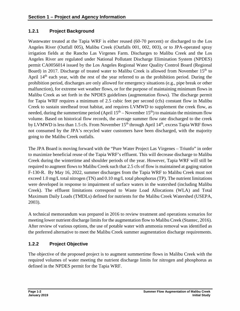
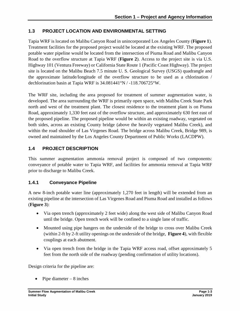
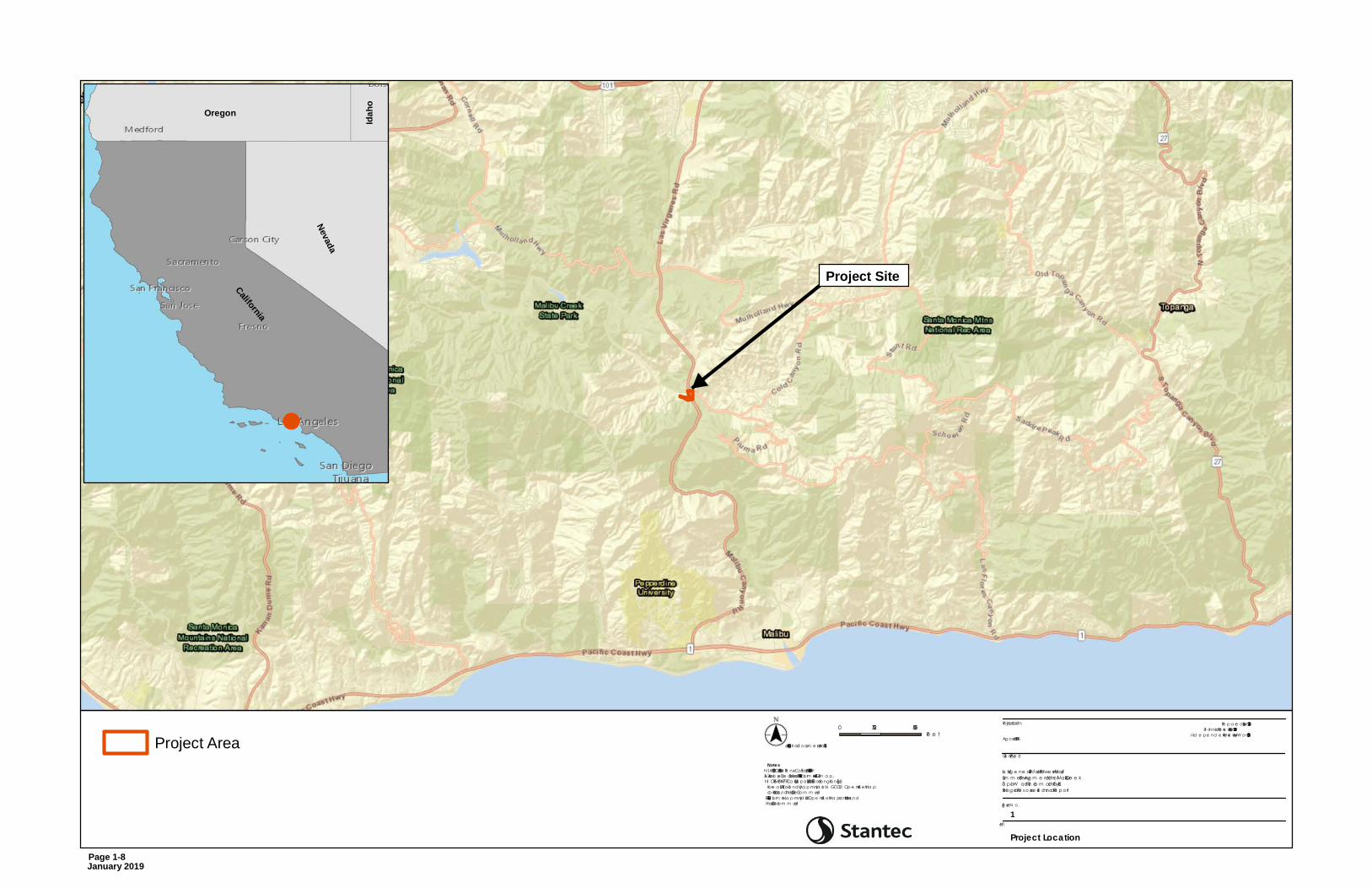
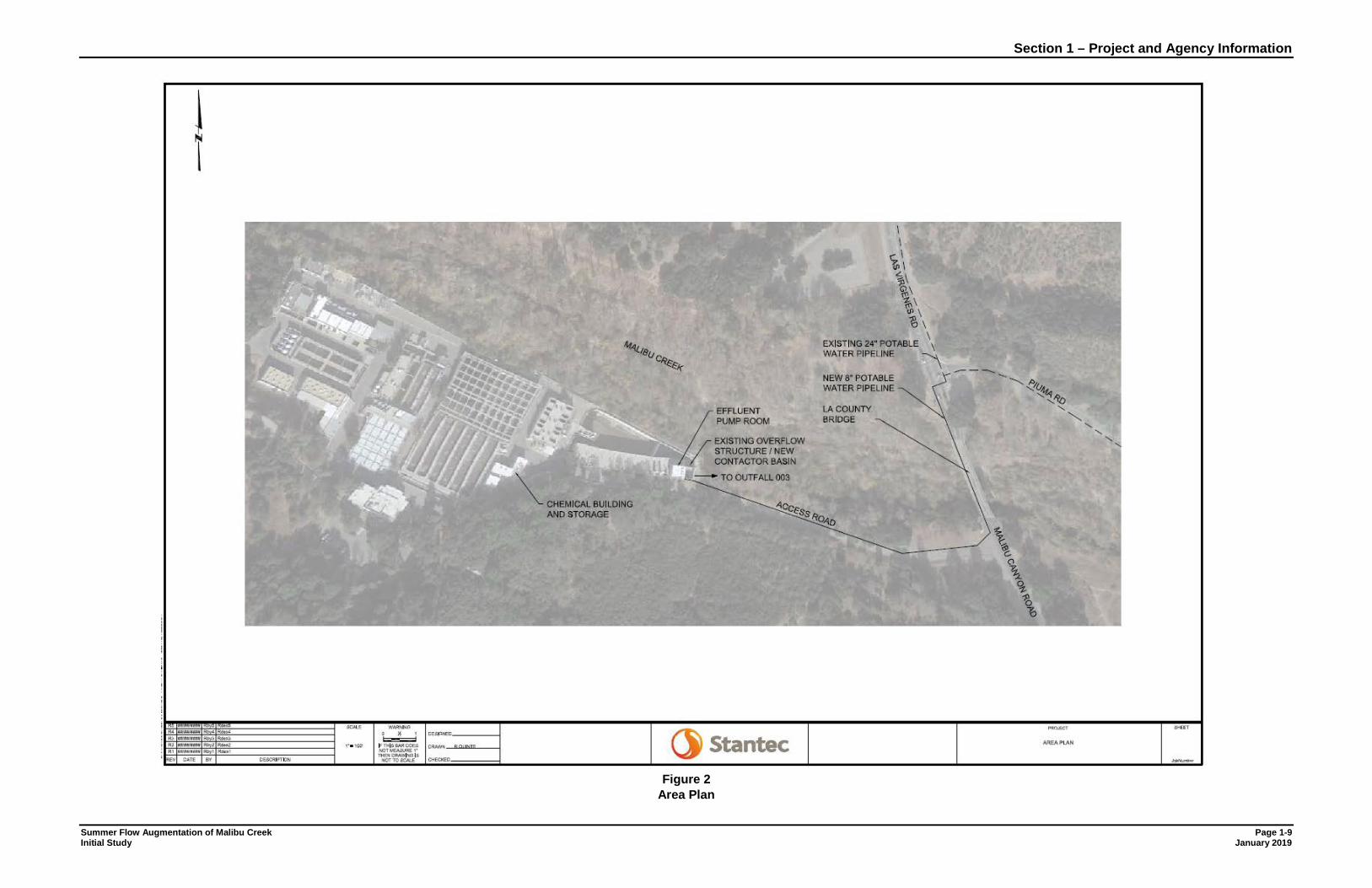
Tapia WRF is located on Malibu Canyon Road in unincorporated Los Angeles County (Figure 1). Treatment facilities for the proposed project would be located at the existing WRF. The proposed potable water pipeline would be located from the intersection of Piuma Road and Malibu Canyon Road to the overflow structure at Tapia WRF (Figure 2). Access to the project site is via U.S. Highway 101 (Ventura Freeway) or California State Route 1 (Pacific Coast Highway). The project site is located on the Malibu Beach 7.5 minute U. S. Geological Survey (USGS) quadrangle and the approximate latitude/longitude of the overflow structure to be used as a chlorination / dechlorination basin at Tapia WRF is 34.081441°N / -118.706725°W. The WRF site, including the area proposed for treatment of summer augmentation water, is developed. The area surrounding the WRF is primarily open space, with Malibu Creek State Park north and west of the treatment plant. The closest residence to the treatment plant is on Piuma Road, approximately 1,330 feet east of the overflow structure, and approximately 630 feet east of the proposed pipeline. The proposed pipeline would be within an existing roadway, vegetated on both sides, across an existing County bridge (above the heavily vegetated Malibu Creek), and within the road shoulder of Las Virgenes Road. The bridge across Malibu Creek, Bridge 989, is owned and maintained by the Los Angeles County Department of Public Works (LACDPW). 1.4 PROJECT DESCRIPTION
This summer augmentation ammonia removal project is composed of two components: conveyance of potable water to Tapia WRF, and facilities for ammonia removal at Tapia WRF prior to discharge to Malibu Creek. 1.4.1 Conveyance Pipeline
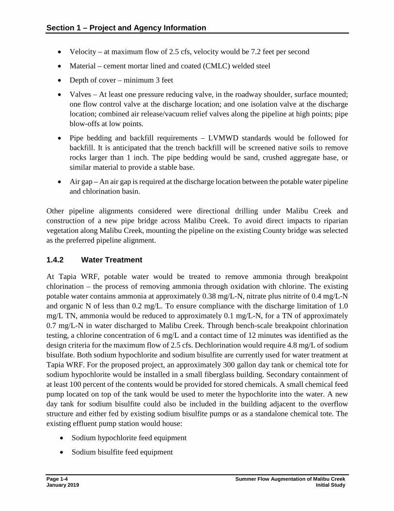
A new 8-inch potable water line (approximately 1,270 feet in length) will be extended from an existing pipeline at the intersection of Las Virgenes Road and Piuma Road and installed as follows (Figure 3):
• Via open trench (approximately 2 feet wide) along the west side of Malibu Canyon Road until the bridge. Open trench work will be confined to a single lane of traffic.
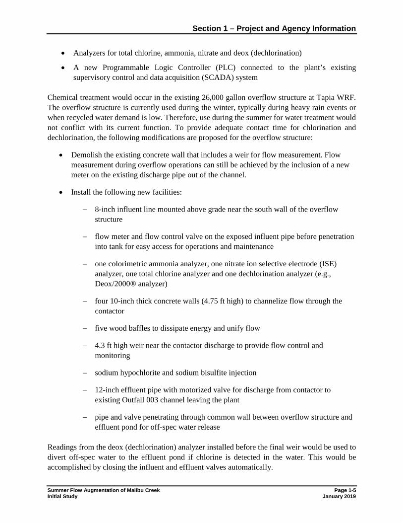
• Mounted using pipe hangers on the underside of the bridge to cross over Malibu Creek (within 2-ft by 2-ft utility openings on the underside of the bridge, Figure 4), with flexible couplings at each abutment.
• Via open trench from the bridge in the Tapia WRF access road, offset approximately 5 feet from the north side of the roadway (pending confirmation of utility locations).
Design criteria for the pipeline are:
• Pipe diameter – 8 inches
Section 1 – Project and Agency Information
Page 1-4 Summer Flow Augmentation of Malibu Creek January 2019 Initial Study
• Velocity – at maximum flow of 2.5 cfs, velocity would be 7.2 feet per second
• Material – cement mortar lined and coated (CMLC) welded steel
• Depth of cover – minimum 3 feet
• Valves – At least one pressure reducing valve, in the roadway shoulder, surface mounted; one flow control valve at the discharge location; and one isolation valve at the discharge location; combined air release/vacuum relief valves along the pipeline at high points; pipe blow-offs at low points.
• Pipe bedding and backfill requirements – LVMWD standards would be followed for backfill. It is anticipated that the trench backfill will be screened native soils to remove rocks larger than 1 inch. The pipe bedding would be sand, crushed aggregate base, or similar material to provide a stable base.
• Air gap – An air gap is required at the discharge location between the potable water pipeline and chlorination basin.
Other pipeline alignments considered were directional drilling under Malibu Creek and construction of a new pipe bridge across Malibu Creek. To avoid direct impacts to riparian vegetation along Malibu Creek, mounting the pipeline on the existing County bridge was selected as the preferred pipeline alignment. 1.4.2 Water Treatment
At Tapia WRF, potable water would be treated to remove ammonia through breakpoint chlorination – the process of removing ammonia through oxidation with chlorine. The existing potable water contains ammonia at approximately 0.38 mg/L-N, nitrate plus nitrite of 0.4 mg/L-N and organic N of less than 0.2 mg/L. To ensure compliance with the discharge limitation of 1.0 mg/L TN, ammonia would be reduced to approximately 0.1 mg/L-N, for a TN of approximately 0.7 mg/L-N in water discharged to Malibu Creek. Through bench-scale breakpoint chlorination testing, a chlorine concentration of 6 mg/L and a contact time of 12 minutes was identified as the design criteria for the maximum flow of 2.5 cfs. Dechlorination would require 4.8 mg/L of sodium bisulfate. Both sodium hypochlorite and sodium bisulfite are currently used for water treatment at Tapia WRF. For the proposed project, an approximately 300 gallon day tank or chemical tote for sodium hypochlorite would be installed in a small fiberglass building. Secondary containment of at least 100 percent of the contents would be provided for stored chemicals. A small chemical feed pump located on top of the tank would be used to meter the hypochlorite into the water. A new day tank for sodium bisulfite could also be included in the building adjacent to the overflow structure and either fed by existing sodium bisulfite pumps or as a standalone chemical tote. The existing effluent pump station would house:
• Sodium hypochlorite feed equipment
• Sodium bisulfite feed equipment
Section 1 – Project and Agency Information
Summer Flow Augmentation of Malibu Creek Page 1-5 Initial Study January 2019
• Analyzers for total chlorine, ammonia, nitrate and deox (dechlorination)
• A new Programmable Logic Controller (PLC) connected to the plant’s existing supervisory control and data acquisition (SCADA) system
Chemical treatment would occur in the existing 26,000 gallon overflow structure at Tapia WRF. The overflow structure is currently used during the winter, typically during heavy rain events or when recycled water demand is low. Therefore, use during the summer for water treatment would not conflict with its current function. To provide adequate contact time for chlorination and dechlorination, the following modifications are proposed for the overflow structure:
• Demolish the existing concrete wall that includes a weir for flow measurement. Flow measurement during overflow operations can still be achieved by the inclusion of a new meter on the existing discharge pipe out of the channel.
• Install the following new facilities:
− 8-inch influent line mounted above grade near the south wall of the overflow structure
− flow meter and flow control valve on the exposed influent pipe before penetration into tank for easy access for operations and maintenance
− one colorimetric ammonia analyzer, one nitrate ion selective electrode (ISE) analyzer, one total chlorine analyzer and one dechlorination analyzer (e.g., Deox/2000® analyzer)
− four 10-inch thick concrete walls (4.75 ft high) to channelize flow through the contactor
− five wood baffles to dissipate energy and unify flow
− 4.3 ft high weir near the contactor discharge to provide flow control and monitoring
− sodium hypochlorite and sodium bisulfite injection
− 12-inch effluent pipe with motorized valve for discharge from contactor to existing Outfall 003 channel leaving the plant
− pipe and valve penetrating through common wall between overflow structure and effluent pond for off-spec water release
Readings from the deox (dechlorination) analyzer installed before the final weir would be used to divert off-spec water to the effluent pond if chlorine is detected in the water. This would be accomplished by closing the influent and effluent valves automatically.
Section 1 – Project and Agency Information
Page 1-6 Summer Flow Augmentation of Malibu Creek January 2019 Initial Study
Treated water would be discharged via existing pipelines to existing Outfall 003 on Malibu Creek. No structural modifications to the pipeline from the plant to the outfall or to the outfall would be required for the project. 1.4.3 Construction
Installation of the proposed potable water pipeline would require the following construction equipment: backhoe, excavator, concrete mixer, roller compactor, articulated aerial lift (or access scaffolding), air compressor, welder, generator and asphalt paving equipment. Vehicles would include a pickup truck, dump truck, haul truck, delivery truck, and construction workers’ personal vehicles. An estimated six construction workers would be required over the approximately 7 to 8 month construction period. Pipeline installation in Malibu Canyon Road may be conducted at night to reduce traffic impacts. In that case, temporary lighting, shielded toward the construction activity and away from adjacent habitat areas, would be required for approximately 5 weeks. 1.4.4 Operations
Minimally, chlorination/dechlorination treatment would be conducted at the WRF from April 15th to November 15th. Additional employees to operate the treatment system are not anticipated to be required. Routine maintenance of the pipeline would be minimal, consisting of periodic inspections of the visible portions of the pipeline attached to the County bridge. 1.5 PUBLIC AGENCY REVIEW AND/OR APPROVAL
The project is being implemented in compliance with the NPDES permit CA0056014 for the Tapia WRF. Permit conditions are prescribed by the Regional Board in compliance with the Los Angeles Basin Plan (Regional Board, 2014). Public agency reviews and approvals are anticipated to include:
• Las Virgenes-Triunfo JPA – Approval of the project and execution of a contract for
construction
• California Department of Transportation, District 7 – Permits for transportation of heavy construction equipment and materials that require the use of oversized-transport vehicles on State highways, as applicable
• South Coast Air Quality Management District (SCAQMD) – Compliance with Rule 403
(dust control) during construction activities; permit for temporary electric generation during construction, as applicable
Section 1 – Project and Agency Information
Summer Flow Augmentation of Malibu Creek Page 1-7 Initial Study January 2019
• Los Angeles County Department of Public Works permit for pipeline installation in the right-of-way of a County Road (Malibu Canyon Road) and on Bridge 989; approval of a Traffic Control Plan
• Los Angeles County Department of Regional Planning Coastal Development Permit or
Waiver for construction in the Santa Monica Mountains Coastal Zone
• Los Angeles County Department of Regional Planning Oak Tree Permit
California
Nevada
Oregon
Idaho
Title
Fig ure N o.
Clie nt/Proje ct
Proje ct Loca tion Pre p a re d by JV on 2018-08-16Te chnica l Re vie w by RB on 2018-08-20
Ind e p e nd e nt Re vie w by MW on 2018-08-20Ag oura Hills, CA
La s Virg e ne s – Triunfo Joint Powe rs AuthoritySum m e r Flow Aug m e nta tion of Ma libu Cre e kTa p ia W a te r Re cla m a tion Fa cilityBiolog ica l Re source s Te chinca l Re port
1
Project Location
0 2,750 5,500Fe e t($$¯
1:65,000 (At orig ina l d ocum e nt size of 8.5x11)
Notes1. N AD 1983 CORS96 Sta te Pla ne Ca lifornia V FIPS 0405 Ft US2. Se rvice La ye r Cre d its: Source s: Esri, HERE, De Lorm e , USGS, Inte rm a p,IN CREMEN T P, N RCa n, Esri Ja pa n, METI, Esri China (Hong Kong ), EsriKore a , Esri (Tha ila nd ), Ma p m yInd ia , N GCC, © Op e nStre e tMa pcontributors, a nd the GIS Use r Com m unityEsri, HERE, De Lorm e , Ma p m yInd ia , © Ope nStre e tMa p contributors, a n dthe GIS use r com m unity
Project Area
Project Site
Page 1-8 January 2019
Section 1 – Project and Agency Information
Summer Flow Augmentation of Malibu Creek Page 1-9 Initial Study January 2019
Figure 2
Area Plan
Page 1-10 Summer Flow Augmentation of Malibu Creek January 2019 Initial Study
Figure 3
Pipeline Alignment
Figure 4
View Under LA County Bridge: Method of Pipe Mounting
Section 2 Environmental Analysis
2.1 ENVIRONMENTAL FACTORS POTENTIALLY AFFECTED
The environmental factors checked below would be potentially affected by this project, involving at least one impact that is a "Potentially Significant Impact· as indicated by the checklist on the following pages.
D Aesthetics D Greenhouse Gas Emissions D Population and Housing
D Agricultural Resources D Hazards and Hazardous Materials D Public Services
D Air Quality D Hydrology and Water Quality D RecreationIZI Biological Resources D Land Use and PlanningIZI Cultural Resources D Mineral Resources
D Geology and Soils IZI Noise
2.2 AGENCY DETERMINATION
On the basis of this initial evaluation:
IZJ Transportation and Traffic
D Utilities and Service SystemsIZJ Mandatory Findings of Significance
D I find that the project COULD NOT have a significant effect on the environment, and a NEGATIVEDECLARATION will be prepared.
IZJ I find that although the project could have a significant effect on the environment, there will not be a significanteffect in this case because revisions in the project have been made by or agreed to by the applicant. A MITIGATED NEGATIVE DECLARATION will be prepared.
D I find that the project MAY have a significant effect on the environment, and an ENVIRONMENTAL IMPACTREPORT is required.
D I find that the project MAY have a "potentially significant impact' or "potentially significant unless mitigated"impact on the environment, but at least one effect 1) has been adequately analyzed in an earlier documentpursuant to applicable legal standards, and 2) has been addressed by mitigation measures based on the earlier analysis as described on attached sheets. An ENVIRONMENTAL IMPACT REPORT is required, but it mustanalyze only the effects that remain to be addressed.
D I find that although the project could have a significant effect on the environment, because all potentiallysignificant effects (a) have been analyzed adequately in an earlier EIR or NEGATIVE DECLARATION pursuantto applicable standards, and (b) have been avoided or mitigated pursuant to that earlier EIR or NEGATIVEDECLARATION, including revisions or mitigation measures that are imposed upon the project, nothing furtheris required.
Signature: __ � __ ,_. __ -__________ _
Printed Name: __ B_
re_
t_
t_
D_
i_n_g_
m_
a_n _______ _
Summer Flow Augmentation of Malibu Creek Initial Study
TiUe: Water Reclamation Manager
Date: 1-7-19
Page 2-1 January 2019
Section 2 – Environmental Analysis
Page 2-2 Summer Flow Augmentation of Malibu Creek January 2019 Initial Study
2.3 ENVIRONMENTAL CHECKLIST
2.3.1 Aesthetics
Issues and Supporting Information Sources Potentially Significant
Impact
Less Than Significant
With Mitigation
Incorporated
Less Than Significant
Impact
No Impact
Would the project: a) Have a substantial adverse effect on a scenic vista? b) Substantially damage scenic resources, including, but
not limited to, trees, rock outcroppings, and historic buildings within a state scenic highway?
c) Substantially degrade the existing visual character or quality of the site and its surroundings?
d) Create a new source of substantial light or glare which would adversely affect day or nighttime views in the area?
Discussion: a) and c) Less than Significant Impact. The proposed project would modify an existing
structure at a wastewater treatment plant and install an 8-inch potable water pipeline (buried and hung on the underside of an existing bridge). During construction, views of the site would be of construction activity, construction vehicles and equipment. Once construction is complete, the visual character and vistas from the project area would be essentially the same as existing conditions. Overall, the impact of the project on visual resources would be temporary and less than significant.
b) No Impact. Scenic roadways are designated by Caltrans and the Federal Highway
Administration. In the project area, Highway 101 west of State Route 27 is an eligible but not officially designated State Scenic Highways (Caltrans, 2018). The closest officially designated (as of March 22, 2017) State Scenic Highway is State Route 27 from post miles 1.0-3.5, over 5 miles east of the project area. Therefore, the project would have no impact on visual resources near a State scenic highway.
d) Less than Significant Impact. The proposed project does not include permanent installation
of new sources of lighting. However, pipeline installation in Malibu Canyon Road may be conducted at night to reduce traffic impacts. In that case, temporary lighting, shielded toward the construction activity and away from adjacent habitat areas, would be required for approximately 5 weeks. The impact would be temporary and less than significant on nighttime views of the project area.
Section 2 – Environmental Analysis
Summer Flow Augmentation of Malibu Creek Page 2-3 Initial Study January 2019
2.3.2 Agricultural and Forest Resources
Issues and Supporting Information Sources Potentially Significant
Impact
Less Than Significant
With Mitigation
Incorporated
Less Than Significant
Impact
No Impact
Would the project: a) Convert Prime Farmland, Unique Farmland, or Farmland
of Statewide Importance (Farmland), as shown on the maps prepared pursuant to the Farmland Mapping and Monitoring Program of the California Resources Agency, to non-agricultural use?
b) Conflict with existing zoning for agricultural use, or a Williamson Act contract?
c) Conflict with existing zoning for, or cause rezoning of, forest land (as defined in Public Resources Code section 12220(g)), timberland (as defined by Public Resources Code section 4526), or timberland zoned Timberland Production (as defined by Government Code section 51104(g))?
d) Result in the loss of forest land or conversion of forest land to non-forest use?
e) Involve other changes in the existing environment which, due to their location or nature, could result in conversion of Farmland, to non-agricultural use or conversion of forest land to non-forest use?
Discussion: a) and b) No Impact. The proposed project site is not designated as Prime Farmland, Unique
Farmland, or Farmland of Statewide Importance (CDC, 2017a). The project site is not associated with a Williamson Act contract (CDC, 2017b). The project site is zoned for Public and Semi-Public (PS) land use, and not for agricultural use. Surrounding zoning is for single family residential (RS), PS and open space (O-S). Therefore, the project would not impact Prime Farmland, Unique Farmland, Farmland of Statewide Importance, existing zoning for agricultural use, or a Williamson Act contract.
c) d) and e) No Impact. The project site is not zoned as forested land and the proposed project
would not result in conversion of forest land to non-forest use. Public Resources Code Section 12220 (g) defines "Forest land" as land that can support 10-percent native tree cover of any species, including hardwoods, under natural conditions, and that allows for management of one or more forest resources, including timber, aesthetics, fish and wildlife, biodiversity, water quality, recreation, and other public benefits. Removal of trees is not proposed. Therefore, the proposed project would have no impact on forest lands.
Section 2 – Environmental Analysis
Page 2-4 Summer Flow Augmentation of Malibu Creek January 2019 Initial Study
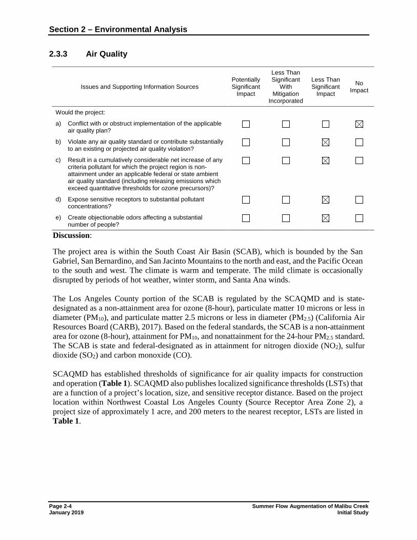
2.3.3 Air Quality
Issues and Supporting Information Sources Potentially Significant
Impact
Less Than Significant
With Mitigation
Incorporated
Less Than Significant
Impact
No Impact
Would the project: a) Conflict with or obstruct implementation of the applicable
air quality plan?
b) Violate any air quality standard or contribute substantially to an existing or projected air quality violation?
c) Result in a cumulatively considerable net increase of any criteria pollutant for which the project region is non-attainment under an applicable federal or state ambient air quality standard (including releasing emissions which exceed quantitative thresholds for ozone precursors)?
d) Expose sensitive receptors to substantial pollutant concentrations?
e) Create objectionable odors affecting a substantial number of people?
Discussion:
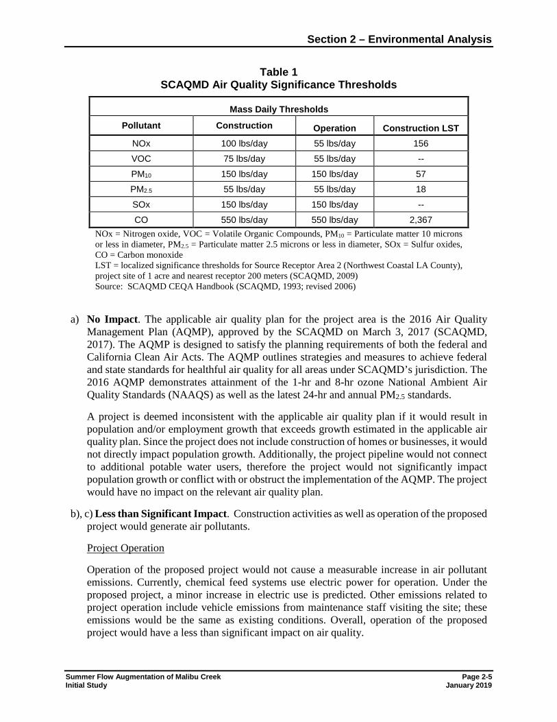
The project area is within the South Coast Air Basin (SCAB), which is bounded by the San Gabriel, San Bernardino, and San Jacinto Mountains to the north and east, and the Pacific Ocean to the south and west. The climate is warm and temperate. The mild climate is occasionally disrupted by periods of hot weather, winter storm, and Santa Ana winds. The Los Angeles County portion of the SCAB is regulated by the SCAQMD and is state-designated as a non-attainment area for ozone (8-hour), particulate matter 10 microns or less in diameter (PM10), and particulate matter 2.5 microns or less in diameter (PM2.5) (California Air Resources Board (CARB), 2017). Based on the federal standards, the SCAB is a non-attainment area for ozone (8-hour), attainment for PM10, and nonattainment for the 24-hour PM2.5 standard. The SCAB is state and federal-designated as in attainment for nitrogen dioxide (NO2), sulfur dioxide (SO2) and carbon monoxide (CO). SCAQMD has established thresholds of significance for air quality impacts for construction and operation (Table 1). SCAQMD also publishes localized significance thresholds (LSTs) that are a function of a project’s location, size, and sensitive receptor distance. Based on the project location within Northwest Coastal Los Angeles County (Source Receptor Area Zone 2), a project size of approximately 1 acre, and 200 meters to the nearest receptor, LSTs are listed in Table 1.
Section 2 – Environmental Analysis
Summer Flow Augmentation of Malibu Creek Page 2-5 Initial Study January 2019
Table 1 SCAQMD Air Quality Significance Thresholds
Mass Daily Thresholds
Pollutant Construction Operation Construction LST NOx 100 lbs/day 55 lbs/day 156 VOC 75 lbs/day 55 lbs/day -- PM10 150 lbs/day 150 lbs/day 57 PM2.5 55 lbs/day 55 lbs/day 18 SOx 150 lbs/day 150 lbs/day -- CO 550 lbs/day 550 lbs/day 2,367
NOx = Nitrogen oxide, VOC = Volatile Organic Compounds, PM10 = Particulate matter 10 microns or less in diameter, PM2.5 = Particulate matter 2.5 microns or less in diameter, SOx = Sulfur oxides, CO = Carbon monoxide LST = localized significance thresholds for Source Receptor Area 2 (Northwest Coastal LA County), project site of 1 acre and nearest receptor 200 meters (SCAQMD, 2009) Source: SCAQMD CEQA Handbook (SCAQMD, 1993; revised 2006)
a) No Impact. The applicable air quality plan for the project area is the 2016 Air Quality Management Plan (AQMP), approved by the SCAQMD on March 3, 2017 (SCAQMD, 2017). The AQMP is designed to satisfy the planning requirements of both the federal and California Clean Air Acts. The AQMP outlines strategies and measures to achieve federal and state standards for healthful air quality for all areas under SCAQMD’s jurisdiction. The 2016 AQMP demonstrates attainment of the 1-hr and 8-hr ozone National Ambient Air Quality Standards (NAAQS) as well as the latest 24-hr and annual PM2.5 standards.
A project is deemed inconsistent with the applicable air quality plan if it would result in population and/or employment growth that exceeds growth estimated in the applicable air quality plan. Since the project does not include construction of homes or businesses, it would not directly impact population growth. Additionally, the project pipeline would not connect to additional potable water users, therefore the project would not significantly impact population growth or conflict with or obstruct the implementation of the AQMP. The project would have no impact on the relevant air quality plan.
b), c) Less than Significant Impact. Construction activities as well as operation of the proposed project would generate air pollutants.
Project Operation
Operation of the proposed project would not cause a measurable increase in air pollutant emissions. Currently, chemical feed systems use electric power for operation. Under the proposed project, a minor increase in electric use is predicted. Other emissions related to project operation include vehicle emissions from maintenance staff visiting the site; these emissions would be the same as existing conditions. Overall, operation of the proposed project would have a less than significant impact on air quality.
Section 2 – Environmental Analysis
Page 2-6 Summer Flow Augmentation of Malibu Creek January 2019 Initial Study
Project Construction
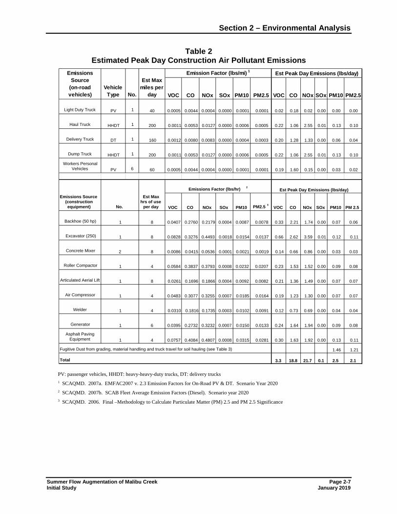
The proposed project would temporarily generate air pollutants from construction activities. Construction of the proposed project would include implementation of modifications at the existing overflow structure and installation of the proposed pipeline. These construction activities would generate air pollutants from equipment exhaust, earth disturbance, and off-gassing from asphalt. Table 2 summarizes estimated emissions based on estimated maximum day emissions during construction. Additional particulate matter emissions would result from earthwork as summarized in Table 3.
Section 2 – Environmental Analysis
Summer Flow Augmentation of Malibu Creek Page 2-7 Initial Study January 2019
Table 2 Estimated Peak Day Construction Air Pollutant Emissions
PV: passenger vehicles, HHDT: heavy-heavy-duty trucks, DT: delivery trucks 1 SCAQMD. 2007a. EMFAC2007 v. 2.3 Emission Factors for On-Road PV & DT. Scenario Year 2020 2 SCAQMD. 2007b. SCAB Fleet Average Emission Factors (Diesel). Scenario year 2020 3 SCAQMD. 2006. Final –Methodology to Calculate Particulate Matter (PM) 2.5 and PM 2.5 Significance
Light Duty Truck PV 1 40 0.0005 0.0044 0.0004 0.0000 0.0001 0.0001 0.02 0.18 0.02 0.00 0.00 0.00
Haul Truck HHDT 1 200 0.0011 0.0053 0.0127 0.0000 0.0006 0.0005 0.22 1.06 2.55 0.01 0.13 0.10
Delivery Truck DT 1 160 0.0012 0.0080 0.0083 0.0000 0.0004 0.0003 0.20 1.28 1.33 0.00 0.06 0.04
Dump Truck HHDT 1 200 0.0011 0.0053 0.0127 0.0000 0.0006 0.0005 0.22 1.06 2.55 0.01 0.13 0.10
Workers Personal Vehicles PV 6 60 0.0005 0.0044 0.0004 0.0000 0.0001 0.0001 0.19 1.60 0.15 0.00 0.03 0.02
Backhoe (50 hp) 8 0.0407 0.2760 0.2179 0.0004 0.0087 0.0078 0.33 2.21 1.74 0.00 0.07 0.06
Excavator (250) 8 0.0828 0.3276 0.4493 0.0018 0.0154 0.0137 0.66 2.62 3.59 0.01 0.12 0.11
Concrete Mixer 8 0.0086 0.0415 0.0536 0.0001 0.0021 0.0019 0.14 0.66 0.86 0.00 0.03 0.03
Roller Compactor 4 0.0584 0.3837 0.3793 0.0008 0.0232 0.0207 0.23 1.53 1.52 0.00 0.09 0.08
Articulated Aerial Lift 8 0.0261 0.1696 0.1866 0.0004 0.0092 0.0082 0.21 1.36 1.49 0.00 0.07 0.07
Air Compressor 4 0.0483 0.3077 0.3255 0.0007 0.0185 0.0164 0.19 1.23 1.30 0.00 0.07 0.07
Welder 4 0.0310 0.1816 0.1735 0.0003 0.0102 0.0091 0.12 0.73 0.69 0.00 0.04 0.04
Generator 6 0.0395 0.2732 0.3232 0.0007 0.0150 0.0133 0.24 1.64 1.94 0.00 0.09 0.08
Asphalt Paving Equipment 4 0.0757 0.4084 0.4807 0.0008 0.0315 0.0281 0.30 1.63 1.92 0.00 0.13 0.11
1.46 1.21
2.5 2.1Total 3.3 18.8 21.7 0.1
Fugitive Dust from grading, material handling and truck travel for soil hauling (see Table 3)
NOx
PM 2.5
Emissions Source(construction equipment) No.
Est Max hrs of use
per day CO
Emissions Source
(on-road vehicles)
Est Max miles per
dayNo.Vehicle
Type VOC
PM10
PM10NOxCO PM2.5
Emissions Factor (lbs/hr) 2
Est Peak Day Emissions (lbs/day)
Est Peak Day Emissions (lbs/day)
PM2.5 3
SOx PM10 PM2.5
VOC CO NOx SOx PM10
VOC
Emission Factor (lbs/mi) 1
COSOx
1
1
VOC NOx SOx
1
2
1
1
1
1
1
Section 2 – Environmental Analysis
Page 2-8 Summer Flow Augmentation of Malibu Creek January 2019 Initial Study
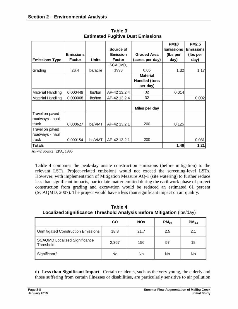
Table 3 Estimated Fugitive Dust Emissions
AP-42 Source: EPA, 1995
Table 4 compares the peak-day onsite construction emissions (before mitigation) to the relevant LSTs. Project-related emissions would not exceed the screening-level LSTs. However, with implementation of Mitigation Measure AQ-1 (site watering) to further reduce less than significant impacts, particulate matter emitted during the earthwork phase of project construction from grading and excavation would be reduced an estimated 61 percent (SCAQMD, 2007). The project would have a less than significant impact on air quality.
Table 4
Localized Significance Threshold Analysis Before Mitigation (lbs/day)
CO NOx PM10 PM2.5
Unmitigated Construction Emissions 18.8 21.7 2.5 2.1
SCAQMD Localized Significance Threshold 2,367 156 57 18
Significant? No No No No
d) Less than Significant Impact. Certain residents, such as the very young, the elderly and those suffering from certain illnesses or disabilities, are particularly sensitive to air pollution
Emissions TypeEmissions
Factor Units
Source of Emission
FactorGraded Area
(acres per day)
PM10 Emissions
(lbs per day)
PM2.5 Emissions
(lbs per day)
Grading 26.4 lbs/acreSCAQMD,
1993 0.05 1.32 1.17Material
Handled (tons per day)
Material Handling 0.000449 lbs/ton AP-42 13.2.4 32 0.014Material Handling 0.000068 lbs/ton AP-42 13.2.4 32 0.002
Miles per dayTravel on paved roadways - haul truck 0.000627 lbs/VMT AP-42 13.2.1 200 0.125Travel on paved roadways - haul truck 0.000154 lbs/VMT AP-42 13.2.1 200 0.031
1.46 1.21Totals
Section 2 – Environmental Analysis
Summer Flow Augmentation of Malibu Creek Page 2-9 Initial Study January 2019
and are considered sensitive receptors. In addition, active park users, such as participants in sporting events, are sensitive air pollutant receptors due to increased respiratory rates. Land uses where sensitive air pollutant receptors congregate include schools, day care centers, parks, recreational areas, medical facilities, rest homes, and convalescent care facilities
As described above, the proposed project would result in temporary dust emissions during construction below established SCAQMD thresholds. However, mitigation to reduce dust emissions during construction will be implemented. Project-related impacts on air quality, including impacts to sensitive receptors, would be less than significant. Operation of the proposed facilities would result in similar air pollutant emissions as under existing conditions.
In addition to the priority pollutants discussed in b) and c) above, toxic air emissions are of potential concern to sensitive receptors. The proposed project would generate emissions from construction equipment during construction activities, including emissions from diesel trucks and heavy construction equipment. CARB classifies diesel particulate emissions as a toxic air contaminant (TAC). Significant impacts associated with exposure to diesel particulate emissions are not expected because construction would occur 5 days per week for approximately 7 to 8 months. Quantitative cancer risk analyses are based on exposure of 70 years for residential exposures and 46 years for occupational exposures; exposure to project-related emissions will be for a much shorter period of time (i.e., during the construction phase). The maximum particulate emissions for diesel engines are estimated at approximately 1 pound per day during the peak construction phase. Based on the short exposure period and small amount of emissions, toxic air contaminant emissions would be less than significant during the construction phase. As discussed above, project operation would not result in substantial air pollutant emissions over existing conditions. Due to the limited duration of project construction, project related air quality impacts on sensitive receptors would be less than significant.
e) Less than Significant Impact. During construction, equipment exhaust and certain construction materials (e.g., asphalt) may be mildly odorous. However, such odors would be limited to the immediate vicinity of the project site, would dissipate rapidly, and would cease at the end of construction. Operation of the proposed project would not result in the generation of odor noticeable to offset receptors. Therefore, the proposed project would not create objectionable odors affecting a substantial number of people, and project-related impacts related to odors would be less than significant.
Mitigation Measure Incorporation of Mitigation Measure AQ-1 would further reduce less than significant air quality impacts from project construction. AQ-1 Site Watering. Disturbed areas of the project site shall be watered a minimum of three
times per day during the demolition, excavation, grading and site preparation phases of project construction.
Section 2 – Environmental Analysis
Page 2-10 Summer Flow Augmentation of Malibu Creek January 2019 Initial Study
2.3.4 Biological Resources
Issues and Supporting Information Sources Potentially Significant
Impact
Less Than Significant
With Mitigation
Incorporated
Less Than Significant
Impact
No Impact
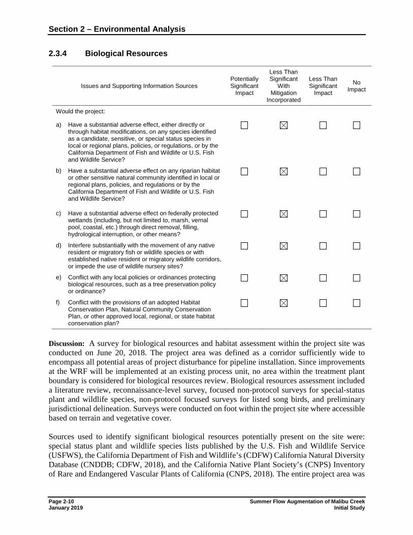
Would the project: a) Have a substantial adverse effect, either directly or
through habitat modifications, on any species identified as a candidate, sensitive, or special status species in local or regional plans, policies, or regulations, or by the California Department of Fish and Wildlife or U.S. Fish and Wildlife Service?
b) Have a substantial adverse effect on any riparian habitat or other sensitive natural community identified in local or regional plans, policies, and regulations or by the California Department of Fish and Wildlife or U.S. Fish and Wildlife Service?
c) Have a substantial adverse effect on federally protected wetlands (including, but not limited to, marsh, vernal pool, coastal, etc.) through direct removal, filling, hydrological interruption, or other means?
d) Interfere substantially with the movement of any native resident or migratory fish or wildlife species or with established native resident or migratory wildlife corridors, or impede the use of wildlife nursery sites?
e) Conflict with any local policies or ordinances protecting biological resources, such as a tree preservation policy or ordinance?
f) Conflict with the provisions of an adopted Habitat Conservation Plan, Natural Community Conservation Plan, or other approved local, regional, or state habitat conservation plan?
Discussion: A survey for biological resources and habitat assessment within the project site was conducted on June 20, 2018. The project area was defined as a corridor sufficiently wide to encompass all potential areas of project disturbance for pipeline installation. Since improvements at the WRF will be implemented at an existing process unit, no area within the treatment plant boundary is considered for biological resources review. Biological resources assessment included a literature review, reconnaissance-level survey, focused non-protocol surveys for special-status plant and wildlife species, non-protocol focused surveys for listed song birds, and preliminary jurisdictional delineation. Surveys were conducted on foot within the project site where accessible based on terrain and vegetative cover. Sources used to identify significant biological resources potentially present on the site were: special status plant and wildlife species lists published by the U.S. Fish and Wildlife Service (USFWS), the California Department of Fish and Wildlife’s (CDFW) California Natural Diversity Database (CNDDB; CDFW, 2018), and the California Native Plant Society’s (CNPS) Inventory of Rare and Endangered Vascular Plants of California (CNPS, 2018). The entire project area was
Section 2 – Environmental Analysis
Summer Flow Augmentation of Malibu Creek Page 2-11 Initial Study January 2019
surveyed by walking meandering transects throughout all accessible portions at an average pace of approximately 1.5 km/hr, while visually searching for and listening to wildlife songs and calls and observing for animal signs. The walking survey was halted approximately every 50 meters to listen for wildlife or as necessary to identify, record, or enumerate any other detected species. The primary goals of wildlife surveys were to identify and assess habitat capable of supporting special-status wildlife species and/or to document the presence/absence of special-status wildlife species. Vegetation maps were prepared by drawing tentative vegetation type boundaries onto high-resolution aerial images while in the field, then digitizing these polygons into GIS. Vegetation descriptions and names are based on Sawyer et al. (2009) and were defined at least to the alliance level. The project site is within existing roadways and at an existing wastewater treatment plant. Vegetation types adjacent to project roadways consist primarily of common plant species and vegetation communities characteristic of the coastal ranges and valleys of southern California. Habitat conditions within undeveloped portions of the project area are generally good, with well-established monocultures of native tree species dominating the riparian areas adjacent to Malibu Canyon Road and the Tapia WRF entrance road. Within the project area, Stantec biologists mapped six plant communities defined by Sawyer et al. (2009) and one additional land cover type (Figure 2 of Appendix A; Stantec, 2018b). a) Less than Significant Impact with Mitigation Incorporated. In general, direct impacts to
special-status plants and terrestrial wildlife include ground-disturbing activities associated with construction of the project (e.g., trenching) and increased human presence (e.g., crushing, trampling, trapping). Potential indirect impacts include increased noise levels from construction equipment (wildlife only), increased human disturbance, exposure to fugitive dust, and the spread of noxious weeds. One special status plant, Southern California black walnut, was observed in the project area during the June 2018 survey. Located away from the roadways and the area of ground disturbance, no impacts to Southern California black walnut would occur. Other special-status plant species were not observed but were determined to have low (8 species), moderate (28 species) or high (5 species) potential to occur in the project area. Construction would be confined to existing developed areas including the Tapia WRF access road and Malibu Canyon Road and their disturbed margins. As such, implementation of the project is not expected to result in direct impacts to native vegetation communities that surround these developed areas.
However, since there is still some limited potential for sensitive plant species to occur at the project site, additional focused botanical surveys will be conducted prior to construction (mitigation measure BIO-3) to reduce potential impacts on sensitive plant species to less than significant levels. Additionally, mitigation measures BIO-1 (best management practices) and BIO-2 (worker environmental education program) will be implemented to avoid or minimize impacts on biological resources.
Although no special status animal species were observed during the surveys, 32 sensitive animal species (14 low, 6 moderate, and 12 high) have the potential to occur in the project region (Table 4 of Appendix A). Since construction would be confined to existing developed
Section 2 – Environmental Analysis
Page 2-12 Summer Flow Augmentation of Malibu Creek January 2019 Initial Study
areas including the Tapia WRF access road and Malibu Canyon Road and their disturbed margins, significant direct impacts to these species are not anticipated. However, installation of the proposed pipeline in Malibu Canyon Road may occur at night for approximately 5 weeks. Noise impacts to sensitive wildlife could occur during this period but would be less than significant with implementation of noise mitigation measure NOI-1. Additionally, wildlife surveys will be conducted prior to construction (mitigation measure BIO-3) to reduce potential impacts on sensitive animals to less than significant levels.
The Migratory Bird Treaty Act (MBTA) and Sections 3503, 3503.5, and 3513 of the Fish and Game Code (FGC) protect the nests of essentially all bird species (native and non-native), including common species such as mourning dove, Anna’s hummingbird, and house finch. Nesting birds have potential to occur in vegetation throughout the project area. If project construction were to occur during the avian nesting season (generally considered to be between February 15th through September 15th, although some raptors species may nest as early as January), indirect impacts to nesting birds could occur. With implementation of mitigation measure BIO-4, impacts on migratory birds would be less than significant.
b) Less than Significant Impact with Mitigation Incorporated. Special-status natural communities are defined by CDFW (2009) as, “...communities that are of limited distribution statewide or within a county or region and are often vulnerable to environmental effects of projects.” All vegetation within the state is ranked with an “S” rank, however only those that are of special concern (S1-S3 rank) are generally evaluated under CEQA. Based on the vegetation mapping, one CDFW sensitive vegetation community, southern coast live oak riparian forest (coast live oak woodland), occurs within the project area; this community has a state rank of S4 (Apparently Secure). In addition, the SMM LUP defines the project area as H1 habitat, considered a Sensitive Environmental Resource Area (SERA) containing habitats of the highest biological significance, rarity, and sensitivity. H1 habitats include: alluvial scrub; coastal bluff scrub; dune; native grassland and scrub with a strong component of native grasses or forbs; riparian; native oak, sycamore, walnut and bay woodlands; rock outcrop habitat types; and wetlands. The canopies of several coast live oak trees extend over the Tapia WRF access road, and construction may result in some minor trimming of branches or cutting of roots. These activities would encroach into the “Protected Zone” of one or more of those trees, which would constitute a direct impact to those individual trees. No oaks or other trees would be directly removed as a result of the project, however, impacts to roots and branches may occur. With implementation of mitigation measures BIO-1 to BIO-3, and BIO-5, impacts on sensitive vegetation communities would be less than significant.
c) Less than Significant Impact with Mitigation Incorporated. Two types of jurisdictional features were documented within the project area associated with Malibu Creek: USACE non-wetland Waters of the U.S. and CDFW State Waters. Malibu Creek is considered a Relatively Permanent Water and flows directly into the Pacific Ocean, which is a Traditionally Navigable Water (TNW). Based on this connectivity to a TNW, Malibu Creek is federally jurisdictional and the creek and associated contiguous areas of riparian vegetation are State jurisdictional. In addition, there are small v-ditches adjacent to the Tapia WRF access road that facilitate
Section 2 – Environmental Analysis
Summer Flow Augmentation of Malibu Creek Page 2-13 Initial Study January 2019
stormwater runoff. These contribute flow to Malibu Creek and therefore would also likely be considered jurisdictional resources. Approximately 0.55 acre of Waters of the U.S. and 1.14 acres of CDFW State Waters occur within the Project Site. Figure 5 in Appendix A depicts the extent of the jurisdictional areas within the Project Site. Installation of the proposed pipeline across the County bridge may be accomplished from scaffolding attached to the bridge and/or through the use of an aerial lift placed below the bridge. Installation of the pipeline under the bridge is anticipated to be completed in approximately 3 weeks. No construction equipment would enter the creek, and if an aerial lift is used, it would be placed directly below the bridge impacting a few square feet of area. Implementation of mitigation measure BIO-3 would reduce impacts on vegetation adjacent to Malibu Creek from use of an aerial lift. Additionally, implementation of mitigation measure BIO-1 would reduce impacts from erosion and inadvertent discharges of disturbed soils, as well as spread of weed species, to Malibu Creek. As mitigated, impacts on wetlands would be less than significant.
d) Less Than Significant Impact with Mitigation Incorporated. Although wildlife movement is hampered by rural development in some portions of the Santa Monica Mountains, animals are still able to move through in many areas. Due to its large size and topographic complexity, many linkages are certain to occur within the Santa Monica Mountains at various bottlenecks. These linkages allow movement between large open space areas within the Santa Monica Mountains as well as between areas outside the Santa Monica Mountains such as the Simi Hills. Within the Project Area, the Malibu Creek riparian corridor serves as an important wildlife travel route. This corridor is free of development and connects other undeveloped lands along its length. Wildlife would be expected to use this route frequently to travel through the Project Area and surrounding region. The proposed project would improve the water quality of the discharge to Malibu Creek, a beneficial impact on the stream. The improvement in water quality would not impact discharge volumes or otherwise adversely impact migratory fish species.
Effects on bird migration patterns, if any, will be temporary and only during the construction phase of the project. Implementation of mitigation measure BIO-4 for the protection of nesting migratory birds would reduce impacts to less than significant levels.
e) Less than Significant Impact with Mitigation Incorporated. Biological resource
management and regulation in the Santa Monica Mountains Coastal Zone, including the Project Site, are implemented through the County Santa Monica Mountains Local Coastal Program (SMM LCP). Together, the Santa Monica Mountains Land Use Plan (SMM LUP; Los Angeles County, 2018a) and the Santa Monica Mountains Local Implementation Program (SMM LIP; Los Angeles County, 2018b) constitute the County's State-mandated LCP for the Santa Monica Mountains segment of the County’s coastal zone.
Since project facilities are proposed for an existing wastewater treatment plant and existing roadways and road right-of-ways, substantial vegetation removal would not be required for project construction. However, mature trees, including native oak trees, are located along the
Section 2 – Environmental Analysis
Page 2-14 Summer Flow Augmentation of Malibu Creek January 2019 Initial Study
project alignment and trenching for pipeline installation may encroach into the protected zone, as defined by the SMM LIP, of one or more of these trees. With implementation of mitigation measure BIO-5, impacts on relevant ordinances, including tree ordinances, would be less than significant.
f) Less than Significant Impact with Mitigation Incorporated. The project area is located within the SMM LUP and mapped as H1 habitat - SERA; the project site is also within Significant Ecological Area (SEA) number 22. SMM LUP policies (see Section 2.3.10) call for infrastructure to be located within legally existing roadways and road rights-of-way in a manner that avoids adverse impacts to coastal resources to the maximum extent feasible; for best management practices (BMPs) to be implemented to minimize environmental effects; for facility design to minimize environmental effects; and for facilities to be sized to support existing and approved land uses, and not induce further development. The proposed water treatment and pipeline project would be located in existing roadways and road rights-of-way, and at an existing wastewater treatment plant. BMPs and mitigation measures will be implemented to reduce construction-impacts to less than significant levels (see mitigation measures BIO-1 through BIO-5). As designed, the pipeline would cross Malibu Creek mounted on the underside of an existing bridge. This stream crossing was selected to minimize environmental effects. Finally, operation of the proposed pipeline would not serve new potable water customers but would ensure compliance with the Tapia WRF discharge permit requirements, a beneficial impact on water quality in Malibu Creek. Overall, the impact of the proposed on relevant habitat plans in the project area is less than significant with incorporation of mitigation measures for the protection of biological resources.
Mitigation Measures With implementation of the following mitigation measures, project-related impacts on biological resources would be less than significant.
BIO-1 Implement BMPs. BMPs shall be implemented as standard operating procedures during all ground disturbance and construction-related activities to avoid or minimize project impacts on biological resources. BMPs shall include:
• Restrict non-essential equipment to the existing roadways and/or ruderal areas to avoid disturbance to native vegetation.
• All excavation, steep-walled holes or trenches in excess of 6 inches in depth shall be covered at the close of each working day by plywood or similar materials or provided with one or more escape ramps constructed of earthen fill or wooden planks with a 2:1 slope ratio. Trenches will also be inspected for entrapped wildlife each morning prior to onset of construction activities and immediately prior to covering with plywood at the end of each working day. Before such holes or trenches are filled, they will be thoroughly inspected for entrapped wildlife. Any wildlife discovered will be allowed to escape before construction
Section 2 – Environmental Analysis
Summer Flow Augmentation of Malibu Creek Page 2-15 Initial Study January 2019
activities are allowed to resume or removed from the trench or hole by a qualified biologist holding the appropriate permits (if required).
• Minimize mechanical disturbance of soils to reduce impact of habitat manipulation on small mammals, reptiles, and amphibians.
• Removal/disturbance of vegetation shall be minimized to the greatest extent feasible.
• Install and maintain appropriate erosion/sediment control measures as needed throughout the duration of work activities. Sediment control measures shall be sufficient to prevent soils disturbed for pipeline installation from entering Malibu Creek. Materials used in implementing stormwater Best Management Practices, including straw wattles or soil fill, shall be certified weed-free to avoid introducing invasive plant species into native habitat.
• Construction-related vehicles shall be clean and maintained free of weeds to avoid spreading noxious weeds across the project or transporting new weeds to the Project Site. Vehicles or equipment brought from different areas of the country, state, or other weed zones shall be cleaned, or documentation provided that they are weed free.
• No vehicles or equipment shall be refueled within 100 feet of an ephemeral drainage or wetland unless a bermed and lined refueling area is constructed. Spill kits shall be maintained on the Project Site in sufficient quantity to accommodate at least three complete vehicle tank failures of 50 gallons each. Any vehicles driven and/or operated within or adjacent to drainages or wetlands shall be checked and maintained daily to prevent leaks of materials.
BIO-2 Implement a Worker Environmental Education Program. Prior to the start of any construction related activities within the Project Site (i.e., mobilization, fencing, grading, or construction), a Worker Environmental Education Program (WEEP) shall be implemented. Briefings for project personnel shall include: a discussion of the Federal and State Endangered Species Acts, Bald and Golden Eagle Protection Act, and the MBTA; the consequences of non-compliance with these acts; identification and values of plant and wildlife species and significant natural plant community habitats; hazardous substance spill prevention and containment measures; a contact person and phone number in the event wildlife needs to be relocated or dead or injured wildlife is discovered; and a review of mitigation requirements.
BIO-3 Pre-Construction Surveys (Plants and Wildlife) and Biological Monitoring Wildlife Surveys: Prior to ground disturbance or tree trimming (if applicable) within the Project Site, a qualified biologist shall conduct surveys for wildlife (no more than 14 days prior to Project Site disturbing activities) where suitable habitat is present and may be directly impacted by construction activities. Wildlife found within the Project Site or in areas potentially affected by the project will be relocated to the nearest suitable habitat that will not be affected by the project prior to the start of construction. Special-status species found within a project impact area shall be relocated by an authorized biologist to suitable habitat outside the impact area.
Section 2 – Environmental Analysis
Page 2-16 Summer Flow Augmentation of Malibu Creek January 2019 Initial Study
The wildlife survey shall include a focused survey for bats within 500 feet of the Project Site. To the extent feasible, maternity roosts, if present, shall be left undisturbed with a buffer of 300 feet from March 15 to September 30. To the extent feasible, hibernation roosts, if present in winter, shall be left undisturbed with a buffer of 100 feet. Where avoidance is infeasible, and a bat roost would be disturbed and/or bats expelled, consultation with CDFW shall be conducted.
Plant Surveys: Prior to initial ground disturbance within the Project Site, a qualified biologist shall conduct pre-construction surveys for special-status plant species in all undeveloped areas subject to ground-disturbing activity. If construction starts in the fall and will extend into the spring, additional surveys shall be conducted in all areas where new ground disturbing activities would occur during the spring (after March 1). All listed plant species found shall be marked and avoided. Any populations of special-status plants found during surveys will be fully described, mapped, and a CNPS Field Survey Form or written equivalent shall be prepared. Prior to Site trenching, any populations of special-status plant species identified during the surveys shall be protected by a buffer zone. The buffer zone shall be established around these areas and shall be of sufficient size to eliminate potential disturbance to the plants from human activity and any other potential sources of disturbance including human trampling, erosion, and dust. The size of the buffer depends upon the proposed use of the immediately adjacent lands and includes consideration of the plant’s ecological requirements (e.g., sunlight, moisture, shade tolerance, physical and chemical characteristics of soils) that are identified by the qualified plant ecologist or botanist. The buffer for herbaceous and shrub species shall be, at minimum, 50 feet from the perimeter of the population or the individual. A smaller buffer may be established, provided there are adequate measures in place to avoid the take of the species. Highly visible flagging shall be placed along the buffer area and remain in good working order during the duration of any construction activities in the area. Where impacts to listed plants cannot be avoided, the USFWS and/or CDFW shall be consulted for authorization, as appropriate. Biological Monitoring: A qualified biologist shall be present during initial ground disturbance within the Project Site and periodically during the bird nesting season. If required, during pre-construction surveys and/or monitoring efforts, the qualified biologist will relocate common and special-status species that enter the Project Site. Some special-status species may require specific permits prior to handling and/or have established protocols for relocation. Records of all detections, captures, and releases shall be reported to CDFW.
BIO-4 Nesting Bird Surveys and Avoidance Measures. Where possible, vegetation removal activities (e.g., tree trimming, if required) should occur after September 15 but prior to February 15 to avoid impacts to nesting birds. Prior to initial site disturbance/issuance of grading permits, seasonally timed presence/absence surveys for nesting birds shall be conducted by a qualified biologist. If construction occurs outside of avian nesting season, only a single presence/absence survey for special status species will be conducted. If
Section 2 – Environmental Analysis
Summer Flow Augmentation of Malibu Creek Page 2-17 Initial Study January 2019
construction is scheduled to begin during the avian nesting season (February 15 through September 15; January 1 to August 15 for raptors), a minimum of three survey events, three days apart, shall be conducted, with the last survey no more than three days prior to the start of site disturbance. Surveys shall be conducted within 500 feet of all proposed project activities.
If least Bell’s vireo, coastal California gnatcatcher, or other special-status species are observed, consultation with USFWS and/or CDFW will be conducted. If breeding birds with active nests are found prior to or during construction, a qualified biologist shall establish a 300-foot buffer around the nest and no activities will be allowed within the buffer(s) until the young have fledged from the nest or the nest fails. The prescribed buffers may be adjusted by the qualified biologist based on existing conditions around the nest, planned construction activities, tolerance of the species, and other pertinent factors. The qualified biologist shall conduct regular monitoring of the nest to determine success/failure and to ensure that project activities are not conducted within the buffer(s) until the nesting cycle is complete or the nest fails.
BIO-5 Oak and Other Native Tree Avoidance Measures. The project shall comply with measures outlined in the SMM LCP and Los Angeles County Oak Woodlands Conservation Management Plan (OWCMP). This will include the following:
• A Protected Tree Survey shall be conducted by a Certified Arborist prior to construction activities in order to document planned and specific impacts to individual trees protected by the SMM LCP, which on the project site include coast live oaks, California ash, California sycamore, and black cottonwood with a single trunk diameter of 6 inches or greater, or a combination of any two trunks measuring 8 inches or greater, at four and one-half feet above natural grade.
• A Los Angeles County Coastal Development Permit-oak tree shall be obtained for encroachment into the protected zone of protected native trees. The permit application shall include a description of the construction; the location of all ordinance/plan oak trees proposed to be removed and/or relocated, or within 200 feet of proposed construction, grading, landfill or other activity; and an oak tree report that evaluates each tree’s dimensions, health, aesthetic appearance, and potential impacts. The permit application shall also substantiate that the construction will not endanger the health of remaining oaks on the property, result in soil erosion through diversion or increased flow of surface waters.
• Removal of ordinance trees, pruning structural roots (roots greater than 1 inch in diameter), or trimming more than 25 percent of a tree’s canopy, and/or removal of more than 50 percent of the root zone shall be avoided to the extent feasible.
• Root or crown pruning activities shall be as minimal as feasible and monitored by a Certified Arborist; pruning shall be done using International Society of Arboriculture (ISA) standards. Any roots larger than 1 inch in diameter that must be pruned shall be cut flush immediately with proper equipment.
Section 2 – Environmental Analysis
Page 2-18 Summer Flow Augmentation of Malibu Creek January 2019 Initial Study
• Excavation and grading shall, to the extent possible, avoid cutting or damaging roots. As recommended by the arborist, hand tools shall be employed when excavating in the root zone. Hand tools or an air spade shall be employed to dig in the protected zone of all protected native trees in the unincorporated areas. Roots of 1-inch diameter or larger shall be preserved. To the extent feasible, construction shall be threaded through the roots or the roots shall be pushed aside. Roots shall be covered with a moist cloth or burlap while they are exposed.
• Root pruning shall be conducted as far from the trunk as possible.
• Parking equipment, staging construction materials, and excessive foot traffic within the protected zone of the affected trees (defined in the unincorporated SMM Coastal Zone as the greater distance between 5 feet from the dripline or 15 feet from the trunk) shall be avoided, as feasible, to prevent soil compaction or damage to roots. As applicable, protected trees near construction shall be protected by substantial (chain-link), temporary, protective fencing.
• Creating holes around tree roots deeper than 3 inches shall be avoided, as feasible. When excavations are unavoidable, backfill shall not use subsurface or clay soils; fill shall be with well-draining soils high in organic matter that do not exceed the surrounding soil surface level.
• Altering the grade within the protected zone shall be avoided to prevent imminent and long-term damage to roots. Any grade changes shall occur beyond the protected zone.
• The Los Angeles County SMM Coastal Zone has no in lieu fee for protected tree impacts. Mitigation trees, where applicable, shall be planted in an area legally protected from development and in the same watershed as the impact. Mitigation trees, as applicable, shall be planted on conserved land under maintenance of an organization with experience in managing land for conservation and preservation.
Section 2 – Environmental Analysis
Summer Flow Augmentation of Malibu Creek Page 2-19 Initial Study January 2019
2.3.5 Cultural Resources
Issues and Supporting Information Sources Potentially Significant
Impact
Less Than Significant
With Mitigation
Incorporated
Less Than Significant
Impact
No Impact
Would the project: a) Cause a substantial adverse change in the significance
of a historical resource as defined in §15064.5?
b) Cause a substantial adverse change in the significance of an archaeological resource pursuant to §15064.5?
c) Directly or indirectly destroy a unique paleontological resource or site or unique geologic feature?
d) Disturb any human remains, including those interred outside of dedicated cemeteries?
Discussion: The Santa Monica Mountains are the ethnographic Traditional Use Areas of both the Chumash and Gabrielino (Tongva) Tribes. A records search and literature review for the project area plus a 0.5-mile radius around the project area (the study area) was conducted at the South Central Coastal Information Center (SCCIC) located at California State University, Fullerton, California on June 27, 2018. As part of the records search, the following inventories in and/or adjacent to the Project Area were reviewed:
• California Inventory of Historic Resources (California Department of Parks and Recreation, 1976)
• California Historical Landmarks (California Office of Historic Preservation, 1996)
• California Points of Historical Interest (California Office of Historic Preservation, 1992)
• Directory of Properties in the Historic Property Data File (includes listings of the National Register of Historic Places (NRHP) and the CRHR) (California Office of Historic Preservation, 2004)
Thirteen previous cultural resources investigations have been conducted within the study area, including an evaluation report for Cultural Resources Near the Proposed Fill Zone at Malibu Creek State Park (Kelly, 1981) and an interpretive plan for the Malibu Creek State Park Day-use and Campground Areas (Hook and Hare, 1983). The other 11 studies include one monitoring report (King, 2010) and 10 survey reports that span from 1977 to 2006. Four of the 13 previously documented studies include portions of the project area. The records search identified 10 previously documented cultural resources within the study area; however, none are located directly within the project area. The four historic era resources are a single 1954 glass bottle, pipe, a rock and concrete marker, and the Malibu Boys Camp. Prehistoric resources include Bedrock Mortar Milling Stations (BRMs), lithic debitage scatters, and a shell scatter. The majority of these sites are located in excess of 0.25-miles from the project area; two
Section 2 – Environmental Analysis
Page 2-20 Summer Flow Augmentation of Malibu Creek January 2019 Initial Study
resources, a BRM site and a rock and concrete marker are located within 0.1-mile of the project area. On June 27, 2018, Stantec conducted an intensive, 100 percent coverage pedestrian survey of the 4.8-acre project area. The project area was surveyed by walking east-west and north-south transects spaced approximately 10-15 meters apart. Due to the overall archaeological sensitivity of the area, banks of the nearby drainage (Sleeper Canyon) were examined for presence of surface deposits. Additionally, per the California Office of Historic Preservation (OHP, 1995) guidelines, Stantec examined surface and subsurface exposures such as rodent burrows and cut banks for physical manifestations of human activity greater than 45 years in age. Ground visibility was relatively good to very good (between 60 and 80 percent). Several modern fire pits, with modern refuse, were observed immediately south of Piuma Road and east of Malibu Canyon Road. No cultural resources were observed during the course of the survey. Results of the investigation are documented in the Cultural Resources Evaluation for the Summer Flow Augmentation of Malibu Creek (Appendix B; Stantec, 2018c). a) No Impact. No historical resources have been identified within the project area.
Construction of the project would be confined to existing roadways; trench depth is estimated at less than 5 feet. Pipeline installation would occur in soils previously disturbed for roadway and utility construction. Since no change to the significance of an historical resource would occur, the project would have no impacts on historical resources.
b) Less than Significant Impact with Mitigation Incorporated. Based on the cultural
resources investigation for the project, no cultural resources were identified within the project area. However, 10 resources are located within 0.5-miles of the project area and two of these resources are located within 0.10-mile of the project area. Intact archaeological resources are not anticipated since any surficial resources that may have been present at one time have been disturbed. However, there is limited potential for project construction to unearth or otherwise adversely impact unidentified archaeological resources. With implementation of mitigation measure CR-1, impacts on unknown archaeological resources would be less than significant.
c) No Impact. There are no known paleontological resources within the project area. In
addition, project construction would be limited to shallow (less that 5-feet) excavation in soils that were previously disturbed during construction for Malibu Canyon Road and the Tapia WRF access roadway, a distance of approximately 1,270-feet (210 feet mounted on the bridge). Since ground-disturbing activities during construction are unlikely to uncover any previously unknown paleontological resources, there would be no project-related impacts on paleontological resources.
d) Less than Significant Impact with Mitigation Incorporated. No known human burials
have been identified on the project site or in the vicinity of the project. The project site is not part of a formal cemetery and is not known to have been used for disposal of historic or prehistoric human remains. Thus, human remains are not expected to be encountered during
Section 2 – Environmental Analysis
Summer Flow Augmentation of Malibu Creek Page 2-21 Initial Study January 2019
construction of the proposed project. In the unlikely event that human remains are encountered during project construction, mitigation measure CR-2 shall be implemented, and impacts from project site development on human remains would be less than significant.
CR-1 Worker Education Awareness Program. The WEAP shall be prepared and presented to
construction workers prior to the start of the project. The WEAP materials shall communicate the cultural significance of the project area to local Tribes and establish procedures to temporarily halt or redirect work in the event that cultural resources are found during ground disturbing activities. The training shall include the types of potential discoveries (e.g., artifact types, features) and proper procedures for notification in the event of an unanticipated discovery. A qualified archaeologist approved by the JPA shall be identified as the contact person in the event of an unanticipated discovery.
If, during excavation or earth moving activities within the project site, the construction contractor identifies potential historic or archaeological resources, all excavation and/or grading within 60 feet of the discovery area shall be halted immediately and work redirected until a qualified archaeologist meeting the Secretary of Interior standards has evaluated the nature and significance of the find. The Fernandeño Tataviam Band of Mission Indians (FTBMI) shall be contacted to consult if any such find occurs. The archaeologist shall determine whether the resource is a “unique archaeological resource” pursuant to Section 21083.2(g) of the California Public Resources Code (PRC) or a “historical resource” pursuant to Section 15064.5(a) of the State CEQA Guidelines (14 California CCR). If the archaeological resource is determined to be a “unique archaeological resource” or a “historical resource”, the archaeologist shall formulate a mitigation plan in consultation with JPA that satisfies the requirements of the above-listed Sections and that reduces the adverse effects of the project to a less than significant level. The archaeologist shall prepare a report of the results of any study prepared as part of a testing or mitigation plan, following accepted professional practice. If the archaeologist determines that the archaeological resource is not a “unique archaeological resource” or “historical resource”, s/he need only record the site and submit the recordation form to the South Central Coastal Information Center (SCCIC). The archaeologist shall complete all relevant California State Department of Parks and Recreation (DPR) 523 Series forms to document the find and submit this documentation to the JPA, Lead Agency, and FTBMI. If the Native American cultural resource is determined to be significant, as defined by consulting Tribes, a Native American archaeological monitor procured by the FTBMI shall be present for all ground disturbing activities that occur within the proposed project area.
• The archaeologist and Tribal monitor shall have the authority to request ground disturbing activities to cease within the area of a discovery to asses potential finds in real time.
• The JPA shall, in good faith, consult with FTBMI on the disposition and treatment of any artifacts or other cultural materials encountered during the project.
Section 2 – Environmental Analysis
Page 2-22 Summer Flow Augmentation of Malibu Creek January 2019 Initial Study
CR-2 Treatment of Previously Unidentified Human Remains. In the unexpected event that human remains or funerary objects are encountered during excavation activities, all work shall halt within a 60-foot buffer of the find and the County Coroner shall be notified (California Public Resources Code §5097.98). The Coroner shall determine whether the remains are of forensic interest. If the Coroner, with the aid of the project Archaeologist, determines that the remains are prehistoric, s/he will contact the Native American Heritage Commission (NAHC), the Fernandeño Tataviam Band of Mission Indians, and consulting tribes. The NAHC will be responsible for designating the Most Likely Descendant (MLD), who will be responsible for the ultimate disposition of the remains, as required by Section 7050.5 of the California Health and Safety Code. The MLD shall make his/her recommendation within 48 hours of being granted access to the site. The recommendation of the MLD shall be followed if feasible and may include scientific removal and non-destructive analysis. If the landowner rejects the recommendations of the MLD, the landowner shall rebury the remains with appropriate dignity on the property in a location that will not be subject to further subsurface disturbance (California Public Resources Code §5097.98).
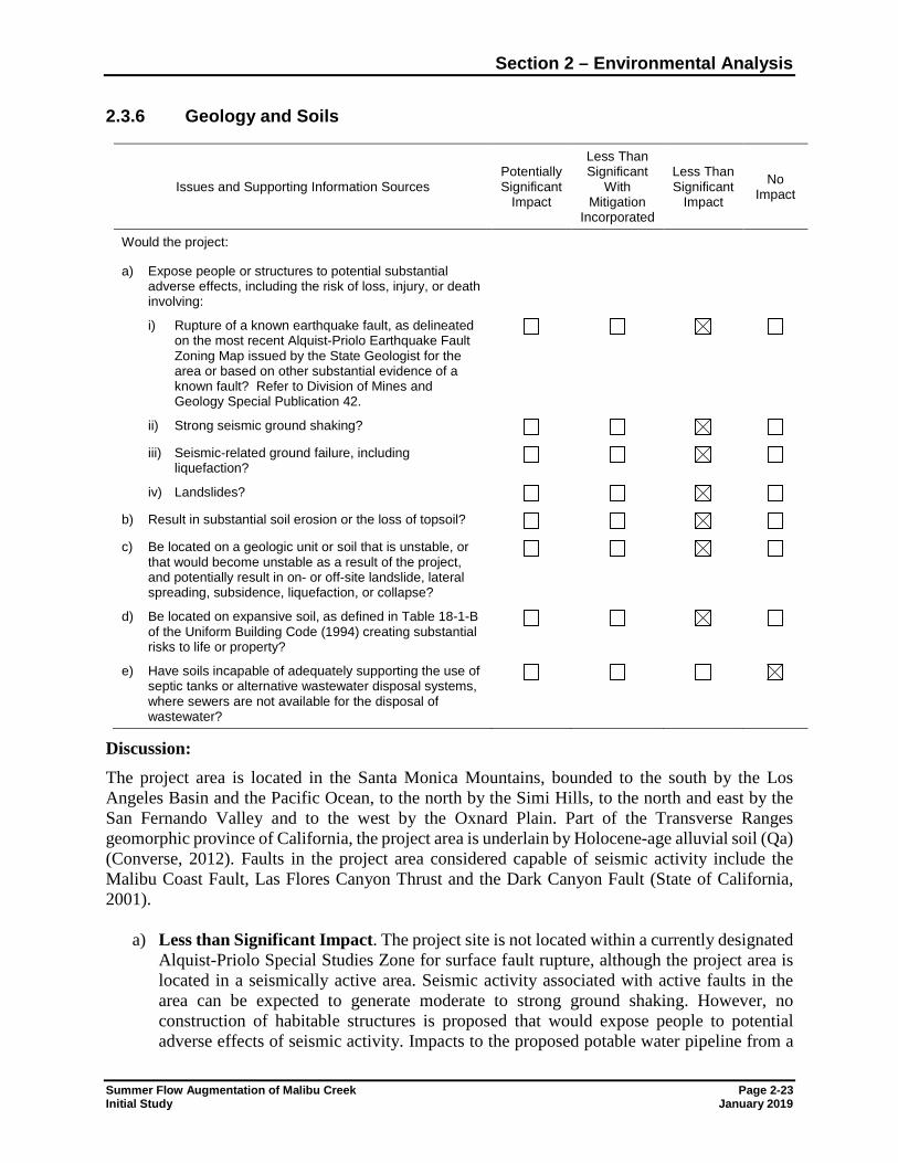
Section 2 – Environmental Analysis
Summer Flow Augmentation of Malibu Creek Page 2-23 Initial Study January 2019
2.3.6 Geology and Soils
Issues and Supporting Information Sources Potentially Significant
Impact
Less Than Significant
With Mitigation
Incorporated
Less Than Significant
Impact
No Impact
Would the project: a) Expose people or structures to potential substantial
adverse effects, including the risk of loss, injury, or death involving:
i) Rupture of a known earthquake fault, as delineated on the most recent Alquist-Priolo Earthquake Fault Zoning Map issued by the State Geologist for the area or based on other substantial evidence of a known fault? Refer to Division of Mines and Geology Special Publication 42.
ii) Strong seismic ground shaking? iii) Seismic-related ground failure, including
liquefaction?
iv) Landslides? b) Result in substantial soil erosion or the loss of topsoil? c) Be located on a geologic unit or soil that is unstable, or
that would become unstable as a result of the project, and potentially result in on- or off-site landslide, lateral spreading, subsidence, liquefaction, or collapse?
d) Be located on expansive soil, as defined in Table 18-1-B of the Uniform Building Code (1994) creating substantial risks to life or property?
e) Have soils incapable of adequately supporting the use of septic tanks or alternative wastewater disposal systems, where sewers are not available for the disposal of wastewater?
Discussion: The project area is located in the Santa Monica Mountains, bounded to the south by the Los Angeles Basin and the Pacific Ocean, to the north by the Simi Hills, to the north and east by the San Fernando Valley and to the west by the Oxnard Plain. Part of the Transverse Ranges geomorphic province of California, the project area is underlain by Holocene-age alluvial soil (Qa) (Converse, 2012). Faults in the project area considered capable of seismic activity include the Malibu Coast Fault, Las Flores Canyon Thrust and the Dark Canyon Fault (State of California, 2001).
a) Less than Significant Impact. The project site is not located within a currently designated Alquist-Priolo Special Studies Zone for surface fault rupture, although the project area is located in a seismically active area. Seismic activity associated with active faults in the area can be expected to generate moderate to strong ground shaking. However, no construction of habitable structures is proposed that would expose people to potential adverse effects of seismic activity. Impacts to the proposed potable water pipeline from a
Section 2 – Environmental Analysis
Page 2-24 Summer Flow Augmentation of Malibu Creek January 2019 Initial Study
seismic event would be repaired as necessary. Since project-related discharges would the same as existing conditions, the project would not impact shallow groundwater or have the potential to cause landslides or increase the potential for liquefaction. Therefore, the proposed project would have less than significant impacts related to geology.
b) Less than Significant Impact. Installation of the proposed pipeline would require
trenching and therefore disturbance to surface soils. BMPs would be employed to reduce wind and water erosion of soils during construction. Discharges to Malibu Creek would be through an existing outfall and the same volume as under existing conditions, therefore no increases in soil erosion related to operational discharges would result. Overall, the impact on soil erosion would be less than significant.
c) Less than Significant Impact. Soils within the project area are fills, alluvial deposits and
weathered bedrock (Converse, 2012). The project area is within an area of potential liquefaction but is not within an earthquake-induced landslide area. The Tapia WRF site is considered susceptible to liquefaction between 15 and 25 feet below ground surface (Converse, 2012); no excavation to those depths would be conducted for the proposed project. Pipeline design will be based on geologic conditions along the alignment. Since the project does not include any habitable structures, and since failure of the pipeline would be repaired as necessary, the project would have a less than significant impact related to unstable soils.
d) Less than Significant Impact. Habitable structures will not be built as part of the proposed
project. Based on previous geotechnical study of the Tapia WRF facility, site soils have low expansion potential, although within the range where measures to improve expansive soils are recommended. Design of project pipelines will specify necessary soil compaction, bedding material, and trench backfill. Therefore, impacts related to expansive soils would be less than significant.
e) No Impact. The project includes modification and use of an existing structure at a
wastewater treatment plant. Since none are proposed, the project would have no impact on septic systems or alternative wastewater disposal facilities.
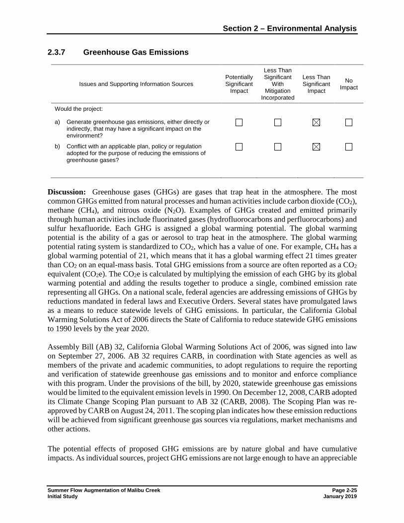
Section 2 – Environmental Analysis
Summer Flow Augmentation of Malibu Creek Page 2-25 Initial Study January 2019
2.3.7 Greenhouse Gas Emissions
Issues and Supporting Information Sources Potentially Significant
Impact
Less Than Significant
With Mitigation
Incorporated
Less Than Significant
Impact
No Impact
Would the project: a) Generate greenhouse gas emissions, either directly or
indirectly, that may have a significant impact on the environment?
b) Conflict with an applicable plan, policy or regulation adopted for the purpose of reducing the emissions of greenhouse gases?
Discussion: Greenhouse gases (GHGs) are gases that trap heat in the atmosphere. The most common GHGs emitted from natural processes and human activities include carbon dioxide (CO2), methane (CH4), and nitrous oxide (N2O). Examples of GHGs created and emitted primarily through human activities include fluorinated gases (hydrofluorocarbons and perfluorocarbons) and sulfur hexafluoride. Each GHG is assigned a global warming potential. The global warming potential is the ability of a gas or aerosol to trap heat in the atmosphere. The global warming potential rating system is standardized to CO2, which has a value of one. For example, CH4 has a global warming potential of 21, which means that it has a global warming effect 21 times greater than CO2 on an equal-mass basis. Total GHG emissions from a source are often reported as a CO2 equivalent (CO2e). The CO2e is calculated by multiplying the emission of each GHG by its global warming potential and adding the results together to produce a single, combined emission rate representing all GHGs. On a national scale, federal agencies are addressing emissions of GHGs by reductions mandated in federal laws and Executive Orders. Several states have promulgated laws as a means to reduce statewide levels of GHG emissions. In particular, the California Global Warming Solutions Act of 2006 directs the State of California to reduce statewide GHG emissions to 1990 levels by the year 2020. Assembly Bill (AB) 32, California Global Warming Solutions Act of 2006, was signed into law on September 27, 2006. AB 32 requires CARB, in coordination with State agencies as well as members of the private and academic communities, to adopt regulations to require the reporting and verification of statewide greenhouse gas emissions and to monitor and enforce compliance with this program. Under the provisions of the bill, by 2020, statewide greenhouse gas emissions would be limited to the equivalent emission levels in 1990. On December 12, 2008, CARB adopted its Climate Change Scoping Plan pursuant to AB 32 (CARB, 2008). The Scoping Plan was re-approved by CARB on August 24, 2011. The scoping plan indicates how these emission reductions will be achieved from significant greenhouse gas sources via regulations, market mechanisms and other actions. The potential effects of proposed GHG emissions are by nature global and have cumulative impacts. As individual sources, project GHG emissions are not large enough to have an appreciable
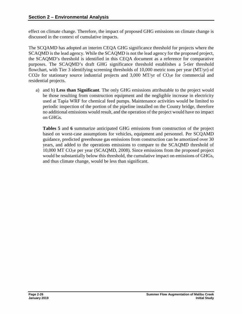
Section 2 – Environmental Analysis
Page 2-26 Summer Flow Augmentation of Malibu Creek January 2019 Initial Study
effect on climate change. Therefore, the impact of proposed GHG emissions on climate change is discussed in the context of cumulative impacts. The SCQAMD has adopted an interim CEQA GHG significance threshold for projects where the SCAQMD is the lead agency. While the SCAQMD is not the lead agency for the proposed project, the SCAQMD’s threshold is identified in this CEQA document as a reference for comparative purposes. The SCAQMD’s draft GHG significance threshold establishes a 5-tier threshold flowchart, with Tier 3 identifying screening thresholds of 10,000 metric tons per year (MT/yr) of CO2e for stationary source industrial projects and 3,000 MT/yr of CO2e for commercial and residential projects.
a) and b) Less than Significant. The only GHG emissions attributable to the project would be those resulting from construction equipment and the negligible increase in electricity used at Tapia WRF for chemical feed pumps. Maintenance activities would be limited to periodic inspection of the portion of the pipeline installed on the County bridge, therefore no additional emissions would result, and the operation of the project would have no impact on GHGs. Tables 5 and 6 summarize anticipated GHG emissions from construction of the project based on worst-case assumptions for vehicles, equipment and personnel. Per SCQAMD guidance, predicted greenhouse gas emissions from construction can be amortized over 30 years, and added to the operations emissions to compare to the SCAQMD threshold of 10,000 MT CO2e per year (SCAQMD, 2008). Since emissions from the proposed project would be substantially below this threshold, the cumulative impact on emissions of GHGs, and thus climate change, would be less than significant.
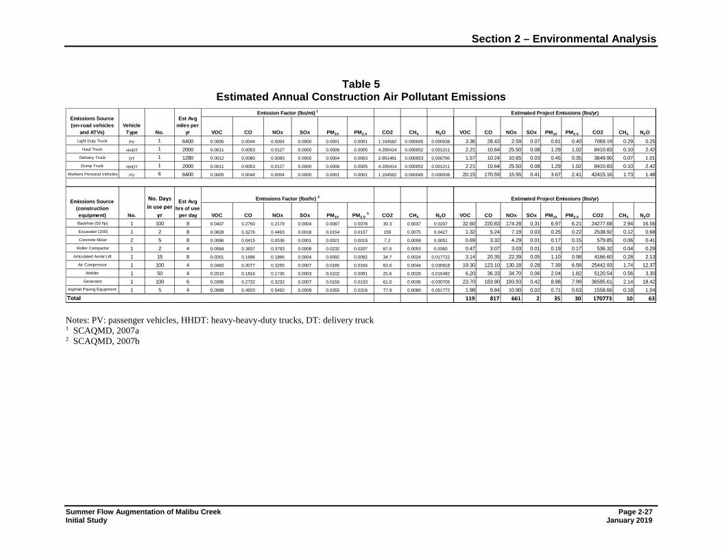
Section 2 – Environmental Analysis
Summer Flow Augmentation of Malibu Creek Page 2-27 Initial Study January 2019
Table 5
Estimated Annual Construction Air Pollutant Emissions
Notes: PV: passenger vehicles, HHDT: heavy-heavy-duty trucks, DT: delivery truck 1 SCAQMD, 2007a 2 SCAQMD, 2007b
Light Duty Truck PV 1 6400 0.0005 0.0044 0.0004 0.0000 0.0001 0.0001 1.104562 0.000045 0.000038 3.36 28.43 2.59 0.07 0.61 0.40 7069.19 0.29 0.25Haul Truck HHDT 1 2000 0.0011 0.0053 0.0127 0.0000 0.0006 0.0005 4.205414 0.000052 0.001211 2.21 10.64 25.50 0.08 1.29 1.02 8410.83 0.10 2.42
Delivery Truck DT 1 1280 0.0012 0.0080 0.0083 0.0000 0.0004 0.0003 2.851481 0.000053 0.000790 1.57 10.24 10.65 0.03 0.45 0.35 3649.90 0.07 1.01Dump Truck HHDT 1 2000 0.0011 0.0053 0.0127 0.0000 0.0006 0.0005 4.205414 0.000052 0.001211 2.21 10.64 25.50 0.08 1.29 1.02 8410.83 0.10 2.42
Workers Personal Vehicles PV 6 6400 0.0005 0.0044 0.0004 0.0000 0.0001 0.0001 1.104562 0.000045 0.000038 20.15 170.59 15.55 0.41 3.67 2.41 42415.16 1.73 1.48
Backhoe (50 hp) 1 100 8 0.0407 0.2760 0.2179 0.0004 0.0087 0.0078 30.3 0.0037 0.0207 32.60 220.83 174.28 0.31 6.97 6.21 24277.68 2.94 16.56Excavator (250) 1 2 8 0.0828 0.3276 0.4493 0.0018 0.0154 0.0137 159 0.0075 0.0427 1.32 5.24 7.19 0.03 0.25 0.22 2538.92 0.12 0.68Concrete Mixer 2 5 8 0.0086 0.0415 0.0536 0.0001 0.0021 0.0019 7.2 0.0008 0.0051 0.69 3.32 4.29 0.01 0.17 0.15 579.85 0.06 0.41
Roller Compactor 1 2 4 0.0584 0.3837 0.3793 0.0008 0.0232 0.0207 67.0 0.0053 0.0360 0.47 3.07 3.03 0.01 0.19 0.17 536.32 0.04 0.29Articulated Aerial Lift 1 15 8 0.0261 0.1696 0.1866 0.0004 0.0092 0.0082 34.7 0.0024 0.017722 3.14 20.35 22.39 0.05 1.10 0.98 4166.60 0.28 2.13
Air Compressor 1 100 4 0.0483 0.3077 0.3255 0.0007 0.0185 0.0164 63.6 0.0044 0.030918 19.30 123.10 130.18 0.28 7.39 6.58 25442.93 1.74 12.37Welder 1 50 4 0.0310 0.1816 0.1735 0.0003 0.0102 0.0091 25.6 0.0028 0.016482 6.20 36.33 34.70 0.06 2.04 1.82 5120.54 0.56 3.30
Generator 1 100 6 0.0395 0.2732 0.3232 0.0007 0.0150 0.0133 61.0 0.0036 0.030705 23.70 163.90 193.93 0.42 8.98 7.99 36595.61 2.14 18.42Asphalt Paving Equipment 1 5 4 0.0989 0.4920 0.5450 0.0009 0.0355 0.0316 77.9 0.0089 0.051772 1.98 9.84 10.90 0.02 0.71 0.63 1558.66 0.18 1.04
119 817 661 2 35 30 170773 10 63
Emissions Source(on-road vehicles
and ATVs)Vehicle
Type No.
Est Avg miles per
yr
Emission Factor (lbs/mi) 1
VOC CO NOx SOx PM10 PM2.5
CO NOx SOx
CH4 CH4
Total
CO2 N2OPM10
VOC CO NOx
Emissions Source(construction equipment)
Est Avg hrs of use
per day
Emissions Factor (lbs/hr) 2
No.
Estimated Project Emissions (lbs/yr)
CO2 N2OCO2 N2O PM10 PM2.5SOx
VOC
No. Days in use per
yr CO NOx SOx PM10 PM2.5 3 CO2 N2O
Estimated Project Emissions (lbs/yr)
CH4 CH4PM2.5VOC
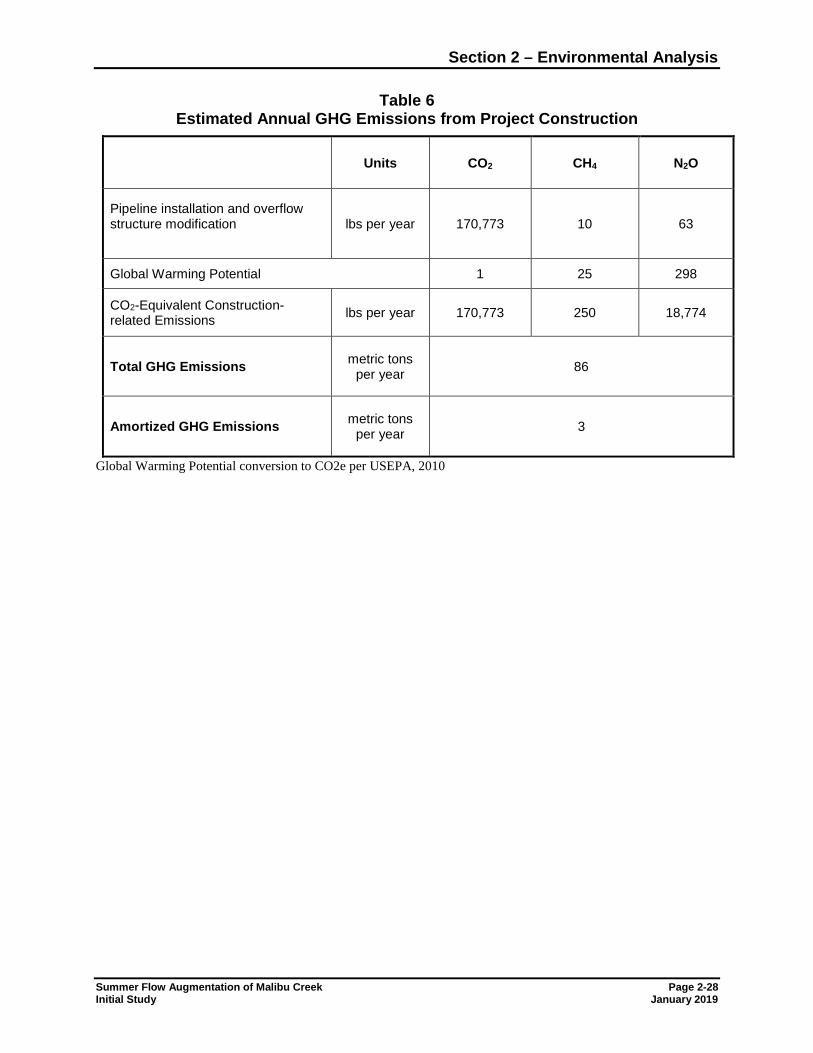
Section 2 – Environmental Analysis
Summer Flow Augmentation of Malibu Creek Page 2-28 Initial Study January 2019
Table 6 Estimated Annual GHG Emissions from Project Construction
Units CO2 CH4 N2O
Pipeline installation and overflow structure modification
lbs per year 170,773 10 63
Global Warming Potential 1 25 298
CO2-Equivalent Construction-related Emissions lbs per year 170,773 250 18,774
Total GHG Emissions metric tons per year 86
Amortized GHG Emissions metric tons per year 3
Global Warming Potential conversion to CO2e per USEPA, 2010
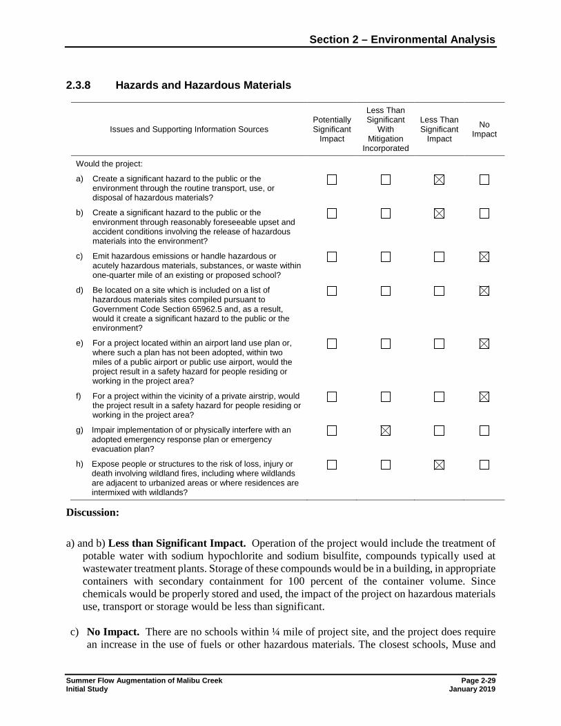
Section 2 – Environmental Analysis
Summer Flow Augmentation of Malibu Creek Page 2-29 Initial Study January 2019
2.3.8 Hazards and Hazardous Materials
Issues and Supporting Information Sources Potentially Significant
Impact
Less Than Significant
With Mitigation
Incorporated
Less Than Significant
Impact
No Impact
Would the project:
a) Create a significant hazard to the public or the environment through the routine transport, use, or disposal of hazardous materials?
b) Create a significant hazard to the public or the environment through reasonably foreseeable upset and accident conditions involving the release of hazardous materials into the environment?
c) Emit hazardous emissions or handle hazardous or acutely hazardous materials, substances, or waste within one-quarter mile of an existing or proposed school?
d) Be located on a site which is included on a list of hazardous materials sites compiled pursuant to Government Code Section 65962.5 and, as a result, would it create a significant hazard to the public or the environment?
e) For a project located within an airport land use plan or, where such a plan has not been adopted, within two miles of a public airport or public use airport, would the project result in a safety hazard for people residing or working in the project area?
f) For a project within the vicinity of a private airstrip, would the project result in a safety hazard for people residing or working in the project area?
g) Impair implementation of or physically interfere with an adopted emergency response plan or emergency evacuation plan?
h) Expose people or structures to the risk of loss, injury or death involving wildland fires, including where wildlands are adjacent to urbanized areas or where residences are intermixed with wildlands?
Discussion: a) and b) Less than Significant Impact. Operation of the project would include the treatment of
potable water with sodium hypochlorite and sodium bisulfite, compounds typically used at wastewater treatment plants. Storage of these compounds would be in a building, in appropriate containers with secondary containment for 100 percent of the container volume. Since chemicals would be properly stored and used, the impact of the project on hazardous materials use, transport or storage would be less than significant.
c) No Impact. There are no schools within ¼ mile of project site, and the project does require
an increase in the use of fuels or other hazardous materials. The closest schools, Muse and
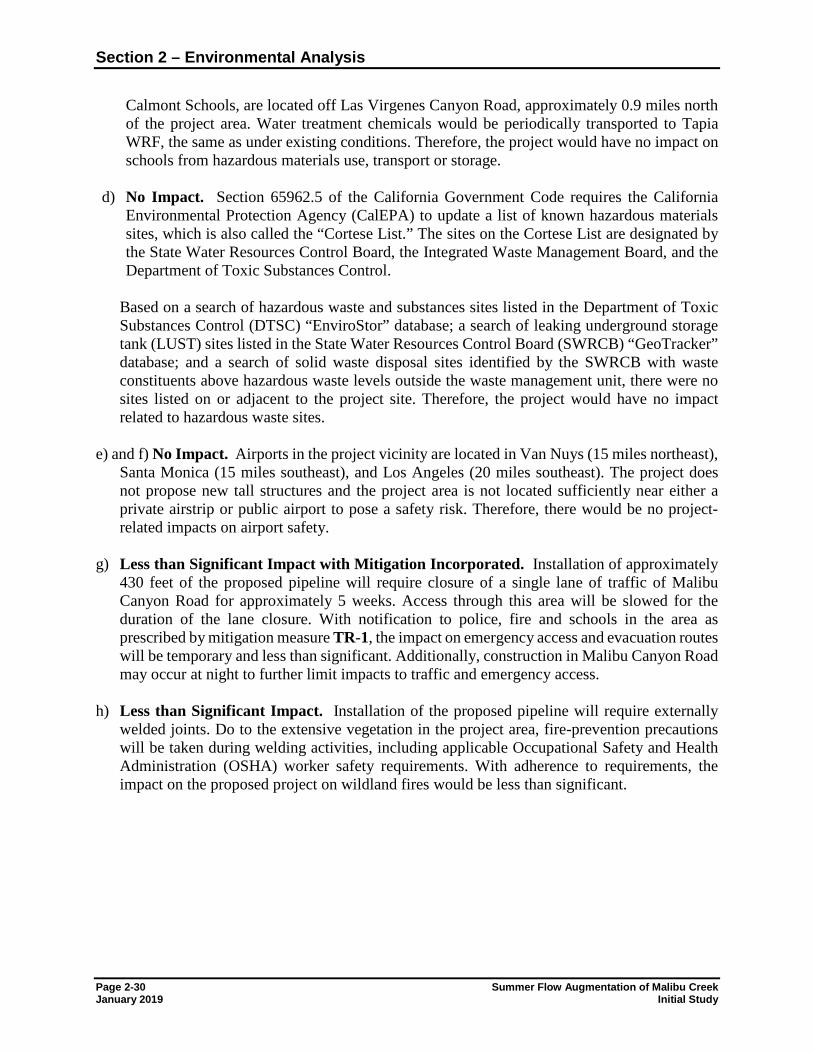
Section 2 – Environmental Analysis
Page 2-30 Summer Flow Augmentation of Malibu Creek January 2019 Initial Study
Calmont Schools, are located off Las Virgenes Canyon Road, approximately 0.9 miles north of the project area. Water treatment chemicals would be periodically transported to Tapia WRF, the same as under existing conditions. Therefore, the project would have no impact on schools from hazardous materials use, transport or storage.
d) No Impact. Section 65962.5 of the California Government Code requires the California
Environmental Protection Agency (CalEPA) to update a list of known hazardous materials sites, which is also called the “Cortese List.” The sites on the Cortese List are designated by the State Water Resources Control Board, the Integrated Waste Management Board, and the Department of Toxic Substances Control.
Based on a search of hazardous waste and substances sites listed in the Department of Toxic Substances Control (DTSC) “EnviroStor” database; a search of leaking underground storage tank (LUST) sites listed in the State Water Resources Control Board (SWRCB) “GeoTracker” database; and a search of solid waste disposal sites identified by the SWRCB with waste constituents above hazardous waste levels outside the waste management unit, there were no sites listed on or adjacent to the project site. Therefore, the project would have no impact related to hazardous waste sites.
e) and f) No Impact. Airports in the project vicinity are located in Van Nuys (15 miles northeast),
Santa Monica (15 miles southeast), and Los Angeles (20 miles southeast). The project does not propose new tall structures and the project area is not located sufficiently near either a private airstrip or public airport to pose a safety risk. Therefore, there would be no project-related impacts on airport safety.
g) Less than Significant Impact with Mitigation Incorporated. Installation of approximately
430 feet of the proposed pipeline will require closure of a single lane of traffic of Malibu Canyon Road for approximately 5 weeks. Access through this area will be slowed for the duration of the lane closure. With notification to police, fire and schools in the area as prescribed by mitigation measure TR-1, the impact on emergency access and evacuation routes will be temporary and less than significant. Additionally, construction in Malibu Canyon Road may occur at night to further limit impacts to traffic and emergency access.
h) Less than Significant Impact. Installation of the proposed pipeline will require externally
welded joints. Do to the extensive vegetation in the project area, fire-prevention precautions will be taken during welding activities, including applicable Occupational Safety and Health Administration (OSHA) worker safety requirements. With adherence to requirements, the impact on the proposed project on wildland fires would be less than significant.
Section 2 – Environmental Analysis
Summer Flow Augmentation of Malibu Creek Page 2-31 Initial Study January 2019
2.3.9 Hydrology and Water Quality
Issues and Supporting Information Sources Potentially Significant
Impact
Less Than Significant
With Mitigation
Incorporated
Less Than Significant
Impact
No Impact
Would the project: a) Violate any water quality standards or waste discharge
requirements?
b) Substantially deplete groundwater supplies or interfere substantially with groundwater recharge such that there would be a net deficit in aquifer volume or a lowering of the local groundwater table level (e.g., the production rate of pre-existing nearby wells would drop to a level which would not support existing land uses or planned uses for which permits have been granted)?
c) Substantially alter the existing drainage pattern of the site or area, including through the alteration of the course of a stream or river, in a manner which would result in substantial erosion or siltation on- or off-site?
d) Substantially alter the existing drainage pattern of the site or area, including through the alteration of the course of a stream or river, or substantially increase the rate or amount of surface runoff in a manner which would result in flooding on- or off-site?
e) Create or contribute runoff water which would exceed the capacity of existing or planned stormwater drainage systems or provide substantial additional sources of polluted runoff?
f) Otherwise substantially degrade water quality? g) Place housing within a 100-year flood hazard area, as
mapped on a federal Flood Hazard Boundary or Flood Insurance Rate Map or other flood hazard delineation map?
h) Place within a 100-year flood hazard area structures which would impede or redirect flood flows?
i) Expose people or structures to a significant risk of loss, injury or death involving flooding, including flooding as a result of the failure of a levee or dam?
j) Expose people or structures to a significant risk of loss, injury or death involving inundation by seiche, tsunami, or mudflow?
Discussion: The Malibu Creek watershed is 109 square miles of primarily open space that extends from the Santa Monica Mountains and adjacent Simi Hills to the Pacific coast at Santa Monica Bay. Malibu Creek drains into Malibu Lagoon, a 13-acre tidal lagoon, which in turn drains into Santa Monica Bay when the lagoon is open. Over 8 miles of Malibu Creek, and three of its tributaries (Las Virgenes Creek, Medea Creek, and Lindero Creek), exceed the water quality objectives (WQOs) for nuisance effects such as algae, odors, and scum (Regional Board, 2014). The United States Environmental Protection Agency (USEPA) established the Malibu Creek
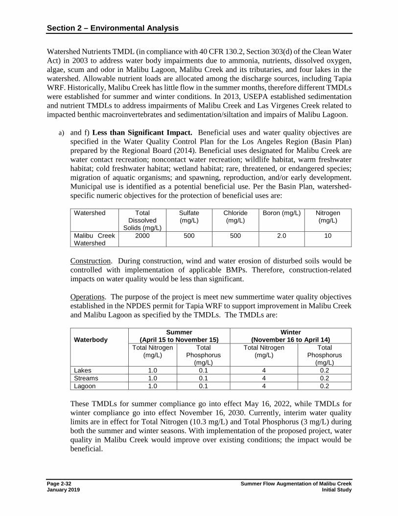
Section 2 – Environmental Analysis
Page 2-32 Summer Flow Augmentation of Malibu Creek January 2019 Initial Study
Watershed Nutrients TMDL (in compliance with 40 CFR 130.2, Section 303(d) of the Clean Water Act) in 2003 to address water body impairments due to ammonia, nutrients, dissolved oxygen, algae, scum and odor in Malibu Lagoon, Malibu Creek and its tributaries, and four lakes in the watershed. Allowable nutrient loads are allocated among the discharge sources, including Tapia WRF. Historically, Malibu Creek has little flow in the summer months, therefore different TMDLs were established for summer and winter conditions. In 2013, USEPA established sedimentation and nutrient TMDLs to address impairments of Malibu Creek and Las Virgenes Creek related to impacted benthic macroinvertebrates and sedimentation/siltation and impairs of Malibu Lagoon.
a) and f) Less than Significant Impact. Beneficial uses and water quality objectives are specified in the Water Quality Control Plan for the Los Angeles Region (Basin Plan) prepared by the Regional Board (2014). Beneficial uses designated for Malibu Creek are water contact recreation; noncontact water recreation; wildlife habitat, warm freshwater habitat; cold freshwater habitat; wetland habitat; rare, threatened, or endangered species; migration of aquatic organisms; and spawning, reproduction, and/or early development. Municipal use is identified as a potential beneficial use. Per the Basin Plan, watershed-specific numeric objectives for the protection of beneficial uses are:
Watershed Total Dissolved
Solids (mg/L)
Sulfate (mg/L)
Chloride (mg/L)
Boron (mg/L) Nitrogen (mg/L)
Malibu Creek Watershed
2000 500 500 2.0 10
Construction. During construction, wind and water erosion of disturbed soils would be controlled with implementation of applicable BMPs. Therefore, construction-related impacts on water quality would be less than significant. Operations. The purpose of the project is meet new summertime water quality objectives established in the NPDES permit for Tapia WRF to support improvement in Malibu Creek and Malibu Lagoon as specified by the TMDLs. The TMDLs are:
Waterbody
Summer (April 15 to November 15)
Winter (November 16 to April 14)
Total Nitrogen (mg/L)
Total Phosphorus
(mg/L)
Total Nitrogen (mg/L)
Total Phosphorus
(mg/L) Lakes 1.0 0.1 4 0.2 Streams 1.0 0.1 4 0.2 Lagoon 1.0 0.1 4 0.2
These TMDLs for summer compliance go into effect May 16, 2022, while TMDLs for winter compliance go into effect November 16, 2030. Currently, interim water quality limits are in effect for Total Nitrogen (10.3 mg/L) and Total Phosphorus (3 mg/L) during both the summer and winter seasons. With implementation of the proposed project, water quality in Malibu Creek would improve over existing conditions; the impact would be beneficial.
Section 2 – Environmental Analysis
Summer Flow Augmentation of Malibu Creek Page 2-33 Initial Study January 2019
b) Less Than Significant Impact. The project does not include any groundwater pumping or withdrawals. The project would improve the quality of water discharged to Malibu Creek during summer months; the volume of surface water discharges which may percolate to the groundwater would be the same as existing conditions. The project would have no impact on groundwater volumes and a beneficial impact on groundwater quality. Overall, impacts on groundwater are considered less than significant.
c) d) and e) Less Than Significant Impact. The project does not involve the permanent alteration of an existing drainage pattern of the site or area. During construction, drainage in the immediate area of active construction, if any, would be diverted around the construction area, and stormwater quality would be maintained through the implementation of stormwater BMPs. Since discharge volumes to Malibu Creek would be the same as existing conditions, the project would have no impact on the course of Malibu Creek. Overall, the impact of the project on drainage and stormwater quality would be less than significant.
g) h) and i) No Impact. Portions of the Tapia WRF, including the overflow structure and
access roadway, are not located within a mapped flood plain (FEMA, 2008). FEMA maps the area adjacent to Malibu Creek as Zone A - areas subject to inundation by the 1-percent-annual-chance flood event generally determined using approximate methodologies. Portions of the proposed pipeline are located with the mapped Zone A floodplain. However, the proposed project does not include the placement of housing or structures that will impede flows within the flood plain or create levees or dams. Summer augmentation flows would be discharged to an existing channel, Malibu Creek, with adequate capacity to carry the flows; volumes would be the same as existing conditions. No levees or dams are present at the project site and no off-site levees or dams would be modified as part of the project. The project would have no impact on housing or structures in a 100-year flood hazard area.
j) No Impact. Tsunamis are tidal waves generated by major ground movement or fault
displacement. At an elevation over 450 feet above ground level and over 3 miles to the ocean, tsunamis do not pose a hazard. Since the project site is not located near a large enclosed body of water, large waves, or seiches, generated in response to ground shaking do not pose a hazard. Mudflows are not known for the project area and the project would not create conditions that would cause mudflows, nor include housing or structures that would be impacted by mudflows. Summer augmentation flows would be discharged to an existing channel, Malibu Creek, with adequate capacity to carry the flows. The proposed project would have no impact on seiche, tsunami or mudflows.
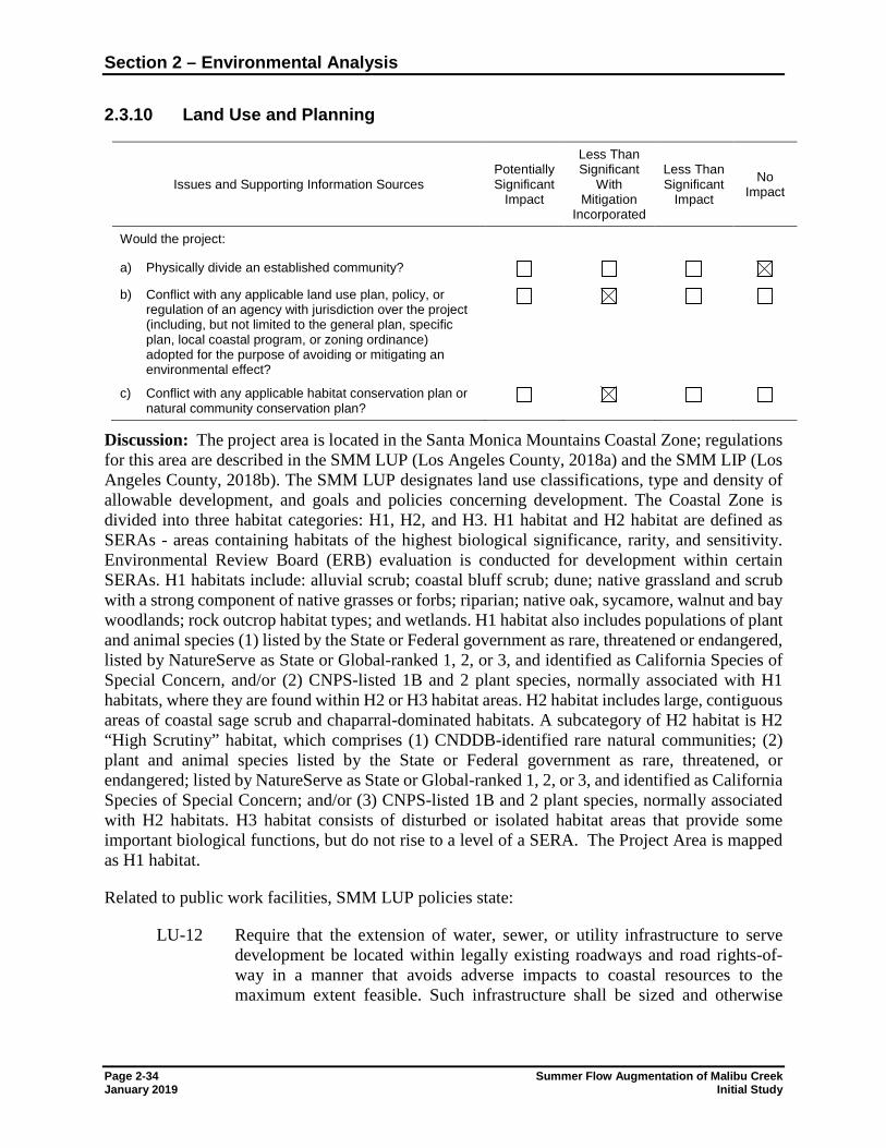
Section 2 – Environmental Analysis
Page 2-34 Summer Flow Augmentation of Malibu Creek January 2019 Initial Study
2.3.10 Land Use and Planning
Issues and Supporting Information Sources Potentially Significant
Impact
Less Than Significant
With Mitigation
Incorporated
Less Than Significant
Impact
No Impact
Would the project: a) Physically divide an established community? b) Conflict with any applicable land use plan, policy, or
regulation of an agency with jurisdiction over the project (including, but not limited to the general plan, specific plan, local coastal program, or zoning ordinance) adopted for the purpose of avoiding or mitigating an environmental effect?
c) Conflict with any applicable habitat conservation plan or natural community conservation plan?
Discussion: The project area is located in the Santa Monica Mountains Coastal Zone; regulations for this area are described in the SMM LUP (Los Angeles County, 2018a) and the SMM LIP (Los Angeles County, 2018b). The SMM LUP designates land use classifications, type and density of allowable development, and goals and policies concerning development. The Coastal Zone is divided into three habitat categories: H1, H2, and H3. H1 habitat and H2 habitat are defined as SERAs - areas containing habitats of the highest biological significance, rarity, and sensitivity. Environmental Review Board (ERB) evaluation is conducted for development within certain SERAs. H1 habitats include: alluvial scrub; coastal bluff scrub; dune; native grassland and scrub with a strong component of native grasses or forbs; riparian; native oak, sycamore, walnut and bay woodlands; rock outcrop habitat types; and wetlands. H1 habitat also includes populations of plant and animal species (1) listed by the State or Federal government as rare, threatened or endangered, listed by NatureServe as State or Global-ranked 1, 2, or 3, and identified as California Species of Special Concern, and/or (2) CNPS-listed 1B and 2 plant species, normally associated with H1 habitats, where they are found within H2 or H3 habitat areas. H2 habitat includes large, contiguous areas of coastal sage scrub and chaparral-dominated habitats. A subcategory of H2 habitat is H2 “High Scrutiny” habitat, which comprises (1) CNDDB-identified rare natural communities; (2) plant and animal species listed by the State or Federal government as rare, threatened, or endangered; listed by NatureServe as State or Global-ranked 1, 2, or 3, and identified as California Species of Special Concern; and/or (3) CNPS-listed 1B and 2 plant species, normally associated with H2 habitats. H3 habitat consists of disturbed or isolated habitat areas that provide some important biological functions, but do not rise to a level of a SERA. The Project Area is mapped as H1 habitat.
Related to public work facilities, SMM LUP policies state:
LU-12 Require that the extension of water, sewer, or utility infrastructure to serve development be located within legally existing roadways and road rights-of-way in a manner that avoids adverse impacts to coastal resources to the maximum extent feasible. Such infrastructure shall be sized and otherwise
Section 2 – Environmental Analysis
Summer Flow Augmentation of Malibu Creek Page 2-35 Initial Study January 2019
designed to provide only for the approved development to avoid growth-inducing impacts.
CO-20 Require that public agencies use the most effective BMPs to protect natural resources at project sites and maintenance yards when the maintenance and modification of public infrastructure involves the removal of vegetation and/or earth.
CO-48 New and replacement infrastructure may be permitted provided that it complies with applicable provisions of this plan and is designed to avoid and, if feasible, minimize adverse impacts to environmental and scenic resources. New roads shall only be construction to provide access to lawfully-approved proposed new development and shall comply with the road standards found in the LIP. New and replacement utilities shall only be developed to serve legally-established uses.
Per the public facilities element of the LUP, the guiding principal to ensure the provision of adequate services and facilities is:
Public facilities should support existing and approved land uses, and are not intended to induce further development, consistent with environmental carrying capacities and the need to protect the unique character of existing communities.
Zoning ordinances required to implement the LUP are contained in the SMM LIP, a component of the SMM LCP and a segment of Los Angeles County Code Title 22 (Planning and Zoning Ordinance). The SMM LIP establishes regulations for new development and for the protection and management of the Santa Monica Mountains Coastal Zone’s unique resources. a) No Impact. The proposed project would not disrupt or divide the physical arrangement of an
established community. The project site has been in continuous use as a wastewater treatment facility since the 1960s. Therefore, there would be no impact on established communities.
b) Less than Significant Impact with Incorporation of Mitigation. The treatment plant and
access roadway are zoned Institutional (I), surrounding land uses are O-S and open space parks (O-S-P). Per the Municipal Code, allowable uses in the I zone are uses and structures accessory to the principal permitted use. Since the proposed project includes modification of existing treatment plant facilities and installation of a pipeline (buried and mounted on the underside of a bridge), the project would not conflict with the general plan or zoning ordinance.
The applicable planning document for the project area is the SMM LCP. The SMM LCP was developed in compliance with the California Coastal Act of 1976, which established a comprehensive coastal protection program focused on public access and recreation, visitor accommodations, sensitive habitats, visual resources, agricultural lands, commercial fisheries, industrial uses, water quality, and offshore oil and gas development. Zoning ordinances required to implement the LUP are contained in the SMM LIP (Los Angeles County, 2018b), a component of the SMM LCP and a segment of Los Angeles County Code Title 22 (Planning and Zoning Ordinance). The SMM LIP establishes regulations for new development and for
Section 2 – Environmental Analysis
Page 2-36 Summer Flow Augmentation of Malibu Creek January 2019 Initial Study
the protection and management of the Santa Monica Mountains Coastal Zone’s unique resources.
The proposed pipeline would not serve new development, would not require the installation of new roads, and would not induce new development. Implementation of mitigation measures identified for the protection of biological resources (see Section 2.3.4) would reduce project-related impacts on the sensitive resources of the Santa Monica Mountains. Operation of the project would improve the water quality of Malibu Creek, a beneficial effect. As mitigated, the project would be consistent with the SMM LCP policies and have a less than significant impact on land use planning.
c) Less than Significant Impact with Mitigation Incorporated. The project site is within SEA 22 (Santa Monica Mountains). However, the management and review of biological resources in the SMM Coastal Zones differs from the countywide SEA regulatory program. Biological resources management and regulation in the Santa Monica Mountains Coastal Zone is implemented through the Santa Monica Mountains LCP. Please see Section 2.3.4 Biological Resources, item f.
Section 2 – Environmental Analysis
Summer Flow Augmentation of Malibu Creek Page 2-37 Initial Study January 2019
2.3.11 Mineral Resources
Issues and Supporting Information Sources Potentially Significant
Impact
Less Than Significant
With Mitigation
Incorporated
Less Than Significant
Impact
No Impact
Would the project: a) Result in the loss of availability of a known mineral
resource that would be of value to the region and the residents of the state?
b) Result in the loss of availability of a locally-important mineral resource recovery site delineated on a local general plan, specific plan, or other land use plan?
Discussion: a) and b) No Impact. The California Department of Conservation (2018) does not map any mines
in the project area, and no active mining operations are known in the immediate vicinity. The closest mapped mine is located in Ventura County, approximately 19 miles west of the project site. Construction of the project will require minor amounts of concrete and gravel bedding. However, since the project would not result in the loss of a known mineral resources or resource recovery site, the proposed project would have no impact on mining or mineral resource availability.
Section 2 – Environmental Analysis
Page 2-38 Summer Flow Augmentation of Malibu Creek January 2019 Initial Study
2.3.12 Noise
Issues and Supporting Information Sources Potentially Significant
Impact
Less Than Significant
With Mitigation
Incorporated
Less Than Significant
Impact
No Impact
Would the project result in: a) Exposure of persons to or generation of noise levels in
excess of standards established in the local general plan or noise ordinance, or applicable standards of other agencies?
b) Exposure of persons to or generation of excessive groundborne vibration or groundborne noise levels?
c) A substantial permanent increase in ambient noise levels in the project vicinity above levels existing without the project?
d) A substantial temporary or periodic increase in ambient noise levels in the project vicinity above levels existing without the project?
e) For a project located within an airport land use plan or, where such a plan has not been adopted, within two miles of a public airport or public use airport, would the project expose people residing or working in the project area to excessive noise levels?
f) For a project within the vicinity of a private airstrip, would the project expose people residing or working in the project area to excessive noise levels?
Discussion: The County of Los Angeles General Plan 2035 Noise Element lists the following policies for the reduction of excessive noise impacts: Policy N 1.1 Utilize land uses to buffer noise-sensitive uses from sources of adverse noise
impacts. Policy N 1.2 Reduce exposure to noise impacts by promoting land use compatibility. Policy N 1.3 Minimize impacts to noise-sensitive land uses by ensuring adequate site design,
acoustical construction, and use of barriers, berms, or additional engineering controls through Best Available Technologies (BAT).
Policy N 1.4 Enhance and promote noise abatement programs in an effort to maintain acceptable levels of noise as defined by the Los Angeles County Exterior Noise Standards and other applicable noise standards.
Policy N 1.5 Ensure compliance with the jurisdictions of State Noise Insulation Standards (Title 24, California Code of Regulations and Chapter 35 of the Uniform Building Code), such as noise insulation of new multifamily dwellings constructed within the 60 dB (CNEL or Ldn) noise exposure contours.
Policy N 1.6 Ensure cumulative impacts related to noise do not exceed health-based safety margins.
Section 2 – Environmental Analysis
Summer Flow Augmentation of Malibu Creek Page 2-39 Initial Study January 2019
Policy N 1.7 Utilize traffic management and noise suppression techniques to minimize noise from traffic and transportation systems.
Policy N 1.8 Minimize noise impacts to pedestrians and transit-riders in the design of transportation facilities and mobility networks.
Policy N 1.9 Require construction of suitable noise attenuation barriers on noise sensitive uses that would be exposed to exterior noise levels of 65 dBA CNEL and above, when unavoidable impacts are identified.
Policy N 1.10 Orient residential units away from major noise sources (in conjunction with applicable building codes).
Policy N 1.11 Maximize buffer distances and design and orient sensitive receptor structures (hospitals, residential, etc.) to prevent noise and vibration transfer from commercial/light industrial uses.
Policy N 1.12 Decisions on land adjacent to transportation facilities, such as the airports, freeways and other major highways, must consider both existing and future noise levels of these transportation facilities to assure the compatibility of proposed uses.
Construction Noise Standards. Title 12, Chapter 12.08 of the Los Angeles County Code contains regulations pertaining to construction noise. It generally prohibits generation of construction noise between weekday hours of 7:00 p.m. and 7:00 a.m., or at any time on Sundays or holidays, such that the sound creates a noise disturbance across a residential or commercial real-property line. Exceptions to this prohibition are made for emergency work of public service utilities and if a variance is issued by the health officer. It also establishes maximum noise levels at the affected buildings that should not be exceeded for two scenarios: 1) nonscheduled, intermittent, short-term operation (less than 10 days) of mobile equipment and 2) repetitively scheduled and relatively long-term operation (periods of 10 days or more) of stationary equipment (Table 7). Construction of project facilities would be scheduled, and noise-generating equipment would be mobile construction equipment. In addition, Title 12, Chapter 12.12 prohibits use of noise-generating equipment (e.g., compressors, jackhammers, power-driven drill, riveting machine, excavator, diesel-powered truck, tractor or other earth moving equipment, hand hammers on steel or iron) on any Sunday or at any other time between the hours of 8:00 p.m. and 6:30 a.m. if it results in disturbance of persons occupying sleeping quarters in a dwelling, apartment, hotel, mobile home, or other place of residence. Exemption may be granted by the county engineer if:
1. The work proposed to be done is in the public interest; or
2. Hardship, injustice or unreasonable delay would result from the interruption thereof during the hours and days specified in Section 4204; or
3. The building or structure involved is devoted or intended to be devoted to a use
immediately incident to public defense.
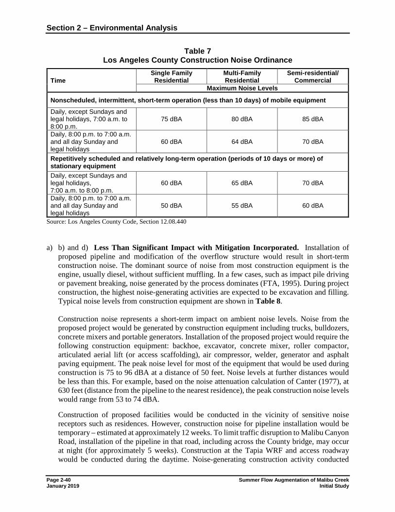
Section 2 – Environmental Analysis
Page 2-40 Summer Flow Augmentation of Malibu Creek January 2019 Initial Study
Table 7 Los Angeles County Construction Noise Ordinance
Time Single Family Residential
Multi-Family Residential
Semi-residential/ Commercial
Maximum Noise Levels
Nonscheduled, intermittent, short-term operation (less than 10 days) of mobile equipment Daily, except Sundays and legal holidays, 7:00 a.m. to 8:00 p.m.
75 dBA 80 dBA 85 dBA
Daily, 8:00 p.m. to 7:00 a.m. and all day Sunday and legal holidays
60 dBA 64 dBA 70 dBA
Repetitively scheduled and relatively long-term operation (periods of 10 days or more) of stationary equipment Daily, except Sundays and legal holidays, 7:00 a.m. to 8:00 p.m.
60 dBA 65 dBA 70 dBA
Daily, 8:00 p.m. to 7:00 a.m. and all day Sunday and legal holidays
50 dBA 55 dBA 60 dBA
Source: Los Angeles County Code, Section 12.08.440 a) b) and d) Less Than Significant Impact with Mitigation Incorporated. Installation of
proposed pipeline and modification of the overflow structure would result in short-term construction noise. The dominant source of noise from most construction equipment is the engine, usually diesel, without sufficient muffling. In a few cases, such as impact pile driving or pavement breaking, noise generated by the process dominates (FTA, 1995). During project construction, the highest noise-generating activities are expected to be excavation and filling. Typical noise levels from construction equipment are shown in Table 8.
Construction noise represents a short-term impact on ambient noise levels. Noise from the proposed project would be generated by construction equipment including trucks, bulldozers, concrete mixers and portable generators. Installation of the proposed project would require the following construction equipment: backhoe, excavator, concrete mixer, roller compactor, articulated aerial lift (or access scaffolding), air compressor, welder, generator and asphalt paving equipment. The peak noise level for most of the equipment that would be used during construction is 75 to 96 dBA at a distance of 50 feet. Noise levels at further distances would be less than this. For example, based on the noise attenuation calculation of Canter (1977), at 630 feet (distance from the pipeline to the nearest residence), the peak construction noise levels would range from 53 to 74 dBA.
Construction of proposed facilities would be conducted in the vicinity of sensitive noise receptors such as residences. However, construction noise for pipeline installation would be temporary – estimated at approximately 12 weeks. To limit traffic disruption to Malibu Canyon Road, installation of the pipeline in that road, including across the County bridge, may occur at night (for approximately 5 weeks). Construction at the Tapia WRF and access roadway would be conducted during the daytime. Noise-generating construction activity conducted
Section 2 – Environmental Analysis
Summer Flow Augmentation of Malibu Creek Page 2-41 Initial Study January 2019
outside the hours permitted by County ordinance (7 p.m. to 7 a.m.) could be disruptive to sensitive receptors and therefore potentially significant. With implementation of mitigation measure NOI-1, impacts would be less than significant with mitigation incorporated.
c) No Impact. Operation of the proposed pipeline and existing overflow structure for water treatment would not increase ambient noise levels over existing conditions. Operation of the proposed project would have no impact on noise.
e) and f) No Impact. Airports in the project vicinity are located in Van Nuys (15 miles northeast), Santa Monica (15 miles southeast), and Los Angeles (20 miles southeast). The project area is not located sufficiently near either a private airstrip or public airport to expose people residing or working in the area to excessive noise levels. There would be no project-related impacts on noise near an airport/airstrip.
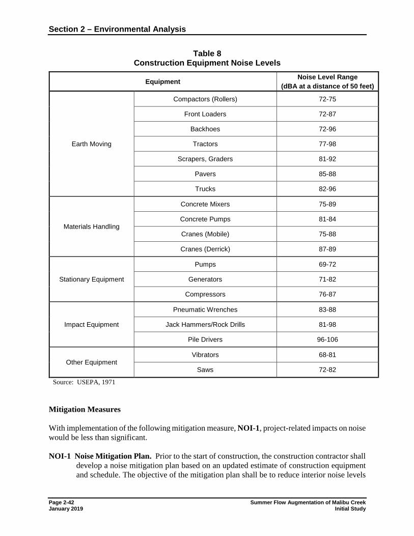
Section 2 – Environmental Analysis
Page 2-42 Summer Flow Augmentation of Malibu Creek January 2019 Initial Study
Table 8 Construction Equipment Noise Levels
Equipment Noise Level Range (dBA at a distance of 50 feet)
Earth Moving
Compactors (Rollers) 72-75
Front Loaders 72-87
Backhoes 72-96
Tractors 77-98
Scrapers, Graders 81-92
Pavers 85-88
Trucks 82-96
Materials Handling
Concrete Mixers 75-89
Concrete Pumps 81-84
Cranes (Mobile) 75-88
Cranes (Derrick) 87-89
Stationary Equipment
Pumps 69-72
Generators 71-82
Compressors 76-87
Impact Equipment
Pneumatic Wrenches 83-88
Jack Hammers/Rock Drills 81-98
Pile Drivers 96-106
Other Equipment Vibrators 68-81
Saws 72-82
Source: USEPA, 1971
Mitigation Measures With implementation of the following mitigation measure, NOI-1, project-related impacts on noise would be less than significant. NOI-1 Noise Mitigation Plan. Prior to the start of construction, the construction contractor shall
develop a noise mitigation plan based on an updated estimate of construction equipment and schedule. The objective of the mitigation plan shall be to reduce interior noise levels
Section 2 – Environmental Analysis
Summer Flow Augmentation of Malibu Creek Page 2-43 Initial Study January 2019
at sensitive receptors to within acceptable limits as outlined in the County of Los Angeles municipal code. The mitigation plans shall detail measures to limit construction noise, including:
• Equip all construction equipment, with properly operating and maintained noise
mufflers and intake silencers, consistent with manufacturers’ standards.
• If construction activity is proposed between 7 p.m. and 7 a.m., the JPA shall obtain express written permission from the County of Los Angeles.
• During nighttime construction (7 p.m. to 7 a.m.) (if permissible by the County of Los Angeles) the construction contractor shall install temporary sound walls or acoustic blankets with a height as required to reduce construction noise.
Section 2 – Environmental Analysis
Page 2-44 Summer Flow Augmentation of Malibu Creek January 2019 Initial Study
2.3.13 Population and Housing
Issues and Supporting Information Sources Potentially Significant
Impact
Less Than Significant
With Mitigation
Incorporated
Less Than Significant
Impact
No Impact
Would the project: a) Induce substantial population growth in an area, either
directly (for example, by proposing new homes and businesses) or indirectly (for example, through extension of roads or other infrastructure)?
b) Displace substantial numbers of existing housing, necessitating the construction of replacement housing elsewhere?
c) Displace substantial numbers of people, necessitating the construction of replacement housing elsewhere?
Discussion: a) No Impact. The proposed project does not involve construction of new homes or
businesses. Under the project, potable water treatment and pipeline conveyance are proposed in order to discharge water of adequate quality for habitat maintenance in Malibu Creek. No additional connections of potable water service are proposed for existing or new residential, commercial, or industrial customers. The project does not include demolition or construction of homes or businesses. Operation of the project would not require additional workers at the Tapia WRF. Therefore, the project would have no impact on population growth or housing.
b) No Impact. No housing would be displaced by the proposed project. Therefore, no impacts would occur.
c) No Impact. No individuals would be displaced by the proposed project. Therefore, no
impacts would occur.
Section 2 – Environmental Analysis
Summer Flow Augmentation of Malibu Creek Page 2-45 Initial Study January 2019
2.3.14 Public Services
Issues and Supporting Information Sources Potentially Significant
Impact
Less Than Significant
With Mitigation
Incorporated
Less Than Significant
Impact
No Impact
a) Would the project result in substantial adverse physical impacts associated with the provision of new or physically altered governmental facilities, need for new or physically altered governmental facilities, the construction of which could cause significant environmental impacts, in order to maintain acceptable service ratios, response times or other performance objectives for any of the public services:
i) Fire protection? ii) Police protection? iii) Schools? iv) Parks? v) Other public facilities?
Discussion: i) – v) No Impact. No additional connections of potable water service are proposed for
existing or new residential, commercial, or industrial customers. Since it would not influence population growth, the project would not create the need for new or expanded public services. There are no fire stations, police stations or schools in the immediate vicinity of project site. Therefore, the project would have no impacts on public services.
Section 2 – Environmental Analysis
Page 2-46 Summer Flow Augmentation of Malibu Creek January 2019 Initial Study
2.3.15 Recreation
Issues and Supporting Information Sources Potentially Significant
Impact
Less Than Significant
With Mitigation
Incorporated
Less Than Significant
Impact
No Impact
a) Would the project increase the use of existing neighborhood and regional parks or other recreational facilities such that substantial physical deterioration of the facility would occur or be accelerated?
b) Does the project include recreational facilities or require the construction or expansion of recreational facilities which might have an adverse physical effect on the environment?
Discussion: a) No Impact. The proposed project involves the modification of an existing structure at a
wastewater treatment plant and installation of a potable water pipeline. Since no new customers would be served by the potable water line, the proposed project would not directly or indirectly cause population growth. Therefore, the proposed project would not increase the use of any neighborhood or regional parks or facilities and would have no associated impacts on recreational facilities.
b) No Impact. The proposed project does not include the development of any recreational facilities. Since no new customers would be served by the potable water line, the proposed project would not lead to the need for the construction or expansion of any recreation facilities.
Section 2 – Environmental Analysis
Summer Flow Augmentation of Malibu Creek Page 2-47 Initial Study January 2019
2.3.16 Transportation and Traffic
Issues and Supporting Information Sources Potentially Significant
Impact
Less Than Significant
With Mitigation
Incorporated
Less Than Significant
Impact
No Impact
Would the project: a) Conflict with an applicable plan, ordinance or policy
establishing measures of effectiveness for the performance of the circulation system, taking into account all modes of transportation including mass transit and non-motorized travel and relevant components of the circulation system, including but not limited to intersections, streets, highways and freeways, pedestrian and bicycle paths, and mass transit?
b) Conflict with an applicable congestion management program, including but not limited to level of service standards and travel demand measures, or other standards established by the county congestion management agency for designated roads or highways?
c) Result in a change in air traffic patterns, including either an increase in traffic levels or a change in location that results in substantial safety risks?
d) Substantially increase hazards due to a design feature (e.g., sharp curves or dangerous intersections) or incompatible uses (e.g., farm equipment)?
e) Result in inadequate emergency access? f) Conflict with adopted policies, plans, or programs
regarding public transit, bicycle, or pedestrian facilities, or otherwise decrease the performance or safety of such facilities?
Discussion: The Los Angeles County Metropolitan Transportation Authority (Metro) is the Congestion Management Agency for Los Angeles County. Metro is responsible for transportation planning, design, construction, and operation of transportation systems. Access to the project area is from U.S. Highway 101, then south on Las Virgenes Road, or from U.S. Highway 1, then north on Malibu Canyon Road. a) and b) Less than Significant with Mitigation Incorporated. The proposed project includes
installation of 1,270 feet of potable water pipeline; approximately 430 feet would be installed in Malibu Canyon Road or hung on an existing County bridge. During construction, the project would generate an increase in vehicle trips from construction workers accessing the site, delivery trucks carrying pipeline and bedding materials, concrete deliveries, and haul trucks removing soil.
Pursuant to the 2010 Los Angeles County Congestion Management Plan “Guidelines for CMP Transportation Impact Analysis”, projects that generate fewer than 50 peak hour trips are not required to conduct a detailed traffic impact analysis.
Section 2 – Environmental Analysis
Page 2-48 Summer Flow Augmentation of Malibu Creek January 2019 Initial Study
The number of construction trips forecast to be generated by this project is as follows: up to 4 trips/day for construction vehicles/delivery trucks and up to 6 trips/day for construction workers commuting to the site. A maximum of 10 trips/day are expected on a weekday. Since these trips would be distributed throughout the day, peak hour trips would be significantly less and would not exceed the minimum guideline for conducting a detailed traffic impact analysis of 50 trips in a peak hour.
Pipeline installation would require closure of one lane of traffic during installation of approximately 430 feet of pipeline in Malibu Canyon Road. Based on existing utilities information, it is assumed that the northbound lane would be the lane closed. Pipeline construction would take an estimated 12 weeks. Pipeline installation that necessitates lane closure would take an estimated 5 weeks (25 work days). To limit disturbance to traffic in the project area, nighttime pipeline installation for the portions of the pipeline in Malibu Canyon Road, including the bridge, will be considered. With implementation of a Construction Traffic Management Plan, as required by mitigation measure TR-1, the proposed project would have a less than significant impact on the surrounding roadway network during project construction.
Staging areas for construction personnel and materials are available at the Tapia WRF. Therefore, impacts related to construction vehicles and personnel parking along Malibu Canyon Road are not anticipated.
Since the project would not change the use of the site or increase the need for operation, maintenance, or service personnel to access the site, the project would not result in any long term increases in vehicle trips generated by the facility. The proposed project would have no long-term traffic impacts.
c) No Impact. There are no public airports located in the immediate vicinity of the project area. Additionally, the project does not involve structures of significant height that would result in a change in air traffic location. The project would not result in any increase in air traffic levels. Therefore, no impacts would occur.
d) Less than Significant with Mitigation Incorporated. Construction of the project would temporarily close one lane of traffic on Malibu Canyon Road. Once the pipeline is installed, the road surface would be restored in the area of the pipeline trench. The project would not result in any long-term roadway hazards. With implementation of mitigation measure TR-1, the impact of the proposed project on roadway hazards would be less than significant.
e) Less than Significant with Mitigation Incorporated. Construction of the project would temporarily close one lane of traffic on Malibu Canyon Road. With implementation of mitigation measure TR-1, the impact on emergency access would be less than significant.
f) Less Than Significant Impact. Malibu Canyon Road and Las Virgenes Road are not designated as bikeways by Los Angeles County (2018). However, bike travel is known for roadways in the project area and construction of the proposed pipeline would require close of one lane of traffic along approximately 430 feet of Malibu Canyon Road for approximately 5 weeks. The impact of lane closure on alternative transportation would be temporary and less than significant. The proposed project would not conflict with adopted policies, plans or
Section 2 – Environmental Analysis
Summer Flow Augmentation of Malibu Creek Page 2-49 Initial Study January 2019
programs supporting alternative transportation. Operation of the project would have no impact on alternative transportation.
Mitigation Measures
TR-1 Construction Traffic Management Plan. The contractor shall prepare and implement a Construction Traffic Management Plan. Specifically, the intent of this plan is to minimize disturbance to the neighborhood, identify those activities to be monitored, and make the contractor responsible for failure to adhere to the requirements. The elements of the Construction Management Plan shall include (but not be limited to) the following:
• Require contractor to obtain all necessary hauling, traffic control and/or transportation permits.
• Require contractor to maintain a 24-hour hotline for complaints and questions from the public.
• Designate a construction haul route, and require any large vehicles not classified as passenger vehicles or light trucks to use the haul route.
• Allow hauling and deliveries between 8 a.m. and 4 p.m. on weekdays only and no County holidays, unless otherwise authorized.
• Submit a traffic control plan for temporary lane closures to be approved by Los Angeles County.
• Require removal of any delivered materials and delivery trucks from streets immediately upon delivery.
• Require notification to residential properties located within 300 feet of any construction activities that occur outside of normal working hours and that generate significant or sustained noise.
• Require notification to the Malibu Unified School District, Calabasas Unified School District, local police, and fire departments prior to start of construction, prior to any lane closures, and prior to any hauling or deliveries outside of designated hours.
• Prohibit staging or queuing of trucks at the project site. At no time shall construction vehicles, materials or equipment obstruct residential driveways.
• Designate an area for remote parking and staging at Tapia WRF.
Section 2 – Environmental Analysis
Page 2-50 Summer Flow Augmentation of Malibu Creek January 2019 Initial Study
2.3.17 Tribal Cultural Resources
Issues and Supporting Information Sources Potentially Significant
Impact
Less Than Significant
With Mitigation
Incorporated
Less Than Significant
Impact
No Impact
a) Would the project cause a substantial adverse change in the significance of a tribal cultural resource, defined in Public Resources Code section 21074 as either a site, feature, place, cultural landscape that is geographically defined in terms of the size and scope of the landscape, sacred place, or object with cultural value to a California Native American tribe, and that is:
i) Listed or eligible for listing in the California Register of Historical Resources, or in a local register of historical resources as defined in Public Resources Code section 5020.1(k), or
ii) A resource determined by the lead agency, in its discretion and supported by substantial evidence, to be significant pursuant to criteria set forth in subdivision (c) of Public Resources Code Section 5024.1. In applying the criteria set forth in subdivision (c) of Public Resource Code Section 5024.1, the lead agency shall consider the significance of the resource to a California Native American tribe
Discussion: Consultation with Native American organizations and individuals was conducted to satisfy the requirements of Assembly Bill (AB) 52. Consultation with the Native American Heritage Commission (NAHC) began on August 16, 2018 to request information about sacred or traditional cultural properties that may be located within the project site. A search of the Sacred Lands file housed at the NAHC, dated August 27, 2018, did not result in the identification of traditional cultural places within or surrounding the project area. The NAHC also provided a list of 16 local groups and individuals to contact for further information regarding their knowledge of cultural resources within and near the project site. On September 27, 2018, letters were mailed to these 16 groups and individuals, as well as 3 additional Native American contacts, to request information regarding local knowledge about cultural resources, traditional gathering areas, or sacred lands in or near the project site. Follow-up via phone and emails was also conducted (Appendix C). The Fernandeño Tataviam Band of Mission Indians notified the JPA that the project area is within traditional Tataviam ancestral territory and that the Tribe is interested in consultation. Since the project area is along a creek, and a trail which connects Native villages, cultural sites, and natural resources, the Tribe considers the area to be sensitive for Native American cultural resources. Among the number of Tataviam Villages in the region, the Tataviam Village of Humaliwo is located along at the mouth of the creek. Tribal records indicate the presence of lithic scatter sites, rock shelters, habitation locations, and Native burial sites in the project vicinity. Although the surface expressions of these sites do not overlap the project boundary, the subsurface extent of these cultural resources have not been well defined and have the potential to extend into the project
Section 2 – Environmental Analysis
Summer Flow Augmentation of Malibu Creek Page 2-51 Initial Study January 2019
area. Additional information has been provided to the Tribal Historic and Cultural Preservation Officer of the FTBMI. Mitigation measures CR-1 and CR-2 reflect input provided by the FTBMI. As of December 10 2018, consultation is complete.
i) and ii) Less Than Significant with Mitigation Incorporated. Installation of the proposed pipeline and modification of the existing overflow structure at the Tapia WRF would not disturb areas not previously disturbed for the installation of the existing roadways and utilities. No cultural resources have been identified for the project site, and no impacts to CRHR-listed or eligible resources are anticipated. Therefore, the proposed project is not anticipated to impact resources significant to a California Native American tribe. However, the project area is within traditional Tataviam ancestral territory. Therefore, mitigation measures CR-1 and CR-2 shall be implemented to prevent substantial adverse changes to any cultural resources or human remains in the unlikely event they are discovered during project implementation.
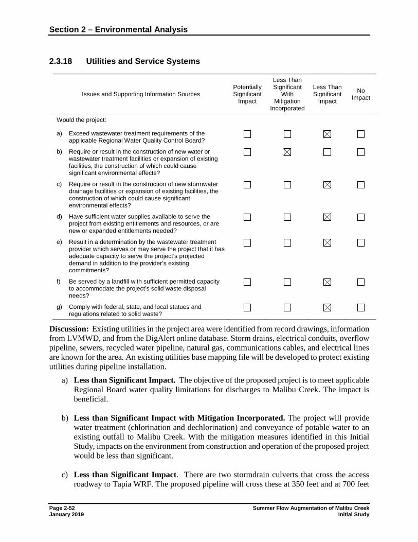
Section 2 – Environmental Analysis
Page 2-52 Summer Flow Augmentation of Malibu Creek January 2019 Initial Study
2.3.18 Utilities and Service Systems
Issues and Supporting Information Sources Potentially Significant
Impact
Less Than Significant
With Mitigation
Incorporated
Less Than Significant
Impact
No Impact
Would the project: a) Exceed wastewater treatment requirements of the
applicable Regional Water Quality Control Board?
b) Require or result in the construction of new water or wastewater treatment facilities or expansion of existing facilities, the construction of which could cause significant environmental effects?
c) Require or result in the construction of new stormwater drainage facilities or expansion of existing facilities, the construction of which could cause significant environmental effects?
d) Have sufficient water supplies available to serve the project from existing entitlements and resources, or are new or expanded entitlements needed?
e) Result in a determination by the wastewater treatment provider which serves or may serve the project that it has adequate capacity to serve the project’s projected demand in addition to the provider’s existing commitments?
f) Be served by a landfill with sufficient permitted capacity to accommodate the project’s solid waste disposal needs?
g) Comply with federal, state, and local statues and regulations related to solid waste?
Discussion: Existing utilities in the project area were identified from record drawings, information from LVMWD, and from the DigAlert online database. Storm drains, electrical conduits, overflow pipeline, sewers, recycled water pipeline, natural gas, communications cables, and electrical lines are known for the area. An existing utilities base mapping file will be developed to protect existing utilities during pipeline installation.
a) Less than Significant Impact. The objective of the proposed project is to meet applicable Regional Board water quality limitations for discharges to Malibu Creek. The impact is beneficial.
b) Less than Significant Impact with Mitigation Incorporated. The project will provide water treatment (chlorination and dechlorination) and conveyance of potable water to an existing outfall to Malibu Creek. With the mitigation measures identified in this Initial Study, impacts on the environment from construction and operation of the proposed project would be less than significant.
c) Less than Significant Impact. There are two stormdrain culverts that cross the access roadway to Tapia WRF. The proposed pipeline will cross these at 350 feet and at 700 feet
Section 2 – Environmental Analysis
Summer Flow Augmentation of Malibu Creek Page 2-53 Initial Study January 2019
from Malibu Canyon Road. Once the pipeline is installed, stormdrain infrastructure will operate as under existing conditions. The impact of the proposed project on stormdrain infrastructure would be less than significant.
d) Less than Significant Impact. The proposed project would treat up to 2.5 cfs of potable water for discharge to Malibu Creek from April 15th to November 15th. LVMWD has sufficient water supplies to meet this requirement. The project would not result in connections to new water customers or otherwise increase water demands. The impact on water supplies would be less than significant.
e) Less than Significant Impact. The project involves the modification of an existing
structure at an existing wastewater treatment facility for use as a chlorination/ dechlorination basin. The Tapia WRF has adequate capacity to treat the proposed summer augmentation flows. The impact on wastewater systems would be less than significant.
f) Less Than Significant Impact. Installation of the proposed pipeline and modification of the existing overflow structure would generate minimal waste. Limited volumes of excess soil may require disposal offsite. The disposal location will be identified by the construction contractor. Due to the limited volumes of waste and excess soil anticipated, the impact of the proposed project on solid waste would be less than significant.
g) Less than Significant Impact. The project would comply with all federal, state, and local statutes and regulations related to solid wastes. The impact is less than significant.
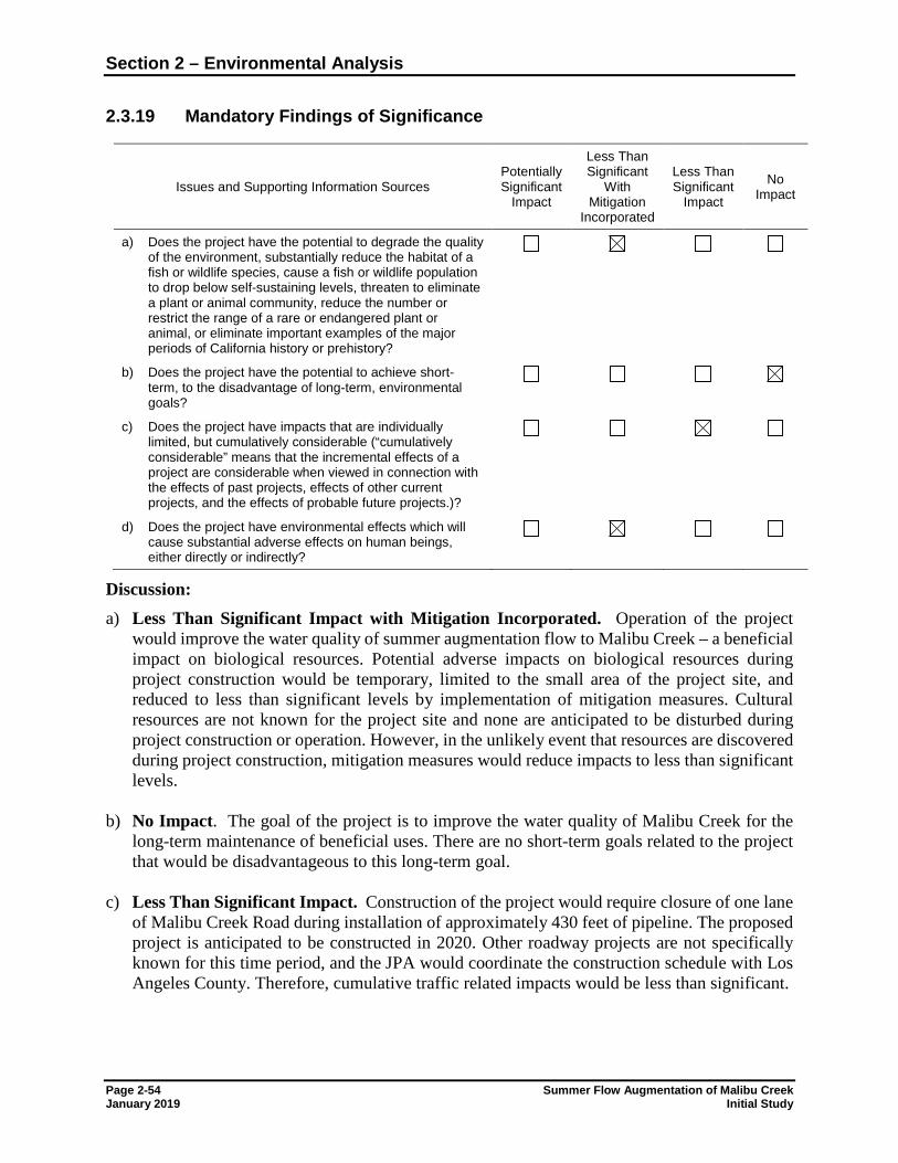
Section 2 – Environmental Analysis
Page 2-54 Summer Flow Augmentation of Malibu Creek January 2019 Initial Study
2.3.19 Mandatory Findings of Significance
Issues and Supporting Information Sources Potentially Significant
Impact
Less Than Significant
With Mitigation
Incorporated
Less Than Significant
Impact
No Impact
a) Does the project have the potential to degrade the quality of the environment, substantially reduce the habitat of a fish or wildlife species, cause a fish or wildlife population to drop below self-sustaining levels, threaten to eliminate a plant or animal community, reduce the number or restrict the range of a rare or endangered plant or animal, or eliminate important examples of the major periods of California history or prehistory?
b) Does the project have the potential to achieve short-term, to the disadvantage of long-term, environmental goals?
c) Does the project have impacts that are individually limited, but cumulatively considerable (“cumulatively considerable” means that the incremental effects of a project are considerable when viewed in connection with the effects of past projects, effects of other current projects, and the effects of probable future projects.)?
d) Does the project have environmental effects which will cause substantial adverse effects on human beings, either directly or indirectly?
Discussion: a) Less Than Significant Impact with Mitigation Incorporated. Operation of the project
would improve the water quality of summer augmentation flow to Malibu Creek – a beneficial impact on biological resources. Potential adverse impacts on biological resources during project construction would be temporary, limited to the small area of the project site, and reduced to less than significant levels by implementation of mitigation measures. Cultural resources are not known for the project site and none are anticipated to be disturbed during project construction or operation. However, in the unlikely event that resources are discovered during project construction, mitigation measures would reduce impacts to less than significant levels.
b) No Impact. The goal of the project is to improve the water quality of Malibu Creek for the
long-term maintenance of beneficial uses. There are no short-term goals related to the project that would be disadvantageous to this long-term goal.
c) Less Than Significant Impact. Construction of the project would require closure of one lane of Malibu Creek Road during installation of approximately 430 feet of pipeline. The proposed project is anticipated to be constructed in 2020. Other roadway projects are not specifically known for this time period, and the JPA would coordinate the construction schedule with Los Angeles County. Therefore, cumulative traffic related impacts would be less than significant.
Section 2 – Environmental Analysis
Summer Flow Augmentation of Malibu Creek Page 2-55 Initial Study January 2019
Since the proposed project would generate only minor air pollutant emissions during construction, and negligible emissions during operations, the project would have a less than significant cumulative impact on GHG emissions.
d) Less Than Significant Impact with Mitigation Incorporated. The goal of the project is to improve the water quality of summer augmentation flow to Malibu Creek – a beneficial impact on biological resources. Improvements to the habitat of the creek would improve recreation beneficial uses of the surface water, a beneficial impact on human beings. Temporary traffic and noise impacts during construction would be reduced to less than significant levels by implementation of mitigation measures.
Summer Flow Augmentation of Malibu Creek Page 3-1 Initial Study January 2019
Section 3 References, Abbreviations and
Report Preparation 3.1 REFERENCES AND BIBLIOGRAPHY
Baldwin, K.P. 1996. A history of Channel Islands archaeology. Unpublished Master's thesis. Department of Anthropology, California State University, Northridge.
Bean, L.J. and C.R. Smith. 1978. Gabrielino in Handbook of North American Indians, Volume
8. California, volume edited by Robert F. Heizer, pp. 538-549 (W. T. Sturtevant, general editor). Smithsonian Institution, Washington, D.C.
California Air Resources Board (CARB). 2008. Climate Change Scoping Plan. Adopted
December 12, 2008. California Department of Conservation. 2018. Division of Mine Reclamation. Mines Online.
Accessed October 16, 2018. Available: https://maps.conservation.ca.gov/mol/index.html California Department of Conservation. 2017. Division of Land Resource Protection Farmland
Mapping and Monitoring Program. Map of Important Farmland in California, 2006. Available: ftp://ftp.consrv.ca.gov/pub/dlrp/FMMP/pdf/statewide/2006/
-----. 2017. Williamson Act Program - Reports and Statistics. Available:
http://www.conservation.ca.gov/dlrp/lca/stats_reports/Pages/index.aspx California Department of Toxic Substances and Control (DTSC). 2018. Hazardous waste and
substances sites (EnviroStor) database. Accessed October 17, 2018. Available: http://www.dtsc.ca.gov/SiteCleanup/Cortese_List.cfm
California Department of Transportation (Caltrans). 2018. Eligible (E) and Officially Designated
(OD) Scenic Highways. Accessed October 16, 2018. Available: http://www.dot.ca.gov/hq/LandArch/scenic/cahisys4.htm
Cal EPA. 2009. Sites identified with waste constituents above hazardous waste levels outside the
waste management unit. Available: http://www.calepa.ca.gov/SiteCleanup/CorteseList/CurrentList.pdf
California Geological Survey. 2007. Fault-Rupture Hazard Zones in California. Special
Publication 42. Alquist-Priolo Earthquake Fault Zoning Act with Index to Earthquake Fault Zones Maps. by W.A. Bryant and E.W. Hart. Available: http://www.conservation.ca.gov/cgs/rghm/ap/Map_index/Pages/F4I.aspx
Section 3 – References, Abbreviations and Report Preparation
Page 3-2 Summer Flow Augmentation of Malibu Creek January 2019 Initial Study
California, State of. 2001. Seismic Hazard Zones, Official Map, Malibu Beach Quadrangle, dated October 17, 2001.
California State Water Resources Control Board. 2009. Leaking Underground Storage Tank Sites
Database (Geotracker). Available: https://geotracker.waterboards.ca.gov/sites_by_county.asp
Canter, Larry W. 1977. Environmental Impact Assessment. Chapter 6. Impacts on the Noise
Environment. McGraw-Hill, New York. Converse Consultants. 2012. Geotechnical Study Report Ammonia Station Tapia Water
Reclamation Facility Las Virgenes Municipal Water District. Project No. 11-31-349-01. Erlandson, John. 1994. California's Coastal Prehistory: A Circum-Pacific Perspective.
Proceedings from the Society of California Archaeology, Vol. 6: 23-36. Federal Emergency Management Agency (FEMA). 2008. Flood insurance rate map
06037C1529F, Los Angeles County, California. Effective September 26, 2008. Federal Transportation Authority. 1995. FTA Guidance Manual – Transit Noise and Vibration
Impact Assessment. Available: http://www.hmmh.com. Grant, Campbell. 1978. Chumash: Introduction. In Handbook of North American Indians,
Volume 8 California. R. F. Heizer (ed.): 505-508. Washington DC: Smithsonian Institute Press.
Harvey, Victoria. 2000. Cemetery Tales: Six Prehistoric Human Burials from CA-KER-303,
Western Mojave Desert, California. Paper presented at the 2000 Annual Meeting for the Society for California Archaeology, Riverside, and on-file with the author.
Hook, Eileen M. and Robert G. Hare. 1993. Malibu Creek State Park Day-Use and Campground
Areas Interpretive Plan and Research Package. Report #LA-03505, on file at the SCCIC, California State University, Fullerton.
Kelly, John. H. 1981. The Following Is an Evaluation of Cultural Resources Near the Proposed
Fill Zone at Malibu Creek State Park. Report # LA-03764, on file at the SCCIC, California State University, Fullerton.
King, Chester. 2006. Archaeological Assessment of King Gillette Ranch, Los Angeles County,
California. Report # LA-07576, on file at the SCCIC, California State University, Fullerton.
-----. 2010. Archaeological Report of Monitoring of the 24" Recycled Water Pipeline from Tapia Park to Mulholland Highway, Los Angeles County, California. Report # LA-10740, on file at the SCCIC, California State University, Fullerton.
Kroeber, A.L. 1976. Handbook of the Indians of California. Dover Publications, Inc., New York.
Reprint of 1925 book.
Section 3 – References, Abbreviations and Report Preparation
Summer Flow Augmentation of Malibu Creek Page 3-3 Initial Study January 2019
Los Angeles, County of. 2018. LA County Bikeways Map. Available:
http://dpw.lacounty.gov/pdd/bike/map.cfm -----. 2014a. Department of Regional Planning. General Plan 2035. Flood Zone Hazards Policy
Map. Available: http://planning.lacounty.gov/assets/upl/project/gp_2035_2014-FIG_12- 2_flood_zones.pdf
-----. 2014b. Department of Regional Planning. SEA Program. Available:
http://planning.lacounty.gov/sea/ 2014c. Santa Monica Mountains Land Use Plan. A Component of the Santa Monica Mountains
Local Coastal Program. Adopted 2014. Available: http://planning.lacounty.gov/assets/upl/project/coastal_adopted-LUP.pdf
-----. 2014d. Santa Monica Mountains Local Implementation Plan. A Component of the Santa
Monica Mountains Local Coastal Program. Adopted 2014. Available: http://planning.lacounty.gov/assets/upl/project/coastal_adopted-LIP.pdf
Los Angeles Regional Water Quality Control Board (RWQCB). 1996. Water Quality Assessment
and Documentation. -----. 2014. Water Quality Control Plan: Los Angeles Region Basin Plan for the Coastal
Watersheds of Los Angeles and Ventura Counties. As amended. Available: https://www.waterboards.ca.gov/losangeles/water_issues/programs/basin_plan/
McCawley, William. 1996. First Angelinos: the Gabrielino Indians of Los Angeles. Malki
Museum Press/Ballena Press, Banning, California. Moratto, Michael J. 1984. California Archaeology. Academic Press. Sawyer, J.O., T. Keeler-Wolf and J.M. Evens. 2009. Manual of California Vegetation, Second
Edition. California. South Coast Air Quality Management District (SCAQMD). 2017. Final 2016 Air Quality
Management Plan. March 2017. Available: http://www.aqmd.gov/docs/default-source/clean-air-plans/air-quality-management-plans/2016-air-quality-management-plan/final-2016-aqmp/final2016aqmp.pdf?sfvrsn=15
-----. 2010. Minutes for the GHG CEQA Significance Threshold Stakeholder Working Group
#15. September 28, 2010. Available: http://www.aqmd.gov/docs/default-source/ceqa/handbook/greenhouse-gases-(ghg)-ceqa-significance-thresholds/year-2008-2009/ghg-meeting-15/ghg-meeting-15-minutes.pdf?sfvrsn=2
Section 3 – References, Abbreviations and Report Preparation
Page 3-4 Summer Flow Augmentation of Malibu Creek January 2019 Initial Study
-----. 2009. Localized Significance Thresholds. Available: http://www.aqmd.gov/home/regulations/ceqa/air-quality-analysis-handbook/localized-significance-thresholds
-----. 2008b. Draft Guidance Document – Interim CEQA Greenhouse Gas (GHG) Significance
Threshold. October 2008. Available: http://www.aqmd.gov/docs/default-source/ceqa/handbook/greenhouse-gases-(ghg)-ceqa-significance-thresholds/year-2008-2009/ghg-meeting-6/ghg-meeting-6-guidance-document-discussion.pdf
-----. 2007a. EMFAC2007 v. 2.3 Emission Factors for On-Road PV & DT. Scenario Year 2018 -----. 2007b. SCAB Fleet Average Emission Factors (Diesel). Scenario year 2020. -----. 2007. OFFROAD Emission Factors.
Available: http://www.aqmd.gov/ceqa/handbook/offroad/offroad.html. -----. 2006. Final Methodology to Calculate Particulate Matter (PM) 2.5 and PM 2.5 Significance
Thresholds. October. -----. 1993. CEQA Air Quality Handbook, revised 2006. Stantec. 2018a. Compliance Method Study. April 2018. Prepared for Las Virgenes – Triunfo
Joint Powers Authority. -----. 2018b. Biological Resources Technical Report Summer Flow Augmentation of Malibu
Creek. Prepared for Las Virgenes – Triunfo Joint Powers Authority. October 2018. -----. 2018c. Cultural Resources Evaluation for the Summer Flow Augmentation of Malibu Creek.
Prepared for Las Virgenes – Triunfo Joint Powers Authority. August 2018. -----. 2016. Treatment and operations scenarios for meeting lower nutrient discharge limits for
the augmentation flow to Malibu Creek. Technical Memorandum prepared for Las Virgenes – Triunfo Joint Powers Authority.
Tejada, Barbara S. 2016. Cultural Resources Survey Report for the Malibu Creek Ecosystem
Restoration Study, Los Angeles and Ventura Counties. Appendix K in the Malibu Creek Ecosystem Restoration Study Draft Integrated Feasibility Report (IFR) with Environmental Impact Statement/Environmental Impact Report (EIR/EIS), Los Angeles and Ventura Counties. Report on file at https://usace.contentdm.oclc.org. Site accessed June 22, 2018.
United States Environmental Protection Agency (USEPA). 2013. Malibu Creek and Lagoon
Sedimentation and Nutrients TMDL to Address Benthic Community Impairments. -----. 2003. Total Maximum Daily Loads for Nutrients Malibu Creek Watershed. Region 9.
Available:
Section 3 – References, Abbreviations and Report Preparation
Summer Flow Augmentation of Malibu Creek Page 3-5 Initial Study January 2019
https://www.waterboards.ca.gov/losangeles/water_issues/programs/tmdl/Established/Malibu%20Creek%20Nutrient%20TMDL/final_nutrients.pdf
-----. 1971. Noise from Construction Equipment and Operations, Building Equipment, and Home
Appliances. NTID300.1. December 31, 1971.
Section 3 – References, Abbreviations and Report Preparation
Page 3-6 Summer Flow Augmentation of Malibu Creek January 2019 Initial Study
3.2 ACRONYMS AND ABBREVIATIONS
AB Assembly Bill AQMP Air Quality Management Plan BAT Best Available Technology BMPs Best Management Practices BRM Bedrock Mortar Milling Station Cal/EPA California Environmental Protection Agency CARB California Air Resources Board CCR California Code of Regulations CDC California Department of Conservation CDFW California Department of Fish and Wildlife CEQA California Environmental Quality Act cfs cubic feet per second CFR Code of Federal Regulations CH4 methane CMLC cement mortar lined and coated CNDDB California Natural Diversity Database CNEL Community Noise Equivalent Level CNPS California Native Plant Society CO carbon monoxide CO2e carbon dioxide equivalent CRHR California Register of Historical Resources dBA Decibel, A-weighted scale DPR Department of Parks and Recreation DTSC Department of Toxic Substances Control EIR Environmental Impact Report ERB Environmental Review Board F Fahrenheit Farmland Prime Farmland, Unique Farmland, or Farmland of Statewide Importance FEMA Federal Emergency Management Agency FGC Fish and Game Code
Section 3 – References, Abbreviations and Report Preparation
Summer Flow Augmentation of Malibu Creek Page 3-7 Initial Study January 2019
FMMP Farmland Mapping and Monitoring Program FTBMI Fernandeño Tataviam Band of Mission Indians GHG Greenhouse Gas I Institutional IS Initial Study ISA International Society of Arboriculture ISE ion selective electrode JPA Joint Powers Authority LACDPW Los Angeles County Department of Public Works LCP Local Coastal Program Ldn Day-Night Average Sound Level LIP Local Implementation Program LST Localized Significance Threshold LUP Land Use Plan LUST Leaking Underground Storage Tank LVMWD Las Virgenes Municipal Water District MBTA Migratory Bird Treaty Act mgd million gallons per day mg/L milligrams per liter MLD Most Likely Descendant MND Mitigated Negative Declaration MT metric tons NAAQS National Ambient Air Quality Standards NAHC Native American Heritage Commission NO2 nitrogen dioxide NO3 nitrate N2O nitrous oxide NPDES National Pollutant Discharge Elimination System NRHP National Register of Historic Places OHP Office of Historic Preservation O-S Open Space O-S-P Open Space Parks
Section 3 – References, Abbreviations and Report Preparation
Page 3-8 Summer Flow Augmentation of Malibu Creek January 2019 Initial Study
OSHA Occupational Safety and Health Administration OWCMP (Los Angeles County) Oak Woodlands Conservation Management Plan PLC Programmable Logic Controller PM10 particulate matter 10 microns or less in diameter PM2.5 particulate matter 2.5 microns or less in diameter PRC Public Resources Code PS Public and Semi-Public RS Residential, Single-Family RWQCB Regional Water Quality Control Board SCAB South Coast Air Basin SCADA Supervisory Control and Data Acquisition SCAQMD South Coast Air Quality Management District SCCIC South Central Coastal Information Center SEA Significant Ecological Area SERA Significant Environmental Resource Area SMM Santa Monica Mountains SO2 sulfur dioxide SOx sulfur oxides SWRCB State Water Resources Control Board TAC Toxic Air Contaminants
TMDL Total Maximum Daily Load
TN total nitrogen
TNW Traditionally Navigable Water
TP total phosphorus
USEPA United States Environmental Protection Agency USGS United States Geological Survey USFWS United States Fish and Wildlife Service VOC volatile organic compound WEEP Worker Environmental Education Program WLA Waste Load Allocation WQO Water Quality Objective WRF Water Reclamation Facility
Section 3 – References, Abbreviations and Report Preparation
Summer Flow Augmentation of Malibu Creek Page 3-9 Initial Study January 2019
3.3 PREPARERS OF THE INITIAL STUDY
Las Virgenes – Triunfo Joint Powers Authority 4232 Las Virgenes Road Calabasas, California 91302-1994 TECHNICAL ASSISTANCE PROVIDED BY: Stantec Consulting Services Inc. Sarah Garber, PMP, CPP, CEQA Documentation Jared Varonin, Biologist Rocky Brown, Biologist Victoria Harvey, Archaeologist Hubert Switalski, Cultural Resources Assessment
Appendix A Biological Resources Technical Report
Biological Resources Technical Report Summer Flow Augmentation of Malibu Creek
October 30, 2018
Prepared for: Las Virgenes – Triunfo Joint Powers Authority 4232 Las Virgenes Road Calabasas, CA 91302-1994 Prepared by: Stantec Consulting Services Inc. 290 Conejo Ridge Avenue Thousand Oaks, CA 91361

Sign-off Sheet
This document entitled Biological Resources Technical Report, for the Summer Flow Augmentation of Malibu Creek, was prepared by Stantec Consulting Services Inc. (“Stantec”) for the account of Las Virgenes – Triunfo Joint Powers Authority (the “Client”). Any reliance on this document by any third party is strictly prohibited. The material in it reflects Stantec’s professional judgment in light of the scope, schedule and other limitations stated in the document and in the contract between Stantec and the Client. The opinions in the document are based on conditions and information existing at the time the document was published and do not take into account any subsequent changes. In preparing the document, Stantec did not verify information supplied to it by others. Any use which a third party makes of this document is the responsibility of such third party. Such third party agrees that Stantec shall not be responsible for costs or damages of any kind, if any, suffered by it or any other third party as a result of decisions made or actions taken based on this document.
Prepared by
(signature)
Rocky Brown, Associate Biologist
Reviewed by
(signature)
Laura Butler, Staff Biologist
Approved by
(signature)
Jared Varonin, Principal Biologist
BIOLOGICAL RESOURCES TECHNICAL REPORT SUMMER FLOW AUGMENTATION OF MALIBU CREEK
i
Table of Contents
ACRONYMS ..............................................................................................................................iii
1.0 INTRODUCTION ............................................................................................................ 1 1.1 PROJECT DESCRIPTION ............................................................................................. 1
2.0 METHODOLOGIES ........................................................................................................ 1 2.1 LITERATURE REVIEW .................................................................................................. 2 2.2 BIOLOGICAL SURVEYS AND HABITAT ASSESSMENTS ............................................ 2
2.2.1 Wildlife ........................................................................................................... 3 2.2.2 Special-Status Plants ..................................................................................... 3 2.2.3 Vegetation Mapping ....................................................................................... 3
3.0 REGULATORY ENVIRONMENT ................................................................................... 4 3.1 FEDERAL REGULATIONS ............................................................................................ 4
3.1.1 Federal Endangered Species Act ................................................................... 4 3.1.2 Migratory Bird Treaty Act ................................................................................ 5 3.1.3 Bald and Golden Eagle Protection Act of 1940 (16 USC 668) ........................ 5 3.1.4 Federally Regulated Habitats ......................................................................... 5 3.1.5 National Environmental Policy Act .................................................................. 6
3.2 STATE REGULATIONS ................................................................................................. 6 3.2.1 California Environmental Quality Act .............................................................. 6 3.2.2 California Endangered Species Act ................................................................ 6 3.2.3 Native Plant Protection Act (Fish & Game Code 1900-1913).......................... 7 3.2.4 Section 3503 & 3503.5 of the Fish and Game Code ....................................... 7 3.2.5 Porter-Cologne Water Quality Control Act ...................................................... 7 3.2.6 State-Regulated Habitats ............................................................................... 7 3.2.7 California Coastal Act ..................................................................................... 8
3.3 OTHER APPLICABLE REGULATIONS, PLANS, AND STANDARDS ............................ 9 3.3.1 California Native Plant Society Rare Plant Program ....................................... 9 3.3.2 County of Los Angeles Oak Tree Ordinances .............................................. 10 3.3.3 County of Los Angeles Significant Ecological Areas ..................................... 11
4.0 EXISTING CONDITIONS ..............................................................................................11 4.1 SETTING .......................................................................................................................11 4.2 GENERAL VEGETATION AND LAND COVERS ...........................................................11
4.2.1 Vegetation Communities and Land Cover Types.......................................... 11 4.2.2 Common Plant Species Observed................................................................ 13 4.2.3 Jurisdictional Waters/Wetlands .................................................................... 14
4.3 COMMON WILDLIFE ....................................................................................................15
5.0 SPECIAL-STATUS SPECIES .......................................................................................17 5.1 SPECIAL-STATUS NATURAL COMMUNITIES ............................................................18 5.2 DESIGNATED CRITICAL HABITAT ..............................................................................18 5.3 SPECIAL-STATUS PLANTS .........................................................................................18 5.4 SPECIAL-STATUS WILDLIFE .......................................................................................24
BIOLOGICAL RESOURCES TECHNICAL REPORT SUMMER FLOW AUGMENTATION OF MALIBU CREEK
ii
5.5 WILDLIFE CORRIDORS AND SPECIAL LINKAGES ....................................................34 5.5.1 Wildlife Movement in the Project Site ........................................................... 35
6.0 PROJECT IMPACTS AND AVOIDANCE AND MINIMIZATION MEASURES ...............35 6.1 PROJECT IMPACTS .....................................................................................................35
6.1.1 Native Vegetation and Trees ........................................................................ 35 6.1.2 Wildlife ......................................................................................................... 36
6.2 AVOIDANCE AND MINIMIZATION MEASURES ...........................................................36 6.2.1 Avoidance and Minimization Measure 1 - Implement BMPs ......................... 36 6.2.2 Avoidance and Minimization Measure 2 - Implement a Worker
Environmental Education Program ............................................................... 37 6.2.3 Avoidance and Minimization Measure 3 - Pre-Construction Surveys
(Plants and Wildlife) and Biological Monitoring ............................................. 37 6.2.4 Avoidance and Minimization Measure 4 - Nesting Bird Surveys and
Avoidance Measures .................................................................................... 38 6.2.5 Avoidance and Minimization Measure 5 – Oak and Other Native Tree
Avoidance Measures .................................................................................... 39
7.0 REFERENCES ..............................................................................................................40
LIST OF APPENDICES
APPENDIX A FIGURES ................................................................................................... A.1
APPENDIX B PHOTOGRAPHIC LOG ............................................................................. B.1
BIOLOGICAL RESOURCES TECHNICAL REPORT SUMMER FLOW AUGMENTATION OF MALIBU CREEK
October 30, 2018
iii
Acronyms
BMP
CCH
CDFW
CEQA
CNDDB
CNPS
CRPR
CWA
ESA
gpm
ISA
LCP
LVMWD
MBTA
NEPA
NPPA
OWCMP
RWQCB
SEA
SERA
SMM LCP
TNW
Best Management Practice
Consortium of California Herbaria
California Department of Fish and Wildlife
California Environmental Quality Act
California Natural Diversity Database
California Native Plant Society
California Rare Plant Rank
Clean Water Act
Endangered Species Act
gallons per minute
International Society of Arboriculture
Local Coastal Program
Las Virgenes Municipal Water District
Migratory Bird Treaty Act
National Environmental Policy Act
Native Plant Protection Act
Oak Woodlands Conservation Management Plan
Regional Water Quality Control Board
Significant Ecological Area
Sensitive Environmental Resource Area
Santa Monica Mountains Local Coastal Program
Traditionally Navigable Water
BIOLOGICAL RESOURCES TECHNICAL REPORT SUMMER FLOW AUGMENTATION OF MALIBU CREEK
October 30, 2018
iv
USACE
USFWS
USGS
WDR
WEEP
WRF
United States Army Corps of Engineers
United States Fish & Wildlife Service
United States Geological Survey
Waste Discharge Requirements
Worker Environmental Education Program
Water Reclamation Facility
BIOLOGICAL RESOURCES TECHNICAL REPORT SUMMER FLOW AUGMENTATION OF MALIBU CREEK
October 30, 2018
1
1.0 INTRODUCTION
This report is intended to document the biological resources that occur at the Project Site for the Las Virgenes – Triunfo Joint Powers Authority’s proposed Summer Flow Augmentation of Malibu Creek at the Las Virgenes Municipal Water District’s (LVMWD) Tapia Water Reclamation Facility (Tapia WRF). The Project Site is along Malibu Canyon Road and the Tapia WRF access road in unincorporated Los Angeles County, California (refer to Appendix A, Figure 1). The surveys and discussions presented in this report were conducted/prepared to support California Environmental Quality Act (CEQA) analysis and associated documentation. The entrance to the Tapia WRF is located at 731 Malibu Canyon Road, approximately 0.09 mile south of Piuma Road, and the Project Site encompasses the entry access road (between Malibu Canyon Road and the facility gate) and the section of Malibu Canyon Road between the facility entrance and Piuma Road (refer to Appendix A, Figure 2).
1.1 PROJECT DESCRIPTION
The Las Virgenes -Triunfo Joint Powers Authority owns and operates the Tapia WRF. The discharge permit for Tapia WRF requires a minimum of 2.5 cubic feet per second constant flow in Malibu Creek and requires that the LVMWD supplement the creek flow as needed during the summer (April 15th – November 15th) to maintain this flow level. New, more stringent nutrient requirements have been implemented as the Total Maximum Daily Loads for nutrients in the Malibu Creek Watershed by the United States Environmental Protection Agency, Region 9. These limits will go into effect for Tapia WRF discharges on May 16, 2022. The use of potable water with ammonia removal is the preferred alternative to meet the Malibu Creek summer augmentation discharge requirements.
This summer flow augmentation project is composed of two components: conveyance of potable water to Tapia WRF, and facilities for ammonia removal at Tapia WRF prior to discharge to Malibu Creek. LVMWD plans to install a new 8-inch potable water line extending from the existing 20-inch pipeline at the intersection of Las Virgenes Road and Piuma Road, routed along Las Virgenes Road/Malibu Canyon Road across the bridge over Malibu Creek, and along the entrance roadway to Tapia WRF. The pipeline will be constructed via open trench along the roadways and will be mounted on the underside of the bridge to cross over Malibu Creek. At Tapia WRF, the potable water will be treated to remove the ammonia from the water through chlorination, followed by dechlorination, and then the existing outfall at the WRF will be used to discharge flows to Malibu Creek. This will involve modifications and reuse of the existing overflow structure and chemical feed facilities at Tapia WRF. New water quality monitoring and controls will prevent the water from being discharged to Malibu Creek if the system does not meet water quality requirements. When completed, the project will enable the augmentation of summer flows to Malibu Creek that meet discharge requirements.
2.0 METHODOLOGIES
Stantec biologists conducted a survey for biological resources and habitat assessment within and immediately adjacent to the Project Site on June 20, 2018. The study area was defined as a corridor sufficiently wide to encompass all potential areas of project disturbance for pipeline installation. The area of the Project Site encompasses 2.45 acres, with elevations in the study area ranging from approximately 450 to 475 feet above mean sea level. Since improvements at the WRF will be implemented at an existing process unit, no area within the treatment plant boundary is considered
BIOLOGICAL RESOURCES TECHNICAL REPORT SUMMER FLOW AUGMENTATION OF MALIBU CREEK
October 30, 2018
2
as part of the Project Site for biological resources review. Surveys were conducted by Stantec Principal Biologist Jared Varonin and Associate Biologist Rocky Brown. This included, but was not limited to, a literature review, reconnaissance-level survey, focused non-protocol surveys for special-status plant and wildlife species, non-protocol focused surveys for listed song birds, and preliminary jurisdictional delineation. Surveys were conducted on foot within the Project Site where accessible based on terrain and vegetative cover.
2.1 LITERATURE REVIEW
A literature search was performed in conjunction with field surveys conducted for the Project Site. The Project Site is located within the U.S. Geological Survey’s (USGS) Malibu Beach, California, 7.5-minute topographic quadrangle. A search of the California Department of Fish and Wildlife (CDFW) California Natural Diversity Database (CNDDB) was conducted for this quadrangle to determine special-status plants, wildlife, and vegetation communities that have been documented within the vicinity of the Project Site (CDFW, 2018a). The following five adjacent quadrangles were also included in the database search due to their proximity to the Project Site (note: due to the Project’s proximity to the coastline, no quadrangles occur to the south):
• Thousand Oaks • Point Dume • Calabasas • Topanga • Canoga Park
Additional data regarding the potential occurrence of special-status species and policies relating to these special-status natural resources were gathered from the following sources:
• State and federally listed endangered and threatened animals of California (CDFW, 2018b); • Special Animals List (CDFW, 2018c); • Inventory of Rare and Endangered Vascular Plants of California (CNPS, 2018); and • Consortium of California Herbaria (CCH, 2018).
2.2 BIOLOGICAL SURVEYS AND HABITAT ASSESSMENTS
In order to document the existing biological resources that are present in the Project Site, on June 20, 2018, Stantec conducted a habitat assessment and reconnaissance-level survey, focused non-protocol surveys for special-status plant and wildlife species, a non-protocol focused survey for listed song birds, and a preliminary jurisdictional delineation. The primary goals of wildlife surveys were to identify and assess habitat capable of supporting special-status wildlife species and/or to document the presence/absence of special-status wildlife species. To the extent possible, surveys were conducted when special-status plant species would be in bloom or identifiable, migratory birds were present at the Project Site, resident bird species were nesting and fledging, small mammals were present and active, and above-ground amphibian and reptile movement would be detectable. However, it is acknowledged that some wildlife species and/or individuals may have been difficult to detect due to their elusive nature, cryptic morphology, or nocturnal behavior.
The Project Site was investigated on foot by experienced field biologists. Species present were identified and recorded through direct visual observation, sound, or their sign (e.g., scat, tracks, etc.). Where necessary, samples of selected plant species were taken to the laboratory and identified microscopically or in consultation with a local herbarium. Species identifications conform to the most up-to-date field guides and technical literature.
BIOLOGICAL RESOURCES TECHNICAL REPORT SUMMER FLOW AUGMENTATION OF MALIBU CREEK
October 30, 2018
3
2.2.1 Wildlife
A reconnaissance-level survey was performed by walking meandering transects through the entirety of the Project Site at an average pace of approximately 1.5 km/hr while visually searching for and listening to wildlife songs and calls and observing for animal signs. The walking survey was halted approximately every 50 meters to listen for wildlife or as necessary to identify, record, or enumerate any other detected species. Table 4 (Section 5.4) lists special-status wildlife species that have the potential to occur in the Project Area.
Terrestrial insects and other invertebrates were searched for on flowers and leaves, under loose bark, and under stones and logs on the ground throughout the Project Site. Randomly selected areas within appropriate micro habitats (e.g., leaf litter, underneath felled logs, etc.) were hand raked or visually inspected to determine the presence/absence of gastropods.
Surveys were conducted during daylight hours when temperatures were such that reptiles would be active (i.e., between 75° – 95° Fahrenheit). Visual observations were made to locate basking reptiles, and potential refuge areas, such as debris piles (e.g., woody debris, trash, etc.), were searched. All refugia sites search were returned to their original state upon survey completion.
2.2.2 Special-Status Plants
Before the field survey, Stantec reviewed available literature to identify special-status plants or natural communities known from the Project Site and vicinity. Database queries included a CNDDB search (CDFW 2018a) of the Malibu Beach and five surrounding USGS topographic quadrangles and the California Native Plant Society's Inventory of Rare and Endangered Vascular Plants of California (CNPS, 2018) for the same six quadrangles. Table 3 (Section 5.3) lists special-status plant species that have a potential to occur in the Project Site.
The entire Project Site was assessed by walking “meandering transects” (Nelson, 1987) throughout all accessible portions, with particular attention given to areas of suitable habitat for special-status plant species. All plant species observed were identified in the field or collected for later identification. Plants were identified using keys, descriptions, and illustrations in Baldwin et al. (2012), applicable volumes of the Flora of North America (1993+), and other regional references. All species identified during the survey are listed in Section 4.3.2. In conformance with CDFW protocols (2009), surveys were (a) floristic in nature, (b) consistent with conservation ethics, (c) systematically covered all habitat types on the sites, and (d) well documented by this report and by voucher specimens to be deposited at Rancho Santa Ana Botanic Garden. No specimens were vouchered as a result of the surveys described in this report.
2.2.3 Vegetation Mapping
Vegetation descriptions and names are based on Sawyer et al. (2009) and have been defined at least to the alliance level. Vegetation maps were prepared by drawing tentative vegetation type boundaries onto high-resolution aerial images while in the field, then digitizing these polygons into GIS. Mapping was done electronically using ArcGIS (version 10.4) with aerial photos with an accuracy of 1 foot. Most boundaries shown on the maps are accurate within approximately 3 feet; however, boundaries between some vegetation types are less precise due to difficulties interpreting aerial imagery and accessing stands of vegetation.

BIOLOGICAL RESOURCES TECHNICAL REPORT SUMMER FLOW AUGMENTATION OF MALIBU CREEK
October 30, 2018
4
Vegetation communities can overlap in many characteristics and over time may shift from one community type to another. Note also that all vegetation maps and descriptions are subject to variability for the following reasons:
• In some cases, vegetation boundaries result from distinct events, such as wildfire or flooding, but vegetation types usually tend to intergrade on the landscape, without precise boundaries between them. Even distinct boundaries caused by fire or flood can be disguised after years of post-disturbance succession. Mapped boundaries represent best professional judgment, but usually should not be interpreted as literal delineations between sharply defined vegetation types.
• Natural vegetation tends to exist in generally recognizable types, but also may vary over time and geographic region. Written descriptions cannot reflect all local or regional variation. Many (perhaps most) stands of natural vegetation do not strictly fit into any named type. Therefore, a mapped unit is given the best name available in the classification system being used, but this name does not imply that the vegetation unambiguously matches written descriptions.
• Vegetation tends to be patchy. Small patches of one named type are often included within larger stands mapped as units of another type. For this Study Area, the minimum mapping unit was approximately 3 feet, and smaller inclusions are described in the text but are not visible on the maps.
3.0 REGULATORY ENVIRONMENT
3.1 FEDERAL REGULATIONS
3.1.1 Federal Endangered Species Act
Federal Endangered Species Act (ESA) provisions protect federally listed threatened and endangered species and their habitats from unlawful take and ensure that federal actions do not jeopardize the continued existence of a listed species or result in the destruction or adverse modification of designated critical habitat. Under the ESA, “take” is defined as “to harass, harm, pursue, hunt, shoot, wound, kill, trap, capture, or collect, or to attempt to engage in any of the specifically enumerated conduct.” The U.S. Fish & Wildlife Service’s (USFWS) regulations define harm to mean “an act which actually kills or injures wildlife.” Such an act “may include significant habitat modification or degradation where it actually kills or injures wildlife by significantly impairing essential behavioral patterns, including breeding, feeding or sheltering” (50 CFR § 17.3). Critical habitat is defined in Section 3(5)(A) of the ESA as “(i) the specific areas within the geographical area occupied by the species on which are found those physical or biological features (I) essential to the conservation of the species, and (II) which may require special management considerations or protection; and (ii) specific areas outside the geographical area occupied by the species upon a determination by the Secretary of Commerce or the Secretary of the Interior (Secretary) that such areas are essential for the conservation of the species.” The effects analyses for designated critical habitat must consider the role of the critical habitat in both the continued survival and the eventual recovery (i.e., the conservation) of the species in question, consistent with the Ninth Circuit judicial opinion, Gifford Pinchot Task Force v. USFWS. Activities that may result in “take” of individuals are regulated by the USFWS. The USFWS produced an updated list of candidate species December 6, 2007 (72 FR 69034). Candidate species are not afforded any legal protection under ESA; however, candidate species typically receive special attention from Federal and State agencies during the environmental review process.
BIOLOGICAL RESOURCES TECHNICAL REPORT SUMMER FLOW AUGMENTATION OF MALIBU CREEK
October 30, 2018
5
3.1.2 Migratory Bird Treaty Act
The Migratory Bird Treaty Act (MBTA) of 1918 (16 U.S.C. 703-711) makes it unlawful to possess, buy, sell, purchase, barter or “take” any migratory bird listed in Title 50 of the Code of Federal Regulations Part 10. “Take” is defined as possession or destruction of migratory birds, their nests or eggs. Disturbances that cause nest abandonment and/or loss of reproductive effort or the loss of habitats upon which these birds depend may be a violation of the MBTA. The MBTA prohibits killing, possessing, or trading in migratory birds except in accordance with regulations prescribed by the Secretary. This act encompasses whole birds, parts of birds, and bird nests and eggs.
3.1.3 Bald and Golden Eagle Protection Act of 1940 (16 USC 668)
The Bald Eagle Protection Act of 1940 (16 U.S.C. 668, enacted by 54 Stat. 250) protects bald and golden eagles by prohibiting the taking, possession, and commerce of such birds and establishes civil penalties for violation of this Act. Take of bald and golden eagles is defined as follows: “disturb means to agitate or bother a bald or golden eagle to a degree that causes, or is likely to cause, based on the best scientific information available, (1) injury to an eagle, (2) a decrease in its productivity, by substantially interfering with normal breeding, feeding, or sheltering behavior, or (3) nest abandonment, by substantially interfering with normal breeding, feeding, or sheltering behavior’’ (72 FR 31132; 50 CFR 22.3).
The USFWS is the primary federal authority charged with the management of golden eagles in the United States. A permit for take of golden eagles, including take from disturbance such as loss of foraging habitat, may be required for this project if such resources are affected. USFWS guidance on the applicability of current Eagle Act statutes and mitigation is currently under review. On November 10, 2009, the USFWS implemented new rules (74 FR 46835) governing the “take” of golden and bald eagles. The new rules were released under the existing Bald and Golden Eagle Act which has been the primary regulation protection unlisted eagle populations since 1940. All activities that may disturb or incidentally take an eagle or its nest as a result of an otherwise legal activity must be permitted by the USFWS under this act. The definition of disturb (72 FR 31132) includes interfering with normal breeding, feeding, or sheltering behavior to the degree that it causes or is likely to cause decreased productivity or nest abandonment. If a permit is required, due to the current uncertainty on the status of golden eagle populations in western United States, it is expected permits would only be issued for safety emergencies or if conservation measures implemented in accordance with a permit would result in a reduction of ongoing take or a net take of zero.
3.1.4 Federally Regulated Habitats
Areas meeting the regulatory definition of “Waters of the U.S.” (Jurisdictional Waters) are subject to the jurisdiction of the United States Army Corps of Engineers (USACE) under provisions of Section 404 of the Clean Water Act (CWA) (1972) and Section 10 of the Rivers and Harbors Act (1899). These waters may include all waters used, or potentially used, for interstate commerce, including all waters subject to the ebb and flow of the tide, all interstate waters, all other waters (intrastate lakes, rivers, streams, mudflats, sandflats, playa lakes, natural ponds, etc.), all impoundments of waters otherwise defined as “Waters of the U.S.,” tributaries of waters otherwise defined as “Waters of the U.S.,” the territorial seas, and wetlands (termed Special Aquatic Sites) adjacent to “Waters of the U.S.” (33 CFR, Part 328, Section 328.3). Wetlands on non-agricultural lands are identified using the Corps of Engineers Wetlands Delineation Manual (Environmental Laboratory, 1987). The Project Site falls within the South Pacific Division of the USACE and is under the jurisdiction of the Los Angeles District.
BIOLOGICAL RESOURCES TECHNICAL REPORT SUMMER FLOW AUGMENTATION OF MALIBU CREEK
October 30, 2018
6
Construction activities within jurisdictional waters are regulated by the USACE. The placement of fill into such waters must comply with permit requirements of the USACE. No USACE permit would be effective in the absence of State water quality certification pursuant to Section 401 of the CWA. As a part of the permit process, the USACE works directly with the USFWS to assess potential project impacts on biological resources.
3.1.5 National Environmental Policy Act
The National Environmental Policy Act of 1969 (NEPA) requires all Federal agencies to examine the environmental impacts of their actions, incorporate environmental information, and utilize public participation in the planning and implementation of all actions. Federal agencies must integrate NEPA with other planning requirements and prepare appropriate NEPA documents to facilitate better environmental decision making. NEPA requires Federal agencies to review and comment on Federal agency environmental plans/documents when the agency has jurisdiction by law or special expertise with respect to any environmental impacts involved (42 U.S.C. 4321- 4327) (40 CFR 1500-1508).
3.2 STATE REGULATIONS
3.2.1 California Environmental Quality Act
CEQA establishes State policy to prevent significant, avoidable damage to the environment by requiring changes in projects through the use of alternatives or mitigation measures. CEQA applies to actions directly undertaken, financed, or permitted by State lead agencies. Regulations for implementation are found in the State CEQA Guidelines published by the Resources Agency. These guidelines establish an overall process for the environmental evaluation of projects.
3.2.2 California Endangered Species Act
Provisions of the California Endangered Species Act protect State-listed Threatened and Endangered species. The CDFW regulates activities that may result in “take” of individuals (“take” means “hunt, pursue, catch, capture, or kill, or attempt to hunt, pursue, catch, capture, or kill”). Habitat degradation or modification is not expressly included in the definition of “take” under the California Fish and Game Code. Additionally, the California Fish and Game Code contains lists of vertebrate species designated as “fully protected” (California Fish & Game Code §§ 3511 [birds], 4700 [mammals], 5050 [reptiles and amphibians], 5515 [fish]). Such species may not be taken or possessed.
In addition to Federal and State-listed species, the CDFW also has produced a list of Species of Special Concern to serve as a “watch list.” Species on this list are of limited distribution or the extent of their habitats has been reduced substantially, such that threat to their populations may be imminent. Species of Special Concern may receive special attention during environmental review, but they do not have statutory protection.
Birds of prey are protected in California under the State Fish and Game Code. Section 3503.5 states it is “unlawful to take, possess, or destroy any birds of prey (in the order Falconiformes or Strigiformes) or to take, possess, or destroy the nest or eggs of any such bird except as otherwise provided by this Code or any regulation adopted pursuant thereto.” Construction disturbance during the breeding season could result in the incidental loss of fertile eggs or nestlings or otherwise lead to nest abandonment. Disturbance that causes nest abandonment and/or loss of reproductive effort is considered “take” by the CDFW. Under Sections 3503 and 3503.5 of the State Fish and Game Code, activities that would result in the taking, possessing, or destroying of any birds-of-prey, taking or possessing of any migratory nongame bird as designated in the MBTA, or the taking, possessing, or needlessly destroying of the nest or eggs of
BIOLOGICAL RESOURCES TECHNICAL REPORT SUMMER FLOW AUGMENTATION OF MALIBU CREEK
October 30, 2018
7
any raptors or non-game birds protected by the MBTA, or the taking of any non-game bird pursuant to Fish and Game Code Section 3800 are prohibited.
3.2.3 Native Plant Protection Act (Fish & Game Code 1900-1913)
California’s Native Plant Protection Act (NPPA) requires all State agencies to utilize their authority to carry out programs to conserve endangered and rare native plants. Provisions of NPPA prohibit the taking of listed plants from the wild and require notification of the CDFW at least 10 days in advance of any change in land use. This allows CDFW to salvage listed plant species that would otherwise be destroyed. The Applicant is required to conduct botanical inventories and consult with CDFW during project planning to comply with the provisions of this act and sections of CEQA that apply to rare or endangered plants.
3.2.4 Section 3503 & 3503.5 of the Fish and Game Code
Under these sections of the Fish and Game Code, the Applicant is not allowed to conduct activities that would result in the taking, possessing, or destroying of any birds-of-prey, taking or possessing of any migratory non-game bird as designated in the MBTA, or the taking, possessing, or needlessly destroying of the nest or eggs of any raptors or non-game birds protected by the MBTA, or the taking of any non-game bird pursuant to Fish and Game Code Section 3800.
3.2.5 Porter-Cologne Water Quality Control Act
Regional water quality control boards (RWQCBs) regulate the “discharge of waste” to “waters of the State.” All projects proposing to discharge waste that could affect waters of the State must file a waste discharge report with the appropriate regional board. The board responds to the report by issuing waste discharge requirements (WDR) or by waiving WDRs for that project discharge. Both of the terms “discharge of waste” and “waters of the State” are broadly defined such that discharges of waste include fill, any material resulting from human activity, or any other “discharge.” Isolated wetlands within California, which are no longer considered “waters of the United States” as defined by Section 404 of the CWA, are addressed under the Porter-Cologne Act.
3.2.6 State-Regulated Habitats
The State Water Resources Control Board is the State agency (together with the RWQCBs) charged with implementing water quality certification in California. The Project Site falls under the jurisdiction of the Los Angeles RWQCB.
The CDFW extends the definition of stream to include “intermittent and ephemeral streams, rivers, creeks, dry washes, sloughs, blue-line streams (USGS-defined), and watercourses with subsurface flows. Canals, aqueducts, irrigation ditches, and other means of water conveyance can also be considered streams if they support aquatic life, riparian vegetation, or stream-dependent terrestrial wildlife” (CDFW, 1994).
Activities that result in the diversion or obstruction of the natural flow of a stream; or which substantially change its bed, channel, or bank; or which utilize any materials (including vegetation) from the streambed, may require that the project Applicant enter into a Streambed Alteration Agreement with the CDFW.
BIOLOGICAL RESOURCES TECHNICAL REPORT SUMMER FLOW AUGMENTATION OF MALIBU CREEK
October 30, 2018
8
3.2.7 California Coastal Act
The California Coastal Act of 1976 was borne out of the Coastal Conservation Initiative, passed in 1972 by California voters concerned about coastal development and its impact on public access and coastal resources. This initiative resulted in the creation of the Coastal Commission and, four years after the initiative was passed, the State Legislature enacted the Coastal Act. The act is designed to balance the right to develop with strict policies to protect resources.
The Coastal Zone encompasses 1.5 million acres of land along the length of the 1,100-mile California coastline and stretches from 3 miles at sea to an inland boundary that varies from several blocks in urban areas to as much as 5 miles inland in less developed areas. It also includes 287 miles of shoreline surrounding nine offshore islands.
The Coastal Act is umbrella legislation designed to encourage local governments to create Local Coastal Programs (LCPs) to govern decisions that determine the short- and long-term conservation and use of coastal resources. These LCPs can be thought of as the equivalent of General Plans for areas within the Coastal Zone. LCPs must be consistent with the policies of Coastal Act and protect public access and coastal resources. Until the Coastal Commission certifies an LCP, the Commission makes the final decisions on all development within a jurisdiction (city or county) within the Coastal Zone. Once an LCP is certified for a jurisdiction, decisions are handled locally, but can be appealed to the Commission.
Biological resource management and regulation in the Santa Monica Mountains Coastal Zone, including the Project Site, is implemented through the County Santa Monica Mountains LCP (SMM LCP). Together, the Santa Monica Mountains Land Use Plan (SMM LUP; Los Angeles County, 2018a) and the Santa Monica Mountains Local Implementation Program (SMM LIP; Los Angeles County, 2018b) constitute the County's State-mandated LCP for the Santa Monica Mountains segment of the County’s coastal zone.
The SMM LUP is the component of the SMM LCP that designates land use classifications, type and density of allowable development, and goals and policies concerning development. The Coastal Zone is divided into three habitat categories: H1, H2, and H3. H1 habitat and H2 habitat are defined as Sensitive Environmental Resource Areas (SERAs) - areas containing habitats of the highest biological significance, rarity, and sensitivity. Environmental Review Board evaluation is conducted for development within certain SERAs. H1 habitats include: alluvial scrub; coastal bluff scrub; dune; native grassland and scrub with a strong component of native grasses or forbs; riparian; native oak, sycamore, walnut and bay woodlands; rock outcrop habitat types; and wetlands. H1 habitat also includes populations of plant and animal species (1) listed by the State or Federal government as rare, threatened or endangered, listed by NatureServe as State or Global-ranked 1, 2, or 3, and identified as California Species of Special Concern, and/or (2) CNPS-listed 1B and 2 plant species, normally associated with H1 habitats, where they are found within H2 or H3 habitat areas. H2 habitat includes large, contiguous areas of coastal sage scrub and chaparral-dominated habitats. A subcategory of H2 habitat is H2 “High Scrutiny” habitat, which comprises (1) CNDDB-identified rare natural communities; (2) plant and animal species listed by the State or Federal government as rare, threatened, or endangered; listed by NatureServe as State or Global-ranked 1, 2, or 3, and identified as California Species of Special Concern; and/or (3) CNPS-listed 1B and 2 plant species, normally associated with H2 habitats. H3 habitat consists of disturbed or isolated habitat areas that provide some important biological functions, but do not rise to a level of a SERA. The Project Site is mapped as H1 habitat.
BIOLOGICAL RESOURCES TECHNICAL REPORT SUMMER FLOW AUGMENTATION OF MALIBU CREEK
October 30, 2018
9
Related to public work facilities, SMM LUP policies state:
LU-12 Require that the extension of water, sewer, or utility infrastructure to serve development be located within legally existing roadways and road rights-of-way in a manner that avoids adverse impacts to coastal resources to the maximum extent feasible. Such infrastructure shall be sized and otherwise designed to provide only for the approved development to avoid growth-inducing impacts.
CO-20 Require that public agencies use the most effective Best Management Practices (BMPs) to protect natural resources at project sites and maintenance yards when the maintenance and modification of public infrastructure involves the removal of vegetation and/or earth.
CO-48 New and replacement infrastructure may be permitted provided that it complies with applicable provisions of this plan and is designed to avoid and, if feasible, minimize adverse impacts to environmental and scenic resources. New roads shall only be construction to provide access to lawfully-approved proposed new development and shall comply with the road standards found in the LIP. New and replacement utilities shall only be developed to serve legally-established uses.
Per the public facilities element of the LUP, the guiding principal to ensure the provision of adequate services and facilities is:
Public facilities should support existing and approved land uses, and are not intended to induce further development, consistent with environmental carrying capacities and the need to protect the unique character of existing communities.
Zoning ordinances required to implement the LUP are contained in the SMM LIP, a component of the SMM LCP and a segment of Los Angeles County Code Title 22 (Planning and Zoning Ordinance). The SMM LIP establishes regulations for new development and for the protection and management of the Santa Monica Mountains Coastal Zone’s unique resources.
3.3 OTHER APPLICABLE REGULATIONS, PLANS, AND STANDARDS
3.3.1 California Native Plant Society Rare Plant Program
The mission of the CNPS Rare Plant Program is to develop current, accurate information on the distribution, ecology, and conservation status of California’s rare and endangered plants, and to use this information to promote science-based plant conservation in California. Once a species has been identified as being of potential conservation concern, it is put through an extensive review process. Once a species has gone through the review process, information on all aspects of the species (e.g., listing status, habitat, distribution, threats, etc.) are entered into the online CNPS Inventory and given a California Rare Plant Rank (CRPR). In 2011, the CNPS officially changed the name “CNPS List” to “CRPR.” The Program currently recognizes more than 1,600 plant taxa (species, subspecies and varieties) as rare or endangered in California.
Vascular plants listed as rare or endangered by the CNPS, but which might not have a designated status under State endangered species legislation, are defined by the following CRPR:
• CRPR 1A - Plants considered by the CNPS to be extinct in California
BIOLOGICAL RESOURCES TECHNICAL REPORT SUMMER FLOW AUGMENTATION OF MALIBU CREEK
October 30, 2018
10
• CRPR 1B - Plants rare, threatened, or endangered in California and elsewhere • CRPR 2 - Plants rare, threatened, or endangered in California, but more numerous elsewhere • CRPR 3 - Plants about which we need more information – a review list • CRPR 4 - Plants of limited distribution – a watch list
In addition to the CRPR designations above, the CNPS adds a Threat Rank as an extension added onto the CRPR and designates the level of endangerment by a 1 to 3 ranking, with 1 being the most endangered and 3 being the least endangered. These are described as follows:
• 0.1 – Seriously threatened in California (high degree/immediacy of threat) • 0.2 – Fairly threatened in California (moderate degree/immediacy of threat) • 0.3 – Not very threatened in California (low degree/immediacy of threats or no current threats known.
3.3.2 County of Los Angeles Oak Tree Ordinances
Los Angeles County has recognized oak trees as significant historical, aesthetic, and ecological resources and has enacted the Los Angeles County Oak Tree Ordinance to preserve and maintain healthy oak trees in the development process. However, trees in the Santa Monica Mountains unincorporated Coastal Zone fall under protections of the SMM LCP, as detailed in the SMM LIP. All locally native trees with a single trunk diameter of 6 inches or greater, or a combination of any two trunks measuring a total of eight inches or more in diameter, measured at four and one-half feet above natural grade, are protected. As detailed in Section 22.44.950 of the SMM LIP, removals and encroachments into the protected zone of oak trees require the procurement of a Coastal Development Permit-oak tree, a specific type of administrative Coastal Development Permit, and likely mitigation, which may require replacement plantings in an area protected from further development. The schedule and mitigations are further detailed in Section 22.44.1920.K of the SMM LIP. While these standards protect individual standing oak trees, the Los Angeles County Oak Woodlands Conservation Management Plan (OWCMP; 2011) is designed to manage oak woodlands and the values they provide to residents of the County (wildlife habitats, watershed, and soil protection). The Plan has the following goal:
Oak Woodlands are preserved and restored so that they are conserved in perpetuity with no net loss of oak woodlands.
An oak stand of at least two native oaks with touching zones of influence with greater than 10 percent canopy cover shall be considered an oak woodland, and, any oak stand consisting of any of the oak associations documented in the OWCMP which can be shown to historically have had a greater than 10 percent canopy cover shall also be considered an oak woodland. Determination of zone of influence is described in the OWCMP. Oak tree canopies cover approximately 10 percent of the zone of influence. Oak trees used to determine zone of influence extent are minimum 5 inches in diameter measured at 4.5 feet from the ground.
BIOLOGICAL RESOURCES TECHNICAL REPORT SUMMER FLOW AUGMENTATION OF MALIBU CREEK
October 30, 2018
11
3.3.3 County of Los Angeles Significant Ecological Areas
Los Angeles County first designated Significant Ecological Areas (SEAs) in 1970. Identified for their biological value, SEAs warrant special management because they contain biotic resources that are considered to be rare or unique; are critical to the maintenance of wildlife; represent relatively undisturbed areas of County habitat types; or serve as linkages. The County considers the biological resources in the Santa Monica Mountains Coastal Zones to be of significance, and the Project Site is located within SEA 22. Development in SEAs is usually reviewed by the Significant Ecological Areas Technical Advisory Committee. However, the management and review of biological resources in the SMM Coastal Zone differs from the countywide SEA regulatory program. Biological resources management and regulation in the Santa Monica Mountains Coastal Zone is implemented through the SMM LCP.
4.0 EXISTING CONDITIONS
4.1 SETTING
The Project Site is located in the Santa Monica Mountains in an unincorporated portion of southwestern Los Angeles County (refer to Appendix A, Figure 1). It is situated adjacent to and crosses Malibu Creek at its intersection with Malibu Canyon Road, just south of Piuma Road. The proposed pipeline will be installed within the existing roadway and disturbed margins of the Tapia WRF access road and the section of Malibu Canyon Road between the access road and Piuma Road, including beneath the bridge spanning Malibu Creek. Land use surrounding the Project Site includes open space with semi-rural residential development to the east.
4.2 GENERAL VEGETATION AND LAND COVERS
Within the non-developed portions of the Project Site, biological resources consist primarily of common plant species and vegetation communities characteristic of the coastal ranges and valleys of southern California. Habitat conditions within undeveloped portions of the Project Site are generally good, with well-established monocultures of native tree species dominating the riparian areas adjacent to Malibu Canyon Road and the Tapia WRF entrance road. Within the Project Site, Stantec biologists mapped six plant communities defined by Sawyer et al. (2009) and one additional land cover type. These are described further in Section 4.2.1 below. Figure 2 (Appendix A) illustrates the land cover types occurring in the Project Site.
4.2.1 Vegetation Communities and Land Cover Types
4.2.1.1 Vegetation Communities
Non-Native Grasslands
Non-native grasslands, dominated by a mix of non-native annual grasses including wild oats (Avena fatua) and brome species (Bromus diandrus and B. madritensis rubens), occur along the disturbed margins adjacent to the Tapia WRF entrance road and Malibu Canyon Road. Other non-native annual herbaceous species are also common within this community, including summer mustard (Hirschfeldia incana), Italian thistle (Carduus pyconcephalus), and red-stem
BIOLOGICAL RESOURCES TECHNICAL REPORT SUMMER FLOW AUGMENTATION OF MALIBU CREEK
October 30, 2018
12
filaree (Erodium cicutarium). Sparsely interspersed within this community are native shrubs common to adjacent areas of native scrub including toyon (Heteromeles arbutifolia), mountain mahogany (Cercocarpus betuloides), and sugar bush (Rhus ovata). Approximately 0.38 acre of this community occurs within the Project Site.
Coyote Brush Scrub
This community occurs at one distinct location within the Project Site at the southwest corner of the intersection of Malibu Canyon Road and the Tapia WRF entrance road. This area is dominated by coyote brush (Baccharis pilularis) with an understory of non-native grasses and forbs consistent with those found in adjacent areas of non-native grassland as described above. Approximately 0.05 acre of this community occurs within the Project Site.
Black Cottonwood Forest
Several tree-dominated riparian plant communities intergrade with each other along the stretch of the Malibu Creek riparian corridor that passes through and adjacent to the Project Site. This community occurs in a strip bordering the northern edge of the Tapia WRF entrance road in the western portion of the Project Site. It is dominated by mature black cottonwood (Populus trichocarpa) trees but also includes other riparian tree species such as California sycamore (Platanus racemosa), white alder (Alnus rhombifolia), California ash (Fraxinus dipetala), and arroyo willow (Salix lasiolepis). Throughout the Malibu Creek riparian corridor, this vegetation type intergrades with the other tree-dominated riparian communities discussed below. Approximately 0.13 acre of this community occurs within the Project Site.
Black Cottonwood Forest/Arroyo Willow Thickets
This plant community occurs in the portion of the riparian corridor that borders the Malibu Canyon Road bridge spanning Malibu Creek. Within it, black cottonwood and arroyo willow are co-dominant with other riparian tree species interspersed including California walnut (Juglans californica) and California sycamore. In more open portions of this community, the understory consists of a mixture of native and non-native shrub and forb species such as mulefat (Baccharis salicifolia), blue elderberry (Sambucus nigra ssp. caerulea), mugwort (Artemesia douglasiana), tree tobacco (Nicotiana glauca), and fennel (Foeniculum vulgare). Approximately 0.53 acre of this community occurs within the Project Site.
Coast Live Oak Woodland
This plant community occurs at various locations within the Project Site, including along sections adjacent to the Tapia WRF access road and toward its northern portion, just south of the intersection of Malibu Canyon Road and Piuma Road. These areas are dominated by a near-monoculture of coast live oak (Quercus agrifolia) with a sparse understory consisting primarily of non-native annual grasses and some native shrubs and forbs such as poison oak (Toxicodendron diversilobum) and California blackberry (Rubus ursinus). Approximately 0.46 acre of this community occurs within the Project Site.
California Sycamore Woodland
As noted above, tree-dominated vegetation types intergrade throughout the Malibu Creek riparian corridor and a small area at the northwest corner of the intersection of Malibu Canyon Road and the Tapia WRF entrance road is dominated by California sycamore. Approximately 0.04 acre of this community occurs within the Project Site.
BIOLOGICAL RESOURCES TECHNICAL REPORT SUMMER FLOW AUGMENTATION OF MALIBU CREEK
October 30, 2018
13
4.2.1.2 Other Land Cover Types
Disturbed/Developed
This classification was used to map portions of the Project Site that are developed, primarily existing paved roadways (Malibu Canyon Road, Piuma Road, and the Tapia WRF access road). Where vegetated, these areas are generally composed of sparse ruderal pioneer plant species that readily colonize open disturbed soil and thrive as a result of anthropogenic impacts. Some of the plants present within this cover type included red-stem filaree, tocalote (Centaurea melitensis), wild oats, and other non-native grasses and forbs. Approximately 0.86 acre of this land cover type occurs within the Project Site.
4.2.2 Common Plant Species Observed
The Project Site was assessed for common and rare vascular plants during the June 2018 survey, though a focused, floristic-level survey was not conducted. The survey resulted in the documentation of 55 species of native and non-native plants within the Project Site. Table 1, below, presents a list of all plants observed within the Project Site.
Table 1 – Plant Species Observed in the Project Site
Scientific Name Common Name Alnus rhombifolia white elder
Ambrosia psilostachya ragweed
Apium graveolens* wild celery
Artemisia douglasiana California mugwort Avena fatua wild oats Baccharis pilularis coyote brush Baccharis salicifolia mulefat Bolboschoenus robustus steady bulrush Bromus diandrus* ripgut brome Bromus madritensis ssp. rubens* foxtail brome Camissonia sp. camissonia Carduus pycnocephalus* Italian thistle Ceanothus sp. ceanothus Centaurea melitensis* tocalote Cercocarpus betuloides mountain mahogany Claytonia parviflora narrow leaved miner’s lettuce Conium maculatum* poison hemlock Corethrogyne filaginifolia common sandaster Cucurbita foetidissima Missouri gourd Datura wrightii jimsonweed Eriogonum fasciculatum California buckwheat Eriophyllum confertiflorum var. confertiflorum golden yarrow Erodium cicutarium* redstem filaree
BIOLOGICAL RESOURCES TECHNICAL REPORT SUMMER FLOW AUGMENTATION OF MALIBU CREEK
October 30, 2018
14
Scientific Name Common Name Foeniculum vulgare* fennel Fraxinus dipetala California ash Gallium sp. gallium Gazania linearis* treasure flower Heteromeles arbutifolia toyon Hirschfeldia incana* summer mustard Hordeum murinum* foxtail barley Juglans californica Southern California black walnut Juniperus californica California juniper Keckiella cordifolia heart leaved penstemon Lactuca serriola* prickly lettuce Lupinus bicolor bicolored lupine Malacothrix saxatilis cliff aster Marah macrocarpus wild cucumber Melilotus alba* white sweetclover Mimulus aurantiacus sticky monkeyflower Nicotiana glauca* tree tabaco Platanus racemosa California sycamore Phacelia sp. phacelia Pinus sp. pine tree Plantago lanceolata* ribwort Populus trichocarpa black cottonwood Quercus agrifolia coast live oak Rhus ovata sugar bush Rubus ursinus California blackberry Salix lasiolepis arroyo willow Sambucus nigra black elderberry Spartium junceum* spanish broom Stephanomeria virgata twiggy wreath plant Stipa miliacea* smilo grass Toxicodendron diversilobum poison oak * Non-native Species
4.2.3 Jurisdictional Waters/Wetlands
There are three key agencies that regulate activities within inland streams, wetlands, and riparian areas in California: the USACE Regulatory Program regulates activities pursuant to Section 404 of the federal CWA; the CDFW regulates activities under the Fish and Game Code Section 1600-1607; and the RWQCB regulates activities under Section 401 of the CWA and the California Porter-Cologne Water Quality Control Act.
BIOLOGICAL RESOURCES TECHNICAL REPORT SUMMER FLOW AUGMENTATION OF MALIBU CREEK
October 30, 2018
15
Two types of jurisdictional features were documented within the Project Site associated with Malibu Creek: USACE non-wetland Waters of the U.S. and CDFW State Waters. Malibu Creek is considered a Relatively Permanent Water and flows directly into the Pacific Ocean, which is a Traditionally Navigable Water (TNW). Based on this connectivity to a TNW, Malibu Creek is federally jurisdictional and the creek and associated contiguous areas of riparian vegetation are State jurisdictional. In addition, there are small v-ditches adjacent to the Tapia WRF access road that facilitate stormwater runoff. These contribute flow to Malibu Creek and therefore would also likely be considered jurisdictional resources. Approximately 0.55 acre of Waters of the U.S. and 1.14 acres of CDFW State Waters occur within the Project Site. Figure 5 in Appendix A depicts the extent of the jurisdictional areas within the Project Site.
4.3 COMMON WILDLIFE
Invertebrates and Gastropods
Focused insect surveys within the boundaries of the Project Site were not performed during the June 2018 survey event; however, a variety of common insects are known to occur in the area. Habitat conditions in the Project Site provide a suite of microhabitat conditions for a wide variety of terrestrial insects and other invertebrates. As in all ecological systems, invertebrates in the Project Site play a crucial role in a number of biological processes. They serve as the primary or secondary food source for a variety of bird, reptile, and mammal predators; they provide important pollination vectors for numerous plant species; they act as efficient components in controlling pest populations; and they support the naturally occurring maintenance of an area by consuming detritus and contributing to necessary soil nutrients. General surveys of the Project Site detected a wide variety of common and non-native invertebrates. Some of the orders identified in the Project Site included Odonata (dragonflies, damselflies), Hemiptera (true bugs), Coleoptera (beetles), Diptera (flies), Pleocoptera (stone flies), Lepidoptera (moths and butterflies), Hymenoptera (wasps, bees and ants), and Orthoptera (grasshoppers). In addition, crayfish (order Decapoda) were observed in Malibu Creek. No gastropod species were observed in the Project Site.
Fish
A number of native and non-native fish species are known to occur in the streams of the Santa Monica Mountains. One fish species was observed during the June 2018 survey: largemouth bass (Micropterus salmoides). The waters of Malibu Creek are known to support a number of other common, though primarily non-native, fish species including bluegill (Lepomis macrochirus), goldfish (Carassius auratus), green sunfish (Lepomis cyanellus), and redear sunfish (Lepomis microlophus). Additionally, steehead trout (Oncorhynchus mykiss) are known to occur in the lowest 2 miles of Malibu Creek, over 2 miles downstream from the Project Site.
Amphibians
Amphibians often require a source of standing or flowing water to complete their life cycle. However, some terrestrial species can survive in drier areas by remaining in moist environments found beneath leaf litter and fallen logs, or by burrowing into the soil. Amphibian species were not observed during surveys within the Project Site. Species not observed in the Project Site but known to occur in the Malibu Creek watershed include the Pacific treefrog [chorus frog] (Pseudacris regilla), western toad (Anaxyrus boreas), and the non-native bullfrog (Lithobates catesbeiana). These species all require aquatic habitat for all or part of their life cycle, which is present in the Project Site, and therefore are likely to occur. These species are highly cryptic and often difficult to detect. Downed logs, bark, and other woody material, present in very limited portions of the Project Site, in various stages of decay (often referred to as coarse
BIOLOGICAL RESOURCES TECHNICAL REPORT SUMMER FLOW AUGMENTATION OF MALIBU CREEK
October 30, 2018
16
woody debris) provide shelter and feeding sites for a variety of wildlife, including amphibians and reptiles (Maser and Trappe, 1984; Aubry et al., 1988).
Reptiles
The number and type of reptile species that may occur at a given site are related to a number of biotic and abiotic features. These include the diversity of plant communities, substrate, soil type, and presence of refugia such as rock piles, boulders, and native debris. Weather conditions were favorable during the survey for reptile activity.
Western fence lizard (Sceloporus occidentalis) was the only reptile species observed in the Project Site. Although not observed, several other common reptiles likely occur in the Project Site. Many reptile species, even if present in an area, are difficult to detect because they are cryptic and their life history characteristics (e.g., foraging, thermoregulatory behavior, fossorial nature, etc.) limit their ability to be observed during most surveys. Further, many species are only active within relatively narrow thermal limits, avoiding both cold and hot conditions, and most take refuge in microhabitats that are not directly visible to the casual observer, such as rodent burrows, in crevices, under rocks and boards, and in dense vegetation where they are protected from unsuitable environmental conditions and predators (USACE and CDFG, 2010). In some cases, they are only observed when flushed from their refugia. Although not detected in the Project Site, habitat conditions are suitable for a number of common reptiles including western skink (Plestiodon skiltonianus), California whipsnake (Masticophis lateralis), coachwhip (Masticophis flagellum), California black-headed snake (Tantilla planiceps), and western rattlesnake (Crotalus oreganus).
Birds
Birds were identified by sight and sound and were observed throughout the Project Site. Some of these included black phoebe (Sayornis nigricans), house finch (Carpodacus mexicanus), song sparrow (Melospiza melodia), Anna’s hummingbird (Calypte anna), and common raven (Corvus corax). All species identified in the Project Site during the June 2018 survey are listed in Table 2. It is possible that many other birds use the Project Site either as wintering habitat, seasonal breeding, or as occasional migrants. Special-status bird species are further discussed in Section 5.4.
Mammals
Generally, the distribution of mammals on a given site is associated with the presence of such factors as access to perennial water, topographical and structural components (e.g., rock piles, vegetation) that provide for cover and support prey base, and the presence of suitable soils for fossorial mammals (e.g., sandy areas). While no mammal species were detected during the June 2018 survey, a number would be expected to occur given the habitat conditions and species that are known to occur in the Santa Monica Mountains. These may include: California ground squirrel (Spermophilus beecheyi), Audubon’s cottontail (Sylvilagus audubonii), Virginia opossum (Didelphis virginiana), coyote (Canis latrans), mountain lion (Puma concolor), bobcat (Lynx rufus), and raccoon (Procyon lotor), which are all known to occur in the region. No special-status mammal species were observed in the Project Site. Special-status mammal species with the potential to occur are further discussed in Section 5.4.
Although bats were not detected in the Project Site (including associated with the County bridge crossing Malibu Creek), they likely forage and roost within the Malibu Creek riparian corridor. Many bats tend to concentrate foraging activities in riparian and wetland habitats similar to those present within the Project Site where insect abundance is high (CDFW, 2000).
BIOLOGICAL RESOURCES TECHNICAL REPORT SUMMER FLOW AUGMENTATION OF MALIBU CREEK
October 30, 2018
17
Table 2 – Wildlife Species Observed on the Project Site*
Scientific Name Common Name
Baeolophus inornatus oak titmouse Buteo jamaicensis red-tailed hawk Calypte anna Anna's hummingbird Carpodacus mexicanus house finch Corvus corax common raven Decopoda (order) crayfish Haemorhous mexicanus house finch Melozone crissalis California towhee Melospiza melodia song sparrow Micropterus salmoides largemouth bass Mimus polyglottos northern mockingbird Myiarchus cinerascens ash-throated flycatcher Petrochelidon pyrrhonota cliff swallow Phainopepla nitens phainopepla Psaltriparus minimus bushtit Sayornis nigricans black phoebe Sceloporus occidentalis western fence lizard Thryomanes bewickii Bewick's wren Zenaida macroura mourning dove *No special-status wildlife species were observed in the Project Site
5.0 SPECIAL-STATUS SPECIES
The background information presented above, combined with field observations taken during the survey, was used to generate a list of special-status natural communities and special-status plant and animal taxa that either occur or may have the potential to occur within the Project Site and/or adjacent habitats. For the purposes of this report, special-status taxa are defined as plants or animals that:
• Have been designated as either rare, threatened, or endangered by CDFW or the USFWS, and are protected under either the California or Federal ESAs;
• Are candidate species being considered or proposed for listing under these same acts;
• Are recognized as Species of Special Concern by the CDFW;
• Are ranked as CRPR 1, 2, 3 or 4 plant species;
• Are fully protected by the California Fish and Game Code, Sections 3511, 4700, 5050, or 5515; or
• Are of expressed concern to resource/regulatory agencies, or local jurisdictions.
BIOLOGICAL RESOURCES TECHNICAL REPORT SUMMER FLOW AUGMENTATION OF MALIBU CREEK
October 30, 2018
18
5.1 SPECIAL-STATUS NATURAL COMMUNITIES
Special-status natural communities are defined by CDFW (2009) as, “...communities that are of limited distribution statewide or within a county or region and are often vulnerable to environmental effects of projects.” All vegetation within the state is ranked with an “S” rank, however only those that are of special concern (S1-S3 rank) are generally evaluated under CEQA. Based on the vegetation mapping, one CDFW sensitive vegetation community, southern coast live oak riparian forest (coast live oak woodland), occurs within the Project Site; this community has a state rank of S4 (Apparently Secure).
In addition, as noted in Section 3.2.7, the SMM LUP defines the Project Site as H1 habitat, considered a SERA containing habitats of the highest biological significance, rarity, and sensitivity. H1 habitats include: alluvial scrub; coastal bluff scrub; dune; native grassland and scrub with a strong component of native grasses or forbs; riparian; native oak, sycamore, walnut and bay woodlands; rock outcrop habitat types; and wetlands.
5.2 DESIGNATED CRITICAL HABITAT
Literature review conducted prior to conducting field surveys determined that critical habitat does not occur within the Project Site or immediate vicinity. The nearest critical habitat is for steelhead in the lower reaches of Malibu Creek, which begins approximately 1.8 miles downstream of the Project Site and extends to the Pacific Ocean. Approximately 2.1 miles south of the Project Site and extending to the ocean is critical habitat for tidewater goby (Eucyclogobius newberryi). Other nearby critical habitat for Lyon’s pentachaeta (Pentachaeta lyonii) occurs approximately 2.7 miles northwest of the Project Site.
5.3 SPECIAL-STATUS PLANTS
Table 3 lists special-status plants, including federally- and State-listed and CRPR 1-4 species that are known to occur in the vicinity of the Project Site. Based on the protections for native trees outlined in Section 22.44.1920.K of the SMM LIP, native trees on the Project Site with a single trunk diameter of 6 inches or greater, or a combination of any two trunks measuring 8 inches or greater, at four and one-half feet above natural grade would be considered special-status as defined by the criteria outlined in Section 5.0, above. Within the Project Site, these would include coast live oak, California ash, California sycamore, and black cottonwood.
A records search using the CNDDB, the CNPS Online Inventory, and the CCH was performed for special-status plant taxa and botanical surveys were conducted within the Project Site (refer to Appendix A, Figures 3 and 4). Each of the taxa identified in the record searches was assessed for their potential to occur within the Project Site based on the following criteria:
• Present: Taxa were observed within the Project Site during recent botanical surveys or population has been acknowledged by CDFW, USFWS, or local experts.
• High: Both a documented recent record (within 10 years) exists of the taxa within the Project Site or immediate vicinity (approximately 5 miles) and the environmental conditions (including soil type) associated with taxa presence occur within the Project Site.
BIOLOGICAL RESOURCES TECHNICAL REPORT SUMMER FLOW AUGMENTATION OF MALIBU CREEK
October 30, 2018
19
• Moderate: Both a documented recent record (within 10 years) exists of the taxa within the Project Site or the immediate vicinity (approximately 5 miles) and the environmental conditions associated with taxa presence are marginal and/or limited within the Project Site or the Project Site is located within the known current distribution of the taxa and the environmental conditions (including soil type) associated with taxa presence occur within the Project Site.
• Low: A historical record (over 10 years) exists of the taxa within the Project Site or general vicinity (approximately 10 miles) and the environmental conditions (including soil type) associated with taxa presence are marginal and/or limited within the Project Site.
BIOLOGICAL RESOURCES TECHNICAL REPORT SUMMER FLOW AUGMENTATION OF MALIBU CREEK
October 30, 2018
20
Table 3. Known and Potential Occurrence of Special-Status Plant Taxa within the Project Site
Taxa Status Blooming
Period Habitat Association and
Elevation Limits Potential to Occur in
Project Site
Asplenium vespertinum western spleenwort
4.2 Feb-Jun
Chaparral, coastal sage scrub, southern oak woodland; about 180-1000 m.
Moderate: The Project Site contains suitable soils/habitat for the species, though it is slightly outside of the known elevation range.
Astragalus brauntonii Braunton’s milk-vetch
FE, 1B.1 Jan- Aug
Chaparral, valley grasslands, coastal sage scrub, closed-cone pine forest. Occurs in disturbed habitat; about 4-640 m.
Not Expected to Occur: Occurrences of this perennial species are well-documented, and it is not known to occur in the immediate vicinity of the Project Site. Ideal soil conditions do not exist. Not observed during June 2018 survey.
Astragalus pycnostachyus var. lanosissimus Ventura Marsh milk-vetch
FE, SE, 1B.1
(Jun) Aug-Oct
Coastal salt marsh, wetland-riparian; about 1-35 m.
Not Expected to Occur: Project Site is outside of the known elevation range of this species, which is limited to coastal areas.
Astragalus tener var. titi coastal dunes milk-vetch
FE, SE, 1B.1 Mar-May
Coastal strand, northern coastal scrub, coastal sage scrub, wetland-riparian; about 1-50 m.
Not Expected to Occur: Project Site is outside of the known elevation range of this species, which is limited to coastal areas.
Atriplex coulteri Coulter’s saltbush 1B.2 Mar-Oct
Coastal bluff scrub, coastal dunes, coastal scrub, valley and foothill grassland; about 3-460 m.
Not Expected to Occur Preferred alkaline soils do not occur within the Project Site.
Atriplex pacifica South Coast saltscale
1B.2 Mar-Oct
Coastal bluff scrub, coastal dunes, coastal scrub, playas; about 0-140 m.
Not Expected to Occur: Suitable habitat does not occur within the Project Site. No alkaline soils present.
Atriplex parishii Parish’s brittlebush 1B.1 Jun-Oct
Chenopod scrub, playas, vernal pools; about 25-1900 m.
Not Expected to Occur: Suitable habitat does not occur within the Project Site.
Atriplex serenana var. davidsonii Davidson’s saltscale
1B.2 Apr-Oct
Coastal bluff scrub, coastal scrub; about 10-200 m.
High: Marginally suitable habitat present and species is known to occur within 2 miles of the Project Site.
Baccharis malibuensis Malibu baccharis 1B.1 Aug
Chaparral, cismontane woodland, coastal scrub, riparian woodland; about 150-305 m.
High: Suitable habitat conditions are present and nearest known occurrence is within 2 miles of the Project Site.
Calandrinia breweri Brewer’s calandrina 4.2 (Jan) Mar-
Jun
Sandy or loamy, disturbed sites and burns; chaparral, coastal scrub; about 10-1220 m.
Moderate: Suitable habitat conditions are present, and the Project Site is within the known distribution range.
BIOLOGICAL RESOURCES TECHNICAL REPORT SUMMER FLOW AUGMENTATION OF MALIBU CREEK
October 30, 2018
21
Taxa Status Blooming
Period Habitat Association and
Elevation Limits Potential to Occur in
Project Site
Calochortus catalinae Catalina mariposa lily
4.2 (Feb) Mar-Jun
Chaparral, cismontane woodland, coastal scrub, valley and foothill grassland; about 15-700 m.
Moderate: Suitable habitat conditions are present, and the Project Site is within the known distribution range.
Calochortus clavatus var. clavatus club-haired mariposa-lily
4.3 (Mar) May- Jun
Chaparral, valley grassland, foothill woodland; about 75-1300 m.
Moderate: Suitable habitat conditions are present, and the Project Site is within the known distribution range.
Calochortus clavatus var. gracilis slender mariposa-lily
1B.2 (Mar) Jun-Nov
Chaparral; about 320-1000 m. Moderate: Marginally suitable habitat present; however, Project Site is well outside of the known elevation range. Species is known to occur within 2 miles of the Project Site.
Calochortus plummerae Plummer’s mariposa-lily
4.2 May-Jul
Shrublands, woodlands, lower pine forests; mountains, foothills, and valleys; Ventura to Orange Cos., inland to Riverside and San Bernardino Cos.; about 60-2500 m.
Moderate: Suitable habitat conditions are present, and the Project Site is within the known distribution range.
Cammissoniopsis lewisii Lewis’ evening-primrose
3 Mar-May (Jun)
Sandy or clay; coastal bluff scrub, cismontane woodland, coastal dunes, coastal scrub, valley and foothill grassland; about 0-300 m.
Moderate: Suitable habitat conditions are present, and the Project Site is within the known distribution range.
Cercocarpus betuloides var. blancheae island mountain-mahogany
4.3 Feb-May
Chaparral; about 30-600 m. Moderate: Marginally suitable habitat conditions are present in the vicinity, and the Project Site is within the known distribution range. Perennial shrub species was not observed during the June 2018 survey.
Chloropyron maritimum ssp. maritimum salt marsh bird’s-beak
FE, SE, 1B.2
May-Oct (Nov)
Coastal strand, coastal salt marsh, wetland-riparian; about 0-30 m.
Not Expected to Occur: Project Site is outside of the known elevation range of this species, which is limited to coastal areas.
Chorizanthe parryi var. fernandina San Fernando Valley spineflower
FPT, SE, 1B.1 Apr-Jul
Sandy areas in coastal scrub and native grasslands; Los Angeles and Ventura Cos.; 135-1070 m.
Moderate: Suitable habitat is present, and the Project Site is within the known distribution range.
Chorizanthe parryi var. parryi Parry’s spineflower
1B.1 Apr-Jun
Chaparral, coastal sage scrub; about 275-1220 m.
Low: Marginally suitable habitat is present; however, the Project Site is outside of the known elevation range of this species.
Convolvulus simulans small-flowered morning-glory
4.2 Mar-Jul
Clay, serpentinite seeps; chaparral (openings), coastal scrub, valley and foothill grassland; about 30-740 m.
Not Expected to Occur: Suitable substrate does not occur within the Project Site.
Deinandra minthornii Santa Susana tarplant
1B.2 Jul- Nov
Chaparral, coastal sage scrub; about 280-760 m.
Low: Marginally suitable habitat is present; however, the Project Site is outside of the known elevation range of this species.
BIOLOGICAL RESOURCES TECHNICAL REPORT SUMMER FLOW AUGMENTATION OF MALIBU CREEK
October 30, 2018
22
Taxa Status Blooming
Period Habitat Association and
Elevation Limits Potential to Occur in
Project Site Delphinium parryi ssp. blochmaniae dune larkspur
1B.2 Apr- Jun Coastal strand, chaparral; about 0-200 m.
Not Expected to Occur: Species is generally limited to coastal areas.
Delphinium parryi ssp. purpureum Mt. Pinos larkspur
4.3 May-Jun
Coastal bush scrub, chaparral, Pinyon-Juniper woodland; about 1000-2600 m.
Not Expected to Occur: Project Site is well outside the known elevation range of this species.
Dithyrea maritima beach spectaclepod ST, 1B.1 Mar- May
Coastal strand, coastal sage scrub; about 3-50 m.
Not Expected to Occur: Project Site is outside of the known elevation range of this species, which is limited to coastal areas.
Dudleya blochmaniae ssp. blochmaniae Blochman’s dudleya
1B.1 Apr- Jun
Coastal bush scrub, chaparral, about 5-450 m.
Moderate: Suitable habitat conditions are present in the vicinity, and the Project Site is within the known distribution range.
Dudleya cymosa ssp. agourensis Agoura Hills dudleya
FT, 1B.2 May-Jun
Chaparral, cismontane woodland; about 200-500 m.
Low: Marginally suitable habitat is present; however, the Project Site is outside of the known elevation range for this species.
Dudleya cymosa ssp. marcescens marcescent dudleya
FT, SR, 1B.2 Apr- Jul
Chaparral; about 150-520 m. Moderate: Marginally suitable habitat present and Project Site is within the species known range. Species is known to occur within 2 miles of the Project Site. Perennial species not observed during June 2018 survey.
Dudleya cymosa ssp.ovatifolia Santa Monica dudleya
FT, 1B.1 Mar-Jun
Chaparral, coastal scrub; about 150-1675 m.
Moderate: Marginally suitable habitat present and Project Site is within the species known range. Species is known to occur within 2 miles of the Project Site. Perennial species not observed during June 2018 survey.
Dudleya multicaulis many-stemmed dudleya
1B.2 Apr-Jul
Chaparral, coastal scrub, valley and foothill grassland; about 15-790 m.
Moderate: Marginally suitable habitat present and Project Site is within the species known range.
Dudleya parva Conejo dudleya FT, 1B.2 May- Jun
Coastal sage scrub, valley and foothill grassland; about 60-450 m.
Moderate: Marginally suitable habitat present and Project Site is within the species known range.
Eriogonum crocatum Conejo buckwheat SR, 1B.2 Apr- Jul
Chaparral, valley grassland, coastal sage scrub; about 50-580 m.
Moderate: Marginally suitable habitat present and Project Site is within the species known range.
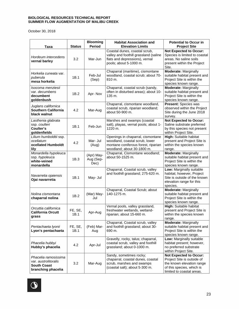
BIOLOGICAL RESOURCES TECHNICAL REPORT SUMMER FLOW AUGMENTATION OF MALIBU CREEK
October 30, 2018
23
Taxa Status Blooming
Period Habitat Association and
Elevation Limits Potential to Occur in
Project Site
Hordeum intercedens vernal barley 3.2 Mar-Jun
Coastal dunes, coastal scrub, valley and foothill grassland (saline flats and depressions), vernal pools; about 5-1000 m.
Not Expected to Occur: Species is limited to coastal areas. No saline soils present within the Project Site.
Horkelia cuneata var. puberula mesa horkelia
1B.1 Feb-Jul (Sep)
Chaparral (maritime), cismontane woodland, coastal scrub; about 70-810 m.
Moderate: Marginally suitable habitat present and Project Site is within the species known range.
Isocoma menziesii var. decumbens decumbent goldenbush
1B.2 Apr- Nov
Chaparral, coastal scrub (sandy, often in disturbed areas); about 10-135 m.
Moderate: Marginally suitable habitat present and Project Site is within the species known range.
Juglans californica Southern California black walnut
4.2 Mar-Aug
Chaparral, cismontane woodland, coastal scrub, riparian woodland; about 50-900 m.
Present: Species was observed within the Project Site during the June 2018 survey.
Lasthenia glabrata ssp. coulteri Coulter’s goldenfields
1B.1 Feb-Jun
Marshes and swamps (coastal salt), playas, vernal pools; about 1-1220 m.
Not Expected to Occur: Saline substrate preferred by this species not present within Project Site.
Lilium humboldtii ssp. ocellatum ocellated Humboldt lily
4.2 Mar- Jul (Aug)
Openings in chaparral, cismontane woodland, coastal scrub, lower montane coniferous forest, riparian woodland; about 30-1800 m.
High: Suitable habitat present and Project Site is within the species known range.
Monardella hypoleuca ssp. hypoleuca white-veined monardella
1B.3 (Apr) May-Aug (Sep-
Dec)
Chaparral, Cismontane woodland; about 50-1525 m.
Moderate: Marginally suitable habitat present and Project Site is within the species known range.
Navarretia ojaiensis Ojai navarretia 1B.1 May- Jul
Chaparral, Coastal scrub, valley and foothill grassland; 275-620 m.
Low: Marginally suitable habitat; however, Project Site is outside of the known elevation range for this species.
Nolina cismontana chaparral nolina 1B.2 (Mar) May-
Jul
Chaparral, Coastal Scrub; about 140-1275 m.
Moderate: Marginally suitable habitat present and Project Site is within the species known range.
Orcuttia californica California Orcutt grass
FE, SE, 1B.1 Apr-Aug
Vernal pools, valley grassland, freshwater wetlands, wetland-riparian; about 15-660 m.
High: Suitable habitat present and Project Site is within the species known range.
Pentachaeta lyonii Lyon’s pentachaeta
FE, SE, 1B.1
(Feb) Mar-Aug
Chaparral, Coastal scrub, valley and foothill grassland; about 30-690 m.
Moderate: Marginally suitable habitat present and Project Site is within the species known range.
Phacelia hubbyi Hubby’s phacelia 4.2 Apr-Jul
Gravelly, rocky, talus; chaparral, coastal scrub, valley and foothill grassland; about 0-1000 m.
Low: Marginally suitable habitat present; however, no preferred substrate within Project Site.
Phacelia ramosissima var. austrolitoralis South Coast branching phacelia
3.2 Mar-Aug
Sandy, sometimes rocky; chaparral, coastal dunes, coastal scrub, marshes and swamps (coastal salt); about 5-300 m.
Not Expected to Occur: Project Site is outside of the known elevation range of this species, which is limited to coastal areas.
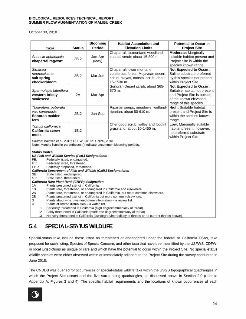
BIOLOGICAL RESOURCES TECHNICAL REPORT SUMMER FLOW AUGMENTATION OF MALIBU CREEK
October 30, 2018
24
Taxa Status Blooming
Period Habitat Association and
Elevation Limits Potential to Occur in
Project Site
Senecio aphanactis chaparral ragwort 2B.2 Jan-Apr
(May)
Chaparral, cismontane woodland, coastal scrub; about 15-800 m.
Moderate: Marginally suitable habitat present and Project Site is within the species known range.
Sidalcea neomexicana salt spring checkerbloom
2B.2 Mar-Jun
Chaparral, lower montane coniferous forest, Mojavean desert scrub, playas, coastal scrub; about 15-1530 m.
Not Expected to Occur: Saline substrate preferred by this species not present within Project Site.
Spermolepis lateriflora western bristly scaleseed
2A Mar-Apr
Sonoran Desert scrub; about 365-670 m.
Not Expected to Occur: Suitable habitat not present and Project Site is outside of the known elevation range of this species.
Thelypteris puberula var. sonorensis Sonoran maiden fern
2B.2 Jan-Sep
Riparian seeps, meadows, wetland-riparian; about 50-610 m.
High: Suitable habitat present and Project Site is within the species known range.
Tortula cailfornica California screw moss
1B.2
Chenopod scrub, valley and foothill grassland; about 10-1460 m.
Low: Marginally suitable habitat present; however, no preferred substrate within Project Site.
Source: Baldwin et al. 2012; CDFW, 2018a; CNPS, 2018. Note: Months listed in parentheses () indicate uncommon blooming periods. Status Codes US Fish and Wildlife Service (Fed.) Designations: FE: Federally listed, endangered. FT: Federally listed, threatened. FPT: Federally proposed, threatened. California Department of Fish and Wildlife (Calif.) Designations: SE: State listed, endangered. ST: State listed, threatened. California Rare Plant Rank (CRPR) designation 1A Plants presumed extinct in California. 1B Plants rare, threatened, or endangered in California and elsewhere. 2A Plants rare, threatened, or endangered in California, but more common elsewhere. 2B Plants presumed extinct in California but more common elsewhere. 3 Plants about which we need more information – a review list. 4 Plants of limited distribution – a watch list.
.1 Seriously threatened in California (high degree/immediacy of threat).
.2 Fairly threatened in California (moderate degree/immediacy of threat).
.3 Not very threatened in California (low degree/immediacy of threats or no current threats known).
5.4 SPECIAL-STATUS WILDLIFE
Special-status taxa include those listed as threatened or endangered under the federal or California ESAs, taxa proposed for such listing, Species of Special Concern, and other taxa that have been identified by the USFWS, CDFW, or local jurisdictions as unique or rare and which have the potential to occur within the Project Site. No special-status wildlife species were either observed within or immediately adjacent to the Project Site during the survey conducted in June 2018.
The CNDDB was queried for occurrences of special-status wildlife taxa within the USGS topographical quadrangles in which the Project Site occurs and the five surrounding quadrangles, as discussed above in Section 2.0 (refer to Appendix A, Figures 3 and 4). The specific habitat requirements and the locations of known occurrences of each
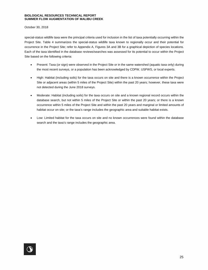
BIOLOGICAL RESOURCES TECHNICAL REPORT SUMMER FLOW AUGMENTATION OF MALIBU CREEK
October 30, 2018
25
special-status wildlife taxa were the principal criteria used for inclusion in the list of taxa potentially occurring within the Project Site. Table 4 summarizes the special-status wildlife taxa known to regionally occur and their potential for occurrence in the Project Site; refer to Appendix A, Figures 3A and 3B for a graphical depiction of species locations. Each of the taxa identified in the database reviews/searches was assessed for its potential to occur within the Project Site based on the following criteria:
• Present: Taxa (or sign) were observed in the Project Site or in the same watershed (aquatic taxa only) during the most recent surveys, or a population has been acknowledged by CDFW, USFWS, or local experts.
• High: Habitat (including soils) for the taxa occurs on site and there is a known occurrence within the Project Site or adjacent areas (within 5 miles of the Project Site) within the past 20 years; however, these taxa were not detected during the June 2018 surveys.
• Moderate: Habitat (including soils) for the taxa occurs on site and a known regional record occurs within the database search, but not within 5 miles of the Project Site or within the past 20 years; or there is a known occurrence within 5 miles of the Project Site and within the past 20 years and marginal or limited amounts of habitat occur on site; or the taxa’s range includes the geographic area and suitable habitat exists.
• Low: Limited habitat for the taxa occurs on site and no known occurrences were found within the database search and the taxa’s range includes the geographic area.
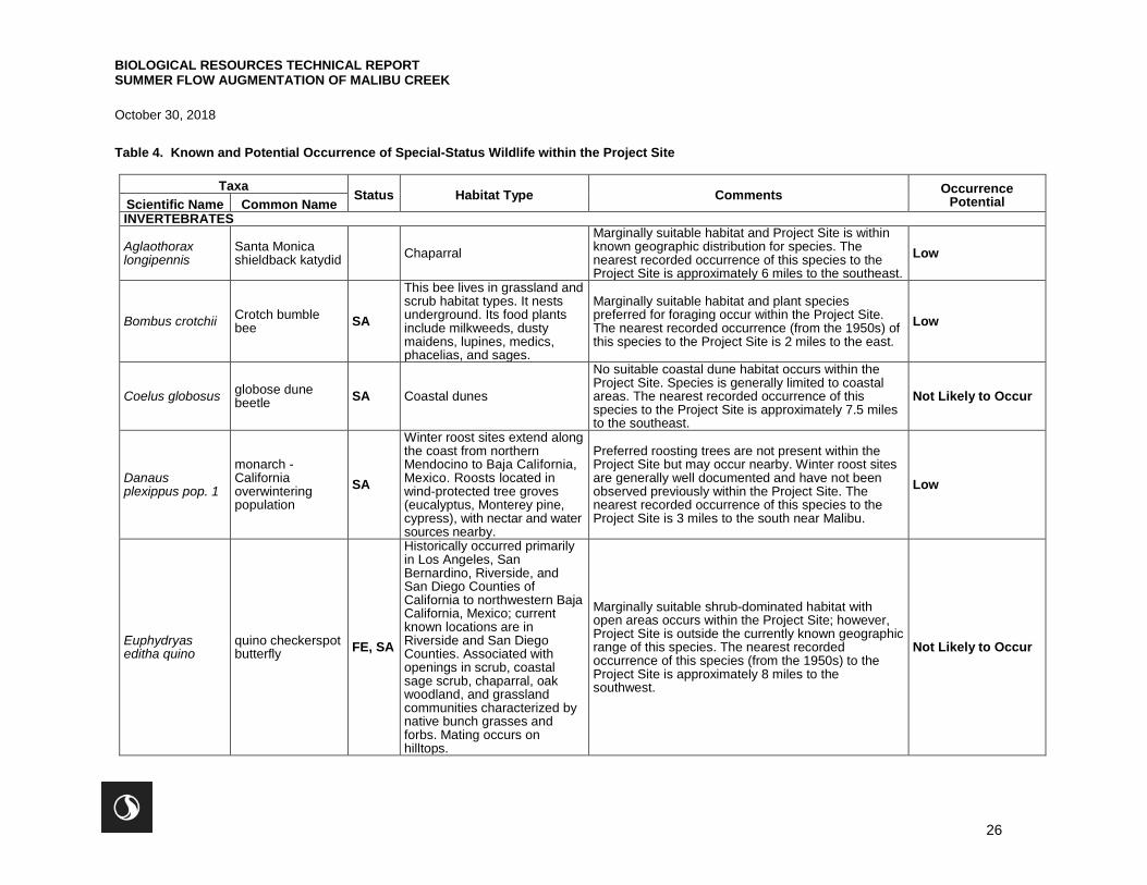
BIOLOGICAL RESOURCES TECHNICAL REPORT SUMMER FLOW AUGMENTATION OF MALIBU CREEK
October 30, 2018
26
Table 4. Known and Potential Occurrence of Special-Status Wildlife within the Project Site
Taxa Status Habitat Type Comments Occurrence Potential Scientific Name Common Name
INVERTEBRATES
Aglaothorax longipennis
Santa Monica shieldback katydid Chaparral
Marginally suitable habitat and Project Site is within known geographic distribution for species. The nearest recorded occurrence of this species to the Project Site is approximately 6 miles to the southeast.
Low
Bombus crotchii Crotch bumble bee SA
This bee lives in grassland and scrub habitat types. It nests underground. Its food plants include milkweeds, dusty maidens, lupines, medics, phacelias, and sages.
Marginally suitable habitat and plant species preferred for foraging occur within the Project Site. The nearest recorded occurrence (from the 1950s) of this species to the Project Site is 2 miles to the east.
Low
Coelus globosus globose dune beetle SA Coastal dunes
No suitable coastal dune habitat occurs within the Project Site. Species is generally limited to coastal areas. The nearest recorded occurrence of this species to the Project Site is approximately 7.5 miles to the southeast.
Not Likely to Occur
Danaus plexippus pop. 1
monarch - California overwintering population
SA
Winter roost sites extend along the coast from northern Mendocino to Baja California, Mexico. Roosts located in wind-protected tree groves (eucalyptus, Monterey pine, cypress), with nectar and water sources nearby.
Preferred roosting trees are not present within the Project Site but may occur nearby. Winter roost sites are generally well documented and have not been observed previously within the Project Site. The nearest recorded occurrence of this species to the Project Site is 3 miles to the south near Malibu.
Low
Euphydryas editha quino
quino checkerspot butterfly FE, SA
Historically occurred primarily in Los Angeles, San Bernardino, Riverside, and San Diego Counties of California to northwestern Baja California, Mexico; current known locations are in Riverside and San Diego Counties. Associated with openings in scrub, coastal sage scrub, chaparral, oak woodland, and grassland communities characterized by native bunch grasses and forbs. Mating occurs on hilltops.
Marginally suitable shrub-dominated habitat with open areas occurs within the Project Site; however, Project Site is outside the currently known geographic range of this species. The nearest recorded occurrence of this species (from the 1950s) to the Project Site is approximately 8 miles to the southwest.
Not Likely to Occur
BIOLOGICAL RESOURCES TECHNICAL REPORT SUMMER FLOW AUGMENTATION OF MALIBU CREEK
October 30, 2018
27
Taxa Status Habitat Type Comments Occurrence Potential Scientific Name Common Name
Socalchemmis gertschi
Gertsch's socalchemmis spider
SA
Known from only two locations (Brentwood and Topanga). Habitat consists of sage scrub, chaparral, oak woodland, coniferous forest; generally in rocky outcrops or talus slopes in non-arid climates.
Marginally suitable shrub scrub and oak woodland habitat occur within the Project Site; however, Project Site is outside of the current known geographic range of this species. The nearest recorded occurrence of this species to the Project Site is approximately 5 miles to the east.
Low
Trimerotropis occidentiloides
Santa Monica grasshopper SA
Known only from the Santa Monica Mountains. Found on bare hillsides and along dirt trails in chaparral.
Suitable habitat occurs, and Project Site is within the known geographic distribution for this species. The nearest documented occurrence of this species (from the 1970s) in the region is approximately 5 miles to the northwest of the Project Site.
Moderate
FISH
Eucyclogobius newberryi tidewater goby FE,
SSC
Known to live only in California; found primarily in brackish waters of coastal lagoons, estuaries, and marshes where water is slow-moving but not stagnant. Naturally absent from steep areas of coastline where streams do not form lagoons or estuaries.
No suitable brackish lagoon or estuarine habitat occurs within the Project Site. Species is limited to more coastal areas. The nearest recorded occurrence of this species to the Project Site is 2 miles to the south.
Not Likely to Occur
Gila orcuttii arroyo chub SSC
Los Angeles Basin southern coastal streams; slow water stream sections with mud or sand bottoms; feeds heavily on aquatic vegetation and associated invertebrates.
Suitable habitat is present within the Project Site in Malibu Creek. There are records of this species from within Malibu Creek where is passes through the Project Site.
High
Oncorhynchus mykiss irideus pop. 10
steelhead – southern California Distinct Population Segment
FE
Federal listing refers to populations from Santa Maria river south to southern extent of range (San Mateo Creek in San Diego County); southern steelhead likely have greater physiological tolerances to warmer water and more variable conditions.
Suitable habitat is present within Malibu Creek, areas of which are listed as Critical Habitat, approximately 1.8 miles downstream of the Project Site. This species has been documented within 2 miles of the Project Site. However, multiple barriers to upstream passage are present downstream which make it unlikely (but not impossible) that this species would occur within the Project Site.
Low
BIOLOGICAL RESOURCES TECHNICAL REPORT SUMMER FLOW AUGMENTATION OF MALIBU CREEK
October 30, 2018
28
Taxa Status Habitat Type Comments Occurrence Potential Scientific Name Common Name
Rana draytonii California red-legged frog
FT, SSC
Lowlands and foothills in or near permanent sources of deep water with dense, shrubby or emergent riparian vegetation; requires 11-20 weeks of permanent water for larval development; must have access to aestivation habitat.
Suitable habitat is present within the Project Site; however, the morphology of Malibu Creek and vegetation characteristics are not ideal. The nearest recorded occurrence of this species to the Project Site is approximately 6.5 miles to the north.
Low
Spea hammondii western spadefoot SSC
Occurs in numerous habitat types, primarily in grasslands but can be found in valley-foothill hardwood woodlands, sage scrubs, chaparral where pooled/ponded water, supporting typically clay-rich soils, remains through early spring (April/May); in certain locations, vernal pools, stock ponds, and road pools are essential for breeding, egg-laying, and larval development.
Within the Project Site, suitable breeding habitat is present within Malibu Creek and suitable upland habitat is present for the terrestrial portion of their life cycle. The nearest recorded occurrence of this species to the Project Site is approximately 10 miles to the north.
Low
REPTILES
Anniella sp. California legless lizard SSC
Contra Costa County south to San Diego, within a variety of open habitats, this element represents California records of anniella not yet assigned to new species within the anniella pulchra complex; variety of habitats; generally, in moist, loose soil, they prefer soils with a high moisture content.
Suitable habitat and high-moisture substrates are present within the Project Site. The nearest recorded occurrence of this species to the Project Site is approximately 7.5 miles to the northwest.
Low
Annella stebbinsi Southern California legless lizard
SSC
Generally south of the transverse range, extending to northwestern Baja California, occurs in sandy or loose loamy soils under sparse vegetation; disjunct populations in the Tehachapi and Piute mountains in Kern County; variety of habitats; generally in moist, loose soil, they prefer soils with a high moisture content.
Suitable habitat and high-moisture substrates are present within the Project Site. This species has been documented immediately downstream of the Project Site.
High
BIOLOGICAL RESOURCES TECHNICAL REPORT SUMMER FLOW AUGMENTATION OF MALIBU CREEK
October 30, 2018
29
Taxa Status Habitat Type Comments Occurrence Potential Scientific Name Common Name
Aspidoscelis tigris stejnegeri coastal whiptail SSC
Found in deserts and semi-arid areas with sparse vegetation and open areas; also found in woodland and riparian habitats; substrates may be firm soil, sandy, or rocky.
Suitable semi-arid and riparian habitat occurs within the Project Site. This species has been documented approximately 2 miles northwest of the Project Site.
High
Diadophis punctatus modestus
San Bernardino ringneck snake SA
Most common in open relatively rocky areas; often in somewhat moist microhabitats near intermittent streams; avoids moving through open or barren areas by restricting movements to areas of surface litter or herbaceous vegetation.
Suitable habitat occurs in the Malibu Creek riparian corridor within the Project Site. This species has been documented within approximately 1 mile of the Project Site.
High
Emys marmorata western pond turtle SSC
A thoroughly aquatic turtle of ponds, marshes, rivers, streams and irrigation ditches, usually with aquatic vegetation, below 6000 feet elevation.
Suitable aquatic and riparian habitat occurs in the Malibu Creek riparian corridor within the Project Site. This species has been documented within 1 mile of the Project Site.
High
Lampropeltis zonata (pulchra)
California mountain kingsnake (San Diego population)
WL
A habitat generalist in diverse habitats including coniferous forest, oak-pine woodlands, riparian woodland, chaparral, manzanita, and coastal sage scrub. Wooded areas near streams with rock outcrops, talus, or rotting logs exposed to the sun. From 1,500 – 8,000 feet elevation.
Suitable foraging habitat with refuge for basking and hiding are present and the Project Site is within the species’ known geographic distribution. However, the Project Site is well outside elevation range in which the species is usually found. The nearest recorded occurrence of this species (from the 1980s) to the Project Site is 2.5 miles to the east.
Low
Phrynosoma blainvillii
coast horned lizard SSC
Frequents a wide variety of habitats, most common in lowlands along sandy washes with scattered low bushes; open areas for sunning, bushes for cover, patches of loose soil for burial, and abundant supply of ants and other insects.
Suitable habitat and friable soils are present within the Project Site. A historic occurrence of this species has been reported immediately upstream of the Project Site with more recent occurrences approximately 3 miles to the east.
High
BIOLOGICAL RESOURCES TECHNICAL REPORT SUMMER FLOW AUGMENTATION OF MALIBU CREEK
October 30, 2018
30
Taxa Status Habitat Type Comments Occurrence Potential Scientific Name Common Name
Thamnophis hammondii
Two-striped gartersnake SSC
Coastal California from vicinity of Salinas to northwest Baja California, from sea to about 7,000 feet elevation; highly aquatic, found in or near permanent fresh water; often along streams with rocky beds and riparian growth.
Suitable aquatic and riparian habitat is present within the Malibu Creek riparian corridor within the Project Site. The nearest recorded occurrence of this species to the Project Site is approximately 4.5 miles to the east.
High
BIRDS
Accipiter cooperii (nesting) Cooper’s hawk WL
Woodland, chiefly of open, interrupted or marginal type; nest sites mainly in riparian growths of deciduous trees, as in canyon bottoms on river flood-plains; also live oaks.
Suitable open woodland habitat with preferred nesting sites is present within the Malibu Creek riparian corridor and the Project Site is within this species’ known range. The nearest recorded occurrence of this species to the Project Site is approximately 8.5 miles to the west.
Moderate (foraging and nesting)
Agelaius tricolor (nesting colony)
tricolored blackbird
SC, SSC
Highly colonial species, most numerous in central valley and vicinity, largely endemic to California; requires open water, protected nesting substrate, and foraging areas with insect prey within a few kilometers of colony.
The Project Site is located within the known geographic range for this species, though suitable breeding and foraging habitat does not occur within the Project Site. The nearest recorded occurrence of this species to the Project Site is approximately 7 miles to the west.
Not Likely to Occur
Aimophila ruficeps canescens
southern California rufous-crowned sparrow
WL
Resident in southern California coastal sage scrub and sparse mixed chaparral; frequents relatively steep, often rocky hillsides with grass and forb patches.
Marginally suitable scrub habitat occurs within the Project Site and the Project Site is within this species’ known geographic range. The Project Site does not contain steep, rocky hillsides. The nearest recorded occurrences of this species to the Project Site are approximately 5 miles to the north.
Low
Athene cunicularia burrowing owl SSC
Open, dry annual or perennial grasslands, deserts, and scrublands characterized by low-growing vegetation; subterranean nester, dependent upon burrowing mammals, mostly notably, the California ground squirrel.
While marginally suitable habitat is present within the Project Site, site conditions are not ideal. This species prefers open areas with sparse, low vegetation growth – conditions that do not occur within the Project Site. The nearest recorded occurrence of this species (from 1998) to the Project Site is approximately 6 miles to the north.
Not Likely to Occur
Aquila chrysaetos golden eagle FP
Rolling foothills, mountain area, sage-juniper flats, and desert; cliff-walled canyons provide nesting habitat in most parts of range; also, large trees in open areas.
Suitable foraging and/or nesting habitat does not occur within the Project Site – species requires more open areas for foraging. There is a historic occurrence of this species immediately downstream of the Project Site.
Not Likely to Occur (nesting or foraging) Moderate (flyover)
BIOLOGICAL RESOURCES TECHNICAL REPORT SUMMER FLOW AUGMENTATION OF MALIBU CREEK
October 30, 2018
31
Taxa Status Habitat Type Comments Occurrence Potential Scientific Name Common Name
Falco peregrinus anatum
American peregrine falcon CFP
Occurs in various open habitats, especially where suitable nesting cliffs present.
The Project Site is within the known year-round geographic distribution for this species and marginally suitable foraging habitat occurs in portions of the Project Site. The CNDDB reports an occurrence of this species within a general 5.5 mile radius of the Project Site.
Not Likely to Occur (nesting) Low (foraging)
Polioptila californica californica
coastal California gnatcatcher
FT, SSC
Obligate, permanent resident of coastal sage scrub below 2500 feet in southern California; low, coastal sage scrub in arid washes, on mesas and slopes, not all areas classified as coastal sage scrub are occupied.
Marginally suitable scrub habitat occurs within the Project Site; however, proximity to existing roadways and limited expanse of habitat greatly reduces the potential for this species to occur in the Project Site. The nearest recorded occurrence of this species to the Project Site is approximately 5.5 miles to the north.
Low
Riparia riparia bank swallow ST
Colonial nester; nests primarily in riparian and other lowland habitats west of the desert; requires vertical banks/cliffs with fine-textured/sandy soils near streams, rivers, lakes, ocean to dig nesting hole.
Marginally suitable riparian habitat is present within the Project Site; however, no suitable nesting habitat occurs. The nearest recorded occurrence of this species to the Project Site is approximately 9 miles to the northwest.
Not Likely to Occur
Vireo bellii pusillus (nesting) least Bell’s vireo FE, SE
Summer resident of southern California in low riparian habitats in vicinity of water or dry river bottoms; found below 2000 ft; nests placed along margins of bushes or on twigs projecting into pathways, usually willow, mesquite.
Suitable nesting and foraging habitat are present within the Malibu Creek riparian corridor within the Project Site. The nearest recorded occurrence, historic in nature, of this species to the Project Site is approximately 12 miles to the southeast.
High
MAMMALS
Antrozous pallidus pallid bat SSC
Deserts, grasslands, shrublands, woodlands and forests; most common in open, dry habitats with rocky areas for roosting; roosts must protect bats from high temperatures; very sensitive to disturbance of roosting sites.
Marginally suitable shrubland and woodland habitat present within the Project Site; however, level of development and human activity in the vicinity greatly reduces the likelihood for this species to occur. No roosting habitat present. The nearest recorded occurrence of this species to the Project Site is approximately 9.5 miles to the north.
Not Likely to Occur (roosting) Low (foraging)
BIOLOGICAL RESOURCES TECHNICAL REPORT SUMMER FLOW AUGMENTATION OF MALIBU CREEK
October 30, 2018
32
Taxa Status Habitat Type Comments Occurrence Potential Scientific Name Common Name
Euderma maculatum spotted bat SSC
Occupies a wide variety of habitats from arid deserts and grasslands, to mixed conifer forests; feeds over water and along washes; needs rock crevices in cliffs or caves for roosting.
Suitable foraging habitat is present within the Malibu Creek riparian corridor; however, no suitable roosting habitat occurs in the immediate vicinity. The nearest recorded occurrence of this species to the Project Site is approximately 2 miles to the northwest.
Not Likely to Occur (roosting) High (foraging)
Eumops perotis californicus
western mastiff bat SSC
Many open, semi-arid to arid habitats, including coniferous and deciduous woodlands, coastal scrub, grasslands, chaparral; roosts in crevices in cliff faces, high buildings, trees, tunnels.
Marginally suitable scrub and woodland habitat present within the Project Site as well as trees for roosting. Project Site is within species’ known range. This species has been documented within 2 miles of the Project Site.
High
Lasiurus blossevillii western red bat SSC
Roosts primarily in trees, 2-40 feet above ground, from sea level up trough mixed conifer forests; prefers habitat edges and mosaics with trees that are protected from above and open below with open areas for foraging.
Suitable tree-dominated habitat is present within the Project Site with open areas for foraging. Project Site is within species’ known range. The nearest recorded occurrence of this species to the Project Site is approximately 3 miles to the east.
Moderate
Lasiurus cinereus hoary bat SA
Prefers open habitats or habitat mosaics, with access to trees for cover and open areas or habitat edges for feeding; roosts in dense foliage of medium to large trees, feeds primarily on moths, requires water.
Suitable tree-dominated habitat and surface water present within the Project Site with open areas for foraging. Project Site is within species’ known range. The nearest recorded occurrence of this species to the Project Site is approximately 5 miles to the northwest.
Moderate
Macrotus californicus
California leaf-nosed bat SSC
Desert riparian, desert wash, desert scrub, desert succulent scrub, alkali scrub and palm oasis habitats; needs rocky, rugged terrain with mines or caves for roosting.
Suitable desert habitat does not occur within the Project Site. No rocky terrain, mines, or caves present. The nearest recorded occurrence of this species (from the early 1990s) to the Project Site is approximately 7.5 miles to the north.
Not Likely to Occur
Myotis yumanensis Yuma myotis SA
Optimal habitats are open forests and woodlands with sources of water over which to feed. Distribution is closely tied to bodies of water, maternity colonies in caves, mines, buildings or crevices.
Suitable open riparian habitat and surface water occur within the Project Site. This species has been documented within 2 miles of the Project Site. The nearest recorded occurrence of this species to the Project Site is approximately 1.5 miles to the northwest.
High
BIOLOGICAL RESOURCES TECHNICAL REPORT SUMMER FLOW AUGMENTATION OF MALIBU CREEK
October 30, 2018
33
Taxa Status Habitat Type Comments Occurrence Potential Scientific Name Common Name
Myotis ciliolabrum
western small-footed myotis SA
Wide range of habitats mostly arid wooded and brushy uplands near water. Seeks cover in caves, buildings, mines and crevices; prefers open stands in forests and woodlands, requires drinking water, feeds on a wide variety of small flying insects.
Suitable open riparian woodland habitat and surface water occur within the Project Site. This species has been documented within 2 miles of the Project Site.
High
Neotoma lepida intermedia
San Diego desert woodrat SSC
Coastal scrub; prefers moderate to dense canopies; particularly abundant in rock outcrops, rocky cliffs, and slopes.
Marginally suitable scrub habitat occurs and the Project Site is within the known geographic distribution of this species. The nearest recorded occurrence of this species to the Project Site is approximately 3 miles to the south.
Moderate
Taxidea taxus American badger SSC
Most abundance in dried open stages of most shrub, forest, and herbaceous habitats, with friable soils; needs sufficient food, friable soils and open, uncultivated ground; preys on burrowing rodents, digs burrows.
Marginally suitable habitat is present; however, proximity of roadways and human disturbance greatly reduces the potential of this species to occur. The nearest recorded occurrence of this species to the Project Site is approximately 6 miles to the west.
Low
Federal Rankings: FE = Federally Endangered FT = Federally Threatened FP = Federally Protected FC = Federal Candidate for Listing BCC = USFWS Bird of Conservation Concern
State Rankings: SE= State Endangered ST = State Threatened SC = State Candidate for Listing CFP = California Fully Protected CPF = California Protected Fur-bearer SA = CDFW Special Animal WL = CDFW Watch List SSC = Species of Special Concern
BIOLOGICAL RESOURCES TECHNICAL REPORT SUMMER FLOW AUGMENTATION OF MALIBU CREEK
October 30, 2018
34
5.5 WILDLIFE CORRIDORS AND SPECIAL LINKAGES
Linkages and corridors facilitate regional animal movement and are generally centered in or around waterways, riparian corridors, flood control channels, contiguous habitat, and upland habitat. Drainages generally serve as movement corridors because wildlife can move easily through these areas, and fresh water is available. Corridors also offer wildlife unobstructed terrain for foraging and for dispersal of young individuals.
As the movements of wildlife species are more intensively studied using radio-tracking devices, there is mounting evidence that some wildlife species do not necessarily restrict their movements to some obvious landscape element, such as a riparian corridor. For example, recent radio-tracking and tagging studies of Coast Range newts, California red-legged frogs, southwestern pond turtles, and two-striped garter snakes found that long-distance dispersal involved radial or perpendicular movements away from a water source with little regard to the orientation of the assumed riparian “movement corridor” (Hunt, 1993; Rathbun et al., 1992; Bulger et al., 2002; Trentham, 2002; Ramirez, 2002, 2003a, 2003b). Likewise, carnivores do not necessarily use riparian corridors as movement corridors, frequently moving overland in a straight line between two points when traversing large distances (Newmark, 1995; Beier, 1993, 1995; Noss, et al., 1996; Noss et al., no date). In general, the following corridor functions can be utilized when evaluating impacts to wildlife movement corridors:
• Movement corridors are physical connections that allow wildlife to move between patches of suitable habitat. Simberloff et al. (1992) and Beier and Loe (1992) correctly state that, for most species, we do not know what corridor traits (length, width, adjacent land use, etc.) are required for a corridor to be useful. But, as Beier and Loe (1992) also note, the critical features of a movement corridor may not be its physical traits but rather how well a particular piece of land fulfills several functions, including allowing dispersal, plant propagation, genetic interchange, and recolonization following local extirpation.
• Dispersal corridors are relatively narrow, linear landscape features embedded in a dissimilar matrix that links two or more areas of suitable habitat that would otherwise be fragmented and isolated from one another by rugged terrain, changes in vegetation, or human-altered environments. Corridors of habitat are essential to the local and regional population dynamics of a species because they provide physical links for genetic exchange and allow animals to access alternative territories as dictated by fluctuating population densities.
• Habitat linkages are broader connections between two or more habitat areas. This term is commonly used as a synonym for a wildlife corridor (Meffe and Carroll, 1997). Habitat linkages may themselves serve as source areas for food, water, and cover, particularly for small- and medium-size animals.
• Travel routes are usually landscape features, such as ridgelines, drainages, canyons, or riparian corridors within larger natural habitat areas that are used frequently by animals to facilitate movement and provide access to water, food, cover, den sites, or other necessary resources. A travel route is generally preferred by a species because it provides the least amount of topographic resistance in moving from one area to another yet still provides adequate food, water, or cover (Meffe and Carroll, 1997).
• Wildlife crossings are small, narrow areas of limited extent that allow wildlife to bypass an obstacle or barrier. Crossings typically are manmade and include culverts, underpasses, drainage pipes, bridges, and tunnels to provide access past roads, highways, pipelines, or other physical obstacles. Wildlife crossings often represent
BIOLOGICAL RESOURCES TECHNICAL REPORT SUMMER FLOW AUGMENTATION OF MALIBU CREEK
October 30, 2018
35
“choke points” along a movement corridor because useable habitat is physically constricted at the crossing by human-induced changes to the surrounding areas (Meffe and Carroll, 1997).
5.5.1 Wildlife Movement in the Project Site
Although wildlife movement is hampered by rural development in some portions of the Santa Monica Mountains, animals are still able to move through in many areas. Due to its large size and topographic complexity, many linkages are certain to occur within the Santa Monica Mountains at various bottlenecks. These linkages allow movement between large open space areas within the Santa Monica Mountains as well as between areas outside the Santa Monica Mountains such as the Simi Hills. The genetic flow through these areas is crucial in maintaining the diversity and viability of certain species within the Santa Monica Mountains. Open space linkages between Kanan Road and Calabasas Parkway along Highway 101, as indicated by the National Park Service, are of particular importance for continued wildlife movement, due to the lack of alternative routes and encroachment of development. Although there are significantly large open spaces within the Santa Monica Mountains, contiguous habitat linkages between them is critical in reducing bottlenecks and providing for long-term sustainability. [L.A. County Department of Regional Planning, 2009]
Within the Project Site, the Malibu Creek riparian corridor serves as an important wildlife travel route. This corridor is free of development and connects other undeveloped lands along its length. Wildlife would be expected to use this route frequently to travel through the Project Site and surrounding region.
6.0 PROJECT IMPACTS AND AVOIDANCE AND MINIMIZATION MEASURES
6.1 PROJECT IMPACTS
In general, direct impacts to special-status plants and terrestrial wildlife include ground-disturbing activities associated with construction of the project (e.g., trenching) and increased human presence (e.g., crushing, trampling, trapping). Potential indirect impacts include increased noise levels from heavy equipment (wildlife only), increased human disturbance, exposure to fugitive dust, the spread of noxious weeds, and disruption of breeding or foraging activity due to routine maintenance activities (wildlife only).
6.1.1 Native Vegetation and Trees
Construction within the Project Site will be confined to existing developed areas including the Tapia WRF access road and Malibu Canyon Road and their disturbed margins. As such, implementation of the project is not expected to result in direct impacts to native vegetation communities that surround these developed areas. However, because the canopies of several coast live oak trees extend over the Tapia WRF access road, construction may result in some minor trimming of the branches and would encroach into the “Protected Zone” of one or more of those trees, which would constitute a direct impact to those individual trees. No trees will be removed as a result of project implementation.
Damage to a tree’s ability to protect, stabilize, and metabolize would be considered a direct impact. Direct effects are impacts to above or below ground portions of the tree, such as removal of bark, branch breakage, surface grading, and
BIOLOGICAL RESOURCES TECHNICAL REPORT SUMMER FLOW AUGMENTATION OF MALIBU CREEK
October 30, 2018
36
trenching injury to roots. These impacts could result in wounds, making the tree susceptible to disease, death from wounds or from damage to the tree, or later removal of a tree. Negative impacts to a tree from construction activities often are not immediately apparent and may take several years to manifest. Avoidance and minimization measures to mitigate impacts to protected trees are discussed in Section 6.2, below.
Bryophytes (e.g., moss) and lichens are considered H1 category (most sensitive) habitat by the SMM LIP. These plants are part of the basis of nutrient provisions to natural communities. Since the proposed pipeline would be installed within existing streets, direct impacts to rock outcrops with bryophytes and/or lichen growth are not anticipated.
6.1.2 Wildlife
If project construction were to occur during the avian nesting season (generally considered to be between February 15th through September 15th, although some raptors species may nest as early as January), indirect impacts to nesting birds could occur. The MBTA of 1918 (16 U.S.C. 703-711) does not allow for take of migratory birds.
Due to the fact that direct impacts to native vegetation will be largely avoided and construction will be limited to existing disturbed areas with limited habitat value, it is anticipated that the effect on wildlife will be minimal and limited primarily to indirect temporary impacts. Avoidance and minimization measures to further mitigate these potential impacts are discussed below.
6.2 AVOIDANCE AND MINIMIZATION MEASURES
6.2.1 Avoidance and Minimization Measure 1 - Implement BMPs
BMPs shall be implemented as standard operating procedures during all ground disturbance and construction-related activities to avoid or minimize project impacts on biological resources. BMPs shall include:
• Restrict non-essential equipment to the existing roadways and/or ruderal areas to avoid disturbance to native vegetation.
• All excavation, steep-walled holes or trenches in excess of 6 inches in depth shall be covered at the close of each working day by plywood or similar materials or provided with one or more escape ramps constructed of earthen fill or wooden planks with a 2:1 slope ratio. Trenches will also be inspected for entrapped wildlife each morning prior to onset of construction activities and immediately prior to covering with plywood at the end of each working day. Before such holes or trenches are filled, they will be thoroughly inspected for entrapped wildlife. Any wildlife discovered will be allowed to escape before construction activities are allowed to resume or removed from the trench or hole by a qualified biologist holding the appropriate permits (if required).
• Minimize mechanical disturbance of soils to reduce impact of habitat manipulation on small mammals, reptiles, and amphibians.
• Removal/disturbance of vegetation shall be minimized to the greatest extent feasible.
• Install and maintain appropriate erosion/sediment control measures as needed throughout the duration of work activities. Sediment control measures shall be sufficient to prevent soils disturbed for pipeline installation from entering Malibu Creek. Materials used in implementing stormwater Best Management Practices,
BIOLOGICAL RESOURCES TECHNICAL REPORT SUMMER FLOW AUGMENTATION OF MALIBU CREEK
October 30, 2018
37
including straw wattles or soil fill, shall be certified weed-free to avoid introducing invasive plant species into native habitat.
• Construction-related vehicles shall be clean and maintained free of weeds to avoid spreading noxious weeds across the project or transporting new weeds to the Project Site. Vehicles or equipment brought from different areas of the country, state, or other weed zones shall be cleaned, or documentation provided that they are weed free.
• No vehicles or equipment shall be refueled within 100 feet of an ephemeral drainage or wetland unless a bermed and lined refueling area is constructed. Spill kits shall be maintained on the Project Site in sufficient quantity to accommodate at least three complete vehicle tank failures of 50 gallons each. Any vehicles driven and/or operated within or adjacent to drainages or wetlands shall be checked and maintained daily to prevent leaks of materials.
6.2.2 Avoidance and Minimization Measure 2 - Implement a Worker Environmental Education Program
Prior to the start of any construction related activities within the Project Site (i.e., mobilization, fencing, grading, or construction), a Worker Environmental Education Program (WEEP) shall be implemented. Briefings for project personnel shall include: a discussion of the Federal and State Endangered Species Acts, Bald and Golden Eagle Protection Act, and the MBTA; the consequences of non-compliance with these acts; identification and values of plant and wildlife species and significant natural plant community habitats; hazardous substance spill prevention and containment measures; a contact person and phone number in the event wildlife needs to be relocated or dead or injured wildlife is discovered; and a review of mitigation requirements.
6.2.3 Avoidance and Minimization Measure 3 - Pre-Construction Surveys (Plants and Wildlife) and Biological Monitoring
Wildlife Surveys: Prior to ground disturbance or tree trimming (if applicable) within the Project Site, a qualified biologist shall conduct surveys for wildlife (no more than 14 days prior to Project Site disturbing activities) where suitable habitat is present and may be directly impacted by construction activities. Wildlife found within the Project Site or in areas potentially affected by the project will be relocated to the nearest suitable habitat that will not be affected by the project prior to the start of construction. Special-status species found within a project impact area shall be relocated by an authorized biologist to suitable habitat outside the impact area.
The wildlife survey shall include a focused survey for bats within 500 feet of the Project Site. To the extent feasible, maternity roosts, if present, shall be left undisturbed with a buffer of 300 feet from March 15 to September 30. To the extent feasible, hibernation roosts, if present in winter, shall be left undisturbed with a buffer of 100 feet. Where avoidance is infeasible and a bat roost would be disturbed and/or bats expelled, consultation with CDFW shall be conducted.
Plant Surveys: Prior to initial ground disturbance within the Project Site, a qualified biologist shall conduct pre-construction surveys for special-status plant species in all undeveloped areas subject to ground-disturbing activity. If construction starts in the fall and will extend into the spring, additional surveys shall be conducted in all areas where new ground disturbing activities would occur during the spring (after March 1). All listed plant species found shall be
BIOLOGICAL RESOURCES TECHNICAL REPORT SUMMER FLOW AUGMENTATION OF MALIBU CREEK
October 30, 2018
38
marked and avoided. Any populations of special-status plants found during surveys will be fully described, mapped, and a CNPS Field Survey Form or written equivalent shall be prepared.
Prior to Site trenching, any populations of special-status plant species identified during the surveys shall be protected by a buffer zone. The buffer zone shall be established around these areas and shall be of sufficient size to eliminate potential disturbance to the plants from human activity and any other potential sources of disturbance including human trampling, erosion, and dust. The size of the buffer depends upon the proposed use of the immediately adjacent lands and includes consideration of the plant’s ecological requirements (e.g., sunlight, moisture, shade tolerance, physical and chemical characteristics of soils) that are identified by the qualified plant ecologist or botanist. The buffer for herbaceous and shrub species shall be, at minimum, 50 feet from the perimeter of the population or the individual. A smaller buffer may be established, provided there are adequate measures in place to avoid the take of the species. Highly visible flagging shall be placed along the buffer area and remain in good working order during the duration of any construction activities in the area.
Where impacts to listed plants cannot be avoided, the USFWS and/or CDFW shall be consulted for authorization, as appropriate.
Biological Monitoring: A qualified biologist shall be present during initial ground disturbance within the Project Site and periodically during the bird nesting season. If required, during pre-construction surveys and/or monitoring efforts, the qualified biologist will relocate common and special-status species that enter the Project Site. Some special-status species may require specific permits prior to handling and/or have established protocols for relocation. Records of all detections, captures, and releases shall be reported to CDFW.
6.2.4 Avoidance and Minimization Measure 4 - Nesting Bird Surveys and Avoidance Measures
Where possible, vegetation removal activities (e.g., tree trimming, if required) should occur after September 15 but prior to February 15 to avoid impacts to nesting birds. Prior to initial site disturbance/issuance of grading permits, seasonally timed presence/absence surveys for nesting birds shall be conducted by a qualified biologist. If construction occurs outside of avian nesting season, only a single presence/absence survey for special status species will be conducted. If construction is scheduled to begin during the avian nesting season (February 15 through September 15; January 1 to August 15 for raptors), a minimum of three survey events, three days apart, shall be conducted, with the last survey no more than three days prior to the start of site disturbance. Surveys shall be conducted within 500 feet of all proposed project activities.
If least Bell’s vireo, coastal California gnatcatcher, or other special-status species are observed, consultation with USFWS and/or CDFW will be conducted. If breeding birds with active nests are found prior to or during construction, a qualified biologist shall establish a 300-foot buffer around the nest and no activities will be allowed within the buffer(s) until the young have fledged from the nest or the nest fails. The prescribed buffers may be adjusted by the qualified biologist based on existing conditions around the nest, planned construction activities, tolerance of the species, and other pertinent factors. The qualified biologist shall conduct regular monitoring of the nest to determine success/failure and to ensure that project activities are not conducted within the buffer(s) until the nesting cycle is complete or the nest fails.
BIOLOGICAL RESOURCES TECHNICAL REPORT SUMMER FLOW AUGMENTATION OF MALIBU CREEK
October 30, 2018
39
6.2.5 Avoidance and Minimization Measure 5 – Oak and Other Native Tree Avoidance Measures
The Project shall comply with measures outlined in the SMM LCP and OWCMP. This will include the following:
• A Protected Tree Survey shall be conducted by a Certified Arborist prior to construction activities in order to document planned and specific impacts to individual trees protected by the SMM LCP, which on the Project Site include coast live oaks, California ash, California sycamore, and black cottonwood with a single trunk diameter of 6 inches or greater, or a combination of any two trunks measuring 8 inches or greater, at four and one-half feet above natural grade.
• A Los Angeles County Coastal Development Permit-oak tree shall be obtained for encroachment into the protected zone of protected native trees. The permit application shall include a description of the construction; the location of all ordinance/plan oak trees proposed to be removed and/or relocated, or within 200 feet of proposed construction, grading, landfill or other activity; and an oak tree report that evaluates each tree’s dimensions, health, aesthetic appearance, and potential impacts. The permit application shall also substantiate that the construction will not endanger the health of remaining oaks on the property, result in soil erosion through diversion or increased flow of surface waters.
• Removal of ordinance trees, pruning structural roots (roots greater than 1 inch in diameter), or trimming more than 25 percent of a tree’s canopy, and/or removal of more than 50 percent of the root zone shall be avoided to the extent feasible.
• Root or crown pruning activities shall be as minimal as feasible and monitored by a Certified Arborist; pruning shall be done using International Society of Arboriculture (ISA) standards. Any roots larger than 1 inch in diameter that must be pruned shall be cut flush immediately with proper equipment.
• Excavation and grading shall, to the extent possible, avoid cutting or damaging roots. As recommended by the arborist, hand tools shall be employed when excavating in the root zone. Hand tools or an air spade shall be employed to dig in the protected zone of all protected native trees in the unincorporated areas. Roots of 1-inch diameter or larger shall be preserved. To the extent feasible, construction shall be threaded through the roots or the roots shall be pushed aside. Roots shall be covered with a moist cloth or burlap while they are exposed.
• Root pruning shall be conducted as far from the trunk as possible.
• Parking equipment, staging construction materials, and excessive foot traffic within the protected zone of the affected trees (defined in the unincorporated SMM Coastal Zone as the greater distance between 5 feet from the dripline or 15 feet from the trunk) shall be avoided, as feasible, to prevent soil compaction or damage to roots. As applicable, protected trees near construction shall be protected by substantial (chain-link), temporary, protective fencing.
• Creating holes around tree roots deeper than 3 inches shall be avoided, as feasible. When excavations are unavoidable, backfill shall not use subsurface or clay soils; fill shall be with well-draining soils high in organic matter that do not exceed the surrounding soil surface level.
BIOLOGICAL RESOURCES TECHNICAL REPORT SUMMER FLOW AUGMENTATION OF MALIBU CREEK
October 30, 2018
40
• Altering the grade within the protected zone shall be avoided to prevent imminent and long-term damage to roots. Any grade changes shall occur beyond the protected zone.
• The Los Angeles County SMM Coastal Zone has no in lieu fee for protected tree impacts. Mitigation trees, where applicable, shall be planted in an area legally protected from development and in the same watershed as the impact. Mitigation trees, as applicable, shall be planted on conserved land under maintenance of an organization with experience in managing land for conservation and preservation.
7.0 REFERENCES
Aubry, K. B., L. L. C. Jones, and P. A. Hall. 1988. Use of woody debris by plethodontid salamanders in Douglas-fir in Washington. Pages 32-37 in R. C. Szabo, K. E. Severson, and D. R. Patton, technical coordinators. Management of amphibians, reptiles and small mammals in North America. General technical report RM-166. U.S. Forest Service, Rocky Mountain Research Station, Fort Collins, Colorado.
Baldwin, B.G., D.H. Goldman, D.J. Keil, R. Patterson, T.J. Rosatti, D.H. Wilken (eds.) 2012. The Jepson Manual:
Vascular Plants of California, 2nd ed. University Press, Berkeley, California. Beier, P. 1993. Determining minimum habitat areas and habitat corridors for cougars. Conservation Biology, 7: 94-
108. Beier, P. and S. Loe. 1992. A checklist for evaluating impacts to wildlife movement corridors. Wildlife Society Bulletin
20: 434-440. Beier, P. 1995. Dispersal of juvenile cougars in fragmented habitat. Journal of Wildlife Management 59:228–237. Bulger, J., N. Scott, and R. Seymour. 2002. Terrestrial activity and conservation of adult California red-legged frogs
(Rana aurora draytonii) in coastal forests and grasslands. Biol. Conservation 15: 234-245. CDFW (California Department of Fish and Wildlife). 2018a. RAREFIND database ed.3.1.1. Electronic database
managed by the California Natural Diversity Data Base, Wildlife Data and Habitat Analysis Branch, California Department of Fish and Wildlife. Sacramento, CA.
_____. 2018b. State and Federally Listed Endangered and Threatened Animals of California. May _____. 2018c. Special Animals List. April.
_____. 2018d. California Sensitive Natural Communities. https://www.wildlife.ca.gov/Data/VegCAMP/Natural-
Communities _____. 2009. Protocols for Surveying and Evaluating Impacts to Special Status Native Plant Populations and
Natural Communities. Sacramento, California.
BIOLOGICAL RESOURCES TECHNICAL REPORT SUMMER FLOW AUGMENTATION OF MALIBU CREEK
October 30, 2018
41
_____. 2000. “Spotted Bat.” California Wildlife Habitat Relationships System California Department of Fish and Game California Interagency Wildlife Task Group.
_____. 1994. A Field Guide to Lake and Streambed Alteration Agreements Section 1600-1607, California
Department of Fish and Game Code. Environmental Services Division. Sacramento, California. January. CNPS (California Native Plant Society). 2018. Inventory of rare and endangered plants. California Native Plant
Society. Sacramento. Online: http://www.cnps.org/inventory. Accessed July 2018. CCH (Consortium of California Herbaria). 2018. California Vascular Plant Online Database. [online]:
http://ucjeps.berkeley.edu/consortium/ Dunning, J.B., B.J. Danielson, and H.R. Pulliam. 1992. Ecological processes that affect populations in complex
landscapes. Oikos 65:169-175. Environmental Laboratory. 1987. Corps of Engineers Wetlands Delineation Manual (Technical Report Y-87-1).
Vicksburg, MS: U.S. Army Engineer Waterways Experiment Station. FAA, 2015. Advisory Circular for Obstruction Marking and Lighting. AC No: 70/7460-1L. Available:
https://www.faa.gov/documentLibrary/media/Advisory_Circular/AC_70_7460-1L_.pdf Flora of North America (1993+), Flora of North America Editorial Committee, eds. 1993+. Flora of North America
North of Mexico. 16+ vols. New York and Oxford. Vol. 1, 1993; vol. 2, 1993; vol. 3, 1997; vol. 4, 2003; vol. 5, 2005; vol. 7, 2010; vol. 8, 2009; vol. 19, 2006; vol. 20, 2006; vol. 21, 2006; vol. 22, 2000; vol. 23, 2002; vol. 24, 2007; vol. 25, 2003; vol. 26, 2002; vol. 27, 2007.
Hunt, L.E. 1993. Relocation and movements of southwestern pond turtles (Clemmys marmorata pallida), upper Santa
Ynez River, Santa Barbara County, California. Prep. for the City of Santa Barbara and U.S. Forest Service. 135 pp.
Los Angeles County Department of Regional Planning. 2018a. Santa Monica Mountains Land Use Plan. A
Component of the Santa Monica Mountains Local Coastal Program. Amended February 2018. Available: http://planning.lacounty.gov/assets/upl/project/coastal_amended-LUP-maps.pdf
_____. 2018b. Santa Monica Mountains Local Implementation Plan. A Component of the Santa Monica Mountains
Local Coastal Program. Amended February 2018. Available: http://planning.lacounty.gov/assets/upl/project/coastal_amended-LIP-maps.pdf
_____. 2011. Oak Woodlands Conservation Management Plan. Prepared by the Los Angeles County Oak
Woodlands Habitat Conservation Strategic Alliance. May 2011. Available: http://planning.lacounty.gov/assets/upl/case/oak_woodland_conservation-management-plan.pdf
BIOLOGICAL RESOURCES TECHNICAL REPORT SUMMER FLOW AUGMENTATION OF MALIBU CREEK
October 30, 2018
42
_____. 2009. Significant Ecological Areas. Available at: http://planning.lacounty.gov/sea/regional_habitat_linkages_and_wildlife_corridors/
Mader, H.J. 1984. Animal habitat isolation by roads and agricultural fields. Biological Conservation 29:81-96. Magney,
D.L. 2005. Atlas of Native California Terrestrial Snails in Ventura County. Maser, C. and J.M. Trappe, tech eds. 1984. The seen and unseen world of the fallen tree. Gen. Tech. Rep. PNW-
164. Portland, OR: U.S. Department of Agriculture, Forest Service, Pacific Northwest Research Station. 56 p.
Meffe, G.K. and C.R. Carroll. 1997. Principles of conservation biology. Sinauer Associates, New York, NY. Moyle, PB, Yoshiyama RM, Williams JE, Wikramanayake ED (1995) Fish species of special concern in California,
second edition. Technical Report. California Department of Fish and Game, Sacramento (USA) Nelson, J.R. 1987. Rare plant surveys: techniques for impact assessment. Pages 159-166 in T.S. Elias (ed.),
Conservation and Management of Rare and Endangered Plants. California Native Plant Society, Sacramento, California.
Newmark, W. 1995. Extinction of mammal populations in western North American national parks. Conservation
Biology, 9: 512-526. Noss, R., P. Beier, and W. Shaw. No date. Evaluation of the Coal Canyon biological corridor, Los Angeles, Orange,
Riverside, and San Bernardino counties, California. Unpub. ms. 19 pp Noss, R., H. Quigley, M. Hornocker, T. Merrill, and P. Paquet. 1996. Conservation biology and carnivore
conservation in the Rocky Mountains. Conservation Biology, 10:949-963. Penrod, K., R. Hunter, and M. Merrifield. 2001. Missing Linkages: Restoring Connectivity to the California Landscape,
Conference Proceedings. Co-sponsored by California Wilderness Coalition, The Nature Conservancy, U.S. Geological Survey, Center for Reproduction of Endangered Species, and California State Parks.
Ramirez, R. 2003a. Arroyo toad (Bufo californicus) radio telemetry study, San Juan Creek, Orange County,
California. Prep. for Rancho Mission Viejo LLC, San Juan Capistrano, CA. October. 64 pp. _____. 2003b. Arroyo toad (Bufo californicus) hydrogeomorphic habitat baseline analysis/radio telemetry study,
Rancho Las Flores, San Bernardino County, CA. November. 110 pp. _____. 2002. Arroyo toad (Bufo californicus) radio telemetry and pitfall trapping studies, Little Horsethief Canyon,
Summit Valley Ranch, San Bernardino County, California. Prep. for CALTRANS, Dept. of Transportation, San Bernardino, CA. April. 92 pp.
BIOLOGICAL RESOURCES TECHNICAL REPORT SUMMER FLOW AUGMENTATION OF MALIBU CREEK
October 30, 2018
43
Rathbun, G.N. Siepel, and D. Holland. 1992. Nesting behavior and movements of western pond turtles (Clemmys marmorata). Southwestern Naturalist 37(3):319-324.
Sawyer, J.O., T. Keeler-Wolf and J.M. Evens. 2009. Manual of California Vegetation, Second Edition. California
Native Plant Society, Sacramento, California. Simberloff, D., J.A. Farr, J. Cox and D.W. Mehlman. 1992. Movement corridors: Conservation bargains or poor
investments? Conservation Biology 6(4): 493-504. Swihart, R.K.; Slade, N.A. 1984. Road crossing in Sigmodon hispidus and Microtus ochrogaster. Journal of
Mammology. 65: 357-360.Tactarian, G. 2001. California bat management plan – Bats in structures. California bat working group.
Trenham, P. 2002. Herpetologist, USGS. Conversation regarding dispersal movements of radio-tagged California
newts (Taricha torosa) in Monterey County, California. June. USACE and CDFG (United States Army Corps of Engineers and California Department of Fish and Game). 2010.
Newhall Ranch Resource Management and Development Plan and Spineflower Conservation Plan Joint Environmental Impact Statement and Environmental Impact Report. SCH No. 2000011025.
USFWS (United States Fish and Wildlife Service). 2000. Final Listing, Threatened Status for the Santa Ana sucker.
Vol 65., April 12, 2000.

APPENDIX A Figures
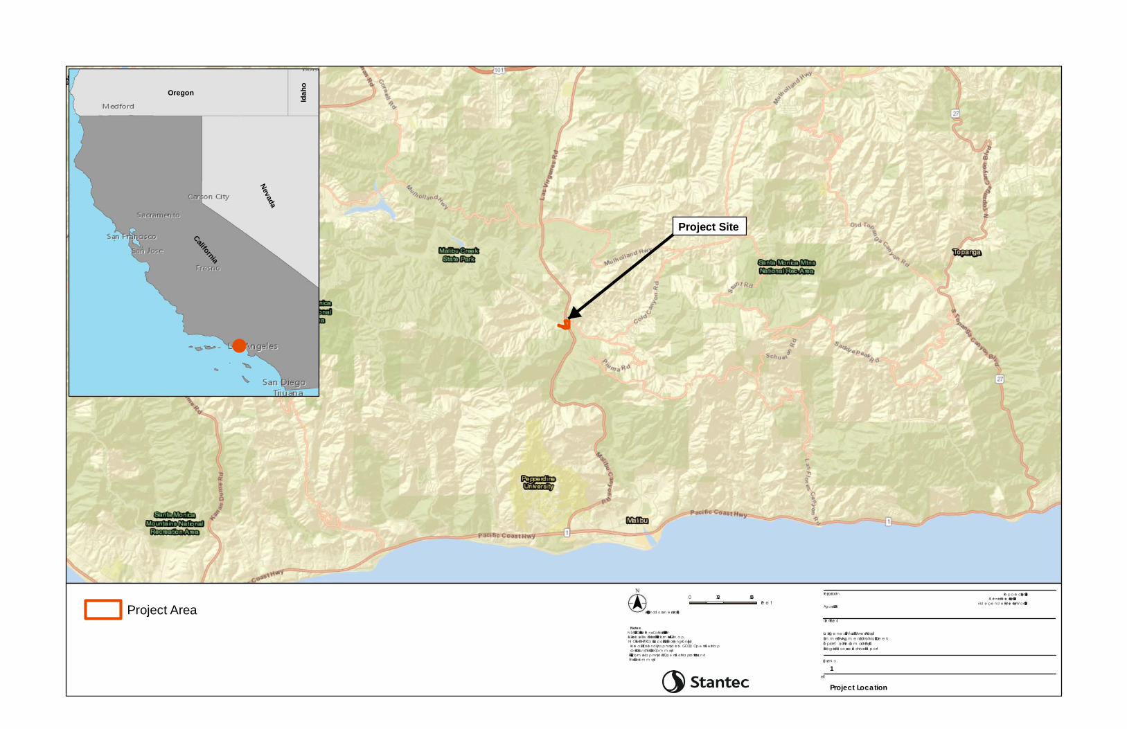
California
Nevada
Oregon
Idaho
Title
Fig ure N o.
Clie nt/Proje ct
Proje ct Loca tion Pre p a re d by JV on 2018-08-16Te chnica l Re vie w by RB on 2018-08-20
Ind e p e nd e nt Re vie w by MW on 2018-08-20Ag oura Hills, CA
La s Virg e ne s – Triunfo Joint Powe rs AuthoritySum m e r Flow Aug m e nta tion of Ma libu Cre e kTa p ia W a te r Re cla m a tion Fa cilityBiolog ica l Re source s Te chinca l Re port
1
Project Location
0 2,750 5,500Fe e t($$¯
1:65,000 (At orig ina l d ocum e nt size of 8.5x11)
Notes1. N AD 1983 CORS96 Sta te Pla ne Ca lifornia V FIPS 0405 Ft US2. Se rvice La ye r Cre d its: Source s: Esri, HERE, De Lorm e , USGS, Inte rm a p,IN CREMEN T P, N RCa n, Esri Ja pa n, METI, Esri China (Hong Kong ), EsriKore a , Esri (Tha ila nd ), Ma p m yInd ia , N GCC, © Op e nStre e tMa pcontributors, a nd the GIS Use r Com m unityEsri, HERE, De Lorm e , Ma p m yInd ia , © Ope nStre e tMa p contributors, a n dthe GIS use r com m unity
Project Area
Project Site
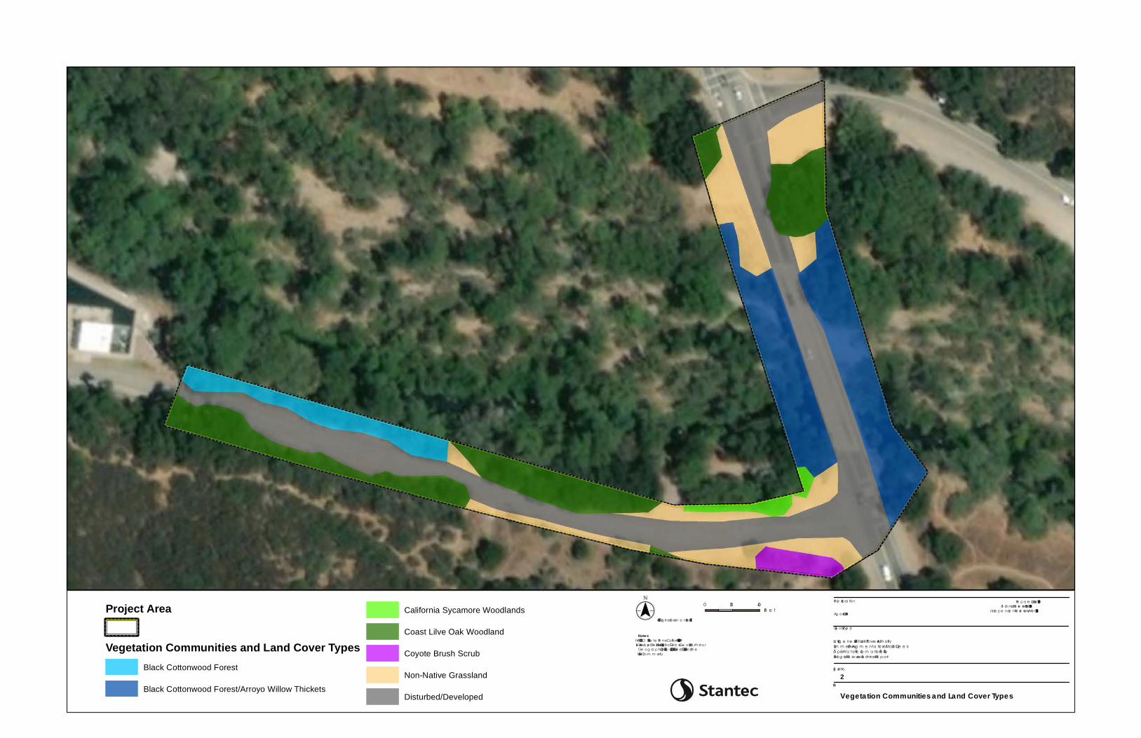
Title
Fig ure No.
Clie nt/Proje ct
Proje ct Loca tion Pre p a re d b y JV on 2018-08-16Te ch nica l Re vie w b y RB on 2018-08-20
Inde p e nde nt Re vie w b y MW on 2018-08-20Ag oura Hills, CA
La s Virg e ne s – Triunfo Joint Powe rs Auth oritySum m e r Flow Aug m e nta tio n of Ma lib u Cre e kTa p ia Wa te r Re cla m a tio n Fa cilityBiolog ica l Re source s Te chinca l Re port
2
Vegetation Communities and Land Cover Types
0 30 60Fe e t($$¯
1:875 (At orig ina l docum e nt size of 8.5x11)
Notes1. NAD 1983 CO RS96 Sta te Pla ne Ca lifornia V FIPS 0405 Ft US2. Se rvice La ye r Cre dits: Source : Esri, Dig ita lGlob e , Ge oEye , Ea rth sta rGe o g ra p h ics, CNES/Airb us DS, USDA, USGS, Ae roGRID, IGN, a nd th eGIS Use r Com m unity
Project Area
XY
XY
XY
XY XY XY XY XY XY XY XY XY XY
XY
XY
XY
XYXYXYXYXYXYXYXYXYXY
Vegetation Communities and Land Cover TypesBlack Cottonwood Forest
Black Cottonwood Forest/Arroyo Willow Thickets
California Sycamore Woodlands
Coast Lilve Oak Woodland
Coyote Brush Scrub
Non-Native Grassland
Disturbed/Developed
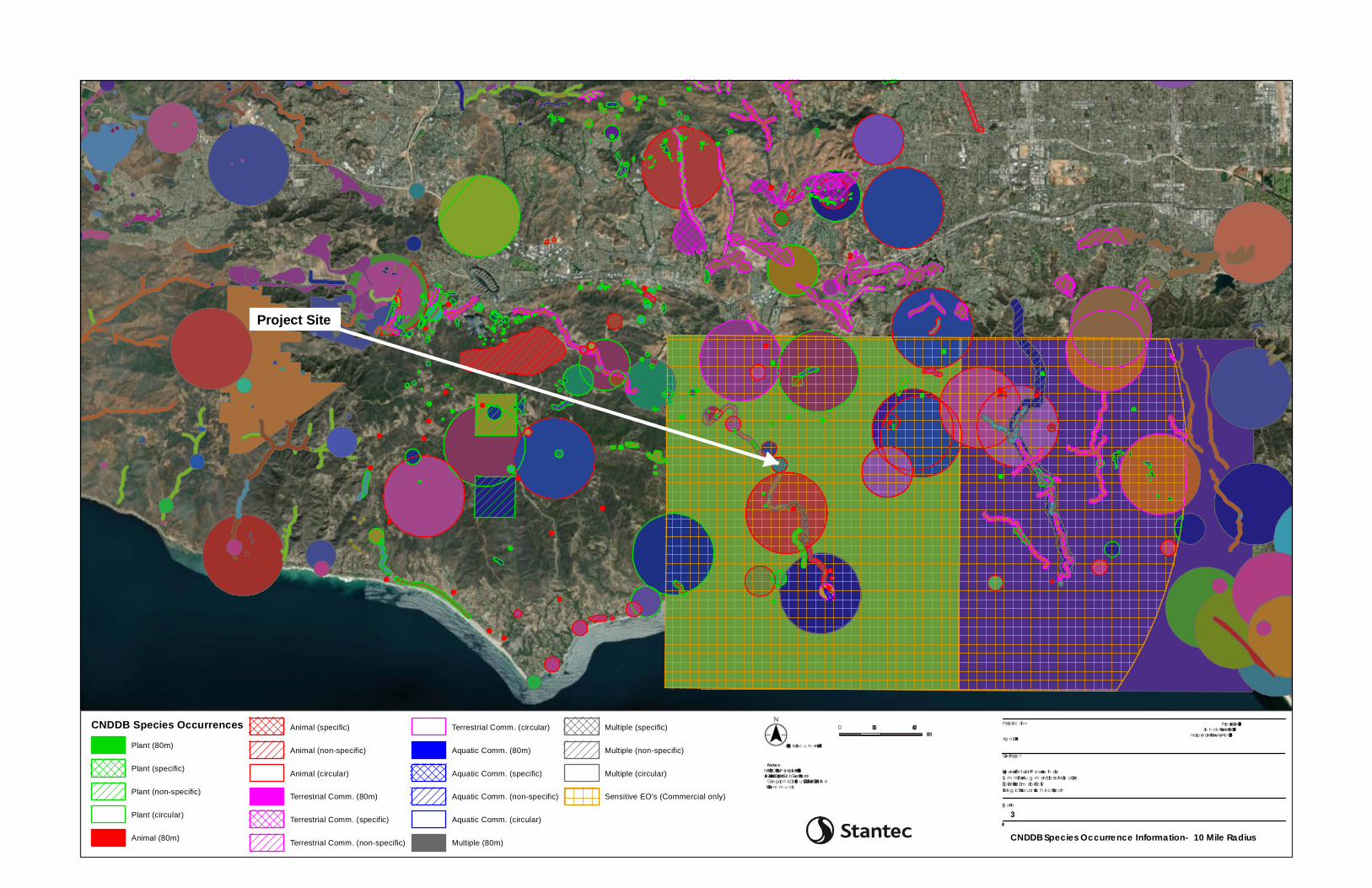
Title
Fig u re No.
Client/P rojec t
P rojec t Loc ation P repared b y JV on 2018-08-16Tec h nic al Review b y RB on 2018-08-20
Independent Review b y MW on 2018-08-20Ag o u ra Hills, CA
Las Virg enes – Triu nfo Joint P owers Au th oritySu m m er Flow Au g m entatio n of Malib u CreekTapia Water Rec lam atio n Fac ilityBiolog ic al Reso u rc es Tec h inc al Report
3
CNDDB Species Occurrence Information- 10 Mile Radius
0 5,300 10,600Feet($$¯
1:125,000 (At orig inal doc u m ent size of 8.5x11)
Notes1. NAD 1983 CORS96 StateP lane California V FIP S 0405 Ft US2. Servic e Layer Credits: Sou rc e: Esri, Dig italGlob e, GeoEye, Earth starGeog rap h ic s, CNES/Airb u s DS, USDA, USGS, AeroGRID, IGN, and th eGIS User Com m u nity
CNDDB Species OccurrencesPlant (80m)
Plant (specific)
Plant (non-specific)
Plant (circular)
Animal (80m)
Animal (specific)
Animal (non-specific)
Animal (circular)
Terrestrial Comm. (80m)
Terrestrial Comm. (specific)
Terrestrial Comm. (non-specific)
Terrestrial Comm. (circular)
Aquatic Comm. (80m)
Aquatic Comm. (specific)
Aquatic Comm. (non-specific)
Aquatic Comm. (circular)
Multiple (80m)
Multiple (specific)
Multiple (non-specific)
Multiple (circular)
Sensitive EO's (Commercial only)
Project Site
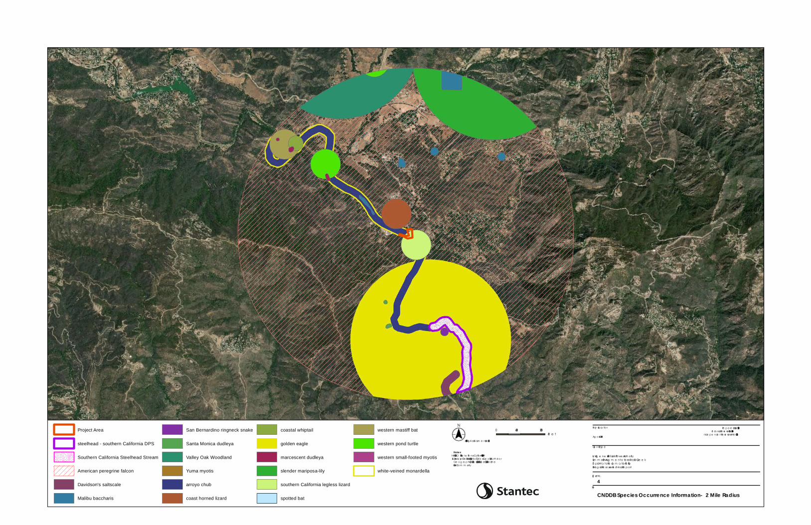
Title
Fig ure No.
Clie nt/Proje ct
Proje ct Loca tion Pre p a re d b y JV on 2018-08-16Te ch nica l Re vie w b y RB on 2018-08-20
Inde p e nde nt Re vie w b y MW on 2018-08-20Ag oura Hills, CA
La s Virg e ne s – Triunfo Joint Powe rs Auth oritySum m e r Flow Aug m e nta tio n of Ma lib u Cre e kTa p ia Wa te r Re cla m a tio n Fa cilityBiolog ica l Re source s Te chinca l Re port
4
CNDDB Species Occurrence Information- 2 Mile Radius
0 1,600 3,200Fe e t($$¯
1:37,489 (At orig ina l docum e nt size of 8.5x11)
Notes1. NAD 1983 CO RS96 Sta te Pla ne Ca lifornia V FIPS 0405 Ft US2. Se rvice La ye r Cre dits: Source : Esri, Dig ita lGlob e , Ge oEye , Ea rth sta rGe o g ra p h ics, CNES/Airb us DS, USDA, USGS, Ae roGRID, IGN, a nd th eGIS Use r Com m unity
Project Area
steelhead - southern California DPS
Southern California Steelhead Stream
American peregrine falcon
Davidson's saltscale
Malibu baccharis
San Bernardino ringneck snake
Santa Monica dudleya
Valley Oak Woodland
Yuma myotis
arroyo chub
coast horned lizard
coastal whiptail
golden eagle
marcescent dudleya
slender mariposa-lily
southern California legless lizard
spotted bat
western mastiff bat
western pond turtle
western small-footed myotis
white-veined monardella
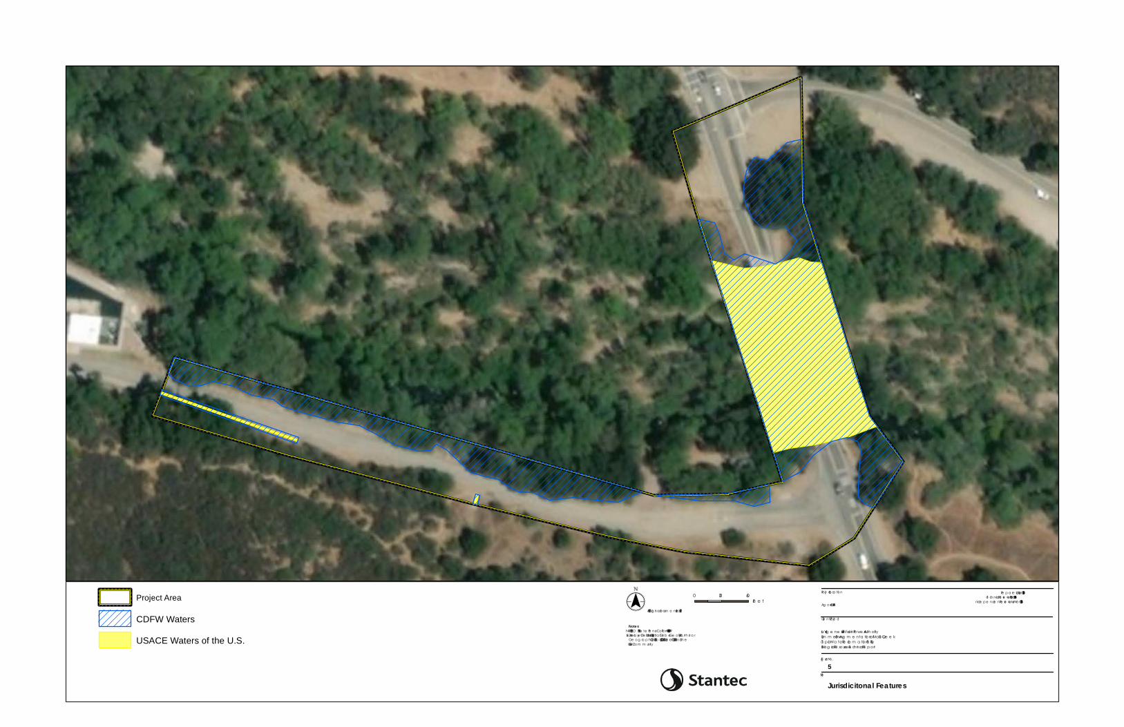
XY
XY
XY
XY
XY
XY
XY
XY
XY
XY
XY
XY
XY
XY
XY
XY
XY
XY
XY
XY
XY
XY
XY
XY
XY
XY
XY
XY
XY
XY
XY
XY
XY
XY
XY
XY
XY
XY
XY
XY
XY
XY
XY
XY
XY
XY
XY
XY
XY
XY
XY
XY
XY
XY
XY
XY
XY
XY
XY
XY
XY
XY
XY
XY
XY
XY
XY
XY
XY
XY
XY
XY
XY
XY
XY
XY
XY
XY
XY
XY
XY
XY
XY
XY
XY
XY
XY
XY
XY
XY
XY
XY
XY
XY
XY
XY
XY
XY
XY
XY
XY
XY
XY
XY
XY
XY
XY
XY
XY
XYXY
XY
XY
XY
XY
XY
XY
XY
XY
XY
XY
XY
XY
XY
XY
XY
XY
XY
XY
XY
XY
XY
XY
XY
XY
XY
XY
XY
XY
XY
XY
XY
XY
XY
XY
XY
XY
XY
XYXYXYXYXYXYXYXYXYXYXYXYXYXYXYXYXYXYXYXYXYXYXYXYXYXYXYXYXYXYXYXYXYXYXYXYXYXYXYXYXYXYXYXYXYXYXYXYXYXYXYXYXYXYXYXYXYXYXYXYXYXYXYXYXYXYXYXYXYXYXYXYXYXYXYXYXYXYXYXYXYXYXYXYXYXYXYXYXYXYXYXYXYXYXYXYXY
XYXYXYXYXY
XYXYXYXY
XYXYXYXY
XYXYXYXY
XYXYXYXY
XYXYXYXY
XYXYXYXYXY
XYXYXYXY
XYXYXYXY
XYXYXYXY
XYXYXYXY
XYXYXYXY
XY
XYXY
XY
XYXY
XYXY
XY
XYXY
XY
XYXY
XY
XYXY
XYXY
XY
XYXY
XY
XYXY
XY
XYXY
XYXY
XY
XYXY
XY
XYXY
XY
XY
XY
XY
XY
XY
XY
XY
XY
XY
XY
XY
XY
XY
XY
XY
XY
XY
XYXY
XY
XY XY
XY XY
XY
XY XY
XY
XY XY
XY XY
XY
XY XY
XY XY
XY
XY XY
XY XY
XY
XY XY
XY
XY XY
XY XY
XY
XY XY
XY XY
XY
XY XY
XY XY
XY
XY XY
XY
XY XY
XY XY XY
XY XY
XY XY
XY
XY XY
XY
XY XY
XY XY
XY
XY XY
XY XY
XY
XY XY
XY XY
XY
XY XY
XY
XY XY
XY XY
XY
XY XY
XY XY
XY
XY XY
XY XY
XY
XY XY
XY
XY XY
XY XY
XY
XY XY
XY XY
XY
XY XY
XY
XY XY
XY XY
XY
XY XY
XY XY
XY
XY XY
XY XY
XY
XY XY
XY
XY XY
XY XY
XY
XY XY
XY XY
XY XY XY XY XY XY XY XY XY XY XY XY XY XY XY XY XY XY XY XY XY XY XY XY XY XY XY XY XY XY XY XY XY XY XY XY
XY
XY
XY
XY
XY
XY
XY
XY
XY
XY
XY
XY
XY
XY
XY
XY
XY
XY
XY
XY
XY
XY
XY
XY
XY
XY
XY
XY
XY
XY
XY
XY
XY
XY
XY
XY
XY
XY
XY
XY
XY
XY
XY
XY
XY
XY
XY
XY
XY
XY
XY
XY
XY
XY
XY
XY
XY
XY
XY
XY
XY
XY
XY
XY
XY
XY
XY
XY
XY
XY
XY
XY
XY
XY
XY
XY
XY
XY
XY
XY
XY
XY
XY
XY
XY
XY
XY
XY
XY
XY
XY
XY
XY
XY
XY
XY
XY
XY
XY
XY
XY
XY
XY
XY
XY
XY
XY
XY
XY
XY
XY
XY
XY
XY
XY
XY
XY
XY
XY
XY
XY
XY
XY
XY
XY
XY
XY
XY
XY
XY
XY
XY
XY
XY
XY
XY
XY
XYXY
Title
Fig ure No.
Clie nt/Proje ct
Proje ct Loca tion Pre p a re d b y JV on 2018-08-16Te ch nica l Re vie w b y RB on 2018-08-20
Inde p e nde nt Re vie w b y MW on 2018-08-20Ag oura Hills, CA
La s Virg e ne s – Triunfo Joint Powe rs Auth oritySum m e r Flow Aug m e nta tio n of Ma lib u Cre e kTa p ia Wa te r Re cla m a tio n Fa cilityBiolog ica l Re source s Te chinca l Re port
5
Jurisdicitonal Features
0 30 60Fe e t($$¯
1:875 (At orig ina l docum e nt size of 8.5x11)
Notes1. NAD 1983 CO RS96 Sta te Pla ne Ca lifornia V FIPS 0405 Ft US2. Se rvice La ye r Cre dits: Source : Esri, Dig ita lGlob e , Ge oEye , Ea rth sta rGe o g ra p h ics, CNES/Airb us DS, USDA, USGS, Ae roGRID, IGN, a nd th eGIS Use r Com m unity
XY
XY
XY
XY XY XY XY XY XY XY XY XY XY
XY
XY
XY
XYXYXYXYXYXYXYXYXYXY
Project Area
CDFW Waters
USACE Waters of the U.S.

APPENDIX B Photographic Log
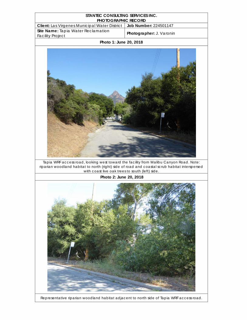
STANTEC CONSULTING SERVICES INC. PHOTOGRAPHIC RECORD
Client: Las Virgenes Municipal Water District Job Number: 224501147 Site Name: Tapia Water Reclamation Facility Project Photographer: J. Varonin
Photo 1: June 20, 2018
Tapia WRF access road, looking west toward the facility from Malibu Canyon Road. Note:
riparian woodland habitat to north (right) side of road and coastal scrub habitat interspersed with coast live oak trees to south (left) side.
Photo 2: June 20, 2018
Representative riparian woodland habitat adjacent to north side of Tapia WRF access road.
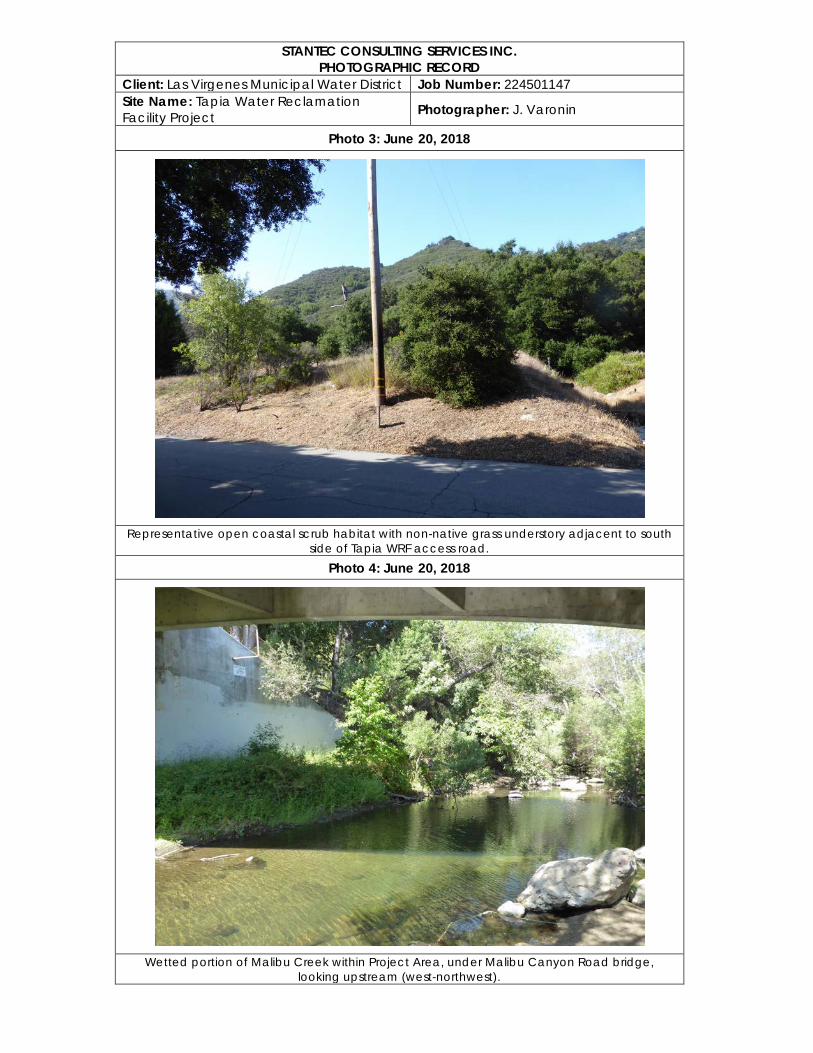
STANTEC CONSULTING SERVICES INC. PHOTOGRAPHIC RECORD
Client: Las Virgenes Municipal Water District Job Number: 224501147 Site Name: Tapia Water Reclamation Facility Project Photographer: J. Varonin
Photo 3: June 20, 2018
Representative open coastal scrub habitat with non-native grass understory adjacent to south
side of Tapia WRF access road. Photo 4: June 20, 2018
Wetted portion of Malibu Creek within Project Area, under Malibu Canyon Road bridge,
looking upstream (west-northwest).
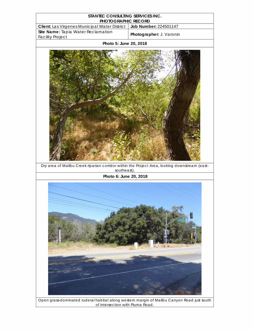
STANTEC CONSULTING SERVICES INC. PHOTOGRAPHIC RECORD
Client: Las Virgenes Municipal Water District Job Number: 224501147 Site Name: Tapia Water Reclamation Facility Project Photographer: J. Varonin
Photo 5: June 20, 2018
Dry area of Malibu Creek riparian corridor within the Project Area, looking downstream (east-
southeast). Photo 6: June 20, 2018
Open grass-dominated ruderal habitat along western margin of Malibu Canyon Road just south
of intersection with Piuma Road.
Appendix B Cultural Resources Technical Report
Cultural Resources Evaluation for the Summer Flow Augmentation of Malibu Creek
August 2018
Prepared for: Las Virgenes Municipal Water District – Triunfo Sanitation District Joint Powers Authority Prepared by: Victoria Harvey and Hubert Switalski Stantec Consulting Services Inc. 5500 Ming Avenue Suite 300 Bakersfield, California 93309-4627
This document entitled Cultural Resources Evaluation for the Summer Flow Augmentation of Malibu Creek was prepared by Stantec Consulting Services Inc. (“Stantec”) for the account of the Los Angeles Department of Water and Power (the “Client”). Any reliance on this document by any third party is strictly prohibited. The material in it reflects Stantec’s professional judgment in light of the scope, schedule and other limitations stated in the document and in the contract between Stantec and the Client. The opinions in the document are based on conditions and information existing at the time the document was published and do not take into account any subsequent changes. In preparing the document, Stantec did not verify information supplied to it by others. Any use which a third party makes of this document is the responsibility of such third party. Such third party agrees that Stantec shall not be responsible for costs or damages of any kind, if any, suffered by it or any other third party as a result of decisions made or actions taken based on this document.
CULTURAL RESOURCES EVALUATION FOR THE SUMMER FLOW AUGMENTATION OF MALIBU CREEK
Table of Contents
EXECUTIVE SUMMARY ............................................................................................................ i
ABBREVIATIONS .......................................................................................................................ii
1.0 PROJECT DESCRIPTION ............................................................................................. 1
2.0 REGULATORY BACKGROUND ................................................................................... 1
3.0 CULTURAL BACKGROUND ......................................................................................... 6 3.1 ARCHAEOLOGICAL BACKGROUND ............................................................................ 6
3.1.1 Topanga I - 8,500 to 5,000 ybp ...................................................................... 6 3.1.2 Topanga II - 5,000 to 3,500 ybp ..................................................................... 6 3.1.3 Angeles I - 3,500 to 2,600 ybp ........................................................................ 7 3.1.4 Angeles II - 2,600 to 1,600 ybp ....................................................................... 7 3.1.5 Angeles III - 1,600 to 1,250 ypb ...................................................................... 7 3.1.6 Angeles IV - 1,250 to 800 ybp ........................................................................ 7 3.1.7 Angeles V - 800 to 450 ypb ............................................................................ 7 3.1.8 Angeles VI - 450 to 150 ybp ........................................................................... 7
3.2 ETHNOGRAPHIC BACKGROUND ................................................................................ 8 3.2.1 Chumash........................................................................................................ 8 3.2.2 Tongva ........................................................................................................... 9
3.3 HISTORIC BACKGROUND ...........................................................................................10 3.3.1 Regional Historic Overview .......................................................................... 10 3.3.2 Las Virgenes Municipal Water District .......................................................... 11
4.0 RECORD SEARCH AND LITERATURE REVIEW ........................................................12 4.1 PREVIOUS STUDIES WITHIN THE STUDY AREA ......................................................12 4.2 PREVIOUSLY DOCUMENTED RESOURCES WITHIN THE STUDY AREA .................13
5.0 ARCHAEOLOGICAL SURVEY/FIELD RECONNAISSANCE .......................................13
6.0 TRIBAL CONSULTATION ............................................................................................15
7.0 PALEONTOLOGICAL RESOURCES ...........................................................................16
8.0 CONCLUSIONS AND RECOMMENDATIONS .............................................................16
9.0 REFERENCES ..............................................................................................................17
CULTURAL RESOURCES EVALUATION FOR THE SUMMER FLOW AUGMENTATION OF MALIBU CREEK
LIST OF TABLES Table 1. Previously Documented Reports within the Study Area .......................................12 Table 2. Previously Documented Resources within the Study Area ....................................13
LIST OF FIGURES Figure 1. Vicinity Map ................................................................................................................. 2 Figure 2. Location Map .............................................................................................................. 3 Figure 3. Proposed Traditions for the Los Angeles Region of Southern California From
Sutton 2010:9. ............................................................................................................. 8 Figure 4. Vegetation ..................................................................................................................15 Figure 5. Overview ....................................................................................................................15
CULTURAL RESOURCES EVALUATION FOR THE SUMMER FLOW AUGMENTATION OF MALIBU CREEK
i
Executive Summary
On June 27, 2018 Stantec Consulting Services, Inc. (Stantec), at the request of the Las Virgenes Municipal Water District (LVMWD) conducted a cultural resources study of an area of approximately 4.8 acres located on the west side of Malibu Creek in unincorporated Los Angeles County, California. The study was conducted as part of California Environmental Quality Act (CEQA) Initial Study for the Summer Augmentation of Malibu Creek Project. This report describes the cultural resources study methodology with conclusions and recommendations based on the results.
The proposed project is subject to compliance with CEQA requirements regarding the project's impacts on cultural resources. CEQA (Public Resources Code Sections 21000 etc.) requires that, before approving most discretionary projects, the Lead Agency must identify and examine any significant adverse environmental effects that may result from activities associated with such projects (Public Resources Code Sections 21083.2 and 21084.1). CEQA explicitly requires that the Initial Study examine whether the project may result in a significant adverse change to “historical resources” and “unique archaeological resources.” Under these requirements, a cultural resources inventory was conducted to determine impacts of future projects on any cultural resources potentially eligible for nomination to the California Register of Historical Resources (CRHR) and/or the National Register of Historic Places (NRHP).
This preliminary cultural resource assessment included a record search and literature review conducted at the South-Central Coastal Information Center (SCCIC) of the California Historic Resource Information System (CHRIS) located at California State University, Fullerton. The background research included review of previously conducted cultural resource surveys and inventories, excavation reports, and regional overviews that were previously conducted within a ½-mile radius of the current Project Area as well as presence of previously documented cultural resources.
The records search results revealed that 13 cultural resources studies were previously conducted within portions of the current Project Area and within a ½-mile radius of the Project Area. Of those 13 studies, two are evaluation and interpretive plans for Malibu Creek State Park, located adjacent to the Project Area. There have been no previous studies conducted within the Project Area. Additionally, four are surveys, all conducted before 2006, and one is a monitoring report. The results of the background research revealed that no cultural resources were previously documented within the Project Area; however, there have been 10 cultural resources previously identified within a ½-mile radius of the Project Area.
In addition, the cultural resources study included an intensive pedestrian survey of the Project Area on June 27, 2018. The survey was conducted at transect intervals of 15-meters or less and areas with exposed washes, erosional banks, and/or animal burrows that could potential expose buried cultural deposits were inspected. During the survey no new or previously documented cultural resources were identified within the Project Area.

CULTURAL RESOURCES EVALUATION FOR THE SUMMER FLOW AUGMENTATION OF MALIBU CREEK
ii
Based on the results of this study, no significant and/or archaeological resources were identified within the Project Area. Therefore, less than significant impacts to cultural resources as defined in Section 15064.5 are expected. The Project will require no additional investigation or evaluation at this time.
CULTURAL RESOURCES EVALUATION FOR THE SUMMER FLOW AUGMENTATION OF MALIBU CREEK
iii
Abbreviations
BRM Bedrock Mortar Milling Station
CEQA California Environmental Quality Act
CRHR California Register of Historical Resources
GPS Global Positioning System
IS Initial Study
LA Los Angeles
LVMWD Las Virgenes Municipal Water District
LACDPW Los Angeles Department of Public Works
MND Mitigated Negative Declaration
Metropolitan Metropolitan Water District of Southern California
NAHC Native American Heritage Commission
NHPA National Historic Preservation Act
NRHP National Register of Historic Places
NAHC Native American Heritage Commission
SCCIC South Central Coastal Information Center
SWP State Water Project
TCR Tribal Cultural Resources
USGS United States Geological Survey
WRF Water Reclamation Facility
ybp years before present
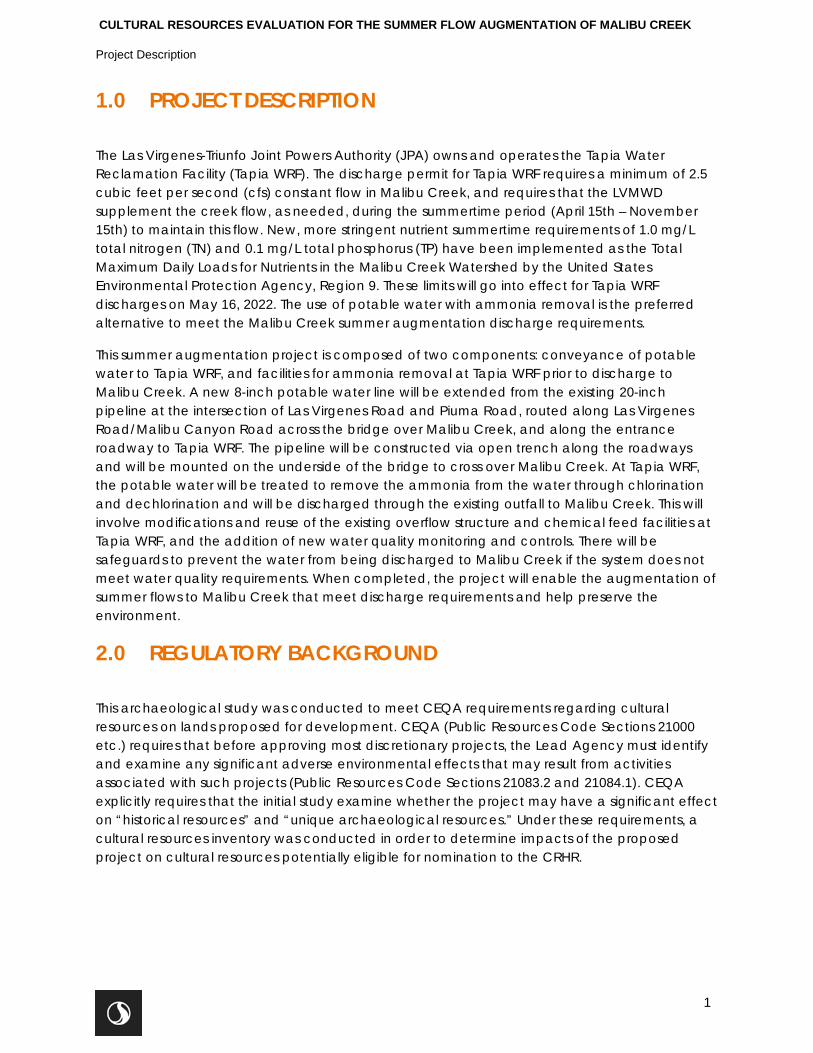
CULTURAL RESOURCES EVALUATION FOR THE SUMMER FLOW AUGMENTATION OF MALIBU CREEK
Project Description
1
1.0 PROJECT DESCRIPTION
The Las Virgenes-Triunfo Joint Powers Authority (JPA) owns and operates the Tapia Water Reclamation Facility (Tapia WRF). The discharge permit for Tapia WRF requires a minimum of 2.5 cubic feet per second (cfs) constant flow in Malibu Creek, and requires that the LVMWD supplement the creek flow, as needed, during the summertime period (April 15th – November 15th) to maintain this flow. New, more stringent nutrient summertime requirements of 1.0 mg/L total nitrogen (TN) and 0.1 mg/L total phosphorus (TP) have been implemented as the Total Maximum Daily Loads for Nutrients in the Malibu Creek Watershed by the United States Environmental Protection Agency, Region 9. These limits will go into effect for Tapia WRF discharges on May 16, 2022. The use of potable water with ammonia removal is the preferred alternative to meet the Malibu Creek summer augmentation discharge requirements.
This summer augmentation project is composed of two components: conveyance of potable water to Tapia WRF, and facilities for ammonia removal at Tapia WRF prior to discharge to Malibu Creek. A new 8-inch potable water line will be extended from the existing 20-inch pipeline at the intersection of Las Virgenes Road and Piuma Road, routed along Las Virgenes Road/Malibu Canyon Road across the bridge over Malibu Creek, and along the entrance roadway to Tapia WRF. The pipeline will be constructed via open trench along the roadways and will be mounted on the underside of the bridge to cross over Malibu Creek. At Tapia WRF, the potable water will be treated to remove the ammonia from the water through chlorination and dechlorination and will be discharged through the existing outfall to Malibu Creek. This will involve modifications and reuse of the existing overflow structure and chemical feed facilities at Tapia WRF, and the addition of new water quality monitoring and controls. There will be safeguards to prevent the water from being discharged to Malibu Creek if the system does not meet water quality requirements. When completed, the project will enable the augmentation of summer flows to Malibu Creek that meet discharge requirements and help preserve the environment.
2.0 REGULATORY BACKGROUND
This archaeological study was conducted to meet CEQA requirements regarding cultural resources on lands proposed for development. CEQA (Public Resources Code Sections 21000 etc.) requires that before approving most discretionary projects, the Lead Agency must identify and examine any significant adverse environmental effects that may result from activities associated with such projects (Public Resources Code Sections 21083.2 and 21084.1). CEQA explicitly requires that the initial study examine whether the project may have a significant effect on “historical resources” and “unique archaeological resources.” Under these requirements, a cultural resources inventory was conducted in order to determine impacts of the proposed project on cultural resources potentially eligible for nomination to the CRHR.
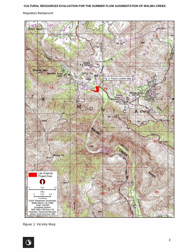
CULTURAL RESOURCES EVALUATION FOR THE SUMMER FLOW AUGMENTATION OF MALIBU CREEK
Regulatory Background
2
Figure 1. Vicinity Map
CULTURAL RESOURCES EVALUATION FOR THE SUMMER FLOW AUGMENTATION OF MALIBU CREEK
Regulatory Background
3
Figure 2. Location Map
CULTURAL RESOURCES EVALUATION FOR THE SUMMER FLOW AUGMENTATION OF MALIBU CREEK
Regulatory Background
4
CEQA (California Public Resources Code Section 21000 et seq.) (1970) establishes that historical and archaeological resources are afforded consideration and protection (14 CCR Section 21083.2, 14 CCR Section 15064). The CEQA Guidelines define significant cultural resources under three regulatory designations: historical resources, tribal cultural resources, and unique archaeological resources. These designations permit for a fair amount of overlap.
A historical resource is a “resource listed in, or determined to be eligible by the State Historical Resources Commission, for listing in the CRHR”; or “a resource listed in a local register of historical resources or identified as significant in a historical resource survey meeting the requirements of Section 5024.1(g) of the Public Resources Code”; or “any object, building, structure, site, area, place, record, or manuscript which a lead agency determines to be historically significant or significant in the architectural, engineering, scientific, economic, agricultural, educational, social, political, military, or cultural annals of California, provided the agency’s determination is supported by substantial evidence in light of the whole record” (14 CCR Section 15064.5[a][3]). Historical resources automatically listed in the CRHR include California cultural resources listed in or formally determined eligible for the NRHP and California Registered Historical Landmarks from No. 770 onward (PRC 5024.1[d]). Locally listed resources are entitled to a presumption of significance unless a preponderance of evidence in the record indicates otherwise.
Tribal Cultural Resources (TCRs) are similar to the traditional cultural property designation within the National Historic Preservation Act (NHPA) guidance. These can be sites, features, places, cultural landscapes, and sacred places or objects that have cultural value or significance to a Tribe. To qualify as a TCR, it must either be 1) listed on or eligible for listing on the California Register or a local historic register or, 2) or is a resource that the lead agency, at its discretion and supported by substantial evidence, determines should be treated as a TCR (PRC Section 21074). TCRs can include “non-unique archaeological resources” (see “unique archaeological resource” below) that, rather than being important for “scientific” value as a resource, can also be significant because of the sacred and/or cultural tribal value of the resource. Tribal representatives are considered experts appropriate for providing substantial evidence regarding the locations, types, and significance of tribal cultural resources within their traditionally and culturally affiliated geographic area (PRC Section 21080.3.1(a)).
Under CEQA, a resource is generally considered historically significant if it meets the criteria for listing in the CRHR. A resource must meet at least one of the following criteria (PRC 5024.1; 14 CCR Section 15064.5[a][3]):
1. Is associated with events that have made a significant contribution to the broad patterns of California’s history and cultural heritage. Title 14, CCR Section 4852(b)(1) adds, “is associated with events that have made a significant contribution to the broad patterns of local or regional history, or the cultural heritage of California or the United States.”
2. Is associated with the lives of persons important in our past. Title 14, CCR Section 4852(b)(2) adds, “is associated with the lives of persons important to local, California, or national history.”
3. Embodies the distinctive characteristics of a type, period, region, or method of construction; or represents the work of an important creative individual; or possesses high artistic values. Title 14, CCR 4852(b)(3) allows a resource to be CRHR eligible if it represents the work of a master.
CULTURAL RESOURCES EVALUATION FOR THE SUMMER FLOW AUGMENTATION OF MALIBU CREEK
Regulatory Background
5
4. Has yielded, or may be likely to yield, information important in prehistory or history. Title 14, CCR 4852(b)(4) specifies that importance in prehistory or history can be defined at the scale of “the local area, California, or the nation.”
Historical resources must also possess integrity of location, design, setting, materials, workmanship, feeling, and association (14 CCR 4852[c]).
An archaeological artifact, object, or site can meet CEQA’s definition of a unique archaeological resource even if it does not qualify as a historical resource (PRC 21083.2[g]; 14 CCR 15064.5[c][3]). An archaeological artifact, object, or site is considered a unique archaeological resource if “it can be clearly demonstrated that, without merely adding to the current body of knowledge, there is a high probability that it meets any of the following criteria (PRC 21083.2[g]):
• Contains information needed to answer important scientific research questions and there is a demonstrable public interest in that information.
• Has a special and particular quality such as being the oldest of its type or the best available example of its type.
• Is directly associated with a scientifically recognized important prehistoric or historic event or person.”
Public Resources Code 5097.98. This section discusses the procedures that need to be followed upon the discovery of Native American human remains. The NAHC, upon notification of the discovery of human remains is required to contact the County Coroner pursuant to subdivision (c) of Section 7050.5 of the Health and Safety Code and shall immediately notify those persons it believes to be most likely descended from the deceased Native American.
Health and Safety Code 7050.5. This code establishes that any person, who knowingly mutilates, disinters, wantonly disturbs, or willfully removes any human remains in or from any location without authority of law is guilty of a misdemeanor. It further defines procedures for the discovery and treatment of Native American human remains.
The Project Area is confined to the Tapia WRF access road and across Malibu Creek along a bridge owned and maintained by the Los Angeles County Department of Public Works (LACDPW), identified as Bridge 989 along LA County Road N-1. The Project Area begins at the existing 20-inch pipeline in Las Virgenes Road, and is constructed via open trench to the bridge. The pipe is then mounted under the existing LA County Bridge. After the bridge, the pipe is constructed via open trench in the roadway across Las Virgenes Road and then along the entrance road to Tapia WRF and the chlorination / dechlorination basin. It is expected that any potential adverse impacts, including ground disturbance, will be contained within this acreage. The Study Area for this project consists of the Project Area and a ½-mile radius surrounding the Project Area.
6
CULTURAL RESOURCES EVALUATION FOR THE SUMMER FLOW AUGMENTATION OF MALIBU CREEK
Cultural Background
3.0 CULTURAL BACKGROUND
Regional human occupation chronologies for parts of southern California and the Southwest have been employed for this locality (Elsasser 1978; Warren and Crabtree 1986). Such sequences are generally based on the presence of temporally diagnostic artifacts, such as projectile points, pottery, or beads. The most recent chronological clarification of the prehistory of the southern California area has been presented by Sutton (2010) and Sutton and Gardner (2010). The more recent chronology is presented below.
3.1 ARCHAEOLOGICAL BACKGROUND
The earliest period of human occupation in southern California is referred to by various terms, including Clovis, Paleoindian, and Early Systems Period. This is a time believed to have commenced about 12,000 years before present (ybp), lasting until about 10,000 years BP. While some scholars have championed the idea of a Pre-Projectile Point Tradition predating this time, it is not considered here, as there are no documented sites of this age near the current Study Area. The following cultural periods reflect human adaptations that occurred among prehistoric societies in inland California. While these are broad generalizations, there appear to be similarities among various populations in southern California, particularly in the inland areas.
Prehistoric chronological sequences for the area can be represented by the Encinitas Tradition and the Del Rey Tradition. The Del Rey Tradition is proposed to have begun with the influx of Takic speakers into the Los Angeles Basin approximately 3,500 years ago and is named for the Del Rey archaeological site near Santa Monica (Sutton 2010). Two patterns within the Del Rey Tradition, the Angeles and Island, reflect geographic variability; although, geographic boundaries for this time period are not clearly delineated. The Del Rey Tradition can be divided into six phases (Phases I-VI) with Angeles I approximately 3,500 years before present (ybp) (Sutton 2010:10). Before the emergence of the Angeles I, the coastal Los Angeles area is defined by Topanga I and II of the Encinitas Tradition (Figure 3). The traits associated with each phase discussed briefly below is from Sutton 2010 and Sutton and Gardener 2010.
3.1.1 Topanga I - 8,500 to 5,000 ybp
During the Topanga I Phase of the Encinitas Tradition there were numerous ground stone artifacts (manos and metates), core tools, charmstones, cogged stones, and large, but not abundant, flaked stone points. Shellfish was an important resource at this time. Mortuary practices include secondary inhumations under metates, some extended burials, but no cremations.
3.1.2 Topanga II - 5,000 to 3,500 ybp
During the Topanga II Phase there was still an abundance of ground stone artifacts but the numbers seem to be decreasing. Mortars and pestles are now being used and some stone balls and charmstones are found in archaeological sites dating to this period. Shellfish is still an important resources and acorns are being added to the diet. Secondary reburial of long bones only is noted, and flexed inhumations are now being adopted. Cremations are rare.
CULTURAL RESOURCES EVALUATION FOR THE SUMMER FLOW AUGMENTATION OF MALIBU CREEK
Cultural Background
7
3.1.3 Angeles I - 3,500 to 2,600 ybp
This phase marks the arrival of Takic speaking groups from the north, accompanied by a population increase and a shift to fewer and larger settlements along the coast. There appears to be less dependence on shellfish and more fishing and hunting subsistence strategies. This includes an increase in the number of projectile points and the appearance of the Elko style dart point and donut stones. This phase introduces an extensive trade in steatite artifacts such as beads and pipes and Olivella shell beads. Obsidian from the Coso volcanic fields becomes important.
3.1.4 Angeles II - 2,600 to 1,600 ybp
The Angeles II Phase continues with the Angeles I phase settlement and subsistence patterns and material culture. Fish hooks become more common during this phase and there is an addition of mortuary features that contain broken tools and cremated human bone.
3.1.5 Angeles III - 1,600 to 1,250 ypb
The Angeles III Phase is marked by the introduction of bow-and-arrow technology and changes in Olivella shell bead types. There is a reduction in obsidian use at the same time that Coso obsidian from the northeast is replaced in importance by obsidian from Obsidian Butte to the southeast, showing a shift in trade patterns. Larger, seasonal villages become more common. Funerary practices are primarily flexed inhumation and obsidian grave goods begin to be seen. There is also an increase in cremations.
3.1.6 Angeles IV - 1,250 to 800 ybp
Angeles IV Phase introduces the smaller Cottonwood style point type and imported ceramics begin to be seen. This phase may mark the appearance of ceramic pipes as well. There is a continued shift to larger but fewer permanent settlements and an expansion into the San Gabriel Mountains, displacing other groups that occupied the areas.
3.1.7 Angeles V - 800 to 450 ypb
During the Angeles V Phase there is an intensification of trade in steatite artifacts with the southern Channel Islands, with the artifact variety increasing to include larger artifacts such as vessels and comals. This brings with it a strengthening of trade relationships with the Channel Islands. Expansion continues with expansion into the Santa Ana Mountains and San Joaquin Hills.
3.1.8 Angeles VI - 450 to 150 ybp
The Angeles VI Phase introduces Euromerican goods such as glass beads and metal tools into the Native material culture. Olivella shell beads are found in archaeological sites with evidence of having been drilled with metal needles. Settlement patterns change as well, with movement closer to missions and ranches. Domesticated animals from the Euromerican settlers are being introduced into Native lifestyle. It is during this time that the Chingichngish religion is introduced.
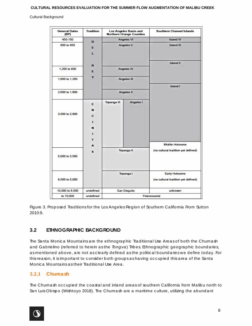
CULTURAL RESOURCES EVALUATION FOR THE SUMMER FLOW AUGMENTATION OF MALIBU CREEK
Cultural Background
8
Figure 3. Proposed Traditions for the Los Angeles Region of Southern California From Sutton 2010:9.
3.2 ETHNOGRAPHIC BACKGROUND
The Santa Monica Mountains are the ethnographic Traditional Use Areas of both the Chumash and Gabrielino (referred to herein as the Tongva) Tribes. Ethnographic geographic boundaries, as mentioned above, are not as clearly defined as the political boundaries we define today. For this reason, it is important to consider both groups as having occupied this area of the Santa Monica Mountains as their Traditional Use Area.
3.2.1 Chumash
The Chumash occupied the coastal and inland areas of southern California from Malibu north to San Luis Obispo (Wishtoyo 2018). The Chumash are a maritime culture, utilizing the abundant
CULTURAL RESOURCES EVALUATION FOR THE SUMMER FLOW AUGMENTATION OF MALIBU CREEK
Cultural Background
9
resources of both the sea and the land (Wishtoyo 2018). The Chumash people can be divided into six groups based on language variation that are related under the more comprehensive Chumashan Language Family (Sampson n.d.). The name Chumash, as it is used today, represents the complex Native population that occupied the areas along the coast from San Luis Obispo to Malibu and inland as far as the San Joaquin Valley, including four islands off the California coast. Chumash was not the name used by these people and appears to have been derived by Powell in 1891 from a word used by the Native people living along the coast to identify Santa Cruz Island and its inhabitants (Grant 1978:507), but was introduced to the public by anthropologist Alfred E. Kroeber in his 1925 work (reprinted 1976) Handbook of California Indians (Sampson n.d.).
The Chumash were likely the first group of Native Californians “discovered” by early explorers, beginning with Juan Cabrillo in 1542 and later, in 1602, when Sebastian Vizcaino named the Santa Barbara Channel (Grant 1978). Other explorations followed, all noting the heavily populated Santa Barbara coastal regions while describing the people who inhabited the region. Kroeber estimated the population within the large Chumash territory to be between 8 and 10 thousand (Grant 1978:506).
The Chumash had a high level of material culture and craftsmanship, including intricate basketry, woodcarving, fine stone objects, well-developed rock art, and excellent oceangoing plank canoes (tomol) that highly impressed Spanish explorers. The Chumash had an extensive trade network that reached well beyond the Santa Barbara Channel region. Shell beads made from Olivella biplicata shells found along the Santa Barbara coast have been identified in large amounts in archaeological sites in the Western Mojave Desert (Harvey 2000). In 1775, Spaniard Pedro Fages commented that the Chumash were very inclined to trade, barter, and engage in general commerce (Erlandson 1994).
Several Chumash villages have been identified in the Malibu area during extensive research by Doctors Chester King and John Johnson into the Spanish Mission archives, accounts from early explorers, and early anthropological writings (Sampson n.d.). These villages include Humaliwo, near the Malibu Lagoon and Ta’lopop in Malibu Canyon (Sampson n.d.).
3.2.2 Tongva
Early Native American peoples of this area are poorly understood. The presence of occupation in this area by the ethnohistoric Gabrielino (Tongva) people began to be demonstrated about 1,000 years ago. Ethnohistorically the Tongva were semi-sedentary hunters and gatherers whose language is one of the Cupan languages in the Takic family, part of the Uto-Aztecan linguistic stock (Bean and Smith 1978).
The Tongva territory encompassed a vast area that stretched from Topanga Canyon in the northwest, to the base of Mount Wilson in the north, to San Bernardino in the east, Aliso Creek in the southeast and the Southern Channel Islands, in all, an area of more than 2,500 square miles (Bean and Smith 1978, McCawley 1996). At European contact, the tribe consisted of more than 5,000 people living in various settlements throughout the area (McCawley 1996). Some of the villages could be quite large, housing up to 150 people. The Tongva are considered to have been one of the wealthiest tribes and they appear to have greatly influenced tribes they traded with (Kroeber 1976:621).
CULTURAL RESOURCES EVALUATION FOR THE SUMMER FLOW AUGMENTATION OF MALIBU CREEK
Cultural Background
10
The Tongva practiced a hunting and gathering economy and subsistence zones exploited were marine, woodland and grassland (Bean and Smith 1978). At the time of contact, plant foods were the more significant part of the Tongva diet with acorns being the most important food source exploited. Therefore, it was necessary that villages be located near water sources to allow for the leaching or removal of tannic acids from the acorns. Grass seeds and chia were also heavily utilized. Seeds were parched, then ground and cooked as mush in various combinations according to taste and availability. Other fruit and plant foods would be eaten raw or cooked and they could be dried for storage. Bulbs, roots, and tubers were dug in the spring and summer and usually eaten fresh. Mushrooms and tree fungus were prized as delicacies. Various teas were made from flowers, fruits, stems, and roots for medicinal cures as well as beverages (Bean and Smith 1978:538-540).
The principal game animals were deer, rabbit, jackrabbit, woodrat, mice, ground squirrels, antelope, quail, dove, ducks, and other birds (Bean and Smith 1978). Predators were largely avoided as food, as were tree squirrels and most reptiles (Bean and Smith 1978). Fresh water fish were caught in the streams and rivers, while salmon were available when they ran in the larger creeks (Bean and Smith 1978). Sea mammals, fish, and crustaceans were hunted and gathered from both the shoreline and the open ocean, using reed and dugout canoes by coastal Tongva groups. Shellfish were the most common resource, including abalone, turbans, mussels, clams, scallops, bubble shells, and others (Bean and Smith 1978:538-540).
Houses were domed, circular structures thatched with tule or similar materials (Bean and Smith 1978:542). The Tongva are renowned for their workmanship of steatite and these artifacts were highly prized (Bean and Smith 1978). Common everyday items were often decorated with inlaid shell or carvings reflecting the intricately developed skill (Bean and Smith 1978:542).
Tongva cosmology centered on the creator Chingichngish (Bean and Smith 1978). Chingichngish was a new leader who appeared to the people as if in a vision, fulfilling the role vacated by the god Wiyot who had been murdered by his sons because of his cruelty. Chingichngish dictated the laws and religion for the people and created, out of mud, a new race of people. An open-air, ceremonial enclosure called a yuva’r was erected near the chief’s home as centers relating to the Chingichngish religion. The yuva’r was made of willow, oval in shape, and decorated with feathers, animal skins, and flowers (Smith and Bean 1978:542). An image representing Chingichngish was a part of the most sacred spot within the yuva’r (Bean and Smith 1978:542). By the time the Spanish arrived in Tongva territory, the Chingichngish religion had become formalized and had spread into neighboring groups (Smith and Bean 1978:548).
3.3 HISTORIC BACKGROUND
3.3.1 Regional Historic Overview
The first written accounts of the southern California coastal area occurred when Juan Cabrillo visited the Pueblo de las Canoas, believed to be the ethnographic village of Muwu near Point Magu or possibly even the village of Humaliwo at the mouth of the Malibu Lagoon (ACOE 2017). In 1602, the Vizcaíno expedition was met by representatives from the Chumash Tribe, from the
CULTURAL RESOURCES EVALUATION FOR THE SUMMER FLOW AUGMENTATION OF MALIBU CREEK
Cultural Background
11
Muwu village (ACOE 2017:129). The Chumash took a canoe, a tomol, out to welcome the foreigners, though the Europeans did not come ashore. Land expeditions began in 1770 when the Portola Expedition passed through the southern California area. In 1776, the Anza Expedition camped near Las Virgenes Creek along the newly established north-south trending El Camino Real that passes through the current City of Calabasas. Local Tongva and Chumash people from the area were removed from their Traditional Use Area to the San Buenaventura Mission (established in 1782) in the current City of Ventura, about 40-miles north along the Pacific coast, or Mission San Fernando (established 1797), about 40-miles north-east along existing roads. By the end of the mission period in California, 1834, Native populations had been drastically depleted by disease and villages once large and productive, were gone.
Several large land grants surrounded the Project Area, including the Rancho de Santa Gertrudis de Las Virgenes just north of the Project Area, and Topanga Malibu Sequit along the coast. Rancho de las Virgenes was one that was given to the San Fernando Mission in 1817 to be used for grazing land as it was considered abandoned. Once the missions were secularized the land was sold or granted to former mission Indians (ACOE 2017). Early enterprise in the area centered on ranching, making use of the areas abundant natural resources. Land holdings remained relatively intact until the 1920s-1930s when they began being sub-divided and sold to people such as the wealthy businessmen and “Hollywood stars” who were discovering the joys of having beachfront property for weekend get-aways, building the exclusive enclaves of Malibu and Calabasas and other incorporated cities of today (ACOE 2017:130). One of the largest land owners in the area, the Rindge Family managed to acquire almost 30,000-acres of land grants in the 1890s. They sold off lots but also donated land for conservation in the 1960s and 70s (ACOE 2017).
3.3.2 Las Virgenes Municipal Water District
The Metropolitan Water District of Southern California (Metropolitan) was formed in 1928 to create a united effort among individual city water districts to assure that these southern California cities were able to provide their residents with an adequate water supply. The first proposal from the Metropolitan was to build an aqueduct stretching across 242-miles of desert, from the Colorado River at the California-Arizona border west to Lake Matthews in Riverside County. The bond was approved by voters in 1931 and two years later construction began, one of the largest public works projects during the Great Depression. Today, Metropolitan consists of 26 members in six counties and provides water imported from northern California. LVMWD is one of Metropolitan’s members.
LVMWD provides potable water, wastewater treatment, recycled water and biosolids composting to more than 65,000 residents in the cities of Agoura Hills, Calabasas, Hidden Hills, Westlake Village, and unincorporated areas of western Los Angeles County for an area that encompasses 122-square miles (97,4640 acres). LVMWD's potable water is provided almost entirely through: wholesale purchases from Metropolitan, which imports water from the State Water Project (SWP) and the Colorado River, recycled water from the Tapia WRF, groundwater from the Russell Valley Basin (which is only used to supplement the Tapia WRF), and surface runoff into Las Virgenes Reservoir. In addition, LVMWD’s potable water distribution system includes 25 storage tanks, 24 pump stations, and about 339 miles of pipelines. LVMWD maintains 22 main pressure zones due to the mountainous topography of its service area.
CULTURAL RESOURCES EVALUATION FOR THE SUMMER FLOW AUGMENTATION OF MALIBU CREEK
Record Search and Literature Review
12
The Tapia WRF is constructed at a low spot in Malibu Creek watershed, utilizing gravity and decreasing the need for pumps (LVMWD n.d.). The facility was built in 1965 and expanded in 1968, 1972, 1984, 1986, and 1994 (LVMWD n.d.).
4.0 RECORD SEARCH AND LITERATURE REVIEW
A records search and literature review for the Project Area plus a 0.5-mile radius around the Project Area (the “Study Area”) was conducted at the South Central Coastal Information Center (SCCIC) located at California State University, Fullerton, California on June 27, 2018. As an affiliate of the California Historical Resources Information System, the SCCIC is the official state repository of cultural resource records and reports for the region that includes Los Angeles County.
As part of the records search, Stantec reviewed the following inventories for cultural resources in and/or adjacent to the Project Area:
• California Inventory of Historic Resources (California Department of Parks and Recreation 1976);
• California Historical Landmarks (California Office of Historic Preservation 1996); • California Points of Historical Interest (California Office of Historic Preservation 1992); and • Directory of Properties in the Historic Property Data File (California Office of Historic
Preservation 2004). The directory includes listings of the NRHP and the CRHR.
4.1 PREVIOUS STUDIES WITHIN THE STUDY AREA
There have been 13 previous studies within the Study area, including an evaluation report for Cultural Resources Near the Proposed Fill Zone at Malibu Creek State Park (Kelly 1981) and an interpretive plan for the Malibu Creek State Park Day-use and Campground Areas (Hook and Hare 1983). The other 11 studies include one monitoring report (King 2010) and ten survey reports that span the years 1977 to 2006. Four of the 13 previously documented studies include portions of the Project Area (Cooley et el 2003, Wlodarski and Conrad 2007, Romani and Larson 2003, Mason 2003). The documented studies are summarized in Table 1.
Table 1. Previously Documented Reports within the Study Area
Author(s) Year Level of Investigation Results Report Reference
No. Frederick J. Bove 1977 Survey Positive LA-00337
Robert J. Wlodarski 1992 Survey Positive LA-02563
Eileen M. Hook and Robert G. Hare 1983 Interpretive Plan Positive LA-03505
John H. Kelly 1981 Evaluation Report Positive LA-03764
Theodore G. Cooley, Stacey C. Jordan, and Laura J. Barrie 2003 Survey Positive LA-06536
Chester King 2006 Survey Positive LA-07576
Robert J. Wlodarski and Matthew Conrad 2007 Survey Positive LA-08128
CULTURAL RESOURCES EVALUATION FOR THE SUMMER FLOW AUGMENTATION OF MALIBU CREEK
archaeological survey/field reconnaissance
13
Author(s) Year Level of Investigation Results Report Reference
No. James J. Schmidt 2000 Survey Positive LA-10201
Stacey C. Jordan and Joshua D. Patterson 2006 Survey Positive LA-10202
Chester King 2010 Monitoring Positive LA-10740
Robert J. Wlodarski 2008 Survey Positive LA-11033
John Romani and Dan Larson 2003 Survey Positive LA-11151
Roger Mason 2002 IS Negative LA-11152
4.2 PREVIOUSLY DOCUMENTED RESOURCES WITHIN THE STUDY AREA
The records search indicated 10 previously documented cultural resources within the Study Area; however, none are located directly within the Project Area. The four historic era resources are a single 1954 glass bottle, pipe, a rock and concrete marker, and the Malibu Boys Camp. Prehistoric resources include Bedrock Mortar Milling Stations (BRMs), lithic debitage scatters and a shell scatter. The majority of these sites are located in excess of 0.25-miles from the Project Area. Two resources, a BRM site and a rock and concrete marker are located within 0.1-mile of the Project Area. The cultural resources documented within the Study area are summarized in Table 2.
Table 2. Previously Documented Resources within the Study Area
Quad. (7.5”) Primary Number Component Description Within
Malibu Beach P-19-000785 Prehistoric BRMs Study Area
Malibu Beach P-19-003107 Prehistoric Lithic Debitage scatter Study Area
Malibu Beach P-19-000417 Prehistoric BRMs Study Area
Malibu Beach P-19-001350 No Data No Data Study Area
Malibu Beach P-19-000817 Prehistoric Flaked stone tool scatter Study Area
Malibu Beach P-19-186812 Historic Rock and concrete marker Study Area
Malibu Beach P-19-003106 Prehistoric shell scatter Study Area
Malibu Beach P-19-003105 Historic Malibu Boys Camp/Rehab
center Study Area
Malibu Beach P-19-100890 Historic 1954 glass bottle Study Area
Malibu Beach P-19-190760 Historic Pipe Study Area
5.0 ARCHAEOLOGICAL SURVEY/FIELD RECONNAISSANCE
On June 27, 2018, Stantec archaeologist, Hubert Switalski, conducted an intensive, 100 percent pedestrian survey of the entire 4.8-acre Project Area. The Project Area was surveyed by walking east-west and north-south transects spaced approximately 10-15 meters apart. Due to the overall archaeological sensitivity of the area, banks of the nearby drainage (Sleeper Canyon)
CULTURAL RESOURCES EVALUATION FOR THE SUMMER FLOW AUGMENTATION OF MALIBU CREEK
archaeological survey/field reconnaissance
14
were examined for presence of surface deposits. Additionally, per the California Office of Historic Preservation (OHP 1995) guidelines, Stantec examined surface and subsurface exposures such as rodent burrows and cut banks for physical manifestations of human activity greater than 45 years in age. Documentation included field notes and photographs.
A hand-held Garmin Global Positioning System (GPS) was used to document features and record data during the survey. Photographs were taken with a Nikon Coolpix digital camera to document the survey area and any sites, features, or resources encountered. The extent of the survey coverage was drawn on the Malibu Beach, CA (1999) United State Geological Survey (USGS) 7.5-minute series topographic quadrangle (see Figs. 1).
The archaeological survey commenced on the south side of the Tapia WRF access road, immediately east of the Tapia WRF, and proceeded east along the south side of the road towards Malibu Canyon Road. Once this portion was completed, the survey continued on the north side of the access road and along the southern bank of Sleeper Canyon. This portion of the Project Area appeared relatively steep and heavily overgrown with native vegetation. Several hiking trails (part of the Tapia Park) originating at a nearby parking lot (located approximately 150 meters south of the access roadway) were observed within this portion of the Project Area. Ground visibility within this portion of the Project Area was very good between 70 and 80 percent, albeit in an already disturbed context (previous construction of roadways and underground utilities).
Once this portion of the Project Area was surveyed, the survey continued on the east and west side of Malibu Creek and north towards Piuma Road. As the survey transects traversed Sleeper Canyon, the vegetation within this natural drainage was dense; however, ground visibility was relatively good (between 60 and 70 percent). Similarly, this portion of the Project Area also appeared to contain several hiking trails with two rails running parallel to the drainage and one hiking trail intersecting the drainage, just east of Malibu Canyon Road. Several modern fire pits, with modern refuse, were observed immediately south of Piuma Road and east of Malibu Canyon Road. No cultural resources were observed during the course of the survey.
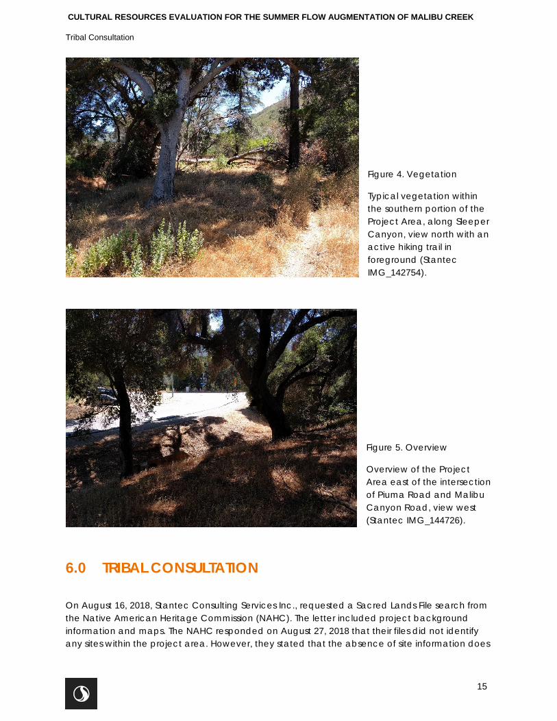
CULTURAL RESOURCES EVALUATION FOR THE SUMMER FLOW AUGMENTATION OF MALIBU CREEK
Tribal Consultation
15
Figure 4. Vegetation
Typical vegetation within the southern portion of the Project Area, along Sleeper Canyon, view north with an active hiking trail in foreground (Stantec IMG_142754).
Figure 5. Overview
Overview of the Project Area east of the intersection of Piuma Road and Malibu Canyon Road, view west (Stantec IMG_144726).
6.0 TRIBAL CONSULTATION
On August 16, 2018, Stantec Consulting Services Inc., requested a Sacred Lands File search from the Native American Heritage Commission (NAHC). The letter included project background information and maps. The NAHC responded on August 27, 2018 that their files did not identify any sites within the project area. However, they stated that the absence of site information does
CULTURAL RESOURCES EVALUATION FOR THE SUMMER FLOW AUGMENTATION OF MALIBU CREEK
Paleontological Resources
16
not preclude the presence of sites. Therefore, they requested that Native American Tribes with specific information of the project area be contacted. The letter contained a list of 16 Tribal contacts. On September 27, 2018, letters requesting consultation under AB 52 were sent to these 16 Tribal contacts as well as three additional contacts.
7.0 PALEONTOLOGICAL RESOURCES
There are no known paleontological resources within the project area. In addition, project construction would be limited to shallow (less that 5-feet) excavation in soils that were previously disturbed during construction for Malibu Canyon Road and the Tapia WRF access roadway, a distance of roughly 1,270-feet (210 feet mounted on the bridge). Therefore, ground-disturbing activities during construction are unlikely to uncover any previously unknown paleontological resources.
8.0 CONCLUSIONS AND RECOMMENDATIONS
During the background research and the cultural resources inventory of the Project Area, no cultural resources were identified. However, 10 previously documented resources were identified within the 0.5-mile Study Area. Two of these resources, a BRM and a rock monument, are located within 0.1-mile of the Project Area.
Under the proposed Project, a new potable water pipeline will be installed via open trench from an existing 20-inch pipeline in Las Virgenes Road, to an existing bridge. The trench would be excavated beneath existing roadway in fill material; native soil would not be impacted. At the bridge over Malibu Creek, the pipe would be mounted in 2-foot-by-2-foot utility openings underneath the existing LA County Bridge with no new ground disturbance. From the bridge, the pipe would be installed via open trench, in fill soils, in the entrance road to the Tapia WRF. Open trench work will be kept in a single lane of the roadway to avoid complete disruption of traffic. Therefore, significant impacts to previously documented or undiscovered cultural resources are not expected during Project implementation.
The methods and techniques used by Stantec are considered sufficient for the identification and evaluation of cultural resources visible at the ground surface. However, there is always a possibility that buried archaeological deposits could be found during construction and/or earth disturbing activities. In the event that cultural resources are encountered during construction activities, all work must stop, and a qualified archaeologist shall be contacted immediately. Further, in the event that any human remains are encountered or in the event that unassociated funerary objects or grave goods are discovered, State Health and Safety Code Section 7050.5 requires that no further work shall continue at the location of the find until the County Coroner has made all the necessary findings as to the origin and distribution of such remains pursuant to Public Code Resources Code Section 5097.98.
CULTURAL RESOURCES EVALUATION FOR THE SUMMER FLOW AUGMENTATION OF MALIBU CREEK
References
17
9.0 REFERENCES
Army Corps of Engineers 2017 Malibu Creek Ecosystem Restoration Study Draft Integrated Feasibility Report (IRF)
with Environmental Impact Statement/Environmental Impact Report (EIR/EIS) Los Angeles and Ventura Counties, California. Report on file at https://usace.contentdm.oclc.org/digital/collection/p16021coll7/id/3660/. Site assessed July 28, 2018.
Baldwin, K.P. 1996 A History of Channel Islands archaeology. Unpublished Master's thesis. Department
of Anthropology, California State University, Northridge.
Bean, L.J. and C.R. Smith 1978 Gabrielino in Handbook of North American Indians, Volume 8. California, volume
edited by Robert F. Heizer, pp. 538-549 (W. T. Sturtevant, general editor). Smithsonian Institution, Washington, D.C.
Bove, Frederick J. 1977 An Archaeological Resource Survey and Impact Assessment of Tentative Tract No.
33186, Los Angeles County, California, Report # LA-00337, on file at the SCCIC, California State University, Fullerton.
Cooley, Theodore G., Stacey C. Jordan, and Laura J. Barrie 2003 Cultural Resources Inventory Survey of 94 Acres Within the Malibu Creek State Park,
Tapia Sub-unit, Los Angeles County, California. Report # LA-06536, on file at the SCCIC, California State University, Fullerton.
Elsasser, A. B. 1978 Development of Regional Prehistoric Cultures. In Handbook of North American
Indians, Vol. 8, California, edited by R. F. Heizer, pp. 37-57. Washington: Smithsonian Institution.
Erlandson, John 1994. California's Coastal Prehistory: A Circum-Pacific Perspective. Proceedings from the Society of California Archaeology, Vol. 6: 23-36
Grant, Campbell 1978 Chumash: Introduction. In Handbook of North American Indians, Volume 8
California. R. F. Heizer (ed.): 505-508. Washington DC: Smithsonian Institute Press.
Harvey, Victoria 2000 Cemetery Tales: Six Prehistoric Human Burials from CA-KER-303, Western Mojave
Desert, California. Paper presented at the 2000 Annual Meeting for the Society for California Archaeology, Riverside, and on-file with the author.
CULTURAL RESOURCES EVALUATION FOR THE SUMMER FLOW AUGMENTATION OF MALIBU CREEK
References
18
Hook, Eileen M. and Robert G. Hare1993 Malibu Creek State Park Day-Use and Campground Areas Interpretive Plan and Research Package. Report # LA-03505, on file at the SCCIC, California State University, Fullerton.
John H. Kelly 1981 The Following Is an Evaluation of Cultural Resources Near the Proposed Fill Zone at
Malibu Creek State Park. Report # LA-03764, on file at the SCCIC, California State University, Fullerton.
King, Chester 2006 Archaeological Assessment of King Gillette Ranch, Los Angeles County, California.
Report # LA-07576, on file at the SCCIC, California State University, Fullerton.
2010 Archaeological Report of Monitoring of the 24" Recycled Water Pipeline from Tapia Park to Mulholland Highway, Los Angeles County, California. Report # LA-10740, on file at the SCCIC, California State University, Fullerton.
Kroeber, A.L 1976 Handbook of the Indians of California. Dover Publications, Inc., New York. Reprint
of 1925 book. LVMWD
n.d. Tapia Water Reclamation Facility. https://www.lvmwd.com/about-us/joint-powers-authority/wastewater-services/tapia-water-reclamation-facility Site assessed August 13, 2013.
McCawley, William 1996 First Angelinos: the Gabrielino Indians of Los Angeles. Malki Museum Press/Ballena
Press, Banning, CA.
Moratto, Michael J. 1984 California Archaeology. Academic Press.
Sampson, M. n.d. Humaliwo: Where the Surf Sounds Loudly.
https://www.parks.ca.gov/?page_id=24435. Site assessed July 31, 2018.
Sutton, Mark Q. 2010 The Del Rey Tradition and its Place in the Prehistory of Southern California. Pacific
Coast Archaeological Society Quarterly 44(2):1-54.
Sutton, Mark Q. and Jill K. Gardner 2010 Reconceptualizing the Encinitas Tradition of Southern California. Pacific Coast
Archaeological Society Quarterly 42(4):1-64.
Wlodarski, Robert J. 1992 A Phase 1 Archaeological Study for the Las Virgenes Municipal Water District
Regional Facility Expansion Iv, Sludge Force Main Las Virgenes Canyon, Los Angeles
CULTURAL RESOURCES EVALUATION FOR THE SUMMER FLOW AUGMENTATION OF MALIBU CREEK
References
19
County, California. Report # LA-02563, on file at the SCCIC, California State University, Fullerton.
2008 Results of an Extended Phase 1 Archaeological Investigation for CA-LAN-3106 Located within the Tapia Park Portion of Malibu Creek State Park, City of Malibu, County of Los Angeles, California. Report # LA-11033, on file at the SCCIC, California State University, Fullerton.
Wlodarski, Robert J. and Matthew Conrad 2007 A Phase 1 Archaeological Study for the Tapia State Park Portion of the LVMWD Rew
Recycled Water Pipeline Project, County of Los Angeles, California. Report # LA-08128, on file at the SCCIC, California State University, Fullerton.
Warren, Claude N. and R. H. Crabtree 1986 Prehistory of the Southwestern Area. In Handbook of North American Indians, Vol. 8,
California, edited by R. F. Heizer, pp. 183-193. Washington: Smithsonian Institution. Wishtoyo
2018 Wishtoyo Chumash Foundation. http://www.wishtoyo.org/cp-chumash-history/ Site accessed July 3, 2018.
Appendix C Native American Consultation
Summary Table
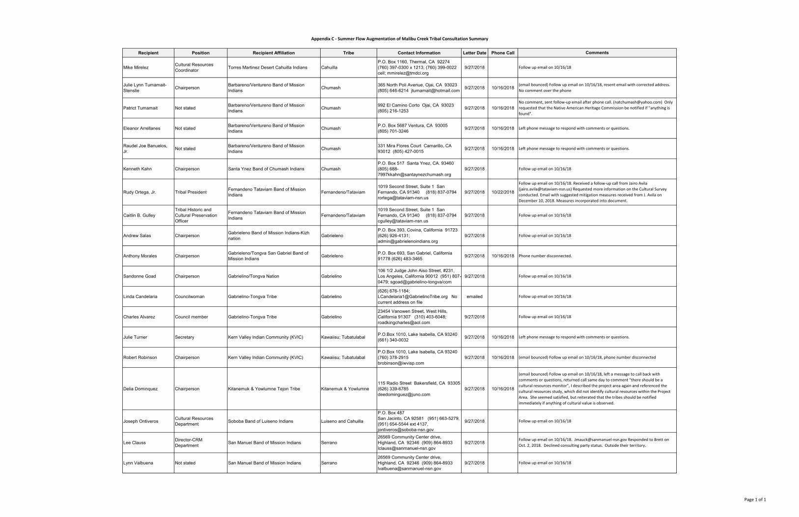
Recipient Position Recipient Affiliation Tribe Contact Information Letter Date Phone Call
Mike Mirelez Cultural Resources Coordinator Torres Martinez Desert Cahuilla Indians Cahuilla
P.O. Box 1160, Thermal, CA 92274 (760) 397-0300 x 1213; (760) 399-0022 cell; [email protected]
9/27/2018
Julie Lynn Tumamait-Stenslie Chairperson Barbareno/Ventureno Band of Mission
Indians Chumash 365 North Poli Avenue, Ojai, CA 93023 (805) 646-6214 [email protected] 9/27/2018 10/16/2018
Patrict Tumamait Not stated Barbareno/Ventureno Band of Mission Indians Chumash 992 El Camino Corto Ojai, CA 93023
(805) 216-1253 9/27/2018 10/16/2018
Eleanor Arrellanes Not stated Barbareno/Ventureno Band of Mission Indians Chumash P.O. Box 5687 Ventura, CA 93005
(805) 701-3246 9/27/2018 10/16/2018
Raudel Joe Banuelos, Jr. Not stated Barbareno/Ventureno Band of Mission
Indians Chumash 331 Mira Flores Court Camarillo, CA 93012 (805) 427-0015 9/27/2018 10/16/2018
Kenneth Kahn Chairperson Santa Ynez Band of Chumash Indians ChumashP.O. Box 517 Santa Ynez, CA. 93460 (805) [email protected]
9/27/2018
Rudy Ortega, Jr. Tribal President Fernandeno Tataviam Band of Mission Indians Fernandeno/Tataviam
1019 Second Street, Suite 1 San Fernando, CA 91340 (818) 837-0794 [email protected]
9/27/2018 10/22/2018
Caitlin B. GulleyTribal Historic and Cultural Preservation Officer
Fernandeno Tataviam Band of Mission Indians Fernandeno/Tataviam
1019 Second Street, Suite 1 San Fernando, CA 91340 (818) 837-0794 [email protected]
9/27/2018
Andrew Salas Chairperson Gabrieleno Band of Mission Indians-Kizh nation Gabrieleno
P.O. Box 393, Covina, California 91723 (626) 926-4131; [email protected]
9/27/2018
Anthony Morales Chairperson Gabrieleno/Tongva San Gabriel Band of Mission Indians Gabrieleno P.O. Box 693, San Gabriel, California
91778 (626) 483-3465 9/27/2018 10/16/2018
Sandonne Goad Chairperson Gabrielino/Tongva Nation Gabrielino106 1/2 Judge John Aiso Street, #231, Los Angeles, California 90012 (951) 807-0479; sgoad@gabrielino-tongva/com
9/27/2018
Linda Candelaria Councilwoman Gabrielino-Tongva Tribe Gabrielino(626) 676-1184; [email protected] No current address on file
emailed
Charles Alvarez Council member Gabrielino-Tongva Tribe Gabrielino23454 Vanowen Street, West Hills, California 91307 (310) 403-6048; [email protected]
9/27/2018
Julie Turner Secretary Kern Valley Indian Community (KVIC) Kawaiisu; Tubatulabal P.O.Box 1010, Lake Isabella, CA 93240 (661) 340-0032 9/27/2018 10/16/2018
Robert Robinson Chairperson Kern Valley Indian Community (KVIC) Kawaiisu; TubatulabalP.O.Box 1010, Lake Isabella, CA 93240 (760) 378-2915 [email protected]
9/27/2018 10/16/2018
Delia Dominquez Chairperson Kitanemuk & Yowlumne Tejon Tribe Kitanemuk & Yowlumne115 Radio Street Bakersfield, CA 93305 (626) 339-6785 [email protected]
9/27/2018 10/16/2018
Joseph Ontiveros Cultural Resources Department Soboba Band of Luiseno Indians Luiseno and Cahuilla
P.O. Box 487San Jacinto, CA 92581 (951) 663-5279, (951) 654-5544 ext 4137, [email protected]
9/27/2018
Lee Clauss Director-CRM Department San Manuel Band of Mission Indians Serrano
26569 Community Center drive, Highland, CA 92346 (909) 864-8933 [email protected]
9/27/2018
Lynn Valbuena Not stated San Manuel Band of Mission Indians Serrano26569 Community Center drive, Highland, CA 92346 (909) 864-8933 [email protected]
9/27/2018
Follow up email on 10/16/18
Follow up email on 10/16/18
Phone number disconnected.
Follow up email on 10/16/18
Follow up email on 10/16/18
Follow up email on 10/16/18
Left phone message to respond with comments or questions.
(email bounced) Follow up email on 10/16/18, phone number disconnected
Follow up email on 10/16/18
(email bounced) Follow up email on 10/16/18, left a message to call back with comments or questions, returned call same day to comment "there should be a cultural resources monitor", I described the project area again and referenced the cultural resources study, which did not identify cultural resources within the Project Area. She seemed satisfied, but reiterated that the tribes should be notified immediately if anything of cultural value is observed.
Follow up email on 10/16/18. Jmauck@sanmanuel‐nsn.gov Responded to Brett on Oct. 2, 2018. Declined consulting party status. Outside their territory.
Appendix C ‐ Summer Flow Augmentation of Malibu Creek Tribal Consultation Summary
Follow up email on 10/16/18
Follow up email on 10/16/18. Received a follow‐up call from Jairo Avila (jairo.avila@tataviam‐nsn.us) Requested more information on the Cultural Survey conducted. Email with suggested mitigation measures received from J. Avila on December 10, 2018. Measures incorporated into document.
Follow up email on 10/16/18
Left phone message to respond with comments or questions.
Left phone message to respond with comments or questions.
No comment, sent follow‐up email after phone call. ([email protected]) Only requested that the Native American Heritage Commission be notified if "anything is found".
(email bounced) Follow up email on 10/16/18, resent email with corrected address. No comment over the phone
Follow up email on 10/16/18
Comments
Page 1 of 1


