Embed Size (px)
Citation preview

Cheniere Forest as Stopover Habitat for Migrant Landbirds: Immediate Effects of Hurricane Rita
By Wylie Barrow, Jr., Paul Chadwick, Brady Couvillion, Thomas Doyle, Stephen Faulkner, Clint Jeske, Tommy Michot, Lori Randall, Chris Wells, and Scott Wilson
It is not known whether en route fall migratory birds (August–October) are likely to suffer more from direct or secondary effects of hurricanes. On September 24, 2005, Hurricane Rita wreaked havoc on Louisiana’s coast by toppling trees over vast areas and by stripping away microhabitats that harbor the invertebrates and produce the fruits upon which migrant landbirds depend (e.g., canopy foliage, vine tangles, epiphytes, leaf litter, and thickets of perennial plant species). Such transient effects of a hurricane on wildlife food resources are poorly understood, but these effects may have long-term consequences for some wildlife species.
IntroductionMany species of
landbirds that breed in eastern North America migrate over the western Atlantic Ocean or the Gulf of Mexico to winter in the West
Indies, Central America, or South America. Because
the continent-wide
pattern of migration concentrates
these birds in relation to ecological barriers, such as the Gulf
of Mexico (Moore and others, 1993), coastal woodlands have been
identified as stopover sites or staging areas of special
concern to migratory landbirds (Barrow and others, 2005).
Stopover Habitat
Chenieres play an important
role in the Nearctic-Neotropical bird
migration system by virtue of their geographic
position along important migration pathways.
Twice each year, millions of songbirds, most all species of
the eastern United States, swarm Louisiana’s coast as they migrate across
and around the Gulf of Mexico. These chenieres serve as safe havens that migrating
landbirds use in spring and autumn to rest and replenish energy reserves before continuing migration
(Barrow and others, 2000a). At least 75 species of migratory birds regularly use these scarce wooded habitats prior to or immediately after crossing the Gulf of Mexico (an additional
Many large flocks
of birds flew over, coming from the north and
flying to the southwest. They were more varied in kind than
any we had seen before and they were landbirds. . . . I know that most of the islands discovered by the Portuguese have been found because of birds.
Christopher Columbus, east of
Bermuda, October 7, 1492
(Butler, 2000)

148 Science and the Storms: the USGS Response to the Hurricanes of 2005
resolution color infrared imagery), and field sampling (branch clippings to quantify arthropods and fruits) to assess loss of forest cover, to quantify canopy defoliation and recovery, to identify types of disturbance (hemispherical photography), and to determine if known food resources (invertebrates and fruits) were still available to staging autumn migrant landbirds (by taking branch clippings) (fig. 2).
Aerial Videography
Aerial transects followed cheniere ridges from Rockefeller Wildlife Refuge to the Louisiana-Texas border. East of the Calcasieu River, cheniere sample sites were located on Little Pecan Island-Little Chenier complex (about 2,800 years old and dominated by live oak (Quercus virginiana)), Grand Cheniere-Oak Grove Ridge-Front Ridge complex (about 1,200 years old and dominated by live oak), and Hackberry Beach chenier (about 600–800 years old and dominated by sugarberry (Celtis laevigata)). West of the Calcasieu River, sample sites were located on the Peveto Beach-Constance Beach-Hackberry Ridge complex (about 600 years old and dominated by sugarberry or toothache tree (Zanthoxylum clava-herculis) and sweet acacia (Acacia farnesiana)) (fig. 2). Flights were conducted at 3,500 ft (1,067 m), and transect width was 1,400 ft (427 m).
30 species overwinter in the coastal plains of Louisiana and Texas) (Barrow and others, 2000b).
Our ApproachTo rapidly assess the effects of Hurricane Rita on
the suitability of cheniere forest as stopover habitat, we assembled a team of wildlife biologists (including a research wildlife biologist who is an aircraft pilot), geographers, a biogeochemist, a dendroecologist, a radar ornithologist, and an electronics engineer. A reconnaissance flight 2 days post-Rita landfall revealed extensive flooding as a result of a massive storm surge, toppled trees, debris and trash entangled in all chenieres, and several major beach overwashes that partially buried some cheniere forests (fig. 1) (see Faulkner, Barrow, Doyle, and others, this volume; Michot and others, this volume).
Because Rita made landfall near the peak of autumn migration, U.S. Department of the Interior land managers needed to know if cheniere forests were still capable of providing food resources to meet the energetic demands of migrant landbirds prior to long gulf crossings. We used a combined approach of remote sensing (Normalized Difference Vegetation Index; see Faulkner, Barrow, Doyle, and others, this volume), weather radar (see Barrow, Buler, and others, this volume), aerial digital videography survey (high-
Figure 1. Hurricane Rita produced a significant storm surge that pushed flood waters inland as far as 25 mi (40 km). This aerial view taken 2 days after the storm shows the extensive flooding of Grand Chenier, La., a site located 4.6 mi (7.4 km) from the coast. Some sites remained inundated for as long as 4–6 weeks after the storm.

Cheniere Forest as Stopover Habitat for Migrant Landbirds: Immediate Effects of Hurricane Rita 149
Project location
19 flight transects along chenieres10 habitat assessment locations
Scale AnalysisVariable Method
Habitat
Branch clipping
Hemispherical photos
Food availability
Canopy cover
Aerial photos(1:2,500, 1:18,000)
Color infrared video Forest cover
Regional and
landscape
Doppler weather radarMigrant density
Sedimentdeposition Sediment profiles
Hurricanedamage
Normalized DifferenceVegetation Index (NDVI)
Figure 2. A multiscale approach was used to assess the effects of Hurricane Rita on stopover habitats in southwest Louisiana used by Nearctic-Neotropical migratory landbirds. Remote sensing methods were used to assess the health (Normalized Difference Vegetation Index (NDVI)), loss of forest cover (color infrared video laid over aerial photographs), and migrant bird use of cheniere forests (Doppler weather radar) at regional and landscape scales. The quality of cheniere habitats was also assessed at 10 locations across the region. At each site, branch clippings were collected to determine the availability of food resources (insects), and hemispherical photographs were taken to estimate canopy cover. At Hackberry Beach chenier, Rita altered the structure of the chenier by removing forest cover and by depositing a substantial amount of sediment. An additional assessment of sediment deposition was conducted at this site (see Faulkner, Barrow, Doyle, and others, this volume).
Digital Aerial PhotographyFrames of aerial photography were selected for analysis
to correspond with the ground-sampling sites. Each frame was interpreted for characteristics that were biologically relevant for birds, relatively easy to measure and interpret, and readily recognizable in the field by those who would need to identify vegetation conditions for future hurricane assessments: forest cover, shrub cover, vegetation type (evergreen versus deciduous), debris cover, and presence/absence of sediment/erosion. Assessment of change in forest cover at Hackberry Beach chenier caused by Hurricane Rita was accomplished by comparing prehurricane and posthurricane digital aerial photographs (fig. 3).
Food ResourcesOne month after Hurricane Rita made landfall, we
sampled abundance of invertebrates on chenieres to assess food resources for migrating and wintering landbirds. Field
sampling focused on the five common canopy species of Louisiana’s chenieres: live oak, sugarberry, sweet acacia, toothache tree, and Chinese tallow (Triadica sebifera). For each of 10 sites sampled (Global Positioning System coordinates were selected prior to field visits), we selected the nearest three individuals of each focus species. We clipped an 8-inch (20-cm) sample from the end of branches of trees with resprouting leaves and of trees with branches not showing resprouting, placed them in a plastic bag, and applied an all-purpose insecticide. The branches were vigorously shaken, and all invertebrates and fruits were sorted from the vegetation after returning to the laboratory. For each sample, we counted leaves and determined dry mass for invertebrates, foliage, and woody material. Notes were taken on direct visual observations of invertebrates and fruits seen in chenieres.
Broad-scale Vegetation Changes
Normalized Difference Vegetation Index (NDVI) is calculated from data (wavelengths and intensity of visible

150 Science and the Storms: the USGS Response to the Hurricanes of 2005
Figure 3. Estimates of forest cover on Hackberry Beach chenier in Louisiana before and after Hurricane Rita. Estimates of forest cover (86 acres (0.35 km2)) prior to Rita (A) were derived by delineating forest edges from 2004 color infrared digital orthophoto quarter quadrangles. Estimates of forest cover (46 acres (0.19 km2)) after Rita (B) were derived by delineating forest edges from post-Rita U.S. Geological Survey 2005 color infrared video rectified image mosaic and rectified U.S. Geological Survey post-Rita 2005 natural color photography (1:18,000 scale).
Approx. 86 ac.
Approx. 86 ac.
A
B

Cheniere Forest as Stopover Habitat for Migrant Landbirds: Immediate Effects of Hurricane Rita 151
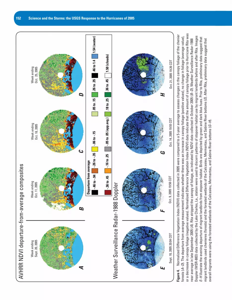
and near-infrared light) collected by the Advanced Very High Resolution Radiometer (AVHRR) multispectral sensor. Normalized Difference Vegetation Index data are commonly used to assess the density and health of vegetation. Regional scale NDVI analyses suggested that storm winds and saltwater surge affected vegetation throughout southwest Louisiana (figs. 4A–4D). At the landscape scale, hurricane damage was extensive and was not confined to a particular habitat type. At the habitat level, the exact nature of the hurricane’s effects was uncertain—were trees stripped of foliage, was foliage burned by saltwater inundation, or were trees felled or buried under debris and sediments?
Interpretation of aerial video from our Hackberry Beach chenier site, eastern Cameron Parish (0.06 mi (0.10 km) from the gulf), determined that more than half of the forest had been swept away or buried by sand deposits induced by storm surge (fig. 3). The depth of sand deposited in the forest ranged from several inches to over 8 ft (2.4 m). For details on how this beach overwash may affect the remaining forest cover, see Faulkner, Barrow, Doyle, and others, this volume.
All cheniere sites we visited had either sediment or debris deposits throughout the forest floor (sediment type and depth varied across chenieres), making the leaf litter unavailable to ground-foraging migrant birds (e.g., Swainson’s warbler (Limnothlypis swainsonii)). For instance, a sediment layer about 0.5 inches (1.3 cm) deep was deposited at Hackberry Ridge in western Cameron Parish (0.09 mi (0.14 km) from the gulf). At Grand Chenier (4.6 mi (7.40 km) from the gulf), more than 4 ft (1.2 m) of debris (predominantly canes of Phragmites with marsh and trash interspersed throughout) were deposited within the forest (fig. 5).
Saltwater inundation was still extensive on some chenieres for several weeks after hurricane passage. All cheniere forest canopies were damaged; most trees had their foliage stripped, and others retained leaves killed by salt water (fig. 6). On our initial field visits 4 days after storm passage, we found no live foliage; many trees did, however, exhibit leaf regrowth about 2–5 weeks after Rita’s landfall. The consequences of sediment deposits, saltwater inundation, and canopy damage for some of these forests may not be understood for several years, and then only if long-term monitoring plots are established.
Changing Food ResourcesHurricanes are significant contributors to the population
dynamics of migratory birds and other wildlife (Butler, 2000). These storms are known to cause mortality in migrant landbirds during passage through the northern Gulf of Mexico region (Weidenfeld and Weidenfeld, 1995; Barrow and Jeske, personal observations after Rita). It is not known whether en route fall migratory birds (August–October) are likely to suffer more from direct or secondary effects of hurricanes.
On September 24, 2005, Hurricane Rita wreaked havoc on Louisiana’s coast by toppling trees over vast areas and stripping away microhabitats that harbor the invertebrates and produce the fruits upon which migrant landbirds depend (e.g., canopy foliage, vine tangles, epiphytes, leaf litter, and thickets of perennial plant species). Such transient effects of a hurricane on wildlife food resources are poorly understood, but these effects may have long-term consequences for some wildlife species. Butler (2000) used the U.S. Geological Survey Breeding Bird Survey database, 1967–96, to test the hypothesis that abundance of eastern North American migrants is negatively related to the severity of storms during autumn passage over oceanic waters. Abundances of mourning warblers (Oporornis philadelphia), rose-breasted grosbeaks (Pheucticus ludovicianus), and especially blackpoll warblers (Dendroica striata), a well-known transoceanic migrant, were all influenced by storms.
Invertebrate samples collected 1 month after Hurricane Rita revealed that food resources were scarce (table 1). Almost half of the invertebrates (25 of 45) in our samples are rarely eaten or were too small to be useful for migrant landbirds: ants (10), early instar beetle larvae (4, too small), and mites (11, too small). There were no significant differences among the invertebrates associated with plant species or between trees with dead foliage and trees that exhibited leaf out following the storm. Apparently, invertebrates known to be associated with these plant species were not available to recolonize them (Barrow and others, 2000a, 2000b). It is unknown whether important prey items will be available to birds during spring migration of 2006.
Fruit, known to facilitate fat deposition during migration (Parrish, 2000), remained on some individual trees of hackberry and Chinese tallow. Salt matrimony-vine (Lycium carolinianum), a low shrub common in the coastal fringes of Louisiana and Texas (especially where the soil and water are slightly salty), survived complete inundation by the storm surge. The fruit of this plant is available throughout the year and is eaten by waterfowl, the larger landbird migrants (e.g., gray catbird (Dumetella carolinensis) and mourning dove (Zenaida macroura)), and large overwintering migrants, such as sandhill crane (Grus canadensis) and whooping crane (Grus americana) (Martin and others, 1951; Everitt and Drawe, 1993). Individual plants appeared healthy and had retained their leaves, and most individuals we observed were producing both flowers and fruit.
Other fruits known to be consumed by migrant birds during migration and winter (e.g., toothache tree, swamp dogwood (Cornus drummondii), bird pepper (Capsicum annuum var. annuum L.), pigeonberry (Rivinia humilis), poison ivy (Toxicodendron radicans), muscadine (Vitis rotundifolia), peppervine (Ampelopsis arborea), green hawthorn (Crataegus viridis), greenbrier (Smilax spp.), yaupon (Ilex vomitoria), and deciduous holly (Ilex deciduas)) perished in the storm surge. The question remains: what happens to
152 Science and the Storms: the USGS Response to the Hurricanes of 2005AV
HRR
NDV
I dep
artu
re-fr
om-a
vera
ge c
ompo
site
s
Wea
ther
Sur
veill
ance
Rad
ar-1
988
Dopp
ler
AB
CD
EF
GH
Depa
rture
from
ave
rage
Wee
k en
ding
Se
pt. 2
0, 2
005
Wee
k en
ding
Oc
t. 11
, 200
5W
eek
endi
ng
Oct.
18, 2
005
Wee
k en
ding
Oc
t. 2
5, 2
005
Sept
. 18,
200
5 20
:04
CDT
Oct.
9, 2
005
19:5
6 CD
TOc
t. 14
, 200
5 19
:55
CDT
Oct.
21, 2
005
19:2
6 CD
T
-.46
to -.
84
-.28
to -.
46
-.28
to -.
26
-.18
to -.
26
-.08
to -.
16
-.06
to .0
6 (a
pp. a
vg.)
.06
to .1
6
.18
to .2
6
.28
to .2
6
.28
to .4
6
.46
to 1
.41.
64 (w
ater
)
1.60
(clo
uds)
1.54
(wat
er)
1.50
(clo
uds)
.46
to 1
.4.2
6 to
.35
.36
to .4
5
.05
to .1
5
.18
to .2
5
-.06
to -.
15
-.05
to .0
5 (a
pp.a
vg.)
-.26
to -.
35
-.16
to .2
5
-.46
to -.
94
-.36
to .4
5
Dep
artu
re fr
om a
vera
ge
Figu
re 4
. N
orm
alize
d Di
ffere
nce
Vege
tatio
n In
dex
(NDV
I) da
ta c
olle
cted
in 2
005
wer
e co
mpa
red
to a
5-y
ear a
vera
ge to
ass
ess
chan
ges
in th
e ca
nopy
folia
ge o
f the
che
nier
fo
rest
s (A
–D).
The
depa
rture
from
ave
rage
mea
sure
men
t ind
icat
es w
heth
er th
ere
was
an
incr
ease
in c
anop
y fo
liage
(pos
itive
val
ues)
, no
chan
ge in
folia
ge (a
vera
ge v
alue
), or
a d
ecre
ase
in c
anop
y fo
liage
(neg
ativ
e va
lues
). N
orm
alize
d Di
ffere
nce
Vege
tatio
n In
dex
(NDV
I) da
ta in
dica
te th
at th
e am
ount
of c
anop
y fo
liage
prio
r to
Hurr
ican
e Ri
ta w
as
near
ave
rage
in la
te S
epte
mbe
r 200
5 (A
). Ri
ta s
tripp
ed th
e ca
nopy
of f
olia
ge, a
s in
dica
ted
by N
DVI d
ata
colle
cted
in O
ctob
er 2
005
(B–D
). W
eath
er S
urve
illan
ce R
adar
-198
8 Do
pple
r (W
SR-8
8D) d
ata
colle
cted
by
the
Lake
Cha
rles,
La.
, sta
tion
wer
e us
ed to
dis
cern
pat
tern
s of
sto
pove
r hab
itat u
se b
y m
igra
nt la
ndbi
rds
befo
re a
nd a
fter R
ita. I
mag
es
E–H
illus
trate
the
even
ing
depa
rture
of m
igra
nt la
ndbi
rds
from
sto
pove
r hab
itat.
Bird
s ar
e de
pict
ed b
y gr
een
and
dark
blu
e hu
es. P
rior t
o Ri
ta, p
relim
inar
y da
ta s
ugge
st th
at
mig
rant
land
bird
s us
ed c
heni
eres
(for
ests
) and
the
fore
sted
wet
land
s of
the
Calc
asie
u, M
erm
anta
u, a
nd S
abin
e Ri
ver b
otto
ms
(E).
Afte
r Rita
, pre
limin
ary
data
sug
gest
that
ov
eral
l mig
rant
s w
ere
usin
g th
e fo
rest
ed w
etla
nds
of th
e Ca
lcas
ieu,
Mer
man
tau,
and
Sab
ine
Rive
r bot
tom
s (G
–H).

Cheniere Forest as Stopover Habitat for Migrant Landbirds: Immediate Effects of Hurricane Rita 153
the distribution of migrant birds when food resources are diminished at the scale of an entire geographic region?
Changing Migrant Distributions Migration pathways over or around the Gulf of
Mexico are affected, in large part, by the prevailing wind patterns when birds are aloft (Gauthreaux, 1999). In autumn, prevailing southerly winds over the gulf are less conducive to transgulf flight, and the majority of migration movement from southwest Louisiana is toward the southwest (Able, 1972). Depending on weather, the movement may be a flight across the northwest gulf, or migrant birds may move along the Texas coast. As the season progresses, cold fronts push southward, increasing the likelihood of transgulf flights. The scarce cheniere forests of southwest Louisiana provide important stopover habitat for migrants, but the frequency of their use is partially determined by weather.
We monitored autumn migration stopover patterns along the southwest Louisiana coast by using Weather Surveillance Radar-1988 Doppler (WSR-88D) data archived by the National Weather Service for the period of August 15 through October 31, 2005. Migrant landbirds resume migration just after sunset, and this evening departure is easily
detected by radar. Preliminary data from September 2005 suggest that migrants departed from the chenieres throughout the month, but use of these areas increased toward late September (fig. 4E). After Rita made landfall on September 24, departures from the chenieres were sporadic, and very little activity was detected in these areas after October 14. The forests of the Sabine, Calcasieu, and Mermantau River bottoms, located north of the chenieres, were routinely used throughout the autumn migration season, with an increase in their use after Rita (figs. 4F–4H).
Hurricane-induced habitat shifts may not be an option for resident birds or foraging specialists. During multiple visits to more than 10 chenieres over a 3-month period after Rita, we did not observe a single northern cardinal (Cardinalis cardinalis), the most common resident species inhabiting cheniere forests (Barrow, unpub. data). Few other resident or overwintering migrant birds were observed during the course of our field sampling in the winter of 2005–06.
AcknowledgmentsWe thank Chad Case and Holly Ramey for their
assistance with fieldwork at Hackberry Beach chenier, Melissa Collins and Margaret Luent for their assistance in the lab, and
Figure 5. Debris deposited by Hurricane Rita within the forest on Grand Chenier, La.

154 Science and the Storms: the USGS Response to the Hurricanes of 2005
Figure 6. View of Hackberry Ridge, La., before (A) and after (B) Hurricane Rita. Hurricane-force winds and the storm surge downed trees, stripped foliage from the vegetation, and deposited sediment and debris on the forest floor. (Photograph in A is copyright of Bill Goulet and used with permission.)
A
B

Cheniere Forest as Stopover Habitat for Migrant Landbirds: Immediate Effects of Hurricane Rita 155
all the landowners of Cameron Parish, La., who allowed us to work on their property.
References
Able, K.P., 1972, Fall migration in coastal Louisiana and the evolution of migration patterns in the gulf region: Wilson Bulletin, v. 84, no. 3, p. 231–242.
Barrow, W.C., Jr., Chen, C., Hamilton, R.B., Ouchley, K., and Spengler, T.J., 2000a, Disruption and restoration of en route habitat, a case study— the chenier plain: Studies in Avian Biology, v. 20, p. 71–87.
Barrow, W.C., Jr., and Fontenot, W., in press, Louisiana cheniere woods—a natural history of vanishing maritime forests and the migratory birds that depend on them: BTNEP Publication.
Barrow, W.C., Jr., Hamilton, R.B., Powell, M.A., and Ouchley, K., 2000b, Contribution of landbird migration to the biological diversity of the northwest gulf coastal plain: Texas Journal of Science, v. 52, no. 4 (supplement), p. 151–172.
Barrow, W.C., Jr., Johnson Randall, L.A., Woodrey, M.S, Cox, J., Ruelas I.E., Riley, C.M., Hamilton, R.B., and Eberly, C., 2005, Coastal forests of the Gulf of Mexico—a description and some thoughts on their conservation, in Ralph, C.J., and Rich, T.D., eds., Bird conservation implementation and integration in the Americas, v. 1. Proceedings of the Third International Partners in Flight Conference, Asilomar, Calif., March 20–24, 2002: Albany , Calif., U.S. Department of Agriculture, Forest Service, Pacific
1 Branches exhibited posthurricane leaf out: L, majority of leaves are new, and D, majority of leaves are dead.
2 Includes 8 spiders, 10 ants, and 27 other insects.
Table 1. Preliminary data of invertebrates on branches clipped from trees on Louisiana cheniers impacted by Hurricane Rita. Samples were collected from November 2 to 4, 2005.
[n, number of samples; dry wt., dry weight. See text for scientific names of tree species]
Tree Species Status1 n Number of leaves Leaf dry mass Number of invertebrates2 Invertebrates/100 g leaves dry wt.
Hackberry L 28 3,230 76.70 11 14.34
Hackberry D 19 1,884 68.63 15 21.85
Live Oak L 13 948 64.95 3 4.62
Live Oak D 18 1,291 118.01 3 2.54
Tallow L 13 1,394 26.37 4 15.17
Tallow D 12 875 60.94 2 3.28
Acacia L 6 3,648 12.33 6 48.66
Acacia D 2 158 0.05 0 0.0
Toothache D 3 540 6.79 1 14.72
Southwest Research Station, general technical report PSW-GTR-191, p. 450–464.
Butler, R.W., 2000, Stormy seas for some North American songbirds—are declines related to severe storms during migration?: Auk, v. 117, p. 518–522.
Everitt, J.H., and Drawe, D.L., 1993, Trees, shrubs, and cactus of south Texas: Lubbock, Texas Tech University Press.
Gauthreaux, S.A., Jr., and Belser, C.G., 1999, Bird migration in the region of the Gulf of Mexico, in Adams, N.J., and Slotow, R.H., eds., International Ornithological Congress, 22, Durban, South Africa, 16–22 August 1998, Proceedings: Johannesburg, BirdLife of South Africa.
Martin, A.C., Zim, H.S., and Nelson, A.L., 1951, American wildlife and plants. A guide to wildlife food habits: New York, Dover Publications, Inc.
Moore, F.R., Gauthreaux, S.A., Jr., Kerlinger, P., and Simons, T.R., 1993, Stopover habitat—management implications and guidelines, in Finch, D.M., and Stangel, P.W., eds., Status and management of Neotropical migratory birds: U.S. Forest Service, general technical report RM-229, p. 58–69.
Parrish, J.D., 2000, Behavioral, energetic, and conservation implications of foraging plasticity during migration: Studies in Avian Biology, v. 20, p. 53–70.
Wiedenfeld, D.A., and Wiedenfeld, M.G., 1995, Large kill of Neotropical migrants by tornado and storm in Louisiana, April 1993: Journal of Field Ornithology, v. 66, no. 1, p. 70–80.

156 Science and the Storms: the USGS Response to the Hurricanes of 2005
Contact InformationWylie Barrow, Jr., Research Wildlife Biologist
([email protected]); Paul Chadwick, Biologist ([email protected]); Thomas Doyle, Ecologist ([email protected]); Stephen Faulkner, Ecologist ([email protected]); Clint Jeske, Research Wildlife Biologist ([email protected]); Tommy Michot, Research Wildlife Biologist ([email protected]); Lori Randall, Biologist ([email protected]); Chris Wells, Geographer ([email protected]); and Scott Wilson, Electronics Engineer ([email protected])
U.S. Department of the InteriorU.S. Geological SurveyNational Wetlands Research Center700 Cajundome Blvd.Lafayette, LA 70506
Brady Couvillion, GIS Specialist II (under contract through IAP World Services, Inc.) ([email protected])
U.S. Department of the InteriorU.S. Geological SurveyNational Wetlands Research CenterCoastal Restoration Field StationLouisiana State University211 Parker ColiseumBaton Rouge, LA 70894
What’s in a Name? Chenier or Cheniere?By Gaye S. Farris
Coastal Louisiana is divided into two major regions: (1) the Deltaic Plain of southeast Louisiana, dominated by the Mississippi River and its delta, and (2) the Chenier Plain of southwest Louisiana, dominated by cheniers (Saucier, 1994). John Barras (this report) also describes a middle area, the Marginal Deltaic Plain, between the Atchafalaya River and Freshwater Bayou.
A chenier is a long, narrow former beach ridge or sandy or shelly hummock (rounded mound) that runs parallel to the shoreline and rises 3–18 ft (1–6 m) above the marshes and mudflats. These ridges are well drained and fertile, often supporting large evergreen live oaks (Quercus virginiana); cheniers range from 148 ft to 1,476 ft (45 to 450 m) wide and several miles (tens of kilometers) long (Neuendorf and others, 2005).
The spelling cheniere is found in place names (U.S. Geological Survey, 2006) and is used by some scientists to describe the oak forest itself (Barrow and others, 2006). Chenier or cheniere is roughly translated “oak grove” and was a name given by the early French settlers based on the French word “chêne,” meaning oak. Both spellings can be found in this report, in many maps, and in the scientific literature.
References
Barras, J.A., 2007, Land area changes in coastal Louisiana after Hurricanes Katrina and Rita, in Farris, G.S., Smith, G.J., Crane, M.P., Demas, C.R., Robbins, L.L., and Lavoie, D.L., eds., Science and the storms: the USGS response to the hurricanes of 2005: U.S. Geological Survey Circular 1306.
Barrow, W.C., Jr., Fontenot, B., Barrow, M.H., DeMay, R., and Muth, D., 2006, Vanishing before our eyes: Louisiana cheniere woods and the birds that depend on them: Barataria-Terrebonne National Estuary Program, 25 p.
Neuendorf, K.K.E., Mehl, J.P., Jr., and Jackson, J.A., eds., 2005, Glossary of geology, (5th ed.): Alexandria, Va., American Geological Institute, 779 p.
Saucier, R.T., 1994, Geomorphology and quaternary geologic history of the Lower Mississippi Valley: Vicksburg, Miss., U.S. Army Corps of Engineers, v. 1, 364 p.
U.S. Geological Survey, 2006, Geographic Names Information System, http://geonames.usgs.gov, accessed August 21, 2006.


![iGalerie.cz: [Rejstriky] Psychologie (Rita L. Atkinson a kol](https://img.pdfslide.net/doc/110x75/63367c9f4e9c1ac02e081a27/igaleriecz-rejstriky-psychologie-rita-l-atkinson-a-kol.jpg)


