Embed Size (px)
Citation preview
Clarence Valley
June 2017
To be reviewed no later than June 2022 (5 year review cycle)
CLARENCE VALLEY FLOOD
EMERGENCY SUB PLAN
A Sub-Plan of the Clarence Valley Local Emergency Management Plan (EMPLAN)
Volume 1 of the Clarence Valley Local Flood Plan
Clarence Valley Local Flood Plan
July 2017 Vol 1: Clarence Valley Flood Emergency Sub Plan Page i
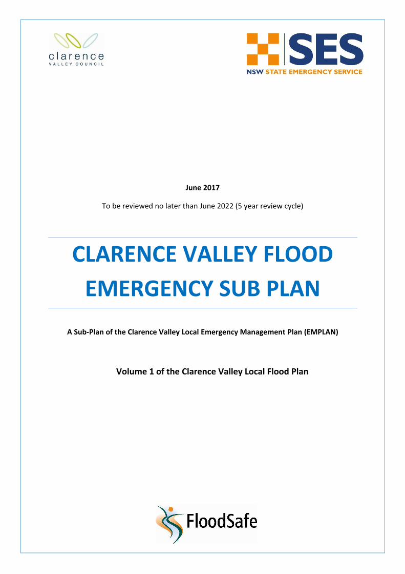
AUTHORISATION
The Clarence Valley Flood Emergency Sub Plan is a sub plan of the Clarence Valley Local Emergency Management Plan (EMPLAN). It has been prepared in accordance with the provisions of the State Emergency Service Act 1989 (NSW) and is authorised by the Local Emergency Management Committee in accordance with the provisions of the State Emergency and Rescue Management Act 1989 (NSW).
Clarence Valley Local Flood Plan
July 2017 Vol 1: Clarence Valley Flood Emergency Sub Plan Page ii
CONTENTS
AUTHORISATION .............................................................................................................................................. i
CONTENTS ....................................................................................................................................................... ii
LIST OF TABLES ............................................................................................................................................... iii
DISTRIBUTION LIST ......................................................................................................................................... iv
VERSION HISTORY ............................................................................................................................................ v
AMENDMENT LIST ........................................................................................................................................... v
LIST OF ABBREVIATIONS ................................................................................................................................. vi
GLOSSARY ..................................................................................................................................................... viii
PART 1 - INTRODUCTION ................................................................................................................................. 1
1.1 Purpose .................................................................................................................................................. 1
1.2 Authority ................................................................................................................................................ 1
1.3 Area Covered by the Plan ...................................................................................................................... 1
1.4 Description of Flooding and its Effects .................................................................................................. 1
1.5 Responsibilities ...................................................................................................................................... 1
1.6 Cross-Border Assistance Arrangements .............................................................................................. 17
PART 2 - PREPAREDNESS ................................................................................................................................ 18
2.1 Maintenance of this Plan ..................................................................................................................... 18
2.2 Floodplain and Coastal Risk Management ........................................................................................... 18
2.3 Development of Flood Intelligence...................................................................................................... 18
2.4 Development of Warning Systems ...................................................................................................... 18
2.5 Community Resilience ......................................................................................................................... 19
2.6 Training ................................................................................................................................................ 19
2.7 Resources ............................................................................................................................................. 19
PART 3 - RESPONSE ........................................................................................................................................ 21
3.1 Control Arrangements ......................................................................................................................... 21
3.2 Operational Management ................................................................................................................... 21
3.3 Start of Response Operations .............................................................................................................. 22
3.4 Response Strategies ............................................................................................................................. 23
3.5 Operations Centres .............................................................................................................................. 24
3.6 Liaison .................................................................................................................................................. 25
3.7 End of Response Operations................................................................................................................ 25
3.8 Collating Situational Information ......................................................................................................... 25
3.9 Provision of Flood Information and Warnings ..................................................................................... 27
3.10 Aircraft Management .......................................................................................................................... 29
3.11 Assistance for Animals ......................................................................................................................... 30
3.12 Communication Systems ..................................................................................................................... 30
3.13 Preliminary Deployments .................................................................................................................... 30
3.14 Road and Traffic Control ...................................................................................................................... 31
3.15 Stranded Travellers .............................................................................................................................. 31
3.16 Managing Property Protection Operations ......................................................................................... 31
3.17 Managing Flood Rescue Operations .................................................................................................... 32
Clarence Valley Local Flood Plan
July 2017 Vol 1: Clarence Valley Flood Emergency Sub Plan Page iii
3.18 Managing Evacuation Operations ........................................................................................................ 32
3.19 Initial Evacuations ................................................................................................................................ 39
3.20 Managing Resupply Operations ........................................................................................................... 39
PART 4 - RECOVERY........................................................................................................................................ 41
4.1 Recovery Coordination at the Local level ............................................................................................ 41
4.2 Recovery Coordination at the Region and State level ......................................................................... 41
4.3 Arrangements for Debriefs / After Action Reviews ............................................................................. 42
ATTACHMENT 1 - Resupply Flowchart ........................................................................................................... 43
ATTACHMENT 2 - Dam Failure Alert Notification Arrangements Flowchart ................................................... 44
ATTACHMENT 3 - Clarence Valley LGA Map ................................................................................................... 45
LIST OF REFERENCES ...................................................................................................................................... 46
LIST OF TABLES
Table 1: Dam Failure Alert Levels ................................................................................................................... 29
Clarence Valley Local Flood Plan
July 2017 Vol 1: Clarence Valley Flood Emergency Sub Plan Page iv
DISTRIBUTION LIST
This Local Flood Plan is distributed through the NSW State Emergency Service in electronic format and is maintained on the NSW SES FloodSafe (www.floodsafe.com.au) website.
Clarence Valley Local Flood Plan
July 2017 Vol 1: Clarence Valley Flood Emergency Sub Plan Page v
VERSION HISTORY
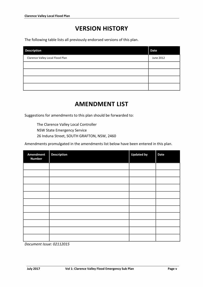
The following table lists all previously endorsed versions of this plan.
Description Date
Clarence Valley Local Flood Plan June 2012
AMENDMENT LIST
Suggestions for amendments to this plan should be forwarded to:
The Clarence Valley Local Controller
NSW State Emergency Service
26 Induna Street, SOUTH GRAFTON, NSW, 2460
Amendments promulgated in the amendments list below have been entered in this plan.
Amendment Number
Description Updated by Date
Document Issue: 02112015
Clarence Valley Local Flood Plan
July 2017 Vol 1: Clarence Valley Flood Emergency Sub Plan Page vi
LIST OF ABBREVIATIONS
The following abbreviations have been used in this plan:
AEP Annual Exceedance Probability
AHD Australian Height Datum
AIIMS Australasian Inter-service Incident Management System
ARI Average Recurrence Interval (Years)
ALERT Automated Local Evaluation in Real Time
AWRC Australian Water Resources Council
BUREAU Australian Government Bureau of Meteorology
CBRN Chemical, Biological, Radiation or Nuclear
DCF Dam Crest Flood
DSC Dams Safety Committee
DSEP Dam Safety Emergency Plan
DVR Disaster Victim Registration
EMPLAN Emergency Management Plan
FRNSW Fire and Rescue NSW
GIS Geographic Information System
GRN Government Radio Network
IAP Incident Action Plan
IFF Imminent Failure Flood
LEMC Local Emergency Management Committee
LEOCON Local Emergency Operations Controller
LO Liaison Officer
LGA Local Government Area
MHL Manly Hydraulics Laboratory
NOW NSW Office of Water
Clarence Valley Local Flood Plan
July 2017 Vol 1: Clarence Valley Flood Emergency Sub Plan Page vii
NSW RFS New South Wales Rural Fire Service
NSW SES NSW State Emergency Service
NSW VRA Volunteer Rescue Association
OEH Office of Environment and Heritage (previously DECCW)
PMF Probable Maximum Flood
PMR Private Mobile Radio
PMP Probable Maximum Precipitation
PIIC Public Information and Inquiry Centre
REMC Region Emergency Management Committee
REMO Regional Emergency Management Officer
RMS Roads and Maritime Services
RFS Rural Fire Service
SEOCON State Emergency Operations Controller
SERCON State Emergency Recovery Controller
SEWS Standard Emergency Warning Signal
SITREPs Situation Reports
WICEN Wireless Institute Civil Emergency Network
Clarence Valley Local Flood Plan
July 2017 Vol 1: Clarence Valley Flood Emergency Sub Plan Page viii
GLOSSARY
Annual Exceedance Probability (AEP). The chance of a flood of a given or larger size
occurring in any one year, usually expressed as a percentage. For example, if a
peak flood level (height) has an AEP of 5%, there is a 5% chance (that is, a one-in-20
chance) of such a level or higher occurring in any one year (see also Average
Recurrence Interval).
Assistance Animal. A guide dog, a hearing assistance dog or any other animal trained to
assist a person to alleviate the effect of a disability (Refer to Section 9 of the
Disability Discrimination Act 1992).
Assembly Area. An assembly area is a designated location used for the assembly of
emergency-affected persons before they move to temporary accommodation or a
nominated evacuation centre. As such these areas do not provide welfare
assistance nor are they used for long term sheltering or provision of meals. An
assembly area may also be a prearranged, strategically placed area, where support
response personnel, vehicles and other equipment can be held in readiness for use
during an emergency.
Australian Height Datum (AHD). A common national surface level datum approximately
corresponding to mean sea level.
Average Recurrence Interval (ARI). The long-term average number of years between the
occurrence of a flood as big as, or larger than, the selected event. For example,
floods reaching a height as great as, or greater than, the 20 year ARI flood event
will occur on average once every 20 years.
Catchment (River Basin). The land area draining through the main stream, as well as
tributary streams, to a particular site. It always relates to an area above a specific
location.
Coastal Erosion. The loss of land along the shoreline predominantly by the offshore
movement of sand during storms.
Coastal Flooding. Flooding due to tidal or storm-driven coastal events, including storm
surges in lower coastal waterways. This can be exacerbated by wind-wave
generation from storm events (1).
Dambreak Study. A Dambreak Study is undertaken to determine the likely downstream
inundation areas in case of a dam failure. Modelling is undertaken for a range of
dam breach possibilities and design floods. The dambreak study includes
information such as the extent of flooding, flood travel times and flood water
velocities. The study can assist dam owners, regulators, and emergency agencies in
Clarence Valley Local Flood Plan
July 2017 Vol 1: Clarence Valley Flood Emergency Sub Plan Page ix
the preparations of evacuation plans, dam break and other flood warning systems,
and hazard classification of affected areas.
Dam Failure. The uncontrolled release of a water storage. The failure may consist of the
collapse of the dam or some part of it, or excessive seepage or discharges. The
most likely causes of dam failure are;
Flood Induced Dam Failure: Dam failure caused by flood, either due to
overtopping erosion or by subsequent structural failure.
Sunny Day Dam Failure: Dam Failure as a result of factors other than flood
i.e. other than flood flow into the reservoir. Causes of "Sunny Day" dam
failure can include internal erosion, landslide, piping, earthquake or sabotage.
Dam Safety Emergency Plan (DSEP). A DSEP outlines the required actions of owners and
their personnel at dams in response to a range of possible emergency situations.
The NSW Dam Safety Committee requires a quality controlled DSEP, with
associated dambreak warning procedures to be prepared for prescribed dams
where persons may be at risk downstream, if the dam failed.
Design Flood (or Flood Standard). A flood of specified magnitude that is adopted for
planning purposes. Selections should be based on an understanding of flood
behaviour and the associated flood risk, and take account of social, economic and
environmental considerations. There may be several design floods for an individual
area.
Emergency Alert. The national telephone warning system used by emergency services to
send voice messages to landlines and text messages to mobile phones within a
defined area, about likely or actual emergencies.
EMPLAN (Emergency Management Plan). The Plan established in accordance with the
provisions in the State Emergency Rescue Management Act 1989. The object of an
EMPLAN is to ensure the coordinated response by all agencies having
responsibilities and functions in emergencies.
Essential Services. Those services, often provided by local government authorities, that are
considered essential to the life of organised communities. Such services include
power, lighting, water, gas, sewerage and sanitation clearance.
Evacuation. The temporary movement of people from a dangerous or potentially dangerous
place to a safe location, and their eventual return. It is a safety strategy which uses
distance to separate people from the danger created by the hazard.
Evacuation Order. Notification to the community, authorised by the NSW SES, when the
intent of an Incident Controller is to instruct a community to immediately evacuate
in response to an imminent threat.
Clarence Valley Local Flood Plan
July 2017 Vol 1: Clarence Valley Flood Emergency Sub Plan Page x
Evacuation Warning. Notification to the community, authorised by the NSW SES, when the
intent of an Incident Controller is to warn a community of the need to prepare for a
possible evacuation.
Flash Flooding. Flooding which is sudden and often unexpected because it is caused by
sudden local or nearby heavy rainfall. It is sometimes defined as flooding which
occurs within six hours of the rain that causes it.
Flood. Relatively high water level which overtops the natural or artificial banks in any part
of a stream, river, estuary, lake or dam, and/or local overland flooding associated
with drainage before entering a watercourse, and/or coastal inundation resulting
from super-elevated sea levels and/or waves overtopping coastline defences,
including Tsunami.
Flood Classifications. Locally defined flood levels used in flood warnings to give an
indication of the severity of flooding (minor, moderate or major) expected. These
levels are used by the State Emergency Service and the Australian Government
Bureau of Meteorology in flood bulletins and flood warnings.
Flood Intelligence. The product of collecting, collating, analysing and interpreting flood-
related data to produce meaningful information (intelligence) to allow for the
timely preparation, planning and warning for and response to a flood.
Flood Fringe. The remaining area of flood prone land after floodway and flood storage have
been defined.
Flood Liable Land (also referred to as Flood Prone Land). Land susceptible to flooding by
the Probable Maximum Flood (PMF) event. This term also describes the maximum
extent of a floodplain which is an area of a river valley, adjacent to the river
channel, which is subject to inundation in floods up to this event.
Flood of Record. Maximum observed historical flood.
Floodplain. Area of land which is subject to inundation by floods up to and including the
probable maximum flood event, that is, flood prone land (2).
Floodplain Management Plan. A plan developed in accordance with the principles and
guidelines in the New South Wales Floodplain Development Manual. Such a plan
usually includes both written and diagrammatic information describing how
particular areas of flood prone land can be used and managed to achieve defined
objectives.
Flood Plan. A response strategy plan that deals specifically with flooding and is a sub-plan
of an Emergency Management Plan. Flood plans describe agreed roles,
responsibilities, functions, strategies and management arrangements for the
Clarence Valley Local Flood Plan
July 2017 Vol 1: Clarence Valley Flood Emergency Sub Plan Page xi
conduct of flood operations and for preparing for them. A flood plan contains
information and arrangements for all floods whereas an IAP is for a specific
flood/event.
Flood Rescue. The rescue or retrieval of persons trapped by floodwaters.
Flood Storage Areas. Those parts of the floodplain that are important for the temporary
storage of floodwaters during the passage of a flood. The extent and behaviour of
flood storage areas may change with flood severity, and loss of flood storage can
increase the severity of flood impacts by reducing natural flood attenuation.
Floodway. An area where a significant volume of water flows during floods. Such areas are
often aligned with obvious naturally-defined channels and are areas that, if partially
blocked, would cause a significant redistribution of flood flow which may in turn
adversely affect other areas. They are often, but not necessarily, the areas of
deeper flow or the areas where higher velocities occur.
Flood Watch. A Flood Watch is a notification of the potential for a flood to occur as a result
of a developing weather situation and consists of short generalised statements
about the developing weather including forecast rainfall totals, description of
catchment conditions and indicates streams at risk. The Bureau will also attempt to
estimate the magnitude of likely flooding in terms of the adopted flood
classifications. Flood Watches are normally issued 24 to 36 hours in advance of
likely flooding. Flood watches are issued on a catchment wide basis.
Flood Warning. A Flood Warning is a gauge specific forecast of actual or imminent flooding.
Flood Warnings specify the river valley, the locations expected to be flooded, the
likely severity of flooding and when it will occur.
Functional Area. A category of services involved in the preparations for an emergency,
including the following:
Agriculture and Animal Services;
Energy and Utility Services;
Engineering Services;
Environmental Services;
Health Services;
Public Information Services;
Telecommunication Services;
Transport Services; and
Welfare Services.
Clarence Valley Local Flood Plan
July 2017 Vol 1: Clarence Valley Flood Emergency Sub Plan Page xii
Geographic Information System (GIS). A geographic information system (GIS) integrates
hardware, software, and data for capturing, managing, analysing, and displaying all
forms of geographically referenced information.
Incident Controller. The individual responsible for the management of all incident control
activities across a whole incident (3).
Incident Action Plan (IAP). An action plan for managing a specific event. Information from
the Local Flood Plan is used to develop the flood IAP.
Indirect Effect. Indirect effects are generally a consequence of infrastructure damage or
interruption of services and can affect communities distant from the actual flood
footprint i.e. floodplain. Indirect effects can also refer to indirect losses due to
disruption of economic activity, both in areas which are inundated or isolated.
Indirect effects are one of the three primary sources of risk in the context of
flooding (the other two are inundation and isolation).
Inundation. See definition for Flood.
Isolation. Properties and/or communities where flooding cuts access to essential services or
means of supply. Isolation is one of the three primary sources of risk in the context
of flooding (the other two are inundation and indirect effects).
Liaison Officer (LO). A person, nominated or appointed by an organisation or functional
area, to represent that organisation or functional area at a control centre,
emergency operations centre, or coordination centre. A liaison officer maintains
communications with and conveys directions/requests to their organisation or
functional area, and provides advice on the status, capabilities, actions and
requirements of their organisation or functional area (3).
Local Emergency Management Committee (LEMC). The LEMC is responsible for the
preparation of plans in relation to the prevention of, preparation for, response to
and recovery from emergencies in the local government area for which it is
constituted. In the exercise of its functions, the Committee is responsible to the
Region Emergency Management Committee (REMC) and may communicate with
the REMC for matters associated with Functional Areas that are not represented at
the local Level.
Local Overland Flooding. Inundation by local runoff rather than overbank discharge from a
stream, river, estuary, lake or dam.
Major Flooding. Flooding which causes inundation of extensive rural areas, with properties,
villages and towns isolated and/or appreciable urban areas flooded.
Clarence Valley Local Flood Plan
July 2017 Vol 1: Clarence Valley Flood Emergency Sub Plan Page xiii
Minor Flooding. Flooding which causes inconvenience such as closing of minor roads and
the submergence of low-level bridges. The lower limit of this class of flooding, on
the reference gauge, is the initial flood level at which landholders and/or
townspeople begin to be affected in a significant manner that necessitates the
issuing of a public flood warning by the Australian Government Bureau of
Meteorology.
Moderate Flooding. Flooding which inundates low-lying areas, requiring removal of stock
and/or evacuation of some houses. Main traffic routes may be covered.
Moveable Dwellings. Any tent, or any caravan or other van or other portable device
(whether on wheels or not), used for human habitation; or a manufactured home;
or any conveyance, structure or thing of a class or description prescribed by the
(Local Government) regulations (4).
Operational Area Commander. The individual commanding an operational area. An
Operational Area Command may be established for an area with multiple incident
management teams functioning, and can cross local government and NSW SES
Region boundaries.
Peak Height. The highest level reached, at a nominated gauging station, during a particular
flood event.
Prescribed Dam. "Prescribed" dams are those listed in Schedule 1 of the Dams Safety Act
1978. The NSW Dam Safety Committee will prescribe those dams with the potential
for a failure which could have a significant adverse effect on community interests.
Probable Maximum Flood (PMF). The largest flood that could conceivably be expected to
occur at a particular location, usually estimated from probable maximum
precipitation. The PMF defines the maximum extent of flood prone land, that is,
the floodplain. It is difficult to define a meaningful Annual Exceedance Probability
for the PMF, but it is commonly assumed to be of the order of 104 to 107 (once in
10,000 to 10,000,000 years).
Riverine Flooding. Inundation of normally dry land occurring when water overflows the
natural or artificial banks of a stream, river, estuary, lake or dam. Riverine flooding
generally excludes watercourses constructed with pipes or artificial channels
considered as stormwater channels (1).
Runoff. The amount of rainfall which ends up as stream flow, also known as ‘rainfall excess’
since it is the amount remaining after accounting for other processes such as
evaporation and infiltration.
Stage Height. A level reached, at a nominated gauging station, during the development of a
particular flood event.
Clarence Valley Local Flood Plan
July 2017 Vol 1: Clarence Valley Flood Emergency Sub Plan Page xiv
Storm Surge. The increases in coastal water levels above predicted astronomical tide levels
(i.e. tidal anomaly) resulting from a range of location dependant factors including
the inverted barometer effect, wind and wave set-up and astronomical tidal waves,
together with any other factors that increase tidal water level (1).
Stream Gauging Station. A place on a river or stream at which the stage height is routinely
measured, either daily or continuously, and where the discharge is measured from
time to time so as to develop a relationship between stage and discharge or rating
curve.
Total Flood Warning System. A flood warning system is made up of components which
must be integrated if the system is to operate effectively. Components of the total
flood warning system include monitoring rainfall and river flows, prediction,
interpretation of the likely impacts, construction and dissemination of warning
messages, response by agencies and community members, and review of the
warning system after flood events (5).
Clarence Valley Local Flood Plan
July 2017 Vol 1: Clarence Valley Flood Emergency Sub Plan Page 1
PART 1 - INTRODUCTION
1.1 PURPOSE
1.1.1 This plan covers preparedness measures, the conduct of response operations and the coordination of immediate recovery measures from flooding within the Clarence Valley LGA. It covers operations for all levels of flooding within the council area.
1.1.2 The plan also covers arrangements for the management of coastal erosion in the council area.
1.2 AUTHORITY
1.2.1 This plan is issued under the authority of the State Emergency and Rescue Management Act 1989 (NSW) and the State Emergency Service Act 1989 (NSW). It has been approved by the NSW SES Clarence Valley Local Controller and the NSW SES Clarence Nambucca Region Controller as a NSW SES plan and endorsed by the Clarence Valley Local Emergency Management Committee as a sub plan of the Local EMPLAN.
1.3 AREA COVERED BY THE PLAN
1.3.1 The area covered by the plan is the Clarence Valley LGA which extends from the coast about 100 kilometres inland to a line through Plains Station, Newton Boyd and Hernani with a total area of 10,440 square kilometres. The Valley has a population of 50,000 spread through 43 towns and villages and rural areas. Extensive areas of National Park have been proclaimed along the Coast as well as the more mountainous foothills of the Ranges. Large areas of natural and plantation State Forest surround the rural population.
1.3.2 The council area and its principal rivers and creeks are shown in Attachment 3.
1.3.3 The council area is in the NSW SES Clarence Nambucca Region and for emergency management purposes is part of the North Coast Emergency Management Region.
1.4 DESCRIPTION OF FLOODING AND ITS EFFECTS
1.4.1 The NSW SES maintains information on the nature of flooding and effects of flooding on the community in the Clarence Valley LGA.
1.5 RESPONSIBILITIES
1.5.1 The general responsibilities of emergency service organisations and supporting services (functional areas) are listed in the State Emergency Management Plan (EMPLAN). Some specific responsibilities are expanded
Clarence Valley Local Flood Plan
July 2017 Vol 1: Clarence Valley Flood Emergency Sub Plan Page 2
upon in the following paragraphs. The extent of their implementation will depend on the severity of the flooding. Specific responsibilities of agencies and organisations as they relate to tsunami are detailed in the State Tsunami Emergency Sub Plan.
1.5.2 NSW SES Clarence Valley Local Controller. The NSW SES Clarence Valley Local Controller is responsible for dealing with floods as detailed in the State Flood Plan, and will;
Preparedness
a. Ensure that NSW SES members are trained to undertake operations in accordance with current policy as laid down in the NSW SES Controllers’ Guide and the NSW SES Operations Manual.
b. Coordinate the development and operation of a flood warning service for the community.
c. Participate in floodplain and coastal risk management initiatives organised by the Clarence Valley Council.
d. Coordinate a community engagement and capacity building program regarding local flood issues and associated risks to assist communities in building resilience to floods.
e. Identify and monitor people and/or communities at risk of flooding and coastal erosion.
f. Ensure that the currency of this plan is maintained.
Response
g. Appoint an appropriate Incident Controller to undertake response roles. The Incident Controller will;
Control flood and storm response operations. This includes;
Directing the activities of the NSW SES units operating within
the council area.
Coordinating the activities of supporting agencies and
organisations and ensuring that liaison is established with
them.
Contribute to preparation of Region IAP.
Coordinate the provision of information services in relation to;
Flood heights and flood behaviour.
Coastal erosion / inundation.
Road conditions and closures.
Advice on methods of limiting property damage.
Confirmation of evacuation warnings and evacuation orders.
Direct the conduct of flood rescue operations.
Clarence Valley Local Flood Plan
July 2017 Vol 1: Clarence Valley Flood Emergency Sub Plan Page 3
Coordinate the provision of the evacuation of people and/or communities.
Provide immediate welfare support for evacuated people.
Coordinate the provision of emergency food and medical supplies to isolated people and/or communities.
Coordinate operations to assist the community to protect property. This may include;
Arranging resources for sandbagging operations.
Lifting or moving household furniture.
Lifting or moving commercial stock and equipment.
Assist the Clarence Valley Council to organise temporary repairs or improvements to levees.
Where possible, arrange for support (for example, accommodation and meals) for emergency service organisation members and volunteers assisting them.
Ensure that the managers of caravan parks are advised of flood warnings and the details of any evacuation order.
If NSW SES resources are available, assist with emergency fodder supply operations conducted by Agriculture and Animal Services.
If NSW SES resources are available, assist the NSW Police Force, RMS and Council with road closure and traffic control operations.
Exercise financial delegations relating to the use of emergency orders as laid down in the NSW SES Controllers’ Guide.
Coordinate the collection of flood and coastal erosion/inundation information for development of intelligence.
Submit Situation Reports to the NSW SES Clarence Nambucca Region Headquarters and agencies assisting within the council area. These should contain information on;
Road conditions and closures.
Current flood behaviour.
Current operational activities.
Likely future flood behaviour.
Likely future operational activities.
Probable resource needs.
Keep the Local Emergency Operations Controller advised of the flood situation and the operational response.
Issue the ‘All Clear’ when flood operations have been completed.
Recovery
Clarence Valley Local Flood Plan
July 2017 Vol 1: Clarence Valley Flood Emergency Sub Plan Page 4
h. Ensure that appropriate After Action Reviews are held after floods.
i. Provide appropriate representation to the recovery committee for the duration of the response phase of an event and as agreed during the recovery phase.
1.5.3 NSW SES Brushgrove, Copmanhurst, Grafton City, Lawrence, Maclean, Nymboida, Ulmarra, Wooli-Yuraygir, and Yamba Unit Controller(s)
a. Assist the NSW SES Clarence Valley Local Controller with flood preparedness activities, including;
Flood planning.
Training of unit members.
The development of flood and coastal erosion/inundation intelligence.
The development of warning services.
Floodplain and coastal risk management initiatives.
Community engagement and capacity building.
b. Conduct flood and coastal erosion operations within the Clarence Valley LGA as directed by the NSW SES Incident Controller.
c. Submit Situation Reports to the NSW SES Clarence Nambucca Region Headquarters and agencies assisting within the local area.
1.5.4 NSW SES Brushgrove, Copmanhurst, Grafton City, Lawrence, Maclean, Nymboida, Ulmarra, Wooli-Yuraygir, and Yamba Unit Members
a. Carry out flood and coastal erosion response tasks. These may include;
The management of the NSW SES Clarence Valley Unit Headquarters Operations Centres.
Assist in the collection of flood and coastal erosion/inundation information for the development of intelligence.
Flood rescue.
Evacuation.
Providing immediate welfare for evacuated people.
Delivery of warnings and information.
Resupply.
Levee monitoring.
Sandbagging.
Lifting and/or moving household furniture and commercial stock.
Animal rescue.
Assisting in repairing or improving levees.
Assisting with road closure and traffic control operations.
Clarence Valley Local Flood Plan
July 2017 Vol 1: Clarence Valley Flood Emergency Sub Plan Page 5
Assisting with emergency fodder supply operations.
b. Assist with preparedness activities.
c. Undertake training in flood and storm response operations.
1.5.5 Clarence Valley Local Emergency Operations Controller (LEOCON)
a. Monitor flood operations.
b. Request and coordinate support to the NSW SES Clarence Valley Incident Controller if requested to do so.
1.5.6 Clarence Valley Local Emergency Management Officer
a. Provide executive support to the LEMC and LEOCON in accordance with the Clarence Valley Local Emergency Management Plan.
b. At the request of the NSW SES Clarence Valley Local Controller, advise appropriate agencies and officers of the start of response operations.
1.5.7 Clarence Valley Council
Preparedness
a. Develop and implement floodplain risk management plans in accordance with the NSW Government’s Flood Prone Land Policy and the Floodplain Development Manual.
b. Establish and maintain floodplain and coastal risk management committees and ensure that key agencies are represented on such committees.
c. Provide levee studies, flood studies, floodplain management studies and coastal management studies to the NSW SES.
d. Maintain Dam Safety Emergency Plans for the Shannon Creek Dam and Rushforth Road 100 Megalitre Reservoir and provide copies to the NSW SES.
e. Provide information on the consequences of dam failure to the NSW SES for incorporation into planning and flood intelligence.
f. Maintain a plant and equipment resource list for the council area.
g. Work with NSW SES on the development and implementation of a community engagement and capacity building program.
Response
h. At the request of the NSW SES Incident Controller, deploy personnel and resources for flood and coastal erosion related activities.
i. Close and reopen council roads (and other roads nominated by agreement with the RMS) and advise the NSW SES Incident Controller and the Police.
j. Provide information on the status of roads including through the website www.myroadinfo.com.au.
Clarence Valley Local Flood Plan
July 2017 Vol 1: Clarence Valley Flood Emergency Sub Plan Page 6
k. Provide filled sandbags to urban areas and sand to village areas in which flooding is expected.
l. Provide back-up radio communications.
m. In the event of evacuations, assist with making facilities available for the domestic pets and companion animals of evacuees.
n. During periods of coastal erosion from ocean storms:
Liaise with the NSW SES Local Controller to provide advice regarding the need for response actions by the NSW SES such as evacuations.
Activate the Clarence Valley Council Coastal Zone Management Plan – Emergency Action Plan.
Establish and maintain Coastal Zone Management Committees to facilitate the development of Coastal Zone Management Plans and ensure that key agencies are represented on such committees.
Assist the NSW SES with reconnaissance of areas susceptible to coastal erosion /inundation.
Where surf lifeguard services are operated by Local Government Councils distribute advice contained in weather warnings to people on beaches when dangerous surf conditions are predicted.
Close beach water areas when dangerous conditions caused by storms occur and notify the SES and Surf Life Saving NSW.
Where emergency physical mitigation works to protect coastal property or other structures have been identified as being required in a Coastal Zone Management Plan, construct works. Where no Coastal Zone Management Plan exists Councils should seek appropriate technical, legal and environmental advice before constructing or allowing the construction of physical mitigation works to protect coastal property or other structures. These works should ensure protection of beach environments and beach amenity and allow continuing and undiminished access to beaches, headlands and waterways.
After the storm, remove and/or mitigate the impact of temporary physical protective measures on the beach; and Assist the SES with the protection of readily moveable household and business contents in areas where coastal storms (likely to result in coastal erosion /inundation) are forecast or occurring.
Recovery
o. Provide for the management of health hazards associated with flooding. This includes removing debris and waste.
p. Ensure premises are fit and safe for reoccupation and assess any need for demolition in liaison with Engineering Services Functional Services.
1.5.8 Community Members
Clarence Valley Local Flood Plan
July 2017 Vol 1: Clarence Valley Flood Emergency Sub Plan Page 7
Preparedness
a. Understanding the potential risk and impact of flooding;
b. Preparing homes and property to reduce the impact of flooding;
c. Understanding warnings and other triggers for action and the safest actions to take in a flood;
d. Households, institutions and businesses developing plans to manage flood risks, sharing and practicing this with family, friends, employees and neighbours;
e. Having an emergency kit;
f. Being involved in local emergency planning processes.
1.5.9 Agriculture and Animal Services Functional Area
a. When requested by NSW SES;
Activate the Agriculture and Animal Services Supporting Plan as required and coordinate the provision of required services which may include;
Co-ordinate response for all animals including pets, livestock
and wildlife.
Supply and delivery of emergency fodder.
Emergency water replacement in certain circumstances.
Coordinate the management of livestock and farm animals.
Advice on dealing with dead and injured farm animals.
Financial, welfare and damage assessment assistance to flood
affected farmers.
Co-ordinate the establishment of animal shelter facilities for
the domestic pets and companion animals of evacuees.
1.5.10 The New South Wales Ambulance
a. Assist with the evacuation of at risk communities (in particular elderly and/or infirm people).
b. Deploy ambulance resources to appropriate locations if access is expected to be lost.
c. Assist the NSW SES with flood rescue operations.
1.5.11 Australian Government Bureau of Meteorology (The Bureau)
a. Provide Flood Watches for the Clarence River Basin.
b. Provide Flood Warnings, incorporating height-time predictions, for Grafton (AWRC 204904 (Prince Street)), Ulmarra (AWRC 204905), Maclean (AWRC 204410), Glenreagh (AWRC 204906) and Coutts Crossing (AWRC 204909 (Orara River)) gauges.
Clarence Valley Local Flood Plan
July 2017 Vol 1: Clarence Valley Flood Emergency Sub Plan Page 8
c. Provide severe weather warnings when large waves and/or storm surge conditions are forecast to result in coastal erosion/inundation.
d. Provide severe weather warnings when flash flooding is likely to occur.
1.5.12 Caravan Park Proprietor(s)
a. Prepare a flood emergency plan for the Caravan Park.
b. Ensure that owners and occupiers movable dwellings are aware that the caravan park is flood liable by;
Providing a written notice to occupiers taking up residence. The notice will indicate that the caravan park is liable to flooding and designate the location of flood liable land within the park.
Displaying this notice and the emergency arrangements for the Caravan Park prominently in the park.
c. Ensure that owners and occupiers of movable dwellings are aware that if they are expecting to be absent for extended periods, they should:
Provide the manager of the caravan park with a contact address and telephone number in case of an emergency.
Leave any movable dwelling in a condition allowing it to be relocated in an emergency (i.e.: should ensure that the wheels, axles and draw bar of the caravans are not removed, and are maintained in proper working order) (6).
d. Ensure that occupiers are informed of Flood Information. At this time, occupiers should be advised to;
Ensure that they have spare batteries for their radios.
Listen to a local radio station for updated flood information.
Prepare for evacuation and movable dwelling relocation.
e. Ensure that owners and occupiers of caravans are aware of what they must do to facilitate evacuation and movable dwelling relocation when flooding occurs.
f. Coordinate the evacuation of people and the relocation of movable dwellings when floods are rising and their return when flood waters have subsided. Movable dwellings will be relocated back to the caravan park(s) by owners or by vehicles and drivers arranged by the park managers.
g. Secure any movable dwellings that are not able to be relocated to prevent floatation.
h. Inform the NSW SES of the progress of evacuation and/or movable dwellings relocation operations and of any need for assistance in the conduct of these tasks.
Clarence Valley Local Flood Plan
July 2017 Vol 1: Clarence Valley Flood Emergency Sub Plan Page 9
1.5.13 Child Care Centres and Preschools
a. Childcare centres are to be contacted by the NSW SES in the event of possible flooding or isolation.
b. When notified the childcare centres and preschools should;
Liaise with the NSW SES and arrange for the early release of children whose travel arrangements are likely to be disrupted by flooding and/or road closures.
Assist with coordinating the evacuation of preschools and child care centres.
1.5.14 Energy and Utility Services Functional Area
a. When requested by NSW SES;
Implement the Energy and Utilities Services Functional Area Supporting Plan.
Where required, coordinate energy and utility services emergency management planning, preparation, response and recovery, including the restoration of services following a flood event.
Coordinate advice to the NSW SES of any need to disconnect electricity, gas, water or wastewater services.
Assist the NSW SES to identify infrastructure at risk of flooding for incorporation into planning and intelligence.
Identify interdependencies between flooding and utility services due to secondary impacts of flooding and advise the NSW SES.
Assist the NSW SES with advisory notices relating to hazards from utility services during flooding.
Coordinate with utilities on restoration of services, including advisory notices relating to estimated time for restoration and mandatory safety checks prior to reconnection. Advise the NSW SES and the relevant recovery committee and coordinator of the timetable for restoration.
b. Local utility service distribution providers (electricity, gas, water, waste water):
Provide advice to the NSW SES Clarence Valley Local Controller of any need to disconnect power/gas/water/waste water supplies or of any timetable for reconnection.
Advise the NSW SES of any hazards from utility services during flooding and coastal erosion/inundation.
Advise the public with regard to electrical hazards during flooding and coastal erosion/inundation, and to the availability or otherwise of the electricity supply.
Clarence Valley Local Flood Plan
July 2017 Vol 1: Clarence Valley Flood Emergency Sub Plan Page 10
Clear or make safe any hazard caused by power lines or electricity distribution equipment.
Reconnect customers’ electrical/ gas/ water/waste water installations, when certified safe to do so and as conditions allow.
Assist the NSW SES to identify infrastructure at risk of flooding for incorporation into planning and intelligence.
1.5.15 Engineering Services Functional Area
a. When requested by NSW SES;
Provide engineering advice regarding the integrity of damaged structures.
Assist the NSW SES with damage assessment.
Acquire and/or provide specialist technical engineering expertise.
Assist the NSW SES and councils with the assessment and operation of flood protection levees when requested.
Assist with property protection, including the construction or repair of levees.
Coordinate the restoration of critical public facilities.
b. When requested by the Recovery Coordinator:
Establish Recovery Centres by the procurement and fit-out of suitable properties.
1.5.16 Environmental Services Functional Area
a. When requested by NSW SES;
Implement the Environmental Services Functional Area (Enviroplan) Supporting Plan if required.
1.5.17 Fire and Rescue NSW, Grafton, Maclean, South Grafton and Yamba
a. FRNSW responsibilities are primarily confined to the FRNSW Fire District. Any deployment of FRNSW resources to assist NSW SES in flood events rests with the respective FRNSW Commander which must be a Senior Officer.
b. The FRNSW Commander will assess the capability of FRNSW to assist NSW SES in the following tasks:
Assist the NSW SES with the warning and/or evacuation of at risk communities.
Assist the NSW SES with the monitoring / reconnaissance of flood prone areas.
Assist the NSW SES with the resupply of isolated communities and/or properties.
Clarence Valley Local Flood Plan
July 2017 Vol 1: Clarence Valley Flood Emergency Sub Plan Page 11
Assist the NSW SES with property protection tasks including sandbagging.
Provide resources for pumping flood water out of buildings and from low-lying areas.
Assist with clean-up operations, including the hosing out of flood affected properties.
Coordinate the deployment of fire resources to communities within Fire and Rescue NSW fire districts if access is expected to be lost in consultation with the NSW SES.
c. FRNSW will use its best endeavours to deploy appliances and or resources into locations where access is expected to be lost.
1.5.18 Forestry Corporation of NSW
a. Close and evacuate at risk camping grounds in State Forest managed areas.
b. Close and reopen Forestry Corporation of NSW roads when affected by flood waters and advise the NSW SES of its status.
c. Facilitate the safe reliable access of emergency resources on Forestry Corporation managed roads.
d. Assist the NSW SES with identification of road infrastructure at risk of flooding.
e. Manage traffic in Forestry Corporation of NSW roads.
f. Assist the NSW SES with the communication of warnings and information provision to the public through variable message signs and other appropriate means.
1.5.19 Health Services Functional Area
a. When requested by NSW SES;
Activate Healthplan if required.
Ensure that appropriate business continuity plans are developed for essential health infrastructure and are activated during floods.
Provide medical support to the NSW SES.
Establish health surveillance in affected areas.
Assess potential public health risks that either acutely endanger the health of human populations or are thought to have longer term consequences.
Provide environmental health advice.
Provide public health warnings and advice to affected communities.
Clarence Valley Local Flood Plan
July 2017 Vol 1: Clarence Valley Flood Emergency Sub Plan Page 12
Provide psychological counselling support to the community and emergency response workers impacted, via NSW Health Mental Health Division.
Assist the NSW SES with the warning and coordination of evacuation of public hospitals, private hospitals and residential aged care facilities.
Undertake vulnerable persons assessment for mental health and drug and alcohol dependant persons, dialysis, community health clients and oxygen dependant persons in the community, known to the health service.
1.5.20 Marine Rescue NSW
a. Assist the NSW SES with the delivery of evacuation warnings and evacuation orders.
b. Assist the NSW SES with the conduct of evacuations.
c. Assist with property protection for vessels that have come adrift or dragged anchor, in the lower river reaches, if safe to do so.
1.5.21 NSW Office of Water
a. Collect and maintain flood data including data relating to flood heights, velocities and discharges.
b. Provide the Bureau of Meteorology and NSW SES real-time or near real-time access to river height gauges and height data for the development of official flood warnings.
c. Provide flow rating charts for river height gauges.
d. Manage (with technical support from OEH) the approval process under the Water Act 1912 and Water Management Act 2000 for flood control works (earthworks, embankments and levees which can affect the distribution of floodwaters) including;
Assessment and approval of flood control works (including flood mitigation works) in rural areas designated under the Acts.
Use of floodplain management plans prepared by OEH in rural areas designated under the Acts to assess flood control work approvals.
Giving the NSW SES access to relevant studies regarding flooding and studies supporting floodplain management plans prepared by OEH including flood studies, floodplain risk management studies and flood behaviour investigations.
1.5.22 NSW Police Force, Coffs-Clarence Local Area Command (LAC)
a. Assist the NSW SES with the delivery of evacuation warnings and evacuation orders.
b. Assist the NSW SES with the conduct of evacuation operations.
c. Conduct road and traffic control operations in conjunction with council and/or RMS.
Clarence Valley Local Flood Plan
July 2017 Vol 1: Clarence Valley Flood Emergency Sub Plan Page 13
d. Coordinate the registration of evacuees.
e. Secure evacuated areas.
1.5.23 NSW Rural Fire Service (RFS Clarence Valley Zone)
a. Provide personnel in rural areas and villages to;
Inform the NSW SES Clarence Valley Local Controller about flood conditions and response needs in their own communities, and
Disseminate flood information.
b. Provide personnel and high-clearance vehicles for flood related activities.
c. Assist the NSW SES with the delivery of evacuation warnings and evacuation orders.
d. Assist the NSW SES with the conduct of evacuations.
e. Provide equipment for pumping flood water out of buildings and from low-lying areas.
f. Assist with the removal of caravans.
g. Provide back-up radio communications.
h. Assist with clean-up operations, including the hosing of flood affected properties.
i. Deploy fire resources to appropriate locations if access is expected to be lost.
1.5.24 Office of Environment and Heritage
a. Assist the NSW SES gain access to relevant studies regarding flooding, including Flood Studies and Floodplain Risk Management Studies undertaken under the Floodplain Management Program.
b. Assist the NSW SES in obtaining required outputs (Section 3.1.4) from Flood Studies and Floodplain Risk Management Studies under the Floodplain Management Program which assist the NSW SES in effective emergency response planning and incorporating information into the NSW Floods Database.
c. Coordinate the collection of post event flood data, in consultation with the NSW SES.
d. Provide specialist advice to the NSW SES on flood related matters on;
The identification of flood risks.
Conditions which may lead to coastal flooding or retarded river drainage near the coast.
e. Collect and maintain flood data relating to flood heights, velocit ies and discharges in coastal areas of NSW (through a contract with MHL as discussed separately).
Clarence Valley Local Flood Plan
July 2017 Vol 1: Clarence Valley Flood Emergency Sub Plan Page 14
f. Provide data to the Bureau of Meteorology and NSW SES real-time or near real-time access to river height gauges and height data for the development of official flood warnings (through a contract with MHL as described in the Response section of this plan).
g. Assist the NSW SES in the exercising of this Flood Sub Plan.
h. Parks and Wildlife Service
Close and reopen Parks and Wildlife Service roads when affected by flood waters and advise the NSW SES of its status.
Facilitate the safe reliable access of emergency resources on National Parks and Wildlife Service managed roads.
Assist the NSW SES with identification of road infrastructure at risk of flooding.
Manage traffic on Parks and Wildlife Service roads.
Assist the NSW SES with the communication of warnings and information provision to the public through variable message signs and other appropriate means.
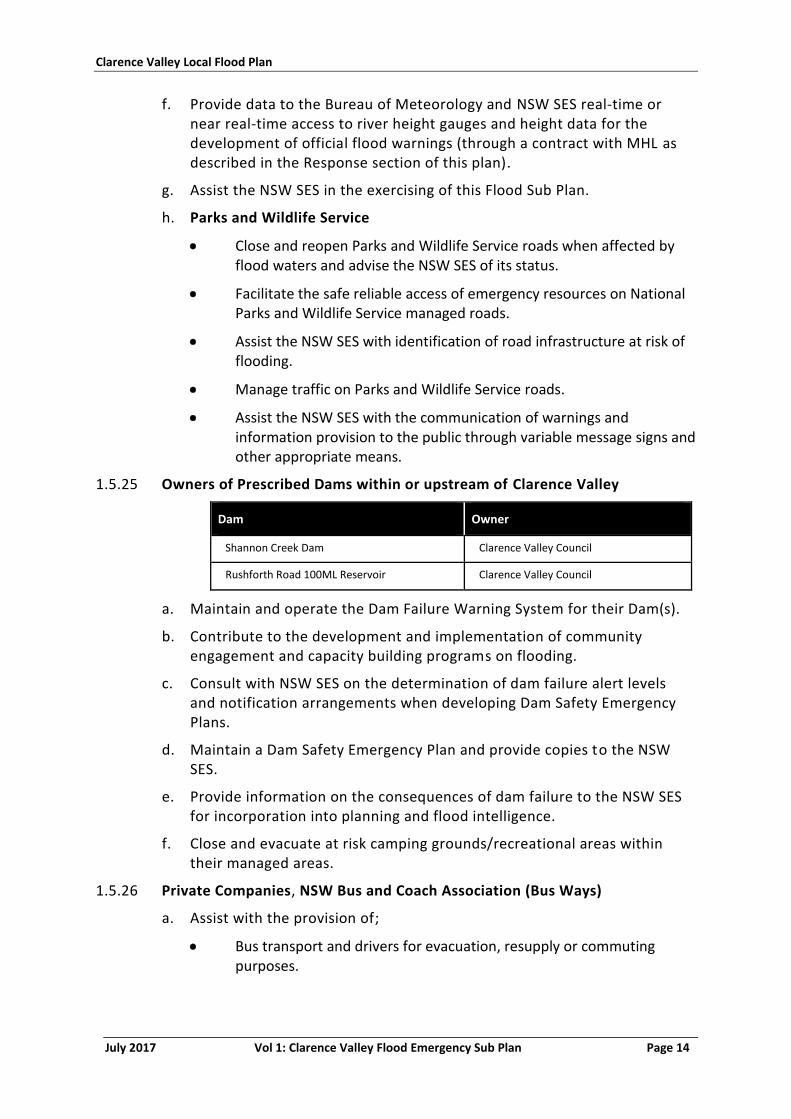
1.5.25 Owners of Prescribed Dams within or upstream of Clarence Valley
Dam Owner
Shannon Creek Dam Clarence Valley Council
Rushforth Road 100ML Reservoir Clarence Valley Council
a. Maintain and operate the Dam Failure Warning System for their Dam(s).
b. Contribute to the development and implementation of community engagement and capacity building programs on flooding.
c. Consult with NSW SES on the determination of dam failure alert levels and notification arrangements when developing Dam Safety Emergency Plans.
d. Maintain a Dam Safety Emergency Plan and provide copies to the NSW SES.
e. Provide information on the consequences of dam failure to the NSW SES for incorporation into planning and flood intelligence.
f. Close and evacuate at risk camping grounds/recreational areas within their managed areas.
1.5.26 Private Companies, NSW Bus and Coach Association (Bus Ways)
a. Assist with the provision of;
Bus transport and drivers for evacuation, resupply or commuting purposes.
Clarence Valley Local Flood Plan
July 2017 Vol 1: Clarence Valley Flood Emergency Sub Plan Page 15
1.5.27 Public Information Services Functional Area
a. When requested by NSW SES;
Assist the NSW SES in the establishment and operation of a Joint Media Information Centre.
1.5.28 Roads and Maritime Services
a. Manage traffic on state roads, state highways and waterways affected by flood waters and advise the NSW SES of their status including the Pacific Gwydir Highways and Summerland Way.
b. Facilitate the safe reliable access of emergency resources on RMS managed roads.
c. Assist the NSW SES with identification of road infrastructure at risk of flooding.
d. Assist in Traffic management associated with evacuations where necessary.
e. Enter state road closure information into the Live Traffic site.
f. Assist the NSW SES and local councils with the communication of warnings and information provision to the public through variable message signs.
g. Cooperate with the North Coast Transport Services Functional Area Coordinator.
1.5.29 School Administration Offices (including Catholic Education Office Grafton, Department of Education Grafton and Private Schools)
a. Liaise with the NSW SES and arrange for the early release of students whose travel arrangements are likely to be disrupted by flooding and/or road closures (or where required, for students to be moved to a suitable location until normal school closing time).
b. Pass information to school bus drivers/companies and/or other schools on expected or actual impacts of flooding.
c. Assist with coordinating the evacuation of schools when flooding or isolation is expected to occur.
d. Provide space in schools for evacuation centres where necessary.
1.5.30 Service and Sporting Clubs, Brooms Head Bowling Club, Wooli Bowling & Recreation Club, Yamba Bowling & Recreation Club, Glenreagh School of Arts
a. Assist with provision of evacuation centres.
1.5.31 Surf Life Saving NSW
a. Assist the NSW SES with the warning and/or evacuation of at risk communities;
Clarence Valley Local Flood Plan
July 2017 Vol 1: Clarence Valley Flood Emergency Sub Plan Page 16
b. Provide space in Surf Life Saving facilities for evacuation centres where required; and
c. Assist the NSW SES with flood rescue operations.
1.5.32 Telecommunication Services Functional Area
a. When requested by NSW SES;
Coordinate the restoration of telephone facilities damaged by flooding.
Assist the NSW SES to identify infrastructure at risk of flooding for incorporation into planning and intelligence.
1.5.33 The North Coast Transport Services Functional Area Coordinator (TSFAC)
a. The TSFAC will assist NSW SES, emergency services and other functional areas through the provision of traffic and transport operations as consistent with the roles of Transport organisations, including;
The movement of emergency equipment and personnel.
The movement of emergency supplies and goods, including water, fuel and food.
The evacuation of people and animals.
Assistance for medical transport.
Transportation of animals and infectious material/dangerous goods.
Maintaining and operating a transport route advisory service to the NSW SES, emergency services organisations and other Functional Areas and members of the community.
Coordinate the provision of traffic and transport operations as consistent with the roles of Transport organisations.
1.5.34 NSW Train Link
a. Operate NSW regional and interstate rail services through the Clarence Valley including the management of railway services affected by flood waters and advise the NSW SES.
b. Assist the NSW SES with the movement or evacuation of people during flood response operations if required.
c. Convey flood information and flood warnings to passengers and travellers on NSW trains.
d. Cooperate with, and assist the NSW SES Local Controller in relation to public safety during flood emergencies.
e. Cooperate with the North Coast Transport Services Functional Area Coordinator.
1.5.35 Welfare Services Functional Area
a. When requested by NSW SES;
Clarence Valley Local Flood Plan
July 2017 Vol 1: Clarence Valley Flood Emergency Sub Plan Page 17
Establish and manage evacuation centres, and provide disaster welfare services from recovery centres.
Administer the Personal Hardship and Distress component of the NSW Disaster Relief Scheme established to provide financial assistance to people affected by emergencies.
Support the Red Cross representatives deployed to Lawrence and Brushgrove.
1.5.36 Jana Ngalee and Baryulgil Square Local Aboriginal Land Council
a. Act as the point of contact between the NSW SES and the Malabugilmah and Baryulgil Aboriginal Communities respectively.
b. Inform the NSW SES Clarence Valley Local Controller about flood conditions and response needs.
c. Disseminate flood information, including flood and evacuation warnings, to the Malabugilmah and Baryulgil Aboriginal Communities.
1.5.37 Sandon/Buccarumbi Flood Network
a. Provide flood information to the NSW SES Clarence Valley Local Controller.
b. Distribute flood warnings and flood information provided by the NSW SES Clarence Valley Local Controller.
1.6 CROSS-BORDER ASSISTANCE ARRANGEMENTS
1.6.1 A local cross-border mutual assistance arrangement exists in which the NSW SES Clarence Valley and the NSW SES Richmond Tweed Region will deploy resources to support each other.
1.6.2 Operations involving the Ewingar area will be conducted by the NSW SES Tabulum Unit. This includes the management of isolation and the coordination of resupply Operations. Operations involving the Mororo area will be conducted by the NSW SES Woodburn Unit when the area is cut off from Maclean by flood waters.
1.6.3 A local cross border arrangement exists for NSW SES Corindi Unit, covering operational response in the Glenreagh-Kungala area in the Clarence Valley LGA.
Clarence Valley Local Flood Plan
July 2017 Vol 1: Clarence Valley Flood Emergency Sub Plan Page 18
PART 2 - PREPAREDNESS
2.1 MAINTENANCE OF THIS PLAN
2.1.1 The NSW SES Clarence Valley Local Controller will maintain the currency of this plan by;
a. Ensuring that all agencies, organisations and officers mentioned in it are aware of their roles and responsibilities.
b. Conducting exercises to test arrangements.
c. Reviewing the contents of the plan;
After each flood operation.
When significant changes in land-use or community characteristics occur.
When new information from flood studies become available.
When flood control or mitigation works are implemented or altered.
When there are changes that alter agreed plan arrangements.
2.1.2 The plan is to be reviewed no less frequently than every five years.
2.2 FLOODPLAIN AND COASTAL RISK MANAGEMENT
2.2.1 The NSW SES Clarence Valley Local Controller will ensure that;
a. NSW SES participates in local floodplain and coastal risk management committee activities when those committees are formed, in accordance with the protocols outlined in the NSW SES Controllers’ Guide.
b. The NSW SES Clarence Nambucca Region Headquarters is informed of involvement in floodplain and coastal risk management activities.
2.3 DEVELOPMENT OF FLOOD INTELLIGENCE
2.3.1 Flood intelligence describes flood behaviour and its effects on the community.
2.3.2 The NSW SES maintains a centralised flood intelligence system.
2.4 DEVELOPMENT OF WARNING SYSTEMS
2.4.1 The NSW SES establishes total flood warning systems for areas affected by flooding. This requires;
a. An identification of the potential clients of flood warning information at different levels of flooding (i.e. who would be affected in floods of differing severities).
b. Available information about the estimated impacts of flooding at different heights.
Clarence Valley Local Flood Plan
July 2017 Vol 1: Clarence Valley Flood Emergency Sub Plan Page 19
c. Identification of required actions and the amounts of time needed to carry them out.
d. Appropriate means of disseminating warnings to different clients and at different flood levels.
2.5 COMMUNITY RESILIENCE
2.5.1 The community needs to be as prepared as emergency agencies for the impact of all hazards (5), including flooding.
2.5.2 As the combat agency, NSW SES has the primary responsibility for the collation, assessment and public dissemination of information relating to flooding (3). To do this, NSW SES will require assistance from other agencies, particularly local government councils, dam owners, and the Bureau in the development and delivery of materials.
2.5.3 The NSW SES Clarence Valley Local Controller, with the assistance of the Clarence Valley Council, the NSW SES Clarence Nambucca Region Headquarters and NSW SES State Headquarters, is responsible for the collation, assessment and public dissemination of information relating to flooding (3).
2.5.4 A range of tailored strategies to be employed with NSW communities include:
a. Dissemination of flood-related brochures and booklets in flood liable areas.
b. Dissemination of coastal erosion related brochures in coastal erosion liable areas.
c. Talks and displays orientated to at-risk groups, community organisations, businesses and schools.
d. Publicity given to this plan and to flood-orientated NSW SES activities through local media outlets, including articles in local newspapers about the flood threat and appropriate responses.
2.6 TRAINING
2.6.1 Throughout this document there are references to functions that must be carried out by the members of the NSW SES Units. The NSW SES Clarence Valley Local Controller is responsible for ensuring that the members are;
a. Familiar with the contents of this plan.
b. Trained in the skills necessary to carry out the tasks allocated to the NSW SES.
2.7 RESOURCES
2.7.1 The NSW SES Clarence Valley Local Controller is responsible for maintaining the condition and state of readiness of NSW SES equipment.
Clarence Valley Local Flood Plan
July 2017 Vol 1: Clarence Valley Flood Emergency Sub Plan Page 20
2.7.2 The NSW SES Brushgrove, Copmanhurst, Grafton City, Lawrence, Maclean, Nymboida, Ulmarra, Yamba, and Wooli-Yuraygir Unit Controllers have similar responsibilities in relation to the Clarence Valley Unit Headquarters and equipment.
Clarence Valley Local Flood Plan
July 2017 Vol 1: Clarence Valley Flood Emergency Sub Plan Page 21
PART 3 - RESPONSE
CONTROL
3.1 CONTROL ARRANGEMENTS
3.1.1 The NSW SES is the legislated Combat Agency for floods and is responsible for the control of flood operations. This includes the coordination of other agencies and organisations for flood management tasks.
3.1.2 The NSW SES is the designated Combat Agency for damage control for storms. This includes damage control for coastal erosion and inundation from storm activity, specifically the protection of life and the coordination of the protection of readily moveable household goods and commercial stock and equipment. The NSW SES is not responsible for planning or conduct of emergency beach protection works or other physical mitigation works.
3.1.3 The Local EMPLAN will operate to provide support as requested by the NSW SES Incident Controller.
3.2 OPERATIONAL MANAGEMENT
3.2.1 NSW SES utilises the Australasian Inter-service Incident Management System (AIIMS), which is based on five principles;
a. Flexibility;
b. Functional management;
c. Management by objectives;
d. Unity of Command; and
e. Span of control.
3.2.2 AIIMS provides for different incident levels based on the complexity of management.
3.2.3 The Local Government Area may be divided into sectors and divisions to manage the flood and/or coastal erosion event (divisions are usually a group of sectors).
3.2.4 Sectors and divisions may be based on floodplain classifications, geographical, physical or functional boundaries. A town, city or suburb may be one sector or split into several sectors and divisions.
3.2.5 The Clarence Valley Council area has nine units and is split into numerous operational sectors during significant flood events. Operational sectors can change during an unknown change in flood behaviour, but usually include:
a. Brushgrove – including Cowper
b. Cangai – including Jackadgery, Coombadjha and Cangai (isolation)
Clarence Valley Local Flood Plan
July 2017 Vol 1: Clarence Valley Flood Emergency Sub Plan Page 22
c. Copmanhurst – including Copmanhurst, Gordonbrook, Coaldale, Carnham, Barretts Creek, Moleville, Seelands and Waterview Heights
d. Glenreagh - note, NSW SES Corindi Unit have a cross border arrangement to respond to this area
e. Grafton – including Eatonsville, Mountain View, South Grafton, Dovedale, Westlawn, Grafton CBD, North Grafton, Junction Hill, Koolkhan, Trenayr and Alumy Creek
f. Iluka – including Iluka and Woombah
g. Lawrence – including Lawrence and Southgate
h. Maclean – Including Maclean, Ashby Island, Brooms Head, Harwood Island, Ilarwill, Warregah Island and Chatworth Island
i. Nymboida – including Coutts Crossing, Braunstone, McPherson Crossing, Nymboida, Kangaroo Creek, Blaxlands Flat and Lanitza (isolation)
j. Sandon
k. Tyringham - Dundurrabin including Billys Creek, Tyringham and Clouds Creek
l. Ulmarra – including Tucabia, Ulmarra and Gilletts Ridge
m. Wooli – including Minnie Waters, Wooli and Pillar Valley
n. Yamba – including Yamba, Palmers Island, and Woolawehay
3.3 START OF RESPONSE OPERATIONS
3.3.1 This plan is always active to ensure that preparedness actions detailed in this plan are completed.
3.3.2 Response operations will begin;
a. On receipt of a Bureau of Meteorology Preliminary Flood Warning, Flood Warning, Flood Watch, Severe Thunderstorm Warning or a Severe Weather Warning for flash flooding or severe ocean conditions.
b. On receipt of a dam failure alert.
c. When other evidence leads to an expectation of flooding or coastal erosion within the council area.
3.3.3 Contact with the Bureau of Meteorology to discuss the development of flood warnings will normally be through the NSW SES Clarence Nambucca Region Headquarters and/or NSW SES State Headquarters.
3.3.4 The following persons and organisations will be advised of the start of response operations regardless of the location and severity of the flooding anticipated:
a. NSW SES Clarence Nambucca Region Headquarters.
Clarence Valley Local Flood Plan
July 2017 Vol 1: Clarence Valley Flood Emergency Sub Plan Page 23
b. NSW SES Brushgrove, Copmanhurst, Grafton City, Lawrence, Maclean, Nymboida, Ulmarra, Wooli-Yuraygir and Yamba Unit Controllers.
c. NSW SES Clarence Valley Brushgrove, Copmanhurst, Grafton City, Lawrence, Maclean, Nymboida, Ulmarra, Wooli-Yuraygir and Yamba Units.
d. Clarence Valley Local Emergency Operations Controller (for transmission to the NSW Police Force).
e. Clarence Valley Local Emergency Management Officer (for transmission to appropriate council officers and departments).
f. Clarence Valley Council Mayor.
g. Other agencies listed in this plan will be advised by the Local Emergency Management Officer on the request of the NSW SES Incident Controller and as appropriate to the location and nature of the threat.
3.4 RESPONSE STRATEGIES
3.4.1 The main response strategies for NSW SES flood operations include;
a. Information Provision and Warning
Provision of warnings, information and advice to communities.
Inform the community regarding the potential impacts of a flood and what actions to undertake in preparation for flooding.
Inform the community regarding the potential impacts of coastal erosion and what preparatory actions to undertake.
Provide timely and accurate information to the community.
b. Property protection
Protect the property of residents and businesses at risk of flood damage.
Assistance with property protection by way of sandbagging and the lifting or transporting of furniture, personal effects, commercial stock and caravans.
Assistance with the relocation of readily moveable household goods and commercial stock and equipment from properties threatened by coastal erosion.
Assistance with the protection of essential infrastructure.
c. Evacuation
Evacuation is a risk management strategy that may be used to mitigate the effects of an emergency on a community. It involves the movement of people to a safer location and their return. For an evacuation to be effective it must be appropriately planned and implemented (7).
Clarence Valley Local Flood Plan
July 2017 Vol 1: Clarence Valley Flood Emergency Sub Plan Page 24
d. Flood Rescue
The rescue or safe retrieval of persons or animals trapped by floodwaters.
e. Resupply
Minimise disruption upon the community by resupplying towns and villages which have become isolated as a consequence of flooding.
Ensure supplies are maintained to property owners by coordinating the resupply of properties which have become isolated as a consequence of flooding.
3.4.2 The NSW SES Incident Controller will select the appropriate response strategy to deal with the expected impact of the flood in each sector and/or community. The impact may vary so a number of different strategies may need to be selected and implemented across the whole operational area. The available strategies for each sector and/or community are maintained by the NSW SES.
3.4.3 Supporting agency strategies may include;
a. Protect the community from incidents involving fire and hazardous materials.
b. Maintain the welfare of communities and individuals affected by the impact of a flood.
c. Minimise disruption to the community by ensuring supply of essential energy and utility services.
d. Ensure coordinated health services are available to and accessible by the flood affected communities.
e. Maintain the welfare of animals affected by the impact of a flood.
3.5 OPERATIONS CENTRES
3.5.1 The Clarence Valley Emergency Operations Centre is located at the Local Land Services Building, 24-26 Mulgi Drive, South Grafton, 2460.
3.5.2 NSW SES Unit Operations Centres are located at:
a. Brushgrove Unit - Short Street, BRUSHGROVE, NSW 2460,
b. Copmanhurst Unit - 15 Prescott Street, COPMANHURST, NSW 2460,
c. Grafton City Unit - Irene Street, GRAFTON, NSW 2460
d. Lawrence Unit - 59 High Street, LAWRENCE, NSW 2460,
e. Maclean Unit - 74 River Street, MACLEAN, NSW 2463,
f. Nymboida Unit - Kangaroo Creek Rd, COUTTS CROSSING, NSW 2460
g. Ulmarra Unit - 20 Coldstream Street, ULMARRA, NSW 2462,
h. Wooli-Yuraygir Unit – Wooli Road, WOOLI, NSW 2462, and
Clarence Valley Local Flood Plan
July 2017 Vol 1: Clarence Valley Flood Emergency Sub Plan Page 25
i. Yamba Unit - Lot 323 Neptune Place, YAMBA, NSW 2464.
3.6 LIAISON
3.6.1 Any agency with responsibilities identified in this plan may be requested by the NSW SES to provide liaison (including a liaison officer where necessary) to the Clarence Valley Operations Centre, or designated Emergency Operations Centre.
3.6.2 In accordance with NSW EMPLAN, Liaison Officers will;
a. Maintain communication with and convey directions/requests to their organisation or functional area;
b. Provide advice on the status, resource availability, capabilities, actions and requirements of their organisation or functional area, and
c. Where appropriate, have the authority to deploy the resources of their parent organisation at the request of the NSW SES Incident Controller.
3.7 END OF RESPONSE OPERATIONS
3.7.1 When the immediate danger to life and property has passed the NSW SES Operational Area Commander or the NSW SES Incident Controller will issue an 'All Clear' message signifying that response operations have been completed. The message will be distributed through the same media outlets as earlier evacuation messages. The relevant Controller will also advise details of recovery coordination arrangements, arrangements made for clean-up operations prior to evacuees being allowed to return to their homes, and stand-down instructions for agencies not required for recovery operations.
PLANNING
3.8 COLLATING SITUATIONAL INFORMATION
Strategy
3.8.1 The NSW SES maintains and records situational awareness of current impacts and response activities.
Actions
3.8.2 The NSW SES Clarence Valley Unit Headquarters’ collate information on the current situation in the Clarence Valley LGA and incorporates in Situation Reports.
3.8.3 The NSW SES Clarence Nambucca Region Headquarters collates Region-wide information for inclusion in NSW SES Region Situation Reports.
3.8.4 Sources of situational information during times of flooding are;
Clarence Valley Local Flood Plan
July 2017 Vol 1: Clarence Valley Flood Emergency Sub Plan Page 26
a. Agency Situation Reports. Agencies and functional areas provide regular situation reports (SITREPs) to the NSW SES.
b. Active Reconnaissance. The NSW SES Incident Controller is responsible for coordinating the reconnaissance of impact areas, recording and communicating observations. Reconnaissance can be performed on the ground and using remote sensing (more commonly aerial). The NSW SES monitors the following problem areas:
Refer to Volume 3 for further information
c. The Bureau of Meteorology’s Flood Warning Centre provides river height and rainfall information, data is available on the website http://www.bom.gov.au/nsw/flood/.
d. Manly Hydraulics Laboratory (a business unit within NSW Public Works) automated river watch system funded by the Office of Environment and Heritage. This system provides river height and rainfall readings for a number of gauges in the Clarence Valley LGA. Recent data from this system is available on the Manly Hydraulic Laboratory website: http://www.mhl.nsw.gov.au. A history of area floods is also available upon request via the website.
e. NSW Office of Water. This office advises flow rates and rates of rise for the Clarence and Orara Rivers. Daily river reports containing information on gauge heights and river flows are available from the website: http://waterinfo.nsw.gov.au/.
f. Shannon Creek Dam Storage Monitoring System. This system provides information on Shannon Creek Dam.
g. NSW SES Clarence Nambucca Region Headquarters. The Region Headquarters provides information on flooding and its consequences, including those in nearby council areas (this information is documented in Bulletins and Situation Reports).
h. Clarence Valley Council. Provide information on road closures on website www.myroadinfo.com.au for local owned roads.
3.8.5 During flood operations sources of information on roads closed by flooding include;
a. My Road Info website (www.myroadinfo.com.au).
b. Coffs-Clarence Police Local Area Command.
c. Roads and Maritime Services (www.livetraffic.com).
d. NSW SES Clarence Nambucca Region Headquarters.
e. NSW SES Clarence Valley Unit Headquarters.
3.8.6 Situational information relating to consequences of flooding and/or coastal erosion should be used to verify and validate NSW SES Flood Intelligence records.
Clarence Valley Local Flood Plan
July 2017 Vol 1: Clarence Valley Flood Emergency Sub Plan Page 27
3.9 PROVISION OF FLOOD INFORMATION AND WARNINGS
Strategy
3.9.1 The NSW SES Clarence Valley Unit Headquarters provides advice to the NSW SES Clarence Nambucca Region Headquarters on current and expected impacts of flooding in the Clarence Valley LGA.
3.9.2 The NSW SES Clarence Nambucca Region Headquarters issues NSW SES Flood Bulletins, NSW SES Livestock and Equipment Warnings, Evacuation Warnings and Evacuation Orders to media outlets and agencies on behalf of all NSW SES units in the Region.
Actions
3.9.3 The NSW SES Incident Controller will ensure that the NSW SES Operational Area Commander is regularly briefed on the progress of operations.
3.9.4 NSW SES Clarence Valley Unit Headquarters operations staff will be briefed regularly so that they can provide information in response to inquiries received in person or by other means such as phone or fax.
3.9.5 Bureau of Meteorology Severe Thunderstorm Warning. These are issued direct to the media by the Bureau when severe thunderstorms are expected to produce dangerous or damaging conditions, including flash flooding. Severe thunderstorms are usually smaller in scale than events covered by Flood Watches and Severe Weather Warnings.
3.9.6 Bureau of Meteorology Severe Weather Warnings for Flash Flooding . These are issued direct to the media by the Bureau and provide a warning of the possibility for flash flooding as a result of intense rainfall. These warnings are issued when severe weather is expected to affect land based communities with 6 to 24 hours. Severe Weather Warnings may also include other conditions such as Damaging Surf, Dangerous Surf or tides, or Damaging Winds.
3.9.7 Bureau of Meteorology Flood Watches. Flood Watches are issued by the Bureau to advise people of the potential for flooding in a catchment area based on predicted or actual rainfall. Flood Watches will be included in NSW SES Flood Bulletins issued by the NSW SES Clarence Nambucca Region Headquarters.
3.9.8 Bureau of Meteorology Flood Warnings. The NSW SES Clarence Nambucca Region Headquarters will send a copy of Bureau Flood Warnings to the NSW SES Clarence Valley Unit. On receipt the NSW SES Incident Controller will provide the NSW SES Clarence Nambucca Region Headquarters with information on the estimated impacts of flooding at the predicted heights for inclusion in NSW SES Region Flood Bulletins.
3.9.9 NSW SES Livestock and Equipment Warnings. Following heavy rain or when there are indications of significant creek or river rises (even to levels below Minor Flood heights), the NSW SES Incident Controller will advise the NSW
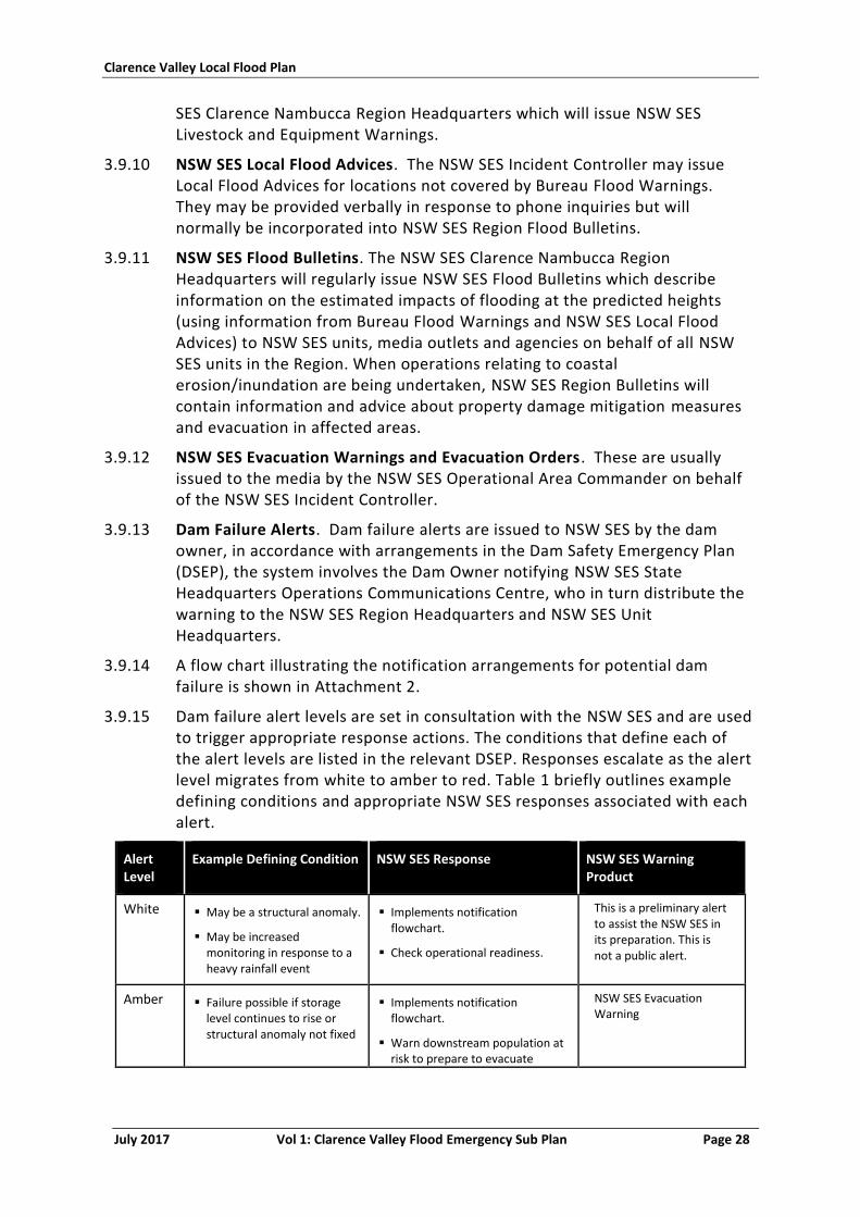
Clarence Valley Local Flood Plan
July 2017 Vol 1: Clarence Valley Flood Emergency Sub Plan Page 28
SES Clarence Nambucca Region Headquarters which will issue NSW SES Livestock and Equipment Warnings.
3.9.10 NSW SES Local Flood Advices. The NSW SES Incident Controller may issue Local Flood Advices for locations not covered by Bureau Flood Warnings. They may be provided verbally in response to phone inquiries but will normally be incorporated into NSW SES Region Flood Bulletins.
3.9.11 NSW SES Flood Bulletins. The NSW SES Clarence Nambucca Region Headquarters will regularly issue NSW SES Flood Bulletins which describe information on the estimated impacts of flooding at the predicted heights (using information from Bureau Flood Warnings and NSW SES Local Flood Advices) to NSW SES units, media outlets and agencies on behalf of all NSW SES units in the Region. When operations relating to coastal erosion/inundation are being undertaken, NSW SES Region Bulletins will contain information and advice about property damage mitigation measures and evacuation in affected areas.
3.9.12 NSW SES Evacuation Warnings and Evacuation Orders. These are usually issued to the media by the NSW SES Operational Area Commander on behalf of the NSW SES Incident Controller.
3.9.13 Dam Failure Alerts. Dam failure alerts are issued to NSW SES by the dam owner, in accordance with arrangements in the Dam Safety Emergency Plan (DSEP), the system involves the Dam Owner notifying NSW SES State Headquarters Operations Communications Centre, who in turn distribute the warning to the NSW SES Region Headquarters and NSW SES Unit Headquarters.
3.9.14 A flow chart illustrating the notification arrangements for potential dam failure is shown in Attachment 2.
3.9.15 Dam failure alert levels are set in consultation with the NSW SES and are used to trigger appropriate response actions. The conditions that define each of the alert levels are listed in the relevant DSEP. Responses escalate as the alert level migrates from white to amber to red. Table 1 briefly outlines example defining conditions and appropriate NSW SES responses associated with each alert.
Alert Level
Example Defining Condition NSW SES Response NSW SES Warning Product
White May be a structural anomaly.
May be increased monitoring in response to a heavy rainfall event
Implements notification flowchart.
Check operational readiness.
This is a preliminary alert to assist the NSW SES in its preparation. This is not a public alert.
Amber Failure possible if storage level continues to rise or structural anomaly not fixed
Implements notification flowchart.
Warn downstream population at risk to prepare to evacuate
NSW SES Evacuation Warning
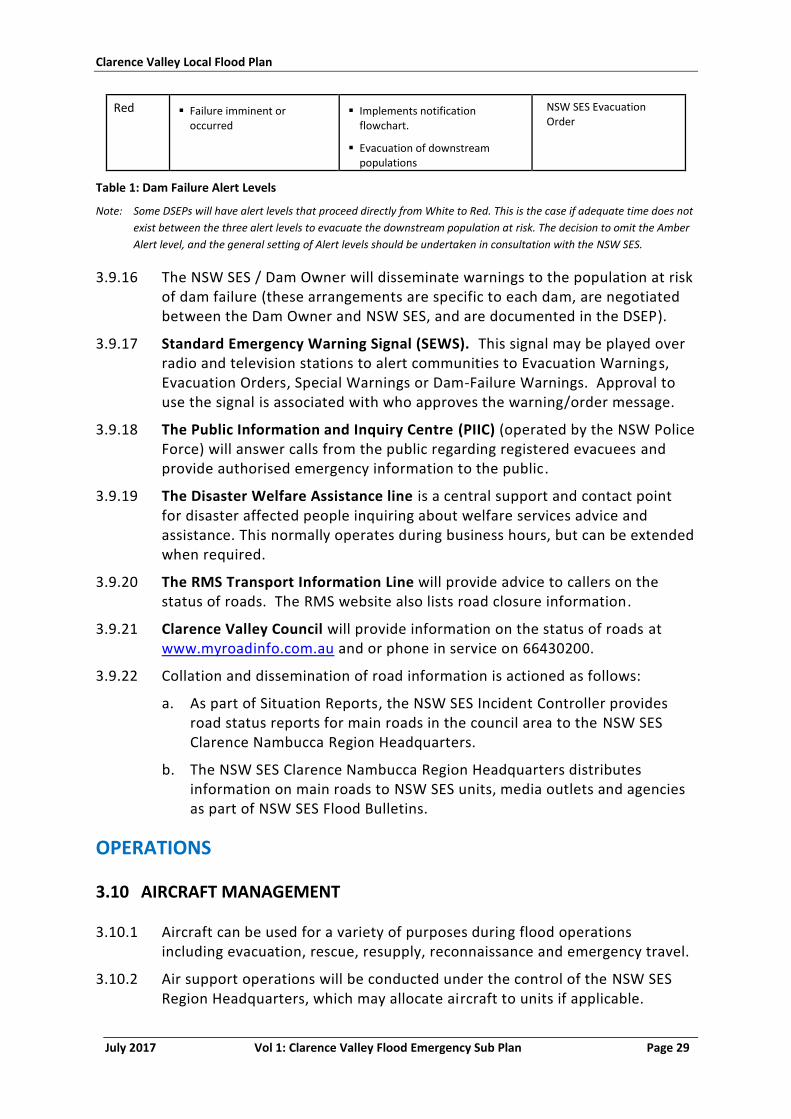
Clarence Valley Local Flood Plan
July 2017 Vol 1: Clarence Valley Flood Emergency Sub Plan Page 29
Red Failure imminent or occurred
Implements notification flowchart.
Evacuation of downstream populations
NSW SES Evacuation Order
Table 1: Dam Failure Alert Levels
Note: Some DSEPs will have alert levels that proceed directly from White to Red. This is the case if adequate time does not
exist between the three alert levels to evacuate the downstream population at risk. The decision to omit the Amber
Alert level, and the general setting of Alert levels should be undertaken in consultation with the NSW SES.
3.9.16 The NSW SES / Dam Owner will disseminate warnings to the population at risk of dam failure (these arrangements are specific to each dam, are negotiated between the Dam Owner and NSW SES, and are documented in the DSEP).
3.9.17 Standard Emergency Warning Signal (SEWS). This signal may be played over radio and television stations to alert communities to Evacuation Warnings, Evacuation Orders, Special Warnings or Dam-Failure Warnings. Approval to use the signal is associated with who approves the warning/order message.
3.9.18 The Public Information and Inquiry Centre (PIIC) (operated by the NSW Police Force) will answer calls from the public regarding registered evacuees and provide authorised emergency information to the public.
3.9.19 The Disaster Welfare Assistance line is a central support and contact point for disaster affected people inquiring about welfare services advice and assistance. This normally operates during business hours, but can be extended when required.
3.9.20 The RMS Transport Information Line will provide advice to callers on the status of roads. The RMS website also lists road closure information.
3.9.21 Clarence Valley Council will provide information on the status of roads at www.myroadinfo.com.au and or phone in service on 66430200.
3.9.22 Collation and dissemination of road information is actioned as follows:
a. As part of Situation Reports, the NSW SES Incident Controller provides road status reports for main roads in the council area to the NSW SES Clarence Nambucca Region Headquarters.
b. The NSW SES Clarence Nambucca Region Headquarters distributes information on main roads to NSW SES units, media outlets and agencies as part of NSW SES Flood Bulletins.
OPERATIONS
3.10 AIRCRAFT MANAGEMENT
3.10.1 Aircraft can be used for a variety of purposes during flood operations including evacuation, rescue, resupply, reconnaissance and emergency travel.
3.10.2 Air support operations will be conducted under the control of the NSW SES Region Headquarters, which may allocate aircraft to units if applicable.
Clarence Valley Local Flood Plan
July 2017 Vol 1: Clarence Valley Flood Emergency Sub Plan Page 30
3.10.3 NSW SES maintains the following information for the Clarence Valley Council area;
a. Locations of suitable helicopter landing points.
b. Locations of suitable airports and records detailing aircraft size and type that can land at airports.
c. Intelligence on when access to these locations is expected to be lost.
3.11 ASSISTANCE FOR ANIMALS
3.11.1 Matters relating to the welfare of livestock, companion animals and wildlife are to be referred to Agriculture and Animal Services Functional Area.
3.11.2 Requests for emergency supply and/or delivery of fodder to stranded livestock, or for livestock rescue, are to be referred to Agriculture and Animal Services Functional Area.
3.11.3 Requests for animal rescue should be referred to the NSW SES.
3.12 COMMUNICATION SYSTEMS
3.12.1 The primary means of communications between fixed locations is by telephone, email and facsimile.
3.12.2 The primary means of communication to and between deployed NSW SES resources is by UHF PMR and mobile telephone.
3.12.3 All liaison officers will provide their own communication links back to their parent agencies.
3.12.4 All other organisations will provide communications as necessary to their deployed field teams.
3.12.5 Back-up communications are provided as follows:
a. RFS UHF PMR
b. CVC UHF PMR
3.13 PRELIMINARY DEPLOYMENTS
3.13.1 When flooding is expected to be severe enough to cut road access to towns, within towns and/or rural communities, the NSW SES Incident Controller will ensure that resources are in place for the distribution of foodstuffs and medical supplies to the areas that could become isolated.
3.13.2 When access between Grafton and Junction Hill is expected to be cut, the NSW SES Incident Controller will advise appropriate agencies so that resources (including sandbags, firefighting appliances, ambulances, etc.) are deployed to ensure that operational capability is maintained.
Clarence Valley Local Flood Plan
July 2017 Vol 1: Clarence Valley Flood Emergency Sub Plan Page 31
3.14 ROAD AND TRAFFIC CONTROL
3.14.1 A number of roads within the council area are affected by flooding. NSW SES maintains details of these roads.
3.14.2 The council closes and re-opens its own roads.
3.14.3 The NSW Police Force has the authority to close and re-open roads but will normally only do so (if the Council or the RMS have not already acted) if public safety requires such action.
3.14.4 When resources permit, the NSW SES assists Council, RMS or the Police by erecting road closure signs and barriers.
3.14.5 In flood events, the NSW SES Incident Controller may direct the imposition of traffic control measures. The entry into flood affected areas will be controlled in accordance with the provisions of the State Emergency Service Act, 1989 (Part 5, Sections 19, 20, 21 and 22) and the State Emergency Rescue Management Act, 1989 (Part 4, Sections 60KA, 60L and 61).
3.14.6 Police, RMS or Council officers closing or re-opening roads or bridges affected by flooding are to advise the NSW SES Clarence Valley Local Controller, which will then provide a road information service to local emergency services, the public and the NSW SES Clarence Nambucca Region Headquarters. All such information will also be passed to the Police, RMS and the Council.
3.15 STRANDED TRAVELLERS
3.15.1 Flood waters can strand travellers. Travellers seeking assistance will be referred to the Welfare Services Functional Area for the arrangement of emergency accommodation.
3.16 MANAGING PROPERTY PROTECTION OPERATIONS
Strategy
3.16.1 Protect the property of residents and businesses at risk of flood damage.
Actions
3.16.2 The NSW SES is the responsible agency for the coordination of operations to protect property.
3.16.3 Property may be protected from floods by;
a. Lifting or moving of household furniture.
b. Lifting or moving commercial stock and equipment.
c. Sandbagging to minimise entry of water into buildings.
3.16.4 The NSW SES maintains stocks of sandbags.
Clarence Valley Local Flood Plan
July 2017 Vol 1: Clarence Valley Flood Emergency Sub Plan Page 32
3.16.5 Property protection options are however very limited in the Clarence Valley LGA due to the large number of properties that can be affected and the depth of floodwaters arising from severe flooding on the Clarence and Orara Rivers
3.16.6 Property protection measures for the threat of coastal erosion involves the relocation of readily moveable household goods and commercial stock and equipment. The NSW SES is not responsible for planning or conduct of emergency beach protection works or other physical mitigation works.
3.17 MANAGING FLOOD RESCUE OPERATIONS
Strategy
3.17.1 Rescue of people and animals from floods.
Actions
3.17.2 The NSW SES Incident Controller controls flood rescue in Clarence Valley LGA during a flood emergency.
3.17.3 Flood rescues, may be carried out by accredited units in accordance with appropriate standards.
3.17.4 Additional flood boats and crews can be requested through the NSW SES Clarence Nambucca Region Headquarters.
3.17.5 There may be some residual population which did not evacuate during the early stages of flooding and which require rescue.
3.18 MANAGING EVACUATION OPERATIONS
Strategy
3.18.1 When there is a risk to public safety, evacuation is the primary strategy. Circumstances may include;
a. Evacuation of people when their homes or businesses are likely to flood.
b. Evacuation of people who are unsuited to living in isolated circumstances, due to flood water closing access.
c. Evacuation of people where essential energy and utility services are likely to fail, have failed or where buildings have been made uninhabitable.
d. Evacuation of people when their homes or business are at threat of collapse from coastal erosion.
Actions
3.18.2 The evacuation operation will have the following stages:
a. Decision to evacuate.
b. Mobilisation (mobilisation may begin prior to the decision to evacuate).
c. Evacuation Warning delivery.
Clarence Valley Local Flood Plan
July 2017 Vol 1: Clarence Valley Flood Emergency Sub Plan Page 33
d. Evacuation Order delivery.
e. Withdrawal.
f. Shelter.
g. Return.
3.18.3 During floods evacuations will be controlled by the NSW SES. Small-scale evacuations will be controlled by the NSW SES Incident Controller. Should the scale of evacuation operations be beyond the capabilities of local resources control may be escalated to the next operational command level.
Decision to evacuate
3.18.4 In most cases the decision to evacuate rests with the NSW SES Incident Controller who exercises his/her authority in accordance with Section 22(1) of The State Emergency Service Act 1989. However, the decision to evacuate will usually be made after consultation with the NSW SES Operational Area Commander and the Local Emergency Operations Controller.
3.18.5 In events that require large scale evacuations, the decision to evacuate must be escalated to the NSW SES Operational Area Commander or the State Controller.
3.18.6 Some people will make their own decision to evacuate earlier and move to alternate accommodation, using their own transport. This is referred to as self-managed evacuation (8).
Mobilisation
3.18.7 The NSW SES Incident Controller will request the following personnel for doorknock teams for designated Sectors/locations:
a. NSW SES Clarence Valley Unit members.
b. RFS Clarence Valley Zone District members via the RFS Fire Control Officer.
c. Local Police Force officers via the local area command.
3.18.8 The NSW SES Operational Area Commander will request any additional personnel required to assist with doorknock teams using;
a. NSW SES members from the NSW SES Clarence Nambucca Region and surrounding NSW SES Regions.
b. FRNSW personnel arranged via the FRNSW Liaison Officer.
c. RFS personnel arranged via the RFS Liaison Officer.
3.18.9 The NSW SES Incident Controller will request the LEMC to provide Council personnel to assist with traffic coordination within Sector(s)/Community.
3.18.10 The NSW SES Incident Controller will arrange liaison officers for Sector Command Centres.
Clarence Valley Local Flood Plan
July 2017 Vol 1: Clarence Valley Flood Emergency Sub Plan Page 34
3.18.11 The NSW SES Operational Area Commander will request the required number of buses for Sectors via the Transport Services Functional Area.
3.18.12 The first evacuation warnings issued in the Clarence Valley Council area can be expected under the following conditions:
a. Predicted to exceed 5m at the Grafton gauge Brushgrove, Cowper and Palmers Island.
b. Predicted to exceed 4.5m at the Grafton gauge – Southgate area.
c. Predicted to exceed 5m at the Ulmarra gauge – properties in the Ulmarra area, lower lying areas outside the Grafton flood protection levee, lower areas in the Maclean area.
d. Predicted to exceed 7.8m at the Grafton gauge – A Targeted Evacuation of Grafton excluding the high areas of South Grafton.
e. Predicted to exceed 8.0m at the Grafton gauge – A targeted Evacuation of remaining areas of Grafton.
Delivery of Evacuation Warnings and Evacuation Orders
3.18.13 The NSW SES will advise the community of the requirements to evacuate. The NSW SES will issue an Evacuation Warning when the intent of an NSW SES Incident Controller is to warn the community of the need to prepare for a possible evacuation.
3.18.14 The NSW SES will issue an Evacuation Order when the intent of the NSW SES Incident Controller is to instruct a community to immediately evacuate in response to an imminent threat.
3.18.15 The NSW SES Incident Controller will distribute Evacuation Warnings and Evacuation Orders to;
a. Sector/Division Command Centres (where established).
b. Clarence Valley Local Emergency Operations Centre.
c. Clarence Valley Council.
d. Coffs-Clarence Police Local Area Command.
e. Clarence Valley Zone Rural Fire Service Control Centre.
f. Radio Stations.
g. Other local agencies and specified individuals.
3.18.16 The NSW SES Operational Area Commander will distribute Evacuation Warnings and Evacuation Orders to;
a. The NSW SES State Operations Centre.
b. The NSW SES Incident Controller.
c. Affected communities via dial-out warning systems where installed or applicable.
d. Relevant media outlets and agencies.
Clarence Valley Local Flood Plan
July 2017 Vol 1: Clarence Valley Flood Emergency Sub Plan Page 35
3.18.17 Evacuation Warnings and Evacuation Orders may be delivered through;
a. Radio and television stations.
b. Doorknocking by emergency service personnel.
c. Public address systems (fixed or mobile).
d. Telephony-based systems (including Emergency Alert, SMS and landline).
e. Two-way Radio.
f. In NSW SES Clarence Nambucca Flood Bulletins.
g. Social Media.
3.18.18 The Standard Emergency Warning Signal (SEWS) may be used to precede all Evacuation Orders broadcast on Radio Stations.
3.18.19 Sector Commanders, where established, will distribute Evacuation Orders via Emergency Service personnel in doorknock teams to areas under threat of inundation.
3.18.20 Doorknock teams will work at the direction of;
a. The Sector Commander if a Sector Command Centre is established.
b. The relevant Division Commander where a Division Command Centre has not been established.
3.18.21 Field teams conducting doorknocks will record and report back the following information to their Sector Commander/Division Commander/ Incident Controller;
a. Addresses and locations of houses doorknocked and/or evacuated.
b. The number of occupants.
c. Details of support required (such as transport, medical evacuation, assistance to secure house and/or property and raise or move belongings).
d. Details of residents who refuse to comply with the Evacuation Order.
3.18.22 Refusal to evacuate. Field teams should not waste time dealing with people who are reluctant or refuse to comply with any Evacuation Order. These cases are to be referred to the NSW Police Force.
Withdrawal
3.18.23 Evacuations will generally be carried out in stages starting from the lowest areas, low flood islands and low trapped perimeters; and progressively from higher areas.
3.18.24 The most desirable method of evacuation is via road using private transport. This may be supplemented by buses for car-less people. However, other means of evacuation may also be used if available and as necessary (e.g. by foot, rail, air).
Clarence Valley Local Flood Plan
July 2017 Vol 1: Clarence Valley Flood Emergency Sub Plan Page 36
3.18.25 Evacuees who require emergency accommodation or disaster welfare assistance will be directed to designated evacuation centres. Evacuees who have made their own accommodation arrangements will not be directed to evacuation centres. It is not possible to determine in advance how many will fall into this category.
3.18.26 Evacuees will:
a. Move under local traffic arrangements from the relevant Sectors/Community via managed evacuation routes;
b. Continue along the suburban/regional/rural road network to allocated Evacuation Centres.
3.18.27 Health Services. The Health Services Functional Area will coordinate the evacuation of hospitals, health centres and aged care facilities (including nursing homes).
3.18.28 Schools. School administration offices (Department of Education, Catholic Education Office and Private Schools) will coordinate the evacuation of schools if not already closed.
3.18.29 If there is sufficient time between the start of response operations and the evacuation of communities, the NSW SES Operational Area Commander will discuss the temporary closure of appropriate schools with the Regional Director, North Coast Region, Department of Education. This will enable pupils to stay at home or be returned home so they can be evacuated (if required) with their families.
3.18.30 Note that in the Clarence Valley LGA, school principals may close some schools affected by flooding in the early stages of flooding.
3.18.31 Caravan parks. When an evacuation order is given occupiers of movable dwellings should:
a. Isolate power to moveable dwellings.
b. Collect personal papers, medicines, a change of clothing, toiletries and bedclothes.
c. Lift the other contents in any remaining dwellings as high as possible.
d. Move to friends, relatives or a designated evacuation centre if they have their own transport, or move to the caravan office to await transport.
e. If undertaking self-managed evacuation, register their movements with the caravan park management upon leaving the park.
3.18.32 Where possible, dwellings that can be moved will be relocated by their owners. Park managers will arrange for the relocation of movable dwellings as required. Council and NSW SES personnel may assist if required.
3.18.33 Caravan park managers will ensure that their caravan park is capable of being evacuated in a timely and safe manner.
3.18.34 Advise the NSW SES Clarence Valley Local Controller of:
Clarence Valley Local Flood Plan
July 2017 Vol 1: Clarence Valley Flood Emergency Sub Plan Page 37
a. The number of people requiring transport.
b. Details of any medical evacuations required.
c. Whether additional assistance is required to effect the evacuation.
3.18.35 Check that all residents and visitors are accounted for.
3.18.36 Inform the NSW SES Clarence Valley Local Controller when the evacuation of the caravan park has been completed.
3.18.37 Provide the NSW SES Clarence Valley Local Controller with a register of people that have been evacuated.
3.18.38 Assistance Animals, Pets and Companion Animals of Evacuees: Assistance animals (guide dogs, hearing assistance animals, etc.) will remain in the care of their owners throughout the evacuation. This includes transport and access into evacuation centres etc.
Where possible owners should take their companion animals with them when
they are asked to evacuate. Due to safety restrictions, it may not be possible to
allow companion animals to accompany their owners when being transported via
aircraft or flood rescue boat. In such circumstances Agriculture and Animal
Services will coordinate separate arrangements for evacuation and care of
companion animals.
3.18.39 Transport and storage: Transport and storage of furniture from flood and/or coastal erosion threatened properties will be arranged as time and resources permit.
3.18.40 Security: The NSW Police Force will coordinate the provision of overall security for evacuated areas.
3.18.41 The NSW SES Incident Controller is to provide the following reports to the NSW SES Clarence Nambucca Region Headquarters:
a. Advice of commencement of the evacuation of each Sector,
b. Half-hourly progress reports (by Sectors) during evacuations,
c. Advice of completion of the evacuation of each Sector.
3.18.42 Assembly areas: An assembly area is a designated location used for the assembly of emergency-affected persons before they move to temporary accommodation or a nominated evacuation centre. As such these areas do not provide welfare assistance nor are they used for long term sheltering or provision of meals. An assembly area may also be a prearranged, strategically placed area, where support response personnel, vehicles and other equipment can be held in readiness for use during an emergency.
Shelter
3.18.43 Evacuation Centres: Evacuees will be advised to go to friends or relatives, or else be taken to the nearest accessible evacuation centre, which may initially
Clarence Valley Local Flood Plan
July 2017 Vol 1: Clarence Valley Flood Emergency Sub Plan Page 38
be established at the direction of the NSW SES Incident Controller, but managed as soon as possible by Welfare Services.
3.18.44 The following locations are suitable for use as flood evacuation centres:
a. South Grafton High School
b. Brooms Head Bowling Club
c. Wooli Bowling & Recreation Club
d. Yamba Bowling & Recreation Club
e. Glenreagh School of Arts
f. Iluka Community Hall
g. Southgate Community Hall
h. Maclean Showground
i. Copmanhurst Hall, Copmanhurst
j. Lawrence Primary School, Lawrence
k. Plantation Motel, 2 Sheehys Lane Tyndale
3.18.45 Registration: The NSW Police Force will facilitate the requirement of Disaster Victim Registration for people evacuated to designated evacuation centres.
3.18.46 Animal Shelter: Facilities to hold and care for companion animals of evacuees will be coordinated by Agriculture and Animal Services if required. If required, Agriculture and Animal Services will also coordinate refuge areas for livestock (e.g. horses) where feasible.
Return
3.18.47 The NSW SES Incident Controller will advise when return to evacuated areas is safe after flood waters have receded and reliable access is available.
3.18.48 The NSW SES Incident Controller will determine when it is safe for evacuees to return to their homes in consultation with:
a. The Recovery Coordinating Committee (if established)
b. Welfare Services Functional Area Coordinator (welfare of evacuees)
c. Engineering Services Functional Area Co-ordinator (safety of buildings, structural integrity of levees/dams)
d. Health Service Functional Area Coordinator (public health)
e. Transport Services Functional Areas Coordinator (arrangement of transport)
f. The Clarence Valley LEOCON
g. The Clarence Valley Council
h. NSW SES Operational Area Commander
Clarence Valley Local Flood Plan
July 2017 Vol 1: Clarence Valley Flood Emergency Sub Plan Page 39
i. Other appropriate agencies/functional areas as required (mitigation and advice regarding identified risks resulting from the flood and/or coastal erosion event).
3.18.49 Once it is considered safe to do so, the NSW SES Incident Controller will authorise the return of evacuees.
3.18.50 The return will be controlled by the NSW SES Incident Controller and may be conducted, at their request, by the Recovery Coordinator.
3.19 INITIAL EVACUATIONS
3.19.1 A number of evacuations are required during the relatively frequent floods of Minor and Moderate classification.
3.19.2 Specific evacuation arrangements for each Sector/Community are detailed in Volume 3.
3.20 MANAGING RESUPPLY OPERATIONS
3.20.1 The NSW SES is responsible for the coordination of the resupply of isolated communities and properties.
3.20.2 If isolation is expected to occur, residents should be encouraged to consider their needs and suitability for an unknown period of isolation.
3.20.3 If properties/communities are going to remain in locations expected to become isolated, households/retailers should be encouraged to stock up on essential supplies.
3.20.4 Where practicable, once supplies are delivered to the NSW SES designated loading point, the NSW SES Incident Controller will arrange for the delivery of essential foodstuffs, fuels or urgent medical supplies required by an isolated property or community.
3.20.5 All reasonable effects will be made to deliver supplies, however where necessary the NSW SES will prioritise the delivery of items.
Resupply of Isolated Towns and Villages
Strategy
3.20.6 Minimise disruption upon the community by resupplying towns and villages which have become isolated as a consequence of flooding.
Actions
3.20.7 The NSW SES is responsible for the coordination of the resupply of isolated communities.
3.20.8 If flood predictions indicate that areas are likely to become isolated, the NSW SES Incident Controller should advise retailers that they should stock up.
3.20.9 When isolation occurs, retailers will be expected to place orders with suppliers where they have a line of credit and to instruct those suppliers to

Clarence Valley Local Flood Plan
July 2017 Vol 1: Clarence Valley Flood Emergency Sub Plan Page 40
package their goods and deliver them to loading points designated by the NSW SES.
3.20.10 The NSW SES is prepared to deliver mail to isolated communities but may not be able to do so according to normal Australia Post timetables.
3.20.11 The NSW SES will assist hospitals with resupply of linen and other consumables where able.
Resupply of Isolated Properties
Strategy
3.20.12 Ensure supplies are maintained to properties by coordinating the resupply of properties which have become isolated as a consequence of flooding.
Actions
3.20.13 The resupply of isolated properties is a common requirement during floods and coordination can be difficult because requests can emanate from a variety of sources. Isolated properties may call their suppliers direct, place their orders through their own social networks or contact the NSW SES.
3.20.14 The principles to be applied when planning for the resupply of isolated properties are;
a. The NSW SES will coordinate resupply and establish a schedule.
b. Some isolated households will not have the ability to purchase essential grocery items due to financial hardship. If an isolated household seeks resupply from the NSW SES and claims to be, or is considered to be, in dire circumstances, he/she is to be referred to Welfare Services for assessment of eligibility. Where financial eligibility criteria are met, Welfare Services will assist with the purchase of essential grocery items. Welfare Services will deliver the essential grocery items to the NSW SES designated loading point for transport.
c. Local suppliers will liaise with the NSW SES regarding delivery of resupply items to the designated loading point.
d. Local suppliers are responsible for packaging resupply items for delivery.
3.20.15 A flowchart illustrating the Resupply process is shown in Attachment 1. Please note that the flowchart outlines the resupply process but does not encompass all potential situations and/or outcomes.
Clarence Valley Local Flood Plan
July 2017 Vol 1: Clarence Valley Flood Emergency Sub Plan Page 41
PART 4 - RECOVERY
4.1 RECOVERY COORDINATION AT THE LOCAL LEVEL
4.1.1 The NSW SES Clarence Valley Local Controller will ensure that planning for long-term recovery operations begins at the earliest opportunity, initially through briefing the Local Emergency Management Committee (LEMC). As soon as possible the LEMC will meet to discuss recovery implications including the need for a Local Recovery Committee. The LEMC will consider any impact assessment in determining the need for recovery arrangements. This is conveyed in the first instance to the State Emergency Operations Controller (SEOCON) for confirmation with the State Emergency Recovery Controller (SERCON).
4.1.2 Once the need for recovery has been identified, the SERCON, in consultation with the SEOCON, may recommend the appointment of a Local Recovery Coordinator and nominate an appropriate candidate to the Minister for Emergency Services.
4.1.3 The SERCON may send a representative to the LEMC and subsequent recovery meetings to provide expert recovery advice and guidance.
4.1.4 The NSW SES Clarence Valley Local Controller and Local Emergency Operations Controller (LEOCON) attend recovery meetings to provide an overview of the emergency response operation.
4.1.5 The NSW SES Operational Area Commander, the Regional Emergency Management Officer and appropriate Regional Functional Area Coordinators will be invited to the initial local meeting and to subsequent meetings as required.
4.1.6 The recovery committee will:
a. Develop and maintain a Recovery Action Plan with an agreed exit strategy.
b. Monitor and coordinate the activities of agencies with responsibility for the delivery of services during recovery.
c. Ensure that relevant stakeholders, especially the communities affected, are involved in the development and implementation of recovery objectives and strategies and are informed of progress made.
d. Provide the SERCON with an end of recovery report.
e. Ensure the recovery is in line with the National Principles of Disaster Recovery and the NSW tenets.
4.2 RECOVERY COORDINATION AT THE REGION AND STATE LEVEL
4.2.1 In the event that an emergency affects several local areas, a Region Emergency Management Committee (REMC) will meet to discuss recovery
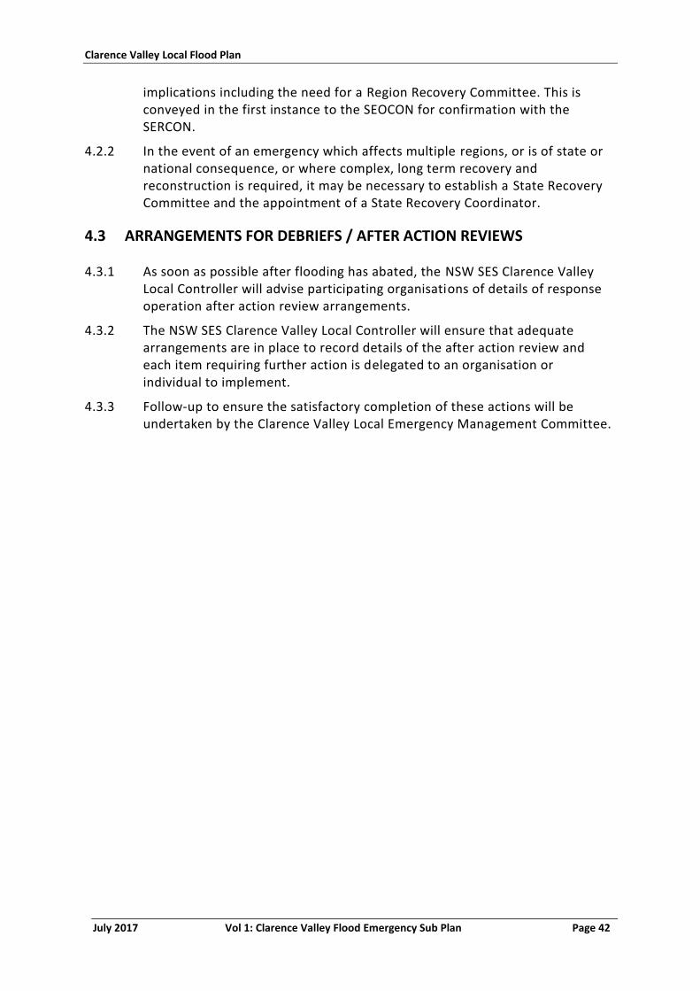
Clarence Valley Local Flood Plan
July 2017 Vol 1: Clarence Valley Flood Emergency Sub Plan Page 42
implications including the need for a Region Recovery Committee. This is conveyed in the first instance to the SEOCON for confirmation with the SERCON.
4.2.2 In the event of an emergency which affects multiple regions, or is of state or national consequence, or where complex, long term recovery and reconstruction is required, it may be necessary to establish a State Recovery Committee and the appointment of a State Recovery Coordinator.
4.3 ARRANGEMENTS FOR DEBRIEFS / AFTER ACTION REVIEWS
4.3.1 As soon as possible after flooding has abated, the NSW SES Clarence Valley Local Controller will advise participating organisations of details of response operation after action review arrangements.
4.3.2 The NSW SES Clarence Valley Local Controller will ensure that adequate arrangements are in place to record details of the after action review and each item requiring further action is delegated to an organisation or individual to implement.
4.3.3 Follow-up to ensure the satisfactory completion of these actions will be undertaken by the Clarence Valley Local Emergency Management Committee.
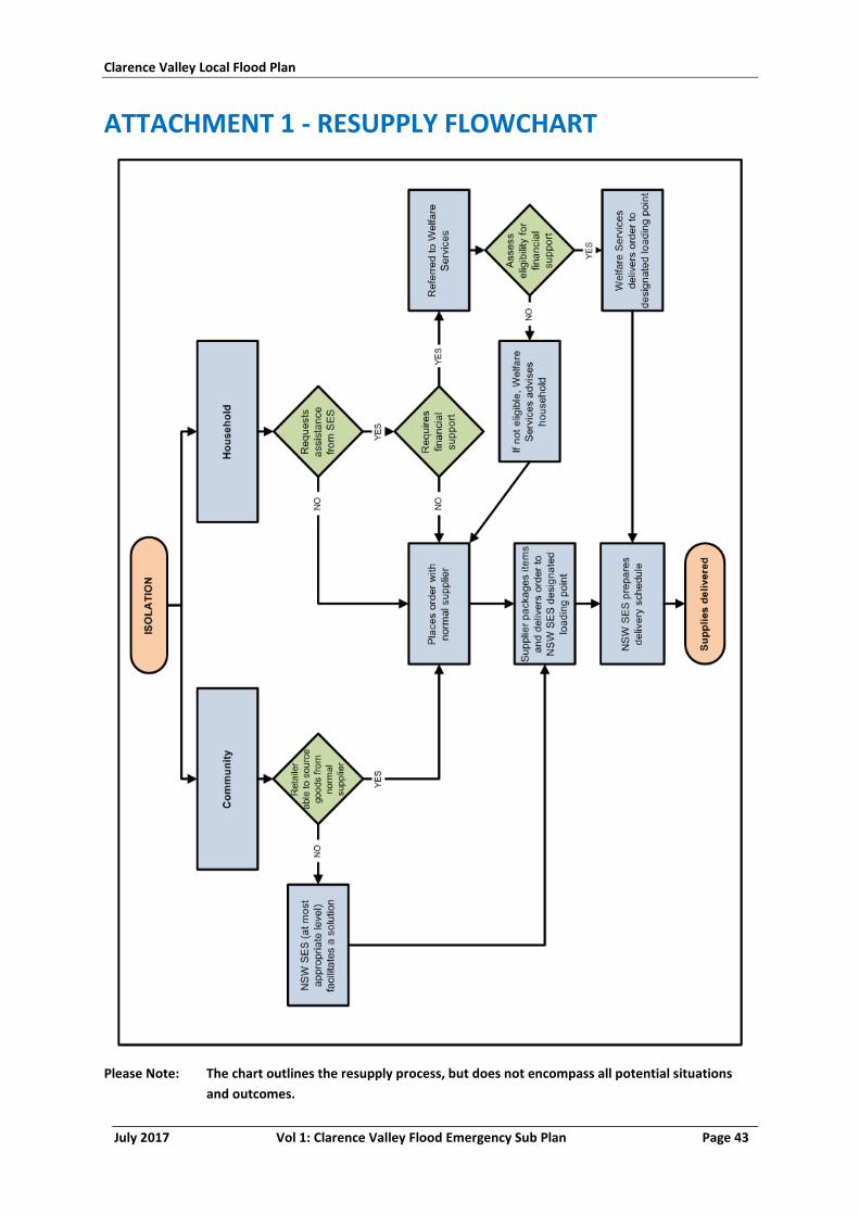
Clarence Valley Local Flood Plan
July 2017 Vol 1: Clarence Valley Flood Emergency Sub Plan Page 43
ATTACHMENT 1 - RESUPPLY FLOWCHART
Please Note: The chart outlines the resupply process, but does not encompass all potential situations
and outcomes.
Clarence Valley Local Flood Plan
July 2017 Vol 1: Clarence Valley Flood Emergency Sub Plan Page 44
ATTACHMENT 2 - DAM FAILURE ALERT NOTIFICATION ARRANGEMENTS FLOWCHART
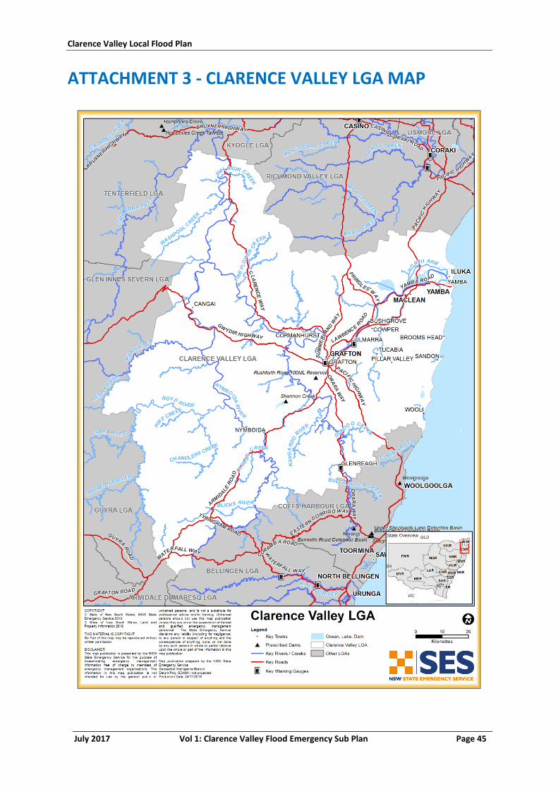
Clarence Valley Local Flood Plan
July 2017 Vol 1: Clarence Valley Flood Emergency Sub Plan Page 45
ATTACHMENT 3 - CLARENCE VALLEY LGA MAP
Clarence Valley Local Flood Plan
July 2017 Vol 1: Clarence Valley Flood Emergency Sub Plan Page 46
LIST OF REFERENCES
1. Emergency Management Australia. Managing the floodplain: a guide to best practice in
flood risk management in Australia. s.l. : Attorney-General's Department, 2013.
2. Department of Infrastructure, Planning and Natural Resources. Floodplain Development
Manual. 2005.
3. Ministry for Police and Emergency Services (MPES). New South Wales State Emergency
Management Plan (EMPLAN). 2012.
4. NSW Government. Local Government Act 1993 No 30. 1993.
5. Emergency Management Australia. Flood Warning: Australian Emergency Manuals Series
Manual 21. s.l. : Attorney-General's Department, 2009.
6. NSW Government. Manufactured Home Estates, Caravan Parks, Camping Grounds and
Moveable Dwellings Regulation. 2005.
7. Emergency Management Australia. Evacuation Planning: Australian Emergency
Management Handbook Series Handbook 4. s.l. : Attorney-General's Department, 2013.
8. SEMC Evacuations Working Group. Evacuation Management Guidelines. 2014.
9. NSW SES. Incident Management Policy. 2015.
HAZARD AND RISK IN
CLARENCE VALLEY
Volume 2 of the Clarence Valley Local Flood Plan
Last Update: August 2017
Clarence Valley Local Flood Plan
August 2017 Vol 2: Hazard and Risk in Clarence Valley Page 1
AUTHORISATION
The Hazard and Risk in Clarence Valley has been prepared by the NSW State Emergency
Service (NSW SES) as part of a comprehensive planning process. The information contained
herein has been compiled from the latest available technical studies.
Tabled at LEMC Date:
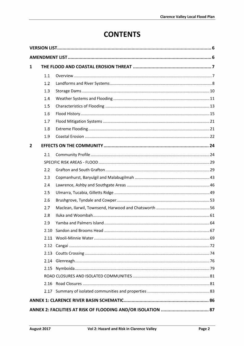
Clarence Valley Local Flood Plan
August 2017 Vol 2: Hazard and Risk in Clarence Valley Page 2
CONTENTS
VERSION LIST .................................................................................................................... 6
AMENDMENT LIST ............................................................................................................ 6
1 THE FLOOD AND COASTAL EROSION THREAT ........................................................... 7
Overview .......................................................................................................................... 7
Landforms and River Systems .......................................................................................... 8
Storage Dams ................................................................................................................. 10
Weather Systems and Flooding ..................................................................................... 11
Characteristics of Flooding ............................................................................................ 13
Flood History .................................................................................................................. 15
Flood Mitigation Systems .............................................................................................. 21
Extreme Flooding ........................................................................................................... 21
Coastal Erosion .............................................................................................................. 22
2 EFFECTS ON THE COMMUNITY ............................................................................... 24
Community Profile ......................................................................................................... 24
SPECIFIC RISK AREAS - FLOOD .................................................................................................. 29
Grafton and South Grafton ............................................................................................ 29
Copmanhurst, Baryulgil and Malabugilmah .................................................................. 43
Lawrence, Ashby and Southgate Areas ......................................................................... 46
Ulmarra, Tucabia, Gilletts Ridge .................................................................................... 49
Brushgrove, Tyndale and Cowper .................................................................................. 53
Maclean, Ilarwil, Townsend, Harwood and Chatsworth ............................................... 56
Iluka and Woombah ....................................................................................................... 61
Yamba and Palmers Island ............................................................................................. 64
Sandon and Brooms Head ............................................................................................. 67
Wooli-Minnie Water ...................................................................................................... 69
Cangai ............................................................................................................................ 72
Coutts Crossing .............................................................................................................. 74
Glenreagh ....................................................................................................................... 76
Nymboida ....................................................................................................................... 79
ROAD CLOSURES AND ISOLATED COMMUNITIES .................................................................... 81
Road Closures ................................................................................................................ 81
Summary of isolated communities and properties ....................................................... 83
ANNEX 1: CLARENCE RIVER BASIN SCHEMATIC ................................................................ 86
ANNEX 2: FACILITIES AT RISK OF FLOODING AND/OR ISOLATION .................................... 87

Clarence Valley Local Flood Plan
August 2017 Vol 2: Hazard and Risk in Clarence Valley Page 3
MAP 1: CLARENCE RIVER BASIN ...................................................................................... 92
MAP 2: GRAFTON TOWN MAP ........................................................................................ 93
MAP 3: COPMANHURST TOWN MAP .............................................................................. 94
MAP 4: LAWRENCE TOWN MAP ...................................................................................... 95
MAP 5: ULMARRA TOWN MAP ....................................................................................... 96
MAP 6: BRUSHGROVE TOWN MAP ................................................................................. 97
MAP 7: MACLEAN TOWN MAP ....................................................................................... 98
MAP 8: ILUKA TOWN MAP .............................................................................................. 99
MAP 9: YAMBA TOWN MAP ......................................................................................... 100
MAP 10: SANDON TOWN MAP ..................................................................................... 101
MAP 11: WOOLI-MINNIE WATER TOWN MAP ............................................................... 102
MAP 12: CANGAI TOWN MAP ....................................................................................... 103
MAP 13: COUTTS CROSSING TOWN MAP ...................................................................... 104
MAP 14: GLENREAGH TOWN MAP ................................................................................ 105
MAP 15: NYMBOIDA TOWN MAP ................................................................................. 106
LIST OF REFERENCES ..................................................................................................... 107
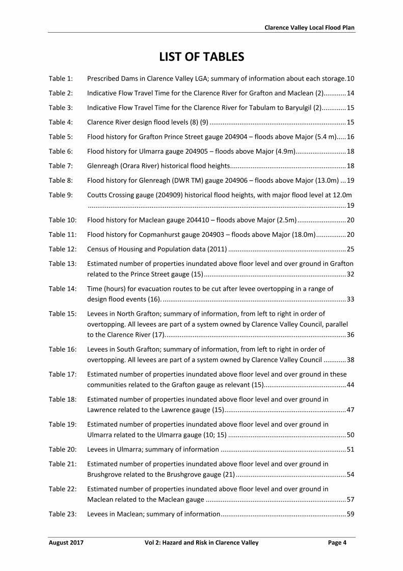
Clarence Valley Local Flood Plan
August 2017 Vol 2: Hazard and Risk in Clarence Valley Page 4
LIST OF TABLES
Table 1: Prescribed Dams in Clarence Valley LGA; summary of information about each storage. 10
Table 2: Indicative Flow Travel Time for the Clarence River for Grafton and Maclean (2) ............ 14
Table 3: Indicative Flow Travel Time for the Clarence River for Tabulam to Baryulgil (2) ............. 15
Table 4: Clarence River design flood levels (8) (9) ......................................................................... 15
Table 5: Flood history for Grafton Prince Street gauge 204904 – floods above Major (5.4 m) ..... 16
Table 6: Flood history for Ulmarra gauge 204905 – floods above Major (4.9m) ........................... 18
Table 7: Glenreagh (Orara River) historical flood heights .............................................................. 18
Table 8: Flood history for Glenreagh (DWR TM) gauge 204906 – floods above Major (13.0m) ... 19
Table 9: Coutts Crossing gauge (204909) historical flood heights, with major flood level at 12.0m
.......................................................................................................................................... 19
Table 10: Flood history for Maclean gauge 204410 – floods above Major (2.5m) .......................... 20
Table 11: Flood history for Copmanhurst gauge 204903 – floods above Major (18.0m) ................ 20
Table 12: Census of Housing and Population data (2011) ............................................................... 25
Table 13: Estimated number of properties inundated above floor level and over ground in Grafton
related to the Prince Street gauge (15) ............................................................................ 32
Table 14: Time (hours) for evacuation routes to be cut after levee overtopping in a range of
design flood events (16). .................................................................................................. 33
Table 15: Levees in North Grafton; summary of information, from left to right in order of
overtopping. All levees are part of a system owned by Clarence Valley Council, parallel
to the Clarence River (17). ................................................................................................ 36
Table 16: Levees in South Grafton; summary of information, from left to right in order of
overtopping. All levees are part of a system owned by Clarence Valley Council ............ 38
Table 17: Estimated number of properties inundated above floor level and over ground in these
communities related to the Grafton gauge as relevant (15)............................................ 44
Table 18: Estimated number of properties inundated above floor level and over ground in
Lawrence related to the Lawrence gauge (15) ................................................................. 47
Table 19: Estimated number of properties inundated above floor level and over ground in
Ulmarra related to the Ulmarra gauge (10; 15) ............................................................... 50
Table 20: Levees in Ulmarra; summary of information ................................................................... 51
Table 21: Estimated number of properties inundated above floor level and over ground in
Brushgrove related to the Brushgrove gauge (21) ........................................................... 54
Table 22: Estimated number of properties inundated above floor level and over ground in
Maclean related to the Maclean gauge ........................................................................... 57
Table 23: Levees in Maclean; summary of information ................................................................... 59
Clarence Valley Local Flood Plan
August 2017 Vol 2: Hazard and Risk in Clarence Valley Page 5
Table 24: Estimated number of properties inundated above floor level and over ground in Iluka
related to the Maclean gauge .......................................................................................... 62
Table 25: Estimated number of properties inundated above floor level and over ground in Yamba
and Palmers Island related to the Maclean gauge (15) ................................................... 65
Table 26: Estimated number of properties inundated above floor level and over ground in Wooli
related to the Wooli gauge (15) ....................................................................................... 70
Table 27: Roads liable to flooding in Clarence Valley LGA (19). ....................................................... 81
Table 28: Potential Periods of Isolation for communities in the Clarence Valley LGA during a Major
flood. ................................................................................................................................ 84
LIST OF FIGURES
Figure 1: Monthly Distribution of Major Floods in Grafton (7) ....................................................... 13
Figure 2: Warning time available (hours) for various design flood events prior to levee
overtopping and evacuation routes are cut (16). ............................................................ 34
Figure 3: Warning time available (hours) for various design flood events prior to levee
overtopping and evacuation routes are cut in Maclean (16). .......................................... 58
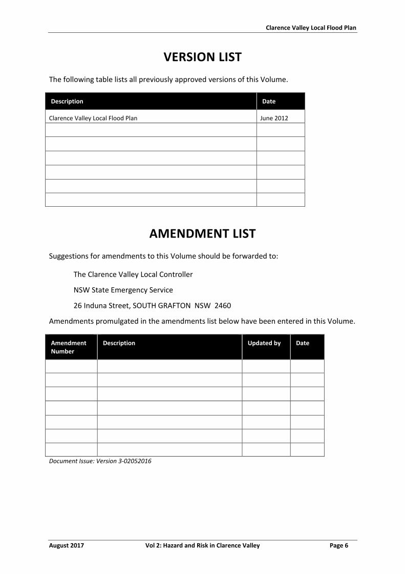
Clarence Valley Local Flood Plan
August 2017 Vol 2: Hazard and Risk in Clarence Valley Page 6
VERSION LIST
The following table lists all previously approved versions of this Volume.
Description Date
Clarence Valley Local Flood Plan June 2012
AMENDMENT LIST
Suggestions for amendments to this Volume should be forwarded to:
The Clarence Valley Local Controller
NSW State Emergency Service
26 Induna Street, SOUTH GRAFTON NSW 2460
Amendments promulgated in the amendments list below have been entered in this Volume.
Amendment Number
Description Updated by Date
Document Issue: Version 3-02052016
Clarence Valley Local Flood Plan
August 2017 Vol 2: Hazard and Risk in Clarence Valley Page 7
1 THE FLOOD AND COASTAL EROSION THREAT
OVERVIEW
a. The Clarence Valley Local Government Area (LGA) is located in the Northern Rivers
region of New South Wales, about 600 kilometres (km) north of Sydney and 300 km
south of Brisbane. The LGA is bounded by the Kyogle and Richmond Valley Council
areas in the north, the Coral Sea in the east, Coffs Harbour City and Bellingen Shire in
the south and Glen Innes Severn Council area, Guyra Shire and Tenterfield Shire in
the west (1).
b. The LGA includes numerous rural localities and the townships and villages including
Alice, Angourie, Ashby, Baryulgil, Braunstone, Brooms Head, Clouds Creek, Coaldale,
Copmanhurst, Coutts Crossing, Cowper, Dalmorton, Diggers Camp, Dundurrabin,
Glenreagh, Grafton, Gulmarrad, Iluka, Jackadgery, Junction Hill, Lawrence, Maclean,
Minnie Water, Newton Boyd, Nymboida, Palmers Island, Ramornie, Sandon, South
Grafton, Southgate, Townsend, Tucabia, Ulmarra, Waterview Heights, Wooli,
Wooloweyah, Woombah and Yamba (1).
c. The landscape is predominantly rural, with expanding residential areas and some
industrial and commercial land uses. The LGA has a total land area of 10,440 square
km, with approximately 27% of the LGA is National Parks, Nature Reserves or
environmental management (1).
d. Much of the rural area is used for forestry, agriculture and grazing, including beef
cattle and sugarcane growing, as well as fishing. In more recent years tourism has
become a major industry, especially along the coast.
e. Settlement is based around the main town of Grafton and the townships of Iluka,
Maclean and Yamba, with many small villages and localities along the coast and
inland (1).
f. The Clarence Valley has a humid subtropical climate with hot, wet and humid
summers, and mild, drier winters. Rainfall is lower inland of the LGA compared to on
the coast. There is an annual average rainfall of up to 1,465 millimetres (mm) in
coastal centres such as Yamba and 975 mm at Grafton (1).
g. The Clarence Valley LGA estimated resident population for 2014 is 51,003. Table 12
provides more detail regarding the specific areas of the Clarence Valley and the
population numbers recorded in the 2011 Census.
h. The Valley is at the convergence of three major highways and the north-south rail
network. The Clarence has its own regional airport and seaport. The Pacific Highway
is the key road transport network linking the Clarence Valley north to Queensland
and south to Sydney. The Summerland Way is an inland highway network that
Clarence Valley Local Flood Plan
August 2017 Vol 2: Hazard and Risk in Clarence Valley Page 8
provides important north-south connectivity and is an alternative highway route
between Brisbane, Casino, Grafton and Coffs Harbour. The Gwydir Highway is an
east-west corridor that links the inland plains to the Clarence via the New England
region. Owned and operated by Council, the Clarence Valley Regional Airport located
17 km south of Grafton along the Pacific Highway (1).
LANDFORMS AND RIVER SYSTEMS
Clarence River Valley
a. The Clarence Valley Council area is part of the Clarence River catchment. The
Clarence River is the largest coastal river in New South Wales in terms of both
catchment area and discharge. The headwaters of the Clarence River system lie
outside the Council area to the north, west and south. The Clarence River enters the
Clarence Valley Council area between Tabulam and Cleveland Crossing, flowing in a
southerly direction. It is joined by numerous creeks and streams draining the Great
Dividing and New England ranges to the west (the Ewingar, Nogrigar, Washpool and
Coombadjha creeks and the Mann River) and the Richmond Range to the east (the
Dulgigin, Kungarrabar, Deep, Josephs, Fourteen Mile and Dumbudgery creeks). In
these western and northern areas of the Council area, the land is rugged and forest
covered and the watercourses are both fast-flowing and quick to rise (2). The
catchment is comprised of four sections (see Map 1):
i. The Upper Clarence section, which drains the area from the Queensland
border to the junction of the Clarence and Mann rivers. In this section the main
streams are the Maryland, Bookookoorara, Booboo Booboo, Cataract and
Timbarra (Rocky) Rivers and the Washpool, Koreelah and Tooloom Creeks
which drain the Great Dividing Range to the north and west, and numerous
small creeks draining the Richmond Range to the east (2).
ii. The Mann River section, which drains the New England Tablelands and the
Dorrigo Plateau to the south-west and south of the Clarence Valley Council
area. The major tributaries of the Mann River are the Henry, Nymboida, Sara,
Aberfoyle, Guy Fawkes and Boyd Rivers (2).
The Nymboida River system drains the New England Tablelands and the
Dorrigo Plateau to the west and south of the Local Government Area. The
principal tributaries of the Nymboida are the Mann, Henry, Boyd and Guy
Fawkes rivers, each of which forms part of the Local Government Area's
western boundary, and the Mitchell, Sara, Aberfoyle, Blicks and Little
Nymboida rivers. The Nymboida River proper flows in a northerly
direction to its confluence with the Mann River and Jackadgery Creek
near Carnham. Most of the tributaries of the Nymboida join it from the
west. Almost all of the Nymboida River's catchment area is rugged,
Clarence Valley Local Flood Plan
August 2017 Vol 2: Hazard and Risk in Clarence Valley Page 9
deeply-dissected and forest-covered. There are few areas of floodplain
development (2).
Below its confluence with the Mann River the Clarence River flows in a
south-easterly direction towards the village of Copmanhurst. On this
stretch the principal tributaries are the Gorden Brook and the Pulganbar,
Smiths, Stockyard and Whiteman creeks. These streams drain the
southern portion of the Richmond Range. Below Copmanhurst the Orara
River joins the Clarence from the south (2).
iii. The Orara River section, which flows northward through a long, narrow valley
drains parts of the Dorrigo Plateau and the Coastal Range. The headwaters are
hilly but along its course the river traverses areas of relatively flat country
interspersed by sections in which it is contained by steep banks. A number of
major tributaries drain into the Orara River Basin, including Urumbillum River,
Mirum Creek and Fridays Creek, discharging to the Orara River in Upper Orara;
Wongiwomble Creek discharging to the Orara River near Karangi; Nana and
Coldwater Creek discharging to the Orara River near Nana Glen; Kings and
Finberg Creek discharging to Bucca Creek upstream of Nana Glen; Glenreagh
Creek; and Tallawudjah creek discharging to Orara River near Glenreagh (3).
iv. The Lower Clarence section, begins at the village of Copmanhurst and marks
the upper limit of tidal influence. Almost all this floodplain land lies
downstream of Grafton. Below the villages, the valley gradually broadens into
a wide, swampy plain. On this section Sportsmans Creek, Swan Creek, Shark
Creek and Coldstream Rivers enters the Clarence River. Lesser watercourses
include Bayldons, Alumy, Deep Gully, Bunyip, Warragai and Harrisons Creeks
(2). The major tributaries include:
Coldstream Basin, which drains the area to the east of Grafton, around
Tucabia and Tyndale, which is approximately 160 square km (2).
Shark Creek Basin, which covers the area between Tyndale and Maclean
along Shark Creek is known as Shark Creek Basin and is approximately 30
square km. North and east of Maclean, the floodplain extends north
across Harwood and Chatsworth Islands and south of the river around
James Creek and Gulmarrad towards Lake Wooloweyah (2).
Coastal Rivers
b. Some minor coastal rivers rise on the eastern side of the coast range and flow
directly to the Tasman Sea (2).
c. The Wooli River, with its main tributary the Bookram Creek, drains an area of about
200 square km. Tidal influence extends about 15 km upstream. The lower reaches
are generally swampy (2).
Clarence Valley Local Flood Plan
August 2017 Vol 2: Hazard and Risk in Clarence Valley Page 10
d. Flood drainage on the Wooli River can be impeded by storm surge conditions
produced by low pressure systems centred off the coast (2).
e. The Sandon River and its tributary the Toumbaal Creek drain an area of mostly
National Park and State Forest (2).
STORAGE DAMS
a. Dam locations are shown on the River Basin Map.
Table 1: Prescribed Dams in Clarence Valley LGA; summary of information about each storage.
Shannon Creek Dam (4)
Owner / Operator
Clarence Valley Council
Description of Dam
Shannon Creek Dam forms part of the Clarence Valley and Coffs Harbour Regional Water Supply scheme. The Dam consists of a main embankment, a spillway and downstream valve house and pump station. The main earth and rock fill embankment is a 44 m high, and 405m long, with the spillway cutting through the left abutment. The spillway is an uncontrolled concrete lined structure with a concrete ogee crest. The Dam crest level is RL 91.65 m AHD. The storage capacity of the Dam at FSL (RL 83.27 m AHD) is 30,000 ML. The catchment area is approximately 37.5 square km.
Location The Shannon Creek Dam Site is located 9 km due west of the township of Coutts Crossing, on Shannon Creek, 14.5 km upstream of the Orara River junction. It lies within the Clarence Valley LGA and Clarence River Basin.
Communities Downstream
Along Shannon Creek and the Orara River, there are several bridges and houses, as well as a number of developed areas along the banks of the Clarence River.
Monitoring System
Automatic rain gauges, water level recorder, piezometers, seepage weir, settlement survey markers, visual inspections.
Warning System
There is a SCADA system with pre-set alert levels. This is no additional alert system to warn downstream residents.
Other
Rushforth Road 100ML Reservoir (5)
Owner / Operator Clarence Valley Council
Description of Dam
Rushforth Road Reservoir is a 8.5m high raw water reservoir with a storage capacity of 100ML.
Location Located in South Grafton.
Communities Downstream
Golf Course and former abattoir are downstream, however impacts are downstream.
Monitoring System
Telemetry and visual monitoring and inspections.
Warning System Telephony-based.
Other n/a
Clarence Valley Local Flood Plan
August 2017 Vol 2: Hazard and Risk in Clarence Valley Page 11
Other Major Water Storages
b. Lake Hiawatha and Minnie Water are located approximately 30 km east of Grafton
and approximately 5 km north of Wooli. These two adjoining lakes are dune contact
freshwater lakes. That is, they are located in depressions in the country rock but are
in contact with a coastal dune. The lakes are 500 m apart and in times of extreme
flooding they become joined and flow into the Wooli River. Lake Hiawatha is clear
and sandy, while Minnie Water is turbid due to high organic matter content (6).
WEATHER SYSTEMS AND FLOODING
a. The heavy rain which produces floods in the Clarence Valley Council area tends to
come from the following kinds of weather system:
i. Monsoonal low-pressure systems moving across the Great Dividing Range from
northern Australia, usually during the summer and autumn months. These
systems are indicated on weather maps as elongated low-pressure troughs
stretching from the Northern Territory to the north coast of NSW, and flooding
from them usually originates on the upper Clarence and Mann Rivers (2).
ii. Rain depressions originating as tropical cyclones in the Gulf of Carpentaria or
the Coral Sea and moving southwards. The flood of January 1974 was of this
type, the ‘tail’ of ex-tropical cyclone Wanda causing heavy falls over south-
eastern Queensland and north-eastern NSW. Two months later, the March
1974 flood resulted from a rain depression which had originated as Tropical
Cyclone Zoe. Such depressions may be associated with storm surge conditions
(temporarily elevated sea levels and large waves) which retard drainage and
therefore worsen the effects of flooding at and near the coast (2).
iii. East Coast low-pressure systems which travel along the coast, usually during
the cooler months and direct moist on-shore winds over the Clarence River
basin. Orographic uplift of these air masses brings heavy rain over the Coast
Range and the higher country to the west of Grafton. The May 1996 flood on
the Clarence River was of this origin. Such events are normally associated with
lower-river floods rather than floods originating in the western uplands
sections of the catchment. They may also produce storm surge conditions
which retard the draining of flood waters (2).
iv. High-intensity, short-duration convective thunderstorms occur frequently over
the valley, especially during the summer months. The rain from such storms
may cause village drainage systems or minor creeks to surcharge, creating
short-duration local ponding of low-lying areas. No rise in the Clarence River or
other main streams is likely from such events (2).
Clarence Valley Local Flood Plan
August 2017 Vol 2: Hazard and Risk in Clarence Valley Page 12
b. Rains from the first three types of weather systems can persist for some days,
especially in the case of east-coast low pressure systems which can cause heavy rain
over periods of three to five days. Sometimes, as in May 1996, there may be two or
more separate rain events a few days apart, causing floods with multiple peaks on
the Clarence River (2).
c. Very heavy rainfalls, in excess of 225 mm in 24 hours and more than 40 mm over the
course of an event, are quite common in the Clarence River catchment. Dorrigo, in
the far south of the catchment, has a recorded 24-hour rainfall of 809 mm and
monthly total of 1395 mm and an average annual precipitation of nearly 2000 mm
(2).
d. The most severe floods in the valley are generally the result of the passage of
degraded ex-tropical cyclones from the north during summer and autumn or east
coast low pressure systems occurring during autumn and winter. When depressions
such as these are characterised by very low central pressures, raised sea levels
(storm surges) can occur. This exacerbates flooding when sea waters invade coastal
areas and when flows in the river are retarded (2).
e. North-eastern NSW experiences a distinct wet period between December and April,
and more than two thirds of the recorded floods on the Clarence River have occurred
during the summer and autumn months from January to May. The spring and early
summer months are relatively dry and floods are infrequent during this time of year.
No floods above the ‘major flood’ level of 5.4 m at Grafton have been recorded in
the September-December months. Severe flooding has, however, occurred in the
early winter months of June and July (2).
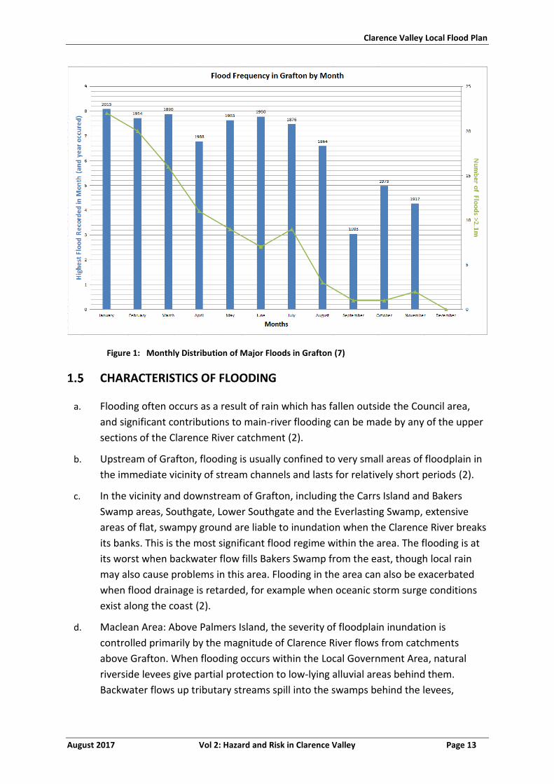
Clarence Valley Local Flood Plan
August 2017 Vol 2: Hazard and Risk in Clarence Valley Page 13
Figure 1: Monthly Distribution of Major Floods in Grafton (7)
CHARACTERISTICS OF FLOODING
a. Flooding often occurs as a result of rain which has fallen outside the Council area,
and significant contributions to main-river flooding can be made by any of the upper
sections of the Clarence River catchment (2).
b. Upstream of Grafton, flooding is usually confined to very small areas of floodplain in
the immediate vicinity of stream channels and lasts for relatively short periods (2).
c. In the vicinity and downstream of Grafton, including the Carrs Island and Bakers
Swamp areas, Southgate, Lower Southgate and the Everlasting Swamp, extensive
areas of flat, swampy ground are liable to inundation when the Clarence River breaks
its banks. This is the most significant flood regime within the area. The flooding is at
its worst when backwater flow fills Bakers Swamp from the east, though local rain
may also cause problems in this area. Flooding in the area can also be exacerbated
when flood drainage is retarded, for example when oceanic storm surge conditions
exist along the coast (2).
d. Maclean Area: Above Palmers Island, the severity of floodplain inundation is
controlled primarily by the magnitude of Clarence River flows from catchments
above Grafton. When flooding occurs within the Local Government Area, natural
riverside levees give partial protection to low-lying alluvial areas behind them.
Backwater flows up tributary streams spill into the swamps behind the levees,
Clarence Valley Local Flood Plan
August 2017 Vol 2: Hazard and Risk in Clarence Valley Page 14
eventually creating flooding of usually dry land. Inundation periods can last for some
weeks, the natural levees acting to inhibit drainage (2).
e. Near the coast, unusually high tides can produce inundation of land which is usually
dry. Thunderstorm activity, especially when it occurs in conjunction with such tides,
can produce significant local ponding in Iluka and Yamba (2).
f. Between Palmers Island and the river’s mouth there is an increasing influence of
ocean storm tide conditions and peak flood levels at Yamba are dictated almost
entirely by ocean storm tides. Storm activity over and off the coastline normally
brings flood-producing rains over the land mass, with peak catchment runoff flows
occurring sometime after the storm activity itself (2).
g. Refer to the River Basin Schematic at the end of this Volume.
Peak height flow times
h. Partly because of variations in flood levels on different tributary streams within the
catchment, travel times of flood peaks can vary significantly from flood to flood. The
times listed below need to be regarded, therefore, as approximations only.
Particularly in periods of very severe flooding, it should be noted that flow times may
be shorter than shown here. Equally, situations in which large volumes of water
suddenly enter a low-flowing river tend to produce much faster flows than situations
in which the inflow is gradual. Indicative flood travel times recorded are shown in
Table 2 and Table 3 below (2).
Table 2: Indicative Flow Travel Time for the Clarence River for Grafton and Maclean (2)
Between Gauges Travel Time
Tabulam to Grafton 16-20 hours
Towgan Grange to Grafton 6 - 14 hours
Lilydale to Grafton 4-13 hours
Glenreagh to Grafton 12 - 18 hours
Grafton to Ulmarra 2 -3 hours
Grafton to Maclean 6 - 24 hours
i. Flow times from Grafton to Maclean can be very variable, depending largely on
ocean conditions and tidal influences. Times as far apart as 6 and 24 hours have been
recorded (2).
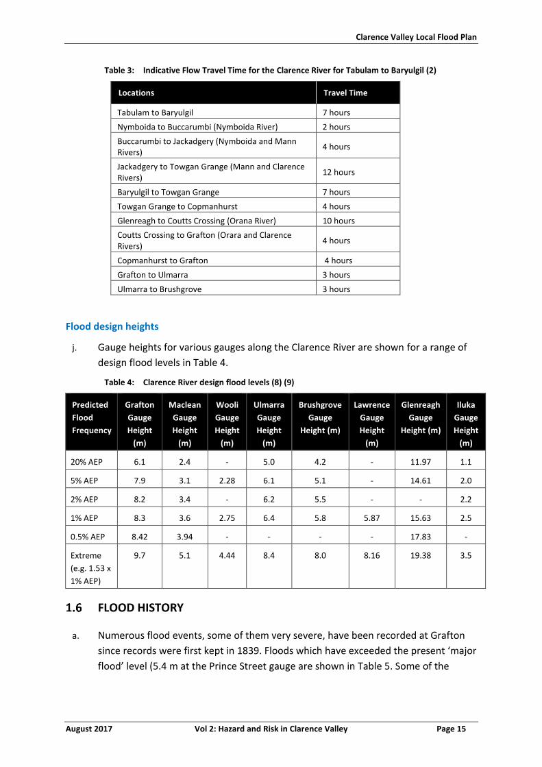
Clarence Valley Local Flood Plan
August 2017 Vol 2: Hazard and Risk in Clarence Valley Page 15
Table 3: Indicative Flow Travel Time for the Clarence River for Tabulam to Baryulgil (2)
Locations Travel Time
Tabulam to Baryulgil 7 hours
Nymboida to Buccarumbi (Nymboida River) 2 hours
Buccarumbi to Jackadgery (Nymboida and Mann Rivers)
4 hours
Jackadgery to Towgan Grange (Mann and Clarence Rivers)
12 hours
Baryulgil to Towgan Grange 7 hours
Towgan Grange to Copmanhurst 4 hours
Glenreagh to Coutts Crossing (Orana River) 10 hours
Coutts Crossing to Grafton (Orara and Clarence Rivers)
4 hours
Copmanhurst to Grafton 4 hours
Grafton to Ulmarra 3 hours
Ulmarra to Brushgrove 3 hours
Flood design heights
j. Gauge heights for various gauges along the Clarence River are shown for a range of
design flood levels in Table 4.
Table 4: Clarence River design flood levels (8) (9)
Predicted
Flood
Frequency
Grafton
Gauge
Height
(m)
Maclean
Gauge
Height
(m)
Wooli
Gauge
Height
(m)
Ulmarra
Gauge
Height
(m)
Brushgrove
Gauge
Height (m)
Lawrence
Gauge
Height
(m)
Glenreagh
Gauge
Height (m)
Iluka
Gauge
Height
(m)
20% AEP 6.1 2.4 - 5.0 4.2 - 11.97 1.1
5% AEP 7.9 3.1 2.28 6.1 5.1 - 14.61 2.0
2% AEP 8.2 3.4 - 6.2 5.5 - - 2.2
1% AEP 8.3 3.6 2.75 6.4 5.8 5.87 15.63 2.5
0.5% AEP 8.42 3.94 - - - - 17.83 -
Extreme
(e.g. 1.53 x
1% AEP)
9.7 5.1 4.44 8.4 8.0 8.16 19.38 3.5
FLOOD HISTORY
a. Numerous flood events, some of them very severe, have been recorded at Grafton
since records were first kept in 1839. Floods which have exceeded the present ‘major
flood’ level (5.4 m at the Prince Street gauge are shown in Table 5. Some of the
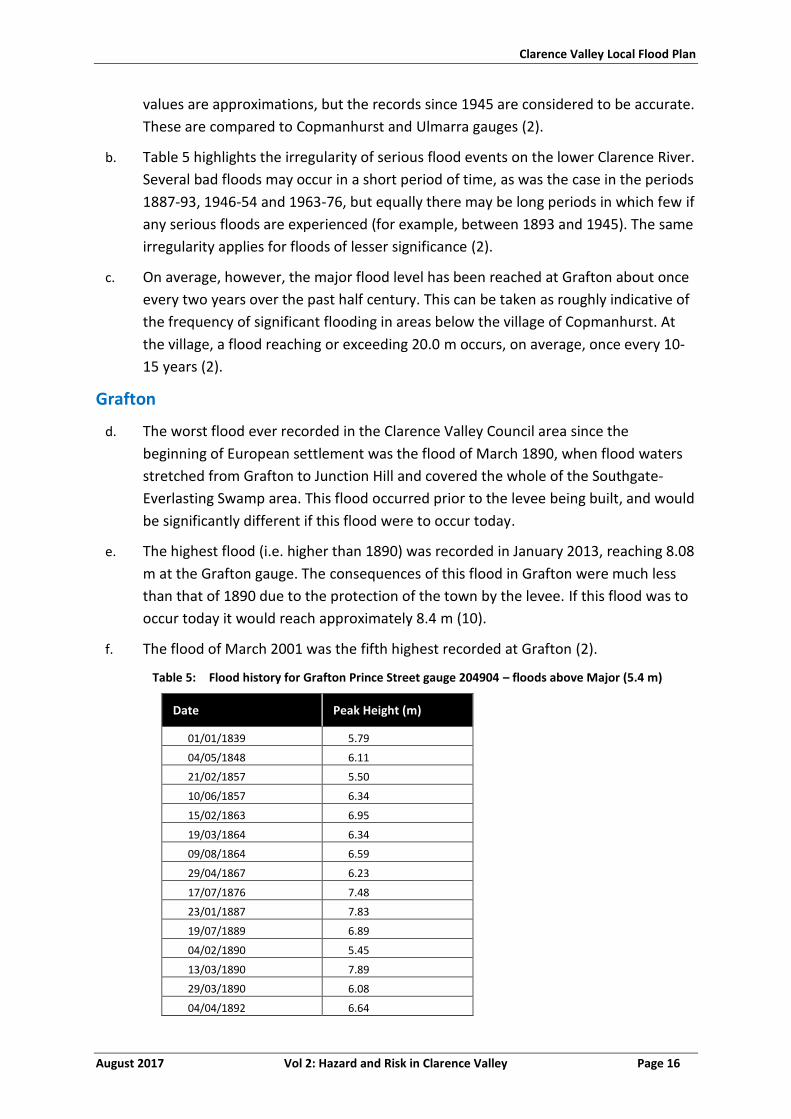
Clarence Valley Local Flood Plan
August 2017 Vol 2: Hazard and Risk in Clarence Valley Page 16
values are approximations, but the records since 1945 are considered to be accurate.
These are compared to Copmanhurst and Ulmarra gauges (2).
b. Table 5 highlights the irregularity of serious flood events on the lower Clarence River.
Several bad floods may occur in a short period of time, as was the case in the periods
1887-93, 1946-54 and 1963-76, but equally there may be long periods in which few if
any serious floods are experienced (for example, between 1893 and 1945). The same
irregularity applies for floods of lesser significance (2).
c. On average, however, the major flood level has been reached at Grafton about once
every two years over the past half century. This can be taken as roughly indicative of
the frequency of significant flooding in areas below the village of Copmanhurst. At
the village, a flood reaching or exceeding 20.0 m occurs, on average, once every 10-
15 years (2).
Grafton
d. The worst flood ever recorded in the Clarence Valley Council area since the
beginning of European settlement was the flood of March 1890, when flood waters
stretched from Grafton to Junction Hill and covered the whole of the Southgate-
Everlasting Swamp area. This flood occurred prior to the levee being built, and would
be significantly different if this flood were to occur today.
e. The highest flood (i.e. higher than 1890) was recorded in January 2013, reaching 8.08
m at the Grafton gauge. The consequences of this flood in Grafton were much less
than that of 1890 due to the protection of the town by the levee. If this flood was to
occur today it would reach approximately 8.4 m (10).
f. The flood of March 2001 was the fifth highest recorded at Grafton (2).
Table 5: Flood history for Grafton Prince Street gauge 204904 – floods above Major (5.4 m)
Date Peak Height (m)
01/01/1839 5.79
04/05/1848 6.11
21/02/1857 5.50
10/06/1857 6.34
15/02/1863 6.95
19/03/1864 6.34
09/08/1864 6.59
29/04/1867 6.23
17/07/1876 7.48
23/01/1887 7.83
19/07/1889 6.89
04/02/1890 5.45
13/03/1890 7.89
29/03/1890 6.08
04/04/1892 6.64
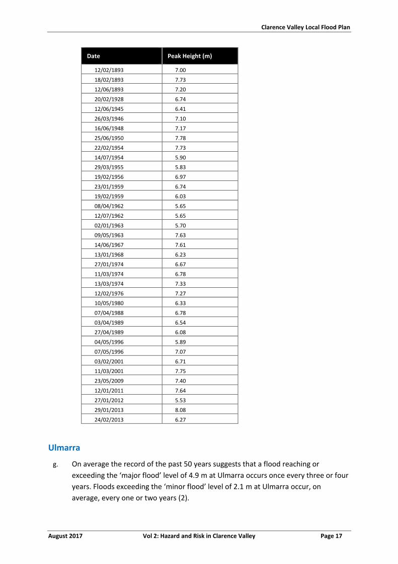
Clarence Valley Local Flood Plan
August 2017 Vol 2: Hazard and Risk in Clarence Valley Page 17
Date Peak Height (m)
12/02/1893 7.00
18/02/1893 7.73
12/06/1893 7.20
20/02/1928 6.74
12/06/1945 6.41
26/03/1946 7.10
16/06/1948 7.17
25/06/1950 7.78
22/02/1954 7.73
14/07/1954 5.90
29/03/1955 5.83
19/02/1956 6.97
23/01/1959 6.74
19/02/1959 6.03
08/04/1962 5.65
12/07/1962 5.65
02/01/1963 5.70
09/05/1963 7.63
14/06/1967 7.61
13/01/1968 6.23
27/01/1974 6.67
11/03/1974 6.78
13/03/1974 7.33
12/02/1976 7.27
10/05/1980 6.33
07/04/1988 6.78
03/04/1989 6.54
27/04/1989 6.08
04/05/1996 5.89
07/05/1996 7.07
03/02/2001 6.71
11/03/2001 7.75
23/05/2009 7.40
12/01/2011 7.64
27/01/2012 5.53
29/01/2013 8.08
24/02/2013 6.27
Ulmarra
g. On average the record of the past 50 years suggests that a flood reaching or
exceeding the ‘major flood’ level of 4.9 m at Ulmarra occurs once every three or four
years. Floods exceeding the ‘minor flood’ level of 2.1 m at Ulmarra occur, on
average, every one or two years (2).
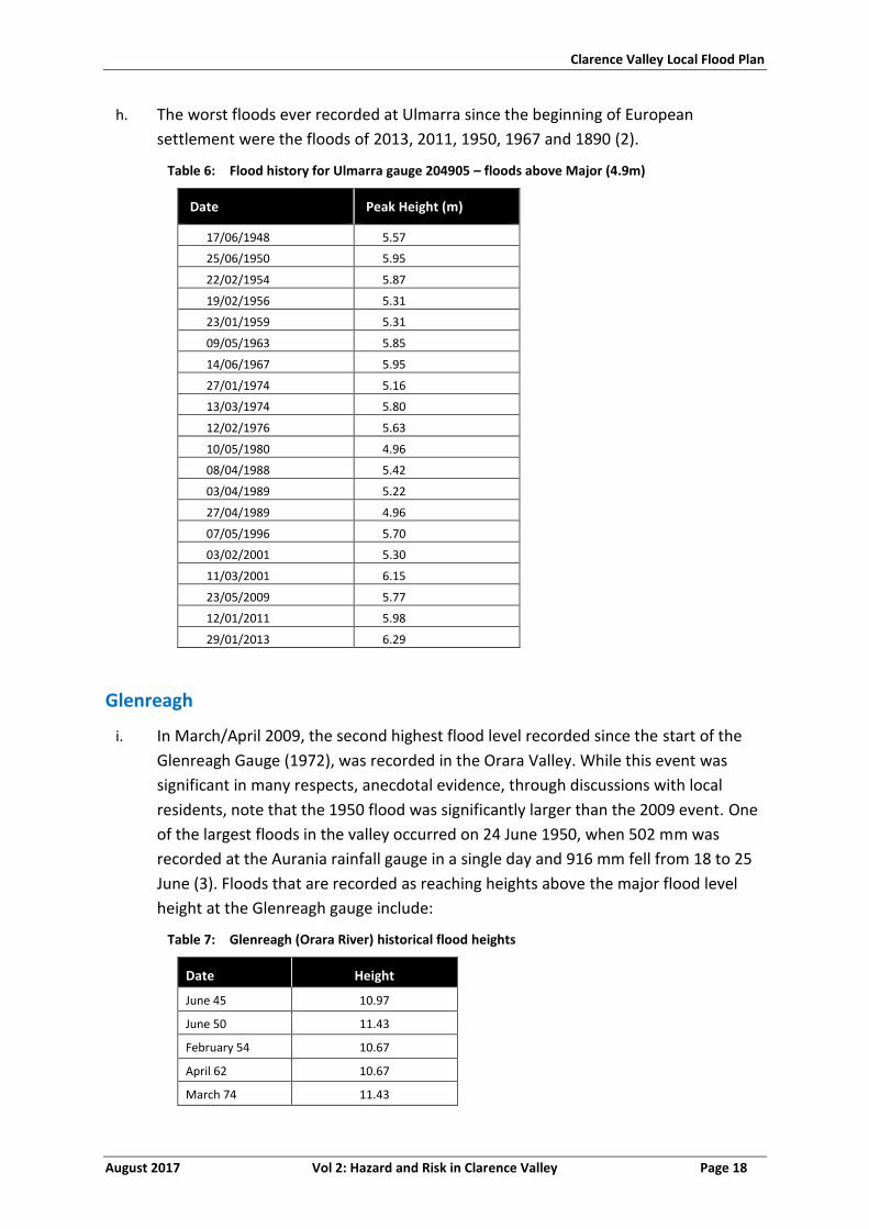
Clarence Valley Local Flood Plan
August 2017 Vol 2: Hazard and Risk in Clarence Valley Page 18
h. The worst floods ever recorded at Ulmarra since the beginning of European
settlement were the floods of 2013, 2011, 1950, 1967 and 1890 (2).
Table 6: Flood history for Ulmarra gauge 204905 – floods above Major (4.9m)
Date Peak Height (m)
17/06/1948 5.57
25/06/1950 5.95
22/02/1954 5.87
19/02/1956 5.31
23/01/1959 5.31
09/05/1963 5.85
14/06/1967 5.95
27/01/1974 5.16
13/03/1974 5.80
12/02/1976 5.63
10/05/1980 4.96
08/04/1988 5.42
03/04/1989 5.22
27/04/1989 4.96
07/05/1996 5.70
03/02/2001 5.30
11/03/2001 6.15
23/05/2009 5.77
12/01/2011 5.98
29/01/2013 6.29
Glenreagh
i. In March/April 2009, the second highest flood level recorded since the start of the
Glenreagh Gauge (1972), was recorded in the Orara Valley. While this event was
significant in many respects, anecdotal evidence, through discussions with local
residents, note that the 1950 flood was significantly larger than the 2009 event. One
of the largest floods in the valley occurred on 24 June 1950, when 502 mm was
recorded at the Aurania rainfall gauge in a single day and 916 mm fell from 18 to 25
June (3). Floods that are recorded as reaching heights above the major flood level
height at the Glenreagh gauge include:
Table 7: Glenreagh (Orara River) historical flood heights
Date Height
June 45 10.97
June 50 11.43
February 54 10.67
April 62 10.67
March 74 11.43
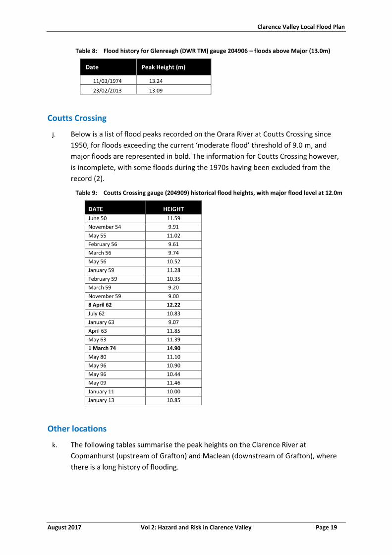
Clarence Valley Local Flood Plan
August 2017 Vol 2: Hazard and Risk in Clarence Valley Page 19
Table 8: Flood history for Glenreagh (DWR TM) gauge 204906 – floods above Major (13.0m)
Date Peak Height (m)
11/03/1974 13.24
23/02/2013 13.09
Coutts Crossing
j. Below is a list of flood peaks recorded on the Orara River at Coutts Crossing since
1950, for floods exceeding the current ‘moderate flood’ threshold of 9.0 m, and
major floods are represented in bold. The information for Coutts Crossing however,
is incomplete, with some floods during the 1970s having been excluded from the
record (2).
Table 9: Coutts Crossing gauge (204909) historical flood heights, with major flood level at 12.0m
DATE HEIGHT
June 50 11.59
November 54 9.91
May 55 11.02
February 56 9.61
March 56 9.74
May 56 10.52
January 59 11.28
February 59 10.35
March 59 9.20
November 59 9.00
8 April 62 12.22
July 62 10.83
January 63 9.07
April 63 11.85
May 63 11.39
1 March 74 14.90
May 80 11.10
May 96 10.90
May 96 10.44
May 09 11.46
January 11 10.00
January 13 10.85
Other locations
k. The following tables summarise the peak heights on the Clarence River at
Copmanhurst (upstream of Grafton) and Maclean (downstream of Grafton), where
there is a long history of flooding.
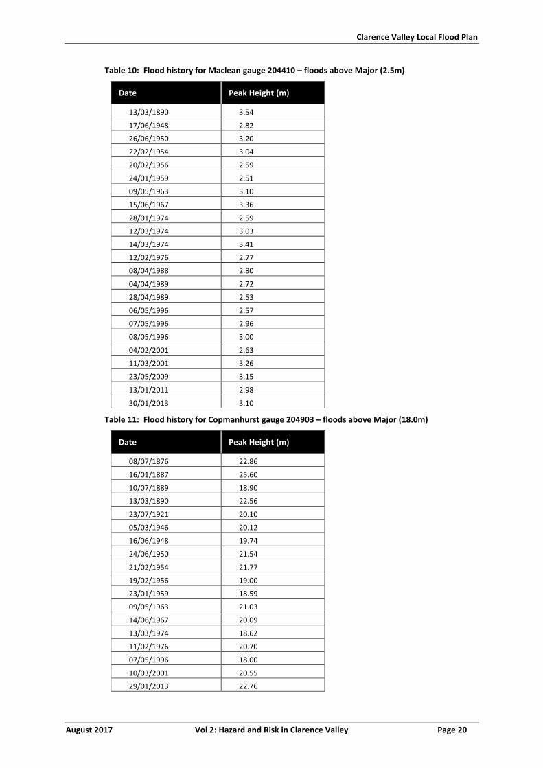
Clarence Valley Local Flood Plan
August 2017 Vol 2: Hazard and Risk in Clarence Valley Page 20
Table 10: Flood history for Maclean gauge 204410 – floods above Major (2.5m)
Date Peak Height (m)
13/03/1890 3.54
17/06/1948 2.82
26/06/1950 3.20
22/02/1954 3.04
20/02/1956 2.59
24/01/1959 2.51
09/05/1963 3.10
15/06/1967 3.36
28/01/1974 2.59
12/03/1974 3.03
14/03/1974 3.41
12/02/1976 2.77
08/04/1988 2.80
04/04/1989 2.72
28/04/1989 2.53
06/05/1996 2.57
07/05/1996 2.96
08/05/1996 3.00
04/02/2001 2.63
11/03/2001 3.26
23/05/2009 3.15
13/01/2011 2.98
30/01/2013 3.10
Table 11: Flood history for Copmanhurst gauge 204903 – floods above Major (18.0m)
Date Peak Height (m)
08/07/1876 22.86
16/01/1887 25.60
10/07/1889 18.90
13/03/1890 22.56
23/07/1921 20.10
05/03/1946 20.12
16/06/1948 19.74
24/06/1950 21.54
21/02/1954 21.77
19/02/1956 19.00
23/01/1959 18.59
09/05/1963 21.03
14/06/1967 20.09
13/03/1974 18.62
11/02/1976 20.70
07/05/1996 18.00
10/03/2001 20.55
29/01/2013 22.76
Clarence Valley Local Flood Plan
August 2017 Vol 2: Hazard and Risk in Clarence Valley Page 21
FLOOD MITIGATION SYSTEMS
a. Levee locations are shown on the Town Maps at the end of this Volume.
b. Clarence Valley Council area has a number of mitigation works in place that aid in
reducing the severity of flooding. These are explained under the headings Levees and
Other Mitigation Systems and separated into their specific areas (2). It is important
to note that levees are susceptible to failure for a variety of reasons, with identified
historical occurrences of pipe and floodgate failures, slumping and sand boils.
c. Levees in Grafton and South Grafton may cause normal flood levels to be slightly
higher in the Copmanhurst area upstream of Grafton. Downstream levels will be
slightly lower (2). Further details are available in each community in Section 2 of this
Volume 2 of the local flood plan.
Other flood mitigation works
d. Rural flood mitigation works in the council area are confined to drainage works,
floodgates and minor levees in the Southgate area and the Everlasting Swamp. These
have reduced the frequency of flooding and sped up the after-flood drainage but
they are not designed to keep out all floods. Large areas still experience inundation,
as happened in 1996, 2001 and 2011 (2).
e. There are no significant flood mitigation works on the Orara River or on the minor
coastal streams, except for training walls at the mouth of the Wooli River (2).
EXTREME FLOODING
a. Floods larger than those experienced by the present residents of Grafton and the
Clarence Valley should be regarded as inevitable (2).
b. At Grafton, the extreme flood is simulated to be 9.7 m at the Prince Street gauge (2).
It is expected that in such a flood, the flood would discharge approximately 20,000
cubic m per second (2).
c. The extreme flood in Grafton, Maclean, Copmanhurst and Ulmarra areas would
cause severe flooding in the town as well as on the islands, in the villages and in the
rural areas (2). Major overtopping of the all levees would occur and the velocity and
depth of flood water would be very high (2).
d. Extreme flood heights for the Maclean and Ulmarra gauges are 5.1 m and 8.4 m
respectively. Major overtopping of the all levees would occur and the velocity of
flood water would be very high (8).
Clarence Valley Local Flood Plan
August 2017 Vol 2: Hazard and Risk in Clarence Valley Page 22
COASTAL EROSION
a. The most severe problems of coastal erosion occur as a result of oceanic storm
conditions associated with the passage of ex-tropical cyclones and east coast low-
pressure systems. These storms may cause temporary sea level rises with large
associated waves. The worst erosion is likely when severe weather conditions occur
in conjunction with unusually high tides (2).
b. The following locations have property at risk of coastal erosion and are shown on the
river basin map.
i. Wooli
Wooli
c. Undercutting of dunes on their seaward sides can occur at Wooli threatening the
collapse of dwellings and other buildings. There is also potential for the sea to break
through of the dunes, causing flooding and isolation of property on the landward
side of the dunes (2).
d. Storm activity is sometimes accompanied by heavy rain, causing flooding on the
Wooli River behind the sand dunes. This flooding can be exacerbated by an elevated
sea level preventing the escape of flood waters to the sea (2).
e. The whole village of Wooli is at risk from erosion and/or associated flooding. Several
hundred dwellings, two caravan parks and a small number of commercial buildings
are at risk (2).
f. Wooli Beach suffered severe storm damage in 1954, 1974, 1996 and 2009. More
recent erosion events have eroded the frontal dune leaving a high, steep escarpment
along much of the beachfront (2).
g. The steep escarpment remains unstable and has continued to recede due to
slumping (2).
h. A review of coastline hazard lines for Wooli (11) has identified that 44 lots are
located in the zone of wave impact for a severe storm (although a few dwellings on
these lots are located landward of the immediate impact line). These beachfront
properties are all located south of the boat ramp on South Terrace and the Wooli
Bowling Club (2).
i. Approximately 20 beachfront dwellings located within the ‘zone of reduced
foundation capacity’ (less than 18 m from the dune crest) have also been identified
as susceptible to structural damage due to the reduced bearing capacity of sand in
this zone. Of the 20 properties, the nine most at risk were located around 13 to 14 m
from the dune crest (12).
Clarence Valley Local Flood Plan
August 2017 Vol 2: Hazard and Risk in Clarence Valley Page 23
Other areas
j. Known coastal erosion threats in the Clarence Valley are at Woody Bay, Yamba
Headland and Brooms Head Beach; however these have not been identified as hot
spots.
Clarence Valley Local Flood Plan
August 2017 Vol 2: Hazard and Risk in Clarence Valley Page 24
2 EFFECTS ON THE COMMUNITY
COMMUNITY PROFILE
a. Clarence Valley Council area is made up of a number of communities that can be
affected in a flood. These include:
1. Grafton – Alumy Creek, Carrs Creek, Carrs Island, Carrs Peninsula, Eatonsville,
Great Marlow, Junction Hill, North Grafton, Seelands, South Grafton,
Southampton, Waterview and Waterview Heights.
2. Copmanhurst - Barretts Creek, Coaldale, Copmanhurst, Fine Flower,
Gordonbrook, Koolkhan, Moleville Creek, Mountain View, Trenayr.
3. Lawrence - Ashby, Ashby Heights, Ashby Island, Chatsworth, Lawrence,
Southgate, Lower Southgate, Tullymorgan and Woodford Island.
4. Ulmarra - Clarenza, Calliope, Coldstream, Gillett’s Ridge, Swan Creek, Tucabia and
Ulmarra.
5. Brushgrove - Brushgrove, Cowper, Tyndale, and Lower Coldstream.
6. Maclean - Maclean, and Taloumbi, it also includes the villages of Chatsworth,
Harwood, Ilarwill, South Arm, Ashby, Shark Creek and extensive rural areas.
7. Iluka - Iluka, Mororo, The Freshwater, Woody Head, Goodwood and Woombah.
8. Yamba - Yamba, Angourie, Wooloweyah and Palmers Island.
9. Sandon - Bookram, Brooms Head, Sandon and Sandon River Village.
10. Wooli-Minnie Water - Calamia, Diggers Camp, Minnie Water, Pillar Valley, Sandy
Crossing and Wooli.
11. Cangai - Cangai, Carnham, Coombadjha, and Jackadgery.
12. Coutts Crossing - Blaxlands, Flat/Creek, Billy’s Creek, Braunstone, Buccarumbi,
Chambigne, Clouds Creek ,Coutts Crossing, , Dundurrabin, Elland, Kangaroo
Creek, Lanitza, Levenstrath, Lower Kangaroo Creek, McPherson Crossing,
Middle Creek, Moonpar, Nymboida, Shannondale, Towallum, and Tyringham.
13. Glenreagh - Glenreagh, Kremnos, Kungala and Wells Crossing.
b. Table 12, shows the 2011 Census ‘usual resident’ counts for key statistics for the
Clarence Valley Local Government Area. Note these vary slightly from the Sector
areas due to census data availability.
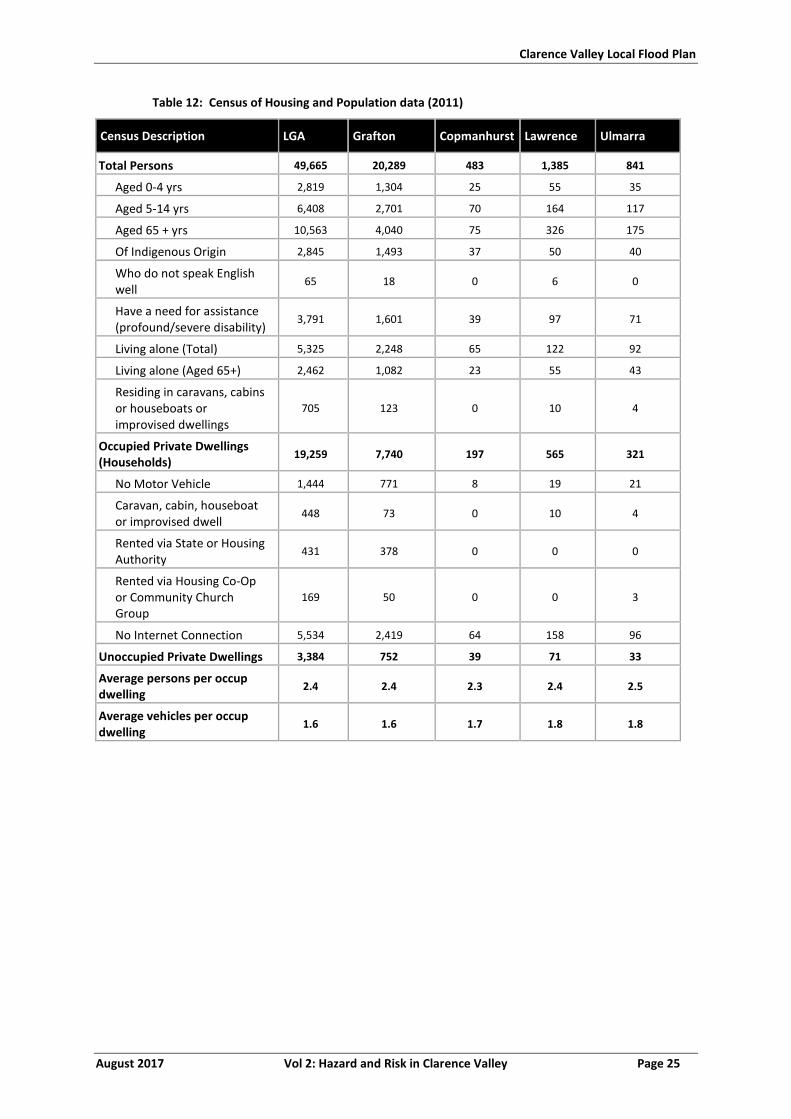
Clarence Valley Local Flood Plan
August 2017 Vol 2: Hazard and Risk in Clarence Valley Page 25
Table 12: Census of Housing and Population data (2011)
Census Description LGA Grafton Copmanhurst Lawrence Ulmarra
Total Persons 49,665 20,289 483 1,385 841
Aged 0-4 yrs 2,819 1,304 25 55 35
Aged 5-14 yrs 6,408 2,701 70 164 117
Aged 65 + yrs 10,563 4,040 75 326 175
Of Indigenous Origin 2,845 1,493 37 50 40
Who do not speak English well
65 18 0 6 0
Have a need for assistance (profound/severe disability)
3,791 1,601 39 97 71
Living alone (Total) 5,325 2,248 65 122 92
Living alone (Aged 65+) 2,462 1,082 23 55 43
Residing in caravans, cabins or houseboats or improvised dwellings
705 123 0 10 4
Occupied Private Dwellings (Households)
19,259 7,740 197 565 321
No Motor Vehicle 1,444 771 8 19 21
Caravan, cabin, houseboat or improvised dwell
448 73 0 10 4
Rented via State or Housing Authority
431 378 0 0 0
Rented via Housing Co-Op or Community Church Group
169 50 0 0 3
No Internet Connection 5,534 2,419 64 158 96
Unoccupied Private Dwellings 3,384 752 39 71 33
Average persons per occup dwelling
2.4 2.4 2.3 2.4 2.5
Average vehicles per occup dwelling
1.6 1.6 1.7 1.8 1.8
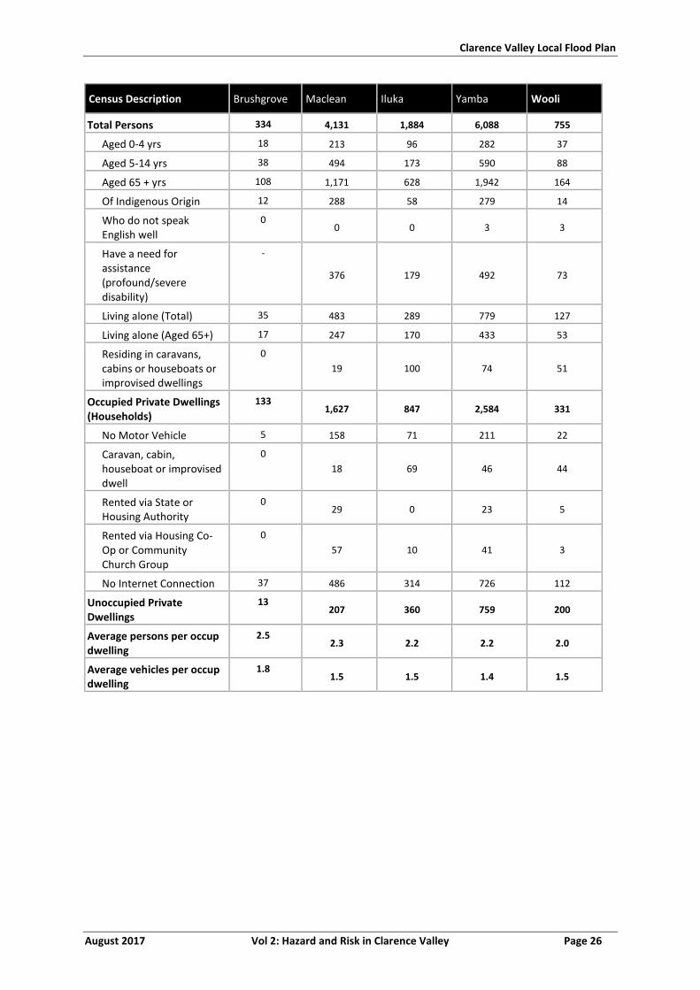
Clarence Valley Local Flood Plan
August 2017 Vol 2: Hazard and Risk in Clarence Valley Page 26
Census Description Brushgrove Maclean Iluka Yamba Wooli
Total Persons 334 4,131 1,884 6,088 755
Aged 0-4 yrs 18 213 96 282 37
Aged 5-14 yrs 38 494 173 590 88
Aged 65 + yrs 108 1,171 628 1,942 164
Of Indigenous Origin 12 288 58 279 14
Who do not speak English well
0 0 0 3 3
Have a need for assistance (profound/severe disability)
-
376 179 492 73
Living alone (Total) 35 483 289 779 127
Living alone (Aged 65+) 17 247 170 433 53
Residing in caravans, cabins or houseboats or improvised dwellings
0
19 100 74 51
Occupied Private Dwellings (Households)
133 1,627 847 2,584 331
No Motor Vehicle 5 158 71 211 22
Caravan, cabin, houseboat or improvised dwell
0
18 69 46 44
Rented via State or Housing Authority
0 29 0 23 5
Rented via Housing Co-Op or Community Church Group
0
57 10 41 3
No Internet Connection 37 486 314 726 112
Unoccupied Private Dwellings
13 207 360 759 200
Average persons per occup dwelling
2.5 2.3 2.2 2.2 2.0
Average vehicles per occup dwelling
1.8 1.5 1.5 1.4 1.5
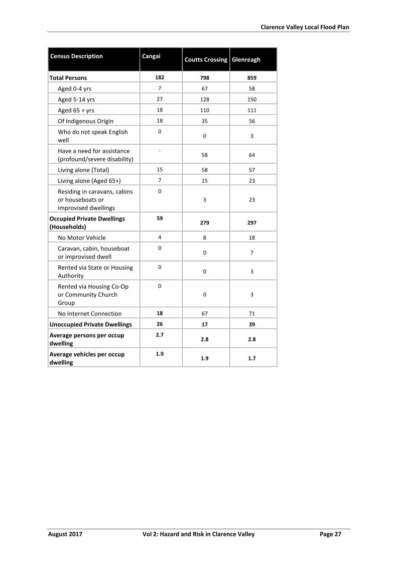
Clarence Valley Local Flood Plan
August 2017 Vol 2: Hazard and Risk in Clarence Valley Page 27
Census Description Cangai Coutts Crossing Glenreagh
Total Persons 182 798 859
Aged 0-4 yrs 7 67 58
Aged 5-14 yrs 27 128 150
Aged 65 + yrs 18 110 111
Of Indigenous Origin 18 35 56
Who do not speak English well
0 0 3
Have a need for assistance (profound/severe disability)
- 58 64
Living alone (Total) 15 58 57
Living alone (Aged 65+) 7 15 23
Residing in caravans, cabins or houseboats or improvised dwellings
0
3 23
Occupied Private Dwellings (Households)
59 279 297
No Motor Vehicle 4 8 18
Caravan, cabin, houseboat or improvised dwell
0 0 7
Rented via State or Housing Authority
0 0 3
Rented via Housing Co-Op or Community Church Group
0
0 3
No Internet Connection 18 67 71
Unoccupied Private Dwellings 26 17 39
Average persons per occup dwelling
2.7 2.8 2.8
Average vehicles per occup dwelling
1.9 1.9 1.7
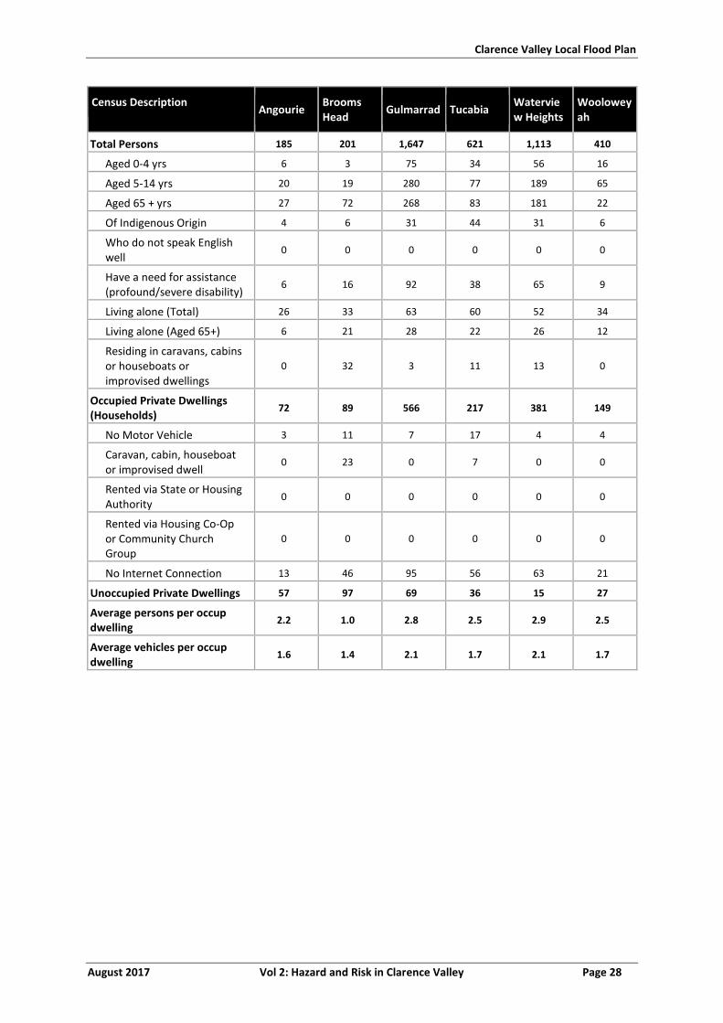
Clarence Valley Local Flood Plan
August 2017 Vol 2: Hazard and Risk in Clarence Valley Page 28
Census Description Angourie
Brooms Head
Gulmarrad Tucabia Waterview Heights
Wooloweyah
Total Persons 185 201 1,647 621 1,113 410
Aged 0-4 yrs 6 3 75 34 56 16
Aged 5-14 yrs 20 19 280 77 189 65
Aged 65 + yrs 27 72 268 83 181 22
Of Indigenous Origin 4 6 31 44 31 6
Who do not speak English well
0 0 0 0 0 0
Have a need for assistance (profound/severe disability)
6 16 92 38 65 9
Living alone (Total) 26 33 63 60 52 34
Living alone (Aged 65+) 6 21 28 22 26 12
Residing in caravans, cabins or houseboats or improvised dwellings
0 32 3 11 13 0
Occupied Private Dwellings (Households)
72 89 566 217 381 149
No Motor Vehicle 3 11 7 17 4 4
Caravan, cabin, houseboat or improvised dwell
0 23 0 7 0 0
Rented via State or Housing Authority
0 0 0 0 0 0
Rented via Housing Co-Op or Community Church Group
0 0 0 0 0 0
No Internet Connection 13 46 95 56 63 21
Unoccupied Private Dwellings 57 97 69 36 15 27
Average persons per occup dwelling
2.2 1.0 2.8 2.5 2.9 2.5
Average vehicles per occup dwelling
1.6 1.4 2.1 1.7 2.1 1.7
Clarence Valley Local Flood Plan
August 2017 Vol 2: Hazard and Risk in Clarence Valley Page 29
SPECIFIC RISK AREAS - FLOOD
Clarence River Valley
GRAFTON AND SOUTH GRAFTON
2.2.1 Community Overview
a. Grafton is the main urban centre in the Clarence Valley, located on the Clarence
River.
b. The population of Grafton is over 10 000 and South Grafton is over 6000 (13).
c. Grafton has 18.9% of the population under 15 years of age and 21.5 % over 65. It has
6.2% indigenous population.
d. South Grafton has 21% of the population under 15 years of age and 18.6% over 65. It
has 11.6% indigenous population.
e. Junction Hill is located 10 km north of Grafton on the Clarence River on Summerland
Way. The population of Junction Hill is over 1170 (13). It has 15.1% of the population
under 15 years of age and 22.1% over 65. It has 2% indigenous population.
f. A summary of demographics is shown in Table 12.
2.2.2 Characteristics of flooding
a. Grafton can expect three different kinds of flood regimes, which will have very
different impacts on the community. These are:
i. Outside-levee floods: these will occur frequently, probably in most years. They
will affect farm properties, a small number of dwellings, and some business
premises and recreational facilities (2).
ii. Stormwater ponding within urban areas: these can be expected to occur less
frequently but will affect low-lying areas within Grafton and South Grafton,
usually for only short periods of time unless the Clarence River is in flood at the
same time. Stormwater flooding can flood areas of Grafton as happened
during the flood of March 1974 when several houses experienced over-floor
inundation. Large areas to the south-east of Queen Street can experience
inundation as a result of a severe storm, as can properties along the banks of
Alumy Creek. Parts of the Central Business District can be affected, including
the Crossroads at the intersection of Bent Street and Ryan Street, however, the
extent and depth of inundation from an extreme storm would be less than
would occur from a levee-overtopping flood (NSW State Emergency Service,
2012).
Clarence Valley Local Flood Plan
August 2017 Vol 2: Hazard and Risk in Clarence Valley Page 30
iii. Levee-Overtopping and/or breaching floods: these will be rare but may have
devastating impacts and will require large-scale evacuations (2).
iv. Flooding of Susan Island and the Clarenza area occurs in most floods and
backwater flow up Cowans Creek can cause flooding of the South Grafton
Common (2).
2.2.3 Flood Behaviour
a. Refer to section 1.5, as well as Table 15 and Table 16 for further information on the
levee.
b. Alipou Basin can be flooded due to slowing of drainage of localised rainfall when
Clarence River has elevated flood levels. It can also be flooded when the Alipou Basin
Levee is overtopped (2).
c. Flood velocities in Alipou Basin are generally less than 1.5 m/s with the average
overbank velocities of 0.5 square m/s. Higher velocities would be expected with the
overtopping of the Clarenza, Heber Street and Alipou Basin Levees (2).
2.2.4 Classification of Floodplain
a. North Grafton is a low flood island during an extreme flood.
b. South Grafton has rising road access to South Grafton Hill.
2.2.5 Inundation
a. This area utilises the Grafton (Prince Street) gauge.
b. North Grafton and South Grafton utilise the Prince Street warning gauge (10).
c. At 7.07 m two houses on Carrs Island are at risk of flooding (previously evacuated in
May 1996) (14).
d. At 7.75 m houses outside the levee flood (two in Fitzroy Street and three in Butter
Lane, one in Alipou Creek) (14).
e. Refer to Table 15 and Table 16 for levee overtopping consequences and sequence,
from around 8 m.
North Grafton
f. Virtually all of Grafton north of the river (approximately 4,130 properties and about
10,370 people) is protected by levees and there is little property exposure in most
floods. In a flood slightly more severe than the record flood of 1890 (7.89 m), minor
overtopping and levee erosion would begin along the southern reaches of the Ulster
Lodge Levee between Pound Street and Dobie Street and inundation would occur in
the Dovedale area (2).
Clarence Valley Local Flood Plan
August 2017 Vol 2: Hazard and Risk in Clarence Valley Page 31
g. In a flood resulting in the overtopping of the Grafton Levee, up to 70 dwellings could
be affected in the Back Lane, Carr Street, Marlow Street, Summerland Way and
Lawrence Road areas between Grafton and Junction Hill. The Gateway Village
Caravan Park on the Summerland Way could also be flooded. Bakers Swamp could
be filled and the Summerland Way closed. Evacuations would be necessary from all
these areas (2).
h. Such a flood would also be expected to result in the closure of most roads around
Grafton and on the floodplain downstream around Southgate and beyond.
Telephone, water supply, power and sewerage services would almost certainly fail
and it is possible that large numbers of Grafton would be affected (2).
i. If flow in the river was sufficient to cause levels to continue to rise, overtopping
would soon occur along much of the Alice Street Levee (between Turf and Clarence
Streets) and eventually along the entire length of the levees including the Pine Street
Levee north of North Street. Inundation would continue in Dovedale, where depths
of more than three m would be experienced at some locations. It would also spread
to the north and west causing inundation of the Central Business District and large
numbers of residential properties (2).
j. Eventually most of Grafton, including Westlawn, would be inundated, though to
lesser depths in most areas than in Dovedale. Most of the land between Carr and
North Streets and Junction Hill would also be under water (2).
k. Complete inundation of Grafton could occur if overtopping conditions were
maintained for as little as ten hours. Complete inundation could occur more quickly
(perhaps in as little as four to five hours) in more severe flood events reaching
greater heights (2).
South Grafton
l. Around 7 m, four dwellings outside the Heber Street Levee can be flooded in Butters
Lane and along the Pacific Highway. A caravan park (Glenwood) is also flood liable, as
are some business and recreational premises (2).
m. A flood exceeding 7.9 m on the Prince Street gauge would cause minor overtopping
of the Heber Street Levee. There would be major overtopping between 7.9 and 8.3 m
and approximately 600 properties (1800 occupants) would experience flooding and
would have to evacuate. Under such conditions, the Wilsons Hill (‘South Grafton
Hill’) island would still exist (2).
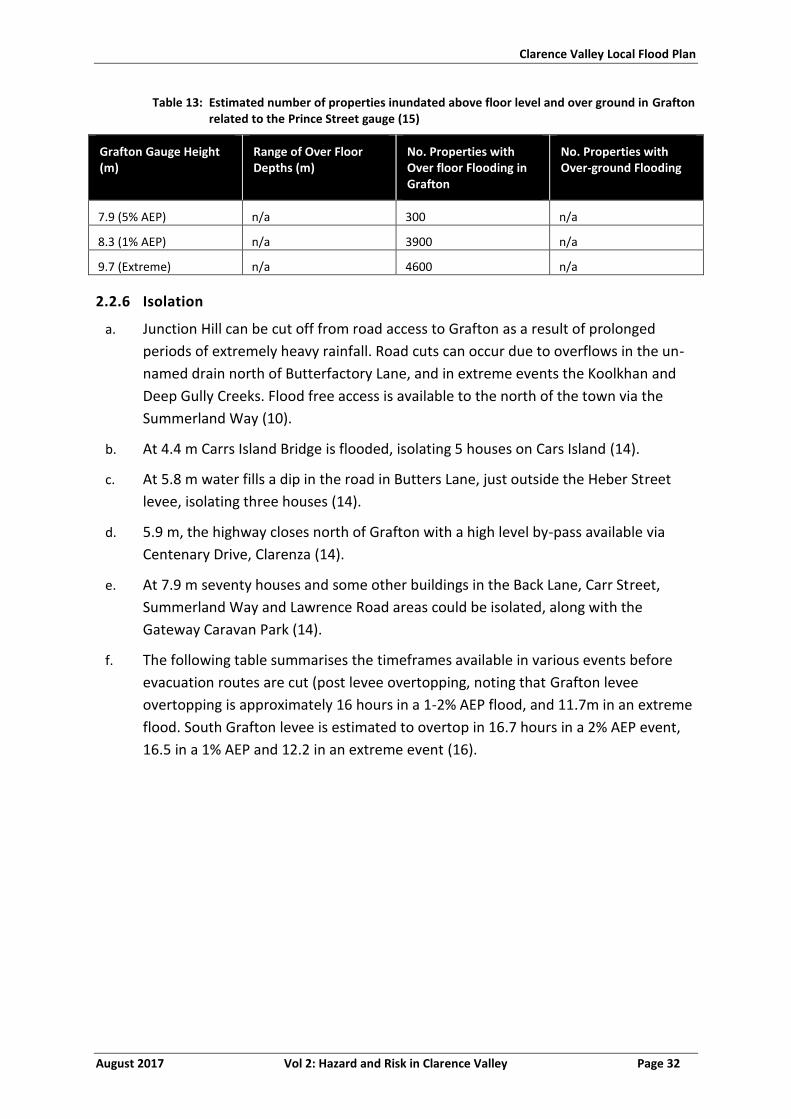
Clarence Valley Local Flood Plan
August 2017 Vol 2: Hazard and Risk in Clarence Valley Page 32
Table 13: Estimated number of properties inundated above floor level and over ground in Grafton related to the Prince Street gauge (15)
Grafton Gauge Height (m)
Range of Over Floor Depths (m)
No. Properties with Over floor Flooding in Grafton
No. Properties with Over-ground Flooding
7.9 (5% AEP) n/a 300 n/a
8.3 (1% AEP) n/a 3900 n/a
9.7 (Extreme) n/a 4600 n/a
2.2.6 Isolation
a. Junction Hill can be cut off from road access to Grafton as a result of prolonged
periods of extremely heavy rainfall. Road cuts can occur due to overflows in the un-
named drain north of Butterfactory Lane, and in extreme events the Koolkhan and
Deep Gully Creeks. Flood free access is available to the north of the town via the
Summerland Way (10).
b. At 4.4 m Carrs Island Bridge is flooded, isolating 5 houses on Cars Island (14).
c. At 5.8 m water fills a dip in the road in Butters Lane, just outside the Heber Street
levee, isolating three houses (14).
d. 5.9 m, the highway closes north of Grafton with a high level by-pass available via
Centenary Drive, Clarenza (14).
e. At 7.9 m seventy houses and some other buildings in the Back Lane, Carr Street,
Summerland Way and Lawrence Road areas could be isolated, along with the
Gateway Caravan Park (14).
f. The following table summarises the timeframes available in various events before
evacuation routes are cut (post levee overtopping, noting that Grafton levee
overtopping is approximately 16 hours in a 1-2% AEP flood, and 11.7m in an extreme
flood. South Grafton levee is estimated to overtop in 16.7 hours in a 2% AEP event,
16.5 in a 1% AEP and 12.2 in an extreme event (16).
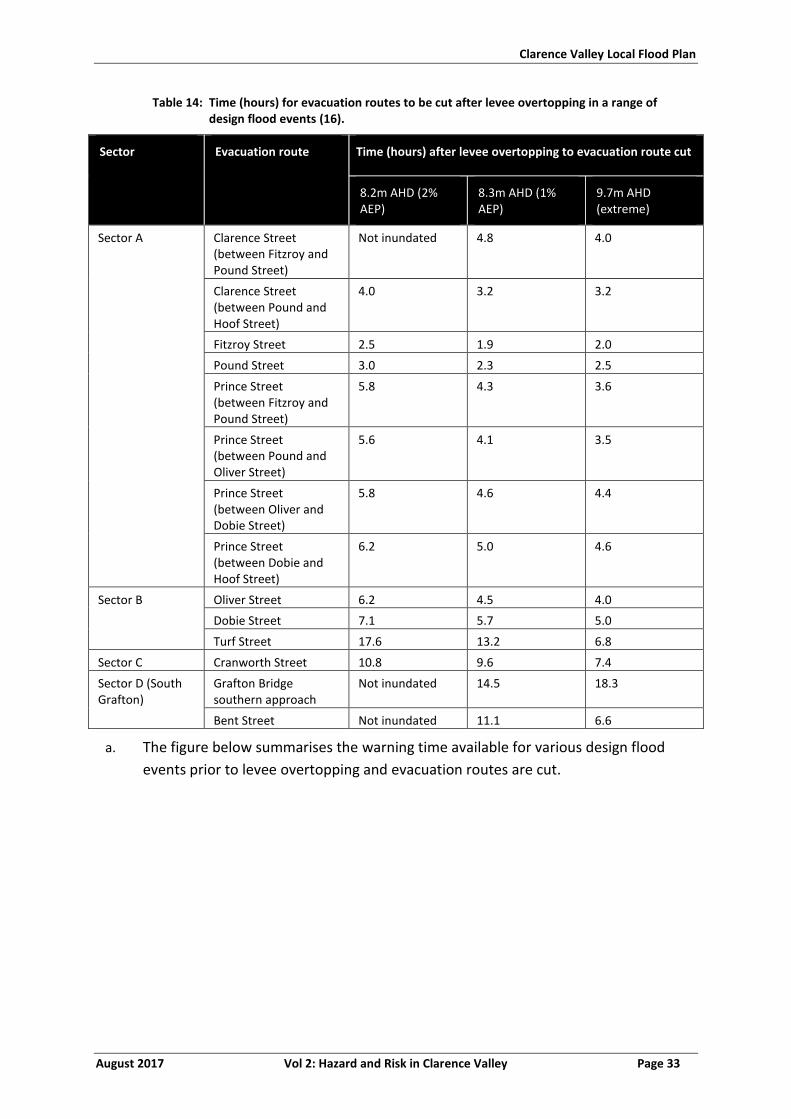
Clarence Valley Local Flood Plan
August 2017 Vol 2: Hazard and Risk in Clarence Valley Page 33
Table 14: Time (hours) for evacuation routes to be cut after levee overtopping in a range of design flood events (16).
Sector Evacuation route Time (hours) after levee overtopping to evacuation route cut
8.2m AHD (2% AEP)
8.3m AHD (1% AEP)
9.7m AHD (extreme)
Sector A Clarence Street (between Fitzroy and Pound Street)
Not inundated 4.8 4.0
Clarence Street (between Pound and Hoof Street)
4.0 3.2 3.2
Fitzroy Street 2.5 1.9 2.0
Pound Street 3.0 2.3 2.5
Prince Street (between Fitzroy and Pound Street)
5.8 4.3 3.6
Prince Street (between Pound and Oliver Street)
5.6 4.1 3.5
Prince Street (between Oliver and Dobie Street)
5.8 4.6 4.4
Prince Street (between Dobie and Hoof Street)
6.2 5.0 4.6
Sector B Oliver Street 6.2 4.5 4.0
Dobie Street 7.1 5.7 5.0
Turf Street 17.6 13.2 6.8
Sector C Cranworth Street 10.8 9.6 7.4
Sector D (South Grafton)
Grafton Bridge southern approach
Not inundated 14.5 18.3
Bent Street Not inundated 11.1 6.6
a. The figure below summarises the warning time available for various design flood
events prior to levee overtopping and evacuation routes are cut.
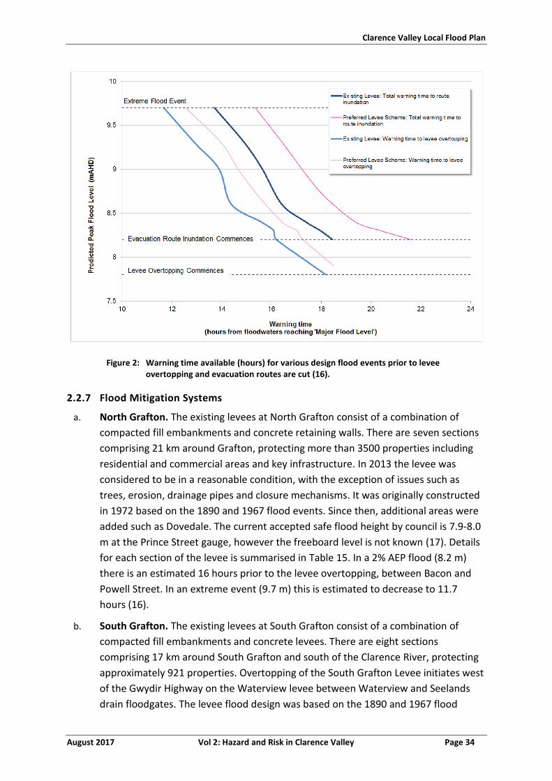
Clarence Valley Local Flood Plan
August 2017 Vol 2: Hazard and Risk in Clarence Valley Page 34
Figure 2: Warning time available (hours) for various design flood events prior to levee overtopping and evacuation routes are cut (16).
2.2.7 Flood Mitigation Systems
a. North Grafton. The existing levees at North Grafton consist of a combination of
compacted fill embankments and concrete retaining walls. There are seven sections
comprising 21 km around Grafton, protecting more than 3500 properties including
residential and commercial areas and key infrastructure. In 2013 the levee was
considered to be in a reasonable condition, with the exception of issues such as
trees, erosion, drainage pipes and closure mechanisms. It was originally constructed
in 1972 based on the 1890 and 1967 flood events. Since then, additional areas were
added such as Dovedale. The current accepted safe flood height by council is 7.9-8.0
m at the Prince Street gauge, however the freeboard level is not known (17). Details
for each section of the levee is summarised in Table 15. In a 2% AEP flood (8.2 m)
there is an estimated 16 hours prior to the levee overtopping, between Bacon and
Powell Street. In an extreme event (9.7 m) this is estimated to decrease to 11.7
hours (16).
b. South Grafton. The existing levees at South Grafton consist of a combination of
compacted fill embankments and concrete levees. There are eight sections
comprising 17 km around South Grafton and south of the Clarence River, protecting
approximately 921 properties. Overtopping of the South Grafton Levee initiates west
of the Gwydir Highway on the Waterview levee between Waterview and Seelands
drain floodgates. The levee flood design was based on the 1890 and 1967 flood
Clarence Valley Local Flood Plan
August 2017 Vol 2: Hazard and Risk in Clarence Valley Page 35
events, and was built in 1997, with the capacity of around a 2% AEP flood (7.9-8.3
m). Current freeboard is unknown, however the current accepted safe flood height
by Council is 8.2 m (18; 10; 19). The levee system was determined to be in a sound
condition by the Town Levee Audit conducted by the NSW Department of Public
Works in 2014, apart from Westlawn levee in North Grafton and Urban and Heber
Street levees in South Grafton which show evidence of localised erosion and slips,
slumping, cracking and scouring which will affect the heights to which the levees are
overtopped or breached (2). Details for each section of the levee is summarised in
Table 16. South Grafton levee is estimated to overtop in 16.7 hours in a 2% AEP
event, 16.5 in a 1% AEP and 12.2 in an extreme event (16).
2.2.8 Dams
a. Refer to Section 1.3.
2.2.9 At Risk Facilities
a. The facilities that are at risk of flooding and/or isolation within the Clarence Valley
LGA including schools, child care centres, hospitals, aged and infirm, infrastructure
and caravan parks are shown in Annex 2.
2.2.10 Other Considerations
a. Historically rates of evacuation in Grafton are low.
b. Grafton has three peak seasons with potential for a 10% population increase:
i. July Race Carnival – early July
ii. Jacaranda Festival – late October / early November
iii. Bridge to Bridge Ski Race – October long weekend.
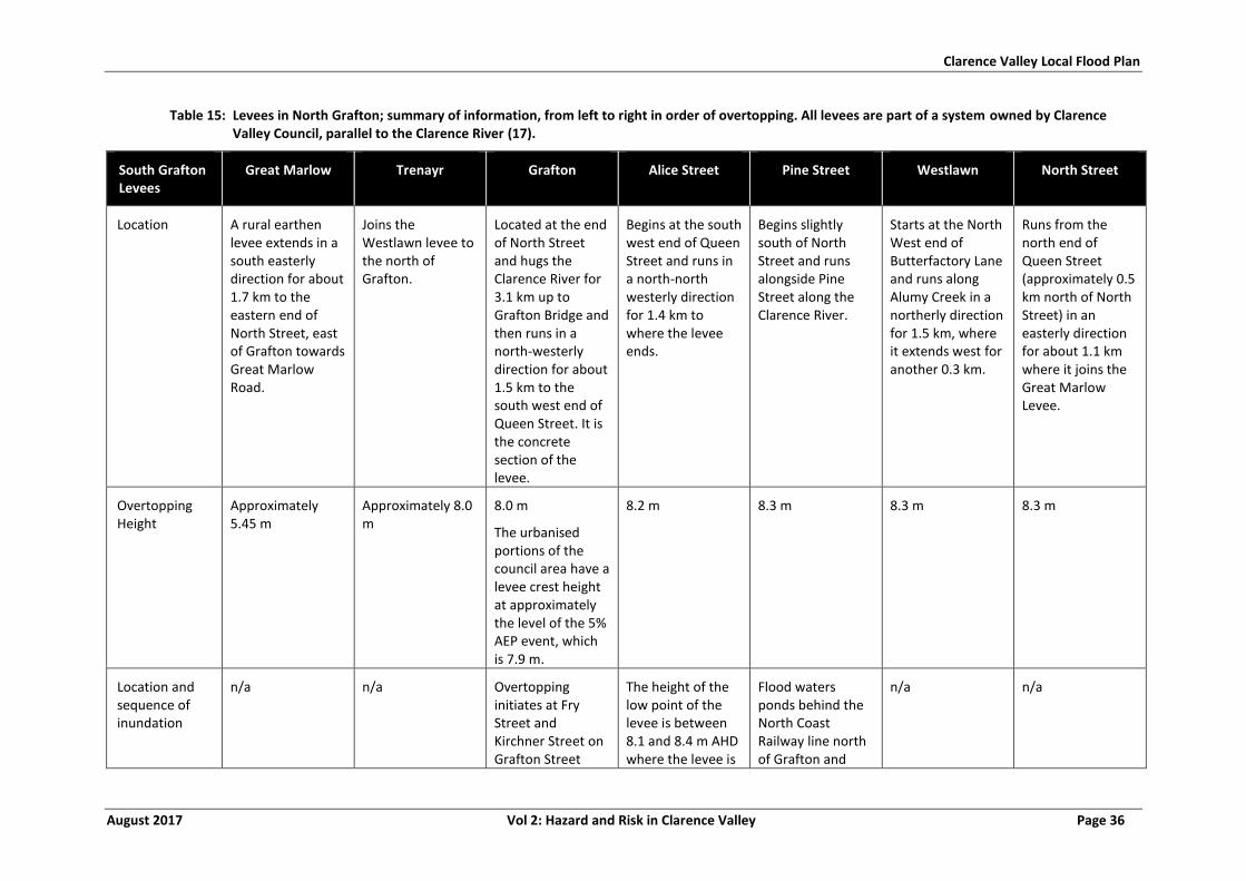
Clarence Valley Local Flood Plan
August 2017 Vol 2: Hazard and Risk in Clarence Valley Page 36
Table 15: Levees in North Grafton; summary of information, from left to right in order of overtopping. All levees are part of a system owned by Clarence Valley Council, parallel to the Clarence River (17).
South Grafton Levees
Great Marlow Trenayr Grafton Alice Street Pine Street Westlawn North Street
Location A rural earthen levee extends in a south easterly direction for about 1.7 km to the eastern end of North Street, east of Grafton towards Great Marlow Road.
Joins the Westlawn levee to the north of Grafton.
Located at the end of North Street and hugs the Clarence River for 3.1 km up to Grafton Bridge and then runs in a north-westerly direction for about 1.5 km to the south west end of Queen Street. It is the concrete section of the levee.
Begins at the south west end of Queen Street and runs in a north-north westerly direction for 1.4 km to where the levee ends.
Begins slightly south of North Street and runs alongside Pine Street along the Clarence River.
Starts at the North West end of Butterfactory Lane and runs along Alumy Creek in a northerly direction for 1.5 km, where it extends west for another 0.3 km.
Runs from the north end of Queen Street (approximately 0.5 km north of North Street) in an easterly direction for about 1.1 km where it joins the Great Marlow Levee.
Overtopping Height
Approximately 5.45 m
Approximately 8.0 m
8.0 m
The urbanised portions of the council area have a levee crest height at approximately the level of the 5% AEP event, which is 7.9 m.
8.2 m 8.3 m 8.3 m 8.3 m
Location and sequence of inundation
n/a n/a Overtopping initiates at Fry Street and Kirchner Street on Grafton Street
The height of the low point of the levee is between 8.1 and 8.4 m AHD where the levee is
Flood waters ponds behind the North Coast Railway line north of Grafton and
n/a n/a
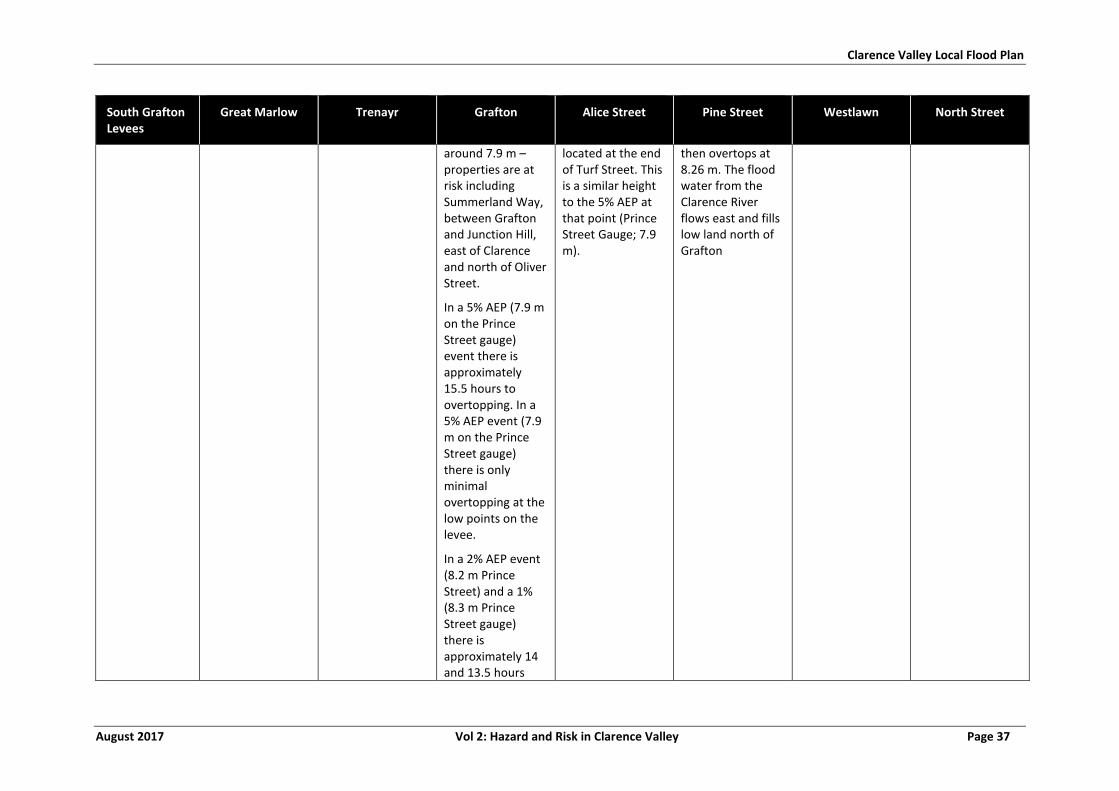
Clarence Valley Local Flood Plan
August 2017 Vol 2: Hazard and Risk in Clarence Valley Page 37
South Grafton Levees
Great Marlow Trenayr Grafton Alice Street Pine Street Westlawn North Street
around 7.9 m –properties are at risk including Summerland Way, between Grafton and Junction Hill, east of Clarence and north of Oliver Street.
In a 5% AEP (7.9 m on the Prince Street gauge) event there is approximately 15.5 hours to overtopping. In a 5% AEP event (7.9 m on the Prince Street gauge) there is only minimal overtopping at the low points on the levee.
In a 2% AEP event (8.2 m Prince Street) and a 1% (8.3 m Prince Street gauge) there is approximately 14 and 13.5 hours
located at the end of Turf Street. This is a similar height to the 5% AEP at that point (Prince Street Gauge; 7.9 m).
then overtops at 8.26 m. The flood water from the Clarence River flows east and fills low land north of Grafton
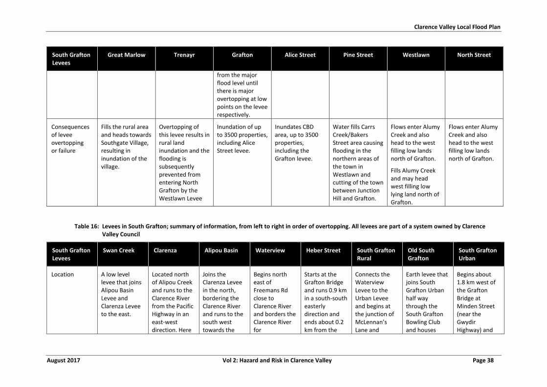
Clarence Valley Local Flood Plan
August 2017 Vol 2: Hazard and Risk in Clarence Valley Page 38
South Grafton Levees
Great Marlow Trenayr Grafton Alice Street Pine Street Westlawn North Street
from the major flood level until there is major overtopping at low points on the levee respectively.
Consequences of levee overtopping or failure
Fills the rural area and heads towards Southgate Village, resulting in inundation of the village.
Overtopping of this levee results in rural land inundation and the flooding is subsequently prevented from entering North Grafton by the Westlawn Levee
Inundation of up to 3500 properties, including Alice Street levee.
Inundates CBD area, up to 3500 properties, including the Grafton levee.
Water fills Carrs Creek/Bakers Street area causing flooding in the northern areas of the town in Westlawn and cutting of the town between Junction Hill and Grafton.
Flows enter Alumy Creek and also head to the west filling low lands north of Grafton.
Fills Alumy Creek and may head west filling low lying land north of Grafton.
Flows enter Alumy Creek and also head to the west filling low lands north of Grafton.
Table 16: Levees in South Grafton; summary of information, from left to right in order of overtopping. All levees are part of a system owned by Clarence Valley Council
South Grafton Levees
Swan Creek Clarenza Alipou Basin Waterview Heber Street South Grafton Rural
Old South Grafton
South Grafton Urban
Location A low level levee that joins Alipou Basin Levee and Clarenza Levee to the east.
Located north of Alipou Creek and runs to the Clarence River from the Pacific Highway in an east-west direction. Here
Joins the Clarenza Levee in the north, bordering the Clarence River and runs to the south west towards the
Begins north east of Freemans Rd close to Clarence River and borders the Clarence River for
Starts at the Grafton Bridge and runs 0.9 km in a south-south easterly direction and ends about 0.2 km from the
Connects the Waterview Levee to the Urban Levee and begins at the junction of McLennan’s Lane and
Earth levee that joins South Grafton Urban half way through the South Grafton Bowling Club and houses
Begins about 1.8 km west of the Grafton Bridge at Minden Street (near the Gwydir Highway) and
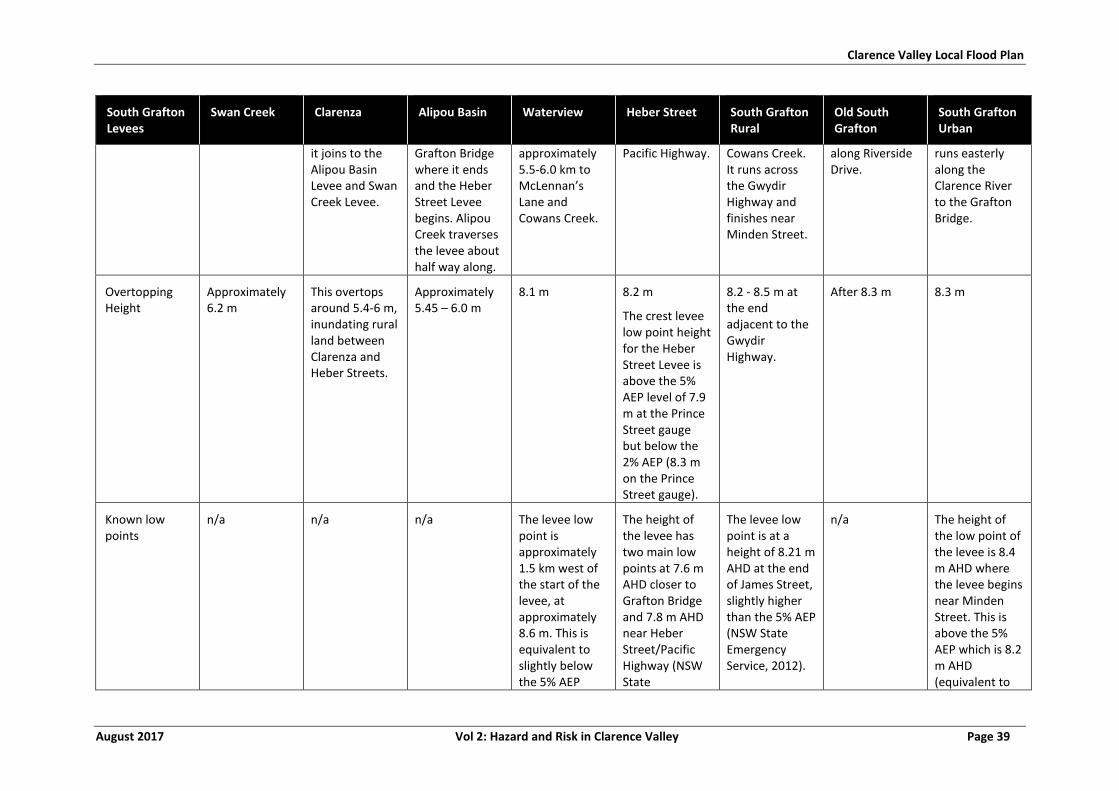
Clarence Valley Local Flood Plan
August 2017 Vol 2: Hazard and Risk in Clarence Valley Page 39
South Grafton Levees
Swan Creek Clarenza Alipou Basin Waterview Heber Street South Grafton Rural
Old South Grafton
South Grafton Urban
it joins to the Alipou Basin Levee and Swan Creek Levee.
Grafton Bridge where it ends and the Heber Street Levee begins. Alipou Creek traverses the levee about half way along.
approximately 5.5-6.0 km to McLennan’s Lane and Cowans Creek.
Pacific Highway. Cowans Creek. It runs across the Gwydir Highway and finishes near Minden Street.
along Riverside Drive.
runs easterly along the Clarence River to the Grafton Bridge.
Overtopping Height
Approximately 6.2 m
This overtops around 5.4-6 m, inundating rural land between Clarenza and Heber Streets.
Approximately 5.45 – 6.0 m
8.1 m 8.2 m
The crest levee low point height for the Heber Street Levee is above the 5% AEP level of 7.9 m at the Prince Street gauge but below the 2% AEP (8.3 m on the Prince Street gauge).
8.2 - 8.5 m at the end adjacent to the Gwydir Highway.
After 8.3 m 8.3 m
Known low points
n/a n/a n/a The levee low point is approximately 1.5 km west of the start of the levee, at approximately 8.6 m. This is equivalent to slightly below the 5% AEP
The height of the levee has two main low points at 7.6 m AHD closer to Grafton Bridge and 7.8 m AHD near Heber Street/Pacific Highway (NSW State
The levee low point is at a height of 8.21 m AHD at the end of James Street, slightly higher than the 5% AEP (NSW State Emergency Service, 2012).
n/a The height of the low point of the levee is 8.4 m AHD where the levee begins near Minden Street. This is above the 5% AEP which is 8.2 m AHD (equivalent to
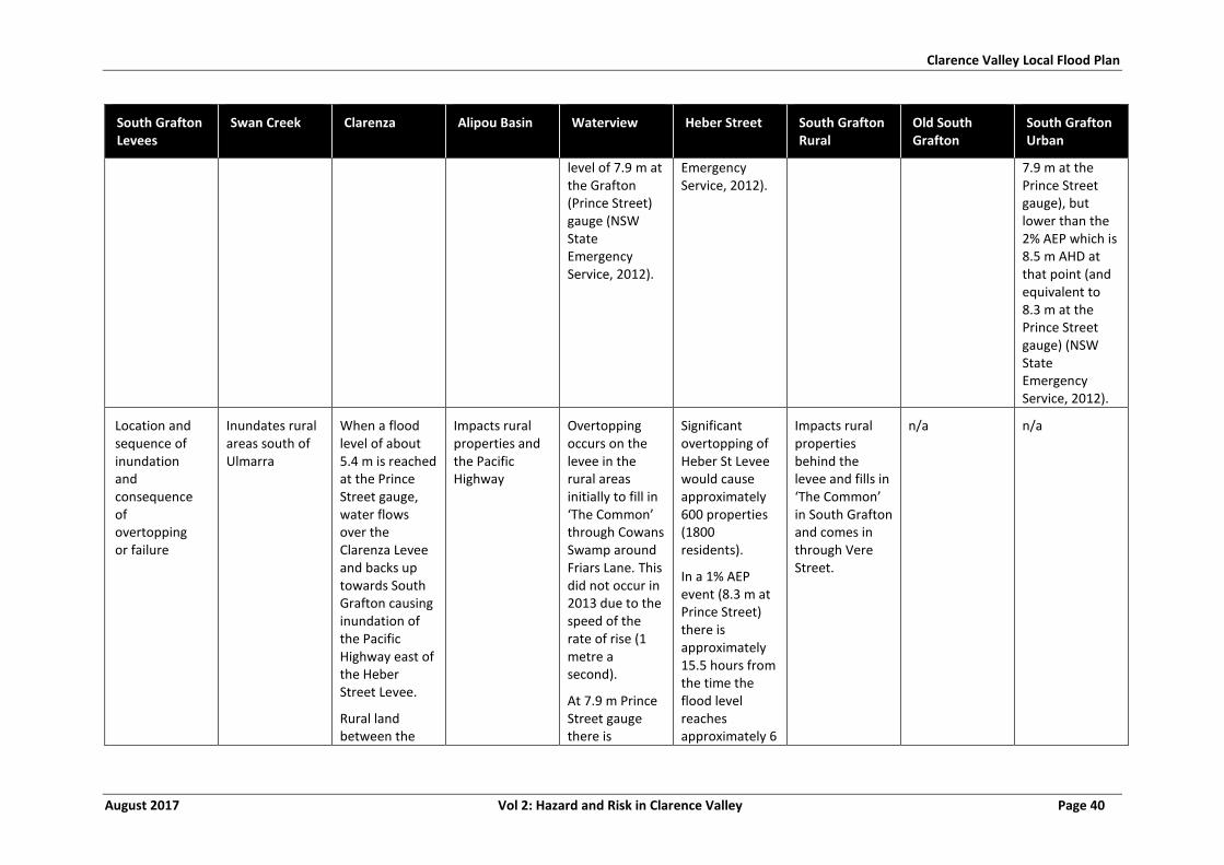
Clarence Valley Local Flood Plan
August 2017 Vol 2: Hazard and Risk in Clarence Valley Page 40
South Grafton Levees
Swan Creek Clarenza Alipou Basin Waterview Heber Street South Grafton Rural
Old South Grafton
South Grafton Urban
level of 7.9 m at the Grafton (Prince Street) gauge (NSW State Emergency Service, 2012).
Emergency Service, 2012).
7.9 m at the Prince Street gauge), but lower than the 2% AEP which is 8.5 m AHD at that point (and equivalent to 8.3 m at the Prince Street gauge) (NSW State Emergency Service, 2012).
Location and sequence of inundation and consequence of overtopping or failure
Inundates rural areas south of Ulmarra
When a flood level of about 5.4 m is reached at the Prince Street gauge, water flows over the Clarenza Levee and backs up towards South Grafton causing inundation of the Pacific Highway east of the Heber Street Levee.
Rural land between the
Impacts rural properties and the Pacific Highway
Overtopping occurs on the levee in the rural areas initially to fill in ‘The Common’ through Cowans Swamp around Friars Lane. This did not occur in 2013 due to the speed of the rate of rise (1 metre a second).
At 7.9 m Prince Street gauge there is
Significant overtopping of Heber St Levee would cause approximately 600 properties (1800 residents).
In a 1% AEP event (8.3 m at Prince Street) there is approximately 15.5 hours from the time the flood level reaches approximately 6
Impacts rural properties behind the levee and fills in ‘The Common’ in South Grafton and comes in through Vere Street.
n/a n/a
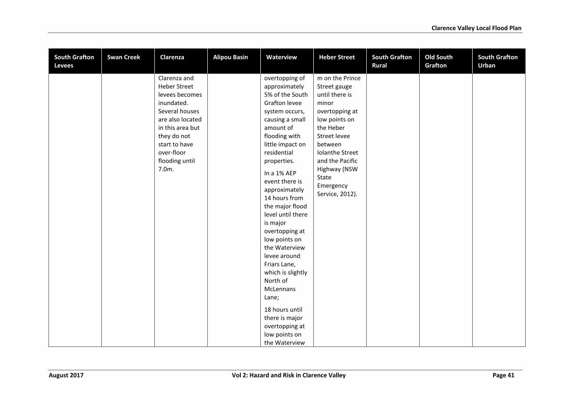
Clarence Valley Local Flood Plan
August 2017 Vol 2: Hazard and Risk in Clarence Valley Page 41
South Grafton Levees
Swan Creek Clarenza Alipou Basin Waterview Heber Street South Grafton Rural
Old South Grafton
South Grafton Urban
Clarenza and Heber Street levees becomes inundated. Several houses are also located in this area but they do not start to have over-floor flooding until 7.0m.
overtopping of approximately 5% of the South Grafton levee system occurs, causing a small amount of flooding with little impact on residential properties.
In a 1% AEP event there is approximately 14 hours from the major flood level until there is major overtopping at low points on the Waterview levee around Friars Lane, which is slightly North of McLennans Lane;
18 hours until there is major overtopping at low points on the Waterview
m on the Prince Street gauge until there is minor overtopping at low points on the Heber Street levee between Iolanthe Street and the Pacific Highway (NSW State Emergency Service, 2012).
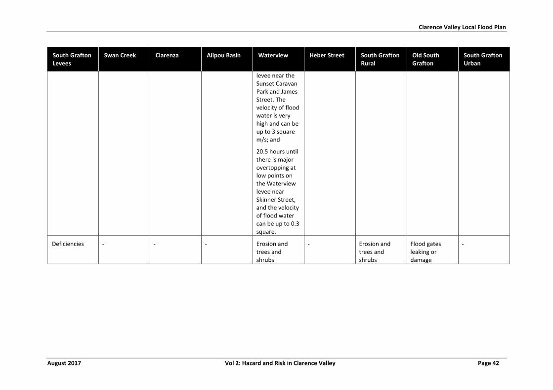
Clarence Valley Local Flood Plan
August 2017 Vol 2: Hazard and Risk in Clarence Valley Page 42
South Grafton Levees
Swan Creek Clarenza Alipou Basin Waterview Heber Street South Grafton Rural
Old South Grafton
South Grafton Urban
levee near the Sunset Caravan Park and James Street. The velocity of flood water is very high and can be up to 3 square m/s; and
20.5 hours until there is major overtopping at low points on the Waterview levee near Skinner Street, and the velocity of flood water can be up to 0.3 square.
Deficiencies - - - Erosion and trees and shrubs
- Erosion and trees and shrubs
Flood gates leaking or damage
-
Clarence Valley Local Flood Plan
August 2017 Vol 2: Hazard and Risk in Clarence Valley Page 43
COPMANHURST, BARYULGIL AND MALABUGILMAH
2.3.1 Community Overview
a. Copmanhurst is located on the Clarence River, approximately 40 km upstream of
Grafton. The population of Copmanhurst is over 483 (13). It has 18.9% of the
population under 15 years of age and 21.5 % over 65. It has 6.2% indigenous
population. A summary of demographics is shown in Table 12.
b. Baryulgil is located on Josephs Creek, near the Clarence River, in the Hinterland
north-west of Copmanhurst. The population of Baryulgil is around 250 (13). It has
19.4% of the population under 15 years of age and 11.5% over 65. It has 35%
indigenous population.
c. Malabugilmah is an aboriginal settlement, on the range to north Baryulgil near the
Clarence River and Bugilbah Creek. The population of Malabugilmah is over 100 (13).
It has 33% of the population under 15 years of age and 6.6% over 65.
2.3.2 Characteristics of Flooding
a. Flooding occurs from riverine flooding of the Clarence River and smaller creeks such
as Josephs Creek Bugilbah, as well as overland flooding from intense rainfall.
b. Farm operations are disrupted and floods can cut off numerous rural properties (2).
2.3.3 Flood Behaviour
a. Refer to section 1.5.
2.3.4 Classification of Floodplain
a. High Flood Island.
2.3.5 Inundation
a. This area utilises the Copmanhurst gauge.
b. Around 5 houses are in a low-lying area of the village of Copmanhurst, in Grafton
Street and Clarence Way and may become flooded (20.5 m and above on the
Copmanhurst gauge) (2). Some of these were flooded up to the ceiling in January
2013 (22.76 m at Copmanhurst).
c. Many farms are affected by the inundation of low lying areas, including those in the
Copmanhurst and Whiporie area (2).
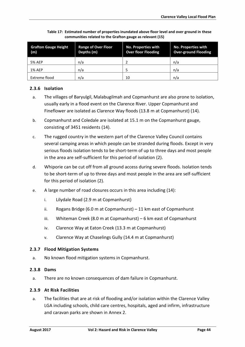
Clarence Valley Local Flood Plan
August 2017 Vol 2: Hazard and Risk in Clarence Valley Page 44
Table 17: Estimated number of properties inundated above floor level and over ground in these communities related to the Grafton gauge as relevant (15)
Grafton Gauge Height (m)
Range of Over Floor Depths (m)
No. Properties with Over floor Flooding
No. Properties with Over-ground Flooding
5% AEP n/a 2 n/a
1% AEP n/a 5 n/a
Extreme flood n/a 10 n/a
2.3.6 Isolation
a. The villages of Baryulgil, Malabugilmah and Copmanhurst are also prone to isolation,
usually early in a flood event on the Clarence River. Upper Copmanhurst and
Fineflower are isolated as Clarence Way floods (13.8 m at Copmanhurst) (14).
b. Copmanhurst and Coledale are isolated at 15.1 m on the Copmanhurst gauge,
consisting of 3451 residents (14).
c. The rugged country in the western part of the Clarence Valley Council contains
several camping areas in which people can be stranded during floods. Except in very
serious floods isolation tends to be short-term of up to three days and most people
in the area are self-sufficient for this period of isolation (2).
d. Whiporie can be cut off from all ground access during severe floods. Isolation tends
to be short-term of up to three days and most people in the area are self-sufficient
for this period of isolation (2).
e. A large number of road closures occurs in this area including (14):
i. Lilydale Road (2.9 m at Copmanhurst)
ii. Rogans Bridge (6.0 m at Copmanhurst) – 11 km east of Copmanhurst
iii. Whiteman Creek (8.0 m at Copmanhurst) – 6 km east of Copmanhurst
iv. Clarence Way at Eaton Creek (13.3 m at Copmanhurst)
v. Clarence Way at Chaselings Gully (14.4 m at Copmanhurst)
2.3.7 Flood Mitigation Systems
a. No known flood mitigation systems in Copmanhurst.
2.3.8 Dams
a. There are no known consequences of dam failure in Copmanhurst.
2.3.9 At Risk Facilities
a. The facilities that are at risk of flooding and/or isolation within the Clarence Valley
LGA including schools, child care centres, hospitals, aged and infirm, infrastructure
and caravan parks are shown in Annex 2.
Clarence Valley Local Flood Plan
August 2017 Vol 2: Hazard and Risk in Clarence Valley Page 45
2.3.10 Other Considerations
a. Copmanhurst has two peak seasons with potential population increase of more than
10%:
i. Camp draft September.
ii. Summer School Holidays - Public Lands within remote areas of this sector are
utilized by campers.
Clarence Valley Local Flood Plan
August 2017 Vol 2: Hazard and Risk in Clarence Valley Page 46
LAWRENCE, ASHBY AND SOUTHGATE AREAS
2.4.1 Community Overview
a. Lawrence is located on the north bank of the Clarence River at the junction with
Sportsmans Creek, approximately half way between Brushgrove and Maclean (2).
The population of Lawrence is around 1050 (13). It has 16.3% of the population
under 15 years of age and 24.3% over 65. It has 3% indigenous population. A
summary of demographics is shown in Table 12.
b. Southgate is located opposite Ulmarra, on the northern floodplain of the Clarence
River (2). The population of Southgate is around 175 (13). It has 16.5% of the
population under 15 years of age and 13.1% over 65. It has 6.2% indigenous
population.
c. Ashby is located opposite Maclean on the north bank of the Clarence River (2). The
population of Ashby is around 350 (13). It has 17.2% of the population under 15
years of age and 23.2% over 65. It has 2.3% indigenous population.
2.4.2 Characteristics of flooding
a. Flooding can occur from riverine flooding from Clarence River and Sportsman Creek,
as well as overland flooding from intense rainfall.
2.4.3 Flood Behaviour
a. Refer to section 1.5.
2.4.4 Classification of Floodplain
a. The low lying areas of Lawrence have rising road access to a High Flood Island.
b. Southgate has rising road access until the Lawrence Road is flooded, thereafter
becoming a low flood island.
2.4.5 Inundation
a. This area utilises the Lawrence, Grafton and Maclean gauges.
b. Lawrence - At 4.4 m on the Lawrence gauge, Lawrence Store, the Hall and several
houses on Bridge Street, Lawrence are flooded (14). Nine houses on Kings Creek
Road are inundated by 4.45 m. At 4.65 m, 12 houses are flooded above floor.
c. At 3.26 m on the Maclean gauge 11 houses are inundated in Falconers Lane, Bridge
Street, Richmond Street and Grafton Street.
d. There are 20 residential and 8 non-residential buildings that have floor levels below
the 1% AEP, and up to 70 at the 1% AEP (Lawrence gauge 5.34 m, Brushgrove gauge
5.8 m) (2). Further details are available in Table 18.
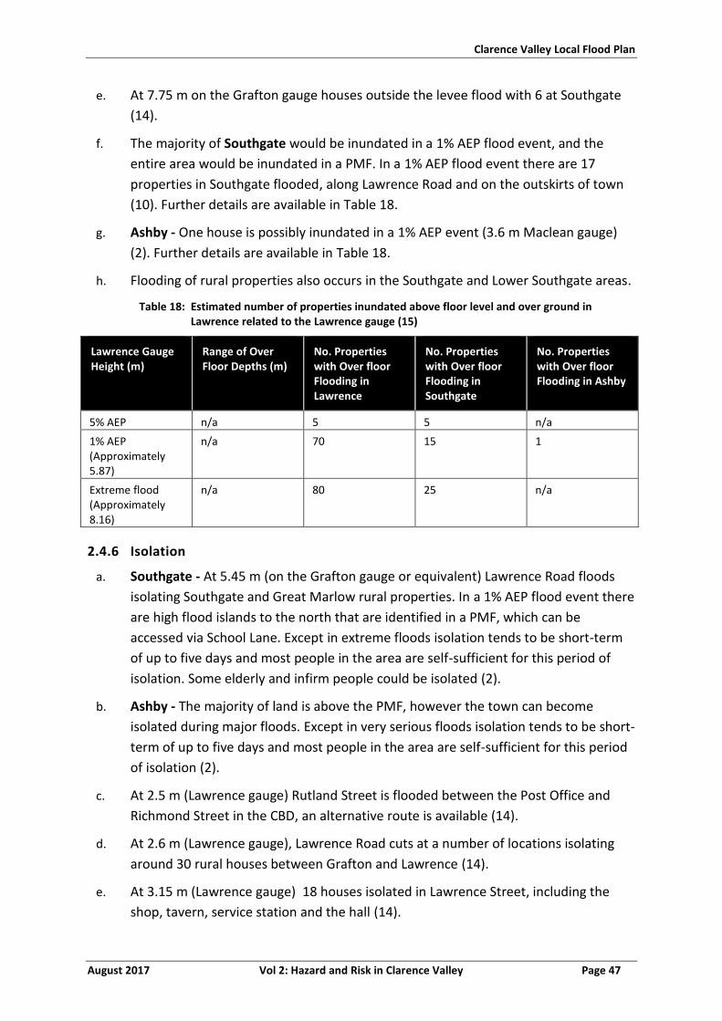
Clarence Valley Local Flood Plan
August 2017 Vol 2: Hazard and Risk in Clarence Valley Page 47
e. At 7.75 m on the Grafton gauge houses outside the levee flood with 6 at Southgate
(14).
f. The majority of Southgate would be inundated in a 1% AEP flood event, and the
entire area would be inundated in a PMF. In a 1% AEP flood event there are 17
properties in Southgate flooded, along Lawrence Road and on the outskirts of town
(10). Further details are available in Table 18.
g. Ashby - One house is possibly inundated in a 1% AEP event (3.6 m Maclean gauge)
(2). Further details are available in Table 18.
h. Flooding of rural properties also occurs in the Southgate and Lower Southgate areas.
Table 18: Estimated number of properties inundated above floor level and over ground in Lawrence related to the Lawrence gauge (15)
Lawrence Gauge Height (m)
Range of Over Floor Depths (m)
No. Properties with Over floor Flooding in Lawrence
No. Properties with Over floor Flooding in Southgate
No. Properties with Over floor Flooding in Ashby
5% AEP n/a 5 5 n/a
1% AEP (Approximately 5.87)
n/a 70 15 1
Extreme flood (Approximately 8.16)
n/a 80 25 n/a
2.4.6 Isolation
a. Southgate - At 5.45 m (on the Grafton gauge or equivalent) Lawrence Road floods
isolating Southgate and Great Marlow rural properties. In a 1% AEP flood event there
are high flood islands to the north that are identified in a PMF, which can be
accessed via School Lane. Except in extreme floods isolation tends to be short-term
of up to five days and most people in the area are self-sufficient for this period of
isolation. Some elderly and infirm people could be isolated (2).
b. Ashby - The majority of land is above the PMF, however the town can become
isolated during major floods. Except in very serious floods isolation tends to be short-
term of up to five days and most people in the area are self-sufficient for this period
of isolation (2).
c. At 2.5 m (Lawrence gauge) Rutland Street is flooded between the Post Office and
Richmond Street in the CBD, an alternative route is available (14).
d. At 2.6 m (Lawrence gauge), Lawrence Road cuts at a number of locations isolating
around 30 rural houses between Grafton and Lawrence (14).
e. At 3.15 m (Lawrence gauge) 18 houses isolated in Lawrence Street, including the
shop, tavern, service station and the hall (14).
Clarence Valley Local Flood Plan
August 2017 Vol 2: Hazard and Risk in Clarence Valley Page 48
f. Mantons Road is flooded, isolating 18 houses at 3.26 m at Lawrence gauge.
g. Lawrence Ferry usually closes at 1.5 m on the Maclean gauge, affecting school
students.
2.4.7 Flood Mitigation Systems
a. No known flood mitigation systems in Lawrence.
2.4.8 Dams
a. No known dam failure consequences in Lawrence.
2.4.9 At Risk Facilities
a. The facilities that are at risk of flooding and/or isolation within the Clarence Valley
LGA including schools, child care centres, hospitals, aged and infirm, infrastructure
and caravan parks are shown in Annex 2.
2.4.10 Other Considerations
a. No additional considerations have been identified.
Clarence Valley Local Flood Plan
August 2017 Vol 2: Hazard and Risk in Clarence Valley Page 49
ULMARRA, TUCABIA, GILLETTS RIDGE
2.5.1 Community Overview
a. Ulmarra is located on the southern bank of Clarence River to the east of Grafton. The
population of Ulmarra is around 784 (13). It has 17.5% of the population under 15
years of age and 21.8% over 65. It has 5.3% indigenous population. A summary of
demographics is shown in Table 12.
b. Tucabia is located on the eastern side of the Coldstream River, to the east of
Ulmarra. Tucabia The population of Tucabia is around 290 (13). It has 16.6% of the
population under 15 years of age and 12.8% over 65. It has 5.9% indigenous
population.
c. Gilletts Ridge is a small rural area with livestock and grain farming. It is located on
the Coldstream River, opposite Tucabia.
2.5.2 Characteristics of flooding
a. Flooding can occur from riverine flooding from Clarence River and Coldstream River,
as well as overland flooding from intense rainfall.
2.5.3 Flood Behaviour
a. Refer to section 1.5.
2.5.4 Classification of Floodplain
a. Low flood island.
b. Tucabia and Gilletts Ridge have Rising Road Access.
2.5.5 Inundation
a. This area utilises the Ulmarra and Grafton gauges.
b. Water from Swan Creek starts to inundate rural areas south of Ulmarra at 6.2 m on
the Grafton gauge (14).
c. Water enters Southgate village roads at 6.7 m on the Grafton gauge (14).
d. Ulmarra has levee protection, but the eastern and southern portions of the town are
not protected by this structure. Backwater inundation occurs in significant floods,
with one commercial premises inundated at 6.15 m on the Ulmarra gauge (2). At
6.29 m the entire levee overtops, inundating the town including River Street,
Coldstream Street, George Street, King Street, Goddger Lane, Pacific Highway and
Lynhaven Crescent.
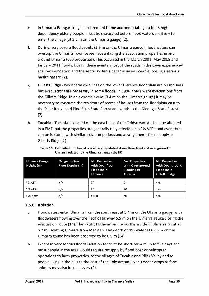
Clarence Valley Local Flood Plan
August 2017 Vol 2: Hazard and Risk in Clarence Valley Page 50
e. In Ulmarra Rathgar Lodge, a retirement home accommodating up to 25 high
dependency elderly people, must be evacuated before flood waters are likely to
enter the village (at 5.5 m on the Ulmarra gauge) (2).
f. During, very severe flood events (5.9 m on the Ulmarra gauge), flood waters can
overtop the Ulmarra Town Levee necessitating the evacuation properties in and
around Ulmarra (660 properties). This occurred in the March 2001, May 2009 and
January 2011 floods. During these events, most of the roads in the town experienced
shallow inundation and the septic systems became unserviceable, posing a serious
health hazard (2).
g. Gilletts Ridge - Most farm dwellings on the lower Clarence floodplain are on mounds
but evacuations are necessary in some floods. In 1996, there were evacuations from
the Gilletts Ridge. In an extreme event (8.4 m on the Ulmarra gauge) it may be
necessary to evacuate the residents of scores of houses from the floodplain east to
the Pillar Range and Pine Bush State Forest and south to the Glenugie State Forest
(2).
h. Tucabia - Tucabia is located on the east bank of the Coldstream and can be affected
in a PMF, but the properties are generally only affected in a 1% AEP flood event but
can be isolated, with similar isolation periods and arrangements for resupply as
Gilletts Ridge (2).
Table 19: Estimated number of properties inundated above floor level and over ground in Ulmarra related to the Ulmarra gauge (10; 15)
Ulmarra Gauge Height (m)
Range of Over Floor Depths (m)
No. Properties with Over floor Flooding in Ulmarra
No. Properties with Over-ground Flooding in Tucabia
No. Properties with Over-ground Flooding in Gilletts Ridge
5% AEP n/a 20 5 n/a
1% AEP n/a 80 50 n/a
Extreme n/a >100 70 n/a
2.5.6 Isolation
a. Floodwaters enter Ulmarra from the south east at 5.4 m on the Ulmarra gauge, with
floodwaters flowing over the Pacific Highway 5.5 m on the Ulmarra gauge closing the
evacuation route (14). The Pacific Highway on the northern side of Ulmarra is cut at
5.7 m, isolating Ulmarra from Maclean. The depth of this water at 6.05 m on the
Ulmarra gauge has been observed to be 0.5 m (14).
b. Except in very serious floods isolation tends to be short-term of up to five days and
most people in the area would require resupply by flood boat or helicopter
operations to farm properties, to the villages of Tucabia and Pillar Valley and to
people living in the hills to the east of the Coldstream River. Fodder drops to farm
animals may also be necessary (2).
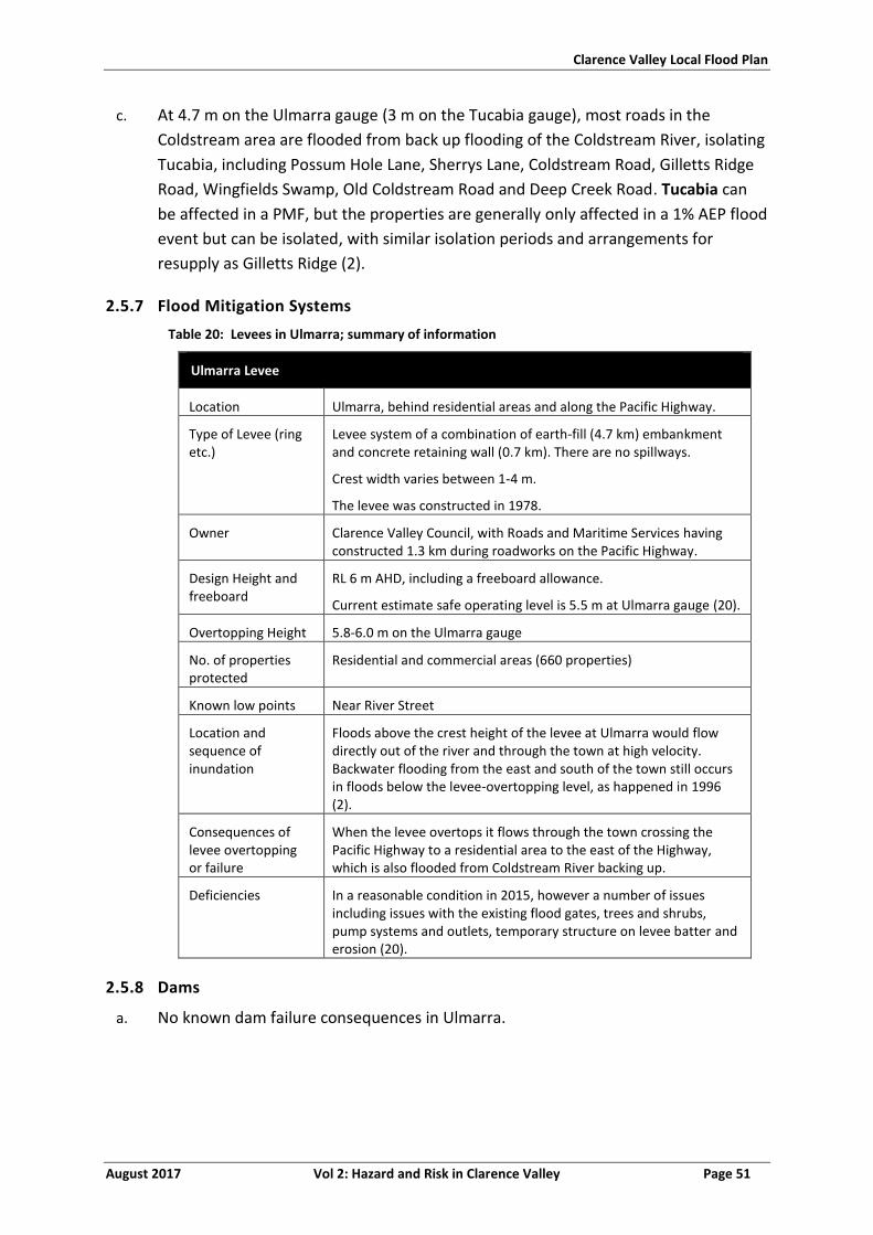
Clarence Valley Local Flood Plan
August 2017 Vol 2: Hazard and Risk in Clarence Valley Page 51
c. At 4.7 m on the Ulmarra gauge (3 m on the Tucabia gauge), most roads in the
Coldstream area are flooded from back up flooding of the Coldstream River, isolating
Tucabia, including Possum Hole Lane, Sherrys Lane, Coldstream Road, Gilletts Ridge
Road, Wingfields Swamp, Old Coldstream Road and Deep Creek Road. Tucabia can
be affected in a PMF, but the properties are generally only affected in a 1% AEP flood
event but can be isolated, with similar isolation periods and arrangements for
resupply as Gilletts Ridge (2).
2.5.7 Flood Mitigation Systems
Table 20: Levees in Ulmarra; summary of information
Ulmarra Levee
Location Ulmarra, behind residential areas and along the Pacific Highway.
Type of Levee (ring etc.)
Levee system of a combination of earth-fill (4.7 km) embankment and concrete retaining wall (0.7 km). There are no spillways.
Crest width varies between 1-4 m.
The levee was constructed in 1978.
Owner Clarence Valley Council, with Roads and Maritime Services having constructed 1.3 km during roadworks on the Pacific Highway.
Design Height and freeboard
RL 6 m AHD, including a freeboard allowance.
Current estimate safe operating level is 5.5 m at Ulmarra gauge (20).
Overtopping Height 5.8-6.0 m on the Ulmarra gauge
No. of properties protected
Residential and commercial areas (660 properties)
Known low points Near River Street
Location and sequence of inundation
Floods above the crest height of the levee at Ulmarra would flow directly out of the river and through the town at high velocity. Backwater flooding from the east and south of the town still occurs in floods below the levee-overtopping level, as happened in 1996 (2).
Consequences of levee overtopping or failure
When the levee overtops it flows through the town crossing the Pacific Highway to a residential area to the east of the Highway, which is also flooded from Coldstream River backing up.
Deficiencies In a reasonable condition in 2015, however a number of issues including issues with the existing flood gates, trees and shrubs, pump systems and outlets, temporary structure on levee batter and erosion (20).
2.5.8 Dams
a. No known dam failure consequences in Ulmarra.
Clarence Valley Local Flood Plan
August 2017 Vol 2: Hazard and Risk in Clarence Valley Page 52
2.5.9 At Risk Facilities
a. The facilities that are at risk of flooding and/or isolation within the Clarence Valley
LGA including schools, child care centres, hospitals, aged and infirm, infrastructure
and caravan parks are shown in Annex 2.
2.5.10 Other Considerations
a. No additional considerations have been identified.
Clarence Valley Local Flood Plan
August 2017 Vol 2: Hazard and Risk in Clarence Valley Page 53
BRUSHGROVE, TYNDALE AND COWPER
2.6.1 Community Overview
a. Brushgrove is a rural village located on the southern tip of Woodford Island in the
Clarence River floodplain, consisting of predominantly sugar cane farmland. There
are around 62 residential and 5 commercial properties in Brushgrove (2). The
population of Brushgrove is around 330 (13). It has 17% of the population under 15
years of age and 19.1% over 65. It has 3.6% indigenous population.
b. Cowper is a small locality located to the south of Brushgrove on the South Arm of
the Clarence River (2).
c. Tyndale is located on the Pacific Highway halfway between Cowper and Maclean.
There are 24 residential properties and a number of businesses in the village (2). The
population of Tyndale is around 330 (13). It has 17.7% of the population under 15
years of age and 15.3% over 65. It has 8.4% indigenous population.
d. A summary of demographics is shown in Table 12.
2.6.2 Characteristics of flooding
a. Flooding occurs from riverine flooding from Clarence River and the South Arm.
2.6.3 Flood Behaviour
a. Refer to section 1.5.
2.6.4 Classification of Floodplain
a. Brushgrove and Cowper are low flood islands.
b. Tyndale is a high flood island.
2.6.5 Inundation
a. This area uses the Brushgrove, Ulmarra, Cowper and Maclean gauges.
b. Brushgrove - The natural levee facing the Clarence River is overtopped in a 5% AEP
flood event (Ulmarra gauge, 6.07 m and Brushgrove 5.15 m) flooding most of the
village, leaving only the high ground adjacent to the South Arm flood free (2). Most
of the properties have floor levels above the 1% AEP flood event level (Brushgrove,
5.8 m), but in an event of this magnitude there would likely to be in excess of 2 m of
water under some properties, as many of the homes in Brushgrove are raised. During
these events, most of the roads in the town experienced shallow inundation and the
septic systems became unserviceable, posing a serious health hazard (2).
c. Three houses in Brushgrove and Brushgrove hotel are inundated at 4.3 m on the
Brushgrove gauge (14).
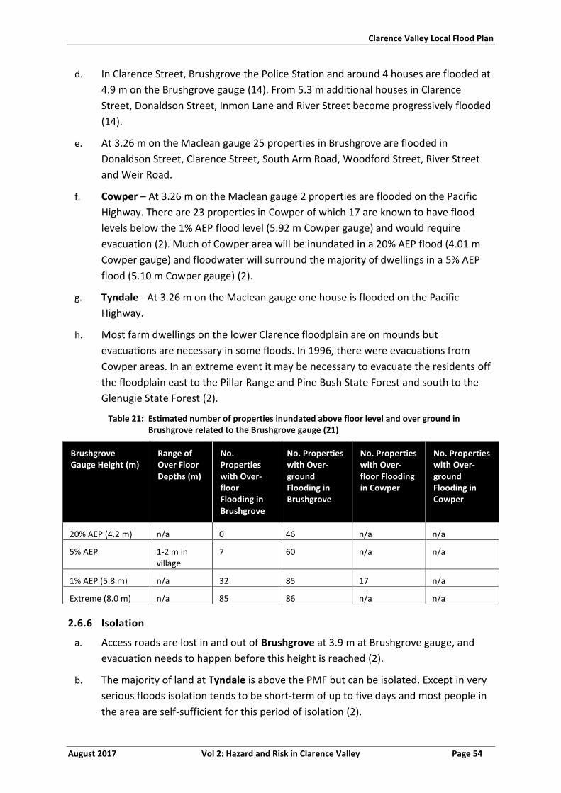
Clarence Valley Local Flood Plan
August 2017 Vol 2: Hazard and Risk in Clarence Valley Page 54
d. In Clarence Street, Brushgrove the Police Station and around 4 houses are flooded at
4.9 m on the Brushgrove gauge (14). From 5.3 m additional houses in Clarence
Street, Donaldson Street, Inmon Lane and River Street become progressively flooded
(14).
e. At 3.26 m on the Maclean gauge 25 properties in Brushgrove are flooded in
Donaldson Street, Clarence Street, South Arm Road, Woodford Street, River Street
and Weir Road.
f. Cowper – At 3.26 m on the Maclean gauge 2 properties are flooded on the Pacific
Highway. There are 23 properties in Cowper of which 17 are known to have flood
levels below the 1% AEP flood level (5.92 m Cowper gauge) and would require
evacuation (2). Much of Cowper area will be inundated in a 20% AEP flood (4.01 m
Cowper gauge) and floodwater will surround the majority of dwellings in a 5% AEP
flood (5.10 m Cowper gauge) (2).
g. Tyndale - At 3.26 m on the Maclean gauge one house is flooded on the Pacific
Highway.
h. Most farm dwellings on the lower Clarence floodplain are on mounds but
evacuations are necessary in some floods. In 1996, there were evacuations from
Cowper areas. In an extreme event it may be necessary to evacuate the residents off
the floodplain east to the Pillar Range and Pine Bush State Forest and south to the
Glenugie State Forest (2).
Table 21: Estimated number of properties inundated above floor level and over ground in Brushgrove related to the Brushgrove gauge (21)
Brushgrove Gauge Height (m)
Range of Over Floor Depths (m)
No. Properties with Over-floor Flooding in Brushgrove
No. Properties with Over-ground Flooding in Brushgrove
No. Properties with Over-floor Flooding in Cowper
No. Properties with Over-ground Flooding in Cowper
20% AEP (4.2 m) n/a 0 46 n/a n/a
5% AEP 1-2 m in village
7 60 n/a n/a
1% AEP (5.8 m) n/a 32 85 17 n/a
Extreme (8.0 m) n/a 85 86 n/a n/a
2.6.6 Isolation
a. Access roads are lost in and out of Brushgrove at 3.9 m at Brushgrove gauge, and
evacuation needs to happen before this height is reached (2).
b. The majority of land at Tyndale is above the PMF but can be isolated. Except in very
serious floods isolation tends to be short-term of up to five days and most people in
the area are self-sufficient for this period of isolation (2).
Clarence Valley Local Flood Plan
August 2017 Vol 2: Hazard and Risk in Clarence Valley Page 55
2.6.7 Flood Mitigation Systems
a. Brushgrove. A short informal levee protects some properties at Brushgrove from
flooding direct from the Clarence River, but will not keep out severe floods (2).
2.6.8 Dams
a. No known dam failure consequences in Brushgrove.
2.6.9 At Risk Facilities
a. The facilities that are at risk of flooding and/or isolation within the Clarence Valley
LGA including schools, child care centres, hospitals, aged and infirm, infrastructure
and caravan parks are shown in Annex 2.
2.6.10 Other Considerations
a. No additional consequences have been identified.
Clarence Valley Local Flood Plan
August 2017 Vol 2: Hazard and Risk in Clarence Valley Page 56
MACLEAN, ILARWIL, TOWNSEND, HARWOOD AND CHATSWORTH
2.7.1 Community Overview
a. Maclean is located on the southern bank of the Clarence River, immediately
downstream of its confluence with South Arm. The population of Maclean is around
2600 (13). It has 15.9% of the population under 15 years of age and 31.9% over 65. It
has 7.5% indigenous population. A high proportion of the population in these areas is
elderly and car ownership is low.
b. Ilarwill is located upstream of Maclean on the south bank of the Clarence River (2).
The population of Ilarwill is around 213 (13). It has 13.5% of the population under 15
years of age and 21.9% over 65. It has 6.5% indigenous population.
c. Townsend is located south east of Maclean on the South Arm of the Clarence River
(2). The population of Townsend is around 817 (13). It has 22.2% of the population
under 15 years of age and 21.5% over 65. It has 9.2% indigenous population. Much of
the town is above the PMF.
d. Harwood is an island on the north bank of the Clarence River, predominantly sugar
cane farming. The population of Harwood is around 360 (13). It has 17.4% of the
population under 15 years of age and 19.7% over 65. It has 3.1% indigenous
population. In Harwood there are 61 properties, 17 businesses and a sugar mill.
e. Chatsworth is located on a ridge of higher land adjacent to the North Arm of the
Clarence River and is predominantly sugar cane farmland (2). The population of
Chatsworth is around 215 (13). It has 23.1% of the population under 15 years of age
and 24.5% over 65. It has no indigenous population.
f. Warregah Island is located between North Arm and Back Channel, with 9 houses.
g. A summary of demographics is shown in Table 12.
2.7.2 Characteristics of flooding
a. Flooding can occur from riverine flooding of Clarence River, South Arm and North
Arm, as well as overland flooding from intense rainfall.
2.7.3 Flood Behaviour
a. Refer to section 1.5.
2.7.4 Classification of Floodplain
a. Maclean has rising road access between 2.5 and 2.7 m, thereafter becoming a high
flood island with the levee overtopping heights at 3.3-3.4 m.
b. Chatsworth and Harwood are low flood islands.
c. Ilarwill and Townsend are high flood islands.
Clarence Valley Local Flood Plan
August 2017 Vol 2: Hazard and Risk in Clarence Valley Page 57
2.7.5 Inundation
a. This area utilises the Maclean gauge.
b. Maclean - Maclean has a levee which protects the CBD and residential areas along
the Clarence River on the town’s western edge, but these areas (100 properties
including nursing home and CBD) would be inundated if the levee were to fail or be
overtopped (above 3.4 m on the Maclean gauge (16)). Refer to Table 22. The caravan
parks within the town are flood liable (2). At 3.26 m on the Maclean gauge 4 houses
are flooded at Shark Creek on Omars Lane and Shark Creek Road; 2 properties are
flooded on the Pacific Highway and Yamba Road.
c. There are around 365 residential properties and 100 business premises in this area
and many of them would have over-floor inundation in a flood between the 5% AEP
(3.1 m on the Maclean gauge) and 2% AEP flood (3.57 m on the Maclean gauge). The
1% AEP flood is 3.6 m on the Maclean gauge) and major overtopping of the levee
would cause further inundation to these properties (2).
d. Harwood - Many of the homes in Harwood are raised homes, however much of the
land in Harwood will be inundated in a 20% AEP flood (2.05 m Harwood gauge, 2.41
m Maclean gauge), and floodwater will surround the majority of dwellings in a 5%
AEP flood (3.1 m Maclean gauge) (2). Inundation of dwellings starts as early as 1.9 m
on the Maclean gauge. Up to 15 houses are flooded from 2.5 m on the Maclean
gauge (14). At 3.26 m on the Maclean gauge 4 are flooded in Martins Point Road,
Morpeth Street and Cannons Lane. Fifteen (15) non-residential buildings and 35
residential properties in Harwood are below the 1% AEP flood level (Harwood gauge
3.23 m, Maclean gauge 3.6 m) (2).
e. Chatsworth - There are approximately 40 properties in Chatsworth of which 11 are
below the 1% AEP flood level (3.19 m Chatsworth gauge, 3.6 m Maclean gauge).
Much of Chatsworth Island will be inundated in a 20% AEP flood and floodwater will
surround the majority of dwellings in a 5% AEP flood (2). Further details are available
in Table 18.
f. Extensive flooding of the islands and Ilarwill occurs at 3 m (14).
Table 22: Estimated number of properties inundated above floor level and over ground in Maclean related to the Maclean gauge
Maclean Gauge Height (m)
Range of Over Floor Depths (m)
No. Properties with Over floor Flooding in Maclean
No. Properties with Over floor flooding in Harwood
No. Properties with Over floor flooding in Chatsworth
5% AEP (3.1 m) n/a 0 20 5
1% AEP (3.6 m) n/a 400 100 25
Extreme flood (5.1 m)
n/a 420 100 30
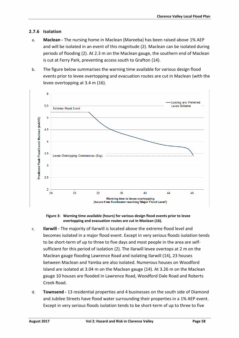
Clarence Valley Local Flood Plan
August 2017 Vol 2: Hazard and Risk in Clarence Valley Page 58
2.7.6 Isolation
a. Maclean - The nursing home in Maclean (Mareeba) has been raised above 1% AEP
and will be isolated in an event of this magnitude (2). Maclean can be isolated during
periods of flooding (2). At 2.3 m on the Maclean gauge, the southern end of Maclean
is cut at Ferry Park, preventing access south to Grafton (14).
b. The figure below summarises the warning time available for various design flood
events prior to levee overtopping and evacuation routes are cut in Maclean (with the
levee overtopping at 3.4 m (16).
Figure 3: Warning time available (hours) for various design flood events prior to levee overtopping and evacuation routes are cut in Maclean (16).
c. Ilarwill - The majority of Ilarwill is located above the extreme flood level and
becomes isolated in a major flood event. Except in very serious floods isolation tends
to be short-term of up to three to five days and most people in the area are self-
sufficient for this period of isolation (2). The Ilarwill levee overtops at 2 m on the
Maclean gauge flooding Lawrence Road and isolating Ilarwill (14), 23 houses
between Maclean and Yamba are also isolated. Numerous houses on Woodford
Island are isolated at 3.04 m on the Maclean gauge (14). At 3.26 m on the Maclean
gauge 10 houses are flooded in Lawrence Road, Woodford Dale Road and Roberts
Creek Road.
d. Townsend - 13 residential properties and 4 businesses on the south side of Diamond
and Jubilee Streets have flood water surrounding their properties in a 1% AEP event.
Except in very serious floods isolation tends to be short-term of up to three to five
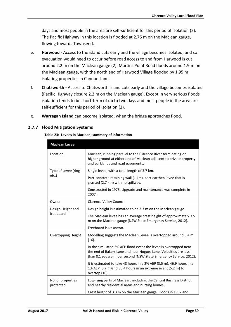
Clarence Valley Local Flood Plan
August 2017 Vol 2: Hazard and Risk in Clarence Valley Page 59
days and most people in the area are self-sufficient for this period of isolation (2).
The Pacific Highway in this location is flooded at 2.76 m on the Maclean gauge,
flowing towards Townsend.
e. Harwood - Access to the island cuts early and the village becomes isolated, and so
evacuation would need to occur before road access to and from Harwood is cut
around 2.2 m on the Maclean gauge (2). Martins Point Road floods around 1.9 m on
the Maclean gauge, with the north end of Harwood Village flooded by 1.95 m
isolating properties in Cannon Lane.
f. Chatsworth - Access to Chatsworth island cuts early and the village becomes isolated
(Pacific Highway closure 2.2 m on the Maclean gauge). Except in very serious floods
isolation tends to be short-term of up to two days and most people in the area are
self-sufficient for this period of isolation (2).
g. Warregah Island can become isolated, when the bridge approaches flood.
2.7.7 Flood Mitigation Systems
Table 23: Levees in Maclean; summary of information
Maclean Levee
Location Maclean, running parallel to the Clarence River terminating on higher ground at either end of Maclean adjacent to private property and parklands and road easements.
Type of Levee (ring etc.)
Single levee, with a total length of 3.7 km.
Part-concrete retaining wall (1 km), part-earthen levee that is grassed (2.7 km) with no spillway.
Constructed in 1975. Upgrade and maintenance was complete in 2007.
Owner Clarence Valley Council
Design Height and freeboard
Design height is estimated to be 3.3 m on the Maclean gauge.
The Maclean levee has an average crest height of approximately 3.5 m on the Maclean gauge (NSW State Emergency Service, 2012).
Freeboard is unknown.
Overtopping Height Modelling suggests the Maclean Levee is overtopped around 3.4 m (16).
In the simulated 2% AEP flood event the levee is overtopped near the end of Bakers Lane and near Hogues Lane. Velocities are less than 0.1 square m per second (NSW State Emergency Service, 2012).
It is estimated to take 48 hours in a 2% AEP (3.5 m), 46.9 hours in a 1% AEP (3.7 m)and 30.4 hours in an extreme event (5.2 m) to overtop (16).
No. of properties protected
Low-lying parts of Maclean, including the Central Business District and nearby residential areas and nursing homes.
Crest height of 3.3 m on the Maclean gauge. Floods in 1967 and
Clarence Valley Local Flood Plan
August 2017 Vol 2: Hazard and Risk in Clarence Valley Page 60
1974 exceeded this level, as did the flood of 1890 and possibly other events in the nineteenth century. The levee is designed to keep out floods only up to about the 30% AEP flood and will be overtopped in larger events (NSW State Emergency Service, 2012).
Known low points Levee low points at the end of Bakers Lane and near Hogues Lane (low points are 250 m either side of Hogues Lane).
Location and sequence of inundation
The first areas to be overtopped are the rural areas to the north of Maclean, with water travelling south towards Maclean through sporting fields and parklands into urban areas. In the 1% AEP flood event (3.6 m on the Maclean gauge) the levee is overtopped near the levee low points at the end of Bakers Lane and near Hogues Lane. In this event approximately 89% of the levee is overtopped.
Consequences of levee overtopping or failure
If the levee is overtopped (from approximately 3.3 -3.4m on the Maclean gauge at the low points), the low-lying land on the western side of the town would be flooded (NSW State Emergency Service, 2012).
If floodwaters continue to rise the levee will begin to overtop north of Stanley Street, inundating the River Street evacuation route
Major overtopping of the levee occurs in a 1% AEP flood and above, resulting in 310 and 330 properties flooded above floor in a 1% and an extreme event respectively.
The flood water velocity can be up to 0.30 square m per second between Central and Union Streets (the grass area west of the Maclean District Hospital), but the average velocity is generally less than 0.1 square m per second (NSW State Emergency Service, 2012).
Deficiencies Generally good condition as at 2015; however, a number of issues have been identified including a steep batter, trees and shrubs, permanent structure on levee (22).
2.7.8 Dams
a. No known consequences of dam failure in Maclean.
2.7.9 At Risk Facilities
a. The facilities that are at risk of flooding and/or isolation within the Clarence Valley
LGA including schools, child care centres, hospitals, aged and infirm, infrastructure
and caravan parks are shown in Annex 2.
2.7.10 Other Considerations
a. The Highland Gathering Festival is held in the Easter School Holidays at the
Showgrounds, with an increase of more than 10% of the population.
Clarence Valley Local Flood Plan
August 2017 Vol 2: Hazard and Risk in Clarence Valley Page 61
ILUKA AND WOOMBAH
2.8.1 Community Overview
a. Iluka is on the northern bank of the Clarence River opposite Yamba, at the river
mouth. The population of Iluka is around 1700 (13). It is an aged population with
13% of the population under 15 years of age, 35.3% over 65 and 3.9% is over 85. It
has 2.8% indigenous population.
b. Woombah is on the north side of the Clarence River, north east of Iluka and
approximately 8 km upstream from the ocean (2). The population of Woombah is
around 745 (13). It has 15.5% of the population under 15 years of age and 23.6%
over 65. It has 2% indigenous population.
c. A summary of demographics is shown in Table 12.
2.8.2 Characteristics of Flooding
a. The effects on the towns and outlying areas in this sector are very much dependent
on tidal influences. Tidal levels will need to be identified at the onset of main
Clarence River flooding (2).
b. This area is subject to flooding either from elevated ocean levels, rain and waves or
from the river.
2.8.3 Flood Behaviour
a. Refer to section 1.5.
2.8.4 Classification of Floodplain
a. Iluka becomes a high flood island following the flooding of access roads at 2.1 m.
b. Woombah is a high flood island following the closure of Clover Leaf/Harwood Bridge
(2.1 m on the Maclean gauge).
2.8.5 Inundation
a. This area utilises the Maclean gauge.
b. Iluka contains a caravan park (The Anchorage Holiday Park) and 20 properties on
low-lying land (2). The main areas subject to inundation are between Conrad Close
in the north and Spencer Street in the south. The following streets have properties
affected by Clarence River flooding: Marandowie Street, Conrad Close, Melville
Street, Hemmingway Place, Loxton Avenue, Duke Street, Gundaroo Close, Riverview
Street, Cave Street and Spenser Street.
c. Woombah - The eastern end of the village is below the 1% AEP flood level of 3.6 m
(Maclean gauge) (2).
Clarence Valley Local Flood Plan
August 2017 Vol 2: Hazard and Risk in Clarence Valley Page 62
d. Goodwood Island - A caravan park on Goodwood Island (Browns Rocks) is on low-
lying land and is subject to flooding in flood events around 2m at the Maclean gauge.
Evacuation of the caravan park (to Woombah Village) is required (2).
Table 24: Estimated number of properties inundated above floor level and over ground in Iluka related to the Maclean gauge
Maclean Gauge Height (m)
Range of Over Floor Depths (m)
No. Properties with Over floor Flooding
No. Properties with Over-ground Flooding
5% AEP (3.1 m) n/a 0 n/a
1% AEP (3.6 m) n/a 130 n/a
Extreme flood (5.1 m) n/a 470 n/a
2.8.6 Isolation
a. Iluka - Some roads within Iluka can also be cut by flood waters, and access can be cut
necessitating large-scale resupply by boat or air (2).
b. Iluka Road is closed at 2.1 m (Maclean gauge) isolating Iluka in larger floods for
periods up to five days; but this is dependent on tidal influences and could be longer
(2).
c. Woombah - Woombah can become isolated when the Pacific Highways closes at the
Clover Leaf/Harwood Bridge (2.1 m on the Maclean gauge) for periods up to five
days; but this is dependent on tidal influences and could be longer (2).
2.8.7 Flood Mitigation Systems
a. Iluka. There are a series of levees at Iluka, referred to as the Marandowie Drive
Concrete Levee and Anchorage Caravan Park Levee protecting one area and the
Duke Street Levee protecting another area. The system of levees protects 225
properties from flooding direct from the Clarence River, but will not keep out severe
floods (2). Wave run up is likely to affect the levee, with the levee low point at 1.9 m
(5% AEP event).
2.8.8 Dams
a. No known consequences of dam failure in Iluka.
2.8.9 At Risk Facilities
a. The facilities that are at risk of flooding and/or isolation within the Clarence Valley
LGA including schools, child care centres, hospitals, aged and infirm, infrastructure
and caravan parks are shown in Annex 2.
2.8.10 Other Considerations
a. Iluka has four peak seasons with a potential population increase of more than 10%:
i. School Holidays Tourist Influx Late Dec/Jan
Clarence Valley Local Flood Plan
August 2017 Vol 2: Hazard and Risk in Clarence Valley Page 63
ii. School Holidays Tourist Influx April
iii. School Holidays Tourist Influx July
iv. School Holidays Tourist Influx Sep/ Oct
Clarence Valley Local Flood Plan
August 2017 Vol 2: Hazard and Risk in Clarence Valley Page 64
YAMBA AND PALMERS ISLAND
2.9.1 Community Overview
a. Yamba is located at the mouth of the Clarence River on the coast, on the southern
bank. The population of Yamba is around 6070 (13). It has 14.2% of the population
under 15 years of age and 32% over 65, making it an aged community. It has 4.8%
indigenous population.
b. Palmers Island is located 6 km up the Clarence River from Yamba (2), with a large
tourist population including caravans. The population of Palmers Island is around 476
(13). It has 22.4% of the population under 15 years of age and 18.2% over 65. It has
0.6% indigenous population.
c. A summary of demographics is shown in Table 12.
2.9.2 Characteristics of Flooding
a. Flooding occurs due to riverine flooding from Clarence River, tides and overland
flooding from intense rainfall.
2.9.3 Flood Behaviour
a. Refer to section 1.5.
b. Yamba is heavily influenced by tides, with Yamba gauge a tide gauge.
2.9.4 Classification of Floodplain
a. Yamba is a high flood island.
b. Palmers Island is a low flood island.
2.9.5 Inundation
a. Yamba and Palmers Island utilise the Maclean and Yamba gauges.
b. In Palmers Island most of the land on the island is flood liable and in severe floods
some islands are completely submerged. At 3.26 m on the Maclean gauge 9
properties and 2 caravan parks are flooded in Yamba Road, River Street, Carrington
Street, Dalley Street and McConnells Street. In a 5% AEP flood event all on Palmers
Island would be surrounded by flood water (Maclean gauge 3.1 m). Fifty Four (54)
properties are located within the Palmers Island Village and up to 30 would be
inundated over floor in a 1% AEP flood event (Maclean gauge 3.6 m) (2).
c. In Yamba, inundation can occur from 2.4 m on the Yamba gauge dependant on the
tides. Streets affected include the Halyard, Telopea Street, Melalueca Drive, Wooli
Street, Carrs Drive, Yamba Plaza, Endeavour Street, Deering Street, Golding Street,
Cook Street and Shores Drive (14).
Clarence Valley Local Flood Plan
August 2017 Vol 2: Hazard and Risk in Clarence Valley Page 65
d. Estimates from Clarence Valley Council indicate that up to 1000 properties may be
flooded in a 1% AEP flood (3.6 m on the Maclean gauge) in Yamba and 2400 in an
extreme event (5.1 m on the Maclean gauge).
e. Rural land along the Clarence River and around The Broadwater and Wooloweyah
Lagoon can also be inundated and substantial numbers of rural properties can be cut
off from normal means of supply, but are not flooded over floor. Few rural residents
are elderly and generally have access to transport (2).
Table 25: Estimated number of properties inundated above floor level and over ground in Yamba and Palmers Island related to the Maclean gauge (15)
Maclean Gauge Height (m)
Range of Over Floor Depths (m)
No. Properties with Over floor Flooding in Yamba
No. Properties with Over floor Flooding in Palmers Island
5% AEP (3.1 m) n/a 0 5
1% AEP (3.6 m) n/a 1000 30
Extreme (5.1 m) n/a 2400 60
2.9.6 Isolation
a. Crystal Waters - Roads within the Crystal Waters area of Yamba can be cut by flood
waters, and several residential and commercial properties can be inundated in
severe floods. The Crystal Waters area is a recently-developed area of Yamba that
has been reclaimed from a swamp, as such uncertainty exists about the effects of a
combination of a severe flood and storm surge conditions in this area (2).
b. Yamba and Palmers Island - Access to the island cuts early and the village becomes
isolated, evacuation needs to occur before road access to and from Yamba is cut at
the Pacific Highway at Clover Leaf/Harwood Bridge (2.1 m on the Maclean gauge) (2).
At 2.4 m at Maclean, Yamba is completely isolated.
c. Except in very serious floods isolation tends to be short-term of up to five days and
most people in the area are self-sufficient for this period of isolation (2)
d. Three caravan parks on Palmers Island are flood prone and the caravans need to be
relocated before the road closes at (2.1 m on the Maclean gauge) (2).
e. Rural areas - Rural land along the Clarence River and around The Broadwater and
Wooloweyah Lagoon can also be inundated and substantial numbers of rural
properties can be cut off from normal means of supply, but are not flooded over
floor. Few rural residents are elderly and generally have access to transport. Most
people in the area are self-sufficient for this period of isolation (2).
2.9.7 Flood Mitigation Systems
a. No known flood mitigation systems in Yamba.
Clarence Valley Local Flood Plan
August 2017 Vol 2: Hazard and Risk in Clarence Valley Page 66
b. Property situated on the western side of Palmers Island has been troubled by river-
bank erosion since at least the mid-1960s. Rock protection proved to be ineffective
in addressing the problem (10).
2.9.8 Dams
a. No known dam failure consequences in Yamba.
2.9.9 At Risk Facilities
a. The facilities that are at risk of flooding and/or isolation within the Clarence Valley
LGA including schools, child care centres, hospitals, aged and infirm, infrastructure
and caravan parks are shown in Annex 2.
2.9.10 Other Considerations
a. Yamba “Rod Run” is a vintage car event held every year in November.
b. Yamba has four peak seasons with a potential population increase of more than
100%:
i. School Holidays Tourist Influx Late December/January
ii. School Holidays Tourist Influx April
iii. School Holidays Tourist Influx July
iv. School Holidays Tourist Influx September/ October
Clarence Valley Local Flood Plan
August 2017 Vol 2: Hazard and Risk in Clarence Valley Page 67
SANDON AND BROOMS HEAD
2.10.1 Community Overview
a. Sandon is located to the south of Yamba, either side of Sandon River. The access
routes are long through national park to the south or north through Brooms Head.
The population of Sandon is around 6, with a median age of 82 years (13). There are
about 35 properties in Sandon and the majority of properties are vacation houses
(2). There are no additional facilities in this location.
b. Brooms Head is located off Brooms Head Road south of Yamba on the coast. The
population of Brooms Head is around 195 (13). It has 10.4% of the population under
15 years of age and 36.3% over 65, making it an aged community. It has 2.1%
indigenous population.
c. A summary of demographics is shown in Table 12.
2.10.2 Characteristics of flooding
a. Flooding occurs from the Sandon River in Sandon. Both areas are susceptible to
coastal inundation.
2.10.3 Flood Behaviour
a. Refer to section 1.5.
2.10.4 Classification of Floodplain
a. Sandon is a high flood island.
b. Brooms Head is a high flood island.
2.10.5 Inundation
a. No flood warning gauge for this area.
b. Parts of the caravan park at Sandon can be flooded by storm surge flooding (2).
c. There are approximately 100 properties in Brooms Head, but these are generally not
affected by flooding (2). However, parts of the caravan park at Brooms Head can be
flooded by storm surge flooding (2). There are approximately 14 residential
properties and a caravan park in Brooms Head susceptible to coastal
erosion/inundation (23).
2.10.6 Isolation
a. During storm surge/large tidal events Sandon River Road closes isolating Sandon.
Most people in the area are self-sufficient for this period of isolation (2). Except in
extreme floods, isolation tends to be short-term of up to three to five days and most
people in the area are self-sufficient for this period of isolation (2).
Clarence Valley Local Flood Plan
August 2017 Vol 2: Hazard and Risk in Clarence Valley Page 68
b. The main access road out of Brooms Head is Brooms Head Road to Maclean, which
can close during flooding (2).
2.10.7 Flood Mitigation Systems
a. No known flood mitigation systems in Sandon.
2.10.8 Dams
a. No known dam failure consequences in Sandon.
2.10.9 At Risk Facilities
a. The facilities that are at risk of flooding and/or isolation within the Clarence Valley
LGA including schools, child care centres, hospitals, aged and infirm, infrastructure
and caravan parks are shown in Annex 2.
2.10.10 Other Considerations
a. Brooms Head and Sandon have 4 peak seasons with potential for a population
increase of more than 10%:
i. School Holidays Dec/Jan
ii. School Holidays April
iii. School Holidays July
iv. School Holidays Sept/Oct
b. The majority of holiday makers in this sector are campers.
Clarence Valley Local Flood Plan
August 2017 Vol 2: Hazard and Risk in Clarence Valley Page 69
WOOLI-MINNIE WATER
2.11.1 Community Overview
a. Wooli is located on the coast half way between Sandon and Corindi Beach, on the
Wooli Wooli River and on Wooli Road. The population of Wooli is around 493 (13). It
has 16.4% of the population under 15 years of age and 28.8% over 65, making it an
aged community. It has 1.8% indigenous population. Wooli has a high proportion of
retirees, with many of the residents elderly and infirm (2).
b. Minnie Water is located to the north of Wooli on the coast, surrounded by Yuraygir
National Park. The population of Minnie Water is around 189 (13). It has 11.5% of
the population under 15 years of age and 26% over 65. It has 3.7% indigenous
population.
c. A summary of demographics is shown in Table 12.
2.11.2 Characteristics of flooding
a. Flooding occurs from the Wooli Wooli River in Wooli. Both areas are susceptible to
coastal inundation and erosion, particularly Wooli.
2.11.3 Flood Behaviour
a. Refer to section 1.5.
b. This area is heavily influenced by tides.
2.11.4 Classification of Floodplain
a. Wooli becomes a high flood island following the closure of Wooli Road, thereafter
becoming a low flood island.
b. Minnie Water is a high flood island.
2.11.5 Inundation
a. Wooli utilises the Wooli gauge.
b. The South Solitary Islands Caravan Park floods at 1.5 m on the Wooli gauge,
dependant on tides.
c. At 2.68 m on the Wooli gauge (1% AEP) flooding of residential areas including Wooli
Council Caravan Park, Riverside Drive, Firth Lane, Durlington Lane, O’Keefe Lane,
Braithewaite Lane, Scope Street, Cyril Ellem Place, Olen Close and North Street. In an
extreme flood (4.5 m on the Wooli gauge) 245 residents premises are affected, with
226 flooded over floor.
d. Floods up to the level of the 5% AEP event (2.28 m on the Wooli River gauge; roughly
the height reached in 1954 and 1974) are largely confined to the main channel with
Clarence Valley Local Flood Plan
August 2017 Vol 2: Hazard and Risk in Clarence Valley Page 70
some minor flooding in the Carraboi Street, Cyril Ellem Place and Olen Close areas
and over floor flooding in the northern caravan park (Solitary Islands Caravan Park)
(2).
e. Floods up to the level of the 1% AEP event (2.75 m on the Wooli River gauge)
properties in Carraboi Street, Cyril Ellem Place, Olen Close, Firth Lane, Durlington
Lane, O’Keefe Lane, Braithwaite Lane, Scope Street and North Street will be
surrounded by flood water. This is estimated to be approximately 100 properties (2).
f. In an extreme event Wooli can be cut into two by the closure of Main Street near the
intersection of Riverside Drive (4.44 m on the Wooli gauge). Evacuation of properties
in low lying areas in the North of Wooli will need to occur before this closure (226
properties). Almost all of the houses are of only one storey (2). Over floor flooding
would occur in the properties in Carraboi Street, Cyril Ellem Place, Olen Close, Firth
Lane, Durlington Lane, O’Keefe Lane, Braithwaite Lane, Scope Street and North
Street and in the northern caravan park (Solitary Islands Caravan Park). This is
estimated to be around 226 properties (2).
g. In the extreme event on the South side of Wooli, lower areas of the southern
caravan park (Wooli Council Caravan Park) would be inundated and the low-lying
portions of Riverside Drive (2). Depths over individual floors could be as much as 2.5
m and structural damage would be expected despite the fact that velocities would
not be high (2).
h. The section of Wooli beach in front of the Wooli village has been declared a ‘coastal
erosion hotspot’, which could potentially impact 6 properties (24).
Table 26: Estimated number of properties inundated above floor level and over ground in Wooli related to the Wooli gauge (15)
Wooli Gauge Height (m)
Range of Over Floor Depths (m)
No. Properties with Over floor Flooding
No. Properties with Over-ground Flooding
5% AEP (2.28 m) n/a n/a n/a
1% AEP (2.75 m) n/a 100 n/a
Extreme >2.5 226 n/a
2.11.6 Isolation
a. In Minnie Water (approximately 200 properties) and Wooli (600 properties)
becomes isolated when Wooli Road closes at Sandy Crossing with localised heavy
rainfall. This road is closed during flood events at Lake Hiawatha, by 2.55 m on the
Wooli gauge. In large floods isolation tends to be short-term of up to three to five
days and most people in the area are self-sufficient for this period of isolation (2).
b. In very severe events, the same may be true of Sandon (2).
Clarence Valley Local Flood Plan
August 2017 Vol 2: Hazard and Risk in Clarence Valley Page 71
2.11.7 Flood Mitigation Systems
a. No known flood mitigation systems in Wooli; however it is a coastal erosion hot spot
with some temporary works such as geotextile bags along the river.
2.11.8 Dams
a. No known consequences of dam failure.
2.11.9 At Risk Facilities
a. The facilities that are at risk of flooding and/or isolation within the Clarence Valley
LGA including schools, child care centres, hospitals, aged and infirm, infrastructure
and caravan parks are shown in Annex 2.
2.11.10 Other Considerations
a. Wooli and Minnie Waters has four peak seasons with potential for a 10% population
increase:
i. School Holidays Tourist Influx Late Dec/Jan
ii. School Holidays Tourist Influx April
iii. School Holidays Tourist Influx July
iv. School Holidays Tourist Influx Sep/ Oct
Clarence Valley Local Flood Plan
August 2017 Vol 2: Hazard and Risk in Clarence Valley Page 72
CANGAI
2.12.1 Community Overview
a. Cangai is located on the Mann River in the ranges to the west of Grafton. The
population of Cangai is around 182 (13), predominantly rural and livestock farms. It
has 20.7% of the population under 15 years of age and 9.2% over 65. It has 9.9%
indigenous population.
2.12.2 Characteristics of flooding
a. Flooding occurs from the Mann River and tributaries, as well as overland flooding
from intense rainfall.
2.12.3 Flood Behaviour
a. Refer to section 1.5.
2.12.4 Classification of Floodplain
a. High flood island.
2.12.5 Inundation
a. No known dwelling inundation.
b. No warning gauges in the area.
2.12.6 Isolation
a. Some properties can become isolated when the Baryulgil Rd closes (1.5m Baryulgil
gauge) (2).
b. The Cangai Road Bridge can close at 5.72 (Jackadgery gauge) cutting access to
Grafton and isolating approximately 220 properties (500 residents) in the area
including the localities of Cangai Baryulgil, Jackadgery, Coombadjha and Carnham (2).
c. There are potentially other road closures due to land slips (e.g. Gwydir Highway)
which may also isolate properties in the area (2).
d. Isolation tends to be short-term of up to five days and most people in the area are
self-sufficient for this period of isolation, if any medical evacuation is required it
would need to be undertaken by helicopter due to the remoteness of the localities
(2).
2.12.7 Flood Mitigation Systems
a. No known flood mitigation systems in Cangai.
2.12.8 Dams
a. No known dam failure consequences in Cangai.
Clarence Valley Local Flood Plan
August 2017 Vol 2: Hazard and Risk in Clarence Valley Page 73
2.12.9 At Risk Facilities
a. The facilities that are at risk of flooding and/or isolation within the Clarence Valley
LGA including schools, child care centres, hospitals, aged and infirm, infrastructure
and caravan parks are shown in Annex 2.
2.12.10 Other Considerations
a. Cangai has one peak season with potential population increase of more than 10%:
i. Summer School Holidays - Public Lands within remote areas of this sector are
utilized by campers.
Clarence Valley Local Flood Plan
August 2017 Vol 2: Hazard and Risk in Clarence Valley Page 74
COUTTS CROSSING
2.13.1 Community Overview
a. Coutts Crossing is located on the Orara River to the south of Grafton, predominantly
livestock farming. The population of Coutts Crossing is around 1040 (13). It has 22.8%
of the population under 15 years of age and 13.3% over 65. It has 4.9% indigenous
population.
b. A summary of demographics is shown in Table 12.
2.13.2 Characteristics of flooding
a. Coutts Crossing area is susceptible to riverine flooding from the Orara River
tributaries and overland flooding.
2.13.3 Flood Behaviour
a. Refer to section 1.5.
2.13.4 Classification of Floodplain
a. A series of high flood islands.
2.13.5 Inundation
a. Floods can cause considerable damage to fences and pastures as well as causing
stock losses. A small river rise of as little as two m on the Orara River can result in a
need for farmers to shift pumps and move cattle to higher ground (2).
2.13.6 Isolation
a. Coutts Crossing (approximately 1000 properties) contains many rural properties
which become isolated with progressive road closures from 3.2 m – 7 m (Nymboida
River gauge) and 6.6 m – 10 m (Orara (Coutts Crossing) gauge) (2).
b. At 6.6 m on the Coutts Crossing gauge, 30 properties in the Middle Creek area is
isolated (14).
c. At 7.1 m on the Coutts Crossing gauge, 70 properties in the Lower Kangaroo Creek
area are isolated (14).
d. At 7.4 m on the Coutts Crossing gauge, 12 properties at Fiddlers Creek are isolated
(14).
e. At 7.9 m on the Coutts Crossing gauge 20 properties in Shannondale are isolated
(14).
f. At 8.5 m on the Coutts Crossing gauge 15 properties at Levenstrath are isolated (14).
g. At 10 m on the Coutts Crossing gauge 6 properties in Braunston are isolated (14).
Clarence Valley Local Flood Plan
August 2017 Vol 2: Hazard and Risk in Clarence Valley Page 75
h. Isolation tends to be short-term of up to five days, except in prolonged floods and
most people in the area will need resupply, if any medical evacuation is required it
would need to be undertaken by helicopter due to the remoteness of the localities
(2).
2.13.7 Flood Mitigation Systems
a. No known flood mitigation systems have been identified in Coutts Crossing.
2.13.8 Dams
a. No known dam failure consequences in Coutts Crossing.
2.13.9 At Risk Facilities
a. The facilities that are at risk of flooding and/or isolation within the Clarence Valley
LGA including schools, child care centres, hospitals, aged and infirm, infrastructure
and caravan parks are shown in Annex 2.
2.13.10 Other Considerations
a. No additional considerations have been identified.
Clarence Valley Local Flood Plan
August 2017 Vol 2: Hazard and Risk in Clarence Valley Page 76
GLENREAGH
2.14.1 Community Overview
a. Glenreagh is a small town near the southern boundary of the Clarence Valley on the
Orara River, a tributary of the Clarence River. The population of Glenreagh is 859
(13), made up of 24% under 15 years and 13% over 65. It has 7% aboriginal
population.
b. This area is predominantly rural, with villages of Karangi, Coramba and Nana Glen
nearby.
c. A summary of demographics is shown in Table 12.
2.14.2 Characteristics of flooding
a. The Glenreagh area is susceptible to riverine flooding from the Orara River and Bucca
Bucca Creek catchments and overland flooding. These catchments flow in a general
north west direction (3).
b. Floodwaters have been known to rise quickly (3).
2.14.3 Flood Behaviour
a. In the 20% and 5% AEP events, flood flows are expected to surcharge the Orara River
and Tallawudjah Creek channels, and spill onto the floodplain (3). Flood velocities are
generally below 2 m/s, in the 20% and 5% AEP flood events in the flood plains.
However in creeks which are steep and confined, flood velocities greater than 2 m/s
could be expected. For example the areas upstream of the Glenreagh Gauge and
downstream of the Glenreagh Bridge have narrow creek channels and elevated flood
velocities would be expected in these locations (3).
b. In the 1% AEP event, large areas of the floodplain would be expected to have flood
velocities below 2 m/s. However flood velocities within many of the creek channels
would be expected to be in excess of 2 m/s (3).
c. In a PMF flood levels are expected to be approximately 3 to 4 m deeper than the 1%
AEP. This would result in significant and widespread flooding (3).
d. Many of the tributaries, which are generally steep in grade, exhibit flood velocities in
excess of 2 m/s (3).
e. The majority of the Orara River and Tallawudjah Creek are designated as being high
hazard, due to the excessive flow depths. In the 20% and 5% AEP events, only small
areas on the floodplain are designated as low or medium hazard; and in a 1% AEP
event, almost the entire valley, with exception of a few areas, is considered high
hazard. This would mean that a number of access tracks to rural properties and road
crossings would be expected to be isolated by high hazard flood waters (3).
Clarence Valley Local Flood Plan
August 2017 Vol 2: Hazard and Risk in Clarence Valley Page 77
2.14.4 Classification of Floodplain
a. High flood island up to and including the PMF.
2.14.5 Inundation
a. Glenreagh utilises the Glenreagh and Karangi stream gauges. The Glenreagh
telemetered gauge has a predictive service from the Bureau of Meteorology
(transferred from the manual gauge in 2016). The telemetered gauge is upstream of
the town and shows a different height during floods to the manual gauge in town.
This can cause confusion during floods, where the manual reading is observed, which
varies from the height reported by the Bureau.
b. A small river rise of as little as two m on the Orara River can result in a need for
farmers to shift pumps and move cattle to higher ground (2).
c. In a 20% and 5% AEP, properties to the north of Glenreagh, in the vicinity of the
confluence of Tallawudjah Creek and the Orara River would be expected to be at risk,
the majority of Glenreagh would largely be unaffected by flood waters (3).
d. In a 1% AEP, flood waters are expected to inundate large areas of the floodplain on
the Orara River, Tallawudjah Creek and associated tributaries. Flood waters are
expected to inundate properties north of Connell Street, Glenreagh and in the
vicinity of the Tallawudjah Creek Road intersection. Flooding is also expected along
Kookaburra Drive and Lorikeet Place in the vicinity of the railway line to the east of
Glenreagh. This is estimated to be around 30 properties (3).
2.14.6 Isolation
a. A large number of rural properties are expected to be isolated by flood waters across
all catchments.
b. Glenreagh, including Braunstone-Mulquinney’s Road and Kungala (approximately
550 properties in total) contains many rural properties and during floods there is
progressive road closures in the area from 5.8 m (Glenreagh gauge) – Orara Way at
the Bluff Bridge, until the closure of the last access out of Glenreagh (1.6 km east of
Glenreagh at Glenreagh Creek) at 7.6 m (Glenreagh gauge) cutting access to Coffs
Harbour, isolating Glenreagh (2).
c. At 5.8 m on the Glenreagh TM gauge 150 properties in Kremnos and Kungala are
isolated. Bluff Bridge on Orara Way closes, preventing access to Grafton (14).
d. At 9.75 m on the Glenreagh TM gauge Glenreagh town is isolated, from Orara Way
flooding 1.6 km south of Glenreagh (14).
e. While flood waters can recede quickly, isolation remains for up to five days. In
prolonged floods and most people in the area most people in the area are self-
Clarence Valley Local Flood Plan
August 2017 Vol 2: Hazard and Risk in Clarence Valley Page 78
sufficient for this period of isolation, if any medical evacuation is required it would
need to be undertaken by helicopter due to the remoteness of the localities (2).
f. Rural landowners can be cut off when local roads are closed by flood waters. Floods
can cause considerable damage to fences and pastures as well as causing stock
losses (2).
g. In a 20% and 5% AEP number of bridges and roads are expected to be inundated.
This includes (3):
i. Orara Way near Lurlocks Road flooded by 3 m in a 20% AEP event.
ii. Orara Way near Shipmans Road flooded by 0.5 m in a 5% AEP event.
iii. Glenreagh Bridge flooded by 2 m in a 20% AEP event.
iv. Tallawudjah Creek Bridge flooded by 0.3 m in a 20% AEP event.
v. Orara Way north of Tallawudjah Creek Bridge flooded by 3 m in a 20% AEP
event.
2.14.7 Flood Mitigation Systems
a. No known flood mitigation systems have been identified in Glenreagh.
2.14.8 Dams
a. No known dam failure consequences in Glenreagh.
2.14.9 At Risk Facilities
a. The facilities that are at risk of flooding and/or isolation within the Clarence Valley
LGA including schools, child care centres, hospitals, aged and infirm, infrastructure
and caravan parks are shown in Annex 2.
2.14.10 Other Considerations
a. No additional considerations have been identified.
Clarence Valley Local Flood Plan
August 2017 Vol 2: Hazard and Risk in Clarence Valley Page 79
NYMBOIDA
2.15.1 Community Overview
a. Nymboida is located in the Hinterland on the Nymboida River, to the south west of
Grafton. The population of Nymboida is around 300 (13). It has 18.7% of the
population under 15 years of age and 12.4% over 65. It has 4% indigenous
population.
b. There are two camping reserves located along the Nymboida River that are
considered to be at risk during flood events. They are Black Mountain Reserve and
Cartmill Park located at Nymboida. Both reserves are only available to canoeists for
camping (2).
c. Camping also occurs along the Clarence River at Winegrove on the Lilydale reserve,
Alice, Buccarumbi and at the Cangai Recreation reserve (Cangai Bridge and Cangai
Broadwater) (2).
d. Camping at these locations is informal and is not authorised or unauthorised (2).
2.15.2 Characteristics of flooding
a. Flooding occurs from the Nymboida River and tributary Creeks, as well as overland
flow during intense rainfall.
2.15.3 Flood Behaviour
a. Refer to section 1.5.
2.15.4 Classification of Floodplain
a. High flood islands.
2.15.5 Inundation
a. No known dwelling inundation.
2.15.6 Isolation
a. No known isolation.
2.15.7 Flood Mitigation Systems
a. No known flood mitigation systems.
2.15.8 Dams
a. No known dam failure consequences.
Clarence Valley Local Flood Plan
August 2017 Vol 2: Hazard and Risk in Clarence Valley Page 80
2.15.9 At Risk Facilities
a. The facilities that are at risk of flooding and/or isolation within the Clarence Valley
LGA including schools, child care centres, hospitals, aged and infirm, infrastructure
and caravan parks are shown in Annex 2.
2.15.10 Other Considerations
a. No additional considerations have been identified.
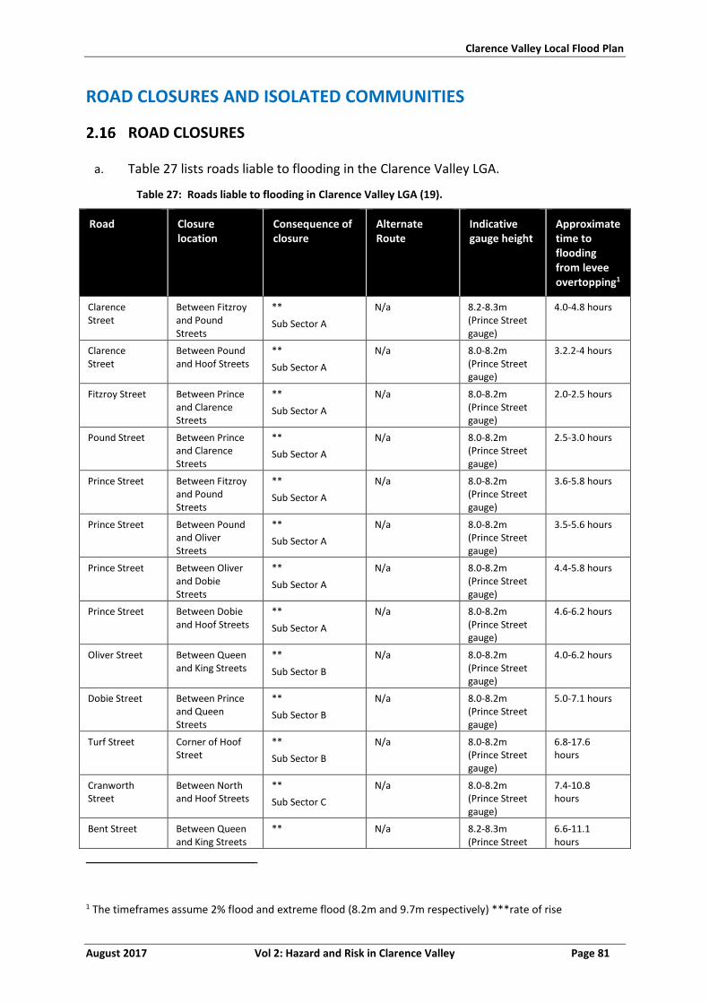
Clarence Valley Local Flood Plan
August 2017 Vol 2: Hazard and Risk in Clarence Valley Page 81
ROAD CLOSURES AND ISOLATED COMMUNITIES
ROAD CLOSURES
a. Table 27 lists roads liable to flooding in the Clarence Valley LGA.
Table 27: Roads liable to flooding in Clarence Valley LGA (19).
Road Closure location
Consequence of closure
Alternate Route
Indicative gauge height
Approximate time to flooding from levee overtopping1
Clarence Street
Between Fitzroy and Pound Streets
**
Sub Sector A
N/a 8.2-8.3m (Prince Street gauge)
4.0-4.8 hours
Clarence Street
Between Pound and Hoof Streets
**
Sub Sector A
N/a 8.0-8.2m (Prince Street gauge)
3.2.2-4 hours
Fitzroy Street Between Prince and Clarence Streets
**
Sub Sector A
N/a 8.0-8.2m (Prince Street gauge)
2.0-2.5 hours
Pound Street Between Prince and Clarence Streets
**
Sub Sector A
N/a 8.0-8.2m (Prince Street gauge)
2.5-3.0 hours
Prince Street Between Fitzroy and Pound Streets
**
Sub Sector A
N/a 8.0-8.2m (Prince Street gauge)
3.6-5.8 hours
Prince Street Between Pound and Oliver Streets
**
Sub Sector A
N/a 8.0-8.2m (Prince Street gauge)
3.5-5.6 hours
Prince Street Between Oliver and Dobie Streets
**
Sub Sector A
N/a 8.0-8.2m (Prince Street gauge)
4.4-5.8 hours
Prince Street Between Dobie and Hoof Streets
**
Sub Sector A
N/a 8.0-8.2m (Prince Street gauge)
4.6-6.2 hours
Oliver Street Between Queen and King Streets
**
Sub Sector B
N/a 8.0-8.2m (Prince Street gauge)
4.0-6.2 hours
Dobie Street Between Prince and Queen Streets
**
Sub Sector B
N/a 8.0-8.2m (Prince Street gauge)
5.0-7.1 hours
Turf Street Corner of Hoof Street
**
Sub Sector B
N/a 8.0-8.2m (Prince Street gauge)
6.8-17.6 hours
Cranworth Street
Between North and Hoof Streets
**
Sub Sector C
N/a 8.0-8.2m (Prince Street gauge)
7.4-10.8 hours
Bent Street Between Queen and King Streets
** N/a 8.2-8.3m (Prince Street
6.6-11.1 hours
1 The timeframes assume 2% flood and extreme flood (8.2m and 9.7m respectively) ***rate of rise
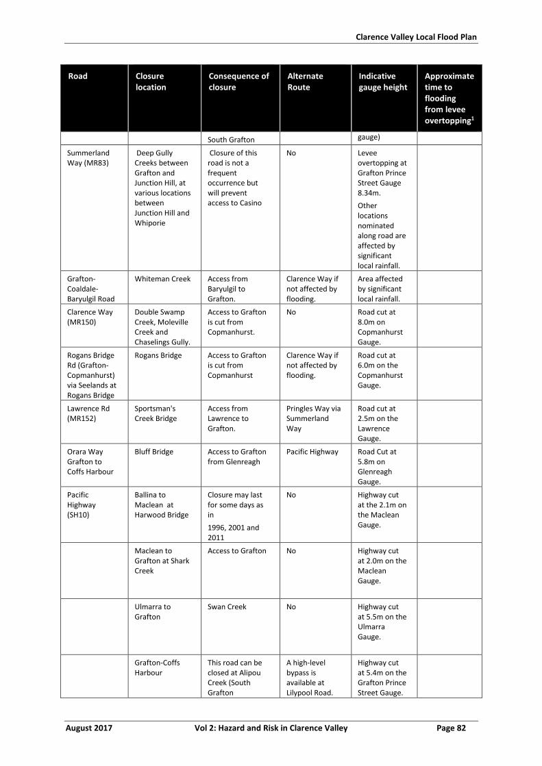
Clarence Valley Local Flood Plan
August 2017 Vol 2: Hazard and Risk in Clarence Valley Page 82
Road Closure location
Consequence of closure
Alternate Route
Indicative gauge height
Approximate time to flooding from levee overtopping1
South Grafton gauge)
Summerland Way (MR83)
Deep Gully Creeks between Grafton and Junction Hill, at various locations between Junction Hill and Whiporie
Closure of this road is not a frequent occurrence but will prevent access to Casino
No Levee overtopping at Grafton Prince Street Gauge 8.34m.
Other locations nominated along road are affected by significant local rainfall.
Grafton-Coaldale-Baryulgil Road
Whiteman Creek Access from Baryulgil to Grafton.
Clarence Way if not affected by flooding.
Area affected by significant local rainfall.
Clarence Way (MR150)
Double Swamp Creek, Moleville Creek and Chaselings Gully.
Access to Grafton is cut from Copmanhurst.
No Road cut at 8.0m on Copmanhurst Gauge.
Rogans Bridge Rd (Grafton-Copmanhurst) via Seelands at Rogans Bridge
Rogans Bridge Access to Grafton is cut from Copmanhurst
Clarence Way if not affected by flooding.
Road cut at 6.0m on the Copmanhurst Gauge.
Lawrence Rd (MR152)
Sportsman's Creek Bridge
Access from Lawrence to Grafton.
Pringles Way via Summerland Way
Road cut at 2.5m on the Lawrence Gauge.
Orara Way Grafton to Coffs Harbour
Bluff Bridge Access to Grafton from Glenreagh
Pacific Highway Road Cut at 5.8m on Glenreagh Gauge.
Pacific Highway (SH10)
Ballina to Maclean at Harwood Bridge
Closure may last for some days as in
1996, 2001 and 2011
No
Highway cut at the 2.1m on the Maclean Gauge.
Maclean to Grafton at Shark Creek
Access to Grafton
No
Highway cut at 2.0m on the Maclean Gauge.
Ulmarra to Grafton
Swan Creek
No
Highway cut at 5.5m on the Ulmarra Gauge.
Grafton-Coffs Harbour
This road can be closed at Alipou Creek (South Grafton
A high-level bypass is available at Lilypool Road.
Highway cut at 5.4m on the Grafton Prince Street Gauge.
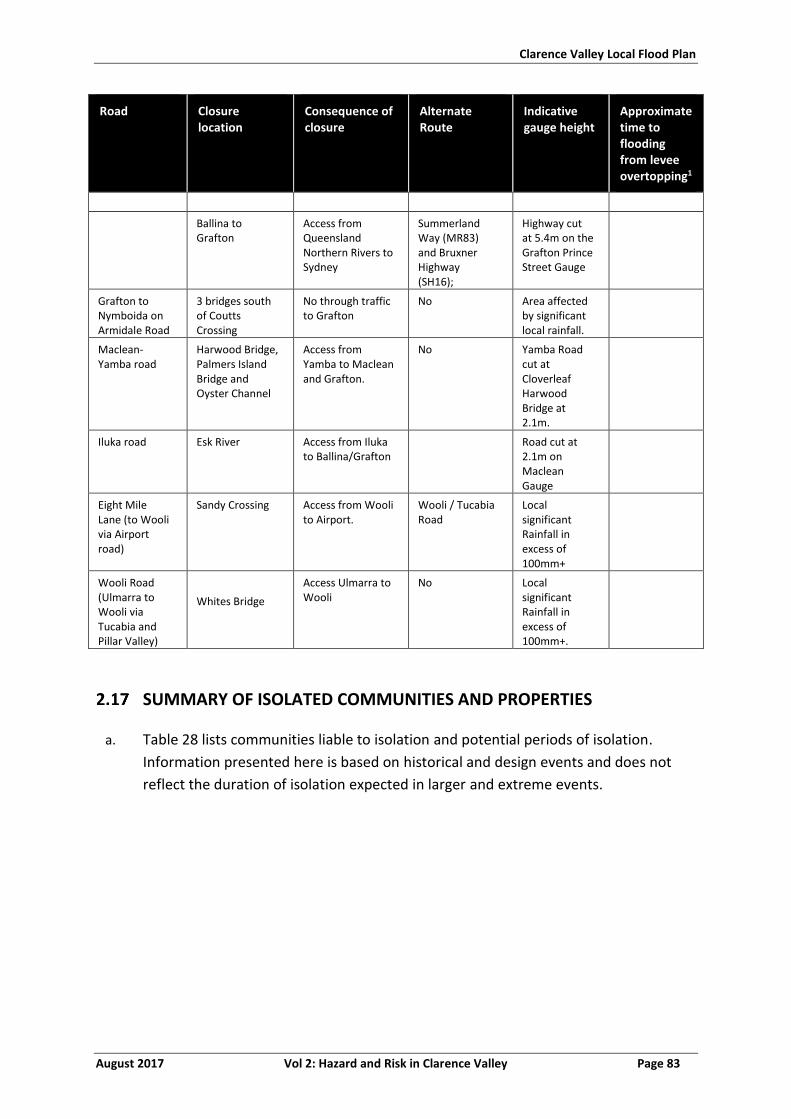
Clarence Valley Local Flood Plan
August 2017 Vol 2: Hazard and Risk in Clarence Valley Page 83
Road Closure location
Consequence of closure
Alternate Route
Indicative gauge height
Approximate time to flooding from levee overtopping1
Ballina to Grafton
Access from Queensland Northern Rivers to Sydney
Summerland Way (MR83) and Bruxner Highway (SH16);
Highway cut at 5.4m on the Grafton Prince Street Gauge
Grafton to Nymboida on Armidale Road
3 bridges south of Coutts Crossing
No through traffic to Grafton
No Area affected by significant local rainfall.
Maclean-Yamba road
Harwood Bridge, Palmers Island Bridge and Oyster Channel
Access from Yamba to Maclean and Grafton.
No Yamba Road cut at Cloverleaf Harwood Bridge at 2.1m.
Iluka road Esk River Access from Iluka to Ballina/Grafton
Road cut at 2.1m on Maclean Gauge
Eight Mile Lane (to Wooli via Airport road)
Sandy Crossing
Access from Wooli to Airport.
Wooli / Tucabia Road
Local significant Rainfall in excess of 100mm+
Wooli Road (Ulmarra to Wooli via Tucabia and Pillar Valley)
Whites Bridge
Access Ulmarra to Wooli
No Local significant Rainfall in excess of 100mm+.
SUMMARY OF ISOLATED COMMUNITIES AND PROPERTIES
a. Table 28 lists communities liable to isolation and potential periods of isolation.
Information presented here is based on historical and design events and does not
reflect the duration of isolation expected in larger and extreme events.
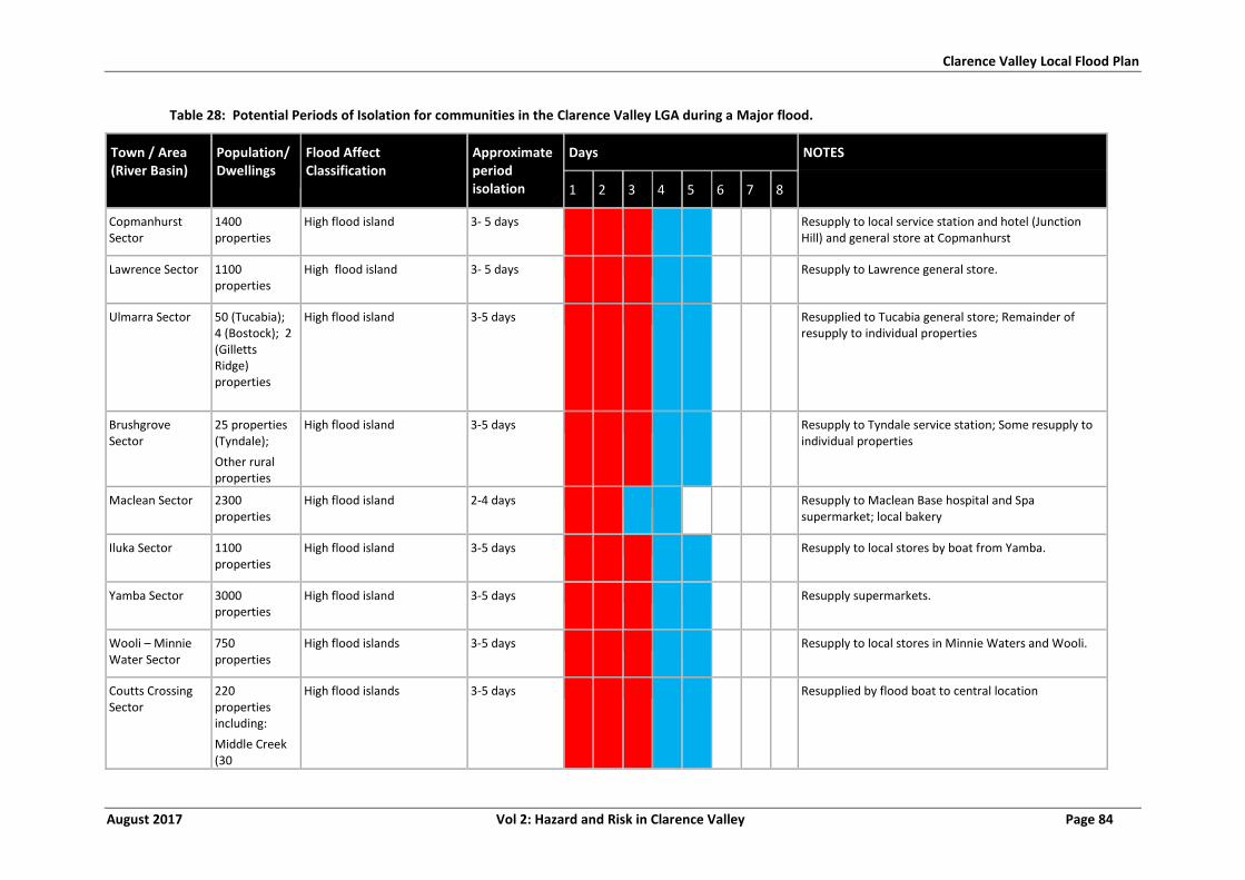
Clarence Valley Local Flood Plan
August 2017 Vol 2: Hazard and Risk in Clarence Valley Page 84
Table 28: Potential Periods of Isolation for communities in the Clarence Valley LGA during a Major flood.
Town / Area (River Basin)
Population/ Dwellings
Flood Affect Classification
Approximate period isolation
Days NOTES
1 2 3 4 5 6 7 8
Copmanhurst Sector
1400 properties
High flood island 3- 5 days Resupply to local service station and hotel (Junction Hill) and general store at Copmanhurst
Lawrence Sector 1100 properties
High flood island 3- 5 days Resupply to Lawrence general store.
Ulmarra Sector 50 (Tucabia); 4 (Bostock); 2 (Gilletts Ridge) properties
High flood island 3-5 days Resupplied to Tucabia general store; Remainder of resupply to individual properties
Brushgrove Sector
25 properties (Tyndale);
Other rural properties
High flood island 3-5 days Resupply to Tyndale service station; Some resupply to individual properties
Maclean Sector 2300 properties
High flood island 2-4 days Resupply to Maclean Base hospital and Spa supermarket; local bakery
Iluka Sector 1100 properties
High flood island 3-5 days Resupply to local stores by boat from Yamba.
Yamba Sector 3000 properties
High flood island 3-5 days Resupply supermarkets.
Wooli – Minnie Water Sector
750 properties
High flood islands 3-5 days Resupply to local stores in Minnie Waters and Wooli.
Coutts Crossing Sector
220 properties including:
Middle Creek (30
High flood islands
3-5 days Resupplied by flood boat to central location
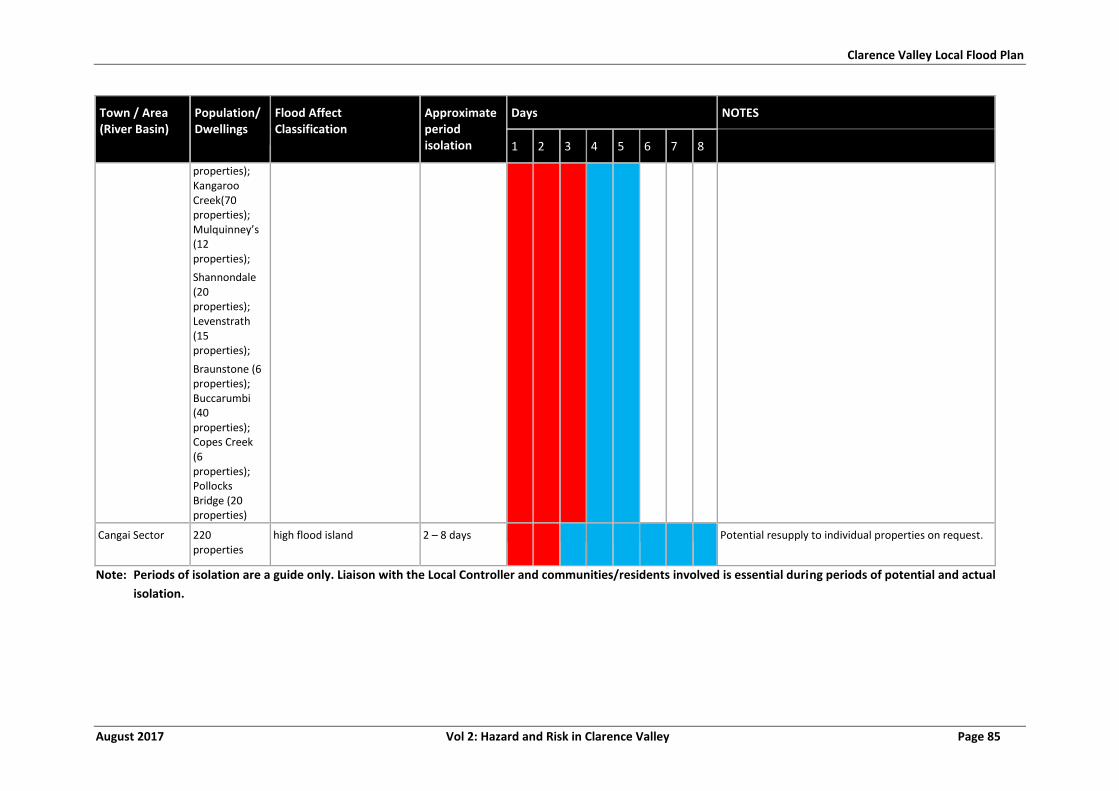
Clarence Valley Local Flood Plan
August 2017 Vol 2: Hazard and Risk in Clarence Valley Page 85
Town / Area (River Basin)
Population/ Dwellings
Flood Affect Classification
Approximate period isolation
Days NOTES
1 2 3 4 5 6 7 8
properties); Kangaroo Creek(70 properties); Mulquinney’s (12 properties);
Shannondale (20 properties); Levenstrath (15 properties);
Braunstone (6 properties); Buccarumbi (40 properties); Copes Creek (6 properties); Pollocks Bridge (20 properties)
Cangai Sector 220 properties
high flood island 2 – 8 days Potential resupply to individual properties on request.
Note: Periods of isolation are a guide only. Liaison with the Local Controller and communities/residents involved is essential during periods of potential and actual
isolation.
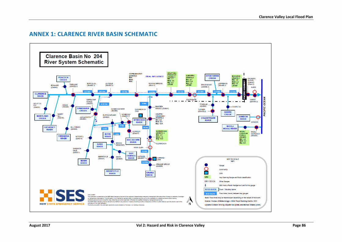
Clarence Valley Local Flood Plan
August 2017 Vol 2: Hazard and Risk in Clarence Valley Page 86
ANNEX 1: CLARENCE RIVER BASIN SCHEMATIC
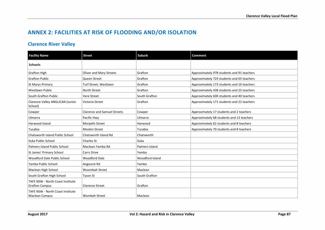
Clarence Valley Local Flood Plan
August 2017 Vol 2: Hazard and Risk in Clarence Valley Page 87
ANNEX 2: FACILITIES AT RISK OF FLOODING AND/OR ISOLATION
Clarence River Valley
Facility Name Street Suburb Comment
Schools
Grafton High Oliver and Mary Streets Grafton Approximately 978 students and 91 teachers
Grafton Public Queen Street Grafton Approximately 724 students and 65 teachers
St Marys Primary Turf Street, Westlawn Grafton Approximately 173 students and 16 teachers
Westlawn Public North Street Grafton Approximately 438 students and 25 teachers
South Grafton Public Vere Street South Grafton Approximately 600 students and 40 teachers
Clarence Valley ANGLICAN (Junior School)
Victoria Street Grafton Approximately 171 students and 22 teachers
Cowper Clarence and Samuel Streets Cowper Approximately 17 students and 2 teachers
Ulmarra Pacific Hwy Ulmarra Approximately 68 students and 13 teachers
Harwood Island Morpeth Street Harwood Approximately 62 students and 8 teachers
Tucabia Mookin Street Tucabia Approximately 70 students and 8 teachers
Chatsworth Island Public School Chatsworth Island Rd Chatsworth
Iluka Public School Charles St Iluka
Palmers Island Public School Maclean-Yamba Rd Palmers Island
St James' Primary School Carrs Drive Yamba
Woodford Dale Public School Woodford Dale Woodford Island
Yamba Public School Angourie Rd Yamba
Maclean High School Woombah Street Maclean
South Grafton High School Tyson St South Grafton
TAFE NSW - North Coast Institute Grafton Campus Clarence Street Grafton
TAFE NSW - North Coast Institute Maclean Campus Wombah Street Maclean

Clarence Valley Local Flood Plan
August 2017 Vol 2: Hazard and Risk in Clarence Valley Page 88
Facility Name Street Suburb Comment
Child Care Centres
South Grafton Multi-Purpose Childcare Centre
Cnr Skinner and Spring Streets South Grafton Approximately 60 students and 9 teachers
Bright Sparks Child Development Centre
Bacon Street Grafton Approximately 50 students and 5 teachers
Blinky’s Children’s Centre Cranworth Street Grafton Approximately 29 students and 5 teachers
Jack And Jill Prince Street Approximately 25 students and 5 teachers
Westlawn Pre-School Milton Street Grafton Approximately 24 students and 4 teachers
Abc Duke Street Approximately 80 students and 20 teachers
Nuture One Arthur Street Approximately 71 students and 14 teachers
Arthur Street Children's Centre Arthur Street Grafton
Clarence Family Day Care Turf Street Grafton
Clarence Valley Anglican School - After School Care Victoria Street Grafton
Coldstream Community Preschool Clarence Street Tucabia
Coldstream Community Pre-School Clarence Street Tucabia
Community OOSH Services South Grafton
South Grafton Public School, Vere Street South Grafton
Community OOSH Services Westlawn
Westlawn Public School, North Street Grafton
Goodstart Early Learning Grafton Duke Street Grafton
Gummyaney Aboriginal Corporation Pound Street Grafton
Iluka Pre-School Micalo Street Iluka
Jacaranda Pre-School Kindergarten Kelly Street Grafton South
Kangabunnabys Childcare Centre Providence Court Yamba
South Grafton Out of School Hours Care (South Grafton Multipurpose Childcare Corner Spring and Skinner Streets South Grafton
St James Outside Hours Care St James School, Lot 1 Carrs Drive Yamba
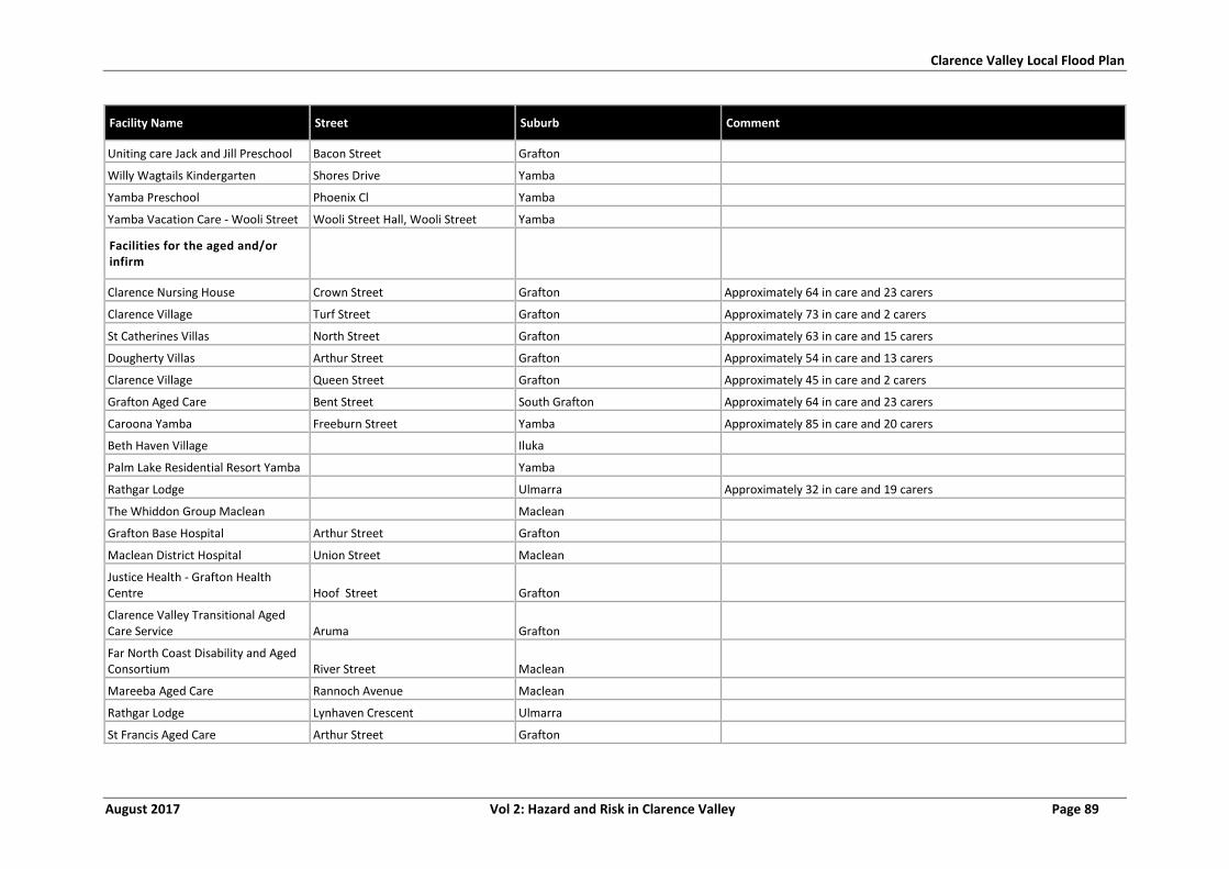
Clarence Valley Local Flood Plan
August 2017 Vol 2: Hazard and Risk in Clarence Valley Page 89
Facility Name Street Suburb Comment
Uniting care Jack and Jill Preschool Bacon Street Grafton
Willy Wagtails Kindergarten Shores Drive Yamba
Yamba Preschool Phoenix Cl Yamba
Yamba Vacation Care - Wooli Street Wooli Street Hall, Wooli Street Yamba
Facilities for the aged and/or infirm
Clarence Nursing House Crown Street Grafton Approximately 64 in care and 23 carers
Clarence Village Turf Street Grafton Approximately 73 in care and 2 carers
St Catherines Villas North Street Grafton Approximately 63 in care and 15 carers
Dougherty Villas Arthur Street Grafton Approximately 54 in care and 13 carers
Clarence Village Queen Street Grafton Approximately 45 in care and 2 carers
Grafton Aged Care Bent Street South Grafton Approximately 64 in care and 23 carers
Caroona Yamba Freeburn Street Yamba Approximately 85 in care and 20 carers
Beth Haven Village Iluka
Palm Lake Residential Resort Yamba Yamba
Rathgar Lodge Ulmarra Approximately 32 in care and 19 carers
The Whiddon Group Maclean Maclean
Grafton Base Hospital Arthur Street Grafton
Maclean District Hospital Union Street Maclean
Justice Health - Grafton Health Centre Hoof Street Grafton
Clarence Valley Transitional Aged Care Service Aruma Grafton
Far North Coast Disability and Aged Consortium River Street Maclean
Mareeba Aged Care Rannoch Avenue Maclean
Rathgar Lodge Lynhaven Crescent Ulmarra
St Francis Aged Care Arthur Street Grafton
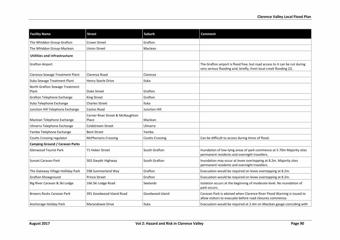
Clarence Valley Local Flood Plan
August 2017 Vol 2: Hazard and Risk in Clarence Valley Page 90
Facility Name Street Suburb Comment
The Whiddon Group-Grafton Crown Street Grafton
The Whiddon Group-Maclean Union Street Maclean
Utilities and infrastructure
Grafton Airport The Grafton airport is flood free, but road access to it can be cut during very serious flooding and, briefly, from local creek flooding (2).
Clarenza Sewage Treatment Plant Clarenza Road Clarenza
Iluka Sewage Treatment Plant Henry Searle Drive Iluka
North Grafton Sewage Treatment Plant Duke Street Grafton
Grafton Telephone Exchange King Street Grafton
Iluka Telephone Exchange Charles Street Iluka
Junction Hill Telephone Exchange Casino Road Junction Hill
Maclean Telephone Exchange Corner River Street & McNaughton Place Maclean
Ulmarra Telephone Exchange Coldstream Street Ulmarra
Yamba Telephone Exchange Bent Street Yamba
Coutts Crossing regulator McPhersons Crossing Coutts Crossing Can be difficult to access during times of flood.
Camping Ground / Caravan Parks
Glenwood Tourist Park 71 Heber Street South Grafton Inundation of low-lying areas of park commence at 5.70m Majority sites permanent residents and overnight travellers.
Sunset Caravan Park 302 Gwydir Highway South Grafton Inundation may occur at levee overtopping at 8.2m. Majority sites permanent residents and overnight travellers.
The Gateway Village Holliday Park 598 Summerland Way Grafton Evacuation would be required on levee overtopping at 8.2m.
Grafton Showground Prince Street Grafton Evacuation would be required on levee overtopping at 8.2m.
Big River Caravan & Ski Lodge 166 Ski Lodge Road Seelands Isolation occurs at the beginning of moderate level. No inundation of park occurs.
Browns Rocks Caravan Park 391 Goodwood Island Road Goodwood Island Caravan Park is advised when Clarence River Flood Warning is issued to allow visitors to evacuate before road closures commence.
Anchorage Holiday Park Marandowie Drive Iluka Evacuation would be required at 2.4m on Maclean gauge coinciding with
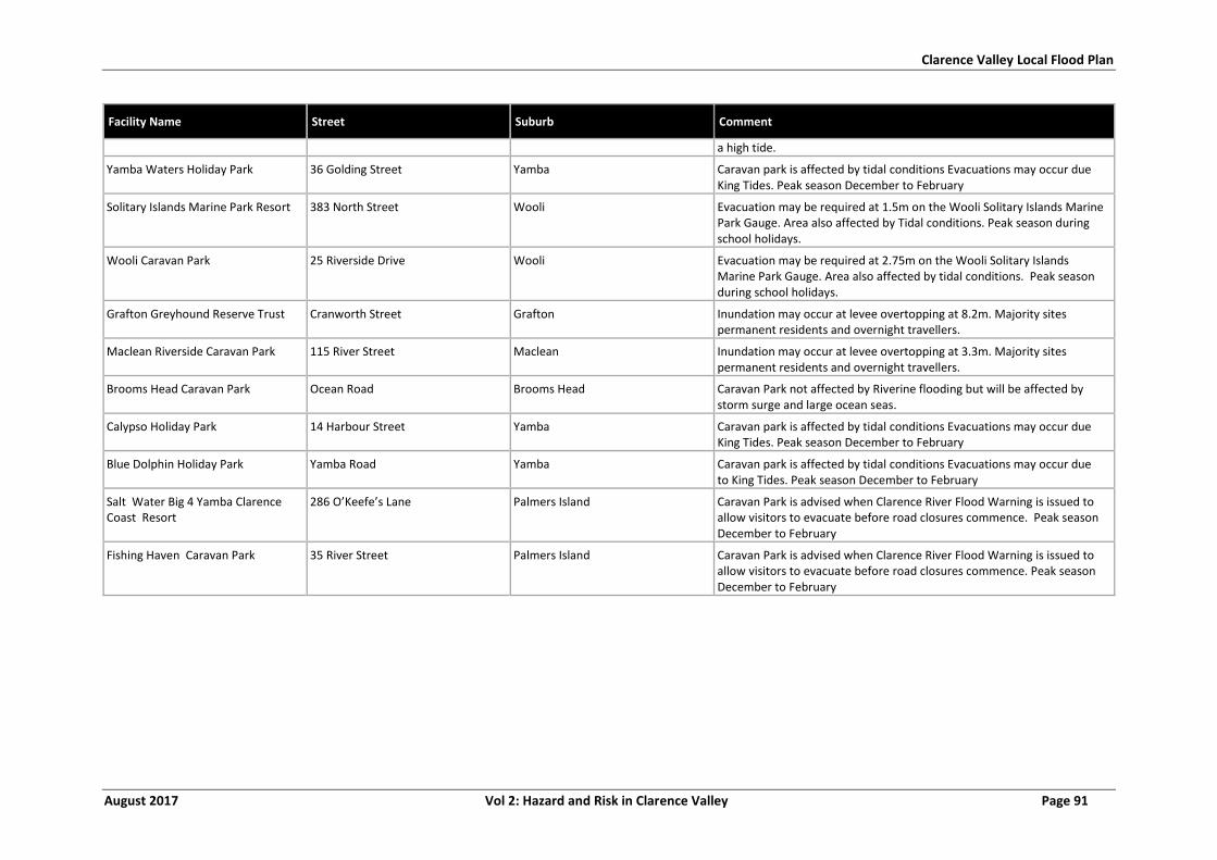
Clarence Valley Local Flood Plan
August 2017 Vol 2: Hazard and Risk in Clarence Valley Page 91
Facility Name Street Suburb Comment
a high tide.
Yamba Waters Holiday Park 36 Golding Street Yamba Caravan park is affected by tidal conditions Evacuations may occur due King Tides. Peak season December to February
Solitary Islands Marine Park Resort 383 North Street Wooli Evacuation may be required at 1.5m on the Wooli Solitary Islands Marine Park Gauge. Area also affected by Tidal conditions. Peak season during school holidays.
Wooli Caravan Park 25 Riverside Drive Wooli Evacuation may be required at 2.75m on the Wooli Solitary Islands Marine Park Gauge. Area also affected by tidal conditions. Peak season during school holidays.
Grafton Greyhound Reserve Trust Cranworth Street Grafton Inundation may occur at levee overtopping at 8.2m. Majority sites permanent residents and overnight travellers.
Maclean Riverside Caravan Park 115 River Street Maclean Inundation may occur at levee overtopping at 3.3m. Majority sites permanent residents and overnight travellers.
Brooms Head Caravan Park Ocean Road Brooms Head Caravan Park not affected by Riverine flooding but will be affected by storm surge and large ocean seas.
Calypso Holiday Park 14 Harbour Street Yamba Caravan park is affected by tidal conditions Evacuations may occur due King Tides. Peak season December to February
Blue Dolphin Holiday Park Yamba Road Yamba Caravan park is affected by tidal conditions Evacuations may occur due to King Tides. Peak season December to February
Salt Water Big 4 Yamba Clarence Coast Resort
286 O’Keefe’s Lane Palmers Island Caravan Park is advised when Clarence River Flood Warning is issued to allow visitors to evacuate before road closures commence. Peak season December to February
Fishing Haven Caravan Park 35 River Street Palmers Island Caravan Park is advised when Clarence River Flood Warning is issued to allow visitors to evacuate before road closures commence. Peak season December to February
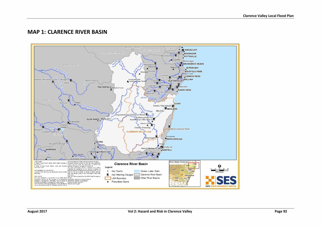
Clarence Valley Local Flood Plan
August 2017 Vol 2: Hazard and Risk in Clarence Valley Page 92
MAP 1: CLARENCE RIVER BASIN
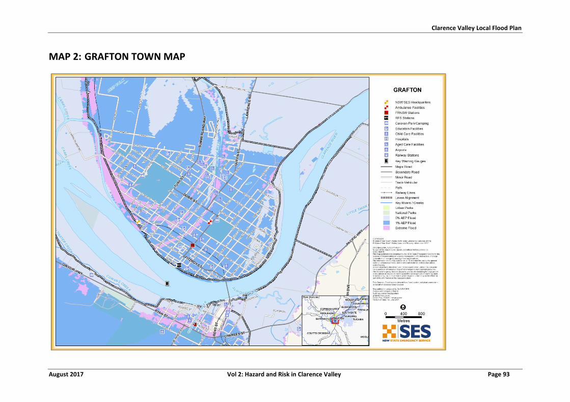
Clarence Valley Local Flood Plan
August 2017 Vol 2: Hazard and Risk in Clarence Valley Page 93
MAP 2: GRAFTON TOWN MAP
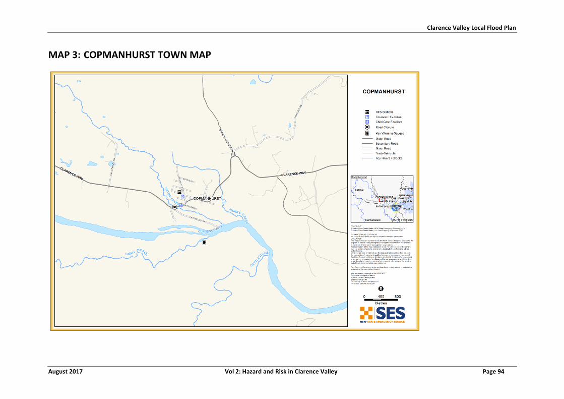
Clarence Valley Local Flood Plan
August 2017 Vol 2: Hazard and Risk in Clarence Valley Page 94
MAP 3: COPMANHURST TOWN MAP
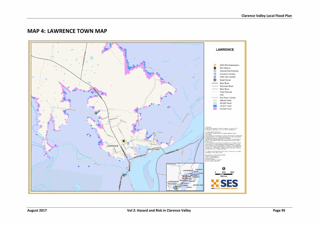
Clarence Valley Local Flood Plan
August 2017 Vol 2: Hazard and Risk in Clarence Valley Page 95
MAP 4: LAWRENCE TOWN MAP
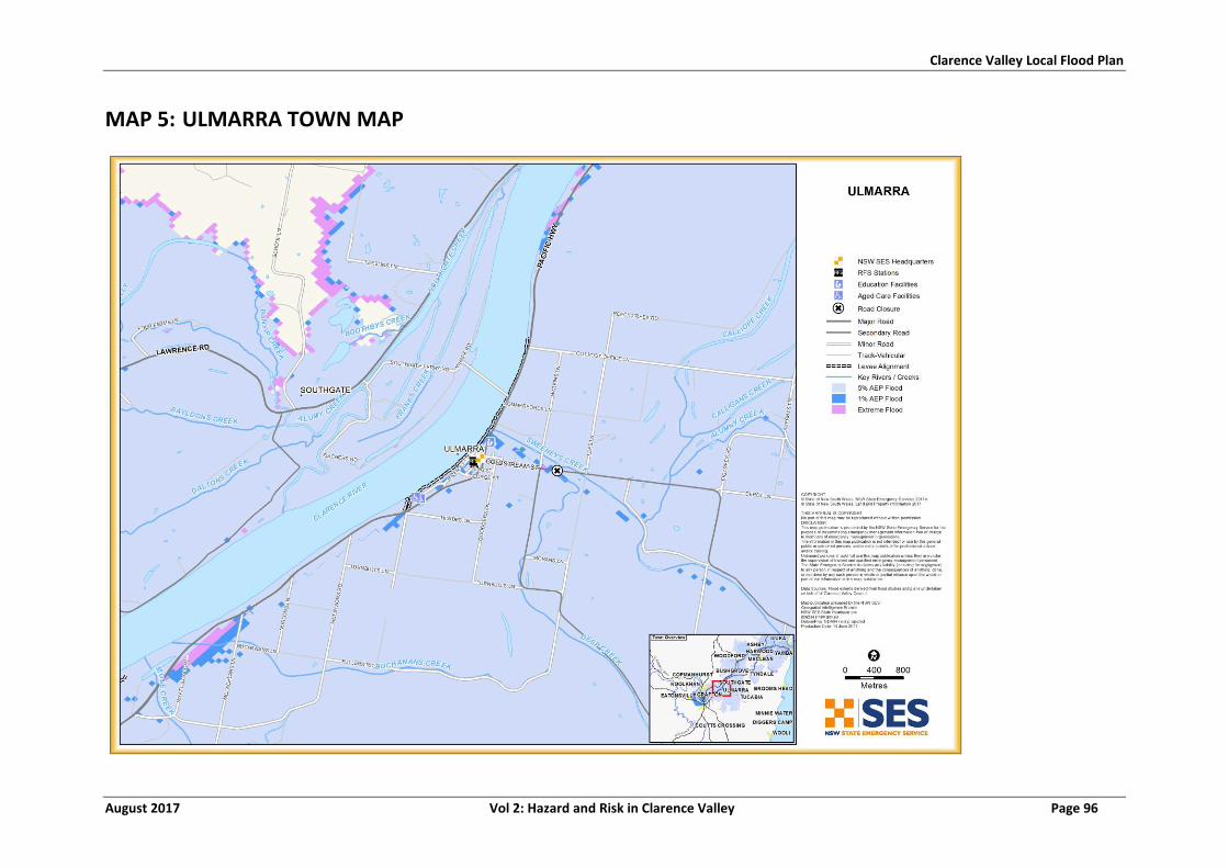
Clarence Valley Local Flood Plan
August 2017 Vol 2: Hazard and Risk in Clarence Valley Page 96
MAP 5: ULMARRA TOWN MAP
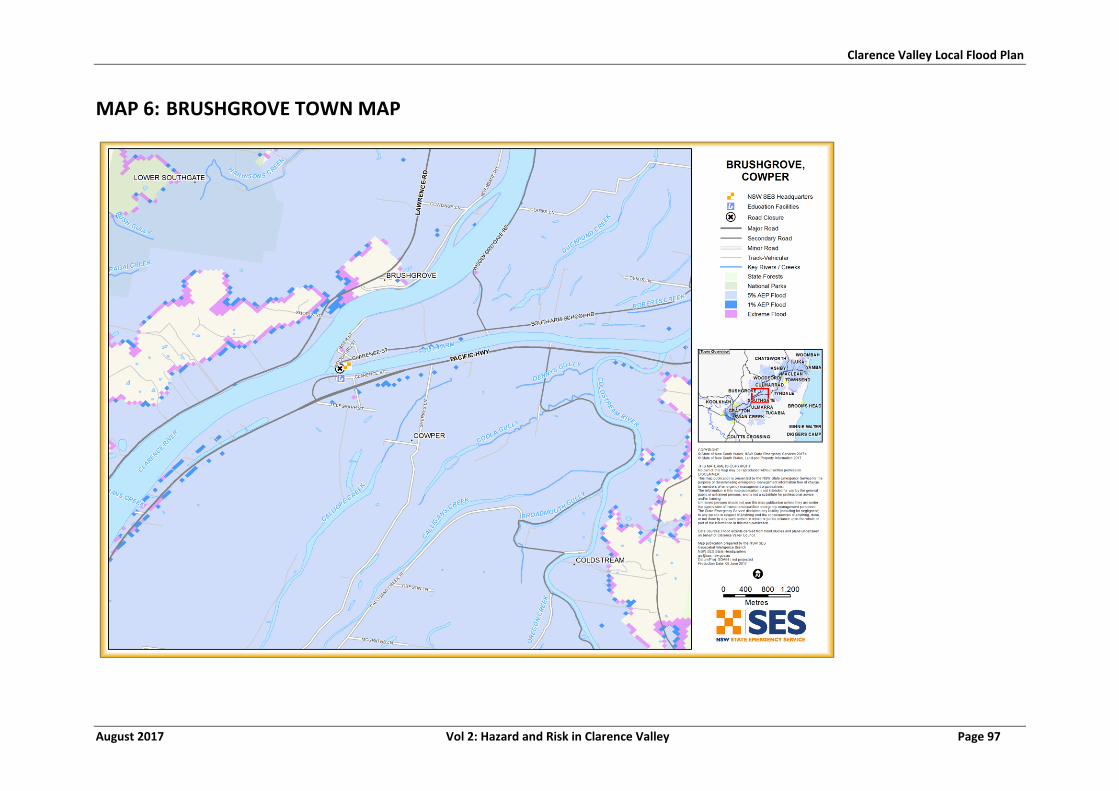
Clarence Valley Local Flood Plan
August 2017 Vol 2: Hazard and Risk in Clarence Valley Page 97
MAP 6: BRUSHGROVE TOWN MAP
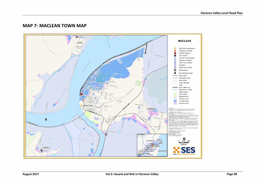
Clarence Valley Local Flood Plan
August 2017 Vol 2: Hazard and Risk in Clarence Valley Page 98
MAP 7: MACLEAN TOWN MAP
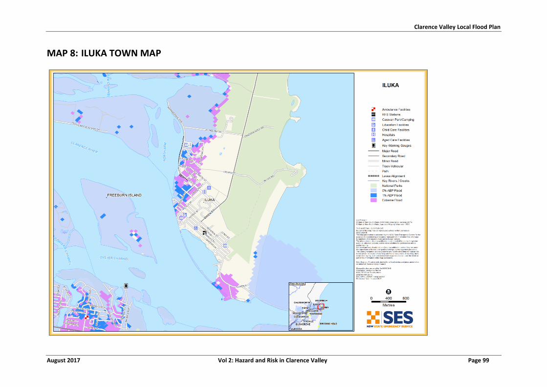
Clarence Valley Local Flood Plan
August 2017 Vol 2: Hazard and Risk in Clarence Valley Page 99
MAP 8: ILUKA TOWN MAP
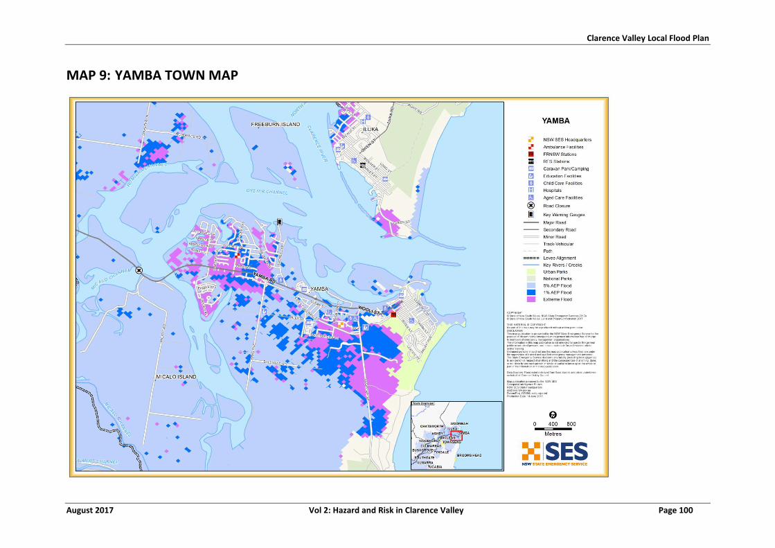
Clarence Valley Local Flood Plan
August 2017 Vol 2: Hazard and Risk in Clarence Valley Page 100
MAP 9: YAMBA TOWN MAP
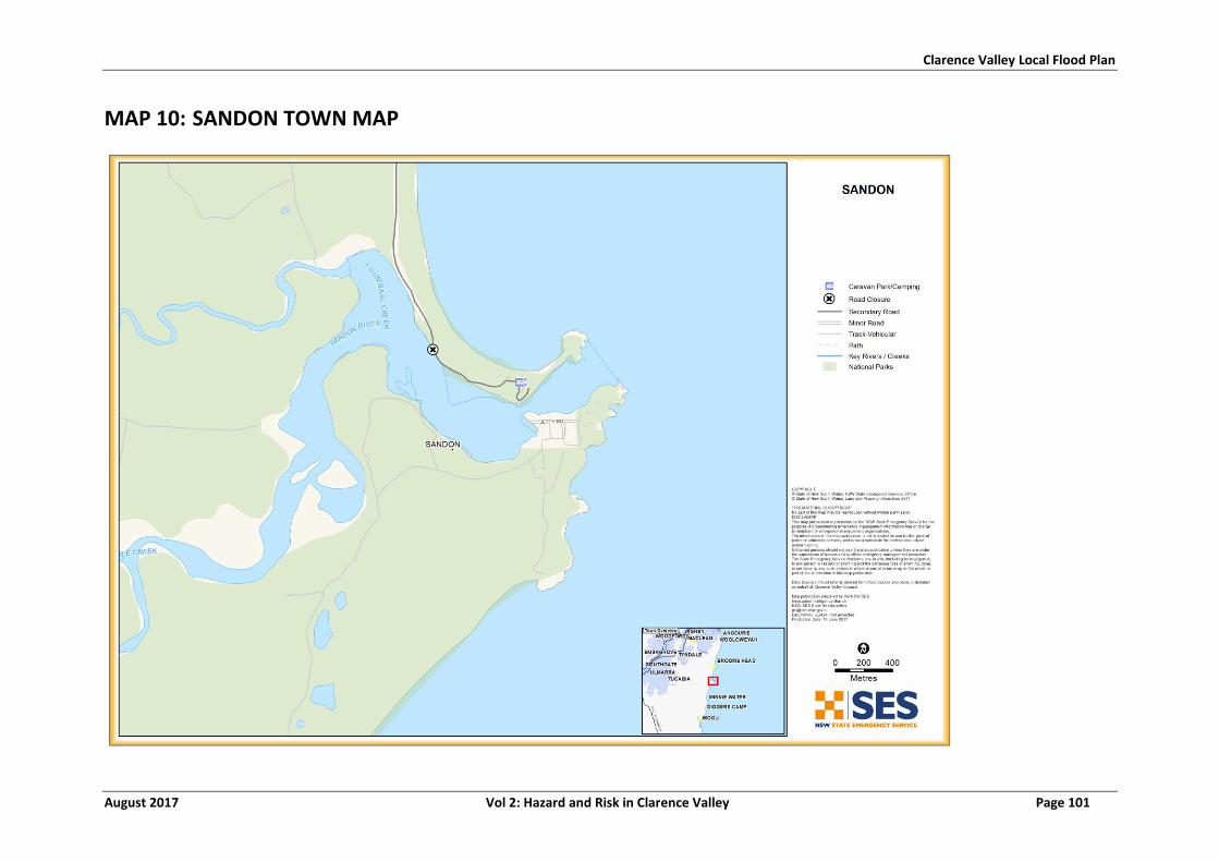
Clarence Valley Local Flood Plan
August 2017 Vol 2: Hazard and Risk in Clarence Valley Page 101
MAP 10: SANDON TOWN MAP

Clarence Valley Local Flood Plan
August 2017 Vol 2: Hazard and Risk in Clarence Valley Page 102
MAP 11: WOOLI-MINNIE WATER TOWN MAP
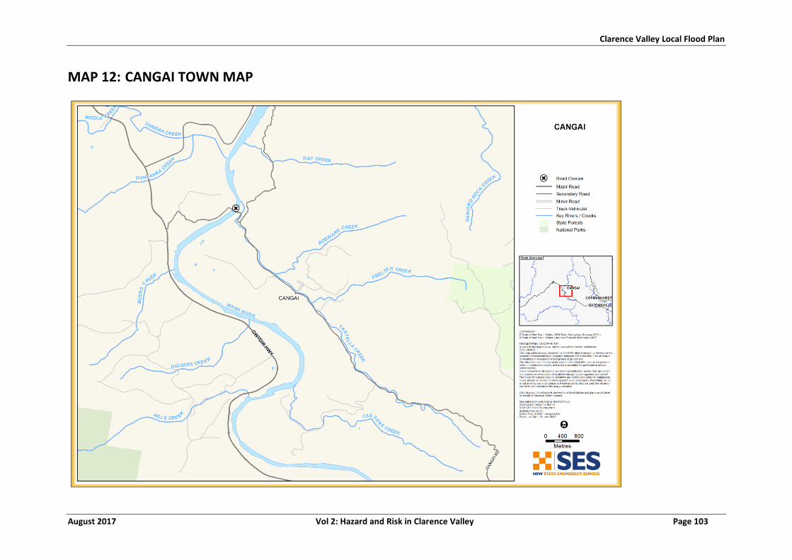
Clarence Valley Local Flood Plan
August 2017 Vol 2: Hazard and Risk in Clarence Valley Page 103
MAP 12: CANGAI TOWN MAP
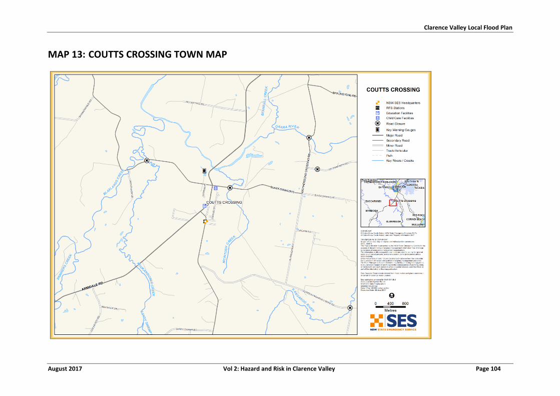
Clarence Valley Local Flood Plan
August 2017 Vol 2: Hazard and Risk in Clarence Valley Page 104
MAP 13: COUTTS CROSSING TOWN MAP
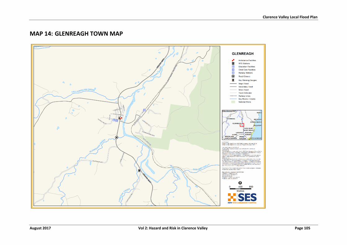
Clarence Valley Local Flood Plan
August 2017 Vol 2: Hazard and Risk in Clarence Valley Page 105
MAP 14: GLENREAGH TOWN MAP
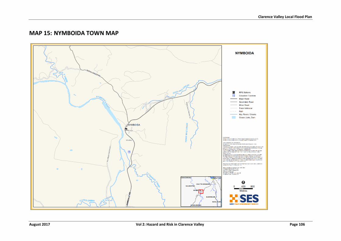
Clarence Valley Local Flood Plan
August 2017 Vol 2: Hazard and Risk in Clarence Valley Page 106
MAP 15: NYMBOIDA TOWN MAP
Clarence Valley Local Flood Plan
August 2017 Vol 2: Hazard and Risk in Clarence Valley Page 107
LIST OF REFERENCES
1. Clarence Valley LEMC. Clarence Valley EMPLAN. 2016.
2. NSW State Emergency Service. Clarence Valley Local Flood Plan. 2012.
3. GHD. Glenreagh Flood Study. s.l. : Clarence Valley Council, 2013.
4. NSW Public Works (Dams & Civil). Shannonn Creek Dam Dam Safety Emergency Plan.
August 2016 update.
5. Clarence Valley Council. Pers. comm. 2016a.
6. Australian Heritage Commission. 1998.
7. McAndrew, K., Stubbs, M. and Anderson, T. Knowing when to get them out - improving
flood evacuation planning through flood modelling and stakeholder involvement. Brisbane :
2015 Floodplain Management Australia National Conference, 2015.
8. BMT WBM. Lower CLarence Flood Model Update. s.l. : Clarence Valley Council, 2013.
9. WBM. Lower Clarence Flood Study Review. 2004.
10. Bewsher. GRAFTON AND LOWER CLARENCE FLOODPLAIN RISK MANAGEMENT PLAN.
s.l. : Clarence Valley Council, 2007.
11. WorleyParsons. Wooli Beach Village Review of Coastal Hazards. s.l. : Clarence Valley
Council, 2010.
12. Royal Haskoning DHV. Wooli Beach Coastal Zone Management Plan. s.l. : Clarence
Valley Council, 2015.
13. Australian Bureau of Statistics. Census. 2011.
14. NSW SES. Flood Intelligence.
15. McAndrew, K. The number of premises with floor levels below design floods. s.l. :
Clarence Valley Council, 2016.
16. BMT WBM. Grafton levee overtopping study - SES evacuation report. 2013a.
17. Public Works Department. Visual Audit of North Grafton Levee. 2015.
18. —. Visual Audit of South Grafton Levee. 2015.
19. BMT WBM. Grafton, South Grafton and Maclean Emergency Management Report. s.l. :
Clarence Valley Council, 2014.
20. Public Works Department. Ulmarra Flood Mitigation - Levee Study Audit. 2015.
Clarence Valley Local Flood Plan
August 2017 Vol 2: Hazard and Risk in Clarence Valley Page 108
21. GHD. Grafton and Lower Clarence Floodplain Risk Management Plan. Clarence Valley
Council : s.n., 2014.
22. Public Works Department. Visual Audit of Maclean Levee. 2015.
23. Clarence Valley Council. Brooms Head Emergency Action Sub-Plan. 2012.
24. —. Draft - Wolli Emergency Action Sub Plan. 2012.
SES RESPONSE
ARRANGEMENTS FOR
CLARENCE VALLEY
Volume 3 of the Clarence Valley Local Flood Plan
CONTENTS
Chapter 1: Flood Warning Systems and Arrangements
- Dissemination options for NSW SES flood information and warning products.
- Gauges monitored by the NSW SES within the LGA.
Chapter 2: SES Locality Response Arrangements
- NSW SES flood response arrangements by individual sector within the LGA.
Chapter 4: SES Caravan Park Arrangements
- Arrangements for the Evacuation of flood liable Caravan Parks within the
LGA.
- Specific arrangements for individual parks likely to be affected by flooding.
VERSION LIST
The following table lists all previously approved versions of this Volume.
Description Date
Clarence Valley Local Flood Plan 2012
AMENDMENT LIST
Suggestions for amendments to this Volume should be forwarded to:
The Clarence Valley Local Controller
NSW State Emergency Service
26 Induna Street GRAFTON NSW 2460
Amendments promulgated in the amendments list below have been entered in this Volume.
Amendment Number
Description Updated by Date
CLARENCE VALLEY: FLOOD WARNING
SYSTEMS AND ARRANGEMENTS
Volume 3, Chapter 1 of the Clarence Valley Local Flood Plan
(NSW SES Response Arrangements for Clarence Valley)
Last Update: August 2017
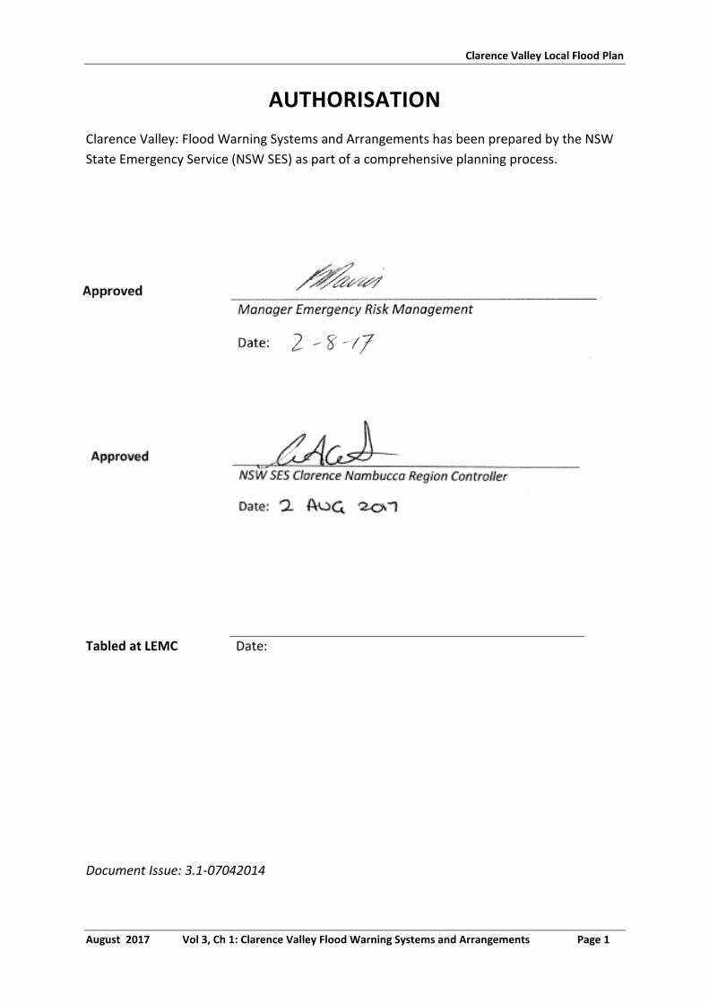
Clarence Valley Local Flood Plan
August 2017 Vol 3, Ch 1: Clarence Valley Flood Warning Systems and Arrangements Page 1
AUTHORISATION
Clarence Valley: Flood Warning Systems and Arrangements has been prepared by the NSW
State Emergency Service (NSW SES) as part of a comprehensive planning process.
Tabled at LEMC Date:
Document Issue: 3.1-07042014
Clarence Valley Local Flood Plan
August 2017 Vol 3, Ch 1: Clarence Valley Flood Warning Systems and Arrangements Page 2
CONTENTS
AUTHORISATION ............................................................................................................................................. 1
1. GAUGES MONITORED BY THE NSW SES CLARENCE VALLEY UNIT HEADQUARTERS ................................. 3
2. DISSEMINATION OPTIONS FOR NSW SES FLOOD INFORMATION AND WARNING PRODUCTS ................. 5
LIST OF TABLES
TABLE 1: GAUGES MONITORED BY THE NSW SES CLARENCE VALLEY UNIT HEADQUARTERS ............................ 3
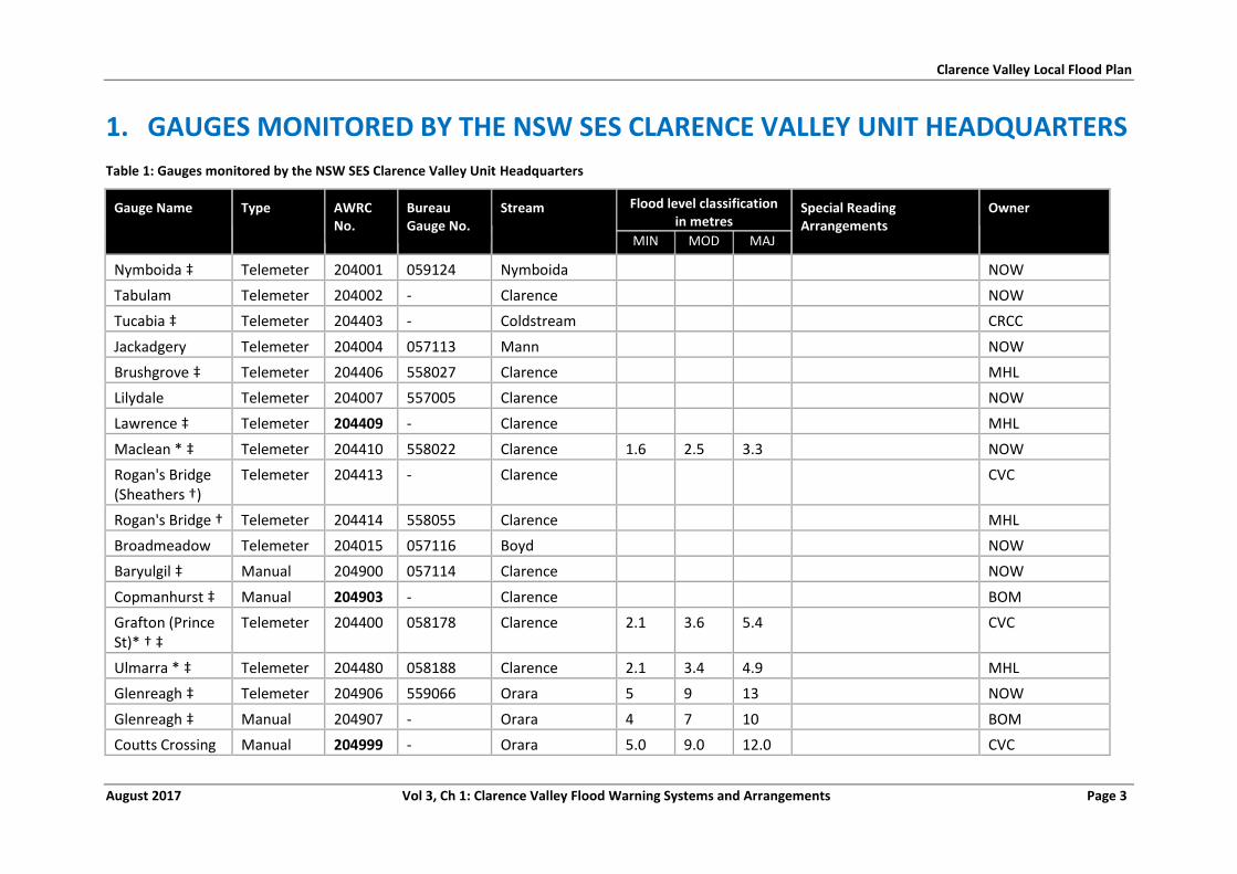
Clarence Valley Local Flood Plan
August 2017 Vol 3, Ch 1: Clarence Valley Flood Warning Systems and Arrangements Page 3
1. GAUGES MONITORED BY THE NSW SES CLARENCE VALLEY UNIT HEADQUARTERS
Table 1: Gauges monitored by the NSW SES Clarence Valley Unit Headquarters
Gauge Name Type AWRC No.
Bureau Gauge No.
Stream Flood level classification in metres
Special Reading Arrangements
Owner
MIN MOD MAJ
Nymboida ‡ Telemeter 204001 059124 Nymboida NOW
Tabulam Telemeter 204002 - Clarence NOW
Tucabia ‡ Telemeter 204403 - Coldstream CRCC
Jackadgery Telemeter 204004 057113 Mann NOW
Brushgrove ‡ Telemeter 204406 558027 Clarence MHL
Lilydale Telemeter 204007 557005 Clarence NOW
Lawrence ‡ Telemeter 204409 - Clarence MHL
Maclean * ‡ Telemeter 204410 558022 Clarence 1.6 2.5 3.3 NOW
Rogan's Bridge (Sheathers †)
Telemeter 204413 - Clarence CVC
Rogan's Bridge † Telemeter 204414 558055 Clarence MHL
Broadmeadow Telemeter 204015 057116 Boyd NOW
Baryulgil ‡ Manual 204900 057114 Clarence NOW
Copmanhurst ‡ Manual 204903 - Clarence BOM
Grafton (Prince St)* † ‡
Telemeter 204400 058178 Clarence 2.1 3.6 5.4 CVC
Ulmarra * ‡ Telemeter 204480 058188 Clarence 2.1 3.4 4.9 MHL
Glenreagh ‡ Telemeter 204906 559066 Orara 5 9 13 NOW
Glenreagh ‡ Manual 204907 - Orara 4 7 10 BOM
Coutts Crossing Manual 204999 - Orara 5.0 9.0 12.0 CVC
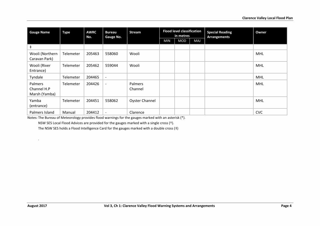
Clarence Valley Local Flood Plan
August 2017 Vol 3, Ch 1: Clarence Valley Flood Warning Systems and Arrangements Page 4
Gauge Name Type AWRC No.
Bureau Gauge No.
Stream Flood level classification in metres
Special Reading Arrangements
Owner
MIN MOD MAJ
‡
Wooli (Northern Caravan Park)
Telemeter 205463 558060 Wooli MHL
Wooli (River Entrance)
Telemeter 205462 559044 Wooli MHL
Tyndale Telemeter 204465 - MHL
Palmers Channel H.P Marsh (Yamba)
Telemeter 204426 - Palmers Channel
MHL
Yamba (entrance)
Telemeter 204451 558062 Oyster Channel MHL
Palmers Island Manual 204412 - Clarence CVC Notes: The Bureau of Meteorology provides flood warnings for the gauges marked with an asterisk (*).
NSW SES Local Flood Advices are provided for the gauges marked with a single cross (†).
The NSW SES holds a Flood Intelligence Card for the gauges marked with a double cross (‡)
.
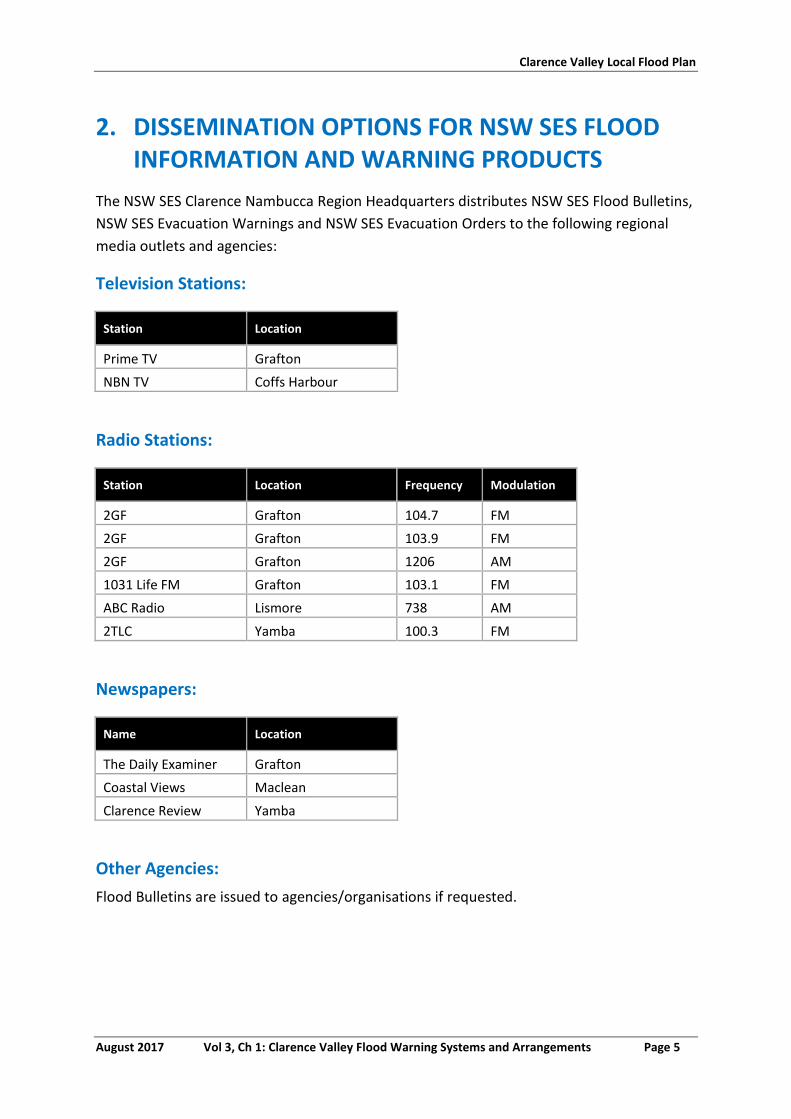
Clarence Valley Local Flood Plan
August 2017 Vol 3, Ch 1: Clarence Valley Flood Warning Systems and Arrangements Page 5
2. DISSEMINATION OPTIONS FOR NSW SES FLOOD INFORMATION AND WARNING PRODUCTS
The NSW SES Clarence Nambucca Region Headquarters distributes NSW SES Flood Bulletins,
NSW SES Evacuation Warnings and NSW SES Evacuation Orders to the following regional
media outlets and agencies:
Television Stations:
Station Location
Prime TV Grafton
NBN TV Coffs Harbour
Radio Stations:
Station Location Frequency Modulation
2GF Grafton 104.7 FM
2GF Grafton 103.9 FM
2GF Grafton 1206 AM
1031 Life FM Grafton 103.1 FM
ABC Radio Lismore 738 AM
2TLC Yamba 100.3 FM
Newspapers:
Name Location
The Daily Examiner Grafton
Coastal Views Maclean
Clarence Review Yamba
Other Agencies:
Flood Bulletins are issued to agencies/organisations if requested.
CLARENCE VALLEY: NSW SES LOCALITY
RESPONSE ARRANGEMENTS
Volume 3, Chapter 2 of the Clarence Valley Local Flood Plan
(NSW SES Response Arrangements for Clarence Valley)
Last Update: August 2017
Clarence Valley Local Flood Plan
August 2017 Vol 3, Ch 2: Clarence Valley NSW SES Locality Response Arrangements Page 1
AUTHORISATION
NSW SES Locality Response Arrangements in Clarence Valley has been prepared by the NSW
State Emergency Service (NSW SES) as part of a comprehensive planning process.
Tabled at LEMC
Date:
Document Issue: V3.2-07042014
Clarence Valley Local Flood Plan
August 2017 Vol 3, Ch 2: Clarence Valley NSW SES Locality Response Arrangements Page 2
CONTENTS
AUTHORISATION ............................................................................................................................................. 1
CONTENTS ....................................................................................................................................................... 2
LIST OF TABLES ................................................................................................................................................ 3
SECTOR OVERVIEW .......................................................................................................................................... 4
1. GRAFTON SECTOR .............................................................................................................................. 6
1.1. Grafton Sector ....................................................................................................................................... 6
1.2. Grafton Sector Map ............................................................................................................................. 12
2. COPMANHURST SECTOR .................................................................................................................. 13
2.1. Copmanhurst Sector ............................................................................................................................ 13
2.2. Copmanhurst Sector Map .................................................................................................................... 16
3. LAWRENCE SECTOR .......................................................................................................................... 17
3.1. Lawrence Sector .................................................................................................................................. 17
3.2. Lawrence Sector Map .......................................................................................................................... 22
4. ULMARRA SECTOR............................................................................................................................ 23
4.1. Ulmarra Sector ..................................................................................................................................... 23
4.2. Ulmarra Sector Map ............................................................................................................................ 27
5. BRUSHGROVE SECTOR ...................................................................................................................... 28
5.1. Brushgrove Sector ............................................................................................................................... 28
5.2. Brushgrove Sector Map ....................................................................................................................... 32
6. MACLEAN SECTOR ............................................................................................................................ 33
6.1. Maclean Sector .................................................................................................................................... 33
6.2. Maclean Sector Map ............................................................................................................................ 38
7. ILUKA SECTOR .................................................................................................................................. 39
7.1. Iluka Sector .......................................................................................................................................... 39
7.2. Iluka Sector Map .................................................................................................................................. 42
8. YAMBA SECTOR ................................................................................................................................ 43
8.1. Yamba Sector ....................................................................................................................................... 43
8.2. Yamba Sector Map ............................................................................................................................... 47
9. SANDON SECTOR .............................................................................................................................. 48
9.1. Sandon Sector ...................................................................................................................................... 48
9.2. Sandon Sector Map.............................................................................................................................. 51
10. WOOLI-MINNIE WATER SECTOR ....................................................................................................... 52
10.1. Wooli Minnie Sector ............................................................................................................................ 52
Clarence Valley Local Flood Plan
August 2017 Vol 3, Ch 2: Clarence Valley NSW SES Locality Response Arrangements Page 3
10.2. Wooli and Minnie Water Sector Map .................................................................................................. 55
11. CANGAI SECTOR ............................................................................................................................... 56
11.1. Cangai Sector ....................................................................................................................................... 56
11.2. Cangai Sector Map ............................................................................................................................... 59
12. COUTTS CROSSING SECTOR .............................................................................................................. 60
12.1. Coutts Crossing Sector ......................................................................................................................... 60
12.2. Coutts Crossing Sector Map ................................................................................................................. 64
13. GLENREAGH SECTOR ........................................................................................................................ 65
13.1. Glenreagh Sector ................................................................................................................................. 65
13.2. Glenreagh Sector Map ......................................................................................................................... 68
LIST OF TABLES
TABLE 1: OVERVIEW OF SECTORS IN THE CLARENCE VALLEY LGA. ................................................................... 4
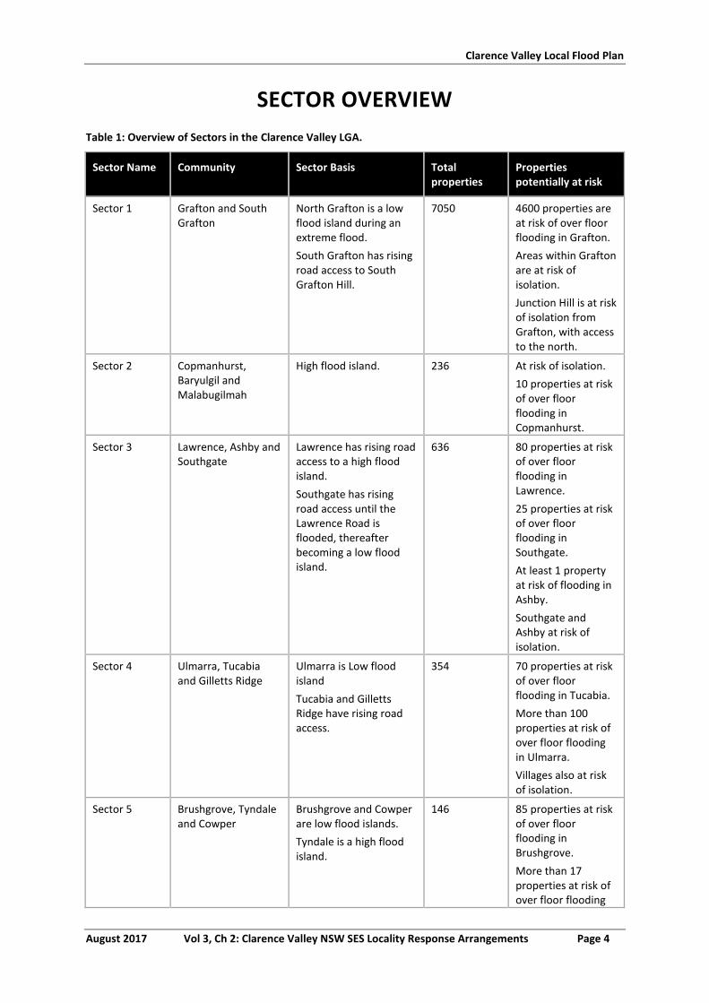
Clarence Valley Local Flood Plan
August 2017 Vol 3, Ch 2: Clarence Valley NSW SES Locality Response Arrangements Page 4
SECTOR OVERVIEW
Table 1: Overview of Sectors in the Clarence Valley LGA.
Sector Name Community Sector Basis Total properties
Properties potentially at risk
Sector 1 Grafton and South Grafton
North Grafton is a low flood island during an extreme flood.
South Grafton has rising road access to South Grafton Hill.
7050 4600 properties are at risk of over floor flooding in Grafton.
Areas within Grafton are at risk of isolation.
Junction Hill is at risk of isolation from Grafton, with access to the north.
Sector 2 Copmanhurst, Baryulgil and Malabugilmah
High flood island. 236 At risk of isolation.
10 properties at risk of over floor flooding in Copmanhurst.
Sector 3 Lawrence, Ashby and Southgate
Lawrence has rising road access to a high flood island.
Southgate has rising road access until the Lawrence Road is flooded, thereafter becoming a low flood island.
636 80 properties at risk of over floor flooding in Lawrence.
25 properties at risk of over floor flooding in Southgate.
At least 1 property at risk of flooding in Ashby.
Southgate and Ashby at risk of isolation.
Sector 4 Ulmarra, Tucabia and Gilletts Ridge
Ulmarra is Low flood island
Tucabia and Gilletts Ridge have rising road access.
354 70 properties at risk of over floor flooding in Tucabia.
More than 100 properties at risk of over floor flooding in Ulmarra.
Villages also at risk of isolation.
Sector 5 Brushgrove, Tyndale and Cowper
Brushgrove and Cowper are low flood islands.
Tyndale is a high flood island.
146 85 properties at risk of over floor flooding in Brushgrove.
More than 17 properties at risk of over floor flooding
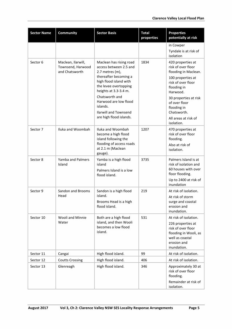
Clarence Valley Local Flood Plan
August 2017 Vol 3, Ch 2: Clarence Valley NSW SES Locality Response Arrangements Page 5
Sector Name Community Sector Basis Total properties
Properties potentially at risk
in Cowper
Tyndale is at risk of isolation
Sector 6 Maclean, Ilarwill, Townsend, Harwood and Chatsworth
Maclean has rising road access between 2.5 and 2.7 metres (m), thereafter becoming a high flood island with the levee overtopping heights at 3.3-3.4 m.
Chatsworth and Harwood are low flood islands.
Ilarwill and Townsend are high flood islands.
1834 420 properties at risk of over floor flooding in Maclean.
100 properties at risk of over floor flooding in Harwood.
30 properties at risk of over floor flooding in Chatsworth.
All areas at risk of isolation.
Sector 7 Iluka and Woombah Iluka and Woombah become a high flood island following the flooding of access roads at 2.1 m (Maclean gauge).
1207 470 properties at risk of over floor flooding.
Also at risk of isolation.
Sector 8 Yamba and Palmers Island
Yamba is a high flood island
Palmers Island is a low flood island.
3735 Palmers Island is at risk of isolation and 60 houses with over floor flooding.
Up to 2400 at risk of inundation
Sector 9 Sandon and Brooms Head
Sandon is a high flood island.
Brooms Head is a high flood island.
219 At risk of isolation.
At risk of storm surge and coastal erosion and inundation.
Sector 10 Wooli and Minnie Water
Both are a high flood island, and then Wooli becomes a low flood island.
531 At risk of isolation.
226 properties at risk of over floor flooding in Wooli, as well as coastal erosion and inundation.
Sector 11 Cangai High flood island. 99 At risk of isolation.
Sector 12 Coutts Crossing High flood island. 406 At risk of isolation.
Sector 13 Glenreagh High flood island. 346 Approximately 30 at risk of over floor flooding.
Remainder at risk of isolation.
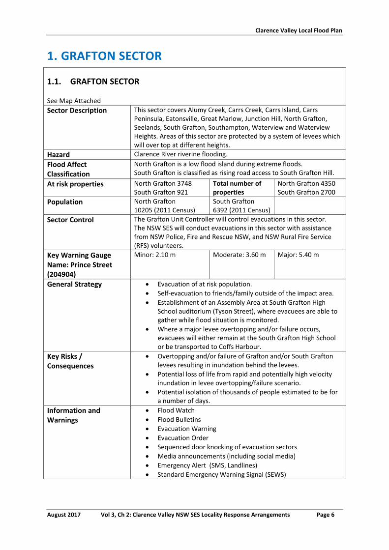
Clarence Valley Local Flood Plan
August 2017 Vol 3, Ch 2: Clarence Valley NSW SES Locality Response Arrangements Page 6
1. GRAFTON SECTOR
1.1. GRAFTON SECTOR
See Map Attached
Sector Description This sector covers Alumy Creek, Carrs Creek, Carrs Island, Carrs Peninsula, Eatonsville, Great Marlow, Junction Hill, North Grafton, Seelands, South Grafton, Southampton, Waterview and Waterview Heights. Areas of this sector are protected by a system of levees which will over top at different heights.
Hazard Clarence River riverine flooding.
Flood Affect Classification
North Grafton is a low flood island during extreme floods. South Grafton is classified as rising road access to South Grafton Hill.
At risk properties North Grafton 3748 South Grafton 921
Total number of properties
North Grafton 4350 South Grafton 2700
Population North Grafton 10205 (2011 Census)
South Grafton 6392 (2011 Census)
Sector Control The Grafton Unit Controller will control evacuations in this sector. The NSW SES will conduct evacuations in this sector with assistance from NSW Police, Fire and Rescue NSW, and NSW Rural Fire Service (RFS) volunteers.
Key Warning Gauge Name: Prince Street (204904)
Minor: 2.10 m Moderate: 3.60 m Major: 5.40 m
General Strategy Evacuation of at risk population.
Self-evacuation to friends/family outside of the impact area.
Establishment of an Assembly Area at South Grafton High School auditorium (Tyson Street), where evacuees are able to gather while flood situation is monitored.
Where a major levee overtopping and/or failure occurs, evacuees will either remain at the South Grafton High School or be transported to Coffs Harbour.
Key Risks / Consequences
Overtopping and/or failure of Grafton and/or South Grafton levees resulting in inundation behind the levees.
Potential loss of life from rapid and potentially high velocity inundation in levee overtopping/failure scenario.
Potential isolation of thousands of people estimated to be for a number of days.
Information and Warnings
Flood Watch
Flood Bulletins
Evacuation Warning
Evacuation Order
Sequenced door knocking of evacuation sectors
Media announcements (including social media)
Emergency Alert (SMS, Landlines)
Standard Emergency Warning Signal (SEWS)
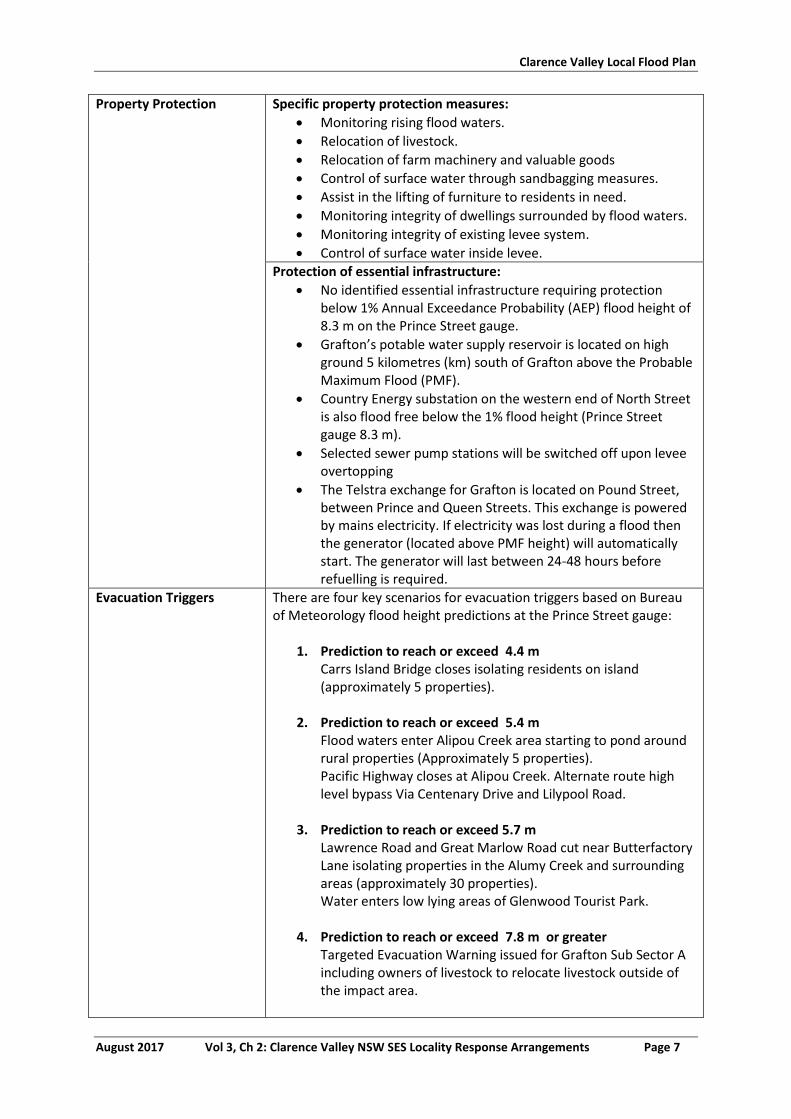
Clarence Valley Local Flood Plan
August 2017 Vol 3, Ch 2: Clarence Valley NSW SES Locality Response Arrangements Page 7
Property Protection Specific property protection measures:
Monitoring rising flood waters.
Relocation of livestock.
Relocation of farm machinery and valuable goods
Control of surface water through sandbagging measures.
Assist in the lifting of furniture to residents in need.
Monitoring integrity of dwellings surrounded by flood waters.
Monitoring integrity of existing levee system.
Control of surface water inside levee.
Protection of essential infrastructure:
No identified essential infrastructure requiring protection below 1% Annual Exceedance Probability (AEP) flood height of 8.3 m on the Prince Street gauge.
Grafton’s potable water supply reservoir is located on high ground 5 kilometres (km) south of Grafton above the Probable Maximum Flood (PMF).
Country Energy substation on the western end of North Street is also flood free below the 1% flood height (Prince Street gauge 8.3 m).
Selected sewer pump stations will be switched off upon levee overtopping
The Telstra exchange for Grafton is located on Pound Street, between Prince and Queen Streets. This exchange is powered by mains electricity. If electricity was lost during a flood then the generator (located above PMF height) will automatically start. The generator will last between 24-48 hours before refuelling is required.
Evacuation Triggers There are four key scenarios for evacuation triggers based on Bureau of Meteorology flood height predictions at the Prince Street gauge:
1. Prediction to reach or exceed 4.4 m Carrs Island Bridge closes isolating residents on island (approximately 5 properties).
2. Prediction to reach or exceed 5.4 m
Flood waters enter Alipou Creek area starting to pond around rural properties (Approximately 5 properties). Pacific Highway closes at Alipou Creek. Alternate route high level bypass Via Centenary Drive and Lilypool Road.
3. Prediction to reach or exceed 5.7 m
Lawrence Road and Great Marlow Road cut near Butterfactory Lane isolating properties in the Alumy Creek and surrounding areas (approximately 30 properties). Water enters low lying areas of Glenwood Tourist Park.
4. Prediction to reach or exceed 7.8 m or greater
Targeted Evacuation Warning issued for Grafton Sub Sector A including owners of livestock to relocate livestock outside of the impact area.
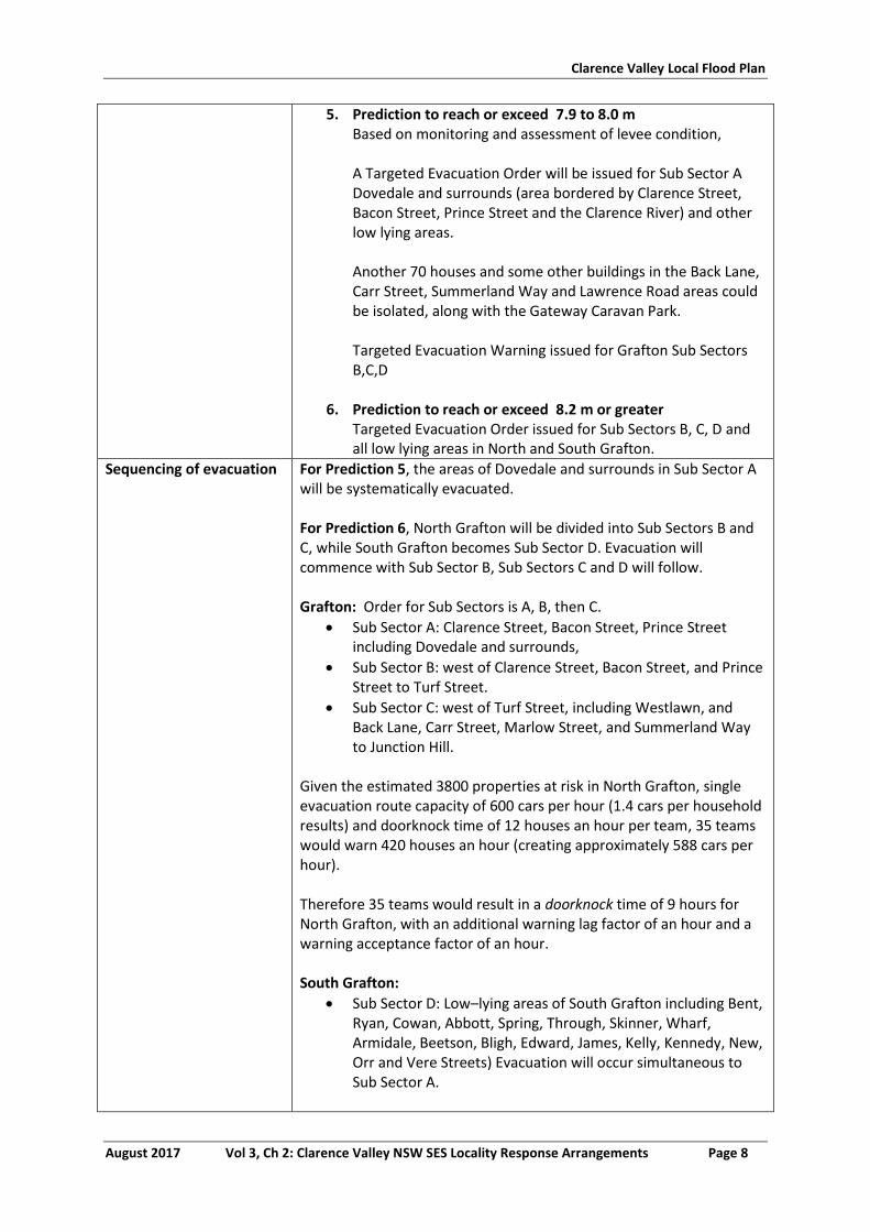
Clarence Valley Local Flood Plan
August 2017 Vol 3, Ch 2: Clarence Valley NSW SES Locality Response Arrangements Page 8
5. Prediction to reach or exceed 7.9 to 8.0 m Based on monitoring and assessment of levee condition,
A Targeted Evacuation Order will be issued for Sub Sector A Dovedale and surrounds (area bordered by Clarence Street, Bacon Street, Prince Street and the Clarence River) and other low lying areas.
Another 70 houses and some other buildings in the Back Lane, Carr Street, Summerland Way and Lawrence Road areas could be isolated, along with the Gateway Caravan Park.
Targeted Evacuation Warning issued for Grafton Sub Sectors B,C,D
6. Prediction to reach or exceed 8.2 m or greater
Targeted Evacuation Order issued for Sub Sectors B, C, D and all low lying areas in North and South Grafton.
Sequencing of evacuation For Prediction 5, the areas of Dovedale and surrounds in Sub Sector A will be systematically evacuated. For Prediction 6, North Grafton will be divided into Sub Sectors B and C, while South Grafton becomes Sub Sector D. Evacuation will commence with Sub Sector B, Sub Sectors C and D will follow. Grafton: Order for Sub Sectors is A, B, then C.
Sub Sector A: Clarence Street, Bacon Street, Prince Street including Dovedale and surrounds,
Sub Sector B: west of Clarence Street, Bacon Street, and Prince Street to Turf Street.
Sub Sector C: west of Turf Street, including Westlawn, and Back Lane, Carr Street, Marlow Street, and Summerland Way to Junction Hill.
Given the estimated 3800 properties at risk in North Grafton, single evacuation route capacity of 600 cars per hour (1.4 cars per household results) and doorknock time of 12 houses an hour per team, 35 teams would warn 420 houses an hour (creating approximately 588 cars per hour). Therefore 35 teams would result in a doorknock time of 9 hours for North Grafton, with an additional warning lag factor of an hour and a warning acceptance factor of an hour. South Grafton:
Sub Sector D: Low–lying areas of South Grafton including Bent, Ryan, Cowan, Abbott, Spring, Through, Skinner, Wharf, Armidale, Beetson, Bligh, Edward, James, Kelly, Kennedy, New, Orr and Vere Streets) Evacuation will occur simultaneous to Sub Sector A.
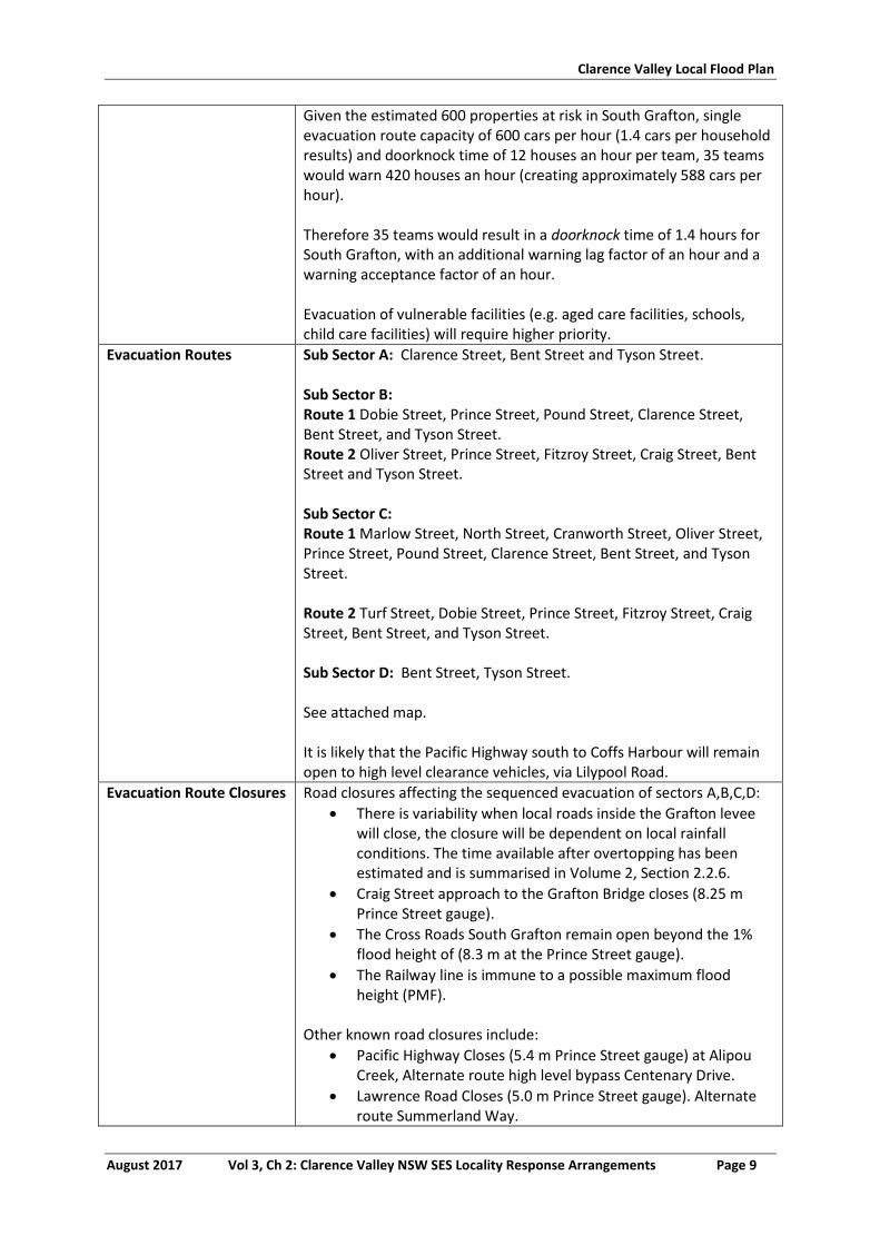
Clarence Valley Local Flood Plan
August 2017 Vol 3, Ch 2: Clarence Valley NSW SES Locality Response Arrangements Page 9
Given the estimated 600 properties at risk in South Grafton, single evacuation route capacity of 600 cars per hour (1.4 cars per household results) and doorknock time of 12 houses an hour per team, 35 teams would warn 420 houses an hour (creating approximately 588 cars per hour). Therefore 35 teams would result in a doorknock time of 1.4 hours for South Grafton, with an additional warning lag factor of an hour and a warning acceptance factor of an hour. Evacuation of vulnerable facilities (e.g. aged care facilities, schools, child care facilities) will require higher priority.
Evacuation Routes Sub Sector A: Clarence Street, Bent Street and Tyson Street. Sub Sector B: Route 1 Dobie Street, Prince Street, Pound Street, Clarence Street, Bent Street, and Tyson Street. Route 2 Oliver Street, Prince Street, Fitzroy Street, Craig Street, Bent Street and Tyson Street. Sub Sector C: Route 1 Marlow Street, North Street, Cranworth Street, Oliver Street, Prince Street, Pound Street, Clarence Street, Bent Street, and Tyson Street. Route 2 Turf Street, Dobie Street, Prince Street, Fitzroy Street, Craig Street, Bent Street, and Tyson Street. Sub Sector D: Bent Street, Tyson Street. See attached map. It is likely that the Pacific Highway south to Coffs Harbour will remain open to high level clearance vehicles, via Lilypool Road.
Evacuation Route Closures Road closures affecting the sequenced evacuation of sectors A,B,C,D:
There is variability when local roads inside the Grafton levee will close, the closure will be dependent on local rainfall conditions. The time available after overtopping has been estimated and is summarised in Volume 2, Section 2.2.6.
Craig Street approach to the Grafton Bridge closes (8.25 m Prince Street gauge).
The Cross Roads South Grafton remain open beyond the 1% flood height of (8.3 m at the Prince Street gauge).
The Railway line is immune to a possible maximum flood height (PMF).
Other known road closures include:
Pacific Highway Closes (5.4 m Prince Street gauge) at Alipou Creek, Alternate route high level bypass Centenary Drive.
Lawrence Road Closes (5.0 m Prince Street gauge). Alternate route Summerland Way.
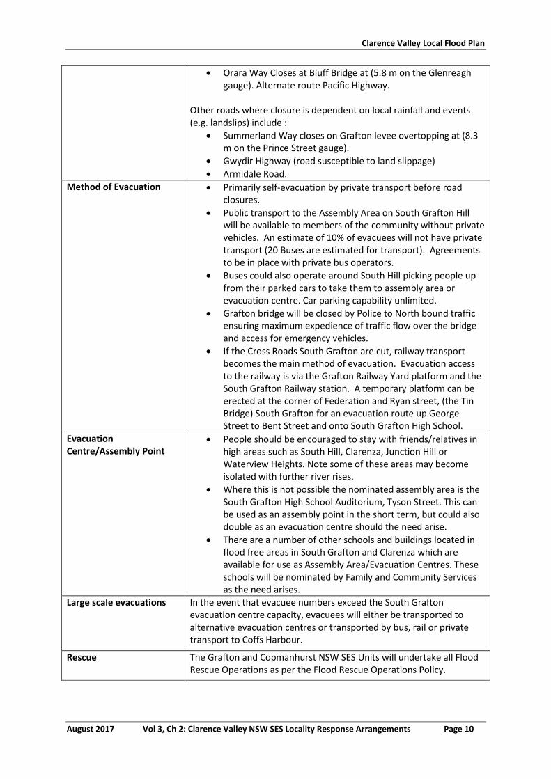
Clarence Valley Local Flood Plan
August 2017 Vol 3, Ch 2: Clarence Valley NSW SES Locality Response Arrangements Page 10
Orara Way Closes at Bluff Bridge at (5.8 m on the Glenreagh gauge). Alternate route Pacific Highway.
Other roads where closure is dependent on local rainfall and events (e.g. landslips) include :
Summerland Way closes on Grafton levee overtopping at (8.3 m on the Prince Street gauge).
Gwydir Highway (road susceptible to land slippage)
Armidale Road.
Method of Evacuation Primarily self-evacuation by private transport before road closures.
Public transport to the Assembly Area on South Grafton Hill will be available to members of the community without private vehicles. An estimate of 10% of evacuees will not have private transport (20 Buses are estimated for transport). Agreements to be in place with private bus operators.
Buses could also operate around South Hill picking people up from their parked cars to take them to assembly area or evacuation centre. Car parking capability unlimited.
Grafton bridge will be closed by Police to North bound traffic ensuring maximum expedience of traffic flow over the bridge and access for emergency vehicles.
If the Cross Roads South Grafton are cut, railway transport becomes the main method of evacuation. Evacuation access to the railway is via the Grafton Railway Yard platform and the South Grafton Railway station. A temporary platform can be erected at the corner of Federation and Ryan street, (the Tin Bridge) South Grafton for an evacuation route up George Street to Bent Street and onto South Grafton High School.
Evacuation Centre/Assembly Point
People should be encouraged to stay with friends/relatives in high areas such as South Hill, Clarenza, Junction Hill or Waterview Heights. Note some of these areas may become isolated with further river rises.
Where this is not possible the nominated assembly area is the South Grafton High School Auditorium, Tyson Street. This can be used as an assembly point in the short term, but could also double as an evacuation centre should the need arise.
There are a number of other schools and buildings located in flood free areas in South Grafton and Clarenza which are available for use as Assembly Area/Evacuation Centres. These schools will be nominated by Family and Community Services as the need arises.
Large scale evacuations In the event that evacuee numbers exceed the South Grafton evacuation centre capacity, evacuees will either be transported to alternative evacuation centres or transported by bus, rail or private transport to Coffs Harbour.
Rescue The Grafton and Copmanhurst NSW SES Units will undertake all Flood Rescue Operations as per the Flood Rescue Operations Policy.
Clarence Valley Local Flood Plan
August 2017 Vol 3, Ch 2: Clarence Valley NSW SES Locality Response Arrangements Page 11
Resupply Resupply will be provided by the NSW SES through the 132500 call out system.
The Grafton Base Hospital and Grafton Correctional Centre will be resupplied if required. The hospital floor begins to be inundated when flood waters exceed 9 m on Prince Street gauge.
Aircraft Management Helicopter Landing Zones
Grafton Airport (S29° 45' 30.56", E153° 1' 45.45”)
Junction Hill (S29° 38' 37.43”, E 152° 55' 12.73”)
SES Region Headquarters (S29° 43' 24.53”, E 152° 56' 37.78”)
Grafton Base Hospital (S29° 40' 31.89", E 152° 56' 27.66”)
Other Special considerations relating to the evacuation:
Closure of schools - coordinated through the Department of Education and Training.
Closure of licensed premises. All hotels and licensed clubs will be closed.
Evacuation of residential institutions, nursing homes and age care facilities will occur where these are threatened by predicted flood waters.
The Grafton Base Hospital will only be evacuated in extreme circumstances. Current floor height 9 m AHD.
Rail Transport. Suspension of normal transport Operations through Grafton would be required, in anticipation of the deployment of rail Operations to assist with evacuees.
Security. Police patrols to be established to maintain law and order after evacuation has occurred.
The NSW SES will use flood boats and helicopters to monitor safety of individuals, where feasible.
Grafton has three peak seasons with potential for a 10% population increase:
July Race Carnival – early July.
Jacaranda Festival – late October / early November.
Bridge to Bridge Ski Race – October long weekend. These arrangements will stay in place until the ‘ALL CLEAR’ is provided by the NSW SES to residents to return to their premises.
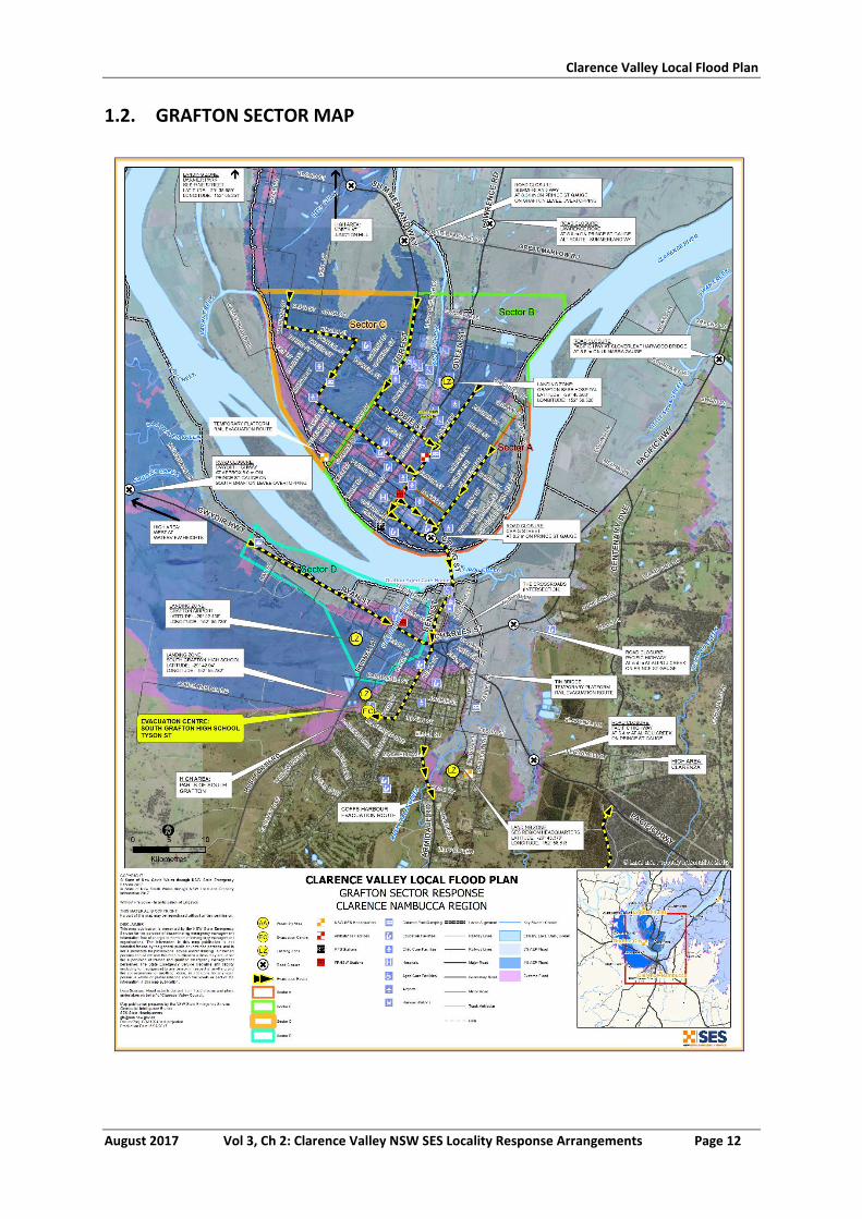
Clarence Valley Local Flood Plan
August 2017 Vol 3, Ch 2: Clarence Valley NSW SES Locality Response Arrangements Page 12
1.2. GRAFTON SECTOR MAP
Clarence Valley Local Flood Plan
August 2017 Vol 3, Ch 2: Clarence Valley NSW SES Locality Response Arrangements Page 13
2. COPMANHURST SECTOR
2.1. COPMANHURST SECTOR
See Map Attached
Sector Description This sector covers Barretts Creek, Coaldale, Copmanhurst, Fine Flower, Gordonbrook, Koolkhan, Moleville Creek, Mountain View, and Trenayr.
Hazard Clarence River riverine flooding.
Flood Affect Classification High flood island.
At risk properties 10 Total number of properties
236 (2011 Census)
Population 487 (2011 Census)
Sector Control The Copmanhurst Unit Controller will control evacuations in this sector. The NSW SES will conduct evacuations in this sector with assistance from NSW Police, Fire and Rescue NSW, and RFS volunteers.
Key Warning Gauge Name: Copmanhurst (204903)
Minor: - Moderate: - Major: -
General Strategy Evacuation of at risk population.
Self-evacuation to friends/family outside of the impact area.
Establishment of an Assembly Area/Evacuation Centre at the Copmanhurst Hall Stuart Street, Copmanhurst where evacuees are able to gather while flood situation is monitored.
Key Risks / Consequences Potential loss of life from rapid and potentially high velocity inundation. Potential isolation of hundreds of people for a number of days.
Information and Warnings Flood Watch
Flood Bulletins
Evacuation Warning
Evacuation Order
Sequenced door knocking of evacuation sectors
Media announcements (including social media)
Emergency Alert (SMS, Landlines)
SEWS
Property Protection Specific property protection measures:
Monitoring rising flood waters.
Relocation of livestock.
Relocation of farm machinery and valuable goods
Control of surface water through sandbagging measures.
Assist in the lifting of furniture to residents in need.
Monitoring integrity of dwellings surrounded by flood waters.
Protection of essential infrastructure:
No identified essential infrastructure requiring protection.
No sewerage, evacuation may be required for sanitary reasons if septic systems overflow.
Clarence Valley Local Flood Plan
August 2017 Vol 3, Ch 2: Clarence Valley NSW SES Locality Response Arrangements Page 14
Evacuation Triggers The Bureau of Meteorology does not provide predictions for the Copmanhurst gauge, however the predicted flood levels at the Lilydale gauge (204007) provides a historical indicative height of the impacts likely to be seen in Copmanhurst. Copmanhurst gauge (204903)
1. Reach and/or exceed 8.0 m (historical equivalent height to reach/or exceed 2.7 m on the Grafton Prince Street gauge (access to Grafton is lost): Clarence Way closes at Whiteman Creek causeway, approximately 6km east of Copmanhurst Access to Grafton lost (main access to supplies).
2. Reach and/or exceed 13.3 m (historical equivalent height to
reach/or exceed 4.4 m on the Grafton Prince Street gauge (isolation): Clarence Way closes due to back waters from Clarence river at Eton Creek western edge of Copmanhurst. Localities of Upper Copmanhurst and Fine flower isolated.
3. Reach and/or exceed 15.1 m (historical equivalent height to
reach/or exceed 5 m on the Grafton Prince Street gauge:
Clarence way closed at Double Swamp, 7 km north of Junction Hill. The village of Copmanhurst and Coaldale now isolated.
4. Reach and/or exceed 20 m (historical equivalent height to
reach/or exceed 6.7 m on the Grafton Prince Street gauge:
Two houses in Copmanhurst village experience over-floor inundation at 20 Grafton Street Copmanhurst.
Sequencing of evacuation A number of residences and properties may need to be evacuated during periods of significant flooding. In most floods, the evacuation tasks will only involve a small number of people. These properties would be dealt with on a case by case situation in conjunction with Family and Community Services.
Evacuation Routes The local Evacuation Routes will be chosen in consideration of current road conditions. These routes will direct residents to the local assembly area/evacuation centre in the town.
See attached map.
Evacuation Route Closures Every flood in the Grafton area is different and thus road conditions are unpredictable. Common road closures include:
Rogan’s Bridge closes cutting access to Waterview Heights. Alternative routes available. (6.0 m Copmanhurst gauge).
Clarence Way closes at Whiteman Creek causeway (8.0 m Copmanhurst gauge), approximately 6 km east of Copmanhurst.
Clarence Way closes at Chaselings Gully, approximately 10 km
Clarence Valley Local Flood Plan
August 2017 Vol 3, Ch 2: Clarence Valley NSW SES Locality Response Arrangements Page 15
east of Copmanhurst. (14.4 m Copmanhurst gauge).
Clarence Way closed at Moleville Creek (15.8 m Copmanhurst gauge).
Other roads where closure is dependent on local rainfall and events (e.g. landslips) include :
Pacific Highway Closes (5.4 m Prince Street gauge) at Alipou Creek, Alternate route high level bypass Centenary Drive.
Summerland Way closes on Grafton levee overtopping at (8.3m on the Prince Street gauge).
Method of Evacuation Primarily self-evacuation by private transport before road closures.
At risk residents will be door knocked by NSW SES, RFS and other emergency personnel and advised on the evacuation details.
Evacuation Centre/Assembly Point
Copmanhurst Community Hall Stuart Street, Copmanhurst
Large scale evacuations Large scale evacuations would be unlikely in this sector but if required additional locations will be identified.
Rescue The Copmanhurst NSW SES Units will undertake all Flood Rescue Operations as per the Flood Rescue Operations Policy.
Resupply Resupply will be provided by the NSW SES through the 132500 call out system.
Resupply to the Copmanhurst Local Store and Copmanhurst Hotel, will mean residents in these areas will have access to basic food supplies.
Aircraft Management Helicopter Landing Points.
Copmanhurst NSW SES Unit Headquarters Prescott Street
Copmanhurst (S2934’98.8”, E15246’52.3”)
Other Special considerations relating to the evacuation:
Closure of schools – coordinated through the Department of Education and Training.
Closure of licensed premises. All hotels and licensed clubs will be closed if required.
Evacuation of residential institutions, nursing homes and age care facilities will occur where these are threatened by predicted flood waters.
Security. Police patrols to be established to maintain law and order after evacuation has occurred.
The NSW SES will use flood boats and helicopters to monitor safety of individuals, where feasible.
Copmanhurst has two peak seasons with potential population increase of more than 10%:
Camp draft September.
Summer school holidays – Public lands within remote areas of this sector are utilized by campers.
These arrangements will stay in place until the ‘ALL CLEAR’ is provided by the NSW SES to residents to return to their premises.
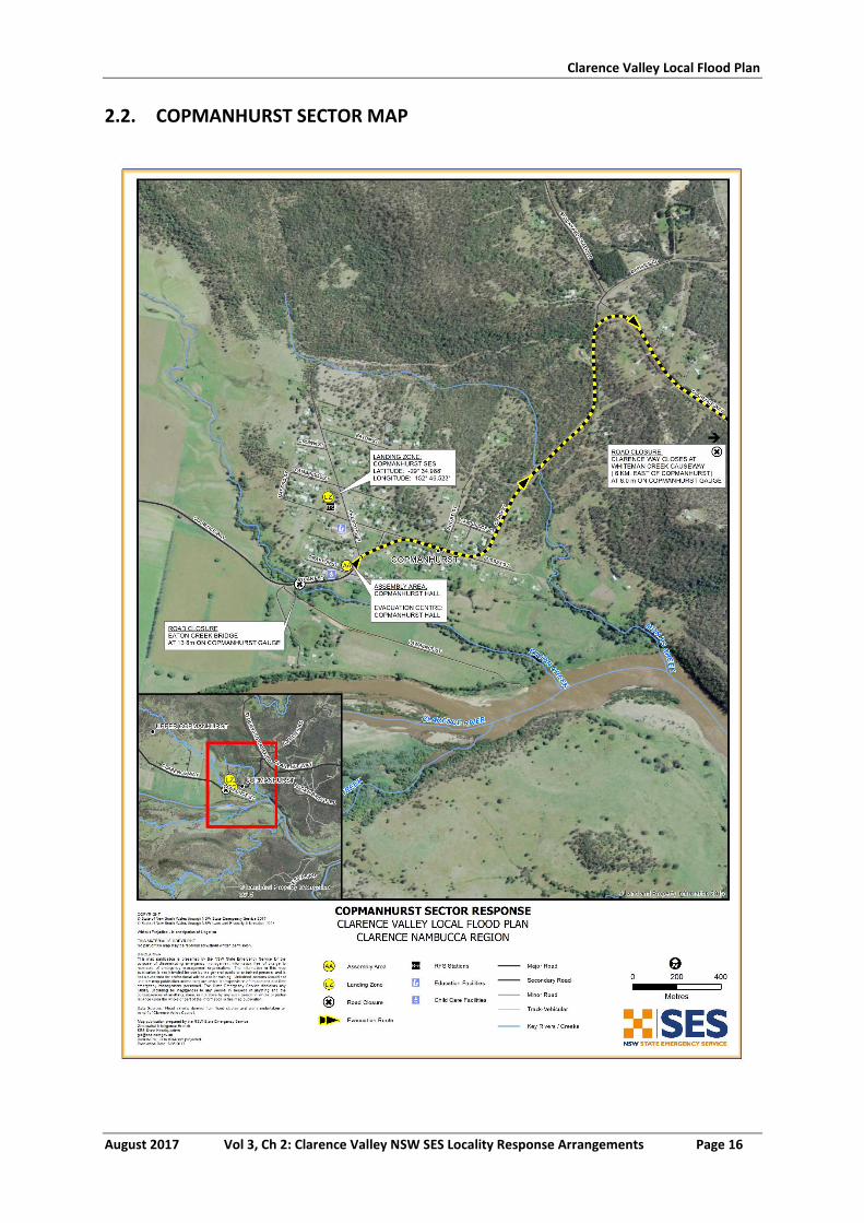
Clarence Valley Local Flood Plan
August 2017 Vol 3, Ch 2: Clarence Valley NSW SES Locality Response Arrangements Page 16
2.2. COPMANHURST SECTOR MAP
Clarence Valley Local Flood Plan
August 2017 Vol 3, Ch 2: Clarence Valley NSW SES Locality Response Arrangements Page 17
3. LAWRENCE SECTOR
3.1. LAWRENCE SECTOR
See Map Attached
Sector Description This sector covers: Ashby, Ashby Heights, Ashby Island, Chatsworth, Lawrence, Southgate, Lower Southgate, Tullymorgan and Woodford Island.
Hazard Clarence River riverine flooding.
Flood Affect Classification Rising road access to a high flood island for Lawrence. Southgate has rising road access and then becomes a low flood island.
At risk properties 106 dwellings including 3 businesses
Total number of properties
636 (2011 Census)
Population 1385 (2011 Census)
Sector Control The Lawrence Unit Controller will control evacuations in this sector. The Maclean Unit Controller will assist with evacuations in Ashby, Ashby Heights, Ashby Island, Chatsworth and the North half of Woodford Island. The NSW SES will conduct evacuations in this sector with assistance from NSW Police, Fire and Rescue NSW, and RFS volunteers.
Key Warning Gauges Name: Lawrence (204409) Grafton Prince Street (204904)
Minor:- Moderate:- Major:-
Minor: 2.10m Moderate:3.60m Major:5.40m
General Strategy Evacuation of at risk population.
Self-evacuation to friends/family outside of the impact area.
Establishment of an Assembly Area/Evacuation Centre at Lawrence Primary School High Street, Lawrence where evacuees are able to gather while flood situation is monitored.
Establishment of an Assembly Area/Evacuation Centre at Southgate Village Hall School Lane Southgate where evacuees are able to gather while flood situation is monitored.
Key Risks / Consequences Potential loss of life from rapid and potentially high velocity flooding inundation.
Potential isolation of thousands of people estimated to be for a number of days.
Information and Warnings Flood Watches
Flood Bulletins
Evacuation Warning
Evacuation Order
Sequenced door knocking of evacuation areas
Media announcements (including social media)
Emergency Alert (SMS, Landlines)
SEWS
Clarence Valley Local Flood Plan
August 2017 Vol 3, Ch 2: Clarence Valley NSW SES Locality Response Arrangements Page 18
Property Protection Specific property protection measures:
Monitoring rising flood waters.
Relocation of livestock.
Relocation of farm machinery and valuable goods
Control of surface water through sandbagging measures.
Assist in the lifting of furniture to residents in need.
Monitoring integrity of dwellings surrounded by flood waters.
Protection of essential infrastructure:
No identified essential infrastructure requiring protection.
Sewer system only in township of Lawrence, most of sector is on septic tank, evacuations may be required in rural areas for sanitary reasons if septic systems overflow.
Clarence Valley Council Water and Sewerage Flood Plan address procedures for sewerage system.
Evacuation Triggers The effect of flooding on the town and outlying areas in this sector could be dependent on tidal influences. Tidal levels will need to be identified at the onset of main Clarence River flooding.
The key evacuation triggers based on Bureau of Meteorology flood height predictions at the Grafton (Prince Street gauge) in reference to Lawrence gauge (204409) are:
1. Prediction to reach and/or exceed 1.0 m (Grafton Prince Street gauge historical equivalent height 1.70 m; Access to Maclean/Brushgrove lost: Lawrence Ferry ceases to operate. Access to Pacific Highway via Maclean is affected.
2. Prediction to reach and/or exceed 2.0 m (Grafton Prince
Street gauge historical equivalent height 3.40 m): Flood waters begin to encroach on top end of Weir Road, approximately 10 houses isolated. Water crosses low spots on Kings Creek Road isolating several rural properties.
3. Prediction to reach and/or exceed 2.5 m (Grafton Prince
Street gauge historical equivalent height 4.25 m): Targeted Evacuation Warning issued for some Lawrence Residents living in low lying areas. Flood waters enter the village. Rutland Street between Post Office Lane and Richmond Street cut. Grafton – Lawrence Road cut at Boothby’s Bridge and Shorts Lane, approximately 30 houses isolated along the road for up to a week.
4. Prediction to reach and/or exceed 3.0 m (Grafton Prince
Street gauge historical equivalent height 5.10 m): River Bank Road cut, approximately 15 houses isolated.
5. Prediction to reach and/or exceed 3.1 m (Grafton Prince
Street gauge historical equivalent height 5.27 m): Evacuation Order needs to be issued a minimum of 7.5 hours
Clarence Valley Local Flood Plan
August 2017 Vol 3, Ch 2: Clarence Valley NSW SES Locality Response Arrangements Page 19
before this height (3.1m) is reached and will be issued to Lawrence Residents living in low lying areas (approximately 10). Water over Road Bridge and Richmond Street approximately 18 houses isolated including the local store, hall and Lawrence Tavern.
6. Prediction to reach and/or exceed 3.2 m (Grafton Prince
Street gauge historical equivalent height 5.44 m) Mantons Road cut, approximately 18 houses isolated.
7. Prediction to reach and/or exceed 4.2 m (evacuation)
(Grafton Prince Street gauge historical equivalent height 7.14 m) Over floor flooding may occur in Weir Street.
8. Prediction to reach and/or exceed 4.4 m (evacuation)
(Grafton Prince Street gauge historical equivalent height 7.48 m) Water enters the Lawrence store, the hall, the Tavern, on Bridge Street, and several houses in Lawrence.
9. Prediction to reach and/or exceed 4.6 m (Evacuation)
(Grafton Prince Street gauge historical equivalent height 7.82 m) Inundation of homes on Sportsman Creek and Kings Creek Rd. NB. If the Bureau issues a flood warning to reach and/or exceed 7.82 m on the Grafton (Prince St) gauge, evacuation will need to be considered for all of the above areas in Lawrence.
Southgate area The four key evacuation triggers based on Bureau of Meteorology flood warning predictions at the Grafton Prince Street gauge (204904) include:
10. Prediction to reach and/or exceed 4.5 m Evacuation Warning issued for Southgate Residents living in low lying areas. Low Lying areas of farmland in Southgate start to become inundated.
11. Prediction to reach and/or exceed 5.4 m
Evacuation Order issued for Southgate Residents living in low lying areas. Isolation of properties begins when the Grafton- Lawrence road closes.
12. Prediction to reach and/or exceed 6.1 m
Over-floor inundation commences for residences on the Grafton – Lawrence Road.
Clarence Valley Local Flood Plan
August 2017 Vol 3, Ch 2: Clarence Valley NSW SES Locality Response Arrangements Page 20
13. Prediction to reach and/or exceed 7.7 m
Over-floor flooding commences in Southgate village, approximately 6 houses. NB. If the Bureau issues a flood warning to reach and/or exceed 7.7 m on the Grafton (Prince Street) gauge, evacuation will need to be considered for all of the above areas in Southgate due to over-floor flooding.
Sequencing of evacuation Evacuation of residents in low lying properties in Lawrence Village.
Evacuation of residents in low lying properties in Southgate.
Outside the identified sequenced evacuation areas, a number of residences and properties may need to be evacuated during periods of significant flooding. In most floods, the evacuation tasks will only involve a small number of people. These properties would be dealt with on a case by case situation in conjunction with Family and Community Services.
Evacuation Routes Properties around Lawrence: Pringles Way to Summerland Way and then onto either Grafton or Casino.
Properties around Southgate: Meet at Assembly Area/Evacuation Centre Southgate Village Hall
Evacuation Route Closures Road closures affecting the evacuation:
The Bluff Point Ferry ceases to operate (1.0 m Lawrence gauge).
Grafton – Lawrence Road closes (5.0m on the Prince Street gauge). Alternate route Summerland Way.
Summerland Way closes on Grafton levee overtopping at (8.3 m on the Prince Street gauge).
Method of Evacuation Primarily self-evacuation by private transport to high parts of Lawrence.
Primarily self-evacuation by private transport to Southgate Hall.
At risk residents will be door knocked by NSW SES, RFS and other emergency personnel and advised on the evacuation details.
Evacuation Centre/Assembly Point
The Lawrence Primary School Cook Street Lawrence
Southgate Village Hall School Lane Southgate
Large scale evacuations Large scale evacuations would be unlikely in this sector but if required additional locations will be identified.
Rescue The Lawrence NSW SES Unit will undertake all Flood Rescue Operations as per the Flood Rescue Operations Policy.
Resupply Resupply will be provided by the NSW SES through the 132500 call out system. The local stores will be supplied by boat from Maclean, if required.
Aircraft Management Helicopter Landing Zones
Lawrence Primary School (S2929’ 31.6”, E15306’0.06”)
Lawrence Road Southgate (S29° 37' 11.12”, E153° 0' 21.91”)
Other Special considerations relating to the evacuation:
Closure of schools - coordinated through the Department of
Clarence Valley Local Flood Plan
August 2017 Vol 3, Ch 2: Clarence Valley NSW SES Locality Response Arrangements Page 21
Education and Training.
Closure of licensed premises. The hotel will be closed if required.
Security. Police patrols to be established to maintain law and order after evacuation has occurred.
The NSW SES will use flood boats and helicopters to monitor safety of individuals, where feasible.
These arrangements will stay in place until the ‘ALL CLEAR’ is provided by the NSW SES to residents to return to their premises.
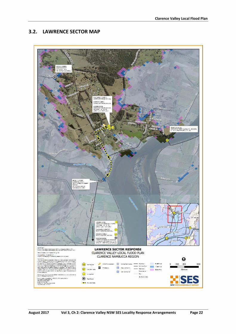
Clarence Valley Local Flood Plan
August 2017 Vol 3, Ch 2: Clarence Valley NSW SES Locality Response Arrangements Page 22
3.2. LAWRENCE SECTOR MAP
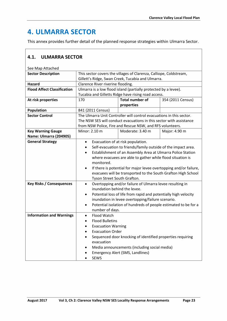
Clarence Valley Local Flood Plan
August 2017 Vol 3, Ch 2: Clarence Valley NSW SES Locality Response Arrangements Page 23
4. ULMARRA SECTOR This annex provides further detail of the planned response strategies within Ulmarra Sector.
4.1. ULMARRA SECTOR
See Map Attached
Sector Description This sector covers the villages of Clarenza, Calliope, Coldstream, Gillett’s Ridge, Swan Creek, Tucabia and Ulmarra.
Hazard Clarence River riverine flooding.
Flood Affect Classification Ulmarra is a low flood island (partially protected by a levee). Tucabia and Gilletts Ridge have rising road access.
At risk properties 170 Total number of properties
354 (2011 Census)
Population 841 (2011 Census)
Sector Control The Ulmarra Unit Controller will control evacuations in this sector. The NSW SES will conduct evacuations in this sector with assistance from NSW Police, Fire and Rescue NSW, and RFS volunteers.
Key Warning Gauge Name: Ulmarra (204905)
Minor: 2.10 m Moderate: 3.40 m Major: 4.90 m
General Strategy Evacuation of at risk population.
Self-evacuation to friends/family outside of the impact area.
Establishment of an Assembly Area at Ulmarra Police Station where evacuees are able to gather while flood situation is monitored.
If there is potential for major levee overtopping and/or failure, evacuees will be transported to the South Grafton High School Tyson Street South Grafton.
Key Risks / Consequences Overtopping and/or failure of Ulmarra levee resulting in inundation behind the levee.
Potential loss of life from rapid and potentially high velocity inundation in levee overtopping/failure scenario.
Potential isolation of hundreds of people estimated to be for a number of days.
Information and Warnings Flood Watch
Flood Bulletins
Evacuation Warning
Evacuation Order
Sequenced door knocking of identified properties requiring evacuation
Media announcements (including social media)
Emergency Alert (SMS, Landlines)
SEWS
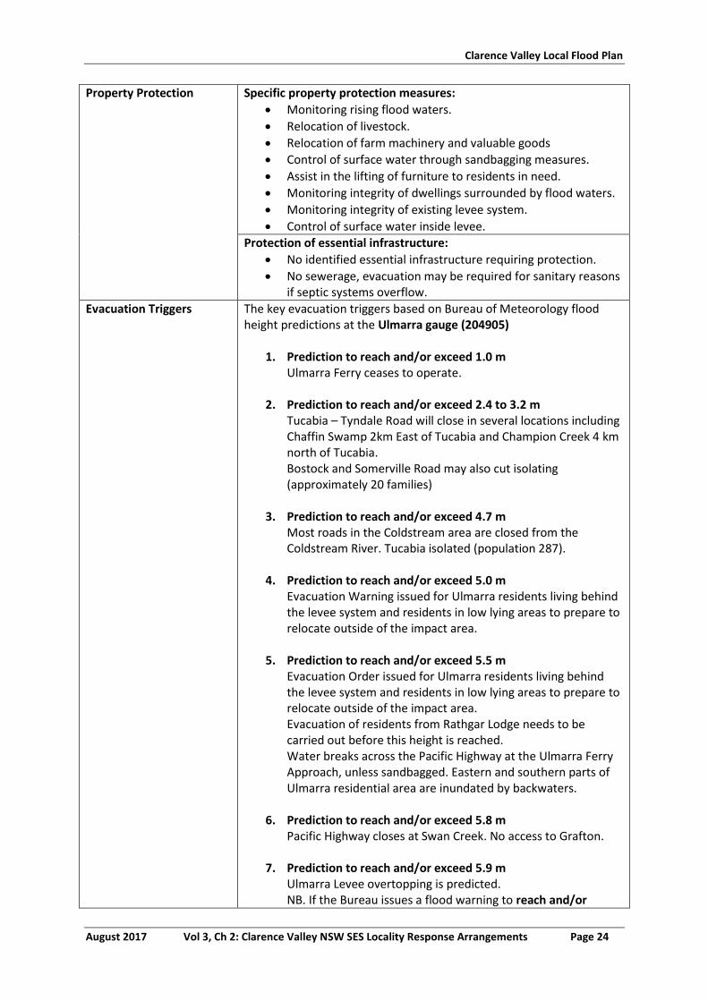
Clarence Valley Local Flood Plan
August 2017 Vol 3, Ch 2: Clarence Valley NSW SES Locality Response Arrangements Page 24
Property Protection Specific property protection measures:
Monitoring rising flood waters.
Relocation of livestock.
Relocation of farm machinery and valuable goods
Control of surface water through sandbagging measures.
Assist in the lifting of furniture to residents in need.
Monitoring integrity of dwellings surrounded by flood waters.
Monitoring integrity of existing levee system.
Control of surface water inside levee.
Protection of essential infrastructure:
No identified essential infrastructure requiring protection.
No sewerage, evacuation may be required for sanitary reasons if septic systems overflow.
Evacuation Triggers The key evacuation triggers based on Bureau of Meteorology flood height predictions at the Ulmarra gauge (204905)
1. Prediction to reach and/or exceed 1.0 m Ulmarra Ferry ceases to operate.
2. Prediction to reach and/or exceed 2.4 to 3.2 m
Tucabia – Tyndale Road will close in several locations including Chaffin Swamp 2km East of Tucabia and Champion Creek 4 km north of Tucabia. Bostock and Somerville Road may also cut isolating (approximately 20 families)
3. Prediction to reach and/or exceed 4.7 m
Most roads in the Coldstream area are closed from the Coldstream River. Tucabia isolated (population 287).
4. Prediction to reach and/or exceed 5.0 m
Evacuation Warning issued for Ulmarra residents living behind the levee system and residents in low lying areas to prepare to relocate outside of the impact area.
5. Prediction to reach and/or exceed 5.5 m
Evacuation Order issued for Ulmarra residents living behind the levee system and residents in low lying areas to prepare to relocate outside of the impact area. Evacuation of residents from Rathgar Lodge needs to be carried out before this height is reached. Water breaks across the Pacific Highway at the Ulmarra Ferry Approach, unless sandbagged. Eastern and southern parts of Ulmarra residential area are inundated by backwaters.
6. Prediction to reach and/or exceed 5.8 m
Pacific Highway closes at Swan Creek. No access to Grafton.
7. Prediction to reach and/or exceed 5.9 m Ulmarra Levee overtopping is predicted. NB. If the Bureau issues a flood warning to reach and/or
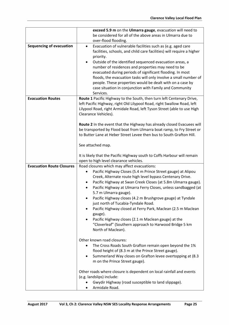
Clarence Valley Local Flood Plan
August 2017 Vol 3, Ch 2: Clarence Valley NSW SES Locality Response Arrangements Page 25
exceed 5.9 m on the Ulmarra gauge, evacuation will need to be considered for all of the above areas in Ulmarra due to over-flood flooding.
Sequencing of evacuation Evacuation of vulnerable facilities such as (e.g. aged care facilities, schools, and child care facilities) will require a higher priority.
Outside of the identified sequenced evacuation areas, a number of residences and properties may need to be evacuated during periods of significant flooding. In most floods, the evacuation tasks will only involve a small number of people. These properties would be dealt with on a case by case situation in conjunction with Family and Community Services.
Evacuation Routes Route 1 Pacific Highway to the South, then turn left Centenary Drive, left Pacific Highway, right Old Lilypool Road, right Swallow Road, left Lilypool Road, right Armidale Road, left Tyson Street (able to use High Clearance Vehicles). Route 2 In the event that the Highway has already closed Evacuees will be transported by Flood boat from Ulmarra boat ramp, to Fry Street or to Butter Lane at Heber Street Levee then bus to South Grafton Hill. See attached map. It is likely that the Pacific Highway south to Coffs Harbour will remain open to high level clearance vehicles.
Evacuation Route Closures Road closures which may affect evacuations:
Pacific Highway Closes (5.4 m Prince Street gauge) at Alipou Creek, Alternate route high level bypass Centenary Drive.
Pacific Highway at Swan Creek Closes (at 5.8m Ulmarra gauge).
Pacific Highway at Ulmarra Ferry Closes, unless sandbagged (at 5.7 m Ulmarra gauge).
Pacific Highway closes (4.2 m Brushgrove gauge) at Tyndale just north of Tucabia-Tyndale Road.
Pacific Highway closed at Ferry Park, Maclean (2.5 m Maclean gauge).
Pacific Highway closes (2.1 m Maclean gauge) at the “Cloverleaf” (Southern approach to Harwood Bridge 5 km North of Maclean).
Other known road closures:
The Cross Roads South Grafton remain open beyond the 1% flood height of (8.3 m at the Prince Street gauge).
Summerland Way closes on Grafton levee overtopping at (8.3 m on the Prince Street gauge).
Other roads where closure is dependent on local rainfall and events (e.g. landslips) include:
Gwydir Highway (road susceptible to land slippage).
Armidale Road.
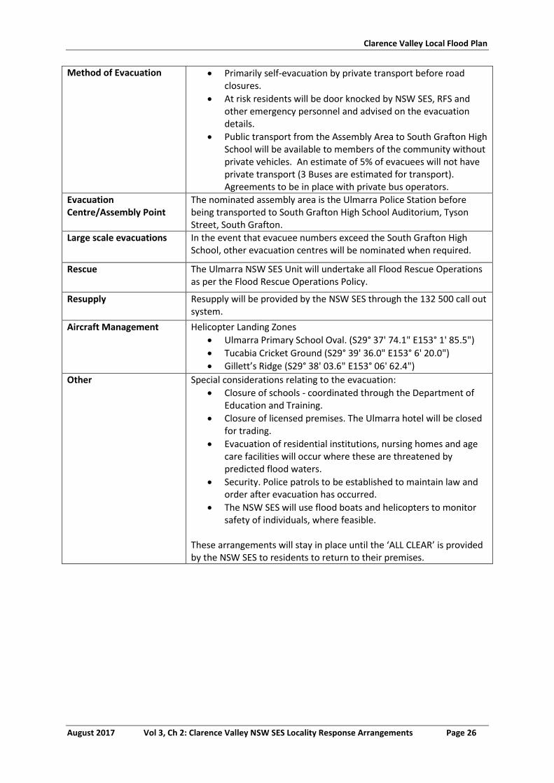
Clarence Valley Local Flood Plan
August 2017 Vol 3, Ch 2: Clarence Valley NSW SES Locality Response Arrangements Page 26
Method of Evacuation Primarily self-evacuation by private transport before road closures.
At risk residents will be door knocked by NSW SES, RFS and other emergency personnel and advised on the evacuation details.
Public transport from the Assembly Area to South Grafton High School will be available to members of the community without private vehicles. An estimate of 5% of evacuees will not have private transport (3 Buses are estimated for transport). Agreements to be in place with private bus operators.
Evacuation Centre/Assembly Point
The nominated assembly area is the Ulmarra Police Station before being transported to South Grafton High School Auditorium, Tyson Street, South Grafton.
Large scale evacuations In the event that evacuee numbers exceed the South Grafton High School, other evacuation centres will be nominated when required.
Rescue The Ulmarra NSW SES Unit will undertake all Flood Rescue Operations as per the Flood Rescue Operations Policy.
Resupply Resupply will be provided by the NSW SES through the 132 500 call out system.
Aircraft Management Helicopter Landing Zones
Ulmarra Primary School Oval. (S29° 37' 74.1" E153° 1' 85.5")
Tucabia Cricket Ground (S29° 39' 36.0" E153° 6' 20.0")
Gillett’s Ridge (S29° 38' 03.6" E153° 06' 62.4")
Other Special considerations relating to the evacuation:
Closure of schools - coordinated through the Department of Education and Training.
Closure of licensed premises. The Ulmarra hotel will be closed for trading.
Evacuation of residential institutions, nursing homes and age care facilities will occur where these are threatened by predicted flood waters.
Security. Police patrols to be established to maintain law and order after evacuation has occurred.
The NSW SES will use flood boats and helicopters to monitor safety of individuals, where feasible.
These arrangements will stay in place until the ‘ALL CLEAR’ is provided by the NSW SES to residents to return to their premises.
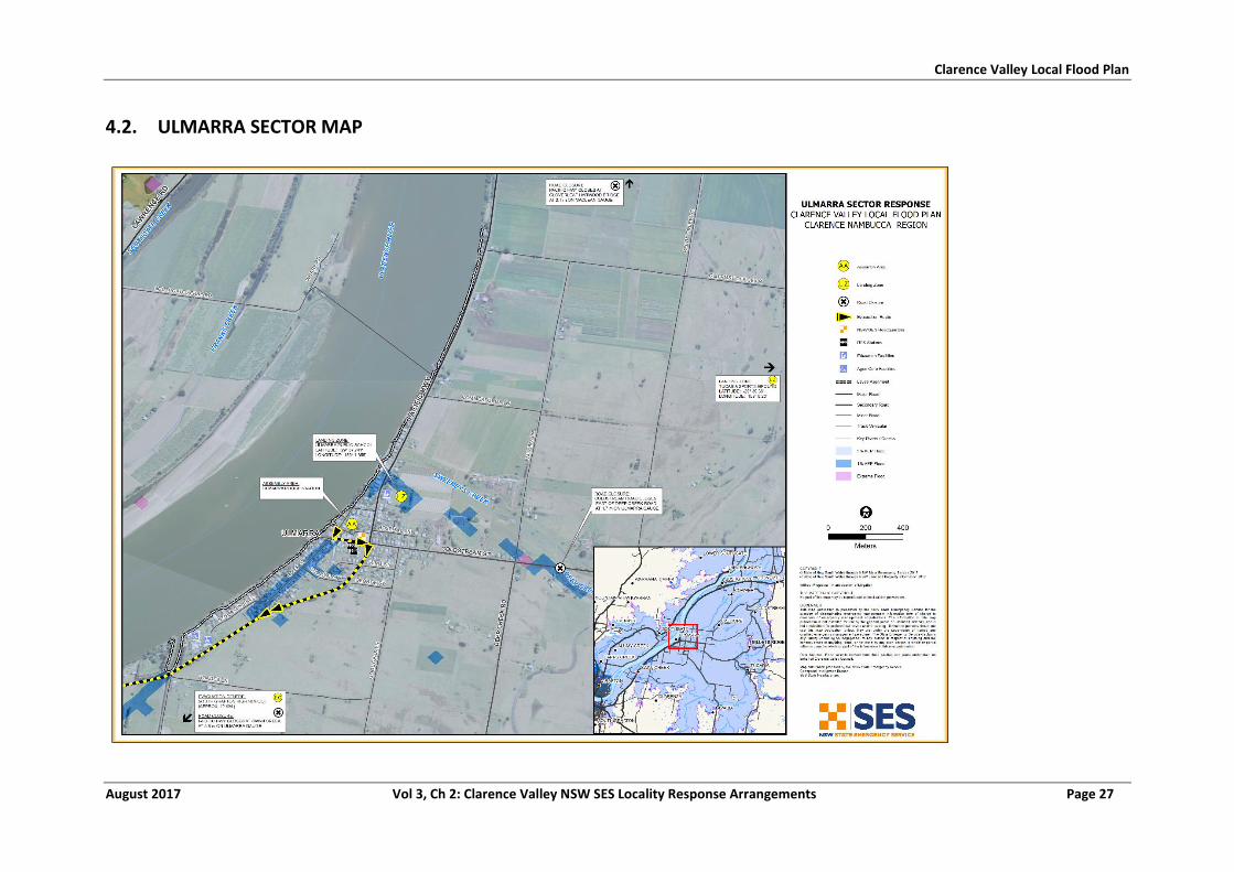
Clarence Valley Local Flood Plan
August 2017 Vol 3, Ch 2: Clarence Valley NSW SES Locality Response Arrangements Page 27
4.2. ULMARRA SECTOR MAP
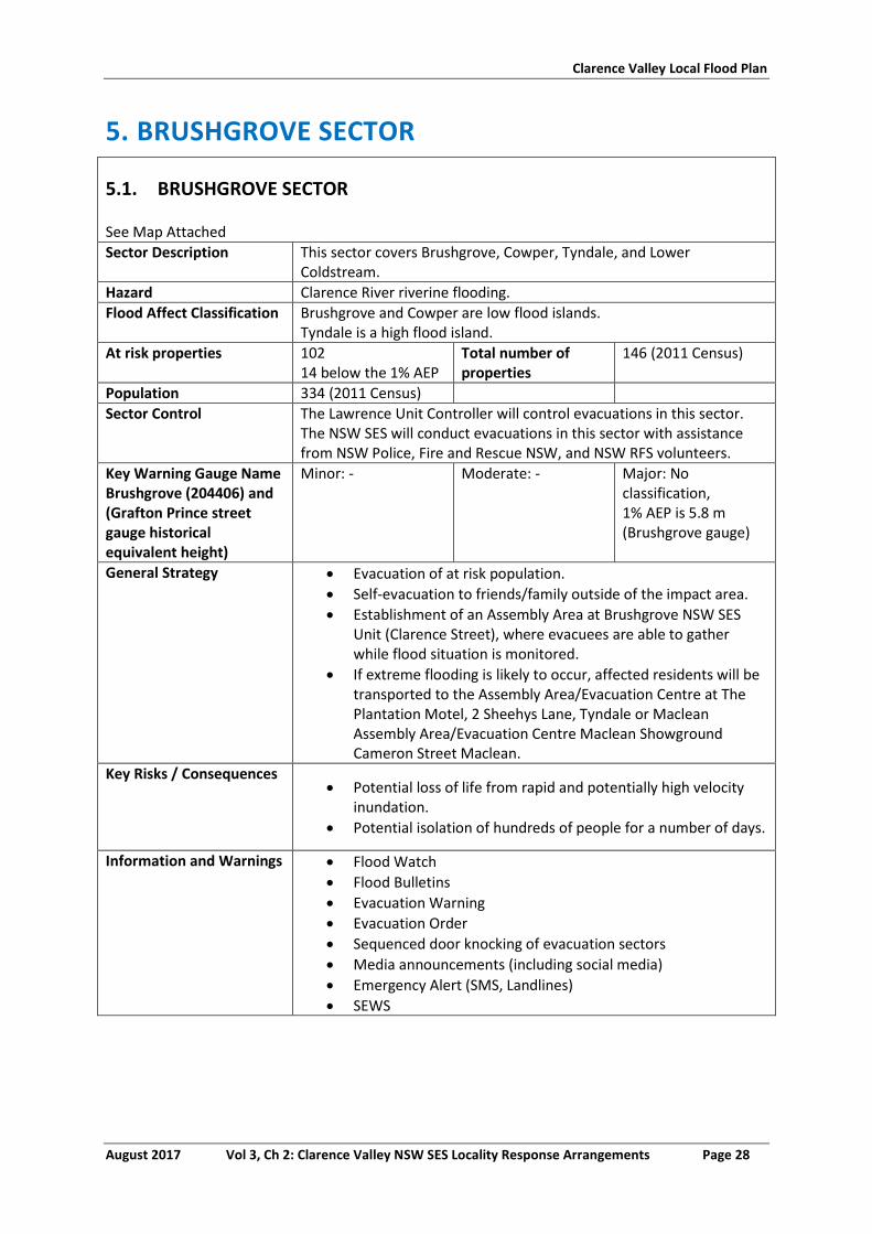
Clarence Valley Local Flood Plan
August 2017 Vol 3, Ch 2: Clarence Valley NSW SES Locality Response Arrangements Page 28
5. BRUSHGROVE SECTOR
5.1. BRUSHGROVE SECTOR
See Map Attached
Sector Description This sector covers Brushgrove, Cowper, Tyndale, and Lower Coldstream.
Hazard Clarence River riverine flooding.
Flood Affect Classification Brushgrove and Cowper are low flood islands. Tyndale is a high flood island.
At risk properties 102 14 below the 1% AEP
Total number of properties
146 (2011 Census)
Population 334 (2011 Census)
Sector Control The Lawrence Unit Controller will control evacuations in this sector. The NSW SES will conduct evacuations in this sector with assistance from NSW Police, Fire and Rescue NSW, and NSW RFS volunteers.
Key Warning Gauge Name Brushgrove (204406) and (Grafton Prince street gauge historical equivalent height)
Minor: - Moderate: - Major: No classification, 1% AEP is 5.8 m (Brushgrove gauge)
General Strategy Evacuation of at risk population.
Self-evacuation to friends/family outside of the impact area.
Establishment of an Assembly Area at Brushgrove NSW SES Unit (Clarence Street), where evacuees are able to gather while flood situation is monitored.
If extreme flooding is likely to occur, affected residents will be transported to the Assembly Area/Evacuation Centre at The Plantation Motel, 2 Sheehys Lane, Tyndale or Maclean Assembly Area/Evacuation Centre Maclean Showground Cameron Street Maclean.
Key Risks / Consequences Potential loss of life from rapid and potentially high velocity
inundation.
Potential isolation of hundreds of people for a number of days.
Information and Warnings Flood Watch
Flood Bulletins
Evacuation Warning
Evacuation Order
Sequenced door knocking of evacuation sectors
Media announcements (including social media)
Emergency Alert (SMS, Landlines)
SEWS
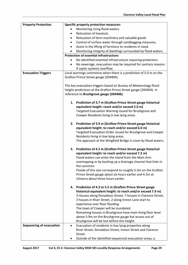
Clarence Valley Local Flood Plan
August 2017 Vol 3, Ch 2: Clarence Valley NSW SES Locality Response Arrangements Page 29
Property Protection Specific property protection measures:
Monitoring rising flood waters.
Relocation of livestock.
Relocation of farm machinery and valuable goods
Control of surface water through sandbagging measures.
Assist in the lifting of furniture to residents in need.
Monitoring integrity of dwellings surrounded by flood waters.
Protection of essential infrastructure:
No identified essential infrastructure requiring protection.
No sewerage, evacuation may be required for sanitary reasons if septic systems overflow.
Evacuation Triggers Local warnings commence when there is a prediction of 5.0 m on the Grafton Prince Street gauge (204404). The key evacuation triggers based on Bureau of Meteorology flood height predictions at the Grafton Prince Street gauge (204404). In reference to Brushgrove gauge (204406):
1. Prediction of 3.7 m (Grafton Prince Street gauge historical equivalent height: reach and/or exceed 5.0 m) Targeted Evacuation Warning issued for Brushgrove and Cowper Residents living in low lying areas.
2. Prediction of 3.9 m (Grafton Prince Street gauge historical
equivalent height: to reach and/or exceed 6.0 m) Targeted Evacuation Order issued for Brushgrove and Cowper Residents living in low lying areas. The approach at the Wingfield Bridge is cover by flood waters.
3. Prediction of 4.2 m (Grafton Prince Street gauge historical
equivalent height: to reach and/or exceed 7.2 m) Flood waters can enter the island from the Main Arm overtopping or by backing up a drainage channel that links in the common. Floods of this size correspond to roughly 5.3m on the Grafton Prince Street gauge about six hours earlier and 4.3m at Ulmarra about three hours earlier.
4. Prediction of 4.3 to 5.5 m (Grafton Prince Street gauge
historical equivalent height: to reach and/or exceed 7.9 m) 3 Houses along Donaldson Street, 7 houses in Clarence Street, 3 houses in River Street, 2 along Inmon Lane start to experience over floor flooding. The town of Cowper will be inundated. Remaining houses in Brushgrove have main living floor level above 5.9m on the Brushgrove gauge but access out of Brushgrove will be lost before this height.
Sequencing of evacuation Evacuation of residents in low lying properties along River Street, Donaldson Street, Inmon Street and Clarence Street.
Outside of the identified sequenced evacuation areas, a
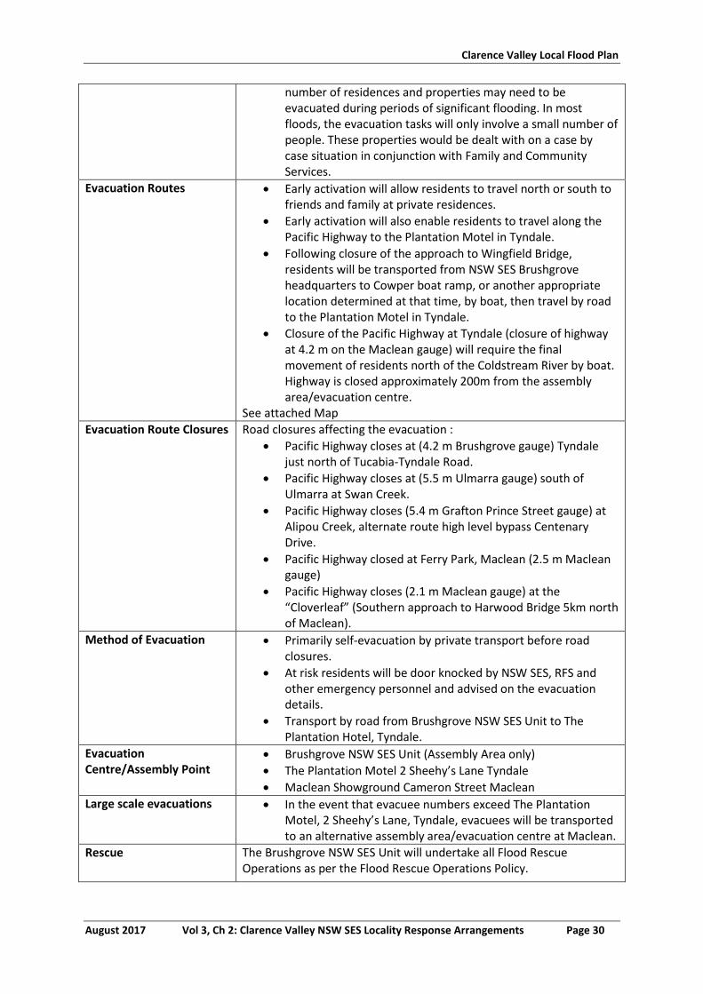
Clarence Valley Local Flood Plan
August 2017 Vol 3, Ch 2: Clarence Valley NSW SES Locality Response Arrangements Page 30
number of residences and properties may need to be evacuated during periods of significant flooding. In most floods, the evacuation tasks will only involve a small number of people. These properties would be dealt with on a case by case situation in conjunction with Family and Community Services.
Evacuation Routes Early activation will allow residents to travel north or south to friends and family at private residences.
Early activation will also enable residents to travel along the Pacific Highway to the Plantation Motel in Tyndale.
Following closure of the approach to Wingfield Bridge, residents will be transported from NSW SES Brushgrove headquarters to Cowper boat ramp, or another appropriate location determined at that time, by boat, then travel by road to the Plantation Motel in Tyndale.
Closure of the Pacific Highway at Tyndale (closure of highway at 4.2 m on the Maclean gauge) will require the final movement of residents north of the Coldstream River by boat. Highway is closed approximately 200m from the assembly area/evacuation centre.
See attached Map
Evacuation Route Closures Road closures affecting the evacuation :
Pacific Highway closes at (4.2 m Brushgrove gauge) Tyndale just north of Tucabia-Tyndale Road.
Pacific Highway closes at (5.5 m Ulmarra gauge) south of Ulmarra at Swan Creek.
Pacific Highway closes (5.4 m Grafton Prince Street gauge) at Alipou Creek, alternate route high level bypass Centenary Drive.
Pacific Highway closed at Ferry Park, Maclean (2.5 m Maclean gauge)
Pacific Highway closes (2.1 m Maclean gauge) at the “Cloverleaf” (Southern approach to Harwood Bridge 5km north of Maclean).
Method of Evacuation Primarily self-evacuation by private transport before road closures.
At risk residents will be door knocked by NSW SES, RFS and other emergency personnel and advised on the evacuation details.
Transport by road from Brushgrove NSW SES Unit to The Plantation Hotel, Tyndale.
Evacuation Centre/Assembly Point
Brushgrove NSW SES Unit (Assembly Area only)
The Plantation Motel 2 Sheehy’s Lane Tyndale
Maclean Showground Cameron Street Maclean
Large scale evacuations In the event that evacuee numbers exceed The Plantation Motel, 2 Sheehy’s Lane, Tyndale, evacuees will be transported to an alternative assembly area/evacuation centre at Maclean.
Rescue The Brushgrove NSW SES Unit will undertake all Flood Rescue Operations as per the Flood Rescue Operations Policy.
Clarence Valley Local Flood Plan
August 2017 Vol 3, Ch 2: Clarence Valley NSW SES Locality Response Arrangements Page 31
Resupply Resupply will be provided by the NSW SES through the 132500 call out system.
Aircraft Management Helicopter Landing Zones
Wingfield Bridge (S2934’05.7” E153 04’39.5”)
High Paddock to the north of Brushgrove (S2932’19.7”
E15308’88.8”)
Cane loading pad at Tyndale beside Pacific Highway
(S2933’60.5” E15308’94”)
Other Special considerations relating to the evacuation:
Closure of schools - coordinated through the Department of Education and Training.
Closure of licensed premises. All hotels will be closed.
Security. Police patrols to be established to maintain law and order after evacuation has occurred.
The NSW SES will use flood boats and helicopters to monitor safety of individuals, where feasible.
These arrangements will stay in place until the ‘ALL CLEAR’ is provided by the NSW SES to residents to return to their premises.
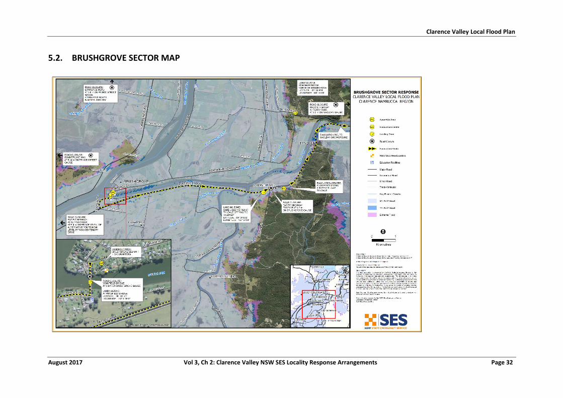
Clarence Valley Local Flood Plan
August 2017 Vol 3, Ch 2: Clarence Valley NSW SES Locality Response Arrangements Page 32
5.2. BRUSHGROVE SECTOR MAP
Clarence Valley Local Flood Plan
August 2017 Vol 3, Ch 2: Clarence Valley NSW SES Locality Response Arrangements Page 33
6. MACLEAN SECTOR
6.1. MACLEAN SECTOR
See Map Attached
Sector Description This sector covers the towns of Maclean, and Taloumbi, it also includes the villages of Chatsworth, Harwood, Ilarwill, South Arm, Ashby, Shark Creek and extensive rural areas.
Hazard Clarence River riverine flooding.
Flood Affect Classification Maclean has rising road access between 2.5 and 2.7 m, thereafter becoming a high flood island with the levee overtopping heights at 3.3-3.4 m. Chatsworth, Harwood and Warregah are low flood islands. Ilarwill and Townsend are high flood islands.
At risk properties 550 dwellings, including 102 commercial
Total number of properties
1834 (2011 Census)
Population 4131 (2011 Census)
Sector Control The Maclean Unit Controller will control evacuations in this sector. The NSW SES will conduct evacuations in this sector with assistance from NSW Police, Fire and Rescue NSW, and NSW RFS volunteers.
Key Warning Gauge Name: Maclean(204410)
Minor: 1.60 m Moderate: 2.20 m Major: 2.50 m
General Strategy Evacuation of at risk population.
Self-evacuation to friends/family outside of the impact area.
Establishment of an Assembly Area at the Maclean Showground Cameron Street, Maclean, where evacuees are able to gather while flood situation is monitored.
Key Risks / Consequences Potential loss of life from rapid and potentially high velocity flooding inundation.
Overtopping and/or failure of Maclean levee resulting in inundation behind the levees.
Potential loss of life from rapid and potentially high velocity inundation in levee overtopping/failure scenario.
Potential isolation of thousands of people estimated to be for a number of days.
Information and Warnings Flood Watches
Flood Bulletins
Evacuation Warning
Evacuation Order
Sequenced door knocking of evacuation sectors
Media announcements (including social media)
Emergency Alert (SMS, Landlines)
SEWS
Clarence Valley Local Flood Plan
August 2017 Vol 3, Ch 2: Clarence Valley NSW SES Locality Response Arrangements Page 34
Property Protection Specific property protection measures:
Monitoring rising flood waters.
Relocation of livestock.
Relocation of farm machinery and valuable goods
Control of surface water through sandbagging measures.
Assist in the lifting of furniture to residents in need.
Monitoring integrity of dwellings surrounded by flood waters.
Monitoring integrity of existing levee system.
Control of surface water inside levee.
Protection of essential infrastructure:
No identified essential infrastructure requiring protection
Sewer system in urban areas of sector in Maclean, Townsend, Ilarwill, rural areas of sector are on septic tank. Evacuations may be required in rural areas for sanitary reasons if septic systems overflow.
Clarence Valley Council Water and Sewerage Flood Plan addresses procedures for sewerage system.
Evacuation Triggers The key evacuation triggers based on Bureau of Meteorology flood height predictions at the Maclean gauge (204410):
1. Prediction to reach and/or exceed 1.5 m Advise schools of possible Lawrence Ferry closure affecting students returning home.
2. Prediction of between 2.5m to 2.7m (Isolation)
Targeted evacuation Warning/Order for residents in Harwood. The town of Maclean becomes progressively isolated by flood waters. The village of Harwood is totally flooded, most houses in this area are raised preventing over floor flooding.
3. Prediction to reach and/or exceed 3.0 m
Evacuation Warning issued for Maclean residents living behind the levee system to prepare to relocate outside of the impact area. Extensive flooding of Chatsworth, Harwood and Warregah Islands. Evacuations of low-lying houses may be necessary.
4. Prediction to reach 3.3 m
At 3.3m the levee design height is thought to be exceeded and it likely that the low points in the levee will begin to be overtopped. Based on monitoring and assessment of levee condition, consideration of targeted Evacuation Order of : Argyle Street, (13 houses 1 business) Bakers Lane, (4 houses) Bank Lane, (1 house 1 business) Basin Street, (1 business) Cameron Street, (6 houses) Centenary Drive, (15 businesses) Central Avenue, (14 houses) Church Street, (3 houses 1 business)
Clarence Valley Local Flood Plan
August 2017 Vol 3, Ch 2: Clarence Valley NSW SES Locality Response Arrangements Page 35
Clyde Street, (9 houses, 2 businesses) Diamond Street, (17 houses)** Dunoon Crescent, (18 houses) Dwartes Lane, (1 house) Emerald Street, (8 houses)** Houghs Lane, (10 houses) Howard Street, (12 houses) Iona Close, (9 houses) John Street, (5 houses) Jubilee Street, (10 houses) McLachlan Street, (84 houses, 3 businesses) McNaughton Place, (2 houses, 4 businesses) Morven Street, (17 houses) Rannoch Ave, (13 houses, 1 business) River Street, (70 houses) River Street, Shops, (66 businesses) Rush Lane, (8 houses) Sapphire Close, (17 houses)** Stanley Street, (1 house, 5 businesses) Taloumbi Street, (12 houses) Union Street, (8 houses, 2 businesses) and other low lying areas. ** Isolation only not flooded over-floor.
5. Prediction to exceed 3.3 m
Evacuation Order issued for all impacted residences mentioned above to commence evacuation (overtopping likely to commence at 3.4 m). Note: 1% AEP in Maclean is 3.6 m (Maclean gauge)
Sequencing of evacuation Evacuation of vulnerable facilities such as (e.g. aged care facilities, schools, and child care facilities) will require a higher priority.
Outside of the identified sequenced evacuation areas, a number of residences and properties may need to be evacuated during periods of significant flooding. In most floods, the evacuation tasks will only involve a small number of people. These properties would be dealt with on a case by case situation in conjunction with Family and Community Services.
Evacuation Routes Option 1: River Street to Cameron Street. Option 2: McLachlan Street, Short Street, River Street, then Cameron Street. Option 3: McLachlan Street, Union Street, Woodford Street, Church Street, River Street, then Cameron Street. See attached map.
Clarence Valley Local Flood Plan
August 2017 Vol 3, Ch 2: Clarence Valley NSW SES Locality Response Arrangements Page 36
Evacuation Route Closures Road closures affecting the evacuation:
The closure of local roads will be dependent on local rainfall conditions.
Known streets affected once overtopping has commenced are shown in the “EVACUATION TRIGGER SECTION” of annexure.
Pacific Highway closes (2.1 m Maclean gauge) at the “Cloverleaf” (Southern approach to Harwood Bridge 5 km north of Maclean).
Pacific Highway closed at Ferry Park, Maclean (2.5 m Maclean gauge).
Other known road closures:
Pacific Highway closes (5.4 m Prince Street gauge) at Alipou Creek, Alternate route high level bypass Centenary Drive.
Method of Evacuation Primarily self-evacuation by private transport before road closures.
At risk residents will be door knocked by NSW SES, RFS and other emergency personnel and advised on the evacuation details.
Public transport will be available to transport the public without private transport to the Evacuation Centre/Assembly Area at the Maclean Showground.
Car parking capability on the Maclean Hill is unlimited.
Other outlying areas such as Chatsworth, Harwood, Goodwood, and Warregah islands may require evacuating on a case by case basis and can be transported by boat to the Assembly Area/Evacuation Centre at the Maclean Show Ground.
Evacuation Centre/Assembly Point
Maclean Showground buildings, Cameron Street, Maclean.
Large scale evacuations In the event that large scale evacuations are required residents will be transported to where an Assembly Area/evacuation centre will be established. The following stages will occur;
Stage 1: Evacuation of the elderly, sick and frail as well as families with young children. This evacuation would be by private vehicles or school buses if possible. If roads are inundated flood boats and helicopters will be utilised.
Stage 2: Evacuation of all people not required for emergency Operations
Stage 3: Evacuation of emergency personnel by flood boat.
Rescue The Maclean NSW SES Unit will undertake all Flood Rescue Operations as per the Flood Rescue Operations Policy.
Resupply Resupply will be provided by the NSW SES through the 132500 call out system.
The Maclean Base Hospital, Spar Supermarket, Local Bakery and Fruit & Vegetable Store will be resupplied if required. This
Clarence Valley Local Flood Plan
August 2017 Vol 3, Ch 2: Clarence Valley NSW SES Locality Response Arrangements Page 37
will ensure residents are continually provided with essential food items.
Aircraft Management Helicopter Landing Zones
Maclean Showground (S2927’88.7”, E15311’91.7”)
Maclean Lookout (S2927’32.0”, E15312’93.6”)
Gulmarrad Public School oval for larger helicopters
(S 2929’98.2”, E15314’16.6”)
Other Special considerations relating to the evacuation:
Closure of schools – coordinated through the Department of Education and Training.
Closure of licensed premises. All hotels and licensed clubs will be closed if affected.
Security. Police patrols to be established to maintain law and order after evacuation has occurred.
The NSW SES will use flood boats and helicopters to monitor safety of individuals, where feasible.
Maclean has one peak season with potential population increase of more than 10% - Highland Gathering – Easter long weekend.
These arrangements will stay in place until the ‘ALL CLEAR’ is provided by the NSW SES to residents to return to their premises.
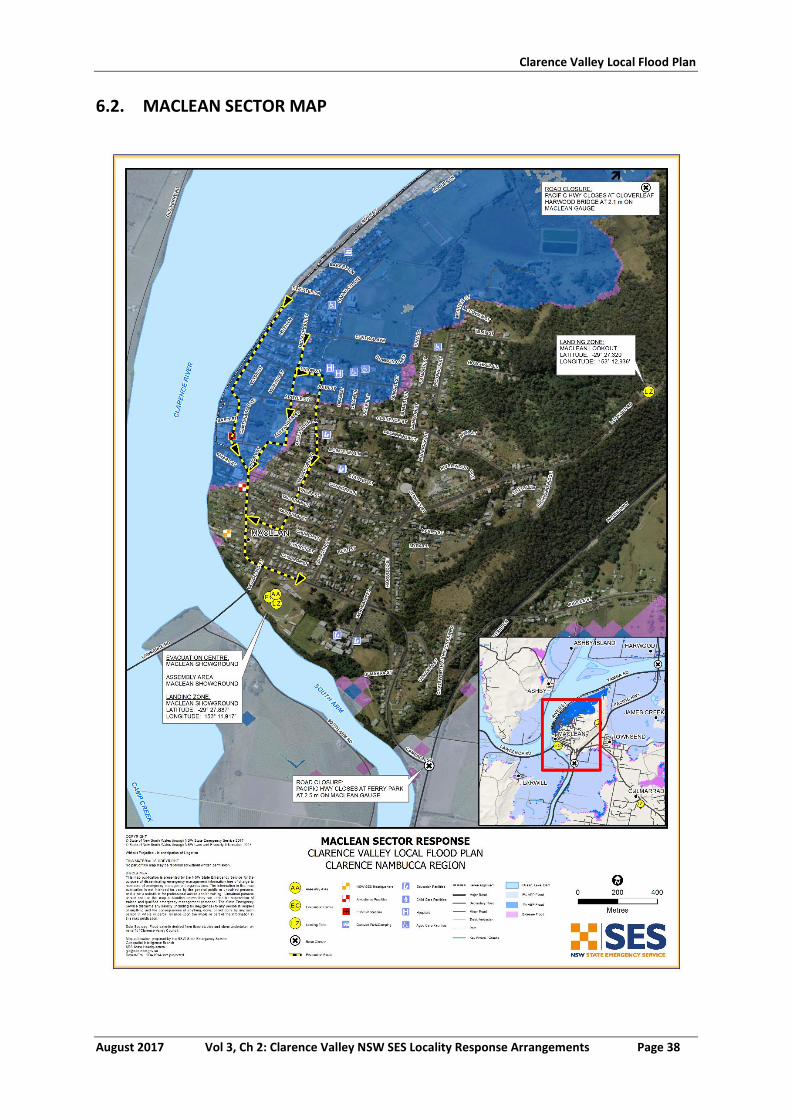
Clarence Valley Local Flood Plan
August 2017 Vol 3, Ch 2: Clarence Valley NSW SES Locality Response Arrangements Page 38
6.2. MACLEAN SECTOR MAP
Clarence Valley Local Flood Plan
August 2017 Vol 3, Ch 2: Clarence Valley NSW SES Locality Response Arrangements Page 39
7. ILUKA SECTOR
7.1. ILUKA SECTOR
See Map Attached
Sector Description This sector covers, Iluka, Mororo, The Freshwater, Woody Head, Goodwood and Woombah.
Hazard Clarence River riverine flooding
Flood Affect Classification Iluka and Woombah become a high flood islands following the flooding of access roads at 2.1 m on the Maclean gauge.
At risk properties 20 residential Iluka 470 Woombah isolation. 2 Caravan Parks.
Total number of properties
1207 (2011 Census)
Population 1884 (2011 Census)
Sector Control The Yamba Unit Controller will control evacuations in this sector. The NSW SES will conduct evacuations in this sector with assistance from NSW Police, Fire and Rescue NSW, and NSW RFS volunteers.
Key Warning Gauge Name: Maclean(204410)
Minor: 1.60 m Moderate: 2.20 m Major:2.50 m
General Strategy Evacuation of at risk population.
Self-evacuation to friends/family outside of the impact area.
Establishment of an Assembly Area/Evacuation Centre at the Iluka Community Hall 54 Spencer Street, Iluka, where evacuees are able to gather while flood situation is monitored.
Key Risks / Consequences Potential loss of life from rapid and potentially high velocity inundation.
Potential isolation of hundreds of people estimated to be for a number of days.
Information and Warnings Flood Watches
Flood Bulletins
Evacuation Warning
Evacuation Order
Sequenced door knocking of evacuation sectors
Media announcements (including social media)
Emergency Alert (SMS, Landlines)
SEWS
Property Protection Specific property protection measures:
Monitoring rising flood waters.
Relocation of livestock.
Relocation of farm machinery and valuable goods
Control of surface water through sandbagging measures.
Assist in the lifting of furniture to residents in need.
Monitoring integrity of dwellings surrounded by flood waters.
Protection of essential infrastructure:
No identified essential infrastructure requiring protection.
Sewer system under construction for township of Iluka.
Clarence Valley Local Flood Plan
August 2017 Vol 3, Ch 2: Clarence Valley NSW SES Locality Response Arrangements Page 40
Expected completion 2013, most of sector is on septic tank, evacuations may be required in rural areas for sanitary reasons if septic systems overflow.
Clarence Valley Council Water and Sewerage Flood Plan address procedures for sewerage treatment plant.
Need to check with Kieran on RL for location reservoir. Evacuation Triggers The effects on the towns and outlying areas in this sector are very
much dependent on tidal influences. Tidal levels will need to be identified at the onset of main Clarence River flooding. Maclean gauge (204410):
1. Prediction to reach and/or exceed 2.0 m Local Warnings will commence, including notification to:
The Anchorage Holiday Park Iluka
Browns Rocks Caravan Park Goodwood Island
2. Prediction to reach and/or exceed 2.1 m (isolation) The Iluka Road at the Esk River may be cut, causing isolation of the town. Based on monitoring and assessment known locations of flooding are: Marandowie Drive, Melville Street, Sovereign Street and Conrad Close.
3. Prediction to reach and/or exceed 2.4 m
Targeted Evacuation Order of a number of houses around town may be considered.
4. Prediction to reach and/or exceed 3.6 m (isolation)
The village of Woombah may become isolated; however land is above the PMF.
Sequencing of evacuation A number of residences and properties may need to be evacuated during periods of significant flooding. In most floods, the evacuation tasks will only involve a small number of people. These properties would be dealt with on a case by case situation in conjunction with Family and Community Services.
Evacuation Routes The local Evacuation Routes will be chosen in consideration of current road conditions. These routes will direct residents to the local Assembly Area/evacuation centres in the town.
See Attached Map
Evacuation Route Closures Road closures which may affect the isolation of the town:
The closure of local roads will be dependent on local rainfall and tidal conditions.
The only route in and out of Iluka is the Iluka Road which can be cut at the Esk River (2.1 m Maclean gauge 204410).
Pacific Highway closes (2.1 m Maclean gauge) at the “Cloverleaf” (Southern approach to Harwood Bridge 5 km north of Maclean).
Pacific Highway closed at Ferry Park, Maclean (2.5 m Maclean gauge).
Clarence Valley Local Flood Plan
August 2017 Vol 3, Ch 2: Clarence Valley NSW SES Locality Response Arrangements Page 41
Other known road closures:
Pacific Highway Closes (5.4m Prince Street gauge) at Alipou Creek, Alternate route high level bypass Centenary Drive.
Method of Evacuation Primarily self-evacuation by private transport before road closures.
At risk residents will be door knocked by NSW SES, RFS and other emergency personnel and advised on the evacuation details.
Evacuation Centre/Assembly Point
Iluka Community Hall 54 Spencer Street, Iluka.
Large scale evacuations If large scale evacuations are likely, additional sites will be identified as an Assembly Area/evacuation centres to accommodate residents of Iluka, Woody Head and any outlying areas.
Rescue The Yamba NSW SES Unit will undertake all Flood Rescue Operations as per the Flood Rescue Operations Policy.
Resupply Resupply will be provided by the NSW SES through the 132500 call out system.
The local stores will be supplied by boat from Yamba, if required.
Aircraft Management Helicopter Landing Zones:
The Golf Course (S29 23’ 73.2” E153 21’39.0”)
The Town Oval (S29 24’ 38.9” E153 21’24.2”)
Other Special considerations relating to the evacuation:
Closure of schools - coordinated through the Department of Education and Training.
Closure of licensed premises. All hotels and licensed clubs will be closed if required.
Security. Police patrols to be established to maintain law and order after evacuation has occurred.
The NSW SES will use flood boats and helicopters to monitor safety of individuals, where feasible.
Iluka has four peak seasons with a potential population increase of more than 10%:
School holidays tourist influx late December/January
School holidays tourist influx April
School holidays tourist influx July
School holidays tourist influx September/ October These arrangements will stay in place until the ‘ALL CLEAR’ is provided by the NSW SES to residents to return to their premises.
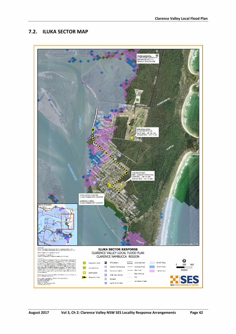
Clarence Valley Local Flood Plan
August 2017 Vol 3, Ch 2: Clarence Valley NSW SES Locality Response Arrangements Page 42
7.2. ILUKA SECTOR MAP
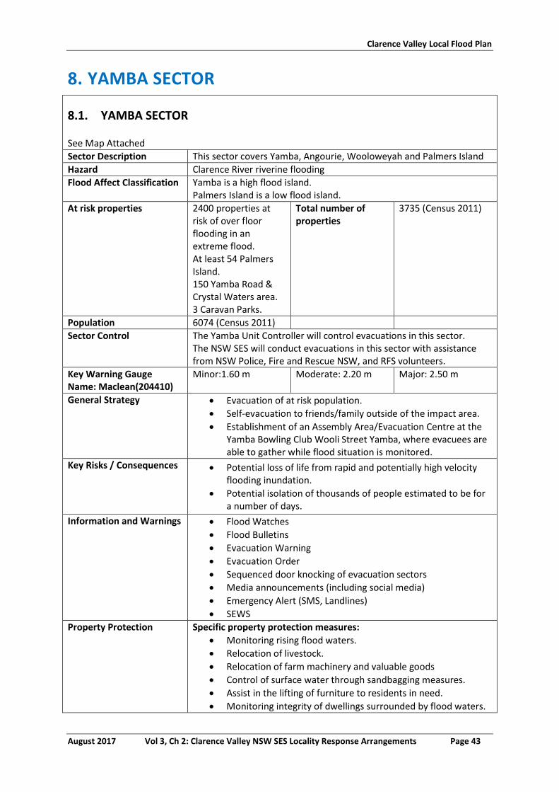
Clarence Valley Local Flood Plan
August 2017 Vol 3, Ch 2: Clarence Valley NSW SES Locality Response Arrangements Page 43
8. YAMBA SECTOR
8.1. YAMBA SECTOR
See Map Attached
Sector Description This sector covers Yamba, Angourie, Wooloweyah and Palmers Island
Hazard Clarence River riverine flooding
Flood Affect Classification Yamba is a high flood island. Palmers Island is a low flood island.
At risk properties 2400 properties at risk of over floor flooding in an extreme flood. At least 54 Palmers Island. 150 Yamba Road & Crystal Waters area. 3 Caravan Parks.
Total number of properties
3735 (Census 2011)
Population 6074 (Census 2011)
Sector Control The Yamba Unit Controller will control evacuations in this sector. The NSW SES will conduct evacuations in this sector with assistance from NSW Police, Fire and Rescue NSW, and RFS volunteers.
Key Warning Gauge Name: Maclean(204410)
Minor:1.60 m Moderate: 2.20 m Major: 2.50 m
General Strategy Evacuation of at risk population.
Self-evacuation to friends/family outside of the impact area.
Establishment of an Assembly Area/Evacuation Centre at the Yamba Bowling Club Wooli Street Yamba, where evacuees are able to gather while flood situation is monitored.
Key Risks / Consequences Potential loss of life from rapid and potentially high velocity flooding inundation.
Potential isolation of thousands of people estimated to be for a number of days.
Information and Warnings Flood Watches
Flood Bulletins
Evacuation Warning
Evacuation Order
Sequenced door knocking of evacuation sectors
Media announcements (including social media)
Emergency Alert (SMS, Landlines)
SEWS
Property Protection Specific property protection measures:
Monitoring rising flood waters.
Relocation of livestock.
Relocation of farm machinery and valuable goods
Control of surface water through sandbagging measures.
Assist in the lifting of furniture to residents in need.
Monitoring integrity of dwellings surrounded by flood waters.
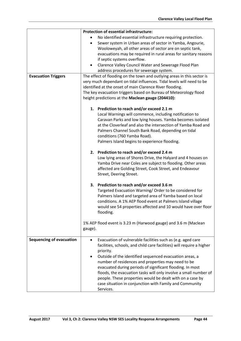
Clarence Valley Local Flood Plan
August 2017 Vol 3, Ch 2: Clarence Valley NSW SES Locality Response Arrangements Page 44
Protection of essential infrastructure:
No identified essential infrastructure requiring protection.
Sewer system in Urban areas of sector in Yamba, Angourie, Wooloweyah, all other areas of sector are on septic tank, evacuations may be required in rural areas for sanitary reasons if septic systems overflow.
Clarence Valley Council Water and Sewerage Flood Plan address procedures for sewerage system.
Evacuation Triggers The effect of flooding on the town and outlying areas in this sector is very much dependant on tidal influences. Tidal levels will need to be identified at the onset of main Clarence River flooding. The key evacuation triggers based on Bureau of Meteorology flood height predictions at the Maclean gauge (204410):
1. Prediction to reach and/or exceed 2.1 m Local Warnings will commence, including notification to Caravan Parks and low lying houses. Yamba becomes isolated at the Cloverleaf and also the intersection of Yamba Road and Palmers Channel South Bank Road, depending on tidal conditions (760 Yamba Road). Palmers Island begins to experience flooding.
2. Prediction to reach and/or exceed 2.4 m
Low lying areas of Shores Drive, the Halyard and 4 houses on Yamba Drive near Coles are subject to flooding. Other areas affected are Golding Street, Cook Street, and Endeavour Street, Deering Street.
3. Prediction to reach and/or exceed 3.6 m
Targeted Evacuation Warning/ Order to be considered for Palmers Island and targeted area of Yamba based on local conditions. A 1% AEP flood event at Palmers Island village would see 54 properties affected and 10 would have over floor flooding.
1% AEP flood event is 3.23 m (Harwood gauge) and 3.6 m (Maclean gauge).
Sequencing of evacuation Evacuation of vulnerable facilities such as (e.g. aged care facilities, schools, and child care facilities) will require a higher priority.
Outside of the identified sequenced evacuation areas, a number of residences and properties may need to be evacuated during periods of significant flooding. In most floods, the evacuation tasks will only involve a small number of people. These properties would be dealt with on a case by case situation in conjunction with Family and Community Services.
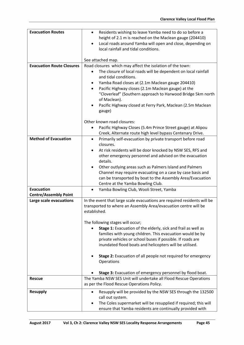
Clarence Valley Local Flood Plan
August 2017 Vol 3, Ch 2: Clarence Valley NSW SES Locality Response Arrangements Page 45
Evacuation Routes Residents wishing to leave Yamba need to do so before a height of 2.1 m is reached on the Maclean gauge (204410)
Local roads around Yamba will open and close, depending on local rainfall and tidal conditions.
See attached map.
Evacuation Route Closures Road closures which may affect the isolation of the town:
The closure of local roads will be dependent on local rainfall and tidal conditions.
Yamba Road closes at (2.1m Maclean gauge 204410)
Pacific Highway closes (2.1m Maclean gauge) at the “Cloverleaf” (Southern approach to Harwood Bridge 5km north of Maclean).
Pacific Highway closed at Ferry Park, Maclean (2.5m Maclean gauge)
Other known road closures:
Pacific Highway Closes (5.4m Prince Street gauge) at Alipou Creek, Alternate route high level bypass Centenary Drive.
Method of Evacuation Primarily self-evacuation by private transport before road closures.
At risk residents will be door knocked by NSW SES, RFS and other emergency personnel and advised on the evacuation details.
Other outlying areas such as Palmers Island and Palmers Channel may require evacuating on a case by case basis and can be transported by boat to the Assembly Area/Evacuation Centre at the Yamba Bowling Club.
Evacuation Centre/Assembly Point
Yamba Bowling Club, Wooli Street, Yamba
Large scale evacuations In the event that large scale evacuations are required residents will be transported to where an Assembly Area/evacuation centre will be established. The following stages will occur;
Stage 1: Evacuation of the elderly, sick and frail as well as families with young children. This evacuation would be by private vehicles or school buses if possible. If roads are inundated flood boats and helicopters will be utilised.
Stage 2: Evacuation of all people not required for emergency Operations
Stage 3: Evacuation of emergency personnel by flood boat.
Rescue The Yamba NSW SES Unit will undertake all Flood Rescue Operations as per the Flood Rescue Operations Policy.
Resupply Resupply will be provided by the NSW SES through the 132500 call out system.
The Coles supermarket will be resupplied if required; this will ensure that Yamba residents are continually provided with
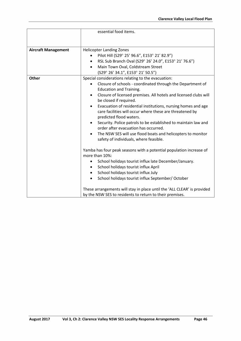
Clarence Valley Local Flood Plan
August 2017 Vol 3, Ch 2: Clarence Valley NSW SES Locality Response Arrangements Page 46
essential food items.
Aircraft Management Helicopter Landing Zones
Pilot Hill (S29 25’ 96.6”, E153 21’ 82.9”)
RSL Sub Branch Oval (S29 26’ 24.0”, E153 21’ 76.6”)
Main Town Oval, Coldstream Street
(S29 26’ 34.1”, E153 21’ 50.5”)
Other Special considerations relating to the evacuation:
Closure of schools - coordinated through the Department of Education and Training.
Closure of licensed premises. All hotels and licensed clubs will be closed if required.
Evacuation of residential institutions, nursing homes and age care facilities will occur where these are threatened by predicted flood waters.
Security. Police patrols to be established to maintain law and order after evacuation has occurred.
The NSW SES will use flood boats and helicopters to monitor safety of individuals, where feasible.
Yamba has four peak seasons with a potential population increase of more than 10%:
School holidays tourist influx late December/January.
School holidays tourist influx April
School holidays tourist influx July
School holidays tourist influx September/ October These arrangements will stay in place until the ‘ALL CLEAR’ is provided by the NSW SES to residents to return to their premises.
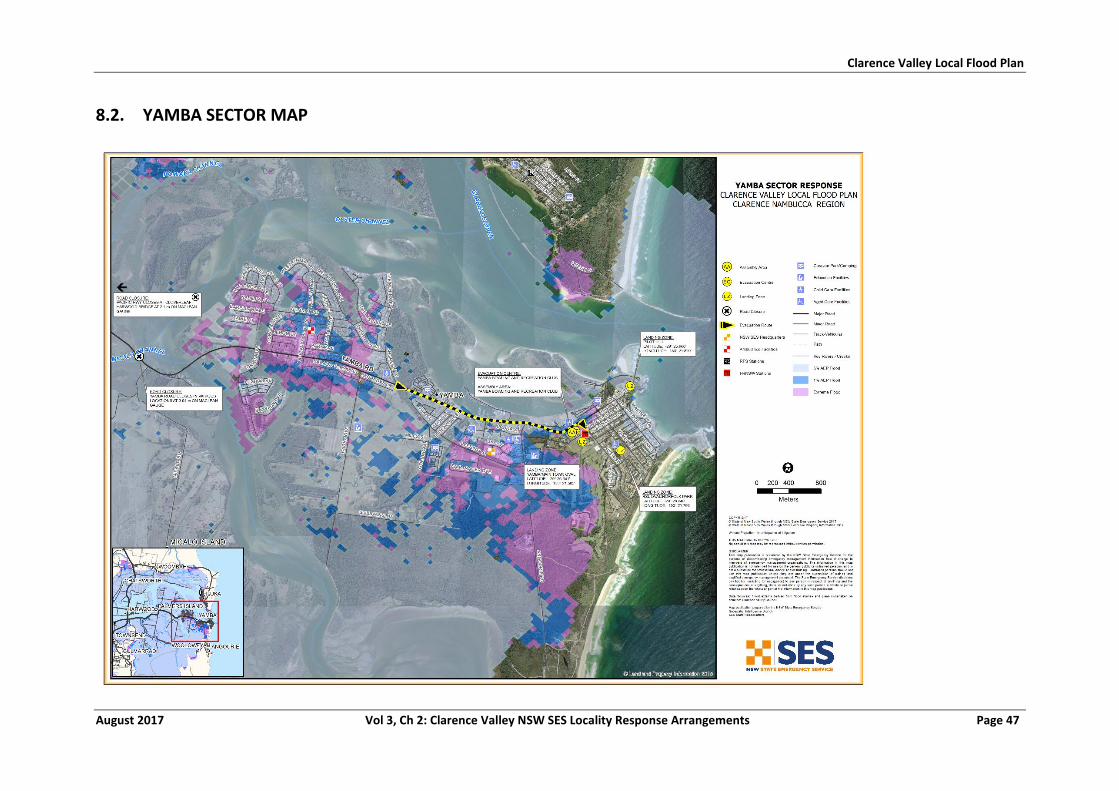
Clarence Valley Local Flood Plan
August 2017 Vol 3, Ch 2: Clarence Valley NSW SES Locality Response Arrangements Page 47
8.2. YAMBA SECTOR MAP
Clarence Valley Local Flood Plan
August 2017 Vol 3, Ch 2: Clarence Valley NSW SES Locality Response Arrangements Page 48
9. SANDON SECTOR
9.1. SANDON SECTOR
See Map Attached
Sector Description This sector covers Bookram, Brooms Head, Sandon and Sandon River Village.
Hazard Flooding by ocean influences and riverine and overland flooding causing isolation.
Flood Affect Classification High flood island.
At risk properties Isolation of all Total number of properties
219 (Census 2011)
Population 195 (Census 2011)
Sector Control The Maclean Unit Controller will control evacuations North of Sandon. Sandon River Village remains under the control of the Yuraygir Unit Controller The NSW SES will conduct evacuations in this sector with assistance from NSW Police, Fire and Rescue NSW, and NSW RFS volunteers.
NO Key Warning Gauge - - -
General Strategy Evacuation of at risk population.
Self-evacuation to friends/family outside of the impact area.
Establishment of an Assembly Area at Brooms Head Bowling Club, 30 - 36 Ocean Road, Brooms Head where evacuees are able to gather while flood situation is monitored.
Establishment of an Assembly Area at Sandon River Village RFS/ Library Building to accommodate village residents.
Key Risks / Consequences Potential loss of life from tidal surges and large ocean seas.
Potential isolation of more than 200 people estimated to be for a number of days.
Information and Warnings Storm Surge Warning
Evacuation Warning
Evacuation Order
Sequenced door knocking of evacuation sectors
Media announcements (including social media)
Emergency Alert (SMS, Landlines)
SEWS
Property Protection Specific property protection measures:
Monitoring integrity of dwellings affect by ocean influences.
Protection of essential infrastructure:
No identified essential infrastructure requiring protection
Evacuation Triggers There is no river height gauge on the Sandon River. The river is tidal with a small catchment area. A river level 1.2 m over high tide can cover access road to Sandon from the north.
Storm surge/large wave events may impact areas within this sector.
Clarence Valley Local Flood Plan
August 2017 Vol 3, Ch 2: Clarence Valley NSW SES Locality Response Arrangements Page 49
Sequencing of evacuation Sandon
35 houses in Sandon village will require door knocking. North Sandon
A potential for 40 camp sites and 12 occasionally occupied houses at Sandon River camping ground will require door knocking in the event of possible flooding. Brooms Head
Low lying parts of Brooms Head Caravan Park may require door knocking.
Low lying houses at Ocean Street may require assistance in Storm Surge/Large Wave events.
Evacuation Routes Brooms Head Road to Maclean.
Sandon River Village has access via main inland track to Minnie Water.
See attached map.
Evacuation Route Closures 1.2 m flood height over the high tide can close Sandon River Road.
Main beach track used to travel to Minnie Water may not be passable during high tides or storm surge events.
Method of Evacuation Affected residents may be transported by helicopter in the event of road closures.
Evacuation Centre/Assembly Point
Brooms Head Bowling Club 30-36 Ocean Road, Broom Head
Sandon River Village RFS/ Library Building.
Large scale evacuations It is not anticipated that large scale evacuations could occur with limited residents affected in this sector.
Rescue The Maclean NSW SES Unit will undertake all Flood Rescue Operations as per the Flood Rescue Operations Policy.
Resupply Resupply will be provided by the NSW SES through the 132500 call out system.
The Brooms Head local store will be resupplied if required, where residents can access essential food supplies for the period of isolation.
Aircraft Management Helicopter Landing Zones
Brooms Head Sports Ground (S29 38’ 40.8”, E 153 19’ 91.5”)
Sandon River Village (S29 40’ 41.0”, E153 19’ 46.3”)
Other Special considerations relating to the evacuation:
Security. Police patrols to be established to maintain law and order after evacuation has occurred.
The NSW SES will use flood boats and helicopters to monitor safety of individuals, where feasible.
Brooms Head and Sandon have four peak seasons with potential for a population increase of more than 100%:
o School holidays December/January o School holidays April o School holidays July
Clarence Valley Local Flood Plan
August 2017 Vol 3, Ch 2: Clarence Valley NSW SES Locality Response Arrangements Page 50
o School holidays September/October
The majority of holiday makers in this sector are campers. These arrangements will stay in place until the ‘ALL CLEAR’ is provided by the NSW SES to residents to return to their premises.
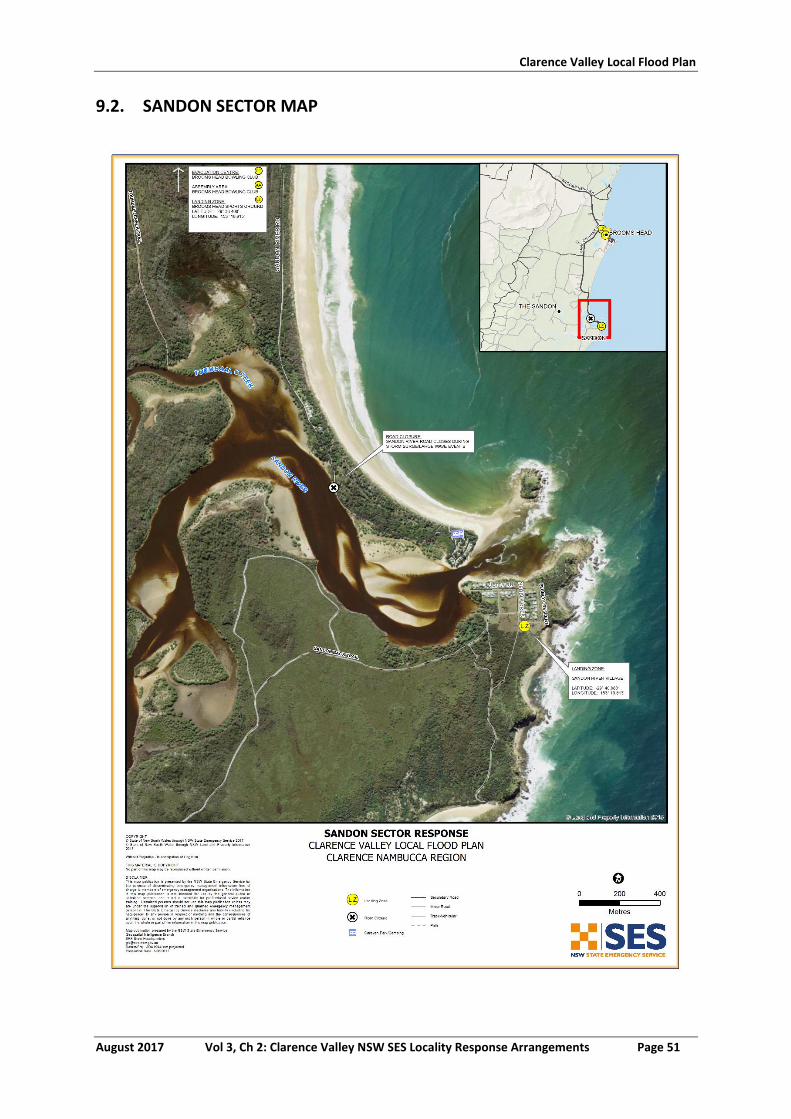
Clarence Valley Local Flood Plan
August 2017 Vol 3, Ch 2: Clarence Valley NSW SES Locality Response Arrangements Page 51
9.2. SANDON SECTOR MAP
Clarence Valley Local Flood Plan
August 2017 Vol 3, Ch 2: Clarence Valley NSW SES Locality Response Arrangements Page 52
10. WOOLI-MINNIE WATER SECTOR
10.1. WOOLI MINNIE SECTOR
See Map Attached
Sector Description This sector covers Calamia, Diggers Camp, Minnie Water, Pillar Valley, Sandy Crossing and Wooli.
Hazard Riverine flooding on the Wooli and Coldstream Rivers.
Flood Affect Classification High flood islands, with Wooli becoming a low flood island.
At risk properties 226 at risk of inundation. All at risk of isolation.
Total number of properties
531 (Census 2011)
Population 755 (Census 2011)
Sector Control The Wooli - Yuraygir Unit Controller will control evacuations in this sector. The NSW SES will conduct evacuations in this sector with assistance from NSW Police, Fire and Rescue NSW, and NSW RFS volunteers.
Key Warning Gauge Name: Wooli (205463)
Minor: - Moderate: - Major-
General Strategy Evacuation of at risk population.
Self-evacuation to friends/family outside of the impact area.
Establishment of an Assembly Area at Wooli Bowling Club, Main Street, Wooli where evacuees are able to gather while flood situation is monitored.
Key Risks / Consequences Potential loss of life from rapid and potentially high velocity inundation.
Potential isolation of thousands of people estimated to be for a number of days.
Information and Warnings Flood Watch
Flood Bulletins
Evacuation Warning
Evacuation Order
Sequenced door knocking of evacuation sectors
Media announcements (including social media)
Emergency Alert (SMS, Landlines)
SEWS
Property Protection Specific property protection measures:
Monitoring rising flood waters.
Relocation of livestock.
Relocation of farm machinery and valuable goods.
Control of surface water through sandbagging measures.
Assist in the lifting of furniture to residents in need.
Monitoring integrity of dwellings surrounded by flood waters.
Protection of essential infrastructure:
No identified essential infrastructure requiring protection.
No sewerage, evacuation may be required for sanitary reasons if septic systems overflow.
Clarence Valley Local Flood Plan
August 2017 Vol 3, Ch 2: Clarence Valley NSW SES Locality Response Arrangements Page 53
Evacuation Triggers The effects of flooding on the town and outlying areas in this sector is very much dependent on tidal influences. Tidal levels will need to be identified at the onset of Wooli River flooding. The key evacuation triggers based on Bureau of Meteorology flood height predictions at the Wooli (Resort) River gauge (205463):
1. Prediction to reach and/or exceed 1.5 m Evacuations will be considered when the predicted height of the Wooli River (Resort) gauge at The Solitary Islands Marine Park reaches 1.5 m. 100 mm of rain and Lake Hiawatha can commence over flowing into the swamp behind village. Water becomes visible behind Williams Crescent. When this occurs Sandy Crossing and White Bridge may be cut.
Large swells, king tides and heavy rain affect low lying areas along Riverside Drive from forks in road to Wooli Oyster supply with no.11 Carraboi Street lowest dwelling. Houses 154 and 156 Main Street over floor flooding from storm water during heavy rain.
Sequencing of evacuation The following stages will occur; Stage 1
Evacuation of the elderly, sick and frail as well as families with young children. This evacuation would be by private vehicles or school buses if possible. If roads are inundated flood boats and helicopters will be utilised.
Stage 2
Evacuation of all people not required for emergency Operations
Use of RFS trucks, at Wooli and Pillar Valley, Hotel bus, Bowling Club bus and Wooli Freight Service truck used to evacuate people from the village.
Evacuation Routes Local roads around Wooli will open and close, depending on local rainfall and tidal conditions.
Evacuation route for Wooli is travel along Riverside Drive until you come to the Bowling Club. Alternately if this road is underwater travel along Main Street turn right at Bowling Club into Riverside Drive and on to Bowling Club.
Evacuation Route Closures Local and heavy rainfall close roads
If Eight Mile Lane closes at Sandy Crossing, the towns of Wooli, Minnie Water and Diggers Camp will be isolated. This situation occurs quite regularly and the residents are aware of this The Eight Mile Lane to the Pacific highway may close at Sandy crossing.
White Bridge on Wooli Road to Tucabia
The towns are often isolated from local storm events as well. Other known road closures include:
Firth Heinz Road Pillar Valley
Clarence Valley Local Flood Plan
August 2017 Vol 3, Ch 2: Clarence Valley NSW SES Locality Response Arrangements Page 54
Diggers Camp Road.
Eight Mile Lane at Sandy Crossing closes
White Bridge closes.
Pacific Highway Closes (5.4 m Prince Street gauge) at Alipou Creek, Alternate route high level bypass Centenary Drive.
Method of Evacuation When flooding is expected the NSW SES, RFS and other Emergency Services will conduct a door knock of the areas to be effected.
Known affected locations are: Riverside Drive, Wooli Road, Olen Close, Little River Close, Main Street
Evacuation Centre/Assembly Point
Wooli Bowling Club Main Street Wooli (Assembly point)
Large scale evacuations If large scale evacuations are likely, the Wooli Community will be directed to the Wooli Bowling Club (Assembly Area), to register and be advised which evacuation centre is open to accommodate the residents.
Rescue The Wooli - Yuraygir NSW SES Unit will undertake all Flood Rescue Operations as per the Flood Rescue Operations Policy.
Resupply Resupply will be provided by the NSW SES through the 132500 call out system.
The Local Stores in Wooli and Minnie Water will be resupplied if required; this will ensure that local residents are continually provided with essential food items. NSW SES informs shops of when the boat will be working at Sandy Crossing.
Aircraft Management Helicopter Landing Zones
Wooli Sports Oval next to Yuraygir NSW SES building (S29° 30' 52.596" E153° 9' 35.2794")
Other Special considerations relating to the evacuation:
Closure of schools - coordinated through the Department of Education and Training.
Closure of licensed premises. All hotels and licensed clubs will be closed if required.
Security. Police patrols to be established to maintain law and order after evacuation has occurred.
The NSW SES will use flood boats and helicopters to monitor safety of individuals, where feasible.
Wooli and Minnie Waters has four peak seasons with potential for a 10% population increase:
o School holidays tourist influx late December/January o School holidays tourist influx April o School holidays tourist influx July o School holidays tourist influx September/ October
These arrangements will stay in place until the ‘ALL CLEAR’ is provided by the NSW SES to residents to return to their premises.
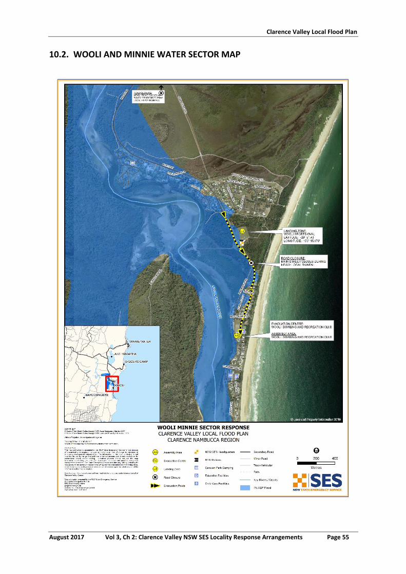
Clarence Valley Local Flood Plan
August 2017 Vol 3, Ch 2: Clarence Valley NSW SES Locality Response Arrangements Page 55
10.2. WOOLI AND MINNIE WATER SECTOR MAP
Clarence Valley Local Flood Plan
August 2017 Vol 3, Ch 2: Clarence Valley NSW SES Locality Response Arrangements Page 56
11. CANGAI SECTOR
11.1. CANGAI SECTOR
See Map Attached
Sector Description This sector covers Cangai, Carnham, Coombadjha, and Jackadgery.
Hazard Clarence River and Mann River riverine flooding.
Flood Affect Classification High flood island.
At risk properties All at risk of isolation. Total number of properties
99 (Census 2011)
Population 182 (Census 2011)
Sector Control The Copmanhurst Unit Controller will control evacuations in this sector. The NSW SES will conduct evacuations in this sector with assistance from NSW Police, Fire and Rescue NSW, and RFS volunteers.
Key Warning Gauges Name: Baryulgil (204900) Jackadgery (204004) Tabulam (204002)
Minor: - Moderate: - Major: -
General Strategy Evacuation of at risk population.
Generally evacuations would not be considered in this sector other than for medical reasons.
Properties become isolated and resupply is required for extended periods.
Key Risks / Consequences Potential isolation of a number of people estimated to be for a number of days.
Information and Warnings Flood Watch
Flood Bulletins
Evacuation Warning
Evacuation Order
Sequenced door knocking of evacuation sectors
Media announcements (including social media)
Emergency Alert (SMS, Landlines)
SEWS
Property Protection Specific property protection measures:
Properties are not directly affected by flooding in this sector.
Residents are encouraged to remain in their houses.
Protection of essential infrastructure:
No identified essential infrastructure requiring protection.
No sewerage or reticulated water supply.
Evacuation Triggers The key evacuation triggers based on the historical equivalent height flood height at the Tabulam gauge (204002):
1. Reach and/or exceed 1.5 m: Baryulgil gauge (204900); (historical equivalent height to reach and/or exceed 2.5m at the Tabulam gauge (204002); with flow time between gauges of three hours)
The Baryulgil Crossing can be cut causing some property isolations.
Clarence Valley Local Flood Plan
August 2017 Vol 3, Ch 2: Clarence Valley NSW SES Locality Response Arrangements Page 57
2. Reach and/or exceed 5.72 m: Jackadgery gauge (204004);
(historical equivalent height to reach and/or exceed 6.72 m at the Tabulam gauge with flow time between gauges of 10-12 hours)
The Cangai Road Bridge can be cut causing isolation from Grafton.
Sequencing of evacuation Properties may need to be evacuated for medical reasons during periods of significant flooding over an extended period; these properties would be dealt with on a single case by case situation in conjunction with Family and Community Services.
Evacuation Routes Gwydir Highway west to Glen Innes (caution - road is subject to land slippage).
Gwydir Highway east to Grafton (caution - road is subject to land slippage).
Clarence Way. See attached map.
Evacuation Route Closures Road closures affecting the isolation of residents in this sector:
There is uncertainty when local roads around the Cangai area will close, the closure will be dependent on local rainfall conditions.
Other known road closures include:
Clarence Way closes at Whiteman Creek causeway(8.0m Copmanhurst gauge), approximately 6km east of Copmanhurst
Gwydir Highway to Grafton (road susceptible to land slippage) Other roads where closure is dependent on local rainfall and events (e.g. landslips) include:
Summerland Way closes on Grafton levee overtopping at (8.3 m on the Prince Street gauge).
Armidale Road
Old Glen Innes Road
Carnham Road
Dandahra Road
Method of Evacuation Property owners are recommended to remain at their properties. Primarily self-evacuation by private transport before road closures. Access is dependent on road conditions; best option for access to evacuate residents is by helicopter when the area is isolated.
Evacuation Centre/Assembly Point
No formal evacuation centre or assembly point in place. If required locations will be determined at the time. These could include:
Mann River Caravan Park (20 sites available to service areas of Cangai and outlying areas of Coombadjha.
Baryulgil Primary School can service remaining outlying areas.
Large scale evacuations Large scale evacuations would be unlikely in this sector but if required additional locations will be identified.
Rescue The Copmanhurst NSW SES Units will undertake all Flood Rescue Operations as per the Flood Rescue Operations Policy.
Clarence Valley Local Flood Plan
August 2017 Vol 3, Ch 2: Clarence Valley NSW SES Locality Response Arrangements Page 58
Resupply Resupply will be provided by the NSW SES through the 132500 call out system.
Local store “The Mann River Caravan Park” will be resupplied if required.
Aircraft Management Helicopter Landing Zones
Cangai Post Office (S29 30’ 30.1”, E152 28’ 45.2”)
Car park at the Gwydir highway bridge over the Mann River
(S29 34’ 38.6”, E152 33’ 24.0”)
Malabugilmah Oval (S29 10’ 55.4”, E152 37’ 37.9”)
Other Special considerations relating to the evacuation:
Closure of schools - coordinated through the Department of Education and Training.
The NSW SES may use helicopters to monitor safety of individuals, where feasible.
Cangai has one peak season with potential population increase of more than 10%:
o Summer school holidays - Public lands within remote areas of this sector are utilized by campers.
These arrangements will stay in place until the ‘ALL CLEAR’ is provided by the NSW SES to residents to return to their premises.
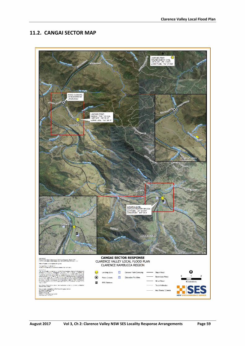
Clarence Valley Local Flood Plan
August 2017 Vol 3, Ch 2: Clarence Valley NSW SES Locality Response Arrangements Page 59
11.2. CANGAI SECTOR MAP
Clarence Valley Local Flood Plan
August 2017 Vol 3, Ch 2: Clarence Valley NSW SES Locality Response Arrangements Page 60
12. COUTTS CROSSING SECTOR
12.1. COUTTS CROSSING SECTOR
See Map Attached
Sector Description This sector covers Blaxlands, Flat/Creek, Billy’s Creek, Braunstone, Buccarumbi, Chambigne, Clouds Creek, Coutts Crossing, Dundurrabin, Elland, Kangaroo Creek, Lanitza, Levenstrath, Lower Kangaroo Creek, McPherson Crossing, Middle Creek, Moonpar, Nymboida, Shannondale, Towallum, and Tyringham.
Hazard Orara River and Nymboida riverine flooding.
Flood Affect Classification High flood island.
At risk properties All at risk of isolation. Total number of properties
406 (Census 2011)
Population 1040 (Census 2011)
Sector Control The Nymboida Unit Controller will control evacuations in this sector. The NSW SES will conduct evacuations in this sector with assistance from NSW Police, Fire and Rescue NSW, and NSW RFS volunteers.
Key Warning Gauge: Coutts Crossing (204999) Nymboida (204001)
Minor: 5.00 m Moderate: 9.00 m Major: 12.00 m
Minor: - Moderate: - Major: -
General Strategy Evacuation of at risk population.
Self-evacuation to friends/family outside of the impact area.
A number of residences and properties may need to be evacuated during periods of significant flooding because of isolation. In most floods, the evacuation tasks will only involve a small number of people.
Key Risks / Consequences Potential loss of life from rapid and potentially high velocity inundation.
Potential isolation of hundreds of people estimated to be for a number of days.
Information and Warnings Flood Watch
Flood Bulletins
Evacuation Warning
Evacuation Order
Sequenced door knocking of evacuation sectors
Media announcements (including social media)
Emergency Alert (SMS, Landlines)
SEWS
Property Protection Specific property protection measures:
Monitoring rising flood waters.
Relocation of livestock.
Relocation of farm machinery and valuable goods
Control of surface water through sandbagging measures.
Assist in the lifting of furniture to residents in need.
Monitoring integrity of dwellings surrounded by flood waters.
Protection of essential infrastructure:
No identified essential infrastructure requiring protection.
Clarence Valley Local Flood Plan
August 2017 Vol 3, Ch 2: Clarence Valley NSW SES Locality Response Arrangements Page 61
Sewer system only in township of Coutts Crossing, most of sector is on septic tank, evacuations may be required in rural areas for sanitary reasons if septic systems overflow.
Clarence Valley Council Flood Procedures Manual addresses procedures for sewerage treatment plant.
Evacuation/Isolation Triggers
Nymboida River area There are no upstream river gauges that have warnings relative to the Nymboida River gauge (204001). Local rainfall gauges can provide an indication of the likely affects in relation to the Nymboida gauge. The following trigger heights related to the Nymboida gauge indicate the point when the communities will be isolated:
1. reach and/or exceed 3.2 m Families in the Buccarumbi Area become isolated (approximately 40 families).
2. reach and/or exceed 4.0 m
Water backs up Copes Creek closing Boundary Road isolating approximately 6 families.
3. reach and/or exceed 7.0 m
Pollock’s Bridge on Leighton’s Range Road may be cut at Pollock’s Bridge causing isolation to residents (approximately 20 Families).
Orara River (Coutts Crossing area) The key evacuation triggers below are based on Flood warnings provided for the Coutts Crossing gauge (204999). Bureau of Meteorology Warnings are provided after the flood peaks at the Glenreagh gauge (204907), allowing approximately 18-24 hours warning time.
1. Prediction to reach and/or exceed 6.6 m on the Coutts Crossing gauge (204999) Middle Creek Road will close isolating the Middle Creek and Kangaroo Creek areas (approximately 30 families).
2. Prediction to reach and/or exceed 7.1 m on the Coutts
Crossing gauge (204999) The Lower Kangaroo Creek Road may be cut causing isolation to residents in the Lower Kangaroo Creek area (approximately 70 families).
3. Prediction to reach and/or exceed 7.4 m on the Coutts
Crossing gauge (204999) Mulquinney’s Road may close causing isolation in the Fiddlers Creek area past School Lane (approximately 12 families).
4. Prediction to reach and/or exceed 7.9 m on the Coutts
Crossing gauge (204999) Geregarow Road may close causing isolation in the
Clarence Valley Local Flood Plan
August 2017 Vol 3, Ch 2: Clarence Valley NSW SES Locality Response Arrangements Page 62
Shannondale area (approximately 20 families).
5. Prediction to reach and/or exceed 8.5 m on the Coutts Crossing gauge (204999) Levenstrath Road will close causing isolation in the Levenstrath area (approximately 15 families).
6. Prediction to reach and/or exceed 10.0 m on the Coutts
Crossing gauge (204999) Lower Braunstone Road may close causing isolation in the Braunstone area (approximately 6 families).
Sequencing of evacuation A number of residences and properties may need to be evacuated during periods of significant flooding because of isolation. In most floods, the evacuation tasks will only involve a small number of people. These properties would be dealt with on a case by case basis in conjunction with Family and Community Services.
Evacuation Routes Armidale Road is normally open to Grafton or Dorrigo (However local flash flooding could impact this route for short periods of time).
Evacuation Route Closures Road closures affecting the isolation/evacuation of residents in this sector:
There is uncertainty when local roads around the Coutts Crossing area will close, the closure will be dependent on local rainfall conditions.
Other known road closures include:
Pacific Highway Closes (5.4m Prince Street gauge) at Alipou Creek, Alternate route high level bypass Centenary Drive.
Orara Way Closes at Bluff Bridge at (5.8 m on the Glenreagh gauge)
Closure may also occur on low lying parts of the Orara Way between School Lane at Braunstone and Parker Road at Wells Crossing. Alternate route Pacific Hwy.
Method of Evacuation Property owners are recommended to remain at their properties.
Primarily self-evacuation by private transport before road closures.
In the event of residents on isolated properties requiring evacuation. The arrangements will be made by the NSW SES dependant on conditions at that time. Options to evacuate residents will be by flood boat or helicopter.
Evacuation Centre/Assembly Point
People are encouraged to stay with friends/relatives outside the affected areas.
Large scale evacuations No Large scale evacuations are anticipated for this sector.
Rescue The Nymboida NSW SES Unit will undertake all Flood Rescue Operations as per the Flood Rescue Operations Policy.
Clarence Valley Local Flood Plan
August 2017 Vol 3, Ch 2: Clarence Valley NSW SES Locality Response Arrangements Page 63
Resupply Resupply will be provided by the NSW SES through the 132500 call out system.
The Local Stores in this sector will be resupplied if required.
Aircraft Management Helicopter Landing Zones
Oval adjacent to Nymboida NSW SES Unit at Coutts Crossing ‘Wajard Park’ (S29°.50’.20.7”, E152°.53’.47.3”)
Coutts Crossing Cricket Oval (S 29°.49'. 50.72”, E152°. 53'. 24.68”)
Other Special considerations relating to the evacuation:
Closure of schools - coordinated through the Department of Education and Training.
Security. Police patrols to be established to maintain law and order after evacuation has occurred.
The NSW SES will use flood boats and helicopters to monitor safety of individuals, where feasible.
These arrangements will stay in place until the ‘ALL CLEAR’ is provided by the NSW SES to residents to return to their premises.
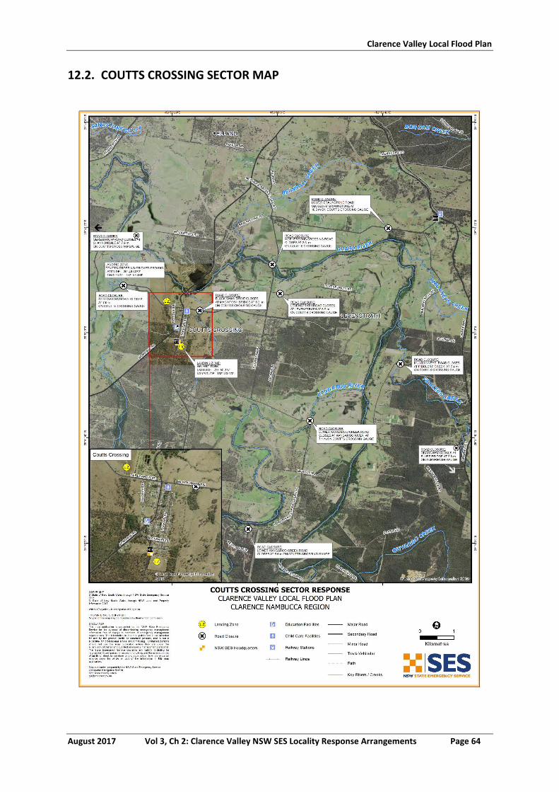
Clarence Valley Local Flood Plan
August 2017 Vol 3, Ch 2: Clarence Valley NSW SES Locality Response Arrangements Page 64
12.2. COUTTS CROSSING SECTOR MAP
Clarence Valley Local Flood Plan
August 2017 Vol 3, Ch 2: Clarence Valley NSW SES Locality Response Arrangements Page 65
13. GLENREAGH SECTOR
13.1. GLENREAGH SECTOR
See Map Attached
Sector Description This sector covers Glenreagh, Kremnos, Kungala and Wells Crossing.
Hazard Orara riverine flooding.
Flood Affect Classification High flood island.
At risk properties 30 at risk of over floor inundation. All at risk of isolation.
Total number of properties
346 (Census 2011)
Population 862 (Census 2011)
Sector Control The Corindi Unit Controller will control evacuations in this sector. The NSW SES will conduct evacuations in this sector with assistance from NSW Police, Fire and Rescue NSW, and RFS volunteers.
Key Warning Gauge Name: Glenreagh (204907)
Minor: 5.00 m Moderate: 9.00 m Major: 12.00 m
General Strategy Evacuation of at risk population.
Self-evacuation to friends/family outside of the impact area.
A number of residences and properties may need to be evacuated during periods of significant flooding because of isolation. In most floods, the evacuation tasks will only involve a small number of people.
In extreme events Glenreagh Community Hall (School of Arts), 62 Coramba Street, Glenreagh will form the Assembly Area/Evacuation Centre.
Key Risks / Consequences Potential loss of life from rapid and potentially high velocity inundation.
Potential isolation of hundreds of people estimated to be for a number of days.
Information and Warnings Flood Watch
Flood Bulletins
Evacuation Warning
Evacuation Order
Sequenced door knocking of evacuation sectors
Media announcements (including social media)
Emergency Alert
SEWS (SMS, Landlines)
Property Protection Specific property protection measures:
Monitoring rising flood waters.
Relocation of livestock.
Relocation of farm machinery and valuable goods.
Control of surface water through sandbagging measures.
Assist in the lifting of furniture to residents in need.
Monitoring integrity of dwellings surrounded by flood waters.
Protection of essential infrastructure:
No identified essential infrastructure requiring protection.
Clarence Valley Local Flood Plan
August 2017 Vol 3, Ch 2: Clarence Valley NSW SES Locality Response Arrangements Page 66
No sewerage, evacuation may be required for sanitary reasons if septic systems overflow.
Evacuation/Isolation Triggers
The key evacuation triggers based on Bureau of Meteorology flood height predictions at the Glenreagh gauge (204907) are:
1. Prediction to reach and/or exceed 5.8 m The Bluff Bridge will close on the Orara Way preventing residents in Glenreagh, Kremnos and Kungala access to Grafton. Kungala Road is closed at Dundoo Creek and Sherwood Creek. Alternate Access to Grafton via Bucca Road may also be cut by the Orara River at Nana Glen.
2. Prediction to reach and/or exceed 7.6 m
Orara Way closed 1.6km east of Glenreagh at Glenreagh Creek cutting access to Coffs Harbour.
3. Prediction to reach and/or exceed 13.24 m
Major Riverine flooding on the Orara River will occur but not expected to involve over floor flooding this sector. Evacuations may need to be undertaken due to long periods of isolation or medical conditions.
Sequencing of evacuation A number of residences and properties may need to be evacuated during periods of isolation. The evacuation tasks will only involve a small number of people these properties would be dealt with on a single case by case basis in conjunction with Family and Community Services.
Evacuation Routes All roads within this sector are expected to be flood affected.
Transport in and out of this sector will be by Rail or Helicopter only.
Evacuation Route Closures Road closures affecting the isolation/evacuation of residents in this sector:
The closure of local roads will be dependent on local rainfall conditions.
Orara Way closes at Bluff Bridge at 5.8 m on the Glenreagh gauge.
Other known road closures include:
Pacific Highway Closes (5.4 m Prince Street gauge) at Alipou Creek, Alternate route high level bypass Centenary Drive.
Summerland Way closes as Grafton levee overtopping at 8.3m on the Prince Street gauge.
Other roads where closure is dependent on local rainfall and events (e.g. landslips) include :
Gwydir Highway (road susceptible to land slippage)
Armidale Road (road closes intermittently with local flooding)
Bucca Road Nana Glen (road closes intermittently with local flooding)
Method of Evacuation Property owners are recommended to remain at their properties.
Primarily self-evacuation by private transport before road
Clarence Valley Local Flood Plan
August 2017 Vol 3, Ch 2: Clarence Valley NSW SES Locality Response Arrangements Page 67
closures.
In the event of residents on isolated properties requiring evacuation, the arrangements will be made by the NSW SES dependent on conditions at that time. Options to evacuate residents will be by flood boat or helicopter.
Evacuation Centre/Assembly Point
People should be encouraged to stay with friends/relatives in the Glenreagh sector.
Glenreagh Community Hall (School of Arts) 62 Coramba Street Glenreagh
Large scale evacuations Large scale evacuations would be unlikely in this sector.
Rescue The Corindi NSW SES Unit will undertake all Flood Rescue Operations as per the Flood Rescue Operations Policy.
Resupply Resupply will be provided by the NSW SES through the 132500 call out system.
The local stores in this sector will be resupplied if required.
Aircraft Management Helicopter Landing Zones
The Glenreagh Public Recreation Reserve in Bridge Street (S30° 03' 10.6, E152° 58' 40.7)
The Glenreagh Railway Station (S30˚ 02’ 58.55” E152˚ 59’ 12.5”)
Other Special considerations relating to the evacuation:
Closure of schools - coordinated through the Department of Education and Training.
Security. Police patrols to be established to maintain law and order after evacuation has occurred.
The NSW SES will use flood boats and helicopters to monitor safety of individuals, where feasible.
These arrangements will stay in place until the ‘ALL CLEAR’ is provided by the NSW SES to residents to return to their premises.
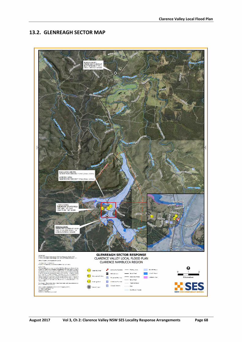
Clarence Valley Local Flood Plan
August 2017 Vol 3, Ch 2: Clarence Valley NSW SES Locality Response Arrangements Page 68
13.2. GLENREAGH SECTOR MAP
CLARENCE VALLEY NSW SES
CARAVAN PARK ARRANGEMENTS
Volume 3, Chapter 4 of the Clarence Valley Local Flood Plan
(NSW SES Response Arrangements for Clarence Valley)
Last Update: August 2017
Clarence Valley Local Flood Plan
August 2017 Vol 3, Ch 4: Clarence Valley NSW SES Caravan Park Arrangements Page 2
AUTHORISATION
The Clarence Valley NSW SES Caravan Park Arrangements have been prepared by the NSW
State Emergency Service (NSW SES) as part of a comprehensive planning process.
Tabled at LEMC Date:
Document Issue: V3.3-21102014
Clarence Valley Local Flood Plan
August 2017 Vol 3, Ch 4: Clarence Valley NSW SES Caravan Park Arrangements Page 3
CONTENTS
AUTHORISATION ............................................................................................................................................. 2
CONTENTS ....................................................................................................................................................... 3
LIST OF TABLES ................................................................................................................................................ 3
1 ARRANGEMENTS FOR THE EVACUATION OF CARAVAN PARKS AND THE RELOCATION OF MOVABLE
DWELLINGS ...................................................................................................................................................... 4
General ............................................................................................................................................. 4
Advising Procedures ......................................................................................................................... 4
Evacuation of Occupants and Relocation of Moveable Dwellings ................................................... 5
Return of Occupants and Moveable Dwellings ................................................................................ 6
LIST OF REFERENCES ...................................................................................................................................... 16
LIST OF TABLES
Table 1: Caravan Parks at risk of Inundation and/or Isolation from Flooding. .................................................. 7
Table 2: Caravan Parks at risk from Coastal Erosion and/or Coastal Inundation. ........................................... 14
Clarence Valley Local Flood Plan
August 2017 Vol 3, Ch 4: Clarence Valley NSW SES Caravan Park Arrangements Page 4
1 ARRANGEMENTS FOR THE EVACUATION OF CARAVAN PARKS AND THE RELOCATION OF MOVABLE DWELLINGS
GENERAL
1.1.1 The following caravan parks are flood liable:
a. Glenwood Tourist Park 71 Heber Street South Grafton
b. Sunset Caravan Park 302 Gwydir Highway South Grafton
c. The Gateway Village Holliday Park 598 Summerland Way
d. GraftonGrafton Showground Prince Street Grafton
e. Big River Caravan & 166 Seelands Road Seelands
f. Browns Rocks Caravan Park 391 Goodwood Island Road Goodwood Island
g. Anchorage Holiday Park Marandowie Drive Iluka
h. Yamba Waters Holiday Park 36 Golding Street Yamba
i. Solitary Islands Marine Park Resort 383 North Street Wooli
j. Wooli Caravan Park 25 Riverside Drive Wooli
k. Grafton Greyhound Reserve Trust Cranworth Street Grafton
l. Maclean Riverside Caravan Park 115 River Street Maclean
m. Brooms Head Caravan Park Ocean Road Brooms Head
n. Calypso Holiday Park 14 Harbour Street Yamba
o. Blue Dolphin Holiday Park Yamba Road Yamba
p. Salt Water Big 4 Yamba Clarence Coast Resort 286 Okeefes Lane Palmers Island
q. Fishing Haven Caravan Park 35 River Street Palmers Island]
1.1.2 For more information on individual caravan parks see Table 1 and Table 2 at the end of this Chapter.
ADVISING PROCEDURES
1.2.1 Caravan Park proprietors will ensure that the owners and occupiers of movable dwellings are:
a. Made aware that the caravan park is flood liable by:
Providing a written notice to occupiers taking up residence. The notice will indicate that the caravan park is liable to flooding and designate the location of flood liable land within the park (1).
Clarence Valley Local Flood Plan
August 2017 Vol 3, Ch 4: Clarence Valley NSW SES Caravan Park Arrangements Page 5
Displaying this notice and the emergency arrangements for the Caravan Park prominently in the park.
b. Made aware that if they are expecting to be absent for extended periods, they should:
Provide the manager of the caravan park with a contact address and telephone number in case of an emergency.
Leave any movable dwelling in a condition allowing it to be relocated in an emergency (i.e.: should ensure that the wheels, axles and draw bar of the caravans are not removed, and are maintained in proper working order).
c. Informed of Flood Warning Information. At this time, occupiers will be advised to:
Ensure that they have spare batteries for their radios.
Listen to a local radio station for updated flood information.
Prepare for evacuation and movable dwelling relocation.
1.2.2 The NSW SES Clarence Valley Local Controller will ensure that the managers of caravan parks are advised of Flood Information (described in Volume 1 of the Clarence Valley Local Flood Plan).
EVACUATION OF OCCUPANTS AND RELOCATION OF MOVEABLE
DWELLINGS
1.3.1 When an evacuation order is given caravan park occupants should follow the flood evacuation procedures for the park under the direction of the caravan park management. This should include advice to:
a. Isolate power to moveable dwellings.
b. Collect personal papers, medicines, a change of clothing, toiletries and bedclothes.
c. Lift the other contents in any remaining dwellings as high as possible.
d. Move to friends, relatives or a designated evacuation centre if they have their own transport, or move to the caravan office to await transport.
e. If undertaking self-managed evacuation, register their movements with the caravan park management upon leaving the park.
1.3.2 Where possible, movable dwellings that can be moved will be relocated by their owners. Park managers will arrange for the relocation of movable dwellings as required. Council and NSW SES personnel may assist if required. Vans are to be moved to the locations outlined in Tables 1 and 2 at the end of this Chapter.
Clarence Valley Local Flood Plan
August 2017 Vol 3, Ch 4: Clarence Valley NSW SES Caravan Park Arrangements Page 6
1.3.3 Caravan park managers will:
a. Secure any movable dwellings that are not able to be relocated to prevent floatation.
b. Ensure that their caravan park is capable of being evacuated in a timely and safe manner.
c. Advise the NSW SES Clarence Valley Local Controller of:
The number of people requiring transport.
Details of any medical evacuations required.
Whether additional assistance is required to effect the evacuation.
d. Check that all residents and visitors are accounted for.
e. Inform the NSW SES Clarence Valley Local Controller when the evacuation of the caravan park has been completed.
f. Provide the NSW SES Clarence Valley Local Controller with a register of people that have been evacuated.
RETURN OF OCCUPANTS AND MOVEABLE DWELLINGS
1.4.1 The NSW SES Clarence Valley Local Controller, using council resources as necessary, will advise when it is safe for the caravan parks to be re-occupied.
1.4.2 Moveable dwellings will be returned back to the caravan park(s) by owners or by vehicles and drivers arranged by the park managers.
1.4.3 Council and NSW SES personnel may assist by request where resources are available.
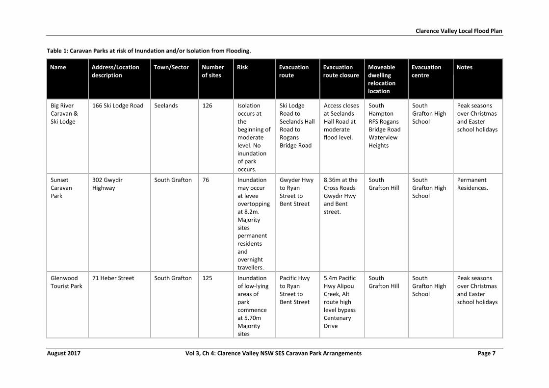
Clarence Valley Local Flood Plan
August 2017 Vol 3, Ch 4: Clarence Valley NSW SES Caravan Park Arrangements Page 7
Table 1: Caravan Parks at risk of Inundation and/or Isolation from Flooding.
Name Address/Location description
Town/Sector Number of sites
Risk Evacuation route
Evacuation route closure
Moveable dwelling relocation location
Evacuation centre
Notes
Big River Caravan & Ski Lodge
166 Ski Lodge Road Seelands 126 Isolation occurs at the beginning of moderate level. No inundation of park occurs.
Ski Lodge Road to Seelands Hall Road to Rogans Bridge Road
Access closes at Seelands Hall Road at moderate flood level.
South Hampton RFS Rogans Bridge Road Waterview Heights
South Grafton High School
Peak seasons over Christmas and Easter school holidays
Sunset Caravan Park
302 Gwydir Highway
South Grafton 76 Inundation may occur at levee overtopping at 8.2m. Majority sites permanent residents and overnight travellers.
Gwyder Hwy to Ryan Street to Bent Street
8.36m at the Cross Roads Gwydir Hwy and Bent street.
South Grafton Hill
South Grafton High School
Permanent Residences.
Glenwood Tourist Park
71 Heber Street South Grafton 125 Inundation of low-lying areas of park commence at 5.70m Majority sites
Pacific Hwy to Ryan Street to Bent Street
5.4m Pacific Hwy Alipou Creek, Alt route high level bypass Centenary Drive
South Grafton Hill
South Grafton High School
Peak seasons over Christmas and Easter school holidays
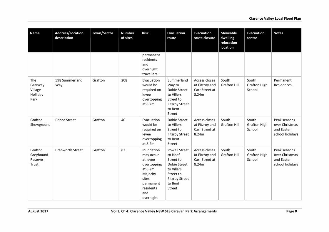
Clarence Valley Local Flood Plan
August 2017 Vol 3, Ch 4: Clarence Valley NSW SES Caravan Park Arrangements Page 8
Name Address/Location description
Town/Sector Number of sites
Risk Evacuation route
Evacuation route closure
Moveable dwelling relocation location
Evacuation centre
Notes
permanent residents and overnight travellers.
The Gateway Village Holliday Park
598 Summerland Way
Grafton 208 Evacuation would be required on levee overtopping at 8.2m.
Summerland Way to Dobie Street to Villers Street to Fitzroy Street to Bent Street
Access closes at Fitzroy and Carr Street at 8.24m
South Grafton Hill
South Grafton High School
Permanent Residences.
Grafton Showground
Prince Street Grafton 40 Evacuation would be required on levee overtopping at 8.2m.
Dobie Street to Villers Street to Fitzroy Street to Bent Street
Access closes at Fitzroy and Carr Street at 8.24m
South Grafton Hill
South Grafton High School
Peak seasons over Christmas and Easter school holidays
Grafton Greyhound Reserve Trust
Cranworth Street Grafton 82 Inundation may occur at levee overtopping at 8.2m. Majority sites permanent residents and overnight
Powell Street to Hoof Street to Dobie Street to Villers Street to Fitzroy Street to Bent Street
Access closes at Fitzroy and Carr Street at 8.24m
South Grafton Hill
South Grafton High School
Peak seasons over Christmas and Easter school holidays
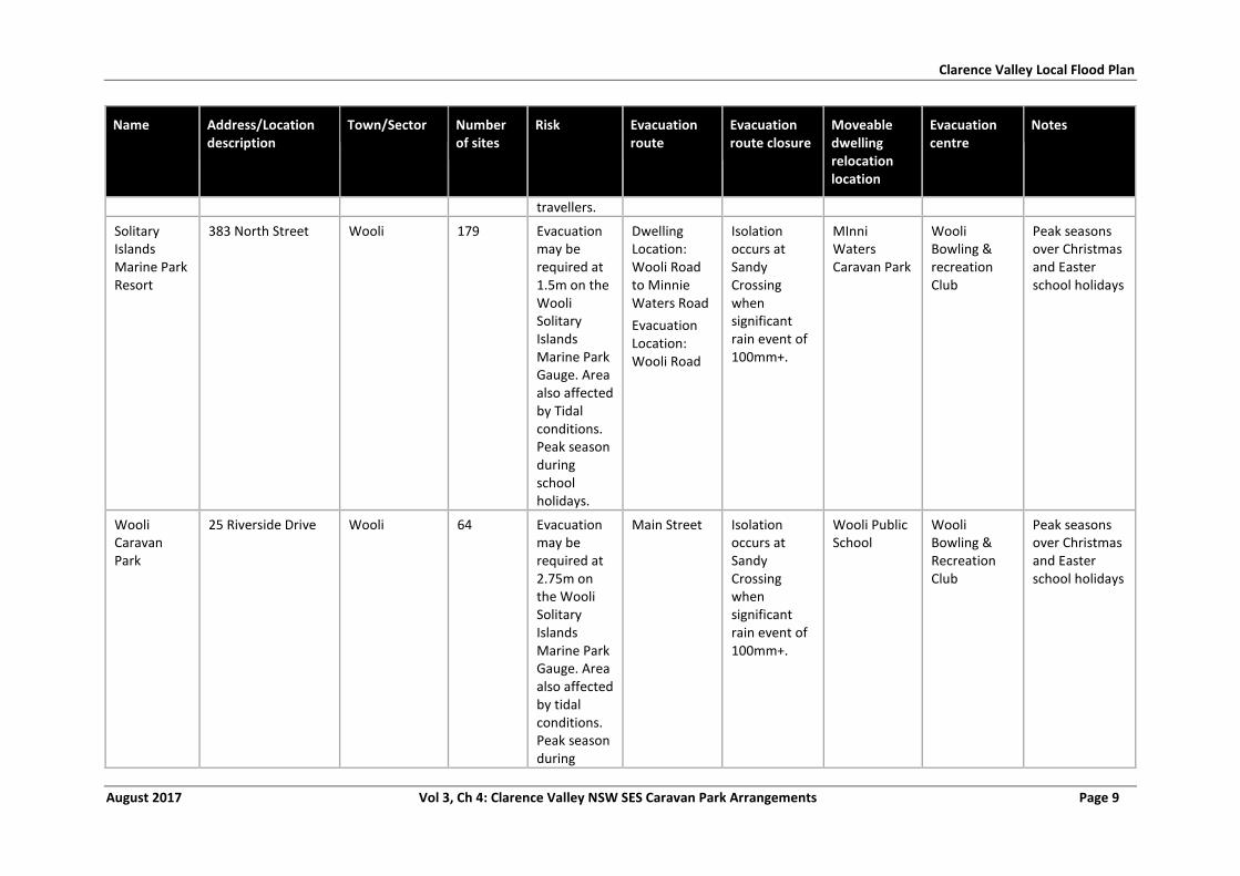
Clarence Valley Local Flood Plan
August 2017 Vol 3, Ch 4: Clarence Valley NSW SES Caravan Park Arrangements Page 9
Name Address/Location description
Town/Sector Number of sites
Risk Evacuation route
Evacuation route closure
Moveable dwelling relocation location
Evacuation centre
Notes
travellers.
Solitary Islands Marine Park Resort
383 North Street Wooli 179 Evacuation may be required at 1.5m on the Wooli Solitary Islands Marine Park Gauge. Area also affected by Tidal conditions. Peak season during school holidays.
Dwelling Location: Wooli Road to Minnie Waters Road
Evacuation Location: Wooli Road
Isolation occurs at Sandy Crossing when significant rain event of 100mm+.
MInni Waters Caravan Park
Wooli Bowling & recreation Club
Peak seasons over Christmas and Easter school holidays
Wooli Caravan Park
25 Riverside Drive Wooli 64 Evacuation may be required at 2.75m on the Wooli Solitary Islands Marine Park Gauge. Area also affected by tidal conditions. Peak season during
Main Street Isolation occurs at Sandy Crossing when significant rain event of 100mm+.
Wooli Public School
Wooli Bowling & Recreation Club
Peak seasons over Christmas and Easter school holidays
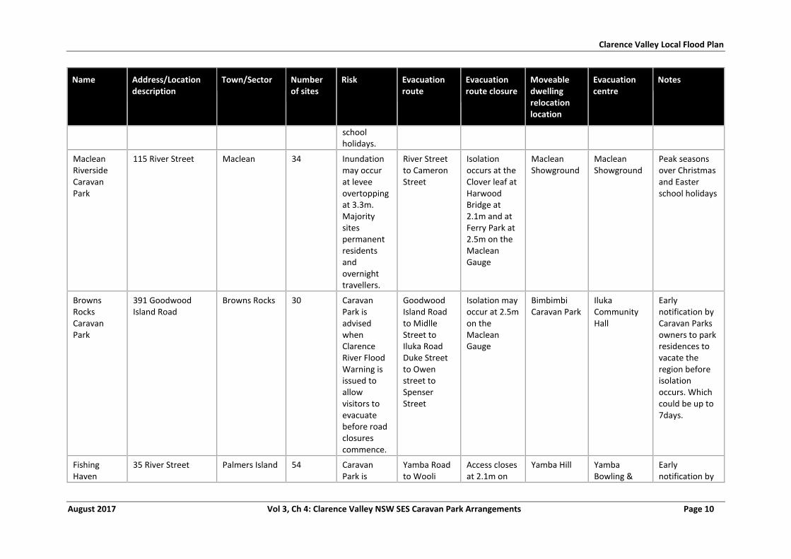
Clarence Valley Local Flood Plan
August 2017 Vol 3, Ch 4: Clarence Valley NSW SES Caravan Park Arrangements Page 10
Name Address/Location description
Town/Sector Number of sites
Risk Evacuation route
Evacuation route closure
Moveable dwelling relocation location
Evacuation centre
Notes
school holidays.
Maclean Riverside Caravan Park
115 River Street Maclean 34 Inundation may occur at levee overtopping at 3.3m. Majority sites permanent residents and overnight travellers.
River Street to Cameron Street
Isolation occurs at the Clover leaf at Harwood Bridge at 2.1m and at Ferry Park at 2.5m on the Maclean Gauge
Maclean Showground
Maclean Showground
Peak seasons over Christmas and Easter school holidays
Browns Rocks Caravan Park
391 Goodwood Island Road
Browns Rocks 30 Caravan Park is advised when Clarence River Flood Warning is issued to allow visitors to evacuate before road closures commence.
Goodwood Island Road to Midlle Street to Iluka Road Duke Street to Owen street to Spenser Street
Isolation may occur at 2.5m on the Maclean Gauge
Bimbimbi Caravan Park
Iluka Community Hall
Early notification by Caravan Parks owners to park residences to vacate the region before isolation occurs. Which could be up to 7days.
Fishing Haven
35 River Street Palmers Island 54 Caravan Park is
Yamba Road to Wooli
Access closes at 2.1m on
Yamba Hill Yamba Bowling &
Early notification by
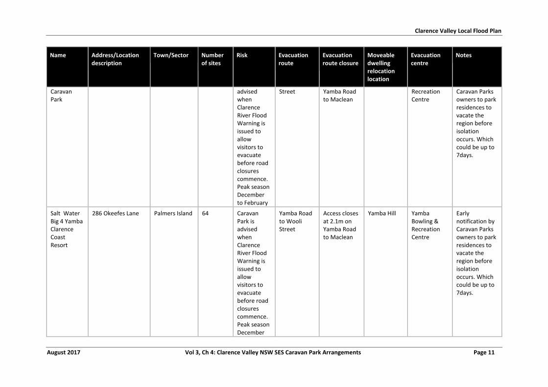
Clarence Valley Local Flood Plan
August 2017 Vol 3, Ch 4: Clarence Valley NSW SES Caravan Park Arrangements Page 11
Name Address/Location description
Town/Sector Number of sites
Risk Evacuation route
Evacuation route closure
Moveable dwelling relocation location
Evacuation centre
Notes
Caravan Park
advised when Clarence River Flood Warning is issued to allow visitors to evacuate before road closures commence. Peak season December to February
Street Yamba Road to Maclean
Recreation Centre
Caravan Parks owners to park residences to vacate the region before isolation occurs. Which could be up to 7days.
Salt Water Big 4 Yamba Clarence Coast Resort
286 Okeefes Lane Palmers Island 64 Caravan Park is advised when Clarence River Flood Warning is issued to allow visitors to evacuate before road closures commence. Peak season December
Yamba Road to Wooli Street
Access closes at 2.1m on Yamba Road to Maclean
Yamba Hill Yamba Bowling & Recreation Centre
Early notification by Caravan Parks owners to park residences to vacate the region before isolation occurs. Which could be up to 7days.
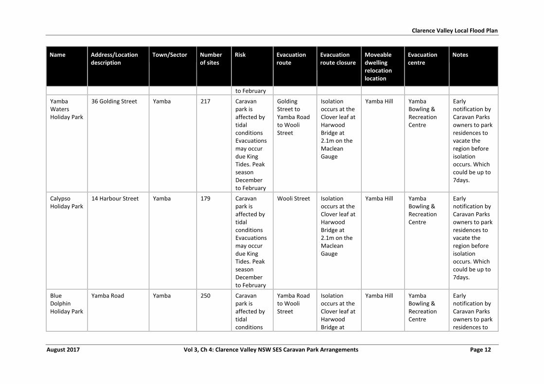
Clarence Valley Local Flood Plan
August 2017 Vol 3, Ch 4: Clarence Valley NSW SES Caravan Park Arrangements Page 12
Name Address/Location description
Town/Sector Number of sites
Risk Evacuation route
Evacuation route closure
Moveable dwelling relocation location
Evacuation centre
Notes
to February
Yamba Waters Holiday Park
36 Golding Street Yamba 217 Caravan park is affected by tidal conditions Evacuations may occur due King Tides. Peak season December to February
Golding Street to Yamba Road to Wooli Street
Isolation occurs at the Clover leaf at Harwood Bridge at 2.1m on the Maclean Gauge
Yamba Hill Yamba Bowling & Recreation Centre
Early notification by Caravan Parks owners to park residences to vacate the region before isolation occurs. Which could be up to 7days.
Calypso Holiday Park
14 Harbour Street Yamba 179 Caravan park is affected by tidal conditions Evacuations may occur due King Tides. Peak season December to February
Wooli Street Isolation occurs at the Clover leaf at Harwood Bridge at 2.1m on the Maclean Gauge
Yamba Hill Yamba Bowling & Recreation Centre
Early notification by Caravan Parks owners to park residences to vacate the region before isolation occurs. Which could be up to 7days.
Blue Dolphin Holiday Park
Yamba Road Yamba 250 Caravan park is affected by tidal conditions
Yamba Road to Wooli Street
Isolation occurs at the Clover leaf at Harwood Bridge at
Yamba Hill Yamba Bowling & Recreation Centre
Early notification by Caravan Parks owners to park residences to
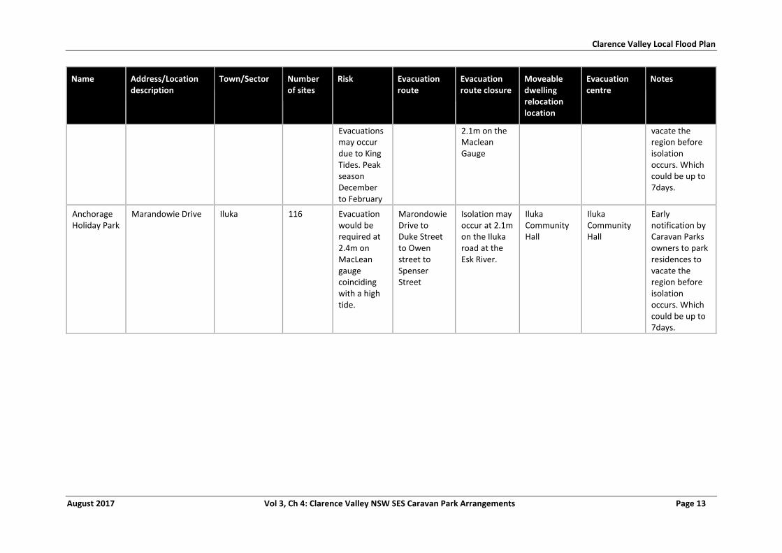
Clarence Valley Local Flood Plan
August 2017 Vol 3, Ch 4: Clarence Valley NSW SES Caravan Park Arrangements Page 13
Name Address/Location description
Town/Sector Number of sites
Risk Evacuation route
Evacuation route closure
Moveable dwelling relocation location
Evacuation centre
Notes
Evacuations may occur due to King Tides. Peak season December to February
2.1m on the Maclean Gauge
vacate the region before isolation occurs. Which could be up to 7days.
Anchorage Holiday Park
Marandowie Drive Iluka 116 Evacuation would be required at 2.4m on MacLean gauge coinciding with a high tide.
Marondowie Drive to Duke Street to Owen street to Spenser Street
Isolation may occur at 2.1m on the Iluka road at the Esk River.
Iluka Community Hall
Iluka Community Hall
Early notification by Caravan Parks owners to park residences to vacate the region before isolation occurs. Which could be up to 7days.
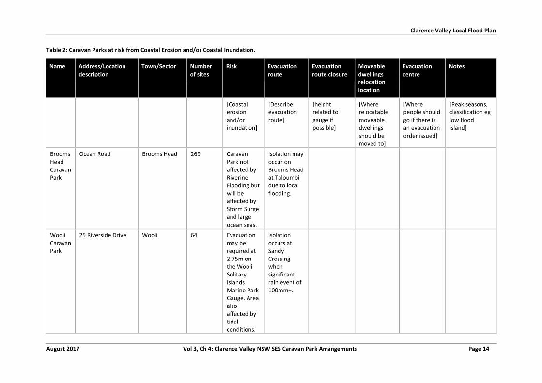
Clarence Valley Local Flood Plan
August 2017 Vol 3, Ch 4: Clarence Valley NSW SES Caravan Park Arrangements Page 14
Table 2: Caravan Parks at risk from Coastal Erosion and/or Coastal Inundation.
Name Address/Location description
Town/Sector Number of sites
Risk Evacuation route
Evacuation route closure
Moveable dwellings relocation location
Evacuation centre
Notes
[Coastal erosion and/or inundation]
[Describe evacuation route]
[height related to gauge if possible]
[Where relocatable moveable dwellings should be moved to]
[Where people should go if there is an evacuation order issued]
[Peak seasons, classification eg low flood island]
Brooms Head Caravan Park
Ocean Road Brooms Head 269 Caravan Park not affected by Riverine Flooding but will be affected by Storm Surge and large ocean seas.
Isolation may occur on Brooms Head at Taloumbi due to local flooding.
Wooli Caravan Park
25 Riverside Drive Wooli 64 Evacuation may be required at 2.75m on the Wooli Solitary Islands Marine Park Gauge. Area also affected by tidal conditions.
Isolation occurs at Sandy Crossing when significant rain event of 100mm+.
Clarence Valley Local Flood Plan
August 2017 Vol 3, Ch 4: Clarence Valley NSW SES Caravan Park Arrangements Page 15
Peak season during school holidays.
Clarence Valley Local Flood Plan
August 2017 Vol 3, Ch 4: Clarence Valley NSW SES Caravan Park Arrangements Page 16
LIST OF REFERENCES
1. NSW Government. Local Government (Manufactured Home Estates, Caravan Parks,
Camping Grounds and Moveable Dwellings) Regulation 2005 Part 3 Division 3 Subdivision 7
Clause 123. 2005.