Embed Size (px)
Citation preview

Climate-SmartLand Husbandry in Jamaica:A Manual for Extension
fao_climate_smart_manual_cover.qxd 10/23/14 1:47 PM Page 1

fao_climate_smart_manual_cover.qxd 10/23/14 1:47 PM Page 2

Written By: Alberto Bigi and Maria Protz
Editor: Maria Protz
Line Drawings: George Hay
Photo Credits: Main source of pictures are: FAO manuals, projects and publications on soil and waterconservation and disaster risk management, WOCAT (World Overview of Conservation Approach andTechnologies), CIAT (International Center for Tropical Agriculture), CARDI (Caribbean Agricultural Research andDevelopment Institute) and writers’ personal pictures. Other photos were provide by Mrs. Marina Young andOfficers of the Rural Agricultural Development Authority (RADA).
Produced for the FAO Project - Emergency food security and rural livelihood recovery for the mostvulnerable farmers affected by Hurricane Sandy in Jamaica (OSRO/JAM/301/BEL).
The designations employed and the presentation of material in this information product do not imply theexpression of any opinion whatsoever on the part of the Food and Agriculture Organization of the United Nations(FAO) concerning the legal or development status of any country, territory, city or area or of its authorities, orconcerning the delimitation of its frontiers or boundaries. The mention of specific companies or products ofmanufacturers, whether or not these have been patented, does not imply that these have been endorsed orrecommended by FAO in preference to others of a similar nature that are not mentioned.
The views expressed in this information product are those of the author(s) and do not necessarily reflect the viewsor policies of FAO.
© FAO, 2014
FAO encourages the use, reproduction and dissemination of material in this information product. Except whereotherwise indicated, material may be copied, downloaded and printed for private study, research and teachingpurposes, or for use in non-commercial products or services, provided that appropriate acknowledgement of FAOas the source and copyright holder is given and that FAO’s endorsement of users’ views, products or services isnot implied in any way.
All requests for translation and adaptation rights, and for resale and other commercial use rights should be madevia www.fao.org/contact-us/licence-request or addressed to [email protected].
FAO information products are available on the FAO website (www.fao.org/publications) and can be purchasedthrough [email protected].
For further information, contact the Rural Agricultural Development Authority (RADA), Hope Gardens, Kingston 6,Jamaica. Phone: 1-888-875-275-7232 or www.rada.gov.jm
Climate-Smart Land Husbandry in Jamaica:A Manual for Extension
With the support ofTHE BELGIANDEVELOPMENT COOPERATION
fao_climate_smart_manual_front.qxd 10/23/14 1:00 PM Page 1

fao_climate_smart_manual_front.qxd 10/23/14 1:00 PM Page 2

Acknowledgements i
Acronyms and Abbreviations iii
INTRODUCTION AND OVERVIEW V
Welcome to the Climate Smart Land Husbandry Manual for Extension Officers! v
Purpose of the Manual vi
Who is the Manual For? vi
How the Manual Was Developed vi
Communication for Development - The key to Climate Change Adaptation and Effective Extension vii
Changing Role of the Extension Officer viii
Core Principles of ComDev: How does ComDev work? viii
Steps toward using ComDev for ADRM and CCA in the Caribbean ix
Adoption of Agricultural Practices ix
Farmer Field School Approach x
What is a Farmer Field School? x
Principles of Farmer Field Schools xi
What the Manual Includes xii
How to Use the Manual xv
Getting Started xv
PART 1 - CLIMATE-SMART LAND HUSBANDRY FUNDAMENTALS 1
Unit 1.1 Overview of Climate Change Impacts on Jamaican Agriculture 2
Unit 1.2 Introduction to Jamaican Soils, Soil Quality and Soil Fertility 15
Unit 1.3 The Impact of Climate Change on Watersheds 31
Unit 1.4 Fundamental Principles and Methods of Land Husbandry 43
Unit 1.5 Matching Best Practices to Climate Hazards 47
PART 2 - CLIMATE-SMART LAND HUSBANDRY PRACTICES 61
SECTION ONE - STRUCTURAL METHODS 62
Unit 2.1.1 Constructing an A-Frame 63
Unit 2.1.2 Calculating Slope Conditions in the Field and Establishing Contours 69
Table of Contents
fao_climate_smart_manual_front.qxd 10/23/14 1:01 PM Page 3

Unit 2.1.3 Sowing on Contour Lines 73
Unit 2.1.4 Strip Cropping 76
Unit 2.1.5 Alley Cropping with Leguminous Bushes or Hedgerows 80
Unit 2.1.6 Grass Barriers 87
Unit 2.1.7 Pineapple Barriers 95
Unit 2.1.8 Organic Trash Barriers 100
Unit 2.1.9 Bench Terraces 106
Unit 2.1.10 Individual Basins 113
Unit 2.1.11 Diversion Ditches, Contour Canals and Trenches 119
Unit 2.1.12 Raised Beds or Continuous Mounds 125
Unit 2.1.13 Check Dams or Gully Plugs 128
Unit 2.1.14 Retaining Walls 137
SECTION TWO - CLIMATE-SMART AGRICULTURAL METHODS 141
Unit 2.2.1 Agro-Forestry and Tree Crop Production 143
Unit 2.2.2 Reforestation 152
Unit 2.2.3 Mulching 156
Unit 2.2.4 Cover Cropping 162
Unit 2.2.5 Minimum Tillage 167
Unit 2.2.6 Composting 172
SECTION THREE - CLIMATE-SMART DROUGHT MITIGATION AND ADAPTATION METHODS 181
Unit 2.3.1 Utilising Drought Tolerant Crops 183
Unit 2.3.2 Water Harvesting 187
Unit 2.3.3 Fire Breaks and Fire Borders 193
SECTION FOUR - CLIMATE-SMART HURRICANE & WIND RESISTANT MEASURES 199
Unit 2.4.1 Windbreaks or Shelterbelts 201
Unit 2.4.2 Growing Wind Tolerant Crops 207
Unit 2.4.3 Triangular Bracing (Propping) for Bananas 211
APPENDICES 219
Appendix A - Known Impacts of Hurricanes on the Agricultural Sector 220
Appendix B - Glossary 222
Appendix C - References 228
Appendix D - Links to Additional Resources 235
Appendix E - Farm Road Construction, Erosion Control and Maintenance 237
Appendix F - Useful Contacts 244
fao_climate_smart_manual_front.qxd 10/23/14 1:01 PM Page 4

Acknowledgements
Climate-Smart Land Husbandry in Jamaica:A Manual for Extension
The Climate-Smart Land Husbandry Manual for Extension is the result of a joint, collaborative
effort between the Food and Agriculture Organisation of the United Nations (FAO) and the Rural
Agricultural Development Agency (RADA).
Its preparation was led by FAO representation in Jamaica with the financial support of The Belgian
Development Cooperation through the project ‘Emergency food security and rural livelihoodrecovery for the most vulnerable farmers affected by Hurricane Sandy in Jamaica(OSRO/JAM/301/BEL)`.
The manual is the result of a participative process in which Jamaican field extension officers shared
their experiences with national and regional experts on Disaster Risk Management, Soil and Water
Conservation and Communication for Development. Field Extension Officers and experts from RADA
were involved in the definition and elaboration of the content and details of the most suitable smart
land husbandry techniques and methods for Jamaica. FAO facilitated the collection of this information,
provided technical and innovative elements and prepared the text of the document.
As a result, this manual was made possible through the multidisciplinary and inter-geographical
collaboration among:
• RADA’s Division of Technology, Training and Technical Information
• RADA’s Land Husbandry unit and the parish offices of Portland and St. Thomas
• FAO representation in Jamaica
i
fao_climate_smart_manual_front.qxd 10/23/14 1:01 PM Page i

ii
• The FAO Disaster Risk Management Unit (Sub-regional office in Panama and regional office
in Chile), and
• The FAO Soil and Water management division (Sub-regional office in Barbados and Panama).
Invaluable technical support and constructive feedback was further provided by Marina Young (RADA,
Director-Technology, Training and Technical Information division), Peter Thompson (RADA, Technical
Services division), Norbert Powel (RADA, Senior Land Husbandry Officer), Norman Baugh (RADA, Land
Husbandry Officer), RADA Parish Manager from Portland and St Thomas, Dr. Lystra Fletcher Paul and
Vera Boerger (FAO Land and Water Technical Officers), Dennis Latimer (FAO Disaster Risk Management
coordinator) and Elvey Donaldson (FAO Project coordinator).
The final product would not have been possible without the active support of the FAO representative in
Jamaica, Dr. Jerome Thomas and the assistant representative, Dr. Gillian Smith.
Special thanks are due to Dr. Maria Protz for her substantial additions to the document and her
elaboration of the communication component of the manual, as well her efficient preparation and
formatting of this document.
fao_climate_smart_manual_front.qxd 10/23/14 1:01 PM Page ii

iii
Acronyms and Abbreviations
ACDI/VOCA Agricultural Cooperation Development International/Volunteers in Overseas
Co-operative Assistance
ADRM Agricultural Disaster Risk Management
AEZ Agro-Ecological Zone
AKIS Agricultural Knowledge Information Systems
BBP Best Bet Practices
BBT Best Bet Technologies
CIAT International Centre for Tropical Agriculture
C4D Communication for Development
CBA Community-Based Adaptation
CBO Community Based Organisation
CC Climate Change
CDC Community Development Committee
CARDI Caribbean Agricultural Research and Development Institute
CO2 Carbon Dioxide
CSA Climate-Smart Agriculture
DRM Disaster Risk Management
EJASP Eastern Jamaica Agriculture Support Project
FAO Food and Agriculture Organisation of the United Nations
FCS Farmer Climate Schools
FD Forestry Department
FFS Farmer Field School
Climate-Smart Land Husbandry in Jamaica:A Manual for Extension
fao_climate_smart_manual_front.qxd 10/23/14 1:01 PM Page iii

iv
GAPs Good Agricultural Practices
GBSJ Goat Breeders Society of Jamaica
GDP Gross Domestic Product
GEF Global Environmental Facility
GOJ Government of Jamaica
IK Indigenous Knowledge
IPCC Intergovernmental Panel on Climate Change
JAF Jamaica Adaptation Fund
JaREEACH Jamaica Rural Economy and Ecosystems Adapting to Climate Change
JOAM Jamaica Organic Agriculture Movement
JSIF Jamaica Social Investment Fund
LBA Livelihood Baseline Assessment
LDC Local Development Committee
LFMC Local Forestry Management Committee
LLL4F Life Long Learning for Farmers
LWMC Local Watershed Management Committee
MoAF Ministry of Agriculture and Fisheries
MYADP Morant/Yallahs Agricultural Development Project
NEPA National Environmental Planning Agency
NGO Non-governmental Organisation
NWA National Works Agency
NWC National Water Commission
ODPEM Office of Disaster Preparedness and Emergency Management
PMO Production and Marketing Organisation
RADA Rural Agricultural Development Authority
SD Sustainable Development
SIDS Small Island Developing States
STEA Southern Trelawny Environmental Agency
UNDP United Nations Environment Programme
WOCAT World Overview of Conservation Approaches and Technologies
WRA Water Resources Authority
fao_climate_smart_manual_front.qxd 10/23/14 1:01 PM Page iv
v
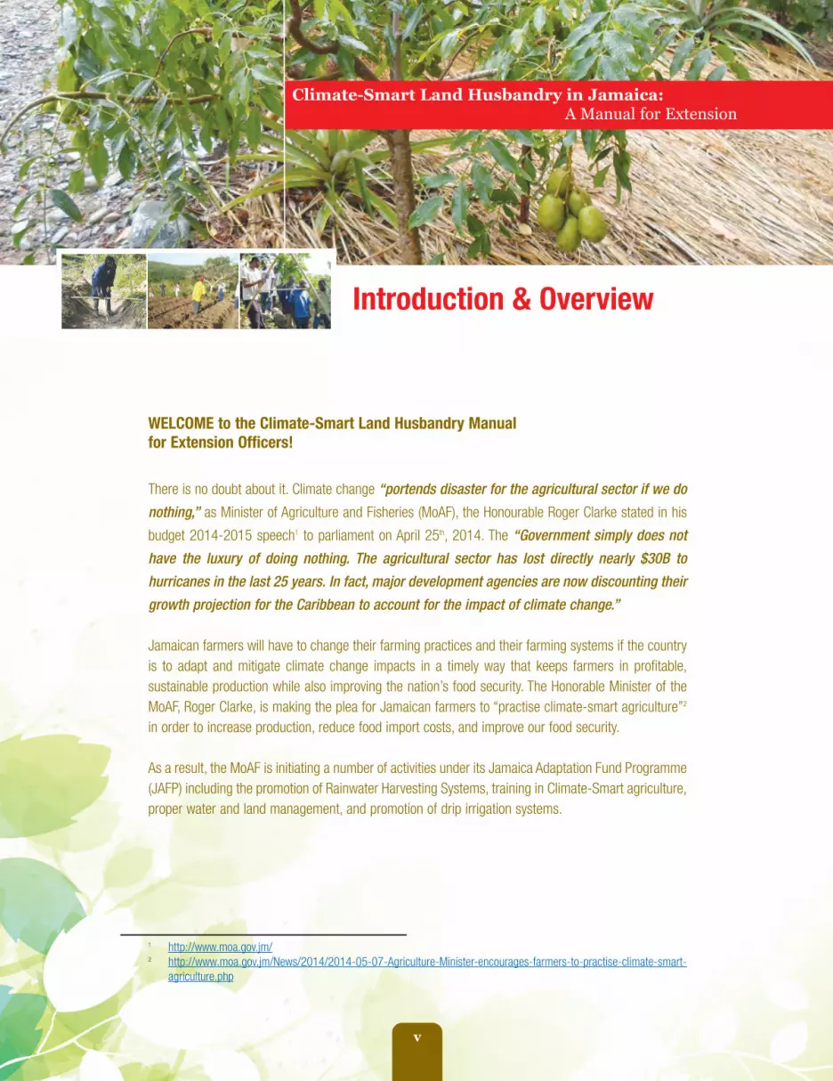
Introduction & Overview
WELCOME to the Climate-Smart Land Husbandry Manualfor Extension Officers!
There is no doubt about it. Climate change “portends disaster for the agricultural sector if we do
nothing,” as Minister of Agriculture and Fisheries (MoAF), the Honourable Roger Clarke stated in his
budget 2014-2015 speech1 to parliament on April 25th, 2014. The “Government simply does not
have the luxury of doing nothing. The agricultural sector has lost directly nearly $30B to
hurricanes in the last 25 years. In fact, major development agencies are now discounting their
growth projection for the Caribbean to account for the impact of climate change.”
Jamaican farmers will have to change their farming practices and their farming systems if the countryis to adapt and mitigate climate change impacts in a timely way that keeps farmers in profitable,sustainable production while also improving the nation’s food security. The Honorable Minister of theMoAF, Roger Clarke, is making the plea for Jamaican farmers to “practise climate-smart agriculture”2
in order to increase production, reduce food import costs, and improve our food security.
As a result, the MoAF is initiating a number of activities under its Jamaica Adaptation Fund Programme(JAFP) including the promotion of Rainwater Harvesting Systems, training in Climate-Smart agriculture,proper water and land management, and promotion of drip irrigation systems.
Climate-Smart Land Husbandry in Jamaica:A Manual for Extension
1 http://www.moa.gov.jm/2 http://www.moa.gov.jm/News/2014/2014-05-07-Agriculture-Minister-encourages-farmers-to-practise-climate-smart-
agriculture.php
fao_climate_smart_manual_front.qxd 10/23/14 1:01 PM Page v

vi
Purpose of the Manual
The ultimate overall purpose of this manual isto ensure that Jamaican farmers become lessvulnerable, more resilient and better able tocope with the changes that climate change willbring to their farming production methods. Theimpact that climate change currently brings isalready making farmers more vulnerable andputting them more at risk to the negativeeffects of increased periods of drought, winddamage and hurricanes, possible floodingevents, deforestation and soil erosion. Ensuringthat all farmers not only learn about, butimplement, the best mix of land husbandrymethods for their own farms is not just optional,it is essential if they are to become moreresilient and adapt to climate change in asustainable manner.
But before farmers can adapt, Jamaicanextension officers first need to be sure thatthey fully understand and appreciate theprinciples of sound land management andknow the various technical methods thatfarmers should consider. Therefore, theprimary purpose of this manual is to equipJamaican extension officers with theknowledge and skills they will need to helpfarmers prepare for climate change throughimprovement of their land husbandry practices.It is meant to provide a comprehensiveknowledge of land husbandry in the Jamaicanclimate change context so that extensionofficers will have everything at their fingertips tobe effective in the field.
Who is the Manual For?
As stated, the main audience for this manual isJamaican extension officers, primarily thoseworking for the Rural Agricultural DevelopmentAuthority (RADA). But it is also useful for
persons working with the Jamaica AgriculturalSociety (JAS) and for persons working withvarious commodity boards.
At the same time, the manual is highly usefulfor Jamaican farmers directly and for farmergroups, such as Production and MarketingOrganisations (PMOs), Farmer Field Schools(FFS), Farmer Climate Schools (FCS), or 4Hclubs - where these exist.
How the Manual Was Developed
The manual was specifically produced underthe FAO Project - “Emergency food securityand rural livelihood recovery for the mostvulnerable farmers affected by HurricaneSandy in Jamaica (OSRO/JAM/301/BEL)”and was funded through the BelgianDevelopment Corporation. But it builds on pastFAO initiatives that have recently helpedJamaica to assess sustainable livelihoods,improve communication, and develop its ownnational Agricultural Disaster Risk ManagementPlan (ADRMP), as well as pilot community-based agricultural disaster plans. Theseprevious initiatives include:
• Assistance to Improve Local AgriculturalEmergency Preparedness in CaribbeanCountries Highly Prone to HurricaneRelated Disasters. 2008. (TCP/RLA/3101)project
• National Disaster Preparedness andEmergency Response Plan for AgriculturalSector 2009, (TCP/JAM/3202(D)
• Communication for Sustainable DevelopmentInitiative (CSDI) - Caribbean Programme(2008-2011)
fao_climate_smart_manual_front.qxd 10/23/14 1:01 PM Page vi
vii
• Strengthening Community Preparednessand Resilience to Natural Disasters inSelected Vulnerable Areas project.2012. (OSRO/RLA/102/BEL)
• And research done under the “ClimateChange and Agriculture in Jamaica:Agriculture Sector Support Analysis”initiative.
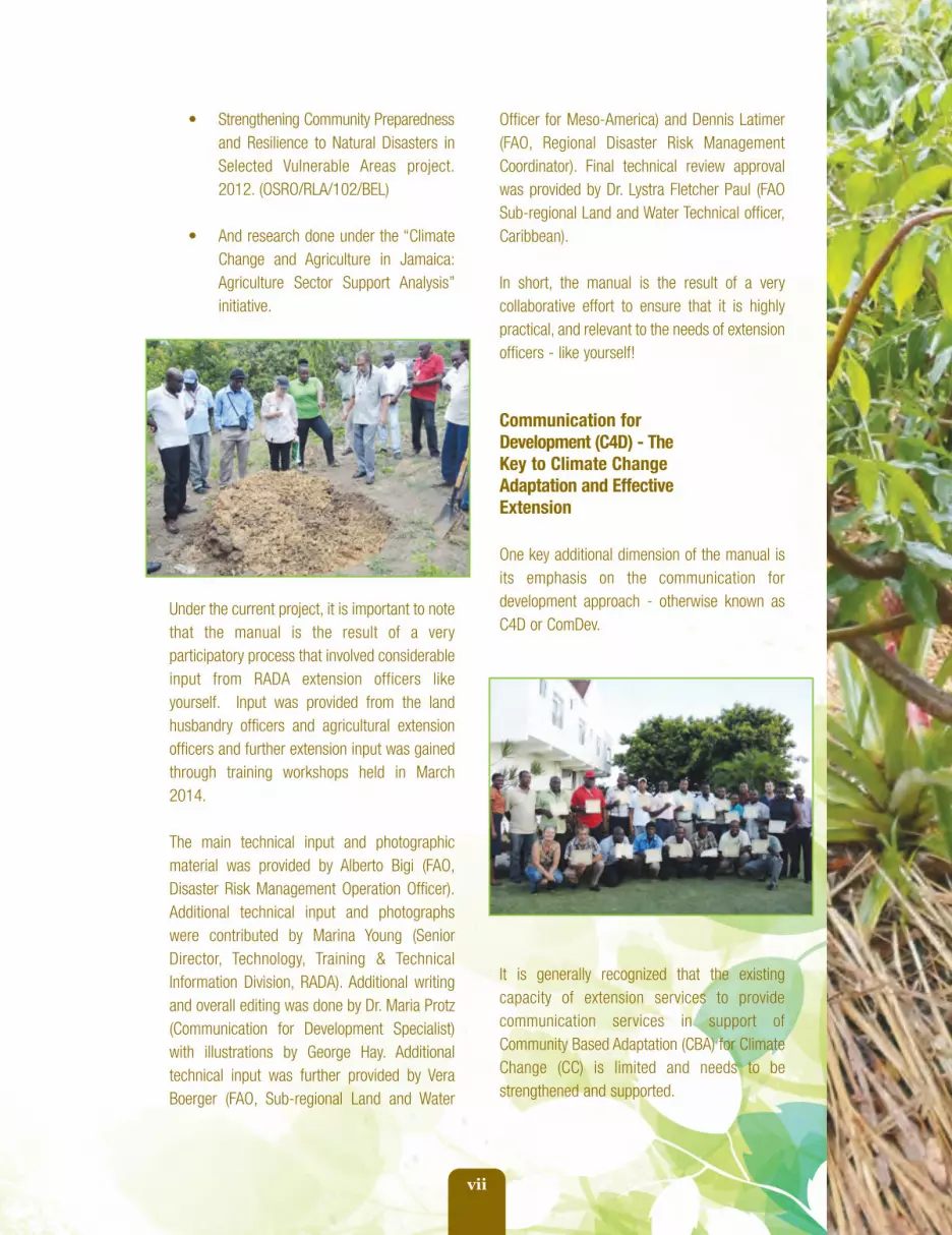
Under the current project, it is important to notethat the manual is the result of a veryparticipatory process that involved considerableinput from RADA extension officers likeyourself. Input was provided from the landhusbandry officers and agricultural extensionofficers and further extension input was gainedthrough training workshops held in March2014.
The main technical input and photographicmaterial was provided by Alberto Bigi (FAO,Disaster Risk Management Operation Officer).Additional technical input and photographswere contributed by Marina Young (SeniorDirector, Technology, Training & TechnicalInformation Division, RADA). Additional writingand overall editing was done by Dr. Maria Protz(Communication for Development Specialist)with illustrations by George Hay. Additionaltechnical input was further provided by VeraBoerger (FAO, Sub-regional Land and Water
Officer for Meso-America) and Dennis Latimer(FAO, Regional Disaster Risk ManagementCoordinator). Final technical review approvalwas provided by Dr. Lystra Fletcher Paul (FAOSub-regional Land and Water Technical officer,Caribbean).
In short, the manual is the result of a verycollaborative effort to ensure that it is highlypractical, and relevant to the needs of extensionofficers - like yourself!
Communication forDevelopment (C4D) - TheKey to Climate Change Adaptation and EffectiveExtension
One key additional dimension of the manual isits emphasis on the communication fordevelopment approach - otherwise known asC4D or ComDev.
It is generally recognized that the existingcapacity of extension services to providecommunication services in support ofCommunity Based Adaptation (CBA) for ClimateChange (CC) is limited and needs to bestrengthened and supported.
fao_climate_smart_manual_front.qxd 10/23/14 1:01 PM Page vii

viii
Budget cutbacks and changes in staff in someof the country's research and extensionsystems, have deteriorated extension’seffectiveness. This in turn has reduced thenumber of extension staff available to serverural areas and/or limited their mobility. As aresult, the opportunity for the traditional type offace-to-face, personal interaction that mostfarmers are accustomed to, has been greatlyreduced. The need is great to find creative andinnovative ways to respond to the technologyneeds of small-scale farmers.
Changing Role of theExtension Officer
Traditionally, extension officers were the main'interface' within an Agricultural Knowledge andInformation System (AKIS) and served tofacilitate interaction among scientificresearchers, ministries of agriculture, marketsand farmers. But the days of regular face-to-face contact have diminished drastically.Increasingly extension officers are usingelectronic materials, text messaging, socialmedia and the internet to facilitate farmerlearning and communicate with farmers.
This poses a problem related to the digitaldivide. While better-off farmers are able to getthe agricultural information they need to copewith CC and to diversify and compete within thenew global market place without the aid ofextension services, many of the region's poorerand more vulnerable farmers are not. Highlyentrepreneurial farmers are able to accessinformation via the internet on their own directlywithout support from extension. But for manyother small holders who may face obstaclesrelated to literacy and numeracy, visits fromtheir extension officer are still very muchdesired.
Moreover, even if vulnerable farmers are able toaccess information through the net, existinginformation is predominantly in a form that istoo scientific, or too culturally foreign to havemuch local significance for this client group.
The C4D or ComDev approach to climatechange is a unique approach that "implies thesystematic design and use of participatorycommunication processes, strategies andmedia to share information and knowledgeamong relevant stakeholders in a particularagro-ecological context, to enhance people'sresilience and offer livelihood options to copewith climate change" (Acunzo and Protz. 2010"Collaborative change", FAO)3.
Core principles of ComDev:How does ComDev work?
The following core principles are central to C4D:
• Priority is given to vulnerable rural groups
• Emphasis is on livelihood adaptationand resilience
• Efforts start by building on localanalysis and existing proven "best bet"technology options
• Conflict resolution and consensusstrengthening are stressed
• Good governance is supported
• Information and knowledge sharing areencouraged
3 http://www.google.com.jm/url?sa=t&rct=j&q=&esrc=s&source=web&cd=6&ved=0CEEQFjAF&url=http%3A%2F%2Fconnect4climate.org%2Fimages%2Fuploads%2Fresources%2FCollaborativeChangeE.pdf&ei=DVZhU5SZA_S42gXDvoGoBw&usg=AFQjCNFDu8fAIUEGRh6c145M5C1-E4xipg
fao_climate_smart_manual_front.qxd 10/23/14 1:01 PM Page viii

ix
• Institutional capacity building andstrengthening are also supported
• ComDev is mainstreamed throughoutextension and adaption services.
Steps toward using ComDev forADRM and CCA in the Caribbean
The basic steps of C4D include:
1. Starting where farmers are at. What dothey know about climate change? Whathave they heard? Felt? Experienced?While they may not use the samescientific terms as climate changeexperts, farmers' indigenous knowledgeis often quite sound. Many of the bestbet technologies presented here startedas farmer technologies. Their indigenousknowledge (IK) is therefore a veryimportant part of the climate changeadaptation (CCA) equation.All knowledgeis needed. Communication toolsare used with farmers to record anddocument this knowledge
2. Simple, cultural icebreakers are used tobegin dialogue and discussion.Jamaican folk expressions, jokes, andsongs can be useful to help exchangeshappen
3. See what farmers are already doingto cope with CC. Look at existingpractices. Are they doing anythingdifferently? Do any of these activitieswork? Do these practices havepotential? Which are poor practicesthat need to be discouraged or
replaced with better bet options? Usecommunication tools (especiallyphotography or drawings) to record anddocument both good and poor practiceswith the farmers in your extension area
4. Using ComDev tools to explain scientificand technological perspectives insimpler terms prepare simple learningmaterials. This guide offers suggestionsfor how to do this
5. Developing a menu of technology optionsto be promoted for in-field pilot testing.Once again, this guide offers a menu of"best bet land management practices"for you to start with.
Adoption of agriculturalpractices
If farmers do need to change their landmanagement practices to adapt to climatechange, they first have to become interested inthe innovation, see its value, and then decide toadopt it. The process of adoption depends onmany different factors and involves differentphases:
1. Awareness of the problem or opportunity:in this context "awareness" means notjust awareness that an innovationexists, but that has potential practicalvalue to the farmer
2. Non-trial evaluation: once the farmer isaware of a new innovation she/heusually starts collecting information fromneighbours, friends, extension officerstrying to evaluate its advantages anddisadvantages
fao_climate_smart_manual_front.qxd 10/23/14 1:01 PM Page ix

x
Conducting a trial incurs cost, energy,finance and land that could be usedmore productively for other purposes
3. Trial evaluation: demonstration trialscontribute substantially to both thedecision making and skill developmentaspects of the learning process. If forsome reasons small-scale trials are notpossible, the chance of widespreadadoption are greatly diminished. TheFarmer Field School approach is a goodmethodology to promote agriculturalpractices by involving farmers inlearning through experimentation/trialingopportunities and limits
4. Adoption: Depending on the result ofthe trial, use of the innovation may bescaled up. Usually the adoption is agradual, continuous process from asmall to larger scale.
Farmer Field Schoolapproach
The Farmer Field School (FFS) is a group-basedlearning process that has been used by anumber of governments, NGOs andinternational agencies to promote GoodAgricultural Practices (GAPs). The first FFSwere designed and managed by the UnitedNations Food and Agriculture Organisation(FAO) in Indonesia in 1989 and since then morethan two million farmers across Asia haveparticipated in this type of learning.
The Farmer Field School (FFS) is a group-basedlearning process. During the FFS, farmerscarried out experiential learning activities thathelped them understand the ecology of their
production areas. These activities involvesimple experiments, regular field observationsand group analysis. The knowledge gained fromthese activities enables participants to maketheir own locally specific decisions about cropmanagement practices. This approachrepresents a radical departure from earlieragricultural extension programmes, in whichfarmers were expected to adopt generalisedrecommendations that had been formulated byspecialists from outside the community.
What is a Farmer FieldSchool?
The Farmer Field School is a group, peerlearning extension method based on principlesof adult education. Essentially a "school withoutwalls", FFS helps farmers learn from each otherby improving their capacity to make decisionsand to innovate on their own farms and withintheir own communities. It is a participatoryapproach to extension, whereby farmers aregiven opportunity to make a choice in themethods of production through empirical andpractical discoveries on their own, or theirneighbours' farms.
A Farmer Field School It is composed of groupsof farmers who meet regularly during thecourse of the growing season to experimentwith new production options. Typically FFSgroups have 15-30 farmers. After the trainingperiod, farmers continue meeting and sharinginformation without input from their extensionofficers. FFS aims to increase the capacity ofgroups of farmers to test new technologies ontheir own, to assess results and to determinethe value of the results for their own particularcircumstances.
fao_climate_smart_manual_front.qxd 10/23/14 1:01 PM Page x

xi
The FFS method fosters a more demand drivenapproach to extension and research becausefarmers ask for help from extension andresearch partners only when they are unable tosolve specific problems on their own. Ratherthan taking what extension officers orresearcher say as given, the FFS methodencourages farmers to test, observe anddebate among themselves and as peers withresearch and extension partners. When farmersmeet, they make management decisions onwhat action to take. Thus FFS as an extensionmethodology is a dynamic process farmerscontrol and which enables them to havesharper observational skills and a morescientific understanding of their owncrop/livestock agro-ecosystem.
Principles of Farmer Field Schools
The training methodology of FFS is based onlearning by doing, through discovery,comparison and non-hierarchical relationshipsamong the learners and trainers. It is alsocarried out almost entirely in the field. The mainprinciples are:
1. Farmers as Experts: they interact andevaluate the trials according to theirown experiences
2. The field is the learning place and theobject of study
3. Extension workers are facilitators andnot teachers, once the farmers knowthe dynamic of the FFS, the extensionworker takes a back seat, offering helpand guidance only when asked to do so
4. Training follows the agriculturalseasonal cycle
5. FFS are incorporated into regularfarmer group meetings.
In Jamaica, the FFS method started with IPMbut has also proven to be very effective athelping farmers to control the Beet Army Worm.The Jamaica Rural Economy and EcosystemsAdapting to Climate Change (JaREEACH)project is working with Cocoa Farmer FieldSchools in St. Mary and Clarendon to improvecocoa production in the face of climate changethrough the assistance of the AgriculturalCooperation Development International/Volunteersin Overseas Co-operative Assistance(ACDI/VOCA) initiative. This project has alsodeveloped a land husbandry curriculum forfarmers which complements this manual forextension officers.
Table 0.1 Comparison between FFS and conventional extension methodology
Parameter
Learning method
Training venue
Duration
Farmer Field School
By doing, experimenting,participating, discovering
Subject of learning(field, crop, etc.)
Complete study(season long cycle)
Conventional extension
By listening
Training room
One or two session
fao_climate_smart_manual_front.qxd 10/23/14 1:01 PM Page xi

xii
For further information of Farmer Field School you can use the following links:
• Introduction:http://www.fao.org/nr/land/sustainable-land-management/farmer-field-school/en/
• FFS implementation guide:http://www.fao.org/docrep/016/i2561e/i2561e00.htm
• FFS approach:http://www.fao.org/ag/ca/CA-Publications/Farmer_Field_School_Approach.pdf
• Participatory training and curriculum development for FFS:http://www.fao.org/docrep/012/ba0031e/ba0031e.pdf
• FFS for Integrated Pest Management:http://www.fao.org/docrep/006/ad487e/ad487e00.htm#TopOfPage
• FFS for conservation agriculture:http://www.fao.org/ag/ca/doc/CA_groundworking.pdf
What the manual includes
The manual is organised into two (2) mainparts. PART ONE provides a theoreticaloverview of climate change and thefundamentals of land husbandry in theJamaican context. PART TWO is devoted to thetechnical components of Climate-Smart landhusbandry and the various practical methodsthat you, as an extension officer, need to know.
Part Two is then further divided into foursections. SECTION ONE outlines all of thestructural methods related to land husbandryand gives step by step instructions forimplementing each method. Most of thesemethods, in one way or another, require the useof an A-Frame to set proper contours. SECTIONTWO then outlines a number of additionalagricultural Climate-Smart land husbandrymethods that are recommended.
Parameter
Role of the extension agent
Role of the farmer
Qualification to participate
Programme planning
Evaluation and adoption
Farmer Field School
Expert facilitator
Decision maker
None discriminatory
Elaborated by farmers
Prepared by farmers,adoptionis a choice of the farmer
Conventional extension
Expert promoter
Listener
Need to be able to write and read
Office work
Office. Usually adoption is througha persuasion process
fao_climate_smart_manual_front.qxd 10/23/14 1:01 PM Page xii

xiii
Each of the methods in PART TWO arepresented as discrete Units and are colour-coded to make it easier for you to find themwhen you are doing field demonstrations. Veryimportantly, every unit is also presented in asystematic and uniform way that alsoallows you to use the same material toshare with farmers. Teaching notes with C4Dtips on how to effectively discuss andcommunicate the unit with farmers through theuse of icebreaker exercises, additionalcommunication resources, or culturalexchanges to enhance interest, farmerengagement and farmer learning, are allincluded.
Here now is an overview of the topics included.
PART ONE provides Climate Change LandManagement Fundamentals as atheoretical overview of land husbandry’simportance in the face of climate change. Itseeks to ensure that extension officers have avery sound understanding and appreciation ofclimate change and of fundamental landhusbandry and soil management principles.
PART ONE also includes several units asfollows:
Unit 1.1 - Overview of climate change onJamaican farming and soil productivity
Unit 1.2 - Introduction to Jamaican Soils
Unit 1.3 - An overview of watersheds
Unit 1.4 - Fundamental Principles of LandHusbandry
Unit 1.5 then goes into more detail about thespecific BBPs that are recommended forimproving land husbandry. An overview of the
different types of options that are available forimproving land husbandry in the Jamaicancontext is provided. These are presented as"best bet practices" (BBPs) or "best bettechnologies” (BBTs) based on considerableresearch4 that has been done for specific agro-ecological zones (AEZs). The pros and cons,advantages and disadvantages of each mainmethod are presented essentially as a menufrom which farmers can select for their ownfarms. Very importantly, for each method, thetype of hazard(s) they are best suited tomitigate against are also clearly indicated soyou can advise farmers according to theclimate hazards they are most at risk ofexperiencing.
Not all of the methods are hazard specifichowever. Many are suitable for more than onetype of hazard and for more than one soil typeor agro-ecological area. To help both you, andyour farmers, see how the methods can bemixed and matched, a colour-coded matrix isprovided. This allows you to see “at a glance"how the methods can be used together, orindividually, as needed.
PART TWO - GUIDE TO LAND HUSBANDRYPRACTICES
With this theoretical foundation established, thesecond half of the manual presents the varioustechnical methods that are recommended toreduce climate impacts. All the practicesoutlined here have positive impacts on disasterrisk reduction, sustainable production andnatural resources management.
4 Spence, Balfour. April 2008. Good Practices forHazard Risk Management in Agriculture: Summary Report(Jamaica), under the project “Assistance to Improve LocalAgricultural Emergency Preparedness in CaribbeanCountries Highly Prone to Hurricane Related Disasters”(TCP/RLA/3101), FAO-Jamaica, Kingston.
fao_climate_smart_manual_front.qxd 10/23/14 1:01 PM Page xiii

xiv
In each case, the main hazards are indicatedfor which the technique is suitable. In addition,for each method, the agro ecological conditionsfor which the technique is appropriate, itsadvantages and disadvantages, cost ofimplementation, recommended species (ifneeded), implementation steps, andrecommended maintenance procedures areoutlined.
First and foremost however, this practicalsection of the manual starts by explaining howto construct and build an A-Frame in order toprecisely calculate slope conditions in the field,so that proper land husbandry methods can beselected from the choices that are available.Next in importance, and fundamental to almostall of the structural techniques that follow, aresteps for constructing and using an A-Frame.
As mentioned, the practical part of the manualis broken into two sub-sections. SECTION 2.1outlines the structural methods that can helpfarmers manage rainfall and possible floodhazards. The units covered in this sectioninclude:
Unit 2.1.1 - Constructing an A-Frame
Unit 2.1.2 - Calculating Slope Conditions
Unit 2.1.3 - Diversion ditches or hillside
ditch construction
Unit 2.1.4 - Raised Beds
Unit 2.1.5 - Check Dams or Gully Plug
Construction
Unit 2.1.6 - Retaining Walls
Unit 2.1.7 - Bench Terraces
Unit 2.1.8 - Individual Basins
Unit 2.1.9 - Sowing on Contour Lines
Unit 2.1.10 - Strip Cropping
Unit 2.1.11 - Alley Cropping with
Leguminous Bushes
Unit 2.1.12 - Grass Barriers
Unit 2.1.13 - Using Pineapple Barriers
Unit 2.1.14 - Organic Trash Barriers
SECTION 2.2 then provides more detailedinformation for specific agricultural methodsthat are best suited for hillside conditions andinclude techniques that specifically focus onestablishing proper contours. These include:
Unit 2.2.1 - Agro-Forestry and Tree Crop
Production
Unit 2.2.2 - Reforestation
Unit 2.2.2 - Mulching
Unit 2.2.4 - Cover Cropping
Unit 2.2.5 - Minimum Tillage
Unit 2.2.6 - Composting
Following these core land husbandry technicalsections, two additional bonus sections are alsopresented. SECTION 2.3 introduces extensionofficers and farmers to additional methods tominimize drought impacts, including:
Unit 2.3.1 - Utilising Drought Toleran
Crops
Unit 2.3.2 - Rainwater Harvesting
Unit 2.3.3 - Fire Breaks and Fire Borders
Similarly, SECTION 2.4 focuses on climateimpacts caused by strong winds andhurricanes. Three units are included in thissection.
Unit 2.4.1 - Establishing Windbreaks or
Shelter Breaks
Unit 2.4.2 - Growing Wind Tolerant Crops
Unit 2.4.3 - Triangular Bracing for
Bananas
fao_climate_smart_manual_front.qxd 10/23/14 1:01 PM Page xiv

xv
Following these sections, the Appendix includesa GLOSSARY of key terms is included alongwith a list of ADDITIONAL RESOURCES,USEFUL LINKS, and CONTACT INFORMATIONfor both officers and farmers to consider.
Also included in the appendix is a bonus unitthat is not directly related to Climate-Smartland husbandry per se, but is focused on FarmRoad Construction and Erosion Control.
How to Use the Manual
Think of this manual as your main referencetraining guide for improving land husbandrywith Jamaican farmers. While it can be used asa stand-alone guide for planning field activitieswith farmers, it is best if used with a few keyresources to make your job easier and clearer.These include:
1. The C4D tips and exercises that arerecommended as discussion startersand ice-breakers for each unit
2. A Land Husbandry Field Kit that eachparish office should have that includesuseful tools for field work anddemonstrations
3. Your own creative ideas for stimulatingdialogue and discussion as well asexamples and stories from the farmersyou work with.
When planning your extension field activities,you should first re-familiarize yourself with thespecific units that are relevant for that specifictopic.
NOTE: in this document the metric system isused but, approximate measurements ininches, feet and yards are also provided sincethese are often better understood by farmers.
Getting Started
To get started, it is strongly recommended thatyou first go through the entire manual and getfamiliar with all of its contents. PARTS ONEAND TWO are "must read" chapters before anyfield activities are undertaken. It is veryimportant that you become fully comfortablewith the information and skills presented inthese fundamental chapters, before you beginfacilitating any field learning steps withfarmers.
SO, THERE YOU HAVE IT! Welcome once againto your complete guide to enable you - aJamaican extension officer - to help yourfarmers become “Climate-Smart” as they adaptto climate change through improved landhusbandry.
Thank you for your efforts!
fao_climate_smart_manual_front.qxd 10/23/14 1:01 PM Page xv

xvi
My Notes
fao_climate_smart_manual_front.qxd 10/23/14 1:01 PM Page xvi

Climate-SmartLand Husbandry Fundamentals
Part
1
Climate has changed, climate willcontinue to change, and so climatechange demands change
Professor Michael Taylor, Climate Change Studies Group,University of the West Indies
“”
fao_climate_smart_manual_part_1.qxd 10/23/14 1:11 PM Page 1

2
In this section we first explain what climatechange is and suggest some creative ways thatyou can introduce the topic to farmers and findout what they know already about it. At the endof this unit, you should:
1. Know what climate change and globalwarming are
2. Understand the differences betweenclimate and weather architecture
3. Recognise climate change terms, and
4. Be able to demonstrate climate termsto farmers.
What exactly is climate changeand why is important for Jamaica?
There is much “heated” debate about climatechange and a lot of confusion about what itactually is. There is a tendency to sometimesuse the terms “natural disasters” and “climatechange impacts” interchangeably. This is amistake. While climate change may increasethe frequency and impact of some types ofnatural disasters, such as hurricanes andflooding, it is important to recognize that thesenatural disasters have always happened.
Climate change, on the other hand, is likely toexacerbate or intensify weather related naturaldisasters when they occur.
So, let’s be clear what we mean by “climatechange”. Several different definitions exist. Onedefinition by the Australian Academy of Science(2010) simply suggests that:
Globally, we now know that climate change isthe result of human actions since the IndustrialRevolution - such as the burning of fossil fuelsand land use changes (Australian Academy ofScience, 2010). In many ways, climate changeis the price of modern development. Theincreased use of fossil fuels have in turnincreased the amount of greenhouse gases -especially carbon dioxide - in the atmosphere,making it warmer and increasing globaltemperatures (Pachauri and Reisinger, 2007).
While greenhouse gases are a natural part ofthe Earth's atmosphere and help to maintaintemperatures at a level that support life, fordecades and even centuries now, too muchcarbon dioxide and too many greenhouse gaseshave crossed a tipping point, and are leading toa complete change of global temperature andweather patterns.
Jamaica’s Carbon Footprint
As consumers and users of gasoline, charcoal,electricity, cooking oil and other types of fossilfuels, and as burners of trash and garbage - we- as Jamaicans - also contribute to the releaseof carbon dioxide into the atmosphere and thusalso contribute to climate change.
...climate change is a changein the average pattern of
weather over a long periodof time, typically decades
or longer.
“
”
Unit 1.1 Overview of Climate Change Impacts on Jamaican Agriculture
fao_climate_smart_manual_part_1.qxd 10/23/14 1:11 PM Page 2

3
But our “carbon footprint” - that is the amountof carbon we use - is a very, very small part ofwhat has really caused climate change. As oneof the world’s Small Island Developing States(SIDS) we contribute relatively little to theoverall Climate Change (CC) phenomenon.
However, as a SIDS - we are most at risk fromthe types of changes that CC will bring. So eventhough we did little to contribute to theproblem, we will pay a big price and have toadapt quickly if we are going to survive in asustainable way.
Germanwatch in its 2009 Global Risk Indexanalyses ranks countries according to howseverely they have been affected by weather-related events such as hurricanes and floods.Out of an analysis of almost 150 countries1, sixCaribbean Islands were ranked as Climatechange “HOT SPOTS” as follows:
• Dominican Republic - 12th
• Haiti - 16th
• Martinique - 24th
• Dominica - 25th
• Saint Lucia - 27th
• Jamaica - 34th
This analysis by the Global Risk Index provesthat Caribbean Small Island Developing States(SIDS) are especially vulnerable to ClimateChange for several reasons.
For one, Caribbean SIDS economies are highlyvulnerable to climate change impact since theydepend largely on agricultural production andtourism - both sectors which have beenexperiencing adverse CC effects for many years
already. Known for beautiful beaches, coralreefs, rare biodiversity - these same naturalresources that draw visitors to the Caribbeanislands are also the resources that areabsolutely critical to the livelihoods of manypeople - especially small farmers and fishingfolk who depend on these assets for theirsurvival.
Climate Change Threatens our Sustainability
Climate change must be taken seriouslybecause it threatens our sustainability. Indeed,climate change is a problem now preciselybecause development has not occurred withoutmuch thought to the needs of futuregenerations.
The concept of Sustainable Development wasintroduced for the first time in the report “OurCommon Future”, released by the UnitedNations World Commission on Environment andDevelopment in 1987 (Brundtland Report). Theconcept is that “development is that processthat improves our quality of life but to besustainable it has to ensure that it meets theneeds of the present without compromising theability of future generations to meet their ownneeds” (WCED, 1987).
FAO defines Sustainable Agriculture and RuralDevelopment as a process which meets thefollowing criteria (Pétry 1995a):
1. Meeting the basic nutritional requirementsof present and future generations,qualitativelyand quantitatively, while providing a numberof other agricultural products (food security)
1 “Six Caribbean Islands in the top 40 climate hot spots” by Indi Mclymont Wednesday 10 December 2008, Panos Caribbean(Jamaica) http://www.climatemediapartnership.org/spip.php?article601
fao_climate_smart_manual_part_1.qxd 10/23/14 1:11 PM Page 3

4
2. Providing employment, sufficientincome, and decent living and workingconditions for all those engaged inagricultural production (equity)
3. Maintaining and, where possible,enhancing the productive capacity ofthe natural resource base as a whole,and the regenerative capacity ofrenewable resources, without disruptingthe functioning of basic ecologicalcycles and natural balances, destroyingthe socio-cultural attributes of ruralcommunities, or causing contaminationof the environment (responsibility)
4. Reducing the vulnerability of the
agricultural sector to adverse naturaland socio-economic factors and otherrisks, and strengthening self-reliance(resilience).
The wise use of natural resources is afundamental part of sustainable developmentwhich involves three different dimensions:environmental, economic and social asillustrated in Figure 1.1.1. If any of thesedynamics are out of whack or imbalanced,sustainability is not possible. With climatechange now, the balance that was possibleamong these three dimensions is threatenedand greater care is needed to ensure that asustainable balance is maintained.
Figure 1.1.1
fao_climate_smart_manual_part_1.qxd 10/23/14 1:11 PM Page 4

5
Added to this is the recognition that agriculturein the Caribbean today is in a state of crisis asthe sector experiences stiff competition fromglobalization and trade liberalization. In everycountry, the sector is being forced to radically,and rapidly, diversify. Now, more than ever, ifCaribbean agriculture is to survive, it has tobecome much more proactive and mustanticipate and satisfy niche markets whichdemand high quality products for the discerningfood, cosmetic, health, chemical and industrialmarkets.2
At the same time, diversification must happenin a sustainable manner without jeopardizingthe region’s fragile eco-systems.
These challenges come in the face of severalother challenges that the region isexperiencing. The decline in the agriculturalsector has threatened food security andcontributed to growing levels of poverty andrural unemployment, particularly among ruralwomen and youth. Farmers are also aging andyoung farmers are not replacing them as theydo not see agriculture as a “high tech,” cuttingedge, profitable business.
Farmers are one of the MostVulnerable Groups
Climate change affects everyone, but especiallythe poor. The 2008 Human Development Reportsays, “how the world deals with this issue will
have a direct bearing on its humandevelopment prospects. Failure to deal with thisissue will consign 40 per cent of the world’spopulation - some 2.6 billion people - to a“future of diminished opportunity”.3
Climate Change will also “undermine efforts tobuild a more inclusive pattern of globalisation,reinforcing the vast disparities between thehaves and have-nots”. But the report notes thatwhile it is the poor who are bearing the brunt ofthe negative effects of climate change,“tomorrow it will be humanity as a whole thatfaces the risks that come with global warming.We are edging toward tipping points ... Ourgeneration may not live to see theconsequences”.
Types of Disasters and Hazards Associated with Climate Change
Unfortunately, with increased climate change,both the number of disasters (Frequency) andthe intensity of disasters will increase.Increasing temperatures; changes in rainpatterns; increased variability both intemperature and rain patterns, changes inwater availability, the frequency and intensity of‘extreme events’, sea level rise and salinization,perturbations in ecosystems, will all haveprofound impacts on agriculture, forestry andfisheries (Gornall, 2010; IPCC, 2007a;Beddington, et al,. 2012b; Thornton et al..,2012).
The extent of these impacts will depend notonly on the intensity and timing (periodicity) ofthe changes but also on their combination,which are likely to be more uncertain.
Disasters are created when a hazard, such as aflood or earthquake, occurs where people,assets and systems are exposed and thusbecome vulnerable to its effects.
3 Boyne, Ian. “Why Climate Change Affects You”. Sunday Gleaner, December 16th, 2007.http://jamaica-gleaner.com/gleaner/20071216/focus/focus3.html
fao_climate_smart_manual_part_1.qxd 10/23/14 1:11 PM Page 5

6
Jamaica has already had its fair share ofnatural disasters, and it can expect to havemore. Disasters are events that bring major andwidespread disruption to life in a community orsociety from which most people are not able torecover without assistance from others. Oftenthis help has come from outside thatcommunity or society. Disasters typically involvewidespread loss of life, infrastructure and otherassets, and impact on people’s wellbeing,security, health and livelihoods. Some disasterimpacts are immediate and others can be
exacerbated by the way people react to thesituation and attempt to recover from it.
New Thinking about Climate Changeand Disasters!
What is new, however, is how we are thinkingabout disasters. Disasters are no longer viewedas inevitable events about which little can bedone except for the rapid distributionemergency relief and post-disaster aid.
Figure 1.1.2 illustrates how this thinking has changed.
fao_climate_smart_manual_part_1.qxd 10/23/14 1:11 PM Page 6

7
Table 2: Assets Lost and Farmers Affected - Source RADA
The new thinking does not view disasters as unavoidable interruptions to development, but rather asevents that should be planned and prepared for based on calculated risks. People need to reduce theirrisk and vulnerability and become more resilient4.
Whether or not farm households are resource poor or rich, however, all face certain risks associated withclimate change and all will have to adapt one way or another. In recent years, natural disasters - suchas floods, landslides, droughts and especially hurricanes have threatened the Caribbean’s agriculturallivelihood base: Ivan (2004), Dean (2007) and Gustav (2008) all brought incredible devastation in thelast few years alone. Table 1 in the appendix, for example, provides an idea of the type of damage thathurricanes have caused to the agricultural sector in Jamaica alone.
Table 2 presents a breakdown of the number of farmers and key assets were affected by the mostrecent storms.
4 Resilience is the ability of a system, community or society exposed to hazards to resist, absorb, accommodate and recoverfrom the effects of a hazard in a timely and efficient manner, including through the preservation and restoration of its essentialbasic structures and functions (UNISDR 2009).
fao_climate_smart_manual_part_1.qxd 10/23/14 1:11 PM Page 7

8
We Need to Adapt to ClimateChange and Try to Mitigate or Lessen its Impacts
Fortunately, we can reduce the risk disasterscause through strategies that seek to decreaseour vulnerability and exposure. These effortsneed to be understood as part of our widerefforts to address poverty and inequality(mitigation and adaptation). Disaster riskmanagement is defined as: “The concept andpractice of reducing disaster risks throughsystematic efforts to analyze and managethe causal factors of disasters, includingthrough reduced exposure to hazards,lessened vulnerability of people andproperty, wise management of land and theenvironment, and improved preparednessand response to adverse events” (UNISDR,2009).
Climate change is clearly bringing huge costsand challenges to farm families that will makethem more vulnerable to risk. They thereforeneed to adapt to new markets and to adopt themost up-to-date technologies available forintegrated pest management, soil fertility,irrigation, harvesting, agro-processing and allother aspects of agricultural production andmarketing while also calculating the potentialrisks in the event of hurricane, drought or otherCC related disasters.
Climate change adaptation involves theadoption of new technologies, practices andactions not only by farmers, but by a wide rangeof actors in the agricultural value change.Everyone in the value chain must change theirpractices to some degree in order for the entiresector to reduce the risks associated withchanges in the climate.
Farmers, however, will have to:
• Adapt to gradual changes in averagetemperature, sea-level and precipitation,and
• Reduce and manage the risksassociated with more frequent, severeand unpredictable extreme weatherevents.
Climate-Smart Agriculture
Reducing farmer risk and helping to make themmore resilient, is a number one priority of bothFAO and the MoAF. In 2010 FAO created thenew concept of “climate-smart agriculture” as away to help farmers cope with the challenges ofRural Development, Disaster Risk Managementand Climate Change.
Climate-smart agriculture (CSA), integrates thethree dimensions of sustainable development(economic, social and environmental) by jointlyaddressing food security and climatechallenges. It is composed of three main pillars:
1. Sustainable increase in agriculturalproductivity and incomes
2. Adaptation and building resilience toclimate change
3. Reduction and/or removing greenhousegas emissions, where possible.
Efforts to reduce the impacts ofclimate change are known as“
Climate ChangeAdaptation ”
fao_climate_smart_manual_part_1.qxd 10/23/14 1:11 PM Page 8

9
Extension Notes Communicating Climate Change to Farmers
Some Suggestions and Tips for Unit 1.1
Purpose - To Communicate Climate Change impacts to farmers using various icebreakerand participatory exercises
Exercises:
Five different exercise are proposed from which you can choose:
1. RADA's video on Land Husbandry Practices which can be watched at:https://www.youtube.com/watch?v=2NsFVIN8WNc&list=UUrSuFQXZl2yiPUmqh4apoVAor on RADA TV: https://www.youtube.com/user/eatjamaican101
2. Icebreaker - Voices for Climate Change - Selection of Panos Songs
3. Discussion Starter - FAO - Strengthening Community Preparedness andResilience to Natural Disasters in Selected Vulnerable Areas - Review of FAOVideo Public Service Announcement
4. Discussion Start - Climate Change Studies Group - UWI-Mona:http://myspot.mona.uwi.edu/physics/csgm/climate-resources(This site has several resources that you can use to start discussions with farmersincluding posters, brochures and video clips)
5. Exploratory - Mi Auntie May Use Fi Say - using proverbs to stimulate discussionand learn about farmers’ perceptions of climate change
Climate-Smart Agriculture is not a single specific agricultural technology or practice that can beuniversally applied. Rather, it is an approach that requires site-specific assessments to identify suitableagricultural production technologies and practices to increase resilience and reduce risks.
Climate-Smart Land Husbandry involves a set of adaptation practices that help to not only makefarmers less vulnerable, but also helps to protect the very resources that farmers need for sustainabledevelopment.
The Climate-Smart practices outlined in this manual respect all of the pillars outlined above.
Additional “Climate-Smart” sources of information:
1. Food and Agricultural Organization of the United Nations (FAO). 2013. Climate-smart agriculturesourcebook, Rome
2. Food and Agricultural Organization of the United Nations (FAO). 2010. “Climate-Smart”Agriculture: Policies, Practices and Financing for Food Security, Adaptation and Mitigation. Rome
3. Gumbs, Frank A. 1997. Farmers and Soil Conservation in the Caribbean. Occasional PaperSeries No. 3. Centre for Environment and Development, University of the West Indies. MonaCampus, Kingston, Jamaica.
fao_climate_smart_manual_part_1.qxd 10/23/14 1:11 PM Page 9
10
Welcome, all the farmers to the meeting and thank them all for coming.
Play a selection of the Voices for Climate Change songs from the CD/DVD or from the internet if youhave access to “Warning! Warning!” - http://www.youtube.com/watch?v=M-5NGTSzTJs.
Play the song as many times as it takes to ensure that the farmers have clearly understood the lyricsand use it to generate discussion. Some questions to ask:
The song says “we can’t stop it but we can slow it down”. What does this mean to you? What can bedone?
What effects and impacts of CC are described in the song? Try to get them to list as many as they can.
Exercise 1 - Icebreaker
Equipment Needed: Internet access to YouTube orPanos “Voices for Climate Change” DVD and CDLaptop computerSpeakers to amplify the sound
Estimated Time Needed for this Exercise: 20 minutes
Exercise 2 - Discussion Starter
Equipment Needed: Internet access to YouTube orA copy of the DVD/CDLaptop computerSpeakers to amplify the sound
Estimated Time Needed for this Exercise: 20 minutes
Welcome, all the farmers to the meeting and thank them all for coming.
Play a selection of the Strengthening Community Preparedness and Resilience to NaturalDisasters in Selected Vulnerable Areas video. It is not necessary to play the entire programme at thispoint - just the first five (5) minutes or so will suffice http://www.youtube.com/watch?v=p5IcvCt64TM, asthis gives an overview of the types of disasters that have affected Jamaica and gives an overview ofwhat some of the impacts have been.
Alternatively, you can show the RADA video focusing on best land husbandry practices/buildingresilience to climate variability and change by being climate smart which is on RADA's youtube channel.
fao_climate_smart_manual_part_1.qxd 10/23/14 1:11 PM Page 10

11
Some questions to ask:
• What do you remember about some of the events that are shown in the video?
• What impact did these disasters have?
• What could have been done to prevent or ease the impact that these disasters caused?
Exercise 3 - Discussion Starter
Equipment Needed: Internet access to YouTubeLaptop computerSpeakers to amplify the sound
Estimated Time Needed for this Exercise: 20 minutes
Exercise 4 - Exploratory - “Mi Auntie May Used to Say...”
Materials needed: Flip chart paperMasking tape“Auntie May Used to Say...” Quote strips”“Auntie May Used to Say...” Blank strips”
Equipment Needed: Flip chart stand, paper and markers
Estimated Duration for this exercise: 40 minutes
Welcome, all the farmers to the meeting and thank them all for coming.
Introduce farmers to the Climate Change Studies Group website and explore some of the video linksand brochures that are on this site http://myspot.mona.uwi.edu/physics/csgm/climate-resources. In particular, we suggest that you watch their video clip talking with farmers:
http://www.youtube.com/watch?v=SoBRR5RlGy0 and explore other resources that the site has.
You may wish to show this video a few times. Then use it as a way to open up discussion about whatthey’ve seen.
fao_climate_smart_manual_part_1.qxd 10/23/14 1:11 PM Page 11

12
Mi Auntie May used to say...
All Jamaican communities have elders that they are fond of quoting and who they recognise
as being a source of knowledge and wisdom. This exercise is meant to trigger a recollection
of traditional knowledge, sayings, proverbs and folk stories, that relate to climate in one way
or another and which can be used to stimulate dialogue about climate change.
To begin, photocopy the page included with the Mi Auntie May Used to Say quotes given
here. Cut them in strips and give them out to individual participants.
Begin the exercise by reading one of the quotes. Read it out loud to the group and then ask
everyone in the group if they have heard of it before or have heard of something similar. Also
ask what they understand the expression to mean. The traditional meaning may be
something quite different than what is understood in today’s context.
Also ask people if the expression provides any insight into climate change and changes in
weather patterns or gives any insight into how behaviours have changed since ‘old time
days’. Try and capture this feedback on flip chart paper for later reflection.
Participants should take turns reading the different Auntie May quotes that have been
distributed. Everyone should take a turn
If some individuals have challenges reading, help them or read it for them as long as they
introduce themselves and are the first person to discuss what the quote means.
Once these few quotes have been read out in turn by participants, ask them individually if
they recall other ‘old time’ knowledge that the elders they grew up with used to say. If time
permits, pass out blank “Mi Auntie May Used to Say...” strips for participants to write their
own contributions.
fao_climate_smart_manual_part_1.qxd 10/23/14 1:11 PM Page 12

13
Young bud no know hard time, or young bud no know breeze blow (a young bird doesnot know hard times or know hurricanes).
Cunny cow nyam peas, lef’ leaf. (A cunning cow eats the peas from the plant but leavesthe leaves).
Jankrow nebber mek ‘ouse till rain come (John Crow never builds a house until it rains).
Ev’ry time rain set, jankrow swear ‘im a go mek ‘ouse (every time rain sets, John Crowswears he is going to build a house).
Man nebber know di use a water till di tank dry. (Man never knows the value of wateruntil the tanks run dry).
When di breeze dem blow, di trees dem shake. (When big breezes blow, the treesshake).
Lil’ kuno keep near di shore. (Little canoes keep near the short).
Kuno no ‘av’ good bottom ‘im cawn go a sea. (A canoe which does not have a soundbottom cannot venture out to sea).
Rakstone a riva bottom no know sun hot. (Stones at the bottom of the river doesn’tknow the sun is hot).
We can no longer observe animals to predict changes in the environment/weather(such as the ant putting on wings, the birds flying in groups, cockroaches behaving ina strange way and pigs dancing (this helped in determining if a hurricane wascoming)].
fao_climate_smart_manual_part_1.qxd 10/23/14 1:11 PM Page 13

14
Mi Auntie May Used to Say
Mi Auntie May Used to Say
Mi Auntie May Used to Say
Mi Auntie May Used to Say
Mi Auntie May Used to Say
fao_climate_smart_manual_part_1.qxd 10/23/14 1:11 PM Page 14

15
Unit 1.2 Introduction to Jamaican Soils, Soil Quality and Soil Fertility
1 Logan, William Bryant. 1995. Dirt: The Ecstatic Skin of the Earth. Penguin-Putman, New York.
Before we begin learning about land husbandryand land management, it is important to firstspend a little time on some fundamentals aboutsoil. The foundation of successful foodproduction is soil. Throughout history, wheneverand wherever soil fertility has been degraded,entire civilizations have crumbled because theycould no longer feed themselves
At the end of this Unit, you should:
1. Know the what soil is and what it iscomposed of
2. Understand basic soil terminology andfeatures
3. Be able to identify the most commontypes of soil in Jamaica
4. Appreciate the factors that contributeto soil erosion.
So what exactly is Soil?
So, what exactly is soil? William Bryant Logandescribes it as “The Ecstatic Skin of the Earth1”because it is so alive. We often think of soil as
being “dead” and just “dirt”, but it is actuallycomposed of billions of small organisms. Thereare more living things in a small amount of soilthan there are people on the earth itself.
Soil is the loose top layer of the earth’s surfaceor earth’s crust. It is the result of hundreds,thousands and millions of years of rock that hasdisintegrated over time and become enriched
with organic material. Soil supports the growthof plants and is made up of two maincomponents - minerals and organic matter,with the addition of water and air.
Soil is made up of minerals from sand, silt, clay,water, air and organic matter from rottingplants. But there are also many other livingthings in the soil including plant roots, algae,fungus, bacteria and insects such as beetles,grubs, earthworms and nematodes.
Rich fertile soil is soil that has high humus - orhigh organic matter. Humus is the part of thesoil that is made from decayed plants andleaves that have fallen on top of the soil overtime forming top soil. Humus is what makes thetop soil look dark brown or almost black incolour.
fao_climate_smart_manual_part_1.qxd 10/23/14 1:11 PM Page 15

16
If you’ve ever dug or seen a soil pit, you mayhave noticed that the darkest layer of soil is onthe top but that the underlying soil is lighter incolour. That’s because the lower layers do nothave the same nutrients or organic content thatthe top layer of humus has. It is this top layerthat is most in danger of washing away whentrees are cut down and proper soil conservationis not practised.
Although humus is made from decaying orrotting plant trash and organic matter, it isactually alive and not dead at all. When plantsdecay, what really happens is that very smallinsects and organisms like fungus, algae,bacteria and earthworms eat the organic matterand break it down into smaller compounds that
the plants can absorb as nutrients through theirroot-system.
Most of these little organisms are too small forus to see, but some of them - such asmillipedes and earthworms can be visible. If youdon’t see many of these creatures in your soil,then your humus or organic content, and thusyour soil fertility is probably low.
Good soil - soil that has high humus or organiccontent is important for “soil structure”. Humusacts like a sponge and allows the soil to holdmore moisture when plants are watered. It alsohelps to create space in the soil for plant rootsto grow, making it easier for them to absorbnutrients.
Figure 1.2.1 - Soil Nomenclature
fao_climate_smart_manual_part_1.qxd 10/23/14 1:11 PM Page 16

17
Here are a few key terms to know about soil.
Soil texture describes the size of the particlesthat soil has. Stones, gravel, sand, silt and clayare all considered soil particles in fact. Soiltexture can be broken down as follows:
• Sand: Particles bigger than 50 µm
• Silt: Particles between 2 and 50 µm
• Clay: Particles smaller than 2 µm.
What defines different types of soils is the sizeof the particles they are composed of and therelative mix of the different sizes. Soilnomenclature of the textures is defined by thetriangle diagram below according to the contentof sand, silt and clay.
Determining soil texture is important becausethe texture determines how easily the soil canbe worked. In general:
• Clay soils hold a lot of water andnutrients but they easily compact whichmakes it hard for roots to penetrate
• Sandy soils are easier for plant roots togrow through, but they don’t retainwater between rains. They dry out veryquickly and easily lose their nutrientsand fertilizers through leaching.
A soil described as “loam” has a balancedcomposition within the three mineralcomponents (sand, silt and clay).
We can tell something about soils by looking attheir colour. Dark red soils, like those in bauxiteareas, tend to have higher iron content. Landwith reddish soils also tend to be drier and dryout easily.
Gray, bluish or greenish soils usually have highclay content. Most clay soils contain lots of soilnutrients but have poor structure and hold toomuch water. Clays usually expand when wet andthen shrink and crack when they dry out. Mostclays feel sticky when wet and are not porous
enough for plant roots to push through easilyand will deprive the plant of oxygen. If your soilis clay, you will need to add sand and humus ororganic matter to improve its structure.
Darker brown soils usually mean that there ishigher organic content, but not necessarilyhigher soil fertility.
Soils that look white or yellowish like marl, meanthat lime or salts are present.
Again, the best way to tell what type of soil youhave is to get your soil tested. A goodagricultural soil consists of 25% water, 25% air,45% mineral material and 5% organic matter.
Different soil types of have different mixtures orlevels of soil nutrients. Plant nutrients can bedivided in two groups according to the needs ofthe plants.
Major elements or macro-elements include:
Horizons in a soil profile
C – CarbonO – OxygenH – HydrogenN – NitrogenS – Sulphur
P – PhosphorusCa – CalciumK – Potassium Mg – Magnesium
fao_climate_smart_manual_part_1.qxd 10/23/14 1:11 PM Page 17

18
Sulphate of Ammonia Diammonium Phosphate (DAP) 11-28-11
Minor elements or micro nutrients include: Lessthan 100 mg per kg of dry matter
Fe – Iron
Cu – Copper
Cl – Chlorine
Mo – Molybdenum
B – Boron
Ni – Nickel
Zn – Zinc
Mn – Manganese
The main soil nutrients that all plants need are:
1. Nitrogen (N)
2. Potassium (K) and
3. Phosphorus (P)
Some plants will need more of these nutrientsthan others which is why some crops growbetter under certain soil conditions and incertain areas than others.
Understanding pH Levels
Soil pH is a measure of the acidity or alkalinity insoils. pH can range from 0 to 14, with 7 beingneutral. A pH below 7 is acidic and above 7 isalkaline. Soil pH is considered a master variablein soils as it controls many chemical processesthat take place. It specifically affects plantnutrient availability by controlling the chemical
forms of the nutrient. The optimum pH range formost plants is between 5.5 and 7.0 howevermany plants have adapted to thrive at pH valuesoutside this range.
Nutrient availability in relation to soilpH
Both macronutrient and micronutrient availabilityare affected by soil pH. In slightly to moderatelyalkaline soils, macronutrient (except forphosphorus) availability is increased, but P, Fe,Mn, Zn Cu, and Co levels are reduced and mayadversely affect plant growth. In acidic soils,micronutrient availability (except for Mo and Bo)is increased. Nitrogen is supplied as ammonium(NH) or nitrate (NO) in fertilizer amendments, anddissolved N will have the highest concentrationsin soil with pH 6-8. Concentrations of available Nare less sensitive to pH than concentration ofavailable P.
In order for P to be available for plants, soil pHneeds to be in the range 6.0 and 7.5. If pH islower than 6, P starts forming insolublecompounds with iron (Fe) and aluminium (Al) andif pH is higher than 7.5 P starts forming insolublecompounds with calcium (Ca). Most nutrientdeficiencies can be avoided between a pH rangeof 5.5 to 6.5, provided that soil minerals andorganic matter contain the essential nutrients tobegin with.
fao_climate_smart_manual_part_1.qxd 10/23/14 1:11 PM Page 18

19
Most commercial fertilizers are a mixture ofthese three key nutrients - nitrogen, potassiumand phosphorus. So by adding fertilizers to oursoil, we are actually adding these nutrients tomake the soil more fertile.
But the best way to ensure that your plantshave the nutrients they need is to make surethe soil has enough humus and organic matterby adding compost.
Organic component
Soil organic matter is the organic component ofsoil, consisting of plant and animal residues atvarious stages of decomposition. Cells andtissues of soil organisms, and substancessynthesized by soil organisms. Once theorganic matter is decomposed (the length ofdecomposition depends on the type andhardness of the material) it becomes humus.Humus works as glue between the mineralparticles creating the soil structure thatprovide empty pores for water and air retentionin the soil. More than that, its decompositionreleases nutrients to plants and soil organisms.
There are several positive effects of soil organicmatter/humus:
• Soils are more airy
• Soils retain more water and soilmoisture (100 times more than clay)without compaction
• Humus adds nutrients for plants(fertilizer) and provides favorable soilorganisms.
Soil acts both as an engineering medium, ahabitat or eco-system for soil organisms, arecycling system for nutrients and organicwastes, a regulator of water quality, a modifierof atmospheric composition, and a medium forplant growth.
Soil provide plants with:
• A support for their roots
• Essential mineral elements
• Water supply
• and Oxygen.
Diagram showing soil structure
fao_climate_smart_manual_part_1.qxd 10/23/14 1:11 PM Page 19

20
Soil Structure
Soil structure is the term used to define how thevarious particles in soil are positioned toprovide space for water and oxygen. Whenthere is more humus and more organicmaterials in the soil, soil structure is improvedbecause it works as a sort of glue or adhesivebetween the particles leaving space for waterand oxygen. According to their size, emptypores retain water and oxygen with a differentforce.
Soil Porosity relates to the proportion of soilminerals and organic matter to the amount ofspace between them. Soils that are highlyporous have more space between the mineralsand organic matter and thus let water filter andmove through more easily. Sandy soils, forexample, are very porous while clay soils aremuch less porous.
Soil erosion occurs when portions of soil orground move (or transport) because of erosiveagents: such as water, wind, and living beings.Soil erosion can be natural or accelerated. Soilerosion takes place in three phases:
1. Detachment of soil particles (“splash”effect)
2. Transport / trickling particles
3. Deposition and sedimentation ofparticles.
Soil transport can happen through:
• Sheet erosion
• Rill erosion or
• Gully erosion.
Sheet, rill and gully erosion are relatedmembers of a family. Erosion starts small invery narrow “sheets” that then lead to biggerand wider collector “rills”.
fao_climate_smart_manual_part_1.qxd 10/23/14 1:11 PM Page 20

21
Little effects at the tops of watersheds (sheet erosion) gradually lead to bigger and bigger forms oferosion as the water travels down slope.
EROSION
Splash effect
Absence of soil structure, crust andcracking of the soil
Sheet erosion
In the surface of the soil presence of bigdimension particles (stones, rocks, etc.)
Rill erosion
Presence of rill (<60 cm depth, it ispossible to remove them by tilling)
Gully erosion
Presence of gully (>60 cm depth, it is notpossible to remove them by tilling)
fao_climate_smart_manual_part_1.qxd 10/23/14 1:11 PM Page 21

22
Key factors influencing soil erosion
Erosion is influenced by Erosivity and erodibilityfactors expressed in the Universal Soil LossEquation (USLE, Wischmeier and Smith, 1962)
A (erosion) =R x K x LS x P x C (ton/ha/year)
Erosive factors:=>Ωrain (or wind), energyindex R
Eroding factors:
• K - Physical characteristics of the soil(texture, structure, etc.)
• LS - Land management index (length ofthe slope and gradient)
• P - Parcel management index
• C - Crop management (soil covering)index.
How can you reduce the extent and physicalimpact of erosion using the equation?
• (K) Ensure physical quality of the soilthrough organic matter management
—> index can vary between 3:20
• (LS) Avoid growing on too steep slope(>40%); —> index can vary between1:50
• (P) Plot with appropriate soil conservationstructures —> index can vary between3:10
• (C) Rationally manage crop selectionand rotation to avoid leaving the soilwithout plant cover—> index can varybetween 1:1.000.
The factor that is influencing more soil erosionis the C index, soil cover.
Soil erosion is favored by:
• Strong rains
• Fine texture of the soil
• Bad structure of the soil
• Long and steep slopes
• Land without anti erosion structures
• Soil bare of vegetation.
Deposition of soil material coming from upstream
Deposition
fao_climate_smart_manual_part_1.qxd 10/23/14 1:11 PM Page 22

23
fao_climate_smart_manual_part_1.qxd 10/23/14 1:11 PM Page 23

24
fao_climate_smart_manual_part_1.qxd 10/23/14 1:11 PM Page 24

25
Clearly, the core of good landhusbandry is good soil managementthat seeks to maintain soil nutrients,soil moisture and soil structure.Steps to do so are covered in PartTwo. This unit closes with a fewsuggested exercises that you shouldtry yourself first, and then use withyour farmers. They include:
1. The hand analysis method
2. The sediment method
3. Soil profile observation
4. Erosion Observation.
fao_climate_smart_manual_part_1.qxd 10/23/14 1:12 PM Page 25

26
Unit 1.2 - Exercise 1: Hand Analysis Method
Materials needed: Various types of soils in small plastic freezer bags(may be in your soil kit)Local soils on-farm
Equipment Needed: HandsPerhaps a small spade to dig different types of soilsSmall amount of water
Estimated Duration for this exercise: 40 minutes (including discussion)
What is the Hand Analysis Method?
Although it is somewhat arbitrary and not anexact method, hand analysis allows a person toreally touch and feel their soil and to comparedifferent soil types through actual experience.
Instructions:
1. Take a small amount of soil - just asmall sample from the surface of thesoil and using spit, water, roll it into aball that is approximately 2.5 cm orroughly an inch
2. Make sure to add enough moisture justuntil the ball is sticky (the point atwhich it begins to adhere to the finger)
3. Clay soils will feel sticky, and can berolled very thinly
4. Sandy soil will feel gritty
5. Silty soils will feel very smooth andeven powdery when dry
6. Then mold the ball or dent it andsqueeze it to determine how easy it isto work
7. Through discussion, describe the typeof soil according to the classes shownin Chart 1.
fao_climate_smart_manual_part_1.qxd 10/23/14 1:12 PM Page 26

27
1 2
3 4
5 6
fao_climate_smart_manual_part_1.qxd 10/23/14 1:12 PM Page 27

Chart 1
28
fao_climate_smart_manual_part_1.qxd 10/23/14 1:12 PM Page 28
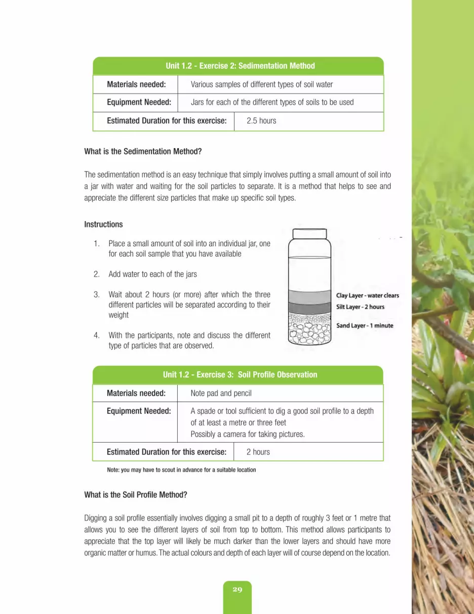
29
Unit 1.2 - Exercise 3: Soil Profile Observation
Materials needed: Note pad and pencil
Equipment Needed: A spade or tool sufficient to dig a good soil profile to a depthof at least a metre or three feetPossibly a camera for taking pictures.
Estimated Duration for this exercise: 2 hours
Note: you may have to scout in advance for a suitable location
What is the Soil Profile Method?
Digging a soil profile essentially involves digging a small pit to a depth of roughly 3 feet or 1 metre thatallows you to see the different layers of soil from top to bottom. This method allows participants toappreciate that the top layer will likely be much darker than the lower layers and should have moreorganic matter or humus.The actual colours and depth of each layer will of course depend on the location.
What is the Sedimentation Method?
The sedimentation method is an easy technique that simply involves putting a small amount of soil intoa jar with water and waiting for the soil particles to separate. It is a method that helps to see andappreciate the different size particles that make up specific soil types.
Instructions
1. Place a small amount of soil into an individual jar, onefor each soil sample that you have available
2. Add water to each of the jars
3. Wait about 2 hours (or more) after which the threedifferent particles will be separated according to theirweight
4. With the participants, note and discuss the differenttype of particles that are observed.
Unit 1.2 - Exercise 2: Sedimentation Method
Materials needed: Various samples of different types of soil water
Equipment Needed: Jars for each of the different types of soils to be used
Estimated Duration for this exercise: 2.5 hours
fao_climate_smart_manual_part_1.qxd 10/23/14 1:12 PM Page 29

30
Instructions:
1. Identify a suitable location to dig your soil profile pit.If possible, try to find a site that will have a good toplayer of soil or humus
2. Using a spade, dig the pit to a depth of only 1 metreor 3 feet
3. With the participants, observe the various layers or“horizons” that are unearthed. Ask participants tocount how many layers they see and note how thelayers are different. What colour are the layers? Howdeep are they? Which is deepest? Does the texturechange? Does the structure change? What organismsdo they see, if any? How deep do the plant rootspenetrate, if there? And so on
Unit 1.2 - Exercise 4: Soil Erosion Profile Observation
Materials needed: Note pad and pencilA local site where a land slide ormajor erosion has recently occurred
Equipment Needed: Possibly a camera for taking pictures.
Estimated Duration for this exercise: 1 hour
What is the Erosion Profile Method?
This method is very similar to Exercise 3, except instead of digging a soil profile, the exercise involvesfinding a location where major erosion or a long slide or breakaway has recently occurred. Farmersvisit the site so they can see and observe the different layers of soil that have been exposed.
Instructions:
1. Identify a suitable location
2. With the participants, observe the various layers that have been unearthed. Ask participants tocount how many layers they see and note how the layers are different. What colour are thelayers? How deep are they? Which is deepest? Does the texture change? Does the structurechange? What organisms do they see, if any? How deep do the plant roots penetrate?And so on
3. Note all the observations that are voiced and take pictures, if possible.
4. Note all the observations that are voiced and take pictures, if possible
5. When you are finished, refill the pit with the soil that was previously removed.
fao_climate_smart_manual_part_1.qxd 10/23/14 1:12 PM Page 30

31
In this unit we now go into more detail aboutthe water cycle and the importance ofwatersheds in maintaining soil moisture andsoil fertility. Understanding how watershedsfunction is very important for understandinghow practices such as deforestation, too muchremoval of vegetative cover and improper landpreparation contribute to soil loss - especiallyon farms with steep slopes.
At the end of this Unit, you should:
1. Know how to correctly explain what awatershed is and why they are important
2. Appreciate the principles of watershedmanagement
3. Know which Watershed ManagementUnit your extension area falls within; and
4. Know the basic steps involved, and toolsto use, to conduct a basic watershedassessment.
What exactly is a “watershed”?
So, what exactly is a “watershed”? You may besurprised to learn that many people in Jamaicaare not at all aware what a watershed actuallyis. In 2002 for example, a “Knowledge,Attitudes and Practices” (KAP) report done forthe Ridge to Reef Watershed Project (R2RW)1,surveyed rural communities in the Rio Cobre,Great River, Rio Grande and Wag Waterwatershed areas of Jamaica. The study found
that at that time, very few people could knewwhat a watershed was. Some of the morecommon responses to the question includedideas such as:
• A place to store water
• A small building over a latrine
• A storage site for the National WaterCommission (NWC)
• A water catchment building to catchrain water.
Other respondents had vaguely correct responsessuch as:
• A place where water comes from
• Forests where water comes from
• An area of land where water runs
• Riverheads.
While it is likely that public awareness aboutwatersheds has improved, it is important forextension officers not to assume that peoplefully understand what the term meanswhenever they use. Asking farmers what theirunderstanding actually is - should always bethe starting point for any extension discussionwith farmers. And it may also be more useful totalk to farmers about “rivers” and how they feelabout them as opposed to watersheds at all.
Unit 1.3 The Impact of Climate Change on Watersheds
1 PSEARCH Consultants, July 24, 2002. “Enhancing Awareness for Sustainable Watershed Management: Report ofthe Knowledge, Attitudes and Practices Survey”, Ridge to Reef Watershed Project, National Environment and PlanningAgency (NEP) and USAID.
fao_climate_smart_manual_part_1.qxd 10/23/14 1:12 PM Page 31

32
A watershed is an area of land bounded by ridge lines (crust lines), irrigatedby the same water system (a river, with its tributaries and all the rivers thatfeed it territory) and corresponding to the entire area of capture anddrainage of precipitation. The entire watershed region has a common outletfor its surface runoff. A watershed is like a funnel, all the rain falling on thewatershed area, will flow to the same outlet/river mouth.
“
”
Despite whatever folk and popular perceptions may exist, officially however, the following definition of“watersheds” applies:
Illustration of a Watershed
fao_climate_smart_manual_part_1.qxd 10/23/14 1:12 PM Page 32

33
DEFINITION OF WATERSHEDS
A watershed, or catchment, is an area that drains to a common point.More specifically, it supplies water by surface or sub-surface flow to agiven drainage system or body of water, be it a stream, river, wetland orsea. Each river has its own watershed. Topography is the key elementaffecting watersheds. The boundary of a watershed is defined by thehighest elevations surrounding the river.
“”
The National Environmental Planning Agency (NEPA)2 has the following definition for watershed:
2 http://www.nepa.gov.jm/symposia_03/Papers/Watersheds.pdf
What do Watersheds Do?
Watersheds are important because theyprovide several functions that are important tosustainable survival.
First, watersheds are critical to the HydrologicalCycle. As funnels, they function to:
• Direct the flow of rainwater from upstreamto downstream
• Collect and accumulate varying amountsof water at varying lengths of time
• Give back water to the water cycle asrunoff.
They also serve important Ecological purposes as:
• Sites for chemical reactions necessaryfor living organisms
• Habitat for plants and animals (faunaand flora). Healthy watersheds arecritical to protect biodiversity andfragile eco-systems.
Finally, and very importantly, watersheds havevery significant Socio-economic value since:
• Human beings depend on watershedsfor their life (water, food, etc.)
• Without watersheds, fundamental resourcessuch as food and water would becomeunaffordable.
Why do watersheds have to beidentified before implementing anysoil conservation action?
The watershed is the geographical unit of thehydrological cycle. So it is a logical unit forplanning local development projects and for themanagement of natural resources since all thenatural resources that are in a watershed areinter-linked, in one way or another, throughwater movements.
The lands upstream and downstream within asingle watershed are physically connected andlinked through the hydrological cycle. In otherwords, “What happens upstream, affects whathappens downstream.”
How upstream actions affect lands downstreamdepend on:
• The geographical shape of the upstreamland (its topography, slopes, ) that determinehow and where water flows and thus,how much water (quantity) movesdownstream
• The soil conditions of upstream lands.Degraded lands that are deforestedand suffering from soil erosion or heavypesticide and herbicide use, will allowexcess soil and farm chemicals to alsowash downstream
• Small changes to natural water flowchannels can lead to large impacts anddamage downstream.
fao_climate_smart_manual_part_1.qxd 10/23/14 1:12 PM Page 33

What is watershed management?
Watershed management is a process thatseeks to uphold fundamental land husbandryprinciples (see Unit 1.4 for more information onthis). Several factors must be “managed” forwatersheds to remain sustainable. Sound watermanagement meets the following criteria:
• Water flow is controlled and there isbetter management and use of waterresources
• Water filtration is promoted, waterflows are regulated, there is increasedpoints of use of water for domestic andproductive needs (agriculture andlivestock), water quality is improved,there is greater availability of energy forproduction, and reduced damage dueto runoff, etc.
• Soil erosion is reduced
• Local people are involved in watershedmanagement through participatoryprocesses and decision-making
• Multiple disciplines are involved in themanagement process including The
Forestry Department (FD), the NationalWater Commission (NWC), the WaterResources Authority (WRA), theNational Environmental PlanningAgency (NEPA), the Ministry ofAgriculture and Fisheries (MoAF),Department of Roads and Works, Officeof Disaster Preparedness andEmergency Management (ODPEM),parish councils, non-governmentalorganisations and other groups, asrelevant to the specific watershed area
• Management is maintained on asustainable basis with on-goingmonitoring and review of planningprocesses
• Management is flexible and iterative(i.e., responds to needs as they arise).
What is the Watershed Unit approach?
Watershed “units” are commonly used now inJamaica for the planning of developmentprojects and building schemes, for naturalresource management, for disaster riskmanagement and for land-use planning.
34
fao_climate_smart_manual_part_1.qxd 10/23/14 1:12 PM Page 34

35
Map 1.3.1
Under this approach:
• Watersheds are the unit for planning,studying, decision-making and action
• Different activities within a specificwatershed are integrated to achievespecific objectives
• Activities are also integrated to ensurethe best use and management of thenatural resources that exist within aspecific watershed
• And local people and communities fullyparticipate as decision-makingstakeholders who are involved inmanaging local watershed resourcesthrough Local Watershed ManagementCommittees (LWMCs) or sometimes inJamaica - Local Forest ManagementCommittees (LFMCs).
It is important to note however, that WatershedUnits do not always coincide with otherplanning units (such as Parish DevelopmentCommittees (PDCs) or Local DevelopmentCommittees (LDCs) or Community Development
Committees (CDCs) that are often used forsocial planning purposes in Jamaica. Nor dothey always coincide with the Agro-EcologicalArea/Zone or Extension Area that RADA usesfor its own planning purposes.
How Many Watershed are there inJamaica?
There are at least 100 actual watersheds inJamaica, but they have been grouped into 26Watershed Management Units (WMU) tofacilitate governance and land management.However, in most instances watershedboundaries do not correspond to administrativeBoundaries (a notable exception in Jamaica isthe parish of Portland where the ParishDevelopment areas correspond to thewatershed management units and Port AntonioUrban area).
Map 1.3.1 below illustrates where are of theWatershed Management Units are located inJamaica. Review it now to identify which WMUyour own extension area is situated.
fao_climate_smart_manual_part_1.qxd 10/23/14 1:12 PM Page 35

36
So how do we define the borders or delimit a Watershed?
Several steps are involved to determine wherea specific watershed begins and ends.
1. First, you must identify a landmark toset a specific point where water passesin a river or a valley. This should be thelowest outlet point that all the waterflows toward
2. From there, on the basis of the altitudes(detected through contour lines) you needto identify and mark the crest lines(highest points or peaks in the watershed,).
Together, these high and low points or markersconstitute the perimeter of the watershed.
You can identify altitudes and key landmarksusing Topographic maps. Topographical mapsactually show “contour lines” so you can beginto see:
• Contour lines within the watershedarea - which are points along the samealtitude along the slope
• The water runoff is always perpendicular(or at right angles) to the contour lineson the map
• The maximum slope lines are thosethat combine two contour lines at the
points of minimum distance betweenthe two. On topographical maps, thevertical difference between contourlines is 100 metres, so they are asclose together as the slope is steep. Aline between the highest point and thelowest point illustrates the degree ofthe slope (%):
Key:
h (vertical difference within contour lines)= 100m
d (horizontal distance within contour lines) = to calculate and to proportionate to the map scale(i.e. for maps 1:25 000: 1 cm in the map = 250 m in the field)
SLOPE (%)= h/d*100
fao_climate_smart_manual_part_1.qxd 10/23/14 1:12 PM Page 36

37
In addition to topographical maps, you can alsouse other maps to study the watershedincluding:
• Photographic maps and
• Geo-referenced maps.
How can we tell if a watershed is degraded?
It is usually pretty obvious when a watershedhas been degraded. Most of the signs are visibleor are directly experienced by the people thatlive there. We can tell a watershed is degradedwhen we see:
• Productivity has been lost. The soilsand potential of land and water resourcesno longer yield the results they used to
• Net changes in the hydrological behavior(reduced quality, quantity and regularityof water flow)
• Evidence of poor practices such asdeforestation, slash and burn farming,landslides, soil loss, increased nutrientsin rivers and streams from run off, andInteraction of geographical, climaticand anthropogenic factors
• Acceleration of ecological degeneration(i.e., loss of flora and fauna, loss biodiversityand soil erosion)
• Reduced economic opportunities tomake livelihoods from the land and arise or intensification of social problems.
Walking through a watershed to do anassessment using transects and communitymapping exercises is a very useful way to
assess the degree of degradation that mayexist. This should be done together with farmersso that their knowledge and experience of thearea can be included to determine howproblems should be addressed and landmanagement improved.
RADA Officers getting ready fora mapping exercise
An example of a participatorytransect map
fao_climate_smart_manual_part_1.qxd 10/23/14 1:12 PM Page 37

38
Purpose - To better understand the local watershed conditions by collecting observable watershed
data from secondary sources (such as maps), farmer testimonials, and from observable evidence
through transect walks and community mapping exercises.
What is the Technique?A physical watershed assessment using to determine the key features of the watershed, main
threats, types of degradation, causes of degradation, and persons most vulnerable.
Objective: identify watershed/land degradation processes and potential solutions.
Solutions could be:
• Individual actions: for which the engagement of the individuals living or working in the targetarea is required
• Collective actions: for which the engagement of all communities of the watershed (usuallythrough statement of local or national authorities) is required.
Methods to be used:
1. Maps(topographical, geo-referenced (GPS)
2. Photographic documentation
3. Oral history documentation
4. Observable evidence
5. Community mapping
6. Transect walks.
Unit 1.3 - Exercise 1: Conducting a Watershed Assessment with Farmers
fao_climate_smart_manual_part_1.qxd 10/23/14 1:12 PM Page 38
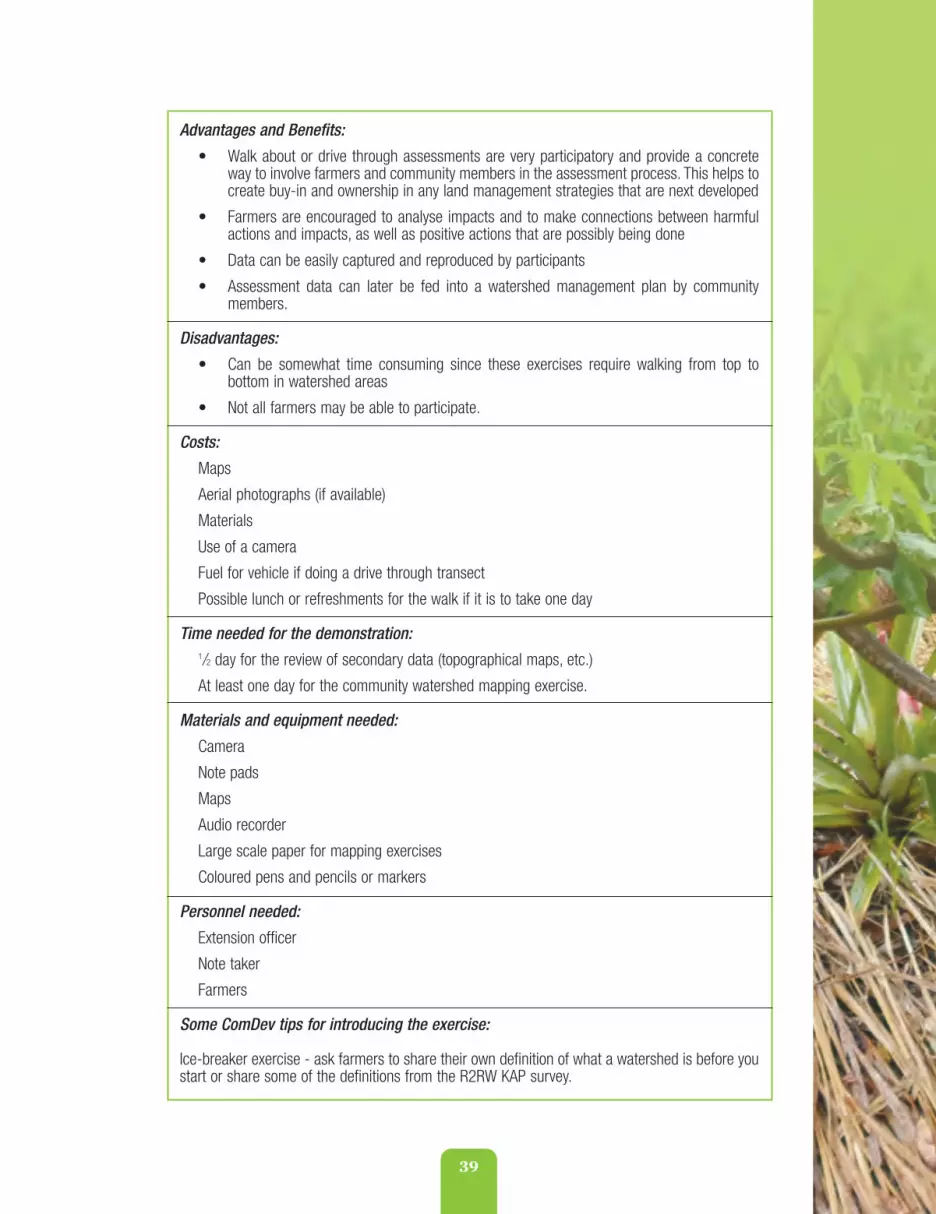
39
Advantages and Benefits:
• Walk about or drive through assessments are very participatory and provide a concreteway to involve farmers and community members in the assessment process. This helps tocreate buy-in and ownership in any land management strategies that are next developed
• Farmers are encouraged to analyse impacts and to make connections between harmfulactions and impacts, as well as positive actions that are possibly being done
• Data can be easily captured and reproduced by participants
• Assessment data can later be fed into a watershed management plan by communitymembers.
Disadvantages:
• Can be somewhat time consuming since these exercises require walking from top tobottom in watershed areas
• Not all farmers may be able to participate.
Costs:
Maps
Aerial photographs (if available)
Materials
Use of a camera
Fuel for vehicle if doing a drive through transect
Possible lunch or refreshments for the walk if it is to take one day
Time needed for the demonstration:1/2 day for the review of secondary data (topographical maps, etc.)
At least one day for the community watershed mapping exercise.
Materials and equipment needed:
Camera
Note pads
Maps
Audio recorder
Large scale paper for mapping exercises
Coloured pens and pencils or markers
Personnel needed:
Extension officer
Note taker
Farmers
Some ComDev tips for introducing the exercise:
Ice-breaker exercise - ask farmers to share their own definition of what a watershed is before youstart or share some of the definitions from the R2RW KAP survey.
fao_climate_smart_manual_part_1.qxd 10/23/14 1:12 PM Page 39

40
Step one:Analysis of aerialphotos (if available)
Analyze the picturesto see if any erosivephenomena can beidentified.
Step two: Analysis of the maps (if available)
Maps can provide important information (plots size, slope, major risk areas of erosion, texture,etc.). In general it is important to have at least an idea about the area we are going to assess andwhich watershed or micro-watershed the area falls within. Even if maps are not available it’salways important to consider the watershed in its entirety.
Step three: Interview farmers
Main questions to ask:
• Are there any signs of erosion in the fields or along streams and ditches?
• Have yields been reduced on your plots and if so, why?
• What crops and practices are used (crop rotations, associations, labor, etc.)?
• What techniques are used traditionally?
During the interview it is important to list possible farmer solutions.
Additional sources of information on this technique:
FAO - Jamaican Livelihood Baseline assessment manual.
Assessment Steps
fao_climate_smart_manual_part_1.qxd 10/23/14 1:12 PM Page 40

41
Step four: Conduct a site visit and observe the watershed for any signs of erosionusing transect and community mapping exercises
Farmers usually tend to bring the technician to see directly signs of erosion on the site. It isimportant to evaluate the signs but also to understand the dynamics of the water upstreamand downstream.
Observe, describe, locate and measure signsof erosion:
• Concentration of big particles on thesurface (sheet erosion)
• Rill (1-60 cm depth)
• Gullies (> 60 cm).
fao_climate_smart_manual_part_1.qxd 10/23/14 1:12 PM Page 41

42
River bank conditions (landslides, slope, etc.);
Deposits of sediments.
• The best time is after heavy rains or when the crop starts to grow
• The purpose of the visit is to characterize the problem and initiate a search for solutions.
fao_climate_smart_manual_part_1.qxd 10/23/14 1:12 PM Page 42

43
Unit 1.4 Fundamental Principles and Methods of Land Husbandry
Now that we have an appreciation for soils andan understanding of how watersheds functionand how they can become degraded, it is timeto be sure we appreciate what “Climate-Smart”land husbandry or land management involves.
At the end of this Unit, you should:
1. Appreciate the historical and culturalfactors that have given rise to thepractice of land husbandry; and
2. Understand the fundamental principlesinvolved in sound land husbandrymanagement.
What do we mean by the term “Husbandry”?
First however, it is interesting to consider wherethe word “husbandry” comes from and how itoriginated. You may be interested to know thatthe term “husband” was not originally meant tomean a “married man” for instance. Theoriginal meaning of the term “husband” has itsroots in the bible and was originally associatedwith the first man - Adam - or : ish ‘adahamah,literally, “man of the soil” (Genesis 9:20); ‘ikkar,literally, “digger,” “a farmer” (2 Chronicles26:10 Jeremiah 31:24; Jeremiah 51:23 Amos5:16 Joel 1:11); gubh, “to dig” (2 Kings 25:12);yaghabh, “to dig” (Jeremiah 52:16); georgos,“cultivator” (Matthew 21:33 John 15:1 James5:7).1
The term husband and husbandry laterdeveloped as a middle English term tospecifically refer to “farmers.” Very importantly,various dictionaries now define husbandry as:
• The act or practice of cultivating cropsand breeding and raising livestock;agriculture
• The application of scientific principlesto agriculture, especially to animalbreeding
• The careful and prudent managementor conservation of resources, thrift,economy.
This last point is important to stress because itimplies that “husbandry” involves taking greatcare of natural resources and using economicprinciples to maximize resources andlivelihoods in a sustainable way.
Fundamental Purpose and Principles of Land Husbandry
This definition of “husbandry” clearly resonateswith the main objective of “land husbandry”which is to literally “care for the land”. Thisinvolves actively taking steps to reduce landdegradation, conserve soil fertility and water,and to thus protect the land’s productivity andecosystem resources and the services theyprovide.
1 http://biblehub.com/topical/h/husbandry.htm
fao_climate_smart_manual_part_1.qxd 10/23/14 1:12 PM Page 43
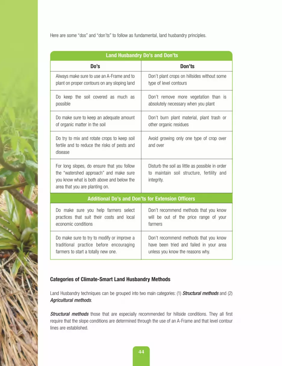
44
Here are some “dos” and “don’ts” to follow as fundamental, land husbandry principles.
Do’s
Always make sure to use an A-Frame and toplant on proper contours on any sloping land
Do keep the soil covered as much aspossible
Do make sure to keep an adequate amountof organic matter in the soil
Do try to mix and rotate crops to keep soilfertile and to reduce the risks of pests anddisease
For long slopes, do ensure that you followthe “watershed approach” and make sureyou know what is both above and below thearea that you are planting on.
Do make sure you help farmers selectpractices that suit their costs and localeconomic conditions
Do make sure to try to modify or improve atraditional practice before encouragingfarmers to start a totally new one.
Don’ts
Don’t plant crops on hillsides without sometype of level contours
Don’t remove more vegetation than isabsolutely necessary when you plant
Don’t burn plant material, plant trash orother organic residues
Avoid growing only one type of crop overand over
Disturb the soil as little as possible in orderto maintain soil structure, fertility andintegrity.
Don’t recommend methods that you knowwill be out of the price range of yourfarmers
Don’t recommend methods that you knowhave been tried and failed in your areaunless you know the reasons why.
Land Husbandry Do’s and Don’ts
Additional Do’s and Don’ts for Extension Officers
Categories of Climate-Smart Land Husbandry Methods
Land Husbandry techniques can be grouped into two main categories: (1) Structural methods and (2)Agricultural methods.
Structural methods those that are especially recommended for hillside conditions. They all firstrequire that the slope conditions are determined through the use of an A-Frame and that level contourlines are established.
fao_climate_smart_manual_part_1.qxd 10/23/14 1:12 PM Page 44

45
Most also involve some type of building up of soil beds, benches, construction of barriers to control andprotect water or wind flow, or to protect against fire damage. They are called “structural” methodsbecause they literally involve planting, building or digging structures of one type or another.
Some structural methods include:
1. Sowing on contour lines
2. Strip cropping
3. Alley Cropping with leguminous bushes
4. Grass barriers
5. Pineapple barriers
6. Organic trash barriers
7. Stone bench terraces
8. Individual basins
9. Diversion ditches
10. Raised beds or network drains
11. Check dams or gully plugs
12. Retaining walls.
Agricultural methods are those that involve the use of plants or trees and specific types of croppingmethods. These methods include:
1. Agro-forestry and tree crop methods
2. Cover cropping
3. Minimum tillage
4. Mulching and
5. Composting.
Agricultural methods help to reduce soil erosion by improving the soil fertility and quality of the field by:
• Avoiding exposure of bare soil to rains and winds
• Increasing soil fertility by adding higher content of organic matter
fao_climate_smart_manual_part_1.qxd 10/23/14 1:12 PM Page 45

46
• Increasing water infiltration into the soil through better soil and crop management.
Several of these agronomic methods are suitable for all soil types and AEZs, but some are especiallywell-suited to farms on steep slopes. Best results are obtained from agronomic methods when theyare integrated with other methods and techniques chosen for specific AEZs.
These methods, and their pros and cons, and suitability to mitigate against different types of climatechange hazards are discussed in Part Two along with other methods that are not specifically related tosoil management, per se, but for other types of potential hazards related to climate change. At thispoint it is simply important to appreciate what land husbandry is and which main principles andmethods can be considered.
fao_climate_smart_manual_part_1.qxd 10/23/14 1:12 PM Page 46

47
Now that we have an appreciation for land husbandry fundamentals and are clear that usingan A-Frame is critical for establishing level contours on hillside farms, let’s look again at thedifferent types of hazards that are likely to become more intense with climate change and seewhich “best bet practices” (BBPs) or “best bet technologies” (BBTs) are most recommended tomitigate these harmful impacts.
At the end of this Unit, you should:
1. Be familiar with the range of best bet land husbandry practices that are suitable forspecific Agro-ecological zones (AEZs) and
2. Feel equipped to share these BBPs with farmers using role-play methods.
A Best Bet Menu
This section provides an overview of the many different options that exist to help mitigateclimate impacts for Jamaican farming conditions. This overview is presented as a “menu” thatyou can use to discuss with your farmers. It is presented as a matrix to allow you to easily see,at a glance, how the different methods compare and to see which are recommended forspecific agricultural ecological zones.
These same methods are then presented in more detail in the upcoming sections in Part Twodepending on whether or not they are agronomical in nature, or structural. In this section, theobjective is to show which climate hazard each is most recommended for.
Types of Hazards
Remember there are several different types of climate change related hazards that can affectour land management sustainability and overall agricultural productivity. This manual is largelyconcerned with the following hazards that are represented in Table 1.5.1 with the specificsymbols. Climate change will also bring increased risk of insect pests and plant diseases, butthese are not covered in this manual.
Unit 1.5 Matching Best Practices to Climate Hazards
fao_climate_smart_manual_part_1.qxd 10/23/14 1:12 PM Page 47

48
1 Note: Climate change does not bring increased risk of chemical pollution directly. However, unless other measures usedto mitigate against landslides, strong rainfall and flooding are practiced to prevent soil erosion, there is an increased risk offarm chemicals washing away and getting into the water system.
Climate Hazard
Drought
Flooding
Strong rainfall
Landslides
Strong winds
Fire
Chemical pollution1
Symbol
Table 1.5.1 Climate Change Hazards and Symbols
Matrix 1.5.1 now presents the different BBPs in matrix form according to the hazard they are bestsuited to address. You can use this matrix to introduce the methods to your farmers by learning firstwhich hazards are of most concern to them and which methods are the best options to consider toaddress their concerns.
fao_climate_smart_manual_part_1.qxd 10/23/14 1:12 PM Page 48

49
BEST
PRA
CTIC
E M
ATRI
X
(Sou
rce:
Spen
ce,B
alfo
ur. A
pril
2008
. “Go
od P
ract
ices
for H
azar
d Ri
sk M
anag
emen
t in
Agric
ultu
re:S
umm
ary
Repo
rt J
amai
ca”.
TCP
/RLA
/310
1.As
sist
ance
to Im
prov
e Lo
cal A
gric
ultu
ral E
mer
genc
y Pr
epar
edne
ss in
Car
ibbe
an C
ount
ries
High
ly P
rone
to H
urric
ane
Rela
ted
Disa
ster
s,FA
O-Ja
mai
ca O
ffice
,Kin
gsto
n.
fao_climate_smart_manual_part_1.qxd 10/23/14 1:12 PM Page 49

50
fao_climate_smart_manual_part_1.qxd 10/23/14 1:12 PM Page 50

51
fao_climate_smart_manual_part_1.qxd 10/23/14 1:12 PM Page 51

52
fao_climate_smart_manual_part_1.qxd 10/23/14 1:12 PM Page 52

53
fao_climate_smart_manual_part_1.qxd 10/23/14 1:12 PM Page 53

54
2 This extension methods exercise has been adapted from the “Sir Arthur Lewis Institute for Social and Economic Studies(SALISES), University of the West Indies” 29013. Project: “C-Change - Managing Adaptation to Environmental Change inCoastal Communities - Canada and the Caribbean)
Caribbean Cook Shop Exercise
Materials needed: A few photocopies of the climate change cook shop menu.Tables and chairs and a few platesHandouts for this exercise
Expected Duration: 1.5 hours
Extension Methods Teaching NotesCaribbean Climate Cook Shop & Café2
This extension methods exercise has been adapted from the Sir Arthur Lewis Institute for Socialand Economic Studies (SALISES), University of the West Indies Project: “C-Change - ManagingAdaptation to Environmental Change in Coastal Communities - Canada and the Caribbean). You mayfind it a useful way to introduce the range of BBPs to your farmers if you feel they are participants whomay enjoy role-playing and dramatization exercises.
You will need:
For this exercise, select at least four individuals from among the participants to “role play” customersat the café.
You will also need at least one facilitator to “role play” the waitress or waiter and another to serve asthe “maître’d” if needed.
To Prepare
Print enough “menus” for all participants to have a copy, even if they are not selected as restaurantpatrons.
The “waitress or waiter” should be an extension officer who is definitely already familiar with the“menu” of options and who should be able to answer simple questions that the patrons may have.
The maître’d should be another trained officer who can answer more sophisticated questions shouldthe patrons have further questions or should a dispute erupt.
fao_climate_smart_manual_part_1.qxd 10/23/14 1:12 PM Page 54

55
Additional props and materials needed (if possible):
• Four chairs
• A table
• Apron for the waitress or waiter
• Table cloth to better set the stage for the café clients.
To play
Role Play Portion (roughly 30 to 40 minutes)
Here is how the scenario should unfold. Four patrons enter the café and sit down at a“restaurant table” in front of the rest of the participant audience.
The waitress/waiter greets them and distributes four menus as per custom. At this point,participants in the audience should also get their copy of the menu, but are not allowed tospeak.
The waitress allows the “clients” to peruse the menu and go over the options available. As theydo so, they should engage in conversation aloud and take turns to read the options that areavailable.
Note: no costs are associated with the menu. The costs will be determined through dialoguewith the participants and with the maître’d and waitress.
After five or so minutes, the waitress/waiter should come and ask the clients if they have anyquestions about the menu. S/he should try her best to answer any questions that arise, butshould not answer about costs. Discussion about cost will result from later dialogue with theaudience.
At some point, the waitress or waiter can no longer answer questions and must call in themaître’d to respond. S/he too will have to renege and agree that the full cost of some selectionsmay not be fully known at this point in time.
The actors should then concede and join the audience at which point a more detaileddiscussion can begin with the audience about the different options presented.
Dialogue and Discussion (roughly 1 hour)
Once the role play is completed, the extension officer who is the lead facilitator should step inand support dialogue and review of the “menu” by the entire group of participants.
fao_climate_smart_manual_part_1.qxd 10/23/14 1:12 PM Page 55

56
One by one, the menu options should be reviewed and clarified so that they are all fullyunderstood by participants.
Specifically, the discussion should centre on the “cost” of each of the options on the menu.What do they think the cost is for them to choose specific options?
Ideally, if additional outside resource persons can be present to discuss the options listed,this would lend more value to the exercise.
At the end however, this exercise should stimulate thought among the participants withregards to what options might actually be available to them.
ADDITIONAL RESOURCES FOR UNIT THREE
Spence, Balfour. April 2008. Good Practices for Hazard Risk Mitigation in Agriculture.http://www.fao.org/fileadmin/templates/tc/tce/pdf/Jamaica_GoodPracticesHRM.pdf
Adaptation Learning Mechanism. Special Programme for Adaptation to Climate Change(SPACC) Implementation of Adaptation Measures in Coastal Zones.http://www.adaptationlearning.net/project/carib-gef-implementation-adaptation-measures-coastal-zones
fao_climate_smart_manual_part_1.qxd 10/23/14 1:12 PM Page 56

SSppeecciiaalliissiinngg iinn CClliimmaattee CChhaannggee AAddaappttaattiioonn DDeelliiccaacciieess
ffoorr FFaarrmmiinngg CCoommmmuunniittiieess
The Caribbean ClimateCook Shop & Café
fao_climate_smart_manual_part_1.qxd 10/23/14 1:12 PM Page 57

58
AppetizersDisaster and Climate Management
Selection Cost
1. Construct your own “A-Frame” to set contours properly
2. Establish the slope conditions on your farm
Main Course - EntréesFarming Livelihood Adaptation Strategies
Selection Cost
Structural entrées:
1. Trenching
2. Diversion ditches
3. Gully plugs
4. Check dam construction
5. Stone wall barriers
6. Retaining wall construction
7. Gabion baskets
8. Raised beds and network drains
9. Individual basins
10. A lá Carte - create your own
Agricultural entrées:
1. Contour sowing
2. Strip cropping
3. Alley cropping with leguminous bushes (hedgerows)
4. Agro-forestry and tree crop production
5. Reforestation
6. Pineapple barriers
7. Khus khus grass (vetiver),king grass or guinea grass barriers
8. Mulching
9. Cover cropping
Some possible strategies for reducing impact of disasters and Climate Change on farms:
fao_climate_smart_manual_part_1.qxd 10/23/14 1:12 PM Page 58

59
Main Course - EntréesFarming Livelihood Adaptation Strategies
Selection Cost
Agricultural entrées (cont’d):10. Minimum tillage
11. Organic trash barriers with bamboo
12. Composting
13. A lá Carte - create your own
Dessert - Sweet OpportunitiesAdditional Selections
Selection Cost
1. Windbreaks
2. Changing crop timing
3. Changing crop options (drought tolerant and wind tolerant)
4. Drip irrigation
5. Water harvesting
6. Windbreaks and hedgerows
7. Fire breaks and fire banks
8. Triangular bracing for bananas
Community selections:
9. Farm road construction and erosion control
A lá Carte - create your own
fao_climate_smart_manual_part_1.qxd 10/23/14 1:12 PM Page 59

60
Notes
fao_climate_smart_manual_part_1.qxd 10/23/14 1:13 PM Page 60

61
Climate-SmartLand Husbandry Practices
Part
2
Section One
fao_climate_smart_manual_part_2_1_front.qxd 10/23/14 1:18 PM Page 61
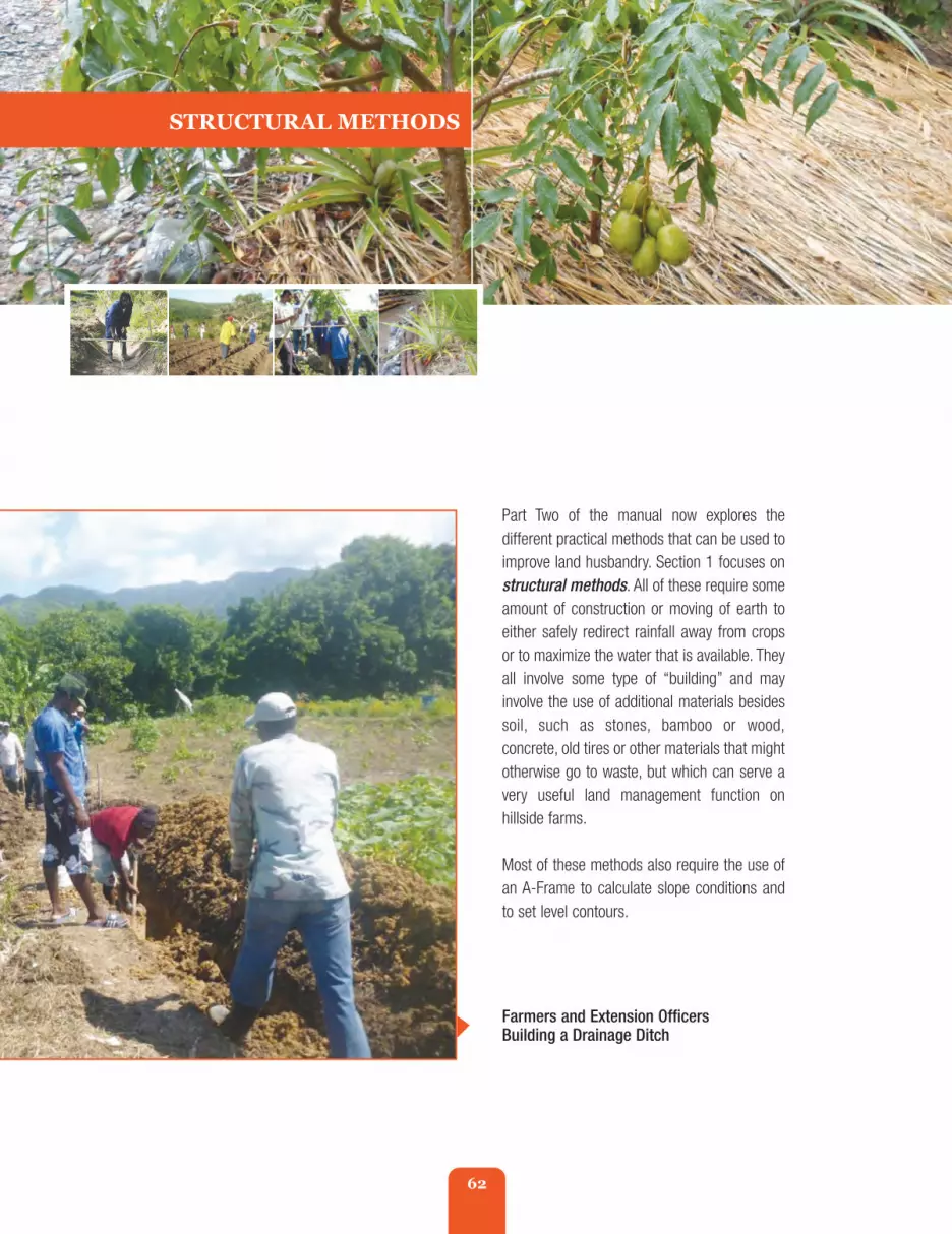
62
Part Two of the manual now explores thedifferent practical methods that can be used toimprove land husbandry. Section 1 focuses onstructural methods. All of these require someamount of construction or moving of earth toeither safely redirect rainfall away from cropsor to maximize the water that is available. Theyall involve some type of “building” and mayinvolve the use of additional materials besidessoil, such as stones, bamboo or wood,concrete, old tires or other materials that mightotherwise go to waste, but which can serve avery useful land management function onhillside farms.
Most of these methods also require the use ofan A-Frame to calculate slope conditions andto set level contours.
STRUCTURAL METHODS
Farmers and Extension OfficersBuilding a Drainage Ditch
fao_climate_smart_manual_part_2_1_front.qxd 10/23/14 1:19 PM Page 62

63
Every good tradesperson knows they are onlyas good as their tools. The same principleapplies to land husbandry. The most importanttool for land husbandry on slopes - is the A-Frame (sometimes called a Triad). An A-Frameallows you to find precise levels so you canbuild proper contours and ensure that anythingthat is planted will also be on level therebyminimising soil erosion.
A-Frames can be bought or purchased, but theyare very simple to make. As an extensionofficer, you should encourage your farmers tomake their own A-Frame Levels using simplematerials that they have at home or in the field.At the end of this Unit, you should:
1. Know how to construct and use an A-Frame
2. Know how to calibrate an A-Frame
3. and feel comfortable teaching farmersto build one as well.
Unit 2.1.1 Constructing an A-Frame
What is an A-Frame?
An A-Frame is a tool that is simple to constructusing three pieces of wood that look like theletter “A” - which is where it gets its name. Italso uses string or twine and a simple weightlike a stone or plastic water bottle. It’s a simpletool that allows you to determine the gradient ordegree of a slope and to set all the points forplanting at the same level of altitude on the hill.
Materials Needed
To build an A-Frame three sticks are need (twothat are 2 metres or (2 yards in length), and onethat is 1.20 metres in length or roughly 1.5metres or 1.2 yards long).
You will also need the following additional tools:a rope, nails and hammer, 2 stakes of equallength, a stone weight or a plastic bottle filledwith water.
The two longest side sticks are then positionedand connected to form an upside down “V”.Make sure you find a very flat place to lay themdown on the ground. Lay the stakes down andseparate them till the bottom of the stakes are2 metres (or 2 yards) apart keeping their topends together.
fao_climate_smart_manual_part_2_1_front.qxd 10/23/14 1:19 PM Page 63

64
Once this is done, and the middle stick isdefinitely level, they you need to find a weightthat can act as your level. Use either the stoneor the plastic bottle with water or anotherobject that will weigh the string down. Tie theweight with enough string that it can hang allthe way down from the top of the “A” and waypast the middle bar. Use string or wire tosecure it tightly to the top of the A-Frame.
You can use wire or string tosecure the sticks together atthe top of the “A”, or a nail orscrew. The shorter stick isthen positioned across themiddle of the “A” (in themiddle of the two longersticks, at 1 metre or 1 yard)and also secured using nails,wire or strong twine.
fao_climate_smart_manual_part_2_1_front.qxd 10/23/14 1:19 PM Page 64

65
Now you need to set your level point or“calibrate” your A-Frame. To do this, be sureagain to find a very flat and even place to standup the A-Frame. Allow the string with the weightto fall straight down from the top and below themiddle bar. Mark the point in the middle of thebar by cutting a notch.
To continue calibrating, place the A-Frame withone of its feet above one of the stakes or on theregular slope. Check the point where theweighted rope now drops and mark this point onthe middle bar as well. Now, do the same withthe other A-Frame foot and mark the pointwhere the weight falls on the other side of themiddle bar. To be precise the marks on themiddle bar should be drawn at the pointsindicated by the wire. Once these two marks areidentified on the bar - one on the left and one onthe right - the “0” or zero level point should beexactly in the middle of these two points.
These are the points that will guide you as youset your stakes on your contours.
fao_climate_smart_manual_part_2_1_front.qxd 10/23/14 1:19 PM Page 65

66
Recommended for Which Hazard(s) and Land Management Practices?
All hillside - slope conditions - and for establishing both agronomic and structural land husbandrymeasures.
Advantages and Benefits
Helps you to ensure that contours are level with the hillside slope conditions so that whatever isplanted or constructed will not wash down the slope in heavy rains.
Disadvantages
None really. But requires an additional step and investment of time for most farmers.
Cost
Next to nothing. Can be made from simple materials. Only cost is the additional time to use the A-frame first and to establish contours before construction or planting.
Learning Objectives
To learn the correct way to build a simple and cost effective A-Frame Tool for lining out correctcontours on hillsides.
Unit 2.1.1 Constructing and Using an A-FrameExtension Notes
Materials Needed
1. 3 sticks or pieces of wood thatare at least 2 metres or 2yards long and maybe aninch and a half or two incheswide. Three pieces of two byone board can also do
2. Some string
3. Some wire and
4. A small rock stone or somethinga bit heavy that can serve as aweight.
fao_climate_smart_manual_part_2_1_front.qxd 10/23/14 1:19 PM Page 66

67
Step threeThen, find the centre piece ofjust two of the sticks thatform the sides of the A-Frame. You need to be sureyou find the exact centre ofboth sticks and drill a hole inthe centre on both of these.Once you’ve done that, cut apiece of string about 62 cmor 2 feet long. Take one endof the string and push itthrough the centre hole onone of the sticks and tie itsecurely. Then, take the otherend of the string and do thesame to the other stick withthe centre hole.
Step fourNext, stand up all three of the sticks together till the string is taut and very straight so that it lookslike the letter “A”.
Step oneCut the correct number of sticks orbamboo to the required length.
Step twoNext, drill a small hole at the top oftwo sticks so that you can tie them orwire them together at the top.
Steps
fao_climate_smart_manual_part_2_1_front.qxd 10/23/14 1:19 PM Page 67

68
Step Six - Calibrating the A-Frame
If the stone is hanging down at an exactly 90 degree angle to the middle bar - then you knowthat the A-Frame is standing level. The 2 feet of the A-Frame are now at the same altitude andyou can use it as a reference to dig a hole for planting in line with the contours of your slope.
You should go along the hillside and use the A-Frame each time and for every spot you wantto plant in, that way you will be 100% sure your contour is level.
Additional sources of information on this technique:
Echo Technical Note. 2007. “A-Frame Level”. Echo, North Fort Myers, Florida.http://c.ymcdn.com/sites/www.echocommunity.org/resource/collection/C01889C5-4BB2-424C-962F-F5B14EF26E69/A-Frame_Level_[office_format].pdf
RADA's brochure on how to construct an A-Framehttp://rada.gov.jm/wp-content/uploads/2013/11/How_to_Make_and_Use_the_A-Frame.pdf
Step Five
Next, cut another piece of string that islong enough to hang from the top of A-Frame where the three sticks are joinedtogether, but to all fall down below theother line of string that is holding thesticks taut. It should drop down at least31 cm or 12 inches below that line. Cutit there, and then use the end of thestring to now tie up the rock stone thatyou have. Tie it tightly and then let itdrop. It should hang down at least 12 -15 cm or 5 - 6 inches below the otherstring. The stone acts as a weight. Youcan also use a plastic water bottle filledwith water.
fao_climate_smart_manual_part_2_1_front.qxd 10/23/14 1:19 PM Page 68
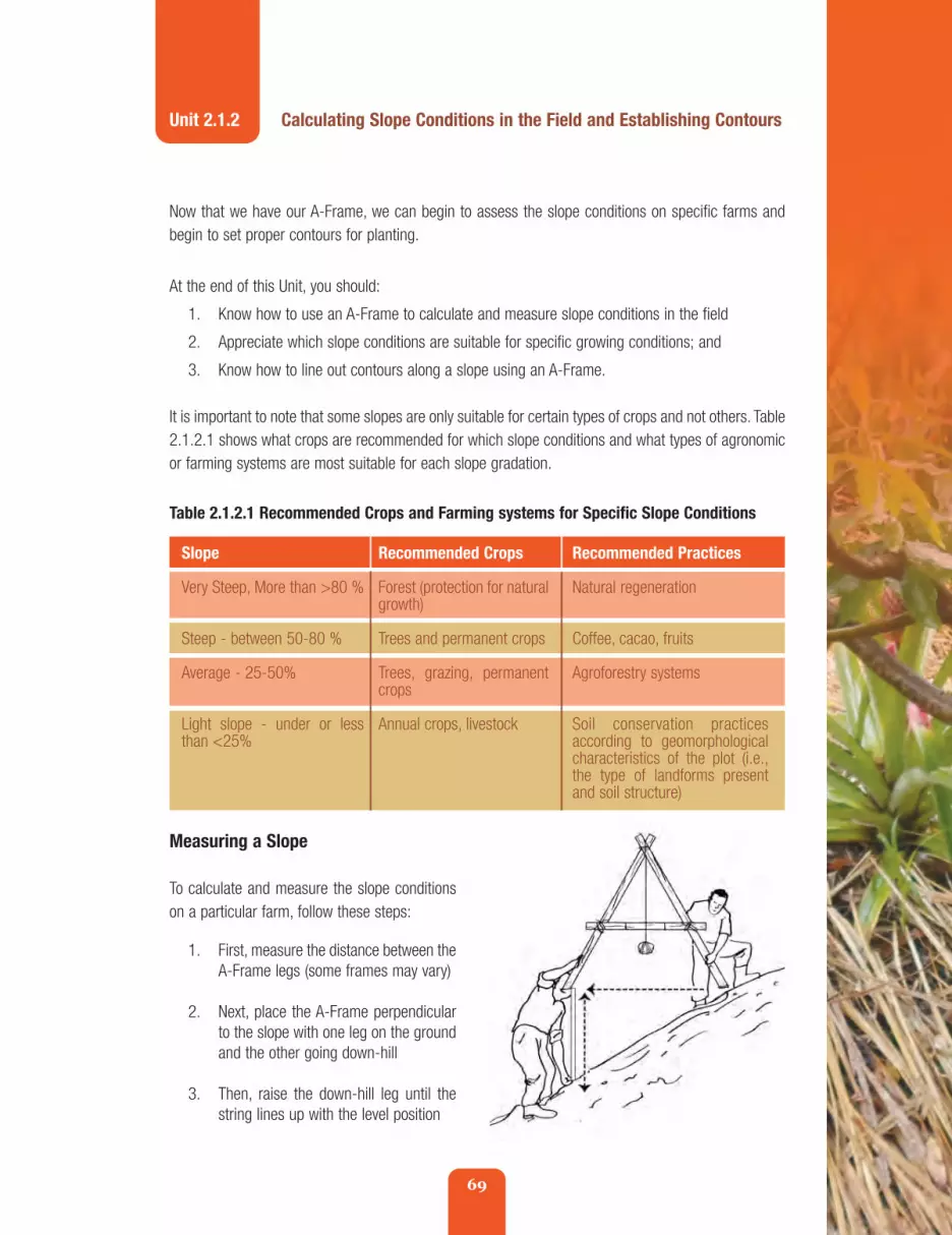
69
Now that we have our A-Frame, we can begin to assess the slope conditions on specific farms andbegin to set proper contours for planting.
At the end of this Unit, you should:
1. Know how to use an A-Frame to calculate and measure slope conditions in the field
2. Appreciate which slope conditions are suitable for specific growing conditions; and
3. Know how to line out contours along a slope using an A-Frame.
It is important to note that some slopes are only suitable for certain types of crops and not others. Table2.1.2.1 shows what crops are recommended for which slope conditions and what types of agronomicor farming systems are most suitable for each slope gradation.
Unit 2.1.2 Calculating Slope Conditions in the Field and Establishing Contours
Table 2.1.2.1 Recommended Crops and Farming systems for Specific Slope Conditions
Recommended Crops
Forest (protection for naturalgrowth)
Trees and permanent crops
Trees, grazing, permanentcrops
Annual crops, livestock
Slope
Very Steep, More than >80 %
Steep - between 50-80 %
Average - 25-50%
Light slope - under or lessthan <25%
Recommended Practices
Natural regeneration
Coffee, cacao, fruits
Agroforestry systems
Soil conservation practicesaccording to geomorphologicalcharacteristics of the plot (i.e.,the type of landforms presentand soil structure)
Measuring a Slope
To calculate and measure the slope conditionson a particular farm, follow these steps:
1. First, measure the distance between theA-Frame legs (some frames may vary)
2. Next, place the A-Frame perpendicularto the slope with one leg on the groundand the other going down-hill
3. Then, raise the down-hill leg until thestring lines up with the level position
fao_climate_smart_manual_part_2_1_front.qxd 10/23/14 1:19 PM Page 69

70
4. Measure the distance straight downfrom the bottom of the down-hill legto the ground
5. The distance to the ground dividedby the distance between the legs willgive you the percentage (%) of theslope. For example, if there is 1metre between the legs, 10 mm tothe ground then 10mm/1000mmequals a slope condition of 0.1 or1.0% slope.
To determine the slope, you need to use the A-Frame by placing it along the slope - finding the “0”point by allowing the weighted rope to line up with the zero mark and then placing a stake in the soilaccordingly. Each time you do this, the gradient of the slope will be: h/d*100. To estimate the gradientof the slope, you should repeat this operation covering the entire profile of the hillside. Later,calculating the average of all the values would give you an estimation of the slope.
Setting your contour lines
Once you have determined what type of slope you have, you can begin to set your contours. You needto set contours for every type of structural method that you use.
It is important here to note that the distance between your contours or the space between your rows- will also vary depending on the steepness of the slope you are working with. The steeper your slopeis, the closer the contour lines will need to be to one another in order to ensure that the hillside remainsstable and to reduce risk of soil erosion.
Table 2.1.2.2 Recommended Distance Between Contours Depending on Slope
Slope Distance between contour lines
< 10% 15-15 metres
10-25% 10-12 metres
25-40% 8-10 metres
40-60% 6-8 metres
<60% <5 metres
Table 2.1.2.2 shows the correctdistance that you should expectto keep between each contourline in order to avoid soilerosion. Contour lines are usedto plant along and to establishvegetative and death barriers.
fao_climate_smart_manual_part_2_1_front.qxd 10/23/14 1:19 PM Page 70

71
Materials needed
To set your contours, in addition to your A-Frame, you will also need several wooden orbamboo stakes to mark the distance betweenyour contour rows. A measuring tape that willextend the correct distance that you need to putbetween the rows is also required. Or you cansimply measure a piece or rope that is the rightlength and use it each time you set a newcontour line.
Steps
Once you’ve determined how steep your slope is(i.e., what degree slope you are working with),following these next steps:
Step One - Establish Distance Markers
Go up to the highest point on the slope and markit with one of your pegs.
Make sure the string is taut and mark the spotwith another peg.
Once you have established the correct distancebetween the top of the slope and the firstcontour line, untie the measuring string fromthe topmost peg, and now move it to one of thepegs that you have just marked on what will beyour first contour line. Tie it tightly to one ofthese pegs and carry the string downhill againtill is taut - indicating the spot where your nextcontour row should start. Mark this spot with apeg as well and complete the process along thisnew contour line (Line 2) to match with the firstcontour (Line 1).
Continue in the same way until you haveidentified the distances between all the contourrows of the hill.
Step Two - Ensure the contours are level
Now that you have marked out the correctdistance between your contours, you need toidentify the level points along each of the rows.To do this you need:
• Your A-Frame
• More pegs or markers
Use your measuring tape or measuring string tomeasure the correct distance between contourlines according to the slope gradient (Table2.1.2.2) down from the top peg to the spotfarther down the slope at the right distance foryour next contour row.
fao_climate_smart_manual_part_2_1_front.qxd 10/23/14 1:19 PM Page 71

72
Step Three - Line Out the Contour
When you’ve pegged out your contour lines, use rope or lining cord to run along pegs marking thecontour to create a continuous line running along the contour that looks something like this:
Now that you have identified the contour lines you can use them to plant or to established whateverstructural method you want along the contour lines.
Once you have established a first reference linefrom the top to the bottom of the slope, you canbegin to move across the slope and establish theactual contour lines taking care to place them atright angles to the slope at every point where theA-frame feet indicate “zero”. Mark each of thesepoints with a peg.
fao_climate_smart_manual_part_2_1_front.qxd 10/23/14 1:19 PM Page 72

73
Unit 2.1.3 Sowing on Contour Lines
Units 2.1.1 and 2.1.2 have already explained how to build an A-Frame and use it to establish contoursproperly. This unit now explains exactly how to plant along the contour lines that have been laid out.
Purpose
The purpose of this unit is to be sure that planting material and seedlings are properly set in order tocreate a barrier for water runoff and to thus reduce soil erosion. Proper sowing on contours also helpsto increase water infiltration by allowing rainwater to better soak into the soil.
By the end of this Unit, you should:
• Understand and be able to communicate the importance of sowing on contour lines.
Best Bet Hazard Category
A contour line follows the same height so that it neither falls down the hill nor rises uphill
Landslides
fao_climate_smart_manual_part_2_1_front.qxd 10/23/14 1:19 PM Page 73

74
Slope This technique is suitable for all slope conditions. However, ifslopes are over 40%, it is better to integrate contour sowingwith other techniques. Tree planting and agro-forestry areespecially recommended.
Soil All soil types.
Agro-Ecological Zones Suitable for all agro-ecological zones.
Crops Suitable for all crop types.
Advantages • There is no reduction in the area that can be used forplanting
• When sown properly, the plants serve to block the flowof rain water, therefore allowing more time for the waterto seep or infiltrate into the soil. This not only reducessoil erosion but also improves and helps to maintain soilmoisture
• Can be done without having extra planting material.
Disadvantages • More labour is needed to identify and properly track andestablish contour lines
• In some cases, if the land is very irregular, it may be difficultto identify contour lines
• Best used when integrated with other soil conservationmethods.
Cost Cost of work/labour to establish contour lines. If a tractor isused, there is the cost of hiring the tractor and there is also arisk that the tractor may over turn.
Recommended species All species.
Sowing on Contours
Steps
1. Once the slope and contour lines have been identified (see A-Frame use, Units 2.1.1 and 2.1.2),plow and sow following the direction of the contour lines that have been laid out
2. Make sure you plow and sow perpendicular (or at right angles) to the slope.
fao_climate_smart_manual_part_2_1_front.qxd 10/23/14 1:19 PM Page 74

75
Maintenance
If any of the plantsdo not succeed,they should bereplaced to avoidholes in the barrieralong the contourline.
Wha gaan bad a mawning, cyan come good a evening!(What is bad in the morning, won’t be good by the evening!)“ ”
Proverb/Testimonial Discussion starter
You can use this proverb as a way to reinforce with your farmers that it is important to set contours rightfrom the beginning. If this is not done properly, all the other work that is done to sow crops may be fornaught. One cannot expect good results later, if foundational steps have not been taken from the beginning.
fao_climate_smart_manual_part_2_1_front.qxd 10/23/14 1:19 PM Page 75

76
Unit 2.1.4 Strip Cropping
The next Unit discusses the importance of sowing plants in rows or strips of different heights but withthe same widths. This unit now explains exactly how plant along the contour lines that have been laidout.
By the end of this Unit, you should:
1. Fully understand the benefits of strip cropping, and
2. Be able to communicate these benefits to farmers.
Best Bet Hazard Categories
Landslides and Wind damage
fao_climate_smart_manual_part_2_1_front.qxd 10/23/14 1:19 PM Page 76

77
What is Strip Cropping?
Strip cropping involves growing crops in rows in a systematic arrangement of equal width strips acrossa field following the established contour lines. At least two strips or rows of crops are involved but morerows may be included depending on the type of crops and the steepness of the slope.
Strip cropping is also a good way to mix food crops with forage or fodder crops for livestock and shouldalso include cover cropping (Unit 2.2.4) between the rows. These can include grasses, legumes (suchas gungo pea), or grass and legume mixtures.
For strip cropping, the same tillage and planting methods are used to follow the contour lines that havebeen established.
What is most important is that the crops grown in the strips or rows can be planted closely enoughtogether to capture or resist soil erosion residue and water runoff.
It is important that no two adjacent strips be vulnerable to erosion at the same time. In other words,one of the strips should always be healthy and in prime condition if another is at a later stage ofmaturity and soon to be replaced. You always want to have at least one of these two strips in hardygrowth.
fao_climate_smart_manual_part_2_1_front.qxd 10/23/14 1:19 PM Page 77

78
STRIP CROPPING
Slope This technique is suitable for all slope conditions under 40%.
Soil All soil types.
Agro-Ecological Zones Suitable for all agro-ecological zones.
Crops Suitable for all crop types.
Advantages Advantages and Benefits
• Reduced soil erosion from water and transport of sedimentand other water-borne contaminants
• Reduced soil erosion from wind, especially if cover croppingis incorporated
• Protection of growing crops from damage by wind-bornsoil particles.
Disadvantages • More labour is needed to identify and properly track andestablish contour lines
• In some cases, if the land is very irregular, it may bedifficult to identify contour lines
• Best used when integrated with other soil conservationmethods.
Cost Cost of work/labour to establish contour lines. If a tractor isused, there is the cost of hiring the tractor and there is also arisk that the tractor may over turn.
Recommended species All species.
Steps
The same steps and maintenance measures apply to strip cropping as they do for sowing on contourlines (Unit 2.1.3)
fao_climate_smart_manual_part_2_1_front.qxd 10/23/14 1:19 PM Page 78

79
Long pass draw swet, short pass draw blood.A long road produces sweat, a short road produces blood.“
”
Proverb/Testimonial Discussion Starter
You can use this proverb as a way to introduce the topic of strip cropping to farmers by playing on theanalogy of long and short roads as strips. Farmers who are accustomed to monoculture are reluctantto invest in trees or mix their crops using strip cropping methods. This proverb can point out that theshort road (monoculture without contours) is more harmful in the long run than what seems like thelong road (strip cropping and/or investing in land husbandry methods that are sound).
fao_climate_smart_manual_part_2_1_front.qxd 10/23/14 1:19 PM Page 79

80
Unit 2.1.5 Alley Cropping with Leguminous Bushes or Hedgerows
One specific type of agro-forestry that is especially good for improving soil nutrient levels and for soilstability is “alley cropping with leguminous bushes” or hedgerow cropping.
By the end of this Unit, you should:
1. Appreciate the different types of leguminous bushes that are suitable to use for hedgerows
2. Know how to plant and establish hedgerows following proper contour procedures, and
3. Be able to communicate these steps to farmers.
Best Bet Hazard Categories
Landslides and to some extent, wind reduction
fao_climate_smart_manual_part_2_1_front.qxd 10/23/14 1:19 PM Page 80

81
What is hedgegrow alley cropping?
The use of leguminous hedgerows (or plants that produce peas and beans) has been practised as asoil conservation technique in many parts of the world, including Jamaica. Unlike fruit and timber treeswhich grow quite large, hedgerows are grown much closer together and are kept much shorter. Hencethe name “hedgerows”.
Because they are closer together and closer to the ground, they are very effective at reducing soilrunoff, aiding water infiltration, and thus excellent at reducing soil erosion. In addition, the leaves ofleguminous hedges are high in nitrogen, phosphorous, potassium and other micro-nutrients that canbe used to either feed animals or to fertilise crops as organic mulch. Their roots also help to reintroduceor “fix” nitrogen back into the soil as a sort of “living fertiliser”.
With this method, fast-growing nitrogen fixing trees are planted in rows, and food or cash crops areplanted in the spaces - or the alley - between the rows.
The most common types of bushes that are typically used in this method are “Gliricidia”, “Luceana”and Calliandra. In Jamaica, bushes known as “grow stick” or “quick stick” are commonly usedsubstitutes. But other bushes are also suitable and valuable such as pigeon pea or gungo pea - aJamaican favourite.
This type of alley cropping has been widely accepted in Southern Trelawny because of its ease inimplementation, effectiveness in controlling soil erosion, and low financial cost to farmers. In addition,the “Calliandra Calothyrsus” hedgerow does not occupy much space. Its vertical root systempenetrates deep into the soil and does not interfere with the root systems of the plants that are grownbetween their rows. This allows farmers to plant food crops very close to the Calliandra plants.
fao_climate_smart_manual_part_2_1_front.qxd 10/23/14 1:19 PM Page 81
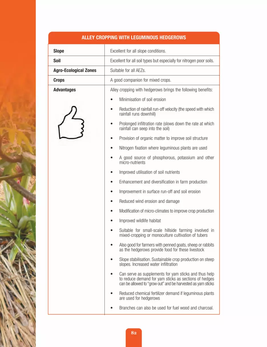
82
ALLEY CROPPING WITH LEGUMINOUS HEDGEROWS
Slope Excellent for all slope conditions.
Soil Excellent for all soil types but especially for nitrogen poor soils.
Agro-Ecological Zones Suitable for all AEZs.
Crops A good companion for mixed crops.
Advantages Alley cropping with hedgerows brings the following benefits:
• Minimisation of soil erosion
• Reduction of rainfall run-off velocity (the speed with whichrainfall runs downhill)
• Prolonged infiltration rate (slows down the rate at whichrainfall can seep into the soil)
• Provision of organic matter to improve soil structure
• Nitrogen fixation where leguminous plants are used
• A good source of phosphorous, potassium and othermicro-nutrients
• Improved utilisation of soil nutrients
• Enhancement and diversification in farm production
• Improvement in surface run-off and soil erosion
• Reduced wind erosion and damage
• Modification of micro-climates to improve crop production
• Improved wildlife habitat
• Suitable for small-scale hillside farming involved inmixed-cropping or monoculture cultivation of tubers
• Also good for farmers with penned goats, sheep or rabbitsas the hedgerows provide food for these livestock
• Slope stabilisation. Sustainable crop production on steepslopes. Increased water infiltration
• Can serve as supplements for yam sticks and thus helpto reduce demand for yam sticks as sections of hedgescan be allowed to “grow out” and be harvested as yam sticks
• Reduced chemical fertilizer demand if leguminous plantsare used for hedgerows
• Branches can also be used for fuel wood and charcoal.
fao_climate_smart_manual_part_2_1_front.qxd 10/23/14 1:19 PM Page 82

83
STRIP CROPPING
Disadvantages • Not a widely used technique. Largely confined toyam growing areas of northern Manchester andsouthern Trelawny. Introduced as an intervention for soilloss reduction on moderately steep slopes
• Seedlings are not widely available for gliricicia and luceana
• However, quick stick is prevalent throughout Jamaica
• Plants are attractive as food for small ruminants so theymay need to be penned. Neighbours livestock may alsobe attracted.
Cost Establishment of contours
Cost of planting material
Labour
Transport
Field training costs
Recommended species 1. Leucaena leucocophala(Common name - Lead Tree or Wild Tamarind
2. Tephrosia candida (no common name)
3. Desmodium rensonii(Common name - Shepherd’s purse)
4. Flemingia macrophylla (Common name - Wild Hops)
5. Alnus nepalensis (no common name)
6. Calliandra calothyrsus (Common name - Callindra)
The choice of species should be selected based on localcriteria including:
Rainfall
• Amount and distribution (number of dry months)
• Drought tolerance
Type of soil
• textural characteristics
• depth
• pH levels; acid/alkaline
• fertility
fao_climate_smart_manual_part_2_1_front.qxd 10/23/14 1:19 PM Page 83

84
ALLEY CROPPING WITH LEGUMINOUS HEDGEROWS
Elevation
Other Considerations
• Pruning tolerance
• Deep-rooted or tap-rooted propagation
• Germination ability/livability of planting materialsnitrogen-protein content
• Availability of planting materials/seeds - origin
• Pest resistance
Steps
On gentle slopes, hedgerows can be established about 2-6 metres or about 6 to 9 feet apart. Onsteeper slopes the hedgerows should be about 2 metres (or roughly 2 yards) apart along the contour.
Within the rows, the distance between the trees will vary depending on the type of trees to be planted,but they may be as close as 5-10 centimetres or roughly 2 to 5 inches.
Step 1 - Establish your contour lines using the A-Frame as presented in Unit 2.1.1 and 2.1.2.
Step 2 - Depending on the species used, place temporary stakes every six inches or so where theseedlings are to be planted.
fao_climate_smart_manual_part_2_1_front.qxd 10/23/14 1:19 PM Page 84

85
Step 3 - Apply plant trash such as banana and plantain trash, large leaves, and branch cuttings alongthe up-slope side of stakes to form barriers that will control soil erosion until the hedges become fullyestablished.
Step 4 - Plant the leguminous seedlings at least every six inches close to the stakes. If starting fromseeds, plant them every 2-3 cm or an inch apart.
Step 5 - Plant other desired crops in between the hedgerows along the contour following therecommended planting procedures for the specific crop.
Step 6 - As the hedges grow, prune them periodically to prevent the shading of crops in the alleys.Use the pruning debris to further build up the trash barrier, or as mulch on the farmed area betweenthe hedgerows. One year after planting the hedgerows, cut the hedgerows at a height of 40centimetres from the ground every 30 to 45 days. You can pile the cut leaves and twigs at the base ofthe crops. These cuttings serve as an excellent organic fertilizer for the crops. You can also use thecuttings to feed animals.
Step 7 - Rotate the types of crops grown in the alleys. Plant one crop along one alley and then anotherat the next growing season to maintain soil fertility.
fao_climate_smart_manual_part_2_1_front.qxd 10/23/14 1:19 PM Page 85
86
Extension Method Tips:
Introduce the session by asking people if they remember when “old time people used to say” “demgonna fatten up the land by using green bush?” Quite often the bushes they used were high innitrogen like quick stick, grow stick, tamarind, gungo pea, Poinciana, Jacaranda or other types of greenmulch. What did they mean by “fattening up the land”? Probe this for a while with the farmers andask what kind of trees they recall people using for this purpose.
Lil bush sometime grow beta dan big tree (a little bushsometimes grows better than a big tree)“ ”
Green bush cawn bwile pot.(green bush cannot make a pot boil) ”
Cunny cow nyam peas, lef’ leaf. (A cunning cow eatsthe peas from the plant, but leaves the leaves).
Be prudent with choices and allow things to replenish.
“”
Proverb/Testimonial Discussion Starters
1.
2.
3.
“
fao_climate_smart_manual_part_2_1_front.qxd 10/23/14 1:19 PM Page 86

87
Unit 2.1.6 Grass Barriers
Best Bet Hazard Categories
Landslides, Drought, Wind Erosion, Flooding and Wind
While leguminous hedges have many advantages as far as increasing soil fertility are concerned, theyare not the only option. Another option that has had excellent results for preventing soil erosion aregrass barriers using guinea grass, elephant grass or vetiver (khus khus) grass.
By the end of this Unit, you should:
1. Appreciate the benefits of using grasses as barriers
2. Be able to effectively communicate how to correctly establish grass barriers.
fao_climate_smart_manual_part_2_1_front.qxd 10/23/14 1:19 PM Page 87

88
Grass barriers are not only very stronglyrecommended for areas prone to soil erosion,they also provide a ready source of mulch thatcan reduce drought impacts and retain soilmoisture. Some varieties of grasses also help toprotect soil from extreme rain impacts, floodingand wind erosion.
What are grass barriers?
Grass barriers are used in the same way thatleguminous bush barriers are used in alleycropping. They are planted in a similar mannerbut have an extra advantage in that they canalso act like a filter to trap soil and keep it fromwashing away. Their root systems also help toimprove water filtration.
Some grasses like vetiver grass (or khus khusgrass) have very, very long roots that growmostly strait down to depths of several feet,greatly helping to keep the soil in place. Vetiver grass showing deep roots
GRASS BARRIER HEDGES
Slope Slopes 40% to 50%.
Soil All soils.
Agro-Ecological Zones Suitable for extremely steep AEZ with high rainfall.
Crops • Can be used with mixed cropping systems especially forhillside farms.
Advantages Vetiver Grass (Khus Khus) • Can support or complement nitrogen fixation if used with
leguminous hedgerows
• Roots grow extremely deeply and form natural barriersto soil erosion thereby reducing soil loss
• Roots help to increase water infiltration
• Roots mainly grow down. They do not spread outwardsto compete with crops
• Is drought resistant
fao_climate_smart_manual_part_2_1_front.qxd 10/23/14 1:19 PM Page 88

89
GRASS BARRIER HEDGES
• Provide a ready supply of mulch to keep soil cool and retainmoisture when pruned
• Provide sustainable crop production on steep slopes
• The smell of khus khus grass natural deters insect pestsand serves as a natural insecticide. Good for mulchingbetween crops to deter common pests
• The sharpness of the edges of the blades also deterssnails and slugs if used as mulch
• Can reduce wind damage to some degree
• Increase soil organic matter content
• Not expensive but not always available
• Low maintenance
• Also good as natural gully plugs
• Need to be pruned and maintained to ensure thicknessand to avoid any breeches to the continuity of the hedgerow.
King Grass, Matt Grass and Guinea GrassThese grasses do not have the same pest control qualities askhus khus or vetiver grass.
Disadvantages King grass, Matt grass and guinea grass can compete withother crops if not properly maintained and pruned.
Some regular maintenances and cutting back of the grass isrequired. Ensuring that thin areas are replanted so that auniform thickness is maintained.
Cost Cost of land preparation to set the contours (labour).
Cost of seedlings or planting material.
Additional sources National Research Council. 1993. Vetiver Grass: A Thin Greenof information Line Against Erosion. National Academy Press,Washington D.C.
fao_climate_smart_manual_part_2_1_front.qxd 10/23/14 1:19 PM Page 89

90
Vetiver grass barrier combined withpineapple barriers
Trimmed vetiver grass hedges in St. Ann
Steps
1. Establish your contours using an A-Frame and following instructions in Units 2.1.1 and 2.1.2.Contour planting of Matt or King grass at specific intervals depending on the steepness of theslop (refer to Unit 2.1.2 to determine what these intervals should be)
2. Construct mini terraces, continuous mounds or benches on contour slope (10%) along thecontour lines (30-40cm)
3. Prepare the planting materials:
• Dig the vetiver clumps with a cutlass
• Tear a handful of the vetiver grass from the clump and further sever the root divisionsor slips
• Cut the leaves 15-20 cm (6 inches) from the base
• Trim the roots 8-10 cm below the base
fao_climate_smart_manual_part_2_1_front.qxd 10/23/14 1:19 PM Page 90

91
4. Plant one or more slips in single rows along the contour furrows 10-15 cm apart at the start ofthe rainy season
fao_climate_smart_manual_part_2_1_front.qxd 10/23/14 1:19 PM Page 91

92
5. Trim the vetiver hedges 40-50 cm from the ground after they have properly established
6. Plant fast-growing leguminous trees/shrubs every 2 m just above the vetiver furrow lines andprune no less then 1.5 m 1 m high.
fao_climate_smart_manual_part_2_1_front.qxd 10/23/14 1:19 PM Page 92

93
Maintenance:
• During first months of growth keep the plot free of animal grazing
• As it grows, it will fill in the gaps and later, you may actually need to thin it out. But you canuse the cut grass as an easy supply of mulch too - to keep weeds down among your crops.Another climate-smart advantage!
• Check regularly while the plants are becoming established to ensure they survive. If any die,replace with new suckers to ensure that no holes are breached along the contour that wouldallow soil to erode. Replenish the barrier regularly to maintain its integrity. Trim the hedgesregularly and use the cuttings as mulch between crops or lay as trash against the barrier forreinforcement.
Vetiver can be planted below contour bunds It can also be paired with leguminous tree and shrubspecies planted on the upper side of the bund.
Sow or plant on the mini terraces. Better if in double rows (5-15cm distance).
fao_climate_smart_manual_part_2_1_front.qxd 10/23/14 1:19 PM Page 93

94
Extension Method Tips:
Remind people that in the old time days, people used to use khus khus grass (vetiver grass) to stufftheir mattresses. This material was chosen partly because it has natural pest repellent properties. Theyalso used to keep it in their closets and clothes for this same reason.
Remind them as well that a perfume called “khus khus” is produced in Jamaica and used as a naturalfragrance.
See if anyone remembers their parents or grandparents using vetiver grass for these purposes.
Grass calaloo grow weh ‘im nature tek. (Wild callaloothrives where natural conditions favour its growth).“ ”
Cane no grow laka grass.(Sugarcane does not grow like grass).”
Mek mi aise nyuam grass or gi’ mi aise a chancefi nyam grass. (Let my ears eat grass, or
give my ears a chance to eat grass).
“”
Proverb/Testimonial Discussion Starters
1.
2.
3.
“
fao_climate_smart_manual_part_2_1_front.qxd 10/23/14 1:19 PM Page 94

95
Unit 2.1.7 Pineapple Barriers
One type of vegetative barrier that has really become popular in Jamaica are pineapple barriers. Unit2.1.7 explores this technology.
By the end of this Unit, you should:
1. Appreciate the benefits of growing pineapples as barriers
2. Be able to effectively communicate how to correctly establish pineapple barriers on farm.
Best Bet Hazard Categories
Landslides and Extreme Rain
fao_climate_smart_manual_part_2_1_front.qxd 10/23/14 1:19 PM Page 95

96
What are pineapple barriers?
Pineapple barriers follow the exact same principles as alley cropping with leguminous bushes orgrasses, but they have the added advantage of brining in cash income to farmers. So instead ofgrowing grass hedges or using nitrogen fixing bushes, you can plant pineapple hedgerows along yourcontours. They will help to stabilize the soil and will also make farmers money.
This technique is now widely practised in St. Thomas and Portland.
PINEAPPLE BARRIERS
Slope Good for extremely steep AEZs with high rainfall and slopeangles of 45-50 degrees.
Soil Can be grown on a wide range of soils but sandy loams withacidity levels of pH 4-6 are ideal.
Agro-Ecological Zones Can be grown all over Jamaica from the sea to BlueMountains, but the optimum elevation is between 1000 and1500 metres or 3330 to 5000 feet above sea level. Rainfallshould be between 500 and 2500 metres per year or 20-100inches and should be well-distributed.
Crops • Suitable for mixed vegetable and cash crop productionin the alleys between pineapple rows.
fao_climate_smart_manual_part_2_1_front.qxd 10/23/14 1:19 PM Page 96

97
PINEAPPLE BARRIERS
Advantages • Widely practiced in steep upland areas with high rainfall,especially in eastern Jamaica
• Good for small scale mixed crop hillside farming
• Help to stabilise slope conditions
• Reduce soil loss
• Provide sustainable crop production on steep slopes
• Increase water infiltration.
Disadvantages • Suckers and planting material can sometimes be difficultto obtain
• Pineapples take 1-5 years to become fully establishedand before income can be experienced.
Cost Cost of land preparation to set the contours (labour).
Cost of seedlings or planting material.
Expected yield Harvesting can begin 18 months after planting. After that,plants will continue to produce an average of at least one fruitper year. Under good conditions, the crop should producebetween 25-50 tonnes per hectare or 10-20 tons per acrefrom a pure stand cultivation.
Recommended species Suitable pineapple varieties include:
• Sugar loaf
• Red Spanish
• Ripley
• Smooth Cayenne.
Additional sources of informationRADA Extension Services Information Brochure for Farmers. 1999. Best Bet Technology:Pineapple Barriers. Morant Yallahs Agricultural Development Project (MYADP) and RADA,Kingston.
http://rada.gov.jm/wp-content/uploads/2013/02/pineapple_Barrier_FAO_2013_reduced.pdf
fao_climate_smart_manual_part_2_1_front.qxd 10/23/14 1:19 PM Page 97

98
5. Make sure that all dead or dry leaves are stripped from the suckers prior to planting andexpose the young roots. Allow the suckers to harden and dry for a few days before planting
6. Plant the seedlings according to RADA recommendations in RADA Extension ServicesInformation Brochure for Farmers. 1999. Best Bet Technology: Pineapple Barriers. MorantYallahs Agricultural Development Project (MYADP) and RADA, Kingston.http://rada.gov.jm/wp-content/uploads/2013/02/pineapple_Barrier_FAO_2013_reduced.pdf
Steps
1. Establish contours using your A-Frame as per Units 2.1.1 and 2.1.2
2. Pineapples can be planted usingminimum tillage methods (Unit 2.2.5).Just like the steps taken to plantleguminous hedgerows, mark theholes for planting with stakes butthis time do so every 40-60centimetres (16-24 inches wide) andwithin double or trip rows which are50 cm or 20 inches apart. Thespacing between each row ofpineapple barriers will depend on theslope conditions and the financialresources of the farmer
3. Establish trash barriers against thestakes to serve as erosion controluntil the pineapples fully mature
4. Following minimum tillagerecommendations, fork a hole foreach pineapple sucker to be planted.Holes should be dug at least 7 cm or3.5 inches deep
fao_climate_smart_manual_part_2_1_front.qxd 10/23/14 1:19 PM Page 98

99
Extension Method Tips:
Show the short public service announcement/video on pineapple barriers that encourages farmer touse this Best Bet technology to minimize landslides and soil erosion.
http://www.youtube.com/watch?v=m92M07O1R80
Ripe pine no know danger till mout’ ketch ‘im. (Ripepineapple doesn’t know danger until the mouth catches it).“ ”
Ketch macca befo’ yu fall dung.(hold on to a thorn rather than fall). ”
Mash macca, no mek macca mash yu(step on a thorn before it steps on you).“ ”
Proverb/Testimonial Discussion Starters
1.
2.
3.
“
fao_climate_smart_manual_part_2_1_front.qxd 10/23/14 1:19 PM Page 99

100
Unit 2.1.8 Organic Trash Barriers
Soil erosion and excessive run off can also be reduced by using organic materials such as bamboo,vegetation, plant trash, dead plant matter to create barriers that stop or slow down rain and soil runoff. Organic or plant trash barriers are cost-effective ways to use materials that farmers already haveon farm or nearby and are excellent ways to minimize soil erosion and rain runoff until more permanentagricultural methods are established (such as pineapple hedgerows, leguminous bush hedgerows,agro-forestry or grass barriers).
By the end of this Unit, you should:
1. Appreciate the advantages of using plant trash as temporary barriers to prevent soil erosion, and
2. Be able to effectively communicate how they should be constructed.
Best Bet Hazard Categories
Landslides and Excessive Rainfall
A trash barrier created with plant trash and rebar stakes
fao_climate_smart_manual_part_2_1_back.qxd 10/23/14 1:22 PM Page 100

101
What are organic trash barriers?
The construction of organic trashbarriers is a technique that piles deadplant trash along bamboo or othertypes of stick barriers that run alonglevel contours. Contours are set usingan A-Frame and bamboo stakes orother types of wood are placed alongthe level contour at appropriateintervals. Additional bamboo or sticksare laid lengthwise or woven betweenthese stakes in a “waddle and daub”fashion to form temporary barriers orsmall fences up to a set height. Planttrash is then laid on the up-slope sideof the “fence” to form organic barriersagainst soil and rain runoff.
Bamboo Barriers on a hillside
fao_climate_smart_manual_part_2_1_back.qxd 10/23/14 1:22 PM Page 101

102
ORGANIC TRASH BARRIERS
Slope Most suitable for slopes less than < 40%.
Soil Fine for all soil types.
Agro-Ecological Zones Areas prone to soil erosion, excessive rainfall. Rainfall shouldbe under 800 mm.
Crops Suitable for mixed vegetable and permanent tree crop production.
Advantages • Already widely practiced in steep upland areas with highrainfall, especially in Eastern Jamaica
• Low cost. Planting material is readily available on all farms
• Eventually the plant trash decays and adds to soil structureand soil fertility
• Trash from weeding and regular crop maintenance is suitable
• Low maintenance.
Disadvantages • Only a short term measure. Not permanent
• Reduces surface area for planting to some extent
• Risk of gully or rill erosion if not properly maintained
• Additional plant trash has to be applied on a regular basis
• Bamboo stakes may rot and need to be replaced
• Barriers have to be maintained. And breaches, holes orirregularities can create a rill and lead to gully erosion inspecific points.
Cost Cost of labour to cut bamboo or other materials for stakes andinitial barriers
Transport to farm
Cost of labour for cutting plant trash
Recommended species All plant matter trash can be used, but weeds and diseasedcrops should be avoided.
fao_climate_smart_manual_part_2_1_back.qxd 10/23/14 1:22 PM Page 102

103
Bamboo used to create terraces
fao_climate_smart_manual_part_2_1_back.qxd 10/23/14 1:22 PM Page 103

104
Steps
1. Establish proper contours using an A-Frame following steps outlined in Units 2.1.1 and 2.1.2
2. Using wooden or bamboo stakes, establish the boundary along the contour line
3. Then establish the barrier of the contour line using bamboo or wood lathes. Stakes are 0,8-1m high and the should be placed at 50cm distance along the contour line 25-30cm deep.Stakes could be repulsing plants that provide the structure with better stability
4. Weave the wood or bamboo material around stakes as if weaving a wattle and daub structure
5. Once the barrier is created, dead plant material can be piled and compacted against thebarrier to form an even stronger barrier to soil erosion and water runoff.
50 cm
wovenbamboo
1m
etre
fao_climate_smart_manual_part_2_1_back.qxd 10/23/14 1:23 PM Page 104

105
Extension Method Tips
You can remind farmers that in the “old time days”, people used “wattle and daub” to build their homes,because that was all they could afford. This method builds on this tradition by using bamboo and otherwooden material as well as plant trash to weave barriers through pegs along the contour, therebyreducing runoff.
Crooked stick, crooked shadow (a Crooked stick castsa crooked shadow). This is a similar adage to
that of “an apple doesn’t fall far from the tree.”
“”
Befo’ twigs bring trubble, mek a squall a rain fall(Before twigs bring trouble, let a shower of rain fall).Fix small disagreements before they become large
misunderstandings.
“”
Proverb/Testimonial Discussion Starters
1.
2.
fao_climate_smart_manual_part_2_1_back.qxd 10/23/14 1:23 PM Page 105

106
Unit 2.1.9 Bench Terraces
By the end of this Unit, you should:
1. Fully understand how stone benchterraces should be constructed, and
2. Appreciate the cost and effort involved.
Best Bet Hazard Categories
Landslides, Flooding, Excessive Rainfall
A hillside showing bench terraces coming down the slope
What are stone bench terraces?
fao_climate_smart_manual_part_2_1_back.qxd 10/23/14 1:23 PM Page 106

107
The process of levelling the land for agricultural or other purposes is called bench terracing. It isgenerally done where there is deep heavy clay soil rather than in very sandy soil. The most directmethod is called the cut and fill procedure and involves moving soil from the upside of the slope andusing it to fill the “bench” on the other side of the slope.
Bench terracing with stones can be a very labourintensive and often expensive way to prevent soilerosion on steep slopes. Usually, some type ofmechanisation or animal draft power may berequired to both cut the trenches and for haulingthe stones to the site.
However, rock walls are more permanent thanother type of bench risers that farmers may useto establish level contours on their farms. So
farmers who can afford to construct them, andhave the material available to do so, should thinkof this option. They are a suitable technology forboth wetland and dry land crops on steep slopes.
In addition to stones however, bench terracescan also be created from old tires and othermaterials. Old tires have been used veryeffectively in Jamaica.
This type of terrace has the advantage that the tires can be filled with soil and used to plantcrops as well as seen here
fao_climate_smart_manual_part_2_1_back.qxd 10/23/14 1:23 PM Page 107

108
BENCH TERRACES
Slope All slope conditions.
Soil Best suited for clay soils.
Agro-Ecological Zones All AEZs with slopes.
Crops Dry land and wetland crops.
Advantages • Much more permanent type of bench terrace
• Can make use of old tires and other types of materialsthat are less costly than stone.
Disadvantages • Very labour intensive unless “day for day” labour is sharedto help with construction
• Can be very costly
• Time consuming to construct
• May require some type of earth moving equipment suchas small tractors or motorized ploughs or animal traction.
Cost A more expensive option for most farmers, but worth the longterm investment.
Farmers working to construct a stone bench terrace
fao_climate_smart_manual_part_2_1_back.qxd 10/23/14 1:23 PM Page 108

109
Steps
1. Locate a site with good soil and where stones/boulders are abundant
2. Calculate the spacing and height of the contours following steps outlined in Unit 2.1.2.
3. Establish the contours and line them out
4. Plow or dig a line on the hillside at soil height following the contours lined out
5. Collect stones/rocks and set them below the plowed contour line. To break big stones,heat and pour tap water over the rock before breaking with pick axe
6. Plow and dig the identified contour deep enough to allow the initial foundation of big stones.Set the initial stones at a right angle towards the slope
31cm
fao_climate_smart_manual_part_2_1_back.qxd 10/23/14 1:23 PM Page 109

110
Soil to supposebackside of wall
Joints or cracks filled withsmall stones or pebbles
Landingpointagainsttheslope
10 to45 cmslope
Two rows ofperennial plants
Vegetation tostabilise the downslope wall
Against aslope of10%
Against aslope of10%
Accumulatedsediment Riser
Initial level oflanding
The restingwall is inclinedrelative to thevertical wall
Against aslope of10%
7. Pile rocks stones gradually in a manner that they fit and lock each other. Fill in the gaps withsmaller stones and clay soil to minimize leakage. The heavier end of the rock or bouldermust be piled facing the hill for greater stability. The base of the rock wall must always bewider than the top. The inclination of the rock wall should be between 5-10 degrees from thevertical axis
8. Plow to loosen the upper portion of the slope and move the soil using a harrow mounted witha wooden plank towards the rock walls if soils are deep
Care should be taken that a finished riser height is not too tall. When one terrace is linked to the onebelow it, the riser height should be the same as the vertical distance between contours. Riser heightsof over one metre are difficult to climb. For example, if the vertical distance between contour lines is20 metres, the riser height of one terrace is 10 metres.
9. After attaining the desiredlevel of the soil, construct adyke on the soil surfaceadjacent to the top of therock wall. This will create aholding area for water
10. It is important to rememberthat terrace building startsfrom the bottom and proceedsuphill
fao_climate_smart_manual_part_2_1_back.qxd 10/23/14 1:23 PM Page 110

111
An example of a riser which is too high (vertical distance between contour lines is 2.0 m)
An example where a riser is too high
This is fine until another bench terrace is built above or below. If the new riser also has a 2.0 metresvertical height between contours, the common riser between the two benches will be 2.0 metres. Afarmer would need a ladder to climb over the riser. It would be more unstable because of its height.
11. To protect the above newly terraced area, a drainage canal or diversion ditch should beconstructed across the top of the farm and excess water from land above the farm can bediverted around the farm. Care must be taken to stabilize the canal and the gully into whichthe water flows. This is especially true on steep slopes.
12. The bench terrace requires maintenance. The canal at the back should be constantly cleaned,the riser checked and its cover maintained, If hedgerows are present, they should be regularlypruned.
Comparison of bench terracing with other soil conservation structures:
HEDGEROWS CANALS ROCK BENCHWALLS TERRACES
Labour Required Low High
Speed of Levelling Slow Fast
Complexity of technology Low High
Effectiveness in erosion Control Low High
fao_climate_smart_manual_part_2_1_back.qxd 10/23/14 1:23 PM Page 111

112
The stone dat di builder refuse, will be di head cornerstone. (The stone that the builder refused,
will be the head corner stone).
“”
Proverb/Testimonial Discussion Starters
Extension Method Tips
While there may not be many examples of stone terraces that you could show your farmers, it is likelythat somewhere near their farmers there are examples of low stone walls that were originallyconstructed to mark farm borders. These were the norm for building farm fences during plantation daysand many of them are still standing. If you find one nearby, you can take your farmers to look at it andlearn a little of its history as a way to start the discussion about stone bench terraces.
fao_climate_smart_manual_part_2_1_back.qxd 10/23/14 1:23 PM Page 112

113
Unit 2.1.10 Individual Basins
By the end of this Unit, you should:
• Fully understand how to construct and build individual basins on farm.
Best Bet Hazard Categories
Drought, Heavy Rains, Wind,Flooding and Landslides
What are individual basins?
Individual basins are round depressions or mini-bench terraces that are established along the contourlines to plant individual trees. They are strongly recommended for all agro-forestry farming systems.The purpose of the individual basin is to create a small well or depression that will:
• Collect and store water and organic matter around the tree’s root system
• Reduce leaching and runoff of plant nutrients
• Reduce soil erosion.
fao_climate_smart_manual_part_2_1_back.qxd 10/23/14 1:23 PM Page 113

114
INDIVIDUAL BASINS
Slope All Slopes.
Soil All soils but better results with clay/loam. Very stronglyrecommended for soils that have been seriously degraded.
Agro-Ecological Zones Can be used in all AEZs but are best suited where rainfall lessthan < 1800 mm.
Crops Cereals, legumes, tree crops, horticulture.
Advantages • Has long been used in Jamaica. Not a new technique.So is culturally acceptable
• Help to rehabilitate badly degraded, stony and marginalizedlands
• Makes better use of fertilisers because fertilizer is keptwithin the basin boundaries
• Is relatively permanent once the tree is established.
Disadvantages • The size of the individual basins can be relatively largeand require manual labour. Can be a bit expensive toconstruct initially
• Too much work to use for high density tree crops suchas coffee or cocoa.
Cost Cost of the manual labour to build the basins.
Materials A-Frame to set contours lines
2 metre or 2 yard length of rope to mark out the perimetre ofeach circular basin to be built
Stakes or pegs to mark the spot for each tree
Fork or hoe, shovel or spade
Labour
Time needed Depends on the size of the field and how many holes are tobe dug.
fao_climate_smart_manual_part_2_1_back.qxd 10/23/14 1:23 PM Page 114

115
Steps
1. Once again, determine your slope conditions and set your contours according to Units 2.1.2and 2.1.3
2. Establish individual basin along the contour line by:
a. First identifying the exact spots where you want to plant
b. At that point, use the 2 metre length of rope to trace out the circular perimetre by firstattaching one end of the stake to the centre peg and then walking around the peg in acircle drawing into the circle as you go
Extension Officers begin construction of an Individual Basin
c. Starting on the higher side ofthe circle (i.e., the side that ismore up slope) dig from thetop part and use the soil thatis excavated to construct ariser around the other side ofthe circle forming a crescenton the lower slope side. Thecontour line should remain inthe centre of the circle - cutting it in half
Excavation
Contour line
fao_climate_smart_manual_part_2_1_back.qxd 10/23/14 1:23 PM Page 115

116
d. Keep digging soil from the top part of the circle and move it to other side until a terraceis created
To maintain the individual basin, be sure to:
• Avoid animal grazing during first months of establishment
• Regularly clean the toe drain
• Regularly check to ensure that the riser on the lower slope side of the circle is maintained - orbetter yet, plant some type of grass coverage on the riser to keep it in place.
Plant the tree in the middle of the individual basin
fao_climate_smart_manual_part_2_1_back.qxd 10/23/14 1:24 PM Page 116

117
level line
circle traced on theground at the site ofthe future terrace
The earth from the semi-circleuphill is used below to makethe bank
seedling planted in themiddle of the basin
semi-circle with a slope of 10%
horizontalsemi-terrace
down hill semi-circle
uphill semi-circle
Side of slope without lots stones: theembankments are left in the ground
Slope with lots of stones: the stones are usedto reinforce the bank of the terrace
fao_climate_smart_manual_part_2_1_back.qxd 10/23/14 1:24 PM Page 117

118
Extension Method Tips
If planning to organize an on-farm demonstration of individual basins, you should try to work with thefarmer ahead of time to at least line out the field and dig some of the holes a day or two in advance.
On the demo day, farmers can add to the number of holes that are dug by helping out.
Di ‘ole yu dig fi mi, yu dig fi yuself. (The hole you digfor me, you are really digging for yourself). Trouble you
may try to cause others will come back to bite you.This can be turned around however, and used as a wayto encourage farmers to invest in this BB technology.
“
”
Proverb/Testimonial Discussion Starters
fao_climate_smart_manual_part_2_1_back.qxd 10/23/14 1:24 PM Page 118

119
Landslides are a severe threat and risk tohillside farms, especially during the rainyseason and during strong storms whenexcessive rainfall can happen. It is thereforeimportant for all hillside farms (and other farmson flatter lands that are at risk of flooding) tofind ways to re-direct water away from theircrops in order to avoid loosing everythingthey’ve worked so hard to achieve.
Diversion ditches are construction methodsused to literally “divert” water flows in a safedirection away from crops and farm assets.
At the end of this Unit, you should:
1. Know exactly what a diversion ditch is,and the different types of diversionditches that are possible to construct,and
2. Know how to build one.
Unit 2.1.11 Diversion Ditches, Contour Canals and Trenches
Best Bet Hazard Categories
Landslides, Flooding, Excessive Rainfall
fao_climate_smart_manual_part_2_1_back.qxd 10/23/14 1:25 PM Page 119

120
What are diversion ditches?
There are a number of differenttypes of diversion ditches thatfarmers can consider, eachhaving a somewhat differentfunction and using differenttypes of materials.
Diversion ditches
Diversion ditches are trenchesor canals that are used to guidewater runoff out of the plot.
The depth and size of a diversion ditchdepends on the slope and depth of soil. Ingeneral diversion ditches are one metre wideand one metre deep. The soil from within theditch is placed just below the ditch wherepossible and planted with trees.
Contour canals:
Contour canals control runoff within cropfields. They are constructed on contour linesacross the slope of the land. A slight gradientencourages surplus water to flow to collectionpoints. On deep soils with adequatepercolation, canals are constructed flat tohold water in the canals and increase soil-moisture retention. Contour canals aretypically one-half metre wide and one-halfmetre deep. Wider canals can be lined withgrasses. Soil removed in construction ofcanals is placed on the downslope side justoutside the canal and planted with trees orfodder grasses.
fao_climate_smart_manual_part_2_1_back.qxd 10/23/14 1:25 PM Page 120

121
Drainage waterways
Drainage waterways are catchments for water collected in the drainage ditch and contour canals. Theyconcentrate runoff from the fields into constructed and managed channels. The major objective is toprovide safe outlets for runoff and prevent soil erosion. The recommended dimensions of a drainagewaterway are one-half metre wide and one metre deep. Sidewalls should slope outward to reduceerosion. Waterways are lined with grass or stone to slow water movement and soil loss. The distancebetween waterways depends on the slope of the land and the amount of water expected, but is usuallyless than 100 metres, measured along the diversion ditch. When possible use natural drainage areas.Water naturally moves to these places and it will reduce construction costs.
Example of a Drainage Ditch
All types of trenches have to be strengthened as much as possible with grass and trees along theirsides. If trenches and ditches are not strong enough, this could create rill/gully erosion and landslides.
fao_climate_smart_manual_part_2_1_back.qxd 10/23/14 1:25 PM Page 121

122
DIVERSION DITCHES
Slope Slopes <30%.
Soil Stable soils clay/loam soils.
Agro-Ecological Zones Long established. Good results with drainage systems in flatbanana crops with clay soils and water logging.
Crops All crops.
Advantages • The sides of the trenches can be stabilized with incomecrops such as sugar cane or pineapple
• Reduced risk of flooding and soil erosion
• Increased infiltration of water to plant roots
• Improved aeration to plant roots.
Disadvantages • Trenches have to be maintained as there will still be arisk of landslides and gully erosion risk if they are notbuilt stable enough
• Labour intensive to construct. May need a small ploughor tractor to really do a good job.
Cost Depends on the materials to be used and their local availability.
Recommended species To stabilize the sides of the trenches, they need to be plantedwith protection plants such as sugar cane, guinea grass orelephant grass, pineapple, or vetiver grass.
Steps
Instruction:
1. Identify and set your contours following the steps outlined in Unit 2.1.2 and Unit 2.1.3.
2. Remove the soil from the ditch, placing it just below the ditch and planting it with fast growingtrees or grasses
3. If using contour drains, build the contour canals in the same manner, with a slope of 0.5percent to 1 percent
fao_climate_smart_manual_part_2_1_back.qxd 10/23/14 1:25 PM Page 122

123
4. Design a simple toolas shown in thispicture to measureand line out the depthand width of eachdrain.
Build the drainage waterways,planting them with grasses orlining them with stones.
Maintain the integrity andstability of the trench byplanting crops or grasses andtrees to avoid landslides andsoil erosion.
fao_climate_smart_manual_part_2_1_back.qxd 10/23/14 1:25 PM Page 123

124
Beta water trow weh, dan goady bruk. (it is better forthe water to be spilt than for the gourd to be broken).“ ”
Proverb/Testimonial Discussion Starters
0.5 to 1 metre
AccumulatedSediment
Band of vegetation thatreinforces the structure
0.5 to 1 metre
fao_climate_smart_manual_part_2_1_back.qxd 10/23/14 1:25 PM Page 124

125
Some parts of Jamaicaare highly prone toflooding. Crops grown inthese areas are at riskfrom having their rootswaterlogged or even fromwashing away altogether.In order to reduce thisrisk, plants need to beelevated or planted higherthan where excess rainfallwill collect.
Unit 2.1.12 Raised Beds or Continuous Mounds
Best Bet Hazard Categories
Raised beds are an excellent technology to cope with drought, but also with extreme rain and flooding.
Drought, Flooding and Extreme Rains
Building raised beds
By the end of this Unit, youshould:
1. Learn how the valuethat raised beds cancontribute to climate-smart land husbandryand
2. Feel comfortable teachingthis technology to farmers.
fao_climate_smart_manual_part_2_1_back.qxd 10/23/14 1:25 PM Page 125

126
What are Raised Beds?
Raised beds are mounds of soil or constructed structures that are used to elevate crops so their root zoneis above areas where water will collect. They can be made simply from mounds of soil or using bamboo orwooden sides. Stone beds can also be used. They are sometimes called “continuous mounds” as well.Continuous mounds are a method of raised bed construction that elevates all the soil along the entire lengthof the contour line.
Raised beds are especially important in agro-ecological zones with high soil moisture that are susceptibleto flooding.
RAISED BEDS OR CONTINUOUS MOUNDS
Slope Slopes <30% and flat lands (susceptible to flooding and waterlogging).
Soil All soils (for raised beds without retention structures, but betterclay soils).
Agro-Ecological Zones Suitable for AEZs with poor drainage and moderate to highannual rainfall. Also good for both small and large farms underdifferent types of cropping systems.
Most suitable however, for flatland AEZ with poor drainage andmoderate to high annual rainfall.
Crops Cereals, legumes, horticulture.
Advantages • Allows crop production in marginal areas with high watertable levels that are prone to some degree of flooding
• Helps to increase crop production
• Reduction in the depth and area extent of floods
• Reduced crop losses from flooding
• Regulation of soil moisture
• Helps production in areas prone to water logging
• Reduced water logging
• Increase soil aeration
• Improve microbial functions
• Reduction of crop loss for flooding
• Facilitate root expansion and development
• Increased production (such as for banana crops)
• Reduces crop losses due to floods.
fao_climate_smart_manual_part_2_1_back.qxd 10/23/14 1:25 PM Page 126

127
RAISED BEDS OR CONTINUOUS MOUNDS
Disadvantages • Require a lot of labour to establish and maintain
• Difficult to use in large scale farms without farm machinerysuch as small bulldozers and diggers.
Cost Cost of labour
Cost of machinery.
StepsRaised beds can be built with different type of materials (wood, stones, bricks, etc.) according to theavailability and their cost. In stable clay soil, raised beds can be created through drain networkestablishment.
MaintenanceDebris from drains needs to be removed on a regular basis. The sides of drains between the beds alsohave to be stabilized by planting grass and trees, and checking that the integrity of the beds aremaintained.
Yu can tek a man outa di gutter, but yu cawn tek di gutterout of the man. (You can take the man out of the gutter,
but you can’t take the gutter out of the man).
“”
Proverb/Testimonial Discussion Starters
fao_climate_smart_manual_part_2_1_back.qxd 10/23/14 1:25 PM Page 127

128
Example of a stone check dam
Unit 2.1.13 Check Dams or Gully Plugs
Sometimes rather than trying to divert water and rainfall away from crops, all that is needed are waysto reduce the speed of water flow from coming too close to the farm and eroding soil. Check dams,gully plugs (or soil traps as they are sometimes known) are simple methods that can be used to“check” the water and reduce the speed and water force before it gets to the plot. They are mainlyused to limit the expansion of already created gullies. This method is useful when severe flooding andrainfall are not an issue and are best used as part of a diversion ditch or contour canal system.
However, they can also serve as a way to catch rainfall in areas that are prone to drought. By blockingthe channels that would drain rainfall away from farms, check dams and gully plugs instead stop thewater flowing away too quickly, thus making it available for production.
By the end of this Unit, you should:
1. Know how to construct a check dam using a variety of materials, and
2. Feel comfortable teaching this BBT to farmers.
Best Bet Hazard Categories
Landslides, Flooding and Drought
fao_climate_smart_manual_part_2_1_back.qxd 10/23/14 1:25 PM Page 128

129
What are gully plugs or check dams?
A check dam is a small, temporary or permanentdam constructed across a drainage ditch, swale,channel or gully that helps to slow down the flowof water, thus reducing soil erosion along thesides of ditches, drains and raised beds.
By reducing the original gradient of the gullychannel, check dams diminish the velocity orspeed of water flow and thus the erosive powerof run-off.
When combined with diversion ditches, checkdams help to ensure that water is redirected at asafe speed and in a safe manner.
Temporary check dams, which can last betweenthree (3) and (8) eight years, collect and hold soiland moisture in the bottom of the gully. Treeseedlings, as well as shrub and grass cuttingsplanted in gullies, can grow without beingwashed away by flowing water. Thus, apermanent vegetative cover can be establishedin a short time.
Gully plugs and check dams can be built fromlogs, stones, pea gravel-filled, cement, bricksand even used tires as seen in thesephotographs.
Another type of check dam or gully plug
A stone check dam Another stone check dam or gully plug
fao_climate_smart_manual_part_2_1_back.qxd 10/23/14 1:25 PM Page 129

130
A gully plug made from tires
Several different types of check dams or gully plugs can be used
Brush fills
Brush fill is a continuous filling of small gullies with brush, branches of trees, stems of bushyvegetation, and such the like. This method is also called “brush plug” and is especially economicalwhere brush is plentiful.
Earth plugs
Earth plugs, which are small structures, are constructed across the gullies. Their main purpose is tohold water and let it percolate into the ground. They can also be used for surface groundwaterrecharge. In non-humid regions, small gullies which are not deeper than 2 metres (or roughly 6 feet),with a gully bed gradient of less than 10 per cent, can be stabilized by a series of earth plugs. In humidregions, earth plugs must be used in combination with small diversion ditches however.
fao_climate_smart_manual_part_2_1_back.qxd 10/23/14 1:26 PM Page 130

131
Woven-wire check dams
Woven-wire check dams aresmall barriers which are usuallyconstructed to hold fine materialin the gully. They are used ingullies with moderate slopes(not more than 10 per cent) andsmall drainage areas that do nothave flood flows which carryrocks and boulders.
Brushwood check dams
For this method, posts and brush are placed across the gully. The main objective of using a brushwoodcheck dam is to hold fine material carried by flowing water in the gully. Small gully heads, no deeperthan one metre, can also be stabilized by brushwood check dams. Brushwood check dams aretemporary structures and should not be used to treat ongoing problems such as concentrated run-offfrom roads or cultivated fields. They are useful when farmers are making land use changes untilvegetative and slope treatment measures become effective.
Log Check Dam
Log check dams made of logs and posts are placed across the gully. They can also be built of planks,heavy boards, slabs, poles or old railroad ties. The main objective of log check dams are to hold fineand coarse material carried by flowing water in the gully, and to stabilize gully heads. They are used tostabilize small branch gullies that are generally not longer than 100 metres and with catchment areasof less than two hectares.
The maximum height of a logdam should be 1.5 metres fromthe ground level. Both itsdownstream and upstream faceinclination must be 25 per centbackwards. Its spillway formshould be rectangular. Ingeneral, the length and depth ofits spillway are one to twometres and 0.5 to 0.6 metres.
fao_climate_smart_manual_part_2_1_back.qxd 10/23/14 1:26 PM Page 131

132
Loose Stone Check Dams
Loose stone check dams made ofrelatively small rocks are placedacross the gully. The mainobjectives of these dams are tocontrol channel erosion along thegully bed and to stop waterfallerosion by stabilizing gully heads.Loose stone check dams are usedto stabilize the incipient and smallgullies and the branch gullies of acontinuous gully or gully network.
The length of the gully channel should not be more than 100 metres and the gully catchment area istwo hectares or less. These dams can be used in all regions.
CHECK DAMS OR GULLY PLUGS
Slope All slopes, but if >50% better to construct them with concrete.Engineering skills will be needed for this. Cost will be high forsteep slope conditions.
Soil All soils.
Agro-Ecological Zones Good for extremely steep AEZs with high rainfall and slopeangles of 45-50 degrees.
Crops Good for small scale hillside mixed cropping farming systems.
Advantages • Reduction of landslide risk and gully expansion
• Slope stabilization and landslide prevention
• Soil loss reduction
• Sustainable crop production on steep slope
• Increased water infiltration
• Flood control
• Can be made from a variety of materials depending onwhat is available
fao_climate_smart_manual_part_2_1_back.qxd 10/23/14 1:26 PM Page 132

133
CHECK DAMS OR GULLY PLUGS
Advantages • Water speed is slowed which reduces soil erosion andprevents unwanted gully formation during a flood
• Can help to recharge shallow wells by holding runoffwater in place long enough to allow it to reach groundwater levels
• Allows ground water to recharge and sediment to settleout (reduces top soil runoff and sediment transport)
• Gully plugs can be made by reusing a lot of differenttypes of materials that would otherwise be thrown away(such as old tires, lumber, zinc, - almost anything can beused in a gully plug)
• Longer-lasting than other forms of slope stabilisationand they increase the water filtration capacity andprevent flooding farther down.
Disadvantages The main disadvantages of a check dam are the cost ofmaterials and labour that you need to build them and thenthey also need to be maintained and repaired to be sure thatthey keep working well.
• Requires some amount of technical skill to build properly
Cost • Labour
• Cost of materials such as old tires, lumber, othermaterial)
• Cost of transportation to get materials to the farm.
Recommended species to use with gully plugs
Protection plants such as sugar cane, guinea grass, elephant grass, vetiver or khus khus grass,or pineapple (which brings in an income)
Steps:
1. There are several designs for how check dams should be constructed. The kind of gully plugthat should be constructed depends on:
fao_climate_smart_manual_part_2_1_back.qxd 10/23/14 1:26 PM Page 133

134
• What kind of material is available and how cheap it is
• Slope gradient
• Whether it is to be a permanent solution or not
2. Before building, all the topographic characteristics of the land should be studied in detailbefore gully-plugging work begins. Contours must be determined using the skills learned inUnits 2.1.2 and 2.1.3.
3. To have an estimation of the distance within check dams in the same flow, calculate thegradation carefully:
D=h/slope gradient (%)
4. The sides of the check dam must be higher than the centre so that water is always directedover the centre of the dam (this avoids the dam being outflanked by the flow). The dam can bemade of temporary or permanent materials in natural gullies on the land surface. Materialsused are concrete, earth, vegetation, stone and brushwood.
Maintenance
1. Check dams should be inspected regularly after each significant rainfall to determine if excesssediment has been deposited at the site
2. If so, sediment should be removed when it reaches one-half of the original height or before
3. Check to ensure that the flow is over the centre of the dam and not either under or around thedam
4. Check that there is no erosion at the outfall
5. Before every hurricane season and every rainy season, be sure that all the check dams arefree from debris that could cause them to overflow.
fao_climate_smart_manual_part_2_1_back.qxd 10/23/14 1:26 PM Page 134

135
EXTENSION METHOD TIPS
Role Play with the following dialogue between Farmer John and Farmer Joe:
Character Voice
Joe
John
Joe
John
Joe
John
Joe
John
Joe
Check Dams to control run off and for water storage
If your farm is very steep and prone to severe rainfall, you are gonna haffi makea bigger investment - you gonna need to build a check dam.
Check Dam - mind you curse Mas Joe!
Mi nuh curse bredda - I’m talking about the type of dams holds the sides ofrivers and gullies from washing wey.
Oh... mi nuh understand. Tell me about dem dere dams den.
Well a check dam has to be built or constructed. You would need to hire peopleto help you build it you know. Or get the community and your farmer groupinvolved. Most times you see check dams that the government has built -because they can cost nuff money. They need to be done properly built of stones,cement or sometimes people use old tires, and you need a lot of them.
Me have a little construction skill you know Mas Joe. Fi offset when di farmingis slow. Mi can build dem.
Look here now John, check dams are serious business. Dis not no “prenta ting”wi is taking about. Dem take skill. Just like grass hedges, your check dams haveto built on contours using an A-Frame same as any other system on a slope. Butthe good news is that they can then hold up the soil like a permanent terracebut with small openings or channels that allow the water to run off in a controlledway. Most slopes need a series of staggered check dams built at incrementsdown the slope to work well - and that takes figuring out.
Hmm I see. Well maybe mi don’t have nuff construction experience fi dat. Tell mimore.
Check dams can be different sizes and make use of different materials (old tires,old barrels, and such filled with stones), the most important thing is to decidewhere it should go. Basically, a check dam is like building a water storage pondto hold back the water from coming down di slope and washing everyting wey.Dey can be different sizes, but must be able to hold back a large volume of rainwater and keep it stored over a long while.
fao_climate_smart_manual_part_2_1_back.qxd 10/23/14 1:26 PM Page 135

136
CONTINUED
John
Joe
Most of di time, check dams are made out of sandbags, logs, or gabion basketswith stones and gravel inside.
The main disadvantages of a check dam are the cost of materials and labourthat you need to build them and then they also need to be maintained andrepaired to be sure that they keep working well.
But there are advantages too - they are longer lasting than other forms of slopestabilisation and they increase the water filtration capacity and prevent floodingfarther down.
Full bag nebber ben’. Empty bag cawn tan up.(A full bag cannot bend. An empty bag can’t stand up).
This proverb really suggests that people who are rich and neverhungry don’t have to bend or change. Whereas poorer, hungry people
are too weak to perform their duties. But it could be usedas a discussion starter about the types of materials to use
for constructing gully plugs.
“
”A chosen burden is nebber felt.
(A chosen burden is never felt). When we pick our duties, they areeasier to perform. (Choosing to build check dams is easier than
restoring damage later).
“”
Proverb/Testimonial Discussion Starters
1.
2.
fao_climate_smart_manual_part_2_1_back.qxd 10/23/14 1:26 PM Page 136

137
Unit 2.1.14 Retaining Walls
By the end of this Unit, you should:
1. Fully understand what a retaining wall and gabion baskets are, and
2. Appreciate how they should be constructed and the cost involved.
Best Bet Hazard Categories
Landslides, Strong Winds, Flooding, Excessive Rainfall
Very large retaining wall built from gabion baskets
fao_climate_smart_manual_part_2_1_back.qxd 10/23/14 1:26 PM Page 137

138
Retaining walls are structures designed to restrain soil on slopes that are unnatural. They are used tokeep soil between two different elevations, often in areas of steep slope conditions that really are notsuitable for farming and which are really very prone to land slippage. Retaining walls requireconsiderable engineering and are very costly to build because they require significant amounts of stoneand the creation of gabion baskets. For most farmers, they will be financially out of reach.
What are retaining walls?
A low cut, stone retaining wall
A retaining wall with a gabion basket
fao_climate_smart_manual_part_2_1_back.qxd 10/23/14 1:26 PM Page 138

139
RETAINING WALLS
Slope Suitable for the very steepest slope conditions and for rivertraining
Soil Soils that are very prone to slippage, breakaways, landslidesand erosion.
Agro-Ecological Zones Higher mountain elevations.
Different types of retaining walls can be constructed as seen in Diagram 2.1.14.1. These includegravity walls, piling walls, cantilevered walls and anchored walls.
Diagram 2.1.14.1.
fao_climate_smart_manual_part_2_1_back.qxd 10/23/14 1:26 PM Page 139

140
RETAINING WALLS
Advantages • Permanent structures that are long lasting.
Disadvantages • Very expensive to build
• Require significant engineering and planning skills toconstruct effectively.
Cost Very expensive.
Extension Method Tips
This method is not really recommended for individual farmers but is something that they should bemade aware of. If large retaining walls are needed in some areas, farmer groups should approach thepublic works division to explore how funds can be obtained to build the wall and to ensure that it isdone to engineering specifications.
It is important for farmers to help to construct the walls, if resources are made available. And theyshould also be involved in regular care and maintenance to ensure that the integrity of the wall is notbreeched.
Stone by stone, wall a fall. (Even seemingly unsurmountableobstacles can be overcome, little by little).“ ”
Proverb/Testimonial Discussion Starters
fao_climate_smart_manual_part_2_1_back.qxd 10/23/14 1:26 PM Page 140

Climate-SmartAgricultural Methods
Part
2
Section Two
fao_climate_smart_manual_part_2_2.qxd 10/23/14 1:34 PM Page 141

142
In this section we now begin to look in much more detail at each
of the Best Bet Methods that do not require building or
construction. Here we focus on agricultural land husbandry
methods that are suitable for almost all farms, regardless of their
slope conditions because they all help to maintain soil structure
and integrity. If slope conditions are relevant however, the units
once again stress the importance of setting proper contours.
Overview
AGRICULTURAL METHODS
fao_climate_smart_manual_part_2_2.qxd 10/23/14 1:34 PM Page 142

143
Unit 2.2.1 Agro-Forestry and Tree Crop Production
This unit explores the benefits of Agro-forestry which is sometimes known as farm forestry. Agro-Forestry includes a variety of systems such as:
• Alley cropping (presented in Unit 2.1.5)
• Silvo-pasture
• Windbreaks and
• Riparian (riverbank) buffer strips.
By the end of this Unit, you should:
1. Appreciate the benefits of growing trees as an important form of soil conservation and landhusbandry, and
2. Be able to effectively communicate how to establish trees on farm.
fao_climate_smart_manual_part_2_2.qxd 10/23/14 1:34 PM Page 143

144
Best Bet Hazard Categories
Landslides and Excessive Rainfall
What is agro-forestry?
Agro-forestry is a method of farming that combines tree crops with vegetable or mixed crops. Usuallythe tree crops are trees that will also bring the farmer income - like fruit trees (such as mango, guava,cocoa, soursop, avocado, otaheiti apple, ackee, bread fruit, rose apple, lime, citrus, June Plum, ornaseberry) - or timber trees (such as mahogany, blue mahoe, cedar or other wood that is highly valuedfor timber or lumber).
Trees have several economical advantages for farmers because they can provide shade for youngerplants, fruit, medicine, oils and resins, fencing material, and coal. They are also excellent at preventingwater and wind erosion, and they greatly enhance the nutrient quality of the soil.
fao_climate_smart_manual_part_2_2.qxd 10/23/14 1:34 PM Page 144

145
How do trees do this?
Trees help to maintain soil fertility by:
• Increasing soil quality by increasingorganic matter, nitrogen fixation, andnutrient uptake)
• Stabilizing slopes and reducing soil loss
• Protecting soil from wind damage
• Reducing waste (organic matter,nutrients) by naturally recycling
• Improving soil physical properties,including the ability to retain water
• Enhancing overall biodiversity andcreating micro-climates and micro-bio-systems that bring benefits tothe soil as well
• Adding regular organic matter tomaintain soil structure.
Trees help to reduce soil erosion by:
• Covering the soil below with theirleaves and shading surface organicmatter
• Forming a barrier against runoff
• Reducing wind erosion as windbreaksand shelterbelts
• Stabilizing soil as they grow and theirroot systems expand
• Strengthening and stabilization ofconservation structures
• Increasing land value and profitabilityas conservation structures.
fao_climate_smart_manual_part_2_2.qxd 10/23/14 1:34 PM Page 145
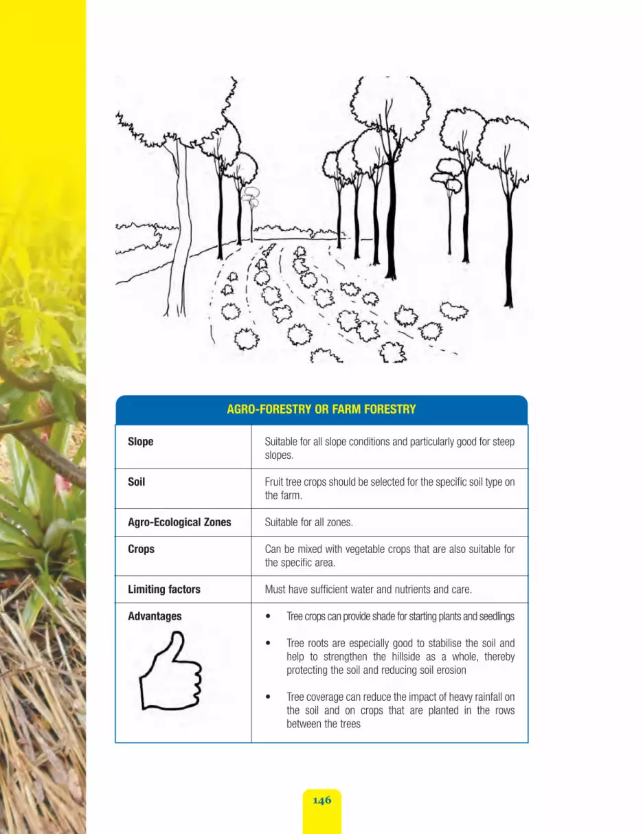
146
AGRO-FORESTRY OR FARM FORESTRY
Slope Suitable for all slope conditions and particularly good for steepslopes.
Soil Fruit tree crops should be selected for the specific soil type onthe farm.
Agro-Ecological Zones Suitable for all zones.
Crops Can be mixed with vegetable crops that are also suitable forthe specific area.
Limiting factors Must have sufficient water and nutrients and care.
Advantages • Tree crops can provide shade for starting plants and seedlings
• Tree roots are especially good to stabilise the soil andhelp to strengthen the hillside as a whole, therebyprotecting the soil and reducing soil erosion
• Tree coverage can reduce the impact of heavy rainfall onthe soil and on crops that are planted in the rowsbetween the trees
fao_climate_smart_manual_part_2_2.qxd 10/23/14 1:34 PM Page 146

147
AGRO-FORESTRY OR FARM FORESTRY
• Tree crops often provide income in the periods betweencash crops
• If pruned regularly, trees can protect other crops fromwind damage and can be established along farm bordersto serve as windbreaks
• Trees can be established using minimum tillage methods
• Falling leaves from trees contribute to the rich humustop layer of soil and can serve as mulch or compost andhelp to maintain soil moisture
• Trees help to increase the overall value of farm land
• The leaves from many different types of trees can alsobe used as fodder to feed livestock
• Many trees have medicinal value
• Several tree seedlings can be established from localseeds through home nurseries
• Overtime, as trees grow and their roots go deeper intothe soil, nutrient uptake takes place from greaterdepths. These nutrients are returned to the soil whentree leaves fall, thereby increasing the soil fertility levelsat the top layers used for vegetable production
• There are always some types of trees that will besuitable for specific soil types, slope conditions andweather patterns
• The incorporation of tree crops helps farmers hedgetheir risks in the face of climate change. If crops fail, treecrops should still provide. They can be a form ofinsurance for farmers.
Disadvantages • Tree crops take much longer to establish than short-term vegetable crops. They are a long-term investment
• Farmers who lease or rent land may not wish to investin permanent tree crop production. It is a technology thatis more attractive to farmers who own their own land
• Fruit tree seedlings can be expensive initially and mustbe sourced from a reputable supplier
fao_climate_smart_manual_part_2_2.qxd 10/23/14 1:34 PM Page 147

148
AGRO-FORESTRY OR FARM FORESTRY
• Trees also need to be protected from livestock when young
• Trees must be pruned and maintained twice-annually toreduce possible wind damage
• Eventually trees will lose their productivity and will haveto be replaced.
Cost Cost of seedlings and transportation to farm. Costs per seedlingswill vary depending on the type of fruit tree desired
Cost of wire mesh and/or basket protection for young seedlings
Cost of chainsaw for pruning or cutting back trees annually.
Materials needed Spade and fork for digging
Seedlings
Chicken wire and sticks or bamboo stakes for temporaryprotection barriers.
Recommended species All woody species with economical or ecological benefits (such as nitrogen fixing potential,timber or lumber value, or fruit production value.
Fruit Trees
• Mango
• Ackee
• Cocoa
• June plum
• Apple
• Naseberry
• Breadfruit
• Tamarind
• Jackfruit
• Otaheiti apple
• Sour sop
• Sweet sop
• Star apple
Timber Trees
• Mahoe
• Mahogany
• Cedar
• Lignum vitae
• Neem
• Guango
• Spanish elm
• Santa Maria
Leguminous Trees:
• Luceana
• Calliandra
• Quick stick or grow stick
• Tamarind
• Poinciana
• Jacaranda
fao_climate_smart_manual_part_2_2.qxd 10/23/14 1:34 PM Page 148

149
Criteria for Selecting the right Trees for anAgro-Forestry System
Selecting the right mix of tree crops depends ona number of factors.
1. Ecological - what are the specificagro-ecological characteristics of thewatershed and soil? What type of treescan be supported?
2. Economical - the specific profits andcosts of individual changing farmingsystems have to be calculated. Suchfactors may be:
• If the trees are cultivated withherbaceous plants (crops orpasture), will the yield of crops bereduced? Will farmers’ yields suffer?
• If so, the performances of treesexceed the difference in yield ofcrops?
• Are the trees and cropscomplementary (the presence ofone increases the performance ofthe other), additional (withoutmutual interaction) or competitive(the presence of a reducedperformance of the other)?
Steps for Contour/Line Planting with trees
1. Use the A-Frame to establish contourlines according to the slope conditionson the farm following the methodsoutlined in Unit 2.1.1 and 2.1.2. Onsteep slopes the distance between therows should be 3 metres (9 feet)widening to about 5 metres (15 feet) onless steep slopes
2. Follow the planting directions for thespecific type of tree to ensure theseedlings are planted the correctdistance apart and have enough roomto grow until they reach a height atwhich they are no longer vulnerable toanimals
Maintenance
Can the farmer maintainseasonal cutting back ofhedgerows and will they beable to replenish any areas thatare thinned out? Light residuesof pruning (leaves, smallbranches) can be left in the soilto increase organic mattercontent. Bigger branches thatare not decomposing can beused to reinforce trash barriersor other structures.
fao_climate_smart_manual_part_2_2.qxd 10/23/14 1:34 PM Page 149

150
3. Dig the holes for the seedlings aboutone week before planting. The holesshould be at least 60 cm or roughly 30inches wider than root ball of theseedling and 31 centimetres or 15inches deeper than the root ball
4. Build a small mound in the centre ofthe planting hole where you will rest theroot ball when you are ready to plant
5. Plant tree seedlings just before therainy season starts to ensure that whenplanted, they will take root quickly. Puteach seedling in the hole on top of themound and make sure that the rootcollar (where the stem meets the root)is level with the ground or just a bitbelow. Make sure the trunk is straight.Fill the hole with the rest of the loosesoil that had been take out and thenmound up the soil in a circle around thebase of the seedling to hold water forthe seedling
6. Protect each seedling with individualcircular cages made from chicken wireand bamboo stakes
7. Water seedlings regularly and check forpest diseases
8. Do not fertilize the tree when firstplanted. Wait to fertilize for one yearand then fertilize twice per year usingthree ounces of 10-10-10 fertiliser in anecklace around the plant being sure toturn the fertilizer into the soil. Fertilizejust before the rainy season
9. Prune or cut back trees on an annualbasis once they are established.
Steps for Planting Timber Trees
Border Planting - Trees planted along the outeredges of farms act as excellent windbreaks(see Unit 2.4.1).
1. Follow steps 2-8 above as directed
2. In this case, however, prepare the holesfor planting only along the farm borderswith only the top and bottom bordersfollowing prepared contour lines
3. It is strongly recommended that forborder planting - a mixture of timbertrees and quick growing leguminousbushes are used. Leguminous plantswill catch more quickly because theyare fast growing. Calliandra or quick-stick should be planted in between thetimber trees every 6 inches to establishhedgerows Timber trees should then beplanted every 4 feet or 1.2 metresalong the border line
4. Fruit trees can be used, but everysecond tree should be a timber tree.
Extension Method Tip - “Mi Navel StringBury Yah So”
To encourage farmers to consider agro-forestryas a sound land husbandry measure, you maywish to ask people if they remember the oldtime days when people would plant fruit treeswhenever a child was born. The traditionalcustom was to plant the child's umbilical cordor navel string in the hole with the young treeseedling, thereby giving the child ownershipand care of the tree. Ask if they rememberpeople adopting this practice to honour a childand suggest that it is a practice that could startagain through agro-forestry.
fao_climate_smart_manual_part_2_2.qxd 10/23/14 1:34 PM Page 150

151
Sources of Additional Information
Trees for a Greener Future - Farm Forestry Leaflet. No Date.Available from the Forestry Department, 173 Constant Spring Road,Kingston 8. Phone: 924-2667/8.
McCaulay, Diana. No Date. Tree Planting for Schools. Save theChildren and Jamaica Environment Trust. Kingston.
Di more yu chop di breadfruit root, di more im spring.(The more you chop the root of a breadfruit tree, the
more new sprouts spring. Those who persevere will prosper).
“”
If yu put yu aise a mango root, yu will ear crab cough.(If you put your ears close to the roots of a mango tree,
you will hear crabs coughing. With hard work,anything is possible)
“”
Proverb/Testimonial Discussion Starters
1.
2.
fao_climate_smart_manual_part_2_2.qxd 10/23/14 1:34 PM Page 151

152
Unit 2.2.2 Reforestation
Reforestation is similar to agro-forestry in principle in that seeks to incorporate the benefits and valueof trees into the farming system. But in this case, there is less emphasis on “crops” and higher valueis placed on the value of trees themselves.
By the end of this Unit, you should:
• Appreciate the soil and land conditions under which reforestation is the best option to pursue.
Best Bet Hazard Categories
Landslides and Wind Damage, as well as Severe Rain and Flooding
fao_climate_smart_manual_part_2_2.qxd 10/23/14 1:34 PM Page 152

153
A degraded hillside in the Blue Mountains
REFORESTATION
Slope Steepest slopes and/or poorly degraded lands.
Soil All soil types (but check to see which trees are best for localsoil conditions).
Agro-Ecological Zones All zones.
Crops None. Mainly timber and some fruit tree crops.
Advantages • Tree roots are especially good to stabilise the soil andhelp to strengthen the hillside as a whole, therebyprotecting the soil and reducing soil erosion
• If pruned regularly, trees can protect other crops fromwind damage and can be established along farmborders to serve as windbreaks
• Trees can be established using minimum tillage methods
What is reforestation?
Reforestation is a technique that is recommended for lands that are very badly degraded andmarginalised and also very steep. Instead of intercropping with vegetables or cash crops, this techniqueplants only trees as a way to try and replenish the soil structure and fertility that has been lost.
fao_climate_smart_manual_part_2_2.qxd 10/23/14 1:34 PM Page 153

154
REFORESTATION
• Falling leaves from trees contribute to the rich humustop layer of soil and can serve as mulch or compost andhelp to maintain soil moisture
• Trees help to increase the overall value of farm land
• The leaves from many different types of trees can alsobe used as fodder to feed livestock
• Many forest trees have medicinal value
• Several tree seedlings can be established from localseeds through home nurseries
• Overtime, as trees grow and their roots go deeper intothe soil, nutrient uptake takes place from greater depthsand are returned to the soil when tree leaves fall,thereby increasing the soil fertility levels at the top layersused for vegetable production.
Disadvantages • Tree crops take much longer to establish than short-termvegetable crops. They are a long-term investment
• Farmers who lease or rent land may not wish to investin permanent tree crop production. It is a technology thatis more attractive to farmers who own their own land
• Fruit tree seedlings can be expensive initially and mustbe sourced from a reputable supplier
• Trees also need to be protected from livestock when young
• Trees must be pruned and maintained twice- annually toreduce possible wind damage
• Can be difficult to enforce since timber trees are also atrisk from lumber thieves and charcoal burners.
Cost Cost of tree seedlings. Labour to dig holes. Tools to dig holes.Transport of seedlings. Enforcement.
Materials needed Spade and fork for digging
Seedlings
Chicken wire and sticks or bamboo stakes for protection barrier
Recommended species • Mahoe
• Mahogany
• Cedar
• Lignum vitae
• Neem
• Guango
• Spanish elm
• Santa Maria
fao_climate_smart_manual_part_2_2.qxd 10/23/14 1:34 PM Page 154

155
Steps
1. Trees should be planted along contour lines following the steps outlined in Unit. 2.1.3.
2. Prior to the rainy season, dig the holes for the trees. Space the holes every two metres or sixfeet
3. Protect the trees by surrounding them with protective fences of chicken wire and bamboo
4. Prune trees twice per year
5. Timber trees can be harvest in 20-25 years - just in time for your daughter’s or son’s collegegraduation or your own retirement!
Extension Method Tips:
Use the same discussion starter about the navel string provided in Unit 2.2.1
When trumpet tree leaves turn up, storm a come.(When the leaves of the trumpet tree turn up, it
signals that a storm is coming).
“”
Wood a wood, but mahoe a no mahogany. (All wood iswood, but mahoe is not the same as mahogany. You can’t use
less expensive wood in place of more expensive wood).
“”
Proverb/Testimonial Discussion Starters
1.
2.
Sources of Additional Information
Trees for a Greener Future - Farm Forestry Leaflet. No Date.Available from the Forestry Department, 173 Constant Spring Road,Kingston 8. Phone: 924-2667/8.
fao_climate_smart_manual_part_2_2.qxd 10/23/14 1:34 PM Page 155

156
Unit 2.2.3 Mulching
Mulching is a practice that has long been used in St Elizabeth - one of the driest parishes in Jamaicaand very prone to drought. Farmers there have traditionally put large sections of their farmers intograss production for mulch because they know the value of mulch for maintaining soil moisture andminimizing weeds.
By the end of this Unit, you should:
1. Appreciate the benefits of mulching to prevent soil moisture loss
2. Be able to effectively communicate the benefits of mulching with farmers.
Best Bet Hazard Categories
Landslides, Drought, Wind Erosion, Flooding and Wind
fao_climate_smart_manual_part_2_2.qxd 10/23/14 1:34 PM Page 156

157
What is Mulching?
Mulching is the use of organic material suchas plant trash, grass and leaves to cover thesoil between crops. It is also very good wayto protect soil in the event of heavy rains byreducing the splash effect that often occurswhen rains fall.
Mulching can be done with plastic mulch toprotect products from contact with the soil.The added expense can be justified formarket-oriented, high income production(large scale horticulture, and fruitproduction).
fao_climate_smart_manual_part_2_2.qxd 10/23/14 1:34 PM Page 157

158
MULCHING
Slope All slopes.
Soil Sandy or loam soils.
Agro-Ecological Zones Drought prone and moisture deficit areas.
Crops Suitable for mixed vegetable farming.
Advantages • This is a practice that has long been used by farmers inSt. Elizabeth
• Cost effective, if done with grasses. Plastic mulch is costeffective only for high level, market-level production
• Allows crop production to take place during dry periodsin areas where this would not be possible withoutirrigation. This process reduces evapotranspiration andtraps soil moisture within the mulch environment andmakes it available for an extended period for theestablishment of crops. In the early stages of seedgermination condensation on the mulch providesmoisture for germinating seeds. Mulch also keeps theroot environment cool, allowing for better cropestablishment and nutrient uptake
• Helps to rebuild rich humus on the top of the soil
• Complements organic methods
• Reduces fertilizer costs
• Provides cushions for vine crops or cover crops
• Regulate soil temperature and maintain soil moisture;
• Retains soil moisture
• Keeps soil at a cooler temperature
• Improves soil structure and texture
• Adds organic matter to the soil (in case of use of organicmaterial)
• Improves soil organism habitat (microbial activity)
• Improve soil texture and structure
• Reduce abrasion and dirt to trailing fruits and vegetables
fao_climate_smart_manual_part_2_2.qxd 10/23/14 1:34 PM Page 158

159
MULCHING
• Mulching suppresses weed grown, reduces competitionfor soil nutrients and reduces cost of weed control
• Mulching protects the soil from splash and rill erosion byreducing the impact of rainfall on the surface and preventsthe development of rills.
• The presence of mulch on the surface helps to deflectdirect sunlight from the root zone of crops thus resultingin lower temperature in the root zone and more efficientutilization of soil nutrients.
Many inorganic fertilizers, especially those with high nitrogencontent and some organic manures (such as poultry manure),volatises if left exposed to high temperature. Exposure to hightemperature is reduced by the application of mulch, thusallowing greater availability of nutrients to plants.
Mulching improves the marketability of vine crops such asmelons and pumpkins ensuring a more even colourationbetween the parts that rest on the ground and the rest of thecrop. Mulching also prevents scarring of crops by providing acushion for vine crops.
Disadvantages • Can be expensive depending on the availability and costof mulching material used
• If humidity levels get too high under the mulch, theremay be a risk of pests such as slugs and snails. Otherinsects may also breed under the mulch.
Cost Depends on the material used
Recommended species Guinea grass primarily. Other materials such as corn trash,banana trash, leguminous bushes and other plant trash canalso be used as mulch.
Materials needed Guinea grass suckers (or matt grass, king grass or khus khus)
Transportation to specific sites
Labour
Hoe or picker or spade
Tools for cutting grass
Donkey or wheel barrow to transport to farm
Gloves to avoid getting cuts on handsPlastic mulch for large-scale production
Time needed foron-farm demonstration Three hours
fao_climate_smart_manual_part_2_2.qxd 10/23/14 1:34 PM Page 159

160
STEPS
Step oneFind enough grass to cover your entire plot. Make sure to harvest it before it flowers and hasseeds. The time you reap the grass is very important because once it starts to flower or go toseed, the stem because more liquefied. This makes it much harder for the grass to break downas mulch. There will also be a higher proportion of stems to leaves after seeding and what youwant is more bulk to come from the leaves rather than the stems to form your mulch.
To provide a mat that will not break down before the cropping season is over, it is recommendedto use 46 cubic metres (or roughly 46 cubic yards) of dried grass for every hectare of land tobe planted.
If you are using other material for mulch such as straw or weeds, make sure you have enoughto cover the soil by at least 5 to 8 cm (2-4 inches ) in height.
In order to reduce the costs, instead of applying mulching material produced in a different plot,you can just plant mulching material in the plot as cover crop (Unit 2.2.4) and cut it beforeplanting the main crop. To plant the main crop you could apply minimum tillage (Unit 2.2.5).
Step twoClear land to sow following steps recommended in 2.1.3.
Step threeApply fertiliser or other soil treatment to land and prepare holes for sowing or transplanting ofseedlings.
Step fourArrange blades of grass lengthwise first in one direction over the area, then repeat the processfrom opposite direction.
Step FivePrepare the holes for sowing the seeds or transplanting your suckers.
Step SixPlant seeds. Your mulching is now done and you should continue with recommended growingand care steps for the specific crops you are planting.
Step Seven Maintain coverage by repeating process once per year.
fao_climate_smart_manual_part_2_2.qxd 10/23/14 1:34 PM Page 160

161
Extension Method Tips
Ice-breaker exercise - Mi don’t believe mi ears! Plant grass! All mi life as a farmer mi try fi get riddadi grass and weed dem. Not plant it. How can dis here grass be Climate-Smart????
Rain a fall, but di dutty tough. (Rain falls, but the ground is still hard as rock. Actually an adage about hunger, but in this case,
it can be used to show that mulching can protect the soil).
“”
Proverb/Testimonial Discussion Starters
fao_climate_smart_manual_part_2_2.qxd 10/23/14 1:34 PM Page 161

162
Unit 2.2.4 Cover Cropping
Cover cropping is exactly what it sounds like. It is a method that integrates or intercrops creeping cropsby allowing them to spread in between other crops that grow vertically. While the primary crop maygrow upwards - such as gungo peas, corn, beans, sorrel, eggplant, okra, tomato, and so forth,secondary crops such as pumpkin, sweet potato, watermelon, creeping legumes or cantaloupes aresown between the primary crops and “cover” the soil in between these primary crops.
By the end of this Unit, you should:
1. Appreciate the benefits of cover cropping to prevent soil moisture loss and soil erosion;
2. Be able to effectively communicate the benefits of cover cropping among farmers.
Best Bet Hazard Categories
Cover cropping is an especially good technique to mitigate against Wind Damage,Excessive Rainfall, Drought, Landslides and Flooding.
fao_climate_smart_manual_part_2_2.qxd 10/23/14 1:34 PM Page 162

163
What is Cover Cropping?
Cover cropping is essentially a “living mulch orgreen manure” that involves the establishment ofsecondary crops such as pumpkin, sweetpotatoes, legumes, and melons) to act as aground cover to protect the soil from soil erosion,wind damage and heavy rains. This is a veryeconomical method for the farmer as theimplementation costs are low. The main conceptis to practise a rational agronomic rotation to keepalways the soil covered. The main objective of thecover crop is its effect on soil erosion thuspreserving fertility for next main crop. It should notneed expensive agricultural inputs.
Cover crops can be introduced either at the sametime that primary crops are planted, or later. Theyare also useful at the early stages of reforestationor agro-forestry when tree seedlings are stillyoung. It is less suitable however, as an inter-cropwhen trees are large.
COVER CROPPING
Slope All slopes.
Soil All soils.
Limiting factor Water and nutrients of the soil.
Application in Jamaica In Jamaica tubers and cucurbitaceae are mainly used in allAEZs. The practice of planting green manure is a traditionalway of farming in Jamaica and thus not new to the culture.
Potential Use of productive species (pumpkin, sweet potato) for incomegeneration or nitrogen fixing for soil improvement (green manure).
Recommended species Pumpkin, sweet potatoes, legumes (all nitrogen fixing species).
Agro-Ecological Zones Suitable for most AEZs.
fao_climate_smart_manual_part_2_2.qxd 10/23/14 1:34 PM Page 163
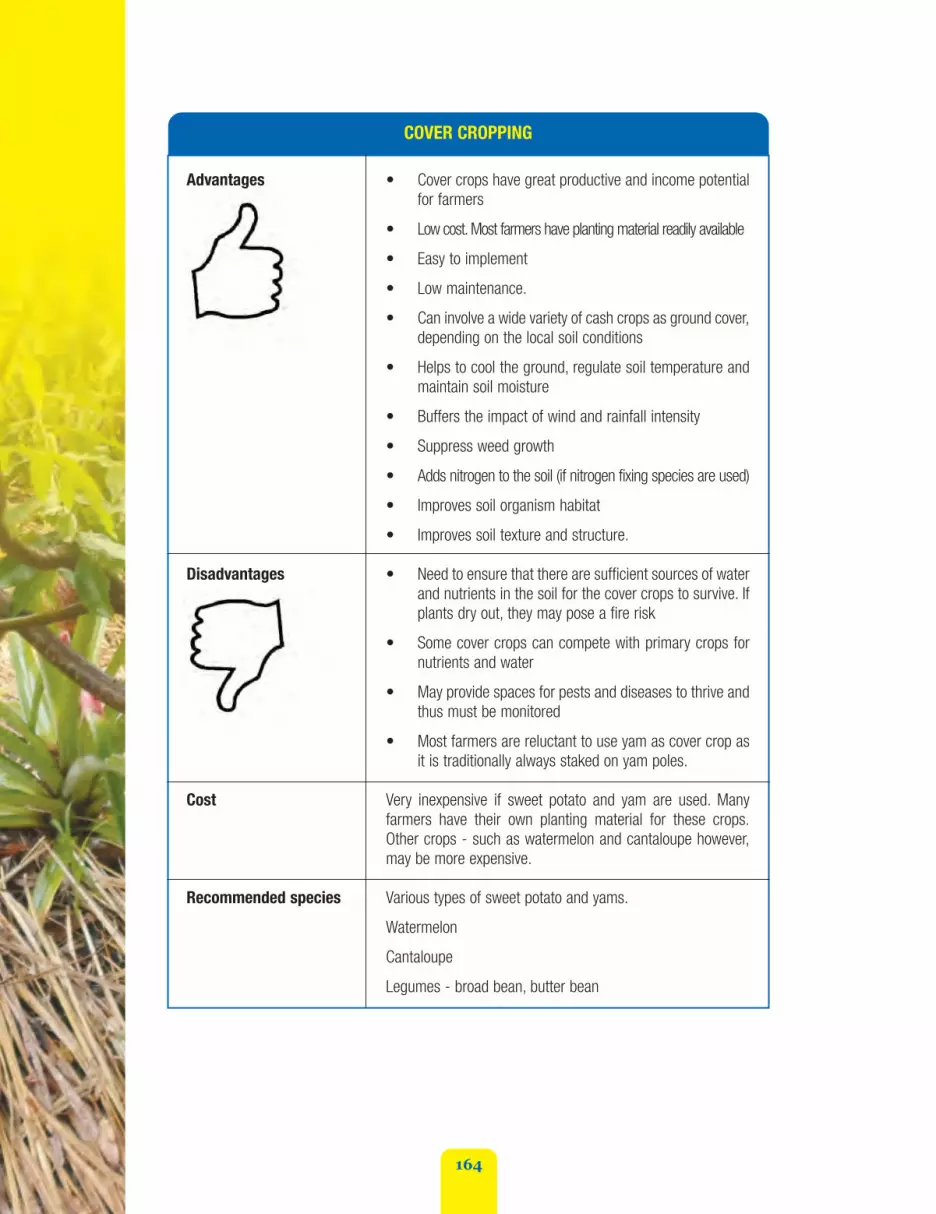
164
COVER CROPPING
Advantages • Cover crops have great productive and income potentialfor farmers
• Low cost. Most farmers have planting material readily available
• Easy to implement
• Low maintenance.
• Can involve a wide variety of cash crops as ground cover,depending on the local soil conditions
• Helps to cool the ground, regulate soil temperature andmaintain soil moisture
• Buffers the impact of wind and rainfall intensity
• Suppress weed growth
• Adds nitrogen to the soil (if nitrogen fixing species are used)
• Improves soil organism habitat
• Improves soil texture and structure.
Disadvantages • Need to ensure that there are sufficient sources of waterand nutrients in the soil for the cover crops to survive. Ifplants dry out, they may pose a fire risk
• Some cover crops can compete with primary crops fornutrients and water
• May provide spaces for pests and diseases to thrive andthus must be monitored
• Most farmers are reluctant to use yam as cover crop asit is traditionally always staked on yam poles.
Cost Very inexpensive if sweet potato and yam are used. Manyfarmers have their own planting material for these crops.Other crops - such as watermelon and cantaloupe however,may be more expensive.
Recommended species Various types of sweet potato and yams.
Watermelon
Cantaloupe
Legumes - broad bean, butter bean
fao_climate_smart_manual_part_2_2.qxd 10/23/14 1:34 PM Page 164

165
Steps
1. Identify the best suited crop based on location, soil type, degree of slope, rain fall, marketability
2. Determine planting distance based on crop type and on slope conditions (Units 2.1.3)
3. Sow and take care of the crop as normal.
Maintenance
No specific maintenance required a part from the ones dedicated for the success of the crop (such asweeding, pest management, and so on).
Extension Method Tips
The tradition of planting pumpkin and sweet potato between bananas and plantains is very old inJamaica. This form of cover cropping is not foreign therefore, but is a local method that is beingrevived.
fao_climate_smart_manual_part_2_2.qxd 10/23/14 1:34 PM Page 165

166
Seven years nuh too long fi pumpkin fi bear (sevenyears is not too long for pumpkin vine to start bearing).
Somethings take time to bear, but they will.
“”
W’en coco head meet rich soil, ‘im root bore grung.(When the coco head is planted in rich soil, its roots bore into the ground).“ ”
Proverb/Testimonial Discussion Starters
1.
2.
Time nebber too long fi bannabis bear bean. (Time isnever too long for the bannabis bean to produce).“ ”
4.
Waak bout potato nebber bear. (A walk about potato neverbears). It’s important to put down roots in order to bear fruit).“ ”
6.
Hungry sweeten bean, but bellyful mek potato ‘av ‘kin.(hunger sweetens beans, but a full stomach makes
potatoes appear to have skin). One who is hungry relishesthe simplest food but becomes choosy when satiated.
“”
5.
De bes’ field ‘av weeds.“ ”3.
fao_climate_smart_manual_part_2_2.qxd 10/23/14 1:34 PM Page 166
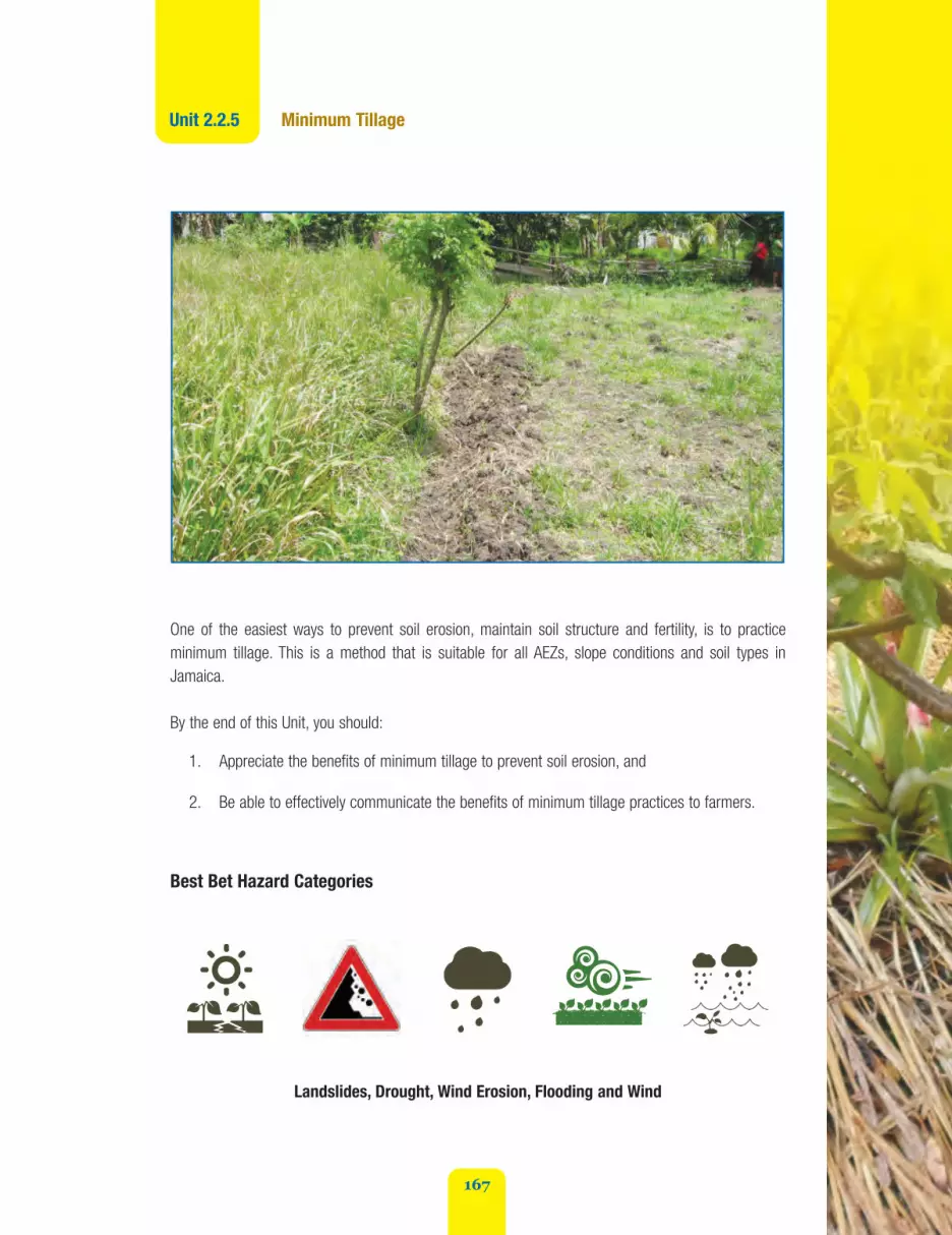
167
Unit 2.2.5 Minimum Tillage
One of the easiest ways to prevent soil erosion, maintain soil structure and fertility, is to practiceminimum tillage. This is a method that is suitable for all AEZs, slope conditions and soil types inJamaica.
By the end of this Unit, you should:
1. Appreciate the benefits of minimum tillage to prevent soil erosion, and
2. Be able to effectively communicate the benefits of minimum tillage practices to farmers.
Best Bet Hazard Categories
Landslides, Drought, Wind Erosion, Flooding and Wind
fao_climate_smart_manual_part_2_2.qxd 10/23/14 1:34 PM Page 167

168
What is minimum tillage?
Minimum tillage is exactly what it sounds like. It is the practice of disturbing (or tilling) the soil andsurrounding vegetation as little as possible in order to plant your crops. Rather than fork up or ploughan entire field or plot of land to farm, minimum tillage only digs in the precise spots where seedlingsor seeds are to be planted.
Minimum tillage is not a new technique to Jamaica. Farmers in St. Elizabeth have been using minimumtillage together with mulching for a very long time. So its benefits have been proven to work.Minimum tillage is strongly recommended in areas where slash and burn is prevalent and labour isexpensive. Instead of clearing fields by plowing or slash and burn methods, minimum tillage simplydigs specific holes where crops are to be planted without disturbing other vegetation.
Since the soil is disturbed as little as possible, heavy rainfall has less impact. Soil structure is thereforebetter maintained and soil remains compacted with much less risk of soil erosion. Soil moisture is alsobetter retained and nitrogen and pesticides are less like to run off.
fao_climate_smart_manual_part_2_2.qxd 10/23/14 1:34 PM Page 168

169
MINIMUM TILLAGE
Slope All slopes.
Soil All soil types, but especially degraded soils can benefit fromthis technique. Better in deep and sandy/loam soil. Very goodfor areas prone to heavy rainfall.
Agro-Ecological Zones • Drought areas, and also areas prone to heavy rainfalland soil erosion
• Mainly beneficial to drier coastal AEZs with stable soilstructure and moderately wet upland zones with stablesoil structure
• This technique has been long established on drysouthern coastal plains and steep uplands in Jamaica.Drier coastal agro-ecological zones, with stable soilstructure are also suitable, as well as wet upland AEZswith stable soil structure.
Crops Mixed cropping, cash crops, vegetables. Can also be used withtree crops, legumes, corn, cassava, sweet potato and sorrel.
Advantages • Reduced labour required for land preparation and sowing
• Reduced fertiliser usage, reduced soil erosion, increasein soil biodiversity, reduced pesticide and nitrogen leaching,soil moisture conservation
• Reduced risk of fire from slash and burn agriculture
• Increased soil organic matter and improving physicaland chemical composition of the soil
• Can be integrated with natural mulching
• Easy to demonstrate and promote among farmers
Disadvantages • Can require intensive weeding, monitoring and control toensure that crops planted are not overcome by weeds.Hence more Labour to weed around each plant
• Increased work for weeding and pest control (but can bemanaged by farmer)
• Difficult to implement in hard and rocky soils
• Difficult to apply in large scale farms without mechanizedtools
• Sometimes need to use chemicals for weed and pest control
Cost Can be labour intensive. May require an investment of daylabour to prepare the holes for minimum tillage planting.
Additional sources of informationRADA Extension Services. 1999. Best Bet Technology: Minimum Tillage. RADA and the MorantYallahs Agricultural Development Project (MYADP), Kingston.http://rada.gov.jm/wp-content/uploads/2013/02/minimum_tillage_FAO_2013_reduced.pdf
fao_climate_smart_manual_part_2_2.qxd 10/23/14 1:34 PM Page 169

170
Steps
The steps for minimum tillage will varydepending on the soil type and slopeconditions of the particular farm.
1. If farming on a slope, be sure thatcontours have been properlyestablished using an A-Frame andfollowing the methods outlined inUnits 2.1.2 and 2.1.3.
2. Depending on the crops to beplanted, determine the correctspacing that will be needed foreach plant. Plant seedlings orseeds as per usual practise.
3. Fertilise plants according totheir specific needs being sureto necklace the plant and to turnthe fertilizer into the soil.
4. Weed regularly to be sure thatthe plants are not taken over byoriginal vegetation and groundcover.
EXTENSION METHOD TIPS
Role play two farmers talking using the following script:
“Mi want di maximum, not di minimum” What is this?
Joe
John
Joe
Minimum Tillage
Good man Mas John. So now you know about using the A-Frame. Now, let metell you more. Once you’ve got your level, another important step is to try“minimum tillage” - I think the old time folks used to do this long ago becauseit made farming easier, but now-a-days dem call it “minimum tillage”
Minimum What? What is dat? Me don’t want minimum nottin. Me want di max!
Well, rather than burning down the whole of your land and clearing off all of dibush before you plant, it is now recommended dat we just clear small areasaround the individual spots where we are actually going to grow our crops.
fao_climate_smart_manual_part_2_2.qxd 10/23/14 1:34 PM Page 170

171
CONTINUED
John
Joe
John
Joe
John
Minimum Tillage
Why? Why is that better than clearing everyting out of di way?
Well when we burn down or clear off everything, there is little left to keep thesoil in place if heavy rains fall. Dere are no roots left to hold onto the soil. Soinstead of getting rid of everything, you decide where you are going to planteach plant and clear only around that spot.
Hmm. Does sound like a lot less work...
Here’s why the minimum tillage method is “climate-smart”. It has a lot ofbenefits you know. You don’t have to fertilizer an entire field and you use lesspesticides too. Plus it keeps the soil stronger. It might be a bit more work toprepare many smaller planting spots, but saving money on fertilizer is worth it.Also, the plants that remain around the crops will help to protect them if a bigbreeze does blow!
Well now, mi like di idea of less work - less digging and hoeing and lessweeding. I will definitely try dat climate-smart method. Thank you!
If yu share wha yu ‘av, yu wi’ get more dan yu need.(If you share what you have, you will have morethan what you need). Less is sometimes more.
“”
Bun dutty an dutty bun fi you.(If you burn dirt, dirt will burn for you).“ ”
Proverb/Testimonial Discussion Starters
1.
2.
Grung nebbr forsake ‘im master. (The ground neverforsakes its master). If you care for the earth, it will care for you.“ ”
3.
fao_climate_smart_manual_part_2_2.qxd 10/23/14 1:34 PM Page 171

172
Unit 2.2.6 Composting
By the end of this Unit, you should:
1. Appreciate the advantages that composting can add to soil quality
2. Understand the composting process
3. Know which materials can be included in compost and in what proportions, and
4. Be able to effectively communicate the benefits of composing to farmers.
Best Bet Hazard Categories
Composting is a complementary practice that adds value to the other BBPs that areencouraged in the manual. It is therefore excellent as a companion practice for mitigatingLandslide/Soil Erosion, Drought, Flooding, Wind Damage and Severe Rains.
We all know that vegetable scraps,plant trash and kitchen scraps willrot and decay and decompose - andwe usually through these things outin our garbage. But not many peoplenecessarily know that thesematerials have the potential ofturning into rich fertile soil, if put intoa compost. When we compost -bacteria and micro-organisms causethe plant trash to break down or“biodegrade” turning into rich, dark,organic humus that can help to buildup the soil structure on our farms.
fao_climate_smart_manual_part_2_2.qxd 10/23/14 1:34 PM Page 172

173
What is composting?
Composting is basically a natural biological process that occurs under aerobic conditions (i.e., whereoxygen is available) and where proper moisture and temperatures exist to ensure that organic mattersuch as plant trash can break down in a way that is hygienic and reusable as humus.
Composting requires the work of tiny soil micro-organisms that digest the decaying plant matter andturn it into nutrients that plants can use.
But composting also:
• Reduces the amount of trash that goes into landfills
• Reduces the unsightly roadside trash and rubbish
• Saves transportation and garbage disposal costs
• Lowers the amount of water you needed on farm because compost retains water better thansoil without it
fao_climate_smart_manual_part_2_2.qxd 10/23/14 1:35 PM Page 173

174
COMPOSTING
Slope All slopes.
Soil All soils.
Agro-Ecological Zones All AEZ in Jamaica.
Crops Suitable for all crops.
Advantages • Recycles available plant trash and materials on farm thatwould otherwise be burned or thrown away
• Compost helps to retain soil moisture and improve soilstructure
• Inexpensive and very easy way to increase soil fertilityand reduce the need for chemical fertilizers
• Low cost compost piles/bins can be found for every budget
• Helps to attract beneficial organisms such as earthwormsto soil.
Disadvantages • Must have sufficient plant material to get the compostgoing robustly
• Can be expensive, if fancy materials are purchased toconstruct the compost bin such as lumber, zinc,plastic piping, and so forth
• If humidity is not monitored, unwanted pests may increase.
Cost Cost of whatever materials you want to use to construct yourcompost bin or pile, but simple things are possible. Onefarmer just covers his pile with a large tarpaulin and getsgreat compost results.
Labour for construction.
Labour to sort materials and add them to the bin.
Additional Sources of informationTechnical Centre for Agricultural and Rural Cooperation (CTA). Enriched Compost for HigherYields: CTA Practical Guide Series, No. 7. Wageningen, The Netherlands.
fao_climate_smart_manual_part_2_2.qxd 10/23/14 1:35 PM Page 174

175
You can make compost with any leftover planttrash and other bio-degradable materials thatyou have on farm.
You can use grass, leaves, or other types ofplant trash that you would otherwise throwaway or burn. You can also use wood ashesfrom fire and newspapers or paper trash.
It is important to know that there are propersteps to compost correctly. You cannot justthrow your plant trash into a pile and hope thatit will break down into beautiful new soil. Thereis a “technique” to composting that we have tofollow to get good results.
First, we need to understand that composting isan “aerobic” process. The little microorganismsand bacteria that do the decomposing work forus - need air and oxygen to do their jobproperly. That is what Aerobic means - with Air.If they have enough air, they’ll do their workwell. And believe it or not, if they have enoughair, your compost won’t smell bad even whileit’s rotting down.
The next important thing to compost properly, isto use the right mix of materials and the rightamounts. Just like commercial fertilizers have amixture of three main nutrients - nitrogen,potassium and phosphorus - that feed plants -so too does our compost pile need to be amixture of materials that have these sameelements.
Usually, with domestic residues your Compostwill have the following nutrient content mix:
We need to have the right mixture of nitrogen(which comes mostly from manures, but alsofrom legume plants like peas and beans).
Plus a mixture of carbons as well as potassiumsuch banana and plantain trash.
And then we need phosphates such as marl orlime based soils or seaweed.
For the ideal compost, you want to have about20 or 30 parts of carbon materials (weeds,grasses, banana trash, vegetable peeling, andso on) to one (1) part of nitrogen or manures.This is the best mixture for the micro-organisms to live and work in. The carbon tonitrogen mix should therefore be 20/30 to 1.
If there is not enough carbon or plant trash inyour compost, the micro-organisms will use uptoo much nitrogen - and you don’t want that.You want to keep as much nitrogen as possiblein the compost so that your plants can use it togrow.
But at the same time, if there is too much planttrash or carbon - the compost will take way toolong to decompose because there will not beenough nitrogen for the micro-organisms tofeed on.
The key ingredient for compost is moisture -but not too much of it. You never want thematerial to be soaking wet, but somewhatdamp and moist.
NUTRIENT
Nitrogen
Phosphorus
Potassium
% IN COMPOST
0.3% - 1.5%
0.1% - 1%
0.3% - 1%
fao_climate_smart_manual_part_2_2.qxd 10/23/14 1:35 PM Page 175

176
What can you include in your Compost Pile?Here are some of the things that you can mix in your compost.
fao_climate_smart_manual_part_2_2.qxd 10/23/14 1:35 PM Page 176

177
Materials that are rich in nitrogen include:
• Egg shells
• Tea bags
• Coffee grounds
• Plant wastes
• Cocoa or chocolate pods
• Peanut trash
• Any pea or legume trash like gungo peas,quick stick
• Nitrogen rich plants leaves from quickstick or grow stick, tamarind trees,Poinciana trees, luceana or gliricida leaves
• Corn trash
• Coconut shells and coir husks
• Oils and fats.
Not all animal manures are ok for composting,but you can use:
• Chicken manure
• Cow dung
• Horse manure
• Rat bat manure
• Goat droppings
• Rabbit droppings and
• Pig manure can be ok, but is not asdesirable.
Materials that are rich in carbon include thingslike:
• Dry leaves
• Straw
• Grass
• Sawdust
• Small wood chips or cuttings
• Coconut trash
• Yard trimmings and grass trimmings
• Sugarcane trash
• Old potted soil
• Residues from harvest
• crushed branches crushed or choppedfrom pruning
• Expired foodstuffs
• Napkins
• tissue paper
• paper and cardboard (not printed orcolored, or mixed with plastic).
Good sources of potassium to use are bananatrash and plantain trash.
Things that are high in phosphorous include:
• Powered marl or limestone
• Cocoa or chocolate pods
• Cowpea husks
• Cassava peelings
• And seaweed and sea-grasses that havehad the salty seawater washed out.
Do not include inert, toxic or harmful materialssuch as:
• Chemicals such as synthetic wastes,adhesives, solvents, gasoline, oil,vehicle oil, and paint
fao_climate_smart_manual_part_2_2.qxd 10/23/14 1:35 PM Page 177

178
• Non-degradable materials (glass, metals, plastics)
• Detergents, chlorine products, antibiotics, drug residues
• Dead animals (these should be incinerated in special conditions, or they can be composted inspecial cells)
• Leftover cooked meat.
Generally, the more diverse materials you have - or the greater the variety of things you put in yourcompost, the more nutritious your soil will result.
It is very important what you break up the materials that you use and make sure they are chopped upor torn up into smallish sizes so that they compost more quickly.
Never put droppings from your cats or dogs in your compost.
Never ever put sick plants, harmful weeds or seeds, pet or animal waste, meat scraps, fats, grease oroil and dairy products. These will attract rats and other unwanted pests.
And make sure you never add any type of material that won't decompose like glass, tin, or plastic.
Types of Compost Bins
Compost can be made inpits in the ground, in openor closed systems, inbuckets, in constructedcompost bins, in pilesunder tarpaulins and evenin plastic garbage bags.
The one thing that stays the sameno matter what type of compostconstruction method is used, is thatplant trash and organic material isadded on a regular basis and tomonitor the levels of moisture andoxygen in the pile to ensure that theright decay rate occurs and odorsare controlled.
fao_climate_smart_manual_part_2_2.qxd 10/23/14 1:35 PM Page 178

179
To do so, you need to control:
1. Oxygen levels (optimum 5-10%): thecomposting material should be airedto allow the microorganisms to breath.Material should be periodically movedand mixed
2. Humidity (optimum 45- 60%): water isconsumed by microorganism for theimplementation of the compostingprocess
If water is missing it can be added or material with high water content can be added. If watercontent is too high material should be mixed and moved or low water content material can beadded
3. Temperature should be between 35 ºC and 70 ºC to allow microorganism to work properly
4. pH should be between 4.5 and 8.5.
Always ensure you chop your trash as much as you can. This will speed the decaying process.
Compost is ready when the material changes its color and original material is not recognizable anymore.When compost is ready it has no smell. Usually the entire composting process takes between 10 and14 weeks depending on the kind of material and key parametres (temperature, humidity, oxygen).
Extension Method Tips
There are some faster ways for farmers to get compost results in the fields. Smaller amounts ofcomposting can be done in:
1. Black plastic scandal bags left in the field as long as the same ratio of carbon to nitrogenapplies. This method requires a good amount of manure to be added however, or
2. In small individual basins in the field, making it easier to transfer the compost to the plantswhen it is ready or even to use as part of regular individual basin technology.
fao_climate_smart_manual_part_2_2.qxd 10/23/14 1:35 PM Page 179

180
A no di same day leaf drop ina water ‘im rotten.(A leaf does not rot on the very day it falls into water).
Today’s consequences may not show up for a long time.
“”
What yu dash wey no wash wey. (What you throw awaydoes not necessarily wash away). All of actions have repercussions.“ ”
Proverb/Testimonial Discussion Starters
1.
2.
fao_climate_smart_manual_part_2_2.qxd 10/23/14 1:35 PM Page 180

Climate-SmartDrought Mitigation and
Adaptation Methods
Part
2
Section Three
fao_climate_smart_manual_part_2_3.qxd 10/23/14 1:39 PM Page 181

182
Most small farmers in Jamaica depend on rainfall for theirproduction.
One of the most important Best Bet methods to help farmers copewith drought is the practice of mulching, which has already beencovered in Unit 2.2.3.
This section touches on some of the additional climate-smartmethods that farmers can use to adapt to, and mitigate against,drought conditions that are likely to increase with climate change.With temperatures rising, drought will increase and will alsoimpact the ability of soils to maintain and utilise soil moisture.
Drought conditions will increase the likelihood of bush fires asplant matter dries out and becomes more vulnerable to fire risks.
DROUGHT MITIGATION
Overview
fao_climate_smart_manual_part_2_3.qxd 10/23/14 1:39 PM Page 182

183
Unit 2.3.1 Utilising Drought Tolerant Crops
Many small farmers in Jamaica are dependent on rainfall for their crop production. Unfortunately, withclimate change, drought periods are not only expected to become more severe, they will also likely lastlonger. This means that the traditional “rainy periods” that farmers could rely on to plant may no longerhappen when expected.
Without irrigation, there is really only one option for many farmers. And that is to change the type ofcrops they grow and switch to instead to more drought tolerant varieties.
By the end of this Unit, you should:
1. Appreciate the climate-smart benefits of using drought tolerant crops to prevent soil moistureloss
2. Be able to effectively communicate the benefits of drought tolerant crops to farmers.
Cassava is considered to be a drought resistant crop.1
1 Photo from:https://www.google.ca/search?q=drought+resistant+food+plants+Jamaica+photos&es_sm=93&tbm=isch&tbo=u&source=univ&sa=X&ei=A42DU77WHKPMsQSk7IEw&ved=0CCcQsAQ&biw=1280&bih=622#facrc=_&imgdii=_&imgrc=p7u2Vvig0yA7bM%253A%3Bh51CLW7OP66V0M%3Bhttp%253A%252F%252Fedib lep lantpro ject .org%252Fwp-c o n t e n t % 2 5 2 F u p l o a d s % 2 5 2 F 2 0 0 8 % 2 5 2 F 0 7 % 2 5 2 F y u c a -plant.jpg%3Bhttp%253A%252F%252Fedibleplantproject.org%252Fplants%252F%3B640%3B427
fao_climate_smart_manual_part_2_3.qxd 10/23/14 1:39 PM Page 183

184
Best Bet Hazard Categories
Drought
What are drought resistant crops?
A number of farmers in Jamaica have already changed their farming systems to incorporate moredrought resistant varieties of crops. Farmers in St. Elizabeth, for example, have already been doing sofor years and incorporate the additional BBP of mulching into their regular operations.
This technique simply involves choosing to grow crops that are known to grow well even under scarcerainfall conditions.
2 http://blog.smartgardener.com/wp-content/uploads/2012/05/800px-BlackEyedPeas.jpg
3 http://edibleplantproject.org/wp-content/uploads/2008/08/callaloo1.jpg
4https://www.google.ca/search?q=Jamaican+sweetpotato+photos&es_sm=93&tbm=isch&imgil=S_rSX9inrNLs0M%253A%253Bhttps%253A%252F%252Fencrypted-tbn2.gstatic.com%252Fimages%253Fq%253Dtbn%253AANd9GcRj7c5ep810qTaVdF0R6PcxAqcWfbkMpkk79ObUr1U36ZhqLy2a%253B440%253B310%253BZa7o-Qi57zNr3M%253Bhttp%25253A%25252F%25252Fwww.21food.com%25252Fproducts%25252Fsweet-potato-376268.html&source=iu&usg=__5bnd7V-ASvM_F__Aq_AFZoOmVXE%3D&sa=X&ei=lJqDU7fLBKmhsQSj5oHoDA&ved=0CDQQ9QEwBA#facrc=_&imgdii=_&imgrc=S_rSX9inrNLs0M%253A%3BZa7o-Qi57zNr3M%3Bhttp%253A%252F%252Fimg.21food.com%252F20110609%252Fproduct%252F1306288209714.jpg%3Bhttp%253A%252F%252Fwww.21food.com%252Fproducts%252Fsweet-potato-376268.html%3B440%3B310
Black-eyed peas (pigeon peas) 2
Callalloo3 Sweet Potato4
fao_climate_smart_manual_part_2_3.qxd 10/23/14 1:39 PM Page 184

185
PLANTING WITH DROUGHT TOLERANT CROPS
Slope Suitable for upland and lowland AEZs with rainfall deficit andfor both small and large scale farms.
Soil All soil types.
Agro-Ecological Zones All AEZs, but especially those with poor rainfall.
Crops
Advantages • Drought impact reduction
• Crop loss reduction
• Maximization of soil moisture use.
Disadvantages • Drought tolerant crops may not be as lucrative as othercrops. A choice between reduced drought risk withpotentially poorer profit margins, or higher potentialmarket value crops but greater risk from drought - hasto be made by the farmer.
Cost • Cost of the chosen planting material
• Labour.
Recommended crops Cassava
Pigeon pea (gungo pea)
Vegetables: amaranth (callallo), sorrel, garlic, onions,purslane, spinach, sweet potatoes, asparagus, black eyedbeans (or cow peas), chickpeas, peanuts, leeks, melons, okra,pumpkins, tomatoes, parsnips, carrots and rhubarb
Fruits: apricots, date plums, avocado, carob, mulberries, figs,grapes, peaches, pomegranates, olives, goji berries andprickly pear
Nuts: almonds, walnuts and pistachio (once established)
Herbs: fennel, borage, calendula, dandelions, lavender, rosemary,savory, thyme, wormwood, garlic chives, oregano and chives.
Additional Sources of informationhttp://myspot.mona.uwi.edu/physics/sites/myspot.mona.uwi.edu.physics/files/uploads/Agricultural%20sector%20presentation%20-%20Dr.%20Simpson.pdf
fao_climate_smart_manual_part_2_3.qxd 10/23/14 1:39 PM Page 185

186
Steps
These crops will need water to germinate and during their early stages of growth, but can cope withdrier conditions once established.
If it is hard to get water when the seedlings are young, it’s a good idea to space plants further apartthan normal to give roots more space to search for available water. Mulching will also help to keep theground cooler, retain any moisture and If you use organic matter it will break down to feed the plants.
Extension Method Tips
Ask farmers what their usual practices are when they expect extended periods of drought. It is quitelikely that several farmers grow some mix of drought resistant crops already. You can begin by doinga simple head count of how many farmers grow which drought tolerant crops and how much of each,as part of their regular farming systems.
Wan-wan coco, full basket. (One by one, the basket is filled).“ ”Commanda coco an’ white yam no bear together (Commander
coco - a type of edoe - and white yam do not thrive together).“ ”
Proverb/Testimonial Discussion Starters
1.
Trubble mek man cut yam head two time.“ ”4.
2.
W’en man ‘av’ coco-head ina barrel, ‘im can go pick wife.(When a man has sufficient coco-heads in a barrel,
he will have enough money to pick a wife)“
”
3.
Farmer Leroy Stewart (from Soho in St. Thomas): “As a farmer, I am exposed to drought,hurricanes and floods and as a result I have to choose the different crops that suit the differentweathers. As for the storm season, I have to plant underground crops such as sweet potatoes,dasheen, and cocos. For the drought season I plant sorrel, gungo peas and pumpkin. “
fao_climate_smart_manual_part_2_3.qxd 10/23/14 1:39 PM Page 186

187
Unit 2.3.2 Water Harvesting
By the end of this Unit, you should:
1. Appreciate the benefits of investing in water harvesting and drip irrigation technologies
2. Be able to effectively communicate the importance of water harvesting to farmers.
Almost all parishes in Jamaicahave large, cement watercatchment ponds that weretraditionally used for collectingand storing rainwater in ruralareas. The concept is not new.Most farm households havealso traditionally collectedwater using gutters on theirrooftops that feed into barrelsor home storage tanks.
Best Bet Hazard Categories
Drought and Fire
fao_climate_smart_manual_part_2_3.qxd 10/23/14 1:39 PM Page 187

188
There is a variety of ways one can harvest rainbut some of the most common are runoffrainwater (eg hillside run off) and rooftoprainwater harvesting systems. The system youwould choose would depend on the purpose,and to some extent, on the cost and thephysical and human conditions that apply.
What is rain water harvesting?
Rainwater harvesting is the process ofcollecting rain water in order to use it later forirrigating crops. This traditional concept hasnow been extended and improved with newtechnologies to make it easier for farmers toapply in the field. Farmers are building linedretention ponds in fields to collect largeamounts of water which are then pumped towhere it is needed using solar technology.
Household farms and gardens are collectingrainwater off of roofs and storing it in plasticwater tanks for simple drip irrigation.
Generally speaking rooftop rainwater systemsare widely used as they are most economical.The rain catchment area is the surface areafrom which rainwater can be collected as cleanwater. Usually, this comprises the roof over ahouse, and any associated covered portions ofthe dwelling, including sheds, factory roofs etc.,and so on and so forth that are situated aboveground level. The covering material as well asshape of roofs varies widely. Most materialsused for roof tops can be used for rain watercatchment but clay roofs, permaclad andgalvanized sheets may be better. If roofs arepainted, non toxic paints should be used. Often,the roof is fitted with gutters to divert rainwater
into drains, to prevent erosion ofground surface directly belowthe edge of the roof as well asdiverting the flow into stormwater drains.
However, in order to ensure thatclean rainwater falling on thecatchment roof does not getcontaminated with extraneousmatter that normally collects onroof tops, it is advisable toensure that there are nooverhanging tree branches inthe vicinity.
Guttering can be used to conveythe water from the roof top tothe storage tank which could bea plastic tank at the side of yourbuilding or another sperate tank.
Regardless of the system used, the constructionmaterial should be of inert material such asreinforced concrete, fiberglass, or stainlesssteel and the system must be properly securedand kept locked.
fao_climate_smart_manual_part_2_3.qxd 10/23/14 1:39 PM Page 188

189
Provisions must all be made toaccommodate any over flows sothat in the event of full capacity theexcess water can be pipedsomewhere else to avoid formingpuddles near the tank. Everysystem used must have a way toallow it to be easily cleaned.
For most residents here in Jamaicacommercially purchased water tankis a viable option for households.
fao_climate_smart_manual_part_2_3.qxd 10/23/14 1:39 PM Page 189

190
RAIN WATER HARVESTING
Slope Suitable for all slope conditions.
Soil Fine for all soil types.
Agro-Ecological Zones Suitable for all AEZs that are deficient in rainfall, but especiallythose growing cash crops on a seasonal basis.
Crops Mixed vegetable production.
Advantages • Year round production
• Increased yields
• Improved crop quality
• More efficient use of water resources
• Lower irrigation costs (as compared with sprinklerirrigation systems).
Disadvantages • Still quite prohibitive for most farmers directly
• Requires regular maintenance to keep in good workingorder
• Systems can be stolen.
Cost Costs include the cost of irrigation hose, cost of pumps, costof building a water storage facility, cost of electricity to pumpthe water (unless gravity fed).
Materials needed • Catchment tanks (such as cement catchment tanks orplastic tanks) or community catchment tanks
• Guttering for roofs
• Pumping systems
• Irrigation hose
• Water supply or storage facility
• Pumping system
• Electricity.
Recommended species Highly recommended and suitable for all vegetable production.
fao_climate_smart_manual_part_2_3.qxd 10/23/14 1:39 PM Page 190
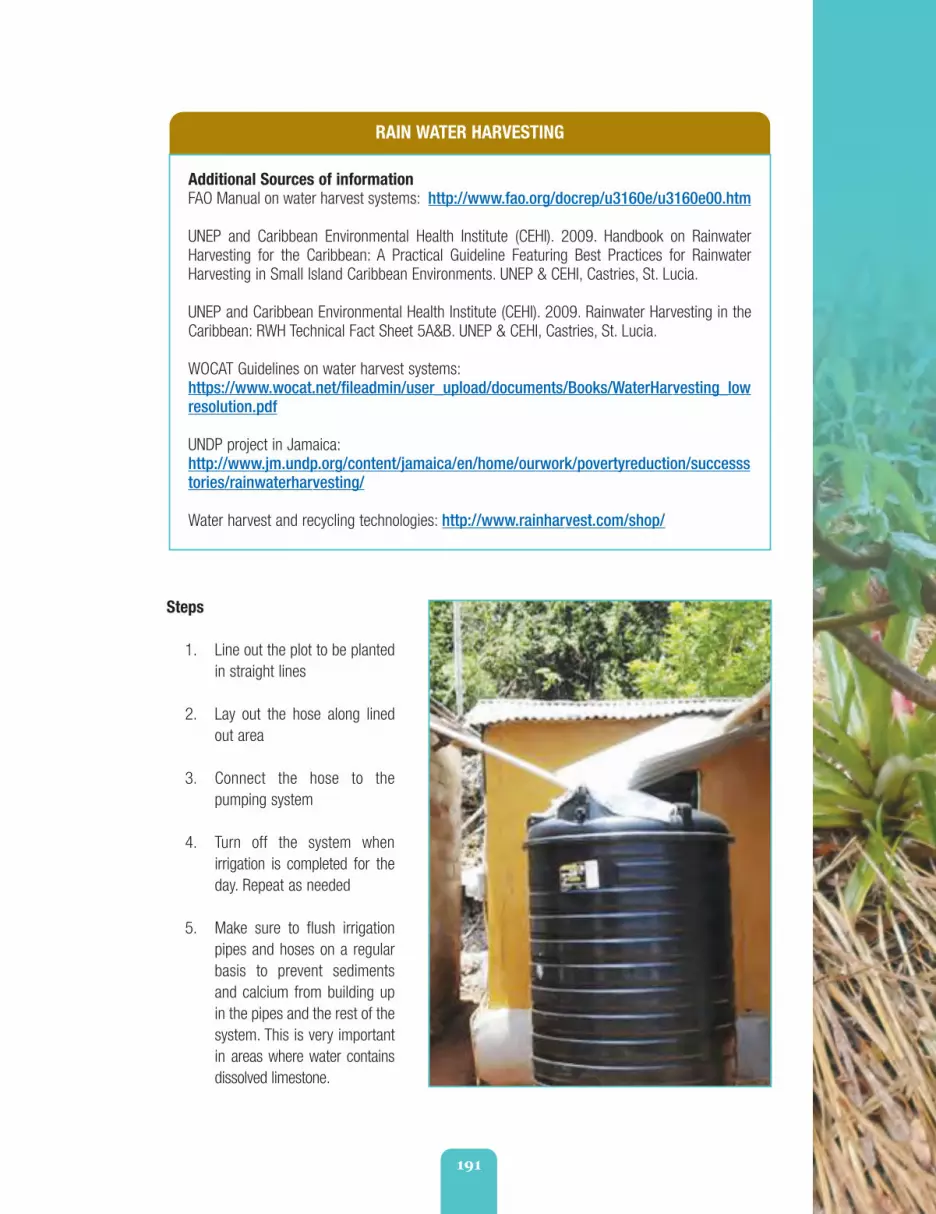
191
RAIN WATER HARVESTING
Additional Sources of informationFAO Manual on water harvest systems: http://www.fao.org/docrep/u3160e/u3160e00.htm
UNEP and Caribbean Environmental Health Institute (CEHI). 2009. Handbook on RainwaterHarvesting for the Caribbean: A Practical Guideline Featuring Best Practices for RainwaterHarvesting in Small Island Caribbean Environments. UNEP & CEHI, Castries, St. Lucia.
UNEP and Caribbean Environmental Health Institute (CEHI). 2009. Rainwater Harvesting in theCaribbean: RWH Technical Fact Sheet 5A&B. UNEP & CEHI, Castries, St. Lucia.
WOCAT Guidelines on water harvest systems:https://www.wocat.net/fileadmin/user_upload/documents/Books/WaterHarvesting_lowresolution.pdf
UNDP project in Jamaica:http://www.jm.undp.org/content/jamaica/en/home/ourwork/povertyreduction/successstories/rainwaterharvesting/
Water harvest and recycling technologies: http://www.rainharvest.com/shop/
Steps
1. Line out the plot to be plantedin straight lines
2. Lay out the hose along linedout area
3. Connect the hose to thepumping system
4. Turn off the system whenirrigation is completed for theday. Repeat as needed
5. Make sure to flush irrigationpipes and hoses on a regularbasis to prevent sedimentsand calcium from building upin the pipes and the rest of thesystem. This is very importantin areas where water containsdissolved limestone.
fao_climate_smart_manual_part_2_3.qxd 10/23/14 1:39 PM Page 191

192
Extension Method Tips
If you have internet, show your choice of a number of videos that the United Nations DevelopmentProgramme (UNDP) has made interviewing farmers about their rain harvesting and irrigation systems.
1. http://www.youtube.com/watch?v=9e1176AvKGo&list=PL548595AF92AEC8F7
Other videos are also good discussion starters to consider.
2. http://www.youtube.com/watch?v=Eeqe-uRrzE8
3. http://www.youtube.com/watch?v=AV8OTnGq9UA
Rakstone a riva bottom no know sun hot. (A stone inthe bottom of the river has no idea the sun is hot).“ ”Man neva know di use of wata till di tank run dry.“ ”
Proverb/Testimonial Discussion Starters
1.
2.
Every day bucket a go a well, one day di bottom a go drop out.“ ”3.
fao_climate_smart_manual_part_2_3.qxd 10/23/14 1:39 PM Page 192

193
Unit 2.3.3 Fire Breaks and Fire Borders
Fire breaks have long been used in the large sugar cane estate areas of Jamaica and to a lesser extentin areas of St Elizabeth that use guinea grass mulch.
With climate change, drought periods will likely become hotter, drier and longer. Under these conditionsthere is increased risk of forest and bush fires. Farmers will need to take extra precautions to protecttheir farms, property and their soil, from possible fire damage by investing time and effort to constructfire breaks or fire banks around their farms.
Farmers assessing fire damage in Jamaica
fao_climate_smart_manual_part_2_3.qxd 10/23/14 1:39 PM Page 193

194
Best Bet Hazard Categories
Wind and Fire
By the end of this Unit, you should:
1. Know the fundamental importance of establishing fire breaks on farms, and
2. Be able to effectively communicate these benefits to farmers.
What are fire breaks or fire borders?
Fire breaks use a combination of agronomicmethods (planting) and clearing of land(structural) along a farm’s borders orboundaries - to create a fire resistant zonearound the farm.
If a bush fire breaks out on a farm nearby, thefire bank makes it more difficult for it to jumpand spread from farm to farm. Likewise, if abush fire accidently starts on your own farm, thefire border makes it less likely that the fire willspread to surrounding areas.
The technique involves: (1) planting a variety ofdifferent types of fire-resistant vegetation asbarriers along the farm’s border together with(2) the clearing of a swath of bare soil aroundthe external boundary of the farm.
As a result, two new borders are essentiallycreated. One is a border of bare earth overwhich fire should hopefully not cross. Next tothis border is an additional border of fire-resistant plants or trees that should further helpreduce the spread of any fire that might happento cross. By using fire-resistant trees along theborder, damage from wind and storms can alsobe reduced.
Fire breaks and fire borders help to:
• Reduce crop-loss from bush fires
• Add protection against wind damage instorms
• Reduce soil moisture loss throughshading and wind reduction.
fao_climate_smart_manual_part_2_3.qxd 10/23/14 1:39 PM Page 194

195
FIRE BREAKS AND FIRE BORDERS
Slope All slopes.
Soil All soils.
Agro-Ecological Zones Good for all AEZs where drought is prevalent and where bushfires are a threat. Suitable for all farm sizes.
Crops Long used to protect sugar cane plantations. Good also formixed vegetable production.
Advantages • Reduced crop-loss from bush fires. Added protectionagainst wind damage in storms. Reduced soil moistureloss through shading and wind reduction
• Low cost
• Little labour required
• Suitable for farmers who continue to practice slash andburn land preparation on their farms.
Disadvantages • Need to have water and nutrients to establish the cropsto be grown along the break
• Regular maintenance is required of the vegetationbarriers and/or removal of undergrowth
• Farmers have to sacrifice a swath of land along theirfarm perimetres to create the border
• The border does not produce any income or have anyother agronomic benefit.
Cost Labour
Equipment for establishing bare soil fire breaks such asshovels, ploughs, small tractors
Fire resistant seedlings.
Materials Needed Input and labour if bare soil firebreaks are used
Fire resistant seedlings for planted firebreaks on small farmersor community-level fire reduction planning schemes.
Recommended species Anacardium occidentale (Cashew), Dichrostachys cinerea, Gmelinaarborea.
fao_climate_smart_manual_part_2_3.qxd 10/23/14 1:39 PM Page 195

196
Steps
1. Clear a strip of land along the perimetre of the field making sure to remove all undergrowth.Make sure this border is at least 3.5 metres or 15 feet wide. This will be the fire border andshould go on the outside perimetre of your farm
2. Next to that, clear an additional width of land to accommodate the full grown size of the fire-resistant border you have decided to establish
3. Plant desired fire-resistant hedgerows according to recommended planting procedures withinthe vegetative fire strip
4. Ensure that the top and bottom borders follow proper contour line procedures as outlined inUnits 2.1.2 and 2.1.3
5. Establish soil conservation measures along the slope where the border is being established toreduce soil erosion. Good methods to consider are small stone gully plugs at regular contourintervals - depending on your slope
6. Establish retaining walls on the upper slope border and the lowest border to reduce soil erosion
7. Weed and clean the bare soil border on a regular basis to ensure that dried plant trash doesnot litter the safe zone
8. Prune the vegetation barriers as needed
9. Clear and maintain the borders before every dry season.
Additional Bush Fire Tips
• If you insist on burning plant trash on your farm, try to burn it in metal drums with holes on thesides and cover the top so the fire does not spread
• Ensure that the land around the drum is bare and clear with a 3.5 metre or 15 foot radius
• Avoid burning any material on your farm on windy days, especially during dry seasons
• Never let a fire be unattended
• Be prepared to deal with the fire, should it accidently escape. Be sure to have water or othermaterials (tarps, soil) to quickly catch it before it spreads
• If it does, get help. Make sure to warn and notify neighbours.
fao_climate_smart_manual_part_2_3.qxd 10/23/14 1:39 PM Page 196

197
Extension Method Tip
Read this story from the Jamaican Observer that describes some of the impact that bush fires can haveon Jamaican farms now and then use the article to start a discussion about what farmers believe theycan do to minimize their own risk, and risk to others.
http://www.jamaicaobserver.com/news/124251_Disaster-response-workers-learn-how-to-deal-with-bush-fires
fao_climate_smart_manual_part_2_3.qxd 10/23/14 1:39 PM Page 197

198
Sweet wood blaze, but ‘im no keep fiah. (Sweet woodblazes, but can’t keep a fire). Romantic flings
can be passionate, but they won’t last).“
”Ole fiah ‘tick eezy fi ketch. (Old fire stick is easy to catch).
An old love flame is easy to reignite.“ ”
Proverb/Testimonial Discussion Starters
1.
2.
fao_climate_smart_manual_part_2_3.qxd 10/23/14 1:39 PM Page 198

Climate Smart Hurricane& Wind Resistant Measures
Part
2
Section Four
fao_climate_smart_manual_part_2_4.qxd 10/23/14 1:42 PM Page 199

200
One of the most serious types of disasters that can affect farm productionand devastate soils are hurricanes and strong winds. This section looks atadditional measures that can be taken to reduce the impact that severewinds and storm events can bring to Jamaican farmers. These measuresinclude:
Unit 2.4.1 - Establishing Windbreaks and Hedgerows for Protection
Unit 2.4.2 - Growing Wind Resistant Crops, and
Unit 2.4.3 - Triangular Bracing for Bananas.
You will see that Units 2.4.1 and 2.4.2 are additional agronomic practicesfor your farmers to consider. Unit 2.4.3 on the other hand, suggests waysto limit the impact caused solely to bananas and plantains, if these are partof your farmers’ crop production mix.
HURRICANE & WIND
Overview
fao_climate_smart_manual_part_2_4.qxd 10/23/14 1:42 PM Page 200

201
Unit 2.4.1 Windbreaks or Shelterbelts
By the end of this Unit, you should:
1. Appreciate the benefits of establishing windbreaks to reduce crop damage from strong windimpacts, and
2. Be able to effectively communicate these benefits to farmers.
Wind breaks at the Jamaica Producersplantation in St. Mary protecting
bananas and pineapple
Plants growing between well-establishedagro-forestry windbreaks
Best Bet Hazard Categories
Strong Winds
fao_climate_smart_manual_part_2_4.qxd 10/23/14 1:42 PM Page 201
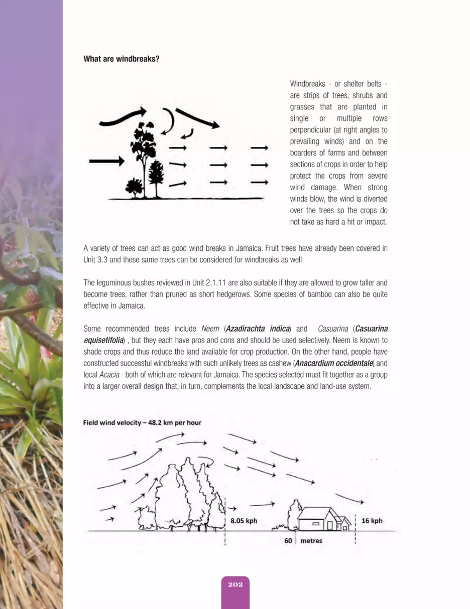
202
A variety of trees can act as good wind breaks in Jamaica. Fruit trees have already been covered inUnit 3.3 and these same trees can be considered for windbreaks as well.
The leguminous bushes reviewed in Unit 2.1.11 are also suitable if they are allowed to grow taller andbecome trees, rather than pruned as short hedgerows. Some species of bamboo can also be quiteeffective in Jamaica.
Some recommended trees include Neem (Azadirachta indica) and Casuarina (Casuarinaequisetifolia) , but they each have pros and cons and should be used selectively. Neem is known toshade crops and thus reduce the land available for crop production. On the other hand, people haveconstructed successful windbreaks with such unlikely trees as cashew (Anacardium occidentale) andlocal Acacia - both of which are relevant for Jamaica. The species selected must fit together as a groupinto a larger overall design that, in turn, complements the local landscape and land-use system.
What are windbreaks?
Windbreaks - or shelter belts -are strips of trees, shrubs andgrasses that are planted insingle or multiple rowsperpendicular (at right angles toprevailing winds) and on theboarders of farms and betweensections of crops in order to helpprotect the crops from severewind damage. When strongwinds blow, the wind is divertedover the trees so the crops donot take as hard a hit or impact.
fao_climate_smart_manual_part_2_4.qxd 10/23/14 1:42 PM Page 202

203
Ideal windbreak species are trees that are fulland bushy and can withstand a wide range ofweather conditions, including drought, strongwinds and salt air.
The best windbreaks are semi-permeable (i.e.,allowing some wind to get through), but at aslower speed or velocity.
Trees work well when grasses and herbaceousplants are also planted at the base of theshelterbelt trees to protect the wind fromeroding the surrounding soil.
The shelterbelts are sited on the upwind side ofthe land to be protected and are most effectivewhen planted perpendicular to the prevailingwind direction.
Sometimes large areas are protected byseveral parallel shelterbelts. Research showsthat wind speed is reduced on both sides of thebarrier when this is done.
Orientation
Windbreaks are most effective when orientedat right angels (perpendicular) to the prevailingdirection of the wind. To allow for changes inwind direction, windbreaks are often planted inmultiple directions to form an “L”, a “U” or an“E” shape.
The ideal windbreak should be located on thewindward side of the land area to be protected.
When orienting the windbreak, avoidplacement that may cause future managementproblems such as interference with utilities orroad visibility.
By considering these factors, an effectivewindbreak can be designed to meet thefarmer’s or landowner’s objectives and to helpprotect crops.
Spacing and Density Considerations
A windbreak is designed to slow and filter thewind, but not to block it entirely. If a windbreakis too dense it can lead to severe turbulenceover the crop area. Ideally, windbreaks areabout 20% to 50% permeable. This can beachieved with the correct spacing of the trees.Spacing within rows should be laid out sowhen trees in the windbreaks are mature thecrowns of the trees will touch or overlapslightly, but not crowd each other. Plantingtrees too closely can cause early deteriorationof windbreaks, especially on dry, un-irrigatedsites due to excessive competition for wateramong trees. Wider spacing may mean that ittakes longer for windbreaks to becomeeffective, but will prolong the life of thewindbreak.
Species selection is important and will alsoaffect the density of a windbreak. The densitycan be managed by the selection of the treespecies, the spacing of the trees, and thenumber of rows in the windbreak.
fao_climate_smart_manual_part_2_4.qxd 10/23/14 1:42 PM Page 203

204
WINDBREAKS OR SHELTER BELTS
Slope Suitable for all slope conditions.
Soil Suitable for all soil types.
Agro-Ecological Zones All AEZs vulnerable to hurricane damage or strong winds.
Crops Suitable for all crop types.
Advantages • Improved crop quality and yield by protecting crops fromwind damage
• Can help to protect crops from extremes of salt spray orhot, dry winds and dusts
• Physical damage to soils, crops, pasture and animals isreduced
• Temperature of soil and air behind shelterbelts is modified
• Moisture loss (caused by high winds) is reduced therebyreducing evaporation and transpiration
• Leaves from shelterbelt can help to fertilise fields and beused as mulch
• Some species can provide fodder for animals or fuel
• Other species can provide fruits, nuts or valuable timber
• Soil erosion can be prevented
• Micro ecosystems for beneficial insects and wildlife habitatscan be provided
• Some trees that are good for windbreaks can also providelumber and fuel wood or fence posts
• Fruit tree windbreaks can provide additional income
• Nitrogen fixing trees can help replenish soil nutrients
• Windbreaks can also help to increase property value andimprove the aesthetic value and/or recreational value ofthe property
• Windbreaks also help to improve the overall ecologicaland economic sustainability of the land through the additionof diverse species to the farming system
• Reduction in noise levels.
fao_climate_smart_manual_part_2_4.qxd 10/23/14 1:42 PM Page 204

205
WINDBREAKS OR SHELTER BELTS
Disadvantages • The space that the shelterbelt takes up reduces the overallland available to the farmer
• If not established correctly and managed properly,windbreakscan create or exacerbate wind damage rather than preventit
• The trees that make up the shelterbelt may competewith crops for water or nutrients, leading to decreasedproduction
• Windbreaks may create too much shade thus inhibitingcrop growth
• Windbreaks are a long-term investment in trees, planningtime and installation. The benefits will not be experienceduntil several years after establishment
• Pests and diseases may develop in the trees and shrubsand spread to nearby crops
• Shelterbelts need continual maintenance to ensuremaximum efficiency
• A badly designed shelterbelt, or one which has developedgaps, will allow wind to be funnelled through at a veryhigh speed, resulting in damage
• Poorly managed windbreaks may damage power lines,utilities, buildings, and infrastructure in the event ofstrong winds.
Cost • Cost of land preparation
• Cost of seedlings
• Cost of labour.
Recommended species 1. Neem
2. Casuarina
3. Eucalyptus (but in conjunction with other bushes)
4. Cashew (Anacardium occidentale) and
5. Local Acacia spp.
6. The species selected must fit together as a group into alarger overall design that, in turn, complements the locallandscape and land-use system.
See Units 2.2.1 for suggestions.
Additional Sources of informationhttp://permaculture-and-sanity.com/pcarticles/designing-multi-use-windbreaks.php
http://www.nrcs.usda.gov/Internet/FSE_PLANTMATERIALS/publications/hipmssy6712.pdf
fao_climate_smart_manual_part_2_4.qxd 10/23/14 1:42 PM Page 205

206
Steps
1. Determine the direction of the prevailing winds on the site and identify the location for theshelterbelts accordingly
2. Follow the other steps outlined in Units 3.3 and 3.5 to prepare the land for the trees to beplanted depending on the direction of the prevailing winds. However, in this case, the treesshould be planted twice as closely as their recommended spacing and then thinned out every-other year after the get to be 8 to 10 years of age. This will give a denser windbreak soonerthan planting the trees at their mature spacing, and will also yield some useful product (poles,firewood, etc) from the thinned trees.
Windbreak Care and Maintenance
1. Water newly-planted trees deeply and regularly for the first couple of years and thereafter asneeded. Using individual basins (Unit 2.1.8) to plant the trees will help with moisture retention
2. Maintain mulch around trees at least 2 or more inches deep. Replace mulch as needed,including a high proportion of tree leaves or needles in the mix as trees like a lot of organicmatter but don’t need - or like - highly-rich soil (in mature forests most nutrients are tied upin existing tree tissues).
Extension Method Tip
Include this exercise as part of your farmer watershed transect walk exercise. Try to have farmersidentify sites that were less affected by strong winds in the last hurricane that affected their area. Weretheir trees that provided protection or other shelters that lessened the impact? Was damage worse inareas that had no wind break protection at all?
Use this line of questioning to help farmers think about the value of trees as windbreaks.
Big breeze blow, di trees dem shake.(When the big winds blow, the trees shake).“ ”
Cotton tree no know how ‘im bottom stand, ‘im nocall breeze. (If the cotton tree wasn’t sure it stood solidly,
it would not have called the wind).“
”
Proverb/Testimonial Discussion Starters
1.
2.
fao_climate_smart_manual_part_2_4.qxd 10/23/14 1:42 PM Page 206

207
Unit 2.4.2 Growing Wind Tolerant Crops1
Several farmers are already changing the types of crops they grow during hurricane season. Ratherthan taking the risk of growing crops that they know are vulnerable to strong winds and hurricanes,some farmers on their own are simply switching to, or back to, crops that they know can withstandhurricane winds more easily.
By the end of this Unit, you should:
1. Appreciate the benefits of planting wind-resistant crops, and
2. Be able to effectively communicate these benefits to farmers.
1
https://www.google.com.jm/search?q=Jamaican+tuber+crops+photos&biw=1477&bih=705&tbm=isch&imgil=rVRSQ1rTn9E7FM%253A%253Bhttps%253A%252F%252Fencrypted-tbn2.gstatic.com%252Fimages%253Fq%253Dtbn%253AANd9GcRfWE6bYPSb_ZhwyzncCk7DYqUpMCc6xIw208nD0KI3kApImUiA%253B540%253B350%253B7O7pIVvmQ_Yc3M%253Bhttps%25253A%25252F%25252Fearthdata.nasa.gov%25252Ffeatured-stories%25252Ffeatured-research%25252Fgrowing-jamaica&source=iu&usg=__jaSstdXe7S4pzGCog-3uqq1f7YU%3D&sa=X&ei=—ODU77YMofmsASMkIIQ&ved=0CDgQ9QEwCA#facrc=_&imgdii=_&imgrc=gw336qxxvAJllM%253A%3BxXVPvJFM0M3KSM%3Bhttp%253A%252F%252Fupload.wikimedia.org%252Fwikipedia%252Fcommons%252F3%252F3d%252FIpomoea_batatasL_ja01.jpg%3Bhttp%253A%252F%252Fen.wikipedia.org%252Fwiki%252FYam_(vegetable)%3B800%3B450
fao_climate_smart_manual_part_2_4.qxd 10/23/14 1:42 PM Page 207

208
Best Bet Hazard Categories
Strong Winds
Even if wind damages their leaves aboveground, there is less likely to be damage to theactual tuber underneath and your plants willrecover faster. The trick is just to know whichtuber crops will do best on local soil conditions.
Other crops are dwarf variety fruit tree cropssuch as dwarf mangos and June plum trees.These can also be incorporated into thefarming system.
Both dwarf trees and tuber crops are alsoimportant for climate smart land husbandry.
What are wind tolerant crops?
Some crops survive strong wind conditions much better than other crops. Most tuber crops forexample, especially those with vines that are allowed to run on the ground - do very well in storms.Sweet potato, yams, eddoes (cocos), potatoes, turnips and beets - all fit in this category.
fao_climate_smart_manual_part_2_4.qxd 10/23/14 1:42 PM Page 208

209
WIND TOLERANT CROPS
Slope All slope conditions.
Soil All soil conditions.
Agro-Ecological Zones • Suitable for all AEZs in Jamaica
• More suitable for smaller farms but can be employed onlarger farms and adapted for sugar estates (for example).
Advantages • Reduced damage to crops by wind
• Maximization of land use area.
Disadvantages • Wind resistant crops may not fetch the best prices ormarkets but they are less risk than investing cropswhich may be more lucrative, but also more risky
• Harvest of tubers should be done in dry periods,harvesting before strong rains can produce high erosion.
Cost • Cost of crop/planting material
• Labour.
Recommended Crops • Sweet potato
• Irish potato
• Carrot
• Beets
• Turnip
• Parsnip.
fao_climate_smart_manual_part_2_4.qxd 10/23/14 1:42 PM Page 209

210
Extension Method Tips
Ask farmers to recall - from their experience - which crops, if any, were able to cope with hurricanewinds. Try to generate a list from the participants and get them to analyze why some crops did betterthan others. Why do think some crops did better than others? What was different in terms of heightbetween the crops that survived and those that did not?
Use this line of questioning to help farmers see that some crops are more wind resistant then others.
Dwarf Mango Tree Dwarf June Plum Tree
Steps
1. Follow the steps outlined in Units 2.1.2 and 2.1.3 for establishing proper contours with an A-Frame
2. Plant your choice of wind resistant crops according to recommendations - following the contours
3. For vine producing crops, use cover cropping methods discussed in Unit 2.2.4 or minimumtillage discussed in Unit 2.2.5
4. For dwarf trees, follow recommended planting methods and steps covered in Unit 2.2.1.
If yu wan roast yam, yu must satisfy fi burn ya finga.(If you want to eat roast yam, you have to accept that you will burn
your finger). Nothing good comes without some sacrifice.“
”Co-co mash ina soup no last. (Coco - edoe- mashed
into soup does not last). United we stand, divided we fall.“ ”
Proverb/Testimonial Discussion Starters
1.
2.
fao_climate_smart_manual_part_2_4.qxd 10/23/14 1:42 PM Page 210
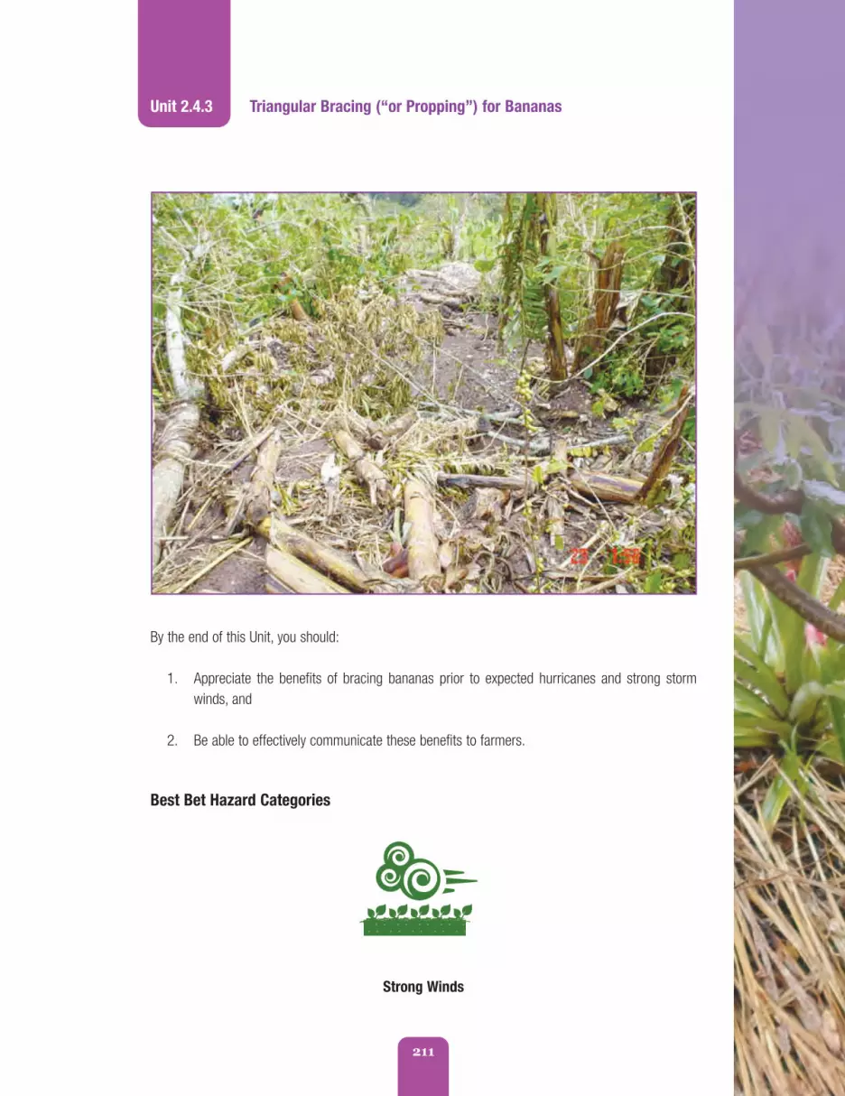
211
Unit 2.4.3 Triangular Bracing (“or Propping”) for Bananas
By the end of this Unit, you should:
1. Appreciate the benefits of bracing bananas prior to expected hurricanes and strong stormwinds, and
2. Be able to effectively communicate these benefits to farmers.
Best Bet Hazard Categories
Strong Winds
fao_climate_smart_manual_part_2_4.qxd 10/23/14 1:42 PM Page 211

212
What is the technique?
Triangular bracing (or propping as it is known in Jamaica) for bananas is a method that is widely usedby farmers in St. Mary and Portland. As soon as a bunch of bananas shoots, propping is done to providesupport. Large banana farms also practice this method but use wire cables and poly cord rather thanbamboo or other local materials.
The method provides additional support to the banana trees so they have a better chance ofwithstanding the strong winds that come with severe storms and hurricanes.
fao_climate_smart_manual_part_2_4.qxd 10/23/14 1:42 PM Page 212

213
TRIANGULAR BRACING (PROPPING) FOR BANANAS
Slope All slope conditions where bananas are cultivated.
Soil Banana growing areas.
Agro-Ecological Zones All areas where bananas are grown.
Crops Bananas and plantains.
Advantages • Suitable for small farms and sloping lands that aresusceptible to strong winds where banana is grownexcessively
• Reduced damage and losses due to wind impact
• If bananas do withstand wind damage, chances are theywill be in high demand after the storm and prices will behigh.
Disadvantages • Hurricane and storm warnings may not provide sufficienttime for farmers to brace all of their bananas before thestorm hits
• The technique reduce the damages but if winds are strongdo not avoid some loss.
Cost Bamboo and wooden stakes
Metal rings (not always needed, expensive)
Cables for bracing (not always needed, can be expensive)
Extra labour.
Tools Machete, cutlass, hoe, wire cutters.
Recommended species Bananas and Plantains.
Additional Sources of informationReducing natural hazard impacts on bananas: integrated practices, Haiti - See more at:http://teca.fao.org/read/6864#sthash.oDIwyw0W.dpufhttp://teca.fao.org/read/6864
Jamaica Banana Board - Catastrophe Manual.http://www.thebananaboard.org/pdf/disaster%20mit%20man.pdf https://www.agriskmanagementforum.org/sites/agriskmanagementforum.org/files/Caribbean%20Risk%20Mitigation%20Module%201.2%20-%20Adaptation%20Measures%20for%20Weather%20Risk.pdf
fao_climate_smart_manual_part_2_4.qxd 10/23/14 1:42 PM Page 213

214
Steps
1. Prepare 2-to-3 metre high stakes/poles (or roughly 6 to 9 feet)
2. Cut one end on an angle to support the banana plant when it is put into position
3. To make the stakes more secure, first dig a hole (10 cm or roughly 5 inches) for each pole atthe exact spot where it will be put into the ground to stake the plant
4. If you can afford to, place a metal or rubber ring around banana stem immediately below thefruiting area to give extra support
5. Next, place the bamboo brace on the up-slope side (front side) of banana tree with the “kotch”firmly braced below the ring while the other end is firmly planted in the soil at an angle of about45 degrees to the brace. This should be the side to which the banana will most likely fall
6. Then firmly peg each end of the cables in the soil on the up-slope side of the tree. Thetriangular configuration provides resistance to wind from all directions.
Extension Method Tips
Start a discussion using this article about the devastating losses to banana farmers after HurricaneSandy hit Jamaica in October 2012.
http://jamaica-gleaner.com/gleaner/20121029/news/news1.html
fao_climate_smart_manual_part_2_4.qxd 10/23/14 1:42 PM Page 214

215
fao_climate_smart_manual_part_2_4.qxd 10/23/14 1:42 PM Page 215

216
fao_climate_smart_manual_part_2_4.qxd 10/23/14 1:42 PM Page 216

217
If plaantn know ‘im neck gwine bruk, ‘im nebberwoulda shoot. (If plantain had known that its neck
would break, it never would have borne fruit).“
”Plaantn wan’ ded, ‘im go a hillside fi shoot.
(When a plantain wants to die, it goes to a hillside to shoot).“ ”
Proverb/Testimonial Discussion Starters
1.
2.
Good proverb discussion starters for this technique include:
fao_climate_smart_manual_part_2_4.qxd 10/23/14 1:42 PM Page 217

218
My Notes
fao_climate_smart_manual_part_2_4.qxd 10/23/14 1:42 PM Page 218

Climate-SmartLand Husbandry in Jamaica:
A Manual for Extension
Appendices
fao_climate_smart_manual_back.qxd 10/23/14 1:44 PM Page 219

220
APPENDIX
A KNOWN IMPACT OF HURRICANE ON THE AGRICULTURAL SECTORSources: Spence (2008) and Ministry of Agriculture and Fisheries (April, 2014).
Type of Disaster Date Sector Economic Impact
Hurricane Gilbert 1988 EntireAgricultureSector
Domestic crop damage J$769 million (at 1988exchange rates); banana industry was totallydestroyed; 60% loss of bearing coconut trees;30-40% loss of citrus production; 17% loss ofsugar cane; trees stripped of foliage; 90% ofpoultry/broiler stock destroyed; 80% oftourism/hotel sector damaged; major damageto entire island’s road network1
60% of coffee damaged2 Overall cost to thesector 8.8 Billion Jamaican Dollars
Hurricane Ivan 2004 Coconut Increased costs in insurance for the sector -$4.50 per $100 of insurance3 Overall losses -8.55 billion Jamaican dollars - 27.6 ofAgriculture Gross Domestic Product (GDP)
Hurricane Dean August2007
All sectors 3.76 Billion Jamaican dollars lost, 9.1% ofAgriculture GDP
2007 Poultry At least 100,000 day-old chicks dumped5
20,000 to 30,000 birds lost in the field6
Banana 90-100% of banana cultivation devastated inPortland and St. Mary4
Hurricanes Emily,Dennis and Wilma
2005 All sectors Losses of 0.99 billion Jamaican dollarssustained. 27% of Agriculture GDP lost
1 ODPEM. 10 September 2008. “Jamaica 20th Anniversary of Hurricane Gilbert’s Impact on Jamaica”http://www.cdera.org/cunews/news_releases/jamaica/printer_2225.php
2 Jamaica Recovers from Hurricane Disaster. (https://entrepreneur.com/tradejournals/article/11921188.html)3 Brown, Jermain O. July 26, 2005. “Coconut Board Urges Farmers to Minimise Loss During the Hurricane Season”.
(http://www.jis.gov.jm/tools/printable.asp?print=/agriclture/html/20050723T100000-0504 FAO/GIEWS Global Watch. 22 August 2007. “Thousands in Need of Humanitarian Assistance After Hurricane Dean:
Banana Plantations Destroyed on Several Islands” (http://www.fao.org/GIEWS/english/shortnews/carib070822.htm)5 “Damage by Dean Hurting Poultry Farmers”. (http://www.jamaica-gleaner.com/gleaner/20070828/news/news5.html)6 “Jamaica Broilers Group Resumes Full Operations - Minimally affected by Hurricane Dean” August 29, 2007.
(http://www.jamaica-gleaner.com/gleaner/20070829/business/business8.html)
fao_climate_smart_manual_back.qxd 10/23/14 1:44 PM Page 220

221
Type of Disaster Date Sector Economic Impact
TropicalStorm Gustav
2008 Overallimpact onagriculturalsector
Overall damage estimated at 1.63 billionJamaican Dollars and 3.3% of agricultural GDPlost
2008 Coffee Damage to crops: $J108 million or 6% of totalcrop value; damage to farm roads: J$30 million
Damage to private farm roads: $J 3.5 million7
2008 Coffee 5-10 percent of production damage to coffeetrees; high increases in insurance costs and inpesticides and farm chemicals8
TropicalStorm Nicole
2010 OverallImpact
0.58 billion Jamaican dollars
Hurricane Sandy 2012 Overallimpact
1.43 billion Jamaican dollars
Unnamed lowpressure system
2011 Overallimpact onsector
0.14 billion Jamaican dollars
Total 25.88 billion Jamaican dollars since 1988
7 Gentles, Christopher C. Friday, September 26, 2008. “How Hurricanes are Undermining Jamaica’s Coffee Industry”(http://www.jamaica-gleaner.com/gleaner/20080926/business/business5.html
8 Damaged Roads, Drains from Tropical Storm Cited as Setbacks to Coffee Sector. September 23, 2008.(http://www.jis.gov.jm/tools/printable.asp?print=/agriclture/html/20080923t100000-050
fao_climate_smart_manual_back.qxd 10/23/14 1:44 PM Page 221

222
APPENDIX
B GLOSSARY
“Adaptation” - is the adjustment in natural or human systems in response to actual or expectedclimate occurrences or their effects, which reduces harm or takes advantages of beneficialopportunities. For people, it means being ready for climate change by building capacity and puttingmeasures in place to cope with and recover from the impacts of climate change. It also meanspreparing ourselves to live with any climate-induced change to our surroundings.
“Aerosols” - Solid or liquid particles suspended within the atmosphere. Particularly bad for the ozonelayer are sulphate aerosols and “black carbon aerosols”. Black carbon aerosols are produced byinefficient combustion of fossil fuels or biomass. Black carbon aerosols absorb light from the sun,shading and cooling the Earth’s surface, but contribute to significant warming of the atmospherethrough “radiative forcing”.
“Afforestation” - Planting of new forests on lands that have not been recently forested.
“Alternative Livelihoods” - Alternative activities to generate income in the event that existinglivelihoods are threatened by natural disasters or climate change.
“Atmosphere” - Includes the air or layers of gases that surround the Earth. The dry atmosphereconsists almost entirely of nitrogen and oxygen (what we need for our bodies’ survival), together withsmall amounts of other gases, including greenhouse gases such as carbon dioxide and ozone. Inaddition, the atmosphere contains water vapour, clouds and aerosols. The atmosphere protects theEarth from the sun’s harmful rays.
“Biodiversity” - The variety of organisms found within a specified geographic region.
“Biomass” - the total quantity or weight of organisms in a given area or volume. Organic matter usedas a fuel, especially in a power station for the generation of electricity
“Calibrate” - to mark or gauge an instrument
“Carbon Dioxide” - Is a colourless, odourless, non-poisonous gas that is a normal part of ambient air.Of the six greenhouse gases (GHGs) normally targeted, carbon dioxide contributes the most to globalwarming and thus, climate change. Human activities such as burning fossil fuels (for gas, electricity,cooking, industry) and deforestation have increased atmospheric concentrations of carbon dioxide byapproximately 30 percent since the industrial revolution.
“Carbon Sink” - Any process, activity or mechanism that removes carbon-containing compounds likegreenhouse gases and aerosols from the atmosphere.
fao_climate_smart_manual_back.qxd 10/23/14 1:44 PM Page 222

223
Trees, plants and oceans can act as carbon sinks but may not always remove carbon from theatmosphere as fast as it is produced. Simple practices, like composting rather than burning yard andplant trash, also act as climate sinks that individuals can implement.
“Climate Change” - Any statistically significant, long-term change in the climate of a zone or region.Climate change may be caused by natural processes or by persistent changes in the atmosphere or inland use caused by human activity. When the term is used to describe what is happening to the earthtoday, it refers to the earth’s temperature and changes in rain, snow or other moisture from theatmosphere, caused by greater levels of CO2 and other gases in the atmosphere. The term ‘climatechange’ is often used interchangeably with ‘global warming’. The term ‘climate change’ is a better termbecause it covers many other changes, besides rising temperature.
“Climate Resilience” - Climate resilience describes a person, household, community or country thathas been able to reduce its vulnerability to climate change and reduce its risk to climate impacts.
“Climate” - Is the average, or typical, weather conditions of a given area observed over a long periodof time (usually 30 years or more).
“Community Based Adaptation” - Community based climate change adaptation is an approach toclimate change adaptation that focuses on the immediate problems and climate impacts that localcommunities face and considers the existing resource base for addressing community priorities. CBAis widely appreciated to be highly participatory in nature and is an approach that does not prescribeready-made solutions to climate change, but involves identifying a range of options with communitymembers in conjunction with service providers.
“Condensation” - Is the process through which water vapour in the air turns into liquid. Water dropsoutside of a cold glass of water are condensed water formed by the cooling of the water vapour in theair on the outside of the glass. Condensation is the opposite of evaporation.
“Coping Strategies” - The strategies that people use to survive and cope during times of disaster andclimate change. Coping strategies will vary depending on people’s resource base. The richer theresource base they have, the more likely they are to cope and the less vulnerable they are. People withpoor financial resources, physical assets, social capital and natural resources are more at risk and aremore likely to resort to poor coping strategies that make them even more vulnerable (such as sellingtheir fishing boat to buy food, taking children out of school, and so on). Households with moreresources can bounce back from climate impacts and disaster much more easily.
“Culvert” - a funnel or open drain carrying water along the side of a road
“Deforestation” - The removal of tree forest cover (either legally or illegally).
“Ecosystem” - A geographical area where a community of living (plants and animals) and non-living(climate, landscape) things interact together and affect each other.
fao_climate_smart_manual_back.qxd 10/23/14 1:44 PM Page 223

224
“Embankment” - a wall of earth or stone built to prevent a river from flooding
“Emissions” - The release of substances (e.g., greenhouse gases) into the atmosphere.
“Enhanced Greenhouse Effect” - The increase in the natural greenhouse effect resulting fromincreases in atmospheric concentrations of greenhouse gases (GHGs) due to emissions from humanactivities.
“Erosion” - the gradual destruction or diminution of something. The process of eroding or being erodedby wind, water, or other natural agents.
“Evaporation” - The process by which a liquid becomes a gas. When the sun heats up water in rivers,streams, lakes or ponds, or the ocean or moisture in the soil, it turns some of it into vapour or steam.The water vapour or steam leaves the source of water or moisture and goes in the air where iteventually forms clouds and falls back down to the earth as rain or snow. Evaporation is an essentialpart of the water cycle and is the reverse of condensation.
“Evapotranspiration” - The process by which water re-enters the atmosphere through evaporationfrom the ground and transpiration by plants.
“Extreme Weather” Events - An extreme weather event is one that is rare within a given period of timeat a particular place. Examples are heat waves, cold snaps/spells, droughts, floods (and the landslidesthat often accompany them), storms, cyclones, hurricanes and storm surges.
“Fording” - a shallow spot in a river that allows a vehicle or person to cross when the river is dry
“Forest Farming” - Forest farming is the cultivation of high-value specialty crops under a forestcanopy that is intentionally modified or maintained to provide shade levels and habitat that favor growthand enhance production levels
“Fossil Fuels” - Are fuels that are produced by the remains of living organisms that built upunderground over geological periods. Fossil fuels mainly consist of carbon and hydrogen and are alsoknown as “hydrocarbons”. They are found in different states: liquid (for example, oil), solid (for example,coal and peat) and gaseous (for example, natural gas).
“Global Warming” - Is often used instead of climate change and has the same meaning. However,global warming is a less accurate term because it connotes mainly increases in temperature only,whereas “climate change” also includes consideration of rainfall, sea surface temperature and otherfactors.
“Greenhouse Effect” -The greenhouse effect is the rise in temperature that the Earth experiencesbecause certain gases in the atmosphere (for example, water vapour, carbon dioxide, nitrous oxide,methane and ozone) trap energy from the sun.
fao_climate_smart_manual_back.qxd 10/23/14 1:44 PM Page 224

225
“Greenhouse Gases” - The atmospheric gases that absorb and emit radiation at specific wavelengthswithin the spectrum of infrared radiation emitted by the Earth’s surface, the atmosphere and clouds.Water vapour (H2O), carbon dioxide (CO2), nitrous oxide (N20), methane (CH4), and ozone (O3) are theprimary greenhouse gases in the Earth’s atmosphere.
“Husbandry” - The care, cultivation and breeding of crops and animals
“Intergovernmental Panel on Climate Change” (IPCC) - Established in 1988 by the WorldMeteorological Organisation of the UN Environment Programme, the IPCC surveys world-wide scientificand technical literature and publishes assessment reports that are widely recognised as the mostcredible sources of information on climate change.
“Invasive Species” - A species occurring in an area outside of its historically known natural range asa result of intentional or accidental dispersal by human activities. Also known as alien or exotic species.
“Kyoto Protocol” -An international agreement that is linked to the United Nations FrameworkConvention on Climate Change (UNFCCC). Its major feature is that it sets binding targets for 37industrialised countries and the European Community for reducing greenhouse gas emissions.
“Livelihood Based Approach” - The Livelihood Based Approach (LBA) seeks to identify climateresiliency strategies by first studying climate impacts on local livelihoods and then identifying potentialoptions for addressing livelihood impacts.
“Micro-climate” - the climate of a very small or restricted area, especially when this differs from theclimate of the surrounding area.
“Mitigation” - involves measures to reduce greenhouse gas emissions, by limiting activities thatproduce greenhouse gases, or to enhance the natural systems or sinks (carbon sinks) that removegreenhouse gases from the atmosphere. Without mitigation, climate change would continueunchecked and would eventually outstrip all our efforts to adapt.
“National Action Plans” - Are the plans that each country submits to the Conference of the Parties(COP) by all Parties outlining the steps that they have adopted to limit their greenhouse gas emissions.
“Parts per Million” - This is a way of measuring the concentration of one thing within another, forexample, carbon dioxide in the atmosphere. One part per million (PPM) of carbon dioxide means forevery 1 unit of carbon dioxide there are 1 million units of air (all the other gases that make up theatmosphere).
“Perpendicular” - at a right angle of 90 degrees to any given line or plane
“Photosynthesis” - The process a plant uses to combine sunlight, water, and carbon dioxide from theair (or bicarbonate in water) to produce oxygen and energy for its own growth (sugar).
fao_climate_smart_manual_back.qxd 10/23/14 1:44 PM Page 225
226
“Porosity” - the property of being porous and able to absorb fluids
“Precipitation” -Moisture that falls from the sky, including rain, snow and hail. Precipitation occurswhen so much water has condensed that the air cannot hold any more. The clouds get heavy and waterfalls back to earth in the form of rain, snow, hail, sleet, dew and frost.
“Protected Area” - An area of land or sea especially dedicated to the protection and maintenance ofbiological diversity, and of natural and associated cultural or historical resources, and managed throughlegal or other effective means.
“Recycling” - The process of reusing items that have already been used or turning them intoalternative items in order to avoid having to through them out in the trash, thereby contributing togreenhouse gas emissions.
“Reforestation” - Replanting of forests on lands that have recently been harvested.
“Renewable Energy” - Energy obtained from non fossil fuel sources such as geothermal, wind,photovoltaic, solar and biomass.
“Reservoirs” - A component or components of the climate system where a greenhouse gas or aprecursor of a greenhouse gas is stored. Trees are “reservoirs” for carbon dioxide.
“Rills” - a small stream or shallow channel cut in the surface of soil or rocks by running water.
“Riparian” - relating to or situated on the banks of a river
“Risk Reduction Plan” - A risk reduction plan is a community driven and designed plan that involvesall stakeholders in determining, and taking, steps to reduce risk and to become climate resilient.
“Risk” - Risk is the chance of injury, damage or loss defined as a measure of the probability andseverity of an adverse effect to health, property, the environment or other things of value.
“Salinisation” - The process of being impregnated with salt.
“Sea Water Intrusion” - The leakage or intrusion of salt sea water into underground fresh watersupplies.
“Semi-Permeable” - allowing certain substances to pass through it but not others, especially allowingthe passage of a solvent but not of certain solutes
“Sequestration” - Opportunities to remove atmospheric carbon dioxide either through biologicalprocesses (e.g., plants and trees), or geological processes through storage of carbon dioxide inunderground reservoirs.
fao_climate_smart_manual_back.qxd 10/23/14 1:44 PM Page 226

227
“Silvopasture” - the practice of combining forestry and grazing of domesticated animals in a mutuallybeneficial way
“Small Island Developing States (SIDS)” - Small Island Developing States or SIDS as they areknown, are countries in the Caribbean and Asia Pacific that generally have a small population andeconomic-resource base. As such they are small players on the world’s economic and political stageand while they generally have low carbon footprints of their own, they are highly vulnerable to climatechange and sea level rise.
“Spillway” - a passage for water from a dam.
“Toe drain” - A drain which carries seepage away from the dam and can allow seepage quantities tobe measured.
“UN Framework Convention on Climate Change” (UNFCCC) - This Convention provides an overallframework for efforts between governments to tackle the global challenge posed by climate change. Itrecognises the stability of the climate system, which is a shared resource, can be affected by industrialand other emissions of carbon dioxide and other greenhouse gases. The Convention has been ratifiedby 192 countries.
“Vector-borne diseases” - Disease that results from an infection transmitted to humans and otheranimals by blood-feeding anthropods, such as mosquitoes, ticks and fleas. Examples of vector-bornediseases include Dengue fever, viral encephalitis, Lyme disease, and malaria.
“Velocity” - the speed of something in a given direction
“Volatization” - The conversion of a chemical substance from a liquid or solid state to a gaseous orvapor state by the application of heat, by reducing pressure, or by a combination of these processes.Otherwise known as vaporization.
“Vulnerability” - The degree to which a natural, human or built system is susceptible to, or unable tocope with, adverse effects of climate change, including climate variability and extreme weather.Vulnerability depends on the scale or severity of the climate change effect, the extent to which thesystem is exposed, its sensitivity to changes, and its ability to adapt.
“Weather” - Short-term atmospheric conditions. Weather is measured by temperature, humidity, windspeed, atmospheric pressure, cloudiness and precipitation
fao_climate_smart_manual_back.qxd 10/23/14 1:44 PM Page 227

228
APPENDIX
C REFERENCES
Acunzo, Mario and Maria Protz. 2010. Collaborative Change: A Communication Framework For ClimateChange Adaptation and Food Security. Communication for Sustainable Development Initiative (CSDI),Food and Agriculture Organisation of the United Nations (FAO), Rome.
Ad Hoc Panel of the Board on Science and Technology for International Development, NationalResearch Council. 1992. Neem: A Tree for Solving Global Problems. National Academy Press.Washington, D.C.
Adapting to Climate Change: A Training Manual for Farmers. Prepared by the ACDI/VOCA for theMarketing and Agriculture for Jamaican Improved Competitiveness (MAJIC) Project.
American Society of Agronomy. 1993. Technologies for Sustainable Agriculture in the Tropics: ASASpecial Publication No. 56. American Society of Agronomy. Madison, Wisconsin.
Baum, Eckhard, Peter Wolff, Michael A. Zöbisch (Eds.) 1993. Acceptance of Soil and WaterConservation Strategies and Technologies. German Institute for Tropical and Subtropical Agriculture(DITSL), Witzenhausen, Federal Republic of Germany.
Bessette, Guy (Ed.). 2006. People, Land & Water: Participatory Development Communication forNatural Resource Management. IDRC, Ottawa.
Bigi A. 2011. Guide de référence sur les pratiques de lutte contre l’érosion dans le Département Sudd’Haïti, CESVI/ MARNDR, Les Cayes, Haïti (http://www.cesvi.org/UserFiles/File/guide_haiti_sud.pdf)Board on Science and Technology for International Development - National Research Council. 1993.Vetiver Grass: A Thin Green Line Against Erosion. Washington, D.C.
Brown, Jermain O. July 26, 2005. “Coconut Board Urges Farmers to Minimise Loss During theHurricane Season”.(http://www.jis.gov.jm/tools/printable.asp?print=/agriclture/html/20050723T100000-050.
Caribbean Farmers Network (CaFAN). 2009. Farmers Associations and Community-Based DisasterManagement in the Caribbean. CaFan, Saint Lucia and the Technical Centre for Agricultural and RuralCooperation (CTA).
Caribbean Institute of Media and Communication (CARIMAC), UWI. 2012. Report on Climate ChangeKnowledge, Attitude and Behavioural Practice Survey. Commissioned by the Planning Institute ofJamaica (PIOJ).
fao_climate_smart_manual_back.qxd 10/23/14 1:44 PM Page 228

229
Cleveland, David A. and Daniela Soleri. 1991. Food from Dryland Gardens: An Ecological, Nutritional,and Social Approach to Small-Scale Household Food Production. Centre for People, Food andEnvironment.
Climate Studies Group, Mona (CSGM), 2012: State of the Jamaican Climate 2012: Information forResilience Building (Full Report). Produced for the Planning Institute of Jamaica (PIOJ), KingstonJamaica.
Coldevin, Gary. 2001. Participatory Communication and Adult Learning for Rural Development. Foodand Agriculture Organisation of the United Nations (FAO), Rome.
Crawford, M. “Rural Women’s Role in Agriculture”, paper presented at UN Women Expert GroupMeeting Enabling rural women’s economic empowerment: institutions, opportunities and Participation.Accra, Ghana; 2011.
De Freitas V. H. 2000 Soil management and conservation for small farms Strategies and methods ofintroduction, technologies and equipment. Food and Agriculture Organisation of the United Nations(FAO), Rome.
De Graaff, Jan. 1993. Soil Conservation and Sustainable Land Use: An Economic Approach. RoyalTropical Institute, The Netherlands.
Dunn, L. et al. 2013 JA-REEACH Project Gender and Youth Assessment- Final Report. Institute forGender & Development Studies. Mona Campus Unit, Jamaica
Farming First. N/D. Enhancing Sustainable Development Through Agriculture: Applying the FarmingFirst Principles to Mitigate and Adapt to Climate Change. www.farmingfirst.org
FAO. 2003. Communication and Natural Resource Management. FAO, Rome.
Food and Agricultural Organization of the United Nations (FAO). 2013. Climate-smart agriculturesourcebook, Rome
Food and Agricultural Organization of the United Nations (FAO). 2010. “Climate-Smart” Agriculture:Policies, Practices and Financing for Food Security, Adaptation and Mitigation. Rome
Food and Agricultural Organization of the United Nations (FAO). 2000. Conservation of NaturalResources for Sustainable Agriculture (e-learning course:http://www.fao.org/ag/ca/CD27Rev.1English.html), Rome.
Food and Agricultural Organization of the United Nations (FAO). 2003. Development of a Framework forGood Agricultural Practices” Seventeenth Session of the committee on agriculture, Rome, 31 March-4April 2003
fao_climate_smart_manual_back.qxd 10/23/14 1:44 PM Page 229

230
FAO. 2008. Disaster Risk Management Systems Analysis: A Guide Book. Rome.
Food and Agricultural Organization of the United Nations (FAO). 2000. Manual on Integrated SoilManagement and Conservation practices, Rome.
Food and Agricultural Organization of the United Nations (FAO). 2000. Mejorando la nutrición a travesde huertos y granjas familiares: manual de capacitación para trabajadores de campo en America Latinay El Caribe. Rome.
Food and Agricultural Organization of the United Nations (FAO). 2013. Status of Disaster RiskManagement plans for Floods, hurricanes, and drought in agricultural sector, a Caribbean prospective.Barbados.
Forestry Department. No Date. Farm Forestry. Trees for a Greener Future. Kingston.
Gumbs, Frank A. 1997. Farmers and Soil Conservation in the Caribbean. Occasional Paper Series No.3. Centre for Environment and Development, University of the West Indies. Mona Campus, Kingston,Jamaica.
Helberg, Ulrich. 2003. Organic Farming Handbook: A Guide for Extension Workers and Farmers. JamaicaOrganic Agricultural Movement (JOAM), Kingston.
Logan, William Bryant. 1995. Dirt: The Ecstatic Skin of the Earth. Riverhead Books, New York.
MacDonald, Ian and David Hearle. 1993. Communication Skills for Rural Development. Evans Brothers,Ltd. London.
McCalla, Winston PhD. 2012. Review of Policy, Plans, Legislation and Regulations for Climate Resiliencein Jamaica. Prepared for the Planning Institute of Jamaica, Kingston.
McCaulay, Diana. No Date. Tree Planting for Schools. Save the Children Jamaica. Kingston.
Mefalopulos, Paolo and Chris Kamlongera. 2004. Participatory Communication Strategy Design: AHandbook. FAO and SADC Centre of Communication for Development. FAO, Rome.
Mefalopulos, Paolo and Chris Kamlongera. 2004. Participatory Rural Communication Appraisal: AHandbook. FAO and SADC Centre of Communication for Development. FAO, Rome.
Mody, Bella. 1991. Designing Messages for Development Communication: An Audience Participation-Based Approach. Sage, New Delhi.
PASOLAC project. 2000. Guía Técnica de Conservación de Suelo y Agua. El SalvadorPadgham, J. 2009. Agricultural development under a changing climate: opportunities and challenges foradaptation. Washington D.C., The World Bank.
fao_climate_smart_manual_back.qxd 10/23/14 1:44 PM Page 230

231
Pétry, F. 1995a, Sustainability Issues in Agricultural and Rural Development, Vol 1and 2, Trainee’sReader, Training Materials for Agricultural Planning 38/1 and 2, Food and Agricultural Organization ofthe United Nations (FAO), Rome.
Pettengell, C. 2010. Climate Change Adaptation: Enabling people living in poverty to adapt. Oxford, UK:Oxfam International.
Pierre B., Ménard P. 2008. Comment diagnostiquer les problémes díérosion hydrique Guidepréliminaire á l’intention des conseillers agricoles, équipe de coordination des club-conseils enagroenvironnement, Port au Prince, Haïti.
Planning Institute of Jamaica and Statistical Institute of Jamaica. 2010. Jamaica Survey of LivingConditions. Kingston, Jamaica
Poitou-Charentes. 2007. Les bassins versants, Observatoire Régional de l’Environnement (ORE), Portau Prince, Haïti
PROSOL project 2012. Manual Técnico de Conservación de Suelo y Agua, Guatemala
Protz, Maria. 1997. Low Cost Soil Fertility Technologies: A Tech Pack for Farm Families. Soil Nutrientsfor Agricultural Productivity (SNAP) project, Kingston, Jamaica.
Protz, Maria. 1997. Participatory Communication for Fertilizer Technology Transfer: A Gender Approach.Soil Nutrients for Agricultural Productivity (SNAP) project, Kingston, Jamaica.
Protz, Maria. 1998. “What to do after a hurricane: A checklist for Farmers, Forest Users and Fishers inthe Caribbean! “Communication Strategies for Hurricane Preparedness in Agriculture, Forestry andFisheries”, SLAC-FAO, Workshop in St Georges, Grenada.
Protz, Maria. 1998. Developing Sustainable Agricultural Technologies With Rural Women in Jamaica: AParticipatory Media Approach, in Training for Agriculture and Rural Development: 1997-98. Food andAgriculture Organisation of the United Nations (FAO), Rome.
Protz, Maria. 2004. Watching for the Unspoken, Listening for the Unseen. Ph.D. Thesis. University ofReading, Reading, U.K.
Quarry, Wendy and Ricardo Ramirez. 2009. Communication for Another Development: Listening BeforeTelling. Zed Books, New York.
Reijntjes, Coen, Bertus Haverkort and Ann Waters-Bayer. 1992. Farming for the Future: An Introductionto Low-External-Input and Sustainable Agriculture. MacMillan Press, London
Regis G. 1999. Manuel pratique de conservation de sol en Haïti, MARNDR, Cap Haïtien, Haïti
fao_climate_smart_manual_back.qxd 10/23/14 1:44 PM Page 231

232
Rogers E. M. 2003. Diffusion of Innovation, The Free Press, New York, USA.
Roman P. Martinez M. M. Pantoja A. 2013. Manual de Compostaje del Agricoltor, Experiencias enAmerica Latina. Food and Agricultural Organization of the United Nations (FAO), Santiago del Chile.
Rosse E. 1996. Land Husbandry. Component and strategy. Food and Agriculture Organisation of theUnited Nations (FAO), Rome.
Rural Agricultural Development Authority (RADA) and Goat Breeders Society of Jamaica (GBSJ). July2001. How to Protect Your Goats from Disasters Brochure. Eastern Jamaica Agricultural SupportProject (EJASP) and RADA, Kingston.
Rural Agricultural Development Authority (RADA). July 2001. Best Bet Technology - Land HusbandryPractices in Coffee Cultivation. Brochure. Eastern Jamaica Agricultural Support Project (EJASP) andRADA, Kingston.
Rural Agricultural Development Authority (RADA). July 2003. Goat Housing. Brochure. Eastern JamaicaAgricultural Support Project (EJASP) and RADA, Kingston.
Rural Agricultural Development Authority (RADA). March 1, 2011. Backyard Gardening Tips. Brochure.Kingston, Jamaica.
Rural Agricultural Development Authority (RADA). October 2002. Best Bet Technology - Guide to BetterLand Husbandry. Booklet. Eastern Jamaica Agricultural Support Project (EJASP) and RADA, Kingston.
Rural Agricultural Development Authority (RADA). September 1999. Best Bet Technology - PineappleBarriers. Brochure. Morant Yallahs Agricultural Development Project (MYADP) and RADA, Kingston.
Rural Agricultural Development Authority (RADA). September 1999. Best Bet Technology - MinimumTillage. Morant Yallahs Agricultural Development Project and RADA, Kingston.
Rural Agricultural Development Authority (RADA). September 1999. Best Bet Technology - GrowingPeanuts. Brochure. Morant Yallahs Agricultural Development Project and RADA, Kingston.
Scheewe, Winfried. 1993. Nuturing the soil - feeding the People: An Introduction to Sustainable OrganicAgriculture. Crust Foundation, Davao, Philippines.
Selected Issues in Fisheries and Aquaculture. Mainstreaming Gender in Fisheries and Aquaculture:From Recognition to Reality http://www.fao.org/docrep/016/i2727e/i2727e02.pdfSelected issues in sustainable agriculture.
Slim, Hugo and Paul Thompson. 1995. Listening for A Change: Oral Testimony and CommunityDevelopment. New Society Publishers, Philadelphia.
fao_climate_smart_manual_back.qxd 10/23/14 1:44 PM Page 232

233
Spence, Balfour in collaboration with the Rural Agricultural Development Authority (RADA). 2008. GoodPractices for Hazard Risk Management in Agriculture: Summary Report-Jamaica. TCP/RLA/3101.Assistance to Improve Local Agricultural Emergency Preparedness in Caribbean Countries Highly Proneto Hurricane Related Disasters. FAO, Rome.
Stonehouse, D. P. and Protz, R. “Socioeconomic Perspectives on Making Conservation PracticesAcceptable” (pages 29 to 58) in Echard, et. al. 1993. Acceptance of Soil and Water ConservationStrategies and Technologies. German Institute for Tropical and Subtropical Agriculture (DITSL),Witzenhausen, Federal Republic of Germany.
Technical Centre for Agriculture and Rural Cooperation (CTA). 2007. Rainwater Harvesting forIncreased Pasture Production. Wageningen, the Netherlands.
Technical Centre for Agriculture and Rural Cooperation (CTA). 2007. Enriched Compost for HigherYields. Wageningen, the Netherlands.
Technical Centre for Agriculture and Rural Cooperation (CTA). 2008. SPORE: Climate Change.Special Issue - August 2008. Wageningen, the Netherlands.
The Communication Initiative and Communication for Development Group (FAO). 2003.Communication and Natural Resource Management. Technical Guidance: Disaster Risk ManagementGroup, Food and Agriculture Organisation of the United Nations (FAO), Rome.
Varghese, Shiney. 2010. Climate and Agriculture: Women at the Center of Climate-friendly Approachesto Agriculture and Water Use. Institute for Agriculture and Trade Policy, Minneapolis, Minnesota.
Watson, G. Llewellyn. 1991. Jamaican Sayings: With Notes on Folklore, Aesthetics, and Social Control.Florida A&M University Press, Tallahassee.
World Overview of Conservation Approaches and Techniques (WOCAT). 2007. Where the land isgreener, case studies and analysis of soil and water conservation initiatives worldwide. Wageningen,Holland (https://www.wocat.net/en/knowledge-base/documentation-analysis/global-regional-books.html).
World Overview of Conservation Approaches and Techniques (WOCAT). 2007. Water harvesting,guidelines to Good Practices. Wageningen, Holland (https://www.wocat.net/en/knowledge-base/documentation-analysis/global-regional-books.html).
World Bank, 2007. World Congress on Communication for Development: Lessons, Challenges, and theWay Forward, Washington.
World Bank. 2012. Project Concept Note. Improving Climate Data and Information Management Project
fao_climate_smart_manual_back.qxd 10/23/14 1:44 PM Page 233

234
World Bank/Planning Institute of Jamaica.2013 Aide Memoire Project Preparation Mission, ImprovingClimate Data and Information Management Project. April 2013
Yarger, Larry and Nate Lehmkuhl. 2007. A-Frame Level. Echo Technical Note. Echo Tech. North FortMyers, Florida.
Young, Anthony. 1991. Agroforestry for Soil Conservation. CAB International. International Council forResearch in Agroforestry. Wallingford, England.
fao_climate_smart_manual_back.qxd 10/23/14 1:45 PM Page 234

235
APPENDIX
D LINKS TO ADDITIONAL RESOURCES
1. WOCAT database: systematization of conservation technologies and approachesworldwide
WOCAT manualshttps://www.wocat.net/en/knowledge-base/documentation-analysis/global-regional-books.html
WOCAT technology databasehttps://qt.wocat.net/qt_report.php
WOCAT approaches databasehttps://qa.wocat.net/SearchApproach.php
WOCAT mapping databasehttps://qm.wocat.net/SimpleMapQueries.php
2. FAO e-learning courses on Sustainable Agriculturehttp://www.fao.org/ag/ca/CD27Rev.1English.html
3. FAO publications and manuals on Conservation Agriculturehttp://www.fao.org/ag/ca/8.html
4. Showing the Green House Effect to teach climate change
The Franklin Institute’s Resources for Science Learning:http://sln.fi.edu/tfi/activity/earth/earth-5.html “The Greenhouse Effect in A Jar”.
Greenhouse Effect-Building Our Own. Climate Change North CA.http://www.climatechangenorth.ca/section-LP/LP_06_I_B_greenhouse.htmlhttp://www.climatechangenorth.ca/sectionLP/LP_06_I_B_greenhouse.html
5. Swales- http://permaculturenews.org/2012/05/16/swales-the-permaculture-element-that-really-holds-water/
6. General Soil Conservation
Gumbs, F.A. Farmers and Soil Conservation in the Caribbeanhttp://books.google.com.jm/books?id=kDxU8wpS2PQC&printsec=frontcover#v=onepage&q&f=false
Gabion Basket Constructionhttp://www.geosolutionsinc.com/gabion_baskets.php
fao_climate_smart_manual_back.qxd 10/23/14 1:45 PM Page 235

236
7. YouTube Clips for Icebreakers
http://www.youtube.com/watch?v=Tg2mzMkOa2s
http://www.youtube.com/watch?v=RNxvVRM2pvo
http://www.youtube.com/watch?v=bCTZNlg-h88
8. Agro-forestry resourceshttp://www.centerforagroforestry.org/pubs/training/
9. Hurricane Impacts
“Damage by Dean Hurting Poultry Farmers”.(http://www.jamaica-gleaner.com/gleaner/20070828/news/news5.html)
“Jamaica Broilers Group Resumes Full Operations - Minimally affected by Hurricane Dean” August29, 2007. (http://www.jamaica-gleaner.com/gleaner/20070829/business/business8.html)
FAO/GIEWS Global Watch. 22 August 2007. “Thousands in Need of Humanitarian Assistance AfterHurricane Dean: Banana Plantations Destroyed on Several Islands”(http://www.fao.org/GIEWS/english/shortnews/carib070822.htm)
Gentles, Christopher C. Friday, September 26, 2008. “How Hurricanes are Undermining Jamaica'sCoffee Industry” (http://www.jamaica-gleaner.com/gleaner/20080926/business/business5.html)
Jamaica Recovers from Hurricane Disaster.(https://entrepreneur.com/tradejournals/article/11921188.html)
ODPEM. 10 September 2008. “Jamaica 20th Anniversary of Hurricane Gilbert’s Impact on Jamaica”http://www.cdera.org/cunews/news_releases/jamaica/printer_2225.php
10. Biodiversity
“Six Caribbean Islands in the top 40 climate hot spots” by Indi Mclymont Wednesday 10 December2008, Panos Caribbean (Jamaica) http://www.climatemediapartnership.org/spip.php?article601
11. RoadsDamaged Roads, Drains from Tropical Storm Cited as Setbacks to Coffee Sector. September 23, 2008.(http://www.jis.gov.jm/tools/printable.asp?print=/agriclture/html/20080923t100000-050)
12. Best Bet PracticesFAO-TECA - Technology and Practices for Small Agricultural Producers. http://teca.fao.org/
fao_climate_smart_manual_back.qxd 10/23/14 1:45 PM Page 236

237
APPENDIX
E FARM ROAD CONSTRUCTION, EROSION CONTROL AND MAINTENANCE(The information for this unit was contributed by
Mr. Norbert Powell, Land Husbandry Officer, RADA)
One of the major factors that contributes to farmers’ losses after climate disasters is the damage thatoften happens to farm roads. Even when farmers sustain little or no direct damage to their own farms,they definitely suffer if the farm roads that lead to their land and communities are damaged bylandslides, breakaways, flooding or fallen debris.
Damaged roads mean that:
• Farmers may not be able to get their produce to market, even if they have goods to sell aftera hurricane
• The cost of transporting produce will likely increase
• Farm workers may not be able to get to the farm and may have to pay more for their owntransport
• Getting farm inputs such as fertilisers, pesticides and livestock supplies will also be harder.
For all these reasons, farm roads must be properly built and constructed. The care and maintenanceof farm roads is crucial for all farmers who depend on them in any given area.
fao_climate_smart_manual_back.qxd 10/23/14 1:45 PM Page 237

238
FARM ROAD CONSTRUCTION AND EROSION CONTROL
Slope Essential for all farm roads, but especially those on steepslopes and those that are the main road in and out of a farmcommunity.
Soil Important for all soil types but especially critical for shale soiltypes.
Agro-Ecological Zones All areas.
Advantages • When community members all play a role and getinvolved, roads can be maintained and repaired a littlecost to any single individual
• Community involvement usually means that people willcare for the road on an on-going basis
• Can help to build community spirit and cooperation.
Disadvantages • Must have willing community members. Not everyone willwant to be involved. Some will do more work than others
• Organizing people can be challenging and time consuming
• May still need to organize special equipment such asbulldozers, graders.
Best Bet Hazard Categories
Landslides and Flooding
What is involved?
Although farm roads are often not major roads, the same basic steps that guide engineers who buildhighways, also apply to the communities and the Conservationist/Land Husbandry Officers involvedin constructing farm roads.
fao_climate_smart_manual_back.qxd 10/23/14 1:45 PM Page 238

239
FARM ROAD CONSTRUCTION AND EROSION CONTROL
Cost • Earth moving motorized machinery such as small bulldozers
• Trucks
• Survey equipment
• Wheel barrows
• Spades and shovels
• Lunch and refreshments for participants.
TIPS - DO’S AND DON’TS
Do’s
Always make sure to liaise and work with RoadEngineers at the National Works Agency (N.W.A.)as these officers share the same watershed androad protection goals and objectives as does RADA
Do make sure to plan your road construction out inadvance based on the slope conditions, soil types,weather patterns and other local factors.
At all times, avoid excavating more roadway thannecessary
Avoid areas with steep dipping elevations, areasprone to earth movement (earth quakes) and heavyconcentration of clay beds
Where construction has to be done close to astream, ensure that adequate buffer strips betweenthe road and stream are also established. And if thestream channel has to be altered, it should only bedone if there is no other alternative
Always ensure that whatever material you use as“Cut and fill” is prevented - at all cost - fromreaching streams and water ways.
Don’ts
Don’t begin any type of constructionwithout getting approval from properauthorities
If at all possible, don’t build roads on verysteep slopes, or at the bottom of valleysand areas with long extended depressions
Never build roadways in naturalwaterways unless absolutelynecessary.
fao_climate_smart_manual_back.qxd 10/23/14 1:45 PM Page 239

240
Community rural road building in Jamaica
https://www.jamaicaobserver.com%252Fassets%252F9546105%252F5.jpg%3Bhttp%253A%252F%252Fwww.jamaicaobserver.com%252Fregional%252FRural-Routes—-June-10_14451581%3B445%3B294
Instructions
1. First and foremost, determine what type of slope and soil you are working with in order todetermine what type of erosion measures you will have to construct to support your road
2. If you have no choice but to build on steep slopes, then you must ensure that construction hugsthe contour as closely as possible. Table E.1 indicates the maximum types of grades andculvert spacing that apply to different slope conditions
Max. Grade (0) Max. Slope Length (m) Culvert Spacing (m)
7-8 30 10
5-7 75 20
3-6 200 40
TABLE E.1 - MAXIMUM GRADE ASSOCIATED WITH SLOPE LENGTH AND CULVERT SPACING.
fao_climate_smart_manual_back.qxd 10/23/14 1:45 PM Page 240

241
3. Build the road in the same way you would build a bench terrace on a farm. Make sure it hasa toe drain. If this is not possible, then you will have to crown the road surface with some typeadditional material to prevent water from concentrating on top and seeping or infiltrating intothe road itself. This will damage the surface, cause potholes and undermine the integrity of theroad making it more prone to erosion
4. Avoid clearing excessive road width and make sure all cut and fill areas are adequatelystabilized by gabion baskets, retaining walls, staking and wattling or any other necessarymeasures to include rolling and compaction
For roadside embankments
5. Build embankment at no less than 450 to avoid heavy breaking
6. Where embankment is 10 ft. or greater a retaining wall should be constructed (See Unit2.1.14)
7. Where possible on the embankment, plant grass covering or use ballast with 6 inch diameterstones where stones are readily available and do not have to be transported to the site
8. Construct hillside ditch/diversion ditch above embankment to minimize silting up of drains andstreams
For Culverts
9. All roads should be built to be self-draining. Therefore it is very important that adequatedrainage facilities are constructed to support this fact
10. Install culverts of adequate size and length on the natural slope of the area using both headand tail walls
11. Fording or cross drains can also be substituted for culverts where appropriate. The intervalsat which culverts, fording or cross drains are constructed will depend on the surface slope asindicated in Table E.1
For Surface Material
12. Mix surfacing material (marl) at the rate of 1 yd3 (1 cubic yard or metre) to 2 bags cement
13. Spread the surface material to a depth of at least 13 cm or 6 inches thick evenly over the cutroad surface
14. Then wet and roll to compact the surface till approximately 8-10 cm or four (4) inches thick
fao_climate_smart_manual_back.qxd 10/23/14 1:45 PM Page 241

242
Maintenance and Erosion Control
15. Establish a regular maintenance programme for the roads, once built. Ensure thatcommunity members sign up for specific duties and responsibilities and rotate duties asneeded
16. Check the road conditions after every heavy rain or storm and inspect for damage
17. Fix and repair damage as soon as possible
18. Prior to every rainy season and every hurricane season, clean the drainage ditches of all silt,debris and trash to ensure proper drainage is possible
19. Sometimes one control measure does not work effectively; hence more than one type ofmethod may be needed. These control measures are primarily for surface erosionprevention which are in most cases inexpensive and have being applied effectively tosituations in Jamaica. Table E.2 provides some options.
TABLE E.2 ROAD EROSION AND CONTROL MEASURES
Position
1. Cut Slopes
2. Fill slopes
3. Road Surface& Ditch Erosion
Erosion Causes & Forms
(a) Concentrated run off forms gullies
(b) No protection enhances erosion
(c) Retrograded sliding from sub-surfaceflow or slippage
(a) Pour drainage results in gully formationand foundation failure
(b) Tension cracks due to poor filling andstream cutting
(c) Surface erosion due to no protection
(a) Steep road gradient will causetrack erosion
(b) Steep side ditch inducesbottom scouring
Control Measures
(a) Diversion/hillside ditch(b) Waterways
(a) Sodding(b) Ballasting(c) Vegetation belt
(a) Retaining wall(b Gabion basket(c) Subsurface drainage
(a) Improve drainage(b) Earth dyke and beam
(a) Eliminate cracks(b) Rip rapping
(a) Wattling and staking
(a) Cross drainsand fording
(b) Grass seeding(c) Marling and compaction(d) Ballasting, checks
and vegetative cover
fao_climate_smart_manual_back.qxd 10/23/14 1:45 PM Page 242

243
The good news is that several of the erosion control methods listed above are not really very expensive.Communities can make these investments on their own in many cases and begin construction insegments using materials that they have available. Once community efforts are proven, it is easier toget more funding from additional sources to finish the job.
Strong man bil pass, mek weak man walk.(A strong man builds roads to help the weaker man walk).“ ”
Proverb/Testimonial Discussion Starters
fao_climate_smart_manual_back.qxd 10/23/14 1:45 PM Page 243

244
APPENDIX
F USEFUL CONTACTS
RADA Parish Offices
Website: www.rada.gov.jm
Toll free number: 1 888 ASK RADA (1 888 275 7232)
EASTERN ZONE
Head OfficeHope Gardens, Kingston 6Tel: (876) 977-1158-62Fax: (876) 970-4660Email: [email protected]
St. Andrew Parish Office197 Old Hope RoadTel: (876) 927-1570/ 927-1570/ 977-4217Fax: (876) 972-0199Email: [email protected]
St. Thomas Parish OfficeBelfast, Morant Bay P.OTel: (876) 982-2234/ 982-2205/ 982-2496Fax: (876) 982-1443Email: [email protected]
Portland Parish Office20 Folly Road, Port Antonio P.O, PortlandTel: (876) 993-2687/ 993-2496Fax: (876) 993-3731Email: [email protected]
St. Mary Parish OfficeFrontier, Port MariaTel: (876) 994-2436/ 725-0581Fax: (876) 994-2632Email: [email protected]
St. Ann Parish Office Claremont P.OTel: (876) 972-3258/ 972-4216/ 971-4286Fax: (876) 972-4635Email: [email protected]
WESTERN ZONE
Trelawny Parish OfficeMain Street, DuncansTel: (876) 954-2596/ 7727Fax: (876) 954-2442Email: [email protected]
St. James Parish OfficeCatherine Hall, Montego Bay P.OTel: (876) 952-1876/ 952-1879/ 940-3307Fax: (876) 952-3661Email: [email protected]
Hanover Parish OfficeHaughton Court, Lucea P.OTel: (876) 956-2252/ 956-2378/ 9563482Fax: (876) 956-2378Email: [email protected]
Westmoreland Parish OfficeLlandilo, Sav-La-MarTel: (876) 955-2767/ 955-4446Fax: (876) 955-4631Email: [email protected]
St Elizabeth Parish Office63 Coke DriveTel: (876) 966-2285/ 966-2232/ 966-2872Fax: (876) 966-2100Email: [email protected]
Manchester Parish OfficeBelair Hotel, Mandeville P.OTel: (876) 962-2307/ 962-0479/ 962-0477Fax: (876) 962-3279Email: [email protected]
fao_climate_smart_manual_back.qxd 10/23/14 1:45 PM Page 244

245
Clarendon Parish OfficeDenbigh Show GroundsTel: (876) 986-2222/ 986-2265/ 986-2061Fax: (876) 902-3467Email: [email protected]
Ministry of Agriculture and FisheriesWebsite: www.moa.gov.jmAddres: Hope Gardens, Kingston 6, JAMAICATel: (876) 927-1731-50Fax: (876) 927-1904Email: [email protected]
Forestry Departmentwww.forestry.gov.jm
Head Office:173 Constant Spring Road, Kingston 8Tel: (876) 924-2667/8,Fax: (876) 924-2626Email: [email protected]
Western Zone:Moneague, St. AnnTel: (876) 973-0190Fax: (876) 973-0190Email: [email protected]
North West Regional Office:Catherine Hall, Montego Bay, St. JamesTel: (876) 952-0848;Fax: (876) 979-3318Email: [email protected]
South West Regional Office:Wait-A-Bit, Litchfield, TrelawnyTel: (876) 371-1924Email: [email protected]
Eastern Zonal Office:173 Constant Spring Road, Kingston 8Tel: (876) 924-2667/8Email: [email protected]
North East Regional Office:20 Folly Road, Port Antonio, PortlandTel: (876) 993-3848Email: [email protected]
South East Regional Office:Coley, St. ThomasTel: (876) 924-2667/8Email: [email protected]
FAO-Jamaica OfficeOffice Address:
FAO Representation in JamaicaUN Common Premises1-3 Lady Musgrave Road, KINGSTONMailing Address: PO Box 1136 KingstonTel: (876) 978-2352Fax: (876) 927-8242Email: [email protected]
Office of Disaster Preparednessand Emergency ManagementWebsite: http://www.odpem.org.jm/Tel:: (876) 906-9674-5
or (876) 754-9077-8Toll Free: 1-888-991-4262Email: [email protected]: Office of Disaster Preparednessand Emergency Management (ODPEM)2-4 Haining Road, Kingston 5, Jamaica
Inter-American Institute for Cooperationon Agriculture (IICA)Website:http://www.iica.int/Eng/regiones/caribe/jamaica/Pages/default.aspxAddress: Hope Gardens, Kingston 6,Jamaica, West IndiesP.O. Box 349, Kingston 6, Jamaica, West IndiesTel: (876) 927-0020, 702-4779, 702-4780Fax: (876) 702-4781Email: [email protected]
Caribbean Agricultural Researchand Development Institute (CARDI)http://www.cardi.org/CARDI JamaicaP.O. Box 113, Mona Campus,Kingston 7, JamaicaTel: (876) 927-1231Fax: (876) 927-2099Email: [email protected]
fao_climate_smart_manual_back.qxd 10/23/14 1:45 PM Page 245

246
Climate Studies Group - University of the West Indies, Monahttp://myspot.mona.uwi.edu/physics/climate-studiesDepartment of Physics, University of the West Indies (UWI), Mona Campus, JamaicaTel: (876) 927-2480Fax: (876) 977-1595Email: [email protected]
Caribbean Community Climate Change Centre (5Cs)Website: http://www.caribbeanclimate.bz/2nd Floor, Lawrence Nicholas BuildingRing Road, P.O. Box 563Belmopan, Belize, Central AmericaTel: (501) 822-1094, or 8221104Fax: (501) 822-1365
Jamaica Organic Agriculture Movement (JOAM) Website: http://www.joamltd.org/P.O. Box 5728, Kingston 6, Jamaica, West IndiesEmail: [email protected]: (876) 564-3770
fao_climate_smart_manual_back.qxd 10/23/14 1:45 PM Page 246

fao_climate_smart_manual_cover.qxd 10/23/14 1:47 PM Page 3

fao_climate_smart_manual_cover.qxd 10/23/14 1:47 PM Page 4


![[2022] JMSC Civ 130 - Supreme Court of Jamaica](https://img.pdfslide.net/doc/110x75/6338a39907e5c8cead0381fb/2022-jmsc-civ-130-supreme-court-of-jamaica.jpg)


![[2021] JMCC Comm 42 - Supreme Court of Jamaica](https://img.pdfslide.net/doc/110x75/633455a662e2e08d490294c9/2021-jmcc-comm-42-supreme-court-of-jamaica.jpg)