Embed Size (px)
Citation preview
Final Adoption
CITY OF WESTON Comprehensive Plan
February 2017
Prepared by:
CGA Project No. 15-8140
City of Weston Comprehensive Plan February 2017
Page 1-1
Future Land Use Element
CHAPTER ONE
FUTURE LAND USE ELEMENT
PURPOSE
The purpose of the Future Land Use Element is the designation of future land use patterns as reflected in the goals, objectives and policies contained in the Weston Comprehensive Plan. Future land use patterns are depicted on the Future Land Use Map (Map 1-6). EXISTING LAND USE CONDITIONS AND DATA
The City of Weston consists of approximately 27 square miles. Weston incorporated as a municipality in September 1996. In April 1997, Weston annexed Bonaventure, an approximately 1,300 acre community to form what now exists as the City of Weston.
Weston is generally a low intensity residential community with vibrant, compact commercial areas and employment centers. Weston prides itself on its scenic vistas and aesthetic standards. The existing land use patterns in the City of Weston were largely developed prior to incorporation. The Bonaventure community in Weston began development in the mid-1970s consisting of 6,388 units, as well as two golf courses and a resort hotel. Residential and non-residential development is largely complete in the Bonaventure community. A majority of the City of Weston was developed in the 1990s-2000s as a master-planned community subject to the regulations of a DRI (Development of Regional Impact).
These existing land use classifications are used in the Existing Land Use Map (Map 1-1).
The categories are as follows:
Single Family Residential Commercial Recreation Multifamily Residential Conservation Commercial School Industrial/Office/Commercial Public Parks/Recreation Vacant Commercial Religious Vacant Industrial Waterway Vacant Residential Agriculture Utility
City of Weston Comprehensive Plan February 2017
Page 1-2
Future Land Use Element
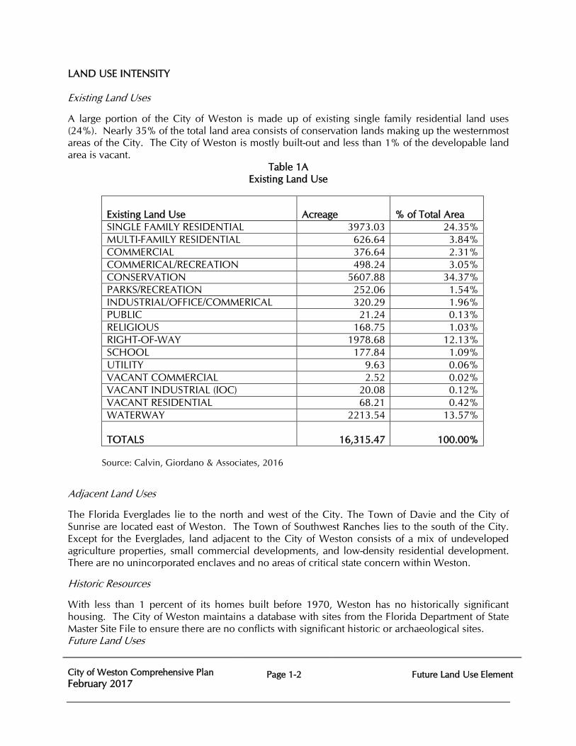
LAND USE INTENSITY Existing Land Uses A large portion of the City of Weston is made up of existing single family residential land uses (24%). Nearly 35% of the total land area consists of conservation lands making up the westernmost areas of the City. The City of Weston is mostly built-out and less than 1% of the developable land area is vacant.
Table 1A Existing Land Use
Existing Land Use
Acreage
% of Total Area
SINGLE FAMILY RESIDENTIAL 3973.03 24.35% MULTI-FAMILY RESIDENTIAL 626.64 3.84% COMMERCIAL 376.64 2.31% COMMERICAL/RECREATION 498.24 3.05% CONSERVATION 5607.88 34.37% PARKS/RECREATION 252.06 1.54% INDUSTRIAL/OFFICE/COMMERICAL 320.29 1.96% PUBLIC 21.24 0.13% RELIGIOUS 168.75 1.03% RIGHT-OF-WAY 1978.68 12.13% SCHOOL 177.84 1.09% UTILITY 9.63 0.06% VACANT COMMERCIAL 2.52 0.02% VACANT INDUSTRIAL (IOC) 20.08 0.12% VACANT RESIDENTIAL 68.21 0.42% WATERWAY 2213.54 13.57% TOTALS
16,315.47
100.00%
Source: Calvin, Giordano & Associates, 2016
Adjacent Land Uses
The Florida Everglades lie to the north and west of the City. The Town of Davie and the City of Sunrise are located east of Weston. The Town of Southwest Ranches lies to the south of the City. Except for the Everglades, land adjacent to the City of Weston consists of a mix of undeveloped agriculture properties, small commercial developments, and low-density residential development. There are no unincorporated enclaves and no areas of critical state concern within Weston.
Historic Resources
With less than 1 percent of its homes built before 1970, Weston has no historically significant housing. The City of Weston maintains a database with sites from the Florida Department of State Master Site File to ensure there are no conflicts with significant historic or archaeological sites. Future Land Uses
City of Weston Comprehensive Plan February 2017
Page 1-3
Future Land Use Element
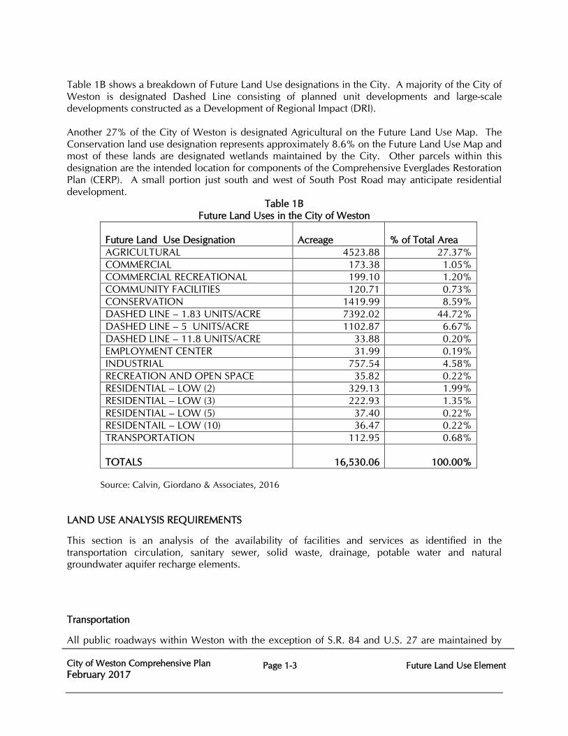
Table 1B shows a breakdown of Future Land Use designations in the City. A majority of the City of Weston is designated Dashed Line consisting of planned unit developments and large-scale developments constructed as a Development of Regional Impact (DRI). Another 27% of the City of Weston is designated Agricultural on the Future Land Use Map. The Conservation land use designation represents approximately 8.6% on the Future Land Use Map and most of these lands are designated wetlands maintained by the City. Other parcels within this designation are the intended location for components of the Comprehensive Everglades Restoration Plan (CERP). A small portion just south and west of South Post Road may anticipate residential development.
Table 1B Future Land Uses in the City of Weston
Future Land Use Designation
Acreage
% of Total Area
AGRICULTURAL 4523.88 27.37% COMMERCIAL 173.38 1.05% COMMERCIAL RECREATIONAL 199.10 1.20% COMMUNITY FACILITIES 120.71 0.73% CONSERVATION 1419.99 8.59% DASHED LINE – 1.83 UNITS/ACRE 7392.02 44.72% DASHED LINE – 5 UNITS/ACRE 1102.87 6.67% DASHED LINE – 11.8 UNITS/ACRE 33.88 0.20% EMPLOYMENT CENTER 31.99 0.19% INDUSTRIAL 757.54 4.58% RECREATION AND OPEN SPACE 35.82 0.22% RESIDENTIAL – LOW (2) 329.13 1.99% RESIDENTIAL – LOW (3) 222.93 1.35% RESIDENTIAL – LOW (5) 37.40 0.22% RESIDENTAIL – LOW (10) 36.47 0.22% TRANSPORTATION 112.95 0.68% TOTALS
16,530.06
100.00%
Source: Calvin, Giordano & Associates, 2016
LAND USE ANALYSIS REQUIREMENTS
This section is an analysis of the availability of facilities and services as identified in the transportation circulation, sanitary sewer, solid waste, drainage, potable water and natural groundwater aquifer recharge elements.
Transportation
All public roadways within Weston with the exception of S.R. 84 and U.S. 27 are maintained by
City of Weston Comprehensive Plan February 2017
Page 1-4
Future Land Use Element
the City. The City of Weston applies transportation Level of Service (LOS) standards through its Concurrency Management System to roadways and public transit intersections. All roadways within Weston are currently meeting their adopted level of service. By 2035, all roadways are anticipated to operate at an acceptable level of service except for the segment of U.S. 27 north of Griffin Road. The City of Weston plans to employ other techniques to improve the level of service and reduce the congestion during the peak hours. The City of Weston supports Transportation Demand Management (TDM) strategies including transit improvements on this constrained corridor. There are, several state roadways (I-595, I-75, US 27, and the Sawgrass Expressway) that are part of the State Highway System (SHS) and the Strategic Intermodal System (SIS) that immediately abut the City of Weston limits. Currently, there is one fixed-route transit service in the City. Bus route #23, a north-south route provides weekday peak hour service to the City of Weston and runs along Weston Road. Broward County funds and administers the Transportation Options Program (TOPS), which provides door-to-door service, upon request, for persons with physical, cognitive, emotional, visual or other disabilities which functionally prevent them from using the Broward County Transit (BCT) fixed-route bus system. Potable Water, Wastewater, Drainage Analysis, and Natural Groundwater Recharge Analysis The City of Sunrise provides potable water and wastewater transmission, treatment and disposal capacity necessary to meet the City’s present and future needs. The Indian Trace Development District (a dependent District of the City), owns and operates the water distribution and wastewater collection and transmission system for most of the City. The Bonaventure Development District provide water and wastewater transmission for the Bonaventure community in the northeast section of the City. Drainage is also divided between the two Districts. The Indian Trace Development District oversees drainage of Basin 1 and Basin 2. The Bonaventure Development District maintains stormwater systems the Bonaventure community in the northeast section of the City. Potable Water The City of Sunrise provides the water supply, treatment, storage and transmission capacity necessary to meet the City’s present and future needs. The City of Weston is a retail customer and does not have a potable water capital improvements schedule. T he City of Weston consists of the Indian Trace Development District (ITDD) and the Bonaventure Development District (BDD) which are both retail customers of the City of Sunrise. As required by Florida Statutes the City of Weston adopted its 20-Year Water Supply Facilities Work Plan in 2015, in conjunction with City of Sunrise. There are no known operational deficiencies in the water transmissions lines. Wastewater The City of Weston consists of the Indian Trace Development District (ITDD) and the Bonaventure Development District (BDD) which are serviced by the City of Sunrise’s Sawgrass Wastewater
City of Weston Comprehensive Plan February 2017
Page 1-5
Future Land Use Element
Treatment Plant. The ITDD wastewater collection and transmission system is owned and operated by the ITDD and the BDD system is owned and operated by the City of Sunrise. The existing wastewater facilities expand on an as-needed basis to service development activities. There are no known operational deficiencies in the sanitary sewage system. See the Sanitary Sewer Subsection of the Infrastructure Element for more information. The Windmill Lakes Estates section of the City of Weston contains certain properties which are not sewered, where homes are on septic tank and drainfield systems. The residential single family areas of the City of Weston served by septic tanks do not appear to pose a threat to the public health. Drainage The current surface water management system is operated by the City of Weston and permitted as the Indian Trace Development District and the Bonaventure Development District. The City of Weston is divided into three surface water management basins:
Indian Trace Development District (ITDD) – Basin I
The surface water management within the Indian Trace Development District Basin I consists of four (4) separate drainage areas as follows:
Increment III Mitigation Area Increment II Mitigation Area Increment III - Sectors 1 and 2 Remainder of Basin 1 - Sectors 3 through 16
Indian Trace Development District (ITDD) – Basin II
This basin is comprised of primarily vacant, grazing or agricultural lands but does contain the development community of the Isles at Weston. Some large parcels have their own water control structures and/or utilize a series of drainage ditches that flow to the C-11 Canal. The City of Weston reviews permit applications within this Basin in accordance with South Florida Water Management District Criteria. Two City mitigation areas were conveyed to the SFWMD in 2015 for the C-11 Impoundment Project.
Bonaventure Development District (BDD)
The surface water management within the Bonaventure Development District (BDD), formerly known as West Lauderdale Water Control District, was annexed into the City of Weston in 1997.
Currently, no significant stormwater issues have been identified.
Natural Groundwater Recharge
The ITDD and BDD Stormwater Management systems offer maximum recharge possibility by indirect infiltration of stormwater into the groundwater, via lakes and canals. Weston lies over the Biscayne Aquifer, a surficial aquifer. Groundwater is locally available for a variety of uses. The quality is good and would be suitable for drinking water supplies, if necessary.
City of Weston Comprehensive Plan February 2017
Page 1-6
Future Land Use Element
Land use regulation, development practices, strong support for vegetation, mitigation and landscaping all provide for a high degree of valuable and effective surface stormwater infiltration and quality groundwater recharge.
Solid Waste Analysis The City of Weston contracts with Republic Services of Florida for all solid waste, bulk waste, and recycling collection; solid waste and bulk waste disposal; and the sale and/or disposal of recyclable materials.
Hazardous wastes are not collected by the hauler but remain the responsibility of the waste generator to dispose through authorized services and agencies outside of the City’s collection system. Solid waste collection is effective under current practices.
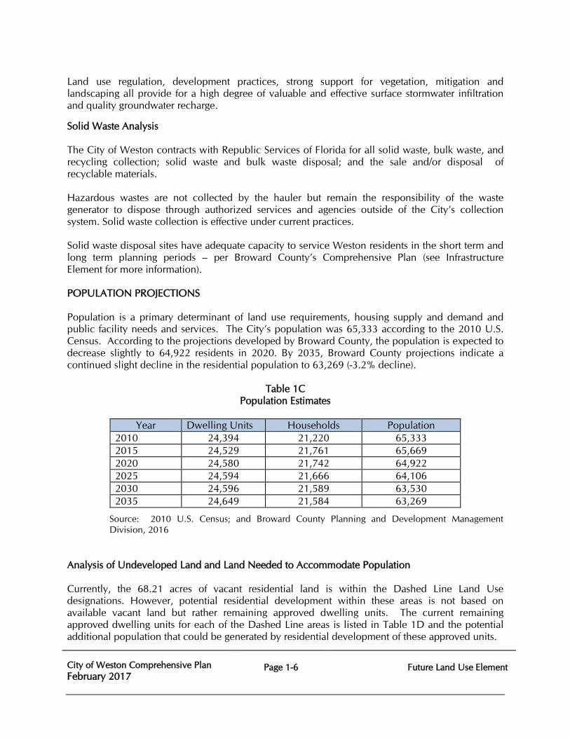
Solid waste disposal sites have adequate capacity to service Weston residents in the short term and long term planning periods – per Broward County’s Comprehensive Plan (see Infrastructure Element for more information). POPULATION PROJECTIONS Population is a primary determinant of land use requirements, housing supply and demand and public facility needs and services. The City’s population was 65,333 according to the 2010 U.S. Census. According to the projections developed by Broward County, the population is expected to decrease slightly to 64,922 residents in 2020. By 2035, Broward County projections indicate a continued slight decline in the residential population to 63,269 (-3.2% decline).
Table 1C
Population Estimates
Year Dwelling Units Households Population 2010 24,394 21,220 65,333 2015 24,529 21,761 65,669 2020 24,580 21,742 64,922 2025 24,594 21,666 64,106 2030 24,596 21,589 63,530 2035 24,649 21,584 63,269
Source: 2010 U.S. Census; and Broward County Planning and Development Management Division, 2016
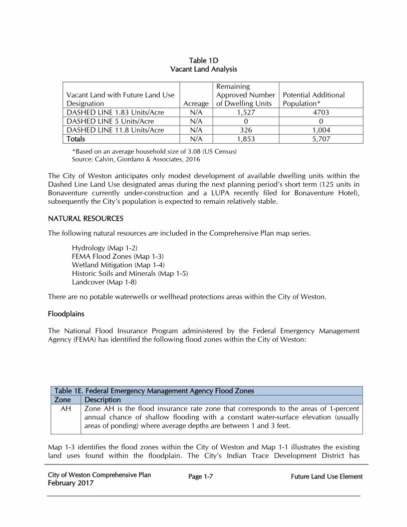
Analysis of Undeveloped Land and Land Needed to Accommodate Population Currently, the 68.21 acres of vacant residential land is within the Dashed Line Land Use designations. However, potential residential development within these areas is not based on available vacant land but rather remaining approved dwelling units. The current remaining approved dwelling units for each of the Dashed Line areas is listed in Table 1D and the potential additional population that could be generated by residential development of these approved units.
City of Weston Comprehensive Plan February 2017
Page 1-7
Future Land Use Element
Table 1D
Vacant Land Analysis
Vacant Land with Future Land Use Designation Acreage
Remaining Approved Number of Dwelling Units
Potential Additional Population*
DASHED LINE 1.83 Units/Acre N/A 1,527 4703 DASHED LINE 5 Units/Acre N/A 0 0 DASHED LINE 11.8 Units/Acre N/A 326 1,004 Totals N/A 1,853 5,707
*Based on an average household size of 3.08 (US Census) Source: Calvin, Giordano & Associates, 2016
The City of Weston anticipates only modest development of available dwelling units within the Dashed Line Land Use designated areas during the next planning period’s short term (125 units in Bonaventure currently under-construction and a LUPA recently filed for Bonaventure Hotel), subsequently the City’s population is expected to remain relatively stable. NATURAL RESOURCES
The following natural resources are included in the Comprehensive Plan map series.
Hydrology (Map 1-2) FEMA Flood Zones (Map 1-3)
Wetland Mitigation (Map 1-4) Historic Soils and Minerals (Map 1-5)
Landcover (Map 1-8)
There are no potable waterwells or wellhead protections areas within the City of Weston. Floodplains The National Flood Insurance Program administered by the Federal Emergency Management Agency (FEMA) has identified the following flood zones within the City of Weston:
Table 1E. Federal Emergency Management Agency Flood Zones Zone Description
AH Zone AH is the flood insurance rate zone that corresponds to the areas of 1-percent annual chance of shallow flooding with a constant water-surface elevation (usually areas of ponding) where average depths are between 1 and 3 feet.
Map 1-3 identifies the flood zones within the City of Weston and Map 1-1 illustrates the existing land uses found within the floodplain. The City’s Indian Trace Development District has
City of Weston Comprehensive Plan February 2017
Page 1-8
Future Land Use Element
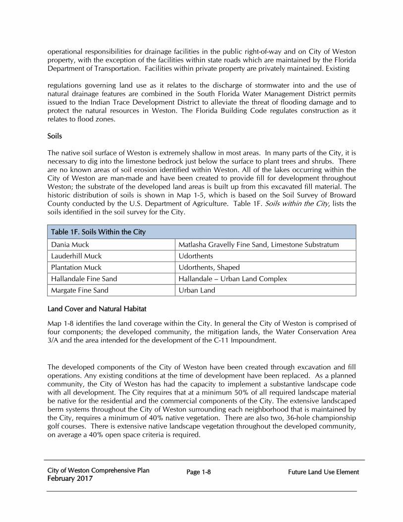
operational responsibilities for drainage facilities in the public right-of-way and on City of Weston property, with the exception of the facilities within state roads which are maintained by the Florida Department of Transportation. Facilities within private property are privately maintained. Existing regulations governing land use as it relates to the discharge of stormwater into and the use of natural drainage features are combined in the South Florida Water Management District permits issued to the Indian Trace Development District to alleviate the threat of flooding damage and to protect the natural resources in Weston. The Florida Building Code regulates construction as it relates to flood zones. Soils The native soil surface of Weston is extremely shallow in most areas. In many parts of the City, it is necessary to dig into the limestone bedrock just below the surface to plant trees and shrubs. There are no known areas of soil erosion identified within Weston. All of the lakes occurring within the City of Weston are man-made and have been created to provide fill for development throughout Weston; the substrate of the developed land areas is built up from this excavated fill material. The historic distribution of soils is shown in Map 1-5, which is based on the Soil Survey of Broward County conducted by the U.S. Department of Agriculture. Table 1F. Soils within the City, lists the soils identified in the soil survey for the City.
Table 1F. Soils Within the City
Dania Muck Matlasha Gravelly Fine Sand, Limestone Substratum
Lauderhill Muck Udorthents
Plantation Muck Udorthents, Shaped
Hallandale Fine Sand Hallandale – Urban Land Complex
Margate Fine Sand Urban Land Land Cover and Natural Habitat
Map 1-8 identifies the land coverage within the City. In general the City of Weston is comprised of four components; the developed community, the mitigation lands, the Water Conservation Area 3/A and the area intended for the development of the C-11 Impoundment.
The developed components of the City of Weston have been created through excavation and fill operations. Any existing conditions at the time of development have been replaced. As a planned community, the City of Weston has had the capacity to implement a substantive landscape code with all development. The City requires that at a minimum 50% of all required landscape material be native for the residential and the commercial components of the City. The extensive landscaped berm systems throughout the City of Weston surrounding each neighborhood that is maintained by the City, requires a minimum of 40% native vegetation. There are also two, 36-hole championship golf courses. There is extensive native landscape vegetation throughout the developed community, on average a 40% open space criteria is required.
City of Weston Comprehensive Plan February 2017
Page 1-9
Future Land Use Element
There are 2,315 acres of mitigation land within the City of Weston that have been restored and maintained in their natural state. Of this total acreage, nearly 2,050 is sawgrass dominated or freshwater marsh habitat with scattered ‘tree islands’; the remaining mitigation acreage is littoral lake edges. The Water Conservation Area located west of U.S. 27 is sawgrass dominated marsh habitat which the South Florida Water Management District maintains. The land identified as the location for the development of the C-11 Impoundment is degraded from the historic sawgrass marsh conditions. The area was ditched and drained, has been utilized for pasture land, some areas used for crop land or plant nurseries, and several man-made borrow pits remain where resource extraction occurred in the past. There are degraded remnant wetlands in this area. Overall the area is heavily infested with the invasive exotic plant species, Melaleuca (Melaleuca quinquenervia), Brazilian Pepper (Schinus terebithifolius) and Australian Pines (Casuarina equisetifolia). ANALYSIS OF NEED FOR REDEVELOPMENT At this time the City of Weston contains no areas which require redevelopment. A majority of the residential and non-residential development has occurred in the past twenty five years and redevelopment would be unsuitable for such consideration. The City of Weston will continue to monitor neighborhoods and make determinations relative to needed redevelopment activities as they become necessary. There exists a need to eliminate and prevent land uses and specific characteristics of development inconsistent with Weston’s unique character and planned future uses. These inconsistencies are monitored in the permit and review process which are, to a great degree, further regulated by land use and zoning constraints. The City of Weston will continue to establish and maintain design and aesthetic standards for buildings, lighting, signage and landscape. Development and redevelopment in flood prone areas must be based upon suitability determined from Flood Insurance Rate Maps, Flood Hazard Boundary Maps or other accurate data to assure the preservation of flood protection to the subject property and the entire community dependent on the overall area. GREENHOUSE REDUCTION STRATEGIES Climate change is largely attributed to the buildup of carbon dioxide and other greenhouse gas (GHG) concentrations in the atmosphere. Global emissions of GHG from human activities, such as the burning of fossil fuels and deforestation, have increased by 70% between 1970 and 2004 according to The American Planning Association (APA). In the April 2008, Policy Guide on Planning and Climate Change, the APA provides guidance for local governments toward the reduction of GHG emissions and on energy efficient land use decisions. The APA document indicates that effect actions to address GHG emissions should include a mix of education, incentives, subsidies, and regulation. The APA has suggested the following strategies for local governments to facilitate a reduction in GHG emissions; these include mixed use development, infill and redevelopment to utilize existing utilities and service, providing employment opportunities near a range of housing opportunities, energy efficient buildings, convenient intermodal transportation systems, and the reduction of heat island effects through green spaces.
City of Weston Comprehensive Plan February 2017
Page 1-10
Future Land Use Element
In addition to the broad strategies listed above, every decrease in energy consumption reduces the carbon dioxide emissions from power plants and associated development to continue to expand the electric system; every diversion from a landfill increases the efficiency of curbside pick-up and the amount of debris placed in the landfill and ultimately the production of methane; every reduction in water use decreases the amount of energy required to produce potable water and to treat wastewater. Encouraging recycling, facilitating the capacity to bicycle and walk, retaining and increasing landscaping, and conserving potable water supplies are also effective strategies to achieve GHG emission reductions.
The City of Weston has implemented a number of these strategies. There is a successful pedestrian and bikeways network throughout the City. The number of bikeways is relatively high compared to other areas within Broward County. There are sidewalks installed throughout the entire City. Bike lanes have been installed along arterial and several collector roadways. Over 140,400 linear feet of roadways have a 5 foot wide sidewalk installed along both sides of the road. Approximately 28,200 linear feet of roadway has a 6.5 foot wide sidewalk installed along one side of the road. Additionally, there are over 105,000 linear feet of designated bike lanes along the roadways. The City of Weston has created a centralized Town Center commercial district as well as several neighboring commercial centers. This facilitates a decrease in the number of trips and the drive times for residents conducting routine shopping trips or outings for dining or entertainment experiences.
Broward County monitors traffic signals on all arterial and collector roadways within the City of Weston. The City of Weston has installed interconnects between all signals which minimizes delays and idling on all arterial and collector roadways. The efficiency of the roadway system throughout the City of Weston is closely monitored to allow rapid response to any problems that may arise, thereby decreasing idling times and unnecessary emissions and decreasing energy consumption through efficiency. These pedestrian and bicycle facilities and the efficiency of the roadway system throughout the City of Weston each facilitate energy conservation.
The City of Weston has significant open space and landscape requirements to diminish heat island effects. The City’s landscape ordinance implements Florida Friendly principles and requires native vegetation. There is 2,315 acres of mitigation land within the City of Weston that have been restored to and is maintained as natural habitat. These natural areas not only also help to diminish heat island effects but contribute to carbon dioxide uptake and oxygen production. The City of Weston is working cooperatively with the South Florida Water Management District and the Army Corps of Engineers on the development and construction of the 1,000+ acre stormwater impoundment area located in the City of Weston that is a component of the Comprehensive Everglades Restoration Plan. Map 1-1 Existing Land Uses depicts conservation areas, parks, and the linear parks within the City of Weston.
The City implements an annual landscape inspection program on all commercial and timeshare or multi-family rental properties to ensure the maintenance and retention of required landscape materials. The City’s Code Enforcement along with each of the homeowners associations assures that required landscaping is retained and maintained on the single-family properties. The City of Weston completed a thorough inventory of all canopy and palm trees located on City of Weston owned and City of Weston maintained property, inclusive of the right of ways in 2009 and completed an update of that inventory in March of 2016. This inventory identifies locates, and provides information on the size and condition of each tree providing the City of Weston with the
City of Weston Comprehensive Plan February 2017
Page 1-11
Future Land Use Element
tools to ensure there will be no decrease in the canopy coverage on publicly owned and maintained lands.
There are thirty (30) existing irrigation pump stations for City of Weston owned irrigated areas that range from 2 hp to 50 hp. Typically, pumps that are 25 hp or higher have jockey pumps to build up pressure through the transmission system and are operated to provide the quantity of water needed. For those locations having multiple main pumps, the City of Weston can shut down one of the pumps to control and reduce the distribution system pressure. The reduction in distribution pressure can help reduce water consumption. All of the City’s existing irrigation pumps are equipped with rain sensors, and with meters that are located on the influent pipeline into the pumps. The irrigation pumps are maintained continuously and calibrated by professional manufacturer representatives. Also, they are reviewed and replaced as needed in a monthly replacement program. One hundred percent (100%) of all raw water pumped out of the lakes and canals by the City’s irrigation pumps is metered. As a planned community with a defined footprint and density, the City of Weston will not contribute to the sprawl and continued expansion of utilities that has become a prominent development concern across the nation. The City of Weston is built-out, and as such, nearly all future projects will be redevelopment projects with existing infrastructure available. The City of Weston recently completed their Public Works, Community Center, Administrative Services, and the City Hall buildings have energy conserving glazing, high efficiency air handling systems, water conserving fixtures and programmable heat and cooling controls providing energy conserving measures. The City of Weston continues to implement strategies for more energy efficient lighting within the City. Voltage regulators have been installed on City-owned street lighting that will reduce their energy cost by 20%-30% and will also reduce the City’s carbon footprint by approximately 370 metric tons per year. Older style fluorescent lighting in all municipal buildings have been replaced with a more efficient version that will reduce energy costs by 20%-30% and reduce the City’s carbon footprint by approximately 15 metric tons per year. Map 1-10 Energy Conservation Areas and Features highlights Weston features that contribute to reduced energy use and greenhouse gas production: wetland mitigation areas, conservation areas, water impoundment area, open spaces and its extensive bicycle paths.
City of Weston Comprehensive Plan February 2017
Page 1-12
Future Land Use Element
FUTURE LAND USE GOALS, OBJECTIVES, AND POLICIES
RESIDENTIAL USES
Goal 1:1 Provide residential areas with a variety of housing types and densities offering convenient and affordable housing opportunities to all segments of Weston’s population while maintaining a desired quality of life and adequate public services and facilities.
1.1 Objective: City of Weston shall maintain a pattern of overall low density residential use with limited medium and high density residential uses in selected areas to preserve the low intensity character of the residential neighborhood. Proposed amendments to the Future Land Use Map shall occur in accordance with the densities provided therein.
1.1.1 Policy: Maintain and enforce effective development and maintenance regulations.
1.2 Objective: City of Weston shall maintain the high aesthetic community design standards through the enforcement of regulations which guide development.
1.2.1 Policy: Maintain and enforce effective development and maintenance regulations.
1.3 Objective: City of Weston shall create, preserve and maintain scenic vistas in keeping with the classic tradition as embodied in the original City of Weston plan.
1.3.1 Policy: Maintain and enforce effective development and maintenance regulations.
1.5 Objective: City of Weston shall maintain subdivision and land development regulations which promote well-planned, orderly and attractive developments which are consistent with the Capital Improvements Elements and the goals, objectives and policies of the Weston Land Use Plan.
1.5.1 Policy: Subdivision regulations shall incorporate a review process for assessing the adequacy of public services and facilities. New residential development shall be established only within those areas where adequate public services and facilities exist or are scheduled to be available in accordance with the Capital Improvements Element.
City of Weston Comprehensive Plan February 2017
Page 1-13
Future Land Use Element
1.5.2 Policy: Subdivision regulations shall provide for both the timely completion and regular maintenance of all required Capital Improvements and amenities.
1.6 Objective:
City of Weston shall develop and implement land use controls through the zoning code and land development regulations which promote residential neighborhoods that are attractive, well-maintained and contribute to the health, safety and welfare of their residents.
1.6.1 Policy: Evaluate and revise the Weston Zoning Code and Land Use Regulations, as necessary, to reflect the unique characteristics of Weston and to provide the appropriate instruments to enforce and effectively carry out the requirements of this plan.
1.7 Objective: City of Weston shall maintain programs to provide a complete range of affordable housing opportunities necessary to accommodate all segments of Weston’s population.
1.7.1 Policy:
City of Weston shall establish programs to provide, encourage, or enable, low and moderate income housing to meet the needs the City’s existing and future population in accordance with the Housing Element of the Comprehensive Plan.
1.7.2 Policy: A pool of “Affordable Housing Units” (AFU’s) shall be established for Weston which is equal to 10% of the total available flexibility and reserve units within the City.
1.7.3 Policy: City of Weston shall evaluate the effect of land development regulations and permitting on the affordability of housing and shall take appropriate actions to support the affordability of housing.
1.7.4 Policy: Zoning Code and Land Development regulations shall include provisions to encourage or enable a variety of housing opportunities in varying price ranges.
City of Weston Comprehensive Plan February 2017
Page 1-14
Future Land Use Element
COMMERCIAL USES
Goal 1:2 Provide a complete range of convenient and accessible commercial facilities to serve Weston’s population.
2.1 Objective:
City of Weston shall provide a sufficient level of commercial development to accommodate the population and economy of Weston.
2.1.1 Policy: Residential neighborhoods shall be protected from intrusion by incompatible uses that would disrupt or degrade the health, safety, tranquility, aesthetics and welfare of the neighborhoods by noise, light, glare, odor, vibration, dust, hazardous materials or traffic.
2.1.2 Policy: Uses designated in the plan causing significant noise, light, glare, odor, vibration, dust, hazardous condition, or industrial traffic shall provide buffering when located adjacent to or across the street from incompatible uses such as residential uses.
2.1.3 Policy:
The Weston Zoning Code shall maintain differing intensities of commercial development incompatible with adjacent and surrounding land uses.
2.1.4 Policy: The Weston Zoning Code shall maintain zoning categories that distinguish between neighborhood, community and regional commercial developments.
2.1.5 Policy: To allow both the public and private sectors to respond to changing conditions and permit the appropriate location of neighborhood commercial uses within or adjacent to established residential neighborhoods, the Weston Comprehensive Plan shall permit up to 5% of the area designated residential within a flexibility zone to be used for neighborhood commercial uses subject to the restrictions identified within the Residential Permitted Uses subsection. No such contiguous area may exceed ten (10) acres in size. For the purpose of this provision, contiguous is defined as: attached; located within 500 feet; or separated only by streets and highways, canals and rivers, or easements. This five percent (5%) residential-to-commercial flexibility rule may be applied through (re)zoning.
2.1.6 Policy: The City of Weston shall maintain a sign code which regulates the size and design of all signage.
2.2. Objective:
City of Weston Comprehensive Plan February 2017
Page 1-15
Future Land Use Element
The City of Weston shall maintain land development regulations that address controlled access to adjacent traffic circulation facilities, the provision of adequate on-site traffic circulation and off-street parking relative to existing and planned commercial development.
2.2.1 Policy: The City of Weston shall develop land use regulations which protect the local roadway network, the regional roadway network and the Broward County Trafficways Plan.
2.2.2 Policy: The City of Weston shall maintain land use regulations, which ensure safe and convenient on-site traffic circulation and adequate off-street parking.
INDUSTRIAL USES
Goal 1:3 Achieve a more diversified local economy by promoting tourism and industrial growth and providing optimum protection of the City’s natural environment and maintaining a desired quality of life.
3.1 Objective: City of Weston shall provide a sufficient level of industrial development to accommodate the population and economy of Weston.
3.1.1 Policy: Future industrial land uses shall be located with access to major transportation facilities.
3.1.2 Policy: Land designated for Industrial development by the Weston Future Land Use Map shall not be utilized for non-industrial purposes except where such uses are consistent with the permitted uses of this category.
3.2 Objective: City of Weston shall maintain an Employment Center land use category in the Future Land Use Element, as depicted on Map 1-6, Future Land Use Map. 3.2.1 Policy:
Employment Center land use shall provide for a variety of commerce and job creating industries.
3.3 Objective: The City of Weston shall maintain land use controls and performance standards necessary to regulate any potentially adverse impacts of industry through the adoption of a zoning code and land development regulations.
3.3.1 Policy:
City of Weston Comprehensive Plan February 2017
Page 1-16
Future Land Use Element
Weston Zoning Code and Land Development regulations shall provide regulations which address adverse impacts of industry, including noise, vibration, air pollution, glare, heat, solid waste, hazardous wastes, fire and explosion.
RECREATIONAL AND OPEN SPACES Goal 1:4 Provide recreation and open spaces which meet resident needs and are compatible with the character of the City of Weston. 4.1 Objective:
Establish local community park standards necessary to provide Weston’s present and future population with a diversified and balanced parks and recreation system as provided in the Recreation and Open Space element.
4.1.1 Policy:
City of Weston shall provide for a minimum of six (6) acres of community level parks for every 1,000 existing and projected permanent residents.
4.1.2 Policy:
City of Weston shall adopt and implement the procedures necessary to meet the standards of Policy 4.1.1.
4.1.3 Policy:
City of Weston shall address methods of protecting existing and designated parks, recreation and open space lands in the Weston Zoning Code and Land Development Regulations.
4.2 Objective:
City of Weston shall maintain a system of public and private open space areas compatible with the character of Weston.
4.2.1 Policy:
City of Weston shall pursue programs that will ensure the provision of and access to open space areas.
CONSERVATION USES Goal 1:5 Ensure the protection of and prevent damage to ecological systems that are an integral component of South Florida’s and Weston’s natural environment. 5.1 Objective:
Identify, conserve and protect all water conservation and recharge areas, consistent with the requirements of the State Comprehensive Plan.
City of Weston Comprehensive Plan February 2017
Page 1-17
Future Land Use Element
5.1.1 Policy: Promote restoration of the Everglades system including its hydrological and ecological functions as well as any degraded or substantially disrupted surface waters.
5.1.2 Policy: No new solid-fill transportation facilities or similar structures shall be permitted within Weston’s identified water conservation areas without provisions for maintaining the fresh water sheet flow.
5.1.3 Policy: Protect and conserve those areas known to be reproduction, nesting and feeding areas for animals listed as endangered or threatened species or species of special concern.
5.1.4 Policy: Protect the minimum seasonal flows and levels of surface watercourses as established by the South Florida Water Management District.
5.1.5 Policy: Protect and conserve those areas known to contain plant species listed in the Regulated Plant Index for protection by the Florida Department of Agriculture and Consumer Services.
5.1.6 Policy: City of Weston shall, as part of the Land Use Plan Amendment and Capital Planning Processes, analyze impact on the South Florida Water Management District regional water resource projects, the Comprehensive Everglades Restoration Plan (CERP), the Lower East Coast Regional Water Supply Plan, the Water Preserve Area Project, and the C-11 West Basin Water Quality Improvement Strategy) of all future development.
5.1.7 Policy: Weston shall distribute land uses in a manner that avoids or minimizes, to the greatest degree practicable, the effect and impact on wetlands and lands identified by the South Florida Water Management District’s East Coast Buffer. Those future land uses identified below as being incompatible with the protection and conservation of wetlands and wetland functions shall be directed away from wetlands, or when incompatible future land uses are allowed to occur, shall be mitigated or enhanced, or both, to compensate for loss of wetland functions.
5.1.8 Policy: Weston shall support the adopted South Florida Water Management District’s East Coast Buffer by discouraging to the maximum extent feasible high density and intensity incompatible land uses within the identified buffer areas and on adjacent lands. Such incompatible land uses may include, but are not limited to, heavy commercial and industrial uses, sewage treatment facilities, solid waste disposal and transfer stations, cemeteries, transportation facilities and gas and service stations.
City of Weston Comprehensive Plan February 2017
Page 1-18
Future Land Use Element
5.2 Objective:
Designate Conservation areas on the Future Land Use Map which includes natural reservations and reserve water supply areas.
5.2.1 Policy: Promote the acquisition, retention and management of unique natural areas in order to preserve their environmental, recreational and other public benefits.
PUBLIC FACILITIES AND PHASED GROWTH
Goal 1:7 Provide public facilities and open space which meets the needs and are compatible with the character of the City of Weston.
7.1 Objective: Coordinate future land uses with availability of regional and community facilities and services sufficient to meet the current and future needs of Weston’s population and economy without endangering its environmental resources.
7.1.1 Policy: City of Weston shall implement development review procedures which assure that facilities and services meet established county-wide and municipal level of service standards and are available consistent with concurrency requirements and Section 163.3180 Florida Statutes.
7.1.2 Policy: Development permits granted by Weston shall be consistent with the Land Use Regulations and Zoning Code of Weston.
7.1.3 Policy: Local governments which authorize development permits shall implement procedures which identify the cumulative impacts of proposed development on public services and facilities.
7.1.4 Policy: City of Weston shall require all new commercial and industrial development to be serviced by centralized wastewater systems.
7.1.5 Policy: City of Weston shall require existing development on septic tanks and private wells to hook up to centralized sewer and water facilities as they become available.
7.1.6 Policy:
City of Weston shall encourage source separation and the recycling of solid waste, in accordance with the Solid Waste Act of 1988, as amended.
7.1.7 Policy:
City of Weston Comprehensive Plan February 2017
Page 1-19
Future Land Use Element
Minimum floor elevation standards for building sites promulgated and administered by the Federal Emergency Management Administration shall be applied city-wide for new construction.
7.1.8 Policy: Minimum road crown elevation standards, as implemented by the South Florida Water Management District, shall be applied throughout the City.
7.1.9 Policy: City of Weston in coordination with the Broward County School Board encourages the location of schools proximate to urban residential areas to the extent possible and to collocate public facilities, such as parks, libraries and community centers with schools to the extent possible.
7.1.10 Policy: City of Weston shall review the school location criteria as adopted by the Broward County School Board and include the criteria appropriate for the City of Weston as an amendment to the City’s Comprehensive Plan upon its availability and subject to the requirements of Chapter 163, Florida Statutes.
7.1.11 Policy: The City of Weston shall coordinate changes to the Future Land Use Element and Future Land Use Map with the availability of potable water services.
7.1.12 Policy: The Future Land Use Element shall include data and analysis demonstrating coordination with current and future water supply demands.
7.1.13 Policy: The City of Weston shall ensure coordination between land use and future
water supply planning within 18 months of the adoption of the Lower East Coast Water Supply Plan, as required by Chapter 163, Florida Statutes.
7.1.14 Policy: The City of Weston adopts the Water Supply Facilities Work Plan
infrastructure sub-element by reference, and will continue to update and implement the projects and policies therein as deemed appropriate or as required in accordance with Florida Statutes.
7.1.15 Policy: The City of Weston shall coordinate land uses with available and projected
fiscal resources and The City of Weston shall coordinate land uses with available and projected fiscal resources and shall coordinate with utility service providers on a financially feasible schedule of capital improvements for water supply and facility projects.
7.1.16 Policy: City of Weston shall continue to coordinate with the Broward County Division of Planning and Development Management to evaluate population projections.
City of Weston Comprehensive Plan February 2017
Page 1-20
Future Land Use Element
7.2 Objective:
City of Weston shall require platting in conformance with City regulations and those of the Broward County Charter.
7.2.1 Policy: City of Weston shall adopt land development regulations that require platting at least in those circumstances where Broward County Regulations require platting.
7.3 Objective:
Discourage urban sprawl and encourage a separation of urban and rural land uses by directing new development into areas where necessary regional and community facilities and services exist.
7.3.1 Policy: Promote infill development through the provision of potable water and sanitary sewer service to those developed portions of Weston which are currently inadequately served.
7.3.2 Policy:
When extending new services to undeveloped portions of Weston, priority shall be given to those areas where other facilities and services are available or are anticipated to be provided concurrent with the extension of such new services.
7.3.3 Policy: Except for schools, regional and community facilities shall be located close to major traffic corridors and mass transit routes adequate to carry the volume of traffic generated by such facilities.
7.3.4 Policy: City of Weston shall encourage the reuse of reclaimed water as an integral part of their wastewater management program, where economically, environmentally, and technically feasible.
7.4 Objective: A concurrency management system has been established (appendix 5) which will effectively monitor and manage new growth, in conformance with Florida’s Community Planning Act, including Section 163.3180 Florida Statutes.
7.4.1 Policy: The City of Weston shall maintain concurrency management systems to effectively manage new growth and to ascertain whether necessary facilities identified within their local Capital Improvement Elements are being constructed in accordance with the schedules in their local plans and to measure the development capacity of such facilities in a given area at a given time.
7.4.2 Policy:

City of Weston Comprehensive Plan February 2017
Page 1-21
Future Land Use Element
Those facilities which are subject to the local concurrency requirements include: traffic circulation, recreational, drainage and flood protection, potable water, solid waste and sanitary sewer facilities.
7.4.3 Policy:
Proposed Future Land Use Map amendments shall be supported with data and analysis demonstrating that adequate water supplies and associated public facilities will be available to meet the projected growth demands.
7.5 Objective: Ensure through the future land use planning process that public elementary and secondary education facilities will be available to meet the current and future needs of Weston’s school population.
7.5.1 Policy: City of Weston shall consider the individual and cumulative impacts of land use plan amendments on existing and planned public elementary and secondary education facilities.
7.5.2 Policy: City of Weston shall coordinate with the School Board of Broward County to achieve an expedited development review procedure for public elementary and secondary education facilities.
7.5.3 Policy: City of Weston and the School Board of Broward County shall establish joint processes for collaborative planning and decision making on population projections and public school siting to accomplish coordination between the adopted local comprehensive plans and the long range plans of the School Board.
7.5.4 Policy: City of Weston shall determine the consistency of land use plan amendments with the Public School Facilities Element. The consistency finding shall address whether sufficient capacity is available, or anticipated within the short or long range planning horizon of their Element, to accommodate the projected student impact of proposed amendments. As provided for within the Amended Interlocal Agreement for Public School Facilities Planning (ILA), the School Board of Broward County shall advise the County and local governments regarding the projected student impact of amendments and the availability of capacity at impacted schools.
7.5.5 Policy: City of Weston shall not accept a building permit application, nor issue a building permit, for new or additional residential units, unless the applicant presents evidence from Broward County that the impact of the proposed development on public educational sites and facilities has been mitigated by payment of school impact fees, based on the fee schedule and accompanying provisions of the Broward County Land Development Code.
City of Weston Comprehensive Plan February 2017
Page 1-22
Future Land Use Element
Alternative methods of mitigation for school impacts may only be approved via a recorded agreement among the property owner(s), Broward County, and/or the City, Broward County, and the School Board of Broward County.
7.5.6 Policy: City, Broward County, and the School Board of Broward County shall coordinate through the processes and procedures identified in the ILA to ensure collaborative planning and decision making on population projections and public school siting and to accomplish coordination between the adopted local comprehensive plans and the School Board’s District Educational Facilities Plan.
7.5.7 Policy: City, Broward County, and the School Board of Broward County shall explore and evaluate opportunities for collocation and shared use of school facilities and civic and recreation activities during their capital improvement planning processes and other processes as provided for in the ILA.
7.5.8 Policy: City, Broward County, and the School Board of Broward County will coordinate through the procedures established in the ILA and the Broward County and local land use planning process to ensure that proposed public school facility sites are consistent and compatible with the land use categories and policies of their comprehensive plans and enable a close integration between existing and planned schools and surrounding land uses.
7.5.9 Policy: City shall incorporate provisions into their local land use plans and land development regulations which provide for safe pedestrian and/or bicycle access to public schools.
7.5.10 Policy: City of Weston shall support the efforts of the School Board of achieve diversity within Broward County district schools by implementing regulations that promote a diversity of housing types and redevelopment opportunities.
7.6 Objective: Develop and implement post-disaster redevelopment and hazard mitigation land use controls and development regulations including strong preventive measures, to protect the health, safety and welfare of Weston’s current and future residents.
7.6.1 Policy:
City, in coordination with Broward County, shall adopt a county-wide post-disaster redevelopment plan which establishes an orderly process for reviewing private and public redevelopment proposals to restore the economic and social viability of the community in a timely fashion.
City of Weston Comprehensive Plan February 2017
Page 1-23
Future Land Use Element
7.6.2 Policy: Post-disaster redevelopment and hazard mitigation plans should inventory hazard prone properties and implement building codes and development regulations, such as setback provisions, structural connections, and other site controls, to reduce future property damages and losses.
Natural, Historic and Cultural Resources
Goal 1:8 Protect Weston’s natural, historic and cultural resources and promote cultural resources through well-planned patterns of growth and development.
8.1 Objective: City of Weston shall monitor and protect any future Natural Resource Areas (which are considered to be environmentally sensitive lands) designated as Local Areas of Particular Concern on the Future Land Use Map.
8.1.1 Policy: Discourage activities in the vicinity of Local Areas of Particular Concern which would have a detrimental impact upon such areas.
8.2 Objective: Protect the quality and quantity of Weston’s potable water supply as depicted on the Natural Resource Map Series of the Future Weston Land Use Plan Map (Series).
8.2.1 Policy: Amendments to the Future Land Use Plan Map proposing land use categories which permit Industrial uses shall be discouraged, to the greatest extent feasible, within wellfield protection zones of influence.
8.2.2 Policy: New septic tank systems shall only be permitted when the Florida Department of Health and Rehabilitative Services determines they are consistent with Broward County’s Water and Septic Tank Ordinance and with the requirements of the Florida Statutes and the Florida Administrative Code.
8.2.3 Policy: City of Weston shall require all future development and redevelopment to connect to sanitary sewer lines.
8.3 Objective: Develop and implement land use controls and programs to preserve and enhance surface waters for their important natural functions and aesthetics and recreational values.
8.3.1 Policy: City’s Zoning Code and Land Development Regulations shall provide for the protection and creation of surface waters in conformance with State and South Florida Water Management District policies.
City of Weston Comprehensive Plan February 2017
Page 1-24
Future Land Use Element
8.3.2 Policy: New development adjacent to or in the vicinity of surface waters shall be designed so as to minimize the direct discharge of stormwater runoff into such bodies of water.
8.3.3 Policy: Lakes shall be required to be constructed with vegetated shallow water habitat as required by the Broward County Department of Natural Resource Protection which will promote both natural lake functions and the health, safety, welfare and recreation of Broward County’s residents.
8.4 Objective:
Identify and protect the wetlands, hydric soils and vegetative communities within Weston in order to maintain and enhance wetland resources as well as functional values such as, but not limited to, wildlife habitat, groundwater recharge and discharge, flood storage, sediment/toxicant retention and nutrient removal/transformation.
8.4.1 Policy: No development order may be issued, except as listed below, within wetlands (as defined herein) until an Environmental Resource License has been issued by the Broward County Environmental Protection Department. However, the City of Weston may issue rezoning, site plan, plat approval or development orders issued pursuant to Chapter 380, Florida Statutes, in areas containing wetlands upon issuance of a conceptual review report by the Broward County Environmental Protection Department.
8.4.2 Policy:
City of Weston shall coordinate their development review and permitting programs with the wetland permitting and mitigation programs of the appropriate local, state and federal jurisdictional agencies.
8.4.3 Policy: City of Weston shall consider the impacts of land use plan amendments on wetland resources and minimize those impacts to the maximum extent practicable.
8.4.4 Policy: Mitigation required pursuant to development activities within “Eastern Broward County” shall be used to restore, enhance or replace wetlands located within “Eastern Broward County”; mitigation may be allowed in other areas of the County only if it is determined by all appropriate permitting agencies that suitable sites for such purposes are not available in “Eastern Broward County”. For the purposes of this policy, “Eastern Broward County” is defined as the area east of the Everglades Buffer Strip and the Reserve Water Supply area.
8.5 Objective:
City of Weston Comprehensive Plan February 2017
Page 1-25
Future Land Use Element
Ensure that mining operations are compatible with existing surrounding land uses and consistent with the Weston Land Use Plan’s policies regarding protection of natural resources including environmentally sensitive lands and water resource quality and quantity.
8.5.1 Policy:
Comprehensive plans and/or land development regulations shall address the reclamation of completed mining excavations and their compatibility with existing surrounding land uses and water resource quality and quantity.
8.6 Objective: Protect identified floodplains and areas subject to seasonal or periodic flooding.
8.6.1. Policy: City of Weston development codes shall contain floodplain protection provisions consistent with the criteria and mapping of the Federal Emergency Management Administration.
8.6.2 Policy: City of Weston shall require redevelopment within identified floodplains to address existing flooding problems.
8.6.3 Policy: Through provisions in the City of Weston regulations, public roads and parking lots shall be designed consistent with the criteria of the South Florida Water Management District.
8.7 Objective: Protect historic resources within the City of Weston from deterioration or loss.
8.7.1 Policy: City of Weston Land Use Plan shall map and maintain a current list of historically, architecturally and archaeologically significant properties and address the protection of these historic resources.
8.7.2 Policy: City of Weston shall implement programs which preserve and/or rehabilitate historic resources through techniques described in the historic preservation ordinances within the City’s Code of Ordinances and building code provisions.
8.7.3 Policy: City of Weston shall coordinate their historic resource protection activities with applicable state and federal laws.
8.7.4 Policy: City of Weston shall consider the impacts of land use plan amendments on historic resources and existing land uses of tracts or areas formerly made up of or currently in tropical hardwood hammocks will be carefully checked for significant historical resources during the impacts of the future land use plan amendment process.
City of Weston Comprehensive Plan February 2017
Page 1-26
Future Land Use Element
8.8 Objective: Eliminate flooding problems while preserving groundwater quality through planned growth, the provision of drainage and stormwater management systems and the adoption of appropriate development codes and regulations.
8.8.1 Policy: New development shall provide water storage capacity equal to that which existed under predevelopment conditions consistent with the water management regulations and plans of the South Florida Water Management District, Broward County Department of Natural Resource Protection and independent drainage districts.
8.8.2 Policy: New non-residential development shall provide pre-treatment for stormwater runoff through grassy swales, wetlands filtration, ex-filtration trenches or other means consistent with the Best Management Practices of the South Florida Water Management District.
8.9 Objective: Coordinate future land uses with topography and soil conditions to protect Weston’s water supply and minimize flooding problems.
8.9.1 Policy: Regulate development on flood prone soils, as defined by the U.S. Department of Agriculture Natural Resource Conservation Service, consistent with the criteria and mapping of the Federal Emergency Management Administration and the policies included under Objectives 8.6 and 8.8.
8.10 Objective:
Promote and enhance opportunities for Weston’s residents and visitors to participate in the arts through accessibility to cultural facilities and activities. 8.10.1 Policy:
City of Weston shall coordinate with public and private entities, including the Broward County Cultural Affairs Division, to ensure a role for art and culture within the City.
8.11 Objective: Improve the quality of air in Weston by establishing land development regulations which promote Broward County’s compliance with the Southeast Florida State Implementation Plan.
8.11.1 Policy: Promote mass transit and discourage automobile travel by encouraging local governments to locate mixed land uses along major roadway corridors with mass transit facilities.
8.12 Objective:
City of Weston Comprehensive Plan February 2017
Page 1-27
Future Land Use Element
Increase Weston’s attractiveness to tourists through the establishment of a land use pattern and development regulations aimed at enhancing the area’s natural and man-made environments.
8.12.1 Policy: To ensure the adequate provision of public services and facilities, the City of Weston shall take into consideration Broward County’s tourist population and the seasonal demands placed upon the County’s infrastructure.
MIXED LAND USES
Goal 1:9 Promote the efficient use of public facilities and services through planned communities with Mixed Land Uses.
9.1 Objective: Encourage the use of innovative land development regulations and techniques, for both residential and non-residential development in order to promote planned communities and activity centers designed for efficient use of public services and facilities.
9.1.1 Policy: Encourage the use of mixed land use development regulations in those areas where compatible mixed land use patters currently exist or are planned.
9.1.2 Policy: In order to create aesthetically pleasing living, shopping, working and recreational environments, Weston will maintain land development regulations to maximize opportunities for the application of innovative site planning concepts.
LEVELS OF SERVICE
Goal 1:10 Provide levels of service for public facilities and services sufficient to meet the existing and future needs of Weston’s population.
10.1 Objective: Ensure that public facilities and services meet those level of service standards established within the Weston Comprehensive Plan and local comprehensive planning efforts.
10.1.1 Policy: City of Weston shall establish a level of service standard for each public facility located within the boundary for which such local government has authority to issue development orders or development permits.
10.1.2 Policy: Prior to plat approval, Weston shall ensure that the public facilities and services necessary to meet the level of service standards established within the Weston Comprehensive Plan and affected municipal comprehensive plans will be available consistent with concurrency requirements. Chapter
City of Weston Comprehensive Plan February 2017
Page 1-28
Future Land Use Element
163.3202(g) Florida Statutes. Chapter 163.3180 Florida Statutes and the concurrency management policies included within Goal 7 of the Weston Comprehensive Plan.
10.1.3 Policy: City of Weston shall continue to review and revise, where necessary, its land development codes and regulations to ensure that all new development in Weston meets the level of service standards established within the Weston Comprehensive Plan.
10.1.4 Policy: Consistent with public health and safety, sanitary sewer, solid waste, drainage, adequate water supplies, and potable water facilities shall be in place and available to serve new development no later than the issuance of a certificate of occupancy. Prior to approval of a building permit, the City of Weston shall consult with the water supplier to determine whether adequate water supplies to serve the new development will be available no later than the anticipated date of issuance of a certificate of occupancy.
LAND USE AND TRANSPORTATION
Goal 1:11 Coordinate transportation and land use planning activities to ensure adequate facilities and services are available to meet the existing and future needs of Weston’s population and economy.
11.1 Objective: Coordinate transportation and land use planning activities of Weston to ensure that the regional roadway network levels of service standards established within the Weston Comprehensive Plan are met.
11.1.1 Policy: For those portions of the regional roadway network within Weston, the City of Weston shall adopt levels of service and concurrency management systems consistent with the Broward County Transportation Element.
11.1.2 Policy: City of Weston shall utilize the highway capacity methodology endorsed by the Broward County Metropolitan Planning Organization and approved by the Broward County Board of County Commissioners to determine the capacities and levels of service on the regional roadway network.
11.1.3 Policy: City of Weston shall consider the individual and cumulative impacts of any land use plan amendment on the existing and planned transportation facilities within the County.
11.1.4 Policy: City of Weston shall not accept a building permit application, nor issue a building permit, unless the applicant presents evidence from Broward County either that the impact of the proposed development on the regional transportation network has been mitigated by payment of road impact fees
City of Weston Comprehensive Plan February 2017
Page 1-29
Future Land Use Element
or transit impact fees, based on the appropriate provisions of the Broward County Land Development Code, or that no such payment is due.
11.2 Objective: Ensure adequate rights-of-way are available to meet Weston’s future transportation needs.
11.2.1 Policy: At the time of plat recordation rights-of-way shall be conveyed to the public by deed or easement sufficient to address the impact of development on transportation needs and to meet the requirements of the Broward County Trafficways Plan.
11.2.2 Policy: In order to protect the transportation corridors identified on the Broward County Trafficways Plan, the City of Weston shall require that development is set back from identified rights-of-way when issuing development orders while providing an administrative relief process to ensure such set back does not deny all beneficial use of the property proposed for development.
INTERGOVERNMENTAL COORDINATION
Goal 1:12 Maximize intergovernmental coordination and cooperation among state, regional and local governments.
12.1 Objective: Continue to implement those requirements and procedures which ensure consistency among the Weston Land Use Plan and the land use plans and land development regulations of Broward County.
12.1.1 Policy: City’s land use plan shall contain policies which further consistency and compatibility with the plan of Broward County.
12.1.2 Policy: City’s land use plans and plan amendments shall successfully complete the Chapter 163, Florida Statutes local comprehensive plan review process prior to their certification or recertification by the Broward County Planning Council.
12.1.3 Policy: City’s utilization of the Broward County Land Use Plan “Flexibility Rules”, shall be subject to a determination by the Broward County Commission that such allocation is compatible with adjacent land uses, and that impacts on public school facilities have been adequately considered. Allocations of “flexibility” for “affordable housing” or “special residential facilities” or
City of Weston Comprehensive Plan February 2017
Page 1-30
Future Land Use Element
“urban infill, urban redevelopment and downtown revitalization areas”, as defined within the Broward County Land Use Plan shall be exempt from this Policy.
12.2 Objective: Coordinate planning activities with the South Florida Water Management District and water service providers.
12.2.1 Policy:
Ensure the City of Weston’s plans, requirements and related actions contained in the Water Supply Facilities Work Plan are consistent with the Lower East Coast Water Supply Plan and the City of Sunrise Water Supply Facilities Work Plan.
12.2.2 Policy:
The City of Weston shall participate in on-going collaborative efforts with other local governments and agencies for long-term alternative water supply sources. The City of Weston shall participate in, at a minimum, annual meetings with water providers and the South Florida Water Management District to discuss population projections, land use changes and implementation of conservation reuse programs and alternative water supplies.
REDEVELOPMENT AND INCOMPATIBLE USES
Goal 1:13 Eliminate areas of blight and incompatible land uses.
13.1 Objective: Develop and implement land use programs to encourage redevelopment activities within identified blighted and deteriorating areas.
13.1.1 Policy: City of Weston shall provide for redevelopment activities in the creation of land development regulations and zoning code.
13.2 Objective: Develop and implement land use programs to encourage the elimination or reduction of existing incompatible land uses and prevent future incompatible land uses. 13.2.1 Policy:
City of Weston shall continue to assure the compatibility of existing and future land uses.
13.2.2 Policy: The City of Weston’s Land Use Plan shall ensure that commercial, industrial and other non-residential land use plan designations are located in a manner
City of Weston Comprehensive Plan February 2017
Page 1-31
Future Land Use Element
which facilitates their serving, but does not adversely impact existing and designated residential areas.
13.2.3 Policy: City of Weston shall minimize the impacts of existing incompatible land uses through requirements within the land development code and regulations, such as buffering and setbacks.
13.2.4 Policy The compatibility of existing and future land uses shall be a primary consideration in the review and approval of amendments to the Weston Comprehensive Plan.
13.3 Objective: Establish land development regulations that employ Crime Prevention Through Environmental Design (CPTED) principles to reduce the incidence of crime and protect the safety and welfare of all Broward County residents.
13.3.1 Policy: City of Weston shall continue to review new development in accordance with a CPTED standard.
GREENHOUSE GAS REDUCTION STRATEGIES Goal 1:14 Reduce energy use and greenhouse gas production. Objective 14.1: The City of Weston shall consider changes to the future land use plan based upon energy-efficient land use pattern and discouragement of sprawl accounting for existing and future energy electric power generation and transmission systems. 14.1.1 Policy:
City of Weston shall ensure the City’s comprehensive plan and land development code does not prevent the construction of electric substations within the City.
14.1.2 Policy:
The land development code shall allow for use of alternate, renewable sources of energy including the use of solar panels.
14.1.3 Policy: City of Weston shall provide for redevelopment activities in the land development regulations and zoning code and enhance the infrastructure of aging neighborhoods as needed.
14.1.4 Policy: City of Weston in coordination with the Broward County School Board encourages the location of schools proximate to urban residential areas to
City of Weston Comprehensive Plan February 2017
Page 1-32
Future Land Use Element
the extent possible and to collocate public facilities, such as parks, libraries and community centers with schools to the extent possible.
14.1.5 Policy:
City of Weston shall provide a sufficient level of industrial development to accommodate the population and economy of the City of Weston.
14.1.6 Policy: Zoning Code and Land Development regulations shall include provisions to encourage or enable a variety of housing opportunities in varying price ranges.
14.1.7 Policy: Employment Center land use shall provide for a variety of commerce and job creating industries.
14.1.8 Policy: City of Weston shall continue to allow home based businesses to the extent that impacts are compatible with a residential community.
14.1.9 Policy:
City of Weston shall support mixed development within the Commercial future land use designation to encourage reduced vehicle usage.
14.1.10 Policy:
City of Weston shall continue to maintain its extensive network of bicycle lanes and enhanced pedestrian facilities with specific consideration of connectivity to schools.
14.1.11Policy:
City of Weston shall ensure new development and redevelopment provides for pedestrian, bicycle, and automobile connectivity to adjacent development and the City’s transportation system.
14.2.12 Policy: City of Weston shall ensure redevelopment is transit-ready along major transportation corridors.
Objective 14.2: The City of Weston shall implement greenhouse gas reduction strategies.
14.2.1 Policy: In accordance with Section 255.2575, F.S., the City of Weston will construct all future municipal buildings to meet the United States Green Building Council (USGBC) Leadership in Energy and Environmental Design (LEED) rating system, the Green Building Initiative's Green Globes rating system, the Florida Green Building Coalition standards, or a nationally recognized, high-performance green building rating system as approved by the Florida Department of Management Services.
City of Weston Comprehensive Plan February 2017
Page 1-33
Future Land Use Element
14.2.2 Policy: City of Weston shall educate Weston residents on home energy reduction strategies.
14.2.3 Policy: City of Weston shall educate Weston residents on the cost and environmental effects of automobile idling.
14.2.4 Policy: City of Weston shall continue to reduce the heat island effect by maintaining its green infrastructure through maintenance of its tree canopy, parks, open spaces, wetland mitigation areas, landscaped medians and scenic vistas.
14.2.5 Policy: City of Weston shall continue to require open space and pervious surface areas in development and redevelopment.
FUTURE LAND USE MAP The Weston Future Land Use Map depicts the future land uses found to be in the public interest and to be the basis for regulations, programs, actions and rules of the City of Weston and other affected agencies. The following Future Land Use Classifications and associated definitions are used for the Future Land Use Map Series. A - Agriculture:
Agriculture areas are designated on the Weston Future Land Use Map to promote agriculture and agricultural related uses. Residential development may occur within specific limits. Uses Permitted:
1. Agriculture and related uses may be broadly defined by the local government to include the following: cultivation of crops, groves, thoroughbred and pleasure horse ranches, private game preserves, fish breeding areas, tree and plant nurseries, cattle ranches and other similar activities.
2. Residential uses at a maximum of one (1) dwelling unit per two (2) net acres or greater or one (1) dwelling per two and one-half (2.5) gross acres or greater. Land submerged by water during the majority of the year shall not count as part of the two (2) net acres, unless the submerged land is a pond entirely confined within the parcel.
Clustering of dwelling units may be permitted if the following conditions are met:
a. The parcel is developed under a unified development plan; b. The areas from which density is transferred are relinquished of all future
development rights and; c. The arrangement of clustered dwelling units is in conformance with all Weston
development standards.
3. Community Facilities and Utilities such as, but not limited to, schools, day care centers, religious institutions, clinics, governmental administration, police and fire facilities, libraries and civic centers not to exceed twenty (20) acres in size. Parcels zones or
City of Weston Comprehensive Plan February 2017
Page 1-34
Future Land Use Element
otherwise approved for Community Facility uses consistent with existing Weston regulations and permits as of December 14, 1999, (the adoption date of the County’s text amendment), and thereafter with extended, amended, renewed regulations and permits, may be developed for such uses pursuant to such regulations and permits. Community Facilities parcels shall be separated by a minimum of 1,000 feet and shall be designated on the Broward County Trafficways Plan.
4. Recreation and open space uses
5. Special Residential Facility Category (1) and (2), subject to the requirements of this land use category for the location of one (1) dwelling unit.
C - Commercial: The areas designated for commercial use on the Weston Future Land Use Map provide land area for business, retail, service and other commercial enterprises which support the Weston population. Uses Permitted:
1. Retail uses
2. Office and business uses
3. Hotels, motels and similar lodging
4. Wholesale, storage, light fabricating warehouses
5. Community facilities
a. Special Residential Facility Category (2) development as defined in the Special Residential Facilities Permitted uses subsection of the Weston Comprehensive Plan; subject to the allocation of two (2) reserve or flexibility units in accordance with the Special Residential Facility provisions and policies for the application of these units as contained in the “Administrative Rules Document: Broward County Land Use Plan”;
b. Special Residential Facility Category (3) development as defined in the Special Residential Facilities Permitted Uses subsection of the Weston Comprehensive Plan; subject to the allocation of reserve units or flexibility units in accordance with the Special Residential Facility provisions and policies for the application of these units, as contained in the “Administrative Rules Document: Broward County Land Use Plan”, each flexibility or reserve unit shall permit two (2) sleeping rooms regardless of the number of kitchens or baths.
7. Non-Residential agricultural uses
8. Utilities.
9. Recreation and open space uses
10. Non-residential agricultural uses
11. Residential uses are permitted subject to the application of flexibility or reserve units as follows:
a. The residential floor area of mixed commercial/residential structures does not exceed 50% of the total floor area of the building;
b. The first floor of mixed commercial/residential structures is totally confined to commercial uses;
City of Weston Comprehensive Plan February 2017
Page 1-35
Future Land Use Element
c. For parcels 5 acres or less in size freestanding multi-family residential uses are permitted.
d. For mixed commercial/residential developments greater than 5 acres in size freestanding multi-family residential uses are permitted provided that the gross residential acreage does not exceed 5 acres or 40% of the total gross acreage of commercially designated parcel, whichever is greater and that the entire mixed commercial residential development be governed by specific zoning regulations that establish criteria to ensure proper integration and compatibility of land uses within and surrounding the development.
CR - Commercial Recreation: Commercial recreation areas are designated on the Weston Future Land Use Map to accommodate public and private commercial recreation facilities which offer recreational opportunities to the residents and tourists of Weston.
Permitted Uses:
1. Outdoor and indoor recreation facilities
2. Hotel, motels and similar lodging ancillary to the primary commercial recreation use.
3. Accessory facilities, including outdoor and indoor recreation facilities that are determined to be an integral part of and supportive to the primary recreation facility (excluding residential uses).
CF - Community Facility: Community facilities are designated on the Weston Future Land Use Map to provide a full range of regional and community uses such as educational, medical, governmental, religious, civic and cultural.
Permitted Uses:
1. Schools, churches, hospitals, governmental administration, police and fire stations, libraries, civic centers, day care centers, clinics, nursing homes.
(a) Special Residential Facility Categories (2) subject to the allocation of two (2) reserve or flexibility units in accordance with the Special Residential Facilities provisions;
(b) Special Residential Facility Category (3) subject to the allocation of reserve units or flexibility units in accordance with the Special Residential Facilities provisions; each flexibility or reserve unit shall permit two (2) sleeping rooms regardless of the number of kitchens.
CON - Conservation: Conservation areas are designated on the Weston Future Land Use Map to protect major reserve water supply areas and natural reservations. Permitted uses include limited development areas restricted to passive support activities.
E - Education: Primary and secondary schools both public and private. In practice both public and private schools exist or are planned for Weston in areas designated by other land uses found in this section.
EC - Employment Center:
City of Weston Comprehensive Plan February 2017
Page 1-36
Future Land Use Element
Employment Center areas are designated on the Weston Future Land Use Map to encourage, development compatible with residential and other less intensive land uses.
1. Principal uses:
a) light manufacturing b) office uses c) research and assembly d) hotels, motels and similar lodging e) restaurant and personal services f) community facilities g) non-residential agricultural uses
h) mixed use developments on parcels greater than 5 acres in size, provided that flexibility or reserve units are applied and the entire mixed use development be governed by specific zoning regulations that establish criteria to ensure proper integration and compatibility of land uses within and surrounding the development (free standing multi-family uses are permitted provided that the gross acreage of the employment center designated parcel, whichever is greater.
2. Accessory uses (limited to less than 50% of the site):
a) transportation and utilities b) storage c) retail within buildings devoted to principal uses d) recreation and open space
3. Community facilities
4. Commercial and retail business uses may also be permitted if certified by the Broward County Planning Council in the Weston Future Land Use Plan, subject to the review of any approval requirements of the Broward County Comprehensive Plan and as long as the total area of these uses does not consume more than 20 percent of the Employment Center land designated on the Weston Future Land Use Plan within a flexibility zone and as long as the location of these uses does not preclude or adversely affect the future use of surrounding areas for employment center use.
I - Industrial: Areas designated Industrial provide the opportunity for the retention and expansion of Weston’s economic base activities. Although other uses are permitted in areas designated industrial, at least 80 percent of such land area must be devoted to industrial use, such as manufacturing, warehouse distribution, research and development, or other substantial employment based activities.
Permitted Uses:
1. Light and heavy industrial uses
2. Office uses
3. Educational, scientific and industrial research facilities, research laboratories.
4. Community facilities
5. Ancillary commercial uses within buildings devoted to primary industrial uses
6. Utilities
City of Weston Comprehensive Plan February 2017
Page 1-37
Future Land Use Element
7. Distribution
8. Transportation facilities
9. Recreation and open space
10. Non-residential agricultural uses
11. Wholesaling uses
12. The following uses may also be permitted as long as the total area of these uses does not consume more than 20 percent of the Industrial land designated on the Weston Future Land Use Plan Map within a flexibility zone and as long as the location of these uses does not preclude or adversely affect the future use of surrounding areas for industrial uses;
a. Commercial and retail businesses b. Hotel, motel
R&O – Recreation and Open Space
The primary intent of the recreation and open space category is to accommodate such uses in order to serve the recreation needs of the residents of Weston. In general, land uses within this category are low intensity in character with a minimum of impervious surface coverage and retain as much natural vegetation and landscape as possible.
Uses permitted in areas designated recreation and open space include:
1. Passive recreational uses, including, but not limited to, nature centers and trails, scenic areas, wildlife sanctuaries and feeding stations, aquatic preserves and picnic areas.
2. Golf courses which are intended to remain as permanent open space.
3. Camping ground and facilities.
4. Active recreational uses, including, but not limited to, tennis courts, playground, swimming pools, athletic fields and courts, bikeway.
5. Outdoor cultural, educational and civic facilities, including, but not limited to, habitats, bandshells and outdoor classrooms.
6. Civic and cultural buildings may be permitted as an ancillary use.
7. Concessions only when accessory to the above uses.
R - Residential
The areas designated for Residential Use are intended primarily for dwellings but other land uses related to a residential environment including shopping centers, parks and schools may also be appropriate therein.
IRR - Residential Irregular (density varies): Permits both single and multi-family development with varying degrees of density.
L-2 Residential Low 2 (2 units per acre): Permits primarily single family detached development with a density not to exceed 2 units per gross acre.
City of Weston Comprehensive Plan February 2017
Page 1-38
Future Land Use Element
L-3 Residential Low 3 (3 units per acre): Permits primarily single-family detached development with a density not to exceed 3 units per gross acre.
L-5 Residential Low 5 (5 units per acre): Permits primarily single-family detached development with a density not to exceed 5 units per gross acre. LM Residential Low Medium 10 (10 units per acre): Permits both single and multi-family development with a density not to exceed 10 units per gross acre. Uses Permitted:
1. Dwelling units, subject to the density limits for a parcel as designated on the Weston Future Land Use Plan map.
2. Home occupation and other uses accessory to the dwelling unit.
3. Parks, golf courses and other outdoor recreational facilities.
4. Community facilities
5. Hotels, motels and similar lodging. The maximum number of hotel, motel or similar lodging units permitted on any parcel designated for residential use is double the maximum number of dwelling units permitted by the land use plan designation.
6. Public utilities
7. Agriculture
8. Special Residential Categories. Special Residential Facilities subject to: meeting one of the Category definitions as contained in the Special Residential Facilities Permitted Use subsection; meeting density provisions by Category type stated below; and the limitations as expressed by the certified land use plan map; and if applicable; the provisions regarding the use and allocation of reserve units, flexibility units or bonus sleeping rooms as contained in the “Administrative Rules Document: Broward County Land Use Plan”.
Density Provisions:
a. Special Residential Facility Category (1) development shall count as one (1) dwelling unit each.
b. Special Residential Facility Category (2) development shall count as two (2) dwelling units each.
c. Special Residential Facility Category (3) development shall count as one (1) dwelling unit per every two (2) sleeping rooms regardless of the number of kitchens or baths.
9. Offices and/or retail sales of merchandise or services subject to the review and approval requirements of the Broward County Comprehensive Plan and the following limitations and provisions.
a. No more than a total of five percent (5%) of the area designated for residential use on the Weston Future Land Use Plan within a flexibility zone may be used for neighborhood offices and/or retail sales of merchandise or services.
City of Weston Comprehensive Plan February 2017
Page 1-39
Future Land Use Element
b. No added contiguous area used for neighborhood, offices and/or retail sales of merchandise or services may exceed ten (10) acres. For the purpose of this provision, contiguous if defined as: attached; located within 500 feet; or separated only by streets and highways, canals and rivers or easements.
Density Calculation
All references to density within the Weston Future Land Use Plan means gross density. Gross density means the number of dwelling units existing or proposed within an area, divided by the gross acreage of the area. Gross acreage means the total number of acres in an area, including acreage used or proposed for streets, lakes, waterways, and other proposed land uses permitted in residential areas by the Weston Future Land Use Plan.
Calculations of acreage covered by different land use categories on the Weston Future Land Use Plan will necessarily be approximate, due to the scale of the map. Where edges of land use categories are close to property lines, streets, transmission lines or other existing lines, edges should be constructed to follow those lines. A lake or canal should be construed as having been assigned the same land use category as that assigned to adjacent unsubmerged land. Canals included in the primary drainage system, as identified in the Broward County Comprehensive Plan, shall not be construed as having credit towards residential density.
Arrangement of Dwelling Units
Any arrangement of dwelling units on a parcel of land designated for residential use is compatible with the Weston Future Land Use Plan as long as the maximum number of dwelling units permitted within the parcel is not exceeded. For example, the Weston Future Land Use Plan does not regulate whether a developer uses 100 acres of land designated for Low (5) Residential density to build 500 single family homes or whether the same 100 acres are used to build a 500 unit high-rise structure, with the balance of the land maintained as permanent open space. The distribution of units will be determined by local zoning and land development regulations.
Dashed-Line Areas
Selected Developments of Regional Impact, planned unit developments and large-scale developments are identified on the Weston Future Land Use Plan by dashed lines circumscribing their edges. For each of these areas, the maximum overall density in dwelling units per acre is the number which appears in the circle inside the dashed line. That number can be multiplied by the number of acres inside the dashed line, including areas not designated for residential use, to ascertain the maximum number of dwelling units allowable within the dashed line. The dwelling units that are permitted within areas circumscribed by a dashed line may only be applied within the boundaries of the circumscribed area and may not be transferred. Additional dashed-line areas may be designated on the Weston Future Land Use Plan through amendments to the plan consistent with the provisions of this section.
Flexibility Units
City of Weston Comprehensive Plan February 2017
Page 1-40
Future Land Use Element
“Flexibility units” mean the difference between the number of dwelling units permitted within a flexibility zone by the Weston Future Land Use Plan and the number of dwelling units permitted within the flexibility zone by the Future Broward County Land Use Plan Map.
Since Weston Future Land Use Plan may be more restrictive than the Future Broward County Land Use Plan Map (Series), available flexibility units may be utilized by Weston to rearrange residential densities consistent with the Broward County Comprehensive Plan.
Rearrangement of residential densities utilizing flexibility units will be administered within “flexibility zones”. The boundaries of and rules governing “flexibility zones” and rearrangement of residential densities therein, will be established, subject to the provisions of the Broward County Comprehensive Plan within the “Administrative Rules Document: Broward County Land Use Plan”.
The maximum number of dwelling units permitted in a flexibility zone by the Weston Land Use Plan Map shall not exceed the number of dwelling units permitted in the flexibility zone by the Future Broward County Land Use Plan Map (Series)
Reserve Units
“Reserve units” mean additional permitted dwelling units equal to two percent (2%) of the total number of dwelling units permitted within a flexibility zone by the Broward County Comprehensive Plan.
Allocation of reserve units will be administered within “flexibility zones” and not require amendment of the certified local land use plan. The boundaries of land rules governing “flexibility zones” and allocation of reserve units therein will be established, subject to the provisions of the Broward County Comprehensive Plan within the “Administrative Rules Document: Broward County Land Use Plan”.
The number of reserve units in a flexibility zone will be fixed at the adoption of the Future Broward County Land Use Plan Map (Series). The number of reserve units assigned to a parcel designated for residential use on the local land use plan map may not exceed 100% of the maximum number of dwelling units indicated for the parcel by the local land use plan map. However, the Weston land use plan, the zoning, and the applicable land development regulations shall not permit any density higher than fifty (50) dwelling units per gross acre.
INTENSITY STANDARDS FOR NON-RESIDENTIAL DEVELOPMENT
The intensity of development within non-residential land use categories cited in this section shall be measured and regulated pursuant to the floor area ratios stated herein. The maximum floor area ratio shall be 0.40 at one (1) story and shall be increased by 0.11 for each additional story.
T – Transportation Existing expressways are designated transportation on the Weston Future Land Use Plan.
City of Weston Comprehensive Plan February 2017
Page 1-41
Future Land Use Element
SPECIAL RESIDENTIAL FACILITIES The Weston Future Land Use Plan defines categories of Special Residential Facilities, in accordance with Broward County Ordinance 85-92, for the purpose of determining permitted locations and density standards. Special Residential Facilities development such as group homes and foster care facilities are defined by category type below and are subject when applicable, to the Special Residential Facilities provisions and allocation of reserve, flexibility, or bonus sleeping rooms as contained in the “Administrative Rules Document: Broward County Land Use Plan. In order to facilitate implementation of this section, Weston may permit a maximum of one hundred (100) “bonus” sleeping rooms, consistent with Broward County Ordinance 85-92, that are permanently dedicated to Special Residential use without allocating density. Special residential facilities are not specifically designated on the Weston Future Land Use Plan as a separate land use category. Special residential facilities are permitted within limitations as stated in the Permitted Uses section of this plan in the following land use categories:
1. Residential 2. Commercial 3. Agricultural 4. Community Facilities
SPECIAL RESIDENTIAL FACILITY, CATEGORY (1) – means a housing facility which is licensed by the State of Florida for no more than eight (8) individuals who require treatment, care, rehabilitation or education. The facility is usually referred to as a group home. This includes individuals who are elderly, dependent children, physically disabled, developmentally disabled or individuals not overtly of harm to themselves or others. The facility provides a family living environment including supervision and care necessity to meet the physical, emotional and social needs of the individuals. It may or may not provide education or training. There may be more than one kitchen within the housing facility. There may be more than one Special Residential Facility Category (1) development on a parcel. SPECIAL RESIDENTIAL FACILITY, CATEGORY (2) - means a housing facility which is licensed by the State of Florida for nine (9) to sixteen (16) non-elderly individuals who require treatment, care, rehabilitation or education. This includes individuals who are dependent children, physically disabled, developmentally disabled or individuals not overtly of harm to themselves or others. The facility provides a family living environment including supervision and care necessary to meet the physical, emotional and social needs of the individuals. It may or may not provide education or training. There may be more than one kitchen within the housing facility. There may be more than one Special Residential Facility Category (2) development on a parcel. SPECIAL RESIDENTIAL FACILITY, CATEGORY (3) - means (a) Any housing facility licensed by the State of Florida for more than sixteen (16) non-elderly
individuals who require treatment, care, rehabilitation or education. This includes
City of Weston Comprehensive Plan February 2017
Page 1-42
Future Land Use Element
individuals who are dependent children, physically disabled, developmentally disabled or individuals not overtly of harm to themselves or others; or
(b) Any housing facility licensed by the State of Florida for more than eight (8) unrelated elderly individuals; or
(c) Governmentally subsidized housing facilities entirely devoted to care of the elderly, dependent children, the physically handicapped, developmentally disabled or individuals not overtly of harm to themselves or others; or
(d) Any not-for-profit housing facility for unrelated elderly individuals; or
(e) Any housing facility which provides a life-care environment. A life-care environment shall include, but is not limited to, creation of a life estate in the facility itself and provision of off-site or on-site medical care.
IMPLEMENTATION REGULATIONS AND PROCEDURES 1) Development Review Requirements
After the effective date of the Weston Land Use Plan, the City of Weston may grant an application for a development permit when the City of Weston has determined that the following requirements are met: (a) Traffic circulation, recreational, drainage and flood protection, potable water, solid
waste and sanitary sewer public facilities and services will be available to meet established level of service standards, consistent with Chapter 163.3202(g) Florida Statutes and the concurrency management policies included in Appendix A5 of the Weston Comprehensive Plan.
(b) Local streets and roads will provide safe, adequate access.
(c) Fire protection service will be adequate to protect people and property in the proposed development.
(d) Police protection service will be adequate to protect people and property in the proposed development.
(e) School sites and school buildings will be adequate to serve the proposed development.
2) Platting Requirements
(a) The City of Weston may not grant an application for a building permit for the construction of a principal building on a parcel of land unless a plat including the parcel or parcels of land has been approved by the City of Weston and the Broward County Commission and recorded in the official records of Broward County subsequent to June 4, 1953. This section will not apply to an application for a building permit which meets any of the following criteria:
(i) construction of one single family dwelling unit or duplex unit on a lot or parcel which lot or parcel was of record as such in the official records of Broward County as of March 1, 1989;

City of Weston Comprehensive Plan February 2017
Page 1-43
Future Land Use Element
(ii) construction on any multi-family or non-residential lot or parcel which is less than five acres in size and specifically delineated on a plat recorded on or before June 4, 1953.
(iii) The building permit may be issued for a parcel of land for which plat approval has been given by the City of Weston and the Board of County Commissioners although the plat has not yet been recorded, provided such authorization is granted in an agreement among the developer, Weston and Broward County. Such agreements shall at a minimum require compliance with the applicable provisions of plat approval and shall prohibit the issuance of a certificate of occupancy until the plat is recorded. Weston and Broward County shall be required to make a finding that facilities and services will be available at the adopted level of service standards concurrent with the issuance of the building permit.
3) The City of Weston Land Development Regulations and Procedures
(a) The Weston Comprehensive Plan shall be implemented by adoption and enforcement of appropriate regulations on the development of lands and waters within its jurisdiction.
(b) No public or private development may be permitted except in compliance with the Weston Comprehensive Plan.
4) Monitoring and Enforcement Procedures for the Weston Comprehensive Plan
(a) The City of Weston shall prepare and transmit to the Broward County Planning Council the information listed below within time periods as specified.
(i) A quarterly summary of all permits issued for demolition of buildings.
(ii) A yearly summary regarding allocation of acreage proposed for commercial or residential uses within lands designated residential, commercial, industrial and employment center utilizing the “flexibility” provisions of the City of Weston Comprehensive Plan.
City of Weston Comprehensive Plan Page 2-1 Housing Element February 2017
CHAPTER TWO
HOUSING ELEMENT
PURPOSE The purpose of the Housing Element is to provide guidance for development of appropriate plans and policies to meet identified or projected deficits in the supply of housing for moderate income, low income and very-low income households, group homes, foster care facilities and households with special housing needs. These plans and policies address government activities, as well as provide direction and assistance to the efforts of the private sector. The City of Weston neither prohibits nor creates barriers against affordable housing. In fact, the City of Weston has made efforts to maintain an affordable housing stock in the older Bonaventure neighborhood through the completion of roadway, drainage, and landscape improvement projects. These improvements have contributed to extending the lifespan of the neighborhood, providing for continuance of a quality area. The age and size of the homes in the Bonaventure area provide a large amount of affordable housing in the City of Weston and through Weston’s continuing improvement efforts, this area can maintain its affordable status. HOUSING INVENTORY Information from the U.S. Census Bureau and other sources has been used to provide the following comparative characteristics between Weston and Broward County. While these figures continue to change since the data was completed, noting the similarities and differences between the City of Weston and the County as a whole in recent years provides a context for better understanding current housing market conditions in the City of Weston. Housing Type: Residential use is a major development characteristic of Weston. The 25,474 total housing units reported for the City of Weston in 2014 comprised 3.1 percent of the County’s total housing stock of 812,817 reported units. The Future Land Use Element identified 4,600 acres that has an existing land use of residential. This represents 28.2 percent of the City’s total land area of approximately 16,315 acres. In 1990, there were approximately the same number of single family dwelling units as multi-family dwelling units. The 2000 Census revealed a sharp increase in the number of single-family homes, and it is now the predominant housing type in the City of Weston. The latest American Community Survey Report (2014) from the U.S. Census indicates that single-family homes making up 76.1 percent (19,384 units) of the City’s housing stock. Multiple family housing now represents 23.9 percent (6,084 units) of the City’s housing. Total units and the percentage of housing inventory by type of unit are shown in Table 2A.
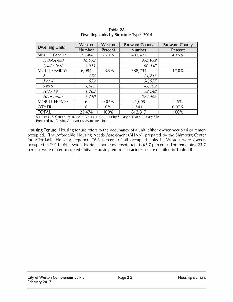
City of Weston Comprehensive Plan Page 2-2 Housing Element February 2017
Table 2A Dwelling Units by Structure Type, 2014
Dwelling Units Weston Weston Broward County Broward County Number Percent Number Percent
SINGLE FAMILY: 19,384 76.1% 402,477 49.5% 1, detached 16,073 335,939 1, attached 3,311 66,538 MULTI-FAMILY: 6,084 23.9% 388,794 47.8% 2 174 21,713 3 or 4 552 36,055 5 to 9 1,085 47,292 10 to 19 1,163 59,248 20 or more 3,110 224,486 MOBILE HOMES 6 0.02% 21,005 2.6% OTHER 0 0% 541 0.07% TOTAL 25,474 100% 812,817 100%
Source: U.S. Census, 2010-2014 American Community Survey 5-Year Summary File Prepared by: Calvin, Giordano & Associates, Inc. Housing Tenure: Housing tenure refers to the occupancy of a unit, either owner-occupied or renter-occupied. The Affordable Housing Needs Assessment (AHNA), prepared by the Shimberg Center for Affordable Housing, reported 76.3 percent of all occupied units in Weston were owner-occupied in 2014. (Statewide, Florida’s homeownership rate is 67.7 percent.) The remaining 23.7 percent were renter-occupied units. Housing tenure characteristics are detailed in Table 2B.
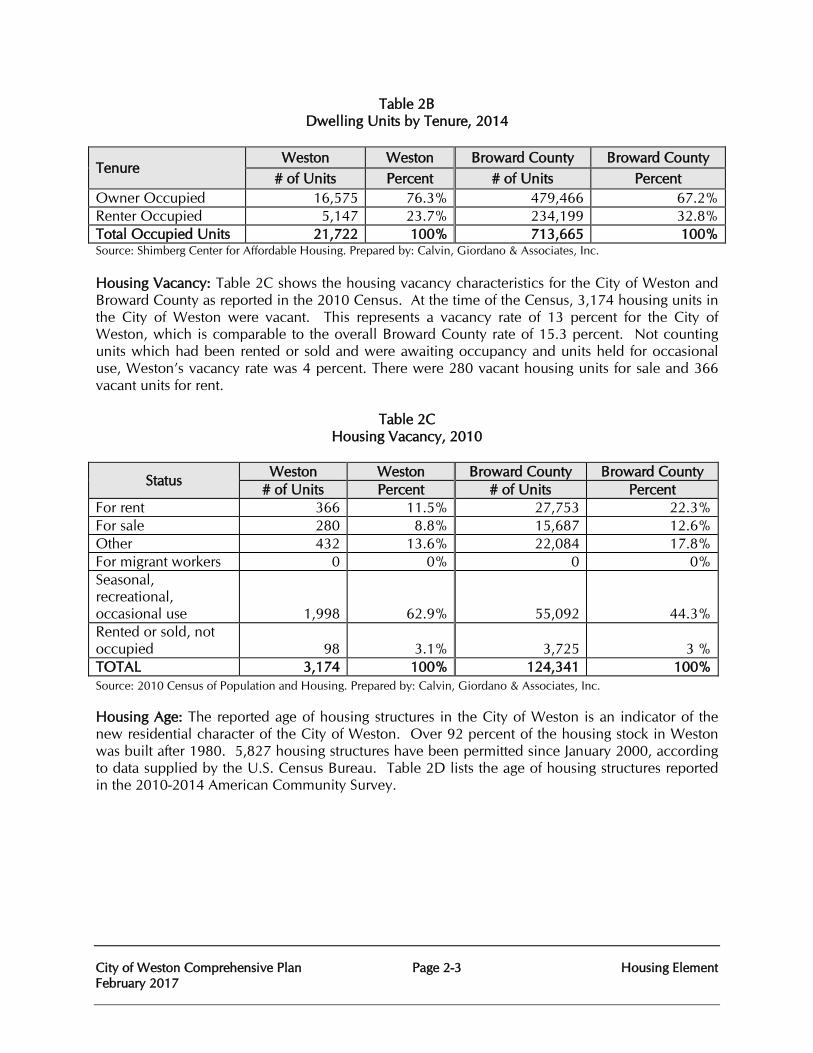
City of Weston Comprehensive Plan Page 2-3 Housing Element February 2017
Table 2B Dwelling Units by Tenure, 2014
Tenure Weston Weston Broward County Broward County
# of Units Percent # of Units Percent Owner Occupied 16,575 76.3% 479,466 67.2% Renter Occupied 5,147 23.7% 234,199 32.8% Total Occupied Units 21,722 100% 713,665 100% Source: Shimberg Center for Affordable Housing. Prepared by: Calvin, Giordano & Associates, Inc. Housing Vacancy: Table 2C shows the housing vacancy characteristics for the City of Weston and Broward County as reported in the 2010 Census. At the time of the Census, 3,174 housing units in the City of Weston were vacant. This represents a vacancy rate of 13 percent for the City of Weston, which is comparable to the overall Broward County rate of 15.3 percent. Not counting units which had been rented or sold and were awaiting occupancy and units held for occasional use, Weston’s vacancy rate was 4 percent. There were 280 vacant housing units for sale and 366 vacant units for rent.
Table 2C
Housing Vacancy, 2010
Status Weston Weston Broward County Broward County
# of Units Percent # of Units Percent For rent 366 11.5% 27,753 22.3% For sale 280 8.8% 15,687 12.6% Other 432 13.6% 22,084 17.8% For migrant workers 0 0% 0 0% Seasonal, recreational, occasional use 1,998 62.9% 55,092 44.3% Rented or sold, not occupied 98 3.1% 3,725 3 % TOTAL 3,174 100% 124,341 100% Source: 2010 Census of Population and Housing. Prepared by: Calvin, Giordano & Associates, Inc. Housing Age: The reported age of housing structures in the City of Weston is an indicator of the new residential character of the City of Weston. Over 92 percent of the housing stock in Weston was built after 1980. 5,827 housing structures have been permitted since January 2000, according to data supplied by the U.S. Census Bureau. Table 2D lists the age of housing structures reported in the 2010-2014 American Community Survey.
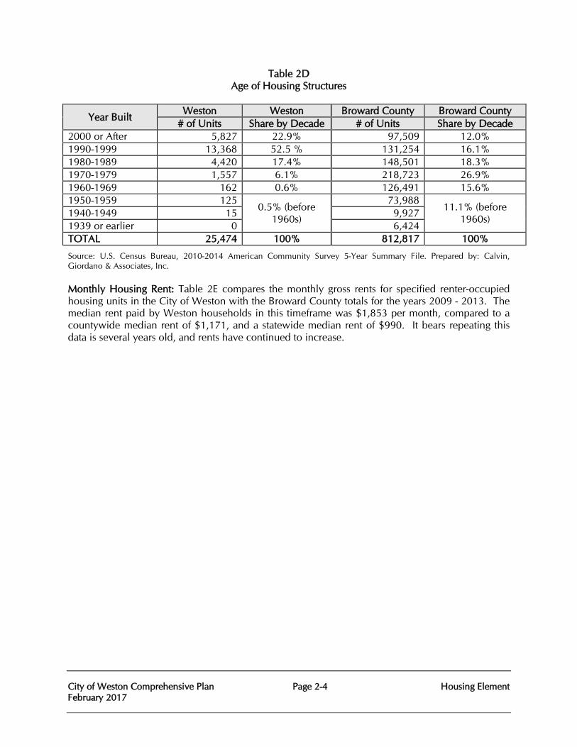
City of Weston Comprehensive Plan Page 2-4 Housing Element February 2017
Table 2D Age of Housing Structures
Year Built Weston Weston Broward County Broward County
# of Units Share by Decade # of Units Share by Decade 2000 or After 5,827 22.9% 97,509 12.0% 1990-1999 13,368 52.5 % 131,254 16.1% 1980-1989 4,420 17.4% 148,501 18.3% 1970-1979 1,557 6.1% 218,723 26.9% 1960-1969 162 0.6% 126,491 15.6% 1950-1959 125
0.5% (before 1960s)
73,988 11.1% (before
1960s) 1940-1949 15 9,927 1939 or earlier 0 6,424 TOTAL 25,474 100% 812,817 100%
Source: U.S. Census Bureau, 2010-2014 American Community Survey 5-Year Summary File. Prepared by: Calvin, Giordano & Associates, Inc. Monthly Housing Rent: Table 2E compares the monthly gross rents for specified renter-occupied housing units in the City of Weston with the Broward County totals for the years 2009 - 2013. The median rent paid by Weston households in this timeframe was $1,853 per month, compared to a countywide median rent of $1,171, and a statewide median rent of $990. It bears repeating this data is several years old, and rents have continued to increase.
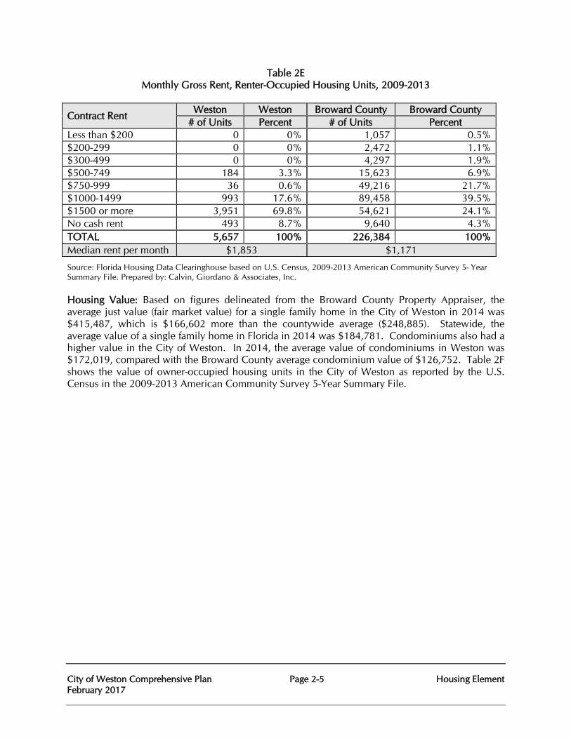
City of Weston Comprehensive Plan Page 2-5 Housing Element February 2017
Table 2E Monthly Gross Rent, Renter-Occupied Housing Units, 2009-2013
Contract Rent Weston Weston Broward County Broward County
# of Units Percent # of Units Percent Less than $200 0 0% 1,057 0.5% $200-299 0 0% 2,472 1.1% $300-499 0 0% 4,297 1.9% $500-749 184 3.3% 15,623 6.9% $750-999 36 0.6% 49,216 21.7% $1000-1499 993 17.6% 89,458 39.5% $1500 or more 3,951 69.8% 54,621 24.1% No cash rent 493 8.7% 9,640 4.3% TOTAL 5,657 100% 226,384 100% Median rent per month $1,853 $1,171
Source: Florida Housing Data Clearinghouse based on U.S. Census, 2009-2013 American Community Survey 5- Year Summary File. Prepared by: Calvin, Giordano & Associates, Inc. Housing Value: Based on figures delineated from the Broward County Property Appraiser, the average just value (fair market value) for a single family home in the City of Weston in 2014 was $415,487, which is $166,602 more than the countywide average ($248,885). Statewide, the average value of a single family home in Florida in 2014 was $184,781. Condominiums also had a higher value in the City of Weston. In 2014, the average value of condominiums in Weston was $172,019, compared with the Broward County average condominium value of $126,752. Table 2F shows the value of owner-occupied housing units in the City of Weston as reported by the U.S. Census in the 2009-2013 American Community Survey 5-Year Summary File.
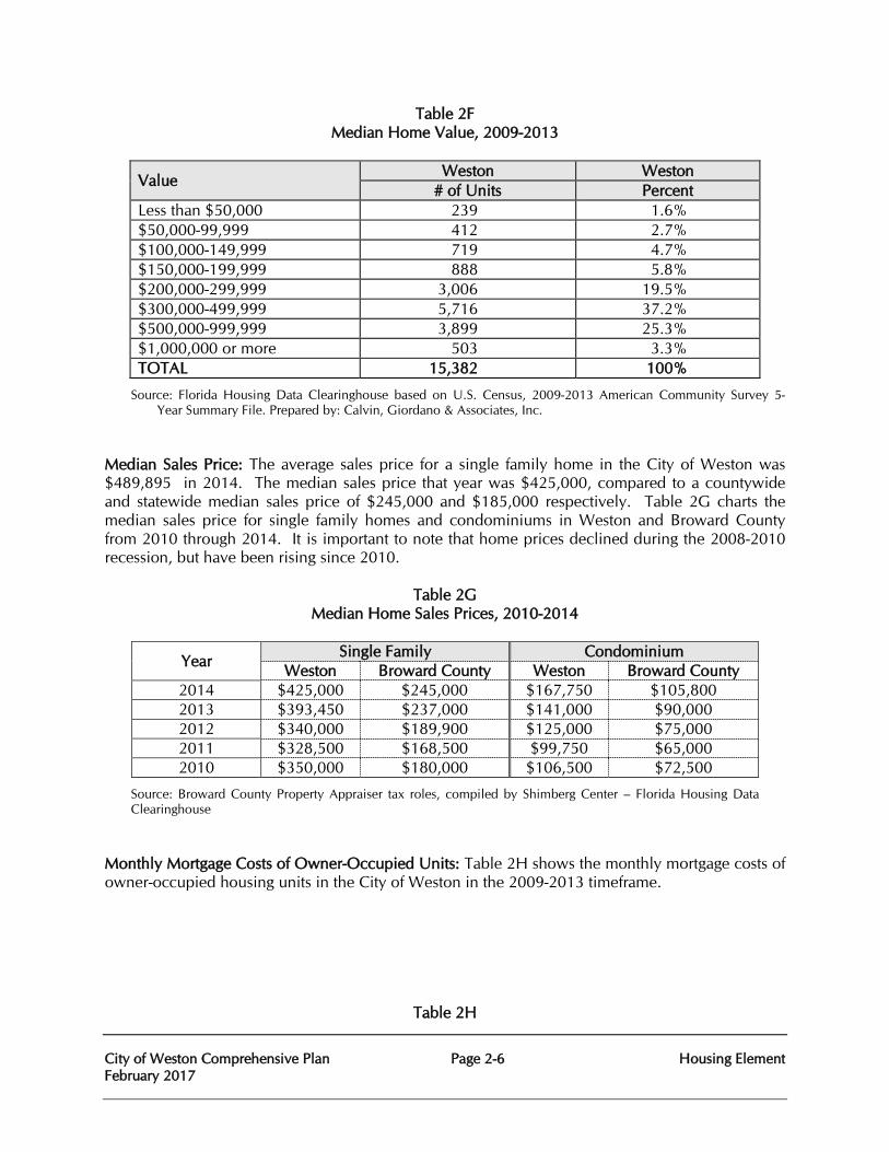
City of Weston Comprehensive Plan Page 2-6 Housing Element February 2017
Table 2F Median Home Value, 2009-2013
Value Weston Weston
# of Units Percent Less than $50,000 239 1.6% $50,000-99,999 412 2.7% $100,000-149,999 719 4.7% $150,000-199,999 888 5.8% $200,000-299,999 3,006 19.5% $300,000-499,999 5,716 37.2% $500,000-999,999 3,899 25.3% $1,000,000 or more 503 3.3% TOTAL 15,382 100%
Source: Florida Housing Data Clearinghouse based on U.S. Census, 2009-2013 American Community Survey 5- Year Summary File. Prepared by: Calvin, Giordano & Associates, Inc.
Median Sales Price: The average sales price for a single family home in the City of Weston was $489,895 in 2014. The median sales price that year was $425,000, compared to a countywide and statewide median sales price of $245,000 and $185,000 respectively. Table 2G charts the median sales price for single family homes and condominiums in Weston and Broward County from 2010 through 2014. It is important to note that home prices declined during the 2008-2010 recession, but have been rising since 2010.
Table 2G
Median Home Sales Prices, 2010-2014
Year Single Family Condominium
Weston Broward County Weston Broward County 2014 $425,000 $245,000 $167,750 $105,800 2013 $393,450 $237,000 $141,000 $90,000 2012 $340,000 $189,900 $125,000 $75,000 2011 $328,500 $168,500 $99,750 $65,000 2010 $350,000 $180,000 $106,500 $72,500
Source: Broward County Property Appraiser tax roles, compiled by Shimberg Center – Florida Housing Data Clearinghouse
Monthly Mortgage Costs of Owner-Occupied Units: Table 2H shows the monthly mortgage costs of owner-occupied housing units in the City of Weston in the 2009-2013 timeframe.
Table 2H
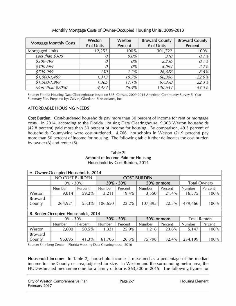
City of Weston Comprehensive Plan Page 2-7 Housing Element February 2017
Monthly Mortgage Costs of Owner-Occupied Housing Units, 2009-2013
Mortgage Monthly Costs Weston Weston Broward County Broward County
# of Units Percent # of Units Percent Mortgaged Units 12,252 100% 301,722 100% Less than $300 0 0.0% 318 0.1% $300-499 0 0% 2,236 0.7% $500-699 0 0% 8,094 2.7% $700-999 150 1.2% 26,676 8.8% $1,000-1,499 1,313 10.7% 66,386 22.0% $1,500-1,999 1,365 11.1% 67,358 22.3% More than $2000 9,424 76.9% 130,654 43.3%
Source: Florida Housing Data Clearinghouse based on U.S. Census, 2009-2013 American Community Survey 5- Year Summary File. Prepared by: Calvin, Giordano & Associates, Inc. AFFORDABLE HOUSING NEEDS Cost Burden: Cost-burdened households pay more than 30 percent of income for rent or mortgage costs. In 2014, according to the Florida Housing Data Clearinghouse, 9,308 Weston households (42.8 percent) paid more than 30 percent of income for housing. By comparison, 49.3 percent of households Countywide were cost-burdened. 4,766 households in Weston (21.9 percent) pay more than 50 percent of income for housing. The following table further delineates the cost burden by owner (A) and renter (B).
Table 2I Amount of Income Paid for Housing
Household by Cost Burden, 2014
A. Owner-Occupied Households, 2014 NO COST BURDEN COST BURDEN 0% - 30% 30% - 50% 50% or more Total Owners Number Percent Number Percent Number Percent Number Percent Weston 9,814 59.2% 3,211 19.4% 3,550 21.4% 16,575 100% Broward County 264,921 55.3% 106,650 22.2% 107,895 22.5% 479,466 100%
B. Renter-Occupied Households, 2014 0% - 30% 30% - 50% 50% or more Total Renters Number Percent Number Percent Number Percent Number Percent Weston 2,600 50.5% 1,331 25.9% 1,216 23.6% 5,147 100% Broward County 96,695 41.3% 61,706 26.3% 75,798 32.4% 234,199 100%
Source: Shimberg Center – Florida Housing Data Clearinghouse, 2016
Household Income: In Table 2J, household income is measured as a percentage of the median income for the County or area, adjusted for size. In Weston and the surrounding metro area, the HUD-estimated median income for a family of four is $63,300 in 2015. The following figures for
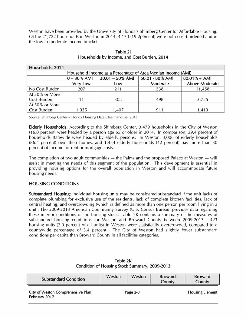
City of Weston Comprehensive Plan Page 2-8 Housing Element February 2017
Weston have been provided by the University of Florida’s Shimberg Center for Affordable Housing. Of the 21,722 households in Weston in 2014, 4,170 (19.2percent) were both cost-burdened and in the low to moderate income bracket.
Table 2J
Households by Income, and Cost Burden, 2014
Households, 2014 Household Income as a Percentage of Area Median Income (AMI) 0 – 30% AMI 30.01 – 50% AMI 50.01 - 80% AMI 80.01%+ AMI
Very Low Low Moderate Above Moderate No Cost Burden 207 211 538 11,458 At 30% or More Cost Burden 11 308 498 3,725 At 50% or More Cost Burden 1,035 1,407 911 1,413
Source: Shimberg Center – Florida Housing Data Clearinghouse, 2016 Elderly Households: According to the Shimberg Center, 3,479 households in the City of Weston (16.0 percent) were headed by a person age 65 or older in 2014. In comparison, 29.4 percent of households statewide were headed by elderly persons. In Weston, 3,006 of elderly households (86.4 percent) own their homes, and 1,454 elderly households (42 percent) pay more than 30 percent of income for rent or mortgage costs. The completion of two adult communities — the Palms and the proposed Palace at Weston — will assist in meeting the needs of this segment of the population. This development is essential in providing housing options for the overall population in Weston and will accommodate future housing needs. HOUSING CONDITIONS Substandard Housing: Individual housing units may be considered substandard if the unit lacks of complete plumbing for exclusive use of the residents, lack of complete kitchen facilities, lack of central heating, and overcrowding (which is defined as more than one person per room living in a unit). The 2009-2013 American Community Survey (U.S. Census Bureau) provides data regarding these interior conditions of the housing stock. Table 2K contains a summary of the measures of substandard housing conditions for Weston and Broward County between 2009-2013. 423 housing units (2.0 percent of all units) in Weston were statistically overcrowded, compared to a countywide percentage of 3.4 percent. The City of Weston had slightly fewer substandard conditions per capita than Broward County in all facilities categories.
Table 2K Condition of Housing Stock Summary, 2009-2013
Substandard Condition Weston Weston Broward
County Broward County
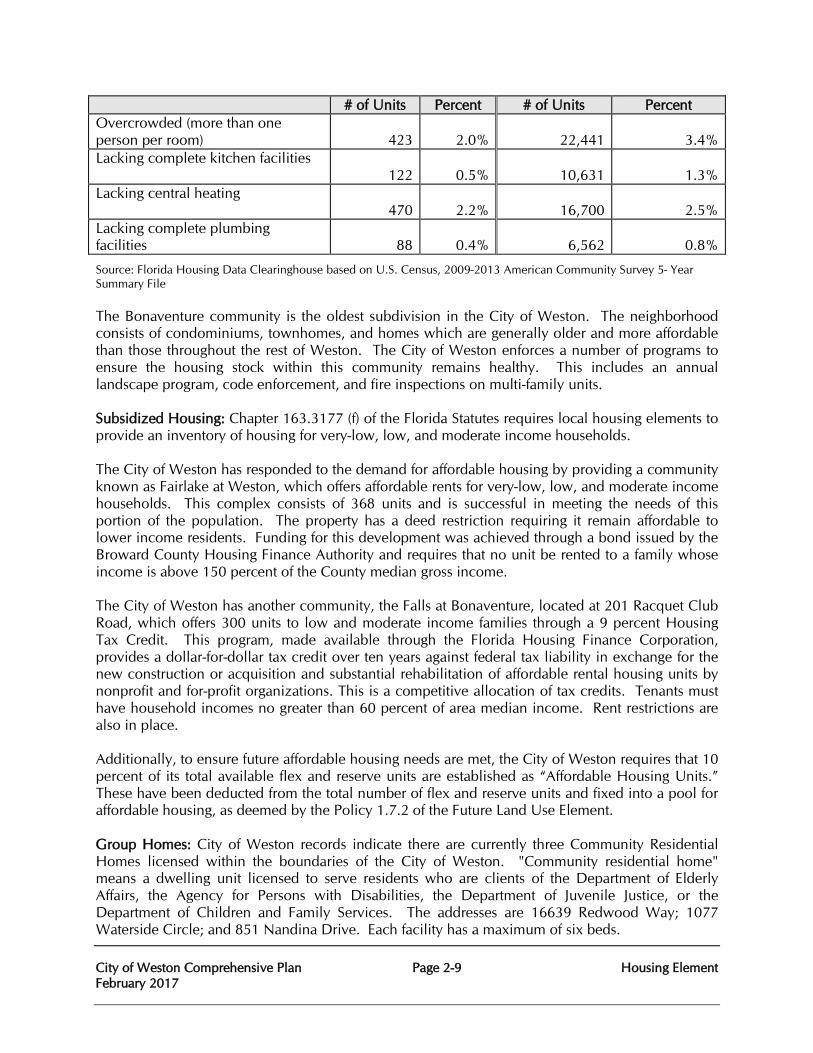
City of Weston Comprehensive Plan Page 2-9 Housing Element February 2017
# of Units Percent # of Units Percent Overcrowded (more than one person per room)
423
2.0%
22,441
3.4%
Lacking complete kitchen facilities 122
0.5%
10,631
1.3%
Lacking central heating 470
2.2%
16,700
2.5%
Lacking complete plumbing facilities
88
0.4%
6,562
0.8%
Source: Florida Housing Data Clearinghouse based on U.S. Census, 2009-2013 American Community Survey 5- Year Summary File The Bonaventure community is the oldest subdivision in the City of Weston. The neighborhood consists of condominiums, townhomes, and homes which are generally older and more affordable than those throughout the rest of Weston. The City of Weston enforces a number of programs to ensure the housing stock within this community remains healthy. This includes an annual landscape program, code enforcement, and fire inspections on multi-family units. Subsidized Housing: Chapter 163.3177 (f) of the Florida Statutes requires local housing elements to provide an inventory of housing for very-low, low, and moderate income households. The City of Weston has responded to the demand for affordable housing by providing a community known as Fairlake at Weston, which offers affordable rents for very-low, low, and moderate income households. This complex consists of 368 units and is successful in meeting the needs of this portion of the population. The property has a deed restriction requiring it remain affordable to lower income residents. Funding for this development was achieved through a bond issued by the Broward County Housing Finance Authority and requires that no unit be rented to a family whose income is above 150 percent of the County median gross income. The City of Weston has another community, the Falls at Bonaventure, located at 201 Racquet Club Road, which offers 300 units to low and moderate income families through a 9 percent Housing Tax Credit. This program, made available through the Florida Housing Finance Corporation, provides a dollar-for-dollar tax credit over ten years against federal tax liability in exchange for the new construction or acquisition and substantial rehabilitation of affordable rental housing units by nonprofit and for-profit organizations. This is a competitive allocation of tax credits. Tenants must have household incomes no greater than 60 percent of area median income. Rent restrictions are also in place. Additionally, to ensure future affordable housing needs are met, the City of Weston requires that 10 percent of its total available flex and reserve units are established as “Affordable Housing Units.” These have been deducted from the total number of flex and reserve units and fixed into a pool for affordable housing, as deemed by the Policy 1.7.2 of the Future Land Use Element. Group Homes: City of Weston records indicate there are currently three Community Residential Homes licensed within the boundaries of the City of Weston. "Community residential home" means a dwelling unit licensed to serve residents who are clients of the Department of Elderly Affairs, the Agency for Persons with Disabilities, the Department of Juvenile Justice, or the Department of Children and Family Services. The addresses are 16639 Redwood Way; 1077 Waterside Circle; and 851 Nandina Drive. Each facility has a maximum of six beds.
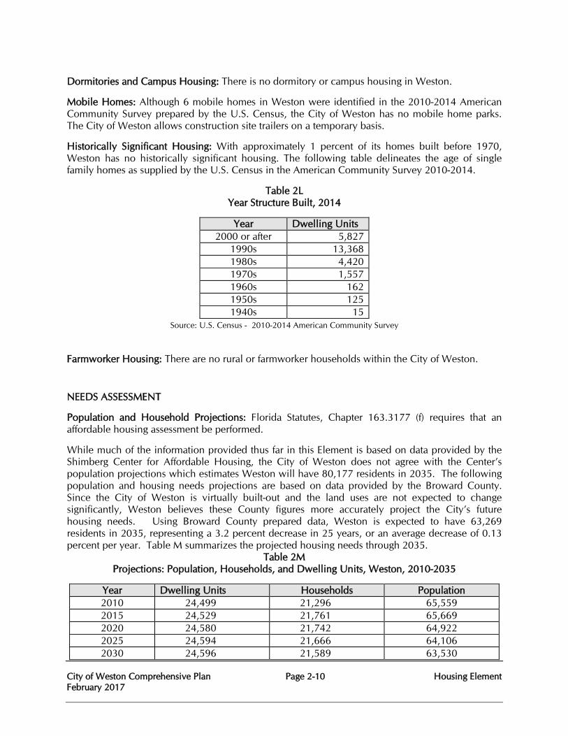
City of Weston Comprehensive Plan Page 2-10 Housing Element February 2017
Dormitories and Campus Housing: There is no dormitory or campus housing in Weston.
Mobile Homes: Although 6 mobile homes in Weston were identified in the 2010-2014 American Community Survey prepared by the U.S. Census, the City of Weston has no mobile home parks. The City of Weston allows construction site trailers on a temporary basis.
Historically Significant Housing: With approximately 1 percent of its homes built before 1970, Weston has no historically significant housing. The following table delineates the age of single family homes as supplied by the U.S. Census in the American Community Survey 2010-2014.
Table 2L Year Structure Built, 2014
Year Dwelling Units 2000 or after 5,827
1990s 13,368 1980s 4,420 1970s 1,557 1960s 162 1950s 125 1940s 15
Source: U.S. Census - 2010-2014 American Community Survey Farmworker Housing: There are no rural or farmworker households within the City of Weston.
NEEDS ASSESSMENT
Population and Household Projections: Florida Statutes, Chapter 163.3177 (f) requires that an affordable housing assessment be performed.
While much of the information provided thus far in this Element is based on data provided by the Shimberg Center for Affordable Housing, the City of Weston does not agree with the Center’s population projections which estimates Weston will have 80,177 residents in 2035. The following population and housing needs projections are based on data provided by the Broward County. Since the City of Weston is virtually built-out and the land uses are not expected to change significantly, Weston believes these County figures more accurately project the City’s future housing needs. Using Broward County prepared data, Weston is expected to have 63,269 residents in 2035, representing a 3.2 percent decrease in 25 years, or an average decrease of 0.13 percent per year. Table M summarizes the projected housing needs through 2035.
Table 2M Projections: Population, Households, and Dwelling Units, Weston, 2010-2035
Year Dwelling Units Households Population 2010 24,499 21,296 65,559 2015 24,529 21,761 65,669 2020 24,580 21,742 64,922 2025 24,594 21,666 64,106 2030 24,596 21,589 63,530
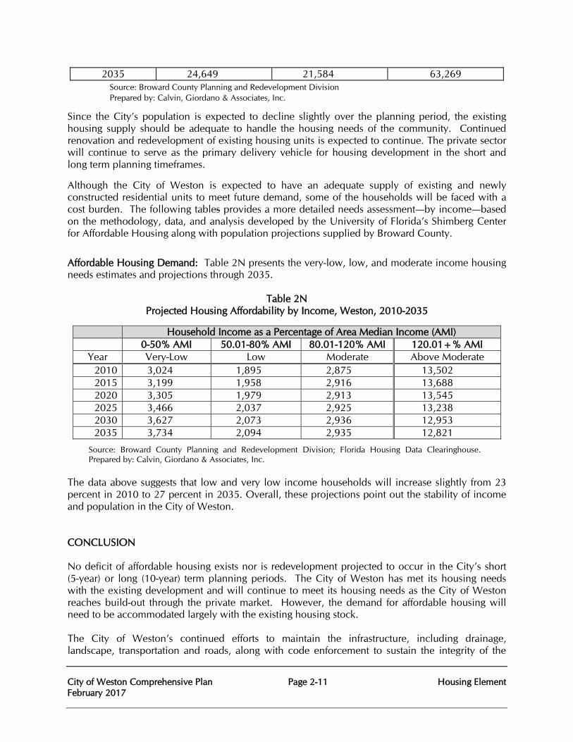
City of Weston Comprehensive Plan Page 2-11 Housing Element February 2017
2035 24,649 21,584 63,269 Source: Broward County Planning and Redevelopment Division Prepared by: Calvin, Giordano & Associates, Inc.
Since the City’s population is expected to decline slightly over the planning period, the existing housing supply should be adequate to handle the housing needs of the community. Continued renovation and redevelopment of existing housing units is expected to continue. The private sector will continue to serve as the primary delivery vehicle for housing development in the short and long term planning timeframes.
Although the City of Weston is expected to have an adequate supply of existing and newly constructed residential units to meet future demand, some of the households will be faced with a cost burden. The following tables provides a more detailed needs assessment—by income—based on the methodology, data, and analysis developed by the University of Florida’s Shimberg Center for Affordable Housing along with population projections supplied by Broward County.
Affordable Housing Demand: Table 2N presents the very-low, low, and moderate income housing needs estimates and projections through 2035.
Table 2N Projected Housing Affordability by Income, Weston, 2010-2035
Household Income as a Percentage of Area Median Income (AMI) 0-50% AMI 50.01-80% AMI 80.01-120% AMI 120.01+% AMI
Year Very-Low Low Moderate Above Moderate 2010 3,024 1,895 2,875 13,502 2015 3,199 1,958 2,916 13,688 2020 3,305 1,979 2,913 13,545 2025 3,466 2,037 2,925 13,238 2030 3,627 2,073 2,936 12,953 2035 3,734 2,094 2,935 12,821
Source: Broward County Planning and Redevelopment Division; Florida Housing Data Clearinghouse. Prepared by: Calvin, Giordano & Associates, Inc.
The data above suggests that low and very low income households will increase slightly from 23 percent in 2010 to 27 percent in 2035. Overall, these projections point out the stability of income and population in the City of Weston. CONCLUSION No deficit of affordable housing exists nor is redevelopment projected to occur in the City’s short (5-year) or long (10-year) term planning periods. The City of Weston has met its housing needs with the existing development and will continue to meet its housing needs as the City of Weston reaches build-out through the private market. However, the demand for affordable housing will need to be accommodated largely with the existing housing stock. The City of Weston’s continued efforts to maintain the infrastructure, including drainage, landscape, transportation and roads, along with code enforcement to sustain the integrity of the
City of Weston Comprehensive Plan Page 2-12 Housing Element February 2017
neighborhood, will prolong the life of older neighborhoods like Bonaventure. These areas function as affordable housing for Weston, which the City of Weston has taken strides to sustain. Affordable housing needs are also accommodated through the two existing subsidized communities, as well the addition of two independent-living adult communities that offer seniors with housing alternatives. Each of these housing opportunities, coupled with the following policies, provides residents with housing choice and assurance of a quality, highly maintained area, all of which demonstrates the advances Weston is taking to address the housing needs of the different demographics and income levels of its residents.
City of Weston Comprehensive Plan Page 2-13 Housing Element February 2017
HOUSING ELEMENT GOALS, OBJECTIVES, AND POLICIES
Goal 2 To assure the availability of a safe, sound and attractive residential environment for all residents of the City of Weston.
2.1 Objective: The City of Weston shall provide for adequate and affordable housing for existing and future residents, households with special housing needs, and very low, low, and moderate income households consistent with the needs identified in Table 2N though the short term (5 year) and long term (10 year) planning timeframes.
2.1.1 Policy: City of Weston shall support the involvement of private and non-profit sectors, as well as county, regional, state and federal agencies in housing production and rehabilitation through expedited plan review.
2.1.2 Policy: The utilization of federal, state and local housing subsidy programs is recognized as a means to provide housing opportunities for very-low income and low income persons and families.
2.1.3 Policy: City of Weston shall continue to develop development regulations and procedures that facilitate production by reviewing current administrative procedures and regulations.
2.1.4 Policy: The City of Weston shall continue to encourage the development of multifamily housing affordable to very low, low and moderate income housing groups within the areas designated for higher density residential development as depicted on the Future Land Use Map in order to promote the provision of an adequate supply of housing to meet with the City’s identified needs.
2.1.5 Policy: The City of Weston shall continue to evaluate the current land development requirements to identify methods to streamline the development process and reduce the costs associated with the development of affordable housing.
2.2 Objective:
City of Weston shall eliminate substandard housing conditions and blighting influences and improve structural and aesthetic housing conditions as defined by the City of Weston Code of Ordinances and the Florida Building Code.
City of Weston Comprehensive Plan Page 2-14 Housing Element February 2017
2.2.1 Policy: New housing construction and remodeling or rehabilitation of existing residences shall be in conformance with local building requirements. The City of Weston will strictly enforce its zoning regulations, building codes and ordinances to assure conformance.
2.2.2 Policy: Maintain accurate records of existing housing conditions and housing stock.
2.2.3 Policy: Aesthetic compatibility and visual harmony shall be considered as bona fide criteria in reviewing requests for building permits.
2.2.4 Policy: Revise and amend the regulatory and permitting processes and revise and amend the appropriate sections of the Comprehensive Plan, zoning regulations, building codes and city ordinances as warranted by changes in housing conditions.
2.2.5 Policy: Require demolition or rehabilitation of unsound housing which poses a threat to the safety and welfare of the community, as provided for by the Florida Building Code.
2.2.6 Policy: New development shall be compatible with adjacent established residential areas.
2.3 Objective:
City of Weston shall provide adequate sites and distribution of housing for very-low income, low income and moderate income households.
2.3.1 Policy:
City of Weston may utilize job training, job creation and economic solutions to address a portion of its affordable housing concerns by continuing to attract non-residential development.
2.3.2 Policy:
City of Weston shall designate sufficient sites at sufficient densities to accommodate the need for affordable housing in the future through land use and zoning regulations.
2.3.3 Policy:
City of Weston shall continue to work with the South Florida Regional Planning Council to help achieve the goals and policies in the Affordable Housing Element of the current Strategic Regional Policy Plan for South Florida (SRPP) as they relate to ensuring the availability of adequate affordable housing for all income ranges in Weston.
2.3.4 Policy:
City of Weston Comprehensive Plan Page 2-15 Housing Element February 2017
City of Weston shall consider bonus densities for affordable housing in selected areas of the City of Weston; provided such bonus densities are coupled with strict design standards.
2.4 Objective: City of Weston shall provide adequate sites in residential areas or areas of residential character for group homes and foster care facilities licensed or funded by the Florida Department of Children and Families.
2.4.1 Policy: Support the involvement of the City of Weston with private and non-profit agencies to improve coordination among participants involved in housing production through expedited plan review.
2.4.2 Policy: Support the provision of adequate sites for housing very-low, low and moderate income families and Florida Department of Children and Families licensed or funded group and foster homes on a regional housing market basis (as mandated by Chapter 419, F.S.), to foster non-discrimination in housing and to encourage effective, healthful, residential alternatives to inappropriate institutionalization.
2.4.3 Policy: Florida Department of Children and Families licensed or funded group and foster homes shall be permitted uses under residential land use classification.
2.4.4 Policy: The location of community residential facilities dispersed among the regional housing market to serve persons with special housing needs, disabilities or handicaps shall be supported by Weston.
2.5 Objective: City of Weston shall identify, conserve or rehabilitate any historically significant housing.
2.5.1 Policy: Promote the conservation and rehabilitation of existing housing as a means of maintaining or improving residential conditions and reducing the waste of valuable resources.
2.5.2 Policy: Preserve identified historically significant housing through City of Weston action or support for private action.
2.5.3 Policy: Establish principles and standards to guide techniques and strategies for conservation, rehabilitation and demolition programs.
2.6 Objective:
City of Weston Comprehensive Plan Page 2-16 Housing Element February 2017
City of Weston shall provide equitable treatment for all residents of Weston displaced through public programs or activities.
2.6.1 Policy: The provision of reasonably located standard housing for persons experiencing displacement due to public actions shall be supported.
2.7 Objective:
City of Weston shall formulate housing implementation programs.
2.7.1 Policy: Residential building permit and demolition data shall be maintained by the Building Department.
2.7.2 Policy: Mixed use development and location of a mix of housing opportunities proximate to employment centers shall be encouraged in the Town Center through appropriate land use and zoning regulations.
2.7.3 Policy: City of Weston shall enforce provisions for waiving dedications of land and payments of money in lieu thereof if the City Commission finds that the proposed project will provide affordable housing for very low income, low income, and/or moderate incomes persons.
2.7.4 Policy: City of Weston shall participate in regional initiatives through the South Florida Regional Planning Council and Broward County aimed at providing affordable housing and cooperate with intergovernmental mechanisms for this purpose.
2.8 Objective: City of Weston shall support energy efficiency and the use of renewable energy resources in existing housing and in the design and construction of new housing.
2.8.1 Policy: The City of Weston shall encourage support for residential construction that meets the United States Green Building Council (USGBC) Leadership in Energy and Environmental Design (LEED) rating system, the Green Building Initiative's Green Globes rating system, the Florida Green Building Coalition standards, or other nationally recognized, high-performance green building rating system as recognized by the Florida Department of Management Services.
2.8.2 Policy: The City of Weston shall educate City residents on home energy reduction strategies.
2.8.3 Policy:
City of Weston Comprehensive Plan Page 2-17 Housing Element February 2017
The City of Weston shall not prohibit the appropriate placement of photovoltaic panels. The City of Weston shall develop and adopt review criteria to establish the standards for the appropriate placement of photovoltaic panels.
2.8.4 Policy: The City of Weston shall provide educational materials on the strategic placement of landscape materials to reduce energy consumption.
City of Weston Comprehensive Plan Page 3-1 Infrastructure February 2017
CHAPTER THREE
INFRASTRUCTURE
PURPOSE The purpose of this element is to provide for necessary public facilities and services correlated to the future land use projections. The City of Weston is comprised of two dependent districts, the Indian Trace Development District (ITDD) and the Bonaventure Development District (BDD). In the ITDD, the district, owns and maintains the potable water distribution, sanitary sewer (wastewater) collection system and drainage (stormwater) infrastructure. In the BDD, the district owns and maintains stormwater infrastructure only. The City does not own or operate water or sanitary sewer treatment facilities. Treatment for water and wastewater is provided by the City of Sunrise. This element addresses the general utilities which are provided by or managed by the City of Weston. These include:
• SANITARY SEWER • SOLID WASTE • DRAINAGE • POTABLE WATER • NATURAL GROUND WATER AQUIFER RECHARGE
The element is organized to provide analysis information about each area of service individually. The element conclusion contains the goal, objectives and policies for all the utilities services. EXISTING CONDITIONS AND DATA
Sanitary Sewer Analysis
The ITDD wastewater collection and transmission system is owned and operated by the City of Weston and all wastewater flow is sent to the Sawgrass Wastewater Treatment Plant, a facility owned and operated by the City of Sunrise. The BDD system is however, completely owned and operated by the City of Sunrise. The existing wastewater facilities expand on an as-needed basis to service development activities. Pursuant to the Settlement Agreement (entered into on June 30th, 1993) between the ITDD and the City of Sunrise, the City of Sunrise certified that it has the ability to provide the wastewater transmission, treatment and disposal capacity necessary to meet the ITDD’s present and future needs. The Windmill Lakes Estates section of the City of Weston contains certain properties which are currently on a septic tank and drainfield systems. The City of Weston had made sewage improvements in the past reducing the number of residents on septic tank systems. The residential single family areas of the City of Weston served by septic tanks do not appear to pose a threat to the public health. No instances of ground water contamination have been reported to date. The extents of sanitary gravity sewers and lift stations, sewer sizes, depths, manhole and service lateral locations are maintained by the City’s Engineering Department.
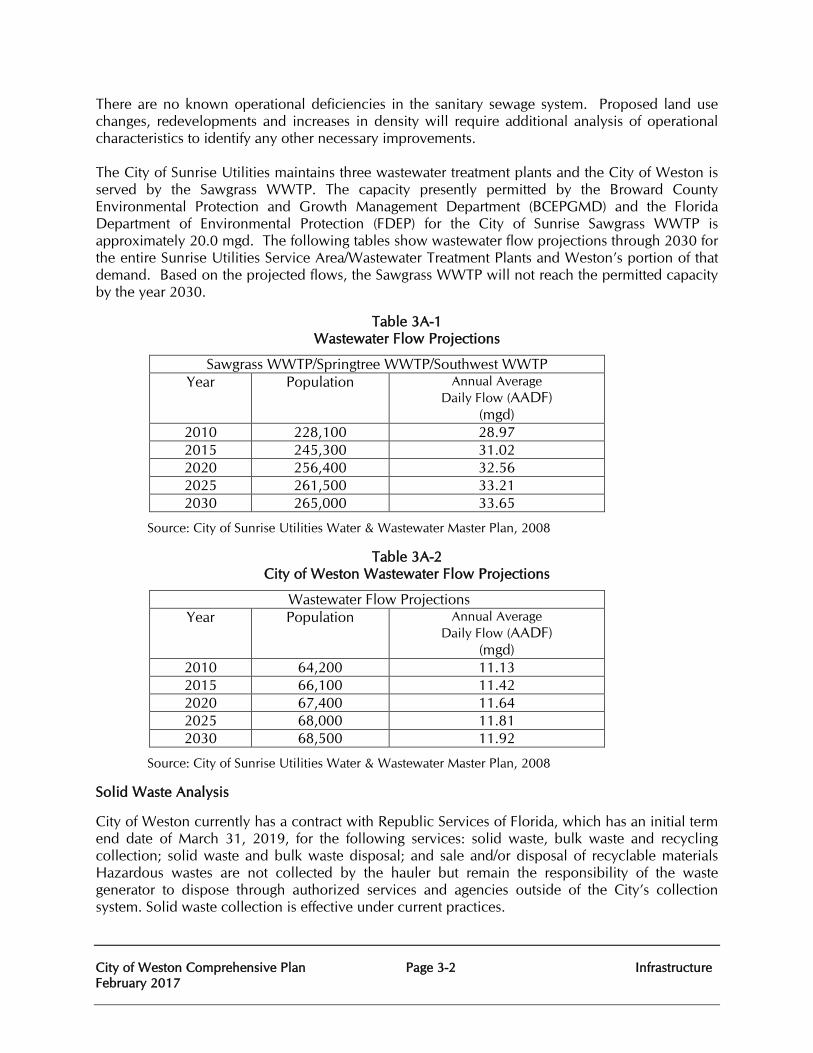
City of Weston Comprehensive Plan Page 3-2 Infrastructure February 2017
There are no known operational deficiencies in the sanitary sewage system. Proposed land use changes, redevelopments and increases in density will require additional analysis of operational characteristics to identify any other necessary improvements. The City of Sunrise Utilities maintains three wastewater treatment plants and the City of Weston is served by the Sawgrass WWTP. The capacity presently permitted by the Broward County Environmental Protection and Growth Management Department (BCEPGMD) and the Florida Department of Environmental Protection (FDEP) for the City of Sunrise Sawgrass WWTP is approximately 20.0 mgd. The following tables show wastewater flow projections through 2030 for the entire Sunrise Utilities Service Area/Wastewater Treatment Plants and Weston’s portion of that demand. Based on the projected flows, the Sawgrass WWTP will not reach the permitted capacity by the year 2030.
Table 3A-1 Wastewater Flow Projections
Sawgrass WWTP/Springtree WWTP/Southwest WWTP Year Population Annual Average
Daily Flow (AADF) (mgd)
2010 228,100 28.97 2015 245,300 31.02 2020 256,400 32.56 2025 261,500 33.21 2030 265,000 33.65
Source: City of Sunrise Utilities Water & Wastewater Master Plan, 2008
Table 3A-2 City of Weston Wastewater Flow Projections
Wastewater Flow Projections Year Population Annual Average
Daily Flow (AADF) (mgd)
2010 64,200 11.13 2015 66,100 11.42 2020 67,400 11.64 2025 68,000 11.81 2030 68,500 11.92
Source: City of Sunrise Utilities Water & Wastewater Master Plan, 2008
Solid Waste Analysis
City of Weston currently has a contract with Republic Services of Florida, which has an initial term end date of March 31, 2019, for the following services: solid waste, bulk waste and recycling collection; solid waste and bulk waste disposal; and sale and/or disposal of recyclable materials Hazardous wastes are not collected by the hauler but remain the responsibility of the waste generator to dispose through authorized services and agencies outside of the City’s collection system. Solid waste collection is effective under current practices.
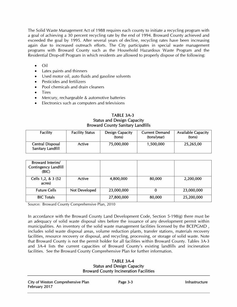
City of Weston Comprehensive Plan Page 3-3 Infrastructure February 2017
The Solid Waste Management Act of 1988 requires each county to initiate a recycling program with a goal of achieving a 30 percent recycling rate by the end of 1994. Broward County achieved and exceeded the goal by 1995. After several years of decline, recycling rates have been increasing again due to increased outreach efforts. The City participates in special waste management programs with Broward County such as the Household Hazardous Waste Program and the Residential Drop-off Program in which residents are allowed to properly dispose of the following:
• Oil • Latex paints and thinners • Used motor oil, auto fluids and gasoline solvents • Pesticides and fertilizers • Pool chemicals and drain cleaners • Tires • Mercury, rechargeable & automotive batteries • Electronics such as computers and televisions
TABLE 3A-3 Status and Design Capacity
Broward County Sanitary Landfills
Facility Facility Status Design Capacity (tons)
Current Demand (tons/year)
Available Capacity (tons)
Central Disposal Sanitary Landfill
Active 75,000,000 1,500,000 25,265,00
Broward Interim/ Contingency Landfill
(BIC)
Cells 1,2, & 3 (52 acres)
Active 4,800,000 80,000 2,200,000
Future Cells Not Developed 23,000,000 0 23,000,000
BIC Totals 27,800,000 80,000 25,200,000
Source: Broward County Comprehensive Plan, 2010
In accordance with the Broward County Land Development Code, Section 5-198(g) there must be an adequacy of solid waste disposal sites before the issuance of any development permit within municipalities. An inventory of the solid waste management facilities licensed by the BCEPGMD , includes solid waste disposal areas, volume reduction plants, transfer stations, materials recovery facilities, resource recovery or disposal, and recycling, processing, or storage of solid waste. Note that Broward County is not the permit holder for all facilities within Broward County. Tables 3A-3 and 3A-4 lists the current capacities of Broward County’s existing landfills and incineration facilities. See the Broward County Comprehensive Plan for further information.
TABLE 3A-4 Status and Design Capacity
Broward County Incineration Facilities
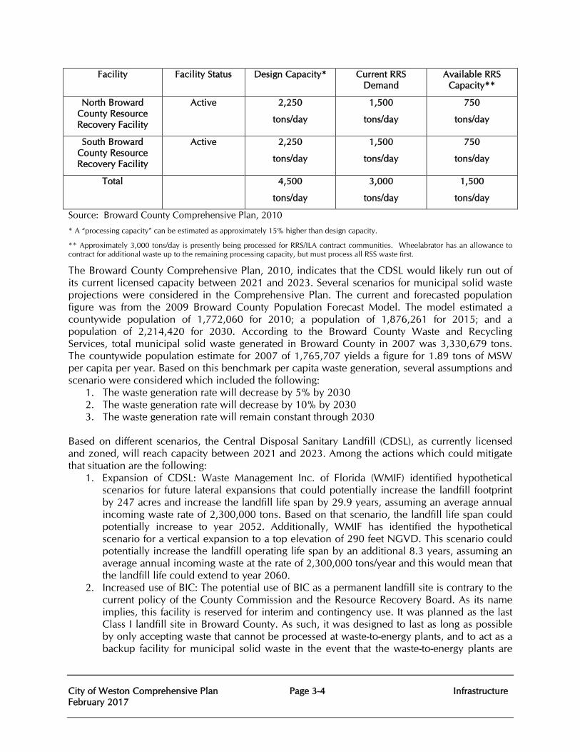
City of Weston Comprehensive Plan Page 3-4 Infrastructure February 2017
Facility Facility Status Design Capacity* Current RRS Demand
Available RRS Capacity**
North Broward County Resource Recovery Facility
Active 2,250
tons/day
1,500
tons/day
750
tons/day
South Broward County Resource Recovery Facility
Active 2,250
tons/day
1,500
tons/day
750
tons/day
Total 4,500
tons/day
3,000
tons/day
1,500
tons/day
Source: Broward County Comprehensive Plan, 2010
* A “processing capacity” can be estimated as approximately 15% higher than design capacity.
** Approximately 3,000 tons/day is presently being processed for RRS/ILA contract communities. Wheelabrator has an allowance to contract for additional waste up to the remaining processing capacity, but must process all RSS waste first.
The Broward County Comprehensive Plan, 2010, indicates that the CDSL would likely run out of its current licensed capacity between 2021 and 2023. Several scenarios for municipal solid waste projections were considered in the Comprehensive Plan. The current and forecasted population figure was from the 2009 Broward County Population Forecast Model. The model estimated a countywide population of 1,772,060 for 2010; a population of 1,876,261 for 2015; and a population of 2,214,420 for 2030. According to the Broward County Waste and Recycling Services, total municipal solid waste generated in Broward County in 2007 was 3,330,679 tons. The countywide population estimate for 2007 of 1,765,707 yields a figure for 1.89 tons of MSW per capita per year. Based on this benchmark per capita waste generation, several assumptions and scenario were considered which included the following:
1. The waste generation rate will decrease by 5% by 2030 2. The waste generation rate will decrease by 10% by 2030 3. The waste generation rate will remain constant through 2030
Based on different scenarios, the Central Disposal Sanitary Landfill (CDSL), as currently licensed and zoned, will reach capacity between 2021 and 2023. Among the actions which could mitigate that situation are the following:
1. Expansion of CDSL: Waste Management Inc. of Florida (WMIF) identified hypothetical scenarios for future lateral expansions that could potentially increase the landfill footprint by 247 acres and increase the landfill life span by 29.9 years, assuming an average annual incoming waste rate of 2,300,000 tons. Based on that scenario, the landfill life span could potentially increase to year 2052. Additionally, WMIF has identified the hypothetical scenario for a vertical expansion to a top elevation of 290 feet NGVD. This scenario could potentially increase the landfill operating life span by an additional 8.3 years, assuming an average annual incoming waste at the rate of 2,300,000 tons/year and this would mean that the landfill life could extend to year 2060.
2. Increased use of BIC: The potential use of BIC as a permanent landfill site is contrary to the current policy of the County Commission and the Resource Recovery Board. As its name implies, this facility is reserved for interim and contingency use. It was planned as the last Class I landfill site in Broward County. As such, it was designed to last as long as possible by only accepting waste that cannot be processed at waste-to-energy plants, and to act as a backup facility for municipal solid waste in the event that the waste-to-energy plants are
City of Weston Comprehensive Plan Page 3-5 Infrastructure February 2017
unable to accept this material in an emergency situation, or if disposal is required while additional capacity is being developed.
3. Use of other Disposal Sites in Central Florida: Landfill sites exist in Central Florida, and beyond, with ample capacity to handle the excess forecasted demand from Broward County during the planning period. However, the transport of solid waste over long distances carries a direct cost, and indirect cost, which may make this option undesirable. Regarding a new landfill site within Broward County, it is difficult to imagine a location that would be socially and environmentally acceptable. Since the completion of the 2000 Land Preservation and Safe Parks County Bond Program, finding a vacant suitable site of sufficient size for this purpose would be very difficult.
4. Reduction of Use of Landfill: Aside from the goal in Florida Statute to achieve 75% recycling, there are many other efforts underway by local and state governments to reduce waste, particularly waste going to landfills. Policies which prohibit and discourage the use of landfill capacity for processable solid waste or waste from outside Broward County, will significantly extend the useful life of the landfill facility.
Drainage Analysis
Drainage within the City of Weston (ITDD and BDD) is provided by a stormwater management system that collects and coveys storm runoff to several points for water treatment and discharge. City of Weston provides for the following drainage services:
Road Protection Residential streets with not greater than fifty (50) feet wide rights-of-way shall have crown elevations not lower than the elevation for the respective area depicted on the Broward County ten year “Flood Criteria Map”. Rights-of-way greater than fifty (50) feet shall have an ultimate edge of pavement no lower than the elevation for the respective area depicted on the Broward County ten (10) year-3 day “Flood Criteria Map”.
Buildings
To have the lowest floor elevation no lower than the elevation for the respective area depicted on the Broward County “100 Year Flood Elevation Map” or Federal Emergency Management Agency Base Flood Elevation, whichever is higher.
Off Site Discharge
Not to exceed the inflow limit of the SFWMD primary receiving canal or the City’s conveyance system, whichever is less.
Storm Sewers
Design frequency minimum to be three-year rainfall intensity of the State Department of Transportation Zone 10 rainfall curves.
Flood Plain Routing
Calculated flood elevations based on the ten-year and one hundred-year return frequency rainfall of three-day duration shall not exceed the corresponding elevation of the Broward County “100 Year Flood Elevation Map.”
Antecedent Water
The higher elevation of either the control level elevation or the elevation depicted on the Broward County “Average Wet Season Water Levels.”
City of Weston Comprehensive Plan Page 3-6 Infrastructure February 2017
On-Site Storage
Minimum capacity above antecedent water level and below the flood plain routing elevations to be the design rainfall volume minus off-site discharge occurring during design rainfall.
Best Management
Prior to discharge to surface or groundwater, BMP’s of the South Florida Water Management District shall be used to reduce pollutant loading from storm water run-off.
The current surface water management system is operated by the City of Weston and permitted as the Indian Trace Development District and the Bonaventure Development District. The attached Map 3-3 delineates each district, basin, and sub basins.
Indian Trace Development District (ITDD) – Basin I
The surface water management within the Indian Trace Drainage District Basin I consists of four (4) separate drainage areas as follows:
Increment III Mitigation Area Increment II Mitigation Area Increment III - Sectors 1 and 2 Remainder of Basin 1 - Sectors 3 through 16
Indian Trace Development District (ITDD) – Basin II
This basin is comprised of primarily vacant, grazing or agricultural lands with little development. Some large parcels have their own water control structures and/or utilize a series of drainage ditches that flow to the C-11 Canal. The City of Weston reviews permit applications within this Basin in accordance with South Florida Water Management District Criteria. Two City of Weston mitigation areas were conveyed to the SFWMD in 2015 for the C-11Impoundment Project.
Bonaventure Development District (BDD)
The surface water management within the Bonaventure Development District (BDD), formerly known as West Lauderdale Water Control District, was annexed into the City of Weston in 1997.
BASIN I - Indian Trace Drainage District (ITDD)
The existing major surface water management facilities consist of more than 1,600 acres of lake within Sectors 3 through 16, and there is approximately 1,900 acres of wetland mitigation land within Weston that the City maintains. This is comprised of enhanced freshwater marsh lands and created littoral lake shelves. Additionally, there is approximately another 415 acres of freshwater marsh wetland mitigation that is maintained through private ownership or by Broward County or the SFWMD. Of this total acreage, nearly 2,050 is sawgrass dominated or freshwater marsh habitat with scattered ‘tree islands’; the remaining mitigation acreage is littoral lake edges. All of the lakes are interconnected by a series of culverts with drainage ditches that flow south to the C-11 Canal, four (4) water control structures and two (2) pump stations.
City of Weston Comprehensive Plan Page 3-7 Infrastructure February 2017
The City’s Indian Trace Development District has operational responsibilities for drainage facilities in the public right-of-way and on City of Weston property, with the exception of the facilities within state roads which are maintained by the Florida Department of Transportation. Facilities within private property are privately maintained. Existing regulations governing land use as it relates to the discharge of stormwater into and the use of natural drainage features are dictated by the South Florida Water Management District permits issued to ITDD.
In 2007 an evaluation of the ITDD Stormwater Management System was performed by Calvin, Giordano & Associates, Inc. The data presented in the reports was prepared to reflect the proposed design changes for the District stormwater management system, which includes a reduction in seepage from Increment III (Sectors 1 and 2) into the Increment I and II (Sectors 3 through 16), and allow for improved balance of water levels in the District’s lakes. Calculations reflect the most current land uses within the District and updated storage curves. Calculations supersede the Water Management Plan Update for the ITDD dated June 1995. The District’s control structures are identified in the SFWMD ERP Permit No. 06-00709-S, dated September 19, 1995. Based on the 2007 evaluation and proposed design changes, the new stormwater management plan was approved by SFWMD on January 8, 2008 (SFWMD Application # 070815-3) and included the following changes:
• The control elevation within the Sectors 3 through 16 was changed from elevation 4.0 ft-
NGVD to the elevation 4.5 ft-NGVD.
• The provided water quality volume was changed from one inch to one and half inch of runoff from the District area.
• The Pump Stations operational procedures was changed to maintain the proposed control elevation of 4.5 ft-NGVD in Sectors 3 through 16, and to provide the additional water quality volume in the District water management system.
• The placement of two new culverts and retrofitting of three existing culverts was conceptually approved.
Since the 2008 permit approval the Pump Operational Schedule was reset as follows:
Pump Station 1: Pump 1 - on elevation 5.00 – off elevation 5.00 Pump 2 – on elevation 5.00 – off elevation 4.50
Pump Station 2: Pump 1 – on elevation 5.00 – off elevation 4.50 Pump 2 – on elevation 5.00 – off elevation 5.00 Pump 3 – on elevation 5.00 – off elevation 5.00 Pump 4 – on elevation 5.00 – off elevation 5.00
In 2013, a reevaluation of the existing culvert system was performed and a modification to the system was approved by the SFWMD on June 11, 2013. The construction of a new 72 inch diameter culvert (141A) was completed in 2015.
The overall ITDD surface water management system consists of five (5) separate drainage basins. Each basin is controlled by the existing permitted control structures described below:
1. Increment III Mitigation Area
City of Weston Comprehensive Plan Page 3-8 Infrastructure February 2017
The Increment III Mitigation area is bordered by US 27 to the west, State Road 84/I-75 to the north, Ditch No.5 to the east, and the Bergeron property to the south. This area is a historic Everglades marsh which is drained by Weston Ditch No. 5 and isolated from historic Everglades’ sheet flow by US 27 and SR 84/I-75. Ditch No. 5 discharges into South Florida Water Management District C-11 West Canal.
The mitigation area consists of the hydrologic and vegetative restorations and was constructed to allow maintenance of historic hydroperiods. The water level of the area is regulated by the four existing control structures: Two control structures which discharge into the Increment III development area
(Sectors 1 and 2) surface water management system.
Water Control Structure which discharges into the Increment II mitigation areas.
Water Control Structure which discharges into the Increment III FDEP Mitigation area east of Ditch No. 5.
In addition, the Increment III Mitigation area and the Increment III Development area (Sectors 1 and 2) are separated by a muck barrier 40 feet deep, to reduce seepage from the mitigation area (controlled at 7.7 feet-NGVD, wet season) and the Sectors 1 and 2 area (controlled at 5.0 feet-NGVD).
The original pre-construction analysis of the muck barrier was reported in, “Seepage Analysis for Weston Increment III Mitigation Area”, prepared by TCE and dated March 1995. This report indicates that the assumed muck barrier hydraulic conductivity of 0.1 feet/day is less than the measured muck barrier material hydraulic conductivity of 0.2 to 2.69 feet/day. Also, both the originally assumed and measured hydraulic conductivities of the muck barrier material are less than the conductivities of the blocked aquifer layer underlying the mitigation area.
The Increment III Mitigation area surface water management system also includes the existing Pump Station No. 3, which provides a mechanism to recover seepage losses from the Increment III Mitigation area into the Sectors 1 and 2 lakes. In addition, the pump will provide recharge water from the Sectors 1 and 2 lake system into the Increment III Mitigation area if seepage from the west is not sufficient to meet the wet season target elevations. The operation schedule for Pump Station No. 3 is not scheduled to be modified.
2. Increment III FDEP Mitigation Area
This area consists of hydrologic and vegetative restoration areas, and is located east of Ditch No. 5. The water level of the area is regulated by the following two existing water control structures: Water Control Structure 3 This structure is a portion of the existing berm (2-200 ft) set at elevation 6.5ft-NGVD to provide an overflow between the III FDEP Mitigation area and the Increment II Mitigation area. The remaining berm top elevation is 10.0 ft-NGVD.
Water Control Structure 5 This structure overflows into the Increment I and II (Sectors 3 through 16) surface water management system.
3. Increment II Mitigation Area
City of Weston Comprehensive Plan Page 3-9 Infrastructure February 2017
This area consists of hydrologic and vegetative restoration areas; it is located east of Ditch No. 5, and south of the Increment III FDEP Mitigation area. The water level of the area is regulated by two existing water control structures: Water Control Structure 2 This structure controls flow between Ditch No.5 and the Increment II Mitigation area, and is located south of the Water Control Structure C. Water Control Structure 4 This control structure overflows into the Increment I and II (Sectors 3 through 16) surface water management system.
4. Increment III – Sectors 1 and 2
The surface water management system serving the Increment III development area (Sectors 1 and 2) consists of 223 acres of lakes and 125 acres of wetland areas, which provide both water quality treatment and stormwater attenuation. As per the SFWMD Permit No. 06-00709-S, the water management system within Sectors 1 and 2 provides on-site detention of the water quality volume of one inch. The control elevation at 5.0 feet-NGVD and the required bleeding rate of half inch of detention volume in 24 hours are regulated through three existing control structures. The Increment III (Sectors 1 and 2) control structures discharge into the Increment I and II (Sectors 3 through 16) areas as follows:
Water Control Structure D This structure discharges into the Sector 7 surface water management system.
Water Control Structure E and F These structures discharge into the Sector 3 surface water management system.
5. Increments I and II – Sectors 3 through 16
The surface water management system serving the Increment I and II development area (Sectors 3 through 16) includes 1,639 acres of lakes and 243 acres of wetland areas, which provide the required water quality treatment and stormwater attenuation. As per the SFWMD Permit No. 06-00709-S, the water management system within Sectors 3 through 16 provides on-site detention of the water quality volume of one inch. The water management system within this basin is controlled at elevation 4.5 feet-NGVD through the operation of the existing Pump Stations No. 1 and No. 2.
Bonaventure Development District (BDD)
The Bonaventure Development District (BDD), formerly known as West Lauderdale Water Control District, was established in the early 1970’s and annexed into the City of Weston in 1997. BDD encompasses 1,237 acres, to include residential, a major hotel/conference facility and commercial properties. Construction of the principal Drainage Facilities began in 1970 and was completed in 1974. The BDD stormwater management system consists of more than 160 acres of interconnected water management system discharging into the South Florida Water Management District (SFWMD) North New River Canal (NNRC). The water quality and discharge rates are permitted to be controlled by two stormwater pump stations on the northern boundary of the community
City of Weston Comprehensive Plan Page 3-10 Infrastructure February 2017
The basic concept of the stormwater management plan developed in 2008 is to provide gravity storm drainage flow northward to the two pump stations. Both pump stations discharge into the South Florida Water Management District (SFWMD) North New River Canal (L-35). As per SFWMD ERP Permit No. 06-0067-S, the District stormwater management system is based on the control elevation of 4.50 feet NGVD, and provides water quality volume of one and one half (1 ½) inches. The permitted total allowable discharge rate is 110,000 GPM (245 cubic feet per second). The Pump Stations provide equal capacities of 55,000 GPM each. A Culvert Hydraulics Report was developed and is a supplement to the Bonaventure Development District Facilities Report, and presents the hydraulic evaluation of the existing culverts and the proposed improvements to the District stormwater management system. The placement of three new culverts and retrofitting of ten existing culverts were proposed and was conceptually approved by SFWMD in June, 2007. In 2013, the culvert hydraulics report was reevaluated and only a number of selected culverts were proposed to be upsized for Bonaventure Development District. Modification to existing conveyance systems along Lakeview Drive, Blatt Boulevard, Bonaventure Blvd, Redwood Way, SW 5th Way, Ranch Road, Harbor Court were also proposed. The construction of Culvert 49 and the conveyance systems modification at various locations were completed in 2015. The former golf course bounded by Racquet Club Road on the west and north, Bonaventure Boulevard to the east, and Golf View Drive to the south is currently being developed as 125 single family residential homes, and a Fire Station and a passive park. The lakes and culverts within the project area of Bonaventure Development Districts are proposed to be modified and replaced to serve the proposed development as well as the Bonaventure master system. The Engineer of Record for the proposed residential development has reevaluated the overall Bonaventure Development District master system and indicated no significant impacts to previously permitted storm stages within the Bonaventure Development District. Potable Water Analysis
The ITDD provides potable water to residential and commercial consumers according to a Settlement Agreement between the ITDD and the City of Sunrise. The City of Sunrise certified that it has the ability to provide the water supply, treatment, storage and transmission capacity necessary to meet the City of Weston’s present and future need. In the BDD, potable water is provided by the City of Sunrise. The potable water transmission and distribution system for the City of Sunrise Utilities service area is comprised of over 750 miles of water lines ranging from 2 inches to 48 inches in diameter. A transmission network of 30 inch and 24 inch mains runs from the Springtree high service pumps in the north, south to the Sawgrass Water Treatment Plant Facility. The transmission network then branches east and west along I-75 and I-595. No lines larger than 24 inches extend south of the Weston (Indian Trace) storage re-pump facility. The area south of Weston (Indian Trace) is served by 16 inch mains and smaller. The SFWMD regulates the volume of water that can be withdrawn from surface and groundwater through the use of a Consumptive Use Permit (CUP) pursuant to Part II of Chapter 373 of the Florida Statutes. The current CUP issued to the City of Sunrise by the SFWMD expires on May 15, 2028. Permit No 06-00120-W includes the Springtree, Sawgrass (Arena), Southwest, and Flamingo
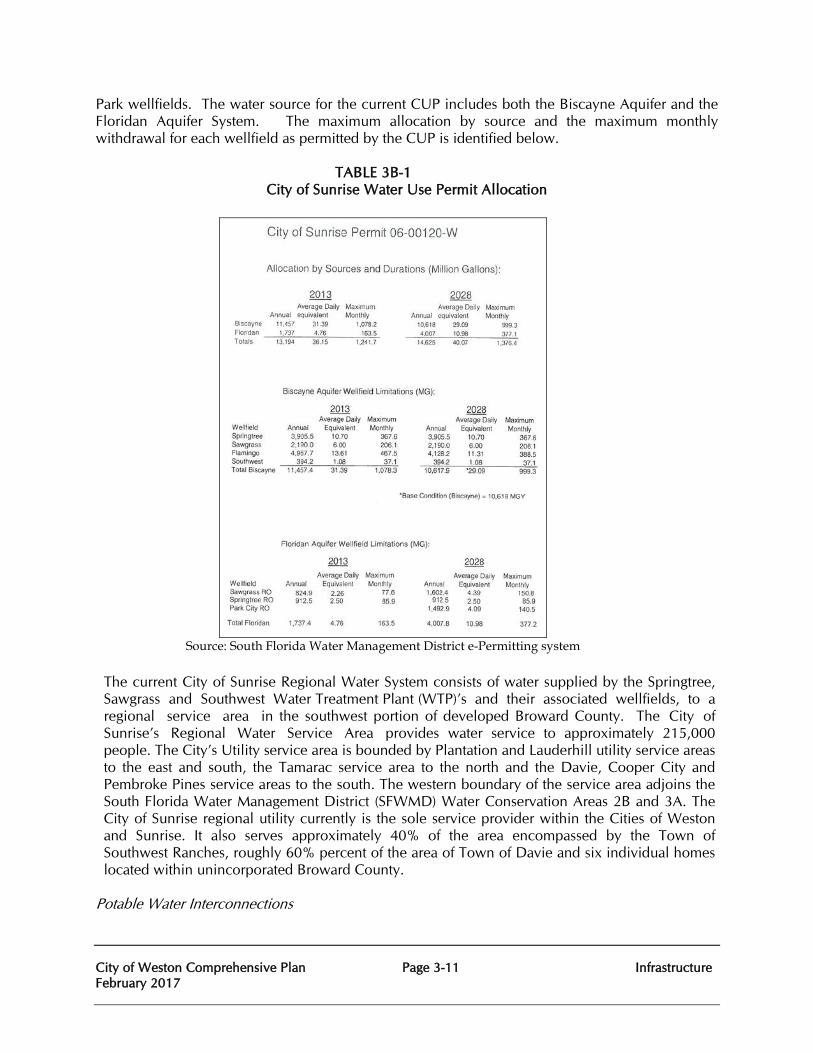
City of Weston Comprehensive Plan Page 3-11 Infrastructure February 2017
Park wellfields. The water source for the current CUP includes both the Biscayne Aquifer and the Floridan Aquifer System. The maximum allocation by source and the maximum monthly withdrawal for each wellfield as permitted by the CUP is identified below.
TABLE 3B-1
City of Sunrise Water Use Permit Allocation
Source: South Florida Water Management District e-Permitting system
The current City of Sunrise Regional Water System consists of water supplied by the Springtree, Sawgrass and Southwest Water Treatment Plant (WTP)’s and their associated wellfields, to a regional service area in the southwest portion of developed Broward County. The City of Sunrise’s Regional Water Service Area provides water service to approximately 215,000 people. The City’s Utility service area is bounded by Plantation and Lauderhill utility service areas to the east and south, the Tamarac service area to the north and the Davie, Cooper City and Pembroke Pines service areas to the south. The western boundary of the service area adjoins the South Florida Water Management District (SFWMD) Water Conservation Areas 2B and 3A. The City of Sunrise regional utility currently is the sole service provider within the Cities of Weston and Sunrise. It also serves approximately 40% of the area encompassed by the Town of Southwest Ranches, roughly 60% percent of the area of Town of Davie and six individual homes located within unincorporated Broward County.
Potable Water Interconnections
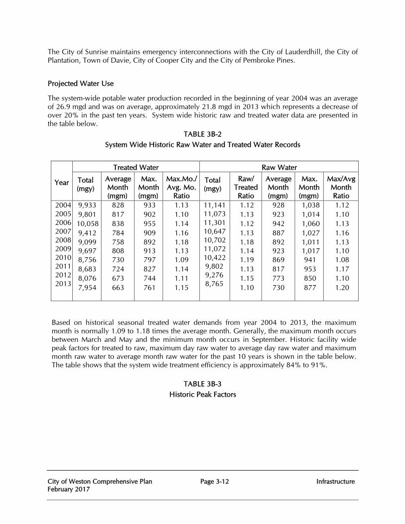
City of Weston Comprehensive Plan Page 3-12 Infrastructure February 2017
The City of Sunrise maintains emergency interconnections with the City of Lauderdhill, the City of Plantation, Town of Davie, City of Cooper City and the City of Pembroke Pines.
Projected Water Use
The system-wide potable water production recorded in the beginning of year 2004 was an average of 26.9 mgd and was on average, approximately 21.8 mgd in 2013 which represents a decrease of over 20% in the past ten years. System wide historic raw and treated water data are presented in the table below.
TABLE 3B-2 System Wide Historic Raw Water and Treated Water Records
Year
Treated Water Raw Water
Total (mgy)
Average Month (mgm)
Max. Month (mgm)
Max.Mo./ Avg. Mo.
Ratio
Total (mgy)
Raw/ Treated Ratio
Average Month (mgm)
Max. Month (mgm)
Max/Avg Month Ratio
2004 2005 2006 2007 2008 2009 2010 2011 2012 2013
9,933 9,801 10,058 9,412 9,099 9,697 8,756 8,683 8,076 7,954
828 817 838 784 758 808 730 724 673 663
933 902 955 909 892 913 797 827 744 761
1.13 1.10 1.14 1.16 1.18 1.13 1.09 1.14 1.11 1.15
11,141 11,073 11,301 10,647 10,702 11,072 10,422 9,802 9,276 8,765
1.12 1.13 1.12 1.13 1.18 1.14 1.19 1.13 1.15 1.10
928 923 942 887 892 923 869 817 773 730
1,038 1,014 1,060 1,027 1,011 1,017 941 953 850 877
1.12 1.10 1.13 1.16 1.13 1.10 1.08 1.17 1.10 1.20
Based on historical seasonal treated water demands from year 2004 to 2013, the maximum month is normally 1.09 to 1.18 times the average month. Generally, the maximum month occurs between March and May and the minimum month occurs in September. Historic facility wide peak factors for treated to raw, maximum day raw water to average day raw water and maximum month raw water to average month raw water for the past 10 years is shown in the table below. The table shows that the system wide treatment efficiency is approximately 84% to 91%.
TABLE 3B-3 Historic Peak Factors
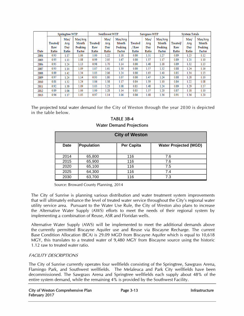
City of Weston Comprehensive Plan Page 3-13 Infrastructure February 2017
The projected total water demand for the City of Weston through the year 2030 is depicted in the table below.
TABLE 3B-4 Water Demand Projections
City of Weston
Date Population Per Capita Water Projected (MGD)
2014 65,800 116 7.6 2015 65,900 116 7.6 2020 65,100 116 7.5 2025 64,300 116 7.4 2030 63,700 116 7.3
Source: Broward County Planning, 2014 The City of Sunrise is planning various distribution and water treatment system improvements that will ultimately enhance the level of treated water service throughout the City’s regional water utility service area. Pursuant to the Water Use Rule, the City of Weston also plans to increase the Alternative Water Supply (AWS) efforts to meet the needs of their regional system by implementing a combination of Reuse, ASR and Floridan wells.
Alternative Water Supply (AWS) will be implemented to meet the additional demands above the currently permitted Biscayne Aquifer use and Reuse via Biscayne Recharge. The current Base Condition Allocation (BCA) is 29.09 MGD from Biscayne Aquifer which is equal to 10,618 MGY, this translates to a treated water of 9,480 MGY from Biscayne source using the historic 1.12 raw to treated water ratio.
FACILITY DESCRIPTIONS
The City of Sunrise currently operates four wellfields consisting of the Springtree, Sawgrass Arena, Flamingo Park, and Southwest wellfields. The Melaleuca and Park City wellfields have been decommissioned. The Sawgrass Arena and Springtree wellfields each supply about 48% of the entire system demand, while the remaining 4% is provided by the Southwest Facility.
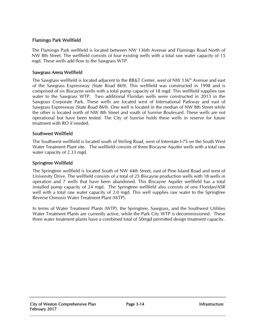
City of Weston Comprehensive Plan Page 3-14 Infrastructure February 2017
Flamingo Park Wellfield
The Flamingo Park wellfield is located between NW 136th Avenue and Flamingo Road North of NW 8th Street. The wellfield consists of four existing wells with a total raw water capacity of 15 mgd. These wells add flow to the Sawgrass WTP.
Sawgrass Arena Wellfield
The Sawgrass wellfield is located adjacent to the BB&T Center, west of NW 136th Avenue and east of the Sawgrass Expressway (State Road 869). This wellfield was constructed in 1998 and is comprised of six Biscayne wells with a total pump capacity of 18 mgd. This wellfield supplies raw water to the Sawgrass WTP. Two additional Floridan wells were constructed in 2013 in the Sawgrass Corporate Park. These wells are located west of International Parkway and east of Sawgrass Expressway (State Road 869). One well is located in the median of NW 8th Street while the other is located north of NW 8th Street and south of Sunrise Boulevard. These wells are not operational but have been tested. The City of Sunrise holds these wells in reserve for future treatment with RO if needed.
Southwest Wellfield
The Southwest wellfield is located south of Stirling Road, west of Interstate I-75 on the South West Water Treatment Plant site. The wellfield consists of three Biscayne Aquifer wells with a total raw water capacity of 2.33 mgd. Springtree Wellfield
The Springtree wellfield is located South of NW 44th Street, east of Pine Island Road and west of University Drive. The wellfield consists of a total of 25 Biscayne production wells with 18 wells in operation and 7 wells that have been abandoned. This Biscayne Aquifer wellfield has a total installed pump capacity of 24 mgd. The Springtree wellfield also consists of one Floridan/ASR well with a total raw water capacity of 2.0 mgd. This well supplies raw water to the Springtree Reverse Osmosis Water Treatment Plant (WTP). In terms of Water Treatment Plants (WTP), the Springtree, Sawgrass, and the Southwest Utilities Water Treatment Plants are currently active, while the Park City WTP is decommissioned. These three water treatment plants have a combined total of 50mgd permitted design treatment capacity.
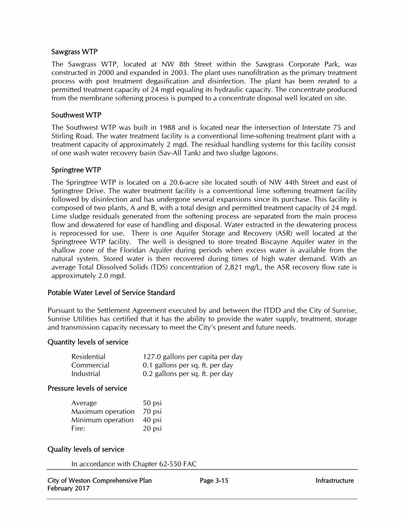
City of Weston Comprehensive Plan Page 3-15 Infrastructure February 2017
Sawgrass WTP
The Sawgrass WTP, located at NW 8th Street within the Sawgrass Corporate Park, was constructed in 2000 and expanded in 2003. The plant uses nanofiltration as the primary treatment process with post treatment degasification and disinfection. The plant has been rerated to a permitted treatment capacity of 24 mgd equaling its hydraulic capacity. The concentrate produced from the membrane softening process is pumped to a concentrate disposal well located on site. Southwest WTP
The Southwest WTP was built in 1988 and is located near the intersection of Interstate 75 and Stirling Road. The water treatment facility is a conventional lime-softening treatment plant with a treatment capacity of approximately 2 mgd. The residual handling systems for this facility consist of one wash water recovery basin (Sav-All Tank) and two sludge lagoons. Springtree WTP
The Springtree WTP is located on a 20.6-acre site located south of NW 44th Street and east of Springtree Drive. The water treatment facility is a conventional lime softening treatment facility followed by disinfection and has undergone several expansions since its purchase. This facility is composed of two plants, A and B, with a total design and permitted treatment capacity of 24 mgd. Lime sludge residuals generated from the softening process are separated from the main process flow and dewatered for ease of handling and disposal. Water extracted in the dewatering process is reprocessed for use. There is one Aquifer Storage and Recovery (ASR) well located at the Springtreee WTP facility. The well is designed to store treated Biscayne Aquifer water in the shallow zone of the Floridan Aquifer during periods when excess water is available from the natural system. Stored water is then recovered during times of high water demand. With an average Total Dissolved Solids (TDS) concentration of 2,821 mg/L, the ASR recovery flow rate is approximately 2.0 mgd.
Potable Water Level of Service Standard
Pursuant to the Settlement Agreement executed by and between the ITDD and the City of Sunrise, Sunrise Utilities has certified that it has the ability to provide the water supply, treatment, storage and transmission capacity necessary to meet the City’s present and future needs.
Quantity levels of service
Residential 127.0 gallons per capita per day Commercial 0.1 gallons per sq. ft. per day Industrial 0.2 gallons per sq. ft. per day
Pressure levels of service
Average 50 psi Maximum operation 70 psi Minimum operation 40 psi Fire: 20 psi
Quality levels of service
In accordance with Chapter 62-550 FAC
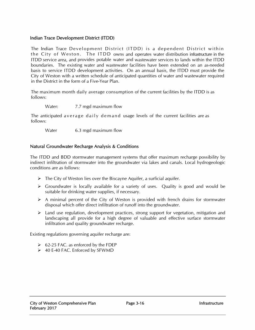
City of Weston Comprehensive Plan Page 3-16 Infrastructure February 2017
Indian Trace Development District (ITDD) The Indian Trace Deve lopmen t D i s t r i c t ( I TDD) i s a dependen t D i s t r i c t w i th in the C i t y o f Wes ton . The ITDD owns and operates water distribution infrastructure in the ITDD service area, and provides potable water and wastewater services to lands within the ITDD boundaries. The existing water and wastewater facilities have been extended on an as-needed basis to service ITDD development activities. On an annual basis, the ITDD must provide the City of Weston with a written schedule of anticipated quantities of water and wastewater required in the District in the form of a Five-Year Plan. The maximum month daily average consumption of the current facilities by the ITDD is as follows:
Water: 7.7 mgd maximum flow
The anticipated a v e r a g e d a i l y d e m a n d usage levels of the current facilities are as follows:
Water 6.3 mgd maximum flow Natural Groundwater Recharge Analysis & Conditions
The ITDD and BDD stormwater management systems that offer maximum recharge possibility by indirect infiltration of stormwater into the groundwater via lakes and canals. Local hydrogeologic conditions are as follows:
The City of Weston lies over the Biscayne Aquifer, a surficial aquifer.
Groundwater is locally available for a variety of uses. Quality is good and would be suitable for drinking water supplies, if necessary.
A minimal percent of the City of Weston is provided with french drains for stormwater disposal which offer direct infiltration of runoff into the groundwater.
Land use regulation, development practices, strong support for vegetation, mitigation and landscaping all provide for a high degree of valuable and effective surface stormwater infiltration and quality groundwater recharge.
Existing regulations governing aquifer recharge are:
62-25 FAC. as enforced by the FDEP 40 E-40 FAC. Enforced by SFWMD
City of Weston Comprehensive Plan Page 3-17 Infrastructure February 2017
INFRASTRUCTURE GOALS, OBJECTIVES, AND POLICIES
Goal 3 Ensure the provision of high quality, healthful, effective, reliable, efficient, environmentally sound and necessary services for coordinated sanitary sewer, solid waste, drainage, potable water and natural ground water aquifer recharge to City of Weston residents and visitors. SANITARY SEWER Goal 3.1 Provide residents of the City of Weston and customers with cost effective, equitable and adequate sanitary sewer facilities which meet applicable federal, state and local design standards and effluent water quality standards. 3.1 Objective:
The City of Weston shall coordinate with the City of Sunrise to identify existing deficiencies in the sanitary sewer system in accordance with regulatory requirements and correct any identified deficiencies to maintain the adopted LOS through the five and ten year time frames.
3.1.1 Policy:
City of Weston shall maintain funding commitments for the systems improvements in order to address any sanitary sewer and water system deficiencies.
3.1.2 Policy:
In the absence of legal constraints on the use of revenues, projects and programs shall be funded in order to correct system deficiencies and maintain an adequate level of service standard
3.1.3 Policy:
City of Weston shall coordinate with the City of Sunrise to assure that sanitary sewer facilities are available to meet the existing needs of its customers.
3.2 Objective:
Sanitary Sewer facilities shall be provided for an adopted Level of Service (LOS) standard of 120 gallons per capita per day (gpcd) to meet the City’s short-term future needs through 2021 and long-term future needs through 2035.
3.2.1 Policy:
City of Weston Comprehensive Plan Page 3-18 Infrastructure February 2017
The level of service (LOS) standard for sanitary sewer facilities shall be 120 gallons per capita per day. The LOS standard for City of Sunrise wastewater treatment plants shall be measured by average daily flow.
3.2.2 Policy:
For all properties that are required to be platted and for those properties within the City of Weston that are not required to be platted, at the time of site plan approval, the wastewater design flow standards listed in Table 10 of the Sanitary Sewer Element of the Broward County Comprehensive Plan, 2010, and adopted by the Board of County Commissioners to assess adequacy of service and concurrency shall be utilized.
3.2.3 Policy:
City of Weston shall incorporate the requirements of the Broward County Health Department and the Florida Department of Health to continue to utilize the development review process of the Land Development Code to require applicants for development permits to utilize existing sanitary sewer facilities if lines are “available” as defined by Chapter 10D-6, “Standards for Onsite Sewage Treatment and Disposal Systems”, Florida Administrative Code (FAC), pursuant to Section 381.0065, “Onsite sewage disposal systems; installation; conditions,” Florida Statutes.
3.2.4 Policy:
Design for additional capacity shall be in accordance with Section 62-600.405, FAC.
3.2.5 Policy: An assessment of the impacts of the construction and operation of wastewater treatment plants and support on adjacent natural resources shall be prepared during site review when considering the siting of new wastewater treatment plants and the expansion of, or increase in capacity of, City of Sunrise wastewater treatment plants.
3.2.6 Policy: In the event of a dispute involving the siting of, the expansion of, or the increase in capacity of wastewater treatment plants, the affected parties, if all affected parties agree, may opt to use the dispute mediation process of the South Florida Regional Planning Council (SFRPC).
3.2.7 Policy:
Private septic tanks and Class V disposal wells discharging into the surficial aquifer for effluent will be phased out and replaced by centralized wastewater systems.
3.2.8 Policy: City shall coordinate with the City of Sunrise to maximize the use of existing sanitary sewer facilities and reduce redundant facilities.
3.2.9 Policy:
City of Weston Comprehensive Plan Page 3-19 Infrastructure February 2017
City of Weston shall continue the implementation of an integrated geographic information system (GIS) in order to make available standardized land use and sanitary sewer facilities information for local and regional planning.
3.2.10 Policy: City of Weston shall acquire land for community facilities in accordance
with the Capital Improvements Element.
3.3 Objective: Sanitary sewer facilities shall be designed, constructed, maintained and operated in a manner that conserves and protects potable water resources by optimizing the use of reclaimed wastewater where feasible, thus offsetting demands on the Biscayne Aquifer.
3.3.1 Policy: City of Weston shall utilize reclaimed water, when available, from the City of Sunrise as an integral part of its wastewater management program, where economically, environmentally and technically feasible.
3.3.2 Policy: Cooperate with the utilization of wastewater reuse from the City of Sunrise Wastewater Treatment Plants, where feasible.
3.3.3 Policy: City of Weston shall continue public education efforts on the reuse of reclaimed water, encouraging the reuse of water of an appropriate quality level for the purpose intended.
3.4 Objective: Sanitary sewer facilities shall be designed, constructed, maintained and operated in a manner that protects the functions and quality of ground and surface waters, natural groundwater recharge and natural drainage features.
3.4.1 Policy:
City of Weston shall continue to coordinate with the City of Sunrise to follow the Broward County Health Department and the Florida Department of Health requirements to reduce potential groundwater pollution sources by continuing to implement Chapter 34, “Water and Sewers,” Article II, “Water and Sewer Connection Ordinance,” Broward County Code of Ordinances.
3.4.2 Policy:
City shall implement the requirements of the Broward County Public Health Unit and the Florida Department of Health to continue to protect the groundwater supply from potential sources of contamination pursuant to Chapter 34, “Water and Sewers,” Article II½, “Water and Septic Tank Ordinance,” Broward County Code of Ordinances.
3.4.3 Policy: City of Weston shall continue to follow Broward County Health Department and the Florida Department of Health requirements to prohibit direct
City of Weston Comprehensive Plan Page 3-20 Infrastructure February 2017
wastewater effluent discharges to surface and ground waters within Zone 2 of wellfield zones of influence as designated on the Wellfield Protection Maps.
3.4.4 Policy:
City of Weston shall utilize Broward County Health Department and the Florida Department of Health requirements to continue to protect ground and surface waters from pollution through licensing of collection and transmission systems.
3.4.5 Policy: City of Weston shall require the proper maintenance of septic tanks by the owner to prevent pollution of groundwater, per requirements of the Broward County Health Department.
3.4.6 Policy: City of Weston shall require that properties on private sewer systems obtain permits whenever modifications are made which could affect the quantity, quality or peak to average loading ratio of their sewage.
3.4.7 Policy: The conditions of gravity sanitary sewers, pump stations and force main systems shall continue to be investigated. The following parameters should be reported on:
• Age, remaining service life
• Infiltration and inflow
• Capacities, compared to loading demands
• Operating pressures
• Physical conditions, need for repairs, replacement
• Reliability in emergency situations
• The annual reports would be detailed and complete sufficient to support critical analysis of the systems condition and future needs.
3.4.8 Policy: City of Weston shall monitor the general operation of its Sanitary Sewer services to assure that no less than the minimum acceptable Level of Service standards are being provided. Such a monitoring program shall provide recommendations for needed capital improvements commitments in the Capital Improvements Budget and the concurrency management program.
3.4.9 Policy: Water conservation practices utilized in support of the policies in the Conservation Element shall be employed including maintenance and operation to minimize groundwater and surface water infiltration, inform the public as to effective use of water-restricted sanitary sewer plumbing fixtures and participation in Broward County programs to improve water conservation.
City of Weston Comprehensive Plan Page 3-21 Infrastructure February 2017
3.4.10 Policy:
City of Weston shall require all future development and redevelopment to connect to sanitary sewer lines.
SOLID WASTE Goal 3.2 Provide a cost-effective and equitable solid waste disposal system which emphasizes resource recovery and meets all federal, state and local environmental quality standards.
3.5 Objective: Solid waste management facilities shall be maintained and operated safely through the next ten (10) year planning period.
3.5.1 Policy: City of Weston shall continue to implement an integrated geographic information system (GIS) in order to make available standardized land use and solid waste management facilities information for local and regional planning, by making this information available to any requesting agencies.
3.6 Objective: Solid waste management facilities shall be provided at an adopted Level of Service (LOS) standard as shown in Tables 3C and 7A to meet the City’s short-term future needs through 2021 and long-term future needs through 2035.
3.6.1 Policy: The level of service (LOS) standard for solid waste management facilities shall be as shown in Tables 3C and 7A of this comprehensive plan.
3.6.2 Policy: City of Weston shall implement the waste generation rates identified in Table 3C which were listed in the Solid Waste Element of the Broward County Comprehensive Plan and adopted by the Board of County Commissioners to assess adequacy of service and concurrency.
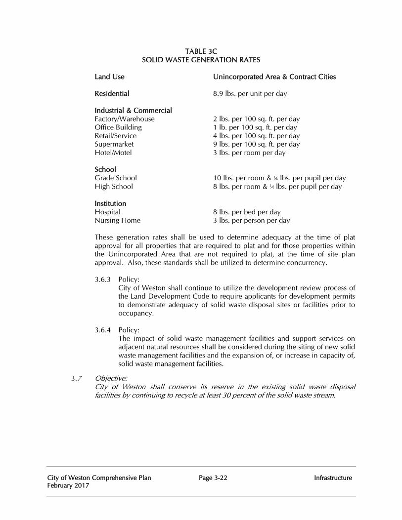
City of Weston Comprehensive Plan Page 3-22 Infrastructure February 2017
TABLE 3C SOLID WASTE GENERATION RATES
Land Use Unincorporated Area & Contract Cities Residential 8.9 lbs. per unit per day Industrial & Commercial Factory/Warehouse 2 lbs. per 100 sq. ft. per day Office Building 1 lb. per 100 sq. ft. per day Retail/Service 4 lbs. per 100 sq. ft. per day Supermarket 9 lbs. per 100 sq. ft. per day Hotel/Motel 3 Ibs. per room per day School Grade School 10 lbs. per room & ¼ lbs. per pupil per day High School 8 lbs. per room & ¼ lbs. per pupil per day Institution Hospital 8 lbs. per bed per day Nursing Home 3 lbs. per person per day
These generation rates shall be used to determine adequacy at the time of plat approval for all properties that are required to plat and for those properties within the Unincorporated Area that are not required to plat, at the time of site plan approval. Also, these standards shall be utilized to determine concurrency. 3.6.3 Policy:
City of Weston shall continue to utilize the development review process of the Land Development Code to require applicants for development permits to demonstrate adequacy of solid waste disposal sites or facilities prior to occupancy.
3.6.4 Policy:
The impact of solid waste management facilities and support services on adjacent natural resources shall be considered during the siting of new solid waste management facilities and the expansion of, or increase in capacity of, solid waste management facilities.
3.7 Objective: City of Weston shall conserve its reserve in the existing solid waste disposal facilities by continuing to recycle at least 30 percent of the solid waste stream.
City of Weston Comprehensive Plan Page 3-23 Infrastructure February 2017
3.7.1 Policy: City of Weston shall continue to maintain or expand its recycling education program as a means of reducing the waste stream.
3.7.2 Policy:
City of Weston government shall reduce the amount of paper through greater reliance upon the electronic media.
3.8 Objective:
Protect the functions of the City of Weston’s groundwater aquifer recharge areas and other natural resources from improper disposal of solid waste.
3.8.1 Policy:
City of Weston shall continue to maintain Broward County Environmental Protection Department regulations, Chapter 27, “Pollution Control,” Article VI, “Solid Waste,” Broward County Code of Ordinances, as it relates to the licensing and compliance of solid waste facilities.
3.8.2 Policy: City of Weston shall be prepared to modify its solid waste collection practices in a manner consistent with any new solid waste recycling, hazardous waste practices requirements of the primary agencies responsible for solid waste disposal and recycling.
3.8.3 Policy:
City of Weston solid waste contractor shall maintain nominal collection and disposal services at existing levels of service, via the franchise agreement.
3.8.4 Policy:
City of Weston shall cooperate in the hazardous waste collection and disposal programs of Broward County by enforcing within the City’s jurisdiction, such hazardous waste collection practices required by the county and other agencies with jurisdiction. Such cooperation shall consist of an annual hazardous waste notification by mail insert in utility billings, local newsletter or electronic media serving the City of Weston
3.8.5 Policy: City of Weston shall monitor the general operation of its solid waste collection services to assure the minimum acceptable Level of Service is being maintained. Such a monitoring program shall provide recommendations for needed capital improvements commitments in the concurrency management program and the Capital Improvements Budget.
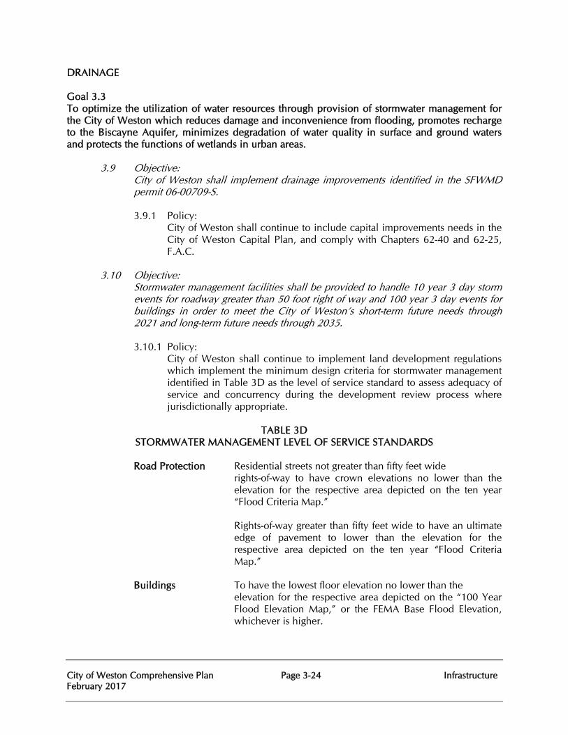
City of Weston Comprehensive Plan Page 3-24 Infrastructure February 2017
DRAINAGE Goal 3.3 To optimize the utilization of water resources through provision of stormwater management for the City of Weston which reduces damage and inconvenience from flooding, promotes recharge to the Biscayne Aquifer, minimizes degradation of water quality in surface and ground waters and protects the functions of wetlands in urban areas. 3.9 Objective:
City of Weston shall implement drainage improvements identified in the SFWMD permit 06-00709-S.
3.9.1 Policy:
City of Weston shall continue to include capital improvements needs in the City of Weston Capital Plan, and comply with Chapters 62-40 and 62-25, F.A.C.
3.10 Objective:
Stormwater management facilities shall be provided to handle 10 year 3 day storm events for roadway greater than 50 foot right of way and 100 year 3 day events for buildings in order to meet the City of Weston’s short-term future needs through 2021 and long-term future needs through 2035.
3.10.1 Policy:
City of Weston shall continue to implement land development regulations which implement the minimum design criteria for stormwater management identified in Table 3D as the level of service standard to assess adequacy of service and concurrency during the development review process where jurisdictionally appropriate.
TABLE 3D
STORMWATER MANAGEMENT LEVEL OF SERVICE STANDARDS Road Protection Residential streets not greater than fifty feet wide
rights-of-way to have crown elevations no lower than the elevation for the respective area depicted on the ten year “Flood Criteria Map.” Rights-of-way greater than fifty feet wide to have an ultimate edge of pavement to lower than the elevation for the respective area depicted on the ten year “Flood Criteria Map.”
Buildings To have the lowest floor elevation no lower than the
elevation for the respective area depicted on the “100 Year Flood Elevation Map,” or the FEMA Base Flood Elevation, whichever is higher.
City of Weston Comprehensive Plan Page 3-25 Infrastructure February 2017
Off Site Discharge Not to exceed the inflow limit of SFWMD primary receiving canal or the local conveyance system, whichever is less.
Storm Sewers Design frequency minimum to be three-year rainfall intensity of the State Department of Transportation Zone 10 rainfall curves.
Flood Plain Routing Calculated flood elevations based on the ten year and one hundred year return frequency rainfall of three day duration shall not exceed the corresponding elevations of the ten year “Flood Criteria Map” and the “100 Year Flood Elevation Map.”
Antecedent Water The higher elevation of either the control level elevation depicted on the map “Average Wet Season Water Levels.”
On Site Storage Minimum capacity above antecedent water level and below flood plain routing elevations to be design rainfall volume minus off-site discharge occurring during design rainfall.
Best Management Prior to discharge to surface or ground water, BMPs will be used to reduce pollutant loading from stormwater runoff.
These levels of service standards shall be used to determine adequacy at the time of plat approval for all properties that are required to plat and for those properties where jurisdictionally appropriate that are not required to plat, at the time of site plan approval.
3.10.2 Policy: City of Weston shall, in order to prevent a degradation of the drainage level of service, require future development in the Indian Trace Development District and Bonaventure Development District to be designed to remove stormwater from non-water management areas, including but not limited to yards, within 72 hours of the end of the ten year three-day design rainfall.
3.10.3 Policy: City of Weston shall update their National Pollution Discharge Elimination System - Municipal Separate Storm Sewer System (NPDES-MS4) Permit or its successor from the U.S. Environmental Protection Agency with the appropriate municipal and agency co-applicants and in accordance with Florida Statutes (Section 403.0885, F.S.).
3.10.4 Policy:
City of Weston Comprehensive Plan Page 3-26 Infrastructure February 2017
City of Weston upon receipt of the NPDES-MS4 Permit shall implement the permit conditions including monitoring of outfalls and improving stormwater management practices.
3.10.5 Policy:
The impact of the construction and operation of stormwater management facilities and support services on adjacent natural resources shall be considered in accordance with SFWMD regulations during the siting of new stormwater management facilities and the expansion of, or increase in capacity of stormwater management facilities.
3.10.6 Policy:
City of Weston shall coordinate with the South Florida Water Management District and the independent drainage districts to implement applicable portions of the South Florida Water Management District regional water resource projects (Central and Southern Florida Project Comprehensive Review Study (Restudy), the Lower East Coast Regional Water Supply Plan, the Water Preserve Area Project, and the C-11 West Basin Water Quality Improvement Strategy) which intend to reduce losses of excess stormwater to tide, recharge the surficial aquifer and Water Preserve Areas or provide additional storage surface waters.
3.10.7 Policy:
City of Weston shall address stormwater management issues on a watershed (basin) basis in accordance with SFWMD permits as a means of providing cost effective water quality and water quantity solutions to specific watershed problems.
3.10.8 Policy: City of Weston shall continue to implement a basin-wide water management protocol that optimizes flood protection, water quality, stormwater storage, wetlands sustainability and ground water recharge functions. By assessing the existing surface water management system, wellfield characteristics, ground water levels, flows and canal stages, an updated computer model will be developed to better utilize the water resource.
3.10.9 Policy:
City of Weston will work with the SFWMD and shall investigate application of the basin-wide protocols which comply with SFWMD permits throughout the City of Weston where appropriate.
3.10.10 Policy:
City of Weston shall manage the construction and operation of its facilities which dam, divert or otherwise alter the flow of surface waters to minimize damage from flooding, soil erosion or excessive drainage.
3.11 Objective:
City of Weston Comprehensive Plan Page 3-27 Infrastructure February 2017
Maintain and protect ground water recharge of the surficial aquifer system so as to maintain all of the functions of the Biscayne Aquifer, including the reduction of saltwater intrusion.
3.11.1 Policy:
City of Weston shall use BMPs in accordance with its regulations and those of the South Florida Water Management District.
3.11.2 Policy:
City of Weston shall work cooperatively with the SFWMD and independent drainage districts to implement plans for additional surface water storage such as water preserve areas, the Lower East Coast Regional Water Supply Plan and any other plans and operating procedures to increase recharge water to the Biscayne Aquifer.
3.11.3 Policy:
City of Weston shall utilize, preserve, restore and enhance natural water bodies and functions by encouraging non-structural and structural erosion control devices and discourage the channelization, installation of seawalls or other alteration of natural rivers, streams and lakes.
3.11.4 Policy:
City of Weston shall protect the water storage and water quality enhancement functions of wetlands, floodplains and aquifer recharge areas through acquisition, enforcement of rules and the application of land and water management practices which provide for compatible uses.
3.11.5 Policy:
City of Weston shall support Broward County to protect aquifers from depletion through water conservation and preservation of the functions of high recharge areas including but not limited to the water conservation areas and water preserve areas.
3.11.6 Policy:
All new drainage facilities should be provided with pollution control to the level approved and locally accepted as best available technology consistent with existing regulatory requirements, including but not limited to the following when applicable: Retention of stormwater Flow of stormwater over grassed and vegetated areas Utilization of pavements that allow water to permeate Sumps Grease separation baffles Mosquito control Infiltration and percolation prior to overflow or outfall discharge
City of Weston Comprehensive Plan Page 3-28 Infrastructure February 2017
POTABLE WATER Goal 3.4 Provide residents of the City of Weston and customers a cost-effective, equitable potable water supply system which provides an adequate supply of water to meet all applicable federal, state and local water quality standards; without compromising the City’s water quality standards or the sustainability of the City’s future water resource supply.
3.12 Objective:
The City of Weston shall identify existing deficiencies in the potable water system in accordance with regulatory requirements and correct any identified deficiencies to maintain the adopted LOS through the five and ten year time frames.
3.12.1 Policy: City of Weston shall coordinate with the City of Sunrise to maintain funding for the systems improvements to alleviate potable water deficiencies.
3.12.2 Policy: In the absence of legal constraints on the use of revenues, projects and programs shall be funded in order to correct system deficiencies and maintain an adequate level of service standard.
3.12.3 Policy: City of Weston shall coordinate with the City of Sunrise to assure that potable water facilities are available to meet the existing needs of its customers.
3.12.4 Policy: The City of Weston adopts the Water Supply Facilities Work Plan infrastructure sub-element by reference, and will continue to update and implement the projects and policies therein as deemed appropriate or as required in accordance with Florida Statutes.
3.12.5 Policy:
The City of Weston Water Supply Facilities Work Plan shall guide future expansion and upgrade of facilities needed to transmit and distribute potable water to meet current and future demands. The City shall research and identify alternative, renewable sources of water to satisfy any projected increases in demand.
3.12.6 Policy: The City of Weston shall identify and incorporate into its Capital Improvement Element the alternative water supply project(s) from the projects identified in the most current SFWMD Water Supply Plan and City of Sunrise Water Supply Facilities Work Plan or updates.
City of Weston Comprehensive Plan Page 3-29 Infrastructure February 2017
3.12.7 Policy: The City of Weston shall protect water quality when using traditional and
new alternative water supply resources.
3.12.8 Policy: The City of Weston shall enforce the adopted Water Conservation Plan which includes utilization of Florida Friendly landscaping principals, rain sensor devices and pressure controls.
3.12.9 Policy: The City of Weston shall maintain and continuously calibrate the City’s irrigation pumps. The irrigation pumps shall be reviewed and replaced as part of a monthly program.
3.12.10 Policy: The City of Weston shall continue to investigate the long-range feasibility of utilizing reclaimed water for irrigation purposes from neighboring municipalities.
3.13 Objective: Potable water facilities shall be provided at an adopted Level of Service (LOS) standard of 127 gallons per capita per day to meet the City’s short-term and long-term future needs through 2030.
3.13.1 Policy:
The level of service (LOS) standard for potable water facilities shall be 127 gallons per capita per day. The LOS standard for City of Sunrise water treatment plants shall be measured by maximum daily flow.
3.13.2 Policy:
The City of Weston, City of Sunrise, Broward County Health Department and the Florida Department of Health shall continue to utilize the potable water demand rates in Table 3E, which were adopted by the Board of County Commissioners to assess adequacy of service and concurrency at the time of plat approval for all properties required to be platted and at the time of site plan approval for those properties within the Unincorporated Area that are not required to be platted.
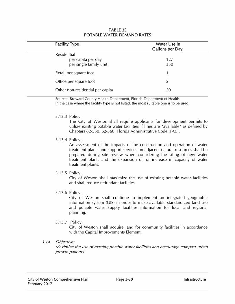
City of Weston Comprehensive Plan Page 3-30 Infrastructure February 2017
TABLE 3E POTABLE WATER DEMAND RATES
Facility Type Water Use in Gallons per Day Residential per capita per day 127 per single family unit 350
Retail per square foot 1
Office per square foot 2
Other non-residential per capita 20
Source: Broward County Health Department, Florida Department of Health. In the case where the facility type is not listed, the most suitable one is to be used.
3.13.3 Policy: The City of Weston shall require applicants for development permits to utilize existing potable water facilities if lines are “available” as defined by Chapters 62-550, 62-560, Florida Administrative Code (FAC).
3.13.4 Policy: An assessment of the impacts of the construction and operation of water treatment plants and support services on adjacent natural resources shall be prepared during site review when considering the siting of new water treatment plants and the expansion of, or increase in capacity of water treatment plants.
3.13.5 Policy: City of Weston shall maximize the use of existing potable water facilities and shall reduce redundant facilities.
3.13.6 Policy: City of Weston shall continue to implement an integrated geographic information system (GIS) in order to make available standardized land use and potable water supply facilities information for local and regional planning.
3.13.7 Policy: City of Weston shall acquire land for community facilities in accordance with the Capital Improvements Element.
3.14 Objective:
Maximize the use of existing potable water facilities and encourage compact urban growth patterns.
City of Weston Comprehensive Plan Page 3-31 Infrastructure February 2017
3.14.1 Policy: As an alternative to new potable water facility construction, the City of Weston shall identify opportunities to increase the efficiency and optimize the use of existing facilities.
3.15 Objective:
Conserve and protect potable water resources with primary focus on the Biscayne Aquifer by optimizing the utilization of water resources through effective water management practices.
3.15.1 Policy:
City of Weston shall develop a basin-wide water management protocol in accordance with SFWMD permits that optimizes flood protection, water quality, stormwater storage, wetlands sustainability and groundwater recharge functions while protecting management system, wellfield characteristics, groundwater levels, saltwater intrusion limits, flows and canal stages, an updated computer model will be developed to better utilize the water resource.
3.15.2 Policy:
City of Weston shall coordinate with the SFWMD to investigate application of the basin-wide protocols throughout the City of Weston, where appropriate and technically feasible.
3.15.3 Policy:
The City of Weston shall enforce the Florida Building Code Chapter 6, Section 604.4, Maximum flow and water consumption of the Florida Building Code, Plumbing, which contains standards for ultra-low volume plumbing fixtures to be used in all new construction and Chapter 9, Section 908.5, which contains water supply efficiencies for new or replaced cooling towers.
3.15.4 Policy: City of Weston shall continue to implement and support the City of Sunrise in its conservation-oriented rate structure within its utility systems.
3.15.5 Policy: City of Weston shall continue to implement a leak detection program to reduce the amount of unaccounted-for water loss within its utility system.
3.15.6 Policy: City of Weston shall continue to implement a year-round public information and education program promoting water conservation.
3.15.7 Policy: The City of Weston shall identify traditional and alternative water supply projects and the conservation and reuse programs to meet current and future water use demands within the City of Weston’s jurisdiction consistent with the City of Sunrise and South Florida Water Management District Water Supply Plans.
City of Weston Comprehensive Plan Page 3-32 Infrastructure February 2017
3.16 Objective: Potable water facilities shall be designed, constructed, maintained and operated in such a manner as to protect the functions of natural groundwater recharge areas and natural drainage features and not exacerbate saltwater intrusion.
3.16.1 Policy: The design for the construction, operation and maintenance of new or expanded potable water facilities shall consider the short-term and long-term impacts to natural groundwater recharge areas, wetlands, surface and groundwater levels and exacerbation of saltwater intrusion. The design shall also consider whether or not the construction, operation and maintenance will harm the aquifer system. Adverse impacts of construction, operation, and maintenance shall be avoided or at least minimized.
3.17 Objective: Provide the customers and residents of the City of Weston a cost-effective, equitable and adequate potable water system meeting all applicable federal, state, and local standards.
3.17.1 Policy: City of Weston shall continue to coordinate the provision of potable water services through agreements with municipalities and other service providers.
3.17.2 Policy: In order to protect and conserve the Biscayne Aquifer, the City of Weston shall investigate utilization of alternate potable water sources to supplement and broaden its future water supply sources. These potential sources could include the Floridan Aquifer, Aquifer Storage and Recovery (ASR), desalinization, capture and storage of excess storm water currently lost to tide and other technologies which may be addressed in the SFWMD’s Lower East Coast Regional Water Supply Plan.
3.17.3 Policy: Consistent with bonding requirements, the City of Weston will take no action by which the rights and benefits of its customers might be impaired or diminished.
3.17.4 Policy: City of Weston shall provide for the periodic update of the Water and Wastewater Master Plan in order to assure that potable water facilities are available to meet its future needs.
3.17.5 Policy: City of Weston shall investigate possible sources of financing for any water system improvements.
NATURAL GROUNDWATER AQUIFER RECHARGE
Goal 3.5
City of Weston Comprehensive Plan Page 3-33 Infrastructure February 2017
To protect the function of natural ground water/aquifer recharge needs.
3.18 Objective: Manage the natural ground water aquifer recharge conditions in a safe, effective and reliable manner as required by current design standards and codes.
3.18.1 Policy: Improve groundwater recharge by requiring all new construction projects to meet or exceed, as detailed in the City of Weston Land Development Regulations:
• Greater pervious open and green space • Pervious pavements • French drains, slab-covered trenches or drainage wells and limit
overflows • Allow direct overland flow discharge to surface waters (canals or bay)
only when no other practical or effective method of stormwater discharge is possible
• Allow positive drainage discharges to surface waters only when other methods are impractical or impossible, and only when adequate pollution control (grit and grease) is provided.
3.18.2 Policy: Permit designs which will diminish groundwater withdrawals.
3.18.3 Policy: Permit designs which will increase high quality groundwater recharge.
3.18.4 Policy:
Comply with South Florida Water Management District environmental protection rules for stormwater disposal methods. Refer to the LOS Table 3D for drainage for retention standards to be met.
City of Weston Comprehensive Plan February 2017
Page 4-1
Conservation Element
CHAPTER FOUR
CONSERVATION ELEMENT
PURPOSE
The purpose of the Conservation Element is to promote the conservation, use and protection of natural resources in Weston.
EXISTING NATURAL RESOURCES CONDITIONS AND DATA
NATURAL ENVIRONMENT
Climate
The environmental setting of Weston is characterized by a subtropical climate. The summer season is relatively long, with warm temperatures and frequent rainfall. The winters are distinguished by milder temperatures and less frequent precipitation. The winter season is unique among continental climatic conditions, although it is typical for the Caribbean and parts of Mexico.
No long term climate data is available that is specific to the City of Weston of Weston, but data is available for the City of Weston of Fort Lauderdale which is located approximately thirteen miles east of Weston. The Southeast Regional Climate Center has identified that from 1912 to 2012, the average annual maximum temperature was 83.7 F°, the average annual minimum temperature was 67.2 F°, and the average annual precipitation was 62.54 inches. Precipitation is not distributed evenly throughout the year. June through November is considered the ‘wet season’ and December through May is considered the ‘dry season’. Precipitation ranges from an average monthly level of 2.40 inches in February to 8.72 inches in September. The heaviest rain events historically occur in September and October. No snowfall has been reported during this recording period.
Thunderstorms are common during the summer months, many accompanied by a high frequency of lightning. Hurricanes, much less frequent occurrences, have the potential to occur from June through November; heavy rainfall, high winds, and widespread flooding may accompany these storm systems. Tornadic activity may also accompany hurricane events. No long-term hurricane data exists specific to the City of Weston of Weston; however, hurricane data is available for Fort Lauderdale. Records from 1871 through 2015 indicate 25 hurricanes have passed within 60 miles of Fort Lauderdale. Five of these hurricanes were from the ‘back door’, meaning they traveled over land from the west coast of Florida. The most recent occurrence was in October of 2005 when Hurricane Wilma hit from the southwest moving quickly northeast. Wilma passed just northwest of Fort Lauderdale. The National Hurricane Center reported 87mph sustained winds with gusts to 104mph in Weston. Geology
City of Weston Comprehensive Plan February 2017
Page 4-2
Conservation Element
The land surface of Weston is underlayed by several strata of limestone and sandstone. These strata (layers) were deposited during past geologic ages when the area which is now Broward County was submerged. The emergence of the South Florida land mass is geologically recent, and these rock formations are among the youngest in the continental United States. The deepest strata is the Tamiami formation which is composed of compacted clay, sand, sandstone, limestone and shell material called marl. This formation is about 100 feet thick, and is the impermeable layer forming the confining base of the Biscayne Aquifer. The Fort Thompson formation lies above the Tamiami formation and slopes gradually deeper from west to east. The strata are composed of limestone and sandstone, with pockets of quartz sand. Parts of the formation, which begins about 50 feet below the surface of Weston, are 150 feet thick. This geologic formation is highly water permeable and is the main component of the Biscayne Aquifer. This aquifer is the source of drinking water for the south east coast of Florida including Weston. The Key Largo formation lies above the Fort Thompson formation beginning at a depth of about 20 feet. It is composed primarily of coral reef limestone, which is highly permeable. Physiography
The City of Weston of Weston, comprised of approximately 27 square miles, is situated in the center of Broward County, which is located on the southeastern coast of the State. The County consists of approximately 1,200 square miles; the eastern 35% of the County (410 square miles) is highly urbanized and the western 65% (790 square miles) is undeveloped conservation land that is part of the Everglades system. The northern and western limits of the City of Weston of Weston abut these undeveloped conservation lands. The southern limit of the City of Weston of Weston abuts the C-11 canal, and Interstate 75 roughly delineates the eastern limits of the City of Weston.
The City of is located approximately 16 miles west of the Atlantic Ocean coastline and is also east of the Atlantic Coastal ridge. The Atlantic West Ridge, 5 miles or less in width, forms the highest ground in the county from 10 feet above sea level in the south to 22 feet above sea level in the north. It is a natural barrier to drainage of the interior, except where it is breached by shallow sloughs or rivers. From this ridge, the ground slopes gently downward in the direction of the Everglades to the western Sandy Flatlands. The Everglades, which covers most of Broward County, is slightly lower than the Sandy Flatlands, and when natural conditions prevailed this area was seasonally inundated. Prior to the diking and canalizing of the Everglades, the City of Weston historically was seasonally inundated Everglades marsh dominated by sawgrass with scattered but not abundant tree islands. The entire City of Weston is relatively flat.
There are no natural rivers, streams or waterbodies in the City of Weston All of the lakes and canals occurring within the City of Weston are man-made, providing fill for development throughout Weston and providing the core of the surface water management system. The substrate of the developed land areas is built up from this excavated fill material. These fill soils are typically composed of Miami limestone or Fort Thompson formation covered with a thin layer of marl limestone. The shallow surface organic muck soils have been utilized in the mitigation areas and for the construction of the large landscaping berms along the neighborhoods and roadways.
Minerals
Many areas of Broward County have been known for their valuable sand and rock materials which are utilized for road building and development activities. A commercially valuable mineral source
City of Weston Comprehensive Plan February 2017
Page 4-3
Conservation Element
in the City of Weston is the bed of oolite limestone which underlies the City of Weston. However, commercial mineral extraction is no longer a permitted land use in the City of Weston. Soils The native soil surface of The City of Weston is extremely shallow in most areas. In many parts of the City of Weston, it is necessary to dig into the limestone bedrock just below the surface to plant trees and shrubs. There are no known areas of soil erosion identified within Weston. All of the lakes occurring within the City of Weston are man-made and have been created to provide fill for development throughout Weston; the substrate of the developed land areas is built up from this excavated fill material. The historic distribution of soils is shown in Map 1-5, which is based on the Soil Survey of Broward County conducted by the U.S. Department of Agriculture. Table 4A. Soils within the City of Weston, lists the soils identified in the soil survey for the City of Weston.
Table 4A. Soils Within the City of Weston
Dania Muck Matlasha Gravelly Fine Sand, Limestone Substratum
Lauderhill Muck Udorthents
Plantation Muck Udorthents, Shaped
Hallandale Fine Sand Hallandale – Urban Land Complex
Margate Fine Sand Urban Land
The Department of Agriculture describes these soils as follows:
The Dania series consists of shallow, very poorly drained, rapidly permeable organic soils in fresh water marshes or swamps on the fringes of areas of deeper organic soils. They formed in thin beds of well decomposed, hydrophytic, non-woody, plant remains.
The Lauderhill series consists of nearly level, very poorly drained soils in broad flats in the Everglades. These soils formed in hydrophytic plant remains mixed with a small amount of mineral material. Lauderhill Muck soil is very poorly drained, organic soils, underlain by limestone at a depth of 20-40 inches.
The Plantation series consists of nearly level, very poorly drained soils in broad flats along the eastern edge of the Everglades. These soils formed in unconsolidated sandy marine sediment. Plantation Muck soil has a muck surface layer over sandy mineral material. The organic surface layer is subject to oxidation, which decreases its amount of organic material each year.
The Hallandale series consists of nearly level, poorly drained, sandy soils in broad flats east of the Everglades and west of the Atlantic Ridge. These soils formed in sandy marine sediment over limestone. Hallandale Fine Sand soil consists of poorly drained, sandy soil underlain by limestone at a depth of 7–20 inches. The Margate series consists of nearly level, poorly drained soils on low terraces between the Everglades and the Atlantic Coast. These soils formed in sandy marine sediment over limestone. Margate Fine Sand soil consists of poorly drained, sandy soil that is underlain by limestone at a depth of 20-40 inches but has solution holes as deep as 60 inches.
City of Weston Comprehensive Plan February 2017
Page 4-4
Conservation Element
The Matlacha soils are formed in material produced by dredging, filling, and earthmoving operations. Most of these soils are used for urban development. They consist of somewhat poorly drained, moderately rapid to rapidly permeable soils on filled and disturbed sloughs, flats, and depressions. The Udorthents consist of unconsolidated or heterogeneous geologic materials removed in the excavation of canals, lakes and ponds. It is commonly piled along banks. The Udorthents, Shaped soil consists of a mixture of soil and geologic soil materials that has been shaped and contoured, mainly for golf courses and highway. The Urban Land soil consists of areas that are more than 70 percent covered by airports, shopping centers, parking lots, large buildings, streets and sidewalks, and other structures, so that the natural soil is not readily observable.
Air Quality
Due to the prevailing breezes occurring in southeastern Florida, the air quality is generally good for the Weston area. Air quality is a matter that must be addressed at a regional level, with each City of Weston contributing and working in coordination with their County and each neighboring County to cooperatively protect the airshed. Broward County is located within the United States Environmental Protection Agency's (USEPA) designated Southeast Florida Airshed, which consists of Miami-Dade, Palm Beach and Broward Counties. The air quality in Broward County is classified in the good range of the Air Quality Index over 90% of the year. The main air pollutant of concern within this airshed is ozone. The major source of air pollution in the airshed is motor vehicle emissions.
The City of Weston provides for industrial opportunities; however, these are light industrial/office park type developments which have minimal impacts on the air quality. The Broward County Air Quality Division enforces federal, state, and local air pollution regulations through licensing and compliance activities and by promoting pollution prevention. They are responsible for the operation and maintenance of a comprehensive network of air quality monitoring stations throughout Broward County to make sure federal air pollution standards are met. The Air Quality Division also participates in local land use planning activities and informs the public about the importance of alternative means of transportation to help protect air quality.
Based upon ambient air quality monitoring, conducted by the Florida Department of Environmental Protection (DEP), and noted in The Florida Air Monitoring Report 2012, Broward County is an attainment area for five of the six major air contaminants: carbon monoxide (CO), lead (Pb), nitrogen dioxide (NO2), particulate matter (PM), and sulfur dioxide (SO2). The attainment area designation indicates that the concentrations of major pollutants are within the acceptable limits set by the DEP and the USEPA. Broward County continues to be classified as an attainment/maintenance area for the pollutant ozone (O3). A maintenance area is an area previously classified as non-attainment, which has successfully reduced air pollutant concentrations to below the standard, but must maintain some of the non-attainment area plans to stay in compliance with the standards. ENERGY CONSERVATION
City of Weston Comprehensive Plan February 2017
Page 4-5
Conservation Element
Climate change is largely attributed to the buildup of carbon dioxide and other greenhouse gas (GHG) concentrations in the atmosphere. Global emissions of GHG from human activities, such as the burning of fossil fuels and deforestation, have increased by 70% between 1970 and 2004 according to The American Planning Association (APA). In the updated April 2011, Policy Guide on Planning and Climate Change, the APA provides guidance for local governments toward the reduction of GHG emissions and on energy efficient land use decisions. The APA document indicates that effective actions to address GHG emissions should include a mix of education, incentives, subsidies, and regulation. The APA has suggested the following strategies for local governments to facilitate a reduction in GHG emissions; these include mixed use development, infill and redevelopment to utilize existing utilities and service, providing employment opportunities near a range of housing opportunities, energy efficient buildings, convenient intermodal transportation systems, and the reduction of heat island effects through green spaces.
In addition to the broad strategies listed above, every decrease in energy consumption reduces the carbon dioxide emissions from power plants and associated development to continue to expand the electric system; every diversion from a landfill increases the efficiency of curbside pick-up and the amount of debris placed in the landfill and ultimately the production of methane; every reduction in water use decreases the amount of energy required to produce potable water and to treat wastewater. Encouraging recycling, facilitating the capaCity of Weston to bicycle and walk, retaining and increasing landscaping, and conserving potable water supplies are also effective strategies to achieve GHG emission reductions.
The City of Weston has implemented a number of these strategies. There is a successful pedestrian and bikeways network throughout the City of Weston. The number of bikeways is relatively high compared to other areas within Broward County. There are sidewalks installed throughout the entire City of Weston. Bike lanes have been installed along most roadways. Over 140,400 linear feet of roadways have a 5 foot wide sidewalk installed along both sides of the road. Approximately 28,200 linear feet of roadway has a 6.5 foot wide sidewalk installed along one side of the road. Additionally, there are over 105,000 linear feet of designated bike lanes along the roadways. The City of Weston has created a centralized Town Center commercial district as well as several neighboring commercial centers. This facilitates a decrease in the number of trips and the drive times for residents conducting routine shopping trips or outings for dining or entertainment experiences.
Broward County monitors traffic signals on all arterial and collector roadways within the City of Weston. The City of Weston has installed interconnects between all signals which minimizes delays and idling on all arterial and collector roadways. The efficiency of the roadway system throughout the City of Weston is closely monitored to allow rapid response to any problems that may arise, thereby decreasing idling times and unnecessary emissions and decreasing energy consumption through efficiency. These pedestrian and bicycle facilities and the efficiency of the roadway system throughout the City of Weston each facilitate energy conservation.
The City of Weston has significant open space and landscape requirements to diminish heat island effects. The City of Weston’s landscape ordinance implements Florida Friendly principles and requires native vegetation. There is approximately 2,400 acres of mitigation land within the City of Weston that have been restored to and is maintained as natural habitat. These natural areas not only also help to diminish heat island effects but contribute to carbon dioxide uptake and oxygen production. The City of Weston is working cooperatively with the South Florida Water Management District and the Army Corps of Engineers on the development and construction of the
City of Weston Comprehensive Plan February 2017
Page 4-6
Conservation Element
1,000+ acre stormwater impoundment area located in the City of Weston that is a component of the Comprehensive Everglades Restoration Plan. Map 1-1 Existing Land Uses depicts conservation areas, parks, and the linear parks within the City of Weston.
The City of Weston implements an annual landscape inspection program on all commercial and multi-family properties to ensure the maintenance and retention of required landscape materials. The City’s Code Enforcement along with each of the Homeowners Associations assures that required landscaping is retained and maintained on the single-family properties. The City of Weston completed a thorough inventory of all canopy and palm trees located on City of Weston owned and City of Weston maintained property, inclusive of the right of ways in 2009 and completed an update of that inventory in March of 2016. This inventory identifies, locates, and provides information on the size and condition of each tree providing the City of Weston with the tools to ensure there will be no decrease in the canopy coverage on publicly owned and maintained lands.
Irrigation for all public properties and right of ways is obtained from withdrawals from the surface water lakes and canals, eliminating the utilization of potable water as the source for this use. The City of Weston maintains and controls all publicly irrigated land (over 850 acres) under one consumptive use permit and carefully monitors the withdrawals from the twenty eight pump locations. The system is carefully timed with rain sensors and efficient sprinklers installed through the entire system. The pumps are calibrated and automated to shut down the high horsepower pumps and only run the lower horsepower pumps when demand is below 100 gallons per minute, thus conserving energy use. As a planned community with a defined footprint and density, the City of Weston will not contribute to the sprawl and continued expansion of utilities that has become a prominent development concern across the nation. The City of Weston is nearly built-out, and as such, nearly all future projects will be redevelopment projects with existing infrastructure available. The City of Weston Public Works, Adminstrative Services, Community Center and City Hall buildings have energy conserving glazing, high efficiency air handling systems, water conserving fixtures and programmable heat and cooling controls providing energy conserving measures. Map 1-10 Energy Conservation Areas and Features was added to highlight the City of Weston features that contribute to reduced energy use and greenhouse gas production: wetland mitigation areas, conservation areas, water impoundment areas, open spaces, and its extensive bicycle paths.
Floodplains
The National Flood Insurance Program administered by the Federal Emergency Management Agency (FEMA) has identified the following flood zones within the City of Weston:
Table 4B. Federal Emergency Management Agency Flood Zones Zone Description
AH Zone AH is the flood insurance rate zone that corresponds to the areas of 1-percent annual chance of shallow flooding with a constant water-surface elevation (usually areas of ponding) where average depths are between 1 and 3 feet. Base Flood Elevations are determined.
City of Weston Comprehensive Plan February 2017
Page 4-7
Conservation Element
AE Corresponds to the areas of 1-percent annual chance of flooding. Base Flood Elevations are determined.
Map 1-3 identifies the flood zones within the City of Weston and Map 1-1 illustrates the existing land uses found within the floodplain. The City’s Indian Trace Development District and Bonaventure Development District has operational responsibilities for drainage facilities in the public right-of-way and on City of Weston property, with the exception of the facilities within state roads which are maintained by the Florida Department of Transportation. Facilities within private property are privately maintained. Existing regulations governing land use as it relates to the discharge of stormwaters into and the use of natural drainage features are combined in the South Florida Water Management District permits issued to the Indian Trace and Bonaventure Development Districts to alleviate the threat of flooding damage and to protect the natural resources in the City of Weston. The Florida Building Code regulates construction as it relates to flood zones.
WATER RESOURCES
Potable Water
Broward County and the City of Weston are within the South Florida Water Management District (SFWMD). The City of Weston falls within the SFWMD Lower East Coast (LEC) Planning Area. The LEC planning area covers approximately 6,100 square miles and includes Palm Beach, Broward, and Miami-Dade counties, most of Monroe County, and eastern Hendry and Collier counties. The Everglades Agricultural Area, located in the LEC Planning Area, is a portion of the Lake Okeechobee Service Area. However, the entire Lake Okeechobee Service Area, which includes portions of Martin, Okeechobee, Glades, and Lee counties, is considered in the LEC water supply planning process because of its reliance on Lake Okeechobee.
The 2013 Lower East Coast Water Supply Plan Update reports that total water demand is projected to increase by 12 percent to 1,933 million gallons per day (MGD) by 2030. Public Water Supply (PWS) remains the LEC Planning Area’s single largest water use category in 2030, representing 52 percent of the planning area’s total water demand. It is followed by agriculture at 34 percent. The remaining four categories, domestic (residential) self-supplies, recreation, landscaping, industrial and power generation account for the remaining 14%. The LEC Planning Area traditionally has relied on fresh groundwater from the surficial aquifer system and surface water from Lake Okeechobee as primary water sources for urban, agricultural, and industrial uses. The Everglades provides groundwater and surface water recharge to the urban coastal communities, contributing to the water supply throughout most of this region. In 2010, fresh groundwater accounted for 94 percent of potable water produced by PWS utilities. The surficial aquifer system, including the Biscayne aquifer, provides more than 1 billion gallons a day for utilities, as well as agricultural production, landscape irrigation, and other uses. Since the last plan update, the SFWMD placed limitations on additional allocations from the freshwater sources in the region to protect the region’s natural resources. As a result, use of alternative water sources has expanded. Residents of the City of Weston receive their potable water supply from the City of Weston of Sunrise. Pursuant to the Settlement Agreement executed by and between the ITDD and the City of
City of Weston Comprehensive Plan February 2017
Page 4-8
Conservation Element
Weston of Sunrise, the City of Weston of Sunrise certified that it has the ability to provide the water supply, treatment, storage and transmission capaCity of Weston necessary to meet the City’s present and future needs. Specific information detailing water use and demand management is contained in the potable water sub-section of the Infrastructure element. The City of Weston cooperates with the City of Weston of Sunrise, Broward County and the South Florida Water Management District for the implementation of water demand management policies and programs.
Ground Water
The principal ground water resources for the LEC Planning Area are the Surficial Aquifer System, including the Biscayne aquifer, and the Floridian Aquifer System. The Surficial and Biscayne aquifers provide most of the fresh water for public water supply and agriculture within the LEC Planning Area. Due to the regional importance of the Biscayne aquifer, it has been designated as a sole source aquifer by the U.S. Environmental Protection Agency under the Safe Drinking Water Act and is, therefore, afforded stringent protection. This designation was made because it is a principal source of drinking water and is highly susceptible to contamination due to its high permeability and close proximity to land surface in many locations. Major sources of contamination are saltwater intrusion and infiltration of contaminants from canal water.
Water resource protection tools under the Florida Statutes are used to protect water supplies for natural systems and human needs. In addition to minimum flows and levels, other resource protection tools include consumptive use permitting, water shortage declarations and the reservation of water.
The Biscayne Aquifer, the Surficial Aquifer system and surface water are dependent upon rainfall for recharge. The average annual rainfall in the LEC Planning Area is about 53 inches. Annually, 75 percent of this occurs during the wet season months. In addition to seasonal variation, rainfall varies significantly from year to year with historic annual amounts ranging from 37 inches to 106 inches in the planning area. The amount of rainfall also varies regionally within the LEC Planning Area. Rainfall also varies by area, with rainfall amounts generally decreasing from east to west.
Surface Water
The Indian Trace Development District (ITDD) and the Bonaventure Development District (BDD) stormwater management systems offer maximum recharge possibility by indirect infiltration of stormwater into the groundwater via lakes and canals. The Bonaventure Development District is responsible for primary drainage and maintenance of the canal system in the Bonaventure area of Weston. The surface water management system within the remainder of the City of Weston is separated into two areas: Basin 1 and Basin 2. Map 3-3 identifies the drainage basins. The existing major surface water management facilities consist of more than 1,600 acres of the manmade lake systems within Sectors 1 through 16. Map 1-2 identifies the waterbodies within the City of Weston.
The drainage and aquifer recharge sub-section of the Infrastructure element provides specific details on the functioning of the lakes and canals and their relationship to the surface and subsurface hydrologic patterns in the City of Weston.
WETLANDS
City of Weston Comprehensive Plan February 2017
Page 4-9
Conservation Element
Historically the area was Everglades marsh dominated by sawgrass with scattered but not abundant tree islands. The area had been ditched and drained for pastureland and had been isolated from the historic surface water sheet flow by the U.S. Highway 27 berm. The water levels over this area decreased and the pasture lands, most unmaintained, then became infested with invasive exotic plant species, predominately Melaleuca (Melaleuca quinquenervia) and Brazilian Pepper (Schinus terebithifolius).
For impacts to the areas of degraded wetlands that remained, mitigation was required for the development of the Weston DRI. For Increment II of the Weston DRI, the following permits were issued: FL-DEP permit 061519289 modified and superseded by 061979619, ACOE permit 89IPG-20040, and Broward County DPEP License DF91-1004. For Increment III, the following permits were issued: ACOE 199101073 (IP-MN). DPEP DF95-1148, and FDEP 061992039. For the Isles at Weston, the following permits were issued: ACOE Permit No. 199602454 (IP-DEB), EPD License No. DF 01-1101, and SFWMD Permit No. 06-03067-P. There is approximately 1,900 acres of wetland mitigation land within Weston that the City of Weston maintains. This is comprised of enhanced freshwater marsh lands and created littoral lake shelves. See Appendix 4-A. Mitigation Lands Maintained by the City of Weston . Additionally, there is approximately another 415 acres of freshwater marsh wetland mitigation that is maintained through private ownership or by Broward County or by the SFWMD.
The vacant, undeveloped lands on the western edge of the City of Weston are the intended location for components of the Comprehensive Everglades Restoration Plan (CERP), a joint project of the Army Corps of Engineers and the South Florida Water Management District. Approved in 2000 by Congress (authorized by the Water Resources Development Act of 2000 (WRDA, 2000), CERP takes a watershed approach and is considered the largest environmental restoration program in history. CERP is largely based upon a series of projects designed to “get the water right” in South Florida through the acquisition, planning, designing and constructing of more than 50 individual projects throughout south Florida. Two CERP projects fall within Weston, the C-11 Impoundment and the 3A/3B Seepage Management Area. The C-11 Impound is proposed on the vacant lands east of US 27, and the 3A/3B Seepage Management Area is the vacant land west of U.S. 27, which is also known as Water Conservation Area 3/A.
The primary purpose of the C-11 Impoundment Project is to divert and temporarily store runoff from the western C-11 basin that is presently discharged into Water Conservation Area 3A. It will also function to control seepage from Water Conservation Areas 3A and 3B by improving groundwater elevations and providing incidental flood protection for the western C-11 basin.
Normally, water in the C-11 Canal goes to tide. However, when a large storm is in the area the S-9 pump station is operated which draws water in the C-11 Canal toward the pump station. The outlet of the S-9 pump station is Water Conservation Area 3 which is a part of the Everglades. Water in the C-11 Canal during a storm has runoff with undesirable characteristics. The purpose of the C-11 Impoundment is to pump water from the C-11 Canal during the storm and store it in the impoundment, diverting the water with undesirable characteristic from being directly discharged into the Everglades system.
The February 2008, Design Documentation Report from the Army Corps of Engineers identifies that the C-11 Impoundment component features a 1,068-acre, 4.3-feet deep, aboveground impoundment feature (also defined as a reservoir). The impoundment is approximately 1.5 miles in width from east to west for the northern half, and 1.0 mile in width for the southern half. Other design elements include a combined inflow/seepage pump station, assorted gated and non-gated
City of Weston Comprehensive Plan February 2017
Page 4-10
Conservation Element
structures, several fixed weirs, one adjustable weir, an emergency spillway structure, and perimeter embankments and seepage control canals. The design also includes two wetland marsh areas.
The proposed impoundment is designed with an embankment crest 14 feet in width with a design crest elevation of 13.00ft.-NAVD or 8.5 feet above assumed average natural grade of 4.50ft.-NGVD. Permanent access around the site will include an 18 foot wide perimeter gravel road, aggregate or soil cement roads along the top of the embankments and levees. Additionally, standard 12 foot wide turnouts will be constructed along the embankment and levee crests at maximum intervals of 0.5 miles. Ramps at various locations will provide access along the impoundment. The perimeter of the C-11 Impoundment Project site will be disturbed by clearing and grubbing; whereas the interior of the site will only be cleared.
The Impoundment will also include three seepage canals: (1) C-511 around the eastern, northern, and western perimeter of the reservoir, (2) C-512 around the mostly eastern and northern perimeter of Mitigation A, and (3) C-513 around the mostly eastern and northern perimeter of Mitigation B. The C-511 Seepage canal has two purposes: (1) the primary purpose is to intercept seepage from the reservoir to eliminate or reduce to a rate that prevents significantly negative impacts to nearby private lands’ existing levels of service flood protection and (2) the secondary purpose is to convey, under emergency conditions, breach flow to the C-11 Canal should the unexpected event occur.
The C-512 Seepage canal has as a primary purpose to intercept seepage from Mitigation A to eliminate or reduce to a rate that prevents significantly negative impacts to nearby private lands’ existing levels of service flood protection. The canal also receives excess seepage collected by C-513 Seepage canals and discharges into the eastern reach of the C-511 Seepage canal. The C-513 Seepage canal is to intercept seepage from Mitigation B to eliminate or reduce to a rate that prevents significantly negative impacts to nearby private lands’ existing levels of service flood protection.
Construction of the C-11 Impoundment Project will impact existing wetlands and existing mitigation wetlands. An interagency team has been established to determine the wetland Functional CapaCity of Weston Units (FCUs) loss due to adverse wetlands impacts which may occur through the development of these projects; as well as to determine a compensatory mitigation plan to address any adverse wetland impacts. The new wetland mitigation area for the project encompasses most of the area north of SW 26th Street, excluding the “Finger Lakes”, man-made borrow pits from previous resource extraction. This wetland mitigation area also includes a smaller area south of SW 26th Street and directly east of US-27. The wetland mitigation area will be bounded on the south by the L-511, and by the L-512/514 on the west, north, and east. Two existing City of Weston mitigation areas fall within the planned C-11 mitigation footprint. The two City of Weston mitigation areas, 110.2 and 115.2 acres respectively, were conveyed to the South Florida Water Management District in December 2015. There will be a drainage ditch running along the outside of the L-512 on the north and east, intercepting stormwater from the western stormwater canal and redirecting it to the C-511 seepage canal. Excavated material from the drainage ditch will be utilized to construct the L-512/514 levee.
The primary objective of the 3A/3B Seepage Management Area Project is to reduce the rate of seepage eastward from Water Conservation Areas 3A and 3B. The project will also provide vital conveyance capaCity of Weston from the C-11 Impoundment to the C-9 Impoundment (located in Miramar) for optimization of storage for stormwater generated within the western C-11 Basin. Map 1-4 identifies the mitigation lands within the City of Weston and Map 1-9 identifies the location of the proposed CERP projects.
City of Weston Comprehensive Plan February 2017
Page 4-11
Conservation Element
The two CERP projects located in the City of Weston are part of the Accelor8 program which is implemented through the South Florida Water Management District to hasten the development of certain projects. Construction for the Impoundment has not yet begun but the land acquisition process is completed.
LAND COVER AND NATURAL HABITAT
Map 1-8 identifies the land coverage within the City of Weston. In general the City of Weston is comprised of four components; the developed community, the mitigation lands, the Water Conservation Area 3/A and the area intended for the development of the C-11 Impoundment.
The developed components of the City of Weston have been created through excavation and fill operations. Any existing conditions at the time of development have been replaced. As a planned community, the City of Weston has had the capaCity of Weston to implement a substantive landscape code with all development. The City of Weston requires that at a minimum 50% of all required landscape material be native for the residential and the commercial components of the City of Weston. The extensive landscaped berm systems throughout the City of Weston surrounding each neighborhood that is maintained by the City of Weston, requires a minimum of 40% native vegetation. There is a 36-hole golf courses and an 18-hole golf course in the City of Weston as well. There is extensive native landscape vegetation throughout the developed community, on average a 40% open space criteria is required.
There are 2315 acres of mitigation land within the City of Weston that have been restored and maintained in their natural state. Of this total acreage, nearly 2,050 is sawgrass dominated or freshwater marsh habitat with scattered ‘tree islands’; the remaining mitigation acreage is littoral lake edges. The Water Conservation Area located west of U.S. 27 is sawgrass dominated marsh habitat which the South Florida Water Management District maintains. The land identified as the location for the development of the C-11 Impoundment is degraded from the historic sawgrass marsh conditions. The area was ditched and drained, has been utilized for pasture land, some areas used for crop land or plant nurseries, and several man-made borrow pits remain where resource extraction occurred in the past. There are degraded remnant wetlands in this area. Overall the area is heavily infested with the invasive exotic plant species, Melaleuca (Melaleuca quinquenervia), Brazilian Pepper (Schinus terebithifolius) and Australian Pines (Casuarina equisetifolia).
Appendix 4-B. Native Plant Species that May Occur in the City of Weston, contains a list of the native plant species that may be found in the City of Weston and identifies those species that are listed as either threatened or endangered by federal and state agencies. Appendix 4-C. Listed Animal Species that May Occur in the City of Weston, identifies the federal and state listed animal species that may occur within or utilize habitat within the City of Weston. Appendix 4-D. Invasive Plant Species, identifies the invasive exotic pest plant species that occur within and are problematic to the City of Weston of Weston.
POLLUTANTS
Waste generators, above and underground storage tanks, and dry cleaning facilities are licensed by the Florida Department of Environmental Protection (FDEP). The Environmental Assessment and
City of Weston Comprehensive Plan February 2017
Page 4-12
Conservation Element
Remediation (EAR) Section of the Pollution Prevention and Remediation Division of the Broward County Environmental Protection Department manages the assessment and remediation of contamination at a majority of the over 1,000 contaminated sites located within Broward County. The EAR Section manages the State funded Petroleum Cleanup Program for the FDEP as well as conducting the oversight, licensing, assessment, and remediation of the Non State Funded cleanup projects, which may involve petroleum or other chemical contaminations.
Broward County has identified seven sites within the City of Weston as contaminated. These sites are licensed for contamination assessment and cleanup by the Division of Pollution Prevention and Remediation of the BCEPD and by the FDEP. Appendix 4-E. Contaminated Sites in the City of Weston identifies these contaminated sites. Development of a coordinated working relationship with the EAR Section of BCEPD will allow the City of Weston to remain current on the status of the sites within the City of Weston that are under the project management of the EAR Section. The City of Weston can discourage residential source contamination through providing public information on the safe disposal of home chemicals and by encouraging these be brought to the Central HHW Collection Center, located at 5490 Reese Road in the Town of Davie. The HHW Center accepts flammables, toxics, corrosives, and reactive waste. (i.e.: paints (oil and latex), paint thinners and strippers, used oil, automotive fluids & gasoline, solvents, pesticides, insecticides, fertilizers, pool chemicals, spot removers, oven and drain cleaners, furniture and metal polish, mercury, batteries and tires.)

City of Weston Comprehensive Plan February 2017
Page 4-13
Conservation Element
CONSERVATION ELEMENT GOALS, OBJECTIVES, AND POLICIES
Goal 4 To conserve, manage, use and protect the natural and environmental resources of Weston ensuring continued resource availability and environmental quality.
4.1 Objective: Maintain the best possible air quality, meeting or exceeding state and federal air quality standards.
4.1.1 Policy: The City of Weston shall support enforcement of applicable standards for air quality to control significant emissions of air pollutants in order to maintain and improve the existing air quality, including enforcement of City of Weston ordinances which prohibit open burning and excessive vehicle exhausts.
4.1.2 Policy: Open burning and excessive vehicle exhausts shall be prohibited.
4.1.3 Policy: The City of Weston shall strictly enforce the adopted landscaping standards to ensure the preservation and restoration of native vegetation, to promote substrate stabilization, to filter air pollutants, and to produce oxygen.
4.1.4 Policy: The City of Weston shall enforce all adopted measures to contain and stabilize exposed or destabilized soil surfaces at construction sites to prevent erosion and the degradation of ambient air quality through the generation of dust particles.
4.1.5 Policy: The City of Weston shall continue to coordinate and cooperate with Federal, State and County Agencies on implementing air pollution control regulations and remediation measures.
4.1.6 Policy: The City of Weston shall continue to amend the land development regulations to adopt specific standards and strategies, such as allowances for electric car charging stations that address greenhouse gas emissions, energy efficient housing, and overall energy conservation.
4.1.7 Policy:
City of Weston Comprehensive Plan February 2017
Page 4-14
Conservation Element
As the replacement of municipal vehicles is scheduled, the City of Weston shall consider the availability of replacement with low emission or fuel efficient vehicles.
4.1.8 Policy: The City of Weston shall provide educational materials and promote recycling to enhance the efficiency of curbside pick-up, and reduce the materials being sent to landfills and ultimate reduce methane production.
4.1.9 Policy: The City of Weston shall encourage the diversion from landfills of materials that are recyclable when issuing construction demolition permits.
4.2 Objective: Secure provision of potable water in sufficient quantity and quality to meet present and projected needs, commensurate with reasonable demand.
4.2.1 Policy: Cooperate with local, regional, state and federal agencies for the management of fresh water resources to maintain adequate fresh water supplies during dry periods and to conserve water by strictly enforcing the Florida Friendly principles incorporated in the adopted Landscape ordinance.
4.2.2 Policy: Cooperate with Broward County and the South Florida Water Management District for the implementation of water demand management policies and programs.
4.2.3 Policy: All federal, state, and regional water quality standards shall be enforced in Weston through periodic monitoring.
4.2.4 Policy: Cooperate with South Florida Water Management District, Bonaventure Development District, Indian Trace Development District, City of Weston of Sunrise and other agencies, municipalities and service providers to conserve water resources in emergencies and during declared water shortages.
4.2.5 Policy: Activities and land uses within natural groundwater recharge areas shall be restricted to protect the quality and quantity of this water source.
4.2.6 Policy: The City of Weston shall participate in the development of conservation programs contained in the Regional Water Supply Plan in conjunction with the South Florida Water Management District.
4.2.7 Policy:
City of Weston Comprehensive Plan February 2017
Page 4-15
Conservation Element
The City of Weston shall continue its efforts to publicize and encourage water conservation, including the implementation of reuse programs and potable water conservation strategies and techniques.
4.2.8 Policy: The City of Weston shall assess projected water needs and sources for the long-range planning period by creating and maintaining a Water Supply Facilities Work Plan with a minimum 10-year planning horizon. Future water supply planning shall emphasize the efficient use of water resources and where possible and financially feasible, utilize alternative water sources.
4.2.9 Policy: The City of Weston shall enforce the adopted Water Conservation Plan which includes utilization of Florida Friendly landscaping principals, rain sensor devices and pressure controls.
4.2.10 Policy: The City of Weston shall maintain and continuously calibrate the City’s irrigation pumps. The irrigation pumps shall be reviewed and replaced as part of a monthly program.
4.2.11 Policy:
The City of Weston shall continue to investigate the long-range feasibility of utilizing reclaimed water for irrigation purposes from neighboring municipalities.
4.2.10 Policy: The City of Weston supports the South Florida Water Management District’s water restrictions and conservation efforts during times of water shortages as well as year-round conservation rules.
4.3 Objective: Assure that generation, storage, transport and disposal of wastes in Weston is managed with the best available technology to protect environmental quality.
4.3.1 Policy: When new sewers are extended into an area currently using septic systems for wastewater disposal, all buildings must connect with the public wastewater collection system within the time frame required by Florida Statute.
4.3.2 Policy: New subdivisions shall provide sewerage and connections for each lot in the development.
4.3.3 Policy: New septic tank systems shall meet applicable state standards for permitting.
4.3.4 Policy:
City of Weston Comprehensive Plan February 2017
Page 4-16
Conservation Element
The City of Weston shall cooperate with appropriate public agencies to assure that solid and hazardous wastes generated within the City of Weston, if any, are properly managed to protect the environment The City of Weston shall report any hazardous waste violation they may become aware of to the appropriate jurisdictional agency.
4.3.5 Policy: The City of Weston shall coordinate with Broward County and the state to encourage the development of effective strategies to improve the area-wide Solid Waste Management Program to include more innovative solid and hazardous waste management technologies to save energy, produce renewable energy and effectively manage hazardous waste.
4.4 Objective: Conserve and protect the remaining natural systems of Weston, including minerals, soils and native vegetative communities, in recognition of the inherent values of these areas left in their natural state, through appropriate land use designation and regulation.
4.4.1 Policy: Conserve and protect the natural resources of all wetlands, conservation areas and oolite limestone bed within the City of Weston.
4.4.2 Policy:
Compliance with approved permits with other local governments, state, federal and private plans and programs for conservation of natural resources shall be incorporated into the City of Weston planning process.
4.4.3 Policy: Wetlands and submerged lands shall be used for purposes which are compatible with their natural values and functions, and City of Weston land development regulations shall be revised where warranted to provide these areas with the maximum possible protection.
4.4.4 Policy: Protect and conserve the natural functions of existing soils, fisheries, lakes and floodplains through enforcement of existing local, state and federal regulations designed to protect and conserve these functions.
4.4.5 Policy:
The City of Weston shall distribute land uses in a manner that avoids or minimizes, to the greatest degree practicable, the effect and impact on wetlands and lands identified by the South Florida Water Management District’s East Coast Buffer.
4.4.6 Policy:
City of Weston Comprehensive Plan February 2017
Page 4-17
Conservation Element
The City of Weston shall maintain consistency with program policies of the National Flood Insurance Program and shall monitor new cost effective programs for minimizing flood damage. Such programs may include modifications to construction setback requirements or other site design techniques, as well as upgraded building and construction techniques.
4.4.7 Policy: The City of Weston shall require all development projects to adhere to measures to contain and stabilize exposed or destabilized soil surfaces at construction sites to prevent erosion and sediment run-off.
4.5 Objective: Preserve areas of significant environmental and public value including fisheries, wildlife, wildlife habitat and marine habitat, through appropriate land use designations and regulations.
4.5.1 Policy: The City of Weston shall continue to cooperate with adjacent municipalities and Broward County to preserve and protect natural resources, natural areas and vegetative communities through periodic meetings.
4.5.2 Policy: The City of Weston shall support state and federal laws for the protection of endangered and threatened species and significant plant and animal habitat. Including: 1. Champion trees as recognized by Florida Department of Agriculture;
2. Specimen trees as recognized by Florida Department of Agriculture;
3. Plant and Animal species listed by the U.S. Fish and Wildlife Service as threatened or endangered; and
4. Plant species listed by the Florida Department of Agriculture and Consumer Services as threatened or endangered; and
5. Animal species as listed by the Florida Fish and Wildlife Commission as threatened or endangered.
4.5.3 Policy:
The City of Weston shall support ongoing education programs about native plant and listed animal species and the diversity of natural communities.
4.5.4 Policy:
The City of Weston shall provide for open space as a part of the requirements for all development and redevelopment. Open space areas shall be designated and treated in such a manner as to maintain the integrity, whether the primary purpose is to serve as natural vegetative or wildlife habitat, or as cultivated landscaped space. No land shall be developed, used or occupied such that the amount of open space on the
City of Weston Comprehensive Plan February 2017
Page 4-18
Conservation Element
parcel proposed for development is less than the required open space established by City of Weston ordinance.
4.5.5 Policy: Provide continued beautification of streets, rights-of-way and public open spaces and facilities within Weston through grant applications or other funding sources. Applicable local, state, federal and private funding sources will be pursued and used to support beautification projects.
4.5.6 Policy: The City of Weston shall protect existing natural reservations identified in the Recreation and Open Space Element through the site planning approval process.
4.6 Objective: Ensure that development activities mitigate adverse ecological changes or actually improve previously degraded environmental conditions.
4.6.1 Policy: Those areas designated on the Future Land Use Map for conservation will not allow development, the only allowable exception shall be open space and recreational uses, subject to review by the City of Weston Commission.
4.6.2 Policy: The City of Weston shall require site-plan review of all proposed development or redevelopment to prevent unnecessary destruction or inappropriate use of existing natural resources and natural sites.
4.6.3 Policy: The City of Weston shall strictly enforce the adopted landscaping standards which require the preservation of existing natural growth, the removal of invasive, exotic plant species and the promotion of native plant materials usage. These standards shall contain limitations, restoration and mitigation measures to compensate for the loss of native vegetation and define stabilization measures for areas impacted by development.
4.6.4 Policy: The City of Weston shall use the best available technical criteria and information for the formulation of regulations and ordinances to ensure that future development is compatible with the functioning of existing natural systems and resources conservation.
4.6.5 Policy: The City of Weston shall require the owner/applicant to remove all Class I and II invasive exotic vegetation, as recognized by the Florida Exotic Pest Plant Council, from the subject site as a condition for new development or re-development.
4.6.6 Policy:
City of Weston Comprehensive Plan February 2017
Page 4-19
Conservation Element
The City of Weston shall continue to maintain pedestrian and bicycle facilities and the efficiency of the roadway system throughout the City of Weston in order to promote energy conservation.
4.7 Objective: Assure the maintenance and conservation of trees within Weston, through continued maintenance of trees within City of Weston properties and the site plan review process for new development.
4.7.1 Policy: Native vegetative communities shall be preserved during development or redevelopment and if any native vegetative community must be removed during development or redevelopment, another native vegetative community shall be replanted to replace the removed vegetative community in equal value in terms of area, quality and quantity.
4.7.2 Policy: The City of Weston shall continue to implement the scheduled maintenance plan for the effective removal of invasive vegetation removal on City of Weston lands. This program shall include monitoring and plans for re-vegetation.
4.7.3 Policy: The City of Weston shall encourage and educate the public in the planting and maintenance of trees.
4.7.4 Policy: The City of Weston shall coordinate with and support the efforts of the Broward Beautiful, Naturescape Broward, Keep America Beautiful and other similar organizations as appropriate.
4.8 Objective: Future land uses that are incompatible with the protection or conservation of wetlands and wetland functions shall be directed away from wetlands. Where incompatible land uses are allowed to occur, mitigation shall be considered as one means to compensate for loss of wetland functions. 4.8.1 Policy:
Proper landscape buffering shall be required between wetlands and designated conservation areas and land uses that negatively impact the conservation ecosystem.
4.8.2 Policy: As a condition of development approval when applicable, the City of Weston shall require approval from all applicable external agencies regarding the protection of wetland habitat.
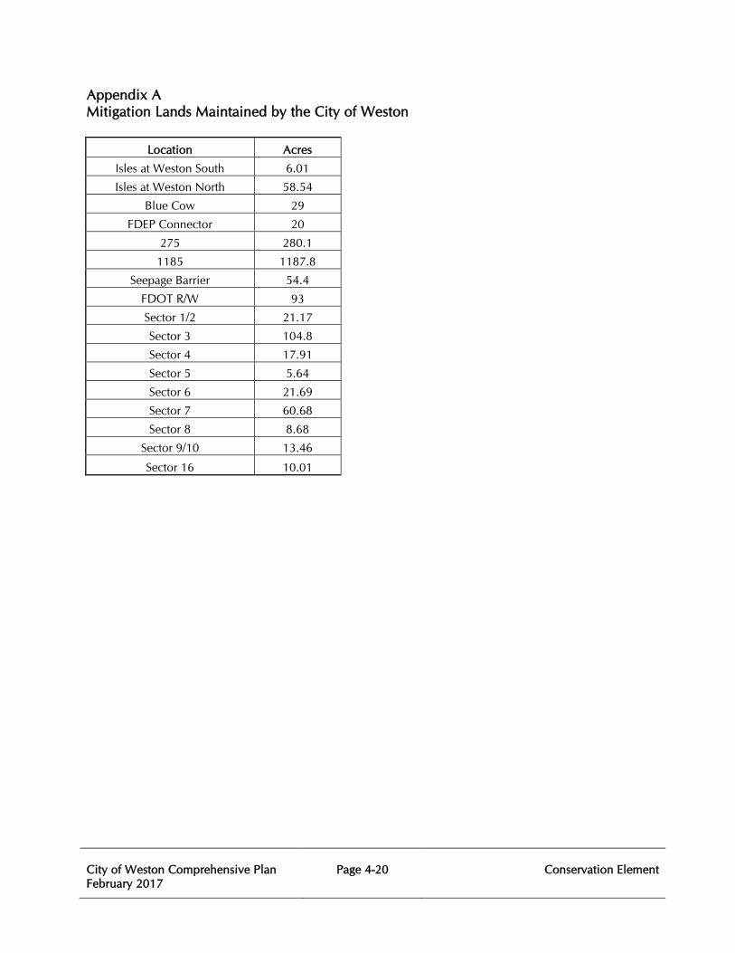
City of Weston Comprehensive Plan February 2017
Page 4-20
Conservation Element
Appendix A Mitigation Lands Maintained by the City of Weston
Location Acres
Isles at Weston South 6.01
Isles at Weston North 58.54
Blue Cow 29
FDEP Connector 20
275 280.1
1185 1187.8
Seepage Barrier 54.4
FDOT R/W 93
Sector 1/2 21.17
Sector 3 104.8
Sector 4 17.91
Sector 5 5.64
Sector 6 21.69
Sector 7 60.68
Sector 8 8.68
Sector 9/10 13.46
Sector 16 10.01
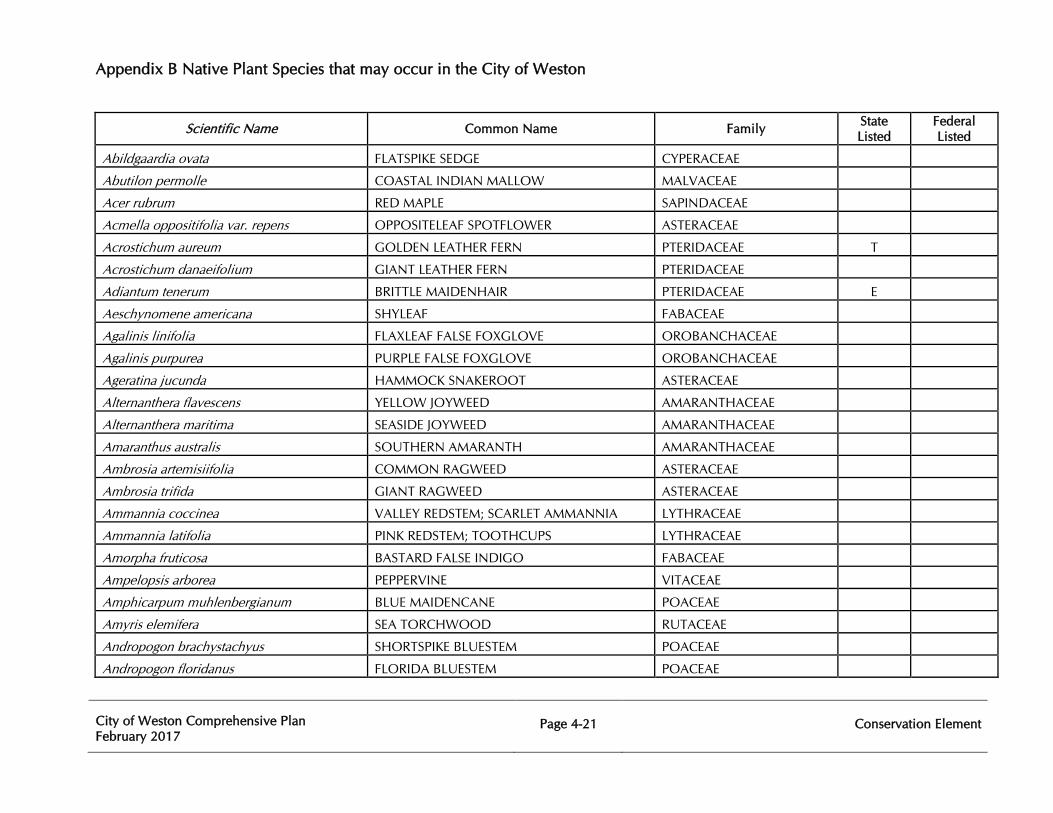
Appendix B Native Plant Species that may occur in the City of Weston
City of Weston Comprehensive Plan February 2017
Page 4-21
Conservation Element
Scientific Name Common Name Family State Listed
Federal Listed
Abildgaardia ovata FLATSPIKE SEDGE CYPERACEAE
Abutilon permolle COASTAL INDIAN MALLOW MALVACEAE
Acer rubrum RED MAPLE SAPINDACEAE
Acmella oppositifolia var. repens OPPOSITELEAF SPOTFLOWER ASTERACEAE
Acrostichum aureum GOLDEN LEATHER FERN PTERIDACEAE T
Acrostichum danaeifolium GIANT LEATHER FERN PTERIDACEAE
Adiantum tenerum BRITTLE MAIDENHAIR PTERIDACEAE E
Aeschynomene americana SHYLEAF FABACEAE
Agalinis linifolia FLAXLEAF FALSE FOXGLOVE OROBANCHACEAE
Agalinis purpurea PURPLE FALSE FOXGLOVE OROBANCHACEAE
Ageratina jucunda HAMMOCK SNAKEROOT ASTERACEAE
Alternanthera flavescens YELLOW JOYWEED AMARANTHACEAE
Alternanthera maritima SEASIDE JOYWEED AMARANTHACEAE
Amaranthus australis SOUTHERN AMARANTH AMARANTHACEAE
Ambrosia artemisiifolia COMMON RAGWEED ASTERACEAE
Ambrosia trifida GIANT RAGWEED ASTERACEAE
Ammannia coccinea VALLEY REDSTEM; SCARLET AMMANNIA LYTHRACEAE
Ammannia latifolia PINK REDSTEM; TOOTHCUPS LYTHRACEAE
Amorpha fruticosa BASTARD FALSE INDIGO FABACEAE
Ampelopsis arborea PEPPERVINE VITACEAE
Amphicarpum muhlenbergianum BLUE MAIDENCANE POACEAE
Amyris elemifera SEA TORCHWOOD RUTACEAE
Andropogon brachystachyus SHORTSPIKE BLUESTEM POACEAE
Andropogon floridanus FLORIDA BLUESTEM POACEAE
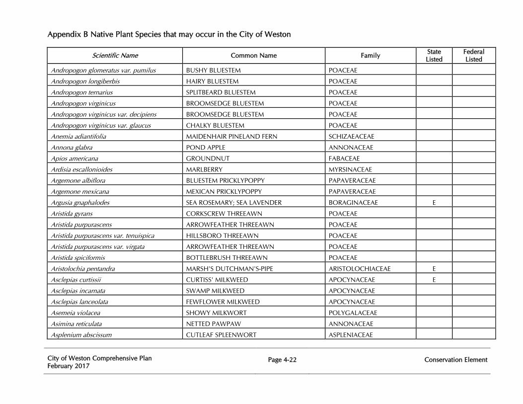
Appendix B Native Plant Species that may occur in the City of Weston
City of Weston Comprehensive Plan February 2017
Page 4-22
Conservation Element
Scientific Name Common Name Family State Listed
Federal Listed
Andropogon glomeratus var. pumilus BUSHY BLUESTEM POACEAE
Andropogon longiberbis HAIRY BLUESTEM POACEAE
Andropogon ternarius SPLITBEARD BLUESTEM POACEAE
Andropogon virginicus BROOMSEDGE BLUESTEM POACEAE
Andropogon virginicus var. decipiens BROOMSEDGE BLUESTEM POACEAE
Andropogon virginicus var. glaucus CHALKY BLUESTEM POACEAE
Anemia adiantifolia MAIDENHAIR PINELAND FERN SCHIZAEACEAE
Annona glabra POND APPLE ANNONACEAE
Apios americana GROUNDNUT FABACEAE
Ardisia escallonioides MARLBERRY MYRSINACEAE
Argemone albiflora BLUESTEM PRICKLYPOPPY PAPAVERACEAE
Argemone mexicana MEXICAN PRICKLYPOPPY PAPAVERACEAE
Argusia gnaphalodes SEA ROSEMARY; SEA LAVENDER BORAGINACEAE E
Aristida gyrans CORKSCREW THREEAWN POACEAE
Aristida purpurascens ARROWFEATHER THREEAWN POACEAE
Aristida purpurascens var. tenuispica HILLSBORO THREEAWN POACEAE
Aristida purpurascens var. virgata ARROWFEATHER THREEAWN POACEAE
Aristida spiciformis BOTTLEBRUSH THREEAWN POACEAE
Aristolochia pentandra MARSH'S DUTCHMAN'S-PIPE ARISTOLOCHIACEAE E
Asclepias curtissii CURTISS' MILKWEED APOCYNACEAE E
Asclepias incarnata SWAMP MILKWEED APOCYNACEAE
Asclepias lanceolata FEWFLOWER MILKWEED APOCYNACEAE
Asemeia violacea SHOWY MILKWORT POLYGALACEAE
Asimina reticulata NETTED PAWPAW ANNONACEAE
Asplenium abscissum CUTLEAF SPLEENWORT ASPLENIACEAE
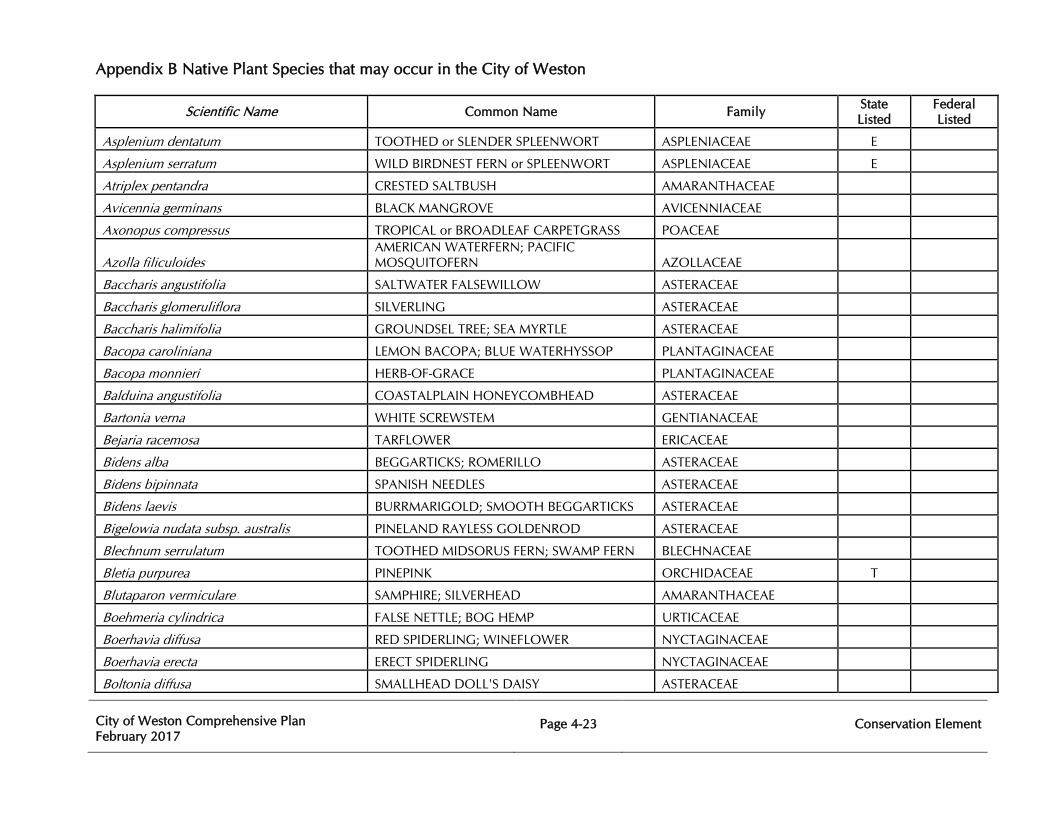
Appendix B Native Plant Species that may occur in the City of Weston
City of Weston Comprehensive Plan February 2017
Page 4-23
Conservation Element
Scientific Name Common Name Family State Listed
Federal Listed
Asplenium dentatum TOOTHED or SLENDER SPLEENWORT ASPLENIACEAE E
Asplenium serratum WILD BIRDNEST FERN or SPLEENWORT ASPLENIACEAE E
Atriplex pentandra CRESTED SALTBUSH AMARANTHACEAE
Avicennia germinans BLACK MANGROVE AVICENNIACEAE
Axonopus compressus TROPICAL or BROADLEAF CARPETGRASS POACEAE
Azolla filiculoides AMERICAN WATERFERN; PACIFIC MOSQUITOFERN AZOLLACEAE
Baccharis angustifolia SALTWATER FALSEWILLOW ASTERACEAE
Baccharis glomeruliflora SILVERLING ASTERACEAE
Baccharis halimifolia GROUNDSEL TREE; SEA MYRTLE ASTERACEAE
Bacopa caroliniana LEMON BACOPA; BLUE WATERHYSSOP PLANTAGINACEAE
Bacopa monnieri HERB-OF-GRACE PLANTAGINACEAE
Balduina angustifolia COASTALPLAIN HONEYCOMBHEAD ASTERACEAE
Bartonia verna WHITE SCREWSTEM GENTIANACEAE
Bejaria racemosa TARFLOWER ERICACEAE
Bidens alba BEGGARTICKS; ROMERILLO ASTERACEAE
Bidens bipinnata SPANISH NEEDLES ASTERACEAE
Bidens laevis BURRMARIGOLD; SMOOTH BEGGARTICKS ASTERACEAE
Bigelowia nudata subsp. australis PINELAND RAYLESS GOLDENROD ASTERACEAE
Blechnum serrulatum TOOTHED MIDSORUS FERN; SWAMP FERN BLECHNACEAE
Bletia purpurea PINEPINK ORCHIDACEAE T
Blutaparon vermiculare SAMPHIRE; SILVERHEAD AMARANTHACEAE
Boehmeria cylindrica FALSE NETTLE; BOG HEMP URTICACEAE
Boerhavia diffusa RED SPIDERLING; WINEFLOWER NYCTAGINACEAE
Boerhavia erecta ERECT SPIDERLING NYCTAGINACEAE
Boltonia diffusa SMALLHEAD DOLL'S DAISY ASTERACEAE
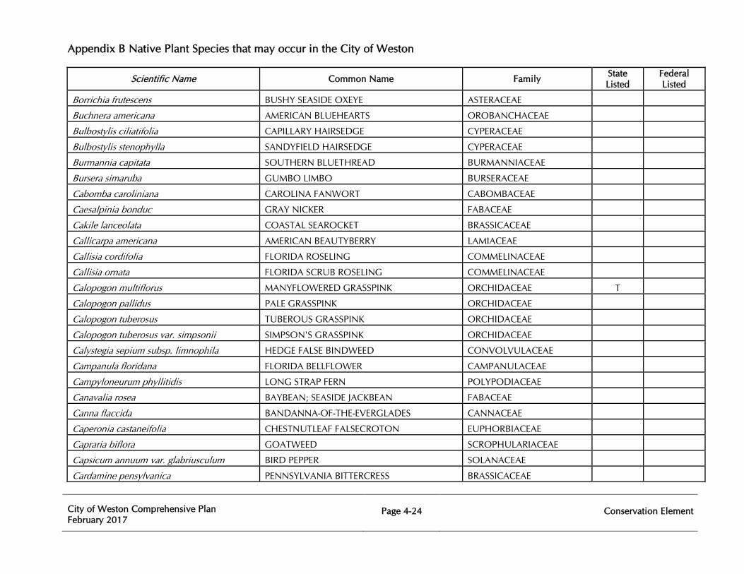
Appendix B Native Plant Species that may occur in the City of Weston
City of Weston Comprehensive Plan February 2017
Page 4-24
Conservation Element
Scientific Name Common Name Family State Listed
Federal Listed
Borrichia frutescens BUSHY SEASIDE OXEYE ASTERACEAE
Buchnera americana AMERICAN BLUEHEARTS OROBANCHACEAE
Bulbostylis ciliatifolia CAPILLARY HAIRSEDGE CYPERACEAE
Bulbostylis stenophylla SANDYFIELD HAIRSEDGE CYPERACEAE
Burmannia capitata SOUTHERN BLUETHREAD BURMANNIACEAE
Bursera simaruba GUMBO LIMBO BURSERACEAE
Cabomba caroliniana CAROLINA FANWORT CABOMBACEAE
Caesalpinia bonduc GRAY NICKER FABACEAE
Cakile lanceolata COASTAL SEAROCKET BRASSICACEAE
Callicarpa americana AMERICAN BEAUTYBERRY LAMIACEAE
Callisia cordifolia FLORIDA ROSELING COMMELINACEAE
Callisia ornata FLORIDA SCRUB ROSELING COMMELINACEAE
Calopogon multiflorus MANYFLOWERED GRASSPINK ORCHIDACEAE T
Calopogon pallidus PALE GRASSPINK ORCHIDACEAE
Calopogon tuberosus TUBEROUS GRASSPINK ORCHIDACEAE
Calopogon tuberosus var. simpsonii SIMPSON'S GRASSPINK ORCHIDACEAE
Calystegia sepium subsp. limnophila HEDGE FALSE BINDWEED CONVOLVULACEAE
Campanula floridana FLORIDA BELLFLOWER CAMPANULACEAE
Campyloneurum phyllitidis LONG STRAP FERN POLYPODIACEAE
Canavalia rosea BAYBEAN; SEASIDE JACKBEAN FABACEAE
Canna flaccida BANDANNA-OF-THE-EVERGLADES CANNACEAE
Caperonia castaneifolia CHESTNUTLEAF FALSECROTON EUPHORBIACEAE
Capraria biflora GOATWEED SCROPHULARIACEAE
Capsicum annuum var. glabriusculum BIRD PEPPER SOLANACEAE
Cardamine pensylvanica PENNSYLVANIA BITTERCRESS BRASSICACEAE
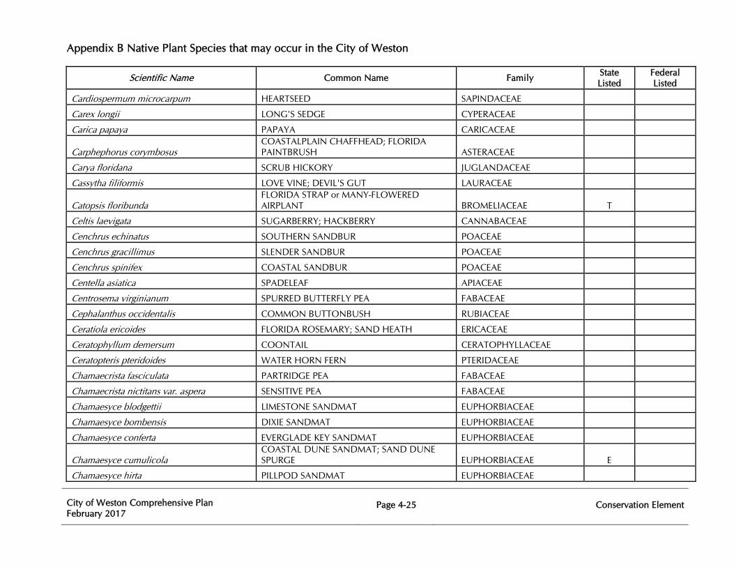
Appendix B Native Plant Species that may occur in the City of Weston
City of Weston Comprehensive Plan February 2017
Page 4-25
Conservation Element
Scientific Name Common Name Family State Listed
Federal Listed
Cardiospermum microcarpum HEARTSEED SAPINDACEAE
Carex longii LONG'S SEDGE CYPERACEAE
Carica papaya PAPAYA CARICACEAE
Carphephorus corymbosus COASTALPLAIN CHAFFHEAD; FLORIDA PAINTBRUSH ASTERACEAE
Carya floridana SCRUB HICKORY JUGLANDACEAE
Cassytha filiformis LOVE VINE; DEVIL'S GUT LAURACEAE
Catopsis floribunda FLORIDA STRAP or MANY-FLOWERED AIRPLANT BROMELIACEAE T
Celtis laevigata SUGARBERRY; HACKBERRY CANNABACEAE
Cenchrus echinatus SOUTHERN SANDBUR POACEAE
Cenchrus gracillimus SLENDER SANDBUR POACEAE
Cenchrus spinifex COASTAL SANDBUR POACEAE
Centella asiatica SPADELEAF APIACEAE
Centrosema virginianum SPURRED BUTTERFLY PEA FABACEAE
Cephalanthus occidentalis COMMON BUTTONBUSH RUBIACEAE
Ceratiola ericoides FLORIDA ROSEMARY; SAND HEATH ERICACEAE
Ceratophyllum demersum COONTAIL CERATOPHYLLACEAE
Ceratopteris pteridoides WATER HORN FERN PTERIDACEAE
Chamaecrista fasciculata PARTRIDGE PEA FABACEAE
Chamaecrista nictitans var. aspera SENSITIVE PEA FABACEAE
Chamaesyce blodgettii LIMESTONE SANDMAT EUPHORBIACEAE
Chamaesyce bombensis DIXIE SANDMAT EUPHORBIACEAE
Chamaesyce conferta EVERGLADE KEY SANDMAT EUPHORBIACEAE
Chamaesyce cumulicola COASTAL DUNE SANDMAT; SAND DUNE SPURGE EUPHORBIACEAE E
Chamaesyce hirta PILLPOD SANDMAT EUPHORBIACEAE
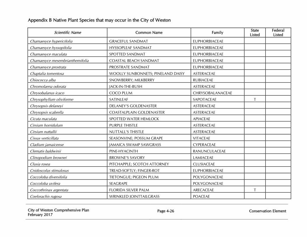
Appendix B Native Plant Species that may occur in the City of Weston
City of Weston Comprehensive Plan February 2017
Page 4-26
Conservation Element
Scientific Name Common Name Family State Listed
Federal Listed
Chamaesyce hypericifolia GRACEFUL SANDMAT EUPHORBIACEAE
Chamaesyce hyssopifolia HYSSOPLEAF SANDMAT EUPHORBIACEAE
Chamaesyce maculata SPOTTED SANDMAT EUPHORBIACEAE
Chamaesyce mesembrianthemifolia COASTAL BEACH SANDMAT EUPHORBIACEAE
Chamaesyce prostrata PROSTRATE SANDMAT EUPHORBIACEAE
Chaptalia tomentosa WOOLLY SUNBONNETS; PINELAND DAISY ASTERACEAE
Chiococca alba SNOWBERRY; MILKBERRY RUBIACEAE
Chromolaena odorata JACK-IN-THE-BUSH ASTERACEAE
Chrysobalanus icaco COCO PLUM CHRYSOBALANACEAE
Chrysophyllum oliviforme SATINLEAF SAPOTACEAE T
Chrysopsis delaneyi DELANEY'S GOLDENASTER ASTERACEAE
Chrysopsis scabrella COASTALPLAIN GOLDENASTER ASTERACEAE
Cicuta maculata SPOTTED WATER HEMLOCK APIACEAE
Cirsium horridulum PURPLE THISTLE ASTERACEAE
Cirsium nuttallii NUTTALL'S THISTLE ASTERACEAE
Cissus verticillata SEASONVINE; POSSUM GRAPE VITACEAE
Cladium jamaicense JAMAICA SWAMP SAWGRASS CYPERACEAE
Clematis baldwinii PINE-HYACINTH RANUNCULACEAE
Clinopodium brownei BROWNE'S SAVORY LAMIACEAE
Clusia rosea PITCHAPPLE; SCOTCH ATTORNEY CLUSIACEAE
Cnidoscolus stimulosus TREAD-SOFTLY; FINGER-ROT EUPHORBIACEAE
Coccoloba diversifolia TIETONGUE; PIGEON PLUM POLYGONACEAE
Coccoloba uvifera SEAGRAPE POLYGONACEAE
Coccothrinax argentata FLORIDA SILVER PALM ARECACEAE T
Coelorachis rugosa WRINKLED JOINTTAILGRASS POACEAE
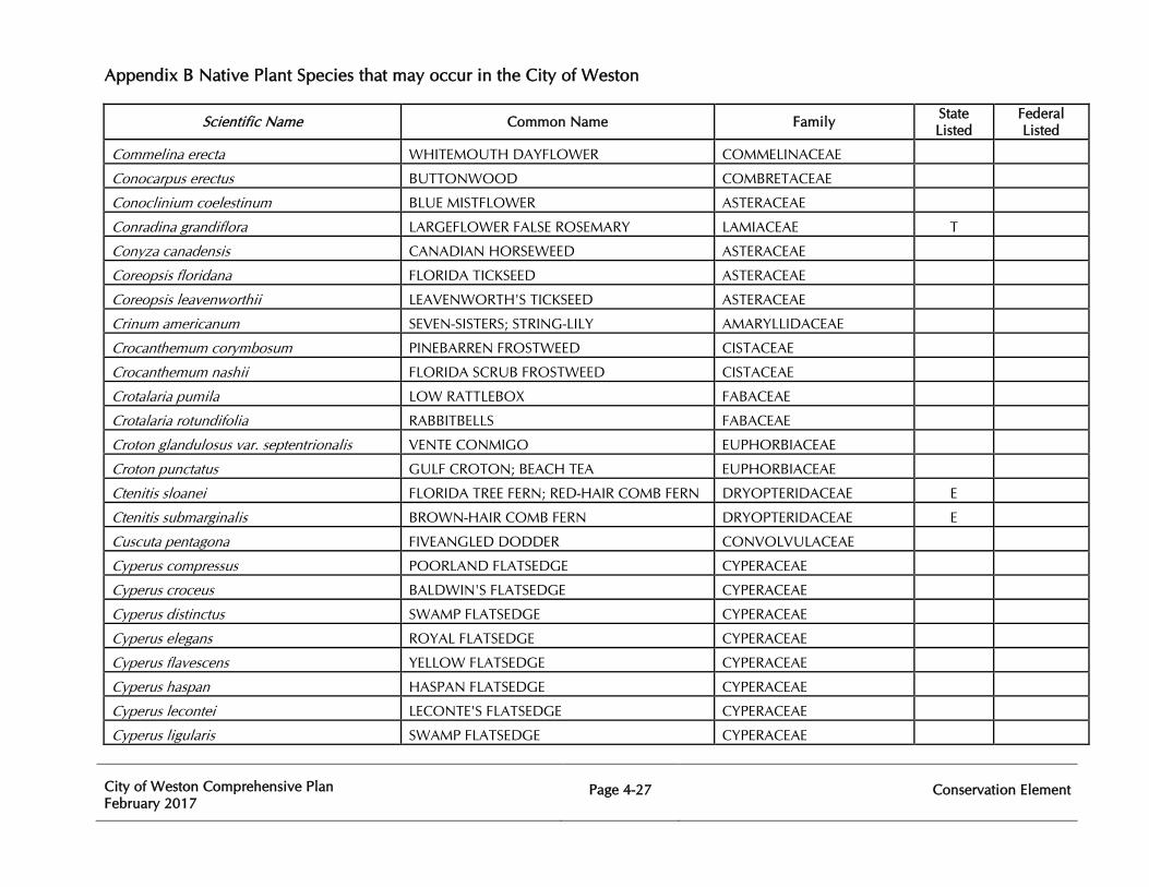
Appendix B Native Plant Species that may occur in the City of Weston
City of Weston Comprehensive Plan February 2017
Page 4-27
Conservation Element
Scientific Name Common Name Family State Listed
Federal Listed
Commelina erecta WHITEMOUTH DAYFLOWER COMMELINACEAE
Conocarpus erectus BUTTONWOOD COMBRETACEAE
Conoclinium coelestinum BLUE MISTFLOWER ASTERACEAE
Conradina grandiflora LARGEFLOWER FALSE ROSEMARY LAMIACEAE T
Conyza canadensis CANADIAN HORSEWEED ASTERACEAE
Coreopsis floridana FLORIDA TICKSEED ASTERACEAE
Coreopsis leavenworthii LEAVENWORTH'S TICKSEED ASTERACEAE
Crinum americanum SEVEN-SISTERS; STRING-LILY AMARYLLIDACEAE
Crocanthemum corymbosum PINEBARREN FROSTWEED CISTACEAE
Crocanthemum nashii FLORIDA SCRUB FROSTWEED CISTACEAE
Crotalaria pumila LOW RATTLEBOX FABACEAE
Crotalaria rotundifolia RABBITBELLS FABACEAE
Croton glandulosus var. septentrionalis VENTE CONMIGO EUPHORBIACEAE
Croton punctatus GULF CROTON; BEACH TEA EUPHORBIACEAE
Ctenitis sloanei FLORIDA TREE FERN; RED-HAIR COMB FERN DRYOPTERIDACEAE E
Ctenitis submarginalis BROWN-HAIR COMB FERN DRYOPTERIDACEAE E
Cuscuta pentagona FIVEANGLED DODDER CONVOLVULACEAE
Cyperus compressus POORLAND FLATSEDGE CYPERACEAE
Cyperus croceus BALDWIN'S FLATSEDGE CYPERACEAE
Cyperus distinctus SWAMP FLATSEDGE CYPERACEAE
Cyperus elegans ROYAL FLATSEDGE CYPERACEAE
Cyperus flavescens YELLOW FLATSEDGE CYPERACEAE
Cyperus haspan HASPAN FLATSEDGE CYPERACEAE
Cyperus lecontei LECONTE'S FLATSEDGE CYPERACEAE
Cyperus ligularis SWAMP FLATSEDGE CYPERACEAE
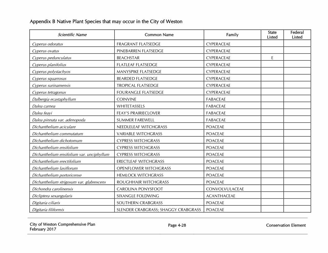
Appendix B Native Plant Species that may occur in the City of Weston
City of Weston Comprehensive Plan February 2017
Page 4-28
Conservation Element
Scientific Name Common Name Family State Listed
Federal Listed
Cyperus odoratus FRAGRANT FLATSEDGE CYPERACEAE
Cyperus ovatus PINEBARREN FLATSEDGE CYPERACEAE
Cyperus pedunculatus BEACHSTAR CYPERACEAE E
Cyperus planifolius FLATLEAF FLATSEDGE CYPERACEAE
Cyperus polystachyos MANYSPIKE FLATSEDGE CYPERACEAE
Cyperus squarrosus BEARDED FLATSEDGE CYPERACEAE
Cyperus surinamensis TROPICAL FLATSEDGE CYPERACEAE
Cyperus tetragonus FOURANGLE FLATSEDGE CYPERACEAE
Dalbergia ecastaphyllum COINVINE FABACEAE
Dalea carnea WHITETASSELS FABACEAE
Dalea feayi FEAY'S PRAIRIECLOVER FABACEAE
Dalea pinnata var. adenopoda SUMMER FAREWELL FABACEAE
Dichanthelium aciculare NEEDLELEAF WITCHGRASS POACEAE
Dichanthelium commutatum VARIABLE WITCHGRASS POACEAE
Dichanthelium dichotomum CYPRESS WITCHGRASS POACEAE
Dichanthelium ensifolium CYPRESS WITCHGRASS POACEAE
Dichanthelium ensifolium var. unciphyllum CYPRESS WITCHGRASS POACEAE
Dichanthelium erectifolium ERECTLEAF WITCHGRASS POACEAE
Dichanthelium laxiflorum OPENFLOWER WITCHGRASS POACEAE
Dichanthelium portoricense HEMLOCK WITCHGRASS POACEAE
Dichanthelium strigosum var. glabrescens ROUGHHAIR WITCHGRASS POACEAE
Dichondra carolinensis CAROLINA PONYSFOOT CONVOLVULACEAE
Dicliptera sexangularis SIXANGLE FOLDWING ACANTHACEAE
Digitaria ciliaris SOUTHERN CRABGRASS POACEAE
Digitaria filiformis SLENDER CRABGRASS; SHAGGY CRABGRASS POACEAE
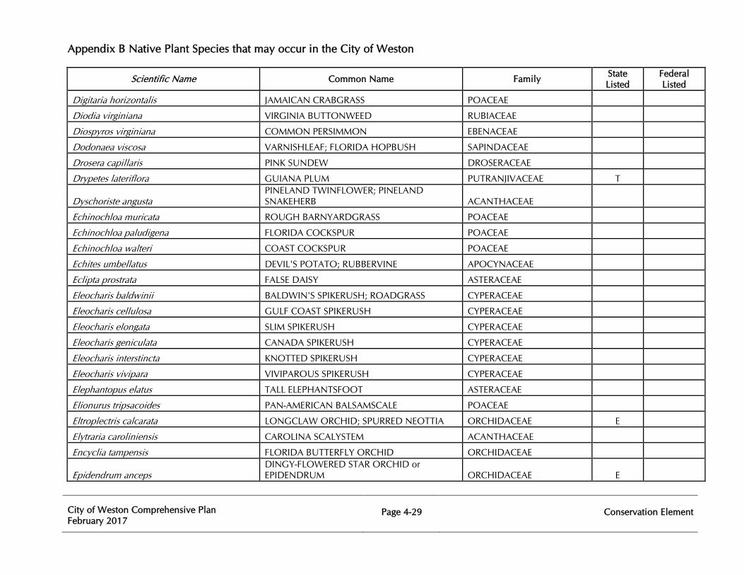
Appendix B Native Plant Species that may occur in the City of Weston
City of Weston Comprehensive Plan February 2017
Page 4-29
Conservation Element
Scientific Name Common Name Family State Listed
Federal Listed
Digitaria horizontalis JAMAICAN CRABGRASS POACEAE
Diodia virginiana VIRGINIA BUTTONWEED RUBIACEAE
Diospyros virginiana COMMON PERSIMMON EBENACEAE
Dodonaea viscosa VARNISHLEAF; FLORIDA HOPBUSH SAPINDACEAE
Drosera capillaris PINK SUNDEW DROSERACEAE
Drypetes lateriflora GUIANA PLUM PUTRANJIVACEAE T
Dyschoriste angusta PINELAND TWINFLOWER; PINELAND SNAKEHERB ACANTHACEAE
Echinochloa muricata ROUGH BARNYARDGRASS POACEAE
Echinochloa paludigena FLORIDA COCKSPUR POACEAE
Echinochloa walteri COAST COCKSPUR POACEAE
Echites umbellatus DEVIL'S POTATO; RUBBERVINE APOCYNACEAE
Eclipta prostrata FALSE DAISY ASTERACEAE
Eleocharis baldwinii BALDWIN'S SPIKERUSH; ROADGRASS CYPERACEAE
Eleocharis cellulosa GULF COAST SPIKERUSH CYPERACEAE
Eleocharis elongata SLIM SPIKERUSH CYPERACEAE
Eleocharis geniculata CANADA SPIKERUSH CYPERACEAE
Eleocharis interstincta KNOTTED SPIKERUSH CYPERACEAE
Eleocharis vivipara VIVIPAROUS SPIKERUSH CYPERACEAE
Elephantopus elatus TALL ELEPHANTSFOOT ASTERACEAE
Elionurus tripsacoides PAN-AMERICAN BALSAMSCALE POACEAE
Eltroplectris calcarata LONGCLAW ORCHID; SPURRED NEOTTIA ORCHIDACEAE E
Elytraria caroliniensis CAROLINA SCALYSTEM ACANTHACEAE
Encyclia tampensis FLORIDA BUTTERFLY ORCHID ORCHIDACEAE
Epidendrum anceps DINGY-FLOWERED STAR ORCHID or EPIDENDRUM ORCHIDACEAE E
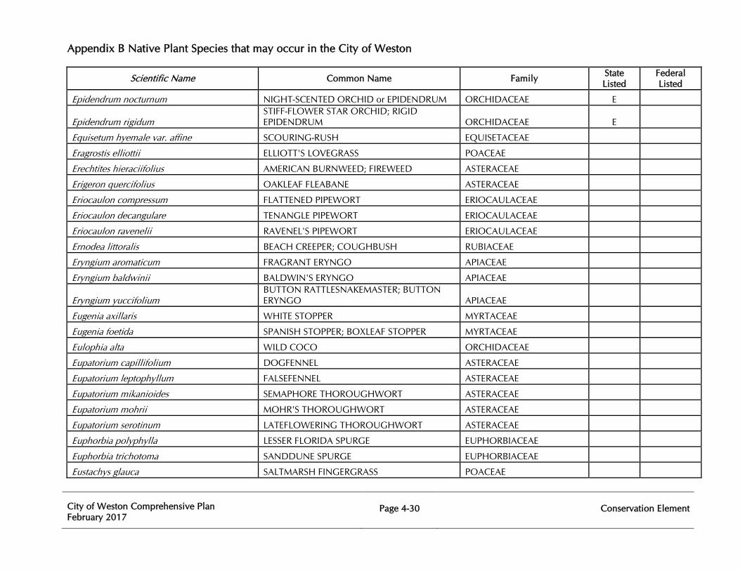
Appendix B Native Plant Species that may occur in the City of Weston
City of Weston Comprehensive Plan February 2017
Page 4-30
Conservation Element
Scientific Name Common Name Family State Listed
Federal Listed
Epidendrum nocturnum NIGHT-SCENTED ORCHID or EPIDENDRUM ORCHIDACEAE E
Epidendrum rigidum STIFF-FLOWER STAR ORCHID; RIGID EPIDENDRUM ORCHIDACEAE E
Equisetum hyemale var. affine SCOURING-RUSH EQUISETACEAE
Eragrostis elliottii ELLIOTT'S LOVEGRASS POACEAE
Erechtites hieraciifolius AMERICAN BURNWEED; FIREWEED ASTERACEAE
Erigeron quercifolius OAKLEAF FLEABANE ASTERACEAE
Eriocaulon compressum FLATTENED PIPEWORT ERIOCAULACEAE
Eriocaulon decangulare TENANGLE PIPEWORT ERIOCAULACEAE
Eriocaulon ravenelii RAVENEL'S PIPEWORT ERIOCAULACEAE
Ernodea littoralis BEACH CREEPER; COUGHBUSH RUBIACEAE
Eryngium aromaticum FRAGRANT ERYNGO APIACEAE
Eryngium baldwinii BALDWIN'S ERYNGO APIACEAE
Eryngium yuccifolium BUTTON RATTLESNAKEMASTER; BUTTON ERYNGO APIACEAE
Eugenia axillaris WHITE STOPPER MYRTACEAE
Eugenia foetida SPANISH STOPPER; BOXLEAF STOPPER MYRTACEAE
Eulophia alta WILD COCO ORCHIDACEAE
Eupatorium capillifolium DOGFENNEL ASTERACEAE
Eupatorium leptophyllum FALSEFENNEL ASTERACEAE
Eupatorium mikanioides SEMAPHORE THOROUGHWORT ASTERACEAE
Eupatorium mohrii MOHR'S THOROUGHWORT ASTERACEAE
Eupatorium serotinum LATEFLOWERING THOROUGHWORT ASTERACEAE
Euphorbia polyphylla LESSER FLORIDA SPURGE EUPHORBIACEAE
Euphorbia trichotoma SANDDUNE SPURGE EUPHORBIACEAE
Eustachys glauca SALTMARSH FINGERGRASS POACEAE
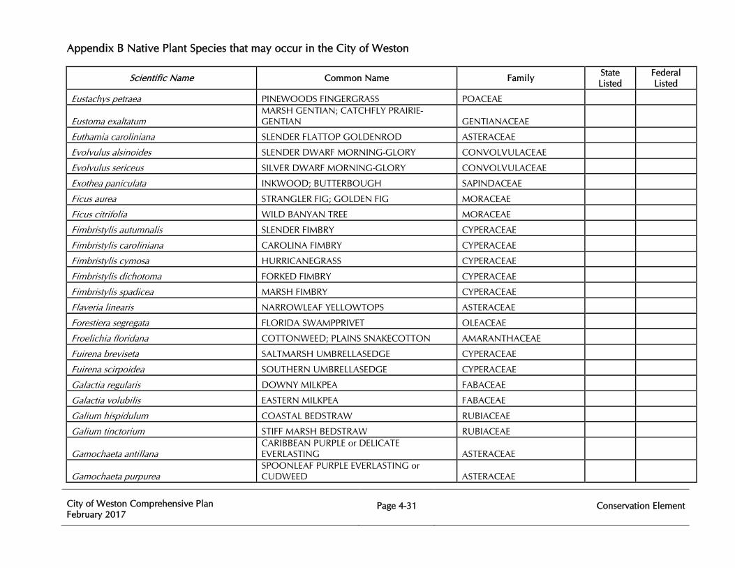
Appendix B Native Plant Species that may occur in the City of Weston
City of Weston Comprehensive Plan February 2017
Page 4-31
Conservation Element
Scientific Name Common Name Family State Listed
Federal Listed
Eustachys petraea PINEWOODS FINGERGRASS POACEAE
Eustoma exaltatum MARSH GENTIAN; CATCHFLY PRAIRIE-GENTIAN GENTIANACEAE
Euthamia caroliniana SLENDER FLATTOP GOLDENROD ASTERACEAE
Evolvulus alsinoides SLENDER DWARF MORNING-GLORY CONVOLVULACEAE
Evolvulus sericeus SILVER DWARF MORNING-GLORY CONVOLVULACEAE
Exothea paniculata INKWOOD; BUTTERBOUGH SAPINDACEAE
Ficus aurea STRANGLER FIG; GOLDEN FIG MORACEAE
Ficus citrifolia WILD BANYAN TREE MORACEAE
Fimbristylis autumnalis SLENDER FIMBRY CYPERACEAE
Fimbristylis caroliniana CAROLINA FIMBRY CYPERACEAE
Fimbristylis cymosa HURRICANEGRASS CYPERACEAE
Fimbristylis dichotoma FORKED FIMBRY CYPERACEAE
Fimbristylis spadicea MARSH FIMBRY CYPERACEAE
Flaveria linearis NARROWLEAF YELLOWTOPS ASTERACEAE
Forestiera segregata FLORIDA SWAMPPRIVET OLEACEAE
Froelichia floridana COTTONWEED; PLAINS SNAKECOTTON AMARANTHACEAE
Fuirena breviseta SALTMARSH UMBRELLASEDGE CYPERACEAE
Fuirena scirpoidea SOUTHERN UMBRELLASEDGE CYPERACEAE
Galactia regularis DOWNY MILKPEA FABACEAE
Galactia volubilis EASTERN MILKPEA FABACEAE
Galium hispidulum COASTAL BEDSTRAW RUBIACEAE
Galium tinctorium STIFF MARSH BEDSTRAW RUBIACEAE
Gamochaeta antillana CARIBBEAN PURPLE or DELICATE EVERLASTING ASTERACEAE
Gamochaeta purpurea SPOONLEAF PURPLE EVERLASTING or CUDWEED ASTERACEAE
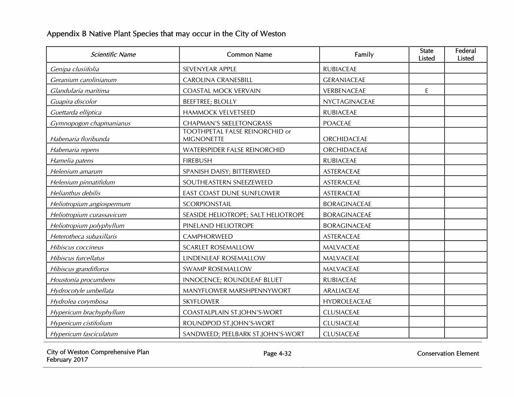
Appendix B Native Plant Species that may occur in the City of Weston
City of Weston Comprehensive Plan February 2017
Page 4-32
Conservation Element
Scientific Name Common Name Family State Listed
Federal Listed
Genipa clusiifolia SEVENYEAR APPLE RUBIACEAE
Geranium carolinianum CAROLINA CRANESBILL GERANIACEAE
Glandularia maritima COASTAL MOCK VERVAIN VERBENACEAE E
Guapira discolor BEEFTREE; BLOLLY NYCTAGINACEAE
Guettarda elliptica HAMMOCK VELVETSEED RUBIACEAE
Gymnopogon chapmanianus CHAPMAN'S SKELETONGRASS POACEAE
Habenaria floribunda TOOTHPETAL FALSE REINORCHID or MIGNONETTE ORCHIDACEAE
Habenaria repens WATERSPIDER FALSE REINORCHID ORCHIDACEAE
Hamelia patens FIREBUSH RUBIACEAE
Helenium amarum SPANISH DAISY; BITTERWEED ASTERACEAE
Helenium pinnatifidum SOUTHEASTERN SNEEZEWEED ASTERACEAE
Helianthus debilis EAST COAST DUNE SUNFLOWER ASTERACEAE
Heliotropium angiospermum SCORPIONSTAIL BORAGINACEAE
Heliotropium curassavicum SEASIDE HELIOTROPE; SALT HELIOTROPE BORAGINACEAE
Heliotropium polyphyllum PINELAND HELIOTROPE BORAGINACEAE
Heterotheca subaxillaris CAMPHORWEED ASTERACEAE
Hibiscus coccineus SCARLET ROSEMALLOW MALVACEAE
Hibiscus furcellatus LINDENLEAF ROSEMALLOW MALVACEAE
Hibiscus grandiflorus SWAMP ROSEMALLOW MALVACEAE
Houstonia procumbens INNOCENCE; ROUNDLEAF BLUET RUBIACEAE
Hydrocotyle umbellata MANYFLOWER MARSHPENNYWORT ARALIACEAE
Hydrolea corymbosa SKYFLOWER HYDROLEACEAE
Hypericum brachyphyllum COASTALPLAIN ST.JOHN'S-WORT CLUSIACEAE
Hypericum cistifolium ROUNDPOD ST.JOHN'S-WORT CLUSIACEAE
Hypericum fasciculatum SANDWEED; PEELBARK ST.JOHN'S-WORT CLUSIACEAE
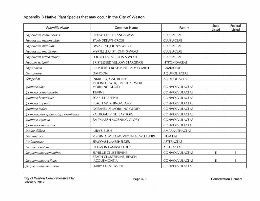
Appendix B Native Plant Species that may occur in the City of Weston
City of Weston Comprehensive Plan February 2017
Page 4-33
Conservation Element
Scientific Name Common Name Family State Listed
Federal Listed
Hypericum gentianoides PINEWEEDS; ORANGEGRASS CLUSIACEAE
Hypericum hypericoides ST.ANDREW'S-CROSS CLUSIACEAE
Hypericum mutilum DWARF ST.JOHN'S-WORT CLUSIACEAE
Hypericum myrtifolium MYRTLELEAF ST.JOHN'S-WORT CLUSIACEAE
Hypericum tetrapetalum FOURPETAL ST.JOHN'S-WORT CLUSIACEAE
Hypoxis wrightii BRISTLESEED YELLOW STARGRASS HYPOXIDACEAE
Hyptis alata CLUSTERED BUSHMINT; MUSKY MINT LAMIACEAE
Ilex cassine DAHOON AQUIFOLIACEAE
Ilex glabra INKBERRY; GALLBERRY AQUIFOLIACEAE
Ipomoea alba MOONFLOWER; TROPICAL WHITE MORNING-GLORY CONVOLVULACEAE
Ipomoea cordatotriloba TIEVINE CONVOLVULACEAE
Ipomoea hederifolia SCARLETCREEPER CONVOLVULACEAE
Ipomoea imperati BEACH MORNING-GLORY CONVOLVULACEAE
Ipomoea indica OCEANBLUE MORNING-GLORY CONVOLVULACEAE
Ipomoea pes-caprae subsp. brasiliensis RAILROAD VINE; BAYHOPS CONVOLVULACEAE
Ipomoea sagittata SALTMARSH MORNING-GLORY CONVOLVULACEAE
Ipomoea x leucantha CONVOLVULACEAE
Iresine diffusa JUBA'S BUSH AMARANTHACEAE
Itea virginica VIRGINIA WILLOW; VIRGINIA SWEETSPIRE ITEACEAE
Iva imbricata SEACOAST MARSHELDER ASTERACEAE
Iva microcephala PIEDMONT MARSHELDER ASTERACEAE
Jacquemontia pentanthos SKYBLUE CLUSTERVINE CONVOLVULACEAE E E
Jacquemontia reclinata BEACH CLUSTERVINE; BEACH JACQUEMONTIA CONVOLVULACEAE E E
Jacquemontia tamnifolia HAIRY CLUSTERVINE CONVOLVULACEAE
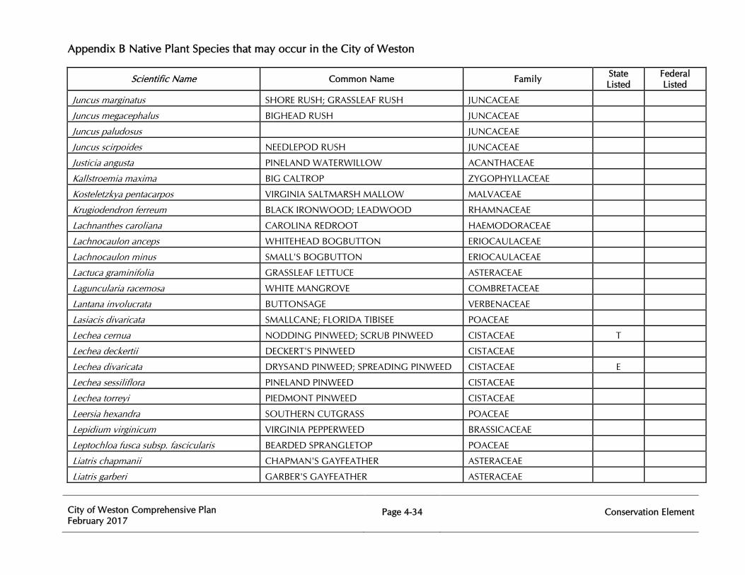
Appendix B Native Plant Species that may occur in the City of Weston
City of Weston Comprehensive Plan February 2017
Page 4-34
Conservation Element
Scientific Name Common Name Family State Listed
Federal Listed
Juncus marginatus SHORE RUSH; GRASSLEAF RUSH JUNCACEAE
Juncus megacephalus BIGHEAD RUSH JUNCACEAE
Juncus paludosus JUNCACEAE
Juncus scirpoides NEEDLEPOD RUSH JUNCACEAE
Justicia angusta PINELAND WATERWILLOW ACANTHACEAE
Kallstroemia maxima BIG CALTROP ZYGOPHYLLACEAE
Kosteletzkya pentacarpos VIRGINIA SALTMARSH MALLOW MALVACEAE
Krugiodendron ferreum BLACK IRONWOOD; LEADWOOD RHAMNACEAE
Lachnanthes caroliana CAROLINA REDROOT HAEMODORACEAE
Lachnocaulon anceps WHITEHEAD BOGBUTTON ERIOCAULACEAE
Lachnocaulon minus SMALL'S BOGBUTTON ERIOCAULACEAE
Lactuca graminifolia GRASSLEAF LETTUCE ASTERACEAE
Laguncularia racemosa WHITE MANGROVE COMBRETACEAE
Lantana involucrata BUTTONSAGE VERBENACEAE
Lasiacis divaricata SMALLCANE; FLORIDA TIBISEE POACEAE
Lechea cernua NODDING PINWEED; SCRUB PINWEED CISTACEAE T
Lechea deckertii DECKERT'S PINWEED CISTACEAE
Lechea divaricata DRYSAND PINWEED; SPREADING PINWEED CISTACEAE E
Lechea sessiliflora PINELAND PINWEED CISTACEAE
Lechea torreyi PIEDMONT PINWEED CISTACEAE
Leersia hexandra SOUTHERN CUTGRASS POACEAE
Lepidium virginicum VIRGINIA PEPPERWEED BRASSICACEAE
Leptochloa fusca subsp. fascicularis BEARDED SPRANGLETOP POACEAE
Liatris chapmanii CHAPMAN'S GAYFEATHER ASTERACEAE
Liatris garberi GARBER'S GAYFEATHER ASTERACEAE

Appendix B Native Plant Species that may occur in the City of Weston
City of Weston Comprehensive Plan February 2017
Page 4-35
Conservation Element
Scientific Name Common Name Family State Listed
Federal Listed
Liatris gracilis SLENDER GAYFEATHER ASTERACEAE
Liatris tenuifolia var. quadriflora SHORTLEAF GAYFEATHER ASTERACEAE
Licania michauxii GOPHER APPLE CHRYSOBALANACEAE
Linaria canadensis CANADIAN TOADFLAX PLANTAGINACEAE
Linaria floridana APALACHICOLA TOADFLAX PLANTAGINACEAE
Lindernia dubia MOISTBANK or YELLOWSEED FALSE PIMPERNEL LINDERNIACEAE
Lindernia grandiflora SAVANNAH FALSE PIMPERNEL LINDERNIACEAE
Linum floridanum FLORIDA YELLOW FLAX LINACEAE
Lippia stoechadifolia SOUTHERN FOGFRUIT; SOUTHERN MATCHSTICKS VERBENACEAE E
Lobelia feayana BAY LOBELIA CAMPANULACEAE
Lobelia glandulosa GLADE LOBELIA CAMPANULACEAE
Ludwigia alata WINGED PRIMROSEWILLOW ONAGRACEAE
Ludwigia curtissii CURTISS' PRIMROSEWILLOW ONAGRACEAE
Ludwigia decurrens WINGLEAF PRIMROSEWILLOW ONAGRACEAE
Ludwigia erecta YERBA DE JICOTEA ONAGRACEAE
Ludwigia maritima SEASIDE PRIMROSEWILLOW ONAGRACEAE
Ludwigia microcarpa SMALLFRUIT PRIMROSEWILLOW ONAGRACEAE
Ludwigia octovalvis MEXICAN PRIMROSEWILLOW ONAGRACEAE
Ludwigia repens CREEPING PRIMROSEWILLOW ONAGRACEAE
Lupinus diffusus SKYBLUE LUPINE FABACEAE
Luziola fluitans SOUTHERN WATERGRASS POACEAE
Lycopodiella appressa SOUTHERN BOG CLUB-MOSS LYCOPODIACEAE
Lycopodiella cernua NODDING CLUB-MOSS; STAGHORN CLUB-MOSS LYCOPODIACEAE
Lygodesmia aphylla ROSE-RUSH ASTERACEAE
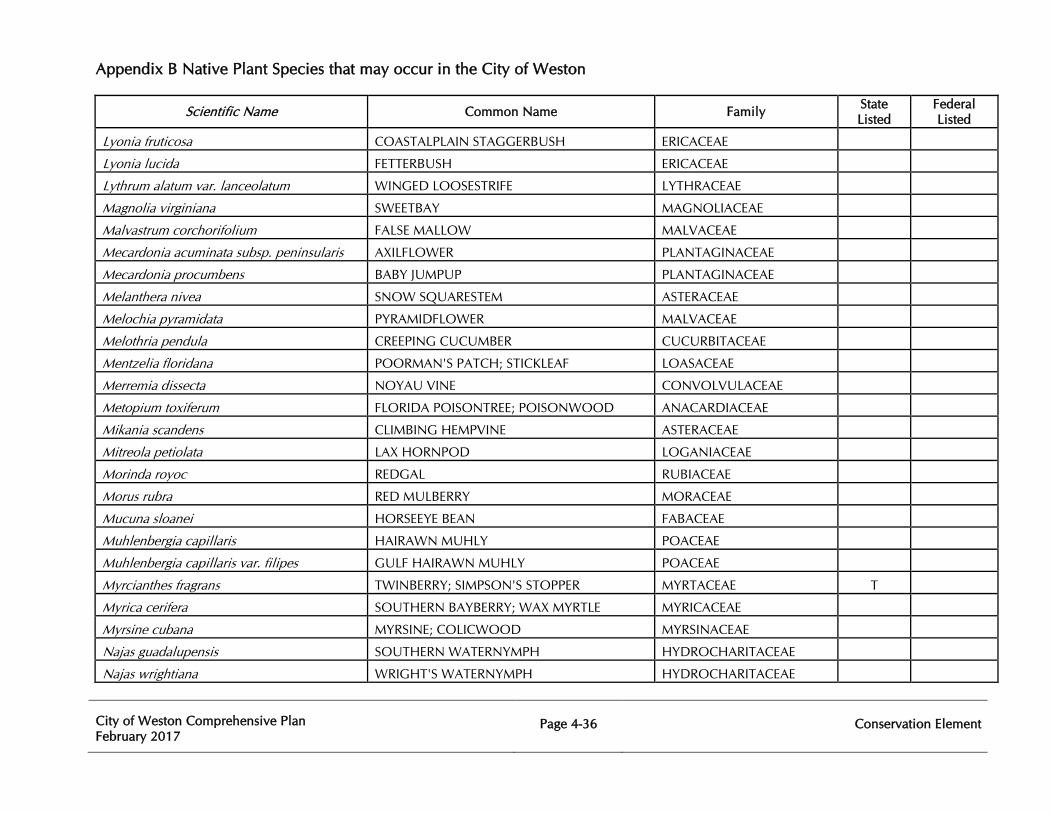
Appendix B Native Plant Species that may occur in the City of Weston
City of Weston Comprehensive Plan February 2017
Page 4-36
Conservation Element
Scientific Name Common Name Family State Listed
Federal Listed
Lyonia fruticosa COASTALPLAIN STAGGERBUSH ERICACEAE
Lyonia lucida FETTERBUSH ERICACEAE
Lythrum alatum var. lanceolatum WINGED LOOSESTRIFE LYTHRACEAE
Magnolia virginiana SWEETBAY MAGNOLIACEAE
Malvastrum corchorifolium FALSE MALLOW MALVACEAE
Mecardonia acuminata subsp. peninsularis AXILFLOWER PLANTAGINACEAE
Mecardonia procumbens BABY JUMPUP PLANTAGINACEAE
Melanthera nivea SNOW SQUARESTEM ASTERACEAE
Melochia pyramidata PYRAMIDFLOWER MALVACEAE
Melothria pendula CREEPING CUCUMBER CUCURBITACEAE
Mentzelia floridana POORMAN'S PATCH; STICKLEAF LOASACEAE
Merremia dissecta NOYAU VINE CONVOLVULACEAE
Metopium toxiferum FLORIDA POISONTREE; POISONWOOD ANACARDIACEAE
Mikania scandens CLIMBING HEMPVINE ASTERACEAE
Mitreola petiolata LAX HORNPOD LOGANIACEAE
Morinda royoc REDGAL RUBIACEAE
Morus rubra RED MULBERRY MORACEAE
Mucuna sloanei HORSEEYE BEAN FABACEAE
Muhlenbergia capillaris HAIRAWN MUHLY POACEAE
Muhlenbergia capillaris var. filipes GULF HAIRAWN MUHLY POACEAE
Myrcianthes fragrans TWINBERRY; SIMPSON'S STOPPER MYRTACEAE T
Myrica cerifera SOUTHERN BAYBERRY; WAX MYRTLE MYRICACEAE
Myrsine cubana MYRSINE; COLICWOOD MYRSINACEAE
Najas guadalupensis SOUTHERN WATERNYMPH HYDROCHARITACEAE
Najas wrightiana WRIGHT'S WATERNYMPH HYDROCHARITACEAE
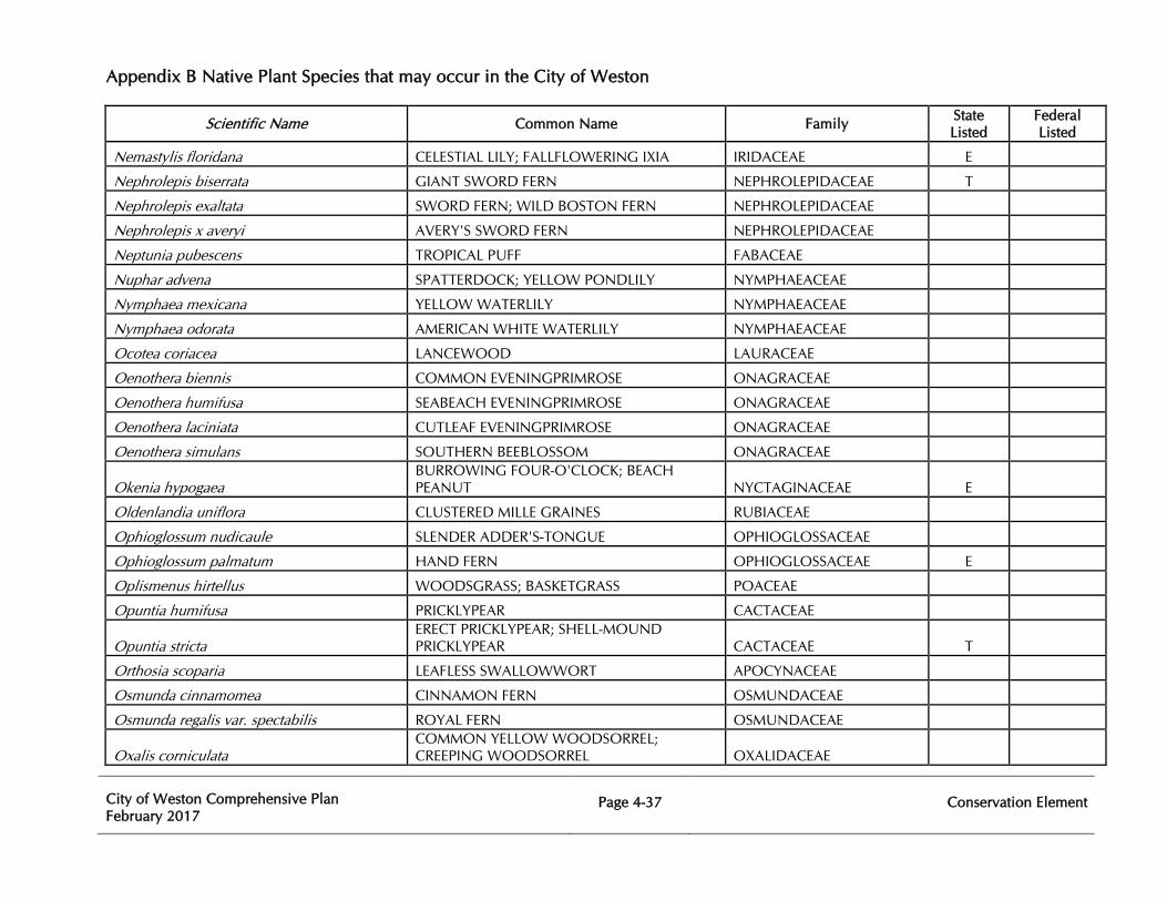
Appendix B Native Plant Species that may occur in the City of Weston
City of Weston Comprehensive Plan February 2017
Page 4-37
Conservation Element
Scientific Name Common Name Family State Listed
Federal Listed
Nemastylis floridana CELESTIAL LILY; FALLFLOWERING IXIA IRIDACEAE E
Nephrolepis biserrata GIANT SWORD FERN NEPHROLEPIDACEAE T
Nephrolepis exaltata SWORD FERN; WILD BOSTON FERN NEPHROLEPIDACEAE
Nephrolepis x averyi AVERY'S SWORD FERN NEPHROLEPIDACEAE
Neptunia pubescens TROPICAL PUFF FABACEAE
Nuphar advena SPATTERDOCK; YELLOW PONDLILY NYMPHAEACEAE
Nymphaea mexicana YELLOW WATERLILY NYMPHAEACEAE
Nymphaea odorata AMERICAN WHITE WATERLILY NYMPHAEACEAE
Ocotea coriacea LANCEWOOD LAURACEAE
Oenothera biennis COMMON EVENINGPRIMROSE ONAGRACEAE
Oenothera humifusa SEABEACH EVENINGPRIMROSE ONAGRACEAE
Oenothera laciniata CUTLEAF EVENINGPRIMROSE ONAGRACEAE
Oenothera simulans SOUTHERN BEEBLOSSOM ONAGRACEAE
Okenia hypogaea BURROWING FOUR-O'CLOCK; BEACH PEANUT NYCTAGINACEAE E
Oldenlandia uniflora CLUSTERED MILLE GRAINES RUBIACEAE
Ophioglossum nudicaule SLENDER ADDER'S-TONGUE OPHIOGLOSSACEAE
Ophioglossum palmatum HAND FERN OPHIOGLOSSACEAE E
Oplismenus hirtellus WOODSGRASS; BASKETGRASS POACEAE
Opuntia humifusa PRICKLYPEAR CACTACEAE
Opuntia stricta ERECT PRICKLYPEAR; SHELL-MOUND PRICKLYPEAR CACTACEAE T
Orthosia scoparia LEAFLESS SWALLOWWORT APOCYNACEAE
Osmunda cinnamomea CINNAMON FERN OSMUNDACEAE
Osmunda regalis var. spectabilis ROYAL FERN OSMUNDACEAE
Oxalis corniculata COMMON YELLOW WOODSORREL; CREEPING WOODSORREL OXALIDACEAE
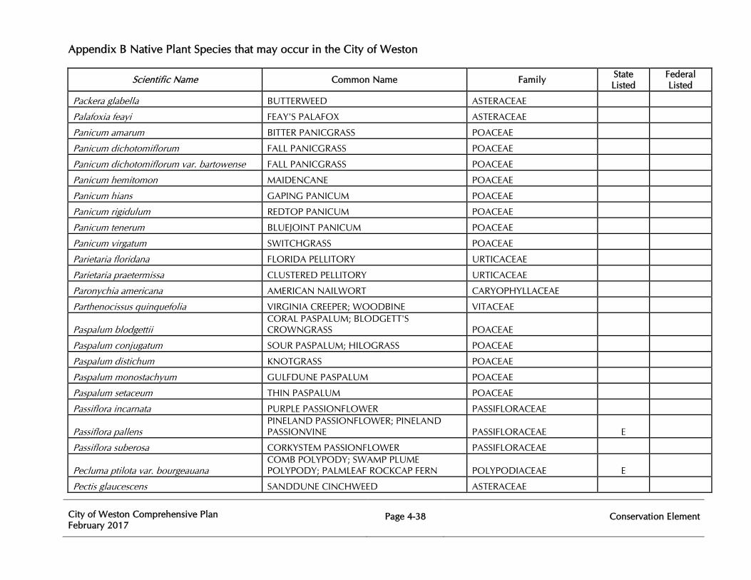
Appendix B Native Plant Species that may occur in the City of Weston
City of Weston Comprehensive Plan February 2017
Page 4-38
Conservation Element
Scientific Name Common Name Family State Listed
Federal Listed
Packera glabella BUTTERWEED ASTERACEAE
Palafoxia feayi FEAY'S PALAFOX ASTERACEAE
Panicum amarum BITTER PANICGRASS POACEAE
Panicum dichotomiflorum FALL PANICGRASS POACEAE
Panicum dichotomiflorum var. bartowense FALL PANICGRASS POACEAE
Panicum hemitomon MAIDENCANE POACEAE
Panicum hians GAPING PANICUM POACEAE
Panicum rigidulum REDTOP PANICUM POACEAE
Panicum tenerum BLUEJOINT PANICUM POACEAE
Panicum virgatum SWITCHGRASS POACEAE
Parietaria floridana FLORIDA PELLITORY URTICACEAE
Parietaria praetermissa CLUSTERED PELLITORY URTICACEAE
Paronychia americana AMERICAN NAILWORT CARYOPHYLLACEAE
Parthenocissus quinquefolia VIRGINIA CREEPER; WOODBINE VITACEAE
Paspalum blodgettii CORAL PASPALUM; BLODGETT'S CROWNGRASS POACEAE
Paspalum conjugatum SOUR PASPALUM; HILOGRASS POACEAE
Paspalum distichum KNOTGRASS POACEAE
Paspalum monostachyum GULFDUNE PASPALUM POACEAE
Paspalum setaceum THIN PASPALUM POACEAE
Passiflora incarnata PURPLE PASSIONFLOWER PASSIFLORACEAE
Passiflora pallens PINELAND PASSIONFLOWER; PINELAND PASSIONVINE PASSIFLORACEAE E
Passiflora suberosa CORKYSTEM PASSIONFLOWER PASSIFLORACEAE
Pecluma ptilota var. bourgeauana COMB POLYPODY; SWAMP PLUME POLYPODY; PALMLEAF ROCKCAP FERN POLYPODIACEAE E
Pectis glaucescens SANDDUNE CINCHWEED ASTERACEAE
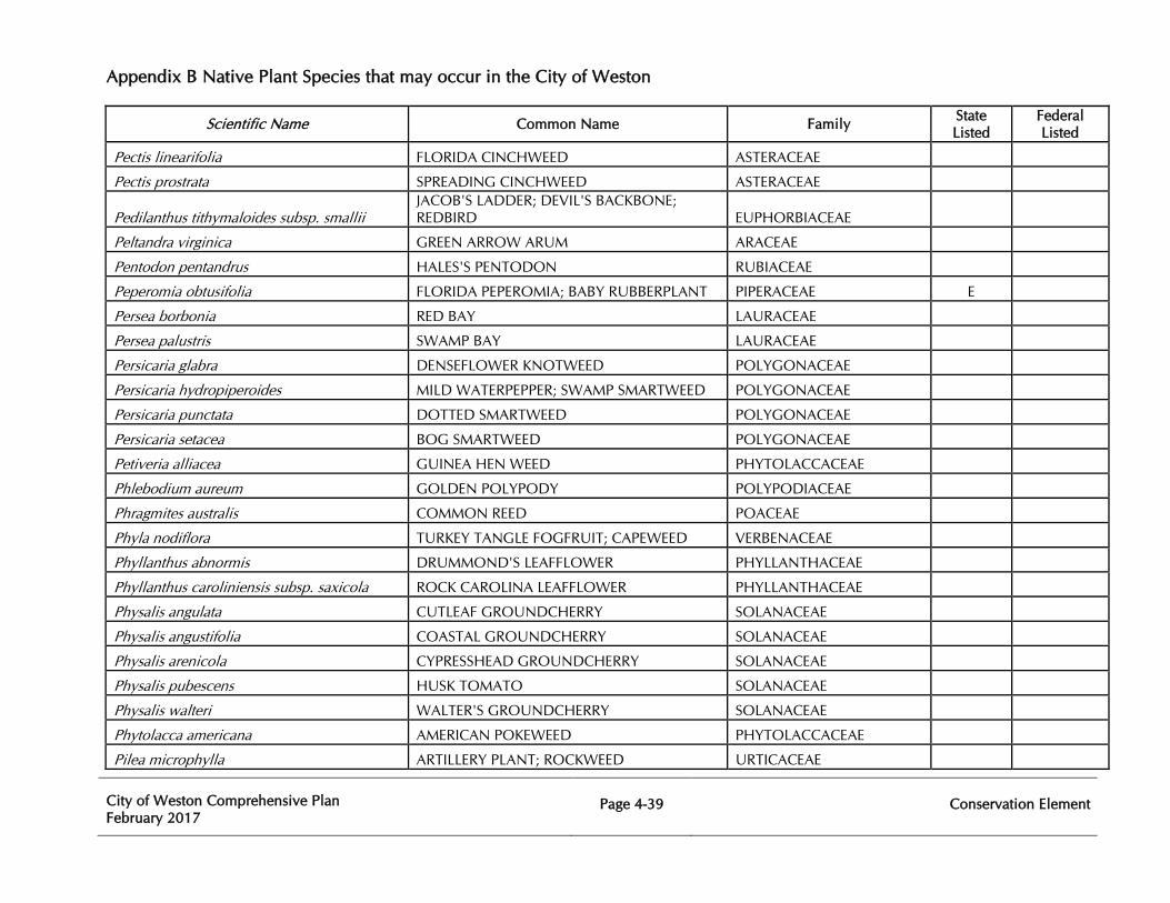
Appendix B Native Plant Species that may occur in the City of Weston
City of Weston Comprehensive Plan February 2017
Page 4-39
Conservation Element
Scientific Name Common Name Family State Listed
Federal Listed
Pectis linearifolia FLORIDA CINCHWEED ASTERACEAE
Pectis prostrata SPREADING CINCHWEED ASTERACEAE
Pedilanthus tithymaloides subsp. smallii JACOB'S LADDER; DEVIL'S BACKBONE; REDBIRD EUPHORBIACEAE
Peltandra virginica GREEN ARROW ARUM ARACEAE
Pentodon pentandrus HALES'S PENTODON RUBIACEAE
Peperomia obtusifolia FLORIDA PEPEROMIA; BABY RUBBERPLANT PIPERACEAE E
Persea borbonia RED BAY LAURACEAE
Persea palustris SWAMP BAY LAURACEAE
Persicaria glabra DENSEFLOWER KNOTWEED POLYGONACEAE
Persicaria hydropiperoides MILD WATERPEPPER; SWAMP SMARTWEED POLYGONACEAE
Persicaria punctata DOTTED SMARTWEED POLYGONACEAE
Persicaria setacea BOG SMARTWEED POLYGONACEAE
Petiveria alliacea GUINEA HEN WEED PHYTOLACCACEAE
Phlebodium aureum GOLDEN POLYPODY POLYPODIACEAE
Phragmites australis COMMON REED POACEAE
Phyla nodiflora TURKEY TANGLE FOGFRUIT; CAPEWEED VERBENACEAE
Phyllanthus abnormis DRUMMOND'S LEAFFLOWER PHYLLANTHACEAE
Phyllanthus caroliniensis subsp. saxicola ROCK CAROLINA LEAFFLOWER PHYLLANTHACEAE
Physalis angulata CUTLEAF GROUNDCHERRY SOLANACEAE
Physalis angustifolia COASTAL GROUNDCHERRY SOLANACEAE
Physalis arenicola CYPRESSHEAD GROUNDCHERRY SOLANACEAE
Physalis pubescens HUSK TOMATO SOLANACEAE
Physalis walteri WALTER'S GROUNDCHERRY SOLANACEAE
Phytolacca americana AMERICAN POKEWEED PHYTOLACCACEAE
Pilea microphylla ARTILLERY PLANT; ROCKWEED URTICACEAE
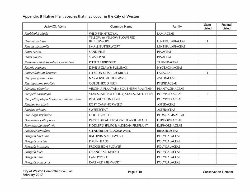
Appendix B Native Plant Species that may occur in the City of Weston
City of Weston Comprehensive Plan February 2017
Page 4-40
Conservation Element
Scientific Name Common Name Family State Listed
Federal Listed
Piloblephis rigida WILD PENNYROYAL LAMIACEAE
Pinguicula lutea YELLOW or YELLOW-FLOWERED BUTTERWORT LENTIBULARIACEAE T
Pinguicula pumila SMALL BUTTERWORT LENTIBULARIACEAE
Pinus clausa SAND PINE PINACEAE
Pinus elliottii SLASH PINE PINACEAE
Piriqueta cistoides subsp. caroliniana PITTED STRIPESEED TURNERACEAE
Pisonia aculeata DEVIL'S CLAWS; PULLBACK NYCTAGINACEAE
Pithecellobium keyense FLORIDA KEYS BLACKBEAD FABACEAE T
Pityopsis graminifolia NARROWLEAF SILKGRASS ASTERACEAE
Pityrogramma trifoliata GOLDENROD FERN PTERIDACEAE
Plantago virginica VIRGINIA PLANTAIN; SOUTHERN PLANTAIN PLANTAGINACEAE
Pleopeltis astrolepis STAR-SCALE POLYPODY; STAR-SCALED FERN POLYPODIACEAE E
Pleopeltis polypodioides var. michauxiana RESURRECTION FERN POLYPODIACEAE
Pluchea baccharis ROSY CAMPHORWEED ASTERACEAE
Pluchea odorata SWEETSCENT ASTERACEAE
Plumbago zeylanica DOCTORBUSH PLUMBAGINACEAE
Poinsettia cyathophora PAINTEDLEAF; FIRE-ON-THE-MOUNTAIN EUPHORBIACEAE
Poinsettia heterophylla FIDDLER'S SPURGE; MEXICAN FIREPLANT EUPHORBIACEAE
Polanisia tenuifolia SLENDERLEAF CLAMMYWEED BRASSICACEAE
Polygala balduinii BALDWIN'S MILKWORT POLYGALACEAE
Polygala cruciata DRUMHEADS POLYGALACEAE
Polygala incarnata PROCESSION FLOWER POLYGALACEAE
Polygala lutea ORANGE MILKWORT POLYGALACEAE
Polygala nana CANDYROOT POLYGALACEAE
Polygala polygama RACEMED MILKWORT POLYGALACEAE
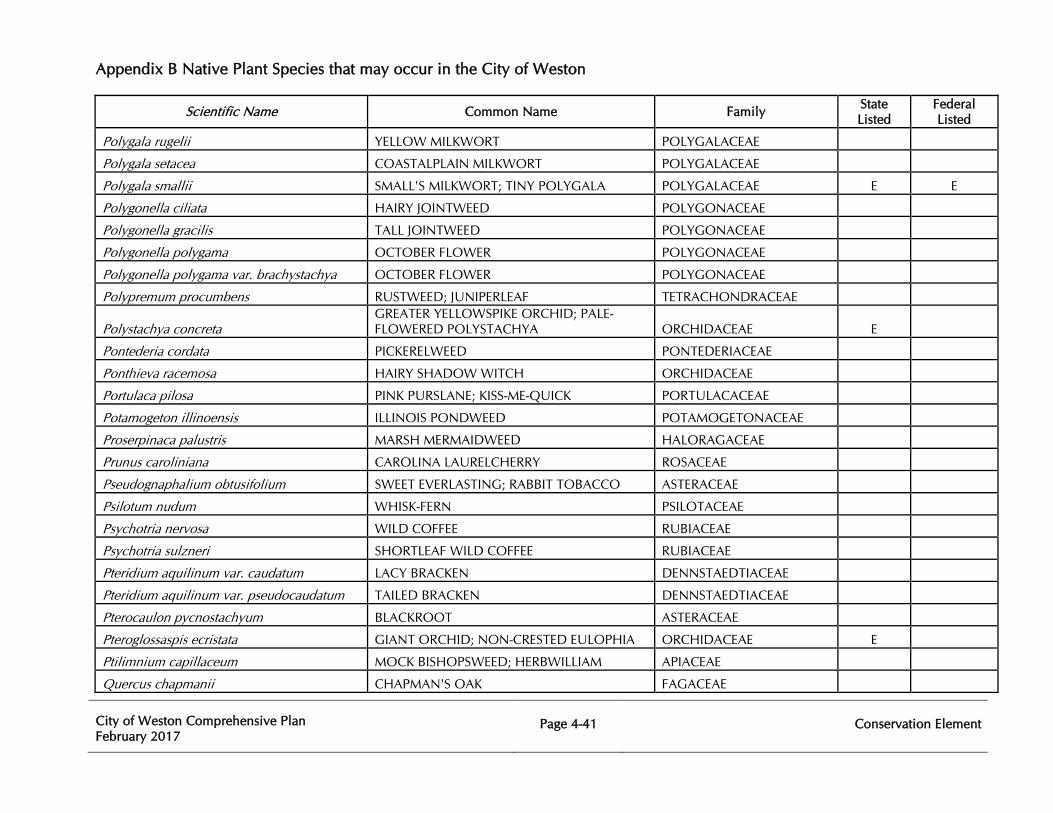
Appendix B Native Plant Species that may occur in the City of Weston
City of Weston Comprehensive Plan February 2017
Page 4-41
Conservation Element
Scientific Name Common Name Family State Listed
Federal Listed
Polygala rugelii YELLOW MILKWORT POLYGALACEAE
Polygala setacea COASTALPLAIN MILKWORT POLYGALACEAE
Polygala smallii SMALL'S MILKWORT; TINY POLYGALA POLYGALACEAE E E
Polygonella ciliata HAIRY JOINTWEED POLYGONACEAE
Polygonella gracilis TALL JOINTWEED POLYGONACEAE
Polygonella polygama OCTOBER FLOWER POLYGONACEAE
Polygonella polygama var. brachystachya OCTOBER FLOWER POLYGONACEAE
Polypremum procumbens RUSTWEED; JUNIPERLEAF TETRACHONDRACEAE
Polystachya concreta GREATER YELLOWSPIKE ORCHID; PALE-FLOWERED POLYSTACHYA ORCHIDACEAE E
Pontederia cordata PICKERELWEED PONTEDERIACEAE
Ponthieva racemosa HAIRY SHADOW WITCH ORCHIDACEAE
Portulaca pilosa PINK PURSLANE; KISS-ME-QUICK PORTULACACEAE
Potamogeton illinoensis ILLINOIS PONDWEED POTAMOGETONACEAE
Proserpinaca palustris MARSH MERMAIDWEED HALORAGACEAE
Prunus caroliniana CAROLINA LAURELCHERRY ROSACEAE
Pseudognaphalium obtusifolium SWEET EVERLASTING; RABBIT TOBACCO ASTERACEAE
Psilotum nudum WHISK-FERN PSILOTACEAE
Psychotria nervosa WILD COFFEE RUBIACEAE
Psychotria sulzneri SHORTLEAF WILD COFFEE RUBIACEAE
Pteridium aquilinum var. caudatum LACY BRACKEN DENNSTAEDTIACEAE
Pteridium aquilinum var. pseudocaudatum TAILED BRACKEN DENNSTAEDTIACEAE
Pterocaulon pycnostachyum BLACKROOT ASTERACEAE
Pteroglossaspis ecristata GIANT ORCHID; NON-CRESTED EULOPHIA ORCHIDACEAE E
Ptilimnium capillaceum MOCK BISHOPSWEED; HERBWILLIAM APIACEAE
Quercus chapmanii CHAPMAN'S OAK FAGACEAE
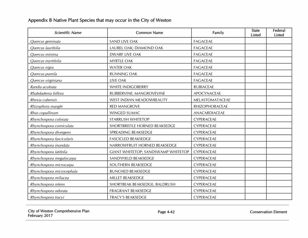
Appendix B Native Plant Species that may occur in the City of Weston
City of Weston Comprehensive Plan February 2017
Page 4-42
Conservation Element
Scientific Name Common Name Family State Listed
Federal Listed
Quercus geminata SAND LIVE OAK FAGACEAE
Quercus laurifolia LAUREL OAK; DIAMOND OAK FAGACEAE
Quercus minima DWARF LIVE OAK FAGACEAE
Quercus myrtifolia MYRTLE OAK FAGACEAE
Quercus nigra WATER OAK FAGACEAE
Quercus pumila RUNNING OAK FAGACEAE
Quercus virginiana LIVE OAK FAGACEAE
Randia aculeata WHITE INDIGOBERRY RUBIACEAE
Rhabdadenia biflora RUBBERVINE; MANGROVEVINE APOCYNACEAE
Rhexia cubensis WEST INDIAN MEADOWBEAUTY MELASTOMATACEAE
Rhizophora mangle RED MANGROVE RHIZOPHORACEAE
Rhus copallinum WINGED SUMAC ANACARDIACEAE
Rhynchospora colorata STARRUSH WHITETOP CYPERACEAE
Rhynchospora corniculata SHORTBRISTLE HORNED BEAKSEDGE CYPERACEAE
Rhynchospora divergens SPREADING BEAKSEDGE CYPERACEAE
Rhynchospora fascicularis FASCICLED BEAKSEDGE CYPERACEAE
Rhynchospora inundata NARROWFRUIT HORNED BEAKSEDGE CYPERACEAE
Rhynchospora latifolia GIANT WHITETOP; SANDSWAMP WHITETOP CYPERACEAE
Rhynchospora megalocarpa SANDYFIELD BEAKSEDGE CYPERACEAE
Rhynchospora microcarpa SOUTHERN BEAKSEDGE CYPERACEAE
Rhynchospora microcephala BUNCHED BEAKSEDGE CYPERACEAE
Rhynchospora miliacea MILLET BEAKSEDGE CYPERACEAE
Rhynchospora nitens SHORTBEAK BEAKSEDGE; BALDRUSH CYPERACEAE
Rhynchospora odorata FRAGRANT BEAKSEDGE CYPERACEAE
Rhynchospora tracyi TRACY'S BEAKSEDGE CYPERACEAE
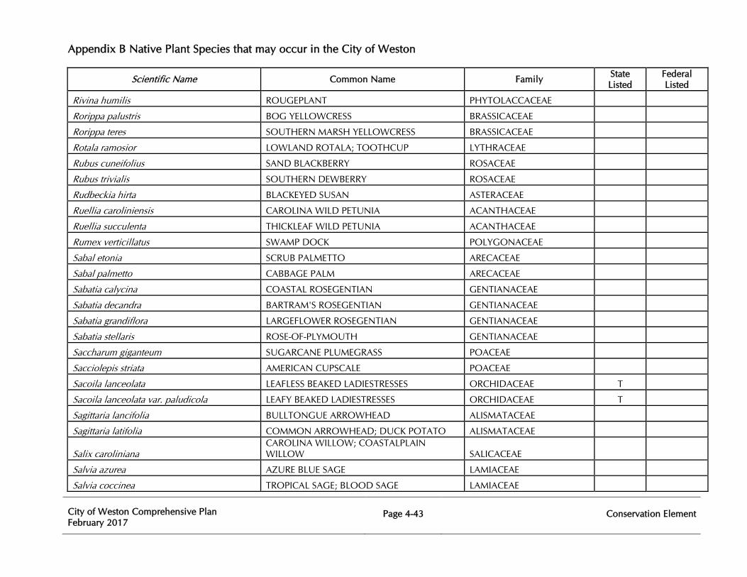
Appendix B Native Plant Species that may occur in the City of Weston
City of Weston Comprehensive Plan February 2017
Page 4-43
Conservation Element
Scientific Name Common Name Family State Listed
Federal Listed
Rivina humilis ROUGEPLANT PHYTOLACCACEAE
Rorippa palustris BOG YELLOWCRESS BRASSICACEAE
Rorippa teres SOUTHERN MARSH YELLOWCRESS BRASSICACEAE
Rotala ramosior LOWLAND ROTALA; TOOTHCUP LYTHRACEAE
Rubus cuneifolius SAND BLACKBERRY ROSACEAE
Rubus trivialis SOUTHERN DEWBERRY ROSACEAE
Rudbeckia hirta BLACKEYED SUSAN ASTERACEAE
Ruellia caroliniensis CAROLINA WILD PETUNIA ACANTHACEAE
Ruellia succulenta THICKLEAF WILD PETUNIA ACANTHACEAE
Rumex verticillatus SWAMP DOCK POLYGONACEAE
Sabal etonia SCRUB PALMETTO ARECACEAE
Sabal palmetto CABBAGE PALM ARECACEAE
Sabatia calycina COASTAL ROSEGENTIAN GENTIANACEAE
Sabatia decandra BARTRAM'S ROSEGENTIAN GENTIANACEAE
Sabatia grandiflora LARGEFLOWER ROSEGENTIAN GENTIANACEAE
Sabatia stellaris ROSE-OF-PLYMOUTH GENTIANACEAE
Saccharum giganteum SUGARCANE PLUMEGRASS POACEAE
Sacciolepis striata AMERICAN CUPSCALE POACEAE
Sacoila lanceolata LEAFLESS BEAKED LADIESTRESSES ORCHIDACEAE T
Sacoila lanceolata var. paludicola LEAFY BEAKED LADIESTRESSES ORCHIDACEAE T
Sagittaria lancifolia BULLTONGUE ARROWHEAD ALISMATACEAE
Sagittaria latifolia COMMON ARROWHEAD; DUCK POTATO ALISMATACEAE
Salix caroliniana CAROLINA WILLOW; COASTALPLAIN WILLOW SALICACEAE
Salvia azurea AZURE BLUE SAGE LAMIACEAE
Salvia coccinea TROPICAL SAGE; BLOOD SAGE LAMIACEAE
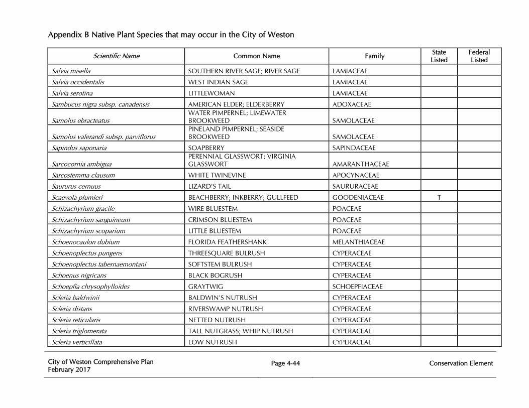
Appendix B Native Plant Species that may occur in the City of Weston
City of Weston Comprehensive Plan February 2017
Page 4-44
Conservation Element
Scientific Name Common Name Family State Listed
Federal Listed
Salvia misella SOUTHERN RIVER SAGE; RIVER SAGE LAMIACEAE
Salvia occidentalis WEST INDIAN SAGE LAMIACEAE
Salvia serotina LITTLEWOMAN LAMIACEAE
Sambucus nigra subsp. canadensis AMERICAN ELDER; ELDERBERRY ADOXACEAE
Samolus ebracteatus WATER PIMPERNEL; LIMEWATER BROOKWEED SAMOLACEAE
Samolus valerandi subsp. parviflorus PINELAND PIMPERNEL; SEASIDE BROOKWEED SAMOLACEAE
Sapindus saponaria SOAPBERRY SAPINDACEAE
Sarcocornia ambigua PERENNIAL GLASSWORT; VIRGINIA GLASSWORT AMARANTHACEAE
Sarcostemma clausum WHITE TWINEVINE APOCYNACEAE
Saururus cernuus LIZARD'S TAIL SAURURACEAE
Scaevola plumieri BEACHBERRY; INKBERRY; GULLFEED GOODENIACEAE T
Schizachyrium gracile WIRE BLUESTEM POACEAE
Schizachyrium sanguineum CRIMSON BLUESTEM POACEAE
Schizachyrium scoparium LITTLE BLUESTEM POACEAE
Schoenocaulon dubium FLORIDA FEATHERSHANK MELANTHIACEAE
Schoenoplectus pungens THREESQUARE BULRUSH CYPERACEAE
Schoenoplectus tabernaemontani SOFTSTEM BULRUSH CYPERACEAE
Schoenus nigricans BLACK BOGRUSH CYPERACEAE
Schoepfia chrysophylloides GRAYTWIG SCHOEPFIACEAE
Scleria baldwinii BALDWIN'S NUTRUSH CYPERACEAE
Scleria distans RIVERSWAMP NUTRUSH CYPERACEAE
Scleria reticularis NETTED NUTRUSH CYPERACEAE
Scleria triglomerata TALL NUTGRASS; WHIP NUTRUSH CYPERACEAE
Scleria verticillata LOW NUTRUSH CYPERACEAE
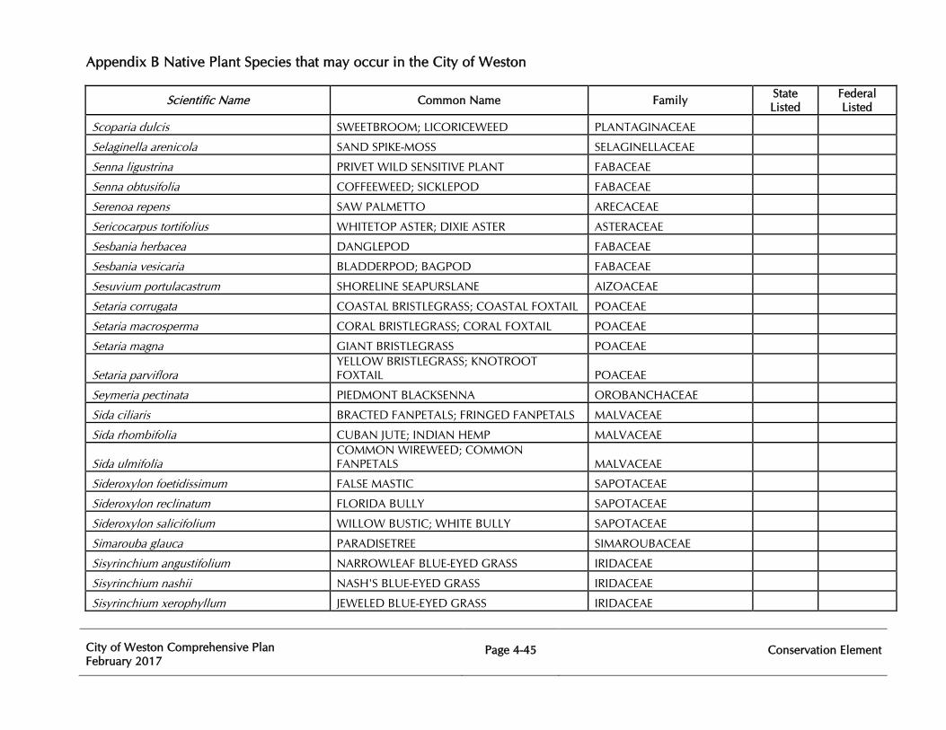
Appendix B Native Plant Species that may occur in the City of Weston
City of Weston Comprehensive Plan February 2017
Page 4-45
Conservation Element
Scientific Name Common Name Family State Listed
Federal Listed
Scoparia dulcis SWEETBROOM; LICORICEWEED PLANTAGINACEAE
Selaginella arenicola SAND SPIKE-MOSS SELAGINELLACEAE
Senna ligustrina PRIVET WILD SENSITIVE PLANT FABACEAE
Senna obtusifolia COFFEEWEED; SICKLEPOD FABACEAE
Serenoa repens SAW PALMETTO ARECACEAE
Sericocarpus tortifolius WHITETOP ASTER; DIXIE ASTER ASTERACEAE
Sesbania herbacea DANGLEPOD FABACEAE
Sesbania vesicaria BLADDERPOD; BAGPOD FABACEAE
Sesuvium portulacastrum SHORELINE SEAPURSLANE AIZOACEAE
Setaria corrugata COASTAL BRISTLEGRASS; COASTAL FOXTAIL POACEAE
Setaria macrosperma CORAL BRISTLEGRASS; CORAL FOXTAIL POACEAE
Setaria magna GIANT BRISTLEGRASS POACEAE
Setaria parviflora YELLOW BRISTLEGRASS; KNOTROOT FOXTAIL POACEAE
Seymeria pectinata PIEDMONT BLACKSENNA OROBANCHACEAE
Sida ciliaris BRACTED FANPETALS; FRINGED FANPETALS MALVACEAE
Sida rhombifolia CUBAN JUTE; INDIAN HEMP MALVACEAE
Sida ulmifolia COMMON WIREWEED; COMMON FANPETALS MALVACEAE
Sideroxylon foetidissimum FALSE MASTIC SAPOTACEAE
Sideroxylon reclinatum FLORIDA BULLY SAPOTACEAE
Sideroxylon salicifolium WILLOW BUSTIC; WHITE BULLY SAPOTACEAE
Simarouba glauca PARADISETREE SIMAROUBACEAE
Sisyrinchium angustifolium NARROWLEAF BLUE-EYED GRASS IRIDACEAE
Sisyrinchium nashii NASH'S BLUE-EYED GRASS IRIDACEAE
Sisyrinchium xerophyllum JEWELED BLUE-EYED GRASS IRIDACEAE
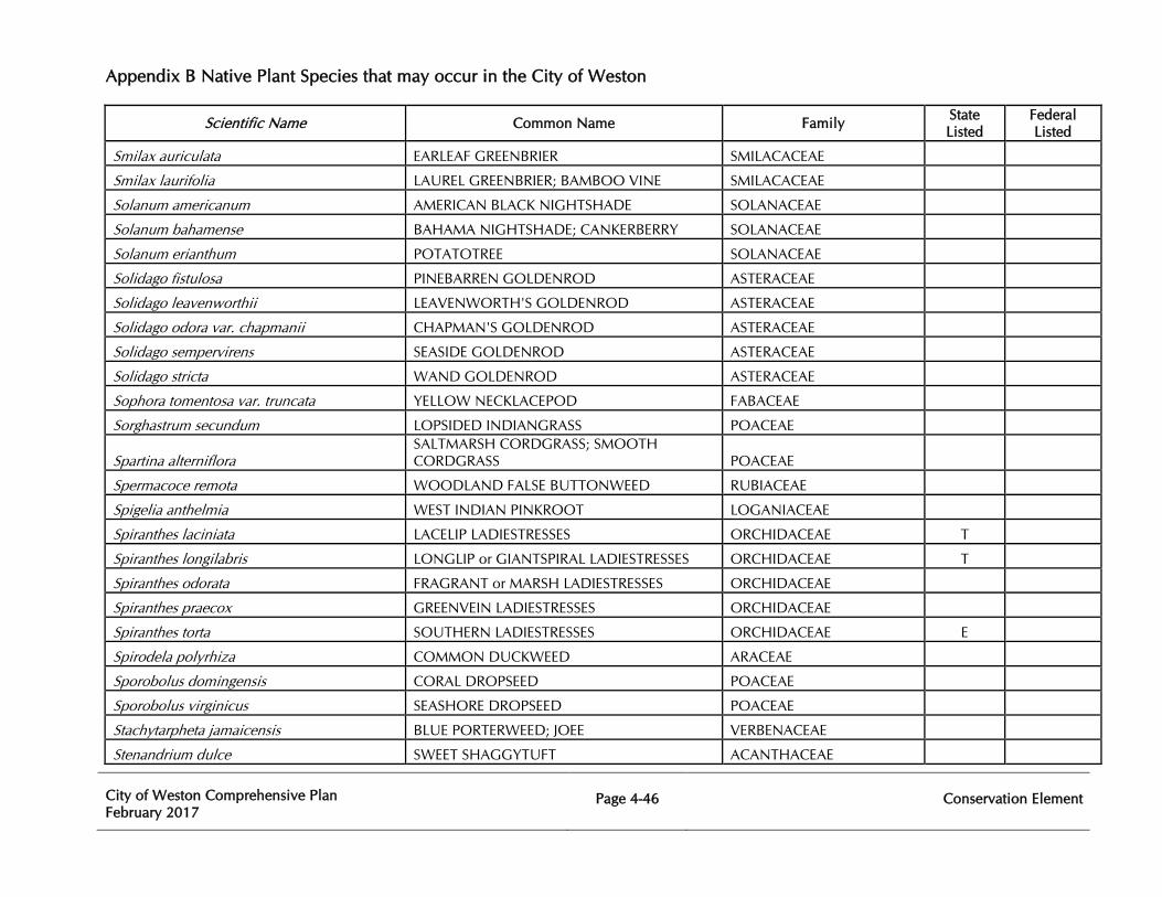
Appendix B Native Plant Species that may occur in the City of Weston
City of Weston Comprehensive Plan February 2017
Page 4-46
Conservation Element
Scientific Name Common Name Family State Listed
Federal Listed
Smilax auriculata EARLEAF GREENBRIER SMILACACEAE
Smilax laurifolia LAUREL GREENBRIER; BAMBOO VINE SMILACACEAE
Solanum americanum AMERICAN BLACK NIGHTSHADE SOLANACEAE
Solanum bahamense BAHAMA NIGHTSHADE; CANKERBERRY SOLANACEAE
Solanum erianthum POTATOTREE SOLANACEAE
Solidago fistulosa PINEBARREN GOLDENROD ASTERACEAE
Solidago leavenworthii LEAVENWORTH'S GOLDENROD ASTERACEAE
Solidago odora var. chapmanii CHAPMAN'S GOLDENROD ASTERACEAE
Solidago sempervirens SEASIDE GOLDENROD ASTERACEAE
Solidago stricta WAND GOLDENROD ASTERACEAE
Sophora tomentosa var. truncata YELLOW NECKLACEPOD FABACEAE
Sorghastrum secundum LOPSIDED INDIANGRASS POACEAE
Spartina alterniflora SALTMARSH CORDGRASS; SMOOTH CORDGRASS POACEAE
Spermacoce remota WOODLAND FALSE BUTTONWEED RUBIACEAE
Spigelia anthelmia WEST INDIAN PINKROOT LOGANIACEAE
Spiranthes laciniata LACELIP LADIESTRESSES ORCHIDACEAE T
Spiranthes longilabris LONGLIP or GIANTSPIRAL LADIESTRESSES ORCHIDACEAE T
Spiranthes odorata FRAGRANT or MARSH LADIESTRESSES ORCHIDACEAE
Spiranthes praecox GREENVEIN LADIESTRESSES ORCHIDACEAE
Spiranthes torta SOUTHERN LADIESTRESSES ORCHIDACEAE E
Spirodela polyrhiza COMMON DUCKWEED ARACEAE
Sporobolus domingensis CORAL DROPSEED POACEAE
Sporobolus virginicus SEASHORE DROPSEED POACEAE
Stachytarpheta jamaicensis BLUE PORTERWEED; JOEE VERBENACEAE
Stenandrium dulce SWEET SHAGGYTUFT ACANTHACEAE
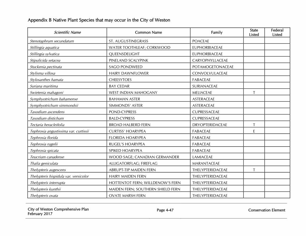
Appendix B Native Plant Species that may occur in the City of Weston
City of Weston Comprehensive Plan February 2017
Page 4-47
Conservation Element
Scientific Name Common Name Family State Listed
Federal Listed
Stenotaphrum secundatum ST. AUGUSTINEGRASS POACEAE
Stillingia aquatica WATER TOOTHLEAF; CORKWOOD EUPHORBIACEAE
Stillingia sylvatica QUEENSDELIGHT EUPHORBIACEAE
Stipulicida setacea PINELAND SCALYPINK CARYOPHYLLACEAE
Stuckenia pectinata SAGO PONDWEED POTAMOGETONACEAE
Stylisma villosa HAIRY DAWNFLOWER CONVOLVULACEAE
Stylosanthes hamata CHEESYTOES FABACEAE
Suriana maritima BAY CEDAR SURIANACEAE
Swietenia mahagoni WEST INDIAN MAHOGANY MELIACEAE T
Symphyotrichum bahamense BAHAMAN ASTER ASTERACEAE
Symphyotrichum simmondsii SIMMONDS' ASTER ASTERACEAE
Taxodium ascendens POND-CYPRESS CUPRESSACEAE
Taxodium distichum BALD-CYPRESS CUPRESSACEAE
Tectaria heracleifolia BROAD HALBERD FERN DRYOPTERIDACEAE T
Tephrosia angustissima var. curtissii CURTISS' HOARYPEA FABACEAE E
Tephrosia florida FLORIDA HOARYPEA FABACEAE
Tephrosia rugelii RUGEL'S HOARYPEA FABACEAE
Tephrosia spicata SPIKED HOARYPEA FABACEAE
Teucrium canadense WOOD SAGE; CANADIAN GERMANDER LAMIACEAE
Thalia geniculata ALLIGATORFLAG; FIREFLAG MARANTACEAE
Thelypteris augescens ABRUPT-TIP MAIDEN FERN THELYPTERIDACEAE T
Thelypteris hispidula var. versicolor HAIRY MAIDEN FERN THELYPTERIDACEAE
Thelypteris interrupta HOTTENTOT FERN; WILLDENOW'S FERN THELYPTERIDACEAE
Thelypteris kunthii MAIDEN FERN; SOUTHERN SHIELD FERN THELYPTERIDACEAE
Thelypteris ovata OVATE MARSH FERN THELYPTERIDACEAE
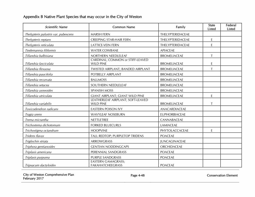
Appendix B Native Plant Species that may occur in the City of Weston
City of Weston Comprehensive Plan February 2017
Page 4-48
Conservation Element
Scientific Name Common Name Family State Listed
Federal Listed
Thelypteris palustris var. pubescens MARSH FERN THELYPTERIDACEAE
Thelypteris reptans CREEPING STAR-HAIR FERN THELYPTERIDACEAE E
Thelypteris reticulata LATTICE-VEIN FERN THELYPTERIDACEAE E
Tiedemannia filiformis WATER COWBANE APIACEAE
Tillandsia balbisiana NORTHERN NEEDLELEAF BROMELIACEAE T
Tillandsia fasciculata CARDINAL; COMMON or STIFF-LEAVED WILD PINE BROMELIACEAE E
Tillandsia flexuosa TWISTED AIRPLANT; BANDED AIRPLANT BROMELIACEAE T
Tillandsia paucifolia POTBELLY AIRPLANT BROMELIACEAE
Tillandsia recurvata BALLMOSS BROMELIACEAE
Tillandsia setacea SOUTHERN NEEDLELEAF BROMELIACEAE
Tillandsia usneoides SPANISH MOSS BROMELIACEAE
Tillandsia utriculata GIANT AIRPLANT; GIANT WILD PINE BROMELIACEAE E
Tillandsia variabilis LEATHERLEAF AIRPLANT; SOFT-LEAVED WILD PINE BROMELIACEAE T
Toxicodendron radicans EASTERN POISON IVY ANACARDIACEAE
Tragia urens WAVYLEAF NOSEBURN EUPHORBIACEAE
Trema micrantha NETTLETREE CANNABACEAE
Trichostema dichotomum FORKED BLUECURLS LAMIACEAE
Trichostigma octandrum HOOPVINE PHYTOLACCACEAE E
Tridens flavus TALL REDTOP; PURPLETOP TRIDENS POACEAE
Triglochin striata ARROWGRASS JUNCAGINACEAE
Triphora gentianoides GENTIAN NODDINGCAPS ORCHIDACEAE
Triplasis americana PERENNIAL SANDGRASS POACEAE
Triplasis purpurea PURPLE SANDGRASS POACEAE
Tripsacum dactyloides EASTERN GAMAGRASS; FAKAHATCHEEGRASS POACEAE
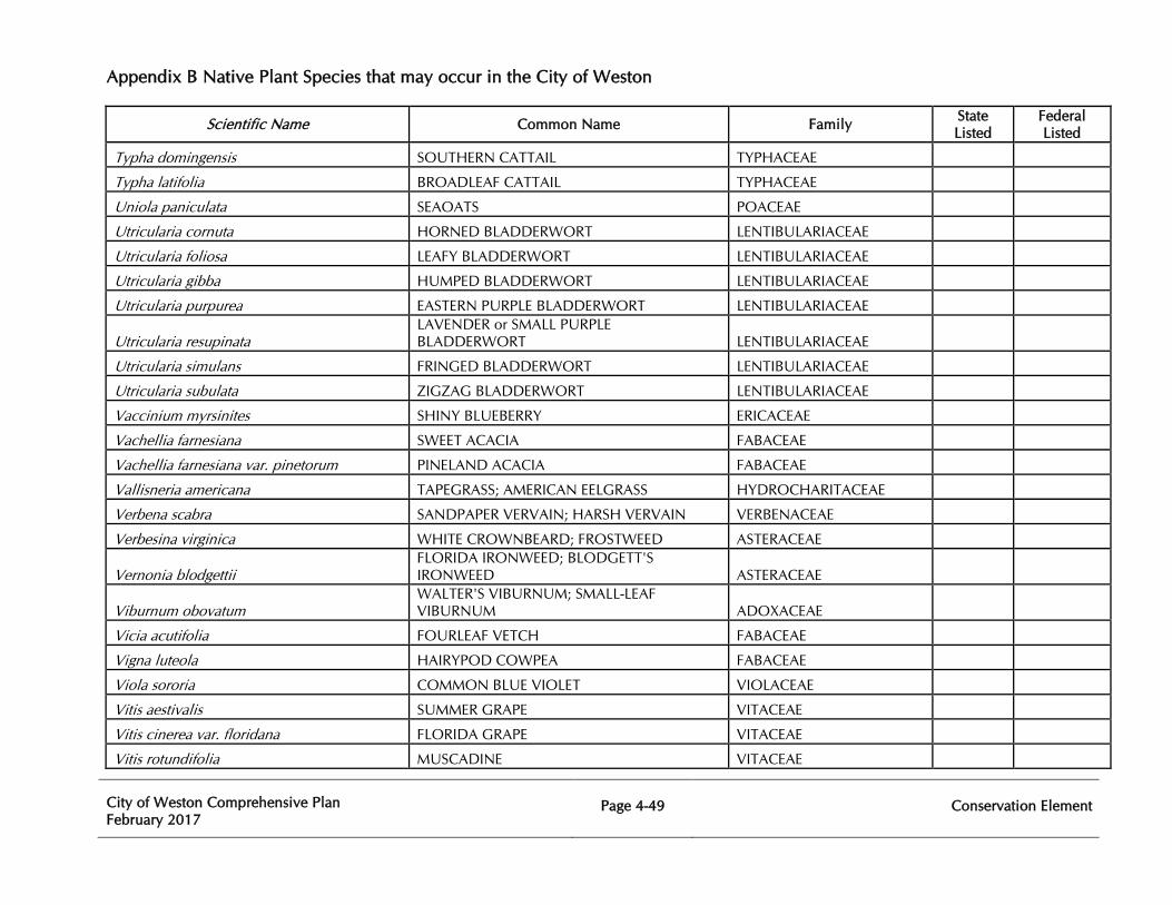
Appendix B Native Plant Species that may occur in the City of Weston
City of Weston Comprehensive Plan February 2017
Page 4-49
Conservation Element
Scientific Name Common Name Family State Listed
Federal Listed
Typha domingensis SOUTHERN CATTAIL TYPHACEAE
Typha latifolia BROADLEAF CATTAIL TYPHACEAE
Uniola paniculata SEAOATS POACEAE
Utricularia cornuta HORNED BLADDERWORT LENTIBULARIACEAE
Utricularia foliosa LEAFY BLADDERWORT LENTIBULARIACEAE
Utricularia gibba HUMPED BLADDERWORT LENTIBULARIACEAE
Utricularia purpurea EASTERN PURPLE BLADDERWORT LENTIBULARIACEAE
Utricularia resupinata LAVENDER or SMALL PURPLE BLADDERWORT LENTIBULARIACEAE
Utricularia simulans FRINGED BLADDERWORT LENTIBULARIACEAE
Utricularia subulata ZIGZAG BLADDERWORT LENTIBULARIACEAE
Vaccinium myrsinites SHINY BLUEBERRY ERICACEAE
Vachellia farnesiana SWEET ACACIA FABACEAE
Vachellia farnesiana var. pinetorum PINELAND ACACIA FABACEAE
Vallisneria americana TAPEGRASS; AMERICAN EELGRASS HYDROCHARITACEAE
Verbena scabra SANDPAPER VERVAIN; HARSH VERVAIN VERBENACEAE
Verbesina virginica WHITE CROWNBEARD; FROSTWEED ASTERACEAE
Vernonia blodgettii FLORIDA IRONWEED; BLODGETT'S IRONWEED ASTERACEAE
Viburnum obovatum WALTER'S VIBURNUM; SMALL-LEAF VIBURNUM ADOXACEAE
Vicia acutifolia FOURLEAF VETCH FABACEAE
Vigna luteola HAIRYPOD COWPEA FABACEAE
Viola sororia COMMON BLUE VIOLET VIOLACEAE
Vitis aestivalis SUMMER GRAPE VITACEAE
Vitis cinerea var. floridana FLORIDA GRAPE VITACEAE
Vitis rotundifolia MUSCADINE VITACEAE
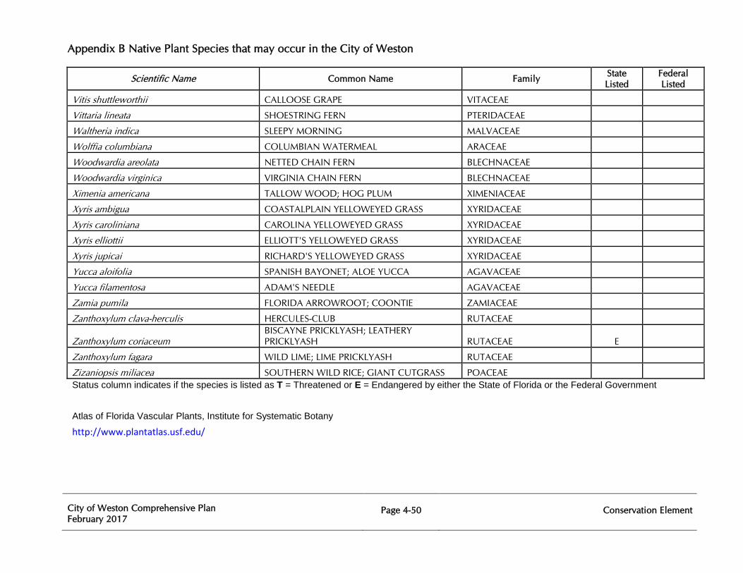
Appendix B Native Plant Species that may occur in the City of Weston
City of Weston Comprehensive Plan February 2017
Page 4-50
Conservation Element
Scientific Name Common Name Family State Listed
Federal Listed
Vitis shuttleworthii CALLOOSE GRAPE VITACEAE
Vittaria lineata SHOESTRING FERN PTERIDACEAE
Waltheria indica SLEEPY MORNING MALVACEAE
Wolffia columbiana COLUMBIAN WATERMEAL ARACEAE
Woodwardia areolata NETTED CHAIN FERN BLECHNACEAE
Woodwardia virginica VIRGINIA CHAIN FERN BLECHNACEAE
Ximenia americana TALLOW WOOD; HOG PLUM XIMENIACEAE
Xyris ambigua COASTALPLAIN YELLOWEYED GRASS XYRIDACEAE
Xyris caroliniana CAROLINA YELLOWEYED GRASS XYRIDACEAE
Xyris elliottii ELLIOTT'S YELLOWEYED GRASS XYRIDACEAE
Xyris jupicai RICHARD'S YELLOWEYED GRASS XYRIDACEAE
Yucca aloifolia SPANISH BAYONET; ALOE YUCCA AGAVACEAE
Yucca filamentosa ADAM'S NEEDLE AGAVACEAE
Zamia pumila FLORIDA ARROWROOT; COONTIE ZAMIACEAE
Zanthoxylum clava-herculis HERCULES-CLUB RUTACEAE
Zanthoxylum coriaceum BISCAYNE PRICKLYASH; LEATHERY PRICKLYASH RUTACEAE E
Zanthoxylum fagara WILD LIME; LIME PRICKLYASH RUTACEAE
Zizaniopsis miliacea SOUTHERN WILD RICE; GIANT CUTGRASS POACEAE Status column indicates if the species is listed as T = Threatened or E = Endangered by either the State of Florida or the Federal Government
Atlas of Florida Vascular Plants, Institute for Systematic Botany http://www.plantatlas.usf.edu/
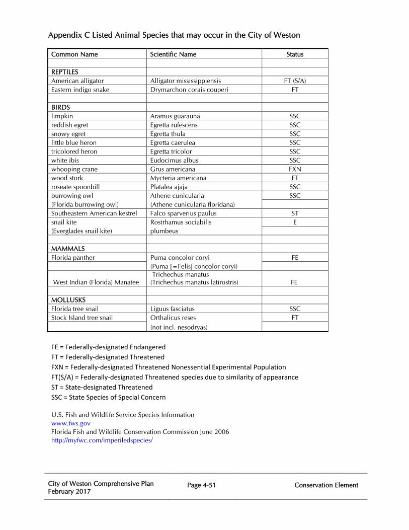
Appendix C Listed Animal Species that may occur in the City of Weston
City of Weston Comprehensive Plan February 2017
Page 4-51 Conservation Element
Common Name Scientific Name Status
REPTILES American alligator Alligator mississippiensis FT (S/A) Eastern indigo snake Drymarchon corais couperi FT
BIRDS limpkin Aramus guarauna SSC reddish egret Egretta rufescens SSC snowy egret Egretta thula SSC little blue heron Egretta caerulea SSC tricolored heron Egretta tricolor SSC white ibis Eudocimus albus SSC whooping crane Grus americana FXN wood stork Mycteria americana FT roseate spoonbill Platalea ajaja SSC burrowing owl Athene cunicularia SSC (Florida burrowing owl) (Athene cunicularia floridana) Southeastern American kestrel Falco sparverius paulus ST snail kite Rostrhamus sociabilis E (Everglades snail kite) plumbeus
MAMMALS Florida panther Puma concolor coryi FE
(Puma [=Felis] concolor coryi)
West Indian (Florida) Manatee Trichechus manatus (Trichechus manatus latirostris) FE
MOLLUSKS Florida tree snail Liguus fasciatus SSC Stock Island tree snail Orthalicus reses FT
(not incl. nesodryas)
FE = Federally-designated Endangered FT = Federally-designated Threatened FXN = Federally-designated Threatened Nonessential Experimental Population FT(S/A) = Federally-designated Threatened species due to similarity of appearance ST = State-designated Threatened SSC = State Species of Special Concern
U.S. Fish and Wildlife Service Species Information www.fws.govFlorida Fish and Wildlife Conservation Commission June 2006 http://myfwc.com/imperiledspecies/
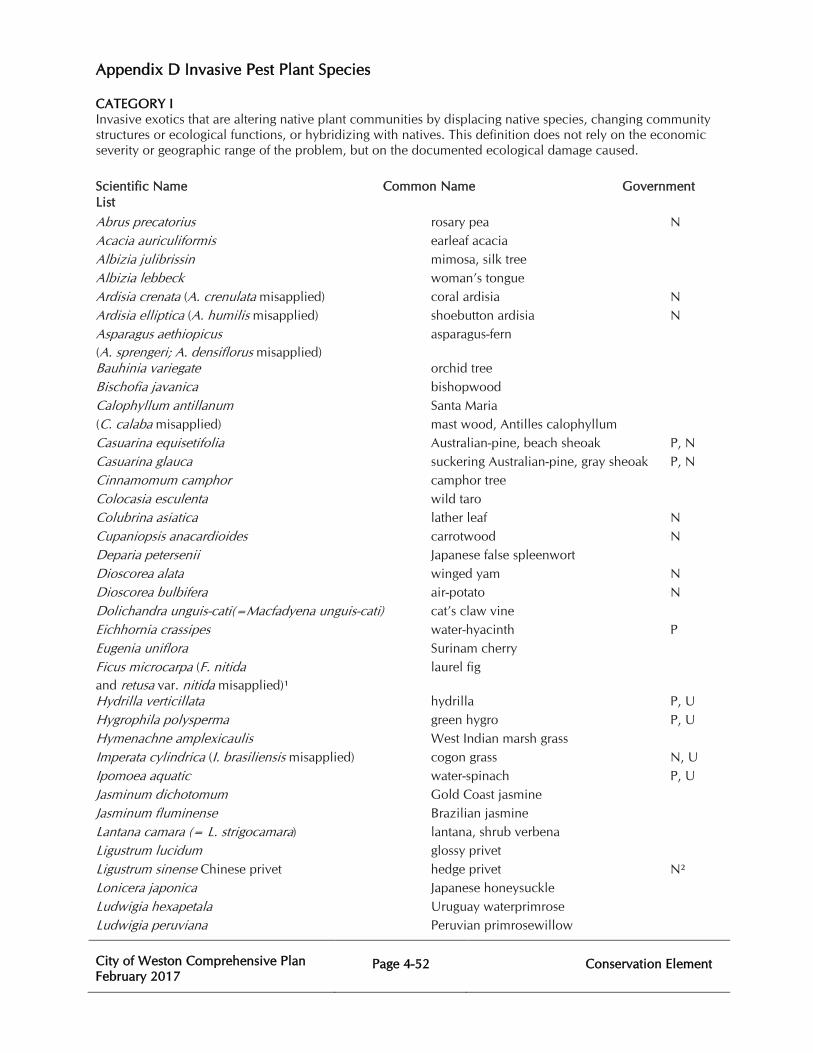
Appendix D Invasive Pest Plant Species
City of Weston Comprehensive Plan February 2017
Page 4-52
Conservation Element
CATEGORY I Invasive exotics that are altering native plant communities by displacing native species, changing community structures or ecological functions, or hybridizing with natives. This definition does not rely on the economic severity or geographic range of the problem, but on the documented ecological damage caused.
Scientific Name Common Name Government List
Abrus precatorius rosary pea N Acacia auriculiformis earleaf acacia Albizia julibrissin mimosa, silk tree Albizia lebbeck woman’s tongue Ardisia crenata (A. crenulata misapplied) coral ardisia N Ardisia elliptica (A. humilis misapplied) shoebutton ardisia N Asparagus aethiopicus asparagus-fern (A. sprengeri; A. densiflorus misapplied) Bauhinia variegate orchid tree Bischofia javanica bishopwood Calophyllum antillanum Santa Maria (C. calaba misapplied) mast wood, Antilles calophyllum Casuarina equisetifolia Australian-pine, beach sheoak P, N Casuarina glauca suckering Australian-pine, gray sheoak P, N Cinnamomum camphor camphor tree Colocasia esculenta wild taro Colubrina asiatica lather leaf N Cupaniopsis anacardioides carrotwood N Deparia petersenii Japanese false spleenwort Dioscorea alata winged yam N Dioscorea bulbifera air-potato N Dolichandra unguis-cati(=Macfadyena unguis-cati) cat’s claw vine Eichhornia crassipes water-hyacinth P Eugenia uniflora Surinam cherry Ficus microcarpa (F. nitida laurel fig and retusa var. nitida misapplied)¹ Hydrilla verticillata hydrilla P, U Hygrophila polysperma green hygro P, U Hymenachne amplexicaulis West Indian marsh grass Imperata cylindrica (I. brasiliensis misapplied) cogon grass N, U Ipomoea aquatic water-spinach P, U Jasminum dichotomum Gold Coast jasmine Jasminum fluminense Brazilian jasmine Lantana camara (= L. strigocamara) lantana, shrub verbena Ligustrum lucidum glossy privet Ligustrum sinense Chinese privet hedge privet N² Lonicera japonica Japanese honeysuckle Ludwigia hexapetala Uruguay waterprimrose Ludwigia peruviana Peruvian primrosewillow
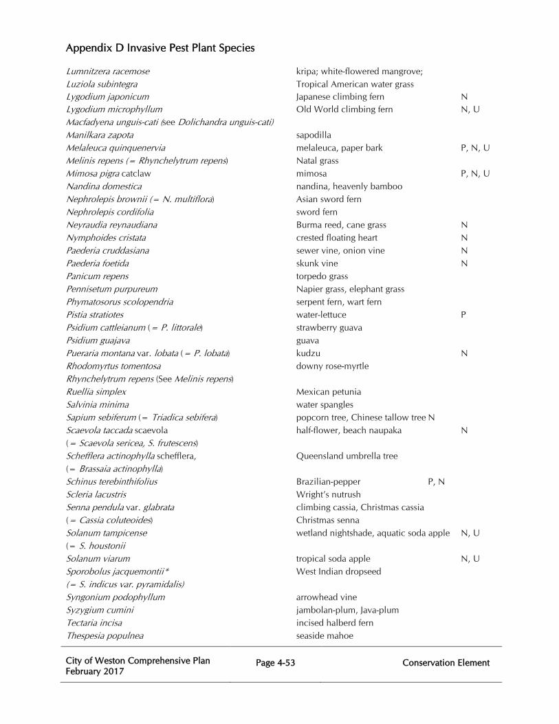
Appendix D Invasive Pest Plant Species
City of Weston Comprehensive Plan February 2017
Page 4-53
Conservation Element
Lumnitzera racemose kripa; white-flowered mangrove; Luziola subintegra Tropical American water grass Lygodium japonicum Japanese climbing fern N Lygodium microphyllum Old World climbing fern N, U Macfadyena unguis-cati (see Dolichandra unguis-cati) Manilkara zapota sapodilla Melaleuca quinquenervia melaleuca, paper bark P, N, U Melinis repens (= Rhynchelytrum repens) Natal grass Mimosa pigra catclaw mimosa P, N, U Nandina domestica nandina, heavenly bamboo Nephrolepis brownii (= N. multiflora) Asian sword fern Nephrolepis cordifolia sword fern Neyraudia reynaudiana Burma reed, cane grass N Nymphoides cristata crested floating heart N Paederia cruddasiana sewer vine, onion vine N Paederia foetida skunk vine N Panicum repens torpedo grass Pennisetum purpureum Napier grass, elephant grass Phymatosorus scolopendria serpent fern, wart fern Pistia stratiotes water-lettuce P Psidium cattleianum (= P. littorale) strawberry guava Psidium guajava guava Pueraria montana var. lobata (= P. lobata) kudzu N Rhodomyrtus tomentosa downy rose-myrtle Rhynchelytrum repens (See Melinis repens) Ruellia simplex Mexican petunia Salvinia minima water spangles Sapium sebiferum (= Triadica sebifera) popcorn tree, Chinese tallow tree N Scaevola taccada scaevola half-flower, beach naupaka N (= Scaevola sericea, S. frutescens) Schefflera actinophylla schefflera, Queensland umbrella tree (= Brassaia actinophylla) Schinus terebinthifolius Brazilian-pepper P, N Scleria lacustris Wright’s nutrush Senna pendula var. glabrata climbing cassia, Christmas cassia (= Cassia coluteoides) Christmas senna Solanum tampicense wetland nightshade, aquatic soda apple N, U (= S. houstonii Solanum viarum tropical soda apple N, U Sporobolus jacquemontii* West Indian dropseed (= S. indicus var. pyramidalis) Syngonium podophyllum arrowhead vine Syzygium cumini jambolan-plum, Java-plum Tectaria incisa incised halberd fern Thespesia populnea seaside mahoe
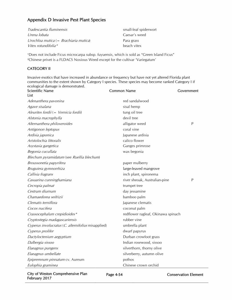
Appendix D Invasive Pest Plant Species
City of Weston Comprehensive Plan February 2017
Page 4-54
Conservation Element
Tradescantia fluminensis small-leaf spiderwort Urena lobata Caesar’s weed
Urochloa mutica (= Brachiaria mutica) Para grass Vitex rotundifolia* beach vitex
¹Does not include Ficus microcarpa subsp. fuyuensis, which is sold as “Green Island Ficus” ²Chinese privet is a FLDACS Noxious Weed except for the cultivar ‘Variegatum’
CATEGORY II Invasive exotics that have increased in abundance or frequency but have not yet altered Florida plant communities to the extent shown by Category I species. These species may become ranked Category I if ecological damage is demonstrated. Scientific Name Common Name Government List
Adenanthera pavonina red sandalwood
Agave sisalana sisal hemp
Aleurites fordii (= Vernicia fordii) tung oil tree
Alstonia macrophylla devil tree
Alternanthera philoxeroides alligator weed P
Antigonon leptopus coral vine
Ardisia japonica Japanese ardisia
Aristolochia littoralis calico flower Asystasia gangetica Ganges primrose
Begonia cucullata wax begonia
Blechum pyramidatum (see Ruellia blechum)
Broussonetia papyrifera paper mulberry
Bruguiera gymnorrhiza large-leaved mangrove
Callisia fragrans inch plant, spironema
Casuarina cunninghamiana river sheoak, Australian-pine P
Cecropia palmat trumpet tree
Cestrum diurnum day jessamine
Chamaedorea seifrizii bamboo palm
Clematis terniflora Japanese clematis
Cocos nucifera coconut palm
Crassocephalum crepidioides* redflower ragleaf, Okinawa spinach
Cryptostegia madagascariensis rubber vine
Cyperus involucratus (C. alternifolius misapplied) umbrella plant
Cyperus prolifer dwarf papyrus
Dactyloctenium aegyptium Durban crowfoot grass
Dalbergia sissoo Indian rosewood, sissoo
Elaeagnus pungens silverthorn, thorny olive
Elaeagnus umbellate silverberry, autumn olive
Epipremnum pinnatum cv. Aureum pothos
Eulophia graminea Chinese crown orchid
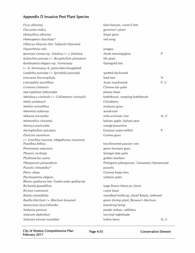
Appendix D Invasive Pest Plant Species
City of Weston Comprehensive Plan February 2017
Page 4-55
Conservation Element
Ficus altissima false banyan, council tree
Flacourtia indica governor’s plum
Hemarthria altissima limpo grass
Heteropterys brachiata* red wing
Hibiscus tiliaceus (See Talipariti tiliaceum)
Hyparrhenia rufa jaragua
Ipomoea carnea ssp. fistulosa (= I. fistulosa) shrub morning-glory P
Kalanchoe pinnata (= Bryophyllum pinnatum) life plant
Koelreuteria elegans ssp. Formosana flamegold tree
(= K. formosana; K. paniculata misapplied)
Landoltia punctata (= Spirodela punctata) spotted duckweed
Leucaena leucocephala lead tree N
Limnophila sessiliflora Asian marshweed P, U
Livistona chinensis Chinese fan palm
Macroptilium lathyroides phasey bean
Melaleuca viminalis (= Callistemon viminalis) bottlebrush, weeping bottlebrush
Melia azedarach Chinaberry
Melinis minutiflora molasses grass
Merremia tuberosa wood-rose
Mikania micrantha mile-a-minute vine N, U
Momordica charantia balsam apple, balsam pear
Murraya paniculata orange-jessamine
Myriophyllum spicatum Eurasian water-milfoil P
Panicum maximum Guinea grass
(= Urochloa maxima, Megathyrsus maximus) Passiflora biflora two-flowered passion vine
Pennisetum setaceum green fountain grass
Phoenix reclinata Senegal date palm
Phyllostachys aurea golden bamboo
Pittosporum pentandrum Philippine pittosporum, Taiwanese cheesewood
Praxelis clematidea* praxelis
Pteris vittata Chinese brake fern
Ptychosperma elegans solitaire palm Rhoeo spathacea (see Tradescantia spathacea) Richardia grandiflora large flower Mexican clover
Ricinus communis castor bean
Rotala rotundifolia roundleaf toothcup, dwarf Rotala, redweed
Ruellia blechum (= Blechum brownei) green shrimp plant, Browne’s blechum
Sansevieria hyacinthoides bowstring hemp
Sesbania punicea purple sesban, rattlebox
Solanum diphyllum two-leaf nightshade
Solanum torvum susumber turkey berry N, U
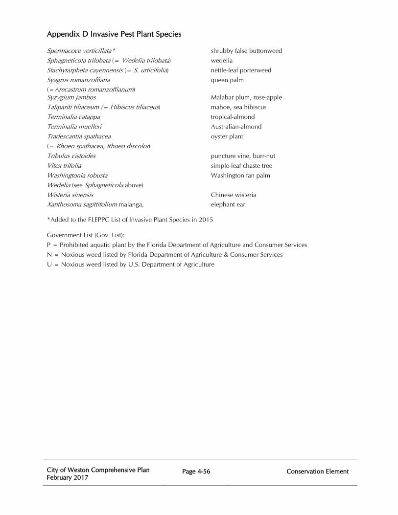
Appendix D Invasive Pest Plant Species
City of Weston Comprehensive Plan February 2017
Page 4-56
Conservation Element
Spermacoce verticillata* shrubby false buttonweed
Sphagneticola trilobata (= Wedelia trilobata) wedelia
Stachytarpheta cayennensis (= S. urticifolia) nettle-leaf porterweed
Syagrus romanzoffiana queen palm
(=Arecastrum romanzoffianum) Syzygium jambos Malabar plum, rose-apple
Talipariti tiliaceum (= Hibiscus tiliaceus) mahoe, sea hibiscus
Terminalia catappa tropical-almond
Terminalia muelleri Australian-almond
Tradescantia spathacea oyster plant
(= Rhoeo spathacea, Rhoeo discolor) Tribulus cistoides puncture vine, burr-nut
Vitex trifolia simple-leaf chaste tree
Washingtonia robusta Washington fan palm
Wedelia (see Sphagneticola above)
Wisteria sinensis Chinese wisteria
Xanthosoma sagittifolium malanga, elephant ear
*Added to the FLEPPC List of Invasive Plant Species in 2015
Government List (Gov. List):
P = Prohibited aquatic plant by the Florida Department of Agriculture and Consumer Services
N = Noxious weed listed by Florida Department of Agriculture & Consumer Services
U = Noxious weed listed by U.S. Department of Agriculture
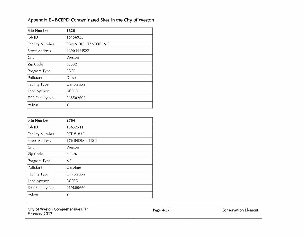
Appendix E - BCEPD Contaminated Sites in the City of Weston
City of Weston Comprehensive Plan February 2017
Page 4-57
Conservation Element
Site Number 1820
Job ID 16156933
Facility Number SEMINOLE "T" STOP INC
Street Address 4690 N US27
City Weston
Zip Code 33332
Program Type FDEP
Pollutant Diesel
Facility Type Gas Station
Lead Agency BCEPD
DEP Facility No. 068502606
Active Y
Site Number 2784
Job ID 18637511
Facility Number FCE #1832
Street Address 276 INDIAN TRCE
City Weston
Zip Code 33326
Program Type NF
Pollutant Gasoline
Facility Type Gas Station
Lead Agency BCEPD
DEP Facility No. 069800660
Active Y
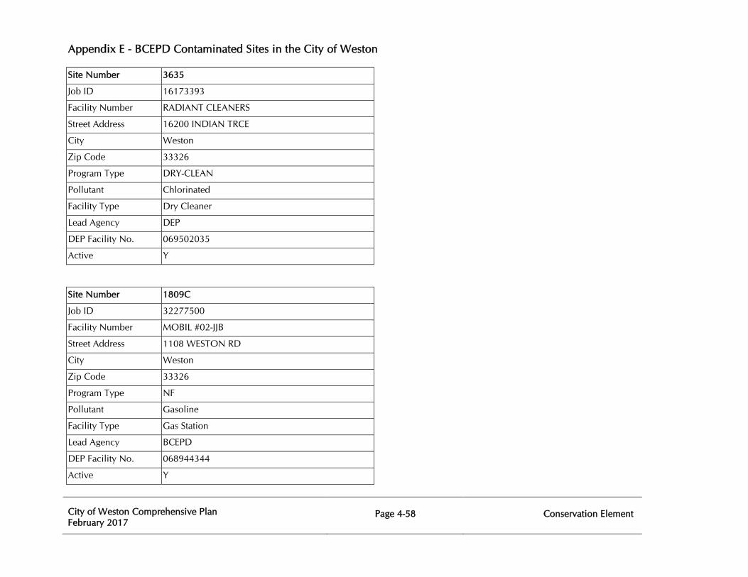
Appendix E - BCEPD Contaminated Sites in the City of Weston
City of Weston Comprehensive Plan February 2017
Page 4-58
Conservation Element
Site Number 3635
Job ID 16173393
Facility Number RADIANT CLEANERS
Street Address 16200 INDIAN TRCE
City Weston
Zip Code 33326
Program Type DRY-CLEAN
Pollutant Chlorinated
Facility Type Dry Cleaner
Lead Agency DEP
DEP Facility No. 069502035
Active Y
Site Number 1809C
Job ID 32277500
Facility Number MOBIL #02-JJB
Street Address 1108 WESTON RD
City Weston
Zip Code 33326
Program Type NF
Pollutant Gasoline
Facility Type Gas Station
Lead Agency BCEPD
DEP Facility No. 068944344
Active Y
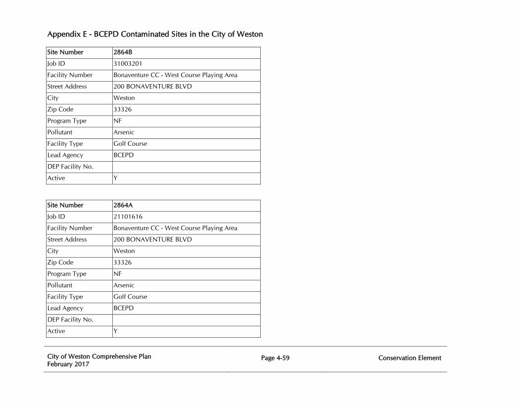
Appendix E - BCEPD Contaminated Sites in the City of Weston
City of Weston Comprehensive Plan February 2017
Page 4-59
Conservation Element
Site Number 2864B
Job ID 31003201
Facility Number Bonaventure CC - West Course Playing Area
Street Address 200 BONAVENTURE BLVD
City Weston
Zip Code 33326
Program Type NF
Pollutant Arsenic
Facility Type Golf Course
Lead Agency BCEPD
DEP Facility No.
Active Y
Site Number 2864A
Job ID 21101616
Facility Number Bonaventure CC - West Course Playing Area
Street Address 200 BONAVENTURE BLVD
City Weston
Zip Code 33326
Program Type NF
Pollutant Arsenic
Facility Type Golf Course
Lead Agency BCEPD
DEP Facility No.
Active Y
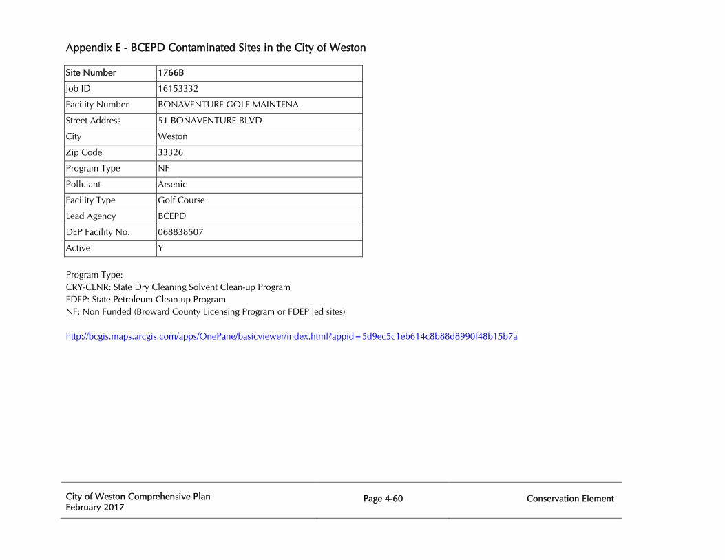
Appendix E - BCEPD Contaminated Sites in the City of Weston
City of Weston Comprehensive Plan February 2017
Page 4-60
Conservation Element
Site Number 1766B
Job ID 16153332
Facility Number BONAVENTURE GOLF MAINTENA
Street Address 51 BONAVENTURE BLVD
City Weston
Zip Code 33326
Program Type NF
Pollutant Arsenic
Facility Type Golf Course
Lead Agency BCEPD
DEP Facility No. 068838507
Active Y
Program Type: CRY-CLNR: State Dry Cleaning Solvent Clean-up Program FDEP: State Petroleum Clean-up Program NF: Non Funded (Broward County Licensing Program or FDEP led sites) http://bcgis.maps.arcgis.com/apps/OnePane/basicviewer/index.html?appid=5d9ec5c1eb614c8b88d8990f48b15b7a
City of Weston Comprehensive Plan February 2017
Page 5-1
Recreation and Open Space Element
CHAPTER FIVE
RECREATION AND OPEN SPACE ELEMENT
PURPOSE The Recreation and Open Space Element of the Weston Comprehensive Plan addresses recreation and open space planning issues for the City of Weston. Existing sites and open space available to the public are identified, and the types of use for each site are characterized. An assessment of current and projected levels of service and recreation needs provides a basis for standards defining the level of services desired by the City of Weston. Statements of a goal, objectives, and policies for guiding the City’s implementation actions conclude the element. These statements provide direction for the municipal recreation programs and maintenance of parks, open space, and recreation facilities to assure that the needs of Weston residents will be met in the future. The purpose of the Recreation and Open Space Element is to plan for a comprehensive system of public and private recreation and open space sites that are available to the public. It is the intent of the City of Weston that this plan element sets forth a comprehensive framework for guiding decisions on public policy and capital improvements for recreation facilities and programs in a manner consistent with the City’s goals and objectives. Recreation and Open Space The City of Weston recognizes that parks and recreation are vital components of the overall community. The diversification of a city creates a healthy environment for growth in all sectors. Residential, commercial, and industrial areas all benefit from the various amenities associated with parks, recreation, and open space. Parks and Recreation services within the City of Weston are managed in a unique and progressive manner. The Park and Recreation Department maintains and operates fourteen City parks which provide an abundance of amenities for every age and lifestyle. The City of Weston contracts with private contractors to manage its organized league athletics and a private contractor performs maintenance of the City's parks and athletic fields. Open space plays an important role in the quality of the urban environment. Parks provide areas where residents can relax, participate in sports, or educate themselves through programs or cultural events. The beauty of the City of Weston’s parks, landscaped areas, waterways, natural preserves, and public open spaces is a source of community pride. The physical and psychological benefits of leisure, “green” open spaces and recreation activity for individuals are well accepted. There are also public values inherent in the maintenance of environmental quality and reduction of noise provided by these spaces, in addition to the visual relief provided. The health and long term viability of a community is contingent on the priority and
City of Weston Comprehensive Plan February 2017
Page 5-2
Recreation and Open Space Element
respect that is given to protecting the passive park environment and creating and maintaining parks and recreation.
EXISTING CONDITIONS AND DATA The City of Weston has an impressive inventory of both public and private parks, recreational areas, and open spaces. Almost 240 acres of public playing fields, basketball courts, roller hockey rinks, playgrounds, picnic areas, nature trails, archaeological sites, and a skate park are currently available for the use and enjoyment of residents and visitors alike. Markham Park, a 667-acre regional park owned and operated by Broward County, is also located in close proximity to the City of Weston. Additionally, the Indian Trace Development District, a dependent district of the City of Weston, has restored 2,315 acres of wetland preserves. The homes and businesses in Weston were allowed to be built on the condition that these wetland preserves were constructed and maintained. Construction began in 1988 and was completed in 2001. The maintenance will continue in perpetuity. Along with the wetland preserves, the City of Weston has 1,877 acres of lakes and canals which are also carefully maintained by the City of Weston. The City of Weston is quite unique in the number and variety of private recreational areas that are available to many of its residents. There are nearly 50 private sites comprising more than 200 acres located throughout the City of Weston including a 36-hole golf course and an 18-hole golf course. Additionally, the City of Weston has over 26 miles of dedicated bike lanes, making it one of the premier areas in South Florida in which to bike. Bike lanes are a portion of the roadway which has been designated by striping and pavement markings, for the use of bicycles. The City of Weston also has paved shoulders and off-street shared use paths which can be used by bicyclists. Over 90% of the City’s arterials have either a bike lane or a paved shoulder. The City of Weston has provided an interconnected system of safe bike lanes, multipurpose paths, and shaded sidewalks for pedestrian travel throughout the City of Weston. Existing Recreation and Open Space Resources Inventory An inventory of the City of Weston’s parks and open space is provided in Table 5A. The inventory shows that the City of Weston currently has 1,931 acres of parks and open space. Map 5.1 illustrates the locations of the City’s parks.
Types of Recreation Facilities
There are several methods for categorizing parks and open space. For the purposes of this element, the following definitions are provided:
Activity-Based: Parks with features such as baseball fields, basketball courts, football fields, roller hockey rinks, soccer fields, etc.
Resource-Based: Parks with features such as picnic areas, shelters, walkways, trails, or boardwalks oriented toward unique natural features.
City of Weston Comprehensive Plan February 2017
Page 5-3
Recreation and Open Space Element
Neighborhood Park: A park having up to 10 acres designed to serve the recreational needs of the population living in the immediate residential area. Neighborhood parks may include recreational activities such as field games, court games, playground apparatus, walking, jogging, picnicking, etc.
Community Park: A park having more than 10 acres designed to serve the recreational needs of several neighborhoods. Community parks may include recreational activities such as field games, court games, playground apparatus, walking, jogging, picnicking, etc.
Regional Park: A park having more than 100 acres intended to serve the recreational needs of the population of the entire City of Weston. A regional park may include active facilities, passive facilities, or a combination of the two.
Open Space: Lands such as conservation areas, natural preserves, and wetlands set aside for preservation and are protected by local, state, or federal law.
Sites and Facilities Ownership The City of Weston owns all the property listed in Table 5A. The privately owned facilities previously mentioned are also a very important part of the City’s recreation resources. These areas, along with Markham Park, supplement city-owned facilities and provide additional diversity. It must be recognized that these areas contribute significantly to the level of available recreational opportunities for City of Weston residents. Specific Recreation Sites and Facilities Country Isles Park: A passive 4.2-acre neighborhood park located at 2260 Country Isles Road. Facilities include a gazebo with benches, an exercise path, and a covered playground area.
Eagle Point Park: An active 7.0-acre neighborhood park located at 18691 North Lake Boulevard, adjacent to Eagle Point Elementary School. Facilities include 2 baseball fields, a covered playground area, an exercise path, a sand volleyball court, open play area, and a lakefront passive area.
Emerald Estates Park: An active 5.0-acre neighborhood park located at 16400 Emerald Park Circle. Facilities include 1 covered playground, 2 tennis courts, 1 basketball court, 2 picnic shelters with tables and grills, 1 exercise path, and restrooms.
Gator Run Park: A passive 7.0-acre neighborhood park located at 1101 Park Road, adjacent to Gator Run Elementary School. Facilities include 1 covered playground, 3 small picnic shelters, lighted walkways, and an exercise path.
Heron Park: An active 5.3-acre neighborhood park located at 2300 Country Isles Road, adjacent to Country Isles Elementary School. Facilities include 2 baseball fields and 1 football/soccer field.
Indian Trace Park: An active 5.0-acre neighborhood park located at 400 Indian Trace, adjacent to Indian Trace Elementary School. Facilities include 1 playground, 4 basketball courts, 1 baseball field, and 1 football/soccer field.
Library Park: This is a 5.0-acre passive “reading” park located adjacent to the Weston Branch Library at 4255 Bonaventure Boulevard. Facilities include 3 gazebos, a unique water fountain with informational signage on Florida authors, pathways, seating, and open areas.
Peace Mound Park: A passive 8.2-acre waterfront neighborhood park with lush landscaping located at 1300 Three Village Road. Facilities include 1 playground, 1 lighted exercise path, 1
City of Weston Comprehensive Plan February 2017
Page 5-4
Recreation and Open Space Element
fishing dock with wooden bridge, and 2 small picnic shelters with tables. This park is the site of a Tequesta Indian burial mound with archaeological exhibits and features included in its design.
Regional Park at Weston: A 102.0-acre active regional park with extensive athletic facilities located at 20200 Saddle Club Road. The park opened in 2000 and cost over $15 million to construct. Facilities include 8 baseball/softball fields, 8 football/soccer fields, 8 basketball courts, 3 4 full size roller hockey rinks, 2 covered playgrounds, 3 sand volleyball courts, 4 soccer rings with turf, a skate park, an event stage, 5 concessions stands with restrooms, 3 picnic shelters with tables and grills, an exercise trail measuring 1.4 miles, and a covered event stage. This park is also home to the West Broward Family YMCA, which contains an Olympic size swimming pool, as well as the Weston Community Center, a 7,376 sq. ft. facility providing activity and meeting rooms. Weston Regional Park also offers a skate park for in-line skaters and skateboarders.
Tequesta Trace Park: An active 42.0-acre community park located at 600 Indian Trace. Facilities include 4 baseball/softball fields, 3 football/soccer fields (one with stadium seating), 1 roller hockey rink, 1 covered playground area, 1 nature trail/boardwalk, concessions stand with restrooms, and an administration/maintenance building.
Town Center Park: A passive 6.0-acre linear waterfront park located at 1900 Bell Tower Lane, along the south end of the Weston Town Center shopping plaza. Facilities include a lighted waterfront walkway, benches, and an outdoor amphitheater band shell.
Vista Park: An active 30.0-acre community park located at 18800 Vista Park Boulevard, adjacent to Cypress Bay High School. Facilities include 4 baseball/softball fields, 4 football/soccer fields, 2 concessions with restrooms, 2 picnic shelters, and a covered playground.
Weston Tennis Center: A 7.0-acre tennis complex located at 16451 Racquet Club Road. Facilities include 15 lighted hydroclay courts, 1 lighted hardcourt, and a clubhouse with pro shop and locker rooms. The City of Weston contracts with Cliff Drysdale Tennis Management to run the facility’s day-to-day operations.
Windmill Ranch Park: An active 5.3-acre neighborhood park located at 2900 Bonaventure Boulevard, adjacent to Everglades Elementary School. Facilities include a covered playground area and 1 football/soccer field.
In addition to the aforementioned recreational facilities, Weston has four major wetlands preservation areas:
• A 280-acre resource-based conservation area west of South Post Road and south of the Weston Regional Park
• A 115-acre resource-based conservation area abutting U.S. 27 near SW 26th and SW 16th Streets
• A 110-acre resource-based conservation area abutting U.S. 27 near SW 26th and SW 16th Streets
• A 1,187-acre resource-based conservation area between the Savanna community and U.S. 27, the largest wetland mitigation project in the United States
RECREATION AND OPEN SPACE ANALYSIS AND NEEDS ASSESSMENT
City of Weston Comprehensive Plan February 2017
Page 5-5
Recreation and Open Space Element
The quantity and quality of a city’s parks, landscaped areas, waterways, natural preserves, and open spaces play a major role in determining where one chooses to reside. In the years prior to the City of Weston’s incorporation, the local developers and Broward County did a commendable job of meeting the demand for parks and recreation. The City’s rapid growth, however, soon overburdened those activity-based facilities. In response, the City of Weston developed of several new parks. The City of Weston now boasts an elaborate parks system complete with a Community Center, a Tennis Center, and a YMCA. While the City of Weston’s population is not expected to increase at the same rate as it did during its first decade, the challenge for both the short and long term planning periods is to continue to provide and maintain these facilities at acceptable levels.
Current and Future Recreation Demand With over 9,000 registrants with the Weston Sports Alliance, Weston is undeniably an active sports-oriented community with large numbers of participants in baseball, basketball, soccer, softball, football, lacrosse, and roller hockey leagues. A number of these athletic facilities are lighted for evening play.
In order to assess current demand, level of service standards must be determined. Local governments within Broward County are required to provide for a minimum of 3 acres of Community level parks for every 1,000 existing and projected permanent residents within their jurisdiction. As per the Broward County Land Use Plan, all park acreage that is owned by the municipality and zoned for open space use is considered a Community Park. Therefore, all of Weston’s City-owned parks and wetland preserves may be used to meet the County’s Community park requirement. To meet the expectations of its residents, Weston has set its parks LOS standard at 6 acres per 1,000 population—twice that of the County’s requirement. Individual athletic facilities (i.e., fields, courts) must also meet a minimum service standard. For the purposes of this element, the guidelines listed below have been used. Parks and Open Space: 6 acres per 1,000 population
Baseball/Softball: 1 field per 5,000 population
Football/Soccer: 1 field per 6,000 population
Basketball: 1 court per 5,000 population
Tennis: 1 court per 5,000 population
Playground: 1 playground per 7,500 population
Volleyball: 1 court per 30,000 population Tables 5B-5I illustrate how the existing inventory meets these levels of service standards based on the City’s 2010 population of 65,333. Based upon the 6 acres/1,000 population standard, Weston currently exhibits a surplus of 1,539 acres of available park and open space. Using population projections provided by the Planning and Development Management Division of the Broward County Environmental and Growth Management Department, these same tables provide a Level of Service analysis for parks and recreation facilities through 2035. The analysis shows the estimated demand for all facilities will easily be met for both the short and long term planning periods. Weston’s park system is exemplary. Even if no additional park acreage is ever
City of Weston Comprehensive Plan February 2017
Page 5-6
Recreation and Open Space Element
developed, the City of Weston will continue to have sufficient park and open space for several decades.
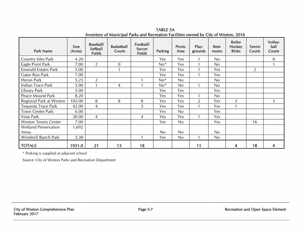
City of Weston Comprehensive Plan February 2017
Page 5-7
Recreation and Open Space Element
TABLE 5A Inventory of Municipal Parks and Recreation Facilities owned by City of Weston, 2016
Park Name
Size
(Acres)
Baseball/ Softball Fields
Basketball
Courts
Football/ Soccer Fields
Parking
Picnic Area
Play-
grounds
Rest-
rooms
Roller Hockey Rinks
Tennis Courts
Volley- ball
Courts
Country Isles Park 4.20 Yes Yes 1 No 0 Eagle Point Park 7.00 2 0 No* Yes 1 No 1 Emerald Estates Park 5.00 1 Yes Yes 1 Yes 2 Gator Run Park 7.00 Yes Yes 1 Yes Heron Park 5.25 2 1 No* No No Indian Trace Park 5.00 1 4 1 No* No 1 No Library Park 5.00 Yes Yes Yes Peace Mound Park 8.20 Yes Yes 1 No Regional Park at Weston 102.00 8 8 8 Yes Yes 2 Yes 3 3 Tequesta Trace Park 42.00 4 3 Yes Yes 1 Yes 1 Town Center Park 6.00 Yes No Yes Vista Park 30.00 4 4 Yes Yes 1 Yes Weston Tennis Center 7.00 Yes No Yes 16 Wetland Preservation Areas
1,692 No No No
Windmill Ranch Park 5.30 1 Yes No 1 No
TOTALS 1931.0 21 13 18 11 4 18 4
* Parking is supplied at adjacent school
Source: City of Weston Parks and Recreation Department
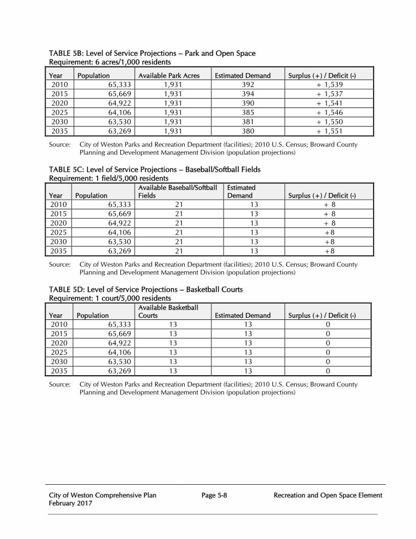
City of Weston Comprehensive Plan February 2017
Page 5-8
Recreation and Open Space Element
TABLE 5B: Level of Service Projections – Park and Open Space Requirement: 6 acres/1,000 residents
Year Population Available Park Acres Estimated Demand Surplus (+) / Deficit (-) 2010 65,333 1,931 392 + 1,539 2015 65,669 1,931 394 + 1,537 2020 64,922 1,931 390 + 1,541 2025 64,106 1,931 385 + 1,546 2030 63,530 1,931 381 + 1,550 2035 63,269 1,931 380 + 1,551
Source: City of Weston Parks and Recreation Department (facilities); 2010 U.S. Census; Broward County Planning and Development Management Division (population projections)
TABLE 5C: Level of Service Projections – Baseball/Softball Fields Requirement: 1 field/5,000 residents
Year Population Available Baseball/Softball Fields
Estimated Demand Surplus (+) / Deficit (-)
2010 65,333 21 13 + 8 2015 65,669 21 13 + 8 2020 64,922 21 13 + 8 2025 64,106 21 13 +8 2030 63,530 21 13 +8 2035 63,269 21 13 +8
Source: City of Weston Parks and Recreation Department (facilities); 2010 U.S. Census; Broward County Planning and Development Management Division (population projections)
TABLE 5D: Level of Service Projections – Basketball Courts Requirement: 1 court/5,000 residents
Year Population Available Basketball Courts Estimated Demand Surplus (+) / Deficit (-)
2010 65,333 13 13 0 2015 65,669 13 13 0 2020 64,922 13 13 0 2025 64,106 13 13 0 2030 63,530 13 13 0 2035 63,269 13 13 0
Source: City of Weston Parks and Recreation Department (facilities); 2010 U.S. Census; Broward County Planning and Development Management Division (population projections)
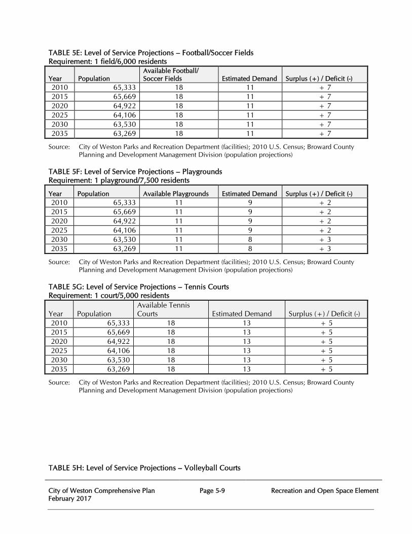
City of Weston Comprehensive Plan February 2017
Page 5-9
Recreation and Open Space Element
TABLE 5E: Level of Service Projections – Football/Soccer Fields Requirement: 1 field/6,000 residents
Year Population Available Football/ Soccer Fields Estimated Demand Surplus (+) / Deficit (-)
2010 65,333 18 11 + 7 2015 65,669 18 11 + 7 2020 64,922 18 11 + 7 2025 64,106 18 11 + 7 2030 63,530 18 11 + 7 2035 63,269 18 11 + 7
Source: City of Weston Parks and Recreation Department (facilities); 2010 U.S. Census; Broward County Planning and Development Management Division (population projections)
TABLE 5F: Level of Service Projections – Playgrounds Requirement: 1 playground/7,500 residents
Year Population Available Playgrounds Estimated Demand Surplus (+) / Deficit (-) 2010 65,333 11 9 + 2 2015 65,669 11 9 + 2 2020 64,922 11 9 + 2 2025 64,106 11 9 + 2 2030 63,530 11 8 + 3 2035 63,269 11 8 + 3
Source: City of Weston Parks and Recreation Department (facilities); 2010 U.S. Census; Broward County Planning and Development Management Division (population projections)
TABLE 5G: Level of Service Projections – Tennis Courts Requirement: 1 court/5,000 residents
Year Population Available Tennis Courts Estimated Demand Surplus (+) / Deficit (-)
2010 65,333 18 13 + 5 2015 65,669 18 13 + 5 2020 64,922 18 13 + 5 2025 64,106 18 13 + 5 2030 63,530 18 13 + 5 2035 63,269 18 13 + 5
Source: City of Weston Parks and Recreation Department (facilities); 2010 U.S. Census; Broward County Planning and Development Management Division (population projections)
TABLE 5H: Level of Service Projections – Volleyball Courts
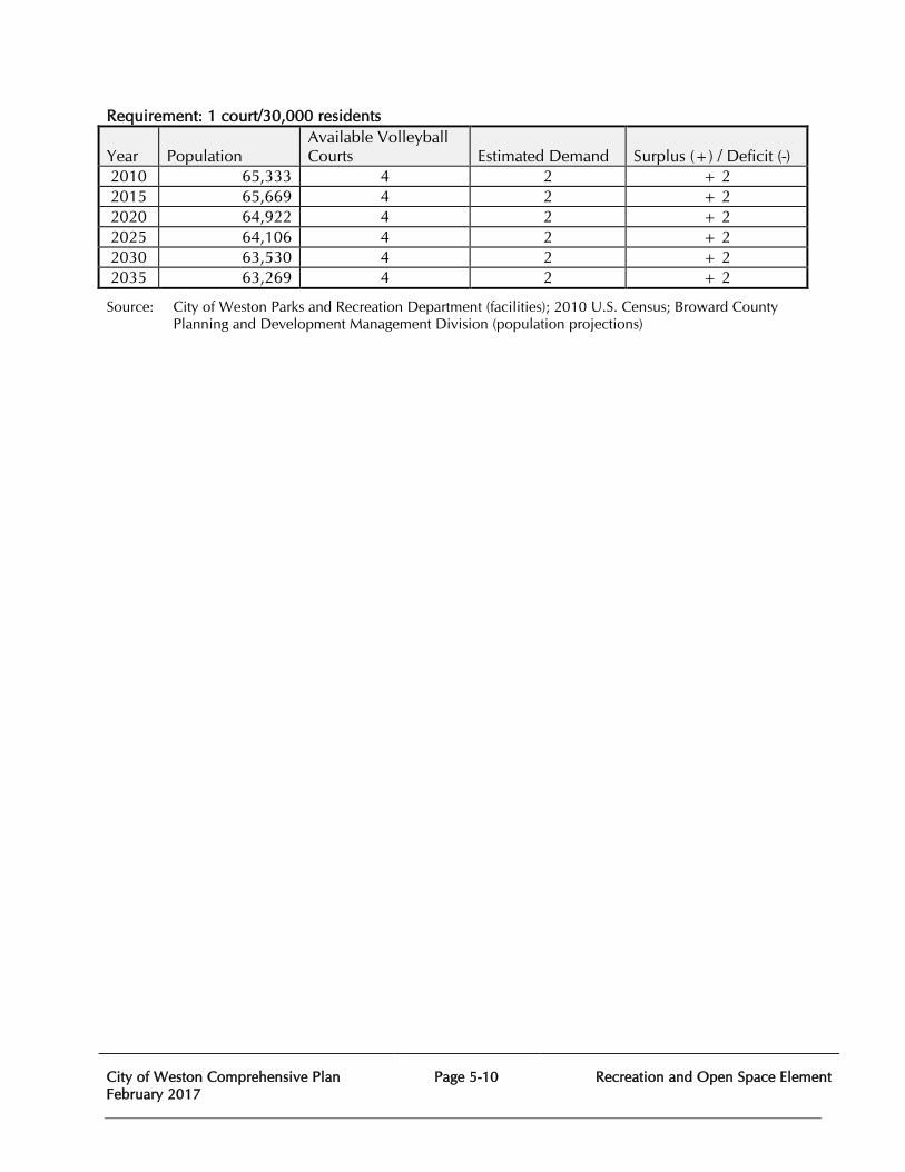
City of Weston Comprehensive Plan February 2017
Page 5-10
Recreation and Open Space Element
Requirement: 1 court/30,000 residents
Year Population Available Volleyball Courts Estimated Demand Surplus (+) / Deficit (-)
2010 65,333 4 2 + 2 2015 65,669 4 2 + 2 2020 64,922 4 2 + 2 2025 64,106 4 2 + 2 2030 63,530 4 2 + 2 2035 63,269 4 2 + 2
Source: City of Weston Parks and Recreation Department (facilities); 2010 U.S. Census; Broward County Planning and Development Management Division (population projections)
City of Weston Comprehensive Plan February 2017
Page 5-11
Recreation and Open Space Element
RECREATION AND OPEN SPACE ELEMENT
GOAL, OBJECTIVES, AND POLICIES Goal 5 To provide safe and adequate open space and recreation facilities accessible to all Weston residents.
5.1 Objective:
As the City’s population increases, ensure that sufficient park acreage is acquired to meet the established level of service standards.
5.1.1 Policy:
Specific open space definitions and level of service standards are as herein provided: Activity-Based: Parks with features such as baseball fields, basketball courts, football fields, roller hockey rinks, soccer fields, etc.
Resource-Based: Parks with features such as picnic areas, shelters, walkways, trails or boardwalks oriented toward unique natural features.
Neighborhood Park: A park having up to 10 acres that is designed to serve the recreational needs of the population living in the immediate residential area. Neighborhood parks may include recreational activities such as field games, court games, playground apparatus, walking, jogging, picnicking, etc.
Community Park: A park having more than 10 acres that is designed to serve the recreational needs of several neighborhoods. Community parks may include recreational activities such as field games, court games, playground apparatus, walking, jogging, picnicking, etc.
Regional Park: A park having more than 100 acres is intended to serve the recreational needs of the population of the entire City. A regional park may include active facilities, passive facilities or a combination of the two.
Open Space: Lands such as conservation areas, natural preserves and wetlands that have been set aside for preservation and are protected by local, state, or federal law.
Parks and Open Space: 6 acres per 1,000 population Baseball/Softball: 1 field per 5,000 population
Football/Soccer: 1 field per 6,000 population Basketball: 1 court per 5,000 population Tennis: 1 court per 5,000 population
Playground: 1 playground per 7,500 population
City of Weston Comprehensive Plan February 2017
Page 5-12
Recreation and Open Space Element
Volleyball: 1 court per 30,000 population
5.1.2 Policy: Require new residential developments to dedicate land for local parks in the amount of 6 acres/1,000 population generated by the project.
5.2 Objective: Provide quality recreation facilities and programs to meet the needs of residents.
5.2.1 Policy: Maintain existing recreation facilities in accordance with proper landscaping and safety standards.
5.2.2 Policy: Improve the physical and aesthetic condition of the City’s parks by renovating, rehabilitating, and upgrading existing facilities.
5.3 Objective: Ensure that all recreation sites are fully accessible to the public.
5.3.1 Policy: Require that all land dedicated to the public for parks and recreation purposes be located adjacent to arterial and/or collector roadways, pedestrian walkways and bicycle routes, or be provided for in future development plans.
5.3.2 Policy: All existing and future parks and recreation facilities shall comply with provisions of the Americans with Disabilities Act.
5.4 Objective:
Establish effective methods of coordinating public and private resources to meet public demands.
5.4.1 Policy:
Maintain cooperative relationships with agencies, groups, individuals, and organizations currently providing leisure programs to the residents.
5.4.2 Policy: Enlist new agencies, groups, individuals, and organizations to expand the programs available to residents.
5.4.3 Policy: Pursue appropriate joint public and private ventures to obtain lands and/or financing necessary to provide recreation areas, facilities, and programs.
City of Weston Comprehensive Plan February 2017
Page 5-13
Recreation and Open Space Element
5.4.4 Policy: Strive to develop partnership programs which seek out private organizations to provide land or facilities compatible to public recreation.
5.5 Objective: Require the provision of open space by public agencies and private enterprise.
5.5.1 Policy:
The provision of open space such as natural areas, vistas, land buffers, or waterways shall be required in residential and non-residential development as per the Land Development Code.
City of Weston Comprehensive Plan February 2017
Page 6-1
Intergovernmental Coordination Element
CHAPTER SIX
INTERGOVERNMENTAL COORDINATION ELEMENT
PURPOSE The purpose of the Intergovernmental Coordination Element, as identified by Chapter 163, Florida Statutes is to “permit local governmental units to make the most efficient use of their powers by enabling them to cooperate with other localities on a basis of mutual advantage and thereby to provide services and facilities in a manner and pursuant to forms of governmental organization that will accord best with geographic, economic, population, and other factors influencing the needs and development of local communities.” The agencies that coordinate with the City of Weston include adjacent municipalities, Broward County, School Board of Broward County, water management districts, regional planning agencies, state government, federal government, independent special districts and utility companies. Each element of the City of Weston comprehensive plan has specific needs for interagency coordination that need to be clearly identified and defined and periodically evaluated in order to determine the effectiveness of current mechanisms used and how to improve overall intergovernmental coordination. EXISTING DATA AND CONDITIONS The City of Weston currently has either formal or informal coordination agreements, or interacts through standard operating procedures under statutory authority, with the following agencies or jurisdictions:
Adjacent Municipalities Davie Pembroke Pines Southwest Ranches Sunrise
Broward County Broward County Administration Broward County Board of County Commissioners Broward County Environmental Licensing and Building Permitting Division Broward County Environmental Protection and Growth Management Department Broward County Planning and Development Management Division Broward County Highway Construction and Engineering Division Broward County Sheriff's Office Department of Fire Rescue and Emergency Services Broward County Transportation Department Broward County Metropolitan Planning Organization
City of Weston Comprehensive Plan February 2017
Page 6-2
Intergovernmental Coordination Element
Broward County Water and Wastewater Services Division Broward County Planning Council Broward County Property Appraiser Broward County School Board Broward County Sheriff’s Office Broward County Records, Taxes, and Treasury Division Broward County Traffic Engineering Division Broward County Supervisor of Elections Broward County Clerk of the Courts
Florida Departments and Agencies Economic Opportunity Emergency Management Environmental Protection Business and Professional Regulation South Florida Regional Planning Council State Division of Historical Resources Transportation Health
United States Departments and Agencies
Commerce, Census Bureau Defense/US Army Corps of Engineers Environmental Protection Agency Interior Postal Service Transportation
Regulated Utilities
AT&T Cable Television: Comcast, Advanced Cable and AT&T U-verse Florida Power and Light Company TECO
Independent Special Districts Indian Trace Development District (Dependent District) North Broward Hospital District South Broward Hospital District South Florida Water Management District Bonaventure Development District
EVALUATION OF EXISTING COORDINATION MECHANISMS
For each agency listed above, Table 6A briefly describes the existing coordination mechanisms indicating the subject, nature of the relationship and the office with primary responsibility for coordination.
City of Weston Comprehensive Plan February 2017
Page 6-3
Intergovernmental Coordination Element
The current process of coordination among the identified agencies and the City of Weston has proven to be generally effective. Greater formality could be required in the future as the technical and administrative foundation of the Comprehensive Plan increases in complexity and becomes more demanding. The City of Weston is a stable and well-planned community. The vast majority of the Objectives and Policies of the Intergovernmental Coordination Element have been fully executed to provide for a highly functional organization and effective coordination between adjacent municipalities and governmental agencies. Upon evaluation of the Comprehensive Plan it was determined that there are no substantial improvements or additional intergovernmental coordination needs required at this time. The City of Weston resolves coordination issues mainly through frequent communication in written and verbal form. The use of electronic communication technologies such as e-mail, the internet, and teleconferencing, have also allowed for faster and increased communication and better coordination between the City of Weston and related intergovernmental agencies. JOINT PLANNING AREAS The City of Weston is party to several Joint Planning Areas through formal agreements with the following agencies: Broward County Sheriff's Office Department of Fire Rescue and Emergency Services Operations for fire and emergency medical services; Broward County School Board for design, development, and construction of classrooms and school facilities in the City of Weston; and Broward County Sheriff’s Office for the provision of law enforcement and code. Coordination mechanisms between the City of Weston and these agencies are delineated in Table 6A. COMPARISON WITH REGIONAL POLICY PLAN The South Florida (2004) Strategic Regional Policy Plan has been reviewed and considered during the process of writing this comprehensive plan. The Comprehensive Plan conforms to the Regional Policy Plan. The following abbreviations are used in Table 6A:
AE - Advise and Encourage AP - Approval, Permit CA - City Agency FA – Formal Agreement FN - Formal Notice IN - Informal Notice OA - Outside Agencies PM - Periodic Meetings to Coordinate Programs TA - Technical Assistance
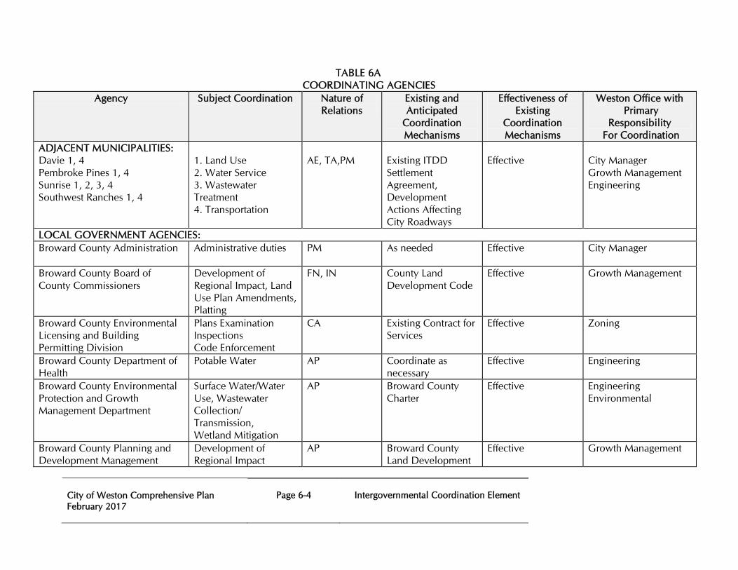
City of Weston Comprehensive Plan February 2017
Page 6-4
Intergovernmental Coordination Element
TABLE 6A COORDINATING AGENCIES
Agency Subject Coordination Nature of Relations
Existing and Anticipated
Coordination Mechanisms
Effectiveness of Existing
Coordination Mechanisms
Weston Office with Primary
Responsibility For Coordination
ADJACENT MUNICIPALITIES: Davie 1, 4 Pembroke Pines 1, 4 Sunrise 1, 2, 3, 4 Southwest Ranches 1, 4
1. Land Use 2. Water Service 3. Wastewater Treatment 4. Transportation
AE, TA,PM
Existing ITDD Settlement Agreement, Development Actions Affecting City Roadways
Effective
City Manager Growth Management Engineering
LOCAL GOVERNMENT AGENCIES: Broward County Administration Administrative duties PM
As needed Effective City Manager
Broward County Board of County Commissioners
Development of Regional Impact, Land Use Plan Amendments, Platting
FN, IN County Land Development Code
Effective Growth Management
Broward County Environmental Licensing and Building Permitting Division
Plans Examination Inspections Code Enforcement
CA Existing Contract for Services
Effective Zoning
Broward County Department of Health
Potable Water AP Coordinate as necessary
Effective Engineering
Broward County Environmental Protection and Growth Management Department
Surface Water/Water Use, Wastewater Collection/ Transmission, Wetland Mitigation
AP Broward County Charter
Effective Engineering Environmental
Broward County Planning and Development Management
Development of Regional Impact
AP Broward County Land Development
Effective Growth Management
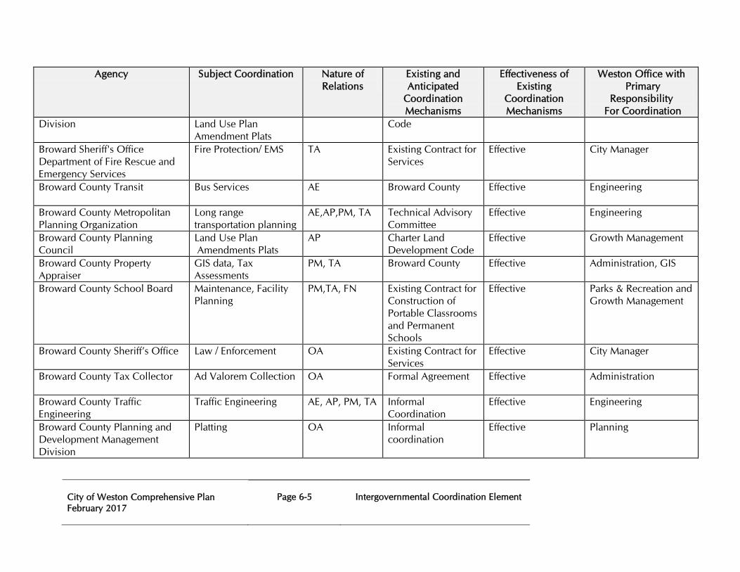
City of Weston Comprehensive Plan February 2017
Page 6-5
Intergovernmental Coordination Element
Agency Subject Coordination Nature of Relations
Existing and Anticipated
Coordination Mechanisms
Effectiveness of Existing
Coordination Mechanisms
Weston Office with Primary
Responsibility For Coordination
Division Land Use Plan Amendment Plats
Code
Broward Sheriff's Office Department of Fire Rescue and Emergency Services
Fire Protection/ EMS TA
Existing Contract for Services
Effective City Manager
Broward County Transit Bus Services AE
Broward County Effective Engineering
Broward County Metropolitan Planning Organization
Long range transportation planning
AE,AP,PM, TA Technical Advisory Committee
Effective Engineering
Broward County Planning Council
Land Use Plan Amendments Plats
AP Charter Land Development Code
Effective Growth Management
Broward County Property Appraiser
GIS data, Tax Assessments
PM, TA Broward County Effective Administration, GIS
Broward County School Board Maintenance, Facility Planning
PM,TA, FN Existing Contract for Construction of Portable Classrooms and Permanent Schools
Effective Parks & Recreation and Growth Management
Broward County Sheriff’s Office Law / Enforcement OA Existing Contract for Services
Effective City Manager
Broward County Tax Collector Ad Valorem Collection OA
Formal Agreement Effective Administration
Broward County Traffic Engineering
Traffic Engineering AE, AP, PM, TA Informal Coordination
Effective Engineering
Broward County Planning and Development Management Division
Platting OA Informal coordination
Effective Planning
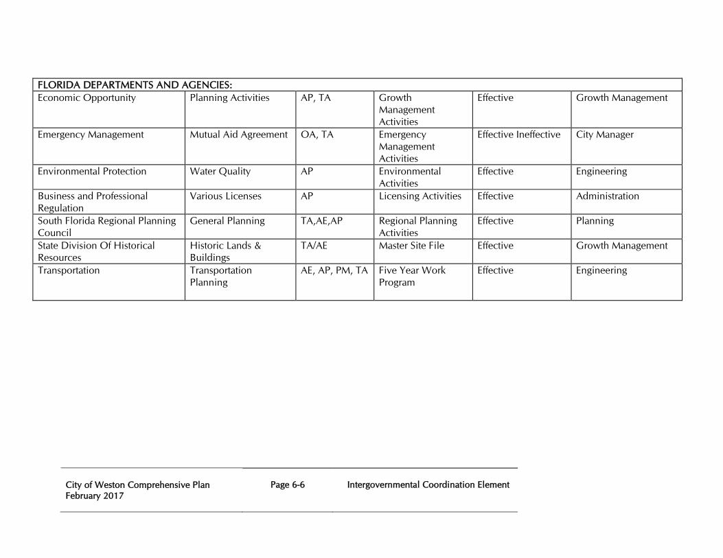
City of Weston Comprehensive Plan February 2017
Page 6-6
Intergovernmental Coordination Element
FLORIDA DEPARTMENTS AND AGENCIES: Economic Opportunity Planning Activities AP, TA
Growth Management Activities
Effective Growth Management
Emergency Management Mutual Aid Agreement OA, TA
Emergency Management Activities
Effective Ineffective City Manager
Environmental Protection Water Quality AP
Environmental Activities
Effective Engineering
Business and Professional Regulation
Various Licenses AP Licensing Activities Effective Administration
South Florida Regional Planning Council
General Planning TA,AE,AP Regional Planning Activities
Effective Planning
State Division Of Historical Resources
Historic Lands & Buildings
TA/AE Master Site File Effective Growth Management
Transportation
Transportation Planning
AE, AP, PM, TA Five Year Work Program
Effective Engineering
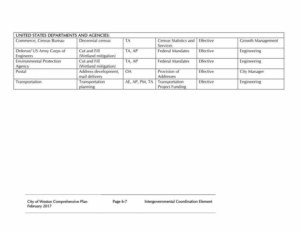
City of Weston Comprehensive Plan February 2017
Page 6-7
Intergovernmental Coordination Element
UNITED STATES DEPARTMENTS AND AGENCIES: Commerce, Census Bureau Decennial census TA
Census Statistics and Services
Effective Growth Management
Defense/ US Army Corps of Engineers
Cut and Fill (Wetland mitigation)
TA, AP Federal Mandates Effective Engineering
Environmental Protection Agency
Cut and Fill (Wetland mitigation)
TA, AP Federal Mandates Effective Engineering
Postal Address development, mail delivery
OA Provision of Addresses
Effective City Manager
Transportation Transportation planning
AE, AP, PM, TA Transportation Project Funding
Effective Engineering
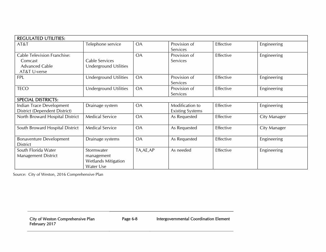
City of Weston Comprehensive Plan February 2017
Page 6-8
Intergovernmental Coordination Element
REGULATED UTILITIES: AT&T Telephone service OA
Provision of Services
Effective Engineering
Cable Television Franchise: Comcast Advanced Cable AT&T U-verse
Cable Services Underground Utilities
OA Provision of Services
Effective Engineering
FPL Underground Utilities OA
Provision of Services
Effective Engineering
TECO Underground Utilities OA Provision of Services
Effective Engineering
SPECIAL DISTRICTS: Indian Trace Development District (Dependent District)
Drainage system OA
Modification to Existing Systems
Effective Engineering
North Broward Hospital District
Medical Service OA As Requested Effective City Manager
South Broward Hospital District
Medical Service OA As Requested Effective City Manager
Bonaventure Development District
Drainage systems OA As Requested Effective Engineering
South Florida Water Management District
Stormwater management Wetlands Mitigation Water Use
TA,AE,AP As needed Effective Engineering
Source: City of Weston, 2016 Comprehensive Plan
City of Weston Comprehensive Plan February 2017
Page 6-9
Intergovernmental Coordination Element
INTERGOVERNMENTAL COORDINATION ELEMENT GOALS, OBJECTIVES, AND POLICIES
Goal 6 To provide accessible, effective and frequent intergovernmental coordination opportunities to achieve consistency among all government agencies implementing plans and programs affecting the City of Weston.
6.1 Objective: Continue and improve coordination activities among government agencies with planning and impact assessment duties affecting the City of Weston, as listed in Table 6A, with other units of local government providing services but not having regulatory authority over the use of land, and with the comprehensive plans of adjacent municipalities, the county and adjacent counties. The City of Weston will coordinate its Comprehensive Plan with the plans of the Broward County School Board.
6.1.1 Policy: Maintain an active program of monitoring and communication with agencies operating under the provisions of the Community Planning Act, Chapter 163 F.S.
6.1.2 Policy: City of Weston shall continue to participate in community workshops and the Regional Planning Council’s informal mediation process to provide an open forum for communication and coordination of programs involving the comprehensive plan, and resolution of conflicts with other local governments.
6.1.3 Policy: City of Weston shall continue to participate in the Broward County League of Cities to ensure full participation in county-wide issues that may involve the City of Weston.
6.1.4 Policy: City of Weston shall evaluate periodically current mechanisms used for intergovernmental coordination and determine the need to increase intergovernmental coordination activities regarding issues involving: emergency preparedness, traffic engineering, fire rescue, police, water and wastewater treatment and administration.
6.1.5 Policy: The review of proposed developments shall include findings that indicate relationships of such proposed developments to the comprehensive plans of adjacent local governments.
City of Weston Comprehensive Plan February 2017
Page 6-10
Intergovernmental Coordination Element
6.1.6 Policy:
City of Weston shall coordinate planning activities with other local governments, Broward County School Board or other units of local government service providers without regulatory authority over the use of land, the region and the State by meeting with these entities on a regular basis.
6.1.7 Policy: City of Weston shall continue to appoint a representative to the “Staff Working Group”, as specified in the Interlocal Agreement for Public School Facility Planning, Broward County FL, to meet at least annually with the Broward County School Board, Broward County and adjacent municipalities to discuss issues and formulate recommendations regarding coordination of land use and school facilities planning and to comply with public school concurrency requirements, including such issues as population and student projections, development trends, school needs, co-location and joint use opportunities, ancillary infrastructure improvements needed to support the schools and safe student access.
6.1.8 Policy: City of Weston shall continue to coordinate with the Florida Department of Transportation during the development review process by requiring all development applications on State Roads to obtain preliminary approval from the Florida Department of Transportation for all vehicular access connections (VAC’s) to the State Highway System prior to City Commission approval. The City of Weston will assist the Florida Department of Transportation in enforcing permit approvals by withholding certificates of occupancy (C.O.s) until the requirements of such permits have been inspected and accepted by the Florida Department of Transportation.
6.1.9 Policy: City of Weston shall continue to coordinate with the Florida Department of Transportation in situations where pending development approvals or other land use activities could significantly impact the State Highway System (SHS) and or the Strategic Intermodal System (SIS), 3% or more of the adopted maximum service volume on the subject segment of the State Highway System. The City of Weston will provide copies of all relevant development application materials to the FDOT District Four Planning and Traffic Operations offices, as appropriate, and indicate what improvements, if any, have been proposed by the applicant. The City of Weston will notify FDOT if unacceptable levels of service are anticipated with the proposed development, and suggest any potential improvements which may not have been identified by the applicant.
6.1.10 Policy: As part of the City’s development review and permitting processes, the City of Weston will assist the Florida Department of Transportation in enforcing its Access Management Standards on all State Highways. The City of
City of Weston Comprehensive Plan February 2017
Page 6-11
Intergovernmental Coordination Element
Weston will continue to require a preliminary “favorable review finding” from the FDOT Permits Section for all proposed development access connections to the State Highway System. The City of Weston will also assist FDOT in any permit violation issues after the development has received its Certificate of Occupancy (C.O.).
6.1.11 Policy: City of Weston shall participate in the Broward County Water Advisory Board and its technical coordinating committee.
6.2 Objective: Ensure that the impacts of development, proposed in the City’s Comprehensive Plan, upon development in adjacent municipalities, the County, adjacent counties, the region and the State are addressed through coordination mechanisms.
6.2.1 Policy: Continue to maintain an active program of monitoring and communication with agencies operating under the provisions of the Community Planning Act, Chapter 163 F.S.
6.2.2 Policy: The City of Weston will utilize the following procedures to identify and implement joint planning areas (JPAs) for the purpose of addressing issues related to annexation and joint infrastructure service areas:
1. Use the Broward League of Cities Technical Advisory Committee, a work group that meets monthly, to coordinate planning activities mandated by the various elements of the Weston Comprehensive Plan with local governments, the School Board of Broward County, other governmental units providing services but not having regulatory authority over the use of land, the region, and the state;
2. Use the South Florida Regional Planning Council’s informal mediation process to resolve conflicts with other local governments, when agreed to by all affected parties;
3. Siting of facilities with county-wide significance including locally unwanted land uses;
4. Making demographic and social-economic information and services available for county, school board and municipal planning activities.
6.2.3 Policy: Pursuant to Chapter 163.3 177(h) F.S. the City of Weston shall coordinate their planning and permitting processes with the School Board, Broward County, and other municipalities consistent with the procedures established within the Interlocal Agreement for Public School Facility Planning (ILA) as follows:
1. Review and update of the annual District Educational Facilities Plan (DEFP) containing the financially feasible schedule of capital
City of Weston Comprehensive Plan February 2017
Page 6-12
Intergovernmental Coordination Element
improvement for school facilities needed to achieve and maintain the adopted level of service standards in all Concurrency Service Areas (CSA).
2. Coordinate County and municipal land use planning and permitting processes with the School Board’s site selection and planning process to ensure future school facilities are consistent and compatible with land use categories and enable a close integration of existing and planned school facilities and the surrounding land uses.
3. Coordinate the preparation of the County and City of Weston projections for future development with the School Board’s school enrollment projections to ensure consistency between the County and City Future Land Use maps and the long term school planning process.
4. Coordinate with the School Board through the Staff Working Group and Oversight Committee regarding the preparation of County and municipal annual comprehensive plan updates and the School Board’s annual update of the District Facilities Educational Program (DEFP) to ensure consistency between the plans.
5. Coordinate with the School Board on the planning, siting, land acquisition, permitting and development of new school facilities to ensure the availability of public facilities, services and grounds, especially for purposes of exploring collocation opportunities.
6. Revise County and municipal land development codes and School Board policies to establish a county-wide public school concurrency system.
6.2.4 Policy: The City of Weston will, within one year of adopting its Intergovernmental Coordination Element, obtain City Commission approval of (by interlocal or other formal agreement executed by all affected entities), in conjunction with Broward County, appropriate municipalities within the county, the Broward County School Board and any other local government service provider to the City of Weston as necessary.
6.2.5 Policy: The review of proposed developments shall include findings that indicate relationships of such proposed developments to the comprehensive plans of adjacent local governments.
6.2.6 Policy: The City of Weston shall meet to the extent necessary with South Florida Water Management District staff to discuss impact of proposed new development on South Florida Water Management District regional water resource projects (Central and Southern Florida Project Comprehensive
City of Weston Comprehensive Plan February 2017
Page 6-13
Intergovernmental Coordination Element
Review Study (Restudy), the Comprehensive Everglades Restoration Plan, the Lower East Regional Water Supply Plan, the Water Preserve Area Project, and the C-11 West Basin Water Quality Improvement Strategy.
6.2.7 Policy: The City of Weston shall notify and consult with the South Florida Water Management District regarding any development proposals received within or adjacent to the East Coast Buffer Area.
6.2.8 Policy: Should the South Florida Water Management District desire to hold workshops with residents and property owners to inform them about the East Coast Buffer Plan, the City of Weston will cooperate with the South Florida Water Management District by providing access to advertising and notification of any workshops scheduled.
6.3 Objective:
Coordination shall be undertaken in the establishment of level of service standards for public facilities with any state, regional or local entity having operational and maintenance responsibility for such facilities.
6.3.1 Policy: City of Weston shall continue to coordinate with state, regional or local entities that have operational and maintenance responsibility for public facilities with Level of Service standards to ensure mutually compatible standards.
6.3.2 Policy: Coordination activities pursuant to the objectives and policies in this element shall include consideration for equitable level of service standards for facility and service delivery systems consistent with the provisions of this plan.
6.3.3 Policy: The City of Weston shall coordinate implementation of the goals, objectives and policies in its Water Supply Facilities Work Plan with the South Florida Water Management District’s Lower East Coast Water Supply Plan and the City of Sunrise’ Water Supply Facilities Work Plan.
6.3.4 Policy:
The City of Weston shall increase its coordination efforts with the South Florida Water Management District and City of Sunrise regarding the sharing and updating of information to meet ongoing water supply needs.
6.3.5 Policy The City of Weston shall coordinate with the South Florida Water Management District and City of Sunrise in the implementation of alternative water supply projects, the establishment of its level-of-service standards and resource allocations.
City of Weston Comprehensive Plan February 2017
Page 6-14
Intergovernmental Coordination Element
6.3.3 Policy
The City of Weston shall participate in on-going collaborative efforts with other local governments and agencies for long-term alternative water supply sources. The City of Weston shall participate in, at a minimum, annual meetings with water providers and the South Florida Water Management District to discuss population projections, land use changes and implementation of conservation reuse programs and alternative water supplies.
City of Weston Comprehensive Plan February 2017
Page 7-1
Capital Improvement Element
CHAPTER SEVEN
CAPITAL IMPROVEMENT ELEMENT PURPOSE Chapter 163 of the Florida Statutes states that the purpose of the Capital Improvement Element is to consider the need for and the location of public facilities in order to encourage the efficient use of such facilities as well as to outline components for construction, extension, or increase in capacity of public facilities for a minimum period of at least 5 years, and ensure adequacy of those facilities to meet established acceptable levels of service. The City of Weston’s Capital Improvement Element is not the City of Weston’s Capital Improvement Program. The Capital Improvement Element is a portion of the City of Weston’s overall Comprehensive Plan and is to be used as a planning tool by the City of Weston and is not to be used to create a capital budget. The Element addresses short and long term level of service needs that have been identified and will assure the orderly growth and development of the City of Weston. The Element will be used to ensure that the identified level of service for the residents of the City of Weston will be met. PLANNING TIMEFRAMES The City of Weston Comprehensive Plan provides guidance on development and redevelopment over two planning horizons: a 5-year period (short term) and a 10-year period (long term). The Capital Improvement Element provides for facility improvements over the short term 5-year planning period. EXISTING DATA AND CONDITIONS Inventory of Capital Improvement Needs
The City of Weston is a built-out community that was incorporated in 1996. The existing demand on the City of Weston’s infrastructure is heading in a different direction than the conditions at the time the Comprehensive Plan was adopted in 1999. Previously, the City of Weston was in need of increasing its infrastructure capacity based on the heavy growth Weston was experiencing. Currently, the main constraint on the infrastructure system is an aging system in older areas of the City of Weston. Weston is now faced with the challenge of capital improvements to areas of the greatest need. The City of Weston has been successful maintaining its required level of service; however, in order to maintain these conditions, enhancements to the current network will be a necessity in the future. The Capital Improvement Element and Capital Improvement Plan are reviewed and updated annually to assess the need for projects required to maintain the City of Weston’s adopted levels of service.
City of Weston Comprehensive Plan February 2017
Page 7-2
Capital Improvement Element
Water and Sewer Facilities
Water and sewer extensions in the City of Weston were installed by the Indian Trace Development District, whose board members are the members of the Weston City Commission and are financed by debt issued by the District. The bonds are satisfied by assessments against future users. The City of Weston does not own water or sewer treatment facilities but contracts for those services through the Settlement Agreement with the City of Sunrise. The City of Weston operates and maintains the collection and distribution system and assures that the installation of new facilities is properly accomplished.
Currently, the City of Weston is maintaining Level of Service (LOS) for Water and Sewer Facilities. See the City of Weston Comprehensive Plan, Infrastructure Element.
Stormwater Drainage Facilities
The City of Weston’s stormwater management and drainage can be separated into two areas, the Bonaventure Development District and the Indian Trace Community Development District (ITCDD). The ITCDD is comprised of Basin 1 and Basin 2 and the Bonaventure Development District includes all of the Bonaventure community. Basin 1 is the largest developed portion of the City of Weston, while Basin 2 is made up of mainly the agricultural areas, but does also contain the developed community of the Isles at Weston.
Currently, the City of Weston is maintaining LOS for Stormwater Drainage Facilities. See the City of Weston Comprehensive Plan, Infrastructure Element.
Transportation
Weston is built-out; therefore, the main concern regarding roadway improvements are the older portions of the City of Weston. The City of Weston is responsible for maintaining the local network program and the traffic control devices, including traffic signals. Improvements for these traffic engineering devices have been provided for in the 2022 City Strategic Value and Business Plan. These projects are financed through the Capital Projects Fund. There are currently no issues that affect level of service standards.
In order to adequately assess roadway performances throughout the City of Weston, an evaluation system was adopted. Roadway performance conditions are measured by Level of Service (LOS), which is represented by letters “A” (most favorable conditions), through “F” (least favorable conditions). In 1999, the City of Weston adopted a concurrency management system and level of service for roads; LOS “D” for peak hour roadway operating condition or “LOS D: 110% Maintain” for purposes of determining the capacity of roadway segments, as required by Broward County.
There is one widening project listed for the City of Weston in the FDOT FY 16/17 to 21/22 Work Program. It is FM #421548-1 for additional lanes and reconstruction of the I-75 interchange at Royal Palm Boulevard from North of SW 36th Street (South Post Road) to south of SW 14th Street (Indian Trace).
Currently, the City of Weston is maintaining LOS for Transportation Facilities. See the City of Weston Comprehensive Plan, Transportation Element.
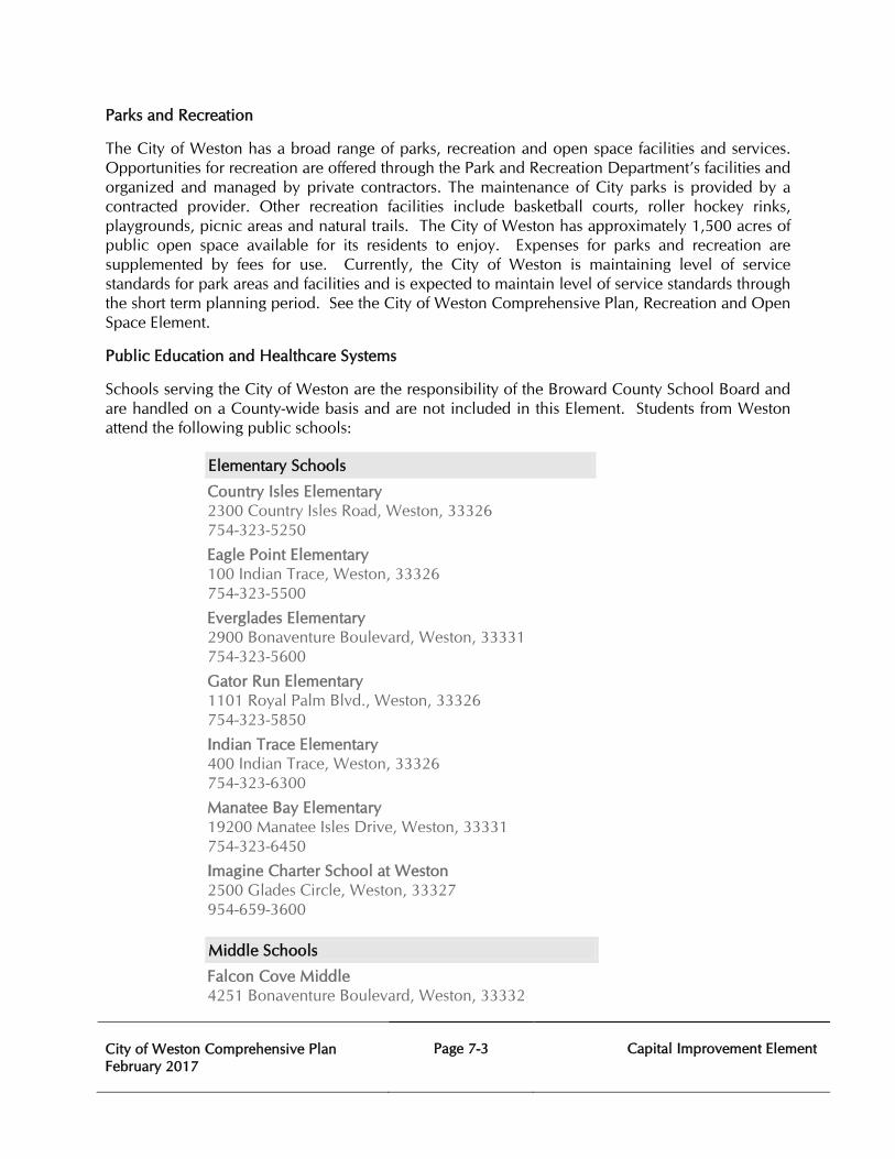
City of Weston Comprehensive Plan February 2017
Page 7-3
Capital Improvement Element
Parks and Recreation
The City of Weston has a broad range of parks, recreation and open space facilities and services. Opportunities for recreation are offered through the Park and Recreation Department’s facilities and organized and managed by private contractors. The maintenance of City parks is provided by a contracted provider. Other recreation facilities include basketball courts, roller hockey rinks, playgrounds, picnic areas and natural trails. The City of Weston has approximately 1,500 acres of public open space available for its residents to enjoy. Expenses for parks and recreation are supplemented by fees for use. Currently, the City of Weston is maintaining level of service standards for park areas and facilities and is expected to maintain level of service standards through the short term planning period. See the City of Weston Comprehensive Plan, Recreation and Open Space Element.
Public Education and Healthcare Systems
Schools serving the City of Weston are the responsibility of the Broward County School Board and are handled on a County-wide basis and are not included in this Element. Students from Weston attend the following public schools:
Elementary Schools
Country Isles Elementary 2300 Country Isles Road, Weston, 33326 754-323-5250
Eagle Point Elementary 100 Indian Trace, Weston, 33326 754-323-5500
Everglades Elementary 2900 Bonaventure Boulevard, Weston, 33331 754-323-5600
Gator Run Elementary 1101 Royal Palm Blvd., Weston, 33326 754-323-5850
Indian Trace Elementary 400 Indian Trace, Weston, 33326 754-323-6300
Manatee Bay Elementary 19200 Manatee Isles Drive, Weston, 33331 754-323-6450
Imagine Charter School at Weston 2500 Glades Circle, Weston, 33327 954-659-3600
Middle Schools
Falcon Cove Middle 4251 Bonaventure Boulevard, Weston, 33332
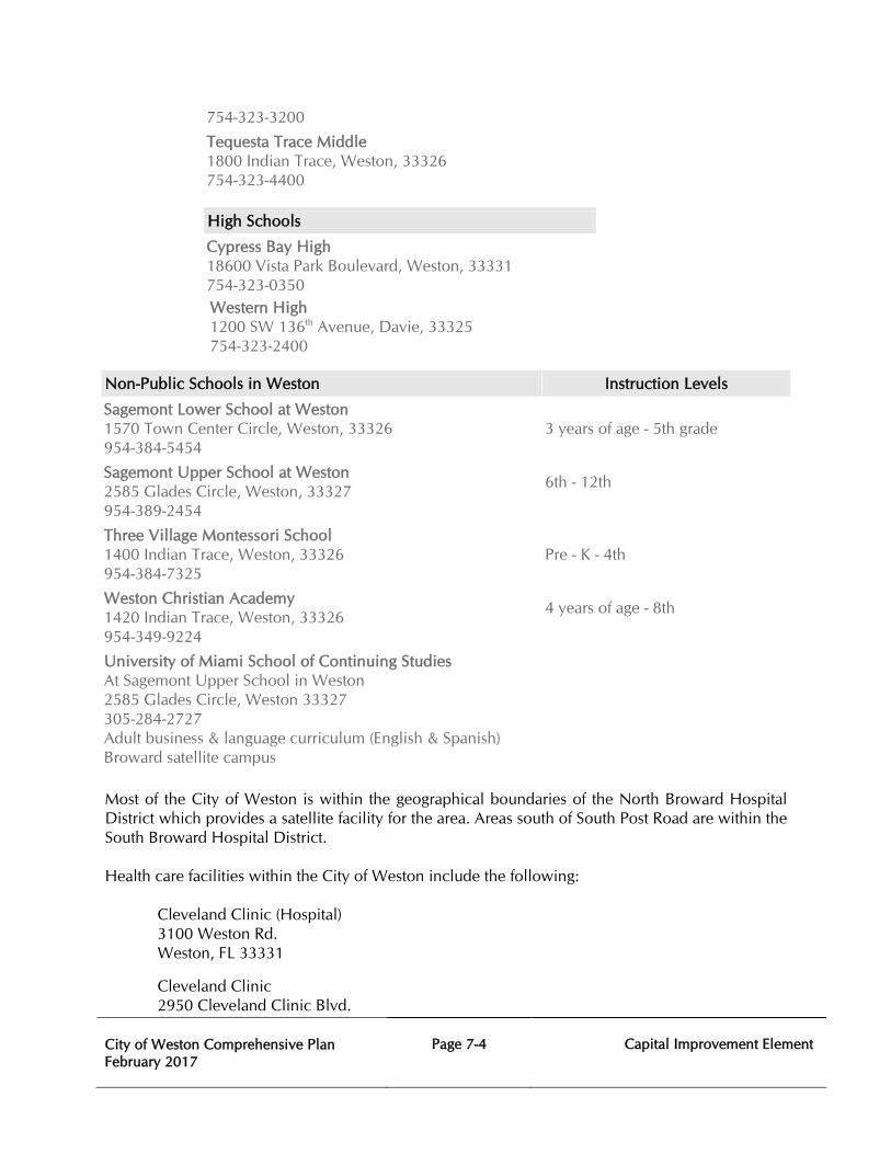
City of Weston Comprehensive Plan February 2017
Page 7-4
Capital Improvement Element
754-323-3200
Tequesta Trace Middle 1800 Indian Trace, Weston, 33326 754-323-4400
High Schools
Cypress Bay High 18600 Vista Park Boulevard, Weston, 33331 754-323-0350 Western High 1200 SW 136th Avenue, Davie, 33325 754-323-2400
Non-Public Schools in Weston Instruction Levels
Sagemont Lower School at Weston 1570 Town Center Circle, Weston, 33326 954-384-5454
3 years of age - 5th grade
Sagemont Upper School at Weston 2585 Glades Circle, Weston, 33327 954-389-2454
6th - 12th
Three Village Montessori School 1400 Indian Trace, Weston, 33326 954-384-7325
Pre - K - 4th
Weston Christian Academy 1420 Indian Trace, Weston, 33326 954-349-9224
4 years of age - 8th
University of Miami School of Continuing Studies At Sagemont Upper School in Weston 2585 Glades Circle, Weston 33327 305-284-2727 Adult business & language curriculum (English & Spanish) Broward satellite campus Most of the City of Weston is within the geographical boundaries of the North Broward Hospital District which provides a satellite facility for the area. Areas south of South Post Road are within the South Broward Hospital District. Health care facilities within the City of Weston include the following:
Cleveland Clinic (Hospital) 3100 Weston Rd. Weston, FL 33331
Cleveland Clinic 2950 Cleveland Clinic Blvd.
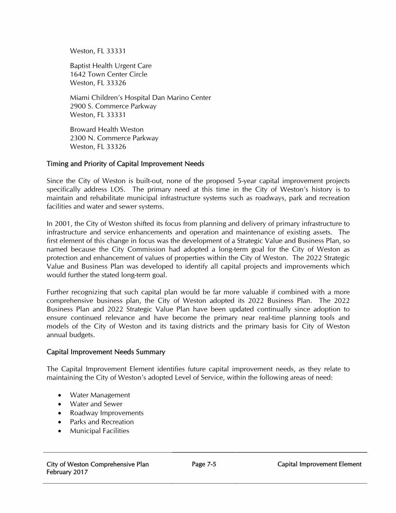
City of Weston Comprehensive Plan February 2017
Page 7-5
Capital Improvement Element
Weston, FL 33331
Baptist Health Urgent Care 1642 Town Center Circle Weston, FL 33326
Miami Children’s Hospital Dan Marino Center 2900 S. Commerce Parkway Weston, FL 33331
Broward Health Weston 2300 N. Commerce Parkway Weston, FL 33326
Timing and Priority of Capital Improvement Needs Since the City of Weston is built-out, none of the proposed 5-year capital improvement projects specifically address LOS. The primary need at this time in the City of Weston’s history is to maintain and rehabilitate municipal infrastructure systems such as roadways, park and recreation facilities and water and sewer systems. In 2001, the City of Weston shifted its focus from planning and delivery of primary infrastructure to infrastructure and service enhancements and operation and maintenance of existing assets. The first element of this change in focus was the development of a Strategic Value and Business Plan, so named because the City Commission had adopted a long-term goal for the City of Weston as protection and enhancement of values of properties within the City of Weston. The 2022 Strategic Value and Business Plan was developed to identify all capital projects and improvements which would further the stated long-term goal. Further recognizing that such capital plan would be far more valuable if combined with a more comprehensive business plan, the City of Weston adopted its 2022 Business Plan. The 2022 Business Plan and 2022 Strategic Value Plan have been updated continually since adoption to ensure continued relevance and have become the primary near real-time planning tools and models of the City of Weston and its taxing districts and the primary basis for City of Weston annual budgets. Capital Improvement Needs Summary The Capital Improvement Element identifies future capital improvement needs, as they relate to maintaining the City of Weston’s adopted Level of Service, within the following areas of need:
• Water Management • Water and Sewer • Roadway Improvements • Parks and Recreation • Municipal Facilities
City of Weston Comprehensive Plan February 2017
Page 7-6
Capital Improvement Element
The Capital Improvement Program as outlined is generally to meet the needs existing facilities. Limited improvements are intended for the needs of future development and expansion within the City of Weston. The water and sewer facilities as indicated in the Plan are intended to serve existing and future development in the City of Weston and to assure that the established levels of service are met. The identified roadway improvements are intended to provide existing and future residents of the City of Weston with safe and adequate access throughout Weston by signalization and intersection improvements. The Recreation and Open Space Element is intended to exceed the established levels of service and to ensure the standards that are established both in existing and proposed parks. Level of Service Standards The criteria established for comprehensive plans must include at a minimum the Level of Service Standards to be utilized for the public facilities described in the Plan. The Level of Service Standards for the City of Weston are shown in the following Table 7A. All future development approvals are contingent upon the fact that the adopted Level of Service Standards are met.
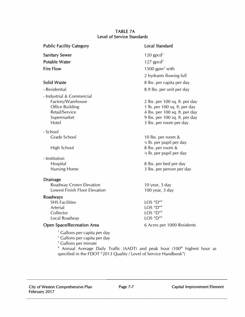
City of Weston Comprehensive Plan February 2017
Page 7-7
Capital Improvement Element
TABLE 7A Level of Service Standards
Public Facility Category Local Standard
Sanitary Sewer 120 gpcd1
Potable Water 127 gpcd2
Fire Flow 1500 gpm3 with
2 hydrants flowing full
Solid Waste 8 lbs. per capita per day
- Residential 8.9 lbs. per unit per day
- Industrial & Commercial Factory/Warehouse 2 lbs. per 100 sq. ft. per day Office Building 1 lb. per 100 sq. ft. per day Retail/Service 4 lbs. per 100 sq. ft. per day Supermarket 9 lbs. per 100 sq. ft. per day Hotel 3 lbs. per room per day
- School Grade School 10 lbs. per room &
¼ lb. per pupil per day High School 8 lbs. per room &
¼ lb. per pupil per day - Institution
Hospital 8 lbs. per bed per day Nursing Home 3 lbs. per person per day
Drainage
Roadway Crown Elevation 10 year, 3 day Lowest Finish Floor Elevation 100 year, 3 day
Roadways SHS Facilities LOS “D”4 Arterial LOS “D”4 Collector LOS “D”4 Local Roadway LOS “D”4
Open Space/Recreation Area 6 Acres per 1000 Residents 1 Gallons per capita per day 2 Gallons per capita per day 3 Gallons per minute 4 Annual Average Daily Traffic (AADT) and peak hour (100th highest hour as specified in the FDOT “2013 Quality / Level of Service Handbook”)
City of Weston Comprehensive Plan February 2017
Page 7-8
Capital Improvement Element
Financial Resources Relative to Capital Improvements
The City of Weston currently utilizes some common municipal revenue sources and financing vehicles capable of funding capital improvement projects. Employment of these methods of financing is not, however, intended to infer that the City of Weston cannot consider or utilize alternative methods, should they be found advantageous. The City of Weston uses the following funds to control its financial activities for City-wide purposes: General, Law Enforcement Trust, Tree Trust, Disaster Management, Street Maintenance, Fire Services, Transportation, Building Fee, and Capital Projects – Infrastructure. The Bonaventure Development District’s activities are accounted for using three funds: Rights-of-Way Fund, Water Management Fund, and Debt Service Fund – Series 2002. The Indian Trace Development District accounts for its activities using eight funds: Enterprise Fund – Water & Sewer Utility, Basin II Water Management Fund, Debt Service Fund – Basin II Series 2003, Basin I Rights-of-Way Fund, Basin I Water Management Fund, Debt Service Fund – Basin I Series 1997, Debt Service Fund – Basin I Series 2005, and Benefit Tax – Basin I.
Special Assessments represent a large portion of revenues raised annually in the City of Weston. Special non-ad valorem assessment revenues fund the services provided by the City of Weston’s two dependent Districts, Indian Trace Development District and Bonaventure Development District, and the City of Weston’s Solid Waste Collection Services which is funded in the General Fund. Special assessments also support Fire Protection Services accounted for in the Fire Protection Services Fund, which serves the entire City of Weston.
Special assessments are raised in whatever amount is necessary to fund the activities, services and debt service obligations of the funds, therefore projecting revenues is a mathematical calculation of how much revenue is required to support the funds. When the assessments are collected by Broward County Revenue Collector, they are deposited into the appropriate fund.
Bonaventure Development District Special Assessments fund the operations, capital improvements and debt service of the Bonaventure Development District. During Fiscal Year 2016, Bonaventure assessments in the total amount of $3,460,178 will be disbursed into the following funds: BDD Rights-of-Way Fund, BDD Water Management Fund, BDD Capital Projects Fund – Series 2002, and BDD Debt Service Fund – Series 2002.
Indian Trace Development District Special Assessments fund the operations, capital improvements and debt service of the Indian Trace Development District. During Fiscal Year 2016, Indian Trace assessments in the total amount of $20,078,046 will be disbursed into the following funds: ITDD Basin II Water Management Fund, ITDD Basin I Rights-of-Way Fund, ITDD Basin I Water Management Fund, ITDD Benefit Tax Fund, ITDD Capital Projects Fund – Basin I Series 1997 and ITDD Basin II Series 2005.
Transportation Fund
The Transportation Fund is responsible for providing a revenue stream to fund mass transit within the City of Weston. The goal of the Transportation Fund is to provide a transportation system and transportation amenities as deemed appropriate by the City Commission, and to operate that system to meet the needs of the Community. Based on the adopted budget, total expenditures were budgeted at $30,400 and revenues were budgeted to be $76,200 in FY 2016.
City of Weston Comprehensive Plan February 2017
Page 7-9
Capital Improvement Element
Capital Projects Fund – Infrastructure
The Capital Projects Fund – Infrastructure accounts for revenues accrued from municipal revenue streams and is dedicated to fund new construction, and rehabilitation of existing municipal infrastructure. The Fund is responsible for segregation of established municipal revenue streams, either in whole or in part, and the receipt of proceeds from borrowings from other funds; with expenditures restricted to funding capital projects to add to and maintain the City of Weston’s infrastructure. Total expenditures are projected to be $8,482,600 in FY 2016.
Water Management Fund
This fund is responsible for the maintenance of the District’s stormwater bodies and the operation of the District’s storm water discharge pumps. Its goal is to manage the District’s stormwater infrastructure by maintaining the water bodies in an environmentally sound manner and neat appearance, and managing the levels of the water bodies, including the culverts and the pump systems so as to avoid flooding during storm events. Expenditures for Water Management Services have decreased due primarily to less capital projects. In Fiscal Year 2016, the District will continue to respond to lake maintenance issues and continue its comprehensive plan of jet vacuuming storm drainage lines.
Locally Levied Taxes
The Locally Levied Taxes category accounts for the proceeds of Ad Valorem Taxes (also known as “Property Taxes”), Franchise Fees, Utility Taxes, Solid Waste Special Assessments and Simplified Communication Taxes. Presented below are descriptions of each revenue source collected by the City of Weston as well as information on the revenue trends and assumptions used in Fiscal Year 2016 Budget projections. Ad Valorem Taxes are authorized by the Florida Constitution; however, the Constitution limits local governments to a 10 mill cap. Revenue projections for this category are based on official certifications of taxable values delivered to all governments in Florida on July 1 of each year by the County Property Appraisers. For Fiscal Year 2016, City’s gross taxable value is $7,466,018,397, a 5.4% increase from Fiscal Year 2015; and based on that figure the City of Weston levied a millage rate of 2.3900 mills. The City of Weston projects Ad Valorem proceeds of $16,951,600 in Fiscal Year 2016, which is $871,900 or 5.4% more than Fiscal Year 2015. Under normal circumstances, Ad Valorem Tax revenues are a stable source of revenue displaying an upward trend in the City of Weston due to the increases in the taxable values of existing properties and new construction added to tax rolls. However, with the build-out of the City of Weston, the impacts of state-mandated taxable value caps and the slow recovery of the real estate market, the City of Weston’s taxable value growth has being severely impacted over the years. While the housing market has been improving in the City of Weston, the City of Weston’s taxable value has been recovering at a much slower rate. Coupling this trend with the slow of growth in non-ad valorem revenues such as sales taxes, gas taxes, utility taxes and franchise fees creates added pressure on the weakened ad valorem revenue source.
City of Weston Comprehensive Plan February 2017
Page 7-10
Capital Improvement Element
Franchise Fees – Electric are authorized by the Florida Constitution and used as a fee for the privilege of transacting utility business within the jurisdiction, as well as the privilege of using the rights-of-way to conduct utility business. Weston levies a franchise fee of 5.9% on all purchases of electricity. During Fiscal Year 2016, the City of Weston’s Budget projects $4,178,200 from this revenue source, a slight decrease of 1.0% from the previous year’s Adopted Budget. Although Electric Franchise Fees decreased this fiscal year they may be increased by 3% based on the long range Strategic Value and Business Plan. Franchise Fees – Solid Waste are authorized by the Florida Constitution and used as a fee upon utility providers for the privilege of a franchise within the jurisdiction as well as the privilege of using the rights-of-way to conduct business. During Fiscal Year 2016, the City of Weston will collect Solid Waste Franchise Fees of 35% for all solid waste accounts within the City of Weston. For Fiscal Year 2016, the City of Weston expects to collect a total of $1,268,300, which represents an increase of 3% from the previous year. Utility Taxes - Electric are authorized by Florida Statutes Section 166.231 to be levied on sellers of electricity within municipalities. Weston levies the utility or public service tax on purchases of electricity at the maximum level allowable under the law of 10%. Fiscal Year 2016 revenues from this source are expected to total $4,500,000, a 17% increase based on actual revenues received on previous years. The Utility Tax is calculated on the portion of the Florida Power & Light electric utility bill which does not include the fuel surcharge. Utility Taxes – Gas are authorized by Florida Statutes Section 166.231 to be levied on sellers of metered or bottled natural gas within municipalities. Weston levies the utility or public service tax on purchases of natural gas at the maximum level allowable under the law of 10%. Fiscal Year 2016 projected revenues are $89,700 and are not significant, representing only 0.2% of General Fund revenues. Special Assessments are Solid Waste Special Assessments collected through the residential property tax bill to pay for residential automated solid waste collection and disposal services with Republic Services doing business as All Service Refuse. The City of Weston collects solid waste assessments from all residential properties within the City of Weston which receive curbside automated solid waste collection services. The City of Weston remits the solid waste collection and disposal portion of the assessment to All Service Refuse (less the Franchise Fee). All Service Refuse directly bills all other property service types within the City of Weston. Fiscal Year 2016 revenues from this source are expected to total $2,252,600, an increase of .4% due to the contractual increase tied to the consumer price index. Simplified Communication Taxes were authorized by Chapter 202 Florida Statutes in 2001 as a way to streamline taxing of increasingly interrelated communications services and to allow for a competitive playing field for providers of these services. The tax replaced all communications-related franchise fees, utility taxes and fees and debuted in Fiscal Year 2002. In Weston, the tax replaced Telephone and Cable Television Franchise Fees and Telephone Utility Taxes. During Fiscal Year 2016, the tax collected by the Florida Department of Revenue and remitted monthly to the City of Weston will be levied at a rate of 5.22% and is expected to generate a net total of $3,000,000 based on projections by the Florida Department of Revenue, which is a decrease from the previous year based on actual revenues received.
City of Weston Comprehensive Plan February 2017
Page 7-11
Capital Improvement Element
Business Tax Receipts are authorized by Chapter 205, Florida Statutes. The City of Weston collects its Business Tax Receipts pursuant to an ordinance which sets fees for the privilege of engaging in or managing any business, profession, and occupation within the City of Weston. Fiscal Year 2016 projected revenues are $918,750, which is a 5% increase from the previous year.
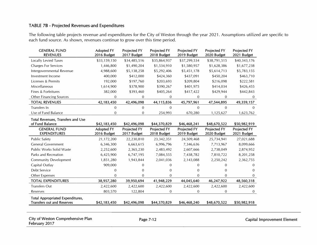
City of Weston Comprehensive Plan February 2017
Page 7-12
Capital Improvement Element
TABLE 7B - Projected Revenues and Expenditures
The following table projects revenue and expenditures for the City of Weston through the year 2021. Assumptions utilized are specific to each fund source. As shown, revenues continue to grow over this time period.
GENERAL FUND REVENUES
Adopted FY 2016 Budget
Projected FY 2017 Budget
Projected FY 2018 Budget
Projected FY 2019 Budget
Projected FY 2020 Budget
Projected FY 2021 Budget
Locally Levied Taxes
$33,159,150 $34,485,516 $35,864,937 $37,299,534 $38,791,515 $40,343,176 Charges For Services
1,446,800 $1,490,204 $1,534,910 $1,580,957 $1,628,386 $1,677,238
Intergovernmental Revenue 4,988,600 $5,138,258 $5,292,406 $5,451,178 $5,614,713 $5,783,155 Investment Income
400,000 $412,000 $424,360 $437,091 $450,204 $463,710
Licenses & Permits
192,000 $197,760 $203,693 $209,804 $216,098 $222,581 Miscellaneous
1,614,900 $378,900 $390,267 $401,975 $414,034 $426,455
Fines & Forfeitures
382,000 $393,460 $405,264 $417,422 $429,944 $442,843 Other Financing Sources
0 0 0 0 0 0
TOTAL REVENUES 42,183,450 42,496,098 44,115,836 45,797,961 47,544,895 49,359,157 Transfers In
0 0 0 0 0 0
Use of Fund Balance
0 0 254,993 670,280 1,125,627 1,623,762
Total Revenues, Transfers and Use of Fund Balance $42,183,450 $42,496,098 $44,370,829 $46,468,241 $48,670,522 $50,982,919
GENERAL FUND EXPENDITURES
Adopted FY 2016 Budget
Projected FY 2017 Budget
Projected FY 2018 Budget
Projected FY 2019 Budget
Projected FY 2020 Budget
Projected FY 2021 Budget
Public Safety
21,172,200 22,230,810 23,342,351 24,509,468 25,734,941 27,021,688 General Government
6,346,300 6,663,615 6,996,796 7,346,636 7,713,967 8,099,666
Public Works Solid Waste
2,252,600 2,365,230 2,483,492 2,607,666 2,738,049 2,874,952 Parks and Recreation
6,425,900 6,747,195 7,084,555 7,438,782 7,810,722 8,201,258
Community Development
1,851,280 1,943,844 2,041,036 2,143,088 2,250,242 2,362,755 Capital Outlay
909,000 0 0 0 0 0
Debt Service
0 0 0 0 0 0 Other Expenses
0 0 0 0 0 0
TOTAL EXPENDITURES 38,957,280 39,950,694 41,948,229 44,045,640 46,247,922 48,560,318 Transfers Out
2,422,600 2,422,600 2,422,600 2,422,600 2,422,600 2,422,600
Reserves
803,570 122,804 0 0 0 0
Total Appropriated Expenditures, Transfers out and Reserves $42,183,450 $42,496,098 $44,370,829 $46,468,240 $48,670,522 $50,982,918
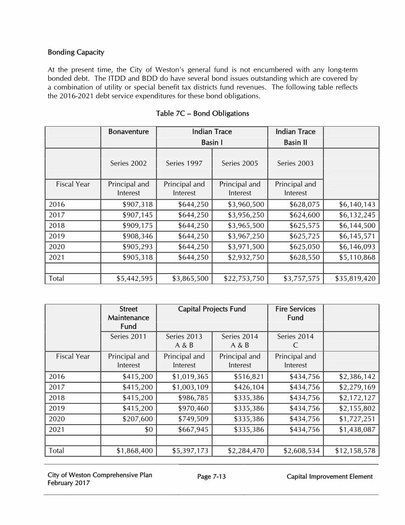
City of Weston Comprehensive Plan February 2017
Page 7-13
Capital Improvement Element
Bonding Capacity At the present time, the City of Weston’s general fund is not encumbered with any long-term bonded debt. The ITDD and BDD do have several bond issues outstanding which are covered by a combination of utility or special benefit tax districts fund revenues. The following table reflects the 2016-2021 debt service expenditures for these bond obligations.
Table 7C – Bond Obligations Bonaventure Indian Trace Indian Trace
Basin I Basin II
Series 2002 Series 1997 Series 2005 Series 2003
Fiscal Year Principal and
Interest Principal and
Interest Principal and
Interest Principal and
Interest
2016 $907,318 $644,250 $3,960,500 $628,075 $6,140,143 2017 $907,145 $644,250 $3,956,250 $624,600 $6,132,245 2018 $909,175 $644,250 $3,965,500 $625,575 $6,144,500 2019 $908,346 $644,250 $3,967,250 $625,725 $6,145,571 2020 $905,293 $644,250 $3,971,500 $625,050 $6,146,093 2021 $905,318 $644,250 $2,932,750 $628,550 $5,110,868 Total $5,442,595 $3,865,500 $22,753,750 $3,757,575 $35,819,420 Street
Maintenance Fund
Capital Projects Fund Fire Services Fund
Series 2011 Series 2013
A & B Series 2014
A & B Series 2014
C
Fiscal Year Principal and Interest
Principal and Interest
Principal and Interest
Principal and Interest
2016 $415,200 $1,019,365 $516,821 $434,756 $2,386,142 2017 $415,200 $1,003,109 $426,104 $434,756 $2,279,169 2018 $415,200 $986,785 $335,386 $434,756 $2,172,127 2019 $415,200 $970,460 $335,386 $434,756 $2,155,802 2020 $207,600 $749,509 $335,386 $434,756 $1,727,251 2021 $0 $667,945 $335,386 $434,756 $1,438,087 Total $1,868,400 $5,397,173 $2,284,470 $2,608,534 $12,158,578
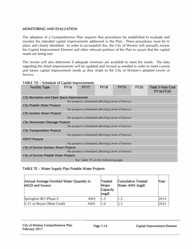
City of Weston Comprehensive Plan February 2017
Page 7-14
Capital Improvement Element
MONITORING AND EVALUATION The adoption of a Comprehensive Plan requires that procedures be established to evaluate and monitor the intended capital improvements addressed in the Plan. These procedures must be in place and clearly identified. In order to accomplish this, the City of Weston will annually review the Capital Improvement Element and other relevant portions of the Plan to assure that the capital needs are being met. The review will also determine if adequate revenues are available to meet the needs. The data regarding the listed improvements will be updated and revised as needed in order to meet current and future capital improvement needs as they relate to the City of Weston’s adopted Levels of Service. TABLE 7D – Schedule of Capital Improvements
Facility Type FY16
FY17
FY18
FY19
FY20
Total 5-Year Cost FY16-FY20
City Recreation and Open Space Improvements No projects scheduled affecting Level of Service
City Potable Water Projects No projects scheduled affecting Level of Service
City Sanitary Sewer Projects No projects scheduled affecting Level of Service
City Stormwater Drainage Projects No projects scheduled affecting Level of Service
City Transportation Projects No projects scheduled affecting Level of Service
FDOT Projects No projects scheduled affecting Level of Service
City of Sunrise Sanitary Sewer Projects No projects scheduled affecting Level of Service
City of Sunrise Potable Water Projects See Table 7E on the following page.
TABLE 7E – Water Supply Plan Potable Water Projects Annual Average Finished Water Quantity in MGD and Source
Treated Water Capacity (mgd)
Cumulative Treated Water AWS (mgd)
Year
Springtree RO (Phase I) AWS 1.5 1.5 2014 C-51 or Reuse Offset Credit AWS 1.0 2.5 2025
City of Weston Comprehensive Plan February 2017
Page 7-15
Capital Improvement Element
CAPITAL IMPROVEMENTS ELEMENT GOALS, OBJECTIVES, AND POLICIES
Goal 7 To ensure the orderly and efficient use and availability of all public services and facilities within the City of Weston that serve the existing and future populations of the City of Weston.
7.1 Objective: To develop a comprehensive and coordinated funding strategy in the adopted Capital Improvements Element to meet existing deficiencies, to accommodate desired future growth and to replace obsolete or worn-out facilities in the City of Weston.
7.1.1 Policy:
City of Weston shall maintain the local capital project review criteria which will prioritize the proposed capital improvement projects on a basis of being consistent with several factors: local comprehensive planning efforts, cost feasibility and effectiveness, size of the project and term of need, intergovernmental commitments, the ability to take advantage of other jurisdictional capital improvements and the overall budget constraints of the City of Weston.
7.1.2 Policy:
City of Weston shall recognize that capital expenditures necessary to maintain or improve the existing facilities will be given greater priority over the expansion or development of proposed facility needs.
7.1.3 Policy:
City of Weston shall prepare and adopt a Five-Year Capital Improvement Program (CIP) as part of the City of Weston’s annual budgeting process and amend the Capital Improvement Element annually to reflect these changes.
7.1.4 Policy: City of Weston shall establish and maintain budget review criteria that recognizes the need and establishes procedures necessary to fund the capital improvement programs which recognize the policies of the other Comprehensive Plan elements.
7.1.5 Policy:
Subdivision regulations established by the City of Weston shall provide for the timely completion and maintenance of the capital improvements required by the Comprehensive Plan.
City of Weston Comprehensive Plan February 2017
Page 7-16
Capital Improvement Element
7.1.6 Policy: The Schedule of Capital Improvements shall be financially feasible.
Sufficient revenues for financing capital improvements shall be available from committed funding sources for the first three years or will be available from committed or planned funding sources for years 4 and 5 of the 5-year capital improvement schedule.
7.1.7 Policy: The Schedule of Capital Improvements shall be based upon the Future Land
Use Element and consistent with all other Plan elements.
7.1.8 Policy: Coordinate planning for City of Weston improvements with the plans of
state agencies, the South Florida Water Management District (SFWMD), Broward County, the City of Sunrise and adjacent municipalities when applicable.
7.2 Objective:
City of Weston shall maintain a Concurrency Management System ensuring that development or redevelopment is approved consistent with the existing service availability or concurrent with proposed additional services. This will ensure that the intended project meets the adopted Level of Service Standards and the identified future facility needs.
7.2.1 Policy: The City of Weston shall review development and redevelopment proposals recognizing the adopted existing and proposed Level of Service Standards. The City of Weston has established a timetable for the implementation of the additional facility needs.
7.2.2 Policy: Approval of a proposed development or redevelopment project shall be contingent on the availability of the related service needs being in place concurrent with the approval at the adopted level of service standards as specified in Policy 7.2.4.
7.2.3 Policy: City of Weston shall allow phasing of development related infrastructure improvements concurrent with project impacts that occur on public facilities.
7.2.4 Policy: The Level of Service (LOS) standards for capital improvement facilities shall be as follows:
• Sanitary Sewer- 120 gallons per day per resident • Potable Water- 127 gallons per day per resident; exclusive of fire flow • Fire Flow- 1500 gallons per minute with two fire hydrants flowing full
City of Weston Comprehensive Plan February 2017
Page 7-17
Capital Improvement Element
• Solid Waste- 8.0 pounds per day/ per resident with twice weekly pick up • Drainage-Roadway Crown- elevation of a 10 year-3 day storm event • Drainage-Lowest Finish Floor- elevation of a 100 year-3 day storm event • SHS Facility, Arterial and Collector Roadways- LOS “D” (AADT and
Peak Hour (100th Highest Hour)) • Local Roadways- LOS “D” (AADT and Peak Hour (100th Highest Hour))
7.2.5 Policy: Potable water facilities must be available to serve new development at the time a certificate of occupancy is issued or guaranteed in an enforceable development agreement or development order issued pursuant to Chapter 380, F.S.
7.3 Objective: Adopt a mechanism whereby private developers participate in providing the required facility improvement, on a proportional basis determined by impact, so that the adopted level of service standards can be maintained.
7.3.1 Policy: City of Weston shall require that performance bonds or other acceptable forms of security be required for the construction of project-related capital improvements, over $10,000.00, necessary to accommodate the development or redevelopment of properties and to assure that the adopted LOS standards are met.
7.3.2 Policy: City of Weston shall institute a policy ensuring that the construction of roadway improvements required by the project to meet LOS standards occurs, rather than collection of impact fees.
7.3.3 Policy: City of Weston shall establish and maintain land development regulations that assesses new development or redevelopment on a proportionate fair-share based on impact, for the costs necessary to finance the required capital improvements in order to maintain the adopted level of service standards as outlined in Policy 7.2.4.
7.3.4 Policy: Annual update of the Capital Improvement Element shall include
proportionate- fair-share contributions.
7.3.5 Policy: Coordinate proportionate fair-share mitigation procedures and payments
with Broward County.
7.4 Objective: City of Weston shall establish a capital improvement program that can be adequately funded by projected revenues or other available funding sources.
City of Weston Comprehensive Plan February 2017
Page 7-18
Capital Improvement Element
7.4.1 Policy: City of Weston shall consider a range of revenue projections and project cost projections based on several variables with regard to the local tax base, shared tax revenues, inflation, contingency costs and the amount and source of shared project funding commitment by other government jurisdictions.
7.4.2 Policy: Establish a minimum debt service coverage of 1.2x (120%) to guide in the preservation of existing bond issues and future bond issues as contemplated by the District.
7.4.3 Policy: City of Weston shall develop and maintain an inventory of required capital
improvements necessary to address future development orders.
7.4.3 Policy: City of Weston’s capital improvement program shall recognize specific funding sources for specific projects or project categories such as developer contribution, special assessment, etc.
7.5 Objective: The City of Weston, in collaboration with the School Board, Broward County and other municipalities shall ensure that public school facilities are available for current and future students consistent with available financial resources and the adopted level of service (LOS).
7.5.1 Policy:
Consistent with policies and procedures within the Interlocal Agreement for Public School Facility Planning (ILA), the District Educational Facilities Plan (DEFP) shall contain a 5-year financially feasible schedule of capital improvements to address existing deficiencies and achieve and maintain the adopted LOS in all Concurrency Service Areas (CSA). This financially feasible schedule shall be updated on an annual basis and annually adopted into the CIE.
7.5.2 Policy: The uniform, district-wide LOS shall be 100% of gross capacity (with relocatable classrooms) for each CSA until the end of the 2018/19 school year; and commencing at the 2019/20 school year, the LOS for each CSA shall be 110% the permanent (FISH) capacity for each public elementary, middle, and high school.
7.5.3 Policy: The adopted LOS shall be applied consistently by Broward County, the municipalities and the School Board, district-wide to all schools of the same type.
City of Weston Comprehensive Plan February 2017
Page 7-19
Capital Improvement Element
7.5.4 Policy:
The School Board’s District Educational Facilities Plan (DEFP), adopted by the School Board annually, are adopted by reference into the CIE.
Capital Improvements Implementation
The City of Weston uses a variety of funding sources to implement local capital improvements. Previous financing mechanisms have included expenditure of local tax revenue, long term revenue bonds, special assessments, shared revenue and developer contributions. All of these funding sources are considered and utilized in developing funding strategies for future capital improvements in the City of Weston.
City of Weston Comprehensive Plan Page 8-1 Transportation Element February 2017
CHAPTER EIGHT
TRANSPORTATION ELEMENT INTRODUCTION
General. The purpose of the Transportation Element (TE) is to plan for a multimodal transportation system that places emphasis on public transportation. The TE Support Document provides the data and analysis used as the basis for the TE goals, objectives and policies.
The Transportation Element Support Documents are divided into four parts, the headings of which are capitalized and bolded. The parts are divided into sections, which are distinguished by underlined headings. The sections are further divided into subsections. The headings of the first and second subsection levels are bolded and italicized, respectively. Any further subsection levels are underlined and indented, as appropriate. Part I identifies the service area, the planning horizons, key terms, and acronyms. Part II addresses the data requirements and includes inventories of the general location of transportation system features; special transportation or land use features; transportation level of service (LOS) standard; capacity of significant parking facilities and duration limitations; safety considerations; air quality monitoring; and transportation and population characteristics. Part III analyzes all modes of transportation and support of the comprehensive plan. Part IV addresses TE implementation. Service Area. Roadway systems are citywide and include public roadways maintained by the City of Weston. Currently, there are no County or State roadways within the City of Weston. There are, however, several state roadways in the State Highway System (SHS) that immediately abut the City of Weston limits, which have been addressed. Bikeways are citywide and are limited to City of Weston maintained public roadways. Waterways are citywide, but are limited only to recreational waterways dedicated for public use; there are currently no navigable waterways or port facilities. Aviation is citywide but there are currently no airport facilities within the City of Weston limits. Recreational traffic is citywide. Intermodal system is area-wide.
Planning Horizon. The TE future planning horizon is 2035. The goals and objectives correspond with the 2035 planning horizon.
Definitions. For TE and its Support Document purposes, the following terms shall be defined as shown below unless the context dictates otherwise. Sources of the definitions, where available, are given in parentheses.
Action Plan. A program of transportation improvements designed to maintain and improve the capacity or reduce demand of roadway links in heavily congested areas (Guidelines for the Development of Action Plans, Broward County, 1992).
Annual average daily traffic (AADT). The volume passing a point or segment of a highway in both directions for one year divided by the number of days in the year (Level of Service Manual, Florida DOT, 2002).
City of Weston Comprehensive Plan Page 8-2 Transportation Element February 2017
Bicycle and pedestrian ways. Any road, path or way which is open to bicycle travel and traffic afoot and from which motor vehicles are excluded (Broward County Land Use Plan, 2016).
Bicycle lane. A portion of a roadway which has been designed by striping, signage, and pavement markings for the preferential or exclusive use of bicyclists (AAHSTO, 1999).
Bicycle path. A bikeway physically separated from motorized vehicular traffic by an open space or barrier and located either within the highway right-of-way or within an independent right-of-way (AAHSTO, 1999).
Bicycle route. A segment of a system of bikeways designated by the jurisdiction having authority with appropriate directional and information markers, with or without a specific bicycle route number (AASHTO, 1999).
Broward County Trafficways Plan. The plan promulgated by the Broward County Planning Council pursuant to Chapter 59-1154, Laws of Florida, as amended, and the Broward County Charter, which depicts a network of trafficways for Broward County (Land Development Code). The Broward County Trafficways Plan is a roadway right-of-way preservation plan. To accommodate the impacts of new development, right-of-way is required of developing parcels to provide for an adequate regional roadway network (Documentation of the Broward County Trafficways Plan, Broward County Planning Council,).
Carpool and vanpool. Carpool is an arrangement where two or more people share the use and cost of privately owned automobiles in traveling to and from pre-arranged destinations together, and vanpool is an arrangement which a group of passengers share the use and cost of a van in traveling to and from pre-arranged destinations together (Transportation Expressions, U.S. DOT, 1996).
Capacity. The maximum rate of flow at which persons or vehicles can be reasonably expected to traverse a point or uniform segment of a lane or roadway during a specified period under prevailing roadway, traffic, and control conditions; usually expressed as vehicles per hour or persons per hour. (Highway Capacity Manual, Special Report 209, Transportation Research Board, 2000).
Committed trip. A trip generated within the Traffic Review and Impact Planning System (TRIPS) model from an approved but not built development (Land Development Code, Broward County, 2016 ).
Concurrency. The provision of insuring that the necessary public facilities and services to maintain the adopted public transit level of service standards are available when the impacts of development occur. Roads, sanitary sewer, solid waste, drainage, potable water, parks and recreation, and public education are the only public facilities and services subject to the Broward County’s and City of Weston concurrency requirement, as applicable. Florida Statutes Section 163.3180.
City of Weston Comprehensive Plan Page 8-3 Transportation Element February 2017
Concurrency management system. The procedures or process that the City of Weston government will utilize to assure that development orders and permits are not issued unless the necessary facilities and services are available concurrent with the impacts of development (Florida Statutes 163.3180).
Constrained roadways. These are roads that cannot be expanded by the addition of two or more through-lanes because of physical, environmental or policy constraints (Level of Service Manual, Florida DOT, 2002).
De Minimis Exception. The Florida Statutes defines a De Minimis Exception to be if the impact from a proposed development would not affect more than 1/2 of 1 percent of the maximum volume at the adopted level of service of the transportation facility as determined by the local government. A proposed development may be deemed to have a de minimis impact and may not be subject to the concurrency requirements if this condition is present and all of the eight (8) exceptions listed in the Broward County Land Development Code are met (Broward County Comprehensive Plan, 2016).
Demand Response Transit Service. Non-fixed-route service utilizing vans or buses with passengers boarding and alighting at pre-arranged times at any location within the systems service area (Transit Fact Book, American Public Transit Association, 1996).
Feeder route. A transit route which has the characteristics of traveling on local streets, utilized for shorter trip lengths and transfer connections (Transportation Expressions, U.S. DOT, 1996).
Fixed-route service. Transit service provided on a repetitive, fixed-scheduled basis along a specific route, with vehicles stopping to pick-up and deliver passengers to specific locations; each fixed-route trip serves the same origins and designations, unlike demand response and taxicabs (Transportation Expressions, U.S. DOT, 1996).
Functional area coverage. A one mile corridor surrounding a bus route, one mile in each direction.
Greenway - A corridor of protected open space established for conservation, recreation or both. (A Community Resource Guide for Greenway Projects, Florida Department of Environmental Protection, Office of Greenways and Trails).
Headway. The time interval between transit revenue vehicles passing a specific location (Transportation Expressions, U.S. DOT, 1996).
Intelligent Transportation System (ITS). Electronic communications, or information processing used singly or in combination to improve the efficiency or safety of a surface transportation system (23 CFR Parts 655 and 940, Intelligent Transportation System Architecture and Standards: final rule, 2001).
Intermodal facility. An intermodal facility is a single or closely related transportation facility used by two or more modes of transportation. Intermodal system is one providing connections between different modes, such as adequate highways to ports or bus feeder services to rail transit; individual modes working together to provide the user with the best choices of services (Corridor Management Procedure, FDOT, 1996).
City of Weston Comprehensive Plan Page 8-4 Transportation Element February 2017
Level of service. A quantitative stratification of the quality of service to a typical traveler on a facility into six letter grade levels with “A” describing the highest quality and “F” describing the lowest quality. The indicated LOS standards designate lowest acceptable operating conditions for the 100th highest volume hour of the year in the predominant traffic flow direction. The 100th highest volume hour represents the typical peak hour during the peak season. Definitions and measurement criteria used for minimum LOS standards are based on the Transportation Research Board Highway Capacity Manual 2000. All LOS evaluations are to be based on the Transportation Research Board Highway Capacity Manual 2000 and the Departments 2013 Quality/Level of Service Handbook. Florida Administrative Code 14-94.
Limited access facility. A street or highway especially designed for through traffic, and over, from, or to which owners or occupants of abutting land or other persons have no right or easement of access, light, air, or view by reason of the fact that their property abuts upon such limited access facility or for any other reason. Such highways or streets may be facilities from which trucks, buses, and other commercial vehicles are excluded; or they may be facilities open to use by all customary forms of street and highway traffic. Florida Statutes Chapter 334.03
Linked trip. A trip from origin to destination on the transit system. Even if a passenger must make several transfers during a journey, the trip is counted as one linked trip on the system (Transportation Expressions, U.S. DOT, 1996).
Major public transit trip generators or attractors. Major trip generators or attractors are concentrated areas of intense land use or activity that produce or attract a significant number of local trip ends. For public transit, a site which attracts a substantial number of person trips per day. Defined here as meeting or exceeding the following thresholds: Office parks - 100,000 sq. ft. GLA; shopping centers - 500,000 sq. ft.; schools – 1,000 students; major employers - 1000 employees; health facilities - 100 beds (Broward County Comprehensive Plan, 2016 ).
Modal split. The proportion of total person trips that use each of various specified modes of transportation (Transportation Expressions, U.S. DOT, 1996).
Multimodal system. A transportation system consists of more than one mode of travel to serve transportation needs in a given area (Corridor Management Procedure, FDOT, 1996).
Paratransit. Those elements of public transit which provide service between specific origins and destinations selected by the individual user with such service being provided at a time that is agreed upon by the user and the provider of the service. Paratransit service is provided by taxis, limousines, “dial-a-ride” buses, and other demand-responsive operations that are characterized by their nonscheduled, nonfixed route nature. Florida Statutes Chapter 341.031
Planning analysis hour factors (K100). The ratio of a highway section’s volume in the year’s 100th highest volume hour to its annual average traffic volume. In developed areas the year’s 100th highest volume hour represents a typical weekday peak traffic hour during the area’s peak travel season, i.e., that area’s peak season “rush” hour, usually in the late afternoon.
City of Weston Comprehensive Plan Page 8-5 Transportation Element February 2017
The K100 factor refers to a demand volume, not necessarily a measured volume.
Public transit. The transporting of people by conveyances, or systems of conveyances, traveling on land or water, local or regional in nature, and available for use by the public. Public transit systems may be either governmentally owned or privately owned. Public transit specifically includes those forms of transportation commonly known as “paratransit.” Florida Statutes Chapter 341.031.
Recreational trip - A trip for leisure, relaxation, or enjoyment purposes, as opposed to utilitarian purposes. (Broward County Comprehensive Plan, 2016)
Right-of-way. Land in which the state, a county, or a municipality owns the fee simple title or has an easement dedicated or required for a transportation or utility use (Florida Statutes Chapter 334.03).
Roadway functional classification. The assignment of roads into categories according to the character of service they provide in relation to the total road network. Basic functional categories include limited access facilities, arterial roads, and collector roads, which may be subcategorized into principal, major or minor levels. Those levels may be further grouped into urban and rural categories.
Arterial road. A route providing service which is relatively continuous and of relatively high traffic volume, long average trip length, high operating speed, and high mobility importance. In addition, every United States numbered highway is an arterial road. Florida Statutes Chapter 334.03.
Principal arterial. A route that generally serves the major centers of activity of an urban area, the highest traffic volume corridors, and the longest trip purpose and carries a high proportion of the total urban area travel on a minimum of mileage. Such roads are integrated, both internally and between major rural connections. Florida Statutes Chapter 334.03.
Minor arterial. A route that generally interconnects with and augments an urban principal arterial road and provides service to trips of shorter length and a lower level of travel mobility. The term includes all arterials not classified as “principal” and contain facilities that place more emphasis on land access than the higher system. Florida Statutes Chapter 334.03.
Collector road. A route providing service which is of relatively moderate average traffic volume, moderately average trip length, and moderately average operating speed. Such a route also collects and distributes traffic between local roads or arterial roads and serves as a linkage between land access and mobility needs. Florida Statutes Chapter 334.03.
Local road. A route providing service which is of relatively low average traffic volume, short average trip length or minimal through-traffic movements, and high land access for abutting property. Florida Statutes Chapter 334.03.
City of Weston Comprehensive Plan Page 8-6 Transportation Element February 2017
Traffic Review and Impact Planning System, (TRIPS) Model. A computer model maintained in the Broward County Development Management Division which accounts for the traffic from approved but not built development. This amount evaluates links within the City of Weston that are monitored by Broward County. The TRIPS Models shall continue to be used to determine the roadway level of service and trips volumes associated with the development. See Committed Trip (Land Development Code, Broward County, 2016).
Transportation corridors. “Transportation corridor” means any land area designated by the state, a county, or a municipality which is between two geographic points and which area is used or suitable for the movement of people and goods by one or more modes of transportation, including areas necessary for management of access and securing applicable approvals and permits. Florida Statutes Chapter 334.03.
Transportation Demand Management (TDM). Techniques that can be used to increase the efficiency of existing transportation systems by influencing demand on the systems and by reducing the number of automobile trips during peak hours of highway use. Florida Statutes Chapter 341.031. Transportation disadvantaged. Those persons who because of physical or mental disability, income status, or age are unable to transport themselves or to purchase transportation and are, therefore, dependent upon others to obtain access to health care, employment, education, shopping, social activities, or other life-sustaining activities, or children who are handicapped or high-risk or at-risk as defined in F.S. 411.202. Florida Statutes Chapter 427.011.
Transportation System Management and Operations (TSM&O). Is defined as "an integrated program to optimize the performance of existing multimodal infrastructure through implementation of systems, services, and projects to preserve capacity and improve the security, safety, and reliability of the transportation system.” (Broward County Comprehensive Plan, 2016 / FDOT, 2016)
Trunk line. A transit route which travels longer distances, primarily along arterial roads, with few deviations (Transportation Expressions, U.S. DOT, 1996).
Acronyms and abbreviations. AADT Annual Average Daily Traffic ADA Americans with Disabilities Act ADT Average Daily Traffic ASV Annual Service Volume BCLDC Broward County Land Development Code BCT Broward County Transit CMP Congestion Management Plan CMS Concurrency Management System COE United States Army Corps of Engineers CPTED Crime Prevention through Environmental Design DEO Florida Department of Economic Opportunity DMT Broward County Division of Mass Transit
City of Weston Comprehensive Plan Page 8-7 Transportation Element February 2017
DRI Development of Regional Impact EIS Environmental Impact Statement FAA Federal Aviation Administration FAC Florida Administrative Code FAR Federal Aviation Regulation FCTD Florida Commission for the Transportation Disadvantaged FDOT Florida Department of Transportation FLL Fort Lauderdale/Hollywood International Airport FS Florida Statutes FSUTMS Florida Standard Urban Transportation Model Structure HOV High Occupancy Vehicle ITS Intelligent Transportation System LOS Level of Service MIS Major Investment Study MLW Mean Low Water mph Miles per hour MPO Metropolitan Planning Organization SHS State Highway System SIS Strategic Intermodal System SFRPC South Florida Regional Planning Council SSPP Safety System Program Plan TAZ Traffic Analysis Zone TCC Broward County Metropolitan Planning Organization’s Technical Coordinating
Committee TCRA Tri-County Commuter Rail Authority TDM Transportation Demand Management TE Transportation Element TIP Transportation Improvement Programs TOPS Transportation Options Program TRIPS Traffic Review and Impact Planning System TSM Transportation System Management USDOT United States Department of Transportation V/C Volume to Capacity ratio DATA REQUIREMENTS Chapter 163.3177(6)(b), F.S., requires the Transportation Element (TE) be based upon the following data: general location of the transportation system features; existing functional classification and maintenance responsibilities; transit trip generators and attractors; designated transportation facilities for hurricane evacuation; the existing peak hour; peak direction of level of service for roads, public transit facilities, and corridors or routes; and capacity of significant parking facilities and duration of limitations. Part II addresses the above described statute requirements. The transportation system. The transportation system encompasses the following networks: roadways, public transit, bikeways, pedestrianways, waterways, airports, railways, recreational traffic, and intermodal facilities.
Roadway network. The roadway network includes the following features: roadway
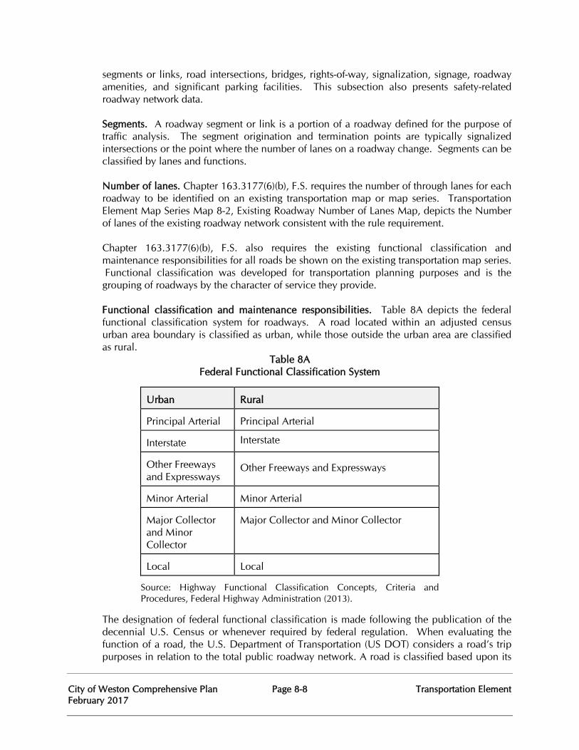
City of Weston Comprehensive Plan Page 8-8 Transportation Element February 2017
segments or links, road intersections, bridges, rights-of-way, signalization, signage, roadway amenities, and significant parking facilities. This subsection also presents safety-related roadway network data. Segments. A roadway segment or link is a portion of a roadway defined for the purpose of traffic analysis. The segment origination and termination points are typically signalized intersections or the point where the number of lanes on a roadway change. Segments can be classified by lanes and functions.
Number of lanes. Chapter 163.3177(6)(b), F.S. requires the number of through lanes for each roadway to be identified on an existing transportation map or map series. Transportation Element Map Series Map 8-2, Existing Roadway Number of Lanes Map, depicts the Number of lanes of the existing roadway network consistent with the rule requirement.
Chapter 163.3177(6)(b), F.S. also requires the existing functional classification and maintenance responsibilities for all roads be shown on the existing transportation map series. Functional classification was developed for transportation planning purposes and is the grouping of roadways by the character of service they provide.
Functional classification and maintenance responsibilities. Table 8A depicts the federal functional classification system for roadways. A road located within an adjusted census urban area boundary is classified as urban, while those outside the urban area are classified as rural.
Table 8A Federal Functional Classification System
Urban
Rural
Principal Arterial
Principal Arterial
Interstate Interstate Other Freeways and Expressways
Other Freeways and Expressways
Minor Arterial
Minor Arterial
Major Collector and Minor Collector
Major Collector and Minor Collector
Local
Local
Source: Highway Functional Classification Concepts, Criteria and Procedures, Federal Highway Administration (2013).
The designation of federal functional classification is made following the publication of the decennial U.S. Census or whenever required by federal regulation. When evaluating the function of a road, the U.S. Department of Transportation (US DOT) considers a road’s trip purposes in relation to the total public roadway network. A road is classified based upon its
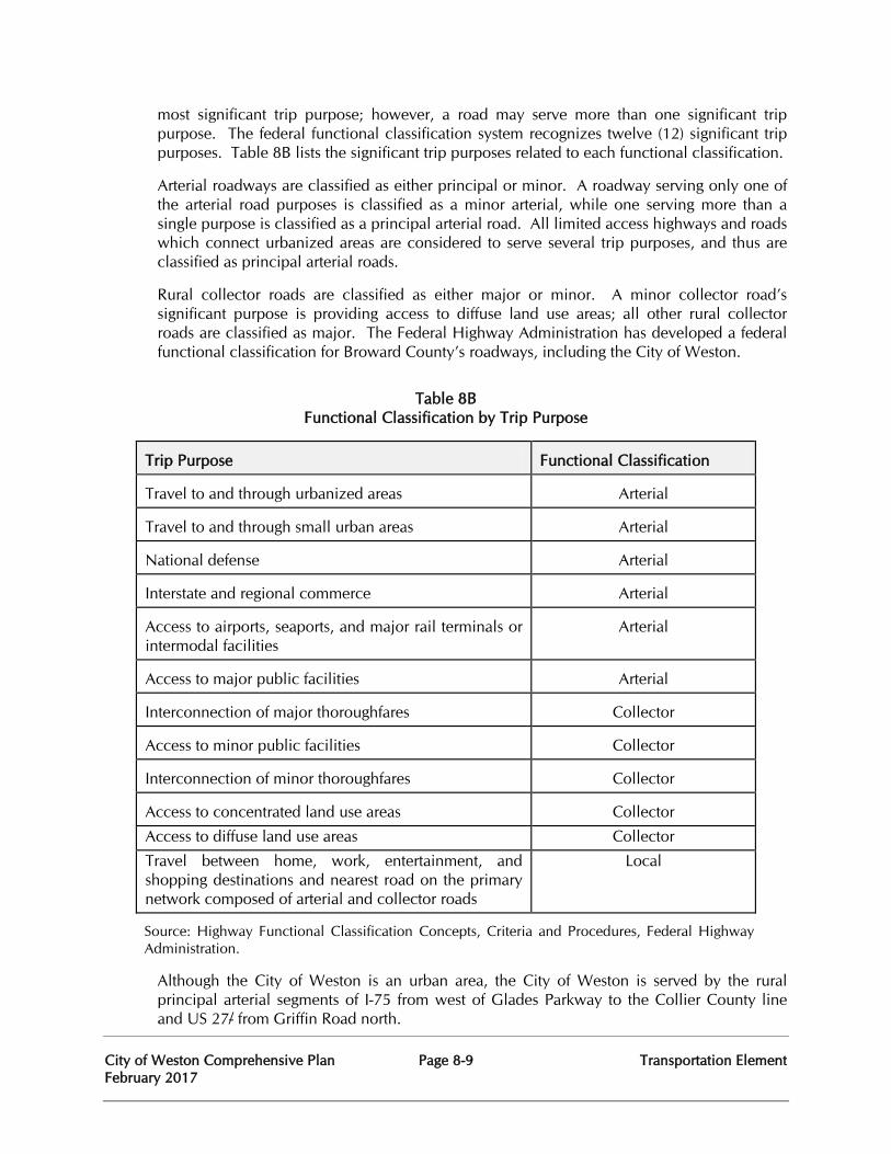
City of Weston Comprehensive Plan Page 8-9 Transportation Element February 2017
most significant trip purpose; however, a road may serve more than one significant trip purpose. The federal functional classification system recognizes twelve (12) significant trip purposes. Table 8B lists the significant trip purposes related to each functional classification.
Arterial roadways are classified as either principal or minor. A roadway serving only one of the arterial road purposes is classified as a minor arterial, while one serving more than a single purpose is classified as a principal arterial road. All limited access highways and roads which connect urbanized areas are considered to serve several trip purposes, and thus are classified as principal arterial roads.
Rural collector roads are classified as either major or minor. A minor collector road’s significant purpose is providing access to diffuse land use areas; all other rural collector roads are classified as major. The Federal Highway Administration has developed a federal functional classification for Broward County’s roadways, including the City of Weston.
Table 8B Functional Classification by Trip Purpose
Trip Purpose
Functional Classification
Travel to and through urbanized areas
Arterial
Travel to and through small urban areas
Arterial
National defense
Arterial
Interstate and regional commerce
Arterial
Access to airports, seaports, and major rail terminals or intermodal facilities
Arterial
Access to major public facilities
Arterial
Interconnection of major thoroughfares
Collector
Access to minor public facilities
Collector
Interconnection of minor thoroughfares
Collector
Access to concentrated land use areas
Collector
Access to diffuse land use areas Collector
Travel between home, work, entertainment, and shopping destinations and nearest road on the primary network composed of arterial and collector roads
Local
Source: Highway Functional Classification Concepts, Criteria and Procedures, Federal Highway Administration.
Although the City of Weston is an urban area, the City of Weston is served by the rural principal arterial segments of I-75 from west of Glades Parkway to the Collier County line and US 27/ from Griffin Road north.
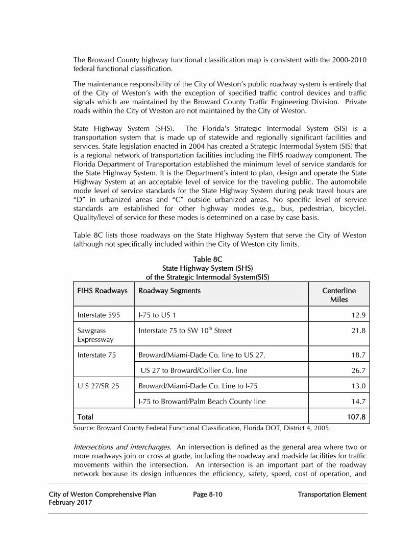
City of Weston Comprehensive Plan Page 8-10 Transportation Element February 2017
The Broward County highway functional classification map is consistent with the 2000-2010 federal functional classification.
The maintenance responsibility of the City of Weston’s public roadway system is entirely that of the City of Weston’s with the exception of specified traffic control devices and traffic signals which are maintained by the Broward County Traffic Engineering Division. Private roads within the City of Weston are not maintained by the City of Weston.
State Highway System (SHS). The Florida's Strategic Intermodal System (SIS) is a transportation system that is made up of statewide and regionally significant facilities and services. State legislation enacted in 2004 has created a Strategic Intermodal System (SIS) that is a regional network of transportation facilities including the FIHS roadway component. The Florida Department of Transportation established the minimum level of service standards for the State Highway System. It is the Department’s intent to plan, design and operate the State Highway System at an acceptable level of service for the traveling public. The automobile mode level of service standards for the State Highway System during peak travel hours are “D” in urbanized areas and “C” outside urbanized areas. No specific level of service standards are established for other highway modes (e.g., bus, pedestrian, bicycle). Quality/level of service for these modes is determined on a case by case basis. Table 8C lists those roadways on the State Highway System that serve the City of Weston (although not specifically included within the City of Weston city limits.
Table 8C State Highway System (SHS) of the Strategic Intermodal System(SIS)
FIHS Roadways
Roadway Segments
Centerline
Miles Interstate 595
I-75 to US 1
12.9
Sawgrass Expressway
Interstate 75 to SW 10th Street
21.8
Interstate 75
Broward/Miami-Dade Co. line to US 27.
18.7
US 27 to Broward/Collier Co. line
26.7
U S 27/SR 25
Broward/Miami-Dade Co. Line to I-75
13.0
I-75 to Broward/Palm Beach County line
14.7
Total
107.8
Source: Broward County Federal Functional Classification, Florida DOT, District 4, 2005.
Intersections and interchanges. An intersection is defined as the general area where two or more roadways join or cross at grade, including the roadway and roadside facilities for traffic movements within the intersection. An intersection is an important part of the roadway network because its design influences the efficiency, safety, speed, cost of operation, and
City of Weston Comprehensive Plan Page 8-11 Transportation Element February 2017
capacity of roadways.
Interchanges are designed to permit traffic to move freely from one road to another without crossing another line of traffic. Generally, two types of interchanges are currently on the FIHS that serve the City of Weston: (1) Partial Cloverleaf (PC) and (2) Diamond (D).
Bridges, overpasses and tunnels. A bridge is a structure, including supports, erected over a depression or an obstruction, such as water, a highway, or railway, which has a track or passageway for carrying traffic or other moving loads. Most bridges within the City of Weston traverse canals or lakes, and are maintained by the Indian Trace Development District.
Right-of-way. Right-of-way often is the major cost for many of the transportation improvement projects; therefore, the acquisition of the needed land should be planned far in advance of the scheduled construction time. The Broward County Trafficways Plan, administered by the Broward County Planning Council, is a roadway right-of-way preservation plan. To accommodate the impacts of new development, right-of-way is dedicated by developing parcels to provide for an adequate regional roadway network. A dedication for at least half of the roadway width that the Trafficways Plan calls for is normally required at the platting stage.
Currently there are four main classifications designated in the Trafficways Plan: limited access/controlled; arterial; collector; and one-way pair. The right-of-way width for the limited access and controlled freeways is 325 feet; for arterial roadways, it varies from 100 to 200 feet; for collector roads, it ranges from 70 to 94 feet; and for one-way pairs, the range is from 42 to 54 feet. There also is an irregular designation as well as a Context Sensitive Corridor which are subject to specific plans.
Where right-of-way cannot be dedicated as a condition of development order approval, right-of-way is acquired through condemnation. City of Weston Transportation Element Objective 8.5 and its implementing policies address right-of-way protection and preservation.
Signalization. Signalization is an important part of the roadway system. It controls the flow of traffic, therefore, it affects the traffic volume passing through a particular intersection. For isolated (that is, non-system or uncoordinated) operation, the signal type indicates the degree to which a traffic signal’s cycle length, phase plan, and phase times are preset or actuated. There are currently two types of signals in use: Actuated signals and Semi-actuated signals. Intersections that have actuated signals will have vehicle detectors for all approaches. Each phase is subject to a minimum and maximum green time and some phases may be “skipped” if no vehicle demand is detected. Intersections installed with semi-actuated signals only have detectors located on the minor street. The signal is set such that the green is always on the major street unless a vehicle is detected on the minor street. The pre-timed signal has preset sequence of phases in repetitive order. Each phase has a fixed green time and change interval that is repeated in each cycle. The Broward County Traffic Engineering Division is responsible for maintaining all signal systems in the City of Weston.
The purpose of traffic signal computerization is to optimize signal operation, thereby, providing a more efficient transportation system. Coordination of traffic signals through computerization has been recognized as one of most effective ways to improve the traffic flows.
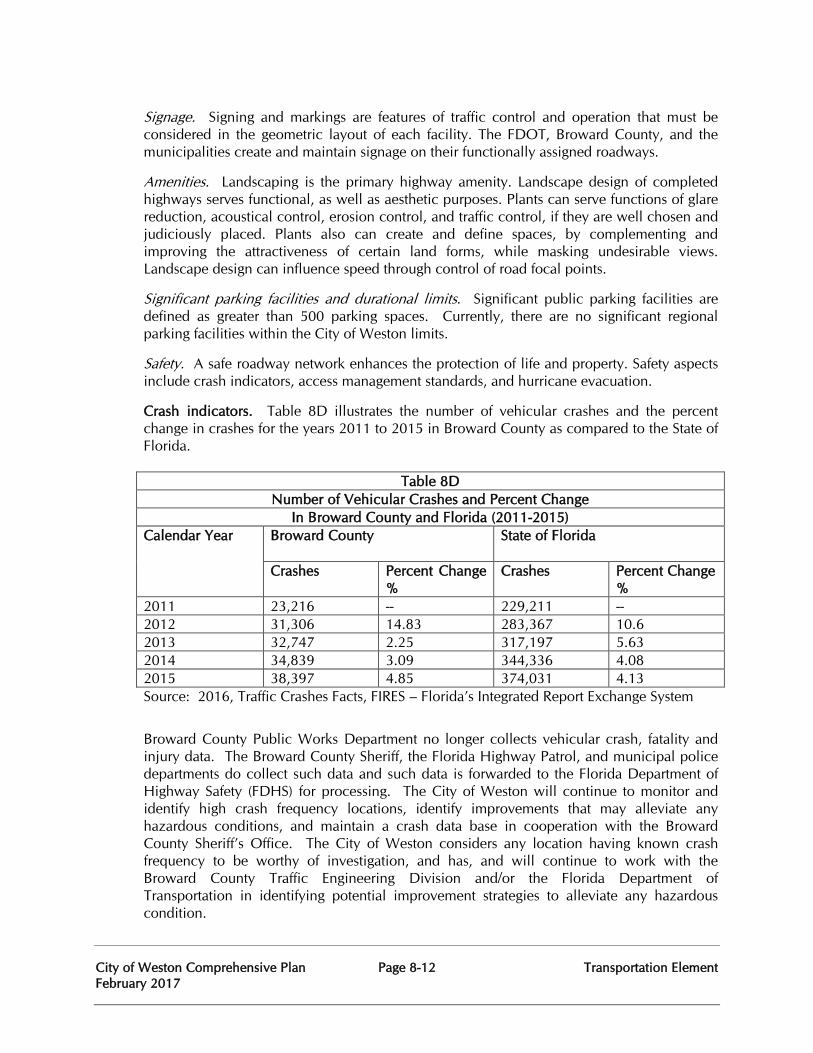
City of Weston Comprehensive Plan Page 8-12 Transportation Element February 2017
Signage. Signing and markings are features of traffic control and operation that must be considered in the geometric layout of each facility. The FDOT, Broward County, and the municipalities create and maintain signage on their functionally assigned roadways.
Amenities. Landscaping is the primary highway amenity. Landscape design of completed highways serves functional, as well as aesthetic purposes. Plants can serve functions of glare reduction, acoustical control, erosion control, and traffic control, if they are well chosen and judiciously placed. Plants also can create and define spaces, by complementing and improving the attractiveness of certain land forms, while masking undesirable views. Landscape design can influence speed through control of road focal points.
Significant parking facilities and durational limits. Significant public parking facilities are defined as greater than 500 parking spaces. Currently, there are no significant regional parking facilities within the City of Weston limits.
Safety. A safe roadway network enhances the protection of life and property. Safety aspects include crash indicators, access management standards, and hurricane evacuation.
Crash indicators. Table 8D illustrates the number of vehicular crashes and the percent change in crashes for the years 2011 to 2015 in Broward County as compared to the State of Florida.
Table 8D Number of Vehicular Crashes and Percent Change
In Broward County and Florida (2011-2015) Calendar Year Broward County
State of Florida
Crashes Percent Change %
Crashes Percent Change %
2011 23,216 -- 229,211 -- 2012 31,306 14.83 283,367 10.6 2013 32,747 2.25 317,197 5.63 2014 34,839 3.09 344,336 4.08 2015 38,397 4.85 374,031 4.13 Source: 2016, Traffic Crashes Facts, FIRES – Florida’s Integrated Report Exchange System
Broward County Public Works Department no longer collects vehicular crash, fatality and injury data. The Broward County Sheriff, the Florida Highway Patrol, and municipal police departments do collect such data and such data is forwarded to the Florida Department of Highway Safety (FDHS) for processing. The City of Weston will continue to monitor and identify high crash frequency locations, identify improvements that may alleviate any hazardous conditions, and maintain a crash data base in cooperation with the Broward County Sheriff’s Office. The City of Weston considers any location having known crash frequency to be worthy of investigation, and has, and will continue to work with the Broward County Traffic Engineering Division and/or the Florida Department of Transportation in identifying potential improvement strategies to alleviate any hazardous condition.
City of Weston Comprehensive Plan Page 8-13 Transportation Element February 2017
Access management. The City of Weston to continue maintaining land development regulations that control the connection of access points of driveways and roads to roadways consistent with FDOT, Broward County and the City of Weston areas management standards.
Hurricane evacuation. The City of Weston is located in the central-western portion of Broward County and therefore does not lie within primary evacuation areas or within the Coastal High Hazard Area. The City of Weston is served by an excellent access system to the FIHS and therefore has significant evacuation capability in the event of an emergency evacuation.
Public transit network. The public transit network, as used here, means those facilities and services used to transport the public. Map 8-6, shows the Broward County Transit public transit routes, and transfer stations located within the City of Weston.
Public transit facilities. Public transit facilities include bus terminals, transfer stations, rights-of-way, motorized vehicles (buses and vans), transit bus stops transit amenities, and other facilities.
Terminals. A terminal is any location where passengers or freight either originates, terminates, or is handled in the transportation process. Broward County has established two (2) public transit bus passenger terminals. There are no currently existing or planned transit passenger terminals located within the City of Weston.
The County’s main bus transit passenger terminal is located in downtown Fort Lauderdale, on the northwest corner of the Broward Boulevard/Brickell Avenue intersection. The bus terminal sits on an approximately three (3) acre site and can accommodate up to 24 buses simultaneously and is accessible as defined by the Americans with Disabilities Act (ADA).
The second County bus terminal is the 1.5 + acre West Broward Terminal, located at Broward Boulevard and Pine Island Road in the City of Plantation. Located approximately eight miles west of the main bus terminal, it is situated in the complex with the West Regional Library and the West Regional Courthouse. The West Broward Terminal, an ADA accessible facility, can accommodate up to nine (9) buses simultaneously and includes parking for transit commuters.
Transfer stations. A transfer station is a fixed location where passengers interchange from one route or vehicle to another. Currently, there are no existing or planned transfer stations located within the City of Weston. The closest transfer station is located northwest of the City at the Sawgrass Mills Mall at the intersection on NW 136 Avenue and Sawgrass Mills Circle.
Rights-of-way and exclusive public transit corridors. Broward County acquires additional right-of-way along major arterial roadways during the platting and roadway widening process for bus pullout bays, also called busbays. Bus pullout bays are specialized bus stop auxiliary lanes, independent of the through traffic travel lane. The busbays are designed to minimize traffic obstruction and maximize passenger safety. The City of Weston will cooperate with Broward County in the siting of potential busbay locations as part of development applications and roadway widening projects.
City of Weston Comprehensive Plan Page 8-14 Transportation Element February 2017
Exclusive public transit corridors are roadway or railway corridors exclusively designated by the FDOT or a local government for public transit, which are physically separated from general use corridors and to which access is highly restricted. There are currently no existing or planned exclusive public transit corridor within the City of Weston.
Public transit vehicles. As of May 2016, Broward County Transit (BCT) BCT has 346 fixed route buses and 82 community buses throughout the County. Vehicles are air conditioned and have kneeling mechanisms, which lower the steps of a bus to accommodate persons who have mobility impairments. Buses are equipped with wheelchair lifts for facilitating boarding and disembarking, which extend from the bus to the at-grade level of the bus stop (either sidewalk or roadway).
Public transit bus stops. As of May 2016, Broward County Transit (BCT) had 4,598 designated bus stops throughout the County. Within the City of Weston, BCT has many bus stops along Weston Road between SR-84 and Griffin Road. The City of Weston will continue to work with Broward County to improve existing and develop new bus stops consistent with Broward County objectives.
Public transit amenities. As of May 2016, Broward County Transit (BCT) had 1,043 bus shelters throughout the County. Shelters located within the City of Weston will be coordinated with Broward County in accordance with BCT standards.
Landscaping, lighting, information kiosks, and any other features intended for public transit will be included as amenities. Public transit services. Public transit services are passenger services provided by public, private or non-profit entities. They include the following surface transit modes: fixed route bus service, express route bus service, feeder bus service, demand responsive service, municipal transit service, intercounty service, and other services. Map 8-6 shows the existing fixed public transit routes and the community bus service routes.
Fixed-route bus service. The City of Weston is served by the Broward County Mass Transit Division, which operates Broward County Transit (BCT), a fixed-route bus system servicing nearly all of Broward County’s developable area. It provides service on a repetitive, fixed-schedule basis. Each fixed-route trip serves the same origins and destinations. Connections also are made to Miami-Dade County and Palm Beach County.
There are two types of fixed-routes: main and local. Main trunk lines are those routes which traverse long distances, primarily along major travel corridors. Local lines provide links and connections to the main trunk lines.
Broward County Transit provides fixed-route transit service during peak hours of week days Park-and-ride routes operate at the beginning and end of each week day. Regular routes primarily operate on 30 minute headways during the week and Saturday, 60 minutes on Sundays. Currently, there is one fixed route service in the City of Weston. The bus route #23, a north-south route provides week day, peak hour service to the City of Weston and runs along Weston Road.
City of Weston Comprehensive Plan Page 8-15 Transportation Element February 2017
Feeder bus services. Feeder bus service routes are defined as local transit service that picks up and delivers passengers to a rail transit terminal, express bus stop, transfer point, or terminal. There are currently no existing or planned feeder bus systems within the City of Weston.
Demand responsive service. Broward County funds and administers the Transportation Options Program (TOPS), which provides door-to-door service, upon request for persons with physical, cognitive, emotional, visual or other disabilities which functionally prevent them from using the Broward County Transit (BCT) fixed-route bus system either permanently or under certain conditions. This program, introduced by Broward County Transit’s Paratransit Service in December 1996, gives consumers a choice of transportation service providers.
FDOT designated public transportation corridors. The purpose of corridor designation and subsequent planning is to relieve congestion by increasing people carrying capacity through the use of high occupancy vehicles. There are currently no FDOT designated public transportation corridors within or adjacent to the City of Weston. Major public transit trip generators and attractors. Major public transit generators and attractors are concentrated areas of intense land use or activity which produce or attract a significant number of local trip ends. Public transit generators are typified by residential land uses. Public transit attractors include commercial, industrial, office, commercial recreation, educational, institutional, and transportation land uses. Ideally, public transit should connect major transit generators to major transit attractors.
Safety. Public transit safety addresses such issues as the safety certification process, transit fatalities and injuries, security surveillance at terminals and on buses, and hurricane evacuation. Because the City of Weston does not maintain such facilities, there is no relevant data to be presented.
Bicycle network. The bicycle network includes bicycle facilities and services designed to enable and encourage the use of bicycles for recreational and utilitarian purposes. Recreational trips include travel for leisure, enjoyment, or pleasure and utilitarian trips include travel for work or errands.
Bicycle facilities. Bicycle facilities include bikeways, bicycle parking racks and lockers, bicycle transport racks, and shower facilities.
Bikeways. The City of Weston has been successful in creating a bikeways network and the number of bikeways is relatively high compared to other areas within Broward County. The increased use of bikeways as a mode of transportation can further reduce morning peak hour traffic. Children biking to school can greatly affect the morning commute for motorists and reduce congestion on the roadways. Through increased security at schools and safe crossing conditions on the roadways, parents will be further encouraged to permit their children to bike or walk to school. The locations of bikeways within the City of Weston are displayed on Map 8-4, “Existing Sidewalks and Bikepaths”.
A bike path is a bikeway that is physically separated by an open space or barrier. Generally, this type of bikeway facility is not utilized within the City of Weston.
City of Weston Comprehensive Plan Page 8-16 Transportation Element February 2017
A bicycle lane is a portion of a roadway which has been designated by striping, signage, and pavement markings for the preferential or exclusive use of bicycles. Unlike bike paths, bike lanes are not physically separated from traffic. Bike lanes are the predominant bicycle facility utilized throughout the City of Weston. Generally, they consist of a five-foot wide designated lane in addition to the adjacent through lane, which has been properly signed and marked in accordance with the Manual on Uniform Traffic Control Devices and applicable Broward County Traffic Engineering Standards. These bike lanes are implemented on both sides of the roadway and are properly transitioned through intersections.
Educational programs. Bicycle education is taught in Broward County’s public schools by teachers, recreation, and law enforcement professionals trained as instructors. Bicycle education includes such topics as traffic laws and defensive riding techniques. The Broward Sheriff’s Office provides bicycle safety education as part of its community outreach.
The Broward County Bicycle Suitability Map displays bikeways and designates traffic interaction ratings, but does not designate routes. It was determined the suitability map is more advantageous than a route map because the user may choose a course of travel based upon ability and confidence. The map provides a wealth of bicycle related information including defensive riding, traffic laws, bicycle repair shops, clubs, and regional park facilities. Bicycle safety. It is known that Broward County consistently has a bicycle injury rate which is significantly higher than Miami-Dade and Palm Beach counties. In response, the City of Weston is committed to ensuring bicycle safety by the provision of designated bike lanes that meet standards and by continued bicycle education particularly for children. Bicycle crashes are always evaluated during traffic safety studies and measures to ensure clear lines of sight for cyclists (as well as pedestrians) are carefully evaluated during development reviews. The Broward Sheriff’s Office has also committed to enforcing bicycle laws, as well as issuing citations to vehicular drivers who violate or encroach upon right-of-way specifically designated for bicycle travel. Bicycle Friendly Community. In 2013, the City of Weston was designated a bronze level Bicycle Friendly Community by the League of American Bicyclists. The Bronze level Bicycle Friendly Community designation recognizes Weston’s commitment to improving conditions for bicycling through investment in Bicycling promotion, education programs, infrastructure and pro-bicycling policies. The City of Weston continues to make investments in bicycle infrastructure including being selected through a joint applicant with the City of Sunrise for a Complete Streets and other Localized Initiative Program grant which included the addition of bicycle lanes on Weston Road between Indian Trace and State Road 84.
Pedestrianways network. The pedestrianways network includes pedestrian facilities and services. Pedestrian facilities are designed to ensure safety and allow access to pedestrianways. Pedestrianways are any road, path or way open to traffic afoot and from which motor vehicles are excluded and includes such facilities as sidewalks, crosswalks, walkways, signals, median strips, curb cuts, and amenities.
Pedestrian facilities. Pedestrian facilities include significant pedestrianways, sidewalks, crosswalks, walkways, access facilities, and amenities.
City of Weston Comprehensive Plan Page 8-17 Transportation Element February 2017
Significant pedestrianways. Pedestrianways can be regionally or locally significant. The regional pedestrianway is intended to facilitate short trips, as well as longer trips in conjunction with public transit. Regionally significant pedestrianways are those pedestrian facilities on both sides of a roadway functionally classified as either a collector or arterial road. Locally significant pedestrianways are those sidewalks, walkways, and crosswalks which connect places which are not feasibly or practically accessible by automobile, such as in a downtown.
TE Map 8-4 displays The City of Weston’s significant pedestrianways. The City of Weston has regionally significant pedestrianways along several of its collector roadways such as Royal Palm Boulevard and Indian Trace. The pedestrianways are generally elevated somewhat and buffered from the adjacent travelway with green space and landscaping. These pedestrianways are also in addition to specifically designated bike lanes located along the same roadway segments.
Sidewalks. The Broward County Land Development Code requires sidewalks to be constructed adjacent to Trafficways delineated on the Broward County Trafficways Plan and all functionally classified County Collector roads. Sidewalks must be a minimum of five (5) feet-wide on both sides of all these roadways. The County requirements affect the City of Weston due to the fact that arterial roadways are on the Broward County Trafficways Plan. Adequate sidewalks are provided throughout the vast majority of the City of Weston, however, some deficiencies have been identified. Current development review procedures strive to ensure compliance with the State Accessibility Code for New Building Construction (2007) which sets forth the states accessibility requirements based on Federal ADA guidelines.
Crosswalks. Crosswalks provide pedestrians with connections between sidewalks and walkways. Crosswalks are located at intersections and mid-block locations which attract heavy pedestrian traffic, such as schools and parks. Well marked crosswalks provide safe paths for pedestrians by alerting drivers of the potential for pedestrians crossing the street. For on-site applications, crosswalks are required to delineate connections between handicapped ramps or otherwise delineate on-site accessible routes. For intersections and mid block crossings within public rights-of-way, the location and design of crosswalks fall within the jurisdiction of the Broward County Traffic Engineering Division.
Walkways. Pedestrian walkways are exterior paths with a prepared surface intended for pedestrian use. These include designated walking areas in parking lots, parking garages, plazas, and other public places. Pedestrian walkways may be marked or unmarked.
Access facilities. Pedestrian access facilities include curb cuts, ramps, bus and rail stops, signals, and median strips. Curb cuts and ramps provide accessibility for the disabled and are designed in accordance with the guidelines established by the Americans with Disabilities Act. Bus stop accessibility is discussed under the public transit component.
Pedestrian signal indications are utilized in conjunction with intersection signals to indicate to the pedestrian when it is safe to cross the street. As a matter of policy, the City of Weston requires pedestrian signal indications at all signalized intersections in conjunction with suitable pedestrian platforms and handicapped ramps. Amenities. Pedestrian amenities are primarily designed to promote a pleasurable walking
City of Weston Comprehensive Plan Page 8-18 Transportation Element February 2017
experience. Amenities include benches, fountains, landscaping, lighting, and other urban design features. In addition to aesthetics, adequate street lighting and maintenance of pedestrian sight lines are important for pedestrian safety. The standard “Weston-style” traffic signal assembly includes street light luminaires on all corners of an intersection for added visibility. Sight visibility triangles and other clear lines of sight are required to be maintained as part of the City of Weston’s Land Development Regulations and Landscaping Code. Appropriate lighting and maintenance of pedestrian sight lines are important for safety enhancement. Lighting and sight lines enable the pedestrian to spot and avoid threatening situations.
Safety. The Surface Transportation Policy Project calculates pedestrian safety rates using a numerical scale called the pedestrian danger index (PDI). The PDI is calculated on a scale of 1 to 100, with 1 being the safest city for walking and 100 the most dangerous. It is based upon the total number of pedestrian injuries and fatalities, the percent of all traffic related fatalities and injuries that are pedestrian, and the percent of commuters who walk to work. Miami-Fort Lauderdale was ranked the third most dangerous large metropolitan area for pedestrians in the United States with a PDI of 78, third to Orlando (PDI 95) and Tampa-St. Petersburg-Clearwater (PDI 87). Crash research performed by the City of Weston as part of various signal warrant analysis would tend to support that most pedestrian and bicycle accidents have been related to clear sight issues, thus further emphasizing the need for clear site lines to be closely examined and maintained as part of the development review process.
Waterway network. The City of Weston does not have any navigable waterways within its jurisdictional limits.
Airports and Railways. Currently, there are no existing or planned airports or railway facilities within the City of Weston.
Recreational traffic network. The primary intent of the recreational traffic network is to provide travel oriented passive and active outdoor recreational opportunities. The City of Weston’s recreational transportation network primarily includes bikeway facilities.
Facilities. Facilities include bikeways located within regional parks and bikeway connections between parks, schools, recreation areas and other points of interest.
Within the 102 acre regional park located in the northwest quadrant of the intersection of Saddle Club Road and South Post Road, there are 8-foot wide shared pedestrian/bicycle paths throughout the facility. More importantly, there is a designated bike lane network along much of the collector roadway system that connects the 102 acre park to other recreational areas and parks throughout the City of Weston (refer to Map 8-4).
Intermodal facilities. An intermodal facility is a facility designed to relate to two or more modes of transportation using single or closely related transportation facility and service. For purposes of the Transportation Element and intermodal facilities are categorized as either freight facilities or passenger facilities.
Facilities. Intermodal facilities include intermodal facilities of state significance, terminals, local intermodal facilities, connections, high-occupancy vehicle (HOV) lanes, and park-and-
City of Weston Comprehensive Plan Page 8-19 Transportation Element February 2017
ride facilities.
Connections. Connections refer to the access or link between transportation nodes. It is the efficiency and effectiveness of this linkage that determines the quality of intermodal transportation. The ease of interconnections between modes can have a significant impact upon the economy of a company, industry, state, region and nation. The benefits of intermodal connections include lowered transportation costs, increased economic productivity and efficiency, reduced congestion, increased return from private and public infrastructure investments, improved mobility, and reduced energy consumption. Intermodal connections can include facilities, such as roadways, railways and waterways, or services, such as bus and taxi services. These facilities and services can be further classified as freight or passenger.
Connection facilities. The City of Weston faces several challenges in terms of intermodal connectivity. The two areas that are addressed are categorized as (1) regional connectivity and (2) local connectivity.
From a regional perspective, there are no true intermodal connections located within the City of Weston. This is due in part to its geographic location, as well as the fact that there are no major airports, seaports or rail facilities located within or in near proximity to the City of Weston. The Weston Park of Commerce and the Meridian Business Campus do however, contain a significant portion of distribution facilities which utilize the surrounding intrastate network (SHS) to distribute goods from major transportation hubs, such as Port Everglades, Fort Lauderdale-Hollywood International Airport and Miami International Airport, to other destinations within the South Florida area. Therefore, the roadway links and interchange that connect the City of Weston’s local roadway network system could be considered smaller “components” of the County’s regional intermodal connection system.
In recognition of this fact, the City of Weston worked with the Florida Department of Transportation and the Broward MPO to complete interchange improvements at the Royal Palm Boulevard interchange with I-75 including improvements to the southbound I-75 off-ramp terminal with Royal Palm Boulevard.
With regard to local intermodal connectivity, the City of Weston recognizes the importance of interconnecting vehicle, pedestrian, bicycle and community transit system modes of travel on a City-wide level. As part of the City of Weston’s Land Development Regulation, and as part of the City of Weston’s Development Review Process, greater emphasis has recently been placed on pedestrian/bicycle interconnections and ensuring sites are more accessible to handicapped persons and the transportation disadvantaged. A major focus has been to ensure that better accessible routes are provided between on-site buildings and the external sidewalks system as required by Chapter 4.1.2 of the State Accessibility Code. This is to ensure that handicapped persons or transportation disadvantaged that may not have the privilege of driving their own automobile can gain access to a site via the external sidewalk system and public transit systems.
High occupancy vehicle (HOV) facilities. HOV facilities are designated for exclusive use by specified HOV vehicles (minimum 2 passengers per vehicle) and all other vehicles are expressly prohibited. The purposes of HOV lanes are to make the most of person-moving capabilities along a corridor and to provide sufficient capacity to meet future transportation demands. One way this can be accomplished is by increasing the occupancy of the vehicles
City of Weston Comprehensive Plan Page 8-20 Transportation Element February 2017
traveling on the corridor. Preferential treatment for high occupancy vehicles (HOVs) is intended to encourage the driving public to change from low to high occupancy vehicles. These high occupancy vehicles include buses, vanpools, carpools, and special vehicles for the handicapped. Multimodal interchange facilities, such as park-and-ride or ride-sharing lots, will also facilitate this mode shift.
Currently, the interstates that directly serve the City of Weston, I-75 and I-95, do not have HOV facilities.
I-75 Express Lanes. The Express lanes are currently under construction along 18 miles of the I-75 and SR 826 (Palmetto Expressway) corridors, from I-595 in Broward to just south of the SR 836 (Dolphin Expressway) in Miami-Dade. The Florida Department of Transportation (FDOT) is working together with local municipalities including the City of Weston to implement the project. The City of Weston is within Segment E (4.7 miles) which has project limits of I-595 to the north to just south of Griffin Road and is anticipated to be open by the Summer of 2017. The project includes include four variable-priced toll lanes (two in each direction in the median of I-75) with direct connections to Florida’s Turnpike and the Palmetto Expressway. New ramp connections between Florida’s Turnpike and I-75 will provide connectivity for Southwest Broward County. Additional features include the five intermediate express lane connections, transit access for Bus Rapid Transit (in cooperation with transit providers), intelligent transportation/tolling system and noise barrier walls where warranted. Express buses will connect to the 595 Express buses in Broward County and to the Palmetto Metro-Rail station in Miami-Dade County.
Transportation level of service (LOS) standard. Florida law requires transportation level of service standards be adopted for roads and public transit facilities within the local government’s jurisdiction. Level of service standards for other transportation facilities, such as bikeways and airports, are optional. The City of Weston adopts transportation LOS standards through Broward County’s Concurrency Management System to roadways and public transit intersections.
Roadway LOS standards. Roadway level of service standards have long been used in systems planning and traffic operations. The roadway level of service (LOS) standard is a qualitative assessment of the road user’s perception of the quality of flow of traffic. The LOS standard is represented by letters “A” through “F,” with “A” representing the most favorable conditions and “F” representing the least favorable. For signalized (interrupted flow) roadway segments average running speed or volume-to-capacity ratios have typically been utilized as measures of effectiveness investigating level of service. For signalized intersections, average vehicle delay is typically used to estimate levels of service.
State Highway System. Florida Statutes 163.3177 and 163.3180 requires local governments to adopt the LOS standards established by the Florida Department of Transportation by rule for facilities on the State Highway System (SHS) and the Strategic Intermodal System (SIS).
Table 8F displays the Statewide Minimum Level of Service Standards for SIS, SHS, and TRIP funded facilities pursuant to Florida Statutes 163.3177 and 163.3180.
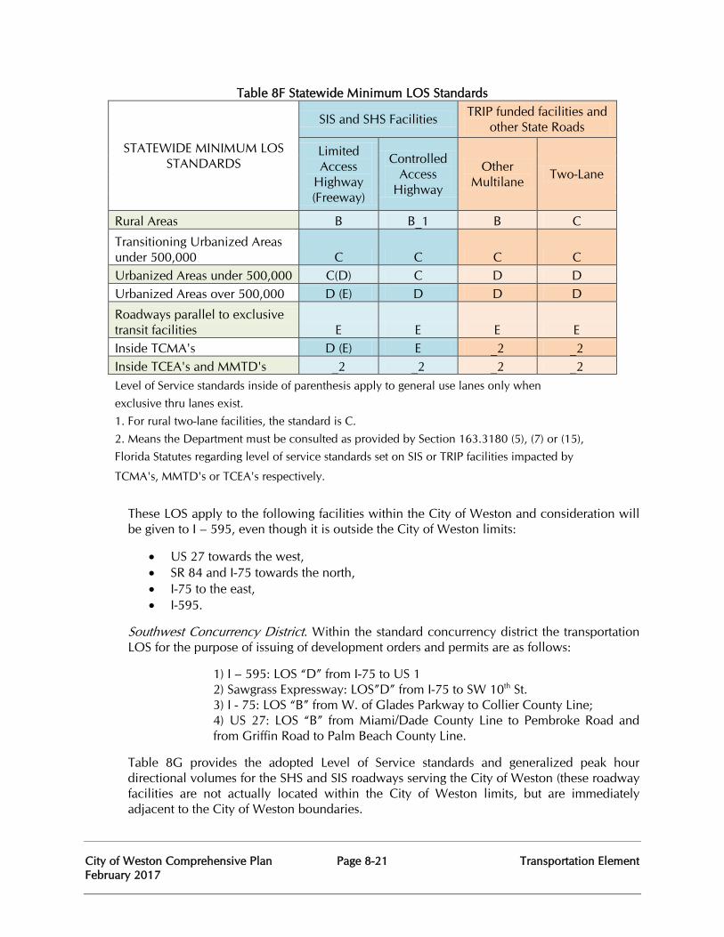
City of Weston Comprehensive Plan Page 8-21 Transportation Element February 2017
Table 8F Statewide Minimum LOS Standards
STATEWIDE MINIMUM LOS STANDARDS
SIS and SHS Facilities TRIP funded facilities and other State Roads
Limited Access
Highway (Freeway)
Controlled Access
Highway
Other Multilane Two-Lane
Rural Areas B B_1 B C
Transitioning Urbanized Areas under 500,000 C C C C Urbanized Areas under 500,000 C(D) C D D Urbanized Areas over 500,000 D (E) D D D
Roadways parallel to exclusive transit facilities E E E E Inside TCMA's D (E) E _2 _2 Inside TCEA's and MMTD's _2 _2 _2 _2 Level of Service standards inside of parenthesis apply to general use lanes only when exclusive thru lanes exist. 1. For rural two-lane facilities, the standard is C. 2. Means the Department must be consulted as provided by Section 163.3180 (5), (7) or (15), Florida Statutes regarding level of service standards set on SIS or TRIP facilities impacted by
TCMA's, MMTD's or TCEA's respectively.
These LOS apply to the following facilities within the City of Weston and consideration will be given to I – 595, even though it is outside the City of Weston limits:
• US 27 towards the west, • SR 84 and I-75 towards the north, • I-75 to the east, • I-595.
Southwest Concurrency District. Within the standard concurrency district the transportation LOS for the purpose of issuing of development orders and permits are as follows:
1) I – 595: LOS “D” from I-75 to US 1 2) Sawgrass Expressway: LOS”D” from I-75 to SW 10th St.
3) I - 75: LOS “B” from W. of Glades Parkway to Collier County Line; 4) US 27: LOS “B” from Miami/Dade County Line to Pembroke Road and from Griffin Road to Palm Beach County Line.
Table 8G provides the adopted Level of Service standards and generalized peak hour directional volumes for the SHS and SIS roadways serving the City of Weston (these roadway facilities are not actually located within the City of Weston limits, but are immediately adjacent to the City of Weston boundaries.
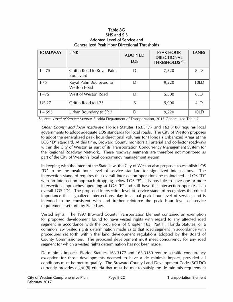
City of Weston Comprehensive Plan Page 8-22 Transportation Element February 2017
Table 8G SHS and SIS
Adopted Level of Service and Generalized Peak Hour Directional Thresholds
ROADWAY LINK ADOPTED
LOS
PEAK HOUR DIRECTIONAL
THRESHOLDS (1)
LANES
I – 75 Griffin Road to Royal Palm Boulevard
D 7,320 8LD
I-75 Royal Palm Boulevard to Weston Road
D 9,220 10LD
I –75 West of Weston Road D 5,500 6LD
US-27 Griffin Road to I-75 B 5,900 4LD
I – 595 Urban Boundary to SR 7 D 9,220 10LD
Source: Level of Service Manual, Florida Department of Transportation, 2013 Generalized Table 7.
Other County and local roadways. Florida Statutes 163.3177 and 163.3180 requires local governments to adopt adequate LOS standards for local roads. The City of Weston proposes to adopt the generalized peak hour directional volumes for Florida’s Urbanized Areas at the LOS “D” standard. At this time, Broward County monitors all arterial and collector roadways within the City of Weston as part of its Transportation Concurrency Management System for the Regional Roadway Network. These roadway segments are therefore not monitored as part of the City of Weston’s local concurrency management system.
In keeping with the intent of the State Law, the City of Weston also proposes to establish LOS “D” to be the peak hour level of service standard for signalized intersections. The intersection standard requires that overall intersection operations be maintained at LOS “D” with no intersection approach dropping below LOS “E”. It is possible to have one or more intersection approaches operating at LOS “E” and still have the intersection operate at an overall LOS “D”. The proposed intersection level of service standard recognizes the critical importance that signalized intersections play in actual peak hour level of service, and is intended to be consistent with and further reinforce the peak hour level of service requirements set forth by State Law.
Vested rights. The 1997 Broward County Transportation Element contained an exemption for proposed development found to have vested rights with regard to any affected road segment in accordance with the provisions of Chapter 163, Part II, Florida Statutes, or a common law vested rights determination made as to that road segment in accordance with procedures set forth within the land development regulations adopted by the Board of County Commissioners. The proposed development must meet concurrency for any road segment for which a vested rights determination has not been made.
De minimis impacts. Florida Statutes 163.3177 and 163.3180 require a traffic concurrency exception for those developments deemed to have a de minimis impact, provided all conditions must be met to qualify. The Broward County Land Development Code (BCLDC) currently provides eight (8) criteria that must be met to satisfy the de minimis requirement
City of Weston Comprehensive Plan Page 8-23 Transportation Element February 2017
which affect regional roadways within the City of Weston. The following are several trip generation related criteria listed in the BCLDC:
• The traffic generated by the proposed development on the overcapacity link does not exceed one-half of one (1) percent of the capacity of that link at the adopted level of service, and the total peak hour trips generated by the development assigned through any deficient intersection does not exceed more than five (5) trips.
• The cumulative impact of such exemptions shall not exceed three (3) percent of the capacity of any overcapacity link at its adopted level of service.
• The total traffic generated by the proposed development shall not exceed five hundred (500) trips per day.
• Additional de minimis conditions are as follows: for development of vacant land, residential density shall not exceed an average of 4 dwelling units per gross acre, and/or non-residential floor area shall not exceed 10% of the gross land area. For redevelopment of developed land, the number of residential units or square footage of non-residential floor area may be doubled. In addition, de minimis may not be applied to “flex” units or “reserve” units.
However, no impact will be de minimis if it would exceed 110 percent of the sum of existing volumes and the projected volumes from approved projects on a transportation facility; provided however, that an impact of a single family home on an existing lot will constitute a de minimis impact on all roadways regardless of the level of deficiency on the roadway. Further, no impact will be de minimis if it would exceed the adopted LOS standard of any affected designated hurricane evacuation routes.
Projects that promote public transportation. Section 163.3164(37), FS, projects that promote public transportation” means projects that directly affect the provisions of public transit, including transit terminals, transit lines and routes, separate lanes for the exclusive use of public transit services, transit stops (shelters and stations), office buildings or projects that include fixed-rail or transit terminals as part of the building, and projects which are transit oriented and designed to complement reasonably proximate planned or existing public facilities.
Urban redevelopment projects. Florida Statutes 163.3177 and 163.3180 provide for a proposed urban redevelopment project, located within a defined and mapped existing urban services area as established pursuant to a local government comprehensive plan, to not be subject to the traffic concurrency requirement. A previously existing development is defined in the rule as “the actual previous built use which was occupied and active within a time period established in the local government comprehensive plan.”
Constrained roadways. Constrained roadways are roads that cannot be expanded by the addition of two or more through-lanes because of physical, environmental or policy constraints. Physical constraints primarily occur when intensive land use development is immediately adjacent to roads, thus making expansion costs prohibitive. Environmental and policy constraints primarily occur when decisions are made not to expand a road based on environmental, historical, archaeological, aesthetic or social impact considerations.
City of Weston Comprehensive Plan Page 8-24 Transportation Element February 2017
Local governments are required to adopt an adequate LOS standard for constrained roadways. An adequate LOS standard is one that ensures adequate facility capacity will be provided to serve the existing and future land uses as demonstrated by the Transportation Element’s data and analysis. Establishment of a constrained roadway LOS standard, therefore, is determined on a case-by-case or road by road basis.
Concurrency Management System. The Concurrency Management System (CMS) provides the following mitigation measures when a development order or permit would cause a roadway to exceed its adopted LOS standard:
1. There is an approved action plan to accommodate the traffic impact of the development.
2. The necessary improvements to provide a LOS “D” are under construction at the time a permit is issued.
3. The necessary improvements to provide LOS “D” are the subject of a binding, executed contract for the construction of the facilities.
4. The necessary improvements for the LOS “D” have been included in the first two (2) years of the adopted state or county five-year schedule of transportation improvements and the applicable government entity makes a determination that a binding contract for the implementation of said improvements will be executed no later than the final day of the second fiscal year of the original schedule.
5. The necessary improvements for the LOS “D” have been included in the first two (2) years of the adopted municipal five-year schedule of transportation improvements and the municipality has entered into an interlocal agreement with the county, which interlocal agreement will include assurances by the municipality, upon which the County may rely, that at the time a development permit is issued, the necessary facilities and services are the subject of a binding executed contract which provides for the commencement of the actual construction of the required facilities or the provision of services within one year of the issuance of a building permit.
6. The necessary facilities and services for LOS “D” are guaranteed in an enforceable development agreement. An enforceable development agreement may include, but is not limited to, development agreements pursuant to Section 163.3220, Florida Statutes, or an agreement or development order issued pursuant to Chapter 380, Florida Statutes; provided that road improvements required by a Development of Regional Impact (DRI) development order shall not be considered for concurrency determinations for the property outside the DRI boundaries unless conditions 3., 4., 5., or 6. above apply.
7. The approved development would not cause deterioration below the 110 percent maintain level of service.
The City of Weston shall assist Broward County in addressing overcapacity roadways segments and roadway segments approaching capacity consistent with Broward County TE. The City of Weston will continue to address and participate in the municipal aspects of the following policy items:
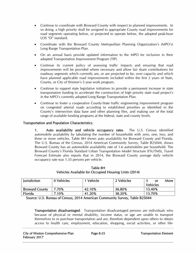
City of Weston Comprehensive Plan Page 8-25 Transportation Element February 2017
• Continue to coordinate with Broward County with respect to planned improvements. In so doing, a high priority shall be assigned to appropriate County road improvements for road segments operating below, or projected to operate below, the adopted peak-hour LOS “D” standard.
• Coordinate with the Broward County Metropolitan Planning Organization’s (MPO’s) Long Range Transportation Plan.
• On an annual basis provide updated information to the MPO for inclusion in their adopted Transportation Improvement Program (TIP).
• Continue its current policy of assessing traffic impacts and ensuring that road improvements will be provided where necessary and allow fair share contributions for roadway segments which currently are, or are projected to be, over capacity and which have planned applicable road improvements included within the first 2 years of State, County, or City of Weston’s 5 year work program.
• Continue to support state legislative initiatives to provide a permanent increase in state transportation funding to accelerate the construction of high priority state road project’s in the MPO’s currently adopted Long Range Transportation Plan.
• Continue to foster a cooperative County-State traffic engineering improvement program on congested arterial roads according to established priorities as identified in the County’s intersection data base and other planning files, and making use of the total range of available funding programs at the federal, state and county levels.
Transportation and Population Characteristics.
1. Auto availability and vehicle occupancy rates. The U.S. Census identified automobile availability by tabulating the number of households with zero, one, two, and three or more vehicles. Table 8H shows auto availability for Broward County and Florida. The U.S. Bureau of the Census, 2014 American Community Survey, Table B25044, shows Broward County has an automobile availability rate of 1.6 automobiles per household. The Broward County’s Florida Standard Urban Transportation Model Structure (FSUTMS), Travel Forecast Estimate also reports that in 2014, the Broward County average daily vehicle occupancy rate was 1.35 persons per vehicle.
Table 8H
Vehicles Available for Occupied Housing Units (2014) Jurisdiction 0 Vehicles 1 Vehicle 2 Vehicles 3 or More
Vehicles Broward County 7.70% 42.10% 36.80% 13.40% Florida 7.10% 41.20% 38.20% 13.70% Source: U.S. Bureau of Census, 2014 American Community Survey, Table B25044
Transportation disadvantaged. Transportation disadvantaged persons are individuals who because of physical or mental disability, income status, or age are unable to transport themselves to or purchase transportation and are, therefore dependent upon others to obtain access to health care, employment, education, shopping, social activities, or other life-
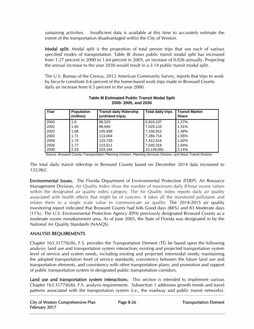
City of Weston Comprehensive Plan Page 8-26 Transportation Element February 2017
sustaining activities. Insufficient data is available at this time to accurately estimate the extent of the transportation disadvantaged within the City of Weston. Modal split: Modal split is the proportion of total person trips that use each of various specified modes of transportation. Table 8I shows public transit modal split has increased from 1.27 percent in 2000 to 1.64 percent in 2005, an increase of 0.026 annually. Projecting the annual increase to the year 2030 would result in a 3.14 public transit modal split. The U.S. Bureau of the Census, 2012 American Community Survey, reports that trips to work by bicycle constitute 0.6 percent of the home-based work trips made in Broward County daily an increase from 0.5 percent in the year 2000.
Year Population Transit daily Ridership Total daily trips Transit Market (million) (unlinked trips) Share 2000 1.6 86,523 6,816,107 1.27% 2001 1.65 98,940 7,029,110 1.41% 2002 1.68 105,938 7,156,912 1.48% 2003 1.71 113,004 7,284,714 1.55% 2004 1.74 119,729 7,412,516 1.62% 2005 1.77 123,511 7,540,318 1.64% 2030 2.33 319,184 10,149,991 3.14% Source: Broward County Transportation Planning Division, Planning Services Division, and Mass Transit Division
Table 8I Estimated Public Transit Modal Split2000- 2005, and 2030
The total daily transit ridership in Broward County based on December 2014 data increased to 132,062. Environmental Issues. The Florida Department of Environmental Protection (FDEP), Air Resource Management Division, Air Quality Index show the number of maximum daily 8-hour ozone values within the designated air quality index category. The Air Quality Index reports daily air quality associated with health effects that might be of concern. It takes all the monitored pollutants and relates them to a single scale value to communicate air quality. The 2014-2015 air quality monitoring report indicated that Broward County had 646 Good days (88%) and 83 Moderate days (11%). The U.S. Environmental Protection Agency (EPA) previously designated Broward County as a moderate ozone nonattainment area. As of June 2005, the State of Florida was designated in by the National Air Quality Standards (NAAQS).
ANALYSIS REQUIREMENTS
Chapter 163.3177(6)(b), F.S. provides the Transportation Element (TE) be based upon the following analysis: land use and transportation system interaction; existing and projected transportation system level of service and system needs, including existing and projected intermodal needs; maintaining the adopted transportation level of service standards; consistency between the future land use and transportation elements, and consistency with other transportation plans; and promotion and support of public transportation system in designated public transportation corridors.
Land use and transportation system interactions. This section is intended to implement various Chapter 163.3177(6)(b), F.S. analysis requirements. Subsection 1 addresses growth trends and travel patterns associated with the transportation system (i.e., the roadway and public transit networks).
City of Weston Comprehensive Plan Page 8-27 Transportation Element February 2017
Subsection 2 focuses on the adequacy of the transportation system for evacuation consistent with the requirements of Florida Statutes. Subsection 3 looks at the availability of the transportation system to serve existing land uses as required by Florida Statutes. Subsection 4 addresses land use compatibility around airports consistent with Chapter 163.3177(6)(b), F.S.
Regional Growth Trends and Travel Patterns
• Connections to I-75/SR 84 from Glades Parkway, Indian Trace and Bonaventure Boulevard will continue to be important as well as connections to I-75 (north/south) from Royal Palm Boulevard.
• The City of Weston is faced with the dilemma of accommodating the combination of outbound home-based work trips with inbound work trips to the commercial and industrial areas during the morning peak hour and accommodating the combination inbound returning home trips with outbound trips from the commercial and industrial areas during the afternoon peak hour. The critical point at which these opposing travel flows meet is at the intersection of Weston Road and Royal Palm Boulevard, which is immediately west of the Royal Palm Boulevard interchange with I-75. This area has been the subject of much analysis and evaluation.
• Based on future year forecasts, the intersection of Royal Palm Boulevard and Weston Road, as well as the I-75 interchange with Royal Palm Boulevard will continue to be an area of critical transportation concern.
Local Land Use and Transportation Systems Interactions
• Industrial/office/commercial developments which have the potential to generate substantial amounts of heavy commercial and industrial traffic (truck traffic) have been appropriately located in close proximity to SHS interchange (e.g. I-75 (north/south)/Glades Parkway and SR 84 (I-75 east/west)/Royal Palm Boulevard. This type of traffic is primarily regional or interstate in nature, and therefore requires access to the FIHS - trips of this kind could not be reasonably accomplished solely on the collector or arterial network.
• Retail and business uses have been centrally located within the interior of the residential components in order for local home-based shopping and business trips to occur on the local roadways and collector streets within the community. This has generally reduced trips on the regional arterial network and significantly reduced the potential for using the FIHS for shorter length trip making.
• Public schools have been located with access to at least two adjacent roadways and are generally located such that student drop-off and pick-up can be made as a pass-by trip associated with other types of trips. School speed zones, pedestrian routes, sidewalks and traffic signals (including school zone flashers) have been implemented to assist in school accessibility via pedestrian and bicycle facilities.
• Residential subdivisions are generally served by interior sidewalk systems and accessible routes, which then connect to external pedestrian and bicycle facilities. Although many of the subdivisions within the City of Weston are gated, there have been requests for traffic calming measures to be implemented within only a few subdivisions primarily due to speeding (as cut-through traffic obviously is not an issue in a gated community.
City of Weston Comprehensive Plan Page 8-28 Transportation Element February 2017
• More emphasis has been placed on reducing the need for vehicular tripmaking between uses within the same mixed-use development. City of Weston staff has recognized that some prior developments have fallen short in providing non-vehicular connectivity between projects within walking or bicycling distance of each other. Certain desirable aspects of the City of Weston’s land development regulations, such as landscaping, bufferyards and strict parking requirements can be counterproductive to interconnectivity by inadvertently creating pedestrian barriers between parcels. As part of the development review process, there has been a greater focus in working with site planners and landscape architects to establish better pedestrian accessibility between adjoining parcels and the surrounding transportation network.
Availability of transportation facilities and service to serve existing land use. Availability, as used here, refers to the extent to which the transportation system provides access to serve existing land uses. Access to serve existing land uses requires an extensive network of connections. Roadways, public transit, bikeways, and pedestrianways are transportation modes that require an extensive network of connections in order to serve existing uses. Some transportation modes, such as waterways, railways and the recreational traffic network, have limited connections and do not serve the primary function of serving or providing access to existing land uses. Still other transportation modes, such as airports and related facilities and intermodal facilities, are in essence transportation hubs serving regions. Consequently, this section addresses availability of the roadway, public transit, bikeways, and pedestrianways networks to serve existing land use.
Roadway network. The availability of the roadway network to service existing land uses is primarily a function of the existing local roadway system. Access from new developments onto State Roads is governed by Rule Chapters 14-96 and 14-97, F.A.C., pertaining to permitting and access management which has been in effect since 1993. Access from new development onto non-State Broward County trafficways is governed by Chapter 5-195(b) of the Broward County Land Development Code, with the location and configuration of access points being determined generally at the platting stage. Access points for local roads within the City of Weston have been in accordance with the local roadway requirements in the Weston Land Development Code.
Public transit network. Availability of public transit to service existing land uses is based on the functional area coverage of the existing fixed-route bus network. Functional area coverage is defined as a ½ mile corridor surrounding a bus route, ¼ mile in each direction. The ¼ mile radius is based upon studies showing a person would walk up to ¼ mile to access the public transit network. As stated earlier, the City of Weston defaults to BCT which employs functional area coverage as the public transit LOS standard. The BCT provides service to 410 square miles within Broward County. Additionally, the BCT has 346 fixed route buses and 82 community buses which serve 41.5 million passenger trips annually.
The Americans with Disabilities Act (ADA) requires that BCT, as an operator of a fixed-route bus system, offer complementary service to persons with disabilities who are unable to use the fixed-route system. A complementary paratransit service should operate at the level of service comparable to what is provided to persons without disabilities who use the fixed-route system. Since 1996, Broward County Transit has been in full compliance with the six (6) service criteria established by the ADA. BCT continues to meet or exceed service requirements mandated in the ADA legislation. Efforts to coordinate service delivery with Miami-Dade and Palm Beach Counties are ongoing in order to meet growing demand of
City of Weston Comprehensive Plan Page 8-29 Transportation Element February 2017
inter-county trips.
Bikeways network. Availability of the bikeways network to serve existing land uses can be defined by the functional area coverage for utilitarian bicycle trips, which can be categorized as a two (2) mile radius from the point of trip origination. The two (2) mile radius was derived from a special tabulation of the 2009 Nationwide Household Travel Survey which found that 72 percent of the work trips by bicycle are two (2) miles or less; the comparable figure for shopping trips is 87 percent.
The availability of the bikeways network to serve existing land within the City of Weston is relatively high compared to other areas of the County. When the utilitarian bicycle functional area coverage is merged with public transit functional area coverage, the availability of bicycles to serve existing land uses increases substantially. This link between the bicycle and public transit is possible because BCT and Tri-Rail provide bicycle storage racks on their vehicles.
For the majority of students, bicycling and walking are the only available type of independent transportation. Removing the barriers to bicycling for this segment of the cycling population has the potential for reducing peak hour traffic. School related traffic has been cited as one of the predominant contributions towards morning peak hour traffic congestion within the City of Weston.
Some concerns regarding students walking or bicycling to and from school are bicycle theft and hazardous walking conditions. These can be minimized through facility or site improvements. The City of Weston will continue to strive to provide adequate bicycle routes to the school sites located throughout Weston. The vast majority of schools are currently served by at least one traffic signal and also by school zone flashers to provide safe street crossings for the children.
Pedestrianways. Availability of pedestrian ways to service existing land uses is primarily a function of the functional area coverage of the existing pedestrianway. As noted in the public transit availability discussion, the distance a person would be willing to walk is approximately ¼ mile. Since this distance is so small, the pedestrianway network should be geared toward improving access to the public transit network and improving connections within compact mixed use areas.
Adequacy of transportation system for evacuation. The City of Weston does not lie within a category 1 or 2 hurricane evacuation area, and because of its geographic location, does not have any Coastal High Hazard areas within its boundaries. Broward County Coastal Management Element’s Natural Disaster Component addresses evacuation under Category three (3), four (4), and five (5) hurricanes. Three critical evacuation factors include the adequacy of evacuation routes, transportation and hazard route constraints, and evacuation time.
Evacuation Routes. Should an emergency evacuation of the City of Weston be necessary, such as in the event of a major hurricane or other emergency, it is anticipated that the evacuating flows would predominantly be to the northwest via SR-84/I-75 or to the northeast via I-75/Sawgrass Expressway (SR-869). To a lesser extent, there may also be evacuation to northbound Florida’s Turnpike or possibly northbound I-95 via eastbound SR-84/I-595. The following intersections and interchanges are therefore considered critical nodes for
City of Weston Comprehensive Plan Page 8-30 Transportation Element February 2017
emergency evacuation.
• SR-84/I-75 (east/west) - Glades Parkway (signalized) - Indian Trace (signalized) - Bonaventure Boulevard (signalized) - Weston Road (signalized)
• I-75 (north/south) - Royal Palm Boulevard (interchange)
Another important consideration during an evacuation is the ability to have override capability or the ability to implement special signal timing and/or phasing for signalized intersection in order to accommodate the highly directional flows. The City of Weston will continue to coordinate with Broward County regarding traffic signals in Weston and the County’s computerized system in order to allow for remote capabilities for implementing special signal timing/ phasing changes from a central controller.
Transportation and Hazard Constraints on Routes. Transportation constraints include the number of lanes and the availability of bridges to evacuate the population Hazard constraints include debris and sand, flooding, and falling objects, such as utility poles causing road blockages, which restrict vehicular movement from the evacuation areas. There are no known transportation constraints that would affect the evacuating population, with the possible exception of signalized intersection constraints. The most likely hazard constraints would be related to fallen trees or landscaping debris as most of the electric utilities in the City of Weston are underground, with the exception of the Bonaventure area.
Evacuation Time. The South Florida Regional Planning Council completed a regional study on hurricane evacuation. This was updated through the Statewide Regional Evacuation Study Program in 2015. Clearance time is the time required to clear all vehicles from the roadway system during an evacuation. The area requiring evacuation during a Category 1 and Category 2 storm is identified in the Coastal Management Element’s Natural Disaster Component. Because the City of Weston is not within the Category 1 and 2 Hurricane Evacuation areas, it is not impacted by the above restricting points. The area requiring evacuation during a Storm Category 3 and Storm Categories 4 and 5 are identified in the Broward County’s Coastal Management Element’s Natural Disaster Component. As indicated by the above table, the City of Weston is not directly impacted by any of the above referenced restricting points. The point closest to the City of Weston, SR-84/Griffin/Stirling/Sheridan Street, has the lowest clearance time to Palm Beach County. The Statewide Regional Evacuation Study updated the Regional Evacuation Transportation Analysis in 2015. The clearance times provided included Clearance Times to Shelter, In-County Clearance Times, Out-of-County Clearance Times and Regional Clearance Times. Table 8.J and 8.K. depict these clearance times for the base scenarios.
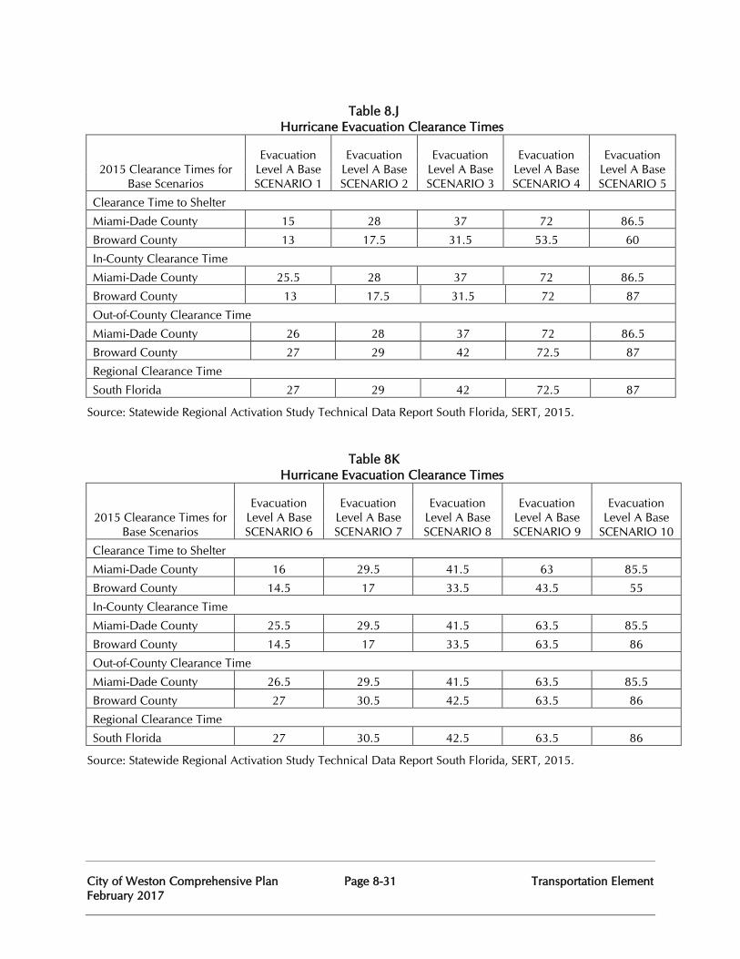
City of Weston Comprehensive Plan Page 8-31 Transportation Element February 2017
Table 8.J
Hurricane Evacuation Clearance Times
2015 Clearance Times for Base Scenarios
Evacuation Level A Base SCENARIO 1
Evacuation Level A Base SCENARIO 2
Evacuation Level A Base SCENARIO 3
Evacuation Level A Base SCENARIO 4
Evacuation Level A Base SCENARIO 5
Clearance Time to Shelter
Miami-Dade County 15 28 37 72 86.5
Broward County 13 17.5 31.5 53.5 60
In-County Clearance Time
Miami-Dade County 25.5 28 37 72 86.5
Broward County 13 17.5 31.5 72 87
Out-of-County Clearance Time
Miami-Dade County 26 28 37 72 86.5
Broward County 27 29 42 72.5 87
Regional Clearance Time
South Florida 27 29 42 72.5 87
Source: Statewide Regional Activation Study Technical Data Report South Florida, SERT, 2015.
Table 8K Hurricane Evacuation Clearance Times
2015 Clearance Times for Base Scenarios
Evacuation Level A Base SCENARIO 6
Evacuation Level A Base SCENARIO 7
Evacuation Level A Base SCENARIO 8
Evacuation Level A Base SCENARIO 9
Evacuation Level A Base
SCENARIO 10
Clearance Time to Shelter
Miami-Dade County 16 29.5 41.5 63 85.5
Broward County 14.5 17 33.5 43.5 55
In-County Clearance Time
Miami-Dade County 25.5 29.5 41.5 63.5 85.5
Broward County 14.5 17 33.5 63.5 86
Out-of-County Clearance Time
Miami-Dade County 26.5 29.5 41.5 63.5 85.5
Broward County 27 30.5 42.5 63.5 86
Regional Clearance Time
South Florida 27 30.5 42.5 63.5 86
Source: Statewide Regional Activation Study Technical Data Report South Florida, SERT, 2015.
City of Weston Comprehensive Plan Page 8-32 Transportation Element February 2017
Compatibility around airports. The City of Weston does not have any existing or future planned airport facilities. Energy Conservation and Reduction of Greenhouse Gas Emissions. The Broward County Land Development Code requires sidewalks to be constructed adjacent to Trafficways delineated on the Broward County Trafficways Plan and all functionally classified County Collector roads. Sidewalks must be a minimum of five (5) feet-wide on both sides of all these roadways. The County requirements affect the City of Weston due to the fact that most of the significant roadways are on the Broward County Trafficways Plan. Adequate sidewalks are provided throughout the vast majority of the City of Weston. The City of Weston has also been successful in creating a bikeways network and the number of bikeways is relatively high compared to other areas within Broward County. Bike lanes are the predominant bicycle facility utilized throughout the City of Weston. Generally, they consist of a five-foot wide designated lane in addition to the adjacent through lane, which has been properly signed and marked in accordance with the Manual on Uniform Traffic Control Devices and applicable Broward County Traffic Engineering Standards. These bike lanes are implemented on both sides of City of Weston roadways and are properly transitioned through intersections. There are over 105,000 linear feet of designated bike lanes along roadways within the City of Weston. The number of bikeways is relatively high compared to other areas within Broward County. There are also sidewalks installed throughout nearly the entire City of Weston. Over 140,400 linear feet of roadways have 5 foot wide sidewalks installed along both sides of the road. Approximately 28,200 linear feet of roadway has a 6.5 foot wide sidewalk installed along one side of the road.
Broward County monitors all arterial and collector roadways within the City of Weston as part of its Transportation Concurrency Management System for the Regional Roadway Network increasing energy efficiency and consideration of impacts of development on the roadway network. The City of Weston shall continue to maintain pedestrian and bicycle facilities and the efficiency of the roadway system throughout the City of Weston in order to promote energy conservation.
Existing transportation system level of service and system needs. Chapter 163.3177(6)(b), F.S. requires the analysis of the existing transportation levels of service (LOS) and system needs to be based on the following data: existing design and operating capacities; most recently available estimates for peak hour vehicle trips; existing modal split and vehicle occupancy rates; existing public transit facilities; population characteristics; and the existing characteristics of the major trip generators and attractors within the community. This description makes clear that the existing transportation system analysis is to focus on only two (2) transportation modes: roadways and public transit. Other transportation modes are addressed under the section on future transportation system level of service and system needs.
Roadways network. To assess the capacity of existing roadways to serve the existing land use, a level of service analysis was performed. Peak hour two-way volumes were obtained from the Broward County Metropolitan Planning Organization’s (MPO’s) published document "Roadway Capacity and Level of Service Analysis for 2013 & 2035" dated
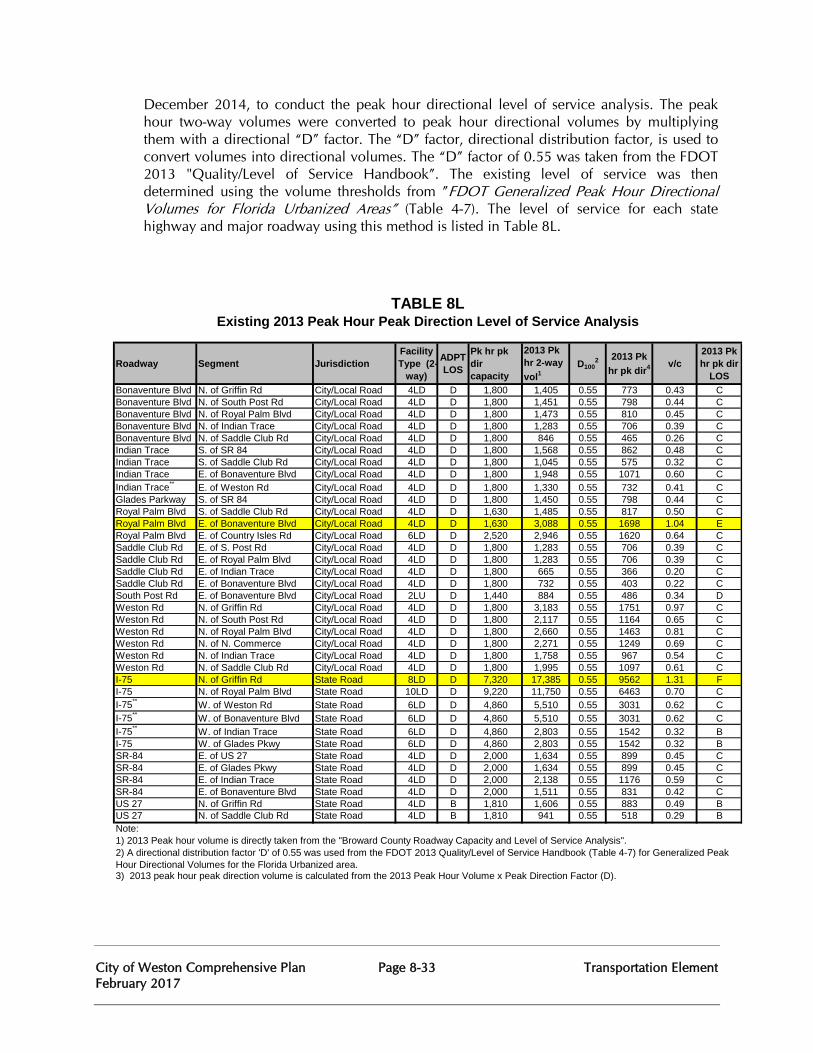
City of Weston Comprehensive Plan Page 8-33 Transportation Element February 2017
December 2014, to conduct the peak hour directional level of service analysis. The peak hour two-way volumes were converted to peak hour directional volumes by multiplying them with a directional “D” factor. The “D” factor, directional distribution factor, is used to convert volumes into directional volumes. The “D” factor of 0.55 was taken from the FDOT 2013 "Quality/Level of Service Handbook”. The existing level of service was then determined using the volume thresholds from ”FDOT Generalized Peak Hour Directional Volumes for Florida Urbanized Areas” (Table 4-7). The level of service for each state highway and major roadway using this method is listed in Table 8L.
Roadway Segment JurisdictionFacility Type (2-
way)
ADPT LOS
Pk hr pk dir capacity
2013 Pk hr 2-way vol1
D1002 2013 Pk
hr pk dir4 v/c2013 Pk hr pk dir
LOS Bonaventure Blvd N. of Griffin Rd City/Local Road 4LD D 1,800 1,405 0.55 773 0.43 CBonaventure Blvd N. of South Post Rd City/Local Road 4LD D 1,800 1,451 0.55 798 0.44 CBonaventure Blvd N. of Royal Palm Blvd City/Local Road 4LD D 1,800 1,473 0.55 810 0.45 CBonaventure Blvd N. of Indian Trace City/Local Road 4LD D 1,800 1,283 0.55 706 0.39 CBonaventure Blvd N. of Saddle Club Rd City/Local Road 4LD D 1,800 846 0.55 465 0.26 CIndian Trace S. of SR 84 City/Local Road 4LD D 1,800 1,568 0.55 862 0.48 CIndian Trace S. of Saddle Club Rd City/Local Road 4LD D 1,800 1,045 0.55 575 0.32 CIndian Trace E. of Bonaventure Blvd City/Local Road 4LD D 1,800 1,948 0.55 1071 0.60 CIndian Trace** E. of Weston Rd City/Local Road 4LD D 1,800 1,330 0.55 732 0.41 CGlades Parkway S. of SR 84 City/Local Road 4LD D 1,800 1,450 0.55 798 0.44 CRoyal Palm Blvd S. of Saddle Club Rd City/Local Road 4LD D 1,630 1,485 0.55 817 0.50 CRoyal Palm Blvd E. of Bonaventure Blvd City/Local Road 4LD D 1,630 3,088 0.55 1698 1.04 ERoyal Palm Blvd E. of Country Isles Rd City/Local Road 6LD D 2,520 2,946 0.55 1620 0.64 CSaddle Club Rd E. of S. Post Rd City/Local Road 4LD D 1,800 1,283 0.55 706 0.39 CSaddle Club Rd E. of Royal Palm Blvd City/Local Road 4LD D 1,800 1,283 0.55 706 0.39 CSaddle Club Rd E. of Indian Trace City/Local Road 4LD D 1,800 665 0.55 366 0.20 CSaddle Club Rd E. of Bonaventure Blvd City/Local Road 4LD D 1,800 732 0.55 403 0.22 CSouth Post Rd E. of Bonaventure Blvd City/Local Road 2LU D 1,440 884 0.55 486 0.34 DWeston Rd N. of Griffin Rd City/Local Road 4LD D 1,800 3,183 0.55 1751 0.97 CWeston Rd N. of South Post Rd City/Local Road 4LD D 1,800 2,117 0.55 1164 0.65 CWeston Rd N. of Royal Palm Blvd City/Local Road 4LD D 1,800 2,660 0.55 1463 0.81 CWeston Rd N. of N. Commerce City/Local Road 4LD D 1,800 2,271 0.55 1249 0.69 CWeston Rd N. of Indian Trace City/Local Road 4LD D 1,800 1,758 0.55 967 0.54 CWeston Rd N. of Saddle Club Rd City/Local Road 4LD D 1,800 1,995 0.55 1097 0.61 CI-75 N. of Griffin Rd State Road 8LD D 7,320 17,385 0.55 9562 1.31 FI-75 N. of Royal Palm Blvd State Road 10LD D 9,220 11,750 0.55 6463 0.70 CI-75** W. of Weston Rd State Road 6LD D 4,860 5,510 0.55 3031 0.62 CI-75** W. of Bonaventure Blvd State Road 6LD D 4,860 5,510 0.55 3031 0.62 CI-75** W. of Indian Trace State Road 6LD D 4,860 2,803 0.55 1542 0.32 BI-75 W. of Glades Pkwy State Road 6LD D 4,860 2,803 0.55 1542 0.32 BSR-84 E. of US 27 State Road 4LD D 2,000 1,634 0.55 899 0.45 CSR-84 E. of Glades Pkwy State Road 4LD D 2,000 1,634 0.55 899 0.45 CSR-84 E. of Indian Trace State Road 4LD D 2,000 2,138 0.55 1176 0.59 CSR-84 E. of Bonaventure Blvd State Road 4LD D 2,000 1,511 0.55 831 0.42 CUS 27 N. of Griffin Rd State Road 4LD B 1,810 1,606 0.55 883 0.49 BUS 27 N. of Saddle Club Rd State Road 4LD B 1,810 941 0.55 518 0.29 BNote:
TABLE 8LExisting 2013 Peak Hour Peak Direction Level of Service Analysis
3) 2013 peak hour peak direction volume is calculated from the 2013 Peak Hour Volume x Peak Direction Factor (D).
1) 2013 Peak hour volume is directly taken from the "Broward County Roadway Capacity and Level of Service Analysis". 2) A directional distribution factor 'D' of 0.55 was used from the FDOT 2013 Quality/Level of Service Handbook (Table 4-7) for Generalized Peak Hour Directional Volumes for the Florida Urbanized area.
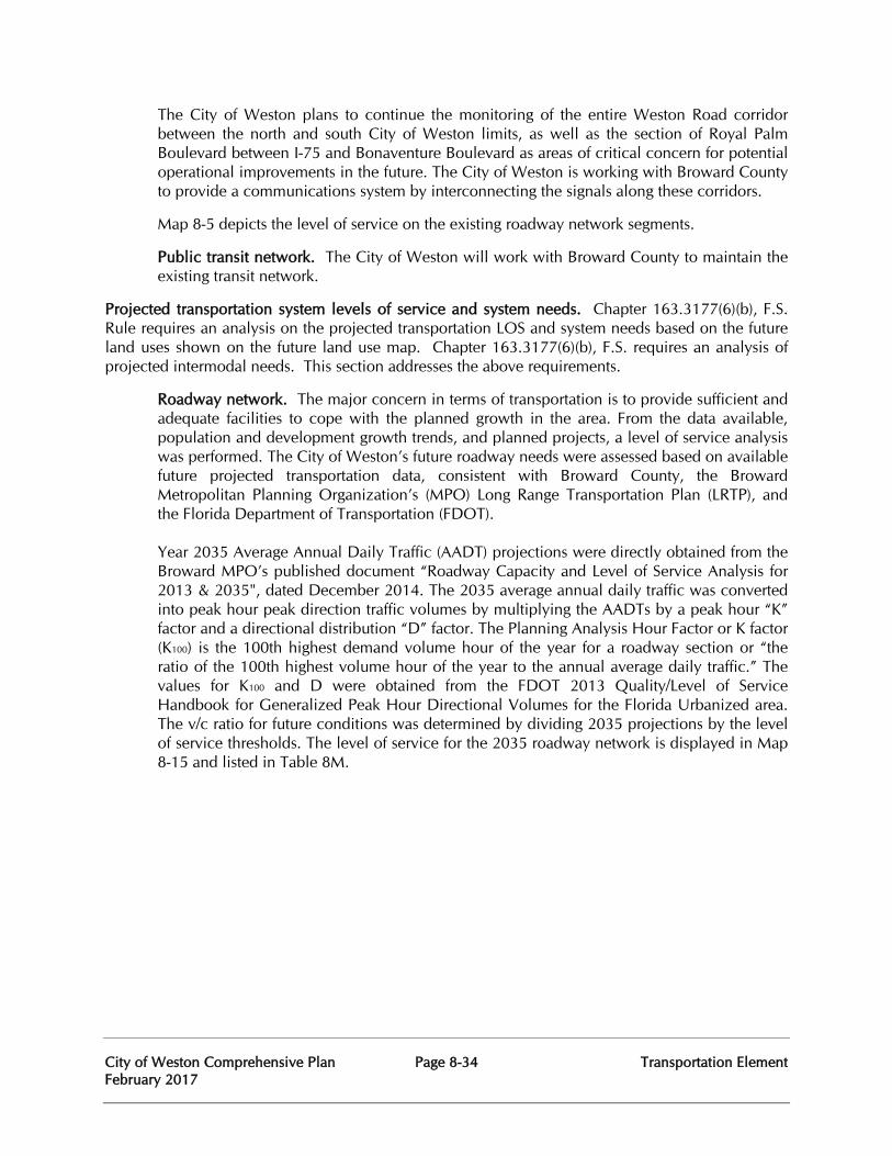
City of Weston Comprehensive Plan Page 8-34 Transportation Element February 2017
The City of Weston plans to continue the monitoring of the entire Weston Road corridor between the north and south City of Weston limits, as well as the section of Royal Palm Boulevard between I-75 and Bonaventure Boulevard as areas of critical concern for potential operational improvements in the future. The City of Weston is working with Broward County to provide a communications system by interconnecting the signals along these corridors.
Map 8-5 depicts the level of service on the existing roadway network segments.
Public transit network. The City of Weston will work with Broward County to maintain the existing transit network.
Projected transportation system levels of service and system needs. Chapter 163.3177(6)(b), F.S. Rule requires an analysis on the projected transportation LOS and system needs based on the future land uses shown on the future land use map. Chapter 163.3177(6)(b), F.S. requires an analysis of projected intermodal needs. This section addresses the above requirements.
Roadway network. The major concern in terms of transportation is to provide sufficient and adequate facilities to cope with the planned growth in the area. From the data available, population and development growth trends, and planned projects, a level of service analysis was performed. The City of Weston’s future roadway needs were assessed based on available future projected transportation data, consistent with Broward County, the Broward Metropolitan Planning Organization’s (MPO) Long Range Transportation Plan (LRTP), and the Florida Department of Transportation (FDOT).
Year 2035 Average Annual Daily Traffic (AADT) projections were directly obtained from the Broward MPO’s published document “Roadway Capacity and Level of Service Analysis for 2013 & 2035", dated December 2014. The 2035 average annual daily traffic was converted into peak hour peak direction traffic volumes by multiplying the AADTs by a peak hour “K” factor and a directional distribution “D” factor. The Planning Analysis Hour Factor or K factor (K100) is the 100th highest demand volume hour of the year for a roadway section or “the ratio of the 100th highest volume hour of the year to the annual average daily traffic.” The values for K100 and D were obtained from the FDOT 2013 Quality/Level of Service Handbook for Generalized Peak Hour Directional Volumes for the Florida Urbanized area. The v/c ratio for future conditions was determined by dividing 2035 projections by the level of service thresholds. The level of service for the 2035 roadway network is displayed in Map 8-15 and listed in Table 8M.
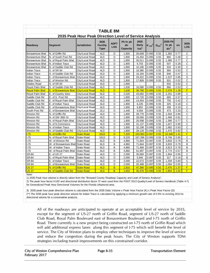
City of Weston Comprehensive Plan Page 8-35 Transportation Element February 2017
Roadway Segment Jurisdiction2035
Facility Type
ADPT LOS
Pk hr pk dir
Capacity
2035 Daily Vol1
K 1002 D100
22035 Pk
hr pk dir3
v/c 2035 LOS
Bonaventure Blvd N. of Griffin Rd City/Local Road 4LD D 1,800 26,648 0.095 0.55 1,392 0.77 CBonaventure Blvd N. of South Post Rd City/Local Road 4LD D 1,800 16,454 0.095 0.55 860 0.48 CBonaventure Blvd N. of Royal Palm Blvd City/Local Road 4LD D 1,800 26,511 0.095 0.55 1,385 0.77 CBonaventure Blvd N. of Indian Trace City/Local Road 4LD D 1,800 9,703 0.095 0.55 507 0.28 CBonaventure Blvd N. of Saddle Club Rd City/Local Road 4LD D 1,800 10,196 0.095 0.55 533 0.30 CIndian Trace S. of SR 84 City/Local Road 4LD D 1,800 18,380 0.095 0.55 960 0.53 CIndian Trace S. of Saddle Club Rd City/Local Road 4LD D 1,800 16,184 0.095 0.55 846 0.47 CIndian Trace E. of Bonaventure Blvd City/Local Road 4LD D 1,800 29,422 0.095 0.55 1,537 0.85 DIndian Trace E. of Weston Rd City/Local Road 4LD D 1,800 17,809 0.095 0.55 931 0.52 CGlades Road S. of SR 84 City/Local Road 4LD D 1,800 - - - 932 0.52 CRoyal Palm Blvd S. of Saddle Club Rd City/Local Road 4LD D 1,630 16,580 0.095 0.55 866 0.53 CRoyal Palm Blvd E. of Bonaventure Blvd City/Local Road 4LD D 1,630 39,795 0.095 0.55 2,079 1.28 FRoyal Palm Blvd E. of Country Isles City/Local Road 6LD D 2,520 43,082 0.095 0.55 2,251 0.89 CSaddle Club Rd E. of S. Post Rd City/Local Road 4LD D 1,800 12,720 0.095 0.55 665 0.37 CSaddle Club Rd E. of Royal Palm Blvd City/Local Road 4LD D 1,800 14,454 0.095 0.55 755 0.42 CSaddle Club Rd E. of Indian Trace City/Local Road 4LD D 1,800 6,226 0.095 0.55 325 0.18 CSaddle Club Rd E. of Bonaventure Blvd City/Local Road 4LD D 1,800 6,852 0.095 0.55 358 0.20 CSouth Post Rd E. of Bonaventure Blvd City/Local Road 2LU D 1,440 9,054 0.095 0.55 473 0.33 CWeston Rd N. of Griffin Rd City/Local Road 4LD D 1,800 28,776 0.095 0.55 1,504 0.84 CWeston Rd N. of SW 36th St City/Local Road 4LD D 1,800 28,056 0.095 0.55 1,466 0.81 CWeston Rd N. of Royal Palm Blvd City/Local Road 4LD D 1,800 26,598 0.095 0.55 1,390 0.77 CWeston Rd N. of N.Commerce City/Local Road 4LD D 1,800 31,137 0.095 0.55 1,627 0.90 CWeston Rd N. of Indian Trace City/Local Road 4LD D 1,800 32,198 0.095 0.55 1,682 0.93 CWeston Rd N. of Saddle Club Rd City/Local Road 4LD D 1,800 28,129 0.095 0.55 1,470 0.82 CI-75 N. of Griffin Rd State Road 10LD D 7,320 193,963 0.097 0.55 10,348 1.41 FI-75 N. of Royal Palm Blvd State Road 10LD D 9,220 167,396 0.095 0.55 8,746 0.95 CI-75 W. of Weston Rd State Road 6LD B 4,860 71,844 0.097 0.55 3,833 0.79 BI-75 W. of Bonaventure Blvd State Road 6LD B 4,860 71,844 0.097 0.55 3,833 0.79 BI-75 W. of Indian Trace State Road 6LD B 4,860 71,466 0.097 0.55 3,813 0.78 BI-75 W. of Royal Palm Blvd State Road 6LD B 4,860 51,997 0.097 0.55 2,774 0.57 BSR-84 E. of US 27 State Road 4LD D 2,000 35,684 0.097 0.55 1,904 0.95 CSR-84 E. of Royal Palm Blvd State Road 4LD D 2,000 5,940 0.097 0.55 317 0.16 BSR-84 E. of Indian Trace State Road 4LD D 2,000 22,572 0.097 0.55 1,204 0.60 CSR-84 E. of Bonaventure Blvd State Road 4LD D 2,000 20,498 0.097 0.55 1,094 0.55 CUS 27 N. of Griffin Rd State Road 4LD B 1,810 47,366 0.095 0.55 2,475 1.37 FUS 27 N. of Saddle Club Rd State Road 4LD B 1,810 35,476 0.095 0.55 1,854 1.02 FNote:
2) The peak hour factor K100' and directional distribution factor 'D' were used from the FDOT 2013 Quality/Level of Service Handbook (Table 4-7) for Generalized Peak Hour Directional Volumes for the Florida Urbanized area.
3) 2035 peak hour peak direction volume is calculated from the 2035 Daily Volume x Peak Hour Factor (K) x Peak Hour Factor (D)(**) The 2035 peak hour peak direction volume for Indian Trace is calculated by applying a minimum growth rate of 0.5% to existing 2013 bi-directional volume for a conservative analysis.
TABLE 8M2035 Peak Hour Peak Direction Level of Service Analysis
1) 2035 Peak hour volume is directly taken from the "Broward County Roadway Capacity and Level of Service Analysis".
All of the roadways are anticipated to operate at an acceptable level of service by 2035, except for the segment of US-27 north of Griffin Road, segment of US-27 north of Saddle Club Road, Royal Palm Boulevard east of Bonaventure Boulevard and I-75 north of Griffin Road. There currently is a new project being constructed on I-75 north of Griffin Road which will add additional express lanes along this segment of I-75 which will benefit the level of service. The City of Weston plans to employ other techniques to improve the level of service and reduce the congestion during the peak hours. The City of Weston supports TDM strategies including transit improvements on this constrained corridor.
City of Weston Comprehensive Plan Page 8-36 Transportation Element February 2017
Public transit network. Fixed route # 23 will continue to provide transit service to the City of Weston, thus meeting the public transit level of service standard established by the County. The City of Weston will continue to coordinate with Broward County to improve the transit service in Weston.
Non-concurrency needs are based on the MPO’s Year 2035 Long Range Plan Needs Assessment. Through the Technical Coordinating Committee and by direct contact, the Broward County MPO has involved various agencies in the development and review process for all applicable transportation plans, in order to ensure compatibility regarding the establishment of locally desired level of service standards. Another important area of public transit service is to accommodate the special needs of the transportation disadvantaged.
Bikeways network. The City of Weston provides many bicycle facilities throughout the community.
Pedestrian network. As stated previously, the City of Weston is already provided with a very high standard of pedestrian facilities and sidewalk systems, both internal to neighborhoods and subdivisions, as well as those that connect the various areas within the community.
Waterways network. As stated previously, there are no navigable waterways within the City of Weston.
Airports and related facilities. There are no existing or planned airport facilities within the City of Weston.
Railways network. As stated previously, there are presently no existing or future anticipated rail facilities that will serve the City of Weston.
Maintaining the adopted level of service standards. The City of Weston shall employ the following strategies in ensuring that the adopted transportation level of service standards are met: Implementation of a concurrency management system, transportation system management, and transportation demand management. This section also addresses maintaining the LOS standard on the Florida Intrastate Highway System (FIHS).
Concurrency Management System (CMS). The CMS is the procedures and process employed by the City of Weston to assure that development orders and permits are not issued unless the necessary facilities and services are available concurrent with the impacts of development.
An applicant for a development order must demonstrate satisfaction of the level of service standards in accordance with Section 5-182(a) of the Broward County Land Development Code as it applies to the regional roadway network (during platting) and satisfy the City of Weston Transportation Concurrency and Traffic Performance Standards consistent with the level of service standards adopted in the plan.
City of Weston Comprehensive Plan Page 8-37 Transportation Element February 2017
Transportation System Management (TSM). TSM means improving roads, intersections, and other related facilities to make the existing transportation system operate more efficiently.
Intersection approach/departure widening: The FDOT LOS Manual recognizes the capacity and operational benefits of providing additional lanes on the approach and departure to signalized intersections. In many instances, this technique is advantageous because it can provide significant capacity improvements at the intersection node itself, where traffic is actually contained, without having to implement more extensive widening of the mainline. Mainline widening of can have an adverse operational impact on bicycle traffic and unsignalized operations at cross streets as well as having adverse social political and environmental impacts.
Access management. Access management is the control and regulation of spacing and design of driveways, ramps, medians, median openings, traffic signals and intersections in order to provide safe and efficient traffic flow on the road system. On the State Highway System, access management is implemented through Rule Chapter 14-97, F.A.C. under authority of Section 334.044 and 335.188, Florida Statute. Trafficways within the City of Weston are implemented through Section 5-195(b) of the Broward County Land Development Code. Access management on local roadway is governed by the City of Weston’s Land Development Code Regulations. Signal Optimization. Optimizing the signal timing of isolated traffic signals, as well as developing computerized interconnected traffic systems for improved arterial progression are very effective methods to improving peak hour traffic flow. The City of Weston continues to work in cooperation with the Broward County Traffic Engineering Division in improving signal timing and phasing plans at major signalized intersections. Rapid growth and corresponding changes in travel patterns often require re-evaluation of signal timing and phasing plans, and the City of Weston has been instrumental in working with Broward County on these re-evaluations. The City of Weston and Broward County have also discussed creation of a localized interconnected signal system that would be served by a master controller within the Weston area.
Incident management/intelligent transportation systems (ITS). Incident management of traffic accidents and other unanticipated events on the FIHS components that serve the City of Weston is an important transportation consideration. The City of Weston Traffic Engineering Division, Broward Sheriff’s Office District VIII (Weston) and the Broward County Fire Rescue Division (Weston) are strongly committed to working with the Florida Highway Patrol and other agencies in addressing major traffic incidents on SR-84, I-75, US-27 and I-595 as appropriate. The City of Weston also strongly supports FDOT and Broward County efforts for ITS implementation on I-95 and would also support such efforts on I-595 and I-75.
Transportation Demand Management (TDM). TDM means strategies and techniques that can be used to increase the efficiency of the transportation system. Demand management focuses on ways of influencing the amount and demand for transportation by encouraging alternatives to the single-occupant automobile and by altering peak hour travel demand. These strategies and techniques include: ridesharing programs, flexible work hours, telecommuting, shuttle services, and parking management. TDM also is effective at lower residential densities than are required for public transit and pedestrian and bicycle programs. Thus, TDM can be another strategy to help combat the effects of sprawl.
City of Weston Comprehensive Plan Page 8-38 Transportation Element February 2017
Flexible work hours. Flexible work hours is a TDM strategy that allows employees to schedule their work hours to avoid driving during the peak hours. Flexible work hour strategies include flextime, staggered work hours, and compressed work schedules. These strategies are well-suited to low and medium densities, where traffic congestion is short-lived.
Telecommuting. Telecommuting is completely independent of densities since employees work at home instead of commuting to work. Constraints on telecommuting relate to the job itself, not its location. Only workers in information-oriented jobs are candidates. The recent explosion of internet users and availability will likely result in increasing popularity and feasibility of telecommuting with little or no impetus from other factors.
Shuttle services. This TDM strategy uses buses, vans and cars to provide transportation from remote parking locations to the workplace. The Cleveland Clinic’s Regional Medical Center is an example of implemented TDM strategies.
The Florida Intrastate Highway System (FIHS)/Strategic Intermodal System (SIS). The FIHS is designed for interregional and intrastate functions. Even though most of the traffic on the FIHS today is local traffic making trips less than 25 miles in length, it is still vital for FDOT and Broward County to establish methods of monitoring the impacts on the system and strategies to facilitate local traffic to use alternatives to the system to protect its interregional function.
Strategies to relieve traffic from the FIHS/SIS. One of the strategies that the City of Weston can implement to help relieve traffic from the FIHS/SIS is to focus on improving and maintaining acceptable levels of service on roadways that are parallel to FIHS/SIS roadways. This strategy is premised on the assumption that improving roads parallel to the FIHS will make the non FIHS roads more attractive as a means of travel.
Because of Weston’s geographic location, most traffic on surrounding FIHS facilities is likely related to longer length home-based work trips and commerce-related trip making. The somewhat diagonal orientation of Royal Palm Boulevard and Indian Trace relative to the surrounding east/west and north/south segments of I-75 inherently discourages the use of these facilities for shorter length trips due to the circuitous nature of the travel path. Also, lack of direct connections between the northbound terminus of Bonaventure Boulevard and northbound terminus of Weston Road to the I-75/I-95 interchange further discourage the use of I-75 as a fast alternative to using local roadways.
The City has already constructed improvements along both Weston Road and Royal Palm Boulevard that improve level of service and reduce travel time along the parallel corridors. Several intersection improvements and new signals have been installed improving the overall roadway capacities. The City has completed traffic studies to evaluate the implementation of triple left turn lanes at Royal Palm Boulevard and Weston Road which would alleviate queue vehicle back-up along the Interstate I-75 ramp.
Coordination with FDOT. The final strategy calls for annually monitoring and evaluating the LOS on the SHS in order to determine whether the strategies are actually relieving traffic. If not, the policy provides for identifying additional strategies in coordination with the FDOT and the MPO.
City of Weston Comprehensive Plan Page 8-39 Transportation Element February 2017
Land Use Planning. Another potential strategy is to provide an adequate land use mix within the City of Weston to discourage FIHS trip making for goods and services that could otherwise be provided within the local roadway network.
Consistency between the future land use element and transportation system and with other plans. This section addresses Chapter 163.3177(6)(b), F.S., which requires an analysis of the compatibility/consistency of the future land use and transportation elements; which requires an analysis that considers the compatibility/consistency of the Transportation Element with the policies and guidelines of other transportation plans; and which requires an analysis of compatibility/consistency with other elements of the Comprehensive Plan.
The Future Land Use Element. Internal consistency between the Future Land Use Element (FLUE) and the Transportation Element is maintained through objectives and policies in both the FLUE and the Transportation Element (TE). The FLUE identifies the City of Weston’s Concurrency Management System (CMS), which assures that development orders and permits are not issued unless adequate transportation facilities are available. There are several policies that address the relationship between land use densities and the surrounding transportation system, and specifically outline land planning strategies that enhance mobility and encourage use of transportation modes other than the single occupancy vehicle.
Long range transportation plan. The Long Range Transportation Plan (LRTP) is the primary source for identifying priority projects for inclusion in the Transportation Improvement Program (TIP) and guides the expenditure of federal, state, and local transportation funds. It provides a coordinated planning effort to mitigate traffic congestion, minimize reconstruction of existing facilities, and allow for adjustment of growth management policies and transportation strategies. The LRTP consists of five major sections: Goals, Objectives, and Evaluation Criteria; Financial Resources; Needs Assessment; Cost Feasible Plan; and Public Involvement. Commitment 2040 The Long Range Transportation Plan for Broward County represents the current adopted LRTP. The 2040 objectives and policies are consistent with the provisions of the FAST Act, under which 15 specific factors were identified. The mission is to support the creation of transportation options, both locally and regionally. Through Commitment 2040, there is emphasis on the need for reliable transit, bicycle, pedestrian and roadway projects that promote economic strength, environmental conservation and improve quality of life. Florida Department of Transportation's Adopted Work Program. The City of Weston is in the jurisdiction of the FDOT’s District 4; therefore, the FDOT District 4’s Work Program for Fiscal Year July 2016 through June 2021 contains Broward County’s projects. The Work Program basically lists the projects with abbreviated terms and codes of action. The Program consists of three sections. First, the Glossary of Terms contains the Work Program item numbers with codes for identifying project; project length; road numbers, project description; phase, estimated cost and source of funds. Second, Fund Codes includes abbreviations of various funding categories. Finally, the actual program lists projects, with details described in the above-mentioned two sections. Priorities in the new 5-year Adopted Work Program are determined by the MPO and are the direct result of the long range planning process. Projects on a priority list submitted to FDOT for inclusion in the Work Program must appear in the Long Range Plan. The Long Range Plan, in turn, is formulated with the goals and objectives consistent with the Transportation Element and ISTEA’s 15
City of Weston Comprehensive Plan Page 8-40 Transportation Element February 2017
suggested planning factors. The Work Program, once adopted, forms the basis of the new TIP.
Broward County Transportation improvement program (TIP). The TIP is a comprehensive listing of transportation projects in Broward County scheduled for funding in the next five years. It represents the cooperative integration of plans by municipalities, the FDOT, the MPO and implementing agencies. Projects are initially identified as part of the Long Range Planning Process. This is a prerequisite for inclusion on an MPO priority list. Priority Lists are then submitted to FDOT. Each year in the Annual Work Program, FDOT funds these priorities identified by the MPO to the extent possible. The Annual Work Program in turn forms the state and federal component of the TIP. The priority list is then updated to reflect these funding actions and a new list is submitted each year to FDOT. The TIP is coordinated with the TE indirectly through the CIE, which includes a section on jointly funded programs.
Promoting and supporting public transit in designated public transportation corridors. Subsection 163.3177(6)(b), FS, requires the Transportation Element to address the identification of land use densities, building intensities, and transportation management programs to promote public transportation systems in designated public transportation corridors to encourage population densities sufficient to support such systems. This section addresses land use and building intensities. They address transportation management programs elsewhere.
Travel demand forecasting model. The Florida Standard Urban Transportation Model Structure (FSUTMS), maintained by the Broward County MPO, was the travel demand forecast model used to model land use intensities and ultimately output the 2035 future AADTs used in the MPOs Long Range Transportation Plan. The FSUTMS model is a four stage gravity model. At the most basic level, the typical forecasting model is structured around the following four sequential steps:
• Trip Generation - Estimation of number of trips produced by and attracted to each “traffic analysis” zone.
• Trip Distribution - Determination of the origin and destination zone for each trip.
• Modal Choice - Calculation of number of trips using the different modes of transportation such as auto, transit, walk and others.
• Assignment - “Loading” of auto trips onto the highway network or person trips onto the transit network.
The FSUTMS model generates trips at each traffic analysis zone (TAZ) from land use variables (population and employments.) Trips are distributed between zones using gravity concept and friction factors. Trips are then split between highway, transit and other modes using mode choice concept. Highway trips are converted to auto trips using an appropriate auto occupancy rate. Auto trips are assigned to the highway network according to equilibrium concept based on speed and capacity of each highway facility in the network.
Before using the model in traffic projection, it should be validated for the most recent year in which travel and census data are available. In Broward County, the most recent adopted model was validated for the year 2010. In the validation process, various coefficients and parameters are developed specifically for the Broward County transportation network such as speed and capacity tables, friction factors, and average auto occupancy rates. Transit
City of Weston Comprehensive Plan Page 8-41 Transportation Element February 2017
coefficients are developed based on current transit market shares. Model runs are made until simulated model output matches the ground count for the year being validated. Then, the validated model coefficients and parameters are applied to future years. In this case, the year 2010 validated model coefficients and parameters were applied to the 2035 network to obtain year 2035 traffic volumes and transit ridership estimates.
IMPLEMENTATION Authority. Planning for the City of Weston roadway network is primarily the responsibility of the City of Weston, with the exception of permitting authority for installation and maintenance of traffic control devices, which remains under the jurisdiction of the Broward County Traffic Engineering Division. Because of the Metropolitan Planning Organization structure outlined by federal guidelines, the Broward County MPO still plays a significant role in planning for the regional roadways (Broward County Trafficways) within the City of Weston. Transportation Agencies Serving the City of Weston
• Broward County Mass Transit Division • Broward Metropolitan Planning Division (MPO) • Broward County Transportation Planning Division • Broward County Traffic Engineering Division • Broward County Engineering Division
City of Weston Comprehensive Plan Page 8-42 Transportation Element February 2017
TRANSPORTATION ELEMENT GOALS, OBJECTIVES, AND POLICIES
Goal 8 Maintain and where feasible, improve the City of Weston’s multimodal transportation system in a manner that provides for safety, convenience and energy efficiency; that coordinates the transportation system with the orderly growth, development and sustainability of the environment; that is coordinated with other transportation plans; that addresses the needs of the present and future populations; and that provides for the protection of the existing and the future transportation system.
8.1 Objective: Continue to improve safety through a reduction in the annual rate or ratio of transportation related crash indicators, improve convenience through an increase in the functional area coverage or access to transportation facilities and improve energy efficiency through an increase in mode split and vehicle occupancy rates.
8.1.1 Policy:
Provide a safe multimodal transportation system through implementation of, but not limited to the following programs, activities or actions: Roadways 1. Continue to construct roadway improvements that meet or exceed
safe design standards;
2. Continue to control the connections and access points along roadways as prescribed by either the Florida Department of Transportation (FDOT) Rule Chapter 14-97 “State Highway System Access Management Classification and Standards,” the Broward County Land Development Code or the City of Weston Land Development Code, as applicable;
3. Continue to encourage joint use of driveways and cross access agreements among adjoining property owners to allow circulation between sites and reduce the number of vehicular access points along roadways;
4. Continue to implement traffic calming techniques, where appropriate;
5. Continue to plan for, and develop a vehicular evacuation plan in the event of a hurricane or other emergency;
6. Continue to work with law enforcement agencies in enforcing traffic codes and regulations;
City of Weston Comprehensive Plan Page 8-43 Transportation Element February 2017
7. Continue to work with the community in developing programs to promote transportation safety;
8. Continue to develop and maintain land development regulations governing signage and sight distance;
9. Continue to encourage private sector participation in street lighting programs;
10. Continue to work with FDOT, the Broward County Traffic Engineering Division and private developers in the timely installation of traffic control devices within the City of Weston;
11. Continue to monitor existing and annually identify new, high accident-frequency locations; identify improvements to those high accident locations which may alleviate the hazardous condition; incorporate such improvements into the Transportation Improvement Program (TIP) as applicable; and implement and/or construct the improvements;
12. Work with FDOT, Broward County and other agencies in resolving safety-related issues on non-city jurisdictional roadways;
13. Continue to maintain an accident data base for City of Weston public roadways in cooperation with the Broward Sheriff’s Office;
14. In cooperation with FDOT, assist in the implementation of incident management strategies for handling accidents on the Florida Intrastate Highway System.
Public Transit
15. Encourage the design and construction of safe and secure transit stops serving existing and future transit routes.
Bikeways and Pedestrian Ways 16. Continue to maintain land development regulations requiring
sidewalks for new development and redevelopment;
17. Continue to provide bicycle and pedestrian safety education for the community;
18. Coordinate with the school board or other appropriate agencies, regarding the development and maintenance of safe bikeways and pedestrian ways to public schools;
19. Continue to encourage safe and interconnected pedestrian facilities within commercial and business districts through land development regulations;
20. Enforce laws pertaining to bicycles and pedestrians;
21. Continue to coordinate with the Broward County Traffic Engineering Division, the Broward County School Board and private developers in the provision of school zone flashers for all designated school speed
City of Weston Comprehensive Plan Page 8-44 Transportation Element February 2017
zones within the City of Weston.
Airways
22. Continue to coordinate with Broward County and the FAA to identify and remove and prohibit any obstructions to air navigation, where possible;
Intermodal Facilities
23. Ensure future intermodal facilities are designed to promote safety and security for facility users.
8.1.2 Policy: Provide a convenient multimodal transportation system through implementation of, but not limited to, the following programs, activities, and actions:
Roadways
1. Continue to ensure that all newly platted properties have direct access to roadways;
2. Continue to encourage master planning of private and public road systems to ensure reasonable and convenient access to individual land parcels;
3. Continue to provide for a functional hierarchy of roadways;
4. Continue to implement transportation system management strategies to make the existing transportation system operate more efficiently;
5. Continue to discourage deletion of segments from the Broward County Trafficways Plan for the purpose of restricting access to or from the regional roadway network.
Public Transit
6. Work with Broward County to maintain and, where feasible, improve the residential and employment functional area coverage within the City of Weston through appropriate public fixed-route transit service, headways and connections to other transportation modes and facilities.
7. Continue to work with Broward County in enhancing and expanding local public transit systems that are coordinated with the County’s public transit system; including the I-595 Express Bus service;
8. Support Broward County’s efforts in the provision of express bus service from park-and-ride locations to major employment centers where sufficient numbers of riders can be identified;
City of Weston Comprehensive Plan Page 8-45 Transportation Element February 2017
9. Support development of a tri-county public transit authority to provide information on regional public transit service;
10. Work with Broward County and other agencies to provide door-to-door public transit service to the transportation disadvantaged;
11. Support Broward County’s efforts to equip the Broward County Transit fleet with bike racks by encouraging installation of bicycle facilities in public places within the City of Weston;
12. Support Broward County’s efforts to maintain and improve the number of public transit vehicles that are accessible to the physically disabled;
13. Assist Broward County in the provision of bus shelters, benches, and stops at appropriate locations.
Bikeways and Pedestrian Ways 14. Continue to maintain and, where feasible, improve the functional
area coverage of the bicycle facility network through inclusion of bikeways in road construction projects and through greenways;
15. Update the Bicycle Facilities Master Plan as needed to address missing links and/or other facilities deficiencies within the City of Weston’s existing and programmed bikeway network, including identification of potential funding sources;
16. Improve the bikeway a network such that all significant commercial, employment and recreational centers are accessible via a bikeway route along at least one collector or arterial roadway route serving the center;
17. Encourage improved access to public transit terminals through the provision of bicycle facilities at appropriate locations;
18. Continue to provide bicycle facilities at commercial and recreation areas and other appropriate locations;
19. Continue to work with Broward County in developing municipal bikeways that are coordinated with the County’s bikeway system;
20. Continue to work with appropriate entities to plan for and develop a recreation transportation system that includes provision of non-motorized transportation facilities;
21. Continue to improve pedestrian access to public transit stops through the City of Weston’s Land Development Regulations;
22. Encourage compact mixed use developments as a land use strategy for promoting walking and biking.
City of Weston Comprehensive Plan Page 8-46 Transportation Element February 2017
Airways
23. Continue to work with Broward to provide connectivity to at least one bus route serving the Fort Lauderdale/Hollywood International Airport.
Railways
24. Continue to work with FDOT and Broward County in providing connector bus service to Tri-Rail facilities and any other future commuter rail facilities.
Intermodal Facilities
25. Coordinate with FDOT and Broward County in the siting of potential future intermodal facilities within or adjacent to the City of Weston.
8.1.3 Policy: Provide for an energy efficient multimodal transportation system through implementation of, but not limited to, the following programs, activities, or actions:
Roadways
1. Continue to support the County’s efforts in the installation and maintenance of a fully computerized signal system throughout the County and completion of local interconnect system;
2. Continue to require private sector contributions towards the interconnection of existing and future traffic signal systems required by new development;
3. Support FDOT and Broward County efforts in the development of the Intelligent Transportation System to maximize the use of existing capacity in all modes of travel;
4. Support federal policies and initiatives related to the development of more energy efficient vehicles;
5. Continue to coordinate with FDOT and Broward County in the evaluation of peak hour travel demand to ensure optimized signal timing and arterial progression for signal systems within the City of Weston;
6. Increase the vehicle occupancy rate and decrease the modal split attributable to the automobile through transportation demand management strategies, such as ride-sharing programs, adoption of preferred parking and other parking strategies and increased high occupancy vehicle lane usage and enforcement.
7. Educate residents on the cost and environmental effects of automobile idling.
City of Weston Comprehensive Plan Page 8-47 Transportation Element February 2017
Public Transit
7. Support the County’s efforts to maintain public transit vehicles so that they operate at their maximum level and replace older, inefficient public transit vehicles with energy efficient vehicles;
8. Support the County’s efforts to increase the public transit modal split from the current 1.64 percent to 3.14 percent by 2030 through strategies such as appropriate transit route planning, increasing peak-hour headways along the most heavily used routes from 30 to 15 minutes and improving accessibility of bus stops and shelters; and
9. Monitor the County’s annual report on the progress of achieving the modal split policy in the Transit Development Plan as it applies to the City of Weston.
Bikeways and Pedestrian Ways
10. Work with the County to periodically update the Bicycle Facilities Network Plan and the Pedestrian Facilities Development Program;
11. Maintain or improve the modal split attributable to bicycles and pedestrians through such strategies as walkable and bikeable compact, mixed use developments;
12. Encourage joint use of driveways and cross access agreements among adjoining or abutting property owners to allow circulation between sites and reduce trip lengths.
Railways
13. Support the Tri-Rail Authority’s efforts to periodically update its Master Plan;
14. Continue to work with FDOT and Broward County in providing connector bus service or other high occupancy vehicle service to Tri-Tail facilities and any other future commuter rail facilities.
.
15. Encourage the design and construction of energy-efficient intermodal facilities.
8.1.4 Policy: The City of Weston will end (cul-de-sac, hammerhead, etc.) S.W. 36th Street west of the U.S. Nature Center and will support vacation of the remaining right–of-way within the impoundment area. In addition, now that the South Florida Water Management District has acquired all land in Basin II, the City of Weston will support vacation of the right-of-way of S.W. 26th Street within the impoundment area.
8.1.5 Policy: In order to preserve and maintain City of Weston’s scenic vistas, Weston
City of Weston Comprehensive Plan Page 8-48 Transportation Element February 2017
Road, Royal Palm Boulevard, Indian Trace Boulevard and Glades Parkway shall not be expanded beyond 4-lane divided cross sections. In the event that there is a need for future capacity on these roadways, this shall be addressed by intersection improvements only.
8.2 Objective: The City of Weston will continue to maintain and, where feasible, improve the functional relationship between the transportation system and the City of Weston’s Future Land Use Element (FLUE).
8.2.1 Policy: Ensure existing and proposed population densities are consistent with transportation modes and services through implementation of, but not limited to, the following programs, activities, or actions:
1. Continue to review the impacts of FLUE amendments as they pertain to increased travel demand upon the existing roadway network (using information from the Broward County the TRIPS model), the and the long range roadway network;
2. Encourage, where feasible, residential densities in the low to medium ranges to be located with access to existing minor arterial and collector streets;
3. Encourage where feasible, residential densities in the medium high and high ranges should be located with adequate access to major and minor arterial roadways, expressways and public transit routes;
4. Discourage the planning and construction of major roadway facilities that would bisect established residential areas;
5. Discourage public transit routes through established single-family areas and encourage such service on collector roadways or higher;
6. Encourage implementation of local public transit service in areas serving existing and proposed population densities in a manner coordinated with the County’s public transit network;
7. Encourage new development and redevelopment that promotes public transit, particularly in the eastern sections of the City of Weston;
8. Discourage increases in residential density within the western portions of the City of Weston that will further perpetuate urban sprawl.
9. Continue to ensure that the roadway and public transit networks have sufficient capacity for emergency evacuation;
10. Support bikeway and pedestrian interconnections between residential areas, commercial areas, employment centers and recreational facilities;
11. Encourage high density residential development within, or in close
City of Weston Comprehensive Plan Page 8-49 Transportation Element February 2017
proximity to, employment and commercial centers in order to promote trip internalization and reduction of trip lengths.
12. Continue to maintain pedestrian and bicycle facilities and the efficiency of the roadway system throughout the City of Weston in order to promote energy conservation and reduce greenhouse gas emissions.
8.2.2 Policy: Ensure housing and employment patterns are consistent with the transportation modes and services through implementation of, but not limited to, the following programs, activities, or actions:
1. Continue to maintain a range of housing opportunities within a 10 minute commute to employment opportunities;
2. Encourage plans for compact mixed use and multiple use developments that provide housing opportunities within one-quarter mile walking distance of employment opportunities;
3. Encourage mixed use or multiple use developments with higher densities and intensities to be located adjacent to public transit, rail, and intermodal terminals; and
4. Encourage the provision of incentives to the private sector to promote and develop mixed use development.
8.2.3 Policy: Ensure land uses are consistent with the transportation modes and services through implementation of, but not limited to, the following programs, activities, or actions:
1. Continue to use the City of Weston’s Transportation Concurrency and Traffic Performance Standards to ensure that development orders or permits are not issued unless these standards are met;
2. Cooperate with FDOT, Broward County and other transportation entities in establishing land uses which promote public transportation in designated public transportation corridors and within regional activity centers;
3. Ensure that industrial uses are located with access to major transportation facilities and expressways that connect to airports, railways and seaports;
4. Encourage regional or community facilities (e.g., libraries, clinics, civic centers) and other public facilities to be located in areas of concentrated activity, in order to allow multi-purpose trips, providing easy access by public transit and economize on parking areas;
City of Weston Comprehensive Plan Page 8-50 Transportation Element February 2017
5. Encourage all regional and community facilities to be located close to major traffic corridors and public transit routes adequate to carry the volume of traffic generated by such facilities with the exception of schools;
6. Encourage land uses which promote the use of bicycles and walking, such as transit oriented development and traditional neighborhood development;
7. Encourage the provision of bicycle and pedestrian access between residential and non-residential land uses during the site plan review process;
8. Coordinate roadway and public transit improvements with Broward County’s major multimodal facilities such as Port Everglades, Hollywood/Fort Lauderdale International Airport, North Perry Airport and other related public transportation facilities, where applicable.
8.2.4 Policy: For the purpose of issuing development orders and permits, the roadway level of service (LOS) standards for the purpose of short and long-range planning and concurrency management shall be the following unless otherwise exempted under another policy:
1. For facilities on the State Highway System and the Strategic Intermodal System (SIS), the peak-hour levels of service are as established by the Florida Department of Transportation by rule, as outlined in the 2013 Quality Level of Service Handbook. The SHS and SIS segments serving the City of Weston and the corresponding level of service standards established by FDOT are as follows:
1. I - 595: LOS “D” from I-75 to US 1.
2. Sawgrass Expressway: LOS “D” from I-75 to SW 10th Street.
3. I - 75: LOS “D” from Miami/Dade County Line to west Glades Parkway; LOS “B” from west of Glades Parkway to Collier County Line.
4. US 27: LOS “B” from Miami/Dade County Line Pembroke Road; LOS “D” from Pembroke Road to Griffin Road; LOS “B” from Griffin Road to Palm Beach County Line.
2. For all other facilities within the City of Weston, the adopted Annual Average Daily Traffic (AADT) and peak-hour (100th highest hour) level of service standard is LOS “D” as determined using the procedures and criteria outlined in the most current version of the FDOT 2013 Quality / Level of Service Handbook, except for those exceptions listed in Policy 8.2.5. Consistent with these standards, signalized intersection level of service is established at LOS “D” as determined using procedures and criteria outlined in the most current version of the Highway Capacity Manual. Overall intersection level of service must be maintained at LOS “D” with no approach operating below
City of Weston Comprehensive Plan Page 8-51 Transportation Element February 2017
LOS “E”. .
8.2.5 Policy: For the purpose of issuing development orders and permits, the following exceptions to the level of service standards adopted in Policy 8.2.4 shall apply:
1. Developments deemed to have a de minimis impact;
2. Developments deemed to promote public transportation, as defined and described in Section 163.3164(28), F.S.;
3. Developments deemed to have vested rights in accordance with the provisions of Chapter 163 Part II Florida Statutes or a common law vested rights determination.
4. Developments which are specifically authorized as a Development of Regional Impact (DRI) pursuant to Chapter 380, Florida Statutes, which has been issued a final local development order either prior to the adoption of the 1989 Broward County Comprehensive Plan, or after being reviewed for satisfaction of the Broward County Transportation Concurrency Standards and after being reviewed for satisfaction of the City of Weston Transportation Concurrency Standards for DRI’s.
8.2.6 Policy: The Broward County Transportation Planning Division, in cooperation with the FDOT and the municipalities, shall conduct a study on constrained roadway facilities. The study shall identify constrained facilities, propose adequate level of service standards for those identified constrained facilities and recommend appropriate actions to improve mobility on the constrained roadways.
8.2.7 Policy: For purposes of the issuance of development orders and permits, the number of trips generated by development shall be calculated as follows:
1. For development applications subject to Broward County concurrency review (plats), vehicle trips shall be generated through the Traffic Review and Impact Planning System (TRIPS) model, which is a computer model maintained by the Broward County Development Management Division which accounts for traffic from existing and approved but not built development; and
City of Weston Comprehensive Plan Page 8-52 Transportation Element February 2017
2. For development applications subject to Broward County concurrency review (plats), transit trips shall be generated by multiplying a modal split of the previous year by the number of trips generated through the TRIPS Model for the development.
3. For any development application which places trips on local City of Weston roadways not monitored for concurrency as part of the Broward County Concurrency Management System, vehicle trips shall be derived from the Broward TRIPS model rates or other available rates from the most current version of the ITE Trip Generation Manual, or local studies, consistent with the procedures outlined in the City of Weston’s Transportation Concurrency Management and Traffic Performance Standards.
8.2.8 Policy: For roadways and public transit, the following actions shall satisfy the concurrency requirements:
1. At the time a development order or permit is issued, the necessary facilities and services are in place or under construction;
2. A development order or permit is issued subject to conditions that the necessary facilities and services needed to serve the new development are in place or under construction not more than three years after issuance of a certificate of occupancy or its functional equivalent as provided in the adopted five year schedule of capital improvements. The schedule of capital improvements may recognize and include transportation projects included in the first three years of the applicable adopted Florida Department of Transportation five-year work program; or
3. At the time a development order or permit is issued, the necessary facilities and services are the subject of a binding executed agreement which requires the necessary facilities and services to serve the new development to be in place or under actual construction no more than three years after the issuance of a certificate of occupancy or its functional equivalent; or
4. At the time a development order or permit is issued, the necessary facilities are guaranteed in an enforceable development agreement, pursuant to Section 163.3220, F.S., or an agreement or development order issued pursuant to Chapter 380, F.S., to be in place not more than three years after issuance of a certificate of occupancy or its functional equivalent.
5. When applicable, the City of Weston should allow mitigation by applying proportionate fair share in accordance with the methodology established by the Florida Department of Transportation.
City of Weston Comprehensive Plan Page 8-53 Transportation Element February 2017
8.2.9 Policy: In cooperation with the State and appropriate municipalities, the City of Weston shall continue to implement strategies to facilitate local traffic using alternatives to the State Highway System (SHS) as a means of protecting its interregional and intrastate functions. Among the strategies that the City of Weston will assist in implementing are: 1. Maintain and improve Levels of Service on parallel facilities to SHS
facilities, such as Weston Road and Royal Palm Boulevard. This includes adoption of the Broward MPO Transportation Improvement Program (TIP) which includes FDOT Financial Project Number 4215481. This project will make modifications to the I-75 (SR-93) Interchange at Royal Palm Boulevard. Modifications to the nearby Weston Road and Royal Palm Boulevard signalized intersection have been requested from FDOT.
2. Work with Broward County in the establishment of a designated transportation corridor (such as Weston Road) which is parallel to a major SHS facility.
3. Work with BCT to enhance regular route service to Tri-Rail stations;
4. Expand transit service alternatives jointly developed by the County in areas which otherwise would not qualify under set standards;
5. Improve pedestrian access to transit by ensuring that all phases of road planning, design, and construction include the necessary walkways on all arterial and collectors under the responsibility of the State, County and City of Weston;
6. Provide public education about public transit desirability and availability;
8.2.10 Policy: Continue to monitor traffic conditions and levels of service at major intersections within the City of Weston, at all intersections/interchanges of city roadways with the FIHS.
8.3 Objective: Coordinate the transportation system with other entities’ transportation plans and programs.
8.3.1 Policy: The City of Weston shall continue to coordinate with municipal, regional and state agencies, as appropriate, on the following plans and programs:
1. The 2019-2040 Regionally Significant and High Priority Cost Feasible Plan and amendments thereto,
2. The Florida Department of Transportation’s Adopted Work Program,
3. The Transportation Improvement Program and amendments thereto;
4. The Hollywood/Fort Lauderdale International Airport Master Plan and
City of Weston Comprehensive Plan Page 8-54 Transportation Element February 2017
amendments thereto;
5. The North Perry Airport Master Plan and amendments thereto;
6. The Port Everglades Master Plan and amendments thereto;
7. The Tri-County Rail Master Plan and amendments thereto;
8. The Broward County Bicycle Facilities Network Plan and amendments thereto;
9. The Broward County Transportation Disadvantaged Service Plan and amendments thereto;
10. The Broward County Transit Development Plan and amendments thereto;
11. The Broward County Five-Year Pedestrian Facilities Development Program and amendments thereto;
12. Any other long-range transportation plans (such as the Florida High Speed Rail);
13. The Short Range Component of the Florida Transportation Plan, including modal components (Section 339.155(3), F.S.);
14. The Transportation component of the SFRPC Strategic Regional Policy Plan (SRPP) (Section 186.507, F.S.);
15. The Transportation related objectives and policies of the Broward County Land Use Plan;
16. The relevant East Coast Buffer plans of the SFWMD.
8.3.2 Policy: City of Weston shall continue to coordinate the following plans and programs with the Turnpike District:
1. Master plans relating to the Sawgrass Expressway or the Florida Turnpike; and
2. City of Weston land use plan amendments that would add traffic to the Sawgrass Expressway or the Florida Turnpike.
8.3.3 Policy: City of Weston shall continue to coordinate the following plans and programs with the Florida Department of Transportation, District IV:
1. The 2019-2040 Regionally Significant and High Priority Cost Feasible Plan and amendments thereto,
2. The Transportation Improvement Program and amendments thereto;
3. The Fort Lauderdale/Hollywood International Airport Master Plan and amendments thereto;
4. The North Perry Airport Master Plan and amendments thereto;
5. The Port Everglades Master Plan and amendments thereto;
City of Weston Comprehensive Plan Page 8-55 Transportation Element February 2017
6. The Broward County Bicycle Facilities Network Plan and amendments thereto; and
7. The Broward County Five-Year Pedestrian Facilities Development Program and amendments thereto.
8. The Short Range Component of the Florida Transportation Plan, including modal components (Section 339.155(3), F.S.)
8.3.4 Policy: Through its participation in the coordinated activities of the Broward County Metropolitan Planning Organization, the City of Weston shall continue to assist the County in the maintenance of its long-range transportation plan, including: 1. Recognition of the Trafficways Plan component of the Broward
County Land Use Plan as the basic system of designated corridors within which the future roadway network shall be planned, designated and constructed;
2. Recognition of the currently Amended Broward County Land Use Plan in maintaining the socio-economic data base, which in turn is the basis of forecasting future travel demand;
3. Direct communications with Broward County for review and comment on amendments to the adopted 2019-2040 Regionally Significant and High Priority Cost Feasible Plan and amendments thereto;
4. By 2021, modify and where appropriate, assist the County in the restructure of the transportation planning process to enhance the relationship between land use and transportation planning.
8.3.5 Policy: City of Weston shall coordinate with FDOT and Broward County as necessary, in order to ensure compatibility regarding the establishment of locally desired level of service standards.
8.4 Objective: Continue to assist Broward County in its objective to improve the efficiency of its public transit services by increasing the annual Broward County Transit ridership and ensure that within 24 hours of a request for transportation services by transportation disadvantaged persons, at least 85 percent are provided such services.
8.4.1 Policy: The provision of efficient public transit services to serve land uses, including major transit generators and attractors, shall be addressed through implementation of, but not limited to, the following programs, activities or actions: 1. Evaluate the County’s socio-economic characteristics of transit riders
City of Weston Comprehensive Plan Page 8-56 Transportation Element February 2017
as it applies to the City of Weston;
2. Support Broward County’s efforts in maintaining and where feasible, improving headways and span of services;
3. Assist Broward County’s efforts to coordinate with existing and future major transit generators and attractors to address the provision of public transit;
4. Assist Broward County’s efforts to coordinate new transit routes and services or route changes with established development and land use plans;
5. Assist Broward County in the provision of passenger amenities, which may include benches, shelters, kiosks and detailed signage, at transfer locations which generate no less than 25 passenger activities per day;
6. Assist Broward County in providing and maintaining express bus service from the City of Weston to Tri-Rail stations.
7. Develop and coordinate any future City of Weston public transit services with the County’s public transit services;
8.4.2 Policy: The provision of safe and convenient public transit terminals shall be addressed through implementation of, but not limited to, the following programs, activities or actions:
1. Design and construct public transit terminals, bus bays and other public transit amenities in a manner that enhances public safety;
2. Maintain and where feasible, improve security at the terminals;
3. Locate future public transit terminals at convenient locations, such as at regional public service facilities.
8.4.3 Policy: Assist Broward County in developing strategies to address intermodal terminals and access to aviation, rail and seaport facilities.
8.5 Objective: Ensure development does not encroach upon existing and future rights-of-way through the short-term and long-term planning horizons.
8.5.1 Policy:
City of Weston shall continue to protect existing rights-of-way from building encroachment through implementation of, but not limited to, the following programs, activities or actions:
1. Coordination with the Broward County Engineering and Traffic Engineering Divisions in identifying right-of-ways designated on the Broward County Trafficways Plan.
City of Weston Comprehensive Plan Page 8-57 Transportation Element February 2017
2. Inaction of land development regulations, sign and landscaping codes that prohibit obstructions within public rights of way;
3. Adoption of code enforcement regulations and other policies to remedy existing obstructions or encroachments within public rights of way.
8.5.2 Policy: City of Weston shall continue to protect future rights-of-way from building encroachment through implementation of, but not limited to, the following programs, activities or actions:
1. Conformance with corridor rights-of-way widths identified on the Broward County Trafficways Plan;
2. Enforcement of Broward County Land Development Code provisions which require that a final plat of lands which abut or contain a future trafficways delineated on the Broward County Trafficways Plan be conveyed to the public by dedication on the face of the plat, deed or, if acceptable to the County, by grant of easement which is necessary for the ultimate construction of roadways, intersections, turn lanes, bicycle facilities, sidewalks, bus pullout bays, bus shelters or roadway drainage facilities;
3. Coordination with the right-of-way protection maps of jurisdictions adjacent to Broward County;
4. Work with the Broward County Planning Council on the feasibility of amending the Trafficways Plan, or adopting some other transportation right-of-way plan, to include other transportation modes, such as public transit corridors recreational corridors, and significant bikeway.

City of Weston Comprehensive Plan Page 9 - i Public School Facilities Element February 2017
CHAPTER NINE
PUBLIC SCHOOLS FACILITIES ELEMENT
TABLE OF CONTENTS
PAGE SUPPORT DOCUMENT .............................................................................................. 1 A. Overview of School Facilities Planning ................................................................ 1
1. Introduction .................................................................................................... 1 2. Concurrency Management System (CMS) ........................................................ 2 3. Collaborative Planning Process and Intergovernmental Coordination.............. 3 4. Level of Service Standard Methodology ........................................................... 3 5. Problems and Opportunities for Existing and Future Schools ........................... 4 6. Analysis of Infrastructure Needs for Existing and Proposed Schools ............... 14
B. Data & Analysis .................................................................................................. 14
1. Population and Housing Conditions .............................................................. 14 Population Growth in Broward County ...................................................... 14 School Age Population ............................................................................... 16 Housing Characteristics. ............................................................................. 16 Development Trends .................................................................................. 17 2. Current Profile of Broward County Public Schools ........................................ 18 Summary Profile of Public Schools in Broward County……………………18
Elementary Schools .................................................................................... 19 Middle Schools ........................................................................................... 24 High Schools .............................................................................................. 25 Charter Schools .......................................................................................... 27 3. Projected 5 Year (S/T) School Enrollment, Capacity, LOS & Improvements Costs ................................................................................... 35 4. Projected 10 Year (L/T) School Enrollment, Capacity, LOS & Improvements Costs ................................................................................... 39 5. Collocation of School Facilities ..................................................................... 40 6. Emergency Shelters ........................................................................................ 40 7. Funding Sources for Capital Improvements ................................................... 43
GOALS, OBJECTIVES AND POLICIES ...................................................................... 53
City of Weston Comprehensive Plan Page 9 - ii Public School Facilities Element February 2017
LIST OF ATTACHMENTS A Amended Interlocal Agreement for Public School Facilities Planning (ILA) B School Board of Broward County Adopted DEFP FY2015-16 to FY 2019-20
LIST OF TABLES
NO PAGE 1 Summary of Enrollment Projections ..................................................................................... 8 2 Charter Schools Serving Elementary, Middle and High School Students ........................... 12 3 Population Broward County 1970-2040 ............................................................................ 15 4 School Age Population Broward County 1970-2040 ......................................................... 16 5 Housing Characteristics Broward County 1970-2013 ....................................................... 17 6 New Dwelling Units by Type 2006-2013 .......................................................................... 17 7 Summary Profile of School Capacity .................................................................................. 18 8 Age of School Facility Buildings ......................................................................................... 18 9 Current Profile - Broward County Elementary Schools 2015-16 ........................................ 19 9A Current Profile - Broward County Middle Schools 2015-16 .............................................. 24 9B Current Profile - Broward County High Schools 2015-16 .................................................. 25 10 Current Profile - Broward County Charter Schools 2015-16 ............................................... 28 11 Projected 10 Year School Facilities by Planning Area and District-Wide ............................ 39 12 List of Emergency Shelters .................................................................................................. 41
City of Weston Comprehensive Plan Page 9 - iii Public School Facilities Element February 2017
LIST OF MAPS NO 1 Existing Public Schools Facilities – 2015 ........................................................................... 44 2 Future Conditions Elementary School Five Year Plan (2015-2020) ................................... 45 3 Future Conditions Middle School Five Year Plan (2015-2020) .......................................... 46 4 Future Conditions High School Five Year Plan (2015-2020) ............................................. 47 5 Future Conditions Charter Schools Five Year Plan (2015-2020)……………………… ..... …... 48 6 Future Conditions Elementary School Ten Year Plan (2015-2025) .................................... 49 7 Future Conditions Middle School Ten Year Plan (2015-2025) ........................................... 50 8 Future Conditions High School Ten Year Plan (2015-2025) .............................................. 51 9 Emergency Shelters ............................................................................................................ 52
City of Weston Comprehensive Plan Page 9 - 1 Public School Facilities Element February 2017
SUPPORT DOCUMENT
A. Overview of School Facilities Planning
1. Introduction Over the past decade the Florida Legislature has progressively strengthened the ties between school planning and general land use and comprehensive planning through amendments to Chapters 163 and 1013, Florida Statutes. The 2005 Legislature mandated that the availability of public schools be made a prerequisite for the approval of residential construction and directed a closer integration of planning for school capacity with comprehensive planning. However, in 2011 the Legislature reversed course and repealed many provisions, including mandatory school concurrency in 2011 with the passage of the Community Planning Act (House Bill 7207). The Community Planning Act shifts much more regulatory discretion to local governments to plan their communities and reduces state oversight in comprehensive planning areas. Under new/revised provisions adopted with House Bill 7207: • Requirement for a Public School Facilities Element is deleted. • State-mandated school concurrency is optional. • Data and analysis and mapping requirements relaxed.
Public School Facilities Element Requirements With the advent of House Bill 7207, local governments have the option to repeal or continue implementing public school concurrency. Local governments who choose to continue implementing it, can do so under provisions set forth in s. 163.3177(1), 163.31777 and 163.3180(6)(a). Broward County will continue to implement the provisions according to state statute and the Interlocal Agreement for Public School Facilities Planning (ILA). The Public School Facilities Element goals, objectives, and policies address the following areas:
• procedure of annual update process;
• procedure for school site selection;
• procedure for school permitting;
• provision of infrastructure necessary to support proposed schools;
• provision for collocation of other public facilities in proximity to public schools;
• provision for location of schools proximate to residential areas and to complement patterns of development;
• measures to ensure compatibility of school sites and surrounding land uses; and
• coordination with adjacent local governments and the school district on emergency preparedness issues.
City of Weston Comprehensive Plan Page 9 - 2 Public School Facilities Element February 2017
The data and analysis portion of the Public School Facilities Element must address: • how level-of-service standards will be achieved and maintained;
• the interlocal agreement (ILA) adopted pursuant to s. 163.31777 and the 5-year school district facilities educational program (DEFP), including LOS maps, adopted pursuant to s. 1013.35;
• the educational plant survey prepared pursuant to s. 1013.31 and an existing map or map series;
• projected future population and associated demographics, including development patterns year by year for the upcoming 5-year and long-term planning periods; and
• information on existing development and development anticipated for the next 5 years and the long-term planning period;
• an analysis of problems and opportunities for existing schools and schools anticipated in the future;
• an analysis of opportunities to collocate future schools with other public facilities such as parks, libraries, and community centers as per the ILA;
• inventory of public schools that serve as emergency shelters, and;
• Funding sources for capital improvements.
2. Concurrency Management System (CMS)
The concurrency management system for Broward County is an intergovernmental effort that is grounded in the provisions of the Broward County Charter, which provide for county-wide planning processes implemented through the County's Land Development Code. The public school facility Concurrency Management System operates according to the state mandated requirements (Section 163.31777 F.S. and 163.3180 F.S.) for the implementation of school concurrency and the adopted School Board’s Interlocal Agreement for Public School Facility Planning (Interlocal Agreement). These require Broward County, the School Board and non-exempt municipalities to ensure that the adopted Level of Service Standard (LOS) to be achieved and maintained for each school type and Concurrency Service Area (CSA). Unlike existing concurrency services (roads, sanitary sewer, solid waste, drainage, potable water, recreation and mass transit) which are the responsibility of local governments, the School Board of Broward County, by constitutional mandate, has the responsibility of providing educational facilities to meet the needs of current and future students as represented in the School Board’s adopted Five Year District Educational Facilities Plan (DEFP). The local governments, therefore, do not have control of the funding sources or the allocation of funds for new or renovated schools which would add student capacity. However, since the School Board isn’t empowered to implement a Concurrency Management System on its own, it must rely upon the local governments to do so through their Land Development Regulations. The Broward County Land Development Code contains the County's Concurrency Management System. The Code requires plat approval of all parcels of land prior to receiving a
City of Weston Comprehensive Plan Page 9 - 3 Public School Facilities Element February 2017
Development Order. Plat approval applies to land within the municipal boundaries as well as that in the unincorporated areas. Per Section 8.2 of the ILA, the point of review for Public School Concurrency is at plat or site plan (or functional equivalent). When a development application is reviewed for school concurrency, it must be determined if the development is exempted or vested (as per Section 8.11 of the Interlocal Agreement) or has been issued a School Capacity Availability Determination Letter (SCAD) by the School Board indicating that adequate school capacity exists. If so, it can be accepted by the County for further processing. If the development application is not exempted or vested, it is subject to school concurrency and the applicant must submit a Public School Impact Application (PSIA) to the applicable local government for review by the School Board of Broward County according to the provisions and processes outlined in Section 8.13 of the Interlocal Agreement. 3. Collaborative Planning Process & Intergovernmental Coordination The collaborative planning process has greatly increased with the passage of the 2005 Infrastructure and Planning Act (SB 360) which mandated the adoption of a Broward County Public School Facility Element and implementation of public school concurrency by February 1, 2008. Since the beginning of 2006, School Board of Broward County staff has been working collaboratively with the County and municipalities through the School Board’s Staff Working Group and Oversight Committee to form consensus on the amendments to the Interlocal Agreement and the preparation of a model Public School Facilities Element. Several Staff Working Group Subcommittees were also established to deal with issues including collocation of school facilities, land use changes and developing urban school standards. These committees continue to meet on a regular basis in order to implement the state mandated requirements to coordinate and collaborate on updates to the District Educational Financially Feasible Plan (DEFP), Concurrency Service Areas (CSAs) and amendments to the Comprehensive Plans of the County and non-exempt municipalities for the implementation of public school concurrency. 4. Level of Service Standard Methodology The level of service standard is based upon the capacity of the school facility, which is the number of pupils to be served by the facility. The level of service is expressed as the percentage (ratio) of student enrollment to the student capacity of the school. The level of service is standard and is expressed in terms of Florida Inventory of School Houses (FISH) capacity. FISH capacity is determined by Florida Department of Education guidelines and represents a measure of the physical capacity of the facility itself. FISH capacity includes satisfactory student stations in permanent classrooms. Based on the second amendment to the Interlocal Agreement for Public School Facility Planning, which became effective in September 2010, the level of service standard was uniformly set as 100% of gross capacity (with relocatable classrooms) for each CSA until the end of the 2018/19 school year; and commencing at the 2019/20 school year, the LOS for each CSA shall be 110% of the permanent FISH capacity.
City of Weston Comprehensive Plan Page 9 - 4 Public School Facilities Element February 2017
The relationship of enrollment to capacity, for individual schools and for concurrency service areas, is derived directly from the five-year schedule of capital improvements that incorporates the Five-Year District Educational Facilities Work Program adopted annually by the School Board. The school capacity and level of service analysis is assigned in a capacity/enrollment and level of service table. This table provides a year-by-year projection of capacity, enrollment, levels of service and available capacity, illustrating surpluses and deficiencies, based on the financially feasible capital program adopted by the School Board of Broward County. Student enrollment is projected annually based on the specific function of the educational facility and the characteristics of the school attendance area, historical trends, the current and projected pace of development and the potential of vacant lands. Other factors such as students attending schools outside their assigned attendance areas due to reassignments, magnet programs, charter schools and other educational choices are factored into the methodology for enrollment projections and for allocating school capacity. Student enrollment projections are designated geographically using local development trend data and the school district student enrollment data. School-by-school enrollment projections by concurrency service areas are applied. General locations of future public schools to be constructed within the district over five years are applied to concurrency service areas relative to the location serving the anticipated capacity deficit. In addition, School Board Policy 5000 allows a variety of options to reduce or avoid the need for additional permanent student stations including, but not limited to: redistricting, reassignment, expanded capacity utilization (e.g. year round schools), and other options. School enrollments exceeding the available capacity resulting in a level of service greater than 110% in the first fiscal year achieve the level of service standard by the fifth year due to planned capital improvements not yet available until the final year. 5. Problems and Opportunities for Existing and Future Schools Land Availability A major issue facing the School Board of Broward County is land availability. Existing schools recovering from the last thirty years of rapid growth have seen the school sites become crowded with classroom additions and relocatables. Additions/relocatables have taken over playfields, playgrounds, green space, and parking areas. The demand for larger water retention areas and more parking facilities has also reduced the useable area for the educational program. In addition, with current legislation demanding more accountability in the area of physical education schools face the dilemma of needing playfield areas to meet new Sunshine Standards for Education.
Due to limited available land, the School Board Staff developed strategies to design for and construct on smaller sites. In February 2009, the School Board adopted the Guidelines for Urban Concepts via Resolution #09-66. The resolution encourages designing a more compact building footprint, sharing parking and playfields, as well as exploring the use of parking garages versus surface parking.
City of Weston Comprehensive Plan Page 9 - 5 Public School Facilities Element February 2017
Construction Costs & Revenue Sources The main source of revenue for the capital plan is the tax on local property. The property tax revenue increased 7% from last year, but is still below historical values before the Great Recession. The state legislature cut the capital tax rate from $2 per thousand of taxable values to $1.50. The School Board of Broward County dealt with the cutbacks through long-range financial planning and project cancelations enabling the School District of Broward County to build up long-term reserves to withstand the economic downturn. Over the past five years, the School District of Broward County has retired $300 million in debt. This year, another $80 million in debt will be retired. The District continues to show discipline and success in retiring and reducing debt on an ongoing basis. On November 4, 2014, Broward County Voters approved an $800 million General Obligation Bond. The overall passage rate was 74 percent. The General Obligation Bond will provide the funds necessary for the School District of Broward County to meet critical school needs, as well as free up existing capital millage outlay to make investments in music, arts and athletics as part of the District’s phased SMART program. SMART stands for Safety, Music and Art, Athletics, Renovation and Technology. On May 9, 2015, the School Board of Broward County approved the amendment to the Adopted District Educational Facilities Plan (ADEFP) to include the $984 million SMART initiative ($800 million GOB plus $184 million existing capital resources) as part of the District’s Five-Year Capital Outlay Plan.
SMART Program (Five-Year Total) SMART Category Amount
(millions) Safety $125.6 Music & Art $39.8 Athletics $7.4 Renovation $730.4 Technology $80.8 SBBC* schools: $68.8 Charter schools: $12.0 Total $984.0
Athletics: Over the next four years (though 2018/19), 29 high schools will receive new weight rooms. The goal is to standardize weight rooms to ensure equity across the School District of Broward County. In addition, there is a comprehensive high school track renovation plan in place for the next three years. Music and Arts: Music Instrument and Equipment Replacement: The Adopted District Educational Facilities plan includes funding for elementary, middle and high schools, as well as centers, to upgrade or make additions to their music program equipment. Beginning the 2015/16 school year, and over a five-year period, every school will receive funding for music equipment.
City of Weston Comprehensive Plan Page 9 - 6 Public School Facilities Element February 2017
Visual Arts: The Kiln Replacement Plan is providing new kilns to schools that have kilns deemed beyond economical repair or pose a safety hazard. The goal is to have safe, operational kilns to support the delivery of visual arts instruction. School Facilities: With the SMART initiative, the School District of Broward County is making tremendous investments in the HVAC (air conditioning) systems in our schools. In addition, SMART projects focus on single point of entry and life-safety system projects in schools. Technology: Technology is one of the cornerstones of the SMART initiative. The work to improve technology infrastructure and provide new devices in schools is already underway. The goal is to ensure a very successful implementation of technology in the School District of Broward County by building the necessary capacity and then delivering the devices for students and teachers. Enrollment Projections. Enrollment is not uniform in nature as local communities go through their aging cycle at different rates. The district is still experiencing growth in certain areas of the county that has stressed the educational facility capacities in that area. This imbalance created by regionalized growth, combined with a decline in enrollment in other areas, has left the District with a surplus in permanent capacity of 21,586 seats, and therefore, due to state plant survey restrictions, unable to add capacity in overcrowded schools. Planning based on sound enrollment projections has proven to be a crucial component especially in times of financial State Plant Survey. Florida Statute 1013.31 requires that every five years each county must submit a plant survey to aid in formulating plans for housing the educational program and student population as well as ancillary plants that provide services for the district. The Educational Plant Survey is a long range facility planning tool that determines the future housing and facility needs of the School District of Broward County to provide an appropriate educational program and services for each student based on the District’s mission statement and strategic plan. The survey is developed using Department of Education five-year projections. All projects in the Adopted District Educational Facilities Plan using state authorized funds must be in the district’s state plant survey. Because of declining enrollment and increased space availability this requirement will eliminate building new capacity additions as a viable option to resolve level of service compliance. However, through the passage of the General Obligation Bond, which includes $800 million for capital projects, the School District of Broward County will provide replacement permanent capacity to certain facilities that rely on aging relocatable classrooms to house their student population. The updated five-year student enrollment projections provide a basis for determining capital needs. Table 1 below, summarizes the actual enrollment, by level, for the 2015-2016 and the projected enrollment for 2020-2021 school years. The enrollment projections are compared to the benchmark day figures for the current (2015-2016) school year. As indicated in the table, a decrease of 3,435 students occurred between 2014-2015 and 2015-2016.
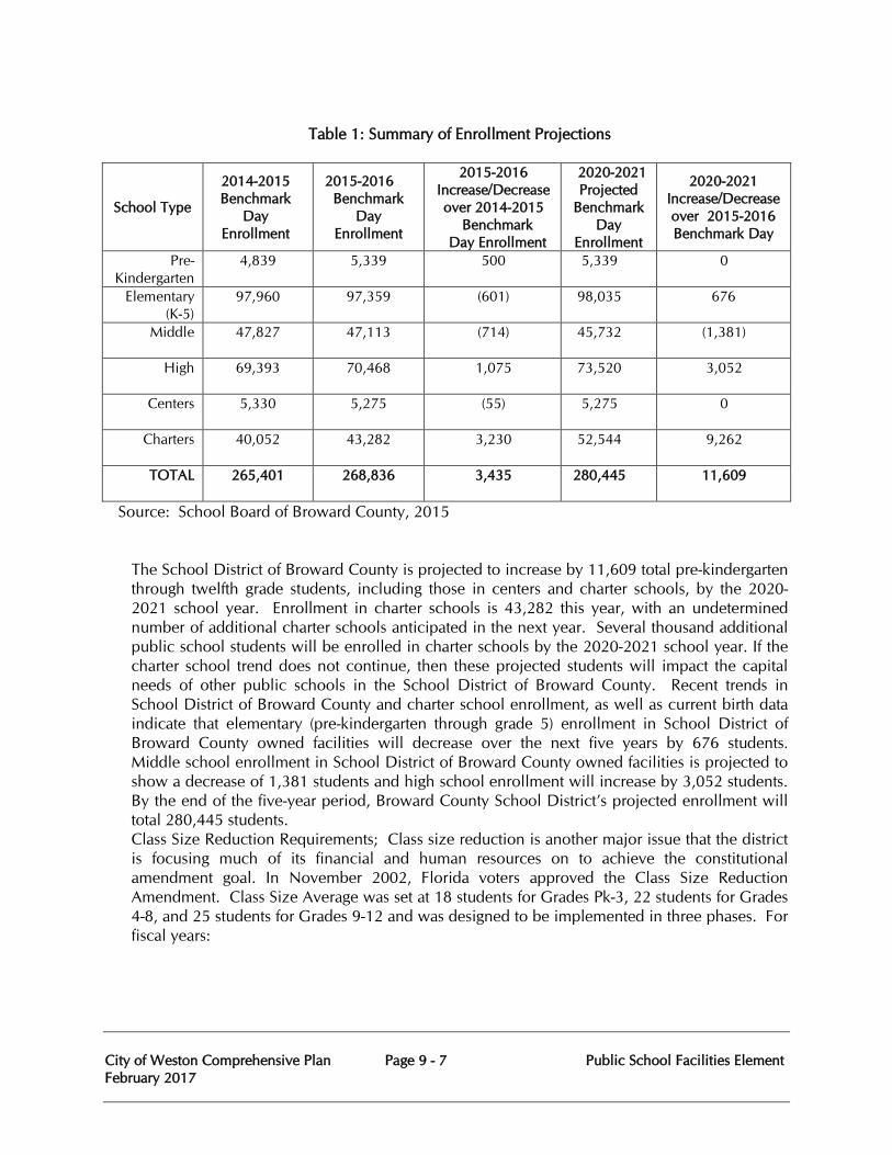
City of Weston Comprehensive Plan Page 9 - 7 Public School Facilities Element February 2017
Table 1: Summary of Enrollment Projections
School Type
2014-2015 Benchmark
Day Enrollment
2015-2016 Benchmark
Day Enrollment
2015-2016 Increase/Decrease over 2014-2015
Benchmark Day Enrollment
2020-2021 Projected
Benchmark Day
Enrollment
2020-2021 Increase/Decrease over 2015-2016 Benchmark Day
Pre-Kindergarten
4,839
5,339
500
5,339
0
Elementary (K-5)
97,960
97,359
(601)
98,035
676
Middle 47,827
47,113
(714)
45,732
(1,381)
High 69,393
70,468
1,075
73,520
3,052
Centers 5,330
5,275
(55)
5,275
0
Charters 40,052
43,282
3,230
52,544
9,262
TOTAL 265,401
268,836
3,435
280,445
11,609
Source: School Board of Broward County, 2015 The School District of Broward County is projected to increase by 11,609 total pre-kindergarten through twelfth grade students, including those in centers and charter schools, by the 2020-2021 school year. Enrollment in charter schools is 43,282 this year, with an undetermined number of additional charter schools anticipated in the next year. Several thousand additional public school students will be enrolled in charter schools by the 2020-2021 school year. If the charter school trend does not continue, then these projected students will impact the capital needs of other public schools in the School District of Broward County. Recent trends in School District of Broward County and charter school enrollment, as well as current birth data indicate that elementary (pre-kindergarten through grade 5) enrollment in School District of Broward County owned facilities will decrease over the next five years by 676 students. Middle school enrollment in School District of Broward County owned facilities is projected to show a decrease of 1,381 students and high school enrollment will increase by 3,052 students. By the end of the five-year period, Broward County School District’s projected enrollment will total 280,445 students. Class Size Reduction Requirements; Class size reduction is another major issue that the district is focusing much of its financial and human resources on to achieve the constitutional amendment goal. In November 2002, Florida voters approved the Class Size Reduction Amendment. Class Size Average was set at 18 students for Grades Pk-3, 22 students for Grades 4-8, and 25 students for Grades 9-12 and was designed to be implemented in three phases. For fiscal years:
City of Weston Comprehensive Plan Page 9 - 8 Public School Facilities Element February 2017
• 2003-04 through 2005-06, class size average was set at the district level;
• 2006-07 and 2009-10, class size average was set at the school level; and
• 2010-11 and thereafter, class size average will be calculated at the individual classroom level.
The 2010 Legislature provided that Charter schools shall be in compliance with Florida Statutes Section 1003.03, relates to maximum class size, except that the calculation shall be the average at the school level by grade grouping. Prior to 2010-11, the School District of Broward County achieved compliance during all years except for 2006-07. In 2007, the Superintendent established the Class Size Reduction Action Committee (CSRAC) which was comprised of staff from the District: Schools, Areas Offices, Facilities, Boundaries, Budget, Curriculum, Human Relations and Instructional Staffing to address compliance and prepare the School District of Broward County for period-by-period implementation. Continued State budget issues, and a failed attempt in 2009 to provide School District of Broward County scheduling flexibility, inclined the State Legislature during the 2011 Legislative session to redefine the term “core-curricula courses.” Under the revised bill, core courses are courses specified by grade levels, subjects measured by State assessments, high school graduation requirements, subgrades of students and include: • Language arts/reading, mathematics, social studies and science courses in prekindergarten
through grade 3; • Courses in grades 4 through 8 in subjects that are measured by state assessment at any
grade level and courses required for middle school promotion; • Courses in grades 9 through 12 in subjects that are measured by state assessment at any
grade level; • Courses that are specifically identified by name in statute, as required for high school
graduation, and that are not measured by State assessments, excluding any extracurricular courses;
• Exceptional student education courses; and • English for Speakers of Other Languages (ESOL) courses.
The Florida Department of Education (FDOC) noted that in 2010-11, there were 849 core courses. Under the legislation approved in May 2011, there were 298 core courses. As of June 2014, a total of 347 courses are considered core. This is down 9 courses from the 2013-14 school year. The courses that were removed include: 3 general education courses – Middle School Advanced Pre-Algebra and High School Economics and Economics Honors. Also included in the removed courses were 6 Exceptional Student Education (ESE) courses. Class Size Reduction Non-Compliance Consequences: The Class Size Legislation continues to require each School Board of Broward County to consider implementing various policies and methods to meet these constitutional class sizes, including encouraging dual enrollment courses, encouraging the Florida Virtual School, maximizing instructional staff, reducing construction costs, using joint-use facilities, implementing alternative class scheduling,
City of Weston Comprehensive Plan Page 9 - 9 Public School Facilities Element February 2017
redrawing attendance zones, implementing evening and multiple sessions, and implementing year-round and non-traditional calendars. During 2012-13, Broward County Public Schools standardized District-wide a 7-period High School schedule to assist with addressing CSR compliance. District-wide, classes at non-charter schools went from 52.3% in compliance during 2011-12, to 87.7% in compliance during 2012-13. During 2013-14, Broward continued to apply State implementation options and increased period-by-period compliance to 89.3%. Additionally, during 2013-14, the state legislature provided that School District of Broward County “Schools of Choice” would be held to the same, school-wide average by grade grouping compliance standards as Charter schools. In 2014, per Florida State Statute, the calculation for the District’s reduction was based on 100% of the base student allocation versus the original 50%. In 2014-15, District-wide period-by-period compliance increased to 90.6% at non-charter schools. At this same time, for the first time in 4 years the School District of Broward County non-charter schools were not included in the FDOE CSR Compliance penalty calculations. Preliminary 2015-16 District Survey 2 results indicate that once again, none of the District’s non-charter Schools of Choice or Traditional non-charter schools will be included in the FDOE penalty calculation. Accountability provisions put into place during the 2011 Legislative session provided the following: • Compliance determination continues to be based on October enrollment survey; • A reduction calculation to class size funding for non-compliant districts, which can be
adjusted for good cause; • A reallocation bonus of up to 5% of the base student allocation for compliant districts, not
to exceed 25% of reduced funds; • An add-back of the remaining 75% of the reduced funds, if the Districts submit a plan to
meet the requirements by October the subsequent year; and • Authorization of virtual instruction programs as an option to meet class size requirements.
During the 2011-12 school year, the FDOE implemented a one-time rule in which a School District could not be fined for more than half the State’s total fine. Under the 2011 bill and continuing, a timeframe was specified for satisfying and maintaining class size maximums, with specific exceptions of an extreme emergency beyond the District’s control and when a student enrolls after the October survey period. Based on a School District’s determination that not assigning the student would be impractical, educationally unsound, or disruptive to student learning, a student could be assigned to an existing class that temporarily exceeds the class size maximums. However, the additional numbers of students, who can be assigned to a teacher above the maximum, may not exceed three students in Grades PK-3; and five students above the maximum in Grades 4-12. This temporary exception is also contingent upon a district school board developing, and filing a plan with the FDOE by February 1st, that provides that a school will be in full compliance with the maximum class size requirements by the following year’s October student membership survey.
City of Weston Comprehensive Plan Page 9 - 10 Public School Facilities Element February 2017
Options for Reducing Capacity
The School Board of Broward County has considered options to optimize the usage of educational facilities within the District. Each year the School District of Broward County undergoes an extensive boundary process and considers the effectiveness of programs that are being utilized as an alternative to adding capacity.
Boundary Process: Each year the School District of Broward County undergoes a boundary process that considers the demographic changes in student populations, available and future facility capacity, programming components, as well as the diversity at each school. As part of the annual boundary process the School District of Broward County relies on input from the communities and stakeholders. Through the boundary process, every effort is made to maintain equal educational opportunities.
Multi-track Scheduling: The School District of Broward County has utilized multi-track schedules for an elementary school successfully. In that school, this multi-track schedule accommodated up to 120% of the school’s FISH capacity in the 2005-06 school year. The community was content with the multi-track scheduling and has shown increases in student achievement, attendance and less discipline situations. The School District of Broward County has continued to utilize this method to increase the utilization of schools.
Grade Level Organization: Various grade level configurations are examined to reduce or add capacity. Presently we have two primary schools with grade levels of Pre-K-3, three Pre-K-7 schools, one Pre-K-8 school, and two 9-12 schools.
Block Scheduling: The School District of Broward County has been in the forefront of implementing and evaluating block scheduling. The School District of Broward County utilize block schedules at several schools.
High School Options: Dual enrollment gives high school juniors and seniors the opportunity to take college level courses and receive credits towards high school graduation. If a student qualifies for this it can free up capacity while benefiting student achievement. The early admissions and 18 credit diploma option allows for high school students to apply for early graduation, which will also relieve enrollment at our high schools.
Other Alternatives: The School District of Broward County has also been using creative alternative methods to assist in distributing the student population by allowing parents and students the choice of school assignment. Some examples are:
• Broward Virtual School: Broward Virtual School (BVS) offers full-time enrollment to students in grades K-12 through an online educational delivery system. Students in grades 6-12 may enroll part-time as well. BVS offers equitable access to high quality, individualized education, through the Internet and other distance learning technologies. The virtual environment provides flexibility of the time and location, and promotes development of the skills, the attitudes, and the self-discipline necessary to achieve success in the 21st century. Broward Virtual School officers students the opportunity to earn a standard high school diploma entirely online. https://www.bved.net
City of Weston Comprehensive Plan Page 9 - 11 Public School Facilities Element February 2017
• Magnet Schools: The District offers magnet programs in several locations largely in schools where space is available. These programs offer a thematic educational program; which entices students/parents to choose a school and fill available seats. They have been a popular choice alternative option.
Charter Schools: The School District of Broward County has led the state in the number of students attending charter schools. During the 1999-00 school year 3,873 students attended charter schools. Since that time charter school enrollment has increased an additional 39,409 students, enrolling a total of 43,282 students during the 2015-2016 school year.
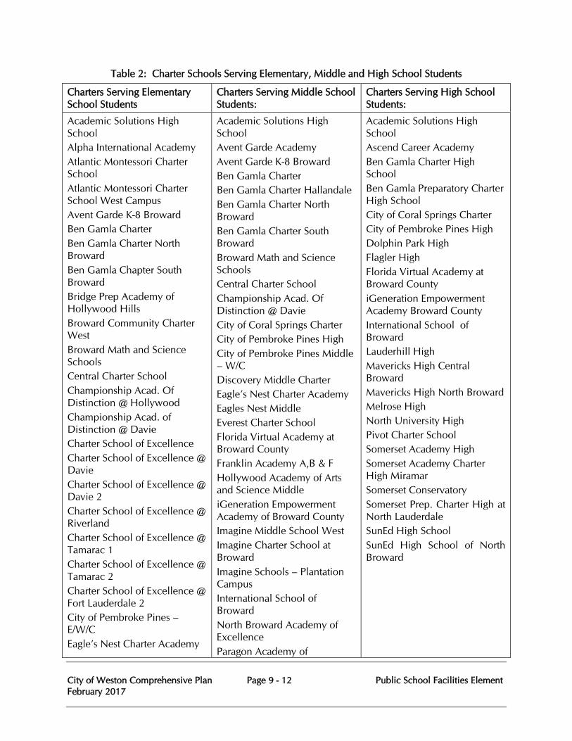
City of Weston Comprehensive Plan Page 9 - 12 Public School Facilities Element February 2017
Table 2: Charter Schools Serving Elementary, Middle and High School Students
Charters Serving Elementary School Students
Charters Serving Middle School Students:
Charters Serving High School Students:
Academic Solutions High School Alpha International Academy Atlantic Montessori Charter School Atlantic Montessori Charter School West Campus Avent Garde K-8 Broward Ben Gamla Charter Ben Gamla Charter North Broward Ben Gamla Chapter South Broward Bridge Prep Academy of Hollywood Hills Broward Community Charter West Broward Math and Science Schools Central Charter School Championship Acad. Of Distinction @ Hollywood Championship Acad. of Distinction @ Davie Charter School of Excellence Charter School of Excellence @ Davie Charter School of Excellence @ Davie 2 Charter School of Excellence @ Riverland Charter School of Excellence @ Tamarac 1 Charter School of Excellence @ Tamarac 2 Charter School of Excellence @ Fort Lauderdale 2 City of Pembroke Pines – E/W/C Eagle’s Nest Charter Academy
Academic Solutions High School Avent Garde Academy Avent Garde K-8 Broward Ben Gamla Charter Ben Gamla Charter Hallandale Ben Gamla Charter North Broward Ben Gamla Charter South Broward Broward Math and Science Schools Central Charter School Championship Acad. Of Distinction @ Davie City of Coral Springs Charter City of Pembroke Pines High City of Pembroke Pines Middle – W/C Discovery Middle Charter Eagle’s Nest Charter Academy Eagles Nest Middle Everest Charter School Florida Virtual Academy at Broward County Franklin Academy A,B & F Hollywood Academy of Arts and Science Middle iGeneration Empowerment Academy of Broward County Imagine Middle School West Imagine Charter School at Broward Imagine Schools – Plantation Campus International School of Broward North Broward Academy of Excellence Paragon Academy of
Academic Solutions High School Ascend Career Academy Ben Gamla Charter High School Ben Gamla Preparatory Charter High School City of Coral Springs Charter City of Pembroke Pines High Dolphin Park High Flagler High Florida Virtual Academy at Broward County iGeneration Empowerment Academy Broward County International School of Broward Lauderhill High Mavericks High Central Broward Mavericks High North Broward Melrose High North University High Pivot Charter School Somerset Academy High Somerset Academy Charter High Miramar Somerset Conservatory Somerset Prep. Charter High at North Lauderdale SunEd High School SunEd High School of North Broward

City of Weston Comprehensive Plan Page 9 - 13 Public School Facilities Element February 2017
Charters Serving Elementary School Students
Charters Serving Middle School Students:
Charters Serving High School Students:
Excelsior Charter of Broward Florida Virtual Academy at Broward County Franklin Academy A, B & C Greentree Preparatory Charter School Henry McNeal Turner Learning Academy Hollywood Academy of Arts and Science Elementary Imagine Charter School at Weston Imagine Charter School at Broward Imagine Elementary at North Lauderdale Imagine Schools – Plantation Campus Innovation Charter School Kidz Choice Charter New Life charter Academy North Broward Academy of Excellence Panacca Prep charter School Paramount Charter School Pathways Academy K-8 Center Renaissance Charter School at Pines Renaissance Charter School at Cooper City Renaissance Charter School at Coral Springs Renaissance Charter School at Plantation Renaissance Charter School at University RISE Academy School of Science and Technology Somerset Academy Somerset Academy Davie Somerset Academy East Prep
Technology Paramount Charter School Pathways Academy K-8 Center Pivot Charter School Renaissance Charter Middle School at Pines Renaissance Charter School at Cooper City Renaissance Charter School at Coral Springs Renaissance Charter School at Plantation Renaissance Charter School at University RISE Academy School of Science and Technology Somerset Academy Middle Somerset Academy Hollywood Middle School Somerset Academy Middle School at Miramar
City of Weston Comprehensive Plan Page 9 - 14 Public School Facilities Element February 2017
Charters Serving Elementary School Students
Charters Serving Middle School Students:
Charters Serving High School Students:
Somerset Academy Hollywood Somerset Academy Miramar Somerset Academy Pompano Source: School Board of Broward County, 2015
6. Analysis of Infrastructure Needs for Existing and Proposed School Facilities (F.S. 163.31777(2)(d).
Broward County currently has 342 public school facilities, including elementary, middle, high, charter and special schools. Due to the fact that Broward County is predominately built out, the major infrastructure, including; roads, drainage, sanitary sewer and potable water facilities are available to support existing and proposed school facilities.
One area which needs attention however, is pedestrian infrastructure. The County has some areas where sidewalks and unobstructed access to schools can be improved. To address this, Broward County promotes safe routes to schools (SRTS) through the Broward County MPO 2035 Long Range Transportation Plan. A goal to “ensure and where possible enhance safety and security” in transportation projects near schools is intended to reduce hazards by providing the necessary infrastructure for pedestrians within a 2 mile radius of schools deemed “hazardous” for school children. In furthering this goal, 2035 Plan proposed sidewalk infrastructure improvements in areas which are deemed hazardous and/or enhance the safety and security of pedestrians. The School District of Broward County has also applied for Safe Route to School (SRTS) Grants for sidewalk construction since 2006 and to date has maintained a list of over 150 locations in Broward County that need sidewalk improvements. This list is updated annually.
In addition, during the development review and site selection process of any proposed school, all infrastructure needs are taken into consideration. These procedures and processes are outlined in Sections V and VI of the ILA. The School Board also requires that all major expansion, remodeling and/or replacements projects (exceeding $1,000,000) go through a Master Planning process. This process, which involves public input, must evaluate infrastructure issues such as; site circulation, parking, retention areas and public utility locations.
B. Data and Analysis
1. Population and Housing Conditions Population Growth in Broward County As displayed in Table 3 below, Broward County has experienced significant population growth since 1970. In 1970 Broward County had a population of 620,100 and the 2010 Census population count was 1,748,066 a growth of 182%. Though the County is approaching “build-
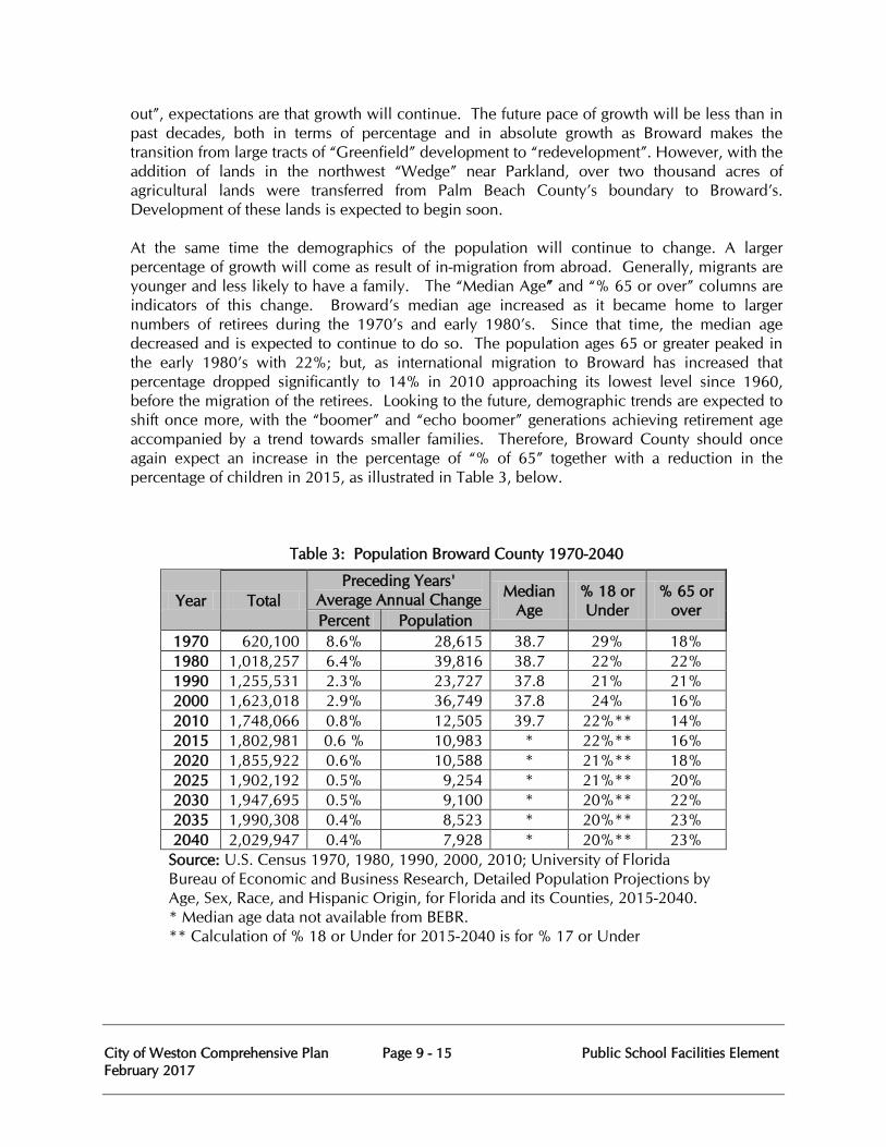
City of Weston Comprehensive Plan Page 9 - 15 Public School Facilities Element February 2017
out”, expectations are that growth will continue. The future pace of growth will be less than in past decades, both in terms of percentage and in absolute growth as Broward makes the transition from large tracts of “Greenfield” development to “redevelopment”. However, with the addition of lands in the northwest “Wedge” near Parkland, over two thousand acres of agricultural lands were transferred from Palm Beach County’s boundary to Broward’s. Development of these lands is expected to begin soon. At the same time the demographics of the population will continue to change. A larger percentage of growth will come as result of in-migration from abroad. Generally, migrants are younger and less likely to have a family. The “Median Age” and “% 65 or over” columns are indicators of this change. Broward’s median age increased as it became home to larger numbers of retirees during the 1970’s and early 1980’s. Since that time, the median age decreased and is expected to continue to do so. The population ages 65 or greater peaked in the early 1980’s with 22%; but, as international migration to Broward has increased that percentage dropped significantly to 14% in 2010 approaching its lowest level since 1960, before the migration of the retirees. Looking to the future, demographic trends are expected to shift once more, with the “boomer” and “echo boomer” generations achieving retirement age accompanied by a trend towards smaller families. Therefore, Broward County should once again expect an increase in the percentage of “% of 65” together with a reduction in the percentage of children in 2015, as illustrated in Table 3, below.
Table 3: Population Broward County 1970-2040
Year Total Preceding Years'
Average Annual Change Median Age
% 18 or Under
% 65 or over
Percent Population 1970 620,100 8.6% 28,615 38.7 29% 18% 1980 1,018,257 6.4% 39,816 38.7 22% 22% 1990 1,255,531 2.3% 23,727 37.8 21% 21% 2000 1,623,018 2.9% 36,749 37.8 24% 16% 2010 1,748,066 0.8% 12,505 39.7 22%** 14% 2015 1,802,981 0.6 % 10,983 * 22%** 16% 2020 1,855,922 0.6% 10,588 * 21%** 18% 2025 1,902,192 0.5% 9,254 * 21%** 20% 2030 1,947,695 0.5% 9,100 * 20%** 22% 2035 1,990,308 0.4% 8,523 * 20%** 23% 2040 2,029,947 0.4% 7,928 * 20%** 23%
Source: U.S. Census 1970, 1980, 1990, 2000, 2010; University of Florida Bureau of Economic and Business Research, Detailed Population Projections by Age, Sex, Race, and Hispanic Origin, for Florida and its Counties, 2015-2040. * Median age data not available from BEBR. ** Calculation of % 18 or Under for 2015-2040 is for % 17 or Under
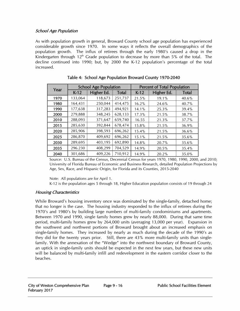
City of Weston Comprehensive Plan Page 9 - 16 Public School Facilities Element February 2017
School Age Population As with population growth in general, Broward County school age population has experienced considerable growth since 1970. In some ways it reflects the overall demographics of the population growth. The influx of retirees through the early 1980’s caused a drop in the Kindergarten through 12th Grade population to decrease by more than 5% of the total. The decline continued into 1990; but, by 2000 the K-12 population’s percentage of the total increased.
Table 4: School Age Population Broward County 1970-2040
Year School Age Population Percent of Total Population
K-12 Higher Ed. Total K-12 Higher Ed. Total 1970 133,064 118,673 251,737 21.5% 19.1% 40.6% 1980 164,431 250,044 414,475 16.2% 24.6% 40.7% 1990 177,638 317,283 494,921 14.1% 25.3% 39.4% 2000 279,888 348,245 628,133 17.3% 21.5% 38.7% 2010 288,093 371,647 659,740 16.55 21.3% 37.7% 2015 285,630 392,844 678,474 15.8% 21.5% 36.9% 2020 285,906 398,593 696,262 15.4% 21.5% 36.6% 2025 286,870 409,692 696,262 15.1% 21.5% 35.6% 2030 289,695 403,195 692,890 14.8% 20.7% 35.6% 2035 296.230 408,299 704,529 14.9% 20.5% 35.4% 2040 301,686 409,226 710,912 14.9% 20.2% 35.0%
Source: U.S. Bureau of the Census, Decennial Census for years 1970, 1980, 1990, 2000, and 2010; University of Florida Bureau of Economic and Business Research, detailed Population Projections by Age, Sex, Race, and Hispanic Origin, for Florida and its Counties, 2015-2040 Note: All populations are for April 1. K-12 is the population ages 5 through 18, Higher Education population consists of 19 through 24
Housing Characteristics
While Broward’s housing inventory once was dominated by the single-family, detached home; that no longer is the case. The housing industry responded to the influx of retirees during the 1970’s and 1980’s by building large numbers of multi-family condominiums and apartments. Between 1970 and 1990, single family homes grew by nearly 88,000. During that same time period, multi-family homes grew by 264,000 units (averaging 13,000 per year). Expansion in the southwest and northwest portions of Broward brought about an increased emphasis on single-family homes. They increased by nearly as much during the decade of the 1990’s as they did for the twenty years prior. Still, there are 43% more multi-family units than single-family. With the annexation of the “Wedge” into the northwest boundary of Broward County, an uptick in single-family units should be expected in the next few years, but these new units will be balanced by multi-family infill and redevelopment in the eastern corridor closer to the beaches.
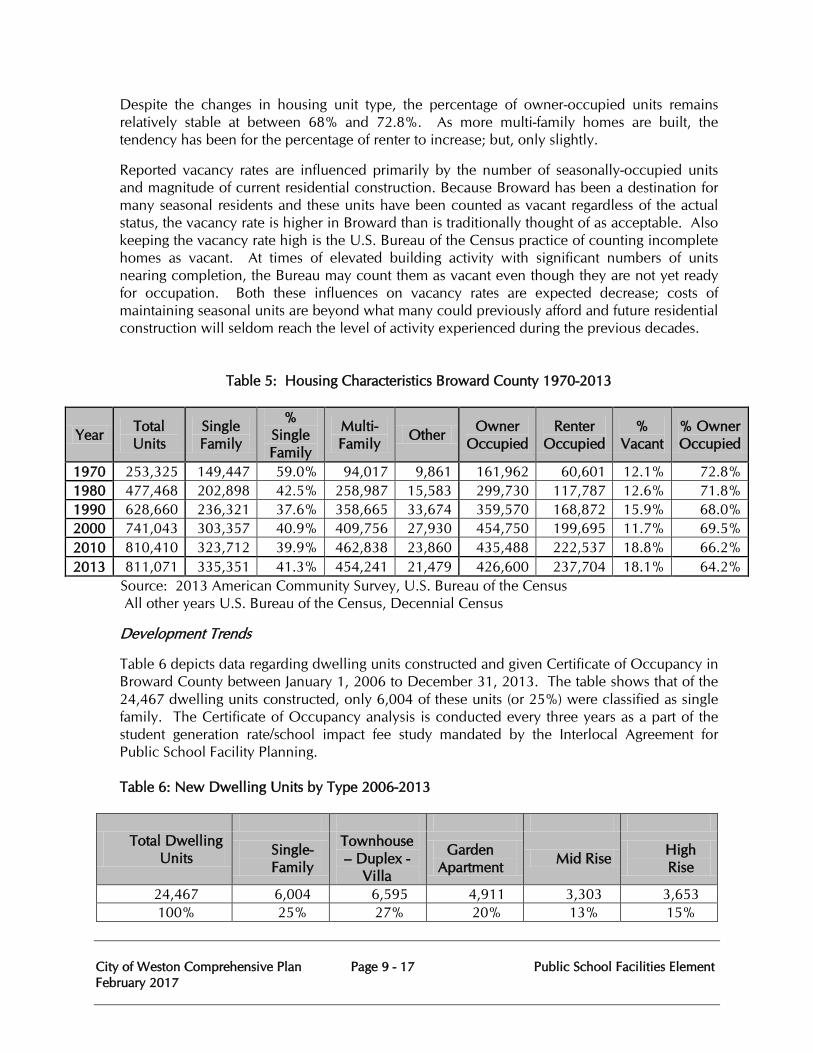
City of Weston Comprehensive Plan Page 9 - 17 Public School Facilities Element February 2017
Despite the changes in housing unit type, the percentage of owner-occupied units remains relatively stable at between 68% and 72.8%. As more multi-family homes are built, the tendency has been for the percentage of renter to increase; but, only slightly.
Reported vacancy rates are influenced primarily by the number of seasonally-occupied units and magnitude of current residential construction. Because Broward has been a destination for many seasonal residents and these units have been counted as vacant regardless of the actual status, the vacancy rate is higher in Broward than is traditionally thought of as acceptable. Also keeping the vacancy rate high is the U.S. Bureau of the Census practice of counting incomplete homes as vacant. At times of elevated building activity with significant numbers of units nearing completion, the Bureau may count them as vacant even though they are not yet ready for occupation. Both these influences on vacancy rates are expected decrease; costs of maintaining seasonal units are beyond what many could previously afford and future residential construction will seldom reach the level of activity experienced during the previous decades.
Table 5: Housing Characteristics Broward County 1970-2013
Year Total Units
Single Family
% Single Family
Multi-Family Other Owner
Occupied Renter
Occupied %
Vacant % Owner Occupied
1970 253,325 149,447 59.0% 94,017 9,861 161,962 60,601 12.1% 72.8% 1980 477,468 202,898 42.5% 258,987 15,583 299,730 117,787 12.6% 71.8% 1990 628,660 236,321 37.6% 358,665 33,674 359,570 168,872 15.9% 68.0% 2000 741,043 303,357 40.9% 409,756 27,930 454,750 199,695 11.7% 69.5% 2010 810,410 323,712 39.9% 462,838 23,860 435,488 222,537 18.8% 66.2% 2013 811,071 335,351 41.3% 454,241 21,479 426,600 237,704 18.1% 64.2%
Source: 2013 American Community Survey, U.S. Bureau of the Census All other years U.S. Bureau of the Census, Decennial Census
Development Trends
Table 6 depicts data regarding dwelling units constructed and given Certificate of Occupancy in Broward County between January 1, 2006 to December 31, 2013. The table shows that of the 24,467 dwelling units constructed, only 6,004 of these units (or 25%) were classified as single family. The Certificate of Occupancy analysis is conducted every three years as a part of the student generation rate/school impact fee study mandated by the Interlocal Agreement for Public School Facility Planning. Table 6: New Dwelling Units by Type 2006-2013
Total Dwelling Units
Single-Family
Townhouse – Duplex -
Villa
Garden Apartment Mid Rise High
Rise
24,467 6,004 6,595 4,911 3,303 3,653 100% 25% 27% 20% 13% 15%
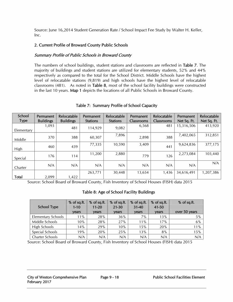
City of Weston Comprehensive Plan Page 9 - 18 Public School Facilities Element February 2017
Source: June 16,2014 Student Generation Rate / School Impact Fee Study by Walter H. Keller, Inc. 2. Current Profile of Broward County Public Schools
Summary Profile of Public Schools in Broward County The numbers of school buildings, student stations and classrooms are reflected in Table 7. The majority of buildings and student stations are utilized for elementary students, 52% and 44% respectively as compared to the total for the School District. Middle Schools have the highest level of relocatable stations (9,819) and high schools have the highest level of relocatable classrooms (481). As noted in Table 8, most of the school facility buildings were constructed in the last 10 years. Map 1 depicts the locations of all Public Schools in Broward County.
Table 7: Summary Profile of School Capacity
School Type
Permanent Buildings
Relocatable Buildings
Permanent Stations
Relocatable Stations
Permanent Classrooms
Relocatable Classrooms
Permanent Net Sq. Ft.
Relocatable Net Sq. Ft.
Elementary 1,093
481 114,929 9,082 6,568
481
15,316,506
413,920
Middle 370 388 60,307 7,896 2,898 388 7,402,065
312,851
High 460 439 77,335
10,590
3,409 441 9,624,836
377,175
Special 176 114 11,200
2,880 779 126 2,273,084
103,440
Charter N/A N/A N/A N/A N/A N/A N/A N/A
Total 2,099 1,422 263,771
30,448
13,654
1,436
34,616,491
1,207,386
Source: School Board of Broward County, Fish Inventory of School Houses (FISH) data 2015 Table 8: Age of School Facility Buildings
School Type % of sq.ft. % of sq.ft. % of sq.ft. % of sq.ft. % of sq.ft. % of sq.ft.
1-10 years
11-20 years
21-30 years
31-40 years
41-50 years over 50 years
Elementary Schools 11% 28% 36% 7% 13% 5% Middle Schools 10% 28% 27% 11% 17% 6% High Schools 14% 29% 10% 15% 20% 11% Special Schools 19% 20% 25% 13% 8% 15% Charter Schools N/A N/A N/A N/A N/A N/A
Source: School Board of Broward County, Fish Inventory of School Houses (FISH) data 2015
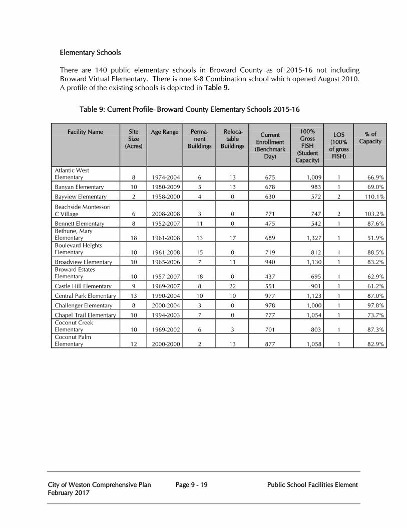
City of Weston Comprehensive Plan Page 9 - 19 Public School Facilities Element February 2017
Elementary Schools There are 140 public elementary schools in Broward County as of 2015-16 not including
Broward Virtual Elementary. There is one K-8 Combination school which opened August 2010. A profile of the existing schools is depicted in Table 9.
Table 9: Current Profile- Broward County Elementary Schools 2015-16
Facility Name
Site Size
(Acres)
Age Range
Perma- nent
Buildings
Reloca- table
Buildings
Current
Enrollment (Benchmark
Day)
100% Gross FISH
(Student Capacity)
LOS
(100% of gross FISH)
% of
Capacity
Atlantic West Elementary
8
1974-2004
6
13
675
1,009
1
66.9%
Banyan Elementary 10 1980-2009 5 13 678 983 1 69.0% Bayview Elementary 2 1958-2000 4 0 630 572 2 110.1% Beachside Montessori C Village
6
2008-2008
3
0
771
747
2
103.2%
Bennett Elementary 8 1952-2007 11 0 475 542 1 87.6% Bethune, Mary Elementary
18
1961-2008
13
17
689
1,327
1
51.9%
Boulevard Heights Elementary
10
1961-2008
15
0
719
812
1
88.5%
Broadview Elementary 10 1965-2006 7 11 940 1,130 1 83.2% Broward Estates Elementary
10
1957-2007
18
0
437
695
1
62.9%
Castle Hill Elementary 9 1969-2007 8 22 551 901 1 61.2% Central Park Elementary 13 1990-2004 10 10 977 1,123 1 87.0% Challenger Elementary 8 2000-2004 3 0 978 1,000 1 97.8% Chapel Trail Elementary 10 1994-2003 7 0 777 1,054 1 73.7% Coconut Creek Elementary
10
1969-2002
6
3
701
803
1
87.3%
Coconut Palm Elementary
12
2000-2000
2
13
877
1,058
1
82.9%
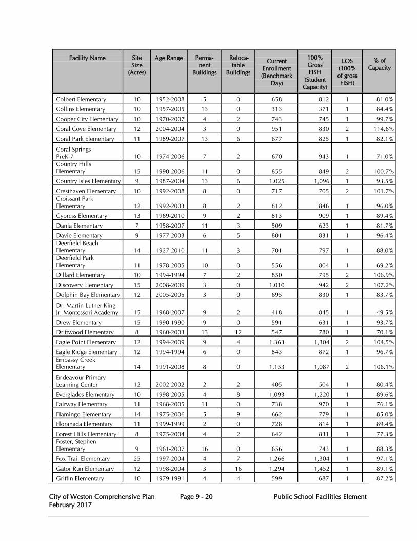
City of Weston Comprehensive Plan Page 9 - 20 Public School Facilities Element February 2017
Facility Name
Site Size
(Acres)
Age Range
Perma- nent
Buildings
Reloca- table
Buildings
Current
Enrollment (Benchmark
Day)
100% Gross FISH
(Student Capacity)
LOS
(100% of gross FISH)
% of
Capacity
Colbert Elementary 10 1952-2008 5 0 658 812 1 81.0% Collins Elementary 10 1957-2005 13 0 313 371 1 84.4% Cooper City Elementary 10 1970-2007 4 2 743 745 1 99.7% Coral Cove Elementary 12 2004-2004 3 0 951 830 2 114.6% Coral Park Elementary 11 1989-2007 13 6 677 825 1 82.1% Coral Springs PreK-7
10
1974-2006
7
2
670
943
1
71.0%
Country Hills Elementary
15
1990-2006
11
0
855
849
2
100.7%
Country Isles Elementary 9 1987-2004 13 6 1,025 1,096 1 93.5% Cresthaven Elementary 10 1992-2008 8 0 717 705 2 101.7% Croissant Park Elementary
12
1992-2003
8
2
812
846
1
96.0%
Cypress Elementary 13 1969-2010 9 2 813 909 1 89.4% Dania Elementary 7 1958-2007 11 3 509 623 1 81.7% Davie Elementary 9 1977-2003 6 5 801 831 1 96.4% Deerfield Beach Elementary
14
1927-2010
11
3
701
797
1
88.0%
Deerfield Park Elementary
11
1978-2005
10
0
556
804
1
69.2%
Dillard Elementary 10 1994-1994 7 2 850 795 2 106.9% Discovery Elementary 15 2008-2009 3 0 1,010 942 2 107.2% Dolphin Bay Elementary 12 2005-2005 3 0 695 830 1 83.7% Dr. Martin Luther King Jr. Montessori Academy
15
1968-2007
9
2
418
845
1
49.5%
Drew Elementary 15 1990-1990 9 0 591 631 1 93.7% Driftwood Elementary 8 1960-2003 13 12 547 780 1 70.1% Eagle Point Elementary 12 1994-2009 9 4 1,363 1,304 2 104.5% Eagle Ridge Elementary 12 1994-1994 6 0 843 872 1 96.7% Embassy Creek Elementary
14
1991-2008
8
0
1,153
1,087
2
106.1%
Endeavour Primary Learning Center
12
2002-2002
2
2
405
504
1
80.4%
Everglades Elementary 10 1998-2005 4 8 1,093 1,220 1 89.6% Fairway Elementary 11 1968-2005 11 0 738 970 1 76.1% Flamingo Elementary 14 1975-2006 5 9 662 779 1 85.0% Floranada Elementary 11 1999-1999 2 0 728 814 1 89.4% Forest Hills Elementary 8 1975-2004 4 2 642 831 1 77.3% Foster, Stephen Elementary
9
1961-2007
16
0
656
743
1
88.3%
Fox Trail Elementary 25 1997-2004 4 7 1,266 1,304 1 97.1% Gator Run Elementary 12 1998-2004 3 16 1,294 1,452 1 89.1% Griffin Elementary 10 1979-1991 4 4 599 687 1 87.2%
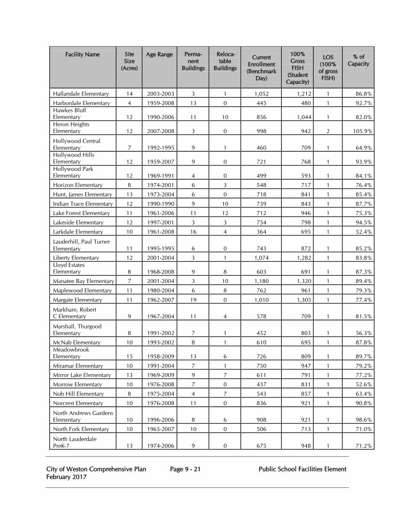
City of Weston Comprehensive Plan Page 9 - 21 Public School Facilities Element February 2017
Facility Name
Site Size
(Acres)
Age Range
Perma- nent
Buildings
Reloca- table
Buildings
Current
Enrollment (Benchmark
Day)
100% Gross FISH
(Student Capacity)
LOS
(100% of gross FISH)
% of
Capacity
Hallandale Elementary 14 2003-2003 3 1 1,052 1,212 1 86.8% Harbordale Elementary 4 1959-2008 13 0 445 480 1 92.7% Hawkes Bluff Elementary
12
1990-2006
11
10
856
1,044
1
82.0%
Heron Heights Elementary
12
2007-2008
3
0
998
942
2
105.9%
Hollywood Central Elementary
7
1992-1995
9
1
460
709
1
64.9%
Hollywood Hills Elementary
12
1959-2007
9
0
721
768
1
93.9%
Hollywood Park Elementary
12
1969-1991
4
0
499
593
1
84.1%
Horizon Elementary 8 1974-2001 6 3 548 717 1 76.4% Hunt, James Elementary 13 1973-2004 6 0 718 841 1 85.4% Indian Trace Elementary 12 1990-1990 9 10 739 843 1 87.7% Lake Forest Elementary 11 1961-2006 11 12 712 946 1 75.3% Lakeside Elementary 12 1997-2001 3 3 754 798 1 94.5% Larkdale Elementary 10 1961-2008 16 4 364 695 1 52.4% Lauderhill, Paul Turner Elementary
11
1995-1995
6
0
743
872
1
85.2%
Liberty Elementary 12 2001-2004 3 1 1,074 1,282 1 83.8% Lloyd Estates Elementary
8
1968-2008
9
8
603
691
1
87.3%
Manatee Bay Elementary 7 2001-2004 3 10 1,180 1,320 1 89.4% Maplewood Elementary 11 1980-2004 6 8 762 961 1 79.3% Margate Elementary 11 1962-2007 19 0 1,010 1,305 1 77.4% Markham, Robert C Elementary
9
1967-2004
11
4
578
709
1
81.5%
Marshall, Thurgood Elementary
8
1991-2002
7
1
452
803
1
56.3%
McNab Elementary 10 1993-2002 8 1 610 695 1 87.8% Meadowbrook Elementary
15
1958-2009
13
6
726
809
1
89.7%
Miramar Elementary 10 1991-2004 7 1 750 947 1 79.2% Mirror Lake Elementary 13 1969-2009 9 7 611 791 1 77.2% Morrow Elementary 10 1976-2008 7 0 437 831 1 52.6% Nob Hill Elementary 8 1975-2004 4 7 543 857 1 63.4% Norcrest Elementary 10 1976-2008 11 0 836 921 1 90.8% North Andrews Gardens Elementary
10
1996-2006
8
6
908
921
1
98.6%
North Fork Elementary 10 1965-2007 10 0 506 713 1 71.0% North Lauderdale PreK-7
13
1974-2006
9
0
675
948
1
71.2%
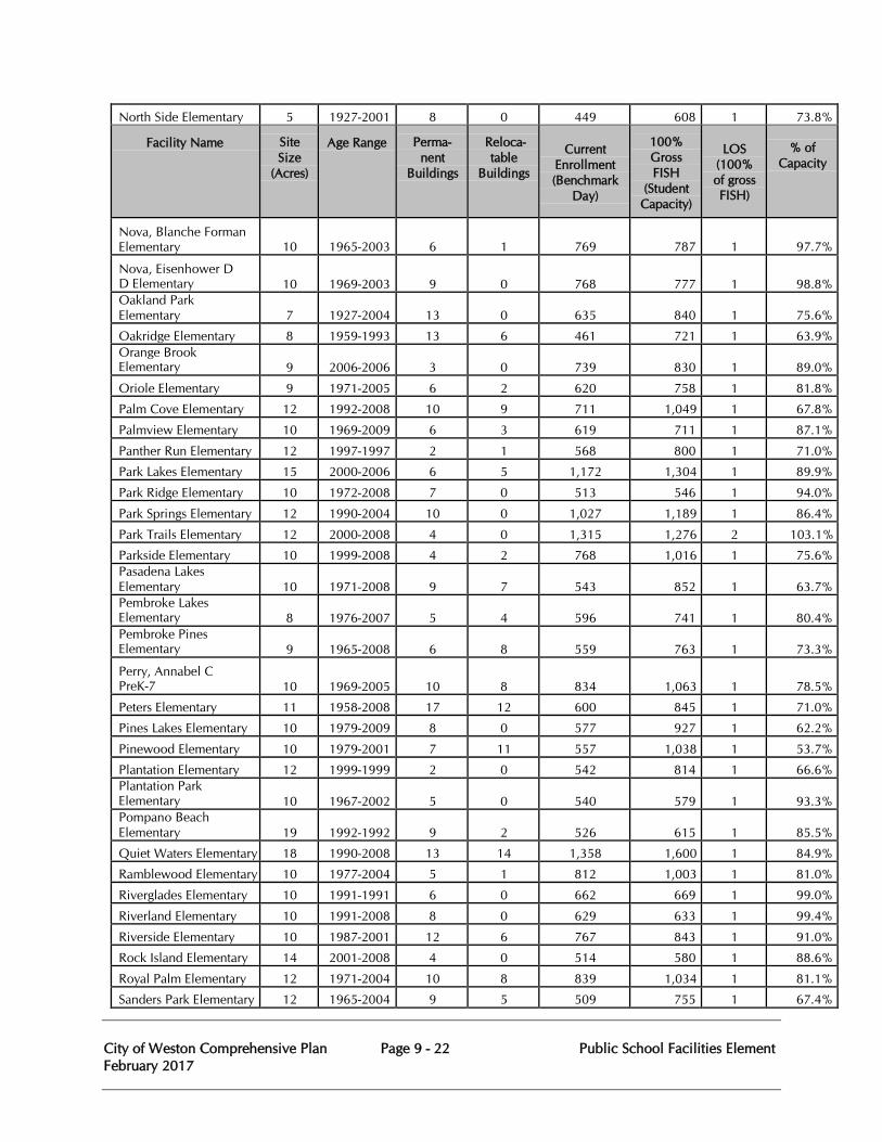
City of Weston Comprehensive Plan Page 9 - 22 Public School Facilities Element February 2017
North Side Elementary 5 1927-2001 8 0 449 608 1 73.8%
Facility Name
Site Size
(Acres)
Age Range
Perma- nent
Buildings
Reloca- table
Buildings
Current
Enrollment (Benchmark
Day)
100% Gross FISH
(Student Capacity)
LOS
(100% of gross FISH)
% of
Capacity
Nova, Blanche Forman Elementary
10
1965-2003
6
1
769
787
1
97.7%
Nova, Eisenhower D D Elementary
10
1969-2003
9
0
768
777
1
98.8%
Oakland Park Elementary
7
1927-2004
13
0
635
840
1
75.6%
Oakridge Elementary 8 1959-1993 13 6 461 721 1 63.9% Orange Brook Elementary
9
2006-2006
3
0
739
830
1
89.0%
Oriole Elementary 9 1971-2005 6 2 620 758 1 81.8% Palm Cove Elementary 12 1992-2008 10 9 711 1,049 1 67.8% Palmview Elementary 10 1969-2009 6 3 619 711 1 87.1% Panther Run Elementary 12 1997-1997 2 1 568 800 1 71.0% Park Lakes Elementary 15 2000-2006 6 5 1,172 1,304 1 89.9% Park Ridge Elementary 10 1972-2008 7 0 513 546 1 94.0% Park Springs Elementary 12 1990-2004 10 0 1,027 1,189 1 86.4% Park Trails Elementary 12 2000-2008 4 0 1,315 1,276 2 103.1% Parkside Elementary 10 1999-2008 4 2 768 1,016 1 75.6% Pasadena Lakes Elementary
10
1971-2008
9
7
543
852
1
63.7%
Pembroke Lakes Elementary
8
1976-2007
5
4
596
741
1
80.4%
Pembroke Pines Elementary
9
1965-2008
6
8
559
763
1
73.3%
Perry, Annabel C PreK-7
10
1969-2005
10
8
834
1,063
1
78.5%
Peters Elementary 11 1958-2008 17 12 600 845 1 71.0% Pines Lakes Elementary 10 1979-2009 8 0 577 927 1 62.2% Pinewood Elementary 10 1979-2001 7 11 557 1,038 1 53.7% Plantation Elementary 12 1999-1999 2 0 542 814 1 66.6% Plantation Park Elementary
10
1967-2002
5
0
540
579
1
93.3%
Pompano Beach Elementary
19
1992-1992
9
2
526
615
1
85.5%
Quiet Waters Elementary 18 1990-2008 13 14 1,358 1,600 1 84.9% Ramblewood Elementary 10 1977-2004 5 1 812 1,003 1 81.0% Riverglades Elementary 10 1991-1991 6 0 662 669 1 99.0% Riverland Elementary 10 1991-2008 8 0 629 633 1 99.4% Riverside Elementary 10 1987-2001 12 6 767 843 1 91.0% Rock Island Elementary 14 2001-2008 4 0 514 580 1 88.6% Royal Palm Elementary 12 1971-2004 10 8 839 1,034 1 81.1% Sanders Park Elementary 12 1965-2004 9 5 509 755 1 67.4%
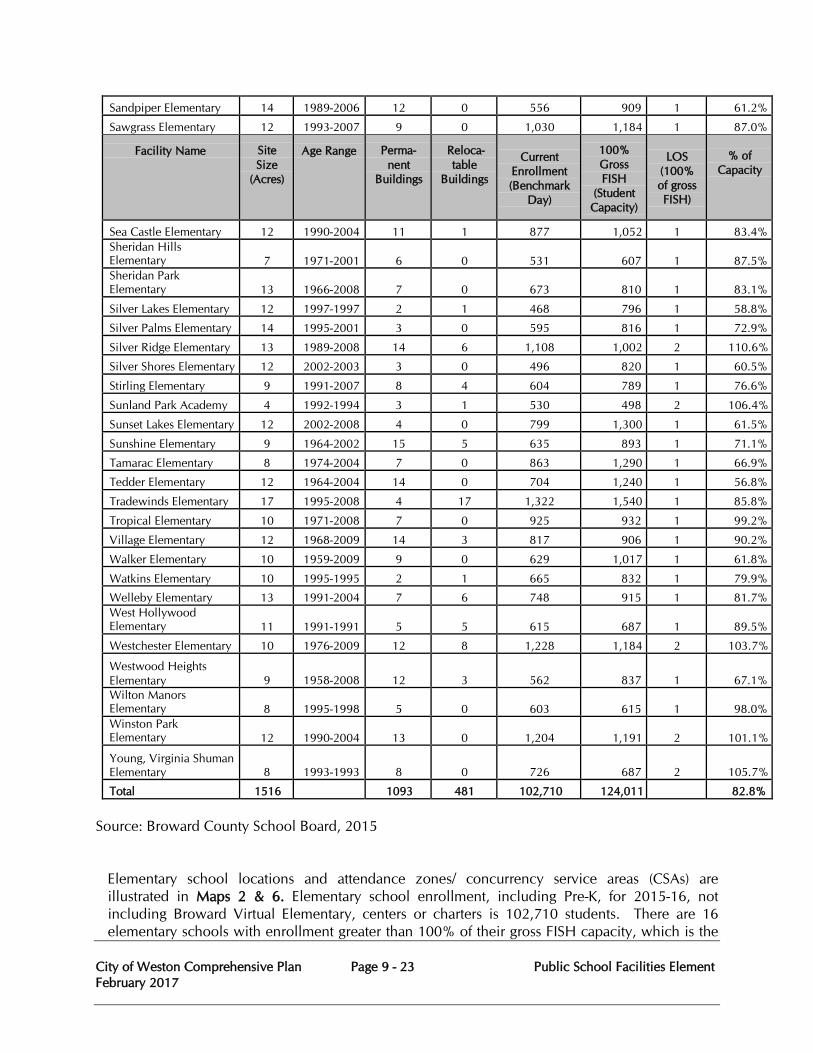
City of Weston Comprehensive Plan Page 9 - 23 Public School Facilities Element February 2017
Sandpiper Elementary 14 1989-2006 12 0 556 909 1 61.2% Sawgrass Elementary 12 1993-2007 9 0 1,030 1,184 1 87.0%
Facility Name
Site Size
(Acres)
Age Range
Perma- nent
Buildings
Reloca- table
Buildings
Current
Enrollment (Benchmark
Day)
100% Gross FISH
(Student Capacity)
LOS
(100% of gross FISH)
% of
Capacity
Sea Castle Elementary 12 1990-2004 11 1 877 1,052 1 83.4% Sheridan Hills Elementary
7
1971-2001
6
0
531
607
1
87.5%
Sheridan Park Elementary
13
1966-2008
7
0
673
810
1
83.1%
Silver Lakes Elementary 12 1997-1997 2 1 468 796 1 58.8% Silver Palms Elementary 14 1995-2001 3 0 595 816 1 72.9% Silver Ridge Elementary 13 1989-2008 14 6 1,108 1,002 2 110.6% Silver Shores Elementary 12 2002-2003 3 0 496 820 1 60.5% Stirling Elementary 9 1991-2007 8 4 604 789 1 76.6% Sunland Park Academy 4 1992-1994 3 1 530 498 2 106.4% Sunset Lakes Elementary 12 2002-2008 4 0 799 1,300 1 61.5% Sunshine Elementary 9 1964-2002 15 5 635 893 1 71.1% Tamarac Elementary 8 1974-2004 7 0 863 1,290 1 66.9% Tedder Elementary 12 1964-2004 14 0 704 1,240 1 56.8% Tradewinds Elementary 17 1995-2008 4 17 1,322 1,540 1 85.8% Tropical Elementary 10 1971-2008 7 0 925 932 1 99.2% Village Elementary 12 1968-2009 14 3 817 906 1 90.2% Walker Elementary 10 1959-2009 9 0 629 1,017 1 61.8% Watkins Elementary 10 1995-1995 2 1 665 832 1 79.9% Welleby Elementary 13 1991-2004 7 6 748 915 1 81.7% West Hollywood Elementary
11
1991-1991
5
5
615
687
1
89.5%
Westchester Elementary 10 1976-2009 12 8 1,228 1,184 2 103.7% Westwood Heights Elementary
9
1958-2008
12
3
562
837
1
67.1%
Wilton Manors Elementary
8
1995-1998
5
0
603
615
1
98.0%
Winston Park Elementary
12
1990-2004
13
0
1,204
1,191
2
101.1%
Young, Virginia Shuman Elementary
8
1993-1993
8
0
726
687
2
105.7%
Total 1516 1093 481 102,710 124,011 82.8% Source: Broward County School Board, 2015
Elementary school locations and attendance zones/ concurrency service areas (CSAs) are illustrated in Maps 2 & 6. Elementary school enrollment, including Pre-K, for 2015-16, not including Broward Virtual Elementary, centers or charters is 102,710 students. There are 16 elementary schools with enrollment greater than 100% of their gross FISH capacity, which is the
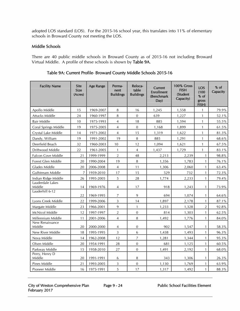
City of Weston Comprehensive Plan Page 9 - 24 Public School Facilities Element February 2017
adopted LOS standard (LOS). For the 2015-16 school year, this translates into 11% of elementary schools in Broward County not meeting the LOS. Middle Schools There are 40 public middle schools in Broward County as of 2015-16 not including Broward Virtual Middle. A profile of these schools is shown by Table 9A.
Table 9A: Current Profile- Broward County Middle Schools 2015-16
Facility Name
Site Size
(Acres)
Age Range
Perma- nent
Buildings
Reloca- table
Buildings
Current
Enrollment (Benchmark
Day)
100% Gross FISH
(Student Capacity)
LOS (100% of gross FISH)
% of
Capacity
Apollo Middle 15 1969-2007 8 16 1,245 1,558 1 79.9%
Attucks Middle 24 1960-1997 8 0 639 1,227 1 52.1%
Bair Middle 10 1975-1993 4 18 885 1,594 1 55.5%
Coral Springs Middle 19 1975-2005 4 0 1,168 1,899 1 61.5%
Crystal Lake Middle 14 1971-2002 4 15 1,319 1,622 1 81.3%
Dandy, William
19
1991-2002
19
8
885
1,291
1
68.6% Deerfield Beach
32
1960-2003
10
12
1,094
1,621
1
67.5% Driftwood Middle 22 1961-2005 1
4 1,437 1,729 1 83.1%
Falcon Cove Middle 21 1999-1999 2 48 2,213 2,239 1 98.8% Forest Glen Middle 20 1990-2004 19 8 1,356 1,783 1 76.1% Glades Middle 20 2006-2008 4 11 1,306 2,060 1 63.4% Gulfstream Middle 7 1959-2010 17 15 529 732 1 72.3% Indian Ridge Middle 26 1995-2005 5 28 1,774 2,233 1 79.4% Lauderdale Lakes Middle
14
1969-1976
4
17
918
1,243
1
73.9%
Lauderhill 6-12 22
1969-1995
7
9
694
1,074
1
64.6%
Lyons Creek Middle 22 1999-2006 3 14 1,897 2,178 1 87.1% Margate Middle 23 1966-2001 9 1 1,233 1,328 2 92.8% McNicol Middle 12 1997-1997 2 0 814 1,303 1 62.5% Millennium Middle 11 2001-2006 4 8 1,492 1,776 1 84.0% New Renaissance Middle
20
2000-2000
4
0
902
1,547
1
58.3%
New River Middle 18 1995-1995 3 6 1,438 1,493 1 96.3% Nova Middle 14 1962-2008 12 7 1,281 1,344 1 95.3% Olsen Middle 20 1954-1991 28 0 681 1,125 1 60.5% Parkway Middle 15 1958-2010 27 0 1,491 2,192 1 68.0% Perry, Henry D Middle
20
1991-1991
6
8
343
1,306
1
26.3%
Pines Middle 21 1993-2005 3 0 1,130 1,769 1 63.9% Pioneer Middle 16 1975-1991 5 17 1,317 1,492 1 88.3%
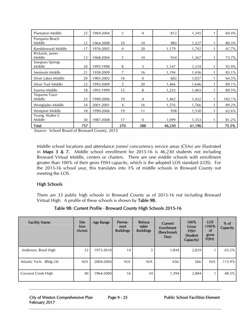
City of Weston Comprehensive Plan Page 9 - 25 Public School Facilities Element February 2017
Plantation Middle 22 1969-2004 5 0 812 1,345 1 60.4% Pompano Beach Middle
12
1964-2008
10
10
985
1,227
1
80.3%
Ramblewood Middle 17 1976-2005 4 20 1,179 1,742 1 67.7% Rickards, James Middle
13
1968-2004
5
10
934
1,267
1
73.7%
Sawgrass Springs Middle
20
1995-1998
8
3
1,147
1,234
1
92.9%
Seminole Middle 21 1958-2009 7 16 1,194 1,436 1 83.1% Silver Lakes Middle 20 1983-2002 16 0 682 1,057 1 64.5% Silver Trail Middle 22 1995-2009 3 20 1,466 1,646 1 89.1% Sunrise Middle 18 1991-1999 15 8 1,255 1,403 1 89.5% Tequesta Trace Middle
23
1990-2006
19
4
1,462
1,432
1
102.1%
Westglades Middle 24 2001-2001 4 16 1,576 1,766 1 89.2% Westpine Middle 18 1990-2006 19 11 958 1,530 1 62.6% Young, Walter C Middle
30
1987-2008
17
0
1,099
1,353
1
81.2%
Total 757 370 388 46,230 61,196 75.5% Source: School Board of Broward County, 2015
Middle school locations and attendance zones/ concurrency service areas (CSAs) are illustrated in Maps 3 & 7. Middle school enrollment for 2015-16 is 46,230 students not including Broward Virtual Middle, centers or charters. There are one middle schools with enrollment greater than 100% of their gross FISH capacity, which is the adopted LOS standard (LOS). For the 2015-16 school year, this translates into 3% of middle schools in Broward County not meeting the LOS.
High Schools
There are 33 public high schools in Broward County as of 2015-16 not including Broward Virtual High. A profile of these schools is shown by Table 9B.
Table 9B: Current Profile - Broward County High Schools 2015-16
Facility Name
Site Size
(Acres)
Age Range
Perma-
nent Buildings
Reloca- table
Buildings
Current
Enrollment (Benchmark
Day)
100% Gross FISH
(Student Capacity)
LOS
(100% of
gross FISH)
% of
Capacity
Anderson, Boyd High 32 1972-2010 14 5 1,844 2,829 1 65.2%
Atlantic Tech. (Bldg 24) N/A 2004-2004 N/A N/A 656 566 N/A 115.9%
Coconut Creek High 40 1964-2000 16 34 1,394 2,884 1 48.3%
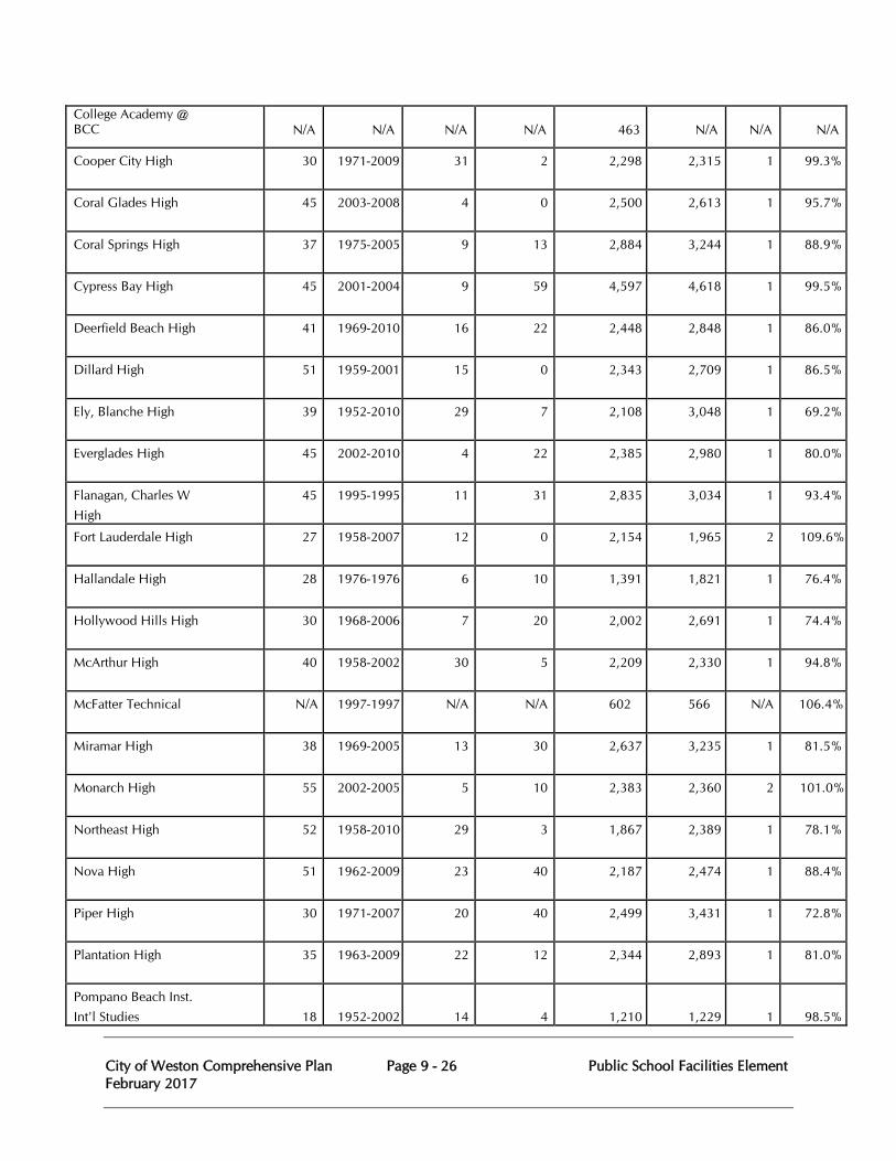
City of Weston Comprehensive Plan Page 9 - 26 Public School Facilities Element February 2017
College Academy @ BCC
N/A
N/A
N/A
N/A
463
N/A
N/A
N/A
Cooper City High 30 1971-2009 31 2 2,298 2,315 1 99.3%
Coral Glades High 45 2003-2008 4 0 2,500 2,613 1 95.7%
Coral Springs High 37 1975-2005 9 13 2,884 3,244 1 88.9%
Cypress Bay High 45 2001-2004 9 59 4,597 4,618 1 99.5%
Deerfield Beach High 41 1969-2010 16 22 2,448 2,848 1 86.0%
Dillard High 51 1959-2001 15 0 2,343 2,709 1 86.5%
Ely, Blanche High 39 1952-2010 29 7 2,108 3,048 1 69.2%
Everglades High 45 2002-2010 4 22 2,385 2,980 1 80.0%
Flanagan, Charles W High
45
1995-1995
11 31 2,835 3,034 1 93.4%
Fort Lauderdale High 27 1958-2007 12 0 2,154 1,965 2 109.6%
Hallandale High 28 1976-1976 6 10 1,391 1,821 1 76.4%
Hollywood Hills High 30 1968-2006 7 20 2,002 2,691 1 74.4%
McArthur High 40 1958-2002 30 5 2,209 2,330 1 94.8%
McFatter Technical N/A 1997-1997 N/A N/A 602 566 N/A 106.4%
Miramar High 38 1969-2005 13 30 2,637 3,235 1 81.5%
Monarch High 55 2002-2005 5 10 2,383 2,360 2 101.0%
Northeast High 52 1958-2010 29 3 1,867 2,389 1 78.1%
Nova High 51 1962-2009 23 40 2,187 2,474 1 88.4%
Piper High 30 1971-2007 20 40 2,499 3,431 1 72.8%
Plantation High 35 1963-2009 22 12 2,344 2,893 1 81.0%
Pompano Beach Inst. Int'l Studies
18
1952-2002
14
4
1,210
1,229
1
98.5%
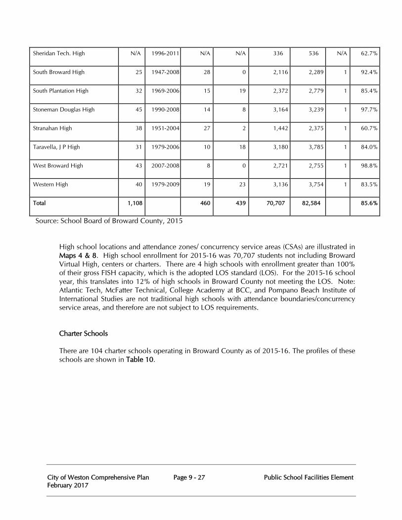
City of Weston Comprehensive Plan Page 9 - 27 Public School Facilities Element February 2017
Sheridan Tech. High N/A 1996-2011 N/A N/A 336 536 N/A 62.7%
South Broward High 25 1947-2008 28 0 2,116 2,289 1 92.4%
South Plantation High 32 1969-2006 15 19 2,372 2,779 1 85.4%
Stoneman Douglas High 45 1990-2008 14 8 3,164 3,239 1 97.7%
Stranahan High 38 1951-2004 27 2 1,442 2,375 1 60.7%
Taravella, J P High 31 1979-2006 10 18 3,180 3,785 1 84.0%
West Broward High 43 2007-2008 8 0 2,721 2,755 1 98.8%
Western High 40 1979-2009 19 23 3,136 3,754 1 83.5%
Total 1,108 460 439 70,707 82,584 85.6%
Source: School Board of Broward County, 2015
High school locations and attendance zones/ concurrency service areas (CSAs) are illustrated in Maps 4 & 8. High school enrollment for 2015-16 was 70,707 students not including Broward Virtual High, centers or charters. There are 4 high schools with enrollment greater than 100% of their gross FISH capacity, which is the adopted LOS standard (LOS). For the 2015-16 school year, this translates into 12% of high schools in Broward County not meeting the LOS. Note: Atlantic Tech, McFatter Technical, College Academy at BCC, and Pompano Beach Institute of International Studies are not traditional high schools with attendance boundaries/concurrency service areas, and therefore are not subject to LOS requirements. Charter Schools There are 104 charter schools operating in Broward County as of 2015-16. The profiles of these schools are shown in Table 10.
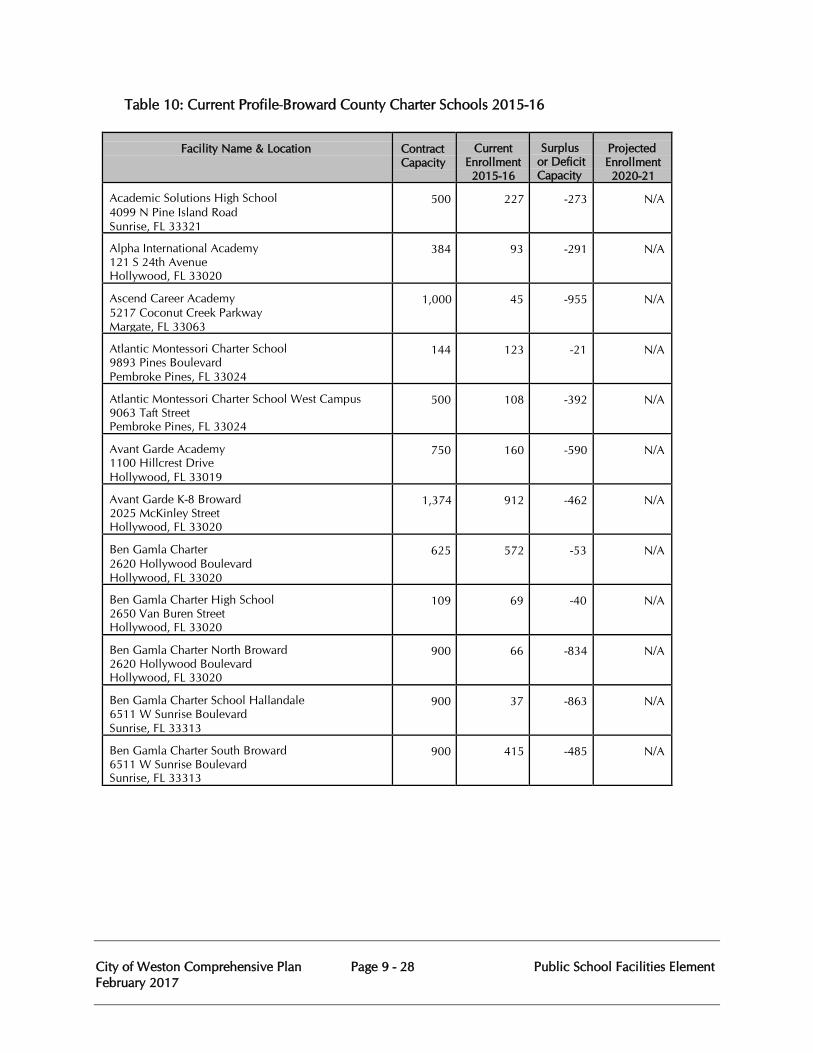
City of Weston Comprehensive Plan Page 9 - 28 Public School Facilities Element February 2017
Table 10: Current Profile-Broward County Charter Schools 2015-16
Facility Name & Location
Contract Capacity
Current Enrollment 2015-16
Surplus or Deficit Capacity
Projected Enrollment 2020-21
Academic Solutions High School 4099 N Pine Island Road Sunrise, FL 33321
500
227
-273
N/A
Alpha International Academy 121 S 24th Avenue Hollywood, FL 33020
384
93
-291
N/A
Ascend Career Academy 5217 Coconut Creek Parkway Margate, FL 33063
1,000
45
-955
N/A
Atlantic Montessori Charter School 9893 Pines Boulevard Pembroke Pines, FL 33024
144
123
-21
N/A
Atlantic Montessori Charter School West Campus 9063 Taft Street Pembroke Pines, FL 33024
500
108
-392
N/A
Avant Garde Academy 1100 Hillcrest Drive Hollywood, FL 33019
750
160
-590
N/A
Avant Garde K-8 Broward 2025 McKinley Street Hollywood, FL 33020
1,374
912
-462
N/A
Ben Gamla Charter 2620 Hollywood Boulevard Hollywood, FL 33020
625
572
-53
N/A
Ben Gamla Charter High School 2650 Van Buren Street Hollywood, FL 33020
109
69
-40
N/A
Ben Gamla Charter North Broward 2620 Hollywood Boulevard Hollywood, FL 33020
900
66
-834
N/A
Ben Gamla Charter School Hallandale 6511 W Sunrise Boulevard Sunrise, FL 33313
900
37
-863
N/A
Ben Gamla Charter South Broward 6511 W Sunrise Boulevard Sunrise, FL 33313
900
415
-485
N/A
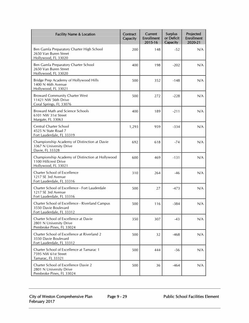
City of Weston Comprehensive Plan Page 9 - 29 Public School Facilities Element February 2017
Facility Name & Location
Contract Capacity
Current Enrollment 2015-16
Surplus or Deficit Capacity
Projected Enrollment 2020-21
Ben Gamla Preparatory Charter High School 2650 Van Buren Street Hollywood, FL 33020
200
148
-52
N/A
Ben Gamla Preparatory Charter School 2650 Van Buren Street Hollywood, FL 33020
400
198
-202
N/A
Bridge Prep Academy of Hollywood Hills 1400 N 46th Avenue Hollywood, FL 33021
500
352
-148
N/A
Broward Community Charter West 11421 NW 56th Drive Coral Springs, FL 33076
500
272
-228
N/A
Broward Math and Science Schools 6101 NW 31st Street Margate, FL 33063
400
189
-211
N/A
Central Charter School 4525 N State Road 7 Fort Lauderdale, FL 33319
1,293
959
-334
N/A
Championship Academy of Distinction at Davie 3367 N University Drive Davie, FL 33328
692
618
-74
N/A
Championship Academy of Distinction at Hollywood 1100 Hillcrest Drive Hollywood, FL 33021
600
469
-131
N/A
Charter School of Excellence 1217 SE 3rd Avenue Fort Lauderdale, FL 33316
310
264
-46
N/A
Charter School of Excellence - Fort Lauderdale 1217 SE 3rd Avenue Fort Lauderdale, FL 33316
500
27
-473
N/A
Charter School of Excellence - Riverland Campus 3550 Davie Boulevard Fort Lauderdale, FL 33312
500
116
-384
N/A
Charter School of Excellence at Davie 2801 N University Drive Pembroke Pines, FL 33024
350
307
-43
N/A
Charter School of Excellence at Riverland 2 3550 Davie Boulevard Fort Lauderdale, FL 33312
500
32
-468
N/A
Charter School of Excellence at Tamarac 1 7595 NW 61st Street Tamarac, FL 33321
500
444
-56
N/A
Charter School of Excellence Davie 2 2801 N University Drive Pembroke Pines, FL 33024
500
36
-464
N/A
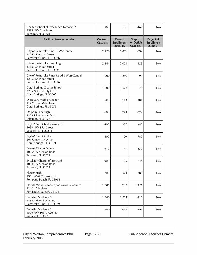
City of Weston Comprehensive Plan Page 9 - 30 Public School Facilities Element February 2017
Charter School of Excellence Tamarac 2 7595 NW 61st Street Tamarac, FL 33321
500
31
-469
N/A
Facility Name & Location
Contract Capacity
Current Enrollment 2015-16
Surplus or Deficit Capacity
Projected Enrollment 2020-21
City of Pembroke Pines - E/W/Central 12350 Sheridan Street Pembroke Pines, FL 33026
2,470
1,876
-594
N/A
City of Pembroke Pines High 17189 Sheridan Street Pembroke Pines, FL 33331
2,144
2,021
-123
N/A
City of Pembroke Pines Middle West/Central 12350 Sheridan Street Pembroke Pines, FL 33026
1,200
1,290
90
N/A
Coral Springs Charter School 3205 N University Drive Coral Springs, FL 33065
1,600
1,678
78
N/A
Discovery Middle Charter 11421 NW 56th Drive Coral Springs, FL 33076
600
119
-481
N/A
Dolphin Park High 3206 S University Drive Miramar, FL 33026
600
278
-322
N/A
Eagles' Nest Charter Academy 3698 NW 15th Street Lauderhill, FL 33311
400
337
-63
N/A
Eagles' Nest Middle 201 University Drive Coral Springs, FL 33071
800
20
-780
N/A
Everest Charter School 10054 W McNab Road Tamarac, FL 33321
910
71
-839
N/A
Excelsior Charter of Broward 10046 W McNab Road Tamarac, FL 33321
900
156
-744
N/A
Flagler High 1951 West Copans Road Pompano Beach, FL 33064
700
320
-380
N/A
Florida Virtual Academy at Broward County 110 SE 6th Street Fort Lauderdale, FL 33301
1,381
202
-1,179
N/A
Franklin Academy A 18800 Pines Boulevard Pembroke Pines, FL 33029
1,340
1,224
-116
N/A
Franklin Academy B 4500 NW 103rd Avenue Sunrise, FL 33351
1,340
1,049
-291
N/A
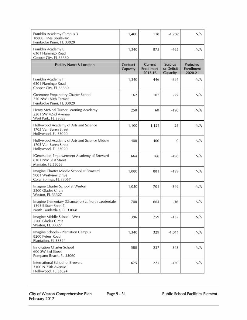
City of Weston Comprehensive Plan Page 9 - 31 Public School Facilities Element February 2017
Franklin Academy Campus 3 18800 Pines Boulevard Pembroke Pines, FL 33029
1,400
118
-1,282
N/A
Franklin Academy E 6301 Flamingo Road Cooper City, FL 33330
1,340
875
-465
N/A
Facility Name & Location
Contract Capacity
Current Enrollment 2015-16
Surplus or Deficit Capacity
Projected Enrollment 2020-21
Franklin Academy F 6301 Flamingo Road Cooper City, FL 33330
1,340
446
-894
N/A
Greentree Preparatory Charter School 750 NW 180th Terrace Pembroke Pines, FL 33029
162
107
-55
N/A
Henry McNeal Turner Learning Academy 2201 SW 42nd Avenue West Park, FL 33023
250
60
-190
N/A
Hollywood Academy of Arts and Science 1705 Van Buren Street Hollywood, FL 33020
1,100
1,128
28
N/A
Hollywood Academy of Arts and Science Middle 1705 Van Buren Street Hollywood, FL 33020
400
400
0
N/A
iGeneration Empowerment Academy of Broward 6101 NW 31st Street Margate, FL 33063
664
166
-498
N/A
Imagine Charter Middle School at Broward 9001 Westview Drive Coral Springs, FL 33067
1,080
881
-199
N/A
Imagine Charter School at Weston 2500 Glades Circle Weston, FL 33327
1,050
701
-349
N/A
Imagine Elementary (Chancellor) at North Lauderdale 1395 S State Road 7 North Lauderdale, FL 33068
700
664
-36
N/A
Imagine Middle School - West 2500 Glades Circle Weston, FL 33327
396
259
-137
N/A
Imagine Schools - Plantation Campus 8200 Peters Road Plantation, FL 33324
1,340
329
-1,011
N/A
Innovation Charter School 600 SW 3rd Street Pompano Beach, FL 33060
580
237
-343
N/A
International School of Broward 3100 N 75th Avenue Hollywood, FL 33024
675
225
-450
N/A
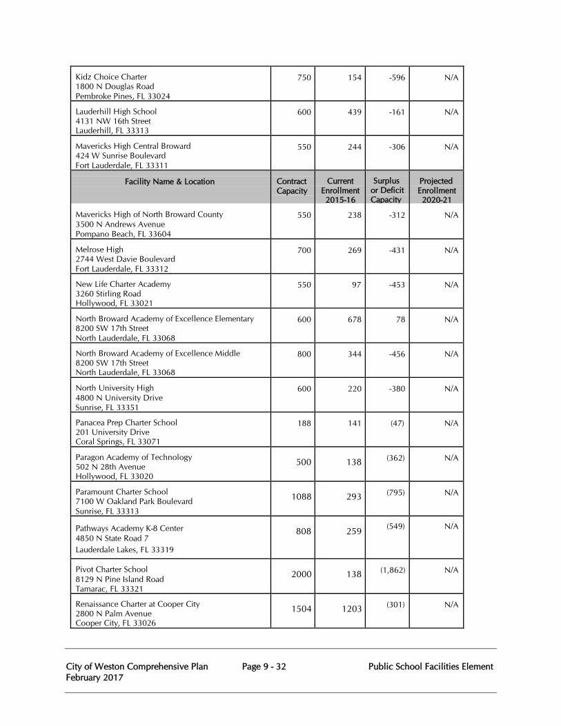
City of Weston Comprehensive Plan Page 9 - 32 Public School Facilities Element February 2017
Kidz Choice Charter 1800 N Douglas Road Pembroke Pines, FL 33024
750
154
-596
N/A
Lauderhill High School 4131 NW 16th Street Lauderhill, FL 33313
600
439
-161
N/A
Mavericks High Central Broward 424 W Sunrise Boulevard Fort Lauderdale, FL 33311
550
244
-306
N/A
Facility Name & Location
Contract Capacity
Current Enrollment 2015-16
Surplus or Deficit Capacity
Projected Enrollment 2020-21
Mavericks High of North Broward County 3500 N Andrews Avenue Pompano Beach, FL 33604
550
238
-312
N/A
Melrose High 2744 West Davie Boulevard Fort Lauderdale, FL 33312
700
269
-431
N/A
New Life Charter Academy 3260 Stirling Road Hollywood, FL 33021
550
97
-453
N/A
North Broward Academy of Excellence Elementary 8200 SW 17th Street North Lauderdale, FL 33068
600
678
78
N/A
North Broward Academy of Excellence Middle 8200 SW 17th Street North Lauderdale, FL 33068
800
344
-456
N/A
North University High 4800 N University Drive Sunrise, FL 33351
600
220
-380
N/A
Panacea Prep Charter School 201 University Drive Coral Springs, FL 33071
188
141
(47)
N/A
Paragon Academy of Technology 502 N 28th Avenue Hollywood, FL 33020
500
138
(362)
N/A
Paramount Charter School 7100 W Oakland Park Boulevard Sunrise, FL 33313
1088
293
(795)
N/A
Pathways Academy K-8 Center 4850 N State Road 7 Lauderdale Lakes, FL 33319
808
259
(549)
N/A
Pivot Charter School 8129 N Pine Island Road Tamarac, FL 33321
2000
138
(1,862)
N/A
Renaissance Charter at Cooper City 2800 N Palm Avenue Cooper City, FL 33026
1504
1203
(301)
N/A
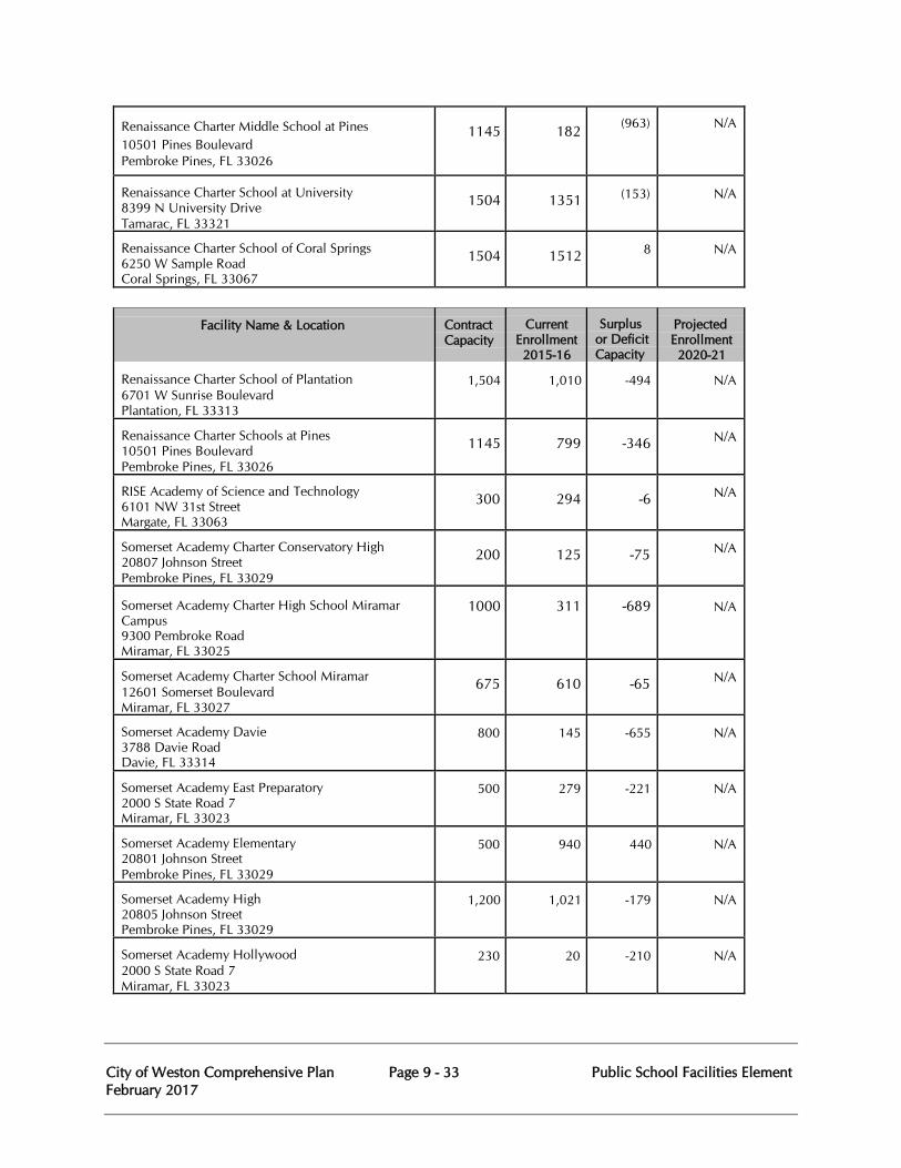
City of Weston Comprehensive Plan Page 9 - 33 Public School Facilities Element February 2017
Renaissance Charter Middle School at Pines 10501 Pines Boulevard Pembroke Pines, FL 33026
1145
182
(963)
N/A
Renaissance Charter School at University 8399 N University Drive Tamarac, FL 33321
1504
1351
(153)
N/A
Renaissance Charter School of Coral Springs 6250 W Sample Road Coral Springs, FL 33067
1504
1512
8
N/A
Facility Name & Location
Contract Capacity
Current Enrollment 2015-16
Surplus or Deficit Capacity
Projected Enrollment 2020-21
Renaissance Charter School of Plantation 6701 W Sunrise Boulevard Plantation, FL 33313
1,504
1,010
-494
N/A
Renaissance Charter Schools at Pines 10501 Pines Boulevard Pembroke Pines, FL 33026
1145
799
-346
N/A
RISE Academy of Science and Technology 6101 NW 31st Street Margate, FL 33063
300
294
-6
N/A
Somerset Academy Charter Conservatory High 20807 Johnson Street Pembroke Pines, FL 33029
200
125
-75
N/A
Somerset Academy Charter High School Miramar Campus 9300 Pembroke Road Miramar, FL 33025
1000
311
-689
N/A
Somerset Academy Charter School Miramar 12601 Somerset Boulevard Miramar, FL 33027
675
610
-65
N/A
Somerset Academy Davie 3788 Davie Road Davie, FL 33314
800
145
-655
N/A
Somerset Academy East Preparatory 2000 S State Road 7 Miramar, FL 33023
500
279
-221
N/A
Somerset Academy Elementary 20801 Johnson Street Pembroke Pines, FL 33029
500
940
440
N/A
Somerset Academy High 20805 Johnson Street Pembroke Pines, FL 33029
1,200
1,021
-179
N/A
Somerset Academy Hollywood 2000 S State Road 7 Miramar, FL 33023
230
20
-210
N/A
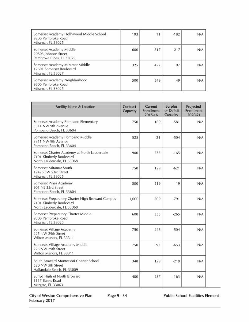
City of Weston Comprehensive Plan Page 9 - 34 Public School Facilities Element February 2017
Somerset Academy Hollywood Middle School 9300 Pembroke Road Miramar, FL 33025
193
11
-182
N/A
Somerset Academy Middle 20803 Johnson Street Pembroke Pines, FL 33029
600
817
217
N/A
Somerset Academy Miramar Middle 12601 Somerset Boulevard Miramar, FL 33027
325
422
97
N/A
Somerset Academy Neighborhood 9300 Pembroke Road Miramar, FL 33025
500
549
49
N/A
Facility Name & Location
Contract Capacity
Current Enrollment 2015-16
Surplus or Deficit Capacity
Projected Enrollment 2020-21
Somerset Academy Pompano Elementary 3311 NW 9th Avenue Pompano Beach, FL 33604
750
169
-581
N/A
Somerset Academy Pompano Middle 3311 NW 9th Avenue Pompano Beach, FL 33604
525
21
-504
N/A
Somerset Charter Academy at North Lauderdale 7101 Kimberly Boulevard North Lauderdale, FL 33068
900
735
-165
N/A
Somerset Miramar South 12425 SW 53rd Street Miramar, FL 33025
750
129
-621
N/A
Somerset Pines Academy 901 NE 33rd Street Pompano Beach, FL 33604
500
519
19
N/A
Somerset Preparatory Charter High Broward Campus 7101 Kimberly Boulevard North Lauderdale, FL 33068
1,000
209
-791
N/A
Somerset Preparatory Charter Middle 9300 Pembroke Road Miramar, FL 33025
600
335
-265
N/A
Somerset Village Academy 225 NW 29th Street Wilton Manors, FL 33311
750
246
-504
N/A
Somerset Village Academy Middle 225 NW 29th Street Wilton Manors, FL 33311
750
97
-653
N/A
South Broward Montessori Charter School 520 NW 5th Street Hallandale Beach, FL 33009
348
129
-219
N/A
SunEd High of North Broward 1117 Banks Road Margate, FL 33063
400
237
-163
N/A
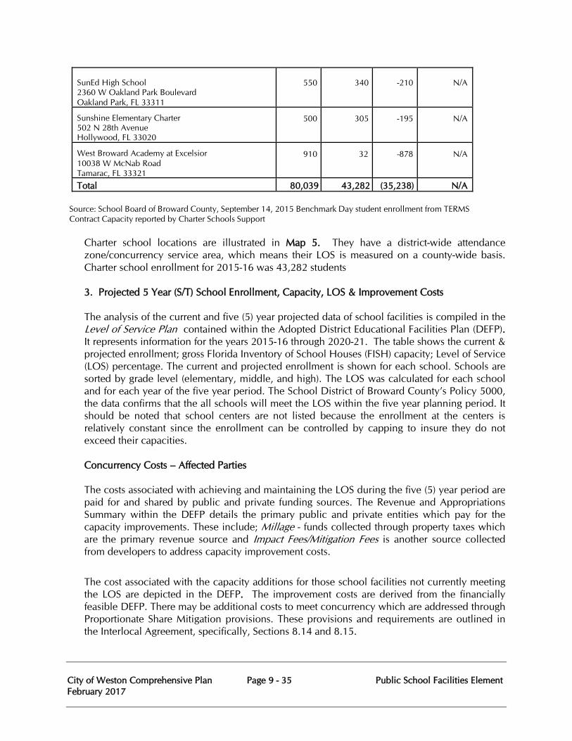
City of Weston Comprehensive Plan Page 9 - 35 Public School Facilities Element February 2017
SunEd High School 2360 W Oakland Park Boulevard Oakland Park, FL 33311
550
340
-210
N/A
Sunshine Elementary Charter 502 N 28th Avenue Hollywood, FL 33020
500
305
-195
N/A
West Broward Academy at Excelsior 10038 W McNab Road Tamarac, FL 33321
910
32
-878
N/A
Total 80,039 43,282 (35,238) N/A
Source: School Board of Broward County, September 14, 2015 Benchmark Day student enrollment from TERMS Contract Capacity reported by Charter Schools Support
Charter school locations are illustrated in Map 5. They have a district-wide attendance zone/concurrency service area, which means their LOS is measured on a county-wide basis. Charter school enrollment for 2015-16 was 43,282 students 3. Projected 5 Year (S/T) School Enrollment, Capacity, LOS & Improvement Costs
The analysis of the current and five (5) year projected data of school facilities is compiled in the Level of Service Plan contained within the Adopted District Educational Facilities Plan (DEFP). It represents information for the years 2015-16 through 2020-21. The table shows the current & projected enrollment; gross Florida Inventory of School Houses (FISH) capacity; Level of Service (LOS) percentage. The current and projected enrollment is shown for each school. Schools are sorted by grade level (elementary, middle, and high). The LOS was calculated for each school and for each year of the five year period. The School District of Broward County’s Policy 5000, the data confirms that the all schools will meet the LOS within the five year planning period. It should be noted that school centers are not listed because the enrollment at the centers is relatively constant since the enrollment can be controlled by capping to insure they do not exceed their capacities. Concurrency Costs – Affected Parties The costs associated with achieving and maintaining the LOS during the five (5) year period are paid for and shared by public and private funding sources. The Revenue and Appropriations Summary within the DEFP details the primary public and private entities which pay for the capacity improvements. These include; Millage - funds collected through property taxes which are the primary revenue source and Impact Fees/Mitigation Fees is another source collected from developers to address capacity improvement costs.
The cost associated with the capacity additions for those school facilities not currently meeting the LOS are depicted in the DEFP. The improvement costs are derived from the financially feasible DEFP. There may be additional costs to meet concurrency which are addressed through Proportionate Share Mitigation provisions. These provisions and requirements are outlined in the Interlocal Agreement, specifically, Sections 8.14 and 8.15.
City of Weston Comprehensive Plan Page 9 - 36 Public School Facilities Element February 2017
Land Area Requirements
There are currently no new schools planned which would require additional land to meet capacity improvements. As such, the DEFP does not contain information to indicate the number of acres needed per school type or a listing of planned school site acquisitions.
As previously stated, the School Board adopted new “urban school” standards intended to reduce the acreage amounts required to build schools given the diminishing availability of land in Broward County.
The School Board of Broward County primary projection tool is a geographically-based Cohort Survival model, which projects future students by grade. The Cohort Survival model is considered very reliable and is utilized by the Florida Department of Education in their student projections and the U.S. Census Bureau for their reports. The model uses an “aging” concept that moves a group, or cohort, of students into the future and increases or decreases their numbers according to past experience through history.
The Cohort Survival methodology relies on historical enrollment and birth data to capture the effects of in and out-migration, housing changes, and natural trends in population. In essence, the model derives a growth factor or ratio for student survival matriculation to the next grade based upon previous survival numbers to the same grade of students in each Traffic Analysis Zone (TAZ), the basic geographic area for the model. In most cases, TAZ areas represent neighborhoods. There are 953 TAZ areas in Broward County. TAZ areas are further divided into smaller geographic areas to account for schools that matriculate to more than one school at each grade level, (e.g. an elementary school that feeds into 2 different middle schools). The combination of elementary, middle and high school attendance zones and TAZ areas create a unique identifiable area called a Study Area Identification or SAID. SAIDs capture the date cohorts more accurately by including feeder patterns. For example, if elementary school A matriculates to 2 different middle schools B and C and one high school D, there would be 2 different SAIDs for elementary school A – one SAID to represent matriculation from elementary A to middle school B to high school D and another SAID to represent matriculation from elementary A to middle school C to high school D.
Once the model has been run for the small geographic units or SAIDs, the projections are then summarized by TAZ. In some instances, individual TAZ areas are corrected to reflect changes in growth which are not picked up in the projection model’s histories. A few examples where corrections are required include areas where:
1. New construction is anticipated to exceed the pace of historical construction for an area, 2. An area is reaching build-out and all new construction will cease or slow down, 3. An unprecedented slow-down in the economic market, or 4. A boundary change has artificially increased/decreased the area. Birth Data
The historical number of births is a good indicator of future kindergarten class size. Birth data is acquired from the Florida Department of Health Vital Records by U.S. Census tract. Several
City of Weston Comprehensive Plan Page 9 - 37 Public School Facilities Element February 2017
steps are taken to interpolate future kindergarten enrollment based on births, as not all children born will enter kindergarten. To project kindergarten enrollment, births by census tract have to be estimated for a five year period i.e., births from 2010 will potentially enter kindergarten in 2015-16. Data is then increased or decreased based on past kindergarten populations by census tract. Once the number of births is adjusted, the percentage of students that are in each census tract is broken down to the SAID level. Since the census tract may intersect more than one SAID, a unique identifier is created between census tracts and SAIDs. The percentage of actual attending kindergarten students for the past two years is calculated for each unique SAID/census tract. This percentage is used to extrapolate the number of kindergarten from the total number of kindergarten aged students within a given unique SAID/census tract. The SAIDs are then summarized to obtain the estimated number of kindergarten students by SAID for five years.
Residential Development Data
Each year Broward County municipal planning staff provides current and forecasted certificates of occupancy to assist county and BCPS demographic staff in estimating population changes. Residential growth is also shared and monitored through the Facility Planning and Real Estate Department. The School Board of Broward County requests city and county planning staff to estimate future certificates of occupancy over the next five years.
Other Data
Other information is analyzed to determine if the Cohort Survival rates may need to be adjusted to align with a shorter or longer historical time horizon. These data may include:
1. Existing home sales (source: Florida Association of Realtors) 2. Population Projections (source: U.S. Census, Broward County, Bureau of Economic and Business Research, and Florida Department of Education)
Attrition Rate of Attending Students
The School Board of Broward County includes four years of attending enrollment to calculate the rate of attrition or rate of students matriculating the next level within their SAID by grade. Attending enrollment is the total number of students within the attendance zone that are attending their geographically assigned school. Determining the attrition rate by SAID, keeps the feeder patterns intact as the grades matriculate to each specific school. For example:
(# of 2007-2008 attending 2nd graders) by SAID =SAID 2nd grade attrition rate 2007-2008 (# of 2006-2007 attending 1st graders) by SAID (# of 2008-2009 attending 2nd graders) by SAID =SAID 2nd grade attrition rate 2008-2009 (# of 2007-2008 attending 1st graders) by SAID (# of 2009-2010 attending 2nd graders) by SAID =SAID 2nd grade attrition rate 2009-2010 (# of 2008-2009 attending 1st graders) by SAID
City of Weston Comprehensive Plan Page 9 - 38 Public School Facilities Element February 2017
Once the attrition rate is calculated for each grade, grades one through twelve, over the past three years, it is then averaged and used as a factor to obtain next year’s projections for that grade. For example:
(Average SAID 2nd grade) X (# of 2009-10 attending)=Projected 2010-11 2nd graders by SAID (attrition rate from 2007-2010 ) (2nd graders by SAID)
To calculate subsequent years of projections by grade, the model uses the projected rate of attrition based on the projected enrollment of the previous year to calculate the next projection year. For Example:
(Average SAID 2nd grade) X(# of projected 2010-22)=projected 2011-12 2nd graders by SAID (Projected attrition rate) (Attending 2nd graders)(from 2008-2011) (by SAID) Projections by SAID for each grade are then reviewed school-by-school. Attrition rates can cause projections to be exceedingly high or low in which case they will have to be adjusted so as not to cause an exponential effect in outer projection years. The following are possible corrections to rates:
Out-of-Boundary Students (OOB): Out-of-boundary (OOB) students are students attending a school from outside their attendance area (i.e. approved reassignments).
The School Board of Broward County assumes that OOB students at each grade level at each school will be the same as the existing year and will have a survival rate of 100% as they matriculate through the grade levels. For example, Middle School A currently has the following OOB students: 35-6th grade, 38-7th grade, and 42-8th grade. For all projected years, Middle School A will have 35-6th grade, 38-7th grade, and 42-8th grade OOB students.
However, adjustments can be made to OOB students if enrollments naturally decline based on the calculated cohort survival rate yet economic or other conditions may suggest enrollment should increase or if schools are eligible to receive assignment transfers. Since assignment data is determined after the release of the projections and is subject to change, the OOB students typically remain constant in the model based on the current year’s data.
The school-by-school Cohort Survival model projections, by grade, are compared and tested for reasonableness with other models such as the Florida Department of Education (FDOE) projections and the Broward County Planning and Redevelopment Division school-aged population projections. Accordingly, adjustments may be made to the Cohort Survival model based on the following factors:
1. changes in the rate or type of new housing development within the county;
2.
changes in the economic conditions (i.e. the creation of jobs usually means families are moving in, recession means moving out);
3. immigration; and
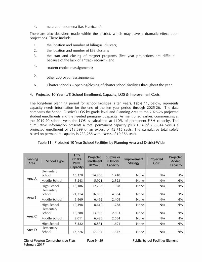
City of Weston Comprehensive Plan Page 9 - 39 Public School Facilities Element February 2017
4. natural phenomena (i.e. Hurricane).
There are also decisions made within the district, which may have a dramatic effect upon projections. These include:
1. the location and number of bilingual clusters; 2. the location and number of ESE clusters; 3.
the start and closing of magnet programs (first year projections are difficult because of the lack of a "track record"); and
4. student choice reassignments;
5. other approved reassignments;
6. Charter schools – opening/closing of charter school facilities throughout the year. 4. Projected 10 Year (L/T) School Enrollment, Capacity, LOS & Improvement Costs
The long-term planning period for school facilities is ten years. Table 11, below, represents capacity needs information for the end of the ten year period through 2025-26. The data compares the School District’s LOS by grade level and Planning Area to the 2025-26 projected student enrollments and the needed permanent capacity. As mentioned earlier, commencing at the 2019-20 school year, the LOS is calculated at 110% of permanent FISH capacity. The cumulative information presents a total permanent capacity plus 10% of 256,614 versus a projected enrollment of 213,899 or an excess of 42,715 seats. The cumulative total solely based on permanent capacity is 233,285 with excess of 19,386 seats.
Table 11: Projected 10 Year School Facilities by Planning Area and District-Wide
Planning Area School Type
LOS (110% Perm.
Capacity)
Projected Enrollment 2025-26
Surplus or (Deficit) Capacity
Improvement Strategy
Projected Cost
Projected Added
Capacity
Area A
Elementary School 16,370 14,960 1,410 None N/A N/A
Middle School 8,243 5,921 2,323 None N/A N/A
High School 13,186 12,208 978 None N/A N/A
Area B
Elementary School 21,214 16,830 4,384 None N/A N/A
Middle School 8,869 6,462 2,408 None N/A N/A
High School 10,398 8,610 1,788 None N/A N/A
Area C
Elementary School 16,788 13,985 2,803 None N/A N/A
Middle School 9,011 6,428 2,584 None N/A N/A
High School 8,522 6,831 1,691 None N/A N/A
Area D Elementary School 18,776 17,134 1,642 None N/A N/A
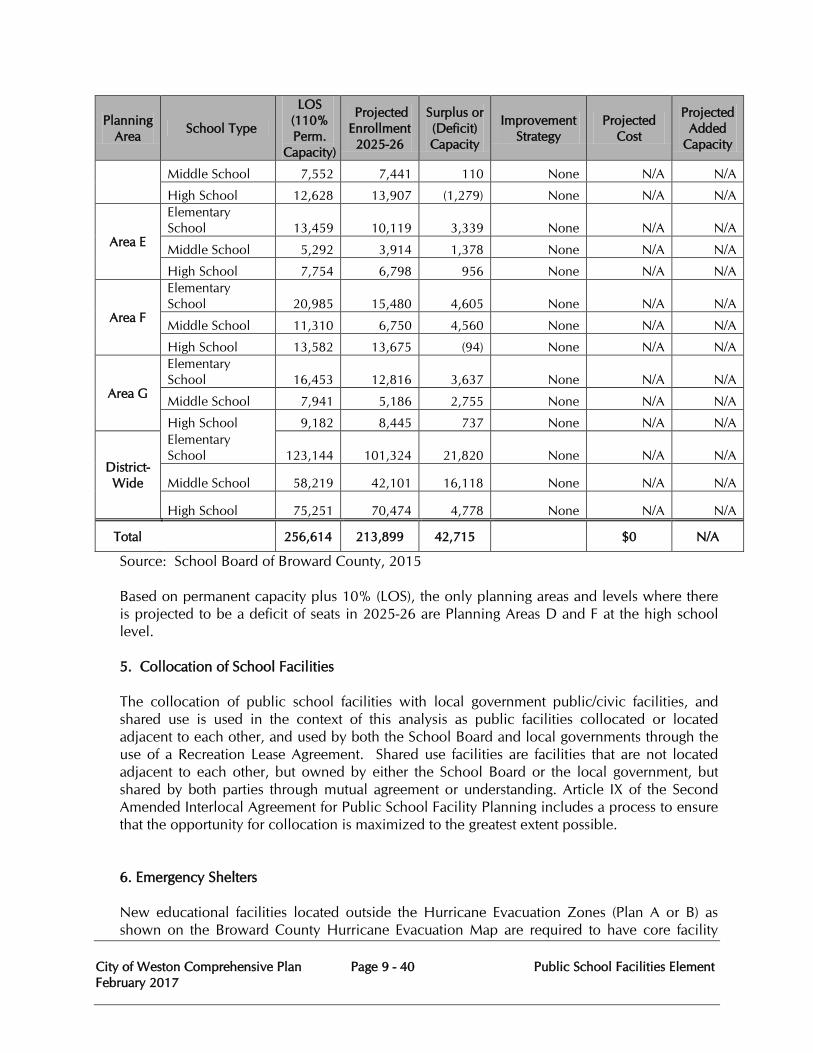
City of Weston Comprehensive Plan Page 9 - 40 Public School Facilities Element February 2017
Planning Area School Type
LOS (110% Perm.
Capacity)
Projected Enrollment 2025-26
Surplus or (Deficit) Capacity
Improvement Strategy
Projected Cost
Projected Added
Capacity
Middle School 7,552 7,441 110 None N/A N/A
High School 12,628 13,907 (1,279) None N/A N/A
Area E
Elementary School 13,459 10,119 3,339 None N/A N/A
Middle School 5,292 3,914 1,378 None N/A N/A
High School 7,754 6,798 956 None N/A N/A
Area F
Elementary School 20,985 15,480 4,605 None N/A N/A
Middle School 11,310 6,750 4,560 None N/A N/A
High School 13,582 13,675 (94) None N/A N/A
Area G
Elementary School 16,453 12,816 3,637 None N/A N/A
Middle School 7,941 5,186 2,755 None N/A N/A
High School 9,182 8,445 737 None N/A N/A
District-Wide
Elementary School 123,144 101,324 21,820 None N/A N/A
Middle School 58,219 42,101 16,118 None N/A N/A
High School 75,251 70,474 4,778 None N/A N/A
Total 256,614 213,899 42,715 $0 N/A
Source: School Board of Broward County, 2015 Based on permanent capacity plus 10% (LOS), the only planning areas and levels where there is projected to be a deficit of seats in 2025-26 are Planning Areas D and F at the high school level. 5. Collocation of School Facilities The collocation of public school facilities with local government public/civic facilities, and shared use is used in the context of this analysis as public facilities collocated or located adjacent to each other, and used by both the School Board and local governments through the use of a Recreation Lease Agreement. Shared use facilities are facilities that are not located adjacent to each other, but owned by either the School Board or the local government, but shared by both parties through mutual agreement or understanding. Article IX of the Second Amended Interlocal Agreement for Public School Facility Planning includes a process to ensure that the opportunity for collocation is maximized to the greatest extent possible.
6. Emergency Shelters New educational facilities located outside the Hurricane Evacuation Zones (Plan A or B) as shown on the Broward County Hurricane Evacuation Map are required to have core facility
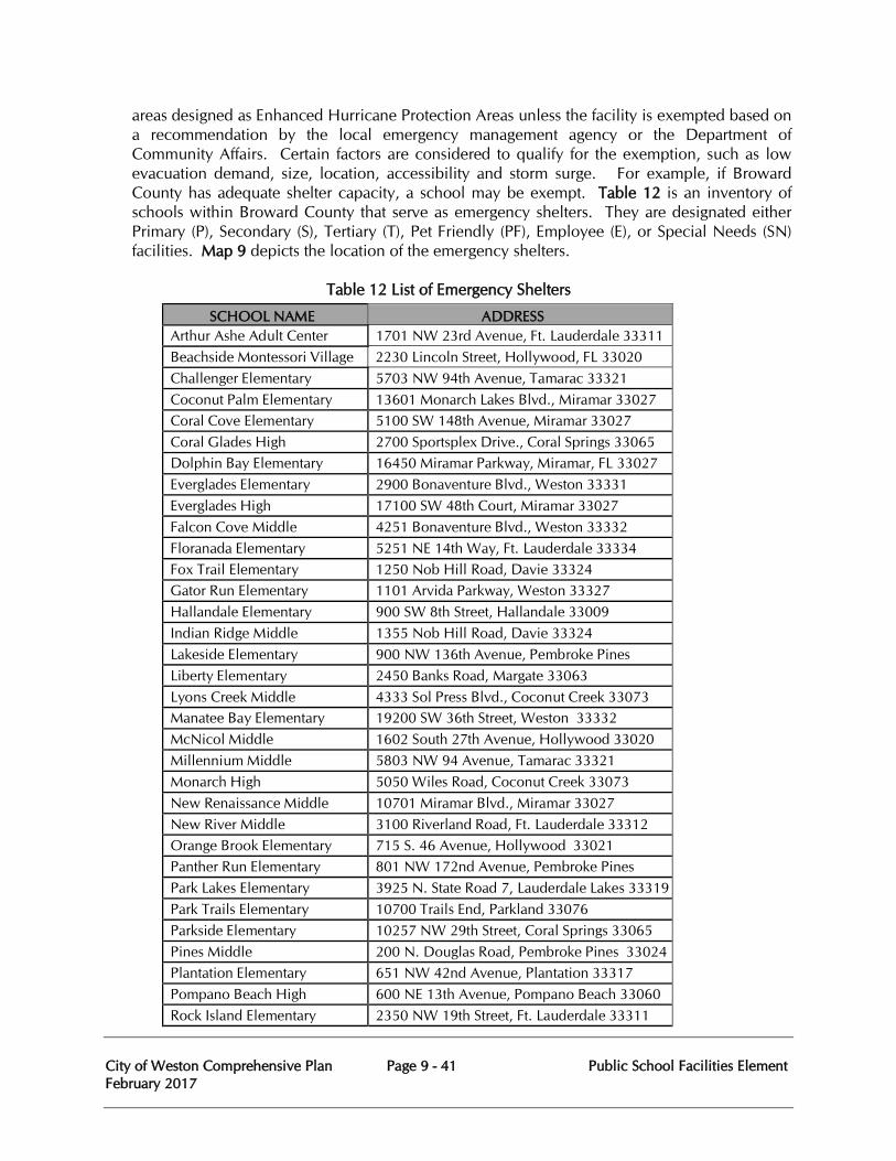
City of Weston Comprehensive Plan Page 9 - 41 Public School Facilities Element February 2017
areas designed as Enhanced Hurricane Protection Areas unless the facility is exempted based on a recommendation by the local emergency management agency or the Department of Community Affairs. Certain factors are considered to qualify for the exemption, such as low evacuation demand, size, location, accessibility and storm surge. For example, if Broward County has adequate shelter capacity, a school may be exempt. Table 12 is an inventory of schools within Broward County that serve as emergency shelters. They are designated either Primary (P), Secondary (S), Tertiary (T), Pet Friendly (PF), Employee (E), or Special Needs (SN) facilities. Map 9 depicts the location of the emergency shelters.
Table 12 List of Emergency Shelters
SCHOOL NAME ADDRESS Arthur Ashe Adult Center 1701 NW 23rd Avenue, Ft. Lauderdale 33311 Beachside Montessori Village 2230 Lincoln Street, Hollywood, FL 33020 Challenger Elementary 5703 NW 94th Avenue, Tamarac 33321 Coconut Palm Elementary 13601 Monarch Lakes Blvd., Miramar 33027 Coral Cove Elementary 5100 SW 148th Avenue, Miramar 33027 Coral Glades High 2700 Sportsplex Drive., Coral Springs 33065 Dolphin Bay Elementary 16450 Miramar Parkway, Miramar, FL 33027 Everglades Elementary 2900 Bonaventure Blvd., Weston 33331 Everglades High 17100 SW 48th Court, Miramar 33027 Falcon Cove Middle 4251 Bonaventure Blvd., Weston 33332 Floranada Elementary 5251 NE 14th Way, Ft. Lauderdale 33334 Fox Trail Elementary 1250 Nob Hill Road, Davie 33324 Gator Run Elementary 1101 Arvida Parkway, Weston 33327 Hallandale Elementary 900 SW 8th Street, Hallandale 33009 Indian Ridge Middle 1355 Nob Hill Road, Davie 33324 Lakeside Elementary 900 NW 136th Avenue, Pembroke Pines
Liberty Elementary 2450 Banks Road, Margate 33063 Lyons Creek Middle 4333 Sol Press Blvd., Coconut Creek 33073 Manatee Bay Elementary 19200 SW 36th Street, Weston 33332 McNicol Middle 1602 South 27th Avenue, Hollywood 33020 Millennium Middle 5803 NW 94 Avenue, Tamarac 33321 Monarch High 5050 Wiles Road, Coconut Creek 33073 New Renaissance Middle 10701 Miramar Blvd., Miramar 33027 New River Middle 3100 Riverland Road, Ft. Lauderdale 33312 Orange Brook Elementary 715 S. 46 Avenue, Hollywood 33021 Panther Run Elementary 801 NW 172nd Avenue, Pembroke Pines
Park Lakes Elementary 3925 N. State Road 7, Lauderdale Lakes 33319 Park Trails Elementary 10700 Trails End, Parkland 33076 Parkside Elementary 10257 NW 29th Street, Coral Springs 33065 Pines Middle 200 N. Douglas Road, Pembroke Pines 33024 Plantation Elementary 651 NW 42nd Avenue, Plantation 33317 Pompano Beach High 600 NE 13th Avenue, Pompano Beach 33060 Rock Island Elementary 2350 NW 19th Street, Ft. Lauderdale 33311

City of Weston Comprehensive Plan Page 9 - 42 Public School Facilities Element February 2017
Silver Lakes Elementary 2300 SW 173rd Avenue, Miramar 33029 Silver Palms Elementary 1209 NW 155th Avenue, Pembroke Pines
Silver Shores Elementary 1701 SW 160th Avenue, Miramar 33027 Silver Trail Middle 18300 Sheridan Street, Pembroke Pines 33331 Sunset Lakes Elementary 18400 SW 25th Street, Miramar 33029 Sheridan Technical High 3775 SW 16th Street, Ft. Lauderdale 33312 Tradewinds Elementary 5400 Johnson Road, Coconut Creek 33073 Watkins Elementary 3520 SW 52nd Avenue, Pembroke Park 33023 West Broward High 500 NW 209 Avenue, Pembroke Pines 33029 Westglades Middle 11000 Holmberg Road, Parkland, FL 33076
Source: Broward School Board 2015
City of Weston Comprehensive Plan Page 9 - 43 Public School Facilities Element February 2017
7. Funding Sources for Capital Improvements The School Board of Broward County has total projected revenue, and financing sources of $2,561,170 for public school capital improvements for the 5 year period ending 2019-20 as depicted in the Revenue and Appropriations Summary of the DEFP. The major sources of revenue are millage, which is collected from local property taxes and a general obligation bond. The primary appropriation is for debt service, and renovation of district facilities, which comprises 57% of total appropriations.
Operating Cost Considerations: There are over 1,000 school buses used by the School District of Broward County on daily routes, transporting more than 80,000 students to and from school, and driving more than 18 million miles to over 290 locations. The School District of Broward County recently purchased 98 new eco-friendly school buses. These school buses will be less expensive to fill up because they use propane gas instead of diesel.
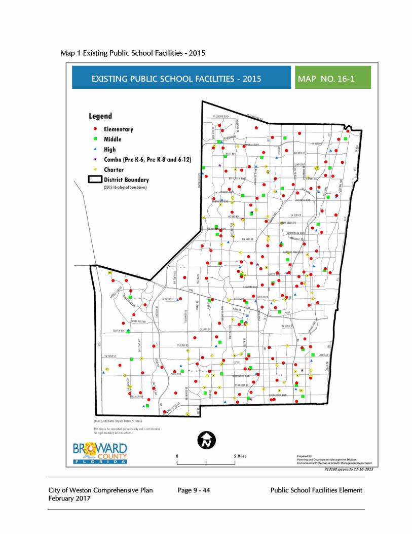
City of Weston Comprehensive Plan Page 9 - 44 Public School Facilities Element February 2017
Map 1 Existing Public School Facilities - 2015
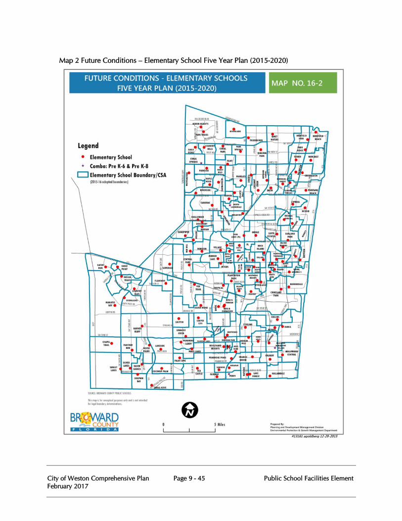
City of Weston Comprehensive Plan Page 9 - 45 Public School Facilities Element February 2017
Map 2 Future Conditions – Elementary School Five Year Plan (2015-2020)
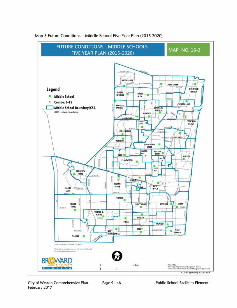
City of Weston Comprehensive Plan Page 9 - 46 Public School Facilities Element February 2017
Map 3 Future Conditions – Middle School Five Year Plan (2015-2020)
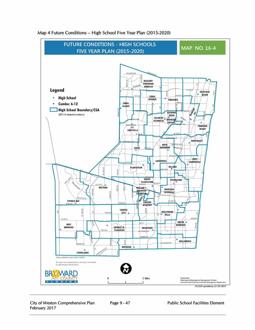
City of Weston Comprehensive Plan Page 9 - 47 Public School Facilities Element February 2017
Map 4 Future Conditions – High School Five Year Plan (2015-2020)
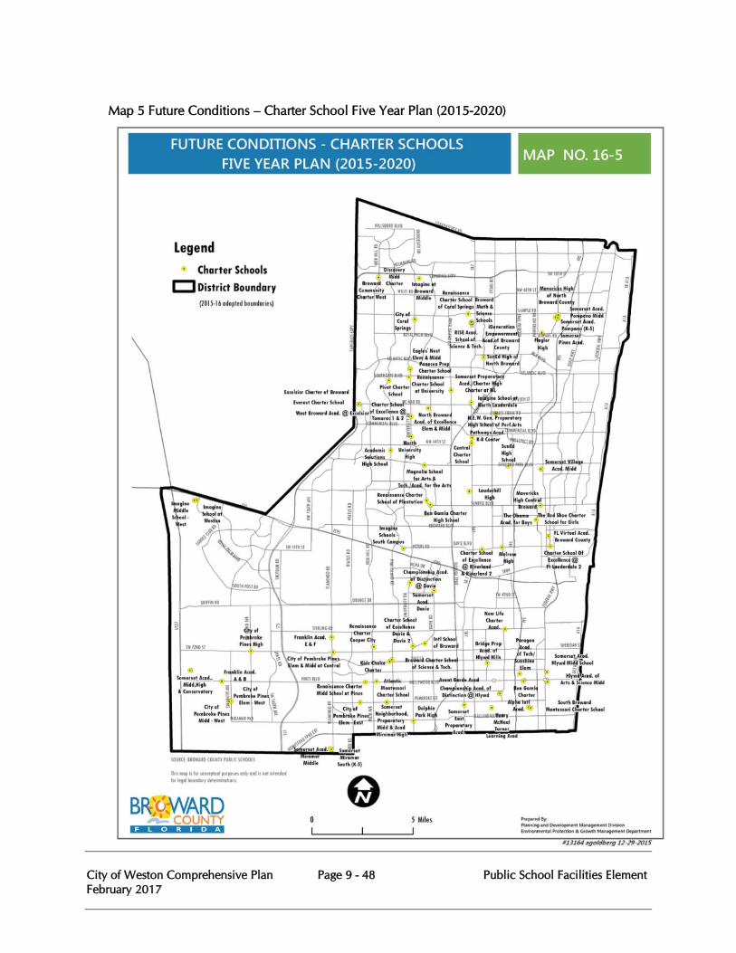
City of Weston Comprehensive Plan Page 9 - 48 Public School Facilities Element February 2017
Map 5 Future Conditions – Charter School Five Year Plan (2015-2020)
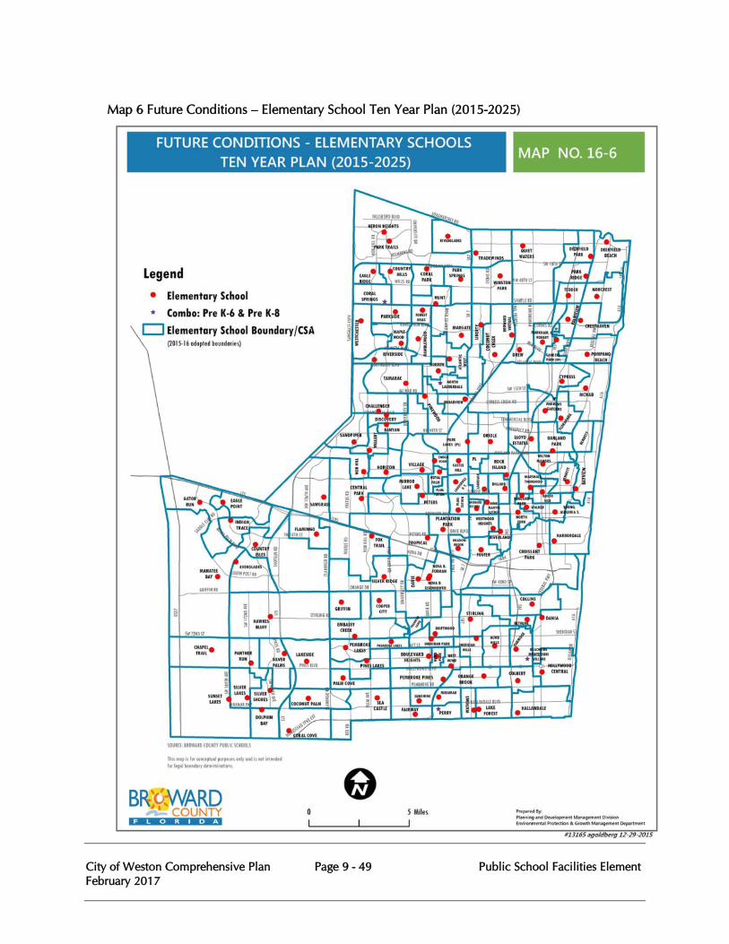
City of Weston Comprehensive Plan Page 9 - 49 Public School Facilities Element February 2017
Map 6 Future Conditions – Elementary School Ten Year Plan (2015-2025)

City of Weston Comprehensive Plan Page 9 - 50 Public School Facilities Element February 2017
Map 7 Future Conditions – Middle School Ten Year Plan (2015-2025)
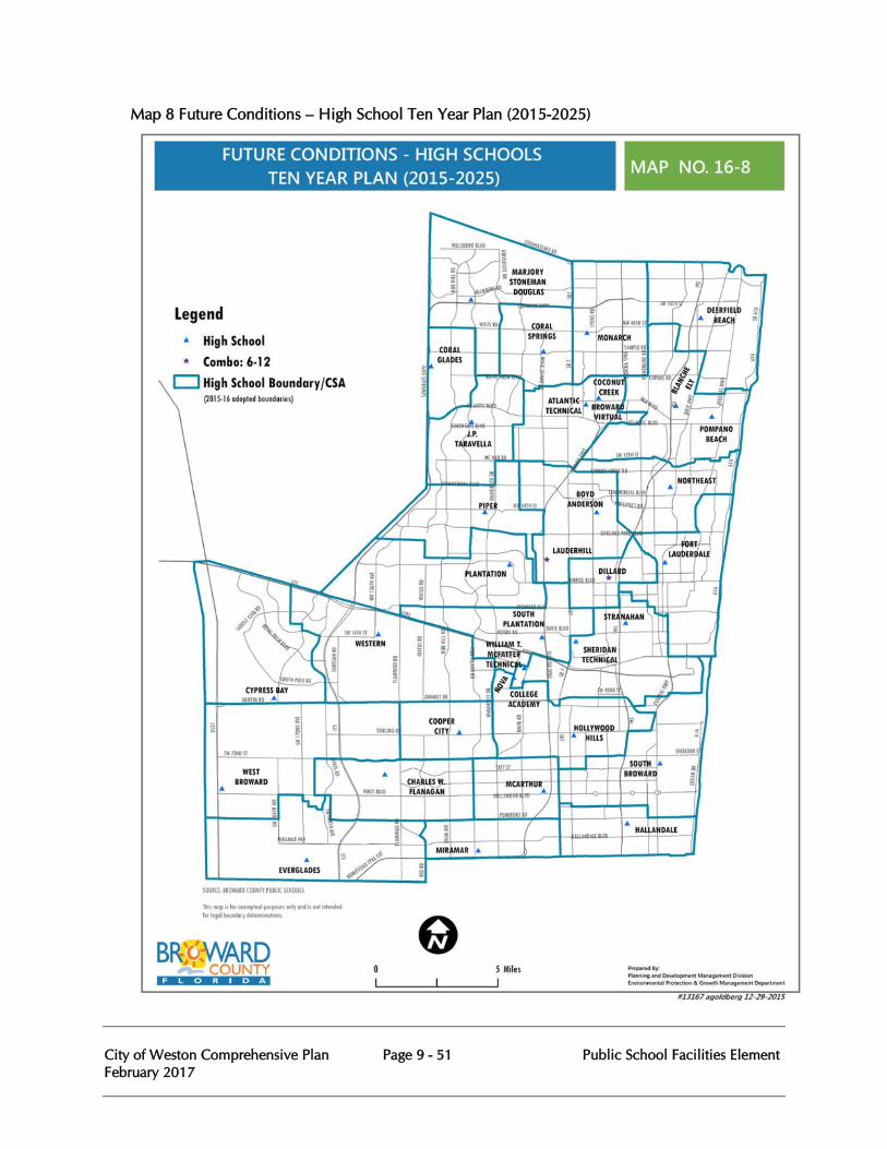
City of Weston Comprehensive Plan Page 9 - 51 Public School Facilities Element February 2017
Map 8 Future Conditions – High School Ten Year Plan (2015-2025)
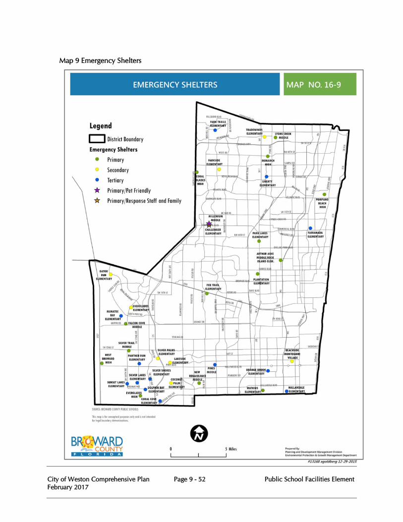
City of Weston Comprehensive Plan Page 9 - 52 Public School Facilities Element February 2017
Map 9 Emergency Shelters
City of Weston Comprehensive Plan Page 9 - 53 Public School Facilities Element February 2017
PUBLIC SCHOOL FACILITIES ELEMENT GOALS, OBJECTIVES, AND POLICIES
Goal 9:1 The City of Weston City Commission in collaboration with the School Board of Broward County (School Board), the Broward County Board of County Commissioners, and other Broward County municipalities (municipalities) shall ensure that public school facilities will be available for current and future students consistent with available financial resources and adopted level of service standards (LOS). This will be accomplished recognizing the School Board’s statutory and constitutional responsibility to provide a uniform system of adequate public school facilities and the authority of the City of Weston for development permitting and comprehensive planning.
9.1 Objective: Financially Feasible District Education Facilities Plan The School Board of Broward County (School Board), Pursuant to Chapters 163.3177 and 163.3180 F.S. and the Interlocal Agreement for Public School Facility Planning (ILA), shall prepare and annually update and adopt the Five-Year district Educational Facilities Plan (DEFP) which shall contain a five-year financially feasible schedule of capital improvements to address existing deficiencies and achieve and maintain the adopted level of service in all concurrency service areas (CSAs). The City of Weston shall provide comments to the School Board during its annual preparation, update and adoption of the Five-Year District Educational Facilities Plan (DEFP). The School Board shall also ensure that school facilities are planned to meet the long-term planning period of the Public School Facility Element (PSFE) of the City of Weston Comprehensive Plan, consistent with the provisions of the ILA.
9.1.1 Policy: The DEFP shall include a financially feasible schedule of capacity additions to existing schools and construction of new schools to eliminate existing level of service deficiencies and meet the needs of projected growth for the five-year planning period. The financially feasible schedule of the DEFP shall be annually adopted into the City of Weston Comprehensive Plan Capital Improvements Element (CIE) by reference.
9.1.2 Policy The School Board, through the Adopted DEFP, shall depict the capacity needed to achieve and maintain the adopted LOS for each CSA within the five-year planning period. These projections are included in the supporting documents of the PSFE.
9.1.3 Policy The School Board, through the DEFP, shall provide a five-year financially feasible schedule for the remodeling/renovation of existing schools to meet the identified needs of aging schools and replace worn facilities.
City of Weston Comprehensive Plan Page 9 - 54 Public School Facilities Element February 2017
9.1.4 Policy The School Board shall amend the DEFP on an annual basis to:
1. add a new fifth year;
2. reflect changes in estimated capital revenues, planned capital appropriations costs, planned capital facilities projects, Concurrency Service Area (CSA) and school usage; and,
3. ensure the DEFP continues to be financially feasible for the five-year planning period.
9.1.5 Policy Annual amendments to the CIE shall be coordinated with adopted updates to the DEFP and CSA maps. The annual plan amendments shall ensure that the schedule of capital improvements within the CIE continues to be financially feasible and the LOS will be achieved and maintained.
9.2 Objective: Concurrency Management System The City of Weston shall participate in the Broward County county-wide public school facilities concurrency management system for implementation of public school concurrency to ensure that public school facilities are available at the adopted level of service standard concurrent with the impact of proposed residential development.
9.2.1 Policy The City of Weston , in collaboration with the School Board and Broward County shall implement a concurrency management system consistent with the policies included in the County’s and the City’s Public School Facilities Element with procedures and requirements included within the City of Weston’s Land Development Code and the ILA.
9.2.2 Policy The CSAs shall be the annually adopted school attendance boundaries for each elementary, middle and high school. The maps of the CSAs are maintained in the data and analysis section of this Element.
9.2.3 Policy The Level of Service standard shall be 100% of gross capacity (with relocatable classrooms) for each CSA until the end of the 2018/19 school year; and commencing at the 2019/20 school year, the LOS for each CSA shall be 110% of permanent FISH capacity for each public elementary, middle and high school.
9.2.4 Policy If adequate capacity is not available in a CSA for a proposed residential development but capacity exists in one or more contiguous CSAs, the development may proceed consistent with the provisions and procedures in the City of Weston’s Land Development Code and the ILA.
City of Weston Comprehensive Plan Page 9 - 55 Public School Facilities Element February 2017
9.2.5 Policy
If adequate capacity is not currently available in a CSA or contiguous CSA for a proposed residential development but capacity is scheduled in the DEFP to be available within 3 years after the issuance of final subdivision or site plan approval or functional equivalent, development of the project may proceed in accordance with the provisions and procedures in the City of Weston’s Land Development Code and the ILA.
9.2.6 Policy The City of Weston shall not approve a residential plat or site plan or functional equivalent until the School Board has reported that the public school concurrency requirement has been satisfied consistent with the provisions and procedures in the City of Weston’s Land Development Code and the ILA.
9.2.7 Policy The CSAs shall be established and subsequently modified to maximize available school capacity and make efficient use of new and existing public schools in accordance with the level of service standards and the permanent capacity, taking into account special considerations such as core capacity, special programs, transportation costs, geographic impediments, diversity programs, and class size reduction requirements to prevent disparate enrollment levels between schools of the same type (elementary, middle, high) and provide an equitable distribution of student enrollment district-wide.
9.2.8 Policy The projected student impact of a proposed residential development shall be determined using the student generation rates approved by the School Board and adopted within the City of Weston’s Land Development Code. The student generation rates shall be reviewed and updated at least every 3 years.
9.2.9 Policy The public school concurrency approval for residential plats shall expire if development within the plat does not commence within 5 years following the date of City Commission approval.
9.3 Objective: Proportionate Share Mitigation The School Board, pursuant to Chapter 163.3180 F.S. and the ILA, shall adopt proportionate share mitigation alternatives that provide an option for residential developments unable to meet the public school concurrency requirement. Upon approval of a proportionate share mitigation alternative by the School Board and completion of a binding agreement if necessary, a development will be deemed to have met the public school concurrency requirement.
City of Weston Comprehensive Plan Page 9 - 56 Public School Facilities Element February 2017
9.3.1. Policy A residential development’s proportionate share mitigation value shall be determined by multiplying the number of additional student stations needed to mitigate the impact of the proposed development on schools within the affected CSA(s) not meeting the adopted LOS standards by the State cost per student station for each school type plus a land impact cost share, if applicable. Pursuant to Section 163.3180(13)(e)(2), F.S., the applicant’s proportionate share mitigation obligation shall be credited toward any other impact or exaction fee imposed by local ordinance for the same need, on a dollar-for dollar basis, at fair market value.
9.3.2. Policy Proportionate share mitigation shall enhance the capacity of the schools (or provide for the construction of new schools) serving the proposed residential development. Proportionate share mitigation shall equate to at least one permanent classroom, which may be funded by one or more residential developments, or other identified funding sources. Mitigation that results in the need for school site(s) shall primarily be the dedication of land. Proportionate share mitigation shall include the following options, as further defined and subject to, procedures and requirements in the ILA:
1. Purchase or dedication of needed elementary, middle or high school sites.
2. Construction of capacity improvements identified in years four (4) or five (5) of the DEFP including advancement of such improvements into the first three years of the DEFP.
3. Construction of previously unplanned schools, classroom additions, modular classrooms or similar facilities. Such facility capacity shall be included in the first three years of the DEFP.
4. Construction of the needed capacity at one or more charter schools.
5. Other mitigation options approved by the School Board on a case by case basis contingent upon a School Board finding that the option mitigates the impact of the proposed development.
9.3.3. Policy
Mitigation shall be assured by a legally binding agreement between the School Board, the applicant and the City of Weston executed prior to the issuance of the final subdivision plat or the final site plan approval (or functional equivalent). The School Board must commit in the agreement to placing the improvement required for mitigation in the first three years of the DEFP.
Goal 9.2 The City of Weston, the School Board, Broward County and municipalities shall maximize collaboration and coordination to effectively plan for public elementary and secondary school facilities to meet the current and future needs of Broward County's public school population. Pursuant to Chapter 163.3180 (6) (a) F.S., Broward County and the City of Weston shall coordinate
City of Weston Comprehensive Plan Page 9 - 57 Public School Facilities Element February 2017
and cooperate to ensure that the adopted public school facilities element and/or provisions include in the comprehensive plan regarding school concurrency are consistent with each other.
9.4 Objective: Land Use Consistency, Compatibility & Adequate Infrastructure The City of Weston shall coordinate with the School Board, and Broward County to ensure that the locations of existing and proposed school sites are compatible with and proximate to the existing and planned land uses they serve. Such coordination shall also ensure there is adequate public infrastructure available to serve existing and planned school sites including infrastructure which provides safe access to schools.
9.4.1. Policy The City of Weston will coordinate through the procedures established in the ILA and the City of Weston’s planning process to ensure that existing and proposed public school facility sites are consistent and compatible with the land use categories, future land use maps and policies of City of Weston’s Comprehensive Plan.
9.4.2. Policy The City of Weston will coordinate with the School Board and Broward County to prepare projections of future development and public school enrollment growth and to ensure such projections are consistent with the City of Weston’s future land use map and the School Board’s Long Range Public School Facilities Map, and procedures and requirements identified in the ILA.
9.4.3. Policy The Broward County PSFE shall include future conditions maps showing existing and anticipated school facilities for the short-term (5 year) and long-term (10 year) planning time frames.
9.4.4. Policy Consistent with provisions and procedures in the ILA, the School Board will advise the City of Weston of inconsistencies in the City of Weston’s Comprehensive Plans and Comprehensive Plan Amendments with the DEFP and Long-Range School Facilities Plan.
9.4.5. Policy The School Board shall monitor and participate in City of Weston’s plat review and site plan review processes, the Development of Regional Impact (DRI) process, the Comprehensive Plan Amendment process and other development order/permit processes that may have an impact on current or planned public facilities in the City of Weston.
9.4.6. Policy The City of Weston shall utilize the procedures identified within the ILA, including the Staff Working Group and Oversight Committee established by the ILA, to coordinate the annual review of school enrollment projections in
City of Weston Comprehensive Plan Page 9 - 58 Public School Facilities Element February 2017
addition to the preparation and annual reviews of public school facilities elements and ensure that the elements are consistent with each other.
9.4.7. Policy The City of Weston shall amend its CIE after the School Board annually updates and adopts the DEFP and transmits it to the City of Weston consistent with the provisions and procedures of the ILA, including any supplemental amendments.
9.4.8. Policy The City of Weston shall share and coordinate information with the School Board and Broward County through the municipal platting, Development Review, and school siting processes and procedures identified in the ILA to ensure the location, phasing, and development of public school facilities, including additions to existing facilities is coordinated with the provision of necessary public infrastructure.
9.4.9. Policy The City of Weston shall coordinate with the School Board and Broward County through the school siting process identified in the ILA and the City of Weston’s municipal platting and Development Review Committee processes to implement strategies, consistent with Florida’s Safe Ways to School Program which reduces hazardous conditions and provide direct, unobstructed and safe access for pedestrian travel (including sidewalks, bicycle paths, signage and signalization) to existing and new school facilities.
9.5 Objective: School Facility Siting, Collocation and Design The City of Weston, pursuant to the ILA, shall coordinate the location of public school facilities with the School Board and Broward County relative to the location of other public facilities such as parks, libraries and community centers and promote schools to be focal points within the community. 9.5.1. Policy
In the planning, siting, land acquisition, permitting and development of a new school facility or significant renovation or expansion, the School Board shall coordinate with the City of Weston on the availability of public facilities, services and grounds (especially for the purposes of collocating parks, libraries, ball fields, community centers, public safety facilities, parking facilities, drainage facilities and other appropriate facilities).
9.5.2. Policy The City of Weston shall pursue shared-use and co-location of school sites with School Board and County facilities having similar facility needs, such as libraries, community centers, parks, ball fields, and other recreation facilities. At a minimum, per the ILA, the City of Weston and County will look for opportunities to collocate and share use of their facilities when preparing updates to the Schedule of capital Improvements within the
City of Weston Comprehensive Plan Page 9 - 59 Public School Facilities Element February 2017
Comprehensive Plan and planning and designing new or renovated facilities.
9.5.3. Policy Through the design of school facilities, establishment of school siting standards and pursuit of collocation opportunities, the School Board is encouraged to promote school facilities to serve as community focal points.
9.5.4. Policy The City of Weston will coordinate with the School Board and Broward County on efforts to build new school facilities, which are designed to serve as emergency shelters as required by Section 1013.372, F.S.
Attachment A
Second Amended Interlocal Agreement for Public School Facility Planning February 2, 2010
Amended Interlocal Agreement for Public School Facility Planning December 7, 2007
Attachment A can be found on the Broward County Public Schools web page at:
http://www.broward.k12.fl.us/propertymgmt/new/growthmanagement/docs/EXECUTED%20Second%20Amended%20ILA%20CLEAN%20Copy.pdf
http://www.broward.k12.fl.us/propertymgmt/new/growthmanagement/docs/Signed%20Amende d%20ILA%20Clean%20_12.07.final_WITH%20SIGNATURES.pdf
Attachment B
BCPS Adopted District Educational Facilities Plan FY2015-16 to 2019-20
Attachment B can be found at:
http://www.broward.k12.fl.us/Comptroller/cfo/capbudget/report/ADEFP_090815.pdf
City of Weston Comprehensive Plan February 2017
Page A1-1 Concurrency Management System
COMPREHENSIVE PLAN APPENDIX A1
CONCURRENCY MANAGEMENT SYSTEM
The following section is adopted by City of Weston Ordinance No.1999-32:
OVERVIEW
The purpose of a concurrency management system is to provide the necessary regulations and rules for the City of Weston to follow in evaluating development orders to ensure that the level of service standards that are adopted in the Comprehensive Plan are adhered to. The system will consist of three components:
1. An inventory of the existing public facilities to which concurrency is to be applied.
2. An assessment of each application for final development order or permit for concurrency.
3. A Schedule of the improvements that are necessary to correct any existing deficiencies of the public facilities. Under this system and in accordance with the Statutes of the State of Florida, no development orders may be issued which will cause a public facility to operate below its adopted level of service standard. Development orders may be granted, however, subject to the adopted level of service standards being met and public facility improvements being accomplished concurrent with the impacts of development.
Concurrency will be determined during the final site plan or final subdivision approval process in order to assure that all public facilities included within the concurrency management system are available concurrent with the impacts of the project. All development orders and permits will indicate any needed improvements and will provide a schedule for their implementation. Thus, some required improvements will not be accomplished until a certificate of occupancy is applied for but the conditions required for obtaining a certificate of occupancy will be known at the time of the issuance of the development order. If a proposed development cannot meet the required test for concurrency, then it may not proceed and no development orders or permits may be issued. Also, if a development fails to meet a condition of approval once it has started, then no additional development orders, permits or Certificates of Occupancy may be issued.
APPLICABLITY
All applications for a final site plan or final subdivision plan shall be reviewed for concurrency in accordance with the provisions and requirements of the concurrency management system prior to the granting of a development order. The City of Weston may only issue a development order upon finding that the public facilities addressed under the Concurrency Management System will be available concurrent with the impacts of the development.
City of Weston Comprehensive Plan February 2017
Page A1-2 Concurrency Management System
All applications for development permits shall be required to provide enough information that is deemed necessary by the City of Weston so that the impacts of the proposed development can be accurately assessed. The application requirements for development permits shall be indicated in the City of Weston’s land development regulations. The application requirements shall reflect the information that is needed for the determination of concurrency. The City of Weston shall develop application forms for use.
CITY OF WESTON COMMUNITY DEVELOPMENT DEPARTMENT
The City of Weston Community Development Department shall be responsible for the tasks that are described below. The Planning Director may delegate all or a part of these functions to members of the Community Development Department staff.
1. An inventory of all existing public facilities shall be maintained along with capacities and any
deficiencies. 2. A determination shall be made for concurrency of any project that does not require City of
Weston commission approval. 3. Concurrency assessments and recommended conditions of approval shall be provided for any
application for development order that requires approval of the City of Weston Commission. 4. The Community Development Department shall report the status of all public facilities covered
under this system to the City Manager and the Assistant City Manager and shall recommend a schedule of improvements for those public facilities that are found to have existing deficiencies so that they can incorporate the improvements in the appropriate capital budget.
CAPACITY AND LEVEL OF SERVICE INVENTORY
The City of Weston Community Development Department will collect capacity information on certain public facilities and shall make that information available to the public no later than September 1, 1999. The concurrency information on the listed public facilities is shown on Table 11. The information contained on the facilities and listed in the Table shall be updated annually beginning on September 1 of each year. The provisions and requirements of the Concurrency Management System shall apply only to those public facilities that are listed in Table 11.
City of Weston Comprehensive Plan February 2017
Page A1-3 Concurrency Management System
TABLE 11
PUBLIC FACILITIES CAPACITIES AND LEVEL OF SERVICE INVENTORY FOR CONCURRENCY MANAGEMENT
City of Weston, Florida
The following inventories shall be maintained by the City of Weston Community Development Department to be used for the concurrency assessment of new development.
TRAFFIC CIRCULATION
Design capacity of different roadway types.
The existing level of service measured by the average annual number of trips per day on a roadway link and the peak hour trips as provided in the last counts taken before November 1 by the Florida Department of Transportation or the City of Weston.
The status of service degradation on those roads classified as backlogged, based on the methodology described in the Traffic Circulation Element of this plan.
The adopted level of service standards for all roadway types.
The existing capacities or deficiencies of the roadway network.
The capacities reserved for approved but unbuilt development.
The projected capacities or deficiencies due to approved but unbuilt development.
The improvements to be made to the roadway network in the current fiscal year by any approved development pursuant to previous development orders and the impact of such improvements on the existing capacities or deficiencies.
The improvements to be made to the roadway network in the current fiscal year by the City of Weston, Broward County, the State of Florida Department of Transportation, or other public agency and the impact of such improvements on the existing capacities or deficiencies.
SANITARY SEWER
The design capacity of the wastewater treatment facilities.
The existing level of service standards measured by the average number of gallons per day per unit based on the average flows that are experienced at the City of Sunrise wastewater treatment plant and the total number of equivalent residential units within the service area.
The adopted level of service standards for the average daily flows per equivalent residential unit.
City of Weston Comprehensive Plan February 2017
Page A1-4 Concurrency Management System
The existing deficiencies of the system.
The capacities that are reserved for approved but unbuilt development
The projected capacities or deficiencies due to approved but unbuilt development.
The improvements to be made to the facilities in the current fiscal year by any approved developments pursuant to previous development orders and the impact of such improvements on the existing capacities or deficiencies.
POTABLE WATER
The design capacities of the potable water treatment facilities of the City of Sunrise.
The existing level of service measured by the average number of gallons per day per unit based on the average flows experienced and the total number of residential units within the service area of the City of Sunrise water treatment plant.
The existing potable water storage capabilities of both the City of Weston and the City of Sunrise.
The existing minimum water pressure in the City of Weston water distribution system.
The adopted level of service standards for the potable water facility components.
The existing capacities or deficiencies of the system.
The capacities reserved for approve but unbuilt developments.
The improvements to be made to the facility in the current fiscal year by any approved developments pursuant to previous development orders and the impact of such improvements on the existing capacities or deficiencies.
The improvements to be made to the facility in the current fiscal year by the City of Sunrise and the impact of such improvements on the existing capacities or deficiencies.
SOLID WASTE DISPOSAL
The design capacity of solid waste disposal facilities.
The existing level of service measured by the number of units approved per route.
The adopted level of service standard for solid waste.
The capacities reserved for approved but unbuilt development.
The projected capacities or deficiencies due to approved but unbuilt development.
City of Weston Comprehensive Plan February 2017
Page A1-5 Concurrency Management System
The improvements to be made to the system in the current fiscal year by any approved developments pursuant to previous development orders and the impact of such improvements on the existing capacities or deficiencies. The improvements to be made to the system in the current fiscal year by the City of Weston or the contracted agency and the impact of such improvements on the existing capacities or deficiencies.
STORMWATER DRAINAGE
The existing level of service measured by storm event as determined by the City of Weston and its Consulting Engineers.
The adopted level of service standard for storm drainage.
RECREATION AND OPEN SPACE
The existing acreage of parkland and the existing number of recreation facilities as outlined in Table III in the Recreation and Open Space Element of this plan.
The existing level of service measured by the number of acres of parkland available per 1,000 residents of the City of Weston based on an inventory of park lands in the City of Weston and the population of the City of Weston.
The existing level of service for recreation facilities measured by the adopted standard based on an inventory of the facilities in the City of Weston and the population of the City of Weston.
The adopted level of service standards for parkland acreage and individual recreation facilities as outlined in Table III in the Recreation and Open Space Element of this plan.
The existing capacities or deficiencies of the recreation facility system.
The capacities reserved for approved but unbuilt development.
The projected capacities or deficiencies due to approved but unbuilt development.
The improvements to be made to the recreation facilities in the current fiscal year by any approved developments pursuant to previous development orders and the impact of such improvements on the existing capacities or deficiencies.
The improvements to be made to the recreation facilities in the current fiscal year by the City of Weston and the impact of such improvements on the existing capacities or deficiencies.
CONCURRENCY ASSESSMENT
The City of Weston Community Development Department will be responsible for determining the concurrency for all applications of development orders for final site plans and/or final subdivision plans. When reviewing applications for plans for such development orders, the Community Development Department shall perform a Concurrency Assessment to ensure that public facilities are available concurrent with the impacts of the proposed development. To conduct the
City of Weston Comprehensive Plan February 2017
Page A1-6 Concurrency Management System
assessment, the inventory presented in Table 11 shall be used as a base for the establishment of existing conditions. The capability of existing public facilities to service new development shall then be determined by using the general rules presented in Table 12 and the facility specific rules presented in Table 13. After this review a determination of concurrency shall be made. The determination of concurrency may include conditions of approval, which are deemed necessary for concurrency to be ensured. The City of Weston Community Development Department shall provide recommendations to the City of Weston Commission concerning those development order applications, which require City of Weston Commission approval. The comments and recommendations provided by the Community Development Department shall include but are not limited to the following:
1. The ability of existing facilities to accommodate the proposed development at the
adopted level of service standards; 2. Any existing facility deficiencies that will need to be corrected prior to the
completion of the proposed development; 3. The facility or facilities improvements or additions that will be needed to
accommodate the impacts of the proposed development at the adopted level(s) of service;
4. The date such facility (s) improvements or additions will need to be completed concurrent with the impacts on such facility(s) created by the proposed development, and
5. A recommendation of approval or denial with any applicable conditions for the timing and location of needed improvements.
Prior to the issuance of a development order for a proposed new development, the City Commission and/or the City of Weston Community Development Department shall:
1. make a finding on the impacts created by the proposed development;
2. make a finding as to whether the public facilities covered under the Concurrency Management system will be available concurrent with the impacts of the new development at the adopted level;
3. make a finding of those facility(s) improvements or additions that are required to ensure the finding of the concurrency, and
4. make a finding of the entity responsible for the design and installation of all required facility(s) improvements or additions.
The adopted level of service standards shall be the minimum acceptable standards with which all proposed new development shall comply. The Concurrency Management System shall not preclude the Community Development Department or the City of Weston Commission from imposing other conditions of approval including improvements and additions to the facilities covered under this system beyond the minimums necessary to achieve concurrency.
City of Weston Comprehensive Plan February 2017
Page A1-7 Concurrency Management System
FACILITIES REPORTING
On September 1 of each year, the City of Weston Community Development Department shall report to the City of Weston Commission the information required in Table 11. The report shall also include the degree of any deficiencies and a summary of the impacts the deficiency(s) will have on the approval of development orders, for example, the creation of a moratorium. The Community Development Department shall then recommend a schedule of improvements necessary to prevent a moratorium or a reduction in the approval of development orders.
TABLE 12
GENERAL RULES FOR CONCURRENCY ASSESSMENT
City of Weston, Florida
EXISTING DEFICIENCIES
No development may be approved which will impact a facility that is currently deficient unless the facility is required to be improved in the current fiscal year pursuant to a previous development order or permit. Any needed improvements shall be completed prior to the projected impacts of the proposed development as required by Table 13.
APPROVED IMPACT
The impacts of new development shall be assessed against the existing conditions as described in Table 11 and the projected impacts from approved but unbuilt development. These two items together shall be considered the existing conditions for all public facilities for the impact assessment of all proposed development.
PHASING
Development that is proposed to be phased may also phase the improvement of facilities provided the concurrency requirements for each facility as described in Table 13 are met.
TIME SPECIFIC APPROVAL
All development approvals shall have a time period specified in the development order or permit in which development must commence. The time period may involve two or more phases but the timing of each phase shall be specified in the development order or permit. The development order may prescribe a time schedule for the initiation of the various components of the development process such as land clearing, site fill, foundation work, etc.
Any required improvements to meet concurrency shall also require a time schedule for construction and completion. Should development or facilities improvements fail to begin or be completed in accordance with the development order or permit, then all outstanding approvals of the development shall expire. Amendments or changes to time schedules shall be permitted but must be approved by the body granting the original approval, normally the City Commission.
City of Weston Comprehensive Plan February 2017
Page A1-8 Concurrency Management System
ADDITIONAL INFORMATION
The City of Weston Community Development Department may require additional information from applicants or other City of Weston Departments in order for an accurate concurrency assessment to be accomplished. Such additional informational requests shall be reasonable and be provided in writing to the appropriate Department. Should the Community Development Department require a special study, the applicant shall provide such information. Examples of such special studies are traffic counts on a road that is not normally included in a traffic count or analyzing a water system for pressure. Review and approval of proposed development may be postponed for a reasonable time period in order that more information may be gathered on the facility. Proposed development may be denied approval for failure of the applicant to provide adequate information on the projected impacts created by the development.
TABLE 13
FACILITY SPECIFIC RULES FOR CONCURRENCY ASSESSMENT
City of Weston, Florida
The following specific rules for facilities shall be enforced by the City of Weston Community Development Department in the process of reviewing a proposed development project for potential issuance of a development order.
TRANSPORTATION FACILITIES
The City of Weston shall abide by the concurrency requirements as established in Policy 8.2.9 in the Transportation Element of the Weston Comprehensive Plan.
SANITARY SEWER
The City of Weston shall adopt land development regulations that establish sanitary sewer flow rates for each type of development that is allowed within the City of Weston. The established flow rates shall conform to the adopted level of service standards for sanitary sewer. An applicant for a development order shall submit calculations to the Community Development Department that reflect the impact of the proposed project on the City of Weston’s sanitary sewer system and shall also include plans of a proposed sanitary sewer system that will service the proposed project.
Prior to the issuance of a certificate of occupancy, all sanitary sewer improvements that are necessary to accommodate the impacts that are created by the project, shall be completed.
POTABLE WATER
The City of Weston shall adopt land development regulations that establish potable water flow rates for each type of development that is allowed within the City of Weston. The established flow rates shall conform to the adopted level of service standards for potable water service. An applicant for a development order shall submit calculations to the Community Development Department that reflect the impact of the proposed project on the City of Weston’s potable water system. Both domestic and fire flow shall be addressed. The submittal should include plans of the proposed
City of Weston Comprehensive Plan February 2017
Page A1-9 Concurrency Management System
water distribution system, including fire hydrants and fire lines that will service the proposed project.
Prior to the issuance of certificate occupancy, all potable water improvements that are necessary to accommodate the impacts that are created by the project, shall be completed. SOLID WASTE
The City of Weston shall adopt land development regulations that provide solid waste generation standards based on land use types. Commercial and industrial developments that are potential hazardous waste generators shall provide a description and estimate of tonnage of solid waste to be generated for which the development will be responsible for coordinating with Broward County for disposal of such waste. The City of Weston will then obtain written approval form Broward County that the proposed development’s hazardous waste generation can be accommodated at the County’s facility.
STORMWATER DRAINAGE
All development shall prepare a stormwater drainage plan based on the storm water criteria that is contained with the City of Weston’s land development regulations and the rules of the Indian Trace Community Development District. The plan shall also include calculations that meet the level of service standards established by the City of Weston for stormwater. The plan shall be submitted to the Community Development Department for approval prior to issuance of a development order.
Prior to the issuance of a certificate of occupancy, all stormwater improvements that are necessary to accommodate the impacts of the proposed development receiving the approval shall be completed.
RECREATION
The City of Weston shall adopt land regulations that provide recreation standards for residential uses. Commercial and industrial developments shall not be assessed as having an impact on recreational facilities. However, the City of Weston reserves the right to require the provision of recreational facilities on PRD projects and others as it sees fit.
Prior to the issuance of a building permit, all facility improvements necessary to accommodate the impacts of the entire development shall be approved and a schedule established for their implementation such that all improvements shall be completed prior to the issuance of the last certificate of occupancy.
This concludes the adopted sections of this appendix.
City of Weston Comprehensive Plan February 2017
Page A2-1 Definitions
COMPRHENSIVE PLAN APPENDIX A2
DEFINITIONS
“Accessory Use” A use naturally and customarily incidental, subservient or subordinate to the principal use.
Accommodations” Any apartment, condominium or cooperative unit, cabin, lodge, hotel or motel room, campground, or other private or commercial structure which is situated on real property and designed for occupancy or use by one or more individuals.
“Activity-based park” A park with features such as baseball fields, basketball courts, football fields, roller hockey rinks, soccer fields, etc.
“Adjusted gross income” All wages, a s s e t s , regular cash or noncash contributions or g i f ts from persons outside the household, and such other resources and benefits as may be determined to be income by the United States Department of Housing and Urban Development, adjusted for family size, less deductions allowable under Section 62 of the Internal Revenue Code.
“Administration commission” The Governor and the Cabinet of the State of Florida.
“Affordable housing” Housing for which monthly rents or monthly mortgage payments, including taxes, insurance, and utilities, do not exceed 30 percent of the adjusted gross household income.
“Agricultural uses” Activities within land areas, which are predominantly used for the cultivation of crops and livestock including: cropland; pastureland; orchards; vineyards; nurseries; ornamental horticulture areas; groves; confined feeding operations; specialty farms and silviculture areas.
“Alley” A right-of-way providing a secondary means of access and service to abutting property.
“Amendment” Any change to an adopted comprehensive plan except for corrections, updates and modifications of the capital improvements element concerning costs, revenue services, acceptance of facilities or facility construction dates consistent with the plan as provided in Subsection 163.3177(3)(b), Florida Statutes, and corrections updates or modifications of current costs in other elements, as provided in Section 163.3187(2) Florida Statutes.
City of Weston Comprehensive Plan February 2017
Page A2-2 Definitions
“Annexation” The adding of real property to the boundaries of an incorporated municipality, such addition making such real property in every way a part of the municipality.
“Antiquated subdivision” A subdivision that was recorded or approved more than 20 years ago and that has substantially failed to be built and the continued buildout of the subdivision in accordance with the subdivision’s zoning and land use purposes would cause an imbalance of land uses and would be detrimental to the local and regional economies and environment, hinder current planning practices, and lead to inefficient and fiscally irresponsible development patterns as determined by the respective jurisdiction. “Arterial road” A roadway providing service which is relatively continuous and of relatively high traffic volume, long trip length and high operating speed.
“Base Flood Elevation” The elevation above North American Vertical Datum (sea level) determined by the Federal Emergency Management Agency to be the surface elevation of flood waters regardless of wind or wave action.
“Bicycle and pedestrian ways” Any road, path or way which is open to bicycle travel and traffic afoot and from which motor vehicles are excluded.
“Building” Any structure having a roof and used or built for the shelter or enclosure of persons, animals, chattels, or property of any kind.
“Building permit” (1) Any permit for the erection or construction of a new building required by Section
301.1 of the South Florida Building Code, 1984, Broward Edition, as amended.
(2) Any permit for an addition to an existing building which would: (a) create one or more additional dwelling units, or (b) involve a change in the occupancy of a building as described in Section104.7 of the South Florida Building Code, 1984, Broward Edition, as amended.
(3) Any permit which would be required for the nonresidential operations included in Section 301.1(a) of the South Florida Building Code, 1984, Broward Edition, as amended.
“Capital budget” The portion of Weston’s budget that reflects capital improvements scheduled for a fiscal year.
“Capital improvement” Physical assets constructed or purchased to provide, improve or replace a public facility and which are large scale and high in cost. The cost of a capital improvement is generally nonrecurring and may require multi-year financing. For the purposes of this rule, physical assets which have been identified as existing or projected needs in the individual comprehensive plan elements shall be considered capital improvements.
City of Weston Comprehensive Plan February 2017
Page A2-3 Definitions
“Collector road” A roadway providing service which is of relatively moderate traffic volume, moderate operating speed. Collector roads collect and distribute traffic between local roads or arterial roads.
“Commercial uses” Activities within land areas which are predominantly connected with the sale, rental and distribution of products, or performance of services.
“Community cultural facility” A facility that is readily accessible to all segments of the community for cultural activities (performing, visual and literary arts). The center should include classroom and workshop space, exhibit and performance space and cultural programming by professional artists for all age groups. “Community park” Park having more than 10 acres that is designed to serve the recreational needs of several neighborhoods. Community parks may include recreational activities such as field games, court games, playground apparatus, walking, jogging, picnicking, etc.
“Community shopping center” A shopping center which typically ranges from approximately 100,000 to 300,000 square feet of gross leasable area and is generally built around a junior department store or variety store and supermarket as the major tenants. Community shopping centers typically range in area from approximately 10 acres to 30 acres and serve trade areas ranging from roughly 40,000 people to 150,000 people.
“Compatibility” A condition in which land uses or conditions can coexist in relative proximity to each other in a stable fashion over time such that no use or condition is unduly negatively impacted directly or indirectly by another use or condition.
“Comprehensive plan” A plan that meets the requirements of ss. 163.3177 and 163.3178, Florida Statutes.
“Concurrency” That the necessary public facilities and services to maintain the adopted level of service standards are available when the impacts of development occur.
“Concurrency Management System” The procedures and/or process that the local government will utilize to assure that development orders and permits are not issued unless the necessary facilities and services are available concurrent with the impacts of development.
“Conservation uses” Activities or conditions within land areas designated for the purpose of conserving or protecting natural resources or environmental quality, including areas designated for such purposes as flood control, protection of quality or quantity of groundwater or surface water, floodplain management, commercially or recreationally valuable fish and shellfish, or protection of vegetative communities or wildlife habitats.
“Consistent” Compatible with and furthers. Compatible with means not in conflict with. Furthers means to take action in the direction of realizing the goals and policies. As applied to the Weston plan shall be consistent with the state plan and the regional plan.
City of Weston Comprehensive Plan February 2017
Page A2-4 Definitions
“Contiguous” In close proximity, touching or adjacent.
“Contraction” The reversion of real property within municipality boundaries to an unincorporated status.
“County Commission” The Board of County Commissioners of Broward County.
“Dashed-line area” An area on the Weston Future Land Use Plan Map bordered by a dashed line and designated as having a particular maximum overall density of dwelling units for all land and land uses within the area, and/or a particular total number of dwelling units permitted within the area. “Density” An objective measure of the number of people or residential units allowed per unit of land, such as residents or employees per acre.
“Developer” Any person, including a governmental agency, undertaking any development.
“Development” The term “development” means: (1) The carrying out of any building activity or mining operation, the making of any
material change in the use of appearance of any structure or land, or the dividing of land into two or more parcels.
(2) The following activities or uses shall be taken for the purposes of this chapter to
involve “development”, as defined in this section: (a) A reconstruction, alteration of the size, or material change in the external
appearance of a structure on land. (b) A change in the intensity of use of land, such as an increase in the number f
dwelling units in a structure or on land or a material increase in the number or businesses, manufacturing establishments, offices, or dwelling units in a structure or on land.
(c) Alteration of a shore or bank of a seacoast, river, stream, lake, pond, or canal, including any “coastal constructure” as defined in s.161.021.
(d) Commencement of drilling, except to obtain soil samples, mining, or excavation on a parcel of land.
(e) Demolition of a structure. (f) Clearing of land as an adjunct of construction. (g) Deposit of refuse, solid or liquid waste, or fill on a parcel of land.
(3) The following operations or uses shall not be taken for the purpose of this chapter to
involve “development” as defined herein:
(a) Work by a highway or road agency or railroad company for the maintenance or improvement of a road or railroad tract, if the work is carried out on land within the boundaries of the right-of-way.
(b) Work by any utility and other persons engaged in the distribution or transmission of gas or water, for the purpose of inspecting, repairing, renewing, or constructing on established rights-of-way any sewers, mains, pipes, cables, utility tunnels, powerlines, towers, poles, tracks or the like.
City of Weston Comprehensive Plan February 2017
Page A2-5 Definitions
(c) Work for the maintenance, renewal, improvement, or alteration of any structure, if the work affects only the interior or the color of the structure or the decoration of the exterior of the structure.
(d) The use of any structure or land devoted to dwelling uses or any purpose customarily incidental to enjoyment of the dwelling.
(e) The use of any land for the purpose of growing plants, crops, trees and other agricultural or forestry products; raising livestock; or for other agricultural purposes.
(f) A change in the use of land or structure from a use within a class specified in an ordinance or rule to another use in the same class.
(g) A change in the ownership or form of ownership of any parcel or structure.
(h) The creation or termination of rights of access, apiarian rights, easements, covenants concerning development of land, or other rights in land.
(4) “Development”, as designated in an ordinance, rule, or development rule includes all other development customarily associated with it unless otherwise specified. When appropriate to the context, “development” refers to the act of developing to the result of development. Reference to any specific operation is not intended to mean that the operation or activity, when part of other operations or activities, is not development. Reference to particular operations is not intended to limit the generality of subsection (1).
“Development order” Any order granting, denying, or granting with conditions an application for a development permit.
“Development permit” Includes any building permit, zoning permit, plat approval, or rezoning, certification, variance, or other action having the effect of permitting development.
“Dwelling unit” A house, apartment, condominium unit, trailer, group of rooms, or a single room intended for occupancy as separate living quarter with direct access from the outside of the building or through a common hall and with complete kitchen facilities for the exclusive use of the occupants, including rental units contained in a multi-unit structure or complex which are licensed by the State Department of Business Regulation, Division of Hotels and Restaurants, as “apartments’, “rental condominiums” and “retirement housing” or live-aboard vessels located in multi-family “Residential” designated areas which are required to hookup to marine sanitation systems.
“Easement” Any strip of land created by a subdivider for public or private utilities, drainage, sanitation, or other specified uses having limitations, the title to which shall remain in the name of the property owner, subject to the right of use designated in the reservation of the servitude.
City of Weston Comprehensive Plan February 2017
Page A2-6 Definitions
“Educational uses” Activities and facilities of public or private primary or secondary schools, vocational and technical schools, and colleges and universities licensed by the Florida Department of Education, including the areas of buildings, campus open space, dormitories, recreational facilities or parking.
“Enhancement” The alteration of an existing wetland to increase the functional value.
“Estuary” A semi-enclosed, naturally existing coastal body of water in which saltwater is naturally diluted by freshwater and which has a connection with oceanic waters, including bays, embayments, lagoons, sounds and tidal streams.
“Flexibility zone” A geographic area, as delineated on the flexibility zone boundary maps in the Administrative Rules Document of the Broward County Planning Council, within which residential densities and land uses may be redistributed through the plan certification process. “Flood plains or Flood prone” Areas inundated during a 100-year flood event or areas identified by the National Flood Insurance Program as an A Zone on Flood Insurance Rate Maps or Flood Hazard Boundary Maps.
“Foster care facility” A facility which houses foster residents and provides a family living environment for the residents including such supervision and care as may be necessary to meet the physical, emotional and social needs of the residents and serving either children or adult foster residents.
“Goal” The long-term end toward which programs or activities are ultimately directed.
“Group home” A facility which provides a living environment for unrelated residents who operate as the functional equivalent of a family, including such supervision and care as may be necessary to meet the physical, emotional and social needs of the resident. Adult congregate living facilities comparable in size to group homes are included in this definition.
“Hazardous waste” Solid waste, or a combination of solid wastes, which, because of its quantity, concentration, or physical, chemical, or infectious characteristics, may cause, or significantly contribute to, an increase in mortality or an increase in serious irreversible or incapacitating reversible illness or may pose a substantial present or potential hazard to human health or the environment when improperly transported, disposed of, stored, treated or otherwise managed.
“High recharge area” or “prime recharge area” An area so designated by the South Florida Water Management District to replenish ground water.
“Hurricane shelter” A structure designated by local officials as a place of safe refuge during a storm or hurricane.
City of Weston Comprehensive Plan February 2017
Page A2-7 Definitions
“Improvements” Include, but not limited to, street pavements, curbs and gutters, sidewalks, alley pavements, walkway pavements, water mains, sanitary sewers, storm sewers or drains, street names, signs, landscaping, permanent reference monuments, permanent control points, or any other improvement required by a governing body.
“Industrial uses” The activities within land areas predominantly connected with manufacturing, assembly, processing or storage of products.
“Infrastructure” Those man-made structures which serve the common needs of the population, such as sewage disposal systems; potable water systems; potable water wells serving a system; solid waste disposal sites or retention areas; stormwater systems; utilities; breakwaters; bulkheads; seawalls; revetments; causeways; bridges and roadways.
“Intensity” An objective measurement of the extent to which land may be developed or used, including the consumption or use of the space above, on or below ground; the measurement of the use of or demand on natural resources; and the measurement of the use of or demand on facilities and services. “Internal trip capture” Trips generated by a mixed-use project that travel from one onsite land use to another onsite land use without using external road networks. “Lake” A natural depression fed by one or more streams and from which a stream may flow; occurs due to widening or natural blockage of a river or stream or occurs in an isolated natural depression that is not part of a surface river or stream; usually too deep to permit the growth of rooted plants from shore to shore.
“Land” The earth, water, and air above, below or on the surface, and includes any improvements or structures customarily regarded as land.
“Land development code” The various types of regulations for the development of land within the jurisdiction of the City of Weston when combined into a single document.
“Land development regulation” Ordinances enacted by the City of Weston for the regulation of any aspect of development and includes any zoning, rezoning, subdivision, building construction, or sign regulations or any other regulations controlling the development of land.
“Land use” The development that has occurred on the land, the development that is proposed by a developer on the land, or the use that is permitted or permissible on the land under an adopted comprehensive plan or element or portion thereof, land development regulations, or a land development code, as the context may indicate.
“Level of service” An indicator of the extent or degree of service provided by, or proposed to be provided by a facility based on and related to the operational characteristics of the facility. Level of service shall indicate the capacity per unit of demand for each public facility.
City of Weston Comprehensive Plan February 2017
Page A2-8 Definitions
“Limited access facility” A roadway especially designed for through traffic, and over, from, or to which owners or occupants of abutting land or other persons have no greater than a limited right or easement of access.
“Local road” A roadway providing service which is of relatively low traffic volume, short average trip length or minimal through traffic movements, and high volume land access for abutting property.
“Lot” Includes tract or parcel – means the latest fractional part of subdivided lands having limited fixed boundaries and an assigned number, letter, or other name through which it may be identified.
“Lot or parcel or record” A quantity of real property as a single unit described and identified in a deed and/or plat recorded in the public records of a county in the State of Florida.
“Low income household” One or more natural persons or a family, the total annual adjusted gross income of which exceeds 50 percent but does not exceed 80 percent of the median annual adjusted gross income for households within the state, or of the median annual adjusted gross income for households within the metropolitan statistical area (MSA), or, if not within an MSA, within the county in which the household resides, whichever is greater. “Major trip generators or attractors” Concentrated areas of intense land use or activity that produces or attracts a significant number of local trip ends.
“Mass transit” Passenger services provided by public, private or non-profit entities such as the following surface transit modes: commuter rail, rail rapid transit, light rail transit, light guideway transit, express bus and local fixed route bus.
“Minerals” All solid minerals, including clay, gravel phosphate rock, lime, shells (excluding live shellfish), stone, sand, heavy minerals and any rare earths, which are contained in the soils or waters of the state.
“Moderate income household” One or more natural persons or a family, the total annual adjusted gross income of which exceeds 80 percent but does not exceed 120 percent of the median annual adjusted gross income for households within the state, or of the median annual adjusted gross income for households within the metropolitan statistical area (MSA), or, if not within an MSA, within the county in which the household resides, whichever is greater.
“Neighborhood park” Park having up to 10 acres that is designed to serve the recreational needs of the population living in the immediate residential area. Neighborhood parks may include recreational activities such as field games, court games, playground apparatus, walking, jogging, picnicking, etc.
City of Weston Comprehensive Plan February 2017
Page A2-9 Definitions
“New town” A urban activity center and community designated on the future land use map of sufficient size, population, and land use composition to support a variety of economic and social activities consistent with and urban area designation. New towns shall include basic economic activities; all major land use categories (exception of agriculture and industrial); and centrally provided full range of public facilities and services that demonstrate internal trip capture. A new town shall be based on a master development plan.
“Objective” A specific, measurable, intermediate end that is achievable and marks progress toward a goal.
“Open space” Lands such as conservation areas, natural preserves and wetlands that have been set aside for preservation and are protected by local, state or federal law. Lands may be suitable for passive recreation or conservation uses.
“Paratransit” Transit services, including ridesharing, car or van pools, demand responsive buses, and other transit services, which are characterized by their nonscheduled, non-fixed route nature.
“Parcel of land” Any quantity of land capable of being described with such definiteness that its location and boundaries may be established, which is designated by its owner or developer as land to be used or developed as a unit or which has been used or developed as a unit.
“Person” An individual, corporation, governmental agency, business trust, estate, trust, partnership, association, two or more persons having a joint or common interest, or any other legal entity. “Plat” A map or delineated representation of the subdivision of lands, being a complete exact representation of the subdivision and other information in compliance with the requirement of all applicable sections of this chapter and of any local ordinances, and may include the terms “replat”, “amended plat”, or “revised plat”. “Policy” The way in which program and activities are conducted to achieve an identified goal.
“Pollution” The presence in the outdoor atmosphere, ground or water of any substances, contaminants, noise, or manmade or man-induced alteration of the chemical, physical, biological, or radiological integrity of air or water, in quantities or at levels which are or may be potentially harmful or injurious to human health or welfare, animal or plant life, or property, or unreasonably interfere with the enjoyment of life or property.
“Potable water facilities” A system of structures designed to collect, treat, or distribute potable water, and includes water wells, treatment plants, reservoirs, and distribution mains.
“Potable water wellfield” The site of one or more water wells which supply potable water for human consumption to a water system which serves at least 15 service connections used by year-round residents or regularly serves at least 25-year round residents.
City of Weston Comprehensive Plan February 2017
Page A2-10 Definitions
“Principal building” A building which is occupied by, devoted to, a principal use or an addition to an existing principal building which is larger than the original existing building. In determining whether a building is of primary importance, the use of the entire parcel shall be considered. There may be more than one principal building on a parcel.
“Principal use” The primary or main use of a parcel of land as distinguished from an accessory use. There may be more than one principal or main use on a parcel of land.
“Private recreation sites” Sites owned by private, commercial or non-profit entities available to the public for purposes of recreational use.
“Public access” The ability of the public to physically reach, enter or use recreation sites including beaches and shores.
“Public buildings and grounds” Structures or lands that are owned, leased, or operated by a government entity, such as civic and community centers, hospitals, libraries, police stations, fire stations and government administration buildings. “Public facilities” Transportation systems or facilities, sewer systems or facilities, solid waste systems or facilities, drainage systems or facilities, potable water systems or facilities, educational systems or facilities, parks and recreation systems or facilities and public health systems or facilities.
“Purchase of development rights” The acquisition of a governmentally recognized right to
develop land which is severed from the realty and held or further conveyed by the purchaser.
“Recreation facility” A component of a recreation site used by the public such as a trail, court, athletic field or swimming pool.
“Recreational uses” Activities within areas where recreation occurs. “Regional park” Park having more than 100 acres that is intended to serve the recreational needs of the population of the entire City of Weston. A regional park may include active facilities, passive facilities or a combination of the two.
“Relocation housing” Those dwellings which are made available to families displaced by public programs, provided that such dwellings are decent, safe and sanitary and within the financial means of the families or individuals displaced.
“Resident population” Inhabitants counted in the same manner utilized by the United States Bureau of the Census, in the category of total population. Resident population does not include seasonal population.
“Residential uses” Activities within land areas used predominantly for housing.
City of Weston Comprehensive Plan February 2017
Page A2-11 Definitions
“Resource-based park” Park with features such as picnic areas, shelters, walkways, trails or boardwalks oriented toward unique natural features.
“Right-of-Way” Land in which the state, a county, or a municipality owns the fee simple title or has an easement dedicated or required for a transportation or utility use.
“Roadway functional classification” The assignment of roads into categories according to the character of service they provide in relation to the total road network. Basic functional categories include limited access facilities arterial roads, and collector roads, which may be subcategorized into principal, major or minor levels. Those levels may be further grouped into urban and rural categories.
“Sanitary sewer facilities” Structures or systems designed for the collection, transmission, treatment, or disposal of sewage and includes trunk mains, interceptors, treatment plants and disposal systems.
“Sanitary sewer interceptor” A sewerage conduit which connects directly to, and transmits sewage to, a treatment plant. “Sanitary sewer trunk main” A sewerage conduit which connects directly to, and transmits sewage to, an interceptor.
“Seasonal population” Part-time inhabitants who utilize, or may be expected to utilize, public facilities or services, but are not residents. Seasonal population shall include tourists, migrant farmworkers, and other short-term and long-term visitors. “Sector Plans” The process authorized by s.163.3245 in which one or more local governments engage in long-term planning for a large area and address regional issues through adoption of detailed specific area plans within the planning area as a means of fostering innovative planning and development strategies, reducing overlapping data and analysis requirements, protecting regionally significant resources and facilities, and addressing extra jurisdictional impacts.
“Solid waste” Sludge from a waste treatment works, water supply treatment plant, or air pollution control facility or garbage, rubbish, refuse, or other discarded material, including solid, liquid, semisolid, or contained gaseous material resulting from domestic, industrial, commercial, mining, agricultural, or governmental operations.
“Solid waste facilities” Structures or systems designed for the collection, processing or disposal of solid wastes, including hazardous wastes, and includes transfer stations, processing plants, recycling plants, and disposal systems. “Solid waste transfer station” A facility for incineration, resource recovery, recycling of solid waste prior to its final disposal.
“Stormwater” The flow of water which results from a rainfall event.
City of Weston Comprehensive Plan February 2017
Page A2-12 Definitions
“Stormwater facilities” Manmade structures that are part of a stormwater management system designed to collect, convey, hold, divert, or discharge stormwater, and may include stormwater sewers, canals, detention facilities and retention facilities.
“Stormwater management system” An integrated compilation of stormwater facilities and waterways which function as a unit to control rainfall events and minimize flooding.
“Street” Includes any access way such as a street, road, lane, highway, avenue, boulevard, alley, parkway, viaduct, circle, a court, terrace, place, or cul-de-sac, and also includes all of the land lying between the right-of-way lines as delineated on a plat showing such streets, whether improved or unimproved, but shall not include those access ways such as easements and rights-of-way intended solely for limited utility purposes, such as for electric power lines, gas lines, telephone lines, water lines, drainage and sanitary sewers, and easements of ingress and egress.
“Structure” Anything constructed, installed or portable, the use of which requires a location on a parcel of land. It includes a movable structure while it is located on land which can be used for housing, business, commercial, agricultural, or office purposes either temporarily or permanently. “Structure” also includes fences, billboards, swimming pools, poles, pipelines, transmission lines, tracks and advertising signs.
“Subdivision” The platting of real property into two or more lots, parcels, tracts, tiers, blocks, sites, units, or any other division of land; and includes establishment of new streets and alleys, additions, and resubdivisions; and, when appropriate to the context, relates to the process of subdividing or to the lands or area subdivided.
“Suitability” The degree to which the existing characteristics and limitations of land and water are compatible with a proposed use or development. “Support documents” means any surveys, studies, inventory maps, data, inventories, listings or analyses used as bases for or in developing the local comprehensive plan.
“Transfer of development rights” A governmentally recognized right to use or develop land at a certain density, or intensity, or for a particular purpose, which is severed from the realty and placed on some other property. “Transit-oriented development” A project or projects, in areas identified in a local government comprehensive plan, that is or will be served by existing or planned transit service. These designated areas shall be compact, moderate to high density developments, of mixed-use character, interconnected with other land uses, bicycle and pedestrian friendly, and designated to support frequent transit service operating through, collectively or separately, rail, fixed guideway, streetcar, or bus systems on dedicated facilities or available roadway connections.
City of Weston Comprehensive Plan February 2017
Page A2-13 Definitions
“Transportation demand management” Strategies and techniques that can be used to increase the efficiency of the transportation system. Demand management focuses on ways of influencing the amount and demand for transportation by encouraging alternatives to the single-occupant automobile and by altering local peak hour travel demand. These strategies and techniques may, among others, include: ridesharing programs, flexible work hours, telecommuting, shuttle services and parking management.
“Transportation system management” Improving roads, intersections, and other related facilities to make the existing transportation system operate more efficiently. Transportation system management techniques include demand management strategies, incident management strategies, and other actions that increase the operating efficiency of the existing system. “Urban service area” Areas identified in the comprehensive plan where public facilities and services, including, but not limited to, central water and sewer capacity and roads, are already in place or are identified in the Capital Improvement Element.
“Very low income household” One or more natural persons or a family, not including
students, the total annual adjusted gross household income of which does not exceed 50 percent of the median annual adjusted gross income for households within the metropolitan statistical areas (MSA) or, it not within an MSA, within the county in which the person or family resides, whichever is greater.
“Water recharge areas” Land or water areas through which groundwater is replenished. “Wellhead protection area” An area designated by local government to provide land use protection for the groundwater source for a potable water wellfield, as defined in this chapter, including the surface and subsurface area surrounding the wellfield. Differing levels of protection may be established within the wellhead protection area commensurate with the capacity of the well and an evaluation of the risk to human health and the environment. Wellhead protection areas shall be delineated using professionally accepted methodologies based on the best available data and taking into account any zones of contribution described in existing data.
“Wetlands” Those areas that are inundated or saturated by surface water or ground water at a frequency and a duration sufficient to support, and under normal circumstances do support, a prevalence of vegetation typically adapted for life in saturated soils.
1
LIST OF ACREYNIMS
Traffic Review and Impact Planning system (TRIPS)
Transportation System Management and Operations (TSM&O)
State Highway System (SHS)
Partial Cloverleaf (PC)
Diamond (D)
Florida Department of Highway Safety (FDHS)
Transportation Options Program (TOP)
Pedestrian Danger Index (PDI)
Broward County Metropolitan Planning Organizations (MPO)
High Occupancy Vehicle (HOV)
Broward County Land Development Code (BCLDC)
Concurrency Management System (CMS)
Transportation Improvement Program (TIP)
Broward County Florida Standard Urban Transportation Model Structure (FSUTMS)
National Air Quality Standards (NAAQS)
American Disabilities Act (ADA)
U.S. Environmental Protection Agency (EPA)
Intelligent Transportation System (ITS)
Transportation Demand Management (TDM)
Long Range Transportation Plan (LRTP)
Intermodel Surface Transportation Efficiency Act of 1991) (ISTEA)
Public Schools Facilities element (PSFE)
School Capacity Availability Determination (SCAD)
2
Safety, Music & Art, Athletics, Renovation & Technology (SMART)
Adopted District Educational Facilities Plan (ADEFP)
ASR – Aquafer Storage and Recovery
Class Size Reduction Action Committee (CSRAC)
English for Speakers of Other Languages (ESOL)
Florida Department of Education (FDOE)
Exceptional Student Education (ESE)
Broward Virtual School (BVS)
Broward County Public School (BCPS)
Traffic Analysis Zone (TAZ)
Study Area Identification (SAID)
Out-of-Boundary (OOB)
Comprehensive Everglades Restoration Plan (CERP)
Water Resources Development Act (WRDA)
Functional Capacity Units (FCUs)
Environmental Assessment and Remediation (EAR)
Florida Department of Transportation (FDOT)
Florida Intrastate Highway System (FHIS)
Joint Planning Areas (JPAs)
District Educational Facilities Plan (DEFP)
Concurrency Service Areas (CSA)
Indian Trace Community Development District (ITCDD)
Annual Average Daily Traffic (AADT)
Capital Improvement Program (CIP)
Florida Inventory of School Housing (FISH)
3
Capital Improvement Element (CIE)
Transportation Element (TE)
Development of Regional Impact (DRI)
Level of Service (LOS)
Strategic Intermodel System (SIS)
Indian Trace Development District (ITDD)
Bonaventure Development District (BDD)
Broward County Transit (BCT)
Greenhouse Gas (GHG)
American Planning Association (APA)
Affordable Housing Units (AFUs)
Crime Prevention through Environmental Design (CPTED)
United States Green Building Council (USGBC)
Affordable Housing Needs Assessment (AHNA)
Strategic Regional Policy Plan for South Florida (SRPP)
Wastewater Treatment Plant (WWTP)
Broward County Environmental Protection Department (EPD)
Central Disposal Sanitary Landfill (CDSL)
South Florida Water Management District (SFWMD)
North New River Canal (NNRC)
Consumptive Use Permit (CUP)
South Florida Water Treatment Plan (WTP)
Alternative Water Supply (AWS)
Base Condition Allocation (BCA)
Gallons per Capita per day (gpcd)
4
South Florida Regional Planning Council (SFRPC)
Geographic Information System (GIS)
National Pollution Discharge Elimination System Municipal Separate Storm Sewer System (NPDES-MS4)
Florida Administrative Code (FAC)
United States Environmental Protection Agency (USEPA)
Carbon Monoxide (CO)
Lead (Pb)
Nitrogen Dioxide (NO2)
Particulate Matter (PM)
Sulfur Dioxide (SO2)
Pollutant Ozone (O3)
Federal Management Agency (FEMA)
Lower East Coast (LEC)
Million Gallons Per Day (MGD)
Broward County Transportation Improvement Program (TIP)
Interlocal Agreement (ILA)