Embed Size (px)
Citation preview

Continuation of the Caledonides north of Norway: seismic reflectors within the basement beneath the southern Barents Sea
St&le E. Johansen Department of Geology, Univers i ty of Oslo, PO Box 1047, Blindern, N-0316 Oslo, Norway
Tormod Henningsen, Egil Rundhovde, Bjorn M. Saether, Christine Fichler and H&kon G. Rueslfitten Statoil Research Centre, Postuttak, N-7004 Trondheim, Norway
Received2 July 1992; revised 13 January 1993; accepted 13 February 1993
The offshore continuation of the Caledonides to the north of Norway is poorly understood, and the seismic signature of these rocks is unknown. Indeed, the seismic signature of basement rocks is in general poorly documented from conventional seismic data. This paper discusses an area in the southern Barents Sea - - the 'Gjesvaer low' - - where inferred Caledonian basement rocks have been studied from conventional seismic data. The Gjesvaer low, which has not been described previously as a separate structural element, is defined on image-processed gravity data. The main processing steps were directional filtering and principal component analysis. The interpretation of the low as a feature within the inferred basement rocks is based on well data, the calculated depth to magnetic basement, seismic signature and velocities. In addition, two-dimensional gravity modelling shows that density variations within the basement rocks may explain the observed gravity anomaly. Although the following model may be simplistic, distinct seismic reflectors within the low may be interpreted as originating from tectonic boundaries within a thrust system. In the most likely evolutionary scenario, the Gjesvaer low and the south-western part of the Nordkapp Basin are interpreted as having been formed as continuous Caledonian structures whose continuity has survived until the present. Subsequent Late Palaeozoic erosion may have removed more than 10 km of Caledonian rocks in the area of the low. Carboniferous rifting reactivated the Caledonian structures and the south-western Nordkapp Basin was formed. The Nordkapp Basin, which was decoupled from the Gjesvaer low in Carboniferous times, subsided while the low was again eroded.
Keywords: Barents Sea; Caledonian structures; basement reflectivity; Gjesvaer low
The Palaeozoic evolution of the northern Norwegian mainland and the southern Barents Shelf (Figure 1) is a controversial subject. The main issues are the offshore continuation and evolution of the Norwegian Caledonides, and the offshore continuation, timing and magnitude of movements along the Trollfjord- Komagelv Fault Zone (Figure 1) (e.g. Faleide et al., 1984; Townsend, 1987; Krill et al., 1988; Sturt and Ramsay, 1988; Gabrielsen and F~erseth, 1989; Daley et al., 1991; Dengo and R0ssland, 1992; Jensen and S0rensen, 1992).
Closure of the Iapetus Ocean and the Early Palaeozoic suturing of Laurentia and Baltica resulted in the Caledonian orogeny. To understand the Late Palaeozoic evolution of the south-western Barents Sea, it is vital to understand the distribution and evolution of the Caledonian strata. In Finnmark, northern Norway, the Caledonian structures (Figure 1) trend north-east (Sturt et al., 1978), whereas in Svalbard the trend is mainly NNW (e.g. Harland, 1985). In the south- western Barents Sea, Caledonian rocks are deeply buried and only a few wells have been drilled into
0264-8172/94/020/190-12 © 1994 Butterworth-Heinemann Ltd
them. The seismic signatures of these Caledonian basement rocks are not known in the offshore area nor onshore in Finnmark. The fact that the seismic signatures of basement rocks are poorly known is not a peculiarity of the Barents Sea. Seismic signatures of basement rocks on conventional industry standard seismic data are in general not well documented.
This paper discusses the Palaeozoic evolution of an area in the south-western Barents Sea where distinct seismic reflectors occur within strata herein interpreted as Caledonian basement rocks. The area, which is informally referred to here as the 'Gjesv~er low' (Figure 1), is also associated with a subtle gravimetric low, identified on image-processed gravimetric data. The low is situated close to the coast and has not previously been recognized as an important structural element (see Gabrielsen et al., 1990).
Geological history
According to the classic model, the Scandinavian Caledonides formed during two main phases of
190 Marine and Petroleum Geology 1994 Volume 11 Number 2

73 °
72 °
71 °
_ 1 I
20 ° 22 ° 24 °
Seismic ref lectors in the Barents Sea: S, E. Johansen et al.
26 ° 28 ° 30 ° 32 °
,,._._ , .
I ~ " " ../.'"~.'.'
" .'" ~ ~ ~ ,.), s ~ ~ _..:,," ,?- ~ ~ _ ~.._-'-----~ ,.
7120/12-2
of,1 ,ij S
l / - / _ - . i t , , , , _,_/- ' / - - --/'-,.--., ) /s ' / i -i- ", .<; ,; I' ,, / i i J / / .; .~,~o~ ~- -~-'.'--',~----_..c.~."
,, I
~, 7 ' , . - - / . , < , + / if . LOPPAIHIGH / . s ~ / # l
1 / I ; Do;, ,.-'- . / o / - .," .~ '--" 7 : " X " " ' - - - - / ' , , , . - ; , . t ~ i ~
/ / s ' ' " ,,~.. / " --]-- J " I J "~ SVALBARD I l _ t .~ ~ / ~ '
] I / / / / / . .... : - - " " + _ . ~ 7 ' .~_--- [ J ~ - I " - <'~ . , ~ ~ X r -
• ~i,,," .. ~ _ . , , , - , 4 " , " . , l . J ,L: ~
- ' ...--.- I ~ / _ - ~ o ~ ' ~ 1 ~ 1 " NO,'RG~' I / i_,~.~" ~ v " / i / o ' \ ~
73 °
72 °
70 °
~ 3
I-7l-]~ 5 ~ 6 [-;-~7 ~ 8
TROMS-':::::::: i!.:::; i~::~;i~::::::::; i i i i i!~i~ Eiiiiiiiiii!iiiii;!iii~:::~:::::::~ + " /
UPPER ALLOCHTHON (MAGEROY NAPPE)
MIDDLE ALLOCHTHON (KALAK- AND LAKSEFJORD NAPPES)
LOWER ALLOCHTHON (GAISSA NAPPE COMPLEX)
VENDIAN AND/OR LOWER PALEOZOIC COVER
BARENTS SEA REGION ALLOCHTHON
PRECAMBRIAN CRYSTALLINE ROCKS
BALTIC SHIELD
BASEMENT AT SEA BED
ABBREVIATIONS: SWNB= SOUTH WEST NORDKAPP BASIN, SDO= SVALIS DOME, ND-- NORDVARG DOME, SD= SAMSOM DOME, SWBS= SOUTH WEST BARENTS SEA, C = FEATURES REFERRED TO IN TEXT, TFK= TROLLFJORD - KOMAGELV FAULT.
~,--+//---,.1' ~ + I "~ +
/' 50 KM \ I I \
~ - - - - - ] 9
~ 1 2
] ~ - - - - - - ~ 1 4
FAULT AT UPPER DEVONIAN/CARBONIFEROUS LEVEL
9, UNCERTAIN
LIMIT OF STRUCTURAL ELEMENT (OFFSHORE)
MAJOR ONSHORE LINEAMENTS
12, UNCERTAIN
LINEAMENTS INTERPRETED FROM GRAVITY AND MAGNETIC DATA
- ~ - ~ 1 5 14, UNCERTAIN
i F ~ ' ~ 16 THRUST FAULT
- " ~ ' ~ 1 7 16, UNCERTAIN
70 °
Figure 1 Palaeozoic structural elements in the south-western Barents Sea and Finnmark, northern Norway. Faults at the Upper Devonian (?)/Carboniferous level are modified from Gudlaugsson (personal communication) and Dengo and ROssland (1992). Major onshore structural elements are modified from Roberts (1985). Lineaments interpreted from gravity and magnetic data are based on Olesen et al. (1990). The approximate boundary for the basement at the sea bed is modified from Lippard and Roberts (1987). Exploration wells drilled into Caledonian basement rocks are marked with circles
M a r i n e a n d P e t r o l e u m G e o l o g y 1 9 9 4 V o l u m e 11 N u m b e r 2 191

Seismic reflectors in the Barents Sea: S. E. Johansen et al.
AGE 900 800 700 600 L 4 L J
J SINIAN
CALEDONIAN OROGENY (1)
TROLLFJ.- KOMAGELV FAULT (1)
LATE PALAEOZOIC EXTENSION (1)
,<PORSANGER OROGENY,, (2)
RIPHEAN
MILL.YEARS BEFORE PRESENT
500 400 300 L J . L _ _
E PALAEOZOIC
s ] - I - -T " ' ' - I I !ss
. . . . . .
LS= LARGE SCALE DEXTRAL STRIKE-SLIP MOVEMENTS
SS= SMALL SCALE STRIKE -SLIP MOVEMENTS
,,ll=--
i=..-
?,= ,,, m , ~
1 = FROM ROBERTS, 1985 2= FROM DALEY ET AL., 1991 F= FINNMARKIAN PHASE S= SCANDIAN PHASE
Figure 2 Timing of regional pre-Mesozoic tectonic events in the Barents Sea and in Finnmark, northern Norway. Note the overlap in t iming between the Finnmarkian phase of deformation and large-scale strike-slip movements along the Tro l l f jo rd-Komagelv Fault Zone. Time-scale from Harland et aL (1989)
orogeny: the Late Cambrian to Early Ordovician 'Finnmarkian' phase, and the Silurian to Early Devonian 'Scandian' phase (Figure 2). The 'Scandian' phase was the most important and is recognized in most of Scandinavia, whereas the 'Finnmarkian' phase is only observed in Finnmark (Sturt et al., 1978). The existence of a Finnmarkian phase of deformation has been questioned (Krill et al., 1988), and according to Daley et al. (1991) the deformation, which was previously attributed to the Finnmarkian phase, took place before about 800 Ma. After the Early Devonian termination of the orogeny, Caledonian rocks were eroded (e.g. Roberts and Sturt, 1980) and deposited in depocentres created by Late Caledonian structuring, such as the Devonian graben in Svalbard (Harland et al., 1974). Devonian grabens have so far not been identified in the south-western Barents Sea.
The Trollfjord-Komagelv Fault Zone (Siedlecka and Siedlicki, 1972) divides eastern Finnmark into two major geological regions, the Barents Sea region allochthon and the Vendian/Lower Palaeozoic cover (Figure 1). The fault was initially interpreted as a thrust without major lateral displacement (Siedlecka, 1975). However, based on tectonic style (Roberts, 1972; Johnson et al., 1978), stratigraphy and thickness variations across the fault (Johnson et al., 1978), the restriction of 640 million year old basic intrusions to the north of the fault (Beckinsdale et al., 1975) and palaeomagnetic data (Kj0de et al., 1978), it has been suggested that large-scale dextral strike-slip movement occurred along the fault zone during Vendian to Early Ordovician times (Figure 2) (Roberts, 1972; Johnson et al., 1978; Kjcde et al., 1978). A small-scale (2-4 km), post-Caledonian (dextral?) strike-slip reactivation of the fault (Johnson et al., 1978; Kjode et al., 1978) was terminated in Visean times (Beckinsdale et al., 1975). A north-west offshore continuation of the fault has been suggested (Ziegler, 1981; Gabrielsen, 1984; Ziegler et al., 1986) and Gabrielsen and F~erseth (1989) have attempted a detailed offshore correlation onto the Finnmark Platform and into the Hammerfest Basin (Figure l).
Data and processing
The data used in this study were conventional seismic data, gravity data and well data. Within the Gjesv~er low area (Figure 3) the seismic line spacing is approximately 4 km or more in the south, and 2 km or
less in the north. The gravimetric images (Plates 1 and 2) are based on all available Bouguer gravity data in the south-western Barents Sea and Finnmark. The marine and onshore gravity data were merged into a single regional data set with a gridded resolution of 1 x 1 km. The gravimetric line spacing in the Gjesv~er low area is approximately the same as that for the seismic data. Wells that have been drilled into Caledonian rock are shown in Figure 1. The nearest well to the Gjesv~er low is well 7120/12-2.
The first gravimetric image (Plate 1) was produced using the following processing sequence. Directional filters oriented north-west, north, north-east and east
71 ° 30'
. /
HAMMERFEST / / BASIN / /
/ f f i / ~ / .. /
/
i,
~__
] UNIT A IN FIG. 5
10 KN ~ 23* 24 °
. . . . . . UPPER PERMIAN SHELF EDGE
- - - - SEISMIC FACIES CHANGE INDICATING
71 ° 30'
71"
UPPER CARBONIFEROUS BASIN CONFIGURATION
NORMAL FAULT WITH DISPLACEMENT AT UPPER CARBONIFEROUS LEVEL
SEISMIC LINE
X - - X ' ADDITIONAL GRAVITY PROFILE
Figure 3 Structural elements in the Gjesv~er low area. The map shows the distribution of seismic reflectors from inferred Caledonian basement rocks (unit A and unit B) within the low. The mapped seismic facies change represents the distribution of Upper Carboniferous evaporites/dolomites. The distribution of these rocks is controlled by the Carboniferous fault pattern, whereas the position of the mapped latest Permian shelf edge is not tectonically controlled. The circle marks the location for magnetic depth estimate (Olesen et al., 1990)
192 Marine and Petroleum Geology 1994 Volume 11 Number 2

Seismic (Moore and Waltz, 1983) were first applied to enhance linear trends/features in the gravity data. These produced new images, one for each of the compass directions. To extract common features within these four images a principal component analysis (PC-analysis) was performed (Johnston, 1978; S~ether et al., in press). The first and second principal components (PC1 and PC2) extracted the major variations within the images, and thus most of the linear information. The final step combined the original data with information from the first and second PCs. These data are presented in Plate 1 as a three-channel (RBG) image with the original data shown in red (R), the first PC in green (G) and the second PC in blue (B). This composite image enhances linear features in the gravity data at the expense of real amplitudes within the data set.
To visualize the relative amplitude variations of the data, a perspective view was generated where the original mgal variation of the gravity is presented as 'topography' (Plate 2), and the composite image (Plate 1) is draped on it. These plates will be discussed in some detail in the following.
Main observations within the Gjesv~er low and adjacent areas
Seismic reflection data Seismic sections (Figure 4) show distinct deep seismic reflectors within the Gjesv~er low. These reflectors are divided into two main units. The lower unit (unit A) occurs between 4 and 6 seconds. The continuity of individual reflectors is low and a reliable reflector correlation is impossible. However, these deep reflectors are present on every seismic section and, as a reflector package, unit A is continuous within the entire low. The distribution of unit A, which dips towards the north and slightly towards the north-east, is shown in Figure 3.
Within the immediately overlying strata a series of reflectors dips in the opposite direction. These reflectors are best illustrated in Figure 4a where the strongest of them are referred to as unit B. These reflectors have similar characteristics to the deeper reflectors with low individual continuity, but with a higher frequency content. As a reflector package this unit is also mappable within the Gjesv~er low (see Figure 3).
Seismic velocities are generally high within these strata, and below the level shown in Figure 5 (circles) stacking velocities are higher than 6.0 km/s. Above this level, within the uppermost part of the dipping strata, the seismic velocities are between 5 and 6 km/s.
Well data As previously mentioned, three wells have been drilled into Caledonian rocks in the south-western Barents Sea (Figure 1). What is common for these wells is that they penetrated Lower Permian or Upper Carboniferous strata overlying Caledonian rocks. Well 7120/12-2 in the southern Hammerfest Basin was drilled on a downfaulted block with a strike parallel to the main fault (see Gabrielsen et al., 1990, their Figure 4, shotpoint 1100). The exact position of the well is 10 km south-west of shotpoint 1100. One kilometre of Permian rocks, mainly coarse siliciclastics, overlie Caledonian basement in this location.
reflectors in the Barents Sea: S. E. Johansen et al.
Regional mapping As shown in Figure l , the dominant trend for the Late Palaeozoic (mainly Carboniferous) structural elements in the south-western Barents Sea is NE-SW. This is also the case for the Caledonian structures in Finnmark. Onshore the mapping of the Caledonides is based on several decades of field studies. In the Barents Sea, the NE-SW direction of the Carboniferous structures is based on a dense grid of seismic reflection data. The areas closest to the Norwegian coast are not well mapped due to an open seismic data grid and reduced data quality.
Gravity data In the offshore region the gravimetric images (Plates 1 and 2) show the same structural elements as the Late Palaeozoic structural elements shown in Figure 1, but with a higher resolution. The structures in the greater Loppa High area and in the Nordkapp Basin area are particularly well imaged.Both the Loppa High and the Nordkapp Basin were formed during Carboniferous times. The area west of the Loppa High was modified by Mesozoic rifting. The Nordkapp Basin was modified by Mesozoic and Cenozoic salt movements, but not by the Mesozoic rifting (Faleide et al., 1984).
The Nordkapp Basin gravity anomaly continues towards the south-west onto the Finnmark Platform, and the Nordkapp Basin and the Gjesv~er low appear to form one continuous structure. Also to the south, south-east and east of the Gjesv~er low, gravity anomalies striking SE-NW occur (Plate 1, marked x-x/y-y) . These anomalies are present both over the land and in the fjords, and some of them continue onto the Finnmark Platform. The north-east striking anomalies are mainly observed in western Finnmark. Further to the east the gravimetric images show a low relief gravity field, and trends parallel to the NW-SE Trollfjord-Komagelv Fault Zone are not obvious. However, the north-eastern termination of the Gjesv~er low has a direction parallel to the fault zone.
Interpretation and discussion
Depth to basement The key question in the interpretation of the 'Gjesva~r low' is the depth to Caledonian basement. With a shallow depth to basement (Figure 5), the gravity anomaly across the low must be explained by density variations within Caledonian rocks, and the seismic reflectors within the low must be explained by impedance variations within the same rocks. With a greater depth to basement, the anomaly and the reflectors may also be attributed to contrasts between sedimentary rocks and basement rocks, in addition to variations within sedimentary rocks. Several arguments support a shallow Caledonian basement in this part of the Barents Sea:
1. The well drilled into Caledonian basement rocks in the southern Hammerfest Basin (7120/12-2) is located close to the fault system separating the basin from the Finnmark Platform (Figure 1). The fault block penetrated by this well was part of the Finnmark Platform during the deposition of Permian sandstones directly overlying the
,~,,,:z-c Marine and Petroleum Geology 1994 Volume 11 Number 2 193

Seismic ref lectors in the Barents Sea: S. E. Johansen et al.
Plate 1 Image-processed Bouguer gravity data in the Barents Sea and Finnmark, northern Norway. The processing sequence is discussed in the text. On the gravity image the Nordkapp Basin and the Gjesvaer low form one continuous gravity anomaly. Also in western Finnmark gravity anomalies striking NE-SW occur (marked x -x / y - y ) . Trends parallel to the NW-SE Trol l f jord-Komagelv Fault Zone (see Figure I) are not obvious. LH = Loppa High, NKB = Nordkapp Basin, G = Gjesv~er low and SWNB = South West Nordkapp Basin. The stippled line C corresponds to fault C in Figure 3
194 M a r i n e a n d P e t r o l e u m G e o l o g y 1994 V o l u m e 11 N u m b e r 2

Seismic reflectors in the Barents Sea: S. E. Johansen et al.
Plate 2 Image processed Bouguer gravity data in the Barents Sea and Finnmark, northern Norway, in perspective view from the south- west. The processing sequence is discussed in the text. The south-west Nordkapp Basin (SWNB) is oriented NE-SW. Compare with Plate 1 for scale and orientation. The large dome-like positive anomaly in the foreground of the image SSW of the Gjesv~er low is the Seiland Igneous Province
basement. The thickness of the Late Palaeozoic sedimentary cover on this part of the Finnmark Platform is therefore 1 km or less. The thickness of the equivalent strata in the Gjesv~er low is approximately 0.5 s TWT or less (Figures 4 and 5). This equals approximately 1.2 km or less with an interval velocity of 4.8 km/s.
2. Olesen et al. (1990) calculated the depth to Precambrian basement rocks to be approximately 6.3 km in the Gjesv~er low (Figures 3 and 4b). In the same area, Am (1975) calculated the depth to Precambrian crystal!ine rocks to be approximately 5 km. In addition, Am (1975) calculated the depth to a possible shallow magnetic basement to be approximately 2 km. Johansen et al. (1993) also reported a shallow depth to basement (approximately 2.5 km) in this area. The minimum combined thickness of the Mesozoic/Upper Palaeozoic sedimentary rocks and sea-water column in the Gjesvaer low is approximately 2 km (Figures 4 and 5).
3. The seismic signature of the strata within the Gjesv~er low does not resemble the signature of
.
a well stratified sedimentary basin. The low continuity of the individual reflectors is typical for both of the mapped units (Figure 3) within the low. The observation of dipping seismic reflectors within Caledonian rocks on the Nordsel High (S. T. Gudlaugsson, personal communication) also supports a basement origin for the dipping reflectors within the Gjesv~er low. The Nordsel High reflectors are observed within strata which equilibrated under upper amphibolite facies pressure-temperature conditions. High amphi- bolite facies rocks also occur in well 7120/12-1 (Austrheim and Solheim, 1985) as well as within Caledonian basement on Mager0y in Finnmark. On Mager0y the metamorphism post-dates the emplacement of the Caledonian nappes (Andersen et al., 1982). These observations surrounding our study area (Figure 1) suggest that intensive erosion of the orogen removed more than 10 km of Caledonian rocks within the Gjesva~r low. The seismic velocities are high within the 'Gjesva:r low'. Below approximately 2 s TWT (Figure 5) the velocities exceed 6 km/s.
Mar i ne and Pet ro leum Geo logy 1994 V o l u m e 11 N u m b e r 2 195

Seismic reflectors in the Barents Sea: S. E. Johansen et al.
~d c~ ° ~ woo
Z ~o 04
0 0 0
b- z_ 0
S I go
o ~ 0
~u
°1 0
._> m - o 4 -
N._~ ~ E r - -o_
"E" . - - °
0 0
~._.
m ¢-
E ~
._~ ~
. c . _ ~ I-- r-
r- ..~
'2- "~ 0 0 ~ ~ . - r-
0 "
. , s . £
- ~
f-
~ , ' , o • ~ 0 c-
I1~.-- 0 . . C ~
. ~ r n . ~
.~- ~ . _ f.--
0 . , ~ m
£~-
' ~ 0 ' - ® ~.£
U . . _ ..-I
196 Marine and Petroleum Geology 1994 Volume 11 Number 2

O o ~ c o
0 0 u¢)
t - z 0 o_
0 3z oo
o Z ~o
o3 n uJ
, ~ , t - - O)
Seismic ref lectors in the Barents Sea: S. E. Johansen et al.
!1
" F o ~
en ~ , ~ r - r -
g;=2 "-- 0
c " o < I--'- .
a ~ ~
I~ e.. "0 o ~
E'E c --- ~ 0
~ E
m Co
. 0 - 0
o_o~ ~ . ~
~ . _ ~
~.~ ~ ~
M .-- .~ = m'$
=u, E, 5
-- < =-~.
o ~ O
~ ~
"~ ..~ Q- (.0
0 t-- ~,~ ~
E > , - = , E •
t._ r-- ~ -~
~'~.~- E.o oLE
~. ~ . - ~ .
._~ "~
Marine and Petroleum Geology 1994 Volume 11 Number 2 197

Seismic reflectors in the Barents Sea: S. E. Johansen et al. TWT, SEC
1000 SHOTPOINT 1500 2000 O , ' ' ' ' , . . L . . . . _ . , ,
1 -
2-
3-
4 -
5-
\o o o" o o-o Z O___C
2500 i L I
3000 I
< - -
)
5 Km
N
0
-1
-2
-3
-4
5
" 6
A = SEISMIC REFLECTORS, UNIT A
B = SEISMIC REFLECTORS, UNIT B
~ = S E D I M E N T A R Y R O C K S
1 = TOP OF CALEDONIAN ROCKS
2 = LATE CARBONIFEROUS
4 = INTRA EARLY TRIASSIC
5 = NEAR TOP JURASSIC
6 = BASE TERTIARY
7 = BASE PLIOCENE / PLEISTOCENE
8 = SEA BOTTOM
Figure 5 Line drawing of a seismic section across the Gjesvaer low. The low is situated between shotpoints 1000 and 2200. Figure 4a is the uninterpreted version of this section between shotpoints 1500 and 2500. Units A and B are the seismic reflector packages referred to in Figure 4. Reflector 1 is the top of the Caledonian rocks and corresponds to reflector TR,1 in Figure 4. PS marks the posit ion of the latest Permian shelf edge. Seismic velocit ies are in general high within the Gjesvaer low, and below the level marked with circles stacking velocit ies exceed 6.0 km/s and between this level and reflector 1 seismic velocities are between 5 and 6 km/s. Location of seismic section in Figure 3
With a greater depth to Caledonian basement the Gjesv~er low could be interpreted as a sedimentary basin, and as such could be a direct continuation of the Nordkapp Basin. However, based on the arguments given here, we prefer the interpretation of a shallow Caledonian basement. In the following we discuss the model shown in Figure 5 and its implications.
Seismic reflectors
The seismic expression of Caledonian rocks in Finnmark is unknown, but the southern Norwegian Caledonides have been investigated from deep seismic reflection data (Hurich et al., 1989). These data suggest that observed seismic reflectors within the basement rocks in this area can be used to map tectonic boundaries. Hurich et al. (1989) observed an alternation between reflective and transparent zones. This alternating reflection pattern is explained by the inferred stacking of thrust sheets containing relatively transparent basement rocks and an associated reflective cover sequence. With this model the thrust faults are mapped at the base of the transparent zones. If this concept is applied to the Gjesv~er low, the top of the deepest reflectors (unit A) would represent a major thrust fault. The strata above, dipping in the opposite direction, would then represent an overlying thrust sheet.
In Figure 4b the depth to the top of the Precambrian basement is plotted on the seismic section (Olesen et al. 1990). If this is correct, reflector unit A represents the uppermost Precambrian strata, and the strata above, including unit B, are thus Caledonian nappes. However, in light of the results from the seismic studies of the southern Norwegian Caledonides (Hurich et al., 1989), this model is probably too simple. Hurich et al. (1989) demonstrated that the preserved Caledonide aliochthon in central Scandinavia is 15-20 km thick and that imbricated Precambrian basement is involved
Gravi ty a n o m a l y
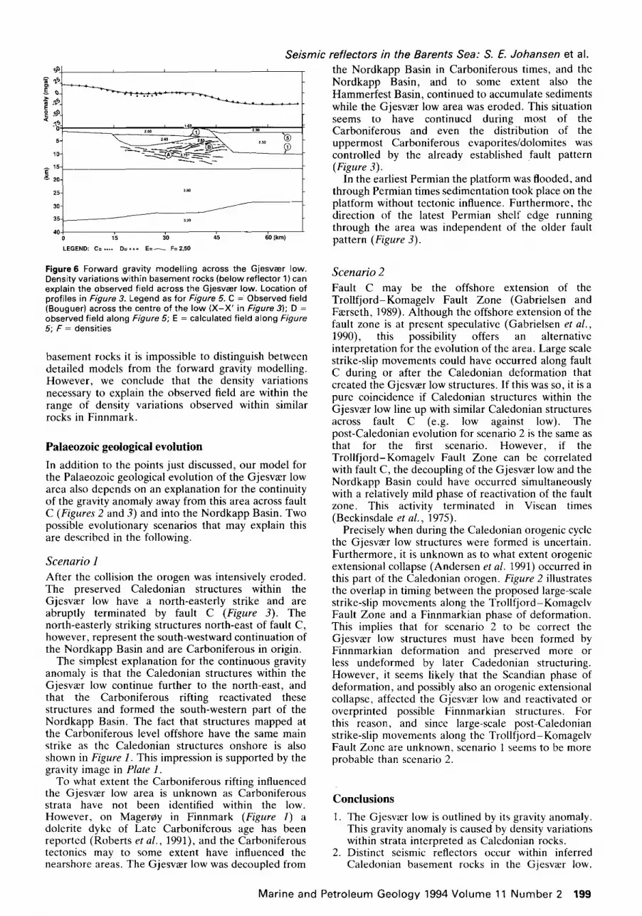
Two and a half dimension forward gravity modelling has been carried out on a profile across the Gjesv~er low. Figure 6 shows one possible model with density variations within the basement rocks that explain the subtle gravity anomaly that defines the low. Densities within outcropping Caledonian and older rocks in Finnmark vary from approximately 2.6 to 3.0 g/cm 3 (Olesen et al., 1990). The highest measured densities were within gabbros in western Finnmark, whereas the lowest densities were within the Kalak Nappe Complex (Figure 1). Density variations within the nappe complexes of 0.1 g/cm 3 were also measured. In the tested models without density variations within the Gjesv~er low, we manipulated the displacement on the faults bounding the low in combination with a shallowing Moho towards the Hammerfest Basin. Such models do not explain the observed field. Owing to limited geometrical constraints on the model within the
in the Caledonian deformation. Well 7120/12-2 (Figure 1) cored basement rocks with a most likely Precambrian model age. However, the intense Caledonian deformation and metamorphism of these rocks have eradicated all primary textures (Austrheim and Solheim, 1985). These lithologies are also referred to here as Caledonian basement rocks.
Relict bedding is commonly observed within Caledonian rocks. However, we do not know to what extent the acoustic properties within the original strata in the Gjesv~er low were preserved during burial and deformation. The low continuity of the individual reflectors within the low does not favour an explanation involving preservation of original bedding over large areas. However, to discuss the seismic signature of the basement in more detail data are needed on the acoustic properties of the Caledonian and Precambrian rocks in Finnmark.
198 Marine and Petroleum Geology 1994 Volume 11 Number 2
5.
10-
15 E
20
25
30-
35-
40-
I 1.03 I I 2 50 ~.30 i
J
3=O
1'5 :30 ,~5 (~0 (km)
.EGEND: C= . . . . D=*++ E = ~ F=2,50
Seismic reflectors in the Barents Sea: S. E. Johansen et al. the Nordkapp Basin in Carboniferous times, and the Nordkapp Basin, and to some extent also the Hammerfest Basin, continued to accumulate sediments while the Gjesv~er low area was eroded. This situation seems to have continued during most of the Carboniferous and even the distribution of the
I uppermost evaporites/dolomites Carboniferous w a s
controlled by the already established fault pattern (Figure 3).
In the earliest Permian the platform was flooded, and through Permian times sedimentation took place on the platform without tectonic influence. Furthermore, the direction of the latest Permian shelf edge running through the area was independent of the older fault pattern (Figure 3).
Figure6 Forward grav i ty mode l l ing across the Gjesvaer low. Density var ia t ions wi th in basement rocks (be low ref lector 1) can explain the observed f ield across the Gjesvaer low. Locat ion of prof i les in Figure 3. Legend as for Figure 5. C = Observed f ield (Bouguer) across the centre of the low ( X - X ' in Figure 3); D = observed f ield a long Figure 5; E = calculated f ield a long Figure 5; F = densities
basement rocks it is impossible to distinguish between detailed models from the forward gravity modelling. However, we conclude that the density variations necessary to explain the observed field are within the range of density variations observed within similar rocks in Finnmark.
Palaeozoic geological evolution
In addition to the points just discussed, our model for the Palaeozoic geological evolution of the Gjesva~r low area also depends on an explanation for the continuity of the gravity anomaly away from this area across fault C (Figures 2 and 3) and into the Nordkapp Basin. Two possible evolutionary scenarios that may explain this are described in the following.
Scenario 1 After the collision the orogen was intensively eroded. The preserved Caledonian structures within the Gjesv~er low have a north-easterly strike and are abruptly terminated by fault C (Figure 3). The north-easterly striking structures north-east of fault C, however, represent the south-westward continuation of the Nordkapp Basin and are Carboniferous in origin.
The simplest explanation for the continuous gravity anomaly is that the Caledonian structures within the Gjesva~r low continue further to the north-east, and that the Carboniferous rifting reactivated these structures and formed the south-western part of the Nordkapp Basin. The fact that structures mapped at the Carboniferous level offshore have the same main strike as the Caledonian structures onshore is also shown in Figure 1. This impression is supported by the gravity image in Plate 1.
To what extent the Carboniferous rifting influenced the Gjesva~r low area is unknown as Carboniferous strata have not been identified within the low. However, on Mager~y in Finnmark (Figure 1) a dolerite dyke of Late Carboniferous age has been reported (Roberts et al., 1991), and the Carboniferous tectonics may to some extent have influenced the nearshore areas. The Gjesv~er low was decoupled from
Scenario 2 Fault C may be the offshore extension of the Trollfjord-Komagelv Fault Zone (Gabrielsen and Fa~rseth, 1989). Although the offshore extension of the fault zone is at present speculative (Gabrielsen et al., 1990), this possibility offers an alternative interpretation for the evolution of the area. Large scale strike-slip movements could have occurred along fault C during or after the Caledonian deformation that created the Gjesv~er low structures. If this was so, it is a pure coincidence if Caledonian structures within the Gjesv~er low line up with similar Caledonian structures across fault C (e.g. low against low). The post-Caledonian evolution for scenario 2 is the same as that for the first scenario. However, if the Trolifjord-Komagelv Fault Zone can be correlated with fault C, the decoupling of the Gjesva~r low and the Nordkapp Basin could have occurred simultaneously with a relatively mild phase of reactivation of the fault zone. This activity terminated in Visean times (Beckinsdale et al., 1975).
Precisely when during the Caledonian orogenic cycle the Gjesv~er low structures were formed is uncertain. Furthermore, it is unknown as to what extent orogenic extensional collapse (Andersen et al. 1991) occurred in this part of the Caledonian orogen. Figure 2 illustrates the overlap in timing between the proposed large-scale strike-slip movements along the Trollfjord-Komagelv Fault Zone and a Finnmarkian phase of deformation. This implies that for scenario 2 to be correct the Gjesv~er low structures must have been formed by Finnmarkian deformation and preserved more or less undeformed by later Cadedonian structuring. However, it seems likely that the Scandian phase of deformation, and possibly also an orogenic extensional collapse, affected the Gjesv~er low and reactivated or overprinted possible Finnmarkian structures. For this reason, and since large-scale post-Caledonian strike-slip movements along the Trollfjord-Komagelv Fault Zone are unknown, scenario 1 seems to be more probable than scenario 2.
Conclusions
1. The Gjesv~r low is outlined by its gravity anomaly. This gravity anomaly is caused by density variations within strata interpreted as Caledonian rocks.
2. Distinct seismic reflectors occur within inferred Caledonian basement rocks in the Gjesva~r low.
Marine and Petroleum Geology 1994 Volume 11 Number 2 199

Seismic reflectors in the Barents Sea: S. E. Johansen et al. These reflectors may be used to identify tectonic boundaries.
3. More than 10 km of Caledonian rocks may have been removed by Late Palaeozoic erosion in the Gjesva~r low.
4. In the most likely scenario for the evolution of the studied area, the inferred Caledonian structures within the Gjesv~er low continued further to the north-east beneath the present day Nordkapp Basin. The continuity of these structures has been preserved until the present, and this is best illustrated by the continuity of their gravity anomaly.
5. Carboniferous rifting reactivated the inferred Caledonian structures and formed the south- western part of the Nordkapp Basin.
6. Image processing is a powerful tool for dealing with subtle trends in a data set. In this study it has been useful for studying low relief gravity anomalies in the south-western Nordkapp Basin and Gjesva~r low area.
Acknowledgements
We thank Statoil for permission to publish these data. We also thank Anthony M. Spencer, Erling Vfignes, Hans E. F. Amundsen, Antony T. Buller and Arild Andresen for constructive reviews of the manuscript. We are grateful to Steinar Thor Gudlaugsson for a critical review of an earlier version of this paper and to Asbjorn Breivik for the work on the gravity models.
References
Am, K. (1975) Aeromagnetic basement complex mapping north of latitude 62 ° N, Norway Norges Geol. Unders. Bull. 29, 351-375
Andersen, T. B., Austrheim, H., Sturt, B. A., Pedersen, S. and Kj,~rsrud, K. (1982) Rb-Sr whole rock ages from Mager~y, north Norwegian Caledonides Norsk GeoL Tidsskr. 62, 79-85
Andersen, T. B., Jamtveit, B., Dewey, D. F. and Swensson, E. (1991) Subduction and eduction of continental crust: major mechanisms during continent-continent collision and orogenic extensional collapse, a model based on the south Norwegian Caledonides Terra Nova 3, 303-310
Austrheim, H. and Solheim, S. (1985) Radiometric and petro- graphic investigations of basement geisses from well 7220/12-2, Troms 1 area, offshore northern Norway Norsk GeoL Tidskr. 65, 227-232
Beckinsdale, R. D., Reading, H. G. and Rex, D. C. (1975) Potassium-argon ages for basic dykes from east Finnmark: stratigraphical and structural implications Scot. J. GeoL 12, 51-65
Daley, J. S., Aitcheson, S. J., Cliff, R. A., Gayer, R. A. and Rice, H. N. (1991) Geochronological evidence from discordant plutons for a late Proterozoic orogen in the Caledonides of Finnmark, Northern Norway J. GeoL Soc. London 148, 29-40
Dengo, C. A. and R~ssland, K. A. (1992) Extensional tectonic history of the western Barents Sea. In: Structural and Tectonic Modelling and its Application to Petroleum Geology (Eds R. M. Larsen and B. T. Larsen), Norwegian Petrol. Soc. Spec. Pub/. No. 1, Elsevier, Amsterdam
Faleide, J. I., Gudlaugsson, S. T. and Jacquart, G. (1984) Evolution of the Western Barents Sea Mar. Petrol. GeoL 1, 123-149
Gabrielsen, R. H. (1984) Long-lived fault zones and their influence on the tectonic development of the southwestern Barents Sea J. Geol. Soc. London 141,651-662
Gabrielsen, R. H. and Faerseth, R. B. (1989) The inner shelf of North Cape, Norway and its implications for the Barents
Shelf-Finnmark Caledonide boundary. A comment Norsk GeoL Tidsskr. 69, 57-62
Gabrielsen, R. H., Faerseth, R. B., Jensen, L. N., Kalheim, J. E. and Riis, F. (1990) Structural elements of the Norwegian continental shelf. Part 1 : the Barents Sea region NPD-Bulletin No. 60ljedirektoratet, Stavanger, pp. 1-33
Harland, W. B. (1985) Caledonide Svalbard: In: The Caledonide Orogen-Scandinavia and Related Areas (Eds D. G. Gee and B. A. Sturt), Wiley, Chichester, pp. 999-1016
Harland, W. B., Cutbill, J. L., Friend, P. F., Gobbett, D. J., Holliday, D. W., Maton, Parker, P. Jr, and Wallis, R. H. (1974) The Billefjorden Fault Zone, Spitsbergen Norsk Polarinst. Skrifter. 161, 1-72
Harland, W. B., Armstrong, R. L, Cox, A. V., Craig, L. E., Smith, A. G. and Smith, D. G. (1989) A Geological Time Scale, Cambridge University Press, pp. 1-263
Hurich, C. A., Palm, D., Dyrelius, D. and Kristoffersen, Y. (1989) Deformation of the Baltic continental crust during Caledonian intracontinental subduction: views from seismic reflection data Geology 7, 423-425
Jensen, L. N. and S~rensen, K. (1992) Tectonic framework and halokinesis of the Nordkapp Basin, Barents Sea: In: Structural and Tectonic Modelling and its Application to Petroleum Geology (Eds R. M. Larsen and B. T. Larsen), Norwegian Petrol Soc. Spec. PubL No. I, Elsevier, Amsterdam, pp. 109-120
Johansen, S. E., Ostisty, B. K., Birkeland, 0., Federovsky, Y. F., Martirosjan, V. N., Bruun Christensen, O., Cheredeev, S. I., Ignatenko, E. A. and Margulis, L. S. (1993) Hydrocarbon potential in the Barents Sea region: play distribution and potential. In: Arctic Geology and Petroleum Potential (Eds T. O. Vorren, E. Bergsaker, ~. A. DahI-Stamnes, E. Holter, B. Johansen, E. Lie and T. B. Lund), Norwegian Petrol Soc., Spec. Pub/. No. 2, Elsevier, Amsterdam, pp. 273-320
Johnson, H. D., Levell, B. K. and Siedlecki, S. (1978) Late Precambrian sedimentary rocks in east Finnmark, north Norway and their relationship to the Trollfjord-Komagelv fault J. Geol. Soc. London 135, 517-533
Johnston, R. J. (1978) Multivariate Statistical Analysis in Geography, Longman, London
Kj~de, J., Storetvedt, K. M., Roberts, D. and Gidskehaug, A. (1978) Paleomagnetic evidence for large-scale dextral movements along the Trollfjord-Komagelv Fault, Finnmark, north Norway Phys. Earth Planet. Interiors 16, 132-144
Krill, A. G, Rodgers, J. and Sundvoll, B. (1988) Alternative to the Finnmarkian-Scandian interpretation on MagerCya, northern Norway Norsk GeoL Tidsskr. 68, 171-185
Lippard, S. J. and Roberts, D. (1987) Fault systems in Caledonian Finnmark and the southern Barents Sea Norg. Geol. Unders. Bull. 410, 55-64
Moore, G. K. and Waltz, F. A. (1983) Objective procedures for lineament enhancement and extraction Photogr. Engin. Remote Sensing No. 5, 641-647
Olesen, O., Roberts, D., Henkel, H., Lile, O. B. and Torsvik, T. H. (1990) Aeromagnetic and gravimetric interpretation of regional structural features in the Caledonides o f West Finnmark and North Troms, northern Norway Norg. GeoL Unders. Bull. 419, 1-24
Roberts, D. (1972) Tectonic deformation in the Barents Sea region of Varanger peninsula, Finnmark Norg. Geol. Unders. Bull. 282, 1-39
Roberts, D. (1985) The Caledonian fold belt in Finnmark: a synopsis Norg. GeoL Under& Bull. 403, 161-177
Roberts, D. and Sturt, B. A. (1980) Caledonian deformation in Norway J. GeoL Soc. London 137, 241-250
Roberts, D., Mitchell, J. G. and Andersen, T. B. (1991) A post- Caledonian dolerite dyke from Magerc~y, North Norway: age and geochemistry Norsk GeoL Tidsskr. 71,289-295
Saether, B. M., Ruesl~tten, H. G., Rundhovde, E., Fichler, C., Henningsen, T. H. and Johansen, S. E. Remote sensing methods in exploration. In: Petroleum Exploration and Exploitation in Norway Norwegian Petrol. Soc., Spec. Pub/. No., in press
Siedlecka, A. (1975) Late Precambrian stratigraphy and structure of the northeastern margin of the Fennoscandian shield Norg. Geol. Unders. Bull. 316, 313-348
Siedlecka, A. and Siedlicki, S. (1972) Lithostratigraphic correlation and sedimentology of the Late Precambrian of Varanger Peninsula and neighbouring areas of East Finnmark, northern Norway. In: 24th International Geological Congress Section 6, pp. 349-358
200 M a r i n e and P e t r o l e u m G e o l o g y 1994 V o l u m e 11 N u m b e r 2

Seismic reflectors in the Barents Sea: S. E. Johansen et al. Sturt, B. A. and Ramsay, D. M. (1988) Reinterpretation of
Finnmarkian deformation on western Serey, northern Norway: a comment Norsk GeoL Tidsskrift. 68, 213-219
Sturt, B. A., Pringle, I. R. and Ramsay, D. M. (1978) The Finnmarkian phase of the Caledonian orogeny J. GeoL Soc. London 135, 597-610
Townsend, C. (1987) The inner shelf of North Cape, Norway and its implications for the Barents Shelf-Finnmark Caledonide boundary Norsk GeoL Tidsskrift 67, 151-153
Ziegler, P. A. (1981) Evolution of sedimentary basins in north- west Europe. In: Petroleum Geology of the Continental Shelf of North-west Europe (Eds L. V. Illing and G. D. Hobson), Heyden, London pp. 3-39
Ziegler, P. A., Doery, R. and Scott, J. (1986) Tectonic habitat of Norwegian oil and gas. In: Habitat of Hydrocarbons of the Norwegian Continental Shelf (Eds A. M. Spencer eta/.), Graham and Trotman, London, pp. 3-19
M a r i n e and Pe t ro leum Geo logy 1994 V o l u m e 11 N u m b e r 2 201


