Embed Size (px)
Citation preview
Journal of Coastal Research 24 5 1161–1173 West Palm Beach, Florida September 2008
Contribution on the Holocene Reconstruction ofThessaloniki Coastal Plain, GreeceEric Fouache†, Matthieu Ghilardi†, Konstantinos Vouvalidis‡, George Syrides‡, Mixalis Styllas‡, StephaneKunesch§, and Stathis Stiros††
†Universite de Paris 12 Val deMarne
Departement de GeographieGEONAT EA 435—UMR
859161 Avenue du General de
Gaulle94010 Creteil [email protected]@wanadoo.fr
‡Aristotle University ofThessaloniki
Department of GeologyGreece
§Laboratoire de GeographiePhysique—UMR 8591
1 place A. Briand92195 MeudonFrance
††University of Patras/GeodesyLaboratory
Department of CivilEngineering
Greece
ABSTRACT
FOUACHE, E.; GHILARDI, M.; VOUVALIDIS, K.; SYRIDES, G.; STYLLAS, M.; KUNESCH, S., and STIROS, S.,2008. Contribution on the Holocene reconstruction of Thessaloniki coastal plain, Greece. Journal of Coastal Research,24(5), 1161–1173. West Palm Beach (Florida), ISSN 0749-0208.
During the Holocene, the western part of the present-day Thessaloniki coastal plain (north-central Greece) was floodedby the rising sea level and formed a bay as a consequence of the last postglacial transgression. The rate of the sea-level rise subsequently decelerated, and this bay began to fill with sediments delivered by the Aliakmon and Axios,as well as by other smaller rivers.
The palaeogeographic and palaeoenvironmental reconstruction of the Thessaloniki Plain was the focus of severalstudies published during the past century. Most of these studies are based on the interpretation of historical sourcesand support the assumption of a fast filling of the bay between the fifth century BC and the fifth century AD.
In this work, we first present the results of the analysis of data collected from six boreholes recently drilled in thewestern part of the plain, up to the western bank of the Axios River. Our study was mainly based on sedimentologicaland palaeontological analyses and accelerator mass spectrometry and conventional radiocarbon dating of shells andpeat. Second, we evaluate the results of this study, as well as of other geological studies, which permit the descriptionof the large-scale stratigraphic pattern of the plain. Data were evaluated on the basis of a geographic informationsystem, used for the first time in such type of work, and were supplemented and assessed with analysis of Landsatimagery.
Based on this evidence, we propose a new, detailed palaeogeographic reconstruction for the evolution of the Thes-saloniki Plain during the Late Holocene. This plain corresponded to a wide marine bay during the Neolithic times(6000 BP), and later it was characterised by a fast displacement of the shoreline, mainly during Late Bronze Age,Iron Age, and Classical–Archaic periods (2650–2300 BP). A slowing down of the progradation of the alluvial plainoccurred during Roman times (2100–1600 BP), and the plain obtained its present-day topography during the secondpart of the 20th century.
ADDITIONAL INDEX WORDS: Greece, Holocene, Thessaloniki Plain, Aliakmon River, Axios River, palaeogeographicreconstruction.
INTRODUCTION
In the Mediterranean, the study of shoreline changes waseither one-dimensional or two-dimensional. Vertical, one-di-mensional shoreline changes in relation to the rising sea levelwere mostly based on natural markers such as beach rocks(FOUACHE et al., 2005b; VOUVALIDIS, SYRIDES, and ALBAN-AKIS, 2005), notches (PIRAZZOLI, 1996), and/or archaeologicalremains (FOUACHE, 1999; KONTOGIANNI, TSOULOS, and STI-ROS, 2002; MARINER and MORHANGE, 2007; PIRAZZOLI,1991). The spatial, two-dimensional evolution of shorelines
DOI:10.2112/06-0786.1 received 15 December 2006; accepted in re-vision 18 May 2007.
has been concentrated mainly on deltaic areas since they of-fer a remarkable opportunity to study the interplay betweenthe progradation of the deltaic systems and the relative sea-level rise (ARNAUD-FASSETTA, 2000; BRUCKNER, 2005; FOU-ACHE and PAVLOPOULOS, 2005; KRAFT, ASCHENBRENNER,and RAPP, 1977; VOTT et al., 2003, 2006).
The Holocene palaeoenvironmental history of several del-tas in Greece has been studied in detail (FOUACHE et al.,2005a; VOTT et al., 2007). On the contrary, the ThessalonikiPlain, the largest deltaic complex in Greece (Figure 1), hasreceived little attention from the palaeoenvironmental pointof view, although its overall evolution is rather well docu-mented (VOUVALIDIS, SYRIDES, and ALBANAKIS, 2005).
1162 Fouache et al.
Journal of Coastal Research, Vol. 24, No. 5, 2008
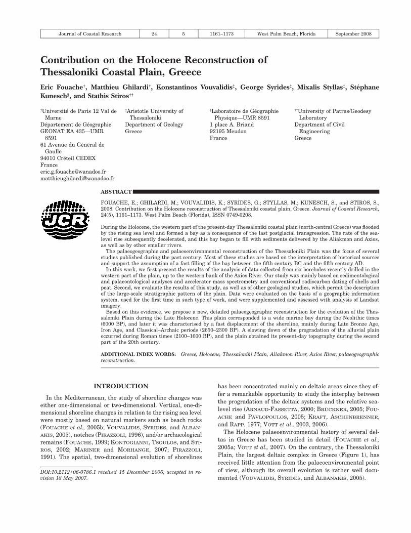
Figure 1. Sea-level curve in Thermaic gulf, after Vouvalidis, Syrides,and Albanakis, 2005. This reconstruction was established on core analy-ses around the Thessaloniki Harbour. bsl � below sea level.
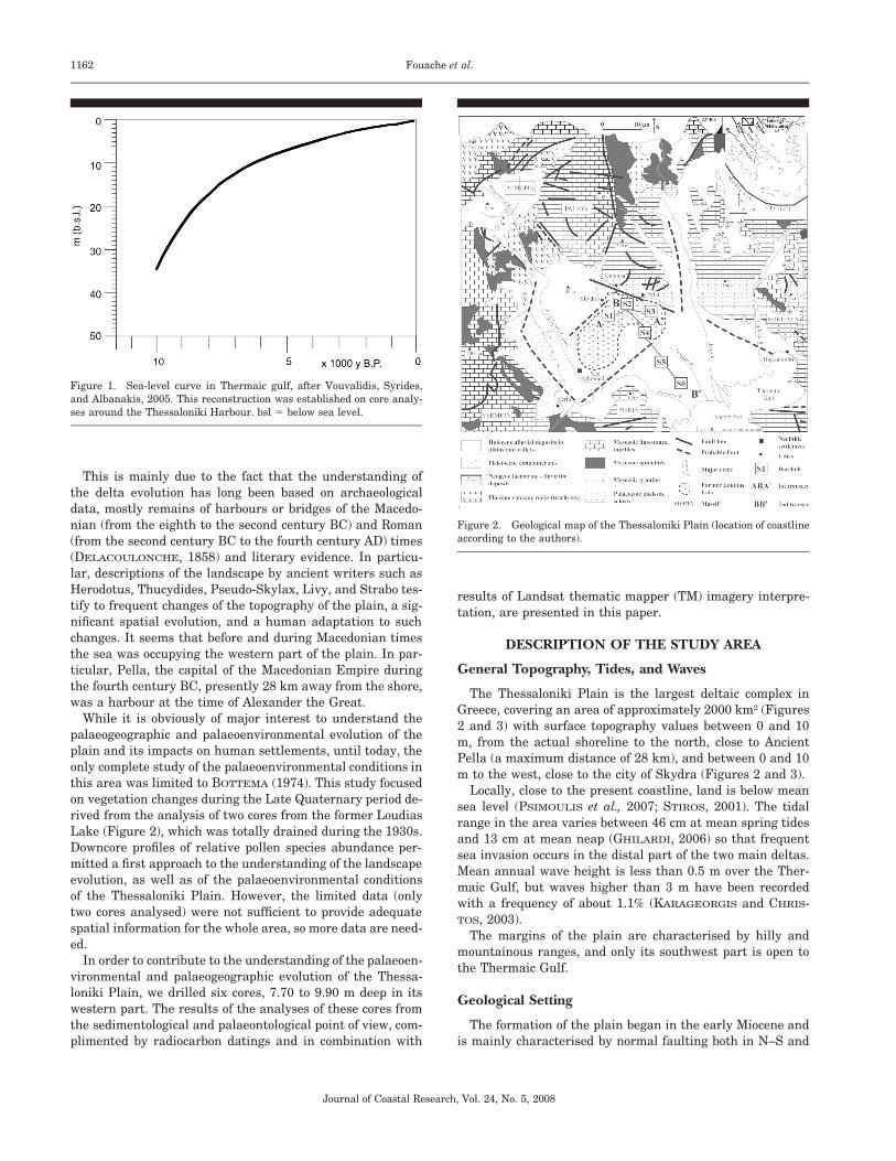
Figure 2. Geological map of the Thessaloniki Plain (location of coastlineaccording to the authors).
This is mainly due to the fact that the understanding ofthe delta evolution has long been based on archaeologicaldata, mostly remains of harbours or bridges of the Macedo-nian (from the eighth to the second century BC) and Roman(from the second century BC to the fourth century AD) times(DELACOULONCHE, 1858) and literary evidence. In particu-lar, descriptions of the landscape by ancient writers such asHerodotus, Thucydides, Pseudo-Skylax, Livy, and Strabo tes-tify to frequent changes of the topography of the plain, a sig-nificant spatial evolution, and a human adaptation to suchchanges. It seems that before and during Macedonian timesthe sea was occupying the western part of the plain. In par-ticular, Pella, the capital of the Macedonian Empire duringthe fourth century BC, presently 28 km away from the shore,was a harbour at the time of Alexander the Great.
While it is obviously of major interest to understand thepalaeogeographic and palaeoenvironmental evolution of theplain and its impacts on human settlements, until today, theonly complete study of the palaeoenvironmental conditions inthis area was limited to BOTTEMA (1974). This study focusedon vegetation changes during the Late Quaternary period de-rived from the analysis of two cores from the former LoudiasLake (Figure 2), which was totally drained during the 1930s.Downcore profiles of relative pollen species abundance per-mitted a first approach to the understanding of the landscapeevolution, as well as of the palaeoenvironmental conditionsof the Thessaloniki Plain. However, the limited data (onlytwo cores analysed) were not sufficient to provide adequatespatial information for the whole area, so more data are need-ed.
In order to contribute to the understanding of the palaeoen-vironmental and palaeogeographic evolution of the Thessa-loniki Plain, we drilled six cores, 7.70 to 9.90 m deep in itswestern part. The results of the analyses of these cores fromthe sedimentological and palaeontological point of view, com-plimented by radiocarbon datings and in combination with
results of Landsat thematic mapper (TM) imagery interpre-tation, are presented in this paper.
DESCRIPTION OF THE STUDY AREA
General Topography, Tides, and Waves
The Thessaloniki Plain is the largest deltaic complex inGreece, covering an area of approximately 2000 km2 (Figures2 and 3) with surface topography values between 0 and 10m, from the actual shoreline to the north, close to AncientPella (a maximum distance of 28 km), and between 0 and 10m to the west, close to the city of Skydra (Figures 2 and 3).
Locally, close to the present coastline, land is below meansea level (PSIMOULIS et al., 2007; STIROS, 2001). The tidalrange in the area varies between 46 cm at mean spring tidesand 13 cm at mean neap (GHILARDI, 2006) so that frequentsea invasion occurs in the distal part of the two main deltas.Mean annual wave height is less than 0.5 m over the Ther-maic Gulf, but waves higher than 3 m have been recordedwith a frequency of about 1.1% (KARAGEORGIS and CHRIS-TOS, 2003).
The margins of the plain are characterised by hilly andmountainous ranges, and only its southwest part is open tothe Thermaic Gulf.
Geological Setting
The formation of the plain began in the early Miocene andis mainly characterised by normal faulting both in N–S and
1163Contribution on the Holocene Reconstruction of Thessaloniki Coastal Plain, Greece
Journal of Coastal Research, Vol. 24, No. 5, 2008
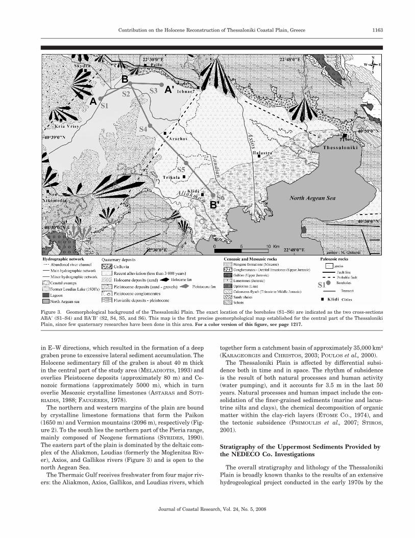
Figure 3. Geomorphological background of the Thessaloniki Plain. The exact location of the boreholes (S1–S6) are indicated as the two cross-sectionsABA� (S1–S4) and BA�B� (S2, S4, S5, and S6). This map is the first precise geomorphological map established for the central part of the ThessalonikiPlain, since few quaternary researches have been done in this area. For a color version of this figure, see page 1217.
in E–W directions, which resulted in the formation of a deepgraben prone to excessive lateral sediment accumulation. TheHolocene sedimentary fill of the graben is about 40 m thickin the central part of the study area (MELADIOTIS, 1993) andoverlies Pleistocene deposits (approximately 80 m) and Ce-nozoic formations (approximately 5000 m), which in turnoverlie Mesozoic crystalline limestones (ASTARAS and SOTI-RIADIS, 1988; FAUGERES, 1978).
The northern and western margins of the plain are boundby crystalline limestone formations that form the Paikon(1650 m) and Vermion mountains (2096 m), respectively (Fig-ure 2). To the south lies the northern part of the Pieria range,mainly composed of Neogene formations (SYRIDES, 1990).The eastern part of the plain is dominated by the deltaic com-plex of the Aliakmon, Loudias (formerly the Moglenitsa Riv-er), Axios, and Gallikos rivers (Figure 3) and is open to thenorth Aegean Sea.
The Thermaic Gulf receives freshwater from four major riv-ers: the Aliakmon, Axios, Gallikos, and Loudias rivers, which
together form a catchment basin of approximately 35,000 km2
(KARAGEORGIS and CHRISTOS, 2003; POULOS et al., 2000).The Thessaloniki Plain is affected by differential subsi-
dence both in time and in space. The rhythm of subsidenceis the result of both natural processes and human activity(water pumping), and it accounts for 3.5 m in the last 50years. Natural processes and human impact include the con-solidation of the finer-grained sediments (marine and lacus-trine silts and clays), the chemical decomposition of organicmatter within the clay-rich layers (ETOME CO., 1974), andthe tectonic subsidence (PSIMOULIS et al., 2007; STIROS,2001).
Stratigraphy of the Uppermost Sediments Provided bythe NEDECO Co. Investigations
The overall stratigraphy and lithology of the ThessalonikiPlain is broadly known thanks to the results of an extensivehydrogeological project conducted in the early 1970s by the
1164 Fouache et al.
Journal of Coastal Research, Vol. 24, No. 5, 2008
Dutch company NEDECO. In the framework of this project,the aim of which was to investigate the water potential forirrigation of the plain, approximately 200 drillholes down to12 m were carried out, mainly between the Axios and theLoudias rivers. The records of these boreholes reveal that theuppermost layers of the plain consist of successive sequencesdeposited under marine, brackish, and fluvial conditions. Nodating was performed, and the data collected did not allowto reconstruct the different steps of deposition.
Human Intervention
In the first decades of the 20th century, an extensive pro-gramme of hydraulic works was conducted by the New YorkFoundation Co. This programme included the construction ofa channel to drain the Loudias Lake and a peripheral channelto prevent flooding of the plain from torrents at its margins(ANCEL, 1930). As a result, the hydrological conditions andsediment transport were radically changed (SIVIGNON, 1987).
Subsequently, a number of dams were built along the Ali-akmon and Axios riverbeds to prevent them from flooding thecultivated land and to store water for irrigation.
These works still control the outflow of the rivers, and sincethe 1970s they were only supplemented locally by additionalworks for further protection of the plain and land reclama-tion.
Previous Palaeogeographic Research
The first efforts of reconstructing the palaeogeography ofthe plain were made in the 20th century on the grounds ofhistorical texts, since ancient authors like Herodotus, Strabo,and Livy report that Pella, the capital of Macedonia, was sit-uated near the sea circa the fifth and fourth centuries BCand under the reign of King Philip II (HERODOTUS, VII, 123,124). Strabo, during the first century BC, suggested that Pel-la was lying on the edge of a wide lake, called Loudias Lake,and was itself linked to the sea by a narrow channel with atotal length of 120 stadia (22,2 km).
Based on such evidence, it has been proposed that the plainof Thessaloniki formed recently in less than 2500 years. (AS-TARAS and SOTIRIADIS, 1988; BINTLIFF, 1976; BOTTEMA,1974; HAMMOND, 1972; STRUCK, 1908). In particular, allthese investigators accept a main phase of alluviation be-tween the fifth century BC and the fifth century AD, whileSTRUCK (1908) and HAMMOND (1972) suggest that the covewas transformed into a wide plain in less than one millen-nium. Human impact is considered as the dominant factorfor the intense sedimentation by the rivers and the delta pro-gradation. The role of farming in alluviation during early oc-cupation from Neolithic times (6500 BC) is taken under con-sideration with the work of BOTTEMA (1974). Pollen data pro-vided by two cores located close to ancient Pella clearly in-dicate changes in vegetation.
METHODS
The aim of our research was to perform in detail for thefirst time the litho- and biostratigraphic study, supplementedby radiocarbon dating, of a number of shallow (up to 11 m
deep) borehole cores in key areas and to investigate the Ho-locene palaeoenvironmental history of the area. Our studieswere focused to the western part of the Axios River, because,as it can be deduced, the eastern part of Axios River was lessinfluenced by the sedimentation of the major rivers.
A pneumatic hammer was used, equipped with a corer 4cm in diameter. Samples were taken into 46-cm-long airtightplastic tubes. The exact locations of the six boreholes wasobtained by global positioning system measurements, and theabsolute elevation was calculated from the Hellenic MilitaryGeographic Service topographic maps scaled 1:5000 (with anerror of � 0.70 m; GHILARDI, 2006).
The facies identification and the sedimentological analyseswere done in the Laboratoire de Geographie Physique deMeudon (UMR 8591—Centre National pour la RechercheScientifique, France).
LASER diffraction was used for the grain-size analyses.Samples, with a dry weight of 20 g, were taken out every 5cm.
We used a Coulter LS 230 Laser granulometer, softwareversion 2.05, with a range of 0.04 to 2000 microns, in 116fractions. The calculation model uses the Fraunhofer and Mietheory, which is applicable down to grain sizes of about0.04�m.
The derived grain-size indexes included the mode grainsize and percentile D10 and were used as indicators of theriver transporting capacity (BUURMAN, PAPE, and MUGGLER,1996).
Accelerator mass spectrometry (AMS) and conventional ra-diocarbon datings were determined at the Poznan Radiocar-bon Laboratory (Poland) and at the Centre for RadiocarbonDating (University of Lyon 1, France). Calibrated ages havebeen obtained by the Centre for Radiocarbon Dating in Lyon(France), following the curve established by STUIVER, REI-MER, and REIMER (2006).
In addition, Landsat TM imagery was employed to revealseveral key landforms (former alluvial levees and coastal bar-riers). The main image analysis technique involved in thepresent work was false colour composite; this technique ledto the creation of enhanced satellite images with respect tothe topographic and geomorphological characteristics of theplain and its margins (NOVAK and SOULAKELLIS, 2000).
The integrated analysis and evaluation of our data wasbased on a geographic information system (GIS) in which allgeological and other information was incorporated. This GISwas based on a digital elevation model produced from con-ventional maps and topographic maps and compatible withthe WGS 84/NUTM 34 mapping projection system.
RESULTS
Description of the Biostratigraphic Sequences
The location of our boreholes (Figure 2) was selected fol-lowing the results provided by the NEDECO data (NEDECO
CO., 1970).The figures indicate that we can distinguish four main lith-
ostratigraphic units according to the microfaunal identifica-tion (Figure 4) and sedimentological analyses; from bottom
1165Contribution on the Holocene Reconstruction of Thessaloniki Coastal Plain, Greece
Journal of Coastal Research, Vol. 24, No. 5, 2008
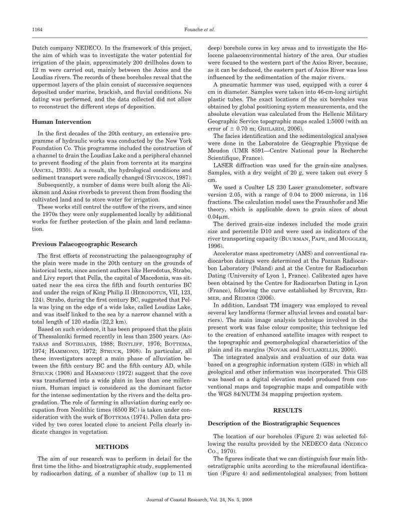
Figure 4. Microfauna identification and shell identifications. Scale bar:1 cm. 1a–b: Cerithium vulgatum; 2a–b: Cyclope neritea; 3a–b: Bittiumreticulatum; 4a–b: Nassarius reticulatum; 5a–b: Cerastoderma edule.
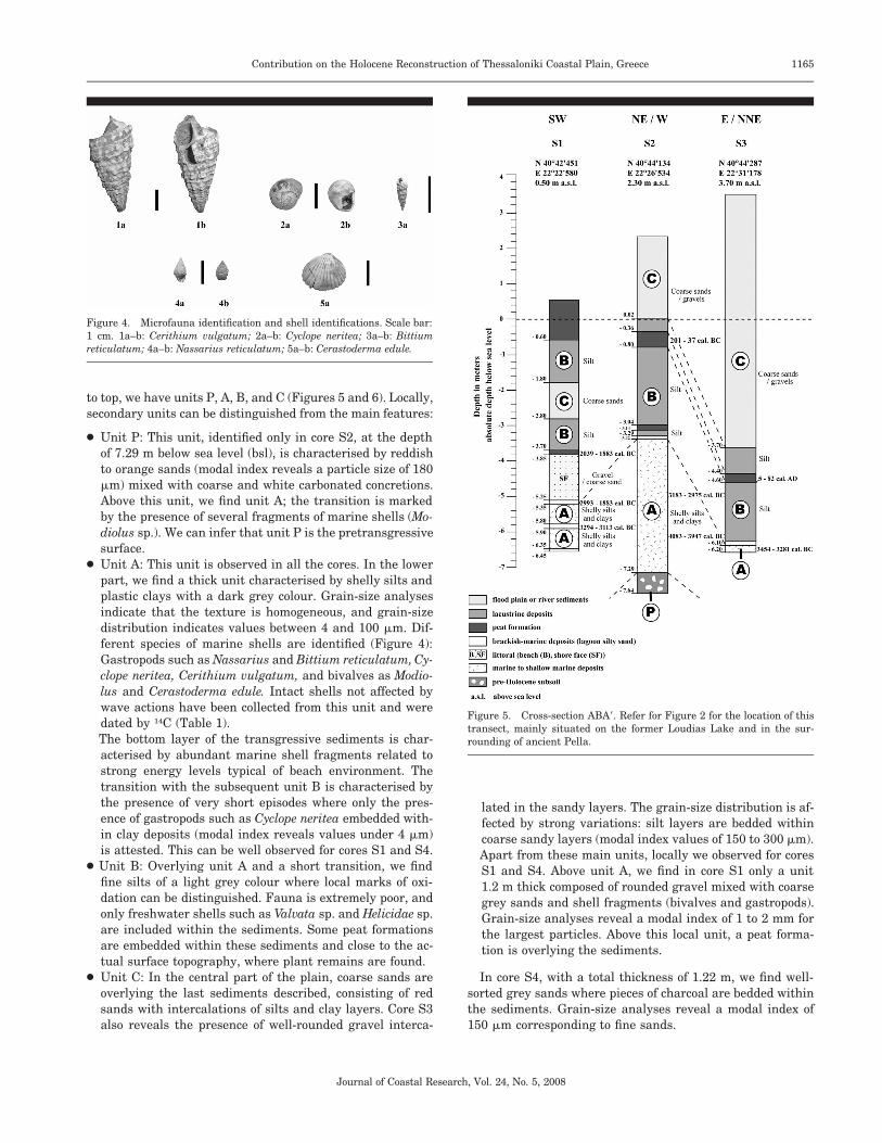
Figure 5. Cross-section ABA�. Refer for Figure 2 for the location of thistransect, mainly situated on the former Loudias Lake and in the sur-rounding of ancient Pella.
to top, we have units P, A, B, and C (Figures 5 and 6). Locally,secondary units can be distinguished from the main features:
● Unit P: This unit, identified only in core S2, at the depthof 7.29 m below sea level (bsl), is characterised by reddishto orange sands (modal index reveals a particle size of 180�m) mixed with coarse and white carbonated concretions.Above this unit, we find unit A; the transition is markedby the presence of several fragments of marine shells (Mo-diolus sp.). We can infer that unit P is the pretransgressivesurface.
● Unit A: This unit is observed in all the cores. In the lowerpart, we find a thick unit characterised by shelly silts andplastic clays with a dark grey colour. Grain-size analysesindicate that the texture is homogeneous, and grain-sizedistribution indicates values between 4 and 100 �m. Dif-ferent species of marine shells are identified (Figure 4):Gastropods such as Nassarius and Bittium reticulatum, Cy-clope neritea, Cerithium vulgatum, and bivalves as Modio-lus and Cerastoderma edule. Intact shells not affected bywave actions have been collected from this unit and weredated by 14C (Table 1).The bottom layer of the transgressive sediments is char-acterised by abundant marine shell fragments related tostrong energy levels typical of beach environment. Thetransition with the subsequent unit B is characterised bythe presence of very short episodes where only the pres-ence of gastropods such as Cyclope neritea embedded with-in clay deposits (modal index reveals values under 4 �m)is attested. This can be well observed for cores S1 and S4.
● Unit B: Overlying unit A and a short transition, we findfine silts of a light grey colour where local marks of oxi-dation can be distinguished. Fauna is extremely poor, andonly freshwater shells such as Valvata sp. and Helicidae sp.are included within the sediments. Some peat formationsare embedded within these sediments and close to the ac-tual surface topography, where plant remains are found.
● Unit C: In the central part of the plain, coarse sands areoverlying the last sediments described, consisting of redsands with intercalations of silts and clay layers. Core S3also reveals the presence of well-rounded gravel interca-
lated in the sandy layers. The grain-size distribution is af-fected by strong variations: silt layers are bedded withincoarse sandy layers (modal index values of 150 to 300 �m).Apart from these main units, locally we observed for coresS1 and S4. Above unit A, we find in core S1 only a unit1.2 m thick composed of rounded gravel mixed with coarsegrey sands and shell fragments (bivalves and gastropods).Grain-size analyses reveal a modal index of 1 to 2 mm forthe largest particles. Above this local unit, a peat forma-tion is overlying the sediments.
In core S4, with a total thickness of 1.22 m, we find well-sorted grey sands where pieces of charcoal are bedded withinthe sediments. Grain-size analyses reveal a modal index of150 �m corresponding to fine sands.
1166 Fouache et al.
Journal of Coastal Research, Vol. 24, No. 5, 2008
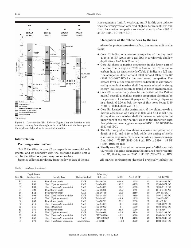
Figure 6. Cross-section BB�. Refer to Figure 2 for the location of thistransect, running from the neighbourhood of Pella until the lower part ofthe Aliakmon delta, close to the actual shoreline.
Table 1. Radiocarbon dating.
Core No.Depth BelowSea Level (m) Sample Type Dating Method
LaboratoryReference �13C Age (14C BP) � Cal. BC/AD
S1 3.80 Peat (lower part) AMS Poz-16759 �26.8 3605 35 2039–1883 BCS1 5.50 Shell (Cyclope neritea) AMS Poz-14362 �43.9 4735 35 2993–2677 BCS1 6.05 Shell (Cerastoderma edule) AMS Poz-14363 �20.3 4995 35 3294–3113 BCS4 1.22 Peat (lower part) AMS Poz-16831 �23.2 900 30 1046–1183 ADS4 2.42 Peat (lower part) AMS Poz-16758 �20.3 2480 30 769–503 BCS4 5.08 Shell (Cerastoderma edule) AMS Poz-14364 �0.7 5190 35 3497–3367 BCS6 3.37 Shell (Cyclope neritea) AMS Poz-14365 �1.3 2855 30 520–379 BCS2 0.55 Peat (lower part) AMS Poz-16763 �28.1 2090 35 201–37 BCS2 5.15 Shell (Cerastoderma edule) AMS Poz-14368 0.1 4920 35 3183–2975 BCS2 6.45 Shell (Modiolus) AMS Poz-16092 3 5730 35 4083–3947 BCS3 4.50 Peat (lower part) AMS Poz-16764 �23.3 1950 35 5–82 ADS3 6.15 Shell (Cyclope neritea) AMS Poz-16091 �0.5 5100 40 3454–3281 BCS5 4.35 Shell (Cerastoderma edule) AMS CEN-002661 �3.1 3390 45 1205–1018 BCS5 4.58 Shell (Cerastoderma edule) AMS CEN-002662 �5.3 3400 45 1220–1033 BCS5 4.70 Shell (Cerithium vulgatum) Conventional Ly-13243 �1.58 3900 70 1823–1648 BC
Interpretation
Pretransgressive Surface
Unit P identified in core S2 corresponds to terrestrial sed-iments, and its boundary with the overlying marine unit Acan be identified as a pretransgression surface.
Samples collected for dating from the lower part of the ma-
rine sediments (unit A) overlying unit P in this core indicatethat the transgression occurred slightly before 6000 BP andthat the marine occupation continued shortly after 4985 �35 BP (3281 BC–3097 BC).
Occupation of the Whole Area by the Sea
Above the pretransgressive surface, the marine unit can befound:
● Core S1 indicates a marine occupation of the bay until4735 � 35 BP (2993–2677 cal. BC) at a relatively shallowdepth (from 6.45 to 5.25 m bsl).
● Core S2 shows a marine occupation in the lower part ofthe core from a depth of 7.29 to 3.42 m bsl. Three radio-carbon dates on marine shells (Table 1) indicate a full ma-rine occupation dated around 6000 BP and 4985 � 35 BP(3281 BC–3097 BC) for the most recent occupation. Thebottom layer of the transgressive sediments is characteri-sed by abundant marine shell fragments related to strongenergy levels such as can be found in beach environments.
● Core S3, situated very close to the foothill of the Paikonmassif, reveals a shallow marine occupation identified bythe presence of molluscs (Cyclope neritea mainly, Figure 4)in a depth of 6.20 m bsl, the age of this layer being 5110� 40 BP (3454–3281 cal. BC).
● Core S4, located in the central part of the plain, reveals amarine occupation at a depth of 8.00 and 4.41 m bsl. Onedating done on a marine shell (Cerastoderma edule) in theupper part of the marine unit, close to the transition withfloodplain sediments, gives an age of 5190 � 35 BP (3497–3367 cal. BC).
● The S5 core profile also shows a marine occupation at adepth of 5.40 and 4.20 m bsl, while the dating of shells(Cerithium vulgatum, Cerastoderma edule), provides an agefrom 3900 � 70 BP (1823–1648 cal. BC) to 3390 � 45 BP(1205–1018 cal BC).
● Finally core S6, located in the lower part of Aliakmon del-ta, reveals a marine occupation that finished more recentlythan S5, that is, around 2855 � 30 BP (520–379 cal. BC).
All marine environments described previously include the
1167Contribution on the Holocene Reconstruction of Thessaloniki Coastal Plain, Greece
Journal of Coastal Research, Vol. 24, No. 5, 2008
fact that the flooding events and the variations of water dis-charge of rivers such as the Aliakmon, Axios, or Loudias sub-stantially modified the environmental conditions, particular-ly during the marine occupation. Lagoonal stages are gener-ally observed in the upper part of all the marine layers, mak-ing a transition with the present terrestrial deposits. Finally,we can assume that the sea regressed gradually from west-wards to eastwards and the bay slightly changed to shallowmarine environments and then lagoons.
Limnic to Freshwater Lake EnvironmentThe subsequent phase is characterised by brackish then
freshwater lake occupation (unit B), with freshwater shells(Valvata sp., Helicidae sp.). This phase corresponds to the be-ginning of the sedimentary filling of the western part of theThermaic Gulf and intensive flooding of the main rivers. Lay-ers comprising this phase permit the exact dating of the endof the marine environmental conditions in the area.
Core S1 indicates that a lake existed there on two occasions(separated by fluvial sediments deposited under 2.80 up to1.80 m bsl): the first phase shows a limnic occupation abovethe marine and brackish deposits at a depth of 3.70 up to2.80 m bsl. The transition between marine and limnic depos-its is dated around 3605 � 35 BP (2039–1883 cal. BC); thepresence of a peat formation immediately above can be in-terpreted as organic matter deposits behind a dune ridge. Thesubsequent phase of limnic occupation seems to be very re-cent since it is found in the contemporaneous soils.
Core S2 shows characteristics of freshwater lake occupa-tion at a depth of 3.29 up to 0.02 m above sea level (asl). Apeat formation, situated in the upper part of the layer, givesan age of 2090 � 35 BP (201–37 cal. BC).
A similar age of peat formation is observed in S3 (1950 �35 BP; 5–82 cal. AD).
On core S4, two datings on peat formation have been done,and they reveal the presence of a lake from 2480 � 30 BP(769–503 cal. BC) to 900 � 30 BP (1046–1183 cal. AD) at adepth of 3.19 up to 0.55 m bsl.
All preceding descriptions confirm that freshwater lakeconditions existed until recently in the central part of theplain. We note that the limnic occupation gradually migratedfrom the west to the east, according to the shift in the shore-line.
Floodplain and Fluvial DepositionThe fourth and last phase corresponds to fluvial deposits
that include sandy layers with coarse silt and clay fractions,witnessing variations in discharges. Such sequences areclearly observed in cores S2, S3, S4, and S5 (Figure 5). S3reveals an important thickness of fluvial sands, at a depth of3.70 m bsl up to 3.70 m asl, characterised by a recent dis-charge, less than 2000 years. The dating done on the upper-most part of the limnic layer (unit B) indicates an age of 1950� 35 BP (5–82 cal. AD).
CROSS-SECTIONSThe results of the analysis of the six cores were used to
compile two stratigraphic cross-sections describing the Ho-locene environmental history of the Thessaloniki Plain.
Cross-Section ABA�
Transect ABA� (Figure 5) was compiled from data fromcores S1–S3 and runs along a total distance of 12 km in amean W–E direction, from the northern margins of the plainto its north-central part through the lowland area.
Previous discussions indicated that during the sea inun-dation after circa 6000 BP the present-day plain was part ofa coastal bay extending to the east until the present AxiosRiver channel. Unit A, which corresponds to marine depositsand brackish sequences, shows a gradual regression from thewest to the east and from the north (close to Pella) to thesouth.
Due to further depositions, this semiclosed bay was sub-sequently transformed into a lake (unit B in cores S1– S5);its presence is dated from 2039–1883 cal. BC until today andserved as a protoharbour to ancient Pella circa fifth centuryBC. This was the early Loudias Lake, which shifted east-wards following the shoreline displacement (the lower part ofunit B in core S1 dated from peat formation around 2039–1883 BC, and the lower part of unit B in core S4 dated 789–503 cal. BC).
Unit C is interpreted as former river levees and indicatesthat after the sea level stabilised near its present-day levelaround 6000 BP (PIRAZZOLI, 1996; VOUVALIDIS, SYRIDES,and ALBANAKIS, 2005) most of the palaeo–Thessaloniki Plainremained naturally semiprotected by a complex of coastalbarriers. These were created by the Aliakmon and Axios riv-ers and acted as natural dams preventing major marine in-vasion. Until the second millennium BC, the biosedimento-logical proxies were typical of a semiopen marine cove aroundancient Pella (unit A in core S3).
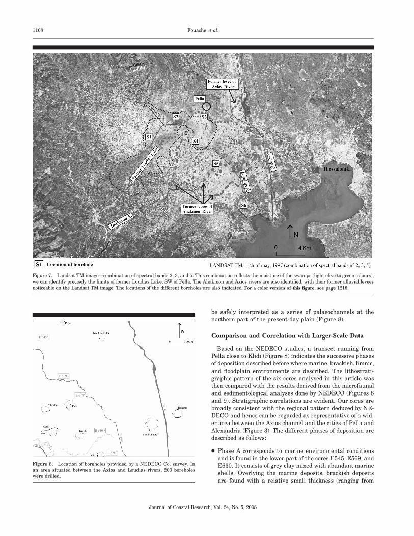
This scenario based on sedimentological data is consistentwith independent geomorphological data. Analysis of theLandsat TM image indicates a series of features (Figure 7)that can be interpreted as former levees of the Aliakmon Riv-er; they are revealed by light pink colour. This migration ofthe river from the NW to the SE (POULOS et al., 2000) witha continuous movement lets us think about the abandonmentof the different palaeochannels to a direction more southern,close to the present position of the Aliakmon channel.
Cross-Section BB�, Including Cores S2, S4, S5, and S6
Transect BB� (Figure 6) was compiled from data from coresS2, S4, S5, and S6 and runs in a mean NW–SE direction fromthe foothill of Paikon mountains, close to the city of Pella, viathe central lowland area of the Thessaloniki Plain, to themarshy area of the Aliakmon delta, 5 km away from the pres-ent-day shoreline. The total length of the cross-section is 25km (Figure 3).
After dating, the overall trend is that of a marine recessionfrom the NW to the SE (unit A in cores S1–S5). The role ofsediments deposited by the Axios River (unit C of core S3)seems more important than those of the Aliakmon River (unitC of cores S4 and S5) in the surrounding area of Pella.
This interpretation entirely based on sedimentological datais supported by Landsat TM imagery evidence. Analysis ofthe Landsat TM image reveals a number of features that can
1168 Fouache et al.
Journal of Coastal Research, Vol. 24, No. 5, 2008
Figure 7. Landsat TM image—combination of spectral bands 2, 3, and 5. This combination reflects the moisture of the swamps (light olive to green colours);we can identify precisely the limits of former Loudias Lake, SW of Pella. The Aliakmon and Axios rivers are also identified, with their former alluvial leveesnoticeable on the Landsat TM image. The locations of the different boreholes are also indicated. For a color version of this figure, see page 1218.
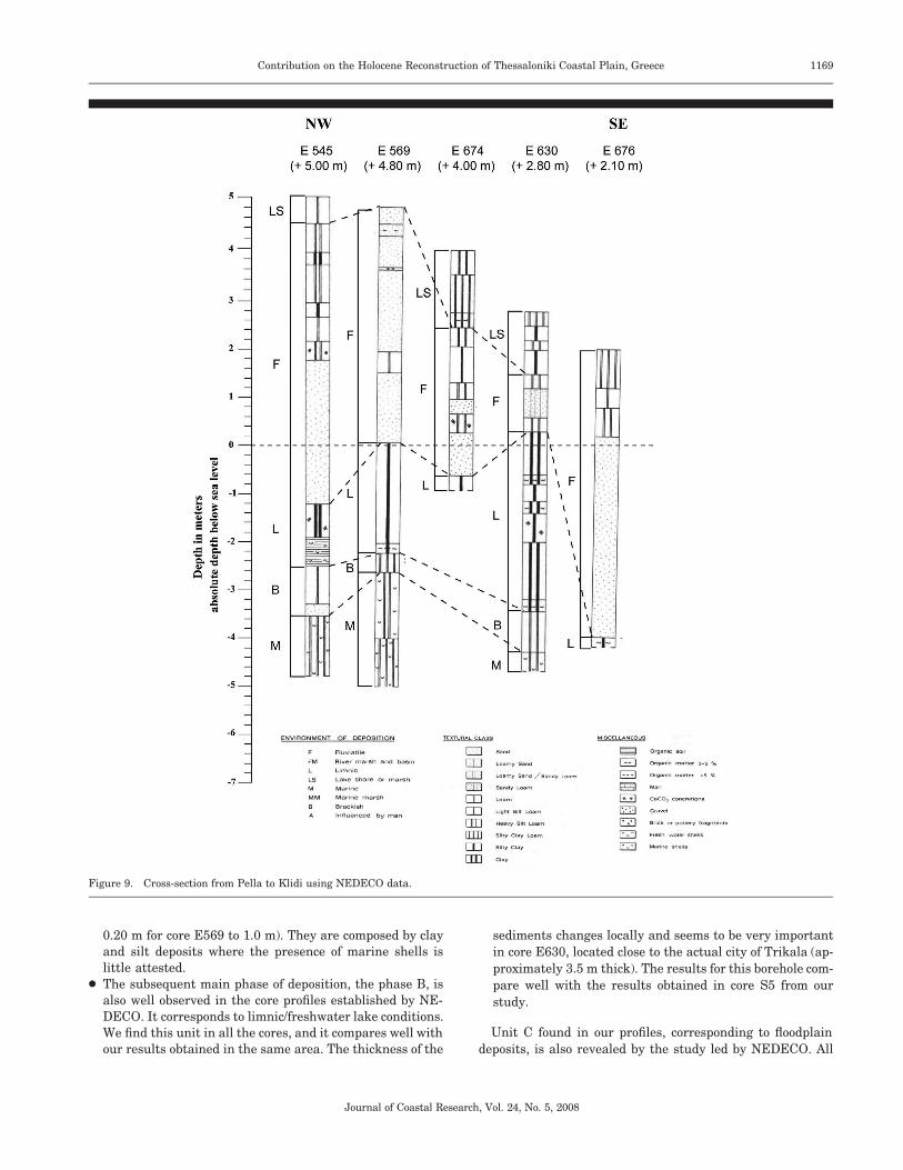
Figure 8. Location of boreholes provided by a NEDECO Co. survey. Inan area situated between the Axios and Loudias rivers, 200 boreholeswere drilled.
be safely interpreted as a series of palaeochannels at thenorthern part of the present-day plain (Figure 8).
Comparison and Correlation with Larger-Scale Data
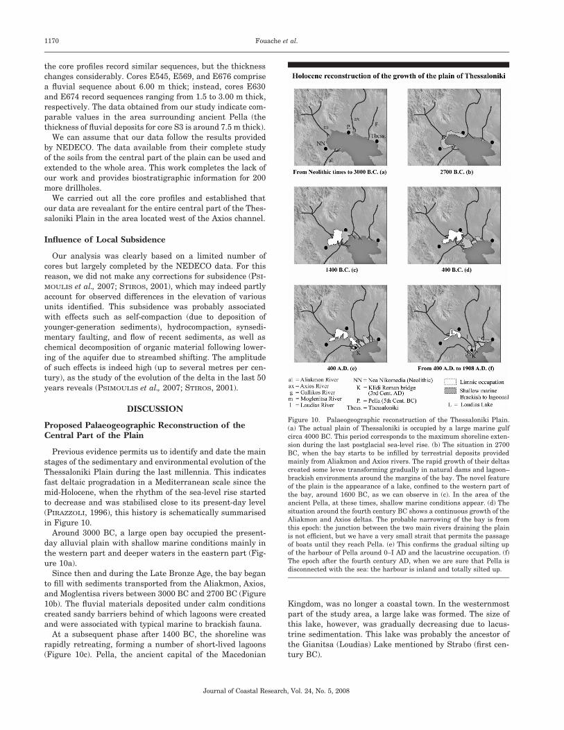
Based on the NEDECO studies, a transect running fromPella close to Klidi (Figure 8) indicates the successive phasesof deposition described before where marine, brackish, limnic,and floodplain environments are described. The lithostrati-graphic pattern of the six cores analysed in this article wasthen compared with the results derived from the microfaunaland sedimentological analyses done by NEDECO (Figures 8and 9). Stratigraphic correlations are evident. Our cores arebroadly consistent with the regional pattern deduced by NE-DECO and hence can be regarded as representative of a wid-er area between the Axios channel and the cities of Pella andAlexandria (Figure 3). The different phases of deposition aredescribed as follows:
● Phase A corresponds to marine environmental conditionsand is found in the lower part of the cores E545, E569, andE630. It consists of grey clay mixed with abundant marineshells. Overlying the marine deposits, brackish depositsare found with a relative small thickness (ranging from
1169Contribution on the Holocene Reconstruction of Thessaloniki Coastal Plain, Greece
Journal of Coastal Research, Vol. 24, No. 5, 2008
Figure 9. Cross-section from Pella to Klidi using NEDECO data.
0.20 m for core E569 to 1.0 m). They are composed by clayand silt deposits where the presence of marine shells islittle attested.
● The subsequent main phase of deposition, the phase B, isalso well observed in the core profiles established by NE-DECO. It corresponds to limnic/freshwater lake conditions.We find this unit in all the cores, and it compares well withour results obtained in the same area. The thickness of the
sediments changes locally and seems to be very importantin core E630, located close to the actual city of Trikala (ap-proximately 3.5 m thick). The results for this borehole com-pare well with the results obtained in core S5 from ourstudy.
Unit C found in our profiles, corresponding to floodplaindeposits, is also revealed by the study led by NEDECO. All
1170 Fouache et al.
Journal of Coastal Research, Vol. 24, No. 5, 2008
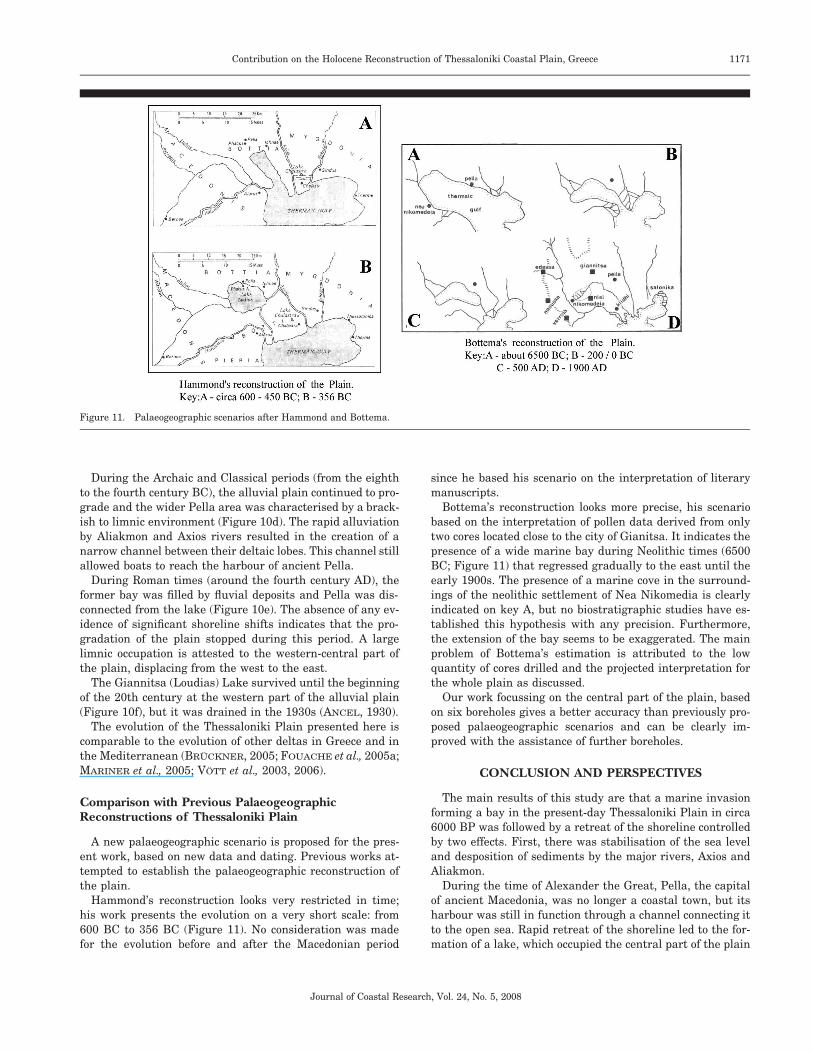
Figure 10. Palaeogeographic reconstruction of the Thessaloniki Plain.(a) The actual plain of Thessaloniki is occupied by a large marine gulfcirca 4000 BC. This period corresponds to the maximum shoreline exten-sion during the last postglacial sea-level rise. (b) The situation in 2700BC, when the bay starts to be infilled by terrestrial deposits providedmainly from Aliakmon and Axios rivers. The rapid growth of their deltascreated some levee transforming gradually in natural dams and lagoon–brackish environments around the margins of the bay. The novel featureof the plain is the appearance of a lake, confined to the western part ofthe bay, around 1600 BC, as we can observe in (c). In the area of theancient Pella, at these times, shallow marine conditions appear. (d) Thesituation around the fourth century BC shows a continuous growth of theAliakmon and Axios deltas. The probable narrowing of the bay is fromthis epoch: the junction between the two main rivers draining the plainis not efficient, but we have a very small strait that permits the passageof boats until they reach Pella. (e) This confirms the gradual silting upof the harbour of Pella around 0–I AD and the lacustrine occupation. (f)The epoch after the fourth century AD, when we are sure that Pella isdisconnected with the sea: the harbour is inland and totally silted up.
the core profiles record similar sequences, but the thicknesschanges considerably. Cores E545, E569, and E676 comprisea fluvial sequence about 6.00 m thick; instead, cores E630and E674 record sequences ranging from 1.5 to 3.00 m thick,respectively. The data obtained from our study indicate com-parable values in the area surrounding ancient Pella (thethickness of fluvial deposits for core S3 is around 7.5 m thick).
We can assume that our data follow the results providedby NEDECO. The data available from their complete studyof the soils from the central part of the plain can be used andextended to the whole area. This work completes the lack ofour work and provides biostratigraphic information for 200more drillholes.
We carried out all the core profiles and established thatour data are revealant for the entire central part of the Thes-saloniki Plain in the area located west of the Axios channel.
Influence of Local Subsidence
Our analysis was clearly based on a limited number ofcores but largely completed by the NEDECO data. For thisreason, we did not make any corrections for subsidence (PSI-MOULIS et al., 2007; STIROS, 2001), which may indeed partlyaccount for observed differences in the elevation of variousunits identified. This subsidence was probably associatedwith effects such as self-compaction (due to deposition ofyounger-generation sediments), hydrocompaction, synsedi-mentary faulting, and flow of recent sediments, as well aschemical decomposition of organic material following lower-ing of the aquifer due to streambed shifting. The amplitudeof such effects is indeed high (up to several metres per cen-tury), as the study of the evolution of the delta in the last 50years reveals (PSIMOULIS et al., 2007; STIROS, 2001).
DISCUSSION
Proposed Palaeogeographic Reconstruction of theCentral Part of the Plain
Previous evidence permits us to identify and date the mainstages of the sedimentary and environmental evolution of theThessaloniki Plain during the last millennia. This indicatesfast deltaic progradation in a Mediterranean scale since themid-Holocene, when the rhythm of the sea-level rise startedto decrease and was stabilised close to its present-day level(PIRAZZOLI, 1996), this history is schematically summarisedin Figure 10.
Around 3000 BC, a large open bay occupied the present-day alluvial plain with shallow marine conditions mainly inthe western part and deeper waters in the eastern part (Fig-ure 10a).
Since then and during the Late Bronze Age, the bay beganto fill with sediments transported from the Aliakmon, Axios,and Moglentisa rivers between 3000 BC and 2700 BC (Figure10b). The fluvial materials deposited under calm conditionscreated sandy barriers behind of which lagoons were createdand were associated with typical marine to brackish fauna.
At a subsequent phase after 1400 BC, the shoreline wasrapidly retreating, forming a number of short-lived lagoons(Figure 10c). Pella, the ancient capital of the Macedonian
Kingdom, was no longer a coastal town. In the westernmostpart of the study area, a large lake was formed. The size ofthis lake, however, was gradually decreasing due to lacus-trine sedimentation. This lake was probably the ancestor ofthe Gianitsa (Loudias) Lake mentioned by Strabo (first cen-tury BC).
1171Contribution on the Holocene Reconstruction of Thessaloniki Coastal Plain, Greece
Journal of Coastal Research, Vol. 24, No. 5, 2008
Figure 11. Palaeogeographic scenarios after Hammond and Bottema.
During the Archaic and Classical periods (from the eighthto the fourth century BC), the alluvial plain continued to pro-grade and the wider Pella area was characterised by a brack-ish to limnic environment (Figure 10d). The rapid alluviationby Aliakmon and Axios rivers resulted in the creation of anarrow channel between their deltaic lobes. This channel stillallowed boats to reach the harbour of ancient Pella.
During Roman times (around the fourth century AD), theformer bay was filled by fluvial deposits and Pella was dis-connected from the lake (Figure 10e). The absence of any ev-idence of significant shoreline shifts indicates that the pro-gradation of the plain stopped during this period. A largelimnic occupation is attested to the western-central part ofthe plain, displacing from the west to the east.
The Giannitsa (Loudias) Lake survived until the beginningof the 20th century at the western part of the alluvial plain(Figure 10f), but it was drained in the 1930s (ANCEL, 1930).
The evolution of the Thessaloniki Plain presented here iscomparable to the evolution of other deltas in Greece and inthe Mediterranean (BRUCKNER, 2005; FOUACHE et al., 2005a;MARINER et al., 2005; VOTT et al., 2003, 2006).
Comparison with Previous PalaeogeographicReconstructions of Thessaloniki Plain
A new palaeogeographic scenario is proposed for the pres-ent work, based on new data and dating. Previous works at-tempted to establish the palaeogeographic reconstruction ofthe plain.
Hammond’s reconstruction looks very restricted in time;his work presents the evolution on a very short scale: from600 BC to 356 BC (Figure 11). No consideration was madefor the evolution before and after the Macedonian period
since he based his scenario on the interpretation of literarymanuscripts.
Bottema’s reconstruction looks more precise, his scenariobased on the interpretation of pollen data derived from onlytwo cores located close to the city of Gianitsa. It indicates thepresence of a wide marine bay during Neolithic times (6500BC; Figure 11) that regressed gradually to the east until theearly 1900s. The presence of a marine cove in the surround-ings of the neolithic settlement of Nea Nikomedia is clearlyindicated on key A, but no biostratigraphic studies have es-tablished this hypothesis with any precision. Furthermore,the extension of the bay seems to be exaggerated. The mainproblem of Bottema’s estimation is attributed to the lowquantity of cores drilled and the projected interpretation forthe whole plain as discussed.
Our work focussing on the central part of the plain, basedon six boreholes gives a better accuracy than previously pro-posed palaeogeographic scenarios and can be clearly im-proved with the assistance of further boreholes.
CONCLUSION AND PERSPECTIVES
The main results of this study are that a marine invasionforming a bay in the present-day Thessaloniki Plain in circa6000 BP was followed by a retreat of the shoreline controlledby two effects. First, there was stabilisation of the sea leveland desposition of sediments by the major rivers, Axios andAliakmon.
During the time of Alexander the Great, Pella, the capitalof ancient Macedonia, was no longer a coastal town, but itsharbour was still in function through a channel connecting itto the open sea. Rapid retreat of the shoreline led to the for-mation of a lake, which occupied the central part of the plain
1172 Fouache et al.
Journal of Coastal Research, Vol. 24, No. 5, 2008
between 1600 BC and 1900 AD, when it was artificiallydrained.
This palaeoenvironmental history, broadly consistent withhistorical data and confirmed by analysis of Landsat TM im-agery, will probably be important for the understanding of therelationship between landscape changes and human occupation.
The latter certainly adapted to the shoreline displacementssince Neolithic times, but the details of this relationship, aswell as the evaluation of the ancient sources describing theancient landscape, are matters for further studies.
ACKNOWLEDGMENTS
This article is a contribution to the research project MAL-RHO of the French Ministry of Foreign Affairs, studying theHolocene shorelines displacements around the Mediterra-nean Sea. French School of Athens provided a financial sup-port. The authors are grateful to Theodoros Paraschou andDavid Psomiadis from the Aristotle University of Thessalo-niki for their help for coring during 2005.
Special thanks to the Wetland Information of Axios, andits director, Urania Giannakou, for the precious help and forthe accommodation offered.
The authors acknowledge Dr. David Zisis Kozlakidis fromthe Imperial College (London) for substantially improving thewriting style and Pr. Cecile Baeteman for improving an ear-lier version of this paper.
LITERATURE CITED
ANCEL, J., 1930. La Macedoine, Etude de la Colonisation Contem-poraine. Delagrave, Paris: Delagrave University, Ph.D. thesis,352p [in French].
ARNAUD-FASSETTA, G., 2000. Quatre mille ans d’histoired’hydrologique dans le delta du Rhone. Grafigeo, Paris, 11, 229p[in French].
ASTARAS, T.A. and SOTIRIADIS, L., 1988. The evolution of the Thes-saloniki–Giannitsa Plain in northern Greece during the last 2500years—from the Alexander the Great era until today. In: Lake,Mire and River Environments during the Last 15,000 Years. Rot-terdam: Balkema, pp. 105–114.
BINTLIFF, J., 1976. The plain of Western Macedonia and the neo-lithic site of Nea Nikomedeia. Proceedings of the Prehistoric Soci-ety, 42, 241–262.
BOTTEMA, S., 1974. Late Quaternary Vegetation History of North-western Greece. Groningen, the Netherlands: Groningen Univer-sity, Ph.D. thesis.
BRUCKNER, H., 2005. Holocene shoreline displacements and theirconsequences for human societies: the example of Ephessus inwestern Turkey. Zeitschrift fur Geomorphologie, 137, S11–S22.
BUURMAN, P.; PAPE, T., and MUGGLER, C.C, 1996. Laser grain-sizedetermination in soil genetic studies: practical problems. Soil Sci-ence, 162(3), 211–218.
DELACOULONCHE, A., 1858. Memoire sur le berceau de la puissancemacedonienne des bords de l’Haliacmon a ceux de l’Axius. Archivesdes missions scientifiques et litteraires [in French].
ETOME CO., 1974. Preliminary Study for Development of the Areaof Installation of the International Fair of Thessaloniki. DetailedReport, Ministry of Public Works/Hydraulic Works Service, Ath-ens, 96p.
FAUGERES, L., 1978. Recherches Geomorphologiques en Grece Sep-tentrionale: Macedoine Centrale et Occidentale. Lille, France:L’Universite de Lille, Ph.D. thesis, 2 volumes, 849p [in French].
FOUACHE, E., 1999. L’Alluvionnement Historique en Grece Occiden-tale et au Peloponnese: Geomorphologie, Archeologie et Histoire.Supplement Bulletin de Correspondance Hellenique, 35, Ed. DeBoccard, 235p [in French].
FOUACHE, E.; DALONGEVILLE, R.; KUNESCH, S.; SUC, J.-P.; SUB-ALLY, D.; PRIEUR, A., and LOUZOUET, P., 2005a. The environmen-tal setting of the harbor of the classical site of Oeniades on theAcheloos delta, Greece. Geoarchaeology, 20(3), 285–302.
FOUACHE, E.; DESRUELLES, S.; PAVLOPOULOS, K.; COQUINOT, Y.;DALONGEVILLE, R.; PEULVAST, J.-P., and POTDEVIN, J.-L., 2005b.Beachrock and sea-level changes in Mykonos, Delos and Rheniaislands (Cyclades, Greece). Zeitschrift fur Geomorphologie, 137,S37–S43.
FOUACHE, E. and PAVLOPOULOS, K., 2005. Sea-level changes in east-ern Mediterranean during Holocene, indicators and human im-pacts. Zeitschrift fur Geomorphologie, 137, S193p.
GHILARDI, M., 2006. Apport et interet de la modelisation numeriquede terrain en geomorphologie: etude du site antique de Methoni(Pierie-Grece). Memoire du laboratoire de Geomorphologie et envi-ronnement littoral, 45, Dinard (France), 114p [in French].
HAMMOND, N.G.L., 1972. A History of Macedonia: I. Historical Ge-ography and Prehistory. Oxford: Clarendon Press.
HERODOTUS. Histories, VII, 123, 124, 127.KARAGEORGIS, A.P. and CHRISTOS, L.A., 2003. Seasonal variation
in the distribution of suspended particulate matter in the north-west Aegean Sea. Journal of Geophysical Research, 108, C8, 3274,doi: 10.1029/2002JCOO672.
KONTOGIANNI, V.; TSOULOS, N., and STIROS, S., 2002. Coastal uplift,earthquakes and active faulting of Rhodes Island (Aegean Arc):Modeling based on geodetic inversion. Marine Geology, 186, 299–317, 2002.
KRAFT, J.-C.; ASCHENBRENNER, S.-E., and RAPP, G., 1977. Palaeo-geographic reconstructions of coastal Aegean archaeological sites.Science, 195, 941–947.
MARINER, N.; MORHANGE, C.; BOUDAGHER-FADEL, M.; BOURCIER,M., and CARBONEL, P., 2005. Geoarchaeology of Tyre’s ancientnorthern harbour, Phoenicia. Journal of Archaeological Science, 32,1302–1327.
MARINER, N. and MORHANGE, C., 2007. Geoscience of Mediterra-nean harbours. Earth Science Reviews, 80(3–4), 137–194.
MELADIOTIS, J., 1993. La subsidence du fosse d’effondrement de Sa-lonique-Giannitsa (Grece) pendant l’Holocene. Quaternaire, 1(4),39–44 [in French].
NEDECO CO., 1970. Regional Development Project of the Salonika(Thessaloniki) Plain. Land Reclamation Service (YEB) of the Min-istry of Agriculture, Athens. Netherlands Engineering Consul-tants, The Hague, Netherlands.
NOVAK, I.D. and SOULAKELLIS, N., 2000. Identifying geomorphicfeatures using LANDSAT T-5/TM data processing techniques onLesvos, Greece. Geomorphology, 34(1–2), 101–109.
PIRAZZOLI, P.A., 1991. World Atlas of Holocene Sea-Level Changes.Amsterdam: Elsevier, 300 p.
PIRAZZOLI, P.A., 1996. Sea-Level Changes: The Last 20,000 Years.New York: Wiley, 211p.
POULOS, S.E.; CHRONIS, G.T.; COLLINS, M.B., and LYKOUSIS, V.,2000. Thermaikos Gulf System, NW Aegean Sea: an overview ofwater/sediment fluxes in relation to air–land–ocean interactionsand human activities. Journal of Marine Systems, 25, 47–76.
PSIMOULIS, P.; GHILARDI, M.; FOUACHE, E., and STIROS, S., 2007.Subsidence and evolution of the Thessaloniki Plain, Greece, basedon historical leveling and GPS data. Engineering Geology, 90(1–2),55–70.
SIVIGNON, M., 1987. La mise en valeur du delta de l’Axios. In: BE-THEMONT, J. and VILLAIN-GANDOSSI, C. (eds.), Les Deltas Medi-terraneens. Vienne: Centre Europeen de Coordination de Recher-che et de Documentation en Sciences Sociales, pp. 279–296 [inFrench].
STIROS, S., 2001. Rapid subsidence of the Thessaloniki (NorthernGreece) coastal plain, 1960–1999. Engineering Geology, 61, 243–256.
STRUCK, A., 1908. Die makedonischen Niederlande. In: Zur Kundedes Balkanhalbinsel. Wien: Reisen und Beobachtungen, Heft 7 [inGerman].
STUIVER, M.; REIMER, P.J., and REIMER, R., 2006. CALIB Radiocar-bon Calibration. http://calib.qub.ac.uk/calib (accessed February 25,2007).
SYRIDES, G., 1990. Lithostratigraphic, Biostratigraphic and Palaeo-
1173Contribution on the Holocene Reconstruction of Thessaloniki Coastal Plain, Greece
Journal of Coastal Research, Vol. 24, No. 5, 2008
geographic Study of the Neogene–Quaternary Sedimentary De-posits of Chalkidiki Peninsula, Macedonia, Greece. Thessaloniki:School of Geology, Ph.D. thesis. Scientific Annals, 1(11), 243p [inGreek].
VOTT, A.; BRUCKNER, H.; SCHRIEVER, A.; BESONEN, M.; VAN DER
BORG, K., and HANDL, M., 2003. Holocene Coastal Changes in theAcheloos Alluvial Plain (Northwestern Greece) and Their Effectson the Ancient Site of Ainiadai. CIESM (Santorini, Greece), 22–25 October 2003, Workshop Monographs No. 24, pp. 33–42.
VOTT, A., 2007. Silting up Oiniadai’s harbours (Archeloos River del-ta, NW Greece). Geoarchaeological implications of late Holocenelandscapes changes. Geomorphologie, 1, 19–36.
VOTT, A.; BRUCKNER, H.; HANDL, M., and SCHRIEVER, A., 2006. Ho-locene palaeogeographies of the Astakos coastal plain (Akarnania,NW Greece), Palaeogeography, Palaeoclimatology, Palaeoecology,239, 126–146.
VOUVALIDIS, K.G.; SYRIDES, G.E., and ALBANAKIS, K.S., 2005. Ho-locene morphology of the Thessaloniki Bay: impact of sea levelrise. Zeitschrift fur Geomorphologie, 137, 147–158.