Embed Size (px)
Citation preview
Journal of Archaeological Science 35 (2008) 111e125http://www.elsevier.com/locate/jas
Human occupation and geomorphological evolution of theThessaloniki Plain (Greece) since mid Holocene
Matthieu Ghilardi a,*, Eric Fouache a, Francois Queyrel b, George Syrides c,Konstantinos Vouvalidis c, Stephane Kunesch d, Mixalis Styllas c, Stathis Stiros e
a University of Paris 12 Val de Marne, Departement de Geographie, EA 435 e UMR 8591, 61 Avenue du General de Gaulle, 94010 Creteil, Franceb Ecole Pratique des Hautes Etudes, INHA, 2 rue Vivienne, 75002 Paris, France
c Aristotle University of Thessaloniki, Department of Geology, Thessaloniki, Greeced Laboratoire de Geographie Physique Pierre Birot, UMR 8591, Meudon, France
e University of Patras, Department of Civil Engineering, Geodesy Laboratory, Patras, Greece
Received 31 October 2006; received in revised form 24 January 2007; accepted 25 February 2007
Abstract
The plain of Thessaloniki is an important area from a historical standpoint. Numerous reigns and empires have occupied the area, leavingbehind numerous archaeological remains. The literature and historical evidences show that the city of Pella was located near the sea and itsharbor was the starting point of various conquests of famous kings such as Philip the 2nd and Alexander the Great. At present, the ancient capitalis located 28 km inland the large fertile plain of Thessaloniki.
Palaeogeographic and palaeoenvironmental studies encourage the idea of a fast infilling of the plain between the 5th century BC and the 5thcentury AD. Twentieth century authors attest to this, but there are contradictory scenarios due to varying interpretations of literature sources.
This research offers a new perspective and understanding of the evolution of the Thessaloniki plain based on chronostratigraphical evidences.Historical references of Herodotus, Livy, and Strabo were used to establish the relations between human occupation and landscape evolution.
Crossing these chronostratigraphical data with archaeological evidences and literary sources, it was possible to reconstruct shoreline displace-ments and landscape evolution during the last 5 millennia.� 2007 Elsevier Ltd. All rights reserved.
Keywords: Aliakmon River; Axios River; Geomorphology; Greece; Holocene; Palaeogeographic reconstruction; Pella; Thessaloniki Plain
1. Introduction
The plain of Thessaloniki is an area with intense humanoccupation since prehistoric times. Since the early Neolithictimes, settlements in the western part of the plain have beenestablished (Rodden and Wardle, 1996). The settlements ofNea Nikomedia and Angelochori attest to a human occupationsince circa 6230 BC (Rodden and Wardle, 1996). Tribes offarmers were the first inhabitants of the area; subsequently,realms and empires succeeded and dominated the area fromMacedonian times until the Ottoman period.
* Corresponding author. Tel.: þ33 6 1026 0864.
E-mail address: [email protected] (M. Ghilardi).
0305-4403/$ - see front matter � 2007 Elsevier Ltd. All rights reserved.
doi:10.1016/j.jas.2007.02.017
The Macedonian realm, with kings Philip the 2nd andAlexander the Great, was the most famous settlement in thearea, leaving behind many archaeological remains such as cit-ies and roads. The discovery of ancient Pella’s ruins by Petsasin the 1960s (Petsas, 1978; Akamitis et al., 2004) and Vergi-na’s tombs by Andronikos in the late 1970s (Andronikos,1984, 1993) reveal the historical importance of the changingmorphology of the area.
Until today, there is a lack of chronostratigraphic evidenceto reconstruct the historical developments in the region vis-a-vis the changing landscape.
Only Bottema who analyzed two cores for paleoenviron-mental purposes during the mid-1970s conducted some dating.In a complementary study led by Albanakis et al. (1993) and
112 M. Ghilardi et al. / Journal of Archaeological Science 35 (2008) 111e125
Poulos et al. (2000), the mechanisms of the delta’s growthalong the Aliakmon-Axios Rivers were studied both in timeand space. However, a palaeogeographical study on the mainshoreline shifts during the mid-Holocene using stratum identi-fication and chronostratigraphy has not been done before.Thus, we decided to compare the results with literary sourcesprovided by ancient authors (Herodotus, Strabo, and Livy).
Previous authors (Struck, 1908; Hammond, 1972; Bintliff,1976; Astaras and Sotiriadis, 1988) based their different scenar-ios of Thessaloniki’s plain progradation over the last millenniaonly on the interpretation of literary sources. The interpretation
of ancient sources is a subjective method and offers variouscontradictions in many aspects. Pella’s location close to thesea is discussed in this paper. Apparently, this affirmationwith Hammond’s and Struck’s palaeogeographic reconstruc-tions is discussed by Bottema and other researchers.
2. Geological background
The Thessaloniki plain is the largest (w2000 km2) deltaicarea of Greece. It is situated in the northern part of Thermai-kos Gulf (Fig. 1). To the west is the Vermion (2150 m)
Fig. 1. Geological background of the Thessaloniki Plain and location of the coastline according to the palaeogeographic reconstructions established by contem-
porary authors: Struck (1908), Hammond (1972) and Bintliff (1976).
113M. Ghilardi et al. / Journal of Archaeological Science 35 (2008) 111e125
Mountain (Mesozoic limestone); the Paikon (1650 m) Moun-tain (Mesozoic limestone) lies in the north; and the Neogenehilly ranges of Pieria and Hortiatis surround the south andeast, respectively.
During the early Neogene, the broader area of Thessalonikiplain and Thermaikos Gulf formed an elongated NNW-SSEtrending tectonic depression (graben), the Axios-Thermaikosdepression (Syrides, 1990; Dinter and Royden, 1993).
The depression was gradually filled up with mainly clastic(conglomerates, sands, clays) and locally calcareous (lime-stones, marls) sediments, which were deposited in successivecomplex depositional palaeoenvironments during the Miocene(fluvial, continental red beds, brackish clays, sands, lime-stones), Pliocene (fluviolacustrine sands, silts, lacustrine marlylimestones), and Pleistocene (continental red beds) periods.
The total thickness of these sediments exceeded w2 km inthe center of Thermaikos Gulf. An intensive tectonic activityduring the Upper Pleistocene heavily affected the formerdepression, which then gradually evolved into the presentmorphology (Syrides, 1990). Holocene sea level rise flooded
the area and river deposits (Axios, Aliakmon) infilled thearea.
In the southeast part, the Thermaikos Gulf connects the twomain deltas of the plain (Fig. 2) created by the Aliakmon andAxios rivers with the sea. The Thermaikos Gulf, which ispart of the north Aegean Sea (Astaras and Sotiriadis, 1988), re-ceives freshwater from four major rivers: Aliakmon, Axios,Gallikos, and Loudias. The total drainage surface of theserivers is approximately 35,000 km2.
Thus, there is a shallow gulf, with a fast filling and an in-tense stranding of the bay. For this reason, in the 1930s, duringa large land reclamation project, the riverbed and river mouthof Axios were deviated to the south, thus avoiding the siltingof Thessaloniki harbor.
Stiros (2001) demonstrated that the plain of Thessaloniki isaffected by differential subsidence both in time and space. Inthe last 50 years, subsidence accounted for a change of 3.5 min the Thessaloniki plain (Psimoulis et al., 2007); an unusuallyhigh value. The subsidence movement across the plain is the re-sult of both natural processes and human impacts. Natural
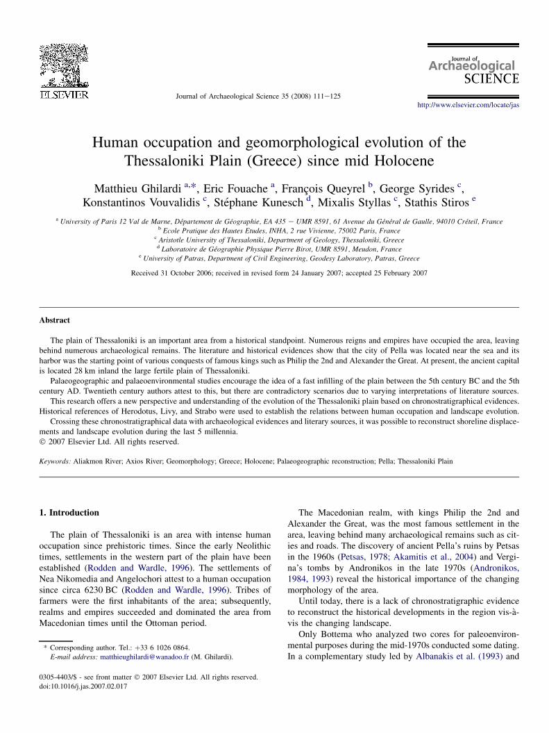
Fig. 2. Geomorphological background of the Thessaloniki Plain, the exact locations of the boreholes (S1, S2, S3, S4, S5 & S6) are indicated as the two cross
section ABA0 (S1, S2, S3 & S4) and BA0B0 (S2, S4, S5 & S6). This map is the first precise geomorphological map established for the central part of the The-
ssaloniki Plain since few quaternary researches have been done in this area.
114 M. Ghilardi et al. / Journal of Archaeological Science 35 (2008) 111e125
processes include the consolidation of the finer sediment facies(marine silts and clays, floodplain deposits), the chemical de-composition of organic matter within the clay rich layers(ETOME Co., 1974), as well as the potential natural tectonicsubsidence from both marginal and across valley faults.
In the prolongation of this tectonic depression, there isanother tectonic graben in the northwest: the Almopias Basinwith Pliocene volcanic extrusions, forming small hillocks. TheMoglenitsa River drains southward the plain of Thessaloniki,but land reclamation in the 1930s cut down this river to a pe-ripheral channel, flowing actually in the Aliakmon River.
To avoid flooding during the heavy rains, various hydraulicpublic works were installed by the New York Foundation Com-pany, as peripheral channel and artificial river banks (Ancel,1930). Therefore, the topography and morphology of the plainhave been totally modified. We just have some oxbows witness-ing from different palaeodynamics. The Gianitsa Lake (Bor-boros Limen and Loudias Lake in Antic times) has beentotally drained for agricultural purposes. We have the largestagricultural area of Greece based on irrigation of the cultivation(Sivignon, 1987), modifying also the flow of the Aliakmon andAxios rivers where several dams were built to control waterdischarges during the seasons.
NEDECO Co., (1970) studied 200 drill holes (lowered toa maximum of 12 m) and found that the soils were mainly de-posited under marine and lagoonal conditions. The researchersfound marine sediments at 10-m depths near Pella, where thearea was covered with lagoonal, limnic, and fluviatile deposits.The river sediments provided by the Aliakmon and Axiosspread over the marine deposits during the lagoonal stages inall the plain. These gradually filled the former bay, giving theplain its present shape. In the NEDECO study, the steps ofthe construction were not known and have not yet been studied.Also, no dating of the material was decided at this time.
Since the end of the maximum of the last post-glacial trans-gression, studies have been done to evaluate the rise of the sealevel in the northern part of the Aegean Sea (Vouvalidis et al.,2005). Using malacological identification and the C14 datingmethod, the results showed a classical sea level rise in thisarea, comparable with findings from other studies over theworld (Pirazzoli, 1996; Bruse et al., 2001).
3. Palaeogeographic reconstructions
3.1. The landscape’s evolution asdescribed by literary sources
The literary sources used by the authors for the palaeogeo-graphic reconstruction of the plain of Emathia refer to the for-mer province of the Macedonian Realm. The descriptionsgiven by Greek or Latin sources covering approximately onemillennium provide the bases of the group’s interpretations.
The first literary source is Herodotus, who, in the mid-5thcentury BC, composed his Histories. Here he describes thecity of Pella (Herodotus, VII, 123) as occupying a narrowstretch of land close to the sea.
Later, in the 5th century BC, Thucydides mentioned in His-tory that the inhabitants of the Macedonian mountains used tocome to Pella and the sea. On a land along the Axios River, peo-ple from Paeonia annexed a territory (Thucydides, II, 99e100).
In Pseudo-Skylax, during the mid-4th century BC, an evo-lution in Pella’s surroundings was described. The contactwith the sea was not direct; a shipway allowed for the warshipto come from Aliakmon estuary, Loudias Lake, and a channelalso called Loudias. It has been proven that Pella was stilla harbor during the Hellenistic times. In late 290 BC, Deme-trius arranged for the building of a fleet composed of 500 war-ships at Pella (Hammond, 1991).
Livy, who described Pella during the Roman occupation ofthe ancient capital by General Paul Emile, after the gloriousbattle of Pydna in 168 BC, indicates that ‘‘swamps of a depthimpenetrable in summer or winter surround it (Pella), formedby the ponding of rivers.’’ Phacos Island (a hillock where theroyal fortress was built) projects like an island from theswamp itself, where it comes nearest the city. The separationbetween the royal palace and the main city is created by a rivercalled Intermuralis Amnis (Livy, XLIV, 46). The presence ofthis river is attested in Demosthenes’ epoch (mid-4th centuryBC), where we learn that Aeschines used to visit Philip inthe fortress, spanning a river. This river, coming from Paikon,was probably progradating in the former gulf and may be re-sponsible for the rapid siltation of the harbor of Pella. Moreprobably, it was a shipshed using a natural river to go directlyto the sea throughout the navigable Loudias Lake.
Strabo’s description of the fast evolution of the landscapesaround 1st century BC is very significant (Strabo, VII, 20e22). Pella was connected to the sea by navigating on the LoudiasChannel, which was connected to the Loudias Lake itself. Wehave a junction of a stream coming from Loudias Lake andthe Axios River in the lower part, the total distance betweenPella and the sea being 120 stadia (Strabo, VII, 20), which cor-responded to 22.2 km. Today, Pella is 28 km inland.
A last literary source cited by Bintliff refers to the definitiveinland location of the ancient capital after Pseudo-Scymnusobservations.
3.2. Human occupation of the study area since Neolithictimes: important archaeological remains arestill present in and around the plain
Intact archaeological remains across different epochs sup-port the evidences gathered from millennium-wide literature.
The oldest archaeological remains in the plain are datedfrom the Neolithic period. The excavation of the Nea Nikome-dia settlement, by Rodden and the joint Cambridge/Harvardteam in the 1960s, led to the assumption of proximity witha sea or a lake. The earliest occupation of the site began prob-ably during early Neolithic circa 6230 BC and the upper phaseof reoccupation date from late Neolithic period, circa 5500e5300 BC (Bintliff, 1976; Rodden and Wardle, 1996).
The typical habitat of the mound revealed that the sedi-ments used by the inhabitants were extracted very close tomud and reeds (Rodden and Wardle, 1996). Many shellfish
115M. Ghilardi et al. / Journal of Archaeological Science 35 (2008) 111e125
remains were identified and Rodden concluded that the NeaNikomedia settlement was probably close to a marshy lakeor inlet during the earliest occupation.
Shackleton closely examined the fauna that was identifiedand dated by Rodden and he confirmed the theory of a positionclose to the sea, given the brackish environmental conditions(Shackleton, 1970). Hammond assumed that the alluvial plaincreated in central Macedonia was occupied first by settlersduring the late Bronze Age (Hammond, 1991), but neitherliterary sources nor bibliographic references supported thistheory.
During Roman times, two roads were constructed throughthe Thessaloniki plain. The first one, called the Early RomanRoad, came from Methoni, Veria, at the foothill close toEdessa, Pella, and Thessaloniki. This road was built around1st century BC.
The second road built by the Roman Empire around 3rdcentury AD (Bintliff, 1976), was shorter and was called theLate Roman Road. For the first time, we have a road passingthrough the central part of the plain, direct from Pydna toThessaloniki.
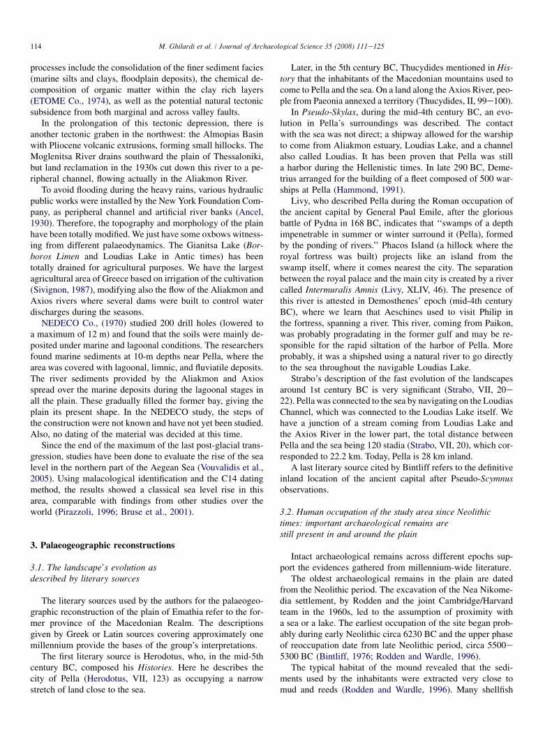
In the middle of the plain, we have the Klidi Arch (N 40� 340
434/E 22� 370 352, Figs. 3 and 7), dated 3rd century AD. Thearch was the only remnant from a Roman bridge built witheight or nine arches. Its direction was west-southwest to east-northeast, with an initial length of 187e190 m that is probablythe 3rd or the 4th arch of the edifice (Delacoulonche, 1858). Noriver can be found under this arch. The hypothesis advanced byStruck and Bintliff refers to a bridge spanning Aliakmon Riveror a junction between Aliakmon and Loudias River right at thearch. However, no manuscripts or any description of this part ofthe plain can provide evidence of this. The NEDECO Companywho drilled close to this place revealed the stratigraphy anddiscovered a sandy barrier coming from the southwest to the
Fig. 3. This picture is the arch of the Roman bridge of Klidhi, its exact loca-
tion, shown on Fig. 1, is in the lower part of the Aliakmon delta, eastern of the
actual Loudias River. This arch is a part of an edifice built during Roman times
(300 AD). Nowadays, the rivers have migrated and we don’t have any fluvial
channels.
northeast: a transect running from the actual city of Klidi toHalastra. Lagoon or swamps with shallow water allowed theformation of structures that provided the shortest route fromPydna to Thessaloniki (NEDECO Co., 1970).
Using the Peutinger Table, Edson (1955) considered thatthe imperial road passed directly into the plain instead of com-ing close to Veria, Edessa, and the Via Egnatia. We can as-sume that during the 3rd century AD, Pella was totallydisconnected from the sea and took a position inland.
The Klidi Bridge was already known during the medievaltimes when Emperor Alexis and his army traversed the roadin 1078.
3.3. Palaeographic reconstructionsestablished during the 20th century
From careful scrutiny of classical references, geographersin the early 20th century put forward a rapid outbuilding ofthe plain of Thessaloniki through the last three millennia.They claimed that the alluvial plain was created mainlyfrom 5th century BC to 5th century AD.
According to literary sources, during the Macedoniantimes (from 8th century BC to 2nd century BC), Pella wason the ridge of the vast Thermaic Gulf, more extended tothe west than at present. Five contemporary authors decidedto establish the Holocene reconstruction of the alluvial plain:Struck (1908), Hammond (1972), Bottema (1974), Bintliff(1976), and Astaras (Astaras and Sotiriadis, 1988). The firstthree authors made original reconstructions, whereas thelast two based their depictions on the work of otherresearchers.
Struck’s scenario, dating back in 1908, was based on two ma-jor shifts in the shoreline of the Thermaic Gulf in its westernpart. The first shift showed the major growth of the plain occur-ring between 500 BC and the 1st century AD. The secondshowed the end of the alluviation during the 5th century AD,with no significant advancement toward the sea since then(Struck, 1908). Struck’s reconstruction was remarkable sinceit was the first time that a research described the intensive allu-viation responsible for the creation of the plain. Nonetheless,Struck’s evidence, which was based only on literary sourcesand field observation, did not reveal any alluviation beforethe 5th century BC. No chronostratigraphical study has beendone.
Rodden who studied the Neolithic settlement of Nea Niko-media agreed partly to Struck’s scenario. Rodden consideredthe great growth of the plain as a natural result of sea-levelrise since the Classical epoch (Bintliff, 1976; Rodden andWardle, 1996).
Struck considered also the Roman bridge of Klidi, whichwas well studied by Delacoulonche (1858) as an important ar-chaeological remain. It explained the shoreline displacementsince the Macedonian times and the exact epoch of Pella’s dis-connection with the sea. This arch (Fig. 3) was one of eight ornine arch bridges constructed in the 3rd century AD by the Ro-mans. The architecture and the material convinced Delacou-lonche of the epoch. Struck, with the help of this description,
116 M. Ghilardi et al. / Journal of Archaeological Science 35 (2008) 111e125
determined the limit of the rapid outbuilding of the plain to becirca 4th century AD.
Hammond in 1972 proposed a different palaeogeographicreconstruction of the plain. Around 600e450 BC, duringKing Archelaos’ time, Pella was not a harbor anymore. Ac-cording to him, Pella and Ichnae were located on the ridge ofan extended lake (Hammond, 1972). Even with the use of abun-dant literary sources and attentive field observations, he wasstill unable to propose an evolution of the plain since themid-Holocene. The period ascribed to (600e356 BC) is tooshort to understand exactly the shifts in the shoreline. Ham-mond’s vision contrasted radically with Struck’s. He consid-ered that the alluvial plain was built before the 7th centuryBC, which was contradictory to Struck’s scenario. During Phi-lip II’s leadership, in 356 B., Hammond indicated a displace-ment of the shoreline close to Pella, with a narrow stretchbetween the right bank of the Axios River and the left bankof the Loudias River (the former Moglenitsa River). Thelake, which was observed 4 centuries earlier, disappearedfrom cartography. Apparently, marine intrusion was responsi-ble for the modification of the shoreline.
Bottema was the first non-geographer in 1974 to proposea non-exclusive scenario based on historical sources. Usingcore profiles, chronostratigraphical and palynological studies,the botanist elaborated his own scenario that was consistentwith Struck’s.
Three main shifts were depicted. The first showed a largeoccupation by the sea during Neolithic times, around6500 BC. The alluviation of the Axios and Aliakmon riverswere non-influent of the outbuilding of the plain in these times(Bottema, 1974). The second phase showed the growth of thetwo deltas, which, around 200e0 BC disconnected the city ofPella from the shoreline. The establishment of a lake was thenovel feature of the area. In 500 AD, Pella was definitely land-locked by the junction of the two main deltas of the plain, theones of Aliakmon and Axios rivers. In this period, the presentshape was formed and the displacements of the shoreline intothe Thermaic Gulf were limited.
Bintliff in 1976 assumed that the evolution of the plain oc-curred during millennia, starting from prehistoric times, withthe first important phase of alluviation during the Archaic andClassical periods (700e300 BC). The Roman times (300e100 BC) showed a deceleration of the growth of the plain, char-acterized also by a marine intrusion inland and development ofswamps close to the ancient Pella. During the late Roman period(500 A.), the area close to Pella turned in a lake, called LoudiasLake (Bintliff, 1976). This lake existed for approximately1500 years until the recent agricultural works in the plain duringthe 1930s.
Bintliff’s scenario was strongly influenced by well-ana-lyzed literary sources, which, in conjunction with the findingsof Bottema and Struck, allowed for a reconstruction that cutacross many millennia.
Astaras and Sotiriadis (1988) linked their own interpretationwith previously criticized palaeogeographic reconstructions,particularly Bintliff’s scenario. No chronostratigraphical stud-ies were done and few literary sources were discussed. Many
contradictions appear as the authors were uncertain about theevolution of the hydrographical network.
4. Drillings in the central part of the alluvial plain
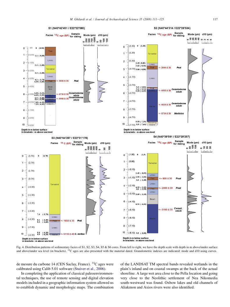
Six cores (S1, S2, S3, S4, S5, and S6; Figs. 4e6) have beendone in MayeJune 2005 and have revealed the stratigraphy ona maximum depth of 9.90 m. The locations were decided onthe basis of NEDECO drill hole data (NEDECO Co., 1970)where contact between marine and terrestrial facies was essen-tial. To find out more about lateral and vertical facies correla-tions in the western part of the Thessaloniki plain, ourpalaeoenvironmental reconstruction was done based on litho-and biostratigraphical studies of six bore holes up to a depthof 11 m maximum below the actual surface.
Unfortunately, we decided to exclude from the study theeastern part of Axios River, considering that the evolutionwas less influenced by the sedimentation of the major rivers.
We used a pneumatic hammer equipped with a 4-cm-diameter corer. Samples were taken into airtight plastic tubes46 cm long.
The exact locations of the boreholes were obtained withclassical global positioning system (GPS) measurements andthe absolute elevation calculated with Hellenic Military Geo-graphic Service data: S1 (N 40� 420 451/E 22� 220 580), S2(N 40� 440 314/E 22� 260 534), S3 (N 40� 440 287/E 22� 310
178), S4 (N 40� 390 591/E 22� 290 257), S5 (N 40� 360 115/E 22� 340 411), and S6 (N 40� 320 557/22� 370 319).
Facies identification and sedimentological analysis havebeen done in the Laboratoire de geographie physique de Meu-don (UMR 8591-Centre national de la recherche scientifique,France).
Granulometry involved analyzing the grain-size distributionusing laser diffraction.
The first step consisted in taking out every 5 cm, sampleswith a dry weight of 20 g.
Every sample was soaked into deionized water with dis-persing agent, 0.5% of hexametaphosphate sodium, and agi-tated for 2 h to deflocculate the clay particles.
For the grain-size distribution analysis, we used a CoulterLS 230 laser granulometer, software version 2.05, with a rangeof 0.04e2000 m, in 116 fractions. The calculation model usedthe Fraunhofer and Mie theory, which is applicable down toa grain size of about 0.4 mm.
The grain size indices derived included the mode grain sizeand percentile D10 and were used as indicators of the river-transporting capacity.
We then identified strata facies under wet and dry condi-tions using microfaunal analyses. The interpretations werealso based on the material type study for non-marine deposits.
The chronostratigraphy of the cores was revealed by a seriesof AMS and classical radiocarbon determinations undertakenin situ on marine shells (Fig. 4), peat, and organic sediments(Table 1). The analyses were performed at the Poznan Radiocar-bon Laboratory (Poland), at the Centre de datation pour le radio-carbone (University of Lyon 1, France), and at the Laboratoire
117M. Ghilardi et al. / Journal of Archaeological Science 35 (2008) 111e125
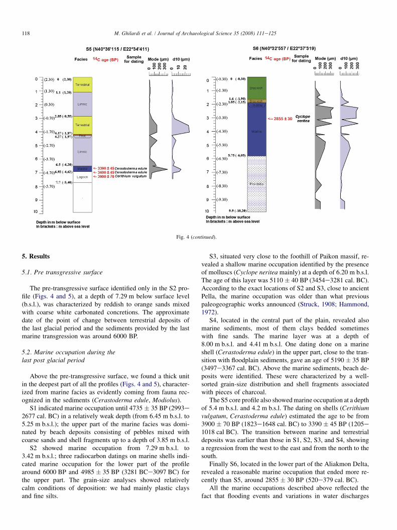
Fig. 4. Distribution patterns of sedimentary facies of S1, S2, S3, S4, S5 & S6 cores. From left to right, we have the depth scale with depth in m above/under surface
and above/under sea level (in brackets). 14C ages are also presented with the material dated. Granulometric indexes are indicated: mode and d10 using curves.
de mesure du carbone 14 (CEN Saclay, France). 14C ages werecalibrated using Calib 5.01 software (Stuiver et al., 2006).
In completing the application of classical paleoenvironmen-tal techniques, the use of remote sensing and digital elevationmodels included in a geographic information system allowed usto establish dynamic and morphologic maps. The combination
of the LANDSAT TM spectral bands revealed wetlands in theplain’s inland and on coastal swamps at the back of the actualshoreline. A large wet area close to the Pella location and goingvery close to the Neolithic settlement of Nea Nikomediasouth-westward was found. Oxbow lakes and old channels ofAliakmon and Axios rivers were also identified.
118 M. Ghilardi et al. / Journal of Archaeological Science 35 (2008) 111e125
Fig. 4 (continued).
5. Results
5.1. Pre transgressive surface
The pre-transgressive surface identified only in the S2 pro-file (Figs. 4 and 5), at a depth of 7.29 m below surface level(b.s.l.), was characterized by reddish to orange sands mixedwith coarse white carbonated concretions. The approximatedate of the point of change between terrestrial deposits ofthe last glacial period and the sediments provided by the lastmarine transgression was around 6000 BP.
5.2. Marine occupation during thelast post glacial period
Above the pre-transgressive surface, we found a thick unitin the deepest part of all the profiles (Figs. 4 and 5), character-ized from marine facies as evidently coming from fauna rec-ognized in the sediments (Cerastoderma edule, Modiolus).
S1 indicated marine occupation until 4735 � 35 BP (2993e2677 cal. BC) in a relatively weak depth (from 6.45 m b.s.l. to5.25 m b.s.l.); the upper part of the marine facies was domi-nated by beach deposits consisting of pebbles mixed withcoarse sands and shell fragments up to a depth of 3.85 m b.s.l.
S2 showed marine occupation from 7.29 m b.s.l. to3.42 m b.s.l.; three radiocarbon datings on marine shells indi-cated marine occupation for the lower part of the profilearound 6000 BP and 4985 � 35 BP (3281 BCe3097 BC) forthe upper part. The grain-size analyses showed relativelycalm conditions of deposition: we had mainly plastic claysand fine silts.
S3, situated very close to the foothill of Paikon massif, re-vealed a shallow marine occupation identified by the presenceof molluscs (Cyclope neritea mainly) at a depth of 6.20 m b.s.l.The age of this layer was 5110 � 40 BP (3454e3281 cal. BC).According to the exact locations of S2 and S3, close to ancientPella, the marine occupation was older than what previouspaleogeographic works announced (Struck, 1908; Hammond,1972).
S4, located in the central part of the plain, revealed alsomarine sediments, most of them clays bedded sometimeswith fine sands. The marine layer was at a depth of8.00 m b.s.l. and 4.41 m b.s.l. One dating done on a marineshell (Cerastoderma edule) in the upper part, close to the tran-sition with floodplain sediments, gave an age of 5190 � 35 BP(3497e3367 cal. BC). Above the marine sediments, beach de-posits were identified. These were characterized by a well-sorted grain-size distribution and shell fragments associatedwith pieces of charcoal.
The S5 core profile also showed marine occupation at a depthof 5.4 m b.s.l. and 4.2 m b.s.l. The dating on shells (Cerithiumvulgatum, Cerastoderma edule) estimated the age to be from3900 � 70 BP (1823e1648 cal. BC) to 3390 � 45 BP (1205e1018 cal BC). The transition between marine and terrestrialdeposits was earlier than those in S1, S2, S3, and S4, showinga regression from the west to the east and from the north to thesouth.
Finally S6, located in the lower part of the Aliakmon Delta,revealed a reasonable marine occupation that ended more re-cently than S5, around 2855 � 30 BP (520e379 cal. BC).
All the marine occupations described above reflected thefact that flooding events and variations in water discharges
119M. Ghilardi et al. / Journal of Archaeological Science 35 (2008) 111e125
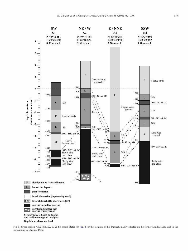
Fig. 5. Cross section ABA0 (S1, S2, S3 & S4 cores). Refer for Fig. 2 for the location of this transect, mainly situated on the former Loudias Lake and in the
surrounding of Ancient Pella.
120 M. Ghilardi et al. / Journal of Archaeological Science 35 (2008) 111e125
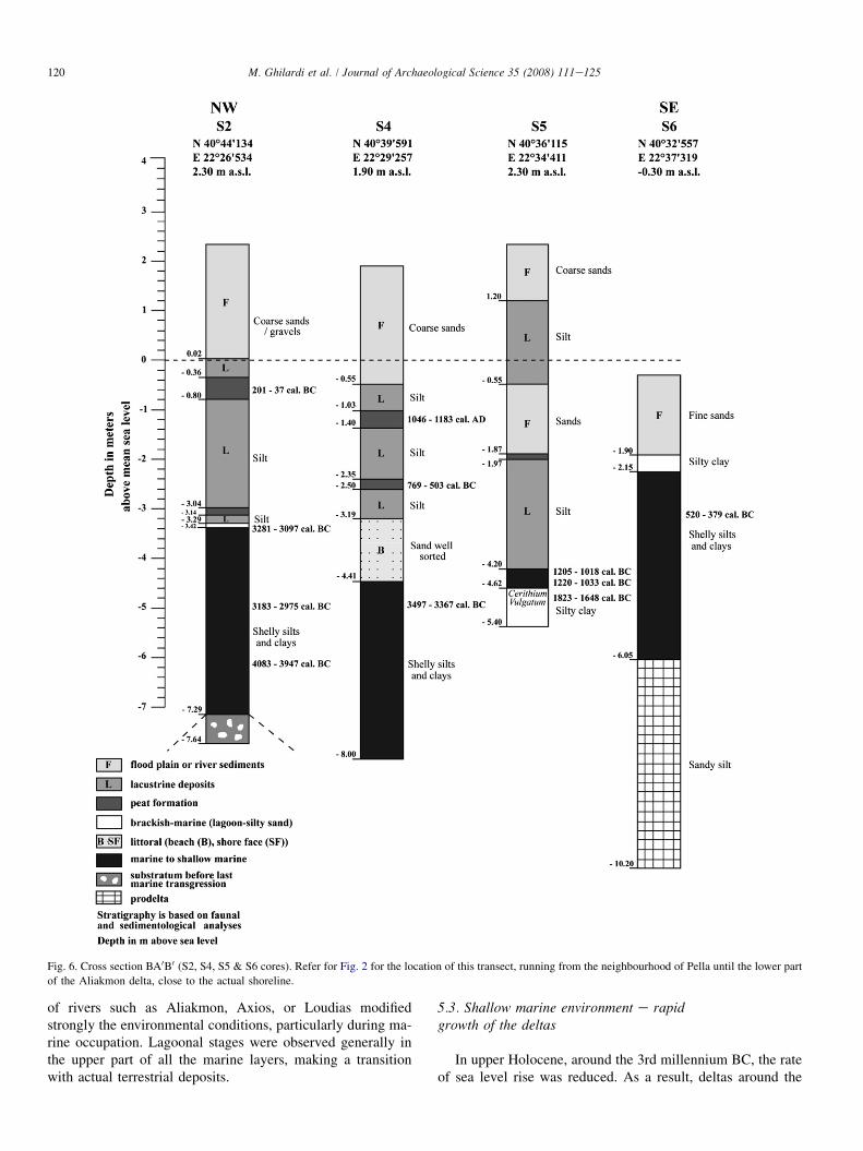
Fig. 6. Cross section BA0B0 (S2, S4, S5 & S6 cores). Refer for Fig. 2 for the location of this transect, running from the neighbourhood of Pella until the lower part
of the Aliakmon delta, close to the actual shoreline.
of rivers such as Aliakmon, Axios, or Loudias modifiedstrongly the environmental conditions, particularly during ma-rine occupation. Lagoonal stages were observed generally inthe upper part of all the marine layers, making a transitionwith actual terrestrial deposits.
5.3. Shallow marine environment e rapidgrowth of the deltas
In upper Holocene, around the 3rd millennium BC, the rateof sea level rise was reduced. As a result, deltas around the
121M. Ghilardi et al. / Journal of Archaeological Science 35 (2008) 111e125
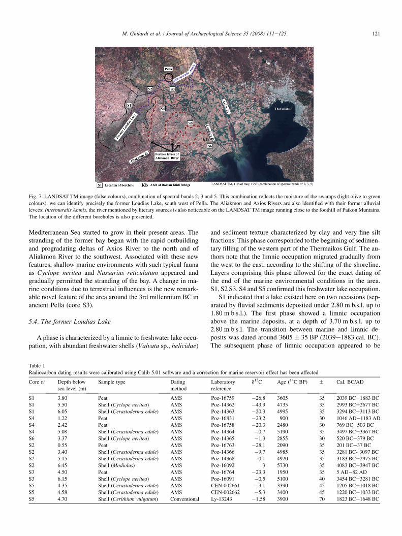
Fig. 7. LANDSAT TM image (false colours), combination of spectral bands 2, 3 and 5. This combination reflects the moisture of the swamps (light olive to green
colours), we can identify precisely the former Loudias Lake, south west of Pella. The Aliakmon and Axios Rivers are also identified with their former alluvial
levees; Intermuralis Amnis, the river mentioned by literary sources is also noticeable on the LANDSAT TM image running close to the foothill of Paikon Muntains.
The location of the different boreholes is also presented.
Mediterranean Sea started to grow in their present areas. Thestranding of the former bay began with the rapid outbuildingand progradating deltas of Axios River to the north and ofAliakmon River to the southwest. Associated with these newfeatures, shallow marine environments with such typical faunaas Cyclope neritea and Nassarius reticulatum appeared andgradually permitted the stranding of the bay. A change in ma-rine conditions due to terrestrial influences is the new remark-able novel feature of the area around the 3rd millennium BC inancient Pella (core S3).
5.4. The former Loudias Lake
A phase is characterized by a limnic to freshwater lake occu-pation, with abundant freshwater shells (Valvata sp., helicidae)
and sediment texture characterized by clay and very fine siltfractions. This phase corresponded to the beginning of sedimen-tary filling of the western part of the Thermaikos Gulf. The au-thors note that the limnic occupation migrated gradually fromthe west to the east, according to the shifting of the shoreline.Layers comprising this phase allowed for the exact dating ofthe end of the marine environmental conditions in the area.S1, S2 S3, S4 and S5 confirmed this freshwater lake occupation.
S1 indicated that a lake existed here on two occasions (sep-arated by fluvial sediments deposited under 2.80 m b.s.l. up to1.80 m b.s.l.). The first phase showed a limnic occupationabove the marine deposits, at a depth of 3.70 m b.s.l. up to2.80 m b.s.l. The transition between marine and limnic de-posits was dated around 3605 � 35 BP (2039e1883 cal. BC).The subsequent phase of limnic occupation appeared to be
Table 1
Radiocarbon dating results were calibrated using Calib 5.01 software and a correction for marine reservoir effect has been affected
Core n� Depth below
sea level (m)
Sample type Dating
method
Laboratory
reference
d13C Age (14C BP) � Cal. BC/AD
S1 3.80 Peat AMS Poz-16759 �26,8 3605 35 2039 BCe1883 BC
S1 5.50 Shell (Cyclope neritea) AMS Poz-14362 �43,9 4735 35 2993 BCe2677 BC
S1 6.05 Shell (Cerastoderma edule) AMS Poz-14363 �20,3 4995 35 3294 BCe3113 BC
S4 1.22 Peat AMS Poz-16831 �23,2 900 30 1046 ADe1183 AD
S4 2.42 Peat AMS Poz-16758 �20,3 2480 30 769 BCe503 BC
S4 5.08 Shell (Cerastoderma edule) AMS Poz-14364 �0,7 5190 35 3497 BCe3367 BC
S6 3.37 Shell (Cyclope neritea) AMS Poz-14365 �1,3 2855 30 520 BCe379 BC
S2 0.55 Peat AMS Poz-16763 �28,1 2090 35 201 BCe37 BC
S2 3.40 Shell (Cerastoderma edule) AMS Poz-14366 �9,7 4985 35 3281 BC- 3097 BC
S2 5.15 Shell (Cerastoderma edule) AMS Poz-14368 0,1 4920 35 3183 BCe2975 BC
S2 6.45 Shell (Modiolus) AMS Poz-16092 3 5730 35 4083 BCe3947 BC
S3 4.50 Peat AMS Poz-16764 �23,3 1950 35 5 ADe82 AD
S3 6.15 Shell (Cyclope neritea) AMS Poz-16091 �0,5 5100 40 3454 BCe3281 BC
S5 4.35 Shell (Cerastoderma edule) AMS CEN-002661 �3,1 3390 45 1205 BCe1018 BC
S5 4.58 Shell (Cerastoderma edule) AMS CEN-002662 �5,3 3400 45 1220 BCe1033 BC
S5 4.70 Shell (Cerithium vulgatum) Conventional Ly-13243 �1,58 3900 70 1823 BCe1648 BC
122 M. Ghilardi et al. / Journal of Archaeological Science 35 (2008) 111e125
123M. Ghilardi et al. / Journal of Archaeological Science 35 (2008) 111e125
very recent, according to descriptions in previous studies(Delacoulonche, 1858; Ancel, 1930; Bintliff, 1976). S2 showedfeatures of freshwater lake occupation at a depth of3.29 m b.s.l. up to 0.02 m above sea level (a.s.l.). A peatyepisode, in the upper part of the layer, gave an age of2090 � 35 BP (201e37 cal. BC).
A similar age of peat episode was observed in S3 (1950 �35 BP/5e82 cal. AD).
S4, where dating on peaty episodes had been done twice,revealed the presence of a lake from 2480 � 30 BP (769e503 cal. BC) to 900 � 30 BP (1046e1183 cal. AD), at a depthof 3.19 m b.s.l. up to 0.55 m b.s.l.
All the descriptions mentioned above confirmed that fresh-water lake conditions were shifting locations in relation to theflood discharges of the major rivers. This large freshwater lakewas mainly confined to the northwest part of the plain, close tothe cities of Pella and Giannitsa, corresponding to the LoudiasLake mentioned in numerous maps (Leake, 1835; Ancel,1930) and historical manuscripts (Herodotus, Strabo, Livy).
5.5. The floodplain and river sedimentationin the alluvial plain
The sedimentation of the Aliakmon and Axios rivers wasresponsible for the stranding of the former bay. The growthof their deltas allowed a marine regression since mid-Holocene.
The Aliakmon River flows from SW toward a NE directionafter the exit from the mountainous terrain to the Thessalonikiplain. The river gradually turns eastward and finally to SE,while the Axios River flows from NNW toward SSE. They cre-ated numerous levees (natural dams), through the past millen-nia, favouring the formation of lagoons, which later evolvedinto swamps and lakes.
The fluvial sediments were found in every core of the upperpart of the lacustrine sequences. The proximity of the foothillinfluenced directly the thickness and grain size distribution ofthe particles.
S2 and S3 cores were directly influenced by the sedimenta-tion of the Axios River and Paikon streams. Their positionclose to the foothill of Paikon and the actual position of AxiosRiver suggest that we have fluvial sediments and also colluvialdischarges in the sedimentological sequences.
S3 core was characterized by yellow-brownish sediments7.4 m thick, consisting of coarse sands bedded with well-rounded gravels. The surrounding area was directly influencedby the growth of the Axios Delta and, in particular, an old
tributary along the foothill of Paikon, running from the cityof Ichnae to Pella and probably going in the former LoudiasLake. The LANDSAT TM, with combinations of the spectralbands n� 2, 3 and 5 (Fig. 7), showed this river, without anydoubt to be the Intermuralis Amnis, mentioned by Livy(XLIV, 46; Delacoulonche, 1858), coming between the cityof Pella and the Phacos Island. It was also the river mentionedby Strabo (VII, 23), as being the main source of freshwater forthe Loudias Lake.
S4 and S5 were directly influenced by the Aliakmon River’ssedimentation. The growth of the delta caused continual ag-gradations of the sediments, creating numerous levees(Fig. 7) and actually fixed in the alluvial plain.
6. Palaeogeographic reconstructionof the Thessaloniki plain
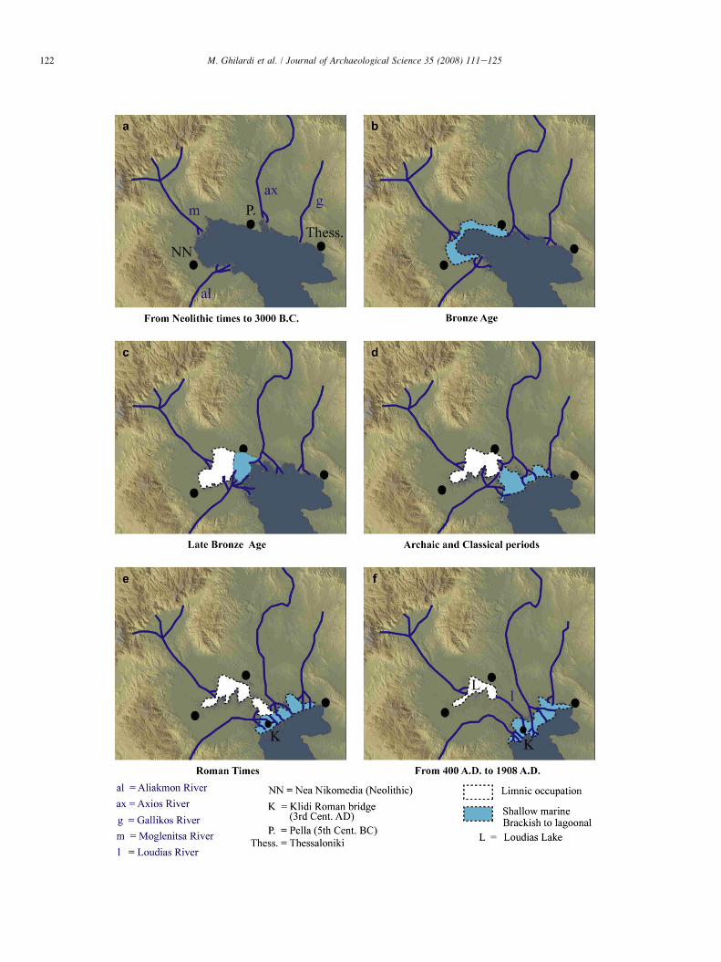
The newly collected data allowed us to propose in Fig. 8,six new sketches, concerning the evolution of Thessalonikiplain the last 5000 years.
In Fig. 8a, the actual plain of Thessaloniki was occupied bya large marine gulf circa 4000 BC. The Neolithic settlement ofNea Nikomedia was located close to the shoreline. This periodcorresponds to the maximum shoreline extension during thelast post glacial sea level rise. We can assume that the riverswere flowing in the former bay and the sediments carriedout did not permit the edification of the alluvial plain.
Fig. 8b shows the situation in 2700 BC, where the baystarted to be infilled by terrestrial deposits provided mainlyby the Aliakmon and Axios rivers. The rapid growth of theirdeltas created some levees, which gradually transformed intonatural dams and lagoons, creating brackish environmentsaround the margins of the bay.
The novel feature of the plain was the appearance of a lake,confined to the western part of the bay, around 1600 BC, ascan be observed in Fig. 8c. In the area of ancient Pella, at thesetimes, shallow marine conditions appeared.
In Fig. 8d, the situation around 4th century BC showeda continuous growth of the Aliakmon and Axios deltas. Theprobable narrowing of the bay was from this epoch. The junc-tion between the two main rivers draining the plain was not ef-ficient, but there was a very small strait that permitted thepassage of boats up to Pella. The increase in freshwaterfrom all the rivers, streams, and creeks modified the salinityof the bay. The marine occupation stricto sensu is discussedhere and probable shallow marine to lagoonal environmentswere the novel feature of the area.
Fig. 8. In (a), the actual plain of Thessaloniki is occupied by a large marine gulf circa 4000 BC. This period corresponds to the maximum shoreline extension
during the last post glacial sea level rise. (b) Shows the situation in 2700 BC, the bay starts to be infilled by terrestrial deposits providing mainly from Aliakmon
and Axios Rivers. The rapid growth of their deltas created some levee transforming gradually in natural dams and lagoon e brackish environments around the
margins of the bay. The novel feature of the plain is the appearance of a lake, confined to the western part of the bay, around 1600 BC, as we can observe in
(c). In the area of the Ancient Pella, at these times, shallow marine conditions appear. In (d), the situation around the fourth century BC shows a continuous growth
of the Aliakmon and Axios deltas. The probable narrowing of the bay is from this epoch: the junction between the two main rivers draining the plain is not efficient,
but we have a very small strait which permits the passage of boats until Pella. (e) Confirms the gradual silting up of the harbour of Pella around 0 e I AD and the
lacustrine occupation. (f) Illustrates the epoch after the fourth century AD, we are sure that Pella is totally disconnected with the sea: the harbour is inland and
totally silted up. The bridge of Klidi constructed by Roman Empire demonstrates that the communications are more eastward than during Macedonian Realm and
reveals the evident change in the environmental conditions affirmed by the position 28 km away from the sea of Pella.

124 M. Ghilardi et al. / Journal of Archaeological Science 35 (2008) 111e125
Herodotus and Aristotle considered that the sea was stillclose to Pella during King Philip II’s time. However, the chro-nostratigraphy revealed a lacustrine occupation more thana marine presence in these times. We do not know actuallythe exact definition of the sea, according to ancient sources.A probable lake occupying a large zone, coming from Pellato Paralimni and Kria Vrisy, could be considered a sea by an-cient authors. The fact that we could not see the limits of thelake and the contact confirmed with the sea allowed us to thinkthat the ‘‘sea’’ of such ancient authors as Herodotus, Thucy-dides, or Aeschines may correspond to a freshwater lake.
Fig. 8e confirmed the gradual silting up of the harbor ofPella around 0e1 AD. The lacustrine occupation and the peatepisode in S2 and S3 cores around this epoch signified a reduc-tion of the size of the lake, caused by the continuous accretionof the deltaic sediments on the coastline. The Intermuralis Am-nis River mentioned by Livy (XLIV, 46; Delacoulonche, 1858),to be flowing between the city of Pella and Phacos Island wasprobably responsible for the silting of the ancient harbor of theMacedonian Realm. Strabo (VII, 23) referred to one arm of theAxios as the freshwater source for the Loudias Lake (Bintliff,1976). The two rivers mentioned before were probably thesame. If we examine carefully the LANDSAT TM picture, inparticular, after the combinations of spectral bands 2, 3, and5 (Fig. 7), we can observe a river coming from the Axios furrowand passing at the foothill of Paikon Mountains: the Intermur-alis Amnis River mentioned above.
Fig. 8f illustrates the epoch after 4th century AD. We aresure that Pella was totally disconnected with the sea: the harborwas inland and totally silted up. The bridge of Klidi con-structed by the Roman Empire demonstrated that communica-tions are more directed eastward than during the MacedonianRealm. The evident change in the environmental conditionswas affirmed by the position 28 km away from the sea of Pella.
7. Discussion
The actual plain of Thessaloniki was occupied by a marinebay six millennia ago. The Holocene reconstruction proposedin this article deals with the main trends of shoreline migrationand landscape evolution. The area was gradually changed frommarine conditions into a large alluvial plain with gradual dis-placements of the shoreline to the southeast, caused by deltaicprogradation. In the western part of the actual plain, an inlandlake was formed for the first time around 1600 BC.
Through time, this lake existed and migrated from the westto the east up to ancient Pella, which was probably connectedto this lake with an embanked channel. A focus on the envi-ronmental conditions of Pella using a more complete chrono-stratigraphical study will help us establish precisely thedifferent changes from marine to terrestrial conditions in thisparticular area. Comparative studies have been done aroundthe Mediterranean Sea (Kraft et al., 1977; Fouache, 2003;Vott et al., 2003; Bruckner, 2005; Mariner et al., 2005).
Historical depictions of ancient authors must be reinter-preted and the definitions of landforms eventually reevaluated
(Lake Loudias was probably considered as a sea, more chrono-stratigraphical evidences have to be established).
This paper focuses on the central part of the actual alluvialplain of Thessaloniki where corings were drilled. For the east-ern part of the Axios River, no boreholes were made and theauthors used historical evidences to build the scenario. It is ev-ident that in order for the investigation to be complete, a chro-nostratigraphic study will help in understanding precisely theshifts in the shoreline between the actual course of AxiosRiver and the city of Thessaloniki. Some literary sources(Hammond, 1972) allow us to interpret the landscape’s evolu-tion. We know that Halastra and Sindos (Fig. 2) were two im-portant harbors (Herodotus, VII, 123) during the Macedonianperiod and, that they, in recent times, were lying on a lake.
8. Conclusions
Since the height of the last post glacial transgression, thepalaeogeography of the alluvial plain of Thessaloniki hasbeen fashioned by the rapid growth of deltaic areas on a formerextensive embayment of the sea.
The different previous scenarios established for the Holo-cene reconstruction of the area were based mainly on the inter-pretation of literary sources from Macedonian to Roman times.
Our research offers a new perspective and understanding ofthe shifts of the shoreline since the Neolithic times based onchronostratigraphic study. Six boreholes concentrated on thecentral part of the plain around ancient Pella were analyzed,analyzing these data along with archaeological evidences andliterary sources made it possible to reconstruct the shoreline dis-placements and landscape evolution during the last 5 millennia.
Pella, the ancient capital of the Macedonian Realm, offersa good opportunity for a geoarchaeological study. A more fo-cused program of palaeoenvironmental analysis around thiscity is necessary to find out the exact landscape evolution.
The western and eastern parts of the alluvial plain have tobe further studied, in particular, Loudias Lake. Chronostrati-graphic analyses, combined with palaeobotanic evaluation,could help bring about a greater understanding of the genesisof this key landform in the evolution of the plain. We know forsure that the lake has an older occupation than previous studieshave indicated.
A final study of sea level rise in this area using our AMSdating and subsidence studies (Stiros, 2001; Psimoulis et al.,2007) could permit a more complete regional trend with theuse of other pertinent data (Desruelles et al., 2004; Fouacheet al., 2005; Vouvalidis et al., 2005).
Acknowledgements
This article is a contribution to the research projectMALRHO of the French Ministry of Foreign Affairs, studyingthe Holocene shorelines displacements around the Mediterra-nean Sea. The authors are graceful to Theodoros Paraschou,David Psomiadis from the Aristotle University of Thessalonikifor their help for coring during the year 2005.
125M. Ghilardi et al. / Journal of Archaeological Science 35 (2008) 111e125
We also thank two anonymous referees for kindly review-ing earlier versions of this paper.
Special thanks to the Wetland Information Centre of Axiosand its Director Urania Giannakou for the precious help andthe hospitality offered.
References
Akamitis, I., Lilimpaki-Akamiti, M.E., Papaefthymiou-Papanthimou, A.,
Petkos, A.S., 2004. Pella and Its Environs. Ministry of Culture, XVII Eph-
orate of Prehistoric and Classical Antiquities e 11th Ephorate of Byzan-
tine Antiquities, Aristotle University of Thessaloniki. Archaeological
Receipts Fund, Athens, 154 p.
Albanakis, K., Vavliakis, E., Psilovikos, A., Sotiriadis, L., 1993. Mechanisms
and Evolution of the Delta of Axios River During the 20th Century (in
Greek). Proceedings, 3rd National Geography Conference, pp. 311e325.
Ancel, J., 1930. La Macedoine, etude de la colonisation contemporaine. Phd
Thesis, Delagrave, Paris, 352 p.
Andronikos, M., 1984. Vergina. The Royal Tombs and the Ancient City.
Andronikos, M., 1993. Les tombes macedoniennes, in: R. Ginouves (Ed.), La
Macedoine. de Philippe II a la conquete romaine, pp. 145e190.
Astaras, T.A., Sotiriadis, L., 1988. The Evolution of the Thessaloniki e Gian-
nitsa Plain in Northern Greece During the Last 2500 years e From the
Alexander the Great Era Until Today. Lake, Mire and River Environments
During the Last 15 000 years. Balkema, Rotterdam, pp. 105e114.
Bintliff, J., 1976. «The Plain of Western Macedonia and the Neolithic Site of
Nea Nikomedeia». Proceedings of The Prehistoric Society 42, 241e262.
Bottema, S., 1974. Late Quaternary Vegetation History of Northwestern
Greece, Ph.D. thesis, Groningen.
Bruckner, H., 2005. «Holocene shoreline displacements and their conse-
quences for human societies: the example of Ephessus in western Turkey».
Zeitschrift fur Geomorphologie 137 (Suppl.), 11e22.
Bruse, C.-D., Kearney, M.-S., Leatherman, S.-P., 2001. Sea-Level Rise. Aca-
demic Press, San Diego, p. 232.
Delacoulonche, A., 1858. Memoire sur le berceau de la puissance macedoni-
enne des bords de l’Haliacmon a ceux de l’Axius, Archives des missions
scientifiques et litteraires, p. 224.
Desruelles, S., Fouache, E., Pavlopoulos, K., Coquinot, Y., Dalongeville, R.,
Peulvast, J.-P., Potdevin, J.-L., 2004. Beachrocks et variations recentes
de la ligne de rivage en Mer Egee dans l’ensemble insulaire Mykonos-
Delos-Rhenee (Cyclades, Grece). Geomorphologie: relief, processus, envi-
ronnement, n�1, p. 5e18.
Dinter, K.-R., Royden, L., 1993. Late Cenozoic extension in northeastern
Greece: Strymon valley detachment system and Rodope metamorphic
core complex. Geology 21, 45e48.
Edson, C., 1955. Strepsa. Classical Philology 50, 160e190.
ETOME Co., 1974. Preliminary study for development of the area of installa-
tion of the International fair of Thessaloniki. Detailed Report. Ministry of
Public Works/Hydraulic Works Service, 96 pp and Annexes.
Fouache, E., 2003. «The Mediterranean World: Environment and History»,
Actes du Colloque Environmental Dynamics and History in Mediterra-
neans Areas, Working Group on Geoarchaeology (IAG), Universite de
Paris IV, UMR 8505, EFA, EFR, Casa de Velasquez, ENS LSH/Lyon, Uni-
versite de Paris IV, 24-25-26 avril 2002, Elsevier, Paris, 485 p.
Fouache, E., Desruelles, S., Pavlopoulos, K., Coquinot, Y., Dalongeville, R.,
Peulvast, J.-P., Potdevin, J.-L., 2005. Beachrock and sea-level changes in
Mykonos, Delos and Rhenia islands (Cyclades, Greece). Zeitschrift fur
Geomorphologie 137 (Suppl.), 37e43.
Hammond, N.G.L., 1991. The Miracle That was Macedonia. Sidgwick and
Jackson, London, p. 229.
Hammond, N.G.L., 1972. A History of Macedonia, vol. I. Historical Geogra-
phy and Prehistory, Clarendon Press, Oxford.
Herodotus. Histories, Book VII. Frag. 123, 124, 127.
Kraft, J.-C., Aschenbrenner, S.-E., Rapp, G., 1977. Palaeogeographic recon-
structions of coastal Aegean archaeological sites. Science 195, 941e947.
Leake, W.M., 1835. Travels in Northern Greece. Blackwell, London.
Livy. Natural Histories Books 44 & 46.
Mariner, N., Morhange, C., Boudagher-Fadel, M., Bourcier, M., Carbonel, P.,
2005. Geoarchaeology of Tyre’s ancient northern harbour, Phoenicia. Jour-
nal of Archaeological Science 32, 1302e1327.
NEDECO Co., Netherlands Engineering Consultants, The Hague, Nether-
lands, 1970. Regional Development Project of the Salonika (Thessaloniki)
Plain. Land Reclamation Service (YEB) of the Ministry of Agriculture,
Athens.
Petsas, P., 1978. Pella, Alexander the Great’s Capital. Institute for Balkan
Studies, Thessaloniki, p. 164.
Pirazzoli, P.A., 1996. Sea-Level Changes: the Last 20’000 years. Wiley, New
York, p. 211.
Poulos, S.E., Chronis, G.T., Collins, M.B., Lykousis, V., 2000. Thermaikos
gulf system, NW Aegean Sea: an overview of water/sediment fluxes in
relation to air-land-ocean interactions and human activities. Journal of
Marine Systems 25, 47e76.
Psimoulis, P., Ghilardi, M., Fouache, E., Stiros, S., 2007. Subsidence and evo-
lution of the Thessaloniki Plain, Greece, based on historical leveling and
GPS data. Engineering Geology 90 (1e2), 55e70.
Rodden, R.J., Wardle, K.A., 1996. Nea Nikomdeia I: the excavation of an early
Neolithic village in Northern Greece 1961e1964. Vol supp. N�25, The
British School at Athens, 212 p.
Shackleton, N., 1970. Stable Isotope Study of the Palaeoenvironment of the
Neolithic site of Nea Nikomedeia, Greece. Nature, 227, London, pp.
943e944.
Sivignon, M., 1987. La mise en valeur du delta de l’Axios in Les Deltas med-
iterraneens, in: Bethemont, J., Villain-Gandossi, C. (Eds.), Centre europeen
de coordination de recherche et de documentation en Sciences sociales,
Vienne, pp. 279e296.
Stiros, S., 2001. Rapid subsidence of the Thessaloniki (Northern Greece)
coastal plain, 1960e1999. Engineering Geology 61, 243e256.
Strabo. Geographies, VII, fragments 20 & 22.
Struck, A., 1908. ‘‘Die makedonischen Niederlande‘‘ dans Zur Kunde des Bal-
kanhalbinsel. Reisen und Beobachtungen. Heft 7, Wien and Leipzig.
Stuiver, M., Reimer, P.J., Reimer, R., 2006. CALIB Radiocarbon Calibration.
http://calib.qub.ac.uk/calib [last access: June 31, 2006].
Syrides, G., 1990. Lithostratigraphic, Biostratigraphic and Palaeogeographic
Study of the Neogene e Quaternary Sedimentary Deposits of Chalkidiki
Peninsula, Macedonia, Greece. Ph D Thesis. Scientific Annals School of
Geology. Vol. I, No 11, 243 p. Thessaloniki (in Greek).
Vott, A., Bruckner, H., Schriever, A., Besonen, M., Van Der Borg, K., Handl,
M., 2003. Holocene Coastal Changes in the Acheloos Alluvial Plain
(Northwestern Greece) and Their Effects on the Ancient Site of Oiniadai.
CIESM Workshop Monographs n�24, Santorini, 22e25 October 2003, pp.
33e42.
Vouvalidis, K.G., Syrides, G.E., Albanakis, K.S., 2005. Holocene morphology
of the Thessaloniki Bay: impact of sea level rise. Zeitschrift fur Geomor-
phologie 137 (Suppl.), 147e158.