Embed Size (px)
Citation preview

Crustal rheology and seismicity in the Gibraltar Arc
(western Mediterranean)
F. Fernandez-Ibanez1,2 and J. I. Soto1
Received 2 August 2007; revised 6 January 2008; accepted 15 February 2008; published 23 April 2008.
[1] On the basis of the lithospheric structure of theGibraltar Arc (western Mediterranean), we constraindepth distribution of crustal seismicity and activetectonics by means of rheological modeling. Crustalyield strength and depth of the brittle-ductile transitionzone (BDT) mimic the curvature of the arc withmaximum depths of 12–9 km whereas in the Beticsand Rif, BDT shallows eastward (to 6–5 km depth),oblique to crustal thickening. Most of the crustalseismicity (>60%) is placed within the brittle crust,decaying exponentially in the ductile crust. Active faultsobserved in surface geology, control the presenttopography of the Betics, connect in depth withscattered seismic swarms, and merge into the BDT.This horizon is interpreted as a decoupling horizon thatconditions the mode of present-day deformationpartitioning. Below the BDT, low-strength domainsenable crustal flow under central Betics promoting stressrotation and topographic uplift.Citation: Fernandez-Ibanez,
F., and J. I. Soto (2008), Crustal rheology and seismicity in the
Gibraltar Arc (western Mediterranean), Tectonics, 27, TC2007,
doi:10.1029/2007TC002192.
1. Introduction
[2] Nonelastic deformation within the lithosphereinvolves either brittle failure or ductile flow. Experimentaldeformation studies over minerals and rocks of the Earth’scrust and mantle, allow defining empirical laws that describeits behavior, and are the base to construct strength profiles inthe lithosphere [Goetze and Evans, 1979; Sibson, 1986;Chenand Molnar, 1983; Ranalli, 1995]. The lithosphere shows astratified or layered structure where high-strength valuesoccur at the brittle-to-ductile transition (BDT). The depthand strength characteristics of the BDT depend on thethermal state of the lithosphere and also on the tectonicregime of the region [e.g., Kohlstedt et al., 1995; Lowryand Smith, 1995; Fernandez and Ranalli, 1997; Behn et al.,2002]. The inference that lithosphere has a rheologicallayering [Ranalli and Murphy, 1987] is also supported byother observations as for example seismic reflection profiles.
In continental settings they usually show a barely reflectiveupper crust with discrete fault planes; whereas the deep crustdisplays a penetrative, laminated fabric, evidencing ductiledeformation processes and eventually magmatism [e.g.,Reston, 1990]. This view is simple and powerful, and hasled us a long way toward understanding the deformation ofcontinents in the context of plate tectonics.[3] Seismicity is commonly regarded as an expression of
frictional sliding along discrete brittle faults, thus providinginformation on the depth distribution of brittle layers in thelithosphere [Scholz, 1988]. Since pioneering study of Sibson[1982] many attempts have been done in different tectonicsettings to correlate strength estimates with depth distribu-tion of earthquakes. Strength profiles of the lithosphere havebeen then used to: (1) characterize brittle-ductile transitions,comparing with focal depth distribution of earthquakes[Meissner and Strehlau, 1982; Sibson, 1986, 2002; Jackson,2002]; and (2) validate deformational processes in tecton-ically active regions [Lowry and Smith, 1995; Pasquale etal., 1997; Cloetingh et al., 2004; Handy and Brun, 2004].Earthquake distribution has also been used to define thethickness of the seismogenic layer (Ts) and its base could beapproximate through the 350±100�C isotherm [Chen andMolnar, 1983; Scholz, 1990]. Recent studies suggest thatthe effective elastic thickness in the continents better con-strain the focal depth distribution of seismicity [Maggi etal., 2000; Jackson, 2002; Watts and Burov, 2003; Afonsoand Ranalli, 2004; Handy and Brun, 2004].[4] The aim of this paper is to model the rheology of the
crust in the Gibraltar Arc region (western Mediterranean).This orogenic region is characterized by large variations ofcrustal thickness and surface heat flow. According to litho-sphere structure, we evaluate crustal strength and how therheological structure constrains depth distribution of thecrustal seismicity. Crustal yield strength has been calculatedfor the complete region of the Gibraltar Arc through aregularly spaced grid of strength profiles, defining in 3Dthe location and characteristics of the BDT in the crust. Wealso discuss whether BDT really represents the base of theseismogenic layer in the region, and if not, which is the role ofthis possible intracrustal discontinuity. Rheological modelingresults provide important clues to analyze the distribution ofcrustal seismicity, advance in the characterization of theseismogenic structures, and discuss the mode of activedeformation partitioning that operates in this orogen.
2. Tectonic Setting
[5] The Gibraltar Arc is the westernmost Alpine orogen inthe Mediterranean and is formed by the Betics (southern
TECTONICS, VOL. 27, TC2007, doi:10.1029/2007TC002192, 2008ClickHere
for
FullArticle
1Instituto Andaluz de Ciencias de la Tierra and Departamento deGeodinamica, CSIC-Universidad de Granada, Granada, Spain.
2Now at GeoMechanics International, Perth, Western Australia,Australia.
Copyright 2008 by the American Geophysical Union.0278-7407/08/2007TC002192$12.00
TC2007 1 of 18

Iberia) and Rif (northern Africa) chains, surrounding a majorextensional basin, the Alboran Sea Basin (Figure 1a). Thisregion was formed during the Neogene by simultaneouswestward migration of the mountain front and late-orogenicextension within a general plate-convergence setting betweenthe African and Eurasian plates [e.g., Platt and Vissers, 1989;Garcıa-Duenas et al., 1992; Jolivet and Faccenna, 2000].Space-geodetic models infer moderate, NW-SE contempo-rary convergence between these two plates in the westernMediterranean (azimuth: 135� with 5.1 mm/a according toNUVEL 1A [DeMets et al., 1994]).
[6] Although it is established that late orogenic exten-sion was superimposed on an earlier collisional orogen[Garcıa-Duenas et al., 1992; Platt et al., 2003; Martınez-Martınez et al., 2002; Platt et al., 2006], the causes forextension are still under debate [e.g., Platt et al., 1998].Different geodynamic models have been postulated toexplain the Neogene tectonic evolution of the region, as forexample: subduction [Royden, 1993; Lonergan and White,1997; Jolivet and Faccenna, 2000; Gutscher et al., 2002],lithosphere delamination [Garcıa-Duenas et al., 1992; Seberet al., 1996; Calvert et al., 2000], and postorogenic collapse
Figure 1. (a) Geologic domains and major tectonic features in the Gibraltar Arc (simplified from Comaset al. [1999]). Digital topography is built on the SRTM (USGS-NASA) global database combined withGEBCO 97 (IOC-IHO) for the offshore region. AB, Algerian Basin; AI, Alboran Island; EAB, EastAlboran Basin; MG, Malaga Graben; SAB, South Alboran Basin; XB, Xauen Bank; and WAB, WestAlboran Basin. (b) Sedimentary thickness map for Neogene and Quaternary sediments in the main basins(sources are given in the text). (c) Crustal thickness (in km). (d) Regional heat flow pattern (in mW m�2)(sources are referred to in the text). Large dots locate strength profiles shown in Figure 6.
TC2007 FERNANDEZ-IBANEZ AND SOTO: GIBRALTAR ARC—RHEOLOGY AND SEISMICITY
2 of 18
TC2007

[Platt and Vissers, 1989;Molnar and Houseman, 2004]. Slabrollback toward the west, accommodated by E-W lithospheretearing along the southern margin of the Alboran Sea has alsobeen proposed recently to explain collectively, the strongcurvature of the arc, the lithosphere slab seen in tomography,and the limited N-S distance between the Eurasian andAfrican plates throughout the Neogene [Duggen et al.,2004; Spakman and Wortel, 2004].[7] The Gibraltar Arc involves four pre-Neogene crustal
domains (Figure 1a): (1) the South-Iberian and Maghrebianpassive continental margins: corresponding to the ExternalZones of the Betics and Rif, respectively; (2) the FlyschTrough Units: mainly represented in the Rif comprisingsediments that originally occupied troughs over oceanic orvery thin continental crust; and (3) the Alboran Domain:composed by a thrust stack of three nappe complexes thatconstitutes the Betic-Rif Internal Zones and the floor of theAlboran Sea Basin.[8] The Alboran Sea has three main subbasins: the West
Alboran Basin (WAB), the East Alboran Basin (EAB), andthe South Alboran Basin (SAB), separated by severalridges, seamounts, and highs that configure a complex,seafloor morphology (Figure 1a). The Alboran Ridge isone of the most outstanding features, has a NE-SW trendand is bounded by large strike-slip faults [e.g., Bourgois etal., 1992]. Major sedimentary accumulations are located inthe WAB (>8 km) defining a curved depocenter that mimicsthe Gibraltar Arc (Figure 1b). This major depocenter fol-lows with an E-W direction along the northern margin of theAlboran Sea [Comas et al., 1992, 1999; Soto et al., 1996].In the SAB maximum sediment accumulations reach 3 kmand in the EAB, at the transition toward the Algerian Basin(AB), the sedimentary pile thickens up to 2–3 km.[9] In the onshore regions, mountain ranges strike parallel
to the shoreline with altitudes that reach more than 3000 m incentral Betics (Figure 1a). Although topography mimics thearcuate shape of the orogenic belt, the highest elevations arelocated in the eastern side of the northern branch of the Arccoinciding with the domains of maximum crustal thickness.[10] Several geophysical observations, as for example
deep crustal seismics and gravity modeling, evidence thatthe arcuate shape of the Gibraltar Arc is also reproduced bythe crust and lithosphere mantle structure [Torne et al.,2000]. According to this model, crustal structure shows anabrupt thinning from the Betics (maximum crustal thicknessof 38 km) and Rif (maximum crustal thickness of 32 km)toward the Alboran Sea (Figure 1c). The East AlboranBasin has a thinned continental crust (12–14 km), whichtoward the Algerian Basin achieves most probably anoceanic nature [Comas et al., 1995; Mauffret et al., 2004;Deverchere et al., 2005].[11] There are concurrent geophysical observations doc-
umenting low seismic velocities and high seismic attenua-tion under the Betics and the Alboran Sea. The deep crusthas a low-velocity structure (Vp = 6.5 km s�1) that has beenused to postulate the lack of a typical lower crust [Banda etal., 1993].[12] The lithosphere structure shows also a mantle bulge
that mimics the arc (lithosphere thickness of 130 km with
60–65 mW m�2) and a severe mantle thinning with highheat flow in the Alboran Sea (60–50 km with >90 mWm�2)(Figure 1d) [Fernandez et al., 1998; Torne et al., 2000]. It isalso inferred a distinctive pattern of crust and lithospherethinning in the eastern Betics toward the Alboran Sea, thussuggesting crust-mantle decoupling during the most recentepisodes of rifting.[13] This region has a complex pattern of stress that
deviates significantly in the Betics and northern margin ofthe Alboran Sea from the pattern imposed by the ongo-ing, NW-SE Eurasian-African convergence [e.g., Galindo-Zaldıvar et al., 1993; Stich et al., 2003; Buforn et al.,2004; Fernandez-Ibanez et al., 2007]. Strike-slip regimeprevails in sectors of the Moroccan margin and turn to thrustregime along the Algerian margin [e.g., Meghraoui et al.,2004; Yelles et al., 2004]. In the central Alboran Sea a strike-slip regime prevail over the area, whereas in the Betics itbecomes more complex, coexisting normal, thrust, andstrike-slip faulting.[14] The Gibraltar Arc is a zone of key interest for
rheological modeling and earlier works have presentedevidence from flexural modeling for strong lateral variationsin lithosphere strength along the Betics [e.g., Cloetingh etal., 1992; van der Beek and Cloetingh, 1992; Garcıa-Castellanos et al., 2002; Cloetingh et al., 2005]. By nowcovering the entire Gibraltar Arc, this paper addresses afirst-order problem in regional tectonic frame: the connec-tion between rheology of the crust and seismicity.
3. Seismicity
[15] The boundary between the African and Eurasianplates in the Western Mediterranean is defined by a broadzone of deformation and strain partitioning, being discussedthe location and nature of the contact between the two plates[e.g., Udıas and Buforn, 1991; Buforn et al., 1995; Stich etal., 2003; Buforn et al., 2004; Fadil et al., 2006; Serpelloniet al., 2007]. The distribution of local seismicity showsscattered seismic swarms (Figure 2). Focal depth distribu-tion displays abundant shallow depth, crustal earthquakes(Figure 2a); but also intermediate depth, mantle seismicevents (30–150 km) and few deep earthquakes (�600 km)(Figure 2b) [Grimison and Chen, 1986; Buforn et al., 1991].Seismic tomography suggests the occurrence of one or morelarge bodies of cold mantle, and it is discussed if theintermediate depth earthquakes are connected or not withthe shallow, crustal seismicity [Seber et al., 1996; Calvert etal., 2000; Spakman and Wortel, 2004].[16] Seismic data gathered for this study belong to the
Instituto Andaluz de Geofısica (IAG) permanent networkwhich is spread over the southern Iberian Peninsula and theMediterranean coast of Morocco. This network consists of9 short period stations and 10–12 broadband stationsequipped with vertical sensors of 1 s natural period. Theacquisition system is working in digital format since 1992and digitizes the record to 100 samples per second in adynamic range of 14 bits (details given by Posadas et al.[2000]). The temporal window selected for this study coversthe 1992–2005 period. Such temporal earthquake selection
TC2007 FERNANDEZ-IBANEZ AND SOTO: GIBRALTAR ARC—RHEOLOGY AND SEISMICITY
3 of 18
TC2007

has been also filtered by magnitude (M > 1.5), number ofstations (N > 4), and RMS (<0.4) in order to obtain areliable database to analyze. For the studied area, thecomplete IAG catalog consists of more than 30,000 eventsthat are reduced to 7206 events after applying these filters.[17] Depth distribution of filtered seismicity shows that
88% (6394 events) of seismicity correspond to crustalearthquakes, whereas 12% (812 events) is located in themantle (Figure 3). Most of the seismic activity is alsoconfined to shallow crustal levels (85% at <15 km;Figure 3a) and mantle seismicity is mostly located withinthe uppermost 100 km (av. 37 ± 18 km) (Figure 3b).Frequency depth distribution of crustal seismicity shows aunimodal distribution of events with two remarkablemaximums located at 5 km and 10 km depth. A Gaussianfit of this tendency results in a mean value of focal depthdistribution at 8.3 km (±4.4 km; Figure 3a). A common factin the region is that seismic events tend to concentrateforming seismic swarms, as for example: the Agron series(1989) (3�500W, 37�040N) [Saccorotti et al., 2002], theAdra-Berja series (1993–1994) (3�020W, 36�450N) [Stichet al., 2003], the Iznajar series (1998) (4�100W, 37�130N),and the Alhoceima series (1994, 2004) (4�W, 35�150N)[e.g., Bezzeghoud and Buforn, 1999].[18] The seismicity in the Gibraltar Arc is characterized
by frequent intermediate-magnitude earthquakes (Mw <5.5). Occasionally some events in the studied area gobeyond this magnitude threshold, as for example the Mw =6.3 Alhoceima (Morocco, 2004) and the Mw = 5.7 Aın-Temouchent (western Algeria, 1999) [e.g., Yelles et al.,2004]. Further to the East, in the Algerian margin, thereare frequent high-magnitude earthquakes [e.g., Meghraouiet al., 2004; Deverchere et al., 2005]. In historic times, high-magnitude earthquakes (Mw > 6; stars in Figure 2a) also
occurred: (1) the 1910 Mw = 6.3 Adra earthquake (3�050W;36�350N); (2) the 1884 Mw � 6.8 Arenas del Rey earthquake(37�000N, 3�590W); (3) the 1804 Mw � 6.2 Almerıa earth-quake (36�460N, 2�500W); (4) the 1680 Mw � 6.9 Malagaearthquake (36�480N, 4�360W); (5) the 1522 Mw � 6.8Alhama de Almerıa earthquake (36�580N, 2�400W); (6) the1911 Ms � 5.7 Murcia earthquake; (7) the 1518 I = IX Veraearthquake (37�140N, 1�520W); and (8) the 1790 Ms = 7.5Oran earthquake (37�30 0N, 0�42 0W) [Mezcua andMartınez Solares, 1983; Buforn et al., 2005, and referencestherein].[19] The earthquake locations we used could be affected
by errors in depth determination (±1 km), owing to thetrade-off between origin time and depth [Lomnitz, 1980] andto the dependence of depth on the velocity model [Posadaset al., 2002]. The latter observation could be a source oferror for those earthquakes located far from the IAGnetwork because the velocity model used consists of threehorizontal layers with constant seismic properties (seeFigure 3). This model does not reproduce the sharp crustalthickness variations occurring in the Alboran Sea margins(see Figure 1c). The high-frequency depth distributionvalues observed at 5 km and 10 km likely represents ashortcoming of the velocity model. In spite of these con-siderations, the feasibility of the IAG database has beenlargely demonstrated to be reliable enough to accomplish aregional study similar to the one we present (see discussionby Posadas et al. [2002]).
4. Rheological Modeling
4.1. Fundamentals
[20] In order to characterize the thermal structure of thelithosphere in the Gibraltar Arc we have combined
Figure 2. Seismicity in the Gibraltar Arc during the 1992–2005 period (N = 7206). (a) Crustalseismicity (N = 6394, 88.7%) and location of the major historical earthquakes (stars). (b) Mantle,intermediate to deep seismicity (N = 812, 11.3%). Stars mark deep (�600 km) earthquakes. Theearthquake depth threshold is taken according to the Moho depth model in Figure 1c.
TC2007 FERNANDEZ-IBANEZ AND SOTO: GIBRALTAR ARC—RHEOLOGY AND SEISMICITY
4 of 18
TC2007

thermal data with local isostasy equilibrium. The conti-nental geotherm in the region has been approximated byassuming steady state conditions and that the base of thelithosphere is defined by the 1350�C isotherm, disregard-ing any fluid circulation. According to heat conductiontheory we determine the distribution of temperature indepth by means of the surface heat flow (q0) and surfacetemperature (T0),
T ¼ T0 þq0
ky� A
2ky2;
where A is the radiogenic heat production and k isthermal conductivity. Unfortunately, no further transientthermal modeling can be done owing to the scarcity ofconstraints on the Neogene history of the lithosphere.[21] Surface heat flow is the sum of incoming heat flow
from the asthenosphere and that produced by radiogenicheat production. From the point of view of modeling, theasthenospheric heat flow is controlled by the structure,composition and thickness of the continental lithosphere.The radiogenic heat production mostly comes from the
upper crust, where it is commonly assumed to be anexponential decay [e.g., Chapman and Furlong, 1992],
0 ¼ kd2T
dy2þ rH0e
�y�hr :
Although we accept this model as a general and smoothapproximation to radiogenic heat production in the crust, weare aware that some other models assess that heat produc-tion may be related to composition and not to depth,suggesting a pattern of radioelement distribution that isinconsistent with the downward-decreasing exponentialfunction predicted from modeling of surface heat flow data[e.g., Mareschal and Jaupart, 2004].[22] To better constraint the continental geotherm we have
used a nonlinear relationship between absolute elevation,surface heat flow, crustal and lithospheric mantle thickness[Lachenbruch and Morgan, 1990] (see Appendix A). Weused heat flow, crustal thickness, and typical thermalparameters for the region (Table 1, according to Fernandezet al. [1998]) as input data to calculate iteratively theoreticalelevation and lithospheric thickness by assuming Airy local
Figure 3. Focal depth distribution of (a) crustal and (b) mantle seismicity. The velocity model used inthe ordinary earthquake location is also indicated (Vp in km s�1). Curve shows the best Gaussian fit fordepth distribution of events.
TC2007 FERNANDEZ-IBANEZ AND SOTO: GIBRALTAR ARC—RHEOLOGY AND SEISMICITY
5 of 18
TC2007

isostasy. Once calculated elevation fits observed topogra-phy/bathymetry, we assess lithospheric structure and vali-date thermal modeling. With this procedure, we are awarethat any possible contribution of dynamic topography to netelevation in relation to deep density heterogeneities (likethose determining subsidence in the Alboran Sea) [e.g.,Husson, 2006], is disregarded.[23] Rock failure properties show a large variation in rock
strength with lithology. Experiments have revealed that thisvariation is almost entirely restricted to the effective pres-sure on the fault, with little dependence on temperature orstrain rate [Byerlee, 1978]. Pore pressure is one of the largeruncertainties in determining the strength of the brittlelithosphere; although continental drillings suggest that porepressure varies between dry and hydrostatic conditions [e.g.,Brace and Kohlstedt, 1980; Zoback and Townend, 2001].[24] Following the idea of Watts [2001] we model the
state of stress in the lithosphere as lithostatic. Thus, brittlefailure occurs between dry and hydrostatic conditions com-puted through the Byerlee’s Law [Byerlee, 1978]. In thisway, and for the case of tension, failure is given by
sv � shð Þ ¼ s1 � s3ð Þ ¼ 2
3rgz;
whereas for compression is:
sv � shð Þ ¼ s3 � s1ð Þ ¼ �2rgz:
[25] Ductile deformation occurs through dislocationcreep, following the power law creep [e.g., Ranalli, 1995],
s1 � s3ð Þ ¼ ee0
� �1n
expQ*
nRT
� �
where e is the strain rate (s�1), e0 is the Dorn parameter fordislocation creep (Pa s�1), E is the activation energy (kJmol�1), n is a constant stress exponent, and T is thetemperature (K). There is a large catalog of steady statecreep parameters for rocks and minerals determined exper-imentally, which makes difficult the selection of the appro-priate values to model crustal and lithosphere mantlerheologies [e.g., Brace and Kohlstedt, 1980; Rutter andBrodie, 1991; Jackson, 2002].[26] The yield strength envelope establishes the depth
distribution of both brittle failure and ductile flow differen-tial stresses [Ranalli, 1995]. The boundary between brittle
failure and ductile flow is defined as the brittle-ductiletransition (BDT). This transition can be found in the crustas well as in the uppermost mantle, resulting in a rheolog-ical layering of the lithosphere [Ranalli and Murphy, 1987],where brittle and ductile domains alternate throughout thelithosphere depending on depth, mineralogical composition,and thermal structure. Yield strength is quite sensitive tostrain rate and temperature distribution, beyond the selectionof a brittle failure model or the creep parameters. The totalcrustal strength (TCS) is calculated through vertical integra-tion of the yield envelope according to this expression:
sL ¼Zh
0
s1 � s3ð Þ � dz
where sL is the total crustal strength and h is the thickness ofthe crust.
4.2. Input Data
[27] Our rheological model is based on a set of equal-spaced one-dimensional strength profiles. The studied areahas been divided in a mesh of 82 134 nodes, whichextends from 0� to 6�W in longitude and from 34�N to38.5�N in latitude. Each one-dimensional profile is extend-ed to 200 km depth with a step size of 100 m.[28] We use surface heat flow and crustal thickness as
numerical inputs to establish the lithospheric structure.Regional heat flow values have been taken from Fernandezet al. [1998] in the Betics and Rimi et al. [1998] in the Rif.In the Alboran Sea we have used the heat flow data given byPolyak et al. [1996]. Additionally we have completed thisdata set with data taken from the global database of Pollacket al. [1993] (Figure 1d). Calculations were done afterfiltering all the observables to remove local features, sowe cannot achieve the fine crustal and lithosphere structure,but it is enough to reproduce the relevant lateral variationswithin the lithosphere. On the basis of the reliability ofthe heat flow data, this pattern is better constrainedbetween 1�W–5.75�W and 34.75�N–37.75�N (framed areain Figure 1) where Torne et al. [2000] estimated the crustaland lithosphere mantle structure on the basis of a three-dimensional gravity modeling combined with heat flow andelevation data. Fernandez et al. [1998] estimated that heatflow in this region varies ±5 mW m�2.[29] Crustal thickness has been taken from Torne et al.
[2000] (framed area in Figure 1c) and completed with theZiegler and Dezes [2006] regional model for Europe. Fromcommercial seismic profiles and well data we have a gooddefinition of the sedimentary infill thickness in the mainbasins: Alboran Sea Basin, Algerian Basin [Soto et al.,1996; Yegorova et al., 1997], and Guadalquivir Basin[Garcıa-Castellanos et al., 2002] (Figure 1b).[30] The elevation model used to validate the thermal
structure of the lithosphere is the result of data gatheredfrom GEBCO (IOC-IHO, UNESCO) database for bathym-etry, and SRTM (USGS-NASA) for topography, with a low-pass filter of 80 km to remove local data.
Table 1. Parameters Used in Thermal Modeling
Heat Production,mW m�3
Thermal Conductivity,W m�1 K�1
Density,kg m�3
Sediments 1 2.1 2400Crust 2.1 exp
(�z/12000)2.5 2800
Lithosphere mantle 0 3.2 TDa
aMantle density is temperature dependent, being equal to 3200 [1 + 3.8 10�5 (Ta�T(z))] and Ta = 1350�C [Lachenbruch and Morgan, 1990].
TC2007 FERNANDEZ-IBANEZ AND SOTO: GIBRALTAR ARC—RHEOLOGY AND SEISMICITY
6 of 18
TC2007
[31] According to the geophysical observations docu-menting low seismic velocities in the deep crust of theBetics, we have considered a crust lacking of a lower maficcrust for rheological modeling. The entire crust is consid-ered to have a quartz-rich bulk composition since thislithotype fits most of the rocks that can be found throughoutthe different terrains of the Gibraltar Arc. There are somedistinctive outcrops of ultramafic rocks within the AlboranDomain, but because of their reduced dimensions (<30 kmwidth in plan view), they do not modified significantly themodeled composition used in this study. The quartz-richcomposition is also consistent with most of the geophysicalvariables, as the low average density used in gravitymodeling [e.g., Torne et al., 2000] and the low seismicvelocities at the deepest levels of the crust (Vp = 6.0–6.5 km s�1 [Banda et al., 1993; Calvert et al., 2000]). Usingthe Christensen and Mooney [1995] Vp-density correlation,we estimate a mean crustal density of 2800 kg m�3.According to sediment density variations measured in wellsin the Alboran Sea Basin, we also estimate a mean value forsediments of 2400 kg m�3. In the lithosphere mantle,density is assumed to be temperature dependent[Lachenbruch and Morgan, 1990] (Table 1). In agreementwith this density model, we have considered creep parame-ters for silicic (nonmafic) rocks suggested by Lynch andMorgan [1987] to model crustal rheology (Table 2). Theseparameters are probably most appropriate for much of theregion and represent an intermediate value among the ductilecreep parameters for diverse upper to intermediate crustalrocks, being commoly used in rheological modeling of silicicrocks [e.g., Fernandez and Ranalli, 1997].[32] On the basis of the relative plate motion velocities
between Africa and Eurasia since Miocene up to present, andin accordance with the geodetic strain rates proposed byWard[1998], we select a constant strain rate value for the westernMediterranean of 10�16 s�1. This value is in agreementwith the mean strain rate estimates of Kreemer et al. [2000](�1.7 10�16 s�1) and it alsomatches the estimates given bythin sheet modeling in the region (e.g., 3.17 10�16 s�1,according to Jimenez-Munt et al. [2001]).
4.3. Model Variability
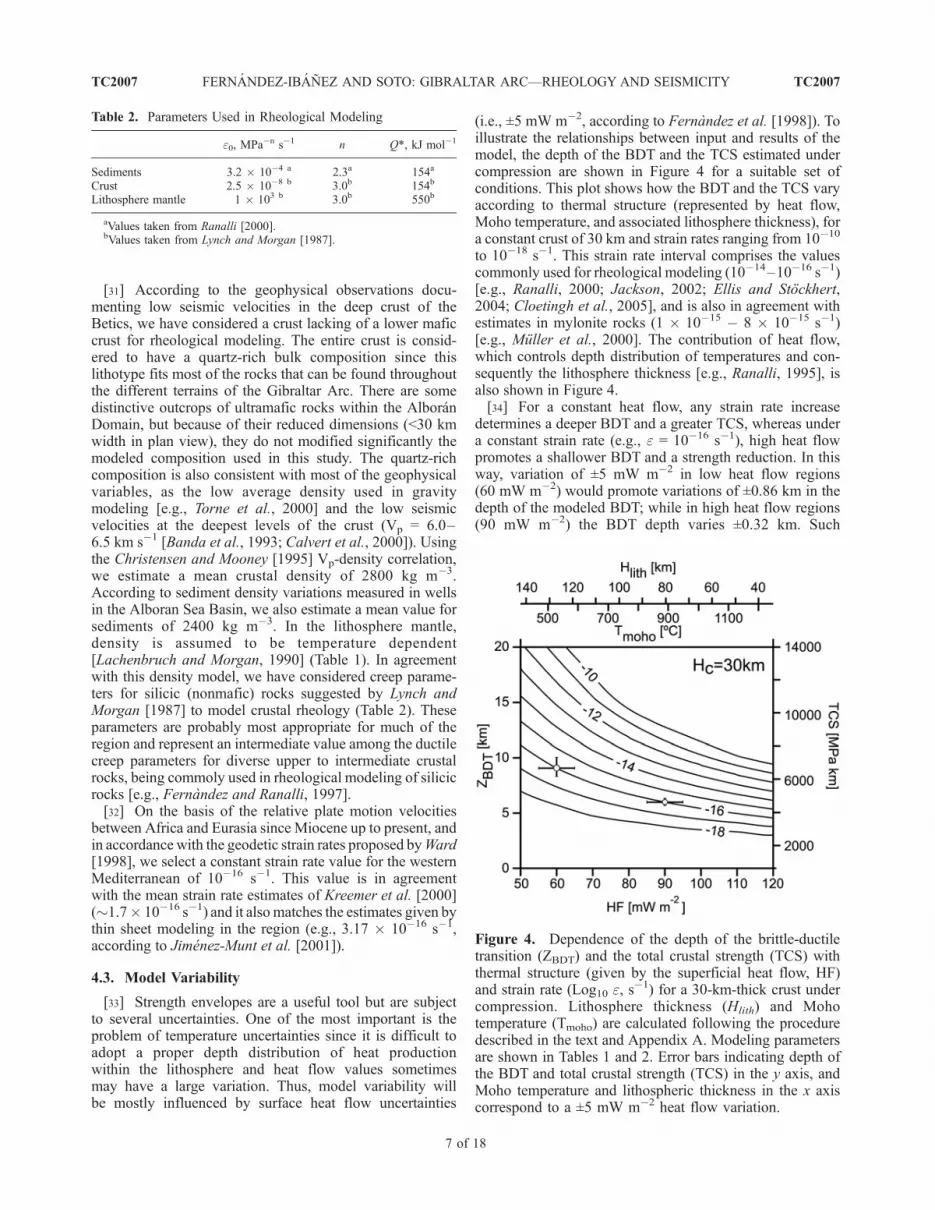
[33] Strength envelopes are a useful tool but are subjectto several uncertainties. One of the most important is theproblem of temperature uncertainties since it is difficult toadopt a proper depth distribution of heat productionwithin the lithosphere and heat flow values sometimesmay have a large variation. Thus, model variability willbe mostly influenced by surface heat flow uncertainties
(i.e., ±5 mW m�2, according to Fernandez et al. [1998]). Toillustrate the relationships between input and results of themodel, the depth of the BDT and the TCS estimated undercompression are shown in Figure 4 for a suitable set ofconditions. This plot shows how the BDT and the TCS varyaccording to thermal structure (represented by heat flow,Moho temperature, and associated lithosphere thickness), fora constant crust of 30 km and strain rates ranging from 10�10
to 10�18 s�1. This strain rate interval comprises the valuescommonly used for rheological modeling (10�14–10�16 s�1)[e.g., Ranalli, 2000; Jackson, 2002; Ellis and Stockhert,2004; Cloetingh et al., 2005], and is also in agreement withestimates in mylonite rocks (1 10�15 � 8 10�15 s�1)[e.g., Muller et al., 2000]. The contribution of heat flow,which controls depth distribution of temperatures and con-sequently the lithosphere thickness [e.g., Ranalli, 1995], isalso shown in Figure 4.[34] For a constant heat flow, any strain rate increase
determines a deeper BDT and a greater TCS, whereas undera constant strain rate (e.g., e = 10�16 s�1), high heat flowpromotes a shallower BDT and a strength reduction. In thisway, variation of ±5 mW m�2 in low heat flow regions(60 mW m�2) would promote variations of ±0.86 km in thedepth of the modeled BDT; while in high heat flow regions(90 mW m�2) the BDT depth varies ±0.32 km. Such
Table 2. Parameters Used in Rheological Modeling
e0, MPa�n s�1 n Q*, kJ mol�1
Sediments 3.2 10�4 a 2.3a 154a
Crust 2.5 10�8 b 3.0b 154b
Lithosphere mantle 1 103 b 3.0b 550b
aValues taken from Ranalli [2000].bValues taken from Lynch and Morgan [1987].
Figure 4. Dependence of the depth of the brittle-ductiletransition (ZBDT) and the total crustal strength (TCS) withthermal structure (given by the superficial heat flow, HF)and strain rate (Log10 e, s
�1) for a 30-km-thick crust undercompression. Lithosphere thickness (Hlith) and Mohotemperature (Tmoho) are calculated following the proceduredescribed in the text and Appendix A. Modeling parametersare shown in Tables 1 and 2. Error bars indicating depth ofthe BDT and total crustal strength (TCS) in the y axis, andMoho temperature and lithospheric thickness in the x axiscorrespond to a ±5 mW m�2 heat flow variation.
TC2007 FERNANDEZ-IBANEZ AND SOTO: GIBRALTAR ARC—RHEOLOGY AND SEISMICITY
7 of 18
TC2007

variations also affect the crustal yield strength (and conse-quently the lithosphere strength), resulting in uncertaintiesof ±575 MPa km in low heat flow regions and conversely,±217 MPa km in high heat flow areas. These effects wouldbe enlarged under higher strain rates.[35] We estimate that this model represents an upper
bound to the crustal rheology since the applied failurecriterion does not consider possible high-pressure failure[Shimada, 1993] nor the simultaneous operation of frictionalsliding and power law creep in the BDT [Handy et al., 1999].All the calculations have been performed in the absence ofany horizontal stresses like far-field stresses, which couldalso cause a reduction of the computed lithospheric strength[e.g., Cloetingh and Burov, 1996].
5. Modeling Results
[36] On the basis of the results of the rheological mod-eling, we will discuss thereafter the relationships withseismicity distribution within the crust, making specialemphasis on the Betics and the northern margin of theAlboran Sea. Our results provide constrains for the present-day tectonics of the area and will be further discussed.
5.1. Total Crustal Strength
[37] Modeling results are summarized in Figure 5, whichshows total yield strength of the crust (TCS) and depth ofthe BDT for both tensional and compressional tectonicregimes. According to the selected composition, this modelis thought to be representative of most of the Gibraltar Arccrust, although it locally includes rocks with distinctivecompositions, such as ultramafic rocks in western Beticsand Rif, or volcanic rocks within the Alboran Sea basement.[38] The maximum crustal yield strength occurs under
central to western Betics (1600 MPa km in tension and3600 MPa km in compression) and describes an open arccentered in the Strait of Gibraltar region (with maximumvalues of 2000 MPa km in tension and 4000 MPa km incompression) (Figure 5a and Figure 5b). The minimumcrustal strength occurs at the AB (<600 MPa km in tensionand <1000 MPa km in compression), where the crustbecomes thin (<10 km) and heat flow rises to 120 mWm�2. Maximum TCS gradient runs across the Betics and theRif (west of the Alhoceima region) with an orientationoblique to the crustal structure. TCS decreases there towardthe SE and E, respectively, following the heat flow pattern,with differences over 1400 MPa km along 40 km inhorizontal distance.[39] The BDT depth for both tensional and compressional
regimes is shown in Figure 5c and Figure 5d, respectively.The difference between both estimates is meaningless,being in average 1.6 ± 0.3 km. The depth of BDT exhibitsa pattern similar to the crustal strength, with a maximumdepth that describes a wide bulge under the western regionof the arc (11 km for tension and 9 km for compression).Minimum values are located in the EAB and its transitiontoward the AB (6 km to 5 km under tension and compres-sion, respectively). In the Rif, the BDT shows gradientshighly oblique to the crustal structure, resulting in a shal-
lower BDT to the East. In summary, BDT shows a signif-icant variation along the orogen trend, ranging undertension between 8 km (eastern Betics and Alhoceimaregion) to 11 km (western Betics and Rif), and between7 km to 9 km under compression.
5.2. Rheology and Crustal Seismicity
[40] Considering the tectonic complexities in the regiontogether with the coexistence of different focal mechanisms[e.g., Buforn et al., 1995, 2004; Stich et al., 2003] and thelittle differences between the BDT under tension andcompression regimens, we use thereafter the BDT as a bandlimited by these two end-member depths (thickness varia-tion of �1–2 km).[41] We have inspected depth distribution of seismicity
dividing the region regularly in sectors of 100 km2 (10 10 km). In each sector we have performed a statistical test tofit focal depth population to a frequency distribution law.We have found that only where the population exceeds20 samples a good fit can be done, resulting in a normal olognormal Gaussian frequency distribution. For that reasonwe have just considered sectors with more than 20 events toevaluate the rheological model, comparing therein the focaldepth distribution with the BDT depth. The relationshipsbetween earthquake distribution and crustal yield strengthare illustrated in Figure 6 for two representative cases. Forthis comparison we focus on the northern margin of theAlboran Sea and in the Betics, because the IAG seismolog-ical database is better constrain here.[42] Central to western Betics are characterized by low
heat flow values and high-strength domains (1200–1900 MPa km for tension, 2800–3800 MPa km for com-pression). The R1 strength profile is representative of theGranada Basin and has a BDT zone located in average at10 km and earthquakes focal depth distribution has a max-imum at 6.6 km depth, decreasing drastically below the BDTzone (Figure 6a). This example illustrates how most of thecrustal seismicity (>95%) in central Betics tends to concen-trate in the brittle crustal domain. Detailed tomographicstudies carried out in the R1 vicinities support this interpre-tation and show a low-velocity zone (�14–17 km [Serranoet al., 2002]), located in our model close to the top of theductile crust.[43] Eastward and along the northern margin of the
Alboran Sea, surface heat flow increases reaching interme-diate values (80–90 mW m�2) and the total crustal strengthdecreases to 1200–1600 MPa km (�800 MPa km fortension), as is illustrated in the strength profile R2 shownin Figure 6b. Crustal seismicity displays in this sector aunimodal depth distribution with a maximum at 6.3 km,close to the BDT zone (av. 6–7 km). This frequency peakperfectly matches the BDT zone, and the brittle crustcontains here 70% of the crustal seismicity.[44] In agreement with other studies [e.g., Lachenbruch
and Sass, 1992; Zoback and Lachenbruch, 1992; Scholz,2000], our results demonstrate that the seismogenic zoneextends below the BDT depth, with a maximum frequencyplaced within or immediately above the BDT. This obser-vation determines that >60% of crustal seismicity in the
TC2007 FERNANDEZ-IBANEZ AND SOTO: GIBRALTAR ARC—RHEOLOGY AND SEISMICITY
8 of 18
TC2007

Gibraltar Arc region is located within the brittle upper crust(<10–11 km). Below the BDT zone, seismicity rapidlydecreases with depth, vanishing at about 20 km depth.[45] Other authors suggest a correlation between the
seismogenic layer (Ts) and a certain temperature limit. Forexample, according to Chen and Molnar [1983] and Scholz[1990] it has been used the 350 ± 100�C isotherm as thelower limit of the seismogenic zone in continental crustregions. Although the validity of this type of correlationbetween crustal temperatures and seismicity is still debated,with the two examples of strength profiles shown in Figure6, it is confirmed that 95% of the earthquake focus distri-bution corresponds to the following crustal temperatures:350�C in central Betics (R1; �21 km depth) and 320�C in
the northern margin of the Alboran Sea (R2; �12 kmdepth). For the overall region, the 350�C isotherm wouldrepresent the lower boundary of a layer containing morethan 85% of earthquake population, while the 450�C geo-therm limits the 95% of crustal earthquakes. The thermalboundary of 450�C may consequently represent in our casea valid threshold to the thickness of the seismogenic layer inthe Gibraltar Arc.
6. Tectonic Implications
[46] With the rheological model we develop and compar-ing with the focal depth distribution of earthquakes, we
Figure 5. (a, b) Total crustal strength (TCS, MPa km) and (c, d) depth of the brittle-ductile transition(BDT, km) in the Gibraltar Arc under tension and compression. R1 and R2 locate the rheological profilesshown in Figure 6. AI, Alboran Island; AB, Algerian Basin; SAB, South Alboran Basin; and WAB, WestAlboran Basin. A-A0 section indicates the location of the profile shown in Figure 9.
TC2007 FERNANDEZ-IBANEZ AND SOTO: GIBRALTAR ARC—RHEOLOGY AND SEISMICITY
9 of 18
TC2007

interpret that the BDT zone acts as a major gently dippingdecoupling horizon in the crust (contains �16% of crustalseismicity). The depth of the BDT zone mimics the arcuateshape of the orogen and in central Betics and the Rif it turnsoblique to both orogen and crustal thickening trends.There are also numerous events located below the BDT,a common observation described in other continental [e.g.,Willingshofer and Cloetingh, 2003; Chen and Yang, 2004]and oceanic settings, where some earthquakes occur in theductile segment of the lithosphere [e.g., Wiens and Stein,1985].We have observed that earthquakes within the ductilecrust of the Gibraltar Arc occur in two different contexts:(1) isolated earthquakes that appear in the ductile, deep crust,and (2) earthquakes related to seismic swarms.[47] Isolated earthquakes located within the ductile do-
main of the deep crust (<5% of the crustal seismicity) may bealso related to domains with low fluid contents, thus repre-senting patches of high strength. The rocks in these domainsmay have failure under high-temperature/high-pressureconditions if crystal plasticity is unable to accommodatethe imposed strain [e.g., Lund et al., 2004].[48] The second type is commonly observed in central
Betics where earthquakes tend to group resulting in subvert-ical clusters with a decreasing number of events in depth.These seismic swarms extend from the upper crust to theductile deep crust crosscutting the BDT. In a preliminaryinspection of the seismic catalog, it suggests a downward
propagation of the aftershocks sequences. This observationagrees with modeling results on the slip and nucleationprocesses at the lower part of seismogenic faults [Shibazakiet al., 2004]. Fault displacements during an earthquake cancause a sudden increase in differential stresses and strain ratesclose to the lower termination of the fault, a transientdeflection of the BDT zone, and a zone of elevated strainrates down to the base of the crust [Ellis and Stockhert, 2004].Aftershocks can therefore nucleate in this case at depths rightbelow the BDT zone. Figure 4 demonstrates how if strain rateincreases up to 10�10 s�1 (for a 30 km thick crust and anaverage heat flow of 70–90 mW m�2), it would induce alocal transient deflection in the BDT depth of about 7–8 km.The existence of a domain under the BDT zone where theseismicity frequency displays an exponential decay maycorrespond to earthquakes generated owing to strain rateperturbations caused after major events.[49] In regard of the previous observation it is clear that
the BDT do not represent the base of the seismogenic layer,but a major discontinuity within the crust capable enough tolocalize strain and develop major detachment faults attypical depths of the brittle-ductile transition [e.g., Gueydanet al., 2004].
6.1. Active Tectonics and Rheology
[50] Medium- to high-strength domains tend to concen-trate most of the crustal seismicity in the region, namely
Figure 6. Examples of crustal yield strength profiles and focal depth distribution of seismic events in(a) central Betics (R1) and (b) the northern margin of the Alboran Sea (R2). The statistical distributionwith the best fit (Gaussian) is also shown. P95 shows 95% of seismicity. Geotherms used for thermalmodeling are represented with a dashed line. Depths of the 250�C, 350�C, and 450�C isotherms areindicated by the vertical arrows.
TC2007 FERNANDEZ-IBANEZ AND SOTO: GIBRALTAR ARC—RHEOLOGY AND SEISMICITY
10 of 18
TC2007

central and NE Betics and the southern margin of theAlboran Sea (in the Alhoceima region). Earthquakes fre-quency diminishes toward the East (in the EAB and AB),where strength has a noticeable reduction. This tendency ondiminishing seismicity eastward agrees with the regionalheat flow pattern. High heat flow areas coincide withdomains of scarce seismic activity as for example the centraland eastern Alboran Sea Basin. There must be therefore animportant partitioning within the crust to promote a hetero-geneous distribution of the seismicity along the Arc.[51] Active fault structures combined with geomorpho-
logical observations in the Betics point out a lengthy eventof tectonically controlled uplift since the Late Miocene[Sanz de Galdeano and Lopez-Garrido, 1999; Braga etal., 2003; Zazo et al., 2003, and references therein]. Wehave analyzed the seismogenic fault structures in the Beticsand the northern margin of the Alboran Sea (most of themcutting up the topographic surface and the seafloor) thatmay control the configuration and the most recent evolutionof the region. The topography along the central to easternBetics reveals the occurrence of WNW-ESE to NW-SE,narrow zones with high slopes (>15–16%; Figure 7a).These zones usually coincide with the western slope ofthe most prominent mountain ranges in the Betics. Fieldobservations confirm that they correspond to recent faultscarps, associated to high-angle normal faults dippingwestward [e.g., Garcıa-Duenas et al., 1992; Sanz deGaldeano and Lopez-Garrido, 1999; Galindo-Zaldıvar etal., 2003; Martınez-Dıaz and Hernandez-Enrile, 2004;Reicherter and Peters, 2005]. The geometry of these faultsin depth is still unknown, but the occurrence of rolloverstructures in their hanging walls and the geometry of theassociated half grabens, suggest that it may consist of listricfaults. Many of the seismic swarms in the brittle crustare located in front of these large topographic scarps(Figure 7b). They image probably the continuation in depthof active faults linked to the structures seen in surfacegeology. These normal faults converge probably with theBDT zone, describing a tilted-block geometry that producesa general WSW-ENE extension in the uppermost crust(Figure 8).[52] Large, E-W trending anticlines condition also the
orientation and internal structure of most of the mountainranges in central Betics and determined high uplift rates upto recent times (Late Miocene to Recent) [e.g., Martınez-Martınez et al., 2004]. The BDT may also represent adecoupling surface for these structures.[53] Other major fault structures seen in the eastern
Betics are high-angle (subvertical) strike-slip faults withNE-SW trend. These faults define a major strike-slip defor-mation zone (the Trans-Alboran Shear Zone, TASZ) thatcrosscut completely the Gibraltar Arc, from eastern Beticsto the Alhoceima region in the Rif and resulting in a majorbathymetric high in the Alboran Sea (the Alboran Ridgefault zone). Most of the fault segments are known to beactive since the Late Miocene [Silva et al., 1993; Montenatand Ott D’Estevou, 1995; Martınez-Dıaz et al., 2003;Booth-Rea et al., 2004; Masana et al., 2004; Gracia etal., 2006]. The nature and distribution of stresses through-
out the TASZ point out the presence of segments havingactive left-lateral faulting within a weak, transtensional faultzone with a complex geometry [Fernandez-Ibanez et al.,2007].[54] The seismicity distribution and the seismic swarms
described in the eastern Betics nevertheless, have in casesan oblique orientation to some of the fault segments of theTASZ depicted by surface geology (see Figure 7b), makingdifficult to characterize in detail now their continuation indepth. This aspect deserves a detailed future analysis of therelationships between fault structures and local seismicity,to discuss which of the fault segments forming this strike-slip system are seismically active.[55] The position of the TASZ in eastern Betics coincides
with an important variation of crustal strength (Figure 5).Lateral strength contrasts have been demonstrated thatinfluence the development of crustal strike-slip fault sys-tems [e.g., Roy and Royden, 2000]. Strong variations ofcrustal strength occurring throughout eastern Betics andtoward the Algerian Basin (see Figure 5), in combinationwith the NW-SE motion imposed by the Eurasia-Africaplate convergence, may promote therefore preferential strainlocalization and the development of subvertical shear zonesin this domain of the Gibraltar Arc.[56] To conclude, we suggest that the BDT zone in the
Betics and along the northern margin of the Alboran Seaconstitutes a gentle horizon where major seismogenic faultstend to merge; thus, explaining the shallow nature of thecrustal seismicity. The depth and geometry of the BDT zoneis also in agreement with seismic refraction studies incentral Betics [Banda et al., 1993], revealing a majorsubhorizontal discontinuity around 10 km. According toour results, this discontinuity constitutes a zone of intensedeformation that may represent a natural channel for fluidmigration [e.g., Brogi et al., 2003; Hobbs et al., 2004].[57] Our interpretation of the BDT in the region is consis-
tent with the numerical modeling made by Regenauer-Lieb etal. [2006], which demonstrate that midcrustal detachmentsarise spontaneously from thermomechanical feedback effectsbetween an elasto-viscoplastic and brittle layers, thus gener-ating a major decoupling level within the crust.
6.2. Strength, Stress, and Topography
[58] This rheological model could also help to interpretgeneral features of the Gibraltar Arc, as for example theobservation that high topographic elevations occur fareastward (in eastern Betics) with respect to the front ofthe orogen, transecting the boundary between the Internaland External zones. We can support the existence of a weak,deep crust that flows from the high-elevation areas, sup-ported by a thickened crust, in central Betics, to the low-elevation areas with a thinner and stretched crust in theoffshore area (the Alboran Sea). Necking of the ductile crustand high temperatures in deeper crustal levels promotecrustal flow, resulting in high topographic elevations [e.g.,Clark and Royden, 2000; McKenzie et al., 2000]. A weak,ductile rheology in the lower crust is also in agreement withthe cut-off in seismicity observed at midcrustal depths in thenorthern margin of the Alboran Sea and the Betics.
TC2007 FERNANDEZ-IBANEZ AND SOTO: GIBRALTAR ARC—RHEOLOGY AND SEISMICITY
11 of 18
TC2007

[59] This process could extend up to the Iberian Massifwhere the Hercynian deep crust mainly consists of a maficlower crust [e.g., Banda et al., 1993], thus representing arigid (high strength domain) backstop for crustal flow. Thelack of a lower crust under the Gibraltar Arc would
therefore promote development of a crustal flow-inducedbulge and topographic uplift. This phenomenon will cer-tainly promote changes in the gravitational potential energy(GPE), thus inducing a modification of the stress field.
Figure 7. (a) Slope analysis of the topography-bathymetry of the Betics and the northern margin of theAlboran Sea with a 5-km low-pass filter. (b) Distribution of seismicity within the brittle upper crust.Major structures, classified according to its relative timing are also included in the map. Barbs are ondownthrown sides of faults. Strike-slip faults also have a normal component. Large dots locate strengthprofiles shown in Figure 6. AlbD, Alboran Domain; EAB, East Alboran Basin; MG, Malaga graben; NB,Neogene basins in Betics; AB, Algerian Basin; and WAB, West Alboran Basin. A-A0 section locatescrustal profile shown in Figure 9.
TC2007 FERNANDEZ-IBANEZ AND SOTO: GIBRALTAR ARC—RHEOLOGY AND SEISMICITY
12 of 18
TC2007

Figure
8
TC2007 FERNANDEZ-IBANEZ AND SOTO: GIBRALTAR ARC—RHEOLOGY AND SEISMICITY
13 of 18
TC2007
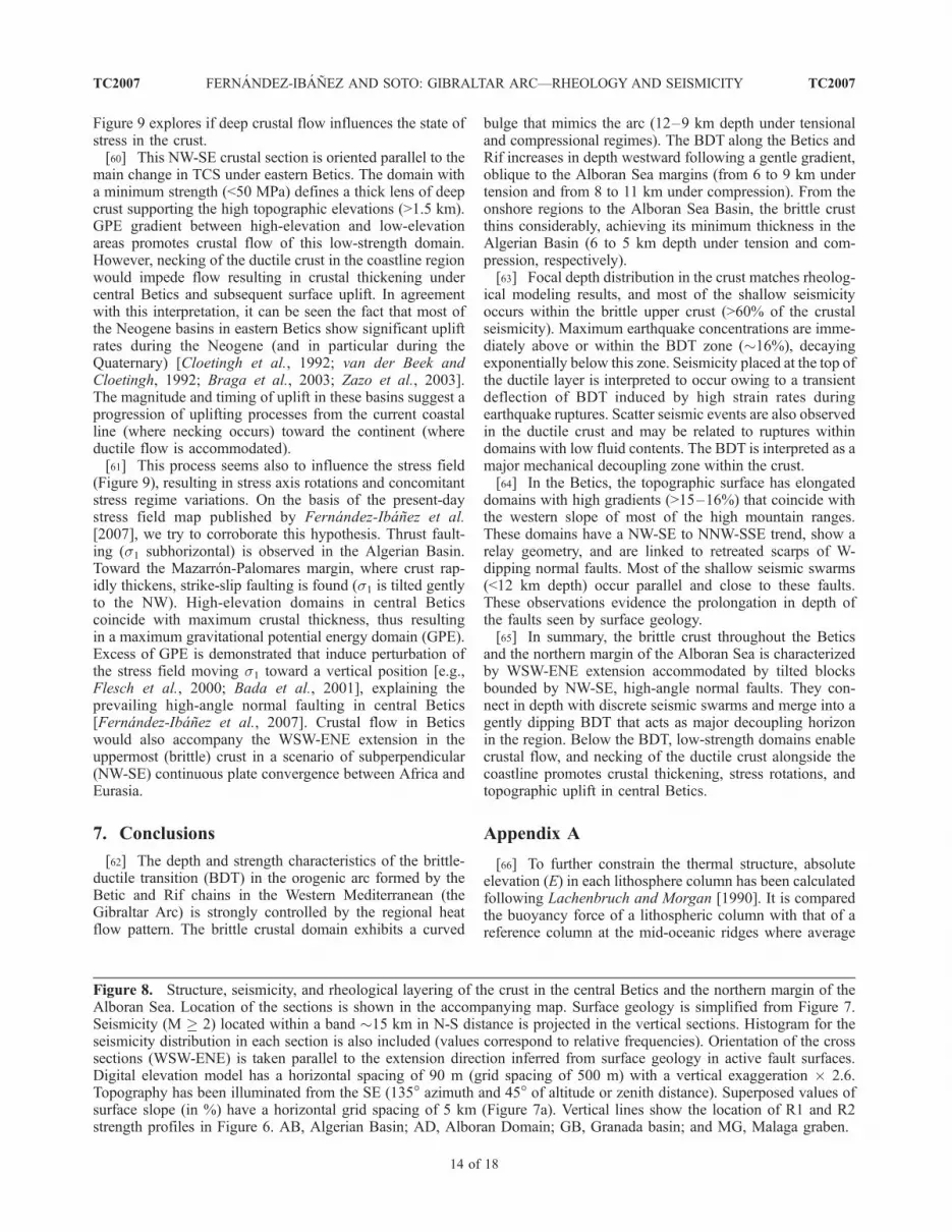
Figure 9 explores if deep crustal flow influences the state ofstress in the crust.[60] This NW-SE crustal section is oriented parallel to the
main change in TCS under eastern Betics. The domain witha minimum strength (<50 MPa) defines a thick lens of deepcrust supporting the high topographic elevations (>1.5 km).GPE gradient between high-elevation and low-elevationareas promotes crustal flow of this low-strength domain.However, necking of the ductile crust in the coastline regionwould impede flow resulting in crustal thickening undercentral Betics and subsequent surface uplift. In agreementwith this interpretation, it can be seen the fact that most ofthe Neogene basins in eastern Betics show significant upliftrates during the Neogene (and in particular during theQuaternary) [Cloetingh et al., 1992; van der Beek andCloetingh, 1992; Braga et al., 2003; Zazo et al., 2003].The magnitude and timing of uplift in these basins suggest aprogression of uplifting processes from the current coastalline (where necking occurs) toward the continent (whereductile flow is accommodated).[61] This process seems also to influence the stress field
(Figure 9), resulting in stress axis rotations and concomitantstress regime variations. On the basis of the present-daystress field map published by Fernandez-Ibanez et al.[2007], we try to corroborate this hypothesis. Thrust fault-ing (s1 subhorizontal) is observed in the Algerian Basin.Toward the Mazarron-Palomares margin, where crust rap-idly thickens, strike-slip faulting is found (s1 is tilted gentlyto the NW). High-elevation domains in central Beticscoincide with maximum crustal thickness, thus resultingin a maximum gravitational potential energy domain (GPE).Excess of GPE is demonstrated that induce perturbation ofthe stress field moving s1 toward a vertical position [e.g.,Flesch et al., 2000; Bada et al., 2001], explaining theprevailing high-angle normal faulting in central Betics[Fernandez-Ibanez et al., 2007]. Crustal flow in Beticswould also accompany the WSW-ENE extension in theuppermost (brittle) crust in a scenario of subperpendicular(NW-SE) continuous plate convergence between Africa andEurasia.
7. Conclusions
[62] The depth and strength characteristics of the brittle-ductile transition (BDT) in the orogenic arc formed by theBetic and Rif chains in the Western Mediterranean (theGibraltar Arc) is strongly controlled by the regional heatflow pattern. The brittle crustal domain exhibits a curved
bulge that mimics the arc (12–9 km depth under tensionaland compressional regimes). The BDT along the Betics andRif increases in depth westward following a gentle gradient,oblique to the Alboran Sea margins (from 6 to 9 km undertension and from 8 to 11 km under compression). From theonshore regions to the Alboran Sea Basin, the brittle crustthins considerably, achieving its minimum thickness in theAlgerian Basin (6 to 5 km depth under tension and com-pression, respectively).[63] Focal depth distribution in the crust matches rheolog-
ical modeling results, and most of the shallow seismicityoccurs within the brittle upper crust (>60% of the crustalseismicity). Maximum earthquake concentrations are imme-diately above or within the BDT zone (�16%), decayingexponentially below this zone. Seismicity placed at the top ofthe ductile layer is interpreted to occur owing to a transientdeflection of BDT induced by high strain rates duringearthquake ruptures. Scatter seismic events are also observedin the ductile crust and may be related to ruptures withindomains with low fluid contents. The BDT is interpreted as amajor mechanical decoupling zone within the crust.[64] In the Betics, the topographic surface has elongated
domains with high gradients (>15–16%) that coincide withthe western slope of most of the high mountain ranges.These domains have a NW-SE to NNW-SSE trend, show arelay geometry, and are linked to retreated scarps of W-dipping normal faults. Most of the shallow seismic swarms(<12 km depth) occur parallel and close to these faults.These observations evidence the prolongation in depth ofthe faults seen by surface geology.[65] In summary, the brittle crust throughout the Betics
and the northern margin of the Alboran Sea is characterizedby WSW-ENE extension accommodated by tilted blocksbounded by NW-SE, high-angle normal faults. They con-nect in depth with discrete seismic swarms and merge into agently dipping BDT that acts as major decoupling horizonin the region. Below the BDT, low-strength domains enablecrustal flow, and necking of the ductile crust alongside thecoastline promotes crustal thickening, stress rotations, andtopographic uplift in central Betics.
Appendix A
[66] To further constrain the thermal structure, absoluteelevation (E) in each lithosphere column has been calculatedfollowing Lachenbruch and Morgan [1990]. It is comparedthe buoyancy force of a lithospheric column with that of areference column at the mid-oceanic ridges where average
Figure 8. Structure, seismicity, and rheological layering of the crust in the central Betics and the northern margin of theAlboran Sea. Location of the sections is shown in the accompanying map. Surface geology is simplified from Figure 7.Seismicity (M 2) located within a band �15 km in N-S distance is projected in the vertical sections. Histogram for theseismicity distribution in each section is also included (values correspond to relative frequencies). Orientation of the crosssections (WSW-ENE) is taken parallel to the extension direction inferred from surface geology in active fault surfaces.Digital elevation model has a horizontal spacing of 90 m (grid spacing of 500 m) with a vertical exaggeration 2.6.Topography has been illuminated from the SE (135� azimuth and 45� of altitude or zenith distance). Superposed values ofsurface slope (in %) have a horizontal grid spacing of 5 km (Figure 7a). Vertical lines show the location of R1 and R2strength profiles in Figure 6. AB, Algerian Basin; AD, Alboran Domain; GB, Granada basin; and MG, Malaga graben.
TC2007 FERNANDEZ-IBANEZ AND SOTO: GIBRALTAR ARC—RHEOLOGY AND SEISMICITY
14 of 18
TC2007

elevation and lithospheric structure are well known. Theelevation is calculated as
E ¼ ra � rLra
L� H0 for E > 0
E ¼ rara � rw
ra � rLra
L� H0
� �for E < 0;
where rL is the lithospheric density (kg m�3), rw waterdensity (1050 kg m�3), ra asthenospheric density (taken as3200 kg m�3), and H0 a calibration constant (�2400 m).The calculation of absolute topography requires implicitlythat the asthenospheric density is the same as underneathmid-ocean ridges. Lithosphere thickness (L) is taken as thedepth where T = 1350�C.
Figure 9. NW-SE rheological cross section showing depth distribution of strength (in compression)across eastern Betics. Red areas correspond to low-strength domains (<10 MPa) which are enabled toflow. Crustal flow would occur from the high GPE regions (central Betics) to low GPE regions (AlgerianBasin). Necking of the ductile crust nearby the coastline controls crustal flow, promoting crustalthickening and subsequent surface uplift. Topography is outlined on the upper part of the sketch.Maximum elevations correspond with thickest crustal regions. Stress field is also influenced by crustalflow, s1 rotates from a subhorizontal position in stretched regions to subvertical position in thickenedcrustal areas. Focal mechanisms and s1 trajectories are taken from Fernandez-Ibanez et al. [2007].
TC2007 FERNANDEZ-IBANEZ AND SOTO: GIBRALTAR ARC—RHEOLOGY AND SEISMICITY
15 of 18
TC2007

[67] Acknowledgments. This work is supported the CSD2006-00041project and by the Spanish program of Formacion del Profesorado Uni-versitario (Ministerio de Educacion y Ciencia). We thank also J. Morales forproving access to the IAG seismicity database, and M. Fernandez and M.D.
Zoback for helpful comments on modeling procedures. The manuscriptbenefited from the constructive comments of S. Cloetingh and an anony-mous reviewer who are gratefully acknowledged.
TC2007 FERNANDEZ-IBANEZ AND SOTO: GIBRALTAR ARC—RHEOLOGY AND SEISMICITY
16 of 18
TC2007
ReferencesAfonso, J. C., and G. Ranalli (2004), Crustal and man-
tle strengths in continental lithosphere: is the jellysandwich model obsolete?, Tectonophysics, 394,221–232, doi:10.1016/j.tecto.2004.08.006.
Bada, G., F. Horvath, S. Cloetingh, D. D. Coblentz, andT. Toth (2001), Role of topographic-induced grav-itational stresses in basin inversion: The case studyof the Pannonian basin, Tectonics, 20, 343 –363,doi:10.1029/2001TC900001.
Banda, E., J. Gallart, V. Garcıa-Duenas, J. J. Danobei-tia, and J. Makris (1993), Lateral variation of thecrust in the Iberian peninsula: new evidence fromthe Betic Cordillera, Tectonophysics, 221, 53 –66,doi:10.1016/0040-1951(93)90027-H.
Behn, M. D., J. Lin, and M. T. Zuber (2002), A con-tinuum mechanics model for normal faulting usinga strain-rate softening rheology: Implications forthermal and rheological controls on continentaland oceanic rifting, Earth Planet. Sci. Lett., 202,725–740, doi:10.1016/S0012-821X(02)00792-6.
Bezzeghoud, M., and E. Buforn (1999), Source para-meters of the 1992 Melilla (Spain, Mw = 4.8), 1994Alhoceima (Morocco, Mw = 5.8) and 1994 (Algeria,Mw = 5.7) Earthquakes and Seismotectonic Implica-tions, Bull. Seismol. Soc. Am., 70, 149 –170.
Booth-Rea, G., J. M. Azanon, A. Azor, and V. Garcıa-Duenas (2004), Influence of strike-slip fault seg-mentation on drainage evolution and topography.A case study: the Palomares fault zone (southeast-ern Betics, Spain), J. Struct. Geol., 26, 1615–1632,doi:10.1016/j.jsg.2004.01.007.
Bourgois, J. A., A. Mauffret, N. A. Ammar, and N. A.Demnati (1992), Multichannel seismic data imagingof inversion tectonics of the Alboran Ridge (wes-tern Mediterranean Sea), Geo Mar. Lett., 12, 117–122, doi:10.1007/BF02084921.
Brace, W. F., and D. L. Kohlstedt (1980), Limits onlithospheric stress impossed by laboratory experi-ments, J. Geophys. Res. , 85 , 6248 – 6252,doi:10.1029/JB085iB11p06248.
Braga, J. C., J. M. Martın, and C. Quesada (2003),Patterns and average rates of late Neogene–Recentuplift of the Betic Cordillera, SE Spain, Geomor-pho logy, 50 , 3 – 26 , do i :10 .1016 /S0169-555X(02)00205-2.
Brogi, A., A. Lazzarottoa, D. Liottab, and G. Ranalli(2003), Extensional shear zones as imaged by re-flection seismic lines: the Larderello geothermalfield (central Italy), Tectonophysics, 363, 127 –139, doi:10.1016/S0040-1951(02)00668-6.
Buforn, E., A.Udıas, and R.Madariaga (1991), Intermedi-ate and deep earthquakes in Spain, Pure Appl. Geo-phys., 136, 375–393, doi:10.1007/BF00878576.
Buforn, E., C. Sanz de Galdeano, and A. Udıas (1995),Sismotectonics of the Ibero-Maghrebian region,Tectonophysics, 248, 247–261, doi:10.1016/0040-1951(94)00276-F.
Buforn, E., M. Bezzeghoud, A. Udıas, and C. Pro (2004),Seismic sources on the Iberia-African plate boundaryand their tectonic implications, Pure Appl. Geophys.,161, 623–646, doi:10.1007/s00024-003-2466-1.
Buforn, E., B.Benito, C. Sanz deGaldeano, C. del Fresno,D. Munoz, and I. Rodrıguez (2005), Study of thedamaging earthquakes of 1911, 1999, and 2002 inthe Murcia, southeastern Spain, region: Seismotec-tonic and seismic-risk implications, Bull. Seismol.Soc. Am., 95, 549–567, doi:10.1785/0120040041.
Byerlee, J. D. (1978), Friction of rocks, Pure Appl. Geo-phys., 116, 615 –626, doi:10.1007/BF00876528.
Calvert, A., E. Sandvol, D. Seber, M. Barazangi,S. Roecker, T. Mourabit, F. Vidal, G. Alguacil, andN. Jabour (2000), Geodynamic evolution of the
lithosphere and upper-mantle beneath the AlboranRegion of the western Mediterranean: Constraintsfrom travel-time tomography, J. Geophys. Res.,105, 10,871–10,898, doi:10.1029/2000JB900024.
Chapman, D. S., and K. P. Furlong (1992), Thermalstate of the lower continental crust, in ContinentalLower Crust, edited by D. M. Fountain, R. Arculus,and R. W. Kay, pp. 179–199, Elsevier, Amsterdam.
Chen, W. P., and P. Molnar (1983), Focal depth ofintracontinental and intraplate earthquakes and theirimplications for the thermal and mechanical proper-ties of the lithosphere, J. Geophys. Res., 88, 4183–4214, doi:10.1029/JB088iB05p04183.
Chen, W. P., and Z. H. Yang (2004), Earthquakes be-neath the Himalayas and Tibet: Evidence for stronglithospheric mantle, Science, 304, 1949 – 1952,doi:10.1126/science.1097324.
Christensen, N. I., and W. D. Mooney (1995), Seismicvelocity structure and composition of the continen-tal crust: A global view, J. Geophys. Res., 100,9761–9788, doi:10.1029/95JB00259.
Clark, M. K., and L. H. Royden (2000), Topographicooze: Building the eastern margin of Tibet by lowercrustal flow, Geology, 28, 703–706, doi:10.1130/0091-7613(2000)28<703:TOBTEM>2.0.CO;2.
Cloetingh, S., and E. Burov (1996), Thermomechanicalstructure of European continental lithosphere: con-straints from rheological profiles and EET esti-mates , Geophys . J . In t . , 124 , 695 – 723,doi:10.1111/j.1365-246X.1996.tb05633.x.
Cloetingh, S., P. A. van der Beek, D. van Rees, T. B.Roep, C. Biermann, and R. A. Stephenson (1992),Flexural interaction and the dynamics of Neogeneextensional basin formation in the Alboran-Beticregion, Geo Mar. Lett., 12, 66 – 75, doi:10.1007/BF02084914.
Cloetingh, S., E. Burov, L. Matenco, G. Toussaint,G. Bertotti, P. A. M. Andriessen, M. J. R. Wortel,and W. Spakman (2004), Thermo-mechanical con-trols on the mode of continental collision in the SECarpathians (Romania), Earth Planet. Sci. Lett.,218, 57 –76, doi:10.1016/S0012-821X(03)00645-9.
Cloetingh, S., P. A. Ziegler, F. Beekman, P. A. M.Andriessen, L. Matenco, G. Bada, D. Garcia-Castellanos, N. Hardebol, P. Dezes, and D. Sokoutis(2005), Lithospheric memory, state of stress andrheology: neotectonic controls on Europe’s intra-plate continental topography, Quat. Sci. Rev., 24,241–304, doi:10.1016/j.quascirev.2004.06.015.
Comas, M. C., V. Garcıa-Duenas, and M. J. Jurado(1992), Neogene tectonic evolution of The AlboranSea from MCS data, Geo Mar. Lett., 12, 157–164,doi:10.1007/BF02084927.
Comas, M. C., J. J. Danobeitia, J. Alvarez-Marron, andJ. I. Soto (1995), Crustal reflections and structure inthe Alboran Basin: Preliminary of the ESCI-AlboranSurvey, Rev. Soc. Geol. Espana, 8, 529–542.
Comas, M. C., J. P. Platt, J. I. Soto, and A. B. Watts(1999), The origin and tectonic history of the Al-boran Basin: Insights from Leg 161 r, Proc. OceanDrill. Program Sci. Results, 161, 555–579.
DeMets, C., R. G. Gordon, D. F. Argus, and S. Stein(1994), Effect of recent revisions to the geomag-netic reversal time scale on estimate of current platemotions, Geophys. Res. Lett., 21, 2191 – 2194,doi:10.1029/94GL02118.
Deverchere, J., et al. (2005), Active thrust faulting off-shore Boumerdes, Algeria, and its relations to the2003 Mw 6.9 earthquake, Geophys. Res. Lett., 32,L04311, doi:10.1029/2004GL021646.
Duggen, S., K. Hoernle, P. van den Bogaard, andC. Harris (2004), Magmatic evolution of the Alboran
region: The role of subduction in forming the wes-tern Mediterranean and causing the MessinianSalinity Crisis, Earth Planet. Sci. Lett., 218, 91–108, doi:10.1016/S0012-821X(03)00632-0.
Ellis, S., and B. Stockhert (2004), Elevated stresses andcreep rates beneath the brittle-ductile transitioncaused by seismic faulting in the upper crust,J. Geophys. Res., 109, B05407, doi:10.1029/2003JB002744.
Fadil, A., P. Vernant, S. McClusky, R. Reilinger,F. Gomez, D. Ben Sari, T. Mourabit, K. Feigl, andM. Barazangi (2006), Active tectonics of the wes-tern Mediterranean: Geodetic evidence for rollbackof a delaminated subcontinental lithosphere salb be-neath the Rif Mountains, Morocco, Geology, 34,529 –532, doi:10.1130/G22291.1.
Fernandez, M., and G. Ranalli (1997), The role ofrheology in extensional basin formation modelling,Tectonophysics, 282, 129 – 145, doi:10.1016/S0040-1951(97)00216-3.
Fernandez, M., I. Marzan, A. Correia, and E. Ramalho(1998), Heat flow, heat production, and lithosphericthermal regime in the Iberian Peninsula, Tectono-physics , 291 , 29 – 53, doi:10.1016/S0040-1951(98)00029-8.
Fernandez-Ibanez, F., J. I. Soto, M. D. Zoback, andJ. Morales (2007), Present-day stress field in theGibraltar Arc, J. Geophys. Res., 112, B08404,doi:10.1029/2006JB004683.
Flesch, L. M., W. E. Holt, A. J. Haines, and T. B. Shen(2000), Dynamics of the Pacific�North Americanplate boundary in the western United States, Science,287, 834–836, doi:10.1126/science.287.5454.834.
Galindo-Zaldıvar, J., F. Gonzalez Lodeiro, andA. Jabaloy (1993), Stress and paleostress in theBetic-Rif cordilleras (Miocene to the present),Tectonophysics, 227, 105 – 126, doi:10.1016/0040-1951(93)90090-7.
Galindo-Zaldıvar, J., A. J. Gil, M. J. Borque, F. GonzalezLodeiro, A. Jabaloy, C. Marın Lechado, P. Ruano,and C. Sanz de Galdeano (2003), Active faulting inthe internal zones of the central Betic Cordilleras(SE, Spain), J. Geod., 36, 239 –250, doi:10.1016/S0264-3707(03)00049-8.
Garcıa-Castellanos, D., M. Fernandez, and M. Torne(2002), Modelling the evolution of the Guadalquivirforeland basin (southern Spain), Tectonics, 21(3),1018, doi:10.1029/2001TC001339.
Garcıa-Duenas, V., J. C. Balanya, and J. M. Martınez-Martınez (1992), Miocene extensional detach-ments in the outcropping basement of the NorthernAlboran Basin (Betics) and their tectonic implica-tions, Geo Mar. Lett., 12, 88– 95, doi:10.1007/BF02084917.
Goetze, C., and B. Evans (1979), Stress and tempera-ture in the bending lithosphere as constrained byexperimental rock mechanics,Geophys. J. R. Astron.Soc., 59, 463 –478.
Gracia, E., et al. (2006), Active faulting offshore SESpain (Alboran Sea): Implications for earthquakehazard assessment in the Southern Iberian Margin,Earth Planet . Sc i . Le t t . , 241 , 734 – 749,doi:10.1016/j.epsl.2005.11.009.
Grimison, N. L., and W.-P. Chen (1986), The Azores-Gibraltar plate boundary: focal mechanisms, depthof earthquakes, and their tectonic implications,J. Geophys. Res., 91, 2029 – 2047, doi:10.1029/JB091iB02p02029.
Gueydan, F., Y. M. Leroy, and L. Jolivet (2004), Me-chanics of low-angle extensional shear zones at thebrittle-ductile transition, J. Geophys. Res., 109,B12407, doi:10.1029/2003JB002806.

TC2007 FERNANDEZ-IBANEZ AND SOTO: GIBRALTAR ARC—RHEOLOGY AND SEISMICITY
17 of 18
TC2007
Gutscher, M. A., J. Malod, J. P. Rehault, I. Contrucci,F. Klingelhoefer, V. L. Mendes, and W. Spakman(2002), Evidence for active subduction beneathGibraltar, Geology, 30, 1071–1074, doi:10.1130/0091-7613(2002)030<1071:EFASBG>2.0.CO;2.
Handy, M. R., and J. P. Brun (2004), Seismicity, struc-ture and strength of the continental lithosphere,Earth Planet . Sc i . Let t . , 223 , 427 – 441,doi:10.1016/j.epsl.2004.04.021.
Handy, M. R., S. B. Wissing, and L. E. Streit (1999),Frictional-viscous flow in mylonite with varied bi-mineralic composition and its effect on lithospherics t renght , Tectonophysics , 303 , 175 – 191,doi:10.1016/S0040-1951(98)00251-0.
Hobbs, B. E., A. Ord, K. Regenauer-Lieb, andB. Drummond (2004), Fluid reservoirs in the crustand mechanical coupling between the upper andlower crust, Earth Planets Space, 56, 1151–1161.
Husson, L. (2006), Dynamic topography above retreat-ing subduction zones, Geology, 34, 741 – 744,doi:10.1130/G22436.1.
Jackson, J. (2002), Strength of the continental litho-sphere: time to abandon the jelly sandwich?, GSAToday, 12 , 4 – 9 , do i :10 .1130 /1052-5173(2002)012<0004:SOTCLT>2.0.CO;2.
Jimenez-Munt, I., M. Fernandez, M. Torne, and P. Bird(2001), The transition from linear to diffuse plateboundary en the Azores-Gibraltar region: resultsfrom thin-sheet model, Earth Planet. Sci. Lett.,1 9 2 , 1 7 5 – 1 8 9 , d o i : 1 0 . 1 0 1 6 / S 0 0 1 2 -821X(01)00442-3.
Jolivet, L., and C. Faccenna (2000), Mediterranean ex-tension and the Africa-Eurasia collision, Tectonics,19, 1095–1106, doi:10.1029/2000TC900018.
Kohlstedt, D. L., B. Evans, and S. J. Mackwell (1995),Strength of the lithosphere: Constraints imposed bylaboratory experiments, J. Geophys. Res., 100,17,587–17,602, doi:10.1029/95JB01460.
Kreemer, C., J. Haines, W. E. Holt, G. Blewitt, andD. Lavallee (2000), On the determination of aglobal strain rate model, Earth Planets Space,52, 765–770.
Lachenbruch, A. H., and P. Morgan (1990), Continentalextension, magmatism and elevation; formal rela-tions and rules of thumb, Tectonophysics, 174,39– 62, doi:10.1016/0040-1951(90)90383-J.
Lachenbruch, A. H., and J. H. Sass (1992), Heat flowfrom Cajon Pass, fault strength, and tectonic impli-cations, J. Geophys. Res., 97, 4995 – 5015,doi:10.1029/91JB01506.
Lomnitz, C. (1980), On the over parameterization ofearthquake location algorithms, Bull. Seismol. Soc.Am., 70, 2159–2170.
Lonergan, L., and N. White (1997), Origin of the Betic-Rif mountain belt, Tectonics, 16, 504 – 522,doi:10.1029/96TC03937.
Lowry, A. R., and R. B. Smith (1995), Strength andrheology of the western U.S. Cordillera, J. Geo-phys. Res., 100, 17,947 – 17,963, doi:10.1029/95JB00747.
Lund, M. G., H. Austrheim, and M. Erambert (2004),Earthquakes in the deep continental crust - insightsfrom studies on exhumed high-pressure rocks, Geo-phys. J. Int., 158, 569 – 576, doi:10.1111/j.1365-246X.2004.02368.x.
Lynch, H. D., and P. Morgan (1987), The tensilestrength of the lithosphere and the localisation ofextension, in Continental Extensional Tectonics,edited by M. P. Coward, J. F. Dewey, and P. L.Hancock, Spec. Publ. Geol. Soc., 28, 53– 65.
Maggi, A., J. A. Jackson, D. McKenzie, and K. Priestley(2000), Earthquake focal depths, effective elasticthickness, and the strength of the continentallithosphere, Geology, 28, 495–498, doi:10.1130/0091-7613(2000)28<495:EFDEET>2.0.CO;2.
Mareschal, J. C., and C. Jaupart (2004), Variations ofsurface heat flow and lithospheric thermal structurebeneath the North American craton, Earth Planet.
S c i . L e t t . , 2 2 3 , 6 5 – 7 7 , d o i : 1 0 . 1 0 1 6 /j.epsl.2004.04.002.
Martınez-Dıaz, J. J., and J. L. Hernandez-Enrile (2004),Neotectonics and morphotectonics of the southern
Almerıa region (Betic Cordillera-Spain): Kine-matics implications, Int. J. Earth Sci., 93, 189 –206, doi:10.1007/s00531-003-0379-y.
Martınez-Dıaz, J. J., E. Masana, J. L. Hernandez-Enrile,and P. Santanach (2003), Effects of repeated pa-leoearthquakes on the Alhama de Murcia Fault (Be-tic Cordillera, Spain) on the Quaternary evolutionof an alluvial fan system, Ann. Geophys., 46, 775–791.
Martınez-Martınez, J. M., J. I. Soto, and J. C. Balanya(2002), Orthogonal folding of extensional detache-ments: Structure and origin of the Sierra Nevadaelongated dome (Betics, SE Spain), Tectonics,21(3), 1012, doi:10.1029/2001TC001283.
Martınez-Martınez, J. M., J. I. Soto, and J. C. Balanya(2004), Elongated domes in extended orogens: Amode of mountain uplift in the Betics (SE Spain),in Gneiss Domes in Orogeny, edited by D. L. Whit-ney, C. Teyssier, and C. S. Siddoway, Spec. Pap.Geol. Soc. Am., 380, 243–266.
Masana, E., J. J. Martınez-Dıaz, P. Hernandez-Enrile,and P. Santanach (2004), The Alhama de Murciafault (SE Spain), a seismogenic fault in a diffuseplate boundary: Seismotectonic implications for theIbero-Magrebian region, J. Geophys. Res., 109,B01301, doi:10.1029/2002JB002359.
Mauffret, A., D. Frizon-de-Lamotte, S. Lallemant,C. Gorini, and A. Maillard (2004), E–W openingof the Algerian Basin (Western Mediterranean),Terra Nova, 16, 257–264, doi:10.1111/j.1365-3121.2004.00559.x.
McKenzie, D., F. Nimmo, J. A. Jackson, P. B. Gans,and E. L. Miller (2000), Characteristics and conse-quences of flow in the lower crust, J. Geophys.Res . , 105 , 11 ,029 – 11,046 , do i :10 .1029/1999JB900446.
Meghraoui, M., S. Maouche, B. Chemaa, Z. Cakir,A. Aoudia, A. Harbi, P.-J. Alasset, A. Ayadi,Y. Bouhadad, and F. Benhamouda (2004), Coastaluplift and thrust faulting associated with the M w =6.8 Zemmouri (Algeria) earthquake of 21 May,2003, Geophys . Res . Le t t . , 31 , L19605 ,doi:10.1029/2004GL020466.
Meissner, R., and J. Strehlau (1982), Limits of stressesin continental crusts and their relation to the depth-frequency distribution of shallow earthquakes, Tec-tonics, 1, 73–89, doi:10.1029/TC001i001p00073.
Mezcua, J., and J. M. Martınez Solares (1983), Sismi-cidad del Area Ibero-Mogrebı, 203, 303InstitutoGeografico Nacional, Madrid.
Molnar, P., and G. A. Houseman (2004), The effects ofbuoyant crust on the gravitational instability ofthickened mantle lithosphere at zones of intraconti-nental convergence, Geophys. J. Int., 158, 1134 –1150, doi:10.1111/j.1365-246X.2004.02312.x.
Montenat, C., and P. Ott D’Estevou (1995), Late Neo-gene basins evolving in the Eastern Betic transcur-rent fault zone: An illustrated review, in TertiaryBasins of Spain, edited by P. F. Friend and C. J.Dabrıo, pp. 372 – 386, Cambridge Univ. Press,Cambridge, U. K.
Muller, W., D. Aerden, and A. N. Halliday (2000),Isotopic dating of strain fringe increments: Durationand rates of deformation in shear zones, Science, 288,2 1 9 5 – 2198 , do i : 1 0 . 11 26 / s c i e n c e . 2 8 8 .5474.2195.
Pasquale, V., M. Verdoya, P. Chiozzi, and G. Ranalli(1997), Rheology and seismotectonic regime in thenorthern central Mediterranean, Tectonophysics,2 7 0 , 2 3 9 – 2 5 7 , d o i : 1 0 . 1 0 1 6 / S 0 0 4 0 -1951(96)00211-9.
Platt, J. P., and R. L. M. Vissers (1989), Extensionalcollapse of thickened continental lithosphere: Aworking hypothesis for the Alboran Sea and Gibral-tar Arc, Geology, 17, 540–543, doi:10.1130/0091-7613(1989)017ile,0540:ECOTCL>2.3.CO;2.
Platt, J. P., J. I. Soto, M. J. Whitehouse, A. J. Hurford,and S. P. Kelley (1998), Thermal evolution, rate ofexhumation, and tectonic significance of meta-morphic rocks from the floor of the Alboran exten-sional basin, Western Mediterranean, Tectonics, 17,671–689, doi:10.1029/98TC02204.
Platt, J. P., S. Allerton, A. Kirker, C. Mandeville,A. Mayfield, E. S. Platzman, and A. Rimi (2003),The ultimate arc: Differential displacement, orocl-inal bending, and vertical axis rotation in the Exter-nal Betic-Rif arc, Tectonics, 22(3), 1017, 1017 –1046, doi:10.1029/2001TC001321.
Platt, J. P., R. Anczkiewicz, J. I. Soto, S. P. Kelley, andM. Thirlwall (2006), Early Miocene continentalsubduction and rapid exhumation in the westernMed i t e r r anean , Geo logy, 34 , 981 – 984 ,doi:10.1130/G22801A.1.
Pollack, H. N., S. J. Hurter, and J. R. Johnson (1993),Heat-flow from the Earths interior�Analysis of theglobal data set, Rev. Geophys., 31, 267 – 280,doi:10.1029/93RG01249.
Polyak, B. G., et al. (1996), Heat flow in the AlboranSea, western Mediterranean, Tectonophysics, 263,191 –218, doi:10.1016/0040-1951(95)00178-6.
Posadas, A., T. Hirata, F. Vidal, and A. Correig (2000),Spatio-temporal seismicity patterns using mutualinformation application to southern Iberian Penin-sula (Spain) earthquakes, Phys Earth Planet. Inter.,1 2 2 , 2 6 9 – 2 7 6 , d o i : 1 0 . 1 0 1 6 / S 0 0 3 1 -9201(00)00181-3.
Posadas, A., J. Morales, F. Vidal, O. Sotolongo-Costa,and J. C. Antoranz (2002), Continuous time randomwalks and south Spain seismic series, J. Seismol., 6,61 –67, doi:10.1023/A:1014203530032.
Ranalli, G. (1995), Rheology of the Earth, 366 pp.,CRC Press, Boca Raton, Fla.
Ranalli, G. (2000), Rheology of the crust and its role intectonic reactivation, J. Geod., 30, 3 – 15,doi:10.1016/S0264-3707(99)00024-1.
Ranalli, G., and D. C. Murphy (1987), Rheologicalstratification of the lithosphere, Tectonophysics,132, 281 –295, doi:10.1016/0040-1951(87)90348-9.
Regenauer-Lieb, K., R. F. Weinberg, and G. Rosen-baum (2006), The effect of energy feedbacks oncontinental strength, Nature , 442 , 67 – 70,doi:10.1038/nature04868.
Reicherter, K. R., and G. Peters (2005), Neotectonicevolution of the central Betic Cordilleras (SouthernSpa in ) , Tec tonophys i c s , 405 , 191 – 212 ,doi:10.1016/j.tecto.2005.05.022.
Reston, T. J. (1990), The lower continental crust and theextension of the continental lithosphere: Kinematicanalysis of Birps deep seismic data, Tectonics, 9,1235–1248, doi:10.1029/TC009i005p01235.
Rimi, A., A. Chalouan, and L. Bahi (1998), Heat flow inthe westernmost part of the Alpine Mediterraneansystem (the Rif, Morocco), Tectonophysics, 285,135 –146, doi:10.1016/S0040-1951(97)00185-6.
Roy, M., and L. H. Royden (2000), Crustal rheologyand faulting at strike-slip plate boundaries: 1. Ananalytic model, J. Geophys. Res., 105, 5583–5597,doi:10.1029/1999JB900339.
Royden, L. H. (1993), Evolution of retreating subduc-tion boundaries formed during continental collision,Tectonics, 12, 629–638, doi:10.1029/92TC02641.
Rutter, E. H., and K. H. Brodie (1991), Lithosphererheology - A note of caution, J. Struct. Geol., 13,363 –367, doi:10.1016/0191-8141(91)90136-7.
Saccorotti, G., E. Carmona, J. M. Ibanez, and E. delPezzo (2002), Spatial characterization of Agron,southern Spain, 1988–1989 seismic series, PhysEarth Planet. Inter., 129, 13 – 29, doi:10.1016/S0031-9201(01)00203-5.
Sanz de Galdeano, C., and A. C. Lopez-Garrido (1999),Nature and impact of the Neotectonic deformationin the western Sierra Nevada, Spain, Geomorphol-ogy, 30 , 259 – 272 , do i : 10 . 1016 /S0169-555X(99)00034-3.
Scholz, C. H. (1988), The brittle-plastic transition andthe depth of seismic faulting, Geol. Rundsch., 77,319 –328, doi:10.1007/BF01848693.
Scholz, C. H. (1990), The Mechanics of Earthquakesand Faulting, 439 pp., Cambridge Univ. Press,Cambridge, U. K.
Scholz, C. H. (2000), Evidence for a strong San An-dreas fault, Geology, 28, 163 –166, doi:10.1130/0091-7613(2000)28ile,163:EFASSA>2.0.CO;2.

TC2007 FERNANDEZ-IBANEZ AND SOTO: GIBRALTAR ARC—RHEOLOGY AND SEISMICITY
18 of 18
TC2007
Seber, D., M. Barazangi, B. A. Tadili, F. Ramdani,A. Ibenbrahim, and D. B. Sari (1996), Three-dimensional upper mantle structure beneath theintraplate Atlas and interplate Rif Mountains ofMorocco, J. Geophys. Res., 101, 3125 – 3138,doi:10.1029/95JB03112.
Serpelloni, E., G. Vannucci, S. Pondrelli, A. Argnani,G. Casula, M. Anzidei, P. Balde, and P. Gasperini(2007), Kinematics of the Western Africa�Eurasiaplate boundary from focal mechanisms and GPSdata , Geophys. J . Int . , 169 , 1180 – 1200,doi:10.1111/j.1365-246X.2007.03367.x.
Serrano, I., D. P. Zhao, and J. Morales (2002), 3-Dcrustal structure of the extensional Granada Basinin the convergent boundary between the Eurasianand African plates, Tectonophysics, 344, 61 – 79,doi:10.1016/S0040-1951(01)00201-3.
Shibazaki, B., N. Shigematsu, and H. Tanaka (2004),Modeling slips and nucleation processes at deeperpart of the seismogenic zone, Earth Planets Space,56, 1087–1093.
Shimada, M. (1993), Lithosphere strength inferred fromfracture strength of rocks at high confining pres-sures and temperatures, Tectonophysics, 217, 55–64, doi:10.1016/0040-1951(93)90202-U.
Sibson, R. H. (1982), Fault zone models, heat flow, andthe depth distribution of earthquakes in the conti-nental crust of the United States, Bull. Seismol. Soc.Am., 72, 151 –163.
Sibson, R. H. (1986), Earthquakes and rock deforma-tion in crustal fault zones, Annu. Rev. Earth Planet.Sc i . , 14 , 149 – 175 , do i :10 .1146 /annure -v.ea.14.050186.001053.
Sibson, R. H. (2002), Continental fault structure and theshallow earthquake source, inExtensional Tectonics:Faulting and Related Processes, vol. 2, edited byR. E. Holdsworth and J. P. Turner, pp. 107–133,Geol. Soc. of London, London.
Silva, P. G., J. L. Goy, L. Somoza, C. Zazo, andT. Bardajı (1993), Landscape response to strike-slipfaulting linked to collisional settings: Quatemarytectonics and Basin formation in the Eastern Betics(SE Spain), Tectonophysics, 224, 289 – 303,doi:10.1016/0040-1951(93)90034-H.
Soto, J. I., M. C. Comas, and J. de la Linde (1996),Espesor de sedimentos en la Cuenca de Alboranmediante una conversion sısmica corregida, Geoga-ceta, 20, 382–385.
Spakman, W., and M. J. R. Wortel (2004), A tomo-graphic view on western Mediterranean geody-namics, in The TRANSMED Atlas - The
Mediterranean Region from Crust to Mantle, edi-ted by W. Cavazza, F. Roure, W. Spakman, G. M.Stampfli, and P. Ziegler, pp. 31 – 52, Springer,Berlin.
Stich, D., C. J. Ammon, and J. Morales (2003), Mo-ment tensor solutions for small and moderate earth-quakes in the Ibero-Maghreb region, J. Geophys.Res., 108(B3), 2148, doi:10.1029/2002JB002057.
Torne, M., M. Fernandez, M. C. Comas, and J. I. Soto(2000), Lithospheric structure beneath the AlboranBasin: Results from 3D gravity modeling and tec-tonic relevance, J. Geophys. Res., 105, 3209–3228,doi:10.1029/1999JB900281.
Udıas, A., and E. Buforn (1991), Regional stressesalong the Eurasia-Africa plate boundary derivedfrom focal mechanisms of large earthquakes, PureAppl. Geophys., 136, 433 – 448, doi:10.1007/BF00878580.
van der Beek, P. A., and S. Cloetingh (1992), Litho-spheric flexure and the tectonic evolution of theBetic Cordilleras (SE Spain), Tectonophysics, 203,325–344, doi:10.1016/0040-1951(92)90230-4.
Ward, S. N. (1998), On the consistency of earthquakemoment release and space geodetic strain rates:Europe, Geophys. J. Int., 135, 1011 – 1018,doi:10.1046/j.1365-246X.1998.t01-2-00658.x.
Watts, A. B. (2001), Isostasy and Flexure of the Litho-sphere, Cambridge Univ. Press, Cambridge, U. K.
Watts, A. B., and E. B. Burov (2003), Lithosphericstrength and its relationship to the elastic and seis-mogenic layer thickness, Earth Planet. Sci. Lett.,2 1 3 , 1 1 3 – 1 3 1 , d o i : 1 0 . 1 0 1 6 / S 0 0 1 2 -821X(03)00289-9.
Wiens, D. A., and S. Stein (1985), Implications of ocea-nic intraplate seismicity for plate stresses, drivingforces and rheology, Tectonophysics, 116, 143 –162, doi:10.1016/0040-1951(85)90227-6.
Willingshofer, E., and S. Cloetingh (2003), Present-daylithospheric strength of the Eastern Alps and itsrelationship to neotectonics, Tectonics, 22(6),1075, doi:10.1029/2002TC001463.
Yegorova, T. P., V. I. Starostenko, V. G. Kozlenko, andN. I. Pavlenkova (1997), Three-dimensional gravitymodelling of the European Mediterranean litho-sphere , Geophys. J . Int . , 129 , 355 – 367,doi:10.1111/j.1365-246X.1997.tb01588.x.
Yelles, K., K. Lammali, A. Mahsas, E. Calais, andP. Briole (2004), Coseismic deformation of the May21st, 2003,Mw = 6.8 Boumerdes earthquake, Algeria,from GPS measurements, Geophys. Res. Lett., 31,L13610, doi:10.1029/2004GL019884.
Zazo, C., J. L. Goy, C. J. Dabrio, T. Bardajı, C. Hillaire-Marcel, B. Ghaleb, J.-A. Gonzalez-Delgado, and V.Soler (2003), Pleistocene raised marine terraces ofthe Spanish Mediterranean and Atlantic coasts: re-cords of coastal uplift, sea-level highstands and cli-mate changes, Mar. Geol. , 194 , 103 – 133,doi:10.1016/S0025-3227(02)00701-6.
Ziegler, P. A., and P. Dezes (2006), Crustal evolution ofwestern and central Europe, in European Litho-sphere Dynamics, edited by D. Gee and R. A. Ste-phenson, Spec. Publ. Geol. Soc., 32, 43�56.
Zoback, M. D., and A. H. Lachenbruch (1992), Introduc-tion to special section on the Cajon Pass scientificdrilling project, J. Geophys. Res., 97, 4991–4994,doi:10.1029/91JB03110.
Zoback, M. D., and J. Townend (2001), Implications ofhydrostatic pore pressures and high crustal strengthfor the deformation of intraplate lithosphere, Tecto-nophysics, 336, 19 – 30, doi:10.1016/S0040-1951(01)00091-9.
���������F. Fernandez-Ibanez, GeoMechanics International,
55 St. Georges Terrace, Perth, WA 6000, Australia.([email protected])
J. I. Soto, Instituto Andaluz de Ciencias de la Tierraand Departamento de Geodinamica, CSIC-Universidadde Granada, Campus Fuentenueva s/n, E-18002Granada, Spain. ([email protected])


