Embed Size (px)
Citation preview
Cultural Landscapes and Traditional Cultural Properties:
A Study in Designation and Protection
By
Evan Bradford Robinson
A thesis submitted to the
Graduate School-New Brunswick
Rutgers, The State University of New Jersey
In partial fulfillment of the requirements
For the degree of
Master of Arts
Graduate Program in Art History
Written under the direction of
Dr. Katharine Woodhouse-Beyer
And approved by
____________________________________
____________________________________
____________________________________
____________________________________
New Brunswick, New Jersey
January 2017
ii
Abstract of the Thesis
Cultural Landscapes and Traditional Cultural Properties: A Study in Designation and
Protection
By Evan Robinson
Thesis Director:
Dr. Katharine Woodhouse-Beyer, PhD, RPA
This thesis discusses issues concerning the way cultural landscapes and traditional
cultural properties are designated by the National Park Service. The field of cultural
heritage has grown rapidly since the passage of the National Historic Preservation Act of
1966 as amended through 1992 (Public Law 102-575) and the Convention Concerning
the Protection of the World Cultural and Natural Heritage in 1972. In 1992, the United
Nations Education, Scientific, Cultural Organization adopted cultural landscapes in their
operational guidelines and the National Park Service created Traditional Cultural
Properties as a new means to recognize and protect cultural heritage. Over the past
twenty years these protections have not succeeded in protecting cultural heritage sites as
they may have been intended. Using examples of Traditional Cultural Properties, cultural
landscapes from the Mid-Atlantic Region in the United States and international cultural
landscapes recognized by UNESCO as case studies, this thesis will explore the failings of
these national and international cultural resource designations.
iii
Table of Contents
Abstract……………………………………………………………………………ii
Table of Contents…………………………………………………………………iii
List of Tables and Figures………………………………………………………...iv
Chapter I: Introduction……………………………………………………….……1
Introduction………………………………………………………………..1
Traditional Cultural Properties………………………………………….…2
Cultural Landscapes………………………………………………….........9
Historic Site Cultural Landscapes………………………………………..10
Historic Designed Landscapes…………………………………………...12
Historic Vernacular Landscapes…………………………..……………..13
Ethnographic Landscapes………………………………………………..14
UNESCO Cultural Landscapes…………………………………………..16
National Park Service Cultural Landscape Designation Challenges…….18
Chapter Conclusion………………………………………………………24
Chapter II: UNESCO and Cultural Landscapes…………….………..……….….27
Introduction………………………………………………………………27
Cultural Landscapes Categories in UNESCO……………………………27
Chapter Conclusion………………………………………………………38
Chapter III: Cultural Landscapes and Traditional Cultural Properties in the United
States……………………………………………………………………...……...41
Introduction………………………………………………………………41
New Jersey……………………………………………………………….42
Maryland…………………………………………………………………52
Washington D.C………………………………………………………….59
Virginia…………………………………………………………………..67
Delaware…………………………………………………………………82
Pennsylvania……………………………………..………………………83
Chapter Conclusion………………………………………………………89
Chapter IV: Conclusion and Recommendations………………….……………...92
Appendix A: …………...…...………………………………………...………...101
Bibliography…………………………………………………..………………..106
iv
List of Tables and Figures
Table 1. Cultural Landscapes and Traditional Cultural Properties in the Mid-Atlantic
Region, United States of America…………….………………………………………....42
Table 2. Cultural Landscapes of New Jersey………..…………………………………..49
Table 3. Cultural Landscapes of Maryland ……………………………………..............53
Table 4. Cultural Landscapes in Washington D.C……..………………………..............61
Table 5. Cultural Landscapes of Virginia………………………...……………..............67
Table 6. Cultural Landscapes of Pennsylvania…………...……………………..............84
Figure 1.………………………………………………………………………...............101
Figure 2…………………………………………………………………………………102
Figure 3…………………………………………………………………………………103
Figure 4………………………………………………………………………................104
Figure 5…………………………………………………………………………………105
1
Chapter I: Introduction
At the end of the twentieth century, the field of heritage protection created
designations to protect landscapes with which communities interact and, thereby, are
important to their culture. Henceforth, the heritage terms of cultural landscapes and
Traditional Cultural Properties (TCP) were made as designations, formally defined by the
United Nations Educational, Scientific, and Cultural Organization (UNESCO) and the
National Park Service (NPS), to legally protect cultural land areas from destruction and
development.
Cultural landscapes and Traditional Cultural Properties are extremely similar in
the way they are defined. They are also similar in the preservation protections they offer.
These similarities raise the question of whether there should be an overarching
regulation enacted to protect cultural landscapes and Traditional Cultural Properties.
This thesis argues that a more comprehensive policy should be enacted and
examines 99 designated cultural landscapes and TCPs in the Mid-Atlantic region, in
order to understand the impact of designation policy change. For the purpose of this
thesis, the Mid-Atlantic Region is defined as the states of New Jersey, Delaware,
Pennsylvania, Maryland, Washington D.C., and Virginia. Although the thesis focuses on
the United States, it will make clear that issues of how cultural landscapes are protected
are also an international challenge. Using examples of the UNESCO cultural landscape
designation, I will demonstrate that the current system of landscape designation is a
failure both on the international level and in the United States.
2
This first chapter begins with a discussion of definitions for both cultural
landscapes and Traditional Cultural Landscapes provided by NPS and UNESCO. Each
organization has slight variations on the designations which this paper explores. Next, I
will provide a literature review of materials on cultural landscapes and Traditional
Cultural Properties. My argument is that there is a missing connection between the
literature on cultural landscapes and Traditional Cultural Properties because they are
rarely discussed together. Ultimately, this thesis bridges that gap and defines how a
unifying landscape regulation improves protection of cultural landscapes and other
cultural resources, as it effectively streamlines landscape designation and provides
greater access to landscape protection for traditional cultural groups.
Traditional Cultural Properties
In 1990, Traditional Cultural Properties (TCP) were recognized by the National
Park Service with the publication of National Register Bulletin 38.1 A TCP is defined as a
place that is associated “with cultural practices or beliefs of a living community that (a)
are rooted in that community’s history, and (b) are important in maintaining the
continuing cultural identity of the community.”2
If they are deemed TCP-eligible, these properties are then qualified as eligible for the
National Register of Historic Places, which protects the land from being changed without
first undergoing a proper investigation, as per Section 106 of the National Historic
1 King and Parker, “Guidelines for Evaluating and Documenting Traditional Cultural Properties”, U.S.
Department of the Interior National Park Service, 1998 (1) 2 Ibid.
3
Preservation Act (NHPA) of 1966.3 The TCP designation covers a varying range of
properties, including places that are associated with Native American belief systems or
cultural origins, rural communities that have a group of buildings or an organization that
reflects a traditional cultural use, and urban neighborhoods that have a “traditional home
of a particular cultural group, and that reflects its beliefs and practices.”4 A TCP is not
limited to these three examples and can include many other types of cultural and historic
landscapes.
A challenge to preservationists is that a TCP may not necessarily include material
evidence that archaeologists or historians can identify visually. Lack of material evidence
is especially germane for properties that have spiritual significance to Native American
communities. For many Native American tribes, there are significant places that appear to
be insignificant natural, untouched land, such as Tecate Peak in California, or Nantucket
Sound in Massachusetts. There are other TCPs with no written indication explaining or
naming the site on the land.5 Consultation with local tribe members or local experts in the
area is required to understand where these properties are located and to identify the TCP
boundaries.6 Local tribes’ cooperation is necessary for site identification, but also for all
situations that require further exploration through Section 106, such as archaeological
sites. There are issues of community trust when attempting to protect these spaces,
because for Native tribes, some religious sites are secrets, protected from outsiders; some
3 Ibid. 4 Ibid. 5 Thomas King and Patricia Parker, Guidelines for Evaluating and Documenting Traditional Cultural
Properties, U.S. Department of the Interior National Park Service 1998 (19) 6 Ibid.
4
tribes have even restricted knowledge of the properties’ locations to a few members
within a community.7 This becomes a problem when a boundary must be created to
protect and preserve the space, if Native Americans or other groups such as
anthropologists, archaeologists, and historic preservation professionals are not able to
inform regulatory and protection agencies as to exactly where or what is important within
the sensitive landscape.8 The property boundary is nevertheless required for any National
Register nomination, whether it be a TCP, Historic Property, or Historic District and,
therefore, its omission creates added difficulty to identify and protect TCPs when the
boundary cannot be clearly articulated.
Since the NPS Bulletin 38 was published in 1990, there has been ongoing
discussion within the cultural resource management field about TCPs concerning their
definition and protection. In 2012, the NPS wished to rework and rearticulate the TCP
designation, with a formal solicitation of public comment from the agency.9 Since then,
there has been no public release of revised terminology concerning TCPs. As Thomas
King points out in Places that Count, TCPs are routinely considered as only to be used
for Native Americans.10 This view of TCPs is a constricted view of the designation
because it limits the definition to a property only belonging to a single ethnic group or
property type.11 The TCP designation is associated with diverse communities that build a
7 Ibid. 8 Ibid. 9 National Register of Historic Places Program: Traditional Cultural Properties Request for Comments,
Accessed 10/31/16, https://www.nps.gov/nr/publications/guidance/TCP_comments.htm Accessed 10/31/16 10 Thomas King, Places that Count: Traditional Cultural Properties in Cultural Resource Management.
Walnut Creek: AltaMira Press, 2003 (6) 11 Ibid.
5
connection to a surrounding land these can include ethnic or other social and historic
groups. The perspective of being connected to the land is shared by all cultures including
Chinese, such as San Francisco’s Chinatown, Mongolian, and Jewish cultures.12 In his
book Space and Place: The Perspective of Experience, Yi-Fu Tuan argues that places do
not need to be visually beautiful with defined characteristics to feel and be significant.13
The TCP designation attempts to protect the feelings and beliefs that communities and
groups hold and preserve about land. Since the TCP designation strives to recognize
places that can be ephemeral, there have been issues in defining and recognizing them.
Within the cultural heritage professional field, there are arguments about whether a TCP
must have a community continually use it, as well as how to define changing boundaries
over space and time. In fact, this is an issue for nearly all National Register properties,
not just TCPs.14
Challenges in the designation of a TCP are highlighted in the example of the
Kuchamaa (Tecate Peak) nomination in California, which is a place of importance to
Native Americans. This was one of the first sites to be named as a TCP after the
designation was first created in 1990. The site provides a clear example of what a TCP
can look like and represent to a Native tribe. Kuchamaa (Tecate Peak) was nominated by
12 Yi-Fu Tuan: Space and Place: The Perspective of Experience, University of Minnesota Press, 1977. (157-158) 13 Yi-Fu, Tuan, Space and Place: The Perspective of Experience, University of Minnesota Press, 1977.
1977 (178) 14 Thomas King Places that Count: Traditional Cultural Properties in Cultural Resource Management.
Walnut Creek: AltaMira Press, 2003 (107)
6
the NPS and listed on the National Register of Historic Places in 1992.15 The peak was
placed on the NRHP under Criteria A, which is a place that is “associated with events
that have made a significant contribution to the broad patterns of our history.”16 The peak
is located in southern California and through ethnographic research of the Kumeyaay
tribe it was revealed to be a significant spiritual location.17 For the Kumyaay, the peak is
a place for many shamanic rituals and is considered to be imbued with power by one of
their gods.18 A long history of continuing religious practices on the mountain makes this
place a classic example of a Native American TCP. The standing traditions and their
tribal significance leave little doubt that this site, under the current NPS definition,
qualifies as a TCP.
The literature on TCPs primarily consists of what qualifies as a TCP, and when
historic preservationists and cultural resource management professionals should use a
TCP designation. Thomas King has authored multiple books and articles on the subject,
including Places that Count and Our Unprotected Heritage.19 He has also written
numerous editions of Cultural Resource Laws & Practice, which also mentions NPS
bulletins and issues of property designation and protection. For King, the major concern
15 Mike Mitchell and Patrick Welch, “Kuchamaa (Tecate Peak) Cultural Landscape” National Register of
Historic Places Inventory/Nomination Form. Bureau of Land Management, California, August 25th, 1992
(1) 16 Patrick Andrus, “National Register Bulletin: How to Apply the National Register Criteria for
Evaluation”, National Park Service: 1995 (12) 17 Mike Mitchell and Patrick Welch, “Kuchamaa (Tecate Peak) Cultural Landscape” National Register of
Historic Places Inventory/Nomination Form. Bureau of Land Management, California, August 25th, 1992
(3) 18 Ibid. 19 Thomas King, Places that Count: Traditional Cultural Properties in Cultural Resource Management.
Walnut Creek: AltaMira Press, 2003
7
is that the researcher must work with the community to understand what land is important
for them to protect.20 King stresses that performing rigorous ethnography and research of
the local area is required to understand the local importance of land and why a
community might find it significant to protect.21
Reliance on the community, however, can have issues for the protection of
landscapes, as preservationists Sarah Palmer, Cheri Shanteau, and Deborah Osborne
argue in their article on Native Americans and TCPs, “Strategies for Addressing Native
Traditional Cultural Properties.”22 The authors assert that there may be conflicts between
federal agencies and local tribes about the importance of land that could be protected by
TCP designation. For example, a federal agency may feel that there is not sufficient
evidence to evaluate the landscape as eligible for nomination to the National Register,
while a Native tribe may feel that there is enough evidence.23 In order to solve this
conflict, there must be a neutral third party to mediate the issue.24 The lack of trust
between these two groups can add years to a multiyear process that produces a
Memorandum of Agreement as to how to proceed with the land.25
20 Thomas King, Places that Count: Traditional Cultural Properties in Cultural Resource Management.
Walnut Creek: AltaMira Press, 2003 21 Ibid. 22Sarah, Palmer. Cherie Shanteau, and Deborah Osborne. "Strategies for Addressing Native Traditional
Cultural Properties." Natural Resources & Environment 20, no. 2 (2005): 45-50.
http://www.jstor.org/stable/40924655. (45) 23 Sarah, Palmer. Cherie Shanteau, and Deborah Osborne. "Strategies for Addressing Native Traditional
Cultural Properties." Natural Resources & Environment 20, no. 2 (2005): 45-50. http://www.jstor.org/stable/40924655. (45) 24 Ibid. 25 Sarah, Palmer. Cherie Shanteau, and Deborah Osborne. "Strategies for Addressing Native Traditional
Cultural Properties." Natural Resources & Environment 20, no. 2 (2005): 45-50.
http://www.jstor.org/stable/40924655. (49)
8
J. Signe Snortland wrote about TCP issues with regard to how a State Historic
Preservation Office (SHPO) works with the local communities while being limited by the
aspects of NHPA Section 106.26 One of the biggest issues that the SHPO must grapple
with for cultural property is where to draw the property boundary.27 Denoting boundary
lines of cultural property is always difficult even if the property is not a TCP, however, a
TCP designation can add another layer of complexity to the process when it is a sacred
site that could be a secret location.28 Historic preservationist Alan Stanfill considers the
challenges of Native American TCP designation. To Stanfill, the creation of a TCP
designation was done in part to increase Native American involvement in TCP
identification and preservation, and to empower them in protecting their land with federal
cultural resource compliance legislation.29 The TCP NPS Bulletin 38 was released within
two years of the Native American Graves Protection and Repatriation Act (NAGPRA
1990), which represented an evolution in protecting the Native American historic land
and property through the federal preservation process in the way that it requires Native
American input.30 Stanfill also highlights that bringing Native Americans fully into all
aspects of Section 106 creates a more in in-depth process of identification and protection,
26 J. Signe, Snortland,. "Caught in the Middle: The State Historic Preservation Office Role In Federal
Regulations." Plains Anthropologist 44, no. 170 (1999): 61-64. http://www.jstor.org/stable/25669627. (63) 27 Ibid. 28 Ibid. 29 Alan L Stanfill,. "Native American Participation in Federal Programs Under the National Historic
Preservation Act." Plains Anthropologist 44, no. 170 (1999): 65-70. http://www.jstor.org/stable/25669628.
(65) 30 Ibid.
9
and gives Native Americans the same professional respect and courtesy as other cultural
resource management professionals.31
Cultural Landscapes
Several years after the 1990 National Register Bulletin focusing on TCP
identification and evaluation was released, the National Park Service issued Preservation
Brief 36, “Protecting Cultural Landscapes: Planning, Treatment and Management of
Historic Landscapes” in 1994.32 In this brief, Charles Birnbaum discusses issues of
protecting cultural landscapes which are defined as a “geographic area, including both
cultural and natural resources and the wildlife or domestic animals therein, associated
with a historic event, activity, or person or exhibiting other cultural or aesthetic values.”33
Within this definition, the NPS lists four landscape categories. A historic site is “a
landscape significant for its association with a historic event, activity, or person.”34 A
Historic Designed Landscape is a landscape intentionally designed by a master in field
landscape design, architect, gardener, or an equivalent field.35 The Historic Vernacular
Landscape is a landscape constructed or designed in such a way that it reflects the
cultural ideas, traditions, or customs, so that there is a clear display of interrelationship
31 Alan L Stanfill,. "Native American Participation in Federal Programs Under the National Historic
Preservation Act." Plains Anthropologist 44, no. 170 (1999): 65-70. http://www.jstor.org/stable/25669628.
(70) 32 Charles Birnhaum Preservation Brief 36 Protecting Cultural Landscapes: Planning, Treatment and
Management of Historic Landscapes NPS: 1994 (1) 33 Ibid. 34 Charles Birnhaum Preservation Brief 36, Protecting Cultural Landscapes: Planning, Treatment and
Management of Historic Landscapes National Park Service: 1994 (2) 35 Ibid.
10
between the people and the land.36 Finally, the Ethnographic Landscape is “a variety of
cultural and natural resources that associated people define as heritage resources.”37
These specific NPS categories of cultural landscapes and their characteristics are
discussed further, below.
Historic Site Cultural Landscapes
The Historic Site as a cultural landscape is the largest deviation from other
organizations’ definitions of cultural landscapes and from the other types of NPS historic
preservation terminology. The UNESCO World Heritage program and the cultural
landscape nonprofit advocacy group, The Cultural Landscape Foundation, do not include
Historic Sites in their definition of cultural landscapes.38 For context, the NPS
Preservation Brief 36 regarding cultural landscapes was published in 1994, only two
years after UNESCO created the cultural landscape designation in the World Heritage
Program.39 A Historic Site Landscape is a landscape that is associated with an important
event, activity, or person.40 The definition does not include reference to the importance of
how the land was shaped by a people, or how the land shaped the people associated with
it. All of the other definitions and categories of cultural landscapes from NPS and
UNESCO require demonstrating more of a relationship between the land and the
community to qualify as a protected cultural landscape. With respect to the UNESCO
36 Ibid. 37 Ibid. 38 The Cultural Landscape Foundation, Accessed 12/6/16, http://tclf.org/places/about-cultural-landscapes 39 Cultural Landscapes, UNESCO, Accessed 12/13/15,http://whc.unesco.org/en/culturallandscape/ 40
Charles Birnhaum, Preservation Brief 36, Protecting Cultural Landscapes: Planning, Treatment and
Management of Historic Landscapes NPS: 1994 (2)
11
World Heritage site list, a property cannot be listed due only to association with a person,
as there must be additional cultural and historical significance attached to the site.41 This
concept of a historic site as a cultural landscape is the weakest definition within the NPS
cultural landscapes categories, because it requires little material evidence of the
connection between the land and human use. This is not to argue that these historic site
cultural landscapes are not still important historical sites that need to be recognized, but
rather, that they are an odd inclusion as a cultural landscape, when historic landscapes
and rural historic landscapes are already separate designations recognized by NPS.
The Dorchester Heights in Boston is an example of an historic site cultural
landscape recognized by the NPS.42 The section of the city was a fortified hill during the
Revolutionary War, when the colonial army drove the British out of Boston in 1776.43 It
was added to the Boston National Historic Park in 1974 for its importance in the
Revolutionary War. The position of the hill and the lack of access to it helped the
colonial army defeat the British army, thereby allowing it to be recognized as a cultural
landscape.44 This landscape is the place of a historic event with little interaction with the
land, even though there is no requirement for interaction with the landscape in the NPS
definition of a cultural landscape.45 This lack of distinction of land use in the NPS
definition of a cultural landscape is problematic, because the definition is extremely
41 The Criteria for Selection, UNESCO, Accessed 3/1/16, http://whc.unesco.org/en/criteria/ 42 Dorchester Heights National Historical Park, National Park Service, Accessed 1/20/16,
http://www.nps.gov/bost/learn/historyculture/dohe.html 43 Ibid. 44 Ibid. 45
Charles Birnhaum, Preservation Brief 36 Protecting Cultural Landscapes: Planning, Treatment and
Management of Historic Landscapes NPS: 1994 (2)
12
similar to those of historic sites or historic districts that were already defined on the
National Register.
Historic Designed Landscapes
A second type of cultural landscape defined by the NPS is that of a historic
designed landscape. This type of site was created by an important designer, who changed
and shaped the land into a work of art that exhibited an important idea or principle from
their time period.46 An example of a Historic Designed Landscape is Meridian Hill Park
in Washington D.C. located within Rock Creek Park. This park has a long history within
the city. First, it was grounds for a mansion in 1829; then it was converted into a walking
pleasure park; later, it was Union army camp during the Civil War, and finally, in 1910 it
became the park that it is today.47 It was in 1910 that the land was sold to the United
States Government, which then commissioned George Burnap and Horace Peaslee to
design the park.48 The design, modeled after the Renaissance and Italian gardens from
Europe, is intended to be reminiscent of the gardens found in the major capital cities of
Europe to prove that the United States and its capital were equal to Europe. This type of
designed landscape is more similar to one of the types of cultural landscapes that
UNESCO recognizes. Here, the designed landscape demonstrates a greater connection
between people that lived in and around the land.
46 Charles Birnhaum, Preservation Brief 36 Protecting Cultural Landscapes: Planning, Treatment and
Management of Historic Landscapes NPS: 1994 (2) 47 Meridian Hill Park, National Park Service, Accessed 1/20/16,
http://www.nps.gov/mehi/learn/historyculture/index.html 48 Ibid.
13
Historic Vernacular Landscapes
A third NPS cultural landscape category is that of the Historic Vernacular
landscape. This category is similar to a historic designed landscape, but it is not reliant on
the fact that historic person designed it. Rather, it is a landscape that reflects a set of
“traditions, customs, beliefs, or values” from a period in history.49 These resources are
then manifested on the surrounding lands that remain a visible part of the landscape to
this day. The Tassi Ranch in the Arizona Mojave Desert represents this particular type of
landscape.50 The ranch is a rural historic district with buildings, structures, and landscape
features that are representative of ranching customs and traditions from the first half of
the twentieth century.51 The ranch still has many intact buildings and structures from the
period when it was a functioning ranch, along with the irrigation canals and the tree
plantings which provide protection from the harsh desert environment.52 The natural
systems that were built into the environment and landscape to make the ranch not only
more livable, but also more effective, make this site a cultural landscape.
49 Understanding Cultural Landscapes, NPS Accessed 1/20/16,
http://www.nps.gov/subjects/culturallandscapes/understand-cl.html 50 Provencher S and Warner L. Tassi Ranch: Cultural Landscape Inventory, Grand Canyon - Parashant
National Monument, National Park Service. Cultural Landscape Inventories. 725387. NPS Pacific West
Regional Office. Pacific West Regional Office/CLI Database 2003 (4) 51 Provencher S and Warner L. Tassi Ranch: Cultural Landscape Inventory, Grand Canyon - Parashant
National Monument, National Park Service. Cultural Landscape Inventories. 725387. NPS Pacific West
Regional Office. Pacific West Regional Office/CLI Database 2003 (4) 52 Ibid.
14
Ethnographic Landscapes
Of all the NPS categories of cultural landscapes, Ethnographic Landscape may be
one of the more difficult landscapes to not only identify and designate, but also to
delineate boundaries. This type of landscape is defined by the local stakeholders of the
land, who determine which important cultural heritage resources have a symbiotic
relationship with the land.53 These landscapes can exist in contemporary communities
where their important customs continue in the neighborhood, such as the historic New
Orleans neighborhoods, or older sites that have geological features with great importance
to the community.54 An example of an ethnographic landscape is the Telaquana Trail,
which has existed for hundreds of years in the Alaskan Lake Clark National Park and
Preserve.55 The trail was originally used by Native tribes to travel between villages and to
gather food and resources; later, it was used by miners, trappers, and explorers in the
nineteenth and twentieth centuries.56 This trail is important for historical researchers who
study how the land influenced the way people traveled and where they needed to travel.
The ethnographic landscape designation requires a great deal of research, collaboration,
and understanding of the local community in order to be designated and protected. With
ethnographic landscapes, however, there is a smaller written and historic record which
increases the difficulty of documentary research required for the nomination.
53 Understanding Cultural Landscapes, NPS Accessed 1/20/16,
http://www.nps.gov/subjects/culturallandscapes/understand-cl.html 54 Ibid. 55 Telaquana Trail, Lake Clark National Park and Preserve, National Park Service, Accessed 1/20/16,
http://www.nps.gov/lacl/learn/historyculture/telaquana-trail.html 56 Ibid.
15
With regard to the entire NPS cultural landscape category, the locations of
designated Cultural Landscapes within the United States are varied in number and in
location. While some states, such as California, have over thirty Cultural Landscapes,
others have fewer Cultural Landscapes, such as Pennsylvania with only four.57 Two states
that border Pennsylvania have a similarly low number of Cultural Landscapes, with a
total of nine total in New Jersey and none in Delaware (Table 1). In Washington D.C.
there are twenty-six Cultural Landscapes, because Washington is designed and groomed
extensively for many of the federal memorial areas, including the National Mall and the
numerous memorials surrounding the Mall, such as the Jefferson Memorial.58 Many of
the Cultural Landscapes in the Mid-Atlantic fall into one of the historic types of
landscape, whether it is a historic site at Jockey Hollow, New Jersey, or a designed
historic landscape, such as the Edison Laboratory Complex, New Jersey (Table 2). This
limited scope of cultural landscapes could be attributed to the fact that the United States
grew and became a nation when the Mid-Atlantic Region was colonized and occupied by
Europeans in the 17th century. While there are many ethnic groups that exist in the region,
these same groups are rarely represented in cultural landscapes identification and
designation patterns. This lack of representation results in no ethnographic landscapes in
the Mid-Atlantic Region. These issues will be explored further in Chapter III.
57
Ibid. 58 Ibid.
16
UNESCO Cultural Landscapes
Cultural landscapes were raised as a property and landscape type for preservation
and protection concurrently for the United States and for UNESCO. The creation of the
cultural landscape category designation occurred in 1992 when the UNESCO World
Heritage Committee changed the guidelines to include Cultural Landscapes in World
Heritage Convention when it was decided that cultural landscapes should be defined and
protected as UNESCO world heritage sites.59 This designation category attempts to
recognize the connection between humankind and the natural environment, and serves to
develop methods that protect both heritage and landscape.60 The cultural landscape
designation is the culmination of efforts to recognize and quantify the connection
between land and humankind, which was often raised in the field of cultural heritage.61
The guideline change in 1992 was an important step towards the significance of
intangible heritage, realized in the creation of the 2003 Convention for Safeguarding
Intangible Culture.62 As stated earlier, although it may not be physically visible, the
landscape can still be important to groups of people. Since 1992, there have been 85
World Heritage properties, including four transboundary properties, recognized as
cultural landscapes.63 These 85 cultural landscapes are underrepresented relative to other
site types, considering that 1,052 properties are currently listed on the World Heritage
59 Mitchell et al. “World Heritage Cultural Landscapes: A Handbook for Conservation and Management”
UNESCO, 2009 (19) 60 Ibid. 61 Ibid. 62 Convention for the Safeguarding of the Intangible Cultural Heritage, Accessed 12/14/16,
http://www.unesco.org/culture/ich/en/convention 63 Cultural Landscapes, UNESCO, Accessed 12/13/15,http://whc.unesco.org/en/culturallandscape/
17
List, which include archaeological sites, groups of buildings, and monuments.64 There are
also archaeological properties added to the World Heritage Sites that could have qualified
under the UNESCO cultural landscapes definition, such as the Silk Road a case discussed
in Chapter 2. This selective use of the cultural landscape property type for UNESCO
results from their Eurocentric definition of cultural landscapes. A limiting view of
landscapes discourages Member States from nominating sites as cultural landscapes, due
to the view that the protection and recognition will not be the same as simply nominating
it as a cultural world heritage site.65
This issue of the Eurocentric view of how World Heritage Sites are judged and
interpreted has been widely discussed by scholars for over twenty years.66 When the
initial 1972 World Heritage Convention was written, the term of Outstanding Universal
Value (OUV) was determined to be the manner judging whether sites were qualified to be
World Heritage sites.67 Sophia Labadi in her book UNESCO, Cultural Heritage, and
Outstanding Universal Value examines the concept and issues of OUV and whether it
truly is inclusive.68 The initial World Heritage Sites were large sites that many considered
to be the ‘wonders of the world’ and were focused mainly in Europe.69 The inclusion of
cultural landscapes in the World Heritage Guidelines in 1992 was widely supported by
64 World Heritage List, UNESCO, Accessed 10/25/16, http://whc.unesco.org/en/list/ 65 Qhapaq Nan, Andean Road. UNESCO, Accessed 12/13/15, http://whc.unesco.org/en/list/1459 66 Sophia, Labadi,. “UNESCO, Cultural Heritage, and Outstanding Universal Value: Value-based Analyses
of the World Heritage and Intangible Cultural Heritage Conventions” New York: Altamira Press (15) 67 Bernd, Von Droste.. “The Concept of Outstanding Universal Value and its Application ‘From the Seven
Wonders of the Ancient World to the 1,000 World Heritage Places Today’” Journal of Cultural Heritage
Management and Sustainable Development. Vol. 1 No. 1 2011 (26-41) 68 Ibid. 69 Ibid.
18
academics in the field of Cultural Heritage to be more inclusive of non-European views
towards conservation and heritage.70
To summarize the above discussion, the NPS and UNESCO specific definitions of
categories of cultural landscapes have been criticized since they were created twenty
years ago. UNESCO’s method of nominating sites receives a great deal of ire from the
cultural heritage community due to the politics that control the voting process. Lynn
Meskell observed the 2011 World Heritage Committee in Paris, and reported that the
fulfillment of actual requirements for site qualification was secondary to the political
alliances contributing to the way Member States voted for the nomination of World
Heritage Sites.71,72 The cultural landscape definition has also been influenced by the
politicking of UNESCO, as discussed in Chapter II in this thesis.
National Park Service Cultural Landscape Designation Challenges
There is considerable literature concerning the criticism of NPS landscapes. The
NPS uses vernacular landscapes interchangeably with rural historic landscapes; rural
landscapes were established as a separate designation in 1989, by the NPS Bulletin 30.73
Bulletin 30 defines a rural historic landscape as “a geographic area that has historically
70 Sarah Titchen. “On the Construction of ‘Outstanding Universal Value’, Some Comments On the
Implementation of the 1972 UNESCO World Heritage Convention” Conservation and Management of
Archaeological Sites (1996) vol. 1 (235-242) 71Lynn Meskell: “The Rush to Inscribe: Reflections on the 35th Session of the World Heritage Committee,
UNESCO Paris, 2011” Journal of Field Archaeology, Vol. 37 No. 2: 2012 (147) 72 Jukka Jokilehto. “World heritage: Observations on Decisions Related to Cultural Heritage” Journal of
Cultural Heritage Management and Sustainable Development. Vol.1 No. 1 2011 (61-74) 73 Arnold Alanen: “Considering the Ordinary: Vernacular Landscapes in Small Towns and Rural Areas” in
Preserving Cultural Landscapes in America, edited by Arnold Alanen and Robert Z. Melnick, 112-142.
Baltimore: The Johns Hopkins University Press, 2003 (112)
19
been used by people, or shaped or modified by human activity… that possesses a
significant concentration, linkage, or continuity of areas of land use, vegetation, buildings
and structures, roads and waterways, and natural features.”74 The rural historic landscape
definition can be used interchangeably with the vernacular historic landscape; despite this
overlap, NPS Bulletin 30 and vernacular historic landscape designation both exist.
Regardless of the many definitions, vernacular landscapes can be difficult for heritage
professionals to identify and delineate. Arnold Alanen’s essay on vernacular landscapes
argues that vernacular landscapes are ordinary landscapes, and have been overlooked by
historic preservationists for many years.75 There is also the difficulty of recognizing the
characteristics of an ordinary landscape, which no longer makes it ordinary.76 With the
vernacular landscape, preservationists must create a balancing act of deciding which
ordinary landscapes from a specific point in time must be preserved, and which ones will
grow and change over time.77
Another challenge for NPS cultural landscape designation is the ethnographic
landscape category. As mentioned above, there are no ethnographic landscapes
designated for the Mid-Atlantic. Ethnographic landscapes are almost the opposite of a
vernacular landscape where, instead of humans putting their mark on the land, the land
74 McClelland et al.: 1990 (1-2) 75 Arnold Alanen: “Considering the Ordinary: Vernacular Landscapes in Small Towns and Rural Areas” in
Preserving Cultural Landscapes in America, edited by Arnold Alanen and Robert Z. Melnick, 112-142. Baltimore: The Johns Hopkins University Press, 2003 (115) 76 Arnold Alanen: “Considering the Ordinary: Vernacular Landscapes in Small Towns and Rural Areas” in
Preserving Cultural Landscapes in America, edited by Arnold Alanen and Robert Z. Melnick, 112-142.
Baltimore: The Johns Hopkins University Press, 2003 (140) 77 Arnold Alanen: “Considering the Ordinary: Vernacular Landscapes in Small Towns and Rural Areas” in
Preserving Cultural Landscapes in America, edited by Arnold Alanen and Robert Z. Melnick, 112-142.
Baltimore: The Johns Hopkins University Press, 2003 (140)
20
puts its mark on humans. 78 Like TCPs, there is a sense that these landscapes are
associated only with Native Americans. However, the Chinese fengshui traditions in
California’s Chinatown planning and the grid pattern Mormon settlement planning in
Utah are both considered examples of ethnographic landscapes.79 For the Chinese cultural
example, fengshui uses cardinal directions and divination as a method to view and
understand the landscape.80 These concepts help determine where to live and which
landscapes will bring good fortune.81 Historical archaeologist Donald Hardesty’s essay,
Ethnographic Landscapes, argues that these examples demonstrate how nature
transforms into culture, where the land affects how a person from one community views
and understands the world.82 The ethnographic landscape is the most difficult to define
and recognize; for this reason it is the easiest property to spark conflicts when another
group of people encroach on what may be considered important land, but for which the
space does not exhibit visible landmarks.83 This conflict of invisible features to the non-
native viewer occurred in Arizona’s Canyon de Chelly, where both Navajo and non-
Native groups have important ties to the land.84
78 Donald Hardesty, “Ethnographic Landscapes: Transforming Nature into Culture” 169-185. Baltimore:
The Johns Hopkins University Press, 2003 (169) 79 Ibid. 80 Donald Hardesty, “Ethnographic Landscapes: Transforming Nature into Culture” 169-185. Baltimore: The Johns Hopkins University Press, 2003 (171-172) 81 Donald Hardesty, “Ethnographic Landscapes: Transforming Nature into Culture” 169-185. Baltimore:
The Johns Hopkins University Press, 2003 (172) 82 Donald Hardesty, “Ethnographic Landscapes: Transforming Nature into Culture” 169-185. Baltimore:
The Johns Hopkins University Press, 2003 (171) 83
Ibid. 84 Ibid.
21
In an article on the Southern Paiute, Stoffle et al. also discuss the problems
inherent in assigning cultural landscape definitions and their relationship with the Grand
Canyon in Arizona.85 They argue that five different types of Native American cultural
landscapes exist: holy landscapes, storyscapes, regional landscapes, ecoscapes, and
landmarks.86 The holy landscapes are similar to the Western definition of a holy land,
where the origin story of humans, or of that tribe, exist.87 The storyscape is a section of
the holy landscape that is delineated by an origin myth or song.88 Regional landscapes
also fall within the holy landscapes that are bounded by important geographic features,
which is similar to the ecoscape that is also bounded by geographic features.89 Finally,
there are landmarks which are geographic features that a Native American tribe finds
important within a landscape.90 Stoffle et al argue that all of these types of landscapes
could fall under the category of ethnographic landscapes.91
Another challenge for NPS designation of cultural landscapes is how to actively
protect and preserve a cultural landscape after its formal nomination. Susan Dolan, the
current director of the NPS Cultural Landscape Program, addressed this issue of
85 Richard, W Stoffle. David B. Halmo, and Diane E. Austin. "Cultural Landscapes and Traditional Cultural
Properties: A Southern Paiute View of the Grand Canyon and Colorado River." American Indian
Quarterly 21, no. 2 (1997): 229-49. doi:10.2307/1185646. (234) 86 Ibid. 87 Ibid. 88 Richard W, Stoffle., David B. Halmo, and Diane E. Austin. "Cultural Landscapes and Traditional
Cultural Properties: A Southern Paiute View of the Grand Canyon and Colorado River." American Indian
Quarterly 21, no. 2 (1997): 229-49. doi:10.2307/1185646.(235-236) 89 Richard W Stoffle. David B. Halmo, and Diane E. Austin. "Cultural Landscapes and Traditional Cultural
Properties: A Southern Paiute View of the Grand Canyon and Colorado River." American Indian Quarterly 21, no. 2 (1997): 229-49. doi:10.2307/1185646. (236-237) 90 Richard W Stoffle. David B. Halmo, and Diane E. Austin. "Cultural Landscapes and Traditional Cultural
Properties: A Southern Paiute View of the Grand Canyon and Colorado River." American Indian Quarterly
21, no. 2 (1997): 229-49. doi:10.2307/1185646. (237-238) 91 Ibid.
22
landscape protection in her essay on sustaining historic and traditional uses for cultural
landscapes.92 For the NPS, this issue mainly applies to historic landscapes and vernacular
landscapes, but not to ethnographic landscapes. The NPS is required to conserve the
integrity of the landscape through landscape maintenance; NPS standards call for historic
properties to be maintained instead of repaired, repaired over replaced, and replaced in-
kind over substitution.93 Another issue for the NPS is what form the landscape should
take in its restoration. In other words, if the landscape has changed ownership multiple
times over the centuries, it has changed in appearance and use.94 For example, in the
1930s, the NPS displaced the settlers living on the land in Shenandoah National Park,
Virginia to create natural scenery for the park; the settlers themselves had displaced the
Native Americans in the 17th century.95 In the present day, preserving the landscape for
the park requires the NPS to make decisions about how to preserve the landscape,
especially on lands with such a complicated land property ownership and use history.
A fourth issue that the NPS must attend to in cultural landscape preservation is
landownership.96 Not all land is owned by the NPS, or a specific NPS park; in some
92 Susan Dolan, “Innovations in Managing National Park Service Cultural Landscapes: Sustaining historic
and traditional uses” In Conserving Cultural Landscapes: Challenges and New Directions ed. by Ken
Taylor, Archer St. Clair, And Nora Mitchell (New York: Routledge Taylor and Francis 2015), 251. 93 Susan Dolan, “Innovations in Managing National Park Service Cultural Landscapes: Sustaining historic
and traditional uses” In Conserving Cultural Landscapes: Challenges and New Directions ed. by Ken
Taylor, Archer St. Clair, And Nora Mitchell (New York: Routledge Taylor and Francis 2015), (253). 94 Susan Dolan, “Innovations in Managing National Park Service Cultural Landscapes: Sustaining historic
and traditional uses” In Conserving Cultural Landscapes: Challenges and New Directions ed. by Ken
Taylor, Archer St. Clair, And Nora Mitchell (New York: Routledge Taylor and Francis 2015), (255) 95 95 Susan Dolan, “Innovations in Managing National Park Service Cultural Landscapes: Sustaining historic and traditional uses” In Conserving Cultural Landscapes: Challenges and New Directions ed. by
Ken Taylor, Archer St. Clair, And Nora Mitchell (New York: Routledge Taylor and Francis 2015), (255) 96 96 Susan Dolan, “Innovations in Managing National Park Service Cultural Landscapes: Sustaining
historic and traditional uses” In Conserving Cultural Landscapes: Challenges and New Directions ed. by
Ken Taylor, Archer St. Clair, And Nora Mitchell (New York: Routledge Taylor and Francis 2015), (256)
23
cases, land is also leased to Native American communities who still use the land.97 At
Arizona’s Hubbell Trading Post National Historic Site, there is a lease agreement with
the local Gando Navajo tribe to farm and live on the land, provided that they use
traditional farming methods and irrigation techniques.98 In Canyon de Chelly National
Monument, the Navajo Nation owns the land, but works with the NPS to accurately
preserve the historic landscape.99 The challenges for cultural landscapes do not end at
nomination or designation as a cultural landscape; rather, nomination raises further
demands required after formal designation through property maintenance, restoration,
collaborative preservation, and interpretive programs.
In the previous two examples, the Native American tribal groups involved with
the NPS were willing parties to protect the cultural landscape. This scenario is not always
the case for nominating cultural landscapes; there are examples where local communities
are not fully invested in preserving the landscapes. Historic preservationist Brenda
Barrett’s essay, “Lessons in Large Landscape Management,” discusses the importance of
community involvement when trying to create a cultural landscape designation.100 For
many communities, the identification and designation of a cultural landscape contributes
97 97 Susan Dolan, “Innovations in Managing National Park Service Cultural Landscapes: Sustaining
historic and traditional uses” In Conserving Cultural Landscapes: Challenges and New Directions ed. by
Ken Taylor, Archer St. Clair, And Nora Mitchell (New York: Routledge Taylor and Francis 2015), (256-
258) 98 Ibid. 99 99 Susan Dolan, “Innovations in Managing National Park Service Cultural Landscapes: Sustaining historic and traditional uses” In Conserving Cultural Landscapes: Challenges and New Directions ed. by
Ken Taylor, Archer St. Clair, And Nora Mitchell (New York: Routledge Taylor and Francis 2015), (258) 100 Brenda Barrett, “Lessons in Large Landscape Management” In Conserving Cultural Landscapes:
Challenges and New Directions ed. by Ken Taylor, Archer St. Clair, And Nora Mitchell (New York:
Routledge Taylor and Francis 2015) (240)
24
to the economic and social revitalization of a community.101 Barrett explains that it is
critical to engage residents, and to tell the story of why it is important to preserve the land
around them, in order to help them find common ground with preservation and the
community’s needs.102
Chapter Conclusion
There have been many discussions and articles written about cultural landscape
designations and preservation strategies in the United States and internationally.
Additionally, there are discussions and articles written about Traditional Cultural
Properties in the United States. There is, however, limited information available about the
landscape designations relationships to each other and their challenges. As explained in
this chapter, the majority of the literature focuses on how these two designations should
be used and applied in the field of Cultural Resource Management. Currently, a
significant number of heritage professionals are discussing how and when to use TCPs or
cultural landscapes in the United States. Thomas King, one of the authors of the initial
NPS Bulletin 38, has written a great deal on the topic of protecting landscapes, and he
argues that it is simple to define a TCP.
This thesis contributes to the growing preservation field literature on cultural
landscapes and their designation as preservation strategies, and aims to bridge the gap
between discussion on cultural landscapes and TCPs. Taking a cultural heritage approach
101 Ibid. 102 Brenda Barrett, “Lessons in Large Landscape Management” In Conserving Cultural Landscapes:
Challenges and New Directions ed. by Ken Taylor, Archer St. Clair, And Nora Mitchell (New York:
Routledge Taylor and Francis 2015) (246)
25
to cultural landscape preservation, this thesis adds to the literature concerning cultural
property law. In the field of law, attorney Naomi Mezey wrote about issues with cultural
property law in her essay the Paradoxes of Cultural Property.103 Her argument is that
cultural property law is a static law for an extremely fluid and complex issue, and,
therefore, fails to protect and properly recognize inherent changes in cultural icons that
are adopted and altered by other cultures.104 Mezey’s argument mainly focuses on the
issue of mascots, Native American symbols used by school teams; she argues that
because the use of mascots has helped cultures mix, one particular group should not
always be the main arbiter of how cultural symbols are used.105 This argument does raise
the thorny issue in the cultural heritage protection field of who should decide what is
important, why it is important, and how it should be protected. In the original Bulletin 38
on TCP language, King and Parker make very clear their thinking that it is the
community living and interacting with the land around them that needs to make this
decision.106Conversely, in the cultural landscape Bulletin 30, the language is centered on
heritage professionals proving the connection between the land and historical
importance.107 This thesis, with its cultural heritage approach to cultural landscapes, will
103 Naomi Mezey, "The Paradoxes of Cultural Property." Columbia Law Review 107, no. 8 (2007): 2004-
046. http://www.jstor.org/stable/40041756. (2005) 104 Naomi Mezey. "The Paradoxes of Cultural Property." Columbia Law Review 107, no. 8 (2007): 2004-
046. http://www.jstor.org/stable/40041756. (2005) 105 Naomi Mezey, "The Paradoxes of Cultural Property." Columbia Law Review 107, no. 8 (2007): 2004-046. http://www.jstor.org/stable/40041756. (2026) 106 Thomas King and Patricia Parker, Guidelines for Evaluating and Documenting Traditional Cultural
Properties, U.S. Department of the Interior National Park Service 1997 (3) 107 Charles Birnhaum, Preservation Brief 36 Protecting Cultural Landscapes: Planning, Treatment and
Management of Historic Landscapes NPS: 1994 (2)
26
address these issues by arguing the need to unify the cultural landscape and TCP
designations.
Clearly, many of the different designations and bulletins created by the NPS
indicate that cultural landscapes and TCPs overlap a great deal. The following chapters
will discuss the overlap in designation and definition of cultural landscapes and TCPs. On
the international level, I will examine how cultural landscapes are labeled as World
Heritage Sites at UNESCO, and do not use the cultural landscape definition, a separate
designation under the general World Heritage definition as stated by the World Heritage
Convention Operational Guidelines. These designations were created to protect specific
and unique landscapes and properties. If properties are not placed in these designations
correctly, the need to have specialized designations becomes moot.
Chapter 2, titled UNESCO and Cultural Landscapes, will address how UNESCO
nominates its cultural landscapes, in comparison with the way it nominates cultural
heritage sites. Chapter 3 pivots to the United States and compares cultural landscapes and
TCPs with a focus on Mid-Atlantic case studies. Finally, I will compare how cultural
landscapes are protected both in the United States and internationally, and what can be
done to improve their protections.
27
Chapter II: UNESCO and Cultural Landscapes
Introduction
Although cultural landscapes are designated on the global level by UNESCO, the
designation process is fraught with issues, from politicking to lack of transparency. This
chapter delves into several examples of how properties are nominated as cultural
landscapes, but ultimately are designated as World Heritage Sites. This nomination and
designation process often occurs without a written public record with documentation to
change its designation. In many situations, the nomination file is written for a site to be
specifically nominated as a cultural landscape, and not as a World Heritage Site.
Ultimately, this chapter highlights the challenges of cultural landscape designation at the
UNESCO level. These challenges are an important point of comparison to the United
States landscape designation system. In the United States, the NPS uses two terms to
designate properties: cultural landscapes and TCP. There are, however, complications
with the process that result in which specific designations are used. It is important to
compare the two definitions used by the NPS, and how the UNESCO cultural heritage
and cultural landscapes designations work in conjunction with each other.
Cultural Landscapes Categories in UNESCO
The 1992 UNESCO World Heritage Committee created the category of cultural
landscapes as world heritage sites by adopting new guidelines to include them to the
World Heritage List, because it recognized the importance of sites that, “combined works
28
of nature and of man.”108 Out of this overarching idea and theme, the World Heritage
Committee created three categories for cultural landscapes in the Operational Guidelines.
The first category recognizes a “clearly defined landscape designed and created
intentionally by man.”109 This type of site recognizes the man-made gardens and
parklands that are designed for aesthetic reasons.110 Kew Royal Botanical Gardens of
England are an ideal example; the 18th century English-style garden has multiple
greenhouses designed and built by renowned architects such as, Bridgeman, Kent,
Chambers, Brown, and Nesfield.111 Many important scientific discoveries in botany and
plant diversity take place on this site, which has been preserved and protected since it was
built so that it still function as a place of research.112
The second category for UNESCO designated cultural landscapes sites is an
“organically evolved landscape which has two sub-categories within.”113 This landscape
is a product of social, economic, administrative, or religious reasons for humans to
interact with the landscape.114 Relict and fossil landscapes were shaped and used in the
past and are no longer used, however, even after abandonment, material evidence remains
in the landscape.115 A continuing landscape is utilized by a contemporary community, in
108 Mitchell et al. “World Heritage Cultural Landscapes: A Handbook for Conservation and Management”.
UNESCO, 2009 (19) 109 Mitchell et al. “World Heritage Cultural Landscapes: A Handbook for Conservation and Management”.
UNESCO, 2009 (20) 110 Ibid. 111 Royal Botanic Gardens, Kew, UNESCO, Accessed 9/1/16, http://whc.unesco.org/en/list/1084 112 Ibid. 113 Mitchell et al. “World Heritage Cultural Landscapes: A Handbook for Conservation and Management”.
UNESCO, 2009 (20) 114
Ibid. 115 Ibid.
29
a similar manner to its traditional use.116 The Philippine Rice Terraces of the Cordilleras
is an example of a continuing landscape; rice paddies that have been used for at least two
thousand years, still function, with the agricultural tradition being passed down from
generation to generation.117 This latter category exemplifies the ability of humans and
nature to work together sustainably.118
The third UNESCO category for cultural landscapes is the “associative cultural
landscape.”119 These landscapes include sites that have a significant religious, artistic, or
cultural association.120 They do not require physical cultural evidence to be designated as
a cultural landscape.121 A famous example is the Uluru-Kata Tjuta National Park in
Australia. Located in Central Australia’s Great Outback, the park consists of 36 massive
rock domes protruding from the ground.122 Uluru-Kata was originally inscribed as a
World Heritage Site, and later changed to a cultural landscape world heritage site after
the guidelines changed in 1992. The change acknowledged the importance to Australia’s
aboriginals, because of their many religious traditions associated with the landscape.123
While UNESCO lists four types of cultural landscapes, surprisingly few have
been nominated or added to the World Heritage List as cultural landscapes, despite fitting
116 Ibid. 117 Rice Terraces of the Philippine Cordilleras, UNESCO, Accessed 9/1/16,
http://whc.unesco.org/en/list/722 118 Rice Terraces of the Philippine Cordilleras, UNESCO, Accessed 9/1/16,
http://whc.unesco.org/en/list/722 119 Mitchell et al. “World Heritage Cultural Landscapes: A Handbook for Conservation and Management”.
UNESCO, 2009 (20) 120 Ibid. 121 Ibid 122
Uluru-Kata Tjuta National Park, UNESCO, Accessed 9/1/16, http://whc.unesco.org/en/list/447. 123 Ibid.
30
UNESCO’s definitions. A precedent of mislabeling cultural heritage sites results from the
absence of similar sites on the list. A cultural landscape site that was previously
nominated, with similar land use, can lay the groundwork for a new site to succeed in the
nomination process.124 In both the Silk Road and the Andean Road nomination files,
other sites are referenced. For example, the Silk Road nomination file uses the Sacred
Sites in the Kii Mountain Range and the Camino Real de Tierra Adentro as references.125
Sites that are not considered World Heritage sites and, therefore, not recognized and
protected, can instead be considered within the cultural landscape of Outstanding
Universal Value. These sites are difficult to recognize for their Outstanding Universal
Value because they exist in a liminal space between a natural and cultural type of
heritage site. If member states nominating the sites consider the definition of cultural
landscapes as ineffective, for either nominating or protecting the sites, then the creation
of cultural landscapes as a UNESCO site category has failed.
The Andean and Silk Roads exemplify the problem of properly identifying
cultural landscapes; in 2014, both were nominated and added to the World Heritage List
as sites, but not as cultural landscapes.126 The Andean Road is a famous South American
road network built by the Incas during the 14th and 15th centuries.127 The road extends
through six countries, including Argentina, Perú, Bolivia, Colombia, Ecuador, and
124 2014 Nomination file Silk Road, UNESCO, Accessed 12/13/16,
http://whc.unesco.org/uploads/nominations/1442.pdf (529) 125 2014 Nomination file Silk Road, UNESCO, Accessed 12/13/15,
http://whc.unesco.org/uploads/nominations/1442.pdf (529) 126
World Heritage List, UNESCO, Accessed 10/25/16, http://whc.unesco.org/en/list/ 127 Qhapaq Nan, Andean Road. UNESCO, Accessed 12/13/15, http://whc.unesco.org/en/list/1459
31
Chile.128 Unfortunately, the entire network of roads is not completely protected, partly
because sections have been destroyed for modern uses, such as agriculture, and modern
development, such as housing and infrastructure. As of 2014, six-thousand kilometers of
the Andean Road are protected by UNESCO.129 This 6,000-kilometer section connects to
273 specific cultural sites along the road that, “highlight social, political, architectural,
and engineering achievements.”130 These sites range from large archaeological sites, such
as the 16th century Machu Picchu, to smaller Incan archaeological sites that are
residential sites with farming and storage centers.131 The Andean Road was not only a
route allowing easier travel along the Incan Empire across the harsh Andes Mountains
that can range to over 6,000 meters above sea level; it also was a pathway for knowledge
and information transmission. There is a distinct style of Incan architecture and farming
seen across the entire range of the Andes because the Andean Road connected the Incan
empire and facilitated the spread of knowledge and goods.132 The distinctive terracing of
the mountains to grow crops in the Andes is credited as a uniquely Incan form of
agriculture.133 The Andean Road remains functional in the modern world, with locals and
tourists using it as a pathway for travel by foot or camelids.134 While these physical
characteristics of the Andean Road qualified it as a World Heritage Site, it was not
nominated as a cultural landscape.
128 Ibid. 129 Qhapaq Nan, Andean Road. UNESCO, Accessed 12/13/15, http://whc.unesco.org/en/list/1459 130 Ibid. 131 Ibid. 132 Ibid. 133
Ibid. 134 Ibid.
32
The Silk Road is another case of a long transboundary World Heritage Site that
was recently inscribed onto the World Heritage List, but not as a cultural landscape. The
Silk Road was originally over 35,000 kilometers long and stretched from China to the
Mediterranean nations; however, because of development, in the modern era it extends
5,000 kilometers across China, Kazakhstan, and Kyrgyzstan.135 The Silk Road connects
thirty-three historical and archaeological sites, from historical cities and trading posts to
religious sites and tombs.136 The road is also known for its extreme terrain, with
elevations ranging from 154 meters below sea level to over 7,000 meters above sea
level.137 Its importance, not only to the region, but also worldwide, is greater than that of
the Andean Road. The Silk Road was originally built in the 2nd century BCE, and was
extended and used until the 16th century CE. It linked multiple Asian civilizations,
including the Han and Tang Dynasties of China, to Europe not only in trade, but also
religion, scientific knowledge, technology, culture, and the arts.138 Some of the most
impressive Buddhist pagodas and caves in the world are located along the route, for
example the Qigexing Temple Ruins. There are also sections of the Silk Road which
possess Islamic and Christian sites, such as those in the Kucha Region.139 The Silk Road
influenced how the land was used, with nomadic tribes establishing agricultural
settlements along the route; new settlements brought new infrastructure, like water
135 2014 Nomination file Silk Road, UNESCO, Accessed 12/13/15,
http://whc.unesco.org/uploads/nominations/1442.pdf (1000) 136 2014 Nomination file Silk Road, UNESCO, Accessed 12/13/15,
http://whc.unesco.org/uploads/nominations/1442.pdf (1001) 137 Ibid. 138
Ibid. 139 Ibid.
33
management systems to sustain agriculture, which proliferated along the Silk Road
during the 1st century BCE.140 Like the Andean Road, it was much more than a trade
route associated with multiple historical eras and cultural groups; it also served as a nexus
for cultural exchange and the spread of both tangible and intangible culture in the form of
architecture, arts, and technology. Yet, similar to the Andean Road world heritage site,
the Silk Road was not recognized as a cultural landscape despite UNESCO’s
acknowledgement that the Road was extremely important and influential to how people
interacted with the land and created settlements along it.141
Decisions to nominate the Andean Road and the Silk Road as World Heritage
Sites alone, and not to nominate them as cultural landscapes, is considerably unusual
when compared to other sites that were successfully added to the World Heritage List as
Cultural Landscapes. The Wachau cultural landscape in Austria is an example of a
successful cultural heritage nomination as a cultural landscape. The Wachau cultural
landscape compares to the Andean Road and Silk Road in that it is also a trade route. The
Wachau is a section of the Danube river valley in Austria, located between the cities of
Melk and Kerms.142 It was nominated and inscribed on the World Heritage List in 2000
as a cultural landscape for architecture. The landscape includes monasteries, castles, and
ruins from as early as the 11th and 12th centuries, as well as its urban design and
agricultural history, particularly in wine production.143 The Wachau Landscape has been
140 Ibid. 141 2014 Nomination file Silk Road, UNESCO, Accessed 12/13/15,
http://whc.unesco.org/uploads/nominations/1442.pdf (1000) 142
Wachau Cultural Landscape, UNESCO, Accessed 12/13/15, http://whc.unesco.org/en/list/970 143 Ibid.
34
a habitat for humans for over four thousand years, with people residing in the region from
the Neolithic period to the present.144 Major changes to the landscape of the river valley
did not start until 800 CE, when the monasteries started to be built.145 These monasteries
were the first in the area to cultivate the land for viticulture on the hillsides around the
river.146 The level of wine production increased dramatically during the 18th century with
climate change and demand for wine.147 The buildings and farmsteads have distinctive
designs that are historically important, with well-preserved structures dating back to the
Middle Ages.148 This landscape is clearly significant on an historical and cultural basis as
a World Heritage List Cultural Landscape. Nonetheless, its inclusion raises the question
as to why Wachau is considered a cultural landscape and the Andean Road and the Silk
Road are not.
To understand why the Andean Road was not nominated as a cultural landscape,
it is key to examine the start of the nomination process. In 2001, Peru began the long and
difficult process to nominate and create the Andean Road as a World Heritage Site; soon
after, Argentina and Chile joined with Peru to include their sections of the Road in the
nomination process.149 By 2003, all six nations (Argentina, Bolivia, Chile, Colombia,
Ecuador, and Peru) asked the World Heritage Centre to take over the coordination of the
144 Wachau Cultural Landscape, UNESCO, Accessed 12/13/15, http://whc.unesco.org/en/list/970 145 Ibid. 146 Ibid. 147 Ibid. 148 Ibid. 149
Main Andean Road, UNESCO, Accessed 3/1/16,
http://whc.unesco.org/pg.cfm?cid=281&id_group=19&s=home
35
nomination process for the site.150 Later in 2003, a World Heritage Centre meeting in
Cuzco determined that the Andean Road, in the six nations, would be nominated as one
property and began to determine which criteria to use; at this 2003 meeting, the Centre
made the initial decision to nominate the site as a cultural landscape.151 In 2006, during a
meeting of experts on the nomination of the Andean Road in Pasto, Colombia, the
decision was made to nominate the site not as a cultural landscape, but as a cultural
heritage site.152 The argument for nominating the site as a cultural site only, was that it
“helps focalize [sic] a selection of segments, and indeed, of territory much more closely
related to the functions of the realities of our countries.”153 The group of experts,
including archaeologists, anthropologists, cartographers, and historians from around the
world, maintained that the cultural landscape title would provide the same protection and
support as a regular cultural site. Despite the group of experts’ recommendation for the
site to be a cultural landscape, and the submission nomination file containing descriptions
of the Andean Road as part of cultural landscapes in both Argentina and Chile, it was
nominated as only a World Heritage Site.154
While the nomination file does not state the official reasoning for the nomination
category to change the World Heritage Site designation, other categories of designation
are mentioned. There is also a nomination file section that presents comparable sites that
150 Ibid. 151 Ibid. 152 2014 Nomination file Andean Road, UNESCO, Accessed 9/18/15,
http://whc.unesco.org/uploads/nominations/1459pdf (2685) 153
Ibid. 154 Ibid.
36
are nominated, or are existing cultural landscape sites that have similarities to the Andean
Road; sites included in the Andean Road file discuss the Silk Road as a cultural
landscape and its importance to humankind in its comparison of sites.155 There is no
written reason explaining why the nomination was changed from a cultural landscape to a
cultural site, leaving outsiders to speculate on the committee’s reasons for the change.
This change of nomination category from a Cultural Landscape to a World
Heritage Site was not an isolated incident. The UNESCO Silk Road nominating group
was comprised of three countries, China, Kazakhstan, and Kyrgyzstan, that united in the
2000s to nominate the Silk Road as a World Heritage Site. In their nomination papers,
researchers supporting the nomination recognized that the Silk Road could be considered
a cultural landscape because trade along this route impacted how civilizations lived on
and used the land.156 Like the nomination committee for the Andean Road, they decided
that to nominate the site as a cultural landscape was not ideal; the reasons for this
nomination strategy is not detailed in the nomination file. Rather, they proposed that
there should be a separate category from cultural landscapes called “cultural routes.”157
They define a cultural route to be:
…(a) physical or perceived representations of a frequent and repeated movement
over a significant period of time, linking places in time and space, over land
and/or water, or otherwise and generating, next to an exchange of goods and
ideas, a cross-fertilization within or between cultural regions of the world.158
155 Ibid. 1562014 Nomination file Silk Road, UNESCO, Accessed 12/13/15,
http://whc.unesco.org/uploads/nominations/1442.pdf, (1000) 157 Ibid. 158
2014 Nomination file Silk Road, UNESCO, Accessed 12/13/15,
http://whc.unesco.org/uploads/nominations/1442.pdf, (1001)
37
The nominating committee, however, recognized that a “cultural route” is a proposed
category concept and is not an accepted nomination type for UNESCO’s World Heritage
List. The report draws upon other examples of routes or linear resources in the world,
including the Camino de Santiago in Spain and Hadrian’s Wall in the United Kingdom;
both are also linear resources crossing large swaths of land.159 Throughout the Silk Road
nomination files, cultural landscapes are used in comparison to the Silk Road, like the
Sacred Sites and Pilgrimage Routes in the Kii Mountain Range.160 Yet, despite
recognizing that cultural landscapes are part of the Silk Road and that the road connects
multiple archaeological and historical sites, the nominating committee nominated the Silk
Road as only a cultural heritage site. The definitions of cultural routes are more similar to
those of WHS cultural landscapes than to the broader-themed cultural sites. Despite this
similarity, the World Heritage nominating committee nominated the site as a cultural
heritage site and not as a cultural landscape. There is a problem with the cultural
landscape definitions and nomination process if nations and groups of nations choose to
nominate cultural landscapes as cultural heritage sites because it would be easier to
nominate, control, and protect cultural heritage sites. The World Heritage Committee is
setting a precedent that only makes it more difficult for other future cultural landscapes to
be nominated to the World Heritage List.
159 2014 Nomination file Silk Road, UNESCO, Accessed 12/13/15,
http://whc.unesco.org/uploads/nominations/1442.pdf, (1003) 160
2014 Nomination file Silk Road, UNESCO, Accessed 12/13/15,
http://whc.unesco.org/uploads/nominations/1442.pdf, (527)
38
Chapter Conclusion
One of the most emphasized aspects of the UNESCO cultural landscapes
definition is that there must be clear and outstanding “combined works of nature and
man.”161 Despite this overarching ideal, UNESCO has failed to nominate many sites
under the cultural landscapes category. Some critics highlight the failings of the
UNESCO cultural landscapes definition for being too narrow.162 One of the main
critiques of UNESCO’s cultural landscape definition is that it is too bound to material
culture, such as ruins and artifacts.163 Requiring material evidence in the landscape to
prove the interaction between humankind and nature reflects a Eurocentric worldview.164
This worldview essentially discriminates against many indigenous cultures by not valuing
non-Eurocentric use of space and place.165 For many heritage professionals, it is much
easier to protect sites with physical evidence of interaction between the land and humans,
because they are easier to delineate and manage.166 This need for material evidence
discriminates against the groups that have landscapes without material evidence.167
161 Mitchell et al. “World Heritage Cultural Landscapes: A Handbook for Conservation and Management”.
UNESCO, 2009 (19) 162 Lisa Prosper,“Wherein Lies the Heritage Value? Rethinking the Heritage Value of Cultural Landscapes from an Aboriginal Perspective.” The George Wright Forum. Vol. 24, Num. 2(2007) (117) 163 Lisa Prosper, “Wherein Lies the Heritage Value? Rethinking the Heritage Value of Cultural Landscapes
from an Aboriginal Perspective.” The George Wright Forum. Vol. 24, Num. 2(2007) (117) 164 Lisa Prosper, “Wherein Lies the Heritage Value? Rethinking the Heritage Value of Cultural Landscapes
from an Aboriginal Perspective.” The George Wright Forum. Vol. 24, Num. 2(2007) (118) 165 Lisa Prosper, “Wherein Lies the Heritage Value? Rethinking the Heritage Value of Cultural Landscapes
from an Aboriginal Perspective.” The George Wright Forum. Vol. 24, Num. 2(2007) (119) 166
Ibid. 167 Ibid.
39
Currently, the UNESCO definition of cultural landscapes only reinforces the
problematic power inequalities between indigenous and Eurocentric cultures. This
discrimination continues the power struggle between the underrepresented indigenous
peoples and the European conservation community, evidenced by their social and legal
treatment within the nations where they reside.168 The need for material culture narrows
the field of sites to be nominated, or even to attempt nomination, as a cultural landscape.
For this reason, it is imperative that UNESCO examine its definition and implementation
of cultural landscapes. This also explains why there are only 85 cultural landscapes that
are currently on the World Heritage List. The idea and concept of cultural landscapes is
useful, because cultural heritage is clearly not contained in merely buildings and ruins. It
encompasses both time and space, and often the two are intertwined. This makes cultural
landscapes all the more important, because it is one of few designations that incorporate
both tangible and intangible cultural heritage.
Cultural landscapes can be powerful tools for site and landscape protection and
preservation that should be utilized by cultural heritage professionals despite challenges
to their implementation on the World Heritage List. Classification of the Andean Road
and the Silk Road as cultural heritage sites, and not cultural landscapes, have implications
for the nomination of the future cultural landscapes, particularly those which are
transnational. When nominating groups’ cultural sites are defined as cultural landscapes,
like the Silk and Andean Roads, and are not nominated as a cultural landscapes, it
168
Lisa Prosper, “Wherein Lies the Heritage Value? Rethinking the Heritage Value of Cultural Landscapes
from an Aboriginal Perspective.” The George Wright Forum. Vol. 24, Num. 2(2007) (121)
40
weakens the concept of cultural landscapes. If sites like the Andean Road and the Silk
Road are not nominated as cultural landscapes, other sites may not be nominated as such.
This could be the case if a site only qualifies as a cultural landscape, but not as cultural
heritage site. All of these cultural sites, including cultural landscapes, intangible cultural,
and cultural heritage sites, are important parts of the world’s cultural heritage; therefore,
they should be properly recognized, managed, and protected.
The UNESCO nation states’ under-utilization of the cultural landscape category,
and the complications in the nomination of cultural landscapes on to the UNESCO World
Heritage List, demonstrate an ineptitude by UNESCO’s World Heritage Committee to
properly nominate these sites. This is a similar situation that exists in the United States
with the classification of TCPs and cultural landscapes by the NPS. Chapter 3: Cultural
Landscapes and Traditional Cultural Properties in the United States, explores how the
U.S. categories of TCP and cultural landscapes are not used to their full potential as tools
to identify and protect significant sites. Focusing on the Mid-Atlantic Region of the
United States, this thesis suggests that properties are either mislabeled or not designated
by either the state historic preservation offices, or the NPS. It is not through malicious
intent, but rather, failure to either understand or maximize the potential of TCP and
cultural landscape designations.
41
Chapter III: Cultural Landscapes and Traditional Cultural Properties in the United States
Introduction
This chapter examines all listed cultural landscapes and TCPs located in each
Mid-Atlantic state. Further, I will consider several additional sites that could potentially
be recognized and designated as cultural landscapes or TCPs in each Mid-Atlantic state.
This section highlights several issues concerning the United States cultural landscape
nomination process; for example, the large number of cultural landscapes recognized by
the State Historic Preservation Office (SHPO) as compared to the relative dearth of listed
TCPs. The chapter also highlights how certain historical and cultural sites are designated
and protected, while others are not.
For the purposes of this thesis, the Mid-Atlantic includes the states of New Jersey,
Pennsylvania, Delaware, Virginia, Maryland, and Washington, D.C. The thesis focuses
on this region as it has witnessed a long period of both Native American and Euro-
American occupation. In addition, historic preservation work started early in the Mid-
Atlantic region, with the initial preservation focus on buildings and sites related to
historic figures. This chapter reviews TCPs and cultural landscapes that have been
designated by the NPS in each state (Table 1). The cultural landscapes in the United
States were inventoried by the NPS through the Olmsted Center for Landscape
Preservation; in the first decade of the 21st century, the Olmsted Center created the
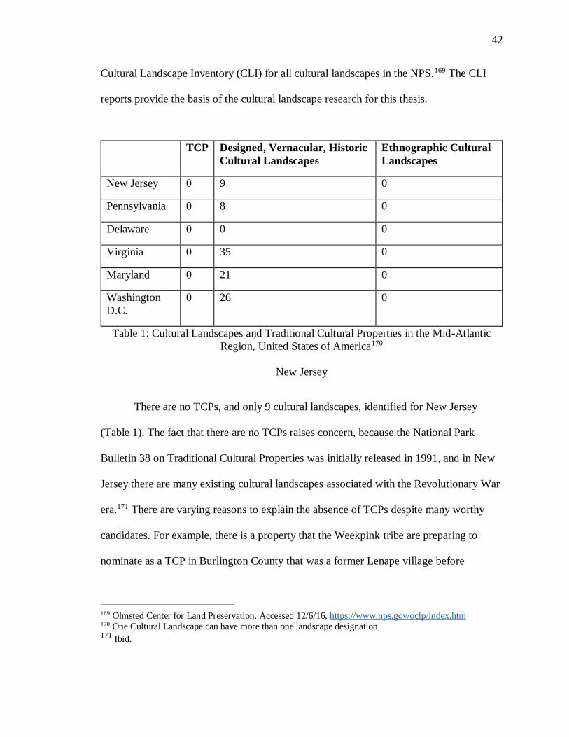
42
Cultural Landscape Inventory (CLI) for all cultural landscapes in the NPS.169 The CLI
reports provide the basis of the cultural landscape research for this thesis.
TCP Designed, Vernacular, Historic
Cultural Landscapes
Ethnographic Cultural
Landscapes
New Jersey 0 9 0
Pennsylvania 0 8 0
Delaware 0 0 0
Virginia 0 35 0
Maryland 0 21 0
Washington
D.C.
0 26 0
Table 1: Cultural Landscapes and Traditional Cultural Properties in the Mid-Atlantic
Region, United States of America170
New Jersey
There are no TCPs, and only 9 cultural landscapes, identified for New Jersey
(Table 1). The fact that there are no TCPs raises concern, because the National Park
Bulletin 38 on Traditional Cultural Properties was initially released in 1991, and in New
Jersey there are many existing cultural landscapes associated with the Revolutionary War
era.171 There are varying reasons to explain the absence of TCPs despite many worthy
candidates. For example, there is a property that the Weekpink tribe are preparing to
nominate as a TCP in Burlington County that was a former Lenape village before
169 Olmsted Center for Land Preservation, Accessed 12/6/16, https://www.nps.gov/oclp/index.htm 170 One Cultural Landscape can have more than one landscape designation 171 Ibid.
43
European colonization.172 The Weekpink land has not been formally nominated for
consideration although background historical research is being completed. Another
example of a TCP is the Lena Blackburne area along the Delaware River. This site has
been used to harvest rubbing mud for Major League Baseball teams across the nation
over the last seventy-five years.173 These two examples will be further discussed in detail
to illustrate that while there are no TCPs in New Jersey, there are numerous properties
with significant potential for Cultural Landscape consideration. Both designations have
existed for over twenty years, thereby their absence represents a failure in the process of
identifying, nominating, and protecting these landscape properties.
Chapter One notes that the term TCP was created by the NPS to help recognize
and protect utilized landscapes in traditional communities that would not normally be
protected by the Listing on the National Register. Native Americans were one of the
communities to benefit from this new designation. The Lenape Tribe lived in what is
present-day New Jersey, New York, Pennsylvania, and Delaware before the European
arrival.174 After European landing and colonization the landing and colonization during
17th and 18th centuries, the tribe was pushed westward through government acts such as
the Indian Removal Act of 1830, and decimated by diseases, such as smallpox and
influenza.175 Before the Indian Removal Act the Lenape migrated into New Jersey as they
172 Brotherton & Weekpink Indian Communities of NJ, Accessed 2/25/16,
http://brotherton-weekping.tripod.com/ 173 Lena Blackburne Baseball Rubbing Mud, Accessed 2/25/16, http://baseballrubbingmud.com/index.html 174 Jay Miller. 1997. “Old Religion Among the Delawares: The Gamwing (big House Rite)”. Ethnohistory
44 (1). Duke University Press: 113–34.: 1997 (115) 175 Ibid.
44
left Pennsylvania to escape the dangerous Indian Wars of the 1760s. This created a flow
of people back and forth in the region and throughout the colonial period.176 Today, the
Lenape Tribal government is located with the Delaware Tribe in Oklahoma, hundreds of
miles from their original homeland.177 Currently, New Jersey has no federally-recognized
Native American tribes, however the state recognizes three: the Nantichoke-Lenni-
Lenape, the Powhatan, and the Ramapough.178 As with many Native American tribes, the
Lenape had their own social, religious, and political structure. In the early historic era, the
tribe organized through a kinship complex system passed through the mother.179 Their
language was a unique dialect of Unami, a subset of the Algonquin language family.180
The social structure was made up familial units and clans.181 There were three different
clans within the Lenape: the Wolf, Turtle, and Turkey.182 The religious system included
beliefs in both the visible and invisible worlds, populated by spirits. In the early colonial
era, the Lenape tribe was quickly forced from the land; by the 1750’s, their land was
greatly limited in western New Jersey, where the tribe reconvened for religious
ceremonies in the Weekpink area.183
176 Marshall Joseph Becker "A New Jersey Haven for Some Acculturated Lenape of Pennsylvania During
the Indian Wars of the 1760s." Pennsylvania History: A Journal of Mid-Atlantic Studies 60, no. 3 (1993):
322-44. http://www.jstor.org/stable/27773651. (322)
177 Official Website of the Delaware Tribe of Indians, Accessed 2/20/16,
http://delawaretribe.org/locations/bartlesville-headquarters/
178 U.S. Department of Interior Indian Affairs, Accessed 10/31/16,
http://www.bia.gov/WhoWeAre/BIA/OIS/TribalGovernmentServices/TribalDirectory/
179 Jay Miller. 1997. “Old Religion Among the Delawares: The Gamwing (big House Rite)”. Ethnohistory
44 (1). Duke University Press: 113–34.: 1997 (115)
180 Ibid.
181 Ibid.
182 Ibid.
183 Brotherton & Weekpink Indian Communities of NJ, Accessed 2/25/16,
45
The issue that arises for the local community of both Lenape and non-Lenape, is
how to properly and best protect the Weekpink land. Considerable information, including
historical documentation and material evidence, proves that the land is a Lenape historic
site.184 Proving that there is traditional cultural importance to the land is much more
difficult than merely proving that a property is an historic site to the SHPO or NPS. For a
site to be considered a TCP, there must be a sizable amount of research conducted within
the local community, including in-depth research and consultation to determine if it
meets the standards laid out in Bulletin 38.185
The first issue that must be addressed when nominating a property for a TCP is to
determine the property’s connection to a tangible place. There is a documentary trail,
starting in the 1700’s, to provide evidence that the Lenape have a local group with a
connection to the Weekpink land.186 The National Register does not recognize intangible
culture alone; listing to the Register requires that it be attached to a property that is a
“district, site, building, structure, or object.”187 Then, the relationship to the property must
be determined to still have physical integrity. Integrity for a TCP is a twofold process,
unlike the process for the other historic properties, because there must have physical
integrity as well as demonstrate that the community’s connection to the site has temporal
http://brotherton-weekping.tripod.com/ 184 Brotherton & Weekpink Indian Communities of NJ, Accessed 2/25/16,
http://brotherton-weekping.tripod.com/ 185Thomas King and Patricia Parker, Guidelines for Evaluating and Documenting Traditional Cultural
Properties, U.S. Department of the Interior National Park Service 1998 (11) 186 Ibid. 187
Patrick Andrus, National Register Bulletin: How to Apply the National Register Criteria for Evaluation,
NPS: 1995 (4)
46
continuity.188 Unfortunately, contemporary development in the Weekpink area weakens
the argument for the land as a TCP in terms of integrity. The nominating group still needs
to prove that the relationship between the community and the physical property has
survived, and that it continues to have ongoing meaning to the tribe. Once the property is
determined to have integrity as a traditional cultural property, it must go through the rigor
of being assessed by the standard National Register Criteria, which involves nomination
under at least one the four nominating Criteria A-D.189 Although Weekpink has a
legitimate argument as a TCP, it has not yet been formally nominated; additional
ethnographic work is also needed to demonstrate the tribe’s connection to the land. This
is merely one example of how difficult it is to nominate a site as a TCP in the Mid-
Atlantic, and why there are no TCPs in New Jersey.
TCPs are not exclusively associated with Native American sites and landscapes.
Other ethnic groups or historic social groups that are non-indigenous also nominate sites
for TCP designation. The Lena Blackburne baseball mud is part of the culture and history
of Major League Baseball (MLB). The mud has been used by both Major league and
Minor league baseball teams to prepare the balls for over seventy-five years.190 This mud
is exclusively used by the MLB and is only provided by the Lena Blackburne Company.
Lean Blackburne discovered the mud in 1938, which is found along the Delaware River,
188 Thomas King and Patricia Parker, Guidelines for Evaluating and Documenting Traditional Cultural
Properties, U.S. Department of the Interior National Park Service 1998 (11) 189 Patrick Andrus, National Register Bulletin: How to Apply the National Register Criteria for Evaluation,
NPS: 1995 (4)
190 Lena Blackburne Baseball Rubbing Mud, Accessed 2/25/16, http://baseballrubbingmud.com/index.html
47
in Burlington County.191 When baseballs leave the factory, they have a sheen that makes
them too slippery for the pitchers. Many attempts were made to dull the balls before the
perfect solution was discovered: the mud from Delaware River banks in Burlington
County.192 The mud is a company secret that has been passed down to a small number of
people; it is harvested every summer for the upcoming season. Over a hundred pounds of
mud are taken from the banks of the river each year for teams to prepare the baseballs.193
This ritual is ingrained in the culture of baseball, and it is important to the sport’s
existence.
This site of mud harvesting along the Delaware River bank could be argued as a
TCP within the current NPS Bulletin 38 definition. The site could qualify as a place
where the community traditionally carries out a practice that is culturally, economically,
or artistically important, and provides an historic legacy.194 Despite the fact that the
specific area is kept a secret, the mud site benefits the national community; the mud
provides an important service to baseball, one of the nation’s longest running sports
traditions. There should be more direct efforts to conduct ethnography research within the
local community in order to understand how the rubbing mud practice affects them if this
is considered for TCP nomination. In the twenty-three years since the National Park
191 Ibid. 192 Lena Blackburne Baseball Rubbing Mud, Accessed 2/25/16, http://baseballrubbingmud.com/index.html 193 Ibid. 194
Thomas King and Patricia Parker, Guidelines for Evaluating and Documenting Traditional Cultural
Properties, U.S. Department of the Interior National Park Service 1998 (1)
48
Service released the National Register Bulletin 38 on Traditional Cultural Properties,
New Jersey has made no TCP designations.
The lack of TCPs in New Jersey raises the issue: Why is there a failure to
designate and protect properties with the TCP designation in New Jersey? There is a long
history of occupation of both Native Americans and Non-Native Americans in the state.
Many communities have multiple generations that have resided in the same place, thus
creating the potential for places to be designated as TCPs. The most obvious issue is the
added level of difficulty to nominate an area as a TCP, rather than as a standard historic
site under one of the four National Register Criteria. Some level of ethnographic research
is required to prove the importance of a site to the local community; however, the time
and resources needed for such an undertaking it may deter groups from nominating a
TCP site. This is especially true if the community can nominate the site as a historic site
on a local level of importance without the work and expense of providing ethnographic
evidence. For a community trying to protect their cultural heritage, the path of least
resistance to protecting it is compelling. Another reason a community may not nominate
a local site as a TCP is that there is no added benefit of site protection provided to a TCP.
If the goal is to protect a significant local site, then the community may not care how the
government designates it as long as it provides the same protections across the board.
Thus, for many sites, it may simply be easier to nominate the site as a historical site and
avoid the ethnographic research required for a TCP.
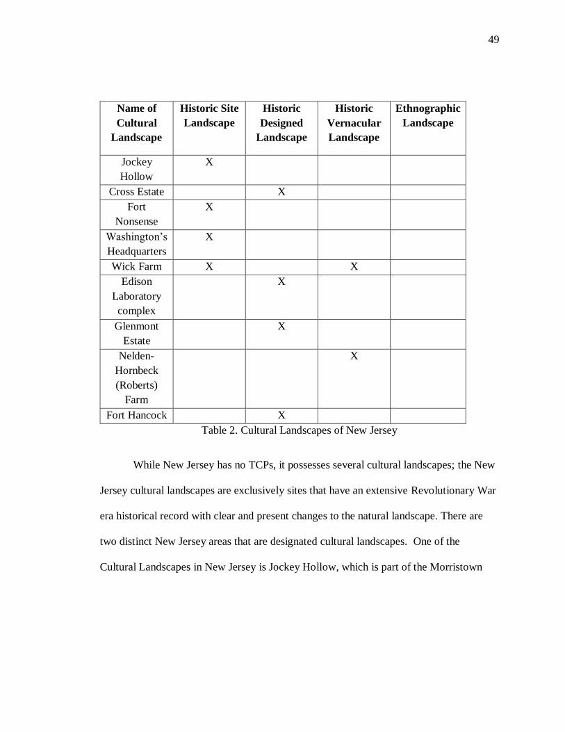
49
Name of
Cultural
Landscape
Historic Site
Landscape
Historic
Designed
Landscape
Historic
Vernacular
Landscape
Ethnographic
Landscape
Jockey
Hollow
X
Cross Estate X
Fort
Nonsense
X
Washington’s
Headquarters
X
Wick Farm X X
Edison
Laboratory
complex
X
Glenmont
Estate
X
Nelden-
Hornbeck
(Roberts)
Farm
X
Fort Hancock X
Table 2. Cultural Landscapes of New Jersey
While New Jersey has no TCPs, it possesses several cultural landscapes; the New
Jersey cultural landscapes are exclusively sites that have an extensive Revolutionary War
era historical record with clear and present changes to the natural landscape. There are
two distinct New Jersey areas that are designated cultural landscapes. One of the
Cultural Landscapes in New Jersey is Jockey Hollow, which is part of the Morristown
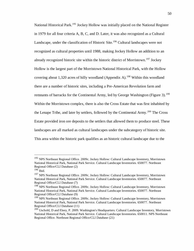
50
National Historical Park.195 Jockey Hollow was initially placed on the National Register
in 1979 for all four criteria A, B, C, and D. Later, it was also recognized as a Cultural
Landscape, under the classification of Historic Site.196 Cultural landscapes were not
recognized as cultural properties until 1988, making Jockey Hollow an addition to an
already recognized historic site within the historic district of Morristown.197 Jockey
Hollow is the largest part of the Morristown National Historical Park, with the Hollow
covering about 1,320 acres of hilly woodland (Appendix A).198 Within this woodland
there are a number of historic sites, including a Pre-American Revolution farm and
remnants of barracks for the Continental Army, led by George Washington (Figure 3).199
Within the Morristown complex, there is also the Cross Estate that was first inhabited by
the Lenape Tribe, and later by settlers, followed by the Continental Army.200 The Cross
Estate provided iron ore deposits to the settlers that allowed them to produce steel. These
landscapes are all marked as cultural landscapes under the subcategory of historic site.
This area within the historic park qualifies as an historic cultural landscape due to the
195 NPS Northeast Regional Office. 2009c. Jockey Hollow: Cultural Landscape Inventory, Morristown
National Historical Park, National Park Service. Cultural Landscape Inventories. 650077. Northeast
Regional Office/CLI Database (2) 196 Ibid. 197 NPS Northeast Regional Office. 2009c. Jockey Hollow: Cultural Landscape Inventory, Morristown
National Historical Park, National Park Service. Cultural Landscape Inventories. 650077. Northeast
Regional Office/CLI Database (7) 198 NPS Northeast Regional Office. 2009c. Jockey Hollow: Cultural Landscape Inventory, Morristown
National Historical Park, National Park Service. Cultural Landscape Inventories. 650077. Northeast Regional Office/CLI Database (9) 199 NPS Northeast Regional Office. 2009c. Jockey Hollow: Cultural Landscape Inventory, Morristown
National Historical Park, National Park Service. Cultural Landscape Inventories. 650077. Northeast
Regional Office/CLI Database (11) 200 Uschold, D and Eleey, P. 2009. Washington's Headquarters: Cultural Landscape Inventory, Morristown
National Historical Park, National Park Service. Cultural Landscape Inventories. 650011. NPS Northeast
Regional Office. Northeast Regional Office/CLI Database (21)
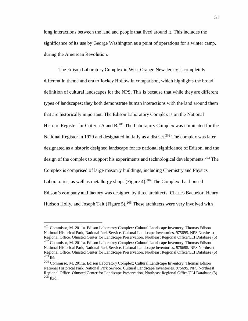
51
long interactions between the land and people that lived around it. This includes the
significance of its use by George Washington as a point of operations for a winter camp,
during the American Revolution.
The Edison Laboratory Complex in West Orange New Jersey is completely
different in theme and era to Jockey Hollow in comparison, which highlights the broad
definition of cultural landscapes for the NPS. This is because that while they are different
types of landscapes; they both demonstrate human interactions with the land around them
that are historically important. The Edison Laboratory Complex is on the National
Historic Register for Criteria A and B.201 The Laboratory Complex was nominated for the
National Register in 1979 and designated initially as a district.202 The complex was later
designated as a historic designed landscape for its national significance of Edison, and the
design of the complex to support his experiments and technological developments.203 The
Complex is comprised of large masonry buildings, including Chemistry and Physics
Laboratories, as well as metallurgy shops (Figure 4).204 The Complex that housed
Edison’s company and factory was designed by three architects: Charles Bachelor, Henry
Hudson Holly, and Joseph Taft (Figure 5).205 These architects were very involved with
201 Commisso, M. 2011a. Edison Laboratory Complex: Cultural Landscape Inventory, Thomas Edison
National Historical Park, National Park Service. Cultural Landscape Inventories. 975695. NPS Northeast Regional Office. Olmsted Center for Landscape Preservation, Northeast Regional Office/CLI Database (5) 202 Commisso, M. 2011a. Edison Laboratory Complex: Cultural Landscape Inventory, Thomas Edison
National Historical Park, National Park Service. Cultural Landscape Inventories. 975695. NPS Northeast
Regional Office. Olmsted Center for Landscape Preservation, Northeast Regional Office/CLI Database (5) 203 Ibid. 204 Commisso, M. 2011a. Edison Laboratory Complex: Cultural Landscape Inventory, Thomas Edison
National Historical Park, National Park Service. Cultural Landscape Inventories. 975695. NPS Northeast
Regional Office. Olmsted Center for Landscape Preservation, Northeast Regional Office/CLI Database (3) 205 Ibid.
52
Edison’s work, and influenced the development of technology, such as the phonograph
and electrical lighting in the United States. UNESCO would not recognize this property
as a cultural landscape because it recognizes a specific person for its nomination under
Register Criteria A; UNESCO does not utilize the NPS National Register Criteria in its
designation process.
In summary, New Jersey has exclusively recognized historical sites as cultural
landscapes. The majority of these landscapes are located in the Edison Laboratory
Complex, or are part of the Morristown Historic Complex. Although there is a prehistoric
history to the Morristown landscapes, there is nothing mentioned or recognized
concerning earlier periods of history in Morristown CLI reports. There are also no TCPs;
however, there are potential TCPs that exist within the state such as the Weekpink
property and the rubbing mud site.
Maryland
Maryland currently possesses twenty-one cultural landscapes, and no NPS TCPs
(Table 3). All of these landscapes fall into three of the four NPS subcategories of
landscape definitions: historic sites, historic designed sites, or historic vernacular sites,
with the majority of them designated historic sites. The cultural landscapes include
numerous historic farmsteads that were used and located at famous Civil War battlefields
throughout United States.
53
Name of Cultural
Landscape
Historic
Site
Landscape
Historic
Designed
Landscape
Historic
Vernacular
Landscape
Ethnographic
Landscape
Four Locks X
Williams Port X
Catoctin Mountain
Park
X X
Camp Misty Mount X
Joseph Poffenberger
Farmstead
X
D.R. Miller
Farmstead
X
Mumma Farmstead X
Roulette Farmstead
X
Parks Farmstead X
X
Newcomer
Farmstead
X
Antietam National
Cemetery
X
Thomas Farm X
X
Monocracy National
Battlefield
X
X
Fort McHenry X X
Seneca Lock
X
Pennyfield Lock
X
Great Falls Tavern X
X
Glen Echo Park-
Clara Barton House
X
X
Oxon Cove Park
X
Harmony Hall
X
Fort Washington
Park
X
Table 3. Cultural Landscapes of Maryland
54
There are four farmsteads and associated landscapes within the Antietam National
Battlefield Park.206 This does not include Antietam National Cemetery that is also located
at the battlefield site.207 The Roulette Farmstead is one of the farmsteads with acres of its
land used in battle associated with the Antietam Battlefield. It remains well-preserved as
a farmstead, and is maintained by historical societies. The farm is also associated with
agricultural developments and landscape use from the eighteenth and early nineteenth
centuries.208 These two historical factors qualify the one hundred and eighty acres as a
vernacular historical landscape. The other areas included with Antietam Battlefield are
the Joseph Poffenberger Farmstead, the D.R. Miller Farmstead, and the Parks Farmstead,
formerly known as Cunningham Farm. All three of these farmsteads are designated as
vernacular cultural landscapes. The Poffenberger Farm has significance from not only its
association with the Battle of Antietam, but also from landscape preservation efforts
following the Civil War.209 Like the Poffenberger Farm, the Miller Farm is significant for
its association with the Battle of Antietam and post-war conservation efforts.210 The
Parks Farmstead also is a historic site associated with a battle that has been farmed
206 Paula Reed and Associates, Inc.. 2011. Antietam National Cemetery: Cultural Landscape Inventory,
Antietam National Battlefield - Antietam National Cemetery, National Park Service. Cultural Landscape
Inventories. 600048. NPS National Capital Regional Office. National Capital Regional Office/CLI
Database (2) 207 Ibid. 208 Everett, J. 2009. Roulette Farmstead: Cultural Landscape Inventory, Antietam National Battlefield,
National Park Service. Cultural Landscape Inventories. 600284. NPS National Capital Regional Office. National Capital Regional Office/CLI Database (2) 209Joseph, M and Barrett, T. 2008. Joseph Poffenberger Farmstead: Cultural Landscape Inventory,
Antietam National Battlefield, National Park Service. Cultural Landscape Inventories. 975301. NPS
National Capital Regional Office. National Capital Regional Office/CLI Database (2) 210 Everett, J. 2011. D.R. Miller Farmstead: Cultural Landscape Inventory, Antietam National Battlefield,
National Park Service. Cultural Landscape Inventories. 600034. NPS National Capital Regional Office.
National Capital Region/CLI Database (2)
55
continuously since the 18th century until it was acquired by the NPS in the 1980s.211
These farm landscapes are extremely important to the Battle of Antietam because the
landscape was shaped by agriculture in a way that influenced battle strategy.
Antietam National Battlefield is not the only Maryland Civil War battlefield
associated with farmsteads. The Battle of Monocracy is linked to the Thomas Farm. The
Thomas Farm existed long before the Battle of Monocracy, and had its own historical and
cultural significance before the battle. The farm, located along an important colonial
road, was part of one of the first transportation networks created in the colonial area.212
The Civil War battle occurred at the farmland because the road connected Fredrick
County to Georgetown.213 The farm continued to be actively farmed well after the battle
and into the early twentieth century. Unlike the Roulette Farm, the Thomas Farm is a
cultural landscape because it is both an historical site and a vernacular cultural landscape.
Another recognized cultural landscape is the Catoctin Mountain Park, which is
considered a designed and vernacular landscape. The Catoctin Mountain Park is another
park in the Mid-Atlantic that owes much of its significance to a New Deal in the 1930s.
The land was first used in the nineteenth century for the iron industry, where developers
installed iron furnaces. The landscape’s iron furnace industry history is not as well
preserved as the landscape structures designed by 1930s NPS architects converted it into
211 Temkin, M. 2011. Parks Farmstead: Cultural Landscape Inventory, Antietam National Battlefield,
National Park Service. Cultural Landscape Inventories. 600047. NPS National Capital Regional Office.
National Capital Regional Office/CLI Database (2) 212 Temkin, M. 2009. Thomas Farm: Cultural Landscape Inventory, Monocacy National Battlefield,
National Park Service. Cultural Landscape Inventories. 600294. NPS National Capital Regional Office.
National Capital Regional Office/CLI Database (2) 213 Ibid.
56
a park; many of those structures and trail designs still exist today.214 One of these camp
structures is Camp Misty Mount, a designated cultural landscape.215 The camp was
designed for children in the 1930s and includes sleeping cabins, larger main cabins, and
including dining and activities areas.216 The camp converted into a barracks in 1942, for
the armed services, until World War II was over. After the war, it returned to use as a
children’s camp, until the middle of the twentieth century. In 1989, the camp was placed
on the National Register, under Criterion A and C, for its association with the New Deal
programs and the NPS design.217
The Chesapeake and Ohio Canal National Historic Park has four Cultural
Landscapes located within the park. Three of the four landscapes are locks, and the fourth
is a historic tavern that overlooks the canal. The three locks, the Seneca Lock, Four
Locks, and the Pennyfield Lock, are considered to be vernacular cultural landscapes; they
were in use beginning in the 19th century until the early twentieth century. These set of
locks were placed on the National Register under Criterion A and C.218,219,220 As a
214 Ibid. 215 Ibid. 216 Ibid. 217 Earley, J and Stafford, B. 2008. Catoctin Mountain Park: Cultural Landscape Inventory, Catoctin
Mountain Park, National Park Service. Cultural Landscape Inventories. 600017. NPS National Capital
Regional Office. National Capital Regional Office/CLI Database. (3) 218 Temkin, M. 2010. Seneca Lock: Cultural Landscape Inventory, Chesapeake and Ohio National
Historical Park, National Park Service. Cultural Landscape Inventories. 975434. NPS National Capital Regional Office. National Capital Regional Office/CLI Database (2) 219 Earley, J. 2009. Pennyfield, Lock: Cultural Landscape Inventory, Chesapeake and Ohio Canal National
Historical Park, National Park Service. Cultural Landscape Inventories. 600289. NPS National Capital
Regional Office. National Capital Regional Office/CLI Database (2) 220 Stevens, C and Bailey, S. 2008. Four Locks: Cultural Landscape Inventory, Chesapeake and Ohio Canal
National Historical Park, National Park Service. Cultural Landscape Inventories. 600279. NPS National
Capital Regional Office. National Capital Regional Office/CLI Database(2)
57
cultural landscape, these locks also comprise a canal landscape that was important to the
growth and transportation in the nineteenth century. The locks have remained in good
preservation and, although not used any more, are still a part of the surrounding
landscape. The Great Falls Tavern sits alongside the canal and was built at the same time
as the canal, in 1828.221 It is a historic structure that became a part of the canal landscape
and was used until the canal was closed, in 1924.
The final three cultural landscapes in Maryland are single cultural landscapes that
are not associated with other landscapes. Fort McHenry is located in Baltimore; while
east of Washington D.C. is Oxon Cove Park and Fort Washington Park. Fort McHenry
was built at the turn of the nineteenth century, and was important in the defense and
battle during the War of 1812.222 In this fort, inspired by a battle in 1814, Francis Scott
Key wrote “The Star-Spangled Banner,” which later became the national anthem. The
fort still stands today, and was an important historic site, which makes it a cultural
landscape according to the NPS. Fort Washington, a designed cultural landscape, which
was used as a fort in the nineteenth century, is now a converted recreational landscape
with curated open spaces and wooded areas.223 The Oxon Cove Park is a vernacular
cultural landscape. Used in the early nineteenth century as a farm in the second half of
221Temkin, M. 2010. Great Falls Tavern: Cultural Landscape Inventory, Chesapeake and Ohio Canal
National Historical Park, National Park Service. Cultural Landscape Inventories. 600271. NPS National
Capital Regional Office. National Capital Regional Office/CLI (2) 222 Davison, M and Foulds, E. 2004. Fort McHenry National Monument and Historic Shrine: Cultural
Landscape Report, Fort McHenry National Monument and Historic Shrine, National Park Service. Cultural
Landscape Report. NPS Olmsted Center for Landscape Preservation. Olmsted Center for Landscape
Preservation (2) 223 Laird, ML. 2006. Fort Washington Park: Cultural Landscape Inventory, Fort Washington Park, National
Park Service. Cultural Landscape Inventories. 600098. NPS National Capital Regional Office. National
Capital Regional Office/CLI Database (2)
58
the nineteenth century the land was used to build the first federally-funded mental health
facility.224 The landscapes are cultural landscapes defined by the NPS because they
demonstrate agrarian techniques from the nineteenth century, and as examples of early
mental health facilities.
In Maryland, like in New Jersey, there is a clear bias in designation in that only
historical sites have been recognized as cultural landscapes. Clearly, a wide range of
historical eras, from 1812 War battlefields to the New Deal park development, are
represented in Maryland. As is the case in New Jersey, there are no ethnographic
landscapes, or TCPs, recognized in Maryland. The state has so many national parks and
land controlled by the federal government that it is surprising that there is no formal
listing of either ethnographic cultural landscapes or TCPs. Maryland has a long history of
settlement, from the earliest years of indigenous occupation, to old historic
neighborhoods of Baltimore, to the colonial settlements in the rural areas of the state.
While there are two state-recognized tribes in Maryland, the Piscataway Indian Nation
and the Piscataway Conoy Tribe, there are no recognized TCPs that formally
acknowledge continuous tribal use in the entire state.225
224 McMillen, F. 2011. Oxon Cove Park: Cultural Landscape Inventory: National Capital Parks-East-Oxon
Cove Park. Cultural Landscape Inventories. 600093. NPS National Capital Regional Office. National
Capital Regional Office/CLI Database (2) 225
U.S. Department of Interior Indian Affairs, Accessed 10/31/16,
http://www.bia.gov/WhoWeAre/BIA/OIS/TribalGovernmentServices/TribalDirectory/
59
Washington D.C.
There are currently twenty-six cultural landscapes and no TCPs recognized in
Washington D.C. (Table 4). There are more cultural landscapes located throughout the
city than in the entire state of Maryland. Many cultural landscapes are either historic
designed landscapes or historic vernacular landscapes, and are related to the amount of
planning that went into the city’s layout. The L’Enfant Plan continued to influence city
planning and land use patterns into the 19th century. Along with numerous planned and
designed monuments and memorials, the majority of the city is a designed cultural
landscape. The National Mall Park has seven landscapes designated within it, including
multiple monuments. Cultural landscapes located within the National Mall include: the
D.C. War Memorial, Washington Monument Grounds, Constitution Gardens, McPherson
Square, Farragut Square, Franklin Park, Union Square, Columbus Plaza, and The Mall
60
itself.226,227,228,229,230,231,232 All of these cultural landscapes are designed cultural
landscapes.
226 Fanning, K and McMillen, F. 2008. Columbus Plaza: Cultural Landscape Inventory, National Mall &
Memorial Parks - L'Enfant Plan Reservations, National Park Service. Cultural Landscape Inventories.
600242. NPS National Capital Regional Office. National Capital Regional Office/CLI Database (2) 227 Fanning, K and Ryberg, S. 2011. McPherson Square: Cultural Landscape Inventory, National Mall &
Memorial Parks - L'Enfant Plan Reservations. Cultural Landscape Inventories. 600215. NPS National Capital Regional Office. National Capital Regional Office/CLI Database (2) 228
NPS National Capital Regional Office and Fanning, K. 2006. Union Square: Cultural Landscape
Inventory, National Mall, National Park Service. Cultural Landscape Inventories. 975261. National Capital
Regional Office/CLI Database (2) 229 Donaldson, E. 2009b. DC War Memorial: Cultural Landscape Inventory, National Mall & Memorial
Parks - West Potomac Park, National Park Service. Cultural Landscape Inventories. 975436. NPS National
Capital Regional Office. National Capital Regional Office/CLI Database (2) 230Fanning, K. 2006. The Mall: Cultural Landscape Inventory, National Mall, National Park Service.
Cultural Landscape Inventories. 600213. NPS National Capital Regional Office. National Capital Regional Office/CLI Database (2) 231 NPS National Capital Regional Office and Donaldson E. 2010. President's Park South: Cultural
Landscape Inventory, The White House (President's Park), National Park Service. Cultural Landscape
Inventories. 975602. National Capital Regional Office/CLI Database (2) 232 Fanning, K. 2011. Franklin Park: Cultural Landscape Inventory, National Mall & Memorial Parks -
L'Enfant Plan Reservation. Cultural Landscape Inventories. 600228. NPS National Capital Regional Office.
National Capital Regional Office/CLI Database (2)
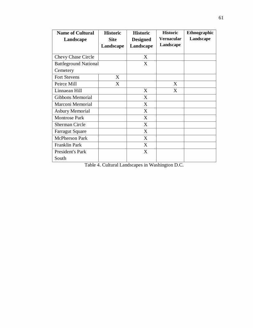
61
Name of Cultural
Landscape
Historic
Site
Landscape
Historic
Designed
Landscape
Historic
Vernacular
Landscape
Ethnographic
Landscape
Chevy Chase Circle
X
Battleground National
Cemetery
X
Fort Stevens X
Peirce Mill X
X
Linnaean Hill
X X
Gibbons Memorial
X
Marconi Memorial
X
Asbury Memorial
X
Montrose Park
X
Sherman Circle
X
Farragut Square
X
McPherson Park
X
Franklin Park
X
President's Park
South
X
Table 4. Cultural Landscapes in Washington D.C.
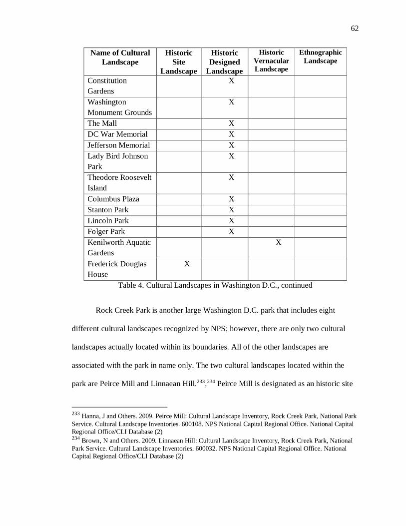
62
Name of Cultural
Landscape
Historic
Site
Landscape
Historic
Designed
Landscape
Historic
Vernacular
Landscape
Ethnographic
Landscape
Constitution
Gardens
X
Washington
Monument Grounds
X
The Mall
X
DC War Memorial
X
Jefferson Memorial
X
Lady Bird Johnson
Park
X
Theodore Roosevelt
Island
X
Columbus Plaza
X
Stanton Park
X
Lincoln Park
X
Folger Park
X
Kenilworth Aquatic
Gardens
X
Frederick Douglas
House
X
Table 4. Cultural Landscapes in Washington D.C., continued
Rock Creek Park is another large Washington D.C. park that includes eight
different cultural landscapes recognized by NPS; however, there are only two cultural
landscapes actually located within its boundaries. All of the other landscapes are
associated with the park in name only. The two cultural landscapes located within the
park are Peirce Mill and Linnaean Hill.233,234 Peirce Mill is designated as an historic site
233 Hanna, J and Others. 2009. Peirce Mill: Cultural Landscape Inventory, Rock Creek Park, National Park
Service. Cultural Landscape Inventories. 600108. NPS National Capital Regional Office. National Capital
Regional Office/CLI Database (2) 234 Brown, N and Others. 2009. Linnaean Hill: Cultural Landscape Inventory, Rock Creek Park, National
Park Service. Cultural Landscape Inventories. 600032. NPS National Capital Regional Office. National
Capital Regional Office/CLI Database (2)
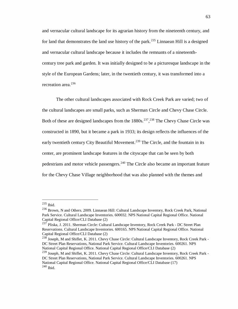
63
and vernacular cultural landscape for its agrarian history from the nineteenth century, and
for land that demonstrates the land use history of the park.235 Linnaean Hill is a designed
and vernacular cultural landscape because it includes the remnants of a nineteenth-
century tree park and garden. It was initially designed to be a picturesque landscape in the
style of the European Gardens; later, in the twentieth century, it was transformed into a
recreation area.236
The other cultural landscapes associated with Rock Creek Park are varied; two of
the cultural landscapes are small parks, such as Sherman Circle and Chevy Chase Circle.
Both of these are designed landscapes from the 1880s.237,238 The Chevy Chase Circle was
constructed in 1890, but it became a park in 1933; its design reflects the influences of the
early twentieth century City Beautiful Movement.239 The Circle, and the fountain in its
center, are prominent landscape features in the cityscape that can be seen by both
pedestrians and motor vehicle passengers.240 The Circle also became an important feature
for the Chevy Chase Village neighborhood that was also planned with the themes and
235 Ibid. 236 Brown, N and Others. 2009. Linnaean Hill: Cultural Landscape Inventory, Rock Creek Park, National
Park Service. Cultural Landscape Inventories. 600032. NPS National Capital Regional Office. National
Capital Regional Office/CLI Database (2) 237 Pliska, J. 2011. Sherman Circle: Cultural Landscape Inventory, Rock Creek Park - DC Street Plan
Reservations. Cultural Landscape Inventories. 600165. NPS National Capital Regional Office. National
Capital Regional Office/CLI Database (2) 238 Joseph, M and Shiflet, K. 2011. Chevy Chase Circle: Cultural Landscape Inventory, Rock Creek Park -
DC Street Plan Reservations, National Park Service. Cultural Landscape Inventories. 600261. NPS
National Capital Regional Office. National Capital Regional Office/CLI Database (2) 239 Joseph, M and Shiflet, K. 2011. Chevy Chase Circle: Cultural Landscape Inventory, Rock Creek Park -
DC Street Plan Reservations, National Park Service. Cultural Landscape Inventories. 600261. NPS
National Capital Regional Office. National Capital Regional Office/CLI Database (17) 240 Ibid.

64
designs of the City Beautiful Movement.241 Sherman Circle located in the Petworth
neighborhood, a modern day traffic rotary, is an important early twentieth century
landscape design that reflects the old city landscape from the early twentieth century with
original design principles from the old cityscape that was designed by L’Enfant in
1791.242
Also associated with the Rock Creek Park complex, but not located in the park
itself, are two memorials to the east of the park. Both the Asbury Memorial and the
Marconi Memorial are extremely small sites of less than an acre and are located in the
Mount Pleasant Historic District.243,244 The Asbury Memorial Park has a bronze statue of
Francis Asbury; around which Irving Payne designed the landscape to accentuate the
statue, but not be dominated by it.245 The Marconi Memorial is also a small site that
contains a statue with a designed landscape by Joseph Gardner around it, completed in
1941.246 These small sites are interesting examples of small cultural landscapes.
Compared to large sites typically associated with cultural landscapes, these small sites
contribute subtly to the landscape.
241 Ibid. 242 Pliska, J. 2011. Sherman Circle: Cultural Landscape Inventory, Rock Creek Park - DC Street Plan
Reservations. Cultural Landscape Inventories. 600165. NPS National Capital Regional Office. National Capital Regional Office/CLI Database (2) 243 Stevens, C and Simpson, A. 2007. Marconi Memorial, US Reservation 309 A: Cultural Landscape
Inventory, Rock Creek Park - DC Plan Reservation, National Park Service. Cultural Landscape Inventories.
600265. NPS National Capital Regional Office. National Capital Regional Office/CLI Database (2) 244 Stevens, C and Simpson, A. 2007. Asbury Memorial, US Reservation 309 B: Rock Creek Park - DC
Street Plan Reservations, National Park Service. Cultural Landscape Inventories. 975383. NPS National
Capital Regional Office. National Capital Regional Office/CLI Database (2) 245
Ibid. 246 Ibid.
65
The other sites associated with Rock Creek Park are Montrose Park, which is a
designed cultural landscape, and Fort Stevens, which is an historic site cultural landscape.
Montrose Park is historically significant in two time periods. The Park was a private
estate in the 19th century with many unique features that still exist today; one example is
the Ropewalk, which includes a canopy tree walk, in the early twentieth century, the Park
was transitioned into a public park.247 Walkways were added along with the tennis
courts.248 Fort Stevens as a cultural landscape is an interesting example of historic
preservation in the United States. Initially, the fort was built as part of a ring of forts
around Washington D.C., to protect it during the Civil War; it was abandoned after
1965.249 It was not until 1900 that veterans and local residents decided to restore and
preserve what was left of the earthworks used in the fort in commemoration of the Civil
War.250 The fort contributes to the landscape of the city because people seek to
memorialize and remember the Civil War, even one hundred and fifty years later.
Aside from the cultural landscapes that are associated with the National Mall and
Rock Creek Park, there are only a few cultural landscapes designated in the greater
Washington D.C. area. Three sites are associated with National Capital Parks East:
Stanton Park, Folger Park, and Lincoln Park, all of which are designed cultural
247 Joseph, M. 2008. Montrose Park: Cultural Landscape Inventory, Rock Creek Park - Montrose Park,
National Park Service. Cultural Landscape Inventories. 600115. NPS National Capital Regional Office.
National Capital Regional Office/CLI Database (2) 248 Ibid. 249 NPS National Capital Regional Office and McMillen F. 2010. Fort Stevens: Cultural Landscape
Inventory, Rock Creek Park - Fort Circle Park - North, National Park Service. Cultural Landscape
Inventories. 600147. National Capital Regional Office/CLI Database (2) 250 Ibid.
66
landscapes that are part of the National Capital Parks-East system.251,252,253, There are
also cultural landscapes with no broader association with the city. These include the
Frederick Douglass National Historic Site, a historic site cultural landscape, and the
Kenilworth Aquatic Gardens, a vernacular cultural landscape.254,255
As with many other states in the region, Maryland’s and Washington D.C.’s
cultural landscapes are all designed, vernacular, or historic sites. The city has a long
history of city planning originating with its founding as a city in the 18th century. This
resulted in many designed landscapes that are now recognized by the NPS. The strong
emphasis on these three cultural landscape types, with no ethnographic cultural
landscapes, is not shocking because there is a similar pattern of omission in the
neighboring states. It is, therefore, not a surprise that there are no TCPs in Maryland or
Washington, D.C., because the ethnographic cultural landscape definition is extremely
similar to the TCP definition.
251
Quinn, R and Wheelock, P. 2007. Stanton Park: Cultural Landscape Inventory, National Capital Parks-
East-Capitol Hill Parks. Cultural Landscape Inventories. 600075. NPS National Capital Regional Office.
National Capital Regional Office/CLI Database (2) 252 Ryberg, S and Fanning, K. 2009. Lincoln Park: Cultural Landscape Inventory, National Capital Parks-
East-Capitol Hill Parks. Cultural Landscape Inventories. 600072. NPS National Capital Regional Office.
National Capital Regional Office/CLI Database (2) 253 Fanning, K and Zhang, G. 2011. Folger Park: Cultural Landscape Inventory, National Capital Parks-
East-Capitol Hill Parks. Cultural Landscape Inventories. 600076. NPS National Capital Regional Office. National Capital Regional Office/CLI Database (2) 254 NPS National Capital Regional Office and Moss S. 2013. Frederick Douglass National Historic Site:
Cultural Landscape Inventory. Cultural Landscape Inventories. 600033. National Capital Regional
Office/CLI Database (2) 255 Donaldson, E. 2010. Kenilworth Aquatic Gardens: Cultural Landscape Inventory, National Capital
Parks-East-Anacostia Park, National Park Service. Cultural Landscape Inventories. 600088. NPS National
Capital Regional Office. National Capital Regional Office/CLI Database (2)
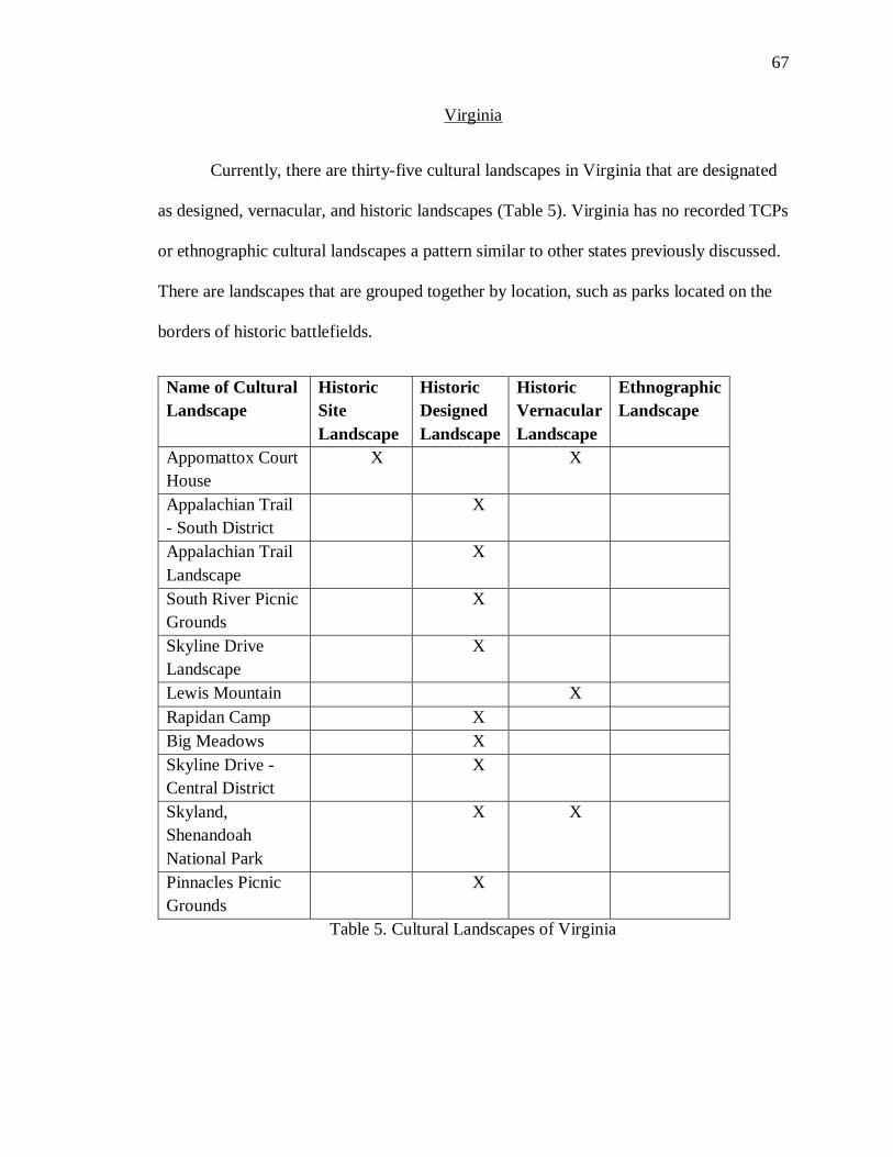
67
Virginia
Currently, there are thirty-five cultural landscapes in Virginia that are designated
as designed, vernacular, and historic landscapes (Table 5). Virginia has no recorded TCPs
or ethnographic cultural landscapes a pattern similar to other states previously discussed.
There are landscapes that are grouped together by location, such as parks located on the
borders of historic battlefields.
Name of Cultural
Landscape
Historic
Site
Landscape
Historic
Designed
Landscape
Historic
Vernacular
Landscape
Ethnographic
Landscape
Appomattox Court
House
X
X
Appalachian Trail
- South District
X
Appalachian Trail
Landscape
X
South River Picnic
Grounds
X
Skyline Drive
Landscape
X
Lewis Mountain
X
Rapidan Camp
X
Big Meadows
X
Skyline Drive -
Central District
X
Skyland,
Shenandoah
National Park
X X
Pinnacles Picnic
Grounds
X
Table 5. Cultural Landscapes of Virginia
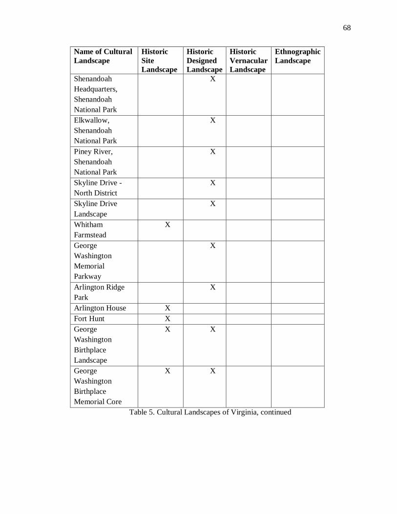
68
Name of Cultural
Landscape
Historic
Site
Landscape
Historic
Designed
Landscape
Historic
Vernacular
Landscape
Ethnographic
Landscape
Shenandoah
Headquarters,
Shenandoah
National Park
X
Elkwallow,
Shenandoah
National Park
X
Piney River,
Shenandoah
National Park
X
Skyline Drive -
North District
X
Skyline Drive
Landscape
X
Whitham
Farmstead
X
George
Washington
Memorial
Parkway
X
Arlington Ridge
Park
X
Arlington House X
Fort Hunt X
George
Washington
Birthplace
Landscape
X X
George
Washington
Birthplace
Memorial Core
X X
Table 5. Cultural Landscapes of Virginia, continued
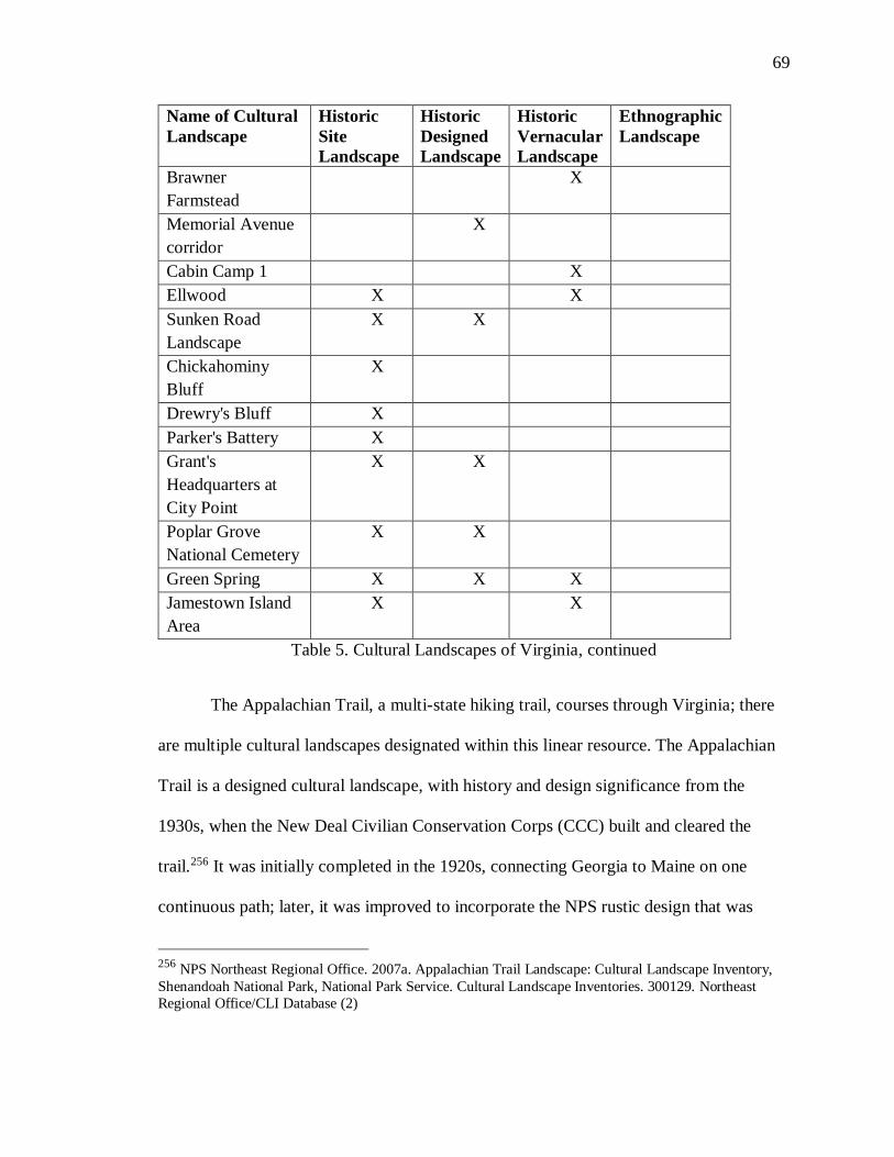
69
Name of Cultural
Landscape
Historic
Site
Landscape
Historic
Designed
Landscape
Historic
Vernacular
Landscape
Ethnographic
Landscape
Brawner
Farmstead
X
Memorial Avenue
corridor
X
Cabin Camp 1
X
Ellwood X
X
Sunken Road
Landscape
X X
Chickahominy
Bluff
X
Drewry's Bluff X
Parker's Battery X
Grant's
Headquarters at
City Point
X X
Poplar Grove
National Cemetery
X X
Green Spring X X X
Jamestown Island
Area
X
X
Table 5. Cultural Landscapes of Virginia, continued
The Appalachian Trail, a multi-state hiking trail, courses through Virginia; there
are multiple cultural landscapes designated within this linear resource. The Appalachian
Trail is a designed cultural landscape, with history and design significance from the
1930s, when the New Deal Civilian Conservation Corps (CCC) built and cleared the
trail.256 It was initially completed in the 1920s, connecting Georgia to Maine on one
continuous path; later, it was improved to incorporate the NPS rustic design that was
256 NPS Northeast Regional Office. 2007a. Appalachian Trail Landscape: Cultural Landscape Inventory,
Shenandoah National Park, National Park Service. Cultural Landscape Inventories. 300129. Northeast
Regional Office/CLI Database (2)
70
iconic in the 1930s.257 The Appalachian Trail design originated from Benton MacKaye, a
U.S. Forester, whose original vision is still intact today, despite the tree growth
surrounding the trail.258 The sense of wilderness that the trail was meant to convey still
exists, though modern development has slowly expanded to areas with proximity to it.
The entire 2,178 mile trail is currently eligible to be listed on the National Register.259
The current cultural landscape designation only covers the area within Shenandoah
National Park.260 This would provide greater protection of the trail, because the
designation would not be limited to the national parks.
Beyond Shenandoah National Park, many of the Virginian cultural landscapes
include George Washington properties and sites. There are multiple landscapes
designated to his birthplace and the areas surrounding it, such as the George Washington
Birthplace Landscape. The importance of the landscape extends beyond the birthplace of
one of country’s founding fathers, as the landscape was also utilized by the Algonquin
during the Woodland period.261 The contributing factor that qualifies this birthplace
landscape site as a cultural landscape is George Washington’s history, along with the
region’s long agricultural history. Before Washington was born on the land, his family
257 Ibid. 258 Ibid. 259 Appalachian National Scenic Trail Special Report, Accessed 12/6/16,
https://www.nps.gov/appa/learn/management/upload/AT-report-web.pdf, (4) 260 260 NPS Northeast Regional Office. 2007a. Appalachian Trail Landscape: Cultural Landscape Inventory,
Shenandoah National Park, National Park Service. Cultural Landscape Inventories. 300129. Northeast
Regional Office/CLI Database (2) 261 NPS Northeast Regional Office. 2009b. George Washington Birthplace Landscape: Cultural Landscape
Inventory, George Washington Birthplace National Monument, National Park Service. Cultural Landscape
Inventories. 300150. Northeast Regional Office/CLI Database (2)
71
had owned it for multiple generations, beginning with his great-great uncle.262 This land
was passed down for generations, with the family continuously farming and living on it.
Soon after Washington’s death in 1799, a marker was placed on the land in 1815 to
commemorate his birthplace.263 There has been some form of marker and
commemorative efforts since that time until the land was purchased by the NPS in 1930.
The park currently has several layers of historical importance, which initially had an
Algonquin site on it and then was settled and farmed by Washington’s family in the 17th
century and then in 1896 an obelisk was erected to commemorate Washington.264
Because of the many years of historic significance, and the land’s use as a memorial
during the contemporary era, the NPS has designated it as a designed and historic cultural
landscape.
Another large park that includes multiple cultural landscapes is the George
Washington Memorial Parkway. The Parkway, which is managed by the NPS, runs
through multiple states and has a total of eight cultural landscapes. Fort Hunt Park in
Fairfax County, is a historic site cultural landscape.265 The fort is a designed landscape,
which was originally part of a coastal defense system established by the federal
government in the 1890s.266 In the 1930s, it was taken over by the Civilian Conservation
262 Ibid. 263 Ibid. 264 NPS Northeast Regional Office. 2009b. George Washington Birthplace Landscape: Cultural Landscape
Inventory, George Washington Birthplace National Monument, National Park Service. Cultural Landscape
Inventories. 300150. Northeast Regional Office/CLI Database (29). 265 Fanning, K. 2009. Fort Hunt Park: Cultural Landscape Inventory, George Washington Memorial
Parkway - Fort Hunt Park, National Park Service. Cultural Landscape Inventories. 600177. NPS National
Capital Regional Office. National Capital Regional Office/CLI Database (2) 266 Ibid.
72
Corps (CCC), and as redesigned for use as a park with picnic and recreation areas.267
Another historic site cultural landscape within the George Washington Memorial
Parkway (GWMP) system is the Arlington House. The house is now the Robert E. Lee
Memorial, which is located within the Arlington National Cemetery.268 The house was
originally part of the Lee family estate during the early 1800s, and then became part of
the headquarters for the Army of the Potomac during the Civil War.269 The landscape of
the house and the surrounding buildings still evoke the original feeling of the early 1800s
homestead.
Arlington also is home to Arlington Ridge Park, another cultural landscape within
the GWMP. Two memorials are located within the Park: the U.S. Marine Corps memorial
(1954), and the Netherlands Carrillon (1960).270 Both of the park’s memorials were built
during the middle of the twentieth century. Though the memorials are over fifty years
old, the historic landscape design is still maintained and is a heavily used park within the
neighborhood. This designed landscape is quite formal, with European-style gardens.271
The landscape design and placement of the statues was created to increase the viewshed
of the Arlington Cemetery and the National Mall that surrounds the park. Within the
GWMP, near Arlington Ridge Park, is a designed cultural landscape, the Memorial
267 Ibid. 268 Moss, S. 2009. Arlington House: The Robert E. Lee Memorial: Cultural Landscape Inventory,
Arlington House: The Robert E. Lee Memorial, National Park Service. Cultural Landscape Inventories.
600049. NPS National Capital Regional Office. National Capital Regional Office/CLI Database (2) 269 Ibid. 270 Fanning, K. 2008. Arlington Ridge Park: Cultural Landscape Inventory, George Washington Memorial
Parkway - Arlington Ridge Park, National Park Service. Cultural Landscape Inventories. 600288. NPS
National Capital Regional Office. National Capital Regional Office/CLI Database (2) 271 Ibid.
73
Avenue Corridor. This corridor includes multiple structures and architecture and is part
of a major transit system.272 There are two memorial bridges in this landscape in addition
to the entrance to Arlington National Cemetery. This mile-long corridor is intended to be
a grand memorial main entrance into the city of Washington D.C.; while the corridor
project was started in 1901, it was completed three decades later.273 The Potomac River
was dredged to help build the bridges, an action which altered the original landscape.
Over the mid-twentieth century, multiple sculptures were added to the road landscape
that changed the entrance viewshed of the city and represented historical moments of the
city.274
Outside of the D.C. metropolitan area, there are other cultural landscapes,
including the Manassas National Battlefield Park. This park possesses two cultural
landscapes: the Brawner Farmstead and the Groveton Cemetery. The Manassas
Battlefield is a major Civil War battlefield, where two battles occurred. The Groveton
Cemetery landscape is a Confederate soldier cemetery where soldiers were buried in
shallow graves.275 The landscape importance follows the Civil War, when in 1867 there
was an effort to memorialize the lives lost and to rebury the soldiers in proper graves.276
Also at the battlefield park is the Brawner Farmstead, a vernacular cultural landscape.
272 Earley, J and Guenther, D. 2009. Memorial Avenue Corridor: Cultural Landscape Inventory, George
Washington Memorial Parkway, National Park Service. Cultural Landscape Inventories. 600247. NPS
National Capital Regional Office. National Capital Regional Office/CLI Database (2) 273 Ibid. 274 Ibid. 275 King, E and Temkin, M. 2011. Groveton Cemetery: Cultural Landscape Inventory, Manassas National
Battlefield, National Park Service. Cultural Landscape Inventories. 600185. NPS National Capital Regional
Office. National Capital Regional Office/CLI Database (2) 276 Ibid.
74
This landscape retains significance from both its location at the Manassas Battlefield and
its agricultural history; it was actively farmed beginning in 1800.277 The Appomattox
Court House National Historical Park also has two cultural landscapes located within it.
The Appomattox Court House Village qualifies as an historic site and a vernacular
cultural landscape.278 The courthouse where General Lee surrendered to General Grant,
ending the Civil War, includes the village surrounding the courthouse, which contributes
to the significance and historic integrity of the site.279 Interestingly, the National Park
Service separately designates the landscape around the village as a separate cultural
landscape due to its historical significance and the political atmosphere that was created
in the area when the surrender was signed.280 These two park landscapes, positioned in
concentric circles around the courthouse, contribute to the historical nature of the site.
Virginia has many battlefields from the Civil War that are cultural landscapes
located within the NPS’s historical parks. The Richmond National Battlefield Park
includes Drewry’s Bluff and Chickahominy Bluff, which are both historic site cultural
277 Donaldson, E. 2009a. Brawner Farmstead: Cultural Landscape Inventory, Manassas National
Battlefield, National Park Service. Cultural Landscape Inventories. 600182. NPS National Capital Regional
Office. National Capital Regional Office/CLI Database (2) 278 NPS Northeast Regional Office. 2007c. Appomattox Court House Village: Cultural Landscape
Inventory, Appomattox Court House National Historical Park, National Park Service. Cultural Landscape
Inventories. 300120. Northeast Regional Office/CLI Database (2) 279 NPS Northeast Regional Office. 2007b. Appomattox Court House Landscape: Cultural Landscape
Inventory, Appomattox Court House National Historical Park, National Park Service. Cultural Landscape
Inventories. 300089. Northeast Regional Office/CLI Database (2) 280 Ibid.
75
landscapes.281,282 These bluffs were part of the defensive measures that General Lee used
to protect Richmond from naval assault.283 Outside of Richmond, there is the Colonial
National Historical Park that is home to multiple colonial landscapes. Both Jamestown
Island and Yorktown are designated as historic site cultural landscapes. The Jamestown
cultural landscape has a long history of settlement; the Powhatan tribe used the site
before the European settlers settled on Jamestown Island and lived there from 1607
onward.284 Yorktown is another historical colonial town that also was a major
Revolutionary War site.285 The historic fabric of the land of the Early Jamestown
settlement, and of the Revolutionary War battlefield, makes this landscape important to
preserve. Other cultural landscapes located within Colonial National Historical Park
include Green Spring, an area connecting Jamestown and Yorktown with historical
plantations and prehistoric remains.286 This cultural landscape site is designated as a
designed, vernacular, and historic site. The Moore House, an old farm house that was
281 Sams, C and Brown, NJ. 2008. Drewry's Bluff: Cultural Landscape Inventory, Richmond National
Battlefield, National Park Service. Cultural Landscape Inventories. 300098. NPS Northeast Regional
Office. Northeast Regional Office/CLI Database (2) 282 Sams, C. 2008. Chickahominy Bluff: Cultural Landscape Inventory, Richmond National Battlefield
Landscape, National Park Service. Cultural Landscape Inventories. 300099. NPS Northeast Regional
Office. Northeast Regional Office/CLI Database 283 Ibid. 284 Killion, J and Hilyard, G. 2008. Jamestown Island Area: Cultural Landscape Inventory, Colonial
National Historical Park, National Park Service. Cultural Landscape Inventories. 300084. NPS Northeast Regional Office. Northeast Regional Office/CLI Database (2) 285 Brown, NJ. 2006. Yorktown: Cultural Landscape Inventory, Colonial National Historical Park, National
Park Service. Cultural Landscape Inventories. 300085. NPS Northeast Regional Office. Northeast Regional
Office/CLI Database (2) 286 Eyring, S and Geyer, D. 2008. Green Spring: Cultural Landscape Inventory, Colonial National
Historical Park, National Park Service. Cultural Landscape Inventories. 300087. NPS Northeast Regional
Office. Northeast Regional Office/CLI Database (2)
76
used both in the Revolutionary and Civil Wars, is also designated as a historic site.287
Preservation groups such as the Daughters of the American Revolution realized its
importance in the early twentieth century and saved the house. Finally, there is the
Petersburg National Battlefield, which includes the Poplar Grove National Cemetery, a
designed cultural landscape.288 The cemetery was established and used during the Civil
War; in the early twentieth century, the federal government bought the land and designed
it, along with re-interring many of the bodies, to honor the battle’s deceased.
In summary, Virginia’s cultural landscapes follow the pattern of other Mid-
Atlantic States: all of its cultural landscapes are all designed, vernacular, or historic
designations. There are no designated ethnographic cultural landscapes; this is troubling,
because there is no protection of properties that are related to Algonquin tribe and other
Native American tribes, such as the Powhatan or other tribal groups active in early
historic times. Similar to the situation in Maryland and Washington D.C., there is a heavy
cultural landscape focus on battlefields and farmsteads of the nineteenth century. These
landscape designations focus on properties that are in spatial clusters, with sites
designated for their importance due to their association with historic events, such as
farmsteads associated with battles, or important individuals who are connected to U.S.
history.
287 NPS Northeast Regional Office. 2006. Moore House: Cultural Landscape Inventory, Colonial National
Historical Park, National Park Service. Cultural Landscape Inventories. 300223. Northeast Regional
Office/CLI Database (2) 288 NPS Northeast Regional Office. 2010b. Poplar Grove National Cemetery: Cultural Landscape
Inventory, Petersburg National Battlefield - Poplar Grove National Cemetery, National Park Service.
Cultural Landscape Inventories. 300216. Northeast Regional Office/CLI Database (2)
77
Much of the Civil War was fought in Virginia, making it extremely important to
the state’s history. Nonetheless, it is problematic that the difference between the numbers
of cultural landscapes that are designed, vernacular, or historic, compared to ethnographic
cultural landscapes, reflects the fact that there are no ethnographic land designations. In
Virginia, there is currently one federally-recognized tribe, the Pamunkey Tribe, and
eleven state-recognized tribes.289,290 The Pamunkey Tribe has a reservation just outside of
Richmond. Its history is intertwined with the contact of Europeans settling at Jamestown,
a site that is now part of a cultural landscape. Yet, within the Jamestown cultural
landscape designation, there is no mention of the Pamunkey Tribe, which was recognized
by the federal government in 2015. It is possible that the tribe has no significant historical
connections to the Jamestown’s landscape, however, there are many other areas within
the region that the tribe could regard as important. Native American tribes are not the
only groups of people that have a history with land that could be recognized with
ethnographic landscapes. There are unrecognized or unidentified non-Native
ethnographic landscapes that could exist within the cityscape and in traditional
neighborhoods. It is shocking that within the massive National Parks in Virginia,
including those of the Shenandoah and the Blue Ridge areas, that there is not a single
cultural landscape that could be designated as an ethnographic cultural landscape,
especially given the eleven state-recognized Native tribes.
289U.S. Department of Interior Indian Affairs, Accessed 10/31/16,
http://www.bia.gov/WhoWeAre/BIA/OIS/TribalGovernmentServices/TribalDirectory/ 290
Historic Jamestown, National Park Service, Accessed 2/29/16,
http://www.nps.gov/jame/learn/historyculture/virginia-indian-tribes.html
78
Whether associated with Native Americans or other ethnic groups, there are
currently no TCPs in Virginia. The state is aware of two properties that could be
considered as TCPs. Yogaville is home to an important interfaith shrine; however,
because it is less than fifty years old, it cannot be nominated as a TCP. Nevertheless, the
site is under consideration for a National Historic Register nomination.291 The second
property is Tangier Island, a small island in the Chesapeake Bay that is home to a small
fishing community. Tangier Island was designated as a historic district in 2014, although
it was initially considered as a TCP.292 The fact that it became an historic district in
2014, instead of a TCP, is a perfect example of the failings of the current TCP system.
Both the Tangier Island and Yogaville cases will be discussed in further detail, below.
Tangier Island is an historic fishing community whose residents have fished in the
same traditional manner for over fifty years. Sea shanties were built in the harbor in the
early 1970s or slightly earlier for the fisherman to store gear and crabs.293 The shanties
are also used to float crab crates while fisherman watch and wait for the crabs to molt so
that they can be harvested as soft-shelled crabs.294 This technique of harvesting soft-
shelled crabs was developed in the 1950s; by the 1960s, all of the sea shanties in the
harbor were built to accommodate floating crab tanks.295 In addition to the sea shanties,
there is a system of canals and channels that connect the island’s two harbors and
291 Historic Resource Form Yogaville: 2012 (1) 292 NRHP Tangier Island: 2014 (4) 293 NRHP Tangier Island: 2014 (7) 294
Ibid. 295 Ibid.
79
marshes.296 The waterway system was primarily developed in the nineteenth and early
twentieth century. The shallow waters and the marshes still make these waterways
important to transportation on the island, where there still are no cars.297 In the island’s
National Register Form, there is a significant emphasis on the buildings and cemeteries of
Tangier Island because it was nominated as an historic district. The island has a long
history of occupancy, which has not changed much over the last century and making it an
ideal candidate for a National Register nomination.
Tangier Island deserves recognition as a National Register-listed property; after
reviewing the nomination file, it certainly qualifies as an historic district. However, this
case raises the issue of nominating a site like Tangier Island as an historic district, and
not as a TCP. This site, like many other National Register eligible sites, could qualify as
either an historic district or a TCP. The nomination process is not particularly easy, due
to the research necessary to prove eligibility; therefore, it is understandable that heritage
professionals who nominate sites choose the strongest possible case for listing on the
National Register. An historic district requires a high level of historic research and
sometimes, archaeological survey, for a nomination. A TCP requires the same historical
research, as well as ethnographic research, for the same amount of protection as an
historic district. The people who wish to nominate the island must consider how
important a TCP nomination is, because the level of effort is greater for nominating a
TCP, with no greater preservation gains.
296
Ibid. 297 Ibid.
80
Nominating TCP-eligible properties as historic properties narrows the definition
of a TCP significantly, so that only a few properties qualify. The consequence is to
weaken and narrow the designation power of a TCP, if it is losing properties to
designations as historic districts. If it is easier for communities to nominate TCP eligible
sites as historic districts, there is little point to move through the more intensive process
of TCPs. This would be disastrous for the properties that may not be lucky enough to
qualify as both historic districts and TCPs. Virginia, like the other Mid-Atlantic States,
should nominate properties that qualify as both historic districts and TCPs.
Returning to the example of Yogaville Virginia, it is an interesting case to explore
the way in which a TCP is nominated. Yogaville, a district in Buckingham County
Virginia, is home to a large ashram and complex that houses residents, as well as places,
to practice the teachings of Yogiraj Sri Swami Satchidananda.298 It was built in 1980, so
it does not qualify for the National Register list yet because of its young age; however, it
is already being considered for nomination when it becomes fifty years old.299 The
Virginia SHPO has already evaluated Yogaville as a potential historic district, with the
main building, called the Light of Truth Universal Shrine (LOTUS), as an historic
building.300 Yogaville is now associated with the flourishing of yoga in the United States;
the town helped develop the interfaith movement that began in the 1960’s and continues
to this day.301 The complex of buildings was built in a planned design around the main
298 Founder – Sri Swami Satchidananda, Yogaville Satchidananda Ashram, Accessed 2/29/16,
https://www.yogaville.org/about-us/swami-satchidananda/ 299 Historic Resource Form: Yogaville: 2012 (2) 300
Historic Resource Form: Yogaville: 2012 (3) 301 Ibid.
81
LOTUS building, which was designed to interact with the natural environment and to
serve as the focus point for the other temples and shrines around it.302 The SHPO, after
evaluating the site, have determined that the shrine’s influence on spirituality in the U.S.
and the teachings of yoga qualify it for nomination under Criteria A.303 Criteria C is also
being considered for the site’s association with Swami Satchidananda, who designed the
buildings, and for the buildings’ high artistic values.304
When Yogaville turns fifty years old, there will be a decision that must be made
as to whether the site should be nominated as a historic district or a TCP. At the fifty year
point, there will likely be a community practicing the same traditional practices taught by
the Swami Satchidananda. A community of people who reside in the complex year round
help further the Swami’s teachings and practices. Also, within the next fifty years, these
same buildings standing will be eligible to make the area an historic district.
Yogaville could be nominated and designated as an historic district. However,
there is an opportunity for the site to be nominated as a TCP, because it also fulfills the
designation requirements. If the site is not nominated as a TCP and instead nominated as
another designation, or not at all, it raises the question: What is point of having a TCP
designation at all?
302 Ibid. 303 Historic Resource Form Yogaville: 2012 (4) 304 Historic Resource Form Yogaville: 2012 (4)
82
Delaware
Unlike Virginia and its 35 cultural landscapes, Delaware is unique to the Mid-
Atlantic Region because there are currently no cultural landscapes within the state’s
boundaries. This dearth of designated cultural landscapes is surprising considering the
many historic landmarks and historic trails that run through the state, including the
Captain John Smith Historic Trail, in Seaford Delaware, and the Chesapeake Bay
Gateway and Water Trails, along the Nanticoke River.305 The John Dickinson Plantation
house still has a garden surrounding it along with old barns and farm structures that were
part of the original plantation, built in 1740.306 This site is similar to the other farmsteads
existing in other states, such as the Miller Farmstead in Maryland, that have been
designated as cultural landscapes. While there are 692 sites listed on the National Historic
Register in Delaware, not one qualifies as either a cultural landscape or a TCP.307 Also,
there is no federally-recognized Native American tribe in Delaware, although there are
state-recognized tribes, including the Delaware Lenape and the Nanticoke.308
The lack of cultural landscapes in Delaware might be related to the fact that there
is little NPS land in Delaware. Yet Delaware has a long history of land use dating to the
pre-Columbian era. The Captain John Smith Trail and the Chesapeake Bay Gateway of
the NPS are in the state, although these two properties are completely in the waterways.
305 Delaware National Parks, Accessed 2/25/16, http://www.nps.gov/state/de/index.html 306 John Dickinson Plantation, State of Delaware, Division of Historical and Cultural Affairs, Accessed
2/25/16, http://history.delaware.gov/museums/jdp/plantation.shtml 307 Ibid. 308 National Congress of American Indians, Tribal Directory, Accessed 10/31/16,
http://www.ncai.org/tribal-directory
83
This leaves only one National Park, the First State National Historical Park, in New
Castle, Delaware. This park is divided into seven different sites, including the John
Dickson Plantation House.309 Out of these seven sites, multiple sites are historic,
including two historic houses: the John Dickson House and the Ryves Holt House.
Additionally, The Green in Dover is a place of public gatherings, troop assembly, and
fairs. Beaver Valley is a section in the park that is that over 1,000 acres in area and is
preserved to reflect the early Quaker settlement patterns, as well as Native American
migration.310 This NPS description falls directly into the definition of a vernacular
cultural landscape, which describes all of these sites, as they represent a connection to the
land through cultural events. For this reason, it is surprising that there is not at least one
designated cultural landscape in Delaware.
Pennsylvania
Pennsylvania is not the outlier that Delaware is in terms of cultural landscape
designation. Pennsylvania has a total of eight cultural landscapes (Table 1); this number
could be misleading, however, because Valley Forge has multiple landscapes designated
within the park, similar to the situation of New Jersey’s Morristown Historical Park
(Table 6). Within the Valley Forge National Historical Park is the Valley Forge
Landscape, which has distinctive topography which made it the ideal winter camp for the
309 Ibid. 310 Beaver Valley First State National Park, Accessed 12/6/16,
https://www.nps.gov/frst/planyourvisit/beaver-valley.html
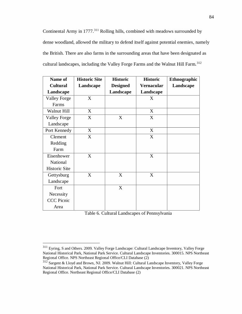
84
Continental Army in 1777.311 Rolling hills, combined with meadows surrounded by
dense woodland, allowed the military to defend itself against potential enemies, namely
the British. There are also farms in the surrounding areas that have been designated as
cultural landscapes, including the Valley Forge Farms and the Walnut Hill Farm.312
Name of
Cultural
Landscape
Historic Site
Landscape
Historic
Designed
Landscape
Historic
Vernacular
Landscape
Ethnographic
Landscape
Valley Forge
Farms
X X
Walnut Hill X X
Valley Forge
Landscape
X X X
Port Kennedy X X
Clement
Redding
Farm
X X
Eisenhower
National
Historic Site
X X
Gettysburg
Landscape
X X X
Fort
Necessity
CCC Picnic
Area
X
Table 6. Cultural Landscapes of Pennsylvania
311 Eyring, S and Others. 2009. Valley Forge Landscape: Cultural Landscape Inventory, Valley Forge
National Historical Park, National Park Service. Cultural Landscape Inventories. 300015. NPS Northeast
Regional Office. NPS Northeast Regional Office/CLI Database (2) 312 Sargent & Lloyd and Brown, NJ. 2009. Walnut Hill: Cultural Landscape Inventory, Valley Forge
National Historical Park, National Park Service. Cultural Landscape Inventories. 300021. NPS Northeast
Regional Office. Northeast Regional Office/CLI Database (2)
85
The Valley Forge Farms landscape is an historical farming area, with an
agricultural heritage during the last two centuries. The farming landscape complements
other industry in the area, specifically, the excavating and processing of lime, because the
area is situated within a dolomite valley.313 The Walnut Hill Farm is a small farm just
west of the main section of the Valley Forge National Historical Park. As with the Valley
Forge Farms, it was part of the complex used by the Continental Army, in 1777.314 The
farm landscape also represents the past two and a half centuries of agricultural
development, beginning with the settlement of Europeans, and progressing to the use of
slaves, and followed by tenant laborers. There is also archaeological evidence the land
was used before the Europeans settled, dating back to the Archaic period.315 The
landscape is similar to that of the rest of the valley, with rolling hills and meadows; there
are also historic farmhouses, adding to the evidence that the farmland has a long history
and culture of use.
Other Pennsylvania cultural landscapes are located in Gettysburg, Eisenhower’s
birthplace, and the area around Fort Necessity. The Gettysburg Battlefield and the
Eisenhower birthplace are located extremely close to each other. In addition to the
Eisenhower home, the Clement Redding Farm was designated as a National Historic
313 Ibid. 314 Sargent & Lloyd and Others. 2002. Valley Forge Farms: Cultural Landscape Inventory, Valley Forge
National Historical Park, National Park Service. Cultural Landscape Inventories. 300020. NPS Northeast
Regional Office. Northeast Regional Office/CLI Database (2) 315 Ibid.
86
Landmark in 1966.316 This farm was nominated for its proximity to the Eisenhower home
and the Gettysburg battlefield; under the nomination form, however, it only was
nominated under Criterion A, for its association with the Gettysburg battlefield.317,318 Its
location near the Eisenhower home provides a preservation zone to protect the home
from development. The farmstead provides another example of simple eighteenth and
nineteenth century farming techniques, though it was farmed until the mid-twentieth
century.319 Although historic, this farm would not be recognized as a cultural landscape,
except for the fact that is located between Gettysburg and the Eisenhower home.
The Gettysburg Battlefield cultural landscape is part of the large Gettysburg
National Military Park. As a cultural landscape, it is designated under three sub-
categories: designed landscape, historic site, and vernacular landscape.320 It is considered
a designed landscape, because parts of the land were designed and changed for a
memorial to commemorate the battle. Following the conflict, it was immediately clear
that the battle and the landscape would be historically important, and that the massive
loss of life required a memorial to honor the dead.321 The landscape is considered an
historic site because of the importance of the battle in the Civil War, as well as many
316 NPS Northeast Regional Office. 2009a. Clement Redding Farm: Cultural Landscape Inventory,
Eisenhower National Historic Site, National Park Service. Cultural Landscape Inventories. 300005.
Northeast Regional Office/CLI Database (2) 317 Eyring, S and Pevaroff, S. 2009. Eisenhower National Historic Site Landscape: Cultural Landscape
Inventory, Eisenhower National Historic Site, National Park Service. Cultural Landscape Inventories.
300003. NPS Northeast Regional Office. Northeast Regional Office/CLI Database (2) 318 NPS Northeast Regional Office. 2010a. Gettysburg Landscape: Cultural Landscape Inventory,
Gettysburg National Military Park, National Park Service. Cultural Landscape Inventories. 300133.
Northeast Regional Office/CLI Database (2) 319 Ibid. 320
Ibid. 321 Ibid.
87
important figures that visited the battlefield, including Abraham Lincoln and Robert E.
Lee.322 It was designated as a vernacular landscape because the rolling hills and woods
surrounding the land affected how the battle was fought.323
The final two cultural landscape areas in Pennsylvania, are in the central and
western sections of the state; both are projects of the1930s Civilian Conservation Corps
(CCC). The CCC built the Fort Necessity Picnic area and the Appalachian Trail during
the Great Depression.324 Although the Appalachian Trail is over two thousand miles long,
and extends along the Appalachian Mountain Range, the section in Shenandoah National
Park is designated as a designed cultural landscape because of the CCC work in the
1930s.325 According to the NPS rustic design guidelines, the CCC designed and built the
Shenandoah trail along with retaining walls and shelters.326 Today the trail is used more
than ever, while keeping the same style and main features that were exhibited when it
was built, in the 1930s.327 The Fort Necessity Picnic Area was designed and built by the
CCC in the 1930s; it is also significant because it is where George Washington won his
first battle, in 1754.328 In the 1930s, as part of the New Deal, the CCC built and designed
many parks within historical areas, including Fort Necessity. The CCC not only built
roadways and drainage systems for the park, they also planted trees and designed the
322 Ibid. 323 Ibid. 324 Sams, C and Others. 2009. Fort Necessity's CCC Picnic Area: Cultural Landscape Inventory, Fort
Necessity National Battlefield, National Park Service. Cultural Landscape Inventories. 300169. NPS
Northeast Regional Office. Northeast Regional Office/CLI Database (2) 325 Ibid. 326 Ibid. 327
Ibid. 328 Ibid.
88
picnic area while enhancing the fort’s historic setting.329 This combination of an historic
fort and the use of the NPS rustic designs from the 1930s makes this site a designed
cultural landscape.
There are currently no TCPs in Pennsylvania, however, there is one site that has
the potential to be nominated. The Seneca Nation could nominate the land around the
Kinzua Dam as a TCP. The Seneca Nation lived in the area along the Allegheny River, in
Warren County Pennsylvania where the dam was built in the 1960’s. Before the dam, the
Seneca lived and practiced their way of life here.330 The Seneca Nation lived on land
given to them through the 1794 Canandaigua Treaty, which was signed by George
Washington.331 The treaty gave the Seneca Nation complete control and power over the
land, so that could not be taken from the Seneca unless they sold it.332 The treaty was
broken by the U.S. government in the 1960s, when it decided to flood the land for the
Kinzua Dam construction.333
The Seneca Nation challenged this takeover of the land in court system; first, in
1958 when they attempted to get an injunction to stop the construction of the dam, which
was denied.334 This resulted in the forced relocation of 600 residents of the Seneca
Nation, who were taken from their homes and watched their houses bulldozed
329 Ibid. 330 Ibid. 331 U.S. Department of State, The Canandaigua Treaty of 1749 http://www.let.rug.nl/usa/documents/1786-
1800/the-canandaigua-treaty-of-1794.php Accessed 2/29/16 332 Ibid. 333 Ibid. 334
Senca Nation v. U.S. Army Corps of Engineers
https://law.resource.org/pub/us/case/reporter/F2/262/262.F2d.27.14488.html Accessed 3/1/16
89
immediately afterward.335 The land was taken, despite the fact that the Seneca Nation
lived there for over a hundred years. This land grab eliminated any land that the tribe
controlled in Pennsylvania and forced them to relocate to New York. The areas lost were
where they conducted religious practices and funerary rites, and where they hunted and
lived off the land.336 The dam formed land around the lake that the Seneca could
potentially reclaim and protect as a TCP. This land could very easily qualify as a TCP,
because it was used in a traditional manner when the tribe lived there from 1794 until
they were evicted in the 1960s. The land could still be used in many of their traditional
practices. Many of their ancestors are still buried there, giving the tribe a deep connection
to the land.337 It is unfortunate that over twenty years have passed since the land has not
been nominated as a TCP, or protected in any form.
Chapter Conclusion
There is a complicated relationship between TCPs and cultural landscapes in the
Mid-Atlantic. There are significantly more designated cultural landscapes in the Mid-
Atlantic compared to TCPs, and there are many factors that contribute to this. The
majority of cultural landscapes in the Mid-Atlantic are colonial or post-colonial historical
sites. They fall into three of the four categories: historic sites, historic designed
landscapes, or historic vernacular landscapes. All of the cultural landscapes are found on
335 Rose, Christina, “9 Reasons NOT to Celebrate the 50th Anniversary of the Kinzua Dam”, Accessed
3/1/16, http://indiancountrytodaymedianetwork.com/2015/10/07/9-reasons-not-celebrate-50th-anniversary-
kinzua-dam-161995 336
Ibid. 337 Ibid.
90
NPS land, and many of the sites are historic sites that have also been named cultural
landscapes. However, it seems absurd that there is not a single ethnographic landscape
out of more than 99 cultural landscapes. While there is nothing wrong with recognizing
these colonial landscapes, the lack of ethnographic landscapes demonstrates a lack of due
diligence by the NPS. It quietly eliminates the history of entire groups of people, and
ignores their impact on the land. By not acknowledging and protecting these lands,
certain histories are not preserved. This includes, but is not limited to, the indigenous
population, as well as the African-American community. This is not to argue that there
should be an equal number of landscapes created by indigenous or ethnic communities to
the colonial sites; however, there should also be representation for the minority
communities, as well. Consider, also, communities like the ethnic Chinese or the
Pennsylvania German groups.
The lack of the ethnographic landscapes would be less appalling if there were
TCPs designated in the Mid-Atlantic. The ethnographic cultural landscape and a TCP
have the most overlapping landscape definitions. There are several states, such as
Pennsylvania and Virginia which are trying to nominate sites as TCPs, but those
examples are limited. There are many potential factors for why there is a limited
representation of indigenous and ethnic communities. Historically, the majority of the
local Native tribes were forced out of the Mid-Atlantic region, beginning in the 1830s.
The local ethnic communities may or may not be aware of regulations that can be used to
protect their local cultural heritage. On the other end, local preservationists may not even
be aware of many potential sites or, without the local communities’ support, cannot push
91
for better government preservation protection of cultural landscapes and meaningful
places. All of these issues are not examples of malicious intent or one person’s failure.
Rather, this is an example of the systematic failure of federal regulations to properly
protect and inform the public of the importance of the identification and protection of
cultural landscapes and TCPs. The TCP and cultural landscape designations should be
combined in order to provide a stronger designation, with greater preservation impact,
rather than continuing to serve as two separate, albeit similar designations that already
lack by recognition.
92
Chapter IV: Conclusion and Recommendations
The systemic issues for identifying, designating, and protecting cultural
landscapes are challenging, though it is not for a lack of designations. Rather, the
significant number of designations, on both the international level and within the United
States, continually leads to challenges in properly protecting cultural landscapes that have
not yet been identified.
There are many different types of property designations that exist in the cultural
heritage protection field. On the international level, UNESCO recognizes cultural
heritage sites, such as monuments, groups of buildings, or sites nominated to the World
Heritage List.338 Under the umbrella of cultural heritage, cultural landscapes are included
with their own separate definition.339
The World Heritage Committee is now a place of politics, more than a place of
heritage preservation, with countries sending their diplomats to Committee meetings
rather than relying on heritage professionals.340 The trend of using diplomats, rather than
heritage professionals, to determine what should be nominated as a World Heritage site,
has led to stretching and bending the Criteria that qualify World Heritage List sites.341
This is apparent when sites are discretely changed from nomination as a cultural
landscape to nomination as a cultural heritage site. There is no means of knowing for
338 World Heritage List, UNESCO, Accessed 10/25/16,
http://whc.unesco.org/en/list/ 339 Ibid. 340Lynn Meskell: “The Rush to Inscribe: Reflections on the 35th Session of the World Heritage Committee,
UNESCO Paris, 2011” Journal of Field Archaeology, Vol. 37 No. 2012 (146) 341 Ibid.
93
certain why, for example, the Silk Road and the Andean Road changed from cultural
landscape designation to only cultural heritage sites; it is possible that this resulted from
politicking. Politicking is more evident when the Committee that decides which
properties to inscribe to the World Heritage List disregards the majority of the
professional opinions provided by the International Council on Monuments and Sites
(ICOMOS) research arm of UNESCO.342 Diplomats, nevertheless, continue in the hope
that nominating sites for their nations can help them gain favor with other countries and
increase favorable relations with each other. This evolution of leveraging cultural
heritage sites for diplomacy purposes is not driven by one particular nation or person. It
is, nonetheless, the result of a greater systemic failure to protect cultural heritage on the
international level.343
Politicking is not necessarily negative as it pertains to global politics, but it is to
the detriment of the quality and inclusiveness of the World Heritage List. If UNESCO
wants to continue to create and use sub-categories in order to designate cultural heritage
sites, then it should be more transparent with regard to how it nominates these sites;
detailed reporting in nomination files and publishing the World Heritage Committee
minutes would have a positive impact. Different definitions and types of cultural heritage
sites become meaningless if the designations and nominated sites are merely pawns in the
geo-political climate. UNESCO’s optimistic goal in creating the category of cultural
landscape was to recognize and protect worthy properties that may not have been
342Lynn Meskell: “The Rush to Inscribe: Reflections on the 35th Session of the World Heritage Committee,
UNESCO Paris, 2011” Journal of Field Archaeology, Vol. 37 No. 2 2012 (146) 343 Ibid.
94
considered otherwise. If properties are merely moved between designations for
diplomacy reasons, it would be foolish to continue the charade of so many in-depth
designations.
This issue of designations as diplomacy is not the same in the United States
system of cultural heritage protection, but misuse or lack of designation use does exist.
Cultural landscapes defined in the United States and the cultural landscapes defined by
UNESCO are extremely similar.344,345 The NPS cultural landscape definitions of a
historic site, historic designed, and historic vernacular landscape, are nearly identical to
the UNESCO definition of a clearly defined cultural landscape, designed and created
intentionally by man and the organically evolved landscape.346,347 The ethnographic
landscape, defined by the NPS, and the associative cultural landscape, defined by
UNESCO, parallel each other.348 For UNESCO, the associative landscape is a landscape
justified by a powerful connection to a religious, artistic, or cultural association that does
not rely on physical evidence for association. Meanwhile, the NPS ethnographic
landscape relies on the association of “natural or cultural resources” with a group’s
heritage.349
344 Cultural Landscapes, UNESCO, Accessed 12/13/15,http://whc.unesco.org/en/culturallandscape/ 345 Understanding Cultural Landscapes, NPS Accessed 1/20/16,
http://www.nps.gov/subjects/culturallandscapes/understand-cl.html 346 Ibid. 347 Ibid. 348
Ibid. 349 Ibid
95
When the majority of subcategories within the cultural landscape definition rely
on the site being built, designed, or associated with important historical events, it is not
shocking that the majority of cultural landscapes within the United States and in
UNESCO are thematically similar. Examples include site categories of monuments,
statues, and historic battles. As discussed in Chapter 3, majority of cultural landscapes
within the Mid-Atlantic region for the NPS are associated with battlefields, or historic
and colonial era farmsteads. The Mid-Atlantic does have a long colonial history; many
Native American tribes and communities were forced westwards in the early 19th century
with the enactment of the Indian Removal Act in 1830. The complete lack of
ethnographic landscapes in the Mid-Atlantic only perpetuates the disenfranchising of the
Native American communities that once lived in the region. There is also the issue that
ethnographic landscapes are not exclusively associated with Native Americans; any
community that has continued use of land and historic connection to an area can be
associated with a property that could be evaluated and nominated to the status of a TCP.
While the Mid-Atlantic does not represent the entire country, the pattern is noticeable;
there are over fifty cultural landscapes within the region, and all of them are designed,
vernacular, or historic sites. While these historic landscapes should be recognized and not
diminished as unimportant, it is problematic that they are the only landscapes represented
in an entire region because their themes and historical perspective are limited. Cultural
landscapes should be identified and associated with other ethnic or historic groups
throughout the United States, regardless of whether these groups produced tangible
heritage. The State Historic Preservation Offices should help diverse communities find
96
ways to protect land that is sacred or important to their social and cultural identity, such
as state-recognized Native American tribes, or a small fishing village that has maintained
its way of life over the last century.
Cultural landscapes in the United States are only designated on federal land and
are federal designations. This limitation restricts the identification of cultural landscapes
and TCPs to these lands and, therefore, their evaluation and recognized significance. The
result of cultural landscapes only designated by the NPS on park land or at national
monuments is that it limits the dissemination of information about these landscapes and
their importance to the public and local communities. One of the many goals of cultural
heritage preservation is public education and protecting the heritage for the greater good.
If cultural landscape designation is only used by the NPS, and without a broader
educational outreach to the local communities, then the program may not be successful in
meeting its goals. The opening line of the National Historic Preservation Act (NHPA)
states that “spirit and direction of the Nation are founded upon and reflected in its historic
past.”350 The original basis for the law is that historical sites should be protected for the
public good. For cultural landscape designation to become an important part of heritage
protection, it needs to be adopted by the local communities that are involved with cultural
heritage protection. Another larger issue at hand is that cultural landscapes, identified and
evaluated on federal land in the Mid-Atlantic, result in land that is already protected by
the National Park Service; there is simply a new change in title and classification. In fact,
all of the cultural landscape designations in the region are part of a larger park system,
350 National Historic Preservation Act, 1
97
under which they are already preserved and protected. Thus, these cultural landscapes
appear to be mere additions within parks where they are already protected.
The similarities between cultural landscapes and TCPs are striking, especially
when TCPs are compared to ethnographic landscapes. For both TCPs and ethnographic
landscapes, there should be an important cultural association with the land for the
community that surrounds it.351 Given this similarity, it is not surprising that there are
also no TCPs or ethnographic cultural landscapes in the Mid-Atlantic region. That sites
are not nominated as TCPs stems from multiple issues. For a TCP to be nominated, there
must be ethnographic research of the area, in addition to the research needed to prove that
the area meets one of the criteria for the National Register and subsequent professional
evaluation for the National Register eligibility. This inadvertently handicaps many small
traditional communities or social groups that might not have the funds to perform the
required research and professional evaluation, thereby punishing them with an inability to
protect their cultural heritage. TCPs originated as a preservation tool because, prior to the
1990s, cultural heritage protection failed to acknowledge and protect sites that did not fit
into the Western-Eurocentric view of cultural heritage.352 The TCP was created to correct
this gap in the heritage protection laws within the U.S.353
While the initial Bulletin 38 authors and NPS were wise to create the designation
of TCPs to include ethnographic evidence to prove a site’s importance, it also puts an
351 Thomas King and Patricia Parker, Guidelines for Evaluating and Documenting Traditional Cultural
Properties, U.S. Department of the Interior National Park Service 1998 (1) 352 Thomas King and Patricia Parker, Guidelines for Evaluating and Documenting Traditional Cultural
Properties, U.S. Department of the Interior National Park Service 1998 (2) 353 Ibid.
98
extra onus on the group nominating the site. A TCP designation should require either
historical evidence or ethnographic evidence. This allows traditional cultures to properly
protect their important landscapes with oral history and ethnographic research, potentially
making it easier for these groups to nominate their sites. Under the current requirements,
properties are more likely to be nominated as merely historical sites, rather than TCPs,
because the process is relatively easy and more familiar. The extra effort seems
superfluous, especially given that a TCP does not result in extra preservation protection
for the property.354 If a small traditional community is interested in protecting a property
in their community, the path of least resistance makes the most sense, regardless of the
designation it receives.
Cultural landscapes and TCPs are important preservation tools and should
continue to be used to protect cultural heritage. However, if these designations continue
to be used as they are now, their importance and ability to define cultural heritage sites
will weaken. If the goal of the cultural heritage field is only to label landscapes as
National Register-eligible in order to provide preservation protection, then the current
method of designating is barely succeeding. If there are more goals to protecting cultural
heritage, such as acknowledging the difference between a Native American religious site
and Independence Hall, then there are still issues of creating a distinction between these
two sites, without favoring one designation over another. Instead of combining all
cultural heritage under one umbrella for definition and protection support, there is
latitude to encourage diversity within the field of cultural heritage protection while still
354 Ibid.
99
making it accessible to all communities. If the field of cultural heritage protection is not
careful, it could favor certain historical narratives over more diverse narratives and
histories.
There are potential methods to correct for this systemic failure in cultural
landscape and TCP designation in order to more effectively protect cultural landscapes.
On the international level, it is foolish to think that the politicking at UNESCO will end
in the near future; however, that does not mean that accurately designating the cultural
heritage sites around the world is impossible. The professional cultural heritage
community needs to impress upon World Heritage Committee members that it is just as
effective to designate sites as cultural landscapes as it is to designate them as cultural
heritage sites. If the professional community does not take a stand to designate sites
properly and argue for their importance, then diplomats at the World Heritage Committee
meetings have little incentive to reform the politicking at the World Heritage Committee.
In the United States, the issues in protecting cultural landscapes are bigger than
politics. Both TCPs and ethnographic landscapes are protecting the same types of land
use patterns, yet neither exist in the Mid-Atlantic. There should be a better method to
disseminate preservation tool information on what protections TCPs and ethnographic
landscapes can offer, especially to disenfranchised communities, whether they are Native
Americans or other minority ethnic groups. This responsibility, once again, is on the
cultural heritage professionals and the State Historic Preservation Offices to provide
information to communities that may not be aware of what property and cultural
landscape protections they might receive. Finally, there should be a review of how TCPs
100
and cultural landscapes are identified and protected by cultural heritage professionals.
The NPS may have begun the internal process of reviewing TCPs designations, but
nothing has been publically published on these matters since 2012. The NPS should also
consider the need to review their cultural landscape designation process. A formal
unification of these two designations should transpire to eliminate competition between
them, and to remove the extra layers of bureaucracy created for people who are motivated
to protect their cultural heritage. Effectively, unification of Traditional Cultural
Properties and cultural landscapes would eliminate debates about whether to take the
easier path to nominate sites and landscapes or whether to follow a more rigorous process
for nomination. As a result, there would be a more efficient nomination process to protect
deserving landscapes.
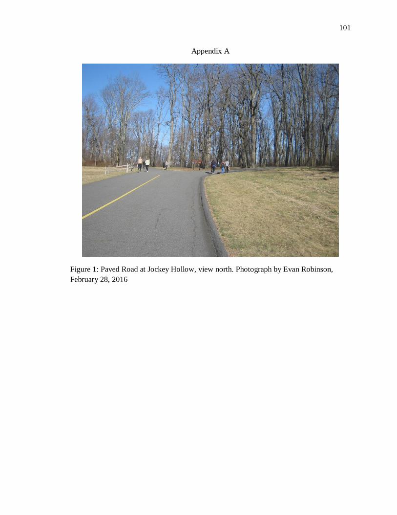
101
Appendix A
Figure 1: Paved Road at Jockey Hollow, view north. Photograph by Evan Robinson,
February 28, 2016
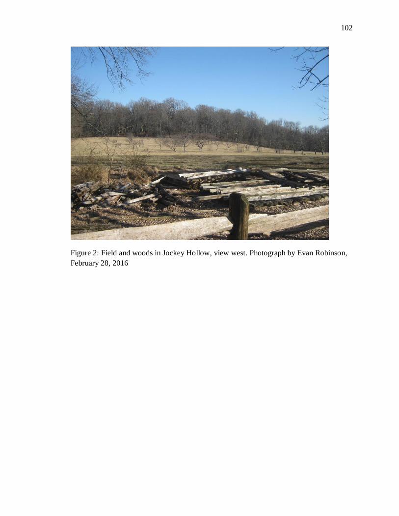
102
Figure 2: Field and woods in Jockey Hollow, view west. Photograph by Evan Robinson,
February 28, 2016
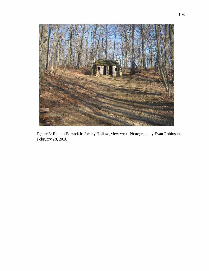
103
Figure 3: Rebuilt Barrack in Jockey Hollow, view west. Photograph by Evan Robinson,
February 28, 2016
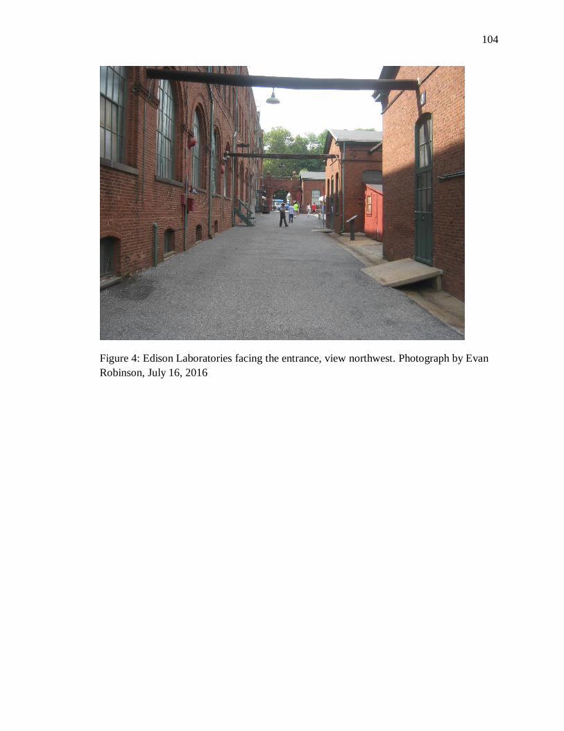
104
Figure 4: Edison Laboratories facing the entrance, view northwest. Photograph by Evan
Robinson, July 16, 2016
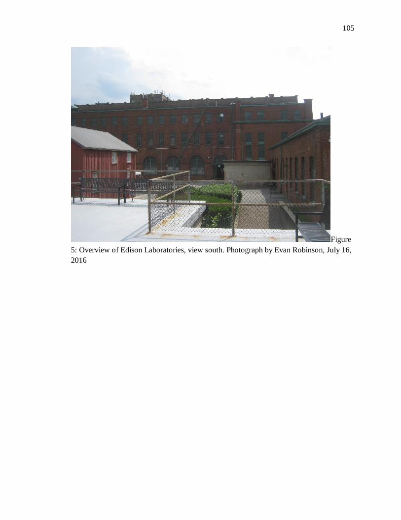
105
Figure
5: Overview of Edison Laboratories, view south. Photograph by Evan Robinson, July 16,
2016
106
Bibliography
2014 Nomination file Andean Road, UNESCO. Accessed 9/18/15.
http://whc.unesco.org/uploads/nominations/1459pdf.
2014 Nomination file Silk Road, UNESCO. Accessed 12/13/15.
http://whc.unesco.org/uploads/nominations/1442.pdf.
Andrus, Patrick. “National Register Bulletin: How to Apply the National Register
Criteria for Evaluation.” National Park Service: 1995.
Alanen, Arnold. “Considering the Ordinary: Vernacular Landscapes in Small Towns and
Rural Areas.” In Preserving Cultural Landscapes in America, edited by Arnold
Alanen and Robert Z. Melnick, Baltimore: The Johns Hopkins University Press,
2003.
Appalachian National Scenic Trail Special Report. Accessed 12/6/16.
https://www.nps.gov/appa/learn/management/upload/AT-report-web.pdf.
Beaver Valley First State National Park. Accessed 12/6/16.
https://www.nps.gov/frst/planyourvisit/beaver-valley.html.
Becker, Marshall Joseph. “A New Jersey Haven for Some Acculturated Lenape of
Pennsylvania During the Indian Wars of the 1760s.” Pennsylvania History: A
Journal of Mid-Atlantic Studies 60, no. 3 (1993): 322-44.
http://www.jstor.org/stable/27773651.
Birnhaum, Charles. Preservation Brief 36: Protecting Cultural Landscapes: Planning,
Treatment and Management of Historic Landscapes. National Park Service: 1994.
Brotherton & Weekpink Indian Communities of NJ. Accessed 2/25/16.
http://brotherton-weekping.tripod.com/.
Brown, N and et al. 2009. Linnaean Hill: Cultural Landscape Inventory, Rock Creek
Park, National Park Service. Cultural Landscape Inventories. 600032. NPS
National Capital Regional Office. National Capital Regional Office/CLI
Database.
Brown, NJ. 2006. Yorktown: Cultural Landscape Inventory, Colonial National Historical
Park, National Park Service. Cultural Landscape Inventories. 300085. NPS
Northeast Regional Office. Northeast Regional Office/CLI Database.
107
Commisso, M. 2011a. Edison Laboratory Complex: Cultural Landscape Inventory,
Thomas Edison National Historical Park, National Park Service. Cultural
Landscape Inventories. 975695. NPS Northeast Regional Office. Olmsted Center
for Landscape Preservation, Northeast Regional Office/CLI Database.
Commisso, M. 2011b. Glenmont Estate: Cultural Landscape Inventory, Thomas Edison
National Historical Park, National Park Service. Cultural Landscape Inventories.
650002. NPS Northeast Regional Office. Olmsted Center for Landscape
Preservation, Northeast Regional Office/CLI Database.
Convention for the Safeguarding of the Intangible Cultural Heritage. Accessed
12/14/16.http://www.unesco.org/culture/ich/en/convention.
Cultural Landscapes, UNESCO. Accessed 12/13/15.
http://whc.unesco.org/en/culturallandscape/.
The Criteria for Selection, UNESCO. Accessed 3/1/16. http://whc.unesco.org/en/criteria/.
Davison, M and Foulds, E. 2004. Fort McHenry National Monument and Historic Shrine:
Cultural Landscape Report, Fort McHenry National Monument and Historic
Shrine, National Park Service. Cultural Landscape Report. NPS Olmsted Center
for Landscape Preservation. Olmsted Center for Landscape Preservation.
Delaware National Parks. Accessed 2/25/16.
http://www.nps.gov/state/de/index.html.
Dolan, Susan. “Innovations in Managing National Park Service Cultural Landscapes:
Sustaining Historic and Traditional uses.” In Conserving Cultural Landscapes:
Challenges and New Directions edited by Ken Taylor, Archer St. Clair Harvey,
and Nora Mitchell, 251-260. New York: Routledge Taylor and Francis 2015.
Donaldson, E. 2009a. Brawner Farmstead: Cultural Landscape Inventory, Manassas
National Battlefield, National Park Service. Cultural Landscape Inventories.
600182. NPS National Capital Regional Office. National Capital Regional
Office/CLI Database.
Donaldson, E. 2009b. DC War Memorial: Cultural Landscape Inventory, National Mall
& Memorial Parks - West Potomac Park, National Park Service. Cultural
108
Landscape Inventories. 975436. NPS National Capital Regional Office. National
Capital Regional Office/CLI Database.
Donaldson, E. 2010. Kenilworth Aquatic Gardens: Cultural Landscape Inventory,
National Capital Parks-East-Anacostia Park, National Park Service. Cultural
Landscape Inventories. 600088. NPS National Capital Regional Office. National
Capital Regional Office/CLI Database.
Dorchester Heights National Historical Park, National Park Service. Accessed 1/20/16.
http://www.nps.gov/bost/learn/historyculture/dohe.htm.
Earley, J and Guenther, D. 2009. Memorial Avenue Corridor: Cultural Landscape
Inventory, George Washington Memorial Parkway, National Park Service.
Cultural Landscape Inventories. 600247. NPS National Capital Regional Office.
National Capital Regional Office/CLI Database.
Earley, J and Stafford, B. 2008. Catoctin Mountain Park: Cultural Landscape Inventory,
Catoctin Mountain Park, National Park Service. Cultural Landscape Inventories.
600017. NPS National Capital Regional Office. National Capital Regional
Office/CLI Database.
Earley, J. 2006. Camp Misty Mount: Cultural Landscape Inventory, Catoctin Mountain
Park, National Park Service. Cultural Landscape Inventories. 600104. NPS
National Capital Regional Office. National Capital Regional Office/CLI
Database.
Earley, J. 2009. Pennyfield Lock: Cultural Landscape Inventory, Chesapeake and Ohio
Canal National Historical Park, National Park Service. Cultural Landscape
Inventories. 600289. NPS National Capital Regional Office. National Capital
Regional Office/CLI Database.
Everett, J. 2009. Roulette Farmstead: Cultural Landscape Inventory, Antietam National
Battlefield, National Park Service. Cultural Landscape Inventories. 600284. NPS
National Capital Regional Office. National Capital Regional Office/CLI
Database.
Everett, J. 2011. D.R. Miller Farmstead: Cultural Landscape Inventory, Antietam
National Battlefield, National Park Service. Cultural Landscape Inventories.
600034. NPS National Capital Regional Office. National Capital Region/CLI
Database.
109
Eyring, S and Geyer, D. 2008. Green Spring: Cultural Landscape Inventory, Colonial
National Historical Park, National Park Service. Cultural Landscape Inventories.
300087. NPS Northeast Regional Office. Northeast Regional Office/CLI
Database.
Eyring, S and et al. 2009. Valley Forge Landscape: Cultural Landscape Inventory, Valley
Forge National Historical Park, National Park Service. Cultural Landscape
Inventories. 300015. NPS Northeast Regional Office. NPS Northeast Regional
Office/CLI Database.
Eyring, S and Pevaroff, S. 2009. Eisenhower National Historic Site Landscape: Cultural
Landscape Inventory, Eisenhower National Historic Site, National Park Service.
Cultural Landscape Inventories. 300003. NPS Northeast Regional Office.
Northeast Regional Office/CLI Database.
Fanning, K and McMillen, F. 2008. Columbus Plaza: Cultural Landscape Inventory,
National Mall & Memorial Parks - L'Enfant Plan Reservations, National Park
Service. Cultural Landscape Inventories. 600242. NPS National Capital Regional
Office. National Capital Regional Office/CLI Database.
Fanning, K and Ryberg, S. 2011. McPherson Square: Cultural Landscape Inventory,
National Mall & Memorial Parks - L'Enfant Plan Reservations. Cultural
Landscape Inventories. 600215. NPS National Capital Regional Office. National
Capital Regional Office/CLI Database.
Fanning, K and Zhang, G. 2011. Folger Park: Cultural Landscape Inventory, National
Capital Parks-East-Capitol Hill Parks. Cultural Landscape Inventories. 600076.
NPS National Capital Regional Office. National Capital Regional Office/CLI
Database.
Fanning, K. 2006. The Mall: Cultural Landscape Inventory, National Mall, National Park
Service. Cultural Landscape Inventories. 600213. NPS National Capital Regional
Office. National Capital Regional Office/CLI Database.
Fanning, K. 2008. Arlington Ridge Park: Cultural Landscape Inventory, George
Washington Memorial Parkway - Arlington Ridge Park, National Park Service.
110
Cultural Landscape Inventories. 600288. NPS National Capital Regional Office.
National Capital Regional Office/CLI Database.
Fanning, K. 2009. Fort Hunt Park: Cultural Landscape Inventory, George Washington
Memorial Parkway - Fort Hunt Park, National Park Service. Cultural Landscape
Inventories. 600177. NPS National Capital Regional Office. National Capital
Regional Office/CLI Database.
Fanning, K. 2011. Franklin Park: Cultural Landscape Inventory, National Mall &
Memorial Parks - L'Enfant Plan Reservation. Cultural Landscape Inventories.
600228. NPS National Capital Regional Office. National Capital Regional
Office/CLI Database.
Founder – Sri Swami Satchidananda, Yogaville Satchidananda Ashram. Accessed
2/29/16. https://www.yogaville.org/about-us/swami-satchidananda/.
Hanna, J and Others. 2009. Peirce Mill: Cultural Landscape Inventory, Rock Creek park,
National Park Service. Cultural Landscape Inventories. 600108. NPS National
Capital Regional Office. National Capital Regional Office/CLI Database.
Hardesty, Donald. “Ethnographic Landscapes: Transforming Nature into Culture.” in
Preserving Cultural Landscapes in America 169-185. Baltimore: The Johns
Hopkins University Press, 2003.
Historic Jamestown, National Park Service. Accessed 2/29/16.
http://www.nps.gov/jame/learn/historyculture/virginia-indian-tribes.html.
John Dickinson Plantation, State of Delaware, Division of Historical and Cultural Affairs.
Accessed 2/25/16. http://history.delaware.gov/museums/jdp/plantation.shtml.
Jokilehto, Jukka. “World heritage: Observations on Decisions Related to Cultural
Heritage.” Journal of Cultural Heritage Management and Sustainable
Development 1 2011 (61-74).
Joseph, M and Barrett, T. 2008. Joseph Poffenberger Farmstead: Cultural Landscape
Inventory, Antietam National Battlefield, National Park Service. Cultural
111
Landscape Inventories. 975301. NPS National Capital Regional Office. National
Capital Regional Office/CLI Database.
Joseph, M and Shiflet, K. 2011. Chevy Chase Circle: Cultural Landscape Inventory,
Rock Creek Park - DC Street Plan Reservations, National Park Service. Cultural
Landscape Inventories. 600261. NPS National Capital Regional Office. National
Capital Regional Office/CLI Database.
Joseph, M. 2008. Montrose Park: Cultural Landscape Inventory, Rock Creek Park -
Montrose Park, National Park Service. Cultural Landscape Inventories. 600115.
NPS National Capital Regional Office. National Capital Regional Office/CLI
Database.
Killion, J and Hilyard, G. 2008. Jamestown Island Area: Cultural Landscape Inventory,
Colonial National Historical Park, National Park Service. Cultural Landscape
Inventories. 300084. NPS Northeast Regional Office. Northeast Regional
Office/CLI Database.
King, E and Temkin, M. 2011. Groveton Cemetery: Cultural Landscape Inventory,
Manassas National Battlefield, National Park Service. Cultural Landscape
Inventories. 600185. NPS National Capital Regional Office. National Capital
Regional Office/CLI Database.
King, Thomas. Places that Count: Traditional Cultural Properties in Cultural Resource
Management. Walnut Creek: AltaMira Press, 2003.
King, Thomas. “Rethinking Traditional Cultural Properties.” Traditional Cultural
Properties: Volume 26, Number 1: 2009.
Labadi, Sophia. UNESCO, Cultural Heritage, and Outstanding Universal Value: Value-
based Analyses of the World Heritage and Intangible Cultural Heritage
Conventions. New York: Altamira Press.
Laird, ML. 2006. Fort Washington Park: Cultural Landscape Inventory, Fort Washington
Park, National Park Service. Cultural Landscape Inventories. 600098. NPS
National Capital Regional Office. National Capital Regional Office/CLI
Database.
112
Lena Blackburne Baseball Rubbing Mud. Accessed 2/25/16.
http://baseballrubbingmud.com/index.html.
Main Andean Road, UNESCO. Accessed 3/1/16.
http://whc.unesco.org/pg.cfm?cid=281&id_group=19&s=home.
McClelland, Linda. et al. National Register Bulletin 30: Evaluation and Documenting
Rural Historic Landscapes, U.S. Department of Interior, National Park Service,
1999.
McMillen, F. 2011. Oxon Cove Park: Cultural Landscape Inventory: National Capital
Parks-East-Oxon Cove Park. Cultural Landscape Inventories. 600093. NPS
National Capital Regional Office. National Capital Regional Office/CLI
Database.
Meridian Hill Park, National Park Service. Accessed 1/20/16.
http://www.nps.gov/mehi/learn/historyculture/index.html.
Meskell, Lynn. “The Rush to Inscribe: Reflections on the 35th Session of the World
Heritage Committee, UNESCO Paris, 2011” Journal of Field Archaeology, Vol.
37 No. 2: 2012.
Mezey, Naomi. "The Paradoxes of Cultural Property." Columbia Law Review 107, no. 8
(2007): 2004-046. http://www.jstor.org/stable/40041756.
Miller, Jay. 1997. “Old Religion Among the Delawares: The Gamwing (big House
Rite).” Ethnohistory 44 (1). Duke University Press: 113–34. doi:10.2307/482903.
Mitchell, Nora. et al. World Heritage Cultural Landscapes: A Handbook for
Conservation and Management. UNESCO, 2009.
Mitchell, Mike and Welch, Patrick. “Kuchamaa (Tecate Peak) Cultural Landscape.”
National Register of Historic Places Inventory/Nomination Form. Bureau of Land
Management, California, August 25th, 1992.
Moss, S. 2009. Arlington House: The Robert E. Lee Memorial: Cultural Landscape
Inventory, Arlington House: The Robert E. Lee Memorial, National Park Service.
Cultural Landscape Inventories. 600049. NPS National Capital Regional Office.
National Capital Regional Office/CLI Database.
National Congress of American Indians, Tribal Directory. Accessed 10/31/16.
113
http://www.ncai.org/tribal-directory.
National Historic Preservation Act, U.S. Code 89-665 (1966).
National Register of Historic Places, Tangier Island Historic District, Tangier,
Accomack, Virginia, National Register #309001.
National Register of Historic Places Program: Traditional Cultural Properties Request for
Comments. Accessed 10/31/16.
https://www.nps.gov/nr/publications/guidance/TCP_comments.htm.
NPS National Capital Regional Office and Donaldson, E. 2010. President's Park South:
Cultural Landscape Inventory, The White House (President's Park), National Park
Service. Cultural Landscape Inventories. 975602. National Capital Regional
Office/CLI Database.
NPS National Capital Regional Office and Fanning, K. 2006. Union Square: Cultural
Landscape Inventory, National Mall, National Park Service. Cultural Landscape
Inventories. 975261. National Capital Regional Office/CLI Database.
NPS National Capital Regional Office and McMillen, F. 2010. Fort Stevens: Cultural
Landscape Inventory, Rock Creek Park - Fort Circle Park - North, National Park
Service. Cultural Landscape Inventories. 600147. National Capital Regional
Office/CLI Database.
NPS National Capital Regional Office and Moss, S. 2013. Frederick Douglass National
Historic Site: Cultural Landscape Inventory. Cultural Landscape Inventories.
600033. National Capital Regional Office/CLI Database.
NPS Northeast Regional Office. 2006. Moore House: Cultural Landscape Inventory,
Colonial National Historical Park, National Park Service. Cultural Landscape
Inventories. 300223. Northeast Regional Office/CLI Database.
NPS Northeast Regional Office. 2007a. Appalachian Trail Landscape: Cultural
Landscape Inventory, Shenandoah National Park, National Park Service. Cultural
Landscape Inventories. 300129. Northeast Regional Office/CLI Database.
114
NPS Northeast Regional Office. 2007b. Appomattox Court House Landscape: Cultural
Landscape Inventory, Appomattox Court House National Historical Park,
National Park Service. Cultural Landscape Inventories. 300089. Northeast
Regional Office/CLI Database.
NPS Northeast Regional Office. 2007c. Appomattox Court House Village: Cultural
Landscape Inventory, Appomattox Court House National Historical Park,
National Park Service. Cultural Landscape Inventories. 300120. Northeast
Regional Office/CLI Database.
NPS Northeast Regional Office. 2009a. Clement Redding Farm: Cultural Landscape
Inventory, Eisenhower National Historic Site, National Park Service. Cultural
Landscape Inventories. 300005. Northeast Regional Office/CLI Database.
NPS Northeast Regional Office. 2009b. George Washington Birthplace Landscape:
Cultural Landscape Inventory, George Washington Birthplace National
Monument, National Park Service. Cultural Landscape Inventories. 300150.
Northeast Regional Office/CLI Database.
NPS Northeast Regional Office. 2009c. Jockey Hollow: Cultural Landscape Inventory,
Morristown National Historical Park, National Park Service. Cultural Landscape
Inventories. 650077. Northeast Regional Office/CLI Database.
NPS Northeast Regional Office. 2010a. Gettysburg Landscape: Cultural Landscape
Inventory, Gettysburg National Military Park, National Park Service. Cultural
Landscape Inventories. 300133. Northeast Regional Office/CLI Database.
NPS Northeast Regional Office. 2010b. Poplar Grove National Cemetery: Cultural
Landscape Inventory, Petersburg National Battlefield - Poplar Grove National
Cemetery, National Park Service. Cultural Landscape Inventories. 300216.
Northeast Regional Office/CLI Database.
NPS Northeast Regional Office. 2011. Cross Estate: Cultural Landscape Inventory,
Morristown National Historical Park, National Park Service. Cultural Landscape
Inventories. 650046. Northeast Regional Office/CLI Database.
115
NPS, NPS-28 Cultural Resource Management Guideline: Chapter 7 Management of
Cultural Landscapes, 2002.
Official Website of the Delaware Tribe of Indians. Accessed 2/25/16.
http://delawaretribe.org/locations/bartlesville-headquarters/.
Olmsted Center for Land Preservation. Accessed 12/6/16.
https://www.nps.gov/oclp/index.htm.
Parker, Patricia and King, Thomas, Guidelines for Evaluating and Documenting
Traditional Cultural Properties, U.S. Department of the Interior, National Park
Service, 1998.
Parker, Patricia. “Traditional Cultural Properties: What We Do and How You Think.”
CRM Volume 16, 1:99:3.
Paula Reed and Associates, Inc.. 2011. Antietam National Cemetery: Cultural Landscape
Inventory, Antietam National Battlefield - Antietam National Cemetery, National
Park Service. Cultural Landscape Inventories. 600048. NPS National Capital
Regional Office. National Capital Regional Office/CLI Database.
Pliska, J. 2011. Sherman Circle: Cultural Landscape Inventory, Rock Creek Park - DC
Street Plan Reservations. Cultural Landscape Inventories. 600165. NPS National
Capital Regional Office. National Capital Regional Office/CLI Database.
Preliminary Information Form: Historic District: Satchidananda Ashram, Yogaville,
Buckingham County, Virginia, 2015.
Prosper, Lisa. “Wherein Lies the Heritage Value? Rethinking the Heritage Value of
Cultural Landscapes from an Aboriginal Perspective.” The George Wright Forum.
Vol. 24, Num. 2(2007).
Provencher, S and Warner, L. 2003. Tassi Ranch: Cultural Landscape Inventory, Grand
Canyon - Parashant National Monument, National Park Service. Cultural
Landscape Inventories. 725387. NPS Pacific West Regional Office. Pacific West
Regional Office/CLI Database.
Qhapaq Nan, Andean Road. UNESCO. Accessed 12/13/15.
http://whc.unesco.org/en/list/1459.
Quinn, R and Wheelock, P. 2007. Stanton Park: Cultural Landscape Inventory, National
Capital Parks-East-Capitol Hill Parks. Cultural Landscape Inventories. 600075.
116
NPS National Capital Regional Office. National Capital Regional Office/CLI
Database.
Rose, Christina. “9 Reasons NOT to Celebrate the 50th Anniversary of the Kinzua Dam.”
Accessed 3/1/16. Http://indiancountrytodaymedianetwork.com/2015/10/07/9-
reasons-not-celebrate-50th-anniversary-kinzua-dam-161995.
Royal Botanic Gardens, Kew, UNESCO. Accessed 9/1/16.
http://whc.unesco.org/en/list/1084.
Rice Terraces of the Philippine Cordilleras, UNESCO. Accessed 9/1/16.
http://whc.unesco.org/en/list/722.
Ryberg, S and Fanning, K. 2009. Lincoln Park: Cultural Landscape Inventory, National
Capital Parks-East-Capitol Hill Parks. Cultural Landscape Inventories. 600072.
NPS National Capital Regional Office. National Capital Regional Office/CLI
Database.
Senca Nation v. U.S. Army Corps of Engineers. Accessed 3/1/16.
https://law.resource.org/pub/us/case/reporter/F2/262/262.F2d.27.14488.html.
Stoffle, Richard W. Halmo, David B and Austin, Diane E. “Cultural Landscapes and
Traditional Cultural Properties: A Southern Paiute View of the Grand Canyon and
Colorado River.” American Indian Quarterly, Vol. 21, No. 2 (Spring, 1997), pp.
229-249.
Sams, C and Brown, NJ. 2008. Drewry's Bluff: Cultural Landscape Inventory, Richmond
National Battlefield, National Park Service. Cultural Landscape Inventories.
300098. NPS Northeast Regional Office. Northeast Regional Office/CLI
Database.
Sams, C and et al. 2009. Fort Necessity's CCC Picnic Area: Cultural Landscape
Inventory, Fort Necessity National Battlefield, National Park Service. Cultural
Landscape Inventories. 300169. NPS Northeast Regional Office. Northeast
Regional Office/CLI Database.
Sams C. 2008. Chickahominy Bluff: Cultural Landscape Inventory, Richmond National
Battlefield Landscape, National Park Service. Cultural Landscape Inventories.
117
300099. NPS Northeast Regional Office. Northeast Regional Office/CLI
Database.
Sargent, Lloyd, and Brown, NJ. 2009. Walnut Hill: Cultural Landscape Inventory, Valley
Forge National Historical Park, National Park Service. Cultural Landscape
Inventories. 300021. NPS Northeast Regional Office. Northeast Regional
Office/CLI Database.
Sargent, Lloyd, and et al. 2002. Valley Forge Farms: Cultural Landscape Inventory,
Valley Forge National Historical Park, National Park Service. Cultural Landscape
Inventories. 300020. NPS Northeast Regional Office. Northeast Regional
Office/CLI Database.
Silk Roads: The Routes Network of Chang'an-Tianshan Corridor, UNESCO. Accessed
12/13/15. http://whc.unesco.org/en/list/1442/.
Smythe, Charles. “The National Register Framework for Protecting Cultural Heritage
Places.” Traditional Cultural Properties: Putting Concept into Practice: Vol. 26
No. 1 2009 pp. 14-27.
Snortland, J. Signe. "Caught in the Middle: The State Historic Preservation Office Role
In Federal Regulations." Plains Anthropologist 44, no. 170 (1999): 61-64.
http://www.jstor.org/stable/25669627.
Stanfill, Alan L. "Native American Participation in Federal Programs Under the National
Historic Preservation Act." Plains Anthropologist 44, no. 170 (1999): 65-70.
http://www.jstor.org/stable/25669628.
Stevens, C and Bailey, S. 2008. Four Locks: Cultural Landscape Inventory, Chesapeake
and Ohio Canal National Historical Park, National Park Service. Cultural
Landscape Inventories. 600279. NPS National Capital Regional Office. National
Capital Regional Office/CLI Database.
Stevens, C and Simpson, A. 2007. Asbury Memorial, US Reservation 309 B: Rock Creek
Park - DC Street Plan Reservations, National Park Service. Cultural Landscape
Inventories. 975383. NPS National Capital Regional Office. National Capital
Regional Office/CLI Database.
118
Stevens, C and Simpson, A. 2007. Marconi Memorial, US Reservation 309 A: Cultural
Landscape Inventory, Rock Creek Park - DC Plan Reservation, National Park
Service. Cultural Landscape Inventories. 600265. NPS National Capital Regional
Office. National Capital Regional Office/CLI Database.
Telaquana Trail, Lake Clark National Park and Preserve, National Park Service.
Accessed 1/20/16. http://www.nps.gov/lacl/learn/historyculture/telaquana-
trail.html.
Temkin, M. 2009. Thomas Farm: Cultural Landscape Inventory, Monocacy National
Battlefield, National Park Service. Cultural Landscape Inventories. 600294. NPS
National Capital Regional Office. National Capital Regional Office/CLI
Database.
Temkin, M. 2010. Great Falls Tavern: Cultural Landscape Inventory, Chesapeake and
Ohio Canal National Historical Park, National Park Service. Cultural Landscape
Inventories. 600271. NPS National Capital Regional Office. National Capital
Regional Office/CLI.
Temkin, M. 2010. Seneca Lock: Cultural Landscape Inventory, Chesapeake and Ohio
National Historical Park, National Park Service. Cultural Landscape Inventories.
975434. NPS National Capital Regional Office. National Capital Regional
Office/CLI Database.
Temkin M. 2011. Parks Farmstead: Cultural Landscape Inventory, Antietam National
Battlefield, National Park Service. Cultural Landscape Inventories. 600047. NPS
National Capital Regional Office. National Capital Regional Office/CLI
Database.
The Cultural Landscape Foundation. Accessed 12/6/16. http://tclf.org/places/about-
cultural-landscapes.
Titchen, Sarah. “On the Construction of ‘Outstanding Universal Value’, Some Comments
on the Implementation of the 1972 UNESCO World Heritage Convention.”
Conservation and Management of Archaeological Sites (1996) vol. 1 (235-242).
Tuan, Yi-Fu. Space and Place: The Perspective of Experience, University of Minnesota
Press, 1977.
119
The Lenape Tribe. Accessed 2/25/16.
http://www.lenapelifeways.org/lenape1.htm.
The Nanticke Lenni-Lenape. Accessed 2/25/16.
http://www.nanticoke-lenape.info/history.htm.
Uluru-Kata Tjuta National Park, UNESCO. Accessed 9/1/16.
http://whc.unesco.org/en/list/447.
Understanding Cultural Landscapes, NPS. Acessed 1/20/16.
http://www.nps.gov/subjects/culturallandscapes/understand-cl.html.
U.S. Department of Interior Indian Affairs. Accessed 10/31/16.
http://www.bia.gov/WhoWeAre/BIA/OIS/TribalGovernmentServices/TribalDirec
tory/.
U.S. Department of State, The Canandaigua Treaty of 1749. Accessed 2/29/16.
http://www.let.rug.nl/usa/documents/1786-1800/the-canandaigua-treaty-of-
1794.php.
Uschold, D and Eleey, P. 2009. Washington's Headquarters: Cultural Landscape
Inventory, Morristown National Historical Park, National Park Service. Cultural
Landscape Inventories. 650011. NPS Northeast Regional Office. Northeast
Regional Office/CLI Database.
Von Droste, Bernd. “The Concept of Outstanding Universal Value and its Application
‘From the Seven Wonders of the Ancient World to the 1,000 World Heritage
Places Today’.” Journal of Cultural Heritage Management and Sustainable
Development. Vol. 1 No. 1 2011 (26-41).
Wachau Cultural Landscape, UNESCO. Accessed 12/13/15.
http://whc.unesco.org/en/list/970.
World Heritage List, UNESCO. Accessed 10/25/16.
http://whc.unesco.org/en/list/.


