Embed Size (px)
Citation preview
No. 56 JUNE 2019
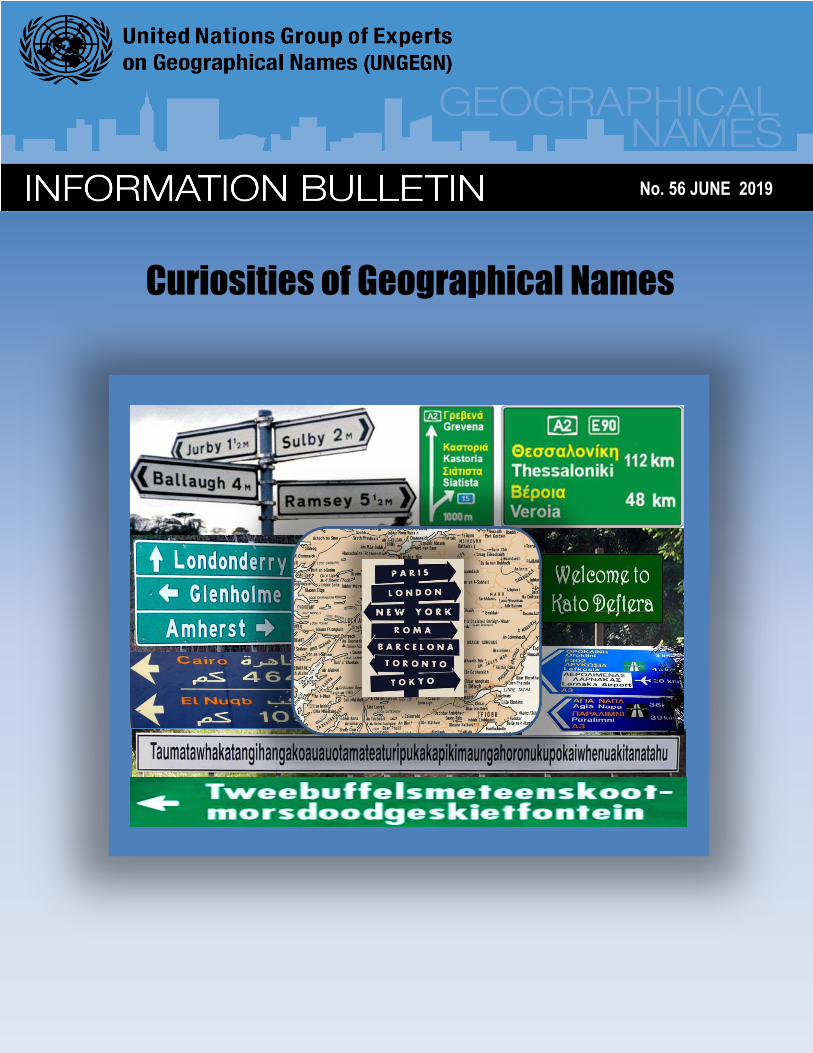
Curiosities of Geographical Names
UNGEGN Information Bulletin No. 56 • June 2019 • Page 2
The Information Bulletin of the United Nations Group of Experts on Geographical Names (formerly UNGEGN Newsletter) is issued twice a year by the Secretariat of the Group of Experts. The Secretariat is served by the Statistics Division (UNSD), Department for Economic and Social Affairs (DESA), Secretariat of the United Nations. Contributions and reports received from the Experts of the Group, its Linguistic/Geographical Divisions and its Working Groups are reviewed and edited jointly by the Secretariat and the UNGEGN Working Group on Publicity and Funding. Contributions for the Information Bulletin can only be considered when they are made available digitally in Microsoft Word or compatible format. They should be sent to the following address: Secretariat of the Group of Experts on Geographical Names (UNGEGN) Room DC2-1508 United Nations New York, NY 10017 USA Tel: (212) 963-5823 Fax: (212) 963-9851 E-mail: [email protected] mailto:[email protected]
IN THIS ISSUE
Message from the Chairperson 3
Message from the Secretariat 5
Special Feature – Curiosities of
geographical names
• The distinction of women's work through toponymy
• Proud of being named by exonyms
• The curious self-restraint of German speakers to use their place names for features abroad
• Considérations sur les curiosités toponymiques au Canada
• Curiosities of Geographical Names in Cyprus
• Curiosities of geographical names in Czechia
• Origins of Egyptian Geographical Names
• Curiosities of geographical names in New Zealand
• Cassiterides: how the mythical Tin Islands became the Azores
6
8 8
10
13
15
18
21
23
From the Divisions
• Division Afrique Centrale
• East Central and South-East Europe Division
24
25
Special Projects and News Items
• Recognizing William (Bill) Watt, 2012-2019
• Ninth Session of UN-GGIM
27
28
In Memoriam
• Dick Block (1925-2019)
29
Upcoming events
30
United Nations Group of Experts on Geographical Names Information Bulletin (ISSN 1014-798) is published by United Nations Statistics Division, Department of Economic and Social Affairs. The designations employed and the presentation of the material in this publication do not imply the expression of any opinion whatsoever on the part of the Secretariat of the United Nations concerning the legal status of any country, territory, city or area, or of its authorities or concerning the delimitation of its frontiers or boundaries. Previous issues of the Bulletin (formerly Newsletter) can be found at http://unstats.un.org/unsd/geoinfo/ungegn_info_bulletins.htm
UNGEGN Information Bulletin No. 56 • June 2019 • Page 3
Message from the Chairperson
Chers Collègues,
otre Groupe d’experts a été créé par une résolution de l’ECOSOC de 1959 1 , et en
soixante ans, nos prédécesseurs et nous avons produit un très important corpus de résolutions et de décisions d’ordre général. Il reste pourtant encore beaucoup à faire en matière de noms de lieux, notamment pour établir les articulations encore nécessaires entre résolutions d’ordre différent, pour favoriser l’application de ces principes généraux dans des outils opérationnels et dans des cas particuliers, et pour faire mieux prendre en compte ces questions par les États membres et au sein de chacun d’eux — y compris le mien. Pour ces raisons et à titre personnel, je suis impressionné par la responsabilité que votre confiance fait peser sur moi depuis que vous m’avez élu président pour quatre ans. Depuis treize ans que je participe au GENUNG, je n’ai pas été le seul à intervenir souvent pour défendre la diversité linguistique et culturelle en matière de noms de lieux et pour promouvoir leur dimension patrimoniale et culturelle. Cela reste des enjeux fondamentaux pour moi, mais cela ne le deviendra aussi pour nos gouvernements respectifs que si nous savons le démontrer par des exemples concrets et par des applications pratiques. En ce sens, le rapprochement avec l’UNGGIM décidé en 20172 est une chance à saisir, à la fois en lui apportant ce qu’il attend comme y travaille particulièrement notre groupe de travail sur les bases de données, et en le sensibilisant aux enjeux non géographiques des noms de lieux. J’ai pu mesurer aussi le sérieux mis par chacun dans sa tâche, qui se traduit tantôt par la volonté d’avancer vers l’établissement de règles communes, tantôt par l’expression de véritables passions autour de certains cas particuliers. Ces passions montrent, si besoin était, combien l’enjeu des noms de lieux dépasse la seule géographie. Elles montrent
aussi combien reste problématique mais urgent l’établissement de règles générales acceptées et appliquées par tous. Et les cas particuliers qui les suscitent constituent les meilleures « pierres de touche » de ces règles, avec aussi l’ensemble des « curiosités » dont certaines alimentent la suite du présent Bulletin. Pour orienter nos travaux maintenant, la première décision prise à l’issue de notre session d’avril-mai 2019 appelle l’élaboration d’un plan stratégique par le Bureau en étroite concertation avec les États membres. Le Bureau a convenu que la façon la plus étroite d’assurer cette concertation était de partir des propositions formulées par les États membres eux-mêmes. Chaque État membre va donc être invité formellement à indiquer au Secrétariat pour le vendredi 13 septembre 2019 les priorités qu’il souhaite voir retenir dans le futur plan stratégique du GENUNG. Le Bureau se réunira peu après et lancera l’élaboration d’un premier projet à partir de ces éléments, puis continuera à solliciter la contribution des États membres au fil de
l’avancement du plan stratégique et du programme de travail en vue d’un examen et d’une adoption à la session prévue en 2021. Parallèlement, le Bureau établira son propre programme de travail pour ces deux années afin de ne pas être réduit à l’inaction en attendant l’adoption du plan stratégique. Je suis sûr que chacun partage la gratitude que je souhaite exprimer enfin pour tous ceux qui font vivre le GENUNG : les membres du Bureau, étendu aux responsables de groupes de travail et aux anciens présidents, parmi lesquels je veux citer particulièrement mon prédécesseur, Bill Watt3 ; le Secrétariat au sein de la Division statistique, les traducteurs et les interprètes à l’occasion des sessions, et les autres services concernés des Nations unies ; et pour finir, bien sûr, chacun de vous qui portez l’expertise en matière de noms de lieux partout dans le monde ! Merci à chacun de votre coopération et d’une confiance dont
je suis résolu à me montrer aussi digne que possible. Pierre Jaillard (France) Chair, UNEGGN E-mail: [email protected]
1 Résolution 715 A (XXVII) de 1959. 2 Résolution E/RES/2018/2 du 10 novembre 2017, paragraphe 4.
3 Voir page 28
N
UNGEGN Information Bulletin No. 56 • June 2019 • Page 4
Dear Colleagues,
ur Group of experts was established by an ECOSOC resolution of 1959 4 , and
within sixty years, our predecessors and we have produced a very large body of resolutions and decisions supporting geographic names standardization. However, much remains to be done on the standardizing of place names; in particular to establish the links that are still necessary between different kinds of resolutions, to promote the implementation of these general principles in operational tools and in particular cases, and to ensure these issues are better taken into account by and within the Member States — including mine. For these reasons and for myself personally, I am impressed by the responsibility your trust has placed on me, with my election as chair for four years. For the thirteen years that I have been involved with UNGEGN, I have not been the only one to intervene often to defend linguistic and cultural diversity about place names and to promote their heritage and cultural dimension. This remains a fundamental issue for me, but it will become so for our respective governments only if we can demonstrate it by concrete examples and practical applications. In this sense, the collaboration with the United Nations Committee of Experts on Global Geospatial Information Management (UN-GGIM) decided in 20175 is an opportunity to be taken, both by bringing to the Committee of Experts what it expects, as works particularly our working group on toponymic data files and gazetteers, and by raising its awareness on the non-geographical issues of place names. I have also been able to measure the seriousness of each expert in his task, which translates sometimes into the will to move towards the establishment of common rules, sometimes by the expression of real passions about particular cases. These passions show, if need be, how
much the issue of place names goes beyond the sole geography. They also show how problematic but urgent is the establishment of general rules accepted and applied by all. And the particular cases that give rise to them constitute the best "touchstones" of these rules, along with all the "curiosities" some of which feed the rest of this Bulletin. To guide our work now, the first decision taken at the end of our April-May 2019 session calls for the Bureau to develop a strategic plan in close consultation with the Member States. The Bureau agreed that the best way to ensure this consultation, was to start from the proposals made by the Member States themselves. Each Member State will be invited shortly by formal correspondence to inform the Secretariat by Friday 13 September 2019 of the priorities it wishes to see reflected in the future UNGEGN strategic plan. The Bureau will meet shortly thereafter and will initiate the preparation of a first draft of the Strategic Plan based on the submissions from Member States. The Bureau will update and seek the input of Member States as the plan progresses, with the objective of having a finalized Strategic Plan and work programme ready for consideration and adoption at the session scheduled for 2021. At the same time, the Bureau will establish its own work program for these two years so as not to be reduced to inaction pending the adoption of the strategic plan. I am sure that everyone shares the gratitude that I wish to express finally for all those who make UNGEGN live: the members of the Bureau, extended to the convenors of working groups and past presidents, among whom I want to particularly mention my predecessor, Bill Watt6 ; the Secretariat within the Statistical Division, translators and interpreters for sessions, and other relevant United Nations services; and finally, of course, each of you who carry the expertise in place names all over the world! Thanks to each of you for your cooperation and confidence, which I am determined to be as worthy as possible. Pierre Jaillard (France) Chair, UNGEGN E-mail: [email protected]
4 Resolution 715 A (XXVII) of 1959 5 Resolution E/RES/2018/2 of 10 November 2017, paragraph 4.
6 See page 28
O
UNGEGN Information Bulletin No. 56 • June 2019 • Page 5
Message from the Secretariat
Dear UNGEGN Experts,
A curious theme
uriosities of geographical names” is the theme for this the 56th issue. My first question was, what does this really mean? A search of the Concise Oxford Dictionary defined curiosity as
“The desire or inclination to know or learn about anything, especially what is novel or strange; a feeling of interest leading one to inquire about anything.” I therefore interpreted this to mean that this issue of the bulletin would be a “humorous” issue, as the focus would be on odd, bizarre, inexplicable place names. A quick desk search unearthed lots of supporting information on peculiar and odd place names. For example, the longest geographical name is found in Thailand which has 163 letters; Papua New Guinea’s name is from the Malay word "papuah," meaning "frizzy-haired men; Saint-Louis-du-Ha!-Ha! in Québec, Canada, is the only city name in the world with two exclamation points; towns with emotive names such as Boring in Oregon, and names that make you hungry such as Hot Coffee and Two Egg. I reasoned therefore that a strange place name would stir one’s curiosity to find the history and meaning resulting in the name, and this would prod government authorities to develop formal place naming policies. Can one correctly conclude that curious place names influence geographical names standardization? Further, I questioned what is the true meaning of the theme? The convenor of the working group on publicity and funding “burst my bubble”. He informed that the theme seeks to highlight special issues and unforeseen aspects of standardizing geographical names. As you would therefore guess, we received eight themed articles with various interpretations of “curiosities of geographical names”. The take away from this exercise was, the meaning of future bulletin themes should be explained in the call for articles. The Working Group on Publicity and Funding and the Secretariat thank our expert authors from Argentina, Austria, Canada, Cyprus, Czechia, Egypt, New Zealand and Spain for researching and contributing a delightful mix of articles. Spain’s article examined the evolution of the name Azores, New Zealand’s looked at how mistakes and folk etymology have fashioned their place names, and Czechia’s and Egypt’s contributions shared the origin of place names based on the human body, plants, animals, distinguished persons and other features. A common thread identified across the articles was the poignant importance of place names in serving as records of a country’s history, heritage and cultural evolution. In hindsight, I thought that should the articles have ventured beyond a description of curiosities to examine whether the naming practices were aligned to UNGEGN resolutions on standardization, would have allowed us to see the relevance and impact of the resolutions. In closing this section, I must share with you the challenge issued by our Canadian experts in their article, “...for geographical names to once again delight the world, they will need to… move and amaze us: names conceived like works of art.” Extending thanks to all our contributors to this issue and to Andreas Hadjiraftis of Cyprus for once again designing the front page.
UNGEGN, the first session The UNSD, UNGEGN Secretariat thanks all attendees to the first (2019) session of the “new” UNGEGN, held in New York from 29 April to 3 May 2019. Two hundred and sixty-four delegates from 71 countries addressed 123 working papers, learnt from four special guest presentations and adopted six recommendations and 15 decisions. The report (E/2019/75) of the first UNGEGN session is now available in all six languages of the United Nations and can be accessed on the UNGEGN website. The report should be tabled at the management meeting of the United Nations Economic and Social Council in July 2019 for adoption. I wish to bring to the attention of our readers and State Members, Recommendation one to six, in section I of the report, specifically recommendation 1 which decided on the development of a draft strategic plan and programme of work for the “new” UNGEGN. Over the next six months you will be called upon to contribute to the exercise. The Secretariat heartily welcomes the officers of the new Bureau, who were elected at the end of the first session. Their names, countries and e-mails are available here: https://unstats.un.org/unsd/ungegn/bureau/. The Secretariat is delighted to announce that a new UNGEGN website was launched, and improvements and updates are continuously being made. Should you experience any problems please do not hesitate to send us at note at [email protected]. If you were not able to attend the first session, please note that the webcast recordings for the five days are available for viewing on the first session webpages. Please note that the second session of UNGEGN is scheduled for 3 to 7 May 2021 in New York, USA.
General Remarks Member States and national institutions responsible for geographical names are reminded to submit their information for the UNGEGN World Geographical Names Database. We also wish to inform our global experts and persons wishing to learn more about toponymy that they can pursue the online BSc level web course and access the recently released Toponymy Training Manual. Your comments on this issue and contribution to Bulletin no. 57, to be circulated in December 2019 under the theme “Communication strategies for encouraging the implementation of standardized geographical names”, are welcomed. Please remember to repost and circulate the bulletin among your colleagues and hoping you will find this issue enriching and interesting. Cecille Blake UNGEGN Secretariat E-mail: [email protected]
“C
UNGEGN Information Bulletin No. 56 • June 2019 • Page 6
SPECIAL FEATURE Curiosities of Geographical Names
The distinction of women's work through toponymy
he following article is focused on the recognition of the first four women assigned to perform field tasks for scientific purposes in the freezing temperatures of Antarctica, announcing, on
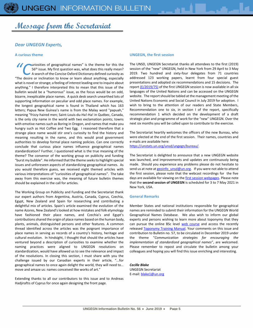
International Women's Day of 2018, that four geographic features of the Argentine Antarctic Sector will carry the name of those first four female scientists. Argentine scientific activity in Antarctica began at the end of 1901 with the help given to the Swedish Antarctic Expedition of Doctor Otto Nordenskjöld. In February of 1904 the Argentine Republic took possession of the Meteorological Observatory in the Orcadas del Sur Islands, thus establishing the permanent presence of Argentine scientists in Antarctica. Formerly human presence in Antarctica was reserved only for men, based on the harsh weather in the region and the characteristics of the work to be performed. It was in 1968 that this gender barrier was broken, with the arrival of the first Argentine female scientists designated to carry out fieldwork at the Melchior base. The researchers, baptized as "The four of Melchior" performed their duties in the Argentine Museum of Natural Sciences "Bernardino Rivadavia" (MACN). They were Elena Martínez Fontes, María Adela Caría, Irene Bernasconi and Carmen Pujals.
Elena Martínez Fontes was the head of the Marine Invertebrate Section of the MACN and she was an internationally recognized specialist in molluscs. Among her most outstanding works is the "Guide of South
American Naturalists" published in 1949 and "Antibacterial Inhibitors of Scenedesmus obliquus and Coelastrum microporum" in 1965.
The bacteriologist María Adela Caría was specialized in marine bacteriology. She was the head of Microbiology Section at the MACN and a member of the research career at the National Council of Scientific and Technical Research (CONICET). Irene María Bernasconi worked as a teacher and was also the most outstanding specialist in echinoderms in Argentina. In 1947 she was awarded the Dr. Eduardo Holmberg Prize for her work Asteroides argentinos (starfish). She published more than 50 papers, among them: "Echinoderms: result of the first expedition to Tierra del Fuego", "The echinoderms of the Argentine seas" and "The South American asteroids of the Indian family". Carmen Pujals graduated as a teacher and was also a renowned phycologist (specialist in marine algae) with an outstanding career. She was also a co-founder member of the Argentine Association of Phycology in 1991. The campaign began the 7th of November 1968 with the departure from Buenos Aires, on board the Argentine Navy transport ship A.R.A. "Bahía Aguirre", with destination to the Melchior naval base in Observatorio Island. It is a temporary base that had been closed for five years, so the first job of the entire crew was to have it rehabilitated.
T
Irene Bernasconi (sitting), Carmen Pujals, María Adela Caría and Elena M. Fontes in a cabinet of the Museo Argentino de
Ciencias Naturales. Photo: Argentine Antarctic Institute
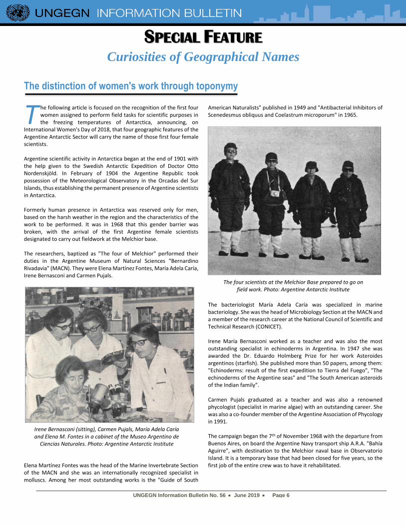
The four scientists at the Melchior Base prepared to go on field work. Photo: Argentine Antarctic Institute
UNGEGN Information Bulletin No. 56 • June 2019 • Page 7
For two and a half months, the scientists worked very intensely, boating thousand kilometers of coastline, and achieving numerous landings for sampling. They installed a large number of nets in depths of up to 180 meters. They made bottom traces up to 150 meters depth to collect benthonic organisms. They took more than one hundred water and sediment samples, as well as specimens of various species of marine flora and fauna, as well as carrying out bacterial counts and cultures.
Among the samples obtained, three specimens of fish called Parachaenichtys charcoti, a species from which only four specimens had been extracted worldwide, and a Gymnadraco victori fish, which existence was denied in the western sector of Antarctica; the more than two thousand specimens of echinoderms, which allowed the discovery of a family not cited for that region. An important novelty was the identification of the brown algae Cystosphaera jacquinotii in its place of rooting. The valuable collection of Antarctic seaweed, product of his work, is still part of the Museum Herbarium in which they worked and serves to train new scientists. On February 2, 1969, the four scientists boarded the A.R.A. “Bahía Aguirre” and undertook the return of such a singular campaign. The long return allowed them to go through Decepción, Esperanza, Petrel and Orcadas argentine bases. The discoveries made by "The Four of Melchior" during the 1968-1969 Antarctic Campaign marked an important advance and turned Argentina into one of the countries with the most complete biological collections in the world. But, undoubtedly, the most significant was to demonstrate that women could adapt to life in Antarctica as well as men, which meant the frequent inclusion of female research staff in following campaigns in Argentina. These four researchers were the first women in Argentina to set a precedent for the role that other scientists in the future would have in fields such as glaciology, biology, oceanography and environmental impact, contributing greatly to the development of science in the area. For this reason, in 2018, marking the 50th anniversary of that Campaign, the Argentine Antarctic Institute and the Antarctic National Directorate
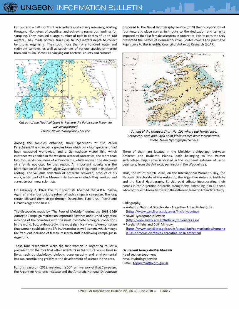
proposed to the Naval Hydrography Service (SHN) the incorporation of four Antarctic place names in tribute to the dedication and tenacity imposed by the first female scientists in Antarctica. For its part, the SHN presented the names of Bernasconi cove, Fontes cove, Caría point and Pujals cove to the Scientific Council of Antarctic Research (SCAR).
Three of them are located in the Melchior archipelago, between Amberes and Brabante islands, both belonging to the Palmer archipelago. Pujals cove is located in the southeast extreme of Jason peninsula, from the Antarctic peninsula in the Weddell sea. Thus, the 8th of March, 2018, on the International Women's Day, the National Directorate of the Antarctic, the Argentine Antarctic Institute and the Naval Hydrography Service paid tribute incorporating their names in the Argentine Antarctic cartography, extending it to all those who continue to break barriers in the different areas of Antarctic activity. Bibliography: • Antarctic National Directorate - Argentine Antarctic Institute
(https://www.cancilleria.gob.ar/es/iniciativas/dna) • Naval Hydrographic Service
(http://www.hidro.gov.ar/Noticias/mpioneras.asp) • Foreign Affairs and Cult Ministry
(https://www.cancilleria.gob.ar/es/actualidad/comunicados/homenaje-las-primeras-cientificas-argentina-en-la-antartida)
Lieutenant Nancy Anabel Marziali Head section toponymy Naval Hydrology Service E-mail: [email protected]
Cut out of the Nautical Chart H-7 where the Pujals cove Toponym was incorporated.
Photo: Naval Hydrography Service
Cut out of the Nautical Chart No. 101 where the Fontes cove,
Bernasconi cove and Caría point Place Names were incorporated. Photo: Naval Hydrography Service
UNGEGN Information Bulletin No. 56 • June 2019 • Page 8
Proud of being named by exonyms
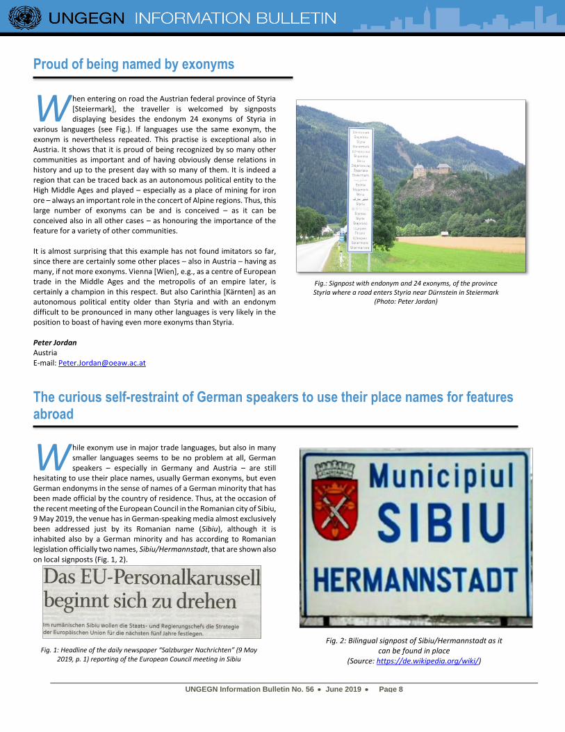
hen entering on road the Austrian federal province of Styria [Steiermark], the traveller is welcomed by signposts displaying besides the endonym 24 exonyms of Styria in
various languages (see Fig.). If languages use the same exonym, the exonym is nevertheless repeated. This practise is exceptional also in Austria. It shows that it is proud of being recognized by so many other communities as important and of having obviously dense relations in history and up to the present day with so many of them. It is indeed a region that can be traced back as an autonomous political entity to the High Middle Ages and played – especially as a place of mining for iron ore – always an important role in the concert of Alpine regions. Thus, this large number of exonyms can be and is conceived – as it can be conceived also in all other cases – as honouring the importance of the feature for a variety of other communities. It is almost surprising that this example has not found imitators so far, since there are certainly some other places – also in Austria – having as many, if not more exonyms. Vienna [Wien], e.g., as a centre of European trade in the Middle Ages and the metropolis of an empire later, is certainly a champion in this respect. But also Carinthia [Kärnten] as an autonomous political entity older than Styria and with an endonym difficult to be pronounced in many other languages is very likely in the position to boast of having even more exonyms than Styria. Peter Jordan Austria E-mail: [email protected]
The curious self-restraint of German speakers to use their place names for features abroad
hile exonym use in major trade languages, but also in many smaller languages seems to be no problem at all, German speakers – especially in Germany and Austria – are still
hesitating to use their place names, usually German exonyms, but even German endonyms in the sense of names of a German minority that has been made official by the country of residence. Thus, at the occasion of the recent meeting of the European Council in the Romanian city of Sibiu, 9 May 2019, the venue has in German-speaking media almost exclusively been addressed just by its Romanian name (Sibiu), although it is inhabited also by a German minority and has according to Romanian legislation officially two names, Sibiu/Hermannstadt, that are shown also on local signposts (Fig. 1, 2).
W
W
Fig. 1: Headline of the daily newspaper “Salzburger Nachrichten” (9 May 2019, p. 1) reporting of the European Council meeting in Sibiu
Fig. 2: Bilingual signpost of Sibiu/Hermannstadt as it can be found in place
(Source: https://de.wikipedia.org/wiki/)
Fig.: Signpost with endonym and 24 exonyms, of the province Styria where a road enters Styria near Dürnstein in Steiermark
(Photo: Peter Jordan)
UNGEGN Information Bulletin No. 56 • June 2019 • Page 9
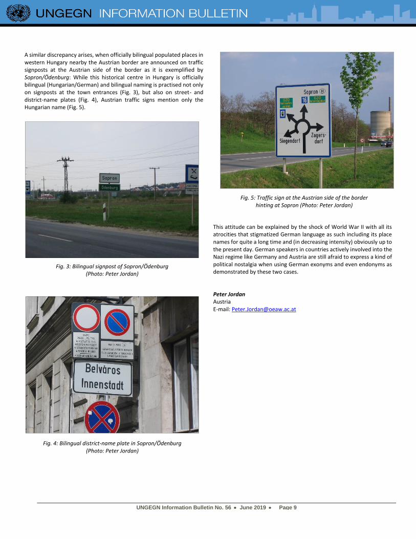
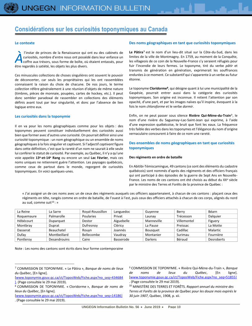
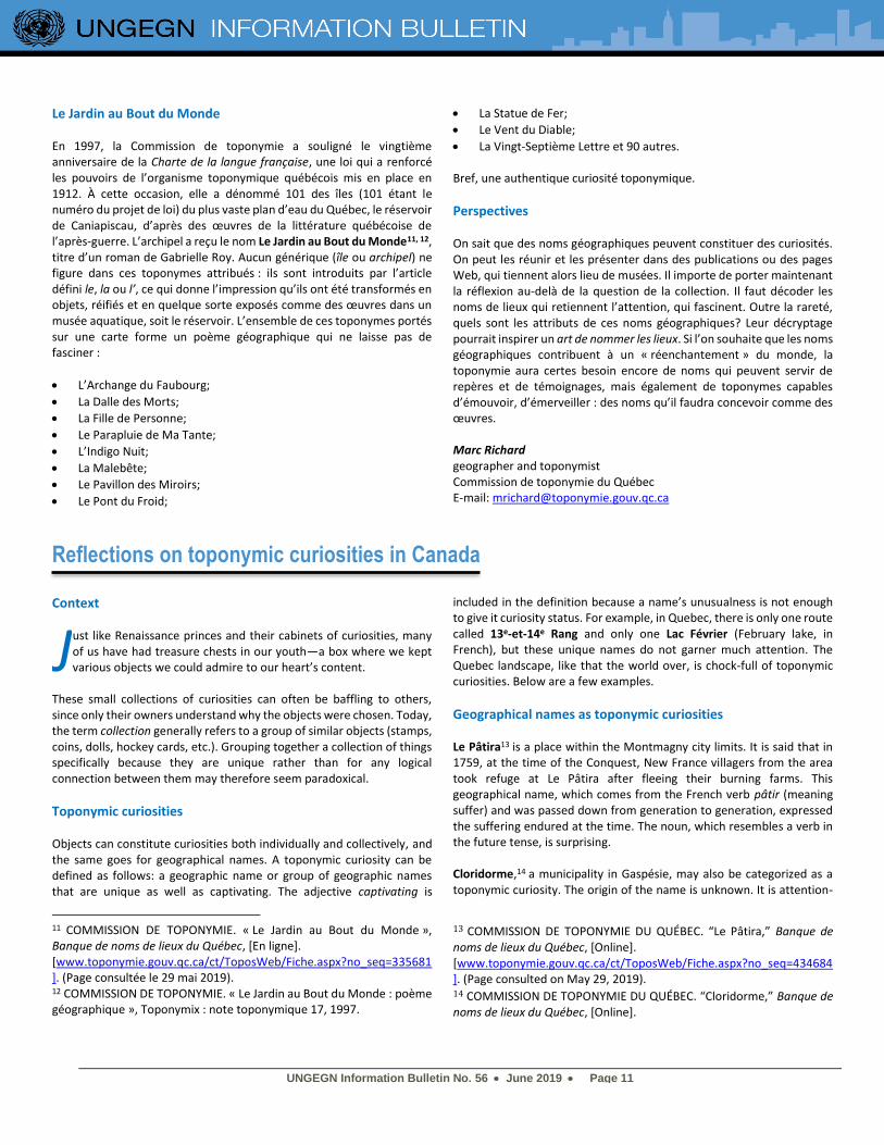
A similar discrepancy arises, when officially bilingual populated places in western Hungary nearby the Austrian border are announced on traffic signposts at the Austrian side of the border as it is exemplified by Sopron/Ödenburg: While this historical centre in Hungary is officially bilingual (Hungarian/German) and bilingual naming is practised not only on signposts at the town entrances (Fig. 3), but also on street- and district-name plates (Fig. 4), Austrian traffic signs mention only the Hungarian name (Fig. 5).
This attitude can be explained by the shock of World War II with all its atrocities that stigmatized German language as such including its place names for quite a long time and (in decreasing intensity) obviously up to the present day. German speakers in countries actively involved into the Nazi regime like Germany and Austria are still afraid to express a kind of political nostalgia when using German exonyms and even endonyms as demonstrated by these two cases. Peter Jordan Austria E-mail: [email protected]
Fig. 3: Bilingual signpost of Sopron/Ödenburg (Photo: Peter Jordan)
Fig. 5: Traffic sign at the Austrian side of the border hinting at Sopron (Photo: Peter Jordan)
Fig. 4: Bilingual district-name plate in Sopron/Ödenburg (Photo: Peter Jordan)
UNGEGN Information Bulletin No. 56 • June 2019 • Page 10
Considérations sur les curiosités toponymiques au Canada Le contexte
l’instar de princes de la Renaissance qui ont eu des cabinets de curiosités, nombre d’entre nous ont possédé dans leur enfance un coffre aux trésors, sous forme de boîte, où étaient entassés, pour
être regardés à satiété, les objets les plus divers. Ces minuscules collections de choses singulières ont souvent le pouvoir de déconcerter, car seuls les propriétaires qui les ont rassemblées connaissent la raison du choix de chacune. De nos jours, le terme collection réfère généralement à une réunion d’objets de même nature (timbres, pièces de monnaie, poupées, cartes de hockey, etc.). Il peut donc sembler paradoxal de rassembler en collections des éléments définis avant tout par leur singularité, et donc par l’absence de lien logique entre eux.
Les curiosités dans la toponymie Il en va pour les noms géographiques comme pour les objets : des toponymes peuvent constituer individuellement des curiosités aussi bien que former avec d’autres une curiosité. On pourrait définir ainsi une curiosité toponymique : un nom géographique ou un ensemble de noms géographiques à la fois singulier et captivant. Si l’adjectif captivant figure dans cette définition, c’est que la rareté d’un nom ne saurait à elle seule lui conférer le statut de curiosité. Par exemple, au Québec, il n’y a qu’une voie appelée 13e-et-14e Rang ou encore un seul Lac Février, mais ces noms uniques ne retiennent guère l’attention. Les paysages québécois, comme ceux de partout dans le monde, regorgent de curiosités toponymiques. En voici quelques-unes.
Des noms géographiques en tant que curiosités toponymiques Le Pâtira7 est le nom d’un lieu-dit situé sur la Côte-du-Sud, dans les limites de la ville de Montmagny. En 1759, au moment de la Conquête, les villageois de ce coin de la Nouvelle-France s’y seraient réfugiés pour fuir l’incendie de leurs fermes. Le toponyme, tiré du verbe pâtir et transmis de génération en génération, exprimerait les souffrances endurées à ce moment. Ce substantif qui s’apparente à un verbe au futur étonne. Le toponyme Cloridorme8, qui désigne quant à lui une municipalité de la Gaspésie, pourrait entrer aussi dans la catégorie des curiosités toponymiques. Son origine est inconnue. Il retient l’attention par son opacité, d’une part, et par les images naïves qu’il inspire, évoquant à la fois le nom chloroforme et le verbe dormir. Enfin, on ne peut passer sous silence Rivière Qui-Mène-du-Train9, le nom d’une rivière du Saguenay–Lac-Saint-Jean qui exprime, à l’aide d’une expression québécoise, le bruit que font les eaux. La fréquence très faible des verbes dans les toponymes et l’élégance du nom d’origine vernaculaire concourent à faire de ce nom une rareté.
Des ensembles de noms géographiques en tant que curiosités toponymiques Des régiments en ordre de bataille En Abitibi-Témiscamingue, 49 cantons (ce sont des éléments du cadastre québécois) sont nommés d’après des régiments et des officiers français qui ont participé à des épisodes de la guerre de Sept Ans en Nouvelle-France. Les noms de ces cantons ont été choisis au début du XXe siècle par le ministre des Terres et Forêts de la province de Québec :
« J’ai assigné un de ces noms avec un de ceux des régiments auxquels ces officiers appartenaient, à chacun de ces cantons : plaçant ceux des régiments en tête, rangés comme en ordre de bataille, de l’ouest à l’est, puis ceux des officiers attachés à chacun de ces corps, alignés du nord au sud, comme suit10 : »
La Reine La Sarre Royal-Roussillon Languedoc Guyenne Berry Béarn
Roquemaure Palmarolle Poularies Privat Launay Trécesson Dalquier Hébécourt Duparquet Destor Aiguebelle Manneville Villemontel Figuery
Montbray Duprat Dufresnoy Cléricy La Pause Preissac La Motte
Dasserat Beauchatel Rouyn Joannès Bousquet Cadillac Malartic Dufay Montbeillard Bellecombe Vaudray Montanier Surimau Fournière
Pontleroy Desandrouins Caire Basserode Darlens Béraud Desroberts
Note : Les noms des cantons sont écrits dans leur forme contemporaine
7 COMMISSION DE TOPONYMIE. « Le Pâtira », Banque de noms de lieux du Québec, [En ligne]. [www.toponymie.gouv.qc.ca/ct/ToposWeb/Fiche.aspx?no_seq=434684]. (Page consultée le 29 mai 2019). 8 COMMISSION DE TOPONYMIE. « Cloridorme », Banque de noms de lieux du Québec, [En ligne]. [www.toponymie.gouv.qc.ca/ct/ToposWeb/Fiche.aspx?no_seq=14186]. (Page consultée le 29 mai 2019).
9 COMMISSION DE TOPONYMIE. « Rivière Qui-Mène-du-Train », Banque de noms de lieux du Québec, [En ligne]. [www.toponymie.gouv.qc.ca/ct/ToposWeb/Fiche.aspx?no_seq=51855]. (Page consultée le 29 mai 2019). 10 MINISTÈRE DES TERRES ET FORÊTS. Rapport annuel du ministre des Terres et Forêts de la province de Québec pour les douze mois expirés le 30 juin 1907, Québec, 1908, p. xii.
À
UNGEGN Information Bulletin No. 56 • June 2019 • Page 11
Le Jardin au Bout du Monde En 1997, la Commission de toponymie a souligné le vingtième anniversaire de la Charte de la langue française, une loi qui a renforcé les pouvoirs de l’organisme toponymique québécois mis en place en 1912. À cette occasion, elle a dénommé 101 des îles (101 étant le numéro du projet de loi) du plus vaste plan d’eau du Québec, le réservoir de Caniapiscau, d’après des œuvres de la littérature québécoise de l’après-guerre. L’archipel a reçu le nom Le Jardin au Bout du Monde11, 12, titre d’un roman de Gabrielle Roy. Aucun générique (île ou archipel) ne figure dans ces toponymes attribués : ils sont introduits par l’article défini le, la ou l’, ce qui donne l’impression qu’ils ont été transformés en objets, réifiés et en quelque sorte exposés comme des œuvres dans un musée aquatique, soit le réservoir. L’ensemble de ces toponymes portés sur une carte forme un poème géographique qui ne laisse pas de fasciner :
• L’Archange du Faubourg;
• La Dalle des Morts;
• La Fille de Personne;
• Le Parapluie de Ma Tante;
• L’Indigo Nuit;
• La Malebête;
• Le Pavillon des Miroirs;
• Le Pont du Froid;
• La Statue de Fer;
• Le Vent du Diable;
• La Vingt-Septième Lettre et 90 autres. Bref, une authentique curiosité toponymique.
Perspectives On sait que des noms géographiques peuvent constituer des curiosités. On peut les réunir et les présenter dans des publications ou des pages Web, qui tiennent alors lieu de musées. Il importe de porter maintenant la réflexion au-delà de la question de la collection. Il faut décoder les noms de lieux qui retiennent l’attention, qui fascinent. Outre la rareté, quels sont les attributs de ces noms géographiques? Leur décryptage pourrait inspirer un art de nommer les lieux. Si l’on souhaite que les noms géographiques contribuent à un « réenchantement » du monde, la toponymie aura certes besoin encore de noms qui peuvent servir de repères et de témoignages, mais également de toponymes capables d’émouvoir, d’émerveiller : des noms qu’il faudra concevoir comme des œuvres. Marc Richard geographer and toponymist Commission de toponymie du Québec E-mail: [email protected]
Reflections on toponymic curiosities in Canada Context
ust like Renaissance princes and their cabinets of curiosities, many of us have had treasure chests in our youth—a box where we kept various objects we could admire to our heart’s content.
These small collections of curiosities can often be baffling to others, since only their owners understand why the objects were chosen. Today, the term collection generally refers to a group of similar objects (stamps, coins, dolls, hockey cards, etc.). Grouping together a collection of things specifically because they are unique rather than for any logical connection between them may therefore seem paradoxical.
Toponymic curiosities Objects can constitute curiosities both individually and collectively, and the same goes for geographical names. A toponymic curiosity can be defined as follows: a geographic name or group of geographic names that are unique as well as captivating. The adjective captivating is
11 COMMISSION DE TOPONYMIE. « Le Jardin au Bout du Monde », Banque de noms de lieux du Québec, [En ligne]. [www.toponymie.gouv.qc.ca/ct/ToposWeb/Fiche.aspx?no_seq=335681]. (Page consultée le 29 mai 2019). 12 COMMISSION DE TOPONYMIE. « Le Jardin au Bout du Monde : poème géographique », Toponymix : note toponymique 17, 1997.
included in the definition because a name’s unusualness is not enough to give it curiosity status. For example, in Quebec, there is only one route called 13e-et-14e Rang and only one Lac Février (February lake, in French), but these unique names do not garner much attention. The Quebec landscape, like that the world over, is chock-full of toponymic curiosities. Below are a few examples.
Geographical names as toponymic curiosities Le Pâtira13 is a place within the Montmagny city limits. It is said that in 1759, at the time of the Conquest, New France villagers from the area took refuge at Le Pâtira after fleeing their burning farms. This geographical name, which comes from the French verb pâtir (meaning suffer) and was passed down from generation to generation, expressed the suffering endured at the time. The noun, which resembles a verb in the future tense, is surprising. Cloridorme,14 a municipality in Gaspésie, may also be categorized as a toponymic curiosity. The origin of the name is unknown. It is attention-
13 COMMISSION DE TOPONYMIE DU QUÉBEC. “Le Pâtira,” Banque de noms de lieux du Québec, [Online]. [www.toponymie.gouv.qc.ca/ct/ToposWeb/Fiche.aspx?no_seq=434684]. (Page consulted on May 29, 2019). 14 COMMISSION DE TOPONYMIE DU QUÉBEC. “Cloridorme,” Banque de noms de lieux du Québec, [Online].
J
UNGEGN Information Bulletin No. 56 • June 2019 • Page 12
grabbing because of both its obscurity and the simple images it inspires, conjuring simultaneously the noun chloroform and the verb dormir (to sleep, in French). Finally, there is Rivière Qui-Mène-du-Train, 15 the name of a river in Saguenay–Lac-Saint-Jean that expresses the sound of water using a Quebec expression. The very uncommon presence of verbs in geographical names and the elegance of this name of vernacular origin make it rare.
Groups of geographical names as toponymic curiosities Regiments in order of battle In Abitibi-Témiscamingue, 49 counties (elements of the Quebec cadastre) are named after French regiments and officers who participated in the Seven Years’ War in New France. The names of these counties were chosen at the beginning of the 20th century by Quebec’s minister of lands and forests:
[TRANSLATION] “I assigned each county the name of a regiment the officers belonged to, starting with the regiments, in order of battle, from
west to east, followed by the names of the officers attached to each of the corps, from north to south, as follows:”16
La Reine La Sarre Royal-Roussillon Languedoc Guyenne Berry Béarn
Roquemaure Palmarolle Poularies Privat Launay Trécesson Dalquier
Hébécourt Duparquet Destor Aiguebelle Manneville Villemontel Figuery
Montbray Duprat Dufresnoy Cléricy La Pause Preissac La Motte
Dasserat Beauchatel Rouyn Joannès Bousquet Cadillac Malartic
Dufay Montbeillard Bellecombe Vaudray Montanier Surimau Fournière
Pontleroy Desandrouins Caire Basserode Darlens Béraud Desroberts
Note: The names of the counties are written in their present-day form. Le Jardin au Bout du Monde In 1997, the Commission de toponymie du Québec (the public body responsible for managing Quebec’s geographical names) marked the 20th anniversary of the Charter of the French Language, a law that strengthened the powers of Quebec’s toponymic organization, established in 1912. For this occasion, the Commission named 101 islands (in honour of Bill 101) in Quebec’s largest body of water, the reservoir de Caniapiscau, after works of post-war Quebec literature. The archipelago was named Le Jardin au Bout du Monde17, 18 (Garden in the Wind), which is the title of a novel by Gabrielle Roy. The generic term (island or archipelago) is not included in these names; they are introduced simply by the French definite article le, la or l’, which gives the impression that they have been turned into objects, made concrete and in a way exhibited as works in an aquatic museum—in this case the reservoir. Together, these geographical names on a map form a geographical poem that is nothing short of fascinating:
• L’Archange du Faubourg (the archangel from the faubourg);
• La Dalle des Morts (the tombstone of the dead);
• La Fille de Personne (the daughter of no one);
• Le Parapluie de Ma Tante (my aunt’s umbrella);
• L’Indigo Nuit (night indigo);
• La Malebête (the dangerous one);
[www.toponymie.gouv.qc.ca/ct/ToposWeb/Fiche.aspx?no_seq=14186]. (Page consulted on May 29, 2019). 15 COMMISSION DE TOPONYMIE DU QUÉBEC. “Rivière Qui-Mène-du-Train,” Banque de noms de lieux du Québec, [Online]. [www.toponymie.gouv.qc.ca/ct/ToposWeb/Fiche.aspx?no_seq=51855]. (Page consulted on May 29, 2019). 16 MINISTÈRE DES TERRES ET FORÊTS. Rapport annuel du ministre des Terres et Forêts de la province de Québec pour les douze mois expirés le 30 juin 1907, Québec, 1908, p. xii.
• Le Pavillon des Miroirs (the house of mirrors);
• Le Pont du Froid (the bridge of coldness);
• La Statue de Fer (the iron statue);
• Le Vent du Diable (wind of the devil);
• La Vingt-Septième Lettre (the twenty-seventh letter) and 90 others.
In other words, it is a true toponymic curiosity.
Perspectives We have seen that geographical names can be curiosities. They can be grouped together and presented in publications or webpages, which then serve as museums. Let’s now move on to a reflection beyond collections. We must decode place names that catch our attention and fascinate us. Besides their unusualness, what attributes do these names have? Decrypting them could inspire an art of naming places. For geographical names to once again delight the world, they will need to not only serve as landmarks and tributes, but also move and amaze us: names conceived like works of art. Marc Richard geographer and toponymist Commission de toponymie du Québec E-mail: [email protected]
17 COMMISSION DE TOPONYMIE DU QUÉBEC. “Le Jardin au Bout du
Monde,” Banque de noms de lieux du Québec, [Online]. [www.toponymie.gouv.qc.ca/ct/ToposWeb/Fiche.aspx?no_seq=335681]. (Page consulted on May 29, 2019). 18 COMMISSION DE TOPONYMIE DU QUÉBEC. “Le Jardin au Bout du Monde : poème géographique,” Toponymix : note toponymique 17, 1997.
UNGEGN Information Bulletin No. 56 • June 2019 • Page 13
Curiosities of Geographical Names in Cyprus Introduction
he History and Culture of Cyprus is among the oldest in the world. The first signs of civilization traced in archaeological excavations and research, date back approximately 9,000 years to the 7th
millennium BC. This rich cultural landscape involves hundreds of archaeological sites scattered throughout the island, representing various historical periods in the island's evolution. To a significant extent, geography determined the historical destiny of Cyprus, because of its geostrategic location, at the meeting point of three continents, namely: Europe, Asia and Africa. For certain periods, Cyprus lived under foreign domination. The following periods in time characterize the multi-cultural history of Cyprus: 1. 7000-3900 BC Neolithic Age 2. 3900-2500 BC Chalcolithic Age 3. 2500-1050 BC Bronze Age 4. 1050-750 BC Geometric Period 5. 750-325 BC Archaic and Classical Period 6. 333-325 BC Alexander the Great defeats Persia and Cyprus
becomes part of his empire. 7. 325-58 BC Hellenistic Period 8. 58 BC - 330 AD Roman Period 9. 330-1191 AD Byzantine Period 10. 1191-1192 AD Richard The Lionheart And The Templars 11. 1192-1489 AD Frankish (Lusignan) Period 12. 1489-1571 AD Venetian Period 13. 1571- 1878 AD OTTOMAN PERIOD 14. 1878-1960 British Period 15. 1960 Republic Of Cyprus
Cyprus became an independent republic in 1960. It is a member of the United Nations, the European Union, the Council of Europe, and the Commonwealth.
Geographical Names in Cyprus As explained above, Cyprus went through several periods in history, which had an influence on the population, the language, the religion, the customs, and the culture. Geographical names are of course a significant part of cultural heritage, and as such, they have been affected significantly by each period in history. Geographical names, in several cases, reveal a significant part of the history of the place they refer to. An analysis was made using GIS technology. Geographical names and toponyms were selected and grouped, based on character strings they include.
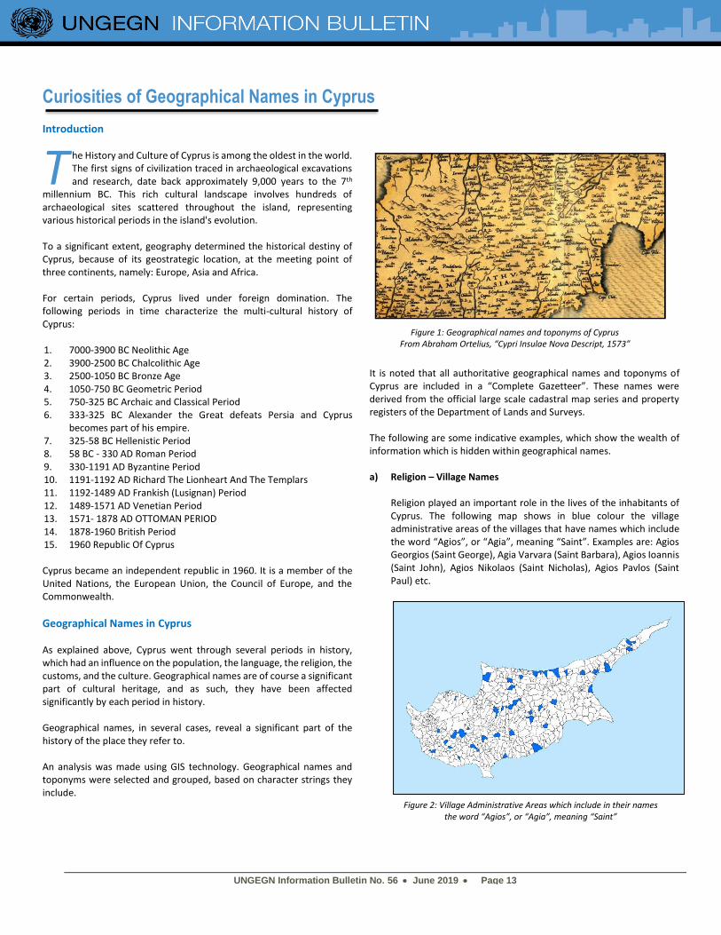
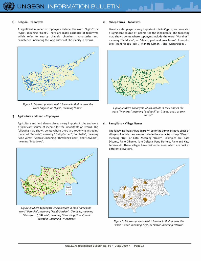
It is noted that all authoritative geographical names and toponyms of Cyprus are included in a “Complete Gazetteer”. These names were derived from the official large scale cadastral map series and property registers of the Department of Lands and Surveys. The following are some indicative examples, which show the wealth of information which is hidden within geographical names. a) Religion – Village Names
Religion played an important role in the lives of the inhabitants of Cyprus. The following map shows in blue colour the village administrative areas of the villages that have names which include the word “Agios”, or “Agia”, meaning “Saint”. Examples are: Agios Georgios (Saint George), Agia Varvara (Saint Barbara), Agios Ioannis (Saint John), Agios Nikolaos (Saint Nicholas), Agios Pavlos (Saint Paul) etc.
T
Figure 1: Geographical names and toponyms of Cyprus From Abraham Ortelius, “Cypri Insulae Nova Descript, 1573”
Figure 2: Village Administrative Areas which include in their names the word “Agios”, or “Agia”, meaning “Saint”
UNGEGN Information Bulletin No. 56 • June 2019 • Page 14
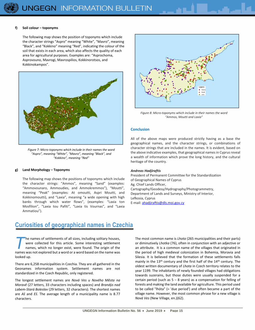
b) Religion – Toponyms
A significant number of toponyms include the word “Agios”, or “Agia”, meaning “Saint”. There are many examples of toponyms which refer to nearby chapels, churches, monasteries and cemeteries, indicating the long history of Christianity in Cyprus.
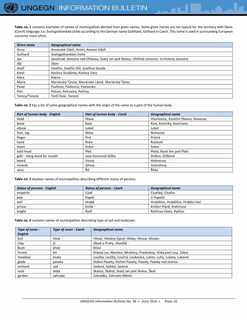
c) Agriculture and Land – Toponyms
Agriculture and land always played a very important role, and were a significant source of income for the inhabitants of Cyprus. The following map shows points where there are toponyms including the word “Pervolia”, meaning “Field/Garden”, “Ambelia”, meaning “vine-yards”, “Alonia”, meaning “Threshing Floors”, and “Leivadia”, meaning “Meadows”.
d) Sheep-Farms – Toponyms Livestock also played a very important role in Cyprus, and was also a significant source of income for the inhabitants. The following map shows points where toponyms include the word “Mandres”, meaning “Paddocks”, or “sheep, goat and cow farms”. Examples are: “Mandres tou Pieri”,” Mandra Kameni”, and “Mantroudes”.
e) Pano/Kato – Village Names
The following map shows in brown color the administrative areas of villages of which their names include the character strings “Pano”, meaning “Up”, or Kato, Meaning “Down”. Examples are: Kato Dikomo, Pano Dikomo, Kato Deftera, Pano Deftera, Pano and Kato Lefkara etc. These villages have residential areas which are built at different elevations.
Figure 6: Micro-toponyms which include in their names the word “Pano”, meaning “Up”, or “Kato”, meaning “Down”
Figure 5: Micro-toponyms which include in their names the word “Mandres” meaning “paddock” or “sheep, goat, or cow
farms”
Figure 3: Micro-toponyms which include in their names the word “Agios”, or “Agia”, meaning “Saint”
Figure 4: Micro-toponyms which include in their names the word “Pervolia”, meaning “Field/Garden”, “Ambelia, meaning
“Vine-yards”, “Alonia”, meaning “Threshing Floors”, and “Leivadia”, meaning “Meadows”
UNGEGN Information Bulletin No. 56 • June 2019 • Page 15
f) Soil colour – toponyms The following map shows the position of toponyms which include the character strings “Aspro” meaning “White”, “Mavro”, meaning “Black”, and “Kokkino” meaning “Red”, indicating the colour of the soil that exists in each area, which also affects the quality of each area for agricultural purposes. Examples are: “Asprochoma, Asprovouno, Mavrogi, Mavrospilios, Kokkinorotsos, and Kokkinokampos”.
g) Land Morphology – Toponyms
The following map shows the positions of toponyms which include the character strings: “Ammos”, meaning “Sand” (examples: “Ammovounaro, Ammoudies, and Ammokremmos”), “Moutti”, meaning “Peak” (examples: At omoutti, Aspri Moutti, and Kokkinomoutti), and “Laxia”, meaning “a wide opening with high banks through which water flows”, (examples: “Laxia ton Mosfilion”, “Laxia tou Pafiti”, “Laxia tis Vournas”, and “Laxia Ammatiou”).
Conclusion
All of the above maps were produced strictly having as a base the geographical names, and the character strings, or combinations of character strings that are included in the names. It is evident, based on the above indicative examples, that geographical names in Cyprus reveal a wealth of information which prove the long history, and the cultural heritage of the country. Andreas Hadjiraftis President of Permanent Committee for the Standardization of Geographical Names of Cyprus Ag. Chief Lands Officer, Cartography/Geodesy/Hydrography/Photogrammetry, Department of Lands and Surveys, Ministry of Interior, Lefkosia, Cyprus E-mail: [email protected]
Curiosities of geographical names in Czechia
he names of settlements of all sizes, including solitary houses, were collected for this article. Some interesting settlement names, which no longer exist, were found. The origin of the
names was not explored but a word or a word based on the name was looked up.
There are 6,258 municipalities in Czechia. They are all gathered in the Geonames information system. Settlement names are not standardized in the Czech Republic, only registered.
The longest settlement names are Nová Ves u Nového Města na Moravě (27 letters, 33 characters including spaces) and Brandýs nad Labem-Stará Boleslav (29 letters, 32 characters). The shortest names are Aš and Eš. The average length of a municipality name is 8.77 characters.
The most common name is Lhota (265 municipalities and their parts) or diminutively Lhotka (76), often in conjunction with an adjective or an attribute. It is a common name of the villages that originated in the period of high medieval colonization in Bohemia, Moravia and Silesia. It is believed that the formation of these settlements falls mainly in the 13th century and the first half of the 14th century. The oldest written documentary of Lhota in Czech territory relates to the year 1199. The inhabitants of newly founded villages had obligations towards suzerains, but those duties were usually suspended for a certain period (such as 5 – 8 years) as a compensation for felling of forests and making the land available for agriculture. This period used to be called "lhóta" (= 'due period') and often became a part of the village name. However, the most common phrase for a new village is Nová Ves (New Village, en.)(62).
T
Figure 8: Micro-toponyms which include in their names the word “Ammos, Moutti and Laxia”
Figure 7: Micro-toponyms which include in their names the word “Aspro”, meaning “White”, “Mavro”, meaning “Black”, and
“Kokkino”, meaning “Red”
UNGEGN Information Bulletin No. 56 • June 2019 • Page 16
Table no. 1 contains examples of names of municipalities derived from given names. Some given names are not typical for the territory with Slavic (Czech) language, i.e. Svatogothardská Lhota according to the German name Gotthard, Gothard in Czech. This name is used in surrounding European countries more often.
Given name Geographical name
Anna Annenské Údolí, Annín, Annino Údolí
Gothard Svatogothardská Lhota
Jan Janohrad, Janovice nad Úhlavou, Svatý Jan pod Skalou, Uhlířské Janovice, Vrchotovy Janovice
Jiljí Jiljov
Josef Josefov, Josefův Důl, Josefova bouda
Karel Karlova Studánka, Karlovy Vary
Klára Klárov
Marie Mariánská Týnice, Mariánské Lázně, Mariánský Týnec
Pavel Pavlínov, Pavlovice, Pavlovsko
Petr Petrov, Petrovice, Petřiny
Tereza/Terezie Terčí Dvůr, Terezín
Table no. 2 has a list of some geographical names with the origin of the name as a part of the human body.
Part of human body - English Part of human body - Czech Geographical name
head Hlava Hlavňovice, Kostelní Hlavno, Hlavenec
bone Kost Kost, Kostníky, Kostrčany
elbow Loket Loket
foot, leg Noha Nohavice
finger Prst Prstná
hand Ruka Rukáveč
heart Srdce Srdov
bald head Pleš Pleše, Nové Ves pod Pleší
gob – slang word for mouth ústa-hovorově držka Držkov, Držková
beard Vousy Holovousy
innards Střeva Holostřevy
anus Řiť Řitka
Table no. 3 displays names of municipalities describing different status of persons.
Status of persons - English Status of persons - Czech Geographical name
emperor Císař Císařský, Císařov
pop Papež U Papežů
earl Hrabě Hrabětice, Hraběšice, Hraběcí Huť
prince Kníže Knížecí Pláně, Kněžmost
knight Rytíř Rytířova Lhota, Rytířov
Table no. 4 contains names of municipalities describing type of soil and landcover.
Type of cover - English
Type of cover - Czech Geographical name
Soil hlína Hlineč, Hliněný Újezd, Hlinky, Hlinná, Hlinsko
Clay jíl Jílové u Prahy, Jíloviště
Bush křoví Křoví
Forest les Krásný Les, Mezilesí, Mrsklesy, Praskolesy, Víska pod Lesy, Zálesí
meadow louka Loučka, Loučky, Loučná, Loukovice, Luhov, Luhy, Lužany, Lukavec
glade paseka Dolení Paseky, Hoření Paseky, Paseky, Paseky nad Jizerou
orchard sad Sadová, Sadská, Sazená
rock skála Skalice, Skalná, Svatý Jan pod Skalou, Škalí
garden zahrada Zahrádky, Zahradní Město
UNGEGN Information Bulletin No. 56 • June 2019 • Page 17
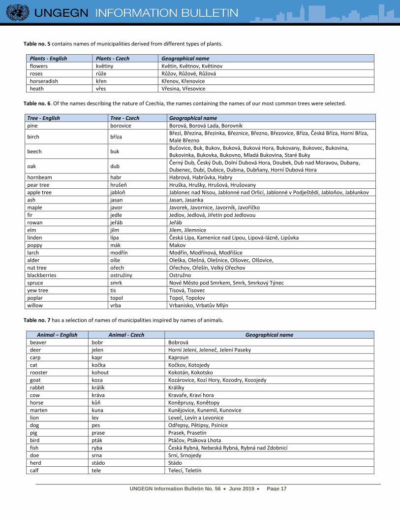
Table no. 5 contains names of municipalities derived from different types of plants.
Plants - English Plants - Czech Geographical name
flowers květiny Květín, Květnov, Květinov
roses růže Růžov, Růžové, Růžová
horseradish křen Křenov, Křenovice
heath vřes Vřesina, Vřesovice
Table no. 6. Of the names describing the nature of Czechia, the names containing the names of our most common trees were selected.
Tree - English Tree - Czech Geographical name
pine borovice Borová, Borová Lada, Borovník
birch bříza Březí, Březina, Březinka, Březnice, Březno, Březovice, Bříza, Česká Bříza, Horní Bříza, Malé Březno
beech buk Bučovice, Buk, Bukov, Buková, Buková Hora, Bukovany, Bukovec, Bukovina, Bukovinka, Bukovka, Bukovno, Mladá Bukovina, Staré Buky
oak dub Černý Dub, Český Dub, Dolní Dubová Hora, Doubek, Dub nad Moravou, Dubany, Dubenec, Dubí, Dubice, Dubina, Dubňany, Horní Dubová Hora
hornbeam habr Habrová, Habrůvka, Habry
pear tree hrušeň Hruška, Hrušky, Hrušová, Hrušovany
apple tree jabloň Jablonec nad Nisou, Jablonné nad Orlicí, Jablonné v Podještědí, Jabloňov, Jablunkov
ash jasan Jasan, Jasanka
maple javor Javorek, Javornice, Javorník, Javoříčko
fir jedle Jedlov, Jedlová, Jiřetín pod Jedlovou
rowan jeřáb Jeřáb
elm jilm Jilem, Jilemnice
linden lípa Česká Lípa, Kamenice nad Lipou, Lipová-lázně, Lipůvka
poppy mák Makov
larch modřín Modřín, Modřínová, Modřišice
alder olše Oleška, Olešná, Olešnice, Olšovec, Olšovice,
nut tree ořech Ořechov, Ořešín, Velký Ořechov
blackberries ostružiny Ostružno
spruce smrk Nové Město pod Smrkem, Smrk, Smrkový Týnec
yew tree tis Tisová, Tisovec
poplar topol Topol, Topolov
willow vrba Vrbanisko, Vrbatův Mlýn
Table no. 7 has a selection of names of municipalities inspired by names of animals.
Animal – English Animal - Czech Geographical name
beaver bobr Bobrová
deer jelen Horní Jelení, Jeleneč, Jelení Paseky
carp kapr Kaproun
cat kočka Kočkov, Kotojedy
rooster kohout Kokotán, Kokotsko
goat koza Kozárovice, Kozí Hory, Kozodry, Kozojedy
rabbit králík Králíky
cow kráva Kravaře, Kraví hora
horse kůň Koněprusy, Konětopy
marten kuna Kunějovice, Kunemil, Kunovice
lion lev Leveč, Levín a Levonice
dog pes Odřepsy, Pětipsy, Psinice
pig prase Prasek, Prasetín
bird pták Ptáčov, Ptákova Lhota
fish ryba Česká Rybná, Nebeská Rybná, Rybná nad Zdobnicí
doe srna Srní, Srnojedy
herd stádo Stádo
calf tele Telecí, Teletín
UNGEGN Information Bulletin No. 56 • June 2019 • Page 18
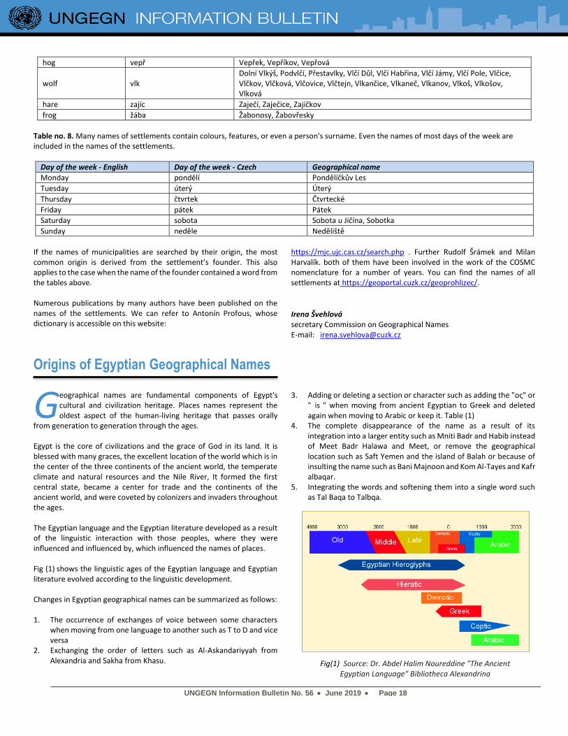
hog vepř Vepřek, Vepříkov, Vepřová
wolf vlk Dolní Vlkýš, Podvlčí, Přestavlky, Vlčí Důl, Vlčí Habřina, Vlčí Jámy, Vlčí Pole, Vlčice, Vlčkov, Vlčková, Vlčovice, Vlčtejn, Vlkančice, Vlkaneč, Vlkanov, Vlkoš, Vlkošov, Vlková
hare zajíc Zaječí, Zaječice, Zajíčkov
frog žába Žabonosy, Žabovřesky
Table no. 8. Many names of settlements contain colours, features, or even a person's surname. Even the names of most days of the week are included in the names of the settlements.
Day of the week - English Day of the week - Czech Geographical name
Monday pondělí Pondělíčkův Les
Tuesday úterý Úterý
Thursday čtvrtek Čtvrtecké
Friday pátek Pátek
Saturday sobota Sobota u Jičína, Sobotka
Sunday neděle Neděliště
If the names of municipalities are searched by their origin, the most common origin is derived from the settlement’s founder. This also applies to the case when the name of the founder contained a word from the tables above. Numerous publications by many authors have been published on the names of the settlements. We can refer to Antonín Profous, whose dictionary is accessible on this website:
https://mjc.ujc.cas.cz/search.php . Further Rudolf Šrámek and Milan Harvalík. both of them have been involved in the work of the COSMC nomenclature for a number of years. You can find the names of all settlements at https://geoportal.cuzk.cz/geoprohlizec/.
Irena Švehlová secretary Commission on Geographical Names E-mail: [email protected]
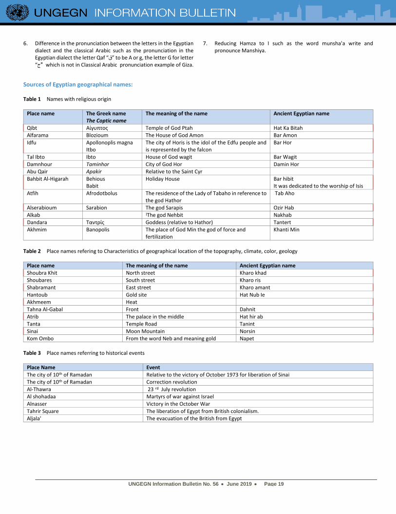
Origins of Egyptian Geographical Names
eographical names are fundamental components of Egypt's cultural and civilization heritage. Places names represent the oldest aspect of the human-living heritage that passes orally
from generation to generation through the ages. Egypt is the core of civilizations and the grace of God in its land. It is blessed with many graces, the excellent location of the world which is in the center of the three continents of the ancient world, the temperate climate and natural resources and the Nile River, It formed the first central state, became a center for trade and the continents of the ancient world, and were coveted by colonizers and invaders throughout the ages. The Egyptian language and the Egyptian literature developed as a result of the linguistic interaction with those peoples, where they were influenced and influenced by, which influenced the names of places. Fig (1) shows the linguistic ages of the Egyptian language and Egyptian literature evolved according to the linguistic development.
Changes in Egyptian geographical names can be summarized as follows: 1. The occurrence of exchanges of voice between some characters
when moving from one language to another such as T to D and vice versa
2. Exchanging the order of letters such as Al-Askandariyyah from Alexandria and Sakha from Khasu.
3. Adding or deleting a section or character such as adding the "ος" or " is " when moving from ancient Egyptian to Greek and deleted again when moving to Arabic or keep it. Table (1)
4. The complete disappearance of the name as a result of its integration into a larger entity such as Mniti Badr and Habib instead of Meet Badr Halawa and Meet, or remove the geographical location such as Saft Yemen and the island of Balah or because of insulting the name such as Bani Majnoon and Kom Al-Tayes and Kafr albaqar.
5. Integrating the words and softening them into a single word such as Tal Baqa to Talbqa.
G
Fig(1) Source: Dr. Abdel Halim Noureddine "The Ancient Egyptian Language" Bibliotheca Alexandrina
UNGEGN Information Bulletin No. 56 • June 2019 • Page 19
6. Difference in the pronunciation between the letters in the Egyptian dialect and the classical Arabic such as the pronunciation in the Egyptian dialect the letter Qaf “ق” to be A or g, the letter G for letter “ "ج which is not in Classical Arabic pronunciation example of Giza.
7. Reducing Hamza to I such as the word munsha'a write and pronounce Manshiya.
Sources of Egyptian geographical names: Table 1 Names with religious origin
Place name The Greek name The Coptic name
The meaning of the name Ancient Egyptian name
Qibt Αίγυπτος Temple of God Ptah Hat Ka Bitah Alfarama Blozioum The House of God Amon Bar Amon
Idfu Apollonoplis magna Itbo
The city of Horis is the idol of the Edfu people and is represented by the falcon
Bar Hor
Tal Ibto Ibto House of God wagit Bar Wagit
Damnhour Taminhor City of God Hor Damin Hor Abu Qair Apakir Relative to the Saint Cyr
Bahbit Al-Higarah Behious Babit
Holiday House Bar hibit It was dedicated to the worship of Isis
Atfih Afrodotbolus The residence of the Lady of Tabaho in reference to the god Hathor
Tab Aho
Alserabioum Sarabion The god Sarapis Ozir Hab
Alkab اThe god Nehbit Nakhab
Dandara Ταντρίς Goddess (relative to Hathor) Tantert Akhmim Banopolis The place of God Min the god of force and
fertilization Khanti Min
Table 2 Place names refering to Characteristics of geographical location of the topography, climate, color, geology
Place name The meaning of the name Ancient Egyptian name
Shoubra Khit North street Kharo khad Shoubares South street Kharo ris
Shabramant East street Kharo amant
Hantoub Gold site Hat Nub Ie Akhmeem Heat
Tahna Al-Gabal Front Dahnit
Atrib The palace in the middle Hat hir ab Tanta Temple Road Tanint
Sinai Moon Mountain Norsin Kom Ombo From the word Neb and meaning gold Napet
Table 3 Place names referring to historical events
Place Name Event
The city of 10th of Ramadan Relative to the victory of October 1973 for liberation of Sinai The city of 10th of Ramadan Correction revolution
Al-Thawra 23 rd July revolution Al shohadaa Martyrs of war against Israel
Alnasser Victory in the October War
Tahrir Square The liberation of Egypt from British colonialism. Aljala' The evacuation of the British from Egypt
UNGEGN Information Bulletin No. 56 • June 2019 • Page 20
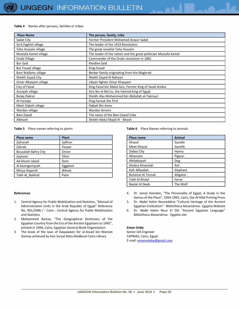
Table 4 Names after persons, families or tribes
Place Name The person, family, tribe
Sadat City Former President Mohamed Anwar Sadat
Sa'd Zaghlol village The leader of the 1919 Revolution
Taha Hussain village The great novelist Taha Hussein
Mustafa Kamel village The leader of the nation and the great politician Mustafa Kamel
Orabi Village Commander of the Orabi revolution in 1881
Bur Said Khedive Said
Bur Fouad village King Fouad
Bani Wallams village Berber family originating from the Maghreb
Sheikh Zayed City Sheikh Zayed Al Nahyan
Omar Alkaiyam village Libyan fighter Omar Khayyam
City of Faisal King Faisal bin Abdul Aziz, Former King of Saudi Arabia
Aziziyah village Aziz ibn al-Mu'izz, the Fatimid king of Egypt
Bulaq Dakror Sheikh Abu Mohammed bin Abdullah al-Takrouri Al-Faroqia King Farouk the First
Meet Oqbah village Oqbah Bin Amer
Wardan village Wardan Arromi
Bani Zayed The name of the Bani Zayed tribe
Albitash Sheikh Abdul Majid Al - Bitash
Table 5 Place names referring to plants
Place name Plant
Zafranah Saffron
Zahrah Flower
Bousailah Bahry City Onion
Zaytoon Olive
Ad-Doom island Dom
Al bazinganiyyah Eggplant
Minya Alqamih Wheat
Tokh Al_Nakhail Palm
Table 6 Place Names referring to animals
Place name Animal
Ghazal Meet Ghazal
Gazelle Gazelle
Dabaa City Hyena
Alhamam Pigeon
Alkilabiyyah Dog
Shobra Alnamlah Ant
Kafr Alfiyallah Elephant Buhairat Al Timsah Alligator
Tokh Al Khaiyl horse
Nazlat Al Deeb The Wolf
References 1. Central Agency for Public Mobilization and Statistics, "Manual of
Administrative Units in the Arab Republic of Egypt" Reference No. 901/2006 / - Cairo - Central Agency for Public Mobilization and Statistics
2. Mohammed Ramzy, "The Geographical Dictionary of the Egyptian Country from the Era of the Ancient Egyptians to 1945", printed in 1994, Cairo, Egyptian General Book Organization.
3. The book of the laws of Dawaween for al-Assad bin Mamati Gomaa achieved by Aziz Suryal Attia Madbouli Cairo Library
4. Dr. Jamal Hamdan, "The Personality of Egypt, A Study in the Genius of the Place", 1994-1995, Cairo, Dar Al Hilal Printing Press
5. Dr. Abdel Halim Noureddine "Cultural Heritage of the Ancient Egyptian Civilization" - Bibliotheca Alexandrina - Egyptia Website
6. Dr. Abdel Halim Nour El Din "Ancient Egyptian Language" Bibliotheca Alexandrina - Egyptia site
Eman Oriby Senior GIS Engineer CAPMAS, Cairo, Egypt E-mail: [email protected]
UNGEGN Information Bulletin No. 56 • June 2019 • Page 21
Curiosities of geographical names in New Zealand
ew Zealand’s geographical names include a host of curiosities that are part of the fabric of our landscape. Many of these historical monikers were given when no naming rules were in
place, written language was reserved to a small number of educated people, and a standardised form of the Māori language was still being developed. They have survived the test of time and are entrenched in our identity, both good and bad. While the social norms of today are largely tolerant, people can be disappointed by misspellings and at the inappropriateness of some of those past names in a modern context, which are now considered offensive, discriminatory or derogatory.
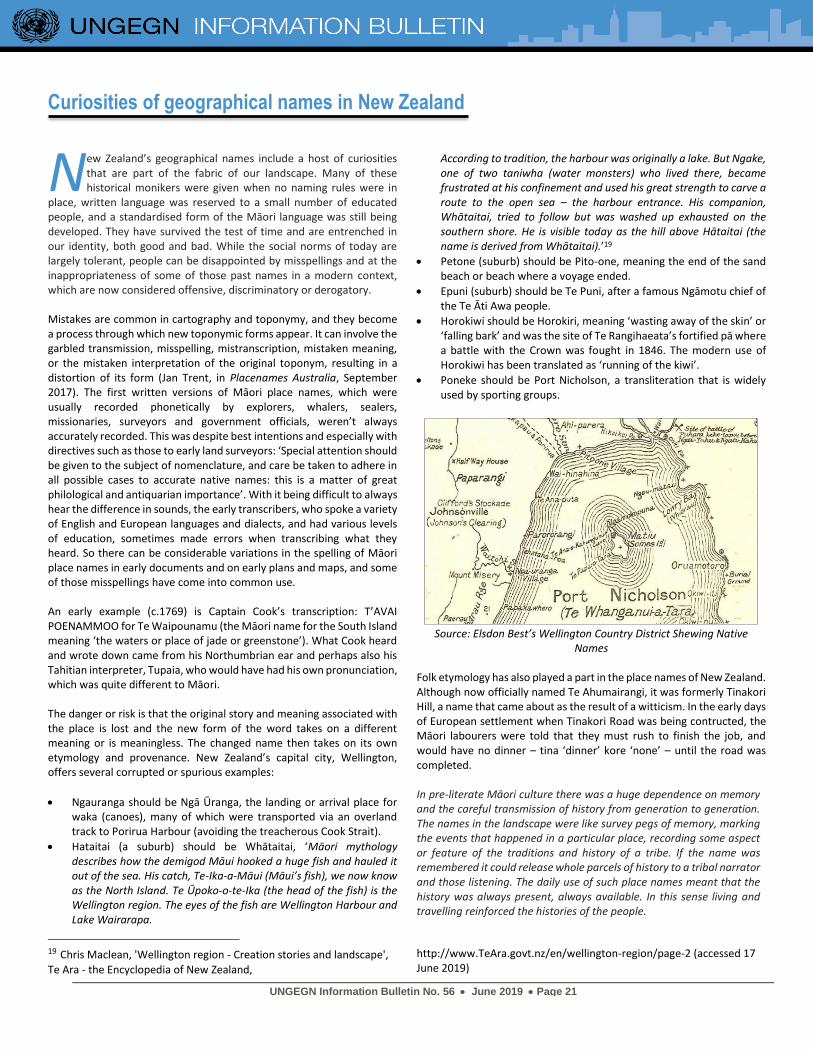
Mistakes are common in cartography and toponymy, and they become a process through which new toponymic forms appear. It can involve the garbled transmission, misspelling, mistranscription, mistaken meaning, or the mistaken interpretation of the original toponym, resulting in a distortion of its form (Jan Trent, in Placenames Australia, September 2017). The first written versions of Māori place names, which were usually recorded phonetically by explorers, whalers, sealers, missionaries, surveyors and government officials, weren’t always accurately recorded. This was despite best intentions and especially with directives such as those to early land surveyors: ‘Special attention should be given to the subject of nomenclature, and care be taken to adhere in all possible cases to accurate native names: this is a matter of great philological and antiquarian importance’. With it being difficult to always hear the difference in sounds, the early transcribers, who spoke a variety of English and European languages and dialects, and had various levels of education, sometimes made errors when transcribing what they heard. So there can be considerable variations in the spelling of Māori place names in early documents and on early plans and maps, and some of those misspellings have come into common use. An early example (c.1769) is Captain Cook’s transcription: T’AVAI POENAMMOO for Te Waipounamu (the Māori name for the South Island meaning ‘the waters or place of jade or greenstone’). What Cook heard and wrote down came from his Northumbrian ear and perhaps also his Tahitian interpreter, Tupaia, who would have had his own pronunciation, which was quite different to Māori. The danger or risk is that the original story and meaning associated with the place is lost and the new form of the word takes on a different meaning or is meaningless. The changed name then takes on its own etymology and provenance. New Zealand’s capital city, Wellington, offers several corrupted or spurious examples:
• Ngauranga should be Ngā Ūranga, the landing or arrival place for waka (canoes), many of which were transported via an overland track to Porirua Harbour (avoiding the treacherous Cook Strait).
• Hataitai (a suburb) should be Whātaitai, ‘Māori mythology describes how the demigod Māui hooked a huge fish and hauled it out of the sea. His catch, Te-Ika-a-Māui (Māui’s fish), we now know as the North Island. Te Ūpoko-o-te-Ika (the head of the fish) is the Wellington region. The eyes of the fish are Wellington Harbour and Lake Wairarapa.
19 Chris Maclean, 'Wellington region - Creation stories and landscape',
Te Ara - the Encyclopedia of New Zealand,
According to tradition, the harbour was originally a lake. But Ngake, one of two taniwha (water monsters) who lived there, became frustrated at his confinement and used his great strength to carve a route to the open sea – the harbour entrance. His companion, Whātaitai, tried to follow but was washed up exhausted on the southern shore. He is visible today as the hill above Hātaitai (the name is derived from Whātaitai).’19
• Petone (suburb) should be Pito-one, meaning the end of the sand beach or beach where a voyage ended.
• Epuni (suburb) should be Te Puni, after a famous Ngāmotu chief of the Te Āti Awa people.
• Horokiwi should be Horokiri, meaning ‘wasting away of the skin’ or ‘falling bark’ and was the site of Te Rangihaeata’s fortified pā where a battle with the Crown was fought in 1846. The modern use of Horokiwi has been translated as ‘running of the kiwi’.
• Poneke should be Port Nicholson, a transliteration that is widely used by sporting groups.
Source: Elsdon Best’s Wellington Country District Shewing Native
Names Folk etymology has also played a part in the place names of New Zealand. Although now officially named Te Ahumairangi, it was formerly Tinakori Hill, a name that came about as the result of a witticism. In the early days of European settlement when Tinakori Road was being contructed, the Māori labourers were told that they must rush to finish the job, and would have no dinner – tina ‘dinner’ kore ‘none’ – until the road was completed. In pre-literate Māori culture there was a huge dependence on memory and the careful transmission of history from generation to generation. The names in the landscape were like survey pegs of memory, marking the events that happened in a particular place, recording some aspect or feature of the traditions and history of a tribe. If the name was remembered it could release whole parcels of history to a tribal narrator and those listening. The daily use of such place names meant that the history was always present, always available. In this sense living and travelling reinforced the histories of the people.
http://www.TeAra.govt.nz/en/wellington-region/page-2 (accessed 17 June 2019)
N
UNGEGN Information Bulletin No. 56 • June 2019 • Page 22
Some of these groups of names, as well as individual names, were of such significance that when a tribe migrated elsewhere it "replanted" its history in its new home by naming its new landscape with the names of the place of origin. Because of the role of place names as a device for recording and remembering tribal history the historical events themselves sometimes became relocated in the new setting. This is one of the reasons why some Māori and Polynesian histories appear so similar and repetitious. They may be the same story being repeated in fresh settings. This does not make the traditions associated with a particular place name, or group of names, any less authentic. It is a perfectly valid process within an oral tradition. It derives, from the character of oral tradition. It uses place names in different ways from the way literate societies use them.20 However, contractions of those original forms, which often told a story, were inevitable with colonial settlement from the early 1800s:
• Pūtiki – from Te-pūtiki-wharanui-a-Tamatea-pōkai-whenua, the topknot tied by Tamatea the Seeker of Lands using the variety of flax known as wharanui
• Taupō – from Taupō-nui-a-Tia, the large shoulder mat of Tia
• Pirongia – from Te Pirongia o Te Aroaro ō Kahu, the scented pathway of Kahu
Wendy Shaw Secretary New Zealand Geographic Board Land Information New Zealand E-mail: [email protected] Jill Remnant Advisor New Zealand Geographic Board Land Information New Zealand E-mail: [email protected]
Cassiterides: how the mythical Tin Islands became the Azores
in is, and was, a strategic good since the Age of Bronze (3000 BC) because its alloy with copper produced bronze, much more resistant in weapons and tools. It is believed that tin mining
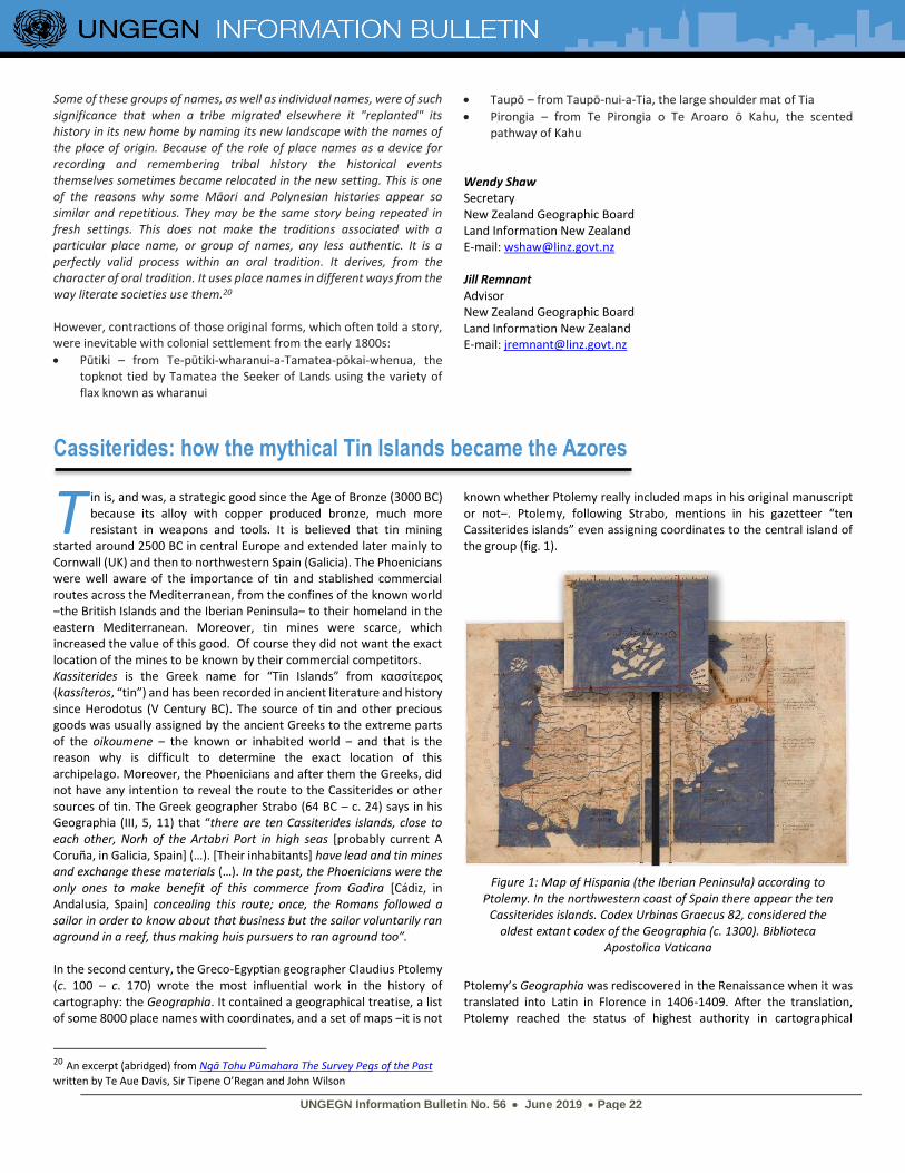
started around 2500 BC in central Europe and extended later mainly to Cornwall (UK) and then to northwestern Spain (Galicia). The Phoenicians were well aware of the importance of tin and stablished commercial routes across the Mediterranean, from the confines of the known world ‒the British Islands and the Iberian Peninsula‒ to their homeland in the eastern Mediterranean. Moreover, tin mines were scarce, which increased the value of this good. Of course they did not want the exact location of the mines to be known by their commercial competitors. Kassiterides is the Greek name for “Tin Islands” from κασσίτερος (kassíteros, “tin”) and has been recorded in ancient literature and history since Herodotus (V Century BC). The source of tin and other precious goods was usually assigned by the ancient Greeks to the extreme parts of the oikoumene ‒ the known or inhabited world ‒ and that is the reason why is difficult to determine the exact location of this archipelago. Moreover, the Phoenicians and after them the Greeks, did not have any intention to reveal the route to the Cassiterides or other sources of tin. The Greek geographer Strabo (64 BC – c. 24) says in his Geographia (III, 5, 11) that “there are ten Cassiterides islands, close to each other, Norh of the Artabri Port in high seas [probably current A Coruña, in Galicia, Spain] (…). [Their inhabitants] have lead and tin mines and exchange these materials (…). In the past, the Phoenicians were the only ones to make benefit of this commerce from Gadira [Cádiz, in Andalusia, Spain] concealing this route; once, the Romans followed a sailor in order to know about that business but the sailor voluntarily ran aground in a reef, thus making huis pursuers to ran aground too”. In the second century, the Greco-Egyptian geographer Claudius Ptolemy (c. 100 – c. 170) wrote the most influential work in the history of cartography: the Geographia. It contained a geographical treatise, a list of some 8000 place names with coordinates, and a set of maps ‒it is not
20 An excerpt (abridged) from Ngā Tohu Pūmahara The Survey Pegs of the Past
written by Te Aue Davis, Sir Tipene O’Regan and John Wilson
known whether Ptolemy really included maps in his original manuscript or not‒. Ptolemy, following Strabo, mentions in his gazetteer “ten Cassiterides islands” even assigning coordinates to the central island of the group (fig. 1).
Ptolemy’s Geographia was rediscovered in the Renaissance when it was translated into Latin in Florence in 1406-1409. After the translation, Ptolemy reached the status of highest authority in cartographical
T
Figure 1: Map of Hispania (the Iberian Peninsula) according to Ptolemy. In the northwestern coast of Spain there appear the ten
Cassiterides islands. Codex Urbinas Graecus 82, considered the oldest extant codex of the Geographia (c. 1300). Biblioteca
Apostolica Vaticana
UNGEGN Information Bulletin No. 56 • June 2019 • Page 23
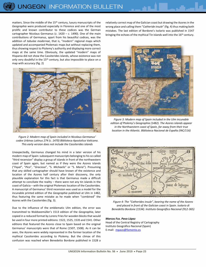
matters. Since the middle of the 15th century, luxury manuscripts of the Geographia were produced especially in Florence and one of the most prolific and known contributor to these codices was the German cartographer Nicolaus Germanus (c. 1420 – c. 1490). One of the main contributions of Germanus, apart from his beautiful codices, was the addition of tabulae modernae, that is, “modern” regional maps which updated and accompanied Ptolemaic maps but without replacing them, thus showing respect to Ptolemy’s authority and displaying more correct maps at the same time. Obviously, the updated “modern” maps of Hispania did not show the Cassiterides islands, whose existence was not only very doubtful in the 15th century, but also impossible to place on a map with accuracy (fig. 2)
Unexpectedly, Germanus changed his mind in a later version of his modern map of Spain: subsequent manuscripts belonging to his so called “third recension” display a group of islands in front of the northwestern coast of Spain again, but named as if they were the Azores islands (“Fayal”, “Pico”, “Graciosa”, “S. Michaelis” or “S. Maria”). Presuming that any skilled cartographer should have known of the existence and location of the Azores half century after their discovery, the only plausible explanation for this fact is that Germanus made a difficult attempt to conciliate the reality ‒ there were not any tin islands in the coast of Galicia ‒ with the original Ptolemaic location of the Cassiterides. A manuscript of Germanus’ third recension was used as a model for the incunable printed edition of the Geographia published at Ulm in 1482, thus featuring the same mistake as he made when “combined” the Azores with the Cassiterides (fig. 3). Due to the influence of the emblematic Ulm edition, the error was
transmitted to Waldseemüller’s 1513 edition of the Geographia, later
copied in a reduced format by Lorenz Fries for wooden blocks that would
be used in four more printed editions: 1522, 1525, 1535 and 1541. Other
editions that featured the Azores close to Spain based on the original
Germanus’ manuscripts were that of Rome (1507, 1508). As it can be
seen, the Azores were widely represented in the former location of the
mythical Cassiterides according to Ptolemy. But the climax of this
confusion was reached when Benedetto Bordone published in 1528 a
relatively correct map of the Galician coast but drawing the Azores in the
wrong place and calling them “Catheride insule” (fig. 4) thus making both
mistakes. The last edition of Bordone’s Isolario was published in 1547
bringing the echoes of the mythical Tin Islands well into the 16th century.
Marcos Fco. Pavo López Head of the Central Registry of Cartography Instituto Geográfico Nacional (Spain) E-mail: [email protected]
Figure 3: Modern map of Spain included in the Ulm incunable edition of Ptolemy’s Geographia (1482). The Azores islands appear
in the Northwestern coast of Spain, far away from their true location in the Atlantic. Biblioteca Nacional de España (INC/116)
Figure 4: The “Catherides insule”, bearing the name of the Azores and placed in front of the Galician coast in Spain. Isolario di
Benedetto Bordone (1534). Instituto Geográfico Nacional (912-365)
Figure 2: Modern map of Spain included in Nicolaus Germanus’ codex Urbinas Latinus 274 (c. 1470) Biblioteca Apostolica Vaticana.
This early version does not include the Cassiterides islands
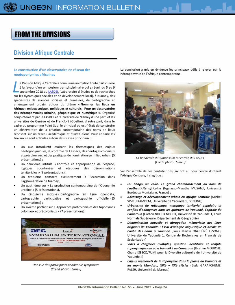
UNGEGN Information Bulletin No. 56 • June 2019 • Page 24
FROM THE DIVISIONS
Division Afrique Centrale
La construction d’un observatoire en réseau des néotoponymies africaines
a Division Afrique Centrale a connu une animation toute particulière à la faveur d’un symposium transdisciplinaire qui a réuni, du 5 au 9 septembre 2018 au LASDEL (Laboratoire d’études et de recherches
sur les dynamiques sociales et de développement local), à Niamey, des spécialistes de sciences sociales et humaines, de cartographie et aménagement urbain, autour du thème « Nommer les lieux en Afrique : enjeux sociaux, politiques et culturels ; Pour un observatoire des néotoponymies urbaine, géopolitique et numérique ». Organisé conjointement par le LASDEL et l’Université de Niamey d’une part, et les universités de Genève et de Francfort (Goethe), d’autre part, dans le cadre du programme Point Sud, le principal objectif était de construire un observatoire de la création contemporaine des noms de lieux reposant sur un réseau académique et d’institutions. Pour ce faire les travaux se sont articulés autour de six axes principaux :
• Un axe introductif croisant les thématiques des enjeux néotoponymiques, du contrôle de l’espace, des héritages coloniaux et précoloniaux, et des pratiques de nomination en milieu urbain (5 présentations) ;
• Un deuxième intitulé « Contrôle et appropriation de l’espace, logiques spontanées et étatiques des dénominations territoriales » (9 présentations) ;
• Un troisième consacré exclusivement à l’excursion dans l’agglomération de Niamey ;
• Un quatrième sur « La production contemporaine de l’Odonymie urbaine » (5 présentations),
• Un cinquième intitulé « Cartographie en ligne opendata, cartographie participative et cartographie officielle » (5 présentations) ;
• Un sixième portant sur « Approches postcoloniales des toponymes coloniaux et précoloniaux » (7 présentations).
La conclusion a mis en évidence les principaux défis à relever par la néotoponymie de l’Afrique contemporaine.
Sur l’ensemble de ces contributions, six ont eu pour centre d’intérêt l’Afrique Centrale, Il s’agit de :
• Du Congo au Zaïre. Le grand chambardement au nom de l’authenticité africaine (Ngalasso-Mwatha MUSANJI, Université Bordeaux Montaigne, France) ;
• Adressage et développement urbain en Afrique Centrale (Michel SIMEU KAMDEM, Université de Yaoundé 1, GENUNG)
• Urbanisme de rattrapage, marquage territorial populaire et conflits d’odonymies dans les quartiers de Yaoundé, Capitale du Cameroun (Gaston NDOCK NDOCK, Université de Yaoundé 1, Ecole Normale Supérieure, Département de Géographie)
• Dénomination nouvelle et abrogation mémorielle des lieux originels de Yaoundé : Essai d’analyse linguistique et aréale de l’oubli des noms à Yaoundé (Louis Martin ONGUÉNÉ ESSONO, Université de Yaoundé 1, Centre de Recherches en Français de Scolarisation)
• Villes à chefferies multiples, question identitaire et conflits toponymiques en pays bamiléké au Cameroun (Ibrahim MOUICHE, Chaire ISESCO/FUMI pour la Diversité culturelle de l’Université de Yaoundé II)
• Enjeux mémoriels de la toponymie dans la plaine du Diamaré et les monts Mandara, XIXè – XXè siècles (Gigla GARAKCHEME, FALSH, Université de Maroua)
L
Une vue des participants pendant le symposium (Crédit photo : Simeu)
La banderole du symposium à l’entrée du LASDEL (Crédit photo : Simeu)
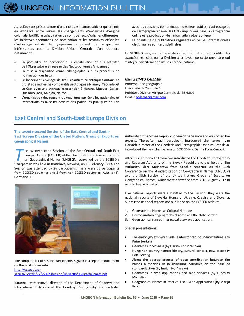
UNGEGN Information Bulletin No. 56 • June 2019 • Page 25
Au-delà de ces présentations d’une richesse incontestable et qui ont mis en évidence entre autres les changements d’exonymes d’origine coloniale, la difficile cohabitation de noms de lieux d’origines différentes, les initiatives spontanées de nomination et les tentatives officielles d’adressage urbain, le symposium a ouvert de perspectives intéressantes pour la Division Afrique Centrale. L’on retiendra notamment:
• La possibilité de participer à la construction et aux activités de l’Observatoire en réseau des Néotoponymies Africaines ;
• La mise à disposition d’une bibliographie sur les processus de nomination des lieux ;
• Le lancement envisagé de trois chantiers scientifiques autour de projets de recherche comparatifs prototypes à Niamey, Yaoundé, et Le Cap, avec une éventuelle extension à Harare, Maputo, Dakar, Ouagadougou, Abidjan, Nairobi …
• L’organisation des rencontres régulières aux échelles nationales et internationales avec les acteurs des politiques publiques en lien
avec les questions de nomination des lieux publics, d’adressage et de cartographie et avec les ONG impliquées dans la cartographie online et la production de l’information géographique ;
• La possibilité de publications régulières en revues internationales disciplinaires et interdisciplinaires.
Le GENUNG sera, en tout état de cause, informé en temps utile, des avancées réalisées par la Division à la faveur de cette ouverture qui s’intègre parfaitement dans ses préoccupations. Michel SIMEU-KAMDEM Professeur de géographie Université de Yaoundé 1 Président Division Afrique Centrale du GENUNG E-mail: [email protected]
East Central and South-East Europe Division The twenty-second Session of the East Central and South-East Europe Division of the United Nations Group of Experts on Geographical Names
he twenty-second Session of the East Central and South-East Europe Division (ECSEED) of the United Nations Group of Experts on Geographical Names (UNGEGN) convened by the ECSEED´s
Chairperson was held in Bratislava, Slovakia, on 13 February 2019. The Session was attended by 26 participants. There were 23 participants from ECSEED countries and 3 from non ECSEED countries: Austria (2), Germany (1).
The complete list of Session participants is given in a separate document on the ECSEED website: http://ecseed.zrc-sazu.si/Portals/22/22%20session/List%20of%20participants.pdf Katarína Leitmannová, director of the Department of Geodesy and International Relations of the Geodesy, Cartography and Cadastre
Authority of the Slovak Republic, opened the Session and welcomed the experts. Thereafter each participant introduced themselves. Ivan Horváth, director of the Geodetic and Cartographic Institute Bratislava, introduced the new chairperson of ECSEED Ms. Darina Porubčanová. After this, Katarína Leitmannová introduced the Geodesy, Cartography and Cadastre Authority of the Slovak Republic and the focus of the Authority. Klára Steinerova from Czechia reported on the 11th Conference on the Standardization of Geographical Names (UNCSGN) and the 30th Session of the United Nations Group of Experts on Geographical Names, which were convened from 7-18 August 2017 in which she participated. Five national reports were submitted to the Session, they were the national reports of Slovakia, Hungary, Ukraine, Czechia and Slovenia. Submitted national reports are published on the ECSEED website: 1. Geographical Names as Cultural Heritage 2. Harmonization of geographical names on the state border 3. Geographical names in practical use – web applications Special presentations:
• The endonym/exonym divide related to transboundary features (by Peter Jordan)
• Geonames in Slovakia (by Darina Porubčanová)
• Hungarian country names: history, cultural context, new cases (by Béla Pokoly)
• About the appropriateness of close coordination between the names authorities of neighbouring countries on the issue of standardization (by Imrich Horňanský)
• Geonames in web applications and map services (by Ľuboslav Michalík)
• Geographical Names in Practical Use - Web Applications (by Marija Brnot)
T
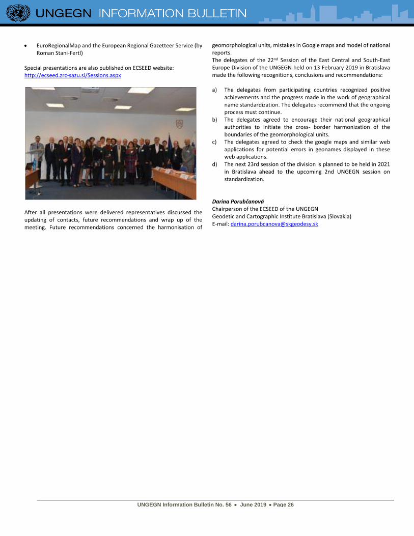
UNGEGN Information Bulletin No. 56 • June 2019 • Page 26
• EuroRegionalMap and the European Regional Gazetteer Service (by Roman Stani-Fertl)
Special presentations are also published on ECSEED website: http://ecseed.zrc-sazu.si/Sessions.aspx
After all presentations were delivered representatives discussed the updating of contacts, future recommendations and wrap up of the meeting. Future recommendations concerned the harmonisation of
geomorphological units, mistakes in Google maps and model of national reports. The delegates of the 22nd Session of the East Central and South-East Europe Division of the UNGEGN held on 13 February 2019 in Bratislava made the following recognitions, conclusions and recommendations: a) The delegates from participating countries recognized positive
achievements and the progress made in the work of geographical name standardization. The delegates recommend that the ongoing process must continue.
b) The delegates agreed to encourage their national geographical authorities to initiate the cross- border harmonization of the boundaries of the geomorphological units.
c) The delegates agreed to check the google maps and similar web applications for potential errors in geonames displayed in these web applications.
d) The next 23rd session of the division is planned to be held in 2021 in Bratislava ahead to the upcoming 2nd UNGEGN session on standardization.
Darina Porubčanová Chairperson of the ECSEED of the UNGEGN Geodetic and Cartographic Institute Bratislava (Slovakia) E-mail: [email protected]
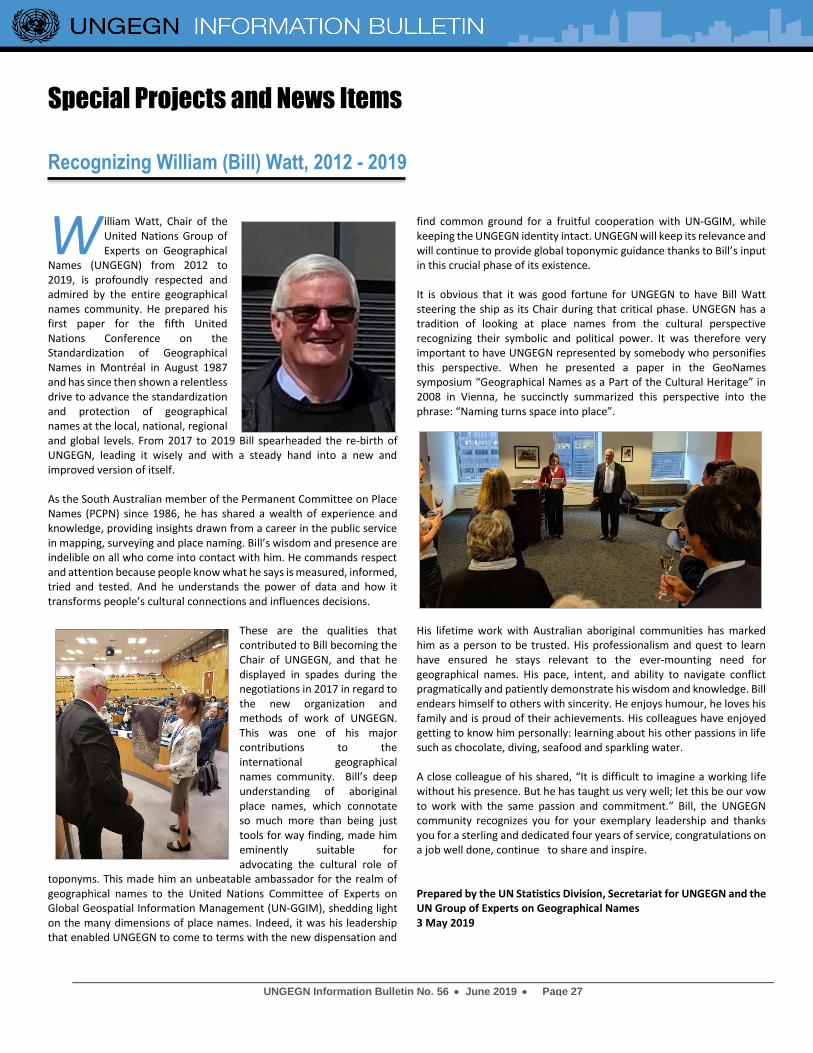
UNGEGN Information Bulletin No. 56 • June 2019 • Page 27
Special Projects and News Items
Recognizing William (Bill) Watt, 2012 - 2019
illiam Watt, Chair of the United Nations Group of Experts on Geographical
Names (UNGEGN) from 2012 to 2019, is profoundly respected and admired by the entire geographical names community. He prepared his first paper for the fifth United Nations Conference on the Standardization of Geographical Names in Montréal in August 1987 and has since then shown a relentless drive to advance the standardization and protection of geographical names at the local, national, regional and global levels. From 2017 to 2019 Bill spearheaded the re-birth of UNGEGN, leading it wisely and with a steady hand into a new and improved version of itself. As the South Australian member of the Permanent Committee on Place Names (PCPN) since 1986, he has shared a wealth of experience and knowledge, providing insights drawn from a career in the public service in mapping, surveying and place naming. Bill’s wisdom and presence are indelible on all who come into contact with him. He commands respect and attention because people know what he says is measured, informed, tried and tested. And he understands the power of data and how it transforms people’s cultural connections and influences decisions.
These are the qualities that contributed to Bill becoming the Chair of UNGEGN, and that he displayed in spades during the negotiations in 2017 in regard to the new organization and methods of work of UNGEGN. This was one of his major contributions to the international geographical names community. Bill’s deep understanding of aboriginal place names, which connotate so much more than being just tools for way finding, made him eminently suitable for advocating the cultural role of
toponyms. This made him an unbeatable ambassador for the realm of geographical names to the United Nations Committee of Experts on Global Geospatial Information Management (UN-GGIM), shedding light on the many dimensions of place names. Indeed, it was his leadership that enabled UNGEGN to come to terms with the new dispensation and
find common ground for a fruitful cooperation with UN-GGIM, while keeping the UNGEGN identity intact. UNGEGN will keep its relevance and will continue to provide global toponymic guidance thanks to Bill’s input in this crucial phase of its existence. It is obvious that it was good fortune for UNGEGN to have Bill Watt steering the ship as its Chair during that critical phase. UNGEGN has a tradition of looking at place names from the cultural perspective recognizing their symbolic and political power. It was therefore very important to have UNGEGN represented by somebody who personifies this perspective. When he presented a paper in the GeoNames symposium “Geographical Names as a Part of the Cultural Heritage” in 2008 in Vienna, he succinctly summarized this perspective into the phrase: “Naming turns space into place”.
His lifetime work with Australian aboriginal communities has marked him as a person to be trusted. His professionalism and quest to learn have ensured he stays relevant to the ever-mounting need for geographical names. His pace, intent, and ability to navigate conflict pragmatically and patiently demonstrate his wisdom and knowledge. Bill endears himself to others with sincerity. He enjoys humour, he loves his family and is proud of their achievements. His colleagues have enjoyed getting to know him personally: learning about his other passions in life such as chocolate, diving, seafood and sparkling water. A close colleague of his shared, “It is difficult to imagine a working life without his presence. But he has taught us very well; let this be our vow to work with the same passion and commitment.” Bill, the UNGEGN community recognizes you for your exemplary leadership and thanks you for a sterling and dedicated four years of service, congratulations on a job well done, continue to share and inspire. Prepared by the UN Statistics Division, Secretariat for UNGEGN and the UN Group of Experts on Geographical Names 3 May 2019
W
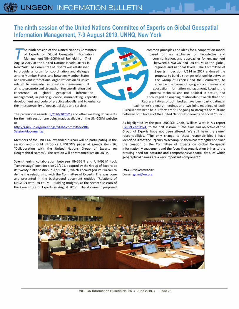
UNGEGN Information Bulletin No. 56 • June 2019 • Page 28
The ninth session of the United Nations Committee of Experts on Global Geospatial Information Management, 7-9 August 2019, UNHQ, New York
he ninth session of the United Nations Committee of Experts on Global Geospatial Information Management (UN-GGIM) will be held from 7 - 9
August 2019 at the United Nations Headquarters in New York. The Committee of Experts was established to provide a forum for coordination and dialogue among Member States, and between Member States and relevant international organizations on all issues related to geospatial information management. It aims to promote and strengthen the coordination and coherence of global geospatial information management, in policy guidance, norm-setting, capacity development and code of practice globally and to enhance the interoperability of geospatial data and services. The provisional agenda (E/C.20/2020/1) and other meeting documents for the ninth session are being made available on the UN-GGIM website at http://ggim.un.org/meetings/GGIM-committee/9th-Session/documents/. Members of the UNGEGN expanded bureau will be participating in the session and should introduce UNGEGN’s paper at agenda item 16, “Collaboration with the United Nations Group of Experts on Geographical Names”. The session will be streamed live on UNTV. Strengthening collaboration between UNGEGN and UN-GGIM took “centre stage” post decision 29/101, adopted by the Group of Experts at its twenty-ninth session in April 2016, which encouraged its Bureau to define the relationship with the Committee of Experts. This was done and presented in the background document entitled “Relations of UNGEGN with UN-GGIM – Building Bridges”, at the seventh session of the Committee of Experts in August 2017. The document proposed
common principles and ideas for a cooperation model based on an exchange of knowledge and
communication, and approaches for engagement between UNGEGN and UN-GGIM at the global, regional and national levels. The Committee of Experts in decision 7/114 in 2017 endorsed the proposal to build a stronger relationship between the Group of Experts and the Committee, to advance the cause of geographical names and
geospatial information management, keeping the process technical and not political in nature, and
encouraged an ongoing relationship towards that end. Representatives of both bodies have been participating in
each other’s plenary meetings and two joint meetings of both Bureaus have been held. Efforts are still ongoing to strength the relations between both bodies of the United Nations Economic and Social Council. As highlighted by the past UNGEGN Chair, William Watt in his report (GEGN.2/2019/4) to the first session, “…the aims and objective of the Group of Experts have not been altered. We still have the same” responsibilities. “The only change to these responsibilities I have identified is that the urgency to accomplish them has strengthened since the creation of the Committee of Experts on Global Geospatial Information Management and the focus that organization brings to the pressing need for accurate and comprehensive spatial data, of which geographical names are a very important component.” UN-GGIM Secretariat E-mail: [email protected]
T
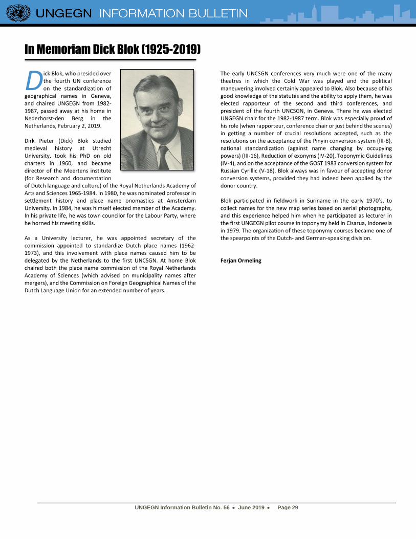
UNGEGN Information Bulletin No. 56 • June 2019 • Page 29
In Memoriam Dick Blok (1925-2019)
ick Blok, who presided over the fourth UN conference on the standardization of
geographical names in Geneva, and chaired UNGEGN from 1982-1987, passed away at his home in Nederhorst-den Berg in the Netherlands, February 2, 2019. Dirk Pieter (Dick) Blok studied medieval history at Utrecht University, took his PhD on old charters in 1960, and became director of the Meertens institute (for Research and documentation of Dutch language and culture) of the Royal Netherlands Academy of Arts and Sciences 1965-1984. In 1980, he was nominated professor in settlement history and place name onomastics at Amsterdam University. In 1984, he was himself elected member of the Academy. In his private life, he was town councilor for the Labour Party, where he horned his meeting skills. As a University lecturer, he was appointed secretary of the commission appointed to standardize Dutch place names (1962-1973), and this involvement with place names caused him to be delegated by the Netherlands to the first UNCSGN. At home Blok chaired both the place name commission of the Royal Netherlands Academy of Sciences (which advised on municipality names after mergers), and the Commission on Foreign Geographical Names of the Dutch Language Union for an extended number of years.
The early UNCSGN conferences very much were one of the many theatres in which the Cold War was played and the political maneuvering involved certainly appealed to Blok. Also because of his good knowledge of the statutes and the ability to apply them, he was elected rapporteur of the second and third conferences, and president of the fourth UNCSGN, in Geneva. There he was elected UNGEGN chair for the 1982-1987 term. Blok was especially proud of his role (when rapporteur, conference chair or just behind the scenes) in getting a number of crucial resolutions accepted, such as the resolutions on the acceptance of the Pinyin conversion system (III-8), national standardization (against name changing by occupying powers) (III-16), Reduction of exonyms (IV-20), Toponymic Guidelines (IV-4), and on the acceptance of the GOST 1983 conversion system for Russian Cyrillic (V-18). Blok always was in favour of accepting donor conversion systems, provided they had indeed been applied by the donor country. Blok participated in fieldwork in Suriname in the early 1970’s, to collect names for the new map series based on aerial photographs, and this experience helped him when he participated as lecturer in the first UNGEGN pilot course in toponymy held in Cisarua, Indonesia in 1979. The organization of these toponymy courses became one of the spearpoints of the Dutch- and German-speaking division. Ferjan Ormeling
D
UNGEGN Information Bulletin No. 56 • June 2019 • Page 30
UPCOMING EVENTS
Pre-conference symposion of ICC Tokyo “National names boards” 15 July 2019, Tokyo, Japan Contact: Peter Jordan ( [email protected] )
29th International Cartographic Conference (ICC), session of the Toponymy Commission
15-20 July 2019, Tokyo, Japan Contact: Peter Jordan ( [email protected] )
Ninth Session of the United Nations Committee of Experts on Global Geospatial Information Management (UN-GGIM)
31 July – 2 August 2019, New York, NY Contact: UN-GGIM Secretariat ( [email protected] )
5th International Symposium on Place Names “Recognition, regulation, revitalisation: place names and indigenous languages”
18-20 September 2019, Clarens, South Africa Contact: Chrismi Linda Loth ( [email protected] )
GeoNames Symposion “Place names and migration”
November 2019, Vienna, Austria Contact: Gerhard Rampl ( [email protected] )


