Embed Size (px)
Citation preview
Massachusetts Department of Conservation and Recreation Bureau of Planning and Resource Protection Resource Management Planning Program
August 2008
R E S O U R C E M A N A G E M E N T P L A N
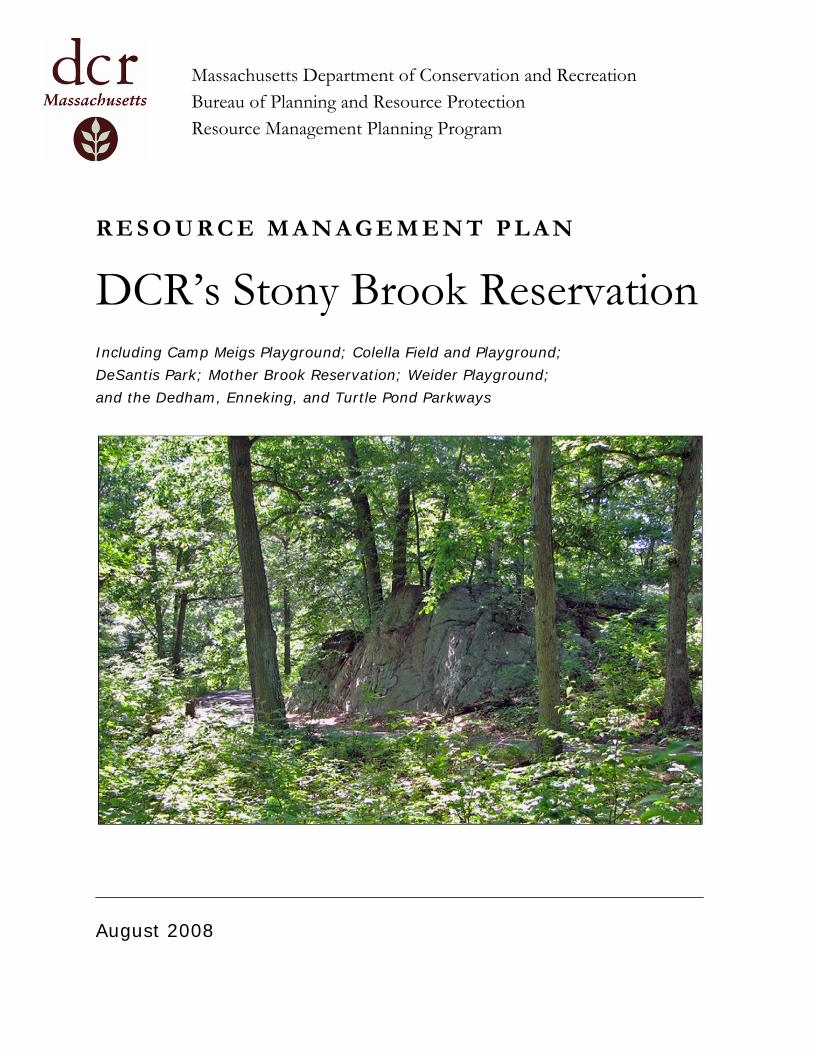
DCR’s Stony Brook Reservation Including Camp Meigs Playground; Colella Field and Playground; DeSantis Park; Mother Brook Reservation; Weider Playground; and the Dedham, Enneking, and Turtle Pond Parkways

DCR’s Stony Brook Reservation
Including Camp Meigs Playground; Colella Field and Playground; DeSantis Park; Mother Brook Reservation; Weider Playground;
and the Dedham, Enneking, and Turtle Pond Parkways
RESOURCE MANAGEMENT PLAN
2008
Deval L. Patrick, Governor Timothy P. Murray, Lt. Governor
Ian A. Bowles, Secretary Richard K. Sullivan, Jr., Commissioner
Jack Murray, Deputy Commissioner for Parks Operations
Resource Management Plans (RMPs) provide guidelines for management of properties under the stewardship of the Department of Conservation and Recreation (DCR). They are intended to be working documents for setting priorities, enabling the Department to adapt to changing fiscal, social and environmental conditions. The planning process provides a forum for communication and cooperation with park visitors and the surrounding communities to ensure transparency in DCR’s stewardship efforts. Stony Brook Reservation, the largest forested open space in the City of Boston, is one of the oldest properties in the Massachusetts state park system. This RMP represents both a connection to the historic past, and a guide to the future of DCR’s Stony Brook Reservation. This RMP also represents the initial step of DCR’s efforts to prepare RMPs for every state forest, park and reservation across the Commonwealth.
Richard K. Sullivan, Jr. Commissioner The Massachusetts Department of Conservation and Recreation (DCR), an agency of the Executive Office of Energy and Environmental Affairs, oversees 450,000 acres of parks and forests, beaches, bike trails, watersheds, dams, and parkways. Led by Commissioner Richard K. Sullivan Jr., the agency’s mission is to protect, promote, and enhance our common wealth of natural, cultural, and recreational resources. To learn more about DCR, our facilities, and our programs, please visit us at www.mass.gov/dcr. Contact us at [email protected].
PRINTED ON RECYCLED PAPER
Contents Page Executive Summary
Introduction i Management Goals i Priority Recommendations ii Public Participation in Developing this Resource Management Plan iii
Section 1. Introduction
1.1. Mission of the Department of Conservation and Recreation 1 1.2. An Introduction to Resource Management Plans 2 1.3. The Planning Process 3 1.4. Public Participation in Developing this Resource Management Plan 4
Section 2. Property Description
2.1. Introduction 5 2.2. Physical, Ecological, and Political Settings 15 2.3. History of Property 16
Section 3. Existing Conditions
3.1. Introduction 19 3.2. Natural Resources 20 3.3. Cultural Resources 29 3.4. Recreation 34 3.5. Interpretive Services and Environmental Education 43 3.6. Infrastructure 45 3.7. Operations and Management 55 3.8. Development and Improvement Projects 60
Section 4. Defining Characteristics and Goals
4.1. Defining Characteristics 63 4.2. Management Goals 63
Section 5. Land Stewardship Zoning
5.1. Introduction 65 5.2. Land Stewardship Zoning Guidelines 65 5.3. Applied Land Stewardship Zoning Guidelines 66
Section 6. Management Recommendations
6.1. Introduction 71 6.2. Natural Resources 75 6.3. Cultural Resources 76 6.4. Recreation 76 6.5. Interpretive Services and Environmental Education 76 6.6. Infrastructure 77 6.7. Operational and Capital Requirements 79
Contents (continued) Page Appendices
A. Plan Contributors 83 B. Public Participation 85 C. Land Stewardship Zoning Guidelines 90 D. GIS Supplemental Information 93 E. Bibliography 100 F. Plants of the Stony Brook Area 104 G. Birds of Stony Brook Reservation 111 H. Mammals of Stony Brook Reservation 113
List of Maps
2005 Orthophotography 7 Regional Land Use (1999) 9 USGS Topographic Quadrangles 11 Regional Open Space 13 Water Resources 21 Priority Natural Resources 25 Cultural Resources 31 Demographics 37 Active Recreation Areas 39 Infrastructure 47 Trails 53 West District 57 Land Stewardship Zoning 67 Recommendations 73
i
Executive Summary Introduction Resource Management Plans (RMPs) are “working" documents that consider the past, present, and future of a forest, park, or reservation. They include an inventory and assessment of environmental, cultural, and recreational resources; identify unique characteristics and values; and develop clear management goals and objectives. RMPs provide a guide to the short and long-term management of properties under the stewardship of the Department of Conservation and Recreation (DCR). They are intended to be working documents for setting priorities, capital and operational budgeting and resource allocation, and enhancing communication and cooperation with park visitors and the surrounding communities.
The Department of Conservation and Recreation is guided by a legislative mandate (M.G.L. Chapter 21: Section 2F) to prepare management plans for “all reservations, parks, and forests under the management of the department.” Although the mandate does not specify the format or content of these management plans, it does require the following:
“Said management plans shall include guidelines for the operation and land stewardship of the aforementioned reservations, parks and forests, shall provide for the protection and stewardship of natural and cultural resources and shall ensure consistency between recreation, resource protection, and sustainable forest management.”
The legislative mandate also establishes two other requirements. First, that the Commissioner of the Department of Conservation and Recreation “shall seek and consider public input in the development of management plans, and shall make draft plans available for a public review and comment period through notice in the Environmental Monitor.” Second, management plans must be reviewed and adopted by the Stewardship Council. Within 30 days of adoption, the Commissioner “…shall file a copy of such management plans as adopted by the council” with the State Secretary and the Joint
Committee on the Environment, Natural Resources, and Agriculture. Resource Management Plans, and the process developed to prepare these plans, exceed all legislative mandates.
This plan covers DCR’s Stony Brook Reservation; Camp Meigs Playground; Colella Field and Playground; DeSantis Park, Mother Brook Reservation; Weider Playground; and the Dedham, Enneking, and Turtle Pond parkways. These properties are included in this plan because of their physical proximity to DCR’s Stony Brook Reservation, and also because they share a common management structure.
Management Goals The following 11 management goals have been identified for DCR’s Stony Brook Reservation and its satellite properties.
• Create a “gateway” to the Reservation. • Establish and nurture programmatic and social
connections between the Reservation and its satellites, and surrounding communities.
• Inventory natural resources and manage them to promote native species and communities.
• Promote the Reservation’s history and preserve its cultural resources.
• Improve the existing athletic facilities to increase their availability for use and to decrease ongoing maintenance needs.
• Reorganize and simplify the existing trail system to decrease maintenance and to increase ease of use.
• Honor the legacy of the Thompson Center by ensuring that facilities and activities are available to the widest cross-section of people.
• Develop environmental education programming and materials for diverse audiences.
• Identify and maintain the properties’ boundaries. • Improve the West District administrative and
operations facilities. • Eliminate unneeded infrastructure.
The first two management goals, creating a “gateway” to the Reservation and establishing
ii
connections with surrounding communities offer conceptual frameworks for the remaining nine goals. Although each management goal and recommendation can and will work independently, several will yield additional benefits if they are addressed as part of these conceptual frameworks.
Priority Recommendations This RMP identifies over 70 management recommendations. These recommendations are specific actions to be taken to achieve the management goals. Each recommendation is associated with one of two levels of management and services; basic or enhanced.
• The basic level maintains a property’s current resources, facilities, and infrastructure. It provides for the continuation of compatible recreation, with the goal of meaningfully and safely connecting visitors to public lands.
• The enhanced level expands facilities and operations beyond the basic level to reach a property’s higher potential.
Simply put, the basic level optimizes existing activities or facilities and the enhanced level expands upon existing activities or facilities.
Recommendations are associated with the basic level of management and services if they meet any of the following criteria. • Maintaining or securing public, visitor, and staff
health and safety. • Maintaining essential property infrastructure. • Providing protection and stewardship for
significant or critical cultural and natural resources.
• Ensuring appropriate access and recreational activities.
Recommendations not meeting these criteria are evaluated on a case-by-case basis to determine if they are associated with the basic or enhanced level of management and services. Only recommendations associated with the basic level of management and services may be considered priority.
Priority recommendations focus on stabilizing or improving existing infrastructure. This includes stopping ongoing damage to buildings, and
improving existing recreation facilities and athletic fields.
Implementation of the following recommendations will increase the protection of Stony Brook’s infrastructure and decrease future maintenance costs.
• Seal the West District Headquarters to the elements.
• Seal the Kelley Field field-house to the elements.
• Seal the house at 57 Dedham Street to the elements.
• Conduct a re-use study for the house at 57 Dedham Street.
• Seal the Thompson Center to the elements. • Conduct a re-use study for the Thompson
Center.
Collectively these recommendations protect the Commonwealth’s investment in these buildings until their roles in the operation of Stony Brook, if any, have been identified.
Implementation of the following recommendation will result in improved recreation facilities.
• Prepare a Master Plan for Stony Brook’s athletic facilities and fields.
Stony Brook’s athletic facilities and fields vary in age and condition, and are a collection of individual recreational resources rather than a single recreational complex. This recommendation promotes a holistic assessment of these resources. It is considered a priority recommendation because some recreation facilities (e.g., Olsen Pool bathhouse) are in urgent need of renovation or replacement, and a Master Plan should be in place before any renovations begin.
The estimated cost of implementing all of the recommendations in this plan is $1,445,000-1,728,000. This includes $1,385,000-1,643,000 for recommendations associated with a basic level of management and services, and $60,000-85,000 for recommendations associated with an enhanced level of management and services. The cost of capital projects identified by the recommended Master Plan and building re-use study are in addition to these estimates.
iii
Public Participation in Developing this Management Plan Notice of a public meeting and of the availability of the draft Stony Brook RMP for public review and comment were published in the February 20, 2008 Environmental Monitor. Additional announcements were made on the DCR web page and press releases were provided to the Hyde Park/Roslindale/West Roxbury Bulletin, Hyde Park Tribune, West Roxbury Transcript, Roslindale Transcript, Daily News Transcript, Boston Globe, Boston Herald, and the Associated Press/Boston. Announcements were also provided to 165 individuals, organizations, libraries, and community centers including those identified by the Executive Office of Energy and Environmental Affairs’ Office of Environmental
Justice. A public meeting was held on March 11, 2008 in the community room of the Boston Police Department’s District E-18 station in Hyde Park; 18 people attended. The public comment period on the draft RMP ran from February 20 – March 28, 2008; six sets of written comments were received. Information about the public meeting, a summary of written comments received, a response to those comments, and a summary of substantive revisions to the public review draft are provided in Appendix B (Public Participation).
This Resource Management Plan was submitted to DCR’s Stewardship Council on May 15, 2008, and was adopted by the Council on August 7, 2008.

iv
This page intentionally left blank.
1
Section 1. Introduction 1.1. Mission of the Department of Conservation and Recreation The Department of Conservation and Recreation (DCR) is responsible for the stewardship of approximately 450,000 acres of Massachusetts’ forests, parks, reservations, greenways, historic sites and landscapes, seashores, lakes, ponds, reservoirs, and watersheds. It is one of the largest state parks systems in the country. The mission of the DCR is:
To protect, promote, and enhance our common wealth of natural, cultural, and recreational resources.
In meeting today’s responsibilities and planning for tomorrow, the DCR’s focus is: • Improving outdoor recreational opportunities
and natural and cultural resource conservation. • Restoring and improving DCR facilities. • Expanding public involvement in carrying out
the DCR’s mission. • Establishing first-rate management systems and
practices.
The DCR was created pursuant to state legislation that in 2004 merged the former Metropolitan District Commission (MDC) and the former Department of Environmental Management (DEM). The DCR’s Division of State Parks and Recreation manages nearly 300,000 acres of the state’s forests, beaches, mountains, ponds, riverbanks, trails and parks outside the Greater Boston area. The Division of Urban Parks and Recreation manages over 17,000 acres of woodland, river, and coastal reservations within the Greater Boston area and has broad management responsibilities for the preservation, maintenance and enhancement of the natural, scenic, historic, and aesthetic qualities within this area.
The health and happiness of people across Massachusetts depend on the accessibility and quality of our green spaces – our natural and cultural resources, recreation facilities, and great historic landscapes. The DCR continues to improve this vital connection between people and their environment.
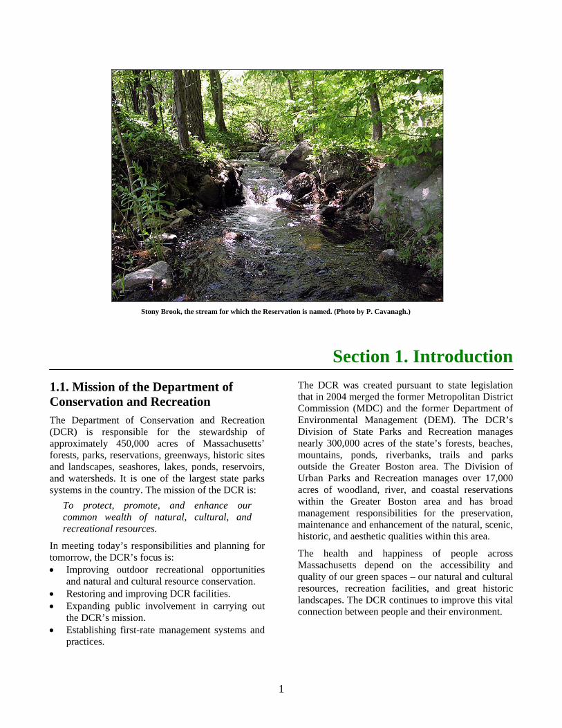
Stony Brook, the stream for which the Reservation is named. (Photo by P. Cavanagh.)
2
1.2. An Introduction to Resource Management Plans Resource Management Plans (RMPs) are “working" documents that consider the past, present, and future of a forest, park, or reservation. They include an inventory and assessment of environmental, cultural, and recreational resources; identify unique characteristics and values; and develop clear management goals and objectives. RMPs provide a guide to the short and long-term management of properties under the stewardship of the DCR. They are intended to be working documents for setting priorities, capital and operational budgeting and resource allocation, and enhancing communication and cooperation with park visitors and the surrounding communities.
The Department of Conservation and Recreation is guided by a legislative mandate (M.G.L. Chapter 21: Section 2F) to prepare management plans for “all reservations, parks, and forests under the management of the department.” Although the mandate does not specify the format or content of these management plans, it does require the following:
“Said management plans shall include guidelines for the operation and land stewardship of the aforementioned reservations, parks and forests, shall provide for the protection and stewardship of natural and cultural resources and shall ensure consistency between recreation, resource protection, and sustainable forest management.”
The legislative mandate also establishes two other requirements. First, that the Commissioner of the Department of Conservation and Recreation “shall seek and consider public input in the development of management plans, and shall make draft plans available for a public review and comment period through notice in the Environmental Monitor.” The mandate is silent on the scope, timing, and format of this input. Second, management plans must be reviewed and adopted by the Stewardship Council. Within 30 days of adoption, the Commissioner “…shall file a copy of such management plans as adopted by the council” with the State Secretary and the Joint Committee on the Environment, Natural Resources, and Agriculture. Resource Management
Plans, and the process developed to prepare these plans (see Sub-section 1.3), exceed all legislative mandates.
The DCR Stewardship Council is a 13-member citizen advisory board that works with the Department to provide a safe, accessible, well-maintained, and well-managed system of open spaces and recreational facilities that are managed and maintained on behalf of the public for the purposes of natural, historic, and cultural resource protection, sustainable recreation, and education.
Resource Management Plans follow a standard format. They begin with a description of the property; identify and assess existing conditions; identify the defining characteristics and management goals for that property; and conclude with management recommendations. This format was developed to present information concisely, while providing sufficient detail to understand a property’s resources, potential, and management needs. This approach yields three benefits. First, shorter documents focused on key information and issues are easier to read, and their content easier to understand, than are exhaustive plans. Second, concise plans take less time to prepare, resulting in a faster rate of RMP development for all DCR properties. Finally, because RMPs follow a standard format, information contained in these plans may be compared across properties (i.e., plans) to identify common issues, challenges, and opportunities.
Much of the information in an RMP is conveyed through maps. The maps provide extensive information on a property’s physical and social settings, its natural and cultural resources, locations of proposed management actions, and land stewardship zoning. These maps both clarify and expand upon information presented elsewhere in the RMP. Although informative, the scale of these report-sized maps makes them inappropriate for planning purposes. Property managers are provided with full-sized versions of the RMP’s maps. It is these full-sized maps, and these maps only, that are to be used for planning.
Resource Management Plans are written to meet the information needs of a diverse audience. Those decision-makers directly involved in the operation and management of a property, and those involved in the regional or system-wide administration of that property are the primary audiences. However, RMPs
3
are not intended as internal DCR documents. Information contained in these plans benefits a variety of stakeholders including individuals and organizations interested in recreation, natural resources, cultural resources, and environmental education and interpretation. Those in local, regional, and State government will also benefit from information contained in RMPs. Finally, RMPs are of value to those who live near a state park, forest, or reservation and are interested in learning more about that property and how decisions affecting it are made. Information contained in RMPs helps all of these stakeholders become more engaged in the operation and management of lands within the DCR system.
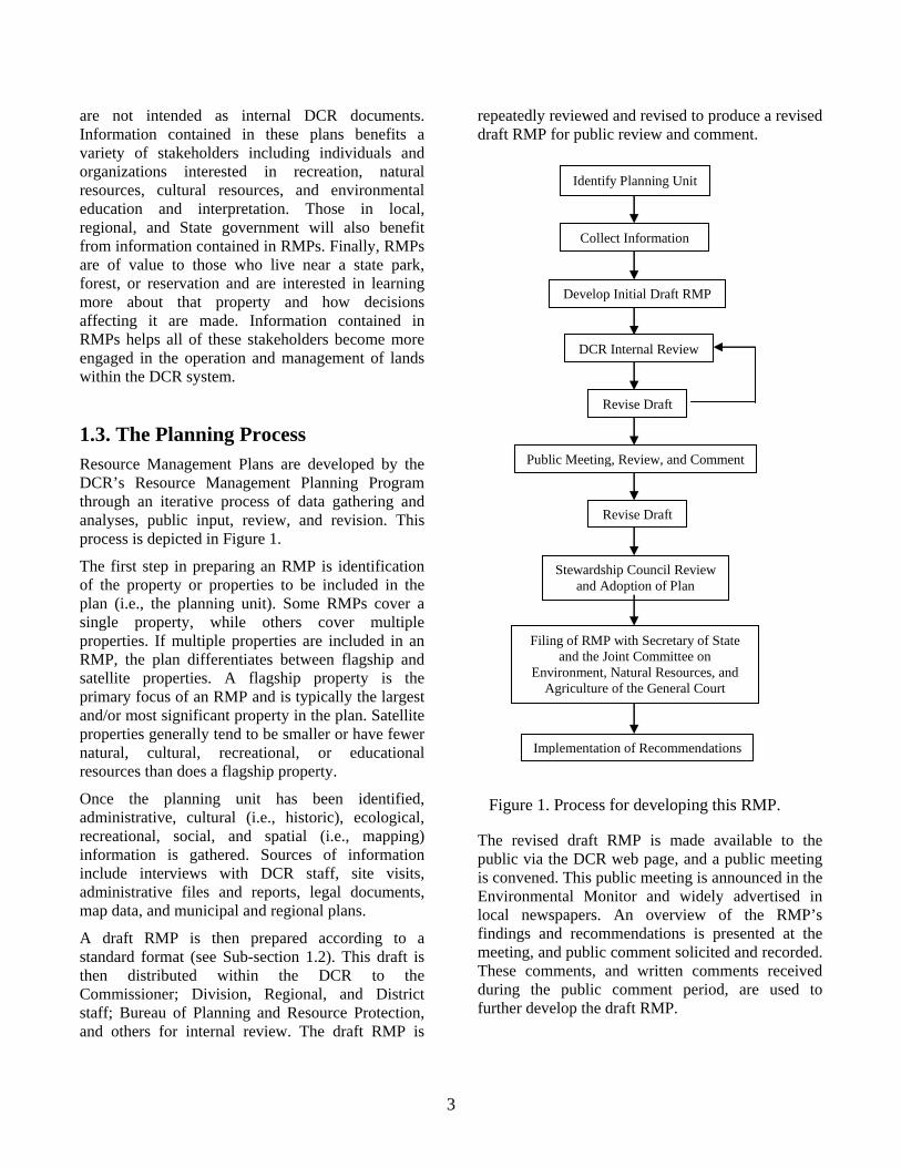
1.3. The Planning Process Resource Management Plans are developed by the DCR’s Resource Management Planning Program through an iterative process of data gathering and analyses, public input, review, and revision. This process is depicted in Figure 1.
The first step in preparing an RMP is identification of the property or properties to be included in the plan (i.e., the planning unit). Some RMPs cover a single property, while others cover multiple properties. If multiple properties are included in an RMP, the plan differentiates between flagship and satellite properties. A flagship property is the primary focus of an RMP and is typically the largest and/or most significant property in the plan. Satellite properties generally tend to be smaller or have fewer natural, cultural, recreational, or educational resources than does a flagship property.
Once the planning unit has been identified, administrative, cultural (i.e., historic), ecological, recreational, social, and spatial (i.e., mapping) information is gathered. Sources of information include interviews with DCR staff, site visits, administrative files and reports, legal documents, map data, and municipal and regional plans.
A draft RMP is then prepared according to a standard format (see Sub-section 1.2). This draft is then distributed within the DCR to the Commissioner; Division, Regional, and District staff; Bureau of Planning and Resource Protection, and others for internal review. The draft RMP is
repeatedly reviewed and revised to produce a revised draft RMP for public review and comment.
Stewardship Council Review and Adoption of Plan
Implementation of Recommendations
Public Meeting, Review, and Comment
Collect Information
Revise Draft
Develop Initial Draft RMP
DCR Internal Review
Revise Draft
Filing of RMP with Secretary of State and the Joint Committee on
Environment, Natural Resources, and Agriculture of the General Court
Identify Planning Unit
Figure 1. Process for developing this RMP.
The revised draft RMP is made available to the public via the DCR web page, and a public meeting is convened. This public meeting is announced in the Environmental Monitor and widely advertised in local newspapers. An overview of the RMP’s findings and recommendations is presented at the meeting, and public comment solicited and recorded. These comments, and written comments received during the public comment period, are used to further develop the draft RMP.
4
Once revised, a final draft RMP is submitted to the Stewardship Council for review and adoption. Once adopted, the Commissioner of the Department of Conservation and Recreation files copies with the State Secretary and the Joint Committee on Environment, Natural Resources and Agriculture of the Massachusetts General Court. The adopted RMP provides structure and guidance for the operation and management of properties included in the plan and ensures consistency between resource management, recreation, and sustainable forest management.
The process used to prepare this RMP differed from that depicted in Figure 1. In 2006, Stony Brook Reservation was one of two DCR properties selected as the subject of a pilot project. The objective of this project was to develop a streamlined RMP process and format that would be applicable to all DCR properties. The approach was to prepare draft RMPs for one urban park and one state park, and to use lessons learned from this experience to create an improved approach to preparing RMPs.
In the spring of 2007, an initial draft Stony Brook RMP was prepared. The process used was similar to that depicted in Figure 1, from “Identify Planning Unit” through “DCR Internal Review.” It was during this review that the decision was made to significantly revise the RMP format (see A Guide to Preparing Resource Management Plans, Department of Conservation and Recreation 2007a), and to rewrite the Stony Brook RMP according to this standard format. The Guide was revised, and the next round in the DCR’s Stony Brook Reservation planning process begun anew. This plan is the first prepared according to the new Guide.
1.4. Public Participation in Developing this Resource Management Plan Notice of a public meeting and of the availability of the draft Stony Brook RMP for public review and comment was published in the February 20, 2008 Environmental Monitor. Additional announcements were made on the DCR web page and press releases announcing the public meeting and availability of the draft RMP were sent to the Hyde Park/Roslindale/West Roxbury Bulletin, Hyde Park Tribune, West Roxbury Transcript, Roslindale Transcript, Daily News Transcript, Boston Globe, Boston Herald, and the Associated Press/Boston. Announcements were also provided to individuals, organizations, and libraries identified by the Executive Office of Energy and Environmental Affairs Office of Environmental Justice. A public meeting was held on March 11, in the community room of the Boston Police Department’s District E-18 station in Hyde Park; 18 people attended. The public comment period on the draft RMP ran from February 20 – March 28, 2008; six sets of comments were received. Information about the public meeting, a summary of written comments received, responses to those comments, and a summary of substantive revisions to the public review draft are provided in Appendix B (Public Participation).
This Resource Management Plan was submitted to the DCR’s Stewardship Council on May 15, 2008, and was adopted by the Council on August 7, 2008.
5
Section 2. Property Description
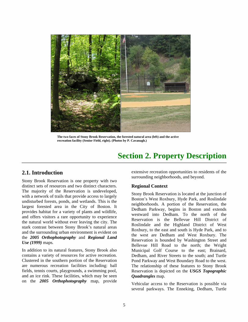
2.1. Introduction Stony Brook Reservation is one property with two distinct sets of resources and two distinct characters. The majority of the Reservation is undeveloped, with a network of trails that provide access to largely undisturbed forests, ponds, and wetlands. This is the largest forested area in the City of Boston. It provides habitat for a variety of plants and wildlife, and offers visitors a rare opportunity to experience the natural world without ever leaving the city. The stark contrast between Stony Brook’s natural areas and the surrounding urban environment is evident on the 2005 Orthophotography and Regional Land Use (1999) maps.
In addition to its natural features, Stony Brook also contains a variety of resources for active recreation. Clustered in the southern portion of the Reservation are numerous recreation facilities including: ball fields, tennis courts, playgrounds, a swimming pool, and an ice rink. These facilities, which may be seen on the 2005 Orthophotography map, provide
extensive recreation opportunities to residents of the surrounding neighborhoods, and beyond.
Regional Context Stony Brook Reservation is located at the junction of Boston’s West Roxbury, Hyde Park, and Roslindale neighborhoods. A portion of the Reservation, the Dedham Parkway, begins in Boston and extends westward into Dedham. To the north of the Reservation is the Bellevue Hill District of Roslindale and the Highland District of West Roxbury, to the east and south is Hyde Park, and to the west are Dedham and West Roxbury. The Reservation is bounded by Washington Street and Bellevue Hill Road to the north; the Wright Municipal Golf Course to the east; Brainard, Dedham, and River Streets to the south; and Turtle Pond Parkway and West Boundary Road to the west. The relationship of these features to Stony Brook Reservation is depicted on the USGS Topographic Quadrangles map.
Vehicular access to the Reservation is possible via several parkways. The Enneking, Dedham, Turtle
The two faces of Stony Brook Reservation, the forested natural area (left) and the active recreation facility (Senior Field, right). (Photos by P. Cavanagh.)
6
Pond, and Neponset Valley parkways, and Reservation Road serve as entrances, and wind among Stony Brook’s extensive tree covered hills, valleys, rock-outcroppings, and wetlands. (Please see the USGS Topographic Quadrangles map.) These roads, along with Centre Street and the VFW Parkway, serve to connect the Arnold Arboretum to the north with the Neponset River and the Blue Hills reservations to the southeast. Connections among the regions parkways, reservations, and other protected open spaces are presented on the Regional Open Space map.
Stony Brook may be accessed on foot from the many residential roads that surround the Reservation; entrance gates are located on Bellevue Hill Road, Blue Ledge Drive, Gordon Avenue, Reservation Road, Dedham Street, Town Street, and River Street.
Stony Brook Reservation, Mother Brook Reservation, and Colella Field and Playground are all accessible via MBTA bus service. Camp Meigs is located close to the Readville MBTA station.
Properties Included in this Resource Management Plan This plan covers Stony Brook Reservation, five “satellite” properties, and three parkways. The satellite properties are Camp Meigs Playground,
Colella Field and Playground, DeSantis Park, Mother Brook Reservation, and Weider Playground. The parkways included in this RMP are the Dedham, Enneking, and Turtle Pond. Locations of these satellite properties and parkways are indicated on the 2005 Orthophotography map. These properties are included in this plan because of their physical proximity to Stony Brook Reservation, and also because they share a common management structure.
Many of these properties are often called by other names. The forested area at the top of Bellevue Hill is often incorrectly referred to as “Bellevue Hill Reservation.” This area is not a separate reservation, but is part of Stony Brook Reservation. Other portions of Stony Brook Reservation are often referred to by their former names. For example, Connell Field is often referred to as Smith Pond Playground, and Lawler Playground is referred to as Factory Hill Playground. It is important to note that the names of many of Stony Brook’s recreation facilities were designated by a variety of acts of the Massachusetts legislature. These official names are used throughout this plan.

7
Place holder for 2005 Orthophotography map.

8
Back of 2005 Orthophotography map.

9
Place holder for Regional Land Use (1999) map.

10
Back of Regional Land Use (1999) map.

11
Place holder for USGS Topographic Quadrangles map.

12
Back of USGS Topographic Quadrangles map.

13
Place holder for Regional Open Space map.

14
Back of Regional Open Space map.
15
Section 2.2. Physical, Ecological, and Political Settings Property Name: Stony Brook Reservation
Location: City of Boston, Suffolk County Town of Dedham, Norfolk County
DCR Management Structure: Unit: Stony Brook Reservation District: West Region South Division: Urban Parks and Recreation
Size: 613 acres (599 in Boston and 14 in Dedham), with a perimeter of 9.5 milesa.
Satellite Properties: Property Name Location Size (ac.)a Perimeter (mi.)a Colella Field and Playground Hyde Park 2.0 0.3 Camp Meigs Playground Hyde Park 3.0 0.3 DeSantis Park Hyde Park 2.2 0.3 Mother Brook Reservation Hyde Park 32.6 1.9 Dedham 15.1 1.8 Weider Playground Roslindale 7.5 0.4
Parkways: Parkway Name Location Length (mi.)a Dedham Parkway (Dedham Boulevard) West Roxbury and Dedham 1.0 Enneking Parkway Hyde Park and West Roxbury 2.1 Turtle Pond Parkway Hyde Park 0.9
Ecoregion: Boston Basin
Watersheds: Charles River, Neponset River
Legislative Districts: Senate District: Suffolk and Norfolk Senator Marian Walsh House Districts: Eleventh Norfolk Representative Paul McMurtry
Tenth Suffolk Representative Michael F. Rush Fourteenth Suffolk Representative Angelo M. Scaccia
Restrictions and Designations: Stony Brook Reservation, excluding Bellevue Hill; the eastern portion of Mother Brook Reservation; and all of the Camp Meigs and Weider Playgrounds occur in Environmental Justice Neighborhoods. The DCR holds two conservation restrictions on properties that abut Stony Brook Reservation.Parkways and one water tower are listed in the National Register of Historic Places.
a. These values were determined through the use of a Geographic Information System (GIS).
16
2.3. History of Property The hills along Stony Brook valley have long been recognized for their rugged scenic quality. This rocky terrain, in combination with the wetlands along Stony Brook, kept much of this area from being farmed by early settlers. (Please see the USGS Topographic Quadrangles map.)
In 1894, one year after the Metropolitan Park Commission (MPC) was established, 475 acres of the Stony Brook area were acquired for a reservation. Charles Eliot, the founder of the MPC, sought to preserve examples of the New England landscape by establishing three kinds of reservations: riverbank, ocean beach, and wild forest. These reservations were chiefly selected for their ability to “secure for the enjoyment of future generations ... interesting and beautiful scenery” (Brouwer 1988). The rocky hills along Stony Brook had both the “interesting and beautiful scenery” and the sense of “enclosure and separateness” that Eliot favored for wild forest reservations (Brouwer 1988).
One of the original planning goals for Stony Brook Reservation was to serve as a connector to the
Boston Park System and other metropolitan reservations via a series of parkways (Brouwer 1988). This vision was never fully realized. Stony Brook Reservation is connected to the Neponset River and Blue Hills reservations via the Neponset Valley Parkway, and to the Hammond Pond Reservation via the West Roxbury and Hammond Pond parkways. However, connections to other reservations and parks are made via a network of both parkways and roadways. (Please see USGS Topographic Quadrangles and Regional Open Space maps.)
Over the years Stony Brook Reservation has grown to 613 acres. Recent acquisitions of key parcels include parcels east of Turtle Pond, other small private in-holdings, and tracts swapped with the City of Boston to square off the boundary with the Wright Municipal Golf Course. In the 1960s, approximately 10-acres of Reservation land were conveyed to the Archdiocese of Boston to build a church on Washington Street.
17
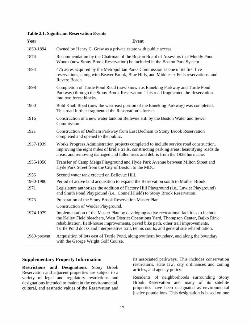
Table 2.1. Significant Reservation Events
Year Event
1850-1894 Owned by Henry C. Grew as a private estate with public access.
1874 Recommendation by the Chairman of the Boston Board of Assessors that Muddy Pond Woods (now Stony Brook Reservation) be included in the Boston Park System.
1894 475 acres acquired by the Metropolitan Parks Commission as one of its first five reservations, along with Beaver Brook, Blue Hills, and Middlesex Fells reservations, and Revere Beach.
1898 Completion of Turtle Pond Road (now known as Enneking Parkway and Turtle Pond Parkway) through the Stony Brook Reservation. This road fragmented the Reservation into two forest blocks.
1900 Bold Knob Road (now the west-east portion of the Enneking Parkway) was completed. This road further fragmented the Reservation’s forests.
1916 Construction of a new water tank on Bellevue Hill by the Boston Water and Sewer Commission.
1921 Construction of Dedham Parkway from East Dedham to Stony Brook Reservation completed and opened to the public.
1937-1939 Works Progress Administration projects completed to include service road construction, improving the eight miles of bridle trails, constructing parking areas, beautifying roadside areas, and removing damaged and fallen trees and debris from the 1938 hurricane.
1955-1956 Transfer of Camp Meigs Playground and Hyde Park Avenue between Milton Street and Hyde Park Street from the City of Boston to the MDC.
1956 Second water tank erected on Bellevue Hill. 1960-1980 Period of active land acquisition to expand the Reservation south to Mother Brook. 1971 Legislature authorizes the addition of Factory Hill Playground (i.e., Lawler Playground)
and Smith Pond Playground (i.e., Connell Field) to Stony Brook Reservation. 1973 Preparation of the Stony Brook Reservation Master Plan.
Construction of Weider Playground. 1974-1979 Implementation of the Master Plan by developing active recreational facilities to include
the Kelley Field bleachers, West District Operations Yard, Thompson Center, Bajko Rink rehabilitation, field-house improvements, paved bike path, other trail improvements, Turtle Pond docks and interpretative trail, tennis courts, and general site rehabilitation.
1980-present Acquisition of lots east of Turtle Pond, along southern boundary, and along the boundary with the George Wright Golf Course.
Supplementary Property Information Restrictions and Designations. Stony Brook Reservation and adjacent properties are subject to a variety of legal and regulatory restrictions and designations intended to maintain the environmental, cultural, and aesthetic values of the Reservation and
its associated parkways. This includes conservation restrictions, state law, city ordinances and zoning articles, and agency policy.
Residents of neighborhoods surrounding Stony Brook Reservation and many of its satellite properties have been designated as environmental justice populations. This designation is based on one
18
or more of the following conditions being true: the median annual household income is at or below 65% of the state median; 25% or more of the residents are minority; 25% or more of the residents are foreign born; or 25% or more of the residents lack proficiency in English. In order to ensure that environmental justice populations have “equal protection and meaningful involvement...with respect to the development, implementation, and enforcement of environmental laws, regulations, and policies and the equitable distribution of environmental benefits” the Executive Office of Energy and Environmental Affairs (EOEA) has developed an environmental justice policy (EOEA 2002). This policy “targets EOEA resources to service those high-minority/low-income neighborhoods in Massachusetts where the residents are most at risk of being unaware of or unable to participate in environmental decision-making.” Of particular relevance to this Resource Management Plan is the need for “enhancing opportunities for residents to participate in environmental decision-making” through enhanced outreach efforts. Detailed information on the planning process, including outreach efforts to environmental justice populations, is provided in Appendix B.
The DCR holds two conservation restrictions, totaling approximately 3.15 acres, on two privately owned parcels of land adjacent to Stony Brook. A conservation restriction is a legal document that limits the uses of land in order to protect specific conservation values of that land. These conservation restrictions were acquired to protect the open space value of partially developed lands, by prohibiting expanded development on these properties.
The DCR holds several permanent easements along Mother Brook. These easements permit the DCR to access private property “… for the purpose of dredging and otherwise improving Mother Brook so as to relieve flood conditions and improve the water quality thereof and to construct, reconstruct and repair such dams and gates as may be required…” These easements do not allow public access.
Chapter 402 of the Acts of 1970 requires that no structure be erected within 35 feet of the boundary of the Reservation and restricts structures within 500 feet of the Reservation to a maximum height of 40 feet. City of Boston Ordinance 7-4.11 requires Boston Parks Commission review and approval of structures proposed to be located within 100 feet of the Reservation boundary.
City of Boston zoning includes a Greenbelt Protection Overlay District that includes the Enneking, Dedham, and Turtle Pond parkways, and a 500-foot buffer to each side of these roads. Projects requiring building permits and involving either the creation of at least 5,000 square feet of floor space or 2,000 square feet of impervious surface must obtain a conditional use permit from the Boston Redevelopment Authority. This zoning article, which does not apply to DCR activities, is intended to help maintain the scenic quality of the parkways.
The Stony Brook Reservation historic parkways and roads (i.e., West Boundary Road, Dedham Parkway, Turtle Pond Parkway, Smith Field Road, Reservation Road, Enneking Parkway, Bellevue Hill Road, and a short section of the West Roxbury Parkway) and the Massachusetts Water Resources Authority (MWRA) stone water tower on Bellevue Hill are listed on the National Register of Historic Places. (Please see Sub-section 3.3 for additional information.) The Reservation Superintendent’s House, which is also referred to as West District Headquarters or the Brainard Street House, is not listed on the National Register of Historic Places but is likely eligible for listing. Similarly, the house at 57 Dedham Street is also not listed on the National Register but it too is likely eligible for listing. (Please see Sub-section 3.3 for more information.) Listing on the National Register does not in itself impose restrictions on a property; it does, however, require Massachusetts Historical Commission review for all actions funded, licensed, or permitted by state or federal agencies.
19
Section 3. Existing Conditions
3.1. Introduction Charles Eliot, the visionary landscape architect responsible for the creation of the Metropolitan Parks Commission and the preservation of Stony Brook advocated that “open space was an essential feature of urban communities” and should be held for the use and enjoyment of the public (Adams et al. 2005). By establishing reservations, preparing general plans, and managing forests to “preserve the inherent scenic qualities of the landscape” Eliot believed that a landscape would remain close to its natural state (Adams et al. 2005). His belief that preservation maintained a landscape’s values are best illustrated in the following passages (Eliot 1898).
“The more or less rock-ribbed masses of the Fells and Blue Hills, and the intricately carved or modeled hollows of Hemlock Gorge, Stony Brook, and Beaver Brook reservations have life-histories of their own; but the processes of their evolution are so slow, that for all human purposes these
smooth, rough, concave, or convex surfaces may be regarded as changeless.” “The distant prospects will remain unchanged, because their very distance makes invisible the superficial alterations which man effects.”
Eliot could not foresee the magnitude or pace of changes that have occurred on Stony Brook Reservation and in surrounding metropolitan Boston. The advent of automobiles on parkways, development of recreation facilities, changes in forest composition and structure, and an increase in surrounding development are some of the forces that have shaped today’s Stony Brook Reservation. Although much has changed, the recognition that open space is an essential feature of urban communities and that it should be held for the enjoyment of the public is as true today as it was in Eliot’s day.
This section describes the current conditions of Stony Brook’s natural, cultural, and recreational resources; interpretive services and environmental education programs; infrastructure; and operations
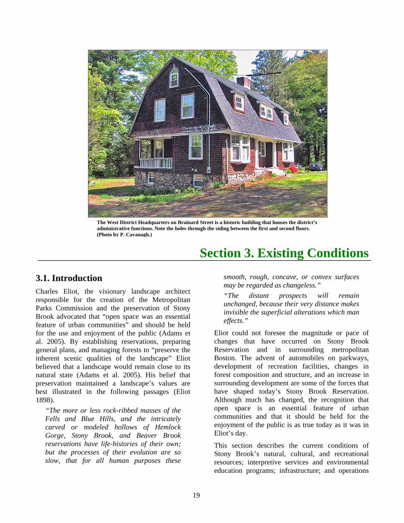
The West District Headquarters on Brainard Street is a historic building that houses the district’s administrative functions. Note the holes through the siding between the first and second floors. (Photo by P. Cavanagh.)
20
and management. When available and appropriate, historic information is incorporated to provide a broader context in which to interpret current conditions.
3.2. Natural Resources
Regional Context Stony Brook Reservation is located in the Boston Basin ecoregion, an area that approximately corresponds to the metropolitan Boston area within the Route 128 beltway. An ecoregion (i.e., ecological region) is a portion of an extensive landscape “with similar geology, physiology, vegetation, climate, and land use history” (EOEA 2006). The ecoregion approach is used by land-holding agencies within the Massachusetts Executive Office of Energy and Environmental Affairs (EOEEA) for regional resource planning because it “allows for the development of landscape-level goals and objectives.”
Although the metropolitan Boston area approximates the extent of the Boston Basin, it is geologic history rather than development that defines this ecoregion. The Boston Basin is a product of sedimentation, sea level change, mountain building, and glaciation (Skehan and Barton n.d.). Some 350-400 million years ago mud, sand, and gravel were being deposited beneath the ocean in what is now the Boston Basin. Over time, mountain building forces in east-central Massachusetts pushed east, creating the elevated ridge that forms the western boundary of the Basin. During the Wisconsin Glaciation, approximately 70,000–14,000 years ago, glaciers scoured the area and meltwater deposited layers of till. These long-passed events created soils that influence the plants and animals that occur here today. Although nearly four centuries of intensive human activity have significantly altered the distribution and abundance of soils, plants, and animals in the ecoregion, portions of Stony Brook Reservation have escaped much of this alteration.
The majority of Stony Brook Reservation occurs in the Charles River Watershed, and it is into this basin that the Reservation’s streams flow. (Please see the Water Resources map.) Weider Playground also occurs in this watershed. Colella Field and Playground, Camp Meigs Playground, DeSantis Park, and a small portion of the Stony Brook
Reservation occur in the Neponset River Watershed. (Please see the Water Resources map.) Mother Brook links these two watersheds, and likely represents the first major inter-basin transfer of water in the Northeast.
Although located within the City of Boston, Stony Brook Reservation is near a variety of protected open spaces. (Please see the Regional Open Space map.) Approximately 21% of the land within a two-mile radius of Stony Brook is permanently protected open space. This is similar to the percentages of protected open space for the entire Boston Basin ecoregion (20%) and for all of Massachusetts (22%). Several DCR properties, including the Neponset River Reservation, Blue Hills Reservation, Fowl Meadow, Havey Beach, Riverdale Park, Cutler Park, Brook Farm, and Hancock Woods are all within two-miles of Stony Brook. Other significant protected open space in the area includes the Arnold Arboretum, municipal parks (e.g., Millennium Park), municipal conservation lands (e.g., Dedham Town Forest), and numerous cemeteries (e.g., Mount Hope Cemetery).
The City of Boston (n.d.) and the Boston Natural Areas Network (Boston Natural Areas Fund 1990) have identified several urban wilds, natural areas of beauty and environmental significance, in the neighborhoods surrounding Stony Brook. Some of these urban wilds are protected (e.g., Allandale Woods) while others are unprotected (e.g., West Roxbury Quarry Urban Wild). Protected urban wilds are depicted on the Regional Open Space map. Unprotected urban wilds are, by definition, not legally protected open space. Because of this they are neither tracked by MassGIS nor displayed in the Regional Open Space map.
Despite the numerous parks and open spaces near Stony Brook Reservation there is little ecological connectivity among properties. Only two properties, the George Wright Golf Course and a seven-acre urban wild called Boundary I, are adjacent to Stony Brook Reservation. From a conservation perspective these three properties may be considered one contiguous piece of open space. Other parcels near the Reservation, but separated by roads, include Mother Brook Reservation and Fairview Cemetery. Such roads, their curbing, and associated vehicle traffic may effectively isolate Stony Brook by impeding the movement of animals; altering the

21
Place holder for Water Resources map.

22
Back of Water Resources map.
23
distribution of water, nutrients, and chemicals; and by increasing light, sound, and temperature levels. For an overview of the ecological impacts of roads, including their isolating effects, see Forman et al. (2003).
Three satellite properties are contiguous with undeveloped properties. Weider Playground, which is partially forested, is contiguous with the Sherrin Street Woods urban wild. DeSantis Park is contiguous with several small undeveloped parcels immediately south of the Park. Mother Brook Reservation is contiguous by land with open space parcels in Dedham (e.g., Brookdale Cemetery) and Boston (e.g., Fairview Cemetery), and by water with the Charles and Neponset rivers.
Ecological Description of Property Stony Brook Reservation ranges in elevation from approximately 15 to 338 feet above sea level. Bellevue Hill, which is the highest point in the Reservation, is also the highest point in the City of Boston. The topography of the Reservation follows a general pattern of declining elevation from north to south, reaching its lowest point at Mother Brook. (Please see the USGS Topographic Quadrangles map.) All of the satellite properties are at low elevation and are approximately level.
As the Reservation’s name implies, stone is an important feature of Stony Brook Reservation. Baxter (1895) described Stony Brook as “...a rocky wilderness, with steep slopes and precipitous ledges enclosing the wild, rugged glen...” The geologic history of the region is revealed by a walk along the Reservation’s trails or by driving its parkways. Outcroppings of ledge provide evidence of the pre-glacial past, and valleys “filled with glacially deposited rocks and boulders” (Primack 1983) provide evidence of glacial history. Bellevue Hill, which is a drumlin, also attests to the geologic forces that shaped the area.
The Reservation’s soils reflect both its geology and topography. The most common soil series is Hollis Rock Outcrop, which ranges from gently sloping soils to steep slopes with exposed bedrock. This soil occurs throughout Stony Brook’s central valley and is considered poor for wildlife habitat and unsuitable for recreational development (Pergallo 1989). On the adjacent slopes, ridges, and hilltops are other soils associated with rock outcrops, including the Rock
Outcrop-Hollis Complex. These too are considered poor for wildlife habitat and unsuitable for most recreational development, although areas with moderate slopes may be appropriate for paths. The soils of Bellevue Hill are Newport Silt Loams, which are associated with good habitat for a variety of upland wildlife and are suitable for several forms of recreational development. Although not highly erodible, disturbed soils at Bellevue Hill are presently washing into the West Roxbury Parkway. Peats, mucks, and other organic soils occur in the Reservation’s wetlands and in portions of Mother Brook. These soils are associated with good habitat for wetland wildlife and are inappropriate for recreational development. None of the soils of Stony Brook are classified as “Prime Farmland.”
Unlike the Reservation, the satellite properties show little evidence of their geologic past. Weider Playground, Colella Field and Playground, DeSantis Park, and Camp Meigs Playground have all been graded to create recreation facilities. Soils in these areas are classified as Udorthents, which are “nearly level and gently sloping areas where the original soils have been cut away or covered with a loamy fill” (Pergallo 1989). Much of Mother Brook is an artificial waterway with its original soil and stone removed. At these locations human-influenced soils, such as Udorthents and the Merrimac–Urban Land Complex, occur along the shore. Other portions of the Reservation have natural soils, such as mucks and silt loam, common to wetlands and floodplains.
Wetlands and other water resources are among the most prominent features of Stony Brook Reservation. (Please see the Water Resources map.) Stony Brook itself originates in the woods and wetlands in the northern portion of the Reservation, and follows the topography, flowing south through the center of the Reservation before turning east toward Bold Knob. Water passes through the Reservation’s largest body of water, Turtle Pond, on this trip downstream. A second, unnamed stream originates in wetlands in the southern portion of the Reservation and flows northeast. This stream merges with Stony Brook in wetlands on the east side of the Reservation, and exits the Reservation under Gordon Avenue. After leaving the Reservation, Stony Brook is “conduited and makes its way under streets and buildings through Boston’s South End before arriving by the Back Bay Fens” (Primack 1983). Seasonal streams also occur on the Reservation,
24
some of which connect Stony Brook’s wetlands with those on the adjacent George Wright Golf Course. An intermittent stream, fed by storm water from the Neponset Valley Parkway, passes through DeSantis Park.
Associated with the Reservation’s streams is an extensive 100-year flood zone. (Please see Water Resources map.) This zone represents “the flood elevation that has a one-percent chance of being equaled or exceeded each year” (FEMA n.d.). Included in this flood zone are portions of Reservation Road, and the Turtle Pond and Enneking parkways. The Connell athletic fields, which are frequently flooded, also occur within this zone. Portions of Mother Brook Reservation also occur within the 100-year floodplain. A small portion of the Mother Brook Reservation, and much of Colella Field and Playground and DeSantis Park occur within the 500-year floodplain. Mother Brook itself is part of a flood control system to help regulate the amount of water in the Charles River basin. Water from the Charles River is diverted through Mother Brook to the Neponset River. The flow of water along Mother Brook is regulated by a water control structure and a series of dams, two of which (i.e., Centennial Dam, Greenough Mill Pond Dam) are owned by the DCR. Neither the Weider nor Camp Meigs playgrounds occur within a floodplain.
A diversity of wetland communities occurs throughout the Reservation. Some are connected by streams, while others are isolated. Emergent marshes, shallow wetlands dominated by tall, grass-like vegetation occur among the Connell Fields and in small forest openings northward to the golf course. Patches of emergent marsh also occur along the water’s edge within Mother Brook Reservation. Shrub Swamps, wetlands dominated by short, woody vegetation occur throughout Stony Brook. However, the most common wetland community on the Reservation is Red Maple Swamp. This forested wetland, which is characterized by a canopy of red maple, occurs along streams and in isolated pockets throughout the Reservation. Eliot (1898, Figure 5) identified the community surrounding Turtle Pond as a “quaking bog,” however this area does not meet the description of any of Massachusetts’ current bog communities (Swain and Kearsley 2001). Comparison of the site with the photo in Eliot (1898)
reveals that what was once a low mat of bog vegetation is now covered with trees and tall shrubs.
Three certified vernal pools occur on Stony Brook. (Please see the Priority Natural Resources map.) These pools, which are temporarily flooded shallow depressions, are unique wildlife habitats critical to the survival of many species of amphibians and invertebrates. Because they have been certified by the Massachusetts Natural Heritage and Endangered Species Program, these pools are protected under Massachusetts’ wetland regulations (310 CMR 10.00). Several other depressions, that may potentially be vernal pools, have also been identified on Stony Brook. (Please see the Priority Natural Resources map.) A small emergent marsh, fed by water from catch basins along the Neponset Valley Parkway occurs in DeSantis Park. No wetlands occur on Weider Playground, Colella Field and Playground, or Camp Meigs Playground.
The Massachusetts Department of Environmental Protection (DEP) has identified three contaminated properties near Stony Brook. (Please see the Water Resources map.) These sites, one residential and two commercial, are referred to as 21E sites after the Chapter of Massachusetts General Law that deals with waste sites and their cleanup. A release and cleanup of motor oil occurred at the residential site, the DEP considers this to pose no risk. Both commercial sites involved the release of industrial chemicals, and both are nearing the completion of their respective cleanup processes. None of these three 21E sites presently represent a risk to the water resources of Stony Brook Reservation. A closed landfill occurs on the Reservation between Turtle Pond and West Boundary Road; this is not considered a 21E site. (Please see the Water Resources map.)
The waters of Mother Brook do not meet water quality standards (Department of Environmental Protection 2005). They are considered a category five, which means that Mother Brook is unsuitable for one or more of the following uses: aquatic life, fish consumption, drinking water, primary contact recreation (e.g., swimming), secondary contact recreation (e.g., boating), shellfish harvesting, and aesthetics. Known problems with Mother Brook include elevated nutrient levels, organic enrichment, low dissolved oxygen, flow alteration, the presence of pathogens, and problems with taste, odor, and

25
Place holder for Priority Natural Resources map.

26
Back of Priority Natural Resources map.
27
color. The segment of the Charles River accessible from Mother Brook has also been designated as category five waters. Known problems with this segment include elevated nutrient levels, organic enrichment, low dissolved oxygen, the presence of pathogens, noxious aquatic plants, high turbidity, and exotic species. The portion of Stony Brook on Stony Brook Reservation is not included in the Integrated List of Waters (Department of Environmental Protection 2005), and has not been assigned a water quality category. Water quality information is also lacking for the stream on DeSantis Park.
Activities on Stony Brook that affect the quantity or quality of storm water are regulated by a National Pollutant Discharge Elimination System (NPDES) permit that covers multiple DCR properties. This permit identifies Best Management Practices (BMPs) employed by the DCR (DCR 2007b) to properly mange storm water. Although many of these BMPs are implemented at the state level (e.g., development of policies), some are implemented at the property level. BMPs for protecting Stony Brook’s waters include stenciling catch basins, washing vehicles at off-site locations, and continued compliance with the Wetlands Protection Act.
Although it is easy to imagine that today’s Stony Brook Reservation looks much the same as it did in the past; this is not the case. Descriptions of the Reservation, made around the time of its acquisition in 1894, detail a much different landscape. Baxter (1895) described the Reservation as “ribbed by cedar-covered ledges, and thickets of shrubs fill the swampy hollows.” Between the ledges and the wetlands were forests of numerous small, shrubby trees. A forest map in Eliot (1898) indicates that the majority of the Reservation’s forests were either “young sprout-growth” or “old sprout-growth.” Sprout-growth, or coppice, “consists of trees sprung, not from seed, but from the axed or burnt stumps from the trees of a previous generation.” The repeated harvesting of wood at Stony Brook modified its forests so that numerous, small-diameter stump sprouts were the norm. Although the map’s legend includes a category for “mature seedling trees,” none are indicated on the map. The high, closed canopy of today’s forests and the single stems of mature oaks and pine were either uncommon or absent from the Stony Brook of the late 1890s. Fireweed, a wild flower associated with
burned areas was a “frequent” plant in the late 1890s (Deane 1896); indicating that fire was a common occurrence. Features once common on Stony Brook, such as active and abandoned pastures (Eliot 1898), are now absent. Such changes in vegetation undoubtedly altered the abundance and diversity of wildlife on the Reservation. Fragmentation of the Reservation’s forests, due to the creation of parkways and associated vehicle traffic, has also undoubtedly affected the Reservation’s plants and wildlife. Current conditions represent one brief point in time in this ongoing process of change.
One of the most common terrestrial natural communities now on the Reservation is Oak-Hickory Forest. Despite the name, this community is dominated by oaks, with hickory present only in small numbers (Swain and Kearsley 2001). White oak, northern red oak, hickories, white pine, cherry, witch hazel, sassafras, maple-leaf viburnum, and poison ivy are common plants of this community. This community type is a fairly recent occurrence, as a plant survey conducted at Stony Brook in the late 1800s (Deane 1896) did not record any hickories.
Three other natural communities: Successional White Pine, Cultural Grassland, and Acidic Rocky Summit/Rock Outcrop (Swain and Kearsley 2001) are also known to occur on the property. Successional White Pine occurs as small stands of white pine among the Oak-Hickory Forest. A Cultural Grassland, which is a human created grassland, occurs atop the closed landfill. This area is rapidly being overgrown by staghorn sumac and quaking aspen, and will soon give way to forest. The Acidic Rock Summit/Rock Outcrop community occurs on many of the Reservation’s hilltops, especially those areas that have burned in recent decades. Scrub oak, blueberries, huckleberry, and coppiced oaks are the common plants in this community.
Mattrick (2003) conducted a botanical survey of the adjacent Boundary I urban wild, and identified four natural communities: Acidic Rocky Summit/Rock Outcrop, Shrub Swamp, Mixed Oak Forest, and Black Oak – Scarlet Oak Forest/Woodland. The first two communities are known to occur, and the last two are likely to occur, on Stony Brook Reservation.
Several species of invasive plants occur along Stony Brook’s roads and trails, and in its wetlands. These plants “are non-native species that have
28
spread into native or minimally managed plant systems” where they “dominate and/or disrupt native ecosystems” (Somers et al. 2006). Because of this, the unmanaged spread of these plants poses a threat to the Reservation’s natural communities. Although systematic surveys have not been conducted on Stony Brook, several species of invasive plants have been identified. Please see Appendix F (Plants of the Stony Brook Area) for a list of plants, including 11 invasive and “likely invasive” species, currently known to occur on the Reservation.
It is interesting to note that only one of the 11 invasive species recorded on Stony Brook in recent years was also recorded in the 1890s (Deane 1896). Japanese barberry, an invasive of forests and fields, was identified in both time periods. Three other invasive species: black locust, border privet, and common buckthorn, were recorded on Stony Brook in the 1890s but have not been recorded since. These plants may still occur on the Reservation.
The wildlife of Stony Brook is little studied and, as a result, largely unknown. Birds are the best known group on the Reservation, with 70 species presently documented by local birders. (Please see Appendix G for a list of the known birds of Stony Brook.) However, bird surveys conducted at other nearby open spaces suggest that this number likely underestimates the true diversity of birds on Stony Brook. For example, sightings at the Massachusetts Audubon Society’s Boston Nature Center in Mattapan have identified several migratory species not yet recorded on Stony Brook, and over 180 species of birds have been documented at the Arnold Arboretum (Mayer 2006).
Fourteen species of mammals have been recorded on Stony Brook Reservation. (Please see Appendix H for a list of the known mammals of Stony Brook Reservation.) Some, such as the gray squirrel and eastern coyote, are familiar city dwellers while others, such as the mink, depend upon the Reservation’s forests, brooks, and wetlands.
In contrast to birds and mammals, reptiles, amphibians, fish, and invertebrates have not been inventoried on Stony Brook and remain poorly documented. The few species recorded on the Reservation, such as the American toad and spring peeper, tend to be those that are easily seen or heard.
The majority of Stony Brook Reservation has been designated Priority Habitat by the Massachusetts Natural Heritage and Endangered Species Program (NHESP). (Please see the Priority Natural Resources map.) This designation is based on the known occurrence of two state-listed insects, and means that any activities with the potential to alter habitat in this area must undergo review by the NHESP. Stony Brook’s two state-listed species are the state-threatened orange sallow moth, and a state-endangered aquatic insect. The former occurs throughout the Reservation’s dry Oak-Hickory Forests, oak forests, and rocky summits; the latter is associated with its wetlands. Two state-listed species of birds, the sharp-shinned hawk (Species of Special Concern) and the northern parula (Threatened) have also been observed on Stony Brook. However, there are no records for these occurrences in the NHESP database. Although not state-listed, five species of birds observed at Stony Brook have been identified as “species in greatest need of conservation” by the Massachusetts Division of Fisheries and Wildlife (2005). These species are the green heron, American black duck, wood thrush, eastern towhee, and white-throated sparrow. Full descriptions of the Massachusetts Endangered Species Act and of Priority Habitat are available at www.mass.gov/ dfwele/dfw/nhesp/nhesp.htm.
Issues, Challenges, and Opportunities Available information did not reveal any significant threats to natural resources or incompatibilities between resource protection and recreation. However, several issues were identified.
The primary issue facing the stewardship of Stony Brook’s natural resources is obtaining additional information to better understand and manage these resources. The amount of information available differs greatly among resources. For example, the soils of Stony Brook have been systematically identified and mapped while the Reservation’s plants, animals, vernal pools, and natural communities have not. Similarly, information on the water quality of Mother Brook has been well-studied, while water quality in Stony Brook, Turtle Pond, and the DeSantis Park wetland has not. Obtaining this information provides an opportunity to actively engage volunteers, non-profit organizations, and educational institutions in Stony Brook, and to establish mutually beneficial
29
relationships. In addition, water quality information can help determine if fishing is an appropriate activity on Stony Brook Reservation.
The next issue is the lack of management guidelines for rare species habitat. Although both species of State-listed insects occur in habitats that are little-disturbed on Stony Brook (e.g., dry woodlands, Turtle Pond), opportunities may exist to enhance these habitats. Such guidelines would inform both current operations and a future forest management plan.
The soil eroding from Bellevue Hill onto the West Roxbury Parkway is due to trenching associated with the installation of underground water pipes. This creates an opportunity to work with the agency responsible for the trenching, the MWRA, to correct this problem.
Finally, although presently limited in occurrence, invasive plants pose a growing threat to the Reservation’s natural resources. Early detection and control of invasive species not only protects Stony Brook’s resources, but minimizes future expenses. An opportunity now exists to develop and initiate control activities so that the impacts of invasive plants are minimized
3.3. Cultural Resources Regional Context The Boston Basin is an area of high archaeological site density and sensitivity. It is a documented locus of ancient Native American settlements that contain regionally dense concentrations of archaeological sites representing every period of Native settlement known for the northeastern United States, from the Paleo-Indian (12,000 years before present) through Historic periods. A wide variety of site types and sizes are represented in the area, ranging from larger, complex habitation sites to smaller, low-density campsites and rock shelters, burials, lithic (i.e., stone) workshops, shell middens, and other special-purpose sites.
The Greater Boston area is also home to an extensive number and variety of historic resources. For example, the National Register of Historic Places has nearly 250 listings for the City of Boston. The Massachusetts Cultural Resource Information System (MACRIS) lists over 10,000 historic areas,
buildings, burial grounds, objects, and structures in the city. Many of these are associated with Boston’s role in the American Revolution. These figures do not include cultural resources that occur in the other cities and towns of the Boston Basin.
Archaeological Resources Stony Brook Reservation contains a single recorded Native American site. This site (19-SU-50) is located adjacent to wetlands that flank Stony Brook. The presence of numerous archaeological sites within the nearby Blue Hills and Fowl Meadow clearly attest to the prime habitat that these areas offered Native American hunters and gatherers. Indeed, one site adjacent to Ponkapoag Pond in Canton places Native Americans in the vicinity of Stony Brook at least 9,000 years ago and more or less continuously, albeit seasonally, to 450 years ago. The single site recorded in Stony Brook is clearly not a true reflection of its importance in prehistoric times and it is predicted that more sites exist on the well-drained and moderately sloping terraces near Stony Brook and Turtle Pond.
Historic Resources Buildings. Stony Brook Reservation has two historic buildings (please see the Cultural Resources map), and two buildings that will soon be considered historic.
The West District Headquarters, located at 12 Brainard Street, was built by the MPC in 1897 to serve as the Stony Brook Reservation Superintendent’s house. It was designed by Arthur F. Gray, a Boston-based civil engineer and architect who was active in eastern Massachusetts in the late 19th and early 20th centuries. This is a significant building as it is one of only a few remaining structures originally built for park purposes. The Massachusetts Historical Commission has inventoried the building. Although it is not listed on either the State or National Register of Historic Places, it is likely eligible for such listing as part of the Metropolitan Park System of Greater Boston Multiple Property Listing. All or part of the house at 57 Dedham Street is historic. Although there are numerous additions of varying age, the original house and at least one of the additions are more than 50-years old. Both Bajko Rink and the Olsen Pool buildings will soon be 50-years old.
30
Work on any of these buildings, regardless of listing status, must be reviewed by the DCR’s Office of Cultural Resources and is also subject to review by the Massachusetts Historical Commission. Such work must also be consistent with the Secretary of Interior’s Standards for the Treatment of Historic Properties (Weeks and Grimmer 1995).
Structures. The stone water tower on Bellevue Hill was built in 1916 as part of the Boston Water Supply System and continues to serve Boston as a vertical reservoir for the MWRA. The tower is a 45-foot high Romanesque-style granite and concrete masonry structure. The tower was modeled after Castle St. Angelo in Rome, a mausoleum of the Roman Emperor Hadrian. It is listed on the National Register of Historic Places for its architectural interest and its contribution as part of the Water Supply System of metropolitan Boston as exemplification of the development of water distribution technology from 1845-1926.
Two dams occur along Mother Brook within the Mother Brook Reservation. These dams, the Centennial Dam in Dedham and the Greenough Mill Pond Dam in Hyde Park, have not been evaluated for historic significance. However, all structures over 50 years old should be treated as historic resources. The Office of Cultural Resources should be consulted when considering undertaking work on these structures, and DCR policy on cultural resource management should be followed.
Landscapes. Early Europeans were challenged by the rugged terrain of the upper Stony Brook valley and their activities appear limited to logging, working wood lots, and minor quarrying with little attempt at farming or pasturing. This small valley was able to retain its undeveloped character as it evolved into a private estate in the middle part of the
nineteenth century. This undeveloped character was preserved as ownership passed into the hands of the MPC in 1894. The MPC, the nation’s first regional park system, was established to create and manage a network of reservations and to construct and manage parkways to link these reservations with one another and with the City of Boston. Surveying and landscape plans for this system of reservations and parkways were prepared by the firm of Olmsted, Olmsted, and Eliot, which was under contract as landscape architects to the newly established MPC. Because Stony Brook Reservation is one of the first five reservations in the Metropolitan Park System, its entire historic boundary is eligible for inclusion in the National Register. Contributing features (e.g., trails) present at the time of the Reservation’s establishment would be included in the listing of the historic boundary.
The eight historic parkways that border and pass through the Stony Brook Reservation are listed on the National Register of Historic Places. (Please see the Cultural Resources map.) These historic parkways were nominated for their significance as a set of internal and border parkways designed for the MPC by Olmsted, Olmsted, and Eliot and its successor firm Olmsted Brothers (Adams et al. 2005). The Stony Brook Reservation historic parkways contain approximately four and one-half miles of internal and border parkways that provide vehicular access to the Reservation and serve as major travel routes from Hyde Park and Dedham to Boston. These parkways offer connections to other major DCR historic parkways and parks such as the West Roxbury Parkway and the Hammond Pond Reservation and Parkway to the north, and the Neponset Valley Parkway and the Blue Hills Reservation to the southeast.

31
Place holder for Cultural Resources map.

32
Back of Cultural Resources map.
33
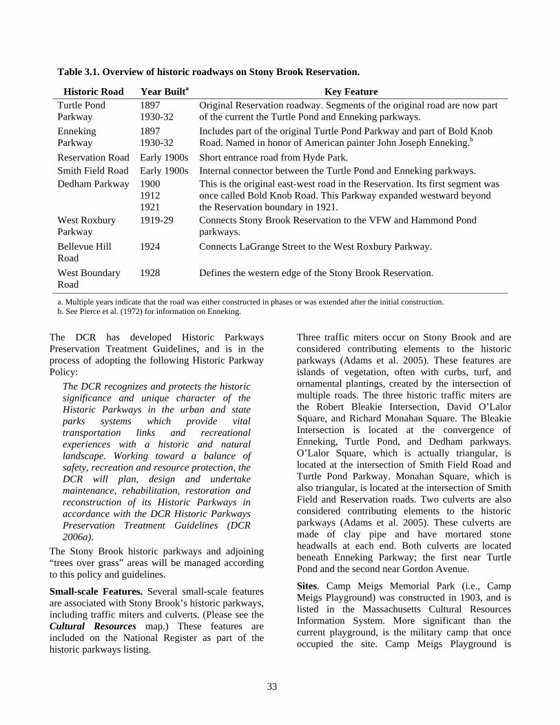
Table 3.1. Overview of historic roadways on Stony Brook Reservation.
Historic Road Year Builta Key Feature Turtle Pond Parkway
1897 1930-32
Original Reservation roadway. Segments of the original road are now part of the current the Turtle Pond and Enneking parkways.
Enneking Parkway
1897 1930-32
Includes part of the original Turtle Pond Parkway and part of Bold Knob Road. Named in honor of American painter John Joseph Enneking.b
Reservation Road Early 1900s Short entrance road from Hyde Park. Smith Field Road Early 1900s Internal connector between the Turtle Pond and Enneking parkways. Dedham Parkway 1900
1912 1921
This is the original east-west road in the Reservation. Its first segment was once called Bold Knob Road. This Parkway expanded westward beyond the Reservation boundary in 1921.
West Roxbury Parkway
1919-29 Connects Stony Brook Reservation to the VFW and Hammond Pond parkways.
Bellevue Hill Road
1924 Connects LaGrange Street to the West Roxbury Parkway.
West Boundary Road
1928 Defines the western edge of the Stony Brook Reservation.
a. Multiple years indicate that the road was either constructed in phases or was extended after the initial construction. b. See Pierce et al. (1972) for information on Enneking.
The DCR has developed Historic Parkways Preservation Treatment Guidelines, and is in the process of adopting the following Historic Parkway Policy:
The DCR recognizes and protects the historic significance and unique character of the Historic Parkways in the urban and state parks systems which provide vital transportation links and recreational experiences with a historic and natural landscape. Working toward a balance of safety, recreation and resource protection, the DCR will plan, design and undertake maintenance, rehabilitation, restoration and reconstruction of its Historic Parkways in accordance with the DCR Historic Parkways Preservation Treatment Guidelines (DCR 2006a).
The Stony Brook historic parkways and adjoining “trees over grass” areas will be managed according to this policy and guidelines.
Small-scale Features. Several small-scale features are associated with Stony Brook’s historic parkways, including traffic miters and culverts. (Please see the Cultural Resources map.) These features are included on the National Register as part of the historic parkways listing.
Three traffic miters occur on Stony Brook and are considered contributing elements to the historic parkways (Adams et al. 2005). These features are islands of vegetation, often with curbs, turf, and ornamental plantings, created by the intersection of multiple roads. The three historic traffic miters are the Robert Bleakie Intersection, David O’Lalor Square, and Richard Monahan Square. The Bleakie Intersection is located at the convergence of Enneking, Turtle Pond, and Dedham parkways. O’Lalor Square, which is actually triangular, is located at the intersection of Smith Field Road and Turtle Pond Parkway. Monahan Square, which is also triangular, is located at the intersection of Smith Field and Reservation roads. Two culverts are also considered contributing elements to the historic parkways (Adams et al. 2005). These culverts are made of clay pipe and have mortared stone headwalls at each end. Both culverts are located beneath Enneking Parkway; the first near Turtle Pond and the second near Gordon Avenue.
Sites. Camp Meigs Memorial Park (i.e., Camp Meigs Playground) was constructed in 1903, and is listed in the Massachusetts Cultural Resources Information System. More significant than the current playground, is the military camp that once occupied the site. Camp Meigs Playground is
34
located in what was once one of twenty-one military camps for training Massachusetts volunteers for Civil War service. The Camp was located on “a level plain containing about one hundred and twenty-five acres” that lay along the bank of the Neponset River and included Sprague Pond (Corthell 1905). It was named after Brigadier General Montgomery C. Meigs, who served as Quartermaster General of the U.S. Army during the Civil War. Nearly 4,000 African-American men of the 54th and 55th Massachusetts Volunteer Militia Infantry Regiments and the 5th Massachusetts Volunteer Militia Cavalry Regiment were trained at Camp Meigs. There is a recent memorial at the Playground “Dedicated to the African-American troops who trained here and distinguished themselves in the Civil War – and to those who continue the fight for equal rights and equal justice.” An additional unit of note that trained at Camp Meigs was the “California hundred,” a group of volunteers from California who served in the 2nd Massachusetts Calvary, Company A. After the war, the northern portion of Camp Meigs became the Readville section of Boston (Anderson 2007), where the Camp Meigs Playground was constructed. The City of Boston transferred the Playground to the MDC in 1958. Archaeological surveys have not been conducted at the Playground, and a potential exists for the presence of archaeological resources.
One of the most significant historic sites associated with Stony Brook Reservation is Mother Brook. In 1639, a ditch was dug to connect water from the Charles River with East Brook, a tributary of the Neponset River (Hanson 1976). This ditch, which was expanded over time, became Mother Brook. It is considered the first canal in America to have been dug by English settlers. Mother Brook was created to increase the flow of water into the Neponset River so that dams and mills could be constructed.
Issues, Challenges, and Opportunities The primary issue facing Stony Brook’s cultural resources is their preservation. Stony Brook’s historic structures have been identified, as have those structures that will soon qualify as historic (e.g., Olsen Pool bathhouse). Although little is known about the DCR owned dams within the Mother Brook Reservation, they too are historic structures. The challenge is ensuring that all activities affecting archaeological and historic
resources are coordinated with the Office of Cultural Resources.
Stony Brook Reservation and its satellite properties have cultural resources of great significance to local and national history. Few people recognize or value Stony Brook’s role in the nation’s first metropolitan park system, Mother Brook’s role in the industrialization of Dedham and Boston, and Camp Meigs role in the American Civil War. Creating an awareness and appreciation of these resources is both a challenge and opportunity. (Please see Sub-section 3.5.)
Stony Brook’s traffic miters were named by acts of the Massachusetts legislature. All three miters are required to have identifying signs; only O’Lalor Square is so marked.
3.4. Recreation Regional Context Stony Brook Reservation provides a variety of organized (e.g., baseball) and individual (e.g., hiking) recreational opportunities. It primarily serves the recreational needs of the surrounding neighborhoods, although it is an important regional resource for some team sports (e.g., hockey).
Demographics By examining U.S. Census data for Boston in general, and for the neighborhoods surrounding the Reservation in particular, we may identify demographic characteristics of the likely users of Stony Brook. Such information helps the DCR better understand and meet the needs of the Reservation’s users.
The U.S. Census is conducted once every ten years, most recently in 2000. The 2000 census results revealed that the City of Boston is home to a diverse population of 589,141 individuals. This figure reflects analyses conducted using “Metropolitan Area” (i.e., city) level data. Readers interested in the different geographic scales of census data are directed to the publication Introduction to Census 2000 data (U.S. Census Bureau 2001). The racial make-up of Boston, as indicated by the 2000 census, is presented in table 3.2.
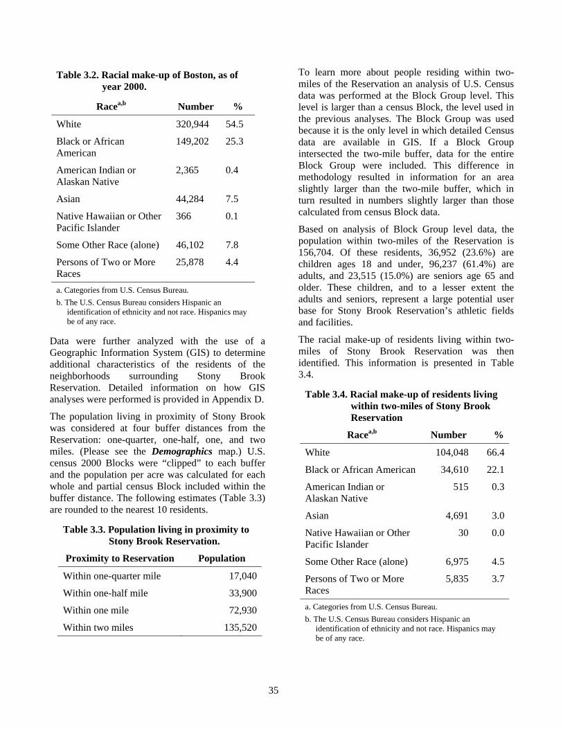
35
Table 3.2. Racial make-up of Boston, as of year 2000.
Racea,b Number %
White 320,944 54.5
Black or African American
149,202 25.3
American Indian or Alaskan Native
2,365 0.4
Asian 44,284 7.5
Native Hawaiian or Other Pacific Islander
366 0.1
Some Other Race (alone) 46,102 7.8
Persons of Two or More Races
25,878 4.4
a. Categories from U.S. Census Bureau. b. The U.S. Census Bureau considers Hispanic an
identification of ethnicity and not race. Hispanics may be of any race.
Data were further analyzed with the use of a Geographic Information System (GIS) to determine additional characteristics of the residents of the neighborhoods surrounding Stony Brook Reservation. Detailed information on how GIS analyses were performed is provided in Appendix D.
The population living in proximity of Stony Brook was considered at four buffer distances from the Reservation: one-quarter, one-half, one, and two miles. (Please see the Demographics map.) U.S. census 2000 Blocks were “clipped” to each buffer and the population per acre was calculated for each whole and partial census Block included within the buffer distance. The following estimates (Table 3.3) are rounded to the nearest 10 residents.
Table 3.3. Population living in proximity to Stony Brook Reservation.
Proximity to Reservation Population
Within one-quarter mile 17,040
Within one-half mile 33,900
Within one mile 72,930
Within two miles 135,520
To learn more about people residing within two-miles of the Reservation an analysis of U.S. Census data was performed at the Block Group level. This level is larger than a census Block, the level used in the previous analyses. The Block Group was used because it is the only level in which detailed Census data are available in GIS. If a Block Group intersected the two-mile buffer, data for the entire Block Group were included. This difference in methodology resulted in information for an area slightly larger than the two-mile buffer, which in turn resulted in numbers slightly larger than those calculated from census Block data.
Based on analysis of Block Group level data, the population within two-miles of the Reservation is 156,704. Of these residents, 36,952 (23.6%) are children ages 18 and under, 96,237 (61.4%) are adults, and 23,515 (15.0%) are seniors age 65 and older. These children, and to a lesser extent the adults and seniors, represent a large potential user base for Stony Brook Reservation’s athletic fields and facilities.
The racial make-up of residents living within two-miles of Stony Brook Reservation was then identified. This information is presented in Table 3.4.
Table 3.4. Racial make-up of residents living within two-miles of Stony Brook Reservation
Racea,b Number %
White 104,048 66.4
Black or African American 34,610 22.1
American Indian or Alaskan Native
515 0.3
Asian 4,691 3.0
Native Hawaiian or Other Pacific Islander
30 0.0
Some Other Race (alone) 6,975 4.5
Persons of Two or More Races
5,835 3.7
a. Categories from U.S. Census Bureau. b. The U.S. Census Bureau considers Hispanic an
identification of ethnicity and not race. Hispanics may be of any race.
36
Next, the primary language spoken in the 58,394 households that occur within two-miles of Stony Brook was identified. English is the primary language of a majority of households (42,290, 72.4%) near Stony Brook. Of the 16,104 households (27.6%) where English is not the primary language, the following languages, or groups of languages, are spoken: Spanish (5,163 households), other European languages (8,316 households), Asian languages (1,328 households), and Other (1,297 households).
Finally, income level was identified for households that occur within two-miles of Stony Brook. Most households (26,363, 45.1%) were classified as medium income, which is defined as an annual household income of $25,000– $74,999. The second most common household income level (18,620, 31.9%) was high income, which is defined as an annual income of $75,000 or more. The least common household income level (13,411, 23.0%) was low income, which is defined as an annual income of $24,999 or less.
It is important to note that this demographic information represents only the local potential users of Stony Brook. There is no information on how many of these nearby residents actually use Stony Brook, or on their age, race, or languages spoken.
Recreational Description of Property Recreational opportunities at Stony Brook differ geographically. Athletic, picnic, and playground facilities occur in the southern portion of the Reservation, while nature-based recreation (e.g., fishing, hiking) occur in the northern portion of the reservation. Cycling, cross-country skiing, and dog walking occur on trails throughout the Reservation. The distribution of these activities reflects the current distribution of natural resources and recreational infrastructure on Stony Brook.
Active recreation is concentrated in three areas in the southern part of the Reservation. (Please see the Active Recreation Areas map.) The first is the Connell Fields area, and includes the fields, Dooley Playground, and the John Joseph Hickey tennis courts. These facilities are accessible from Brainard
Street, Reservation Road, and Enneking Parkway. The second active recreation area is the John F. Thompson Memorial Park. When in operation, access to the Thompson Memorial Park was available from Smith Field Road. The third, and largest, active recreation area is the complex of fields and buildings that extends from Olsen Pool southward to the Kelley Field complex. (Please see Active Recreation Areas map.) Vehicular access to these sports facilities is available from Turtle Pond Parkway and River Street. Pedestrian access is also available via a series of trails and walkways that originate at Dooley Playground, Dedham Street, and Lawler Playground. Active recreation resources are also available at the following three satellite properties: Weider Playground, Colella Field and Playground, and Camp Meigs Playground. There are no active recreation facilities on Mother Brook Reservation.
Opportunities for passive recreation are distributed throughout Stony Brook, especially the northern portion of the Reservation. Information on the Reservation’s trail system is provided in Sub-section 3.6. Two docks provide fishing access to Turtle Pond. Although Mother Brook is accessible for fishing, its classification as category five impaired waters (Sub-section 3.2) makes it inappropriate for this use. The portion of the Charles River that is accessible for fishing from Mother Brook Reservation has also been classified as a category five impaired waters, and is also inappropriate for this use. Limited passive recreation opportunities (e.g., birding) are available at DeSantis Park.
Inventory of Recreational Resources Stony Brook Reservation and its satellite properties provide a variety of recreational fields and athletic facilities. (Please see the Active Recreation Areas map.) A complete listing of these resources is provided in Table 3.5, and a schedule for the maintenance of these facilities is provided on the DCR’s web page at www.mass.gov/dcr/ maintenance. Guidance on reserving and using DCR athletic fields and facilities is presented in DCR (n.d. a).

37
Place holder for Demographics map.

38
Back of Demographics map.

39
Place holder for Active Recreation map.

40
Back of Active Recreation map.
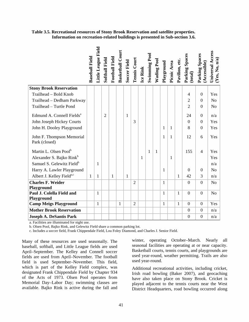
41
Table 3.5. Recreational resources of Stony Brook Reservation and satellite properties. Information on recreation-related buildings is presented in Sub-section 3.6.
Bas
ebal
l Fie
ld
Litt
le L
eagu
e Fi
eld
Soft
ball
Fiel
d Fo
otba
ll Fi
eld
Bas
ketb
all C
ourt
So
ccer
Fie
ld
Ten
nis C
ourt
Ic
e R
ink
Swim
min
g Po
ol
Wad
ing
Pool
Pl
aygr
ound
Pi
cnic
Are
a Pa
vilio
n, e
tc.
Park
ing
Spac
es
(tot
al)
Park
ing
Spac
es
(Acc
essi
ble)
U
nive
rsal
Acc
ess
(Yes
, No,
n/a
)
Stony Brook Reservation Trailhead – Bold Knob 4 0 Yes Trailhead – Dedham Parkway 2 0 No Trailhead – Turtle Pond 2 0 No
Edmund A. Connell Fieldsa 2 1 24 0 n/a John Joseph Hickey Courts 3 0 0 Yes John H. Dooley Playground 1 1 8 0 Yes
John F. Thompson Memorial Park (closed)
1 1 12 6 Yes
Martin L. Olsen Poolb 1 1 155 4 Yes Alexander S. Bajko Rinkb 1 1 Yes Samuel S. Gelewitz Fieldb 1 n/a Harry A. Lawler Playground 1 0 0 No Albert J. Kelley Fielda,c 1 1 1 1 1 42 3 n/a
Charles F. Weider Playground
2 1 0 0 No
Paul J. Colella Field and Playground
1 1 1 0 0 No
Camp Meigs Playground 1 1 2 1 1 0 0 Yes Mother Brook Reservation 0 0 n/a Joseph A. DeSantis Park 0 0 n/a a. Facilities are illuminated for night use. b. Olsen Pool, Bajko Rink, and Gelewitz Field share a common parking lot. c. Includes a soccer field, Frank Chippendale Field, Lou Foley Diamond, and Charles J. Senior Field.
Many of these resources are used seasonally. The baseball, softball, and Little League fields are used April–September. The Kelley and Connell soccer fields are used from April–November. The football field is used September–November. This field, which is part of the Kelley Field complex, was designated Frank Chippendale Field by Chapter 934 of the Acts of 1973. Olsen Pool operates from Memorial Day–Labor Day; swimming classes are available. Bajko Rink is active during the fall and
winter, operating October–March. Nearly all seasonal facilities are operating at or near capacity. Basketball courts, tennis courts, and playgrounds are used year-round, weather permitting. Trails are also used year-round.
Additional recreational activities, including cricket, Irish road bowling (Baker 2007), and geocaching have also taken place on Stony Brook. Cricket is played adjacent to the tennis courts near the West District Headquarters, road bowling occurred along
42
the Reservation’s paved trails, and geocaching occurs both on and off the Reservation’s trails. Cricket is a permitted recreational activity, while the other two activities were conducted without the appropriate permits or coordination with DCR staff.
Few of Stony Brook’s recreational facilities are universally accessible. The John F. Thompson Memorial Park, which opened in 1977, was New England’s first recreational facility designed specifically to accommodate people with all abilities. Closed since 2002, the facility is in disrepair and no longer meets accessibility standards. In addition, since the Thompson Memorial Park opened, the concept of a separate universally accessible facility has given way to the goal of making all facilities universally accessible. Both the Dooley Playground and Camp Meigs Playground provide limited universally accessible equipment; neither facility provides accessible parking. Olsen Pool is universally accessible, and universal access recreation programs have taken place at Bajko Rink. Both facilities have designated accessible parking. A variety of universally accessible recreation programs are offered at other DCR properties in the metropolitan Boston area. Additional information on these programs is available from the DCR’s Universal Access Program at www.state.mass.gov/dcr/universal_access.
Actual and Potential Users As indicated in the Demographics section (above), there have been no surveys of the users of Stony Brook Reservation. However, the origin of Stony Brook’s users may be inferred by reviewing permit applications. The DCR issues two types of permits: Special Use Permits and Athletic Field Permits. Special Use Permits are required for activities such as special events, large group outings, and small group outings with amplified sound, tents, or amusements. Athletic Field Permits are required to schedule and use athletic fields. Both permits require that the applicant carry liability insurance.
In 2006, the DCR issued a total of 45 permits for Stony Brook Reservation and its satellite facilities. Permits were requested by individuals from seven cities and towns. (Please see Table 3.6.)
Table 3.6. Geographic origins of permits requested in 2006 for Stony Brook Reservation and its satellite facilities.
City or Town of Permit Request
#
%
Cambridge 1 2.2 Everett 1 2.2 Quincy 1 2.2 Somerville 1 2.2 Brookline 3 6.7 Canton 3 6.7 Boston 35 77.8
Total 45 100.0
The majority of permits were requested from within the City of Boston. Every other city or town from which permits were requested borders Boston.
Permits requested from within the City of Boston came from eight different neighborhoods. The majority of requests (21) originated in Hyde Park. Two permit requests, each, were made from Brighton, Dorchester, and West Roxbury. One request for permits originated in each of the following neighborhoods: Jamaica Plain, Roslindale, Roxbury, and South Boston. Four permits originated from within Boston, but the neighborhood of origin was not indicated on the permit application.
There is a close association between the cities and towns from which the permits were requested, and the area included in the two-mile buffer around Stony Brook. (Please see the Demographics map.) The two-mile buffer includes the Boston neighborhoods of Hyde Park, Roslindale, and West Roxbury, as well as parts of Jamaica Plain, Milton, Canton, Westwood, Dedham, and Brookline. Thirty-one of the permit requests (68.9%) originated from within these neighborhoods or communities. This suggests that the demographic information associated with Stony Brook’s two-mile buffer reflects the majority of the Reservation’s users. It also indicates that Stony Brook is primarily a recreational resource for the neighborhoods in which it occurs and adjacent communities.
Information on sports teams using Stony Brook’s recreation facilities provides additional insight into the geographic origins of the Reservation’s users. Hockey teams came from Brighton, Brookline, Canton, Dedham, Hyde Park (including Readville),
43
Jamaica Plain, and West Roxbury. All of these neighborhoods and communities are associated with the area within two-miles of Stony Brook Reservation. However, teams also came from Braintree, Norwood, Pembroke, Taunton, Walpole, and Waltham; communities that are not within the two-mile buffer. This indicates that although most of Stony Brook’s users are local to the Reservation, the Bajko Ice Rink is a regionally important recreational resource.
Issues, Challenges, and Opportunities Numerous issues, challenges, and opportunities face Stony Brook’s recreational facilities, including some facilities going largely unused while others are operating at or near capacity, an aging infrastructure (see Sub-section 3.6), and a lack of universal access.
The main recreation challenge is integrating Stony Brook’s recreational resources. Stony Brook is functionally two reservations; the intensively-used active recreation area to the south and the little-used forested area to the north. The challenge is to present a holistic perspective of the Reservation to actual and potential visitors so that they are first made aware of the full spectrum of available recreational opportunities and resources, and then make use of these opportunities and resources.
The regular flooding of the Connell Fields presents a challenge to their use and maintenance. These fields are located in the 100-year flood zone and are adjacent to wetlands. They frequently flood in the spring, reducing the amount of time that they are available for use. Drains were installed in the mid 1970s to address this problem, but the efficacy of these drains has decreased over time. In addition, these fields are not graded appropriately for their sports (i.e., baseball and soccer).
There are also multiple challenges to the use and maintenance of the Kelley Field complex. The fields lack the recommended grade (Landry and Murphy 2001), have soils that make it difficult to maintain turf grass, and the existing irrigation system is not functional. Because of this, maintenance of these fields is labor intensive.
There is insufficient parking adjacent to the Kelley and Connell Fields during team sporting events. As a result, vehicles are parked along roads and parkways; often illegally. The limited room to
expand existing parking areas makes the resolution of this issue particularly challenging.
Stony Brook has limited picnic facilities. There are presently only three facilities; the first (Thompson Memorial Park) is closed to the public, the second (Dooley Playground) has four tables and no grill, and the third (east of the Olsen Pool parking lot) has too few tables (approximately 12) to meet current demand. In addition to the current facilities, there are two “remnant” picnic areas. The first is located in the woods to the north of Turtle Pond, and the second is located between the Connell Fields and Smith Field Road.
Formal names, designated by acts of the Massachusetts Legislature, exist for two former picnic areas. The first was designated the Reverend F. Taylor Weil Picnic Grounds by Chapter 176 of the Acts of 1961. This picnic ground was located at what is now the Thompson Center. The second was designated the Doctor H. Robert Wise Memorial Picnic Grove by Chapter 114 of the Acts of 1973. The latter site was to have a “suitable marker bearing said designation;” this marker has not been located.
The final recreation challenge is ensuring that Stony Brook’s facilities and infrastructure are fully available to all potential users. Demographic analyses revealed that the neighborhoods surrounding Stony Brook are diverse in terms of age, race, and language spoken. Although Stony Brook’s current recreation facilities and activities likely meet the needs of a diversity of age groups and races, it is unclear if they meet the needs of the area’s non English-speaking communities. Similarly, the limited number of specialized parking spaces and universally accessible facilities and activities suggests that Stony Brook may also not be meeting the needs of visitors of differing abilities.
3.5. Interpretive Services and Environmental Education Regional Context The City of Boston is rich in non-profit organizations that offer environmental education programs. The Boston Experiential Environmental Education Program Directory (www.enviroedboston. org/directory/default.aspx) identifies 22
44
organizations offering programs to residents of Hyde Park, Roslindale, and West Roxbury. Program topics include renewable energy, sustainable agriculture, science and nature writing, the environmental impacts of transportation choices, park stewardship, and plant and animal ecology and conservation. Some programs are offered in the neighborhoods surrounding Stony Brook Reservation, while others require travel from the neighborhoods to the program.
In general, large place-based organizations (i.e., those organizations associated with a particular property or facility) offer the most programs. Examples include the Arnold Arboretum of Harvard University in Roslindale and Jamaica Plain, Zoo New England (i.e., Franklin Park Zoo) in Roxbury, and the Massachusetts Audubon Society’s Boston Nature Center in Mattapan. However, organizations that are not place-based may also offer a variety of environmental education programs. Examples include the University of Massachusetts Extension and the Urban Ecology Institute. Many programs offered are applicable to conservation lands, including such activities as restoring urban wilds, providing park stewardship, and conducting wildlife surveys.
Inventory of Interpretive Services and Environmental Education Programs Stony Brook Reservation has no formal interpretive or environmental education programs. It does, however, offer four seasonal events. A Cabin Fever Festival, which focuses on activities such as ice skating, is offered in winter. The spring event is the DCR’s annual Park Serve Day, where volunteers help clean-up, fix, and maintain DCR properties, such as Stony Brook. In the summer, Stony Brook offers the Stony Brook Kids Festival which focuses on family recreation. Finally, the fall event is a clean-up, similar to Park Serve Day, timed to coincide with National Public Lands Day. None of these events focuses on environmental education or interpretation.
Information kiosks are provided at the West District Headquarters and at the Bold Knob trailhead parking lot near the intersection of Enneking Parkway and Smith Field Road. These kiosks provide an event calendar, emergency contact information, Reservation rules and regulations, and a copy of the Reservation trail map. Minimal environmental
education materials are provided at these kiosks. There are no kiosks at the Dedham Parkway or Turtle Pond trail head parking areas, or at the Olsen Pool/Bajko Rink/Gelewitz Field parking lot.
Issues, Challenges, and Opportunities Stony Brook Reservation has outstanding natural and cultural resources, and efforts could be made to increase awareness and appreciation of these resources. Environmental education and interpretive programs and materials are needed to connect the public to these resources. In the DCR’s urban properties, such programs and materials are typically developed and presented by Rangers. The challenge for creating environmental education and interpretive programs at Stony Brook is that with only one Ranger assigned to the West District there is little time for such programs. Typically, most Rangers’ time is spent ensuring public safety and providing emergency services rather than providing interpretation. However, there are two opportunities for developing environmental education and interpretive programs at Stony Brook. The first involves supplemental Ranger staffing from the DCR South Region. A potential exists to periodically provide additional Ranger support to the West District to assist in presenting educational and interpretive programs. This approach decreases the amount of time that Rangers spend at other properties or addressing other issues at Stony Brook. An opportunity also exists to partner with non-profit organizations that presently offer environmental education and interpretive programs in the area, to offer similar programs on Stony Brook Reservation. An added benefit of this approach is that these non-profit organizations already have existing relationships with a variety of communities in the Stony Brook area and can help identify and respond to their needs.
Local experts provide opportunities to develop cultural resource materials and programs. The DCR Office of Cultural Resources has expertise in the historic parkways, structures, and activities at Stony Brook Reservation, Mother Brook Reservation, and Camp Meigs Playground. In addition, other local cultural resource experts, such as the Boston City Archaeologist or the Fiske Center at the University of Massachusetts at Boston, have expertise that may also be applied to the development of cultural resource materials and interpretive programs.
45
An additional component of environmental education is informational signs and printed information. An opportunity exists to inform visitors of the Reservation’s resources, regulations, and events, by providing information and brochures at strategic locations. The DCR has sign standards (DCR n.d. b) and interpretive guidance (DCR 2006b) for creating and placing these informational resources.
Several named features of Stony Brook Reservation and its satellite properties have legal requirements that these names be memorialized with appropriate markers (e.g., signs). These include the historic traffic miters identified in Sub-section 3.3, the picnic areas identified in Sub-section 3.4, Weider Playground, DeSantis Park, Enneking Parkway, Lawler Playground, the Edward U. Howley Trails (see Sub-section 3.4), Norton Park, Enneking Woodland, and Greenough Mill Pond. Not all of these features are currently memorialized with the required signs.
A unique challenge is providing the required informational, commemorative, and regulatory signs without detracting from the natural qualities of the Reservation, parks, or parkways. This requires careful consideration of which signs to install and where they are installed in relation to natural and cultural resources.
3.6. Infrastructure Overview of Infrastructure Stony Brook Reservation is among the oldest properties in the Department of Conservation and Recreation system and accordingly, has some of the oldest infrastructure in the system. The historic parkways and original park superintendent’s house date from the late 1800s and early 1900s. Although more recent in origin, many of the active recreation facilities are nearly 50-years old. Much of the Reservation’s infrastructure is in need of updating and repair. (Please see the Infrastructure map.)
Inventory Property Boundary. The nine and one-half mile perimeter of Stony Brook Reservation borders roads, residences, the George Wright Golf Course, and the unprotected Boundary I urban wild. A fence, or
combination fence and wall clearly identify the border between Stony Brook and the golf course. A primitive stone wall marks the border between Stony Brook and Boundary I. Colella Field and Playground, Mother Brook Reservation, and DeSantis Park are also bordered by roads and residences. Weider Playground is bounded by roads, the Sherrin Street Woods urban wild, and MBTA railroad tracks. There is no marking to identify the boundary between the Playground and the Sherrin Street urban wild. Camp Meigs Playground is entirely bordered by roads. The historic parkways are bounded by either residences or by Stony Brook Reservation. There are no signs to identify the boundary of reservations or parkways with private residences.
Buildings and Structures. Stony Brook Reservation has nine major buildings, and numerous ancillary buildings including a garage, grandstand, gazebo, and baseball dugouts. (Please see the Infrastructure map.) Satellite facilities lack major buildings, but may have ancillary buildings (e.g., sun shelter), playground facilities, or mechanical structures associated with them. A full inventory of these structures and information on their condition, as assessed by the acting Regional Engineer, is provided below.
West District Headquarters. This building, also referred to as the Brainard Street House, was constructed in 1897. It is a two-story wood-framed structure designed as a residence. Structurally sound, the exterior is in poor condition. Roofing, siding, gutters, and trim are needed to seal this structure. There are no ancillary structures associated with this building.
Edmund A. Connell Fields. There are no buildings or ancillary structures associated with these fields.
John H. Dooley Playground. There are no major buildings or ancillary structures at this playground. This playground, which was reconstructed in 1999, has equipment constructed from plastic composite materials.
57 Dedham Street. This is a two-story wood-framed residential building with numerous additions and decks. Little is known about its structural condition. Stained interior ceilings
46
indicate that water has been entering the structure. A preliminary assessment identified two chimneys, roofing, siding, gutters, rake boards, and fascias in need of replacement or repair to seal the structure. This building provides temporary housing for visiting trail maintenance crews from the Appalachian Mountain Club. Two ancillary structures, a garage and a shed, are adjacent to the house and are in good repair. These structures are used to store equipment associated with the operation of Stony Brook and the West District.
The Thompson Center. The Thompson Center is a cinder block structure, designed as part of the John F. Thompson Memorial Park. Constructed in 1977, it has a two-story central portion with two one-story wings. Heavily vandalized both inside and out, the Thompson Center is not sealed to the elements. Removal of the chimney, repair of the roof sheathing, replacing the roof, and replacing wall caps are needed to seal this structure. This building is not in use. There are numerous ancillary structures, including wooden walls and an inoperative spray pool associated with this building. All are in poor condition.
Martin L. Olsen Pool. Olsen Pool is a complex of two pools and two buildings constructed circa 1961. One ancillary structure has been added since that time. The two pools, swimming and wading, are in-ground and constructed of concrete, and surrounded by poured concrete decking. To the south of the swimming pool is the Olsen Pool bathhouse, a one-story cinder block structure. To the north of the swimming pool is the pump-house, a one-story cinder block structure with a basement that contains the pumps, filters, chemicals, and controls for the pool. The pump-house structure is structurally sound and in good repair. During the winter the pump-house is used to store lawn maintenance equipment. The ancillary structure is a small, cinder block shed that houses the pump and filtration equipment for the wading pool.
Alexandar S. Bajko Rink. Bajko Rink is a cinder block and steel-framed building with a
stone facade; it was constructed circa 1958. The front portion of the building is a one-story-high cinder block structure, while the back of the building (i.e., the portion over the rink) is a three-story-high building with a structural steel frame. This building is used for ice hockey and free-skating. Renovated in the late 1970s, this building is structurally sound and in good condition.
Harry A. Lawler Playground. There are no major buildings or ancillary structures at this playground.
Samuel S. Gelewitz Field. Located immediately south of Bajko Rink, Gelewitz field is a Little League field with aluminum bleachers. These bleachers are in good condition.
Clem Norton Park. This park is located along the ridge between Gelewitz and Kelley fields. There is a gazebo, stone walkway, benches, and paved paths. The gazebo is a one-story-high, wooden structure with an octagonal roof. The framing of the structure is in good condition but the roofing shingles and sheathing are damaged. This structure covers the former location of a spray pool, and electric outlets and water valves are still visible. A new set of steps, constructed of pressure-treated wood, cover damaged concrete steps on the south side of the gazebo. These wooden steps were vandalized shortly after construction.
Albert J. Kelley Field. The Kelley Field area is a complex of buildings, ancillary structures, and playing fields. The two main buildings are the Kelley Field grandstand and the Kelley Field field-house. The grandstand is a poured concrete structure with tongue and groove boards attached on three sides to create the appearance of a wooden structure. This building was constructed circa the mid 1970s. The grandstand is used for seating during football games and other athletic events. Beneath the grandstand is secure, unheated storage space used by both the DCR and Hyde Park Recreation. The concrete portion of the grandstand is in good repair, but much of the wooden sheathing is broken or rotted. The

47
Place holder for Infrastructure map.

48
Back of Infrastructure map.
49
Kelley Field field-house is a brick, cinder block, and wood structure. This building, which contains public restrooms and controls for the Kelley Field lights, is one-story-high at the front and two stories high at the back. Although the roof was recently replaced, the building is not sealed to the elements as wooden sheathing is exposed on its east and west walls. Vandalism has resulted in exterior brick damage and interior tile damage. Age and exposure to the elements has resulted in damage to window frames and steel doors. Ancillary structures include dugout-like structures at Charles J. Senior Field, bleachers east of that field, and bleachers north of the Kelley soccer field. The dugout-like structures at Senior Field are painted plywood structures that rest on the ground. There is one for each team. A set of concrete and wood bleachers lie buried beneath the hillside east of Senior Field. This was purposefully buried after the wooden portion of the structure fell into disrepair. The concrete portion of these bleachers may be seen emerging from the hillside. A small section of concrete bleachers, four rows high, occurs immediately north of the Kelley soccer field. These bleachers are in disrepair.
William J. Dervan Maintenance Center. This facility is more commonly called the West District Operations Yard. There is one building and one ancillary structure associated with the operations yard. The building is an L-shaped structure made of block and covered with a steel roof. One wing of the “L” has four garage bays and the other has five. Offices are located in the corner where the wings meet; a room for storing drums of vehicle fluids (e.g., hydraulic fluid) is located immediately adjacent to the office. This facility is used for servicing and storing West District vehicles and equipment, and is in good repair. The ancillary structure is a two-story-high wooden salt shed. The condition of the shed is suitable for its function. The remainder of the operations yard is either paved or grass surface used to store vehicles and equipment. Two fuel pumps, one for diesel and the other for unleaded gasoline, are
located in the yard. The tanks for these pumps are located underground.
Charles F. Weider Playground. This playground was renovated in 2007 and all recreation equipment replaced. There are no buildings or ancillary structures associated with this playground. However, there is a drainage system that consists of pumps and electronic controls. This equipment was repaired or replaced in 2007. Problems with the renovations are being addressed
Paul J. Colella Field and Playground. This playground has equipment made of wood, metal bleachers, and a rectangular, wooden shade-shelter. This shelter is structurally sound, but needs replacement of the roofing shingles. Pressure-treated wood, which had previously been used at the playground, was removed in 2005. The corner of Colella Field and Playground at the intersection of River Street, Readville Street, and the Neponset Valley Parkway, is designated as John Tiberii Square. There are no structures associated with this square, only a memorial stone and plaque.
Joseph A. DeSantis Park. This park was officially designated the Joseph A. DeSantis Playground by Chapter 336 of the Acts of 1974. However, there is no recreation equipment on the property and the entrance is marked with a stone bearing the inscription “Sgt. Joseph A. DeSantis Park.” The only structures at this park are two wooden bridges, both of which are in disrepair.
Camp Meigs Playground. There is a rectangular, wooden pavilion in good repair at this playground. The playground equipment is made of plastic and other low maintenance materials, and is good repair. Rubber safety surfacing was installed beneath the playground equipment in 2006.
Mother Brook Reservation. There is one building, a flood control structure, and two DCR-owned dams on Mother Brook Reservation. The building and flood control structure are located on the portion of Mother Brook Reservation at the junction of the Charles River and Mother Brook. The
50
building is a single-story, brick structure, approximately 10 x 12 feet in size. It appears to be in good repair. Immediately adjacent to this building is the Charles River Diversion Flood Control Structure. This structure, which is made of poured concrete, regulates the flow of water from the Charles River into Mother Brook. Downstream of the flood control structure are two DCR-owned dams; one in Dedham and one in Boston. The Department of Conservation and Recreation’s Office of Dam Safety has classified the Centennial Dam in Dedham (dam identification number MA-02569) as a “High Hazard Potential” dam. This designation is not an assessment of dam condition, but rather an assessment of the potential downstream damage in the event of dam failure. High Hazard Potential “refers to dams where failure will likely cause loss of life and damage home(s), industrial or commercial facility, important public utilities, main highway(s) or railroad(s)” (DCR n.d. c). The dam identification number and hazard potential for the Greenough Mill Pond dam could not be identified.
Roads and Parking. Most of Stony Brook’s roads are classified as historic parkways. Information on these parkways is presented in Sub-section 3.3. Two non-historic roads also occur on the Reservation. The first is an un-named loop road that circles the summit of Bellevue Hill. (Please see the Infrastructure map.) This road intersects Bellevue Hill Road, and provides restricted vehicle access to the two water towers atop the hill. A description of the historic water tower is provided in Sub-section 3.3. Access to this road is limited to DCR, MWRA, and emergency personnel. The second non-historic road is Enneking Parkway Branch. This road is a short connector between Washington Street and Enneking Parkway, located immediately south of LaGrange Street. A maintenance schedule for these roads is available on the DCR’s web page at www.state.mass.gov/dcr/maintenance.
A non-historic traffic miter is located at the intersection of Turtle Pond Parkway, River Street, Alvarado Avenue, and Fairview Avenue. A sign on this miter identifies it as the Michael J. Maguire Memorial Square.
Most of the Reservation’s 7-miles of roads are classified as “Priority 1” for snow removal. This means that snow removal occurs during a storm. Exceptions include Smith Field and Reservation roads, which are Priority 2, and the un-named road on Bellevue Hill which has no assigned priority. Snow removal occurs on Priority 2 roads within the first 24 hours after a snow storm. Additional information on the DCR’s winter storm plan may be found at www.mass.gov/dcr/winterstormplan.htm.
One of Stony Brook’s intersections is among the top motor vehicle crash locations in Massachusetts. The intersection of Washington Street and the West Roxbury Parkway was ranked 174th of the 200 highest crash intersections in Massachusetts (Massachusetts Highway Department 2007). A total of 29 crashes were recorded at this intersection between 2003 and 2005. No other intersection on Stony Brook was identified as a high crash intersection. There are no traffic volume data for any of Stony Brook’s intersections.
Public parking is available at the West District Headquarters, as well as at many recreation facilities. (Please see the Active Recreation Areas map.) The West District Headquarters has six paved parking spaces, none of which are designated as accessible. Informal parking occurs on the lawn behind headquarters, and additional parking is available on Brainard Street. Parking for trail access is available at the Bold Knob trailhead, opposite Turtle Pond, and in a designated area along Dedham Parkway. (Please see the Infrastructure map.) Information on the number of spaces at these locations is provided in Sub-section 3.4. Recreation facilities with parking include the Connell Fields, Dooley Playground, the Olsen Pool/Bajko Rink/Gelewitz Field complex, and the Kelley Fields. Parking for athletic events also occurs along Enneking Parkway adjacent to Connell Fields, Brainard Street, and River Street. The Thompson Center has a dedicated parking lot. However, neither the Center nor the lot is open to the public. Information on the number of parking spaces at the Reservation’s recreation facilities is provided in Sub-section 3.4.
Two formerly used public parking lots occur along Enneking Parkway, one to the west of the Parkway opposite Turtle Pond and the other east of the Parkway to the north of Turtle Pond. These parking
51
lots were closed due to illegal activities. In 2006, pavement was removed from the former lot opposite Turtle Pond and the area restored to natural vegetation. Parking at this location is now limited to two spaces along the road shoulder. The lot north of Turtle Pond is presently closed to the public and awaiting pavement removal and restoration to natural vegetation. There is no legal parking at this location.
Roads and parking at non-public facilities include the driveway associated with the house at 57 Dedham Street, the driveway to the Olsen Pool pump-house, and the parking and storage area at the West District Operations Yard on River Street. None of these facilities are open to the public.
A small paved area is associated with the Charles River Flood Control Structure on Mother Brook Reservation. This pavement provides both access and parking. There are no pavement markings or parking-related signs.
Trails. An extensive trail network occurs throughout the northern portion of Stony Brook Reservation. This network was designated the Edward U. Howley Trails by Chapter 430 of the acts of 1974. Over 5.6 miles of paved trails and 5.4 miles of unpaved trails provide bicycle and pedestrian access to many of the Reservation’s forests, ponds, and wetlands. Information on the location, dimensions, construction materials, and condition of these trails is provided in the Trails map. Trailhead parking is available at three locations. The first is near the intersection of Enneking Parkway and Smith Field Road, the second is along Dedham Parkway west of Enneking Parkway, and the third is along Enneking Parkway immediately opposite Turtle Pond. Numerous connections exist between Stony Brook’s trail system and the neighborhoods surrounding the Reservation.
The Claire Saltonstall Memorial Bikeway passes through Stony Brook Reservation. This 135-mile long bikeway begins in Boston and ends in Provincetown. A map of the West Roxbury to Milton segment of the bikeway (Massachusetts Bicycle Coalition (n.d.) indicates that cyclists enter Stony Brook via the West Roxbury Parkway, travel south through the Reservation on the Enneking and Turtle Pond parkways, cross Mother Brook, and continue on to Provincetown via the Neponset Valley Parkway.
Issues, Challenges, and Opportunities The long-term maintenance of Stony Brook’s infrastructure represents that greatest set of challenges facing the Reservation, for it is this infrastructure that makes possible public recreation and the management and maintenance of the Reservation’s resources. Amid these challenges are opportunities to decrease encroachment, expand the Reservation, and develop a new vision for its infrastructure.
The lack of boundary markers or signs between the DCR’s property and private residences has contributed to encroachment. This encroachment takes the form of illegal cutting of vegetation (e.g., mowing, pruning, and tree removal), dumping (e.g., brush, lawn clippings), and storage of motor vehicles. In addition, the West District Manager has indicated a belief that this encroachment may also include the construction of structures.
The presence of the urban wild (Boundary I) adjacent to Stony Brook creates an opportunity to expand the Reservation to protect this property. Boston’s most recent Open Space and Recreation Plan (Boston Parks and Recreation Department 2002) encourages the transfer of adjacent urban wilds “for incorporation into the Stony Brook Reservation.”
There is no regular monitoring of Conservation Restrictions (CRs) held by the DCR on properties adjacent to Stony Brook. Such monitoring is the responsibility of the holder of the CR, and should “occur as often as needed but at least annually” (Massachusetts Audubon Society 2006). In the absence of monitoring, there can be no assessment of the condition of these properties or protection of the interests of the CR.
One of the greatest challenges facing Stony Brook’s infrastructure is stopping the ongoing damage to structures that are not sealed to the elements. The West District Headquarters, Thompson Center, Kelley Field field-house, and 57 Dedham Street are all subject to ongoing water damage. Failure to respond quickly will result in increased damage to these structures and higher repair costs.
An additional issue is the age and condition of many of the recreation facilities. The Olsen Pool Bathhouse, one of the Reservation’s most heavily used facilities is approaching 50-years of use and is
52
in need of rehabilitation to meet current accessibility, comfort, and maintenance standards. In contrast, the similarly aged Bajko Rink has already undergone renovations and is in good repair. The slightly younger Kelley Field field-house is in need in need of electrical, plumbing, and exterior repairs. The aging of these facilities creates the ongoing challenge of keeping them in good repair and open to the public. Because so many recreation facilities are in need of substantial rehabilitation or capital repair projects at the same time, an opportunity now exists for a holistic review of these facilities.
Some infrastructure has become an attractive nuisance. The two parking lots along the Enneking Parkway were closed because they had become a magnet for dumping and other illegal activity. Although both lots are closed to the public, the lot north of Turtle Pond has not yet been restored. Lawler Playground has also become an attractive nuisance, serving as an evening gathering point for youth gangs. The isolation of the Thompson Center from other Reservation facilities and from the view of neighbors and passers-by has also made it an attractive nuisance. Many of the Thompson Center’s needed repairs were caused by extensive vandalism to the building. This site may no longer be appropriate for a building and recreational facilities.
Another challenge facing the Thompson Center is that the universal access standards in place at the time of its construction are no longer appropriate. When new, it was acceptable for the Thompson Center to provide universally accessible recreation that was isolated from other Reservation facilities and visitors. However, current standards call for accessibility to be broadly integrated into recreational resources and activities. The best way to integrate accessibility is to design “programs and facilities to be usable by all people, to the greatest extent possible, without separate or segregated access for people with disabilities” (U.S. Department of Agriculture, Forest Service 2006). “Separate, segregated programs just for people with disabilities” are unacceptable and for some recreation providers, explicitly prohibited by policy (e.g., U.S. Department of Agriculture, Forest Service (2006)). Although such separate facilities are no longer appropriate, providing universally accessible facilities and programs at Stony Brook remains an appropriate goal. This creates an opportunity to honor the legacy of the Thompson Center by
ensuring that universal access considerations are integrated in facilities and programs throughout the Reservation and at its satellite properties.
The storage of vehicles and equipment is also a significant issue. Equipment is stored indoors at five locations; the West District Operations Yard, Kelley Field grandstand, the garage at 57 Dedham Street, and seasonally at Bajko Rink and the Olsen Pool pump-house. Additional equipment is stored outdoors at the West District Operations Yard. Some of these storage locations (e.g., Bajko Rink and Olsen Pool) were not designed for storage, and outside storage provides little protection. In addition, the garage at 57 Dedham Street is located in a residential neighborhood, an inappropriate location for the storage of what is functionally industrial equipment. Future acquisitions of capital equipment, such as identified in Sub-section 3.8, will exacerbate the storage problem.
Public comment on the Draft Stony Brook Reservation RMP identified the issue of traffic volume and safety at the intersection of the Dedham, Enneking, and Turtle Pond parkways, and requested the installation of traffic control signals as remedial action. The absence of traffic volume data for this intersection prohibits determination of the need for remedial action. In addition, the historic nature of these parkways and of the associated Robert Bleakie Intersection, limits the types of potential remedial actions, should any be warranted. Please see Sub-section 3.3 Cultural Resources for additional information on these historic parkways.
Although Stony Brook has an extensive trail system, it presently lacks many of the features that encourage use. There are numerous challenges associated with this issue. The first is that most of the trail system does not connect to the heavily used active recreation areas. For example, Rooney Rock Path, which begins near Olsen Pool, ends at Reservation Road and does not connect to trails in the northern portion of the Reservation. The second challenge is that the trails are a collection of segments, rather than an organized system. Typically, trail systems are designed as an interconnected series of loops (e.g., State of Minnesota 2007) that lead users to destinations. There are no paved connections between the paved trails to the east and west of Enneking Parkway, and the trail system lacks specific destinations.

53
Place holder for Trails map.

54
Back of Trails map.
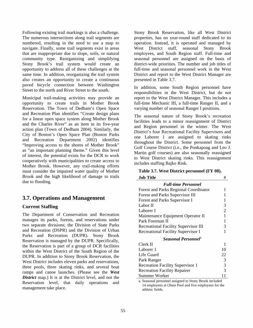
55
Following existing trail markings is also a challenge. The numerous intersections along trail segments are numbered, resulting in the need to use a map to navigate. Finally, some trail segments exist in areas that are inappropriate due to slope, soils, or natural community type. Reorganizing and simplifying Stony Brook’s trail system would create an opportunity to address all of these challenges at the same time. In addition, reorganizing the trail system also creates an opportunity to create a continuous paved bicycle connection between Washington Street to the north and River Street to the south.
Municipal trail-making activities may provide an opportunity to create trails in Mother Brook Reservation. The Town of Dedham’s Open Space and Recreation Plan identifies “Create design plans for a linear open space system along Mother Brook and the Charles River” as an item in its five-year action plan (Town of Dedham 2004). Similarly, the City of Boston’s Open Space Plan (Boston Parks and Recreation Department 2002) identifies “Improving access to the shores of Mother Brook” as “an important planning theme.” Given this level of interest, the potential exists for the DCR to work cooperatively with municipalities to create access to Mother Brook. However, any trail-making efforts must consider the impaired water quality of Mother Brook and the high likelihood of damage to trails due to flooding.
3.7. Operations and Management Current Staffing The Department of Conservation and Recreation manages its parks, forests, and reservations under two separate divisions; the Division of State Parks and Recreation (DSPR) and the Division of Urban Parks and Recreation (DUPR). Stony Brook Reservation is managed by the DUPR. Specifically, the Reservation is part of a group of DCR facilities within the West District of the South Region of the DUPR. In addition to Stony Brook Reservation, the West District includes eleven parks and reservations, three pools, three skating rinks, and several boat ramps and canoe launches. (Please see the West District map.) It is at the District level, and not the Reservation level, that daily operations and management take place.
Stony Brook Reservation, like all West District properties, has no year-round staff dedicated to its operation. Instead, it is operated and managed by West District staff, seasonal Stony Brook employees, and South Region staff. Full-time and seasonal personnel are assigned on the basis of district-wide priorities. The number and job titles of full-time and seasonal personnel work in the West District and report to the West District Manager are presented in Table 3.7.
In addition, some South Region personnel have responsibilities in the West District, but do not report to the West District Manager. This includes a full-time Mechanic III, a full-time Ranger II, and a varying number of seasonal Ranger I positions.
The seasonal nature of Stony Brook’s recreation facilities leads to a minor reassignment of District and Region personnel in the winter. The West District’s four Recreational Facility Supervisors and one Laborer I are assigned to skating rinks throughout the District. Some personnel from the Golf Course District (i.e., the Ponkapoag and Leo J. Martin golf courses) are also seasonally reassigned to West District skating rinks. This reassignment includes staffing Bajko Rink.
Table 3.7. West District personnel (FY 08). Job Title #
Full-time Personnel Forest and Parks Regional Coordinator 1Forest and Parks Supervisor III 1Forest and Parks Supervisor I 1Labor II 3Laborer I 2Maintenance Equipment Operator II 1Park Foreman II 1Recreational Facility Supervisor III 3Recreational Facility Supervisor I 1
Seasonal Personnela Clerk II 1Laborer 1 10Life Guard 22Park Ranger 3Recreation Facility Supervisor 1 3Recreation Facility Repairer 3Summer Worker 11a. Seasonal personnel assigned to Stony Brook included
14 employees at Olsen Pool and five employees for the athletic fields.
56
West District personnel perform a variety of activities related to the operation and maintenance of recreational facilities and athletic fields, buildings and grounds, parkways, visitor services, and administration. Recreation related activities include fertilizing, cutting, and lining fields; ongoing pool, rink, and playground maintenance and staffing; and trail maintenance. Buildings and grounds related activities include cleaning, painting, minor carpentry, mowing grass, removing leaves, picking up litter, emptying trash barrels, graffiti removal, and the operation and maintenance of hand and power tools. Parkway-related activities include repairing potholes, street sweeping, cleaning drains and catch basins, plowing snow, and vehicle and equipment maintenance and repair. Visitor services related activities, which are provided by Rangers, include promoting awareness and enforcement of regulations, providing information, and developing and delivering educational programs and materials. Administrative activities include employee scheduling and supervision, report preparation, coordinating volunteer activities, coordinating special events, and budget preparation.
West District personnel are supplemented by a work crew from the Massachusetts Correctional Institute (MCI) at Framingham. This work crew, which is assigned to the entire West District and not just Stony Brook, is made possible through a Memorandum of Understanding between the Department of Corrections and the Department of Conservation and Recreation. This work crew provides light maintenance activities, including cleaning public restrooms, picking up litter, mowing grass, raking leaves, shoveling snow, and painting. In 2006, this work crew performed over 500 hours of labor.
Additional DCR personnel provide support for the operation of Stony Brook Reservation. Rangers from the South Region provide visitor services for special events and programs, such as the Stony Brook Kids Festival, and provide assistance when the local Ranger is unavailable or when multiple Rangers are required. The Bureau of Forest Fire Control, District 4, provides assistance with fire control. The DCR’s Management Forestry program can provide technical expertise on the management of Stony Brook’s forests.
Volunteers also contribute to the operation and maintenance of Stony Brook. Their presence and activities at Stony Brook are typically coordinated through non-profit organizations with a focus on public service, such as Boston Cares, City Year, Outdoor Explorations, and the Student Conservation Association’s Massachusetts Parks Program. Such organizations provide large numbers of volunteers for a single day’s activities. In 2006, these organized volunteer efforts contributed over 2,900 hours of service; the equivalent of an annual workload of approximately 1.5 full-time employees. Individual volunteer efforts also occur at Stony Brook. In 2006, individual volunteers contributed over 120 hours of service. There is no friends group for Stony Brook Reservation or for Mother Brook Reservation.
Public safety and emergency response services are provided by state and local departments. The Massachusetts State Police has primary law enforcement authority on State-owned lands, such as Stony Brook Reservation and its satellite properties. In addition, a State Police detail is stationed at Olsen Pool and Bajko Rink during all operating hours. Additional law enforcement is provided by the Executive Office of Energy and Environmental Affairs’ Office of Law Enforcement. Local police, both Boston and Dedham, provide additional law enforcement on the Reservation, its satellite properties, and associated parkways within their respective jurisdictions. Fire control and emergency medical response are also provided by the municipalities in which the properties are located.
In calendar year 2006 the Massachusetts State Police responded to fifty incidents at Stony Brook (Calnan 2007). The majority of these incidents were non-violent, and involved providing aid (e.g., assisting motorist), responding to disturbances (e.g., loudness, racing), and property damage (e.g., vandalism, breaking into vehicles). Police reported three sex crimes; this category includes a variety of crimes, including indecent exposure, sexual assault, prostitution, and illicit consensual sex. State Police also responded to two assaults.
General Budgetary Information A variety of funds support the operations, maintenance, and capital improvement of DCR facilities. Operations funds support daily operations and maintenance including utilities, supplies, equipment leases, administration, and the

57
Place holder for West District map.

58
Back of West District map.
59
maintenance and minor repair of facilities, vehicles, and equipment. All regions and districts, not individual properties, receive operations funds. Staff support is not included in operations funds, but is provided from a centrally administered payroll account. Water and sewer bills for DCR properties within the City of Boston, such as Stony Brook Reservation, are also paid from a central account rather than from district operations budgets.
Capital funds support projects (e.g., construction, repair) and items (i.e., equipment) with a per-unit cost of at least $5,000 and an expected lifespan of at least seven years. Projects and items with lower costs and/or a shorter lifespan are funded through operations funds and not capital funds.
Capital projects are identified and funded through a five-year capital plan. These plans identify proposed capital projects, their costs, and the year in which they are to be funded. They are reviewed monthly and updated annually. Annual updates permit the modification of previously approved projects (e.g., changes in cost or priority); the addition of emergency projects to years 1- 4 of the plan, and the addition of new projects for the fifth year of the plan. These plans are extensively reviewed within the DCR, approved by the Commissioner, and included in DCR’s annual budget. This budget is then reviewed by the Executive Office of Energy and Environmental Affairs, the Executive Office of Administration and Finance, and the Governor. Additional capital initiatives may be identified and added to the budget by the Commissioner of Conservation and Recreation, Secretary of Energy and Environmental Affairs, or the Governor during this review process.
In addition to operations and capital funds, DCR facilities may receive funding through legislative earmark, the Urban Parks Trust Fund, or through a dedicated property fund. Earmarks are funds directed to specific projects by the Massachusetts General Court via the annual State budget. In 2006, such an earmark paid for the renovation of the Camp Meigs Playground. The Urban Parks Trust Fund uses donations to support special initiatives above and beyond basic property maintenance. Finally, funds placed into “iron rangers” (i.e., secure metal donation boxes) or associated with revenue generating leases (e.g., cell phone towers on park property) are dedicated to the property from which
they are derived. There are no dedicated funds associated with Stony Brook or its satellite properties.
Funding for the operations and maintenance of Stony Brook Reservation and its satellite properties comes from the West District’s operational budget; there are no dedicated operational budgets for the individual properties. The West District staff provides services to facilities throughout the District on an as-needed basis. In Fiscal Year 2007, which ran from July 1, 2006 through June 30, 2007, the West District’s operational budget excluding staff costs was approximately $40,000.
Issues, Challenges, and Opportunities The current approach to operations, where resources are provided at the District level, precludes the quantitative identification of either current or optimal levels of staffing for Stony Brook. Assigning staff to work at different properties on an as-needed basis provides the District Manager with the flexibility needed to ensure that the proper available staffing levels and skill sets are applied to operations and management activities. However, because the amount of time that employees spend at individual properties is not tracked, the amount of labor applied to the operations and management of any single property cannot be determined.
The West District Manager has identified additional staffing needs for the District. This assessment is based on the Manager’s professional opinion, and not a quantitative assessment of staffing. The following five positions have been identified by the Manager as necessary for the improved performance of current operations and management activities: Forest and Parks Supervisor II, Forest and Parks Supervisor III, Administrative Assistant I, Ranger I, and a Mechanical Equipment Operator. Each of these five positions would service the entire West District, including Stony Brook Reservation and its satellite properties.
Although Stony Brook has benefited from volunteer labor, opportunities exist to expand the variety and complexity of these activities. Volunteer efforts at Stony Brook tend to be single day events involving a large number of participants. This approach minimizes the amount of staff time required to organize and oversee these events. Although this approach is appropriate for basic tasks (e.g.,
60
painting, clean-up) it is not appropriate for ongoing activities or activities that require specialized training. Development of an ongoing volunteer program would create opportunities for more technical and sustained activities than are now possible. Associated with this is the challenge of securing adequate staff time to develop and oversee a volunteer program.
One of the greatest challenges to visitation at Stony Brook is the perception that it is unsafe. Massachusetts State Police incident records revealed few crimes, and most importantly few violent crimes, at Stony Brook in 2006. Boston Police crime statistics (Boston Police Department 2007) indicate that District E-18, the District in which Stony Brook occurs, had the fourth lowest number of crimes in the City of Boston between January 1 and September 16, 2007. In addition, 75.6 % of residents in District E-18 indicated that they feel “safe” or “very safe” out alone in their neighborhood at night (The Boston Foundation 2007). Creating awareness of these statistics provides an opportunity to begin to change public perceptions.
There is a direct relationship between Stony Brook’s operations and the public’s perception of safety. Boston residents’ sense of safety is “profoundly affected by symbols of neglect, such as a lack of cleanliness and poor repair of public and private properties” (The Boston Foundation 2007). In a recent survey, the top five crime-related issues identified as either a “serious problem” or “somewhat a problem” by Boston residents were litter and trash lying around, car break-ins, drug sales, burglary, and vandalism (The Boston Foundation 2007). An opportunity exists to improve the public perception of safety at Stony Brook by aggressively addressing litter and vandalism. However, an increased response to vandalism will likely require additional staff resources.
As with staffing, allocating funding at the District level precludes identification of the operations budget for Stony Brook. Staff costs also cannot be quantified, as individual employees divide their labor among many properties on an as-needed basis. Capital funding is somewhat easier to identify as most capital projects are associated with only a single property. However, capital funding may also be applied to purchase equipment that is used on a District-wide basis. Because of this, the costs
associated with the current operations and management of Stony Brook cannot be identified.
3.8. Development and Improvement Projects Capital projects, repairs, and purchases that will benefit Stony Brook Reservation or its satellite properties are presented in Table 3.8. Some of these projects are funded, while others are unfunded requests. The following projects and repairs are currently funded.
Dedham Boulevard Drainage. This project will install a “drop inlet” drainage structure and double grade catch-basins along Dedham Boulevard near Emmett Avenue.
Olsen Pool Shade Shelter. A shade-shelter has been purchased and will be installed adjacent to the wading pool.
Kelley Field Field-house Renovations. Planned renovations include repairing bathroom tiles, adding concessionaire space, and sealing the building to the elements.
Olsen Pool Security Features. Lighting and perimeter fencing will be replaced, and a new public address system added.
Kelley Field Artificial Surface. The existing natural turf surface of the Kelley Field soccer field will be removed and replaced with a synthetic, easily maintained material.
Repair River Street Bridge. Planned repairs include repair and resurfacing of the bridge’s deck, replacement of the bridge’s railing and lights, repair of the portion of the stone wall adjacent to the bridge, and the re-striping of roadways approaching the bridge.
A project to renovate Weider Playground was recently completed. This project involved repairing and replacing pumps, valves, and electric controls associated with the Playground’s drainage system, rehabilitation of tennis courts, and replacement of playground equipment. Problems with this new drainage system are being corrected.
.
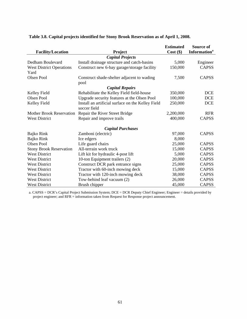
61
Table 3.8. Capital projects identified for Stony Brook Reservation as of April 1, 2008.
Facility/Location
Project
Estimated Cost ($)
Source of Informationa
Capital Projects Dedham Boulevard Install drainage structure and catch-basins 5,000 EngineerWest District Operations Yard
Construct new 6-bay garage/storage facility 150,000 CAPSS
Olsen Pool Construct shade-shelter adjacent to wading pool
7,500 CAPSS
Capital Repairs Kelley Field Rehabilitate the Kelley Field field-house 350,000 DCEOlsen Pool Upgrade security features at the Olsen Pool 100,000 DCEKelley Field Install an artificial surface on the Kelley Field
soccer field 250,000 DCE
Mother Brook Reservation Repair the River Street Bridge 2,200,000 RFRWest District Repair and improve trails 400,000 CAPSS
Capital Purchases Bajko Rink Zamboni (electric) 97,000 CAPSSBajko Rink Ice edgers 8,000 Olsen Pool Life guard chairs 25,000 CAPSSStony Brook Reservation All-terrain work truck 15,000 CAPSSWest District Lift kit for hydraulic 4-post lift 5,000 CAPSSWest District 10-ton Equipment trailers (2) 20,000 CAPSSWest District Construct DCR park entrance signs 25,000 CAPSSWest District Tractor with 60-inch mowing deck 15,000 CAPSSWest District Tractor with 120-inch mowing deck 38,000 CAPSSWest District Tow-behind leaf vacuum (2) 26,000 CAPSSWest District Brush chipper 45,000 CAPSS
a. CAPSS = DCR’s Capital Project Submission System; DCE = DCR Deputy Chief Engineer; Engineer = details provided by project engineer; and RFR = information taken from Request for Response project announcement.

62
This page intentionally left blank.
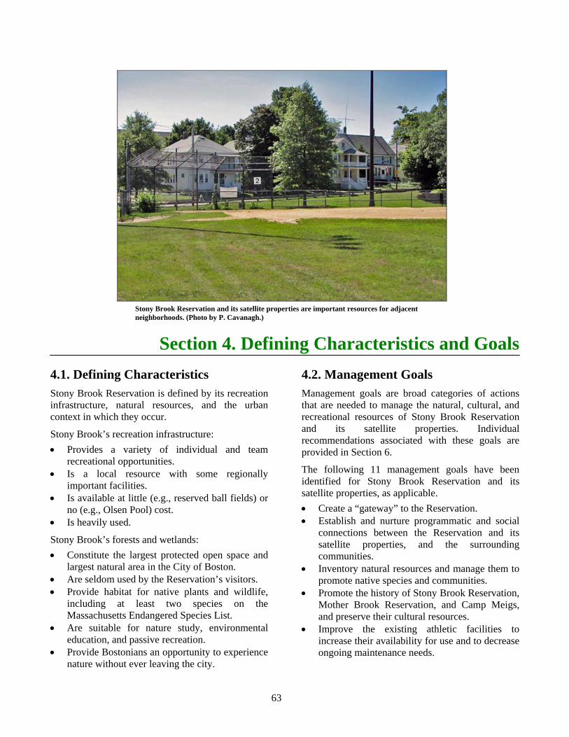
63
Section 4. Defining Characteristics and Goals 4.1. Defining Characteristics Stony Brook Reservation is defined by its recreation infrastructure, natural resources, and the urban context in which they occur.
Stony Brook’s recreation infrastructure: • Provides a variety of individual and team
recreational opportunities. • Is a local resource with some regionally
important facilities. • Is available at little (e.g., reserved ball fields) or
no (e.g., Olsen Pool) cost. • Is heavily used.
Stony Brook’s forests and wetlands: • Constitute the largest protected open space and
largest natural area in the City of Boston. • Are seldom used by the Reservation’s visitors. • Provide habitat for native plants and wildlife,
including at least two species on the Massachusetts Endangered Species List.
• Are suitable for nature study, environmental education, and passive recreation.
• Provide Bostonians an opportunity to experience nature without ever leaving the city.
4.2. Management Goals Management goals are broad categories of actions that are needed to manage the natural, cultural, and recreational resources of Stony Brook Reservation and its satellite properties. Individual recommendations associated with these goals are provided in Section 6.
The following 11 management goals have been identified for Stony Brook Reservation and its satellite properties, as applicable. • Create a “gateway” to the Reservation. • Establish and nurture programmatic and social
connections between the Reservation and its satellite properties, and the surrounding communities.
• Inventory natural resources and manage them to promote native species and communities.
• Promote the history of Stony Brook Reservation, Mother Brook Reservation, and Camp Meigs, and preserve their cultural resources.
• Improve the existing athletic facilities to increase their availability for use and to decrease ongoing maintenance needs.
Stony Brook Reservation and its satellite properties are important resources for adjacent neighborhoods. (Photo by P. Cavanagh.)
64
• Reorganize and simplify the existing trail system to decrease maintenance and to increase ease of use.
• Honor the legacy of the Thompson Center by ensuring that facilities and activities are available to the widest cross-section of people.
• Develop environmental education programming and materials for diverse audiences.
• Identify and maintain the properties’ boundaries. • Improve the West District administrative and
operations facilities. • Eliminate unneeded infrastructure.
The first two management goals, creating a “gateway” to the Reservation and establishing connections with surrounding communities offer conceptual frameworks for the remaining nine goals. For example, the goal of creating a “gateway” to the Reservation influences the development of specific recommendations associated with promoting the Reservation’s history, improving existing athletic fields, reorganizing and simplifying the trail system, improving universal access to facilities, developing an environmental education program, improving administrative and operations facilities, and eliminating unneeded infrastructure. The gateway is not an individual project, but rather a framework to organize a variety of projects and activities around a single geographic location. Although each management goal and recommendation can and will work independently, several will yield additional benefits if they are addressed as part of a gateway to Stony Brook. Similarly, several management goals
and recommendations will yield additional benefits if they are addressed as part of a broader effort to increase community involvement.
Creating a gateway to Stony Brook will unify the Reservation’s disparate resources and improve the visitor experience. Stony Brook’s history has produced one Reservation with two distinct sets of resources and two distinct characters. The Reservation was established in 1894, and largely remained a natural area until the 1950s. At that time Stony Brook’s mission significantly expanded to include providing extensive athletic facilities. These facilities were clustered in the southern portion of the Reservation while the northern portion remained forested. There was no central location for visitor contact and no connections established between active and passive recreation resources. The parking lot at Bajko Rink/Olsen Pool has become the activity center of the Reservation. Formalizing this area as the Reservation’s gateway will create a single location for obtaining information about Stony Brook and accessing all of its recreation resources.
Although Stony Brook is located in several Boston neighborhoods, with the exception of organized athletics, there is virtually no ongoing dialog with the residents, neighborhood associations, civic groups, or non-profit organizations of Hyde Park, Roslindale, and West Roxbury. Better connections will contribute to improved park safety and operations, and improve the DCR’s ability to identify and respond to local needs.
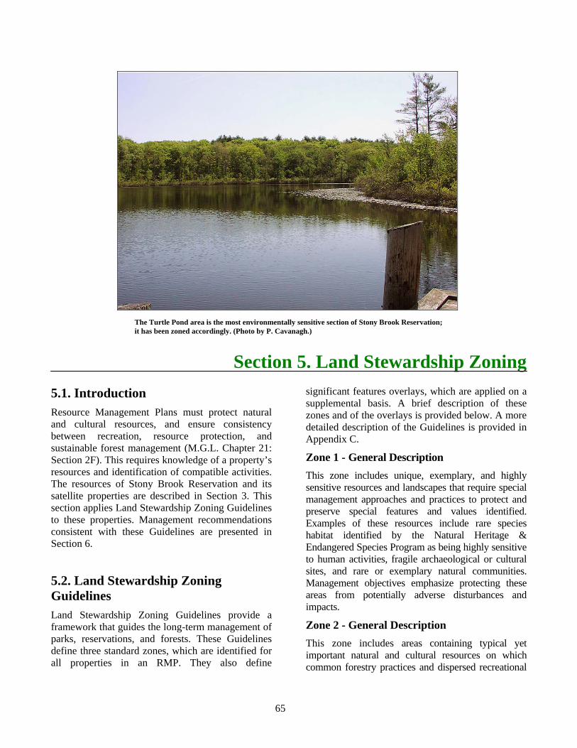
65
Section 5. Land Stewardship Zoning 5.1. Introduction Resource Management Plans must protect natural and cultural resources, and ensure consistency between recreation, resource protection, and sustainable forest management (M.G.L. Chapter 21: Section 2F). This requires knowledge of a property’s resources and identification of compatible activities. The resources of Stony Brook Reservation and its satellite properties are described in Section 3. This section applies Land Stewardship Zoning Guidelines to these properties. Management recommendations consistent with these Guidelines are presented in Section 6.
5.2. Land Stewardship Zoning Guidelines Land Stewardship Zoning Guidelines provide a framework that guides the long-term management of parks, reservations, and forests. These Guidelines define three standard zones, which are identified for all properties in an RMP. They also define
significant features overlays, which are applied on a supplemental basis. A brief description of these zones and of the overlays is provided below. A more detailed description of the Guidelines is provided in Appendix C.
Zone 1 - General Description This zone includes unique, exemplary, and highly sensitive resources and landscapes that require special management approaches and practices to protect and preserve special features and values identified. Examples of these resources include rare species habitat identified by the Natural Heritage & Endangered Species Program as being highly sensitive to human activities, fragile archaeological or cultural sites, and rare or exemplary natural communities. Management objectives emphasize protecting these areas from potentially adverse disturbances and impacts.
Zone 2 - General Description This zone includes areas containing typical yet important natural and cultural resources on which common forestry practices and dispersed recreational
The Turtle Pond area is the most environmentally sensitive section of Stony Brook Reservation; it has been zoned accordingly. (Photo by P. Cavanagh.)
66
activities can be practiced at sustainable levels without degrading these resources. These areas hold the potential for improved ecological health, productivity, or protection through active management. Examples include terrestrial and aquatic ecosystems characterized by a diversity of wildlife and plant habitats, rare species habitat that is compatible with sustainable forestry and dispersed recreation, agricultural resources, and resilient cultural sites and landscapes. Zone 2 areas may be actively managed provided that the management activities are consistent with the approved Resource Management Plan for the property.
Zone 3 - General Description This zone includes constructed or developed administrative, maintenance, and recreation sites; structures; and resilient landscapes that accommodate concentrated use by recreational visitors. Zone 3 areas require intensive maintenance by DCR staff. Examples include areas developed and deemed appropriate for park headquarters and maintenance areas, parking lots, swimming pools and skating rinks, paved bikeways, swimming beaches, campgrounds, playgrounds and athletic fields, parkways, golf courses, picnic areas and pavilions, concessions, and areas assessed to be suitable for those uses.
Significant Feature Overlays - General Description The three land stewardship zones may be supplemented with significant feature overlays that identify specific designated/recognized resource features. These significant features are generally identified through an inventory process or research, and are formally designated. The purpose of these overlays is to provide more precise management guidance for identified resources and to recognize, maintain, protect, or preserve unique and significant values, regardless of the zone in which they occur. Examples of significant feature overlays include Forest Reserves, areas subject to public drinking water regulations, or areas subject to historic preservation restrictions. Specific management guidelines for significant features overlays are provided by resource specialists or by the federal, state, regional, or local agency that has recognized and listed the resource or site.
5.3. Applied Land Stewardship Zoning Guidelines The development and application of these Guidelines is the result of a step-by-step analysis of the natural and cultural resources of the Reservation, compatible public access, and recreational uses. In a sense they are the culmination of the planning process, and are intended to help guide the long-term management of the Reservation. (Please see the Land Stewardship Zoning map.)
The recommended Guidelines for Stony Brook Reservation and its satellite properties are listed below.
Zone 1 Turtle Pond and adjacent wetlands and forest east of the Enneking Parkway. This zone approximates the boundaries as the Estimated Habitat of Rare Species of Wetland Wildlife as identified by the NHESP. The area has been designated as a Zone 1 to protect known breeding and foraging sites of the State-endangered insect that occurs on Stony Brook Reservation.
Mother Brook Reservation at the junction of the Charles River. This portion of Mother Brook Reservation falls within Estimated Habitat of Rare Species of Wetland Wildlife as identified by the NHESP. The undeveloped portions of this property have been designated as a Zone 1 to protect its value as wildlife habitat.
Zone 2 The majority of land within Stony Brook Reservation, including wetlands and forested areas, and most of Mother Brook Reservation are included in this zone. For Stony Brook, this zone has the same boundaries as the Priority Habitat identified by the NHESP. These areas are to be managed for resource protection and compatible passive recreation.
Zone 3 All developed areas, including Stony Brook’s active recreation areas, the western portion of Dedham Parkway, and the Bellevue Hill section of the Reservation. This zone also includes all of Camp Meigs Playground, Colella Field and Playground, DeSantis Park, Weider Playground, and the developed portion of Mother Brook Reservation

67
Place holder for Land Stewardship Zoning map.

68
Back of Land Stewardship Zoning map.

69
adjacent to the Charles River. These areas are to be managed for active recreation, operations, and flood control, as appropriate.
Significant Feature Overlay The historic parkways, including Dedham Parkway east of Harding Terrace, Dedham; the paved portion
of West Boundary Road; Enneking Parkway; Turtle Pond Parkway; and Smith Field Road. Also included in this overlay are the historic traffic miters and culverts. Activities within this overlay must follow the Historic Parkways Preservation Treatment Guidelines (DCR 2006a).

70
This page intentionally left blank.
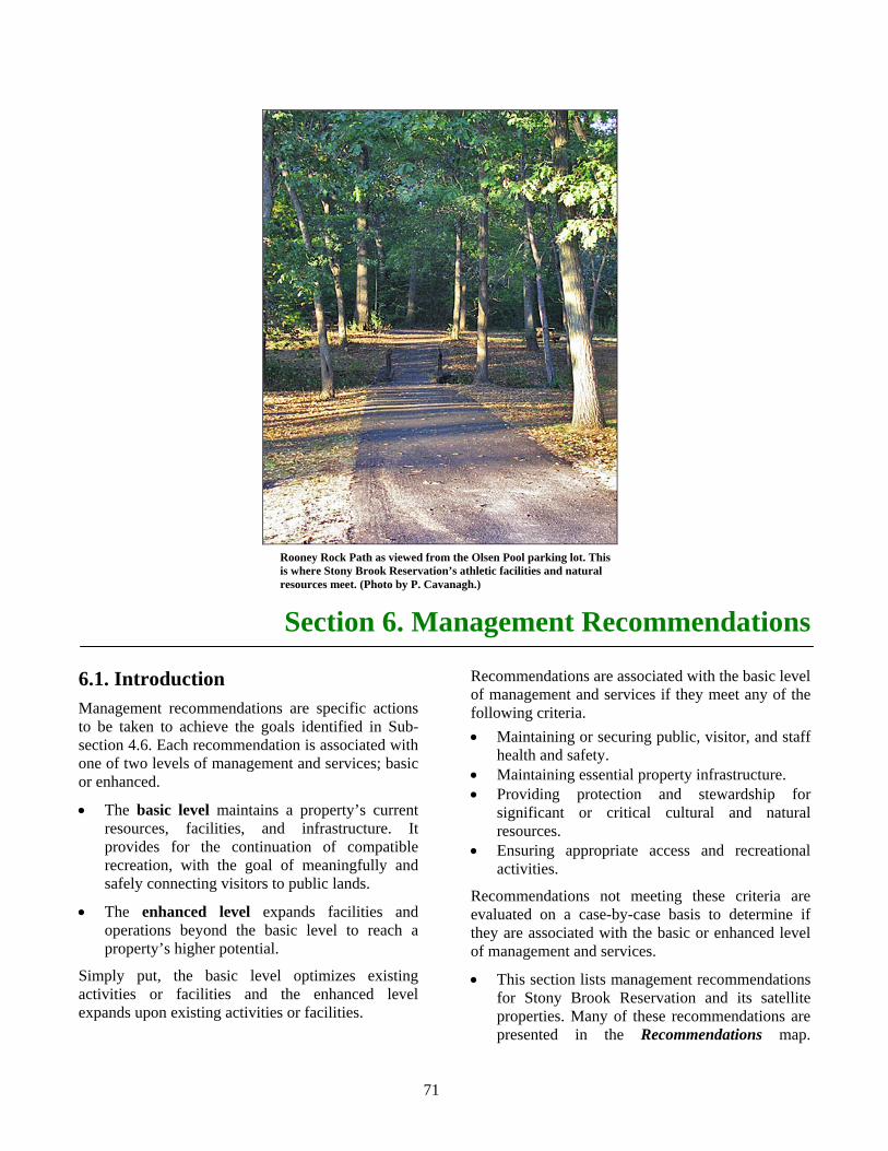
71
Section 6. Management Recommendations
6.1. Introduction Management recommendations are specific actions to be taken to achieve the goals identified in Sub-section 4.6. Each recommendation is associated with one of two levels of management and services; basic or enhanced.
• The basic level maintains a property’s current resources, facilities, and infrastructure. It provides for the continuation of compatible recreation, with the goal of meaningfully and safely connecting visitors to public lands.
• The enhanced level expands facilities and operations beyond the basic level to reach a property’s higher potential.
Simply put, the basic level optimizes existing activities or facilities and the enhanced level expands upon existing activities or facilities.
Recommendations are associated with the basic level of management and services if they meet any of the following criteria. • Maintaining or securing public, visitor, and staff
health and safety. • Maintaining essential property infrastructure. • Providing protection and stewardship for
significant or critical cultural and natural resources.
• Ensuring appropriate access and recreational activities.
Recommendations not meeting these criteria are evaluated on a case-by-case basis to determine if they are associated with the basic or enhanced level of management and services.
• This section lists management recommendations for Stony Brook Reservation and its satellite properties. Many of these recommendations are presented in the Recommendations map.
Rooney Rock Path as viewed from the Olsen Pool parking lot. This is where Stony Brook Reservation’s athletic facilities and natural resources meet. (Photo by P. Cavanagh.)
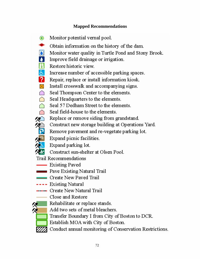
72
Mapped Recommendations

73
Place holder for Recommendations map.

74
Back of Recommendations map.
75
Sub-sections 6.2-6.6 present management recommendations by topic, without reference to associated levels of management and services. Sub-section 6.7 presents recommendations in a summary format. It identifies the associated level of management and services, the estimated cost associated with implementing each recommendation, and the estimated total cost of implementing all basic recommendations or all enhanced recommendations. The estimated total cost associated with the basic level of services and management, as identified in Sub-section 6.7, is the best available estimate of the cost of optimizing a property’s existing facilities and operations.
There are two assumptions associated with all recommendations. First, ongoing maintenance and operations activities will continue unless they are superseded by the requirements of a recommendation being implemented. For example, implementation of a recommendation to close and restore a trail segment negates future activities to maintain that segment. Second, all recommendations will be implemented in accordance with all applicable laws, guidance, and DCR policies.
6.2. Natural Resources Recommendations for the management of Stony Brook’s natural resources fall into two categories. The first addresses the protection of the Reservation’s known rare species and their habitats. The second addresses the need for additional information on the Reservation’s plants and wildlife. Implementation of the following recommendations will improve the conservation and management of Stony Brook’s natural resources, and that of the satellite properties.
• Consult with the NHESP on the proper management of Stony Brook’s wetlands and forests to enhance endangered species habitat.
• Monitor water quality in Turtle Pond and Stony Brook to ensure protection of rare species habitat and to determine if fishing is appropriate. Do not actively promote fishing in Turtle Pond until such time as the water quality has been identified as safe for fishing. Share water quality information with interested governmental and non-governmental agencies and organizations.
• Stencil catch-basins to indicate “Do not dump. Drains into “name” River.” Where “name” is the name of the river into which water in the catch-basin flows. This will be either “Charles” or “Neponset,” depending on location. Refer to the Water Resources map to identify the appropriate river name for locations of individual catch-basins.
• Work with the MWRA to address the soil erosion problem, caused by trenching for water pipes, on Bellevue Hill.
• Monitor potential vernal pools, complete certification paperwork for all pools, and submit paperwork to the NHESP for those pools likely to meet certification criteria.
• Survey for invasive species, develop an invasive species management plan, and implement prioritized control actions. Coordinate development of the plan with the Boston Conservation Commission and the NHESP.
• Establish a protocol to ensure that no cutting of vegetation occurs within Priority Habitat without the review and approval of the NHESP.
• Establish a protocol to ensure that no alteration of soils or vegetation occurs within 100-feet of wetlands, 200-feet of perennial streams, or within regulated flood zones without the review and approval of the Boston or Dedham Conservation Commission, as appropriate.
• Conduct plant and wildlife inventories on Stony Brook Reservation and satellite properties. Emphasis should be placed on identifying additional species on Massachusetts’ endangered species list (e.g., northern parula, sharp-shinned hawk). As additional species are identified, consult with the NHESP on proper management activities.
• Inventory Stony Brook’s forest resources and develop a forest management plan. This plan should provide for the management of rare species habitat and the monitoring of forest health.
• Identify and map the distribution of natural communities on Stony Brook. This may be done concurrently with the forest resources inventory.
76
6.3. Cultural Resources Recommendations for the management of Stony Brook’s cultural resources address the need for their ongoing preservation. Implementation of the following recommendations will improve the preservation of cultural resources at Stony Brook Reservation and its satellite properties.
• Establish a protocol to ensure that all repairs to historic buildings and structures, clearing of vegetation along parkways, and sub-surface digging in the undeveloped portions of Stony Brook are coordinated with the DCR Office of Cultural Resources.
• Conduct annual preventative maintenance inspections of the West District Headquarters and the house at 57 Dedham Street using the Historic Curatorship Program’s Annual Maintenance Inspection Checklist (DCR 2007c). Do minor repairs and implement capital project requests, as needed, to correct problems identified by these inspections.
• Obtain information on the history of the two dams in Mother Brook Reservation.
• Replace missing identification signs at Richard Monahan Square and the Robert Bleakie Intersection. In the absence of standards for these signs (DCR n.d. b), replacement signs should match the style and construction of the existing sign at the Robert O’Lalor Intersection.
6.4. Recreation Recommendations for the management of Stony Brook and its satellite’s recreation facilities address current problems affecting their use and maintenance, and propose an integrated review of the condition of athletic facilities and their ability to meet future recreation demands. Implementation of the following recommendations will result in both immediate and long-term improvements to recreation resources.
• Correct the drainage of the Connell Fields to decrease the frequency and severity of flooding, thereby increasing the number of days that the fields are available for use. Coordinate this action with the Boston Conservation Commission.
• Prepare a Master Plan for Stony Brook’s athletic facilities (e.g., Olsen Pool, Bajko Rink) and fields. This plan should consider programmatic needs, operations and maintenance, accessibility, and water and energy conservation.
• Expand picnic facilities at the south end of Rooney Rock Path. At least 5% of the picnic site and all picnic tables should be universally accessible.
• Consult with the DCR’s legal services about the opportunity to rededicate the new picnic areas along Rooney Rock Path with the names of historic picnic areas.
• Replace irrigation system at Kelley Field. • Manage all athletic fields in accordance with
Turf management for athletic fields (Department of Food and Agriculture et al. 1999) in order to improve field condition while reducing water use and chemical inputs.
6.5. Interpretive Services and Environmental Education Recommendations for Stony Brook’s interpretive and educational activities include traditional activities, such as ranger-led programs, as well as community outreach activities. This outreach will educate the surrounding communities about the Reservation and its resources, and the Reservation staff about the surrounding communities’ interests and recreation needs. Many of the recommendations associated with community outreach are ongoing, long-term activities that will involve the DCR Office of External Affairs and Partnerships. The following recommendations will increase opportunities to learn about the natural and cultural resources of Stony Brook Reservation and its satellite facilities; they will also lead to improved community relations and involvement.
• Develop and implement an educational program that highlights the cultural resources and history of Stony Brook Reservation and its satellite properties.
• Develop and implement an educational program that highlights the natural resources of Stony Brook Reservation.
• Establish ongoing volunteer programs or Friends groups for Stony Brook Reservation, Mother Brook Reservation, and other satellite properties.
77
• Continue efforts to establish a Park Watch program at Stony Brook.
• Establish a “welcome waysides/ orientation” sign (DCR n.d. b) near the southern end of Rooney Rock Path where it meets the Olsen Pool/Bajko Rink parking lot. Ensure that the sign and the approach to the sign are universally accessible.
• Create a universally accessible self-guided nature trail along Rooney Rock Path.
• Use the bi-annual West District open-house as an opportunity to educate the public about the Reservation and its satellite properties, and to build relations with the neighboring communities.
• Identify non-profit organizations that currently offer environmental or cultural resource education programs in the neighborhoods of Hyde Park, West Roxbury, and Roslindale, and work with them to bring their programs to Stony Brook Reservation, Mother Brook Reservation, or Camp Meigs.
• Identify nature-based recreation or exercise programs (e.g., walking clubs) in the area, and encourage them to bring their activities to Stony Brook Reservation.
• Regularly update Stony Brook’s trails maps. These updates should occur as major trail-related recommendations are implemented.
• Install signs along Mother Brook Reservation indicating that fish caught in the brook should not be eaten. These signs should incorporate universal symbols, rather than text.
6.6. Infrastructure Recommendations for the management of Stony Brook’s infrastructure address current problems affecting the Reservation’s buildings, signs, parking, and trails. Emphasis has been placed on stabilizing or improving critical infrastructure, eliminating unnecessary infrastructure, and decreasing long-term maintenance costs. Implementation of the following recommendations will improve the infrastructure of Stony Brook Reservation and that of its satellite properties.
• Seal the West District Headquarters to the elements.
• Seal the Kelley Field field-house to the elements.
• Seal the house at 57 Dedham Street to the elements.
• Conduct a re-use study for the house at 57 Dedham Street.
• Seal the Thompson Center to the elements. • Conduct a re-use study for the Thompson
Center. • Increase the number of accessible parking
spaces to meet or exceed current standards. At a minimum this includes creating one designated parking space, each, at the Connell Fields parking lot, the Dooley Playground, and the West District Headquarters; and adding two designated parking spaces to the Olsen Pool parking lot.
• Construct a new storage building at the West District Operations Yard. This building should consolidate equipment currently stored at 57 Dedham Street, Olsen Pool, and Bajko Rink, and be based on an assessment of programmatic needs.
• Construct a sun-shelter at Olsen Pool. • Conduct annual monitoring of Conservation
Restrictions. • Designate the Olsen Pool/Bajko Rink parking lot
as the main parking area for Stony Brook Reservation. Install a “gateway sign” (DCR n.d. b) at the parking lot entrance.
• Install “road marker/lead-in” signs (DCR n.d. b) to direct traffic to the Olsen Pool/Bajko Rink parking lot. Signs should be placed along the following primary access roads: West Roxbury Parkway, River Street, Dedham Parkway, and Washington Street. Within the Reservation, signs should be placed at the intersection of Dedham and Enneking parkways.
• Install “secondary identification” signs (DCR n.d. b) at Mother Brook Reservation, Weider Playground, DeSantis Park, and Camp Meigs Playground.
• Establish “suitable” markers for the Enneking Woodland, Greenough Mill Pond, Clem Norton Park, and the Edward U. Howley Trails in accordance with Chapter 429 of the Acts of 1974. In the absence of graphic standards for these markers, work with the DCR sign shop to identify, create, and install suitable markers.
78
• Add appropriate signs to all universally accessible facilities.
• Take down outdated signs (e.g., lead-in signs to the Thompson Center).
• Identify the boundaries of Stony Brook Reservation, satellite properties, and associated parkways. Once identified, mark the boundaries, monitor for encroachment, and work with abutters to resolve encroachment issues.
• Rehabilitate or replace the stands at the Kelley Field soccer field.
• Add metal bleachers, two per field, to the Kelley Field baseball diamonds.
• Replace broken or rotted wooden siding on the Kelley Field grandstand, or remove siding to restore the grandstand to its original pre-cast concrete exterior appearance.
• Conduct a traffic volume study at the intersection of the Dedham, Enneking, and Turtle Pond parkways to see if remedial action is warranted.
• Remove pavement and, using native species, re-vegetate the closed parking lot located east of Enneking Parkway and north of Turtle Pond. Monitor annually for invasive species and remove as encountered. Allow this area to succeed from herbaceous vegetation to shrubs, and eventually to forest. Document the process for potential inclusion in future interpretive materials.
• Expand the Connell Fields parking lot toward Smith Field Road to accommodate extra parking spaces while maintaining a vegetated buffer along the road.
• Remove all remaining old benches, grills, and tables from former picnic areas.
• Assess closing or modifying Lawler Playground and other attractive nuisances. Work with the surrounding neighborhoods to identify attractive nuisances and strategies for mitigating these problems.
• Work with the City of Boston to transfer the Boundary I urban wild, or other appropriate properties, to the DCR.
• Establish a Memorandum of Agreement (MOA) with the City of Boston for the maintenance of the boundary fence between Stony Brook Reservation and the George Wright Golf Course.
• Identify and pursue opportunities to protect undeveloped, unprotected land adjacent to Stony
Brook Reservation, Mother Brook Reservation, and DeSantis Park through either fee acquisition or the purchase of Conservation Restrictions.
• Repair or replace the existing kiosk at the Bold Knob parking area, and install similar informational kiosks at the Turtle Pond and Dedham Parkway parking areas. These kiosks should provide information that is updated frequently, such as current information on trail conditions, wildlife sightings, and Reservation happenings.
• Install “regulatory” signs (DCR n.d c) at all parking areas and at the following intersections along the paved trail: Bellevue Hill Road, West Roxbury Parkway, Washington Street, and West Boundary Road.
• Connect Rooney Rock Path to the rest of the trail system via the existing paved trail around the Thompson Center’s artificial pond. Relocate the southern end of Smith Path Trail to meet this new trail segment.
• Pave or harden Turtle Pond Path from the Enneking Parkway to the Stony Brook Path to connect the existing paved bike paths.
• Install crosswalks, accompanying signs, and curb cuts (as needed) at all locations where trails cross roads, including Chamberlain Path at Turtle Pond Parkway, Gavin Path and Dedham Parkway, Turtle Pond Path at Enneking Parkway, Smith Path at Smith Field Road, and the trail head parking along the Enneking Parkway.
• Support the City of Boston and the Town of Dedham in their efforts to expand access to, and create trails along, Mother Brook. DCR’s Greenways and Trails Planner can facilitate trail-related meetings if requested by these municipalities.
• Create trail destinations by identifying Turtle Pond as a trail destination, restoring the historic view of Great Blue Hill from Bold Knob, and restoring the historic view to Boston Harbor from Bellevue Hill. In order to minimize the amount of vegetation removed, historic views should provide a narrow line of sight, rather than a panoramic view, to distant features.
• Add “internal park information” signs (DCR n.d. b) to Stony Brook’s trails. These signs should indicate the distance to destinations and major connecting paths.
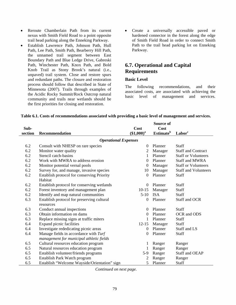
79
• Reroute Chamberlain Path from its current nexus with Smith Field Road to a point opposite trail head parking along the Enneking Parkway.
• Establish Lawrence Path, Johnson Path, Hull Path, Lee Path, Smith Path, Bearberry Hill Path, the unnamed trail segment between East Boundary Path and Blue Ledge Drive, Gabreski Path, Winchester Path, Knox Path, and Bold Knob Trail as Stony Brook’s natural (i.e., unpaved) trail system. Close and restore spurs and redundant paths. The closure and restoration process should follow that described in State of Minnesota (2007). Trails through examples of the Acidic Rocky Summit/Rock Outcrop natural community and trails near wetlands should be the first priorities for closing and restoration.
• Create a universally accessible paved or hardened connector in the forest along the edge of Smith Field Road in order to connect Smith Path to the trail head parking lot on Enneking Parkway.
6.7. Operational and Capital Requirements Basic Level The following recommendations, and their associated costs, are associated with achieving the basic level of management and services.
Table 6.1. Costs of recommendations associated with providing a basic level of management and services.
Sub- section
Recommendation
Cost ($1,000)a
Source of Cost
Estimateb
Laborc Operational Expenses
6.2 Consult with NHESP on rare species 0 Planner Staff 6.2 Monitor water quality 2 Manager Staff and Contract 6.2 Stencil catch-basins 1 Planner Staff or Volunteers 6.2 Work with MWRA to address erosion 0 Planner Staff and MWRA 6.2 Monitor potential vernal pools 0 Manager Staff or Volunteers 6.2 Survey for, and manage, invasive species 10 Manager Staff and Volunteers 6.2 Establish protocol for conserving Priority
Habitat 0 Planner Staff
6.2 Establish protocol for conserving wetlands 0 Planner Staff 6.2 Forest inventory and management plan 10-15 Manager Staff 6.2 Identify and map natural communities 5-10 ISA Staff 6.3 Establish protocol for preserving cultural
resources 0 Planner Staff and OCR
6.3 Conduct annual inspections 0 Planner Staff 6.3 Obtain information on dams 0 Planner OCR and ODS 6.3 Replace missing signs at traffic miters 1 Planner Staff 6.4 Expand picnic facilities 12-15 Manager Staff 6.4 Investigate rededicating picnic areas 0 Planner Staff and LS 6.4 Manage fields in accordance with Turf
management for municipal athletic fields 0 Planner Staff
6.5 Cultural resources education program 1 Ranger Ranger 6.5 Natural resources education program 1 Ranger Ranger 6.5 Establish volunteer/friends programs 5-9 Ranger Staff and OEAP 6.5 Establish Park Watch program 2 Ranger Ranger 6.5 Establish “Welcome Wayside/Orientation” sign 5 Planner Staff
Continued on next page.
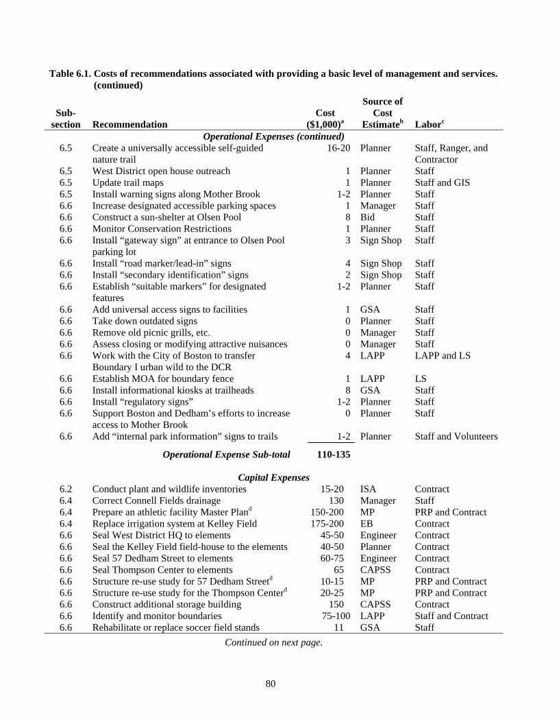
80
Table 6.1. Costs of recommendations associated with providing a basic level of management and services. (continued)
Sub- section
Recommendation
Cost ($1,000)a
Source of Cost
Estimateb
Laborc Operational Expenses (continued)
6.5 Create a universally accessible self-guided nature trail
16-20 Planner Staff, Ranger, and Contractor
6.5 West District open house outreach 1 Planner Staff 6.5 Update trail maps 1 Planner Staff and GIS 6.5 Install warning signs along Mother Brook 1-2 Planner Staff 6.6 Increase designated accessible parking spaces 1 Manager Staff 6.6 Construct a sun-shelter at Olsen Pool 8 Bid Staff 6.6 Monitor Conservation Restrictions 1 Planner Staff 6.6 Install “gateway sign” at entrance to Olsen Pool
parking lot 3 Sign Shop Staff
6.6 Install “road marker/lead-in” signs 4 Sign Shop Staff 6.6 Install “secondary identification” signs 2 Sign Shop Staff 6.6 Establish “suitable markers” for designated
features 1-2 Planner Staff
6.6 Add universal access signs to facilities 1 GSA Staff 6.6 Take down outdated signs 0 Planner Staff 6.6 Remove old picnic grills, etc. 0 Manager Staff 6.6 Assess closing or modifying attractive nuisances 0 Manager Staff 6.6 Work with the City of Boston to transfer
Boundary I urban wild to the DCR 4 LAPP LAPP and LS
6.6 Establish MOA for boundary fence 1 LAPP LS 6.6 Install informational kiosks at trailheads 8 GSA Staff 6.6 Install “regulatory signs” 1-2 Planner Staff 6.6 Support Boston and Dedham’s efforts to increase
access to Mother Brook 0 Planner Staff
6.6 Add “internal park information” signs to trails 1-2 Planner Staff and Volunteers
Operational Expense Sub-total 110-135
Capital Expenses 6.2 Conduct plant and wildlife inventories 15-20 ISA Contract 6.4 Correct Connell Fields drainage 130 Manager Staff 6.4 Prepare an athletic facility Master Pland 150-200 MP PRP and Contract 6.4 Replace irrigation system at Kelley Field 175-200 EB Contract 6.6 Seal West District HQ to elements 45-50 Engineer Contract 6.6 Seal the Kelley Field field-house to the elements 40-50 Planner Contract 6.6 Seal 57 Dedham Street to elements 60-75 Engineer Contract 6.6 Seal Thompson Center to elements 65 CAPSS Contract 6.6 Structure re-use study for 57 Dedham Streetd 10-15 MP PRP and Contract 6.6 Structure re-use study for the Thompson Centerd 20-25 MP PRP and Contract 6.6 Construct additional storage building 150 CAPSS Contract 6.6 Identify and monitor boundaries 75-100 LAPP Staff and Contract 6.6 Rehabilitate or replace soccer field stands 11 GSA Staff
Continued on next page.
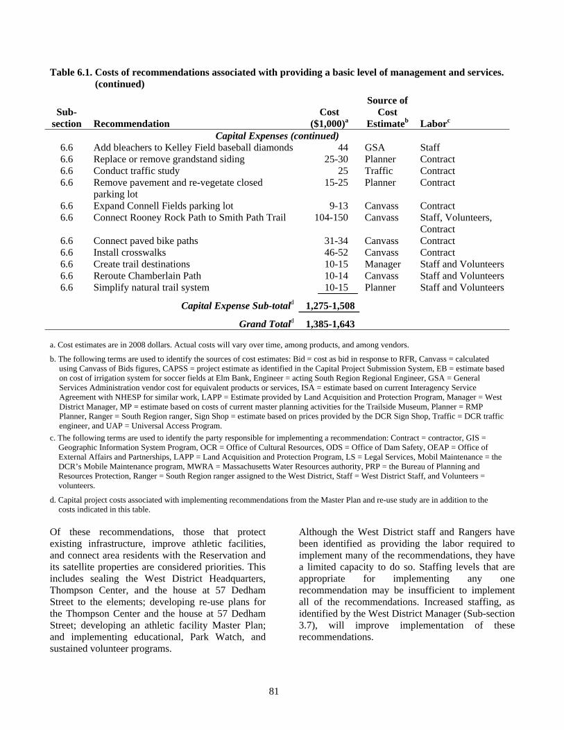
81
Table 6.1. Costs of recommendations associated with providing a basic level of management and services. (continued)
Sub- section
Recommendation
Cost ($1,000)a
Source of Cost
Estimateb
Laborc Capital Expenses (continued)
6.6 Add bleachers to Kelley Field baseball diamonds 44 GSA Staff 6.6 Replace or remove grandstand siding 25-30 Planner Contract 6.6 Conduct traffic study 25 Traffic Contract 6.6 Remove pavement and re-vegetate closed
parking lot 15-25 Planner Contract
6.6 Expand Connell Fields parking lot 9-13 Canvass Contract 6.6 Connect Rooney Rock Path to Smith Path Trail 104-150 Canvass Staff, Volunteers,
Contract 6.6 Connect paved bike paths 31-34 Canvass Contract 6.6 Install crosswalks 46-52 Canvass Contract 6.6 Create trail destinations 10-15 Manager Staff and Volunteers 6.6 Reroute Chamberlain Path 10-14 Canvass Staff and Volunteers 6.6 Simplify natural trail system 10-15 Planner Staff and Volunteers
Capital Expense Sub-totald 1,275-1,508
Grand Totald 1,385-1,643
a. Cost estimates are in 2008 dollars. Actual costs will vary over time, among products, and among vendors.
b. The following terms are used to identify the sources of cost estimates: Bid = cost as bid in response to RFR, Canvass = calculated using Canvass of Bids figures, CAPSS = project estimate as identified in the Capital Project Submission System, EB = estimate based on cost of irrigation system for soccer fields at Elm Bank, Engineer = acting South Region Regional Engineer, GSA = General Services Administration vendor cost for equivalent products or services, ISA = estimate based on current Interagency Service Agreement with NHESP for similar work, LAPP = Estimate provided by Land Acquisition and Protection Program, Manager = West District Manager, MP = estimate based on costs of current master planning activities for the Trailside Museum, Planner = RMP Planner, Ranger = South Region ranger, Sign Shop = estimate based on prices provided by the DCR Sign Shop, Traffic = DCR traffic engineer, and UAP = Universal Access Program.
c. The following terms are used to identify the party responsible for implementing a recommendation: Contract = contractor, GIS = Geographic Information System Program, OCR = Office of Cultural Resources, ODS = Office of Dam Safety, OEAP = Office of External Affairs and Partnerships, LAPP = Land Acquisition and Protection Program, LS = Legal Services, Mobil Maintenance = the DCR’s Mobile Maintenance program, MWRA = Massachusetts Water Resources authority, PRP = the Bureau of Planning and Resources Protection, Ranger = South Region ranger assigned to the West District, Staff = West District Staff, and Volunteers = volunteers.
d. Capital project costs associated with implementing recommendations from the Master Plan and re-use study are in addition to the costs indicated in this table.
Of these recommendations, those that protect existing infrastructure, improve athletic facilities, and connect area residents with the Reservation and its satellite properties are considered priorities. This includes sealing the West District Headquarters, Thompson Center, and the house at 57 Dedham Street to the elements; developing re-use plans for the Thompson Center and the house at 57 Dedham Street; developing an athletic facility Master Plan; and implementing educational, Park Watch, and sustained volunteer programs.
Although the West District staff and Rangers have been identified as providing the labor required to implement many of the recommendations, they have a limited capacity to do so. Staffing levels that are appropriate for implementing any one recommendation may be insufficient to implement all of the recommendations. Increased staffing, as identified by the West District Manager (Sub-section 3.7), will improve implementation of these recommendations.
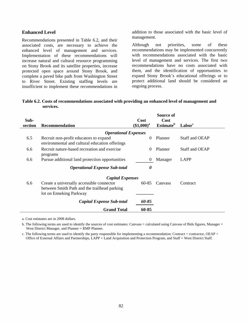
82
Enhanced Level Recommendations presented in Table 6.2, and their associated costs, are necessary to achieve the enhanced level of management and services. Implementation of these recommendations will increase natural and cultural resource programming on Stony Brook and its satellite properties, increase protected open space around Stony Brook, and complete a paved bike path from Washington Street to River Street. Existing staffing levels are insufficient to implement these recommendations in
addition to those associated with the basic level of management.
Although not priorities, some of these recommendations may be implemented concurrently with recommendations associated with the basic level of management and services. The first two recommendations have no costs associated with them, and the identification of opportunities to expand Stony Brook’s educational offerings or to protect additional land should be considered an ongoing process.
Table 6.2. Costs of recommendations associated with providing an enhanced level of management and services.
Sub- section
Recommendation
Cost ($1,000)a
Source of Cost
Estimateb
Laborc Operational Expenses
6.5 Recruit non-profit educators to expand environmental and cultural education offerings
0 Planner Staff and OEAP
6.6 Recruit nature-based recreation and exercise programs
0 Planner Staff and OEAP
6.6 Pursue additional land protection opportunities 0 Manager LAPP
Operational Expense Sub-total 0
Capital Expenses 6.6 Create a universally accessible connector
between Smith Path and the trailhead parking lot on Enneking Parkway
60-85 Canvass Contract
Capital Expense Sub-total 60-85
Grand Total 60-85
a. Cost estimates are in 2008 dollars. b. The following terms are used to identify the sources of cost estimates: Canvass = calculated using Canvass of Bids figures, Manager =
West District Manager, and Planner = RMP Planner. c. The following terms are used to identify the party responsible for implementing a recommendation: Contract = contractor, OEAP =
Office of External Affairs and Partnerships, LAPP = Land Acquisition and Protection Program, and Staff = West District Staff.
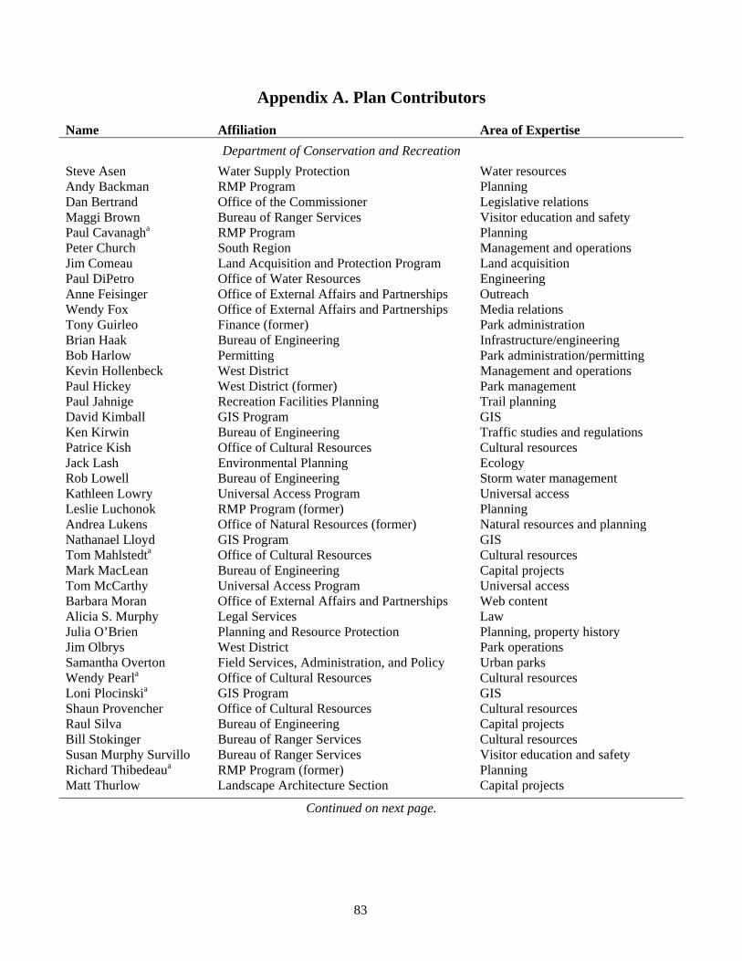
83
Appendix A. Plan Contributors Name Affiliation Area of Expertise Department of Conservation and Recreation Steve Asen Water Supply Protection Water resources Andy Backman RMP Program Planning Dan Bertrand Office of the Commissioner Legislative relations Maggi Brown Bureau of Ranger Services Visitor education and safety Paul Cavanagha RMP Program Planning Peter Church South Region Management and operations Jim Comeau Land Acquisition and Protection Program Land acquisition Paul DiPetro Office of Water Resources Engineering Anne Feisinger Office of External Affairs and Partnerships Outreach Wendy Fox Office of External Affairs and Partnerships Media relations Tony Guirleo Finance (former) Park administration Brian Haak Bureau of Engineering Infrastructure/engineering Bob Harlow Permitting Park administration/permitting Kevin Hollenbeck West District Management and operations Paul Hickey West District (former) Park management Paul Jahnige Recreation Facilities Planning Trail planning David Kimball GIS Program GIS Ken Kirwin Bureau of Engineering Traffic studies and regulations Patrice Kish Office of Cultural Resources Cultural resources Jack Lash Environmental Planning Ecology Rob Lowell Bureau of Engineering Storm water management Kathleen Lowry Universal Access Program Universal access Leslie Luchonok RMP Program (former) Planning Andrea Lukens Office of Natural Resources (former) Natural resources and planning Nathanael Lloyd GIS Program GIS Tom Mahlstedta Office of Cultural Resources Cultural resources Mark MacLean Bureau of Engineering Capital projects Tom McCarthy Universal Access Program Universal access Barbara Moran Office of External Affairs and Partnerships Web content Alicia S. Murphy Legal Services Law Julia O’Brien Planning and Resource Protection Planning, property history Jim Olbrys West District Park operations Samantha Overton Field Services, Administration, and Policy Urban parks Wendy Pearla Office of Cultural Resources Cultural resources Loni Plocinskia GIS Program GIS Shaun Provencher Office of Cultural Resources Cultural resources Raul Silva Bureau of Engineering Capital projects Bill Stokinger Bureau of Ranger Services Cultural resources Susan Murphy Survillo Bureau of Ranger Services Visitor education and safety Richard Thibedeaua RMP Program (former) Planning Matt Thurlow Landscape Architecture Section Capital projects
Continued on next page.
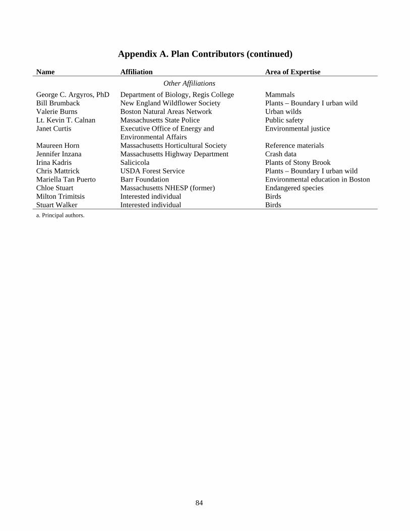
84
Appendix A. Plan Contributors (continued) Name Affiliation Area of Expertise Other Affiliations George C. Argyros, PhD Department of Biology, Regis College Mammals Bill Brumback New England Wildflower Society Plants – Boundary I urban wild Valerie Burns Boston Natural Areas Network Urban wilds Lt. Kevin T. Calnan Massachusetts State Police Public safety Janet Curtis Executive Office of Energy and
Environmental Affairs Environmental justice
Maureen Horn Massachusetts Horticultural Society Reference materials Jennifer Inzana Massachusetts Highway Department Crash data Irina Kadris Salicicola Plants of Stony Brook Chris Mattrick USDA Forest Service Plants – Boundary I urban wild Mariella Tan Puerto Barr Foundation Environmental education in Boston Chloe Stuart Massachusetts NHESP (former) Endangered species Milton Trimitsis Interested individual Birds Stuart Walker Interested individual Birds a. Principal authors.
85
Appendix B. Public Participation In accordance with M.G.L. Chapter 21: Section 2F, the Resource Management Plan (RMP) for Stony Brook Reservation was developed in conjunction with a public participation process to ensure that interested parties had an opportunity to review the draft RMP and offer input in its development. This appendix identifies the public participation process, summarizes comments on the draft RMP, and identifies changes to the RMP made in response to public input.
B.1. The Public Participation Process Announcements of Availability of Plan and Public Meeting The draft Stony Brook Reservation Resource Management Plan was made available to the public via the Internet and through the distribution of review copies to local public libraries. The RMP was available for download, as a PDF file, from the DCR’s Resource Management Planning web page (www.mass.gov/dcr/stewardship/rmp/rmp-stonyBrk.htm). One full-color public review copy of the draft RMP was placed at each of the following branches of the Boston Public Library: Hyde Park, Roslindale, and West Roxbury. Two copies were provided to the Dedham Public Library; one for the main library and one for the Endicott Branch. Finally, a review copy of the draft RMP and large-format maps were placed at the West District Headquarters on Brainard Street in Hyde Park. All public review copies of the draft RMP, both electronic and print, were distributed prior to the announcement in the Environmental Monitor.
An announcement of the availability of the draft RMP and the associated public meeting was published in the February 20th, 2008 issue of the Environmental Monitor. The associated public comment period ran from February 20th through March 28th, 2008.
Additional efforts were made to increase public awareness of the draft RMP, the associated public meeting, and the public comment period. A press release, announcing the draft RMP and public meeting, was provided to the Hyde Park/Roslindale/West Roxbury Bulletin, Hyde Park
Tribune, West Roxbury Transcript, Roslindale Transcript, Daily News Transcript, Boston Globe, Boston Herald, and the Associated Press/Boston.
Announcements were provided to 165 elected officials, public employees, neighborhood groups and organizations, non-profit and advocacy groups, and other interested parties. Elected officials were notified via phone, all others were notified via e-mail or U.S. Mail. The list of individuals and organizations notified was developed in association with Janet Curtis, Policy Coordinator, Environmental Justice and Urban Environments, Massachusetts Executive Office of Energy and Environmental Affairs. The names and affiliations of those receiving written notice of the draft RMP and public meeting follow.
Individuals and organizations notified of the Stony Brook Reservation RMP and public meeting:
Elected Officials • Marian Walsh; Senator, Suffolk and Norfolk
District. • Paul McMurtry; Representative, 11th Norfolk
District. • Michael F. Rush; Representative, 10th Suffolk
District. • Angelo M. Scaccia; Representative, 14th Suffolk
District. • Thomas M. Menino; Mayor, City of Boston. • Robert Consalvo; Boston City Councilor, District
5. • John M. Tobin, Jr.; Boston City Councilor,
District 6. • Bill Linehan; Boston City Councilor, District 2. Public Employees • David McNulty; Neighborhood Coordinator,
Hyde Park/Readville/Roslindale. • Andrea Post-Ergun; Senior Landscape Architect,
Boston Department of Neighborhood Development.
• Bryan Glasscock; Director, Environment Department, Boston.
• William Keegan; Town Administrator, Dedham. • Anthony Mucciaccio, Jr.; Park and Recreation
Director, Dedham.
86
• Chris Tracy; Neighborhood Coordinator, West Roxbury.
• Aldo Ghirin; Senior Planner, Boston Parks and Recreation Department.
• Chris Bush; Executive Secretary, Boston Conservation Commission.
• Virginia S. LeClair; Environmental Coordinator, Dedham Conservation Commission.
• Henry Woolsey; Program Manager, Massachusetts Natural Heritage & Endangered Species Program.
Neighborhood Groups and Organizations • Hyde Park YMCA. • Roslindale Community Center/Youth Zone. • West Roxbury YMCA. • West Roxbury Community Center. Non-profit and Advocacy Groups • Arnold Arboretum, Harvard University. • Boston Nature Center, Massachusetts Audubon
Society. • Sheri Brokopp; Urban Ecology Institute. • Valerie J. Burns; Boston Natural Areas Network. • Annie Cardinaux; Earthworks Boston. • Ian Cooke; Neponset River Watershed
Association. • Penn Loh; Alternatives for Community and
Environment. • Doug Mink; Mass Paths. • Carly Rocklen; Neponset River Watershed
Association. • Steve Sloan; The Trustees of Reservations. • Joe Sloane; New England Mountain Bike
Association. • Mariella Tan Puerto; The Barr Foundation. • Susan Tufts; Outdoor Explorations. • Rick Wallwork; Boston Cares. • Robert Zimmerman; Charles River Watershed
Association. Other Interested Parties • George Argyros; plan contributor. • Barry Fleischer; abutter. • Whitley Frost; abutter. • Milton Trimitsis; plan contributor. • Stuart Walker; plan contributor.
In addition to the individuals and organizations listed above, written notices were provided to 77 recreation and special-use permit holders for the
properties covered in the RMP, and to 46 members of the Blue Hills Trail Watch.
Public Meeting A public meeting for the draft Stony Brook Reservation Resource Management Plan was held on March 11, 2008, from 6:30 – 8:30 P.M., at the Boston Police Department’s District E-18 Station, 1249 Hyde Park Avenue, Hyde Park. Eighteen members of the public and six DCR staff members were in attendance. A list of attendees and their affiliations follows. The sequence of names of members of the public, and their affiliations, are taken from the meeting’s sign-in sheet.
Attendees of the March 11, 2008 public meeting on the draft Stony Brook Reservation RMP:
Members of the Public • Kim O’Connell; Roslindale resident. • M. O’Brien; Dedham Civic Pride. • Kiki Trahon; Dedham Civic Pride. • Beth Beighlie; Roslindale resident. • Wayne Beitler; Longfellow Neighborhood
Association. • Martha McDonough; Citizens for the
Preservation of Readville. • Rita Walsh; Fairmount. • Karl Simon; Boston Trinity Academy. • Tim Wiens; Boston Trinity Academy. • Harvey Soolman; Boston Park League. • Stephen Clark; Office of Senator Marian Walsh. • Doug Mink; Mass Paths. • Lisa M. Consalvo; Office of Representative
Angelo M. Scaccia. • Barbara Baxter; Hyde Park resident. • Russ Rylko; Hyde Park resident. • David Vittorini; Office of City Councilor Rob
Consalvo. • Aldo Ghirin; Boston Parks and Recreation
Department. • Candace Cook; Boston Natural Areas Network. DCR Staff • Andy Backman; Acting Director, RMP Program. • Paul Cavanagh; RMP Program. • Peter Church; South Region Director. • Kevin Hollenbeck; West District Manager. • Loni Plocinski; GIS Program. • Susan Murphy Survillo; Ranger, West District.
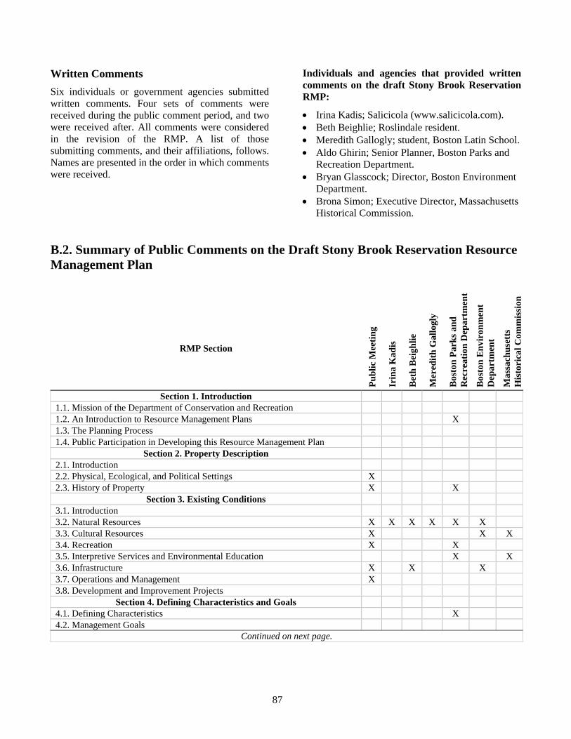
87
Written Comments Six individuals or government agencies submitted written comments. Four sets of comments were received during the public comment period, and two were received after. All comments were considered in the revision of the RMP. A list of those submitting comments, and their affiliations, follows. Names are presented in the order in which comments were received.
Individuals and agencies that provided written comments on the draft Stony Brook Reservation RMP:
• Irina Kadis; Salicicola (www.salicicola.com). • Beth Beighlie; Roslindale resident. • Meredith Gallogly; student, Boston Latin School. • Aldo Ghirin; Senior Planner, Boston Parks and
Recreation Department. • Bryan Glasscock; Director, Boston Environment
Department. • Brona Simon; Executive Director, Massachusetts
Historical Commission.
B.2. Summary of Public Comments on the Draft Stony Brook Reservation Resource Management Plan
RMP Section
Publ
ic M
eetin
g
Irin
a K
adis
Bet
h B
eigh
lie
Mer
edith
Gal
logl
y
Bos
ton
Park
s and
R
ecre
atio
n D
epar
tmen
t
Bos
ton
Env
iron
men
t D
epar
tmen
t
Mas
sach
uset
ts
His
tori
cal C
omm
issi
on
Section 1. Introduction 1.1. Mission of the Department of Conservation and Recreation 1.2. An Introduction to Resource Management Plans X 1.3. The Planning Process 1.4. Public Participation in Developing this Resource Management Plan
Section 2. Property Description 2.1. Introduction 2.2. Physical, Ecological, and Political Settings X 2.3. History of Property X X
Section 3. Existing Conditions 3.1. Introduction 3.2. Natural Resources X X X X X X 3.3. Cultural Resources X X X 3.4. Recreation X X 3.5. Interpretive Services and Environmental Education X X 3.6. Infrastructure X X X 3.7. Operations and Management X 3.8. Development and Improvement Projects
Section 4. Defining Characteristics and Goals 4.1. Defining Characteristics X 4.2. Management Goals
Continued on next page.
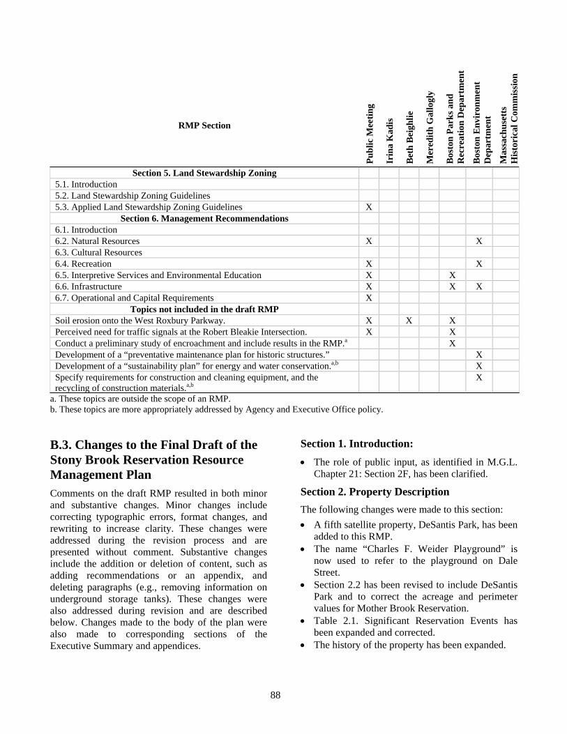
88
RMP Section
Publ
ic M
eetin
g
Irin
a K
adis
Bet
h B
eigh
lie
Mer
edith
Gal
logl
y
Bos
ton
Park
s and
R
ecre
atio
n D
epar
tmen
t
Bos
ton
Env
iron
men
t D
epar
tmen
t
Mas
sach
uset
ts
His
tori
cal C
omm
issi
on
Section 5. Land Stewardship Zoning 5.1. Introduction 5.2. Land Stewardship Zoning Guidelines 5.3. Applied Land Stewardship Zoning Guidelines X
Section 6. Management Recommendations 6.1. Introduction 6.2. Natural Resources X X 6.3. Cultural Resources 6.4. Recreation X X 6.5. Interpretive Services and Environmental Education X X 6.6. Infrastructure X X X 6.7. Operational and Capital Requirements X
Topics not included in the draft RMP Soil erosion onto the West Roxbury Parkway. X X X Perceived need for traffic signals at the Robert Bleakie Intersection. X X Conduct a preliminary study of encroachment and include results in the RMP.a X Development of a “preventative maintenance plan for historic structures.” X Development of a “sustainability plan” for energy and water conservation.a,b X Specify requirements for construction and cleaning equipment, and the recycling of construction materials.a,b
X
a. These topics are outside the scope of an RMP. b. These topics are more appropriately addressed by Agency and Executive Office policy. B.3. Changes to the Final Draft of the Stony Brook Reservation Resource Management Plan Comments on the draft RMP resulted in both minor and substantive changes. Minor changes include correcting typographic errors, format changes, and rewriting to increase clarity. These changes were addressed during the revision process and are presented without comment. Substantive changes include the addition or deletion of content, such as adding recommendations or an appendix, and deleting paragraphs (e.g., removing information on underground storage tanks). These changes were also addressed during revision and are described below. Changes made to the body of the plan were also made to corresponding sections of the Executive Summary and appendices.
Section 1. Introduction: • The role of public input, as identified in M.G.L.
Chapter 21: Section 2F, has been clarified.
Section 2. Property Description The following changes were made to this section: • A fifth satellite property, DeSantis Park, has been
added to this RMP. • The name “Charles F. Weider Playground” is
now used to refer to the playground on Dale Street.
• Section 2.2 has been revised to include DeSantis Park and to correct the acreage and perimeter values for Mother Brook Reservation.
• Table 2.1. Significant Reservation Events has been expanded and corrected.
• The history of the property has been expanded.
89
• The description of physical connections between parkways and DCR properties has been clarified.
• Information on easements along Mother Brook has been added.
Section 3. Existing Conditions Information on the following topics has been added or significantly expanded or revised: • Mother Brook Reservation, including properties
owned in fee by the DCR and those on which the DCR holds an easement.
• Soil erosion onto the West Roxbury Parkway. • Lack of map data for unprotected urban wilds. • Invasive plants; to reflect new information on the
flora of Stony Brook Reservation. • Cultural resource experts with whom the DCR
may partner to develop cultural resource materials and interpretive programs.
• Demographic information; this was recalculated to include the Bellevue Hill portion of Stony Brook Reservation and its associated buffers.
• DCR sign standards. • Named features of Stony Brook Reservation and
satellite properties. • The status of recent upgrades to Weider
Playground. • Dangerous intersections. • The Claire Saltonstall Memorial Bikeway. • Current universal access standards as they relate
to the Thompson Center. • The lack of connections between Stony Brook’s
trail segments. • Locations of existing kiosks; these are now
indicated on the Infrastructure and Active Recreation Areas maps.
• Pending capital projects (e.g., repairs to the River Street Bridge).
• The capital budget planning process.
Information on underground storage tanks was removed from the RMP. This followed MassGIS identifying “currency and data quality concerns” with the statewide Underground Storage Tank datalayer and removing it from distribution on the MassGIS web site.
Section 4. Defining Characteristics and Goals • The goal regarding universal access has been
expanded.
Section 5. Land Stewardship Zoning • The boundary of Land Stewardship Zone 1 has
been adjusted to match existing landmarks so that operations staff may more easily identify this zone on the ground and adjust their activities accordingly.
• The western-most portion of Mother Brook Reservation now includes an area designated as Land Stewardship Zone 1.
• Additional information has been added on appropriate activities within areas designated Zone 2.
Section 6. Management Recommendations • Eighteen recommendations were added, 10 of
which are related to signs and DCR sign standards.
• Costs of projects estimated using “Canvass of Bids” unit prices were increased by 30% to account for design and permitting costs.
Section 7. Appendices • Appendix B. Public Participation has been
added. • Eleven references were added to Appendix E.
References. • A new appendix (Appendix F. Plants of the Stony
Brook Area) has been added to include natural resources information identified during the public comment period.
90
Appendix C. Land Stewardship Zoning Guidelines Department of Conservation and Recreation
February, 2006
Background In July, 2003 state legislation established the Department of Conservation and Recreation (DCR), consisting of a Division of Urban Parks and Recreation, a Division of State Parks and Recreation, and a Division of Water Supply Protection. This legislation essentially merged the former Department of Environmental Management (DEM) and the Metropolitan District Commission (MDC). In addition, the legislation required the preparation of management plans for state parks, forests and reservations under the management of the DCR (Chapter 21, Section 2F). This legislation states that management plans shall include guidelines for operation and land stewardship, provide for the protection and stewardship of natural and cultural resources, and shall ensure consistency between recreation, resource protection, and sustainable forest management.
As part of addressing this legislative requirement, land stewardship zoning guidelines will be incorporated into the development and implementation of DCR Resource Management Plans. These Land Stewardship Zoning Guidelines (Guidelines) represent a revision of the previous Land Stewardship Zoning system developed by Executive Office of Environmental Affairs (EOEA) agencies in the early 1990s, and which had been applied to the preparation of management plans for state parks, forests and reservations under the management of the former DEM.
The purpose of these revised Guidelines is to provide a general land stewardship zoning framework for the development of Resource Management Plans for all state reservations, parks and forests under the management of the DCR Divisions of Urban Parks and Recreation and State Parks and Recreation. The Guidelines do not apply to Division of Water Supply Protection (DWSP) properties because DWSP watershed planning has a separate legislative mandate and established planning procedures.
Overview of Guidelines The Guidelines define three types of zones to address the legislative requirement to provide for the protection and stewardship of natural and cultural resources and to ensure consistency between recreation, resource protection, and sustainable forest management. The Guidelines are intended to provide a general land stewardship zoning framework that is flexible and that can guide the long-term management of a given DCR property or facility. The three zones may be supplemented with significant feature overlays that identify specific designated/recognized resource features (such as Forest Reserves, Areas of Critical Environmental Concern, or areas subject to historic preservation restrictions). DCR parks, forests, and reservations are also subject to specific policy guidelines and/or performance standards (such as Executive Order No. 181 for Barrier Beaches) and applicable environmental laws and regulations of the Commonwealth.
Application of the three-zone system to a particular DCR park, forest or reservation is facilitated by the development and application of Geographic Information Systems (GIS) technology. GIS resource overlays provide a general screen whereby lands of special resource significance and sensitivity can be mapped and identified. General landscape features such as forested areas, wetlands, streams and ponds can also be mapped as part of this overlay approach. Further, additional data regarding recreational uses and developed facilities and sites can be added. This type of mapping and data collection, based on the best information currently available, provides the basis for subsequent analysis and ultimately the development and application of appropriate land stewardship zoning guidelines to a specific state park, forest or reservation.
Land Stewardship Zoning Guidelines provide a foundation for recommendations that will address resource stewardship and facility management objectives, and are intended to cover both existing DCR property or facility conditions and desired
91
future conditions for that property or facility. Proposals for changing the Guidelines in a previously approved Resource Management Plan should be submitted to the DCR Stewardship Council for review and adoption.
Land Stewardship Zones Zone 1 General Description
This zone includes unique, exemplary, and highly sensitive resources and landscapes that require special management approaches and practices to protect and preserve the special features and values identified in the specific Resource Management Plan. Examples of these resources include rare species habitat identified by the Natural Heritage & Endangered Species Program as being highly sensitive to human activities, fragile archaeological or cultural sites, and unique or exemplary natural communities. Management objectives emphasize protecting these areas from potentially adverse disturbances and impacts.
General Management Guidelines
• Only dispersed, low-impact, non-motorized, sustainable recreation will be allowed provided that the activities do not threaten or impact unique and highly sensitive resources.
• Existing trails and roads will be evaluated to ensure compatibility with identified resource features and landscape, and will be discontinued if there are suitable sustainable alternatives. New trails may be constructed only after a strict evaluation of need and avoidance of any potential adverse impacts on identified resources. New roads may only be constructed to meet public health and safety needs or requirements; however, the project design and siting process must avoid any potential adverse impacts on identified resources and demonstrate that there are no other suitable alternatives.
• Vegetation or forest management will be utilized only to preserve and enhance identified resource features and landscapes.
Zone 2 General Description
This Zone includes areas containing typical yet important natural and cultural resources on which common forestry practices and dispersed recreational activities can be practiced at sustainable levels that do not degrade these resources, and that hold potential for improving their ecological health, productivity and/or protection through active management. Examples include terrestrial and aquatic ecosystems characterized by a diversity of wildlife and plant habitats, rare species habitat that is compatible with sustainable forestry and dispersed recreation, agricultural resources, and resilient cultural sites and landscapes. Zone 2 areas may be actively managed provided that the management activities are consistent with the approved Resource Management Plan for the property.
General Management Guidelines
• Management approaches and actions may include a wide range of potential recreational opportunities and settings that are consistent and compatible with natural resource conservation and management goals.
• Utilize Best Management Practices for forestry and other resource management activities to encourage native biodiversity, protect rare species habitats and landforms.
• Protect and maintain water quality by providing for healthy functioning terrestrial and aquatic ecosystems.
• Provide a safe, efficient transportation network with minimal impact on natural and cultural resources while serving public safety needs and allowing visitors to experience a variety of outdoor activities.
• New trails may be allowed dependent upon existing area trail densities, purpose and need, physical suitability of the site, and specific guidelines for protection of rare species habitat and archaeological resources.
92
• Sustainable forest management activities may be undertaken following guidelines established through ecoregion-based assessments, district level forestry plans, current best forestry management practices, and providing for consistency with resource protection goals.
• Roads may be constructed if access for resource management or public access is needed and construction can be accomplished in an environmentally protective manner. Existing roads will be maintained in accordance with the DCR road classification system and maintenance policy.
• Additional site-specific inventory and analysis may be needed prior to any of the management activities described above to ensure that no adverse impacts occur to previously un-documented unique and sensitive resources and landscape features.
Zone 3 General Description
This zone includes constructed or developed administrative, maintenance and recreation sites, structures and resilient landscapes which accommodate concentrated use by recreational visitors and require intensive maintenance by DCR staff. Examples include areas developed and deemed appropriate for park headquarters and maintenance areas, parking lots, swimming pools and skating rinks, paved bikeways, swimming beaches, campgrounds, playgrounds and athletic fields, parkways, golf courses, picnic areas and pavilions, concessions, and areas assessed to be suitable for those uses.
General Management Guidelines
• The management approach and actions will emphasize public safety conditions and provide for an overall network of accessible facilities that meets the needs of DCR visitors and staff.
• Maintenance of these facilities and associated natural and cultural resources, and new construction or development, will meet state public health code, and state building code and environmental regulations.
• Shorelines and surface waters may be used for recreation within constraints of maintaining public safety and water quality.
• Historic restoration, rehabilitation or reconstruction for interpretation or adaptive reuse of historic structures will be undertaken only in conjunction with a historic restoration plan.
• To the greatest extent possible, construction will include the use of “green design” for structures, such as use of low-flow water fixtures and other water conservation systems or techniques, solar and other renewable energy sources, and the implementation of Best Management Practices to protect the soil and water resources at all facilities.
Significant Feature Overlays General Description
The three land stewardship zones may be supplemented with significant feature overlays that identify specific designated/recognized resource features. These significant features are generally identified through an inventory process or research, and are formally designated. The purpose of these overlays is to provide more precise management guidance for identified resources and to recognize, maintain, protect, or preserve unique and significant values, regardless of the zone in which they occur. Examples of significant feature overlays include Forest Reserves, areas subject to public drinking water regulations, or areas subject to historic preservation restrictions.
Management Guidelines
Specific management guidelines for significant features overlays are provided by resource specialists or by the federal, state, regional, or local agency that has recognized and listed the resource or site.
93
Appendix D. GIS Supplemental Information
Methodology The following is a summary of the GIS methodology used by the Department of Conservation and Recreation (DCR) GIS Program to generate and present data within the Stony Brook Reservation Resource Management Plan (RMP).
Property Boundaries The source of the property boundaries for Stony Brook Reservation, Mother Brook Reservation (fee ownership only), Weider Playground and Camp Meigs Playground is unknown. However, it is most likely that the boundaries originated within the former Metropolitan District Commission. Even though the source is unknown, the boundaries are considered a fair approximation of the actual boundaries of each property and as such, suitable for planning level analysis. A DCR GIS Specialist edited the northern boundaries of Stony Brook Reservation, near Bellevue Hill, in ArcGIS for the purpose of this RMP. The boundaries were adjusted to the approximate extent of West Roxbury Parkway, as seen in the 2005 color orthophotography.
The source of the property boundaries for Colella Field, Colella Playground, and DeSantis Park is level zero Assessor’s parcel data for the City of Boston. For the purpose of this RMP, a DCR GIS Specialist split the one parcel representing all three properties into two parcels representing 1) Colella Field and Playground and 2) DeSantis Park as seen in the 2005 color orthophotography using ArcGIS.
The source of the property boundaries for the deed restrictions within Mother Brook Reservation is level zero Assessor’s parcel data for the Town of Dedham. For the purpose of this RMP, a DCR GIS Specialist, using ArcGIS and 2005 color orthophotography, extended the boundaries across VFW Parkway, East Street, and Washington Street as shown on the Mother Brook Flood Control Project Land Taking Plans (Anderson-Nichols & Co. 1958). Where appropriate, the deed restriction boundaries were also adjusted in ArcGIS to abut, without gaps or overlap, the existing Mother Brook Reservation fee property boundaries.
2005 Orthophotography The 2005 color orthophotography was not altered for this map.
Regional Land Use (1999) For the purpose of this RMP, the 21 land use classifications were aggregated into nine classifications:
1. Forest. 2. Agriculture (a. Cropland, b. Pasture, c. Woody Perennial). 3. Open Land (a. Open Land, b. Urban Open). 4. Wetland (a. Non-forested Wetland, b. Salt Water Wetland). 5. Water. 6. Recreation (a. Water Based, b. Participation, c. Spectator). 7. Low Density Residential (a. Low Density, b. Medium Density). 8. High Density Residential (a. High Density, b. Multi-family Density). 9. Intensive Use (a. Industrial, b. Commercial, c. Transportation, d. Mining, e. Waste Disposal).
The land use statistics reported below were generated using the following methodology within ArcGIS. Stony Brook Reservation was buffered at one and two miles using the buffer tool. The total number of acres within each buffer was then calculated using the calculate geometry feature. Next, land use data were clipped to the area of the buffers. The land use acres were summed by classification and then divided by the acres in each buffer to obtain the percentage. The reported acreage values were rounded to the nearest acre; the reported percentages were rounded to one decimal place.
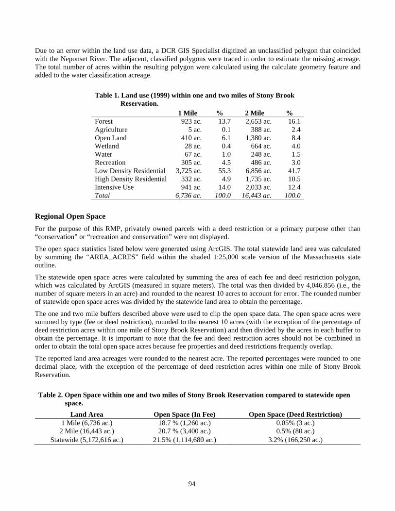
94
Due to an error within the land use data, a DCR GIS Specialist digitized an unclassified polygon that coincided with the Neponset River. The adjacent, classified polygons were traced in order to estimate the missing acreage. The total number of acres within the resulting polygon were calculated using the calculate geometry feature and added to the water classification acreage.
Table 1. Land use (1999) within one and two miles of Stony Brook
Reservation. 1 Mile % 2 Mile % Forest 923 ac. 13.7 2,653 ac. 16.1 Agriculture 5 ac. 0.1 388 ac. 2.4 Open Land 410 ac. 6.1 1,380 ac. 8.4 Wetland 28 ac. 0.4 664 ac. 4.0 Water 67 ac. 1.0 248 ac. 1.5 Recreation 305 ac. 4.5 486 ac. 3.0 Low Density Residential 3,725 ac. 55.3 6,856 ac. 41.7 High Density Residential 332 ac. 4.9 1,735 ac. 10.5 Intensive Use 941 ac. 14.0 2,033 ac. 12.4 Total 6,736 ac. 100.0 16,443 ac. 100.0
Regional Open Space For the purpose of this RMP, privately owned parcels with a deed restriction or a primary purpose other than “conservation” or “recreation and conservation” were not displayed.
The open space statistics listed below were generated using ArcGIS. The total statewide land area was calculated by summing the “AREA_ACRES” field within the shaded 1:25,000 scale version of the Massachusetts state outline.
The statewide open space acres were calculated by summing the area of each fee and deed restriction polygon, which was calculated by ArcGIS (measured in square meters). The total was then divided by 4,046.856 (i.e., the number of square meters in an acre) and rounded to the nearest 10 acres to account for error. The rounded number of statewide open space acres was divided by the statewide land area to obtain the percentage.
The one and two mile buffers described above were used to clip the open space data. The open space acres were summed by type (fee or deed restriction), rounded to the nearest 10 acres (with the exception of the percentage of deed restriction acres within one mile of Stony Brook Reservation) and then divided by the acres in each buffer to obtain the percentage. It is important to note that the fee and deed restriction acres should not be combined in order to obtain the total open space acres because fee properties and deed restrictions frequently overlap.
The reported land area acreages were rounded to the nearest acre. The reported percentages were rounded to one decimal place, with the exception of the percentage of deed restriction acres within one mile of Stony Brook Reservation.
Table 2. Open Space within one and two miles of Stony Brook Reservation compared to statewide open
space. Land Area Open Space (In Fee) Open Space (Deed Restriction)
1 Mile (6,736 ac.) 18.7 % (1,260 ac.) 0.05% (3 ac.) 2 Mile (16,443 ac.) 20.7 % (3,400 ac.) 0.5% (80 ac.)
Statewide (5,172,616 ac.) 21.5% (1,114,680 ac.) 3.2% (166,250 ac.)
95
Water Resources For cartographic purposes, two different USGS hydrography datalayers were used to represent Stony Brook (the waterway). The segment north of Turtle Pond was selected from the 1:25,000 scale version and the segment south of Turtle Pond was selected from the 1:100,000 scale version. The stream and wetland in DeSantis Park were digitized by a DCR GIS Specialist using the 2005 color orthophotography. The source data for the remaining hydrography on this map is the Department of Environmental Protection (DEP) wetlands datalayer (1:12,000).
Dams along Mother Brook were digitized in ArcGIS by a DCR GIS Specialist using the 2005 color orthophotography. Information from the Mother Brook Flood Control Feasibility Study (Anderson-Nichols & Co. 1973) and the DCR Office of Dam Safety was also used in order to refine the location of each dam.
The underground storage tank (UST) locations were removed from the final version of this map due to currency and data quality concerns. Additional information can be found on the MassGIS website.
Cultural Resources The MWRA water tower and Camp Meigs memorial were digitized in ArcGIS by a DCR GIS Specialist using the 2005 color orthophotography.
Dams along Mother Brook were also digitized in ArcGIS by a DCR GIS Specialist using the 2005 color orthophotography. Information from the Mother Brook Flood Control Feasibility Study (Anderson-Nichols & Co. 1973) and the DCR Office of Dam Safety was also used in order to refine the location of each dam.
The extent of the historic parkway segments were determined from information contained in the National Register of Historic Places nomination form (Adams et al. 2005) for Stony Brook’s parkways.
Demographics The following methodology was used to generate the demographics information for this RMP. The area of each Census Block, calculated by ArcGIS and measured in square meters, was divided by 4,046.856 (i.e., the number of square meters in an acre). The quotient was divided into the population of each Census Block to obtain the number of people per acre of each Census Block.
Four different buffers were drawn around Stony Brook Reservation at one-fourth, one-half, one, and two miles, using the buffer tool in ArcGIS. The Census Blocks were then clipped to the area of the buffers. The area of the clipped Census Blocks was recalculated in acres, using the calculate geometry feature in ArcGIS. This value was then multiplied by the number of people per acre of each Census Block to obtain the population estimate.
It is important to note that the population estimates within smaller distances are likely less accurate than those within greater distances. This occurs because the Census Blocks were clipped. Clipping eliminates the actual count of the Census and makes the data an estimation of population in the remaining portion of the Census Block. To account for this, the reported number of residents per acre was rounded to the nearest 10 residents.
Table 3. The number of residents within ¼, ½, 1, and 2 miles of Stony Brook Reservation.
Within ¼ mile: 17,040 Within ½ mile: 33,900 Within 1 mile: 72,930
Within 2 miles: 135,520
96
It is also important to note that the buffer distances were chosen to describe the density of residents living close to the property. There is some qualitative and anecdotal information showing that most visitors of DCR properties live nearby. Therefore, knowing how many people live in close proximity to a particular property can provide some insight as to the user demand for the recreation resources at that property. This is a general description of visitation patterns and does not hold for all properties within the DCR system.
Census data were further analyzed with ArcGIS to determine the characteristics of the population surrounding Stony Brook Reservation. The Block Group datalayer and the Census Summary File 3 (SF3) Tables were used. Each Block Group that intersected with the two mile buffer described above was selected using the select by location tool in ArcGIS. Data for the selected Block Groups are summarized below.
Table 4. Summary of Block Groups within two miles of Stony Brook Reservation. Sample Population: 156,704 Number of Households: 58,394
Age and Gender Males Females Total 73,343 83,361 Children (<18) 18,975 17,977 Adults (18-64) 45,391 50,846 Seniors (65+) 8,977 14,538 Income Low (<$10,000 - $24,999) 13,411 Medium ($25,000 - $74,999) 26,363 High ($75,000 - >$200,000) 18,620 Race White 104,048 Black or African American 34,610 American Indian or Alaskan Native 515 Asian 4,691 Native Hawaiian or Other Pacific Islander 30 Some Other Race (alone) 6,975 Persons of Two or More Races 5,835
Language English: 42,290 Not English: 16,104
Spanish: 5,163 European: 8,316 Asian: 1,328 Other: 1,297
Education Males Females Population >25 48,581 59,005 < High School1 7,349 8,650 High School Diploma 12,505 15,858 < Bachelor’s Degree2 11,131 14,633 Bachelor’s Degree 9,663 11,258 > Bachelor’s Degree3 7,933 8,606 1 No School, < 11th Grade, 12th Grade No Diploma 2 College < 1 Year, College > 1 Year No Degree,
Associate’s Degree 3 Master’s Degree, Professional School Degree,
Doctorate Degree
It is important to emphasize the differences between Table 3 and Table 4. First, there is a difference in Census geography. Table 3 reflects Census Block geography and Table 4 reflects the larger, Census Block Group geography. Next, there is a difference in geoprocessing. The Census Blocks were clipped, meaning that they were cut to the shape of the buffer. In turn, both whole and partial Blocks were included. The Census Block Groups were selected via intersection, meaning that if any part of a Block Group overlapped with the buffer, it was selected. Only whole Block Groups were selected. The following figures identify the differences in areas included in the analyses, as a result of these two different approaches.
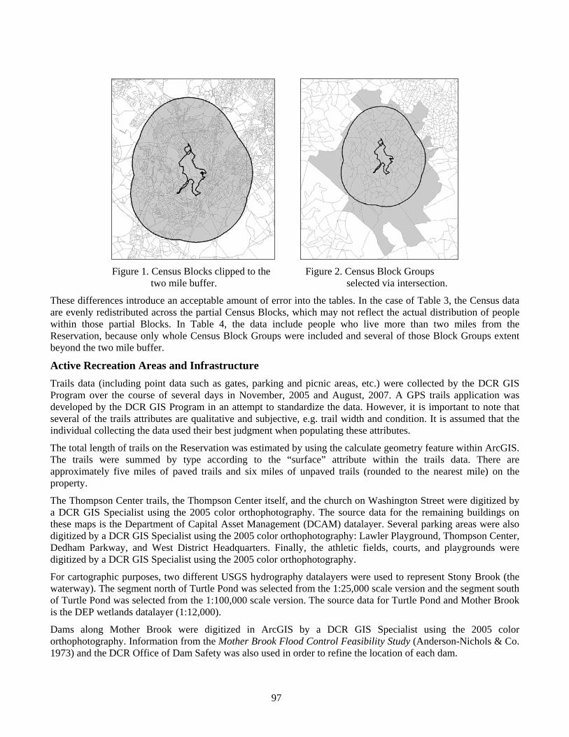
97
Figure 1. Census Blocks clipped to the Figure 2. Census Block Groups
two mile buffer. selected via intersection.
These differences introduce an acceptable amount of error into the tables. In the case of Table 3, the Census data are evenly redistributed across the partial Census Blocks, which may not reflect the actual distribution of people within those partial Blocks. In Table 4, the data include people who live more than two miles from the Reservation, because only whole Census Block Groups were included and several of those Block Groups extent beyond the two mile buffer.
Active Recreation Areas and Infrastructure Trails data (including point data such as gates, parking and picnic areas, etc.) were collected by the DCR GIS Program over the course of several days in November, 2005 and August, 2007. A GPS trails application was developed by the DCR GIS Program in an attempt to standardize the data. However, it is important to note that several of the trails attributes are qualitative and subjective, e.g. trail width and condition. It is assumed that the individual collecting the data used their best judgment when populating these attributes.
The total length of trails on the Reservation was estimated by using the calculate geometry feature within ArcGIS. The trails were summed by type according to the “surface” attribute within the trails data. There are approximately five miles of paved trails and six miles of unpaved trails (rounded to the nearest mile) on the property.
The Thompson Center trails, the Thompson Center itself, and the church on Washington Street were digitized by a DCR GIS Specialist using the 2005 color orthophotography. The source data for the remaining buildings on these maps is the Department of Capital Asset Management (DCAM) datalayer. Several parking areas were also digitized by a DCR GIS Specialist using the 2005 color orthophotography: Lawler Playground, Thompson Center, Dedham Parkway, and West District Headquarters. Finally, the athletic fields, courts, and playgrounds were digitized by a DCR GIS Specialist using the 2005 color orthophotography.
For cartographic purposes, two different USGS hydrography datalayers were used to represent Stony Brook (the waterway). The segment north of Turtle Pond was selected from the 1:25,000 scale version and the segment south of Turtle Pond was selected from the 1:100,000 scale version. The source data for Turtle Pond and Mother Brook is the DEP wetlands datalayer (1:12,000).
Dams along Mother Brook were digitized in ArcGIS by a DCR GIS Specialist using the 2005 color orthophotography. Information from the Mother Brook Flood Control Feasibility Study (Anderson-Nichols & Co. 1973) and the DCR Office of Dam Safety was also used in order to refine the location of each dam.
98
Trails Trails data (including parking areas) were collected by the DCR GIS Program over the course of several days in November, 2005 and August, 2007. A GPS trails application was developed by the DCR GIS Program in an attempt to standardize the data. However, it is important to note that several of the trails attributes are qualitative and subjective, e.g. trail width and condition. It is assumed that the individual collecting the data used their best judgment when populating these attributes.
The Thompson Center trails were digitized by a DCR GIS Specialist using the 2005 color orthophotography. The trailhead parking area on Dedham Parkway was also digitized by a DCR GIS Specialist using the 2005 color orthophotography. The locations of the noteworthy topographical features were digitized by a DCR GIS Specialist using the USGS Topographic Quadrangles.
Land Stewardship Zoning The Natural Heritage and Endangered Species Program (NHESP) Estimated Habitat of Rare Species datalayer was used as a guide for defining Zone 1 within Stony Brook Reservation. Using ArcGIS, a DCR GIS Specialist extended the boundary of the NHESP polygon to “on the ground features,” such as roads and trails, in an effort to make the area easily identifiable for DCR field staff. The “on the ground features” approach was also taken when a DCR GIS Specialist digitized the areas defined as Zone 3 within Stony Brook Reservation.
The area defined as Zone 3 within Mother Brook Reservation was digitized by a DCR GIS Specialist using the 2005 color orthophotography.
Recommendations Trails data (including point data such as gates, parking and picnic areas, etc.) were collected by the DCR GIS Program over the course of several days in November, 2005 and August, 2007. A GPS trails application was developed by the DCR GIS Program in an attempt to standardize the data. However, it is important to note that several of the trails attributes are qualitative and subjective, e.g. trail width and condition. It is assumed that the individual collecting the data used their best judgment when populating these attributes. New trail recommendations were digitized by a DCR GIS Specialist using the 2005 color orthophotography.
The dams along Mother Brook were also digitized in ArcGIS by a DCR GIS Specialist using the 2005 color orthophotography. Information from the Mother Brook Flood Control Feasibility Study (Anderson-Nichols & Co. 1973) and the DCR Office of Dam Safety was used in order to refine the location of each dam. Additional digitized information includes: information kiosks, crosswalks, historic views, West District Headquarters and Lawler Playground parking areas and the Thompson Center. The MassGIS 2005 orthophotography was used for digitizing. Finally, “Boundary I” was digitized by a DCR GIS Specialist using the level zero Assessor’s parcel data for the City of Boston to refine the location of the southeastern boundaries.
For cartographic purposes, two different USGS hydrography datalayers were used to represent Stony Brook (the waterway). The segment north of Turtle Pond was selected from the 1:25,000 scale version and the segment south of Turtle Pond was selected from the 1:100,000 scale version. The source data for Turtle Pond and Mother Brook is the DEP wetlands datalayer (1:12,000).
Datalayers A summary of the GIS datalayers used by the Department of Conservation and Recreation (DCR) GIS Program to generate and present data within the Stony Brook Reservation Resource Management Plan (RMP) is presented in Table 5.
99
Table 5. Summary of datalayers used to create the Stony Brook Reservation RMP. Datalayer Name Source Additional Information
2000 Census Blocks and Block Groups MassGIS http://mass.gov/mgis/census2000.htm 2005 Orthophotography MassGIS http://mass.gov/mgis/colororthos2005.htm 21e Tier 1 Sites MassGIS http://mass.gov/mgis/c21e.htm Aquifers MassGIS http://mass.gov/mgis/aq.htm BioMap Core Habitat MassGIS http://mass.gov/mgis/biocore.htm BioMap Supporting Natural Landscape MassGIS http://mass.gov/mgis/biosnl.htm Boundary I DCR GIS Buildings DCAM; DCR GIS Camp Meigs Memorial DCR GIS Certified Vernal Pools MassGIS http://mass.gov/mgis/cvp.htm Crosswalks DCR GIS Dams DCR GIS DCR District Boundaries DCR GIS DCR Historic Parkways DCR GIS DCR Parkways DCR GIS Estimated Habitat of Rare Wildlife MassGIS http://mass.gov/mgis/esthab.htm Fields/Playgrounds DCR GIS Flood Zones MassGIS http://mass.gov/mgis/q3.htm Gates DCR GIS George Wright Golf Course MassGIS http://mass.gov/mgis/osp.htm Historic Buildings DCAM; DCR GIS Historic View DCR GIS
Hydrography MassGIS http://mass.gov/mgis/wetdep.htm, http://mass.gov/mgis/hd.htm, http://mass.gov/mgis/hd100_.htm
Information Kiosk DCR GIS Land Use MassGIS http://mass.gov/mgis/lus.htm Level 0 Assessor’s Parcels MassGIS http://mass.gov/mgis/parcels.htm Living Waters Critical Supporting Watershed MassGIS http://mass.gov/mgis/lwcsw.htm Major Drainage Basins MassGIS http://mass.gov/mgis/maj_bas.htm MBTA MassGIS http://mass.gov/mgis/trains.htm Open Space MassGIS http://mass.gov/mgis/osp.htm Other DCR Properties MassGIS http://mass.gov/mgis/osp.htm Parking DCR GIS Picnic Areas DCR GIS Pools DCR GIS Potential Vernal Pools MassGIS http://mass.gov/mgis/pvp.htm Priority Habitat of Rare Species MassGIS http://mass.gov/mgis/prihab.htm Rinks DCR GIS Roads MassGIS http://mass.gov/mgis/eotroads.htm State Outline (1:25,000) MassGIS http://www.mass.gov/mgis/outline.htm Stony Brook Reservation MassGIS; DCR GIS http://mass.gov/mgis/osp.htm Town Boundaries MassGIS http://mass.gov/mgis/townssurvey.htm Trails DCR GIS Underground Storage Tanks MassGIS http://mass.gov/mgis/ust.htm USGS Topographic Quadrangles MassGIS http://mass.gov/mgis/im_quad.htm Water Towers DCR GIS
100
Appendix E. Bibliography Adams, V., S. Berg, T. Orwig, E. Maas, Public Archaeology Lab, Inc., and B. Friedberg. 2005. National Register of Historic Places nomination form: Stony Brook Reservation parkways, Metropolitan Park System of Greater Boston MPS. Massachusetts Historical Commission. Boston, MA.
Anderson, P. 2007. Warehouse site holds much history. Daily News Transcript. May 28, 2007. <http://dailynewstranscript.com/homepage/x1945191882> Accessed May 29, 2007.
Anderson-Nichols & Co. 1958. Mother Brook Flood Control Project Land Taking Plans. June 5th, 1958. Plans prepared for the Metropolitan District Commission. Boston, MA.
Anderson-Nichols & Co. 1973. Mother Brook Flood Control Feasibility Study. February 1973. Prepared for the Metropolitan District Commission. Boston, MA.
Argyros, G. C. 2007a. September 29. Mammals of Stony Brook Reservation. [Personal e-mail.]
Argyros, G. C. 2007b. September 29. Mammals of Stony Brook (cont.). [Personal e-mail.]
Baker, B. 2007. You’ll be bowled over. Irish sports fans keep on their toes. Boston Globe. July 1, 2007.
Baxter, S. 1895. Boston park guide, including the municipal and metropolitan systems of Greater Boston. Published by the author. Boston, MA.
Blodget, B. G. n.d. Bird list for the Commonwealth of Massachusetts. Massachusetts Division of Fisheries and Wildlife. Westborough, MA.
Boston Natural Areas Fund. 1990. 1990 Boston urban wilds report. Boston, MA.
Boston Parks and Recreation Department. 2002. Open space plan 2002-2006; restoring the legacy... fulfilling the vision. Prepared by the Parks & Recreation Department, Policy and Resource Development Unit. September 2002. <http:// cityofboston.gov/parks/openspace_doc.asp> Accessed September 25, 2007.
Boston Police Department. 2007. Reported part one crime in the City of Boston by offense and District/Area. January 1– September 16, 2006 vs. January 1– September 16, 2007. <http://www.ci. boston.ma.us/police/divisions/pdfs/ Crime_stats_9-16-07.pdf> Accessed September 19, 2007.
Brouwer, C. 1988. Charles Eliot’s intent in the establishment and design of the Metropolitan Park System. Metropolitan District Commission. Boston, MA.
Calnan, K. T. 2007. September 9. Re: Crime statistics for Stony Brook. [E-mail between Lieutenant K. Calnan, Massachusetts State Police and Lieutenant S. M. Survillo, DCR Park Ranger.]
Cardoza, J. E., G. S. Jones, and T. W. French. n.d. MassWildlife’s state mammal list. <http:// www.mass.gov/dfwele/dfw/dfwmam.htm> Accessed October 2, 2007.
City of Boston. n.d. Urban wilds. <http:// www.cityofboston.gov/parks/UrbanWilds/ > Accessed July 27, 2007.
Corthell, J. R. 1905. The story of Camp Meigs. New England Magazine. 32(4):385-395.
Deane, W. (Compiler and Editor). 1896. Flora of the Blue Hills, Middlesex Fells, Stony Brook and Beaver Brook reservations, of the Metropolitan Parks Commission, Massachusetts. Olmsted, Olmsted, and Eliot. C. M. Barrows and Co. Boston, MA.
Department of Conservation and Recreation (DCR). 2006a. Historic parkways preservation treatment guidelines. November 2006. Massachusetts Department of Conservation and Recreation, Division of Planning and Engineering. Boston, MA.
Department of Conservation and Recreation (DCR). 2006b. BRS: Interpretive Services 2006 handbook. Bureau of Ranger Services, Interpretive Services Program. Boston, MA.
101
Department of Conservation and Recreation (DCR). 2007a. A guide to preparing Resource Management Plans. Draft – November 30, 2007. Massachusetts Department of Conservation and Recreation, Office of Natural Resources, Resource Management Planning Program and GIS Program. Boston, MA.
Department of Conservation and Recreation (DCR). 2007b. NPDES storm water management plan for coverage under the National Pollutant Discharge Elimination System (NPDES): general permit for storm water discharges from Small Municipal Separate Storm Sewer Systems (MS4s). Revision 3: July 17, 2007. Boston, MA. <http://www.mass.gov/dcr/stewardship/stormwater/ downloads/swmp.pdf> Accessed January 3, 2008.
Department of Conservation and Recreation 2007c. Guidelines for: The maintenance of historic properties; including recommendations for the long term care of historic buildings and landscapes. Office of Cultural Resources, Historic Curatorship Program. Boston, MA.
Department of Conservation and Recreation (DCR). n.d. a. Community guide for reserving and using Massachusetts Department of Conservation and Recreation athletic fields and facilities. <http://www.mass.gov/dcr/recreate/field_guide.pdf> Accessed November 26, 2007.
Department of Conservation and Recreation (DCR). n.d. b. Graphic standards manual. Department of Conservation and Recreation, Graphic Design Team. Boston, MA.
Department of Conservation and Recreation (DCR). n.d. c. Office of Dam Safety. <http://www.mass.gov/dcr/pe/damSafety/> Accessed September 13, 2007.
Department of Environmental Protection (DEP). 2005. Massachusetts year 2004 integrated list of waters. April 2005. Prepared by the Division of Watershed Management, Watershed Planning Program, Worcester, MA. <http://www.mass.gov/ dep/water/ resources/2004il4.pdf> Accessed September 13, 2007.
Department of Food and Agriculture, Essex Conservation District, and Commission for Soil, Water and Related Resources. 1999. Turf management for municipal athletic fields: A resource guide and planning tool for environmentally responsible turf management. Second edition. Boston, MA. <www.mass.gov/agr/ pesticides/publications/turf_municipal_athletic. PDF> Accessed November 27, 2007.
Eliot, C. 1898. Vegetation and scenery in the metropolitan reservations of Boston. A forestry report written by Charles Eliot and presented to the Metropolitan Parks Commission, February 15, 1897 by Olmsted, Olmsted & Eliot, Landscape Architects. Lamson, Wolffe and Company. Boston, MA.
Executive Office of Environmental Affairs (EOEA). 2002. Environmental justice policy of the Executive Office of Environmental Affairs. <http://www.mass.gov/envir/ej/pdf/ EJ_Policy_English.pdf> Accessed October 2, 2007.
Executive Office of Environmental Affairs (EOEA). 2006. Introduction. In Landscape assessment and forest management framework: Berkshire Ecoregions in Massachusetts. Commonwealth of Massachusetts, Executive Office of Environmental Affairs. June 2006. <http:// www.mass.gov/envir/forest/berkshire.htm> Accessed July 26, 2007.
Federal Emergency Management Agency (FEMA). n.d. What is the “100-year flood”? FEMA: Frequently asked questions. FAQ ID# 1014. <http:// www.fema.gov/faq> Accessed July 26, 2007.
Forman, R. T. T., D. Sperling, J. A. Bissonette. A. P. Clevenger, C. D. Cutshall, V. H. Dale, L. Fahrig, R. France, C. R. Goldman, K. Heanue, J. A. Jones, F. J. Swanson, T. Turrentine, and T. C. Winter. 2003. Road ecology: science and solutions. Island Press. Washington, DC.
Hanson, R. B. 1976. Dedham, Massachusetts 1635-1890. The Dedham Historical Society. Dedham, MA.
Kadis, I., and A. Zinovjev. n.d. Salicicola Plant Gallery: Eastern Massachusetts vascular plants. Location = Stony Brook Reservation. <http://www.salicicila.com/XML/search.html> Accessed March 27, 2008.
102
Landry, G., and T. Murphy. 2001. Athletic field management. Circular 822. Cooperative Extension Service, the University of Georgia College of Agricultural and Environmental Sciences. <http://pubs.caes.uga.edu/caespubs/pubs/PDF/ c822.pdf> Accessed October 10, 2007.
Massachusetts Audubon Society. 2006. Massachusetts conservation restriction stewardship manual. Lincoln, MA. <http://www.massaudubon. org/Nature_Connection/landprotection/index.php> Accessed October 30, 2007.
Massachusetts Bicycle Coalition. n.d. 3. West Roxbury – Milton. <http://www.massbike.org/ bikeways/ccbw/map03.gif> Accessed April 3, 2008.
Massachusetts Division of Fisheries and Wildlife. 2005. Commonwealth of Massachusetts Comprehensive Wildlife Conservation Strategy. Massachusetts Division of Fisheries and Wildlife, Department of Fish and Game, Executive Office of Environmental Affairs. Westborough, MA. <http://www.mass.gov/dfwele/dfw/habitat/cwcs/ cwcs_home.htm> Accessed July 30, 2007.
Massachusetts Highway Department. 2007. Top 200 high crash intersection location report: 2003-2005. April, 2007. Boston, MA.
Massachusetts Invasive Plant Advisory Group (MIPAG) 2005. The evaluation of non-native plant species for invasiveness in Massachusetts (with annotated list). Update: April 1, 2005. <http://www. mass.nrc.org/MIPAG/docs/MIPAG_Findings_ Final_042005.pdf> Accessed March 27, 2008.
Mattrick, C. 2003. Botanical survey of the Boundary I property, Hyde Park, MA. Survey conducted for Boston Natural Areas Fund. New England Wildflower Society. Framingham, MA.
Mayer, R. 2006. Birds of the Arnold Arboretum. <http://www.arboretum.harvard.edu/visitors/ bird_list.html> Accessed 27 August, 2007.
Pergallo, T. A. 1989. Soil survey of Norfolk and Suffolk counties, Massachusetts. United States Department of Agriculture, Soil Conservation Service. Washington, DC.
Pierce, P. J., J. J. Enneking, and R. H. Kristiansen. 1972. John Joseph Enneking: American impressionist painter. Pierce Galleries, North Abington, MA.
Primack, M. L. 1983. Greater Boston park and recreation guide. The Globe Pequot Press. Chester, CT.
Skehan, J. W., and C. W. Barton. n.d. The geology of Newton. <http://www.ci.newton.ma.us/ Planning/Geology.htm> Accessed July 25, 2007.
Somers, P., R. Kramer, K. Lombard, and B. Brumback. 2006. A guide to invasive plants in Massachusetts. Commonwealth of Massachusetts, Massachusetts Division of Fisheries and Wildlife. Westborough, MA.
State of Minnesota. 2007. Trail planning, design, and development guidelines. Department of Natural Resources, Trails and Waterways Division. St. Paul, MN.
Swain, P., and J. B. Kearsley. 2001. Classification of the natural communities of Massachusetts. Draft, 2001 (Version 1.3). Natural Heritage & Endangered Species Program, Massachusetts Division of Fisheries and Wildlife. Westborough, MA. <http://www.mass.gov/dfwele/dfw/nhesp/natural_ community/natural_community_classification.htm> Accessed November 7, 2007.
The Boston Foundation. 2007. Perception of public safety, Section 8.3 In The Boston Indicators Project. <http://www.bostonindicators.org/IndicatorsProject/PublicSafety/Indicator.aspx?id=3776> Accessed September 11, 2007.
Town of Dedham. 2004. Town of Dedham Open Space and Recreation Plan. January, 2004. Open Space Committee, Planning Board, and Taintor & Associates, Inc. Dedham, MA.
Trimitsis, M. 2007a. July 17. Re: [MASSBIRD] Bird sightings needed for Stony Brook Reservation (Boston). [Personal e-mail.]
Trimitsis, M. 2007b. August 19. Fwd: [BostonBirds] Stonybrook wood ducks. [Personal e-mail.]
Trimitsis, M. 2007c. August 23. Fwd: One more. [Personal e-mail.]
U.S. Census Bureau. 2001. Introduction to Census 2000 data. Publication MSO/01-ICDP. U.S. Department of Commerce, Economics and Statistics Administration. <http://www.census.gov/prod/ 2001pubs/mso-01icdp.pdf> Accessed August 2, 2007.
103
U.S. Department of Agriculture, Forest Service. 2006. Accessibility guidebook for outdoor recreation and trails. May 2006. USDA, Forest Service, Technology and Development Program. Missoula, MT.
U.S. Department of Agriculture, Natural Resources Conservation Service. 2008. The PLANTS database. National Plant Data Center. Baton Rouge, LA. <http://plants.usda.gov> Accessed March 25, 2008.
Walker, S. 2007a. July 17. Re: [MASSBIRD] Bird sightings needed for Stony Brook Reservation (Boston). [Personal e-mail.]
Walker, S. 2007b. July 19. More Stony Brook birds. [Personal e-mail.]
Weeks, K. D. and A. E. Grimmer. 1995. The Secretary of the Interior’s standards for the treatment of historic properties with guidelines for preserving, rehabilitating, restoring, & reconstructing historic buildings. U.S. Department of the Interior, National Park Service, Cultural Resource Stewardship and Partnerships, Heritage Preservation Services. Washington, DC.
Zinovjev, A., and I. Kadis. 2008. European rusty willow S. atrocinerea in eastern Massachusetts. <http://www.salicicola.com/servlet/atrocinerea> Accessed March 27, 2008.
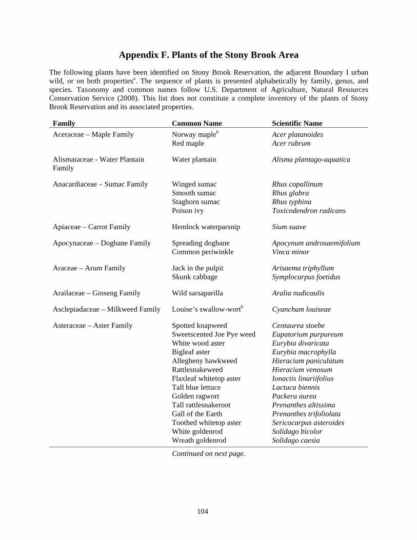
104
Appendix F. Plants of the Stony Brook Area
The following plants have been identified on Stony Brook Reservation, the adjacent Boundary I urban wild, or on both propertiesa. The sequence of plants is presented alphabetically by family, genus, and species. Taxonomy and common names follow U.S. Department of Agriculture, Natural Resources Conservation Service (2008). This list does not constitute a complete inventory of the plants of Stony Brook Reservation and its associated properties.
Family Common Name Scientific Name Aceraceae – Maple Family Norway mapleb Acer platanoides Red maple Acer rubrum Alismataceae - Water Plantain Family
Water plantain Alisma plantago-aquatica
Anacardiaceae – Sumac Family Winged sumac Rhus copallinum Smooth sumac Rhus glabra Staghorn sumac Rhus typhina Poison ivy Toxicodendron radicans Apiaceae – Carrot Family Hemlock waterparsnip Sium suave Apocynaceae – Dogbane Family Spreading dogbane Apocynum androsaemifolium Common periwinkle Vinca minor Araceae – Arum Family Jack in the pulpit Arisaema triphyllum Skunk cabbage Symplocarpus foetidus Arailaceae – Ginseng Family Wild sarsaparilla Aralia nudicaulis Asclepiadaceae – Milkweed Family Louise’s swallow-wortb Cyanchum louiseae Asteraceae – Aster Family Spotted knapweed Centaurea stoebe Sweetscented Joe Pye weed Eupatorium purpureum White wood aster Eurybia divaricata Bigleaf aster Eurybia macrophylla Allegheny hawkweed Hieracium paniculatum Rattlesnakeweed Hieracium venosum Flaxleaf whitetop aster Ionactis linariifolius Tall blue lettuce Lactuca biennis Golden ragwort Packera aurea Tall rattlesnakeroot Prenanthes altissima Gall of the Earth Prenanthes trifoliolata Toothed whitetop aster Sericocarpus asteroides White goldenrod Solidago bicolor Wreath goldenrod Solidago caesia
Continued on next page.
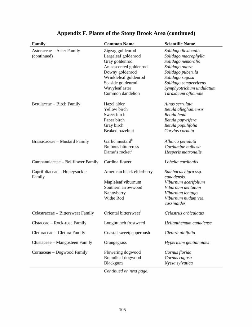
105
Appendix F. Plants of the Stony Brook Area (continued)
Family Common Name Scientific Name Asteraceae – Aster Family Zigzag goldenrod Solidago flexicaulis (continued) Largeleaf goldenrod Solidago macrophylla Gray goldenrod Solidago nemoralis Anisescented goldenrod Solidago odora Downy goldenrod Solidago puberula Wrinkleleaf goldenrod Solidago rugosa Seaside goldenrod Solidago sempervirens Wavyleaf aster Symphyotrichum undulatum Common dandelion Taraxacum officinale Betulaceae – Birch Family Hazel alder Alnus serrulata Yellow birch Betula alleghaniensis Sweet birch Betula lenta Paper birch Betula papyrifera Gray birch Betula populifolia Beaked hazelnut Corylus cornuta Brassicaceae – Mustard Family Garlic mustardb Alliaria petiolata Bulbous bittercress Cardamine bulbosa Dame’s rocketb Hesperis matronalis Campanulaceae – Bellflower Family Cardinalflower Lobelia cardinalis Caprifoliaceae – Honeysuckle Family
American black elderberry Sambucus nigra ssp. canadensis
Mapleleaf viburnum Viburnum acerifolium Southern arrowwood Viburnum dentatum Nannyberry Viburnum lentago Withe Rod Viburnum nudum var.
cassinoides Celastraceae – Bittersweet Family Oriental bittersweetb Celastrus orbiculatus Cistaceae – Rock-rose Family Longbranch frostweed Helianthemum canadense Clethraceae – Clethra Family Coastal sweetpepperbush Clethra alnifolia Clusiaceae – Mangosteen Family Orangegrass Hypericum gentianoides Cornaceae – Dogwood Family Flowering dogwood Cornus florida Roundleaf dogwood Cornus rugosa Blackgum Nyssa sylvatica
Continued on next page.
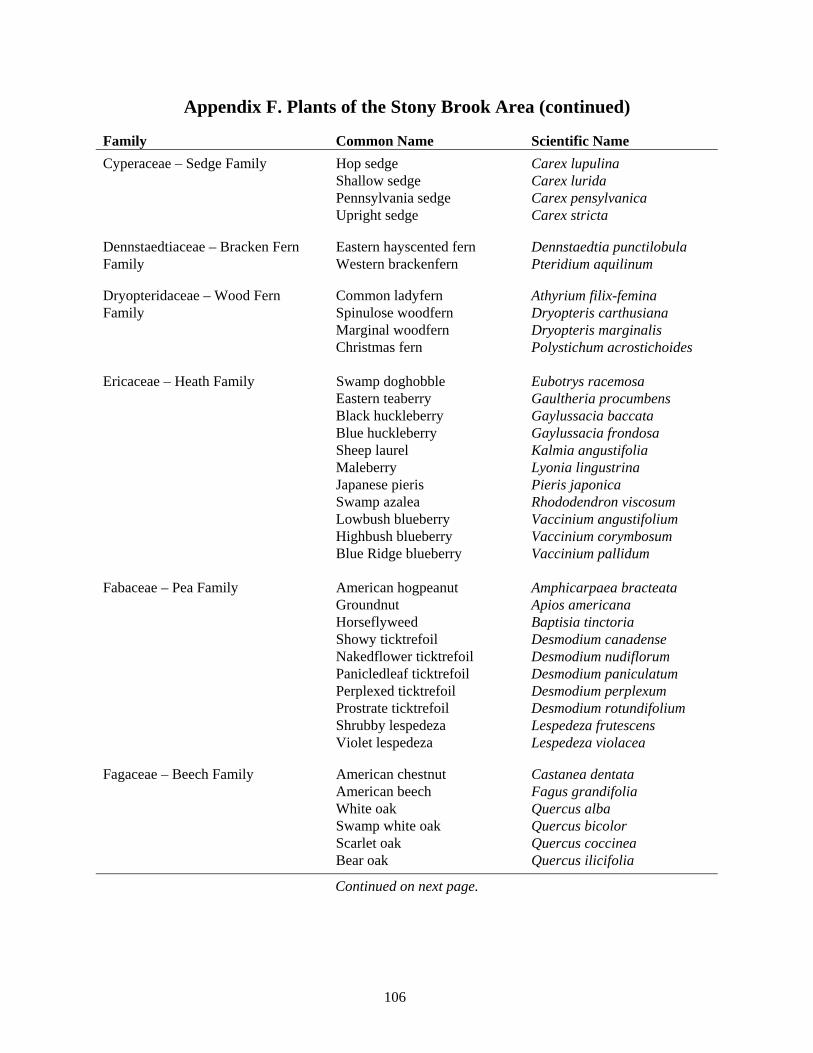
106
Appendix F. Plants of the Stony Brook Area (continued)
Family Common Name Scientific Name Cyperaceae – Sedge Family Hop sedge Carex lupulina Shallow sedge Carex lurida Pennsylvania sedge Carex pensylvanica Upright sedge Carex stricta Dennstaedtiaceae – Bracken Fern Eastern hayscented fern Dennstaedtia punctilobula Family Western brackenfern Pteridium aquilinum Dryopteridaceae – Wood Fern Common ladyfern Athyrium filix-femina Family Spinulose woodfern Dryopteris carthusiana Marginal woodfern Dryopteris marginalis Christmas fern Polystichum acrostichoides Ericaceae – Heath Family Swamp doghobble Eubotrys racemosa Eastern teaberry Gaultheria procumbens Black huckleberry Gaylussacia baccata Blue huckleberry Gaylussacia frondosa Sheep laurel Kalmia angustifolia Maleberry Lyonia lingustrina Japanese pieris Pieris japonica Swamp azalea Rhododendron viscosum Lowbush blueberry Vaccinium angustifolium Highbush blueberry Vaccinium corymbosum Blue Ridge blueberry Vaccinium pallidum Fabaceae – Pea Family American hogpeanut Amphicarpaea bracteata Groundnut Apios americana Horseflyweed Baptisia tinctoria Showy ticktrefoil Desmodium canadense Nakedflower ticktrefoil Desmodium nudiflorum Panicledleaf ticktrefoil Desmodium paniculatum Perplexed ticktrefoil Desmodium perplexum Prostrate ticktrefoil Desmodium rotundifolium Shrubby lespedeza Lespedeza frutescens Violet lespedeza Lespedeza violacea Fagaceae – Beech Family American chestnut Castanea dentata American beech Fagus grandifolia White oak Quercus alba Swamp white oak Quercus bicolor Scarlet oak Quercus coccinea Bear oak Quercus ilicifolia
Continued on next page.
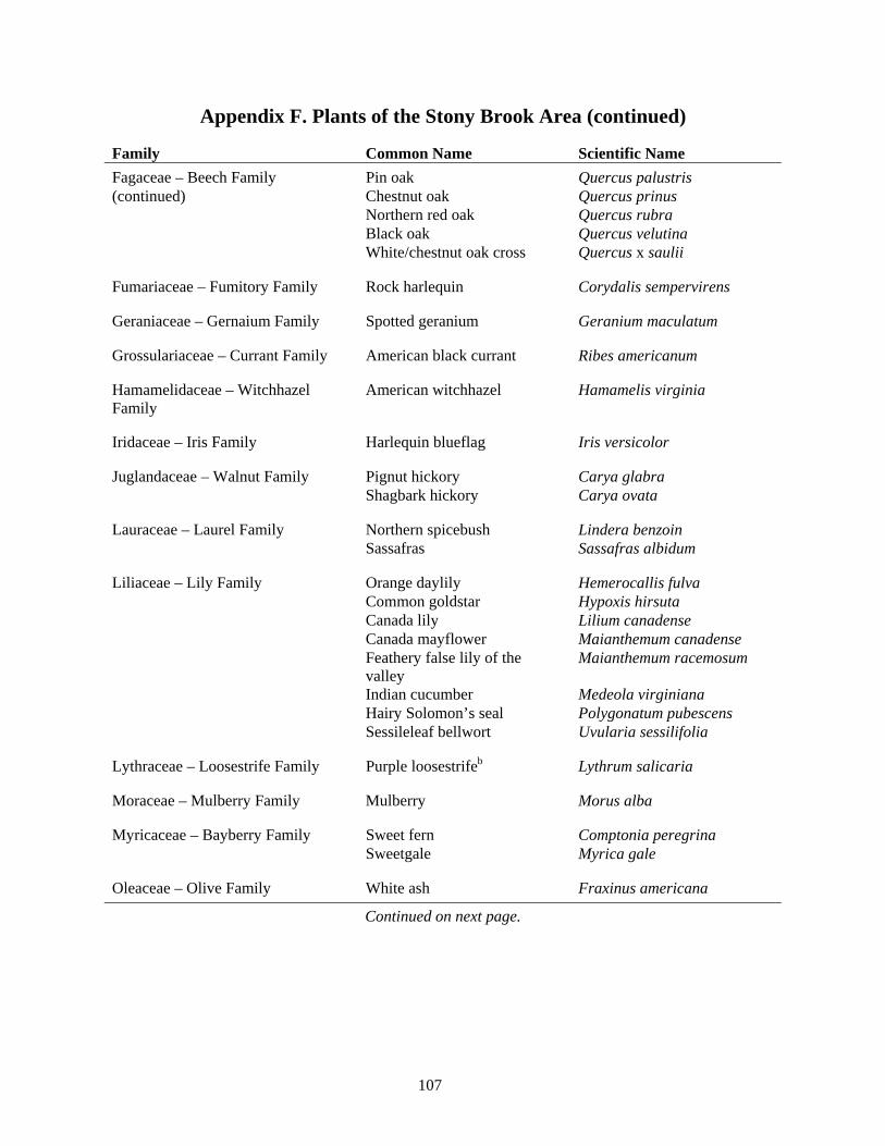
107
Appendix F. Plants of the Stony Brook Area (continued)
Family Common Name Scientific Name Fagaceae – Beech Family Pin oak Quercus palustris (continued) Chestnut oak Quercus prinus Northern red oak Quercus rubra Black oak Quercus velutina White/chestnut oak cross Quercus x saulii Fumariaceae – Fumitory Family Rock harlequin Corydalis sempervirens Geraniaceae – Gernaium Family Spotted geranium Geranium maculatum Grossulariaceae – Currant Family American black currant Ribes americanum Hamamelidaceae – Witchhazel Family
American witchhazel Hamamelis virginia
Iridaceae – Iris Family Harlequin blueflag Iris versicolor Juglandaceae – Walnut Family Pignut hickory Carya glabra Shagbark hickory Carya ovata Lauraceae – Laurel Family Northern spicebush Lindera benzoin Sassafras Sassafras albidum Liliaceae – Lily Family Orange daylily Hemerocallis fulva Common goldstar Hypoxis hirsuta Canada lily Lilium canadense Canada mayflower Maianthemum canadense Feathery false lily of the
valley Maianthemum racemosum
Indian cucumber Medeola virginiana Hairy Solomon’s seal Polygonatum pubescens Sessileleaf bellwort Uvularia sessilifolia Lythraceae – Loosestrife Family Purple loosestrifeb Lythrum salicaria Moraceae – Mulberry Family Mulberry Morus alba Myricaceae – Bayberry Family Sweet fern Comptonia peregrina Sweetgale Myrica gale Oleaceae – Olive Family White ash Fraxinus americana
Continued on next page.
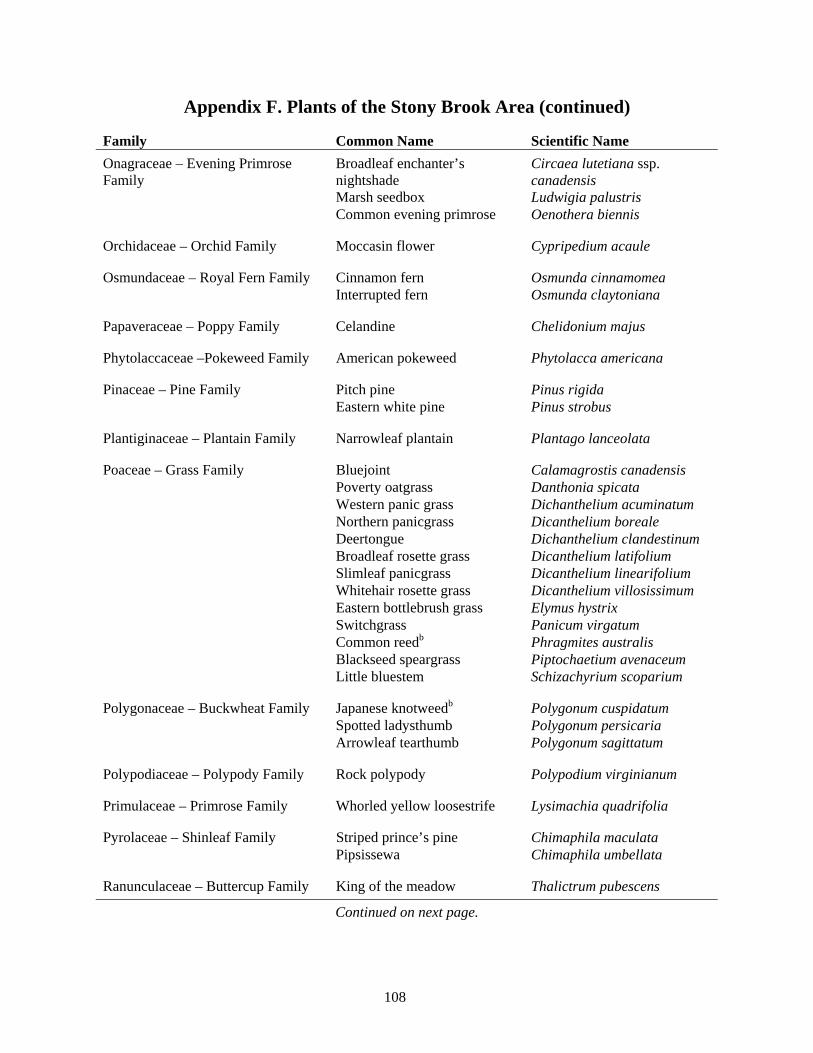
108
Appendix F. Plants of the Stony Brook Area (continued)
Family Common Name Scientific Name Onagraceae – Evening Primrose Family
Broadleaf enchanter’s nightshade
Circaea lutetiana ssp. canadensis
Marsh seedbox Ludwigia palustris Common evening primrose Oenothera biennis Orchidaceae – Orchid Family Moccasin flower Cypripedium acaule Osmundaceae – Royal Fern Family Cinnamon fern Osmunda cinnamomea Interrupted fern Osmunda claytoniana Papaveraceae – Poppy Family Celandine Chelidonium majus Phytolaccaceae –Pokeweed Family American pokeweed Phytolacca americana Pinaceae – Pine Family Pitch pine Pinus rigida Eastern white pine Pinus strobus Plantiginaceae – Plantain Family Narrowleaf plantain Plantago lanceolata Poaceae – Grass Family Bluejoint Calamagrostis canadensis Poverty oatgrass Danthonia spicata Western panic grass Dichanthelium acuminatum Northern panicgrass Dicanthelium boreale Deertongue Dichanthelium clandestinum Broadleaf rosette grass Dicanthelium latifolium Slimleaf panicgrass Dicanthelium linearifolium Whitehair rosette grass Dicanthelium villosissimum Eastern bottlebrush grass Elymus hystrix Switchgrass Panicum virgatum Common reedb Phragmites australis Blackseed speargrass Piptochaetium avenaceum Little bluestem Schizachyrium scoparium Polygonaceae – Buckwheat Family Japanese knotweedb Polygonum cuspidatum Spotted ladysthumb Polygonum persicaria Arrowleaf tearthumb Polygonum sagittatum Polypodiaceae – Polypody Family Rock polypody Polypodium virginianum Primulaceae – Primrose Family Whorled yellow loosestrife Lysimachia quadrifolia Pyrolaceae – Shinleaf Family Striped prince’s pine Chimaphila maculata Pipsissewa Chimaphila umbellata Ranunculaceae – Buttercup Family King of the meadow Thalictrum pubescens
Continued on next page.
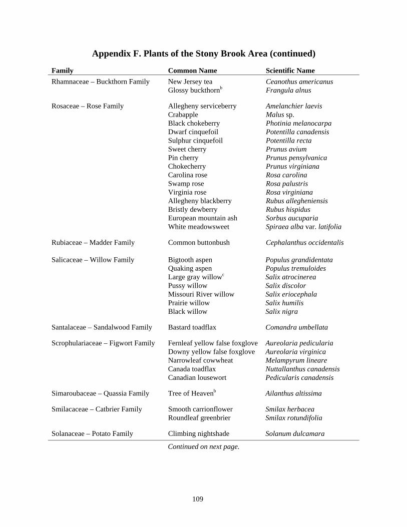
109
Appendix F. Plants of the Stony Brook Area (continued)
Family Common Name Scientific Name Rhamnaceae – Buckthorn Family New Jersey tea Ceanothus americanus Glossy buckthornb Frangula alnus Rosaceae – Rose Family Allegheny serviceberry Amelanchier laevis Crabapple Malus sp. Black chokeberry Photinia melanocarpa Dwarf cinquefoil Potentilla canadensis Sulphur cinquefoil Potentilla recta Sweet cherry Prunus avium Pin cherry Prunus pensylvanica Chokecherry Prunus virginiana Carolina rose Rosa carolina Swamp rose Rosa palustris Virginia rose Rosa virginiana Allegheny blackberry Rubus allegheniensis Bristly dewberry Rubus hispidus European mountain ash Sorbus aucuparia White meadowsweet Spiraea alba var. latifolia Rubiaceae – Madder Family Common buttonbush Cephalanthus occidentalis Salicaceae – Willow Family Bigtooth aspen Populus grandidentata Quaking aspen Populus tremuloides Large gray willowc Salix atrocinerea Pussy willow Salix discolor Missouri River willow Salix eriocephala Prairie willow Salix humilis Black willow Salix nigra Santalaceae – Sandalwood Family Bastard toadflax Comandra umbellata Scrophulariaceae – Figwort Family Fernleaf yellow false foxglove Aureolaria pedicularia Downy yellow false foxglove Aureolaria virginica Narrowleaf cowwheat Melampyrum lineare Canada toadflax Nuttallanthus canadensis Canadian lousewort Pedicularis canadensis Simaroubaceae – Quassia Family Tree of Heavenb Ailanthus altissima Smilacaceae – Catbrier Family Smooth carrionflower Smilax herbacea Roundleaf greenbrier Smilax rotundifolia Solanaceae – Potato Family Climbing nightshade Solanum dulcamara
Continued on next page.
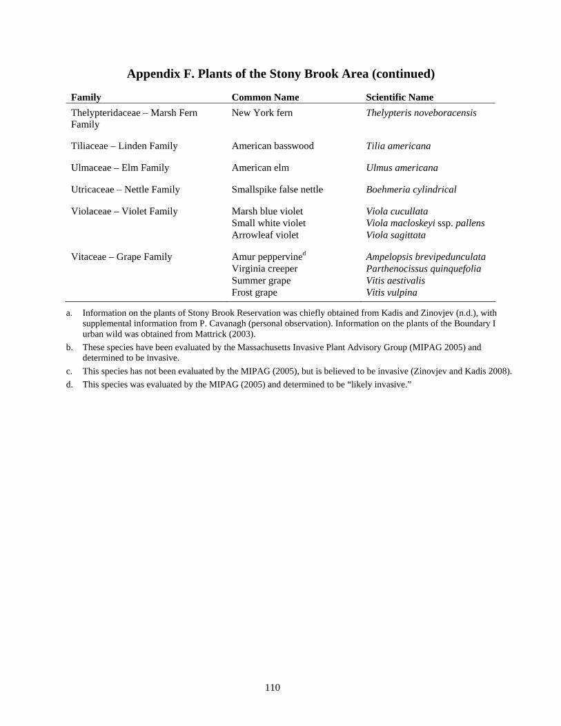
110
Appendix F. Plants of the Stony Brook Area (continued)
Family Common Name Scientific Name Thelypteridaceae – Marsh Fern Family
New York fern Thelypteris noveboracensis
Tiliaceae – Linden Family American basswood Tilia americana Ulmaceae – Elm Family American elm Ulmus americana Utricaceae – Nettle Family Smallspike false nettle Boehmeria cylindrical Violaceae – Violet Family Marsh blue violet Viola cucullata Small white violet Viola macloskeyi ssp. pallens Arrowleaf violet Viola sagittata Vitaceae – Grape Family Amur peppervined Ampelopsis brevipedunculata Virginia creeper Parthenocissus quinquefolia Summer grape Vitis aestivalis Frost grape Vitis vulpina
a. Information on the plants of Stony Brook Reservation was chiefly obtained from Kadis and Zinovjev (n.d.), with supplemental information from P. Cavanagh (personal observation). Information on the plants of the Boundary I urban wild was obtained from Mattrick (2003).
b. These species have been evaluated by the Massachusetts Invasive Plant Advisory Group (MIPAG 2005) and determined to be invasive.
c. This species has not been evaluated by the MIPAG (2005), but is believed to be invasive (Zinovjev and Kadis 2008). d. This species was evaluated by the MIPAG (2005) and determined to be “likely invasive.”
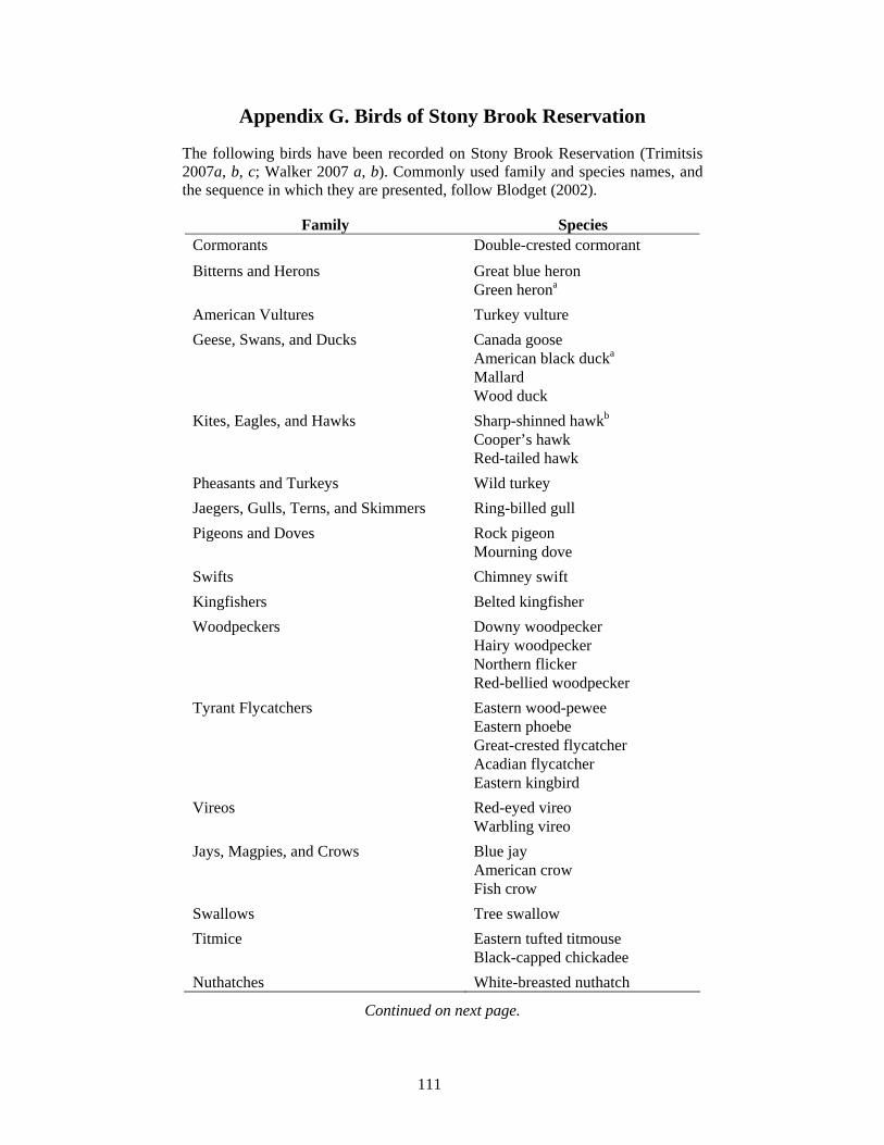
111
Appendix G. Birds of Stony Brook Reservation
The following birds have been recorded on Stony Brook Reservation (Trimitsis 2007a, b, c; Walker 2007 a, b). Commonly used family and species names, and the sequence in which they are presented, follow Blodget (2002).
Family Species
Cormorants Double-crested cormorant Bitterns and Herons Great blue heron Green herona American Vultures Turkey vulture Geese, Swans, and Ducks Canada goose American black ducka Mallard Wood duck Kites, Eagles, and Hawks Sharp-shinned hawkb Cooper’s hawk Red-tailed hawk Pheasants and Turkeys Wild turkey Jaegers, Gulls, Terns, and Skimmers Ring-billed gull Pigeons and Doves Rock pigeon Mourning dove Swifts Chimney swift Kingfishers Belted kingfisher Woodpeckers Downy woodpecker Hairy woodpecker Northern flicker Red-bellied woodpecker Tyrant Flycatchers Eastern wood-pewee Eastern phoebe Great-crested flycatcher Acadian flycatcher Eastern kingbird Vireos Red-eyed vireo Warbling vireo Jays, Magpies, and Crows Blue jay American crow Fish crow Swallows Tree swallow Titmice Eastern tufted titmouse Black-capped chickadee Nuthatches White-breasted nuthatch
Continued on next page.
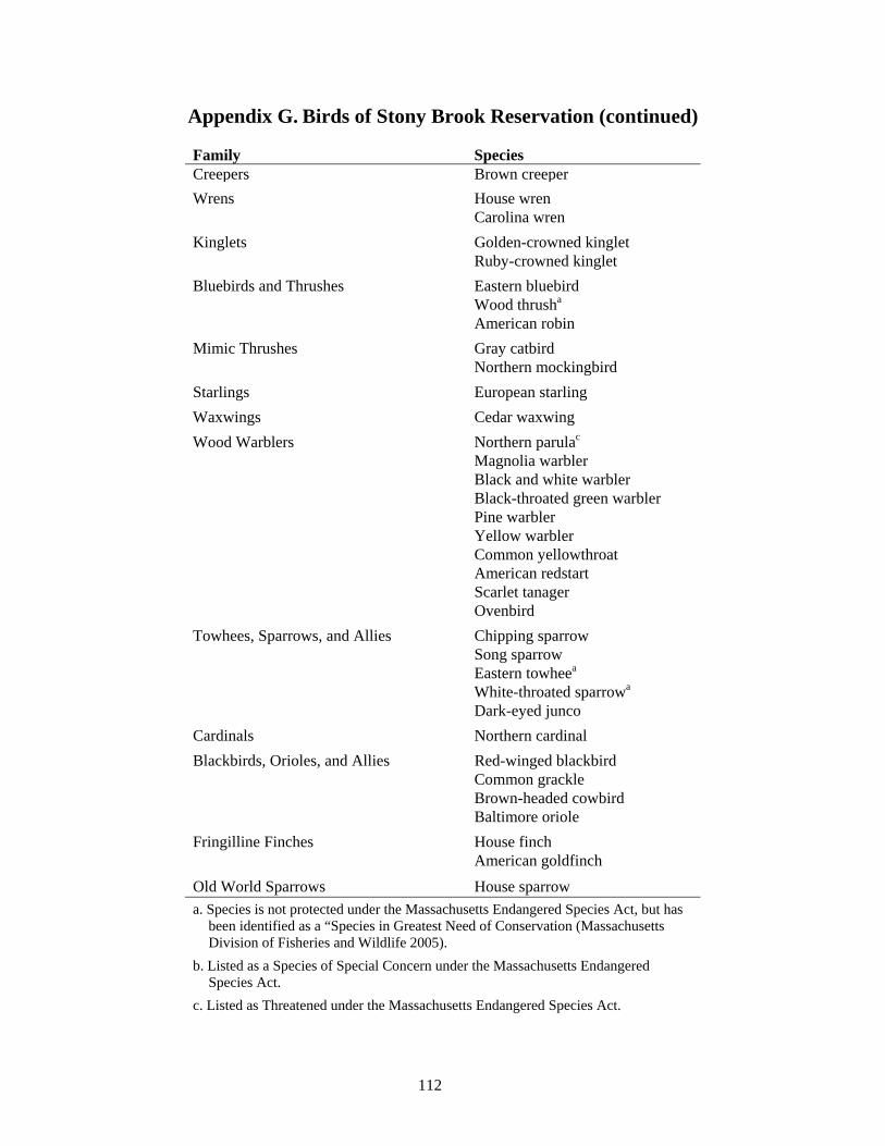
112
Appendix G. Birds of Stony Brook Reservation (continued)
Family Species Creepers Brown creeperWrens House wren Carolina wren Kinglets Golden-crowned kinglet Ruby-crowned kinglet Bluebirds and Thrushes Eastern bluebird Wood thrusha American robin Mimic Thrushes Gray catbird Northern mockingbird Starlings European starling Waxwings Cedar waxwing Wood Warblers Northern parulac Magnolia warbler Black and white warbler Black-throated green warbler Pine warbler Yellow warbler Common yellowthroat American redstart Scarlet tanager Ovenbird Towhees, Sparrows, and Allies Chipping sparrow Song sparrow Eastern towheea White-throated sparrowa Dark-eyed junco Cardinals Northern cardinal Blackbirds, Orioles, and Allies Red-winged blackbird Common grackle Brown-headed cowbird Baltimore oriole Fringilline Finches House finch American goldfinch Old World Sparrows House sparrow a. Species is not protected under the Massachusetts Endangered Species Act, but has
been identified as a “Species in Greatest Need of Conservation (Massachusetts Division of Fisheries and Wildlife 2005).
b. Listed as a Species of Special Concern under the Massachusetts Endangered Species Act.
c. Listed as Threatened under the Massachusetts Endangered Species Act.
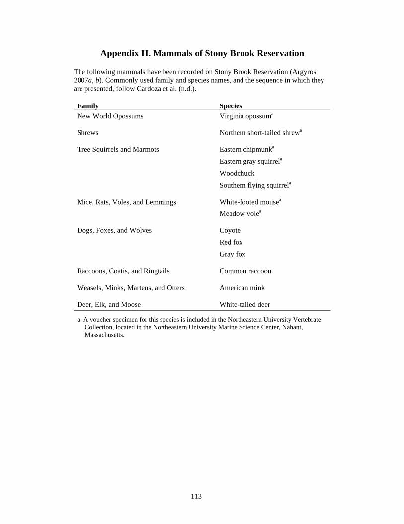
113
Appendix H. Mammals of Stony Brook Reservation
The following mammals have been recorded on Stony Brook Reservation (Argyros 2007a, b). Commonly used family and species names, and the sequence in which they are presented, follow Cardoza et al. (n.d.).
Family Species New World Opossums Virginia opossuma
Shrews Northern short-tailed shrewa
Tree Squirrels and Marmots Eastern chipmunka Eastern gray squirrela Woodchuck Southern flying squirrela
Mice, Rats, Voles, and Lemmings White-footed mousea Meadow volea
Dogs, Foxes, and Wolves Coyote Red fox Gray fox
Raccoons, Coatis, and Ringtails Common raccoon
Weasels, Minks, Martens, and Otters American mink
Deer, Elk, and Moose White-tailed deer
a. A voucher specimen for this species is included in the Northeastern University Vertebrate Collection, located in the Northeastern University Marine Science Center, Nahant, Massachusetts.
Recommended citation for this document: Department of Conservation and Recreation. 2008. Resource Management Plan. DCR’s Stony Brook Reservation: Including Camp Meigs Playground; Colella Field and Playground; DeSantis Park; Mother Brook Reservation; Weider Playground; and the Dedham, Enneking, and Turtle Pond Parkways. Final Draft – August 2008. Massachusetts Department of Conservation and Recreation, Bureau of Planning and Resource Protection, Resource Management Planning Program. Boston, MA.


