Embed Size (px)
Citation preview
Winter 2022Winter 2022WSBLE Station Planning Progress ReportWSBLE Station Planning Progress Report 138138
The Denny station area includes Denny Triangle and portions of the South Lake Union and Cascade neighborhoods. In the past twenty years, the area has transformed from low-intensity commercial and light-industrial uses to mixed-use urban development with several high-rise rentals and condos. In addition to Amazon’s headquarters, other major employers in or near the station area include Seattle Children’s, PATH, Cornish College of the Arts, and Whole Foods Market. Historic Denny Park and the more recent Urban Triangle Park provide neighborhood open space.
This fast-growing area is easily accessed from surrounding neighborhoods—including Belltown, Capitol Hill and Downtown—by foot, bus, and streetcar.
Based on feedback received at the Fall 2019 Neighborhood Forum, community members value the neighborhood’s walkability, sense of place, denser development, and emergence as a tech and life sciences hub.
N
Bill & Melinda Gates Foundation
Denny Park
TheSpheres
Denny Way
Thomas St
Dexter Ave N
5th Ave
Blan
char
d St
John St
Harrison St
Fairview Ave N
9th Ave
Terry Ave8th Ave
Westlake Ave N
Republican St
3
2
5
6
11
Whatwe heard
so far NEIGHBORHOOD FEEDBACK
Denny Way is currently a busy street with narrow sidewalks but it could be improved to provide a more comfortable experience for people walking and biking
Buses along Denny Way are often delayed due to traffic and people choose to walk instead of waiting for a bus
Prefer cycling on 8th Ave N and 9th Ave N (protected bike lanes)
Enhance bike network for safe and convenient access to and from station
Encourage safe and convenient transfers between bus, streetcar and light rail
Where possible, establish bike pathways that do not intersect with the Seattle Streetcar tracks
Promote uses and activities near the station that are outside of typical business hours
1
2
3
4
5
6
7
7
4
5
7
Neighborhood feedback gathered from in-person and on-line events during alternatives development 2018-2019.
Denny Way
Westlake Ave N
John St
7th Ave
6th AveBell
St
Boren Ave
Leno
ra S
t Virg
ina
St
Stew
art S
t
Terry Ave N
Boren Ave N
Minor Ave N
Cascade Playground 5
8th Ave N
9th Ave N
4 Urban Triangle
Park
Potential station location
To Ta
com
a
To E
verett
WSJSegment
DELSegment
DUWSegment
SODOSegment
CIDSegment
DTSegment
SIBSegment
IBBSegment
Alaska
Junction
Avalon
Delridge
SODOSODO
(Existing)
Stadium
(Existing)
Midtown
Westlake
Denny
Seattle
Center
Smith
Cove
Interbay
Ballard
Int’l
District/
Chinatown
West Seattle Link Extension
Ballard Link Extension
South
Lake Union
Station area context
DennyStation
BallardLink Extension
Winter 2022Winter 2022WSBLE Station Planning Progress ReportWSBLE Station Planning Progress Report 139139
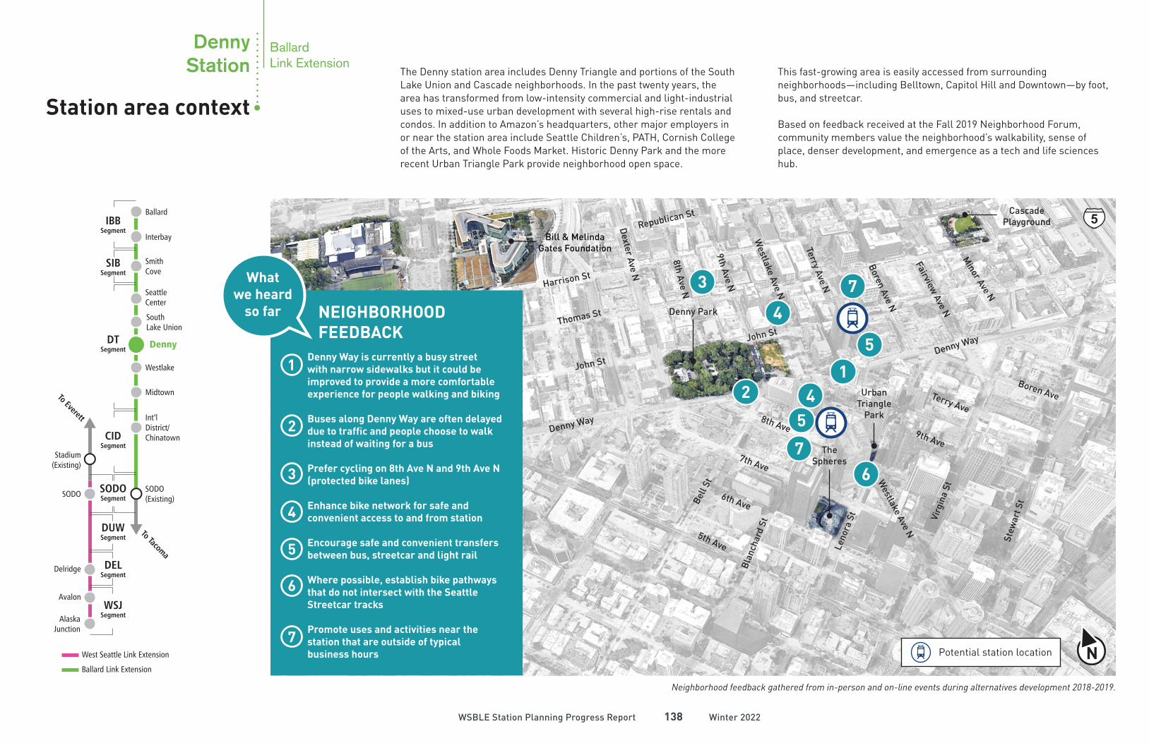
Footnotes:1. Data based on combined 10-minute walkshed unless noted
otherwise. Source: City of Seattle and Sound Transit.
2. Based on preferred alternative. Results for other alternatives
are similar.
3. Bike facilities include multi-use trails, bike lanes, and
neighborhood greenways within combined 10-minute bikeshed.
4. Based on PSRC future year forecasts and allocated to
combined 10-minute walkshed.
15,300
(2)Ridership/daily boardings
(1)Existing land use in the station area
Bus
Walk
Bike
Auto
12%
82%
5%
1%
(2)How people will travel to the station
Combined
10-minute walkshed
Planning and design priorities can help frame how a station and station area will look and function
• Increase pedestrian connectivity across Denny Way
• Leverage station entrances to navigate east-west grade change
• Provide multiple station entrances; include a mix of main entrances and secondary entrance locations
• Provide setbacks at entrances and wide sidewalks along station frontages to provide ample space for pedestrian movement and orientation to surroundings
• Design station and station environment in partnership with local communities, including indigenous communities, to include local culture in the public realm
• Design station structures with active frontages that maximize access from key paths and directions of travel
• Integrate station entrances into new equitable transit oriented development project if feasible
5
Denny Way
SR99
/Aur
ora
Ave
N
Harrison St
Broad St
Mercer St
Republican St
Seattle Center
Bill & Melinda Gates
Foundation
Space Needle
Thomas St
Dex
ter
Ave
N
Cascade Playground
John St
Elliott Ave
Denny Park
6th
Ave
N
7th
Ave
N
5th
Ave
N
Wes
tlak
e Av
e N
Terr
y Av
e N
Fair
view
Ave
N
8th
Ave
N
Bell St
Battery
St
Vine St
6th Ave
5th Ave
Westlake Ave
Western Ave4th Ave3rd Ave2nd Ave
1st Ave
7th Ave
8th Ave9th Ave
Terry Ave
Boren Ave
Minor Ave
E Denny Way
Yale
Ave
N
Stewar
t St
Virgin
ia St
Lenor
a St
Blanch
ard S
t
Olive Way
Pine St
Pike St
Pike Place Market
Existing Land Use
Multifamily Single Family Park
Commericial/Mixed Use Downtown Manufacturing/Industrial
Major Institutions
Park2%
Commercial/Mixed-Use
39%
Downtown59%
(Dense commercial and residential uses generally allowed)
38,40021,100
114,300
Population
Households
Employment
(1,4)Living and working in the station area 2040
(3)Bike facilities within 10-minute bikeshed
miles of existing35
miles of planned34
NPotential station location
Planning and
design prioritiesStation area context
DennyStation
Capitol Hill
BallardLink Extension
1
2
DennyStation
Draft EIS station alternatives
BallardLink Extension
Winter 2022Winter 2022WSBLE Station Planning Progress ReportWSBLE Station Planning Progress Report 140140
Stewar
t St
Denny Way
Dex
ter
Ave
N Mercer St
Republican St
Harrison St
Thomas St
John St
7th
Ave
NBel
l St
Blanch
ard S
tLen
ora S
t
Wes
tlak
e Av
e N Te
rry
Ave
N
Bor
en A
ve N
Fair
view
Ave
N
Virgin
ia St
8th Ave
Westlake Ave
7th Ave
Terry Ave9th Ave
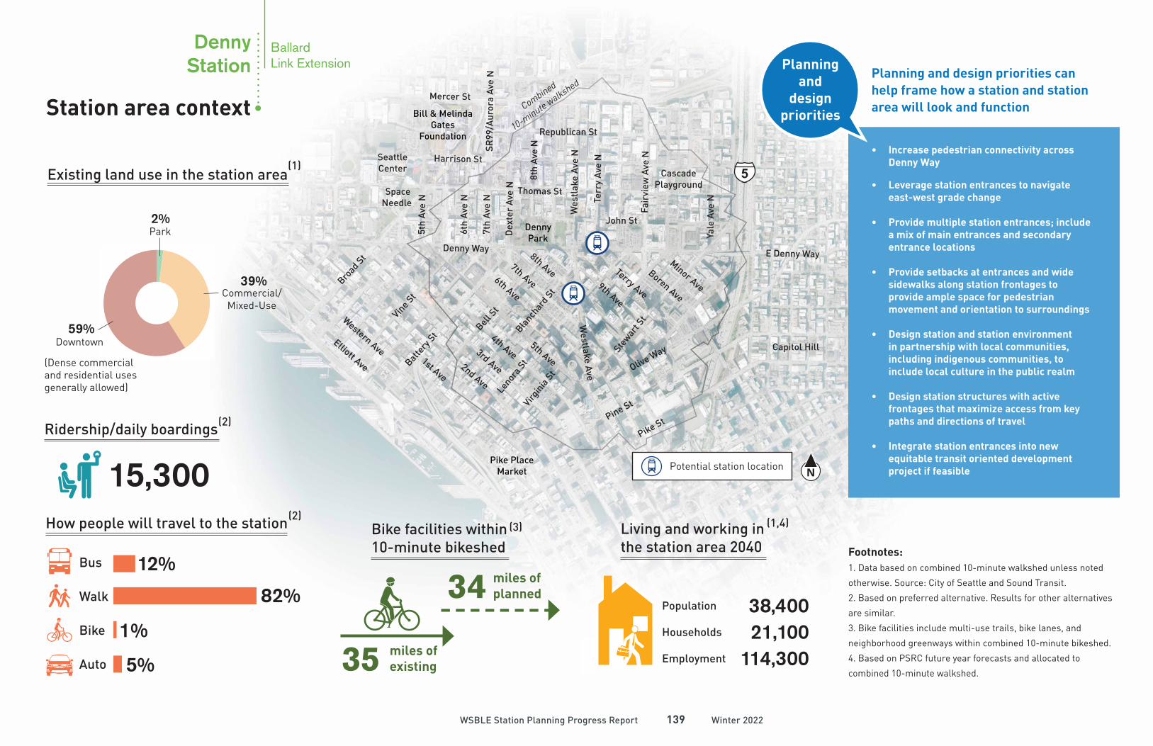
The Draft Environmental Impact Statement (EIS) contains two alternatives for the Denny Station.
Tunnel Westlake Avenue Station (DT-1)Tunnel station under Westlake Ave between Denny Way and 8th Ave
Preferred Alternative1 See P.141
Tunnel Terry Avenue North Station (DT-2)Tunnel station under Terry Ave N between Denny Way and John St
Other Alternative2 See P.147
Draft EIS alternatives
Preferred alternative
Other alternative
Route and station profilesTunnel
N
John St
9th
Ave N
Denny Park
Westl
ake A
ve N
Terr
y A
ve N
Bo
ren
Ave N
Terry Ave
Denny Way
Bell S
t
Bla
nch
ard
St
9th Ave
8th Ave
7th Ave
6th Ave
Lenora
St
Virgin
ia S
t
Urban
Triangle
Park
BallardLink Extension
Winter 2022Winter 2022WSBLE Station Planning Progress ReportWSBLE Station Planning Progress Report 141141
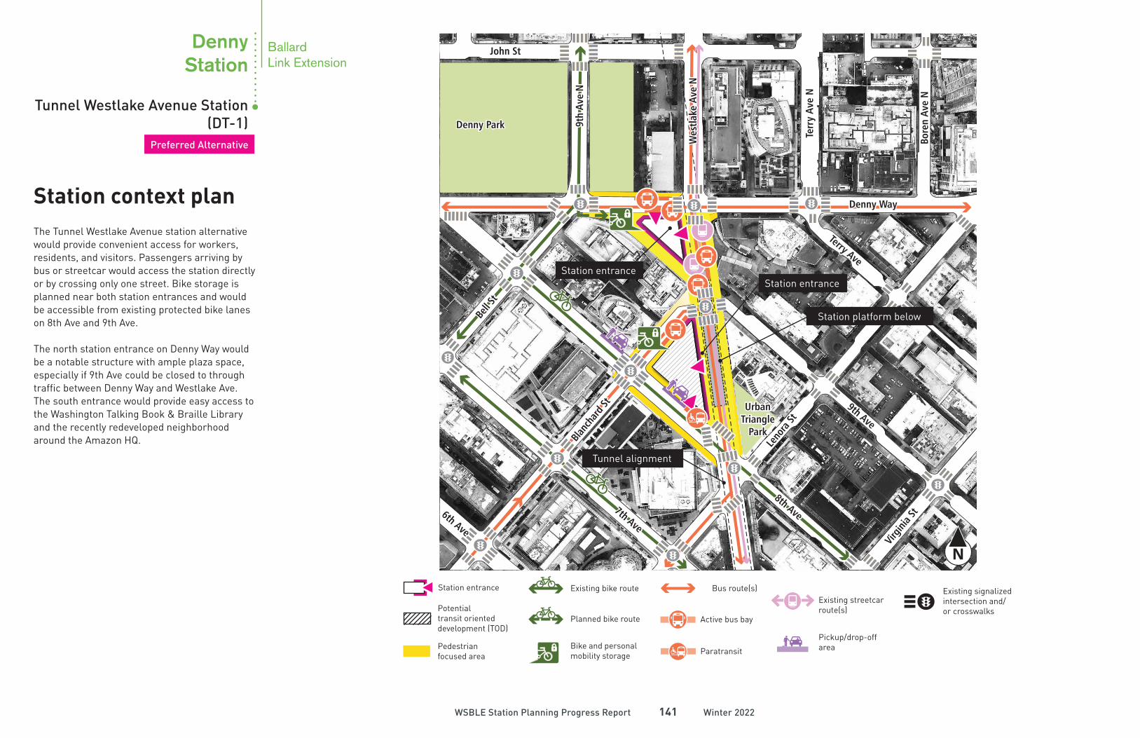
The Tunnel Westlake Avenue station alternative would provide convenient access for workers, residents, and visitors. Passengers arriving by bus or streetcar would access the station directly or by crossing only one street. Bike storage is planned near both station entrances and would be accessible from existing protected bike lanes on 8th Ave and 9th Ave.
The north station entrance on Denny Way would be a notable structure with ample plaza space, especially if 9th Ave could be closed to through traffic between Denny Way and Westlake Ave. The south entrance would provide easy access to the Washington Talking Book & Braille Library and the recently redeveloped neighborhood around the Amazon HQ.
N
Station context plan
Existing bike route
Planned bike route
Bike and personal mobility storage
Station entrance
Potential transit oriented development (TOD)
Bus route(s)
Active bus bay
ParatransitPedestrianfocused area
Existing streetcar route(s)
Existing signalized intersection and/or crosswalks
Pickup/drop-off area
Station platform below
Tunnel alignment
Station entranceStation entrance
Preferred Alternative
Tunnel Westlake Avenue Station (DT-1)
DennyStation
Tunnel Westlake Avenue Station (DT-1)
DennyStation
John St
9th
Ave N
Denny Park
Westl
ake A
ve N
Terr
y A
ve N
Bo
ren
Ave N
Terry Ave
Denny Way
Bell S
t
Bla
nch
ard
St
9th Ave
8th Ave
7th Ave
6th Ave
Lenora
St
Virgin
ia S
t
Urban
Triangle
Park
BallardLink Extension
Winter 2022Winter 2022WSBLE Station Planning Progress ReportWSBLE Station Planning Progress Report 142142
Looking inside the station
N
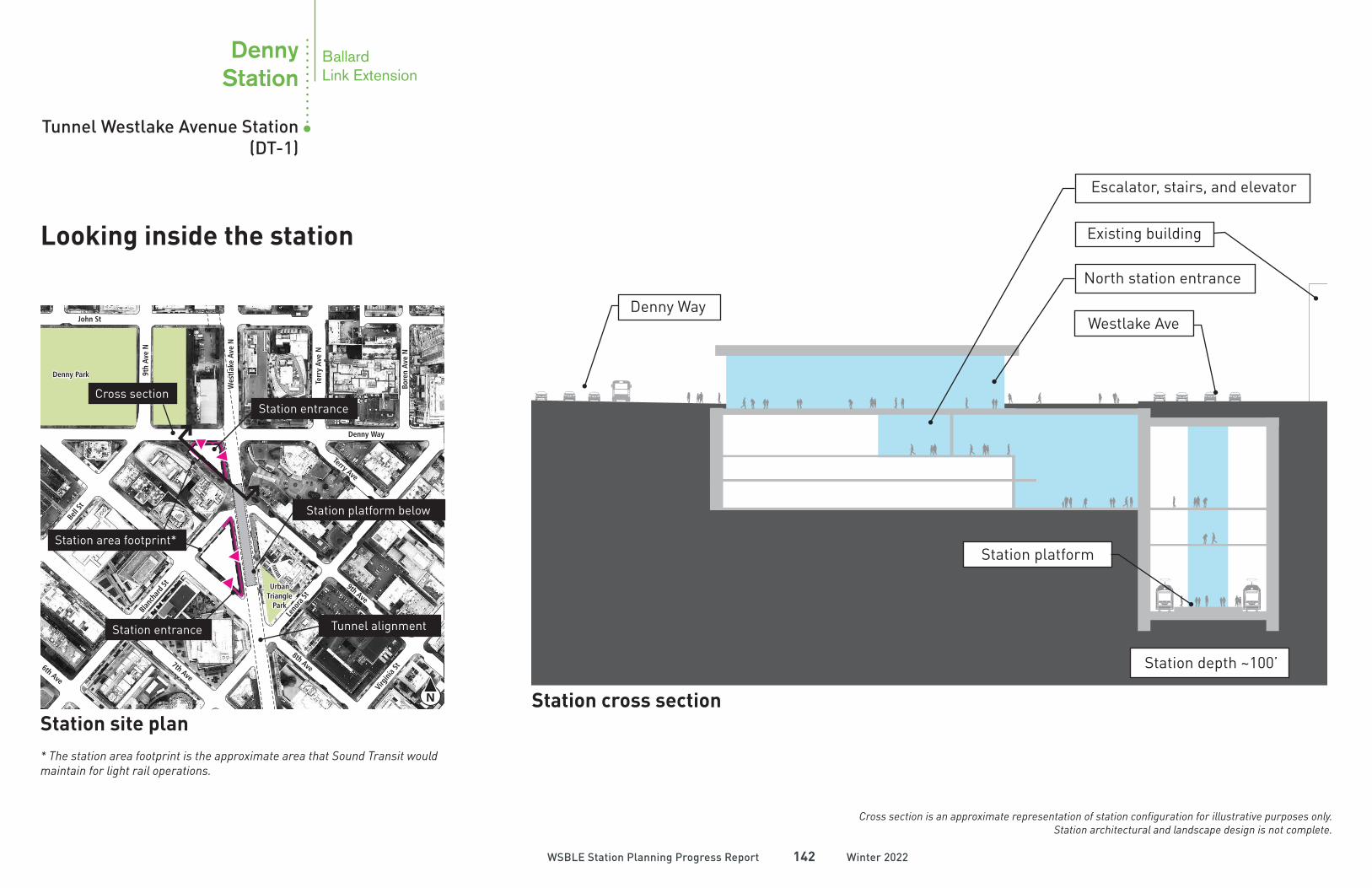
Station site plan* The station area footprint is the approximate area that Sound Transit would maintain for light rail operations.
Cross sectionStation entrance
Station area footprint*
Tunnel alignment
Station platform below
Station entrance
Cross section is an approximate representation of station configuration for illustrative purposes only. Station architectural and landscape design is not complete.
Station cross section
Station platform
Station depth ~100’
Escalator, stairs, and elevator
North station entrance
Westlake Ave
Existing building
Denny Way
John St
9th
Ave N
Denny Park
Westl
ake A
ve N
Terr
y A
ve N
Bo
ren
Ave N
Terry Ave
Denny Way
Bell S
t
Bla
nch
ard
St
9th Ave
8th Ave
7th Ave
6th Ave
Lenora
St
Virgin
ia S
t
Urban
Triangle
Park
BallardLink Extension
(1) (10)
Winter 2022Winter 2022WSBLE Station Planning Progress ReportWSBLE Station Planning Progress Report 143143
N
N
9th Ave
Harrison St
Thomas St
Republican St
Denny Way
Westlake Ave N
Bell
St
Denny Park
Bill & Melinda Gates Foundation
The Spheres
John St
Stew
art S
t
7th Ave
Dexter Ave N
8th Ave N
9th Ave N
2
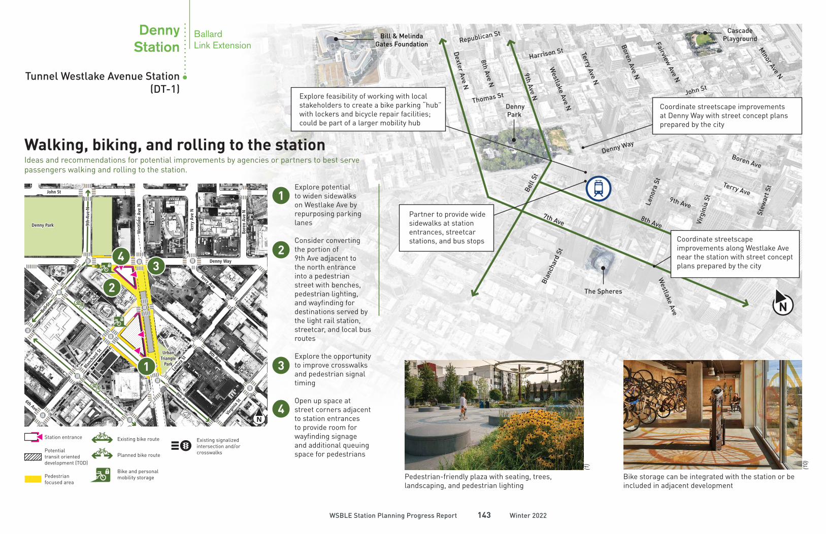
Explore potential to widen sidewalks on Westlake Ave by repurposing parking lanes
Consider converting the portion of 9th Ave adjacent to the north entrance into a pedestrian street with benches, pedestrian lighting, and wayfinding for destinations served by the light rail station, streetcar, and local bus routes
Explore the opportunity to improve crosswalks and pedestrian signal timing
Open up space at street corners adjacent to station entrances to provide room for wayfinding signage and additional queuing space for pedestrians
1
31
2
3
Walking, biking, and rolling to the stationIdeas and recommendations for potential improvements by agencies or partners to best serve passengers walking and rolling to the station.
4
4
Terry Ave N
Boren Ave N
Fairview Ave N
Minor Ave N
Boren Ave
Terry Ave
8th Ave
Leno
ra S
t
Virg
inia
St
Blan
char
d St
Cascade Playground
Westlake Ave
Pedestrian-friendly plaza with seating, trees, landscaping, and pedestrian lighting
Bike storage can be integrated with the station or be included in adjacent development
Station entrance Existing bike route
Planned bike route
Bike and personal mobility storage
Potential transit oriented development (TOD)
Pedestrianfocused area
Existing signalized intersection and/or crosswalks
Coordinate streetscape improvements at Denny Way with street concept plans prepared by the city
Explore feasibility of working with local stakeholders to create a bike parking “hub” with lockers and bicycle repair facilities; could be part of a larger mobility hub
Coordinate streetscape improvements along Westlake Ave near the station with street concept plans prepared by the city
Partner to provide wide sidewalks at station entrances, streetcar stations, and bus stops
Tunnel Westlake Avenue Station (DT-1)
DennyStation
John St
9th
Ave N
Denny Park
Westl
ake A
ve N
Terr
y A
ve N
Bo
ren
Ave N
Terry Ave
Denny Way
Bell S
t
Bla
nch
ard
St
9th Ave
8th Ave
7th Ave
6th Ave
Lenora
St
Virgin
ia S
t
Urban
Triangle
Park
(50)
(85)
Winter 2022Winter 2022WSBLE Station Planning Progress ReportWSBLE Station Planning Progress Report 144144
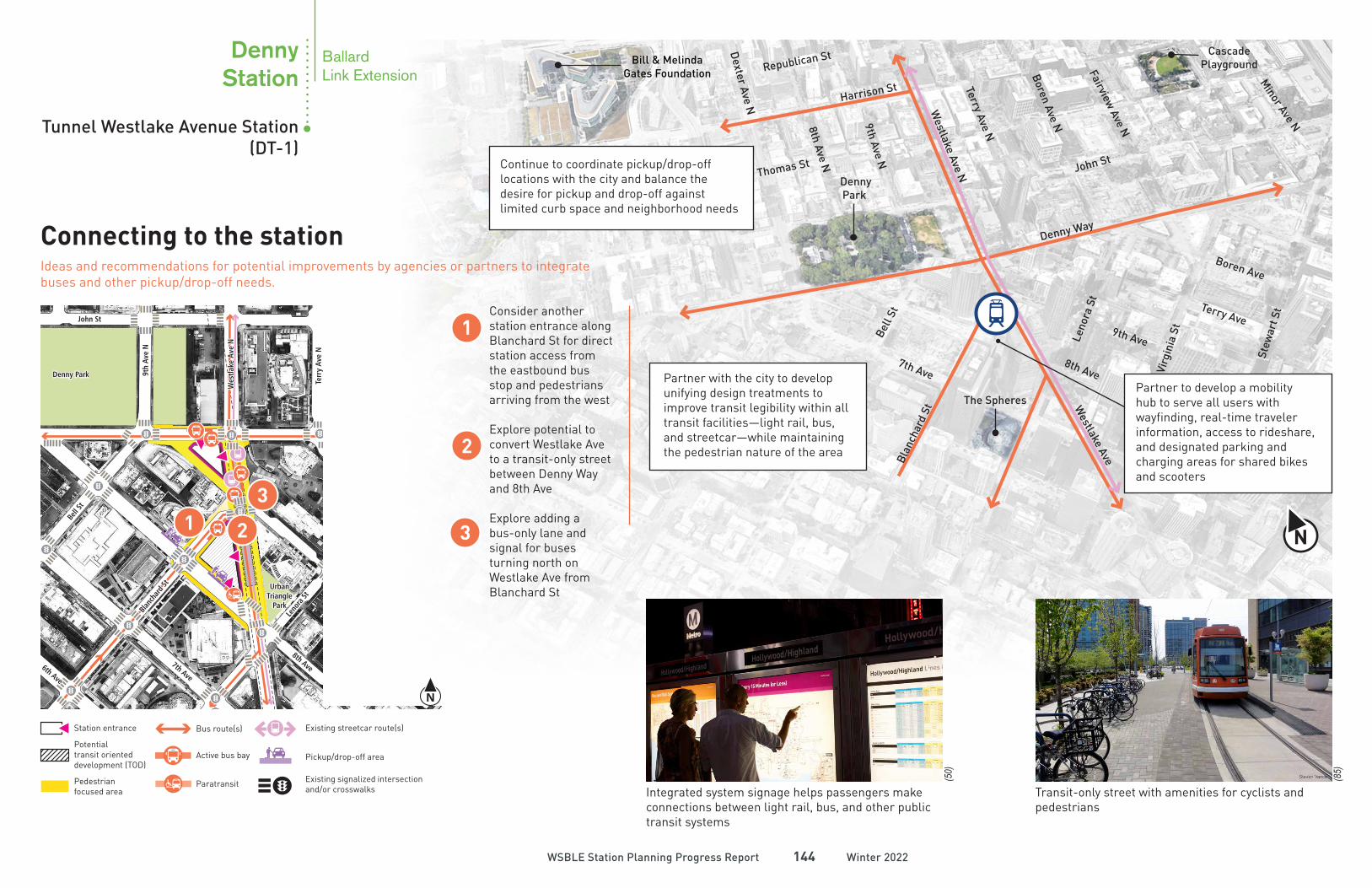
Partner to develop a mobility hub to serve all users with wayfinding, real-time traveler information, access to rideshare, and designated parking and charging areas for shared bikes and scooters
N
1 2
2
Consider another station entrance along Blanchard St for direct station access from the eastbound bus stop and pedestrians arriving from the west
Explore potential to convert Westlake Ave to a transit-only street between Denny Way and 8th Ave
Explore adding a bus-only lane and signal for buses turning north on Westlake Ave from Blanchard St
1
3
3
Connecting to the stationIdeas and recommendations for potential improvements by agencies or partners to integrate buses and other pickup/drop-off needs.
9th Ave
Harrison St
Thomas St
Republican St
Denny Way
Westlake Ave N
Bell
St
Denny Park
Bill & Melinda Gates Foundation
The Spheres
John St
Stew
art S
t
7th Ave
Dexter Ave N
8th Ave N
9th Ave N
Terry Ave N
Boren Ave N
Fairview Ave N
Minor Ave N
Boren Ave
Terry Ave
8th Ave
Leno
ra S
t
Virg
inia
St
Blan
char
d St
Cascade Playground
Westlake Ave
Integrated system signage helps passengers make connections between light rail, bus, and other public transit systems
Transit-only street with amenities for cyclists and pedestrians
Station entrance
Potential transit oriented development (TOD)
Bus route(s)
Active bus bay
ParatransitPedestrianfocused area
Existing signalized intersection and/or crosswalks
Existing streetcar route(s)
Pickup/drop-off area
Partner with the city to develop unifying design treatments to improve transit legibility within all transit facilities—light rail, bus, and streetcar—while maintaining the pedestrian nature of the area
Continue to coordinate pickup/drop-off locations with the city and balance the desire for pickup and drop-off against limited curb space and neighborhood needs
Tunnel Westlake Avenue Station (DT-1)
DennyStation
N
BallardLink Extension
John St
9th
Ave N
Denny Park
Westl
ake A
ve N
Terr
y A
ve N
Bo
ren
Ave N
Terry Ave
Denny Way
Bell S
t
Bla
nch
ard
St
9th Ave
8th Ave
7th Ave
6th Ave
Lenora
St
Virgin
ia S
t
Urban
Triangle
Park
Commercial/ Mixed-Use
(39)
(43)
Downtown
Winter 2022Winter 2022WSBLE Station Planning Progress ReportWSBLE Station Planning Progress Report 145145
N
Bla
ncha
rd S
t
Denny Way
John St
Bel
l St
9th Ave N
Westlake Ave N
Denny Park
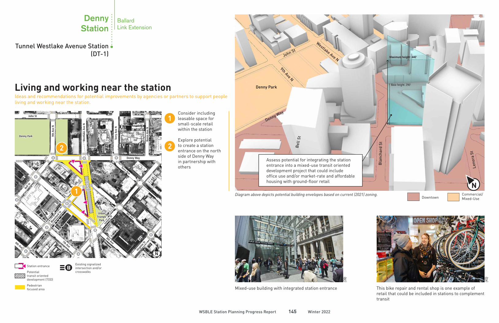
Consider including leasable space for small-scale retail within the station
Explore potential to create a station entrance on the north side of Denny Way in partnership with others
1
2
1
2
N
Living and working near the stationIdeas and recommendations for potential improvements by agencies or partners to support people living and working near the station.
Leno
ra S
t
Mixed-use building with integrated station entrance This bike repair and rental shop is one example of retail that could be included in stations to complement transit
Diagram above depicts potential building envelopes based on current (2021) zoning.
Existing signalized intersection and/or crosswalks
Station entrance
Potential transit oriented development (TOD)
Pedestrianfocused area
Assess potential for integrating the station entrance into a mixed-use transit oriented development project that could include office use and/or market-rate and affordable housing with ground-floor retail
Tunnel Westlake Avenue Station (DT-1)
DennyStation
BallardLink Extension
John St
9th
Ave N
Denny Park
Westl
ake A
ve N
Terr
y A
ve N
Bo
ren
Ave N
Terry Ave
Denny Way
Bell S
t
Bla
nch
ard
St
9th Ave
8th Ave
7th Ave
6th Ave
Lenora
St
Virgin
ia S
t
Urban
Triangle
Park
(96)
(3)
Winter 2022Winter 2022WSBLE Station Planning Progress ReportWSBLE Station Planning Progress Report 146146
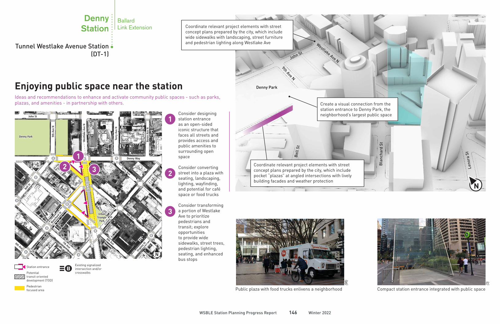
Coordinate relevant project elements with street concept plans prepared by the city, which include wide sidewalks with landscaping, street furniture and pedestrian lighting along Westlake Ave
N
Enjoying public space near the stationIdeas and recommendations to enhance and activate community public spaces - such as parks, plazas, and amenities - in partnership with others.
21
2
Consider designing station entrance as an open-sided iconic structure that faces all streets and provides access and public amenities to surrounding open space
Consider converting street into a plaza with seating, landscaping, lighting, wayfinding, and potential for café space or food trucks
Consider transforming a portion of Westlake Ave to prioritize pedestrians and transit; explore opportunities to provide wide sidewalks, street trees, pedestrian lighting, seating, and enhanced bus stops
1
3
3
N
Bla
ncha
rd S
t
Denny Way
John St
Bel
l St
9th Ave N
Westlake Ave N
Denny Park
Leno
ra S
t
Public plaza with food trucks enlivens a neighborhood Compact station entrance integrated with public space
Existing signalized intersection and/or crosswalks
Station entrance
Potential transit oriented development (TOD)
Pedestrianfocused area
Coordinate relevant project elements with street concept plans prepared by the city, which include pocket “plazas” at angled intersections with lively building facades and weather protection
Create a visual connection from the station entrance to Denny Park, the neighborhood’s largest public space
Tunnel Westlake Avenue Station (DT-1)
DennyStation
BallardLink Extension
John St
9th
Ave N
Denny Park
Westl
ake A
ve N
Terr
y A
ve N
Bo
ren
Ave N
Terry Ave
Denny Way
Bell S
t
Bla
nch
ard
St
9th Ave
8th Ave
7th Ave
Lenora
St
Denny Way
Thomas St Thomas St
8th
Ave N
Winter 2022Winter 2022WSBLE Station Planning Progress ReportWSBLE Station Planning Progress Report 147147
Coordinate with street concept plans prepared by the city, which include wide sidewalks with large street trees, art, benches, bike racks, special paving, and pedestrian lighting
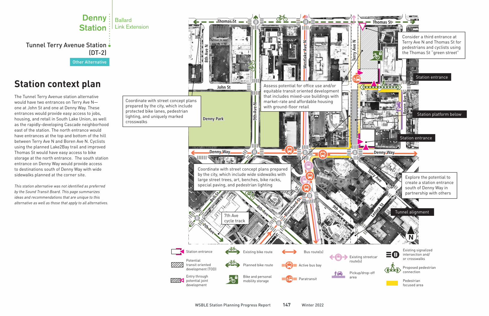
The Tunnel Terry Avenue station alternative would have two entrances on Terry Ave N—one at John St and one at Denny Way. These entrances would provide easy access to jobs, housing, and retail in South Lake Union, as well as the rapidly-developing Cascade neighborhood east of the station. The north entrance would have entrances at the top and bottom of the hill between Terry Ave N and Boren Ave N. Cyclists using the planned Lake2Bay trail and improved Thomas St would have easy access to bike storage at the north entrance. The south station entrance on Denny Way would provide access to destinations south of Denny Way with wide sidewalks planned at the corner site.
This station alternative was not identified as preferred by the Sound Transit Board. This page summarizes ideas and recommendations that are unique to this alternative as well as those that apply to all alternatives.
N
Station context planCoordinate with street concept plans prepared by the city, which include protected bike lanes, pedestrian lighting, and uniquely marked crosswalks
Assess potential for office use and/or equitable transit oriented development that includes mixed-use buildings with market-rate and affordable housing with ground-floor retail
Explore the potential to create a station entrance south of Denny Way in partnership with others
Consider a third entrance at Terry Ave N and Thomas St for pedestrians and cyclists using the Thomas St “green street”
7th Ave cycle track
Existing bike route
Planned bike route
Bike and personal mobility storage
Station entrance
Potential transit oriented development (TOD)
Bus route(s)
Active bus bay
Paratransit Pedestrianfocused area
Existing streetcar route(s)
Existing signalized intersection and/or crosswalks
Entry through potential joint development
Pickup/drop-off area
Proposed pedestrian connection
Station platform below
Tunnel alignment
Station entrance
Station entrance
Tunnel Terry Avenue Station (DT-2)
Other Alternative
DennyStation
BallardLink Extension
John St
9th
Ave N
Denny Park
Westl
ake A
ve N
Terr
y A
ve N
Bo
ren
Ave N
Terry Ave
Denny Way
Bell S
t
Bla
nch
ard
St
9th Ave
8th Ave
7th Ave
Lenora
St
Denny Way
Thomas St Thomas St
8th
Ave N
Winter 2022Winter 2022WSBLE Station Planning Progress ReportWSBLE Station Planning Progress Report 148148
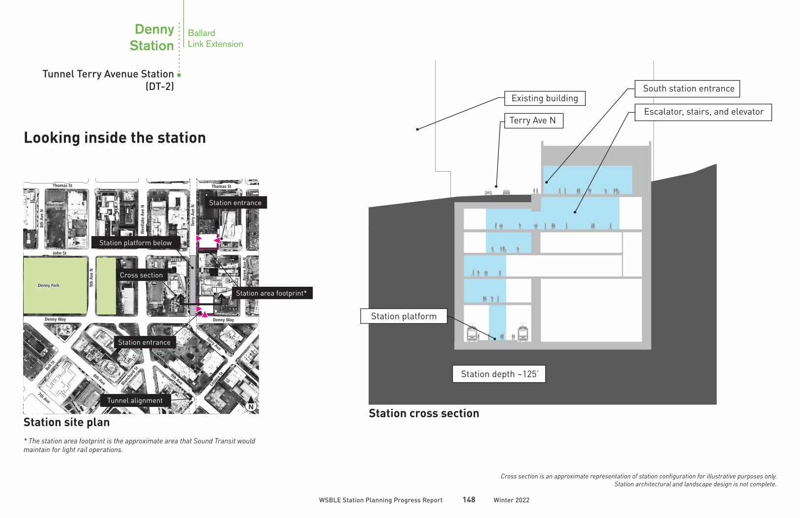
N
Station site plan* The station area footprint is the approximate area that Sound Transit would maintain for light rail operations.
Cross section
Station entrance
Station area footprint*
Tunnel alignment
Station platform below
Station entrance
Cross section is an approximate representation of station configuration for illustrative purposes only. Station architectural and landscape design is not complete.
Station cross section
Station platform
Station depth ~125’
Escalator, stairs, and elevator
South station entrance
Terry Ave N
Existing building
Tunnel Terry Avenue Station (DT-2)
Other Alternative
DennyStation
Looking inside the station
BallardLink Extension