Embed Size (px)
Citation preview
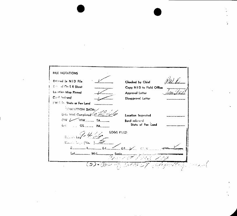
FiLE NOTATIONS
E- ed in N I D File.. Checked by Chief ......
d 0, SR Sheet... ........... .. Copy N I D to Field Office
.......-...............
i.o fien Mep Pinned... .. Approval Letter s... .dkJUA.i
Cd 'ndmed... . Disapproval Letter ....-..---......-......
I WR State or Fee Land ...
MPLET!ON DATA:
Completed €.. Location inspected ..... ...........
YW ........ TA Bond rele sdState o Fee Land ......
LOGS FILED
E....... ., L--...-- E-L........... GL
Lat.-. .-...Mi-L............... Sonic....
a de
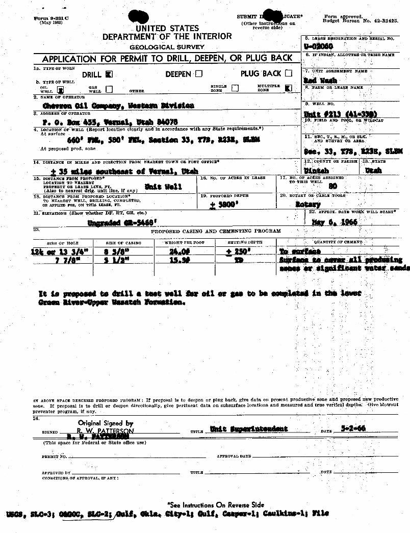
Form 9-8810 SUBMIT CATE* Form approved.(May 1968) (Other instruersons on Budget Bureau No. 42-R1425.
UNITED STATES r•v•rs• a•>DEPARTMENT0F THE INTERIOR SE DW IGNA ION ÅND ERIAL NO.
GEOLOGICAL SURVEY
APPLICATIONFOR PERMITTO DRILL,DEEPEN,OR PLUGBACK 6 INDIAN,ALLOTTE RTRIBENAME
1R. TYPE OF WORK
DRILLK DEEPENO PLUGBACK NIT AGREEMENT N
b. TIra or war,L
W LLGWASLL
OTHERBLE M TŒLE AEM OR LEASE NAME
2. NAME OF OPERATOR
9. ELL NO.
3. ADDRESS OF OPERATOR
10. IBLD AND P L, OR I DCAT
4. LocazzoN or wmLr (Report location clearly and in accordance with any State requirements.*)At surface
g 11. ., T osapr
At proposed prod. zone
14. DISTANCE IN MILES AND DIRECTION FROM NEAREST TOWN OE POST OFFICE 12, COUNTY OR PARISH 18. STATE
g ¾ s&les eenmaamatet Wagnate Utah romaa BA10. DISTANCE FROM PROPOSED* 16. NO. OF ACBES IN LEASE 17. NO OF ACÊEfS ASS GNED
LOCATION TO NEAREST TO THIÈ WELLPROPERTÏ OR LEASE LINE, FT,(Also to nearest drlg. unit line, if any)
18. DISTANCE FROM PROPOSED LOCATION* 19. PROPOSEÐ DEPTH $Û. ROTARY OR ABLE TOOLSTO NEAREST WELL, DRILLING, COMPLETED,OR APPLIED FOR, ON THIS LEASE, FT.
21. ËLEVATIONS (Show whether DF, RT, GR, etc.) 22 ÀPPEOK. DA E WOl LL START*
Unesa ei •5440' er se 196623. PROPOSED CASING AND CEMENTING PROGRAM
SIEE OF HOLE SIZE OF CASING WRIGHT PER FOOT BETTING DEPTH QÜANTPËY OF CEMEN
124 er 13 3/4" 8 sle" 2446 + 250* to estadhe1 7/8 i 112" 15.50 to 4 aguar att paeasiäing
saae* eige&¾eantwheet.saada
la As psaposed to drill a teet weil er ett er gas to be semple et in ehktoget
IN ABOVE SPACE DESCRIBE PROPOSED PROGRAM : If proposal is to deepen or plug back, give data on present productive zone and ÿroposeŒ new productive
zone. If proposal is to drill or deepen directionally, give pertinent data on subsurface locations and measured and true Vertical depths Give blowoutpreventer program, if any.24.
OriginalSigned bySIGNED TITT,N DATE
(This space for Federal or State oflice use)
PER30T4 N APPyny AT. O ATP
APPROVED BY TITLE DATE
CONDITIONS OF APPROVAL, IF ANY :
*SeeInstructionsOn ReverseSidewas, she•3; et000,sha•agg, alar stay•t; este,esa¢aret;cantataa•1;
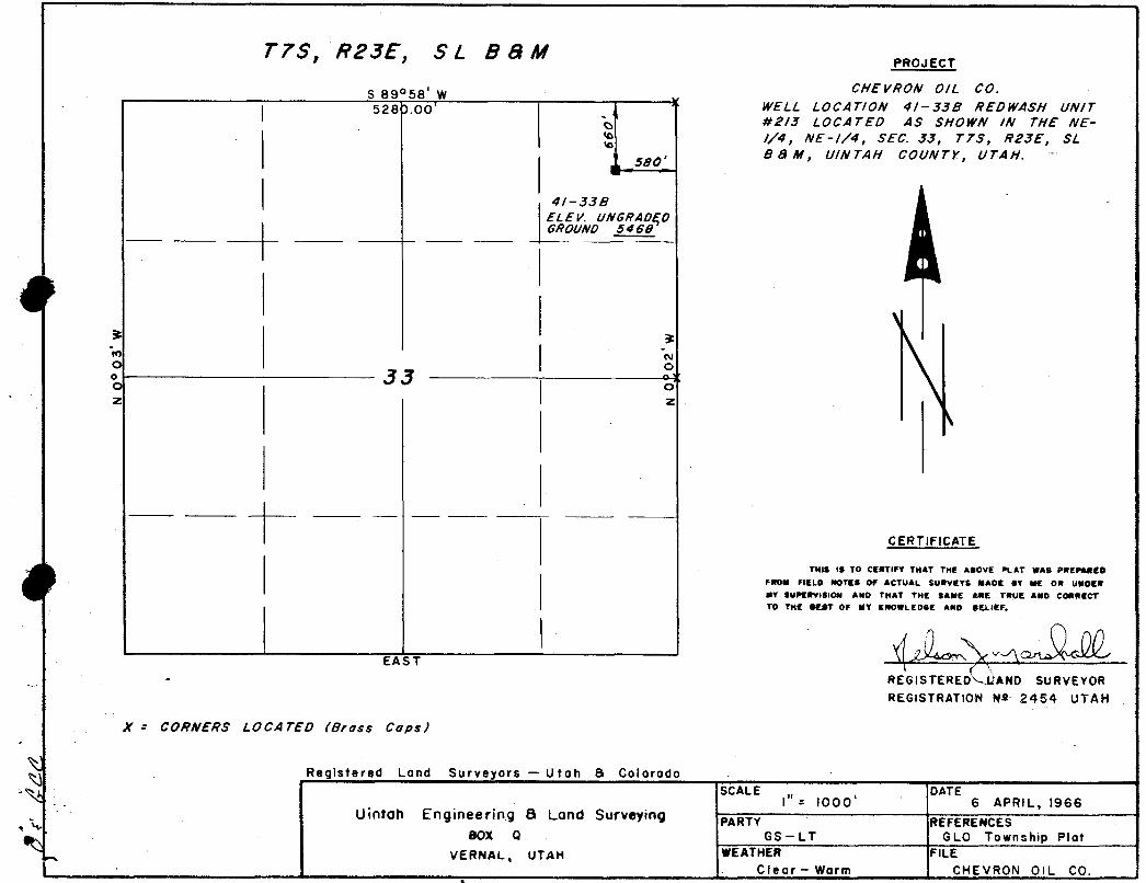
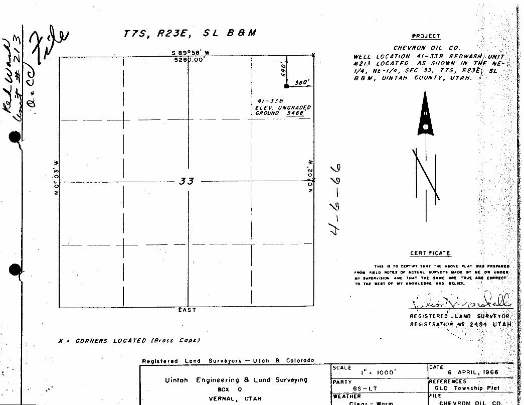
T7S, R23E, SL BBMPROJECT
S 89°58' W CHEVRON 0/L CO.528).00' WELL LOCAT/0N 4/-338 REDWASH UNIT
#2/3 LOCATED AS SHOWN /N THE NE-//4, NE-//4, SEC. 33, T7S, R23E, SL
580, B & hi, U/N TAH COUNTY, UTAH.
4/-338ELEV. UNGRAD(DGROUND 5468
o oo gg o
OI z
CERTIFICATE
TNig 19 TO CERTIFY THAT THE ABOVE PLAT WAS PWEPAREDFROM FIELD NOTES OF ACTUAL SURVEYS MADE BY ME OR UNDERMY SUPERvtSION ANO THAT THE SAME ARE TRUE ANO CORRECT
EA 3 T
TO TNE BEST OF MY KNOWL EF
- REGISTERED LAND SURVEYORREGISTRATION Na 2454 UTAH
X - CORNERS LOCATED (Brass Cops)
Registered Land Surveyors - Utah & ColoradoSCALE DATE
I" - 1000' 6 APRIL, 1966Uintoh Engineering 8 Lond Surveying PARTY REFERENCES
BOX Q GS-LT GLO Township PlatVERNAL, UTAM WEATHER FILE
Clear - Warm CHEVRON OIL

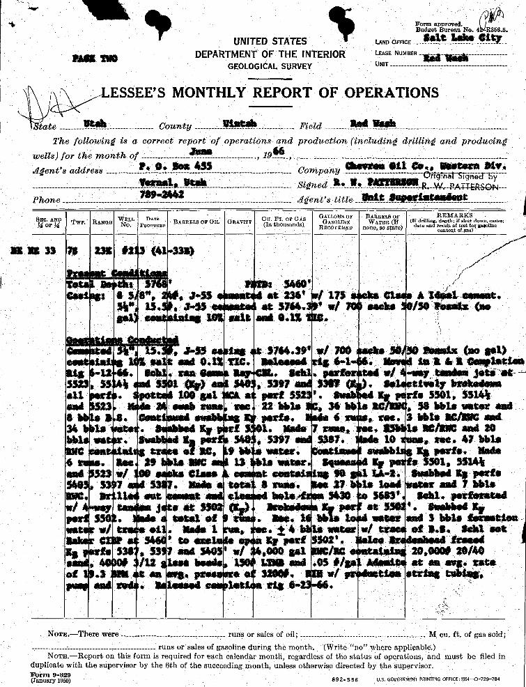
Form amoroved.
UNITEDSTATES 1.MID OFFICE
DEPARTMENT OF THE INTERIOR LEASÉNUMBER ..... ...1-
Red washGEOLOGICALSURVEY urar ... ......
......
SSEE'S MONTHLY REPORT OF OPERATIONS
as um33 7a 23x #213 (41 338)
Tot 1 i peh: $7 '
Ces ag. ! 8 5/8", ,J-55 ¢esman at 236' w/ 175 sacks Cla es A Ideal Cernent.
d it Pioamer 1 iLtîng Co. Rig and spuddad 5-8-66. BrAlg & 124" surface holeto 16' Ce:entg Ñ 5/ñ", ;&#, 55 casing at 236' w/ 179 a Class A IdealComm¢. Drilled | 7/8" ho10 to 1 depth of $760'. Seb1. ran 188, Microlog w/Cal.per and RECS*aio logs. Aan #1 (35:46•¾98, Ky saad) 60 min test. GTS,
gossa rest $487,er. A aat-t wo, asto. ser - atsraa, aan etr 95 *Wi.41st,1.se nas t ese, saa so ans, Pressure n za-ases, M i, 150.114, tr-43,m y, m-nes - - se ...a., s, ma..
ynnamnen a oesteertzenPN Aust tens
Gas In.1erted 145,73 Y *
eas »..«. 4.« y •
Die posi tiens
V t fuel 494320 NCFa Fuel 134,76 "
as teored 0 Unit 2,4G T "
Sold 510,94 ¥ "
Os11eete 3,61 "
enserea4 17,21 "
To 1 Diaposition
Nat Field 49
Norg----There were............ .........-..........-runs or sales of oil; _..___....____ _...__ .. M cu. ft. of gas sold;
................. ........ runs or sales of gasolíne during the month. (Write "no" where applicable.)NOTE.-Report on this form is required for each calendar month, regardless of the status of operations, and must.be filed in
duplicate with the supervisor by the 6th of the succeeding month unless otherwise directed by the supervisor.Form 9-329(January 1950) 892•556 U.S. GOVERNMENTPRINTING
Form approved.Budget Bureau No. 56.5.
UNITEDSTATES LAND ÒFFICE
DEPARTMENTOF THE INTERIOR LEASE NUMBER .......--
GEOLOGICALSURVEY umt. .... .........
ESSEE'S MONTHLY REPORT OF OPERATIONS
tate .... ... ..... .. .. Courety .... . Field . .......
The followiregis a correct report of operations and production (inciading drillireg ared producin
wells) for th neoreth of .. .... .... 19 ...
Osa ASS ewan 011 m, Wassera 919.igeret's address .. ... Cornparey ¯¯¯Ô§TriãTSi <T5
Sigreed W,-M-NRSG --
Phone .. .. .... .. .... .dgeret's tit e
GALLONSDF ARRELSOF REMARkSTwP. RANGE ELL BARRELS OF IL GRAVITY I E R (I ri h f u do n use
as as sa is nas et 3sa)
saaeese , a.ss a saa i in ex... .....e.
15. •$5 at 5964, w/ eacha 50/59 essitz (ne105 enkt ask 0.18 .
. , a-as saa syse.se i veo bise **..4= Oa•ant>se a.« et tre. ama....a 4-1 a..yse*** e.mptactea
ass 12 saa any . perte set w/ 4 -way taneen Jesi at5523 5 $40 3397 93W , settetteely brekadame11 . 100 get a part $5 '. Parte 5501, $5144ami $2 eneb suas see 22 able 36 ab a , 58 bble water anda s. esat snabb parts. 6 wee. S bbts aclaWC sad34 te . Er $ 1. Made T sme . 35ttle ag/ast ami 20bb . 8 gg part 5397 5387. 10 tons, see. 47 bbleBBC of a , 9 ab water, snabbis g parte. Made6 . See 9 to ME 13 to water. My yes te 501, BilA%and $25 w/ etene e een 94 met enabbeiEg ports$40 , 53 7. Made a a smaa. 27 to loa4 water amt b¾1eama. a.a not. suo assa sent, versonates./ e, as soon a as sm . s..n.a erpe . etat of Reg. Able water and 3 bbis teammate
ei . Made 1 . la water w/ tweet of B.t geht seten emot 57 part sor' ressed 1
x, sse , as 7 and sees w/ ,oon aat lac 20,000 20/40/18 tase beams s.9m an es e/ga se aa , sata
of .) en agg, e 32000. w/ ats og hag,and leaset la sig 6• •
NOTE -There were ... ---------. .. --.. ...... . runs or sales of oil; ......... ............ ........ _ _ M cu. Ét.of gas sold;.... .. runs or sales of gasoline during the month. (Write "no" where applicable.)
NOTE.-Report on this form is required for each calendar month, regardless of the status of operations, and must be filed induplicate with the supervisor by the 6th of the succeeding month, unless otherwise directed by the supervisonForm 9-329(January 1950) 892•556 U.S. GOVERNMENÖRINTONG
STAT I'AHDEPARTMENT i MEMORANDUR
FromDEPARTMENT DATE:
DIVISION FILE:
ToDEPARTMENT SUBJECT:
DIVISION
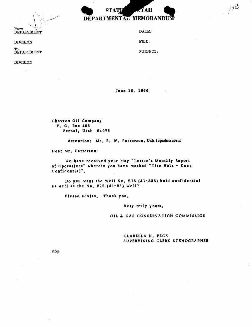
June 10, 1966
Chevron Oil CompanyP. O, Box 455
Vernal, Utah 84078
Attention: Mr, R. W. Patterson,UnitSuperintendent
Dear Mr. Patterson:
We have received your May "Lessee's Monthly Reportof Operations" wherein you have marked "Tite Hole • KeepConfidential".
Do you want the well No. 218 (41-888) held confidentialas well as the No. 212 (41-8F) Well?
Please advise. Thank you.
Very truly yours,
OIL & GAS CONSERVATION COMMISSION
CLARELLA N. PECKSUPERVISING CLERK STENOGRAPHER
STAT I'AHDEPARTMENT i MEMORANDUR
FromDEPARTMENT DATE:
DIVISION FILE:
ToDEPARTMENT SUBJECT:
DIVISION
June 10, 1966
Chevron Oil CompanyP. O, Box 455
Vernal, Utah 84078
Attention: Mr, R. W. Patterson,UnitSuperintendent
Dear Mr. Patterson:
We have received your May "Lessee's Monthly Reportof Operations" wherein you have marked "Tite Hole • KeepConfidential".
Do you want the well No. 218 (41-888) held confidentialas well as the No. 212 (41-8F) Well?
Please advise. Thank you.
Very truly yours,
OIL & GAS CONSERVATION COMMISSION
CLARELLA N. PECKSUPERVISING CLERK STENOGRAPHER
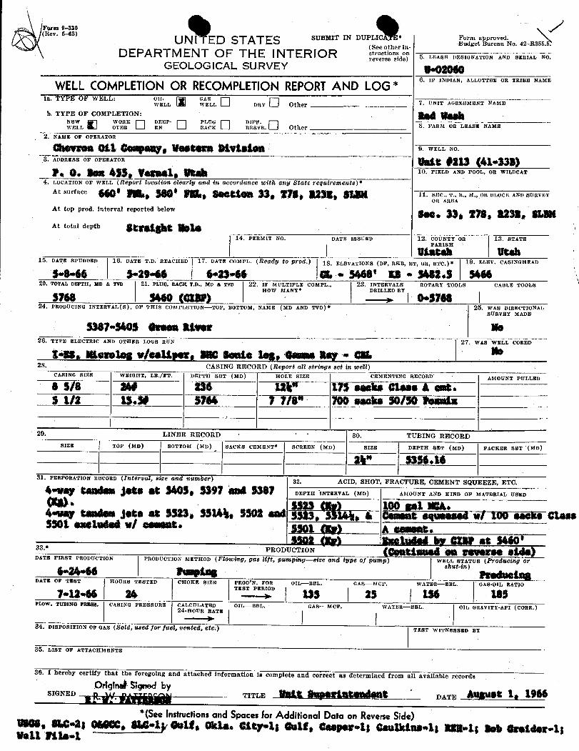
Form 9-330(liev. 5-68)
UN ITED ST AT ES SUBMIT IN DUPLICA. *
et e No. 42--R355.5.(See other in-
DEPARTMENT OF THE INTERIOR d 5. LEASE DESIGNATION AND SERIAL NO.
GEOLOGICAL SURVEY g.gggggÛ. IF INDIAN, ALLOTTEE OR TRIBE NAMEWELLCOMPLETIONOR RECOMPLETIONREPORTAND LOG *
1a. TYPE OF WELL:LL
VASLIDRY Other 7. UNIT AGREEMENT NAME
b. TYPE OF COMPLETION:
V LWORK DEEP- F
. Other 8. FARM OR LEASE NAME
2. NAME OF OPERATOR
9. WELL NO.
3. ADDRESS OF OPERATOR
1Û, FIELD AND POOL, OB WILDCAT
4. LOCATIÒOF WELL (Rep0T‡ IOCation C 6erly and in GCC0Td NCS toi 18 GRy Ñ$af6 T€l]MirBM€n 8)
At surface 11. SEC.,R , R., M., OR BLOCK AND SURVEY
At top prod. interval reported below
At total depth St t &¾14. PERhilT NO. DATE ISSUED 12. COUNTY OR 13. STATE
15. DATE SPUDDED 16. DATÈT.D. REACHED 17. DATE COMPL, (RBady $0 pf0d.) 18. ELEVATIONS (DF, RKB, RT, GR, ETC.) * 19. ELEV. CASINGHEAD
$•8•66 $•29•66 6•23•ë6 SL.• 5468' Es • $482.$ $46620. TOTAL DEPTH, MD & TVD 21. PLUG, BACK T.D., MD & TVD 22. IF MULTIPLE COMPL., 23. INTERVALS ROTARY TOOLS CABLE TOOLS
HOW MANY* DRILLED BY
$768 seso(exar) I ••$768 I24. PRODUCING INTERVAL(S), OF THIS CORIPLETION-TOP, BOTTOM, NAME (MD AND TVD)* 25. WAS DIRECTIONAL
SURVEY MADE
5387•$405 Green atwar We26. TYPE ELECTRIC AND OTHER LOGS RUN 27, WAS WEIaL CORED
tW, Roselag w/ea3Aper, BBCSente leg, dammaRay • dBL28. CASING RECORD (Report all strings set in toell)
CASINO SIZE WEIGHT, LB./FT. DEPTH SET (MD) HOLE SIZE CEMENTING RECORD AMOUNT PULLED
6 S/s $4# 236 184" 175 easks Stase A est.I 1/2 15.3# 5764 7 7/8" 700 eeske 50/50 Woenix
29. LINER RECORD ' ^ 30. TUBING RECORDSIZE TOP (MD) BOTTOM (MD) SACKS CEMENT SCREEN (MD) SIZE DEPTH SET (MD) PACKER SET (MD)
24" _ $356 .16
31. PERFORATION RECORD (Interval, size and nutaber) 82. ACID, SHOT, FRACTURE, CEMENT SQUEEEE, ETC.DEPTH INTERVAL (MD) AMOUNT AND KIND OF MATERIAL USED
(BB) $$23(K 100 gal WA.4•way tandemJoka at 5523, $5144, 5502 ana 5523, g , & Coment equeemedw/ 109 paese cases$301 eastudag w/ osaset* $301 (Ep) A sensas.
sson gagy saatuaeser car as 5460'33.*PRODUCTION ggglŠg $
DATE FIRST PRODUCTION PRODUCTION METHOp (FlOtoing, gas lif‡, pumping-Bize and þ€ Of pH1Np) WELL STATUs (Producing orshut-in)6•24•66 femina ***en•ì aaDATE OF TEST HOURS TESTED CHOKE SIZE PROD'N. FOR OIL-BBL, GAS-MCF. WATER-BBL. GAS-OIL RATIOv.u-se as '"=" us as us us
FLOW. TUBING PRESB. CASING PRESSURE CALCULATED OIL-BBL. GAS-MCF. WATER-BBL. OIL GRAVITY-API (CORR.)24-ROUR RATE
34. DISPOSITION OF GAS (ÑOld, ¾804 for f 65, USNÉSd, €$0 TEllT WITNESSED BY
35. LIST OF ATTACHMENTS
36. I hereby C rmation is comp nd determumd from all available recor
*(SeeInstructionsand Spacesfor Additional Data on ReverseSide)WBS, SLC•28 OtWC. SM4g detta Okla. Gity4; Gott, Saaperus Canikins4; 8854; Bob Greider4;Wall
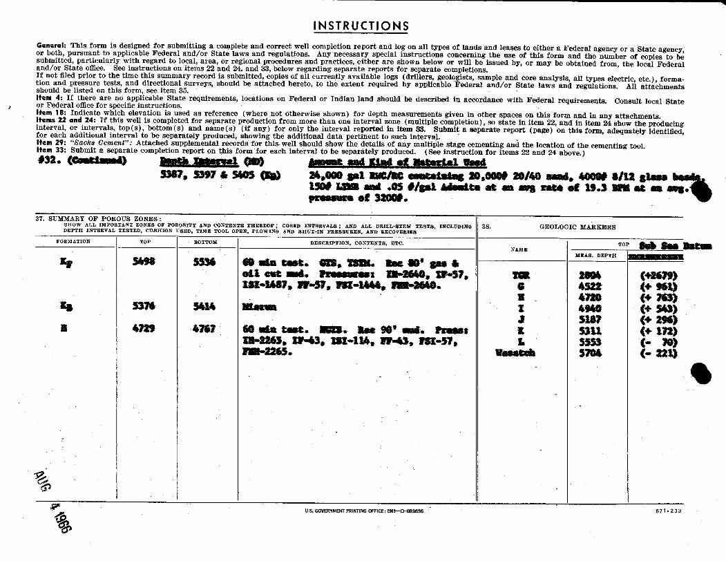
INSTRUCTIONSGeneral: This form is designed for submitting a complete and correct well completion report and log on all types of lands and leases to either a Federal agency or a State agency,or both, pursuant to applicable Federal and/or State laws and regulations. Any necessary special instructions concerning the use of this form and the number of copies to besubmitted, particularly with regard to local, area, or regional procedures and practices, either are shown below or will be issued by, or may be obtained from, the local Federaland/or State ofilee. See instructions on items 22 and 24, and 33, below regarding separate reports for separate completions.If not filed prior to the time this summary record is submitted, copies of all currently available logs (drillers, geologists, sample and core analysis, all types electric, etc.), forma-tion and pressure tests, and directional surveys, should be attached hereto, to the extent required by applicable Federal and/or State laws and regulations. All attachmentsshould be listed on this form, see item 35.Item 4: If there are no applicable. State requirements, locations on Federal or Indian land should be described in accordance with Federal requirements. Consult local Stateor Federal office for specific instructions.Item 18: Indicate which elevation is used as reference (where not otherwise shown) for depth measurements given in other spaces on this form and in any attachments.Items 22 and 24: If this well is completed for separate production from more than one interval zone (multiple completion), so state in item 22, and in item 24 show the producinginterval, or intervals, top(s), bottom(s) and name(s) (if any) for only the interval reported in item 33. Submit a separate report (page) on this form, adequately identified,for each additional interval to be separately produced, showing the additional data pertinent to such interval.Item 29: "ßacks Cement": Attached supplemental records for this. well should show the details of any multiple stage cementing and the location of the cementing tool.Item 33: Submit a separate completion report on this form for each interval to be separately produced. (See instruction for items 22 and 24 above.)#32. $$$ Ammat and Etni of ilatorial Uset
3387, 5397 5405 (Eg} 24,000 gal RMClag -•*•••ÿ 30,0000 20/40 anni, 400W 8/12 stans150# MMB and .05 #/gal ad==**= at an aus rate et 19.3 MB et sa aug.PE ROME $Ê No
37. SUMMARY OF POROUS ZONES :SHOW ALL IMPORTANT ZONES OF POROSITY AND CONTENTS THEREOF; CORED INTERVALS; AND ALL DRILL-STEM TESTS, INCLUDING 88. GEOLOGIC MARKERSDEPTH INTERVAL TESTED, CUSHION USED, TIME TOOL OPEN, FLOWING AND SHUT-IN PRESSURES, AND BECOVERIES
FORMATION TOP BOTTOM DESCRIPTION, CONTENTS, ETC.NAME
TOP
MEAS. DEPTH giliBUMIREMMERsr sees sass e una tese. ess, tom. a.. so• s.. aen ene ..e. an.......: m-esto, w-sv. sea asas (+asteIsa-asar, 59-57, sez-8444,am-seto, o as2x (+ 96tþ
a ese (+ 760as 5574 5414 morna x esto (+ soa star (+ 296)a was war se usa case. auss. amase*ans. reness a ssu (+ tray
IN-8863, 29-43, st-lië, W•41, 791-57. L 5555 (• 70)E--2265. Enestek 5704 (- 221)
U.S. GOVERNMENTPRINTINGOFFICE:1963CHIB3636 87 1.
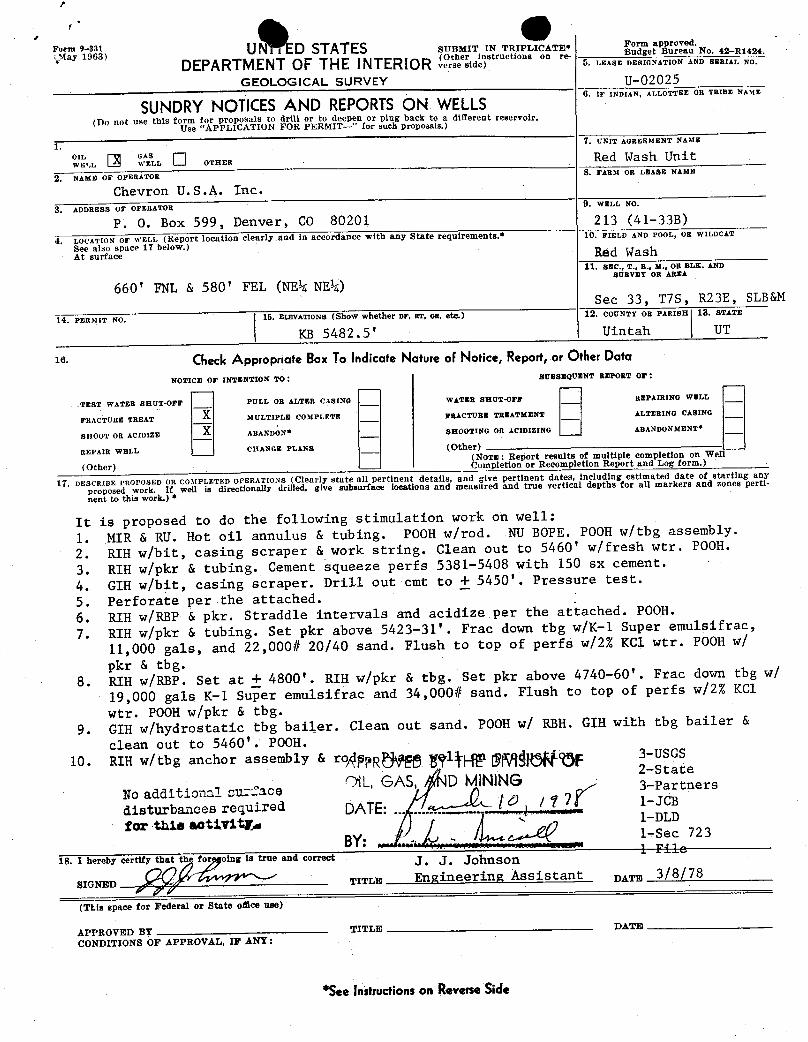
pg y; U a ED STATES SUBMIT IN TRIPLICATE* e B ea No. 42-R1424
DEPARTMENT OF THE INTERIOR JA"esidinstructions on re-f). LEASE DESIGNATION AND SERIAL
GEOLOGICAL SURVEY U-02025
SUNDRYNOTIŒS AND REPORTSON WELLS6. IF INDIAN, ALLOTTEE OR TRIBE NAME
(Do not use this form for proposals to drill or to deepen or plug back to a different reservoir.Use "APPLICATION FOR PERMIT-" for such proposals.)
1.7. UNIT AGREEMENT NAME
°w'ELLL ASLLOTHER Red Wash. Unit
AME OF OPERATOR 8. FARM OR LEASE NAME
Chevron U.S.A. Inc.3. ADDRESS OF OPERATOR 9. WELL NO.
P. O. Box 599, Denver, CO 80201 213 (41-333)
4, LOCATION OF WELL (Report location cÌearly.and in accordance with any State requirements.* 10. FIELD AND POOL, OR WILDCAT
See also space 17 below.)At surface Red Wash
11. anc., T., n., x., om BLK. AND
660' FNL & 580' FEL (NEk NE¼)soavar on sama
Sec 33, T7S, R23E, SLB&M
14. PERMIT No. 15. ELEVATIONs (Show whether or, RT, on, etc.) 12. COUNTY OR PARISH 13. STATE
KB 5482.5' Uintah UT
16 CheckAppropriate BoxTo Indicate Nature oFNotice, Report,or OtherDataNOTICE OF INTENTION TO: SUBSEQUENT BEPORT 07:
TEST WATER SHUT•OFF PULL OR ALTER CASING WATER SHUT-OFF BEPAIRING WELL
FRACTURE TREAT MULTIPLE COMPLETE FRACTURE TREATMENT ALTERING CASING
SHOOT OR ACIDIZE X ABANDON* SHOOTING OR ACIDIZING ABANDONMENT*
REPAIR WELL CHANGE PLANS (Other)(NoTE: Report results of multiple completion on Wel
(Other) Completion or Recompletion Report and Log form.)
17. DESCRIBE PROPOSED OR CO3tPLETED OPERATIONS (Clearly state all pertinent details, and give pertinent dates, including estimated date of starting any
proposed work. If well is directionally drilled, give subsurface locations and measttred and true vertical depths for all markers and zones perti-
nent to this work.) *
It is proposed to do the following stimulation work on well:
1. MIR & RU. Hot oil annulus & tubing. POOH w/rod. NU BOPE. POOH w/tbg assembly.
2. RIH w/bit, casing scraper & work string. Clean out to 5460' w/fresh wtr. POOH.
3. RIH w/pkr & tubing. Cement squeeze perfs 5381-5408 with 150 sx cement.
4. GIH w/bit, casing scraper. Drill out cmt to ± 5450'. Pressure test.
5. Perforate per the attached.6. RIH w/REP & pkr. Straddle intervals and acidize per the attached. POOH.
7. RIH w/pkr & tubing. Set pkr above 5423-31'. Frac down tbg w/K-1 Super emulsifrac,
11,000 gals, and 22,000# 20/40 sand. Flush to top of perfs w/2% KC1 wtr. POOH w/
pkr & tbg.8. RIH w/RBP. Set at ± 4800'. RIH w/pkr & tbg. Set pkr above 4740-60'. Frac down tbg w/
19,000 gals K-1 Super emulsifrac and 34,000# sand. Flush to top of perfs w/2% KC1
wtr. POOH w/pkr & tbg.9. GIH w/hydrostatic tbg bailer. Clean out sand. POOH w/ RBH. GIH with tbg bailer &
clean out to 5460'. POOH.10. RIH w/tbg anchor assembly & ro glŠŒ MŠdbF
3-USGS2-State
iL, GAS D MININGNo additional cu-Tace ' y 3-Partners
disturbances required DATE: / 7 71 1-Jcs
for thie activitE.1-DLD1-Sec 723
18. I hereby certify that th for oing is true and correct. . JOÎluSO
1 FilC
SIGNED TITLE Engineering Assistant pagg 98 8
(This space for Federal or State ofBee use)
APPROVED BY TITLE DATE
CONDITIONS OF APPROVAL, IF ANY:
*SeeInstructionson Reverse
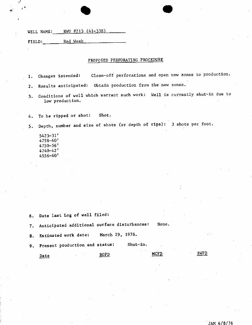
WELL NAME: RWU #213 (41-338)
FIELD: Red Wash
PROPOSED PERFORATING PROCEDURE
1. Changes intended: Close-off perforations and open new zones to production.
2. Results anticipated: Obtain production from the new zones.
3. Conditions of well which warrant such work: Well is currently shut-in due to
low production.
4. To be ripped or shot: Shot.
5. Depth, number and size of shots (or depth of rips): 3 shots per foot.
5423-31'4758-60'4750-56'4740-42'4556-60'
6. Date last Log of well filed:
7. Anticipated additional surface disturbances: None.
8. Estimated work date: March 29, 1978.
9. Present production and status: Shut-in.
Date BOPD MCFD BWPD
JAM
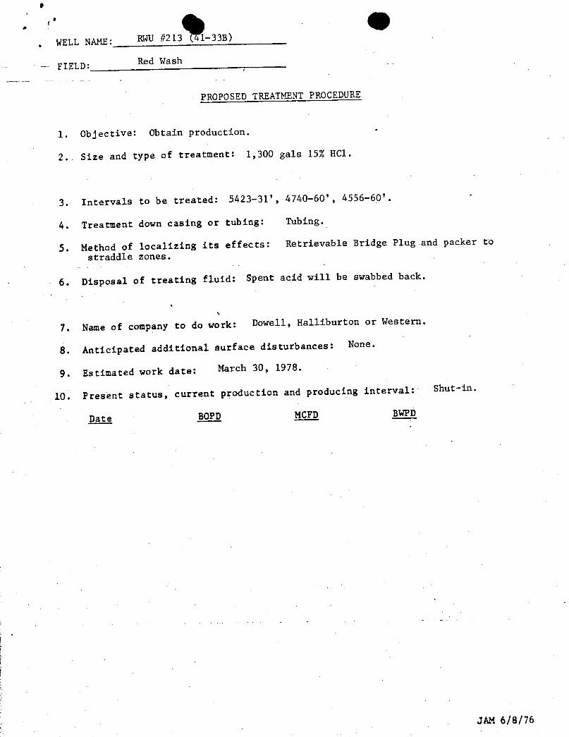
. WELL NAME: RWU#213 (41-333)
FIELD: Red Vash
PROPOSED TREATMENT PROCEDURE
1. Objective: Obtain production.
2. Size and type of treatment: 1,300 gals 15% HCl.
3. Intervals to be treated: 5423-31', 4740-60', 4556-60'.
4. Treatment down casing or tubing: Tubing.
5. Method of localizing its effects: Retrievable Bridge Plug and packer tostraddle zones.
6. Disposal of treating fluid: Spent acid will be swabbed back.
7. Name of company to do work: Dowell, Halliburton or Western.
8. Anticipated additional surface disturbances: None.
9. Estimated work date: March 30, 1978.
10. Present status, current production and producing interval: Shut-in.
Date BOPD MCFD BWPD
JAM
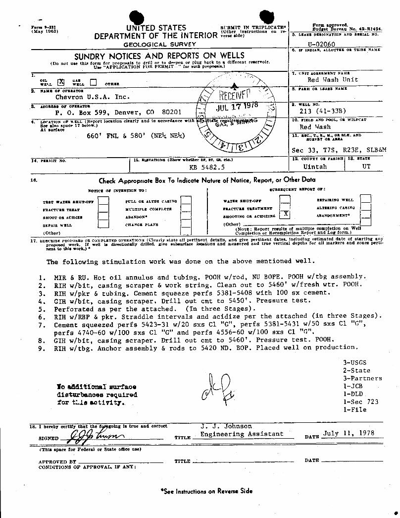
- 4 OS'"NA UNITED STATES SUB¼IT IN TRIPUCATE• g°Ëet
No 4M1424
DEPARTMENT OF THE INTERIOR L°r'à"sidinstructionson re-5. LEASE DESIGNATION AND SERIAL NO.
GEOLOGICAL SURVEY U-02060
SUNDRYNOTICESAND REPORTSON WELLS(Do not use this form for proposals to drill or to deepen or plug back to a different reservoir.
Use "APPLICATION FOR PERhilT- ' for such proposals.)
1. UNIT ¿ôazzxsNT NAbts
°ix. Ð "w^."... O ora..Red Wash Unit
2. NAME OP OPERATOR 8. FABat OB EAsiNAME
Chevron U.S.A. Inc· 7 hiCEN3. ADDRESS OF OPERATOR WELL NÕ.
P. O. Box 599, Denver, CO 80201 213 (41-338)
4. LOCATION or WELL (Report location clearly and in accordance with taté reautre G 10. FIELD AND POOL, OR WILDCAT
See also space 17 below.) GÁlf, &At surface Red Wash
660 ' FNL & 580 ' (NEk NE¼) 11. asc., 9.. n.. x., on sex. AnnBURVET OR AREA
Sec 33, T7S, R23E, SLB&M
14. PERMIT NO. 15. ElÆVATIONB (Show whether or, RT, an, etc.) 12. COUNTT 08 PARISH 18, STATE
KB 5482.5 Uintah UT
18. $ÑtCk Appropnate BoxTo indicate Nature of Notice, Report,or OtherDataNOTICE OF INTENTION TO: SUBBEQUENT REPORT 07:
TEST WATER BRUT-Orr PULL OR ALTER C.tBING WATER SHUT-OFF REPAIRING WELL
FRACTURE TREAT MULTIPLE COMPLETE FRACTURE TREATMENT ALTERING CASING
SHOOT OR ACIDIZE ABANDON* SHOOTING OR ACIDI2ING ABANDONMENT*
REPAIR WELL CHANGE PLANs (Other)(NoTE: Report results of multiple completion on Wel
(Other) Completion or Recompletion Report and Log form.)
17. DESCRIBE PROPOSED OR CO31PLETED OPERATIONS (Clearly state all pertinent details, and give pertinent dates, including estimated date of starting anyproposed work. If well is directionally drilled. give subsurface locations and measured and true vertical depths for all markers and zones perti-
nent to this work.) *
The following stimulation work was done on the above mentioned well.
1. MIR & RU. Hot oil annulus and tubing. POOH w/rod, NU BOPE. POOH w/tbg assembly.2. RIH w/bit, casing scraper & work string. Clean out to 5460' w/fresh wtr. POOH.3. RIH w/pkr & tubing. Cement squeeze perfs 5381-5408 with 100 sx cement.4. GIH w/bit, casing scraper. Drill out cmt to 5450'. Pressure test.5. Perforated as per the attached. (In three Stages) .
6. RIH w/RBP & pkr. Straddle intervals and acidize per the attached (in three Stages) .
7. Cement squeezed perfs 5423-31 w/20 sxs Cl "G", perfs 5381-5431 w/50 sxs C1 "G",perfs 4740-60 w/100 sxs Cl "G" and perfs 4556-60 w/100 sxs Cl "G".
8. GIH w/bit, casing scraper. Drill out cmt to 5460'. Pressure test. POOH.9. RIH w/tbg. Anchor assembly & rods to 5420 ND. BOP. Placed well on production.
3-USGS2-State3-Partners
Io aMitional surface 1-JCB
disturbanoes required 1-DLDfor ti.ls activity. 1-Sec 723
1-File
18. I hereby certif e a true and correct
TITLES Stant DATE
(This space for Federal or State omce use)
APPROVED BY TITLE DATECONDITIONS OF APPROVAL, IF ANY:
*SeeInstructionson ReverseSide
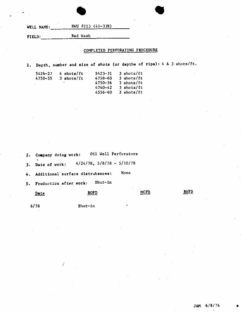
lill IIIIWELL NAME: RWU #213 (41-33B)
FIELD: Red Wash
COMPLETED PERFORATING PROCEDURE
1. Depth, number and size of shots (or depths of rips): 4 & 3 shots/ft.
5424-27 4 shots/ft 5423-31 3 shots/ft4750-55 3 shots/ft 4758-60 3 shots/ft
4750-56 3 shots/ft4740-42 3 shots/ft4556-60 3 shots/ft
2. Company doing work: Oil Well Perforators
3. Date of work: 4/24/78, 5/8/78 - 5/10/78
4. Additional surface distrubances: None
5. Production after work: Shut-in
Dagy: BOPD MCFD BWPD
6/78 Shut-in •
JAM 6/8/76
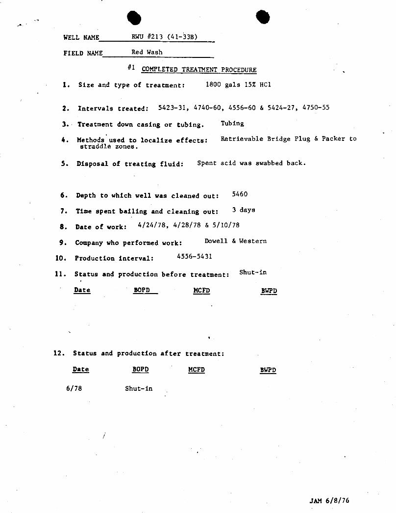
4 4WELL NAME RWU #213 (41-33B)
FIELD NAME Red Wash
#1 COMPLETED TREATMENTPROCEDURE ,
1. Size and type of treatment: 1800 gals 15% HCl
2. Intervals treated: 5423-31, 4740-60, 4556-60 & 5424-27, 4750-55
3. Treatment down casing or tubing. Tubing
4. Methods used to localize effects: Retrievable Bridge Plug & Packer tostraddle zones.
5. Disposal of treating fluid: Spent acid was swabbed back.
6. Depth to which well was cleaned out: 5460
7. Time spent bailing and cleaning out: 3 days
8. Date of work: 4/24/78, 4/28/78 & 5/10/78
9. Company who performed work: Dowell & Western
10. Production interval: 4556-5431
11. Status and production before treatment: Shut-in
BOPD MCFD BWPD
12. Status and production after treatment:
D_ate BOPD MCFD BWPD
6/78 Shut-in
JAM
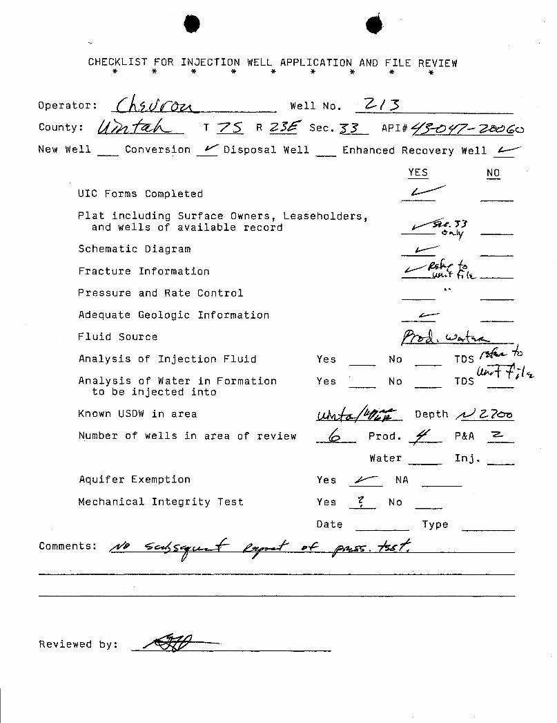
e 4CHECKLIST FOR INJECTION WELL APPLICATION AND FILE REVIEW
Operator: Well No. / JCounty: T 75 a zJf see. yy API#ff-og-7->so
New Well Conversion >'Disposal Well Enhanced Recovery Well A- '
YES NO
UTC Forms Completed A-
Plat including Surface Owners, Leaseholders,and wells of available record 4, 1a .71
Schematic Diagram A '
Fracture Information A~'
Pressure and Rate Control
Adequate Geologic Information A-
Fluid Source 91rÑsGAN
Analysis of Injection Fluid Yes No TDS
Analysis of Water in Formation Yes No TOSto be injected into
Known USDW in area Afig Depth .,7ee
Number of wells in area of review Prod. ý P&A 7-
Water Inj.
Aquifer E×emption Yes /--~ NA
Mechanical Integrity Test Yes No
Date Type
Comments: ,4/? G.u(,
-/gr
Reviewed
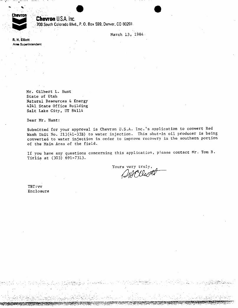
(ik tilChevron ChevronU.S.A.Inc.
700 SouthColoradoBlvd.,P. 0. Box599,Denver,CO80201
March 13, 1984-8.H.EllionAree Superintendent
Mr. Gilbert L. HuntState of UtahNatural Resources & Energy4241 State Office BuildingSalt Lake City, UT 84114
Dear Mr. Hunt:
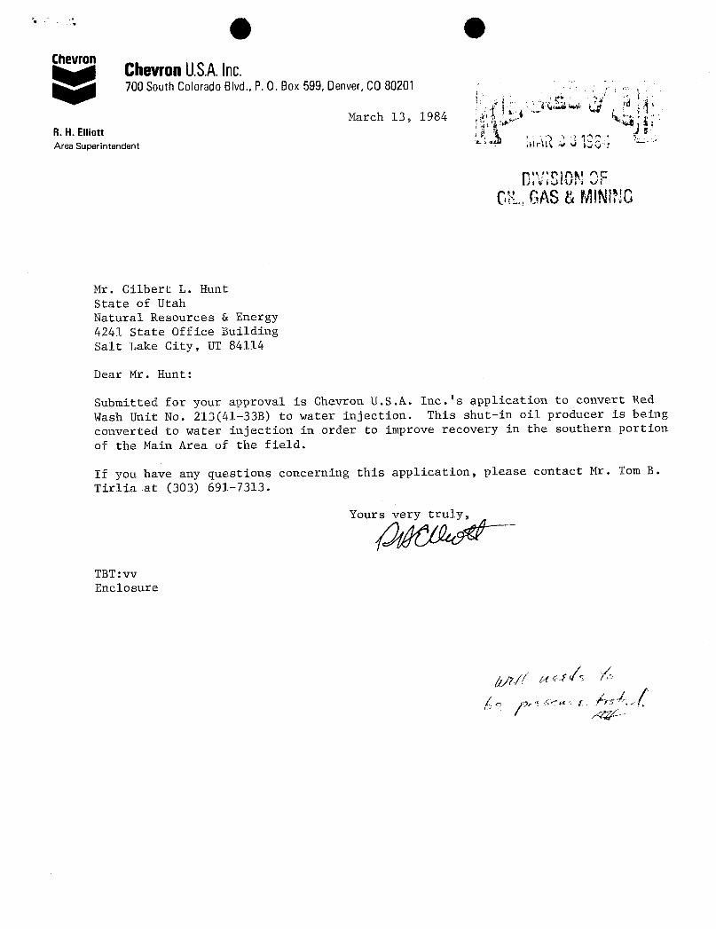
Submitted for your approval is Chevron U.S.A. Inc.'s application to convert Red
Wash Unit No. 213(41-33B) to water injection. This shut-in oil producer is beingconverted to water injection in order to improve recovery in the southern portion
of the Main Area of the field.
If you have any questions concerning this application, please contact Mr. Tom B.
Tirlia at (303) 691-7313.
Your
TBT:vv
(ik tilChevron ChevronU.S.A.Inc.
700 SouthColoradoBlvd.,P. 0. Box599,Denver,CO80201
March 13, 1984-8.H.EllionAree Superintendent
Mr. Gilbert L. HuntState of UtahNatural Resources & Energy4241 State Office BuildingSalt Lake City, UT 84114
Dear Mr. Hunt:
Submitted for your approval is Chevron U.S.A. Inc.'s application to convert Red
Wash Unit No. 213(41-33B) to water injection. This shut-in oil producer is beingconverted to water injection in order to improve recovery in the southern portion
of the Main Area of the field.
If you have any questions concerning this application, please contact Mr. Tom B.
Tirlia at (303) 691-7313.
Your
TBT:vv
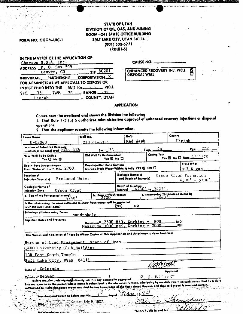
STATEOFUTAHOtVIS10NOF OIL,GAS,ANDMINING -
•
ROOM 4241 STATROFFICEBU1LDINGFORM NO. DOGM-UtC-1 SALTLAKECITY,UTAH84114
(801) S33•5771(RULEI-5)
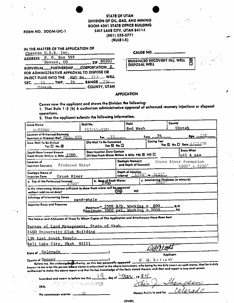
IN THEMATTEROFTHEAPPLICATIONOFÇhevron U.S.A. Inc· CAUSENO.
ADDRESS P. O. Box 599Denver, CO ItP 80201 ENHANCEDRECOVERYINJ. WELL © .
..
DISPOSALWELL O ·
INDIVIDUA ARTNERSHIP-CORPORTATION.JLFOR ADMINISTRATIVEAPPROVALTO DISPOSEORINJECTFLUiOINTO THE ...RNU..No......2.13.......WELLSEC. 33 TWP. 78 RANGE 73F
ninenh _ COUNTY,UTAH
APPUCAflON
Comes now the opplicant and shows the Divisionthe following:1. That Rule 1 -5 (b) 6 outhorizes administrative opprovoi of enhanced recovery injections or disposaloperations.2. That the applicant submits the following information.
tease Nom• Well No. Held County
I U-02060 ?] 3(Al -339 Red Wash Uintalltecesien af Enhanced Recoveryingestien er Disposel won N" ;, NEk s... 33 Twp. TS ag..New Wet! Te Be Orilled Old Wet! Te se Converted Casing Test
Y•• O N. 8 Yes © No O Yes El Ne O Oefe TO
Depth.Bose Lowest Knewn Dess injection Zene CentoinFresh Weser Within ½ Mil. 2700 on.o...pr..h was.,withina mit. Yes O No 0 oil & gasLecoliono! GeelegicNeme(s) Green River FormationIn¡.<sien soure.(s) Produced Water end Depth of Senec•ts) 4300 '
- 5700 '
Geelegie Nome of Depth of injectioninjects..z••• Green River Int•,..¡ 4750 '
,, 5427'
T•P•f th•P•rferos.atoe.,,4 40 ,
b. *••: e. Int••ven n Thighn•••(o minus b)
is the intervening thickness sufficient te show fresh wefer will be tectedwithevt additienoi dato? YES NO
tithology of intervening Zones sand--sha leinjeclien Roses and Pressures
..¡...= 2500 B/D. Working = 800 aioMaximum= 3000 pai. Work ing = 7000 psi
The Nomes and Addresses of These Te Whem Copies of This Applicarlen and Attachments Have seen Sent
Bttrean of Land Manaÿement Armen of Itrah
1400 University ,Club ßuilding136 East South Temnlo
Salt Lake city, litah 84111
stos••« Col orado Appilcont
Counsy .t OfflVera.fore mesthe undersig uthority, en this doy personelly appeared
'
hatewra te.me tehe the persen whose nome is subscribed to the obeve instrument, who being by me duty sworn en eeth stores, shus he is duly
esithufised te maketheobeve repeat and thes he hos knowledge et the fossa stated therem, and shot seed report is true and conect.
scri and sween to before me shie day of
STATEOFUTAHOtVIS10NOF OIL,GAS,ANDMINING -
•
ROOM 4241 STATROFFICEBU1LDINGFORM NO. DOGM-UtC-1 SALTLAKECITY,UTAH84114
(801) S33•5771(RULEI-5)
IN THEMATTEROFTHEAPPLICATIONOFÇhevron U.S.A. Inc· CAUSENO.
ADDRESS P. O. Box 599Denver, CO ItP 80201 ENHANCEDRECOVERYINJ. WELL © .
..
DISPOSALWELL O ·
INDIVIDUA ARTNERSHIP-CORPORTATION.JLFOR ADMINISTRATIVEAPPROVALTO DISPOSEORINJECTFLUiOINTO THE ...RNU..No......2.13.......WELLSEC. 33 TWP. 78 RANGE 73F
ninenh _ COUNTY,UTAH
APPUCAflON
Comes now the opplicant and shows the Divisionthe following:1. That Rule 1 -5 (b) 6 outhorizes administrative opprovoi of enhanced recovery injections or disposaloperations.2. That the applicant submits the following information.
tease Nom• Well No. Held County
I U-02060 ?] 3(Al -339 Red Wash Uintalltecesien af Enhanced Recoveryingestien er Disposel won N" ;, NEk s... 33 Twp. TS ag..New Wet! Te Be Orilled Old Wet! Te se Converted Casing Test
Y•• O N. 8 Yes © No O Yes El Ne O Oefe TO
Depth.Bose Lowest Knewn Dess injection Zene CentoinFresh Weser Within ½ Mil. 2700 on.o...pr..h was.,withina mit. Yes O No 0 oil & gasLecoliono! GeelegicNeme(s) Green River FormationIn¡.<sien soure.(s) Produced Water end Depth of Senec•ts) 4300 '
- 5700 '
Geelegie Nome of Depth of injectioninjects..z••• Green River Int•,..¡ 4750 '
,, 5427'
T•P•f th•P•rferos.atoe.,,4 40 ,
b. *••: e. Int••ven n Thighn•••(o minus b)
is the intervening thickness sufficient te show fresh wefer will be tectedwithevt additienoi dato? YES NO
tithology of intervening Zones sand--sha leinjeclien Roses and Pressures
..¡...= 2500 B/D. Working = 800 aioMaximum= 3000 pai. Work ing = 7000 psi
The Nomes and Addresses of These Te Whem Copies of This Applicarlen and Attachments Have seen Sent
Bttrean of Land Manaÿement Armen of Itrah
1400 University ,Club ßuilding136 East South Temnlo
Salt Lake city, litah 84111
stos••« Col orado Appilcont
Counsy .t OfflVera.fore mesthe undersig uthority, en this doy personelly appeared
'
hatewra te.me tehe the persen whose nome is subscribed to the obeve instrument, who being by me duty sworn en eeth stores, shus he is duly
esithufised te maketheobeve repeat and thes he hos knowledge et the fossa stated therem, and shot seed report is true and conect.
scri and sween to before me shie day of
a - ••••- •- - - - , , ,
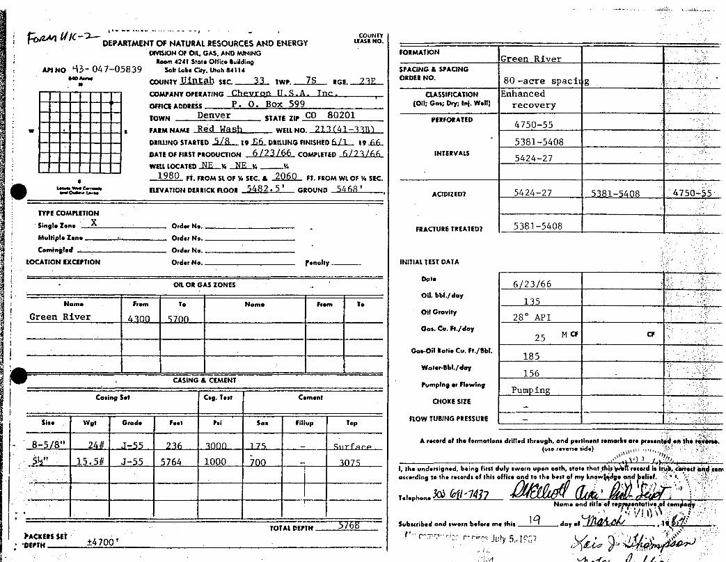
COUNTYDEPARTMENTOF NATURALRESOURCESAND ENERGY MONO.
CIVISIONOF OIL, GAS, AND MINING FORMATIONRoom 4241 Stose Office Building Green River
API No 43- 047-05839 Sob take City, Utah 84114 SPACING A SPACING640¾ COUNTY U‡ntah sec. 33 twr. 7S RGE. ORDER NO 80 -acre spacit g
COMPANYOPERATING Chevron U. S. A . Tnc - CIASSIFICAT10N Enhancednmes annarss . .
P. O. Box 599 toil:Go•: ry: Ini- W•!) recoveryTOWN $TATE ZIP CO 80201 PERFORATED
g FARMNAME Red Wash WELLNO. 213(41-33B3 4750-55
DRILUNGSTARTED5 A 19.6.6..DRILUNGFINISHEDG|1 19.66..° 5381-5408
DATEOF nasT Paooucnon 6 (23 /66 COMPLETED 6 /2 3 /66 INTERVALS 5424-27WELLLOCATED NE v. NE v. ¼
1980 FT.FROM St OF ¼ SEc. A 2060 FT. FROM WL OF ¼ SEC.
ELEVATION DERRICK ROOR 5482. 5 'GROUND 5468 '
ACIDIZEDT 5424-27 5381-5408 4750-55
TYPE COMPLETION
Single Tone Order No.• FRACTURE TREATEDT 5381-5408
Multiple 2en• Order No.
Comingled Order No.
LOCATION EXCEPTION Order No. ¶enotty. INITIAL TEST DATA
DateOIL OR GAS IONES . 6 /23/66
Oil, bbl./dayName From To Nome From To 135
Oli GravityGreen River 43pp sygg 28° APIGas. Co. Fr./doy
25 M ce cr
Gos.Oli Refio Cu. Ft./Bbl.185
Water-Bbl./day156 -
. CASINGA CEMENT Pumping er FlowingPump ing
Casing Set Csg. Test Coment CHOKE SIZE
Sise Wgt Grode Feet Psi San Fillup Top ROW TUBING PRE$5URE -
A record of the formations drifted through, and pertinent remarks are presen en the towerso.- 8-5/8 24# J-55 236 3000 175 - Siirface (usereverseside)
' 15.5# J-55 5764 1000 700 - 3075I, she undersigned, being first duly sworn upon oath, state that ifsis 1 record is it terrect osedcomoccordhinneto the ords of t7his offic fmk lyd d
Name and title of rep entative i
TOTALDEPTH $/68 Subscribed and sworn before me this day of 1 .
.
AC ERS ET±4700 ' I r r- rir July5,
a - ••••- •- - - - , , ,
COUNTYDEPARTMENTOF NATURALRESOURCESAND ENERGY MONO.
CIVISIONOF OIL, GAS, AND MINING FORMATIONRoom 4241 Stose Office Building Green River
API No 43- 047-05839 Sob take City, Utah 84114 SPACING A SPACING640¾ COUNTY U‡ntah sec. 33 twr. 7S RGE. ORDER NO 80 -acre spacit g
COMPANYOPERATING Chevron U. S. A . Tnc - CIASSIFICAT10N Enhancednmes annarss . .
P. O. Box 599 toil:Go•: ry: Ini- W•!) recoveryTOWN $TATE ZIP CO 80201 PERFORATED
g FARMNAME Red Wash WELLNO. 213(41-33B3 4750-55
DRILUNGSTARTED5 A 19.6.6..DRILUNGFINISHEDG|1 19.66..° 5381-5408
DATEOF nasT Paooucnon 6 (23 /66 COMPLETED 6 /2 3 /66 INTERVALS 5424-27WELLLOCATED NE v. NE v. ¼
1980 FT.FROM St OF ¼ SEc. A 2060 FT. FROM WL OF ¼ SEC.
ELEVATION DERRICK ROOR 5482. 5 'GROUND 5468 '
ACIDIZEDT 5424-27 5381-5408 4750-55
TYPE COMPLETION
Single Tone Order No.• FRACTURE TREATEDT 5381-5408
Multiple 2en• Order No.
Comingled Order No.
LOCATION EXCEPTION Order No. ¶enotty. INITIAL TEST DATA
DateOIL OR GAS IONES . 6 /23/66
Oil, bbl./dayName From To Nome From To 135
Oli GravityGreen River 43pp sygg 28° APIGas. Co. Fr./doy
25 M ce cr
Gos.Oli Refio Cu. Ft./Bbl.185
Water-Bbl./day156 -
. CASINGA CEMENT Pumping er FlowingPump ing
Casing Set Csg. Test Coment CHOKE SIZE
Sise Wgt Grode Feet Psi San Fillup Top ROW TUBING PRE$5URE -
A record of the formations drifted through, and pertinent remarks are presen en the towerso.- 8-5/8 24# J-55 236 3000 175 - Siirface (usereverseside)
' 15.5# J-55 5764 1000 700 - 3075I, she undersigned, being first duly sworn upon oath, state that ifsis 1 record is it terrect osedcomoccordhinneto the ords of t7his offic fmk lyd d
Name and title of rep entative i
TOTALDEPTH $/68 Subscribed and sworn before me this day of 1 .
.
AC ERS ET±4700 ' I r r- rir July5,
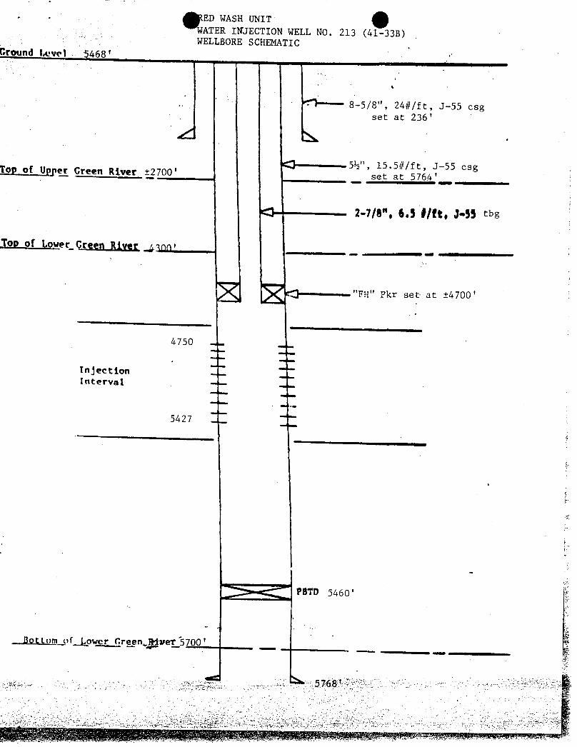
. ED WASH UNITWATER INJECTION WELL NO. 213 (41-33B)WELLBORESCHEMATIC
Ground I.cvel 468'
4
8-5/8", 24#/ft, J-55 esgset at 236'
CO 5½", 15.5#/ft, J-55 esgT_opof Upper Green River ±2700' set at 576A'
c:3 2-7/8", 6.5 #/ft, J•SS tbg
Top of LoveLCreen RiYet Jann'...
"FH" Pkr set at ±4700'
4750 --
InjectionInterval
5427
PBTD 5460 '
.Jiot tom oflower Green-Muet 5700 '
T7S, R23E, SL B & M PROJECT
CHEVRON 0/L CO.S 89°58' W528).00' WELL LOCAT/0H 4/-338 REDWASN UNIT
#2/3 LOCATED AS SHOWN IN 7ÑE gg-//4, NE-//4, SEC. 33, 77S, R23Ë SL
560, BBM, U/NTAN COUNTY, UTAH.
4/-33ÐELEV UNGRAD(D \GROUND 5468
o o33
I z
CERTIFICATE
TMIS IS TO CERTIFY THAT TNE ABOVE PL AT WAÉ pgpaggp
FRÒŒ FIELD NOTES OF ACTUAL SURVETS MADE ST MÉ 08 UNDERMY $wPERVISiON AMO TMAT THE SAME ARE TRaft AÑO CORRECTTO TNE OEST OF MY KNOWLEDOE AND SELiEF.
EA3TREGISTERED AND SURV YORREGISTRATIO 2 4 TAN
X -• CORNERS LOCATED (Bross Cops)
Registered Land Surveyors -- Utah & ColorodoSCALE ,,
=1000, DATE
6 APRIL 966Uentoh Engineering 8 Land Surveying PARTY REFERENCES
BOx Q GS-LT GLO Township Plot
VERNAL, UTAH WEATHER FILEe.... - w...- ruraronu nn
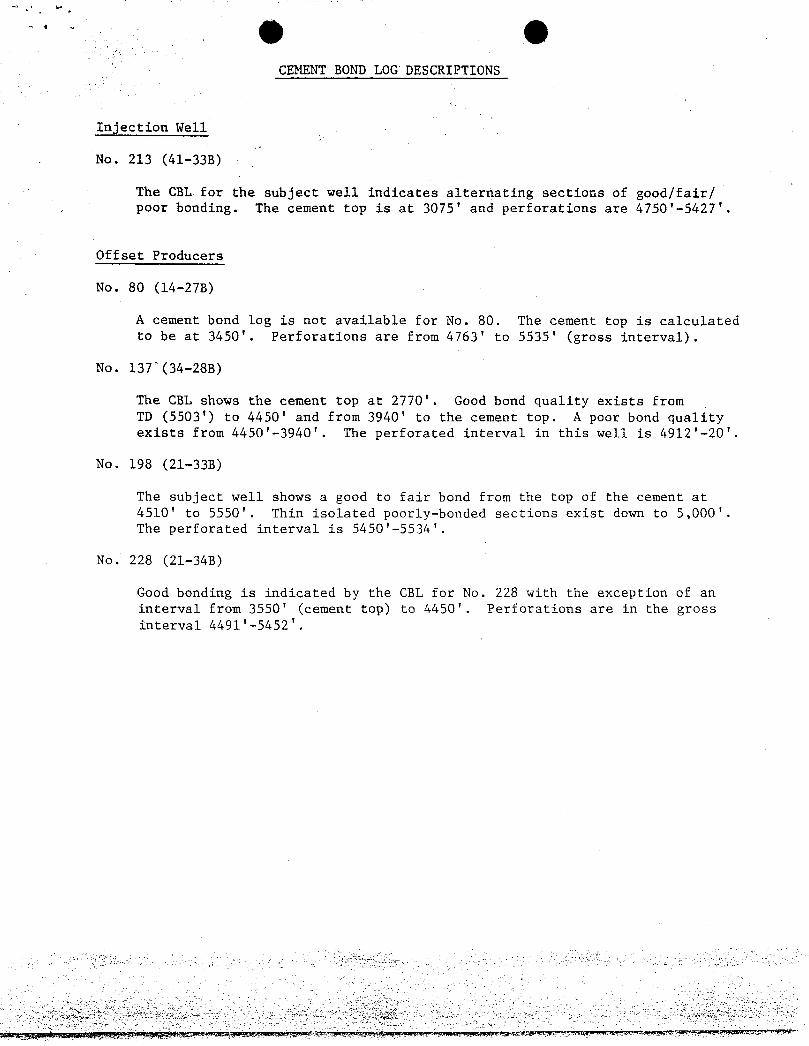
CEMENT BOND LOG DESCRIPTIONS
Injection Well
No. 213 (41-333)
Tlue CBL for the subject well indicates alternating sections of good/fair/poor bonding. The cement top is at 3075' and perforations are 4750'-5427'.
Offset Producers
No. 80 (14-278)
A cement bond log is not available for No. 80. The cement top is calculatedto be at 3450'. Perforations are from 4763' to 5535' (gross interval).
No. 13T (34-288)
The CEL shows the cement top at 2770'. Good bond quality exists fromTD (5503') to 4450' and from 3940' to the cement top. A poor bond qualityexists from 4450'-3940'. The perforated interval in this well is 4912'-20'.
No. 198 (21-338)
The subject well shows a good to fair bond from the top of the cement at4510' to 5550'. Thin isolated poorly-bonded sections exist down to 5,000'.The perforated interval is 5450'-5534'.
No. 228 (21-34B)
Good bonding is indicated by the CBL for No. 228 with the exception of aninterval from 3550' (cement top) to 4450'. Perforations are in the grossînterval
Chevron ChevronIJ.S.A.Inc.700 SouthColoradoBlvd.,P. 0. Box 599,Denver, CO80201
March 13, 1984R.H.ElliottArea Superintendent à gå Q y
'
DN!SJONOFCL GAS&MINING
Mr. Gilbert L. HuntState of UtahNatural Resources & Energy4241 State Office BuildingSalt Lake City, UT 84114
Dear Mr. Hunt:
Submitted for your approval is Chevron U.S.A. Inc.'s application to convert RedWash Unit No. 213(41-33B) to water injection. This shut-in oil producer is beingconverted to water injection in order to improve recovery in the southern portion
of the Main Area of the field.
If you have any questions concerning this application, please contact Mr. Tom B.Tirlia at (303) 691-7313.
Yours very truly,
TBT:vv
STATEOF UTAHDIVISIONOF OIL,GAS,ANDMINING .
-
ROOM 4241 STATEOFFICEBUILOING
FORM NO. DOGM-U1C-1 SALTLAKECITY,UTAN84114(801) 533•5771
(RULEI-5)
IN THEMATTEROF THEAPPLICATIONOFChevron U.S.A. Inc• CAUSENO.
ADDRESS P. O. Box 599,
Denver, CO ZIP 80201 ENHANCEDRECOVERYINJ. WELL .
.· -
015POSALWELL O ·
INDIVIDUA ARTNERSHIP-CORPORTATION.JLFOR ADMINISTRATIVEAPPROVALTODISPOSEORIN,iECTFLUiOINTO THE ...RNU..No.......2.13.......WELLSEC. 33 TWP. 78 RANGE 73F
Uintah . - - COUNTY,UTAN
APPUCATION
Comes now the opplicont and shows the Olvisionthe following:1. Thot Rule 1 -5 (b) 6 authorizes administrative approval of enhanced recovery injections or disposaloperations.2. That the opplicant submits the feitowing informotion.
t•¤••Nom• Well No. Fleid County
U-02060 21M41-asy Red Wash Uintat)Location el Enhanced Recoveryin¡ection or Disposel Wen N"sk, NE½ Sea. 33 twp. U Rge. 2 SF
New Well To Be Orilled Old Well To Be Converted Casing Test
Y••0 Ne YesO NeO . Yes© NoO Oefe 4/21/78
Depth-Base Lowest Known Does injection lone Centoin $fote Whof
Fresh Woter Within ½ Mil. 2700 oil·Gas-Fresh Water Within ½ Mile YES O NO O oil & gastocationof GeologicNome(s) Green River Formationini.<tion suure.(s) Produced Water and Depth of Sourcets) 4300 - 5700
Geologic Nome of Oepthof injectionintesti.42••• Creen River Int•rvei 4750' t. 5427'
o. Top of the Perforated inteno40 ' b. O e resh Water: c. Interven n Thigess (o minus 6)
is the intervening thickness sufficione to show fresh water will be sectedwithout odditional dato? YES NO
Lithology of intervening lones sand-shaleinjection Roses and Pressures
,,¡m..= 2500 R/D._ Horking = 800_. . _ atoMaximum=. 3000 pai,. Norking = 2000 ._ .
Psi
The Nomes and Addresses of Those To Whom Copies of This Applicotton and Attochments Have Been Sent
Bureau of Lan<i Management, Arare of Henh
1400 University ,Club Building
136 F.ast Smith Temple
Salt Lake City, Utah 84111
se.t..t ColoradoApplicant
Coun ofre,
trheundersig uthority, on this day personelly appeared ' g LLL tog
known to me to be the persen whose nome is subscribed to the above instrument, who being by me duly sworn en enth states, that he is duty
authorized to make the above report und that he has knowledge of the facts stated therein, and that said report is true and correct.
Suscri6•d and sworn to before me this day of , 19
My commission espires 10. Notory Public n and fe,
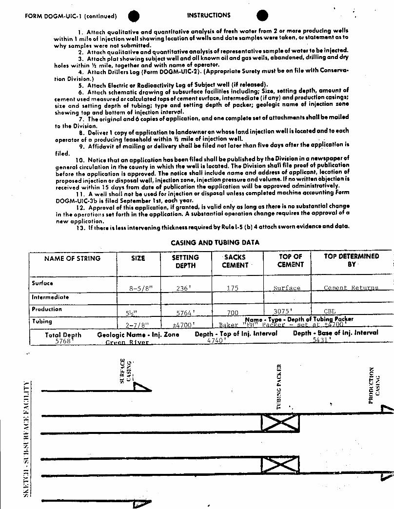
FORM DOGM-UIC-1 (continued) INSTRUCTIONS ',
1. Attach qualitative and guantitative analysis of fresh water from 2 or more producing wellswithin 1 mile of injection weli showing location of wells and date somples were token, or statement as towhy samples were not submitted.
2. Attach qualitative and quantitative analysis of representative sample of water to be injected.3. Attach plot showing subject well and all known oil and gas wells, abandoned, driiting and day
holes within ½ mile, together and with name of operator.4. Attach Drillers Log (Form DOGM•U1C-2).(Appropriate Surety must be on file with Conserva-
tion Division.)5. Attach Electric or Radioactivity Log of Subject well (if released).6. Attach schematic drawing of subsurface facilities including; Size, setting depth, amount of
cement used measured or calculated tops of cement surface, intermediate (if any) and production casings;size and setting depth of tubing; type and setting depth of packer; geologic nome of injection zoneshowing top and bottom of injection interval.
7. The original and 6 copies of opplication, and one complete set of attachments shall be mailedto the Division.
8. Deliver I copy of application to landowner on whose land injection well is located and to eachoperator of a producing leasehold within ½ mile of injection well.
9. Affidavit of mailing or delivery shall be filed not later than five days after the application isfiled.
10. Notice that on application has been filed shall be published by the Division in a newspaper ofgeneral circulation in the county in which the well is located. The Division shell file proof of publicationbefore the opplication is approved. The notice shall include name and address of appliconi, location ofproposed injection or disposal well, injection zone, injection pressure and volume. If no written objection isreceived within 15 days from date of publication the application will be approved administratively.
11. A well shall not be used for injection or disposal unless completed machine accounting FormDOGM-UIC-3b is filed September 1st, each year.
12. Approval of this application, if granted, is valid only as long as there is no substantial changein the operations set forth in the application. A substantial operation change requires the approvoi of anew application.
13. If there is less intervening thickness required by Rule1-5 (b) 4 ottach sworn evidence and data.
CASINGANDTUBINGDATA
NAME OF STRING SIZE SETTING SACKS TOP OF TOP DETERMINEDDEPTH CEMENT CEMENT BY
Surface8-5/8" 236' 175 Surface Cement Returns
intermediate
Production5½" 5764' 700 3075' CBL
Tubing Name - Type - Depth ot Tubing Packer2-7/8" ±4700' Baker "FH" Packer -,set at +4760'
Total Depth Geologic Name . Inj. Zone Depth - Top of inj. Interval Depth • Base of inj. Interval5768 green pyypy 4740'
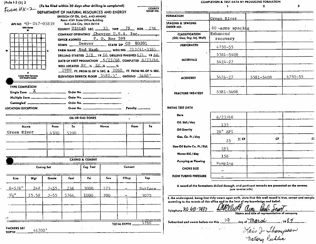
(Role 1-5 (b) 2 COMPLETlON & TEST DATA BY PRODUCING FORMATION(To be filed within 30 days after drilling is completed) 1 2 3
jf - 2--- COUNTY
DEPARTMENTOF NATURALRESOURCESAND ENERGY LEASENO.
DIVISION OF OIL, GAS, AND MINING FORMATIONRoom 4241 State Office Building Green River
Art No - 047-05839 Salt Lake City, Utah 84114 SPACING & SPACING"°."" COUNTY Uintah SEC. 33 TWP. RGE. ? SF ORDER No 80 -acre spacit g
COMPANYOPERATING Chevron U. S. A. Tnc: CLASSINCATION Enhanced
OmcE ADDREss P. O. Box 599 (Oil; oos:Dryalal- W•til recoveryTOWN STATEZIP CO 80201 PERFORATED
w · s FARM NAMg Red Wash WELLNO. 21 S I -SSE34750-55
DRituNG STARTED 5 78 19 EfL DRtLUNGFINISHED A fl 19.6.6..° 5381-5408
DATE OF FIRSTPRODUCTION 6 /23 /66 COMPLETED 6 77 3 /66 1NTERVALS 5424-27WELLLOCATED NE w NE y. m
1980 FT.FROM St OF ¼ SEC.& 2060 FT.FROM WL OF ¼ SEC.
AC101ZEDT 5424--27 5381-5408 4750-55
TYPECOMPLETIONSingle Zone X Order No.
- FRACTURETREATEDT 5381-5408Muhiple Zone Order No.
Comingled Order No.
LOCATION EXCEPTION Order No. Penalty INITIALTESTDATA
Ott OR GAS ZONES ..6 /23/66
Name From To Name From ToOil. bbl./day
135
Green River /4300 5700oilGravity
Gas. Co. Ft./day25 M cF cF ci
Gos-Oil Ratio Cu. Ft./8bl.18 5
Water-Bbl./day156
CASING & CEMENT Pumping or Flowing
Casing Set Csg. T•st Cement CHOKE SilE
Size Wgt Grade Feet Psi Sax Fittup TopFLOW TUBINGPRESSURE -
A record of the formations drilled through, and pertinent remarks are presented on the reverse.8-5/8" 24# J-55 236 3000 175 - Siirface (us,,,,,,s.sia.)
5½" 15.5# J-55 5764 1000 700 - 3075I, the undersigned, being first duly sworn upon oath, state that this well record is true, correct and compleaccording to the records of this office and to the best of my knowledge and belief.
TelephoneName and title of rep esentative of company
TOTAL DEPTH $ f ( 8 Subscribed and sworn before me this day of -, 19
CyKERSSET±4700
PROJECT
CHEVRON 0/L CO.S 89°58'W528 ).OOI WELL LOCATION 4/-338 REDWASH UN/7
#2/3 LOCATED AS SHOWN /N THE NE-//4, NE-//4, SEC. 33, T7S, R23E, SLBBM, U/NTAH COUNTY UTAH.
360 '
4/-338ELEV UNGRAD(DGROUND 5468
CERTIFICATE
TMis IS TO CERTIFY TNAT TNE ABOVE PLAT WAS PREPaREDFRÒ- FIELD NOTES OF ACTUAL SURVEYS MADE BY ME OR UNDER
MY SUPERvtSiON AMO TMAT THE SAME ARE TRdt ANO CoRRECT
TO THE BEST OF MY KNOWLEDOE AND SEtt(F.
EA3TREGISTERED AND SURVEYOR
REGISTRATIOѾì 2494 UTAH
X - CORNERS LOCATEÐ (Brass Caps)
Registered Land Surveyors - Utoh a ColoradoSCALE
\" =1000, DATE
6 APRIL, 1966Uintoh Engineering 8 Land Surveying PARTY REFERENCES
BOx Q GS-LT GLO Township Plot
VERNAL, UTAN WEATHER FILEClear - Warm CHEVRON OIL
RED WASH UNITWATER INJECTION WELL NO. 213 (41-33B)WELLBORE SCHEMATIC
,
Cround Level 5468'
4
8-5/8", 24#/ft, J-55 esgset at 236'
CO 5½", 15.5#/ft, J-55 esgTop of Upper Green River ±2700' set at 5764'
<0 2-7/8", 6.5 #/ft. J-SS tbg
Top of LoweLGreen River..gson' ..
"FH" Pkr set at ±4700'
4750
InjectionInterval
5427
PBTD 5460'
ßottom of Lower Green,River 5700'
CEMENT BOND LOG DESCRIPTIONS
Injection Well
No. 213 (41-33B)
The CBL for the subject well indicates alternating sections of good/fair/poor bonding. The cement top is at 3075' and perforations are 4750'-5427'.
Offset Producers
No. 80 (14-278)
A cement bond log is not available for No. 80. The cement top is calculatedto be at 3450'. Perforations are from 4763' to 5535' (gross interval).
No. 137 (34-28B)
The CBL shows the cement top at 2770'. Good bond quality exists fromTD (5503') to 4450' and from 3940' to the cement top. A poor bond qualityexists from 4450'-3940'. The perforated interval in this well is 4912'-20'.
No. 198 (21-33B)
The subject well shows a good to fair bond from the top of the cement at4510' to 5550'. Thin isolated poorly-bonded sections exist down to 5,000'.The perforated interval is 5450'-5534'.
No. 228 (21-34B)
Good bonding is indicated by the CBL for No. 228 with the exception of aninterval from 3550' (cement top) to 4450'. Perforations are in the grossinterval
O O
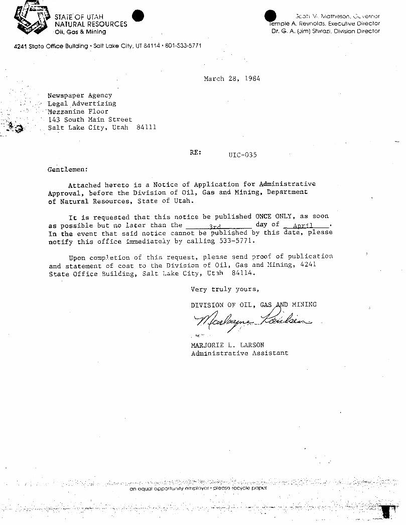
BEFORETHE DIVISION OF OIL, GAS ANDMINIlU4241 State Office BuildingSalt Lake City, Utah 84114
IN THE MATIEROF THE APPLICATION )OF CHEVRONU. S.A. , INC. , FOR ) CAUSENO. UIC-035ADMINISEMTIVE APPROVALTO INJECT )WATERIN1'O WELLNO. 213(41-33B) )SECTION33,10WNSHIP 7 SOUTH, )RANGE23 EAST, UINIAH COUNTY,UTAH. )
THE STATEOF UTAHTO ALL PERSONS, OWNERSPRODUCERS,OPERATORS,PURCHASERSANDTAKERSOF OIL ANDGAS ANDALL ØrHER INTERESIED PERSONS,PARTICULARLYIN UINTAHCOUNIY, UTAH:
NØrICE IS HEREBYGIVEN that Chevron U.S.A., Inc., P.O. Box 599,Denver , Colorado 80201 has requested administrative approval from theDivision to convert the No. 213(41-33B) well located in the NE 1/4 NE 1/4,Section 33, Township 7 South, Range 23 East, Uintah County, Utah to a waterinjection well as follows:
INJECTION INIERVAL: Green River Formation 4300 '- 5700 '
MAXIMUMINJECTION PRESSURE: 3000 psiESTDATED WORKINGPRESSURE: 2000 psiMAXIMUMINJECTION RATE: 2500 BWPD
This application will be granted unless objections are filed with theDivision of 01.1, Gas and Mining within fifteen days after publication of thisNotice. Objections if any, should be mailed to: Division of Oil, Gas andMining, 4241 State Office Building, Salt Lake City, Utah 84114.
STATEOF UTAHDIVISION OF OIL , GASANDMINING
OREEL . LARSONAdministrative Assistant
ML/mfp
O O
BEFORETHE DIVISION OF OIL, GAS ANDMINIlU4241 State Office BuildingSalt Lake City, Utah 84114
IN THE MATIEROF THE APPLICATION )OF CHEVRONU. S.A. , INC. , FOR ) CAUSENO. UIC-035ADMINISEMTIVE APPROVALTO INJECT )WATERIN1'O WELLNO. 213(41-33B) )SECTION33,10WNSHIP 7 SOUTH, )RANGE23 EAST, UINIAH COUNTY,UTAH. )
THE STATEOF UTAHTO ALL PERSONS, OWNERSPRODUCERS,OPERATORS,PURCHASERSANDTAKERSOF OIL ANDGAS ANDALL ØrHER INTERESIED PERSONS,PARTICULARLYIN UINTAHCOUNIY, UTAH:
NØrICE IS HEREBYGIVEN that Chevron U.S.A., Inc., P.O. Box 599,Denver , Colorado 80201 has requested administrative approval from theDivision to convert the No. 213(41-33B) well located in the NE 1/4 NE 1/4,Section 33, Township 7 South, Range 23 East, Uintah County, Utah to a waterinjection well as follows:
INJECTION INIERVAL: Green River Formation 4300 '- 5700 '
MAXIMUMINJECTION PRESSURE: 3000 psiESTDATED WORKINGPRESSURE: 2000 psiMAXIMUMINJECTION RATE: 2500 BWPD
This application will be granted unless objections are filed with theDivision of 01.1, Gas and Mining within fifteen days after publication of thisNotice. Objections if any, should be mailed to: Division of Oil, Gas andMining, 4241 State Office Building, Salt Lake City, Utah 84114.
STATEOF UTAHDIVISION OF OIL , GASANDMINING
OREEL . LARSONAdministrative Assistant
ML/mfp
STATEOF UTAH scan a Mameson, vernor
NATURALRESOURCES emple A. Reynolds. Executive Director
Oil, Gas & Mining Dr. G. A. (Jim) Shirazi, Division Director
4241 State Office Building • Salt Lake City, UT 84114 • 801-533-5771
March 28, 1984
Newspaper AgencyLegal AdvertizingMezzanine Floor143 South Main StreetSalt Lake City, Utah 84111
RE: UIC-035
Gentlemen:
Attached hereto is a Notice of Application for AdministrativeApproval, before the Division of Oil, Gas and Mining, Department
of Natural Resources, State of Utah.
It is requested that this notice be published ONCE ONLY, as soon
as possible but no later than the gra day of April •
In the event that said notice cannot be published by this date, please
notify this office immediately by calling 533-5771.
Upon completion of this request, please send proof of publication
and statement of cost to the Division of Oil, Gas and Mining, 4241State Office Building, Salt Lake City, Utah 84114.
Very truly yours,
D , G
MARJORIE L. LARSONAdministrative Assistant
an equar opportunity empiover • please recycle
STATEOF UTAH Scott R Matheson. GovernorNATURALRESOURCES Temple A. Reynolds. Executive DirectorOil, Gas & Mining DT.G. A. (Jim) Shirozi, Division Director
4241 State Office Building • Salt Lake City, UT84114 • 801-533-5771
March 28, 1984
Vernal ExpressLegal AdvertizingVernal, Utah 84078
RE: UIC-035
Gentlemen:
Attached hereto is a Notice of Application for AdministrativeApproval, before the Division of Oil, Gas and Mining, Departmentof Natural Resources, State of Utah.
It is requested that this notice be published ONCE ONLY, as soonas possible but no later than the 3rd day of April .
In the event that said notice cannot be published by this date, pleasenotify this office immediately by calling 533-5771.
Upon completion of this request, please send proof of publicationand statement of cost to the Division of Oil, Gas and Mining, 4241State Office Building, Salt Lake City, Utah 84114.
Very truly yours,
DIVISION OF OIL, GAS AND MINING
MARJORIE L. LARSONAdministrative Assistant
an equal opportunity employor • please locycle
O O
UIC-035 sent to:
Newspaper Agency
Vernal Express
Enviromental Protection AgencyATTN: Mike Strieby1860 Lincoln StreetDenver, Colorado 80295
Minerals Management2000 Adminstration Bldg.1745 West 1700 SouthSalt Lake City, Utah 84104
Utah Dept. of HealthBureau of Water Pollution ControlATTN: Jerry RidingRoom 410150 West North TempleSalt Lake CIty, Utah 84103
Bureau of Land Management, State of Utah1400 University Club Building136 East South TempleSalt Lake CIty, Utah 84111
Marlaýne p/ulsen March 28,
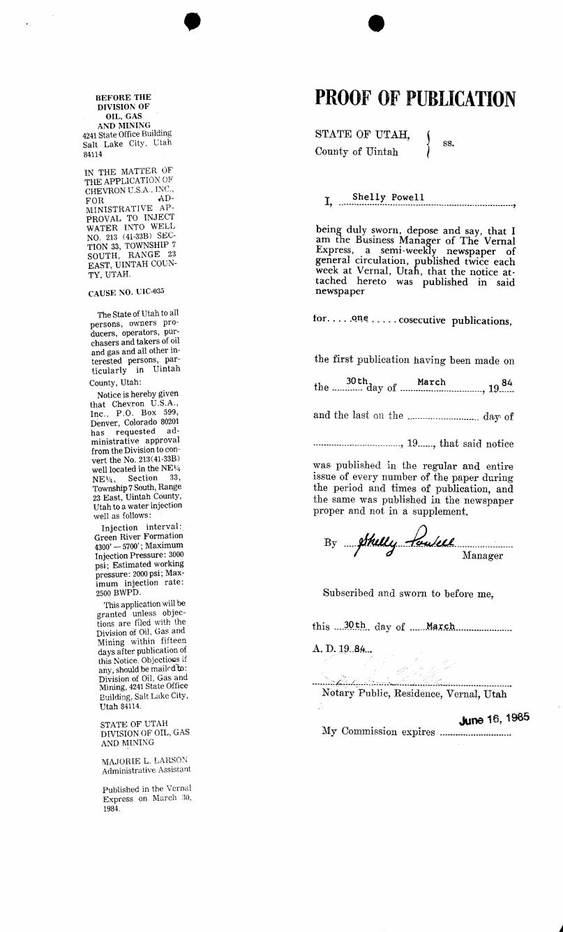
9 O
BEFORE THE PROOFOFPUBLICATIONDIVISION OFOIL, GAS
AND MINING4241 State Office BuildingSalt Lake City, Utah
STATE OF UTAH,
84114 County of Uintah
IN THE MATTER OFTHE APPLICATION OFCHEVRON U.S.A., INC.,FOR AD- I 1 yMINISTRATIVE AP-
PROVAL TO INJECTWATER INTO WELL being duly sworn, depose and say, that INo. 213 (41-338) sEC¯
am the Business Manager of The VernalTION 33, TOWNSHIP 7 Express, a semi-weekl newspaper ofSEO TH RAANHGCEo general circulation, ub ished twice eachweek at Vernal, Uta , that the notice at-TY, UTAH.tached hereto was published in said
CAUSE NO. UIC-03s newspaper
The State of Utah to allpersons, owners pro- for. . . . .oM
. . . . . cosecutive publications,ducers, operators, pur-chasers and takers of oiland gas and all other in-terested persons, par- the first publication having been made onticularly in Uintah
County, Utah:.
the ...... .
.f.hday of.......Ma r ch
.........., 19.Ë..
Notice is hereby giventhat Chevron U.S.A.,Inc., P.O. Box 599, and the last on the
............................ day ofDenver, Colorado 80201has requested ad-ministrative approval
.........................., 19......, that said notice
from the Division to con-ve t e o -
was published in the regular and entireNE½, Section 33, issue of every number of the paper duringTownship7South,Range the period and timesof publication, and23 East, Uintah County, the same was published in the newspaperUtah to a water injection
proper and not in a supplement.well as follows:
Injection interval:Green River Formation4300' -- 5700'; Maximum ByInjection Pressure: 3000
¯¯ --·--
psi; Estimated workingManager
pressure: 2000 psi; Max-imum injection rate:2500 BWPD.
This application will beSubscribed and sworn to before me,
granted unless objec-tions are fíled with theDivision of Oil, Gas and this -- 9¾¾..day of ...-...MarchMining within fifteendays after publication of ggthis Notice. Objections ifany, should be mailedh:Division of Oil, Gas andMining, 4241 State Office ......
Uhdi8ng.Salt Lake City, Notary Public, Residence, 1 Å,
kne 16, 1985STATE OF UTAHDIVISION OF OIL, GAS My Connnission expires . .........
AND MINING
MAJORIE L. LARSONAdministrative Assistant
Published in the VernalExpress on March 30,
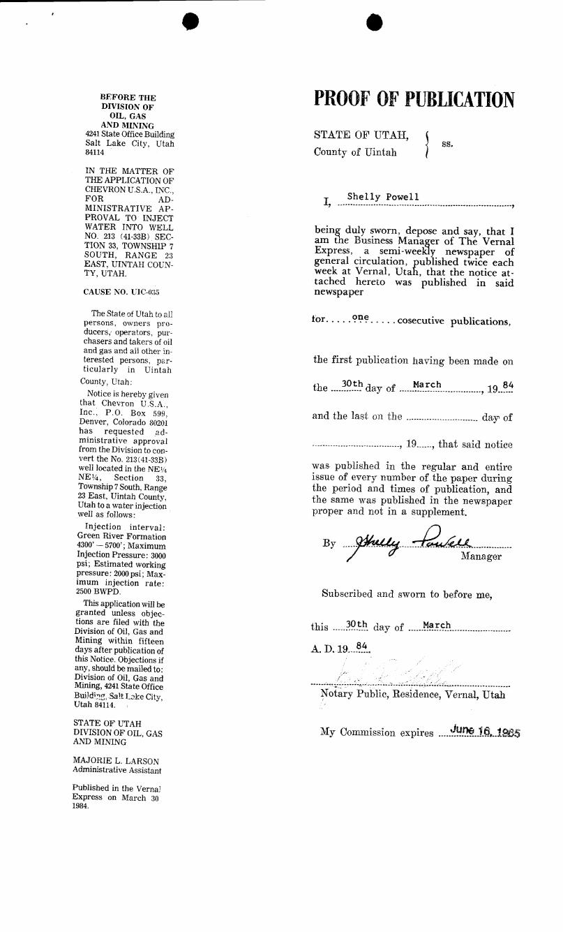
BEFORE THE PROOFOFPUBLICATIONDIVISION OFOIL, GAS
AND MINING4241 State Office Building STATE OF UTAH,Salt Lake City, Utah SS·84114 County of UintahIN THE MATTER OFTHE APPLICATION OFCHEVRON U.S.A., INC.,
Shelly PowellFOR AD - I, .................................................................--,MINISTRATIVE AP-
PROVAL TO INJECTWATER INTO WELL being duly sworn, depose and say, that INO. 213 (41-33B). SEC- am the Business Manager of The VernalTION 33, TOWNSHIP 7 Express, a semi-weekly newspaper ofSOUTH, RANGE 23 general circulation, published twice eachEAST, UINTAH COUN¯
week at Vernal, Utah, that the notice at-TY, UTAH.tached hereto was published in said
CAUSE NO. UIC-035 newspaper
The State of Utah to a11 for. . . ..pn?.
. . . . cosecutive publications,persons, owners pro-ducers,r operators, pur-chasers and takers of oiland gas and all other in-terested persons, par- the first publication having been made onticularly in Uintah
County, Utah: 30th March 84the ............ day of................................, 19......Notice is hereby given
that Chevron U.S.A.,Inc., P.O. Box 599, and the last on the
............................ day ofDenver, Colorado 80201has requested ad-ministrative approvat
........, 19......, that said noticefrom the Division to con-vert the No. 213(41-33B)
was published in the regular and entirewell located in the NE¼NE¼, Section 33 issue of every number of the paper duringTownship7South,Rang' the period and times of publication, and23 East, Uintah County, the same was published in the newspaperUtah to a water injection proper and not in a supplement.well as follows:
Injection interval:Green River Formation4300' - 5700'; Maximum ¯¯~¯ ·
¯°~¯¯¯·~
Injection Pressure: 3000 1\fanagerpsi; Estimated workingpressure: 2000 psi; Max-imum injection rate:2500 BWPD. Subscribed and sworn to before me,
This application will begranted unless objec-tions are filed with the this ... Ëië. day of ......959.4. ..........----------Division of Oil, Gas andMining within fifteen 84days after publication ofthis Notice. Objections ifany, should be mailed to:Division of Oil, Gas and
.......... .. ...m-----------=--
--------------------Mining,4241StateOffice NÃaryPublic, Residence, Vernal, UtahBuildire, Salt Lake City,Utah 84114.
STATE OF UTAHMy Conunission expires .....$. ..Í.R..124DIVISION OF OIL, GAS
AND MINING
MAJORIE L. LARSONAdministrative Assistant
Published in the Verna2Express on March 30
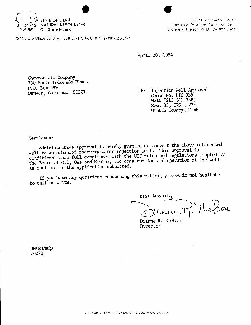
0 &STATEOF UTAH Scott M Matheson, GoveNATURALRESOURCES Ternpie A Reynolds, Executive Due
'V' Oil, Gas & Mining Dianne R. Nielson, Ph.D., Division Dire
42A1 State Office Building · Salt Lake City. UT84114 • 801-533-5771
April 20, 1984
Chevron Oil Company700 South Colorado Blvd.P.O. Box 599Denver, Colorado 80201 RE: Injection Well Approval
Cause No. UICd35Well #213 (41-33B)Sec. 33, T7S. , 23E.Uintah County, Utah
Gentlemen:
Administrative approval is hereby granted to convert the above referenced
well to an enhanced recovery water injection well. This approval is
conditional upon full compliance with the UIC rules and regulations adopted by
the Board of Oil, Gas and Mining, and construction and operation of the well
as outlined in the application submitted.
If you have any questions concerning this matter, please do not hesitate
to call or write.
Best Regards,
Dianne R. NielsonDirector
DN/GH/mfp
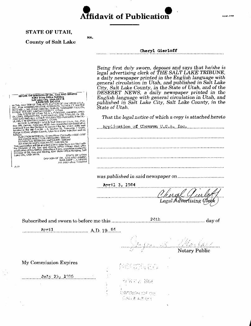
O O.Affidavit of Publication -
STATE OF UTAH,ss.
County of Salt Lake
Being first duly sworn, deposes and says that he/she islegal advertising clerk of THE SALT LAKE TRIBUNE,a daily newspaper printed in the English language withgeneral circulation in Utah, and published in Salt LakeCity, Salt Lake County, in the State of Utah, and of the
Nr DESERET NEWS, a daily newspaper printed in theEnglish language with general circulation in Utah, and
NTHEMATTEROFCAHUE PPLICU -OOOFCHEVR U .; published in Salt Lake City, Salt Lake County, in the
ESN HIP7SOUTH State of Utah.
PR haÉ ÉLO IOg3IDOÉiCO OÎWhich a copy is attached hereto
Lake City, Utah 84114. STATE OF UTAH
DIVISION OF OtL, GAS AND MINING,
MARJORIE L. LARSONAdministrative Assist00Ì
A-55
was published in said newspaper on.........
Subscribed and sworn to before me this .............................?AR.................................day of
Notary Public
My Commission
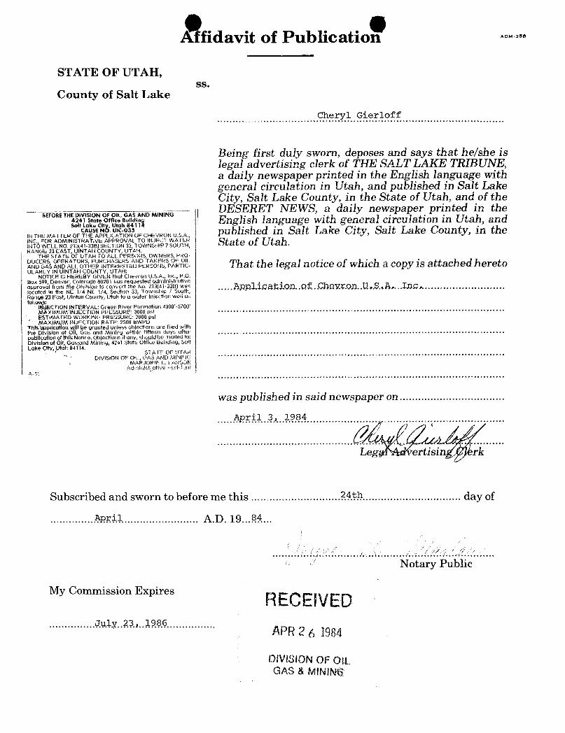
A fidavit of Publicatio -
STATE OF UTAH,ss.
County of Salt Lake
Being first duly sworn, deposes and says that he/she islegal advertising clerk of THE SALT LAKE TRIBUNE,a daily newspaper printed in the English language withgeneral circulation in Utah, and published in Salt LakeCity, Salt Lake County, in the State of Utah, and of theDESERET NEWS, a daily newspaper printed in the
BEFORETHE DIVISION OF OIL, GAS AND MINING ,
s'.Y'Ltot Of6Uo Im English language with general circulation in Utah, and
INTHEMATTEROFCAHUE PNPIL
TiO3NSOFCHEVRONU.S.A., published in Salt Lake City, Salt Lake County, in theINC. FOR ADMINISTRATIVE APPROVAL TO INJECT WATER Q ‡INTÖWELLNO.213(41-33B)SECTION33,TOWNSHIP7SOUTH, D Û Û ÛI Û •
RANGE 23 EAST, UINTAH COUNTY, UTAH.THE STATE OF UTAH TO ALL PERSONS, OWNERS, PRO-
DUCERS OPERATORS, PURCHASERS AND TAKERS OF OlLAND GAŠ AND ALL OTHER INTEWESTED PERSONS, PARTic- ThaÉ Éhe IOgâI DOÉiCO Of Which a copy is attached heretoULARLY IN UINTAH COUNTY, UTAH:
NOTICE IS HEREBY GIVEN that Chevron U.S.A., Inc., P.O.Box 599, Denver, Colorado 80201 has requested administrativeapproval from the Division to convert the No. 213(41-33B) well ggglocated in the NE 1/4 NE 1/4,.Section 33, Township 7 South,Range 23 East, Uintoh County, Utah to a water injection well asfoll :
I CTION IN.TERVAL: Green River Formation 4300'-5700'M XIMUM INJECTION PRESSURE: 3000 psiESTiMATED WORKING PRESSURE: 2000 ps!MAXIMUM INJECTION RATE: 2500 BWPD
This opplication willbe granted unless obiections are filed withthe Division of Oll, Gas and Mining within fifteen days afterpublicotlon of thlkNotice. Objections if any, should be mailed to:Division of Oll;GUS:Gud Mining, 4241 State Office Building, SaltLake City, Utah 84Tl4.
STATE OF UTAHDIVISION OF Oli , GAS AND MINING
MARJORIF L. LARSONAdminist ative Assisicut
A-56
was published in said newspaper on.........
Subscribed and sworn to before me this .............................?.9.t.4................................ day of
Notary Public
My Commission ExpiresRECEIVED
.........J.v.W..U.2.. ·········· APR2 6 1984
OlVISION OF OILGAS &
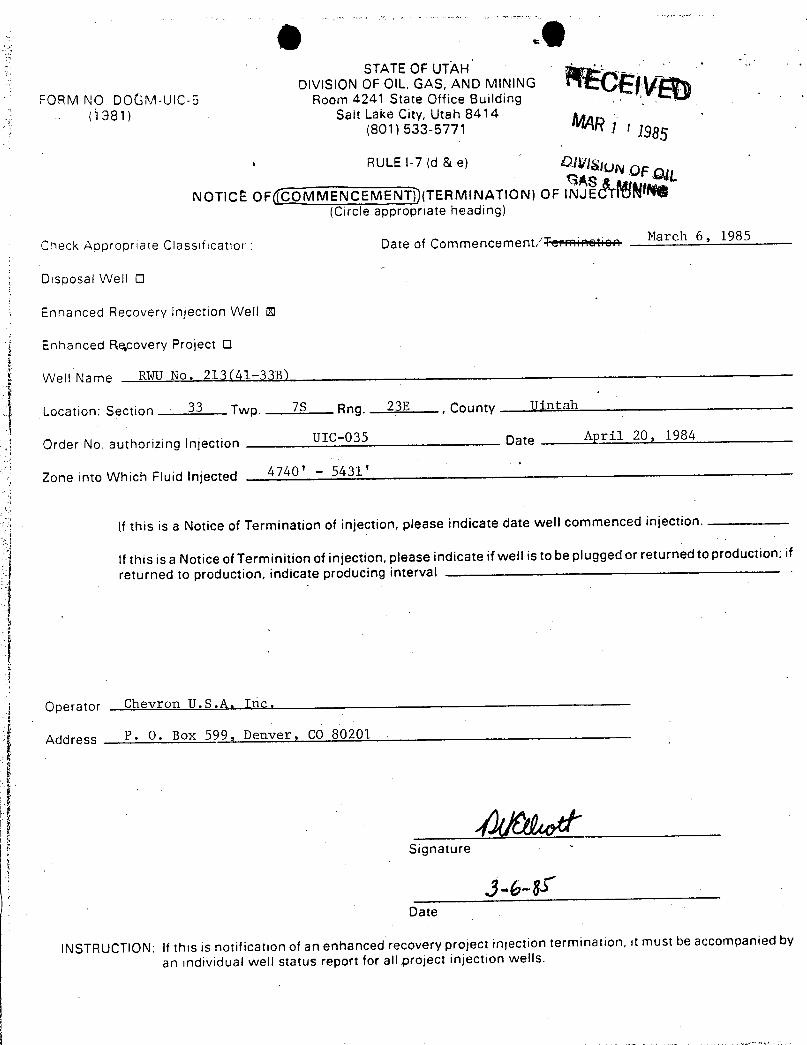
O -0
STATEOF UTÀHDIVISION OF OIL. GAS, AND MINING
FORM NO. DOGM-UlC-5 Room 4241 State Office Building( \ 38 1) Salt Lake City, Utah 8414
(801) 533-5771 1 1 1985· RULEI-7 (d & e) UN OFOL
NOTICËOF((COMMENCEMENT))(TERMINATION) OF INJE N(Circle appropriate heading)
Check Appropriate Classificattor: Date of Commencement/ March 6, 1985
Disposal Well O
Enhanced Recovery injection Well O
Enhanced Re,covery Project O
Well Name RWU No. 213(41-33B)
Location: Section 33 Twp. 7S Rng. 23E, County Uintah
Order No. authorizing Injection UIC-035 Date April 20, 1984
Zone into Which Fluid injected 4740 '- 5431'
If this is a Notice of Termination of injection, please indicate date well commenced injection.
If this is a Notice of Terminition of injection, please indicate if well is to be plugged or returned to production; if
returned to production, indicate producing interval
Operator Chevron U.S.A. Inc.
Artriress P. O. Box 599, Denver, CO 80201
Signature -
Date
INSTRUCTION: If this is notification of an enhanced recovery project injection termination, it must be accompanied by
an individual well status report for all project injection
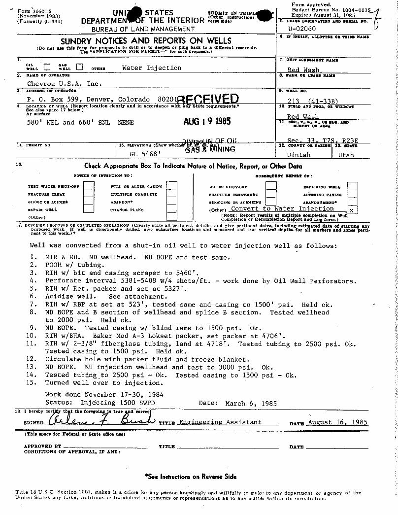
Form approved.
Noepb6e 5983) UNI STATES s spy IN T I Ep
rees ure N31, 11090845-0135
(Formerly 9-331) DEPARTMEN F THE INTERIOR verse side) 5. LEASE DESIGNATION AND SERIAL NO.
BUREAU OF LAND MANAGEMENT U-02060¯"'"
SUNDRYNOTKES AND REPORfSON WELLS0. IP INDIAN, ALE.OTTER 08 TRIBM NAME
(Do not use this form for proposals to drill or to deepen or plug back to a different reservoir.Use "APPLICATION FOR PERMIT-" for such proposals.)
1. 7,UNITAGREEMENTNAME
w'.'es [] °w^."r,s [] er... Water Injection Red Wash2. NAME OF OPERATOR 8. FARM OR LEABB NAME
Chevron U.S.A. Inc.3. ADDUBBSOPOPERAWR S.WRABIO.
P. O. Box 599, Denver, Colorado 80201 213 (41-33B)4. LOCATION Or wELt, (Report location clearly and in accordance wit any State requirements.• 10. FIELD AND POOL, OB WILDCAT
See also space 17 below.)atsunam Red Wash580' WEL and 660' SNL NENE ALAG19 1985 21.......... ... ...
BURVET OR ABBA
niv ¡ON FOli See, 33, T78 823714. Psahtio No. 15. EIÆVATIONs (Show whethatbf, on, 12. COUNTY OR PARISH S. STATE
(9 & INGGL 5468' Uintah Utah
ie· CheckAppropriate BoxTo Indicate Nature oFNotice, Report,or OtherDataNOTICE 07 INTENTION TO: BUBBBOUENT REPOET 07:
TEST TVATER SHDT-Drr PCLL OR ALTER CASING WATER SHUT-OFF BEPAIRING ?FELL
FRACTURE TREAT SIULTIPLE COMPLETE FRACTURE TREATMENT ALTERING CAalNG
SHOOT OR ACIDIES ABANDON* SHOOTING OR ACIDIEING ABANDONMENT*
REPAIR WELL CHANGE PLANs (Other) CORV€rt tO Water Iû OCtiOR X(Norm: Report results of multiple completion on Wel(Other) - Completion or Recompletion Report and Log form.)
17. DESCRIBE PROPOSED OR COSIPLETED OPERATIONS (Clearly state all pertinent details, and give pertinent dates, including estimated date of starting anyproposed work. If well is directionally drilled, give subsurface locations and measured and true vertical depths for all markers and nones perti-nent to this work.) *
Well was converted from a shut-in oil well to water injection well as follows:
1. MIR & RU. ND wellhead. NU BOPE and test same.2. POOH w/ tubing.3. RIH w/ bit and casing scraper to 5460'.4. Perforate interval 5381-5408 w/4 shots/ft. - work done by Oil Well Perforators.5. RIH w/ Ret. packer and set at 5327'.6. Acidize well. See attachment.7. RIH w/ RBP at set at 523', tested same and casing to 1500' psi. Held ok.8. ND BOPE and B section of wellhead and splice B section. Tested wellhead
to 2000 psi. Held ok.9. NU BOPE. Tested casing w/ blind rams to 1500 psi. Ok.
10. RIH w/BHA. Baker Mod A-3 Lokset packer, set packer at 4706'.11. RIH w/ 2-3/8" fiberglass tubing, land at 4718'. Tested tubing to 2500 psi. Ok.
Tested casing to 1500 psi. Held ok.12. Circulate hole with packer fluid and freeze blanket.13. ND BOPE. NU injection wellhead and test to 3000 psi. Ok.14. Tested tubing to 2500 psi - Ok. Tested casing to 1500 psi - Ok.15. Turned well over to injection.
Work done November 17-30, 1984Status: Injecting 1500 SWPD Date: March 6, 1985
18. I hereby cer th t the foregoing is true d correc
SIGNED I AJ dat / ( , TITLE Engineering Assistant DATE AuguSt 16, 1985
(This space for Federal or State omce use)
APPROVED BY TITLE DATECONDITIONS OF APPROVAL, IF ANY:
*SeeInstructionson ReveneSide
Title 18 U.S.C. Section 1001, makes it a crime for any person knoWingly and willfully to make to any department or agency of theUnited States any false, fictitious or fraudulent statements or representations as to any matter within its
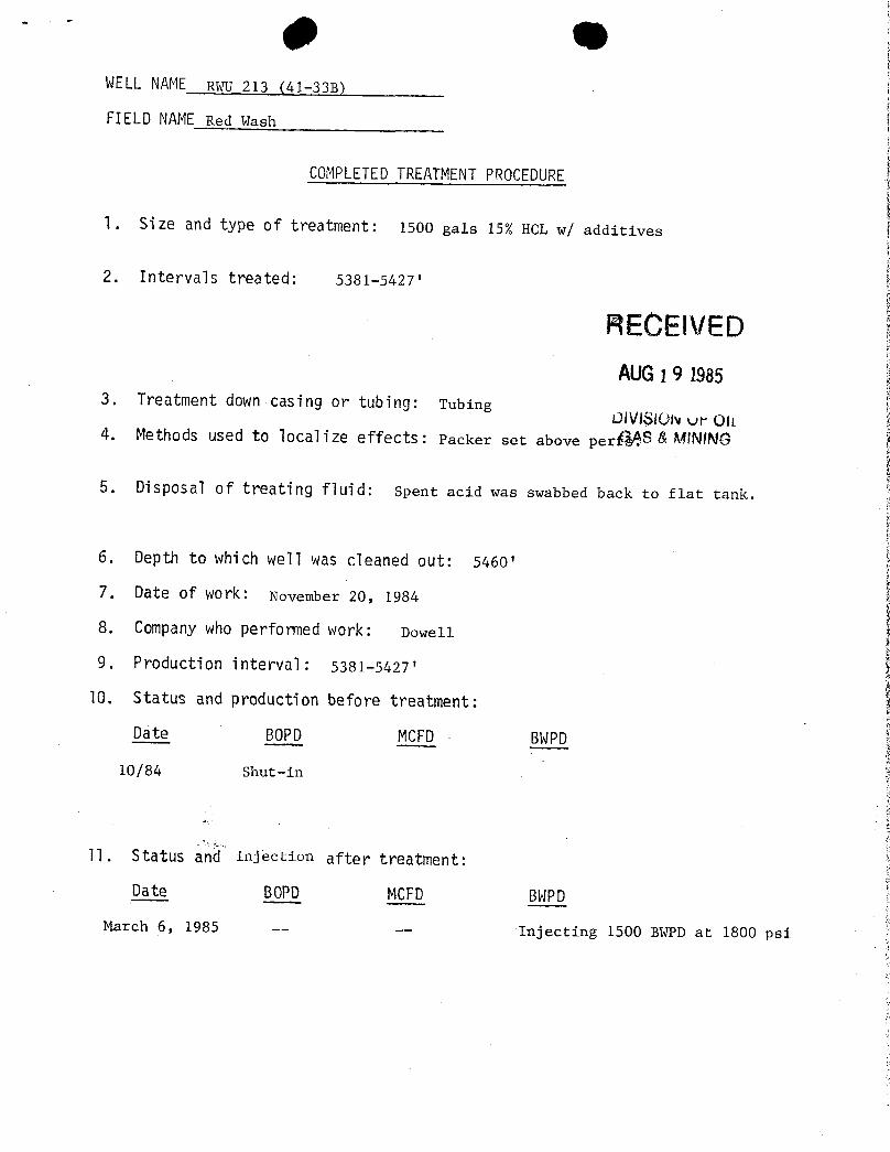
WELLNAME RWU 213 (41-338)
FIELD NAMERed wash
COMPLETEDTREATMENTPROCEDURE
1. Size and type of treatment: 1500 gals 15% HCL w/ additives
2. Intervals treated: 5381-5427'
RECEIVEDAUG19 1985
3. Treatment down casing or tubing: TubingOlvlSION ur olL
4. Methods used to localize effects: Packer set above perŠ&ŸSA NUNINÛ
5. Disposal of treating fluid: Spent acid was swabbed back to flat tank.
6. Depth to which well was cleaned out: 5460'
7. Date of work: November 20, 1984
8. Companywho performed work: Dowell
9. Production interval: 5381-5427'
10. Status and production before treatment:
Date BOPD MCFD BWPD
10/84 Shut-in
11. Status (62 injection after treatment:Date 80PD MCFD BWPD
March 6, 1985 -- -- Injecting 1500 BWPD at 1800
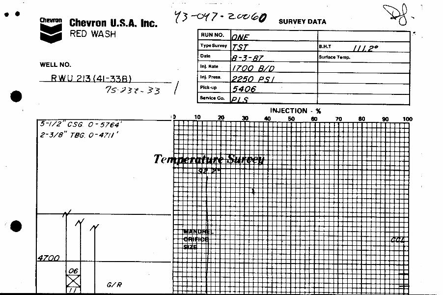
Chewo. Chevron U.S.A.Inc. SURVEY DATA
RED WASH RUNNO.
TypeSurvey B.H.T
Date Surface Temp.
WELL NO. Ini. nate
RWU 2l3 (41-338) '"'""" 60 P,9/Pick-up
Service Co.
INJECTION - %i D 10 20 30 40 50 00 70 80 90 1005-//2" CSG 0 - 5764'
2-3/8' TÐG 0-47//'
Te
4700
Chewo. Chevron U.S.A.Inc. SURVEY DATA
RED WASH RUNNO.
TypeSurvey B.H.T
Date Surface Temp.
WELL NO. Ini. nate
RWU 2l3 (41-338) '"'""" 60 P,9/Pick-up
Service Co.
INJECTION - %i D 10 20 30 40 50 00 70 80 90 1005-//2" CSG 0 - 5764'
2-3/8' TÐG 0-47//'
Te
4700
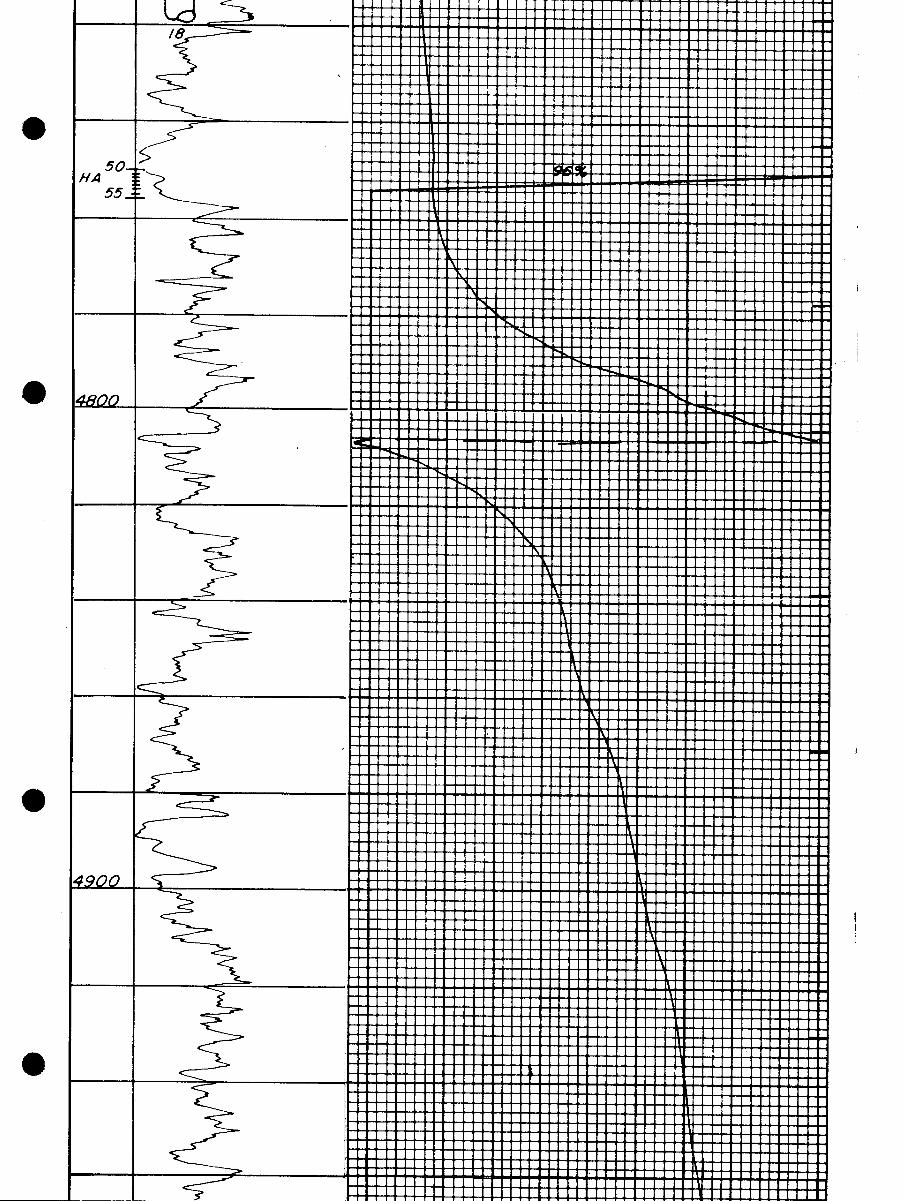
Ld/8
50-/A
55
I i
Ld/8
50-/A
55
I i
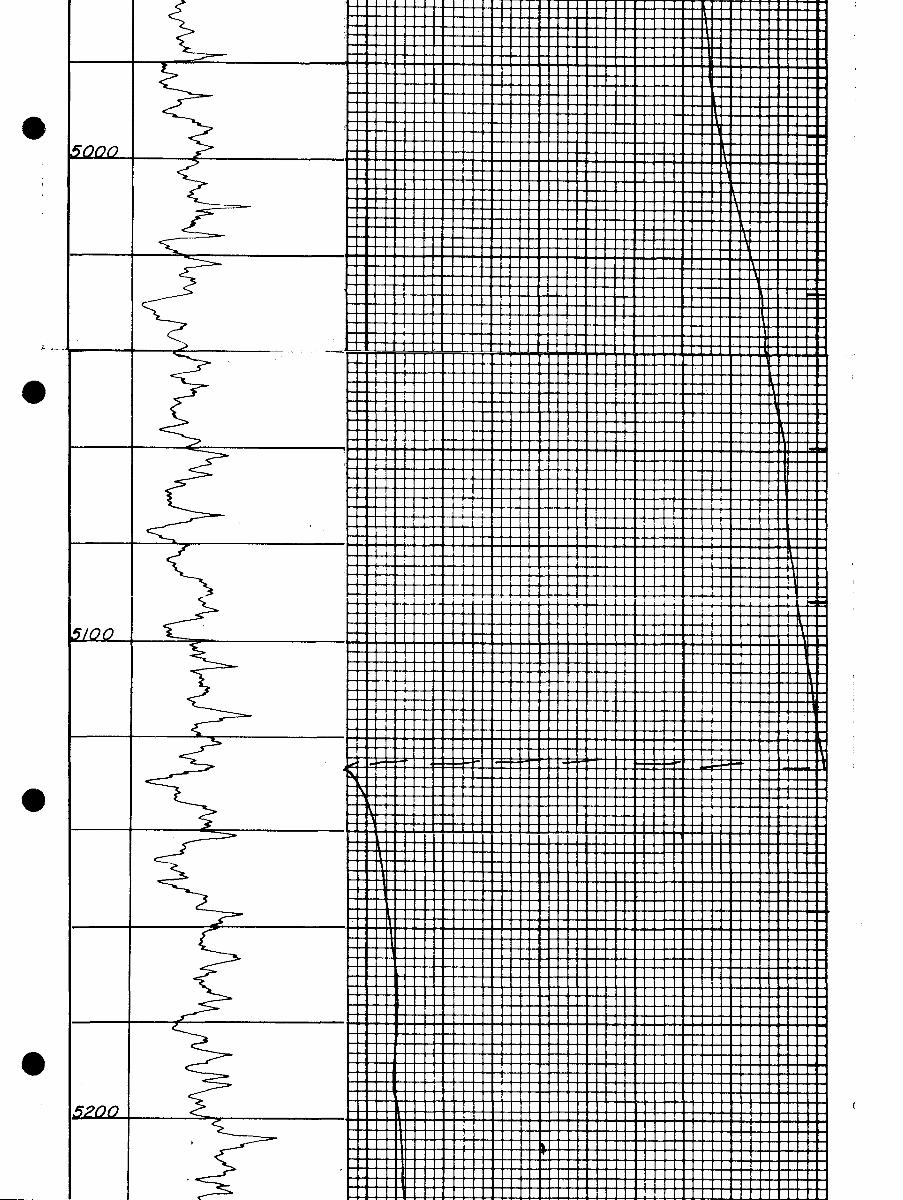
Osaca
O
L2L2
O
O
Osaca
O
L2L2
O
O
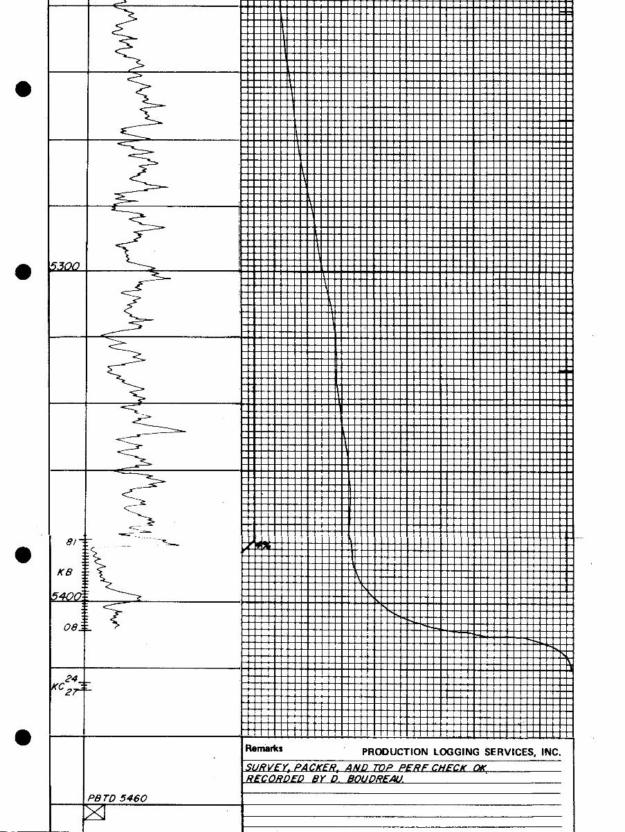
KB
08
24KC "
2?"
O Remarks PRODUCTION LOGGING SERVICES, INC.SURVEY, PACKER, AND TOP PERE CHECK DWRECORDED BY D. BOUDREAU.
PB TD 5460
KB
08
24KC "
2?"
O Remarks PRODUCTION LOGGING SERVICES, INC.SURVEY, PACKER, AND TOP PERE CHECK DWRECORDED BY D. BOUDREAU.
PB TD 5460
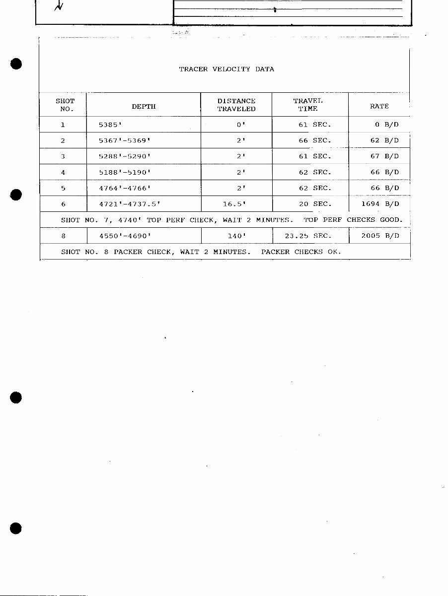
O TRACER VELOCITY DATA
SHOT DISTANCE TRAVELNO. DEPTH TRAVELED TIME RATE
1 5385' O' 61 SEC. O B/D
2 5367'-5369' 2' 66 SEC. 62 B/D
3 5288'-5290' 2' 61 SEC. 67 B/D
4 5188'-5190' 2' 62 SEC. 66 B/D
5 4764'-4766' 2' 62 SEC. 66 B/D
6 4721'-4737.5' 16.5' 20 SEC. 1694 B/D
SHOT NO. 7, 4740' TOP PERF CHECK, WAIT 2 MINUTES. TOP PERF CHECKS GOOD.
8 4550'-4690' 140' 23.25 SEC. 2005 B/D
SHOT NO. 8 PACKER CHECK, WAIT 2 MINUTES. PACKER CHECKS OK.
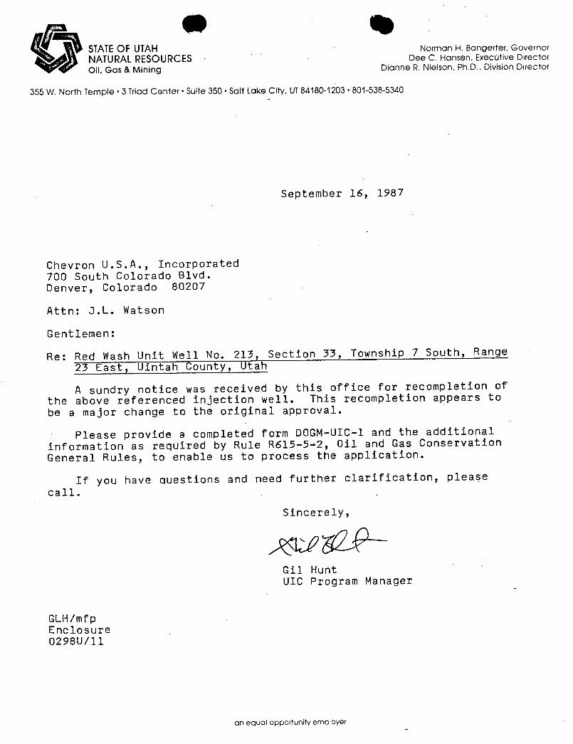
STATEOF UTAH Norman H. Bangerter, GovernorNATURALRESOURCES Dee C. Hansen, Execotive DirectorOil, Gas & Mining Dianne R. Nielson, Ph.D., Division Director
355 W. North Temple •3 Triad Center • Suite 350 • Salt Lake City, UT84180-1203• 801-538-5340
September 16, 1987
Chevron U.S.A., Incorporated700 South Colorado Blvd.Denver, Colorado 80207
Attn: J.L. Watson
Gentlemen:
Re: Red Wash Unit Well No. 213, Section 33, Township 7 South, Range
23 East, Uintah County, Utah
A sundry notice was received by this office for recompletion ofthe above referenced injection well. This recompletion appears tobe a major change to the original approval.
Please provide a completed form DOGM-UIC-1 and the additionalinformation as required by Rule R615-5-2, Oil and Gas ConservationGeneral Rules, to enable us to process the application.
If you have questions and need further clarification, pleasecall.
Sincerely,
Gil HuntUIC Program Manager
GLH/mfpEnclosure0298U/11
an equal opportunity
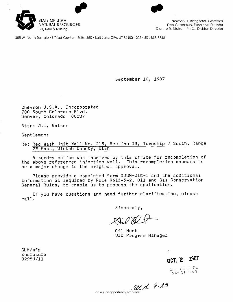
O STATEOF UTAH Norman H. Bangerter, GovernorNATURALRESOURCES Dee C. Hansen, E×ecutive DirectorOil, Gas & Mining Dianne R. Nielson, Ph.D., Division Director
355 W. North Temple • 3 Triad Center • Suite 350 • Salt Lake City, UT84180-1203 · 801-538-5340
September 16, 1987
Chevron U.S.A., Incorporated700 South Colorado Blvd.Denver, Colorado 80207
Attn: J.L. Watson
Gentlemen:
Re: Red Wash Unit Well No. 213, Section 33, Township 7 South, Range23 East, Uintah County, Utah
A sundry notice was received by this office for recompletion ofthe above referenced injection well. This recompletion appears tobe a major change to the original approval.
Please provide a completed form DOGM-UIC-1 and the additionalinformation as required by Rule R615-5-2, Oil and Gas ConservationGeneral Rules, to enable us to process the application.
If you have questions and need further clarification, pleasecall.
Sincerely,
Gil HuntUIC Program Manager
GLH/mfpEnclosure0298U/11 $$Î
an equal opportunity

ormerly 9-331) DEPARTMENT OF THE INTERIOR verse.lae>" °" " reine stadessiori,« ,ia,cino
BUREAU OF LAND MANAGEMENT U-02060
SUNDRYNOTICESAND REPORTSON WELLS6. W INDIAN, AROWW, OR Rint NAllE
(Do not une this form for proposals to drill or to deepen er plug back to a different reservoir.Use "APPLICATION FOR PERMIT-" for auch proposals.)
'I. UNIT AanzEMENT NAME
°w"a O ills. O osan Water Injection Red Wash
OF OPERATOR8, FARM OR LEASE NAME
Chevron U.S.A. Inc.3. Annares or OPERATOR DMSIO 1 OF OIL * """ "°·
P. O. Box 599, DenveceColorado 80201 GAS & UNING 213 (41-338)
4 Ï.ofarioN or «ci.L (Report location clearly and in accordance with any State requirements.* 10. FIELD AND POOL, OK WILDCAT
See also space 17 below.)At surface
11. szC., T., R., M., Om BLK. INDBURVET OR AREA
580' WEL & 660' SNL NE¼NE¼S. 33, T7S, R23E
14. PrastiT No. 15. ELEVATIONs (Show whether or, RT, on, etc.) 12. COUNTY OR PARISH 13. STATE
GL 5,468' Uintah Utah
16- CheckAppropriate BoxTo indicate Nature of Notice, Report, or Other DataNOTICE OF INTENTION TO: 8088EQUENT REPORT OT:
TEST WATEli SOUT-OFF PCLL OR ALTER C.iSING WATER SHOT-Orif REPAllt!NO WELL
FRACTURY TREAT NIULTIPLE COtiPl.ETE FRACTURE TREATMENT ALTr,1tlNG CASINC
81100T Ott ^Cilal7.F1 ABANDON* SHOOTING Ott ACIDIZING ABANDONMENT*
ItEPAIR WKLL CHANGE PLANS (Ûther)(NoTE: Report results of multiple complettor2 on Well
(Other) Recomplete L Completion or Recolapletion Report and Log torm.)
17. os.scarni: PROPOSED Oil CO.31PI.ETED OPEllATioNs (Clently state all pertinent details, and give pertinent dates, including estimated date of starting anyproposed work. If well is diroctionally drilled, give subsurface locations and measured and true vertical depths for all markers and mones pertl-
nent to this work.) *
It is proposed to recomplete injection well as follows:
1. MIRU. N/D we11head. N/U BOPE and test. Kill well as necessary.2. Clean out to PBTD with bit and scraper.3. Cement squeeze existing perforations 4,750'-5,427'. (Ha, Kb> Ec)•4. Drill out cement. Clean out with bit and scraper.5. Add new perforations: 4,311'-28', 4,332'-36', 4,352'-59', 4,378'-86', 4,411'-20',
4,438'-46', 4,468'-78'. Correlate to Schl. Sonic-GR log 5-29-66.6. Selectively break down new perfs with filtered produced water.7. Acidize new perforations with 7,000 gal. 15% HCL. Swab/flow back load.8. Hydrotest in hole with new injection packer and 2-7/8" internally plastic coated
injection string.9. Circulate corrosion-inhibited packer fluid and freeze blanket. Land tubing and
set packer.10. Pressure test annulus for U.I.C. compliance.11. N/D BOPE. N/U injection tree. Rig down. Place well on injection.
APPROVED BYTHE STATE3 - BLM 3 - Drlg
OF UTAH DIVISIONOF 3 - State 1 - File
OIL, GA INING 2 - rarenersDATE: 1 - EEM
11. I dreby certif jihat ef re olng la true and correct a
sionico TITLEOffice Assistant . DATm _"A
(This spa for Federal or State ofIlce use)
APPROVED BY TITLE _ _ DATIC
CONDITIONS OF APPROVAL, IF ANY:
See Instructionson ReverseSide 00T 2 198TTine 13 ').S.C. Section 1001, makes it a crime for any person knowingly and willfully to make to any department or agençy,af theUnited States any false, fictitious or fraudulent statements or representations as to any matter within its jurisdiction.
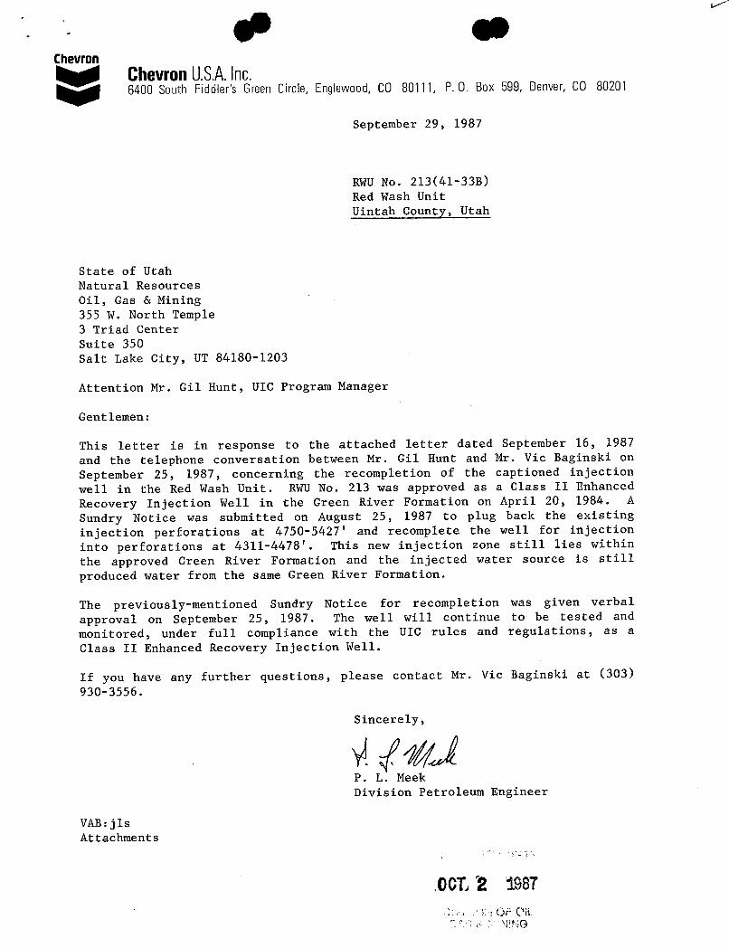
ChevronChevronU.S.A.Inc.6400 South Fiddler's Green Circle, Englewood, CO 80111, P. O. Box 599, Denver, CO 80201
September 29, 1987
RWU No. 213(41-33B)
Red Wash UnitUintah County, Utah
State of UtahNatural ResourcesOil, Gas & Mining355 W. North Temple3 Triad CenterSuite 350Salt Lake City, UT 84180-1203
Attention Mr. Gil Hunt, UIC Program Manager
Gentlemen:
This letter is in response to the attached letter dated September 16, 1987and the telephone conversation between Mr. Gil Hunt and Mr. Vic Baginski onSeptember 25, 1987, concerning the recompletion of the captioned injectionwell in the Red Wash Unit. RWU No. 213 was approved as a Class II Enhanced
Recovery Injection Well in the Green River Formation on April 20, 1984. A
Sundry Notice was submitted on August 25, 1987 to plug back the existinginjection perforations at 4750-5427' and recomplete the well for injectioninto perforations at 4311-4478'. This new injection zone still lies withinthe approved Green River Formation and the injected water source is stillproduced water from the same Green River Formation.
The previously-mentioned Sundry Notice for recompletion was given verbalapproval on September 25, 1987. The well will continue to be tested andmonitored, under full compliance with the UIC rules and regulations, as a
Class II Enhanced Recovery Injection Well.
If you have any further questions, please contact Mr. Vic Baginski at (303)930-3556.
Sincerely,
P. L. MeekDivision Petroleum Engineer
VAB:jlsAttachments
ADCT2
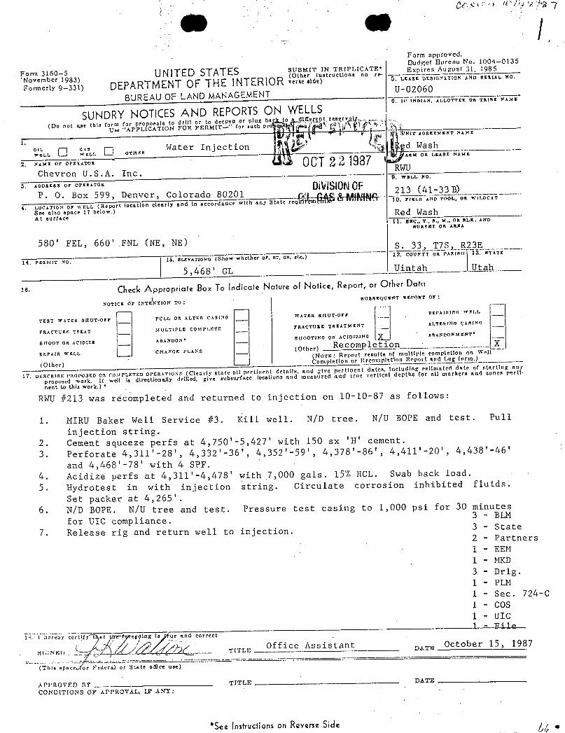
Form approved.
oeen5983) UNITED STATES sgauto y Taipicios· c pi"Á"L°',3°
Formerly 9-331) DEPARTMENTOF THE INTERIOR vme niseair¯raaiiië¯a
BUREAU OF LAND MANAGEMENTU-02060
SUNDRY NOTICES AND REPORTSON WELLS"°¯°
(Do not use this form for proposale to drill or to deepen or plug b titeppt rengryo
Use "APPLICATION FOR PERMIT-'' for auch p
°wix's= O °;;. Oo water Injection d Wash
2. NAME Or OPERATOR
ARM OR ASE NAME
Chevron U.S.A. Inc·RWU
3. ADDREBB OT OPERATOR
9. WELL NO.
P. O. Box 599, Denver, Colorado 80201DNISONOF 213 (4
4. LOCATtoN or n ELL (Report location clearly and in accordance with any State re 10. Trzt.o AND root,, UR wit.DCAT
See also space 17 below.)at surface
Red Wash11. sac., T., a., M., on al,K. Ano
80RTET OR ARWA
580' FEL, 660' FNL (NE, NE) S. 33, T7Sa R23E
14. PERMIT NO. 15. ELY.VATIONS (Show whether or, RT, cR. etc.) 12. COUNTT on PAntatt 13. BTATr
| 5,468' GL Uintah I Utah
checkAppropriate Box To Indicate Nature of Notice, Report, or Other Dam
NOTICE 7 INTE TION TO:BUnstqUtt!T REINRT 07:
TEST WITER 3EIUT-Orr PCLL OR ALTER C.iSING WATER SITUT-UTF REPAllt1NG WP.I.L
FRACTURE TREAT 3fULTIPLE COAFPF.ETE YRACTURE TREATMENT AT,TERING CARING
SHOOT OR ACIDIZE ABANDON' SBOOT1NG On AC1DI7,INGABANDONMENT*
REPAIR WELI, CHANGE PLANs (Other)ompletion X
(NOTE: Report resulta of multiple completion on WeH
(Other) ..
. Completion or Recolaplet1an Report and Lo orm.)
17. De:.SCRIBE l'ROI'OSED OR CO>fPLETED OPERATIo.Ns (Clearly state all pertlnrnt details, and give pertloent datea, including estimated date of starting any
proposed work. If well is directionally drilled, give subsurface locations and measured and true vertical depths for all markers and mones parti-
nent to this work.) •
RWU #213 was recompleted and returned to injection on 10-10-87 as follows:
1. MIRU Baker Well Service #3. Kill well. N/D tree. N/U BOPE and test. Pull
injection string.2. Cement squeeze perfs at 4,750'-5,427' with 150 sx 'H' cement.3. Perforate 4,311'-28', 4,332'-36', 4,352'-59', 4,378'-86', 4,411'-20', 4,438'-46'
and 4,468'-78' with 4 SPF.4. Acidize perfs at 4,311'-4,478' with .7,000 gals. 15% HCL. Swab back load.5. Hydrotest in with injection string. Circulate corrosion inhibited fluids.
Set packer at 4,265'.6. N/D BOPE. N/U tree and test. Pressure test casing to 1,000 psi for 30 minutes
for UIC compliance.3 - ELM
7. Release rig and return well to injection. 3 - State2 - Partners1 - EEM1 - MKD3 - Drlg.1 - PLM1 - Sec. 724-C
1 - COS1 - UIC
li i bereby certyy t at t,tre egging la ue and correct
«;sico X TiracOffice Assistant October 15, 1987
(This spaceÁor Federd or State ofilee use)
APPROVED BY TITLE DATE
CONOITIONS OF APPROVIL, 17 ANY:
*See Instructionson Revene Side y
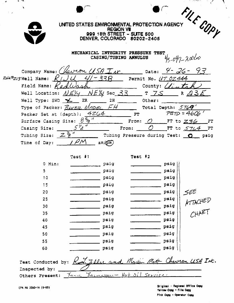
UMTEDSTATESENVIRONMENTALPROTECTIONAGENCYREGM3N\M
999 18th STREET - SUTE 500DENVER,COLORADO 80202-2405
MECHANICAL INTEGRITY PRESSURE TESTCASING/TUBING ANNULUS
Company Name: gy Date:3Well Name: ( Permit No. //7 0
Field Name: y County: ff'Well Location: ÅÎË Sec 3 T 76 R Â 3Well Type: SWD 14. ER 2H Other:
Type of Packer: Ñ¿Vriz.. DDFt & Ñ Total Depth: 57{pg'Packer Set at ( depth ) : 4 FT STÑ 2
Surface Casing Size: 6 r" From: () FT to 2136, FT
Casir.g Size: íË From: (9 FT to jf (pg FT
Tubing Size: 11 6"
Tubing Pressure during Test: (3 psig
Time of Day: | |2A am/(g )
Test #1 Test #20 Min: psig psig
5 psig psig
10 psig psig
15 psig psig
20 psig psig 2:25 psig psig
30 psig psig
35 psig psig
40 psig psig
45 psig psig
50 psig 9519
55 psig psig
60 psig 9819
Test Conducted by: 2 (/ha . M. ÍGA //fÑ IkInspected by:Others Present: <ma w - Ñ.4 !) Í Tavir.« -
EPA 88 3560-lA (8-89) OrlSinal - Aegional Office CopyYellow Copy- File copyPink Copy - Operator
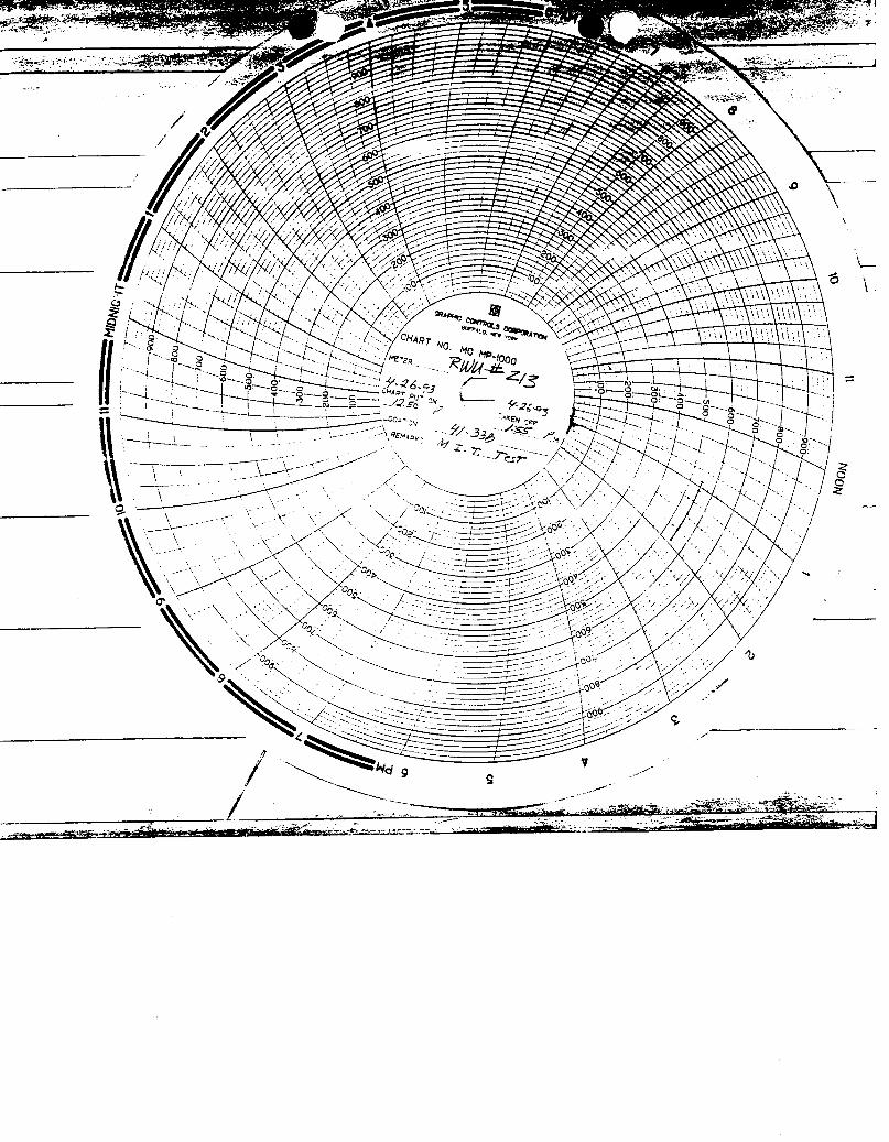
Status=0
/ 4 UNITED STA S ENVIRONMENTAL PROTECT.a AGENCYREGION VIII
999 18th STREET - SUITE 500DENVER, COLORADO 80202-2466
UNDERGROUND INJECTION CONTROL PROGRAM
FINAL PERMIT
Class II Salt Water Disposal Well (SWD)
Permit No. UT2661-02444
Well Name: Red Wash Unit #213 (41-33B) SWDField Name: Red Wash Unit (RWU)
County & State: Uintah, Utah
issued to:
Chevron U.S.A. Production Company11002 East 17500 South
Vernal, Utah 84078-8526
Date Prepared: January 1998
Printed on Recycled
O
TABLE OF CONTENTSPage
TITLESHEET..................... 1
TABLE OF CONTENTS . . . . . . . . . . . . . . . . 2
PART I. AUTHORIZATION TO INJECT . . . . . . . . . 4
PART II. SPECIFIC PERMIT CONDITIONS . . . . . . . 6
Section A. WELL CONSTRUCTIONREQUIREMENTS 6
1. Casing and Cementing . . . . . . . . . . 62. Tubing and Packer Specifications
. . . . 63. Monitoring Devices . . . . . . . . . . . 64. Proposed Changes and Workovers . . . . . 75. Formation Testing and Logging . . . . . 7
Section B. CORRECTIVE ACTION . . . . . . . . . 7
Section C. WELL OPERATION . . . . . . . . . . . 8
1. Transition from Rule to PermitAuthorization . . . . . . . . . . . . . 7
2. Mechanical Integrity . . . . . . . . . 83. Injection Interval . . . . . . . . . . . 84. Injection Pressure Limitation . . . . . 95. Injection Volume Limitation . . . . . . 96. Injection Fluid Limitation . . . . . . . 9
Section D. MONITORING, RECORDKEEPING, AND REPORTINGOFRESULTS
.............. 9
1. Injection Well Monitoring Program . . . 92. Monitoring Information . . . . . . . . . 103. Recordkeeping . . . . . . . . . . . . . 104. Annual Reporting . . . . . . . . . . . 11
Section E. PLUGGING AND ABANDONMENT . . . . 11
1. Notice of Plugging and Abandonment . . . 112. Plugging and Abandonment Plan . . . . . 113. Cessation of Injection Activities . . . 124. Plugging and Abandonment Report . . . . 12
Page 2 of 29EPA FINAL Permit No.
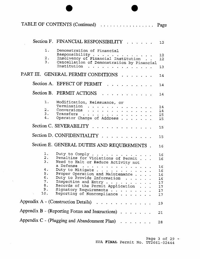
O OTABLE OF CONTENTS (Continued) . . . . . . . . . . . . . . . . . Page
Section F. FINANCIAL RESPONSIBILITY . . . . . . 12
1. Demonstration of FinancialResponsibility . . . . . . . . . . . . . 12
2. Insolvency of Financial Institution . . 123. Cancellation of Demonstration by Financial
Institution . . . . . . . . . . . . . . 13
PART III. GENERAL PERMIT CONDITIONS . . . . . . . 14
Section A. EFFECT OF PERMIT . . . . . . . . . . 14
Section B. PERMIT ACTIONS . . . . . . . . . . . 14
1. Modification, Reissuance, orTermination . . . . . . . . . . . . . . 14
2. Conversions . . . . . . . . . . . . . . 143. Transfers . . . . . . . . . . . . . . . 154. Operator Change of Address . . . . . . . 15
Section C. SEVERABILITY . . . . . . . . . . . . . 15
Section D. CONFIDENTIALITY . . . . . . . . . . . 15
Section E. GENERAL DUTIES AND REQUIREMENTS. 15
1. Duty to Comply . . . . . . . . . . . . . 162. Penalties for Violations of Permit . . . 163. Need to Halt or Reduce Activity not
a Defense . . . . . . . . . . . . . . . 164. Duty to Mitigate . . . . . . . . . . . . 165. Proper Operation and Maintenance . . . . 166. Duty to Provide Information . . . . . . 167. Inspection and Entry . . . . . . . . . . 178. Records of the Permit Application . . . 179. Signatory Requirements . . . . . . . . . 17
10. Reporting of Noncompliance . . . . . . . 17
Appendix A - (Construction Details) . . . . . . . . . . . . 19
Appendix B - (Reporting Forms and Instructions) . . . . . . . 21
Appendix C - (Plugging and Abandonment Plan) . . . . . . . 2 8
Page 3 of 29EPA FINAL Permit No.
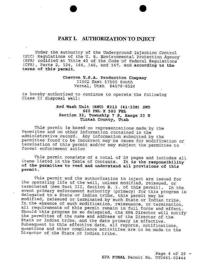
O O
PART I. AUTHORIZATION TO INJECT
Under the authority of the Underground Injection Control(UIC) Regulations of the U. S. Environmental Protection Agency(EPA) codified at Title 40 of the Code of Federal Regulations(CFR), Parts 2, 124, 144, 146, and 147, and according to theterms of this permit,
Chevron U.S.A. Production Company11002 East 17500 South
Vernal, Utah 84078-8526
is hereby authorized to continue to operate the followingClass II disposal well:
Red Wash Unit (RWU) #213 (41-338) SWD660 FNL X 580 FEL
Section 33, Township 7 S, Range 23 EUintah County, Utah
This permit is based on representations made by thePermittee and on other information contained in theadministrative record. Any information submitted by thepermittee found to be incorrect may be cause for modification ortermination of this permit and/or may subject the permittee toformal enforcement action
This permit consists of a total of 29 pages and includes allitems listed in the Table of Contents. It is the responsibilityof the permittee to read and understand all provisions of thispermit.
This permit and the authorization to inject are issued forthe operating life of the well, unless modified, reissued, orterminated (see Part III, Section B. 1. of this permit). In theevent primary enforcement authority (primacy) for this program isdelegated to a State or Indian tribe, this permit may bemodified, reissued or terminated by such State or Indian tribe.In the absence of such modification, reissuance, or termination,all requirements of this permit remain in full force and effect.Should this program be so delegated, the EPA Director will notifythe permittee of the name and address of the Director of theState or Indian tribe, and the date primacy is effective.Subsequent to this effective date, all reports, notifications,questions and other compliance activities are to be made to theDirector of the State or Indian tribe.
Page 4 of 29EPA FINAL Permit No.
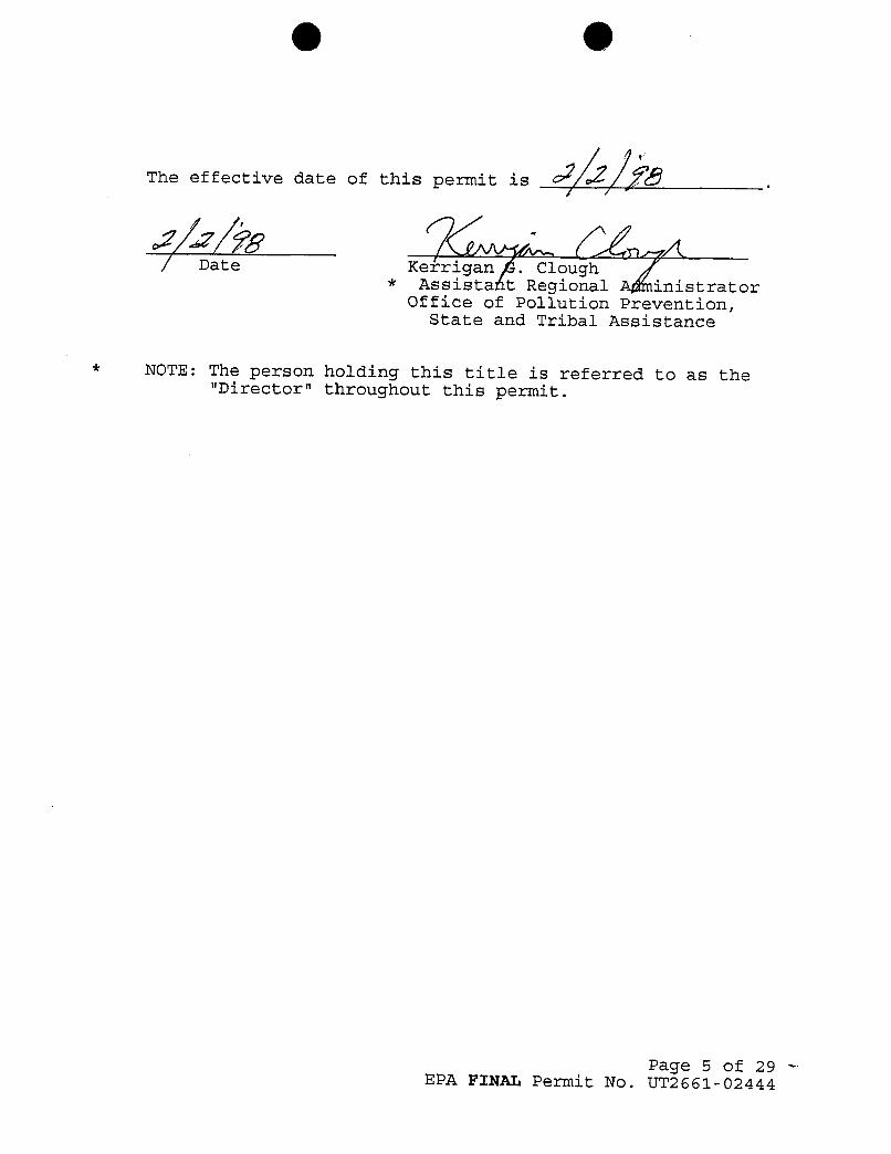
O O
The effective date of this permit is > / / ¿Û.
| Date Kerrigan . Clough* Assistant Regional inistrator
Office of Pollution Prevention,State and Tribal Assistance
* NOTE: The person holding this title is referred to as the"Director" throughout this permit.
Page 5 of 29EPA FINAL Permit No.
O O
The effective date of this permit is > / / ¿Û.
| Date Kerrigan . Clough* Assistant Regional inistrator
Office of Pollution Prevention,State and Tribal Assistance
* NOTE: The person holding this title is referred to as the"Director" throughout this permit.
Page 5 of 29EPA FINAL Permit No.
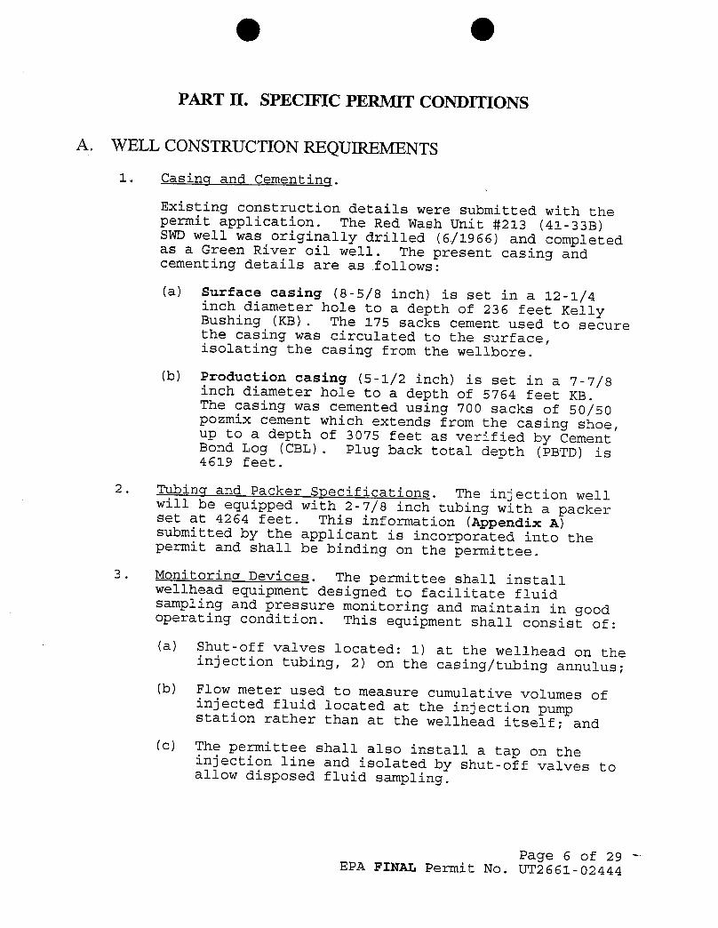
O O
PART II. SPECIFIC PERMIT CONDITIONS
A. WELL CONSTRUCTION REQUIREMENTS
1. Casing and Cementing.
Existing construction details were submitted with thepermit application. The Red Wash Unit #213 (41-33B)SWD well was originally drilled (6/1966) and completedas a Green River oil well. The present casing andcementing details are as follows:
(a) Surface casing (8-5/8 inch) is set in a 12-1/4inch diameter hole to a depth of 236 feet KellyBushing (KB). The 175 sacks cement used to securethe casing was circulated to the surface,isolating the casing from the wellbore.
(b) Production casing (5-1/2 inch) is set in a 7-7/8inch diameter hole to a depth of 5764 feet KB.The casing was cemented using 700 sacks of 50/50pozmix cement which extends from the casing shoe,up to a depth of 3075 feet as verified by CementBond Log (CBL). Plug back total depth (PBTD) is4619 feet.
2. Tubing and Packer Specifications. The injection wellwill be equipped with 2-7/8 inch tubing with a packerset at 4264 feet. This information (Appendix A)submitted by the applicant is incorporated into thepermit and shall be binding on the permittee.
3. Monitoring Devices. The permittee shall installwellhead equipment designed to facilitate fluidsampling and pressure monitoring and maintain in goodoperating condition. This equipment shall consist of:
(a) Shut-off valves located: 1) at the wellhead on theinjection tubing, 2) on the casing/tubing annulus;(b) Flow meter used to measure cumulative volumes ofinjected fluid located at the injection pump
station rather than at the wellhead itself; and
(c) The permittee shall also install a tap on theinjection line and isolated by shut-off valves toallow disposed fluid sampling.
Page 6 of 29EPA FINAL Permit No.
O O4. Provosed Changes and Workovers. The permittee shall
give advance notice to the Director, as soon aspossible, of any planned physical alterations oradditions to the permitted well. Major alterations orworkovers of the permitted well shall meet allconditions as set forth in this permit. A majoralteration or workover shall be considered any workperformed, which affects casing, packer(s), or tubing.A demonstration of mechanical integrity shall beperformed within thirty (30) days of completion of anyworkover and/or alterations, and prior to resuminginjection activities in accordance with Part II,Section C. 3. (a).
The permittee shall provide all records of wellworkovers, logging, or other test data to EPA withinsixty (60) days of completion of the activity.Appendix B contains samples of the appropriatereporting forms.
5. Formation Testing and Logging. The permittee is notrequired to perform any logging or other formationtests on the disposal well before the effective date ofthis permit.
B. CORRECTIVE ACTION
In accordance with 40 CFR § 144.55, existing wells areexempt from corrective action requirements. The applicant hasshown that this well qualified for such an exemption as the wellhas been active as a disposal well since November 1987 (prior tothe November 25, 1988, effective date of the UndergroundInjection Control [UIC] Program for all classes of wells onIndian lands in the State of Utah administered by theEnvironmental Protection Agency) and was automatically granted anaquifer exemption extending in a 1/4-mile radius from thewellbore. This was done for all existing disposal/injectionwells that were eligible for the 1/4-mile aquifer exemptions.
C. WELL OPERATION
1. Transition from Rule to Permit Authorization. The RWU#213 (41-33B) disposal well has been operating sincebefore November 25, 1988. Adherence to allrequirements under 40 CFR Parts 144, 146, and 147,including construction and mechanical integrity, hasbeen verified. Disposal activities for the RWU #213(41-33B)D well are no longer authorized by rule withfinal issuance of this permit. Disposal activities areauthorized, through this permit, to continue, providedall conditions of this permit are met.
Page 7 of 29EPA FINAL Permit No.
O OThe tubing/casing annulus of the RWU #213 (41-338) SWDwas tested with pressure chart, and approved formechanical integrity on April 26, 1993.
2. Mechanical Integrity Demonstration.
(a) Notification. The permittee shall notify theDirector at least 30 (thirty) days prior to anyrequired mechanical integrity test (MIT). TheDirector may allow a shorter notification periodif it would be sufficient to enable EPA to witnessthe MIT. Notification may be in the form of ayearly or quarterly schedule of planned MIT's, orit may be on an individual basis.
(b) Test Methods and Criteria. Test methods andcriteria are to follow current UIC guidance. Thisguidance will be made available to the Permitteewhen the permittee notifies the Director(paragraph 1., above) of an upcoming mechanicalintegrity test.
(c) Routine Demonstrations of Mechanical Integrity.A demonstration of mechanical integrity shall bemade at regular intervals during the life of thewell, but no less frequently than once every five(5) years, in accordance with 40 CFR § 146.8, and
paragraph (a), above, unless otherwise modified.Results of the test shall be submitted to theDirector as soon as possible but no later thansixty (60) days after the test is complete.
(d) Loss of Mechanical Integrity. If the well failsto demonstrate mechanical integrity during a test,or a loss of mechanical integrity as defined by 40CFR § 146.8 becomes evident during operation, thepermittee shall notify the Director in accordancewith Part III, Section E. 10. of this permit.Furthermore, injection activities shall beterminated immediately; and operation shall not beresumed until the permittee has taken necessaryactions to restore integrity to the well and theDirector gives approval to recommence injection.
3. Iniection Interval. Disposal will limited to the grossGreen River disposal zone, being 4311' to 4619'.
4. Iniection Pressure Limitation.
(a) Injection pressure, measured at the surface, shallnot exceed an amount that the Director determinesis appropriate to ensure that injection does notinitiate new fractures or propagate existing
Page 8 of 29EPA FINAL Permit No.
O Ofractures in the confining zone adjacent to USDWs.In no case shall injection pressure cause themovement of injected or formation fluids into aUSDW.
(b) The exact pressure limit may be increased ordecreased by the Director to ensure that therequirements in paragraph (a) are fulfilled. Inorder to determine an exact pressure limit, thepermittee shall conduct a step-rate injection testor other authorized well test(s) that will serveto determine the fracture pressure of theinjection zone. Test procedures shall be pre-approved by the Director. The Director willspecify in writing, to the permittee, any increaseor decrease to the injection pressure based uponthe test results and/or other parametersreflecting actual injection operations. Untilsuch time that this demonstration is made, theinitial iniection pressure, measured at thesurface, shall not exceed 1479 psig.
5. Injection Volume Limitation. There is no limitation onthe number of barrels of water per day (BWPD) thatshall be injected into the Green River Formationperforations, provided further that in no case shallinjection pressure exceed that limit shown in Part II,Section C. 4. (b) of this permit.
6. Iniection Fluid Limitation. Disposal fluids arelimited to those which are identified in 40 CFR §144.6. (b). Fluids shall be further limited to thosegenerated by sources owned or operated by thepermittee. The permittee shall provide a listing ofthe sources of the injected fluids in accordance withthe reporting requirements in Part II, Section D. 4. ofthis permit.
D. MONITORING, RECORDKEEPING, AND REPORTING OFRESULTS
1. Iniection Well Monitoring Program. Samples andmeasurements shall be representative of the monitoredactivity. The permittee shall utilize the applicableanalytical methods described in Table 1 of 40 CFR §136.3, or in Appendix III of 40 CFR Part 261, or incertain circumstances, by other methods that have beenapproved by the EPA Administrator. Monitoring shallconsist of:
(a) Analysis of the disposed fluids, performed:
Page 9 of 29EPA FINAL Permit No.
O O(i) annually for Total Dissolved Solids, Ph,
Specific Conductivity, and Specific Gravityfrom the common facility; however, ifinjection is maintained from more than onewell from each common facility, then only oneannual analysis is required for thatfacility.
(ii) whenever there is a change in the source ofdisposed fluids. A comprehensive wateranalysis shall be submitted to the Directorwithin thirty (30) days of any change ininjection fluids.
Ob) Observations of flow rate, injection pressure,annulus pressure, and cumulative volume shall beconducted weekly. All observations shall beobserved and/or measured at approximately the sametime. Observations of each shall be recordedmonthly.
2. Monitoring Information. Records of any monitoringactivity required under this permit shall include:
(a) The date, exact place, the time of sampling orfield measurements;
(b) The name of the individual(s) who performed thesampling or measurements;
(c) The exact sampling method(s) used to take samples;
(d) The date(s) laboratory analyses were performed;
le) The name of the individual(s) who performed theanalyses;
(f) The analytical techniques or methods used bylaboratory personnel; and
[g) The results of such analyses.
3. Recordkeeping.
(a) The permittee shall retain records concerning:
(i) the nature and composition of all injectedfluids until three (3) years after thecompletion of plugging and abandonment whichhas been carried out in accordance with thePlugging and Abandonment Plan shown inAppendix C, and is consistent with 40 CFR §146.10.
Page 10 of 29EPA FINAL Permit No.
O O(ii) all monitoring information, including all
calibration and maintenance records and alloriginal strip chart recordings forcontinuous monitoring instrumentation andcopies of all reports required by this permitfor a period of at least five (5) years fromthe date of the sample, measurement.or reportthroughout the operating life of the well.
(b) The permittee shall continue to retain suchrecords after the retention period specified inparagraphs (a) (i) and (a) (ii) unless he deliversthe records to the Director or obtains writtenapproval from the Director to discard the records.
(c) The Permittee shall maintain copies (or originals)of all pertinent records at the office of ChevronU.S.A. Production Company, 11002 East 17500 South,Vernal, Utah.
4. Annual Reporting. The permittee shall submit anAnnual Report, whether iniecting or not, to theDirector summarizing the results of the monitoringrequired by Part II, Section D. 1. (a) and (b) of thispermit. The permittee shall also include a listing ofall sources of the fluids injected during the yearidentifying the source by either the well name(s), thefield name(s), or the facility name(s). The firstAnnual Report shall cover the period from the effectivedate of the permit through December 31 of that year.Subsequent Annual Reports shall cover the period fromJanuary 1 through December 31. Annual Reports shall besubmitted by February 15 of the following yearfollowing data collection. Appendix B contains Form7520-11 which may be copied and used to submit theAnnual Report.
E. PLUGGING AND ABANDONMENT
1. Notice of Pluqqing and Abandonment. The permitteeshall notify the Director forty-five (45) days beforeabandonment of the well.
2. Pluqqinq and Abandonment Plan. The plugging andabandonment plan submitted by the permittee, withrevisions by EPA, is incorporated into the permit(Appendix C of the Permit) and shall be binding on thepermittee. This plan has been reviewed and approved bythe EPA. The EPA reserves the right to change themanner in which the well will be plugged if the well ismodified during its permitted life or if the well isnot made consistent with EPA requirements for
Page 11 of 29EPA FINAL Permit No.
O Oconstruction and mechanical integrity. The Directormay require the permittee to update the estimatedplugging cost periodically. Such estimates shall bebased upon costs which a third party would incur toplug the well according to the plan.
3. Cessation of Iniection Activities. After a cessationof operations of two (2) years, the permittee shallplug and abandon the well in accordance with thePlugging and Abandonment Plan, unless the permittee:
(a) has provided notice to the Director; and
(b) has demonstrated that the well will be used in thefuture; and
(c) has described actions or procedures, satisfactoryto the Director, that will be taken to ensurethat the well will not endanger undergroundsources of drinking water during the period of
temporary abandonment.
4. Pluqqinq and Abandonment Revort. Within sixty (60)days after plugging the well, the permittee shallsubmit a report on Form 7520-13 to the Director. Thereport shall be certified as accurate by the person whoperformed the plugging operation, and the report shallconsist of either: (1) a statement that the well wasplugged in accordance with the plan; or (2) whereactual plugging differed from the plan, a statementthat specifies the different procedures followed.
F. FINANCIAL RESPONSIBILITY
1. Demonstration of Financial Responsibility. Thepermittee is required to maintain continuous financialresponsibility and resources to close, plug, andabandon the injection wells as provided in the pluggingand abandonment plan(s). The permittee may submit awritten request to EPA to change the type of financialmechanism or instrument utilized. A change indemonstration of financial responsibility must beapproved in writing by the Director.
2. Insolvency of Financial Institution. In the event thatan alternate demonstration of financial responsibilityhas been approved under, the permittee must submit analternate demonstration of financial responsibilityacceptable to the Director within sixty (60) days aftereither of the following events occur:
Page 12 of 29EPA FINAL Permit No.
O O
(a) The institution issuing the trust or financialinstrument files for bankruptcy; or
(b) The authority of the trustee institution to act astrustee, or the authority of the institutionissuing the financial instrument, is suspended orrevoked.
3. Cancellation of Demonstration by Financial Institution.The permittee must submit an alternative demonstrationof financial responsibility acceptable to the Director,within sixty (60) days after the institution issuingthe trust or financial instrument serves 120-day noticeto the EPA of their intent to cancel the trust orfinancial instrument.
Page 13 of 29EPA FINAL Permit No.
O OPART III. GENERAL PERMIT CONDITIONS
A. EFFECT OF PERMIT
The permittee is allowed to engage in underground disposalin accordance with the conditions of this permit. The permittee,as authorized by this permit, shall not construct, operate,maintain, convert, plug, abandon, or conduct any other disposalactivity in a manner that allows the movement of fluid containingany contaminant into underground sources of drinking water, ifthe presence of that contaminant may cause a violation of anyprimary drinking water regulation under 40 CFR Part 142 orotherwise adversely affect the health of persons. Anyunderground disposal activity not authorized in this permit orotherwise authorized by permit or rule is prohibited. Issuanceof this permit does not convey property rights of any sort or anyexclusive privilege; nor does it authorize any injury to personsor property, any invasion of other private rights, or anyinfringement of State or local law or regulations. Compliancewith the terms of this permit does not constitute a defense toany enforcement action brought under the provisions of Section1431 of the Safe Drinking Water Act (SDWA), 42 USC § 300i, or anyother law governing protection of public health or theenvironment for any imminent and substantial endangerment tohuman health, or the environment, nor does it serve as a shieldto the permittee's independent obligation to comply with all UICregulations.
B. PERMIT ACTIONS
1. Modification, Reissuance, or Termination. The Directormay, for cause or upon a request from the permittee,modify, revoke and reissue, or terminate this permit inaccordance with 40 CFR §§ 124.5, 144.12, 144.39, and144.40. Also, the permit is subject to minormodifications for cause as specified in 40 CFR §144.41. The filing of a request for a permitmodification, revocation and reissuance, or terminationor the notification of planned changes or anticipatednoncompliance on the part of the permittee does notstay the applicability or enforceability of any permitcondition.
2. Conversions. The Director may, for cause or upon arequest from the permittee, allow conversion of thewell from a Class II salt water disposal well to anon-Class II well. Requests to convert the disposalwell from its Class II status to a non-Class II well,such as, a production well, must be made in writing tothe Director. Conversion may not proceed until a
Page 14 of 29EPA FINAL Permit No.
Opermit modification indicating the conditions of theproposed conversion is received by the permittee.Conditions of the modification may include such itemsas, but is not limited to, approval of the proposedwell rework, follow up demonstration of mechanicalintegrity, and well specific monitoring and reportingfollowing the conversion.
3. Transfers. This permit is not transferrable to anyperson except after notice is provided to the Directorand the requirements of 40 CFR § 144.38 are compliedwith. The Director may require modification, orrevocation and reissuance, of the permit to change thename of the permittee and incorporate such otherrequirements as may be necessary under the SDWA.
4. Operator Change of Address. Upon the operator's changeof address, notice must be given to the appropriate EPAoffice at least fifteen (15) days prior to theeffective date.
C. SEVERABILITY
If any provision of this permit or the application of anyprovision of this permit to any circumstance is stayed or heldinvalid, all remaining provisions of this permit shall remainfully effective and enforceable, except for those provisionswhich are not severable from the stayed or invalid provision.
D. CONFIDENTIALITY
In accordance with 40 CFR Part 2 and 40 CFR § 144.5, anyinformation submitted to EPA pursuant to this permit may beclaimed as confidential by the submitter. Any such claim must beasserted at the time of submission by stamping the words"confidential business information" on each page containing suchinformation. If no claim is made at the time of submission, EPAmay make the information available to the public without furthernotice. If a claim is asserted, the validity of the claim willbe assessed in accordance with the procedures in 40 CFR Part 2(Public Information). EPA will deny claims of confidentialityincluding but not limited to the following information:- The name and address of the permittee; and- Information which deals with the existence, absence orlevel of contaminants in drinking water.
Page 15 of 29EPA FINAL Permit No.

O O
E. GENERAL DUTIES AND REQUIREMENTS
1. Duty to Comply. The permittee shall comply with allconditions of this permit, except to the extent and forthe duration such noncompliance is authorized by anemergency permit. Any permit noncompliance constitutesa violation of the SDWA and is grounds for enforcementaction, permit termination, revocation and reissuance,or modification. Such noncompliance may also begrounds for enforcement action under the ResourceConservation and Recovery Act (RCRA) .
2. Penalties for Violations of Permit Conditions. Anyperson who violates a permit requirement is subject tocivil penalties, fines, and other enforcement actionunder the SDWA and may be subject to such actionspursuant to the RCRA. Any person who willfullyviolates permit conditions may be subject to criminalprosecution.
3. Need to Halt or Reduce Activity not a Defense. Itshall not be a defense for a permittee in anenforcement action that it would have been necessary tohalt or reduce the permitted activity in order tomaintain compliance with the conditions of this permit.
4. Duty to Mitigate. The permittee shall take allreasonable steps to minimize or correct any adverseimpact on the environment resulting from noncompliancewith this permit.
5. Proper Overation and Maintenance. The permittee shallat all times properly operate and maintain allfacilities and systems of treatment and control (andrelated appurtenances) which are installed or used bythe permittee to achieve compliance with the conditionsof this permit. Proper operation and maintenanceincludes effective performance, adequate funding,adequate operator staffing and training, and adequatelaboratory and process controls, including appropriatequality assurance procedures. This provision requiresthe operation of back-up or auxiliary facilities orsimilar systems only when necessary to achievecompliance with the conditions of this permit.
6. Duty to Provide Information. The permittee shallfurnish the Director, within a time specified, anyinformation which the Director may request to determinewhether cause exists for modifying, revoking andreissuing, or terminating this permit, or to determinecompliance with the permit. The permittee shall also
Page 16 of 29EPA FINAL Permit No.
O Ofurnish to the Director, upon request, copies ofrecords required to be kept by this permit.
7. Inspection and Entry. The permittee shall allow theDirector, or an authorized representative, upon thepresentation of credentials and other documents as maybe required by law, to:
(a) Enter upon the permittee's premises where aregulated facility or activity is located orconducted, or where records must be kept under theconditions of this permit;
(b) Have access to and copy, at reasonable times, anyrecords that must be kept under the conditions ofthis permit;
(c) Inspect at reasonable times any facilities,equipment (including monitoring and controlequipment), practices, or operations regulated orrequired under this permit; and
(d) Sample or monitor, at reasonable times, for thepurpose of assuring permit compliance or asotherwise authorized by the SDWA any substances orparameters at any location.
8. Records of Permit ADD1ication. The permittee shallmaintain records of all data required to complete thepermit application and any supplemental informationsubmitted for a period of five (5) years from theeffective date of this permit. This period may beextended by request of the Director at any time.
9. Signatory Requirements. All reports or otherinformation requested by the Director shall be signedand certified according to 40 CFR § 144.32.
10. Revorting of Noncompliance.
(a) Anticivated Noncomeliance. The permittee shallgive advance notice to the Director of any plannedchanges in the permitted facility or activitywhich may result in noncompliance with permitrequirements.
(b) Compliance Schedules. Reports of compliance ornoncompliance with, or any progress reports on,interim and final requirements contained in anycompliance schedule of this permit shall besubmitted no later than thirty (30) days followingeach schedule date.
Page 17 of 29EPA FINAL Permit No.
O O(c) Twenty-four Hour Reporting.
(i) The permittee shall report to the Directorany noncompliance which may endanger healthor the environment. Information shall beprovided orally within twenty-four (24) hoursfrom the time the permittee becomes aware ofthe circumstances by telephoning EPA at (303)312-6142 (during normal business hours) or at(303) 293-1788 (for reporting at all othertimes). The following information shall beincluded in the verbal report:
04) Any monitoring or other informationwhich indicates that any contæminantmay cause endangerment to an under-
ground source of drinking water.
B) Any noncompliance with a permitcondition or malfunction of theinjection system which may cause fluidmigration into or between undergroundsources of drinking water.
(ii) A written submission shall also be providedto the Director within five (5) days of thetime the permittee becomes aware of thepotential for endangerment to health or theenvironment. The written submission shallcontain a description of the noncomplianceand its cause; the period of noncompliance,including exact dates and times, and if thenoncompliance has not been corrected, theanticipated time it is expected to continue;and steps taken or planned to reduce,eliminate, and prevent recurrence of thenoncompliance.
(d) Other Noncompliance. The permittee shall reportall other instances of noncompliance not otherwisewise reported at the time monitoring reportsare submitted. The reports shall contain theinformation listed in Part III, Section E. 10.(c) (ii) of this permit.
(e) Other Information. Where the permittee becomesaware that any relevant facts were not submittedin the permit application, or incorrectinformation was submitted in a permit applicationor in any report to the Director, the permitteeshall submit such correct facts or informationwithin two (2) weeks of the time such informationbecomes known.
Page 18 of 29EPA FINAL Permit No.
O O
APPENDIX A
CONSTRUCTION SCHEMATIC
Page 19 of 29EPA FINAL Permit No.
O O
APPENDIX A
CONSTRUCTION SCHEMATIC
Page 19 of 29EPA FINAL Permit No.
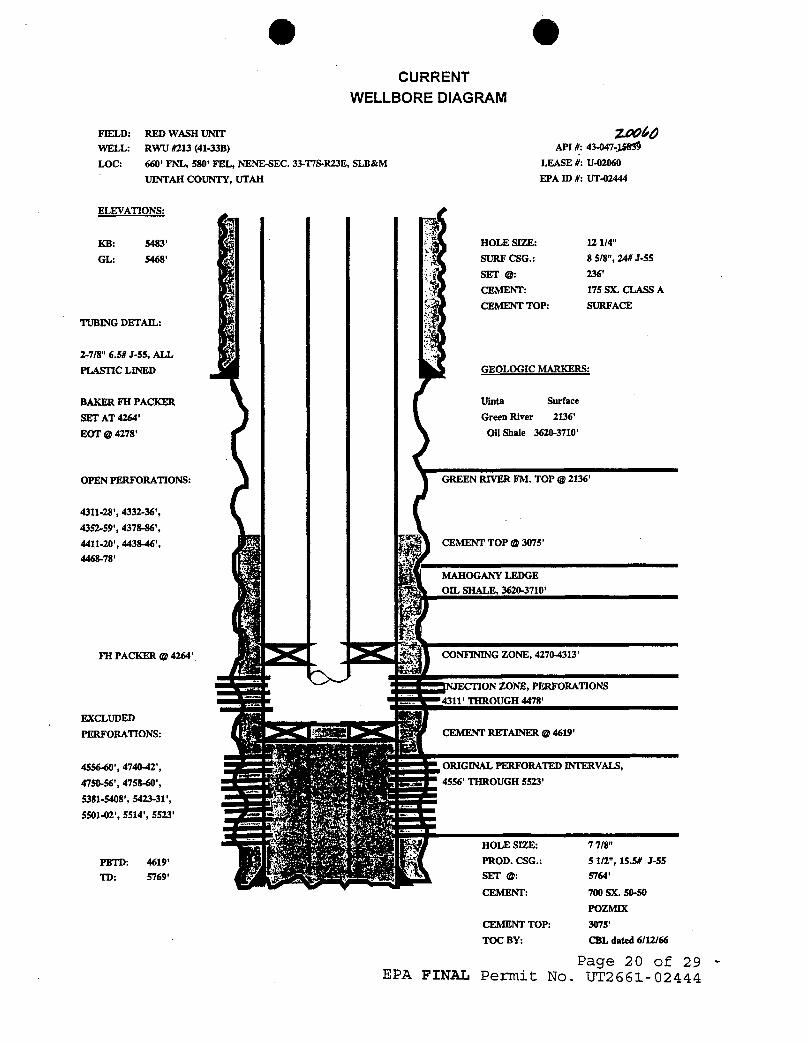
O OCURRENT
WELLBORE DIAGRAM
FIELD: RED WASH UNIT N ÔWELL: RWU #213 (41-338) API #: 43-047-¾
LOC: 660' FNL, 580' FEL, NENE-SEC. 33-T7S-R23E, SLB&M LEASE #: U-02060
UINTAH COUNTY, UTAH EPA ID #: UT-02444
ELEVATIONS:
KB: 5483' HOLE SIZE: 12 1/4"
GL: 5468' SURF CSG.: 8 5/8", 24# J-55
SET @: 236'
CEMENT: 175 SX. CLASS A
CEMENT TOP: SURFACETUBINGDETAIL:
2-7/8" 6.5# J-55, ALL
PLASITC LINED GEOLOGIC MARKERS:
BAKER FH PACKER Uinta Surface
SET AT 4264' Green River 2136'
EOT @ 4278' Oil Shale 3620-3710'
OPEN PERFORATIONS: GREEN RIVER FM. TOP @ 2136'
4311-28', 4332-36',
4352-59', 4378-86',
4411-20', 4438-46', CEMENT TOP @ 3075'4468-78'
MAHOGANYLEDGEOIL SHALE, 3620-3710'
FH PACKER @ 4264' CONFINING ZONE, 4270-4313'
ON ZONE, PERFORATIONS4311' THROUGH 4478'
EXCLUDED
PERFORATIONS: CEMENT RETAINER @4619'
4556-40', 4740-42', ORIGINAL PERFORATED INTERVAIß,
4750-56', 4758-60', 4556' THROUGH 5523'5381-5408', 5423-31',
5501-02', 5514', 5523'
HOLE SIZE: 7 7/8"
PBTD: 4619' PROD. CSG.: 5 1/2", 15.5# J-55
TD: 5769' SET @: 5764'
CEMENT: 700 SX. 50-50
POZMIX
CEMENT TOP: 3075'
TOC BY: CBL dated 6/12/66
Page 20 of 29EPA FINAL Permit No.
APPENDIX B
REPORTING FORMS
1. EPA Form 7520- 7: APPLICATION TO TRANSFER PERMIT
2. EPA Form 7520-10: COMPLETION REPORT FOR BRINE DISPOSALWELL
3. EPA Form 7520-11: ANNUAL DISPOSAL/INJECTION WELLMONITORING REPORT
4. EPA Form 7520-12: WELL REWORK RECORD
5. EPA Form 7520-13: PLUGGING RECORD
6. EPA Form RS: MECHANICAL INTEGRITY PRESSURE TEST
Page 21 of 29EPA FINAL Permit No.
roved. OMB No 20004X)42 Approval expires 9 30UNITEDSTATES ENVIRONMENTAL PROTECTION AGENCY
WASHINGTON. DC 20460•E PA APPLICATION TO TRANSFER PERMITNAME AND ADDRESS OF EXISTINGPERMITTEE NAME AND ADDRESS OF SURFACE OWNER
STATE COUNTY PERMIT NUMBERLOCATE WELL AND OUTLINEUNITONSECTION RLAT - 640 ACRES
SURFACE LOCATION DESCRIPTIONN
¼ OF ¼ OF ¼ SECTION TOWNSHIP RANGELOCATE WELL IN TWO DIRECTIONS FROM NEAREST UNES OF QUARTER SECTION AND DRILLINGUNIT
SurfaceLocation -ft. from (N/S) - Line of quarter sectionI 1and - ft. from (E/W) - Une of quarter section
WELL ACTIVITY WELL STATUS - TYPE OF PERMIT
E O Class I O Operating O IndividualO Class 11 O Modification/Conversion O Area
OBrine Disposal O Proposed Number of Wells ..-..
Il I I O Enhanced RecoveryO Hydrocarbon Storage
O Class Ill
I \ \ \ \ \ O Other
Lease Name Well Number
NAME(S) AND ADDRESS(ES) OF NEW OWNER(S) NAME AND ADDRESS OF NEW OPERATOR
Attach to this application a written agreement between the existing and new permittee containing aspecific date for transfer of permit responsibility, coverage, and liability between them.
The new permittee must show evidence of financial responsibility by the submission of surety bond, orother adequate assurance, such as financial statements or other materials acceptable to the director.
CERTIFICATION
/ certify under the penalty of law that I have personally examined and am familiar with the informationsubmitted in this document and all attachments and that, based on my inquiry of those individualsimmediately responsible for obtaining the information, I believe that the information is true, accurate,and complete. l am aware that there are significant penalties for submitting false information, includingthe possibility of fine and imprisonment. (Ref. 40 CFR 144.32)
NAME AND OFFICIAL TITLE(Please type or prmt) SIGNATURE DATE SIGNED -
EPA Form 7520-7
e OUNITEDSTATES ENVIRONMENTALPROTECTIONAGENCY Form Approved
WASHINGTON, DC 20460 OMB No. 2040-0042EPA COMPLETION REPORT FOR BRINE DISPOSAL, ^*"'°v.iexpir.ss-so-96
HYDROCARBON STORAGE, OR ENHANCED RECOVERY WELLNAME AND ADDRESS OF EXISTINGPERMITTEE NAME AND ADDRESS OF SURFACE OWNER
STATE COUNTY PERMIT NUMBERLOCATE WELL AND OUTUNE UNITONSECTION PLAT - 640 ACRES
SURFACE LOCATION DESCRIPTIONN¼ OF ¾ OF ¼ SECTION TOWNSHIP
. RANGELOCATE WELL IN TWODIRECTIONS FROM NEAREST LINES OF QUARTER SECTION AND DRILLINGUNIT
l l l I l l suu•=•Location -ft. from (N/S) - Line of quarter sectiontil lliand -ft. from (E/W)...-... Line of quarter section
WELL ACTIVITY TYPEOF PERMITE O aran.oi.po... O Individual Estimated Fracture Pressure
O Enhanced Recovery Area of Injection ZoneO Hydrocarbon Storage Number of Wells.-..-
Antecapated Daily injection Volume (Bbis) Injection IntervalAverage Maximum Feet to Feet
Antecepeted Daily Injection Pressure (PSI) Depth to Bottom of Lowermost Freshwater FormationAverage Maximum (Feet)
Type of injection Fluid (Check the apprepnere Mockts2 Lease Name Well NumberO s.a w.2., O ar.co.n w.., O Fresh WmerO Uquid Hydrocarbon Omer Name of Injection Zone
Date Drilling Began Date Well Completed Permeability of Injection Zone
Date Drilling Completed Porosity of injection Zone
CASING AND TUBING CEMENT HOLEOD Size Wt/Ft - Grade - New or Used Depth Sacks Class Depth Bit Diameter
INJECT10N ZONE ST1MULATION WIRE UNE LOGS, UST EACH TYPEInterval Treated Materiais and Amount Used Lag Types Logged intervals
Complete Attachments A -- E listed on the reverse.
CERTIFICATION/ certify under the penalty of law that I have personally examined and am familiar with the informationsubmkted in this document and all attachments and that, based on my inquiry of those individualsimmediately responsible for obtaining the information, I believe that the information is true, accurate,and complete. I am aware that there are significant penalties for submitting false information, includingthe possibility of fine and imprisonment. (Ref. 40 CFR 144.32).
NAME ANDOFFICIAL TITLE(Please type or print) DATE
•E PA ANNUAL DISPOSAL/INJECTION WELL MONITORING REPORTNAME AND ADDRESS.OF EXISTINGPERMITTEE NAME AND ADDRESS OF SURFACE OWNER
STATE COUNTY PERMIT NUMBERLOCATEWELL AND OUTLINEUNITONSECTION PLAT - 640 ACRES
SURFACE LOCATIONDESCRIPTIONN
¾ OF ¼ OF ¼ SECTION TOWNSHIP RANGELOCATE WELL IN TWO DIRECTIONS FROM NEAREST LINES OF QUARTER SECTION AND DRILLINGUNIT
lil Ill 6"''•••Location...__.ft. from (N/S)-Line of quarter sectionIll Illand -ft. from (E/W) - Line of quarter section
WELL ACTIVITY TYPE OF PERMIT
ll l I I I E O Brine Disposal O Individual"I i i O Enhanced Recovery O Area
O Hydrocarbon Storage Number of Wells -
Ill IllLease Name Well Number
lll lil
TUBING - CASINGANNULUS PRESSUREINJECTION PRESSURE TOTALVOLUME INJECTED (OPTIONAL MONITORING)
MONTH YEAR AVERAGE PSIG MAXIMUM PSIG BBL MCF MINIMUM PSIG MAXIMUM PSIG
CERTIFICATION/certify under the penalty of law that / have personally examined and am familiar with the information submitted inthis document and all attachments and that, based on my inquiry of those individuals immediately responsible forobtaining the information, I believe that the information is true, accurate, and complete. I am aware that there aresignificant penalties for submitting false information, including the possibility of fine and imprisonment. (Ref. 40CFR 144.32).
NAME AND OFFICIALTITLE(Please type or print) SIGNATURE DATE SIGNED
EPA Form 7520-11
ôE PA WELL RE RECORDNAME AND ADDRESS OF PERMITTEE NAME AND ADDRESS OF CONTRACTOR
STATE COUNTY PERMIT NUMBERLOCATEWELL AND OUTLINEUNITONSECTION PLAT - 640 ACRES
SURFACE LOCATIONDESCRIPTIONN ¼ OF ¼ OF ¼ SECTION TOWNSHIP RANGE
LOCATE WELL INTWO DIRECTIONSFROM NEAREST LINES OF QUARTER SECTION AND DRILLINGUNITSurfaceLocation.__-ft. from (N/S)... _ Line of quarter section¯¯TIT TIT¯and aft. from (E/W) - Li le of quarter section
WELL ACTIVITY Total Depth Before Rework TYPE OF PERMITO Brine Disposal O IndividualW E O Enhanced Recovery Total Depth After Rework O AreaO Hydrocarbon Storage Number of Wells --...
Lease Name Date Rework Commenced Well Number
--
- Date Rework Completed
WELL CASING RECORD - BEFORE REWORKCasing Cement Perforations Acid or Fracture
Size Depth Sacks Type From To Treatment Record
WE LL CASI NG RECORD - AFTER REWORK findicate Additions and Changes Only)Casing Cement Perforations Acid or Fracture
Size Depth Sacks Type From To Treatment Record
DESCRIBE REWORK OPERATIONS IN DETAIL WIRE LINE LOGS, LIST EACH TYPEUSE ADDITIONALSHEETS IF NECESSARY Log Types Logged Intervals
CERTIFICATION/ certify under the penalty of law that I have personally examined and am familiar with the informationsubmitted in this document and all attachments and that, based on my inquiry of those individualsimmediate/y responsible for obtaining the information, I believe that the information is true, accurate,and complete. l am aware that there are significant penalties for submitting false information, includingthe possibility of fine and imprisonment. (Ref. 40 CFR 144.32).
NAME AND OFFICIALTITLE(Please type or print) SIGNATURE DATE SIGNED
PA Form 7520-12
UNITED STATES ENVIRONMENTAL PAOTECTIC C3
EPA PLUGGI ECORDNAMEAND ADDRESS OF PERMITTEE AAME AND ACDRESI OF :IM£NTING cas.apany
STATË COUNW PERMIT NUMBER
LOCATEWELL AND OUTLINE UNIT ON
SECTION PLAT -- 640 ACRESSURFACE LOCATION DESCRIPTION
N ¼ OF ¼ OF ¼ SECTION TOWNSHIP RANGELOCATEWELL IN TWO DIRECTIONS FROM NEAAEST LINES OF QUARTER SECTION AND DRILLING UNIT
SudaceLocatson - ft. from (N/5) ....... Line of quarter section
and tt from (E/W1........Line of ouarter sectionTYPE OF AUTHORIZATION De5Cribt in detail the meantf in sittien the fluid was Diated and. tne method used in introaucing it into use noleIll Ill
. . , , O Individual Permiti i i I i i
E O Area PermitI \ ! I | | ORun
ill lil Number of Wells -
lil lli
l i llll !5 Lease Name
CASING AND TUBING RECORO AFTER PLUGGINGWEU. ACTivtTY METHOD OF EMP1.ACEMEWT OF CEMEWT PLUGS
O CLASS: The Botance Matriod
SIZE WTILS/FT) TO BEPUT IN WELL (FS O SE GPT IN WELL fri3 HOLE StZE C CASS 11 The Dumo Bauer MemedSnne Disoosal
O Ennanced RecoveryTh• T-•Plue Memod
O Mvarocaroon Storage omerCl.ASS lli
CEMENTING TO PLUG AND ABANDON DATA. PLUG 1 PLUG #2 PLUG ¤3 PLUG « PLUG ¤5 I PLUG n6 PLUG x7
Samot Mole or Pice m wnien Plug Will Be Placed finenes)
Oseth to Bottom of Tubing or Drill Pios tft.)
Sacas of Cement To Be Used leaen olug)
Slurrv Volume To Be Pumoed (cu. tt.)
Calcuiated Too of Plug (ft.
Measured Too of Plug fif tagged ft.)
Siurry Wt. (Lb./Gal.)
Tvoe Cement or Otner Matenal (Class 110
LIST ALL OPEN HOLE AND/OR PERFORATED INTERVALS
From To From To
I
aignature of Cementer or Authorized Representative Signature of EPA Representative
CERTIFICATIONI certify under penalty of law that this document and all attachments were prepared under mydirection or supervision in accordance with a system designed to assure that qualified person-nel properly gather and evaluate the infonnation submitted. Based on my inguiry of the personor persons wno manage the system, or those persons directly responsible for gathering theinformation, the information submitted is, to the best of my knowledge and belief, true,accurate, and complete. I am aware that there are significant penalties for submitting falseinformation, including the possibi3ity of fine and imprinsonment for knowing violations.(REF. 40 CFR 122.22)
NAMEAND OFFICIAL TITLE /Please type or prmt; SIGNATURE DATE
O OMechanical Integrity Test
Casing or Annulus Pressure Test for Well UT2661-02444U.S. Environmental Protection Agency
Underground Injection Control Program, UIC Implementation Section, SWM-DW999 18th Street, Suite 500, Denver, CO 80202-2466
This form was printed on 01/29/1998.
EPA Witness: Date / /Test conducted by:Others present:
RW #213 (41-33B) 2D AC as of / /RED WASH NENE 33 07S 23EChevron U.S.A., Inc., Vernal, UT Op ID CVRO4
Last MIT: Passed 04/26/1993 Not witnessed by EPAMax Allowed Press 1479 psig 1997 Max Reported Press O psig
Is this a regularly scheduled test? [ ] Yes ( ) NoInitial test for permit? E ] Yes [ ] No
Test after well rework? [ ] Yes [ ] No
Well injecting during test? [ ] NO [ ] YES BPD
Initial casing/tubing annulus pressure psigDoes the annulus pressure build back up? [ ] Yes [ ] No
TUBING PRESSURE
Initial psig psig psigEnd of Test psig psig psig
CASING/TUBING ANNULUS PRESSURE
Time Test #1 Test #2 Test #30 min psig psig psig5
10
15 min
20
25
30 min
Result (circle) Pass Fail Pass Fail Pass Fail
Page 1 of
APPENDIX C
(PLUGGING & ABANDONMENT PLAN)
Page 28 -of 29EPA FINAL Permit No.
APPENDIX C
(PLUGGING & ABANDONMENT PLAN)
Page 28 -of 29EPA FINAL Permit No.
O O
Plugging and Abandonment Plan
The plugging and abandonment plan submitted by the applicantconsists of four (4) plugs with the followingspecifications:
Move in rig up (MIRU), ND WH and NU BOPE. Kill well ifrequired and release packer, trip out of hole (TOH). Cleanout to ±4300' with bit and scraper, TOH.
PLUG #1: To isolate perforations, set CIBP at ±4250 anddump bail 40' (5 sxs) Class "H" cement on top.
TIH with tubing and displace hole from PBTD to±3000' with 9.2 ppg brine.
PLUG #2: Mahogany Ledge Oil Shale interval appears to be at3620'-3710', below top of cement in 5-1/2" X 7-7/8" annulus. To isolate oil shale, set balancedcement plug from 3566'-3764' using 25 sxs Class"H" cement.
Circulate tubing clean and displace from PBTD to2000' with 9.2 ppg brine
PLUG #3: To isolate Green River Formation top at 2136,perforate at ±2190', set CICR at 2086' and squeeze25 sxs Class "H" cement below retainer.
Sting out of retainer, circulate tubing clean anddisplace well with 9.2 ppg brine.
PLUG #4 To set surface plug, perforate at 300' andestablish circulation down 5-1/2" casing and up 5-1/2" X 8-5/8" annulus. Pump sufficient volume ofcement to fill casing and annulus from 300' tosurface.
Cut off wellhead and install dry hole marker perBLM guidelines. RDMO, rehab location per BLMguidelines. information.
Page 29 of 29EPA FINAL Permit No.
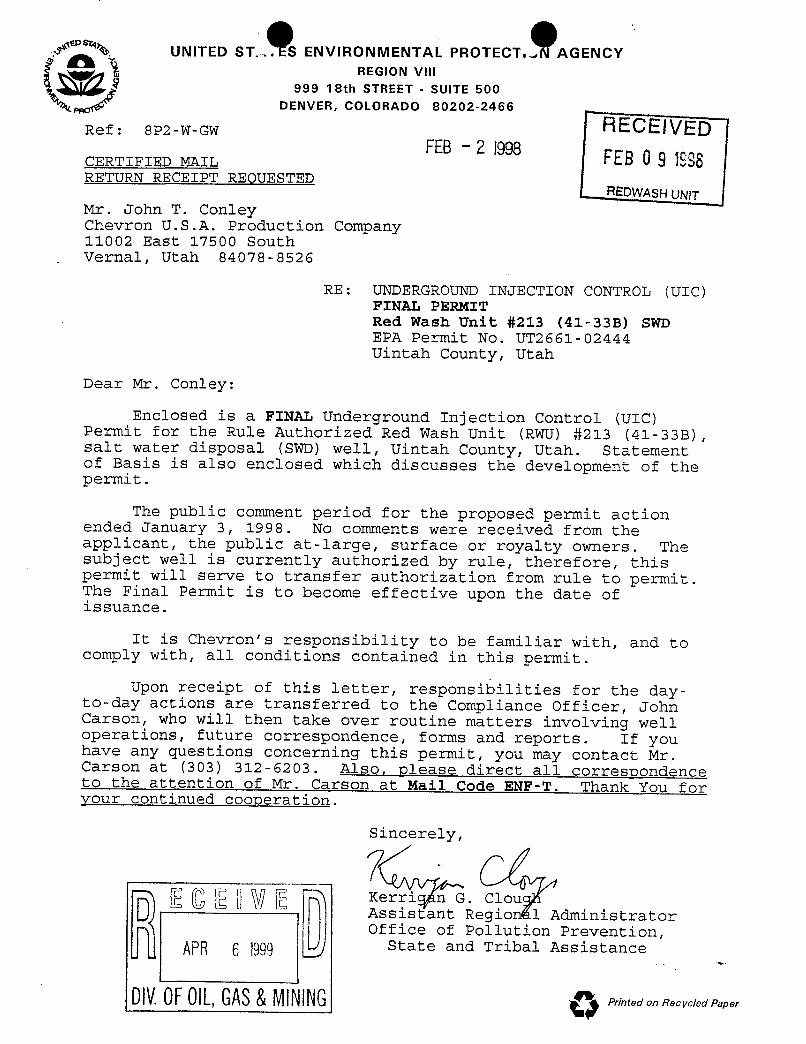
.? %. UNITED ST. S ENVIRONMENTAL PROTECT.- AGENCYREGION VIII
999 18th STREET - SUITE 500DENVER,COLORADO 80202-2466
Ref: 8P2-W-GW FIECEIVEDFEB- 2 1998 -
CERTIFIED MAIL FtB 0 9 1998RETURN RECEIPT REQUESTED
REDWASHUNITMr. John T. ConleyChevron U.S.A. Production Co:mpany11002 East 17500 SouthVernal, Utah 84078-8526
RE: UNDERGROUND INJECTION CONTROL (UIC)FINAL PERMITRed Wash Unit #213 (41-338) SWDEPA Permit No. UT2661-02444Uintah County, Utah
Dear Mr. Conley:
Enclosed is a FINAL Underground Injection Control (UIC)Permit for the Rule Authorized Red Wash Unit (IGRJ) #213 (41-33B),salt water disposal (SWD) well, Uintah County, Utah. Statementof Basis is also enclosed which discusses the development of thepermit.
The public comment period for the proposed permit actionended January 3, 1998. No comments were received from theapplicant, the public at-large, surface or royalty owners. Thesubject well is currently authorized by rule, therefore, thispermit will serve to transfer authorization from rule to permit.The Final Permit is to become effective upon the date ofissuance.
It is Chevron's responsibility to be familiar with, and tocomply with, all conditions contained in this permit.
Upon receipt of this letter, responsibilities for the day-to-day actions are transferred to the Compliance Officer, JohnCarson, who will then take over routine matters involving welloperations, future correspondence, forms and reports. If youhave any questions concerning this permit, you may contact Mr.Carson at (303) 312-6203. Also, please direct all correscondenceto the attention of Mr. Carson at Mail Code ENF-T. Thank You foryour continued cooperation.
Sincerely,
K G. ClouD Assistant Region 1 AdministratorOffice of Pollution Prevention,
State and Tribal Assistance
DIV.OFOlL,GAS&MINING (";
O O2
Enclosure: Final PermitStatement of Basis
cc: w/enclosures
Mr. Ronald Wopsock, ChairmanUintah & Ouray Business Committee
Ms. Elaine Willie, Environmental DirectorUte Indian Tribe
Norman CambridgeBIA - Uintah & Ouray Agency
Mr. Jerry KenczkaBLM - Vernal District Office
Mr. Gilbert HuntState of Utah Natural ResourcesDivision of Oil, Gas &
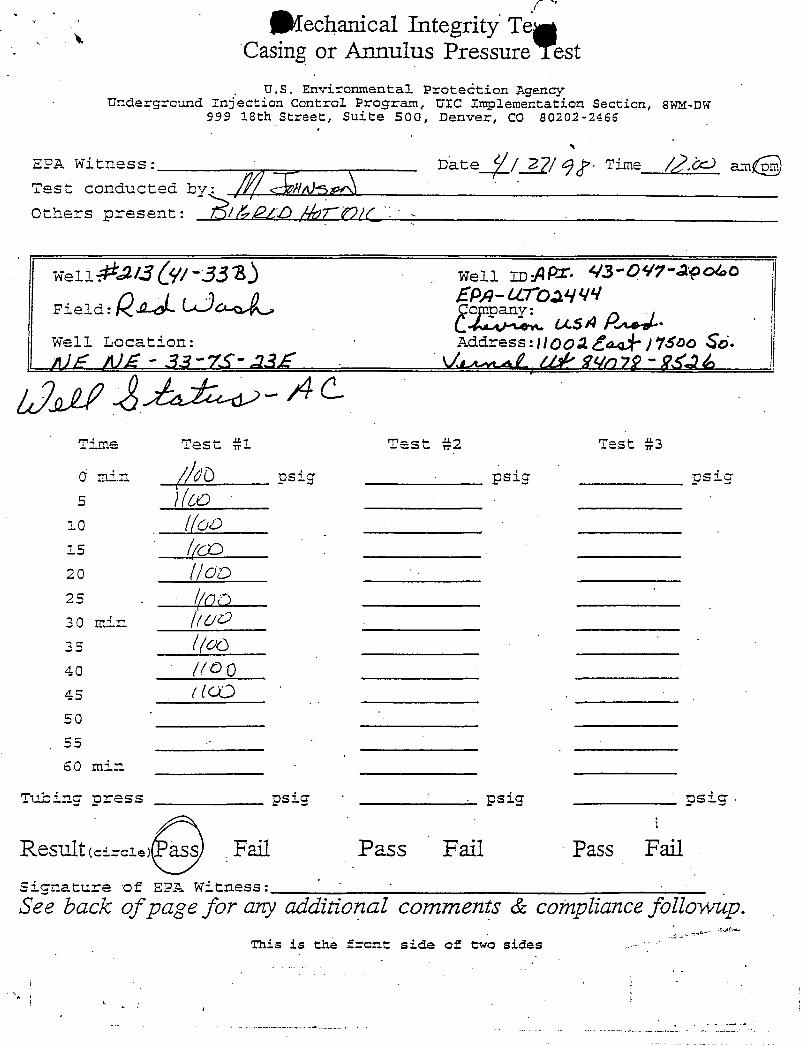
f
echanical Integrity TegCasing or Annulus Pressure Test
U.S. Environmental Proteótion AgencyUnderground Injection Control Program, UTC Implementation Section, SWM-DW
999 18th Street, Suite 500, Denver, CO 80202-2466
EPA Witness: Date / / Time / . amTest conducted by Irds
Others present: / O SEQ/
weilÈJAS V/-333 weil Inßpr. 3-OW-apolao
Field:
Well Location: Address:HQQA / j $ o Sá.
Time Test #1 Test #2 Test #3
0 min / dÒ psig - psig psigs h'Co
i o li'oD
15 //CD2o //CD25 . /()O3 0 min C/O
as It'ao4 o // 045 / (CD50
55
60 min
Tubing press psig ·
· psig psig -
Result (e±==1.> ass.Fail Pass Fail Pass Fail
Signature of EPA Witness:
See back of page for any additional comments & compliance followup.This is the fecnt side of two
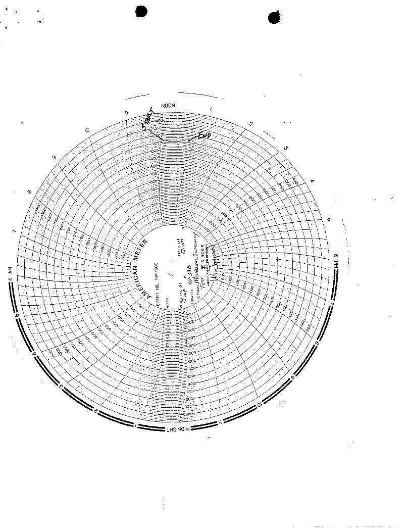
A.
NOON1
oo0>
A.
NOON1
oo0>
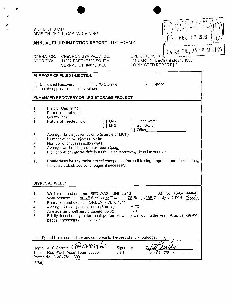
O OSTATE OF UTAHDIVISlON OF OIL, GAS AND MINING
ANNUAL FLUID INJECTION REPORT - UIC FORM 4
DíV.OFOiL,GAS&MMGOPERATOR: CHEVRON USA PROD. CO. OPERATIONS PEFlOEL------ "~"
~~~¯
ADDRESS: 11002 EAST 17500 SOUTH JANUARY 1 - DECEMBER 31, 1998VERNAL, UT 84078-8526 CORRECTED REPORT [ ]
PURPOSE OF FLUID INJECTION
[ ] Enhanced Recovery [ ] LPG Storage [x] Disposal(Complete applicable sections below)
ENHANCED RECOVERY OR LPG STORAGE PROJECT
1. Field or Unit name:2. Formation and depth:3. County(les):4. Nature of injected fluid: [ ] Gas [ ] Fresh water
[ ] LPG [ ] Salt Water[ ] Other
5. Average daily injection voluine (Barrels or MCF):6. Number of active injection wells:7. Number of shut-in injection wells:8. Average wellhead injection pressure (psig):9. If all or part of injected fluid is fresh water, accurately describe source:
10. Briefly describe any major project changes and/or well testing programs performed duringthe year. Attach additional pages if necessary.
DISPOSAL WELL:
1. Well name and number: RED WASH UNIT #213 API No. 43-047-4458392. Well location: QQ NENE Section ] Township 9 Range County UlNTAH gge3. Formation and depth: GREEN RIVER, 4311'4. Average daily disposal volume (Barrels): ~120
5. Average daily wellhead pressure (psig): ~700
6. Briefly describe any major repair performed on the well during the year. Attach additionalpages if necessary. NONE
I certify that this report is trueand complete to the best of my knowledge. 4 ,
Name J. T. Conley Signature /ATitle Red Wash Asset Team Leader Date 29 †ÿ $Phone No. (435) 781-4300
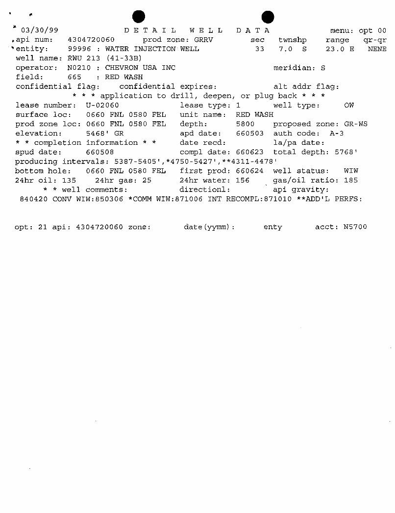
(Iþ (Iþ03/30/99 DET A I L WELL D A T A menu: opt 00
api num: 4304720060 prod zone: GRRV sec twnshp range gr-qrentity: 99996 : WATER INJECTION WELL 33 7.0 S 23.0 E NENEwell name: RWU 213 (41-33B)
operator: NO210 : CHEVRON USA INC meridian: Sfield: 665 : RED WASHconfidential flag: confidential expires: alt addr flag:
* * * application to drill, deepen, or plug back * * *
lease number: U-02060 lease type: 1 well type: OWsurface loc: 0660 FNL 0580 FEL unit name: RED WASHprod zone loc: 0660 FNL 0580 FEL depth: 5800 proposed zone: GR-WS
elevation: 5468' GR apd date: 660503 auth code: A-3* * completion information * * date recd: la/pa date:spud date: 660508 compl date: 660623 total depth: 5768'producing intervals: 5387-5405',*4750-5427',**4311-4478'
bottom hole: 0660 FNL 0580 FEL first prod: 660624 well status: WIW24hr oil: 135 24hr gas: 25 24hr water: 156 gas/oil ratio: 185
* * well comments: directionl: api gravity:840420 CONV WIW:850306 *COMM WIW:871006 INT RECOMPL:871010 **ADD'L PERFS:
opt: 21 api: 4304720060 zone: date(yymm): enty acct:
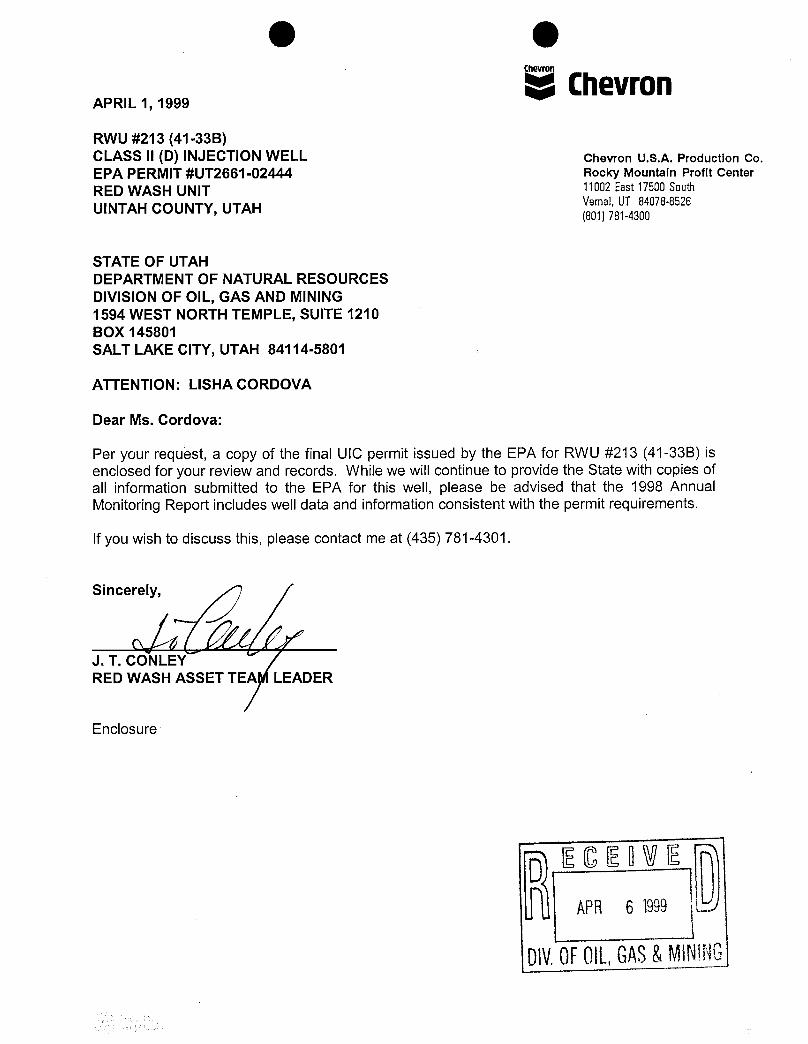
O O
APRIL 1, 1999
c
ChevronRWU #213 (41-33B)CLASS II (D) INJECTION WELL Chevron U.S.A. Production Co.EPA PERMIT #UT2661-02444 Rocky Mountain Profit CenterRED WASH UNIT 11002East17500South
UINTAH COUNTY, UTAH Vemal,UT 84078-8526(801)781-4300
STATE OF UTAHDEPARTMENT OF NATURAL RESOURCESDIVISION OF OIL, GAS AND MINING1594 WEST NORTH TEMPLE, SUITE 1210BOX 145801SALT LAKE CITY, UTAH 84114-5801
ATTENTION: LISHA CORDOVA
Dear Ms. Cordova:
Per your request, a copy of the final UIC permit issued by the EPA for RWU #213 (41-33B) isenclosed for your review and records. While we will continue to provide the State with copies ofall information submitted to the EPA for this well, please be advised that the 1998 AnnualMonitoring Report includes well data and information consistent with the permit requirements.
Ifyou wish to discuss this, please contact me at (435) 781-4301.
Sincerely,
J. T. CONLEYRED WASH ASSET TEA LEADER
Enclosure
DIV.0FOIL,GAS&MIN
O O
STATEMENT OF BASISCHEVRON U.S.A. PRODUCTION COMPANY
RED WASH UNIT #213 (41-33B)
EPA PERMIT NUMBER: UT2661-02444
CONTACTS: Chuck WilliamsU. S. Environmental Protection AgencyMail Code, 8P2-W-UIC999 18th Street, Suite 500Denver, Colorado 80202-2466Telephone: (303) 312-6625
DESCRIPTION OF FACILITY AND BACKGROUND INFORMATION
On November 20, 1992, Chevron U.S.A. Production Company(Chevron) made application for an underground injection control
permit for disposal of Class II fluids (most common fluid beingproduced water) from Red Wash Unit area and back into the GreenRiver Formation. The area covered by the application is in aportion of the Red Wash Unit which lies within the exteriorboundary of the Uintah-Ouray Indian Reservation and the disposalwell located as follows:
RWU #213 (41-33B)Red Wash Unit (RWU)
660 FNL X 580 FELSection 33, Township 7S, Range 23E
Uintah County, Utah
The RWU #213 well is currently authorized by rule, thereforethis permit will serve to transfer authorization from rule topermit. As such, a corrective action requirement is notspecifically applicable.
The RWU #213 SWD well was in operation prior to November 25,1988 (effective date of the Underground Injection Control [UIC]program for all classes of wells on Indian lands in the State ofUtah administered by the Environmental Protection Agency) and wasautomatically granted an aquifer exemption extending in a 1/4-mile radius from the wellbore. This was done for all existinginjection wells that were eligible for 1/4-mile aquiferexemptions.
Chevron has submitted all required information and datanecessary for permit issuance in accordance with 40 CFR Parts144, 146 and 147, and a draft permit has been
O O2
The permit will be issued for the operating life of thedisposal well, therefore, no reapplication will be necessaryunless the permit is terminated for reasonable cause (40 CFR144.39. 144.40 and 144.41). However, the permit will be reviewedevery five (5) years.
This Statement of Basis gives the derivation of the sitespecific permit conditions and reasons for them. The generalpermit conditions for which the content is mandatory and notsubject to site specific differences (based on 40 CFR Parts 144,146 and 147), are not included in the discussion.
PART II, Section A WELL CONSTRUCTION REQUIREMENTS
Casing and Cementing (Condition 1)
The as-built construction details submitted with theapplication are hereby incorporated into this permit as AppendixA, and shall be binding on the permittee. All cement used in theoriginal construction of the well was designed for the lifeexpectancy of the well. The existing well is a rule-authorizedClass II disposal well and will not be subject to anyconstruction changes.
The existing construction as represented by the permittee isas follows:
(1) Surface casing (8-5/8 inch) is set in a 12-1/4 inchdiameter hole to a depth of 236 feet kelly bushing(KB). The casing is secured with 175 sacks of Class"G"cement. The cement was circulated to the surface,isolating the casing from the wellbore.
(2) Long string casing (5-1/2 inch) is set in an 7-7/8 inchdiameter hole to a depth of 5,764 feet KB. This casingis secured with 700 sacks of cement, and the estimatedtop of cement (TOC), by cement bond log, is at a depthof 3075 feet KB. Plug back total depth (PBTD) 4619feet KB.
Adequate confining beds are present above and below thedisposal zone. The Green River Formation, from its top at 2804feet to 4311 feet (upper confining zone above top perforations),is composed of interbedded thick confining shales, thinnerconfining marls and siltstones. Chevron proposes to inject waterinto multiple lenticular sands which are distributed throughoutthe upper Green River Formation. These sands occur over 167 feetof vertical section at a depth range of 4311 feet to 4478 feetand are individually separated by shale which act as isolationbarriers (confining zones) for the
O O3
The overlying formation is the vinta Formation which extendsfrom surface to about 2804' in this area. The Uinta Tar Sandsare found within the Uinta Formation and occur between the depthsof ±800' to a minimum depth of ±1950'. There are no known USDWsands below the top of the Uinta Tar Sands at ±800'.Hydrocarbons are encountered in all zones capable of producingfluid from the top of the tar sands to the base of the GreenRiver Formation (5705'). Chevron has water analysis and otherinformation (core analysis) available that shows that USDWreservoirs do not occur below the top of the Uinta Tar Sands.
The top of the Uinta Tar Sands may be a more accurateinterpretation of the base of USDWs in the Red Wash/WonsistsValley/Gypsum Hills area. Additionally, it is not consideredreasonable to expect injected water to migrate the ±1507' upwardthrough the Upper Green River to enter the Uinta formation.
Tubing and Packer Specifications (Condition 2)
The 2-7/8 inch tubing information submitted by the applicantis incorporated into the permit and shall be binding on thepermittee. The packer is set at a depth of 4265 feet KB.
Monitoring Devices (Condition 3)
For the purposes of taking tubing and tubing/long stringcasing annulus pressure measurements, the EPA is requiring thatthe permittee install 1/2 inch fittings with cut-off valves atthe wellhead on the tubing, on the tubing/casing annulus (forattachment of calibrated pressure gauges which the operator willhave in his possession at all times). EPA is further requiringthe permittee to install a sampling tap on the line to thedisposal well. A flow meter that is used to measure cumulativevolumes of disposed fluid is located at the injection pumpstation rather than at the wellhead.
PART II, Section B AREA OF REVIEW (AOR) AND CORRECTIVEACTION
In accordance with 40 CFR 144.55, existing wells are exemptfrom corrective action requirements. The permittee has shown thatthis well qualifies for such an exemption since it has beenactive (September 1987) as a disposal well prior to November1988.
PART II, Section C WELL OPERATION
Transition From Rule to Permit Authorization (Condition 1)
The RWU #213 (41-33B) SWD well has been in operation sinceNovember 1987. Adherence to all requirements under 40 CFR
O O4
144, 146, and 147 have been verified for this well andcontinuance of injection will be allowed.
Mechanical IntegritV (Condition 2)
The tubing/casing annulus of the RWU #213 well was testedand witnessed for mechanical integrity on April 26, 1993. Atubing/ casing annulus pressure test must be repeated at leastevery five (5) years to demonstrate continued tubing, packer, andcasing integrity. The permittee is required to demonstratetubing/ casing integrity, using the current UIC Guidance.
Observations of annulus pressure and injection pressureshall be performed weekly and the results shall be recorded atintervals no greater than thirty (30) days. The results shall bereported annually.
Iniection Interval (Condition 3)
Disposal will be limited to the gross Green River Formationsubsurface interval 4311-4619 feet KB (PBTD).
Iniection Pressure Limitation (Condition 4)
The maximum allowable injection pressure is 1479 veig.Assuming a specific gravity of 1.010 (derived from recent wateranalysis of the injection fluid), the estimated maximum wellheadinjection pressure (Pm) has been calculated for this well by EPAstaff assuming no frictional flow pressure loss and using the0.78 psi/ft sand face pressure gradient as established by thepermittee reported step-rate test results and fracturestimulation treatments performed on nearby oil wells. Theseresults have been reviewed and are acceptable by EPA staff. Themaximum surface injection pressure (Pm) was calculated asfollows:
Pm = [0.78 - 0,433 Sg] d
Where: Pm = maximum pressure at wellheadSg = specific gravity of the injected fluid
(1.010) derived from recent water analysisd = depth to injection zone = 4311 feet
or Rm = [0.78 - 0.433 (1.010] 4311 = 1479 psig
Iniection Volume Limitation (Condition 5)
Effective on the date of the Final Permit there will be nolimitation on the number of barrels of water per day (BWPD) thatshall be injected into the RWU #213 SWD well, provided that in nocase shall injection pressure exceed that limit shown in Part II,Section C. 4 of this
O O5
PART H, Section D MONITORING, RECORDKEEPING ANDREPORTING OF RESULTS
Iniection Well Monitoring Program (Condition 1)
The permittee is required to monitor water quality of theinjected fluids annually for total dissolved solids, pH, specificconductivity, and specific gravity. Any time there is a changein the source of injection fluid, a new water quality analysis isalso required.
In addition, weekly observations of flow rate, injectionpressure, and cumulative volume will be made. At least oneobservation each for flow rate, injection pressure, andcumulative volume will be recorded on a monthly basis.
The permittee shall maintain copies (or originals) of allpertinent records at the office of Chevron U.S.A. ProductionCompany, Vernal, Utah.
PART H, Section E PLUGGING AND ABANDONMENT
Plugging and Abandonment Plan (Condition 1)
The plugging and abandomment plan submitted by the applicantconsists of four (4) plugs with the following specifications:
Move in rig up (MIRU), ND WH and NU BOPE. Killwell if required and release packer, trip out ofhole (TOH). Clean out to ±4300' with bit andscraper, TOH.
PLUG #1: To isolate perforations, set CIBP at ±4250 anddump bail 40' (5 sxs) Class "H" cement on top.
TIH with tubing and displace hole from PBTD to±3000' with 9.2 ppg brine.
PLUG #2: Oil Shale interval appears to be at 3620'-3710',below cement top in 5-1/2" X 7-7/8" annulus. Toisolate oil shale, set balanced cement plug from3566'-3764' using 25 sxs Class "H" cement.
Circulate tubing clean and displace from PBTD to2000' with 9.2 ppg brine
PLUG #3: To isolate Green River Formation top at 2136,perforate at ±2190', set CICR at 2086' and squeeze25 sxs Class "H" cement below
O O6
Sting out of retainer, circulate tubing clean anddisplace well with 9.2 ppg brine.
PLUG #4 To set surface plug, perforate at 300' andestablish circulation down 5-1/2" casing and up 5-1/2" X 8-5/8" annulus. Pump sufficient volume ofcement to fill casing and annulus from 300' tosurface.
Cut off wellhead and install dry hole marker perBLM guidelines. RDMO, rehab location per BLMguidelines. information.
PART II, Section F FINANCIAL RESPONSIBILITY
Demonstration of Financial Responsibility (Condition 1)
The permittee has chosen to demonstrate financialresponsibility through a Financial Statement that has beenreviewed and determined to meet the financial criteriaestablished by the
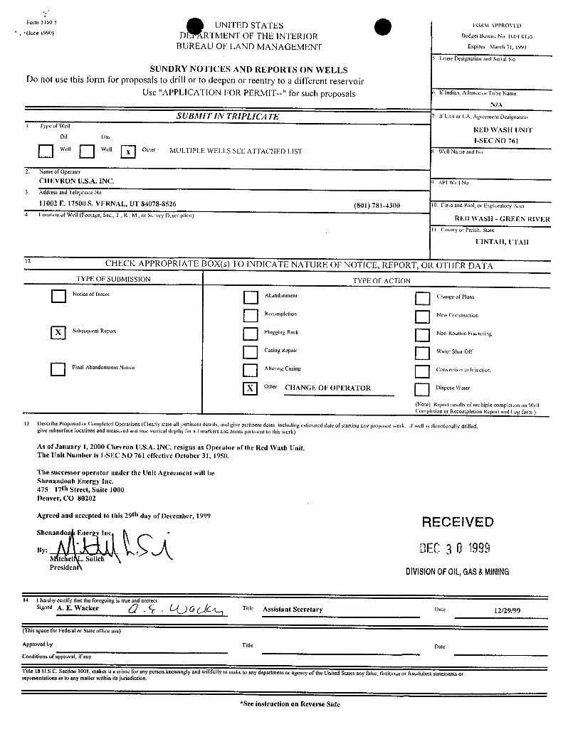
Formaio-s UNITED STATES EoamArraoveo.pane isso) DE RTMENT OF THE INTERIOR BudgetBureauNo 1004-0135
BUREAU OF LAND MANAGEMENT Expires March31, 1993
5 Lease Designation and Serial No.
SUNDRY NOTICES AND REPORTS ON WELLSDo not use this form for proposals to drill or to deepen or reentry to a different reservoir
Use "APPLICATION FOR PERMIT--" for such proposals 5 IfIndian, AllotteeorTribeName
N/A
SUBMIT IN TRIPLICA TE I Ir unit or cA, Agreement Designation
i Type of Well RED WASH UNIToil Gas I-SEC NO 761
O " " O " " O Other MULTIPLE WELLS SEE ATTACilED LIST 8 Well Name and No.
2 Name of Operator
CHEVRON U.S.A. INC. 9 APl Well No.3 Address and Telephone No
11002 E. 17500 S. VERNAL, UT 84078-8526 (801) 781-4300 10. Field and Pool, or Exploratory Area
4 Location of Well (Footage, Sec., T,R
,M., or Survey Description) RED WASH - GREEN RIVER
11. County or Parish, State
UINTAII, UTAH
CHECK APPROPRIATE BOX(s) TO INDICATE NATURE OF NOTICE, REPORT, Os OTHER DATATYPE OF SUBMISSION TYPE OF ACTION
Notice of Intent Abandonment Change of Plans
Recompletion New Construction
Subyequent Report Plugging Back Non-Routine Fracturing
Casing Repair Wadut-OŒ
Final Abandonment Notice Altering Casing Conversion to Injection
Other CIIANGE OF OPERATOR Dispose water
(Note) Report results of multiple completion on WellCompletion or Recompletion Report and Log form )
13. Describe Proposed or Completed Operations (Clearly state all peninent details, and give pertinent dates, including estimated date of starting any proposed work If well is directionally drilled,give subsurface locations and measured and true vertical depths for all markers and zones pertinent to this work)
As of January 1, 2000 Chevron U.S.A. INC. resigns as Operator of the Red Wash Unit.The Unit Number is I-SEC NO 761 effective October 31, 1950.
The successor operator under the Unit Agreement will beShenandoah Energy Inc.475 17th Street, Suite 1000Denver, CO 80202
Agreed and accepted to this 29th day of December, 1999 RECE IVEDShenando Ener
DEC3 0 1999. Solich
Presiden DIVISIONOFOIL,GAS&MINING
14. I hereby certify that the foregoing is true and correctsignedA. E. Wacker Title Assistant Secretary Date 12/29/99
(This space for Federal or State ofTiceuse)
Approved by: Title Date
Conditions of approval, if any
Title 18 U.S.C. Section 1001, makes it a crime for any person knowingly and willfully to make to any department or agency of the United States any false, fictitious or fraudulent statements orrepresentations as to any matter within its jurisdiction.
*See instruction en Reverse
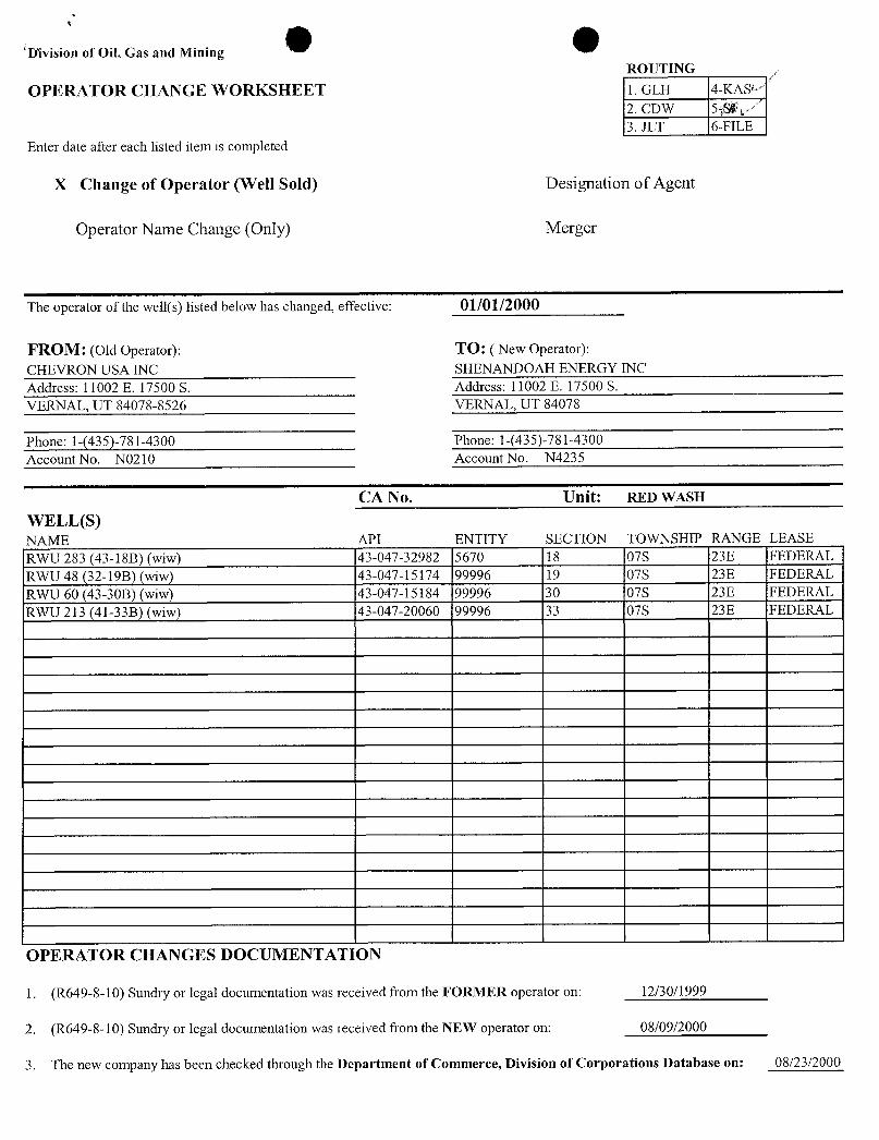
D'ivision of Oil, Gas and MiningROUTING
OPERATOR CHANGE WORKSHEET 1. GLH 4-KAS2. CDW 5gy3. JLT 6-FILE
Enter date after each listed item is completed
X Change of Operator (Well Sold) Designation of Agent
Operator Name Change (Only) Merger
The operator of the well(s) listed below has changed, effective: 01/01/2000
FROM: (Old Operator): TO: ( New Operator):CHEVRON USA INC SHENANDOAH ENERGY INCAddress: 11002 E. 17500 S. Address: 11002 E. 17500 S.VERNAL, UT 84078-8526 VERNAL, UT 84078
Phone: 1-(435)-781-4300 Phone: 1-(435)-781-4300
Account No. NO210 Account No. N4235
CA No. Unit: RED WASH
WELL(S)NAME API ENTITY SECTION TOWNSHIP RANGE LEASERWU 283 (43-18B) (wiw) 43-047-32982 5670 18 07S 23E FEDERALRWU 48 (32-19B) (wiw) 43-047-15174 99996 19 07S 23E FEDERALRWU 60 (43-30B) (wiw) 43-047-15184 99996 30 07S 23E FEDERALRWU 213 (41-33B) (wiw) 43-047-20060 99996 33 07S 23E FEDERAL
OPERATOR CHANGES DOCUMENTATION
1. (R649-8-10) Sundry or legal documentation was received from the FORMER operator on: 12/30/1999
2. (R649-8-10) Sundry or legal documentation was received from the NEW operator on: 08/09/2000
3. The new company has been checked through the Department of Commerce, Division of Corporations Database on:
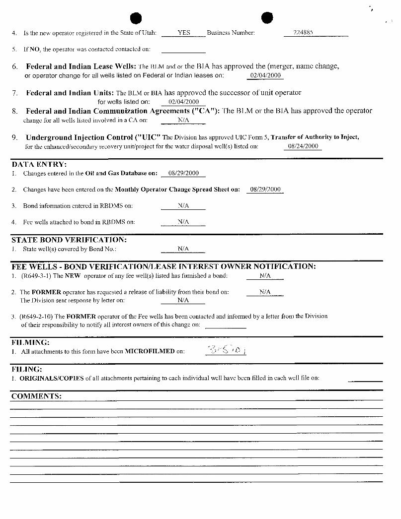
O O4. Is the new operator registered in the State of Utah: YES Business Number: 224885
5. If NO, the operator was contacted contacted on:
6. Federal and Indian Lease Wells: The BLM and or the BIA has approved the (merger, name change,or operator change for all wells listed on Federal or Indian leases on: 02/04/2000
7. Federal and Indian Units: The BLM or BIA has approved the successor of unit operatorfor wells listed on: 02/04/2000
8. Federal and Indian Communization Agreements ("CA"): The BLM or the BIA has approved the operatorchange for all wells listed involved in a CA on: N/A
9. Underground Injection Control ("UIC" The Division has approved UIC Form 5, Transfer of Authority to Inject,for the enhanced/secondary recovery unit/project for the water disposal well(s) listed on: 08/24/2000
DATA ENTRY:1. Changes entered in the Oil and Gas Database on: 08/29/2000
2. Changes have been entered on the Monthly Operator Change Spread Sheet on: 08/29/2000
3. Bond information entered in RBDMS on: N/A
4. Fee wells attached to bond in RBDMS on: N/A
STATE BOND VERIFICATION:1. State well(s) covered by Bond No.: N/A
FEE WELLS - BOND VERIFICATION/LEASE INTEREST OWNER NOTIFICATION:1. (R649-3-1) The NEW operator of any fee well(s) listed has furnished a bond: N/A
2. The FORMER operator has requested a release of liability from their bond on: N/AThe Division sent response by letter on: N/A
3. (R649-2-10) The FORMER operator of the Fee wells has been contacted and informed by a letter from the Divisionof their responsibility to notify all interest owners of this change on:
FILMING:1. All attachments to this form have been MICROFILMED on:
FILING:1. ORIGINALS/COPIES of all attachments pertaining to each individual well have been filled in each well file on:
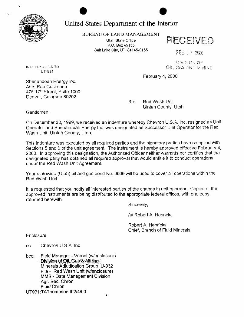
O OUnited States Department of the Interior
BUREAU OF LAND MANAGEMENTCH Utah State Office RECElVED
P.O. Box 45155Salt Lake City, UT 84145-0155
IN REPLY REFER TO QL Ofsg gggyUT-931
February 4, 2000Shenandoah Energy Inc.Attn: Rae Cusimano475 17thStreet, Suite 1000Denver, Colorado 80202
Re: Red Wash UnitUintah County, Utah
Gentlemen:
On December 30, 1999, we received an indenture whereby Chevron U.S.A. Inc. resigned as UnitOperator and Shenandoah Energy Inc. was designated as Successor UnitOperator for the RedWash Unit, Uintah County, Utah.
This indenture was executed by all required parties and the signatory parties have complied withSections 5 and 6 of the unit agreement. The instrument is hereby approved effective February 4,2000. In approving this designation, the Authorized Officer neither warrants nor certifies that thedesignated party has obtained all required approval that would entitle it to conduct operationsunder the Red Wash Unit Agreement.
Your statewide (Utah) oil and gas bond No. 0969 willbe used to cover all operations within theRed Wash Unit.
It is requested that you notifyall interested parties of the change in unit operator. Copies of theapproved instruments are being distributed to the appropriate federal offices, with one copyreturned herewith.
Sincerely,
Is/ Robert A. Henricks
Robert A. HenricksChief, Branch of Fluid Minerals
Enclosure
cc: Chevron U.S.A. Inc.
bcc: Field Manager - Vernal (wlenclosure)Division of Oil,Gas &MiningMinerals Adjudication Group U-932File - Red Wash Unit (wlenclosure)MMS - Data Management DivisionAgr. Sec. ChronFluid Chron
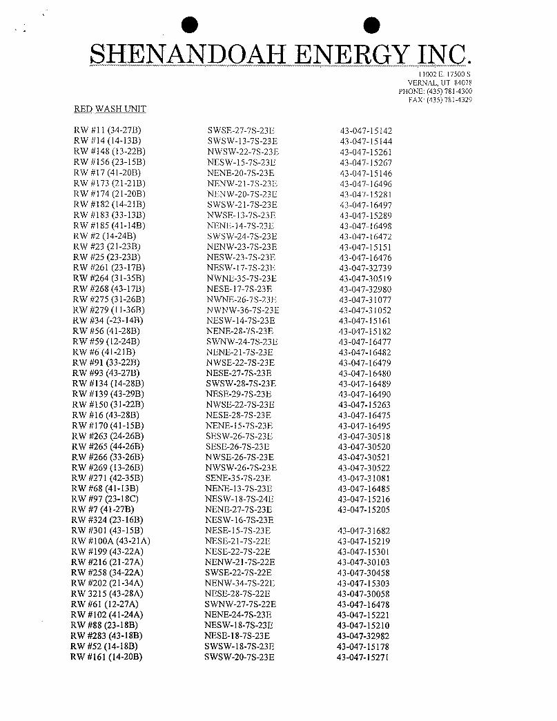
e eSHENANDOAH ENERGY INC.
l 1002 E. 17500 S.VERNAL, UT 84078
PHONE: (435) 781-4300FAX: (435) 781-4329
RED WASH UNIT
RW #11 (34-27B) SWSE-27-7S-23E 43-047-15142RW #14 (14-13B) SWSW-13-7S-23E 43-047-15144RW #148 (13-22B) NWSW-22-7S-23E 43-047-15261RW #156 (23-15B) NESW-15-7S-23E 43-047-15267RW #17 (41-20B) NENE-20-7S-23E 43-047-15146RW #173 (21-21B) NENW-21-7S-23E 43-047-16496RW #174 (21-20B) NENW-20-7S-23E 43-047-15281RW #182 (14-21B) SWSW-21-7S-23E 43-047-16497RW #183 (33-13B) NWSE-13-7S-23E 43-047-15289RW #185 (41-14B) NENE-14-7S-23E 43-047-16498RW #2 (14-24B) SWSW-24-7S-23E 43-047-16472RW #23 (21-23B) NENW-23-7S-23E 43-047-15151RW #25 (23-23B) NESW-23-7S-23E 43-047-16476RW #261 (23-17B) NESW-17-7S-23E 43-047-32739RW #264 (31-35B) NWNE-35-7S-23E 43-047-30519RW #268 (43-17B) NESE-17-7S-23E 43-047-32980RW #275 (31-26B) NWNE-26-7S-23E 43-047-31077RW #279 (11-36B) NWNW-36-7S-23E 43-047-31052RW #34 (-23-14B) NESW-14-7S-23E 43-047-15161RW #56 (41-28B) NENE-28-7S-23E 43-047-15182RW #59 (12-24B) SWNW-24-7S-23E 43-047-16477RW #6 (41-21B) NENE-21-7S-23E 43-047-16482RW #91 (33-22B) NWSE-22-7S-23E 43-047-16479RW #93 (43-27B) NESE-27-7S-23E 43-047-16480RW #134 (14-28B) SWSW-28-7S-23E 43-047-16489RW #139 (43-29B) NESE-29-7S-23E 43-047-16490RW #150 (31-22B) NWSE-22-7S-23E 43-047-15263RW #16 (43-28B) NESE-28-7S-23E 43-047-16475RW #170 (41-15B) NENE-15-7S-23E 43-047-16495RW #263 (24-26B) SESW-26-7S-23E 43-047-30518RW #265 (44-26B) SESE-26-7S-23E 43-047-30520RW #266 (33-26B) NWSE-26-7S-23E 43-047-30521RW #269 (13-26B) NWSW-26-7S-23E 43-047-30522RW #271 (42-35B) SENE-35-7S-23E 43-047-31081RW #68 (41-13B) NENE-13-7S-23E 43-047-16485RW #97 (23-18C) NESW-18-7S-24E 43-047-15216RW #7 (41-27B) NENE-27-7S-23E 43-047-15205RW #324 (23-16B) NESW-16-7S-23ERW #301 (43-15B) NESE-l5-7S-23E 43-047-31682RW #100A (43-21A) NESE-21-7S-22E 43-047-15219RW #199 (43-22A) NESE-22-7S-22E 43-047-15301RW #216 (21-27A) NENW-21-7S-22E 43-047-30103RW #258 (34-22A) SWSE-22-7S-22E 43-047-30458RW #202 (21-34A) NENW-34-7S-22E 43-047-15303RW 3215 (43-28A) NESE-28-7S-22E 43-047-30058RW #61 (12-27A) SWNW-27-7S-22E 43-047-16478RW #102 (41-24A) NENE-24-7S-23E 43-047-15221RW #88 (23-18B) NESW-18-7S-23E 43-047-15210RW #283 (43-18B) NESE-18-7S-23E 43-047-32982RW #52 (14-18B) SWSW-18-7S-23E 43-047-15178RW #161 (14-20B) SWSW-20-7S-23E
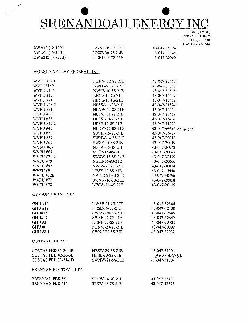
e eSHENANDOAH ENERGY INC.
11002 E. 17500 S.VERNAL, UT 84078
PHONE: (435) 781-4300FAX: (435) 781-4329
RW #48 (32-19B) SWNE-19-7S-23E 43-047-15174RW #60 (43-30B) NESE-30-7S-23E 43-047-15184RW #213 (41-33B) NENE-33-7S-23E 43-047-20060
WONSITS VALLEY FEDERAL UNIT
WVFU #120 NENW-22-8S-21E 43-047-32462WVFU#140 NWNW-15-8S-21E 43-047-31707WVFU #143 NWSE-10-8S-21E 43-047-31808WVFU #16 NENE-15-8S-21E 43-047-15447WVFU #2l NENE-16-8S-21E 43-047-15452WVFU #28-2 NESW-11-8S-21E 43-047-31524WVFU #31 NENW-14-8S-21E 43-047-15460WVFU #35 NESW-14-8S-21E 43-047-15463WVFU #36 NESW-10-8S-21E 43-047-15464WVFU #40-2 NESE-10-8S-2lE 43-047-31798WVFU #41 NENW-l5-8S-2lE 43-047-NJ496 i£4/ ýWVFU #50 SWNE-15-8S-21E 43-047-15477WVFU #59 SWNW-14-8S-21E 43-047-20018WVFU #60 SWSE-15-8S-21E 43-047-20019WVFU #67 NESW-15-8S-21E 43-047-20043WVFU #68 NESE-15-8S-21E 43-047-20047WVFU #71-2 SWSW-15-8S-21E 43-047-32449WVFU #73 NESE-16-8S-21E 43-047-20066WVFU #97 NWSW-1l-8S-21E 43-047-30014WVFU #9 NESE-12-8S-21E 43-047-15440WVFU #126 NWNE-21-8S-21E 43-047-30796WVFU #72 SWSW-16-8S-21E 43-047-20058WVFU #78 NESW-16-8S-21E 43-047-20115
GYPSUM HILLS UNIT
GHU #10 NWSE-21-8S-20E 43-047-32306GHU #12 NESE-19-8S-21E 43-047-32458GHU#15 SWSW-20-8S-21E 43-047-32648GHU#17 SWSE-20-8S-21E 43-047-32649GHU #3 NENE-20-8S-21E 43-047-20002GHU #6 NENW-20-8 S-2 lE 43-047-30099GHU #8-1 SWNE-20-8S-21E 43-047-31932
COSTAS FEDERAL
COSTAS FED #1-20-4B NESW-20-8S-21E 43-047-31006COSTAS FED #2-20-3B NESE-20-8S-21E d Vf-J/o &COSTAS FED 33-21-lD SWNW-21-8S-21E 43-047-31604
BRENNAN BOTTOM UNIT
BRENNAN FED #5 SENW-18-7S-21E 43-047-15420BRENNAN FED #11 SESW-18-7S-21E
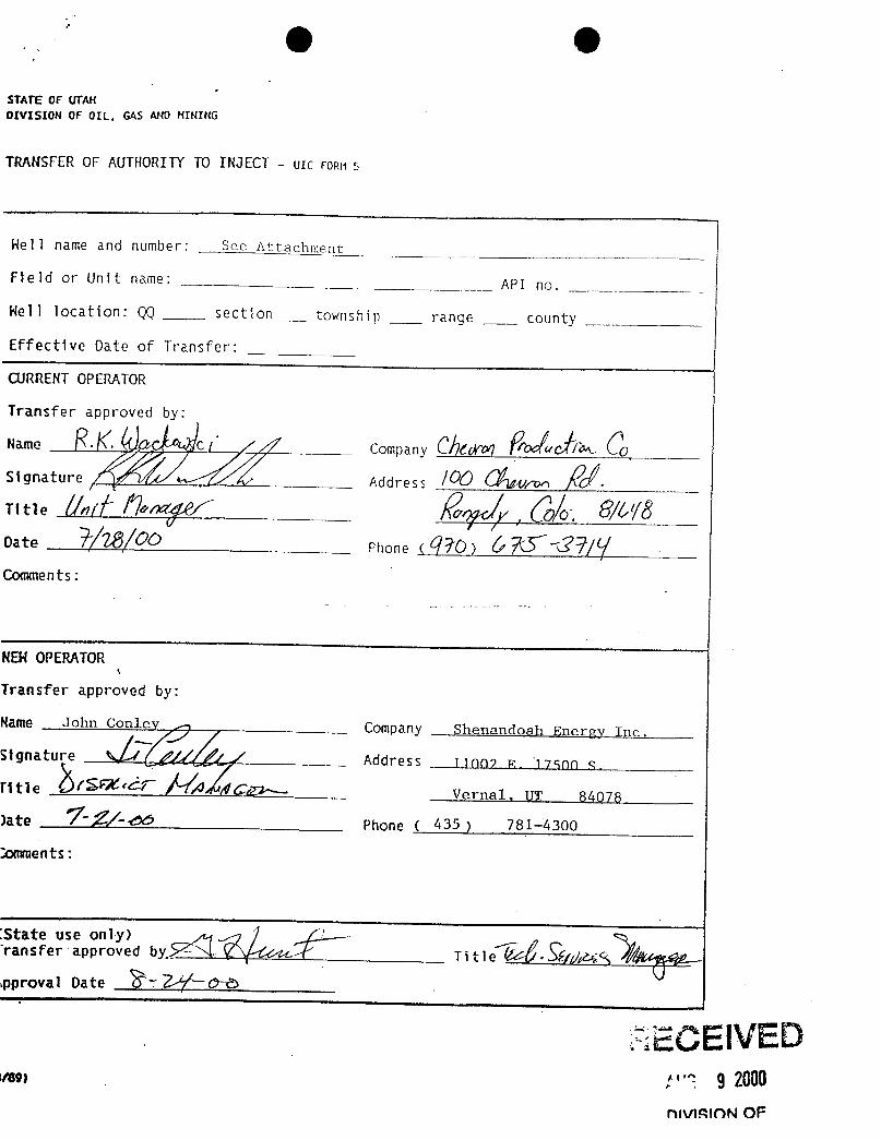
' (Iþ (IþSTATE OF UTANDIVISION OF OIL, GAS AND HINING
TRANSFER OF AUTHORITYTO INJECT - UIC FORN S
Hel l name and number: t
Field or Unit name: API no.
Hell location: QQ sect on _ township range county
Effective Oate of Transfer:
CURRENTOPERATOR
Transfer approved by:
Name C ( Company Öf<k / 0,
Signature Address NÛTitle
Date Phone (9ŸO) 'S~Comments:
NEHOPERATOR
Transfer approved by:
Name John Conlev ,, Company Shenandoah Energy Inc.
Signature 4 / fr / AddreSS 1.1007 R. 17500 S.
Title IN' Cr Vernal, 1.IT 84078)ate ' 7-<> Phone ( 435 ) 781-4300
:omments:
anae ap edbv Ti tle SEf;//6
spproval Date $7 ,3
ECEIVEDvem :"? .9 2000
OfVimnN
SHENANDOANERGY INC.11002 East 17500 South
Vernal, Utah 80478(435) 781-4300
Fax (435) 781-4329August 20, 2001
RWU #213Red Wash UnitUintah County, Utah
Mr. Al CraverUnderground Injection Control ProgramUnited States Environmental Protection AgencyRegion VIII999 18th Street - Suite 300Denver, Colorado 80202-2466
Dear Mr. Craver,Your letter of August 6, 2001 noted a packrat nest in the injection building containingthiswell. This conditionhas been cleared effectiveAugust 8, 2001.
Weliname EPA IDRWU#213 (41-33B) UT2661-02444
If you have any questions regarding the tests, please contact me at (435) 781-4301.
Sincerely,
J. T. ConleyDistrict Manager
cc Utah Division of Oil, Gas and Mining U.S Department of the Interior1594 West North Temple, Suite 1210 Bureau of Land ManagementP. O. Box 145801 Vernal District OfficeSalt Lake City, UT 84114-5801 170 South 500 EastAttn. Mr. GilHunt Vernal, UT 84078
Accepted by theUtah Division of
Oil, Gas and Mining
FO ORD
Division of Oil, Gas and MiningROUTING
OPERATOR CHANGE WORKSHEET 1. GLH2. CDW3. FILE
Change of Operator (Well Sold) Designation of Agent/Operator
X Operator Name Change Merger
The operator of the well(s) listed below has changed, effective: 2/1/2003FROM: (Old Operator): TO: ( New Operator):N4235-Shenandoah Energy Inc N2460-QEP Uinta Basin Inc
11002E 17500S 11002E 17500SVernal, UT 84078-8526 Vernal, UT 84078-8526
Phone: (435) 78 1-434 l Phone: (435) 78 1-434 1CA No. Unit: RED WASH UNIT
WELL(S)NAME SEC TWN RNG API NO ENTITY LEASE WELL WELL Confid
NO TYPE TYPE STATUS
RWU 199 (43-22A) 22 070S 220E 4304715301 5670 Federal WI ARWU 258 (34-22A) 22 070S 220E 4304730458 5670 Pederal WI ARWU 216 (21-27A) 27 070S 220E 4304730103 5670 Federal WI ARWU 215 (43-28A) 28 070S 220E 4304730058 5670 Federal WI ARWU 202 (21-34A) 34 070S 220E 4304715303 5670 Federaf WI IRWU 183 (33-13B) 13 070S 230E 4304715289 5670 Federal WI ARWU 185 (41-1B) 14 070S 230E 4304716498 5670 Federal WI ARWU 170 (41-15B) 15 070S 230E 4304716495 5670 Federal WI IRWU 268 (43-17B) 17 Oi0S 230E 4304732980 5670 Federal
_
W1 ARWU 174 (21-20B) 20 070S 230E 4304715281 5670 Federal WI ARWU 173 (21-21B) 21 070S 230E 4304716496 5670 Federal WI ARWU 182 (14-21B) 21 070S 230E 4304716497 5670 Federal WI ARWU 23 (21-23B) 23 070S 230E 4304715151 5670 Federal WI ARWU 25 (23-238) 23 070S 230E 4304716476 5670 Federal WI ARWU 2 (14-24B) 24 070S 230E 4304716472 5670 Federal WI ARWU 263 (24-268) 26 070S 230E 4304730518 5670 Federal WI IRWU 266 (33-26B) 26 070S 230E 4304730521 5670 Federal WI IRWU 213 (41-33B) 33 070S 230E 4304720060 5670 Federal WD ARWU 264 (31-35B) 35 070S 230E 4304730519 5670 Federal WI ARWU 23-18C (97) 18 070S 240E 4304715216 5670 Federal WI I
OPERATOR CHANGES DOCUMENTATIONEnter date after each listed item is completed1. (R649-8-10) Sundry or legal documentation was received from the FORMER operator on: 6/2/2003
2. (R649-8-10) Sundry or legal documentation was received from the NEW operator on: 6/2/2003
3. The new company was checked on the Department of Commerce, Division of Corporations Database on: 6/19/2003
4. Is the new operator registered in the State of Utah: YES Business Number: 5292864-0151
5. If NO, the operator was contacted contacted on:
OEP UB 36 FORM
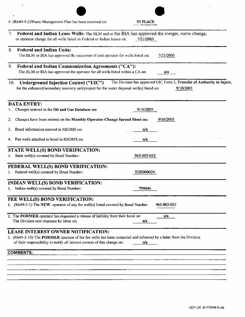
, O O6. (R649-9-2)Waste Management Plan has been received on: IN PLACE
7. Federal and Indian Lease Wells: The BLM and or the BIA has approved the merger, name change,or operator change for all wells listed on Federal or Indian leases on: 7/21/2003
8. Federal and Indian Units:The BLM or BIA has approved the successor of unit operator for wells listed on: 7/21/2003
9. Federal and Indian Communization Agreements ("CA"):The BLM or BIA has approved the operator for all wells listed within a CA on: n/a
10. Underground Injection Control ("UIC") The Division has approved UIC Form 5, Transfer of Authority to Inject,for the enhanced/secondary recovery unit/project for the water disposal well(s) listed on: 9/10/2003
DATA ENTRY:1. Changes entered in the Oil and Gas Database on: 9/16/2003
2. Changes have been entered on the Monthly Operator Change Spread Sheet on: 9/16/2003
3. Bond information entered in RBDMS on: n/a
4. Fee wells attached to bond in RBDMS on: n/a
STATE WELL(S) BOND VERIFICATION:1. State well(s) covered by Bond Number: 965-003-032
FEDERAL WELL(S) BOND VERIFICATION:1. Federal well(s) covered by Bond Number: ESBOOOO24
INDIAN WELL(S) BOND VERIFICATION:1. Indian well(s) covered by Bond Number: 799446
FEE WELL(S) BOND VERIFICATION:1. (R649-3-1) The NEW operator of any fee well(s) listed covered by Bond Number 965-003-033
2. The FORMER operator has requested a release of liability from their bond on: n/aThe Division sent response by letter on: n/a
LEASE INTEREST OWNER NOTIFICATION:3. (R649-2-10) The FORMER operator of the fee wells has been contacted and informed by a letter from the Division
of their responsibility to notify all interest owners of this change on: n/a
COMMENTS:
QEP UB 36 FORM
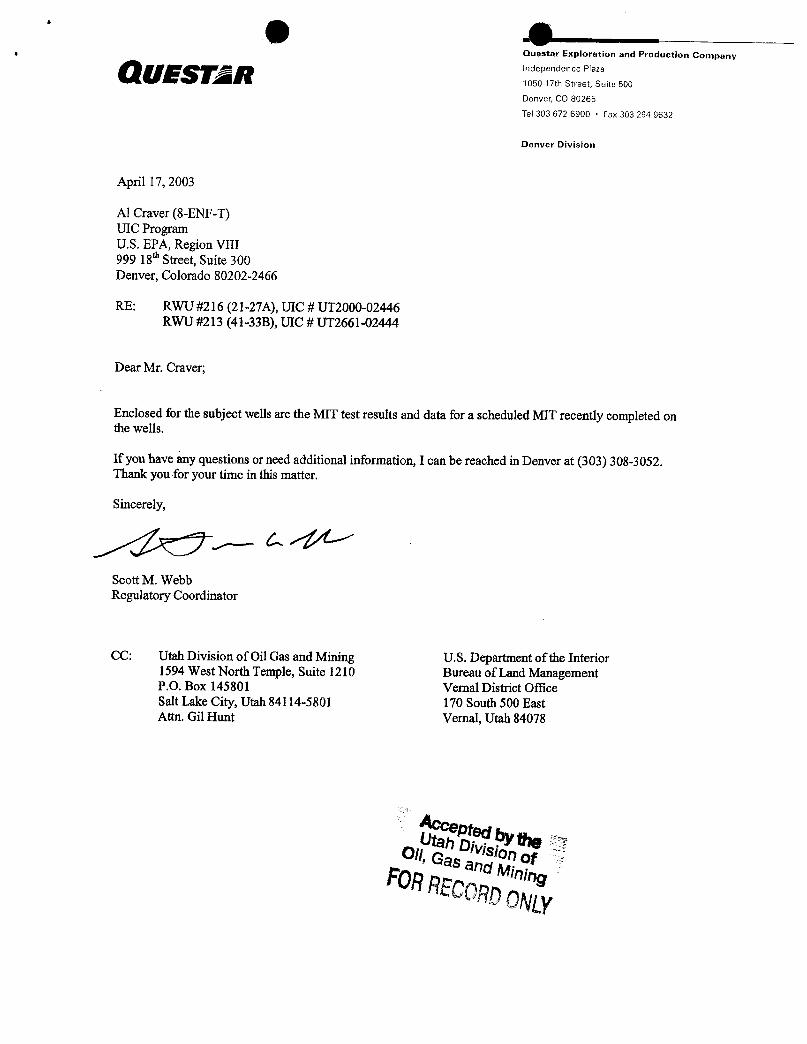
Ouestar Exploration and Production Companyindependence Plaza
1050 17th Street, Suite 500
Denver, CO 80265
Tel 303 672 6900 • Fax 303 294 9632
Denver Division
April 17, 2003
Al Craver (8-ENF-T)UIC ProgramU.S. EPA, Region VIII999 18* Street, Suite 300Denver, Colorado 80202-2466
RE: RWU #216 (2 I-27A), UIC # UT2000-02446RWU #213 (41-33B), UIC # UT2661-02444
Dear Mr. Craver;
Enclosed for the subject wells are the MIT test results and data for a scheduled MIT recently completed onthe wells.
If you have any questions or need additional information, I can be reached in Denver at (303) 308-3052.Thank you for your time in this matter.
Sincerely,
Scott M. WebbRegulatory Coordinator
CC: Utah Division of Oil Gas and Mining U.S. Department of the Interior1594 West North Temple, Suite 1210 Bureau of Land ManagementP.O. Box 145801 Vernal District OfficeSalt Lake City, Utah 84114-5801 170 South 500 EastAttu. Gil Hunt Vernal, Utah 84078
Acceptedby tteUtah DivisionofOil,Gas and MiningFORRECORD
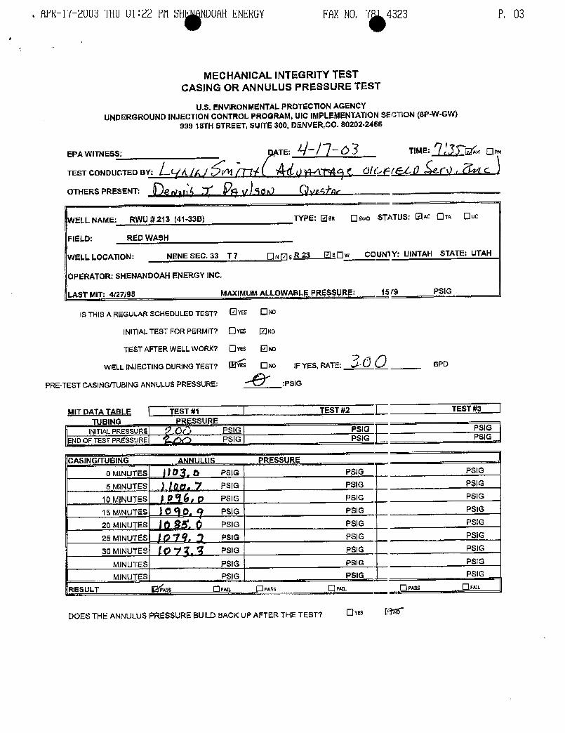
.fWR-li--2UU3 THUU1:22 FN SH NDUAHENERGY FAXNO. 7 4323 P. 03
MECHANICAL INTEGRITYTESTCASING OR ANNULUS PRESSURE TEST
U.S. ENVIRONMENTALPROTECTIONAGENCYUNDERGROUNDINJECTIONCONTROL PROGRAM,UIC IMPLEMENTATIONSECTION ($P-W-GW}
999 18fH STREET, suiTE 300, DENVER,CO.80202-2466
EPA WITNESS: TE: 4¯ TIME
TEST CONDUCTED sy: L('/L/Af //N t) MN ( C/CF/EL Û $(0OTHERS PRESENT: 4 gy __7' pgy ggr/p
WELL NAME: RWU #213 (41-338) TYPE: Um Oswa STATUS: OK OTA[¯Iuc
FIELD: RED WASH
WELL LOCATION: NENE SEC. 33 T 7 ON sR 23 OEOw COUN1Y: UINTAH STATE: UTAH
.OPERATOR: SHENANDOAHENERGY INC,
T MIT: 4/27/98 MAXIMUMALLOWABLEPRESSURE: '1579.
PSIG
IS THIS A REGULARSCHEDULED TEST7 YES ND
INITIALTEST FOR PERMITY Ovus No
TEST AFTER WELL woRKT Oves ONO
WELL INJECTING DURINGTEST? ONo 1F YES, RATE: 3d O_ soo
PRE-TEST CASING/TUBINGANNULUSPRESSURE: PSIG
MIT DATA TABLE TEST#1 TEST #2 TEST#3TUBING
,,,PRESSU,RE
INITIALPREssuRG QQ ESJG PSIG PSIGEND OF TEST PRESSURE PSIG (G PgG
CASINGITUBING ANNULUS PRESSUREO MINUTES
__IUg, PSIG PSIG PSIG
5 M1NUTES g, y PSIG PSIG PSIG
10 MINUTES sO PSIG PSIG PStG
15 MINUTES PSIG PSIG PSIG
20 MINUTES PSIG PSIG P_SIG
25 MINUTES PSIG Psic PelG
30 MINUTES (Q PSIG PSIG PSIG
MINUTES PSIG PSIG PSIG
MINUTES PSIG PSIG PSIG
RESULT BYÍAss Orm. Oras
DOES THE ANNULUS PRESSURE BUILD BACKUP AFTER THETEST7 Ovas
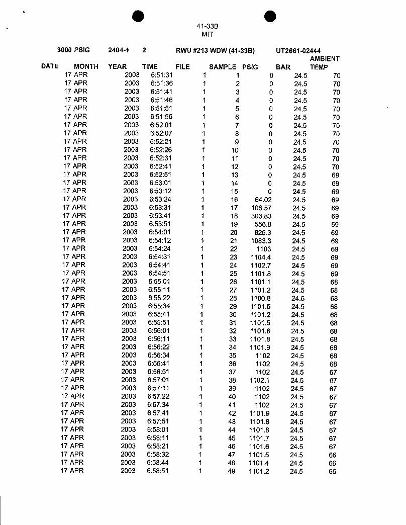
O O41-33B
MIT
3000 PSIG 2404-1 2 RWU #213 WDW (41-33B) UT2661-02444AMBIENT
DATE MONTH YEAR TIME FILE SAMPLE PSIG BAR TEMP17 APR 2003 6:51:31 1 1 0 24.5 7017 APR 2003 6:51:36 1 2 0 24.5 7017 APR 2003 6:51:41 1 3 0 24.5 7017 APR 2003 6:51:46 1 4 0 24.5 7017 APR 2003 6:51:51 1 5 0 24.5 7017 APR 2003 6:51:56 i 6 0 24.5 7017 APR 2003 6:52:01 1 7 0 24.5 7017 APR 2003 6:52:07 1 8 0 24.5 7017 APR 2003 6:52:21 1 9 0 24.5 7017 APR 2003 6:52:26 1 10 0 24.5 7017 APR 2003 6:52:31 1 11 0 24.5 7017 APR 2003 6:52:41 1 12 0 24.5 7017 APR 2003 6:52:51 1 13 0 24.5 6917 APR 2003 6:53:01 1 14 0 24.5 6917 APR 2003 6:53:12 1 15 0 24.5 6917 APR 2003 6:53:24 1 16 64.02 24.5 6917 APR 2003 6:53:31 1 17 106.57 24.5 6917 APR 2003 6:53:41 1 18 303.83 24.5 6917 APR 2003 6:53:51 1 19 556.8 24.5 6917 APR 2003 6:54:01 1 20 825.3 24.5 6917 APR 2003 6:54:12 1 21 1083.3 24.5 6917 APR 2003 6:54:24 1 22 1103 24.5 6917 APR 2003 6:54:31 1 23 1104.4 24.5 6917 APR 2003 6:54:41 1 24 1102.7 24.5 6917 APR 2003 6:54:51 1 25 1101.8 24.5 6917 APR 2003 6:55:01 1 26 1101.1 24.5 6817 APR 2003 6:55:11 1 27 1101.2 24.5 6817 APR 2003 6:55:22 1 28 1100.8 24.5 6817 APR 2003 6:55:34 1 29 1101.5 24.5 6817 APR 2003 6:55:41 1 30 1101.2 24.5 6817 APR 2003 6:55:51 1 31 1101.5 24.5 6817 APR 2003 6:56:01 1 32 1101.6 24.5 6817 APR 2003 6:56:11 1 33 1101.8 24.5 6817 APR 2003 6:56:22 1 34 1101.9 24.5 6817 APR 2003 6:56:34 1 35 1102 24.5 6817 APR 2003 6:56:41 1 36 1102 24.5 6817 APR 2003 6:56:51 1 37 1102 24.5 6717 APR 2003 6:57:01 1 38 1102.1 24.5 6717 APR 2003 6:57:11 1 39 1102 24.5 6717 APR 2003 6:57:22 1 40 1102 24.5 6717 APR 2003 6:57:34 1 41 1102 24.5 6717 APR 2003 6:57:41 1 42 1101.9 24.5 6717 APR 2003 6:57:51 1 43 1101.8 24.5 6717 APR 2003 6:58:01 1 44 1101.8 24.5 6717 APR 2003 6:58:11 1 45 1101.7 24.5 6717 APR 2003 6:58:21 1 46 1101.6 24.5 6717 APR 2003 6:58:32 1 47 1101.5 24.5 6617 APR 2003 6:58:44 1 48 1101.4 24.5 6617 APR 2003 6:58:51 1 49 1101.2 24.5
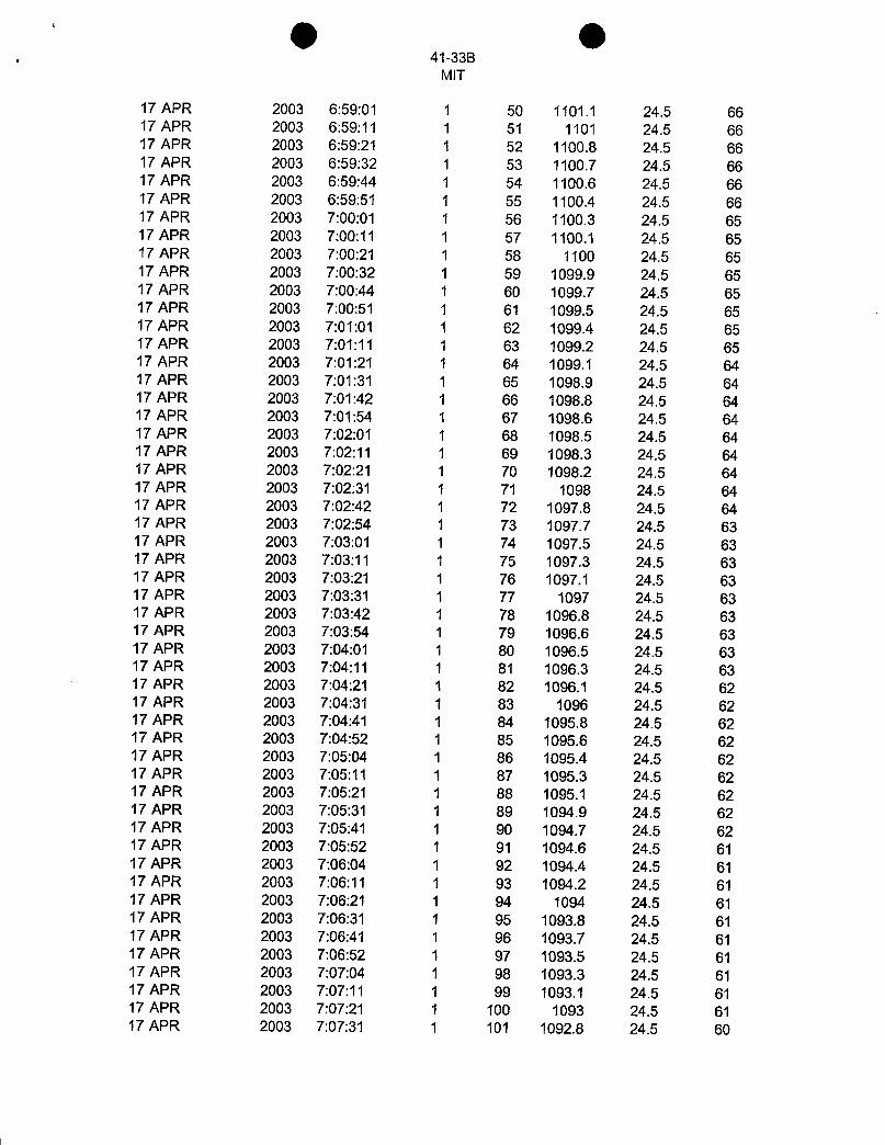
O O41-33B
MIT
17 APR 2003 6:59:01 1 50 1101.1 24.5 6617 APR 2003 6:59:11 1 51 1101 24.5 6617 APR 2003 6:59:21 1 52 1100.8 24.5 6617 APR 2003 6:59:32 1 53 1100.7 24.5 6617 APR 2003 6:59:44 1 54 1100.6 24.5 6617 APR 2003 6:59:51 1 55 1100.4 24.5 6617 APR 2003 7:00:01 1 56 1100.3 24.5 6517 APR 2003 7:00:11 1 57 1100.1 24.5 6517 APR 2003 7:00:21 1 58 1100 24.5 6517 APR 2003 7:00:32 1 59 1099.9 24.5 6517 APR 2003 7:00:44 1 60 1099.7 24.5 6517 APR 2003 7:00:51 1 61 1099.5 24.5 6517 APR 2003 7:01:01 i 62 1099.4 24.5 6517 APR 2003 7:01:11 1 63 1099.2 24.5 6517 APR 2003 7:01:21 1 64 1099.1 24.5 6417 APR 2003 7:01:31 1 65 1098.9 24.5 6417 APR 2003 7:01:42 1 66 1098.8 24.5 6417 APR 2003 7:01:54 1 67 1098.6 24.5 6417 APR 2003 7:02:01 1 68 1098.5 24.5 6417 APR 2003 7:02:11 1 69 1098.3 24.5 6417 APR 2003 7:02:21 1 70 1098.2 24.5 6417 APR 2003 7:02:31 1 71 1098 24.5 6417 APR 2003 7:02:42 1 72 1097.8 24.5 6417 APR 2003 7:02:54 1 73 1097.7 24.5 6317 APR 2003 7:03:01 1 74 1097.5 24.5 6317 APR 2003 7:03:11 1 75 1097.3 24.5 6317 APR 2003 7:03:21 1 76 1097.1 24.5 6317 APR 2003 7:03:31 1 77 1097 24.5 6317 APR 2003 7:03:42 1 78 1096.8 24.5 6317 APR 2003 7:03:54 1 79 1096.6 24.5 6317 APR 2003 7:04:01 1 80 1096.5 24.5 6317 APR 2003 7:04:11 1 81 1096.3 24.5 6317 APR 2003 7:04:21 1 82 1096.1 24.5 6217 APR 2003 7:04:31 1 83 1096 24.5 6217 APR 2003 7:04:41 1 84 1095.8 24.5 6217 APR 2003 7:04:52 1 85 1095.6 24.5 6217 APR 2003 7:05:04 1 86 1095.4 24.5 6217 APR 2003 7:05:11 1 87 1095.3 24.5 6217 APR 2003 7:05:21 1 88 1095.1 24.5 6217 APR 2003 7:05:31 1 89 1094.9 24.5 6217 APR 2003 7:05:41 1 90 1094.7 24.5 6217 APR 2003 7:05:52 1 91 1094.6 24.5 6117 APR 2003 7:06:04 1 92 1094.4 24.5 6117 APR 2003 7:06:11 1 93 1094.2 24.5 6117 APR 2003 7:06:21 1 94 1094 24.5 6117 APR 2003 7:06:31 1 95 1093.8 24.5 6117 APR 2003 7:06:41 1 96 1093.7 24.5 6117 APR 2003 7:06:52 1 97 1093.5 24.5 6117 APR 2003 7:07:04 1 98 1093.3 24.5 6117 APR 2003 7:07:11 1 99 1093.1 24.5 6117 APR 2003 7:07:21 1 100 1093 24.5 6117 APR 2003 7:07:31 1 101 1092.8 24.5
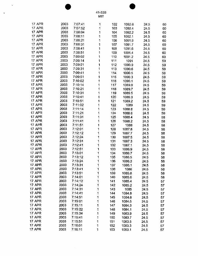
O O. 41-33B
MIT
17 APR 2003 7:07:41 1 102 1092.6 24.5 6017 APR 2003 7:07:52 1 103 1092.4 24.5 6017 APR 2003 7:08:04 1 104 1092.2 24.5 6017 APR 2003 7:08:11 1 105 1092.1 24.5 6017 APR 2003 7:08:21 1 106 1091.9 24.5 6017 APR 2003 7:08:31 1 107 1091.7 24.5 6017 APR 2003 7:08:41 1 108 1091.6 24.5 6017 APR 2003 7:08:51 1 109 1091.4 24.5 6017 APR 2003 7:09:02 1 110 1091.2 24.5 6017 APR 2003 7:09:14 1 111 1091 24.5 5917 APR 2003 7:09:21 1 112 1090.9 24.5 5917 APR 2003 7:09:31 1 113 1090.6 24.5 5917 APR 2003 7:09:41 1 114 1090.5 24.5 5917 APR 2003 7:09:51 1 115 1090.3 24.5 5917 APR 2003 7:10:02 1 116 1090.1 24.5 5917 APR 2003 7:10:14 1 117 1089.9 24.5 5917 APR 2003 7:10:21 1 118 1089.7 24.5 5917 APR 2003 7:10:31 1 119 1089.5 24.5 5917 APR 2003 7:10:41 1 120 1089.3 24.5 5917 APR 2003 7:10:51 1 121 1089.2 24.5 5917 APR 2003 7:11:02 1 122 1089 24.5 5917 APR 2003 7:11:14 1 123 1088.8 24.5 5917 APR 2003 7:11:21 1 124 1088.6 24.5 5917 APR 2003 7:11:31 1 125 1088.4 24.5 5817 APR 2003 7:11:41 1 126 1088.2 24.5 5817 APR 2003 7:11:51 1 127 1088 24.5 5817 APR 2003 7:12:01 1 128 1087.8 24.5 5817 APR 2003 7:12:12 1 129 1087.7 24.5 5817 APR 2003 7:12:24 1 130 1087.5 24.5 5817 APR 2003 7:12:31 1 131 1087.3 24.5 5817 APR 2003 7:12:41 1 132 1087.1 24.5 5817 APR 2003 7:12:51 1 133 1086.9 24.5 5817 APR 2003 7:13:01 1 134 1086.7 24.5 5817 APR 2003 7:13:12 1 135 1086.5 24.5 5817 APR 2003 7:13:24 1 136 1086.3 24.5 5817 APR 2003 7:13:31 1 137 1086.1 24.5 5817 APR 2003 7:13:41 1 138 1086 24.5 5817 APR 2003 7:13:51 1 139 1085.8 24.5 5817 APR 2003 7:14:01 1 140 1085.6 24.5 5817 APR 2003 7:14:12 1 141 1085.4 24.5 5717 APR 2003 7:14:24 1 142 1085.2 24.5 5717 APR 2003 7:14:31 1 143 1085 24.5 5717 APR 2003 7:14:41 1 144 1084.8 24.5 5717 APR 2003 7:14:51 1 145 1084.6 24.5 5717 APR 2003 7:15:01 1 146 1084.5 24.5 5717 APR 2003 7:15:11 1 147 1084.3 24.5 5717 APR 2003 7:15:22 1 148 1084.1 24.5 5717 APR 2003 7:15:34 1 149 1083.9 24.5 5717 APR 2003 7:15:41 1 150 1083.7 24.5 5717 APR 2003 7:15:51 1 151 1083.5 24.5 5717 APR 2003 7:16:01 1 152 1083.3 24.5 5717 APR 2003 7:16:11 1 153 1083.1 24.5
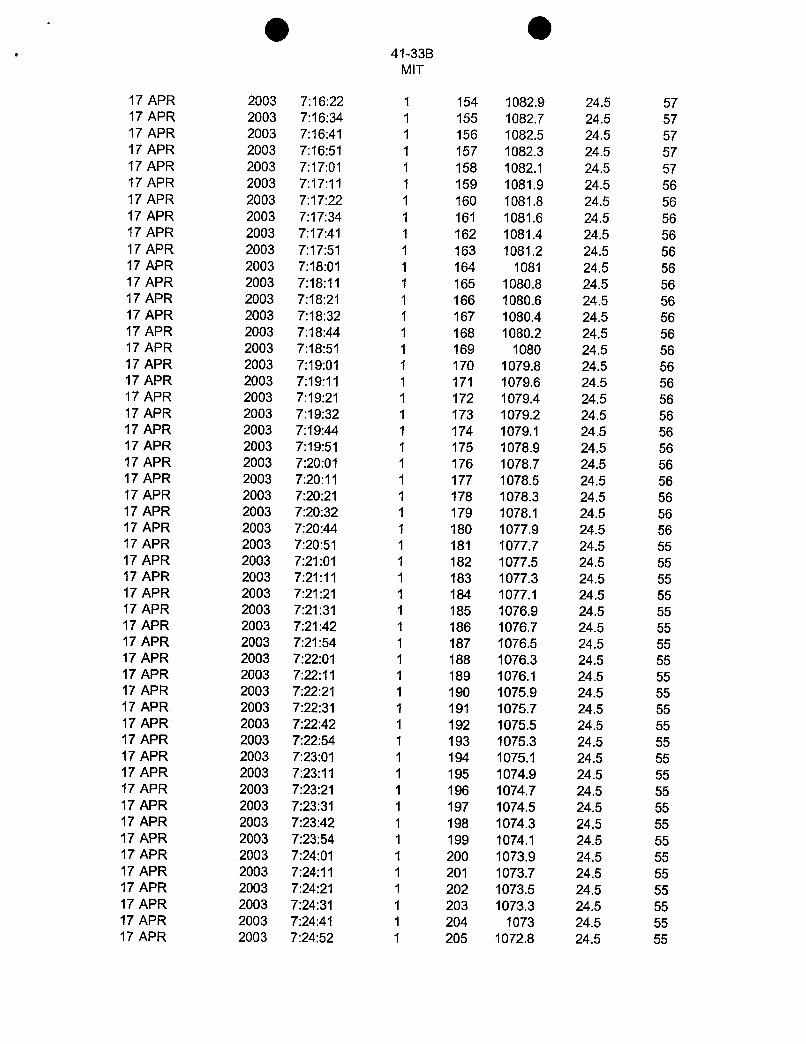
O O. 41-33B
MIT
17 APR 2003 7:16:22 1 154 1082.9 24.5 5717 APR 2003 7:16:34 1 155 1082.7 24.5 5717 APR 2003 7:16:41 1 156 1082.5 24.5 5717 APR 2003 7:16:51 1 157 1082.3 24.5 5717 APR 2003 7:17:01 1 158 1082.1 24.5 5717 APR 2003 7:17:11 1 159 1081.9 24.5 5617 APR 2003 7:17:22 1 160 1081.8 24.5 5617 APR 2003 7:17:34 1 161 1081.6 24.5 5617 APR 2003 7:17:41 1 162 1081.4 24.5 5617 APR 2003 7:17:51 1 163 1081.2 24.5 5617 APR 2003 7:18:01 1 164 1081 24.5 5617 APR 2003 7:18:11 1 165 1080.8 24.5 5617 APR 2003 7:18:21 1 166 1080.6 24.5 5617 APR 2003 7:18:32 1 167 1080.4 24.5 5617 APR 2003 7:18:44 1 168 1080.2 24.5 5617 APR 2003 7:18:51 1 169 1080 24.5 5617 APR 2003 7:19:01 1 170 1079.8 24.5 5617 APR 2003 7:19:11 1 171 1079.6 24.5 5617 APR 2003 7:19:21 1 172 1079.4 24.5 5617 APR 2003 7:19:32 1 173 1079.2 24.5 5617 APR 2003 7:19:44 1 174 1079.1 24.5 5617 APR 2003 7:19:51 1 175 1078.9 24.5 5617 APR 2003 7:20:01 1 176 1078.7 24.5 5617 APR 2003 7:20:11 1 177 1078.5 24.5 5617 APR 2003 7:20:21 1 178 1078.3 24.5 5617 APR 2003 7:20:32 1 179 1078.1 24.5 5617 APR 2003 7:20:44 1 180 1077.9 24.5 5617 APR 2003 7:20:51 1 181 1077.7 24.5 5517 APR 2003 7:21:01 1 182 1077.5 24.5 5517 APR 2003 7:21:11 1 183 1077.3 24.5 5517 APR 2003 7:21:21 1 184 1077.1 24.5 5517 APR 2003 7:21:31 1 185 1076.9 24.5 5517 APR 2003 7:21:42 1 186 1076.7 24.5 5517 APR 2003 7:21:54 1 187 1076.5 24.5 5517 APR 2003 7:22:01 1 188 1076.3 24.5 5517 APR 2003 7:22:11 1 189 1076.1 24.5 5517 APR 2003 7:22:21 1 190 1075.9 24.5 5517 APR 2003 7:22:31 1 191 1075.7 24.5 5517 APR 2003 7:22:42 1 192 1075.5 24.5 5517 APR 2003 7:22:54 1 193 1075.3 24.5 5517 APR 2003 7:23:01 1 194 1075.1 24.5 5517 APR 2003 7:23:11 1 195 1074.9 24.5 5517 APR 2003 7:23:21 1 196 1074.7 24.5 5517 APR 2003 7:23:31 1 197 1074.5 24.5 5517 APR 2003 7:23:42 1 198 1074.3 24.5 5517 APR 2003 7:23:54 1 199 1074.1 24.5 5517 APR 2003 7:24:01 1 200 1073.9 24.5 5517 APR 2003 7:24:11 1 201 1073.7 24.5 5517 APR 2003 7:24:21 1 202 1073.5 24.5 5517 APR 2003 7:24:31 1 203 1073.3 24.5 5517 APR 2003 7:24:41 1 204 1073 24.5 5517 APR 2003 7:24:52 1 205 1072.8 24.5
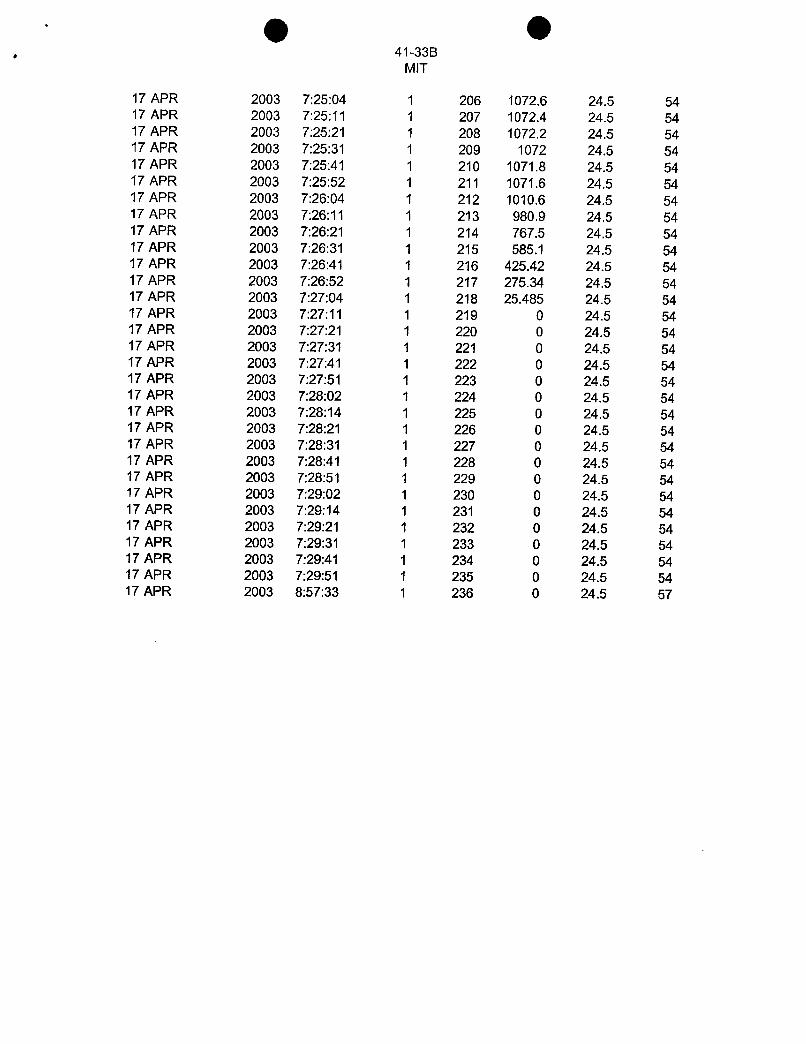
O O41-33B
MIT
17 APR 2003 7:25:04 1 206 1072.6 24.5 5417 APR 2003 7:25:11 1 207 1072.4 24.5 5417 APR 2003 7:25:21 1 208 1072.2 24.5 5417 APR 2003 7:25:31 1 209 1072 24.5 5417 APR 2003 7:25:41 1 210 1071.8 24.5 5417 APR 2003 7:25:52 1 211 1071.6 24.5 5417 APR 2003 7:26:04 1 212 1010.6 24.5 5417 APR 2003 7:26:11 1 213 980.9 24.5 5417 APR 2003 7:26:21 1 214 767.5 24.5 5417 APR 2003 7:26:31 1 215 585.1 24.5 5417 APR 2003 7:26:41 1 216 425.42 24.5 5417 APR 2003 7:26:52 1 217 275.34 24.5 5417 APR 2003 7:27:04 1 218 25.485 24.5 5417 APR 2003 7:27:11 1 219 0 24.5 5417 APR 2003 7:27:21 1 220 0 24.5 5417 APR 2003 7:27:31 1 221 0 24.5 5417 APR 2003 7:27:41 1 222 0 24.5 5417 APR 2003 7:27:51 1 223 0 24.5 5417 APR 2003 7:28:02 1 224 0 24.5 5417 APR 2003 7:28:14 1 225 0 24.5 5417 APR 2003 7:28:21 1 226 0 24.5 5417 APR 2003 7:28:31 1 227 0 24.5 5417 APR 2003 7:28:41 1 228 0 24.5 5417 APR 2003 7:28:51 1 229 0 24.5 5417 APR 2003 7:29:02 1 230 0 24.5 5417 APR 2003 7:29:14 1 231 0 24.5 5417 APR 2003 7:29:21 1 232 0 24.5 5417 APR 2003 7:29:31 1 233 0 24.5 5417 APR 2003 7:29:41 1 234 0 24.5 5417 APR 2003 7:29:51 1 235 0 24.5 5417 APR 2003 8:57:33 1 236 0 24.5
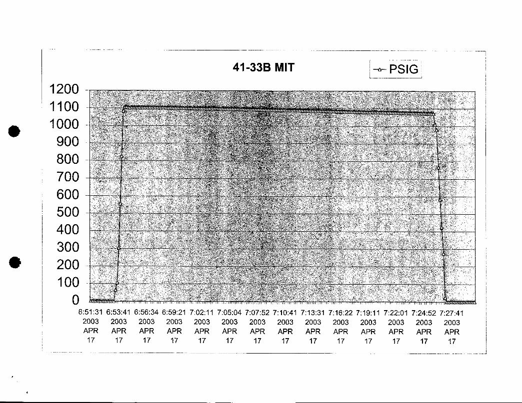
41-33B MIT PSIG1200 NE
iooog 900800700006500400300
O 200100
0 22
6:51:31 6:53:41 6:56:34 6:59:21 7:02:11 7:05:04 7:07:52 7:10:41 7:13:31 7:16:22 7:19:11 7:22:01 7:24:52 7:27:412003 2003 2003 2003 2003 2003 2003 2003 2003 2003 2003 2003 2003 2003APR APR APR APR APR APR APR APR APR APR APR APR APR APR
17 17 17 17 17 17 17 17 17 17 17 17 17 17
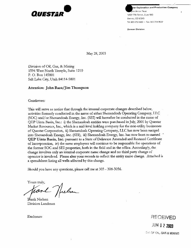
duction Company
1050 17th Street, Suite 500
Denver, CO 80265
Tel 303 672 6900 • Fax 303 294 9632
Denver Division
May 28, 2003
Division of Oil, Gas, & Mining1594 West North Temple, Suite 1210P. O. Box 145801Salt Lake City, Utah 84114-5801
Attention: JohnBaza/JimThompson
Gentlemen:
This will serve as notice that through the internal corporate changes described below,activities formerly conducted in the name of either Shenandoah Operating Company, LLC(SOC) and/or Shenandoah Energy, Inc. (SEI) will hereafter be conducted in the name of
QEP Uinta Basin, Inc.: i) the Shenandoah entities were purchased in July,2001 by QuestarMarket Resources, Inc., which is a mid-level holding company for the non-utility businessesof QuestarCorporation, ii) Shenandoah Operating Company, LLC has now been mergedinto Shenandoah Energy, Inc. (SEI), iii) Shenandoah Energy, Inc. has now been te-named '
QEP Uinta Basin, Inc. pursuant to a State of Delaware Amended and Restated Certiñcateof Incorporation, iv) the same employees will continue to be responsible for operations ofthe former SOC and SEI properties, both in the field and in the office. Accordingly, thechange involves only an internal corporate name change and no third party change ofoperator is involved. Please alter your records to reflect the entity name change. Attached isa spreadsheet listing all wells affected by this change.
Should you have any questions, please call me at 303 - 308-3056.
Youts truly,
rank NielsenDivision Landman
Enclosure RECEl VEDJUNO2 2003
O OF OIL,GAS &
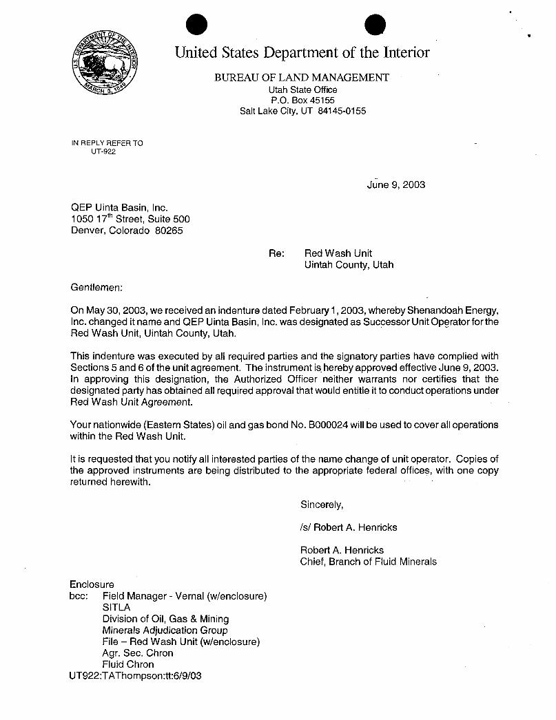
O OUnited States Department of the Interior
BUREAU OF LAND MANAGEMENTCH a Utah State Office
P.O. Box 45155Salt Lake City,UT 84145-0155
IN REPLY REFER TOUT-922
June 9, 2003
QEP Uinta Basin, Inc.1050 17th Street, Suite 500Denver, Colorado 80265
Re: Red Wash UnitUintah County, Utah
Gentlemen:
On May 30, 2003, we received an indenture dated February 1, 2003, whereby Shenandoah Energy,Inc. changed it name and QEP Uinta Basin, Inc. was designated as Successor UnitOperator for theRed Wash Unit, Uintah County, Utah.
This indenture was executed by all required parties and the signatory parties have complied withSections 5 and 6 of the unit agreement. The instrument is hereby approved effectiveJune 9, 2003.In approving this designation, the Authorized Officer neither warrants nor certifies that thedesignated party has obtained all required approval that would entitle itto conduct operations underRed Wash Unit Agreement.
Your nationwide (Eastern States) oiland gas bond No. BOOOO24willbe used to cover all operationswithin the Red Wash Unit.
It is requested that you notify all interested parties of the name change of unit operator. Copies ofthe approved instruments are being distributed to the appropriate federal offices, with one copyreturned herewith.
Sincerely,
/s/ Robert A. Henricks
Robert A. HenricksChief, Branch of Fluid Minerals
Enclosurebcc: Field Manager - Vernal (wlenclosure)
SITLADivision of Oil, Gas & MiningMinerals Adjudication GroupFile - Red Wash Unit (wlenclosure)Agr. Sec. ChronFluid Chron
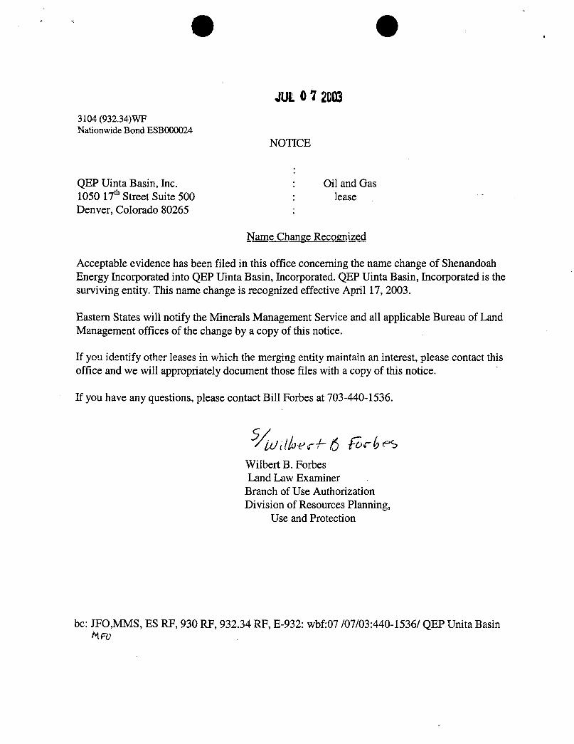
O O
JUL 0 Y20033104 (932.34)WFNationwide Bond ESBOOOO24
NOTICE
QEP Uinta Basin, Inc. : Oil and Gas1050 17* Street Suite 500 : leaseDenver, Colorado 80265 :
Name Change Recognized
Acceptable evidence has been filed in this office concerning the name change of ShenandoahEnergy Incorporated into QEP Uinta Basin, Incorporated. QEP Uinta Basin, Incorporated is thesurviving entity. This name change is recognized effective April 17, 2003.
Eastern States will notify the Minerals Management Service and all applicable Bureau of LandManagement offices of the change by a copy of this notice.
If you identify other leases in which the merging entity maintain an interest, please contact thisoffice and we will appropriately document those files with a copy of this notice.
If you have any questions, please contact Bill Forbes at 703-440-1536.
Wilbert B. ForbesLand Law Examiner
Branch of Use AuthorizationDivision of Resources Planning,
Use and Protection
bc: JFO,MMS, ES RF, 930 RF, 932.34 RF, E-932: wbf:07 /07/03:440-1536/ QEP Unita
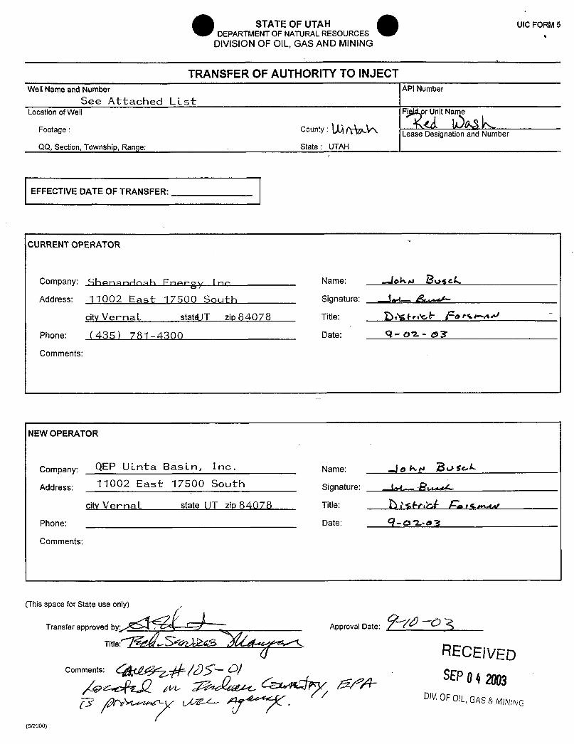
STATE OF UTAH UIC FORM5O DEPARTMENT OF NATURALRESOURCES ,
DIVISION OF OIL, GAS AND MINING
1
TRANSFER OF AUTHORITY TO INJECTWell Name and Number API Number
See Attached LLstLocation ofWell Fi or Unit Name
Footage : County : Lease Designation and Number
QQ, Section, Township, Range: State : UTAH
EFFECTIVE DATE OF TRANSFER:
CURRENT OPERATOR
Company: Shenancinah Fnergy Ino Name: ....leka BoyckAddress: 11002 East 17500 Sout-h signature: .. im Ä>
city VernaL statd)T zip 84078 Title: g)gexF fe er-4
Phone: (435) 781-4300 Date: 9-02- sT
Comments:
NEW OPERATOR
Company: QEP ULnta BasLn, Inc · Name: go Ay Rege,L
Address: 11002 East 17500 South Signature: (A- Racity VernaL state UT zip 84078 Title: Ò NWebf En et .a
Phone: Date: 9-O2-o3
Comments:
(This spraacnesfeorrappreovuseon
Approval Date:
Title:
RECEIVEDComments: 4 5 D/ SEPO4m
a pr> / oíV OF OIL,GAS & MIMNG
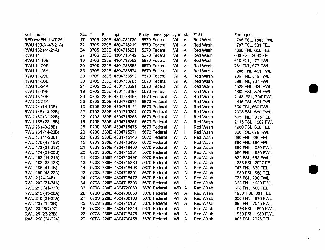
well_name Sec T R api Entity Lease Type type stat Field FootagesRED WASH UNIT 261 17 070S 230E 4304732739 5670 Federal WI A Red Wash 1785 FSL, 1843 FWLRWU 100-A (43-21A) 21 070S 220E 4304715219 5670 Federal WI A Red Wash 1787 FSL, 534 FELRWU 102 (41-24A) 24 070S 220E 4304715221 5670 Federal WI A Red Wash 1360 FNL, 660 FELRWU 11 27 070S 230E 4304715142 5670 Federal WI A Red Wash 660 FSL, 2030 FELRWU 11-19B 19 070S 230E 4304733552 5670 Federal WI A Red Wash 618 FNL, 477 FWLRWU 11-20B 20 070S 230E 4304733553 5670 Federal WI A Red Wash 761 FNL, 677 FWLRWU 11-25A 25 070S 220E 4304733574 5670 Federal WI A Red Wash 1206 FNL, 491 FWLRWU 11-29B 29 070S 230E 4304733590 5670 Federal WI A Red Wash 786 FNL, 819 FWLRWU 11-30B 30 070S 230E 4304733785 5670 Federal WI A Red Wash 590 FNL, 787 FWLRWU 12-24A 24 070S 220E 4304733591 5670 Federal WI A Red Wash 1528 FNL, 930 FWLRWU 13-19B 19 070S 230E 4304733497 5670 Federal WI A Red Wash 1802 FSL, 374 FWLRWU 13-20B 20 070S 230E 4304733498 5670 Federal WI A Red Wash 2143' FSL, 704' FWLRWU 13-25A 25 070S 220E 4304733575 5670 Federal WI A Red Wash 1446 FSL, 664 FWLRWU 14 (14-13B) 13 070S 230E 4304715144 5670 Federal WI A Red Wash 660 FSL, 660 FWLRWU 148 (13-22B) 22 070S 230E 4304715261 5670 Federal WI A Red Wash 2073 FSL, 660 FWLRWU 150 (31-22B) 22 070S 230E 4304715263 5670 Federal WI I Red Wash 595 FNL, 1935 FELRWU 156 (23-15B) 15 070S 230E 4304715267 5670 Federal WI A Red Wash 2115 FSL, 1982 FWLRWU 16 (43-28B) 28 070S 230E 4304716475 5670 Federal WI I Red Wash 1980 FSL, 660 FELRWU 161 (14-20B) 20 070S 230E 4304715271 5670 Federal WI I Red Wash 660 FSL, 678 FWLRWU 17 (41-20B) 20 070S 230E 4304715146 5670 Federal WI A Red Wash 660 FNL, 660 FELRWU 170 (41-15B) 15 070S 230E 4304716495 5670 Federal WI \ Red Wash 660 FNL, 660 FELRWU 173 (21-21B) 21 070S 230E 4304716496 5670 Federal WI A Red Wash 660 FNL, 1980 FWLRWU 174 (21-20B) 20 070S 230E 4304715281 5670 Federal WI A Red Wash 660 FNL, 1980 FWLRWU 182 (14-21B) 21 070S 230E 4304716497 5670 Federal WI A Red Wash 629 FSL, 652 FWLRWU 183 (33-13B) 13 070S 230E 4304715289 5670 Federal WI A Red Wash 1833 FSL, 2027 FELRWU 185 (41-1B) 14 070S 230E 4304716498 5670 Federal WI A Red Wash 747 FNL, 660 FELRWU 199 (43-22A) 22 070S 220E 4304715301 5670 Federal WI A Red Wash 1980 FSL, 658 FELRWU 2 (14-24B) 24 070S 230E 4304716472 5670 Federal WI A Red Wash 735 FSL, 790 FWLRWU 202 (21-34A) 34 070S 220E 4304715303 5670 Federal WI I Red Wash 660 FNL, 1980 FWLRWU213 (41-33B) 33 070S 230E 4304720060 5670 Federal WD A Red Wash 660 FNL, 580 FELRWU215 (43-28A) 28 070S 220E 4304730058 5670 Federal WI A Red Wash 1980' FSL, 661 FELRWU 216 (21-27A) 27 070S 220E 4304730103 5670 Federal WI A Red Wash 660 FNL, 1976 FWLRWU 23 (21-23B) 23 070S 230E 4304715151 5670 Federal WI A Red Wash 695 FNL, 2015 FWLRWU 23-18C (97) 18 070S 240E 4304715216 5670 Federal WI I Red Wash 1956 FSL, 1699 FWLRWU 25 (23-23B) 23 070S 230E 4304716476 5670 Federal WI A Red Wash 1980 FSL, 1980 FWLRWU 258 (34-22A) 22 070S 220E 4304730458 5670 Federal WI A Red Wash 885 FSL, 2025
well_name Sec T R api Entity Lease Type type stat Field FootagesRED WASH UNIT 261 17 070S 230E 4304732739 5670 Federal WI A Red Wash 1785 FSL, 1843 FWLRWU 100-A (43-21A) 21 070S 220E 4304715219 5670 Federal WI A Red Wash 1787 FSL, 534 FELRWU 102 (41-24A) 24 070S 220E 4304715221 5670 Federal WI A Red Wash 1360 FNL, 660 FELRWU 11 27 070S 230E 4304715142 5670 Federal WI A Red Wash 660 FSL, 2030 FELRWU 11-19B 19 070S 230E 4304733552 5670 Federal WI A Red Wash 618 FNL, 477 FWLRWU 11-20B 20 070S 230E 4304733553 5670 Federal WI A Red Wash 761 FNL, 677 FWLRWU 11-25A 25 070S 220E 4304733574 5670 Federal WI A Red Wash 1206 FNL, 491 FWLRWU 11-29B 29 070S 230E 4304733590 5670 Federal WI A Red Wash 786 FNL, 819 FWLRWU 11-30B 30 070S 230E 4304733785 5670 Federal WI A Red Wash 590 FNL, 787 FWLRWU 12-24A 24 070S 220E 4304733591 5670 Federal WI A Red Wash 1528 FNL, 930 FWLRWU 13-19B 19 070S 230E 4304733497 5670 Federal WI A Red Wash 1802 FSL, 374 FWLRWU 13-20B 20 070S 230E 4304733498 5670 Federal WI A Red Wash 2143' FSL, 704' FWLRWU 13-25A 25 070S 220E 4304733575 5670 Federal WI A Red Wash 1446 FSL, 664 FWLRWU 14 (14-13B) 13 070S 230E 4304715144 5670 Federal WI A Red Wash 660 FSL, 660 FWLRWU 148 (13-22B) 22 070S 230E 4304715261 5670 Federal WI A Red Wash 2073 FSL, 660 FWLRWU 150 (31-22B) 22 070S 230E 4304715263 5670 Federal WI I Red Wash 595 FNL, 1935 FELRWU 156 (23-15B) 15 070S 230E 4304715267 5670 Federal WI A Red Wash 2115 FSL, 1982 FWLRWU 16 (43-28B) 28 070S 230E 4304716475 5670 Federal WI I Red Wash 1980 FSL, 660 FELRWU 161 (14-20B) 20 070S 230E 4304715271 5670 Federal WI I Red Wash 660 FSL, 678 FWLRWU 17 (41-20B) 20 070S 230E 4304715146 5670 Federal WI A Red Wash 660 FNL, 660 FELRWU 170 (41-15B) 15 070S 230E 4304716495 5670 Federal WI \ Red Wash 660 FNL, 660 FELRWU 173 (21-21B) 21 070S 230E 4304716496 5670 Federal WI A Red Wash 660 FNL, 1980 FWLRWU 174 (21-20B) 20 070S 230E 4304715281 5670 Federal WI A Red Wash 660 FNL, 1980 FWLRWU 182 (14-21B) 21 070S 230E 4304716497 5670 Federal WI A Red Wash 629 FSL, 652 FWLRWU 183 (33-13B) 13 070S 230E 4304715289 5670 Federal WI A Red Wash 1833 FSL, 2027 FELRWU 185 (41-1B) 14 070S 230E 4304716498 5670 Federal WI A Red Wash 747 FNL, 660 FELRWU 199 (43-22A) 22 070S 220E 4304715301 5670 Federal WI A Red Wash 1980 FSL, 658 FELRWU 2 (14-24B) 24 070S 230E 4304716472 5670 Federal WI A Red Wash 735 FSL, 790 FWLRWU 202 (21-34A) 34 070S 220E 4304715303 5670 Federal WI I Red Wash 660 FNL, 1980 FWLRWU213 (41-33B) 33 070S 230E 4304720060 5670 Federal WD A Red Wash 660 FNL, 580 FELRWU215 (43-28A) 28 070S 220E 4304730058 5670 Federal WI A Red Wash 1980' FSL, 661 FELRWU 216 (21-27A) 27 070S 220E 4304730103 5670 Federal WI A Red Wash 660 FNL, 1976 FWLRWU 23 (21-23B) 23 070S 230E 4304715151 5670 Federal WI A Red Wash 695 FNL, 2015 FWLRWU 23-18C (97) 18 070S 240E 4304715216 5670 Federal WI I Red Wash 1956 FSL, 1699 FWLRWU 25 (23-23B) 23 070S 230E 4304716476 5670 Federal WI A Red Wash 1980 FSL, 1980 FWLRWU 258 (34-22A) 22 070S 220E 4304730458 5670 Federal WI A Red Wash 885 FSL, 2025
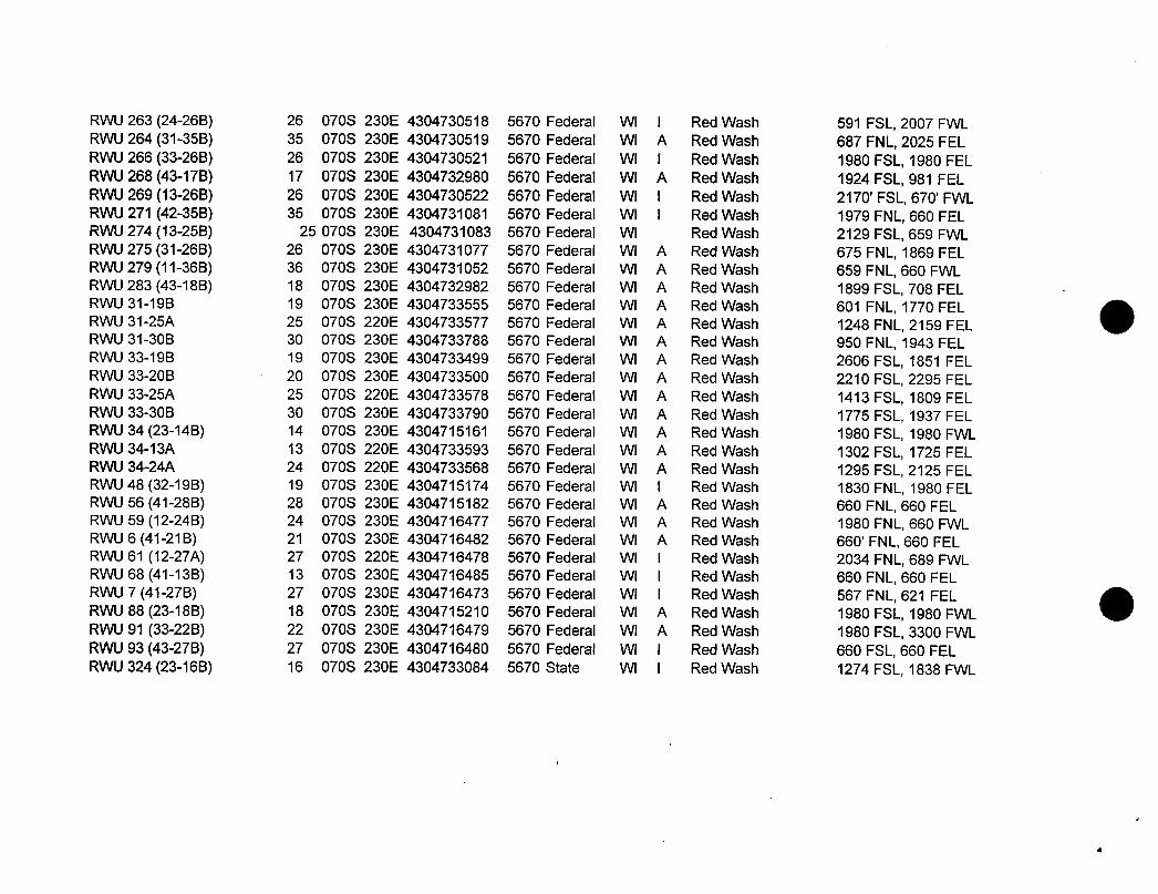
RWU 263 (24-26B) 26 070S 230E 4304730518 5670 Federal WI I Red Wash 591 FSL, 2007 FWLRVAJ264(31-35B) 35 070S 230E 4304730519 5670 Federal VVI A RedvVash 687FNL,2025FELRWU 266 (33-26B) 26 070S 230E 4304730521 5670 Federal WI I Red Wash 1980 FSL, 1980 FELR½AJ268(43-17B) 17 070S 230E 4304732980 5670 Federal VV A RedvVash 1924FSL,981FELFRARJ269(13-26B) 26 070S 230E 4304730522 5670 Federal VVI I Red\Nash 2170'FSL,670'FVVLFRAAJ271(42-35B) 35 070S 230E 4304731081 5670 Federal VVI I Red\Nash 1979FNL,660FELFRAAJ274(13-25B) 25 070S 230E 4304731083 5670 Federal VVI Red\Nash 2129FSL,659FVVLFRAAJ275(31-26B) 26 070S 230E 4304731077 5670 Federal VVI A Red\Nash 675FNL,1869FELRVVU279(11-36B) 36 070S 230E 4304731052 5670 Federal VII A Red\Nash 659FNL,660FVVLRWU 283 (43-18B) 18 070S 230E 4304732982 5670 Federal WI A Red Wash 1899 FSL, 708 FELRVVU31-19B 19 070S 230E 4304733555 5670 Federal VVI A Red\Nash 601 FNL,1770FELRVVU31-25A 25 070S 220E 4304733577 5670 Federal VVI A Red\Nash 1248FNL,2159FELRVVU31-30B 30 070S 230E 4304733788 5670 Federal VVI A Red\Nash 950FNL,1943FELRVVU33-19B 19 070S 230E 4304733499 5670 Federal VVI A Red\Nash 2606FSL,1851 FELRWU 33-20B 20 070S 230E 4304733500 5670 Federal WI A Red Wash 2210 FSL, 2295 FELRVVU33-25A 25 070S 220E 4304733578 5670 Federal VVI A Red\Nash 1413FSL,1809FELRVVU33-30B 30 070S 230E 4304733790 5670 Federal VVI A Red\Nash 1775FSL,1937FELRVVU34(23-14B) 14 070S 230E 4304715161 5670 Federal VVI A Red\Nash 1980FSL,1980FVVLRVVU34-13A 13 070S 220E 4304733593 5670 Federal VVI A Red\Nash 1302FSL,1725FELRVVU34-2.4A 24 070S 220E 4304733568 5670 Federal VV A Red\Nash 1295FSL,2125FELRVVU48(32-19B) 19 070S 230E 4304715174 5670 Federal VVI I RedVVash 1830 FNL,1980 FELRVVU56(41-28B) 28 070S 230E 4304715182 5670 Federal VVI A Red\Nash 660FNL,660FELRVVUS9(12-24B) 24 070S 230E 4304716477 5670 Federal VVI A Red\Nash 1980 FNL,660 FVVLRVVU6(41-21B) 21 070S 230E 4304716482 5670 Federal VVI A Red\Nash 660'FNL,660 FELRVVU61 (12-27A) 27 070S 220E 4304716478 5670 Federal VVI I Red\Nash 2034FNL,689FVVLRVVU68(41-13B) 13 070S 230E 4304716485 5670 Federal VVI I Red\Nash 660FNL,660FELRVVU7(41-27B) 27 070S 230E 4304716473 5670 Federal VVI I Red\Nash 567FNL,621 FELRVVU88(23-18B) 18 070S 230E 4304715210 5670 Federal VVI A Red\Nash 1980FSL,1980FVVLRWU91 (33-22B) 22 070S 230E 4304716479 5670 Federal WI A Red Wash 1980 FSL, 3300 FWLRVVU93(43-27B) 27 070S 230E 4304716480 5670 Federal VVI I Red\Nash 660FSL,660FELRVVU324(23-16B) 16 070S 230E 4304733084 5670 State VVI I Red\Nash
RWU 263 (24-26B) 26 070S 230E 4304730518 5670 Federal WI I Red Wash 591 FSL, 2007 FWLRVAJ264(31-35B) 35 070S 230E 4304730519 5670 Federal VVI A RedvVash 687FNL,2025FELRWU 266 (33-26B) 26 070S 230E 4304730521 5670 Federal WI I Red Wash 1980 FSL, 1980 FELR½AJ268(43-17B) 17 070S 230E 4304732980 5670 Federal VV A RedvVash 1924FSL,981FELFRARJ269(13-26B) 26 070S 230E 4304730522 5670 Federal VVI I Red\Nash 2170'FSL,670'FVVLFRAAJ271(42-35B) 35 070S 230E 4304731081 5670 Federal VVI I Red\Nash 1979FNL,660FELFRAAJ274(13-25B) 25 070S 230E 4304731083 5670 Federal VVI Red\Nash 2129FSL,659FVVLFRAAJ275(31-26B) 26 070S 230E 4304731077 5670 Federal VVI A Red\Nash 675FNL,1869FELRVVU279(11-36B) 36 070S 230E 4304731052 5670 Federal VII A Red\Nash 659FNL,660FVVLRWU 283 (43-18B) 18 070S 230E 4304732982 5670 Federal WI A Red Wash 1899 FSL, 708 FELRVVU31-19B 19 070S 230E 4304733555 5670 Federal VVI A Red\Nash 601 FNL,1770FELRVVU31-25A 25 070S 220E 4304733577 5670 Federal VVI A Red\Nash 1248FNL,2159FELRVVU31-30B 30 070S 230E 4304733788 5670 Federal VVI A Red\Nash 950FNL,1943FELRVVU33-19B 19 070S 230E 4304733499 5670 Federal VVI A Red\Nash 2606FSL,1851 FELRWU 33-20B 20 070S 230E 4304733500 5670 Federal WI A Red Wash 2210 FSL, 2295 FELRVVU33-25A 25 070S 220E 4304733578 5670 Federal VVI A Red\Nash 1413FSL,1809FELRVVU33-30B 30 070S 230E 4304733790 5670 Federal VVI A Red\Nash 1775FSL,1937FELRVVU34(23-14B) 14 070S 230E 4304715161 5670 Federal VVI A Red\Nash 1980FSL,1980FVVLRVVU34-13A 13 070S 220E 4304733593 5670 Federal VVI A Red\Nash 1302FSL,1725FELRVVU34-2.4A 24 070S 220E 4304733568 5670 Federal VV A Red\Nash 1295FSL,2125FELRVVU48(32-19B) 19 070S 230E 4304715174 5670 Federal VVI I RedVVash 1830 FNL,1980 FELRVVU56(41-28B) 28 070S 230E 4304715182 5670 Federal VVI A Red\Nash 660FNL,660FELRVVUS9(12-24B) 24 070S 230E 4304716477 5670 Federal VVI A Red\Nash 1980 FNL,660 FVVLRVVU6(41-21B) 21 070S 230E 4304716482 5670 Federal VVI A Red\Nash 660'FNL,660 FELRVVU61 (12-27A) 27 070S 220E 4304716478 5670 Federal VVI I Red\Nash 2034FNL,689FVVLRVVU68(41-13B) 13 070S 230E 4304716485 5670 Federal VVI I Red\Nash 660FNL,660FELRVVU7(41-27B) 27 070S 230E 4304716473 5670 Federal VVI I Red\Nash 567FNL,621 FELRVVU88(23-18B) 18 070S 230E 4304715210 5670 Federal VVI A Red\Nash 1980FSL,1980FVVLRWU91 (33-22B) 22 070S 230E 4304716479 5670 Federal WI A Red Wash 1980 FSL, 3300 FWLRVVU93(43-27B) 27 070S 230E 4304716480 5670 Federal VVI I Red\Nash 660FSL,660FELRVVU324(23-16B) 16 070S 230E 4304733084 5670 State VVI I Red\Nash
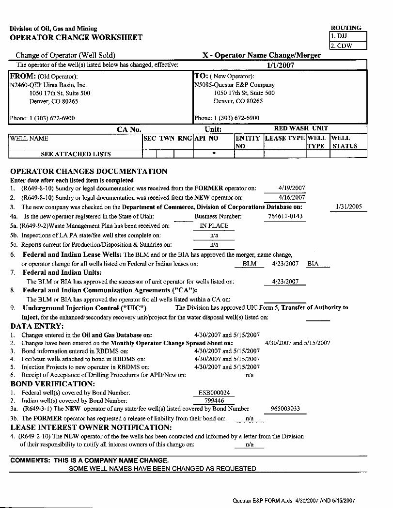
Division of Oil, Gas and Mining ROUTING
OPERATOR CHANGE WORKSHEET2. CDW
Change of Operator (Well Sold) X - Operator Name Change/MergerThe operator of the well(s) listed below has changed, effective: 1/1/2007
FROM: (Old Operator): TO: ( New Operator):N2460-QEP Uinta Basin, Inc. N5085-QuestarE&P Company
1050 17th St, Suite 500 1050 17th St, Suite 500Denver, CO 80265 Denver, CO 80265
Phone: 1 (303) 672-6900 Phone: 1 (303) 672-6900
CA No. Unit: RED WASH UNIT
WELL NAME SEC TWN RNG API NO ENTITY LEASE TYPE WELL WELLNO TYPE STATUS
SEE ATTACHED LISTS *
OPERATOR CHANGES DOCUMENTATIONEnter date after each listed item is completed1. (R649-8-10) Sundry or legal documentationwas received from the FORMER operator on: 4/19/2007
2. (R649-8-10) Sundry or legal documentation was received from the NEW operator on: 4/16/20073. The new company was checked on the Department of Commerce, Division of Corporations Database on: 1/31/20054a. Is the new operator registered in the State of Utah: Business Number: 764611-0143
5a. (R649-9-2)Waste Management Plan has been received on: IN PLACE5b. Inspections of LA PA state/fee well sites complete on: n/a5c. Reports current for Production/Disposition & Sundries on: n/a
6. Federal and Indian Lease Wells: The BLM and or the BIA has approved the merger, name change,
or operator change for all wells listed on Federal or Indian leases on: BLM 4/23/2007 BIA7. Federal and Indian Units:
The BLM or BIA has approved the successor of unit operator for wells listed on: 4/23/20078. Federal and Indian Communization Agreements ("CA"):
The BLM or BIA has approved the operator for all wells listed within a CA on:9. Underground Injection Control ("UIC") The Division has approved UIC Form 5, Transfer of Authority to
Inject, for the enhanced/secondary recovery unit/project for the water disposal well(s) listed on:DATA ENTRY:1. Changes entered in the Oil and Gas Database on: 4/30/2007 and 5/15/20072. Changes have been entered on the Monthly Operator Change Spread Sheet on: 4/30/2007 and 5/15/20073. Bond information entered in RBDMS on: 4/30/2007 and 5/15/20074. Fee/State wells attached to bond in RBDMS on: 4/30/2007 and 5/15/20075. Injection Projects to new operator in RBDMS on: 4/30/2007 and 5/15/20076. Receipt of Acceptance of Drilling Procedures for APD/New on: n/aBOND VERIFICATION:1. Federal well(s) covered by Bond Number: ESB0000242. Indian well(s) covered by Bond Number: 7994463a. (R649-3-1) The NEW operator of any state/fee well(s) listed covered by Bond Number 9650030333b. The FORMER operator has requested a release of liability from their bond on: n/aLEASE INTEREST OWNER NOTIFICATION:4. (R649-2-10) The NEW operator of the fee wells has been contacted and informed by a letter from the Division
of their responsibility to notify all interest owners of this change on: n/a
COMMENTS: THIS IS A COMPANY NAME CHANGE.SOME WELL NAMES HAVE BEEN CHANGED AS REQUESTED
Questar E&P FORM A.xls 4/30/2007 AND
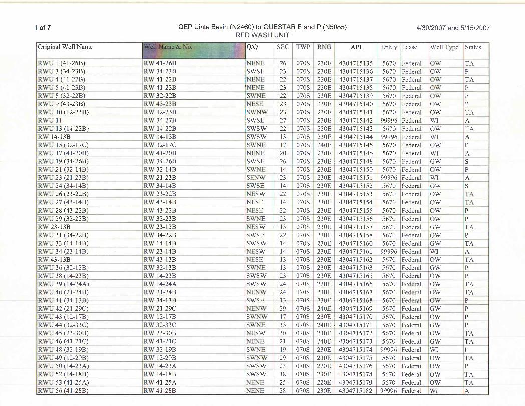
1 of 7 QEP Uinta Basin (N2460) to QUESTAR E and P (N5085) 4/30/2007 and 5/15/2007RED WASH UNIT
Original Wel1Name QIQ SEC TWP RNG API Entity Lease Well Type Status
RWU l (41-26B) RW 41-26B 'NENE 26 070S 230E 4304715135 5670 Federal OW TARWU 3 (34-23B) RW 34-23B SWSE 23 070S 230E 4304715136 5670 Federal OW PRWU4(41-22B) RW41-22B |NENE 22 070S 230E 4304715137 5670 'Federal OW TARWU 5 (41-23B) RW 41-23B 'NENE 23 070S 230E 4304715138 5670 Federal OW PRWU 8 (32-22B) RW 32-22B SWNE 22 070S 230E 4304715139 5670 Federal OW PRTVLI9 (43-23B) livV43-23B FUESE 23 070S 230E 4304715140 5670 Federal O3AT PRWU 10 (12-23B) RW 12-23B iSWNW 23 070S 230E 4304715141 5670 Federal OW TARNVU11 FCA'34-27B SVVSE 27 070S 230E 4304715142 99996 Federal VVI ARWU 13 (14-22B) RW 14-22B SWSW 22 070S 230E 4304715143 5670 Federal OW TAFCgr14-13B RYVl4-13B STVSTV 13 070S 230E 4304715144 99995 Federal YVI AFDASJ15 (32-17C) FON32-17C STVNE 17 070S 240E
,4304715145 5670 Fedenal CTWT P
RWU 17 (41-20B) RW 41-20B NENË 20 070S 230E 43047]5146 5670 Federal WI_ _ AR3RTJl9 (34-.26B) 100/34-26B STVSE 26 070S 230E i 4304715148 5670 Federal GP¥ SFONIJ21 (32-14B) ICA'32-14B S3ATTE 14 1070S 230E 4304715250 , 5670 Fedend OVV PRWU23 (21-23B) RW 21-23B SENW 23 070S 230E 43_04715151 | 99996 Federal IWI ARYVU24(34-14B) IUn'34-14B SNVSE 14 070S 230E 4304715152 5670 Federal ONV SRWU 26 (23-22B) RW 23-22B NESW 22 070S 230E 4304715153 5670 Federal OW TARTVII27(43-14B) ECWf43-14B NESE 14 070S 230E 4304715154 5670 Fedend (TW' TTARM/U28 (43-22B) R3¥43-22B NESE 22 070S i 230E 4304715155 5670 Fedend ()?V PRWU 29 (32-23B) RW 32-23B SWNE 23 070S 230E 4304715156 5670 Federal OW PFCAT23-13B ICB123-13B FEESTV - 13 070S 230E 4304715157 5670 Fedeñd (iW1 T,4FDARJ31 (34-22B) FUN34-22B STVSE 22 ' 070S 230E 4304715158 5670 Fedeñal OXV PRWU 33 (14-14B) RW 14-14B SWSW 14 ) 070S 230E 4304715160 5670 Federal GW TAR\VU34(23-14B) Ifn'23-14B FRESVV 14 |070S 230E 4304715161 99996 Federal 3¥I ARW 43-13B RW 43-13B NESE 13 0708 230E 4304715162 5670 Federal OW TAFERTO36(32-13B) R3¥32-13B SivliE 13 ! 070S 230E 4304715163 5670 Federal (39V PRWU 38 (14-23B) RW 14-23B SWSW 23 0708 230E 4304715165 5670 Federal OW |PRWU 39 (14-24A) RW 14-24A SWSW 24 070S 220E 4304715166 5670 Federal OW |TARWU40 (21-24B) RW 21-24B NENW 24 070S 230E 4304715167 5670 Federal OW TARSVU41 (34-13B) IUM/34-13B SVVSE 13 070S 230E 4304715168 5670 Fixieral ONV PRWU42 (21-29C) RW 21-29C NENW 29 0708 240E 4304715169 5670 Federal GW PR3VIJ43 (12-17B) R\V 12-17B SYVNIV 17 070S 230E ! 4304715170 5670 Fedend Cny PRWU44 (32-33C) RW 32-33C SWNE 33 070S 240E : 4304715171 5670 Federal GW PRWU45(23-30B) RW23-30B NESW 30 070S 230E 4304715172 5670 Federal OW TARTVU46(41-21C) Ifwf41-21C NENE 21 070S 240E 4304715173 5670 Fedend GAW 134RYVU48(32-19B) ICA'32-19B SYVFUE 19 070S 230E 4304715174 99996 IFederd TVI IRWU 49 (12-29B) RW 12-29B SWNW 29 070S 230E 4304715175 5670 Federal ,OW TARWU 50 (14-23A) RW 14-23A SWSW 23 070S 220E i 4304715176 5670 Federal OW -PRWU 52 (14-18B) RW 14-18B SWSW 18 070S 230E | 4304715178 5670 Federal OW TARNVU53(41-25A) IEW'41-25A FRENE 25 070S 220E 4304715179 5670 Federal ONV TARTVII56(41-28B) Irgr41-28B EfiNE 28 070S 230E 4304715182 99996 Fedeml 5¥I
1 of 7 QEP Uinta Basin (N2460) to QUESTAR E and P (N5085) 4/30/2007 and 5/15/2007RED WASH UNIT
Original Wel1Name QIQ SEC TWP RNG API Entity Lease Well Type Status
RWU l (41-26B) RW 41-26B 'NENE 26 070S 230E 4304715135 5670 Federal OW TARWU 3 (34-23B) RW 34-23B SWSE 23 070S 230E 4304715Ï36 5670 Federal OW PRWU4(41-22B) RW41-22B |NENE 22 070S 230E 4304715137 5670 'Federal OW TARWU 5 (41-23B) RW 41-23B 'NENE 23 070S 230E 4304715138 5670 Federal OW PRWU 8 (32-22B) RW 32-22B SWNE 22 070S 230E 4304715139 5670 Federal OW PIfvVLI9 (43-23B) livV43-23B FUESE 23 070S 230E 4304715140 5670 Federal O3AT PRWU 10 (12-23B) RW 12-23B iSWNW 23 070S 230E 4304715141 5670 Federal OW TARNVU11 R'A'34-27B SVVSE 27 070S 230E 4304715142 99996 Federal VVI ARWU 13 (14-22B) RW 14-22B SWSW 22 070S 230E 4304715143 5670_ Federal OW TARMr14-13B RYVl4-13B STVSTV 13 070S 230E 4304715144 99996 Federal YVI AFDASJ15 (32-17C) FON32-17C STVNE 17 070S 240E
,4304715145 5670 Fedenal CTWT P
RWU 17 (41-20B) RW 41-20B NENË 20 070S 230E 43047]5146 5670 Federal WI AR3RTJl9 (34-.26B) 100/34-26B STVSE 26 070S 230E i 4304715148 5670 ·Federal
GPѯS
FONIJ21 (32-14B) ICR'32-14B S3ATTE 14 1070S 230E 4304715250 , 5670 |Fedend OVV PRWU23 (21-23B) RW 21-23B SENW 23 070S 230E 43_04715151 | 99996 Federal IWI ARY/U24 (34-14B) R3N34-14B SNVSE 14 070S 230E 4304715152 | 5670 Federal 43NV SRWU 26 (23-22B) RW 23-22B NESW 22 070S 230E 4304715153 5670 Federal IOW TARTVII27(43-14B) ECn'43-14B NESE 14 070S 230E 4304715154 5670 Fedend (TW' TARM/U28 (43-22B) R3¥43-22B NESE 22 070S i 230E 4304715155 5670 Fedend ()?V PRWU 29 (32-23B) RW 32-23B SWNE 23 070S 230E 4304715156 5670 Federal OW PFCAT23-13B ICB123-13B FEESTV - 13 070S 230E 4304715157 5670 Fedeñd (iW1 T,4FDARJ31 (34-22B) FUN34-22B STVSE 22 ' 070S 230E 4304715158 5670 Fedeñal OXV PRWU 33 (14-14B) RW 14-14B SWSW 14 ) 070S 230E 4304715160 5670 Federal GW TAR\VU34(23-14B) Ifn'23-14B FRESVV 14 |070S 230E 4304715161 99996 Federal 3¥I ARW 43-13B RW 43-13B NESE 13 0708 230E 4304715162 5670 Federal OW TAFERTO36(32-13B) R3¥32-13B SivliE 13 ! 070S 230E 4304715163 5670 Federal (39V PRWU 38 (14-23B) RW 14-23B SWSW 23 0708 230E 4304715165 5670 Federal OW |PRWU 39 (14-24A) RW 14-24A SWSW 24 070S 220E 4304715166 5670 Federal OW |TARWU40 (21-24B) RW 21-24B NENW 24 070S 230E 4304715167 5670 Federal OW TARSVU41 (34-13B) IUM/34-13B SVVSE 13 070S 230E 4304715168 5670 Fixieral ONV PRWU42 (21-29C) RW 21-29C NENW 29 0708 240E 4304715169 5670 Federal GW PR3VIJ43 (12-17B) R\V 12-17B SYVNIV 17 070S 230E ! 4304715170 5670 Fedend Cny PRWU44 (32-33C) RW 32-33C SWNE 33 070S 240E : 4304715171 5670 Federal GW PRWU45(23-30B) RW23-30B NESW 30 070S 230E 4304715172 5670 Federal OW TARTVU46(41-21C) Ifwf41-21C NENE 21 070S 240E 4304715173 5670 Fedend GAW 134RYVU48(32-19B) ICA'32-19B SYVFUE 19 070S 230E 4304715174 99996 IFederd TVI IRWU 49 (12-29B) RW 12-29B SWNW 29 070S 230E 4304715175 5670 Federal ,OW TARWU 50 (14-23A) RW 14-23A SWSW 23 070S 220E i 4304715176 5670 Federal OW -PRWU 52 (14-18B) RW 14-18B SWSW 18 070S 230E | 4304715178 5670 Federal OW TARNVU53(41-25A) IEW'41-25A FRENE 25 070S 220E 4304715179 5670 Federal ONV TARTVII56(41-28B) Irgr41-28B EfiNE 28 070S 230E 4304715182 99996 Fedeml 5¥I
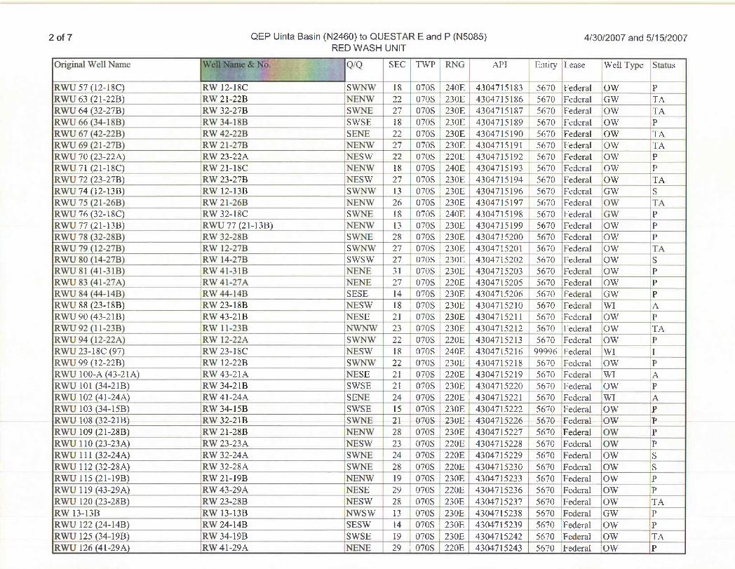
2 of 7 QEP Uinta Basin (N24 30) to QUESTAR E and P (N5085) 4/30/2007 and 5/15/2007RE 3 WASH UNIT
Original Well Name Q/Q SEC TWP RNG API Entity Lease Well Type Status
RWU 57 (12-18C) RW 12-18C SWNW 18 070S 240E 4304715183 : 5670 Federal :OW PRWU 63 (21-22B) IRW 21-22B NENW 22 070S 230E 4304715186 i 5670 Federal GW TARWU 64 (32-27B) RW 32-27B SWNE 27 070S 230E
43047¯51875670 Federal OW TA
RNVII66(34-18B) RMT34-18B STVSE 18 070S 230E 4304715189 5670 Ëederal OTV PRWU 67 (42-22B) iRW 42-22B _ _ SENE 22 070S 230E 4304715190 5670 Federal OW TARWU 69 (21-27B) RW 21-27B NENW 27 070S 230E 4304715191 : 5670 Federal OW TARWU 70 (23-22A) _ 'RW 23-22A NESW 22 070S 220E 4304715192 5670 Federal OW PFONU71 (21-18C) PON21-18C NGENNV 18 070S 240E 4304715193 5670 Federal OYV PRWU 72 (23-27B) |RW 23-27B NESW 27 070S | 230E 4304715194 5670 Federal IOW TARWU 74 (12-13B) IRW 12-13B SWNW 13 070S 230E 4304715196 5670 Federal GW SRWU 75 (21-26B) iRW 21-26B NENW 26 070S 230E 4304715197 5670 Federal OW TARAVU76(32-18C) RM/32-18C STV>UI 18 |070S .240E 4304715198 567ÒFederal G\V PRWU 77 (21-13B) RWU 77 (21-13B) NENW 13 ' 070S 230E 4304715199 5670 Federal OW PFCA1378 (32-28B) RTV32-28B SNVIDE 28 070S 230E 4304715200 5670 Fedend CON PRAVIJ79(12-27B) RAV12-27B SvibnW 27 070S 230E 4304715201 5670 Federd CON TAR3N1180 (14-278) RV/ 14-27B SVVS3V 27 070S i 230E 4304715202 5670 Fedend CON SRTVLí8l (41-31B) P3N41-31B FEEbni 31 070S . 230E 4304715203 5670 Federal CAN PFDASJ83 (41-27A) RYV41-27A NEFUE 27 070S 220E 4304715205 5670 Federal CON PR3NIJS4(44-14B)_ COT44-14B SESE 14 070S 230E 4304715206 5670 Fedeñd GRY PR3¥\J88 (23-18B) RTV23-18B __ NESTV _ 18 i 070S 230E 4304715210 5670 Fedend TVI atRNVU90(43-21B) RV/43-21B NESE 21 070S 230E 4304715211 5670 Federed 03¥ PRWU92 (ll-23B) RW ll-23B NWNW 23 i 070S 230E 4304715212 5670 Federal OW TARWU 94 (l2-22A) RW 12-22A SWNW 22 070S 220E 4304715213 5670 Federal OW PRWU 23-18C (97) RW 23-18C NESW 18 070S 240E , 4304715216 99996 Federal WI IRYYLI99(12-22B) Irvi 12-22B STVliv/ 22 0708 230E 4304715218 5670 Federal (39V IPRWlJ 100-A (43-21A) RW 43-21A NESE 21 070S 220E 4304715219 5670 Federal iWI ARWU 101 (34-21B) ,RW 34-21B SWSE 21 070S 230E | 4304715220 5670 Federal OW PR3NIJ102 (41-24/k) 'R3N41-24A SETJE 24 070S 220E | 4304715221 5670 Federal .9VI AB3N11103(34-15B) RMT34-15B STVSE 15 0708 230E 4304715222 5670 Fedenal |OVV PP:41] 108(32-21B) GRTV32-21B SVVfDE 21 0708 230E - 4304715226 5670 Federal 139V PR ÑU 109 (21-28B) RTV21-28B NElNYV \ 28 070S 230E 4304715227 5670 Fedenal CON PRWU 110 (23-23A) RW 23-23A NESW 23 070S 220E 4304715228 : 5670 Federal OW PR3¥U 111 (32-24A.) ICW'32-24A STVPRE , 24 070S 220E 4304715229 5670 Fedend 03¥ SRWU 112 (32-28A) RW 32-28A SWNE 28 070S 220E 4304715230 5670 Federal OW SBONIJ115(21-19B) RW121-19B FU]¾¾V 19 070S 230E 4304715 33 5670 Federal Cn¥ PRWU 119 (43-29A) RW 43-29A _NESE 29 070S 220E 4304715236 5670 Federal OW |PRWU 120 (23-28B) RW 23-28B NESW 28 070S 230E 4304715237 5670 Federal OW TARW 13-13B RW 13-13B NWSW 13 070S 230E 4304715238 5670 Federal GW PR\VUl22(24-14B) RV/24-14B SESVV 14 070S 230E 4304715239 5670 Feden] Cß :PRMRJ125(34-19B) Ifn134-19B SNVSE 19 070S 230E 4304715242 5670 'Federid OAN T,4RWU 126 (41-29A) RW 41-29A |NENE 29 ; 070S 220E 4304715243 5670 Federal iOW
2 of 7 QEP Uinta Basin (N24 30) to QUESTAR E and P (N5085) 4/30/2007 and 5/15/2007RE 3 WASH UNIT
Original Well Name Q/Q SEC TWP RNG API Entity Lease Well Type Status
RIVU57(12-18C) RVil2-18C SVVbnV 18 070S 240E 4304715183 : 5670 Federal :ONV PRWU 63 (21-22B) IRW 21-22B NENW 22 070S 230E 4304715186 i 5670 Federal GW TARWU 64 (32-27B) RW 32-27B SWNE 27 070S 230E
43047¯51875670 Federal OW TA
REVII66(34-18B) RMT34-18B STVSE 18 070S 230E 4304715189 5670 Ëederal OTV PRWU 67 (42-22B) iRW 42-22B _ _ SENE 22 070S 230E 4304715190 5670 Federal OW TARWU 69 (21-27B) RW 21-27B NENW 27 070S 230E 4304715191 : 5670 Federal OW TARWU 70 (23-22A) _ 'RW 23-22A NESW 22 070S 220E 4304715192 5670 Federal OW PFONU71 (21-18C) PON21-18C NGENNV 18 070S 240E 4304715193 5670 Federal OYV PRWU 72 (23-27B) |RW 23-27B NESW 27 070S | 230E 4304715194 5670 Federal IOW TARWU 74 (12-13B) IRW 12-13B SWNW 13 070S 230E 4304715196 5670 Federal GW SRWU 75 (21-26B) iRW 21-26B NENW 26 070S 230E 4304715197 5670 Federal OW TARTVU76(32-18C) Rw/32-18C Svinni 18 |070S .240E 4304715198 567ÒFedend Giv PRWU 77 (21-13B) RWU 77 (21-13B) NENW 13 ' 070S 230E 4304715199 5670 Federal OW PFCA1378 (32-28B) RTV32-28B SVVIDE 28 070S 230E 4304715200 5670 Fedend CON PRAVIJ79(12-27B) RiV 12-27B SvibnW 27 070S 230E 4304715201 5670 Federd CON TAR3N1180 (14-278) RV/ 14-27B SVVS3V 27 070S i 230Ë 4304715202 5670 Fedend CON SRTVLí8l (41-31B) P3N41-31B FEEFUE 31 070S . 230E 4304715203 5670 Federal CAN PFDASJ83 (41-27A) RYV41-27A NEFUE 27 070S 220E 4304715205 5670 Fedend CON PR3NIJS4(44-14B)_ COT44-14B SESE 14 070S 230E 4304715206 5670 Fedeñd GRY PR3¥IJ88 (23-18B) RTV23-18B __ NESTV _ 18 i 070S 230E 4304715210 5670 Fedend TVI atRNVU90(43-21B) RV/43-21B NESE 21 2070S 230E 4304715211 5670 Fedend 03¥ PRWU92 (ll-23B) RW ll-23B NWNW 23 i 070S 230E 4304715212 5670 Federal OW TARWU 94 (l2-22A) RW 12-22A SWNW 22 070S 220E 4304715213 5670 Federal OW PRWU 23-18C (97) RW 23-18C NESW 18 070S 240E , 4304715216 99996 Federal WI IRYYLI99(12-22B) Irvi 12-22B STVliv/ 22 0708 230E 4304715218 5670 Federal (39V IPRWlJ 100-A (43-21A) RW 43-21A NESE 21 070S 220E 4304715219 5670 Federal iWI ARWU 101 (34-21B) ,RW 34-21B SWSE 21 070S 230E | 4304715220 5670 Federal OW PR3NIJ102 (41-24/k) 'R3N41-24A SETJE 24 070S 220E | 4304715221 5670 Federal .9VI AB3N11103(34-15B) RMT34-15B STVSE 15 0708 230E 4304715222 5670 Fedenal |OVV PP:41] 108(32-21B) GRTV32-21B SVVfDE 21 0708 230E - 4304715226 5670 Federal 139V PR ÑU 109 (21-28B) RTV21-28B NIENYV \ 28 070S 230E 4304715227 5670 Fedenal CON PRWU 110 (23-23A) RW 23-23A NESW 23 070S 220E 4304715228 : 5670 Federal OW PRWU 111 (32-24A) RW 32-24A SWNE , 24 070S 220E 4304715229 5670 Federal OW SRWU 112 (32-28A) RW 32-28A SWNE 28 070S 220E 4304715230 5670 Federal OW SBONIJ115(21-19B) RW121-19B FUENTV 19 070S 230E 4304715 33 5670 Federal Cn¥ PRWU 119 (43-29A) RW 43-29A _NESE 29 070S 220E 4304715236 5670 Federal OW |PRWU 120 (23-28B) RW 23-28B NESW 28 070S 230E 4304715237 5670 Federal OW TARW 13-13B RW 13-13B NWSW 13 070S 230E 4304715238 5670 Federal GW PR\VUl22(24-14B) RV/24-14B SESVV 14 070S 230E 4304715239 5670 Feden] Cß :PRMRJ125(34-19B) Ifn134-19B SNVSE 19 070S 230E 4304715242 5670 'Federid OAN 134RWU 126 (41-29A) RW 41-29A |NENE 29 ; 070S 220E 4304715243 5670 Federal iOW
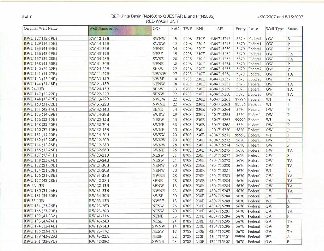
3 of 7 QEP Uinta Basin (N2460) to QUESTARE and P (N5085) 4/30/2007 and 5/15/2007RED WASH UNIT
Original Well Name Q/Q SEC TWP RNG API Entity Lease Well Type Status
RWU 127 (12-19B) RW 12-19B SWNW 19 | 070S 230E 4304715244 5670 Federal OW SRYVLI129 (14-15B) RM/ 14-15B SNVSNV 15 070S 230E 4304715246 5670 Federal ()VV PRYVU133 (41-348) RTV41-34B 74EPJE 34 070S 230E 4304715250 5670 Federal ()VV pPRWU 136 (43-19B) RW 43-198 NESE 19 070S 230E 4304715252 5670 FederaÏ|OW TARWU 137 (34-28B} RW 34-28B SWSE 28 070S 230E 4304715253 5670 Federal GW TARWU 138 (4 l-30B) RW 41-30B NENE O 070S 230E 4304715254 5670 Federal OW PRWU 140 (24-22B) _ _ RW 24-22B SESW 22 070S 230E 4304715255 5670 Federal OW PICRUJ 141(11-27B) RAV11-27B ffwavyV 27 070S 230E 4304715256 | 5670 .Fedeml ,ONV 114RWU 143 (33-14B) RW 33-14B NWSE 14 070S 230E 4304715257 5670 IFederal OW PRWU 144 (21-18B) RW 21-18B NENW 18 070S 230E 4304715258 5670 Federal OW TAICA'24-13B RV/24-13B SESTV 13 0705 230E 4304715259 5670 Fedenal CB¥ 134B3A1J147(22-22B) FUN22-22B SE245V 22 070S 230E 4304715260 5670 Federal Ovv 134RWU 148 (13-22B) RW 13-22B NWSW 22 070S 230E I 4304715261 99996 Federal W1 AFDASJ150(31-22B) Ifn131-22B FPAffE 22 070S 230E 4304715263 99996 Fedend VVI IRWU 151 (42-14B) RW 42-14B _ SENE 14 | 070S 230E 4304715264 5670 Federal OW PRWU 153 (14-29B) RW 14-29B SWSW 29 070S 230E 4304715265 5670 Federal OW IPFEROJ156(23-15B) I gr23-15B
FEB¯MT15 070S 230E 4304715267 99990 Fedend $W1 A
Ri¥U 158 (32-30B) RYl32-30B STVITE 30 . 070S 230E 4304715268 5670 Federal 139V PFDA1]160(32-15B) Ifn'32-15B _ SVV>UE 15 070S 230E 4304715270 5670 Federal CON PRWU 161 (14-20B) RW 14-20B SWSW 20 070S 230E 4304715271 99996 Federal , WI IRANU 162(12-20B) __ RTV 12-20B STYT4Y/ 20 070S 230E 4304715272 5670 Federal ()?V PRWU 164 (12-28B) RW 12-28B SWNW 28 070S 230E 4304715274 5670 Federal OW PRWU 165 (32-26B) RW 32-26B SWNE 26 070S 230E 4304715275 5670 Federal GW TARWU 167 (23-21B) RW 23-21B NESW 21 0708 230E 4304715277 : 5670 Federal OW SRWU 168 (23-24B) RW 23-24B ,NESW 24 070S 230E 4304715278 i 5670 Federal OW TARWU 172 (21-30B) RW 21-30B NENW 30 0708 230E I 4304715280 : 5670 Federal OW TARIARJ174(21-20B) FØV21-20B EniblA' 20 0708 230E 4304715281 | 5670 Federal Y/I ikFDA11176(31-28B) ICA'31-28B PPATVE 28 070S 230E i 4304715283 5670 Fedend CON 134RWU 177 (42-28B) RW 42-28B SENE 28 070S 230E 4304715284 5670 Federal OW TAIUn/22-13B Ifn/22-13B SElin' 13 070S 230E 4304715285 5670 Fedend ONV 354RWU 180 (31-23B) _ _ RW 31-23B NWNE 23 070S 230E 4304715287 5670 Federal OW TARWU 181 (34-30B) RW 34-30B SWSE 30 070S 230E 4304715288 5670 Federal OW PIUn'33-13B RVV33-13B NRWSE 13 070S .230E 4304715289 5670 Fedeñd TVI ARWU 184 (23-26B) [RW 23-26B NESW 26 070S I 230E 4304715290 5670 Federal GW SRWU 188 (23-20B) RW 23-20B NESW , 20 . 070S 230E 4304715291 5670 Federal OW TARWU 192 (41-33A) RW 41-33A NENE i 33 070S 220E 4304715294 5670 Federal OW PR343] 193 (43-24B) EUR/43-24B NESE 24 070S 230E 4304715295
¯5670 Federal CPN 134
RNVU194(12-14B) RTV12-14B SYVANY 14 070S 230E 4304715296 5670 Federal COW SRYVLI196(23-17C) RAW23-17C FEESTV 17 070S 240E 4304715298 5670 Federal GRAT TAL
RWU 199 (43-22A) RW 43-22A NESE 22 070S 220E 4304715301 99996 Federal WI ARWU 201 (32-28C) RW 32-28C iSWNE 28 070S 240E 4304715302 5670 Federal GW
3 of 7 QEP Uinta Basin (N2460) to QUESTARE and P (N5085) 4/30/2007 and 5/15/2007RED WASH UNIT
Original Well Name Q/Q SEC TWP RNG API Entity Lease Well Type Status
RWU 127 (12-19B) RW 12-19B SWNW 19 | 070S 230E 4304715244 5670 Federal OW SRTVU 129(14-15B) RAV14-15B SNVSNV 15 070S 230E 4304715246 5670 Federal O'N PRYVU133 (41-348) RTV41-34B 74EPJE 34 070S 230E 4304715250 5670 Federal ()VV pPRWU 136 (43-19B) RW 43-198 NESE 19 070S 230E 4304715252 5670 FederaÏ|OW TARWU 137 (34-28B} RW 34-28B SWSE 28 070S 230E 4304715253 5670 Federal GW TARWU 138 (4 l-30B) RW 41-30B NENE O 070S 230E 4304715254 5670 Federal OW PRWU 140 (24-22B) _ _ RW 24-22B SESW 22 070S 230E 4304715255 5670 Federal OW PICRUJ 141(11-27B) RAV11-27B ffwavyV 27 070S 230E 4304715256 | 5670 .Fedeml ,ONV 114RWU 143 (33-14B) RW 33-14B NWSE 14 070S 230E 4304715257 5670 IFederal OW PRWU 144 (21-18B) RW 21-18B NENW 18 070S 230E 43047 I5258 5670 Federal OW TAICA'24-13B RV/24-13B SESTV 13 0705 230E 4304715259 5670 Fedenal CB¥ 134B3A1J147(22-22B) FUN22-22B SE245V 22 070S 230E 4304715260 5670 Federal Ovv 134RWU 148 (13-22B) RW 13-22B NWSW 22 070S 230E I 4304715261 99996 Federal W1 AFDASJ150(31-22B) Ifn131-22B FPAffE 22 070S |230E 4304715263 99996 Fedend VVI I1041] 151 (42-14B) Ifür42-14B SENE 14 \070S 230E 4304715264 5670 Fedend CP¥ PRWU 153 (14-29B) RW 14-29B SWSW 29 070S 230E 4304715265 5670 Federal OW PFEROJ156(23-15B) I gr23-15B FDESMT 15 070S 230E 4304715267 99990 Fedend $W1 ARi¥U 158 (32-30B) RYl32-30B STVITE 30 . 070S 230E 4304715268 5670 Federal 139V PFDA1]160(32-15B) Ifn'32-15B SVV>UE 15 070S 230E 4304715270 5670 Federal CON PRWU 161 (14-20B) RW 14-20B SWSW 20 070S 230E 4304715271 99996 Federal , WI IRWU Hi2 (12-20B) _ RW 12-20B SWNW 20 070S 230E 4304715272 5670 Federal OW PRWU 164 (12-28B) RW 12-28B SWNW 28 070S 230E 4304715274 5670 Federal OW PRWU 165 (32-26B) RW 32-26B SWNE 26 070S 230E 4304715275 5670 Federal GW TARWU 167 (23-21B) RW 23-21B NESW 21 0708 230E 4304715277 : 5670 Federal OW SRWU 168 (23-24B) RW 23-24B ,NESW 24 070S 230E 4304715278 i 5670 Federal OW TARWU 172 (21-30B) RW 21-30B NENW 30 0708 230E I 4304715280 : 5670 Federal OW TAR3ARJ174(21-20B) FØV21-20B EniblA' 20 0708 230E 4304715281 | 5670 Federal Y/I ikFDA11176(31-28B) ICA'31-28B PPATVE 28 070S 230E i 4304715283 5670 Fedend CON 134RWU 177 (42-28B) RW 42-28B SENE 28 070S 230E 4304715284 5670 Federal OW TAIUn/22-13B Ifn/22-13B SElin' 13 070S 230E 4304715285 5670 Fedend ONV 354RWU 180 (31-23B) _ _ RW 31-23B NWNE 23 070S 230E 4304715287 5670 Federal OW TARWU 181 (34-30B) RW 34-30B SWSE 30 070S 230E 4304715288 5670 Federal OW PffW'33-13B RVV33-13B NRWSE 13 070S .230E 4304715289 5670 Fedeñd TVI ARWU 184 (23-26B) [RW 23-26B NESW 26 070S I 230E 4304715290 5670 Federal GW SRWU 188 (23-20B) RW 23-20B NESW , 20 . 070S 230E 4304715291 5670 Federal OW TARWU 192 (41-33A) RW 41-33A NENE i 33 070S 220E 4304715294 5670 Federal OW PR343] 193 (43-24B) EUR/43-24B NESE 24 070S 230E 4304715295
¯5670 Federal CPN 134
RNVU194(12-14B) RTV12-14B SYVANY 14 070S 230E 4304715296 5670 Federal COW SRYVLI196(23-17C) RAW23-17C FEESTV 17 070S 240E 4304715298 5670 Federal GRAT TAL
RWU 199 (43-22A) RW 43-22A NESE 22 070S 220E 4304715301 99996 Federal WI ARWU 201 (32-28C) RW 32-28C iSWNE 28 070S 240E 4304715302 5670 Federal GW
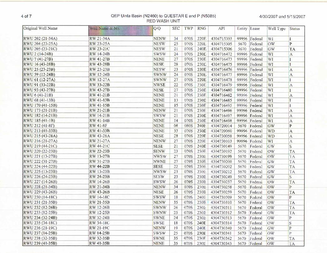
4 of 7 QEP Uinta Basin (N2460) to QUESTAR E and P (N5085) 4/30/2007 and 5/15/2007RED WASH UNIT
Original Well Name Q/Q SEC TWP RNG API Entity Lease Well Type Status
RTVU202(21-34A) IUw/21-34A NENTV 34 0708 220E 4304715303 99996 Fedem] VVI IIfül]204(23-25As) BON23-25As NESTV 25 070S 220E 4304715305 5670 Fedend CON PF3ARJ205(23-21C) FON23-21C NESNV 21 070S 240E 4304715306 5670 Fedenal CON TAIUMTU2(144b‡B) RNV144L4B STVSNV 24 070S 230E 4304716472 99996 Fedend VVI ARWU 7 (41-27B) RW 41-27B |NENE 27 070S 230E 4304716473 99996 Federal |WI IRWR43-28B) RW 43-28B \NESE 28 070S 230E 4304716475 99996 Federal WI IRWU 25 (23-23B) RW 23-23B NESW 23 070S 230E 4304716476 99996 Federal WI ARWU 59 (12-24B) RW 12-24B SWNW 24 070S 230E 4304716477 99996 Federal WI ARWU 61 (12-27A) RW 12-27A SWNW 27 070S 220E | 4304716478 99996 Federal .WI _ IRWU 91 (33-22B) RW 33-22B INWSE 22 070S 230E 4304716479 99996 Federal WI ARWU 93 (43-27B) RW 43-27B INESE 27 070S 230E 4304716480 99996 Federal WI IRWU 6 (41-21B) RW 41-21B INENE 21 070S 230E I 4304716482 99996 Federal WI ARTVII68 (41-13B) gr41-13B JfEFU: 13 070S 230E 4304716485 99996 Federal YVI IRWU 170 (41-15B) RW 41-15B NENE 15 070S 230E . 4304716495 99996 Federal WI IRWU 173 (21-21B) RW 21-21B NENW 21 070S 230E 4304716496 99996 Federal WI ARWU 182 (14-21B) RW 14-21B SWSW 21 070S I 230E 4304716497 99996 Federal WI AFDARJ185(41-lB) Rw/41-14B NHilfE 14 070S i230E i 4304716498 99996 Fedend Vil ARTV11212(41-8F) ECn'41-8F NG:NE 08 080S '240E 4304720014 5670 Fedentl GM' PRWU 213 (41-33B) RW 41-33B NENE 33 070S 230E 4304720060 99996 Federal WD ARWU 215 (43-28A) RW 43-28A NESE _28 | 070S 220E 4304730058 99996 Federal WD ARNVU216(21-27A) _ IEW21-27A PLEbnV 27 070S 220E 4304730103 99996 Fedeñd YVI ARWU 219 (44-21C) RW 44-21C SESE 21 070S 240E 4304730 149 5670 Federal GW SEUMTU220(22-23B) R3A'22-23B SEf4vl 23 070S 230E 4304730192 5670 Fedend ()?V T,4RWU 221 (13-27B) RW 13-27B NWSW 27 070S 230E 4304730199 5670 Federal OW TARYTU222(31-27B) R3A'31-27B FTYl>pi 27 0708 230E 4304730200 5670 Federal :(39V TARWU 224 (44-22B) RW 44-22B SESE 22 070S 230E 4304730202 5670 Federal IGW TAB¾All225 (13-23E() FCA/13-23B f VISTV 23 070S 230E 4304730212 5670 Federal (39V TILRWU 226 (24-23B) RW 24-23B SESW 23 0705 230E 4304730249 5670 Federal i GW SRWU 227 (14-26B) RW 14-26B SWSW 26 0708 230E 4304730257 5670 Federal OW TARWU 228 (21-34B) RW 21-34B NENW 34 0708 230E 4304730258 5670 Federal OW PRWU 229 (43-26B) RW 43-26B NESE 26 070S 230E 4304730259 5670 Federal OW TAR3411230(l4-18C) Rvi 14-18C SVVSVV 18 070S 240E 4304730309 5670 Federal O'N PRWU 231 (21-35B) RW 21-35B NENW 35 070S 230E 4304730310 ' 5670 Federal OW TARWU 232 (12-26B) RW 12-26B _ _ .SWNW 26 070S 230E 4304730311 5670 Federal OW TARWU 233 (12-25B) RW 12-25B SWNW 25 070S 230E : 4304730312 i 5670 Federal OW TARNVU234(32-24B) R'n'32-24B SYVÏË 24 070S 230E
,4304730313 5670 Fedend CON P
RWU 235 (34-18C) RW 34-18C .SWSE 18 070S 240E 4304730314 5670 Federal OW SRTVU236(21-19C) RAN21-19C 14ElfM/ 19 070S 240E 4304730340 5670 Feden11 GON PR3VU237(14-25B) RNV14-25B SNVSTV 25 070S 230E 4304730341 5670 Fedend ONV PRTVLI238 (32-35B) R3¥32-35B 89VT(E_ 35 070S 230E 4304730342 5670 Federal ()?V TitRWU 239 (41-35B) RW 41-35B NENE 35 0708 230E 4304730343 5670 Federal OW
4 of 7 QEP Uinta Basin (N2460) to QUESTAR E and P (N5085) 4/30/2007 and 5/15/2007RED WASH UNIT
Original Well Name Q/Q SEC TWP RNG API Entity Lease Well Type Status
RTVU202(21-34A) IUw/21-34A NENTV 34 0708 220E 4304715303 99996 Fedem] VVI IIfül]204(23-25As) BON23-25As NESTV 25 070S 220E 4304715305 5670 Fedend CON PF3ARJ205(23-21C) FON23-21C NESNV 21 070S 240E 4304715306 5670 Fedenal CON TAIUMTU2(144b‡B) RNV144L4B STVSNV 24 070S 230E 4304716472 99996 Fedend VVI ARWU 7 (41-27B) RW 41-27B |NENE 27 070S 230E 4304716473 99996 Federal |WI IRWR43-28B) RW 43-28B \NESE 28 070S 230E 4304716475 99996 Federal WI IRWU 25 (23-23B) RW 23-23B NESW 23 070S 230E 4304716476 99996 Federal WI ARWU 59 (12-24B) RW 12-24B SWNW 24 070S 230E 4304716477 99996 Federal WI ARWU 61 (12-27A) RW 12-27A SWNW 27 070S 220E | 4304716478 99996 Federal .WI _ IRWU 91 (33-22B) RW 33-22B INWSE 22 070S 230E 4304716479 99996 Federal WI ARWU 93 (43-27B) RW 43-27B INESE 27 070S 230E 4304716480 99996 Federal WI IRWU 6 (41-21B) RW 41-21B INENE 21 070S 230E I 4304716482 99996 Federal WI ARTVII68 (41-13B) gr41-13B JfEFU: 13 070S 230E 4304716485 99996 Federal YVI IRWU 170 (41-15B) RW 41-15B NENE 15 070S 230E . 4304716495 99996 Federal WI IRWU 173 (21-21B) RW 21-21B NENW 21 070S 230E 4304716496 99996 Federal WI
_
ARWU 182 (14-21B) RW 14-21B SWSW 21 070S I 230E 4304716497 99996 Federal WI AFDARJ185(41-lB) Rw/41-14B NHilfE 14 070S i230E i 4304716498 99996 Fedend Vil ARTV11212(41-8F) ECn'41-8F NG:NE 08 080S '240E 4304720014 5670 Fedentl GM' PRWU 213 (41-33B) RW 41-33B NENE 33 070S 230E 4304720060 99996 Federal WD ARWU 215 (43-28A) RW 43-28A NESE _28 | 070S 220E 4304730058 99996 Federal WD ARNVU216(21-27A) _ IEW21-27A PLEbnV 27 070S 220E 4304730103 99996 Fedeñd YVI ARWU 219 (44-21C) RW 44-21C SESE 21 070S 240E 4304730 149 5670 Federal GW SEUMTU220(22-23B) R3A'22-23B SEf4vl 23 070S 230E 4304730192 5670 Fedend ()?V T,4RWU 221 (13-27B) RW 13-27B NWSW 27 070S 230E 4304730199 5670 Federal OW TARYTU222(31-27B) R3A'31-27B FTYl>pi 27 0708 230E 4304730200 5670 Federal :(39V TARWU 224 (44-22B) RW 44-22B SESE 22 070S 230E 4304730202 5670 Federal IGW TAB¾All225 (13-23E() FCA/13-23B f VISTV 23 070S 230E 4304730212 5670 Federal (39V TILRWU 226 (24-23B) RW 24-23B SESW 23 0705 230E 4304730249 5670 Federal i GW SRWU 227 (14-26B) RW 14-26B SWSW 26 0708 230E 4304730257 5670 Federal OW TARWU 228 (21-34B) RW 21-34B NENW 34 0708 230E 4304730258 5670 Federal OW PRWU 229 (43-26B) RW 43-26B NESE 26 070S 230E 4304730259 5670 Federal OW TAR3411230(l4-18C) Rvi 14-18C SVVSVV 18 070S 240E 4304730309 5670 Federal O'N PRWU 231 (21-35B) RW 21-35B NENW 35 070S 230E 4304730310 ' 5670 Federal OW TARWU 232 (12-26B) RW 12-26B _ _ .SWNW 26 070S 230E 4304730311 5670 Federal OW TARWU 233 (12-25B) RW 12-25B SWNW 25 070S 230E : 4304730312 i 5670 Federal OW TARNVU234(32-24B) Ifn'32-24B SYVÏË 24 070S 230E
,4304730313 5670 Fedend CON P
RTVIJ235 (34-18C) FD¥34-18C .SVTSE 18 070S 240E 4304730314 5670 Fedend CON SRTVU236(21-19C) FUN21-19C 14ElfM/ 19 070S 240E 4304730340 5670 Feden11 GON PR3VU237(14-25B) RNV14-25B SNVSTV 25 070S 230E 4304730341 5670 Fedend ONV PRTVLI238 (32-35B) R3¥32-35B 89VT(E_ 35 070S 230E 4304730342 5670 Federal ()?V TitRWU 239 (41-35B) RW 41-35B NENE 35 0708 230E 4304730343 5670 Federal OW
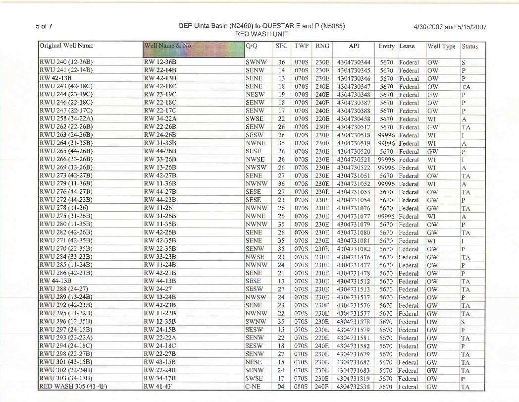
5 of 7 QEP UintaBasin (N2460) to QUESTARE and P (N5085) 4/30/2007 and 5/15/2007REDWASH UNIT
Original Well Name Q/Q SEC TWP RNG API Entity Lease Well Type Status
80A'IU240(12-36B)___
FUN12-36B STVITY/ 36 070S 230E 4304730344 5670 Federal O'N SEDNIJ241(22-14B) RM/22-14B SEFUN 14 0708 230E 4304730345 5670 Federal OYV PEin'42-13B f gr42-13B SEffE 13 070S 230E 4304730346 5670 Fedend ONV PRIVIJ243 (42-18C) fin/42-18C SEffE 18 0705 240E 4304730347 5670
Fede¯lCOW TA
BDA1J244(23-19C) PD¥23-19C NESTV 19 0708 240E 4304730348 5670 Ipderal GRW P90ARJ246(22-18C) RNV22-18C_ SElfvl 18 0708 240E 4304730387 5670 Federal ETür PRIVIJ247(22-17C) RM/22-17C SElfv/ 17 0708 240E 4304730388 5670 Fedenil GAV PRWU 258 (34-22A) RW 34-22A SWSE 22 0708 220E 4304730458 567ÖFederal WI ARWU 262 (22-26B) RW 22-26B SENW 26 0708 230E 4304730517 5670 Federal GW ITARWU 263 (24-26B) RW 24-26B SESW 26 070S 230E I 4304730518 99996 Federal WI IRTVU264(31-35B) Ituf31-35B 1(VTNE 35 070S 230E 4304730519 99996 Federal NVI ARWU 265 (44-26B)
¯RW 44-26B SESE 26 070S 230E 4304730520 5670 Federal GW P
RWU 266 (33-26B) RW 33-26B .NWSE 26 070S 230E 4304730521 I_9999_6 Federal WI |IRWU 269 (13-26B) RW 13-26B INWSW 26 070S 230E 4304730522 99996 Federal WI ARWU273(42-27B) RW42-27B SENE 27 070S 230E 4304731051 5670 Federal OW _TARWU 279 (11-36B) RW ll-36B NWNW 36 .
070S . 230E 4304731052 99996 Federal WI ARWU 276 (44-27B) RW 44-27B SESE 27 | 070S I 230E 4304731053 5670 Federal OW TAFUNU272(44-23B) RTV44-23B SESE 23 070S 230E 4304731054 5670 Federed GSV PRNVU278(11-26) RTVll-26 FDAlfy/ 26 070S4_230E 4304731076 5670 Federed Giv TARWU 275 (31-26B) RW 31-26B NWNE 26 070S 230E 4304731077 99996 Federal WI ARWU 280 (ll-35B) RW 11-35B NWNW 35 070S 230E 4304731079 5670 Federal OW
¯
RWU 282 (42-26B) RW 42-26B SENE 26 070S 230E 4304731080 5670 Federal GW TARY/U271 (42-35B) R3W42-35B SERVE 35 0708 | 230E 4304731081 5670 Federal VVI IR3A3J270(22-35B) RTV22-35B SEfivV 35 0708 230E 4304731082 | 5670 Federal ()TV PRWU284(33-23B) IRW33-23B NWSE i23 0708 230E,4304731476.5670Federal IGW TARWU 285 (11-24B) RW ll-24B NWNW I 24 0708 230E I 4304731477 5670 Federal OW PRETU286(42-21B) (R3N42-21B SETTE I 21 0708 230E 4304731478 '
5670 Federal (39V JPR3N44-13B R3W44-13B SESE 13 070S 230E 4304731512 5670 Federal ()?V TikRWU 288 (24-27) RW 24-27 .SESW 27 070S 230E 4304731513 5670 Federal OW TARWU 289 (13-24B) RW 13-24B NWSW 24 070S 230E 4304731517 5670 Federal OW PRWU 292 (42-23B) RW 42-23B SENE 23 070S 230E 4304731576 5670 Federal GW TARWU 295 (11-22B) RW 11-22B NWNW 22 070S 230E 4304731577 5670 Federal GW TARTVU296(12-35B) RSV12-35B STV>SV 35 1070S 1230E 4304731578 5670 Federal CTW7 SRWU 297 (24-15B) RW 24-15B SESW 15 070S 230E 4304731579 5670 iFederal OW PRWU 293 (22-22A) RW 22-22A SENW 22 070S 220E 4304731581 5670 Federal OW TAP3WU294(24-18C) RV/24-18C SESTV 18 ,070S 240E 4304731582 5670 Federal GNV PRWU 298 (22-27B) RW 22-27B SENW 27 070S 230E 4304731679 5670 Federal OW TARWU 301 (43-15B) RW 43-15B NESE 15 0708 230E 4304731682 5670 Federal GW TARWU 302 (22-24B) RW 22-24B SENW 24 0708 230E 4304731683 5670 Federal GW TARM11303(34-17B) RM/34-17B SVVSE I 17 0708 230E 4304731819 5670 Federal OVV PRED WASH 305 (41-4F) RW 41-4F C-NE 04 080S 240E 4304732538 | 5670 Federal GW
5 of 7 QEP UintaBasin (N2460) to QUESTARE and P (N5085) 4/30/2007 and 5/15/2007REDWASH UNIT
Original Well Name Q/Q SEC TWP RNG API Entity Lease Well Type Status
80A'IU240(12-36B)___
FUN12-36B STVITY/ 36 070S 230E 4304730344 5670 Federal O'N SEDNIJ241(22-14B) RM/22-14B SEFUN 14 0708 230E 4304730345 5670 Federal OYV PEin'42-13B f gr42-13B SEffE 13 070S 230E 4304730346 5670 Fedend ONV PRIVIJ243 (42-18C) fin/42-18C SEffE 18 0705 240E 4304730347 5670
Fede¯lCOW TA
BDA1J244(23-19C) PD¥23-19C NESTV 19 0708 240E 4304730348 5670 Ipderal GRW P90ARJ246(22-18C) RNV22-18C_ SElfvl 18 0708 240E 4304730387 5670 Federal ETür PRIVIJ247(22-17C) RM/22-17C SElfv/ 17 0708 240E 4304730388 5670 Fedenil GAV PRWU 258 (34-22A) RW 34-22A SWSE 22 0708 220E 4304730458 567ÖFederal WI ARWU 262 (22-26B) RW 22-26B SENW 26 0708 230E 4304730517 5670 Federal GW ITARWU 263 (24-26B) RW 24-26B SESW 26 070S 230E I 4304730518 99996 Federal WI IRTVU264(31-35B) Ituf31-35B 1(VTNE 35 070S 230E 4304730519 99996 Federal NVI ARWU 265 (44-26B)
¯RW 44-26B SESE 26 070S 230E 4304730520 5670 Federal |GW P
RWU 266 (33-26B) RW 33-26B .NWSE 26 070S 230E 4304730521 I_9999_6 Federal WI |IRWU 269 (13-26B) RW 13-26B INWSW 26 070S 230E 4304730522 99996 Federal iWI ARWU273(42-27B) RW42-27B SENE 27 070S 230E 4304731051 5670 Federal OW _TARWU 279 (11-36B) RW ll-36B NWNW 36 .
070S . 230E 4304731052 99996 Federal WI ARWU 276 (44-27B) RW 44-27B SESE 27 | 070S I 230E 4304731053 5670 Federal OW TAFUNU272(44-23B) RTV44-23B SESE 23 070S 230E 4304731054 5670 Federed GSV PRNVU278(11-26) RTVll-26 FDAlfy/ 26 070S4_230E 4304731076 5670 Federed Giv TARWU 275 (31-26B) RW 31-26B NWNE 26 070S 230E 4304731077 99996 Federal WI ARWU 280 (11-35B) RW 11-35B NWNW 35 070S 230E 4304731079 5670 Federal OW
¯
RWU 282 (42-26B) RW 42-26B SENE 26 070S 230E 4304731080 5670 Federal GW TARY/U271 (42-35B) R3W42-35B SERVE 35 0708 | 230E 4304731081 5670 Federal VVI IR3A3J270(22-35B) RTV22-35B SEfivV 35 0708 230E 4304731082 | 5670 Federal ()TV PRWU284(33-23B) IRW33-23B NWSE i23 0708 230E,4304731476.5670Federal IGW TARWU 285 (11-24B) RW ll-24B NWNW I 24 0708 230E I 4304731477 5670 Federal OW PRETU286(42-21B) (R3N42-21B SETTE I 21 0708 230E 4304731478 '
5670 Federal (39V JPR3N44-13B R3W44-13B SESE 13 070S 230E 4304731512 5670 Federal ()?V TikRWU 288 (24-27) RW 24-27 .SESW 27 070S 230E 4304731513 5670 Federal OW TARWU 289 (13-24B) RW 13-24B NWSW 24 070S 230E 4304731517 5670 Federal OW PRWU 292 (42-23B) RW 42-23B SENE 23 070S 230E 4304731576 5670 Federal GW TARWU 295 (11-22B) RW 11-22B NWNW 22 070S 230E 4304731577 5670 Federal GW TARTVU296(12-35B) RSV12-35B STV>SV 35 1070S 1230E 4304731578 5670 Federal CTW7 SRWU 297 (24-15B) RW 24-15B SESW 15 070S 230E 4304731579 5670 iFederal OW PRWU 293 (22-22A) RW 22-22A SENW 22 070S 220E 4304731581 5670 Federal OW TAP3WU294(24-18C) RV/24-18C SESTV 18 ,070S 240E 4304731582 5670 Federal GNV PRWU 298 (22-27B) RW 22-27B SENW 27 070S 230E 4304731679 5670 Federal OW TARWU 301 (43-15B) RW 43-15B NESE 15 0708 230E 4304731682 5670 Federal GW TARWU 302 (22-24B) RW 22-24B SENW 24 0708 230E 4304731683 5670 Federal GW TARM11303(34-17B) RM/34-17B SVVSE I 17 0708 230E 4304731819 5670 Federal OVV PRED WASH 305 (41-4F) RW 41-4F C-NE 04 080S 240E 4304732538 | 5670 Federal GW
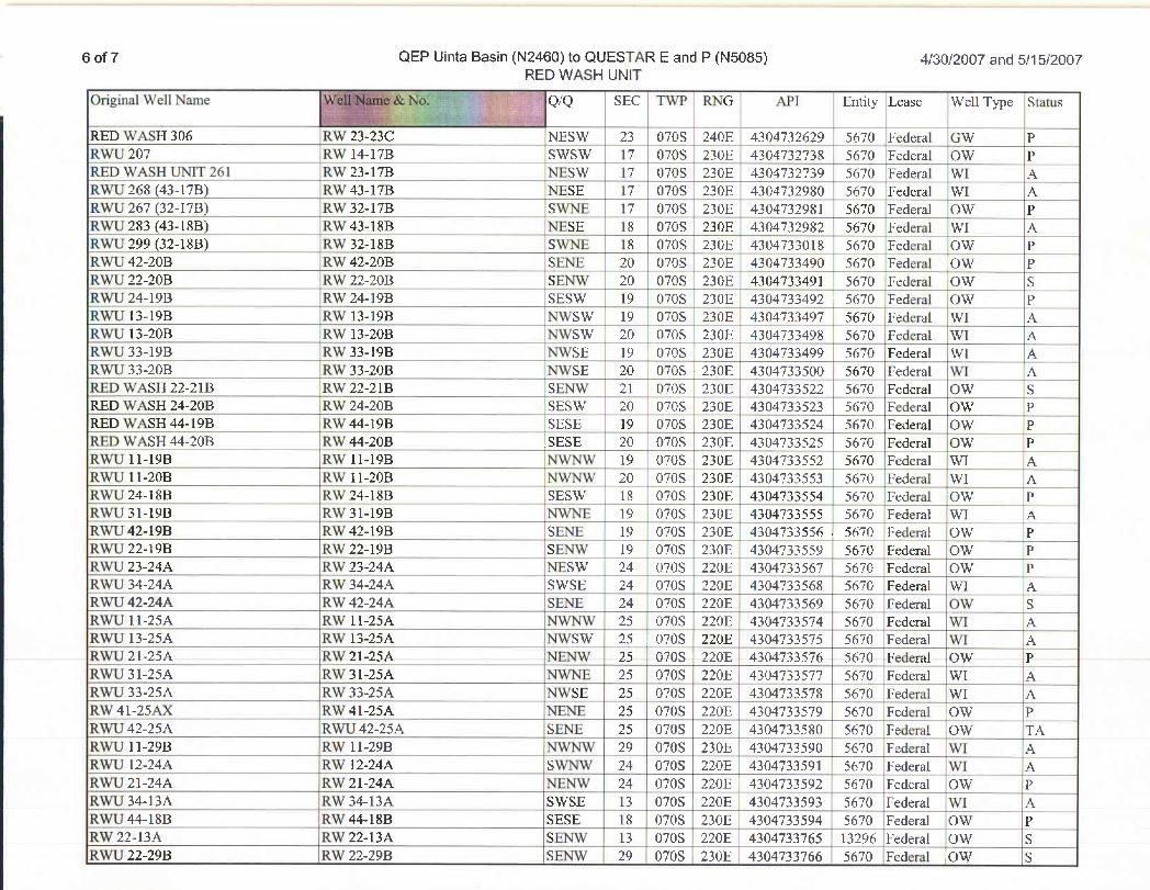
6 of 7 QEP Uinta Basin (N2460) to QUESTARE and P (N5085) 4/30/2007 and 5/15/2007RED WASH UNIT
Original Well Name Q/Q SEC TWP RNG API Entity Lease Well Type Status
RED \VrtSEl306 ICR/23-23C 14ESTV 23 070S 240E 4304732629 5670 Federal Cygr pRTVII207 RYVl4-17B STVSTV 17 0708 230E 4304732738 5670 Federal Cygr pRED WASH UNIT 261 RW 23-17B NESW 17 0708 230E 4304732739 5670 Federal WI AECurU268 (4i-Ï7E6 R3W43-17B _ FEBSE 17 0708 230E 4304732980 5670 Federal VVI ARTVIJ267(32-17B) IEgr32-17B SvibHi 17 0708 230E 4304732981 5670 Federed Cygr yRYVLI283(43-18B) RAN43-18B NESE 18 0708 230E 4304732982 5670 Federal VVI ARYVU299(32-18B) fin'32-18B 89V>UE 18 0708 230E 4304733018 5670 Federal IONV PRWU 42-20B RW 42-20B SENE 20 070S 230E 4304733490 5670 Federal OW PRWU 22-20B RW 22-20B SENW 20 070S 230E 4304733491 5670 Federal OW SRSVU24-19B Ein'24-19B SESJV 19 070S 230E 4304733492 5670 Federal iONV PR3NIJl3-19B RNVl3-19B NWVSVV 19 070S 230E 4304733497 , 5670 FederEd NVI ÁRWU 13-20B _ RW 13-20B NWSW 20 070S 230E 4304733498 5670 Federal WI ARW1133-19B RM'33-19B FAVSE 19 .070S 230E 4304733499 5670 Federed VVI AEUMTU33-20B R'Ar33-20B fŒYVSE 20 070S 230E 4304733500 5670 Federal VI ARED WASH 22-21B RW 22-21B SENW 21 070S 230E 4304733522 5670 Federal OW SRED WASH 24-20B IRW 24-20B SESW 20 070S 230E 4304733523 5670 Federal OW PRED n'ASH44-19B iltn'44-19B SESE 19 070S 230E 4304733524 5670 Fedend Cfni PRED WASH 44-20B RW 44-20B SESE 20 070S 230E 4304733525 5670 Federal OW PR N1111-19B RTV11-19B NVŒNNV 19 070S 230E 4304733552 5670 Fedend TVI AFDA3]11-20B R'N 11-20B NIV7IV/ 20 0708 230E 4304733553 5670 Federal TVI ARTVII24-18B ECW'24-18B SESTV 18 070S 230E 4304733554 5670 Federal CON PRW 31-19B RW 31-19B NWNE 19 070S 230E 4304733555
¯Š¯76Federal IWI A
RWU 42-19B RW 42-19B SENE 19 070S 230E 4304733556 . 5670 Federal OW PRWU 22-19B RW 22-19B SENW 19 070S 230E 4304733559 5670 [Federal OW iPRWU 23-24A RW 23-24A NESW | 24 070S 220E 4304733567 5670 Federal OW PRWU 34-24A RW 34-24A SWSE 24 070S 220E 4304733568 5670 Federal WI ARWU 42-24A RW 42-24A SENE 24 070S 220E 4304733569 5670 Federal OW SR3¥\J 11-25/s RYVll-25/L bnA14NV 25 070S 220E 4304733574 5670 Federal VVI AR3431 13-25/k RVI 13-25/t __ fiY/STV 25 070S 220E 4304733575 5670 Federal VVI ARTVIJ21-25A Itur21-25A NENYV . 25 070S 220E 4304733576 5670 Fedend O1AT PRTVII31-25A ffü'31-25A FDATIE 25 070S |220E 4304733577 5670 Fedend VVI AR3WIJ33-25/s RYl33-25/L fiv/SE 25 070S 220E 4304733578 5670 Federal 1¥I Ay gr41-25AJ< RS/41-25A ILENHi 25 070S 220E 4304733579 5670 ÈedeñdCON PffMTU42-25/t RTVLI42-25/t SEbni 25 0708 220E 4304733580 5670 Federal ()97 TrkRWU ll-29B RW ll-29B NWNW 29 0708 230E 4304733590 5670 Federal WI AFDASJ12-24)t llTV 12-24/6 S\¾749V 24 070S 220E 4304733591 5670 Federal 9/1 ARWU 21-24A RW 21-24A NENW 24 070S 220E 43047335 2 5670 Federal OW PRSVU34-13A RM/34-13A STVSE 13 070S 220E 4304733593 5670 Federal TVI AEUMTU44-18B RIN44-18B SESE 18 070S .230E 4304733594 5670 Federal ()VV PITET22-13/t fin/22-13A SETTwi 13 070S .220E 4304733765 13296 Fedend ¡ONV SRTTLT22-29Il FON22-29B SE199V i 29 i 070S | 230E 4304733766 5670 Federal ()?V
6 of 7 QEP Uinta Basin (N2460) to QUESTARE and P (N5085) 4/30/2007 and 5/15/2007RED WASH UNIT
Original Well Name Q/Q SEC TWP RNG API Entity Lease Well Type Status
RED \VrtSEl306 ICR/23-23C 14ESTV 23 070S 240E 4304732629 5670 Federal Cygr pRTVII207 RYVl4-17B STVSTV 17 0708 230E 4304732738 5670 Federal Cygr pRED WASH UNIT 261 RW 23-17B NESW 17 0708 230E 4304732739 5670 Federal WI AECurU268 (4i-Ï7E6 R3W43-17B _ FEBSE 17 0708 230E 4304732980 5670 Federal VVI ARTVIJ267(32-17B) IEgr32-17B SvibHi 17 0708 230E 4304732981 5670 Federed Cygr yRYVLI283(43-18B) RAN43-18B NESE 18 0708 230E 4304732982 5670 Federal VVI ARYVU299(32-18B) fin'32-18B 89V>UE 18 0708 230E 4304733018 5670 Federal IONV PRWU 42-20B RW 42-20B SENE 20 070S 230E 4304733490 5670 Federal OW PRWU 22-20B RW 22-20B SENW 20 070S 230E 4304733491 5670 Federal OW SRSVU24-19B Ein'24-19B SESJV 19 070S 230E 4304733492 5670 Federal iONV PR3NIJl3-19B RNVl3-19B NWVSVV 19 070S 230E 4304733497 , 5670 FederEd NVI ÁRWU 13-20B _ RW 13-20B NWSW 20 070S 230E 4304733498 5670 Federal WI ARW1133-19B RM'33-19B FAVSE 19 .070S 230E 4304733499 5670 Federed VVI AEUMTU33-20B R'Ar33-20B fŒYVSE 20 070S 230E 4304733500 5670 Federal VI ARED WASH 22-21B RW 22-21B SENW 21 070S 230E 4304733522 5670 Federal OW SRED WASH 24-20B IRW 24-20B SESW 20 070S 230E 4304733523 5670 Federal OW PRED n'ASH44-19B iltn'44-19B SESE 19 070S 230E 4304733524 5670 Fedend Cfni PRED WASH 44-20B RW 44-20B SESE 20 070S 230E 4304733525 5670 Federal OW PR N1111-19B RTV11-19B NVŒNNV 19 070S 230E 4304733552 5670 Fedend TVI AFDA3]11-20B R'N 11-20B NIV7IV/ 20 0708 230E 4304733553 5670 Federal TVI ARTVII24-18B ECW'24-18B SESTV 18 070S 230E 4304733554 5670 Federal CON PRW31-19B RW31-19B NWNE 19 070S 230E 4304733555
¯Š¯70Federal IWI A
RWU 42-19B RW 42-19B SENE 19 070S 230E 4304733556 . 5670 Federal OW PRWU 22-19B RW 22-19B SENW 19 070S 230E 4304733559 5670 [Federal OW iPRWU 23-24A RW 23-24A NESW | 24 070S 220E 4304733567 5670 Federal OW PRWU 34-24A RW 34-24A SWSE 24 070S 220E 4304733568 5670 Federal WI ARWU 42-24A RW 42-24A SENE 24 070S 220E 4304733569 5670 Federal OW SR3¥\J 11-25/s RYVll-25/L bnA14NV 25 070S 220E 4304733574 5670 Federal VVI AR3431 13-25/k RVI 13-25/t __ fiY/STV 25 070S 220E 4304733575 5670 Federal VVI ARTVIJ21-25A Itur21-25A NENYV . 25 070S 220E 4304733576 5670 Fedend O1AT PRTVII31-25A ffü'31-25A FDATIE 25 070S |220E 4304733577 5670 Fedend VVI AR3WIJ33-25/s RYl33-25/L fiv/SE 25 070S 220E 4304733578 5670 Federal 1¥I Ay gr41-25AJ< RS/41-25A ILENHi 25 070S 220E 4304733579 5670 ÈedeñdCON PffMTU42-25/t RTVLI42-25/t SEbni 25 0708 220E 4304733580 5670 Federal ()97 TrkRWU ll-29B RW ll-29B NWNW 29 0708 230E 4304733590 5670 Federal WI AFDASJ12-24)t llTV 12-24/6 S\¾749V 24 070S 220E 4304733591 5670 Federal 9/1 ARWU 21-24A RW 21-24A NENW 24 070S 220E 43047335 2 5670 Federal OW PRSVU34-13A RM/34-13A STVSE 13 070S 220E 4304733593 5670 Federal TVI AEUMTU44-18B RIN44-18B SESE 18 070S .230E 4304733594 5670 Federal ()VV PITET22-13/t fin/22-13A SETTwi 13 070S .220E 4304733765 13296 Fedend ¡ONV SRTTLT22-29Il FON22-29B SE199V i 29 i 070S | 230E 4304733766 5670 Federal ()?V
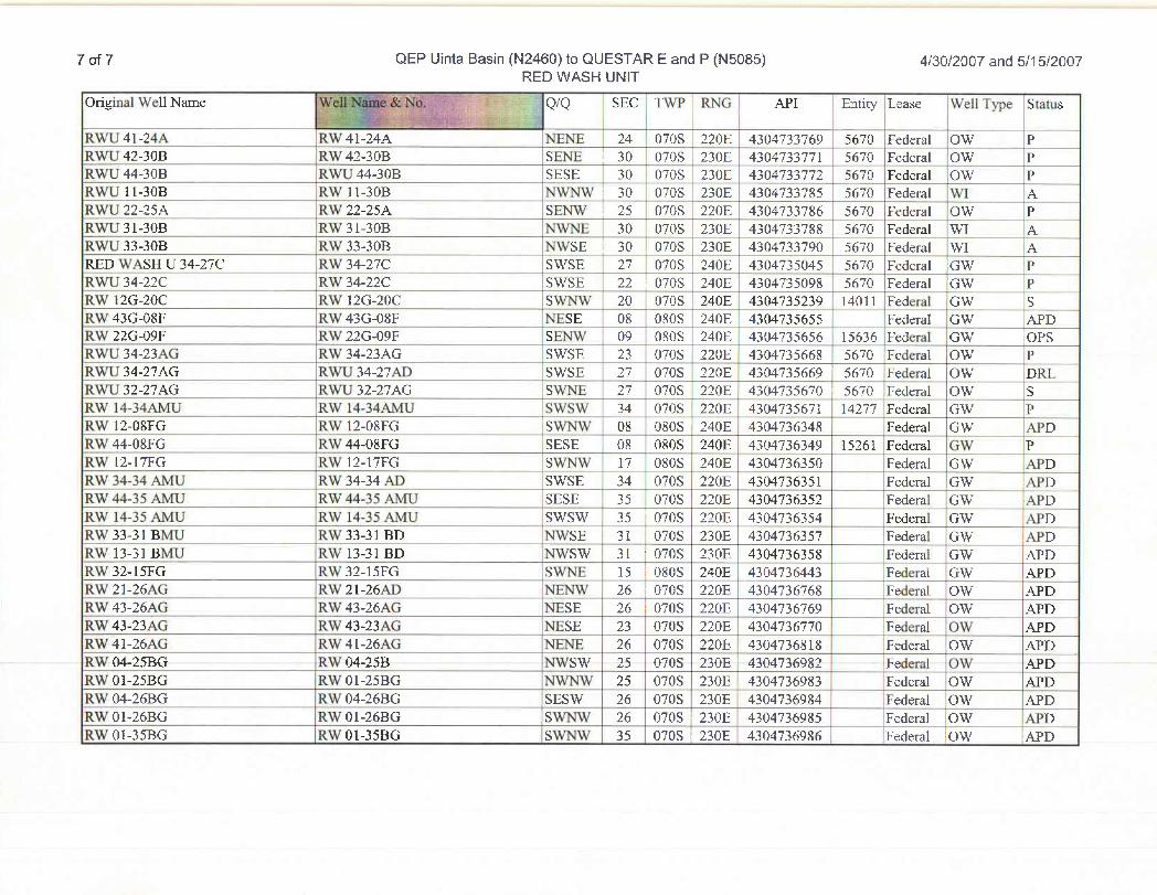
7 of 7 QEP Uinta Basin (N2460) to QUESTARE and P (N5085) 4/30/2007 and 5/15/2007RED WASH UNIT
Original Well Name Q/Q SEC TWP RNG API Entity Lease Well Type Status
RV/U41-24A R3Y41-24/t IEEbnE 24 070S 220E 4304733769 5670 Federal CAW PRWU42-30B RW42-30B SENE | 30 070S 230E 4304733771 5670 Federal OW PFUMTU44-30B R342J44-30B SESE 30 070S 230E 4304733772 5670 Federal ()VV PRTVUll-30B RYVll-30B FAV>DN: 30 070S 230E 4304733785 5670 Federal TVI ARTVU22-25As Fi'N22-25/t SEff9/ i 25 070S 220E 4304733786 5670 Fedent] CON PRYTET31-30B __ FCAT31-30B NBA24E [ 30 070S 230E 4304733788 5670 Fedend TVI APOWIJ33-30Il FUN33-30B NONSE : 30 070S 230E 4304733790 5670 Fedend TVI AtRED WASH U 34-27C RW 34-27C SWSE 27 070S 240E 4304735045 5670 Federal GW PFDASJ34-22C Itur34-22C STVSE 22 ; 070S 240E 4304735098 5670 Federd GNV PF 12Gi-20C RNV12G-20C SNV>SV 20 | 070S 240E 4304735239 14011 Federal GD¥ SRM/43G-08F RMT43Gi-08F NESE 08 080S 240E .4304735655 Fedend GilV Ad?DRM/22Gi-09F RM/22Gi-09F SEbnV 09 OSOS 240E |430473565615636 IFederal GIV OPSRWU 34-23AG RW 34-23AG SWSE 23 070S 220E ' 4304735668 5670 Federal OW PRWU 34-27AG RWU 34-27AD |SWSE 27 070S 220E 4304735669
' 5670 Federal OW DRLR\N1J32-27/tGi RY/U32-27/uG SYVfdE 27 070S i220E 4304735670 : 5670 Federal CAAT SRW 14-34AMU RW 14-34AMU SWSW 34 070S 220E Í 4304735671 i 14277 Federal GW PRW 12-08FG RW 12-08FG SWÑW
¯08 080S 240E 4304736348 |Federal GW APD
RTVakt-08FG RTV645-08FG SESE 08 080S 240E 4304736349 15261 Federal GNV PRSV12-17FG RTV12-17FG SNVbnV 17 080S |240E 4304736350 Federal GDW APDRW 34-34 AMU RW 34-34 AD SWSE I 34 070S 220E 4304736351 Federal GW APDRW 44-35 AMU RW 44-35 AMU SESE 35 070S 220E 4304736352 Federal GW APDRW 14-35 AMU RW 14-35 AMU SWSW 35 070S 220E 430473635 i Federal GW ÄPDRW 33-31 BMU RW 33-31 BD NWSE 31 070S 230E 4304736357 Federal GW APDRW 13-31 BMU RW 13-31 BD NWSW I 31 070S 230E 4304736358 Federal GW APDRM/32-15FGi RYl32-15FGi SMOVE I 15 10803 240E 4304736443 Federal GON Ad?DRW 21-26AG RW 21-26AD NENW 26 : 0708 220E 4304736768 Federal OW APDRAV43-26AvG R3W43-26/cG FRESE 26 0708 220E 4304736769 Federal (TRI AUPDRW43-23AG IRW43-23AG NESE 23 070S 220E 4304736770 I Federal OW APDRW 41-26AG
, RW 41-26AG_ _
NENE 26 0708 220E 4304736818 i iFederal OW APDRW 04-25BG .RW 04-25B NWSW 25 0708 230E 4304736982 : Federal OW APDRW 01-25BG RW 01-25BG NWNW 25 070S 230E 4304736983 Federal OW APDRW 04-26BG RW 04-26BG SESW 26 070S 230E 4304736984 Federal OW APDRM101-26BG RM101-26BG SYVNAV 26 070S 230E 4304736985 Federd ONV AJ'DRW 01-35BG RW 01-35BG SWNW 35 07ÒS 230E 4304736986 Federal IOW
7 of 7 QEP Uinta Basin (N2460) to QUESTARE and P (N5085) 4/30/2007 and 5/15/2007RED WASH UNIT
Original Well Name Q/Q SEC TWP RNG API Entity Lease Well Type Status
RV/U41-24A R3Y41-24/t IEEbnE 24 070S 220E 4304733769 5670 Federal CAW PRWU42-30B RW42-30B SENE | 30 070S 230E 4304733771 5670 Federal OW PFUMTU44-30B R342J44-30B SESE 30 070S 230E 4304733772 5670 Federal ()VV PRTVUll-30B RYVll-30B FAV>DN: 30 070S 230E 4304733785 5670 Federal TVI ARTVU22-25As Fi'N22-25/t SEff9/ i 25 070S 220E 4304733786 5670 Fedent] CON PRYTET31-30B __ FCAT31-30B NBA24E [ 30 070S 230E 4304733788 5670 Fedend TVI APOWIJ33-30Il FUN33-30B NONSE : 30 070S 230E 4304733790 5670 Fedend TVI AtRED WASH U 34-27C RW 34-27C SWSE 27 070S 240E 4304735045 5670 Federal GW PFDASJ34-22C Itur34-22C STVSE 22 ; 070S 240E 4304735098 5670 Federd GNV PF 12Gi-20C RNV12G-20C SNV>SV 20 | 070S 240E 4304735239 14011 Federal GD¥ SRM/43G-08F RMT43Gi-08F NESE 08 080S 240E .4304735655 Fedend GilV Ad?DRM/22Gi-09F RM/22Gi-09F SEbnV 09 OSOS 240E |430473565615636 IFederal GIV OPSRWU 34-23AG RW 34-23AG SWSE 23 070S 220E ' 4304735668 5670 Federal OW PRWU 34-27AG RWU 34-27AD |SWSE 27 070S 220E 4304735669
' 5670 Federal OW DRLR\N1J32-27/tGi RY/U32-27/uG SYVfdE 27 070S i220E 4304735670 : 5670 Federal CA¥ SRW 14-34AMU RW 14-34AMU SWSW 34 070S 220E Í 4304735671 i 14277 Federal GW PRW 12-08FG RW 12-08FG SWÑW
¯08 080S 240E 4304736348 Federal GW APD
RTVakt-08FG RTV645-08FG SESE 08 080S 240E 4304736349 15261 Federal GNV PRSV12-17FG RTV12-17FG SNVbnV 17 080S |240E 4304736350 Federal GDW APDRW 34-34 AMU RW 34-34 AD SWSE I 34 070S 220E 4304736351 Federal GW APDRW 44-35 AMU RW 44-35 AMU SESE 35 070S 220E 4304736352 Federal GW APDRW 14-35 AMU RW 14-35 AMU SWSW 35 070S 220E 430473635 i Federal GW ÄPDRW 33-31 BMU RW 33-31 BD NWSE 31 070S 230E 4304736357 Federal GW APDRW 13-31 BMU RW 13-31 BD NWSW I 31 070S 230E 4304736358 Federal GW APDRM/32-15FGi RYl32-15FGi SMOVE I 15 10803 240E 4304736443 Federal GON Ad?DRW 21-26AG RW 21-26AD NENW 26 : 0708 220E 4304736768 Federal OW APDRAV43-26AvG R3W43-26/cG FRESE 26 0708 220E 4304736769 Federal (TRI AUPDRW43-23AG IRW43-23AG NESE 23 070S 220E 4304736770 I Federal OW APDRW 41-26AG
, RW 41-26AG_ _
NENE 26 0708 220E 4304736818 i iFederal OW APDRW 04-25BG .RW 04-25B NWSW 25 0708 230E 4304736982 : Federal OW APDRW 01-25BG RW 01-25BG NWNW 25 070S 230E 4304736983 Federal OW APDRW 04-26BG RW 04-26BG SESW 26 070S 230E 4304736984 Federal OW APDRW 01-26BG RW 01-26BG SWNW 26 070S 230E 4304736985 Federal OW APDRW 01-35BG RW 01-35BG SWNW 35 07ÒS 230E 4304736986 Federal IOW
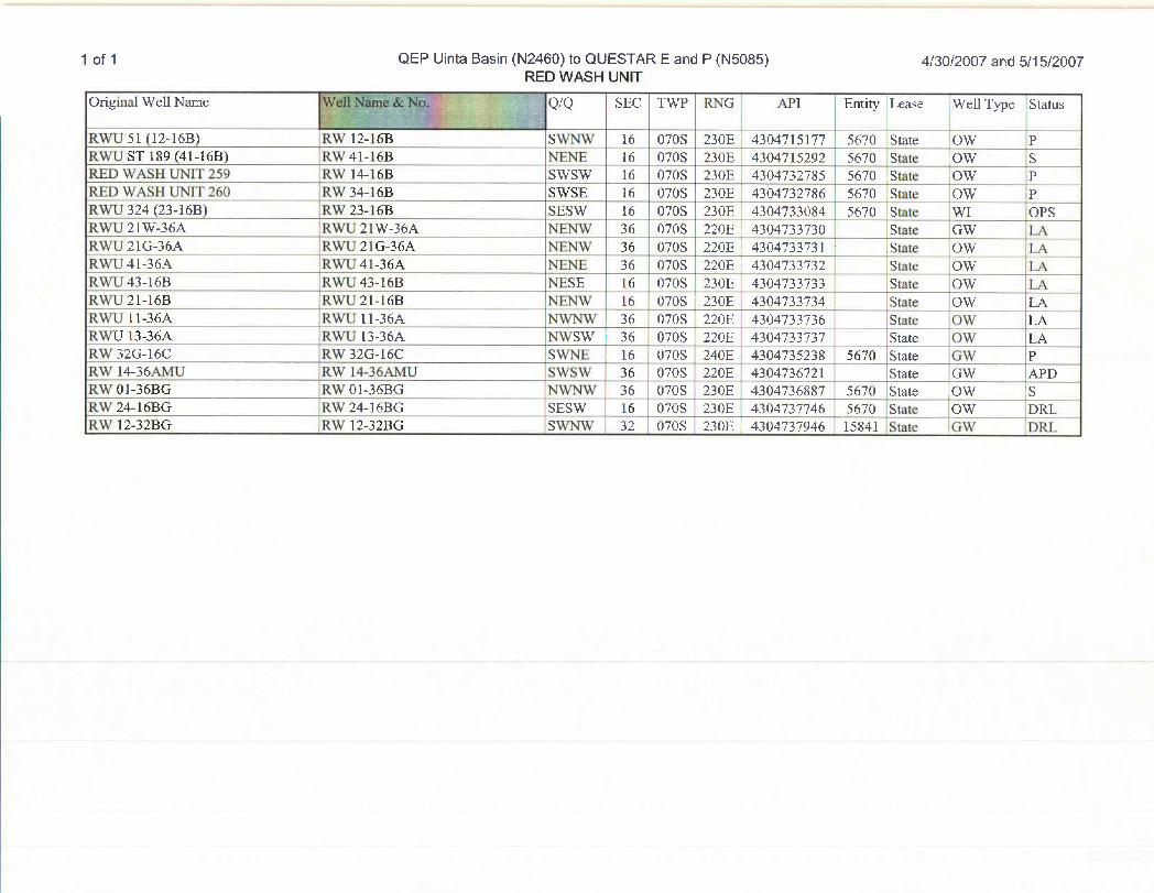
1 of 1 QEP Uinta Basin (N2460) to QUESTAR E and P (N5085) 4/30/2007 and 5/15/2007RED WASH UNIT
Original Well Name Q/Q SEC TWP RNG API Entity Lease Well Type Status
RWU 51 (12-16B) RW 12-16B SWNW 16 070S 230E 4304715177 5670 State OW PRWU ST 189 (41-16B) RW 41-16B NENE 16 070S 230E 4304715292 5670 State iOW SRED WASH UNIT 259 RW 14-16B SWSW 16 070S 230E 4304732785 5670 State OW _ _ PRED WASH UNIT 260 RW 34-16B SWSE 16 070S 230E 4304732786 5670 State OW PRWU 324 (23-16B) RW 23-16B SESW 16 070S 230E 4304733084 5670 State WI OPSRWU 21W-36A _ RWU 21W-36A NENW 36 070S 220E ; 4304733730 State GW LARWU21G-36A RWU 21G-36A NENW 36 070S 220E : 4304733731 .State OW LARWU 41-36A RWU 4 l-56A NENE 36 070S 220E | 4304733732 State OW LARWU43-16B RWU43-16B NESE 16 070S 230E 4304733733 IState OW LARTVLI21-16B RYVU21-16B NENIV 16 070S 230E 4304733754 State Cin' LARMTI 11-36A RWU 11-36A NWNW 36 070S 220E 4304733736 State OW LARWU 13-36A RWU 13-36A NWSW 36 070S - 220E 4304733737 State OW LAR1N32Gi-16C RAT32G-16C SVŒ>E: , 16 070S 240E 4304735238 5670 State G\V PRW 14-36AMU RW 14-36AMU SWSW 36 070S 220E 4304736721 State GW IAPDRW 01-36BG RW 01-36BG NWNW 36 0708 230E 430475688 5670 State OW SRW 24-16BG RW 24-16BG SESW 16 070S 230E 4304737746 5670 IState OW DRLRW 12-32BG RW 12-32BG SWNW 32 070S | 230E 4304737946 15841 State GW
1 of 1 QEP Uinta Basin (N2460) to QUESTAR E and P (N5085) 4/30/2007 and 5/15/2007RED WASH UNIT
Original Well Name Q/Q SEC TWP RNG API Entity Lease Well Type Status
RWU 51 (12-16B) RW 12-16B SWNW 16 070S 230E 4304715177 5670 State OW PRWU ST 189 (41-16B) RW 41-16B NENE 16 070S 230E 4304715292 5670 State iOW SRED WASH UNIT 259 RW 14-16B SWSW 16 070S 230E 4304732785 5670 State OW _ _ PRED WASH UNIT 260 RW 34-16B SWSE 16 070S 230E 4304732786 5670 State OW PRWU 324 (23-16B) RW 23-16B SESW 16 070S 230E 4304733084 5670 State WI OPSRWU 21W-36A _ RWU 21W-36A NENW 36 070S 220E ; 4304733730 State GW LARWU21G-36A RWU 21G-36A NENW 36 070S 220E : 4304733731 .State OW LARWU 41-36A RWU 4 l-Š6A NENE 36 | 070S 220E | 4304733732 State OW LARWU43-16B RWU43-16B NESE 16 070S 230E 4304733733 State OW LARTVLI21-16B RYVU21-16B NENIV 16 070S 230E 4304733754 State Cin' LARWU 11-36A RWU 11-36A NWNW 36 070S 220E 4304733736 State OW LARWU 13-36A RWU 13-36A NWSW 36 070S 220E 4304733737 State OW LAR1N32Gi-16C RMT32G-16C Svibf: , 16 070S 240E 4304735238 5670 State G\V PRW 14-36AMU RW 14-36AMU SWSW 36 070S 220E 43Õ47367il State GW APDRW 01-36BG RW 01-36BG NWNW 36 0708 230E 430475688 Ì 5670 State OW SRW 24-16BG RW 24-16BG SESW 16 070S 230E 4304737746 5670 State OW DRLRW 12-32BG RW 12-32BG SWNW 32 070S 230E 4304737946 15841 State GW
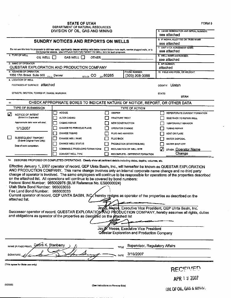
STATEOFUTAH FORM9DEPARTMENTOF NATURALRESOURCES
DIVISIONOF OIL, GAS AND MINING S. LEASEDESIGNATIONANDSERIALNUMBER:
see attachedSUNDRY NOTICES AND REPORTS ON WELLS 6 IFINDIAN ALhLOTTEEORTRIBENAME:
7. UNITor CA AGREEMENTNAME:Do not use this form for proposals to dritinew wells,significantly deepen existing wells below currentbottom-hole depth, reenter plugged wells,or todrillhorizontal laterals. Use APPLICATIONFOR PERMIT TO DRILLform forsuch proposals. See attached
1. TYPE OF WELL -- -- 8. WELLNAMEand NUMBER;OIL WELL [_| GAS WELL [_j OTHER see attached2. NAMEOF OPERATOR 9. API NUMBER.
QUESTAR EXPLORATIONAND PRODUCTION COMPANY attached3. ADDRESSOF OPERATOR: PHONE NUMBER: 10. FIELDAND POOL, ORWILDCAT:1050 17th Street Suite 500 ,. , Denver sy,,, CO ,80265 (303) 308-3068
4. LOCATIONOF WELL
FOOTAGESATSURFACE: attached couNTY: Ulntah
QTR/QTR, SECTION, TOWNSHIP, RANGE, MERIDIAN: STATE:UTAH
CHECK APPROPRIATE BOXES TO INDICATENATUREOF NOTICE, REPORT, OR OTHER DATATYPE OF SUBMISSION TYPE OF ACTION
O ACIDIZE DEEPEN REPERFORATE CURRENT FORMATIONNOTICE OF INTENT
(Submit in Duplicate) ALTER CASING FRACTURETREAT SIDETRACKTO REPAIR WELL
Approximate date work willstart; CASING REPAIR NEWCONSTRUCTION TEMPORARILYABANDON
1/1/2007 CHANGE TO PREVIOUS PLANS OPERATOR CHANGE TUBINGREPAIR
CHANGE TUBING PLUGANDABANDON VENTOR FLARE
O SUBSEQUENT REPORT CHANGE WELL NAME PLUGBACK WATER DISPOSAL(Submit Original Form Only)
CHANGE WELL STATUS PRODUCTION(START/RESUME) WATER SHUT-OFFDate ofwork completion:
COMMINGLEPRODUCING FORMATIONS RECLAMATIONOF WELL slTE OTHER: Operator NarneO CONVERT WELL TYPE RECOMPLETE - DIFFERENT FORMATION Change
12. DESCRIBE PROPOSED OR COMPLETED OPERATIONS. Clearly show allpertinent details including dates, depths, volumes, etc.
Effective January 1, 2007 operator of record,QEP Uinta Basin, Inc., willhereafter be known as QUESTAR EXPLORATIONAND PRODUCTION COMPANY. Thls name change involves onlyan internal corporate name change and no thirdpartychange of operator is involved. The same employeeswillcontinue to be responsible for operatlonsof theproperties describedon the attached list. AIIoperationswillcontinueto be covered by bond numbers:Federal Bond Number: 965002976 (BLMReference No. ESBOOOO24)Utah State Bond Number: 965003033 ,
Fee Land Bond Number: 965003033Current operatorof record, QEP UINTABASIN, IN , hereby r signs as operatorof the properties as described on theattached list.
Ja es , Executive Vice President, QEP Uinta Basin, Inc.Successor operator of record, QUESTAR EXPLORATIO É PO UCTIONCOMPANY, hereby assumes all rights, dutiesand obligations as operator of the propertles as descr ed on the ttachedlist
Jayf. Neese, Exec tiveVice PresidentQ6estar Explorationand Production Company
NAME(PLEASEPRINT) D rSK. Stanberry ; ) TITLE Supervisor, Regulatory Affalrs
SIGNATI.lRE DATE 3/16/2007
(This spaeo for Stato use only)
RECFVEAPR1 3 2007
(5/2000) (See Instructions on Reverse SIde)
DN.0F0\L,GAS&
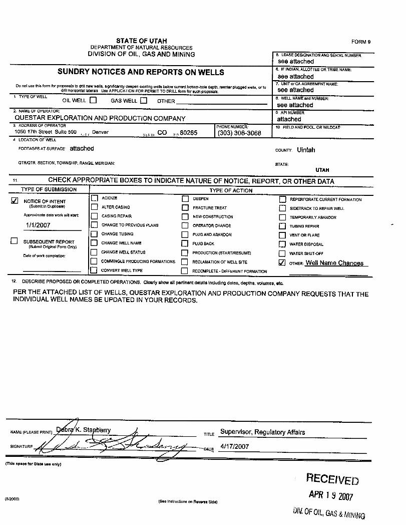
STATEOFUTAH FORMSDEPARTMENT OF NATURALRESOURCES
DIVISIONOF OIL, GASAND MINING 5. LEASEDESIGNATIONANDSERIAL.NUMBER:see attached
SUNDRY NOTICES AND REPORTS ON WELLS 6 NDAN LhLOTTEEORTRIBENAME:
7. UNITor CA AGREEMENTNAME:Do not use thisform for proposals to drillnew wells, significantly deepen existing wells below current bottom-hole depth, reenterplugged wells, or to See attacheddrill horizontal laterals Use APPLICATIONFOR PERMIT TO DRILLform forsuch proposals.1 TYPE OF WELL 6. WELLNAMEand NUMBER:OIL WELL GAS WELL OTHER see attached2. NAMEOF OPERATOR. 9. API NUMBER:QUESTAR EXPLORATION AND PRODUCTION COMPANY attached
3 ADDRESS OF OPERATOR PHONE NUMBER: 10. FIELDAND POOL, OR WILDCAT1050 17th Street Suite 500 Denver sy,,, CO 80265 (303) 308-3068
4 LOCATIONOF WELL
FOOTAGESATSURFACE 8ÍtBChed COUNTY; Ulntah
QTR/QTR, SECTION, TOWNSHIP, RANGE, MERIDIAN: STATE:UTAH
CHECK APPROPRIATE BOXES TO INDICATENATUREOF NOTICE, REPORT, OR OTHER DATATYPE OF SUBMISSION TYPE OF ACTION
O ACIDIZE DEEPEN REPERFORATECURRENT FORMATIONNOTICE OF INTENT(Submit in Duplicate) ALTERCASING FRACTURETREAT SIDETRACKTOREPAIR WELL
Approximate date work willstart CASING REPAIR NEW CONSTRUCTION TEMPORARILYABANDON
1/1/2007 CHANGE TO PREVIOUS PLANS OPERATOR CHANGE TUBINGREPAIRCHANGE TUBING PLUGANDABANDON VENT OR FLARE
SUBSEQUENT REPORT CHANGE WELL NAME PLUG BACK O WATER DISPOSAL(Submit originalForm Only)CHANGE WELLSTATUS PRODUCTION(START/RESUME) WATERSHUT-OFFDate of workcompletion:
O COMMINGLEPRODUCING FORMAflONS RECLAMATIONOF WELL SITE OTHER: Well Name ChangesO CONVERT WELLTYPE RECOMPLETE - DIFFERENT FORMATION
12 DESCRIBE PROPOSED ORCOMPLETED OPERATIONS. Clearly show allpertinent details including dates, deptils, volurnes,etc.
PER THE ATTACHEDLIST OF WELLS, QUESTAR EXPLORATIONAND PRODUCTION COMPANYREQUESTS THAT THEINDIVIDUALWELL NAMES BE UPDATED INYOUR RECORDS.
NAME (PLEASE PRINT) n , TITLE Supervisor, Regulatory Affairs
SIGNATURE 4/17/2007
(This space for State use only)
RECEfVEDAPR18 2007(See instructions on ReverseSide
DN.OF016GAS&MINiNG
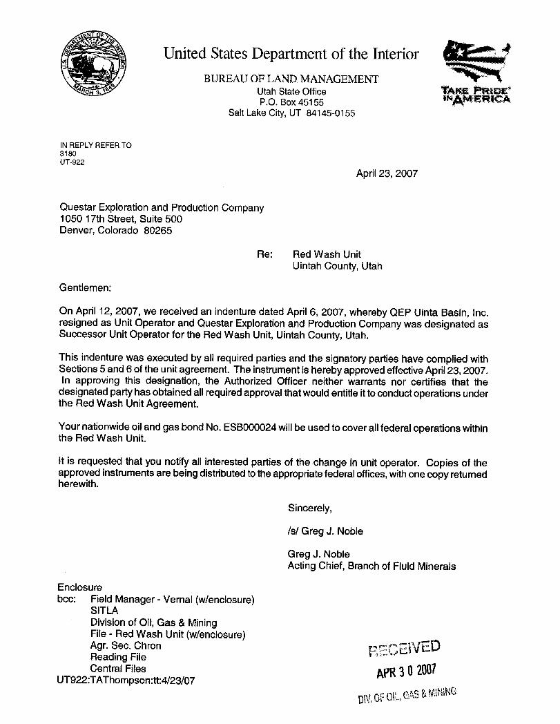
United States Department of the InteriorBUREAUOF LAND MANAGEMENT
Utah State Office T^KE PR DEP.O. Box 45155 "Am emcA
Salt Lake City,UT 84145-0155
IN REPLY REFER TO3180UT-922
April 23, 2007
Questar Exploration and Production Company1050 17th Street, Suite 500Denver, Colorado 80265
Re: Red Wash UnitUintah County, Utah
Gentlemen:
On April 12, 2007, we received an indenture dated April 6, 2007, whereby QEP Uinta Basin, Inc.resigned as Unit Operator and Questar Exploration and Production Company was designated asSuccessor Unit Operator for the Red Wash Unit,Uintah County, Utah.
This indenture was executed by all required parties and the signatory parties have complied withSections 5 and 6 of the unit agreement. The instrument is hereby approved effectiveApril23, 2007.In approving this designation, the Authorized Officer neither warrants nor certifies that the
designated party has obtained all requiredapproval that wouldentitle itto conductoperations underthe Red Wash UnitAgreement.
Yournationwideoiland gas bond No. ESBOOOO24willbe used tocover allfederal operations withinthe Red Wash Unit.
It is requested that you notifyall interested parties of the change in unit operator. Copies of theapproved instruments are being distributed to the appropriatefederal offices,with one copy returnedherewith.
Sincerely,
/s/ Greg J. Noble
Greg J. NobleActingChief, Branch of FluidMinerals
Enclosurebcc: Field Manager - Vernal (wlenclosure)
SITLADivision of Oil,Gas &MiningFile - Red Wash Unit(wlenclosure)Agr. Sec. Chron ggggivEDReading FileCentral Files ggg 30 2ÛÛÎ
UT922:TAThompson:tt:4/23/07
gy OFOLGAS&
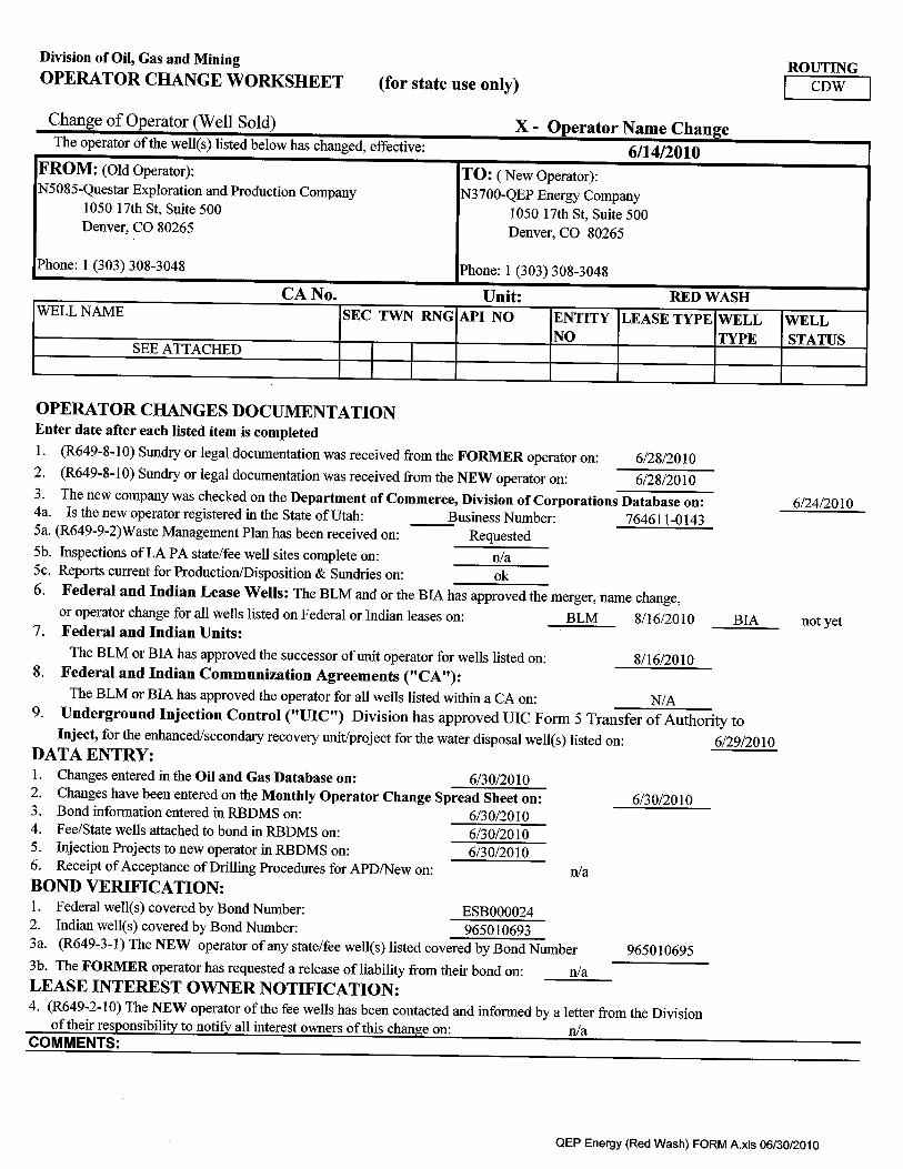
Division of Oil, Gas and Mining ROUTINGOPERATOR CHANGE WORKSHEET (for state use only) CDW
Change of Operator (Well Sold) X - Operator Name ChangeThe operator of the well(s) listed below has changed, effective: 6/14/2010
FROM: (Old Operator): TO: ( New Operator):N5085-QuestarExploration and Production Company N3700-QEP Energy Company
1050 17th St, Suite 500 1050 17th St, Suite 500Denver, CO 80265 Denver, CO 80265
Phone: 1 (303) 308-3048 Phone: 1 (303) 308-3048
CA No. Unit: RED WASHWELL NAME SEC TWN RNG API NO ENTITY LEASE TYPE WELL WELL
NO TYPE STATUSSEE ATTACHED
OPERATOR CHANGES DOCUMENTATIONEnter date after each listed item is completed1. (R649-8-10) Sundry or legal documentation was received from the FORMER operator on: 6/28/20102. (R649-8-10) Sundry or legal documentation was received from the NEW operator on: 6/28/20103. The new company was checked on the Department of Commerce, Division of Corporations Database on: 6/24/20104a. Is the new operator registered in the State of Utah: Business Number: 764611-01435a. (R649-9-2)Waste Management Plan has been received on: Requested5b. Inspections of LA PA state/fee well sites complete on: n/a5c. Reports current for Production/Disposition & Sundries on: ok6. Federal and Indian Lease Wells: The BLM and or the BIA has approved the merger, name change,
or operator change for all wells listed on Federal or Indian leases on: BLM 8/16/2010 BIA not yet7. Federal and Indian Units:The BLM or BIA has approved the successor of unit operator for wells listed on: 8/16/2010
8. Federal and Indian Communization Agreements ("CA"):The BLM or BIA has approved the operator for all wells listed within a CA on: N/A
9. Underground Injection Control ("UIC") Division has approved UIC Form 5 Transfer of Authority toInject, for the enhanced/secondary recovery unit/project for the water disposal well(s) listed on: 6/29/2010
DATA ENTRY:1. Changes entered in the Oil and Gas Database on: 6/30/20102. Changes have been entered on the Monthly Operator Change Spread Sheet on: 6/30/20103. Bond information entered in RBDMS on: 6/30/20104. Fee/State wells attached to bond in RBDMS on: 6/30/20105. Injection Projects to new operator in RBDMS on: 6/30/20106. Receipt of Acceptance of Drilling Procedures for APD/New on: n/aBOND VERIFICATION:1. Federal well(s) covered by Bond Number: ESBOOOO242. Indian well(s) covered by Bond Number: 9650106933a. (R649-3-1) The NEW operator of any state/fee well(s) listed covered by Bond Number 9650106953b. The FORMER operator has requested a release of liability from their bond on: n/aLEASE INTEREST OWNER NOTIFICATION:4. (R649-2-10) The NEW operator of the fee wells has been contacted and informed by a letter from the Division
of their responsibility to notify all interest owners of this change on: n/aCOMMENTS:
QEP Energy (Red Wash) FORM A.xls
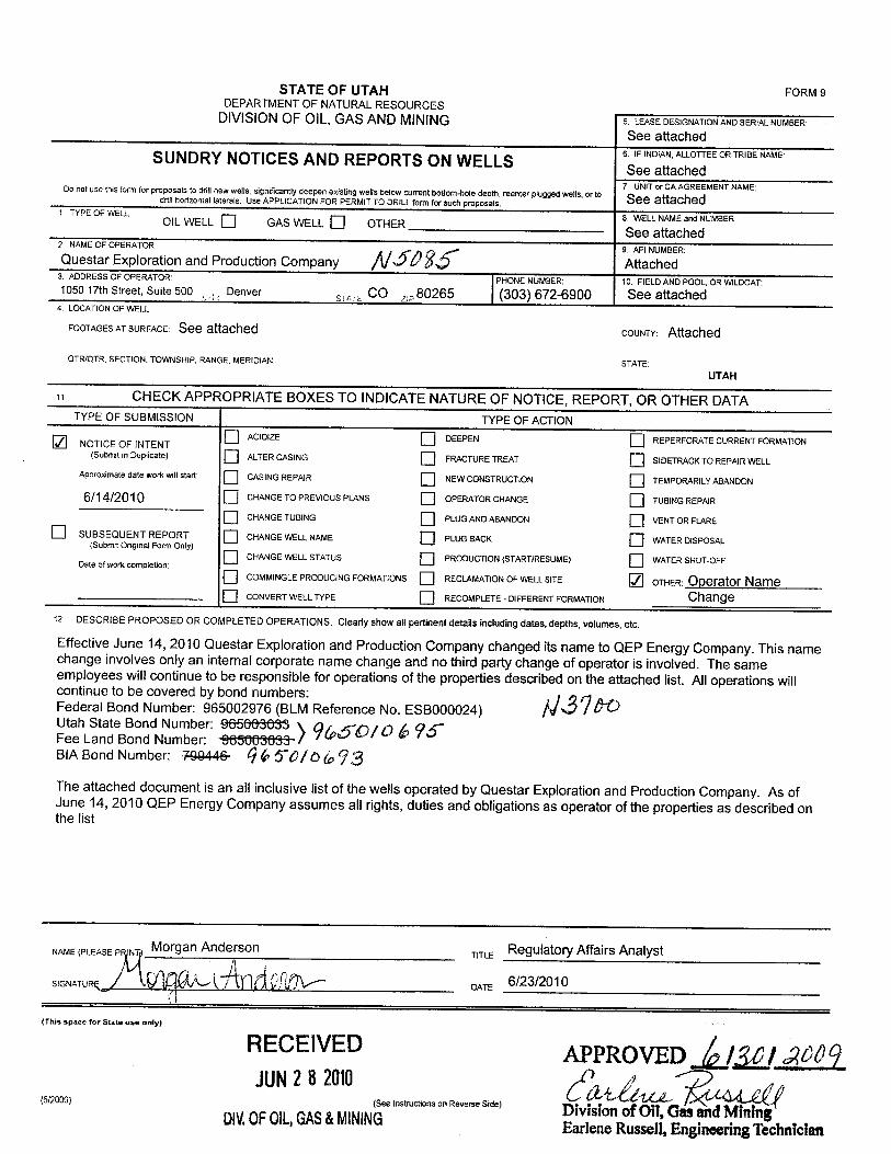
STATE OF UTAH FORM 9DEPARTMENTOFNATURALRESOURCES
DIVISIONOF OIL,GAS ANDMINING 5. LEASEDESIGNATIONANDSERIALNUMBER
See attached6. IF INDIAN,ALLOTTEEOR TRIBE NAMESUNDRY NOTICES AND REPORTS ON WELLS See attached7 UNIT or CA AGREEMENT NAME:Do not use this form for proposals to drill newwells, significantlydeepen existing wells below current bottom-hole depth, reenter plugged wells, or t° See attacheddrill horizontal laterals. Use APPLICATIONFOR PERMITTO DRILL form forsuch proposals.
1 TYPE OF WELL 8 WELLNAMEand NUMBER:OIL WELL O GAS WELL OTHER See attached2 NUOMEOFO
Xplor tion and Production Company $$ ttchM &
3 ADDRESS OF OPERATOR: PHONE NUMBER: 10. FIELDANDPOOL, OR WILDCAT:1050 17th Street, Suite 500 Denver
, ,, CO z,80265 (303) 672-6900 See attached4 LOCATIONOF WELL
FOOTAGESATSURFACE: See attached COUNTY: Attached
QTR/QTR, SECTION, TOWNSHIP, RANGE.MERIDIAN: STATE:UTAH
CHECK APPROPRIATE BOXES TO INDICATENATUREOF NOTICE, REPORT, OR OTHER DATATYPE OF SUBMISSION TYPE OF ACTION
O ACIDIZE DEEPEN REPERFORATE CURRENT FORMATIONNOTICEOF INTENT(Suomit m Duplicate) ALTERCASING FRACTURETREAT SIDETRACKTO REPAIRWELL
Approximate date work willstart: CASING REPAIR NEW CONSTRUCTION TEMPORARILYABANDON
6/14/2010 CHANGETO PREVIOUS PLANS OPERATOR CHANGE TUBINGREPAIR
CHANGE TUBING PLUG ANDABANDON VENTOR FLARE
O SUBSEQUENT REPORT CHANGEWELL NAME PLUG BACK WATERDISPOSAL(Submit Original Form Only)
O CHANGE WELLSTATUS PRODUCTION(STARTIRESUME) WATER SHUT-OFFDate of work completion:
O COMMINGLEPRODUCING FORMATIONS RECLAMATIONOF WELLSITE OTHER: Operator NameCONVERT WELL TYPE RECOMPLETE - DIFFERENTFORMATION Change
12 DESCRIBE PROPOSED OR COMPLETED OPERATIONS. Clearly show all pertinent details including dates, depths, volumes, etc.
Effective June 14, 2010 Questar Exploration and Production Company changed its name to QEP Energy Company. This namechange involves only an internal corporate name change and no thirdparty change of operator is involved. The sameemployees will continue to be responsible for operations of the properties described on the attached list. All operations willcontinue to be covered by bond numbers:Federal Bond Number: 965002976 (BLMReference No. ESBOOOO24)Utah State Bond Number: 965666683Fee Land Bond Number: ¾5063683··BIA Bond Number: 79944& QG$~0/O to 3The attached document is an all inclusive list of the wells operated by Questar Exploration and Production Company. As ofJune 14, 2010 QEP Energy Company assumes all rights, duties and obligations as operator of the properties as described onthe list
NAME(PLEASE P Morgan Anderson vivo Regulatory Affairs Analyst
SIGNATURg ) i DATE 6/23/2010
(This space for State use only)
RECElVED APPROVED /BJUN2 8 2010
(5/2000) (See instructions on Reverse Side)ÛÎVÎSlon of Oil,GasandMintDIV.0FOIL,GAS&MINING Earlene Russell, Engineering
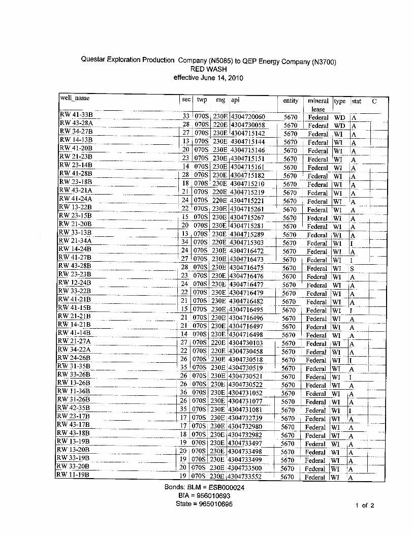
Questar Exploration Production Company (N5085) to QEP Energy Company (N3700)RED WASH
efectiveJune 14,2010
well name see twp rng api entity mineral type stat Clease10%T41-33B 33 070S 230E 4304720060 5670 Federed EnD AIUgr43-28A 28 070S 220E 4304730058 5670 Federed TVD A109734-27B 27 070S 230E 4304715142 5670 Federal TVI A
RW 14-13B 13 070S 230E 4504715144 5670 Federal WI AFUN41-20B 20 070S 230E 4304715146 5670 Federal TVI A10%T21-23B 23 070S 230E 4304715151 5670 Federed VVI ARW23-14B 14 070S 230E 4304715161 5670 Federal WI .AIUMT41-28B 28 070S 230E 4304715182 5670 Federed TVI AIUM/23-18B 18 070S 230E 4304715210 5670 Federed TVI lARTV43-21A 21 070S 220E 4304715219 5670 Federed TVI AICW41-24\ 24 070S 220E 4304715221 5670 Federed TVI ARTVl3-22B 22 070S 230E 4304715261 5670 Federed 3VI AICA'23-15B 15 070S 230È4304715267 5670 Fedeñd TVI ARET21-20B 20 070S 230E 4304715281 5670 Federed Vil ARTV33-13B 13 070S 230E 4304715289 5670 Federal TVI ARM/21-34A 34 070S 220E 4304715303 5670 Federed VVI IRW 14-24B 24 070S 230E 4304716472 5670 Federal WI A10W'41-27B 27 070S 230E 4304716473 5670 Federed TVI IFCgr43-2.8B 28 070S 230E 4304716475 5670 Fedend TVI SFÖÑ23-23B 23 070S 230E 4304716476 5670 Fedeñd TVI ARTV12-24B 24 070S 230E 4304716477 5670 Federal TVI AICW'33-ZIB 22 070S 230E 4304716479 5670 Federed NVI A 'FUN41-21B 21 070S 230E 4304716482 5670 Federal TVI AIUn'41-15B 15 070S 230E 4304716495 5670 Fedeñd TVI IIUMT21-21B 21 070S 230E 4304716496 5670 Federed VVI ARNVl4-:21B 21 070S 230E 4304716497 5670 Fedeñd TVI ARV/41-14B 14 070S 230E 4304716498 5670 Federed TVI ARW 21-27A 27 070S 220E 4304730103 5670 Federal WI ARNV34-22A 22 070S 220E 4304730458 5670 Federal TVI A10W'24-26B 26 070S 230E 4304730518 5670 Federed TVI IRVV31-35B 35 070S 230E 4304730519 5670 Federal TVI ARW 33-26B 26 070S 230E 4304730521 5670 Federal WI IRNVl3-26B 26 070S 230E 4304730522 5670 Federed TVI ARW 11-36B 36 070S 230E 4304731052 5670 Federal WI ARW 31-26B 26 070S 230E 4304731077 5670 Federal WI ARTV42-35B 35 070S 230E 4304731081 5670 Federed TVI IIUn'23-17B 17 070S 230E 4304732739 5670 Federed VVI ARM/43-17B 17 070S 230E 4304732980 5670 Federal VVI AIUgr43-18B 18 070S 230E 4304732982 5670 Federed TVI ARNV13-19B 19 070S 230E 4304733497 5670 Federed TVI ARW 13-20B 20 070S 230E 4304733498 5670 Federal WI A10%733-19B 19 070S 230E 4304733499 5670 Federal TVI AIUn'33-20B 20 070S 230E 4304733500 5670 Federed TVI ARNV11-19B 19 070S 230E 4304733552 5670 Federed TVI |A
Bonds:BLAñ= ESBOOOO24BlA=956010693
State=965010695 1 of
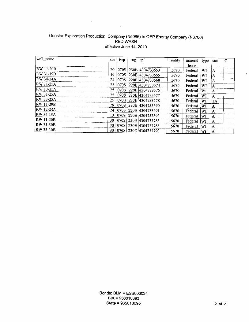
Questar Exploration Production Company (N5085) to QEP Energy Company (N3700)RED WASH
efectiveJune 14,2010
well name sec twp rng api entity mineral type tat C
REV 11-20B 20 070S 230E 4304733553 5670 Federed TVI AECgr31-19B 19 070S 230E 4304733555 5670 Federal TVI 11ECAT34 4A 24 070S 220E 4304733568 5670 Fedend VVI AREVllstLA 25 070S 220E 4304733574 5670 Federed TVI ARNV134Müt 25 070S 220E 4304733575 5670 Federed TVI AE00731-25/1 25 070S 220E 4304733577 5670 Federal TVI AtECW33-25bt 25 070S 220E 4304733578 5670 Federed VVI TARNVll-29B 29 070S 230E 4304733590 5670 Federed TVI ARNV12-24A 24 070S 220E 4304733591 5670 Federed TVI AEU%T34-13A 13 070S 220E 4304733593 5670 Federed TVI ARNVll-30B 30 070S 230E 304733785 5670 Federal TVI AEin'31-30B 30 070S 230E 304733788 5670 Federed TVI ARM'33-30B 30 070S 230E 304733790 5670 Federed NVI A
Bonds:BLAñ= ESBOOOO24BIA=956010693
State= 965010695 2 of
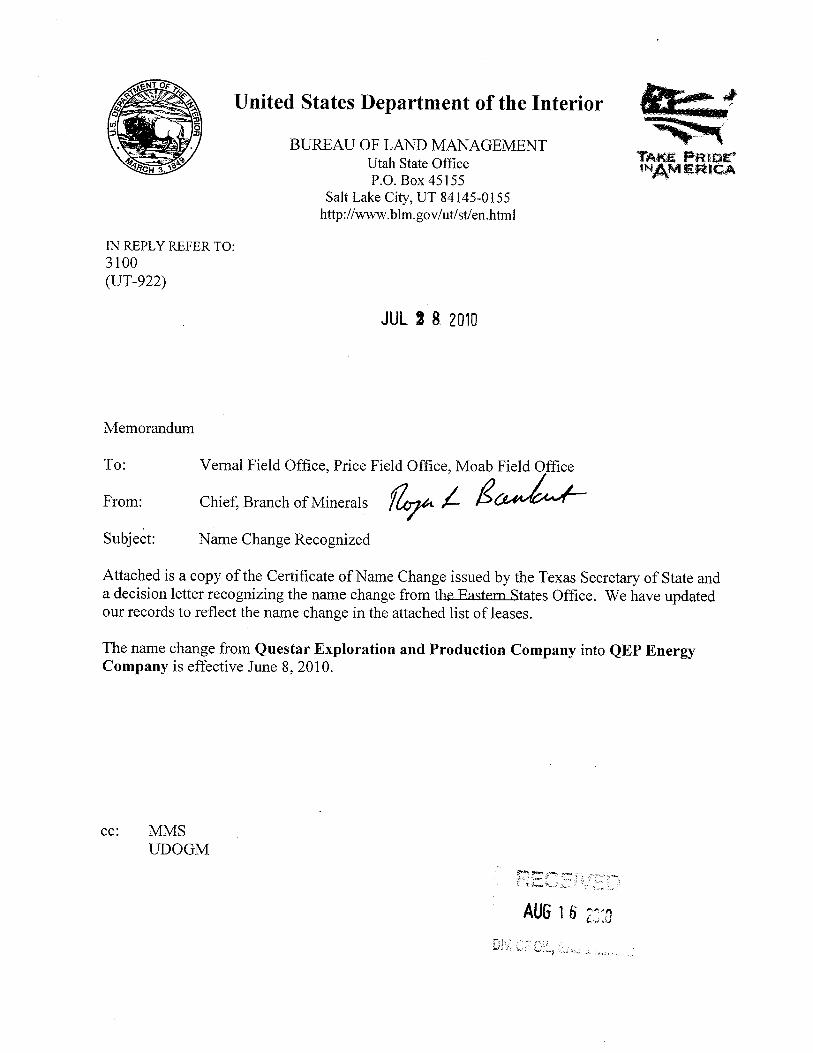
United States Department of the Interior
BUREAU OF LAND MANAGEMENTTAKE PRIDE
ACH ¢ Utah State Office INAMER ICAP.O. Box 45155
Salt Lake City, UT 84145-0155http://www.blm.gov/ut/st/en.html
IN REPLY REFER TO:3100(UT-922)
JUL 2 &2010
Memorandum
Fr m:
1Frield Office PeriaceFie ce Mo Fi
Subject: Name Change Recognized
Attached is a copy of the Certificate of Name Change issued by the Texas Secretary of State anda decision letter recognizing the name change from the Eastern States Office. We have updatedour records to reflect the name change in the attached list of leases.
The name change from QuestarExploration and Production Company into QEP EnergyCompany is effective June 8, 2010.
cc: MMS
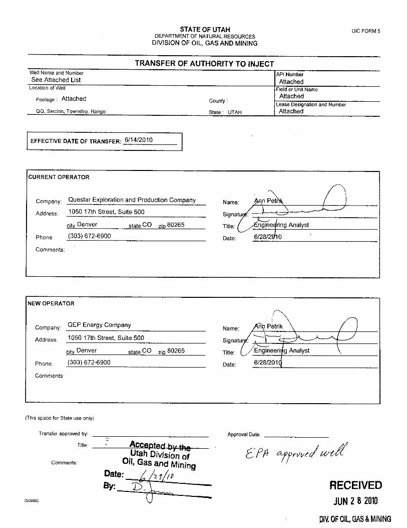
STATE OF UTAH UICFORM 5DEPARTMENTOF NATURALRESOURCES
DIVISIONOF OIL,GAS AND MINING
TRANSFER OF AUTHORITY TO INJECTWell Name and Number API NumberSee Attached List Attached
Location of Well Field or Unit NameAttached
Footage : Attached County :Lease Designation and Number
QQ, Section, Township, Range: State : UTAH Attached
EFFECTIVE DATE OF TRANSFER: 6/14/2010
CURRENT OPERATOR
Company: Questar Exploration and Production Company Name: gn P
Address: 1050 17th Street, Suite 500 Signatur :
city Denver state CO zio 80265 Title: ngine ring Analyst
Phone: (303) 672-6900 Date: 6/28/2910
Comments:
NEW OPERATOR
.QEP Energy Company Name:Company.
Address: 1050 17th Street, Suite 500 Signatu :
city Denver state CO zip 80265 Title: Engineeri g Analyst
Phone: (303) 672-6900 Date: 6/28/201
Comments:
(This space for State use only)
Transfer approved by Approva te
Comments: Oil, Gas and MiningDate: I
gyBy: y RECEIVED
(5/2000> JUN2 8 2010
DIV.0F0\L,GAS&
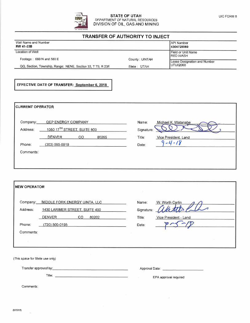
STATE OF UTAH UIC FORM SDNR DEPARTMENTOF NATURALRESOURCESDIVISION OF OIL, GAS AND MINING
TRANSFER OF AUTHORITY TO INJECTWell Name and Number API NumberRW 41-33B 4304720060
Location of Well Field or Unît NameRED WASH
Footage : 660 N and 580 E County : UINTAH Lease Designation and Number
QQ, Section, Township, Range: NENE, Section 33, T 7S, R 23E State : UTAH UTUO2060
EFFECTIVE DATE OF TRANSFER: September 8, 2018
CURRENT OPERATOR
Company: QEP ENERGY COMPANY Name: Michael K. Watanabe
Address: 1050 17TH STREET, SUITE 800 Signature:
DENVER CO 80265 Title: Vice President, Land
Phone: (303) 595-5919 Date:
Comments:
NEW OPERATOR
Company: MIDDLE FORK ENERGY UINTA,LLC Name: W. Worth Carlin
Address: 1430 LARIMERSTREET, SUITE 400 Signature:
DENVER CO 80202 Title: Vice President - Land
Phone: (720) 500-0195 Date:
Comments:
(This space for State use only)
Transfer approved by: Approval Date:
Title: EPA approval required
Comments: Accepted by theUtah Division of
Oil, Gas and MiningSep 17, 2018
(6/2018) FOR RECORD
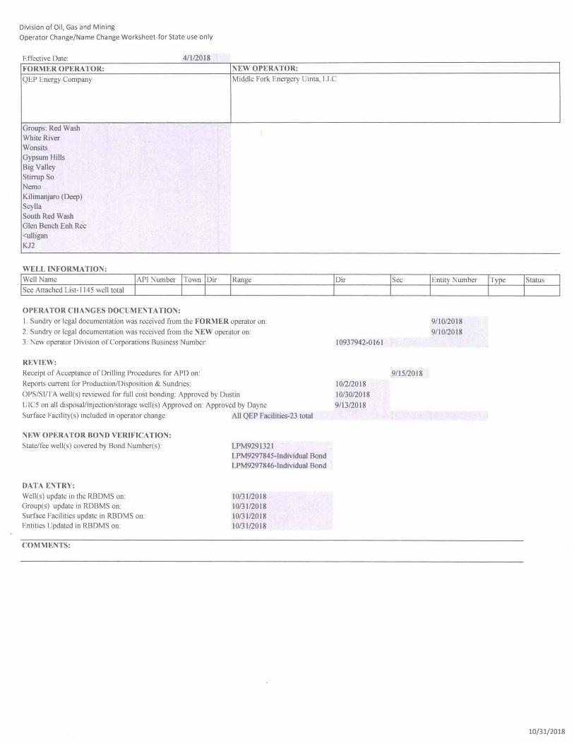
Division of Oil, Gas and Mining
Operator Change/Name Change Worksheet-for State use only
Effective Date· 4/112018
FORMER OPERA TOR: NEW OPERA TOR:
QEP Energy Company Middle Fork Energery Uinta, LLC
Groups: Red Wash WhiteRiver Wonsits Gypsum Hills Big Valley Stirrup So Nemo Kilimanjaro (Deep) Scylla South Red Wash Glen Bench Enh Rec <ulligan KJ2
WELL INFORMATION:
Well Name Range
See Attached List -I 145 well total
OPERATOR CHANGES DOCUMENTATION:
I. Sundry or legal documentation was received from the FORMER operator on:
2. Sundry or legal documentation was received from the NEW operator on:
3. New operator Division of Corporations Business Number:
REVIEW:
Receipt of Acceptance of Drilling Procedures for APD on:
Reports current for Production/Disposition & Sundries:
OPS/SlffA well(s) reviewed for full cost bonding: Approved by Dustin
UIC5 on all disposallinjection/storage well(s) Approved on: Approved by Dayne
Surface Facility(s) included in operator change: All QEP Facilities-23 total
NEW OPERATOR BOND VERIFICATION:
Statel fee well(s) covered by Bond Number(s):
DATA ENTRY:
Well(s) update in the RBDMS on: Group(s) update in RDBMS on: Surface Facilities update in RBDMS on: Entities Updated in RBDMS on:
COMMENTS:
LPM929132I LPM9297845-lndividual Bond LPM9297846-lndividual Bond
10/3112018 10/3112018 10/3112018 10/3112018
Dir
10937942-0161
1012/2018
10130/2018
9113/2018
9/15/2018
Entity Number
9/10/2018
9/10/2018
10/31/2018
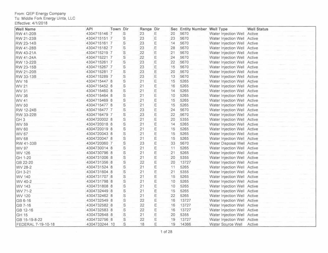
From: QEP Energy Company To: Middle Fork Energy Uinta, LLC Effective: 4/1/2018
Well Name RW 41-20B RW 21-23B RW 23-14B RW 41-28B RW 43-21A RW 41-24A RW 13-22B RW 23-15B RW 21-20B RW 33-13B WV 16 WV21 WV31 WV36 WV41 WV50 RW 12-24B RW 33-22B GH 3 WV59 WV60 WV67 WV68 RW 41-33B WV97 WV 126 GH 1-20 GB 22-20 WV 28-2 GH 3-21 WV 140 WV 40-2 WV 143 WV 71-2 WV 120 GB 6-16 GB 7-16 GB 12-16 GH15 GB 15-19-8-22 FEDERAL 7-19-10-18
API Town Dir 4304715146 7 S 4304715151 7 S 4304715161 7 S 4304715182 7 S 4304715219 7 S 4304715221 7 S 4304715261 7 S 4304715267 7 S 4304715281 7 S 4304715289 7 S 4304715447 8 S 4304715452 8 S 4304715460 8 S 4304715464 8 S 4304715469 8 S 4304715477 8 S 4304716477 7 S 4304716479 7 S 4304720002 8 S 4304720018 8 S , 4304720019 8 S 4304720043 8 S 4304720047 8 S 4304720060 7 S 4304730014 8 S 4304730796 8 S 4304731006 8 S 4304731356 8 S 4304731524 8 S 4304731604 8 S 4304731707 8 S 4304731798 8 S 4304731808 8 S 4304732449 8 S 4304732462 8 S 4304732549 8 S 4304732582 8 S 4304732583 8 S 4304732648 8 S 4304732756 8 S 4304733244 10 S
Range Dir Sec Entity Number Well Type Well Status 23 E 20 5670 Water Injection Well Active 23 E 23 5670 Water Injection Well Active 23 E 14 5670 Water Injection Well Active 23 E 28 5670 Water Injection Well Active , 22 E 21 5670 Water Injection Well Active 22 E 24 5670 Water Injection Well Active 23 E 22 5670 Water Injection Well Active 23 E 15 5670 Water Injection Well Active 23 E 20 5670 Water Injection Well Active 23 E 13 5670 Water Injection Well Active 21 E 15 5265 Water Injection Well Active 21 E 16 5265 Water Injection Well Active 21 E 14 5265 Water I njection Well Active 21 E 10 5265 Water Injection Well Active 21 E 15 5265 Water Injection Well Active 21 E 15 5265 Water Injection Well Active 23 E 24 5670 ,Water Injection Well Active 23 E 22 5670 Water Injection Well Active 21 E 20 5355 Water I njection Well Active 21 E 14 5265 ,Water Injection Well Active 21 E 15 5265 Water Injection Well Active 21 E 15 5265 Water Injection Well Active 21 E 15 5265 Water Injection Well Active 23 E 33 5670 Water Disposal Well Active 21 E 11 5265 Water Injection Well Active 21 E 21 5265 Water Injection Well Active 21 E 20 5355 Water Injection Well Active 22 E 20 13727 Water Injection Well Active 21 E 11 5265 Water Injection Well Active 21 E 21 5355 Water Injection Well Active 21 E 15 5265 Water Injection Well Active 21 E 10 5265 Water Injection Well Active 21 E 10 5265 Water Injection Well Active 21 E 15 5265 Water Injection Well Active 21 E 22 5265 Water Injection Well Active 22 E 16 13727 Water Injection Well Active 22 E 16 13727 Water Injection Well Active 22 E 16 13727 Water Injection Well Active 21 E 20 5355 Water Injection Well Active 22 E 19 13727 Water Injection Well Active 18 E 19 14366 Water Source Well Active
1 of 28
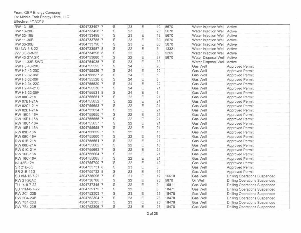
From: QEP Energy Company To: Middle Fork Energy Uinta, LLC Effective: 4/1/2018
RW 13-19B RW 13-20B RW 33-19B RW 11-30B RW 33-30B SU 3W-5-8-22 WV 3G-8-8-22 RW 43-27AGR RW 11-33B SWD RW H3-43-20C RW H2-43-20C RW H2-32-06F RW H3-32-06F RW H2-34-22C RW H2-44-21C RW H3-32-05F RW 08C-21A RW 07B1-21A RW 02C1-21A RW 02B1-21A RW 15C1-16A RW 15B1-16A RW 10C1-16A RW 10B1-16A RW 09B-16A RW 09C-16A RW 01B-21A RW 08B-21A RW 01C-21A RW 16B-16A RW 16C-16A KJ 42B-12A SR 21B-3G SR21B-15G SU 8M-12-7-21 RW 21-26AD TU 14-9-7-22 SU 11M-8-7-22 RW 2C1-23B RW 2C4-23B RW 7B1-23B RW 7B4-23B
4304733497 7 S 23 4304733498 7 S 23 4304733499 7 S 23 4304733785 7 S 23 4304733790 7 S 23 4304733987 8 S 22 4304734596 8 S 22 4304753680 7 S 22 4304754035 7 S 23 4304755525 7 S 24 4304755526 7 S 24 4304755527 8 S 24 4304755528 8 S 24 4304755529 7 S 24 4304755530 7 S 24 4304755531 8 S 24 4304755651 7 S 22 4304755652 7 S 22 4304755653 7 S 22 4304755654 7 S 22 4304755655 7 S 22 4304755656 7 S 22 4304755657 7 S 22 4304755658 7 S 22 4304755659 7 S 22 4304755660 7 S 22 4304755661 7 S 22 4304755662 7 S 22 4304755663 7 S 22 4304755664 7 S 22 4304755665 7 S 22 4304755700 7 S 22 4304755731 8 S 23 4304755732 8 S 23 4304736096 7 S 21 4304736768 7 S 22 4304737345 7 S 22 4304739175 7 S 22 4304752303 7 S 23 4304752304 7 S 23 4304752305 7 S 23 4304752306 7 S 23
E 19 5670 Water Injection Well Active E 20 5670 Water I njection Well Active E 19 5670 Water Injection Well Active E 30 5670 Water Injection Well Active E 30 5670 Water Injection Well Active E 5 13321 Water Injection Well Active E 8 5265 Water Injection Well Active E 27 5670 Water Disposal Well Active E 33 Water Disposal Well Active E 20 Gas Well Approved Permit E 20 Gas Well Approved Permit E 6 Gas Well Approved Permit E 6 Gas Well Approved Permit E 22 Gas Well Approved Permit E 21 Gas Well Approved Permit E 5 Gas Well . Approved Permit E 21 Gas Well Approved Permit E 21 Gas Well Approved Permit E 21 Gas Well Approved Permit E 21 Gas Well Approved Permit E 21 Gas Well Approved Permit E 21 Gas Well Approved Permit E 21 Gas Well Approved Permit E 21 Gas Well Approved Permit E 16 Gas Well Approved Permit E 16 Gas Well Approved Permit E 21 Gas Well Approved Permit E 16 Gas Well Approved Permit E 21 Gas Well Approved Permit E 21 Gas Well Approved Permit E 21 Gas Well Approved Permit E 12 Gas Well Approved Permit E 3 Gas Well Approved Permit E 15 Gas Well Approved Permit E 12 16610 Gas Well Drilling Operations Suspended E 26 5670 Oil Well Drilling Operations Suspended E 9 16811 Gas Well Drilling Operations Suspended E 8 18471 Gas Well Drilling Operations Suspended E 23 18478 Gas Well Drilling Operations Suspended E 23 18478 Gas Well Drilling Operations Suspended E 23 18478 Gas Well Drilling Operations Suspended E 23 18478 Gas Well DrillinQ Operations Suspended
2 of 28
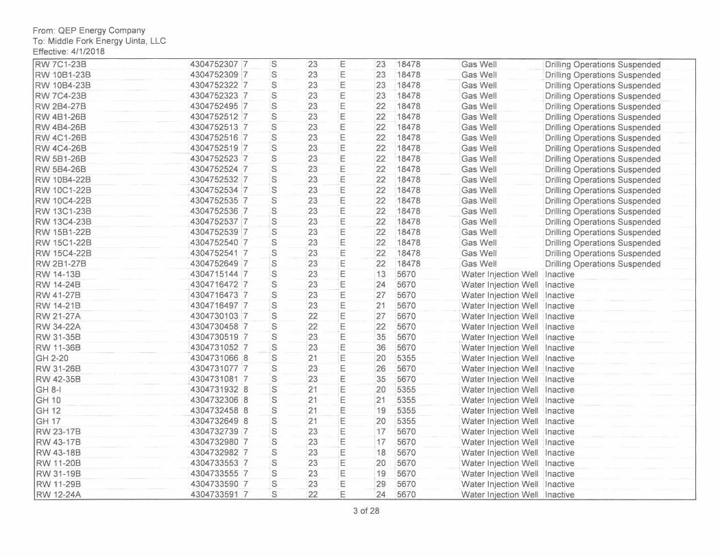
From: QEP Energy Company To: Middle Fork Energy Uinta, LLC Effective: 4/1/2018
RW 7C1 -23B RW 10B1-23B RW 10B4-23B RW 7C4-23B RW 2B4-27B RW 4B1-26B RW 4B4-26B RW 4C1-26B RW 4C4-26B RW 5B1-26B RW 5B4-26B RW 10B4-22B RW 10C1-22B RW 10C4-22B RW 13C1-23B RW 13C4-23B RW 15B1-22B RW 15C1-22B RW 15C4-22B RW 2B1-27B RW 14-13B RW 14-24B RW 41-27B RW 14-21B RW 21-27A RW 34-22A RW 31-35B RW 11-36B GH 2-20 RW 31-26B RW 42-35B GH 8-1 GH10 GH12 GH17 RW 23-17B RW 43-17B RW 43-18B RW 11-20B RW 31-19B RW 11-29B RW 12-24A
4304752307 7 S 4304752309 7 S 4304752322 7 S 4304752323 7 S 4304752495 7 S 4304752512 7 S 4304752513 7 S 4304752516 7 S 4304752519 7 S 4304752523 7 S 4304752524 7 S 4304752532 7 S 4304752534 7 S 4304752535 7 S 4304752536 7 S 4304752537 7 S 4304752539 7 S 4304752540 7 S 4304752541 7 S 4304752649 7 S 4304715144 7 S 4304716472 7 S 4304716473 7 S 4304716497 7 S 4304730103 7 S 4304730458 7 S 4304730519 7 S 4304731052 7 S 4304731066 8 S 4304731077 7 S 4304731081 7 S 4304731932 8 S 4304732306 8 S 4304732458 8 S 4304732649 8 S 4304732739 7 S 4304732980 7 S 4304732982 7 S 4304733553 7 S 4304733555 7 S 4304733590 7 S 4304733591 7 S
23 E 23 18478 Gas Well Drilling Operations Suspended 23 E 23 18478 Gas Well Drilling Operations Suspended 23 E 23 18478 Gas Well Drilling Operations Suspended 23 E 23 18478 Gas Well Drilling Operations Suspended 23 E 22 18478 Gas Well Drilling Operations Suspended 23 E 22 18478 Gas Well Drilling Operations Suspended 23 E 22 18478 Gas Well Drilling Operations Suspended 23 E 22 18478 Gas Well Drilling Operations Suspended 23 E 22 18478 Gas Well Drilling Operations Suspended 23 E 22 18478 Gas Well Drilling Operations Suspended 23 E 22 18478 Gas Well Drilling Operations Suspended 23 E 22 18478 Gas Well Drilling Operations Suspended 23 E 22 18478 Gas Well Drilling Operations Suspended 23 E 22 18478 Gas Well Drilling Operations Suspended 23 E 22 18478 Gas Well Drilling Operations Suspended 23 E 22 18478 Gas Well Drilling Operations Suspended 23 E 22 18478 Gas Well Drilling Operations Suspended 23 E 22 18478 Gas Well Drilling Operations Suspended 23 E 22 18478 Gas Well Drilling Operations Suspended 23 E 22 18478 Gas Well Drilling Operations Suspended 23 E 13 5670 Water Injection Well Inactive 23 E 24 5670 Water Injection Well Inactive 23 E 27 5670 Water Injection Well Inactive 23 E 21 5670 Water Injection Well Inactive 22 E 27 5670 Water Injection Well Inactive 22 E 22 5670 Water Injection Well Inactive 23 E 35 5670 Water Injection Well Inactive 23 E 36 5670 Water Injection Well Inactive 21 E 20 5355 Water Injection Well Inactive 23 E 26 5670 Water Injection Well Inactive 23 E 35 5670 Water Injection Well Inactive 21 E 20 5355 Water Injection Well Inactive 21 E 21 5355 Water Injection Well Inactive 21 E 19 5355 Water Injection Well Inactive 21 E 20 5355 Water Injection Well Inactive 23 E 17 5670 Water Injection Well Inactive 23 E 17 5670 Water Injection Well Inactive 23 E 18 5670 Water Injection Well Inactive 23 E 20 5670 Water Injection Well Inactive 23 E 19 5670 Water Injection Well Inactive 23 E 29 5670 Water Injection Well Inactive 22 E 24 5670 Water Injection Well Inactive
3 of 28
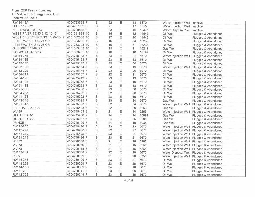
From: QEP Energy Company To: Middle Fork Energy Uinta, LLC Effective: 4/1/2018
RW 34-13A GH 8G-17-8-21 NBE 12SWD-1 0-9-23 WEST RIVER BEND 3-12-10-15 WEST DESERT SPRING 11-20-10-17 PETES WASH U 14-24 GR PETES WASH U 13-06 GR GILSONITE 11-02GR BIG WASH 61-16GR RW 34-27B RW 34-13B RW 23-30B RW 32-19B RW 12-29B RW 34-21A RW 34-19B RW 43-19B RW 21-18B RW 21 -30B RW 34-28A RW 41-16B RW 43-24B RW 21-34A FEDERAL 2-29-7-22 WV35 UTAH FED 0-1 UTAH FED 0-2 PRINCE 1 RW 23-23B RW 12-27A RW41-21B RW 21-21B WV72 WV73 WV78 RW 43-28A GH 6 RW 13-27B RW 43-26B RW 14-18C RW 12-26B RW 12-36B,
4304733593 7 S 22 E 4304737992 8 S 21 E 4304738875 9 S 23 E 4301331888 10 S 15 E 4301332088 10 S 17 E 4301333202 10 S 16 E 4301333203 10 S 16 E 4301333483 10 S 15 E 4301333485 10 S 16 E 4304715142 7 S 23 E 4304715168 7 S 23 E 4304715172 7 S 23 E 4304715174 7 S 23 E 4304715175 7 S 23 E 4304715207 7 S 22 E 4304715242 7 S 23 E 4304715252 7 S 23 E 4304715258 7 S 23 E 4304715280 7 S 23 E 4304715282 7 S 22 E 4304715292 7 S 23 E 4304715295 7 S 23 E 4304715303 7 S 22 E 4304715423 7 S 22 E 4304715463 8 S 21 E 4304715936 7 S 24 E 4304715937 7 S 24 E 4304716199 7 S 24 E 4304716476 7 S 23 E 4304716478 ,7 S 22 E 4304716482 7 S 23 E 4304716496 7 S 23 E 4304720058 8 S 21 E 4304720066 8 S 21 E 4304720115 8 S 21 E 4304730058 7 S 22 E 4304730099 8 S 21 E 4304730199 7 S 23 E 4304730259 7 S 23 E 4304730309 7 S 24 E 4304730311 7 S 23 E 4304730344 7 S 23 E
13 5670 Water Injection Well Inactive 17 5355 Water Injection Well Inactive 10 16477 Water Disposal Well Inactive 12 14542 Oil Well Plugged & Abandoned 20 14545 Oil Well Plugged & Abandoned 24 16232 Oil Well Plugged & Abandoned 6 16233 Oil Well Plugged & Abandoned 2 16211 Gas Well Plugged & Abandoned 16 16192 Oil Well Plugged & Abandoned 27 5670 Water Injection Well Plugged & Abandoned 13 5670 Oil Well Plugged & Abandoned 30 5670 Oil Well Plugged & Abandoned 19 5670 Water Injection Well Plugged & Abandoned 29 5670 Oil Well Plugged & Abandoned 21 5670 Oil Well Plugged & Abandoned 19 5670 Oil Well Plugged & Abandoned 19 5670 Oil Well Plugged & Abandoned 18 5670 Oil Well Plugged & Abandoned 30 5670 Oil Well Plugged & Abandoned 28 5670 Oil Well Plugged & Abandoned 16 5670 Oil Well Plugged & Abandoned 24 5670 Gas Well Plugged & Abandoned 34 5670 Water Injection Well Plugged & Abandoned 29 5266 Gas Well Plugged & Abandoned 14 5265 Water Injection Well Plugged & Abandoned 14 10699 Gas Well Plugged & Abandoned 25 9295 Gas Well Plugged & Abandoned 10 7035 Gas Well Plugged & Abandoned 23 5670 Water Injection Well Plugged & Abandoned 27 5670 Water Injection Well Plugged & Abandoned 21 5670 Water Injection Well Plugged & Abandoned 21 5670 Water Injection Well Plugged & Abandoned 16 5265 Water Injection Well Plugged & Abandoned 16 5265 Water Injection Well Plugged & Abandoned 16 5265 Water Injection Well Plugged & Abandoned 28 5670 Water Disposal Well Plugged & Abandoned 20 5355 Water Injection Well Plugged & Abandoned 27 5670 Oil Well Plugged & Abandoned 26 5670 Oil Well Plugged & Abandoned 18 5670 Oil Well Plugged & Abandoned 26 5670 Oil Well Plugged & Abandoned 36 5670 Oil Well Plugged & Abandoned
4 of 28
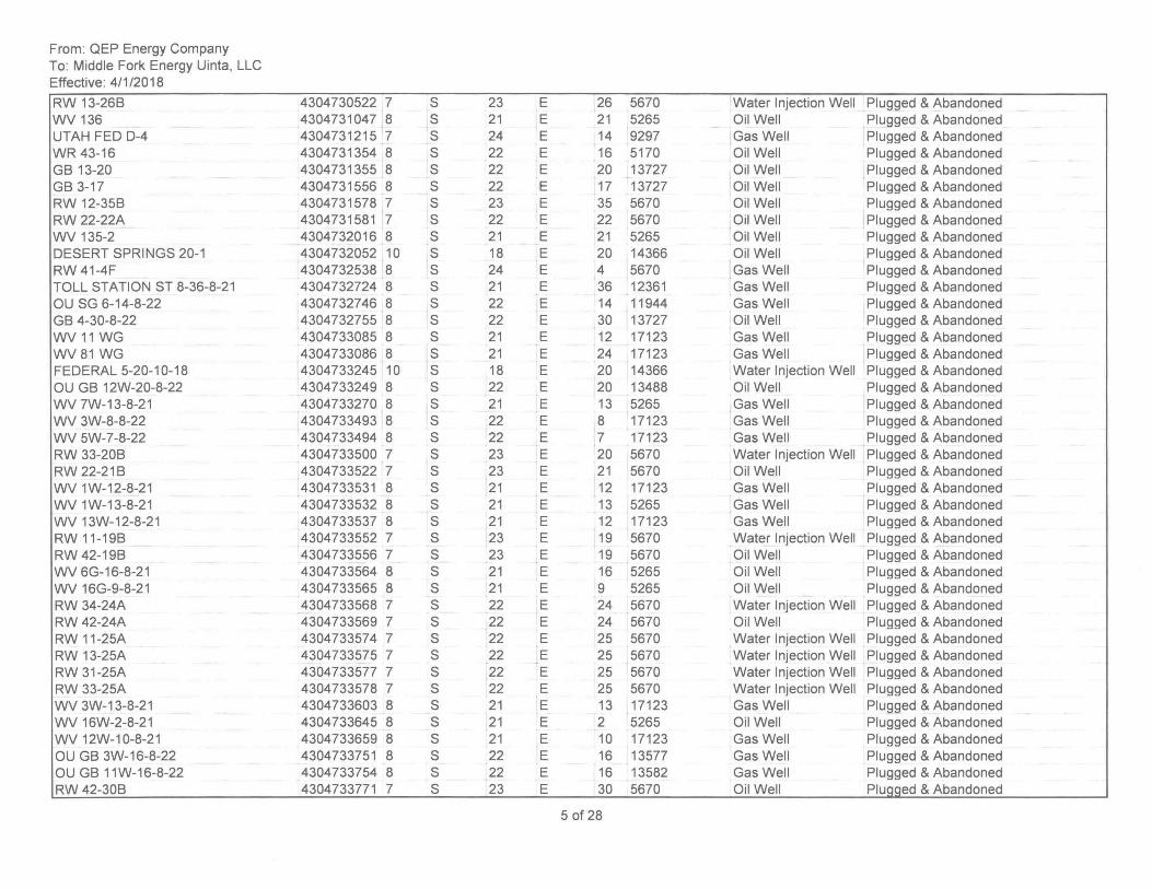
From: QEP Energy Company To: Middle Fork Energy Uinta, LLC Effective: 4/1/2018
RW 13-26B WV 136 UTAH FED 0-4 WR 43-16 GB 13-20 GB 3-17 RW 12-35B RW 22-22A WV 135-2 DESERT SPRINGS 20-1 RW 41-4F TOLL STATION ST 8-36-8-21 OU SG 6-14-8-22 GB 4-30-8-22 WV 11 WG WV81 WG FEDERAL 5-20-10-18 OU GB 12W-20-8-22 WV 7W-13-8-21 WV 3W-8-8-22 WV 5W-7-8-22 RW 33-20B RW 22-21B WV 1W-12-8-21 WV 1W-13-8-21 WV 13W-12-8-21 RW 11-19B RW 42-19B WV 6G-16-8-21 WV 16G-9-8-21 RW 34-24A RW 42-24A RW 11-25A RW 13-25A RW 31-25A RW 33-25A WV 3W-13-8-21 WV 16W-2-8-21 WV 12W-10-8-21 OU GB 3W-16-8-22 OU GB 11W-16-8-22 RW 42-30B
4304730522 7 S 4304731047 8 S 4304731215 7 S 4304731354 8 S 4304731355 8 S 4304731556 8 S 4304731578 7 S 4304731581 7 S 4304732016 8 S 4304732052 10 S 4304732538 8 S 4304732724 8 S 4304732746 8 S 4304732755 8 S 4304733085 8 S 4304733086 8 S 4304733245 10 S 4304733249 8 S 4304733270 8 S 4304733493 8 S 4304733494 8 S 4304733500 7 S 4304733522 7 S 4304733531 8 S 4304733532 8 S 4304733537 8 S 4304733552 7 S 4304733556 7 S 4304733564 8 S 4304733565 8 S 4304733568 7 S 4304733569 7 S 4304733574 7 S 4304733575 7 S 4304733577 7 S 4304733578 7 S 4304733603 8 S 4304733645 8 S 4304733659 8 S 4304733751 8 S 4304733754 8 S 4304733771 7 S
23 E 26 5670 Water Injection Well Plugged & Abandoned 21 E 21 5265 Oil Well Plugged & Abandoned 24 E 14 9297 Gas Well Plugged & Abandoned 22 E 16 5170 Oil Well Plugged & Abandoned 22 E 20 13727 Oil Well Plugged & Abandoned 22 E 17 13727 Oil Well Plugged & Abandoned 23 E 35 5670 Oil Well Plugged & Abandoned 22 E 22 5670 Oil Well Plugged & Abandoned 21 E 21 5265 Oil Well Plugged & Abandoned 18 E 20 14366 Oil Well Plugged & Abandoned 24 E 4 5670 Gas Well Plugged & Abandoned 21 E 36 12361 Gas Well Plugged & Abandoned 22 E 14 11944 Gas Well Plugged & Abandoned 22 E 30 13727 Oil Well Plugged & Abandoned 21 E 12 17123 Gas Well Plugged & Abandoned 21 E 24 17123 Gas Well Plugged & Abandoned 18 E 20 14366 Water Injection Well Plugged & Abandoned 22 E 20 13488 Oil Well Plugged & Abandoned 21 E 13 5265 Gas Well Plugged & Abandoned 22 E 8 17123 Gas Well Plugged & Abandoned 22 E 7 17123 Gas Well Plugged & Abandoned 23 E 20 5670 Water Injection Well Plugged & Abandoned 23 E 21 5670 Oil Well Plugged & Abandoned 21 E 12 17123 Gas Well Plugged & Abandoned 21 E 13 5265 Gas Well Plugged & Abandoned 21 E 12 17123 Gas Well Plugged & Abandoned 23 E 19 5670 Water Injection Well Plugged & Abandoned 23 E 19 5670 Oil Well Plugged & Abandoned 21 E 16 5265 Oil Well Plugged & Abandoned 21 E 9 5265 Oil Well Plugged & Abandoned 22 E 24 5670 Water Injection Well Plugged & Abandoned 22 E 24 5670 Oil Well Plugged & Abandoned 22 E 25 5670 Water Injection Well Plugged & Abandoned 22 E 25 5670 Water Injection Well Plugged & Abandoned 22 E 25 5670 Water Injection Well Plugged & Abandoned 22 E 25 5670 Water Injection Well Plugged & Abandoned 21 E 13 17123 Gas Well Plugged & Abandoned 21 E 2 5265 Oil Well Plugged & Abandoned 21 E 10 17123 Gas Well Plugged & Abandoned 22 E 16 13577 Gas Well Plugged & Abandoned 22 E 16 13582 Gas Well Plugged & Abandoned 23 E 30 5670 Oil Well PluQQed & Abandoned
50f28
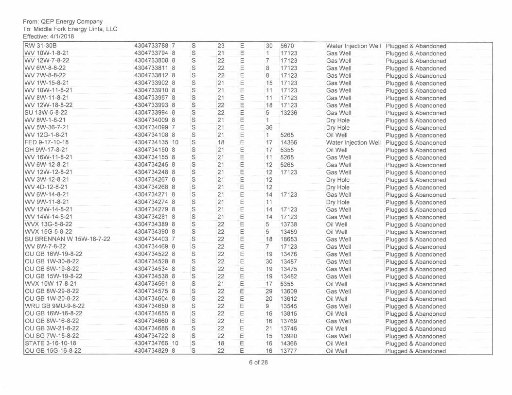
From: QEP Energy Company To: Middle Fork Energy Uinta, LLC Effective: 4/1/2018
RW 31-30B WV 10W-1-8-21 WV 12W-7-8-22 WV 6W-8-8-22 WV 7W-8-8-22 WV 1W-15-8-21 WV 10W-11-8-21 WV 8W-11-8-21 WV 12W-18-8-22 SU 13W-5-8-22 WV 8W-1-8-21 WV 5W-36-7-21 WV 12G-1-8-21 FED 9-17-10-18 GH 9W-17-8-21 WV 16W-11-8-21 WV 6W-12-8-21 WV 12W-12-8-21 WV 3W-12-8-21 WV 40-12-8-21 WV 6W-14-8-21 WV 9W-11-8-21 WV 12W-14-8-21 WV 14W-14-8-21 WVX 13G-5-8-22 WVX 15G-5-8-22 SU BRENNAN W 15W-18-7-22 WV 8W-7-8-22 OU GB 16W-19-8-22 OU GB 1W-30-8-22 OU GB 6W-19-8-22 OU GB 15W-19-8-22 WVX 10W-17-8-21 OU GB 8W-29-8-22 OU GB 1W-20-8-22 WRU GB 9MU-9-8-22 OU GB 16W-16-8-22 OU GB 8W-16-8-22 OU GB 3W-21-8-22 OU SG 7W-15-8-22 STATE 3-16-10-18 OU GB 15G-16-8-22
4304733788 7 S 23 4304733794 8 S 21 4304733808 8 S 22 4304733811 8 S 22 4304733812 8 S 22 4304733902 8 S 21 4304733910 8 S 21 4304733957 8 S 21 4304733993 8 S 22 4304733994 8 S 22 4304734009 8 S 21 4304734099 7 S 21 4304734108 8 S 21 4304734135 10 S 18 4304734150 8 S 21 4304734155 8 S 21 4304734245 8 S 21 4304734248 8 S 21 4304734267 8 S 21 4304734268 8 S 21 4304734271 8 S 21 4304734274 8 S 21 4304734279 8 S 21 4304734281 8 S 21 4304734389 8 S 22 4304734390 8 S 22 4304734403 7 S 22 4304734469 8 S 22 4304734522 8 S 22 4304734528 8 S 22 4304734534 8 S 22 4304734538 8 S 22 4304734561 8 S 21 4304734575 8 S 22 4304734604 8 S 22 4304734650 8 S 22 4304734655 8 S 22 4304734660 8 S 22 4304734686 8 S 22 4304734722 8 S 22 4304734766 10 S 18 4304734829 8 S 22
E 30 5670 Water Injection Well Plugged & Abandoned E 1 17123 Gas Well Plugged & Abandoned E 7 17123 Gas Well Plugged & Abandoned E 8 17123 Gas Well Plugged & Abandoned E 8 17123 Gas Well Plugged & Abandoned E 15 17123 Gas Well Plugged & Abandoned E 11 17123 Gas Well Plugged & Abandoned E 11 17123 Gas Well Plugged & Abandoned E 18 17123 Gas Well Plugged & Abandoned E 5 13236 Gas Well Plugged & Abandoned E 1 Dry Hole Plugged & Abandoned E 36 Dry Hole Plugged & Abandoned E 1 5265 Oil Well Plugged & Abandoned E 17 14366 Water Injection Well Plugged & Abandoned E 17 5355 Oil Well Plugged & Abandoned E 11 5265 Gas Well Plugged & Abandoned E 12 5265 Gas Well Plugged & Abandoned E 12 17123 Gas Well Plugged & Abandoned E 12 Dry Hole Plugged & Abandoned E 12 Dry Hole Plugged & Abandoned E 14 17123 Gas Well Plugged & Abandoned E 11 Dry Hole Plugged & Abandoned E 14 17123 Gas Well Plugged & Abandoned E 14 17123 Gas Well Plugged & Abandoned E 5 13738 Oil Well Plugged & Abandoned E 5 13459 Oil Well Plugged & Abandoned E 18 18653 Gas Well Plugged & Abandoned E 7 17123 Gas Well Plugged & Abandoned E 19 13476 Gas Well Plugged & Abandoned E 30 13487 Gas Well Plugged & Abandoned E 19 13475 Gas Well Plugged & Abandoned E 19 13482 Gas Well Plugged & Abandoned E 17 5355 Oil Well Plugged & Abandoned E 29 13609 Gas Well Plugged & Abandoned E 20 13612 Oil Well Plugged & Abandoned E 9 13545 Gas Well Plugged & Abandoned E 16 13815 Oil Well Plugged & Abandoned E 16 13769 Gas Well Plugged & Abandoned E 21 13746 Oil Well Plugged & Abandoned E 15 13920 Gas Well Plugged & Abandoned E 16 14366 Oil Well Plugged & Abandoned E 16 13777 Oil Well Pluaaed & Abandoned
60f28
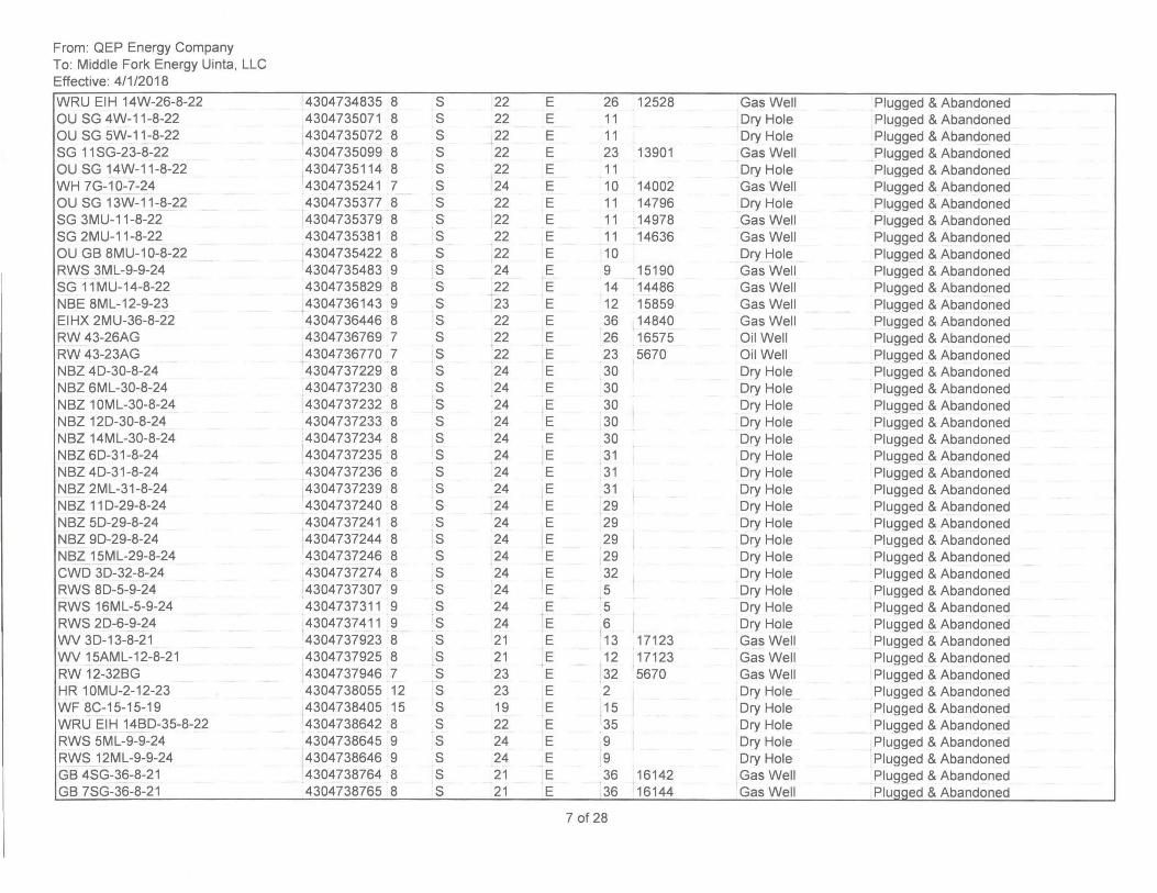
From: QEP Energy Company To: Middle Fork Energy Uinta, LLC Effective: 4/1/2018
WRU EIH 14W-26-8-22 OU SG 4W-11-8-22 OU SG 5W-11-8-22 SG 11 SG-23-8-22 OU SG 14W-11-8-22 WH 7G-10-7-24 OU SG 13W-11-8-22 SG 3MU-11-8-22 SG 2MU-11-8-22 OU GB 8MU-10-8-22 RWS 3ML-9-9-24 SG 11MU-14-8-22 NBE 8ML-12-9-23 EIHX 2MU-36-8-22 RW 43-26AG RW 43-23AG NBZ 40-30-8-24 NBZ 6ML-30-8-24 NBZ 10ML-30-8-24 NBZ 120-30-8-24 NBZ 14ML-30-8-24 NBZ 60-31-8-24 NBZ 40-31-8-24 NBZ 2ML-31-8-24 NBZ 110-29-8-24 NBZ 50-29-8-24 NBZ 90-29-8-24 NBZ 15ML-29-8-24 CWO 30-32-8-24 RWS 80-5-9-24 RWS 16ML-5-9-24 RWS 20-6-9-24 WV 30-13-8-21 WV 15AML-12-8-21 RW 12-32BG HR 10MU-2-12-23 WF 8C-15-15-19 WRU EIH 14BO-35-8-22 RWS 5ML-9-9-24 RWS 12ML-9-9-24 GB 4SG-36-8-21 GB 7SG-36-8-21
4304734835 8 S 22 4304735071 8 S 22 4304735072 8 S 22 4304735099 8 S 22 4304735114 8 S 22 4304735241 7 S 24 4304735377 8 S 22 4304735379 8 S 22 4304735381 8 S 22 4304735422 8 S 22 4304735483 9 S 24 4304735829 8 S 22 4304736143 9 S 23 4304736446 8 S 22 4304736769 7 S 22 4304736770 7 S 22 4304737229 8 S 24 4304737230 8 S 24 4304737232 8 S 24 4304737233 8 S 24 4304737234 8 S 24 ,
4304737235 8 S 24 4304737236 8 S 24 4304737239 8 S 24 4304737240 8 S 24 4304737241 8 S 24 4304737244 8 S 24 4304737246 8 S 24 4304737274 8 S 24 4304737307 9 S 24 4304737311 9 S 24 4304737411 9 S 24 4304737923 8 S 21 4304737925 8 S 21 4304737946 7 S 23 4304738055 12 S 23 4304738405 15 S 19 4304738642 8 S 22 4304738645 9 S 24 4304738646 9 S 24 4304738764 8 S 21 4304738765 8 S 21
E 26 12528 Gas Well Plugged & Abandoned E 11 Dry Hole Plugged & Abandoned E 11 Dry Hole Plugged & Abandoned E 23 13901 Gas Well Plugged & Abandoned E 11 Dry Hole Plugged & Abandoned E 10 14002 Gas Well Plugged & Abandoned E 11 14796 Dry Hole Plugged & Abandoned E 11 14978 Gas Well Plugged & Abandoned E 11 14636 Gas Well Plugged & Abandoned E 10 Dry Hole Plugged & Abandoned E 9 15190 Gas Well Plugged & Abandoned E 14 14486 Gas Well Plugged & Abandoned E 12 15859 Gas Well Plugged & Abandoned E 36 14840 Gas Well Plugged & Abandoned E 26 16575 Oil Well Plugged & Abandoned E 23 5670 Oil Well Plugged & Abandoned E 30 Dry Hole Plugged & Abandoned E 30 Dry Hole Plugged & Abandoned E 30 Dry Hole Plugged & Abandoned E 30 Dry Hole Plugged & Abandoned E 30 Dry Hole Plugged & Abandoned E 31 Dry Hole Plugged & Abandoned E 31 Dry Hole Plugged & Abandoned E 31 Dry Hole Plugged & Abandoned E 29 Dry Hole Plugged & Abandoned E 29 Dry Hole . Plugged & Abandoned E 29 Dry Hole Plugged & Abandoned E 29 Dry Hole Plugged & Abandoned E 32 Dry Hole Plugged & Abandoned
t
E 5 Dry Hole Plugged & Abandoned E 5 Dry Hole Plugged & Abandoned E 6 Dry Hole Plugged & Abandoned E 13 17123 Gas Well Plugged & Abandoned E 12 17123 Gas Well Plugged & Abandoned E 32 5670 Gas Well Plugged & Abandoned E 2 Dry Hole Plugged & Abandoned E 15 Dry Hole . Plugged & Abandoned E 35 Dry Hole Plugged & Abandoned E 9 Dry Hole Plugged & Abandoned E 9 Dry Hole Plugged & Abandoned E 36 16142 Gas Well Plugged & Abandoned E 36 16144 Gas Well PluQQed & Abandoned
7 of 28
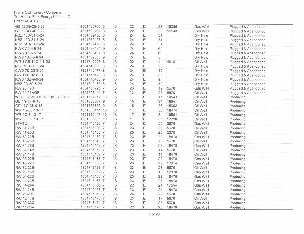
From: QEP Energy Company To: Middle Fork Energy Uinta, LLC Effective: 4/1/2018
GB 12SG-29-8-22 GB 10SG-30-8-22 NBZ 100-31-8-24 NBZ 120-31-8-24 NBZ 140-31-8-24 RWS 70-6-9-24 RWS 90-6-9-24 RWS 130-5-9-24 WRU GB 14G-4-8-22 NBZ 160-30-8-24 CWO 70-32-8-24 CWO 90-32-8-24 RWS 130-9-9-24 NBZ 20-30-8-24 RW 23-19B RW 24-25AGR WEST RIVER BEND 16-17-10-17 GO 1G-34-9-15 GO 16G-35-9-15 WR 4G-35-1 0-17 WR 9G-5-10-17 WR 6G-32-1 0-17 STATE 1 RW 34-23B RW 41-23B RW 32-22B RW 43-23B RW 34-26B RW 32-14B RW 34-14B RW 23-22B RW 43-22B RW 32-23B RW 23-13B RW 34-22B RW 14-23B RW 14-24A RW 21-24B RW 21-29C RW 12-17B RW 32-33C RW 14-23A
4304738766 8 S 22 4304738767 8 S 22 4304739456 8 S 24 4304739457 8 S 24 4304739458 8 S 24 4304739494 9 S 24 4304739497 9 S 24 4304739505 9 S 24 4304740097 8 S 22 4304740355 8 S 24 4304740477 8 S 24 4304740478 8 S 24 4304740480 9 S 24 4304740485 8 S 24 4304751725 7 S 23 4304753441 7 S 22 4301332057 10 S 17 4301333827 9 S 15 4301333833 9 S 15 4301350414 10 S 17 4301350417 10 S 17 4301351631 10 S 17 4304715128 7 S 24 4304715136 7 S 23 4304715138 7 S 23 4304715139 7 S 23 4304715140 7 S 23 4304715148 7 S 23 4304715150 7 S 23 4304715152 7 S 23 4304715153 7 S 23 4304715155 7 S 23 4304715156 7 S 23 4304715157 7 S 23 4304715158 7 S 23 4304715165 7 S 23 4304715166 7 S 22 4304715167 7 S 23 4304715169 7 S 24 4304715170 7 S 23 4304715171 7 S 24 4304715176 7 S 22
E 29 16096 Gas Well Plugged & Abandoned E 30 16143 Gas Well Plugged & Abandoned E 31 Dry Hole Plugged & Abandoned E 31 Dry Hole Plugged & Abandoned E 31 Dry Hole Plugged & Abandoned E 6 Dry Hole Plugged & Abandoned E 6 Dry Hole Plugged & Abandoned E 5 Dry Hole Plugged & Abandoned E 4 4915 Oil Well Plugged & Abandoned E 30 Dry Hole Plugged & Abandoned E 32 Dry Hole Plugged & Abandoned E 32 Dry Hole Plugged & Abandoned E 9 Dry Hole Plugged & Abandoned E 30 Dry Hole Plugged & Abandoned E 19 5670 Gas Well Plugged & Abandoned E 25 5670 Oil Well Plugged & Abandoned E 17 14543 Oil Well Producing E 34 18651 Oil Well Producing E 35 18652 Oil Well Producing E 35 18474 Oil Well Producing E 5 18554 Oil Well Producing E 32 17720 Oil Well Producing E 36 5878 Gas Well Producing E 23 5670 Oil Well Producing E 23 5670 Oil Well Producing E 22 18478 Gas Well Producing E 23 5670 Oil Well Producing E 26 18478 Gas Well Producing E 14 5670 Oil Well Producing E 14 18478 Oil Well Producing E 22 18478 Gas Well Producing E 22 17914 Gas Well Producing E 23 5670 Oil Well Producing E 13 17878 Gas Well Producing E 22 18478 Gas Well Producing E 23 18478 Gas Well Producing E 24 17554 Gas Well Producing E 24 18478 Gas Well Producing E 29 5670 Gas Well Producing E 17 5670 Oil Well Producing E 33 5670 Gas Well Producing E 23 18478 Gas Well ProducinQ
8 of 28
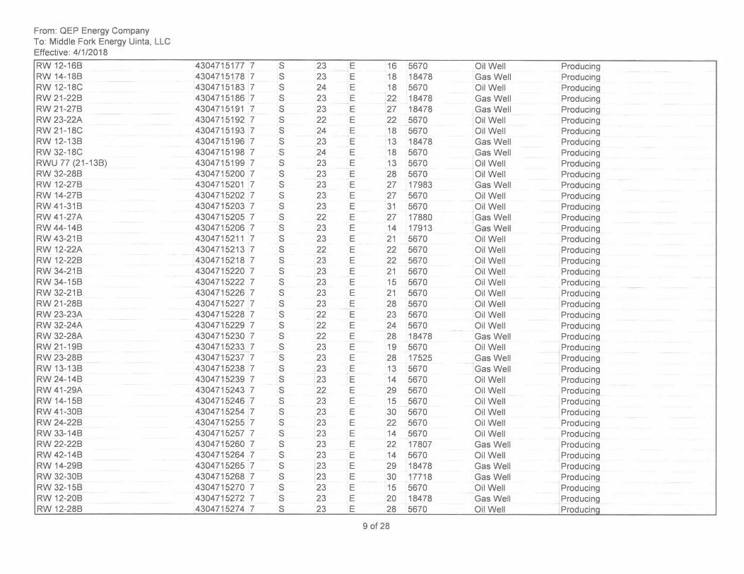
From: QEP Energy Company To: Middle Fork Energy Uinta, LLC Effective: 4/1/2018
RW 12-168 RW 14-188 RW 12-18C RW 21-228 RW 21-278 RW 23-22A RW 21-18C RW 12-138 RW 32-18C RWU 77 (21-138) RW 32-288 RW 12-278 RW 14-278 RW 41-318 RW 41-27A RW 44-148 RW 43-218 RW 12-22A RW 12-228 RW 34-218 RW 34-158 RW 32-218 RW 21-288 RW 23-23A RW 32-24A RW 32-28A RW 21 -198 RW 23-288 RW 13-138 RW 24-148 RW 41-29A RW 14-158 RW 41-308 RW 24-228 RW 33-148 RW 22-228 RW 42-148 RW 14-298 RW 32-308 RW 32-158 RW 12-208 RW 12-288
4304715177 7 4304715178 7 4304715183 7 4304715186 7 4304715191 7 4304715192 7 4304715193 7 4304715196 7 4304715198 7 4304715199 7 4304715200 7 4304715201 7 4304715202 7 4304715203 7 4304715205 7 4304715206 7 4304715211 7 4304715213 7 4304715218 7 4304715220 7 4304715222 7 4304715226 7 4304715227 7 4304715228 7 4304715229 7 4304715230 7 4304715233 7 4304715237 7 4304715238 7 4304715239 7 4304715243 7 4304715246 7 4304715254 7 4304715255 7 4304715257 7 4304715260 7 4304715264 7 4304715265 7 4304715268 7 4304715270 7 4304715272 7 4304715274 7
S 23 E S 23 E S 24 E S 23 E S 23 E S 22 E S 24 E S 23 E S 24 E S 23 E S 23 E S 23 E S 23 E S 23 E S 22 E S 23 E S 23 E S 22 E S 23 E S 23 E S 23 E S 23 E S 23 E S 22 E S 22 E S 22 E S 23 E S 23 E S 23 E S 23 E S 22 E S 23 E S 23 E S 23 E S 23 E S 23 E S 23 E S 23 E S 23 E S 23 E S 23 E S 23 E
16 5670 Oil Well Producing 18 18478 Gas Well Producing 18 5670 Oil Well Producing 22 18478 Gas Well Producing 27 18478 Gas Well Producing 22 5670 Oil Well Producing 18 5670 Oil Well Producing 13 18478 Gas Well Producing 18 5670 Gas Well Producing 13 5670 Oil Well Producing 28 5670 Oil Well Producing 27 17983 Gas Well Producing 27 5670 Oil Well Producing 31 5670 Oil Well Producing 27 17880 Gas Well Producing 14 17913 Gas Well Producing 21 5670 Oil Well Producing 22 5670 Oil Well Producing 22 5670 Oil Well Producing 21 5670 Oil Well Producing 15 5670 Oil Well Producing 21 5670 Oil Well Producing 28 5670 Oil Well Producing 23 5670 Oil Well Producing 24 5670 Oil Well Producing 28 18478 Gas Well Producing 19 5670 Oil Well Producing 28 17525 Gas Well Producing 13 5670 Gas Well Producing 14 5670 Oil Well Producing 29 5670 Oil Well Producing 15 5670 Oil Well Producing 30 5670 Oil Well Producing 22 5670 Oil Well Producing 14 5670 Oil Well Producing 22 17807 Gas Well Producing 14 5670 Oil Well Producing ,
29 18478 Gas Well Producing 30 17718 Gas Well Producing 15 5670 Oil Well Producing 20 18478 Gas Well Producing 28 5670 Oil Well Producinq
9 of 28
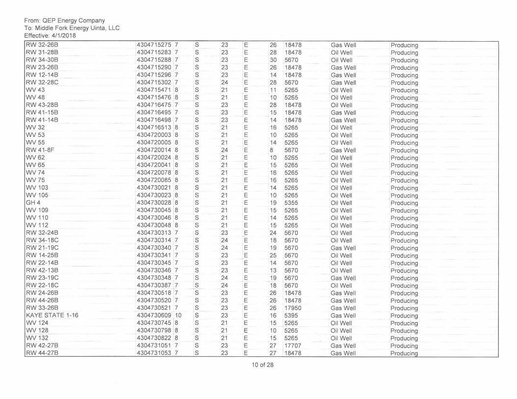
From: QEP Energy Company To: Middle Fork Energy Uinta, LLC Effective: 4/1/2018
RW 32-268 RW 31-288 RW 34-308 RW 23-268 RW 12-148 RW 32-28C WV43 WV48 RW 43-288 RW 41-158 RW 41-148 WV32 WV53 WV55 RW 41-8F WV62 WV65 WV74 WV75 WV 103 WV 105 GH4 WV 109 WV 110 WV 112 RW 32-248 RW 34-18C RW 21-19C RW 14-258 RW 22-148 RW 42-138 RW 23-19C RW 22-18C RW 24-268 RW 44-268 RW 33-268 KAYE STATE 1-16 WV 124 WV 128 WV 132 RW 42-278 RW 44-278
4304715275 7 S 23 E 4304715283 7 S 23 E 4304715288 7 S 23 E 4304715290 7 S 23 E 4304715296 7 S 23 E 4304715302 7 S 24 E 4304715471 8 S 21 E 4304715476 8 S 21 E 4304716475 7 S 23 E 4304716495 7 S 23 E 4304716498 7 S 23 E 4304716513 8 S 21 E 4304720003 8 S 21 E 4304720005 8 S 21 E 4304720014 8 S 24 E 4304720024 8 S 21 E 4304720041 8 S 21 E 4304720078 8 S 21 E 4304720085 8 S 21 E 4304730021 8 S 21 E 4304730023 8 S 21 E 4304730028 8 S 21 E 4304730045 8 S 21 E 4304730046 8 S 21 E 4304730048 8 S 21 E 4304730313 7 S 23 E 4304730314 7 S 24 E 4304730340 7 S 24 E 4304730341 7 S 23 E 4304730345 7 S 23 E 4304730346 7 S 23 E 4304730348 7 S 24 E 4304730387 7 S 24 E 4304730518 7 S 23 E 4304730520 7 S 23 E 4304730521 7 S 23 E 4304730609 10 S 23 E 4304730745 8 S 21 E 4304730798 8 S 21 E 4304730822 8 S 21 E 4304731051 7 S 23 E 4304731053 7 S 23 E
26 18478 Gas Well Producing 28 18478 Oil Well Producing 30 5670 Oil Well Producing 26 18478 Gas Well Producing 14 18478 Gas Well Producing 28 5670 Gas Well Producing 11 5265 Oil Well Producing 10 5265 Oil Well Producing 28 18478 Oil Well Producing 15 18478 Gas Well Producing 14 18478 Gas Well Producing 16 5265 Oil Well Producing 10 5265 Oil Well Producing 14 5265 Oil Well Producing 8 5670 Gas Well Producing 10 5265 Oil Well Producing 15 5265 Oil Well Producing 16 5265 Oil Well Producing 16 5265 Oil Well Producing 14 5265 Oil Well Producing 10 5265 Oil Well Producing 19 5355 Oil Well Producing 15 5265 Oil Well Producing 14 5265 Oil Well Producing 15 5265 Oil Well Producing 24 5670 Oil Well ,Producing 18 5670 Oil Well Producing 19 5670 Gas Well Producing 25 5670 Oil Well Producing 14 5670 Oil Well Producing 13 5670 Oil Well Producing 19 5670 Gas Well Producing 18 5670 Oil Well Producing 26 18478 Gas Well Producing 26 18478 Gas Well Producing 26 17950 Gas Well Producing 16 5395 Gas Well Producing 15 5265 Oil Well Producing 10 5265 Oil Well Producing 15 5265 Oil Well Producing 27 17707 Gas Well Producing 27 18478 Gas Well Producing
10 of 28
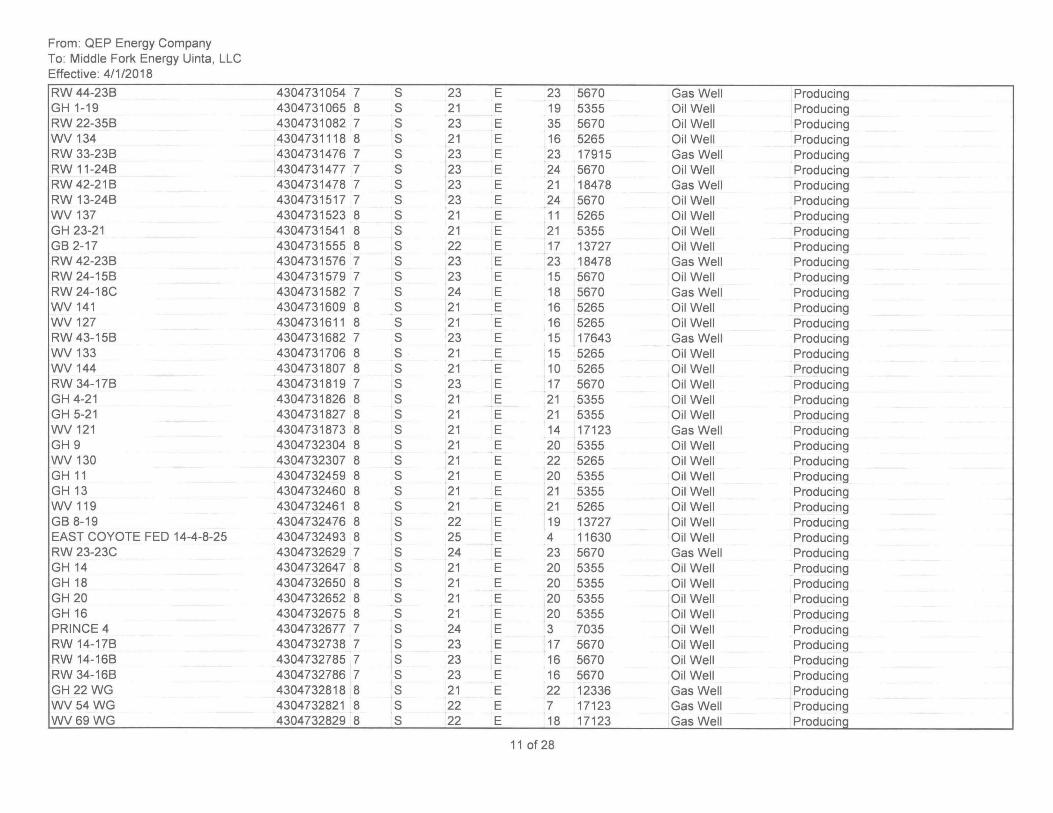
From: QEP Energy Company To: Middle Fork Energy Uinta, LLC Effective: 4/1/2018
RW 44-238 GH 1-19 RW 22-358 WV 134 RW 33-238 RW 11-248 RW 42-218 RW 13-248 WV 137 GH 23-21 G82-17 RW 42-238 RW 24-158 RW 24-18C WV 141 WV 127 RW 43-158 WV 133 WV 144 RW 34-178 GH 4-21 GH 5-21 WV 121 GH 9 WV 130 GH 11 GH13 WV 119 G88-19 EAST COYOTE FED 14-4-8-25 RW 23-23C GH14 GH18 GH 20 GH16 PRINCE 4 RW 14-178 RW 14-168 RW 34-168 GH 22WG WV 54 WG WV69 WG
4304731054 7 S 23 E 4304731065 8 S 21 E 4304731082 7 S 23 E 4304731118 8 S 21 E 4304731476 ,7 S 23 E 4304731477 7 S 23 E 4304731478 7 S 23 E 4304731517 7 S 23 E 4304731523 8 S 21 E 4304731541 8 S 21 E 4304731555 8 S 22 E 4304731576 7 S 23 E 4304731579 7 S 23 E 4304731582 7 S 24 E 4304731609 8 S 21 E 4304731611 8 S 21 E 4304731682 7 S 23 E 4304731706 8 S 21 E 4304731807 8 S 21 E 4304731819 7 S 23 E 4304731826 8 S 21 E 4304731827 8 S 21 E 4304731873 8 S 21 E 4304732304 8 S 21 E 4304732307 8 S 21 E 4304732459 8 S 21 E 4304732460 8 S 21 E 4304732461 8 S 21 E 4304732476 8 S 22 E 4304732493 8 S 25 E 4304732629 7 S 24 E 4304732647 8 S 21 E 4304732650 8 S 21 E 4304732652 8 S 21 E 4304732675 8 S 21 E 4304732677 7 S 24 E 4304732738 7 S 23 E 4304732785 7 S 23 E 4304732786 7 S 23 E 4304732818 8 S 21 E 4304732821 8 S 22 E 4304732829 8 S 22 E
23 5670 Gas Well Producing 19 5355 Oil Well Producing 35 5670 Oil Well Producing 16 5265 Oil Well Producing 23 17915 Gas Well Producing 24 5670 Oil Well Producing 21 18478 Gas Well Producing 24 5670 Oil Well Producing 11 5265 Oil Well Producing 21 5355 Oil Well Producing 17 13727 Oil Well Producing 23 18478 Gas Well Producing 15 5670 Oil Well Producing 18 5670 Gas Well Producing 16 5265 Oil Well Producing 16 5265 Oil Well Producing 15 17643 Gas Well Producing 15 5265 Oil Well Producing 10 5265 Oil Well Producing 17 5670 Oil Well Producing 21 5355 Oil Well Producing 21 5355 Oil Well Producing 14 17123 Gas Well Producing 20 5355 Oil Well Producing 22 5265 Oil Well Producing 20 5355 Oil Well Producing 21 5355 Oil Well Producing 21 5265 Oil Well Producing 19 13727 Oil Well Producing 4 11630 Oil Well Producing 23 5670 Gas Well Producing 20 5355 Oil Well Producing 20 5355 Oil Well Producing 20 5355 Oil Well Producing 20 5355 Oil Well Producing 3 7035 Oil Well Producing 17 5670 Oil Well Producing 16 5670 Oil Well Producing 16 5670 Oil Well Producing 22 12336 Gas Well Producing 7 17123 Gas Well Producing 18 17123 Gas Well Producinq
11 of 28
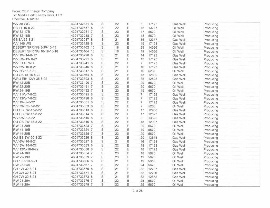
From: QEP Energy Company To: Middle Fork Energy Uinta, LLC Effective: 4/1/2018
WV38WG GB 11-16-8-22 RW 32-17B RW 32-18B GB 8A-36-8-21 WV 146WG DESERT SPRING 3-29-10-18 DESERT SPRING 16-19-10-18 WV 1W-14-8- 21 WV 5W-13- 8-21 WVFU46 WG WV 2W-16-8-21 WV 2G-16-8-21 OU GB 15-18-8-22 WRU EIH 12W-35-8-22 RW 42-20B RW 22-20B RW 24-19B WV 11W-7-8-22 WV 13W-7-8-22 WV 1W-7-8-22 WV 7WRG-7-8-22 OU GB 3W-17-8-22 OU GB 5W-17 -8-22 WV 9W-8-8-22 OU GB 9W-18-8-22 RW 24-20B RW 44-19B RW 44-20B OU GB 3W-20-8-22 WV 6W-16-8-21 WV 3W-18-8-22 WV 13W-18-8-22 RW 24-18B RW 22-19B GH 10G-19-8-21 RW 23-24A GH 1 W-32-8-21 GH 3W-32-8-21 GH 7W-32-8-21 RW 21-25A RW 41-25A
4304732831 8 S 22 4304732857 8 S 22 4304732981 7 S 23 4304733018 7 S 23 4304733037 8 S 21 4304733128 8 S 22 4304733162 10 S 18 4304733164 10 S 18 4304733220 8 S 21 4304733221 8 S 21 4304733241 8 S 22 4304733246 8 S 21 4304733247 8 S 21 4304733364 8 S 22 4304733393 8 S 22 4304733490 7 S 23 4304733491 7 S 23 4304733492 7 S 23 4304733495 8 S 22 4304733496 8 S 22 4304733501 8 S 22 4304733503 8 S 22 4304733513 8 S 22 4304733514 8 S 22 4304733515 8 S 22 4304733516 8 S 22 4304733523 7 S 23 4304733524 7 S 23 4304733525 7 S 23 4304733526 8 S 22 4304733527 8 S 21 4304733533 8 S 22 4304733538 8 S 22 4304733554 7 S 23 4304733559 7 S 23 4304733566 8 S 21 4304733567 7 S 22 4304733570 8 S 21 4304733571 8 S 21 4304733573 8 S 21 4304733576 7 S 22 4304733579 7 S 22
E 8 17123 Gas Well Producing E 16 13727 Oil Well Producing E 17 5670 Oil Well Producing E 18 5670 Oil Well Producing E 36 12377 Gas Well Producing E 19 17123 Gas Well Producing E 29 14366 Oil Well Producing E 19 14366 Oil Well Producing E 14 17123 Gas Well Producing E 13 17123 Gas Well Producing E 7 17123 Gas Well Producing E 16 17123 Gas Well Producing E 16 5265 Oil Well Producing E 18 12690 Gas Well Producing E 35 12528 Gas Well Producing E 20 5670 Oil Well Producing E 20 5670 Oil Well Producing E 19 5670 Oil Well Producing E 7 17123 Gas Well Producing E 7 17123 Gas Well Producing E 7 17123 Gas Well Producing E 7 5265 Oil Well Producing E 17 12950 Gas Well Producing E 17 12873 Gas Well Producing E 8 13395 Gas Well Producing E 18 12997 Gas Well Producing
I
E 20 5670 Oil Well Producing E 19 5670 Oil Well Producing E 20 5670 Oil Well Producing E 20 13514 Gas Well Producing E 16 17123 Gas Well Producing E 18 17123 Gas Well Producing E 18 17123 Gas Well Producing E 18 5670 Oil Well Producing E 19 5670 Oil Well Producing E 19 5355 Oil Well Producing E 24 5670 Oil Well Producing E 32 12797 Gas Well Producing E 32 12796 Gas Well Producing E 32 12872 Gas Well Producing E 25 5670 Oil Well Producing E 25 5670 Oil Well Producinq
12 of 28
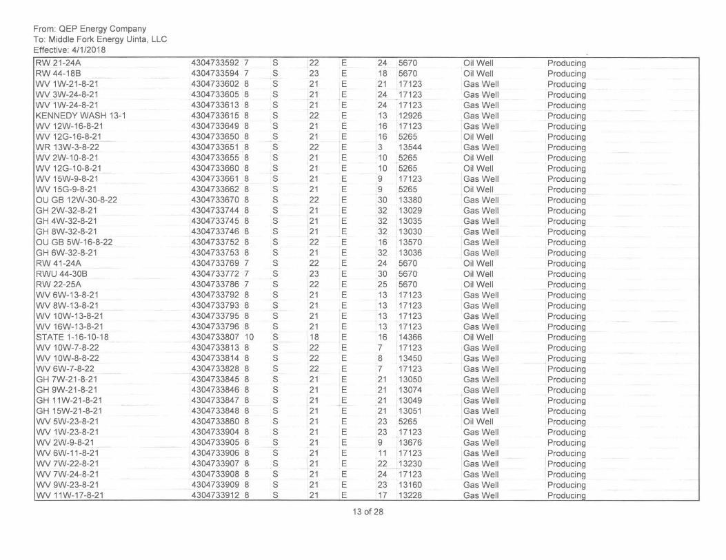
From: QEP Energy Company To: Middle Fork Energy Uinta, LLC Effective: 4/1/2018
RW 21-24A RW 44-188 WV 1W-21-8-21 WV 3W-24-8-21 WV 1W-24-8-21 KENNEDY WASH 13-1 WV 12W-16-8-21 WV 12G-16-8-21 WR 13W-3-8-22 WV 2W-10-8-21 WV 12G-1 0-8-21 WV 15W-9-8-21 WV 15G-9-8-21 OU G8 12W-30-8-22 GH 2W-32-8-21 GH 4W-32-8-21 GH 8W-32-8-21 OU G8 5W-16-8-22 GH 6W-32-8-21 RW 41-24A RWU 44-308 RW 22-25A WV 6W-13-8-21 WV 8W-13-8-21 WV 10W-13-8-21 WV 16W-13-8-21 STATE 1-16-10-18 WV 10W-7-8-22 WV 10W-8-8-22 WV 6W-7-8-22 GH 7W-21-8-21 GH 9W-21-8-21 GH 11W-21-8-21 GH 15W-21-8-21 WV 5W-23-8-21 WV 1W-23-8-21 WV 2W-9-8-21 WV 6W-11-8-21 WV 7W-22-8-21 WV 7W-24-8-21 WV 9W-23-8-21 WV 11W-17-8-21
4304733592 7 4304733594 7 4304733602 8 4304733605 8 4304733613 8 4304733615 8 4304733649 8 4304733650 8 4304733651 8 4304733655 8 4304733660 8 4304733661 8 4304733662 8 4304733670 8 4304733744 8 4304733745 8 4304733746 8 4304733752 8 4304733753 8 4304733769 7 4304733772 7 4304733786 7 4304733792 8 4304733793 8 4304733795 8 4304733796 8 4304733807 10 4304733813 8 4304733814 8 4304733828 8 4304733845 8 4304733846 8 4304733847 8 4304733848 8 4304733860 8 4304733904 8 4304733905 8 4304733906 8 4304733907 8 4304733908 8 4304733909 8 4304733912 8
S 22 E 24 5670 Oil Well Producing S 23 E 18 5670 Oil Well Producing S 21 E 21 17123 Gas Well Producing S 21 E 24 17123 Gas Well Producing S 21 E 24 17123 Gas Well Producing , S 22 E 13 12926 Gas Well Producing S 21 E 16 17123 Gas Well Producing S 21 E 16 5265 Oil Well Producing S 22 E 3 13544 Gas Well Producing S 21 E 10 5265 Oil Well Producing S 21 E 10 5265 Oil Well Producing S 21 E 9 17123 Gas Well Producing S 21 E 9 5265 Oil Well Producing S 22 E 30 13380 Gas Well Producing S 21 E 32 13029 Gas Well Producing S 21 E 32 13035 Gas Well Producing S 21 E 32 13030 Gas Well Producing S 22 E 16 13570 Gas Well Producing S 21 E 32 13036 Gas Well Producing S 22 E 24 5670 Oil Well Producing S 23 E 30 5670 Oil Well Producing S 22 E 25 5670 Oil Well Producing S 21 E 13 17123 Gas Well Producing S 21 E 13 17123 Gas Well Producing S 21 E 13 17123 Gas Well Producing S 21 E 13 17123 Gas Well Producing S 18 E 16 14366 Oil Well Producing S 22 E 7 17123 Gas Well Producing S 22 E 8 13450 Gas Well Producing S 22 E 7 17123 Gas Well Producing S 21 E 21 13050 Gas Well Producing S 21 E 21 13074 Gas Well Producing S 21 E 21 13049 Gas Well Producing S 21 E 21 13051 Gas Well Producing S 21 E 23 5265 Oil Well Producing S 21 E 23 17123 Gas Well Producing S 21 E 9 13676 Gas Well Producing S 21 E 11 17123 Gas Well Producing S 21 E 22 13230 Gas Well Producing S 21 E 24 17123 Gas Well Producing S 21 E 23 13160 Gas Well Producing S 21 E 17 13228 Gas Well Producing
13 of 28
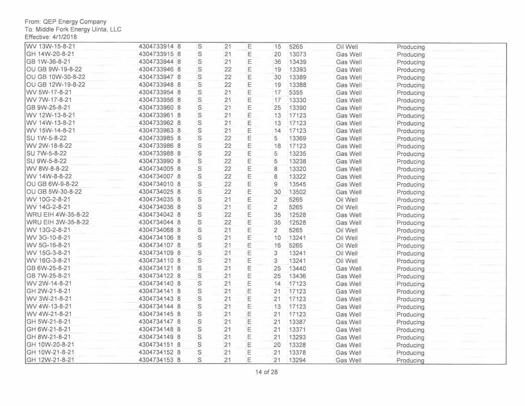
From: QEP Energy Company To: Middle Fork Energy Uinta, LLC Effective: 4/1/2018
WV 13W-15-8-21 GH 14W-20-8-21 GB 1W-36-8-21 OU GB 9W-19-8-22 OU GB 10W-30-8-22 OU GB 12W-19-8-22 WV 5W-17-8-21 WV 7W-17-8-21 GB 9W-25-8-21 WV 12W-13-8-21 WV 14W-13-8-21 WV 15W-14-8-21 SU 1 W-5-8-22 WV 2W-18-8-22 SU 7W-5-8-22 SU 9W-5-8-22 WV 8W-8-8-22 WV 14W-8-8-22 OU GB 6W-9-8-22 OU GB 5W-30-8-22 WV 10G-2-8-21 WV 14G-2-8-21 WRU EIH 4W-35-8-22 WRU EIH 3W-35-8-22 WV 13G-2-8-21 WV 3G-1 0-8-21 WV 5G-16-8-21 WV 15G-3-8-21 WV 16G-3-8-21 GB 6W-25-8-21 GB 7W-25-8-21 WV 2W-14-8-21 GH 2W-21-8-21 WV 3W-21 -8-21 WV 4W-13-8-21 WV 4W-21-8-21 GH 5W-21-8-21 GH 6W-21-8-21 GH 8W-21-8-21 GH 10W-20-8-21 GH 10W-21-8-21 GH 12W-21-8-21
4304733914 8 S 21 E 4304733915 8 S 21 E 4304733944 8 S 21 E 4304733946 8 S 22 E 4304733947 8 S 22 E 4304733948 8 S 22 E 4304733954 8 S 21 E 4304733956 8 S 21 E 4304733960 8 S 21 E 4304733961 8 S 21 E 4304733962 8 S 21 E 4304733963 8 S 21 E 4304733985 8 S 22 E 4304733986 8 S 22 E 4304733988 8 S 22 E 4304733990 8 S 22 E 4304734005 8 S 22 E 4304734007 8 S 22 E 4304734010 8 S 22 E 4304734025 8 S 22 E 4304734035 8 S 21 E 4304734036 8 S 21 E 4304734042 8 S 22 E 4304734044 8 S 22 E 4304734068 8 S 21 E 4304734106 8 S 21 E 4304734107 8 S 21 E 4304734109 8 S 21 E 4304734110 8 S 21 E 4304734121 8 S 21 E 4304734122 8 S 21 E 4304734140 8 S 21 E 4304734141 8 S 21 E 4304734143 8 S 21 E 4304734144 8 S 21 E 4304734145 8 S 21 E 4304734147 8 S 21 E 4304734148 8 S 21 E 4304734149 8 S 21 E 4304734151 8 S 21 E 4304734152 8 S 21 E 4304734153 8 S 21 E
15 5265 Oil Well Producing 20 13073 Gas Well Producing 36 13439 Gas Well Producing 19 13393 Gas Well Producing 30 13389 Gas Well Producing 19 13388 Gas Well Producing 17 5355 Gas Well Producing 17 13330 Gas Well Producing 25 13390 Gas Well Producing 13 17123 Gas Well Producing
T
13 17123 Gas Well Producing 14 17123 Gas Well Producing 5 13369 Gas Well Producing 18 17123 Gas Well Producing 5 13235 Gas Well Producing 5 13238 Gas Well Producing 8 13320 Gas Well Producing 8 13322 Gas Well Producing 9 13545 Gas Well Producing 30 13502 Gas Well Producing 2 5265 Oil Well ,Producing 2 5265 Oil Well Producing 35 12528 Gas Well Producing 35 12528 Gas Well Producing 2 5265 Oil Well Producing 10 13241 Oil Well Producing 16 5265 Oil Well Producing 3 13241 Oil Well Producing 3 13241 Oil Well Producing 25 13440 Gas Well ,Producing 25 13436 Gas Well Producing 14 17123 Gas Well Producing 21 17123 Gas Well Producing 21 17123 Gas Well Producing 13 17123 Gas Well Producing 21 17123 Gas Well Producing 21 13387 Gas Well Producing 21 13371 Gas Well Producing 21 13293 Gas Well Producing 20 13328 Gas Well Producing 21 13378 Gas Well Producing 21 13294 Gas Well Producinq
14 of 28
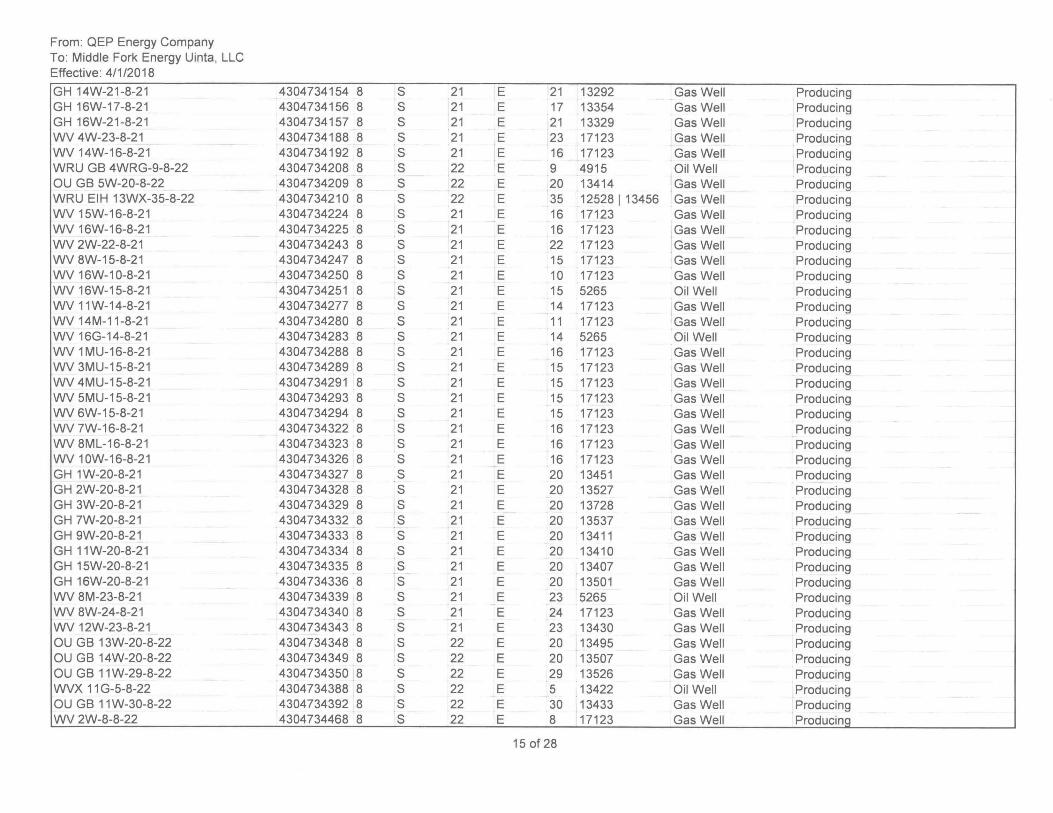
From: QEP Energy Company To: Middle Fork Energy Uinta, LLC Effective: 4/1/2018
GH 14W-21-8-21 GH 16W-17-8-21 GH 16W-21-8-21 WV 4W-23-8-21 WV 14W-16-8-21 WRU GB 4WRG-9-8-22 OU GB 5W-20-8-22 WRU EIH 13WX-35-8-22 WV 15W-16-8-21 WV 16W-16-8-21 WV 2W-22-8-21 WV 8W-15-8-21 WV 16W-10-8-21 WV 16W-15-8-21 WV 11W-14-8-21 WV 14M-11-8-21 WV 16G-14-8-21 WV 1MU-16-8-21 WV 3MU-15-8-21 WV 4MU-15-8-21 WV 5MU-15-8-21 WV 6W-15-8-21 WV 7W-16-8-21 WV 8ML-16-8-21 WV 10W-16-8-21 GH 1W-20-8-21 GH 2W-20-8-21 GH 3W-20-8-21 GH 7W-20-8-21 GH 9W-20-8-21 GH 11W-20-8-21 GH 15W-20-8-21 GH 16W-20-8-21 WV 8M-23-8-21 WV 8W-24-8-21 WV 12W-23-8-21 OU GB 13W-20-8-22 OU GB 14W-20-8-22 OU GB 11W-29-8-22 WVX 11 G-5-8-22 OU GB 11 W-30-8-22 WV 2W-8-8-22
4304734154 8 S 21 E 4304734156 8 S 21 E 4304734157 8 S 21 E 4304734188 8 S 21 E 4304734192 8 S 21 E 4304734208 8 S 22 E 4304734209 8 S 22 E 4304734210 8 S 22 E 4304734224 8 S 21 E 4304734225 8 S 21 E 4304734243 8 S 21 E 4304734247 8 S 21 E 4304734250 8 S 21 E 4304734251 8 S 21 E 4304734277 8 S 21 E 4304734280 8 S 21 E 4304734283 8 S 21 E 4304734288 8 S 21 E 4304734289 8 S 21 E 4304734291 8 S 21 E 4304734293 8 S 21 E 4304734294 8 S 21 E 4304734322 8 S 21 E 4304734323 8 S 21 E 4304734326 8 S 21 E 4304734327 8 S 21 E 4304734328 8 S 21 E 4304734329 8 S 21 E 4304734332 8 S 21 E 4304734333 8 S 21 E 4304734334 8 S 21 E 4304734335 8 S 21 E 4304734336 8 S 21 E 4304734339 8 S 21 E 4304734340 8 S 21 E 4304734343 8 S 21 E 4304734348 8 S 22 E 4304734349 8 S 22 E 4304734350 8 S 22 E 4304734388 8 S 22 E 4304734392 8 S 22 E 4304734468 8 S 22 E
21 13292 Gas Well Producing 17 13354 Gas Well Producing 21 13329 Gas Well Producing 23 17123 Gas Well Producing 16 17123 Gas Well Producing 9 4915 Oil Well Producing 20 13414 Gas Well Producing 35 12528 I 13456 Gas Well Producing 16 17123 Gas Well Producing 16 17123 Gas Well Producing 22 17123 Gas Well Producing 15 17123 Gas Well Producing 10 17123 Gas Well Producing 15 5265 Oil Well Producing 14 17123 Gas Well Producing 11 17123 Gas Well Producing 14 5265 Oil Well Producing 16 17123 Gas Well Producing 15 17123 Gas Well Producing 15 17123 Gas Well Producing 15 17123 Gas Well Producing 15 17123 Gas Well Producing 16 17123 Gas Well Producing 16 17123 Gas Well Producing 16 17123 Gas Well Producing 20 13451 Gas Well Producing 20 13527 Gas Well Producing 20 13728 Gas Well Producing 20 13537 Gas Well Producing 20 13411 Gas Well Producing 20 13410 Gas Well Producing 20 13407 Gas Well Producing 20 13501 Gas Well Producing 23 5265 Oil Well Producing 24 17123 Gas Well Producing 23 13430 Gas Well Producing 20 13495 Gas Well Producing 20 13507 Gas Well Producing 29 13526 Gas Well Producing 5 13422 Oil Well Producing 30 13433 Gas Well Producing 8 17123 Gas Well Producinq
15 of 28
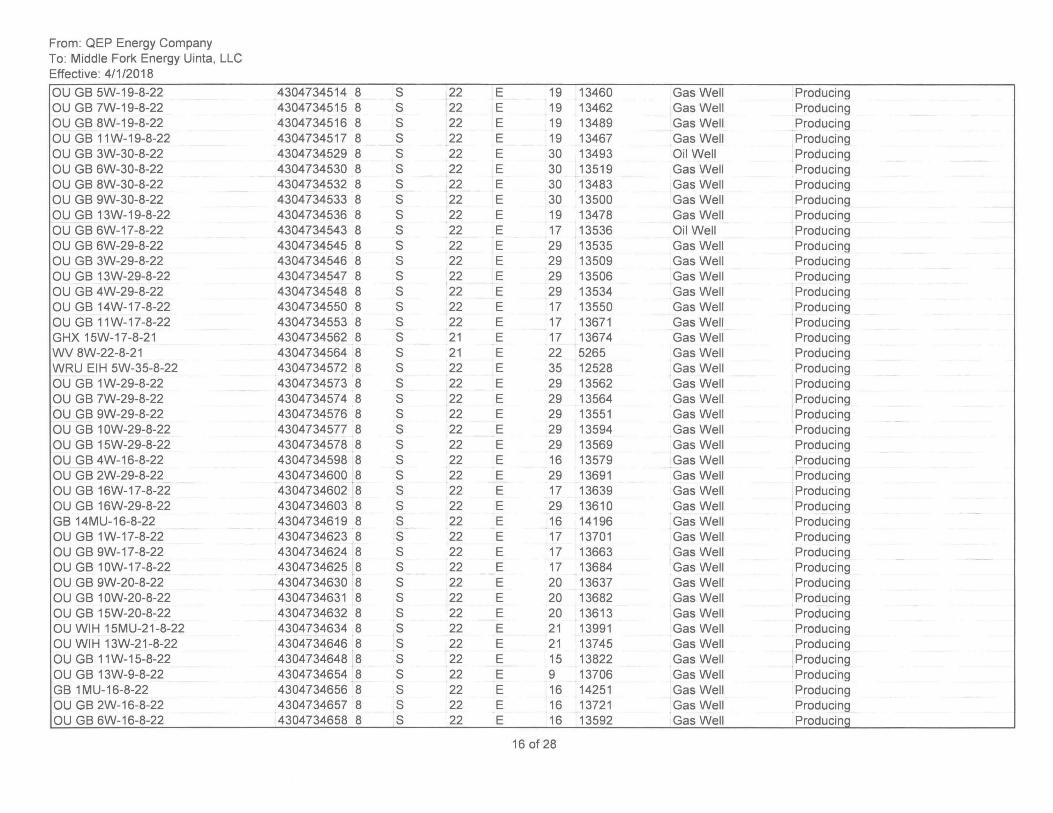
From: QEP Energy Company To: Middle Fork Energy Uinta, LLC Effective: 4/1/2018
OU GB 5W-19-8-22 OU GB 7W-19-8-22 OU GB 8W-19-8-22 OU GB 11 W-19-8-22 OU GB 3W-30-8-22 OU GB 6W-30-8-22 OU GB 8W-30-8-22 OU GB 9W-30-8-22 OU GB 13W-19-8-22 OU GB 6W-17-8-22 OU GB 6W-29-8-22 OU GB 3W-29-8-22 OU GB 13W-29-8-22 OU GB 4W-29-8-22 OU GB 14W-17-8-22 OU GB 11W-17-8-22 GHX 15W-17-8-21 WV 8W-22-8-21 WRU EIH 5W-35-8-22 OU GB 1 W-29-8-22 OU GB 7W-29-8-22 OU GB 9W-29-8-22 OU GB 10W-29-8-22 OU GB 15W-29-8-22 OU GB 4W-16-8-22 OU GB 2W-29-8-22 OU GB 16W-17-8-22 OU GB 16W-29-8-22 GB 14MU-16-8-22 OU GB 1W-17-8-22 OU GB 9W-17-8-22 OU GB 10W-17-8-22 OU GB 9W-20-8-22 OU GB 10W-20-8-22 OU GB 15W-20-8-22 OU WIH 15MU-21-8-22 OU WIH 13W-21-8-22 OU GB 11W-15-8-22 OU GB 13W-9-8-22 GB 1 MU-16-8-22 OU GB 2W-16-8-22 OU GB 6W-16-8-22
4304734514 8 S 4304734515 8 S 4304734516 8 S 4304734517 8 S 4304734529 8 S 4304734530 8 S 4304734532 8 S 4304734533 8 S 4304734536 8 S 4304734543 8 S 4304734545 8 S 4304734546 8 S 4304734547 8 S 4304734548 8 S 4304734550 8 S 4304734553 8 S 4304734562 8 S 4304734564 8 S 4304734572 8 S 4304734573 8 S 4304734574 8 S 4304734576 8 S 4304734577 8 S 4304734578 8 S 4304734598 8 S 4304734600 8 S 4304734602 8 S 4304734603 8 S 4304734619 8 S 4304734623 8 S 4304734624 8 S 4304734625 8 S 4304734630 8 S 4304734631 8 S 4304734632 8 S 4304734634 8 S 4304734646 8 S 4304734648 8 S 4304734654 8 S 4304734656 8 S 4304734657 8 S 4304734658 8 S
22 E 19 13460 Gas Well Producing 22 E 19 13462 Gas Well Producing 22 E 19 13489 Gas Well Producing 22 E 19 13467 Gas Well Producing 22 E 30 13493 Oil Well Producing 22 E 30 13519 Gas Well Producing 22 E 30 13483 Gas Well Producing 22 E 30 13500 Gas Well Producing 22 E 19 13478 Gas Well Producing 22 E 17 13536 Oil Well Producing 22 E 29 13535 Gas Well Producing 22 E 29 13509 Gas Well Producing 22 E 29 13506 Gas Well Producing 22 E 29 13534 Gas Well Producing 22 E 17 13550 Gas Well Producing 22 E 17 13671 Gas Well Producing 21 E 17 13674 Gas Well Producing 21 E 22 5265 Gas Well Producing 22 E 35 12528 Gas Well Producing 22 E 29 13562 Gas Well Producing 22 E 29 13564 Gas Well Producing 22 E 29 13551 Gas Well Producing 22 E 29 13594 Gas Well Producing 22 E 29 13569 Gas Well Producing 22 E 16 13579 Gas Well Producing 22 E 29 13691 Gas Well Producing 22 E 17 13639 Gas Well Producing 22 E 29 13610 Gas Well Producing 22 E 16 14196 Gas Well Producing 22 E 17 13701 Gas Well Producing 22 E 17 13663 Gas Well Producing 22 E 17 13684 Gas Well Producing 22 E 20 13637 Gas Well Producing 22 E 20 13682 Gas Well Producing 22 E 20 13613 Gas Well Producing 22 E 21 13991 Gas Well Producing 22 E 21 13745 Gas Well Producing 22 E 15 13822 Gas Well Producing 22 E 9 13706 Gas Well Producing 22 E 16 14251 Gas Well Producing 22 E 16 13721 Gas Well Producing 22 E 16 13592 Gas Well Producing
16 of 28
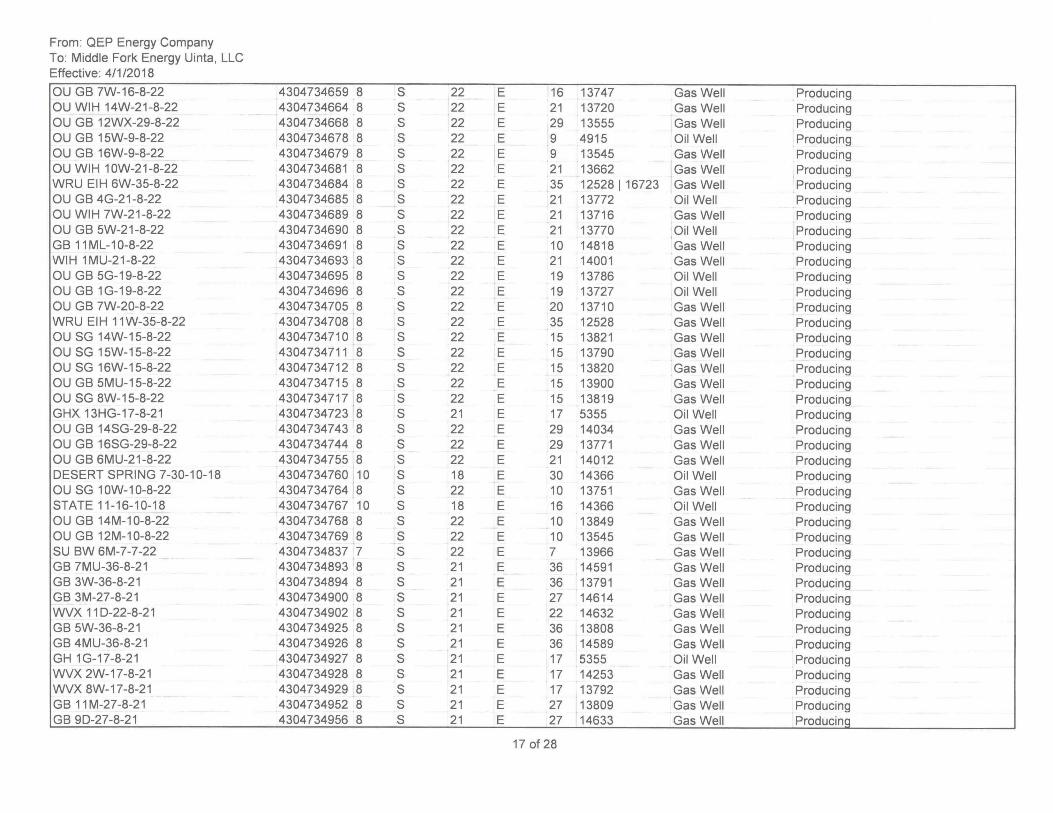
From: QEP Energy Company To: Middle Fork Energy Uinta, LLC Effective: 4/1/2018
au GB 7W-16-8-22 au WIH 14W-21-8-22 au GB 12WX-29-8-22 au GB 15W-9-8-22 au GB 16W-9-8-22 au WIH 10W-21-8-22 WRU EIH 6W-35-8-22 au GB 4G-21-8-22 au WIH 7W-21-8-22 au GB 5W-21-8-22 GB 11ML-10-8-22 WIH 1MU-21-8-22 au GB 5G-19-8-22 au GB 1 G-19-8-22 au GB 7W-20-8-22 WRU EIH 11W-35-8-22 au SG 14W-15-8-22 au SG 15W-15-8-22 au SG 16W-15-8-22 au GB 5MU-15-8-22 au SG 8W-15-8-22 GHX 13HG-17-8-21 au GB 14SG-29-8-22 au GB 16SG-29-8-22 au GB 6MU-21-8-22 DESERT SPRING 7-30-10-18 au SG 10W-10-8-22 STATE 11-16-1 0-18 au GB 14M-10-8-22 au GB 12M-10-8-22 SU BW 6M-7-7-22 GB 7MU-36-8-21 GB 3W-36-8-21 GB 3M-27-8-21 WVX 110-22-8-21 GB 5W-36-8-21 GB 4MU-36-8-21 GH 1G-17-8-21 WVX 2W-17-8-21 WVX 8W-17-8-21 GB 11M-27-8-21 GB 90-27-8-21
4304734659 8 S 22 4304734664 8 S 22 4304734668 8 S 22 4304734678 8 S 22 4304734679 8 S 22 4304734681 8 S 22 4304734684 8 S 22 4304734685 8 S 22 4304734689 8 S 22 4304734690 8 S 22 4304734691 8 S 22 4304734693 8 S 22 4304734695 8 S 22 4304734696 8 S 22 4304734705 8 S 22 4304734708 8 S 22 4304734710 8 S 22 4304734711 8 S 22 4304734712 8 S 22 4304734715 8 S 22 4304734717 8 S 22 4304734723 8 S 21 4304734743 8 S 22 4304734744 8 S 22 4304734755 8 S 22 4304734760 10 S 18 4304734764 8 S 22 4304734767 10 S 18 4304734768 8 S 22 4304734769 8 S 22 4304734837 7 S 22 4304734893 8 S 21 4304734894 8 S 21 4304734900 8 S 21 4304734902 8 S 21 4304734925 8 S 21 4304734926 8 S 21 4304734927 8 S 21 4304734928 8 S 21 4304734929 8 S 21 4304734952 8 S 21 4304734956 8 S 21
E 16 13747 Gas Well Producing E 21 13720 Gas Well Producing E 29 13555 Gas Well Producing E 9 4915 ail Well Producing E 9 13545 Gas Well Producing E 21 13662 Gas Well Producing E 35 12528 I 16723 Gas Well Producing E 21 13772 ail Well Producing E 21 13716 Gas Well Producing E 21 13770 ail Well Producing E 10 14818 Gas Well Producing E 21 14001 Gas Well Producing E 19 13786 ail Well Producing E 19 13727 ail Well Producing E 20 13710 Gas Well Producing E 35 12528 Gas Well Producing E 15 13821 Gas Well Producing E 15 13790 Gas Well Producing E 15 13820 Gas Well Producing E 15 13900 Gas Well Producing E 15 13819 Gas Well Producing E 17 5355 ail Well Producing E 29 14034 Gas Well Producing E 29 13771 Gas Well Producing E 21 14012 Gas Well Producing E 30 14366 ail Well Producing E 10 13751 Gas Well Producing E 16 14366 ail Well Producing E 10 13849 Gas Well Producing E 10 13545 Gas Well Producing E 7 13966 Gas Well Producing E 36 14591 Gas Well Producing E 36 13791 Gas Well Producing E 27 14614 Gas Well Producing E 22 14632 Gas Well Producing E 36 13808 Gas Well Producing E 36 14589 Gas Well Producing E 17 5355 ail Well Producing E 17 14253 Gas Well Producing E 17 13792 Gas Well Producing E 27 13809 Gas Well Producing E 27 14633 Gas Well Producina
17 of 28
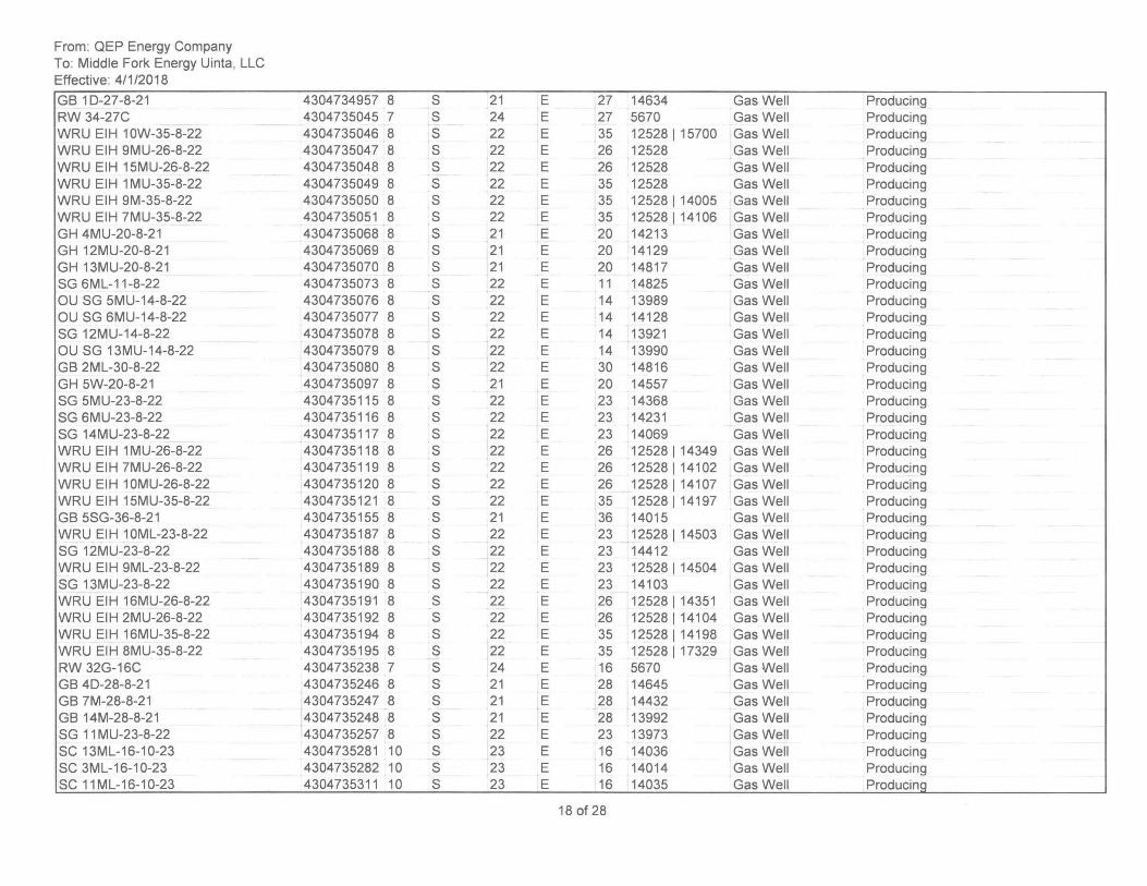
From: QEP Energy Company To: Middle Fork Energy Uinta, LLC Effective: 4/1/2018
GB 10-27-8-21 RW 34-27C WRU EIH 10W-35-8-22 WRU EIH 9MU-26-8-22 WRU EIH 15MU-26-8-22 WRU EIH 1 MU-35-8-22 WRU EIH 9M-35-8-22 WRU EIH 7MU-35-8-22 GH 4MU-20-8-21 GH 12MU-20-8-21 GH 13MU-20-8-21 SG 6ML-11-8-22 au SG 5MU-14-8-22 au SG 6MU-14-8-22 SG 12MU-14-8-22 au SG 13MU-14-8-22 GB 2ML-30-8-22 GH 5W-20-8-21 SG 5MU-23-8-22 SG 6MU-23-8-22 SG 14MU-23-8-22 WRU EIH 1 MU-26-8-22 WRU EIH 7MU-26-8-22 WRU EIH 10MU-26-8-22 WRU EIH 15MU-35-8-22 GB 5SG-36-8-21 WRU EIH 10ML-23-8-22 SG 12MU-23-8-22 WRU EIH 9ML-23-8-22 SG 13MU-23-8-22 WRU EIH 16MU-26-8-22 WRU EIH 2MU-26-8-22 WRU EIH 16MU-35-8-22 WRU EIH 8MU-35-8-22 RW 32G-16C GB 40-28-8-21 GB 7M-28-8-21 GB 14M-28-8-21 SG 11 MU-23-8-22 SC 13ML-16-10-23 SC 3ML-16-10-23 SC 11ML-16-10-23
4304734957 8 4304735045 7 4304735046 8 4304735047 8 4304735048 8 4304735049 8 4304735050 8 4304735051 8 4304735068 8 4304735069 8 4304735070 8 4304735073 8 4304735076 8 4304735077 8 4304735078 8 4304735079 8 4304735080 8 4304735097 8 4304735115 8 4304735116 8 4304735117 8 4304735118 8 4304735119 8 4304735120 8 4304735121 8 4304735155 8 4304735187 8 4304735188 8 4304735189 8 4304735190 8 4304735191 8 4304735192 8 4304735194 8 4304735195 8 4304735238 7 4304735246 8 4304735247 8 4304735248 8 4304735257 8 4304735281 10 4304735282 10 4304735311 10
S 21 E 27 14634 Gas Well Producing S 24 E 27 5670 Gas Well Producing S 22 E 35 12528 1 15700 Gas Well Producing S 22 E 26 12528 Gas Well Producing S 22 E 26 12528 Gas Well Producing S 22 E 35 12528 Gas Well Producing S 22 E 35 12528 1 14005 Gas Well Producing S 22 E 35 12528114106 Gas Well Producing S 21 E 20 14213 Gas Well Producing S 21 E 20 14129 Gas Well Producing S 21 E 20 14817 Gas Well Producing S 22 E 11 14825 Gas Well Producing S 22 E 14 13989 Gas Well Producing S 22 E 14 14128 Gas Well Producing S 22 E 14 13921 Gas Well Producing S 22 E 14 13990 Gas Well Producing S 22 E 30 14816 Gas Well Producing S 21 E 20 14557 Gas Well Producing S 22 E 23 14368 Gas Well Producing S 22 E 23 14231 Gas Well Producing S 22 E 23 14069 Gas Well Producing S 22 E 26 12528114349 Gas Well Producing S 22 E 26 12528114102 Gas Well Producing S 22 E 26 12528114107 Gas Well Producing S 22 E 35 12528 114197 Gas Well Producing S 21 E 36 14015 Gas Well Producing S 22 E 23 12528114503 Gas Well Producing S 22 E 23 14412 Gas Well Producing S 22 E 23 12528 1 14504 Gas Well Producing S 22 E 23 14103 Gas Well Producing S 22 E 26 125281 14351 Gas Well Producing S 22 E 26 12528114104 Gas Well Producing S 22 E 35 12528114198 Gas Well Producing S 22 E 35 12528 1 17329 Gas Well Producing S 24 E 16 5670 Gas Well Producing S 21 E 28 14645 Gas Well Producing S 21 E 28 14432 Gas Well Producing S 21 E 28 13992 Gas Well Producing S 22 E 23 13973 Gas Well Producing S 23 E 16 14036 Gas Well Producing S 23 E 16 14014 Gas Well Producing S 23 E 16 14035 Gas Well Producing
18 of 28
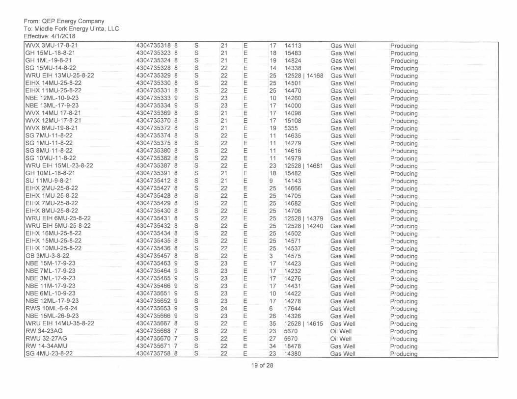
From: QEP Energy Company To: Middle Fork Energy Uinta, LLC Effective: 4/1/2018
WVX 3MU-17 -8-21 GH 15ML-18-8-21 GH 1 ML-19-8-21 SG 15MU-14-8-22 WRU EIH 13MU-25-8-22 EIHX 14MU-25-8-22 EIHX 11 MU-25-8-22 NBE 12ML-10-9-23 NBE 13ML-17-9-23 WVX 14MU 17-8-21 WVX 12MU-17-8-21 WVX 8MU-19-8-21 SG 7MU-11-8-22 SG 1 MU-11-8-22 SG 8MU-11 -8-22 SG 10MU-11-8-22 WRU EIH 15ML-23-8-22 GH 10ML-18-8-21 SU 11 MU-9-8-21 EIHX 2MU-25-8-22 EIHX 1 MU-25-8-22 EIHX 7MU-25-8-22 EIHX 8MU-25-8-22 WRU EIH 6MU-25-8-22 WRU EIH 5MU-25-8-22 EIHX 16MU-25-8-22 EIHX 15MU-25-8-22 EIHX 10MU-25-8-22 GB 3MU-3-8-22 NBE 15M-17-9-23 NBE 7ML-17-9-23 NBE 3ML-17-9-23 NBE 11M-17-9-23 NBE 6ML-10-9-23 NBE 12ML-17-9-23 RWS 10ML-6-9-24 NBE 15ML-26-9-23 WRU EIH 14MU-35-8-22 RW 34-23AG RWU 32-27AG RW 14-34AMU SG 4MU-23-8-22
4304735318 8 S 21 4304735323 8 S 21 4304735324 8 S 21 4304735328 8 S 22 4304735329 8 S 22 4304735330 8 S 22 4304735331 8 S 22 4304735333 9 S 23 4304735334 9 S 23 4304735369 8 S 21 4304735370 8 S 21 4304735372 8 S 21 4304735374 8 S 22 4304735375 8 S 22 4304735380 8 S 22 4304735382 8 S 22 4304735387 8 S 22 4304735391 8 S 21 4304735412 8 S 21 4304735427 8 S 22 4304735428 8 S 22 4304735429 8 S 22 4304735430 8 S 22 4304735431 8 S 22 4304735432 8 S 22 4304735434 8 S 22 4304735435 8 S 22 4304735436 8 S 22 4304735457 8 S 22 4304735463 9 S 23 4304735464 9 S 23 4304735465 9 S 23 4304735466 9 S 23 4304735651 9 S 23 4304735652 9 S 23 4304735653 9 S 24 4304735666 9 S 23 4304735667 8 S 22 4304735668 7 S 22 4304735670 7 S 22 4304735671 7 S 22 4304735758 8 S 22
E 17 14113 Gas Well Producing E 18 15483 Gas Well Producing E 19 14824 Gas Well Producing E 14 14338 Gas Well Producing E 25 12528114168 Gas Well Producing E 25 14501 Gas Well Producing E 25 14470 Gas Well Producing E 10 14260 Gas Well Producing E 17 14000 Gas Well Producing E 17 14098 Gas Well Producing E 17 15108 Gas Well Producing E 19 5355 Gas Well Producing E 11 14635 Gas Well Producing E 11 14279 Gas Well Producing E 11 14616 Gas Well Producing E 11 14979 Gas Well Producing E 23 12528114681 Gas Well Producing E 18 15482 Gas Well Producing E 9 14143 Gas Well Producing E 25 14666 Gas Well Producing E 25 14705 Gas Well Producing E 25 14682 Gas Well Producing E 25 14706 Gas Well Producing E 25 12528114379 Gas Well Producing E 25 12528 1 14240 Gas Well Producing E 25 14502 Gas Well Producing E 25 14571 Gas Well Producing E 25 14537 Gas Well Producing E 3 14575 Gas Well Producing E 17 14423 Gas Well Producing E 17 14232 Gas Well Producing E 17 14276 Gas Well Producing E 17 14431 Gas Well Producing E 10 14422 Gas Well Producing E 17 14278 Gas Well Producing E 6 17644 Gas Well Producing E 26 14326 Gas Well Producing E 35 12528114615 Gas Well Producing E 23 5670 Oil Well Producing E 27 5670 Oil Well Producing E 34 18478 Gas Well Producing E 23 14380 Gas Well Producing
19 of 28
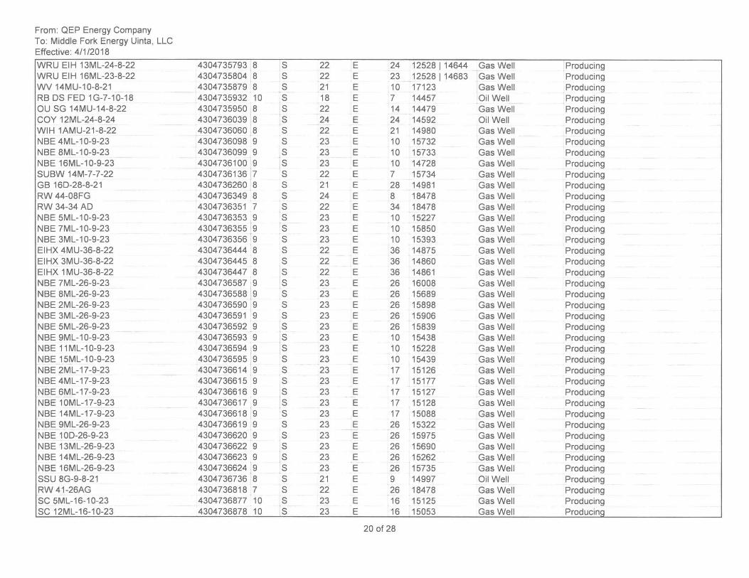
From: QEP Energy Company To: Middle Fork Energy Uinta, LLC Effective: 4/1/2018
WRU EIH 13ML-24-8-22 WRU EIH 16ML-23-8-22 WV 14MU-10-8-21 RB OS FED 1G-7-10-18 OU SG 14MU-14-8-22 COY 12ML-24-8-24 WIH 1AMU-21-8-22 NBE 4ML-10-9-23 NBE 8ML-10-9-23 NBE 16ML-10-9-23 SUBW 14M-7-7-22 GB 160-28-8-21 RW 44-08FG RW 34-34 AD NBE 5ML-1 0-9-23 NBE 7ML-1 0-9-23 NBE 3ML-1 0-9-23 EIHX 4MU-36-8-22 EIHX 3MU-36-8-22 EIHX 1 MU-36-8-22 NBE 7ML-26-9-23 NBE 8ML-26-9-23 NBE 2ML-26-9-23 NBE 3ML-26-9-23 NBE 5ML-26-9-23 NBE 9ML-10-9-23 NBE 11 ML-1 0-9-23 NBE 15ML-10-9-23 NBE 2ML-17-9-23 NBE 4ML-17-9-23 NBE 6ML-17-9-23 NBE 10ML-17-9-23 NBE 14ML-17-9-23 NBE 9ML-26-9-23 NBE 100-26-9-23 NBE 13ML-26-9-23 NBE 14ML-26-9-23 NBE 16ML-26-9-23 SSU 8G-9-8-21 RW 41-26AG SC 5ML-16-10-23 SC 12ML-16-10-23
4304735793 8 S 4304735804 8 S 4304735879 8 S 4304735932 10 S 4304735950 8 S 4304736039 8 S 4304736060 8 S 4304736098 9 S 4304736099 9 S 4304736100 9 S 4304736136 7 S 4304736260 8 S 4304736349 8 S 4304736351 7 S 4304736353 9 S 4304736355 9 S 4304736356 9 S 4304736444 8 S 4304736445 8 S 4304736447 8 S 4304736587 9 S 4304736588 9 S 4304736590 9 S 4304736591 9 S 4304736592 9 S 4304736593 9 S 4304736594 9 S 4304736595 9 S 4304736614 9 S 4304736615 9 S 4304736616 9 S 4304736617 9 S 4304736618 9 S 4304736619 9 S 4304736620 9 S 4304736622 9 S 4304736623 9 S 4304736624 9 S 4304736736 8 S 4304736818 7 S 4304736877 10 S 4304736878 10 S
22 E 24 12528114644 Gas Well Producing 22 E 23 12528 1 14683 Gas Well Producing 21 E 10 17123 Gas Well Producing 18 E 7 14457 Oil Well Producing 22 E 14 14479 Gas Well Producing 24 E 24 14592 Oil Well Producing 22 E 21 14980 Gas Well Producing 23 E 10 15732 Gas Well Producing 23 E 10 15733 Gas Well Producing 23 E 10 14728 Gas Well Producing 22 E 7 15734 Gas Well Producing 21 E 28 14981 Gas Well Producing 24 E 8 18478 Gas Well Producing 22 E 34 18478 Gas Well Producing 23 E 10 15227 Gas Well Producing 23 E 10 15850 Gas Well Producing 23 E 10 15393 Gas Well Producing 22 E 36 14875 Gas Well Producing 22 E 36 14860 Gas Well Producing 22 E 36 14861 Gas Well Producing 23 E 26 16008 Gas Well Producing 23 E 26 15689 Gas Well Producing 23 E 26 15898 Gas Well Producing 23 E 26 15906 Gas Well Producing 23 E 26 15839 Gas Well Producing 23 E 10 15438 Gas Well Producing 23 E 10 15228 Gas Well Producing 23 E 10 15439 Gas Well Producing 23 E 17 15126 Gas Well Producing 23 E 17 15177 Gas Well Producing 23 E 17 15127 Gas Well Producing 23 E 17 15128 Gas Well Producing 23 E 17 15088 Gas Well Producing 23 E 26 15322 Gas Well Producing 23 E 26 15975 Gas Well Producing 23 E 26 15690 Gas Well Producing 23 E 26 15262 Gas Well Producing 23 E 26 15735 Gas Well Producing 21 E 9 14997 Oil Well Producing 22 E 26 18478 Gas Well Producing 23 E 16 15125 Gas Well Producing 23 E 16 15053 Gas Well Producing
20 of 28
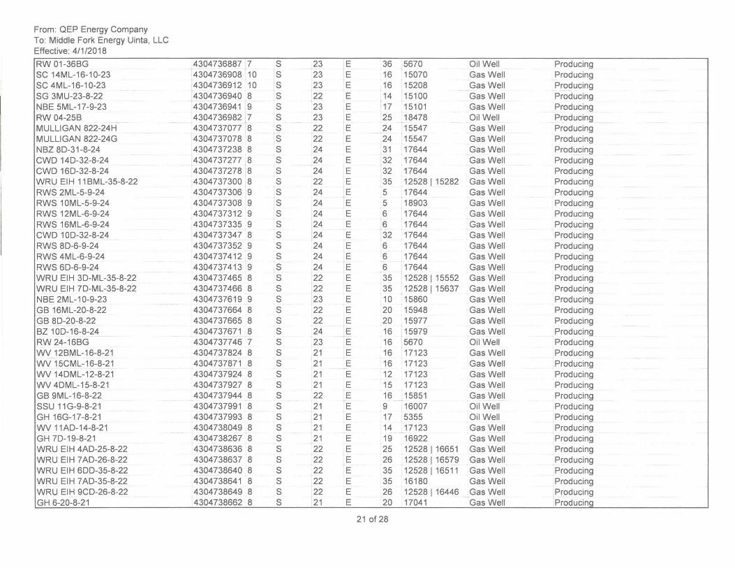
From: QEP Energy Company To: Middle Fork Energy Uinta, LLC Effective: 4/1/2018
RW 01-36BG SC 14ML-16-10-23 SC 4ML-16-10-23 SG 3MU-23-8-22 NBE 5ML-17-9-23 RW 04-25B MULLIGAN 822-24H MULLIGAN 822-24G NBZ 80-31-8-24 CWO 140-32-8-24 CWO 160-32-8-24 WRU EIH 11 BML-35-8-22 RWS 2ML-5-9-24 RWS 10ML-5-9-24 RWS 12ML-6-9-24 RWS 16ML-6-9-24 CWO 100-32-8-24 RWS 80-6-9-24 RWS 4ML-6-9-24 RWS 60-6-9-24 WRU EIH 30-ML-35-8-22 WRU EIH 70-ML-35-8-22 NBE 2ML-10-9-23 GB 16ML-20-8-22 GB 80-20-8-22 BZ 100-16-8-24 RW 24-16BG WV 12BML-16-8-21 WV 15CML-16-8-21 WV 140ML-12-8-21 WV 40ML-15-8-21 GB 9ML-16-8-22 SSU 11 G-9-8-21 GH 16G-17-8-21 WV 11AO-14-8-21 GH 70-19-8-21 WRU EIH 4AO-25-8-22 WRU EIH 7AO-26-8-22 WRU EIH 600-35-8-22 WRU EIH 7 AO-35-8-22 WRU EIH 9CO-26-8-22 GH 6-20-8-21
4304736887 7 4304736908 10 4304736912 10 4304736940 8 4304736941 9 4304736982 7 4304737077 8 4304737078 8 4304737238 8 4304737277 8 4304737278 8 4304737300 8 4304737306 9 4304737308 9 4304737312 9 4304737335 9 4304737347 8 4304737352 9 4304737412 9 4304737413 9 4304737465 8 4304737466 '8 4304737619 9 4304737664 8 4304737665 8 4304737671 8 4304737746 7 4304737824 8 4304737871 8 4304737924 8 4304737927 8 4304737944 8 4304737991 8 4304737993 8 4304738049 8 4304738267 8 4304738636 8 4304738637 8 4304738640 8 4304738641 8 4304738649 8 4304738662 8
S 23 E 36 5670 Oil Well Producing S 23 E 16 15070 Gas Well Producing S 23 E 16 15208 Gas Well Producing S 22 E 14 15100 Gas Well Producing S 23 E 17 15101 Gas Well Producing S 23 E 25 18478 Oil Well Producing S 22 E 24 15547 Gas Well Producing S 22 E 24 15547 Gas Well Producing S 24 E 31 17644 Gas Well Producing S 24 E 32 17644 Gas Well Producing S 24 E 32 17644 Gas Well Producing S 22 E 35 12528 1 15282 Gas Well Producing S 24 E 5 17644 Gas Well Producing S 24 E 5 18903 Gas Well Producing S 24 E 6 17644 Gas Well Producing S 24 E 6 17644 Gas Well Producing S 24 E 32 17644 Gas Well Producing S 24 E 6 17644 Gas Well Producing S 24 E 6 17644 Gas Well Producing S 24 E 6 17644 Gas Well Producing S 22 E 35 12528 1 15552 Gas Well Producing S 22 E 35 12528 1 15637 Gas Well Producing S 23 E 10 15860 Gas Well Producing S 22 E 20 15948 Gas Well Producing S 22 E 20 15977 Gas Well Producing S 24 E 16 15979 Gas Well Producing S 23 E 16 5670 Oil Well Producing S 21 E 16 17123 Gas Well Producing S 21 E 16 17123 Gas Well Producing S 21 E 12 17123 Gas Well Producing S 21 E 15 17123 Gas Well Producing S 22 E 16 15851 Gas Well Producing S 21 E 9 16007 Oil Well Producing S 21 E 17 5355 Oil Well Producing S 21 E 14 17123 Gas Well Producing S 21 E 19 16922 Gas Well Producing S 22 E 25 12528116651 Gas Well Producing S 22 E 26 12528 1 16579 Gas Well Producing S 22 E 35 12528116511 Gas Well Producing S 22 E 35 16180 Gas Well Producing S 22 E 26 12528 1 16446 Gas Well Producing S 21 E 20 17041 Gas Well Producing
21 of 28
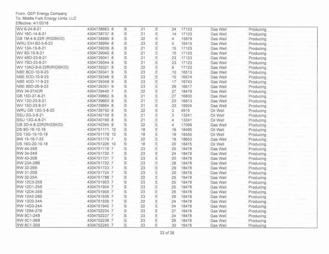
From: QEP Energy Company To: Middle Fork Energy Uinta, LLC Effective: 4/1/2018
WV 6-24-8-21 WV 16C-14-8-21 GB 1 M-4-8-22R (RIGSKIO) WRU EIH 60-5-8-23 WV 13A-15-8-21 WV 80-15-8-21 WV 4BO-23-8-21 WV 7BO-23-8-21 WV 13AO-8-8-22R(RIGSKIO) NBE 8CO-10-9-23 NBE 500-10-9-23 NBE 400-17-9-23 NBE 8BO-26-9-23 RW 34-27AOR GB 150-27-8-21 WV 130-23-8-21 WV 150-23-8-21 WRU GB 13G-3-8-22 SSU 2G-3-8-21 SSU 13G-4-8-21 GB 30-4-8-22R(RIGSKIO) OS 9G-16-10-18 OS 13G-19-10-18 BW 15-18-7-22 OS 16G-20-10-18 RW 44-25B RW 34-24B RW 43-20B RW 23A-28B RW 32-29B RW 31-20B RW 32-25A RW 12C3-25B RW 1201-25B RW 1204-25B RW 12A2-28B RW 1302-24A RW 1403-24A RW 12B4-27B RW 9C1-24B RW 9C1-26B RW 8C1-30B
4304738663 8 S 4304738737 8 S 4304738990 8 S 4304738994 8 S 4304739039 8 S 4304739040 8 S 4304739041 8 S 4304739044 8 S 4304739321 8 S 4304739341 9 S 4304739346 9 S 4304739348 9 S 4304739351 9 S 4304739445 7 S 4304739662 8 S 4304739663 8 S 4304739664 8 S 4304739792 8 S 4304740159 8 S 4304740199 8 S 4304740345 8 S 4304751171 10 S 4304751178 10 S 4304751179 7 S 4304751226 10 S 4304751719 7 S 4304751720 7 S 4304751721 7 S 4304751722 7 S 4304751723 7 S 4304751724 7 S 4304751788 7 S 4304751903 7 S 4304751904 7 S 4304751905 7 S 4304751938 7 S 4304751939 7 S 4304751940 7 S 4304752234 7 S 4304752237 7 S 4304752238 7 S 4304752240 7 S
21 E 24 17123 Gas Well Producing 21 E 14 17123 Gas Well Producing 22 E 4 15879 Gas Well Producing 23 E 5 16415 Gas Well Producing 21 E 15 17123 Gas Well Producing 21 E 15 17123 Gas Well Producing 21 E 23 17123 Gas Well Producing 21 E 23 17123 Gas Well Producing 22 E 8 17123 Gas Well Producing 23 E 10 16513 Gas Well Producing 23 E 10 16574 Gas Well Producing 23 E 17 16743 Gas Well Producing 23 E 26 16617 Gas Well Producing 22 E 27 18478 Gas Well Producing 21 E 27 16830 Gas Well Producing 21 E 23 16813 Gas Well Producing 21 E 23 16924 Gas Well Producing 22 E 3 4915 Oil Well Producing 21 E 3 13241 Oil Well Producing 21 E 4 13241 Oil Well Producing 22 E 4 17099 Gas Well . Producing 18 E 16 18495 Oil Well Producing 18 E 19 18555 Oil Well Producing 22 E 18 18653 Gas Well Producing 18 E 20 18475 Oil Well Producing 23 E 25 18478 Gas Well . Producing 23 E 24 18478 Gas Well Producing 23 E 20 18478 Gas Well Producing 23 E 28 18478 Gas Well Producing 23 E 29 18478 Gas Well Producing 23 E 20 18478 Gas Well Producing 22 E 25 18478 Gas Well Producing 23 E 25 18478 Gas Well Producing 23 E 25 18478 Gas Well Producing 23 E 25 18478 Gas Well Producing 23 E 28 18478 Gas Well Producing 22 E 24 18478 Gas Well Producing 22 E 24 18478 Gas Well Producing 23 E 27 18478 Gas Well Producing 23 E 24 18478 Gas Well Producing 23 E 26 18478 Gas Well Producing 23 E 30 18478 Gas Well Producinq
22 of 28
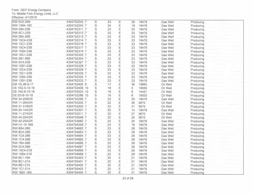
From: QEP Energy Company To: Middle Fork Energy Uinta, LLC Effective: 4/1/2018
RW 502-26B RW 13B4-18C RW 5B4-23B RW 5C1-23B RW 2B4-26B RW 15C4-23B RW 15C1-23B RW 10C4-23B RW 15B4-23B RW 10C1-23B RW 2B1-26B RW 5C4-23B RW 12B1-23B RW 12C4-23B RW 12C1-23B RW 12B4-23B RW 13B1-23B EM 1G-36-9-17 OS 15G-5-10-18 OS 14G-6-10-18 OS 2G-6-10-18 RW 34-20BGR RW 11-26AGR RW 31 -31BGR RW 24-14AGR RW 11-27AGR RW 44-25AGR RW 42-25AGR RW H1-14-16B RW 8B4-28B RW 8C4-28B RW 7C4-28B RW 1C4-28B RW 7B4-28B RW 2C4-28B RW 15C4-21B RW 15B4-21B RW 9C1 -16A RW 8C1-21A RW 8B1-21A RW 1C1-21A RW 16B1-16A
4304752242 7 S 23 4304752243 7 S 24 4304752311 7 S 23 4304752312 7 S 23 4304752313 7 S 23 4304752314 7 S 23 4304752316 7 S 23 4304752317 7 S 23 4304752319 7 S 23 4304752320 7 S 23 4304752324 7 S 23 4304752327 7 S 23 4304752328 7 S 23 4304752329 7 S 23 4304752330 7 S 23 4304752332 7 S 23 4304752333 7 S 23 4304752400 9 S 17 4304752406 10 S 18 4304753023 10 S 18 4304753286 10 S 18 4304753299 7 S 23 4304753302 7 S 22 4304753305 7 S 23 4304753307 7 S 22 4304753311 7 S 22 4304753648 7 S 22 4304753682 7 S 22 4304754358 7 S 23 4304754662 7 S 23 4304754663 7 S 23 4304754664 7 S 23 4304754665 7 S 23 4304754666 7 S 23 4304754667 7 S 23 4304754668 7 S 23 4304754669 7 S 23 4304755303 7 S 22 4304755401 7 S 22 4304755402 7 S 22 4304755403 7 S 22 4304755404 7 S 22
E 26 18478 Gas Well Producing E 18 18478 Gas Well Producing E 23 18478 Gas Well Producing E 23 18478 Gas Well Producing E 23 18478 Gas Well Producing E 23 18478 Gas Well Producing E 23 18478 Gas Well Producing E 23 18478 Gas Well Producing E 23 18478 Gas Well Producing E 23 18478 Gas Well Producing E 23 18478 Gas Well Producing E 23 18478 Gas Well Producing E 23 18478 Gas Well Producing E 23 18478 Gas Well Producing E 23 18478 Gas Well Producing E 23 18478 Gas Well Producing E 23 18478 Gas Well Producing E 36 18860 Oil Well Producing E 5 18959 Oil Well Producing E 6 14457 Oil Well Producing E 6 19002 Oil Well Producing E 20 18478 Gas Well Producing E 26 5670 Oil Well Producing E 31 5670 Oil Well Producing E 14 18478 Gas Well Producing E 27 5670 Oil Well Producing E 25 5670 Oil Well ,Producing E 25 18478 Gas Well Producing E 16 18478 Gas Well Producing E 28 18478 Gas Well Producing E 28 18478 Gas Well Producing E 28 18478 Gas Well Producing E 28 18478 Gas Well Producing E 28 18478 Gas Well Producing E 28 18478 Gas Well Producing E 28 18478 Gas Well Producing E 28 18478 Gas Well Producing E 21 18478 Gas Well Producing E 21 18478 Gas Well Producing E 21 18478 Gas Well Producing E 21 18478 Gas Well Producing E 21 18478 Gas Well ProducinQ
23 of 28
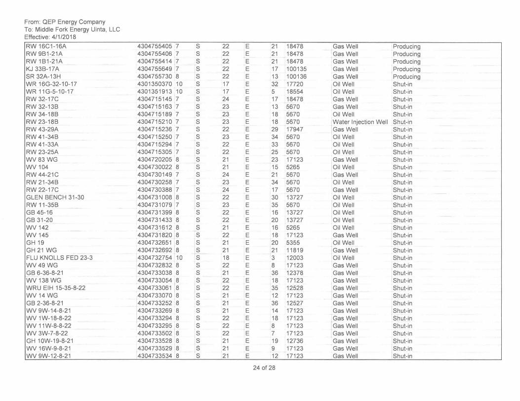
From: QEP Energy Company To: Middle Fork Energy Uinta, LLC Effective: 4/1/2018
RW 16C1-16A RW 9B1-21A RW 1B1-21A KJ 33B-17A SR 32A-13H WR 16G-32-10-17 WR 11 G-5-1 0-17 RW 32-17C RW 32-13B RW 34-18B RW 23-18B RW 43-29A RW 41-34B RW 41-33A RW 23-25A WV83WG WV 104 RW 44-21C RW 21-34B RW 22-17C GLEN BENCH 31-30 RW 11-35B GB 45-16 GB 31-20 WV 142 WV 145 GH19 GH 21 WG FLU KNOLLS FED 23-3 WV49WG GB 6-36-8-21 WV 138 WG WRU EIH 15-35-8-22 WV 14 WG GB 2-36-8-21 WV 9W-14-8-21 WV 1 W-18-8-22 WV 11 W-8-8-22 WV 3W-7-8-22 GH 10W-19-8-21 WV 16W-9-8-21 WV 9W-12-8-21
4304755405 7 4304755406 7 4304755414 7 4304755649 7 4304755730 8 4301350370 10 4301351913 10 4304715145 7 4304715163 7 4304715189 7 4304715210 7 4304715236 7 4304715250 7 4304715294 7 4304715305 7 4304720205 8 4304730022 8 4304730149 7 4304730258 7 4304730388 7 4304731008 8 4304731079 7 4304731399 8 4304731433 8 4304731612 8 4304731820 8 4304732651 8 4304732692 8 4304732754 10 4304732832 8 4304733038 8 4304733054 8 4304733061 8 4304733070 8 4304733252 8 4304733269 8 4304733294 8 4304733295 8 4304733502 8 4304733528 8 4304733529 8 4304733534 8
S 22 E 21 18478 Gas Well Producing S 22 E 21 18478 Gas Well Producing S 22 E 21 18478 Gas Well Producing S 22 E 17 100135 Gas Well Producing S 22 E 13 100136 Gas Well Producing S 17 E 32 17720 Oil Well Shut-in S 17 E 5 18554 Oil Well Shut-in S 24 E 17 18478 Gas Well Shut-in S 23 E 13 5670 Gas Well Shut-in S 23 E 18 5670 Oil Well Shut-in S 23 E 18 5670 Water Injection Well Shut-in S 22 E 29 17947 Gas Well Shut-in S 23 E 34 5670 Oil Well Shut-in S 22 E 33 5670 Oil Well Shut-in S 22 E 25 5670 Oil Well Shut-in S 21 E 23 17123 Gas Well Shut-in S 21 E 15 5265 Oil Well Shut-in S 24 E 21 5670 Gas Well Shut-in S 23 E 34 5670 Oil Well Shut-in S 24 E 17 5670 Gas Well Shut-in S 22 E 30 13727 Oil Well Shut-in S 23 E 35 5670 Oil Well Shut-in S 22 E 16 13727 Oil Well Shut-in S 22 E 20 13727 Oil Well Shut-in S 21 E 16 5265 Oil Well Shut-in S 22 E 18 17123 Gas Well Shut-in S 21 E 20 5355 Oil Well Shut-in S 21 E 21 11819 Gas Well Shut-in S 18 E 3 12003 Oil Well Shut-in S 22 E 8 17123 Gas Well Shut-in S 21 E 36 12378 Gas Well Shut-in S 22 E 18 17123 Gas Well Shut-in S 22 E 35 12528 Gas Well Shut-in S 21 E 12 17123 Gas Well Shut-in S 21 E 36 12527 Gas Well Shut-in S 21 E 14 17123 Gas Well Shut-in S 22 E 18 17123 Gas Well Shut-in S 22 E 8 17123 Gas Well Shut-in S 22 E 7 17123 Gas Well Shut-in S 21 E 19 12736 Gas Well Shut-in S 21 E 9 17123 Gas Well Shut-in S 21 E 12 17123 Gas Well Shut-in
24 of 28
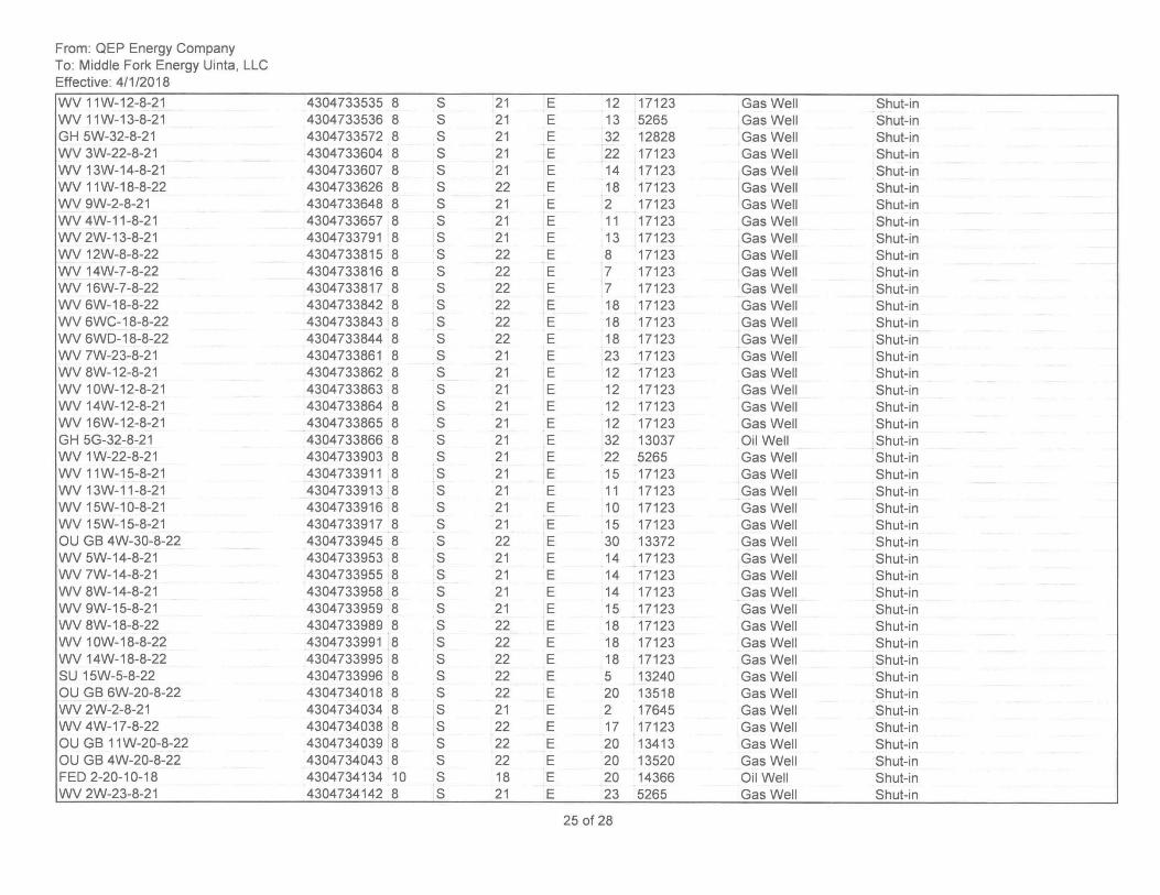
From: QEP Energy Company To: Middle Fork Energy Uinta, LLC Effective: 4/1/2018
WV 11W-12-8-21 WV 11W-13-8-21 GH 5W-32-8-21 WV 3W-22-8-21 WV 13W-14-8-21 WV 11W-18-8-22 WV 9W-2-8-21 WV 4W-11-8-21 WV 2W-13-8-21 WV 12W-8-8-22 WV 14W-7-8-22 WV 16W-7-8-22 WV 6W-18-8-22 WV 6WC-18-8-22 WV 6WD-18-8-22 WV 7W-23-8-21 WV 8W-12-8-21 WV 10W-12-8-21 WV 14W-12-8-21 WV 16W-12-8-21 GH 5G-32-8-21 WV 1W-22-8-21 WV 11W-15-8-21 WV 13W-11-8-21 WV 15W-10-8-21 WV 15W-15-8-21 OU GB 4W-30-8-22 WV 5W-14-8-21 WV 7W-14-8-21 WV 8W-14-8-21 WV 9W-15-8-21 WV 8W-18-8-22 WV 10W-18-8-22 WV 14W-18-8-22 SU 15W-5-8-22 OU GB 6W-20-8-22 WV 2W-2-8-21 WV 4W-17-8-22 OU GB 11 W-20-8-22 OU GB 4W-20-8-22 FED 2-20-10-18 WV 2W-23-8-21
4304733535 8 S 21 4304733536 8 S 21 4304733572 8 S 21 4304733604 8 S 21 4304733607 8 S 21 4304733626 8 S 22 4304733648 8 S 21 4304733657 8 S 21 4304733791 8 S 21 4304733815 8 S 22 4304733816 8 S 22 4304733817 8 S 22 4304733842 8 S 22 4304733843 8 S 22 4304733844 8 S 22 4304733861 8 S 21 4304733862 8 S 21 4304733863 8 S 21 4304733864 8 S 21 4304733865 8 S 21 4304733866 8 S 21 4304733903 8 S 21 4304733911 8 S 21 4304733913 8 S 21 4304733916 8 S 21 4304733917 8 S 21 4304733945 8 S 22 4304733953 8 S 21 4304733955 8 S 21 4304733958 8 S 21 4304733959 8 S 21 4304733989 8 S 22 4304733991 8 S 22 4304733995 8 S 22 4304733996 8 S 22 4304734018 8 S 22 4304734034 8 S 21 4304734038 8 S 22 4304734039 8 S 22 4304734043 8 S 22 4304734134 10 S 18 4304734142 8 S 21
E 12 17123 Gas Well Shut-in E 13 5265 Gas Well Shut-in E 32 12828 Gas Well Shut-in E 22 17123 Gas Well Shut-in E 14 17123 Gas Well Shut-in E 18 17123 Gas Well Shut-in E 2 17123 Gas Well Shut-in E 11 17123 Gas Well Shut-in E 13 17123 Gas Well Shut-in E 8 17123 Gas Well Shut-in E 7 17123 Gas Well Shut-in E 7 17123 Gas Well Shut-in E 18 17123 Gas Well Shut-in E 18 17123 Gas Well Shut-in E 18 17123 Gas Well Shut-in E 23 17123 Gas Well Shut-in E 12 17123 Gas Well Shut-in E 12 17123 Gas Well Shut-in E 12 17123 Gas Well Shut-in E 12 17123 Gas Well Shut-in E 32 13037 Oil Well Shut-in E 22 5265 Gas Well Shut-in E 15 17123 Gas Well Shut-in E 11 17123 Gas Well Shut-in E 10 17123 Gas Well Shut-in E 15 17123 Gas Well Shut-in E 30 13372 Gas Well Shut-in E 14 17123 Gas Well Shut-in E 14 17123 Gas Well Shut-in E 14 17123 Gas Well Shut-in E 15 17123 Gas Well Shut-in E 18 17123 Gas Well Shut-in E 18 17123 Gas Well Shut-in E 18 17123 Gas Well Shut-in E 5 13240 Gas Well Shut-in E 20 13518 Gas Well Shut-in E 2 17645 Gas Well Shut-in E 17 17123 Gas Well Shut-in E 20 13413 Gas Well Shut-in E 20 13520 Gas Well Shut-in E 20 14366 Oil Well Shut-in E 23 5265 Gas Well Shut-in
25 of 28
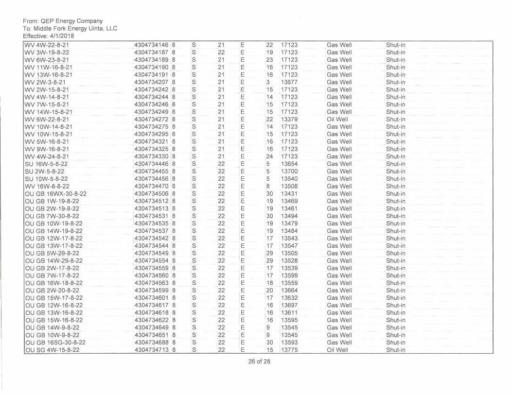
From: QEP Energy Company To: Middle Fork Energy Uinta, LLC Effective: 4/1/2018
WV 4W-22-8-21 WV 3W-19-8-22 WV 6W-23-8-21 WV 11W-16-8-21 WV 13W-16-8-21 WV 2W-3-8-21 WV 2W-15-8-21 WV 4W-14-8-21 WV 7W-15-8-21 WV 14W-15-8-21 WV 6W-22-8-21 WV 10W-14-8-21 WV 10W-15-8-21 WV 5W-16-8-21 WV 9W-16-8-21 WV 4W-24-8-21 SU 16W-5-8-22 SU 2W-5-8-22 SU 10W-5-8-22 WV 16W-8-8-22 au GB 16WX-30-8-22 au GB 1W-19-8-22 au GB 2W-19-8-22 au GB 7W-30-8-22 au GB 10W-19-8-22 au GB 14W-19-8-22 au GB 12W-17-8-22 au GB 13W-17-8-22 au GB 5W-29-8-22 au GB 14W-29-8-22 au GB 2W-17-8-22 au GB 7W-17 -8-22 au GB 16W-18-8-22 au GB 2W-20-8-22 au GB 15W-17-8-22 au GB 12W-16-8-22 au GB 13W-16-8-22 au GB 15W-16-8-22 au GB 14W-9-8-22 au GB 10W-9-8-22 au GB 16SG-30-8-22 au SG 4W-15-8-22
4304734146 8 S 4304734187 8 S 4304734189 8 S 4304734190 8 S 4304734191 8 S 4304734207 8 S 4304734242 8 S 4304734244 8 S 4304734246 8 S 4304734249 8 S 4304734272 8 S 4304734275 8 S 4304734295 8 S 4304734321 8 S 4304734325 8 S 4304734330 8 S 4304734446 8 S 4304734455 8 S 4304734456 8 S 4304734470 8 S 4304734506 8 S 4304734512 8 S 4304734513 8 S 4304734531 8 S 4304734535 8 S 4304734537 8 S 4304734542 8 S 4304734544 8 S 4304734549 8 S 4304734554 8 S 4304734559 8 S 4304734560 8 S 4304734563 8 S 4304734599 8 S 4304734601 8 S 4304734617 8 S 4304734618 8 S 4304734622 8 S 4304734649 8 S 4304734651 8 S 4304734688 8 S 4304734713 8 S
21 E 22 17123 Gas Well Shut-in 22 E 19 17123 Gas Well Shut-in 21 E 23 17123 Gas Well Shut-in 21 E 16 17123 Gas Well Shut-in 21 E 16 17123 Gas Well Shut-in 21 E 3 13677 Gas Well Shut-in 21 E 15 17123 Gas Well Shut-in 21 E 14 17123 Gas Well Shut-in 21 E 15 17123 Gas Well Shut-in 21 E 15 17123 Gas Well Shut-in 21 E 22 13379 ail Well Shut-in 21 E 14 17123 Gas Well Shut-in 21 E 15 17123 Gas Well Shut-in 21 E 16 17123 Gas Well Shut-in 21 E 16 17123 Gas Well Shut-in 21 E 24 17123 Gas Well Shut-in 22 E 5 13654 Gas Well Shut-in 22 E 5 13700 Gas Well Shut-in 22 E 5 13540 Gas Well Shut-in 22 E 8 13508 Gas Well Shut-in 22 E 30 13431 Gas Well Shut-in 22 E 19 13469 Gas Well Shut-in 22 E 19 13461 Gas Well Shut-in 22 E 30 13494 Gas Well Shut-in 22 E 19 13479 Gas Well Shut-in 22 E 19 13484 Gas Well Shut-in 22 E 17 13543 Gas Well Shut-in 22 E 17 13547 Gas Well Shut-in 22 E 29 13505 Gas Well Shut-in 22 E 29 13528 Gas Well Shut-in 22 E 17 13539 Gas Well Shut-in 22 E 17 13599 Gas Well Shut-in 22 E 18 13559 Gas Well Shut-in 22 E 20 13664 Gas Well Shut-in 22 E 17 13632 Gas Well Shut-in 22 E 16 13697 Gas Well Shut-in 22 E 16 13611 Gas Well Shut-in 22 E 16 13595 Gas Well Shut-in 22 E 9 13545 Gas Well Shut-in 22 E 9 13545 Gas Well Shut-in 22 E 30 13593 Gas Well Shut-in 22 E 15 13775 ail Well Shut-in
26 of 28
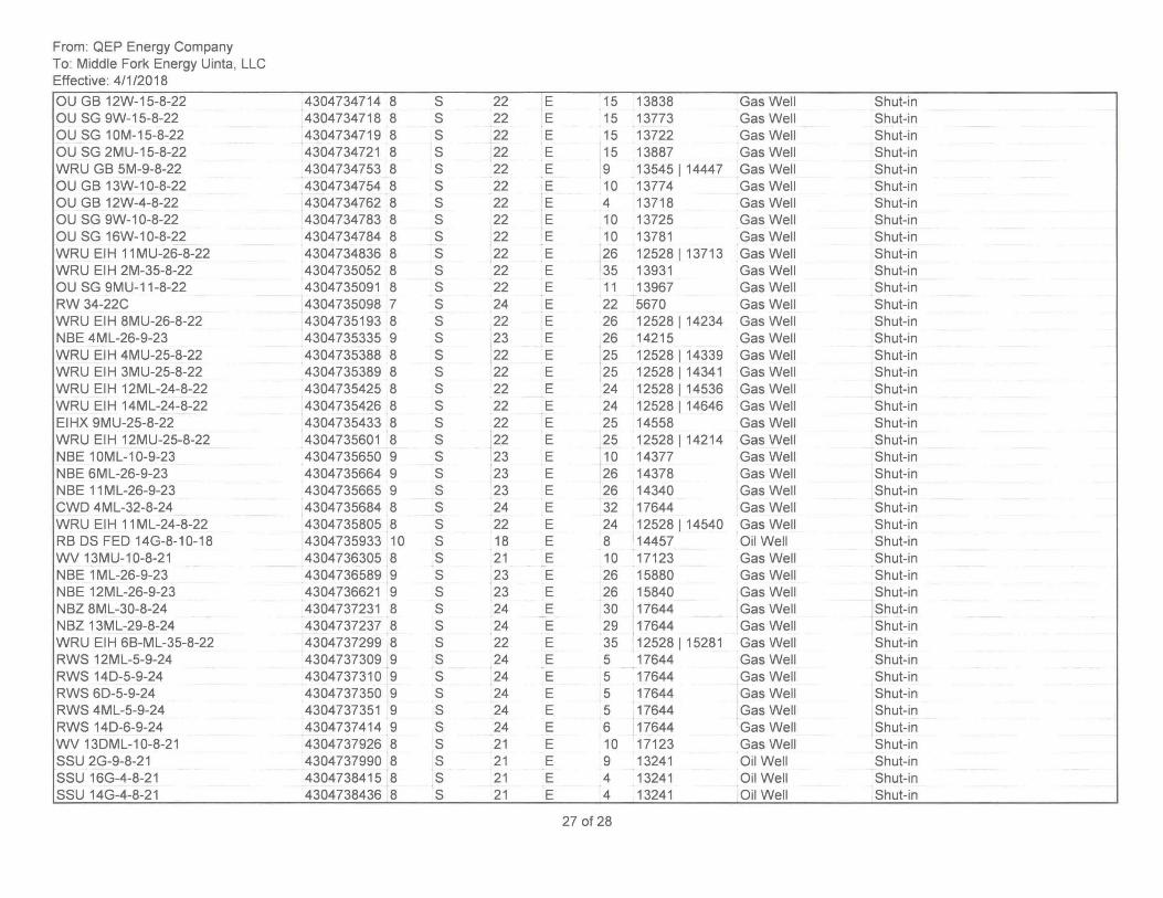
From: QEP Energy Company To: Middle Fork Energy Uinta, LLC Effective: 4/1/2018
OU GB 12W-15-8-22 OU SG 9W-15-8-22 OU SG 10M-15-8-22 OU SG 2MU-15-8-22 WRU GB 5M-9-8-22 OU GB 13W-10-8-22 OU GB 12W-4-8-22 OU SG 9W-10-8-22 OU SG 16W-1 0-8-22 WRU EIH 11 MU-26-8-22 WRU EIH 2M-35-8-22 OU SG 9MU-11-8-22 RW 34-22C WRU EIH 8MU-26-8-22 NBE 4ML-26-9-23 WRU EIH 4MU-25-8-22 WRU EIH 3MU-25-8-22 WRU EIH 12ML-24-8-22 WRU EIH 14ML-24-8-22 EIHX 9MU-25-8-22 WRU EIH 12MU-25-8-22 NBE 10ML-10-9-23 NBE 6ML-26-9-23 NBE 11 ML-26-9-23 CWO 4ML-32-8-24 WRU EIH 11 ML-24-8-22 RB OS FED 14G-8-10-18 WV 13MU-10-8-21 NBE 1 ML-26-9-23 NBE 12ML-26-9-23 NBZ 8ML-30-8-24 NBZ 13ML-29-8-24 WRU EIH 6B-ML-35-8-22 RWS 12ML-5-9-24 RWS 140-5-9-24 RWS 60-5-9-24 RWS 4ML-5-9-24 RWS 140-6-9-24 WV 130ML-10-8-21 SSU 2G-9-8-21 SSU 16G-4-8-21 SSU 14G-4-8-21
4304734714 8 S 4304734718 8 S 4304734719 8 S 4304734721 8 S 4304734753 8 S 4304734754 8 S 4304734762 8 S 4304734783 8 S 4304734784 8 S 4304734836 8 S 4304735052 8 S 4304735091 8 S 4304735098 7 S 4304735193 8 S 4304735335 9 S 4304735388 8 S 4304735389 8 S 4304735425 8 S 4304735426 8 S 4304735433 8 S 4304735601 8 S 4304735650 9 S 4304735664 9 S 4304735665 9 S 4304735684 8 S 4304735805 8 S 4304735933 10 S 4304736305 8 S 4304736589 9 S 4304736621 9 S 4304737231 8 S 4304737237 8 S 4304737299 8 S 4304737309 9 S 4304737310 9 S 4304737350 9 S 4304737351 9 S 4304737414 9 S 4304737926 8 S 4304737990 8 S 4304738415 8 S 4304738436 8 S
22 E 15 13838 Gas Well Shut-in 22 E 15 13773 Gas Well Shut-in 22 E 15 13722 Gas Well Shut-in 22 E 15 13887 Gas Well Shut-in 22 E 9 13545114447 Gas Well Shut-in 22 E 10 13774 Gas Well Shut-in 22 E 4 13718 Gas Well Shut-in 22 E 10 13725 Gas Well Shut-in 22 E 10 13781 Gas Well Shut-in 22 E 26 12528113713 Gas Well Shut-in 22 E 35 13931 Gas Well Shut-in 22 E 11 13967 Gas Well Shut-in 24 E 22 5670 Gas Well Shut-in 22 E 26 12528 1 14234 Gas Well Shut-in 23 E 26 14215 Gas Well Shut-in 22 E 25 12528 1 14339 Gas Well Shut-in 22 E 25 12528114341 Gas Well Shut-in 22 E 24 12528 1 14536 Gas Well Shut-in 22 E 24 12528 1 14646 Gas Well Shut-in 22 E 25 14558 Gas Well Shut-in 22 E 25 12528114214 Gas Well Shut-in 23 E 10 14377 Gas Well Shut-in 23 E 26 14378 Gas Well Shut-in 23 E 26 14340 Gas Well Shut-in 24 E 32 17644 Gas Well Shut-in 22 E 24 12528114540 Gas Well Shut-in 18 E 8 14457 Oil Well Shut-in 21 E 10 17123 Gas Well Shut-in 23 E 26 15880 Gas Well Shut-in 23 E 26 15840 Gas Well Shut-in 24 E 30 17644 Gas Well Shut-in 24 E 29 17644 Gas Well Shut-in 22 E 35 12528115281 Gas Well Shut-in 24 E 5 17644 Gas Well Shut-in 24 E 5 17644 Gas Well Shut-in 24 E 5 17644 Gas Well Shut-in 24 E 5 17644 Gas Well Shut-in 24 E 6 17644 Gas Well Shut-in 21 E 10 17123 Gas Well Shut-in 21 E 9 13241 Oil Well Shut-in 21 E 4 13241 Oil Well Shut-in 21 E 4 13241 Oil Well Shut-in
27 of 28
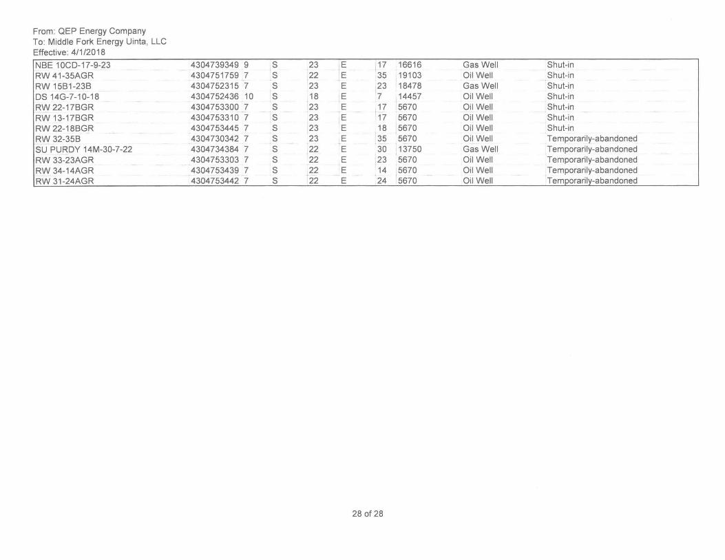
From: QEP Energy Company To: Middle Fork Energy Uinta, LLC Effective: 4/1/2018
NBE 10CD-17-9-23 RW 41-35AGR RW 15B1-23B OS 14G-7-10-18 RW 22-17BGR RW 13-17BGR RW 22-18BGR RW 32-35B SU PURDY 14M-30-7-22 RW 33-23AGR RW 34-14AGR RW 31-24AGR
4304739349 9 S 23 4304751759 7 S 22 4304752315 7 S 23 4304752436 10 S 18 4304753300 7 S 23 4304753310 7 S 23 4304753445 7 S 23 4304730342 7 S 23 4304734384 7 S 22 4304753303 7 S 22 4304753439 7 S 22 4304753442 7 S 22
E 17 16616 Gas Well Shut-in E 35 19103 Oil Well Shut-in E 23 18478 Gas Well Shut-in E 7 14457 Oil Well Shut-in E 17 5670 Oil Well Shut-in E 17 5670 Oil Well Shut-in E 18 5670 Oil Well Shut-in E 35 5670 Oil Well Temporarily-abandoned E 30 13750 Gas Well Temporarily-abandoned E 23 5670 Oil Well Temporarily-abandoned E 14 5670 Oil Well Temporarily-abandoned E 24 5670 Oil Well Temporarily-abandoned
28 of 28
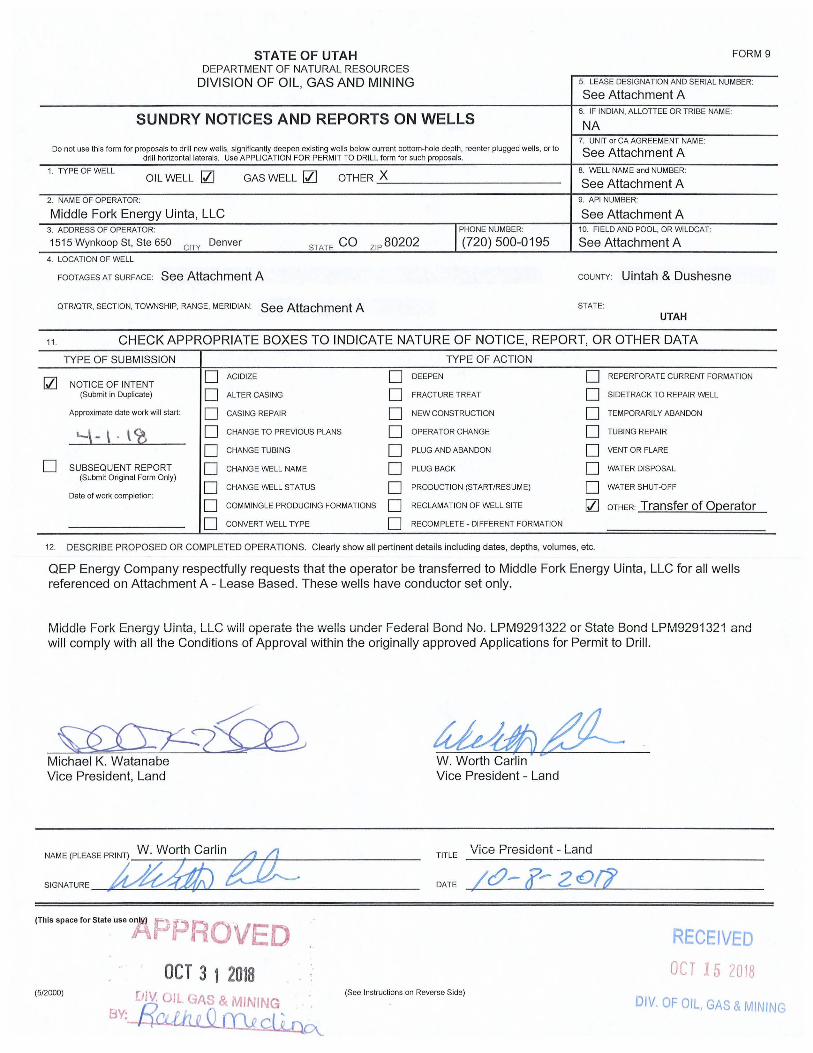
STATE OF UTAH DEPARTMENT OF NATURAL RESOURCES
DIVISION OF OIL, GAS AND MINING
SUNDRY NOTICES AND REPORTS ON WELLS
Do not use this form for proposals to drill new wells, significantly deepen existing wells below current bottom-hole depth, reenter plugged wells, or to drill horizontal laterals. Use APPLI CATI ON FOR PERMIT TO DRILL form for such proposals.
1. TYPE OF WELL OIL WELL IZl GAS WELL IZl OTHER X ------------------------
2. NAME OF OPERATOR:
Middle Fork Energy Uinta, LLC
STATE CO ZIP 80202 I PHONE NUMBER:
(720) 500-0195 3. ADDRESS OF OPERATOR:
1515 Wynkoop St, Ste 650 CITY Denver
4. LOCATION OF WELL
FOOTAGES AT SURFACE: See Attachment A
OTR/OTR, SECTION, TOWNSHIP, RANGE, MERIDIAN: See Attachment A
FORM 9
5. LEASE DESIGNATION AND SERIAL NUMBER:
See Attachment A 6. IF INDIAN, ALLOTTEE OR TRIBE NAME:
NA 7. UNIT or CA AGREEMENT NAME:
See Attachment A 8. WELL NAME and NUMBER:
See Attachment A 9. API NUMBER:
See Attachment A 10. FIELD AND POOL, OR WI LDCAT:
See Attachment A
COUNTY Uintah & Dushesne
STATE:
UTAH
11 . CHECK APPROPRIATE BOXES TO INDICATE NATURE OF NOTICE, REPORT, OR OTHER DATA
TYPE OF SUBM ISSION TYPE OF ACTION
IZl D ACIDIZE D DEEPEN D REPERFORATE CURRENT FORMATION NOTICE OF INTENT
(Submit in Duplicate) D ALTER CASING D FRACTURE TREAT D SIDETRACK TO REPAIR WELL
Approximate date work wi ll start: D CASING REPAIR D NEW CONSTRUCTION D TEMPORARILY ABANDON
'-~- \ . \ <l D CHANGE TO PREVIOUS PLANS D OPERATOR CHANGE D TUBING REPAIR
D CHANGE TUBING D PLUG AND ABANDON D VENT OR FLARE
D SUBSEQUENT REPORT D CHANGE WELL NAME D PLUG BACK D WATER DISPOSAL (Submit Original Form Only)
D D D CHANGE WELL STATUS PRODUCTION (START/RESUME) WATER SHUT-OFF Date of work completion:
D COMMI NGLE PRODUCING FORMATIONS D RECLAMATION OF WELL SITE IZl OTHER: Transfer of O(2erator
D CONVERT WELL TYPE D RECOMPLETE - DIFFERENT FORMATION
12. DESCRIBE PROPOSED OR COMPLETED OPERATIONS. Clearly show all pertinent details including dates, depths, volumes, etc.
QEP Energy Company respectfu lly requests that the operator be transferred to Middle Fork Energy Uinta, LLC for all wells referenced on Attachment A - Lease Based , These wells have conductor set only,
rv1iddle Fork Energy Uinta, LLC 'vvill opeiat6 the '\Ivens under Federal Bond No. LP~v19291322 or State Bond LP~v19291321 and wi ll comply with all the Conditions of Approval within the originally approved Applications for Permit to Dri ll.
~?fu Michael K, Watanabe Vice President, Land
''''I~~''ffi'''1 W. Worth carlin~
SIGNATURE .Q~ (This space for State use °A P F~ R OV ED
OCT 3 1 2018 (5/2000)
Ull!. ulL GA~ & MINING . "
8Y: RCi.Jh e Q (Dg ct~
kWdlvL£ W. Worth Carlin Vice President - Land
TITLE Vice President - Land
DATE
(See Instructions on Reverse Side)
RECEIVED
OCT 15 2018
D/V. OF OIL, GAS & MINING
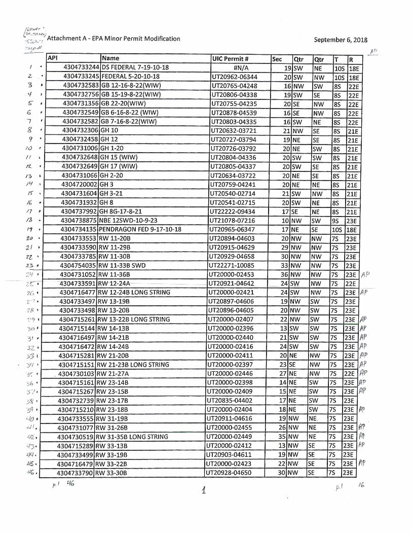
Ii.,O'.A)t r "
L~·(',)r"rl~ .. ".:J.:,).-: Attachment A - EPA Minor Permit Modification
~~'RJI ~
2..
3
!;
6 "7 g
r Iu II
Ie.
I~
/ 4
I~
. . • , , , , I
· , I
• I
· · · /(,
17 /$
11 2.lJ
21 Zl..
,
· •
· • ,
29 • • ze-
7(, •
t
3D '
I
3 1 ,
JZ;:'~ I
3'1 ,
40 • .:..J I .
ilZ .
:..I"j .
114 • 1/5 . l/(, .
API Name
430473324 4 DS FEDERAL 7-19-10-18
430473324 5 FEDERAL 5-20-10-18
430473258 3 GB 12-16-8-22(WIW)
430473275 6 GB 15-19-8-22(WIW)
430473135 6 GB 22-20(WIW)
4304732549 GB 6-16-8-22 (WIW)
4304732582 GB 7-16-8-22{WIW)
4304732306 GH 10
4304732458 GH 12
4304731006 GH 1·20
4304732648 GH 15 (WIW)
4304732649 GH 17 (WIW)
4304731066 GH 2-20
4304720002 GH 3
4304731604 GH 3-21
4304731932 GH 8
4304737992 GH 8G-17-8-21 4304738875 NBE 12SWD-1O-9-23
4304734135 PENDRAGON FED 9-17-10-18
4304733553 RW 11-20B
4304733590 RW 11-29B
4304733785 RW 11-30B
4304754035 RW 11-33B SWD
4304731052 RW 11-36B
il304733591 RW~1-2-24A
4304716477 RW 12-24B LONG STRING
4304733497 RW 13-19B
4304733498 RW 13-20B
4304715261 RW 13-22B LONG STRING
4304715144 RW 14·13B
4304716497 RW 14-21B
4304716472 RW 14-24B
4304715281 RW 21-20B
4304715151 RW 21-23B LONG STRING
. 4304730103 RW21-27A
4304715161 RW 23-14B
4304715267 RW 23-15B
4304732739 RW 23-17B
4304715210 RW 23-18B
4304733555 RW 31-19B
4304731077 RW 31-26B
4304730519 RW 31-35B LONG STRING
4304715289 RW 33-13B
4304733499
4304716479
4304733790
1% p.
RW 33-19B
RW 33-22B
RW 33-30B
UIC Permit #
#N/A
UT20962-06344
UT20765-04248
UT20806-04338
UT20755-04235
UT20878-04539
UT20803-04335
UT20632-03721
UT20727-03794
UT20726-03792
UT20804-04336
UT20805-04337
UT20634-03722
UT20759-04241
UT20540-02714
UT20541-02715
UT22222-09434
UT21078-07216
UT20965-06347
UT20894-04603
UT20915-04629
UT20929-04658
UT22271-10085
UT20000-02453
UJ2092~OA64~
UT20000-02421
UT20897-04606
UT20896-04605
UT20000-02407
UT20000-02396
UT20000-02440
UT20000-02416
UT20000-02411
UT20000-02397
UT20000-02446
UT20000-02398
UT20000-02409
UT20835-04402
UT20000-02404
UT20911-04616
UT20000-02455
UT20000-02449
UT20000-02412
UT20903 ~04611
UT20000-02423
UT20928-04650
i
Sec Qtr
19SW
20 SW
16 NW
19 SW
20 SE
16 SE
16 SW
21 NW
19 NE
20 NE
20 SW
20 SW
20 NE
20 NE
21 SW
20 SW
17 SE
10 NW
17 NE
20 NW
29 NW
30 NW
33 NW
36 NW
--M SW
24 5W
19 NW
20 NW
22 NW
13 SW
21 SW
24 SW
20 NE
23 SE
27 NE
14 NE
15 NE
17 NE
18 NE
19 NW
26 NW
35 NW
13 NW
19 NW
22 NW
30 NW
September 6, 2018
Qtr
NE
NW
SW
SE
NW
NW
NE
5E
SE
SW
SW
SE
SE
NE
NW
NE
NE
SW
SE
NW
NW
NW
NW
NW
NW
NW
5W
SW
SW
SW
5W
SW
NW
NW
NW
SW
SW
SW
SW
NE.
NE
NE
SE
SE
SE
SE
T R lOS 18E
105 18E 8S
85
8S
85
85
85
8S
85
85
8S
85
85
85
85
85
95
105
7S
75
75
75
7S
7S
7S
75
75
75
7S
75
75
75
75
75
75
75
75
75
7S
75
75
7S
75
75
75
p.1
22E
22E
22E
22E
22E
21E
21E
21E
21E
21E
21E
21E
21E
21E
21E
23E
18E
23E
23E
23E
23E
23E AP 22E
23E II p
23E
23E
23E A 23E It 23E A
~ l' P p p p
23E ~ 23E ,n 23E /}
22E f(;> p
f(f 23E II 23E
23E
23E ~p
23E
23E 'P ff 23E A~ 23E M' 23E
23E fl f 23E
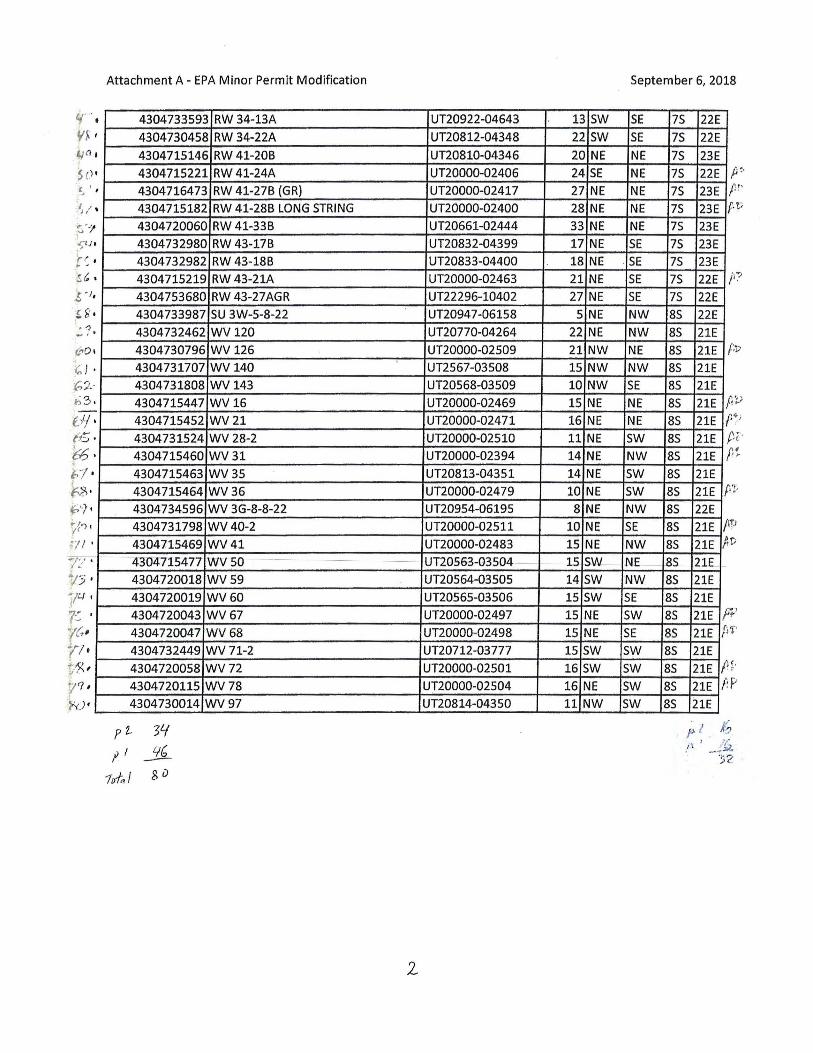
oJ / 0' ,
• t
I
, ,
• ~ ' "1 .. .~( j
'r r .ft' J
:S ~
S ' J
,H ' " 1
(,,-:'0
" h ?· '; 3
Of ( t5
~ ,
, • , , ,
· , · ,
•
· · b1 ~s · f ') l({') ,
•
0 / ,
· · •
·
Attachment A - EPA Minor PermIt Modification
4304733593 RW 34-13A
4304730458 RW 34-22A
4304715146 RW 41-20B
4304715221 RW 41-24A
4304716473 RW 41-27B (GR)
4304715182 RW 41-28B LONG STRING
4304720060 RW 41-33B
4304732980 RW 43-17B
4304732982 RW 43-18B
4304715219 RW 43-21A
4304753680 RW 43-27AGR
4304733987 5U 3W-5-8-22
4304732462 WV 120
4304730796 WV126
4304731707 WV140
4304731808 WV 143
4304715447 WV16
4304715452 WV21
4304731524 WV 28-2
4304715460 WV31
4304715463 WV35
4304715464 WV36
4304734596 WV 3G-8-8-22
4304731798 WV40-2
43047.15469 WV41
:lBo-4715477 WVSO
4304720018 WV59
4304720019 WV60
4304720043 WV67
4304720047 WV68
4304732449 WV71-2
4304720058 WV72
4304720115 WV78
4304730014 WV97
p2.. YI r I Lj(, -
1iJl,1 SD
UT20922-04643
UT20812-04348
UT20810-04346
UT20000-02406
UT20000-02417
UT20000-02400
UT20661-02444
UT20832-04399
UT20833-04400
UT20000-02463
UT22296-10402
UT20947-06158
UT20770-04264
UT20000-02509
UT2567-03508
UT20568-03509
UT20000-02469
UT20000-02471
UT20000-02510
UT20000-02394
UT20813-04351
UT20000-02479
UT20954-06195
UT20000-02511
UT20000-02483
UH0563-Q3SQ4--
UT20564-03505
UT20565-03506
UT20000-02497
UT20000-02498
UT20712-03777
UT20000-0250 1
UT20000-02504
UT20814-043S0
2.
5eptember 6, 2018
13 5W 5E 75 22E
22 SW 5E 75 22E
20 NE NE 75 23E 24 5E NE 75 22E
27 NE NE 75 23E 28 NE NE 75 23E 33 NE NE 75 23E
17 NE 5E 75 23E 18 NE o 5E 75 23E
21 NE 5E 75 22E 27 NE 5E 75 22E
5 NE NW 85 22E
22 NE NW 85 21E
21 NW NE 85 21E
15 NW NW 85 21E 10 NW 5E 85 21E
15 NE NE 85 21E f 16 NE NE 85 21E f "o , t '
11 NE 5W 85 21E
14 NE NW 85 21E
14 NE 5W 85 21E
10 NE 5W 85 21E P 8 NE NW 85 22E
10 NE 5E 85 21E II 15 NE NW 85 21E A 1-5 SW NE---- 85_ 21E_
14 5W NW 85 21E
15 5W SE 85 21E
15 NE 5W 85 21E f 15 NE 5E 85 21E fi l '
15 SW 5W 8S 21E
16 SW 5W 85 21E I! 16 NE 5W 85 21E f: 11 NW 5W 85 21E
p I I(; /-~ I _ • .;~~
'l~ ~ .) ~.
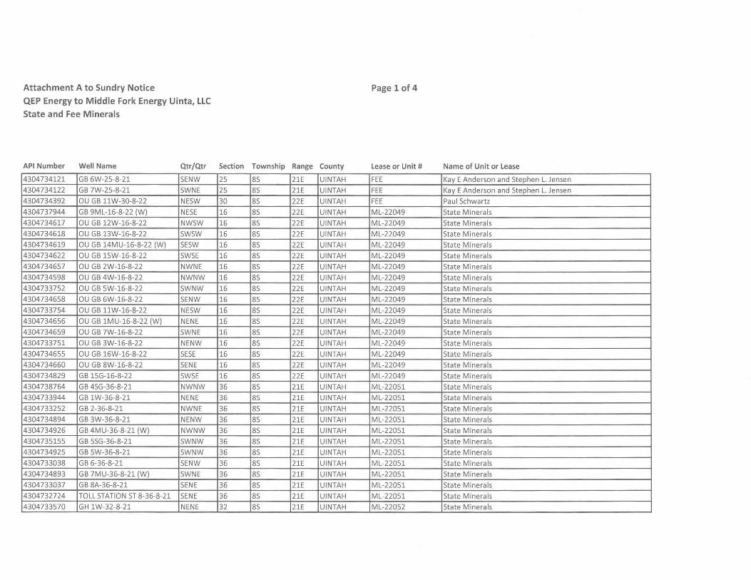
Attachment A to Sundry Notice
QEP Energy to Middle Fork Energy Uinta, LLC
State and Fee Minerals
API Number Well Name Qtr/Qtr Section Township Range County
4304734121 GB 6W-25-8-21 SENW 25 8S 21E UINTAH
4304734122 GB 7W-25-8-21 SWNE 25 8S 21E UINTAH
4304734392 au GB llW-30-8-22 NESW 30 8S 22E UINTAH
4304737944 GB 9ML-16-8-22 (W) NESE 16 8S 22E UINTAH
4304734617 au GB 12W-16-8-22 NWSW 16 8S 22E UINTAH
4304734618 au GB 13W-16-8-22 SWSW 16 8S 22E UINTAH
4304734619 au GB 14MU-16-8-22 (W) SESW 16 8S 22E UINTAH
4304734622 OU GB 15W-16-8-22 SWSE 16 8S 22E UINTAH
4304734657 OU GB 2W-16-8-22 NWNE 16 8S 22E UINTAH
4304734598 au GB 4W-16-8-22 NWNW 16 8S 22E UINTAH
4304733752 OU GB 5W-16-8-22 SWNW 16 8S 22E UINTAH
4304734658 OU GB 6W-16-8-22 SENW 16 8S 22E UINTAH
43047337S4 OU GB llW-16-8-22 NESW 16 8S 22E UINTAH
4304734656 OU GB 1MU-16-8-22 (W) NENE 16 8S 22E UINTAH
4304734659 OU GB 7W-16-8-22 SWNE 16 8S 22E UINTAH
4304733751 OU GB 3W-16-8-22 NENW 16 8S 22E UINTAH
4304734655 OU GB 16W-16-8-22 SESE 16 8S 22E UINTAH
4304734660 OU GB 8W-16-8-22 SENE 16 8S 22E UINTAH
4304734829 GB lSG-16-8-22 SWSE 16 8S 22E UINTAH
4304738764 GB 4SG-36-8-21 NWNW 36 8S 21E UINTAH
4304733944 GB 1W-36-8-21 NENE 36 8S 21E UINTAH
4304733252 GB 2-36-8-21 NWNE 36 8S 21E UINTAH
4304734894 GB 3W-36-8-21 NENW 36 8S 21E UINTAH
4304734926 GB 4MU-36-8-21 (W) NWNW 36 8S 21E UINTAH
4304735155 GB 5SG-36-8-21 SWNW 36 8S 21E UINTAH
4304734925 GB 5W-36-8-21 SWNW 36 8S 21E UINTAH
4304733038 GB 6-36-8-21 SENW 36 8S 21E UINTAH
4304734893 GB 7MU-36-8-21 (W) SWNE 36 8S 21E UINTAH
4304733037 GB 8A-36-8-21 SENE 36 8S 21E UINTAH
4304732724 TOLL STATION ST 8-36-8-21 SENE 36 8S 21E UINTAH
4304733570 GH 1W-32-8-21 NENE 32 8S 21E UINTAH
Page 1 of 4
Lease or Unit # Name of Unit or Lease
FEE Kay E Anderson and Stephen L. Jensen
FEE Kay E Anderson and Stephen L. Jensen
FEE Paul Schwartz
ML-22049 State Minerals
ML-22049 State Minerals
ML-22049 State Minerals
ML-22049 State Minerals
ML-22049 State Minerals
ML-22049 State Minerals
ML-22049 State Minerals
ML-22049 State Minerals
ML-22049 State Minerals
ML-22049 State Minerals
ML-22049 State Minerals
ML-22049 State Minerals
ML-22049 State Minerals
ML-22049 State Minerals
ML-22049 State Minerals
ML-22049 State Minerals
ML-22051 State Minerals
ML-22051 State Minerals
ML-22051 State Minerals
ML-22051 State Minerals
ML-22051 State Minerals
ML-22051 State Minerals
ML-22051 State Minerals
ML-22051 State Minerals
ML-22051 State Minerals
ML-22051 State Minerals
ML-22051 State Minerals
ML-22052 State Minerals
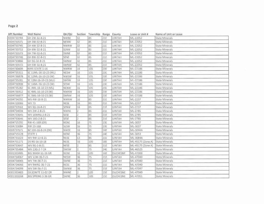
Page 2
API Number Well Name Qtr/Qtr Section Township Range County Lease or Unit # Name of Unit or Lease
4304733744 GH 2W-32-8-21 NWNE 32 8S 21E UINTAH ML-22052 State Minerals
4304733571 GH 3W-32-8-21 NENW 32 8S 21E UINTAH ML-22052 State Minerals
4304733745 GH 4W-32-8-21 NWNW 32 8S 21E UINTAH ML-22052 State Minerals
4304733753 GH 6W-32-8-21 SENW 32 8S 21E UINTAH ML-22052 State Minerals
4304733573 GH 7W-32-8-21 SWNE 32 8S 21E UINTAH ML-22052 State Minerals
4304733746 GH 8W-32-8-21 SENE 32 8S 21E UINTAH ML-22052 State Minerals
4304733866 GH 5G-32-8-21 SWNW 32 8S 21E UINTAH ML-22052 State Minerals
4304733572 GH 5W-32-8-21 SWNW 32 8S 21E UINTAH ML-22052 State Minerals
4304730609 KAYE STATE 1-16 NWNW 16 lOS 23E UINTAH ML-22186 State Minerals
4304735311 SC 11ML-16-10-23 (ML) NESW 16 lOS 23E UINTAH ML-22186 State Minerals
4304736878 SC 12ML-16-10-23 (W) NWSW 16 lOS 23E UINTAH ML-22186 State Minerals
4304735281 SC 13M-16-10-23 (MU) SWSW 16 lOS 23E UINTAH ML-22186 State Minerals
4304736908 SC 14ML-16-10-23 (W) SESW 16 lOS 23E UINTAH ML-22186 State Minerals
4304735282 SC 3ML-16-10-23 (ML) NENW 16 lOS 23E UINTAH ML-22186 State Minerals
4304736912 SC 4ML-16-10-23 (W) NWNW 16 lOS 23E UINTAH ML-22186 State Minerals
4304736877 SC 5ML-16-10-23 (W) SWNW 16 lOS 23E UINTAH ML-22186 State Minerals
4304734292 WV 4W-16-8-21 NWNW 16 8S 21E UINTAH ML-2237 State Minerals
4304720066 WV73 NESE 16 8S 21E UINTAH ML-2237 State Minerals
4304733564 WV 6G-16-8-21 SENW 16 8S 21E UINTAH ML-2237 State Minerals
4304734034 WV 2W-2-8-21 NWNE 2 8S 21E UINTAH ML-2785 State Minerals
4304733645 WV 16WRG-2-8-21 SESE 2 8S 21E UINTAH ML-2785 State Minerals
4304733646 WV 16G-2-8-21 SESE 2 8S 21E UINTAH ML-2785 State Minerals
4304715292 RW 41-16B (GR) NENE 16 7S 23E UINTAH ML-3037 State Minerals
4304733084 RW 23-16B SESW 16 7S 23E UINTAH ML-3037 State Minerals
4304737671 BZ 10D-16-8-24 (DK) NWSE 16 8S 24E UINTAH ML-3044A State Minerals
4304715128 STATE 1 NENE 36 7S 24E UINTAH ML-3053 State Minerals
4304733223 WV 9W-13-8-21 NESE 13 8S 21E UINTAH ML-3084A State Minerals
4304751171 DS 9G-16-10-18 NESE 16 lOS 18E UINTAH ML-45175 (Zone A) State Minerals
4304733647 WV 9G-2-8-21 NESE 2 8S 21E UINTAH ML-45175 (Zone A) State Minerals
4304735484 WH 13G-2-7-24 SWSW 2 7S 24E UINTAH ML-46525 State Minerals
4301333485 BIG WASH 61-16 GR NENE 16 lOS 16E DUCHESNE ML-47000 State Minerals
4304734067 WV 11W-36-7-21 NESW 36 7S 21E UINTAH ML-47040 State Minerals
4304734065 WV 7W-36-7-21 SWNE 36 7S 21E UINTAH ML-47040 State Minerals
4304734066 WV 9WRG-36-7-21 NESE 36 7S 21E UINTAH ML-47040 State Minerals
4304734099 WV SW-36-7-21 SWNW 36 7S 21E UINTAH ML-47047 State Minerals
4301333483 GILSONITE 11-02 GR NWNE 2 lOS lSE DUCHESNE ML-47049 State Minerals
4301333168 BIG SPRING 3-36 GR SWNE 36 lOS lSE DUCHESNE ML-47051 State Minerals
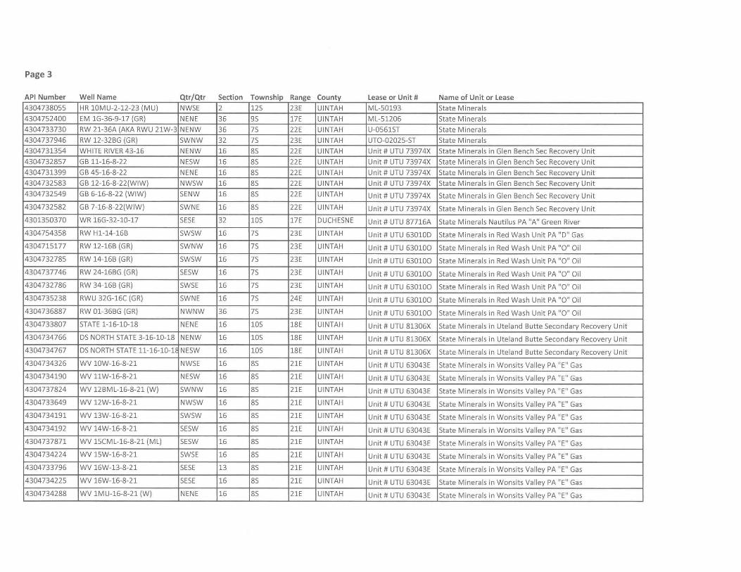
Page 3
API Number Well Name Qtr/Qtr Section Township Range County Lease or Unit # Name of Unit or Lease 4304738055 HR 10MU-2-12-23 (MU) NWSE 2 125 23E UINTAH ML-50193 State Minerals
4304752400 EM 1G-36-9-17 (GR) NENE 36 95 17E UINTAH ML-51206 State Minerals
4304733730 RW 21-36A (AKA RWU 21W-3 NENW 36 75 22E UINTAH U-0561ST State Minerals
4304737946 RW 12-32BG (GR) SWNW 32 75 23E UINTAH UTO-02025-ST State Minerals
4304731354 WHITE RIVER 43-16 NENW 16 85 22E UINTAH Unit # UTU 73974X State Minerals in Glen Bench Sec Recovery Unit
4304732857 GB 11-16-8-22 NESW 16 85 22E UINTAH Unit # UTU 73974X State Minerals in Glen Bench Sec Recovery Unit
4304731399 GB 45-16-8-22 NENE 16 85 22E UINTAH Unit # UTU 73974X State Minerals in Glen Bench Sec Recovery Unit
4304732583 GB 12-16-8-22(WIW) NWSW 16 85 22E UINTAH Unit # UTU 73974X State Minerals in Glen Bench Sec Recovery Unit
4304732549 GB 6-16-8-22 (WIW) SENW 16 85 22E UINTAH Unit # UTU 73974X State Minerals in Glen Bench Sec Recovery Unit
4304732582 GB 7-16-8-22(WIW) SWNE 16 85 22E UINTAH Unit # UTU 73974X State Minerals in Glen Bench Sec Recovery Unit
4301350370 WR 16G-32-10-17 SESE 32 105 17E DUCHESNE Unit # UTU 87716A State Minerals Nautilus PA "A" Green River
4304754358 RW Hl-14-16B SWSW 16 75 23E UINTAH Unit # UTU 63010D State Minerals in Red Wash Unit PA "D" Gas
4304715177 RW 12-16B (GR) SWNW 16 75 23E UINTAH Unit # UTU 630100 State Minerals in Red Wash Unit PA "0" Oil
4304732785 RW 14-16B (GR) SWSW 16 75 23E UINTAH Unit # UTU 630100 State Minerals in Red Wash Unit PA "0" Oil
4304737746 RW 24-16BG (GR) SESW 16 75 23E UINTAH Unit # UTU 630100 State Minerals in Red Wash Unit PA "0" Oil
4304732786 RW 34-16B (GR) SWSE 16 75 23E UINTAH Unit # UTU 630100 State Minerals in Red Wash Unit PA "0" Oil
4304735238 RWU 32G-16C (GR) SWNE 16 75 24E UINTAH Unit # UTU 630100 State Minerals in Red Wash Unit PA "0" Oil
4304736887 RW 01-36BG (GR) NWNW 36 75 23E UINTAH Unit # UTU 630100 State Minerals in Red Wash Unit PA "0" Oil
4304733807 STATE 1-16-10-18 NENE 16 105 18E UINTAH Unit # UTU 81306X State Minerals in Uteland Butte Secondary Recovery Unit
4304734766 DS NORTH STATE 3-16-10-18 NENW 16 105 18E UINTAH Unit # UTU 81306X State Minerals in Uteland Butte Secondary Recovery Unit
4304734767 DS NORTH STATE 11-16-10-11 NESW 16 105 18E UINTAH Unit # UTU 81306X State Minerals in Uteland Butte Secondary Recovery Unit
4304734326 WV 10W-16-8-21 NWSE 16 85 21E UINTAH Unit # UTU 63043E State Minerals in Wonsits Valley PA "E" Gas
4304734190 WV 11W-16-8-21 NESW 16 85 21E UINTAH Unit # UTU 63043E State Minerals in Wonsits Valley PA "E " Gas
4304737824 WV 12BML-16-8-21 (W) SWNW 16 85 21E UINTAH Unit # UTU 63043E State Minerals in Wonsits Valley PA "E" Gas
4304733649 WV 12W-16-8-21 NWSW 16 85 21E UINTAH Unit # UTU 63043E State Minerals in Wonsits Valley PA "E" Gas
4304734191 WV 13W-16-8-21 SWSW 16 85 21E UINTAH Unit # UTU 63043E State Minerals in Wonsits Valley PA "E" Gas
4304734192 WV 14W-16-8-21 SESW 16 85 21E UINTAH Unit # UTU 63043E State Minerals in Wonsits Valley PA "E" Gas
4304737871 WV 15CML-16-8-21 (ML) SESW 16 85 21E UINTAH Unit # UTU 63043E State Minerals in Wonsits Valley PA "E" Gas
4304734224 WV 15W-16-8-21 SWSE 16 85 21E UINTAH Unit # UTU 63043E State Minerals in Wonsits Valley PA "E" Gas
4304733796 WV 16W-13-8-21 SESE 13 85 21E UINTAH Unit # UTU 63043E State Minerals in Wonsits Valley PA "E" Gas
4304734225 WV 16W-16-8-21 SESE 16 85 21E UINTAH Unit # UTU 63043E State Minerals in Wonsits Valley PA "E" Gas
4304734288 WV 1MU-16-8-21 (W) NENE 16 85 21E UINTAH Unit # UTU 63043E State Minerals in Wonsits Valley PA "E" Gas
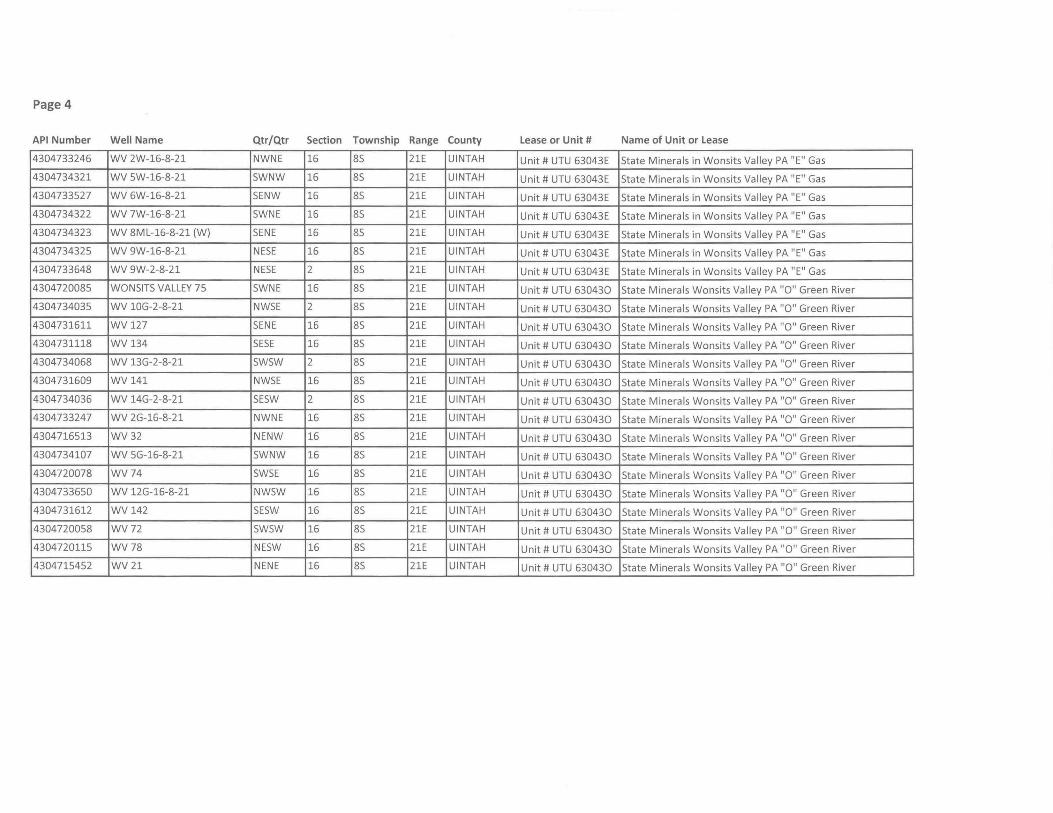
Page 4
API Number Well Name Qtr/Qtr Section Township Range County lease or Unit # Name of Unit or lease
4304733246 WV 2W-16-8-21 NWNE 16 8S 21E UINTAH Unit # UTU 63043E State Minerals in Wonsits Valley PA "E" Gas
4304734321 WV 5W-16-8-21 SWNW 16 8S 21E UINTAH Unit # UTU 63043E State Minerals in Won sits Valley PA "E" Gas
4304733527 WV 6W-16-8-21 SENW 16 8S 21E UINTAH Unit # UTU 63043E State Minerals in Wonsits Valley PA "E" Gas
4304734322 WV 7W-16-8-21 SWNE 16 8S 21E UINTAH Unit # UTU 63043E State Minerals in Wonsits Valley PA "E" Gas
4304734323 WV 8ML-16-8-21 (W) SENE 16 8S 21E UINTAH Unit # UTU 63043E State Minerals in Wonsits Valley PA "E" Gas
4304734325 WV 9W-16-8-21 NESE 16 8S 21E UINTAH Unit # UTU 63043E State Minerals in Wonsits Valley PA "E" Gas
4304733648 WV 9W-2-8-21 NESE 2 8S 21E UINTAH Unit # UTU 63043E State Minerals in Wonsits Valley PA "E" Gas
4304720085 WONSITS VALLEY 75 SWNE 16 8S 21E UINTAH Unit # UTU 630430 State Minerals Wonsits Valley PA "0" Green River
4304734035 WV 10G-2-8-21 NWSE 2 8S 21E UINTAH Unit # UTU 630430 State Minerals Wonsits Valley PA "0" Green River
4304731611 WV 127 SENE 16 8S 21E UINTAH Unit # UTU 630430 State Minerals Wonsits Valley PA "0" Green River
4304731118 WV 134 SESE 16 8S 21E UINTAH Unit # UTU 630430 State Minerals Wonsits Valley PA "0" Green River
4304734068 WV 13G-2-8-21 SWSW 2 8S 21E UINTAH Unit # UTU 630430 State Minerals Wonsits Valley PA "0" Green River
4304731609 WV141 NWSE 16 8S 21E UINTAH Unit # UTU 630430 State Minerals Wonsits Valley PA "0" Green River
4304734036 WV 14G-2-8-21 SESW 2 8S 21E UINTAH Unit # UTU 630430 State Minerals Wonsits Valley PA "0" Green River
4304733247 WV 2G-16-8-21 NWNE 16 8S 21E UINTAH Unit # UTU 630430 State Minerals Wonsits Valley PA "0" Green River
4304716513 WV32 NENW 16 8S 21E UINTAH Unit # UTU 630430 State Minerals Wonsits Valley PA "0" Green River
4304734107 WV 5G-16-8-21 SWNW 16 8S 21E UINTAH Unit # UTU 630430 State Minerals Wonsits Valley PA "0" Green River
4304720078 WV74 SWSE 16 8S 21E UINTAH Unit # UTU 630430 State Minerals Wonsits Valley PA "0" Green River
4304733650 WV 12G-16-8-21 NWSW 16 8S 21E UINTAH Unit # UTU 630430 State Minerals Wonsits Valley PA "0" Green River
4304731612 WV142 SESW 16 8S 21E UINTAH Unit # UTU 630430 State Minerals Wonsits Valley PA "0" Green River
43047200S8 WV72 SWSW 16 8S 21E UINTAH Unit # UTU 630430 State Minerals Wonsits Valley PA "0" Green River
4304720115 WV78 NESW 16 8S 21E UINTAH Unit # UTU 630430 State Minerals Wonsits Valley PA "0" Green River
43047154S2 WV21 NENE 16 8S 21E UINTAH Unit # UTU 630430 State Minerals Wonsits Valley PA "0" Green River
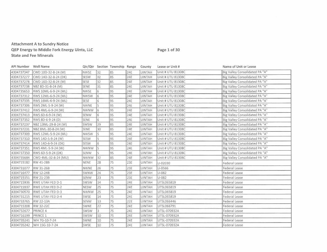
Attachment A to Sundry Notice
QEP Energy to Middle Fork Energy Uinta, llC
State and Fee Minerals
Page 1 of 30
API Number Well Name Qtr/Qtr Section Township Range County Lease or Unit #
4304737347 CWD 10D-32-8-24 (M) NW5E 32 85 24E UINTAH Unit # UTU 81308C
4304737277 CWD 14D-32-8-24 (DK) 5E5W 32 85 24E UINTAH Unit # UTU 81308C
4304737278 CWD 16D-32-8-24 (M) SESE 32 85 24E UINTAH Unit # UTU 81308C
4304737238 NBZ 8D-31-8-24 (M) SENE 31 85 24E UINTAH Unit # UTU 81308C
4304735653 RW5 10ML-6-9-24 (ML) NW5E 6 95 24E UINTAH Unit # UTU 81308C
4304737312 RW5 12ML-6-9-24 (ML) NW5W 6 95 24E UINTAH Unit # UTU 81308C
4304737335 RW5 16ML-6-9-24 (ML) SESE 6 95 24E UINTAH Unit # UTU 81308C
4304737306 RW5 2ML-5-9-24 (W) NWNE 5 95 24E UINTAH Unit # UTU 81308C
4304737412 RW5 4ML-6-9-24 (W) NWNW 6 95 24E UINTAH Unit # UTU 81308C
4304737413 RW5 6D-6-9-24 (W) 5ENW 6 95 24E UINTAH Unit # UTU 81308C
4304737352 RW5 8D-6-9-24 (D) SENE 6 95 24E UINTAH Unit # UTU 81308C
4304737237 NBZ 13ML-29-8-24 (W) 5W5W 29 85 24E UINTAH Unit # UTU 81308C
4304737231 NBZ 8ML-30-8-24 (W) SENE 30 85 24E UINTAH Unit # UTU 81308C
4304737309 RW5 12ML-5-9-24 (ML) NW5W 5 95 24E UINTAH Unit # UTU 81308C
4304737310 RW5 14D-5-9-24 (W) 5E5W 5 95 24E UINTAH Unit # UTU 81308C
4304737414 RW5 14D-6-9-24 (DK) 5E5W 6 95 24E UINTAH Unit # UTU 81308C
4304737351 RW5 4ML-5-9-24 (W) NWNW 5 95 24E UINTAH Unit # UTU 81308C
4304737350 RW5 6D-5-9-24 (DK) 5ENW 5 95 24E UINTAH Unit # UTU 81308C
4304735684 CWD 4ML-32-8-24 (MU) NWNW 32 85 24E UINTAH Unit # UTU 81308C
4304715182 RW 41-28B NENE 28 75 23E UINTAH U-02030
4304731077 RW 31-26B NWNE 26 75 23E UINTAH U-0566
4304716477 RW 12-24B 5WNW 24 75 23E UINTAH U-082
4304715151 RW 21-23B 5ENW 23 75 23E UINTAH U-082
4304715936 RWE UTAH FED D-1 5W5W 14 75 24E UINTAH UT5L065819
4304715937 RWE UTAH FED D-2 NE5W 25 75 24E UINTAH UT5L065819
4304730570 RWE UTAH FED D-3 NWNW 25 75 24E UINTAH UT5L065819
4304731215 RWE UTAH FED D-4 5W5E 14 75 24E UINTAH UT5L065819
4304733765 RW 22-13A 5ENW 13 75 22E UINTAH UT5L066446
4304715308 RW 32-22C 5WNE 22 75 24E UINTAH UT5L066791
4304732677 PRINCE 4 5W5W 3 75 24E UINTAH UT5L-070932A
4304716199 PRINCE 1 5W5W 10 75 24E UINTAH UT5L-070932A
4304735241 WH 7G-10-7-24 5WNE 10 75 24E UINTAH UT5L-070932A
4304735242 WH 15G-10-7-24 5W5E 10 75 24E UINTAH UT5L-070932A
Name of Unit or Lease
Big Valley Consolidated PA "A"
Big Valley Consolidated PA "A"
Big Valley Consolidated PA "A"
Big Valley Consolidated PA "A"
Big Valley Consolidated PA "A"
Big Valley Consolidated PA "A"
Big Valley Consolidated PA "A"
Big Valley Consolidated PA "A"
Big Valley Consolidated PA "A"
Big Valley Consolidated PA "A"
Big Valley Consolidated PA "A"
Big Valley Consolidated PA "A"
Big Valley Consolidated PA "A"
Big Valley Consolidated PA "A"
Big Valley Consolidated PA "A"
Big Valley Consolidated PA "A"
Big Valley Consolidated PA "A"
Big Valley Consolidated PA "A"
Big Valley Consolidated PA "A"
Federal Lease
Federal Lease
Federal Lease
Federal Lease
Federal Lease
Federal Lease
Federa I Lease
Federal Lease
Federal Lease
Federal Lease
Federal Lease
Federal Lease
Federal Lease
Federal Lease
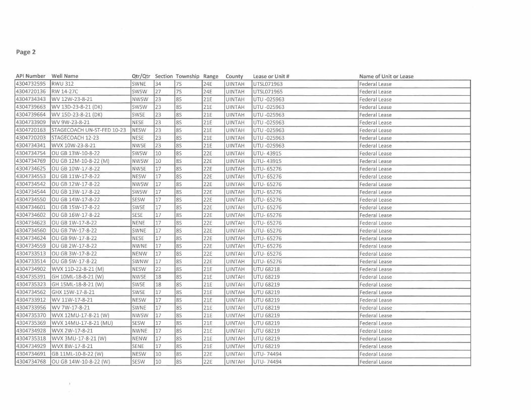
Page 2
API Number Well Name Qtr/Qtr Section Township Range County lease or Unit # Name of Unit or lease 4304732595 RWU 312 5WNE 34 75 24E UINTAH UT5L071963 Federal Lease
4304720136 RW 14-27C 5W5W 27 75 24E UINTAH UT5L071965 Federal Lease
4304734343 WV 12W-23-8-21 NW5W 23 85 21E UINTAH UTU -025963 Federal Lease
4304739663 WV 13D-23-8-21 (DK) 5W5W 23 85 21E UINTAH UTU -025963 Federal Lease
4304739664 WV 15D-23-8-21 (DK) 5W5E 23 85 21E UINTAH UTU -025963 Federal Lease
4304733909 WV 9W-23-8-21 NE5E 23 85 21E UINTAH UTU -025963 Federal Lease
4304720163 STAGECOACH UN-5T-FED 10-23 NE5W 23 85 21E UINTAH UTU -025963 Federal Lease
4304720203 STAGECOACH 12-23 NE5E 23 85 21E UINTAH UTU -025963 Federal Lease
4304734341 WVX 10W-23-8-21 NW5E 23 85 21E UINTAH UTU -025963 Federal Lease
4304734754 au GB 13W-10-8-22 5W5W 10 85 22E UINTAH UTU- 43915 Federal Lease
4304734769 au GB 12M-10-8-22 (M) NW5W 10 85 22E UINTAH UTU- 43915 Federal Lease
4304734625 au GB 10W-17-8-22 NW5E 17 85 22E UINTAH UTU-65276 Federal Lease
4304734553 au GB llW-17-8-22 NE5W 17 85 22E UINTAH UTU-65276 Federal Lease
4304734542 au GB 12W-17-8-22 NW5W 17 85 22E UINTAH UTU-65276 Federa I Lease
4304734544 au GB 13W-17-8-22 5W5W 17 85 22E UINTAH UTU-65276 Federal lease
4304734550 au GB 14W-17-8-22 5E5W 17 85 22E UINTAH UTU- 65276 Federal Lease
4304734601 au GB 15W-17-8-22 5W5E 17 85 22E UINTAH UTU-65276 Federal Lease
4304734602 au GB 16W-17-8-22 SESE 17 85 22E UINTAH UTU-65276 Federal Lease
4304734623 au GB 1W-17-8-22 NENE 17 85 22E UINTAH UTU- 65276 Federal Lease
4304734560 au GB 7W-17-8-22 5WNE 17 85 22E UINTAH UTU- 65276 Federal Lease
4304734624 au GB 9W-17-8-22 NE5E 17 85 22E UINTAH UTU- 65276 Federal Lease
4304734559 au GB 2W-17-8-22 NWNE 17 85 22E UINTAH UTU- 65276 Federa I Lease
4304733513 au GB 3W-17-8-22 NENW 17 85 22E UINTAH UTU- 65276 Federal Lease
4304733514 au GB 5W-17-8-22 5WNW 17 85 22E UINTAH UTU- 65276 Federal Lease
4304734902 WVX llD-22-8-21 (M) NE5W 22 85 21E UINTAH UTU 68218 Federal Lease
4304735391 GH 10ML-18-8-21 (W) NW5E 18 85 21E UINTAH UTU 68219 Federal Lease
4304735323 GH 15ML-18-8-21 (W) 5W5E 18 85 21E UINTAH UTU 68219 Federal Lease
4304734562 GHX 15W-17-8-21 5W5E 17 85 21E UINTAH UTU 68219 Federal Lease
4304733912 WV llW-17-8-21 NE5W 17 85 21E UINTAH UTU 68219 Federal Lease
4304733956 WV 7W-17-8-21 5WNE 17 85 21E UINTAH UTU 68219 Federal Lease
4304735370 WVX 12MU-17-8-21 (W) NW5W 17 85 21E UINTAH UTU 68219 Federal Lease
4304735369 WVX 14MU-17-8-21 (MU) 5E5W 17 85 21E UINTAH UTU 68219 Federal Lease
4304734928 WVX 2W-17-8-21 NWNE 17 85 21E UINTAH UTU 68219 Federal Lease
4304735318 WVX 3MU-17-8-21 (W) NENW 17 85 21E UINTAH UTU 68219 Federal Lease
4304734929 WVX 8W-17-8-21 SENE 17 85 21E UINTAH UTU 68219 Federal Lease
4304734691 GB llML-10-8-22 (W) NE5W 10 85 22E UINTAH UTU-74494 Federal Lease
4304734768 au GB 14W-10-8-22 (W) 5E5W 10 85 22E UINTAH UTU-74494 Federal Lease
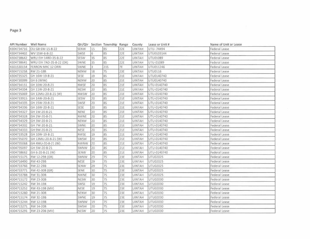
Page 3
API Number Well Name Qtr/Qtr Section Township Range County Lease or Unit # Name of Unit or Lease
4304734716 au GB 6W-15-8-22 5ENW 15 85 22E UINTAH UTU-74494 Federal Lease
4304734402 WV 15W-6-8-22 5W5E 6 85 22E UINTAH UTU0103144 Federal Lease
4304738642 WRU EIH 14BO-35-8-22 5E5W 35 85 22E UINTAH UTU01089 Federal Lease
4304738641 WRU EIH 7AO-35-8-22 (OK) 5WNE 35 85 22E UINTAH UTU-01089 Federal Lease
4301530154 FERRON MRC 12 ORRI 5WNE 3 215 7E UINTAH UTU01l246 Federal Lease
4304715258 RW 21-188 NENW 18 75 23E UINTAH UTU01l6 Federal Lease
4304735325 GH 16W-19-8-21 5E5E 19 85 21E UINTAH UTU0140740 Federa I Lease
4304730099 GH 6 (WIW) NENW 20 85 21E UINTAH UTU0140740 Federa I Lease
4304734151 GH 10W-20-8-21 NW5E 20 85 21E UINTAH UTU-0140740 Federa I Lease
4304734334 GH llW-20-8-21 NE5W 20 85 21E UINTAH UTU-0140740 Federal Lease
4304735069 GH 12MU-20-8-21 (W) NW5W 20 85 21E UINTAH UTU-0140740 Federal Lease
4304733915 GH 14W-20-8-21 5E5W 20 85 21E UINTAH UTU-0140740 Federal Lease
4304734335 GH 15W-20-8-21 5W5E 20 85 21E UINTAH UTU-0140740 Federal Lease
4304734336 GH 16W-20-8-21 5E5E 20 85 21E UINTAH UTU-0140740 Federal Lease
4304734327 GH 1W-20-8-21 NENE 20 85 21E UINTAH UTU-0140740 Federa I Lease
4304734328 GH 2W-20-8-21 NWNE 20 85 21E UINTAH UTU-0140740 Federal Lease
4304734329 GH 3W-20-8-21 NENW 20 85 21E UINTAH UTU-0140740 Federal Lease
4304734332 GH 7W-20-8-21 5WNE 20 85 21E UINTAH UTU-0140740 Federal Lease
4304734333 GH 9W-20-8-21 NE5E 20 85 21E UINTAH UTU-0140740 Federal Lease
4304733528 GH 10W-19-8-21 NW5E 19 85 21E UINTAH UTU-0140740 Federal Lease
4304735070 GH 13MU-20-8-21 (W) 5W5W 20 85 21E UINTAH UTU-0140740 Federal Lease
4304735068 GH 4MU-20-8-21 (W) NWNW 20 85 21E UINTAH UTU-0140740 Federal Lease
4304735097 GH 5W-20-8-21 5WNW 20 85 21E UINTAH UTU-0140740 Federal Lease
4304738662 GH 6-20-8-21 (W) 5ENW 20 85 21E UINTAH UTU-0140740 Federal Lease
4304715175 RW 12-298 (GR) 5WNW 29 75 23E UINTAH UTU02025 Federal Lease
4304716490 RW 43-29B NE5E 29 75 23E UINTAH UTU02025 Federa I Lease
4304733766 RW 22-29B 5ENW 29 75 23E UINTAH UTU02025 Federal Lease
4304733771 RW 42-30B (GR) 5ENE 30 75 23E UINTAH UTU02025 Federal Lease
4304733788 RW 31-30B NWNE 30 75 23E UINTAH UTU02025 Federal Lease
4304715172 RW 23-30B NE5W 30 75 23E UINTAH UTU02030 Federal Lease
4304715242 RW 34-19B 5W5E 19 75 23E UINTAH UTU02030 Federal Lease
4304715252 RW 43-19B (MV) NE5E 19 75 23E UINTAH UTU02030 Federa I Lease
4304715280 RW 21-30B NENW 30 75 23E UINTAH UTU02030 Federal Lease
4304715174 RW 32-19B 5WNE 19 75 23E UINTAH UTU02030 Federa I Lease
4304715244 RW 12-19B 5WNW 19 75 23E UINTAH UTU02030 Federal Lease
4304715271 RW 14-20B 5W5W 20 75 23E UINTAH UTU02030 Federal Lease
4304715291 RW 23-20B (MV) NE5W 20 75 23E UINTAH UTU02030 Federal Lease
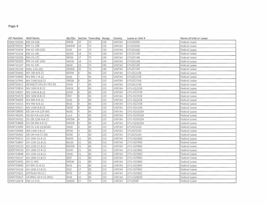
Page 4
API Number Well Name Qtr/Qtr Section Township Range County Lease or Unit # Name of Unit or Lease
4304733500 RW 33-20B NWSE 20 7S 23E UINTAH UTU02030 Federal Lease
4304733552 RW 11-19B NWNW 19 7S 23E UINTAH UTU02030 Federa I Lease
4304733556 RW 42-19B (GR) SENE 19 7S 23E UINTAH UTU02030 Federa I Lease
4304715216 RW 23-18C NESW 18 7S 24E UINTAH UTU02148 Federa I Lease
4304715298 RW 23-17C NESW 17 7S 24E UINTAH UTU02148 Federa I Lease
4304730309 RW 14-18C (GR) SWSW 18 7S 24E UINTAH UTU02148 Federa I Lease
4304715147 RW 41-19C NENE 19 7S 24E UINTAH UTU02149 Federal Lease
4304735239 RWU 12G-20C SWNW 20 7S 24E UINTAH UTU02149 Federa I Lease
4304733493 WV 3W-8-8-22 NENW 8 8S 22E UINTAH UTU022158 Federa I Lease
4304734469 WV 8W-7-8-22 SENE 7 8S 22E UINTAH UTU022158 Federal Lease
4304737945 WV 13AD 8-8-22 SWSW 8 8S 22E UINTAH UTU022158 Federal Lease
4304730017 WaNSITS VALLEY-FED 99 SESW 7 8S 22E UINTAH UTU022158 Federal Lease
4304733814 WV 10W-8-8-22 NWSE 8 8S 22E UINTAH UTU-022158 Federal Lease
4304734007 WV 14W-8-8-22 SESW 8 8S 22E UINTAH UTU-022158 Federal Lease
4304734470 WV 16W-8-8-22 SESE 8 8S 22E UINTAH UTU-022158 Federal Lease
4304734005 WV 8W-8-8-22 SENE 8 85 22E UINTAH UTU-022158 Federal Lease
4304733515 WV 9W-8-8-22 NESE 8 8S 22E UINTAH UTU-022158 Federa I Lease
4304733517 WV 15W-8-8-22 SWSE 8 8S 22E UINTAH UTU-022158 Federa I Lease
4304738990 GB lM-4-8-22R (M) NENE 4 8S 22E UINTAH UTU-025010A Federa I Lease
4304740345 GB 3D-4-8-22R (DK) Lot 6 4 8S 22E UINTAH UTU-025010A Federa I Lease
4304734762 au GB 12W-4-8-22 NWSW 4 8S 22E UINTAH UTU-025010A Federal Lease
4304734808 au GB 5M-4-8-22 SWNW 4 8S 22E UINTAH UTU-025010A Federal Lease
4304715090 WR 31-4-8-22(WSW) SWSE 4 8S 22E UINTAH UTU02510A Federal Lease
4304734006 WR 14W-4-8-22 SESW 4 8S 22E UINTAH UTU02510A Federal Lease
4304735462 GB lM-4-8-22 (M) NENE 4 8S 22E UINTAH UTU02510A Federal Lease
4304734152 GH 10W-21-8-21 NWSE 21 8S 21E UINTAH UTU-025960 Federal Lease
4304733847 GH 11W-21-8-21 NESW 21 8S 21E UINTAH UTU-025960 Federal Lease
4304734153 GH 12W-21-8-21 NWSW 21 8S 21E UINTAH UTU-025960 Federa I Lease
4304734154 GH 14W-21-8-21 SESW 21 8S 21E UINTAH UTU-025960 Federal Lease
4304733848 GH 15W-21-8-21 SWSE 21 8S 21E UINTAH UTU-025960 Federal Lease
4304734157 GH 16W-21-8-21 SESE 21 8S 21E UINTAH UTU-025960 Federal Lease
4304732692 GH 21 WG SWSW 21 8S 21E UINTAH UTU-025960 Federa I Lease
4304733846 GH 9W-21-8-21 NESE 21 8S 21E UINTAH UTU-025960 Federa I Lease
4304734156 GH 16W-17-8-21 SESE 17 8S 21E UINTAH UTU-025962 Federal Lease
4304715421 GYPSUM HILLS 1 NESE 17 8S 21E UINTAH UTU-025962 Federal Lease
4304735422 GB 8MU-l0-8-22 (MU) SENE 10 8S 22E UINTAH UTU-029649 Federal Lease
4304716478 RW 12-27A SWNW 27 7S 22E UINTAH UTU0558 Federa I Lease
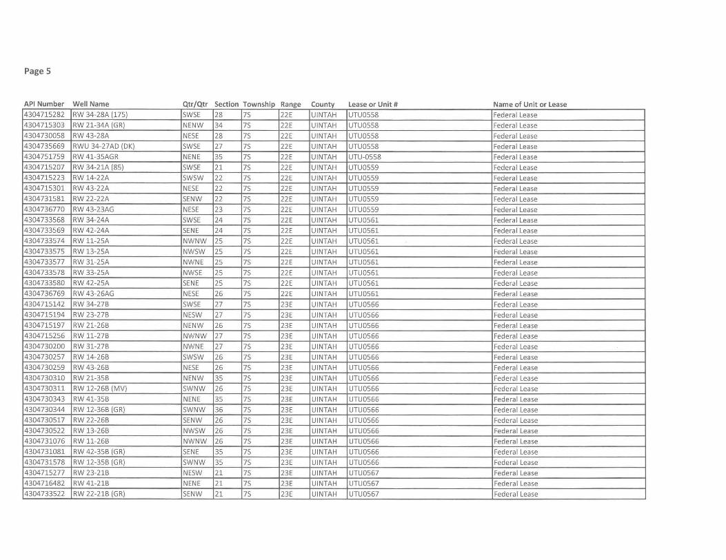
Page 5
API Number Well Name Qtr/Qtr Section Township Range County Lease or Unit # Name of Unit or Lease
4304715282 RW 34-28A (175) 5W5E 28 75 22E UINTAH UTU0558 Federal Lease
4304715303 RW 21-34A (GR) NENW 34 75 22E UINTAH UTU0558 Federal Lease
4304730058 RW 43-28A NE5E 28 75 22E UINTAH UTU0558 Federal Lease
4304735669 RWU 34-27AD (DK) 5W5E 27 75 22E UINTAH UTU0558 Federal Lease
4304751759 RW 41-35AGR NENE 35 75 22E UINTAH UTU-0558 Federa I Lease
4304715207 RW 34-21A (85) 5W5E 21 75 22E UINTAH UTU0559 Federa I Lease
4304715223 RW 14-22A 5W5W 22 75 22E UINTAH UTU0559 Federa I Lease
4304715301 RW 43-22A NE5E 22 75 22E UINTAH UTU0559 Federal Lease
4304731581 RW 22-22A 5ENW 22 75 22E UINTAH UTU0559 Federa I Lease
4304736770 RW 43-23AG NE5E 23 75 22E UINTAH UTU0559 Federal Lease
4304733568 RW 34-24A 5W5E 24 75 22E UINTAH UTU0561 Federal Lease
4304733569 RW 42-24A 5ENE 24 75 22E UINTAH UTU0561 Federal Lease
4304733574 RW 11-25A NWNW 25 75 22E UINTAH UTU0561 Federal Lease
4304733575 RW 13-25A NW5W 25 75 22E UINTAH UTU0561 Federa I Lease
4304733577 RW 31-25A NWNE 25 75 22E UINTAH UTU0561 Federa I Lease
4304733578 RW 33-25A NW5E 25 75 22E UINTAH UTU0561 Federa I Lease
4304733580 RW 42-25A 5ENE 25 75 22E UINTAH UTU0561 Federal Lease
4304736769 RW 43-26AG NE5E 26 75 22E UINTAH UTU0561 Federal Lease
4304715142 RW 34-27B 5W5E 27 75 23E UINTAH UTU0566 Federal Lease
4304715194 RW 23-27B NE5W 27 75 23E UINTAH UTU0566 Federal Lease
4304715197 RW 21-26B NENW 26 75 23E UINTAH UTU0566 Federal Lease
4304715256 RW 11-27B NWNW 27 75 23E UINTAH UTU0566 Federal Lease
4304730200 RW 31-27B NWNE 27 75 23E UINTAH UTU0566 Federal Lease
4304730257 RW 14-26B 5W5W 26 75 23E UINTAH UTU0566 Federal Lease
4304730259 RW 43-26B NE5E 26 75 23E UINTAH UTU0566 Federal Lease
4304730310 RW 21-35B NENW 35 75 23E UINTAH UTU0566 Federa I Lease
4304730311 RW 12-26B (MV) 5WNW 26 75 23E UINTAH UTU0566 Federal Lease
4304730343 RW 41-35B NENE 35 75 23E UINTAH UTU0566 Federal Lease
4304730344 RW 12-36B (GR) 5WNW 36 75 23E UINTAH UTU0566 Federa I Lease
4304730517 RW 22-26B 5ENW 26 75 23E UINTAH UTU0566 Federal Lease
4304730522 RW 13-26B NW5W 26 75 23E UINTAH UTU0566 Federal Lease
4304731076 RW 11-26B NWNW 26 75 23E UINTAH UTU0566 Federal Lease
4304731081 RW 42-35B (GR) 5ENE 35 75 23E UINTAH UTU0566 Federal Lease
4304731578 RW 12-35B (GR) 5WNW 35 75 23E UINTAH UTU0566 Federal Lease
4304715277 RW 23-21B NE5W 21 75 23E UINTAH UTU0567 Federal Lease
4304716482 RW 41-21B NENE 21 75 23E UINTAH UTU0567 Federal Lease
4304733522 RW 22-21B (GR) 5ENW 21 75 23E UINTAH UTU0567 Federal Lease
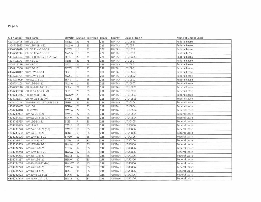
Page 6
API Number Well Name Qtr/Qtr Section Township Range County Lease or Unit # Name of Unit or Lease
4304716496 RW 21-21B NENW 21 75 23E UINTAH UTU0569 Federal Lease
4304733993 WV 12W-18-8-22 NW5W 18 85 22E UINTAH UTU057 Federa I Lease
4304734648 au GB 11W-15-8-22 NE5W 15 85 22E UINTAH UTU-058 Federa I Lease
4304734714 au GB 12W-15-8-22 NW5W 15 85 22E UINTAH UTU-058 Federa I Lease
4304735193 WRU EIH 8MU-26-8-22 (W) SENE 26 85 22E UINTAH UTU-0629 Federal Lease
4304715173 RW 41-21C NENE 21 75 24E UINTAH UTU080 Federal Lease
4304715299 RW 43-21C NE5E 21 75 24E UINTAH UTU080 Federal Lease
4304715306 RW 23-21C NE5W 21 75 24E UINTAH UTU080 Federal Lease
4304734047 WV 16W-1-8-21 SESE 1 85 21E UINTAH UTU0802 Federal Lease
4304733794 WV 10W-1-8-21 NWSE 1 85 21E UINTAH UTU0802 Federal Lease
4304734009 WV 8W-1-8-21 SENE 1 85 21E UINTAH UTU0802 Federal Lease
4304734108 WV 12G-1-8-21 NW5W 1 85 21E UINTAH UTU0802 Federal Lease
4304735248 GB 14M-28-8-21 (MU) SESW 28 85 21E UINTAH UTU-0803 Federal Lease
4304736260 GB 16D-28-8-21 (M) SESE 28 85 21E UINTAH UTU-0803 Federal Lease
4304735246 GB 4D-28-8-21 (M) NWNW 28 85 21E UINTAH UTU-0803 Federal Lease
4304735247 GB 7M-28-8-21 (M) 5WNE 28 85 21E UINTAH UTU-0803 Federal Lease
4304730824 WON51T5 VALLEY UNIT 1-35 NENE 21 85 21E UINTAH UTU0804 Federal Lease
4304731047 WV136 NENW 21 85 2lE UINTAH UTU0804 Federal Lease
4304732818 GH 22 WG 5WNW 22 85 21E UINTAH UTU-0804 Federal Lease
4304733907 WV 7W-22-8-21 5WNE 22 85 21E UINTAH UTU-0804 Federal Lease
4304734272 WV 6W-22-8-21 (GR) SENW 22 85 21E UINTAH UTU-0804 Federa I Lease
4304733565 WV 16G-9-8-21 SESE 9 85 21E UINTAH UTU0805 Federa I Lease
4304733085 WV 11 WG SWNE 12 85 21E UINTAH UTU0806 Federal Lease
4304733270 WV 7W-13-8-21 (GR) SWNE 13 85 21E UINTAH UTU0806 Federal Lease
4304733532 WV 1W-13-8-21 NENE 13 85 21E UINTAH UTU0806 Federal Lease
4304733606 WV 13W-13-8-21 5WSW 13 85 21E UINTAH UTU0806 Federal Lease
4304733608 WV 15W-13-8-21 5W5E 13 85 21E UINTAH UTU0806 Federal Lease
4304733659 WV 12W-1O-8-21 NW5W 10 85 21E UINTAH UTU0806 Federal Lease
4304734245 WV 6W-12-8-21 5ENW 12 85 21E UINTAH UTU0806 Federal Lease
4304734248 WV 12W-12-8-21 NW5W 12 85 21E UINTAH UTU0806 Federa I Lease
4304734265 WV 2W-12-8-21 NWNE 12 85 21E UINTAH UTU0806 Federal Lease
4304734267 WV 3W-12-8-21 NENW 12 85 21E UINTAH UTU0806 Federal Lease
4304734268 WV 4D-12-8-21 (DK) NWNW 12 85 21E UINTAH UTU0806 Federal Lease
4304734270 WV 5W-12-8-21 5WNW 12 85 21E UINTAH UTU0806 Federal Lease
4304734274 WV 9W-11-8-21 NESE 11 85 21E UINTAH UTU0806 Federal Lease
4304737923 WV 3DML-13-8-21 5ENW 13 85 21E UINTAH UTU0806 Federal Lease
4304737925 WV 15AML-12-8-21 NW5E 12 85 21E UINTAH UTU0806 Federa I Lease
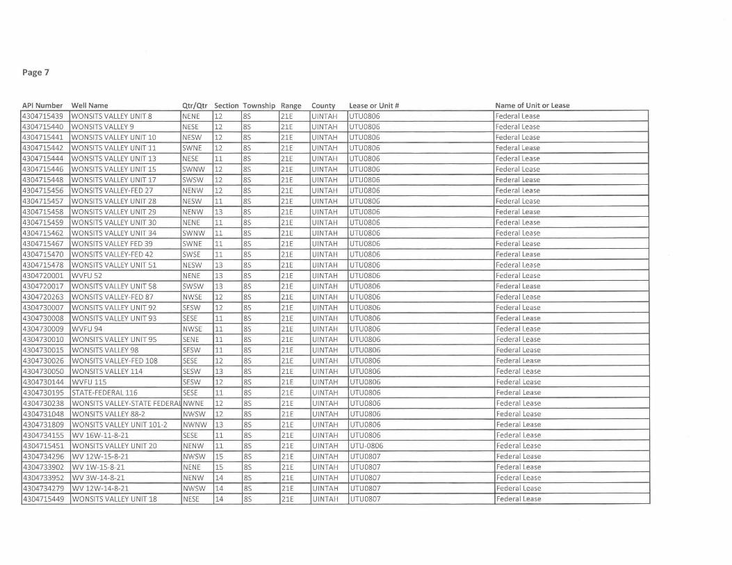
Page 7
API Number Well Name Qtr/Qtr Section Township Range County Lease or Unit # Name of Unit or Lease
4304715439 WONSITS VALLEY UNIT 8 NENE 12 8S 21E UINTAH UTU0806 Federal Lease
4304715440 WONSITS VALLEY 9 NESE 12 8S 21E UINTAH UTU0806 Federal Lease
4304715441 WONSITS VALLEY UNIT 10 NESW 12 8S 21E UINTAH UTU0806 Federal Lease
4304715442 WONSITS VALLEY UNIT 11 SWNE 12 8S 21E UINTAH UTU0806 Federal Lease
4304715444 WONSITS VALLEY UNIT 13 NESE 11 8S 21E UINTAH UTU0806 Federal Lease
4304715446 WONSITS VALLEY UNIT 15 SWNW 12 8S 21E UINTAH UTU0806 Federal Lease
4304715448 WONSITS VALLEY UNIT 17 SWSW 12 8S 21E UINTAH UTU0806 Federal Lease
4304715456 WONSITS VALLEY-FED 27 NENW 12 8S 21E UINTAH UTU0806 Federal Lease
4304715457 WONSITS VALLEY UNIT 28 NESW 11 8S 21E UINTAH UTU0806 Federal Lease
4304715458 WONSITS VALLEY UNIT 29 NENW 13 8S 21E UINTAH UTU0806 Federal Lease
4304715459 WONSITS VALLEY UNIT 30 NENE 11 8S 21E UINTAH UTU0806 Federa I Lease
4304715462 WONSITS VALLEY UNIT 34 SWNW 11 8S 21E UINTAH UTU0806 Federal Lease
4304715467 WONSITS VALLEY FED 39 SWNE 11 8S 21E UINTAH UTU0806 Federal Lease
4304715470 WONSITS VALLEY-FED 42 SWSE 11 8S 21E UINTAH UTU0806 Federal Lease
4304715478 WONSITS VALLEY UNIT 51 NESW 13 8S 21E UINTAH UTU0806 Federal Lease
4304720001 WVFU 52 NENE 13 8S 21E UINTAH UTU0806 Federal Lease
4304720017 WONSITS VALLEY UNIT 58 SWSW 13 8S 21E UINTAH UTU0806 Federal Lease
4304720263 WONSITS VALLEY-FED 87 NWSE 12 8S 21E UINTAH UTU0806 Federal Lease
4304730007 WONSITS VALLEY UNIT 92 SESW 12 8S 21E UINTAH UTU0806 Federal Lease
4304730008 WONSITS VALLEY UNIT 93 SESE 11 8S 21E UINTAH UTU0806 Federal Lease
4304730009 WVFU 94 NWSE 11 8S 21E UINTAH UTU0806 Federal Lease
4304730010 WONSITS VALLEY UNIT 95 SENE 11 8S 21E UINTAH UTU0806 Federa I Lease
4304730015 WONSITS VALLEY 98 SESW 11 8S 21E UINTAH UTU0806 Federa I Lease
4304730026 WONSITS VALLEY-FED 108 SESE 12 8S 21E UINTAH UTU0806 Federal Lease
4304730050 WONSITS VALLEY 114 SESW 13 8S 21E UINTAH UTU0806 Federal Lease
4304730144 WVFU 115 SESW 12 8S 21E UINTAH UTU0806 Federal Lease
4304730195 STATE-FEDERAL 116 SESE 11 8S 21E UINTAH UTU0806 Federal Lease
4304730238 WONSITS VALLEY-STATE FEDERA NWNE 12 8S 21E UINTAH UTU0806 Federa I Lease
4304731048 WONSITS VALLEY 88-2 NWSW 12 8S 21E UINTAH UTU0806 Federa I Lease
4304731809 WONSITS VALLEY UNIT 101-2 NWNW 13 8S 21E UINTAH UTU0806 Federa I Lease
4304734155 WV 16W-11-8-21 SESE 11 8S 21E UINTAH UTU0806 Federal Lease
4304715451 WONSITS VALLEY UNIT 20 NENW 11 8S 21E UINTAH UTU-0806 Federal Lease
4304734296 WV 12W-15-8-21 NWSW 15 8S 21E UINTAH UTU0807 Federal Lease
4304733902 WV 1W-15-8-21 NENE 15 8S 21E UINTAH UTU0807 Federal Lease
4304733952 WV 3W-14-8-21 NENW 14 8S 21E UINTAH UTU0807 Federal Lease
4304734279 WV 12W-14-8-21 NWSW 14 8S 21E UINTAH UTU0807 Federa I Lease
4304715449 WONSITS VALLEY UNIT 18 NESE 14 8S 21E UINTAH UTU0807 Federa I Lease
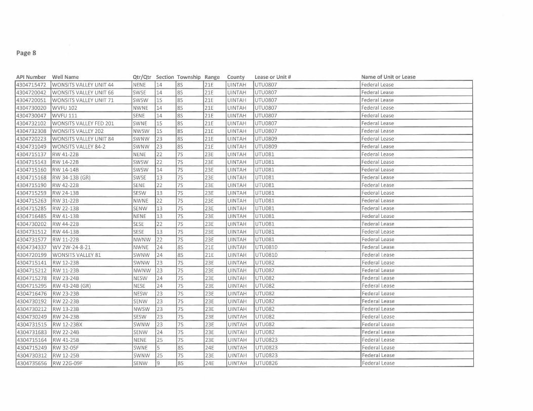
Page 8
API Number Well Name Qtr/Qtr Section Township Range County Lease or Unit # Name of Unit or Lease
4304715472 WONSITS VALLEY UNIT 44 NENE 14 85 21E UINTAH UTU0807 Federa I Lease
4304720042 WONSITS VALLEY UNIT 66 SWSE 14 85 21E UINTAH UTU0807 Federa I Lease
4304720051 WONSITS VALLEY UNIT 71 SWSW 15 85 21E UINTAH UTU0807 Federal Lease
4304730020 WVFU 102 NWNE 14 85 21E UINTAH UTU0807 Federal Lease
4304730047 WVFU 111 SENE 14 85 21E UINTAH UTU0807 Federal Lease
4304732102 WONSITS VALLEY FED 201 SWNE 15 85 2lE UINTAH UTU0807 Federal Lease
4304732308 WONSIT5 VALLEY 202 NW5W 15 85 2lE UINTAH UTU0807 Federa I Lease
4304720223 WON51T5 VALLEY UNIT 84 5WNW 23 85 2lE UINTAH UTU0809 Federa I Lease
4304731049 . WON51T5 VALLEY 84-2 5WNW 23 85 21E UINTAH UTU0809 Federa I Lease
4304715137 RW 41-22B NENE 22 75 23E UINTAH UTU081 Federal Lease
4304715143 RW 14-22B 5W5W 22 75 23E UINTAH UTU081 Federal Lease
4304715160 RW 14-14B 5WSW 14 75 23E UINTAH UTU081 Federal Lease
4304715168 RW 34-13B (GR) 5WSE 13 75 23E UINTAH UTU081 Federal Lease
4304715190 RW 42-22B 5ENE 22 75 23E UINTAH UTU081 Federa I Lease
4304715259 RW 24-13B SESW 13 75 23E UINTAH UTU081 Federa I Lease
4304715263 RW 31-22B NWNE 22 75 23E UINTAH UTU081 Federal Lease
4304715285 RW 22-13B 5ENW 13 75 23E UINTAH UTU081 Federal Lease
4304716485 RW 41-13B NENE 13 75 23E UINTAH UTU081 Federal Lease
4304730202 RW 44-22B 5E5E 22 75 23E UINTAH UTU081 Federal Lease
4304731512 RW 44-13B SESE 13 75 23E UINTAH UTU081 Federa I Lease
4304731577 RW 11-22B NWNW 22 75 23E UINTAH UTU081 Federa I Lease
4304734337 WV 2W-24-8-21 NWNE 24 85 21E UINTAH UTU0810 Federa I Lease
4304720199 WON51T5 VALLEY 81 SWNW 24 85 21E UINTAH UTU0810 Federal Lease
4304715141 RW 12-23B 5WNW 23 75 23E UINTAH UTU082 Federal Lease
4304715212 RW 11-23B NWNW 23 75 23E UINTAH UTU082 Federal Lease
4304715278 RW 23-24B NE5W 24 75 23E UINTAH UTU082 Federal Lease
4304715295 RW 43-24B (GR) NESE 24 75 23E UINTAH UTU082 Federal Lease
4304716476 RW 23-23B NESW 23 75 23E UINTAH UTU082 Federal Lease
4304730192 RW 22-23B SENW 23 75 23E UINTAH UTU082 Federal Lease
4304730212 RW 13-23B NW5W 23 75 23E UINTAH UTU082 Federal Lease
4304730249 RW 24-23B SESW 23 75 23E UINTAH UTU082 Federal Lease
4304731515 RW 12-23BX SWNW 23 75 23E UINTAH UTU082 Federal Lease
4304731683 RW 22-24B SENW 24 75 23E UINTAH UTU082 Federal Lease
4304715164 RW 41-25B NENE 25 75 23E UINTAH UTU0823 Federal Lease
4304715249 RW 32-05F 5WNE 5 85 24E UINTAH UTU0823 Federal Lease
4304730312 RW 12-25B 5WNW 25 75 23E UINTAH UTU0823 Federal Lease
4304735656 RW 22G-09F 5ENW 9 85 24E UINTAH UTU0826 Federal Lease
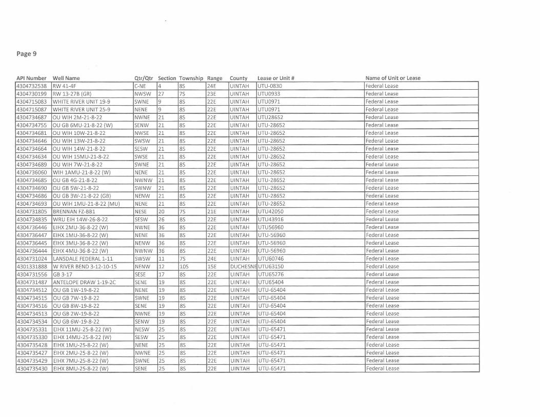
Page 9
API Number Well Name Qtr/Qtr Section Township Range County Lease or Unit # Name of Unit or Lease
4304732538 RW 41-4F C-NE 4 85 24E UINTAH UTU-0830 Federal Lease
4304730199 RW 13-27B (GR) NW5W 27 75 23E UINTAH UTU0933 Federa I Lease
4304715083 WHITE RIVER UNIT 19-9 5WNE 9 85 22E UINTAH UTU0971 Federal Lease
4304715087 WHITE RIVER UNIT 25-9 NENE 9 85 22E UINTAH UTU0971 Federal Lease
4304734687 OU WIH 2M-21-8-22 NWNE 21 85 22E UINTAH UTU28652 Federal Lease
4304734755 OU GB 6MU-21-8-22 (W) 5ENW 21 85 22E UINTAH UTU-28652 Federal Lease
4304734681 OU WIH 10W-21-8-22 NW5E 21 85 22E UINTAH UTU-28652 Federal Lease
4304734646 OU WIH 13W-21-8-22 5W5W 21 85 22E UINTAH UTU-28652 Federal Lease
4304734664 OU WIH 14W-21-8-22 5E5W 21 85 22E UINTAH UTU-28652 Federal Lease
4304734634 OU WIH 15MU-21-8-22 5W5E 21 85 22E UINTAH UTU-28652 Federal Lease
4304734689 OU WIH 7W-21-8-22 5WNE 21 85 22E UINTAH UTU-28652 Federal Lease
4304736060 WIH 1AMU-21-8-22 (W) NENE 21 85 22E UINTAH UTU-28652 Federal Lease
4304734685 OU GB 4G-21-8-22 NWNW 21 85 22E UINTAH UTU-28652 Federal Lease
4304734690 OU GB 5W-21-8-22 SWNW 21 85 22E UINTAH UTU-28652 Federal Lease
4304734686 OU GB 3W-21-8-22 (GB) NENW 21 85 22E UINTAH UTU-28652 Federal Lease
4304734693 OU WIH 1MU-21-8-22 (MU) NENE 21 85 22E UINTAH UTU-28652 Federal Lease
4304731805 BRENNAN FZ-BB1 NE5E 20 75 21E UINTAH UTU42050 Federal Lease
4304734835 WRU EIH 14W-26-8-22 5E5W 26 85 22E UINTAH UTU43916 Federal Lease
4304736446 EIHX 2MU-36-8-22 (W) NWNE 36 85 22E UINTAH UTU56960 Federal Lease
4304736447 EIHX 1MU-36-8-22 (W) NENE 36 85 22E UINTAH UTU-56960 Federa I Lease
4304736445 EIHX 3MU-36-8-22 (W) NENW 36 85 22E UINTAH UTU-56960 Federal Lease
4304736444 EIHX 4MU-36-8-22 (W) NWNW 36 85 22E UINTAH UTU-56960 Federal Lease
4304731024 LANSDALE FEDERAL 1-11 5W5W 11 75 24E UINTAH UTU60746 Federal Lease
4301331888 W RIVER BEND 3-12-10-15 NENW 12 105 15E DUCHESNE UTU63150 Federal Lease
4304731556 GB 3-17 SESE 17 85 22E UINTAH UTU65276 Federal Lease
4304731487 ANTELOPE DRAW 1-19-2C SENE 19 85 22E UINTAH UTU65404 Federa I Lease
4304734512 OU GB 1W-19-8-22 NENE 19 85 22E UINTAH UTU-65404 Federal Lease
4304734515 OU GB 7W-19-8-22 5WNE 19 85 22E UINTAH UTU-65404 Federal Lease
4304734516 OU GB 8W-19-8-22 SENE 19 85 22E UINTAH UTU-65404 Federal Lease
4304734513 OU GB 2W-19-8-22 NWNE 19 85 22E UINTAH UTU-65404 Federal Lease
4304734534 OU GB 6W-19-8-22 5ENW 19 85 22E UINTAH UTU-65404 Federal Lease
4304735331 EIHX 11MU-25-8-22 (W) NE5W 25 85 22E UINTAH UTU-65471 Federal Lease
4304735330 EIHX 14MU-25-8-22 (W) 5E5W 25 85 22E UINTAH UTU-65471 Federal Lease
4304735428 EIHX 1MU-25-8-22 (W) NENE 25 85 22E UINTAH UTU-65471 Federal Lease
4304735427 EIHX 2MU-25-8-22 (W) NWNE 25 85 22E UINTAH UTU-65471 Federal Lease
4304735429 EIHX 7MU-25-8-22 (W) 5WNE 25 85 22E UINTAH UTU-65471 Federal Lease
4304735430 EIHX 8MU-25-8-22 (W) SENE 25 85 22E UINTAH UTU-65471 Federal Lease
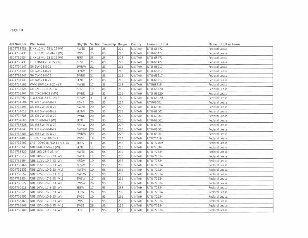
Page 10
API Number Well Name Qtr/Qtr Section Township Range County Lease or Unit # Name of Unit or Lease 4304735436 EIHX 10MU-25-8-22 (W) NW5E 25 85 22E UINTAH UTU-65472 Federal Lease
4304735435 EIHX 15MU-25-8-22 (W) 5W5E 25 85 22E UINTAH UTU-65472 Federal Lease
4304735434 EIHX 16MU-25-8-22 (W) SESE 25 85 22E UINTAH UTU-65472 Federal Lease
4304735433 EIHX 9MU-25-8-22 (W) NE5E 25 85 22E UINTAH UTU-65472 Federal Lease
4304734147 GH 5W-21-8-21 5WNW 21 85 21E UINTAH UTU-68217 Federal Lease
4304734148 GH 6W-21-8-21 5ENW 21 85 21E UINTAH UTU-68217 Federal Lease
4304733845 GH 7W-21-8-21 5WNE 21 85 21E UINTAH UTU-68217 Federal Lease
4304734149 GH 8W-21-8-21 SENE 21 85 21E UINTAH UTU-68217 Federal Lease
4304734561 WVX 10W-17-8-21 (GR) NW5E 17 85 21E UINTAH UTU68219 Federal Lease
4304735324 GH 1ML-19-8-21 (W) NENE 19 85 21E UINTAH UTU-68220 Federa I Lease
4304738267 GH 7D-19-8-21 (MV) 5WNE 19 85 21E UINTAH UTU-68220 Federa I Lease
4304732754 FLU KNOLLS FED 23-3 NE5W 3 105 18E UINTAH UTU-68620 Federa I Lease
4304734604 OU GB 1W-20-8-22 NENE 20 85 22E UINTAH UTU69001 Federal Lease
4304734599 OU GB 2W-20-8-22 NWNE 20 85 22E UINTAH UTU-69001 Federal Lease
4304734018 OU GB 6W-20-8-22 5ENW 20 85 22E UINTAH UTU-69001 Federal Lease
4304734705 OU GB 7W-20-8-22 5WNE 20 85 22E UINTAH UTU-69001 Federal Lease
4304737665 GB 8D-20-8-22 (W) SENE 20 85 22E UINTAH UTU-69001 Federal Lease
4304733526 OU GB 3W-20-8-22 NENW 20 85 22E UINTAH UTU-69001 Federal Lease
4304734043 OU GB 4W-20-8-22 NWNW 20 85 22E UINTAH UTU-69001 Federal Lease
4304734209 OU GB 5W-20-8-22 5WNW 20 85 22E UINTAH UTU-69001 Federal Lease
4304734403 5U BW 15W-18-7-22 5W5E 18 75 22E UINTAH UTU71416 Federal Lease
4304732493 EAST COYOTE FED 14-4-8-25 5E5W 4 85 25E UINTAH UTU-72109 Federal Lease
4304736143 NBE 8ML-12-9-23 (W) SENE 12 95 23E UINTAH UTU72634 Federa I Lease
4304736620 NBE 10D-26-9-23 (M) NW5E 26 95 23E UINTAH UTU-72634 Federa I Lease
4304736617 NBE 10ML-17-9-23 (W) NW5E 17 95 23E UINTAH UTU-72634 Federa I Lease
4304736594 NBE llML-10-9-23 (W) NE5W 10 95 23E UINTAH UTU-72634 Federal Lease
4304735466 NBE llML-17-9-23 (W) NE5W 17 95 23E UINTAH UTU-72634 Federa I Lease
4304735333 NBE 12ML-10-9-23 (ML) NW5W 10 95 23E UINTAH UTU-72634 Federal Lease
4304735652 NBE 12ML-17-9-23 (ML) NW5W 17 95 23E UINTAH UTU-72634 Federa I Lease
4304735334 NBE 13ML-17-9-23 (ML) SWSW 17 95 23E UINTAH UTU-72634 Federa I Lease
4304736622 NBE 13ML-26-9-23 (W) SWSW 26 95 23E UINTAH UTU-72634 Federal Lease
4304736618 NBE 14ML-17-9-23 (W) SESW 17 9S 23E UINTAH UTU-72634 Federal Lease
4304736623 NBE 14ML-26-9-23 (W) SESW 26 9S 23E UINTAH UTU-72634 Federal Lease
4304736595 NBE 15ML-1O-9-23 (W) SWSE 10 9S 23E UINTAH UTU-72634 Federal Lease
4304735463 NBE 15ML-17-9-23 (W) SWSE 17 9S 23E UINTAH UTU-72634 Federal Lease
4304735666 NBE 15ML-26-9-23 (ML) SWSE 26 95 23E UINTAH UTU-72634 Federal Lease
4304736100 NBE 16ML-1O-9-23 (W) SESE 10 9S 23E UINTAH UTU-72634 Federal Lease
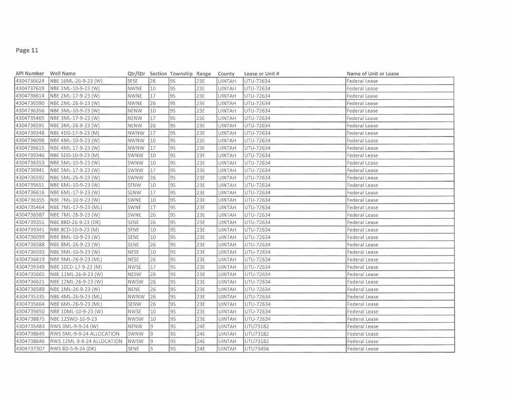
Page 11
API Number Well Name Qtr/Qtr Section Township Range County Lease or Unit # Name of Unit or Lease 4304736624 NBE 16ML-26-9-23 (W) SESE 26 95 23E UINTAH UTU-72634 Federal Lease
4304737619 NBE 2ML-10-9-23 (W) NWNE 10 95 23E UINTAH UTU-72634 Federal Lease
4304736614 NBE 2ML-17-9-23 (W) NWNE 17 95 23E UINTAH UTU-72634 Federa I Lease
4304736590 NBE 2ML-26-9-23 (W) NWNE 26 95 23E UINTAH UTU-72634 Federa I Lease
4304736356 NBE 3ML-10-9-23 (W) NENW 10 95 23E UINTAH UTU-72634 Federa I Lease
4304735465 NBE 3ML-17-9-23 (W) NENW 17 95 23E UINTAH UTU-72634 Federal Lease
4304736591 NBE 3ML-26-9-23 (W) NENW 26 9S 23E UINTAH UTU-72634 Federal Lease
4304739348 NBE 400-17-9-23 (M) NWNW 17 95 23E UINTAH UTU-72634 Federal Lease
4304736098 NBE 4ML-10-9-23 (W) NWNW 10 95 23E UINTAH UTU-72634 Federal Lease
4304736615 NBE 4ML-17-9-23 (W) NWNW 17 95 23E UINTAH UTU-72634 Federal Lease
4304739346 NBE 500-10-9-23 (M) SWNW 10 95 23E UINTAH UTU-72634 Federal Lease
4304736353 NBE 5ML-10-9-23 (W) SWNW 10 95 23E UINTAH UTU-72634 Federal Lease
4304736941 NBE 5ML-17-9-23 (W) SWNW 17 95 23E UINTAH UTU-72634 Federal Lease
4304736592 NBE 5ML-26-9-23 (W) SWNW 26 95 23E UINTAH UTU-72634 Federal Lease
4304735651 NBE 6ML-10-9-23 (W) 5ENW 10 95 23E UINTAH UTU-72634 Federal Lease
4304736616 NBE 6ML-17-9-23 (W) 5ENW 17 95 23E UINTAH UTU-72634 Federal Lease
4304736355 NBE 7ML-10-9-23 (W) SWNE 10 95 23E UINTAH UTU-72634 Federal Lease
4304735464 NBE 7ML-17-9-23 (ML) SWNE 17 95 23E UINTAH UTU-72634 Federal Lease
4304736587 NBE 7ML-26-9-23 (W) 5WNE 26 95 23E UINTAH UTU-72634 Federal Lease
4304739351 NBE 8BO-26-9-23 (OK) 5ENE 26 95 23E UINTAH UTU-72634 Federal Lease
4304739341 NBE 8CD-10-9-23 (M) SENE 10 95 23E UINTAH UTU-72634 Federal Lease
4304736099 NBE 8ML-1O-9-23 (W) SENE 10 95 23E UINTAH UTU-72634 Federal Lease
4304736588 NBE 8ML-26-9-23 (W) SENE 26 95 23E UINTAH UTU-72634 Federal Lease
4304736593 NBE 9ML-10-9-23 (W) NESE 10 95 23E UINTAH UTU-72634 Federal Lease
4304736619 NBE 9ML-26-9-23 (ML) NESE 26 95 23E UINTAH UTU-72634 Federal Lease
4304739349 NBE 10CO-17-9-23 (M) NW5E 17 95 23E UINTAH UTU-72634 Federal Lease
4304735665 NBE llML-26-9-23 (W) NESW 26 95 23E UINTAH UTU-72634 Federal Lease
4304736621 NBE 12ML-26-9-23 (W) NWSW 26 95 23E UINTAH UTU-72634 Federa I Lease
4304736589 NBE 1ML-26-9-23 (W) NENE 26 95 23E UINTAH UTU-72634 Federa I Lease
4304735335 NBE 4ML-26-9-23 (ML) NWNW 26 95 23E UINTAH UTU-72634 Federa I Lease
4304735664 NBE 6ML-26-9-23 (ML) SENW 26 95 23E UINTAH UTU-72634 Federa I Lease
4304735650 NBE lOML-10-9-23 (W) NW5E 10 95 23E UINTAH UTU-72634 Federa I Lease
4304738875 NBE 12SWO-10-9-23 NWSW 10 95 23E UINTAH UTU-72634 Federa I Lease
4304735483 RWS 3ML-9-9-24 (W) NENW 9 95 24E UINTAH UTU73182 Federa I Lease
4304738645 RW5 5ML-9-9-24 ALLOCATION 5WNW 9 95 24E UINTAH UTU73182 Federal Lease
4304738646 RWS 12ML-9-9-24 ALLOCATION NWSW 9 95 24E UINTAH UTU73182 Federal Lease
4304737307 RW5 80-5-9-24 (OK) 5ENE 5 95 24E UINTAH UTU73456 Federal Lease
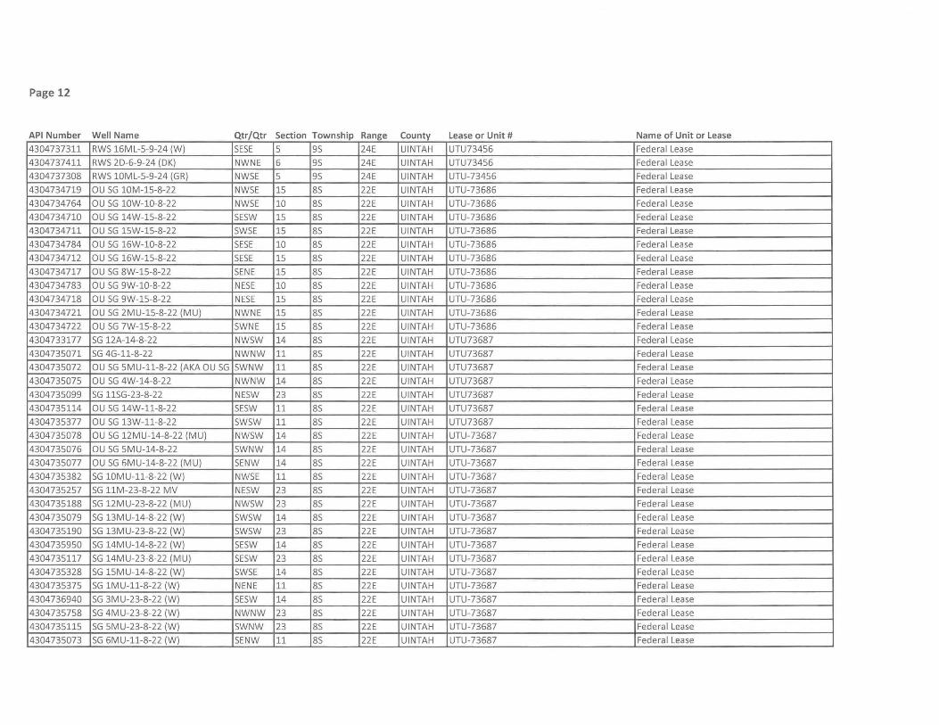
Page 12
API Number Well Name Qtr/Qtr Section Township Range County Lease or Unit # Name of Unit or Lease
4304737311 RW5 16ML-5-9-24 (W) SESE 5 95 24E UINTAH UTU73456 Federal Lease
4304737411 RW5 2D-6-9-24 (DK) NWNE 6 95 24E UINTAH UTU73456 Federal Lease
4304737308 RW5 10ML-5-9-24 (GR) NW5E 5 95 24E UINTAH UTU-73456 Federal Lease
4304734719 au 5G 10M-15-8-22 NW5E 15 85 22E UINTAH UTU-73686 Federal Lease
4304734764 au 5G 10W-l0-8-22 NW5E 10 85 22E UINTAH UTU-73686 Federal Lease
4304734710 au 5G 14W-15-8-22 5E5W 15 85 22E UINTAH UTU-73686 Federal Lease
4304734711 au 5G 15W-15-8-22 5W5E 15 85 22E UINTAH UTU-73686 Federal Lease
4304734784 au 5G 16W-1O-8-22 SESE 10 85 22E UINTAH UTU-73686 Federal Lease
4304734712 au 5G 16W-15-8-22 SESE 15 85 22E UINTAH UTU-73686 Federal Lease
4304734717 au 5G 8W-15-8-22 SENE 15 85 22E UINTAH UTU-73686 Federa I Lease
4304734783 au 5G 9W-1O-8-22 NE5E 10 85 22E UINTAH UTU-73686 Federal Lease
4304734718 au 5G 9W-15-8-22 NE5E 15 85 22E UINTAH UTU-73686 Federal Lease
4304734721 au 5G 2MU-15-8-22 (MU) NWNE 15 85 22E UINTAH UTU-73686 Federal Lease
4304734722 au 5G 7W-15-8-22 5WNE 15 85 22E UINTAH UTU-73686 Federal Lease
4304733177 5G 12A-14-8-22 NW5W 14 85 22E UINTAH UTU73687 Federal Lease
4304735071 5G 4G-11-8-22 NWNW 11 85 22E UINTAH UTU73687 Federal Lease
4304735072 au 5G 5MU-11-8-22 (AKA au 5G 5WNW 11 85 22E UINTAH UTU73687 Federal Lease
4304735075 au 5G 4W-14-8-22 NWNW 14 85 22E UINTAH UTU73687 Federa I Lease
4304735099 5G 115G-23-8-22 NE5W 23 85 22E UINTAH UTU73687 Federa I Lease
4304735114 au 5G 14W-11-8-22 5E5W 11 85 22E UINTAH UTU73687 Federa I Lease
4304735377 au 5G 13W-11-8-22 5W5W 11 85 22E UINTAH UTU73687 Federal Lease
4304735078 au 5G 12MU-14-8-22 (MU) NW5W 14 85 22E UINTAH UTU-73687 Federal Lease
4304735076 au 5G 5MU-14-8-22 5WNW 14 85 22E UINTAH UTU-73687 Federal Lease
4304735077 au 5G fiMU-14-8-22 (MU) 5ENW 14 85 22E UINTAH UTU-73687 Federal Lease
4304735382 5G 10MU-11-8-22 (W) NW5E 11 85 22E UINTAH UTU-73687 Federal Lease
4304735257 5G 11M-23-8-22 MV NE5W 23 85 22E UINTAH UTU-73687 Federal Lease
4304735188 5G 12MU-23-8-22 (MU) NW5W 23 85 22E UINTAH UTU-73687 Federa I Lease
4304735079 5G 13MU-14-8-22 (W) 5W5W 14 85 22E UINTAH UTU-73687 Federa I Lease
4304735190 5G 13MU-23-8-22 (W) 5W5W 23 85 22E UINTAH UTU-73687 Federa I Lease
4304735950 5G 14MU-14-8-22 (W) 5E5W 14 85 22E UINTAH UTU-73687 Federa I Lease
4304735117 5G 14MU-23-8-22 (MU) 5E5W 23 85 22E UINTAH UTU-73687 Federal Lease
4304735328 5G 15MU-14-8-22 (W) 5WSE 14 85 22E UINTAH UTU-73687 Federal Lease
4304735375 5G lMU-11-8-22 (W) NENE 11 85 22E UINTAH UTU-73687 Federal Lease
4304736940 5G 3MU-23-8-22 (W) 5E5W 14 85 22E UINTAH UTU-73687 Federal Lease
4304735758 5G 4MU-23-8-22 (W) NWNW 23 85 22E UINTAH UTU-73687 Federal Lease
4304735115 SG 5MU-23-8-22 (W) 5WNW 23 85 22E UINTAH UTU-73687 Federal Lease
4304735073 5G 6MU-11-8-22 (W) 5ENW 11 85 22E UINTAH UTU-73687 Federal Lease
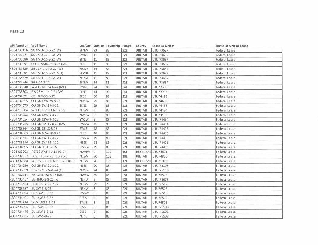
Page 13
API Number Well Name Qtr/Qtr Section Township Range County Lease or Unit # Name of Unit or Lease 4304735116 SG 6MU-23-8-22 (W) SENW 23 8S 22E UINTAH UTU-73687 Federal Lease
4304735374 SG 7MU-11-8-22 (W) SWNE 11 8S 22E UINTAH UTU-73687 Federal Lease
4304735380 SG 8MU-11-8-22 (W) SENE 11 8S 22E UINTAH UTU-73687 Federal Lease
4304735091 au SG 9MU-11-8-22 (MU) NESE 11 85 22E UINTAH UTU-73687 Federal Lease
4304735829 SG 11MU-14-8-22 (W) NESW 14 8S 22E UINTAH UTU-73687 Federal Lease
4304735381 SG 2MU-11-8-22 (MU) NWNE 11 8S 22E UINTAH UTU-73687 Federal Lease
4304735379 SG 3MU-11-8-22 (W) NENW 11 8S 22E UINTAH UTU-73687 Federal Lease
4304732746 SG 6-14-8-22 SENW 14 8S 22E UINTAH UTU-73687 Federa I Lease
4304736040 WWT 7ML-24-8-24 (ML) SWNE 24 8S 24E UINTAH UTU73698 Federa I Lease
4304735803 RWS 8ML-14-9-24 (W) SENE 14 9S 24E UINTAH UTU73917 Federa I Lease
4304734391 GB 16W-30-8-22 SESE 30 8S 22E UINTAH UTU74493 Federa I Lease
4304734555 au GB 12W-29-8-22 NWSW 29 8S 22E UINTAH UTU74493 Federal Lease
4304734575 au GB 8W-29-8-22 SENE 29 8S 22E UINTAH UTU74493 Federal Lease
4304715084 WHITE RIVER UNIT 20-9 NESW 9 85 22E UINTAH UTU74494 Federal Lease
4304734652 au GB 12W-9-8-22 NWSW 9 8S 22E UINTAH UTU74494 Federal Lease
4304734654 au GB 13W-9-8-22 SWSW 9 8S 22E UINTAH UTU-74494 Federal Lease
4304734715 au GB 5M-15-8-22 (MV) SWNW 15 8S 22E UINTAH UTU-74494 Federal Lease
4304733364 au GB 15-18-8-22 SWSE 18 8S 22E UINTAH UTU-74495 Federal Lease
4304734563 au GB 16W-18-8-22 SESE 18 8S 22E UINTAH UTU-74495 Federal Lease
4304734514 au GB 5W-19-8-22 SWNW 19 8S 22E UINTAH UTU-74495 Federa I Lease
4304733516 au GB 9W-18-8-22 NESE 18 8S 22E UINTAH UTU-74495 Federa I Lease
4304734695 au GB 5G-19-8-22 SWNW 19 8S 22E UINTAH UTU-74495 Federal Lease
4301333203 PETES WASH U 13-06 GR NWNW 6 lOS 16E DUCHESNI UTU74831 Federal Lease
4304732052 DESERT SPRING FED 20-1 NESW 20 lOS 18E UINTAH UTU74836 Federal Lease
4301332088 W DESERT SPRING 11-20-10-17 NESW 20 lOS 17E DUCHESNI UTU75083 Federal Lease
4304734630 au GB 9W-20-8-22 NESE 20 8S 22E UINTAH UTU-75103 Federal Lease
4304736039 COY 12ML-24-8-24 (G) NWSW 24 8S 24E UINTAH UTU-75116 Federa I Lease
4304737114 HK 12ML-30-8-25 (ML) NWSW 30 8S 25E UINTAH UTU75503 Federal Lease
4304735457 GB 3MU-3-8-22 (W) NENW 3 8S 22E UINTAH UTU-75678 Federal Lease
4304715423 FEDERAL 2-29-7-22 NESW 29 7S 22E UINTAH UTU76507 Federa I Lease
4304733987 SU 3W-5-8-22 NENW 5 8S 22E UINTAH UTU76508 Federa I Lease
4304733994 SU 13W-5-8-22 SWSW 5 85 22E UINTAH UTU76508 Federa I Lease
4304734401 SU 14W-5-8-22 SESW 5 8S 22E UINTAH UTU76508 Federa I Lease
4304734390 WVX 15G-5-8-22 SWSE 5 8S 22E UINTAH UTU76508 Federa I Lease
4304733996 SU 15W-5-8-22 SWSE 5 8S 22E UINTAH UTU-76508 Federa I Lease
4304734446 SU 16W-5-8-22 SESE 5 8S 22E UINTAH UTU-76508 Federal Lease
4304733985 SU 1W-5-8-22 NENE 5 8S 22E UINTAH UTU-76508 Fed e ra I Lea se

Page 14
API Number Well Name Qtr/Qtr Section Township Range County Lease or Unit # Name of Unit or Lease
4304734455 SU 2W-5-8-22 NWNE 5 8S 22E UINTAH UTU-76508 Federal Lease
4304733988 SU 7W-5-8-22 SWNE 5 8S 22E UINTAH UTU-76508 Federal Lease
4304733990 SU 9W-5-8-22 NESE S 8S 22E UINTAH UTU-76508 Federal Lease
4304734456 SU 10W-5-8-22 NWSE 5 8S 22E UINTAH UTU-76508 Federal Lease
4304737229 NBZ 4D-30-8-24 (W) NWNW 30 8S 24E UINTAH UTU77301 Federal Lease
4304737230 NBZ 6ML-30-8-24 (W) SENW 30 8S 24E UINTAH UTU77301 Federal Lease
4304737232 NBZ 10ML-30-8-24 NWSE 30 8S 24E UINTAH UTU77301 Federal Lease
4304737233 NBZ 12D-30-8-24 (W) NWSW 30 8S 24E UINTAH UTU77301 Federal Lease
4304737234 NBZ 14ML-30-8-24 (W) SESW 30 85 24E UINTAH UTU77301 Federa I Lease
4304737235 NBZ 6D-31-8-24 SENW 31 8S 24E UINTAH UTU77301 Federal Lease
4304737236 NBZ 4D-31-8-24 (W) NWNW 31 85 24E UINTAH UTU77301 Federal Lease
4304737239 NBZ 2ML-31-8-24 NWNE 31 85 24E UINTAH UTU77301 Federal Lease
4304737240 NBZ 11D-29-8-24 (W) NESW 29 85 24E UINTAH UTU77301 Federal Lease
4304737241 NBZ 5D-29-8-24 (W) SWNW 29 85 24E UINTAH UTU77301 Federal Lease
4304737244 NBZ 9D-29-8-24 (W) NESE 29 85 24E UINTAH UTU77301 Federal Lease
4304737246 NBZ 15ML-29-8-24 SWSE 29 85 24E UINTAH UTU77301 Federal Lease
4301333833 GD 16G-35-9-15 SESE 35 95 15E DUCHESNE UTU-78021 Federa I Lease
4301333827 GD 1G-34-9-15 NENE 34 95 15E DUCHESNE UTU-78021 Federal Lease
4304737274 CWD 3D-32-8-24 (W) NENW 32 85 24E UINTAH UTU78029 Federal Lease
4304737276 CWD 12ML-32-8-24 (ML) NWSW 32 8S 24E UINTAH UTU78029 Federal Lease
4301350414 WR 4G-35-10-17 NWNW 35 105 17E DUCHESNE UTU-78216 Federa I Lease
4301333202 PETES WASH U 14-24 GR NWNW 24 105 16E DUCHESNE UTU79824 Federal Lease
4304734952 GB 11M-27-8-21 (ML) NESW 27 85 21E UINTAH UTU-804 Federal Lease
4304734957 GB 1D-27-8-21 (M) NENE 27 85 21E UINTAH UTU-804 Federal Lease
4304734900 GB 3M-27-8-21 (ML) NENW 27 85 21E UINTAH UTU-804 Federal Lease
4304734956 GB 9D-27-8-21 NESE 27 85 21E UINTAH UTU-804 Federal Lease
4304739662 GB 15D-27-8-21 (FR) SWSE 27 85 21E UINTAH UTU-804 Federal Lease
4304734207 WV 2W-3-8-21 NWNE 3 85 21E UINTAH UTU-80636 Federal Lease
4304735412 SU 11MU-9-8-21 (W) NESW 9 8S 21E UINTAH UTU-80637 Federal Lease
4304733905 WV 2W-9-8-21 NWNE 9 85 21E UINTAH UTU-80637 Federal Lease
4304751226 DS 16G-20-10-18 SESE 20 lOS 18E UINTAH UTU-84264 Federal Lease
4304751178 DS 13G-19-10-18 SWSW 19 105 18E UINTAH UTU-88320 Federal Lease
4304733960 GB 9W-25-8-21 NESE 25 8S 21E UINTAH UTU-8909 Federal Lease
4304754035 RW 11-33B SWD NWNW 33 7S 23E UINTAH UTU-90144 Federal Lease
4304731257 GLEN BENCH 44-19 SESE 19 8S 22E UINTAH UTU9617 Federal Lease
4304731260 GLEN BENCH 22-30 SENW 30 85 22E UINTAH UTU9617 Federal Lease
4304731355 GB 13-20-8-22 NWSW 20 85 22E UINTAH UTU9617 Federal Lease

Page 15
API Number Well Name Qtr/Qtr Section Township Range County lease or Unit # Name of Unit or lease 4304732755 GLEN BENCH UN 4-30-8-22 NWNW 30 85 22E UINTAH UTU9617 Federa I Lease
4304737664 GB 16ML-20-8-22 (W) SESE 20 85 22E UINTAH UTU-9617 Federa I Lease
4304734577 au GB lOW-29-8-22 NWSE 29 85 22E UINTAH UTU-9617 Federal Lease
4304734350 au GB llW-29-8-22 NESW 29 85 22E UINTAH UTU-9617 Federal Lease
4304733948 au GB 12W-19-8-22 NWSW 19 85 22E UINTAH UTU-9617 Federal Lease
4304734668 au GB 12WX-29-8-22 NWSW 29 85 22E UINTAH UTU-9617 Federal Lease
4304734536 au GB 13W-19-8-22 SWSW 19 85 22E UINTAH UTU-9617 Federal Lease
4304734547 au GB 13W-29-8-22 SWSW 29 85 22E UINTAH UTU-9617 Federal Lease
4304734743 au GB 14SG-29-8-22 SESW 29 85 22E UINTAH UTU-9617 Federal Lease
4304734632 au GB lSW-20-8-22 SWSE 20 85 22E UINTAH UTU-9617 Federal Lease
4304734578 au GB 15W-29-8-22 SWSE 29 85 22E UINTAH UTU-9617 Federa I Lease
4304734744 au GB 16SG-29-8-22 SESE 29 85 22E UINTAH UTU-9617 Federa I Lease
4304734603 au GB 16W-29-8-22 SESE 29 85 22E UINTAH UTU-9617 Federal Lease
4304734506 au GB 16WX-30-8-22 SESE 30 85 22E UINTAH UTU-9617 Federal Lease
4304734573 au GB 1W-29-8-22 NENE 29 85 22E UINTAH UTU-9617 Federal Lease
4304734600 au GB 2W-29-8-22 NWNE 29 85 22E UINTAH UTU-9617 Federal Lease
4304734546 au GB 3W-29-8-22 NENW 29 85 22E UINTAH UTU-9617 Federal Lease
4304734549 au GB SW-29-8-22 SWNW 29 85 22E UINTAH UTU-9617 Federal Lease
4304734545 au GB 6W-29-8-22 SENW 29 85 22E UINTAH UTU-9617 Federal Lease
4304734574 au GB 7W-29-8-22 SWNE 29 85 22E UINTAH UTU-9617 Federal Lease
4304734576 au GB 9W-29-8-22 NESE 29 85 22E UINTAH UTU-9617 Federa I Lease
4304734533 au GB 9W-30-8-22 NESE 30 85 22E UINTAH UTU-9617 Federa I Lease
4304734554 au GB 14W-29-8-22 SESW 29 85 22E UINTAH UTU-9617 Federa I Lease
4304734688 au GB 16SG-30-8-22 SESE 30 85 22E UINTAH UTU-9617 Federal Lease
4304734535 au GB 10W-19-8-22 NWSE 19 85 22E UINTAH UTU-9617 Federal Lease
4304734522 au GB 16W-19-8-22 SESE 19 85 22E UINTAH UTU-9617 Federal Lease
4304734631 au GB 10W-20-8-22 NWSE 20 85 22E UINTAH UTU-9617 Federal Lease
4304733947 au GB 10W-30-8-22 NWSE 30 85 22E UINTAH UTU-9617 Federal Lease
4304734517 au GB llW-19-8-22 NESW 19 85 22E UINTAH UTU-9617 Federal Lease
4304734039 au GB llW-20-8-22 NESW 20 85 22E UINTAH UTU-9617 Federal Lease
4304733670 au GB 12W-30-8-22 NWSW 30 85 22E UINTAH UTU-9617 Federal Lease
4304734348 au GB 13W-20-8-22 SWSW 20 85 22E UINTAH UTU-9617 Federal Lease
4304734537 au GB 14W-19-8-22 SESW 19 85 22E UINTAH UTU-9617 Federal Lease
4304734349 au GB 14W-20-8-22 SESW 20 85 22E UINTAH UTU-9617 Federal Lease
4304734548 au GB 4W-29-8-22 NWNW 29 85 22E UINTAH UTU-9617 Federal Lease
4304733945 au GB 4W-30-8-22 NWNW 30 85 22E UINTAH UTU-9617 Federa I Lease
4304734025 au GB 5W-30-8-22 SWNW 30 85 22E UINTAH UTU-9617 Federal Lease
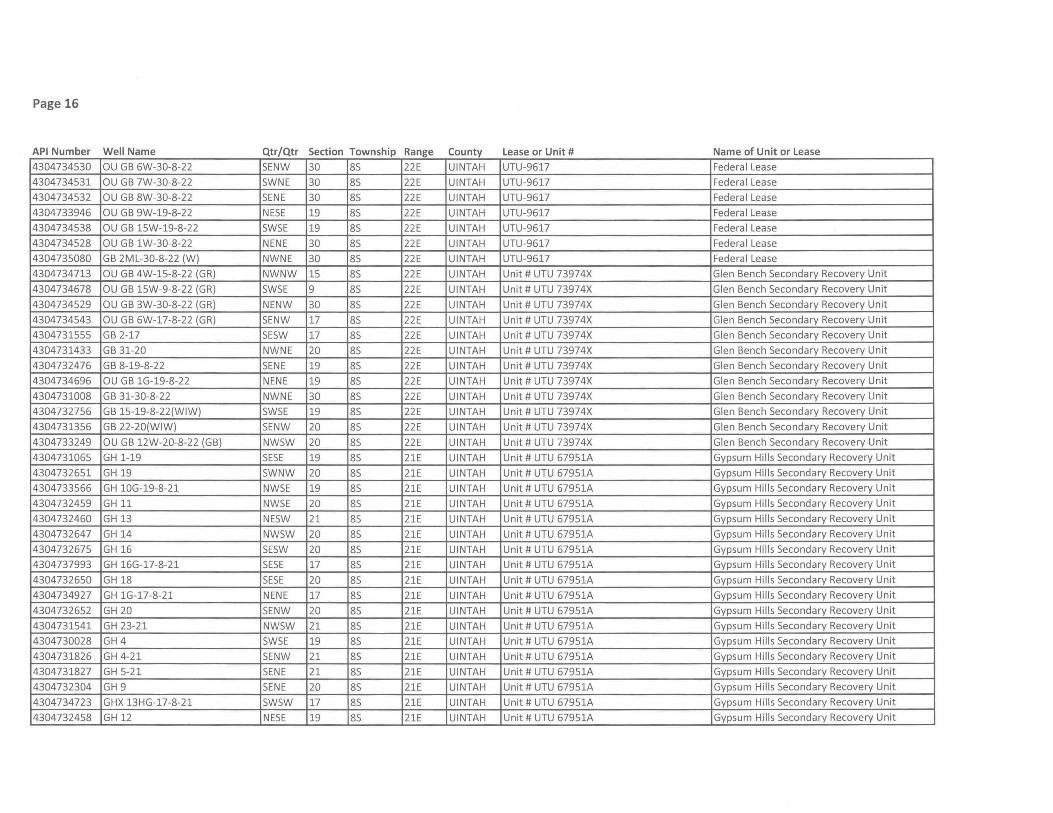
Page 16
API Number Well Name Qtr/Qtr Section Township Range County Lease or Unit # Name of Unit or Lease 4304734530 au GB 6W-30-8-22 SENW 30 8S 22E UINTAH UTU-9617 Federal Lease
4304734531 au GB 7W-30-8-22 SWNE 30 8S 22E UINTAH UTU-9617 Federal Lease
4304734532 au GB 8W-30-8-22 SENE 30 8S 22E UINTAH UTU-9617 Federal Lease
4304733946 au GB 9W-19-8-22 NESE 19 8S 22E UINTAH UTU-9617 Federal Lease
4304734538 au GB 15W-19-8-22 SWSE 19 8S 22E UINTAH UTU-9617 Federal Lease
4304734528 au GB 1W-30-8-22 NENE 30 8S 22E UINTAH UTU-9617 Federal Lease
4304735080 GB 2ML-30-8-22 (W) NWNE 30 8S 22E UINTAH UTU-9617 Federa I Lease
4304734713 au GB 4W-15-8-22 (GR) NWNW 15 8S 22E UINTAH Unit # UTU 73974X Glen Bench Secondary Recovery Unit
4304734678 au GB 15W-9-8-22 (GR) SWSE 9 8S 22E UINTAH Unit # UTU 73974X Glen Bench Secondary Recovery Unit
4304734529 au GB 3W-30-8-22 (GR) NENW 30 8S 22E UINTAH Unit # UTU 73974X Glen Bench Secondary Recovery Unit
4304734543 au GB 6W-17-8-22 (GR) SENW 17 8S 22E UINTAH Unit # UTU 73974X Glen Bench Secondary Recovery Unit
4304731555 GB 2-17 SESW 17 8S 22E UINTAH Unit # UTU 73974X Glen Bench Secondary Recovery Unit
4304731433 GB 31-20 NWNE 20 8S 22E UINTAH Unit # UTU 73974X Glen Bench Secondary Recovery Unit
4304732476 GB 8-19-8-22 SENE 19 8S 22E UINTAH Unit # UTU 73974X Glen Bench Secondary Recovery Unit
4304734696 au GB 1G-19-8-22 NENE 19 8S 22E UINTAH Unit # UTU 73974X Glen Bench Secondary Recovery Unit
4304731008 GB 31-30-8-22 NWNE 30 8S 22E UINTAH Unit # UTU 73974X Glen Bench Secondary Recovery Unit
4304732756 GB 15-19-8-22(WIW) SWSE 19 8S 22E UINTAH Unit # UTU 73974X Glen Bench Secondary Recovery Unit
4304731356 GB 22-20(WIW) SENW 20 8S 22E UINTAH Unit # UTU 73974X Glen Bench Secondary Recovery Unit
4304733249 au GB 12W-20-8-22 (GB) NWSW 20 8S 22E UINTAH Unit # UTU 73974X Glen Bench Secondary Recovery Unit
4304731065 GH 1-19 SESE 19 8S 21E UINTAH Unit # UTU 67951A Gypsum Hills Secondary Recovery Unit
4304732651 GH 19 SWNW 20 8S 21E UINTAH Unit # UTU 67951A Gypsum Hills Secondary Recovery Unit
4304733566 GH 10G-19-8-21 NWSE 19 8S 21E UINTAH Unit # UTU 67951A Gypsum Hills Secondary Recovery Unit
4304732459 GH 11 NWSE 20 8S 21E UINTAH Unit # UTU 67951A Gypsum Hills Secondary Recovery Unit
4304732460 GH 13 NESW 21 8S 21E UINTAH Unit # UTU 67951A Gypsum Hills Secondary Recovery Unit
4304732647 GH 14 NWSW 20 8S 21E UINTAH Unit # UTU 67951A Gypsum Hills Secondary Recovery Unit
4304732675 GH 16 SESW 20 8S 21E UINTAH Unit # UTU 67951A Gypsum Hills Secondary Recovery Unit
4304737993 GH 16G-17-8-21 SESE 17 8S 21E UINTAH Unit # UTU 67951A Gypsum Hills Secondary Recovery Unit
4304732650 GH 18 SESE 20 8S 21E UINTAH Unit # UTU 67951A Gypsum Hills Secondary Recovery Unit
4304734927 GH 1G-17-8-21 NENE 17 8S 21E UINTAH Unit # UTU 67951A Gypsum Hills Secondary Recovery Unit
4304732652 GH 20 SENW 20 8S 21E UINTAH Unit # UTU 67951A Gypsum Hills Secondary Recovery Unit
4304731541 GH 23-21 NWSW 21 8S 21E UINTAH Unit # UTU 67951A Gypsum Hills Secondary Recovery Unit
4304730028 GH 4 SWSE 19 8S 21E UINTAH Unit # UTU 67951A Gypsum Hills Secondary Recovery Unit
4304731826 GH 4-21 SENW 21 8S 21E UINTAH Unit # UTU 67951A Gypsum Hills Secondary Recovery Unit
4304731827 GH 5-21 SENE 21 8S 21E UINTAH Unit # UTU 67951A Gypsum Hills Secondary Recovery Unit
4304732304 GH 9 SENE 20 8S 21E UINTAH Unit # UTU 67951A Gypsum Hills Secondary Recovery Unit
4304734723 GHX 13HG-17-8-21 SWSW 17 8S 21E UINTAH Unit # UTU 67951A Gypsum Hills Secondary Recovery Unit
4304732458 GH 12 NESE 19 8S 21E UINTAH Unit # UTU 67951A Gypsum Hills Secondary Recovery Unit
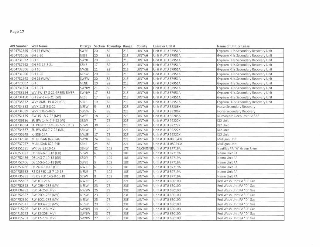
Page 17
API Number Well Name Qtr/Qtr Section Township Range County Lease or Unit # Name of Unit or Lease
4304732649 GH 17 (WIW) SWSE 20 85 21E UINTAH Unit # UTU 67951A Gypsum Hills Secondary Recovery Unit
4304731066 GH 2-20 NESE 20 85 21E UINTAH Unit # UTU 67951A Gypsum Hills Secondary Recovery Unit
4304731932 GH 8 SWNE 20 85 21E UINTAH Unit # UTU 67951A Gypsum Hills Secondary Recovery Unit
4304737992 GH 8G-17-8-21 SENE 17 85 21E UINTAH Unit # UTU 67951A Gypsum Hills Secondary Recovery Unit
4304732306 GH 10 NWSE 21 85 21E UINTAH Unit # UTU 67951A Gypsum Hills Secondary Recovery Unit
4304731006 GH 1-20 NESW 20 85 21E UINTAH Unit # UTU 67951A Gypsum Hills Secondary Recovery Unit
4304732648 GH 15 (WIW) SWSW 20 85 21E UINTAH Unit # UTU 67951A Gypsum Hills Secondary Recovery Unit
4304720002 GH 3 NENE 20 85 21E UINTAH Unit # UTU 67951A Gypsum Hills Secondary Recovery Unit
4304731604 GH 3-21 SWNW 21 85 21E UINTAH Unit # UTU 67951A Gypsum Hills Secondary Recovery Unit
4304733954 WV 5W-17-8-21 GREEN RIVER SWNW 17 85 21E UINTAH Unit # UTU 67951A Gypsum Hills Secondary Recovery Unit
4304734150 GH 9W-17-8-21 (GR) NESE 17 85 21E UINTAH Unit # UTU 67951A Gypsum Hills Secondary Recovery Unit
4304735372 WVX 8MU-19-8-21 (GR) SENE 19 85 21E UINTAH Unit # UTU 67951A Gypsum Hills Secondary Recovery Unit
4304734388 WVX llG-5-8-22 NESW 5 85 22E UINTAH Unit # UTU 88206X Horse Secondary Recovery
4304734389 WVX 13G-5-8-22 SWSW 5 85 22E UINTAH Unit # UTU 88206X Horse Secondary Recovery
4304751179 BW 15-18-7-22 (MV) SWSE 18 75 22E UINTAH Unit # UTU 88205A Kilimanjaro Deep Unit PA "A"
4304736136 SU BW 14M-7-7-22 (W) SESW 7 75 22E UINTAH Unit # UTU 92222X KJ2 Unit
4304734384 SU PURDY 14M-30-7-22 (MU) SESW 30 75 22E UINTAH Unit # UTU 92222X KJ2 Unit
4304734837 SU BW 6M-7-7-22 (MU) SENW 7 75 22E UINTAH Unit # UTU 92222X KJ2 Unit
4304755649 KJ 33B-17A NWSE 17 75 22E UINTAH Unit # UTU 92222X KJ2 Unit
4304737078 MULLIGAN 822-24G SWNE 24 85 22E UINTAH Unit # UTU-080643X Mulligan Unit
4304737077 MULLIGAN 822-24H SENE 24 85 22E UINTAH Unit # UTU-080643X Mulligan Unit
4301351631 WR 6G-32-10-17 SENW 32 105 17E DUCHESNE Unit # UTU 87716A Nautilus PA "A" Green River
4304753023 DS 14G-6-10-18 (GR) SESW 6 105 18E UINTAH Unit # UTU 87719A Nemo Unit PA
4304752436 DS 14G-7-10-18 (GR) SESW 7 105 18E UINTAH Unit # UTU 87719A Nemo Unit PA
4304752406 DS 15G-5-10-18 (GR) SWSE 5 105 18E UINTAH Unit # UTU 87719A Nemo Unit PA
4304753286 DS 2G-6-10-18 (GR) NWNE 6 105 18E UINTAH Unit # UTU 87719A Nemo Unit PA
4304735932 RB DS FED lG-7-10-18 NENE 7 105 18E UINTAH Unit # UTU 87719A Nemo Unit PA
4304735933 RB DS FED 14G-8-10-18 SESW 8 105 18E UINTAH Unit # UTU 87719A Nemo Unit PA
4304755403 RW lCl-21A NWNE 21 75 22E UINTAH Unit # UTU 63010D Red Wash Unit PA "D" Gas
4304752313 RW 02B4-26B (MV) NESW 23 75 23E UINTAH Unit # UTU 63010D Red Wash Unit PA "D" Gas
4304736982 RW 04-25B (MV) NWSW 25 75 23E UINTAH Unit # UTU 63010D Red Wash Unit PA "D" Gas
4304752327 RW 05C4-23B (MV) NESW 23 75 23E UINTAH Unit # UTU 63010D Red Wash Unit PA "D" Gas
4304752320 RW 10Cl-23B (MV) NESW 23 75 23E UINTAH Unit # UTU 63010D Red Wash Unit PA "D" Gas
4304752317 RW 10C4-23B (MV) NESW 23 75 23E UINTAH Unit # UTU 63010D Red Wash Unit PA "D" Gas
4304715296 RW 12-14B (MV) SWNW 14 75 23E UINTAH Unit # UTU 63010D Red Wash Unit PA "D" Gas
4304715272 RW 12-20B (MV) SWNW 20 75 23E UINTAH Unit # UTU 63010D Red Wash Unit PA "D" Gas
4304715201 RW 12-27B (MV) SWNW 27 75 23E UINTAH Unit # UTU 63010D Red Wash Unit PA "D" Gas

Page 18
API Number Well Name Qtr/Qtr Section Township Range County Lease or Unit # Name of Unit or Lease
4304751938 RW 12A2-28B (MV) NW5W 28 75 23E UINTAH Unit # UTU 630100 Red Wash Unit PA "0" Gas
4304752328 RW 12Bl-23B (MV) NE5W 23 75 23E UINTAH Unit # UTU 630100 Red Wash Unit PA "0" Gas
4304752332 RW 12B4-23B (MV) NE5W 23 75 23E UINTAH Unit # UTU 630100 Red Wash Unit PA "0" Gas
4304752234 RW 12B4-27B (MV) NW5W 27 75 23E UINTAH Unit # UTU 630100 Red Wash Unit PA "0" Gas
4304752330 RW 12Cl-23B (MV) NE5W 23 75 23E UINTAH Unit # UTU 630100 Red Wash Unit PA "0" Gas
4304751903 RW 12C3-25B (MV) NW5W 25 75 23E UINTAH Unit # UTU 630100 Red Wash Unit PA "0" Gas
4304752329 RW 12C4-23B (MV) NE5W 23 75 23E UINTAH Unit # UTU 630100 Red Wash Unit PA "0" Gas
4304751904 RW 1201-25B (MV) NE5W 25 75 23E UINTAH Unit # UTU 630100 Red Wash Unit PA "0" Gas
4304751905 RW 1204-25B (MV) NE5W 25 75 23E UINTAH Unit # UTU 630100 Red Wash Unit PA "0" Gas
4304752333 RW 13Bl-23B (MV) NE5W 23 75 23E UINTAH Unit # UTU 630100 Red Wash Unit PA "0" Gas
4304752243 RW 13B4-18C (MV) 5W5W 18 75 24E UINTAH Unit # UTU 630100 Red Wash Unit PA "0" Gas
4304751939 RW 1302-24A (MV) 5W5W 24 75 22E UINTAH Unit # UTU 630100 Red Wash Unit PA "0" Gas
4304715178 RW 14-18B (MV) 5W5W 18 75 23E UINTAH Unit # UTU 630100 Red Wash Unit PA "0" Gas
4304715176 RW 14-23A (MV) 5W5W 23 75 22E UINTAH Unit # UTU 630100 Red Wash Unit PA "0" Gas
4304715165 RW 14-23B (MV) 5W5W 23 75 23E UINTAH Unit # UTU 630100 Red Wash Unit PA "0" Gas
4304715166 RW 14-24A (MV) 5W5W 24 75 22E UINTAH Unit # UTU 630100 Red Wash Unit PA "0" Gas
4304715265 RW 14-29B (MV) 5W5W 29 75 23E UINTAH Unit # UTU 630100 Red Wash Unit PA "0" Gas
4304751940 RW 1403-24A (MV) 5E5W 24 75 22E UINTAH Unit # UTU 630100 Red Wash Unit PA "0" Gas
4304754669 RW 15B4-21B SENE 28 75 23E UINTAH Unit # UTU 630100 Red Wash Unit PA "0" Gas
4304752319 RW 15B4-23B (MV) NE5W 23 75 23E UINTAH Unit # UTU 630100 Red Wash Unit PA "0" Gas
4304752316 RW 15C1-23B (MV) NE5W 23 75 23E UINTAH Unit # UTU 630100 Red Wash Unit PA "0" Gas
4304754668 RW 15C4-21B SENE 28 75 23E UINTAH Unit # UTU 630100 Red Wash Unit PA "0" Gas
4304752314 RW 15C4-23B (MV) NE5W 23 75 23E UINTAH Unit # UTU 630100 Red Wash Unit PA "0" Gas
4304755404 RW 16Bl-16A NWNE 21 75 22E UINTAH Unit # UTU 630100 Red Wash Unit PA "0" Gas
4304755405 RW 16Cl-16A NENE 21 75 22E UINTAH Unit # UTU 630100 Red Wash Unit PA "0" Gas
4304755414 RW IBl-21A NWNE 21 75 22E UINTAH Unit # UTU 630100 Red Wash Unit PA "0" Gas
4304754665 RW lC4-28B SENE 28 75 23E UINTAH Unit # UTU 630100 Red Wash Unit PA "0" Gas
4304715186 RW 21-22B (MV) NENW 22 75 23E UINTAH Unit # UTU 630100 Red Wash Unit PA "0" Gas
4304715167 RW 21-24B (MV) NENW 24 75 23E UINTAH Unit # UTU 630100 Red Wash Unit PA "0" Gas
4304715191 RW 21-27B (MV) NENW 27 75 23E UINTAH Unit # UTU 630100 Red Wash Unit PA "0" Gas
4304715260 RW 22-22B (MV) 5ENW 22 75 23E UINTAH Unit # UTU 630100 Red Wash Unit PA "0" Gas
4304715157 RW 23-13B (MV) NE5W 13 75 23E UINTAH Unit # UTU 630100 Red Wash Unit PA "0" Gas
4304715290 RW 23-26B (MV) NE5W 26 75 23E UINTAH Unit # UTU 630100 Red Wash Unit PA "0" Gas
4304715237 RW 23-28B (MV) NE5W 28 75 23E UINTAH Unit # UTU 630100 Red Wash Unit PA "0" Gas
4304751722 RW 23A-28B (MV) 5E5W 28 75 23E UINTAH Unit # UTU 630100 Red Wash Unit PA "0 " Gas
4304753307 RW 24-14AGR 5E5W 14 75 22E UINTAH Unit # UTU 630100 Red Wash Unit PA "0" Gas
4304730518 RW 24-26B (MV) 5E5W 26 75 23E UINTAH Unit # UTU 630100 Red Wash Unit PA "0" Gas

Page 19
API Number Well Name Qtr/Qtr Section Township Range County Lease or Unit # Name of Unit or Lease
4304752324 RW 2Bl-26B (MV) NESW 23 75 23E UINTAH Unit # UTU 630100 Red Wash Unit PA "0" Gas
4304754667 RW 2C4-28B SENE 28 75 23E UINTAH Unit # UTU 630100 Red Wash Unit PA "0" Gas
4304751724 RW 31-20B (MV) NWNE 20 75 23E UINTAH Unit # UTU 630100 Red Wash Unit PA "0" Gas
4304715283 RW 31-28B (MV) NWNE 28 75 23E UINTAH Unit # UTU 630100 Red Wash Unit PA "0" Gas
4304715139 RW 32-22B (MV) SWNE 22 75 23E UINTAH Unit # UTU 630100 Red Wash Unit PA "0" Gas
4304751788 RW 32-25A (MV) SWNE 25 75 22E UINTAH Unit # UTU 630100 Red Wash Unit PA "0" Gas
4304715275 RW 32-26B (MV) SWNE 26 75 23E UINTAH Unit # UTU 630100 Red Wash Unit PA "0" Gas
4304751723 RW 32-29B (MV) SWNE 29 75 23E UINTAH Unit # UTU 630100 Red Wash Unit PA "0" Gas
4304730521 RW 33-26B (MV) NWSE 26 75 23E UINTAH Unit # UTU 630100 Red Wash Unit PA "0" Gas
4304715152 RW 34-14B (MV) SWSE 14 75 23E UINTAH Unit # UTU 630100 Red Wash Unit PA "0" Gas
4304753299 RW 34-20BGR SWSE 20 75 23E UINTAH Unit # UTU 630100 Red Wash Unit PA "0" Gas
4304715158 RW 34-22B (MV) SWSE 22 75 23E UINTAH Unit # UTU 630100 Red Wash Unit PA "0" Gas
4304751720 RW 34-24B (MV) SWSE 24 75 23E UINTAH Unit # UTU 630100 Red Wash Unit PA "0" Gas
4304715148 RW 34-26B (MV) SWSE 26 75 23E UINTAH Unit # UTU 630100 Red Wash Unit PA "0" Gas
4304739445 RW 34-27 AOR (M) SWSE 27 75 22E UINTAH Unit # UTU 630100 Red Wash Unit PA "0" Gas
4304736351 RW 34-34AO (W) SWSE 34 75 22E UINTAH Unit # UTU 630100 Red Wash Unit PA "0" Gas
4304716498 RW 41-14B (MV) NENE 14 75 23E UINTAH Unit # UTU 630100 Red Wash Unit PA "0" Gas
4304716495 RW 41-15B (MV) NENE 15 75 23E UINTAH Unit # UTU 630100 Red Wash Unit PA "0" Gas
4304736818 RW 41-26AG (MV) NENE 26 75 22E UINTAH Unit # UTU 630100 Red Wash Unit PA "0" Gas
4304753682 RW 42-25AGR SENE 25 75 22E UINTAH Unit # UTU 630100 Red Wash Unit PA "0" Gas
4304731051 RW 42-27B (MV) SENE 27 75 23E UINTAH Unit # UTU 630100 Red Wash Unit PA "0" Gas
4304731682 RW 43-15B (MV) NESE 15 75 23E UINTAH Unit # UTU 630100 Red Wash Unit PA "0" Gas
4304751721 RW 43-20B (MV) NESE 20 75 23E UINTAH Unit # UTU 630100 Red Wash Unit PA "0" Gas
4304716475 RW 43-28B (MV) NESE 28 75 23E UINTAH Unit # UTU 630100 Red Wash Unit PA "0" Gas
4304715236 RW 43-29A (MV) NESE 29 75 22E UINTAH Unit # UTU 630100 Red Wash Unit PA "0" Gas
4304736349 RW 44-08FG (MV) SESE 8 85 24E UINTAH Unit # UTU 630100 Red Wash Unit PA "0" Gas
4304715206 RW 44-14B (MV) SESE 14 75 23E UINTAH Unit # UTU 630100 Red Wash Unit PA "0" Gas
4304751719 RW 44-25B (MV) SESE 25 75 23E UINTAH Unit # UTU 630100 Red Wash Unit PA "0" Gas
4304731053 RW 44-27B (MV) SESE 27 75 23E UINTAH Unit # UTU 630100 Red Wash Unit PA "0" Gas
4304752311 RW 5B4-23B NESW 23 75 23E UINTAH Unit # UTU 630100 Red Wash Unit PA "0" Gas
4304752312 RW 5C1-23B (MV) NESW 23 75 23E UINTAH Unit # UTU 630100 Red Wash Unit PA "0" Gas
4304752242 RW 502-26B (MV) SWNW 26 75 23E UINTAH Unit # UTU 630100 Red Wash Unit PA "0" Gas
4304754666 RW 7B4-28B (MV) SENE 28 75 23E UINTAH Unit # UTU 630100 Red Wash Unit PA "0" Gas
4304754664 RW 7C4-28B SENE 28 75 23E UINTAH Unit # UTU 630100 Red Wash Unit PA "0" Gas
4304755402 RW 8Bl-21A NWNE 21 75 22E UINTAH Unit # UTU 630100 Red Wash Unit PA "0" Gas
4304754662 RW 8B4-28B SENE 28 75 23E UINTAH Unit # UTU 630100 Red Wash Unit PA "0" Gas
4304755401 RW 8C1-21A NWNE 21 75 22E UINTAH Unit # UTU 630100 Red Wash Unit PA "0" Gas

Page 20
API Number Well Name Qtr/Qtr Section Township Range County Lease or Unit # Name of Unit or Lease
4304752240 RW 8Cl-30B (MV) 5ENE 30 75 23E UINTAH Unit # UTU 630100 Red Wash Unit PA "0" Gas
4304754663 RW 8C4-28B 5ENE 28 75 23E UINTAH Unit # UTU 630100 Red Wash Unit PA "0" Gas
4304755406 RW 9B1-21A NWNE 21 75 22E UINTAH Unit # UTU 630100 Red Wash Unit PA "0" Gas
4304755303 RW 9C1-16A NWNE 21 75 22E UINTAH Unit # UTU 630100 Red Wash Unit PA "0" Gas
4304752237 RW 9C1-24B (MV) NE5E 24 75 23E UINTAH Unit # UTU 630100 Red Wash Unit PA "0" Gas
4304752238 RW 9Cl-26B (MV) NE5E 26 75 23E UINTAH Unit # UTU 630100 Red Wash Unit PA "0 " Gas
4304735671 RWU 14-34AMU (W) 5W5W 34 75 22E UINTAH Unit # UTU 630100 Red Wash Unit PA "0" Gas
4304715145 RW 32-17C (MV) 5WNE 17 75 24E UINTAH Unit # UTU 630100 Red Wash Unit PA "0" Gas
4304752315 RW 15B1-23B (MV) NE5W 23 75 23E UINTAH Unit # UTU 630100 Red Wash Unit PA "0" Gas
4304715196 RW 12-13B (MV) 5WNW 13 75 23E UINTAH Unit # UTU 630100 Red Wash Unit PA "0" Gas
4304715153 RW 23-22B (MV) NE5W 22 75 23E UINTAH Unit # UTU 630100 Red Wash Unit PA "0" Gas
4304715230 RW 32-28A (MV) 5WNE 28 75 22E UINTAH Unit # UTU 630100 Red Wash Unit PA "0" Gas
4304715268 RW 32-30B (MV) 5WNE 30 75 23E UINTAH Unit # UTU 630100 Red Wash Unit PA "0" Gas
4304731476 RW 33-23B (MV) NW5E 23 75 23E UINTAH Unit # UTU 630100 Red Wash Unit PA "0" Gas
4304715205 RW 41-27A (MV) NENE 27 75 22E UINTAH Unit # UTU 630100 Red Wash Unit PA "0" Gas
4304731478 RW 42-21B (MV) 5ENE 21 75 23E UINTAH Unit # UTU 630100 Red Wash Unit PA "0" Gas
4304731576 RW 42-23B (MV) 5ENE 23 75 23E UINTAH Unit # UTU 630100 Red Wash Unit PA "0" Gas
4304715155 RW 43-22B (MV) NE5E 22 75 23E UINTAH Unit # UTU 630100 Red Wash Unit PA "0" Gas
4304730520 RW 44-26B (MV) 5E5E 26 75 23E UINTAH Unit # UTU 630100 Red Wash Unit PA "0" Gas
4304735098 RWU 34-22C (GR) 5W5E 22 75 24E UINTAH Unit # UTU 630100 Red Wash Unit PA "0" Oil
4304715169 RW 2l-29C (GR) NENW 29 75 24E UINTAH Unit # UTU 630100 Red Wash Unit PA "0" Oil
4304730348 RW 23-19C (GR) NE5W 19 75 24E UINTAH Unit # UTU 630100 Red Wash Unit PA "0" Oil
4304732629 RW 23-23C (GR) NE5W 23 75 24E UINTAH Unit # UTU 630100 Red Wash Unit PA "0" Oil
4304715302 RW 32-28C (GR) 5WNE 28 75 24E UINTAH Unit # UTU 630100 Red Wash Unit PA "0" Oil
4304715171 RW 32-33C (GR) 5WNE 33 75 24E UINTAH Unit # UTU 630100 Red Wash Unit PA "0" Oil
4304720014 RW 41-8F (GR) NENE 8 85 24E UINTAH Unit # UTU 630100 Red Wash Unit PA "0" Oil
4304735045 RWU 34-27C (GR) 5W5E 27 75 24E UINTAH Unit # UTU 630100 Red Wash Unit PA "0" Oil
4304731477 RW 11-24B (GR) NWNW 24 75 23E UINTAH Unit # UTU 630100 Red Wash Unit PA "0" Oil
4304753302 RW 11-26A (GR) NWNW 26 75 22E UINTAH Unit # UTU 630100 Red Wash Unit PA "0" Oil
4304753311 RW 11-27AGR NWNW 27 75 22E UINTAH Unit # UTU 630100 Red Wash Unit PA "0" Oil
4304715170 RW 12-17B (GR) 5WNW 17 75 23E UINTAH Unit # UTU 630100 Red Wash Unit PA "0" Oil
4304715183 RW 12-18C (GR) 5WNW 18 75 24E UINTAH Unit # UTU 630100 Red Wash Unit PA "0" Oil
4304715213 RW 12-22A (GR) 5WNW 22 75 22E UINTAH Unit # UTU 630100 Red Wash Unit PA "0" Oil
4304715218 RW 12-22B (GR) 5WNW 22 75 23E UINTAH Unit # UTU 630100 Red Wash Unit PA "0" Oil
4304715274 RW 12-28B (GR) 5WNW 28 75 23E UINTAH Unit # UTU 630100 Red Wash Unit PA "0" Oil
4304731517 RW 13-24B (GR) NW5W 24 75 23E UINTAH Unit # UTU 630100 Red Wash Unit PA "0" Oil
4304715246 RW 14-15B (GR) 5W5W 15 75 23E UINTAH Unit # UTU 630100 Red Wash Unit PA "0" Oil

Page 21
API Number Well Name Qtr/Qtr Section Township Range County Lease or Unit # Name of Unit or Lease
4304732738 RW 14-17B (GR) SWSW 17 7S 23E UINTAH Unit # UTU 630100 Red Wash Unit PA "0" Oil
4304730341 RW 14-25B (GR) SWSW 25 7S 23E UINTAH Unit # UTU 630100 Red Wash Unit PA "0" Oil
4304715202 RW 14-27B (GR) SWSW 27 7S 23E UINTAH Unit # UTU 630100 Red Wash Unit PA "0" Oil
4304715199 RW 21-13B (GR) NENW 13 7S 23E UINTAH Unit # UTU 630100 Red Wash Unit PA "0" Oil
4304715193 RW 21-18C (GR) NENW 18 7S 24E UINTAH Unit # UTU 630100 Red Wash Unit PA "0" Oil
4304715233 RW 21-19B (GR) NENW 19 7S 23E UINTAH Unit # UTU 630100 Red Wash Unit PA "0" Oil
4304730340 RW 21-19C (GR) NENW 19 75 24E UINTAH Unit # UTU 630100 Red Wash Unit PA "0" Oil
4304733592 RW 21-24A (GR) NENW 24 7S 22E UINTAH Unit # UTU 630100 Red Wash Unit PA "0" Oil
4304733576 RW 21-25A (GR) NENW 25 75 22E UINTAH Unit # UTU 630100 Red Wash Unit PA "0" Oil
4304715227 RW 21-28B (GR) NENW 28 75 23E UINTAH Unit # UTU 630100 Red Wash Unit PA "0" Oil
4304730258 RW 21-34B (GR) NENW 34 7S 23E UINTAH Unit # UTU 630100 Red Wash Unit PA "0" Oil
4304730345 RW 22-14B (GR) 5ENW 14 7S 23E UINTAH Unit # UTU 630100 Red Wash Unit PA "0" Oil
4304730387 RW 22-18C (GR) SENW 18 75 24E UINTAH Unit # UTU 630100 Red Wash Unit PA "0" Oil
4304733559 RW 22-19B (GR) SENW 19 7S 23E UINTAH Unit # UTU 630100 Red Wash Unit PA "0" Oil
4304733491 RW 22-20B (GR) SENW 20 75 23E UINTAH Unit # UTU 630100 Red Wash Unit PA "0" Oil
4304733786 RW 22-25A (GR) SENW 25 75 22E UINTAH Unit # UTU 630100 Red Wash Unit PA "0" Oil
4304715192 RW 23-22A (GR) NE5W 22 7S 22E UINTAH Unit # UTU 630100 Red Wash Unit PA "0" Oil
4304715228 RW 23-23A (GR) NE5W 23 7S 22E UINTAH Unit # UTU 630100 Red Wash Unit PA "0" Oil
4304733567 RW 23-24A (GR) NE5W 24 75 22E UINTAH Unit # UTU 630100 Red Wash Unit PA "0" Oil
4304715239 RW 24-14B (GR) SESW 14 75 23E UINTAH Unit # UTU 630100 Red Wash Unit PA "0" Oil
4304731579 RW 24-15B (GR) SESW 15 75 23E UINTAH Unit # UTU 630100 Red Wash Unit PA "0" Oil
4304733554 RW 24-18B (GR) SESW 18 7S 23E UINTAH Unit # UTU 630100 Red Wash Unit PA "0" Oil
4304731582 RW 24-18C (GR) SESW 18 7S 24E UINTAH Unit # UTU 630100 Red Wash Unit PA "0" Oil
4304733492 RW 24-19B (GR) SESW 19 75 23E UINTAH Unit # UTU 630100 Red Wash Unit PA "0" Oil
4304733523 RW 24-20B (GR) SESW 20 75 23E UINTAH Unit # UTU 630100 Red Wash Unit PA "0" Oil
4304715255 RW 24-22B (GR) SESW 22 75 23E UINTAH Unit # UTU 630100 Red Wash Unit PA "0" Oil
4304753305 RW 31-31B (GR) NWNE 31 7S 23E UINTAH Unit # UTU 630100 Red Wash Unit PA "0" Oil
4304715150 RW 32-14B (GR) SWNE 14 7S 23E UINTAH Unit # UTU 630100 Red Wash Unit PA "0" Oil
4304715270 RW 32-15B (GR) SWNE 15 7S 23E UINTAH Unit # UTU 630100 Red Wash Unit PA "0" Oil
4304732981 RW 32-17B (GR) SWNE 17 7S 23E UINTAH Unit # UTU 630100 Red Wash Unit PA "0" Oil
4304733018 RW 32-18B (GR) SWNE 18 7S 23E UINTAH Unit # UTU 630100 Red Wash Unit PA "0" Oil
4304715198 RW 32-18C (GR) SWNE 18 7S 24E UINTAH Unit # UTU 630100 Red Wash Unit PA "0" Oil
4304715226 RW 32-21B (GR) SWNE 21 7S 23E UINTAH Unit # UTU 630100 Red Wash Unit PA "0" Oil
4304715156 RW 32-23B (GR) SWNE 23 7S 23E UINTAH Unit # UTU 630100 Red Wash Unit PA "0" Oil
4304715229 RW 32-24A (GR) SWNE 24 7S 22E UINTAH Unit # UTU 630100 Red Wash Unit PA "0" Oil
4304730313 RW 32-24B (GR) SWNE 24 75 23E UINTAH Unit # UTU 630100 Red Wash Unit PA "0" Oil
4304715200 RW 32-28B (GR) SWNE 28 7S 23E UINTAH Unit # UTU 630100 Red Wash Unit PA "0" Oil
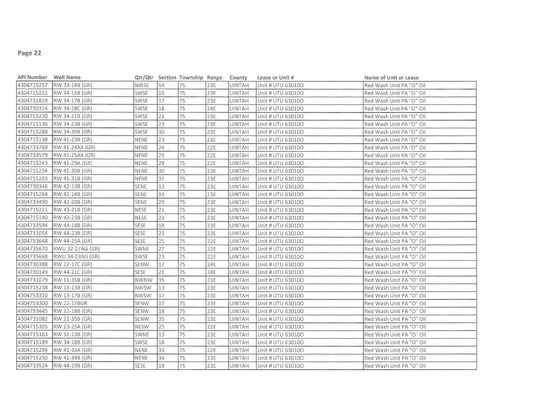
Page 22
API Number Well Name Qtr/Qtr Section Township Range County Lease or Unit # Name of Unit or Lease
4304715257 RW 33-14B (GR) NW5E 14 75 23E UINTAH Unit # UTU 630100 Red Wash Unit PA "0" Oil
4304715222 RW 34-15B (GR) 5W5E 15 75 23E UINTAH Unit # UTU 630100 Red Wash Unit PA "0" Oil
4304731819 RW 34-17B (GR) SW5E 17 75 23E UINTAH Unit # UTU 630100 Red Wash Unit PA "0" Oil
4304730314 RW 34-18C (GR) 5W5E 18 75 24E UINTAH Unit # UTU 630100 Red Wash Unit PA "0" Oil
4304715220 RW 34-21B (GR) 5W5E 21 75 23E UINTAH Unit # UTU 630100 Red Wash Unit PA "0" Oil
4304715136 RW 34-23B (GR) 5WSE 23 75 23E UINTAH Unit # UTU 630100 Red Wash Unit PA "0" Oil
4304715288 RW 34-30B (GR) 5W5E 30 75 23E UINTAH Unit # UTU 630100 Red Wash Unit PA "0" Oil
4304715138 RW 41-23B (GR) NENE 23 75 23E UINTAH Unit # UTU 630100 Red Wash Unit PA "0" Oil
4304733769 RW 41-24AX (GR) NENE 24 75 22E UINTAH Unit # UTU 630100 Red Wash Unit PA "0" Oil
4304733579 RW 41-25AX (GR) NENE 25 75 22E UINTAH Unit # UTU 630100 Red Wash Unit PA "0" Oil
4304715243 RW 41-29A (GR) NENE 29 75 22E UINTAH Unit # UTU 630100 Red Wash Unit PA "0" Oil
4304715254 RW 41-30B (GR) NENE 30 75 23E UINTAH Unit # UTU 630100 Red Wash Unit PA "0" Oil
4304715203 RW 41-31B (GR) NENE 31 75 23E UINTAH Unit # UTU 630100 Red Wash Unit PA "0" Oil
4304730346 RW 42-13B (GR) SENE 13 75 23E UINTAH Unit # UTU 630100 Red Wash Unit PA "0" Oil
4304715264 RW 42-14B (GR) 5ENE 14 75 23E UINTAH Unit # UTU 630100 Red Wash Unit PA "0" Oil
4304733490 RW 42-20B (GR) 5ENE 20 75 23E UINTAH Unit # UTU 630100 Red Wash Unit PA "0" Oil
4304715211 RW 43-21B (GR) NE5E 21 75 23E UINTAH Unit # UTU 630100 Red Wash Unit PA "0" Oil
4304715140 RW 43-23B (GR) NE5E 23 75 23E UINTAH Unit # UTU 630100 Red Wash Unit PA "0" Oil
4304733594 RW 44-18B (GR) SE5E 18 75 23E UINTAH Unit # UTU 630100 Red Wash Unit PA "0" Oil
4304731054 RW 44-23B (GR) SESE 23 75 23E UINTAH Unit # UTU 630100 Red Wash Unit PA "0" Oil
4304753648 RW 44-25A (GR) 5ESE 25 75 22E UINTAH Unit # UTU 630100 Red Wash Unit PA "0" Oil
4304735670 RWU 32-27AG (GR) 5WNE 27 75 22E UINTAH Unit # UTU 630100 Red Wash Unit PA "0" Oil
4304735668 RWU 34-23AG (GR) 5W5E 23 75 22E UINTAH Unit # UTU 630100 Red Wash Unit PA "0" Oil
4304730388 RW 22-17C (GR) SENW 17 75 24E UINTAH Unit # UTU 630100 Red Wash Unit PA "0" Oil
4304730149 RW 44-21C (GR) 5E5E 21 75 24E UINTAH Unit # UTU 630100 Red Wash Unit PA "0" Oil
4304731079 RW 11-35B (GR) NWNW 35 75 23E UINTAH Unit # UTU 630100 Red Wash Unit PA "0" Oil
4304715238 RW 13-13B (GR) NW5W 13 75 23E UINTAH Unit # UTU 630100 Red Wash Unit PA "0" Oil
4304753310 RW 13-17B (GR) NW5W 17 75 23E UINTAH Unit # UTU 630100 Red Wash Unit PA "0" Oil
4304753300 RW 22-17BGR 5ENW 17 75 23E UINTAH Unit # UTU 630100 Red Wash Unit PA "0" Oil
4304753445 RW 22-18B (GR) SENW 18 75 23E UINTAH Unit # UTU 630100 Red Wash Unit PA "0" Oil
4304731082 RW 22-35B (GR) SENW 35 75 23E UINTAH Unit # UTU 630100 Red Wash Unit PA "0" Oil
4304715305 RW 23-25A (GR) NE5W 25 75 22E UINTAH Unit # UTU 630100 Red Wash Unit PA "0" Oil
4304715163 RW 32-13B (GR) SWNE 13 75 23E UINTAH Unit # UTU 630100 Red Wash Unit PA "0" Oil
4304715189 RW 34-18B (GR) SWSE 18 75 23E UINTAH Unit # UTU 630100 Red Wash Unit PA "0" Oil
4304715294 RW 41-33A (GR) NENE 33 75 22E UINTAH Unit # UTU 630100 Red Wash Unit PA "0" Oil
4304715250 RW 41-34B (GR) NENE 34 75 23E UINTAH Unit # UTU 630100 Red Wash Unit PA "0" Oil
4304733524 RW 44-19B (GR) 5ESE 19 75 23E UINTAH Unit # UTU 630100 Red Wash Unit PA "0" Oil
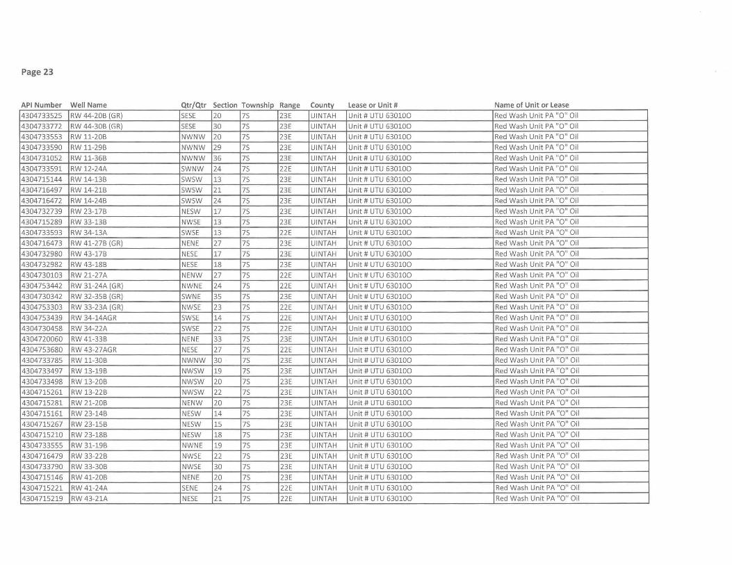
Page 23
API Number Well Name Qtr/Qtr Section Township Range County Lease or Unit # Name of Unit or Lease
4304733525 RW 44-20B (GR) 5E5E 20 75 23E UINTAH Unit # UTU 630100 Red Wash Unit PA "0" Oil
4304733772 RW 44-30B (GR) 5E5E 30 75 23E UINTAH Unit # UTU 630100 Red Wash Unit PA "0" Oil
4304733553 RW 11-20B NWNW 20 75 23E UINTAH Unit # UTU 630100 Red Wash Unit PA "0" Oil
4304733590 RW 11-29B NWNW 29 75 23E UINTAH Unit # UTU 630100 Red Wash Unit PA "0" Oil
4304731052 RW 11-36B NWNW 36 75 23E UINTAH Unit # UTU 630100 Red Wash Unit PA "0" Oil
4304733591 RW 12-24A 5WNW 24 75 22E UINTAH Unit # UTU 630100 Red Wash Unit PA "0" Oil
4304715144 RW 14-13B 5W5W 13 75 23E UINTAH Unit # UTU 630100 Red Wash Unit PA "0" Oil
4304716497 RW 14-21B 5W5W 21 75 23E UINTAH Unit # UTU 630100 Red Wash Unit PA "0" Oil
4304716472 RW 14-24B 5W5W 24 75 23E UINTAH Unit # UTU 630100 Red Wash Unit PA "0" Oil
4304732739 RW 23-17B NE5W 17 75 23E UINTAH Unit # UTU 630100 Red Wash Unit PA "0" Oil
4304715289 RW 33-13B NW5E 13 75 23E UINTAH Unit # UTU 630100 Red Wash Unit PA "0" Oil
4304733593 RW 34-13A 5W5E 13 75 22E UINTAH Unit # UTU 630100 Red Wash Unit PA "0" Oil
4304716473 RW 41-27B (GR) NENE 27 75 23E UINTAH Unit # UTU 630100 Red Wash Unit PA "0" Oil
4304732980 RW 43-17B NE5E 17 75 23E UINTAH Unit # UTU 630100 Red Wash Unit PA "0" Oil
4304732982 RW 43-18B NE5E 18 75 23E UINTAH Unit # UTU 630100 Red Wash Unit PA "0" Oil
4304730103 RW 21-27A NENW 27 75 22E UINTAH Unit # UTU 630100 Red Wash Unit PA "0" Oil
4304753442 RW 31-24A (GR) NWNE 24 75 22E UINTAH Unit # UTU 630100 Red Wash Unit PA "0" Oil
4304730342 RW 32-35B (GR) 5WNE 35 75 23E UINTAH Unit # UTU 630100 Red Wash Unit PA "0" Oil
4304753303 RW 33-23A (GR) NW5E 23 75 22E UINTAH Unit # UTU 630100 Red Wash Unit PA "0" Oil
4304753439 RW 34-14AGR 5W5E 14 75 22E UINTAH Unit # UTU 630100 Red Wash Unit PA "0" Oil
4304730458 RW 34-22A 5W5E 22 75 22E UINTAH Unit # UTU 630100 Red Wash Unit PA "0" Oil
4304720060 RW 41-33B NENE 33 75 23E UINTAH Unit # UTU 630100 Red Wash Unit PA "0" Oil
4304753680 RW 43-27AGR NE5E 27 75 22E UINTAH Unit # UTU 630100 Red Wash Unit PA "0" Oil
4304733785 RW 11-30B NWNW 30 75 23E UINTAH Unit # UTU 630100 Red Wash Unit PA "0" Oil
4304733497 RW 13-19B NW5W 19 75 23E UINTAH Unit # UTU 630100 Red Wash Unit PA "0" Oil
4304733498 RW 13-20B NW5W 20 75 23E UINTAH Unit # UTU 630100 Red Wash Unit PA "0" Oil
4304715261 RW 13-22B NW5W 22 75 23E UINTAH Unit # UTU 630100 Red Wash Unit PA "0" Oil
4304715281 RW 21-20B NENW 20 75 23E UINTAH Unit # UTU 630100 Red Wash Unit PA "0" Oil
4304715161 RW 23-14B NE5W 14 75 23E UINTAH Unit # UTU 630100 Red Wash Unit PA "0" Oil
4304715267 RW 23-15B NE5W 15 75 23E UINTAH Unit # UTU 630100 Red Wash Unit PA "0" Oil
4304715210 RW 23-18B NE5W 18 75 23E UINTAH Unit # UTU 630100 Red Wash Unit PA "0" Oil
4304733555 RW 31-19B NWNE 19 75 23E UINTAH Unit # UTU 630100 Red Wash Unit PA "0" Oil
4304716479 RW 33-22B NW5E 22 75 23E UINTAH Unit # UTU 630100 Red Wash Unit PA "0" Oil
4304733790 RW 33-30B NW5E 30 75 23E UINTAH Unit # UTU 630100 Red Wash Unit PA "0" Oil
4304715146 RW 41-20B NENE 20 75 23E UINTAH Unit # UTU 630100 Red Wash Unit PA "0" Oil
4304715221 RW 41-24A 5ENE 24 75 22E UINTAH Unit # UTU 630100 Red Wash Unit PA "0" Oil
4304715219 RW 43-21A NE5E 21 75 22E UINTAH Unit # UTU 630100 Red Wash Unit PA "0" Oil
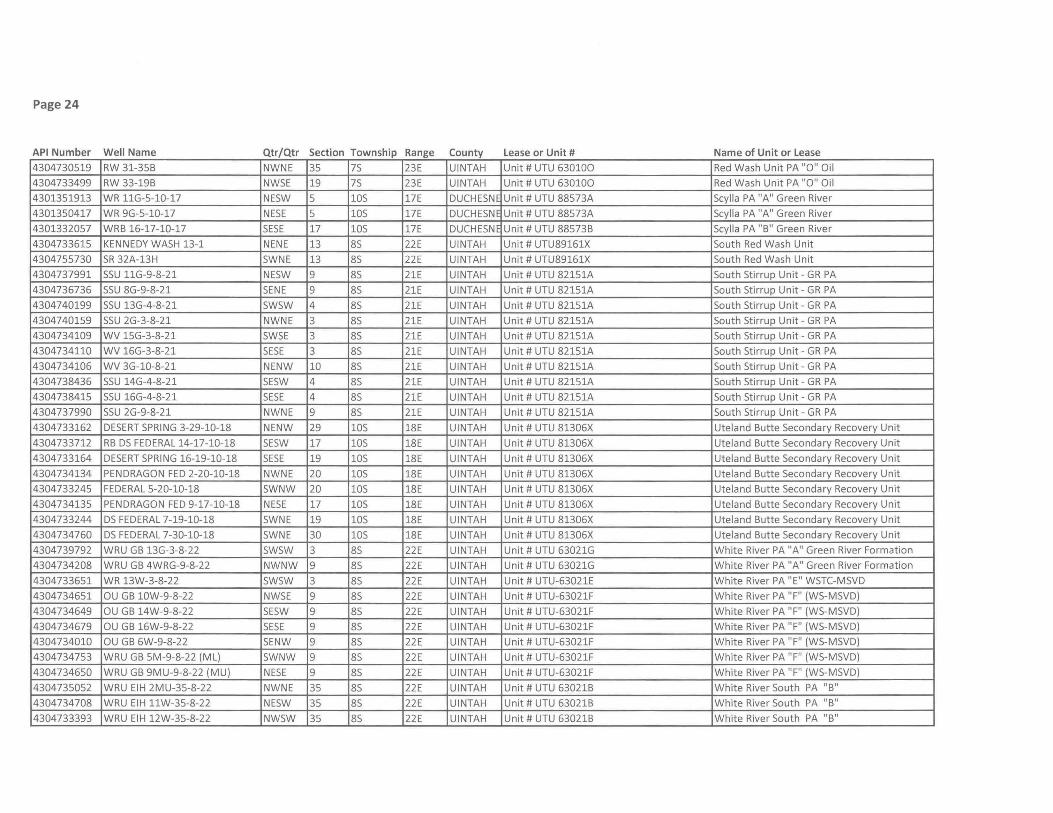
Page 24
API Number Well Name Qtr/Qtr Section Township Range County Lease or Unit # Name of Unit or Lease
4304730519 RW 31-35B NWNE 35 7S 23E UINTAH Unit # UTU 630100 Red Wash Unit PA "0" Oil
4304733499 RW 33-19B NWSE 19 7S 23E UINTAH Unit # UTU 630100 Red Wash Unit PA "0" Oil
4301351913 WR 11G-5-10-17 NESW 5 lOS 17E DUCHESNE Unit # UTU 88573A Scylla PA "A" Green River
4301350417 WR 9G-5-10-17 NESE 5 lOS 17E DUCHESNE Unit # UTU 88573A Scylla PA "A" Green River
4301332057 WRB 16-17-10-17 SESE 17 lOS 17E DUCHESNE Unit # UTU 88573B Scylla PA "B" Green River
4304733615 KENNEDY WASH 13-1 NENE 13 8S 22E UINTAH Unit # UTU89161X South Red Wash Unit
4304755730 SR 32A-13H SWNE 13 8S 22E UINTAH Unit # UTU89161X South Red Wash Unit
4304737991 SSU 11G-9-8-21 NESW 9 8S 21E UINTAH Unit # UTU 82151A South Stirrup Unit - GR PA
4304736736 SSU 8G-9-8-21 SENE 9 8S 21E UINTAH Unit # UTU 82151A South Stirrup Unit - GR PA
4304740199 SSU 13G-4-8-21 SWSW 4 8S 21E UINTAH Unit # UTU 82151A South Stirrup Unit - GR PA
4304740159 SSU 2G-3-8-21 NWNE 3 8S 21E UINTAH Unit # UTU 82151A South Stirrup Unit - GR PA
4304734109 WV 15G-3-8-21 SWSE 3 8S 21E UINTAH Unit # UTU 82151A South Stirrup Unit - GR PA
4304734110 WV 16G-3-8-21 SESE 3 8S 21E UINTAH Unit # UTU 82151A South Stirrup Unit - GR PA
4304734106 WV 3G-l0-8-21 NENW 10 8S 21E UINTAH Unit # UTU 82151A South Stirrup Unit - GR PA
4304738436 SSU 14G-4-8-21 SESW 4 8S 21E UINTAH Unit # UTU 821S1A South Stirrup Unit - GR PA
4304738415 SSU 16G-4-8-21 SESE 4 8S 21E UINTAH Unit # UTU 821S1A South Stirrup Unit - GR PA
4304737990 SSU 2G-9-8-21 NWNE 9 8S 21E UINTAH Unit # UTU 82151A South Stirrup Unit - GR PA
4304733162 DESERT SPRING 3-29-10-18 NENW 29 lOS 18E UINTAH Unit # UTU 81306X Uteland Butte Secondary Recovery Unit
4304733712 RB DS FEDERAL 14-17-10-18 SESW 17 lOS 18E UINTAH Unit # UTU 81306X Uteland Butte Secondary Recovery Unit
4304733164 DESERT SPRING 16-19-10-18 SESE 19 lOS 18E UINTAH Unit # UTU 81306X Uteland Butte Secondary Recovery Unit
4304734134 PENDRAGON FED 2-20-10-18 NWNE 20 lOS 18E UINTAH Unit # UTU 81306X Uteland Butte Secondary Recovery Unit
4304733245 FEDERAL 5-20-10-18 SWNW 20 lOS 18E UINTAH Unit # UTU 81306X Uteland Butte Secondary Recovery Unit
4304734135 PENDRAGON FED 9-17-10-18 NESE 17 lOS 18E UINTAH Unit # UTU 81306X Uteland Butte Secondary Recovery Unit
4304733244 DS FEDERAL 7-19-10-18 SWNE 19 lOS 18E UINTAH Unit # UTU 81306X Uteland Butte Secondary Recovery Unit
4304734760 DS FEDERAL 7-30-10-18 SWNE 30 lOS 18E UINTAH Unit # UTU 81306X Uteland Butte Secondary Recovery Unit
4304739792 WRU GB 13G-3-8-22 SWSW 3 8S 22E UINTAH Unit # UTU 63021G White River PA "A" Green River Formation
4304734208 WRU GB 4WRG-9-8-22 NWNW 9 8S 22E UINTAH Unit # UTU 63021G White River PA "A" Green River Formation
4304733651 WR 13W-3-8-22 SWSW 3 8S 22E UINTAH Unit # UTU-63021E White River PA "E" WSTC-MSVD
4304734651 OU GB 10W-9-8-22 NWSE 9 8S 22E UINTAH Unit # UTU-63021F White River PA "F" (WS-MSVD)
4304734649 OU GB 14W-9-8-22 SESW 9 8S 22E UINTAH Unit # UTU-63021F White River PA "F" (WS-MSVD)
4304734679 OU GB 16W-9-8-22 SESE 9 8S 22E UINTAH Unit # UTU-63021F White River PA "F" (WS-MSVD)
4304734010 OU GB 6W-9-8-22 SENW 9 8S 22E UINTAH Unit # UTU-63021F White River PA "F" (WS-MSVD)
4304734753 WRU GB 5M-9-8-22 (ML) SWNW 9 8S 22E UINTAH Unit # UTU-63021F White River PA " F" (WS-MSVD)
4304734650 WRU GB 9MU-9-8-22 (MU) NESE 9 8S 22E UINTAH Unit # UTU-63021F White River PA "F" (WS-MSVD)
4304735052 WRU EIH 2MU-35-8-22 NWNE 35 8S 22E UINTAH Unit # UTU 63021B White River South PA "B"
4304734708 WRU EIH 11W-35-8-22 NESW 35 8S 22E UINTAH Unit # UTU 63021B White River South PA "B"
4304733393 WRU EIH 12W-35-8-22 NWSW 35 8S 22E UINTAH Unit # UTU 63021B White River South PA "B"
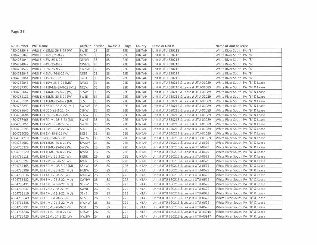
Page 25
API Number Well Name Qtr/Qtr Section Township Range County Lease or Unit # Name of Unit or Lease
4304735048 WRU EIH 15MU-26-8-22 (W) SWSE 26 8S 22E UINTAH Unit # UTU 63021B White River South PA "B"
4304735049 WRU EIH 1MU-35-8-22 NENE 35 8S 22E UINTAH Unit # UTU 63021B White River South PA "B"
4304734044 WRU EIH 3W-35-8-22 NENW 35 8S 22E UINTAH Unit # UTU 63021B White River South PA " B"
4304734042 WRU EIH 4W-35-8-22 NWNW 35 8S 22E UINTAH Unit # UTU 63021B White River South PA " B"
4304734572 WRU EIH 5W-35-8-22 SWNW 35 8S 22E UINTAH Unit # UTU 63021B White River South PA "B"
4304735047 WRU EIH 9MU-26-8-22 (W) NESE 26 8S 22E UINTAH Unit # UTU 63021B White River South PA "B"
4304733061 WRU EIH 15-35-8-22 SWSE 35 8S 22E UINTAH Unit # UTU 63021B White River South PA "B"
4304735046 WRU EIH 10W-35-8-22 (MU) NWSE 35 8S 22E UINTAH Unit # UTU 63021B & Lease # UTU-01089 White River South PA "B" & Lease
4304737300 WRU EIH 11B-ML-35-8-22 (ML) NESW 35 8S 22E UINTAH Unit # UTU 63021B & Lease # UTU-01089 White River South PA "B" & Lease
4304735667 WRU EIH 14MU-35-8-22 (W) SESW 35 8S 22E UINTAH Unit # UTU 63021B & Lease # UTU-01089 White River South PA "B" & Lease
4304735121 WRU EIH 15MU-35-8-22 (W) SWSE 35 8S 22E UINTAH Unit # UTU 63021B & Lease # UTU-01089 White River South PA "B" & Lease
4304735194 WRU EIH 16MU-35-8-22 (MU) SESE 35 8S 22E UINTAH Unit # UTU 63021B & Lease # UTU-01089 White River South PA "B" & Lease
4304737299 WRU EIH 6B-ML-35-8-22 (ML) SWNW 35 8S 22E UINTAH Unit # UTU 63021B & Lease # UTU-01089 White River South PA "B" & Lease
4304738640 WRU EIH 600-35-8-22 (OK) SENW 35 8S 22E UINTAH Unit # UTU 63021B & Lease # UTU-01089 White River South PA " B" & Lease
4304734684 WRU EIH 6W-35-8-22 (MU) SENW 35 8S 22E UINTAH Unit # UTU 63021B & Lease # UTU-01089 White River South PA "B" & Lease
4304737466 WRU EIH 70-ML-35-8-22 (ML) SWNE 35 8S 22E UINTAH Unit # UTU 63021B & Lease # UTU-01089 White River South PA "B" & Lease
4304735051 WRU EIH 7MU-35-8-22 (W) SWNE 35 8S 22E UINTAH Unit # UTU 63021B & Lease # UTU-01089 White River South PA "B" & Lease
4304735195 WRU EIH 8MU-35-8-22 (W) SENE 35 8S 22E UINTAH Unit # UTU 63021B & Lease # UTU-01089 White River South PA "B" & Lease
4304735050 WRU EIH 9M-35-8-22 (W) NESE 35 8S 22E UINTAH Unit # UTU 63021B & Lease # UTU-01089 White River South PA "B" & Lease
4304734210 WRU 13WX-35-8-22 (M) SWSW 35 8S 22E UINTAH Unit # UTU 63021B & Lease # UTU-01089 White River South PA "B" & Lease
4304735601 WRU EIH 12MU-25-8-22 (W) NWSW 25 8S 22E UINTAH Unit # UTU 63021B & Lease # UTU-0629 White River South PA "B" & Lease
4304735329 WRU EIH 13MU-25-8-22 (W) SWSW 25 8S 22E UINTAH Unit # UTU 63021B & Lease # UTU-0629 White River South PA "B" & Lease
4304735120 WRU EIH 10MU-26-8-22 (W) NWSE 26 8S 22E UINTAH Unit # UTU 63021B & Lease # UTU-0629 White River South PA "B" & Lease
4304735118 WRU EIH 1MU-26-8-22 (W) NENE 26 8S 22E UINTAH Unit # UTU 63021B & Lease # UTU-0629 White River South PA "B" & Lease
4304735192 WRU EIH 2MU-26-8-22 (W) NWNE 26 8S 22E UINTAH Unit # UTU 63021B & Lease # UTU-0629 White River South PA "B" & Lease
4304737465 WRU EIH 30-ML-35-8-22 (ML) SENW 35 8S 22E UINTAH Unit # UTU 63021B & Lease # UTU-0629 White River South PA "B" & Lease
4304735389 WRU EIH 3MU-25-8-22 (MU) NENW 25 8S 22E UINTAH Unit # UTU 63021B & Lease # UTU-0629 White River South PA " B" & Lease
4304738636 WRU EIH 4AO-25-8-22 (W) NWNW 25 8S 22E UINTAH Unit # UTU 63021B & Lease # UTU-0629 White River South PA " B" & Lease
4304735432 WRU EIH 5MU-25-8-22 (MU) SWNW 25 8S 22E UINTAH Unit # UTU 63021B & Lease # UTU-0629 White River South PA "B" & Lease
4304735431 WRU EIH 6MU-25-8-22 (MU) SENW 25 8S 22E UINTAH Unit # UTU 63021B & Lease # UTU-0629 White River South PA "B" & Lease
4304738637 WRU EIH 7AO-26-8-22 (M) SWNE 26 8S 22E UINTAH Unit # UTU 63021B & Lease # UTU-0629 White River South PA "B" & Lease
4304735119 WRU EIH 7MU-26-8-22 (MU) SENE 26 8S 22E UINTAH Unit # UTU 63021B & Lease # UTU-0629 White River South PA "B" & Lease
4304738649 WRU EIH 9CO-26-8-22 (W) NESE 26 8S 22E UINTAH Unit # UTU 63021B & Lease # UTU-0629 White River South PA "B" & Lease
4304735388 WRU EIH 4MU-25-8-22 (MU) NWNW 25 8S 22E UINTAH Unit # UTU 63021B & Lease # UTU-0629 White River South PA "B" & Lease
4304735191 WRU EIH 16MU-26-8-22 (W) SESE 26 8S 22E UINTAH Unit # UTU 63021B & Lease # UTU-0629 White River South PA "B" & Lease
4304734836 WRU EIH 11MU-26-8-22 (W) NESW 26 8S 22E UINTAH Unit # UTU 63021B & Lease # UTU-43916 White River South PA "B" & Lease
4304735425 WRU EIH 12ML-24-8-22 (W) NWSW 24 8S 22E UINTAH Unit # UTU 63021B & Lease # UTU-43917 White River South PA "B" & Lease
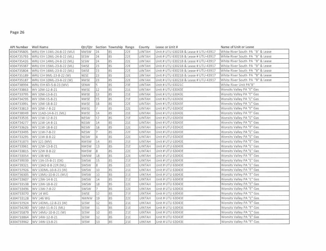
Page 26
API Number Well Name Qtr/Qtr Section Township Range County Lease or Unit # Name of Unit or Lease
4304735805 WRU EIH 11ML-24-8-22 (MU) NWSW 24 8S 22E UINTAH Unit # UTU 63021B & Lease # UTU-43917 White River South PA "B" & Lease
4304735793 WRU EIH 13ML-24-8-22 (ML) SESW 24 8S 22E UINTAH Unit # UTU 63021B & Lease # UTU-43917 White River South PA "B" & Lease
4304735426 WRU EIH 14ML-24-8-22 (ML) SESW 24 8S 22E UINTAH Unit # UTU 63021B & Lease # UTU-43917 White River South PA "B" & Lease
4304735387 WRU EIH 15ML-23-8-22 (ML) SWSE 23 8S 22E UINTAH Unit # UTU 63021B & Lease # UTU-43917 White River South PA "B" & Lease
4304735804 WRU EIH 16ML-23-8-22 (ML) SWSE 23 8S 22E UINTAH Unit # UTU 63021B & Lease # UTU-43917 White River South PA "B" & Lease
4304735189 WRU EIH 9ML-23-8-22 (W) NESE 23 8S 22E UINTAH Unit # UTU 63021B & Lease # UTU-43917 White River South PA "B" & Lease
4304735187 WRU EIH 10ML-23-8-22 (W) NWSE 23 8S 22E UINTAH Unit # UTU 63021B & Lease # UTU-43917 White River South PA "B" & Lease
4304738994 WRU EIH 60-5-8-23 (MV) SENW 5 8S 23E UINTAH Unit # UTU 63021C White River Unit PA"B"
4304733863 WV 10W-12-8-21 NWSE 12 8S 21E UINTAH Unit # UTU 63043E Wonsits Valley PA "E" Gas
4304733795 WV 10W-13-8-21 NWSE 13 8S 21E UINTAH Unit # UTU 63043E Wonsits Valley PA "E" Gas
4304734295 WV 10W-15-8-21 NWSE 15 8S 21E UINTAH Unit # UTU 63043E Wonsits Valley PA "E" Gas
4304733991 WV 10W-18-8-22 NWSE 18 8S 22E UINTAH Unit # UTU 63043E Wonsits Valley PA "E" Gas
4304733813 WV 10W-7-8-22 NWSE 7 8S 22E UINTAH Unit # UTU 63043E Wonsits Valley PA "E" Gas
4304738049 WV 11AO-14-8-21 (ML) NWSE 14 8S 21E UINTAH Unit # UTU 63043E Wonsits Valley PA "E" Gas
4304733535 WV 11W-12-8-21 NESW 12 8S 21E UINTAH Unit # UTU 63043E Wonsits Valley PA "E" Gas
4304734277 WV 11W-14-8-21 NESW 14 8S 21E UINTAH Unit # UTU 63043E Wonsits Valley PA "E" Gas
4304733626 WV 11W-18-8-22 NESW 18 8S 22E UINTAH Unit # UTU 63043E Wonsits Valley PA "E" Gas
4304733495 WV 11W-7-8-22 NESW 7 8S 22E UINTAH Unit # UTU 63043E Won sits Valley PA "E" Gas
4304733295 WV 11W-8-8-22 NESW 8 8S 22E UINTAH Unit # UTU 63043E Wonsits Valley PA "E" Gas
4304731873 WV 121 (MV) NWSW 14 8S 21E UINTAH Unit # UTU 63043E Won sits Valley PA "E" Gas
4304733961 WV 12W-13-8-21 NWSW 13 8S 21E UINTAH Unit # UTU 63043E Wonsits Valley PA "E" Gas
4304733815 WV 12W-8-8-22 NWSW 8 8S 22E UINTAH Unit # UTU 63043E Wonsits Valley PA "E" Gas
4304733054 WV 138WG SWNW 18 8S 22E UINTAH Unit # UTU 63043E Wonsits Valley PA "E" Gas
4304739039 WV 13A-15-8-21 (OK) SWSW 15 8S 21E UINTAH Unit # UTU 63043E Wonsits Valley PA "E" Gas
4304739321 WV 13AO-8-8-22R (ML) SWSW 8 8S 22E UINTAH Unit # UTU 63043E Wonsits Valley PA "E" Gas
4304737926 WV 130ML-10-8-21 (W) SWSW 10 8S 21E UINTAH Unit # UTU 63043E Wonsits Valley PA "E" Gas
4304736305 WV 13MU-10-8-21 (MU) SWSW 10 8S 21E UINTAH Unit # UTU 63043E Wonsits Valley PA "E" Gas
4304733607 WV 13W-14-8-21 SWSW 14 8S 21E UINTAH Unit # UTU 63043E Wonsits Valley PA "E" Gas
4304733538 WV 13W-18-8-22 SWSW 18 8S 22E UINTAH Unit # UTU 63043E Wonsits Valley PA "E" Gas
4304733496 WV 13W-7-8-22 SWSW 7 8S 22E UINTAH Unit # UTU 63043E Wonsits Valley PA "E" Gas
4304733070 WV 14WG SWSE 12 8S 21E UINTAH Unit # UTU 63043E Wonsits Valley PA "E" Gas
4304733128 WV 146WG NWNW 19 8S 22E UINTAH Unit # UTU 63043E Wonsits Valley PA "E" Gas
4304737924 WV 140ML-12-8-21 (W) SESW 12 8S 21E UINTAH Unit # UTU 63043E Won sits Valley PA "E" Gas
4304734280 WV 14M-11-8-21 (ML) SESW 11 8S 21E UINTAH Unit # UTU 63043E Wonsits Valley PA "E" Gas
4304735879 WV 14MU-1O-8-21 (W) SESW 10 8S 21E UINTAH Unit # UTU 63043E Wonsits Valley PA "E" Gas
4304733864 WV 14W-12-8-21 SESW 12 8S 21E UINTAH Unit # UTU 63043E Won sits Valley PA "E" Gas
4304733962 WV 14W-13-8-21 SESW 13 8S 21E UINTAH Unit # UTU 63043E Wonsits Valley PA "E" Gas

Page 27
API Number Well Name Qtr/Qtr Section Township Range County Lease or Unit # Name of Unit or Lease
4304733995 WV 14W-18-8-22 SESW 18 85 22E UINTAH Unit # UTU 63043E Wonsits Valley PA "E" Gas
4304733816 WV 14W-7-8-22 SESW 7 85 22E UINTAH Unit # UTU 63043E Wonsits Valley PA "E" Gas
4304733963 WV 15W-14-8-21 5WSE 14 85 21E UINTAH Unit # UTU 63043E Wonsits Valley PA "E" Gas
4304733661 WV 15W-9-8-21 5WSE 9 85 21E UINTAH Unit # UTU 63043E Wonsits Valley PA "E" Gas
4304738737 WV 16C-14-8-21 (W) SESE 14 85 21E UINTAH Unit # UTU 63043E Wonsits Valley PA "E" Gas
4304734250 WV 16W-I0-8-21 SESE 10 85 21E UINTAH Unit # UTU 63043E Wonsits Valley PA "E" Gas
4304733865 WV 16W-12-8-21 5ESE 12 85 21E UINTAH Unit # UTU 63043E Wonsits Valley PA "E" Gas
4304733529 WV 16W-9-8-21 5ESE 9 85 21E UINTAH Unit # UTU 63043E Won sits Valley PA "E" Gas
4304733220 WV lW-14-8-21 NENE 14 85 21E UINTAH Unit # UTU 63043E Wonsits Valley PA "E" Gas
4304733294 WV lW-18-8-22 NENE 18 85 22E UINTAH Unit # UTU 63043E Wonsits Valley PA "E" Gas
4304733602 WV lW-21-8-21 NENE 21 85 21E UINTAH Unit # UTU 63043E Wonsits Valley PA "E" Gas
4304733904 WV lW-23-8-21 NENE 23 85 21E UINTAH Unit # UTU 63043E Wonsits Valley PA "E" Gas
4304733613 WV lW-24-8-21 NENE 24 85 21E UINTAH Unit # UTU 63043E Wonsits Valley PA "E" Gas
4304733501 WV lW-7-8-22 NENE 7 85 22E UINTAH Unit # UTU 63043E Wonsits Valley PA "E" Gas
4304733791 WV 2W-13-8-21 NWNE 13 85 21E UINTAH Unit # UTU 63043E Wonsits Valley PA "E" Gas
4304734140 WV 2W-14-8-21 NWNE 14 85 21E UINTAH Unit # UTU 63043E Wonsits Valley PA "E" Gas
4304733986 WV 2W-18-8-22 NWNE 18 85 22E UINTAH Unit # UTU 63043E Wonsits Valley PA "E" Gas
4304734141 WV 2W-21-8-21 NWNE 21 85 21E UINTAH Unit # UTU 63043E Wonsits Valley PA "E" Gas
4304734243 WV 2W-22-8-21 NWNE 22 85 21E UINTAH Unit # UTU 63043E Wonsits Valley PA "E" Gas
4304734468 WV 2W-8-8-22 NWNE 8 85 22E UINTAH Unit # UTU 63043E Wonsits Valley PA "E" Gas
4304732831 WV38WG 5WNW 8 85 22E UINTAH Unit # UTU 63043E Wonsits Valley PA "E" Gas
4304734289 WV 3MU-15-8-21 (MU) NENW 15 85 21E UINTAH Unit # UTU 63043E Wonsits Valley PA "E" Gas
4304733533 WV 3W-18-8-22 NENW 18 85 22E UINTAH Unit # UTU 63043E Wonsits Valley PA "E" Gas
4304734187 WV 3W-19-8-22 NENW 19 85 22E UINTAH Unit # UTU 63043E Wonsits Valley PA "E" Gas
4304734143 WV 3W-21-8-21 NENW 21 85 21E UINTAH Unit # UTU 63043E Wonsits Valley PA "E" Gas
4304733604 WV 3W-22-8-21 NENW 22 85 21E UINTAH Unit # UTU 63043E Wonsits Valley PA "E" Gas
4304733605 WV 3W-24-8-21 NENW 24 85 21E UINTAH Unit # UTU 63043E Won sits Valley PA "E" Gas
4304733502 WV 3W-7-8-22 NENW 7 85 22E UINTAH Unit # UTU 63043E Wonsits Valley PA "E" Gas
4304733241 WV46WG NE5E 7 85 22E UINTAH Unit # UTU 63043E Wonsits Valley PA "E" Gas
4304732832 WV49WG SWSW 8 85 22E UINTAH Unit # UTU 63043E Wonsits Valley PA "E" Gas
4304739041 WV 4BD-23-8-21 (W) NWNW 23 85 21E UINTAH Unit # UTU 63043E Wonsits Valley PA "E" Gas
4304737927 WV 4DML-15-8-21 (ML) NWNW 15 85 21E UINTAH Unit # UTU 63043E Wonsits Valley PA "E" Gas
4304734291 WV 4MU-15-8-21 (MU) NWNW 15 85 21E UINTAH Unit # UTU 63043E Wonsits Valley PA "E" Gas
4304733657 WV 4W-11-8-21 NWNW 11 85 21E UINTAH Unit # UTU 63043E Wonsits Valley PA "E" Gas
4304734144 WV 4W-13-8-21 NWNW 13 85 21E UINTAH Unit # UTU 63043E Wonsits Valley PA "E" Gas
4304734038 WV 4W-17-8-22 NWNW 17 85 22E UINTAH Unit # UTU 63043E Wonsits Valley PA "E" Gas
4304734145 WV 4W-21-8-21 NWNW 21 85 21E UINTAH Unit # UTU 63043E Wonsits Valley PA "E" Gas

Page 28
API Number Well Name Qtr/Qtr Section Township Range County Lease or Unit # Name of Unit or Lease
4304734188 WV 4W-23-8-21 NWNW 23 8S 21E UINTAH Unit # UTU 63043E Wonsits Valley PA "E" Gas
4304734330 WV 4W-24-8-21 NWNW 24 8S 21E UINTAH Unit # UTU 63043E Won sits Valley PA "E" Gas
4304732821 WV54WG SW5E 7 85 22E UINTAH Unit # UTU 63043E Wonsits Valley PA "E" Gas
4304734293 WV 5MU-15-8-21 (W) SWNW 15 85 21E UINTAH Unit # UTU 63043E Wonsits Valley PA "E" Gas
4304733221 WV 5W-13-8-21 5WNW 13 85 21E UINTAH Unit # UTU 63043E Won sits Valley PA "E" Gas
4304733953 WV 5W-14-8-21 5WNW 14 85 21E UINTAH Unit # UTU 63043E Wonsits Valley PA "E" Gas
4304738663 WV 6-24-8-21 (M) 5ENW 24 85 21E UINTAH Unit # UTU 63043E Wonsits Valley PA "E" Gas
4304732829 WV 69 WG SWNE 18 85 22E UINTAH Unit # UTU 63043E Wonsits Valley PA "E" Gas
4304733906 WV 6W-11-8-21 5ENW 11 85 21E UINTAH Unit # UTU 63043E Wonsits Valley PA "E" Gas
4304733792 WV 6W-13-8-21 5ENW 13 85 21E UINTAH Unit # UTU 63043E Wonsits Valley PA "E" Gas
4304734294 WV 6W-15-8-21 5ENW 15 85 21E UINTAH Unit # UTU 63043E Wonsits Valley PA "E" Gas
4304733842 WV 6W-18-8-22 SENW 18 8S 22E UINTAH Unit # UTU 63043E Wonsits Valley PA "E" Gas
4304733828 WV 6W-7-8-22 5ENW 7 8S 22E UINTAH Unit # UTU 63043E Wonsits Valley PA "E " Gas
4304733843 WV 6WC-18-8-22 5ENW 18 8S 22E UINTAH Unit # UTU 63043E Wonsits Valley PA "E" Gas
4304733844 WV 6WO-18-8-22 5ENW 18 8S 22E UINTAH Unit # UTU 63043E Wonsits Valley PA "E" Gas
4304739044 WV 7BO-23-8-21 (W) 5WNE 23 8S 21E UINTAH Unit # UTU 63043E Wonsits Valley PA "E" Gas
4304733955 WV 7W-14-8-21 5WNE 14 8S 21E UINTAH Unit # UTU 63043E Wonsits Valley PA "E" Gas
4304734246 WV 7W-15-8-21 5WNE 15 8S 21E UINTAH Unit # UTU 63043E Wonsits Valley PA "E" Gas
4304733908 WV 7W-24-8-21 5WNE 24 8S 21E UINTAH Unit # UTU 63043E Wonsits Valley PA "E" Gas
4304739040 WV 80-15-8-21 (OK) SENE 15 85 21E UINTAH Unit # UTU 63043E Wonsits Valley PA "E " Gas
4304733862 WV 8W-12-8-21 SENE 12 85 21E UINTAH Unit # UTU 63043E Wonsits Valley PA "E" Gas
4304733793 WV 8W-13-8-21 SENE 13 85 21E UINTAH Unit # UTU 63043E Wonsits Valley PA "E" Gas
4304733958 WV 8W-14-8-21 SENE 14 85 21E UINTAH Unit # UTU 63043E Wonsits Valley PA "E" Gas
4304734247 WV 8W-15-8-21 SENE 15 85 21E UINTAH Unit # UTU 63043E Wonsits Valley PA "E" Gas
4304733989 WV 8W-18-8-22 SENE 18 85 22E UINTAH Unit # UTU 63043E Won sits Valley PA "E" Gas
4304734340 WV 8W-24-8-21 SENE 24 85 21E UINTAH Unit # UTU 63043E Wonsits Valley PA "E" Gas
4304733534 WV 9W-12-8-21 NE5E 12 85 21E UINTAH Unit # UTU 63043E Won sits Valley PA "E" Gas
4304733269 WV 9W-14-8-21 NE5E 14 85 21E UINTAH Unit # UTU 63043E Wonsits Valley PA "E" Gas
4304733959 WV 9W-15-8-21 NE5E 15 85 21E UINTAH Unit # UTU 63043E Wonsits Valley PA "E" Gas
4304733910 WV 10W-11-8-21 NW5E 11 85 21E UINTAH Unit # UTU 63043E Won sits Valley PA "E" Gas
4304734275 WV 10W-14-8-21 NW5E 14 85 21E UINTAH Unit # UTU 63043E Wonsits Valley PA "E" Gas
4304733911 WV 11W-15-8-21 NE5W 15 85 21E UINTAH Unit # UTU 63043E Wonsits Valley PA "E" Gas
4304733808 WV 12W-7-8-22 NW5W 7 85 22E UINTAH Unit # UTU 63043E Wonsits Valley PA "E" Gas
4304733913 WV 13W-11-8-21 SW5W 11 85 21E UINTAH Unit # UTU 63043E Wonsits Valley PA "E" Gas
4304733537 WV 13W-12-8-21 5W5W 12 85 21E UINTAH Unit # UTU 63043E Wonsits Valley PA "E" Gas
4304734281 WV 14W-14-8-21 SE5W 14 85 21E UINTAH Unit # UTU 63043E Wonsits Valley PA "E" Gas
4304734249 WV 14W-15-8-21 SE5W 15 85 21E UINTAH Unit # UTU 63043E Wonsits Valley PA "E" Gas
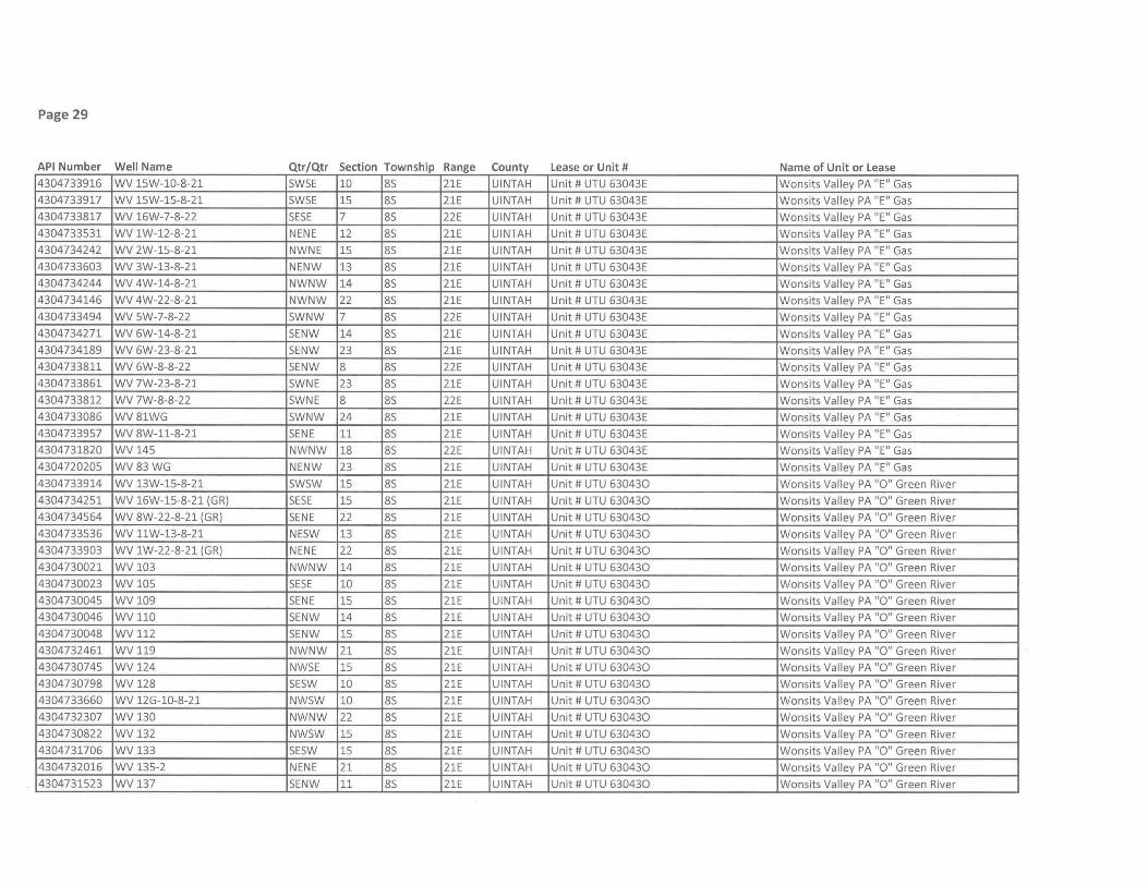
Page 29
API Number Well Name Qtr/Qtr Section Township Range County Lease or Unit # Name of Unit or Lease
4304733916 WV 15W-10-8-21 SWSE 10 8S 21E UINTAH Unit # UTU 63043E Wonsits Valley PA "E" Gas
4304733917 WV 15W-15-8-21 SWSE 15 8S 21E UINTAH Unit # UTU 63043E Wonsits Valley PA "E" Gas
4304733817 WV 16W-7-8-22 SESE 7 8S 22E UINTAH Unit # UTU 63043E Wonsits Valley PA "E" Gas
4304733531 WV 1W-12-8-21 NENE 12 8S 21E UINTAH Unit # UTU 63043E Wonsits Valley PA "E" Gas
4304734242 WV 2W-15-8-21 NWNE 15 8S 21E UINTAH Unit # UTU 63043E Wonsits Valley PA "E" Gas
4304733603 WV 3W-13-8-21 NENW 13 8S 21E UINTAH Unit # UTU 63043E Wonsits Valley PA "E" Gas
4304734244 WV 4W-14-8-21 NWNW 14 8S 21E UINTAH Unit # UTU 63043E Wonsits Valley PA "E" Gas
4304734146 WV 4W-22-8-21 NWNW 22 8S 21E UINTAH Unit # UTU 63043E Won sits Valley PA "E" Gas
4304733494 WV 5W-7-8-22 SWNW 7 8S 22E UINTAH Unit # UTU 63043E Wonsits Valley PA "E" Gas
4304734271 WV 6W-14-8-21 SENW 14 8S 21E UINTAH Unit # UTU 63043E Wonsits Valley PA "E" Gas
4304734189 WV 6W-23-8-21 SENW 23 8S 21E UINTAH Unit # UTU 63043E Wonsits Valley PA "E" Gas
4304733811 WV 6W-8-8-22 SENW 8 8S 22E UINTAH Unit # UTU 63043E Wonsits Valley PA "E" Gas
4304733861 WV 7W-23-8-21 SWNE 23 8S 21E UINTAH Unit # UTU 63043E Wonsits Valley PA "E" Gas
4304733812 WV 7W-8-8-22 SWNE 8 8S 22E UINTAH Unit # UTU 63043E Wonsits Valley PA "E" Gas
4304733086 WV81WG SWNW 24 8S 21E UINTAH Unit # UTU 63043E Wonsits Valley PA "E" Gas
4304733957 WV 8W-11-8-21 SENE 11 8S 21E UINTAH Unit # UTU 63043E Wonsits Valley PA "E" Gas
4304731820 WV145 NWNW 18 8S 22E UINTAH Unit # UTU 63043E Wonsits Valley PA "E" Gas
4304720205 WV83WG NENW 23 8S 21E UINTAH Unit # UTU 63043E Wonsits Valley PA "E" Gas
4304733914 WV 13W-15-8-21 SWSW 15 8S 21E UINTAH Unit # UTU 630430 Wonsits Valley PA "0" Green River
4304734251 WV 16W-15-8-21 (GR) SESE 15 8S 21E UINTAH Unit # UTU 630430 Wonsits Valley PA "0" Green River
4304734564 WV 8W-22-8-21 (GR) SENE 22 8S 21E UINTAH Unit # UTU 630430 Wonsits Valley PA "0" Green River
4304733536 WV 11W-13-8-21 NESW 13 8S 21E UINTAH Unit # UTU 630430 Wonsits Valley PA "0" Green River
4304733903 WV 1W-22-8-21 (GR) NENE 22 8S 21E UINTAH Unit # UTU 630430 Wonsits Valley PA "0" Green River
4304730021 WV103 NWNW 14 8S 21E UINTAH Unit # UTU 630430 Wonsits Valley PA "0" Green River
4304730023 WV105 SESE 10 8S 21E UINTAH Unit # UTU 630430 Wonsits Valley PA "0" Green River
4304730045 WV109 SENE 15 8S 21E UINTAH Unit # UTU 630430 Wonsits Valley PA "0" Green River
4304730046 WV110 SENW 14 8S 21E UINTAH Unit # UTU 630430 Won sits Valley PA "0" Green River
4304730048 WV 112 SENW 15 8S 21E UINTAH Unit # UTU 630430 Wonsits Valley PA "0" Green River
4304732461 WV119 NWNW 21 8S 21E UINTAH Unit # UTU 630430 Wonsits Valley PA "0" Green River
4304730745 WV124 NWSE 15 8S 21E UINTAH Unit # UTU 630430 Wonsits Valley PA "0" Green River
4304730798 WV128 SESW 10 8S 21E UINTAH Unit # UTU 630430 Wonsits Valley PA "0" Green River
4304733660 WV 12G-10-8-21 NWSW 10 8S 21E UINTAH Unit # UTU 630430 Wonsits Valley PA "0" Green River
4304732307 WV130 NWNW 22 8S 21E UINTAH Unit # UTU 630430 Wonsits Valley PA "0" Green River
4304730822 WV132 NWSW 15 8S 21E UINTAH Unit # UTU 630430 Wonsits Valley PA "0" Green River
4304731706 WV133 SESW 15 8S 21E UINTAH Unit # UTU 630430 Wonsits Valley PA "0" Green River
4304732016 WV 135-2 NENE 21 8S 21E UINTAH Unit # UTU 630430 Wonsits Valley PA "0" Green River
4304731523 WV137 SENW 11 8S 21E UINTAH Unit # UTU 630430 Wonsits Valley PA "0" Green River
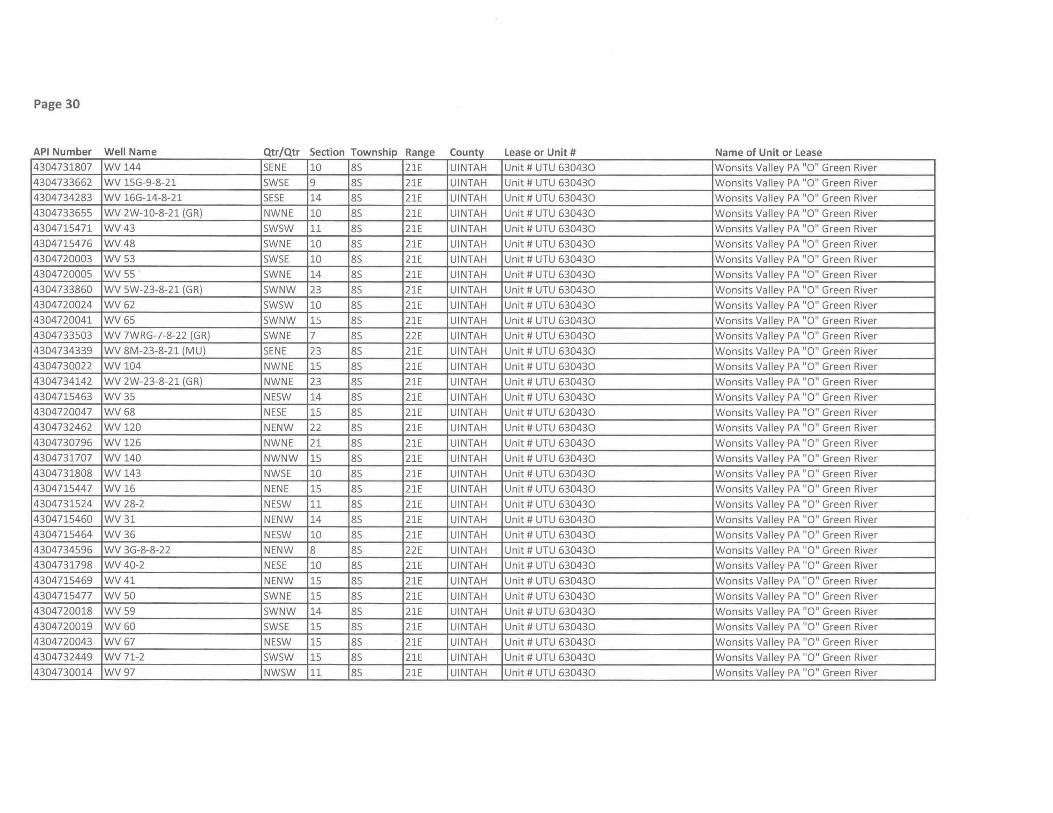
Page 30
API Number Well Name Qtr/Qtr Section Township Range County Lease or Unit # Name of Unit or Lease 4304731807 WV144 SENE 10 85 21E UINTAH Unit # UTU 630430 Wonsits Valley PA "0" Green River
4304733662 WV 15G-9-8-21 5W5E 9 85 21E UINTAH Unit # UTU 630430 Wonsits Valley PA "0" Green River
4304734283 WV 16G-14-8-21 SESE 14 85 21E UINTAH Unit # UTU 630430 Wonsits Valley PA "0" Green River
4304733655 WV 2W-l0-8-21 (GR) NWNE 10 85 21E UINTAH Unit # UTU 630430 Wonsits Valley PA "0" Green River
4304715471 WV43 5W5W 11 85 21E UINTAH Unit # UTU 630430 Wonsits Valley PA "0" Green River
4304715476 WV48 5WNE 10 85 21E UINTAH Unit # UTU 630430 Wonsits Valley PA "0" Green River
4304720003 WV53 5W5E 10 85 21E UINTAH Unit # UTU 630430 Wonsits Valley PA "0" Green River
4304720005 WV55 5WNE 14 85 21E UINTAH Unit # UTU 630430 Wonsits Valley PA "0" Green River
4304733860 WV 5W-23-8-21 (GR) 5WNW 23 85 21E UINTAH Unit # UTU 630430 Wonsits Valley PA "0" Green River
4304720024 WV62 5W5W 10 85 21E UINTAH Unit # UTU 630430 Wonsits Valley PA "0" Green River
4304720041 WV65 5WNW 15 85 21E UINTAH Unit # UTU 630430 Wonsits Valley PA "0" Green River
4304733503 WV 7WRG-7-8-22 (GR) 5WNE 7 85 22E UINTAH Unit # UTU 630430 Wonsits Valley PA "0" Green River
4304734339 WV 8M-23-8-21 (MU) SENE 23 85 21E UINTAH Unit # UTU 630430 Wonsits Valley PA "0" Green River
4304730022 WV104 NWNE 15 85 21E UINTAH Unit # UTU 630430 Wonsits Valley PA "0" Green River
4304734142 WV 2W-23-8-21 (GR) NWNE 23 85 21E UINTAH Unit # UTU 630430 Wonsits Valley PA "0" Green River
4304715463 WV35 NE5W 14 85 21E UINTAH Unit # UTU 630430 Wonsits Valley PA "0" Green River
4304720047 WV68 NE5E 15 85 21E UINTAH Unit # UTU 630430 Wonsits Valley PA "0" Green River
4304732462 WV120 NENW 22 85 21E UINTAH Unit # UTU 630430 Wonsits Valley PA "0" Green River
4304730796 WV 126 NWNE 21 85 21E UINTAH Unit # UTU 630430 Wonsits Valley PA "0" Green River
4304731707 WV140 NWNW 15 85 21E UINTAH Unit # UTU 630430 Wonsits Valley PA "0" Green River
4304731808 WV 143 NW5E 10 85 21E UINTAH Unit # UTU 630430 Wonsits Valley PA "0" Green River
4304715447 WV 16 NENE 15 85 21E UINTAH Unit # UTU 630430 Wonsits Valley PA "0" Green River
4304731524 WV 28-2 NE5W 11 85 21E UINTAH Unit # UTU 630430 Wonsits Valley PA "0" Green River
4304715460 WV31 NENW 14 85 21E UINTAH Unit # UTU 630430 Wonsits Valley PA "0" Green River
4304715464 WV36 NE5W 10 85 21E UINTAH Unit # UTU 630430 Wonsits Valley PA "0" Green River
4304734596 WV 3G-8-8-22 NENW 8 85 22E UINTAH Unit # UTU 630430 Wonsits Valley PA "0" Green River
4304731798 WV 40-2 NE5E 10 85 21E UINTAH Unit # UTU 630430 Wonsits Valley PA "0" Green River
4304715469 WV41 NENW 15 85 21E UINTAH Unit # UTU 630430 Wonsits Valley PA "0" Green River
4304715477 WV 50 5WNE 15 85 21E UINTAH Unit # UTU 630430 Wonsits Valley PA "0" Green River
4304720018 WV 59 5WNW 14 85 21E UINTAH Unit # UTU 630430 Wonsits Valley PA "0" Green River
4304720019 WV60 5W5E 15 85 21E UINTAH Unit # UTU 630430 Wonsits Valley PA "0" Green River
4304720043 WV67 NE5W 15 85 21E UINTAH Unit # UTU 630430 Wonsits Valley PA "0" Green River
4304732449 WV 71-2 5W5W 15 85 21E UINTAH Unit # UTU 630430 Wonsits Valley PA "0" Green River
4304730014 WV97 NW5W 11 85 21E UINTAH Unit # UTU 630430 Wonsits Valley PA "0" Green River
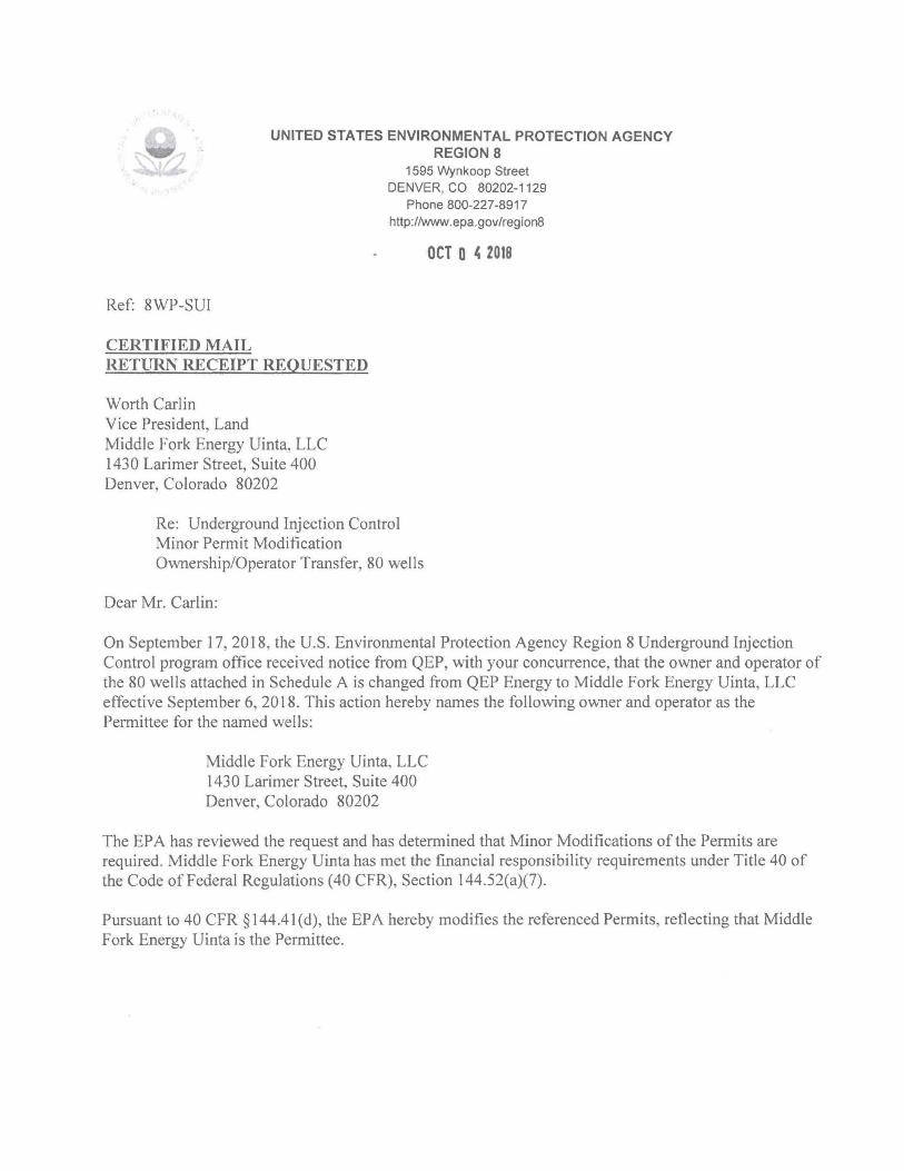
'-UNITED STATES ENVIRONMENTAL PROTECTION AGENCY
REGION 8
Ref: 8WP-SUI
CERTIFIED MAIL RETURN RECEIPT REQUESTED
Worth Carlin Vice President, Land Middle Fork Energy Uinta, LLC 1430 Larimer Street, Suite 400 Denver, Colorado 80202
1595 Wynkoop Street DENVER, CO 80202-1129
Phone 800-227-8917 http://www.epa.gov/regionS
OCT 0 ~ 2018
Re: Underground Injection Control Minor Permit Modification Ownership/Operator Transfer, 80 wells
Dear Mr. Carlin:
On September 17,2018, the U.S. Environmental Protection Agency Region 8 Underground Injection Control program office received notice from QEP, with your concurrence, that the owner and operator of the 80 wells attached in Schedule A is changed from QEP Energy to Middle Fork Energy Uinta, LLC effective September 6, 2018. This action hereby names the following owner and operator as the Permittee for the named wells:
Middle Fork Energy Uinta, LLC 1430 Larimer Street, Suite 400 Denver, Colorado 80202
The EPA has reviewed the request and has detem1ined that Minor Modifications of the Permits are required . Middle Fork Energy Uinta has met the financial responsibility requirements under Title 40 of the Code of Federal Regulations (40 CFR), Section 144.S2(a)(7).
Pursuant to 40 CFR § 144.41 (d), the EPA hereby modifies the referenced Permits, reflecting that Middle Fork Energy Uinta is the Permittee.
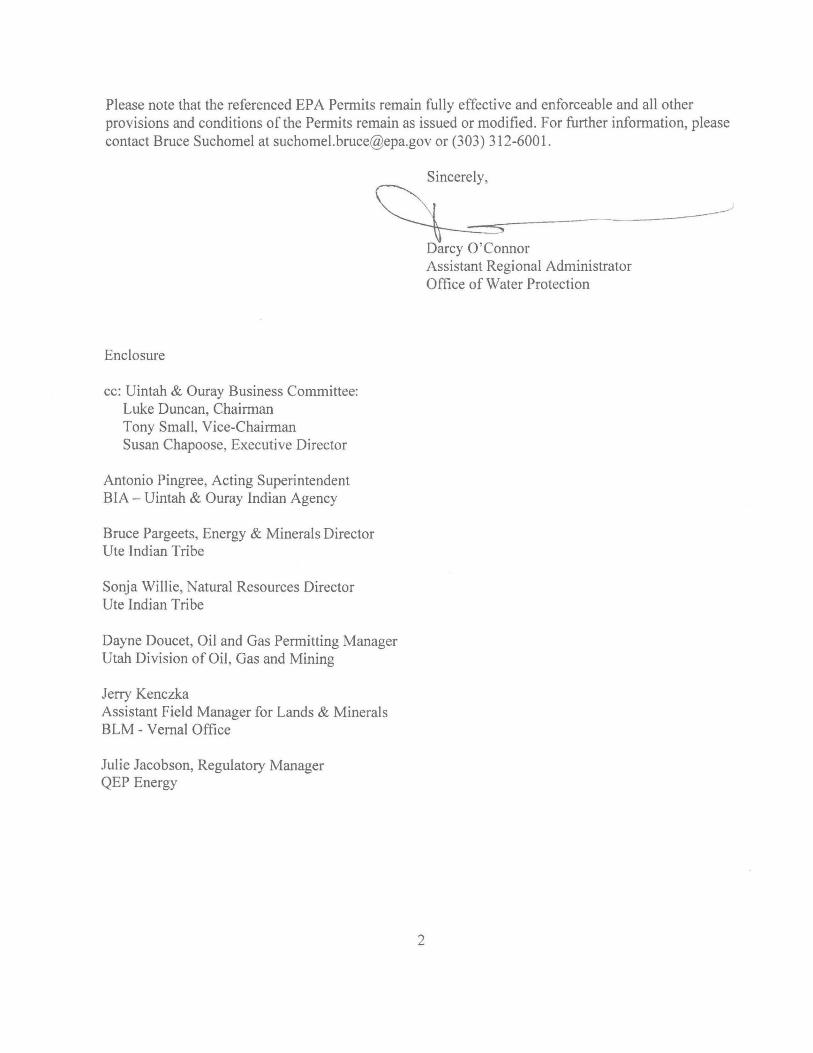
Please note that the referenced EPA Permits remain fully effective and enforceable and all other provisions and conditions of the Permits remain as issued or modified. For further information, please contact Bruce Suchomel at [email protected](303) 312-6001.
~re_l_y,-=~ ______ --------------~ Darcy O'Connor
Enclosure
cc: Uintah & Ouray Business Committee: Luke Duncan, Chairn1an Tony Small, Vice-Chailman Susan Chapoose, Executive Director
Antonio Pingree, Acting Superintendent BIA - Uintah & Ouray Indian Agency
Bruce Pargeets, Energy & Minerals Director Ute Indian Tribe
Sonja Willie, Natural Resources Director Ute Indian Tribe
Dayne Doucet, Oil and Gas Permitting Manager Utah Division of Oil , Gas and Mining
Jerry Kenczka Assistant Field Manager for Lands & Minerals BLM - Vernal Office
Julie Jacobson, Regulatory Manager QEP Energy
2
Assistant Regional Administrator Office of Water Protection
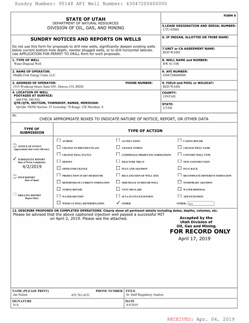
RECEIVED: Apr. 04, 2019
STATE OF UTAHDEPARTMENT OF NATURAL RESOURCES
DIVISION OF OIL, GAS, AND MINING
FORM 9
5.LEASE DESIGNATION AND SERIAL NUMBER: UTU-02060
SUNDRY NOTICES AND REPORTS ON WELLSDo not use this form for proposals to drill new wells, significantly deepen existing wellsbelow current bottom-hole depth, reenter plugged wells, or to drill horizontal laterals.Use APPLICATION FOR PERMIT TO DRILL form for such proposals.
6. IF INDIAN, ALLOTTEE OR TRIBE NAME:
7.UNIT or CA AGREEMENT NAME: RED WASH
1. TYPE OF WELL Water Disposal Well
8. WELL NAME and NUMBER: RW 41-33B
2. NAME OF OPERATOR: Middle Fork Energy Uinta, LLC
9. API NUMBER: 43047200600000
3. ADDRESS OF OPERATOR: PHONE NUMBER: 1515 Wynkoop Street, Suite 650 , Denver, CO, 80202
9. FIELD and POOL or WILDCAT: RED WASH
4. LOCATION OF WELL FOOTAGES AT SURFACE: 660 FNL 580 FEL QTR/QTR, SECTION, TOWNSHIP, RANGE, MERIDIAN: Qtr/Qtr: NENE Section: 33 Township: 7S Range: 23E Meridian: S
COUNTY: UINTAH
STATE: UTAH
11.CHECK APPROPRIATE BOXES TO INDICATE NATURE OF NOTICE, REPORT, OR OTHER DATA
TYPE OFSUBMISSION TYPE OF ACTION
NOTICE OF INTENTApproximate date work will start:
SUBSEQUENT REPORTDate of Work Completion:
4/2/2019
SPUD REPORTDate of Spud:
DRILLING REPORTReport Date:
ACIDIZE ALTER CASING CASING REPAIR
CHANGE TO PREVIOUS PLANS CHANGE TUBING CHANGE WELL NAME
CHANGE WELL STATUS COMMINGLE PRODUCING FORMATIONS CONVERT WELL TYPE
DEEPEN FRACTURE TREAT NEW CONSTRUCTION
OPERATOR CHANGE PLUG AND ABANDON PLUG BACK
PRODUCTION START OR RESUME RECLAMATION OF WELL SITE RECOMPLETE DIFFERENT FORMATION
REPERFORATE CURRENT FORMATION SIDETRACK TO REPAIR WELL TEMPORARY ABANDON
TUBING REPAIR VENT OR FLARE WATER DISPOSAL
WATER SHUTOFF SI TA STATUS EXTENSION APD EXTENSION
WILDCAT WELL DETERMINATION OTHER OTHER: MIT
12. DESCRIBE PROPOSED OR COMPLETED OPERATIONS. Clearly show all pertinent details including dates, depths, volumes, etc. Please be advised that the above captioned injection well passed a successful MIT
on April 2, 2019. Please see the attached.
NAME (PLEASE PRINT) PHONE NUMBER Jan Nelson 435-781-4331
TITLE Sr. Staff Regulatory Analyst
SIGNATURE N/A
DATE 4/4/2019
April 17, 2019
Sundry Number: 95148 API Well Number: 43047200600000
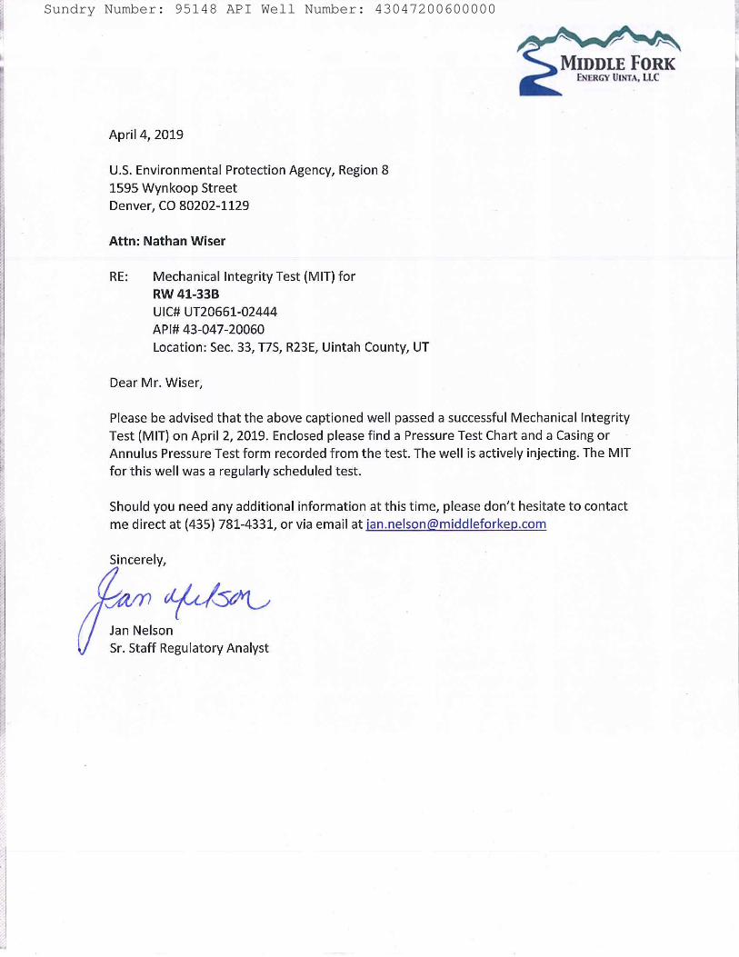
RECEIVED: Apr. 04, 2019
Sundry Number: 95148 API Well Number: 43047200600000
RECEIVED: Apr. 04, 2019
Sundry Number: 95148 API Well Number: 43047200600000
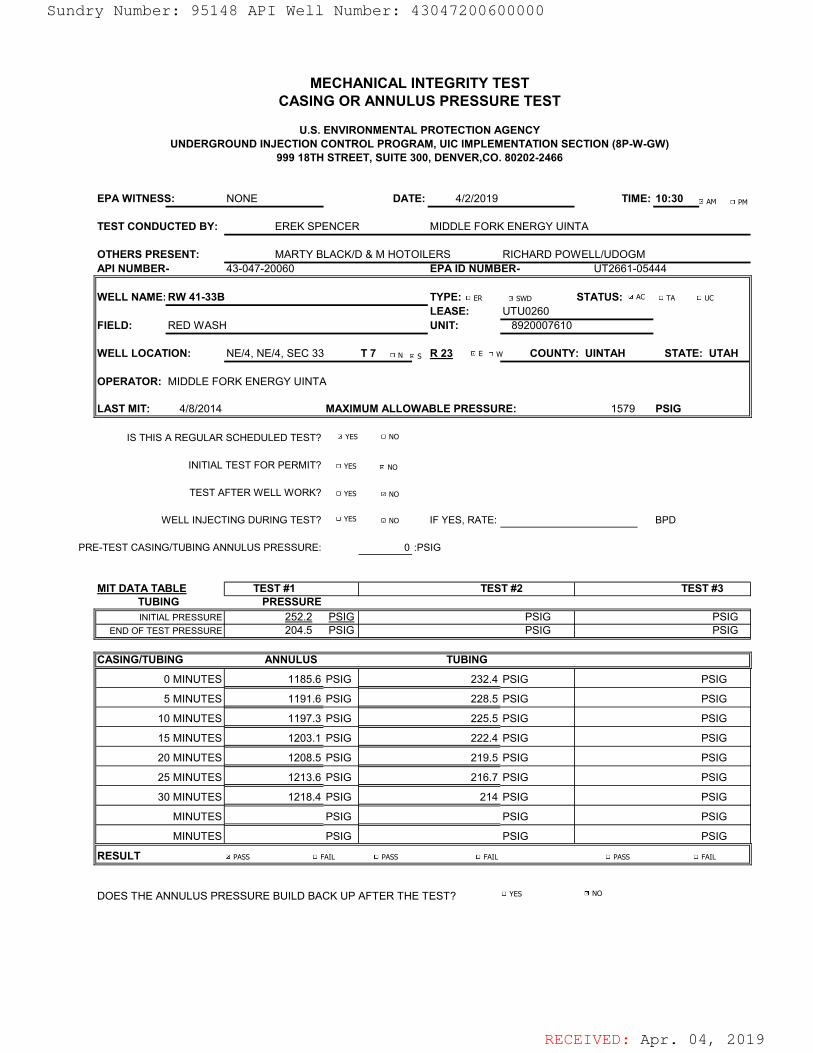
RECEIVED: Apr. 04, 2019
EPA WITNESS: NONE DATE: 4/2/2019 TIME: 10:30
TEST CONDUCTED BY: EREK SPENCER MIDDLE FORK ENERGY UINTA
OTHERS PRESENT: MARTY BLACK/D & M HOTOILERS RICHARD POWELL/UDOGMAPI NUMBER- 43-047-20060 EPA ID NUMBER- UT2661-05444
WELL NAME: RW 41-33B TYPE: STATUS: LEASE: UTU0260
FIELD: RED WASH UNIT: 8920007610
WELL LOCATION: NE/4, NE/4, SEC 33 T 7 R 23 COUNTY: UINTAH STATE: UTAH
OPERATOR: MIDDLE FORK ENERGY UINTA
LAST MIT: 4/8/2014 MAXIMUM ALLOWABLE PRESSURE: 1579 PSIG
IS THIS A REGULAR SCHEDULED TEST?
INITIAL TEST FOR PERMIT?
TEST AFTER WELL WORK?
WELL INJECTING DURING TEST? IF YES, RATE: BPD
PRE-TEST CASING/TUBING ANNULUS PRESSURE: 0 :PSIG
MIT DATA TABLE
INITIAL PRESSURE 252.2 PSIG PSIG PSIGEND OF TEST PRESSURE 204.5 PSIG PSIG PSIG
CASING/TUBING
0 MINUTES PSIG PSIG PSIG
5 MINUTES PSIG PSIG PSIG
10 MINUTES PSIG PSIG PSIG
15 MINUTES PSIG PSIG PSIG
20 MINUTES PSIG PSIG PSIG
25 MINUTES PSIG PSIG PSIG
30 MINUTES PSIG PSIG PSIG
MINUTES PSIG PSIG PSIG
MINUTES PSIG PSIG PSIG
RESULT
DOES THE ANNULUS PRESSURE BUILD BACK UP AFTER THE TEST?
999 18TH STREET, SUITE 300, DENVER,CO. 80202-2466
1218.4
225.5
222.4
219.51208.5
TEST #2
1197.3
214
TUBING
232.4
PRESSURE
MECHANICAL INTEGRITY TESTCASING OR ANNULUS PRESSURE TEST
U.S. ENVIRONMENTAL PROTECTION AGENCYUNDERGROUND INJECTION CONTROL PROGRAM, UIC IMPLEMENTATION SECTION (8P-W-GW)
TEST #1
1203.1
TEST #3TUBING
228.5
216.71213.6
ANNULUS
1185.6
1191.6
AC TA UCER SWD
YES NO
YES
YES
YES
NO
NO
NO
YES NO
PASS FAIL PASS FAIL PASS FAIL
AM PM
N S E W
Sundry Number: 95148 API Well Number: 43047200600000
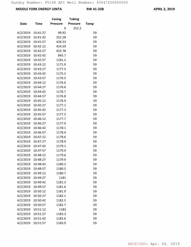
RECEIVED: Apr. 04, 2019
MIDDLE FORK ENERGY UINTA RW 41-33B APRIL 2, 2019
Date TimeCasing
PressureTubing
Pressure Temp0 252.2
4/2/2019 10:41:27 99.92 594/2/2019 10:41:42 252.28 594/2/2019 10:41:57 426.53 594/2/2019 10:42:12 424.59 594/2/2019 10:42:27 422.78 594/2/2019 10:42:42 845.7 594/2/2019 10:42:57 1181.2 594/2/2019 10:43:12 1171.9 594/2/2019 10:43:27 1177.5 594/2/2019 10:43:42 1175.2 594/2/2019 10:43:57 1176.5 594/2/2019 10:44:12 1176.6 594/2/2019 10:44:27 1176.6 594/2/2019 10:44:42 1176.7 594/2/2019 10:44:57 1176.8 594/2/2019 10:45:12 1176.9 594/2/2019 10:45:27 1177.1 594/2/2019 10:45:42 1177.3 594/2/2019 10:45:57 1177.5 594/2/2019 10:46:12 1177.7 594/2/2019 10:46:27 1177.9 594/2/2019 10:46:42 1178.1 594/2/2019 10:46:57 1178.4 594/2/2019 10:47:12 1178.6 594/2/2019 10:47:27 1178.9 594/2/2019 10:47:42 1179.1 594/2/2019 10:47:57 1179.4 594/2/2019 10:48:12 1179.6 594/2/2019 10:48:27 1179.9 594/2/2019 10:48:42 1180.2 594/2/2019 10:48:57 1180.5 594/2/2019 10:49:12 1180.7 594/2/2019 10:49:27 1181 594/2/2019 10:49:42 1181.3 594/2/2019 10:49:57 1181.6 594/2/2019 10:50:12 1181.9 594/2/2019 10:50:27 1182.1 594/2/2019 10:50:42 1182.5 594/2/2019 10:50:57 1182.7 594/2/2019 10:51:12 1183 594/2/2019 10:51:27 1183.3 594/2/2019 10:51:42 1183.6 594/2/2019 10:51:57 1183.9 59
Sundry Number: 95148 API Well Number: 43047200600000
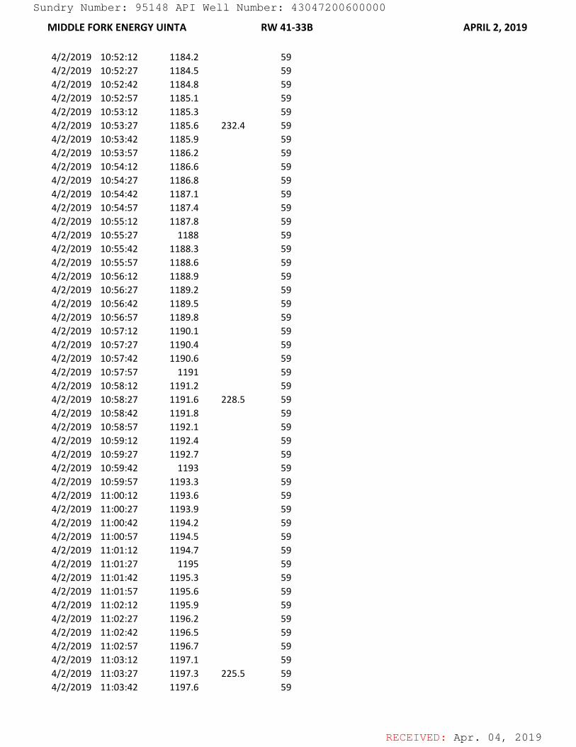
RECEIVED: Apr. 04, 2019
MIDDLE FORK ENERGY UINTA RW 41-33B APRIL 2, 2019
4/2/2019 10:52:12 1184.2 594/2/2019 10:52:27 1184.5 594/2/2019 10:52:42 1184.8 594/2/2019 10:52:57 1185.1 594/2/2019 10:53:12 1185.3 594/2/2019 10:53:27 1185.6 232.4 594/2/2019 10:53:42 1185.9 594/2/2019 10:53:57 1186.2 594/2/2019 10:54:12 1186.6 594/2/2019 10:54:27 1186.8 594/2/2019 10:54:42 1187.1 594/2/2019 10:54:57 1187.4 594/2/2019 10:55:12 1187.8 594/2/2019 10:55:27 1188 594/2/2019 10:55:42 1188.3 594/2/2019 10:55:57 1188.6 594/2/2019 10:56:12 1188.9 594/2/2019 10:56:27 1189.2 594/2/2019 10:56:42 1189.5 594/2/2019 10:56:57 1189.8 594/2/2019 10:57:12 1190.1 594/2/2019 10:57:27 1190.4 594/2/2019 10:57:42 1190.6 594/2/2019 10:57:57 1191 594/2/2019 10:58:12 1191.2 594/2/2019 10:58:27 1191.6 228.5 594/2/2019 10:58:42 1191.8 594/2/2019 10:58:57 1192.1 594/2/2019 10:59:12 1192.4 594/2/2019 10:59:27 1192.7 594/2/2019 10:59:42 1193 594/2/2019 10:59:57 1193.3 594/2/2019 11:00:12 1193.6 594/2/2019 11:00:27 1193.9 594/2/2019 11:00:42 1194.2 594/2/2019 11:00:57 1194.5 594/2/2019 11:01:12 1194.7 594/2/2019 11:01:27 1195 594/2/2019 11:01:42 1195.3 594/2/2019 11:01:57 1195.6 594/2/2019 11:02:12 1195.9 594/2/2019 11:02:27 1196.2 594/2/2019 11:02:42 1196.5 594/2/2019 11:02:57 1196.7 594/2/2019 11:03:12 1197.1 594/2/2019 11:03:27 1197.3 225.5 594/2/2019 11:03:42 1197.6 59
Sundry Number: 95148 API Well Number: 43047200600000
RECEIVED: Apr. 04, 2019
MIDDLE FORK ENERGY UINTA RW 41-33B APRIL 2, 2019
4/2/2019 11:03:57 1197.9 594/2/2019 11:04:12 1198.2 594/2/2019 11:04:27 1198.5 594/2/2019 11:04:42 1198.7 594/2/2019 11:04:57 1199 594/2/2019 11:05:12 1199.3 594/2/2019 11:05:27 1199.6 594/2/2019 11:05:42 1199.8 594/2/2019 11:05:57 1200.1 594/2/2019 11:06:12 1200.4 594/2/2019 11:06:27 1200.7 594/2/2019 11:06:42 1201 594/2/2019 11:06:57 1201.3 594/2/2019 11:07:12 1201.5 594/2/2019 11:07:27 1201.8 594/2/2019 11:07:42 1202.1 594/2/2019 11:07:57 1202.3 594/2/2019 11:08:12 1202.6 594/2/2019 11:08:27 1202.9 594/2/2019 11:08:42 1203.1 222.4 594/2/2019 11:08:57 1203.4 594/2/2019 11:09:12 1203.7 594/2/2019 11:09:27 1204 594/2/2019 11:09:42 1204.2 594/2/2019 11:09:57 1204.5 594/2/2019 11:10:12 1204.8 594/2/2019 11:10:27 1205.1 594/2/2019 11:10:42 1205.3 594/2/2019 11:10:57 1205.5 594/2/2019 11:11:12 1205.8 594/2/2019 11:11:27 1206.1 594/2/2019 11:11:42 1206.4 594/2/2019 11:11:57 1206.6 594/2/2019 11:12:12 1206.9 594/2/2019 11:12:27 1207.2 594/2/2019 11:12:42 1207.5 594/2/2019 11:12:57 1207.7 594/2/2019 11:13:12 1208 594/2/2019 11:13:27 1208.2 594/2/2019 11:13:42 1208.5 219.5 594/2/2019 11:13:57 1208.8 594/2/2019 11:14:12 1209 594/2/2019 11:14:27 1209.3 594/2/2019 11:14:42 1209.6 594/2/2019 11:14:57 1209.8 594/2/2019 11:15:12 1210 594/2/2019 11:15:27 1210.3 59
Sundry Number: 95148 API Well Number: 43047200600000
RECEIVED: Apr. 04, 2019
MIDDLE FORK ENERGY UINTA RW 41-33B APRIL 2, 2019
4/2/2019 11:15:42 1210.5 594/2/2019 11:15:57 1210.8 604/2/2019 11:16:12 1211.1 594/2/2019 11:16:27 1211.4 594/2/2019 11:16:42 1211.5 594/2/2019 11:16:57 1211.8 604/2/2019 11:17:12 1212.1 594/2/2019 11:17:27 1212.3 604/2/2019 11:17:42 1212.6 604/2/2019 11:17:57 1212.8 604/2/2019 11:18:12 1213.1 604/2/2019 11:18:27 1213.3 604/2/2019 11:18:42 1213.6 216.7 604/2/2019 11:18:57 1213.8 604/2/2019 11:19:12 1214.1 604/2/2019 11:19:27 1214.3 604/2/2019 11:19:42 1214.6 604/2/2019 11:19:57 1214.8 604/2/2019 11:20:12 1215.1 604/2/2019 11:20:27 1215.3 604/2/2019 11:20:42 1215.5 604/2/2019 11:20:57 1215.8 604/2/2019 11:21:12 1216 604/2/2019 11:21:27 1216.3 604/2/2019 11:21:42 1216.6 604/2/2019 11:21:57 1216.8 604/2/2019 11:22:12 1217 604/2/2019 11:22:27 1217.2 604/2/2019 11:22:42 1217.5 604/2/2019 11:22:57 1217.7 604/2/2019 11:23:12 1218 604/2/2019 11:23:27 1218.3 604/2/2019 11:23:42 1218.4 214 604/2/2019 11:23:57 1218.7 604/2/2019 11:24:12 1218.9 604/2/2019 11:24:27 1219.2 604/2/2019 11:24:42 1219.4 604/2/2019 11:24:57 1218.6 604/2/2019 11:25:12 1199.5 604/2/2019 11:25:27 1127.8 604/2/2019 11:25:42 167.55 604/2/2019 11:25:57 26.96 604/2/2019 11:26:12 0 604/2/2019 11:26:27 0 604/2/2019 11:26:42 0 604/2/2019 11:26:57 0 604/2/2019 11:27:12 0 60
Sundry Number: 95148 API Well Number: 43047200600000
RECEIVED: Apr. 04, 2019
MIDDLE FORK ENERGY UINTA RW 41-33B APRIL 2, 2019
4/2/2019 11:27:27 0 604/2/2019 11:27:42 0 604/2/2019 11:27:57 0 604/2/2019 11:28:12 0 604/2/2019 11:28:27 0 604/2/2019 11:28:42 0 604/2/2019 11:28:57 0 604/2/2019 11:29:12 0 604/2/2019 11:29:27 0 604/2/2019 11:29:42 6.193 604/2/2019 11:29:57 6.767 604/2/2019 11:30:12 7.379 604/2/2019 11:30:27 7.996 604/2/2019 11:30:42 8.483 604/2/2019 11:30:57 9.08 604/2/2019 11:31:12 9.538 604/2/2019 11:31:27 9.989 604/2/2019 11:31:42 10.437 604/2/2019 11:31:57 10.842 604/2/2019 11:32:12 11.203 604/2/2019 11:32:27 11.558 604/2/2019 11:32:42 11.879 604/2/2019 11:32:57 12.208 604/2/2019 11:33:12 12.463 604/2/2019 11:33:27 12.687 604/2/2019 11:33:42 12.991 604/2/2019 11:33:57 13.19 604/2/2019 11:34:12 13.433 604/2/2019 11:34:27 13.597 604/2/2019 11:34:42 13.782 604/2/2019 11:34:57 14.041 604/2/2019 11:35:12 14.216 604/2/2019 11:35:27 14.362 604/2/2019 11:35:42 14.526 604/2/2019 11:35:57 14.615 614/2/2019 11:36:12 14.825 604/2/2019 11:36:27 14.919 604/2/2019 11:36:42 15.077 614/2/2019 11:36:57 15.155 614/2/2019 11:37:12 15.282 614/2/2019 11:37:27 15.442 614/2/2019 11:37:42 15.49 614/2/2019 11:37:57 15.643 614/2/2019 11:38:12 15.75 614/2/2019 11:38:27 15.808 614/2/2019 11:38:42 15.979 614/2/2019 11:38:57 16.038 61
Sundry Number: 95148 API Well Number: 43047200600000
RECEIVED: Apr. 04, 2019
MIDDLE FORK ENERGY UINTA RW 41-33B APRIL 2, 2019
4/2/2019 11:39:12 16.063 614/2/2019 11:39:27 16.175 614/2/2019 11:39:42 0 614/2/2019 11:39:57 0 614/2/2019 11:40:12 0 614/2/2019 11:40:27 0 614/2/2019 11:40:42 0 614/2/2019 11:40:57 0 614/2/2019 11:41:12 0 614/2/2019 11:41:27 0 614/2/2019 11:41:42 0 614/2/2019 11:41:57 0 614/2/2019 11:42:12 0 614/2/2019 11:42:27 0 614/2/2019 11:42:42 0 614/2/2019 11:42:57 0 614/2/2019 11:43:12 0 614/2/2019 11:43:27 0 614/2/2019 11:43:42 0 614/2/2019 11:43:57 0 614/2/2019 11:44:12 0 614/2/2019 11:44:27 0 614/2/2019 11:44:42 0 614/2/2019 11:44:57 0 614/2/2019 11:45:12 0 614/2/2019 11:45:27 0 624/2/2019 11:45:42 0 624/2/2019 11:45:57 0 624/2/2019 11:46:12 0 624/2/2019 11:46:27 0 624/2/2019 11:46:42 0 624/2/2019 11:46:57 0 624/2/2019 11:47:12 0 624/2/2019 11:47:27 0 634/2/2019 11:47:42 0 634/2/2019 11:47:57 0 634/2/2019 11:48:12 0 634/2/2019 11:48:27 0 634/2/2019 11:48:42 0 634/2/2019 11:48:57 0 634/2/2019 11:49:12 0 634/2/2019 11:49:27 0 644/2/2019 11:49:42 0 644/2/2019 11:49:57 0 644/2/2019 11:50:12 0 644/2/2019 11:50:27 0 644/2/2019 11:50:42 0 64
Sundry Number: 95148 API Well Number: 43047200600000
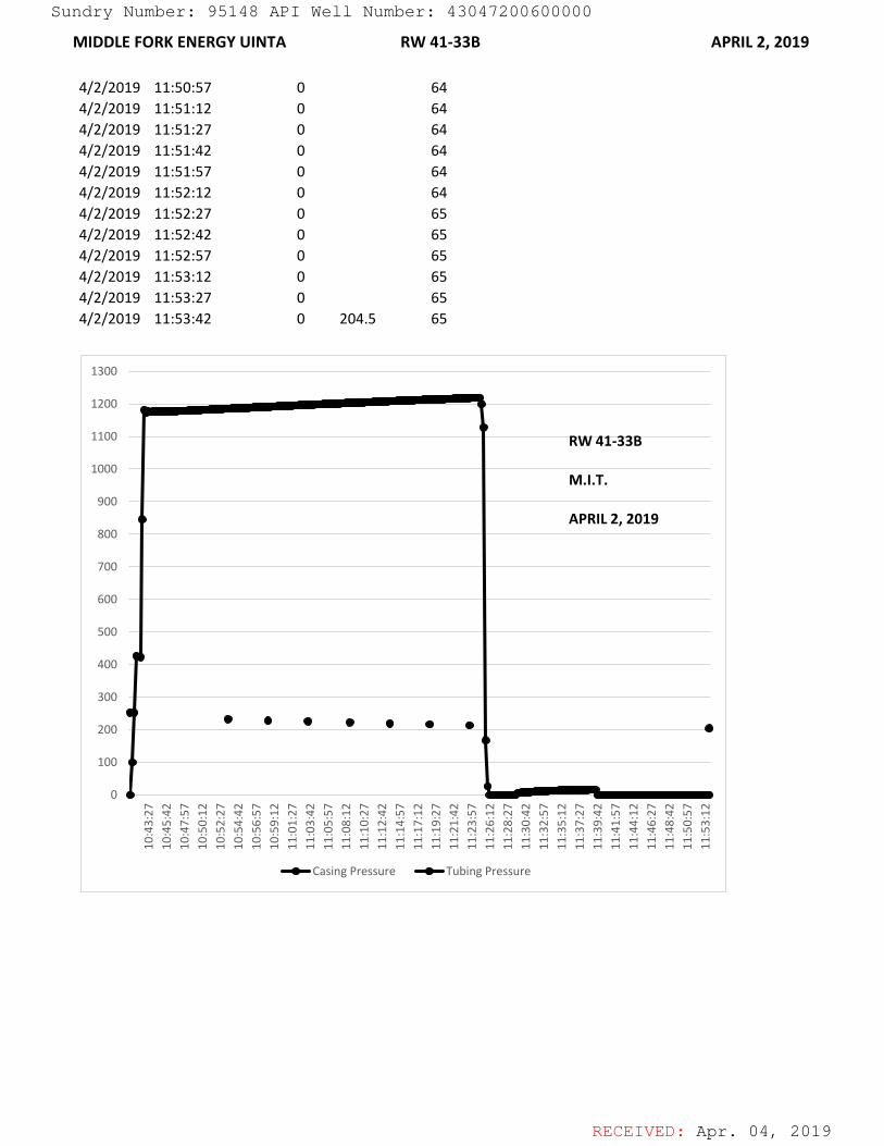
RECEIVED: Apr. 04, 2019
MIDDLE FORK ENERGY UINTA RW 41-33B APRIL 2, 2019
4/2/2019 11:50:57 0 644/2/2019 11:51:12 0 644/2/2019 11:51:27 0 644/2/2019 11:51:42 0 644/2/2019 11:51:57 0 644/2/2019 11:52:12 0 644/2/2019 11:52:27 0 654/2/2019 11:52:42 0 654/2/2019 11:52:57 0 654/2/2019 11:53:12 0 654/2/2019 11:53:27 0 654/2/2019 11:53:42 0 204.5 65
0
100
200
300
400
500
600
700
800
900
1000
1100
1200
1300
10:4
3:27
10:4
5:42
10:4
7:57
10:5
0:12
10:5
2:27
10:5
4:42
10:5
6:57
10:5
9:12
11:0
1:27
11:0
3:42
11:0
5:57
11:0
8:12
11:1
0:27
11:1
2:42
11:1
4:57
11:1
7:12
11:1
9:27
11:2
1:42
11:2
3:57
11:2
6:12
11:2
8:27
11:3
0:42
11:3
2:57
11:3
5:12
11:3
7:27
11:3
9:42
11:4
1:57
11:4
4:12
11:4
6:27
11:4
8:42
11:5
0:57
11:5
3:12
Casing Pressure Tubing Pressure
RW 41-33B
M.I.T.
APRIL 2, 2019
Sundry Number: 95148 API Well Number: 43047200600000
RECEIVED: Apr. 04, 2019
MIDDLE FORK ENERGY UINTA RW 41-33B APRIL 2, 2019
0100200300400500600700800900
1000110012001300 10:41:5710:42:4210:43:2710:44:1210:44:5710:45:4210:46:2710:47:1210:47:5710:48:4210:49:27
10:50:1210:50:57
10:51:4210:52:27
10:53:1210:53:5710:54:4210:55:2710:56:1210:56:5710:57:4210:58:2710:59:1210:59:5711:00:4211:01:2711:02:12
11:02:5711:03:42
11:04:2711:05:12
11:05:5711:06:42
11:07:2711:08:12
11:08:5711:09:4211:10:2711:11:1211:11:5711:12:4211:13:2711:14:1211:14:5711:15:4211:16:2711:17:1211:17:5711:18:4211:19:2711:20:1211:20:5711:21:4211:22:2711:23:1211:23:5711:24:4211:25:2711:26:1211:26:57
11:27:4211:28:27
11:29:1211:29:57
11:30:4211:31:27
11:32:1211:32:5711:33:4211:34:2711:35:1211:35:5711:36:4211:37:2711:38:1211:38:5711:39:4211:40:2711:41:1211:41:57
11:42:4211:43:27
11:44:1211:44:57
11:45:4211:46:2711:47:1211:47:5711:48:4211:49:2711:50:1211:50:5711:51:4211:52:2711:53:12
Casing Pressure Tubing PressureRW 41-33B
M.I.T.
APRIL 2, 2019
Sundry Number: 95148 API Well Number: 43047200600000


