Embed Size (px)
Citation preview
DOCUMENT A ASIANA VI
AYANis I Ten Years' Excavations at Rusahinili Eiduru-kai
1989-1998
Edited by Altan <;ilingirog1u and Mirjo Sa1vini
With contributions by
E. Abay, L. Castelletti, O. <;evik, A. <;ilingirog1u, Z. Derin, G. Kozbe, P.1. Kuniho1m, A. Maspero, O.W. Muscarella, M.W. Newton, L. Pena Cocharro, A. Rigamonti,
I. Reindell, H. Sag1amtimur, M. Sa1vini, E.C. Stone, P. Zimansky
CNR ISTITUTO PER GLI STUDI MICENEI ED EGEO-ANATOLICI
ROMA 2001
SURVEY AND SOUNDINGS IN THE OUTER TOWN OF A Y ANis 1996-1998
by Elizabeth C. STONE and Paul ZIMANSKyl
Only a small percentage of the people who created and maintained the Urartian center at Ayanis could have resided within the walls of its citadel. The limited space in upper stories that may have existed above the storerooms and ceremonial areas so far unearthed might have accommodated the garrison and elites, but not the larger workforce who tilled the fields, made the pottery, and worked on the construction of the fortress itself. In this regard, the situation at Ayanis does not differ significantly from what can be observed at other Urartian sites. The question of where and under what circumstances the majority of the population lived is not satisfactorily answered by either by the cuneiform record, with its almost exclusive focus on royal actions, or by the archaeology of the fortresses themselves, however much they highlight the hallmarks of a military/administrative political apex. A full understanding of the remarkable achievements of the Urartians, however, can be achieved only by studying the structure of the society as a whole.
Previous research on Urartian settlement has been circumscribed both by the priorities of excavators and the unrewarding ratio of knowledge gained for effort expended in unearthing residential buildings. Most of what we know comes from three sites at which a limited number of domestic structures were excavated: Argistihinil? (Arrnavir), RusaiURU .TUR (Bastam),3 and URU TeiSebaini (Karrnir Blur).4 The latter two, like Ayanis, are fortresses created in the 7th century B.C. by Rusa II. In none of these cases was a
The authors directed the work in the Outer Town as a sub-project under the overall control of Dr. Altan <:;ilingiroglu . In 1996 the authors were assisted in the preliminary survey by Dilek Ozttirk. In 1997, the outer town field crew included Carol Frey and Ken McDonough from the State University of New York at Stony Brook; Christine Bedore Ehlers and Kyle Wagner of Boston University; and Attila Batmaz of Ege University. Batmaz, Ehlers, and McDonough worked in the Outer Town again in 1998, joined by Ozlem Atay of Ege University, Jennifer MacCormack of Yale University, and Asa Randall of Boston University. For all seasons the plans were drawn by Dr. Zafer Derin and while pottery and small finds were recorded by the whole staff of the expedition under the supervision of Ozlem <:;evik. A. A. Martirosjan, Argistichinili, Archeologiceskie Pamjatniki Armenii 8 (Erevan: Akademija Nauk Armjanskoj SSR, 1974). Wolfram Kleiss, ed., Bastam J: Ausgrabungen in den urartdischen Anlagen 1972-1975, Teheraner Forschungen 4 (Berlin: Gebr. Mann, 1979); idem, Bas/am IJ: Ausgrabungen in den urartdischen Anlagen 1977-1978, Teheraner Forschungen 5 (Berlin: Gebr. Mann, 1988). A. A. Martirosjan, Gorod Tejsebaini (Erevan: Akademija Nauk Armjanskoj SSR, 1961).
356 Elizabeth C. Stone and Paul Zimansky
comprehensive evaluation of the layout of the city and the principles by which it was organized attempted.
The Ayanis project thus offers an unprecedented opportunity to investigate the nature of Urartian settlement in the final years of Urartu ' s history. From the outset scatters of pottery and traces of architecture made it evident that a substantial population resided in the vicinity of the fortress . The inscription associated with the city gate informs us that Rusa II had not only built a fortress, but a city and a vineyard as well,5 and the much lengthier inscription from the temple reinforces this claim. Limited soundings by Zafer Derin at several locations outside the citadel walls prior to 1996 had unearthed reasonably well preserved architectural remains. While the precise date of the end of the Urartian Empire remains unclear, all of the evidence suggests that Rusa II was the last king of any significance and thus a settlement founded by him is unlikely to have been occupied for more than a generation. One would expect distributions of architecture and artifacts to reveal more significant patterns here than they would in a site with a longer settlement history.
Systematic exploration of the outer town began in 1996, and the work discussed here represents only the first step in the larger objective attaining a general understanding of the organization of this Urartian city. Ultimately we hope to be able to determine whether there were extra-mural public structures such as the Hallenbau, Nord-Gebaude, Ostbau of Bastam ; identify any areas distinguished by class, ethnicity, occupational specialty, or craft production; and establish what relationships there were between these - in short, to elicit as much of information on the urban fabric and city planning as possible . In these initial seasons, however, only the more limited objectives of establishing the size of the settlement and the existence of differentiation within it were attainable. Funding for the work in the outer town in 1997 and 1998 was provided by generous grants from the National Geographic Society and a private donor, for which the authors are most grateful.
In essence, three techniques were employed in locating and exploring the Outer Town6
in the 1996-98 seasons: shovel test pits, magnetic field gradient survey, and excavation. Since it was not clear at the outset how effective each of these would be there was a measure of experimentation involved and the results of each method were used to interpret the information provided by the others . Shovel testing suggested areas in which we might most profitably concentrate our efforts in magnetic field gradient survey, and the magnetometry in turn helped us to select limited areas for excavation . The excavations provided detailed information on what the magnetometers and shovel testing did and did not reveal.
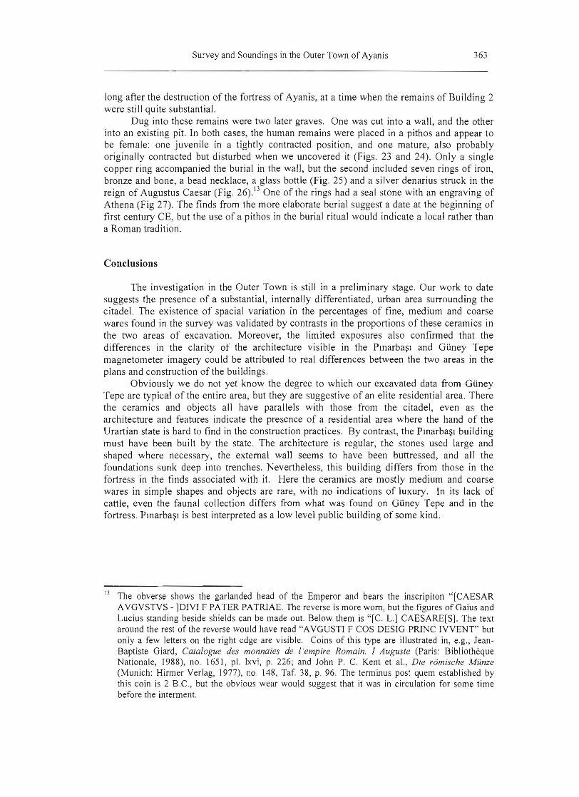
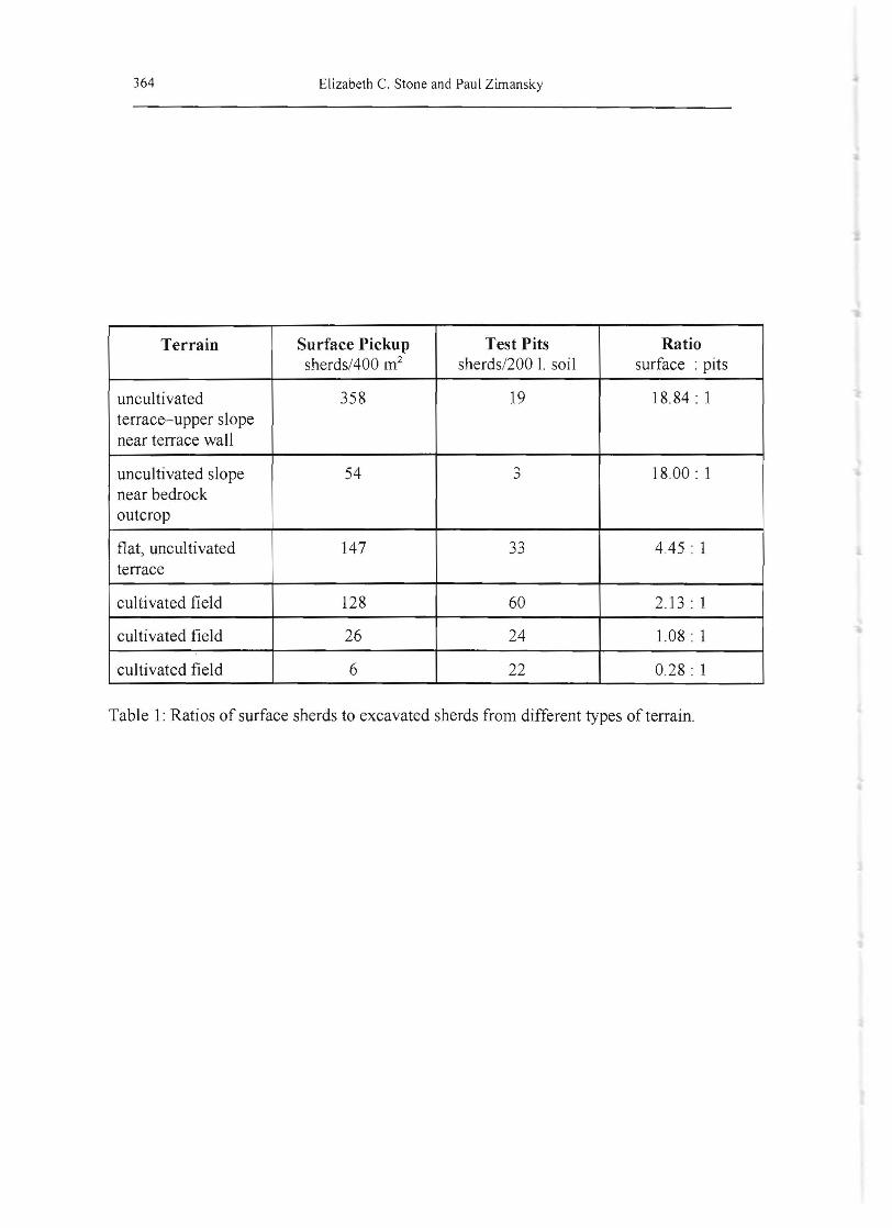
To a certain extent geological features mark out the area in which one might expect to find a settlement. The citadel was constructed on a natural rock outcrop centered approximately one kilometer inland from the shore of Lake Van (see Figs. 1 and 2). This rock rises abruptly from the relatively low-lying agricultural land beside the Lake and sits astride a terrace. Today there are gardens north of the citadel, and north of these is a small, currently denuded plateau named Ptnarba~1 after a spring which provides water for the gardens. As one moves farther inland from Ptnarba~1 and this spring, there is a spine of rocks into which a large quarry has been cut. This continues in a ridge known at Gtiney Tepe, strekhing more than a kilometer east of the citadel and rising above it to an elevation from which one can see Van and Toprakkale . On the southern and western slopes of Gtiney Tepe, facing the Lake and the citadel , sherds of the Urartian period were relatively abundant. The fortress itself is most easily approached where Gtiney Tepe meets the citadel rock, and
A. A. C;:ilingiroglu and M. Salvini, Rusahinili in Front of Mount Eiduru: The Urartian Fortress of Ayanis (7 th Century B.C.) , SMEA 35 (1995):111-124. We employ this term as an equivalent of the Turkish " DI~ Kent" and refer to the whole area around the citadel that was settled in the Urartian period. We do wish to imply that it was necessarily a single, coherent community.
6
357 Survey and Soundings in the Outer Town of Ayanis
indeed the city gate overlooks the southeast comer of this juncture. The south face of the citadel rock slopes steeply downward, ending in streambed at a much lower elevation and then, as one continues south, the ground rises again through the modem village of Agartl , eventually reaching an escarpment that surrounds the whole ova on the south and east. Except for immediately south of the main gate of the citadel, where a grid of walls is visible , there are hardly any traces of ancient architecture immediately apparent in these surroundings, and certainly nothing that could be construed as an outer settlement fortification.
Shovel Testing
The technique of digging shovel test pits of uniform volume in regular intervals was chosen for the comprehensive survey after testing survey methods in the summer of 1996. Preliminary inspection of the area surrounding the fortress demonstrated that Urartian ceramics were widely, but unevenly scattered over the landscape around the citadel and their density appeared to vary with the condition of the terrain . On GUney Tepe, for example, where local farmers practice alternate year fallowing, sherds were more conspicuous on the uncultivated than the cultivated sections.
This variability led us to question whether there was a regular relationship between ceramics on the surface and those found beneath the ground. By collecting all sherds from the surface of 24 ten by ten meter squares located in several different areas and comparing their numbers with what was recovered from shovel test pits dug within them, we were able to determine that there were indeed significant discrepancies between surface and subsurface sherd densities on eroded s lopes and plowed fields (see Table I). Under these circumstances, we felt that the subsurface count would be the more consistent and informative measure with which to assess the distribution of settlement in the surroundings of the citadel.
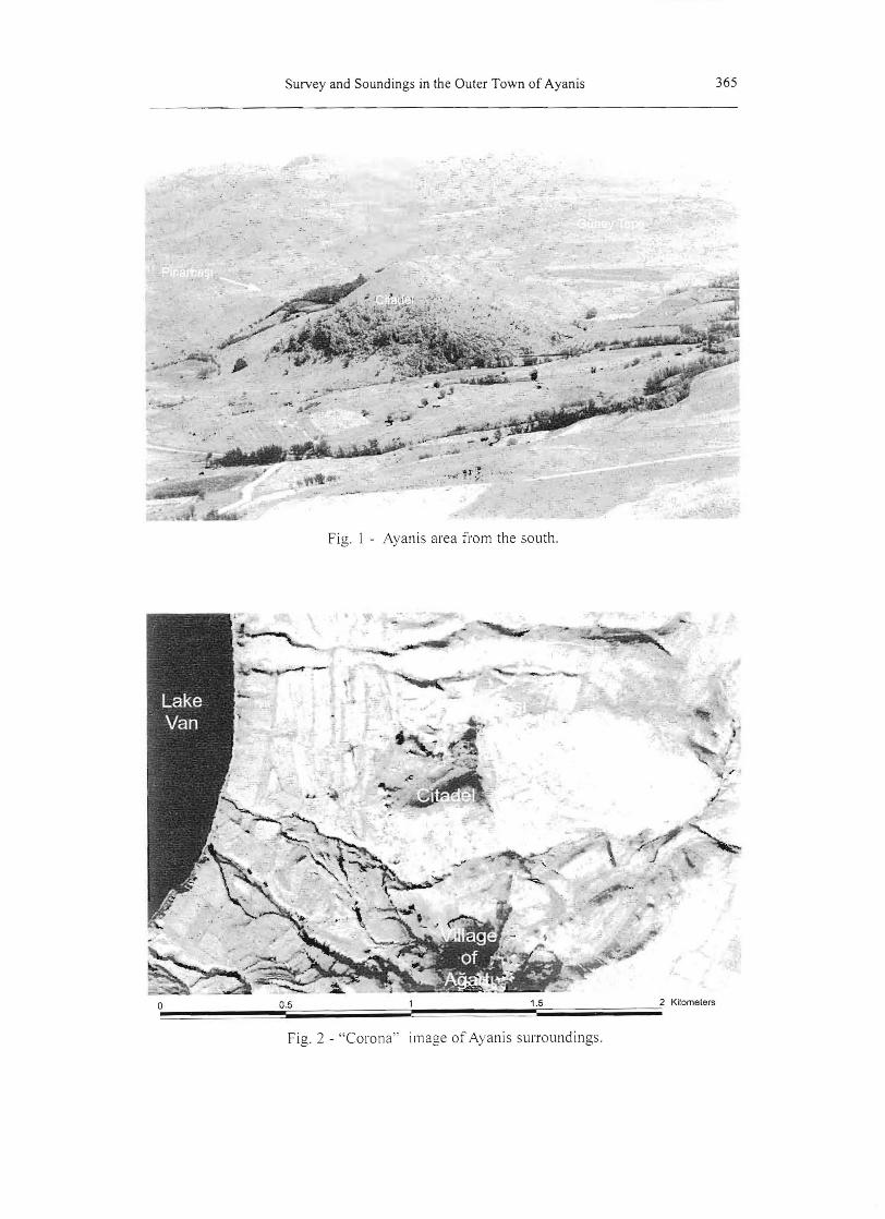
In the 1997 season, we used an EDM "total station" to mark out a fifty-meter grid around the site and took forty-liter soil samples at each point. The survey area extended five hundred meters to the north, south and west of the citadel and one kilometer to the east, thus enclosing an area of 150 hectares. The actual number of shovel pits, however, was smaller than this figure would suggest: we did not include any on the citadel itself and of the 685 locations marked out, 159 were not tested, either because they were on bedrock or because modern construction made them inaccessible. These soil samples were screened through a one-centimeter mesh, and all the sherds found in them were washed, counted, weighed and classified according to ware type. Pieces large enough to give evidence of vessel shape were also drawn.
Generally, pottery was most abundant in the immediate vicinity of the citadel and relatively sparse in the northeastern and southeastern corners of the survey area (Fig. 3). Four primary concentrations were identified: one northeast of the citadel on the relatively level ground of Plnarba~l and near the associated spring; one on the slopes of GUney Tepe; one at the eastern foot of the fortress; and one near the village of Agartl. Less dense scatters of ceramics were found in the west and south central areas. In general sherds were not particularly numerous; in the entire survey the total recovered only amounted to 510.7
Low sherd densities are characteristic of Urartian sites. In his surveys in Iranian Azerbaijan , Stephan Kroll noted "Die urartaischen Festungen in Iran lieferten jedoch generell so wenig Oberflachenfunde, daf3 man auch meist mehrmaligem Absuchen der ganzen Ruine auf nich mehr als ein paar Handvoll Scherben kam - einige Ruinen lieferten ilberhaupt keine Oberftachenfunde." See Stephan Kroll, Keramik urarttiischer Festungen in iran, «Archaologische Mitteilungen aus Iram), Erganzungsband 2 (Berlin : Dietrich Reimer Verlag, 1976), pp.12-13, note 12. While this
358 Elizabeth C. Stone and Paul Zimansky
Nevertheless, if one uses the criteria of five sherds per test pit to define the area of settlement, the residential area around the Ayanis citadel covered at least eighty hectares, and probably extended beyond our survey to the west and south, since we identified only its northern and eastern perimeter.
Most of the ceramics recovered from the test pits were not large enough to be classified according to shape and thus our analysis is based primarily on wares. 98.5% of the sherds could be assigned to one of nine fabric types, eight of which are known to be Urartian.8 The ninth-medium buff ware is present in excavated Urartian levels of the fortress, but is also common in those of the Medieval Period. It made up less than 7% of the total sherds found in the survey, and was most abundant in the southern portion of our survey area where the unambiguously Urartian ceramics were less common. Only three of the diagnostic sherds were non-Urartian two dating to the Medieval period and one assigned to the Early Iron Age. The survey data therefore provide evidence of extensive settlement in the area only in Urartian times.
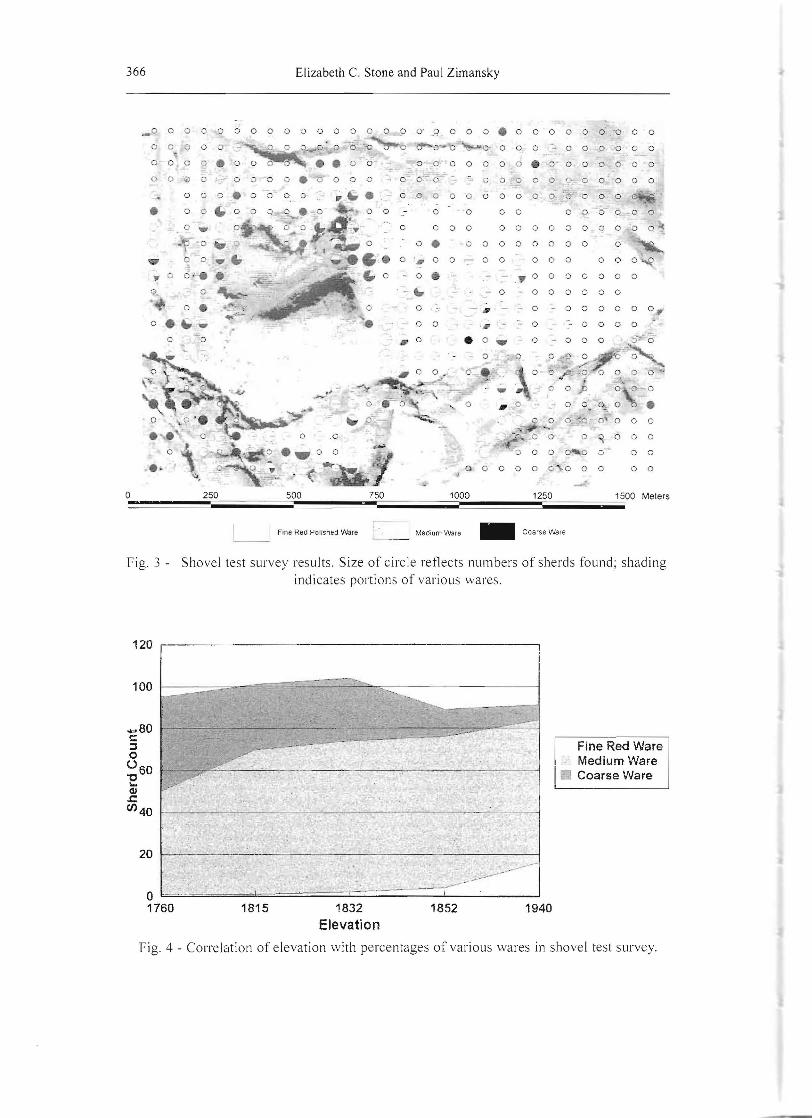
In spite of the small numbers of sherds involved, the samples suggest a consistent pattern of differences between the various parts of the survey area. GUney Tepe was characterized by a mixture of fine and medium wares, with significant amounts of red polished wares. As the slope descended to the west, however, there was a decrease in the amount of fine ware and an increase in the amount of coarse ware, and the low areas close to Lake Van were in fact dominated by coarse wares (Fig. 4). In view of the short period of time during which the area was settled and the quite different wares involved, we presume these differences mark contemporaneous settlement areas of varied character, rather than temporal distinctions.
Although it was not to be expected that significant numbers of objects would be recovered in the survey, a number of grinding stones were discovered on the surface. An iron spatula, similar to one from Argistihinili9 was recovered from one of the test pits on GUney Tepe.
Magnetometry
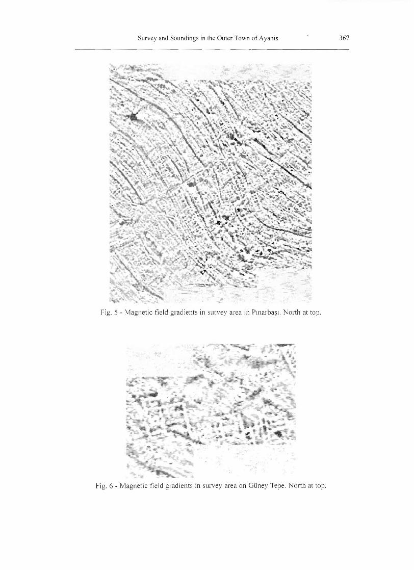
In the 1997, we marked out two areas for magnetic field gradient survey in places where the preliminary results from the shovel testing suggested there should be occupation. The largest of these was on GUney Tepe and it eventually covered slightly more than five hectares. The second, in the southwestern portion of Pmarba~1 where the survey ceramics were dominated by coarse and medium wares, was limited to one hectare. Dr. Louis Somers of Geoscan conducted the survey, walking twenty-meter squares along lines one meter apart.
In both areas the magnetometry revealed clear traces of substantial structures, but the most impressive results came from PlDarba~l where partial plans of two monumental buildings could be made out (Fig. 5) despite the small area covered. On GUney Tepe the terrain was much more broken up-cultivated in some places, fallow in others, and scored by numerous terraces and stone outcroppings which affected the collection of data and made its interpretation more difficult. Nevertheless, the white lines marking the negative anomalies of
paucity may be due in part to the fact that fortresses rather than purely residential sites have been the primary focus of research, the relatively short time that Urartian sites were occupied is probably the most significant factor. The categories used in this survey were those developed by the Ege University team on the basis of their work on the citadel. A. A. j';1artirosjan, Argistichinili, p. 141, fig. 867, far left. At 53 cm in length, however, this object is somewhat larger than the one we found.
359 Survey and Soundings in the Outer Town of Ayanis
walls reveal the plans ten structures, with many other isolated elements of architecture also visible in the five hectare area (see Fig. 6). In general these buildings appear to be smaller, less solidly built, and more scattered than the those in Ptnarba~l. They align themselves along the contours of the slope rather than into any kind of regular gird pattern. The Gtiney Tepe data also show several large positive anomalies, seen as black spots. The magnetic conductivity of these locations is most probably attributable to ancient fire installations like of furnaces or kilns, but other explanations such as concentrations of metal objects, basalt blocks or geological features cannot to be ruled out.
Excavations
Both the architectural patterns revealed by the magnetometry and the sherds recovered in survey suggested that Gtiney Tepe and Pmarba~l represented areas of dissimilar types of Urartian settlement. In the 1997 season we commenced test excavations with three 5 x 5 meter squares on Gtiney Tepe to assess the depth, state of preservation, and accessibility of the Urartian levels. These were marked out where the magnetic field gradient survey showed clear, but relatively faint walls of a building, and we felt that if excavations confirmed the existence of this structure we could be very confident of building plans that showed up more sharply elsewhere in the imagery. This initial test proved quite successful. Urartian walls were found immediately below the surface exactly where the magnetometer indicated they should be, and a very small positive anomaly in one comer proved to mark the location of a tandlr.
In the 1998 season, we expanded our excavations in Pmarba~l and on Gtiney Tepe, digging four 10m x 10m squares in each area down to bedrock or sterile soil. lO In PlDarba~1 these units were placed within the smaller of the two structures discovered by the magnetometry and on Gtiney Tepe we expanded the area of excavation around oUi 5 x 5 meter squares of the previous season. In addition to further testing the effectiveness of the magnetometry, the aims of excavation on this occasion also included testing whether the shovel test survey was a good predictor of the ceramics in the two areas, and to recover a broad range of ceramics, objects, faunal remains and plant remains. We tried to position our excavations so that they would include both interior and exterior space in the hope of finding trash disposal areas on the outside of the buildings. As will be seen below, this strategy worked well in Gtiney Tepe, but in Pmarba~l the area beyond the confines of the building was very small.
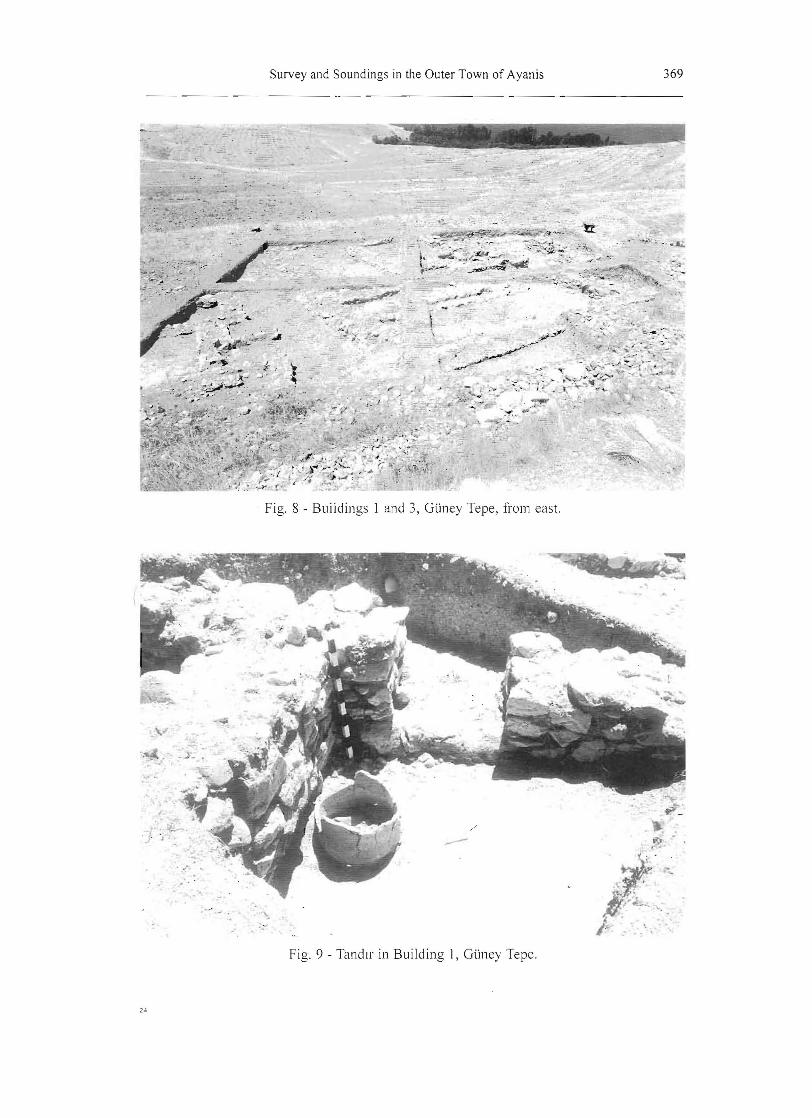
Gtiney Tepe. On Gtiney Tepe (Fig. 7) we were able to uncover nearly the entire plan of structure visible in the magnetometry (Building 1),11 including both living areas and exterior courtyards. This structure was solidly built and clearly well planned. To the southwest of it
10 One five by five meter square was left unexcavated in the northeast comer of the northeastemmost square in Gtiney Tepe. This lay under a massive modem stone terrace and the labor involved in clearing it was deemed disproportional to what we might recover.
II For the purposes of description, we number buildings in t~e Outer Town in the order that we excavate them, without regard to locations. Thus Buildings I and 3 are on Gtiney Tepe and Building 2 is in Pmarb~l. The actual field recording, however, is done on a square and locus system, with squares designated by number and letter combinations by extending the grid of the countour map of the citadel drawn up by the Ayanis excavation. On this plan, the squares excavated on Gtiney Tepe on this grid would be KK68, KK69, LL68, and LL69, and on Pmarba~l AAH27, AAH28, AAI 27, and AAI 28. At the time of excavation, however, we gave them slightly different designations, which remain in the field notes.

360 Elizabeth C. Stone and Paul Zimansky
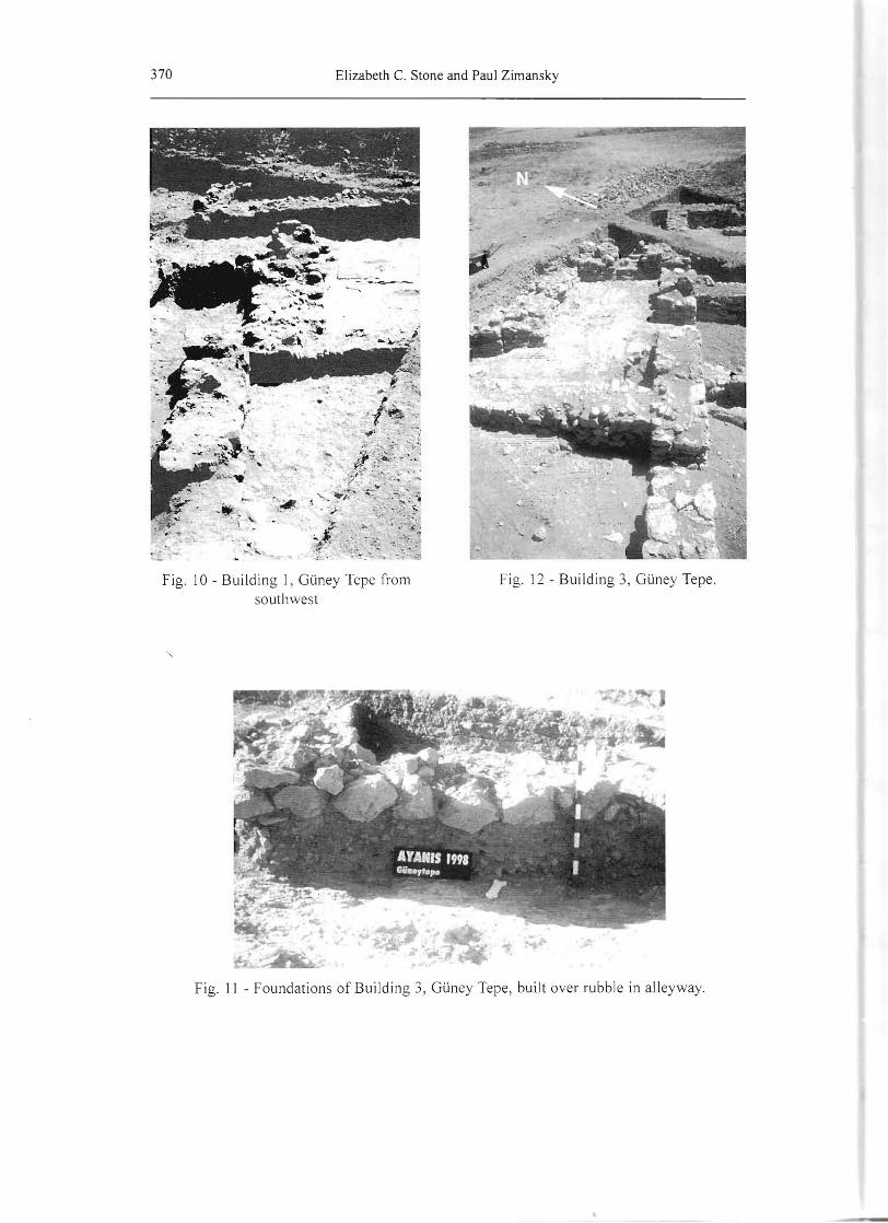
was a long alleyway filled with ash, faunal remains, ceramics and artifacts. To our surprise. we also found a second structure (Building 3), across the alley to the southeast. Perhaps because its walls were partially built upon ashy debris rather than bedrock, this structure did not show up clearly in the magnetometry.
Building I included a large room with a bench along its east wall, and a drain and paved floor to the west (Fig. 8). To the north and west of this large room were what we interpret as the main living quarters of this house, not all of which have been excavated. These consist of at least six rooms, all interconnecting and replete with domestic feature such as hearths, bread ovens (Fig. 9), and a pestle and mortar. Preservation of floor levels was best to the northwest, where a modern terrace helped to retain more fill, and worst to the southeast where the floors were eroded away and only parts of the foundation walls were preserved. The relationship between the magnetometry and the underlying architecture was quite exact, with all walls, no matter how well preserved, clearly visible in the survey data. Even items as small as the bread oven noted above and an iron axe could be seen as a small positive anomalies. The only place where the initial interpretation of the magnetometry differed from the excavated remains was in one room where the effects of a stone packing, presumably designed to support a floor, had been interpreted as another wall.
The walls were built of limestone. These were founded on bedrock in some places and cut into a deposit of a pebble-filled yellowish sterile soil in others. The stones were not dressed, but the builders employed the common Urartian technique of using larger stones with one flattish surface to form the outer faces and packing the interiors of the walls with smaller stones and rubble. Doorways, sometimes accompanied by door sockets, often included steps to allow movement between rooms constructed at different levels on the hill.
When Building I was constructed the alleyway immediately to its southeast south must have been denuded oftopsoil. Trash lay directly on the bedrock here and had built up to a level of approximately half a meter directly beside the foundations of the walls. This debris could also be seen in the magnetometry as a weak linear anomaly, but what was not so visible were the remains of Building 3, located further to the southeast (Fig. 10). Only part of four rooms of this structure lay within our excavation area, two of which contained fire installations. The walls of this building were of smaller stones than those of Building 1 and in some places their bases lay upon the lower levels of debris from the alleyway (Fig. 11). They were also less uniformly and solidly constructed than any of the other architecture we encountered in the Outer Town and did not invariably meet at right angles. In the southeasternmost corner of the excavation unit LL69, the bottom portion of the wall and the floor were carved directly into the bedrock. The northwest wall of Building 3 zig-zagged in and out to form a sort of alcove giving onto the alleyway (Fig. 12). This alcove was further divided by a thin wall made up of a single row of stones. The purpose of these walls is difficult to discern, but the impression of improvisation is inescapable.
The ceramics from our excavations on Guney Tepe were noteworthy for the high percentage of fine red wares (15%), the majority of which were red polished, and the low percentage of coarse wares (22%).12 This proportion of red polished wares is comparable to, and in many instances higher than, what is generally recovered from Urartian fortresses. The wares were not, however, evenly distributed within the excavated area. About 10% of the sherds found within both Buildings I and 3 were fine red wares, whereas the percentage rose to 18% in the alleyway that separated them. Although the overall percentages of fine,
12 Percentages of ware types may be calculated on the basis of either all sherds or of all diagnostics or of rim sherds only, providing differing results. It is our belief that the closest estimate of the original percentages of whole vessels comes from using rim sherd data, because one can expect both large and small vessels to have their rims break into a comparable number of pieces, whereas the actual size of the vessels is likely to be more closely reflected in the body sherd counts.
361 Survey and Soundings in the Outer Town of Ayanis
medium and coarse wares were similar in Buildings I and 3, in Building 3 much less of the fine red ware showed evidence of polish in than either the alleyway or Building I.
Most of the fine red ware sherds were parts of serving vessels, generally small, including bowls with elaborate rim profiles and trefoil jars. A few sherds also came iarger, simpler bowls. Coarse wares were seen primarily in sherds of large storage containers and trays, and many of the larger bowls were made of medium wares. In general, open vessels dominated the Gtiney Tepe assemblage.
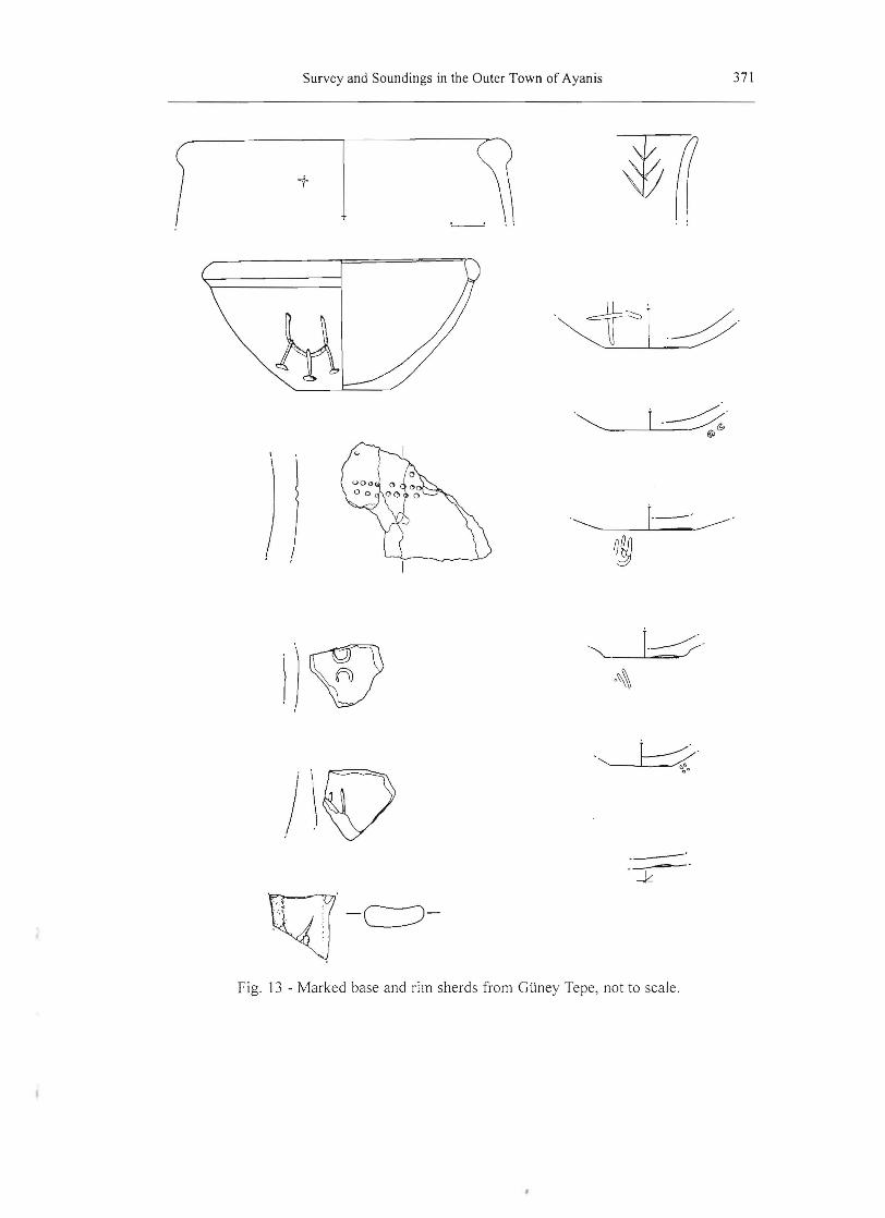
It was not just in the percentages of various types of wares that the ceramics from the from Gtiney Tepe resembled those of the fortress, we also find the same kinds of incised and impressed marks on the pottery. These included one pithos sherd with part of a hieroglyphic inscription, three red polished bases bearing impressions on their bottoms, four other bases with incised or impressed marks by or on the base, and five body or rim sherds with marks (Fig. 13). In addition to these, we recovered a number of other decorated sherds, some with decorative bands, and two red polished trefoil jars with decoration either on the spout or beneath the handle. In general, the ceramics from Gtiney Tepe could not be distinguished from those from the fortress in either ware or decoration.
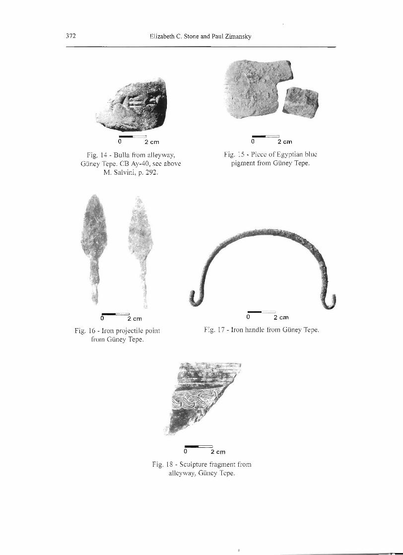
The impression that Gliney Tepe was an elite area is further reinforced by the nonceramic finds from the area. Objects recovered included an unbaked clay bulla with a broken inscription (Fig. 14); two pieces of "Egyptian Blue" pigment (Fig. 15); four flat, thin iron arrowheads of a slightly different in shape from those found on the citadel (Fig. 16); a fragment of a bow-shaped iron handle, perhaps for a situla; a handle in bronze with a similar shape (Fig. 17); a bracelet fragment with a worn snake head decoration; a bronze pin; and a small piece of what must have been a substantial bronze sculpture decorated with band of wave-like patterns that are somewhat similar to the stylized hair of the magnificent lion head found beside the temple in the 1997 season (Fig. 18).
Even the faunal remains recovered from this area suggest a degree of luxury. Although Building 1 itself was relatively clean, the alleyway between Buildings 1 and 3 was packed with animal bones, in which the specimen counts are almost equally divided between cattle bones on the one hand and ovicaprids on the other. There were also a few horse and dog remains. Given the difference in the size of the animals, this would suggest that beef formed the highest percentage of the meat consumed on Gliney Tepe, albeit with supplemented with substantial quantities of sheep and goat.
In summary, the architecture and many of the features and finds from Gtiney Tepe suggest a domestic area, and if the magnetometry results of the entire area are to be trusted, one characterized by large houses. The finds associated with Building 1 suggest that these structures were inhabited by elites who shared with the denizens of the fortress a degree of literacy and luxury. They had access to high quality ceramics, decorated bronzework, iron arrowheads, and artificial pigments which must have been used to paint the walls .
Pmarba~l. Unlike Gliney Tepe, where everything we excavated belonged to the Urartian period, Pmarba~l showed evidence of post-Urartian activities. The large and well constructed Urartian edifice (Building 2) which attracted our attention in the magnetic field gradient images proved to be slightly modified in places by construction apparently undertaken within a few centuries of the destruction of the citadel. Somewhat later, in the time of the early Roman Empire a few graves were also cut into the ruins, although no contemporary habitation debris associated with population is in evidence. The Post-Urartian construction complicates our analysis of the finds from the area, since it is sometimes difficult to determine which deposits should be associated with which occupation, especially since most of the ceramics are very similar.
362 Elizabeth C. Stone and Paul Zimansky
It had been our intention to layout our squares in such a way as to include some external areas, as we had on GUney Tepe, but a positive magnetic anomaly within the baulk to the north of our excavations masked traces of architecture in that area and thwarted us in this. Although we did expose the north and west outer walls of Building 2, we only dug outside of these walls in one small area on the north side of the structure.
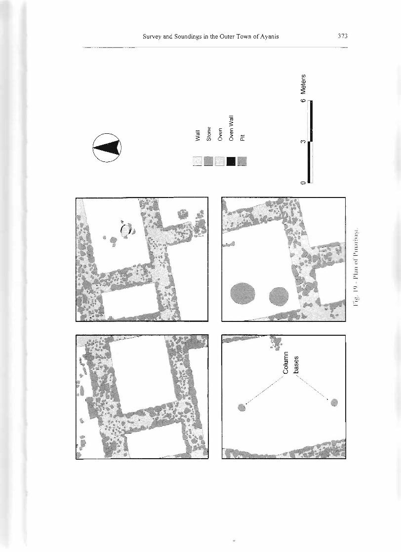
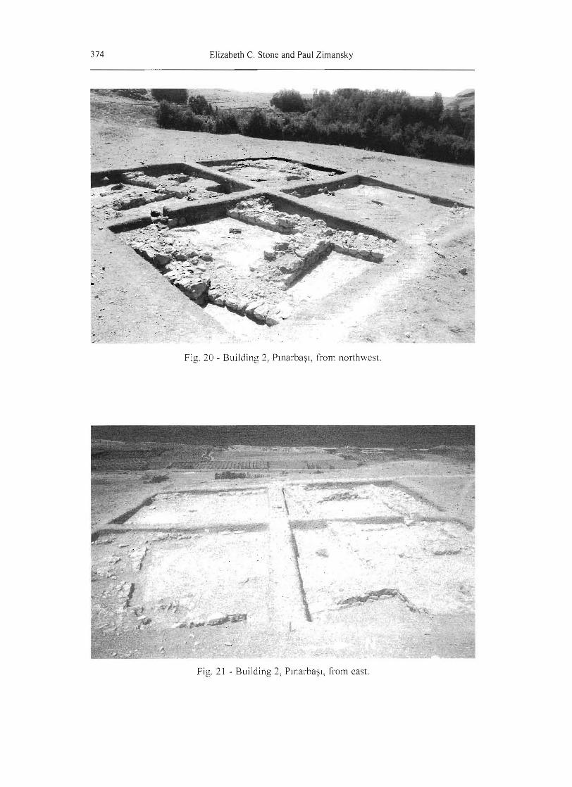
The architecture of Building 2 presented a contrast to both of the structures we had excavated on GUney Tepe. The interior walls were regularly 1.5 meters thick and the external ones closer to 2.0 meters, whereas in Building 1 the thickness was closer to 1.0 meter. Building 2 was obviously a well constructed and well planned structure (Figs. 19 and 20), with the foundations buried in trenches cut into sterile soil and even bedrock. The only portion of an external wall excavated, in the north, was graced by a substantial buttress. Intact floor levels were found in most parts of the excavation, especially to the northeast, but in some areas erosion had left only the foundations preserved. In few instances were the walls preserved high enough above the floor levels for us to be able to distinguish doorways.
Four rooms lay along the northern wall of the building. The easternmost of these had a partially preserved sherd pavement and a fire installation. The southern portion of the excavation area was dominated by two large enclosed spaces and portions of a range of rooms to the south and east. A pair of stone column bases (Fig. 21) in the larger space to the west suggests that it may have been roofed in whole or in part, but the smaller one to the east may have been unroofed. Both spaces had pits dug into them, three large ones in the eastern space and one small one in the room with the columns. The latter also had a small hearth. Floor levels in this area were generally poorly preserved, but along the walls of the northeast corner of the smaller space there was an area of preserved living surface on which ceramics and a sealed bulla were found in situ. The south and east ends sides of Building 2 remain unexcavated.
Generally, finds from Plnarba~l were scanty. The ceramics were significantly different from those from GUney Tepe. Only 5% of the sherds were of fine wares, of which 3% were red polished, and the percentage of coarse wares was 37% compared with only 22% at GUney Tepe. Moreover, the shapes were different. Although the basic forms of the vessels utilized in both areas were more or less the same, they were more elaborately shaped on GUney Tepe and simpler in Plnarba~l. The ceramics from Plnarba~l lack the impressions and incisions so commonly found on of those from GUney Tepe.
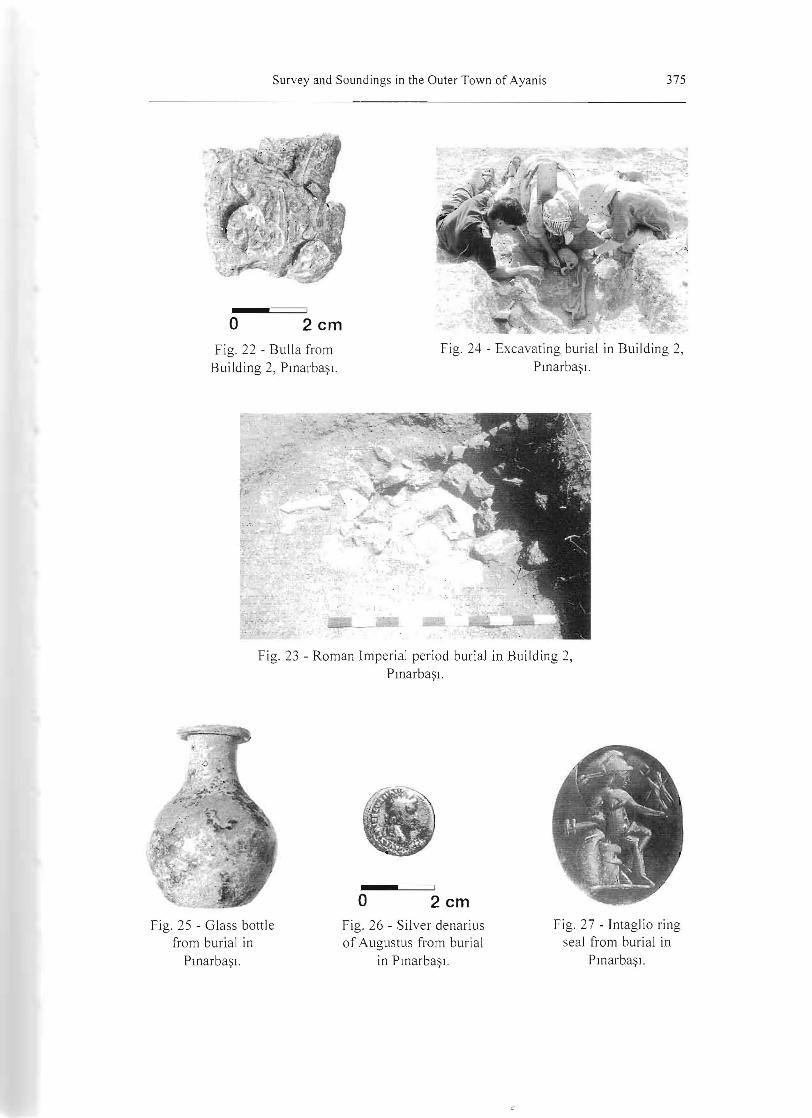
Objects were rare in the Plnarba~l building. Apart from some iron and obsidian fragments, the only smallfind of note was the unbaked bulla mentioned above. This shows several impressions of the same seal, but no cuneiform writing (Fig. 22).
The smallest of the excavated rooms of Building 2, in the middle of a series of chambers along the northern exterior wall, was found to be packed with animal bones. Smaller faunal samples were also recovered from the rest of the building. In marked contrast to bones from GUney Tepe, these proved to be almost entirely from sheep or goat.
In addition to the Urartian remains, we also uncovered traces of Post-Urartian modifications to the architecture at PlDarba~1. These took the form of some insubstantial walls built up against or over the remains of the Urartian construction, and a somewhat fragmentary channel, perhaps related to the nearby spring. Associated with this architecture were three very small door sockets, perhaps for simple gates to some rough farmyard. Although the vast majority of the ceram ics associated with this later construction could not be differentiated from the Urartian ceramics, three painted sherds were found, one a typical piece of Triangle Ware. Recent work at Horom suggests that "Urartian" ceramics did not go out of use with end of the Urartian Empire but evolved gradually in the following centuries, as Triangle Ware came into use (S. Kroll , personal communication). The fact that parts of Building I were incorporated into this later architecture suggests to us that it was built not
363 Survey and Soundings in the Outer Town of Ayanis
long after the destruction of the fortress of Ayanis, at a time when the remains of Building 2 were still quite substantial.
Dug into these remains were two later graves. One was cut into a wall, and the other into an existing pit. In both cases, the human remains were placed in a pithos and appear to be female: one juvenile in a tightly contracted position, and one mature, also probably originally contracted but disturbed when we uncovered it (Figs. 23 and 24). Only a single copper ring accompanied the burial in the wall, but the second included seven rings of iron, bronze and bone, a bead necklace, a glass bottle (Fig. 25) and a silver denarius struck in the reign of Augustus Caesar (Fig. 26).13 One of the rings had a seal stone with an engraving of Athena (Fig 27). The finds from the more elaborate burial suggest a date at the beginning of first century CE, but the use of a pithos in the burial ritual would indicate a local rather than a Roman tradition.
Conclusions
The investigation in the Outer Town is still in a preliminary stage. Our work to date suggests the presence of a substantial, internally differentiated, urban area surrounding the citadel. The existence of spacial variation in the percentages of fine, medium and coarse wares found in the survey was val idated by contrasts in the proportions of these ceramics in the two areas of excavation. Moreover, the limited exposures also confirmed that the differences in the clarity of the architecture visible in the PInarba~J and GUney Tepe magnetometer imagery could be attributed to real differences between the two areas in the plans and construction of the buildings.
Obviously we do not yet know the degree to which our excavated data from GUney Tepe are typical of the entire area, but they are suggestive of an elite residential area. There the ceramics and objects all have parallels with those from the citadel, even as the architecture and features indicate the presence of a residential area where the hand of the Urartian state is hard to find in the construction practices. By contrast, the PInarba~l building must have been built by the state. The architecture is regular, the stones used large and shaped where necessary, the external wall seems to have been buttressed, and all the foundations sunk deep into trenches. Nevertheless, this building differs from those in the fortress in the finds associated with it. Here the ceramics are mostly medium and coarse wares in simple shapes and objects are rare, with no indications of luxury. In its lack of cattle, even the faunal collection differs from what was found on GUney Tepe and in the fortress. PInarba~l is best interpreted as a low level public building of some kind.
13 The obverse shows the garlanded head of the Emperor and bears the inscripiton "[CAESAR A VGVSTVS - )DIVI F PATER PATRlAE. The reverse is more worn, but the figures of Gaius and Lucius standing beside shields can be made out. Below them is "[C. L.) CAESARE[S) . The text around the rest of the reverse would have read "A VGUSTI F COS DESIG PRlNC IVVENT" but only a few letters on the right edge are visible. Coins of this type are illustrated in, e.g., JeanBaptiste Giard, Catalogue des monnaies de I 'empire Romain. 1 Auguste (Paris: Bibliotheque Nationale, 1988), no. 1651 , pI. lxvi, p. 226; and John P. C. Kent et aI., Die rdmische Miinze (Munich: Hirmer Verlag, 1977), no. 148, Taf. 38, p. 96. The terminus post quem established by this coin is 2 B.C., but the obvious wear would suggest that it was in circulation for some time before the interment.
364 Elizabeth C. Stone and Paul Zimansky
Terrain Surface Pickup sherds/400 m2
Test Pits sherds/200 1. soil
Ratio surface : pits
uncultivated terrace-upper slope near terrace wall
358 19 18.84: 1
uncultivated slope near bedrock outcrop
54 .., .) 18.00 : 1
flat, uncultivated terrace
147 33 4.45: 1
cultivated field 128 60 2.13 : 1
cultivated field 26 24 1.08 : 1
cultivated field 6 22 0.28: 1
Table 1: Ratios of surface sherds to excavated sherds from different types of terrain.
365 Survey and Soundings in the Outer Town of Ayanis
Fig. 1 - Ayanis area from the south.
Fig. 2 - "Coro na" image of Ayanis surroundings.
--
366 Elizabeth C. Stone and Paul Zimansky
... ..... 0 0 C C) o 0 C o 0 0 0 0 0 0 0 09 0 o 0 • 0 o 0 o 0 o ' 0 0 0
o 0 :: 0 0 o '0 0 0
o • 0 0 0 0 .0 0 0
o 0 0 0 0_ 0 0 0
0 o o~~?i 0 0 o .. . , 0 o J:) 0 Q. 0 0
c 0 0 0 0 Q 0 0 Q~ 0 0 0 0 0 o , ; :'\
- 0 0 0 o 0 0 ~
." 0 0 0 0 000
- 0 0 8 C o 0
- 0 - 080 000...
-. 0 000
o 0 .. 0 e o. o
- 0
o 0 :,' - 6"1
o 0 0 0 6 • o. ~o o'll 0 o 0
~1 0 ~) 0
0 .... 0 0 o 8
o (; 0 0 0 0 000 o 0
0~"""""""""""""""""""""""""2~5~0o;;;o;;;o;;;o;;;o;;;;;5;;0~0""""""""""""""""""""~~7~5;;0~o;;;~o;;;_;;1~00~0~""""""""""""""""",,,,,,~1~25;;0;;;;o;;;~o;;;_oi;1;500 Meters
__ Coarse Ware Fine Red Polished I.Nare Medium Ware
Fig. 3 - Shovel test survey results. Size of ci rcle reflects numbers of sherds found; shading indicates pOltions of various wares.
120 I
0 0 0 0 C
COO 0
• .. .. 0 c ;
~6~~~ 'J ' C~'\) .0 0
J! ". - OO O 00 0 o o 0 - o 0
00 0
o
8
•
o
o • o ., 0 0
o • . -_..
_. 0
0
o 0 0
c- o
- 0
- , · If -
-- 0 0 0
8 2> .,A o 0 F
100
Fine Red Ware I Medium Ware ~arseware
20
o --. .... _- '-1760 1815 1832
Elevation 1852 1940
Fi g. 4 - Correlation of e levation with percentages of various wares in shovel test survey.
367 Survey and Soundings in the Outer Town of Ayanis
Fig. 5 - Magnetic field gradients in survey area in Pll1arba~1. NOlth at top.
Fig. 6 - Magnetic field gradients in survey area on Gi.iney Tepe. North at top.

368 Elizabeth C. Stone and Paul Zimansky
I=:J Bench Wall Stone Oven .. Oven Wall
Fig. 7 - Plan of architecture in GUney Tepe soundi ng. N011h at top.
369 Survey and Soundings in the Outer Town of Ayanis
Fig. 8 Buildings 1 and 3, GUney Tepe, from east.
Fig. 9 - Tandll' in Building I, Giiney Tepe.
24
370 Elizabeth C. Stone and Paul Zimansky
Fig. 10 - Building 1, GUney Tepe from Fig. 12 - Building 3, GUney Tepe. southwest
Fig. 11 - Foundations of Building 3, GUney Tepe, built over rubble in alleyway.
371 Survey and Soundings in the Outer Town of Ayanis
, .
I·-' ___ ' . ,
J\v ,-',-'-.k
Fig. 13 - Marked base and rim sherds from Gliney Tepe, not to scale .
372 Elizabeth C. Stone and Paul Zimansky
2cm o 2cm
Fig. 14 - Bulla from alleyway, Fig. 15 - Piece of Egyptian blue
Gliney Tepe. CB Ay-40, see above pigment from Gliney Tepe.
M. Salvini, p. 292.
o 2cmo 2cm
Fig. 16 - Iron projectile point Fig. 17 - Iron handle from GUney Tepe.
from Gliney Tepe .
o 2cm
Fig. 18 - Sculpture fragment from alleyway, Gliney Tepe.
373 Survey and Soundings in the Outer Town of Ayanis
ro $:
Ql t:: t:: ro 0
t:: Ql Ql > >
$: ii3 0 0 0:::
o
c tilE <l>::l
(5 til co
U .0
374 Elizabeth C. Stone and Paul Zimansky
Fig. 20 - Building 2, Pmarba~l, from northwest.
Fig. 21 - Building 2, Pll1arba~l, from east.
375 Survey and Soundings in the Outer Town of Ayanis
o 2cm Fig. 22 - Bulla from
Building 2, Ptnarba$l. Fig. 24 - Excavating burial in Building 2,
Ptnarba$l.
Fig. 23 - Roman Imperial period burial in Building 2, Ptnarba$l.
Fig. 25 - Glass bottle from burial in
Plllarba$l.
o 2cm Fig. 26 - Silver denarius of Augustus from burial
in Ptnarba$l.
Fig. 27 - Intaglio ring seal from burial in
Ptnarba$l.


