Embed Size (px)
Citation preview
Chapter 4
Enhancing slope safety preparedness forextreme rainfall and potential climatechange impacts in Hong Kong
K.K.S. Ho, H.W. Sun, A.C.W. Wong and C.F. YamGeotechnical Engineering Office, Department of Civil Engineering and Development,Hong Kong SAR Government
S.M. LeeHong Kong Observatory, Hong Kong SAR Government
ABSTRACT
A comprehensive Slope Safety System has been implemented by the Geotechnical Engi-neering Office (GEO) to manage the landslide risk in Hong Kong. The system hasgenerally proved to be effective in coping with the prevailing landslide problems. How-ever, the more frequent occurrences of extreme rainfall causing serious landslides andmajor casualties in different parts of the world in recent years have highlighted theimpact of extreme rainfall on the community and concerns about the possible effectof climate change on slope safety. The impact of extreme rainfall poses new challengeswhich need to be addressed from a strategy, policy and technical perspective, as thenumber, scale and mobility of the corresponding landslides could be unprecedented.To manage the new challenges, a systematic approach was adopted by the GEO to (a)take stock of the relevant climate change studies, (b) identify the nature and scale of thecredible extreme landslide events, (c) assess the severity of landslide consequences, (d)evaluate the capacity of emergency management, and (e) examine the scope for improv-ing crisis preparedness as well as system and community resilience. The preliminaryfindings are presented in this report.
4.1 INTRODUCTION
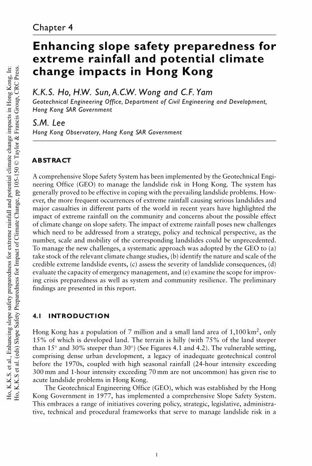
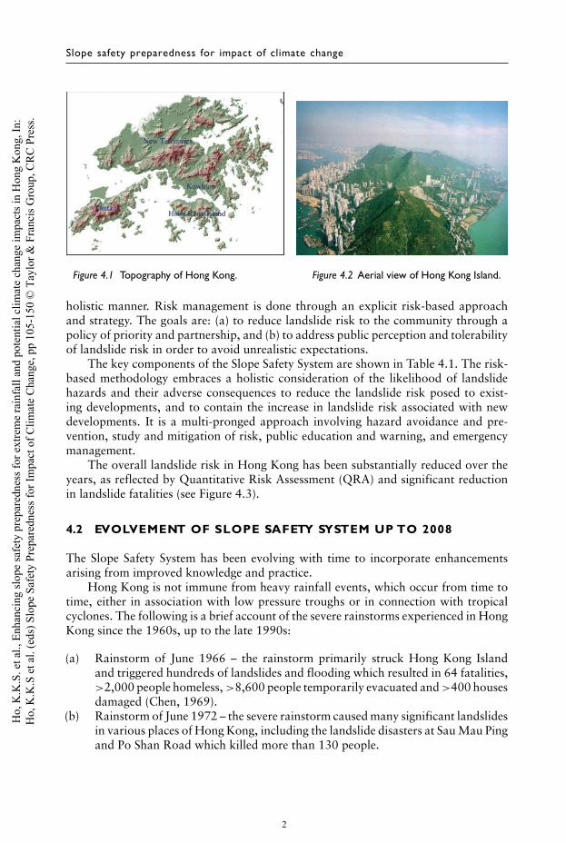
Hong Kong has a population of 7 million and a small land area of 1,100 km2, only15% of which is developed land. The terrain is hilly (with 75% of the land steeperthan 15◦ and 30% steeper than 30◦) (See Figures 4.1 and 4.2). The vulnerable setting,comprising dense urban development, a legacy of inadequate geotechnical controlbefore the 1970s, coupled with high seasonal rainfall (24-hour intensity exceeding300 mm and 1-hour intensity exceeding 70 mm are not uncommon) has given rise toacute landslide problems in Hong Kong.
The Geotechnical Engineering Office (GEO), which was established by the HongKong Government in 1977, has implemented a comprehensive Slope Safety System.This embraces a range of initiatives covering policy, strategic, legislative, administra-tive, technical and procedural frameworks that serve to manage landslide risk in a
1
Ho,
K.K
.S. e
t al.,
Enh
anci
ng sl
ope
safe
ty p
repa
redn
ess f
or e
xtre
me
rain
fall
and
pote
ntia
l clim
ate
chan
ge im
pact
s in
Hon
g K
ong,
In:
Ho,
K.K
.S e
t al.
(eds
) Slo
pe S
afet
y Pr
epar
edne
ss fo
r Im
pact
of C
limat
e C
hang
e, p
p 10
5-15
0 ©
Tay
lor &
Fra
ncis
Gro
up, C
RC
Pre
ss.
Slope safety preparedness for impact of climate change
Figure 4.1 Topography of Hong Kong. Figure 4.2 Aerial view of Hong Kong Island.
holistic manner. Risk management is done through an explicit risk-based approachand strategy. The goals are: (a) to reduce landslide risk to the community through apolicy of priority and partnership, and (b) to address public perception and tolerabilityof landslide risk in order to avoid unrealistic expectations.
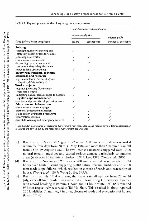
The key components of the Slope Safety System are shown in Table 4.1. The risk-based methodology embraces a holistic consideration of the likelihood of landslidehazards and their adverse consequences to reduce the landslide risk posed to exist-ing developments, and to contain the increase in landslide risk associated with newdevelopments. It is a multi-pronged approach involving hazard avoidance and pre-vention, study and mitigation of risk, public education and warning, and emergencymanagement.
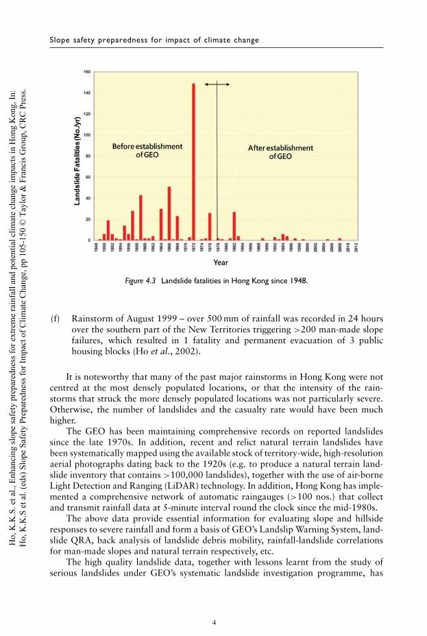
The overall landslide risk in Hong Kong has been substantially reduced over theyears, as reflected by Quantitative Risk Assessment (QRA) and significant reductionin landslide fatalities (see Figure 4.3).
4.2 EVOLVEMENT OF SLOPE SAFETY SYSTEM UP TO 2008
The Slope Safety System has been evolving with time to incorporate enhancementsarising from improved knowledge and practice.
Hong Kong is not immune from heavy rainfall events, which occur from time totime, either in association with low pressure troughs or in connection with tropicalcyclones. The following is a brief account of the severe rainstorms experienced in HongKong since the 1960s, up to the late 1990s:
(a) Rainstorm of June 1966 – the rainstorm primarily struck Hong Kong Islandand triggered hundreds of landslides and flooding which resulted in 64 fatalities,>2,000 people homeless, >8,600 people temporarily evacuated and >400 housesdamaged (Chen, 1969).
(b) Rainstorm of June 1972 – the severe rainstorm caused many significant landslidesin various places of Hong Kong, including the landslide disasters at Sau Mau Pingand Po Shan Road which killed more than 130 people.
2
Ho,
K.K
.S. e
t al.,
Enh
anci
ng sl
ope
safe
ty p
repa
redn
ess f
or e
xtre
me
rain
fall
and
pote
ntia
l clim
ate
chan
ge im
pact
s in
Hon
g K
ong,
In:
Ho,
K.K
.S e
t al.
(eds
) Slo
pe S
afet
y Pr
epar
edne
ss fo
r Im
pact
of C
limat
e C
hang
e, p
p 10
5-15
0 ©
Tay
lor &
Fra
ncis
Gro
up, C
RC
Pre
ss.
Enhancing slope safety preparedness for extreme rainfal
Table 4.1 Key components of the Hong Kong slope safety system.
Contribution by each component
reduce landslip riskaddress public
Slope Safety System components hazard consequence attitude & perception
Policing-cataloguing, safety screening and �statutory repair orders for slopes
-checking new works � �-slope maintenance audit �-inspecting squatter areas and �recommending safety clearance
-input to land use planning � �Safety requirements, technicalstandards and research[e.g. natural terrain hazard study and � � �mitigation, debris mobility, etc.]
Works projects-upgrading existing Government �man-made slopes
-mitigating natural terrain landslide hazards � �Regular slope maintenance-routine and preventive slope maintenance �Education and information-slope maintenance campaign � �-personal precautions campaign � �-slope safety awareness programme � � �-information services � � �-landslide warning and emergency services � � �
Note: Regular maintenance of registered Government man-made slopes and natural terrain defence/stabilisationmeasures are carried out by the responsible Government departments.
(c) Rainstorms of May and August 1982 – over 600 mm of rainfall was recordedwithin the four days from 28 to 31 May 1982 and more than 520 mm of rainfallfrom 15 to 19 August 1982. The two intense rainstorms triggered over 1,400natural terrain landslides and caused serious damage particularly to squatterareas (with over 20 fatalities) (Hudson, 1993; Lee, 1983; Wong et al., 2006).
(d) Rainstorm of November 1993 – over 700 mm of rainfall was recorded in 24hours over Lantau Island triggering >800 natural terrain landslides and >300man-made slope failures, which resulted in closure of roads and evacuation ofhouses (Wong et al., 1997; Wong & Ho, 1995).
(e) Rainstorm of July 1994 – during the heavy rainfall episode from 22 to 24July, over 600 mm rainfall was recorded at Hong Kong Observatory, togetherwith record-breaking maximum 1-hour, and 24-hour rainfall of 185.5 mm and954 mm respectively recorded at Tai Mo Shan. This resulted in about reported200 landslides, 5 fatalities, 4 injuries, closure of roads and evacuations of houses(Chan, 1996).
3
Ho,
K.K
.S. e
t al.,
Enh
anci
ng sl
ope
safe
ty p
repa
redn
ess f
or e
xtre
me
rain
fall
and
pote
ntia
l clim
ate
chan
ge im
pact
s in
Hon
g K
ong,
In:
Ho,
K.K
.S e
t al.
(eds
) Slo
pe S
afet
y Pr
epar
edne
ss fo
r Im
pact
of C
limat
e C
hang
e, p
p 10
5-15
0 ©
Tay
lor &
Fra
ncis
Gro
up, C
RC
Pre
ss.
Slope safety preparedness for impact of climate change
Figure 4.3 Landslide fatalities in Hong Kong since 1948.
(f) Rainstorm of August 1999 – over 500 mm of rainfall was recorded in 24 hoursover the southern part of the New Territories triggering >200 man-made slopefailures, which resulted in 1 fatality and permanent evacuation of 3 publichousing blocks (Ho et al., 2002).
It is noteworthy that many of the past major rainstorms in Hong Kong were notcentred at the most densely populated locations, or that the intensity of the rain-storms that struck the more densely populated locations was not particularly severe.Otherwise, the number of landslides and the casualty rate would have been muchhigher.
The GEO has been maintaining comprehensive records on reported landslidessince the late 1970s. In addition, recent and relict natural terrain landslides havebeen systematically mapped using the available stock of territory-wide, high-resolutionaerial photographs dating back to the 1920s (e.g. to produce a natural terrain land-slide inventory that contains >100,000 landslides), together with the use of air-borneLight Detection and Ranging (LiDAR) technology. In addition, Hong Kong has imple-mented a comprehensive network of automatic raingauges (>100 nos.) that collectand transmit rainfall data at 5-minute interval round the clock since the mid-1980s.
The above data provide essential information for evaluating slope and hillsideresponses to severe rainfall and form a basis of GEO’s Landslip Warning System, land-slide QRA, back analysis of landslide debris mobility, rainfall-landslide correlationsfor man-made slopes and natural terrain respectively, etc.
The high quality landslide data, together with lessons learnt from the study ofserious landslides under GEO’s systematic landslide investigation programme, has
4
Ho,
K.K
.S. e
t al.,
Enh
anci
ng sl
ope
safe
ty p
repa
redn
ess f
or e
xtre
me
rain
fall
and
pote
ntia
l clim
ate
chan
ge im
pact
s in
Hon
g K
ong,
In:
Ho,
K.K
.S e
t al.
(eds
) Slo
pe S
afet
y Pr
epar
edne
ss fo
r Im
pact
of C
limat
e C
hang
e, p
p 10
5-15
0 ©
Tay
lor &
Fra
ncis
Gro
up, C
RC
Pre
ss.
Enhancing slope safety preparedness for extreme rainfall
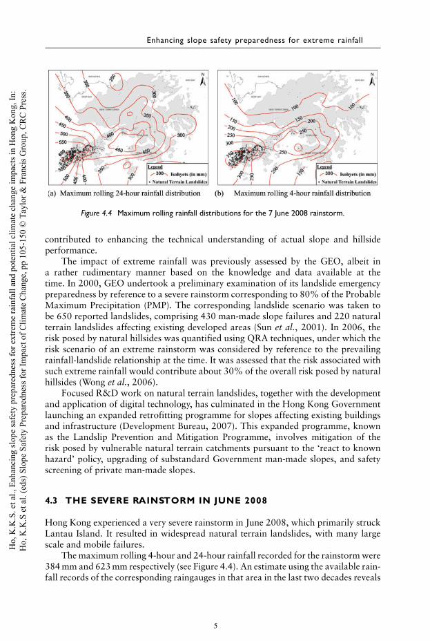
Figure 4.4 Maximum rolling rainfall distributions for the 7 June 2008 rainstorm.
contributed to enhancing the technical understanding of actual slope and hillsideperformance.
The impact of extreme rainfall was previously assessed by the GEO, albeit ina rather rudimentary manner based on the knowledge and data available at thetime. In 2000, GEO undertook a preliminary examination of its landslide emergencypreparedness by reference to a severe rainstorm corresponding to 80% of the ProbableMaximum Precipitation (PMP). The corresponding landslide scenario was taken tobe 650 reported landslides, comprising 430 man-made slope failures and 220 naturalterrain landslides affecting existing developed areas (Sun et al., 2001). In 2006, therisk posed by natural hillsides was quantified using QRA techniques, under which therisk scenario of an extreme rainstorm was considered by reference to the prevailingrainfall-landslide relationship at the time. It was assessed that the risk associated withsuch extreme rainfall would contribute about 30% of the overall risk posed by naturalhillsides (Wong et al., 2006).
Focused R&D work on natural terrain landslides, together with the developmentand application of digital technology, has culminated in the Hong Kong Governmentlaunching an expanded retrofitting programme for slopes affecting existing buildingsand infrastructure (Development Bureau, 2007). This expanded programme, knownas the Landslip Prevention and Mitigation Programme, involves mitigation of therisk posed by vulnerable natural terrain catchments pursuant to the ‘react to knownhazard’ policy, upgrading of substandard Government man-made slopes, and safetyscreening of private man-made slopes.
4.3 THE SEVERE RAINSTORM IN JUNE 2008
Hong Kong experienced a very severe rainstorm in June 2008, which primarily struckLantau Island. It resulted in widespread natural terrain landslides, with many largescale and mobile failures.
The maximum rolling 4-hour and 24-hour rainfall recorded for the rainstorm were384 mm and 623 mm respectively (see Figure 4.4). An estimate using the available rain-fall records of the corresponding raingauges in that area in the last two decades reveals
5
Ho,
K.K
.S. e
t al.,
Enh
anci
ng sl
ope
safe
ty p
repa
redn
ess f
or e
xtre
me
rain
fall
and
pote
ntia
l clim
ate
chan
ge im
pact
s in
Hon
g K
ong,
In:
Ho,
K.K
.S e
t al.
(eds
) Slo
pe S
afet
y Pr
epar
edne
ss fo
r Im
pact
of C
limat
e C
hang
e, p
p 10
5-15
0 ©
Tay
lor &
Fra
ncis
Gro
up, C
RC
Pre
ss.
Slope safety preparedness for impact of climate change
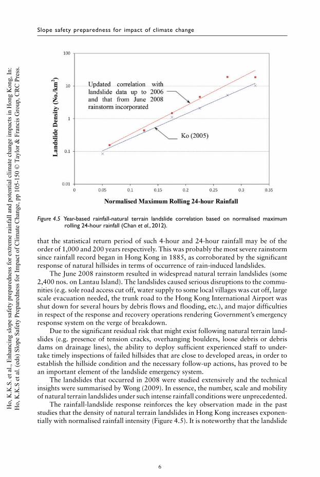
Figure 4.5 Year-based rainfall-natural terrain landslide correlation based on normalised maximumrolling 24-hour rainfall (Chan et al., 2012).
that the statistical return period of such 4-hour and 24-hour rainfall may be of theorder of 1,000 and 200 years respectively. This was probably the most severe rainstormsince rainfall record began in Hong Kong in 1885, as corroborated by the significantresponse of natural hillsides in terms of occurrence of rain-induced landslides.
The June 2008 rainstorm resulted in widespread natural terrain landslides (some2,400 nos. on Lantau Island). The landslides caused serious disruptions to the commu-nities (e.g. sole road access cut off, water supply to some local villages was cut off, largescale evacuation needed, the trunk road to the Hong Kong International Airport wasshut down for several hours by debris flows and flooding, etc.), and major difficultiesin respect of the response and recovery operations rendering Government’s emergencyresponse system on the verge of breakdown.
Due to the significant residual risk that might exist following natural terrain land-slides (e.g. presence of tension cracks, overhanging boulders, loose debris or debrisdams on drainage lines), the ability to deploy sufficient experienced staff to under-take timely inspections of failed hillsides that are close to developed areas, in order toestablish the hillside condition and the necessary follow-up actions, has proved to bean important element of the landslide emergency system.
The landslides that occurred in 2008 were studied extensively and the technicalinsights were summarised by Wong (2009). In essence, the number, scale and mobilityof natural terrain landslides under such intense rainfall conditions were unprecedented.
The rainfall-landslide response reinforces the key observation made in the paststudies that the density of natural terrain landslides in Hong Kong increases exponen-tially with normalised rainfall intensity (Figure 4.5). It is noteworthy that the landslide
6
Ho,
K.K
.S. e
t al.,
Enh
anci
ng sl
ope
safe
ty p
repa
redn
ess f
or e
xtre
me
rain
fall
and
pote
ntia
l clim
ate
chan
ge im
pact
s in
Hon
g K
ong,
In:
Ho,
K.K
.S e
t al.
(eds
) Slo
pe S
afet
y Pr
epar
edne
ss fo
r Im
pact
of C
limat
e C
hang
e, p
p 10
5-15
0 ©
Tay
lor &
Fra
ncis
Gro
up, C
RC
Pre
ss.
Enhancing slope safety preparedness for extreme rainfall
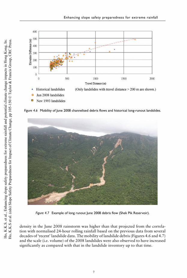
Figure 4.6 Mobility of June 2008 channelised debris flows and historical long-runout landslides.
Figure 4.7 Example of long runout June 2008 debris flow (Shek Pik Reservoir).
density in the June 2008 rainstorm was higher than that projected from the correla-tion with normalised 24-hour rolling rainfall based on the previous data from severaldecades of ‘recent’ landslide data. The mobility of landslide debris (Figures 4.6 and 4.7)and the scale (i.e. volume) of the 2008 landslides were also observed to have increasedsignificantly as compared with that in the landslide inventory up to that time.
7
Ho,
K.K
.S. e
t al.,
Enh
anci
ng sl
ope
safe
ty p
repa
redn
ess f
or e
xtre
me
rain
fall
and
pote
ntia
l clim
ate
chan
ge im
pact
s in
Hon
g K
ong,
In:
Ho,
K.K
.S e
t al.
(eds
) Slo
pe S
afet
y Pr
epar
edne
ss fo
r Im
pact
of C
limat
e C
hang
e, p
p 10
5-15
0 ©
Tay
lor &
Fra
ncis
Gro
up, C
RC
Pre
ss.
Slope safety preparedness for impact of climate change
All in all, the data from a relatively short time window (i.e. of several tens ofyears for natural terrain landslides) are liable to under-represent the effects of extremerainfall. In light of the severe rainstorm of June 2008, the corresponding rainfall-landslide correlation was duly updated, as presented below.
The torrential rain in June 2008 fell largely on Lantau Island, the largest outlyingisland and one of the sparsely populated areas in Hong Kong, hence it could be regardedas a near-miss event. The consequences could have been much more serious had the2008 rainstorm hit the more densely developed urban areas of Hong Kong.
4.4 CONSIDERATION OF EXTREME RAINFALL EVENTS
According to the Intergovernmental Panel on Climate Change (IPCC), extreme weatherrefers to “the occurrence of a value of a weather or climate variable above (or below)a threshold value near the upper (or lower) ends of the range of observed values of thevariable’’ (IPCC, 2012). The US National Oceanic and Atmospheric Administration(NOAA) echoes that by the following: “… charts the occurrence of specific extremeevents over time since 1910. In most cases, extreme events are defined as lying in theoutermost (“most unusual’’) ten percent’’ of a place’s historical data (where analysesare done at national and regional scales, and “Climatic extremes are an importantcomponent of a location’s climatology and are used for quality controlling meteo-rological observations, setting engineering limits, and helping authorities to developclimate-related safety plans, among other things’’ (NOAA, 2014). In essence, ‘extremeevent’ may be taken to refer to rare and adverse condition at the extremities of therelevant historical or statistical distribution at national/regional scale.
The above highlights the important observation that an extreme event could be anatural phenomenon given the natural and intrinsic variability of the weather system.As such, extreme events would need to be considered irrespective of whether climatechange prevails or not. Climate change is liable to render extreme rainfall events morefrequent, as well as more intense.
In so far as landslide risk management is concerned, the extreme events that needto be considered are those which would bring about many sizeable and/or mobilelandslides (either due to rainfall or earthquake). Such extreme landslide scenarios arecharacterised by widespread landslides which could impact on developed areas and leadto serious loss of life and damage to buildings, infrastructure and essential services.Around the globe, catastrophic landslides induced by extreme rainfall causing seriouscasualties have been reported increasingly in recent years. For example, the landslideat Xiaolin village during the passage of Typhoon Morakot in Taiwan in 2009 killedmore than 400 people; the rain-induced landslides in Brazil in 2011 caused more than900 fatalities; the debris flow in Gansu in 2010 led to more than 1,400 fatalities; thetorrential rain in South Korea in 2011 brought about more than 30 landslide-relatedfatalities; Tropical Storm Washi brought flash floods and severe landslides, resultingin 1,010 fatalities in the Philippines in 2011; Severe Typhoon Wipha struck easternJapan in 2013 and caused more than 40 landslide-related fatalities, etc. Hong Kongwas not immune from extreme rainfall events. The occurrence of widespread naturalterrain landslides during the June 2008 rainstorm, which involved many large-scaleand mobile failures, has emphasised the critical need to address extreme rainfall eventsin a more rigorous manner.
8
Ho,
K.K
.S. e
t al.,
Enh
anci
ng sl
ope
safe
ty p
repa
redn
ess f
or e
xtre
me
rain
fall
and
pote
ntia
l clim
ate
chan
ge im
pact
s in
Hon
g K
ong,
In:
Ho,
K.K
.S e
t al.
(eds
) Slo
pe S
afet
y Pr
epar
edne
ss fo
r Im
pact
of C
limat
e C
hang
e, p
p 10
5-15
0 ©
Tay
lor &
Fra
ncis
Gro
up, C
RC
Pre
ss.
Enhancing slope safety preparedness for extreme rainfall
The more frequent occurrences of extreme rainfall causing serious landslides andmajor casualties around the world in recent years have highlighted the real threatof the potential impact of extreme rainfall on community and concerns about thepossible effect of climate change on slope safety. The impact of extreme rainfall posesnew challenges which need to be addressed from a strategic, policy and technicalperspective, given that the number, scale and mobility of the corresponding landslidescould be unprecedented.
To address the acute challenges of more frequent occurrences of extreme rainfall,a systematic approach has been adopted by the GEO as follows:
(a) to take stock of the relevant climate change and rainfall studies,(b) to identify the key component of risk and the nature and scale of credible extreme
landslide events,(c) to assess the severity of the landslide consequences,(d) to evaluate the capacity of emergency management, and(e) to examine the scope for improving crisis preparedness, as well as system and
community resilience in respect of slope safety.
4.4.1 Climate change and rainfall studies
4.4.1.1 Globally observed changes in extreme rainfall and futureprojections
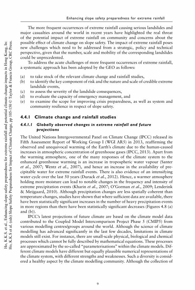
The United Nations Intergovernmental Panel on Climate Change (IPCC) released itsFifth Assessment Report of Working Group I (WGI AR5) in 2013, reaffirming theobserved and unequivocal warming of the Earth’s climate due to the human-causedincreases in atmospheric concentration of greenhouse gases (IPCC, 2013). Apart fromthe warming atmosphere, one of the many responses of the climate system to theenhanced greenhouse warming is an increase in tropospheric water vapour (Santeret al., 2007; Wentz et al., 2007), and hence an increase in the availability of pre-cipitable water for extreme rainfall events. There is also evidence of an intensifyingwater cycle over the last 50 years (Durack et al., 2012). Hence, a warmer atmosphereholding more moisture can lead to notable changes in the frequency and intensity ofextreme precipitation events (Kharin et al., 2007; O’Gorman et al., 2009; Lenderink& Meijgaard, 2010). Although precipitation changes are less spatially coherent thantemperature changes, studies have shown that where sufficient data are available, therehave been statistically significant increases in the number of heavy precipitation eventsin more regions than there have been statistically significant decreases (Figures 4.8 (a)and (b)).
IPCC’s latest projections of future climate are based on the climate model datacontributed to the Coupled Model Intercomparison Project Phase 5 (CMIP5) fromvarious modelling centres/groups around the world. Although the science of climatemodelling has advanced significantly in the last few decades, limitations in climatemodels still exist. For instance, there are small-scale physical, biological and chemicalprocesses which cannot be fully described by mathematical equations. These processesare approximated by the so-called “parameterisations’’ within the climate models. Dif-ferent climate models have different but equally plausible numerical representations ofthe climate system, with different strengths and weaknesses. Such a diversity is consid-ered a healthy aspect by the climate modelling community. Although the collection of
9
Ho,
K.K
.S. e
t al.,
Enh
anci
ng sl
ope
safe
ty p
repa
redn
ess f
or e
xtre
me
rain
fall
and
pote
ntia
l clim
ate
chan
ge im
pact
s in
Hon
g K
ong,
In:
Ho,
K.K
.S e
t al.
(eds
) Slo
pe S
afet
y Pr
epar
edne
ss fo
r Im
pact
of C
limat
e C
hang
e, p
p 10
5-15
0 ©
Tay
lor &
Fra
ncis
Gro
up, C
RC
Pre
ss.
Slope safety preparedness for impact of climate change
Figure 4.8 Trend in (a) the annual amount of precipitation from days above the 95th percentile (R95p)and (b) the daily precipitation intensity (SDII) during 1951–2010. Grey areas indicate incom-plete or missing data. Black plus signs indicate statistically significant trends (IPCC, 2013).
CMIP5 model data is not meant to be a systematic or comprehensive sampling of pos-sible future climate, it does provide a range of plausible climate projections as well as abasis for assessing the uncertainties in the projections. The “multi-model’’ approach isnow a standard technique used by the climate science community to assess projectionof a specific climate variable.
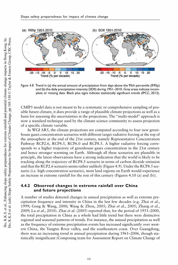
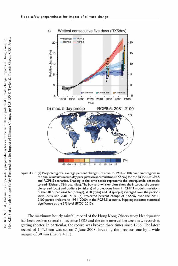
In WGI AR5, the climate projections are computed according to four new green-house gases concentration scenarios with different target radiative forcing at the top ofthe atmosphere at the end of the 21st century, namely Representative ConcentrationPathway RCP2.6, RCP4.5, RCP6.0 and RCP8.5. A higher radiative forcing corre-sponds to a higher trajectory of greenhouse gases concentration in the 21st centuryand hence stronger warming on Earth. Although all these scenarios are plausible inprinciple, the latest observations have a strong indication that the world is likely to betracking along the trajectory of RCP8.5 scenario in terms of carbon dioxide emissionand that the RCP2.6 scenario seems rather unlikely (Figure 4.9). Under the RCP8.5 sce-nario (i.e. high concentration scenario), most land regions on Earth would experiencean increase in extreme rainfall for the rest of this century (Figures 4.10 (a) and (b)).
4.4.2 Observed changes in extreme rainfall over Chinaand future projections
A number of studies detected changes in annual precipitation as well as extreme pre-cipitation frequency and intensity in China in the last few decades (e.g. Zhai et al.,1999; Gong & Wang, 2000; Wang & Zhou, 2005; Zhai et al., 2005; Zhang et al.,2009; Lu et al., 2010). Zhai et al. (2005) reported that, for the period of 1951–2000,the total precipitation in China as a whole had little trend but there were distinctiveregional and seasonal patterns of trends. For instance, the annual precipitation as wellas the frequency of extreme precipitation events has increased significantly over west-ern China, the Yangtze River valley, and the southeastern coast. Over Guangdong,there was an increasing trend in annual precipitation during 1961–2006, though sta-tistically insignificant (Composing team for Assessment Report on Climate Change of
10
Ho,
K.K
.S. e
t al.,
Enh
anci
ng sl
ope
safe
ty p
repa
redn
ess f
or e
xtre
me
rain
fall
and
pote
ntia
l clim
ate
chan
ge im
pact
s in
Hon
g K
ong,
In:
Ho,
K.K
.S e
t al.
(eds
) Slo
pe S
afet
y Pr
epar
edne
ss fo
r Im
pact
of C
limat
e C
hang
e, p
p 10
5-15
0 ©
Tay
lor &
Fra
ncis
Gro
up, C
RC
Pre
ss.
Enhancing slope safety preparedness for extreme rainfall
Figure 4.9 Observed emissions and emissions scenarios (image source: Global Carbon Project).
Guangdong, 2007). The number of rain days over southern China had a decreasingtrend but the precipitation intensity increased significantly during 1961–2008 (Wuet al., 2011). The frequency of heavy precipitation (40 mm per hour) increased from1.3 times per year in the 1960s to 1.8 times per year in recent years (Composing teamfor Assessment Report on Climate Change of Guangdong, 2007).
Using 19 climate models, Sun & Ding (2009) projected an increase in summer(June–August) rainfall over southern China due to the increase in atmospheric watervapour under a warming climate and the presence of an anticyclone over westernPacific and South China Sea which enhances water vapour transport. Kitoh et al.(2013) found that, over the East Asian region, the daily precipitation intensity andseasonal (May–September) maximum 5-day precipitation total would increase underthe RCP4.5 and RCP8.5 scenarios. Chen (2013) and Zhou et al. (2014) also foundan intensification of precipitation over southern China under these two scenarios.Zhou et al. (2014) projected that the proportion of heavy precipitation in annualprecipitation and maximum daily rainfall would increase over southern China. Thesechanges can be attributed to intensification of the East Asian monsoon circulation(Kitoh et al., 2013), and more unstable atmosphere over southern China (Chen, 2013).
4.4.3 Observed changes in extreme rainfall in Hong Kong
The rainfall trend in Hong Kong is generally consistent with that in southern China.In the last 60 years or so (1947–2013), Hong Kong’s annual precipitation exhibited anincreasing trend of 36 mm/decade, though statistically insignificant. On the analysis ofthe past trend in extreme rainfall in Hong Kong, Wong & Mok (2009) found that thereturn periods of short-duration extreme rainfall events had decreased significantlyfrom the year 1885 to 2009. For example, the return period of hourly rainfall of100 mm or more shortened from 37 years in 1900 to 18 years in 2000, indicating thatsuch heavy rainfall events have become more frequent.
11
Ho,
K.K
.S. e
t al.,
Enh
anci
ng sl
ope
safe
ty p
repa
redn
ess f
or e
xtre
me
rain
fall
and
pote
ntia
l clim
ate
chan
ge im
pact
s in
Hon
g K
ong,
In:
Ho,
K.K
.S e
t al.
(eds
) Slo
pe S
afet
y Pr
epar
edne
ss fo
r Im
pact
of C
limat
e C
hang
e, p
p 10
5-15
0 ©
Tay
lor &
Fra
ncis
Gro
up, C
RC
Pre
ss.
Slope safety preparedness for impact of climate change
Figure 4.10 (a) Projected global average percent changes (relative to 1981–2000) over land regions inthe annual maximum five-day precipitation accumulation (RX5day) for the RCP2.6,RCP4.5and RCP8.5 scenarios. Shading in the time series represents the interquartile ensemblespread (25th and 75th quantiles).The box-and-whisker plots show the interquartile ensem-ble spread (box) and outliers (whiskers) of projections from 11 CMIP3 model simulationsof the SRES scenarios A2 (orange), A1B (cyan) and B1 (purple) averaged over the periods2046–2065 and 2081–2100. (b) Projected percent change of RX5day over the 2081–2100 period (relative to 1981–2000) in the RCP8.5 scenario. Stippling indicates statisticalsignificance at the 5% level (IPCC, 2013).
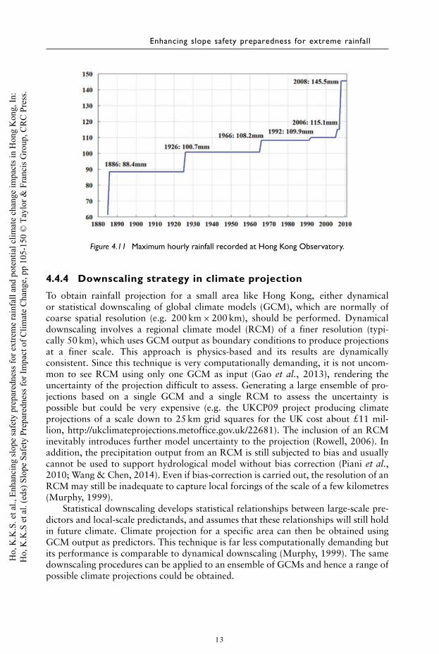
The maximum hourly rainfall record of the Hong Kong Observatory Headquarterhas been broken several times since 1885 and the time interval between new records isgetting shorter. In particular, the record was broken three times since 1966. The latestrecord of 145.5 mm was set on 7 June 2008, breaking the previous one by a widemargin of 30 mm (Figure 4.11).
12
Ho,
K.K
.S. e
t al.,
Enh
anci
ng sl
ope
safe
ty p
repa
redn
ess f
or e
xtre
me
rain
fall
and
pote
ntia
l clim
ate
chan
ge im
pact
s in
Hon
g K
ong,
In:
Ho,
K.K
.S e
t al.
(eds
) Slo
pe S
afet
y Pr
epar
edne
ss fo
r Im
pact
of C
limat
e C
hang
e, p
p 10
5-15
0 ©
Tay
lor &
Fra
ncis
Gro
up, C
RC
Pre
ss.
Enhancing slope safety preparedness for extreme rainfall
Figure 4.11 Maximum hourly rainfall recorded at Hong Kong Observatory.
4.4.4 Downscaling strategy in climate projection
To obtain rainfall projection for a small area like Hong Kong, either dynamicalor statistical downscaling of global climate models (GCM), which are normally ofcoarse spatial resolution (e.g. 200 km × 200 km), should be performed. Dynamicaldownscaling involves a regional climate model (RCM) of a finer resolution (typi-cally 50 km), which uses GCM output as boundary conditions to produce projectionsat a finer scale. This approach is physics-based and its results are dynamicallyconsistent. Since this technique is very computationally demanding, it is not uncom-mon to see RCM using only one GCM as input (Gao et al., 2013), rendering theuncertainty of the projection difficult to assess. Generating a large ensemble of pro-jections based on a single GCM and a single RCM to assess the uncertainty ispossible but could be very expensive (e.g. the UKCP09 project producing climateprojections of a scale down to 25 km grid squares for the UK cost about £11 mil-lion, http://ukclimateprojections.metoffice.gov.uk/22681). The inclusion of an RCMinevitably introduces further model uncertainty to the projection (Rowell, 2006). Inaddition, the precipitation output from an RCM is still subjected to bias and usuallycannot be used to support hydrological model without bias correction (Piani et al.,2010; Wang & Chen, 2014). Even if bias-correction is carried out, the resolution of anRCM may still be inadequate to capture local forcings of the scale of a few kilometres(Murphy, 1999).
Statistical downscaling develops statistical relationships between large-scale pre-dictors and local-scale predictands, and assumes that these relationships will still holdin future climate. Climate projection for a specific area can then be obtained usingGCM output as predictors. This technique is far less computationally demanding butits performance is comparable to dynamical downscaling (Murphy, 1999). The samedownscaling procedures can be applied to an ensemble of GCMs and hence a range ofpossible climate projections could be obtained.
13
Ho,
K.K
.S. e
t al.,
Enh
anci
ng sl
ope
safe
ty p
repa
redn
ess f
or e
xtre
me
rain
fall
and
pote
ntia
l clim
ate
chan
ge im
pact
s in
Hon
g K
ong,
In:
Ho,
K.K
.S e
t al.
(eds
) Slo
pe S
afet
y Pr
epar
edne
ss fo
r Im
pact
of C
limat
e C
hang
e, p
p 10
5-15
0 ©
Tay
lor &
Fra
ncis
Gro
up, C
RC
Pre
ss.
Slope safety preparedness for impact of climate change
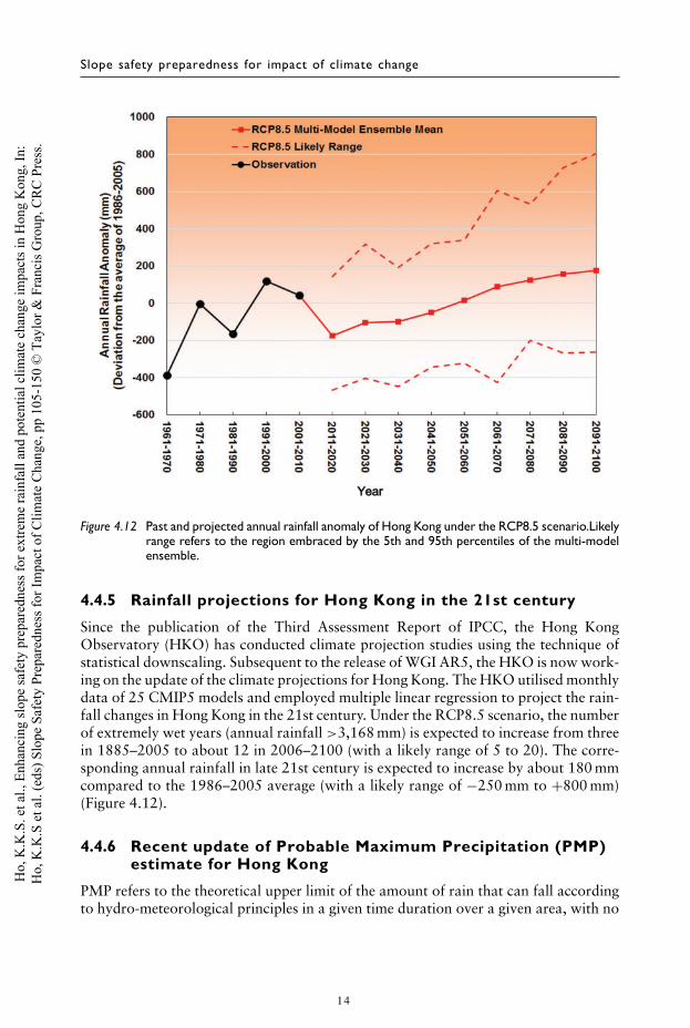
Figure 4.12 Past and projected annual rainfall anomaly of Hong Kong under the RCP8.5 scenario.Likelyrange refers to the region embraced by the 5th and 95th percentiles of the multi-modelensemble.
4.4.5 Rainfall projections for Hong Kong in the 21st century
Since the publication of the Third Assessment Report of IPCC, the Hong KongObservatory (HKO) has conducted climate projection studies using the technique ofstatistical downscaling. Subsequent to the release of WGI AR5, the HKO is now work-ing on the update of the climate projections for Hong Kong. The HKO utilised monthlydata of 25 CMIP5 models and employed multiple linear regression to project the rain-fall changes in Hong Kong in the 21st century. Under the RCP8.5 scenario, the numberof extremely wet years (annual rainfall >3,168 mm) is expected to increase from threein 1885–2005 to about 12 in 2006–2100 (with a likely range of 5 to 20). The corre-sponding annual rainfall in late 21st century is expected to increase by about 180 mmcompared to the 1986–2005 average (with a likely range of −250 mm to +800 mm)(Figure 4.12).
4.4.6 Recent update of Probable Maximum Precipitation (PMP)estimate for Hong Kong
PMP refers to the theoretical upper limit of the amount of rain that can fall accordingto hydro-meteorological principles in a given time duration over a given area, with no
14
Ho,
K.K
.S. e
t al.,
Enh
anci
ng sl
ope
safe
ty p
repa
redn
ess f
or e
xtre
me
rain
fall
and
pote
ntia
l clim
ate
chan
ge im
pact
s in
Hon
g K
ong,
In:
Ho,
K.K
.S e
t al.
(eds
) Slo
pe S
afet
y Pr
epar
edne
ss fo
r Im
pact
of C
limat
e C
hang
e, p
p 10
5-15
0 ©
Tay
lor &
Fra
ncis
Gro
up, C
RC
Pre
ss.
Enhancing slope safety preparedness for extreme rainfall
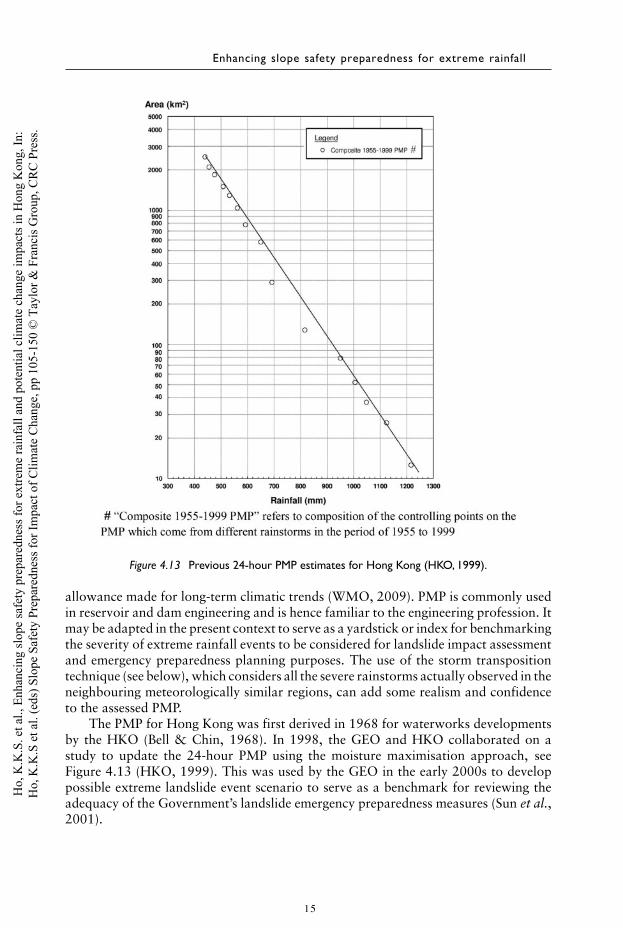
Figure 4.13 Previous 24-hour PMP estimates for Hong Kong (HKO, 1999).
allowance made for long-term climatic trends (WMO, 2009). PMP is commonly usedin reservoir and dam engineering and is hence familiar to the engineering profession. Itmay be adapted in the present context to serve as a yardstick or index for benchmarkingthe severity of extreme rainfall events to be considered for landslide impact assessmentand emergency preparedness planning purposes. The use of the storm transpositiontechnique (see below), which considers all the severe rainstorms actually observed in theneighbouring meteorologically similar regions, can add some realism and confidenceto the assessed PMP.
The PMP for Hong Kong was first derived in 1968 for waterworks developmentsby the HKO (Bell & Chin, 1968). In 1998, the GEO and HKO collaborated on astudy to update the 24-hour PMP using the moisture maximisation approach, seeFigure 4.13 (HKO, 1999). This was used by the GEO in the early 2000s to developpossible extreme landslide event scenario to serve as a benchmark for reviewing theadequacy of the Government’s landslide emergency preparedness measures (Sun et al.,2001).
15
Ho,
K.K
.S. e
t al.,
Enh
anci
ng sl
ope
safe
ty p
repa
redn
ess f
or e
xtre
me
rain
fall
and
pote
ntia
l clim
ate
chan
ge im
pact
s in
Hon
g K
ong,
In:
Ho,
K.K
.S e
t al.
(eds
) Slo
pe S
afet
y Pr
epar
edne
ss fo
r Im
pact
of C
limat
e C
hang
e, p
p 10
5-15
0 ©
Tay
lor &
Fra
ncis
Gro
up, C
RC
Pre
ss.
Slope safety preparedness for impact of climate change
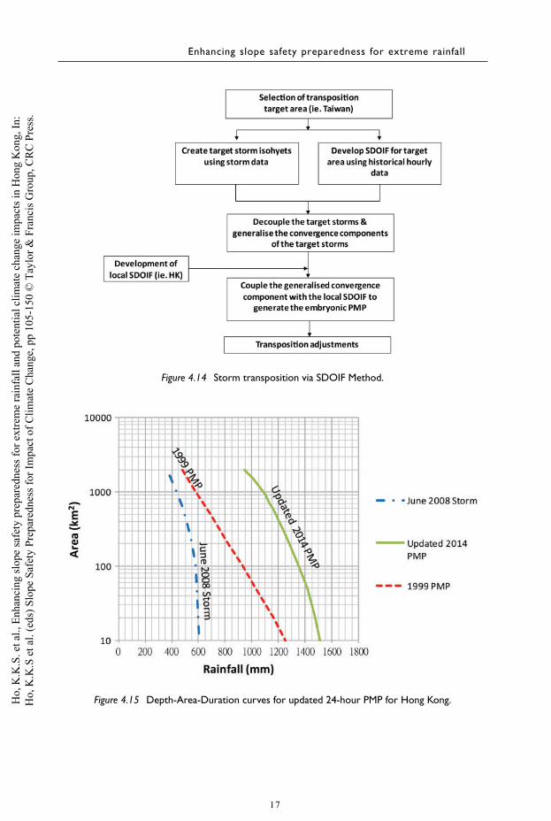
The GEO, with technical support by the HKO and various other Governmentdepartments and tertiary institutes, commissioned a study in 2011 to further updatethe 24-hour PMP estimates. In this third-generation update, the storm separation tech-nique (viz. the Step Duration Orographic Intensification Factors (SDOIF) Method) wasadopted. The rainfalls for each selected rainstorm are decomposed into two compo-nents (i.e. convergence component and local orographic component respectively) tofacilitate the transposition analysis. A statistical approach was adopted to estimate theorographic factors (denoted as orographic intensification factors) by examining thegeographical variation of historical annual maximum rainfalls of the correspondingduration. The associated rainstorm survey covered various meteorologically similarareas in the region, including Taiwan, Guangdong, Guangxi, Hainan, Fujian andZhejiang. Following a detailed review of the severity of the storms and data availabilityand quality, four major rainstorms in Taiwan (viz. Herb in 1996, Aere in 2004,Haitang in 2005 and Morakot in 2009) were selected for transposition analysis.
By accounting for the orographic intensification factors of Taiwan (to eliminate theorographic effect), the isohyets of the above four rainstorms were converted into theconvergence components. Then the convergence components of these four rainstormswere generalised to elliptical-shaped isohyets with an aspect ratio of 1.6 to establish theso-called “generalised convergence component’’. The generalised convergence compo-nent was then multiplied by orographic intensification factors of Hong Kong to takeinto account the local orographic effect. The results were further adjusted by a mois-ture maximisation factor (WMO, 2009) to produce the PMP estimate. The mergingof the generalised convergence component and the orographic intensification factorswas subjected to different orientations of the generalised convergence component anddifferent relative positions of the convergence component to Hong Kong in order toascertain the worst combination (see Figure 4.14).
The findings are given in AECOM & Lin (2014). The Depth-Area-Duration curveof the updated PMP estimate is shown in Figure 4.15, while the isohyets of the updatedPMP estimates are given in Figure 4.16. The updated PMP for 10 km2 has increasedfrom 1,250 to 1,510 mm (i.e. 21% increase), whilst for 100 km2 the updated PMP hasincreased from 930 mm to 1,350 mm (i.e. 45% increase), as compared with the 1999PMP (denoted as PMP1999).
By definition, the PMP estimates do not explicitly consider or fully account for thepotential impact of climate change. AECOM & Lin (2014) have attempted to inves-tigate the impact of climate change on the PMP estimates for Hong Kong througha literature review (e.g. studies on impact of climate change on PMP, extreme rain-falls and tropical cyclone activities in North Pacific, etc.), and a trend analysis of therelated climate parameters that affect the PMP estimates. Based on the trend analysis,the time series of monthly average sea surface temperature in July and August in therelevant areas (i.e. the sea to the south-east of Hong Kong) shows a statistically signif-icant increasing trend from 1961 to 2010 with a confidence level of 95%. However,the time series of annual maximum persisting 12-hour dew point temperature at theHKO does not show an increasing trend from 1961 to 2010. AECOM & Lin (op.cit.) opined that the uncertainties involved are too high to quantify the projection ofextreme rainfalls, potential changes in the amount of precipitable water and the rela-tionship between extreme rainfalls and PMP. As a result, they concluded that it wasnot credible to quantify the impact of climate change on the PMP in Hong Kong in
16
Ho,
K.K
.S. e
t al.,
Enh
anci
ng sl
ope
safe
ty p
repa
redn
ess f
or e
xtre
me
rain
fall
and
pote
ntia
l clim
ate
chan
ge im
pact
s in
Hon
g K
ong,
In:
Ho,
K.K
.S e
t al.
(eds
) Slo
pe S
afet
y Pr
epar
edne
ss fo
r Im
pact
of C
limat
e C
hang
e, p
p 10
5-15
0 ©
Tay
lor &
Fra
ncis
Gro
up, C
RC
Pre
ss.
Enhancing slope safety preparedness for extreme rainfall
Figure 4.14 Storm transposition via SDOIF Method.
Figure 4.15 Depth-Area-Duration curves for updated 24-hour PMP for Hong Kong.
17
Ho,
K.K
.S. e
t al.,
Enh
anci
ng sl
ope
safe
ty p
repa
redn
ess f
or e
xtre
me
rain
fall
and
pote
ntia
l clim
ate
chan
ge im
pact
s in
Hon
g K
ong,
In:
Ho,
K.K
.S e
t al.
(eds
) Slo
pe S
afet
y Pr
epar
edne
ss fo
r Im
pact
of C
limat
e C
hang
e, p
p 10
5-15
0 ©
Tay
lor &
Fra
ncis
Gro
up, C
RC
Pre
ss.
Slope safety preparedness for impact of climate change
Figure 4.16 Isohyets of 24-hour rainfall of a hypothetical rainstorm corresponding to 2014 PMPestimate.
the 21st century with sufficient confidence based on the currently available data andtechnical-knowhow.
4.4.7 Geological evidence on relationship between landslideactivity and climate change
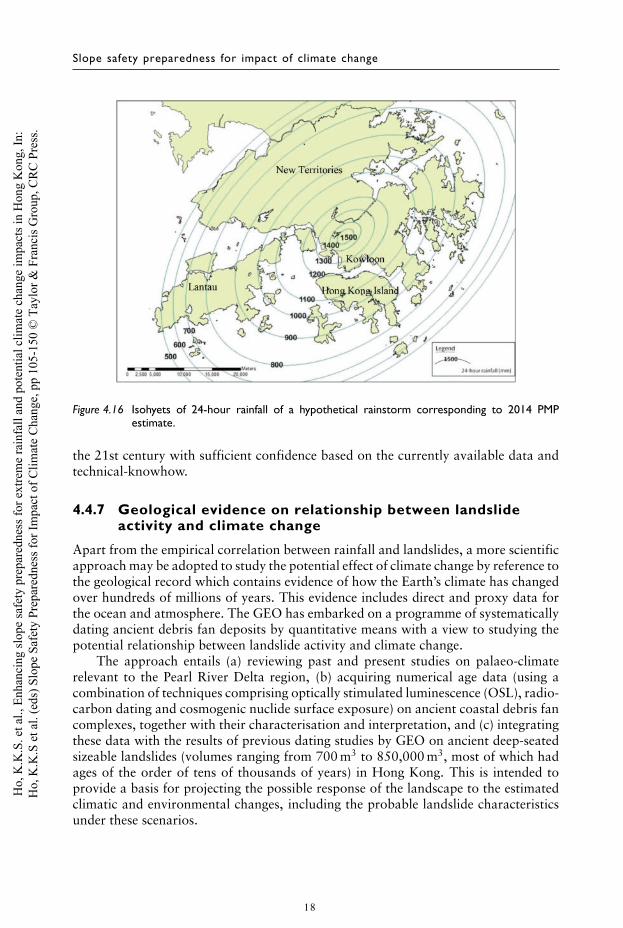
Apart from the empirical correlation between rainfall and landslides, a more scientificapproach may be adopted to study the potential effect of climate change by reference tothe geological record which contains evidence of how the Earth’s climate has changedover hundreds of millions of years. This evidence includes direct and proxy data forthe ocean and atmosphere. The GEO has embarked on a programme of systematicallydating ancient debris fan deposits by quantitative means with a view to studying thepotential relationship between landslide activity and climate change.
The approach entails (a) reviewing past and present studies on palaeo-climaterelevant to the Pearl River Delta region, (b) acquiring numerical age data (using acombination of techniques comprising optically stimulated luminescence (OSL), radio-carbon dating and cosmogenic nuclide surface exposure) on ancient coastal debris fancomplexes, together with their characterisation and interpretation, and (c) integratingthese data with the results of previous dating studies by GEO on ancient deep-seatedsizeable landslides (volumes ranging from 700 m3 to 850,000 m3, most of which hadages of the order of tens of thousands of years) in Hong Kong. This is intended toprovide a basis for projecting the possible response of the landscape to the estimatedclimatic and environmental changes, including the probable landslide characteristicsunder these scenarios.
18
Ho,
K.K
.S. e
t al.,
Enh
anci
ng sl
ope
safe
ty p
repa
redn
ess f
or e
xtre
me
rain
fall
and
pote
ntia
l clim
ate
chan
ge im
pact
s in
Hon
g K
ong,
In:
Ho,
K.K
.S e
t al.
(eds
) Slo
pe S
afet
y Pr
epar
edne
ss fo
r Im
pact
of C
limat
e C
hang
e, p
p 10
5-15
0 ©
Tay
lor &
Fra
ncis
Gro
up, C
RC
Pre
ss.
Enhancing slope safety preparedness for extreme rainfall
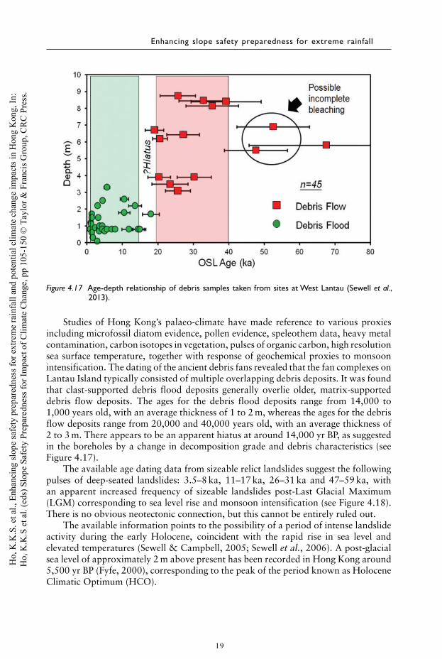
Figure 4.17 Age-depth relationship of debris samples taken from sites at West Lantau (Sewell et al.,2013).
Studies of Hong Kong’s palaeo-climate have made reference to various proxiesincluding microfossil diatom evidence, pollen evidence, speleothem data, heavy metalcontamination, carbon isotopes in vegetation, pulses of organic carbon, high resolutionsea surface temperature, together with response of geochemical proxies to monsoonintensification. The dating of the ancient debris fans revealed that the fan complexes onLantau Island typically consisted of multiple overlapping debris deposits. It was foundthat clast-supported debris flood deposits generally overlie older, matrix-supporteddebris flow deposits. The ages for the debris flood deposits range from 14,000 to1,000 years old, with an average thickness of 1 to 2 m, whereas the ages for the debrisflow deposits range from 20,000 and 40,000 years old, with an average thickness of2 to 3 m. There appears to be an apparent hiatus at around 14,000 yr BP, as suggestedin the boreholes by a change in decomposition grade and debris characteristics (seeFigure 4.17).
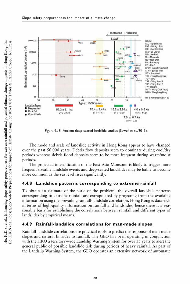
The available age dating data from sizeable relict landslides suggest the followingpulses of deep-seated landslides: 3.5–8 ka, 11–17 ka, 26–31 ka and 47–59 ka, withan apparent increased frequency of sizeable landslides post-Last Glacial Maximum(LGM) corresponding to sea level rise and monsoon intensification (see Figure 4.18).There is no obvious neotectonic connection, but this cannot be entirely ruled out.
The available information points to the possibility of a period of intense landslideactivity during the early Holocene, coincident with the rapid rise in sea level andelevated temperatures (Sewell & Campbell, 2005; Sewell et al., 2006). A post-glacialsea level of approximately 2 m above present has been recorded in Hong Kong around5,500 yr BP (Fyfe, 2000), corresponding to the peak of the period known as HoloceneClimatic Optimum (HCO).
19
Ho,
K.K
.S. e
t al.,
Enh
anci
ng sl
ope
safe
ty p
repa
redn
ess f
or e
xtre
me
rain
fall
and
pote
ntia
l clim
ate
chan
ge im
pact
s in
Hon
g K
ong,
In:
Ho,
K.K
.S e
t al.
(eds
) Slo
pe S
afet
y Pr
epar
edne
ss fo
r Im
pact
of C
limat
e C
hang
e, p
p 10
5-15
0 ©
Tay
lor &
Fra
ncis
Gro
up, C
RC
Pre
ss.
Slope safety preparedness for impact of climate change
Figure 4.18 Ancient deep-seated landslide studies (Sewell et al., 2013).
The mode and scale of landslide activity in Hong Kong appear to have changedover the past 50,000 years. Debris flow deposits seem to dominate during cool/dryperiods whereas debris flood deposits seem to be more frequent during warm/moistperiods.
The projected intensification of the East Asia Monsoon is likely to trigger morefrequent sizeable landslide events and deep-seated landslides may be liable to becomemore common as the sea level rises significantly.
4.4.8 Landslide patterns corresponding to extreme rainfall
To obtain an estimate of the scale of the problem, the overall landslide patternscorresponding to extreme rainfall are extrapolated by projecting from the availableinformation using the prevailing rainfall-landslide correlation. Hong Kong is data-richin terms of high-quality information on rainfall and landslides, hence there is a rea-sonable basis for establishing the correlations between rainfall and different types oflandslides by empirical means.
4.4.9 Rainfall-landslide correlations for man-made slopes
Rainfall-landslide correlations are practical tools to predict the response of man-madeslopes and natural hillsides to rainfall. The GEO has been operating in conjunctionwith the HKO a territory-wide Landslip Warning System for over 35 years to alert thegeneral public of possible landslide risk during periods of heavy rainfall. As part ofthe Landslip Warning System, the GEO operates an extensive network of automatic
20
Ho,
K.K
.S. e
t al.,
Enh
anci
ng sl
ope
safe
ty p
repa
redn
ess f
or e
xtre
me
rain
fall
and
pote
ntia
l clim
ate
chan
ge im
pact
s in
Hon
g K
ong,
In:
Ho,
K.K
.S e
t al.
(eds
) Slo
pe S
afet
y Pr
epar
edne
ss fo
r Im
pact
of C
limat
e C
hang
e, p
p 10
5-15
0 ©
Tay
lor &
Fra
ncis
Gro
up, C
RC
Pre
ss.
Enhancing slope safety preparedness for extreme rainfall
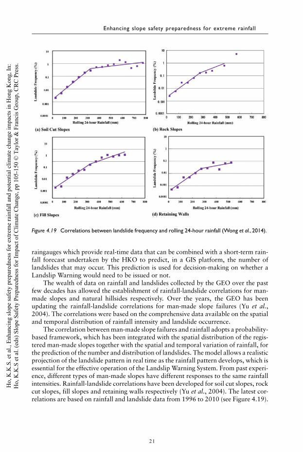
Figure 4.19 Correlations between landslide frequency and rolling 24-hour rainfall (Wong et al., 2014).
raingauges which provide real-time data that can be combined with a short-term rain-fall forecast undertaken by the HKO to predict, in a GIS platform, the number oflandslides that may occur. This prediction is used for decision-making on whether aLandslip Warning would need to be issued or not.
The wealth of data on rainfall and landslides collected by the GEO over the pastfew decades has allowed the establishment of rainfall-landslide correlations for man-made slopes and natural hillsides respectively. Over the years, the GEO has beenupdating the rainfall-landslide correlations for man-made slope failures (Yu et al.,2004). The correlations were based on the comprehensive data available on the spatialand temporal distribution of rainfall intensity and landslide occurrence.
The correlation between man-made slope failures and rainfall adopts a probability-based framework, which has been integrated with the spatial distribution of the regis-tered man-made slopes together with the spatial and temporal variation of rainfall, forthe prediction of the number and distribution of landslides. The model allows a realisticprojection of the landslide pattern in real time as the rainfall pattern develops, which isessential for the effective operation of the Landslip Warning System. From past experi-ence, different types of man-made slopes have different responses to the same rainfallintensities. Rainfall-landslide correlations have been developed for soil cut slopes, rockcut slopes, fill slopes and retaining walls respectively (Yu et al., 2004). The latest cor-relations are based on rainfall and landslide data from 1996 to 2010 (see Figure 4.19).
21
Ho,
K.K
.S. e
t al.,
Enh
anci
ng sl
ope
safe
ty p
repa
redn
ess f
or e
xtre
me
rain
fall
and
pote
ntia
l clim
ate
chan
ge im
pact
s in
Hon
g K
ong,
In:
Ho,
K.K
.S e
t al.
(eds
) Slo
pe S
afet
y Pr
epar
edne
ss fo
r Im
pact
of C
limat
e C
hang
e, p
p 10
5-15
0 ©
Tay
lor &
Fra
ncis
Gro
up, C
RC
Pre
ss.
Slope safety preparedness for impact of climate change
1000
Proposed Storm-basedCorrelation
Proposed Storm-basedCorrelation
100
10
1
0.1
0.010.05
(a) Correlation based on normalised maximum rolling24-hour rainfall
(b) Correlation based on normalised maximumrolling 4-hour and 24-hour rainfalls
(c) Rainfall classes referred in (b)
Normalised24-hourRainfall
Land
slid
e D
ensi
ty (
No.
/Km
2 ) 1000
100
10
1
0.1
0.01Land
slid
e D
ensi
ty (
No.
/Km
2 )
Rainfall Class0.10 0.15
I II III IV V VI
VI
VII
V
IV
III
II
I
0.025 -010
0.10 -0.15
0.15 -0.20
Normalized Maximum Rolling 24-hour Rainfall
Nor
mal
ized
Max
imum
Rol
ling
4-ho
ur R
ainf
all
0.20 -0.25
0.25 -0.30
0.30 -0.35
VII0.20 0.25 0.30 0.35
< 0.06
0.03 - 0.08
0.08 - 0.11
0.11 - 0.13
0.13 - 0.16
0.16 - 0.18
≥ 0.18
≥ 0.35
0.40 I II III IV
Rainfall Class
V VI VII
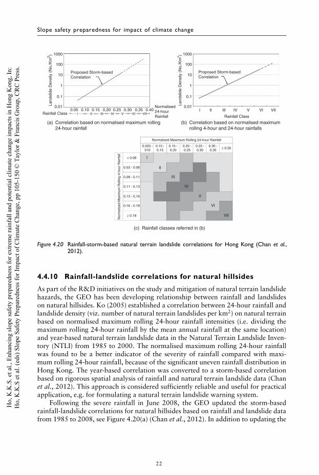
Figure 4.20 Rainfall-storm-based natural terrain landslide correlations for Hong Kong (Chan et al.,2012).
4.4.10 Rainfall-landslide correlations for natural hillsides
As part of the R&D initiatives on the study and mitigation of natural terrain landslidehazards, the GEO has been developing relationship between rainfall and landslideson natural hillsides. Ko (2005) established a correlation between 24-hour rainfall andlandslide density (viz. number of natural terrain landslides per km2) on natural terrainbased on normalised maximum rolling 24-hour rainfall intensities (i.e. dividing themaximum rolling 24-hour rainfall by the mean annual rainfall at the same location)and year-based natural terrain landslide data in the Natural Terrain Landslide Inven-tory (NTLI) from 1985 to 2000. The normalised maximum rolling 24-hour rainfallwas found to be a better indicator of the severity of rainfall compared with maxi-mum rolling 24-hour rainfall, because of the significant uneven rainfall distribution inHong Kong. The year-based correlation was converted to a storm-based correlationbased on rigorous spatial analysis of rainfall and natural terrain landslide data (Chanet al., 2012). This approach is considered sufficiently reliable and useful for practicalapplication, e.g. for formulating a natural terrain landslide warning system.
Following the severe rainfall in June 2008, the GEO updated the storm-basedrainfall-landslide correlations for natural hillsides based on rainfall and landslide datafrom 1985 to 2008, see Figure 4.20(a) (Chan et al., 2012). In addition to updating the
22
Ho,
K.K
.S. e
t al.,
Enh
anci
ng sl
ope
safe
ty p
repa
redn
ess f
or e
xtre
me
rain
fall
and
pote
ntia
l clim
ate
chan
ge im
pact
s in
Hon
g K
ong,
In:
Ho,
K.K
.S e
t al.
(eds
) Slo
pe S
afet
y Pr
epar
edne
ss fo
r Im
pact
of C
limat
e C
hang
e, p
p 10
5-15
0 ©
Tay
lor &
Fra
ncis
Gro
up, C
RC
Pre
ss.
Enhancing slope safety preparedness for extreme rainfall
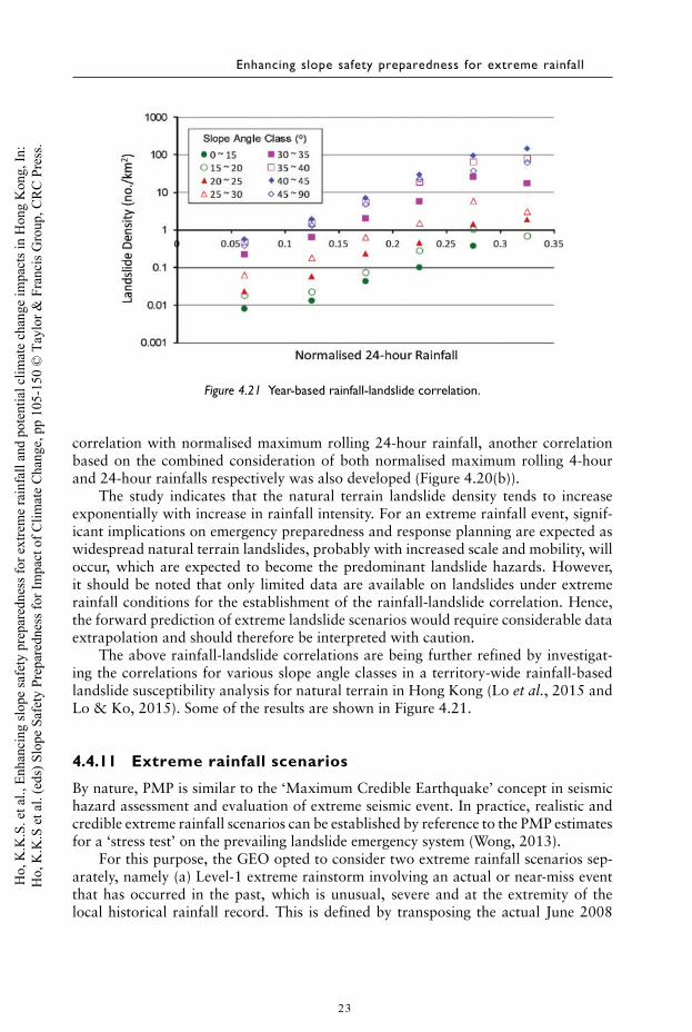
Figure 4.21 Year-based rainfall-landslide correlation.
correlation with normalised maximum rolling 24-hour rainfall, another correlationbased on the combined consideration of both normalised maximum rolling 4-hourand 24-hour rainfalls respectively was also developed (Figure 4.20(b)).
The study indicates that the natural terrain landslide density tends to increaseexponentially with increase in rainfall intensity. For an extreme rainfall event, signif-icant implications on emergency preparedness and response planning are expected aswidespread natural terrain landslides, probably with increased scale and mobility, willoccur, which are expected to become the predominant landslide hazards. However,it should be noted that only limited data are available on landslides under extremerainfall conditions for the establishment of the rainfall-landslide correlation. Hence,the forward prediction of extreme landslide scenarios would require considerable dataextrapolation and should therefore be interpreted with caution.
The above rainfall-landslide correlations are being further refined by investigat-ing the correlations for various slope angle classes in a territory-wide rainfall-basedlandslide susceptibility analysis for natural terrain in Hong Kong (Lo et al., 2015 andLo & Ko, 2015). Some of the results are shown in Figure 4.21.
4.4.11 Extreme rainfall scenarios
By nature, PMP is similar to the ‘Maximum Credible Earthquake’ concept in seismichazard assessment and evaluation of extreme seismic event. In practice, realistic andcredible extreme rainfall scenarios can be established by reference to the PMP estimatesfor a ‘stress test’ on the prevailing landslide emergency system (Wong, 2013).
For this purpose, the GEO opted to consider two extreme rainfall scenarios sep-arately, namely (a) Level-1 extreme rainstorm involving an actual or near-miss eventthat has occurred in the past, which is unusual, severe and at the extremity of thelocal historical rainfall record. This is defined by transposing the actual June 2008
23
Ho,
K.K
.S. e
t al.,
Enh
anci
ng sl
ope
safe
ty p
repa
redn
ess f
or e
xtre
me
rain
fall
and
pote
ntia
l clim
ate
chan
ge im
pact
s in
Hon
g K
ong,
In:
Ho,
K.K
.S e
t al.
(eds
) Slo
pe S
afet
y Pr
epar
edne
ss fo
r Im
pact
of C
limat
e C
hang
e, p
p 10
5-15
0 ©
Tay
lor &
Fra
ncis
Gro
up, C
RC
Pre
ss.
Slope safety preparedness for impact of climate change
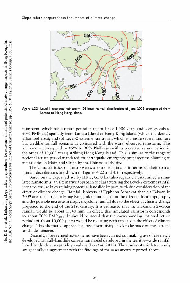
Figure 4.22 Level-1 extreme rainstorm: 24-hour rainfall distribution of June 2008 transposed fromLantau to Hong Kong Island.
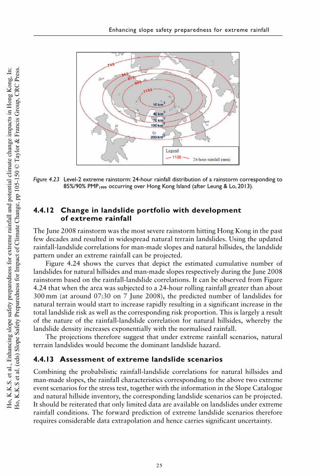
rainstorm (which has a return period in the order of 1,000 years and corresponds to60% PMP1999) spatially from Lantau Island to Hong Kong Island (which is a denselyurbanised area); and (b) Level-2 extreme rainstorm, which is a more severe, and rarebut credible rainfall scenario as compared with the worst observed rainstorm. Thisis taken to correspond to 85% to 90% PMP1999 (with a projected return period inthe order of 10,000 years) striking Hong Kong Island. This is similar to the range ofnotional return period mandated for earthquake emergency preparedness planning ofmajor cities in Mainland China by the Chinese Authority.
The characteristics of the above two extreme rainfalls in terms of their spatialrainfall distributions are shown in Figures 4.22 and 4.23 respectively.
Based on the expert advice by HKO, GEO has also separately established a simu-lated rainstorm as an alternative approach to characterising the Level-2 extreme rainfallscenario for use in examining potential landslide impact, with due consideration of theeffect of climate change. Rainfall isohyets of Typhoon Morakot that hit Taiwan in2009 are transposed to Hong Kong taking into account the effect of local topographyand the possible increase in tropical cyclone rainfall due to the effect of climate changeprojected to the end of the 21st century. It is estimated that the maximum 24-hourrainfall would be about 1,040 mm. In effect, this simulated rainstorm correspondsto about 70% PMP2014. It should be noted that the corresponding notional returnperiod (of about 10,000 years) would be reducing with time given the effect of climatechange. This alternative approach allows a sensitivity check to be made on the extremelandslide scenario.
Recently, more refined assessments have been carried out making use of the newlydeveloped rainfall-landslide correlation model developed in the territory-wide rainfallbased landslide susceptibility analysis (Lo et al. 2015). The results of this latest studyare generally in agreement with the findings of the assessments reported above.
24
Ho,
K.K
.S. e
t al.,
Enh
anci
ng sl
ope
safe
ty p
repa
redn
ess f
or e
xtre
me
rain
fall
and
pote
ntia
l clim
ate
chan
ge im
pact
s in
Hon
g K
ong,
In:
Ho,
K.K
.S e
t al.
(eds
) Slo
pe S
afet
y Pr
epar
edne
ss fo
r Im
pact
of C
limat
e C
hang
e, p
p 10
5-15
0 ©
Tay
lor &
Fra
ncis
Gro
up, C
RC
Pre
ss.
Enhancing slope safety preparedness for extreme rainfall
Figure 4.23 Level-2 extreme rainstorm: 24-hour rainfall distribution of a rainstorm corresponding to85%/90% PMP1999 occurring over Hong Kong Island (after Leung & Lo, 2013).
4.4.12 Change in landslide portfolio with developmentof extreme rainfall
The June 2008 rainstorm was the most severe rainstorm hitting Hong Kong in the pastfew decades and resulted in widespread natural terrain landslides. Using the updatedrainfall-landslide correlations for man-made slopes and natural hillsides, the landslidepattern under an extreme rainfall can be projected.
Figure 4.24 shows the curves that depict the estimated cumulative number oflandslides for natural hillsides and man-made slopes respectively during the June 2008rainstorm based on the rainfall-landslide correlations. It can be observed from Figure4.24 that when the area was subjected to a 24-hour rolling rainfall greater than about300 mm (at around 07:30 on 7 June 2008), the predicted number of landslides fornatural terrain would start to increase rapidly resulting in a significant increase in thetotal landslide risk as well as the corresponding risk proportion. This is largely a resultof the nature of the rainfall-landslide correlation for natural hillsides, whereby thelandslide density increases exponentially with the normalised rainfall.
The projections therefore suggest that under extreme rainfall scenarios, naturalterrain landslides would become the dominant landslide hazard.
4.4.13 Assessment of extreme landslide scenarios
Combining the probabilistic rainfall-landslide correlations for natural hillsides andman-made slopes, the rainfall characteristics corresponding to the above two extremeevent scenarios for the stress test, together with the information in the Slope Catalogueand natural hillside inventory, the corresponding landslide scenarios can be projected.It should be reiterated that only limited data are available on landslides under extremerainfall conditions. The forward prediction of extreme landslide scenarios thereforerequires considerable data extrapolation and hence carries significant uncertainty.
25
Ho,
K.K
.S. e
t al.,
Enh
anci
ng sl
ope
safe
ty p
repa
redn
ess f
or e
xtre
me
rain
fall
and
pote
ntia
l clim
ate
chan
ge im
pact
s in
Hon
g K
ong,
In:
Ho,
K.K
.S e
t al.
(eds
) Slo
pe S
afet
y Pr
epar
edne
ss fo
r Im
pact
of C
limat
e C
hang
e, p
p 10
5-15
0 ©
Tay
lor &
Fra
ncis
Gro
up, C
RC
Pre
ss.

Slope safety preparedness for impact of climate change
2500Estimated number of landslides for natural terrain
Estimated number of landslides for man-made slopes
Cumulative rainfall at N19 - Keung Shan, Lantau
Cumulative rainfall at N21 - Tung Chung Au, Lantau
Cumulative rainfall at N17 - Tung Chung2000
1500
1000
500
0
2500
2000
1500
1000
500
007/06/2008
06:0007/06/2008
07:0007/06/2008
08:0007/06/2008
09:00
Date and Time
Est
imat
ed N
o. o
f Lan
dslid
es Cum
ulative Rainfall (m
m)
07/06/200810:00
07/06/200811:00
07/06/200812:00
Figure 4.24 Comparison of estimated number of landslides from man-made slopes and natural terrain(based on the June 2008 rainstorm).
The historical data from the worst observed rainstorm in Hong Kong (i.e. the June2008 rainstorm) since records began in 1885 provided a means to project the scale ofnatural terrain failure and debris mobility under extreme rainfall intensities in orderto minimise data extrapolation as far as possible. Nonetheless, caution is needed whenusing historical data as a basis for assessing the scale of landslides and mobility oflandslide debris under extreme rainfall events. Extreme rainfalls are liable to give riseto more watery debris, which tends to travel further and faster and is liable to overshootfrom a drainage line. The increased surface runoff may overwhelm surface drainageprovisions turning road pavement into drainage channels (or catchwater channels canbecome blocked and breached by landslides), overspilling a large volume of wateronto the downhill slope at road bends and leading to washout type failures as well asflooding of the downhill areas. The possibility of major knock-on effects, such as thescenario of a service water reservoir being breached by major landslides releasing acolossal amount of water running violently downhill could also lead to major washoutfailures or debris floods, and grave consequences.
In essence, the possibility of large scale and mobile landslides being under-represented through data extrapolation needs to be borne in mind. Case histories ofsizeable landslides triggered by world record or near world record rainfall intensitieshave indicated four main types of landslide hazards under extreme rainfall, namelymobile debris flows, mobile rockslides (or rock avalanches), large scale deep-seatedlandslides, and formation and subsequent collapse of landslide debris dams. The occur-rence of the above hazards would depend on the site-specific setting (e.g. existence of
26
Ho,
K.K
.S. e
t al.,
Enh
anci
ng sl
ope
safe
ty p
repa
redn
ess f
or e
xtre
me
rain
fall
and
pote
ntia
l clim
ate
chan
ge im
pact
s in
Hon
g K
ong,
In:
Ho,
K.K
.S e
t al.
(eds
) Slo
pe S
afet
y Pr
epar
edne
ss fo
r Im
pact
of C
limat
e C
hang
e, p
p 10
5-15
0 ©
Tay
lor &
Fra
ncis
Gro
up, C
RC
Pre
ss.
Enhancing slope safety preparedness for extreme rainfall
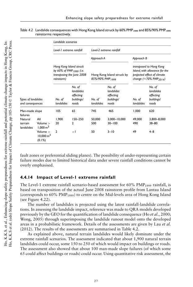
Table 4.2 Landslide consequences with Hong Kong Island struck by 60% PMP1999 and 85%/90% PMP1999rainstorms respectively.
Landslide scenarios
Level-1 extreme rainfall Level-2 extreme rainfall
Approach A Approach B
Hong Kong Island struck transposed to Hong Kongby 60% of PMP1999 (i.e. Island, with allowance for thetransposing the June 2008 Hong Kong Island struck by projected effect of climaterainstorm) 85%/90% PMP1999 change (≈70% PMP2014)
No. of No. of No. oflandslides landslides landslidesaffecting affecting affecting
Types of landslides No. of buildings/ No. of buildings/ No. of buildings/and consequences landslides roads landslides roads landslides roads
Man-made slope 105 65 745 465 1,000 620failuresNatural All 1,900 150–250 50,000 3,000–10,000 49,000 3,800–8,000terrain Volume > 20 2 500 30–100 490 38–80landslides 1,000 m3
Volume > 2 <1 50 3–10 49 4–810,000 m3
(0.1%)
fault zones or preferential sliding planes). The possibility of under-representing certainfailure modes due to limited historical data under severe rainfall conditions cannot beoverly emphasised.
4.4.14 Impact of Level-1 extreme rainfall
The Level-1 extreme rainfall scenario-based assessment for 60% PMP1999 rainfall, isbased on transposition of the actual June 2008 rainstorm profile from Lantau Island(corresponds to 60% PMP1999) to centre on the Mid-levels area of Hong Kong Island(see Figure 4.22).
The number of landslides is projected using the latest rainfall-landslide correla-tions. In assessing the landslide impact, reference was made to QRA models developedpreviously by the GEO for the quantification of landslide consequence (Ho et al., 2000;Wong, 2005) through superimposing the landslide runout model onto the developedareas in a probabilistic framework. Details of the assessments are given by Lau et al.(2012). The results of the assessments are summarised in Table 4.2.
As explained above, natural terrain landslides would likely dominate under theextreme rainfall scenarios. The assessment indicated that about 1,900 natural terrainlandslides could occur, some 150 to 250 of which would impact on buildings or roads.The assessment also showed that about 100 man-made slope failures (of which some65 could affect buildings or roads) could occur. Using quantitative risk assessment, the
27
Ho,
K.K
.S. e
t al.,
Enh
anci
ng sl
ope
safe
ty p
repa
redn
ess f
or e
xtre
me
rain
fall
and
pote
ntia
l clim
ate
chan
ge im
pact
s in
Hon
g K
ong,
In:
Ho,
K.K
.S e
t al.
(eds
) Slo
pe S
afet
y Pr
epar
edne
ss fo
r Im
pact
of C
limat
e C
hang
e, p
p 10
5-15
0 ©
Tay
lor &
Fra
ncis
Gro
up, C
RC
Pre
ss.
Slope safety preparedness for impact of climate change
corresponding Potential Loss of Life (PLL) given the occurrence of the events was alsoevaluated. For the 60% PMP1999 scenario, the calculated PLL for the event is about10, which is about two orders of magnitude higher than the annual average PLL forthe area.
The above assessment was also benchmarked against the outcome of the 1966 rain-storm, which was the most severe rainstorm that hit Hong Kong Island (correspondingto about 40% to 45% PMP1999 with the normalised maximum rolling 24-hour rainfallin the range of 0.1 to 0.25). The present assessment took into consideration that about15% of the natural terrain landslides triggered by the June 1966 rainstorm reachedthe present-day development areas and allowed for the increased mobility of land-slides under extreme rainfall, given that the June 2008 rainstorm at Lantau was about40–50% more severe than the June 1966 rainstorm in terms of normalised maximumrolling 24-hour rainfall.
The 1966 rainstorm resulted in much damage and social disruption, includingcomplete closure of many roads and 64 fatalities as a result of landslides and flood-ing. In comparison, the present assessment appears to be credible and the assessedconsequences seem realistic and are broadly consistent with the past observations.
4.4.15 Impact of Level-2 extreme rainfall based on 85%/90%PMP1999
A similar analysis was conducted to assess the extreme landslide scenario on HongKong Island in the event of the Level-2 extreme rainfall based on 85%/90% PMP1999
(Leung & Lo, 2013).The assessment indicated that about 50,000 natural terrain landslides could occur,
some 3,000 to 10,000 of which could impact on buildings or roads. This correspondsto approximately one landslide per 1,000 m2 of natural terrain area, which is about20 times the estimate obtained in the assessment by Lau et al. (2012) for the scenarioinvolving the June 2008 rainstorm hitting Hong Kong Island. The landslides wouldresult in the detachment of about 10% of the natural terrain area.
The assessment also showed that about 750 man-made slope failures (of whichsome 450 cases could affect buildings or roads) could occur (see Table 4.2).
It is expected that PLL of this event would be much greater than that associatedwith the scenario of 60% PMP1999(roughly by an order of magnitude). However, thereis much uncertainty in the expected PLL values, given that the collapse of a numberof high-rise buildings due to landslide debris impact cannot be ruled out in adversecombination of circumstances.
4.4.16 Impact of Level-2 extreme rainfall based on transpositionof Typhoon Morakot to Hong Kong with climate changeeffect projected to the end of 21st century
Additional analyses were also carried out to assess the extreme landslide scenarioon Hong Kong Island under the Level-2 extreme rainfall scenario of a transposedTyphoon Morakot rainstorm, with allowance made for the effect of climate changeprojected to the end of 21st century. This assessment indicated that about 49,000natural terrain landslides could occur, some 4,000 to 8,000 of which could impact on
28
Ho,
K.K
.S. e
t al.,
Enh
anci
ng sl
ope
safe
ty p
repa
redn
ess f
or e
xtre
me
rain
fall
and
pote
ntia
l clim
ate
chan
ge im
pact
s in
Hon
g K
ong,
In:
Ho,
K.K
.S e
t al.
(eds
) Slo
pe S
afet
y Pr
epar
edne
ss fo
r Im
pact
of C
limat
e C
hang
e, p
p 10
5-15
0 ©
Tay
lor &
Fra
ncis
Gro
up, C
RC
Pre
ss.
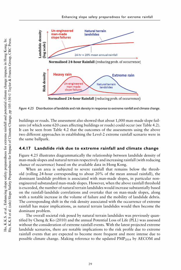
Enhancing slope safety preparedness for extreme rainfall
Figure 4.25 Distribution of landslide and risk density in response to extreme rainfall and climate change.
buildings or roads. The assessment also showed that about 1,000 man-made slope fail-ures (of which some 620 cases affecting buildings or roads) could occur (see Table 4.2).It can be seen from Table 4.2 that the outcomes of the assessments using the abovetwo different approaches in establishing the Level-2 extreme rainfall scenario were inthe same ballpark.
4.4.17 Landslide risk due to extreme rainfall and climate change
Figure 4.25 illustrates diagrammatically the relationship between landslide density ofman-made slopes and natural terrain respectively and increasing rainfall (with reducingchance of occurrence) based on the available data in Hong Kong.
When an area is subjected to severe rainfall that remains below the thresh-old (rolling 24-hour corresponding to about 20% of the mean annual rainfall), thedominant landslide problem is associated with man-made slopes, in particular non-engineered substandard man-made slopes. However, when the above rainfall thresholdis exceeded, the number of natural terrain landslides would increase substantially basedon the rainfall-landslide correlations and overtake that on man-made slopes, alongwith a notable increase in the volume of failure and the mobility of landslide debris.The corresponding shift in the risk density associated with the occurrence of extremerainfall has major implications, as natural terrain landslides would then become thedominant problem.
The overall societal risk posed by natural terrain landslides was previously quan-tified by Cheng & Ko (2010) and the annual Potential Loss of Life (PLL) was assessedwithout the consideration of extreme rainfall events. With the latest projected extremelandslide scenarios, there are notable implications to the risk profile due to extremerainfall events that are expected to become more frequent and more intense due topossible climate change. Making reference to the updated PMP2014 by AECOM and
29
Ho,
K.K
.S. e
t al.,
Enh
anci
ng sl
ope
safe
ty p
repa
redn
ess f
or e
xtre
me
rain
fall
and
pote
ntia
l clim
ate
chan
ge im
pact
s in
Hon
g K
ong,
In:
Ho,
K.K
.S e
t al.
(eds
) Slo
pe S
afet
y Pr
epar
edne
ss fo
r Im
pact
of C
limat
e C
hang
e, p
p 10
5-15
0 ©
Tay
lor &
Fra
ncis
Gro
up, C
RC
Pre
ss.
Slope safety preparedness for impact of climate change
Table 4.3 Summary of GEO’s landslide emergency service from 1994 to 2013.
No. of reported No. of building units evacuated*No. of Landslip landslide No. of roadWarning issued incidents Block House Flat/Unit sections closed
62 5,274 21 119 1,003 2,434
Note: *A ‘block’ is a multi-storey building, which may comprise up to several dozens of flats/units. A ‘house’ istypically within 3 storeys, which comprises several flats/units.
Lin (2014), consideration of natural terrain landslide risk arising from extreme rain-fall will bring about 50% increase in the overall risk in terms of annual PLL (Ko &Sun, 2016). However, one must not lose sight of the major uncertainties involved inassessing the risk of extreme landslide scenarios. The above risk quantification wouldat best give a very rough order of the possible risk level of extreme rainfall events andone must not be misled by the apparent precision of the estimate. Notwithstandingthe above, the present assessment findings reinforce the notion that extreme rainfallwould constitute an increasing concern and hence expanded efforts are warranted toenhance the resilience of Hong Kong’s Slope Safety System in order to better managethe risk of extreme weather conditions.
4.4.18 Evaluating the capacity of landslide emergencymanagement system
The findings from the above scenario-based assessments were used as a form of ‘stresstest’ to review the adequacy of the GEO’s prevailing landslide emergency preparedness.
Since 1978, the GEO has been operating a 24-hour year round landslide warningsystem and landslide emergency system to provide warning and emergency services andgive professional advice to Government departments on actions to be taken in case oflandslide danger. The aim is to minimise casualty and damage to property under heavyrainfall conditions, and facilitate recovery.
When it is predicted that numerous landslides will occur based on recorded andforecasted rainfall, the HKO in consultation with the GEO will issue the LandslipWarning to alert the general public of the potential landslide danger. As shown inTable 4.3 above, the landslide emergency service has played a significant role inminimising the exposure of the general public to landslide danger, thereby reducinglandslide risk.
The landslide emergency system in Hong Kong has proved to be effective in dealingwith emergency management under heavy rainfall conditions, such as those typicallyencountered when Landslide Warning is issued to the general public. However, thesystem has not been specifically designed to cope with, and tested for, extreme events,particularly in respect of preparedness, response and recovery.
An assessment has been made of the likely capacity of the landslide emergencymanagement system, based on consideration of the available human resources foremergency inspection of landslide incidents that require GEO’s input in emergencyresponse (Wong, 2013).
The findings indicate that the current system is able to handle about 210 reportednatural terrain landslides, or about 360 reported man-made slope failures.
30
Ho,
K.K
.S. e
t al.,
Enh
anci
ng sl
ope
safe
ty p
repa
redn
ess f
or e
xtre
me
rain
fall
and
pote
ntia
l clim
ate
chan
ge im
pact
s in
Hon
g K
ong,
In:
Ho,
K.K
.S e
t al.
(eds
) Slo
pe S
afet
y Pr
epar
edne
ss fo
r Im
pact
of C
limat
e C
hang
e, p
p 10
5-15
0 ©
Tay
lor &
Fra
ncis
Gro
up, C
RC
Pre
ss.
Enhancing slope safety preparedness for extreme rainfall
It is noteworthy that the above is the existing capacity following the current prac-tice of dealing with reported landslides and making recommendations on emergencyactions to be taken, such as making recommendation on evacuation of buildings, clo-sure of affected areas and urgent works needed to remove the immediate landslidedanger.
All in all, it is projected that a Level-1 extreme rainstorm (viz. a 60% PMP1999
hitting a densely populated area on Hong Kong Island) would stretch the existing sys-tem to the limit. In comparison, about one-third of the system capacity was mobilisedin June 2008 when the rainfall event hit the relatively sparsely populated and lessaccessible western part of Lantau Island.
In case a Level-2 extreme rainstorm (viz. an extreme rainstorm corresponding to85%/90% PMP1999 or the transposed Morakot rainstorm allowing for the effect ofclimate change) were to hit a densely populated area on Hong Kong Island, the verylarge number of predicted natural terrain landslides would completely overwhelm thecapacity of the current landslide emergency management system. Both the responseand recovery phases would face acute challenges and the landslide consequences arelikely to be very serious.
Other bottlenecks will almost certainly exist in emergency management forextreme events, such as transport arrangements, communication facilities, and provi-sion for prompt and safe settlement of the affected community, which are constrainedby the capacity of other Government agencies or non-government organisationsinvolved in emergency management. All these issues need to be addressed in a holisticmanner as part of the emergency preparedness for extreme landslide scenarios.
4.5 ADAPTATION STRATEGIES FOR MANAGING EXTREMELANDSLIDE EVENTS
In the context of risk management, emergency management is the discipline that dealswith or mitigates the risk of weather-related extreme events or natural disasters. Inthe context of protecting the community from the adverse consequences of landslidedisasters, the following adaptation strategies are pertinent:
(a) Prevention: This involves preventive activities to provide protection from disas-ters, e.g. setting up and enforcing the use of suitable slope investigation, design,construction, supervision and maintenance standards.
(b) Mitigation: This involves implementation of engineering measures to lessen theimpact of landslides, e.g. retrofitting substandard slopes to reduce the chanceof landslide, or providing mitigation measures (e.g. barriers or check dams) toreduce adverse landslide consequences.
(c) Preparedness: This focuses on formulating procedures, managing humanresources, setting up emergency systems, preparing equipment, etc. for promptmobilisation when a disaster occurs. It also involves preparing the vulnerablecommunity to respond promptly and effectively to the landslide disaster, e.g.taking suitable personal precautionary actions during Landslip Warning.
(d) Response: The response phase of an emergency may involve search and rescue,as well as evacuation and fulfilling the basic humanitarian needs of the affectedpopulation. Emergency inspections for identification of any imminent danger
31
Ho,
K.K
.S. e
t al.,
Enh
anci
ng sl
ope
safe
ty p
repa
redn
ess f
or e
xtre
me
rain
fall
and
pote
ntia
l clim
ate
chan
ge im
pact
s in
Hon
g K
ong,
In:
Ho,
K.K
.S e
t al.
(eds
) Slo
pe S
afet
y Pr
epar
edne
ss fo
r Im
pact
of C
limat
e C
hang
e, p
p 10
5-15
0 ©
Tay
lor &
Fra
ncis
Gro
up, C
RC
Pre
ss.
Slope safety preparedness for impact of climate change
and advice on necessary response actions, safe settlement of those people whohave been evacuated and provision of relief measures, are examples of responseactivities.
(e) Recovery: The recovery phase starts after the immediate threat to life has beendealt with. The goal is to bring the affected area back to normal, e.g. carryingout landslide repair or mitigation works.
Items (a) and (b) may be construed as broad risk reduction strategies whereasemergency management relates mainly to items (c) to (e). Resilience embraces items(a) to (e) and reflects the ability of a system to withstand shocks and stresses whilstmaintaining its essential functions. Resilient systems are also more amenable to repairand recovery afterwards. Whilst slope safety systems commonly include provisionsfor emergency management, the existing systems are rarely designed for, nor testedagainst, extreme events.
Other options may include protection of the built environment by means of engi-neering works, allowing for ‘safe’ failure, embedding redundancy, better land-useplanning, possible relocation of existing development, etc.
The various adaptation strategies and measures that are being implemented by theGEO to manage the risk of extreme rainfall events are outlined in the following.
4.5.1 Promulgate enhanced technical guidance and promotemore robust mitigation measures
Following the June 2008 rainstorm, enhanced technical guidance was promulgated onthe delineation of adverse site settings for the potential development of highly mobilechannelised debris flows associated with major drainage lines fed by sizeable catch-ments. In addition, guidance was issued on the appropriate parameters for landslidedebris runout modelling based on back analyses of actual mobile debris flows in 2008.Appropriate assessment of the mobility of natural terrain landslide debris is of theessence, as this will affect decision-making on whether or not mitigation measures areneeded to protect a given facility and the detailed design of the corresponding mitiga-tion measures. Furthermore, enhanced technical guidance on natural terrain hazardstudies, together with empirical design of standard barriers for open hillside landslides,was promulgated in 2013 following consolidation of experience in the past few yearsand a probabilistic assessment of the scale and mobility of open hillside landslidestriggered by the June 2008 rainstorm.
Designing slopes to a higher safety standard against possible extreme weatherconditions (e.g. by adopting a higher factor of safety) may not be practicable orcost effective. Experience from disaster management of other natural hazards (e.g.earthquakes) indicates that it is generally more effective and appropriate to improveemergency management and enhance both system resilience and community resiliencewith a view to minimising landslide damage and protecting the community from theadverse consequences of landslide disasters.
Lessons learnt from systematic landslide studies in Hong Kong have emphasisedthe need to give due attention to improve the robustness of slope design and detail-ing by means of measures that will make the slopes less vulnerable to uncertainties(Ho & Lau, 2008). These include the use of more robust slope stabilisation schemes
32
Ho,
K.K
.S. e
t al.,
Enh
anci
ng sl
ope
safe
ty p
repa
redn
ess f
or e
xtre
me
rain
fall
and
pote
ntia
l clim
ate
chan
ge im
pact
s in
Hon
g K
ong,
In:
Ho,
K.K
.S e
t al.
(eds
) Slo
pe S
afet
y Pr
epar
edne
ss fo
r Im
pact
of C
limat
e C
hang
e, p
p 10
5-15
0 ©
Tay
lor &
Fra
ncis
Gro
up, C
RC
Pre
ss.
Enhancing slope safety preparedness for extreme rainfall
(e.g. soil nailing, retaining wall, etc.), improved design of slope surface drainage sys-tem (GEO, 2004; Tang & Cheung, 2010), application of prescriptive slope surfaceprotection and drainage measures as contingency provisions (Wong et al., 1999), aswell as improved detailing of and enhanced redundancy in drainage provisions.
4.5.2 Low-frequency, large-magnitude landslides
In addition to the need to address extreme landslide scenarios involving widespreadnatural terrain landslides, the increase in the severity and frequency of rainfall also callsfor attention to the challenges of low-frequency, large-magnitude landslides impactingon densely populated areas (viz. several tens of thousands m3 or more, which can behighly damaging given Hong Kong’s vulnerable setting).
Some low-frequency, large-magnitude landslides have occurred in Hong Kongwithin the last few decades. For example, the 1990 Tsing Shan landslide was triggeredby a relatively moderate rainstorm, which involved a 400 m3 failure at the source areaand the adverse site setting resulted in a large and mobile debris flow due to signifi-cant entrainment along the runout path. The total active volume amounted to about20,000 m3 (King, 1996).
Another example is the 1995 Shum Wan Road failure, which involved a large-scaleand mobile open hillside landslide. The drainage provisions along Shum Wan Roadabove the landslide source area were substandard and became blocked due to lackof maintenance, which resulted in the uncontrolled discharge of surface water flowonto the hillside below during severe rainfall. This led to concentrated water ingress inaddition to rainwater infiltration arising from the severe rainstorm, triggering a fairlydeep-seated and long runout open hillside landslide by exploiting the adverse geologicalfeatures in the saprolite with weak clay infill. Two persons were killed in the incident.The additional source of concentrated water ingress arising from uncontrolled overflowof surface water that contributed to the large-scale failure illustrates the potentialimpact of extreme rainfall on the mode of landslide.
A further example is the 2008 Shek Pik reservoir landslide which comprised asizeable and mobile channelised debris flow involving watery debris and a total debrisdeposition volume of about 46,000 m3. The severe rainstorm in November 1993 onlytriggered a relatively small failure in the same catchment with limited mobility (traveldistance of about 400 m), whereas the more severe June 2008 rainstorm triggered avery mobile failure (travel distance of about 1.3 km).
The identification of potential ‘hot-spots’ that are liable to give rise to low-frequency, large-magnitude landslide events is being examined along several fronts.These include (a) examination of large relict landslides and known distressed hillsides,(b) identification of vulnerable site settings based on an engineering geomorphologicalapproach, and (c) delineation and mapping of major drainage lines fed by sizeablecatchments.
Systematic assessment of digital elevation model (DEM) generated from territory-wide LiDAR data, together with field mapping, will assist with the identification ofnotable morphological features such as pre-historic deep-seated rockslides, relict scarsof large landslides, sizeable colluvial lobes or fans, terrain with signs of disturbeddrainage patterns, hillside with geomorphological signs of possible past large-scaleslope instability, concentration of talluvium, etc.
33
Ho,
K.K
.S. e
t al.,
Enh
anci
ng sl
ope
safe
ty p
repa
redn
ess f
or e
xtre
me
rain
fall
and
pote
ntia
l clim
ate
chan
ge im
pact
s in
Hon
g K
ong,
In:
Ho,
K.K
.S e
t al.
(eds
) Slo
pe S
afet
y Pr
epar
edne
ss fo
r Im
pact
of C
limat
e C
hang
e, p
p 10
5-15
0 ©
Tay
lor &
Fra
ncis
Gro
up, C
RC
Pre
ss.
Slope safety preparedness for impact of climate change
To address the risk of potential debris flows or debris floods with significantentrainment and high mobility under extreme rainfall events, the need to give spe-cial attention to major drainage lines fed by sizeable catchments was highlighted bythe June 2008 rainstorm, as these are potential locations of sizeable and mobile debrisflows with watery debris. Catchment size, channelisation ratio, drainage line mor-phology, drainage order, length and straightness, together with presence of potentiallyentrainable material, are some of the important factors that govern the mobility ofchannelised debris flows. A GIS methodology has recently been developed by the GEOfor the systematic delineation of major drainage lines and the corresponding catch-ment boundaries on a territory-wide basis (Lo & Ko, 2014). This was used to identifymajor drainage catchments (MDC), which are defined as hillside catchments with anydrainage line of a length greater than 500 m that is originated from a watershed witha plan area of at least 10,000 m2. The above definition has been benchmarked againstthe past large-magnitude channelised debris flows in Hong Kong.
4.5.3 Systematic implementation of mitigation measures onexisting features posing highest risks to community
‘Hardware’ resilience may be enhanced through engineering measures in accordancewith a risk-based approach to upgrade or retrofit the city infrastructure. The GEOhas been systematically upgrading substandard man-made slopes since 1977 under theLandslip Preventive Measures (LPM) Programme. Over the last three decades, some7,000 substandard man-made slopes were dealt with at a total expenditure of US$1.5B,resulting in about 75% reduction in overall landslide risk.
To dovetail the LPM Programme, the GEO launched in 2010 the Landslip Pre-vention and Mitigation (LPMit) Programme with an expanded scope to systematicallymitigate natural terrain landslide hazards and retrofit the remaining substandard man-made slopes, in accordance with risk-based priority ranking systems. The pledgedannual outputs approximately correspond to dealing with the worst 1% of the vul-nerable hillside catchments and substandard man-made slopes every year on a rollingbasis (Development Bureau, 2007).
The annual output in terms of number of catchments and slopes dealt with is notsignificant in comparison with the slope population and the extensive area of steep nat-ural terrain in Hong Kong. Thus, the LPMitP cannot be the sole answer in addressingthe impact of extreme rainfall events. However, as this systematic retrofitting pro-gramme systematically mitigates the risks of those hillside catchments and man-madeslopes that are posing the highest risk to life, it will contribute to contain the over-all landslide risk to an “as low as reasonably practicable’’ (ALARP) level and help toreduce the adverse consequences under extreme events, particularly in respect of thechances of multiple-fatality landslide events.
4.5.4 Improving crisis preparedness
The available resources of the existing landslide emergency system have a limited capac-ity in handling the reported landslide incidents under an extreme event. To furtherenhance the resilience of the Hong Kong Slope Safety System, crisis preparedness
34
Ho,
K.K
.S. e
t al.,
Enh
anci
ng sl
ope
safe
ty p
repa
redn
ess f
or e
xtre
me
rain
fall
and
pote
ntia
l clim
ate
chan
ge im
pact
s in
Hon
g K
ong,
In:
Ho,
K.K
.S e
t al.
(eds
) Slo
pe S
afet
y Pr
epar
edne
ss fo
r Im
pact
of C
limat
e C
hang
e, p
p 10
5-15
0 ©
Tay
lor &
Fra
ncis
Gro
up, C
RC
Pre
ss.
Enhancing slope safety preparedness for extreme rainfall
needs to be improved, albeit with different strategies and emphasis for the two extremerainfall scenarios under consideration.
(a) Up to Level-1 extreme rainstorm scenario (viz. 60% PMP1999)The main focus is to ensure effective and efficient emergency management whenthe system is stretched to the limit. This calls for streamlining the emergencyresponse with due priority given to more critical cases, and enhancing prepared-ness by identifying and dealing with possible bottlenecks in the operation of thesystem.
(b) Exceeding Level-1 extreme rainstorm (viz. 60% PMP1999) and up to Level-2extreme rainstorm scenario (viz. 85%/90% PMP1999)The capacity of the existing system will be completely overwhelmed. The cur-rent mode of emergency management operation including deploying professionalgeotechnical engineers to landslide sites to give advice on emergency actions willbecome impracticable. The development and implementation of a new strategyand mode of operation in managing the landslide emergency is therefore of theessence.
4.5.5 Enhancing and streamlining landslide emergency services
Based on the findings of the stress tests using the scenario-based assessments, the HongKong’s landslide emergency system could in principle just about cope with the Level-1extreme rainfall scenario (notional return period of 1,000 years) by stretching to itslimits. There is scope, however, for further streamlining and continuous improvementand development of suitable contingency plans to enhance robustness. The constraintsand bottlenecks associated with other relevant Government departments also requireattention. The current landslide emergency system will break down under the Level-2extreme rainfall scenario (notional return period of 10,000 years under the currentclimate condition).
The above scenario-based assessments and stress tests emphasise that the GEOneeds to gear up its slope safety crisis preparedness under extreme rainfall conditionsin respect of preparedness, response and recovery. As an illustration, the followingmeasures have been undertaken recently by the GEO to strengthen and streamline theemergency service:
– Draw up a list of more experienced geologists/geotechnical engineers as a con-tingency provision for prompt deployment to the field to assist in assessing theresidual risk of major natural terrain landslides.
– Put in place arrangements for GEO works contractors to be mobilised, if andwhen needed, to undertake emergency repair or risk mitigation works on large-scale natural terrain landslides. Flexible barrier components have been stockpiledfor possible use in landslide emergency works.
– Use of modern information technology for sharing of key information andenhanced communication in order to facilitate prompt emergency response. Anew, web-based landslide information management system was developed. Thissystem is equipped with a mobile map and geo-location service that enables usersto identify and record landslide locations conveniently. The timely reporting of
35
Ho,
K.K
.S. e
t al.,
Enh
anci
ng sl
ope
safe
ty p
repa
redn
ess f
or e
xtre
me
rain
fall
and
pote
ntia
l clim
ate
chan
ge im
pact
s in
Hon
g K
ong,
In:
Ho,
K.K
.S e
t al.
(eds
) Slo
pe S
afet
y Pr
epar
edne
ss fo
r Im
pact
of C
limat
e C
hang
e, p
p 10
5-15
0 ©
Tay
lor &
Fra
ncis
Gro
up, C
RC
Pre
ss.
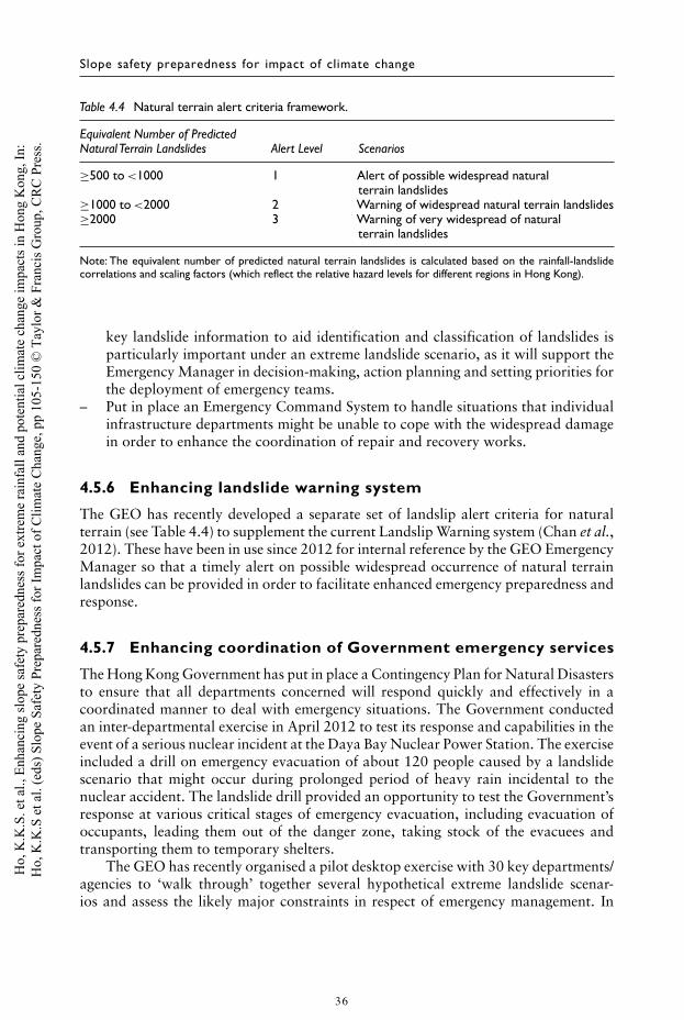
Slope safety preparedness for impact of climate change
Table 4.4 Natural terrain alert criteria framework.
Equivalent Number of PredictedNatural Terrain Landslides Alert Level Scenarios
≥500 to <1000 1 Alert of possible widespread naturalterrain landslides
≥1000 to <2000 2 Warning of widespread natural terrain landslides≥2000 3 Warning of very widespread of natural
terrain landslides
Note: The equivalent number of predicted natural terrain landslides is calculated based on the rainfall-landslidecorrelations and scaling factors (which reflect the relative hazard levels for different regions in Hong Kong).
key landslide information to aid identification and classification of landslides isparticularly important under an extreme landslide scenario, as it will support theEmergency Manager in decision-making, action planning and setting priorities forthe deployment of emergency teams.
– Put in place an Emergency Command System to handle situations that individualinfrastructure departments might be unable to cope with the widespread damagein order to enhance the coordination of repair and recovery works.
4.5.6 Enhancing landslide warning system
The GEO has recently developed a separate set of landslip alert criteria for naturalterrain (see Table 4.4) to supplement the current Landslip Warning system (Chan et al.,2012). These have been in use since 2012 for internal reference by the GEO EmergencyManager so that a timely alert on possible widespread occurrence of natural terrainlandslides can be provided in order to facilitate enhanced emergency preparedness andresponse.
4.5.7 Enhancing coordination of Government emergency services
The Hong Kong Government has put in place a Contingency Plan for Natural Disastersto ensure that all departments concerned will respond quickly and effectively in acoordinated manner to deal with emergency situations. The Government conductedan inter-departmental exercise in April 2012 to test its response and capabilities in theevent of a serious nuclear incident at the Daya Bay Nuclear Power Station. The exerciseincluded a drill on emergency evacuation of about 120 people caused by a landslidescenario that might occur during prolonged period of heavy rain incidental to thenuclear accident. The landslide drill provided an opportunity to test the Government’sresponse at various critical stages of emergency evacuation, including evacuation ofoccupants, leading them out of the danger zone, taking stock of the evacuees andtransporting them to temporary shelters.
The GEO has recently organised a pilot desktop exercise with 30 key departments/agencies to ‘walk through’ together several hypothetical extreme landslide scenar-ios and assess the likely major constraints in respect of emergency management. In
36
Ho,
K.K
.S. e
t al.,
Enh
anci
ng sl
ope
safe
ty p
repa
redn
ess f
or e
xtre
me
rain
fall
and
pote
ntia
l clim
ate
chan
ge im
pact
s in
Hon
g K
ong,
In:
Ho,
K.K
.S e
t al.
(eds
) Slo
pe S
afet
y Pr
epar
edne
ss fo
r Im
pact
of C
limat
e C
hang
e, p
p 10
5-15
0 ©
Tay
lor &
Fra
ncis
Gro
up, C
RC
Pre
ss.
Enhancing slope safety preparedness for extreme rainfall
addition, the GEO has met with the relevant stakeholders to brainstorm the possiblecascading events with adverse knock-on effects that may be triggered by large-scalelandslides.
4.6 FURTHER WORK
4.6.1 Strengthening and streamlining existing landslideemergency system
Potential areas for further improvement or streamlining of the prevailing landslideemergency system include the following:
• Sourcing additional and contingency resources to narrow the gap between thedemand for emergency services and the existing emergency management capac-ity (e.g. develop plans for mobilisation of resources from the private sector andquasi-government organisations to assist in emergency management under extremelandslide events).
• Streamlining the emergency management procedures and practice for dealing withextreme landslide events, focusing on cases where priority attention is required inorder to facilitate provision of the essential emergency response actions.
• Revamping the emergency management strategy to make it more pragmatic andeffective to implement under the constraints of extreme landslide events. For exam-ple, geotechnical engineers may be deployed in district police/fire service commandcentres for more effective provision of geotechnical advice on emergency rescueactions.
• Improving public awareness of possible extreme landslide scenarios and equip-ping the general public with the knowledge and skills required for emergencymanagement, e.g. launch appropriate publicity campaigns and public educationprogrammes.
• Utilising the recently formulated natural terrain landslip alert criteria to enhanceforewarning and landslide emergency mobilisation in the event that widespreadnatural terrain landslides are predicted under critical rainfall conditions.
• Conducting forums, workshops and drills to engage the vulnerable community andrelevant stakeholders in emergency management and response (e.g. developmentof evacuation plans in advance).
• Revamping the emergency information system to facilitate sharing of informa-tion and communication among the different Government bureaux/departments/agencies responsible for different types of hazards via a common GIS operatingplatform.
• Improving communication with the public during a crisis, such as pre-written pressreleases and clear protocols in terms of the officers that will engage with the media.
• Providing enhanced advice and training to the Police and Fire Services Departmenton appropriate actions to be taken by their front-line staff on emergency dutiesfor typical landslide incidents.
• Developing an emergency service continuity plan to react efficiently to unexpectedsituations, e.g. prolonged interruption of utility services (including power gridsand communication networks).
37
Ho,
K.K
.S. e
t al.,
Enh
anci
ng sl
ope
safe
ty p
repa
redn
ess f
or e
xtre
me
rain
fall
and
pote
ntia
l clim
ate
chan
ge im
pact
s in
Hon
g K
ong,
In:
Ho,
K.K
.S e
t al.
(eds
) Slo
pe S
afet
y Pr
epar
edne
ss fo
r Im
pact
of C
limat
e C
hang
e, p
p 10
5-15
0 ©
Tay
lor &
Fra
ncis
Gro
up, C
RC
Pre
ss.
Slope safety preparedness for impact of climate change
Other potential bottlenecks and constraints still exist in the emergency manage-ment system, such as the provision and arrangements of emergency transport andcommunication facilities. All the potential bottlenecks need to be addressed in a holisticmanner and contingency plans developed in order to further enhance system resilience.
4.6.2 Need to consider concurrent multiple hazard scenarios
In September 2013, when Super Typhoon Usagi was still travelling over the Pacific, itwas recognised to have the potential to bring about significant storm surge to HongKong. In the event, the typhoon made landfall just to the east of Hong Kong at Shanwei,Guangdong Province, where at least 15,000 homes were destroyed and more than 30fatalities were reported. Based on storm surge modelling, the HKO found that shouldthe typhoon have travelled along a track to the west of Hong Kong, the highest sealevel at Victoria Harbour would reach 5 m above Chart Datum, instead of 2.8 m asrecorded during the typhoon (Ng et al., 2014). In this event, serious and widespreadflooding would have occurred in the densely populated urban areas adjoining theharbour, with major impact to the infrastructure including both above-ground andbelow-ground facilities, and at the same time heavy downpour would probably havetriggered extensive landslides.
By virtue of the vulnerable and densely urbanised settings, it is perceivable thatan extreme weather event hitting Hong Kong could result in multiple hazards, such aslandslides, flooding, storm surges, tree falls, damages to squatter huts and buildingsby wind, breach of reservoirs and catchwaters, damage to port facilities by waves, etc.,which call for different forms of emergency operations.
To effectively handle the impacts of such multiple hazards that could happen con-currently, the adoption of a holistic approach is of the essence in assessing the severityof the plausible combination of extreme events and development of suitable crisis pre-paredness plans. The GEO in conjunction with the relevant departments that manageother weather-related hazards is conducting scenario-based assessments of multiplehazard scenarios under extreme weather conditions, including the consideration ofpotential cascading events. In this regard, the extreme weather events to be adoptedin emergency preparedness will be refined, and the projected landslide scenarios andconsequences will be updated.
4.6.3 New strategy for landslide emergency managementunder extreme rainfall condition
Apart from the need to further strengthen and streamline the landslide emergency sys-tem to make it more robust and resilient, a new strategy and mode of operation areneeded in enhancing the preparedness for extreme rainfall events. This new strategywould primarily involve key elements that include (a) enhancing the coordination andcollaboration of emergency services provided by different Government departments,(b) enhancing community resilience by promoting the public to take personal precau-tionary measures, and (c) empowering and facilitating the public to take appropriateemergency response actions to protect themselves and minimise exposure to landslidehazards, by providing them with the necessary knowledge and information in a timelymanner for their decision-making on emergency response.
38
Ho,
K.K
.S. e
t al.,
Enh
anci
ng sl
ope
safe
ty p
repa
redn
ess f
or e
xtre
me
rain
fall
and
pote
ntia
l clim
ate
chan
ge im
pact
s in
Hon
g K
ong,
In:
Ho,
K.K
.S e
t al.
(eds
) Slo
pe S
afet
y Pr
epar
edne
ss fo
r Im
pact
of C
limat
e C
hang
e, p
p 10
5-15
0 ©
Tay
lor &
Fra
ncis
Gro
up, C
RC
Pre
ss.
Enhancing slope safety preparedness for extreme rainfall
Under the current system in dealing with normal emergency situations, the GEOwill endeavour to attend to each significant or serious landslide incident in order toundertake an inspection and give advice on the immediate precautionary measures (e.g.evacuation or road closure) to safeguard public safety, and the necessary emergencyworks to remove the immediate or impending danger.
Such a mode of emergency service will become impractical during extreme rainfalland landslide conditions. Apart from the very large number of landslides that will bereported, many of them will likely become inaccessible as a large number of roads andfootpaths are expected to be blocked by landslide debris, or flooding. A new strategyfor managing the landslide emergency is therefore needed.
Enhancing the resilience of the vulnerable population and the relevant stakeholdersin facing up to the extreme natural events is of the essence. Maintaining vigilance of theextreme landslide scenarios and awareness of emergency management constraints iscritical to crisis preparedness. Hence, public education and communication would beas important as technical assessments, formulation of emergency plans and procedures,and preventive and mitigation works.
The key is to enhance the resilience of the community, without causing undue alarmor generating misunderstanding by the public on the Government’s motives. Membersof the public will need to be empowered and encouraged to take appropriate emergencyresponse actions in order to protect themselves and their families, and to minimise theirexposure to landslide hazards. This may be done by providing them with the necessaryknowledge and information on the latest landslide and rainfall situations in a timelymanner so as to assist them to make their own decisions on emergency response, beforethe arrival of GEO staff or other emergency staff. An analogy will be the general publictaking appropriate emergency response actions in the event of a fire before the arrivalof the firemen.
An account of GEO’s expanded efforts on public education, information and com-munication under the Hong Kong Slope Safety System is given by Tam & Lui (2013).Focused and enhanced publicity and public education efforts are warranted to improvethe community resilience against extreme landslide events.
4.7 OTHER INITIATIVES
In the 2008 Policy Address, the Chief Executive announced that the Hong Kong Gov-ernment will make early preparations to meet the challenge of climate change, inparticular in enhancing fuel efficiency, using clean fuels and relying less on fossil fuelsto reduce carbon footprints of our city. It was proposed to adopt a voluntary car-bon intensity reduction target of 50%–60% by 2020 as compared with 2005 level.(Environment Bureau, 2010).
The GEO has continued to promulgate environmental-friendly construction tech-niques in slope works. Soil nailing is now widely used by the local geotechnicalprofession to upgrade soil cut slopes, fill slopes and masonry walls. Apart from beingrobust, this technique is also more environmentally friendly and sustainable than otheralternative solutions (such as trimming back a cut slope or re-compaction of loosefill) in terms of carbon emission. In comparison, carbon emission of soil nailing issome 40% lower than that of cutting back of a slope and 50% lower than that of
39
Ho,
K.K
.S. e
t al.,
Enh
anci
ng sl
ope
safe
ty p
repa
redn
ess f
or e
xtre
me
rain
fall
and
pote
ntia
l clim
ate
chan
ge im
pact
s in
Hon
g K
ong,
In:
Ho,
K.K
.S e
t al.
(eds
) Slo
pe S
afet
y Pr
epar
edne
ss fo
r Im
pact
of C
limat
e C
hang
e, p
p 10
5-15
0 ©
Tay
lor &
Fra
ncis
Gro
up, C
RC
Pre
ss.
Slope safety preparedness for impact of climate change
fill re-compaction. Vegetation covers are also provided to slopes upgraded under theLPMP/LPMitP as far as practicable. This will not only enhance slope appearance butalso contribute to negative carbon emission.
The GEO has recently completed a study on the carbon footprint of slope construc-tion works under the LPMitP and concluded that the carbon emission intensity (i.e.carbon emission/project value) of LPMit works was lower than that of general civil andinfrastructure works by about 15%. Also, the total carbon footprint of LPMit works isabout 2% of the construction sector’s total carbon emission in Hong Kong. Notwith-standing this, GEO will continue with the efforts to enhance green and sustainableconstruction practices in LPMit works.
4.8 DISCUSSION AND CONCLUSIONS
All the climate scenarios projected for Hong Kong so far, based on various approaches,are consistent in that they suggest increasing precipitation with greater extremes, aswell as increasing spread (i.e. variability) with time. These are generally consistentwith the projected regional climate change patterns in South China. In essence, bothextreme changes and chronic changes need to be considered.
It is pertinent to note that there are major uncertainties associated with the variousclimate change projection models (Ho, 2014). The resolution of the predictions is nothigh, particularly for extreme rainfalls, because of the constraints of data availabil-ity and the current technical know-how. The approaches are mostly not amenable toverification or calibration. The physical processes involved (e.g. cloud microphysics,small-scale turbulence, etc.) are generally not well understood and often not modelledin detail. Thus, both model uncertainty and parameter uncertainty can be significantdespite the use of state-of-the-art climate models, not to mention there may also beunknown unknowns in addition to the known unknowns. Given the many uncertain-ties involved, an adaptive management approach is promoted (e.g. Hall & O-Connell,2013). Decision-making in public policy and risk management should be risk-based asfar as possible.
A key observation is that the occurrence of extreme rainfall could be within thenatural variability of the weather system, irrespective of whether or not there will beclimate change. If climate change does lead to notable impacts, it is likely to lead toan increase in the frequency and severity of extreme rainfall, apart from other adverseconsequences such as increase in sea water level, storm surge, droughts, etc. Hence,the risk of extreme rainfall would need to be managed. In view of the potential direconsequences to densely urbanised areas that are vulnerable to rain-induced landslidehazards, the impact of extreme rainfall should be duly considered from a strategy,policy and technical perspective, in order to assess the scale of the problem and thenecessary risk management actions.
A ‘stress test’ of GEO’s landslide emergency management system in a desktop exer-cise using scenario-based assessments, as described above, has provided considerableinsights into the nature and scale of extreme landslide scenarios, as well as the gapsin emergency preparedness. Based on the study findings, the current landslide emer-gency system is currently not properly geared up to deal with extreme rainfall events interms of preparedness, response and recovery. Both system resilience and community
40
Ho,
K.K
.S. e
t al.,
Enh
anci
ng sl
ope
safe
ty p
repa
redn
ess f
or e
xtre
me
rain
fall
and
pote
ntia
l clim
ate
chan
ge im
pact
s in
Hon
g K
ong,
In:
Ho,
K.K
.S e
t al.
(eds
) Slo
pe S
afet
y Pr
epar
edne
ss fo
r Im
pact
of C
limat
e C
hang
e, p
p 10
5-15
0 ©
Tay
lor &
Fra
ncis
Gro
up, C
RC
Pre
ss.
Enhancing slope safety preparedness for extreme rainfall
resilience to landslides under extreme rainfall conditions need to be enhanced. Thegeneral public generally expect or believe that the responsibility for slope safety lieswith the Government. Most people tend to have a short memory of past landslidedisasters. Landslide hazards are, by and large, not perceived to be of major concern inHong Kong and that there is a general perception that the landslide problem is nowunder good control by the Government. At the same time, the public tend to havea very low tolerance level of fatal landslides (especially multiple-fatality landslides).Also, there appears to be an increasing ‘blame culture’ by the media in pinpoint-ing which senior Government officials are to be accountable for major mishaps orincidents.
It is imperative that the community maintains highly vigilant about serious land-slides and be better prepared to deal with extreme rainfall events. It is neither practicalnor cost-effective to rely solely on engineering solutions to manage the risk of extremerainfall. The engineering approach needs to be supplemented by non-works, ‘software’measures involving enhanced emergency preparedness, response and recovery.
Consideration should be given to the possible concurrent occurrence of multiplehazards in a holistic manner and the development of integrated strategies using a sys-tems approach. This would require concerted efforts by various Government bureauxand departments, and engaging the community through public education and com-munication, together with public awareness and publicity programmes, in order toenhance community resilience and response capabilities. The challenges of and difficul-ties in enhancing community resilience in a truly effective and sustained manner should,however, not be under-estimated, given the public (mis)perception or indifference toslope safety in Hong Kong.
A holistic and systems view is called for, including the consideration of the systemof systems, possible interdependencies amongst different systems, and local distributedcapacity. This is pertinent in the context of multi-hazards and the corresponding emer-gency responses. In addition, a more rigorous consideration of the resilience frameworkis warranted (e.g. Arup, 2014). Such a framework may include key elements such asrobustness, redundancy, responsiveness, integration, inclusive, reflective and diver-sity. For example, a review is in progress by the Hong Kong Government with aview to establishing a ‘Common Operation Picture’ GIS platform for all emergencyworks agencies to share emergency information in real-time. This would bring aboutbetter integration and coordination, which would also enhance the responsiveness toemergency and is conducive to better planning of the emergency response. In addi-tion, the adoption of suitable smart technologies (e.g. a city-wide Global PositioningSystem) and information technology and communication tools could promote bettercoordination and communication amongst the different emergency departments.
In terms of enhancing slope safety preparedness for extreme rainfall, further workis needed in respect of exploring the practicability of developing landslide evacuationplans for vulnerable communities, large-scale drills of emergency evacuations, consid-eration of the use of landslide detection and alert systems to supplement landslide riskmitigation works, or the possible use of such system as a risk management tool in lieuof mitigation works, etc.
A recent report by the Institution of Mechanical Engineers (2013) calls for a muchgreater focus on preparing people for the possibility of an extreme natural event occur-ring and building disaster resilience into communities. In particular, it estimates that
41
Ho,
K.K
.S. e
t al.,
Enh
anci
ng sl
ope
safe
ty p
repa
redn
ess f
or e
xtre
me
rain
fall
and
pote
ntia
l clim
ate
chan
ge im
pact
s in
Hon
g K
ong,
In:
Ho,
K.K
.S e
t al.
(eds
) Slo
pe S
afet
y Pr
epar
edne
ss fo
r Im
pact
of C
limat
e C
hang
e, p
p 10
5-15
0 ©
Tay
lor &
Fra
ncis
Gro
up, C
RC
Pre
ss.
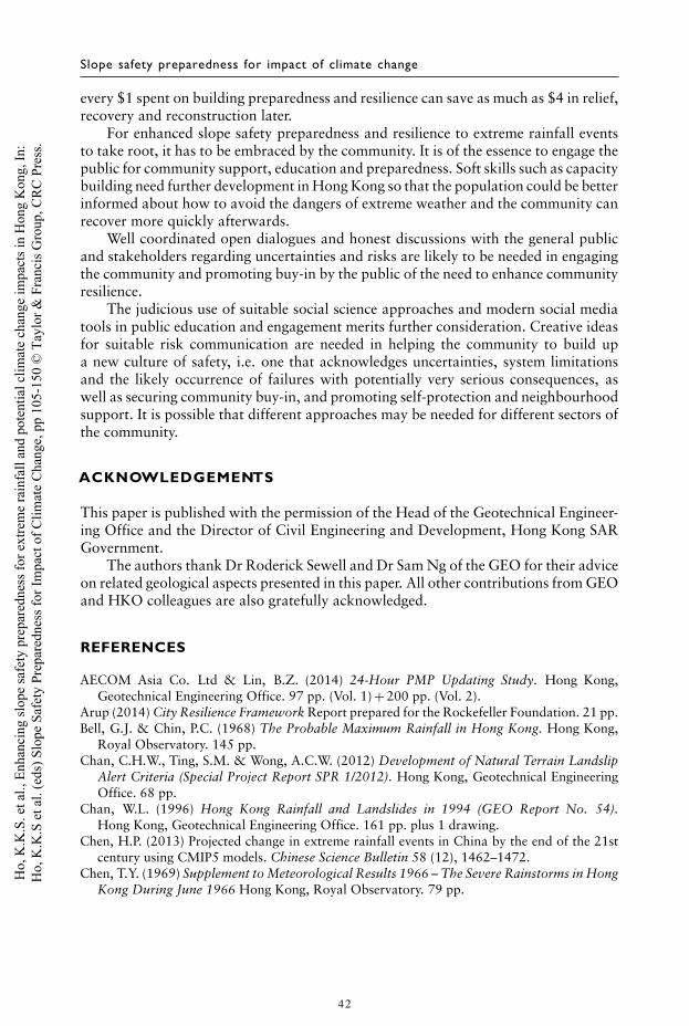
Slope safety preparedness for impact of climate change
every $1 spent on building preparedness and resilience can save as much as $4 in relief,recovery and reconstruction later.
For enhanced slope safety preparedness and resilience to extreme rainfall eventsto take root, it has to be embraced by the community. It is of the essence to engage thepublic for community support, education and preparedness. Soft skills such as capacitybuilding need further development in Hong Kong so that the population could be betterinformed about how to avoid the dangers of extreme weather and the community canrecover more quickly afterwards.
Well coordinated open dialogues and honest discussions with the general publicand stakeholders regarding uncertainties and risks are likely to be needed in engagingthe community and promoting buy-in by the public of the need to enhance communityresilience.
The judicious use of suitable social science approaches and modern social mediatools in public education and engagement merits further consideration. Creative ideasfor suitable risk communication are needed in helping the community to build upa new culture of safety, i.e. one that acknowledges uncertainties, system limitationsand the likely occurrence of failures with potentially very serious consequences, aswell as securing community buy-in, and promoting self-protection and neighbourhoodsupport. It is possible that different approaches may be needed for different sectors ofthe community.
ACKNOWLEDGEMENTS
This paper is published with the permission of the Head of the Geotechnical Engineer-ing Office and the Director of Civil Engineering and Development, Hong Kong SARGovernment.
The authors thank Dr Roderick Sewell and Dr Sam Ng of the GEO for their adviceon related geological aspects presented in this paper. All other contributions from GEOand HKO colleagues are also gratefully acknowledged.
REFERENCES
AECOM Asia Co. Ltd & Lin, B.Z. (2014) 24-Hour PMP Updating Study. Hong Kong,Geotechnical Engineering Office. 97 pp. (Vol. 1) + 200 pp. (Vol. 2).
Arup (2014) City Resilience Framework Report prepared for the Rockefeller Foundation. 21 pp.Bell, G.J. & Chin, P.C. (1968) The Probable Maximum Rainfall in Hong Kong. Hong Kong,
Royal Observatory. 145 pp.Chan, C.H.W., Ting, S.M. & Wong, A.C.W. (2012) Development of Natural Terrain Landslip
Alert Criteria (Special Project Report SPR 1/2012). Hong Kong, Geotechnical EngineeringOffice. 68 pp.
Chan, W.L. (1996) Hong Kong Rainfall and Landslides in 1994 (GEO Report No. 54).Hong Kong, Geotechnical Engineering Office. 161 pp. plus 1 drawing.
Chen, H.P. (2013) Projected change in extreme rainfall events in China by the end of the 21stcentury using CMIP5 models. Chinese Science Bulletin 58 (12), 1462–1472.
Chen, T.Y. (1969) Supplement to Meteorological Results 1966 – The Severe Rainstorms in HongKong During June 1966 Hong Kong, Royal Observatory. 79 pp.
42
Ho,
K.K
.S. e
t al.,
Enh
anci
ng sl
ope
safe
ty p
repa
redn
ess f
or e
xtre
me
rain
fall
and
pote
ntia
l clim
ate
chan
ge im
pact
s in
Hon
g K
ong,
In:
Ho,
K.K
.S e
t al.
(eds
) Slo
pe S
afet
y Pr
epar
edne
ss fo
r Im
pact
of C
limat
e C
hang
e, p
p 10
5-15
0 ©
Tay
lor &
Fra
ncis
Gro
up, C
RC
Pre
ss.
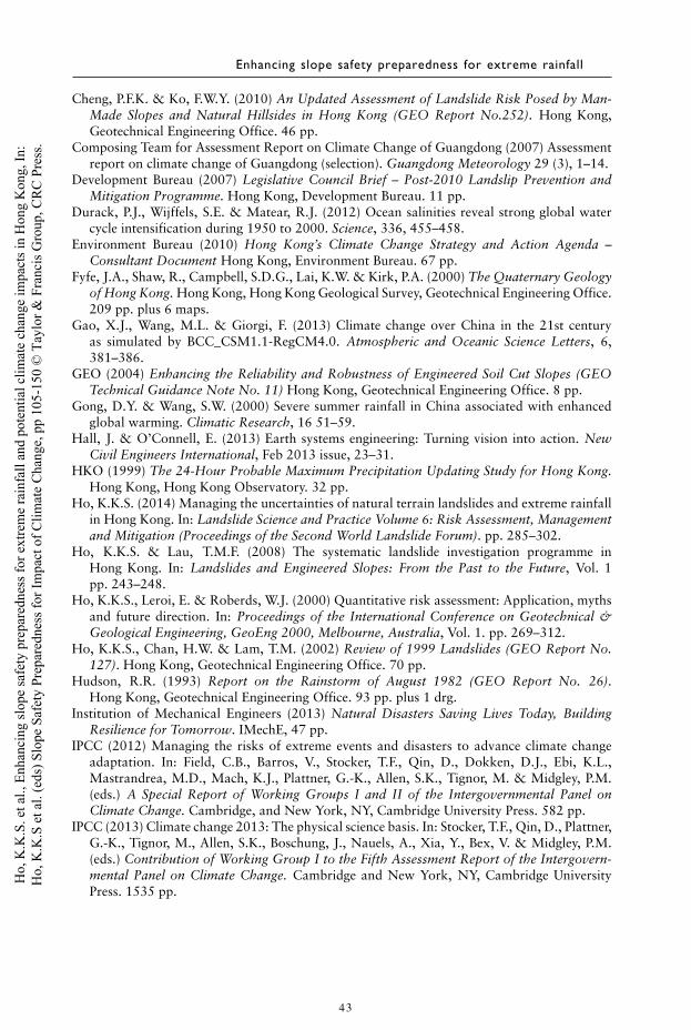
Enhancing slope safety preparedness for extreme rainfall
Cheng, P.F.K. & Ko, F.W.Y. (2010) An Updated Assessment of Landslide Risk Posed by Man-Made Slopes and Natural Hillsides in Hong Kong (GEO Report No.252). Hong Kong,Geotechnical Engineering Office. 46 pp.
Composing Team for Assessment Report on Climate Change of Guangdong (2007) Assessmentreport on climate change of Guangdong (selection). Guangdong Meteorology 29 (3), 1–14.
Development Bureau (2007) Legislative Council Brief – Post-2010 Landslip Prevention andMitigation Programme. Hong Kong, Development Bureau. 11 pp.
Durack, P.J., Wijffels, S.E. & Matear, R.J. (2012) Ocean salinities reveal strong global watercycle intensification during 1950 to 2000. Science, 336, 455–458.
Environment Bureau (2010) Hong Kong’s Climate Change Strategy and Action Agenda –Consultant Document Hong Kong, Environment Bureau. 67 pp.
Fyfe, J.A., Shaw, R., Campbell, S.D.G., Lai, K.W. & Kirk, P.A. (2000) The Quaternary Geologyof Hong Kong. Hong Kong, Hong Kong Geological Survey, Geotechnical Engineering Office.209 pp. plus 6 maps.
Gao, X.J., Wang, M.L. & Giorgi, F. (2013) Climate change over China in the 21st centuryas simulated by BCC_CSM1.1-RegCM4.0. Atmospheric and Oceanic Science Letters, 6,381–386.
GEO (2004) Enhancing the Reliability and Robustness of Engineered Soil Cut Slopes (GEOTechnical Guidance Note No. 11) Hong Kong, Geotechnical Engineering Office. 8 pp.
Gong, D.Y. & Wang, S.W. (2000) Severe summer rainfall in China associated with enhancedglobal warming. Climatic Research, 16 51–59.
Hall, J. & O’Connell, E. (2013) Earth systems engineering: Turning vision into action. NewCivil Engineers International, Feb 2013 issue, 23–31.
HKO (1999) The 24-Hour Probable Maximum Precipitation Updating Study for Hong Kong.Hong Kong, Hong Kong Observatory. 32 pp.
Ho, K.K.S. (2014) Managing the uncertainties of natural terrain landslides and extreme rainfallin Hong Kong. In: Landslide Science and Practice Volume 6: Risk Assessment, Managementand Mitigation (Proceedings of the Second World Landslide Forum). pp. 285–302.
Ho, K.K.S. & Lau, T.M.F. (2008) The systematic landslide investigation programme inHong Kong. In: Landslides and Engineered Slopes: From the Past to the Future, Vol. 1pp. 243–248.
Ho, K.K.S., Leroi, E. & Roberds, W.J. (2000) Quantitative risk assessment: Application, mythsand future direction. In: Proceedings of the International Conference on Geotechnical &Geological Engineering, GeoEng 2000, Melbourne, Australia, Vol. 1. pp. 269–312.
Ho, K.K.S., Chan, H.W. & Lam, T.M. (2002) Review of 1999 Landslides (GEO Report No.127). Hong Kong, Geotechnical Engineering Office. 70 pp.
Hudson, R.R. (1993) Report on the Rainstorm of August 1982 (GEO Report No. 26).Hong Kong, Geotechnical Engineering Office. 93 pp. plus 1 drg.
Institution of Mechanical Engineers (2013) Natural Disasters Saving Lives Today, BuildingResilience for Tomorrow. IMechE, 47 pp.
IPCC (2012) Managing the risks of extreme events and disasters to advance climate changeadaptation. In: Field, C.B., Barros, V., Stocker, T.F., Qin, D., Dokken, D.J., Ebi, K.L.,Mastrandrea, M.D., Mach, K.J., Plattner, G.-K., Allen, S.K., Tignor, M. & Midgley, P.M.(eds.) A Special Report of Working Groups I and II of the Intergovernmental Panel onClimate Change. Cambridge, and New York, NY, Cambridge University Press. 582 pp.
IPCC (2013) Climate change 2013: The physical science basis. In: Stocker, T.F., Qin, D., Plattner,G.-K., Tignor, M., Allen, S.K., Boschung, J., Nauels, A., Xia, Y., Bex, V. & Midgley, P.M.(eds.) Contribution of Working Group I to the Fifth Assessment Report of the Intergovern-mental Panel on Climate Change. Cambridge and New York, NY, Cambridge UniversityPress. 1535 pp.
43
Ho,
K.K
.S. e
t al.,
Enh
anci
ng sl
ope
safe
ty p
repa
redn
ess f
or e
xtre
me
rain
fall
and
pote
ntia
l clim
ate
chan
ge im
pact
s in
Hon
g K
ong,
In:
Ho,
K.K
.S e
t al.
(eds
) Slo
pe S
afet
y Pr
epar
edne
ss fo
r Im
pact
of C
limat
e C
hang
e, p
p 10
5-15
0 ©
Tay
lor &
Fra
ncis
Gro
up, C
RC
Pre
ss.
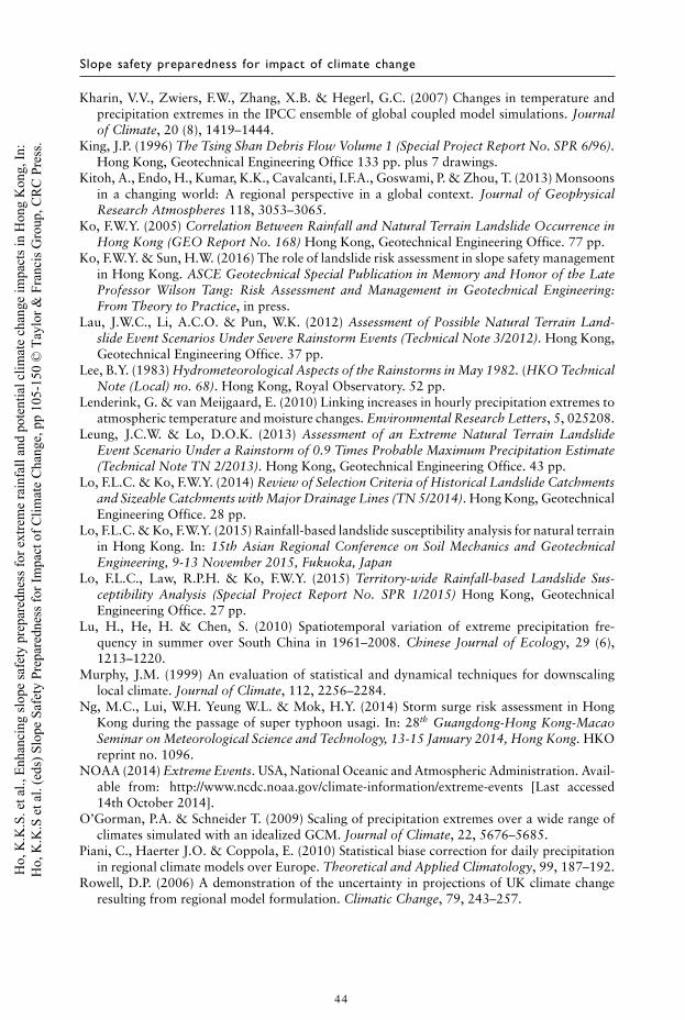
Slope safety preparedness for impact of climate change
Kharin, V.V., Zwiers, F.W., Zhang, X.B. & Hegerl, G.C. (2007) Changes in temperature andprecipitation extremes in the IPCC ensemble of global coupled model simulations. Journalof Climate, 20 (8), 1419–1444.
King, J.P. (1996) The Tsing Shan Debris Flow Volume 1 (Special Project Report No. SPR 6/96).Hong Kong, Geotechnical Engineering Office 133 pp. plus 7 drawings.
Kitoh, A., Endo, H., Kumar, K.K., Cavalcanti, I.F.A., Goswami, P. & Zhou, T. (2013) Monsoonsin a changing world: A regional perspective in a global context. Journal of GeophysicalResearch Atmospheres 118, 3053–3065.
Ko, F.W.Y. (2005) Correlation Between Rainfall and Natural Terrain Landslide Occurrence inHong Kong (GEO Report No. 168) Hong Kong, Geotechnical Engineering Office. 77 pp.
Ko, F.W.Y. & Sun, H.W. (2016) The role of landslide risk assessment in slope safety managementin Hong Kong. ASCE Geotechnical Special Publication in Memory and Honor of the LateProfessor Wilson Tang: Risk Assessment and Management in Geotechnical Engineering:From Theory to Practice, in press.
Lau, J.W.C., Li, A.C.O. & Pun, W.K. (2012) Assessment of Possible Natural Terrain Land-slide Event Scenarios Under Severe Rainstorm Events (Technical Note 3/2012). Hong Kong,Geotechnical Engineering Office. 37 pp.
Lee, B.Y. (1983) Hydrometeorological Aspects of the Rainstorms in May 1982. (HKO TechnicalNote (Local) no. 68). Hong Kong, Royal Observatory. 52 pp.
Lenderink, G. & van Meijgaard, E. (2010) Linking increases in hourly precipitation extremes toatmospheric temperature and moisture changes. Environmental Research Letters, 5, 025208.
Leung, J.C.W. & Lo, D.O.K. (2013) Assessment of an Extreme Natural Terrain LandslideEvent Scenario Under a Rainstorm of 0.9 Times Probable Maximum Precipitation Estimate(Technical Note TN 2/2013). Hong Kong, Geotechnical Engineering Office. 43 pp.
Lo, F.L.C. & Ko, F.W.Y. (2014) Review of Selection Criteria of Historical Landslide Catchmentsand Sizeable Catchments with Major Drainage Lines (TN 5/2014). Hong Kong, GeotechnicalEngineering Office. 28 pp.
Lo, F.L.C. & Ko, F.W.Y. (2015) Rainfall-based landslide susceptibility analysis for natural terrainin Hong Kong. In: 15th Asian Regional Conference on Soil Mechanics and GeotechnicalEngineering, 9-13 November 2015, Fukuoka, Japan
Lo, F.L.C., Law, R.P.H. & Ko, F.W.Y. (2015) Territory-wide Rainfall-based Landslide Sus-ceptibility Analysis (Special Project Report No. SPR 1/2015) Hong Kong, GeotechnicalEngineering Office. 27 pp.
Lu, H., He, H. & Chen, S. (2010) Spatiotemporal variation of extreme precipitation fre-quency in summer over South China in 1961–2008. Chinese Journal of Ecology, 29 (6),1213–1220.
Murphy, J.M. (1999) An evaluation of statistical and dynamical techniques for downscalinglocal climate. Journal of Climate, 112, 2256–2284.
Ng, M.C., Lui, W.H. Yeung W.L. & Mok, H.Y. (2014) Storm surge risk assessment in HongKong during the passage of super typhoon usagi. In: 28th Guangdong-Hong Kong-MacaoSeminar on Meteorological Science and Technology, 13-15 January 2014, Hong Kong. HKOreprint no. 1096.
NOAA (2014) Extreme Events. USA, National Oceanic and Atmospheric Administration. Avail-able from: http://www.ncdc.noaa.gov/climate-information/extreme-events [Last accessed14th October 2014].
O’Gorman, P.A. & Schneider T. (2009) Scaling of precipitation extremes over a wide range ofclimates simulated with an idealized GCM. Journal of Climate, 22, 5676–5685.
Piani, C., Haerter J.O. & Coppola, E. (2010) Statistical biase correction for daily precipitationin regional climate models over Europe. Theoretical and Applied Climatology, 99, 187–192.
Rowell, D.P. (2006) A demonstration of the uncertainty in projections of UK climate changeresulting from regional model formulation. Climatic Change, 79, 243–257.
44
Ho,
K.K
.S. e
t al.,
Enh
anci
ng sl
ope
safe
ty p
repa
redn
ess f
or e
xtre
me
rain
fall
and
pote
ntia
l clim
ate
chan
ge im
pact
s in
Hon
g K
ong,
In:
Ho,
K.K
.S e
t al.
(eds
) Slo
pe S
afet
y Pr
epar
edne
ss fo
r Im
pact
of C
limat
e C
hang
e, p
p 10
5-15
0 ©
Tay
lor &
Fra
ncis
Gro
up, C
RC
Pre
ss.
Enhancing slope safety preparedness for extreme rainfall
Santer, B.D., Mears, C., Wentz, F.J., Taylor, K.E., Gleckler, P.J., Wigley, T.M.L., Barnett, T.P.,Boyle, J.S., Brüggemann, W., Gillett, N.P., Klein, S.A., Meehl, G.A., Nozawa, T., Pierce,D.W., Stott, P.A., Washington, W.M. & Wehner, M.F. (2007) Identification of human-inducedchanges in atmospheric moisture content. Proceedings of the National Academy of Scienceof the United States of America, 104, 15248–15253.
Sewell, R.J. & Campbell., S.D.G. (2005) Report on the Dating of Natural Terrain Landslides inHong Kong (GEO Report No. 170). Hong Kong, Geotechnical Engineering Office. 154 pp.
Sewell, R.J., Barrows, T.T., Campbell, S.D.G. & Fifield, L.K. (2006) Exposure dating (10Be, 26Al)of natural terrain landslides in Hong Kong, China. Geological Society of America SpecialPapers 2006, 415, 131–146.
Sewell, R.J., Wong, J.C.F. & Wang N.S. (2013) The potential relationship between land-slide activity and climate change – Dating of Ancient debris fan complexes, Lantau Island,Hong Kong. In: American Geophysical Union Fall Meeting, San Francisco, 9–13 December2013 – Poster Session
Sun, H.W., Evans, N.C. & Pang, P.L.R. (2001) Possible extreme landslide event scenarios forHong Kong. In: Ho, S. & Li, K.S. (eds.) Proceedings of the Fourteenth Southeast AsianGeotechnical Conference Hong Kong/10-14 December 2001, Geotechnical EngineeringMeeting Society’s Needs Vol. 3. pp. 225–230.
Sun, Y. & Ding, Y.H. (2009) A projection of future changes in summer precipitation andmonsoon in East Asia. Science China Earth Sciences, 53 (2), 284–300.
Tam, R.C.K. & Lui, B.L.S. (2013) Public education and engagement in landslip preventionand hazard mitigation In: Paper Submitted to the International Conference on Post-disasterReconstruction – Sichuan 5.12 Hong Kong, The Hong Kong Institution of Engineers.9 pp.
Tang, C.S.C. & Cheung, S.P.Y. (2011) Frequency analysis of extreme rainfall values. In: Pro-ceedings of the HKIE Geotechnical Division Annual Seminar on Landslide Risk Reductionthrough Works: Thirty-Five Years of Landslip Preventive Measures Programme and BeyondHong Kong, Hong Kong Institution of Engineers pp. 204–209
Wang, L. & Chen, W. (2014) Equiratio cumulative distribution function matching as an improve-ment to the equidistant approach in bias correction of precipitation. Atmospheric ScienceLetters, 15, 1–6.
Wang, Y. & Zhou, L. (2005) Observed trends in extreme precipitation events in China dur-ing 1961–2001 and the associated changes in large-scale circulation. Geophysical ResearchLetters, 32, L09707.
Wentz, F.J., Ricciardulli, L. Hilburn, K. & Mears, C. (2007) How much more rain will globalwarming bring? Science, 317 233–235.
WMO (2009) Manual on Estimation of Probable Maximum Precipitation (PMP) (WMO-No.1045). Geneva, World Meteorological Organisation. 257 pp.
Wong, A.C.W., Ting, S.M., Shiu, Y.K. & Ho, K.K.S. (2014) Latest developments of Hong Kong’slandslip warning system. In: Proceedings of World Landslide Forum 3, 2–6 June 2014,Beijing. 6 pp.
Wong, H.N. (2005) Landslide risk assessment for individual facilities. In: Proceedings of theInternational Conference on Landslide Risk Management, Vancouver, Canadabreak pp. 237–296.
Wong, H.N. (2009) Rising to the challenges of natural terrain landslides. Natural hillsides: Studyand risk management measures. In: Proceedings of the 29th Annual Seminar of the HKIEGeotechnical Division, Hong Kong, 17 April 2009. Hong Kong, Hong Kong Institution ofEngineers. pp. 15–53.
Wong, H.N. (2013) Enhancing the resilience of slope safety system against extreme events. In:The International Conference on Sichuan Reconstruction – The Review and Prospects ofSichuan (5.12) Post-Disaster Reconstruction. Hong Kong. 11 pp.
45
Ho,
K.K
.S. e
t al.,
Enh
anci
ng sl
ope
safe
ty p
repa
redn
ess f
or e
xtre
me
rain
fall
and
pote
ntia
l clim
ate
chan
ge im
pact
s in
Hon
g K
ong,
In:
Ho,
K.K
.S e
t al.
(eds
) Slo
pe S
afet
y Pr
epar
edne
ss fo
r Im
pact
of C
limat
e C
hang
e, p
p 10
5-15
0 ©
Tay
lor &
Fra
ncis
Gro
up, C
RC
Pre
ss.
Slope safety preparedness for impact of climate change
Wong, H.N. & Ho, K.K.S. (1995) General Report on Landslips on 5 November 1993 at Man-Made Features in Lantau (GEO Report No. 44). Hong Kong, Geotechnical EngineeringOffice. 78 pp.
Wong, H.N., Chen, Y.M. & Lam, K.C. (1997) Factual Report on the November 1993 NaturalTerrain Landslides in Three Study Areas on Lantau Island (GEO Report No. 61). Hong Kong,Geotechnical Engineering Office. 42 pp.
Wong, H.N., Pang, L.S., Wong, A.C.W., Pun, W.K. & Yu, Y.F. (1999) Application of PrescriptiveMeasures to Slopes and Retaining Walls (GEO Report No. 56). 2nd edition Hong Kong,Geotechnical Engineering Office. 73 pp.
Wong, H.N., Ko, F.W.Y. & Hui, T.H.H. (2006) Assessment of Landslide Risk of Natural Hill-sides in Hong Kong (GEO Report No. 191). Hong Kong, Geotechnical Engineering Office.117 pp.
Wong, M.C. & Mok, H.Y. (2009) Trends in Hong Kong climate parameters relevant to engi-neering design. In: Presented in HKIE Civil Division Conference 2009, January 2009. HKOreprint no. 832.
Wu, H.Y., Du, Y.D., Chen, Z.H., Pan, W.J. & Duan, H.L. (2011) Climatic variations of wetdays and rain intensity in South China. Journal of Tropical Meteorology 27, 877–888.
Yu, Y.F. (2004) Correlations Between Rainfall, Landslide Frequency and Slope Information forRegistered Man-Made Slopes (GEO Report No. 144). Hong Kong, Geotechnical EngineeringOffice. 109 pp.
Zhai, P., Ren, F. & Zhang, Q. (1999) Detection of trends in China’s precipitation extremes. ActaMeteorologica Sinica, 57, 208–216.
Zhai, P., Zhang, X., Wan, H. & Pan, X. (2005) Trends in total precipitation and frequency ofdaily precipitation extremes over China. Journal of Climate 18, 1096–1108.
Zhang, Q., Xu, C.Y., Becker, S., Zhang, Z.X., Chen, Y.D. & Coulibaly, M. (2009) Trends andabrupt changes of precipitation maxima in the Pearl River Basin, China. Atmospheric ScienceLetters, 10 (2), 132–144.
Zhou, B., Wen, Q.H., Xu, Y., Song, L. & Zhang, X. (2014) Projected changes in temperature andprecipitation extremes in China by the CMIP5 multimodel ensembles. Journal of Climate,27, 6591–6611.
46
Ho,
K.K
.S. e
t al.,
Enh
anci
ng sl
ope
safe
ty p
repa
redn
ess f
or e
xtre
me
rain
fall
and
pote
ntia
l clim
ate
chan
ge im
pact
s in
Hon
g K
ong,
In:
Ho,
K.K
.S e
t al.
(eds
) Slo
pe S
afet
y Pr
epar
edne
ss fo
r Im
pact
of C
limat
e C
hang
e, p
p 10
5-15
0 ©
Tay
lor &
Fra
ncis
Gro
up, C
RC
Pre
ss.


