Embed Size (px)
Citation preview
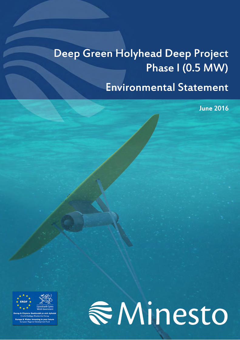
Deep Green Holyhead Deep ProjectPhase I (0.5 MW)
Environmental Statement
June 2016
Deep Green Project EIA: Coordination – Environmental Statement Assignment Number: L100194-S14 Document Number: L-100194-S14-EIAS-001 ii
Environmental Statement L100194-S14
Client: Minesto AB Document Type: Environmental Impact Assessment Document Number: L-100194-S14-EIAS-001
A01 16/06/2016 Issued for Use JDM LF LF -
R01 08/06/2016 Issued for Review JDM LF LF -
Rev Date Description Issued by
Checked by
Approved by
Client Approval
Deep Green Project EIA: Coordination – Environmental Statement Assignment Number: L100194-S14 Document Number: L-100194-S14-EIAS-001 iii
Table of Contents
ACCOMPANYING CD DOCUMENT INDEX 1
FOREWORD 3
1 INTRODUCTION 4
1.1 Introduction to Minesto 4 1.2 Background to the Project 4 1.3 Overview of the Project 5 1.4 Consenting strategy 7 1.5 Approach to EIA and document purpose 8 1.6 Data gaps and uncertainties 8 1.7 Contributors to the EIA 9 1.8 References 11
2 NEED FOR THE PROJECT 12
2.1 The need for renewable energy 12 2.2 Energy and climate change policy 12 2.3 The need to tackle climate change 14 2.4 The need to secure energy supply 14 2.5 The need for new energy infrastructure 14 2.6 The need to maximise economic opportunities 14 2.7 Benefits of tidal energy generation 15 2.8 References 15
3 PLANNING AND LEGISLATIVE REQUIREMENTS 16
3.1 Introduction 16 3.2 Marine planning framework 16 3.3 Environmental Impact Assessment legislation 18 3.4 Nature conservation legislation 18 3.5 Guidance and best practice 20 3.6 References 20
4 SITE SELECTION AND ASSESSMENT OF ALTERNATIVES 22
4.1 Introduction 22 4.2 Background to site selection 22 4.3 Site evaluation 23 4.4 Project design 25 4.5 Tidal technology 26 4.6 Device foundation 26 4.7 Conclusion 26 4.8 References 26
Deep Green Project EIA: Coordination – Environmental Statement Assignment Number: L100194-S14 Document Number: L-100194-S14-EIAS-001 iv
5 PROJECT DESCRIPTION 28
5.1 Introduction 28 5.2 Project timescale 28 5.3 Offshore infrastructure 29 5.4 Offshore installation 36 5.5 Operational stage 38 5.6 Maintenance activities 40 5.7 Decommissioning 40
6 STAKEHOLDER ENGAGEMENT 42
6.1 Background 42 6.2 Approach to stakeholder engagement 42 6.3 Pre-scoping and scoping consultation 42 6.4 Consultation with regulators and their advisors 45 6.5 Consultation with fishing community 45 6.6 Public consultation 45 6.7 Post submission consultation 47 6.8 References 47
7 ENVIRONMENTAL OVERVIEW 48
7.1 Introduction 48 7.2 Physical characteristics 48 7.3 Biological characteristics 48 7.4 Protected sites and species 49 7.5 Human environment 50
8 ENVIRONMENTAL IMPACT ASSESSMENT (EIA) METHODOLOGY 52
8.1 Introduction 52 8.2 Approach to EIA 52 8.3 Assessment of impact 54 8.4 References 71
9 PHYSICAL PROCESSES 74
9.1 Introduction 74 9.2 Area of assessment 75 9.3 Legislation, policy and guidance 75 9.4 Scoping and consultation 77 9.5 Baseline description 78 9.6 Impact assessment 94 9.7 Impacts during construction and installation period 95 9.8 Impacts during operation and maintenance 96 9.9 Impacts during decommissioning 97 9.10 Potential variances in environmental impacts 97 9.11 Cumulative impacts 97
Deep Green Project EIA: Coordination – Environmental Statement Assignment Number: L100194-S14 Document Number: L-100194-S14-EIAS-001 v

9.12 Impact summary 99 9.13 Monitoring 99 9.14 References 99
10 BENTHIC ECOLOGY 102
10.1 Introduction 102 10.2 Area of assessment 103 10.3 Legislation, policy and guidance 103 10.4 Scoping and consultation 104 10.5 Baseline description 105 10.6 Impact assessment 132 10.7 Impacts during construction and installation period 134 10.8 Impacts during operation and maintenance 142 10.9 Impacts during decommissioning 145 10.10 Potential variances in environmental impacts 145 10.11 Cumulative impacts 145 10.12 Impact summary 148 10.13 Habitats Regulations Appraisal 149 10.14 Monitoring 149 10.15 References 149
11 MARINE MAMMALS AND MEGAFAUNA 152
11.1 Introduction 152 11.2 Area of assessment 153 11.3 Legislation, policy and guidance 153 11.4 Scoping and consultation 154 11.5 Baseline description 158 11.6 Impact assessment 190 11.7 Impacts during construction and installation 193 11.8 Impacts during operation and maintenance 200 11.9 Impacts during decommissioning 213 11.10 Potential variances in environmental impacts 213 11.11 Cumulative and in-combination impacts 214 11.12 Impact summary 216 11.13 Habitats Regulations Assessment (HRA) 217 11.14 European Protected Species (EPS) and wildlife licensing 217 11.15 Monitoring 217 11.16 References 217
12 OFFSHORE ORNITHOLOGY 224
12.1 Introduction 224 12.2 Area of assessment 225 12.3 Legislation, policy and guidance 226 12.4 Scoping and consultation 226 12.5 Baseline description 229 12.6 Impact assessment 235 12.7 Impacts during construction and installation period 239 12.8 Impacts during operation and maintenance 242
Deep Green Project EIA: Coordination – Environmental Statement Assignment Number: L100194-S14 Document Number: L-100194-S14-EIAS-001 vi

12.9 Decommissioning 248 12.10 Potential variances in environmental impacts 249 12.11 Cumulative impacts 249 12.12 Habitat Regulations Asessment 252 12.13 Monitoring 253 12.14 Impact summary 253 12.15 References 253
13 FISHERIES 256
13.1 Introduction 256 13.2 Area of assessment 256 13.3 Legislation, policy and guidance 257 13.4 Scoping and consultation 257 13.5 Baseline description 258 13.6 Impact assessment 272 13.7 Impacts during construction and installation period 274 13.8 Impacts during operation and maintenance 274 13.9 Potential variances in environmental impacts 275 13.10 Cumulative and in-combination impacts 275 13.11 Impact summary 276 13.12 Monitoring 277 13.13 References 277
14 NAVIGATION AND SHIPPING 279
14.1 Introduction 279 14.2 Area of assessment 280 14.3 Legislation, policy and guidance 280 14.4 Scoping and consultation 282 14.5 Baseline description 285 14.6 Impact assessment 300 14.7 Impacts during construction and installation period 304 14.8 Impacts during operation and maintenance 307 14.9 Impacts during decommissioning 319 14.10 Potential variances in environmental impacts 319 14.11 Cumulative impacts 320 14.12 Impact summary 322 14.13 Monitoring 327 14.14 References 327
15 MARINE ARCHAEOLOGY AND CULTURAL HERITAGE 329
15.1 Introduction 329 15.2 Area of assessment 330 15.3 Legislation, policy and guidance 331 15.4 Scoping and consultation 335 15.5 Baseline description 337 15.6 Impact assessment 355 15.7 Impacts during construction, installation, operation and maintenance periods 361 15.8 Potential impacts during decommissioning 369
Deep Green Project EIA: Coordination – Environmental Statement Assignment Number: L100194-S14 Document Number: L-100194-S14-EIAS-001 vii
15.9 Potential variances in environmental impacts 369 15.10 Cumulative impacts 369 15.11 Impact summary 370 15.12 Monitoring 371 15.13 References 371
16 SEASCAPE, LANDSCAPE AND VISUAL IMPACT ASSESSMENT 375
16.1 Introduction 375 16.2 Area of assessment 375 16.3 Legislation, policy and guidance 376 16.4 Scoping and consultation 376 16.5 Baseline description 377 16.6 Impact assessment 381 16.7 Impacts during construction, installation and operation 383 16.8 Impacts during decommissioning 386 16.9 Potential variances in environmental impacts 386 16.10 Cumulative impacts 386 16.11 Impact summary 386 16.12 References 387
17 SOCIO-ECONOMIC 419
17.1 Introduction 419 17.2 Area of assessment 420 17.3 Legislation, policy and guidance 420 17.4 Scoping and consultation 423 17.5 Baseline description 424 17.6 Impact assessment 431 17.7 Assessment of impacts 432 17.8 Cumulative impacts 433 17.9 Monitoring 434 17.10 References 434
18 HYDROCARBON AND CHEMICAL RELEASES 437
18.1 Introduction 437 18.2 Area of assessment 437 18.3 Legislation, policy and guidance 438 18.4 Scoping and consultation 438 18.5 Baseline description 439 18.6 Impact assessment 439 18.7 Impacts during all Project stages (installation, operation and decommissioning) 442 18.8 Potential variances in environmental impacts 445 18.9 Cumulative and in-combination impacts 445 18.10 Impact summary 445 18.11 Monitoring 446 18.12 References 446
19 OTHER SEA USERS 447
Deep Green Project EIA: Coordination – Environmental Statement Assignment Number: L100194-S14 Document Number: L-100194-S14-EIAS-001 viii
19.1 Introduction 447 19.2 Area of assessment 447 19.3 Legislation, policy and guidance 448 19.4 Scoping and consultation 448 19.5 Baseline description 449 19.6 Impact assessment 453 19.7 Impacts during construction and installation period 455 19.8 Impacts during operation and maintenance 457 19.9 Potential variances in environmental impacts 458 19.10 Cumulative and in-combination impacts 458 19.11 Impact summary 459 19.12 Monitoring 459 19.13 References 460
20 ENVIRONMENTAL MANAGEMENT AND MONITORING 461
20.1 Introduction 461 20.2 Environmental Management Plan (EMP) 461 20.3 Environmental Monitoring Strategy (EMS) 466 20.4 Interface with contractors 469 20.5 Environmental awareness and training 469
ACRONYMS AND UNITS 470
GLOSSARY 478
Deep Green Project EIA: Coordination – Environmental Statement Assignment Number: L100194-S14 Document Number: L-100194-S14-EIAS-001 ix
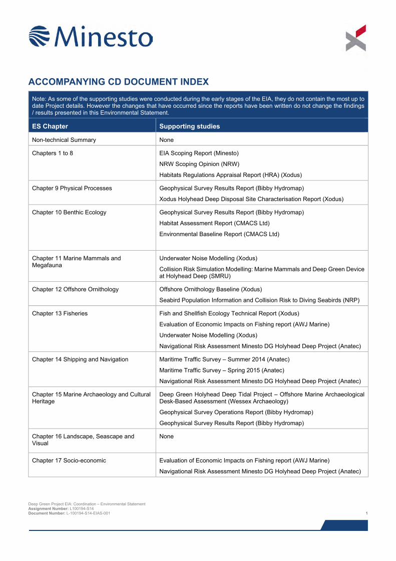
ACCOMPANYING CD DOCUMENT INDEX Note: As some of the supporting studies were conducted during the early stages of the EIA, they do not contain the most up to date Project details. However the changes that have occurred since the reports have been written do not change the findings / results presented in this Environmental Statement.
ES Chapter Supporting studies
Non-technical Summary None
Chapters 1 to 8 EIA Scoping Report (Minesto)
NRW Scoping Opinion (NRW)
Habitats Regulations Appraisal Report (HRA) (Xodus)
Chapter 9 Physical Processes Geophysical Survey Results Report (Bibby Hydromap)
Xodus Holyhead Deep Disposal Site Characterisation Report (Xodus)
Chapter 10 Benthic Ecology Geophysical Survey Results Report (Bibby Hydromap)
Habitat Assessment Report (CMACS Ltd)
Environmental Baseline Report (CMACS Ltd)
Chapter 11 Marine Mammals and Megafauna
Underwater Noise Modelling (Xodus)
Collision Risk Simulation Modelling: Marine Mammals and Deep Green Device at Holyhead Deep (SMRU)
Chapter 12 Offshore Ornithology Offshore Ornithology Baseline (Xodus)
Seabird Population Information and Collision Risk to Diving Seabirds (NRP)
Chapter 13 Fisheries Fish and Shellfish Ecology Technical Report (Xodus)
Evaluation of Economic Impacts on Fishing report (AWJ Marine)
Underwater Noise Modelling (Xodus)
Navigational Risk Assessment Minesto DG Holyhead Deep Project (Anatec)
Chapter 14 Shipping and Navigation Maritime Traffic Survey – Summer 2014 (Anatec)
Maritime Traffic Survey – Spring 2015 (Anatec)
Navigational Risk Assessment Minesto DG Holyhead Deep Project (Anatec)
Chapter 15 Marine Archaeology and Cultural Heritage
Deep Green Holyhead Deep Tidal Project – Offshore Marine Archaeological Desk-Based Assessment (Wessex Archaeology)
Geophysical Survey Operations Report (Bibby Hydromap)
Geophysical Survey Results Report (Bibby Hydromap)
Chapter 16 Landscape, Seascape and Visual
None
Chapter 17 Socio-economic Evaluation of Economic Impacts on Fishing report (AWJ Marine)
Navigational Risk Assessment Minesto DG Holyhead Deep Project (Anatec)
Deep Green Project EIA: Coordination – Environmental Statement Assignment Number: L100194-S14 Document Number: L-100194-S14-EIAS-001 1
Note: As some of the supporting studies were conducted during the early stages of the EIA, they do not contain the most up to date Project details. However the changes that have occurred since the reports have been written do not change the findings / results presented in this Environmental Statement.
ES Chapter Supporting studies
Chapter 18 Hydrocarbon and Chemical Releases
Navigational Risk Assessment Minesto DG Holyhead Deep Project (Anatec)
Chapter 19 Other Sea Users Holyhead Deep Disposal Site Characterisation Report (Xodus)
Navigational Risk Assessment Minesto DG Holyhead Deep Project (Anatec)
Chapter 20 Environmental Management and Monitoring
None
Deep Green Project EIA: Coordination – Environmental Statement Assignment Number: L100194-S14 Document Number: L-100194-S14-EIAS-001 2
FOREWORD The DG Holyhead Deep Project will be the first full-scale deployment of Minesto’s tidal energy concept, Deep Green, which uses underwater ‘kites’ to generate electricity. Deep Green’s ability to operate in deep water sites and low velocity currents will open up new areas to tidal energy projects and it is expected to provide significant advantages over fixed turbine technologies in terms of efficiency and operational costs. The Project will pave the way for the first full-scale commercial deployment, representing an important step towards Wales fulfilling its potential to become a world leader in marine renewable energy.
Minesto was founded in 2007 for the purpose of developing the Deep Green technology. The company’s headquarters are located in Gothenburg, Sweden, our prototype testing facility is in Portaferry, Northern Ireland, and we recently opened our UK headquarters in Holyhead, Anglesey. To date, our work has focused on developing the Deep Green technology and demonstrating its viability through basin tests and field trials in Strangford Lough, Northern Ireland, using 1:10 and 1:4 scale devices. The next step is to deploy a full scale device. Following a comprehensive site selection study, the Holyhead Deep in North Wales was selected as the ideal location to deploy the Project, providing deep water and favourable tidal conditions in close proximity to port facilities and viable grid connection options for the future. An additional benefit is the potential for sharing future project infrastructure with Morlais Marine Energy, who are developing the West of Anglesey Tidal Demonstration Zone, increasing cost efficiency whilst minimising the combined environmental footprint of the projects.
This Environmental Statement is the result of nearly two years’ multi-disciplinary environmental research and stakeholder consultation. We are highly aware of the special character of the marine environment in North Wales and the responsibility we have to preserve it. We hope that this is clearly demonstrated through the approach with which we have carried out the research, consultation and project design that contributed to the environmental impact assessment.
It is our intention to be transparent and communicative in all of our work, and we are committed to maintaining effective dialogue with all interested parties. Thus far, we have consulted with a wide range of stakeholder groups and organisations and have incorporated their concerns and observations when making project decisions. In our view, consultation is an ongoing process which we will continue after the submission of the application throughout the duration of the Project, should we obtain consent.
The submission of this document is a critical step for the Project, and we welcome the opportunity it provides for all interested parties to take part in the decision making process. Should consent for the Project be granted, it will represent a significant milestone in the journey towards the marine renewable energy and with it, the opportunity to create a prosperous and sustainable industry in Wales.
The predicted positive impacts of marine renewables to the Welsh and UK economy is significant with an estimated 19,500 jobs being created by 2035 and associated revenue generation estimated at £6.1 billion. In recognition of the significant potential of the Project to positively impact the socio-economic landscape of the region, the Welsh European Funding Office has publicly pledged to award Minesto £9.5 million of European Union funds to help make a positive impact on North Wales through clean energy generation, job creation and economic growth. We will continue our work with regional development organisations such as Mentor Môn, and the North Wales supply chain, in order to attract inward investment and diversify the existing skills base.
Delivering this Project so it does not affect the integrity of the environment, fully complies with all environmental obligations, and capitalises on the opportunity to confer economic benefits to the region is a fundamental priority to Minesto. We hope that on consideration of this document, you will agree that we have a sound understanding of what is required to achieve these goals, and look forward to continuing our dialogue with all interested parties.
Dr. Martin Edlund
Managing Director
Deep Green Project EIA: Coordination – Environmental Statement Assignment Number: L100194-S14 Document Number: L-100194-S14-EIAS-001 3
1 INTRODUCTION
1.1 Introduction to Minesto Minesto is a marine energy technology company founded in 2007 whose majority owners are BGA Invest and Midroc New Technology. Minesto’s headquarters are in Gothenburg, Sweden, and the company also has offices in Portaferry on the edge of Strangford Lough, Northern Ireland, and in Anglesey, North Wales.
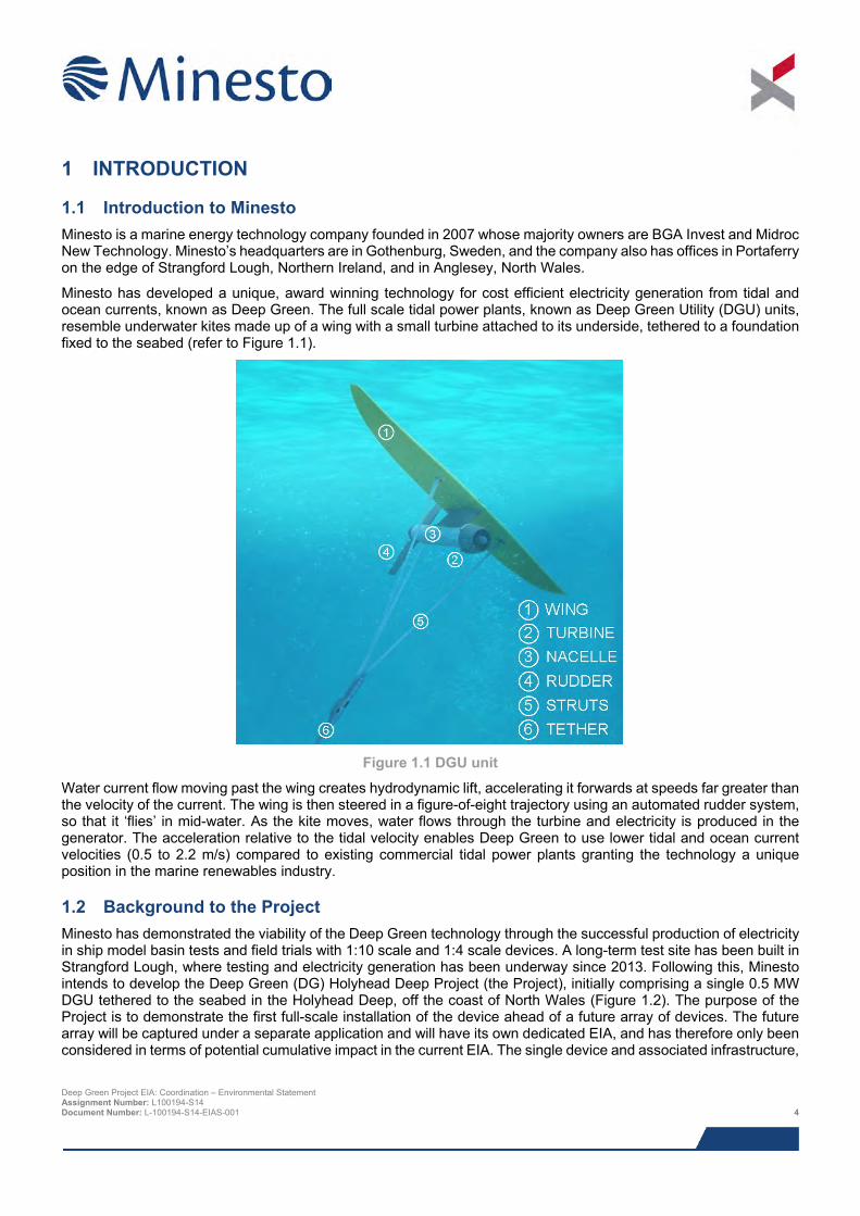
Minesto has developed a unique, award winning technology for cost efficient electricity generation from tidal and ocean currents, known as Deep Green. The full scale tidal power plants, known as Deep Green Utility (DGU) units, resemble underwater kites made up of a wing with a small turbine attached to its underside, tethered to a foundation fixed to the seabed (refer to Figure 1.1).
Figure 1.1 DGU unit
Water current flow moving past the wing creates hydrodynamic lift, accelerating it forwards at speeds far greater than the velocity of the current. The wing is then steered in a figure-of-eight trajectory using an automated rudder system, so that it ‘flies’ in mid-water. As the kite moves, water flows through the turbine and electricity is produced in the generator. The acceleration relative to the tidal velocity enables Deep Green to use lower tidal and ocean current velocities (0.5 to 2.2 m/s) compared to existing commercial tidal power plants granting the technology a unique position in the marine renewables industry.
1.2 Background to the Project Minesto has demonstrated the viability of the Deep Green technology through the successful production of electricity in ship model basin tests and field trials with 1:10 scale and 1:4 scale devices. A long-term test site has been built in Strangford Lough, where testing and electricity generation has been underway since 2013. Following this, Minesto intends to develop the Deep Green (DG) Holyhead Deep Project (the Project), initially comprising a single 0.5 MW DGU tethered to the seabed in the Holyhead Deep, off the coast of North Wales (Figure 1.2). The purpose of the Project is to demonstrate the first full-scale installation of the device ahead of a future array of devices. The future array will be captured under a separate application and will have its own dedicated EIA, and has therefore only been considered in terms of potential cumulative impact in the current EIA. The single device and associated infrastructure,
Deep Green Project EIA: Coordination – Environmental Statement Assignment Number: L100194-S14 Document Number: L-100194-S14-EIAS-001 4
will be tested for a period of up to 5 years. At the end of this period the single device will either be decommissioned or incorporated the array, subject to the relevant permissions.
The Holyhead Deep has been chosen for a number of reasons:
> Tidal velocities off the north-west coast of Anglesey are highly suitable for the Deep Green technology requirements, falling within the operational range (0.5 – 2.2 m/s) for energy generation more than 70% of the time and within the optimal range (1 – 2.2 m/s) around 50% of the time;
> Proximity to a major port and harbour (Holyhead) with sufficient resources to support manufacture, installation and maintenance activities;
> Unique collaborative research opportunities offered by Bangor University and SEACAMS;
> Strong commitment from the Welsh Government to marine renewable energy generation;
> Suitably deep waters within relatively close proximity to shore (6 km) with large and flat area of seabed to accommodate the device and with room for expansion of the Project if required; and
> Both Holy Island and Anglesey have appropriate and accessible electrical grid connections (relevant for the potential future deployment of an array).
1.3 Overview of the Project In June 2014 Minesto was awarded an Agreement for Lease (AfL) by The Crown Estate (TCE), for up to a 10 MW Commercial Demonstration installation of an array of tidal devices in an area known as the Holyhead Deep. Although the AfL does not give consent for Minesto to develop the site, it does allow Minesto exclusive rights to investigate the feasibility of developing the Project, whilst seeking the necessary development consent(s) from the regulatory authorities. The AfL is positioned within the Holyhead Deep dredge disposal site and in close proximity to the West Anglesey Demonstration Zone (WADZ) (Figure 1.2). The adjacent WADZ project will seek to provide a consented tidal technology demonstration zone for tidal technology developers to install and test arrays of tidal energy converters, with the potential to deliver up to 100 MW of tidal energy (Morlais, 2015). Minesto is exploring future opportunities for collaboration with Morlais Marine Energy (referred to as Morlais from hereon in), the manager of the WADZ project, which will help reduce costs and minimise the combined environmental footprint of the two projects.
Minesto has designated a subsection in the southern half of the AfL where they will identify the most suitable location for the DGU; this is referred to as the Project Development Area (PDA). The PDA, AfL and an indicative Project footprint and schematic are displayed in Figure 1.2, however, the exact position of the DGU within the PDA is yet to be determined.
The DGU unit is made up of a hydrodynamic wing with a turbine and generator attached to its underside. Three struts connect the wing to a specially designed tether attached to a bottom joint, which can either be fastened to a foundation structure on the seabed or the underside of a moored barge or similar such surface platform, such as a moored vessel or self-contained buoy. Electricity generated by the DGU unit will be transported via a subsea umbilical running to an electricity meter1 located on the barge (or similar such surface platform). The umbilical also allows communication between the DGU and barge.
During operation, the device will ‘fly’ in the water column, generally at depths between 20 to 60 m. The device will at all times maintain a depth greater than 12.5 m below the sea surface. Following an initial commissioning period, the DGU will be attached to a foundation on the seabed. However, during the initial testing and commissioning the DGU can also be operated in ‘upside-down mode’, with the tether attached to the bottom of the barge. The DGU unit can operate in the same area of the water column regardless of the attachment point.
1 A self-contained electrical system designed to allow the DGU to operate remotely without a grid connection. The system will provide a means of dissipating the energy generated by the DGU, in addition to monitoring and characterising the energy output of the device. Deep Green Project EIA: Coordination – Environmental Statement Assignment Number: L100194-S14 Document Number: L-100194-S14-EIAS-001 5
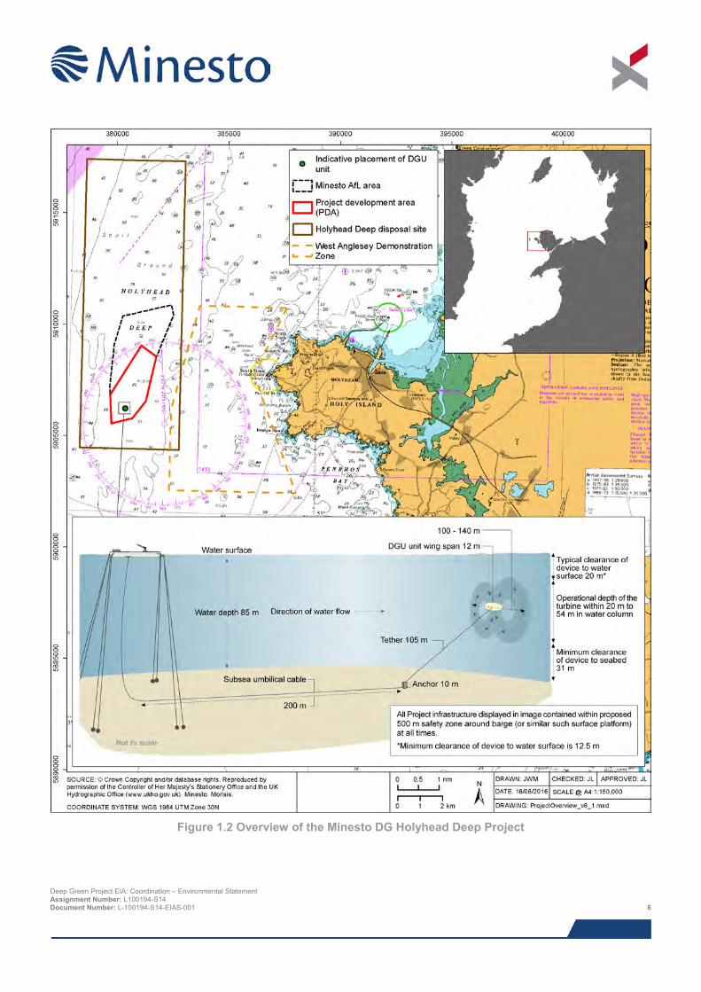
Figure 1.2 Overview of the Minesto DG Holyhead Deep Project
Deep Green Project EIA: Coordination – Environmental Statement Assignment Number: L100194-S14 Document Number: L-100194-S14-EIAS-001 6
The centre of the Holyhead Deep AfL is approximately 6.5 km west of Holy Island, Anglesey, North Wales, located in a large depression in the seabed known as the Holyhead Deep, where depths range from approximately 50 to 96 m. Mean depth-averaged tidal currents within the PDA are around 1.0 m/s, with maximum flow speeds in the region of 2.5 m/s.
1.4 Consenting strategy The proposed consenting strategy for the DG Holyhead Deep Project has been developed in discussion with Natural Resources Wales (NRW), the Marine Management Organisation (MMO) and the Island of Anglesey County Council (IACC) through the screening and scoping process. This initial application (ahead of a future application for a larger grid connected array) is for the deployment of a single 0.5 MW DGU unit, only producing electricity to a meter located on a barge moored offshore.
A Marine Licence under the Marine and Coastal Access Act 2009 (the Marine Act) is required for the construction and operation of the Project. To support the Marine Licence application, Minesto has been required, due to the novel nature of the Project, to produce an ES under the Marine Works (Environmental Impact Assessment) Regulations 2007 (as amended), in order to determine whether there is potential for the Project to have any adverse effects on the environment. The ES includes consideration of navigational issues via a Navigational Risk Assessment (NRA) as well as an evaluation of potential impacts on Natura 2000 sites and Marine Conservation Zones (MCZs) (see below).
Depending on the findings of the EIA there may also be a requirement for a European Protected Species (EPS) Licence and / or Wildlife Licence. NRW will confirm this requirement during the consent application determination period.
Potential effects of the offshore Project on sites of European nature conservation importance (Special Protection Areas (SPAs) and Special Areas of Conservation (SACs) and Ramsar sites) have also been assessed through a Habitats Regulations Assessment (HRA) in line with the requirements of the Habitats Directive and Conservation of Habitats and Species Regulations 2010. This has included consideration of possible SACs (pSACs) and potential SPAs (pSPAs) which went out to consultation in January 2016. Although information collated during the EIA has
Project definitions The following terminology has been used within this Environmental Statement (ES):
> Deep Green (DG) Holyhead Deep Project (the Project): the entire Project, including all offshore components, and all project stages from installation and construction to decommissioning.
> Project Development Area (PDA): subsection of the AfL area within which the tidal energy device will be installed (see Figure 1.2). The exact locations of the device within the PDA is yet to be determined.
> Deep Green: generic term referring to the technological concept developed by Minesto for tidal energy extraction using underwater kites.
> Deep Green Utility unit (DGU): DGU refers specifically to the 0.5 MW model of tidal device that will be installed as part of the Project.
> Foundation: structure placed on the seabed to which the DGU tether will be fastened.
> Upside down mode: special mode of operation in which a DGU is tethered to the underside of a barge, as opposed to the foundation structure.
> Normal mode: normal mode of operation in which a DGU is tethered to the foundation structure on the seabed.
> Barge: a barge or alternative platform structure of approximately 50 m by 12 m, with a draft of 0.5 m from which the DGU device can be tethered and controlled.
> Electricity meter: A self-contained electrical system located on the barge (or similar surface platform) designed to allow the DGU to operate remotely without a grid connection. The system will provide a means of dissipating the energy generated by the DGU, in addition to monitoring and characterising the energy output of the device
Deep Green Project EIA: Coordination – Environmental Statement Assignment Number: L100194-S14 Document Number: L-100194-S14-EIAS-001 7
informed the HRA process, the requirements for each assessment vary according to the different legislation. The results of the HRA are presented in a separate HRA Report (Xodus, 2016) which will be submitted with the ES, to determine the requirements for an Appropriate Assessment.
Under the requirements of the Marine and Coastal Access Act (MCAA) (2009); and in a similar vein to the HRA process described above, there is a need to undertake an MCZs assessment during marine licence determination. Information provided in this ES will support this process.
The licences/consents will be required to cover the construction and installation, operational and decommissioning periods of the Project, which will span a maximum of five years.
Once the Project is granted consent, the Department of Energy and Climate Change (DECC) will request production of a Decommissioning Programme which must be approved prior to the commencement of installation. This is a requirement under the Energy Act 2013.
1.5 Approach to EIA and document purpose This ES presents the results from the EIA of the DG Holyhead Deep Project. The purpose of the document is to bring together, evaluate and present succinctly the findings from a number of dedicated studies carried out as part of the EIA. The information and conclusions regarding potential significant impacts presented within this report will be considered by the regulatory authority and their advisors as part of the determination of the Marine Licence application.
As a public document, it is essential that the information included in this ES is fully accessible to all members of the public and key stakeholders to allow them to make informed views of the potential impacts of the proposed Project on the environment. All views from the public and key stakeholders must then be taken into account by the authorities when determining the consent applications. To make the document available to as wide an audience as possible, both within and outside Wales, the Non-Technical Summary has been produced in both English and Welsh.
In addition to providing information on the potential impacts associated with the installation, operation and decommissioning of the Deep Green devices and associated infrastructure, the following information is also included within this ES:
> Detailed description of the Project;
> Rationale for the selection of the site;
> Information on legislation and policy relevant to the Project; and
> A summary of all consultation activities carried out as part of the EIA.
1.6 Data gaps and uncertainties The Irish Sea has been extensively investigated by numerous researchers, meaning that this EIA has been able to draw on an extensive amount of published data. This bank of published data has been supplemented by a site survey programme and studies undertaken on behalf of Minesto to collect Project specific baseline data.
The EIA process aims to identify and characterise potential impacts using information on the current status of the environment as a basis. As potential impacts are predicted based on currently available Project and environmental information, there is some uncertainty in predictions. Impact predictions are based on Project specific surveys and the most up to date scientific knowledge and data analysis techniques currently available. Also where appropriate studies have been commissioned to inform the impact assessment.
Where uncertainty in baseline information or impact characterisation remains, this is acknowledged within this ES and an indication of its scale is provided. Data gaps and uncertainties detailed are typical of those facing offshore marine renewable projects and are not considered to be critical in assessing the broad range of impacts associated with the DG Holyhead Deep Project.
Deep Green Project EIA: Coordination – Environmental Statement Assignment Number: L100194-S14 Document Number: L-100194-S14-EIAS-001 8
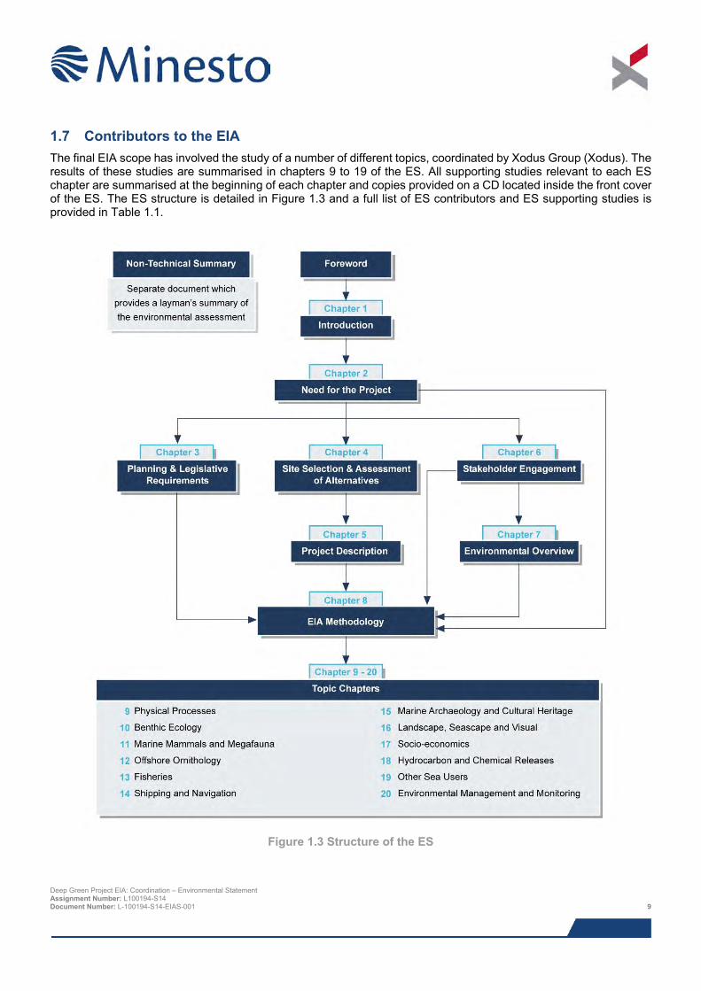
1.7 Contributors to the EIA The final EIA scope has involved the study of a number of different topics, coordinated by Xodus Group (Xodus). The results of these studies are summarised in chapters 9 to 19 of the ES. All supporting studies relevant to each ES chapter are summarised at the beginning of each chapter and copies provided on a CD located inside the front cover of the ES. The ES structure is detailed in Figure 1.3 and a full list of ES contributors and ES supporting studies is provided in Table 1.1.
Figure 1.3 Structure of the ES
Deep Green Project EIA: Coordination – Environmental Statement Assignment Number: L100194-S14 Document Number: L-100194-S14-EIAS-001 9
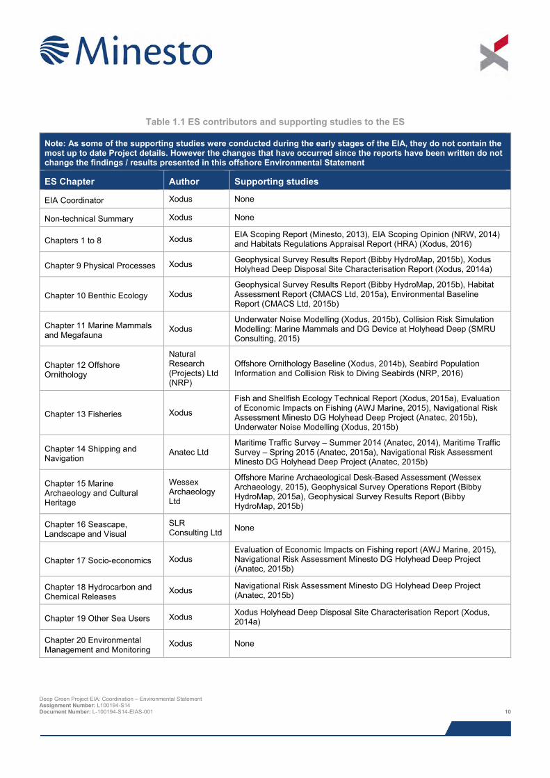
Table 1.1 ES contributors and supporting studies to the ES
Note: As some of the supporting studies were conducted during the early stages of the EIA, they do not contain the most up to date Project details. However the changes that have occurred since the reports have been written do not change the findings / results presented in this offshore Environmental Statement
ES Chapter Author Supporting studies
EIA Coordinator Xodus None
Non-technical Summary Xodus None
Chapters 1 to 8 Xodus EIA Scoping Report (Minesto, 2013), EIA Scoping Opinion (NRW, 2014) and Habitats Regulations Appraisal Report (HRA) (Xodus, 2016)
Chapter 9 Physical Processes Xodus Geophysical Survey Results Report (Bibby HydroMap, 2015b), Xodus Holyhead Deep Disposal Site Characterisation Report (Xodus, 2014a)
Chapter 10 Benthic Ecology Xodus Geophysical Survey Results Report (Bibby HydroMap, 2015b), Habitat Assessment Report (CMACS Ltd, 2015a), Environmental Baseline Report (CMACS Ltd, 2015b)
Chapter 11 Marine Mammals and Megafauna
Xodus Underwater Noise Modelling (Xodus, 2015b), Collision Risk Simulation Modelling: Marine Mammals and DG Device at Holyhead Deep (SMRU Consulting, 2015)
Chapter 12 Offshore Ornithology
Natural Research (Projects) Ltd (NRP)
Offshore Ornithology Baseline (Xodus, 2014b), Seabird Population Information and Collision Risk to Diving Seabirds (NRP, 2016)
Chapter 13 Fisheries Xodus
Fish and Shellfish Ecology Technical Report (Xodus, 2015a), Evaluation of Economic Impacts on Fishing (AWJ Marine, 2015), Navigational Risk Assessment Minesto DG Holyhead Deep Project (Anatec, 2015b), Underwater Noise Modelling (Xodus, 2015b)
Chapter 14 Shipping and Navigation
Anatec Ltd Maritime Traffic Survey – Summer 2014 (Anatec, 2014), Maritime Traffic Survey – Spring 2015 (Anatec, 2015a), Navigational Risk Assessment Minesto DG Holyhead Deep Project (Anatec, 2015b)
Chapter 15 Marine Archaeology and Cultural Heritage
Wessex Archaeology Ltd
Offshore Marine Archaeological Desk-Based Assessment (Wessex Archaeology, 2015), Geophysical Survey Operations Report (Bibby HydroMap, 2015a), Geophysical Survey Results Report (Bibby HydroMap, 2015b)
Chapter 16 Seascape, Landscape and Visual
SLR Consulting Ltd None
Chapter 17 Socio-economics Xodus Evaluation of Economic Impacts on Fishing report (AWJ Marine, 2015), Navigational Risk Assessment Minesto DG Holyhead Deep Project (Anatec, 2015b)
Chapter 18 Hydrocarbon and Chemical Releases
Xodus Navigational Risk Assessment Minesto DG Holyhead Deep Project (Anatec, 2015b)
Chapter 19 Other Sea Users Xodus Xodus Holyhead Deep Disposal Site Characterisation Report (Xodus, 2014a)
Chapter 20 Environmental Management and Monitoring
Xodus None
Deep Green Project EIA: Coordination – Environmental Statement Assignment Number: L100194-S14 Document Number: L-100194-S14-EIAS-001 10
1.8 References Anatec (2014). Maritime Traffic Survey, Summer 2014, Minesto Tidal Project. Ref: A3401-XG-TS-00. October 2014.
Anatec (2015a). Maritime Traffic Survey, March (Spring) 2015, Minesto Tidal Project. Ref: A3401-XG-TS-02. April 2015.
Anatec (2015b). Navigational Risk Assessment, Deep Green Holyhead Deep Project. Anatec October 2015. A3401-XG-NRA-1.
AWJ Marine (2015). Evaluation of Economic Impacts on Fishing. Version 4. November 2015.
Bibby HydroMap (2015a). Deep Green Project – Holyhead Deep, Volume 1 – Operations Report. Unpublished survey report, ref: REP-F015-1.
Bibby HydroMap (2015b). Deep Green Project – Holyhead Deep, Project and Export Cable Route – Offshore Survey, Volume 2 – Results Report. Unpublished survey report, ref: REP-F011-1.
CMACS (2015a). Deep Green Project – Holyhead Deep: Habitats Assessment Report. Report number J3279.
CMACS (2015b). Deep Green Project – Holyhead Deep: Benthic Technical Report. Job number 2179.
Minesto (2013). Deep Green Project. Request to Natural Resources Wales and the Marine Management Organisation for an Opinion on the Scope of the Environmental Statement. Report prepared by PMSS on behalf of Minesto. November 2013.
Morlais (2015). Morlais Tidal Demonstration Array – Scoping Report. Final Report v1 PB2735. Prepared by Royal HaskoningDHV on behalf of Morlais Energy. April 2015.
Natural Resources Wales (NRW) (2014). Scoping Opinion Under The Marine Works (Environmental Impact Assessment) Regulations 2007 (as amended). February 2014.
NRP (2015). Deep Green Holyhead Deep Project: Seabird population information and collision risk to diving seabirds. Report to Minesto. November 2015.
SMRU Consulting (2015). Collision risk simulation modelling: marine mammals and deep green device at Holyhead Deep – final report. Report number SMRUC-MIN-2015-007 provided to Minesto UK Ltd, June 2015 (unpublished).
Wessex Archaeology (2015). Deep Green Holyhead Deep Tidal Project – Onshore Historic Environment Desk-Based Assessment. Unpublished report reference 107791.03.
Xodus (2014a). Deep Green Project EIA: Coordination Holyhead Deep disposal site: characterisation and assessment of capacity to accommodate Minesto AfL. Document number L-100194-S06-REPT-001.
Xodus (2014b). Minesto Offshore Ornithology Baseline. Document number L-100194-S03-REPT-002. July 2014.
Xodus (2015a). Minesto Fish and Shellfish Ecology technical report. Document number L-100194-S01-TECH-004-R01. August 2015.
Xodus (2015b). Minesto Underwater Noise Modelling technical report. Document number L-100194-S01-TECH-006-R01. August 2015.
Xodus (2016). Deep Green Holyhead Deep – Habitats Regulations Appraisal (HRA) Report. Document number L-100194-S00-REPT-012. June 2016.
Deep Green Project EIA: Coordination – Environmental Statement Assignment Number: L100194-S14 Document Number: L-100194-S14-EIAS-001 11

2 NEED FOR THE PROJECT
2.1 The need for renewable energy The UK has committed to sourcing 15% of its total energy needs from renewable sources by 2020 under the 2009 Directive on Renewable Energy (2009/28/EC) including electricity, heat and transport. The UK and Welsh Governments have also made legally binding commitments through the Climate Change Act 2008 which sets the legally binding target of an 80% cut in greenhouse emissions by 2050.
The two main aims of the Act are to:
> Improve carbon management in the UK, helping the transition towards a low-carbon economy; and
> Demonstrate UK leadership internationally, signalling commitment to taking an appropriate share of responsibility for reducing global emissions in the context of developing international negotiations.
There are four key drivers for the shift in energy production to low carbon sources, including renewable energy, in the UK and Wales which are:
> The need to tackle climate change;
> The need to secure energy supply;
> The need for new energy infrastructure; and
> The need to maximise economic opportunities.
The Welsh Government has also made a commitment in its Energy Wales: A Low Carbon Transition document (Welsh Government, 2014) stating “Our aim is that by 2025 up to twice as much renewable electricity is generated annually in Wales as today. By 2050 our aim is that almost all our local energy needs are met by low carbon electricity production.” The percentage of electricity generated from renewable sources in Wales was 10.1% in 2013.
2.2 Energy and climate change policy The challenges of climate change, energy supply and security of supply are driving policy on renewable energy developments. There are now a significant number of national and international policies, strategies and regulations relating to climate change and the development of renewable energy in Europe, the UK and Wales. The DG Holyhead Deep Project will provide valuable insight into being able to deploy this technology on a larger scale, and in the longer term make a contribution to achieving relevant International, European, UK and Welsh policy aims including for example:
> Kyoto protocol;
> EU Renewable Energy Directive (2009/28/EC);
> UK Climate Change Act 2008;
> Climate Change Strategy for Wales, 2010; and
> Energy Wales: A Low Carbon Transition, 2014.
Figure 2.1 illustrates key legislation and policy relating to climate change and energy.
Deep Green Project EIA: Coordination – Environmental Statement Assignment Number: L100194-S14 Document Number: L-100194-S14-EIAS-001 12
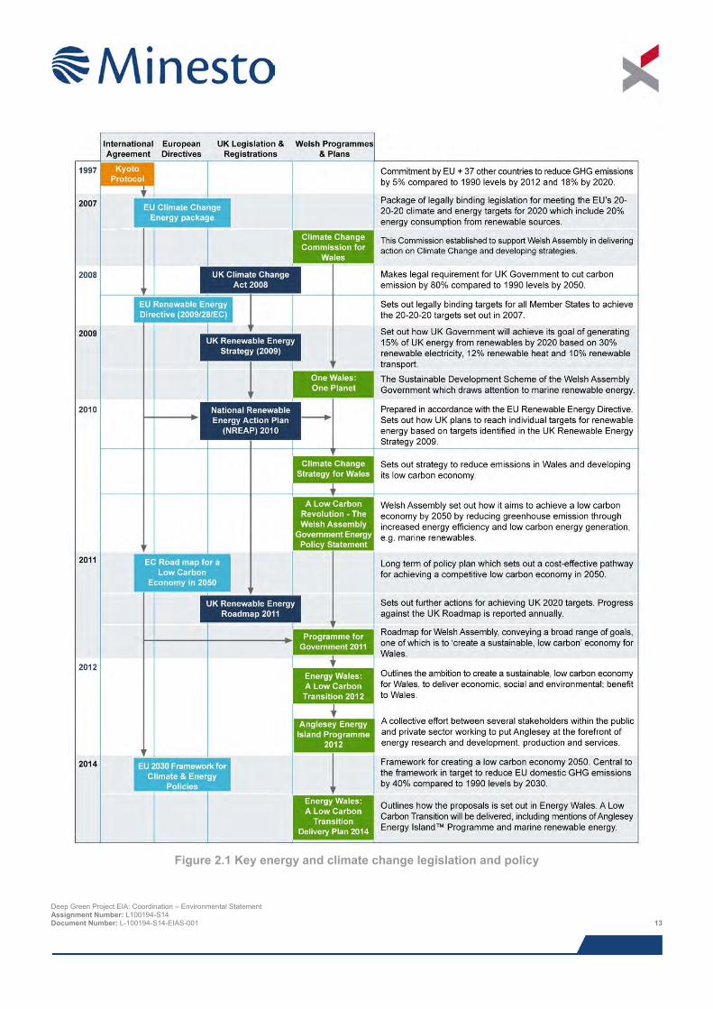
Figure 2.1 Key energy and climate change legislation and policy
Deep Green Project EIA: Coordination – Environmental Statement Assignment Number: L100194-S14 Document Number: L-100194-S14-EIAS-001 13
2.3 The need to tackle climate change The potential effects of climate change are well documented. Future climate will depend on committed warming caused by past anthropogenic emissions, as well as future anthropogenic emissions and natural climate variability, but the projected increase in global mean surface temperature by the end of the 21st Century (relative to 1986 to 2005 levels), is likely to be between 0.3 and 4.8°C (IPCC, 2014). This would make extreme weather events like floods and droughts more frequent, and increase global instability, conflict, public health-related deaths and migration of people to levels beyond any recent experience (DECC, 2011). Within the UK it is considered that heat waves, droughts, and floods would become more prevalent (DECC, 2011).
Climate change also poses a significant economic threat. The Stern Review (Stern, 2006) estimates the cost of acting to reduce emissions to a level consistent with avoiding dangerous climate change would around 1% to 2% of gross domestic product (GDP) by 2050, whereas the cost of doing nothing to tackle climate change will cost between 5 to 20% of GDP.
2.4 The need to secure energy supply Indigenous energy production with the UK has fallen year on year since 1999 and, in 2004, the United Kingdom became a net energy importer, with net imports accounting for 46% of energy used in the UK in 2014 (DECC, 2015). This reliance has long been identified as an unsustainable energy model. It puts the UK at both financial and demand risk through increased global competition for resources combined with increased national growth.
Without action the UK will become even more reliant on imported energy sources and would have greater exposure to global energy price fluctuations. In 2009, the UK Government released the Low Carbon Transition Plan (HM Government, 2009) which outlines how the UK will cut greenhouse gas emissions compared to 1990 levels, by 34% by 2020. This Plan identified that a reduction in reliance on fossil fuels will achieve greater security of future energy supplies (HM Government, 2009).
2.5 The need for new energy infrastructure There are four key themes driving the requirement for new energy infrastructure within the UK:
> Currently three quarters of UK electricity comes from coal and gas. To meet climate change targets by 2050, virtually all electricity will need to come from zero carbon energy generation such as renewable sources, nuclear or fossil fuel (where they employ carbon capture and storage techniques) (DECC, 2009);
> There will be an increased emphasis on electricity as the source for supporting the heat and transport sectors. This could see the UK's demand for electricity in 2050 increasing to 50% higher than it is today, making it possible that electricity could account for half of the UK's overall energy use (DECC, 2009);
> As the UK moves to low carbon energy sources it is acknowledged that there will be a need for net additional electricity generating infrastructure to ensure adequate supplies because of changes in the nature and location of generating capacity. It is estimated that this will require about 43 GW net of new capacity by 2020 and about 60 GW by 2025 (DECC, 2011); and
> This rise in electricity demand will coincide with the scheduled closure of around sixteen power stations by 2018 representing approximately 25% (18 GW) of our electricity generating capacity and also the decline of North Sea oil and gas reserves (DECC, 2010 and DECC, 2009).
In the UK, at least 22 GW of existing electricity generating capacity will need to be replaced in the coming years, particularly by 2020. This is as a result of tightening environmental regulation and ageing power stations.
2.6 The need to maximise economic opportunities The energy industries in the UK play a central role in the economy and supporting a key commitment within the UK’s Low Carbon Transition Plan to help make the UK a centre of green industry by supporting the development and use of clean technologies (HM Government, 2009).
Deep Green Project EIA: Coordination – Environmental Statement Assignment Number: L100194-S14 Document Number: L-100194-S14-EIAS-001 14
The energy industries in the UK play a central role in the economy. In 2014, the energy industries contributed 2.8% of GDP and directly employed over 162,000 people (5.9% of industrial employment) (DECC, 2015). In addition the number of people employed through low carbon and environmental goods and services in the UK was 937,923 in 2012 and for the same year the value was estimated at £128.1 billion (Department for Business, Innovation and Skills, 2013). It is estimated that employment levels could rise to more than a million people by 2020 if the UK is able to maximise the opportunity presented by being a world leader in low carbon technologies.
2.7 Benefits of tidal energy generation Tidal energy is a form of low carbon electricity generation benefitting from a predictability of generation as it is powered by the tides which, unlike other forms of renewable energy production, are not affected by weather conditions. Tidal energy schemes such as the Project will be a significant contribution to the mix of energy sources.
This Project will be a key milestone towards meeting UK and Welsh targets, as it will provide key lessons on how to deploy this technology at a larger scale and pave the way for future developments.
2.8 References Department of Energy and Climate Change (DECC) (2011). Overarching National Policy Statement for Energy (EN-1). July 2011.
Department of Energy and Climate Change (DECC) (2015). Digest of United Kingdom Energy Statistics (DUKES) 2015. A National Statistics Publication. 2015
Department for Business, Innovation and Skills, (2013). Low Carbon Environmental Goods and Services Report 2011/2012. Available from: https://www.gov.uk/government/uploads/system/uploads/attachment_data/file/224068/bis-13-p143-low-carbon-and-environmental-goods-and-services-report-2011-12.pdf [Accessed 03/11/2015].
HM Government (2009a). The UK Low Carbon Transition Plan: National Strategy for Climate and Energy. July 2009. Available from: https://www.gov.uk/government/uploads/system/uploads/attachment_data/file/228752/9780108508394.pdf [Accessed 03/11/2015].
HM Government (2009b). The UK Renewable Energy Strategy. July 2009. Available from: https://www.gov.uk/government/uploads/system/uploads/attachment_data/file/228866/7686.pdf [Accessed 03/11/2015].
Intergovernmental Panel on Climate Change (IPCC) (2014). Climate Change 2014: Synthesis Report. Contribution of Working Groups I, II and III to the Fifth Assessment Report of the Intergovernmental Panel on Climate Change. IPCC, Geneva, Switzerland, 151 pp.
Stern, N. (2006). The Stern Review: The Economics of Climate Change. Available from: http://webarchive.nationalarchives.gov.uk/20100407172811/http://www.hm-treasury.gov.uk/d/Part_1_Introduction.pdf [Accessed 03/11/2015].
Welsh Government (2011). Programme for Government. 2011. Available from: http://gov.wales/docs/strategies/110929fullen.pdf [Accessed 03/11/2015].
Welsh Government (2012). Energy Wales: A Low Carbon Transition. March 2012. Available from: http://gov.wales/docs/desh/publications/120314energywalesen.pdf [Accessed 03/11/2015].
Welsh Government (2014). Energy Wales: A Low Carbon Transition Deliver Plan. March 2014. Available from: http://gov.wales/docs/desh/publications/140314energy-wales-delivery-plan-en.pdf [Accessed 03/11/2015].
Deep Green Project EIA: Coordination – Environmental Statement Assignment Number: L100194-S14 Document Number: L-100194-S14-EIAS-001 15
3 PLANNING AND LEGISLATIVE REQUIREMENTS
3.1 Introduction This chapter discusses the international, UK, Welsh, regional and local planning and environmental policies and legislation that are directly relevant to the Project. Key information included in this chapter includes:
> Marine policy and legislation;
> Environmental Impact Assessment (EIA) legislation; and
> Environmental protection and nature conservation legislation.
3.2 Marine planning framework
3.2.1 The Marine Act The Marine and Coastal Access Act 2009 (the Marine Act) came into force in November 2009 covering UK offshore waters (12 to 200 nm) (22 to 370 km) and English and Welsh territorial waters (0 to 12 nm) (0 to 22 km). The Marine Act amends the Government of Wales Act 2006 to define the area of sea adjacent to Wales out the Welsh/Irish median line in the Irish Sea as the Welsh Zone. A range of powers relating to the management of the Welsh Zone have been devolved to Welsh Ministers including:
> Marine planning;
> Marine nature conservation; and
> Marine licensing.
3.2.1.1 Marine planning
3.2.1.1.1 Marine Strategy Framework Directive (MSFD) The EU Marine Strategy Framework Directive 2008/56/EC (MSFD) was formally adopted in July 2008 and was transposed into UK Legislation under the Marine Strategy Regulations 2010 on 15th July 2010. The Directive is the environmental pillar of the Integrated European Maritime Policy which focuses on the development of a coherent, co-ordinated and integrated approach to the management of marine environment through marine planning. The MSFD constitutes a vital environmental component of the European Union’s future maritime policy and is designed to achieve full economic potential of oceans and seas in harmony with the marine environment (MSFD, 2015).
The main requirement of the MSFD is for Member States to prepare national strategies, including marine spatial plans, to manage their seas to achieve Good Environmental Status (GES) by 2020 at the latest (Welsh Government, 2015).
In December 2012, the UK Marine Strategy Part 1 was published. This included an assessment of UK marine waters; proposals on defining GES and developing targets and indicators for achieving and monitoring GES. Provisions for Wales to work with other UK administrations e.g. Scottish Government, DEFRA and the DoENI towards achieving GES are set out under the MSFD (DEFRA, 2012).
In July 2014, Part two of the Marine Strategy was published by the UK government to establish and implement coordinated monitoring programmes for the ongoing assessment of the environmental status of marine waters around the UK (DEFRA, 2014). Part 3 of the Marine Strategy was established at the end of 2015, setting out a programme of measures to enable the achievement of GES. These measures are to be fully implemented throughout UK waters by the end of 2016.
Deep Green Project EIA: Coordination – Environmental Statement Assignment Number: L100194-S14 Document Number: L-100194-S14-EIAS-001 16
3.2.1.1.2 Marine policy statement The UK Marine Policy Statement (MPS) applies to all UK waters and has been adopted by the UK Government, the Scottish Government, the Welsh Assembly Government and the Northern Ireland Executive. The function of the MPS is to provide the framework for preparing Marine Plans and taking decisions affecting the marine environment. All national and regional marine plans must be in conformity with the MPS.
The objectives of the MPS are to:
> Promote sustainable economic development; enable the UK’s move towards a low-carbon economy, in order to mitigate the causes of climate change and ocean acidification and adapt to their effects;
> Ensure a sustainable marine environment which promotes healthy, functioning marine ecosystems and protects marine habitats, species and our heritage assets; and
> Contribute to the societal benefits of the marine area, including the sustainable use of marine resources to address local social and economic issues.
The MPS emphasises the importance of renewable energy and recognises the importance of considering marine renewable projects in marine planning, stating that "Contributing to securing the UK's energy objectives, while protecting the environment, will be a priority for marine planning".
3.2.1.1.3 National Marine Plan for Wales In March 2011, the Welsh Government adopted the UK MPS through which they are committed to develop and implement a Marine Plan for Wales. The National Marine Plan for Wales (NMPW) is currently being developed. An initial draft of the plan has been produced and formal consultation on the draft plan will commence this year. The plan will cover a 20 year period providing policy guidance, and set specific objectives for each region and guide developers about how and what activities can be carried out and will provide consistency in the decision making process.
3.2.1.1.4 The Planning (Wales) Act The Planning (Wales) Act received Royal Assent on the 7th July 2015, setting out a series of legislative changes to deliver reform of the planning system in Wales. It will establish a National Development Framework which will help Welsh Ministers to make decisions on Development of National Significance including renewable energy generation schemes in Welsh territorial waters up to 350 MW (onshore and offshore).
3.2.1.2 Marine nature conservation Under the Marine Act, the Welsh Government can designate Marine Conservation Zones (MCZs) in Welsh waters. The aim of MCZs is to halt the deterioration of the UK’s marine biodiversity, recover damaged habitats, and promote healthy ecosystem functioning. It is intended that the new designation will exist alongside the existing marine nature conservation sites (collectively referred to as Marine Protected Areas (MPAs)) described below to produce an ecologically coherent network:
> Natura sites:
o Special Areas of Conservation (SACs) designated under the EC Habitats Directive (Directive 92/43/EEC on the conservation of natural habitats and of wild fauna and flora) for the protection of rare and vulnerable habitats and species listed under Annexes I and II respectively; and
o Special Protection Areas (SPAs) designated under the Birds Directive (Directive 2009/147/EC on the conservation of wild birds) for the protection of rare and vulnerable birds listed under Annex of the Directive and regularly occurring migratory species.
> Wetlands of international importance (Ramsar sites) designated under the Ramsar Convention (Convention on Wetlands of International Importance especially as Waterfowl Habitat);
> Sites of Special Scientific Interest (SSSIs) designated for nationally important habitats and species in Wales, England and Scotland; and
Deep Green Project EIA: Coordination – Environmental Statement Assignment Number: L100194-S14 Document Number: L-100194-S14-EIAS-001 17
> Marine Nature Reserves (MNRs) for nationally important habitats and species.
3.2.1.3 Marine Licensing The Marine Licensing Team in Natural Resources Wales (NRW) administer marine licences on behalf of the Welsh Government who are the licensing authority for the Welsh inshore waters. Part 4 of the Marine Act introduced a system of marine licensing which allowed for the use of special procedures in respect of certain electricity works in parts of the UK. Marine Licences are required for a range of projects requiring the construction, alteration or improvement of new marine works or alteration or improvement of any existing works. This includes the construction of renewable energy generating infrastructure. Marine Licences are also required for projects involving the deposition or removal of any substance or object in or from the sea – or on or under the sea bed, using a vehicle, vessel, aircraft, a marine structure or floating container.
3.2.2 Electricity Act 1989 In Welsh Territorial Waters, planning consent for offshore renewable energy generation with a capacity of between 1 MW and 100 MW is determined under Section 36 of the Electricity Act. The responsibility for processing marine renewable energy projects requiring consideration under the Electricity Act lies with the Marine Management Organisation (MMO). As the current Project is under 1 MW capacity, no Section 36 consent is required.
3.3 Environmental Impact Assessment legislation The requirements for carrying out an EIA are set out under Directive 85/337/EEC on the assessment of the effects of certain public and private developments on the environment (“the EIA Directive”) as amended by Council Directives 97/11/EC, 2003/35/EC and 2009/31/EC. The European Commission (EC) has now brought the 1985 Directive and its three subsequent revisions into one single codified Directive without making changes to existing provisions.
The purpose of the EIA Directive is to ensure that the Competent Authority, in relation to development that is likely to have significant effects on the environment, has appropriate information to enable it to come to a decision on whether or not to grant consent. The EIA Directive sets out procedures that must be followed for such projects before they can be given 'development consent'.
Where a development is deemed to need an EIA, environmental information must be provided by the developer in the form of an Environmental Statement (ES). The Competent Authority cannot grant consent for an EIA development without taking into account an ES.
The requirements of the EIA Directive are transposed in to UK law though a series of EIA regulations. The regulations that apply to this Project, as confirmed by NRW, are The Marine Works (Environmental Impact Assessment) Regulations 2007 (as amended).
3.4 Nature conservation legislation
3.4.1 Habitats and Birds Directive The Habitats Directive affords protection to European sites designated under the Habitats Directive (Special Areas of Conservation (SACs)) and the Birds Directive (Special Protection Areas (SPAs), collectively referred to as Natura 2000 or European sites. Under Article 6(3) of the Habitats Directive (EC Directive 92/43/EEC on the conservation of natural habitats and of wild flora and fauna) “any plan or project which is not directly connected with or necessary to the management of a European site but would be likely to have a significant effect on such as site, either individually or in-combination with other plans and projects, shall be subject to an appropriate assessment of its implications for the European site in view of the site’s conservation objectives”.
The Habitats Directive applies the precautionary principle to these sites and projects can only be permitted when it is ascertained that there will be no adverse effect on the integrity of the site(s) in question. Where adverse effects are identified a project may only be permitted in the absence of alternative solutions if there is an Imperative Reason of Overriding Public Interest (IROPI) for the project to go head. Where this is the case, Member States are required to take all compensatory measures necessary to ensure that the overall coherence of the Natura 2000 network is protected. Deep Green Project EIA: Coordination – Environmental Statement Assignment Number: L100194-S14 Document Number: L-100194-S14-EIAS-001 18
The Habitats Directive is transposed in Wales by the Conservation of Habitats and Species Regulations 2010 which covers onshore areas and territorial waters (out to 12 nm) (22 km). In accordance with these Regulations, the effects of a project on the integrity of a European site are assessed and evaluated as part of the Habitat Regulations Assessment (HRA) process. This process draws heavily on the findings of the EIA and the methodology and findings of the Minesto HRA are presented in the accompanying HRA Report (Xodus, 2016). It has included consideration of possible SACs (pSACs) and potential SPAs (pSPAs) which went out to consultation in January 2016.
3.4.2 Marine Conservation Zone (MCZ) assessment Under the requirements of the Marine and Coastal Access Act (MCAA) (2009) all marine licence applications are assessed to determine whether;
> The licensable activity is taking place within or near an area being put forward or already designated as an MCZ; or
> The activity is capable of affecting (other than insignificantly) either (i) the protected features of an MCZ; or (ii) any ecological or geomorphological process on which the conservation of any protected feature of an MCZ is (wholly or in part) dependant.
The closest MCZ to the Project is over 100 km to the north east. Based on the potential impacts predicted from the Project, it is not considered to be capable of affecting either protected features, or ecological or geomorphological processes on which the conservation of any protected features are dependant.
3.4.3 Wildlife licences NRW is the licensing authority in Welsh inshore waters (out to 12 nm) (22 km). Wildlife licences are required under the following legislation:
> Wildlife and Countryside Act 1981; and
> Conservation of Habitats and Species Regulations 2010.
For any European Protected Species (EPS), Part 3 of the Conservation of Habitats and Species Regulations 2010 makes it an offence to deliberately capture, kill, injure, or disturb any such animal. An EPS Licence is required for any activity that might result in injury to, or disturbance of, an EPS. Deliberate harm to any EPS is not anticipated as part of the Project; however, inadvertent or accidental disturbance may occur if project activities take place in the presence of an EPS.
Basking sharks are protected under Schedule 5 of the Wildlife and Countryside Act 1981 which prohibits the killing, injuring or taking by any method of those wild animals listed on Schedule 5 of the Act. Licensing requirements under the Wildlife and Countryside Act 1981 are similar to those for European Protected Species (EPS) protected under Annex IV of the Habitats Directive.
NRW will determine specific licensing requirements based on the information contained in this ES, as part of the application determination.
3.4.4 Other conservation legislation As detailed in the NRW tidal stream energy checklist for the West of Holy Island, Anglesey (2014), the EIA should include assessment of possible impacts on:
> Sites of Special Scientific Interest (SSSI), which are nationally important sites, notified under the Wildlife and Countryside Act (1981), as amended by the Countryside and Rights of Way Act (2000):
> Protected landscapes including Areas of Outstanding Natural Beauty, Heritage Coasts and Historic Landscapes; and
> Local Nature Reserves.
Deep Green Project EIA: Coordination – Environmental Statement Assignment Number: L100194-S14 Document Number: L-100194-S14-EIAS-001 19
Where appropriate the EIA has considered the potential for impacts on such sites from the offshore Project and this has been reported in relevant topic chapters in the ES.
3.5 Guidance and best practice Current best practice guidelines for EIA methodologies and licensing for offshore renewables projects have been followed in the preparation of this ES. Some of the guidance available includes:
> BSI (2015). Environmental impact assessment for offshore renewable energy projects – Guide;
> NRW (2014). Draft advice on scoping and Environmental Impact Assessment (EIA) for offshore renewable energy developments and NRW (2014). Tidal stream energy checklist – West of Holy Island, Anglesey;
> The Crown Estate (2014). Wave and tidal further leasing plan HRA: summary report for Holyhead Deep project site;
> IEMA (2011). The State of Environmental Assessment Practice in the UK;
> Institute of Environmental Management and Assessment (2004). Guidelines for Environmental Impact Assessment;
> Scottish Natural Heritage (2013). A handbook on environmental impact assessment; and
> IEEM (2010). Guidelines for Ecological Impact Assessment in Britain and Ireland - Marine and Coastal.
Other relevant guidance relating wave and tidal stream devices published for other UK members have also been used including:
> Marine Scotland (2012). Marine Scotland Licensing and Consents Manual: Covering Marine Renewables and Offshore Wind Energy Development; and
> Cefas (2012). Guidelines for data acquisition to support marine environmental assessments of offshore renewable energy projects.
Relevant guidance and best practice applying to specific EIA topics is identified in chapters 9 to 19.
3.6 References BSI (2015). Environmental impact assessment for offshore renewable energy projects – Guide. PD 6900:2015.
Cefas (2012). Guidelines for data acquisition to support marine environmental assessments of offshore renewable energy projects. 2012.
DEFRA (2012). Marine Strategy Part One: UK Initial Assessment and Good Environmental Status. Available from https://www.gov.uk/government/uploads/system/uploads/attachment_data/file/69632/pb13860-marine-strategy-part1-20121220.pdf [Accessed on 16/07/2015].
DEFRA (2014). Marine Strategy Part Two: UK Marine Monitoring Programmes. Available from https://www.gov.uk/government/uploads/system/uploads/attachment_data/file/341146/msfd-part-2-final.pdf [Accessed 16/07/2015].
Gwynedd Council (2015). Joint Local Development Plan for Anglesey and the Gwynedd Local Planning Authority Area. Available from https://www.gwynedd.gov.uk/en/Council/Strategies-and-policies/Environment-and-planning/Planning-policy/Joint-Local-Development-Plan/Joint-Local-Development-Plan.aspx [Accessed 16/07/2015].
Institute of Ecology and Environmental Management (IEEM) (2010). Guidelines for Ecological Impact Assessment in Britain and Ireland - Marine and Coastal. IEEM. 2010.
Institute of Environmental Management and Assessment (IEMA) (2004). Guidelines for Environmental Impact Assessment. IEMA. 2004.
Deep Green Project EIA: Coordination – Environmental Statement Assignment Number: L100194-S14 Document Number: L-100194-S14-EIAS-001 20
Institute of Environmental Management and Assessment (IEMA) (2011). The State of Environmental Assessment Practice in the UK. IEMA. 2011.
Marine Scotland (2012). Marine Scotland Licensing and Consents Manual: Covering Marine Renewables and Offshore Wind Energy Development. Report R.1957. October 2012.
MSFD (2013). A timeline for the implementation of the Marine Strategy Framework Directive. Available from http://www.msfd.eu/knowseas/library/timeline.pdf [Accessed 16/07/2015].
MSFD (2015). Supporting the Marine Strategy Framework Directive. MSFD. Available from http://www.msfd.eu/index.html [Accessed 16/07/2015].
PPW (2014). Planning Policy Wales Edition 7 – July 2014 Available from http://gov.wales/docs/desh/publications/140731planning-policy-wales-edition-7-en.pdf [Accessed 16/07/2015].
Scottish Natural Heritage (SNH) (2013). A handbook on environmental impact assessment. SNH. 2013.
Welsh Government (2015). Marine strategy Framework Directive. Available from http://gov.wales/topics/environmentcountryside/marineandfisheries/marine-fisheries-policy/directives/marine-strategy-framework-directive/?lang=en [Accessed 16/07/2015].
Xodus (2016). Deep Green Holyhead Deep – Habitats Regulations Appraisal (HRA) Report. Document number L-100194-S00-REPT-012. June 2016.
Deep Green Project EIA: Coordination – Environmental Statement Assignment Number: L100194-S14 Document Number: L-100194-S14-EIAS-001 21
4 SITE SELECTION AND ASSESSMENT OF ALTERNATIVES
4.1 Introduction This section describes the alternatives considered for achieving the objectives of the proposed Project and an explanation of the basis for the selection of the preferred Project.
Clearly one of the fundamental drivers of site selection for any tidal energy project is the location of tidal resource suitable for exploitation by the particular technology to be employed. In the case of Deep Green (DG), consistent low velocity currents between 0.5 m/s and 2.2 m/s represent ideal conditions. The Deep Green technology’s ability to operate in low velocity currents significantly expands the potential areas within which the Project can be delivered, but nevertheless, has specific depth, current speed and wave height constraints that require careful site selection.
There are several additional fundamental drivers of site selection which affect the technical and economic viability of a tidal energy project, including the seabed conditions, grid access (in this case for future, potential Project expansion), proximity to port and other infrastructure, business climate, governmental support, research support and stakeholder opinion.
4.2 Background to site selection The Deep Green technology has been developed in Sweden and 1:10 and 1:4 scale prototypes successfully deployed and operated in Strangford Lough, Northern Ireland. The DG Holyhead Deep Project was born out of the need to deploy, test and operate a full scale device. The Minesto site development team conducted an in-depth option analysis of low flow velocity sites around the world, following the European Marine Energy Centre (EMEC) standards for site evaluation (EMEC, 2009). The UK was identified as the most suitable location on the basis that its territorial waters contain approximately half of the European tidal resource and around 10-15% of the known global resource (Carbon Trust, 2005). Several locations around the UK were initially considered, including:
> The English Channel;
> The east coast of Northern Ireland;
> EMEC in Orkney, Scotland; and
> Welsh coast.
The combination of highly suitable conditions and a government committed to marine renewable energy make Wales an area of high strategic importance to the marine energy industry, offering significant funding opportunities and a positive business climate. The Welsh Government has taken significant steps to ensure that Wales fulfils its potential to be a world-leader in the marine energy market, having already invested £1 million through the Marine Renewable Energy Strategy Framework, worked with The Crown Estate to open Welsh sea areas with significant potential for marine renewables deployments and supported partnerships between academia, the public and private sectors. The Welsh Government made a commitment to the following:
> Lead the development of a competitive marine energy sector in Wales by helping businesses, academia and the public sector to work together;
> Work with The Crown Estate and industry to develop a marine energy leasing round for Welsh waters;
> Continue to support institutions like the Low Carbon Research Institute (LCRI) and SEACAMS to develop expertise and technologies;
> Work with partners to promote Wales as a centre for marine renewables;
> Investigate methods to advance the deployment of marine energy arrays; and
> Gear up training providers to ensure capacity exists to deliver a future workforce with the skills needed to support marine energy investments.
Deep Green Project EIA: Coordination – Environmental Statement Assignment Number: L100194-S14 Document Number: L-100194-S14-EIAS-001 22
In addition to the Welsh Government’s clear commitment to renewable energy, considerable funding resources for marine renewables are available through the EU Structural Funds programme in Wales, administered by the Welsh European Funding Office (WEFO). Between 2014 and 2020, Wales will receive European Structural Funds worth £2 billion to stimulate development in Wales and one of the appointed areas to be supported is marine renewable energy. In recognition of the of the potential offered by the DG Holyhead Deep Project, WEFO has publicly pledged to award Minesto a grant of EU funding to progress the Holyhead Deep Project
In terms of tidal resource, an in-depth options analysis was conducted. This revealed that the tidal conditions around the north-west coast of Wales are particularly well suited to the Deep Green technology, with a large resource of slow moving currents between 0.5 and 2.2 m/s. Additionally, this location’s close proximity to Bangor University offers unique collaborative research opportunities through the SEACAMS project.
4.3 Site evaluation Following the decision to investigate deployment on the coast of Wales, Minesto engaged SEACAMS to undertake a detailed modelling exercise using state-of-the-art three dimensional ocean modelling to calculate the present-day Irish Sea tidal resource (CAMS, 2012). SEACAMS used this data to undertake a site identification process, taking account of the following physical constraints:
> Suitable operational tidal velocities (0.5 to 2.2 m/s);
> Water depths (50 to 120 m);
> Significant wave heights (less than 4 m); and
> Proximity to shore.
Three broad areas were considered: north-west Anglesey, south-west Wales and the Llŷn peninsula (Figure 4.1). The modelling work showed that areas with the most favourable tidal conditions were generally close to shore. Nearshore areas are advantageous from the perspective of minimising cabling costs, but water depths at such locations tend to be too shallow to deploy the Deep Green technology. It was also determined that maximum wave heights generally diminished toward the north of the study area.
Following a detailed review of the SEACAMs modelling findings, Minesto concluded that the Holyhead Deep off the coast of north-west Anglesey was the preferred area for the following reasons:
> The site has the most favourable tidal velocities for the DGU devices, so would potentially yield the most electricity;
> Tidal velocities fall within the operational range (0.5 to 2.2 m/s) for energy generation more than 75% of the time, and are within the optimal range (1.0 to 2.2 m/s) for the Deep Green technology for almost 50% of the time;
> The large depression in the seabed, after which the Holyhead Deep is named, provides suitable depths of between 50 m and 100 m, and yet, is only 6.5 km from shore, thus minimising future cabling costs (when grid connection is potentially required) in comparison to other areas with similar depths; and
> There is a sufficiently large area of suitable seabed to accommodate potential future expansion.
The Holyhead Deep is also close to several viable grid connection points (required for the planned expansion) on Holy Island and Anglesey, and a major port and harbour (Holyhead), which will be used for manufacture, launch and maintenance. In addition, there is significant interest from tidal energy projects in the area west of Anglesey, which has the potential to provide opportunities for tidal job cluster creations, area knowledge build up and cost savings through shared works.
Deep Green Project EIA: Coordination – Environmental Statement Assignment Number: L100194-S14 Document Number: L-100194-S14-EIAS-001 23
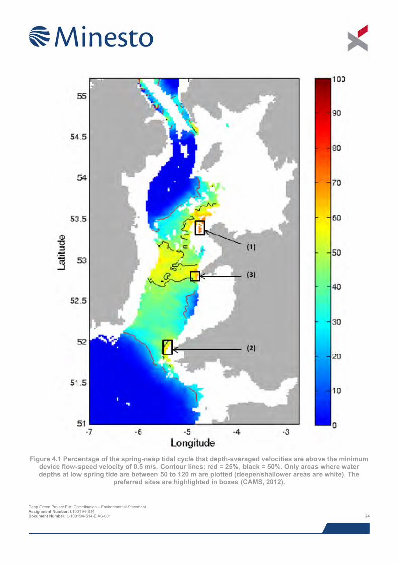
Figure 4.1 Percentage of the spring-neap tidal cycle that depth-averaged velocities are above the minimum
device flow-speed velocity of 0.5 m/s. Contour lines: red = 25%, black = 50%. Only areas where water depths at low spring tide are between 50 to 120 m are plotted (deeper/shallower areas are white). The
preferred sites are highlighted in boxes (CAMS, 2012).
Deep Green Project EIA: Coordination – Environmental Statement Assignment Number: L100194-S14 Document Number: L-100194-S14-EIAS-001 24
In June 2014 Minesto Ltd (Minesto) was awarded an Agreement for Lease (AfL) area within the Holyhead Deep by The Crown Estate (TCE). Under the AfL, Minesto has exclusive rights to investigate the opportunity for a marine tidal energy development within the allocated area. At this same time there was also an AfL area awarded to Morlais for the West Anglesey Demonstration Zone (WADZ), located at its closest 1.2 km to the east of the Minesto AfL area.
Following the award of the AfL, Minesto undertook a high level constraints mapping exercise for the AfL area, taking into account:
> Bathymetry;
> Environmental factors (species, habitats and designated sites); and
> Other sea users (navigation, fisheries, dredge disposal and navigation).
Minesto also sought consultation with Stena Line, who owns Holyhead port and uses the Holyhead Deep to dispose of dredging waste. NRW and Cefas were consulted and presented with the results of a study conducted by SEACAMS investigating the fate of dredged material deposited in Holyhead Deep, which demonstrated that the re-designation of the disposal site to accommodate the Project would have no effect on sediment transport and enable the disposal site to be reduced by 50%.
This allowed Minesto to determine an area in the south of the AfL area which represented the best location for the DGU, placing it as far as possible from the shipping lanes and dredge disposal activities to the north and offering the most suitable water depths and tidal conditions. This area is known as the Project Development Area (PDA) (Figure 1.2). The precise location of the DGU within the PDA is yet to be determined and will be subject to a detailed site evaluation process.
4.4 Project design
4.4.1 Project design process The first major milestone in the Project design process was gaining access to a suitable site by securing the AfL area through The Crown Estate. As soon as the AfL area was approved, Minesto commenced with EIA work and technology development was focussed on scaling up the existing quarter-scale Deep Green devices to the full scale DGU by evaluation of alternative design options.
The second major milestone in the Project design process was acquiring sufficient funding for the Project. Minesto was able to secure a public pledge for a grant from the Wales European Funding Office (WEFO) and Welsh Government in May 2015, as well as a €3.5M investment from KIC Innoenergy in September 2015 and €15.5M private equity in relation to an Initial Public Offering (IPO) in November 2015. This has enabled Minesto to commence with the currently ongoing Front End Engineering and Design (FEED) phase for the Project. During the initial stages of the FEED phase there has been further refinement off the offshore aspects of the Project.
The Deep Green technology development team are currently in the detailed design phase, which will be finalised by the Q3 2016. The first full scale DGU will subsequently be deployed in the PDA during spring/summer of 2017.
A brief overview of the design process for the offshore aspects of the Project is provided in the following sections.
4.4.2 DGU location The exact location of the DGU within the PDA is yet to be determined and is dependent on a number of factors, including:
> Optimal tidal resource (using measured and modelled data);
> Turbulence;
> Bathymetry;
> Seabed conditions; and
> Most cost efficient foundation design Deep Green Project EIA: Coordination – Environmental Statement Assignment Number: L100194-S14 Document Number: L-100194-S14-EIAS-001 25
In order to provide more detailed data on the above factors, SEACAMS have undertaken numerous site specific geophysical and environmental surveys of the PDA between mid-2013 and present, comprising:
> Multibeam bathymetry and backscatter;
> Pseudo side-scan sonar;
> Sub-bottom profiler;
> Acoustic Doppler Current Profiler (ADCP) deployments; and
> Benthic sediment grabs.
A further geophysical benthic survey campaign was completed in autumn 2015 by Bibby HydroMap (Bibby HydroMap, 2015; CMACS Ltd, 2015), comprising the following data:
> Multibeam bathymetry and backscatter;
> Side-scan sonar;
> Sub-bottom profiler;
> Magnetometer;
> Benthic sediment grabs; and
> Video tow and still photography.
Data from these surveys and the three dimensional modelling work undertaken by SEACAMS (SEACAMS, 2013a, 2013b) will be used to inform the final location of the DGU during the detailed design process.
4.5 Tidal technology The principal purpose of the Project is to install, test and prove the viability of the full scale Deep Green technology. Therefore, no alternative tidal technologies have been considered for the DG Holyhead Deep Project.
4.6 Device foundation There are several foundation options being considered. These options are described in Chapter 5: Project Description.
4.7 Conclusion This section of the ES has provided an overview of the evolution of the Project design to date, the alternatives that have been considered and the factors taken into account in the site selection and Project design processes. The subsequent Project description presented in Chapter 5 describes the current status of Project design for which the EIA has been undertaken.
4.8 References Bibby HydroMap (2015). Deep Green Project – Holyhead Deep Project and Export Cable Route – Offshore Survey. Volume 2 – Results Report. Bibby HydroMap Project No. 2015-021. July 2015.
CAMS (2012). Irish Sea Hydrodynamic Resource. Centre for Applied Marine Sciences, School of Ocean Sciences, Bangor University. February 2012.EMEC (2009). Assessment of Tidal Energy Resource – Marine Renewable Energy Guides. The European Marine Energy Centre Ltd. 2009.
Carbon Trust (2005). Phase II – UK Tidal Stream Energy Resource Assessment. Black & Veatch. July 2005.
CMACS Ltd (2015). Deep Green Project Holyhead Deep – Benthic technical report. CMACS Job Number: 3279. October 2015.
Deep Green Project EIA: Coordination – Environmental Statement Assignment Number: L100194-S14 Document Number: L-100194-S14-EIAS-001 26

SEACAMS (2013a). Site selection for the Minesto DGU tidal power plant – Interim Report. January 2013.
SEACAMS (2013b). Site selection for the Minesto DGU tidal power plant – Interim Report. February 2013.
Xodus (2014b). Landfall Site Evaluation – Holy Island, Anglesey, Desktop Study. L-100194-S04-REPT-001-R01. June 2014.
Deep Green Project EIA: Coordination – Environmental Statement Assignment Number: L100194-S14 Document Number: L-100194-S14-EIAS-001 27
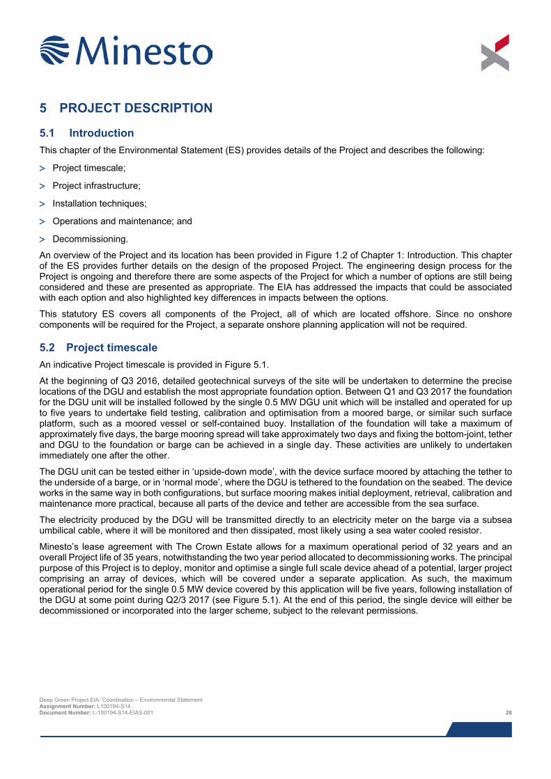
5 PROJECT DESCRIPTION
5.1 Introduction This chapter of the Environmental Statement (ES) provides details of the Project and describes the following:
> Project timescale;
> Project infrastructure;
> Installation techniques;
> Operations and maintenance; and
> Decommissioning.
An overview of the Project and its location has been provided in Figure 1.2 of Chapter 1: Introduction. This chapter of the ES provides further details on the design of the proposed Project. The engineering design process for the Project is ongoing and therefore there are some aspects of the Project for which a number of options are still being considered and these are presented as appropriate. The EIA has addressed the impacts that could be associated with each option and also highlighted key differences in impacts between the options.
This statutory ES covers all components of the Project, all of which are located offshore. Since no onshore components will be required for the Project, a separate onshore planning application will not be required.
5.2 Project timescale An indicative Project timescale is provided in Figure 5.1.
At the beginning of Q3 2016, detailed geotechnical surveys of the site will be undertaken to determine the precise locations of the DGU and establish the most appropriate foundation option. Between Q1 and Q3 2017 the foundation for the DGU unit will be installed followed by the single 0.5 MW DGU unit which will be installed and operated for up to five years to undertake field testing, calibration and optimisation from a moored barge, or similar such surface platform, such as a moored vessel or self-contained buoy. Installation of the foundation will take a maximum of approximately five days, the barge mooring spread will take approximately two days and fixing the bottom-joint, tether and DGU to the foundation or barge can be achieved in a single day. These activities are unlikely to undertaken immediately one after the other.
The DGU unit can be tested either in ‘upside-down mode’, with the device surface moored by attaching the tether to the underside of a barge, or in ‘normal mode’, where the DGU is tethered to the foundation on the seabed. The device works in the same way in both configurations, but surface mooring makes initial deployment, retrieval, calibration and maintenance more practical, because all parts of the device and tether are accessible from the sea surface.
The electricity produced by the DGU will be transmitted directly to an electricity meter on the barge via a subsea umbilical cable, where it will be monitored and then dissipated, most likely using a sea water cooled resistor.
Minesto’s lease agreement with The Crown Estate allows for a maximum operational period of 32 years and an overall Project life of 35 years, notwithstanding the two year period allocated to decommissioning works. The principal purpose of this Project is to deploy, monitor and optimise a single full scale device ahead of a potential, larger project comprising an array of devices, which will be covered under a separate application. As such, the maximum operational period for the single 0.5 MW device covered by this application will be five years, following installation of the DGU at some point during Q2/3 2017 (see Figure 5.1). At the end of this period, the single device will either be decommissioned or incorporated into the larger scheme, subject to the relevant permissions.
Deep Green Project EIA: Coordination – Environmental Statement Assignment Number: L100194-S14 Document Number: L-100194-S14-EIAS-001 28
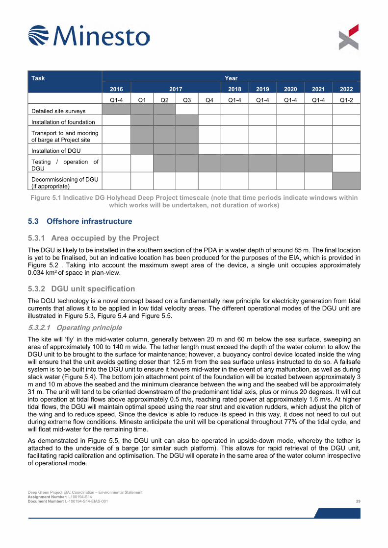
Task Year
2016 2017 2018 2019 2020 2021 2022
Q1-4 Q1 Q2 Q3 Q4 Q1-4 Q1-4 Q1-4 Q1-4 Q1-2
Detailed site surveys
Installation of foundation
Transport to and mooring of barge at Project site
Installation of DGU
Testing / operation of DGU
Decommissioning of DGU (if appropriate)
Figure 5.1 Indicative DG Holyhead Deep Project timescale (note that time periods indicate windows within which works will be undertaken, not duration of works)
5.3 Offshore infrastructure
5.3.1 Area occupied by the Project The DGU is likely to be installed in the southern section of the PDA in a water depth of around 85 m. The final location is yet to be finalised, but an indicative location has been produced for the purposes of the EIA, which is provided in Figure 5.2 . Taking into account the maximum swept area of the device, a single unit occupies approximately 0.034 km2 of space in plan-view.
5.3.2 DGU unit specification The DGU technology is a novel concept based on a fundamentally new principle for electricity generation from tidal currents that allows it to be applied in low tidal velocity areas. The different operational modes of the DGU unit are illustrated in Figure 5.3, Figure 5.4 and Figure 5.5.
5.3.2.1 Operating principle The kite will ‘fly’ in the mid-water column, generally between 20 m and 60 m below the sea surface, sweeping an area of approximately 100 to 140 m wide. The tether length must exceed the depth of the water column to allow the DGU unit to be brought to the surface for maintenance; however, a buoyancy control device located inside the wing will ensure that the unit avoids getting closer than 12.5 m from the sea surface unless instructed to do so. A failsafe system is to be built into the DGU unit to ensure it hovers mid-water in the event of any malfunction, as well as during slack water (Figure 5.4). The bottom join attachment point of the foundation will be located between approximately 3 m and 10 m above the seabed and the minimum clearance between the wing and the seabed will be approximately 31 m. The unit will tend to be oriented downstream of the predominant tidal axis, plus or minus 20 degrees. It will cut into operation at tidal flows above approximately 0.5 m/s, reaching rated power at approximately 1.6 m/s. At higher tidal flows, the DGU will maintain optimal speed using the rear strut and elevation rudders, which adjust the pitch of the wing and to reduce speed. Since the device is able to reduce its speed in this way, it does not need to cut out during extreme flow conditions. Minesto anticipate the unit will be operational throughout 77% of the tidal cycle, and will float mid-water for the remaining time.
As demonstrated in Figure 5.5, the DGU unit can also be operated in upside-down mode, whereby the tether is attached to the underside of a barge (or similar such platform). This allows for rapid retrieval of the DGU unit, facilitating rapid calibration and optimisation. The DGU will operate in the same area of the water column irrespective of operational mode.
Deep Green Project EIA: Coordination – Environmental Statement Assignment Number: L100194-S14 Document Number: L-100194-S14-EIAS-001 29
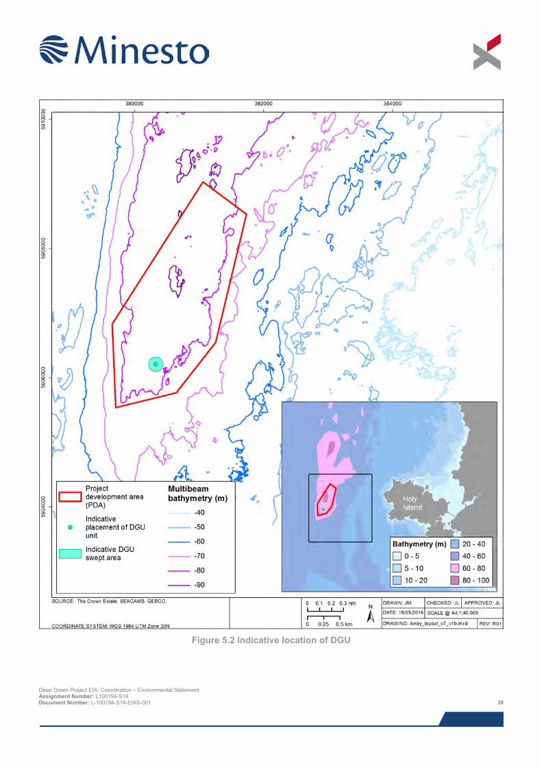
Figure 5.2 Indicative location of DGU
Deep Green Project EIA: Coordination – Environmental Statement Assignment Number: L100194-S14 Document Number: L-100194-S14-EIAS-001 30
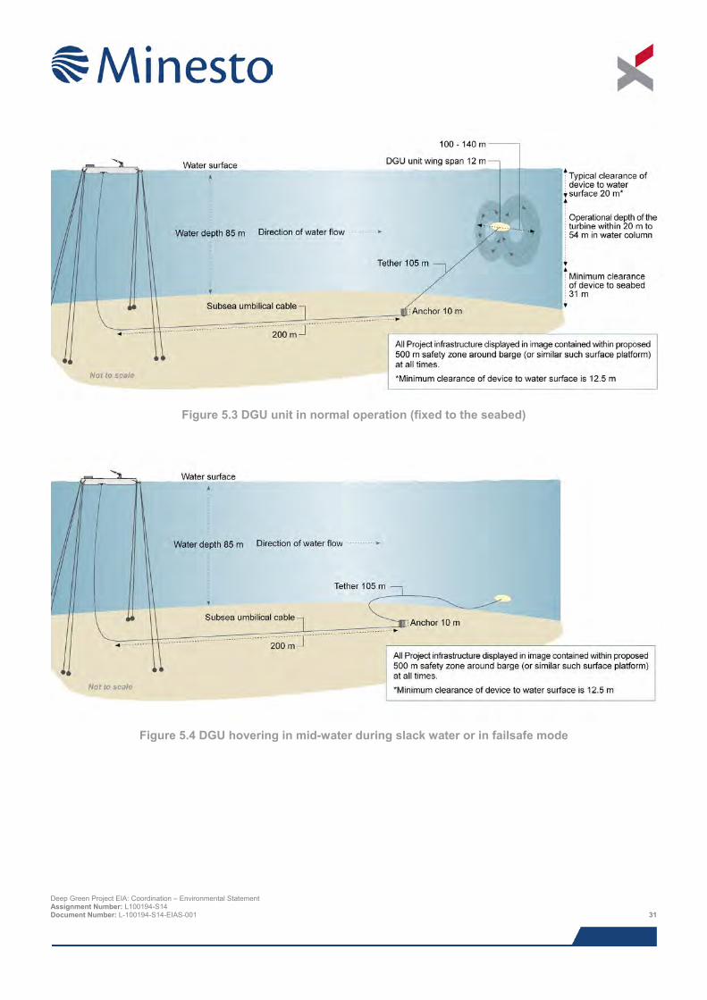
Figure 5.3 DGU unit in normal operation (fixed to the seabed)
Figure 5.4 DGU hovering in mid-water during slack water or in failsafe mode
Deep Green Project EIA: Coordination – Environmental Statement Assignment Number: L100194-S14 Document Number: L-100194-S14-EIAS-001 31
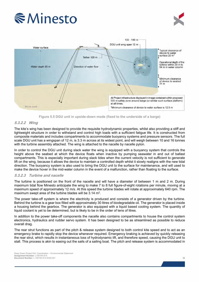
Figure 5.5 DGU unit in upside-down mode (fixed to the underside of a barge)
5.3.2.2 Wing The kite’s wing has been designed to provide the requisite hydrodynamic properties, whilst also providing a stiff and lightweight structure in order to withstand and control high loads with a sufficient fatigue life. It is constructed from composite materials and includes compartments to accommodate buoyancy systems and pressure sensors. The full scale DGU unit has a wingspan of 12 m, is 3.3 m across at its widest point, and will weigh between 10 and 16 tonnes with the turbine assembly attached. The wing is attached to the nacelle by nacelle pylon.
In order to control the DGU unit during slack water the wing is equipped with a buoyancy system that controls the height above the seabed at which the device floats when inactive by pumping seawater in and out of ballast compartments. This is especially important during slack tides when the current velocity is not sufficient to generate lift on the wing, because it allows the device to maintain a controlled depth whilst it slowly realigns with the new tidal direction. The buoyancy system is also used to bring the DGU unit to the surface for maintenance, and will used to make the device hover in the mid-water column in the event of a malfunction, rather than floating to the surface.
5.3.2.3 Turbine and nacelle The turbine is positioned on the front of the nacelle and will have a diameter of between 1 m and 2 m. During maximum tidal flow Minesto anticipate the wing to make 7 to 8 full figure-of-eight rotations per minute, moving at a maximum speed of approximately 12 m/s. At this speed the turbine blades will rotate at approximately 640 rpm. The maximum swept area of the turbine blades will be 3.14 m2.
The power take-off system is where the electricity is produced and consists of a generator driven by the turbine. Behind the turbine is a gear box filled with approximately 30 litres of biodegradable oil. The generator is placed inside a housing behind the gearbox. The generator is also equipped with a liquid based cooling system. The quantity of liquid coolant is yet to be determined, but is likely to be in the order of tens of litres.
In addition to the power take-off components the nacelle also contains compartments to house the control system electronics, hydraulics and rudder servo system. It has been designed to be as streamlined as possible to reduce overall drag.
The rear strut functions as part of the pitch & release system designed to both control kite speed and to act as an emergency brake to rapidly stop the device whenever required. Emergency braking is achieved by quickly releasing the rear strut, which results in instantaneous loss of hydrodynamic lift, and therefore speed, causing the DGU unit to stall. This process is akin to easing out the sails of a sailing boat. The pitch and release system is accommodated in
Deep Green Project EIA: Coordination – Environmental Statement Assignment Number: L100194-S14 Document Number: L-100194-S14-EIAS-001 32
the lower part of the nacelle, connected to the rear strut. The DGU unit is also equipped with an underwater tracking device so that they can be readily located following a tether malfunction.
5.3.2.4 Tether The tether has been designed to serve two functions: first, to connect the wing and turbine to the foundation using a load carrying cable made of Dyneema®, and second, to allow power transfer and signal cables to pass from the nacelle to the foundation. The tether consists of 0.5 to 0.6 m wide streamlined fairing (maximum of 0.08 m thickness in direction of travel), which has been designed to minimise the overall drag of the device. Within the fairing are channels for the load carrying, power transfer and signal cables.
The tether has been designed with a safety margin of 3.5 times the static load, which will ensure that it can hold much larger forces than it will ever be exposed to during operation. The tether will be designed to avoid dragging on the seabed and tangling by using distributed buoyancy, which allows it to float above the seabed during slack water.
It is possible that the DGU will need to be taken off site for extended periods, during which time the tether would be suspended beneath a buoy and allowed to move within the same swept area as the DGU (which is limited by the length of the tether). However, permanent presence of the DGU on site is viewed as the worst-case and has formed the basis of the assessments undertaken in the EIA.
5.3.2.5 Bottom joint A rotating bottom joint will form the anchoring point for the tether and ensures that it can move smoothly in all directions, irrespective of tidal current direction and wing motion.
5.3.2.6 Barge There will be the need for a barge (or alternative surface platform facility) to be on site to undertake field-testing, calibration and optimisation activities and provide electricity meter facilities, since the DGU device will not be grid connected. The kite will be operated from the barge, requiring suitable on-board control room facilities. The barge will be connected to the DGU via a subsea umbilical running from the DGU foundation. An attendant support vessel equipped with a Launch and Recovery System (LARS) will be on site during all periods of operation, both to provide launch and recovery capabilities and to act as guard vessel.
Two alternatives to the barge concept are also being considered:
> A mooring buoy with suspended subsea umbilical connected to the DGU foundation, to which a support vessel housing the necessary electrical equipment (including the meter) would be attached during periods of operation; and
> An autonomous self-contained buoy housing all electrical equipment, with suspended subsea umbilical connected to the DGU foundation. The buoy would most likely house a remote data access equipment, but would still require an attendant support vessel for launch and recovery of the DGU and guard duties.
The mooring and self-contained buoy options would use a similar or, more likely, reduced mooring spread in comparison to the barge, and likewise, the attendant support vessels would have similar or smaller dimensions than the barge. As such, the barge option is viewed as the worst case and has formed the basis of the assessments undertaken in the EIA.
The barge will have maximum dimensions of approximately 50 m long and 12 m wide. It is likely to be equipped with a diesel generator, a basic workshop with a bunded COSHH cupboard for small volumes of chemicals, toilet facilities, and a small crane and winch with associated power packs. In addition, there may be a bunded fuel store for generator and safety boat fuel (diesel and petrol, ca 200 litres), as well as fresh and grey water tanks (ca 50 litres).
The electricity meter on the barge will be a self-contained electrical system designed to allow the DGU to operate remotely without a grid connection. The system will consist of control electronics, a diesel powered generator, a battery bank and a means of dissipating the energy generated by the DGU (likely to be a sea water cooled resistor). The purpose of the meter is also to monitor and characterise the energy generated by the DGU.
The barge will be attached to the seabed via a four to eight point catenary mooring, with surface buoys 80 m from barge holding the surface lines at/out of the water. The anchoring methods are to be determined during detailed
Deep Green Project EIA: Coordination – Environmental Statement Assignment Number: L100194-S14 Document Number: L-100194-S14-EIAS-001 33
design taking into account seabed type and cost. It may be necessary to retrieve the barge during adverse weather conditions, in which case it will be taken to Holyhead harbour. It is possible that the barge will be attached to a hook-up buoy rather than being directly attached to the seabed. The hook-up buoy would use a mooring spread that is comparable to the spread used for the direct attachment option.
The barge is highly likely to be intermittently retrieved for extended periods during severe weather. During this time the subsea umbilical (see Section 5.3.2.7) and barge mooring spread would be suspended from a single buoy. However, permanent presence of the barge on site is viewed as the worst-case and has formed the basis of the assessments undertaken in the EIA.
5.3.2.7 Subsea umbilical Electricity produced by the DGU will be transmitted via a subsea umbilical cable running from the foundation to the electricity meter located on the barge (or similar such surface platform). The umbilical will be a 100 mm braided steel cable, running for up to 200 m along the seabed before smoothly curving up through the water column to the barge (see Figure 5.3). The cable will be held on the seabed under its own weight and therefore will not require any additional anchoring material.
5.3.3 DGU unit protection systems 5.3.3.1 Antifouling The prevention of marine growth is an important consideration, even on a rapidly moving device, where the movement might be expected to prevent settlement by marine organisms. Minesto is currently participating in the FP7 SeaFront project, looking into environmentally friendly approaches for marine growth prevention through the development of non-copper based antifouling paints. In addition it should be noted that as an internal standard, Minesto will only work with approved and certified antifoul solutions that conform to all existing environmental standards.
5.3.3.2 Corrosion Appropriate corrosion protection is of paramount importance in the marine environment. It is likely that a combination of cathodic protection and specialist paints will be used in the same way that they are applied in other marine technologies. Minesto intend to use mainly corrosion resistant material to prevent the need for additional treatment. Minesto is currently engaged in an external research project in collaboration with other experienced partners from the marine industry to develop innovative solutions to this issue.
5.3.4 Lighting and marking Throughout the period that the barge will be present at the PDA, there will be four corner buoys with lights marking the barge mooring system. There may also be a requirement for marker buoys to attach to the tether during periods when the DGU is taken out of the water, and to suspend the umbilical and barge mooring spread from if the barge needs to be removed from site.
The barge will be illuminated with floodlights when necessary. Normal offshore operations would take place during daylight hours, so floodlighting would typically be avoided. However, floodlighting will be required on the barge to allow safe working conditions during hours of darkness, and at times this may involve 24 hour periods of working. As the proposed Project will involve periods of testing, the duration of operations that may take place during hours of darkness are uncertain, but it is anticipated this will be unlikely to exceed 30 nights per year and later afternoon periods during winter months. The requirement for working in hours of darkness is also likely to reduce as the testing/operational phase progresses.
Minesto will consult with and follow guidance provided by Trinity House Lighthouse Service (THLS). The site will most likely be demarcated using blinking lights visible up to 5 km. It is also possible that the project will be fitted with an Automatic Identification System (AIS) beacon, a radar beacon and or Virtual Navigation markers. The regulatory authorities will make their final recommendation for all charting, lighting or demarcation requirements following the submission of the consent application and the Navigational Risk Assessment (NRA).
Deep Green Project EIA: Coordination – Environmental Statement Assignment Number: L100194-S14 Document Number: L-100194-S14-EIAS-001 34
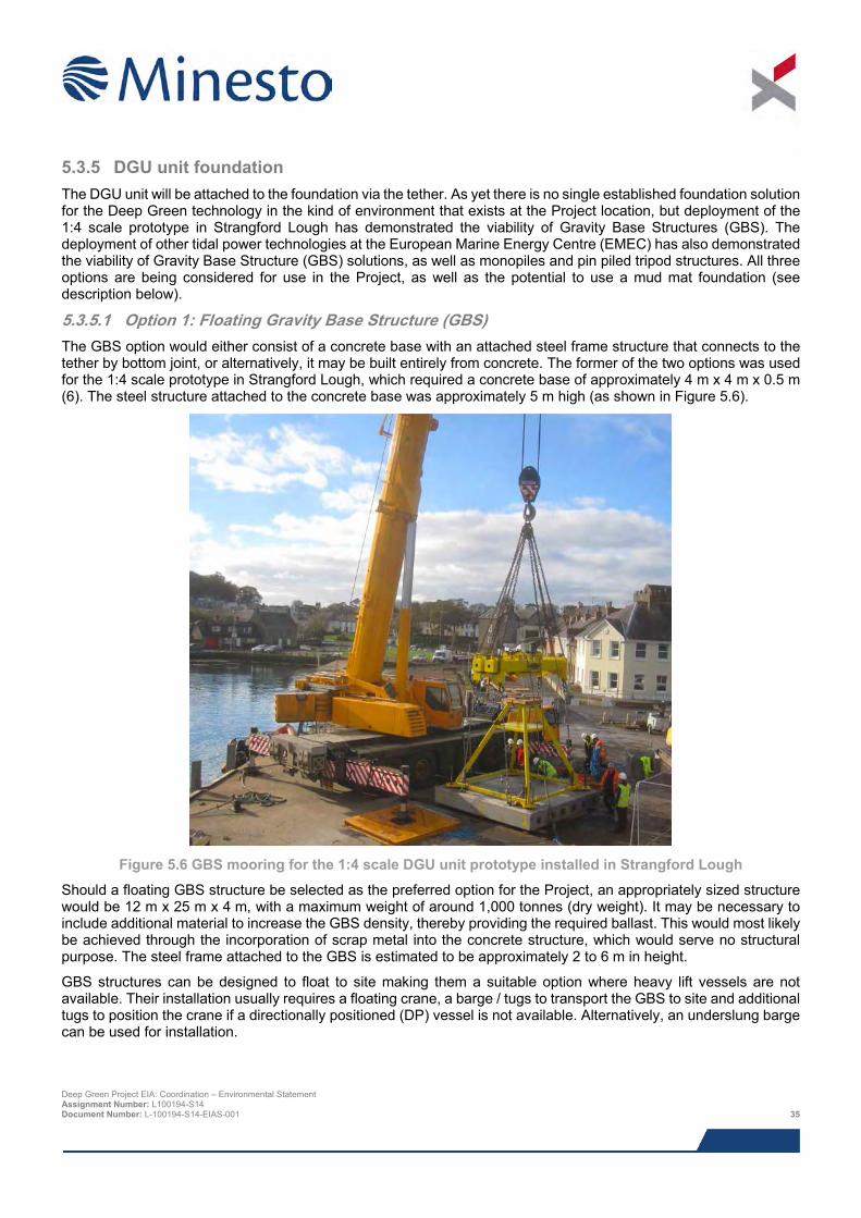
5.3.5 DGU unit foundation The DGU unit will be attached to the foundation via the tether. As yet there is no single established foundation solution for the Deep Green technology in the kind of environment that exists at the Project location, but deployment of the 1:4 scale prototype in Strangford Lough has demonstrated the viability of Gravity Base Structures (GBS). The deployment of other tidal power technologies at the European Marine Energy Centre (EMEC) has also demonstrated the viability of Gravity Base Structure (GBS) solutions, as well as monopiles and pin piled tripod structures. All three options are being considered for use in the Project, as well as the potential to use a mud mat foundation (see description below).
5.3.5.1 Option 1: Floating Gravity Base Structure (GBS) The GBS option would either consist of a concrete base with an attached steel frame structure that connects to the tether by bottom joint, or alternatively, it may be built entirely from concrete. The former of the two options was used for the 1:4 scale prototype in Strangford Lough, which required a concrete base of approximately 4 m x 4 m x 0.5 m (6). The steel structure attached to the concrete base was approximately 5 m high (as shown in Figure 5.6).
Figure 5.6 GBS mooring for the 1:4 scale DGU unit prototype installed in Strangford Lough
Should a floating GBS structure be selected as the preferred option for the Project, an appropriately sized structure would be 12 m x 25 m x 4 m, with a maximum weight of around 1,000 tonnes (dry weight). It may be necessary to include additional material to increase the GBS density, thereby providing the required ballast. This would most likely be achieved through the incorporation of scrap metal into the concrete structure, which would serve no structural purpose. The steel frame attached to the GBS is estimated to be approximately 2 to 6 m in height.
GBS structures can be designed to float to site making them a suitable option where heavy lift vessels are not available. Their installation usually requires a floating crane, a barge / tugs to transport the GBS to site and additional tugs to position the crane if a directionally positioned (DP) vessel is not available. Alternatively, an underslung barge can be used for installation.
Deep Green Project EIA: Coordination – Environmental Statement Assignment Number: L100194-S14 Document Number: L-100194-S14-EIAS-001 35
5.3.5.2 Option 2: Pin piled tripod foundation A steel tripod (or perhaps simple four legged structure) foundation would typically be constructed from welded steel tubular sections. It would be attached to the seabed using small diameter steel tubes, known as pin piles, which are fixed to the seabed by either using piling hammers to vertically drive them into the seabed, drilling and grouting them into position, or a combination of these two approaches. The expertise to fabricate and install tripod structures is widely available since they are an established part of the oil and gas supply chain.
The tripod structures required for the Project would be approximately 5 to 8 m high, weighing around 25 tonnes. The footprint of each individual structure would be a 5 to 8 m triangle, with pin piles driven or drilled into the seabed at each corner. Pin pile lengths are expected to be no greater than 20 m, with a maximum diameter of 3 m.
5.3.5.3 Option 3: Monopile foundation It may be possible to anchor the DGU unit to a single monopile with the dimensions 20 m long and a maximum diameter of 4 m. The monopile will be fixed to the seabed either using piling hammers, or drilling and grouting it into position, or a combination of these two approaches.
5.3.5.4 Option 4: Mud mat foundation Minesto are also considering the possibility of a mud mat foundation comprising a steel structure placed on the seabed, which may also require the use of anchors for additional stability. The combined footprint of the mud mat and anchors would be equal to or less than the 12 x 25 m gravity base option. No drilling or hammering would be necessary.
5.4 Offshore installation
5.4.1 Barge moorings The barge (or similar such surface platform) may be self-propelled, or towed to the PDA by tug. The mooring setup that would be used to secure the barge, secure a hook-up buoy for a vessel to attach to, or to directly secure a self-contained buoy would be broadly similar. The moorings will be pre-laid using an appropriate vessel/barge with sufficient lifting capacity equipped with accurate plotting equipment to record the positions of the anchors. The mooring spread will comprise the following:
> Embedment anchors;
> Clump weights and chains; and
> Recovery lines and small surface buoys equipped with blinking lights.
First, the vessel/barge will deploy the anchors using an anchor handling winch and roller. The anchor will be rendered out to the required position, followed by the chain clump weight, riser wire, marker buoy and messenger line. This will be followed by a 24 hour soak period. Next, a tug will be deployed to pick up each buoy and secure the short mooring pennants to the barge.
5.4.2 DGU unit foundation installation The specific requirements for foundation installation method, foundation type and size, seabed preparation and scour protection will be determined following a detailed seabed assessment and geotechnical survey. The descriptions below provide an overview of the likely approaches that would be adopted to install each of the foundation technologies under consideration.
5.4.2.1 Option 1: Gravity base structure The floating GBS structure can simply be towed to site. Fine positioning will be achieved through the use of an ROV. GBS structures are installed during slack water on a neap tide, and the installation of a GBS would take between one and two days, with five days being a likely maximum (assuming 24 hour working).
The general installation sequence will include the following stages:
Deep Green Project EIA: Coordination – Environmental Statement Assignment Number: L100194-S14 Document Number: L-100194-S14-EIAS-001 36
> Fabricate foundation at quayside or in a dry-dock;
> Load from quayside or slipway and tow to site;
> Transport foundation to site; and
> Lower to seabed position by adjusting flotation and controlling with ROV.
5.4.2.2 Option 2: Pin piled tripod foundation The pin pile installation equipment will be deployed from a vessel or barge equipped with mounted cranes, a piling frame and pile tilting equipment. A support barge, tug, guard vessel and personnel transfer vessel may also be present.
There are two methods for installing the tripod foundation, pre-piling and post-piling. It is most likely that the post-piling technique would be used, in which piles are installed with the foundation structure in place. The piles will be installed using one of the following approaches:
> Drilling – requires use of specialist drilling equipment to drill out a socket for the pile to sit in and multi-stage operations to grout2 the piles into their sockets. Drilling operations would result in a direct release of drill spoil to the environment. Considering the probable dimensions of the piles, which are likely to be no greater than 20 m in length, with a maximum diameter of between 2 and 3 m, a maximum of 141.4 m3 of drill cuttings will be released per pile i.e. 424.2 m3 per DGU unit; or
> Vibro-hammering – requires use of percussive piling of to drive the pin piles into position. Negligible quantities of spoil would be released; or
> A combination of drilling and hammering – some spoil would be released, but in smaller quantities than would be using drilling alone.
The tripod, which will either be transported to site on the DP vessel or a separate barge, is lowered onto the pre-installed piles in the correct orientation. The DP vessel then leaves for the next tripod installation, leaving the piles to be grouted to the tripod.
5.4.2.3 Option 3: Monopile foundation Installation of the monopile will follow the same procedure as described above for pin piles but without the requirement for a subsea template.
5.4.2.4 Option 4: Mudmat foundation Installation of the mud mat foundation is likely to follow the same approximate process as for gravity base foundations i.e. heavy lift crane barge or underslung barge, to install the mud mat and possibly an ROV for fine positioning. No drilling or hammering would be necessary.
5.4.3 DGU unit installation The DGU unit is small and light in comparison to other types of tidal power technology, making its installation a relatively straightforward process, which has been well practiced in Strangford Lough with the 1:4 scale prototype.
The dimensions of the DGU unit is such that it can be transported by road without the need to notify or seek specific permissions from the relevant authorities. It is Minesto’s intention to assemble the unit as close to Holyhead harbour as possible, thereby minimising the onshore transport requirements.
2 Grout is a cement based product used extensively for pile grouting operations in offshore industries and conforms to the required environmental standards. The grout will either be mixed in large tanks aboard the DP vessel or barge, or onshore prior to being transported to site. The grout is pumped through a series of grout tubes previously installed into the tripod pile sleeves, which direct the grout into the void between the pile and pile sleeve. The level of grout in each tube is monitored during pumping by a grout probe unit; so that the flow can be switched off once the required levels have been reached. Deep Green Project EIA: Coordination – Environmental Statement Assignment Number: L100194-S14 Document Number: L-100194-S14-EIAS-001 37
As previously described the DGU unit can be operated in two configurations, upside-down mode and normal mode, each having a slightly differing installation requirements.
5.4.3.1 Upside-down mode In upside-down the DGU unit will be moored to the underside of the barge, which will be equipped with a crane and winch. Once the barge is moored, an ROV will be used to attach the tether to its underside. The DGU unit will be lowered into the water using a crane on the barge or support vessel, or alternatively, the barge may be provided with a moon pool equipped with a structure in which the tether joint can be lifted up for easy access from the barge deck. The buoyancy system will then be used to move the device down into the mid-water column ready for operation, which will occur once tidal flow reaches the necessary velocity.
5.4.3.2 Normal mode Installation of the DGU unit in normal mode will be achieved using an appropriate installation vessel equipped with a crane and winch. Typically these types of vessel are able to hold station in tidal flows of up to 1.5 m/s, although DGU unit installation will take place over periods of slack tide. First, the tether and bottom joint will be attached to the foundation using an ROV, deployed and controlled from the vessel. The DGU will then be lowered into the water using the crane and attached to the other end of the tether. Next, the buoyancy system will be used to submerge the device and move it towards the mid-water column, where it will hover until the tidal flow reaches a sufficient speed to generate lift and drive the movement of the DGU unit.
5.4.4 Marine installation operations Preferably marine installation operations will take place during the spring, summer and autumn months when weather conditions are most favourable, but works during winter may also be undertaken if necessary and deemed appropriate by the parties involved. Operations are likely to be confined to periods when the tidal flows are lowest. To take advantage of the restricted tidal windows, works will be undertaken at any time during the day or night.
5.4.5 Vessel requirements Table 5.1 provides details for the different vessel activities involved in the offshore installation of the Project and the estimated number of operating days required. These vessels may also require smaller vessels to be present for support services.
5.5 Operational stage Following initial deployment of the DGU there will be extensive calibration and optimisation of the DGU unit. As previously described the barge will house control facilities and an electricity meter, which will be connect to the device via a subsea umbilical cable. Alternatively, the subsea umblicial may connect directly to a hook-up buoy for a support vessel, or a self-contained buoy. There will also be a requirement to have the LARS support vessel on site to launch and recover the DGU and effect routine maintenance.
There will be high frequency transfers to and from the site throughout the initial testing stage, probably daily during the first few weeks following DGU installation. This is likely to drop to somewhere in the region of one transfer per week for the remainder of the Project (up to five years).
The DGU unit is expected to generate approximately 1.56 GWh / year. Once installed, the DGU unit is designed for an operational lifetime of 10 years, whereas the foundation will be designed to last for at least the operational life of the Project. Considering the relatively low cost of the DGU unit, and the ease with which it can be replaced, the DGU unit could be swapped out for an improved version (or simply a replacement) as part of a future project, subject to appropriate consent(s).
During normal operations the DGU units will be controlled according to a set of pre-defined rules and algorithms related to tidal velocity and error alarms.
If the DGU device encounters a problem the internal systems will automatically initiate failure mode, in which movement is inhibited and the device will hover at a constant depth using the buoyancy system (Figure 5.4). Whilst
Deep Green Project EIA: Coordination – Environmental Statement Assignment Number: L100194-S14 Document Number: L-100194-S14-EIAS-001 38
hovering, the device will naturally align itself with tidal flow direction and await instructions to begin normal operation or retrieval to the sea surface for servicing.
There will be a number of additional activities that will also need to be undertaken during the operating stage, including:
> Health and safety management;
> Pre-commissioning inspection of all onshore and offshore equipment;
> Pre-energisation inspection;
> Commissioning inspection and on-load testing; and
> Post-commissioning inspection / online monitoring.
Table 5.1 Vessel activities
Activity Vessel type Indicative operating period Installation
Deploying pin piled tripod, monopile, mud mat or GBS.
DP vessel or underslung barge (depending on mooring structure solution).
Maximum of five days.
Installation of barge (or similar such surface platform) moorings and/or buoys.
Anchor handler tug or multicat. Approximately 1 week.
Transport of barge (or similar such surface platform) to site.
Tug(s). 1 day per transfer, but multiple transfers expected.
Transport DGU unit to site. LARS support vessel designed specifically for purpose.
1 day per transfer, but multiple transfers expected. Could be daily for the last few weeks of installation/first few weeks of operation, dropping to around 1 per week thereafter.
Deployment of an ROV to attach tether to foundation, if not handled from barge deck).
Support vessel with ROV capabilities. Less than 1 week.
May also be required intermittently throughout field testing and calibration.
Operation
Field testing and calibration of DGU unit and hosting of electricity meter.
Barge (or similar such surface platform). Throughout the 5 year testing period, although the barge is highly unlikely to be present consistently throughout the 5 year period due to constraints imposed by weather.
Retrieval, deployment and routine maintenance of DGU unit.
LARS support vessel designed specifically for purpose.
Throughout the 5 year testing period.
Transfer of commissioning barge throughout commissioning stage.
Tug(s). 1 day per transfer, but multiple transfers expected during the 5 year testing period.
Unplanned maintenance of DGU power plant.
Service vessel, occasional requirement for DP vessel.
Approximately 6 days per year.
Deep Green Project EIA: Coordination – Environmental Statement Assignment Number: L100194-S14 Document Number: L-100194-S14-EIAS-001 39
5.6 Maintenance activities
5.6.1 Maintenance strategy Following the initial period of intensive calibration and optimisation described in the section above, the DGU unit will be left to operate for longer periods, during which the barge will be on station. The LARS support vessel will need to be on site during operations to act as a guard vessel and provide launch and recovery capability. All routine maintenance will be undertaken by the LARS vessel.
In the event that unplanned maintenance is required, for instance, an issue with the tether or bottom joint, a more specialist service vessel/DP vessel may be required. For the purposes of this EIA it has been conservatively assumed that such events will occur no more than 6 times per year.
5.6.2 Marine operations During installation and testing the DGU unit will be lifted out of the water onto the LARS vessel, where all servicing / calibration activities will be carried out. Some servicing may also be carried out on the barge (or similar such surface platfrom), but the DGU would still need to be retrieved and delivered using the LARS support vessel. Alternatively the kite may be transported to shore for major serving/overhaul. Whenever the DGU is taken off-site, the tether will be connected to a surface marker buoy and left to move within the same horizontal swept area as described for the DGU (a maximum of 0.034 km2).
It is also possible that the barge will be taken off-site intermittently for extended periods due to severe weather. During these periods, the barge mooring and subsea umbilcal will be collected and suspended under a single surface marker buoy. Should the hook-up buoy option be selected, the subsea umbilical and mooring spread would remain in place irrespective of the presence of the barge/support vessel equipped with the electricity meter.
5.6.3 Harbour facilities The PDA is located approximately 12 km from Holyhead port, where all of the vessels associated with the Project will operate from. The port is operated by Stena Line Ports Ltd, who is the statutory Harbour Authority. The port lies in well protected position east of Holyhead Mountain, shielded by the 1.5 mile long historic breakwater. It is a 24 hour, deep water, lock-free port, linked to the British motorway network by the A55 dual carriageway.
Throughout the installation of the Project, the following facilities will be required at Holyhead harbour:
> Laydown area and marshalling yard close to a quayside;
> Assembly Hall and workshops where Minesto will run its operations from within the inner harbour.
> Quayside for installation vessels (for DGU unit); and
> Quayside for offshore support vessels.
> During the operations and maintenance period, an operations and maintenance base / quay will be required for the maintenance vessel(s).
5.7 Decommissioning Decommissioning of the DGU unit will be a relatively straightforward procedure. The DGU unit, tether, bottom joint and foundation will be removed using an installation vessel and ROV, and subsequently transported to shore. The decommissioning process will follow the same relative sequence used in construction, but in reverse and follow standard industry guidance/practices.
Deep Green Project EIA: Coordination – Environmental Statement Assignment Number: L100194-S14 Document Number: L-100194-S14-EIAS-001 40

This page has been intentionally left blank.
Deep Green Project EIA: Coordination – Environmental Statement Assignment Number: L100194-S14 Document Number: L-100194-S14-EIAS-001 41
6 STAKEHOLDER ENGAGEMENT
6.1 Background Since the award of the AfL in June 2014, Minesto has been actively consulting a wide range of statutory and non-statutory stakeholders and interested parties on the Project. All consultation has been carried out in line with relevant legislation. All stakeholder enagement to date has considered a small array (three devices) with a export cable transmitting electricity to onshore. A decision was later made to modify the initial application so that it covers a single non-grid connected DGU unit only, ahead of a future application for a larger array. The feedback received from stakeholders remains relevant and has been used to inform the EIA for a single DGU unit. Minesto has informed key stakeholders to this the change in consenting strategy.
Minesto is committed to the highest environmental standards and best practice throughout the entire Project lifecycle and as part of this, recognises the importance of early consultation that continues throughout the Project in order to integrate public and stakeholder concerns and opinions into the Project decision making process. Consequently, consultation with both statutory and non-statutory stakeholders has been an integral aspect of the Environmental Impact Assessment (EIA) and associated Navigational Risk Assessment (NRA) and Habitats Regulations Assessment (HRA) process since the commencement of the Project. The primary aim of the consultation process is to facilitate two way communications about the Project with all relevant stakeholders. This allows any environmental concerns to be identified at an early stage and the opportunity for the project team to ensure that these concerns can be adequately addressed during the EIA process.
This chapter of the ES describes the overall consultation process that was undertaken during the EIA. Detailed information on topic specific consultation is included in study specific chapters throughout the ES.
6.2 Approach to stakeholder engagement For successful stakeholder engagement it is essential that the following is undertaken:
> The stakeholders and groups/individuals interested in or affected by the Project are identified;
> Information is issued at the appropriate time to all interested parties in an accurate and understandable manner;
> Early and continuous dialogue is held between those affected by decisions and those responsible for making decisions;
> The information provided by the stakeholders and interested parties is considered and incorporated in the decision making process and final decision for the Project; and
> Feedback is provided to all stakeholders and interested parties explaining the actions taken and how the final decision has been influenced by the process.
Using experience from previous similar projects and incorporating the requirements of legislation (e.g. Public Participation Directive and EIA Directive), the overall approach to stakeholder engagement carried out as part of the DG Holyhead Deep Project is presented in Figure 6.1.
6.3 Pre-scoping and scoping consultation Prior to submitting their Scoping Report, Minesto consulted with a number of statutory and non-statutory stakeholders (Minesto, 2013). A public stakeholder meeting was also held in Holyhead on the 25th September 2013, see Section 6.6.
An EIA Scoping Report for the Project was submitted to Natural Resources Wales (NRW) Marine Licensing Team and the Marine Management Organisation (MMO)3 in November 2013. This report (Minesto, 2013) included an
3 EIA scoping considered a small array of devices (1.5 MW capacity) from which electricity would be exported via a subsea cable to a grid connection onshore. A decision was later made that the initial application was to cover a single non-grid connected DGU unit only, ahead of a future application for a larger array. The advice provided in the Scoping Opinion relevant to the DGU unit
Deep Green Project EIA: Coordination – Environmental Statement Assignment Number: L100194-S14 Document Number: L-100194-S14-EIAS-001 42
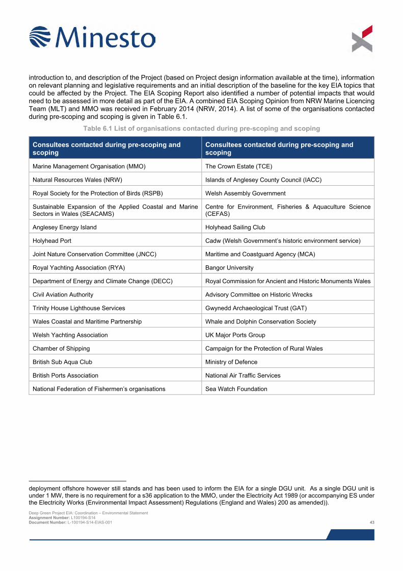
introduction to, and description of the Project (based on Project design information available at the time), information on relevant planning and legislative requirements and an initial description of the baseline for the key EIA topics that could be affected by the Project. The EIA Scoping Report also identified a number of potential impacts that would need to be assessed in more detail as part of the EIA. A combined EIA Scoping Opinion from NRW Marine Licencing Team (MLT) and MMO was received in February 2014 (NRW, 2014). A list of some of the organisations contacted during pre-scoping and scoping is given in Table 6.1.
Table 6.1 List of organisations contacted during pre-scoping and scoping
Consultees contacted during pre-scoping and scoping
Consultees contacted during pre-scoping and scoping
Marine Management Organisation (MMO) The Crown Estate (TCE)
Natural Resources Wales (NRW) Islands of Anglesey County Council (IACC)
Royal Society for the Protection of Birds (RSPB) Welsh Assembly Government
Sustainable Expansion of the Applied Coastal and Marine Sectors in Wales (SEACAMS)
Centre for Environment, Fisheries & Aquaculture Science (CEFAS)
Anglesey Energy Island Holyhead Sailing Club
Holyhead Port Cadw (Welsh Government’s historic environment service)
Joint Nature Conservation Committee (JNCC) Maritime and Coastguard Agency (MCA)
Royal Yachting Association (RYA) Bangor University
Department of Energy and Climate Change (DECC) Royal Commission for Ancient and Historic Monuments Wales
Civil Aviation Authority Advisory Committee on Historic Wrecks
Trinity House Lighthouse Services Gwynedd Archaeological Trust (GAT)
Wales Coastal and Maritime Partnership Whale and Dolphin Conservation Society
Welsh Yachting Association UK Major Ports Group
Chamber of Shipping Campaign for the Protection of Rural Wales
British Sub Aqua Club Ministry of Defence
British Ports Association National Air Traffic Services
National Federation of Fishermen’s organisations Sea Watch Foundation
deployment offshore however still stands and has been used to inform the EIA for a single DGU unit. As a single DGU unit is under 1 MW, there is no requirement for a s36 application to the MMO, under the Electricity Act 1989 (or accompanying ES under the Electricity Works (Environmental Impact Assessment) Regulations (England and Wales) 200 as amended)). Deep Green Project EIA: Coordination – Environmental Statement Assignment Number: L100194-S14 Document Number: L-100194-S14-EIAS-001 43
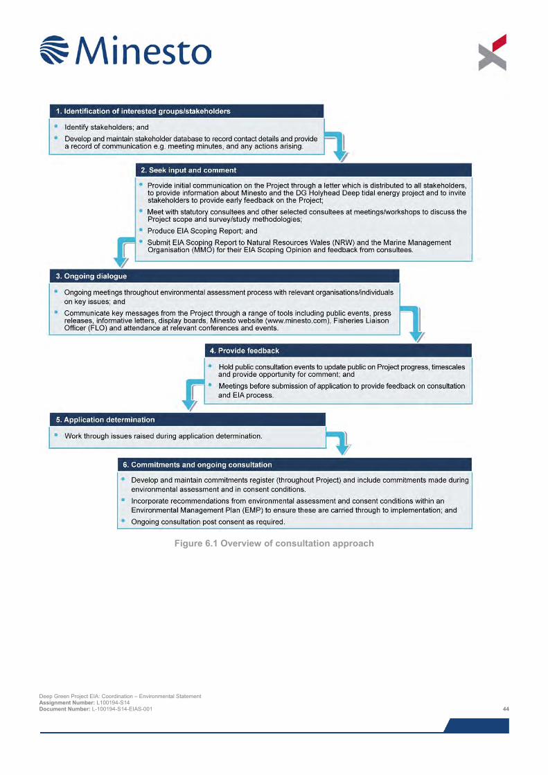
Figure 6.1 Overview of consultation approach
Deep Green Project EIA: Coordination – Environmental Statement Assignment Number: L100194-S14 Document Number: L-100194-S14-EIAS-001 44
6.4 Consultation with regulators and their advisors Minesto has attended regular meetings with NRW, MMO, IACC and others (as relevant) in order to keep them directly informed and up to date with progress of the Project. Meetings to address a number of issues have taken place, including:
> Project consenting strategy;
> Consultation on EIA and HRA methodologies;
> General EIA and HRA progress and study finding updates;
> Marine mammal and offshore ornithology EIA methodology approach;
> Meetings with Cefas to discuss the redesignation of the Holyhead Deep disposal site; and
> Meetings with Cadw and the Royal Commission for Ancient and Historic Monuments Wales (RCAHMW) on offshore archaeology.
6.5 Consultation with fishing community The local fishing community is seen as an important and key stakeholder to the EIA process. To maintain ongoing consultation and liaison with the fishing community a Fisheries Liaison Officer (FLO) was appointed to the Project. This is in accordance with the FLOWW Best Practice Guidance for Offshore Renewables Developments: Recommendations for Fisheries Liaison (January 2014). The use of the FLO ensured that the fishing community was kept up to date with information about the Project, made aware of surveys taking place within the AfL area and to voice the interests of the fishing community, providing Minesto with specialist advice and guidance as to any industry sensitivities.
6.6 Public consultation Minesto has undertaken three public consultation events for the DG Holyhead Deep Project. The first during the preparation of the Scoping Report and the second during the execution of the EIA. A third meeting was held ahead of application submission.
On 25th September 2013 Minesto held a public consultation event as part of the pre-scoping process of the Project. A letter informing stakeholders of the event was issued in August 2013. The purpose of the event was to ensure that the wider community was aware of and positive to the Project idea. A presentation was held in Holyhead Town Hall, Holy Island and approximately 20 persons attended from 10 different organisations.
On 21st May 2015 Minesto held a second public consultation event as part of pre-submission consultation on the Project. A letter informing consultees of the event was issued in May 2015. The purpose of the event was to ensure that the wider community was aware of the Project proposals and was given an opportunity to comment on the Project prior to submission of the ES and consent applications. A feedback form was available at the event for attendees to provide comments or submit comments at a later date.
The meeting was held in Holyhead Town Hall, Holy Island, between 10 am and 8 pm. Newspaper notices of the event were displayed in local papers on the following dates:
> North Wales Chronicle – 14th April and 21st April 2015;
> Holyhead and Bangor Mail – 13th April and 20th April 2015; and
> Adverts were also placed on the above publication’s websites.
A radio advert aired at regular intervals on Heart North Wales for a number of days preceding the public event. Posters advertising the public event were displayed in shops, libraries, hotels, local clubs, associations, public buildings and the local University in Holyhead, Llangefni, Menai Bridge and Trearddur Bay.
Over 150 people attended the event from a wide range of groups and organisations including:
Deep Green Project EIA: Coordination – Environmental Statement Assignment Number: L100194-S14 Document Number: L-100194-S14-EIAS-001 45

> Holyhead Port;
> Holyhead Town Council;
> SEACAMS;
> Stena Line;
> Wales Government and WEFO;
> Isle of Anglesey County Council;
> M-SParc (Bangor Marine Science Park);
> Menter Mon (and Morlais);
> Energy Island;
> RSPB; and
> People local community members living and working in the region.
Leaflets were available to take away from the event, to give people a summary of the Project, and Minesto contact details to follow up any further questions.
On January 26th 2016, Minesto held a third public consultation event as part of pre-submission consultation on the Project. The purpose of the event was to update the wider community on Project progress including, updates to Project design that occurred since the last public event, and to disseminate the results of the EIA.
The meeting was held in Holyhead Town Hall, Holy Island between 3 pm and 8 pm. Newspaper notices of the event were displayed in local papers on the following dates:
> North Wales Chronicle – 14th and 21st January 2016;
> Holyhead and Bangor Mail – 13th and 20th January 2016; and
> Adverts were also placed on the above publication’s websites.
A radio advert aired at regular intervals on Heart North Wales for a number of days preceding the public event. Posters advertising the public event were displayed in shops, libraries, hotels, local clubs, associations, public buildings and the local University in Holyhead, Llangefni, Menai Bridge and Trearddur. Deep Green Project EIA: Coordination – Environmental Statement Assignment Number: L100194-S14 Document Number: L-100194-S14-EIAS-001 46
6.7 Post submission consultation Following submission of the Marine Licence Application, notice of the application will be advertised as instructed by NRW (including in local newspapers in the Anglesey area). Minesto will also make hard copies publicly available in key locations to facilitate inspection, in person, by members of the local communities in the vicinity of the Project. These locations will be confirmed post submission and all stakeholders will be notified of the confirmed locations via email and/or letter. This is to allow the public an opportunity to review the application, ES or request a copy of the submission. A statutory public consultation period will allow written representations on the Project to be made.
Consultation will continue beyond the submission of the application. Assuming successful award of Project consent, licence condition implementation will require continuing engagement and consultation with the Regulators and their statutory consultees. In addition, Minesto will continue its communications with the local community and wider public to keep them informed of the Project progress and key milestones.
6.8 References Fishing Liaison with Offshore Wind and Wet Renewables Group (FLOWW) (2014). Best Practice Guidance for Offshore Renewables Developments: Recommendations for Fisheries Liaison. January 2014.
Isle of Anglesey County Council (IACC) (2015). Response to Screening Request. Letter prepared by Island of Anglesey County Council. March 2015.
Minesto (2013). Deep Green Project. Request to Natural Resources Wales and the Marine Management Organisation for an Opinion on the Scope of the Environmental Statement. Report prepared by PMSS on behalf of Minesto. November 2013.
Minesto (2015). Minesto Deep Green Holyhead Deep Project – Request for Screening Opinion. Letter prepared by Xodus on behalf of Minesto. January 2015.
Natural Resources Wales (NRW) (2014). Scoping Opinion Under The Marine Works (Environmental Impact Assessment) Regulations 2007 (as amended). February 2014.
Deep Green Project EIA: Coordination – Environmental Statement Assignment Number: L100194-S14 Document Number: L-100194-S14-EIAS-001 47
7 ENVIRONMENTAL OVERVIEW
7.1 Introduction This chapter provides an overview of the environment in which the Project will be developed. More detailed descriptions of specific aspects of the environment are detailed in the individual topic-specific chapters of the ES (chapters 9 to 19).
7.2 Physical characteristics
7.2.1 Offshore The Project is located within the Holyhead Deep, a large depression in the seabed where water depths reach a maximum of 97 m, in the eastern Irish Sea, 6.5 km off the coast of Holy Island, Anglesey. Detailed bathymetry data obtained as part of a geophysical survey campaign undertaken in summer 2015 showed that water depths inside the PDA range from 65 m to 91 m.
Prevailing winds on Anglesey are from the south and west. The mean hourly wind speed for the Irish Sea region is approximately 35 m/s (approximately 65 knots), with gusts of up to 50 m/s (approximately 93 knots). Due to the semi-enclosed nature of the Irish Sea, most waves tend to be locally generated from the south-west. A wave modelling study at the PDA has indicated that the 1-year return period significant wave height is approximately 5.2 m, and the 100-year return period significant wave height is 7.2 m.
In terms of currents, the semi-diurnal tide is the dominant physical process in the PDA, flooding into the Irish Sea from the Atlantic Ocean through the North Channel in the north and St. George’s Channel in the south. Peak depth-averaged mean spring current speeds can approach 3 m/s through the North Channel on the coastal edges, while peak depth-averaged mean neap currents approach 1.5 m/s. Depth-averaged tidal current velocities in the area near Holyhead are generally between 1.75 to 2 m/s, although modelling work suggests they may exceed 2.5 m/s during spring tidal flow.
The seabed off the northwest coast of Anglesey is largely defined by the presence of an extensive platform of hard pre-Cambrian rock, which extends north-westerly to approximately 25 km offshore. The seabed therefore tends to be characterised by patches of either exposed bedrock, or bedrock thinly overlain by boulders and lag gravel. Geophysical and environmental data comprising side-scan sonar, mutlibeam bathymetry, seabed imagery and sediment grabs show that the vast majority of the seabed in the PDA is coarse substrata composed of gravel with pebbles and boulders.
The PDA is located within the boundaries of the Holyhead Deep disposal site (IS040), which has been in active use since the mid-1980s. Predictive modelling and seabed surveys show that the site is highly dispersive, such that almost all disposed dredging waste is removed from the site and dispersed into the wider marine environment in a matter of days. Sediment grabs obtained during the summer 2015 surveys were subjected to contaminants analysis, which revealed that levels of arsenic, chromium lead and mercury were elevated above normal levels at several locations within and well beyond the boundaries of the Holyhead Deep disposal site.
7.3 Biological characteristics
7.3.1 Seabed Video surveys of the Project area show that the seabed is mainly composed of very coarse sediment that supported limited epifauna, likely owing to scour from suspended particles in strong tidal flows. The epifaunal communities present are generally sparse and principally made up of scour tolerant taxa including anemones, hydroids, erect bryozoa and epifaunal polychaetes. Grab samples show that infaunal communities are typical of offshore sands and gravels, with a relatively high degree of species richness and diversity.
The seabed in the PDA comprises mainly sand and gravel, with several small irregular patches of megarippled sand and gravel, including boulders. Survey data revealed that the benthos was dominated by two main biotope complexes: Offshore circalittoral mixed sediment, and Infralittoral mixed sediment. Several small patches of Deep Green Project EIA: Coordination – Environmental Statement Assignment Number: L100194-S14 Document Number: L-100194-S14-EIAS-001 48
Sabellaria spinulosa encrusted circalittoral rock were identified, but none were considered to represent Annex I biogenic reef. A large area of Annex I stony reef was identified to the east of the PDA, which very slightly encroached within its boundaries. In addition, numerous biotopes in and around the PDA fall into the priority habitat ‘subtidal sands and gravels’.
7.3.2 Birds A detailed desk-based review of surveys previously undertaken in the vicinity of the Project area and regional data was undertaken to determine which species occur in the Project area, and identify those which have the potential to be affected by the Project. Existing boat-based and aerial survey data indicate that during the breeding period the area holds relatively low densities of seabirds. The most abundant species during the breeding period are the auks (guillemots, razorbills and puffins). Other species that may occur in low densities are Manx shearwater, gannet, common and Arctic terns. However, waters to the north, adjacent to their breeding colonies hold significantly higher densities of terns. During the post-breeding and non-breeding periods seabird densities reduce and are largely absent from the area they disperse offshore or migrate south. Neither seaduck nor divers occur regularly in the area. So although there is the potential for seabirds to be present in the Project area throughout the year, the number and behaviour of species will vary seasonally. The full list of species that may occur was screened on the basis of species’ sensitivity to potential effects and their habitat selection. The list was confirmed through the scoping and consultation with NRW.
Four potentially sensitive seabird receptor populations that could plausibly be affected by the Project were identified, namely the regional breeding populations of common guillemot, razorbill, Atlantic puffin and northern gannet. Common guillemot is by far the most numerous of the species examined, and occurs commonly throughout the year in the vicinity of the offshore Project area. Razorbill, puffin and northern gannet also occur throughout the year in the vicinity of the Project site.
7.3.3 Marine mammals A total of twenty cetacean and two pinniped species have been recorded in the Irish Sea, although the majority are considered to be rare, scarce or occasional visitors. The northern half of the Irish Sea is not generally considered to be an important area for marine mammals compared to the south, primarily due to its shallow bathymetry and distance from traditional whale migration routes and the deeper waters of the shelf edge. The Project is located roughly in the middle of Irish Sea, and as such, is bordered by areas of lower importance to marine mammals to the north and higher importance to the south. Seven of the 22 marine mammal species referred to above are known to occur regularly in the Irish Sea, either on a year-round basis or on an annual-seasonal basis.
Following an in-depth review of the literature relating to marine mammals in the Irish Sea and site-specific surveys it was determined that two of the seven species regularly recorded in the Irish Sea are likely to be present in the Project area: harbour porpoise and grey seal. There appear to be localised hotspots for harbour porpoise off the north and west of Anglesey, in particular around Point Lynas and South Stack, including the Deep Green Holyhead Deep site. Bottlenose dolphin were identified as a species that may occur in the area, albeit with a lower likelihood, but it is likely that a proportion of the dolphins in the vicinity of Holy Island may be part of a wider Cardigan Bay / west Wales population and could be considered as belonging to the Cardigan Bay SAC and Lleyn Peninsula and the Sarnau SAC. There is also a slim possibility that several other marine mammal species have the potential to be present, including minke whale, common dolphin, Risso’s dolphin and harbour seal, as well as basking shark and marine turtles, however these species were all assessed as being unlikely visitors to the Project area.
7.4 Protected sites and species There are no Special Areas of Conservation (SACs) designated for Annex I seabed habitat interests in or near to the Project area, and there are no Marine Conservation Zones (MCZs) within 100 km of the Project.
There are a number of SACs off the coasts of Wales and Ireland designated for the protection of marine mammals listed under Annex II of the EU Habitats Directive, several of these are within the foraging distance of the Annex II species known to occur in the Project area (harbour porpoise, bottlenose dolphin and grey seal), and therefore have the potential to be ecologically connected. These include:
Deep Green Project EIA: Coordination – Environmental Statement Assignment Number: L100194-S14 Document Number: L-100194-S14-EIAS-001 49
> Menai Strait and Conwy Bay SAC (Wales);
> Dee Estuary SAC (Wales);
> Lleyn Peninsula and the Sarnau SAC (Wales);
> Cardigan Bay SAC (Wales);
> Pembrokeshire Marine SAC (Wales);
> Strangford Lough SAC (Northern Ireland);
> Murlough SAC (Northern Ireland);
> Lambay Island SAC (Ireland);
> Rockabill to Dalkey Island Reef SAC (Ireland); and
> Saltee Islands SAC (Ireland).
In addition to these existing designations, there are four possible future marine SAC designations for harbour porpoise that have the potential to interact with the Project: a site running from Carmarthen Bay down to Cornwall (Bristol Channel Approaches pSAC), a site covering the Cardigan Bay and Pembrokeshire seas area (West Wales Marine pSAC), a site off the east coast of Northern Ireland (North Channel pSAC) a site close to Anglesey (North Anglesey Marine pSAC),which encompasses the Project area. These possible future sites went out to consultation in January 2016.
There are thirty-two Special Protected Areas (SPAs) designated for the protection of birds listed under Annex I of the Birds Directive within 141 km of the Project. Of these, fourteen contain birds with mean maximum foraging ranges that indicate the birds from the site could be present in the Project area, either on a year-round, overwintering, passage or breeding basis. The closest site, the Holy Island SPA, is designated for Chough and therefore does not have the potential to be affected, since these species will not occur in the offshore Project area as the Chough is not a seabird. There are several other sites designated for the protection of birds, including the Calf of Man Nature Reserve on the Isle of Man, the internationally important South Stack RSPB Reserve situated on the coast close to the project site, The Skerries RSPB Reserve, and Valley Wetlands RSPB Reserve. There are also four potential SPAs of relevance, one in south-west Pembrokeshire (Skomer, Skokholm and the seas off Pembrokeshire pSPA), one in North Cardigan Bay (Northern Cardigan Bay pSPA), one in the seas around Anglesey (Anglesey Terns pSPA), one encompassing Morecambe Bay and the Duddon Estuary (Morecambe Bay and Duddon Estuary pSPA), which went out to consultation in January 2016.
In addition to the above, there are various other conservation designations on the Holy Island coast, including a large Area of Outstanding Natural Beauty (AONB), Sites of Special Scientific Interest (SSSI), a designated heritage area and scheduled ancient monuments. There are no Marine Conservation Zones (MCZs) in close proximity to or likely to be impacted by the Project (the closest site is over 100 km to the north east).
7.5 Human environment
7.5.1 Fisheries The Project is located within ICES rectangle 35E5, where an average of 1,850 tonnes of fish and shellfish have been landed per year between 2010 and 2014, with a quayside value of approximately £1.5 million. In terms of commercial value, the most important species landed are whelks, scallops, Queen scallops, lobsters, and Sole. Overall, shellfish form the most important component of commercial fish landings in this area of the Irish Sea, both in terms of volume and value.
The most significant fishing activity in the inshore waters around Anglesey is potting, and the key commercial fishery likely to exist inside the PDA is fishing with static gear for whelks. Closer to shore, and distant from the PDA, pots and creels are used to catch shellfish such as lobsters and crabs. There are no indications that scallop, trawling or netting fisheries operate in the vicinity of the Project.
Deep Green Project EIA: Coordination – Environmental Statement Assignment Number: L100194-S14 Document Number: L-100194-S14-EIAS-001 50
Sea angling, shore angling, recreational potting and hand gathering of shellfish also occur around Holy Island and in the vicinity of the Project area. Chartered and private angling vessels for recreational fishing and small numbers of recreational potting and recreational handlining vessels are active in the coastal waters around Holyhead.
7.5.2 Shipping The PDA has been carefully sited in order to minimise the potential impact on shipping and navigation, by avoiding interaction with the busy commercial traffic routes to the north (vessel movements associated with Holyhead harbour) and west (vessel movements associated with the Off Skerries traffic separation scheme) and also avoids the movement of small craft (fishing and recreational vessels) in close proximity to the coast.
Through site-specific marine traffic surveys supplemented by a desk study, a total of four commercial main routes (maximum of nine vessel transits per day) are identified within the study area, two of which transit to / from Holyhead Port. Commercial traffic (high speed craft, cargo vessels, passenger vessels, tanker vessels, tugs and dredging / underwater ops vessels) represented the majority of marine traffic recorded throughout both the summer (85.0% of marine traffic within study area) and spring (87.4% of marine traffic within study area) surveys. In addition a number of small vessels (recreational and fishing) were also recorded. An average of three recreational vessels per day were recorded throughout the summer survey.
7.5.3 Other activities The PDA is located within the boundaries of the Holyhead Deep disposal site IS040, a dredge disposal site that has been in active use since the mid -1980s. An average of 85,000 tonnes of material is disposed each year, and the only current licensee is Stena Line Port Limited, who use the site to dispose of spoil from maintenance dredging at Holyhead Port. The PDA also intersects a closed disposal site located within the southernmost portion of the extant Holyhead Deep site (Holyhead South (IS041)), and is just over 1 km from another closed disposal site (Holyhead East (IS042)), whose boundary adjoins the south-east boundary of the Holyhead Deep site.
There are two renewable energy projects in close proximity to the Project area: the West Anglesey Demonstration Zone (WADZ) and Skerries Anglesey. Following the recent hand back of the AfL for the Skerries project to The Crown Estate by Atlantis Resources Ltd the development of the 10 MW tidal project is uncertain (originally expected to commence in summer 2016). Based on information presented in the scoping report for the WADZ project, Morlais will seek to provide a consented tidal technology demonstration zone for tidal technology developers to install and test arrays of tidal energy converters, with the potential to deliver up to 100 MW of tidal energy.
There are two active telecommunications cables to the south of the PDA: the ‘Emerald Bridges Fibres’ fibre optic cable, which runs from Holy Island to Clonshaugh, Ireland, passing 3.9 km south of the PDA; and the ‘CeltixConnect’ fibre optic cable running from Holy Island to Dublin, Ireland, which passes 4.4 km south of the PDA.
Approximately 13 km west of the PDA is a Ministry of Defence training area, the Aberporth practise and exercise area, which is used for firing live ammunition. No restrictions are placed on the right to transit the firing practice areas at any time however mariners are advised to exercise particular caution whilst in the area.
There is no oil and gas infrastructure (including pipelines), aggregate extraction areas, offshore wind farm projects or carbon capture storage facilities in the vicinity of the Project.
7.5.4 Marine archaeology The marine archaeological baseline was defined using a combination of desk based review and site-specific geophysical data. Two cut and fill features of palaeogeographic potential were identified in the PDA. In terms of wrecks, none were identified, but there is potential for shipwrecks dating from the Mesolithic to the modern period to occur in the area, as well as for aircraft crash sites and associated material dating from the 20th century and in particular to World War II. Twenty one geophysical anomalies of possible anthropogenic origin were encountered in the PDA.
Deep Green Project EIA: Coordination – Environmental Statement Assignment Number: L100194-S14 Document Number: L-100194-S14-EIAS-001 51
8 ENVIRONMENTAL IMPACT ASSESSMENT (EIA) METHODOLOGY
8.1 Introduction This chapter describes the approach to, and method for, completing the Environmental Impact Assessment (EIA). This assessment methodology has been developed to meet the requirements of the EIA regulations.
8.2 Approach to EIA
8.2.1 EIA Process As illustrated in Figure 8.1, EIA is the process of systematically identifying the potential impacts of a project or development, in this case the offshore components of the DG Holyhead Deep Project, on the environment. The process requires a detailed understanding of the Project e.g. proposed installation, operation and maintenance, and decommissioning activities, and the environment within which the Project will be located. Potential impacts are then evaluated to determine how the Project will affect the environment and the significance of those impacts. Where potential impacts are likely to be significant specific measures will need to be taken either directly or through design, construction, operation and decommissioning of the Project to reduce, remove or offset such impacts. The EIA process also requires the identification of any appropriate monitoring to either confirm impacts predicted in the ES and/or demonstrate compliance with legal requirements.
As described in Chapter 5: Project Description, for all EIA topics the approach has been to assess the maximum potential impact of the Project based on the worst case parameters as defined by the different project options. Further detail on specific design parameters identified for each EIA topic is provided in each of the relevant ES chapters (chapters 9 to 19).
The engineering design process for the Project is ongoing and as described in the Project description there are some aspects of the Project for which a number of options are still being considered. Each EIA study has given careful consideration to the range of potential impacts that may result from the proposed Project options and highlighted where there will be any variations in potential impacts due to the different Project options.
8.2.2 EIA Scoping Information provided within the EIA Scoping Opinion, together with responses from other consultees and information included in the EIA Scoping Report (Minesto, 2013) have been reviewed and implications for the overall Project and EIA considered where necessary. All issues relevant to individual EIA studies are highlighted in the relevant impact assessment chapters of this Environmental Statement (ES).
The EIA Scoping Report (Minesto, 2013) and EIA Scoping Opinion (NRW, 2014) are provided on the CD that can be found on the inside of the front cover of this ES.
The following guidance has also been used to inform this EIA:
> NRW (2014). Draft advice on scoping and Environmental Impact Assessment (EIA) for offshore renewable energy developments;
> NRW (2014). Tidal stream energy checklist – West of Holy Island, Anglesey; and
> The Crown Estate (2014). Wave and tidal further leasing plan HRA: summary Report for Holyhead Deep project site.
8.2.3 Scoped out topics As part of the EIA scoping process a number of potential topics were scoped out of the EIA on the basis that potential impacts were considered not to be significant. This included specific EIA topics (as listed below) and specific impacts on certain receptors. All exclusions were approved by NRW. Specific impacts that have been scoped out of impact assessment topics included in the EIA are listed in each of the topic specific impact assessment chapters in the ES (chapters 9 to 19). Deep Green Project EIA: Coordination – Environmental Statement Assignment Number: L100194-S14 Document Number: L-100194-S14-EIAS-001 52
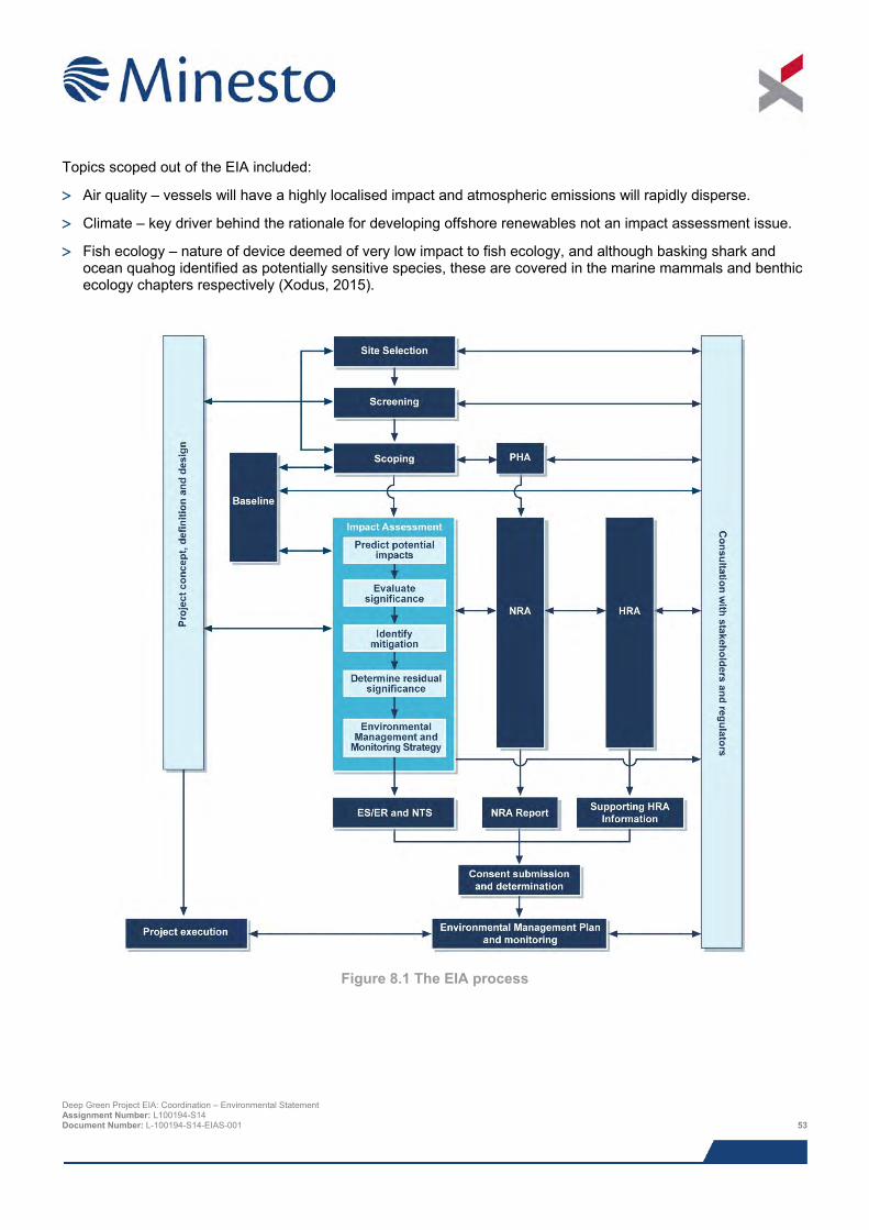
Topics scoped out of the EIA included:
> Air quality – vessels will have a highly localised impact and atmospheric emissions will rapidly disperse.
> Climate – key driver behind the rationale for developing offshore renewables not an impact assessment issue.
> Fish ecology – nature of device deemed of very low impact to fish ecology, and although basking shark and ocean quahog identified as potentially sensitive species, these are covered in the marine mammals and benthic ecology chapters respectively (Xodus, 2015).
Figure 8.1 The EIA process
Deep Green Project EIA: Coordination – Environmental Statement Assignment Number: L100194-S14 Document Number: L-100194-S14-EIAS-001 53
8.3 Assessment of impact
8.3.1 Overview of approach for assessing impact significance The EIA regulations require that the EIA should consider the likely significant environmental impacts. The decision process related to defining whether or not a project is likely to significantly impact the environment is the core principal of the EIA process. The regulations themselves do not provide a specific definition of "significance". However the methods used for identifying and assessing impacts should be transparent and verifiable.
The method detailed here has been developed by reference to the latest EIA principals and guidance provided by SNH in their handbook on EIA (SNH, 2013), the MarLIN species and ecosystem sensitivities guidelines (Tyler-Walters et al., 2001) the Chartered Institute of Ecology and Environmental Management (CIEEM) guidelines for marine impact assessment (IEEM, 2010) and the BSI EIA guidelines (BSI, 2015), and builds upon experience gained from undertaking other EIAs.
EIA provides an assessment of the environmental effects that may result from a project’s impact on the receiving environment. The terms impact and effect have different definitions in EIA and one drives the other. Impacts are defined as the changes resulting from an action, and effects are defined as the consequences of those impacts.
In general, impacts are specific, measureable changes in the receiving environment (volume, time and/or area) e.g. 25 seals will be disturbed following exposure to vessel noise emissions for a period of 2 months. Effects (the consequences of those impacts) consider the response of a receptor to an impact. For example, the effect of the seal/noise impact example might be a breeding failure in the local seal colony caused by disturbance, leading to a significant population decline. The relationship between impacts and effects is not always so straightforward e.g. a secondary effect may result in both a direct and indirect impact on a single receptor. There may also be circumstances where a receptor is not sensitive to a particular impact and thus there will be no significant effects/consequences.
For each impact, the assessment identifies a receptor’s sensitivity and vulnerability to that effect and implements a systematic approach to understand the level of impact. The process considers the following:
> Identification of receptor and impact (including duration, timing and nature of impact);
> Definition of sensitivity, vulnerability and value of receptor;
> Definition of magnitude and likelihood of impact; and
> Assessment of consequence of the impact on the receptor, considering the probability that it will occur, the spatial and temporal extent and the importance of the impact. If the assessment of consequence of impact is determined as moderate or major, it is considered a significant impact.
Once the consequence of a potential impact has been assessed it is possible to identify measures that can be taken to mitigate impacts through design or operational measures. This process also identifies aspects of the proposed Project that may require monitoring.
For some impacts, for example noise, significance criteria are standard or numerically based. For others, for which no applicable limits, standards or guideline values exist, a more qualitative approach is required. This involves assessing significance using professional judgement.
Despite the assessment of impact significance being a subjective process, a defined methodology, outlined below, is used to make the assessment as objective as possible and consistent across different topics. As the environmental factors under consideration can vary considerably depending on what is being assessed, there is likely to be some variation in this process in particular for this Project which has the potential to effect biological, physical and socio-economic environments. The assessment process is summarised below. Initially terms and criteria associated with the impact assessment process are described and defined, followed by details on how these are combined to assess consequence and impact significance.
8.3.2 Baseline characterisation and receptor identification In order to make an assessment of potential impacts on the environment it is necessary to firstly characterise the different aspects of the environment that could potentially be affected (the baseline environment). Characterisation Deep Green Project EIA: Coordination – Environmental Statement Assignment Number: L100194-S14 Document Number: L-100194-S14-EIAS-001 54
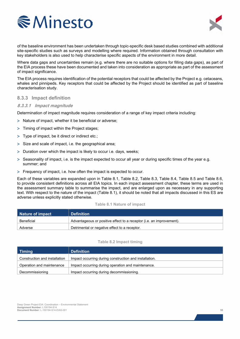
of the baseline environment has been undertaken through topic-specific desk based studies combined with additional site-specific studies such as surveys and modelling where required. Information obtained through consultation with key stakeholders is also used to help characterise specific aspects of the environment in more detail.
Where data gaps and uncertainties remain (e.g. where there are no suitable options for filling data gaps), as part of the EIA process these have been documented and taken into consideration as appropriate as part of the assessment of impact significance.
The EIA process requires identification of the potential receptors that could be affected by the Project e.g. cetaceans, whales and pinnipeds. Key receptors that could be affected by the Project should be identified as part of baseline characterisation study.
8.3.3 Impact definition 8.3.3.1 Impact magnitude Determination of impact magnitude requires consideration of a range of key impact criteria including:
> Nature of impact, whether it be beneficial or adverse;
> Timing of impact within the Project stages;
> Type of impact, be it direct or indirect etc.;
> Size and scale of impact, i.e. the geographical area;
> Duration over which the impact is likely to occur i.e. days, weeks;
> Seasonality of impact, i.e. is the impact expected to occur all year or during specific times of the year e.g. summer; and
> Frequency of impact, i.e. how often the impact is expected to occur.
Each of these variables are expanded upon in Table 8.1, Table 8.2, Table 8.3, Table 8.4, Table 8.5 and Table 8.6, to provide consistent definitions across all EIA topics. In each impact assessment chapter, these terms are used in the assessment summary table to summarise the impact, and are enlarged upon as necessary in any supporting text. With respect to the nature of the impact (Table 8.1), it should be noted that all impacts discussed in this ES are adverse unless explicitly stated otherwise.
Table 8.1 Nature of impact
Nature of impact Definition Beneficial Advantageous or positive effect to a receptor (i.e. an improvement).
Adverse Detrimental or negative effect to a receptor.
Table 8.2 Impact timing
Timing Definition Construction and installation Impact occurring during construction and installation.
Operation and maintenance Impact occurring during operation and maintenance.
Decommissioning Impact occurring during decommissioning.
Deep Green Project EIA: Coordination – Environmental Statement Assignment Number: L100194-S14 Document Number: L-100194-S14-EIAS-001 55
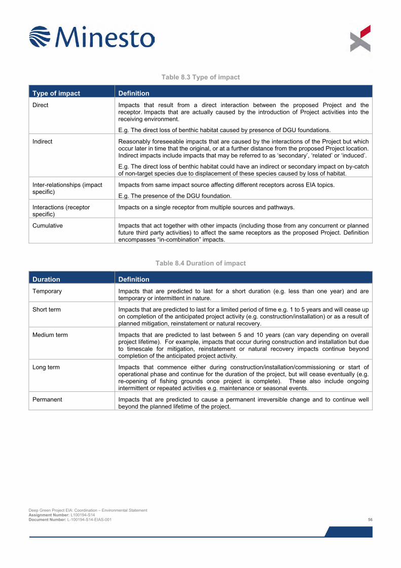
Table 8.3 Type of impact
Type of impact Definition Direct Impacts that result from a direct interaction between the proposed Project and the
receptor. Impacts that are actually caused by the introduction of Project activities into the receiving environment.
E.g. The direct loss of benthic habitat caused by presence of DGU foundations.
Indirect Reasonably foreseeable impacts that are caused by the interactions of the Project but which occur later in time that the original, or at a further distance from the proposed Project location. Indirect impacts include impacts that may be referred to as ‘secondary’, ‘related’ or ‘induced’.
E.g. The direct loss of benthic habitat could have an indirect or secondary impact on by-catch of non-target species due to displacement of these species caused by loss of habitat.
Inter-relationships (impact specific)
Impacts from same impact source affecting different receptors across EIA topics.
E.g. The presence of the DGU foundation.
Interactions (receptor specific)
Impacts on a single receptor from multiple sources and pathways.
Cumulative Impacts that act together with other impacts (including those from any concurrent or planned future third party activities) to affect the same receptors as the proposed Project. Definition encompasses “in-combination” impacts.
Table 8.4 Duration of impact
Duration Definition Temporary Impacts that are predicted to last for a short duration (e.g. less than one year) and are
temporary or intermittent in nature.
Short term Impacts that are predicted to last for a limited period of time e.g. 1 to 5 years and will cease up on completion of the anticipated project activity (e.g. construction/installation) or as a result of planned mitigation, reinstatement or natural recovery.
Medium term Impacts that are predicted to last between 5 and 10 years (can vary depending on overall project lifetime). For example, impacts that occur during construction and installation but due to timescale for mitigation, reinstatement or natural recovery impacts continue beyond completion of the anticipated project activity.
Long term Impacts that commence either during construction/installation/commissioning or start of operational phase and continue for the duration of the project, but will cease eventually (e.g. re-opening of fishing grounds once project is complete). These also include ongoing intermittent or repeated activities e.g. maintenance or seasonal events.
Permanent Impacts that are predicted to cause a permanent irreversible change and to continue well beyond the planned lifetime of the project.
Deep Green Project EIA: Coordination – Environmental Statement Assignment Number: L100194-S14 Document Number: L-100194-S14-EIAS-001 56
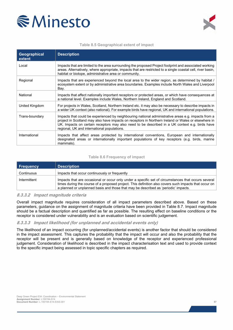
Table 8.5 Geographical extent of impact
Geographical extent
Description
Local Impacts that are limited to the area surrounding the proposed Project footprint and associated working areas. Alternatively, where appropriate, impacts that are restricted to a single coastal cell, river basin, habitat or biotope, administrative area or community.
Regional Impacts that are experienced beyond the local area to the wider region, as determined by habitat / ecosystem extent or by administrative area boundaries. Examples include North Wales and Liverpool Bay.
National Impacts that affect nationally important receptors or protected areas, or which have consequences at a national level. Examples include Wales, Northern Ireland, England and Scotland.
United Kingdom For projects in Wales, Scotland, Northern Ireland etc. it may also be necessary to describe impacts in a wider UK context (also national). For example birds have regional, UK and international populations.
Trans-boundary Impacts that could be experienced by neighbouring national administrative areas e.g. impacts from a project in Scotland may also have impacts on receptors in Northern Ireland or Wales or elsewhere in UK. Impacts on certain receptors may also need to be described in a UK context e.g. birds have regional, UK and international populations.
International Impacts that affect areas protected by international conventions, European and internationally designated areas or internationally important populations of key receptors (e.g. birds, marine mammals).
Table 8.6 Frequency of impact
Frequency Description Continuous Impacts that occur continuously or frequently
Intermittent Impacts that are occasional or occur only under a specific set of circumstances that occurs several times during the course of a proposed project. This definition also covers such impacts that occur on a planned or unplanned basis and those that may be described as ‘periodic’ impacts.
8.3.3.2 Impact magnitude criteria Overall impact magnitude requires consideration of all impact parameters described above. Based on these parameters, guidance on the assignment of magnitude criteria have been provided in Table 8.7. Impact magnitude should be a factual description and quantified as far as possible. The resulting effect on baseline conditions or the receptor is considered under vulnerability and is an evaluation based on scientific judgement.
8.3.3.3 Impact likelihood (for unplanned and accidental events only) The likelihood of an impact occurring (for unplanned/accidental events) is another factor that should be considered in the impact assessment. This captures the probability that the impact will occur and also the probability that the receptor will be present and is generally based on knowledge of the receptor and experienced professional judgement. Consideration of likelihood is described in the impact characterisation text and used to provide context to the specific impact being assessed in topic specific chapters as required.
Deep Green Project EIA: Coordination – Environmental Statement Assignment Number: L100194-S14 Document Number: L-100194-S14-EIAS-001 57
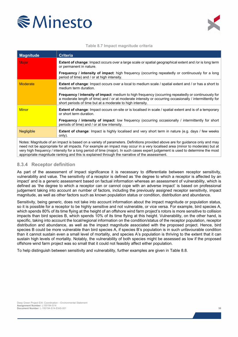
Table 8.7 Impact magnitude criteria
Magnitude Criteria Major Extent of change: Impact occurs over a large scale or spatial geographical extent and /or is long term
or permanent in nature.
Frequency / intensity of impact: high frequency (occurring repeatedly or continuously for a long period of time) and / or at high intensity.
Moderate Extent of change: Impact occurs over a local to medium scale / spatial extent and / or has a short to medium term duration.
Frequency / intensity of impact: medium to high frequency (occurring repeatedly or continuously for a moderate length of time) and / or at moderate intensity or occurring occasionally / intermittently for short periods of time but at a moderate to high intensity.
Minor Extent of change: Impact occurs on-site or is localised in scale / spatial extent and is of a temporary or short term duration.
Frequency / intensity of impact: low frequency (occurring occasionally / intermittently for short periods of time) and / or at low intensity.
Negligible Extent of change: Impact is highly localised and very short term in nature (e.g. days / few weeks only).
Notes: Magnitude of an impact is based on a variety of parameters. Definitions provided above are for guidance only and may need not be appropriate for all impacts. For example an impact may occur in a very localised area (minor to moderate) but at very high frequency / intensity for a long period of time (major). In such cases expert judgement is used to determine the most appropriate magnitude ranking and this is explained through the narrative of the assessment.
8.3.4 Receptor definition As part of the assessment of impact significance it is necessary to differentiate between receptor sensitivity, vulnerability and value. The sensitivity of a receptor is defined as ‘the degree to which a receptor is affected by an impact’ and is a generic assessment based on factual information whereas an assessment of vulnerability, which is defined as ‘the degree to which a receptor can or cannot cope with an adverse impact’ is based on professional judgement taking into account an number of factors, including the previously assigned receptor sensitivity, impact magnitude, as well as other factors such as known population status or condition, distribution and abundance.
Sensitivity, being generic, does not take into account information about the impact magnitude or population status, so it is possible for a receptor to be highly sensitive and not vulnerable, or vice versa. For example, bird species A, which spends 80% of its time flying at the height of an offshore wind farm project’s rotors is more sensitive to collision impacts than bird species B, which spends 10% of its time flying at this height. Vulnerability, on the other hand, is specific, taking into account the local/regional information on the condition/status of the receptor population, receptor distribution and abundance, as well as the impact magnitude associated with the proposed project. Hence, bird species B could be more vulnerable than bird species A, if species B’s population is in such unfavourable condition than it cannot sustain even a small level of mortality, and species A’s population is thriving to the extent that it can sustain high levels of mortality. Notably, the vulnerability of both species might be assessed as low if the proposed offshore wind farm project was so small that it could not feasibly affect either population.
To help distinguish between sensitivity and vulnerability, further examples are given in Table 8.8.
Deep Green Project EIA: Coordination – Environmental Statement Assignment Number: L100194-S14 Document Number: L-100194-S14-EIAS-001 58
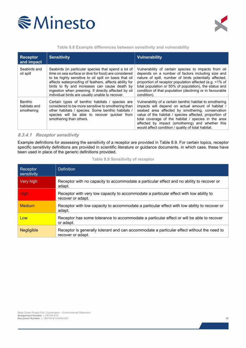
Table 8.8 Example differences between sensitivity and vulnerability
Receptor and impact
Sensitivity Vulnerability
Seabirds and oil spill
Seabirds (in particular species that spend a lot of time on sea surface or dive for food) are considered to be highly sensitive to oil spill on basis that oil affects waterproofing of feathers, affects ability for birds to fly and increases can cause death by ingestion when preening. If directly affected by oil individual birds are usually unable to recover.
Vulnerability of certain species to impacts from oil depends on a number of factors including size and nature of spill, number of birds potentially affected, proportion of receptor population affected (e.g. <1% of total population or 50% of population), the status and condition of that population (declining or in favourable condition).
Benthic habitats and smothering
Certain types of benthic habitats / species are considered to be more sensitive to smothering than other habitats / species. Some benthic habitats / species will be able to recover quicker from smothering than others.
Vulnerability of a certain benthic habitat to smothering impacts will depend on actual amount of habitat / seabed area affected by smothering, conservation value of the habitat / species affected, proportion of total coverage of the habitat / species in the area affected by impact (smothering) and whether this would affect condition / quality of total habitat.
8.3.4.1 Receptor sensitivity Example definitions for assessing the sensitivity of a receptor are provided in Table 8.9. For certain topics, receptor specific sensitivity definitions are provided in scientific literature or guidance documents, in which case, these have been used in place of the generic definitions provided.
Table 8.9 Sensitivity of receptor
Receptor sensitivity
Definition
Very high Receptor with no capacity to accommodate a particular effect and no ability to recover or adapt.
High Receptor with very low capacity to accommodate a particular effect with low ability to recover or adapt.
Medium Receptor with low capacity to accommodate a particular effect with low ability to recover or adapt.
Low Receptor has some tolerance to accommodate a particular effect or will be able to recover or adapt.
Negligible Receptor is generally tolerant and can accommodate a particular effect without the need to recover or adapt.
Deep Green Project EIA: Coordination – Environmental Statement Assignment Number: L100194-S14 Document Number: L-100194-S14-EIAS-001 59
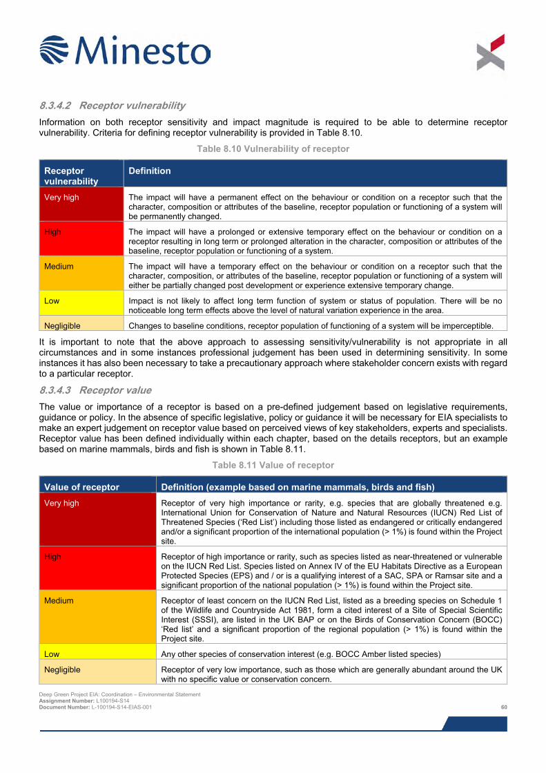
8.3.4.2 Receptor vulnerability Information on both receptor sensitivity and impact magnitude is required to be able to determine receptor vulnerability. Criteria for defining receptor vulnerability is provided in Table 8.10.
Table 8.10 Vulnerability of receptor
Receptor vulnerability
Definition
Very high The impact will have a permanent effect on the behaviour or condition on a receptor such that the character, composition or attributes of the baseline, receptor population or functioning of a system will be permanently changed.
High The impact will have a prolonged or extensive temporary effect on the behaviour or condition on a receptor resulting in long term or prolonged alteration in the character, composition or attributes of the baseline, receptor population or functioning of a system.
Medium The impact will have a temporary effect on the behaviour or condition on a receptor such that the character, composition, or attributes of the baseline, receptor population or functioning of a system will either be partially changed post development or experience extensive temporary change.
Low Impact is not likely to affect long term function of system or status of population. There will be no noticeable long term effects above the level of natural variation experience in the area.
Negligible Changes to baseline conditions, receptor population of functioning of a system will be imperceptible.
It is important to note that the above approach to assessing sensitivity/vulnerability is not appropriate in all circumstances and in some instances professional judgement has been used in determining sensitivity. In some instances it has also been necessary to take a precautionary approach where stakeholder concern exists with regard to a particular receptor.
8.3.4.3 Receptor value The value or importance of a receptor is based on a pre-defined judgement based on legislative requirements, guidance or policy. In the absence of specific legislative, policy or guidance it will be necessary for EIA specialists to make an expert judgement on receptor value based on perceived views of key stakeholders, experts and specialists. Receptor value has been defined individually within each chapter, based on the details receptors, but an example based on marine mammals, birds and fish is shown in Table 8.11.
Table 8.11 Value of receptor
Value of receptor Definition (example based on marine mammals, birds and fish) Very high Receptor of very high importance or rarity, e.g. species that are globally threatened e.g.
International Union for Conservation of Nature and Natural Resources (IUCN) Red List of Threatened Species (‘Red List’) including those listed as endangered or critically endangered and/or a significant proportion of the international population (> 1%) is found within the Project site.
High Receptor of high importance or rarity, such as species listed as near-threatened or vulnerable on the IUCN Red List. Species listed on Annex IV of the EU Habitats Directive as a European Protected Species (EPS) and / or is a qualifying interest of a SAC, SPA or Ramsar site and a significant proportion of the national population (> 1%) is found within the Project site.
Medium Receptor of least concern on the IUCN Red List, listed as a breeding species on Schedule 1 of the Wildlife and Countryside Act 1981, form a cited interest of a Site of Special Scientific Interest (SSSI), are listed in the UK BAP or on the Birds of Conservation Concern (BOCC) ‘Red list’ and a significant proportion of the regional population (> 1%) is found within the Project site.
Low Any other species of conservation interest (e.g. BOCC Amber listed species)
Negligible Receptor of very low importance, such as those which are generally abundant around the UK with no specific value or conservation concern.
Deep Green Project EIA: Coordination – Environmental Statement Assignment Number: L100194-S14 Document Number: L-100194-S14-EIAS-001 60
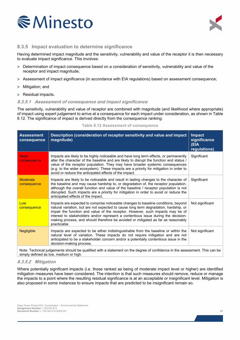
8.3.5 Impact evaluation to determine significance Having determined impact magnitude and the sensitivity, vulnerability and value of the receptor it is then necessary to evaluate impact significance. This involves:
> Determination of impact consequence based on a consideration of sensitivity, vulnerability and value of the receptor and impact magnitude;
> Assessment of impact significance (in accordance with EIA regulations) based on assessment consequence;
> Mitigation; and
> Residual impacts.
8.3.5.1 Assessment of consequence and impact significance The sensitivity, vulnerability and value of receptor are combined with magnitude (and likelihood where appropriate) of impact using expert judgement to arrive at a consequence for each impact under consideration, as shown in Table 8.12. The significance of impact is derived directly from the consequence ranking.
Table 8.12 Assessment of consequence
Assessment consequence
Description (consideration of receptor sensitivity and value and impact magnitude)
Impact significance (EIA regulations)
Major consequence
Impacts are likely to be highly noticeable and have long term effects, or permanently alter the character of the baseline and are likely to disrupt the function and status / value of the receptor population. They may have broader systemic consequences (e.g. to the wider ecosystem). These impacts are a priority for mitigation in order to avoid or reduce the anticipated effects of the impact.
Significant
Moderate consequence
Impacts are likely to be noticeable and result in lasting changes to the character of the baseline and may cause hardship to, or degradation of, the receptor population, although the overall function and value of the baseline / receptor population is not disrupted. Such impacts are a priority for mitigation in order to avoid or reduce the anticipated effects of the impact.
Significant
Low consequence
Impacts are expected to comprise noticeable changes to baseline conditions, beyond natural variation, but are not expected to cause long term degradation, hardship, or impair the function and value of the receptor. However, such impacts may be of interest to stakeholders and/or represent a contentious issue during the decision-making process, and should therefore be avoided or mitigated as far as reasonably practicable
Not significant
Negligible Impacts are expected to be either indistinguishable from the baseline or within the natural level of variation. These impacts do not require mitigation and are not anticipated to be a stakeholder concern and/or a potentially contentious issue in the decision-making process.
Not significant
Note: Technical judgements should be qualified with a statement on the degree of confidence in the assessment. This can be simply defined as low, medium or high.
8.3.5.2 Mitigation Where potentially significant impacts (i.e. those ranked as being of moderate impact level or higher) are identified mitigation measures have been considered. The intention is that such measures should remove, reduce or manage the impacts to a point where the resulting residual significance is at an acceptable or insignificant level. Mitigation is also proposed in some instances to ensure impacts that are predicted to be insignificant remain so.
Deep Green Project EIA: Coordination – Environmental Statement Assignment Number: L100194-S14 Document Number: L-100194-S14-EIAS-001 61
8.3.5.3 Residual impacts Residual impacts are those that remain once all options for removing, reducing or managing potentially significant impacts have been taken into account. Ideally, taking into account relevant mitigation the resulting significance of any residual impact should no longer be significant (i.e. reduced to an acceptable or insignificant level).
However, in some cases a significant residual impact may still remain. Where this is the case, it will be the role of the regulator with necessary advice from statutory bodies, as part of the decision making process to determine how the remaining residual impact influences the determination of the consent application.
8.3.6 Deviations from standard approach Some topic specific impact assessments have used a process which has deviated from the standard approach e.g. due to specific guidance / practices endorsed by professional accreditation organisations and consultees. Xodus has worked with each of the EIA specialists to ensure, where possible, that a consistent approach between topics has been used in the assessment of potentially significant impacts. The following topics have adopted a process which deviates from the standard approach:
> Shipping and navigation – agreed in consultation with the MCA and DECC in line with IMO’s Formal Safety Assessment (FSA) process;
> Hydrocarbon and chemical releases – adopts aspects of approach used for shipping and navigation;
> Offshore ornithology – adopts species specific sensitivity criteria defined by Furness et al. (2012) and Wiens et al. (1995), referenced in Chapter 12;
> Marine historic environment – agreed with Cadw and in line with established guidance;
> Seascape, landscape and visual – agreed with JNCC, NRW (and IACC) and in line with best practice methodologies and policy and landscape and seascape characterisation guidance; and
> Socio-economic.
8.3.7 Cumulative impacts The consideration of potential cumulative impacts is an important stage in the EIA process as combined incremental impacts pose a threat to sensitive receptors. Cumulative impacts act together with other impacts (including those from any concurrent or planned future third party activities) to affect the same receptors as the proposed Project.
Cumulative impacts have been considered throughout the EIA process and have been considered for all stages of the Project. Minesto has, in consultation with NRW (and IACC), identified a list of other projects, which together with the DG Holyhead Deep Project may result in potential cumulative impacts. These projects and associated project details are provided in Table 8.13. The location of these projects is shown in Figure 8.2.
The general principle for the cumulative impact assessment was to consider only those projects that were at EIA scoping stage (i.e. for which an EIA Scoping Report and requests for a EIA Scoping Opinion have been submitted) and beyond (as of August 2015). However there were other projects which were very close to submitting their EIA Scoping Reports and/or directly relevant to the proposed Project and NRW advised that these should also be included in the cumulative impact assessment.
With regards to the West Anglesey Demonstration Zone (WADZ), part way through the process of the present EIA, Morlais undertook consultation to change their site boundary, moving the overall site to the north. All chapters in this ES were subsequently updated to ensure that cumulative impacts were assessed in light of the WADZ boundary modification.
Details of the projects to be considered for the cumulative impact assessment were provided to all EIA study leads. The study leads then considered which of these projects could result in potential cumulative impacts with the Project. This decision was based on the results of the specific impact assessment together with the expert judgement of the specialist consultant undertaking the impact assessment.
Deep Green Project EIA: Coordination – Environmental Statement Assignment Number: L100194-S14 Document Number: L-100194-S14-EIAS-001 62

Inevitably the assessment of these ‘future projects’ is dependent upon the level of information available on those projects at the time of undertaking the cumulative assessment. Due to the fact there were different levels of detail available for different projects, the cumulative impact assessment has been undertaking qualitatively. Sufficient data was not available in the public domain to allow a fully quantified cumulative impact assessment.
Each technical ES chapter contains a sub section which identifies the projects which are relevant on a cumulative basis and an assessment of the relevant cumulative impacts.
Deep Green Project EIA: Coordination – Environmental Statement Assignment Number: L100194-S14 Document Number: L-100194-S14-EIAS-001 63

Figure 8.2 Projects to be considered when making selection for cumulative impact assessment
Deep Green Project EIA: Coordination – Environmental Statement Assignment Number: L100194-S14 Document Number: L-100194-S14-EIAS-001 64

This page has intentionally been left blank.
Deep Green Project EIA: Coordination – Environmental Statement Assignment Number: L100194-S14 Document Number: L-100194-S14-EIAS-001 65
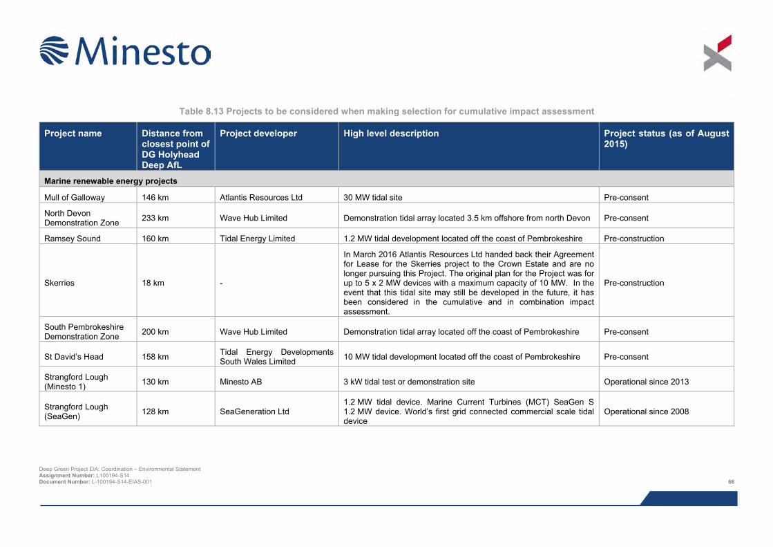
Table 8.13 Projects to be considered when making selection for cumulative impact assessment
Project name Distance from closest point of DG Holyhead Deep AfL
Project developer High level description Project status (as of August 2015)
Marine renewable energy projects
Mull of Galloway 146 km Atlantis Resources Ltd 30 MW tidal site Pre-consent
North Devon Demonstration Zone 233 km Wave Hub Limited Demonstration tidal array located 3.5 km offshore from north Devon Pre-consent
Ramsey Sound 160 km Tidal Energy Limited 1.2 MW tidal development located off the coast of Pembrokeshire Pre-construction
Skerries 18 km -
In March 2016 Atlantis Resources Ltd handed back their Agreement for Lease for the Skerries project to the Crown Estate and are no longer pursuing this Project. The original plan for the Project was for up to 5 x 2 MW devices with a maximum capacity of 10 MW. In the event that this tidal site may still be developed in the future, it has been considered in the cumulative and in combination impact assessment.
Pre-construction
South Pembrokeshire Demonstration Zone 200 km Wave Hub Limited Demonstration tidal array located off the coast of Pembrokeshire Pre-consent
St David’s Head 158 km Tidal Energy Developments South Wales Limited 10 MW tidal development located off the coast of Pembrokeshire Pre-consent
Strangford Lough (Minesto 1) 130 km Minesto AB 3 kW tidal test or demonstration site Operational since 2013
Strangford Lough (SeaGen) 128 km SeaGeneration Ltd
1.2 MW tidal device. Marine Current Turbines (MCT) SeaGen S 1.2 MW device. World’s first grid connected commercial scale tidal device
Operational since 2008
Deep Green Project EIA: Coordination – Environmental Statement Assignment Number: L100194-S14 Document Number: L-100194-S14-EIAS-001 66
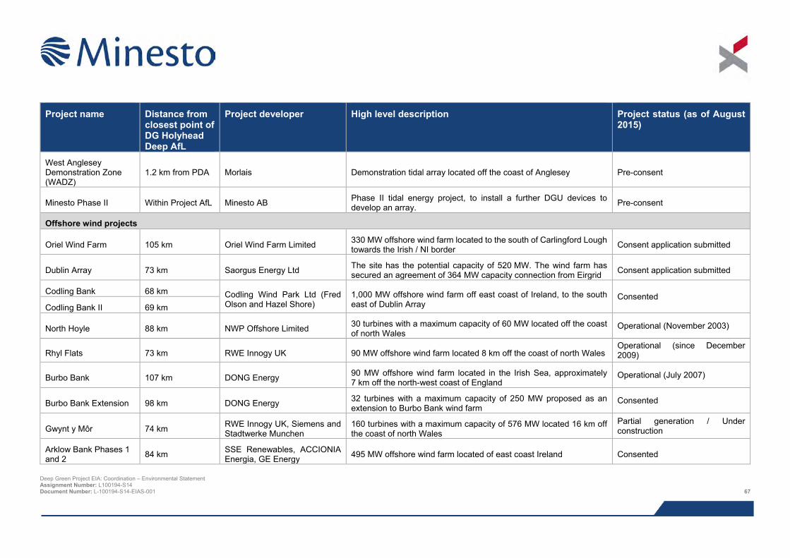
Project name Distance from
closest point of DG Holyhead Deep AfL
Project developer High level description Project status (as of August 2015)
West Anglesey Demonstration Zone (WADZ)
1.2 km from PDA Morlais Demonstration tidal array located off the coast of Anglesey Pre-consent
Minesto Phase II Within Project AfL Minesto AB Phase II tidal energy project, to install a further DGU devices to develop an array. Pre-consent
Offshore wind projects
Oriel Wind Farm 105 km Oriel Wind Farm Limited 330 MW offshore wind farm located to the south of Carlingford Lough towards the Irish / NI border Consent application submitted
Dublin Array 73 km Saorgus Energy Ltd The site has the potential capacity of 520 MW. The wind farm has secured an agreement of 364 MW capacity connection from Eirgrid Consent application submitted
Codling Bank 68 km Codling Wind Park Ltd (Fred Olson and Hazel Shore)
1,000 MW offshore wind farm off east coast of Ireland, to the south east of Dublin Array
Consented Codling Bank II 69 km
North Hoyle 88 km NWP Offshore Limited 30 turbines with a maximum capacity of 60 MW located off the coast of north Wales
Operational (November 2003)
Rhyl Flats 73 km RWE Innogy UK 90 MW offshore wind farm located 8 km off the coast of north Wales Operational (since December 2009)
Burbo Bank 107 km DONG Energy 90 MW offshore wind farm located in the Irish Sea, approximately 7 km off the north-west coast of England
Operational (July 2007)
Burbo Bank Extension 98 km DONG Energy 32 turbines with a maximum capacity of 250 MW proposed as an extension to Burbo Bank wind farm
Consented
Gwynt y Môr 74 km RWE Innogy UK, Siemens and Stadtwerke Munchen
160 turbines with a maximum capacity of 576 MW located 16 km off the coast of north Wales
Partial generation / Under construction
Arklow Bank Phases 1 and 2 84 km SSE Renewables, ACCIONIA
Energia, GE Energy 495 MW offshore wind farm located of east coast Ireland Consented
Deep Green Project EIA: Coordination – Environmental Statement Assignment Number: L100194-S14 Document Number: L-100194-S14-EIAS-001 67
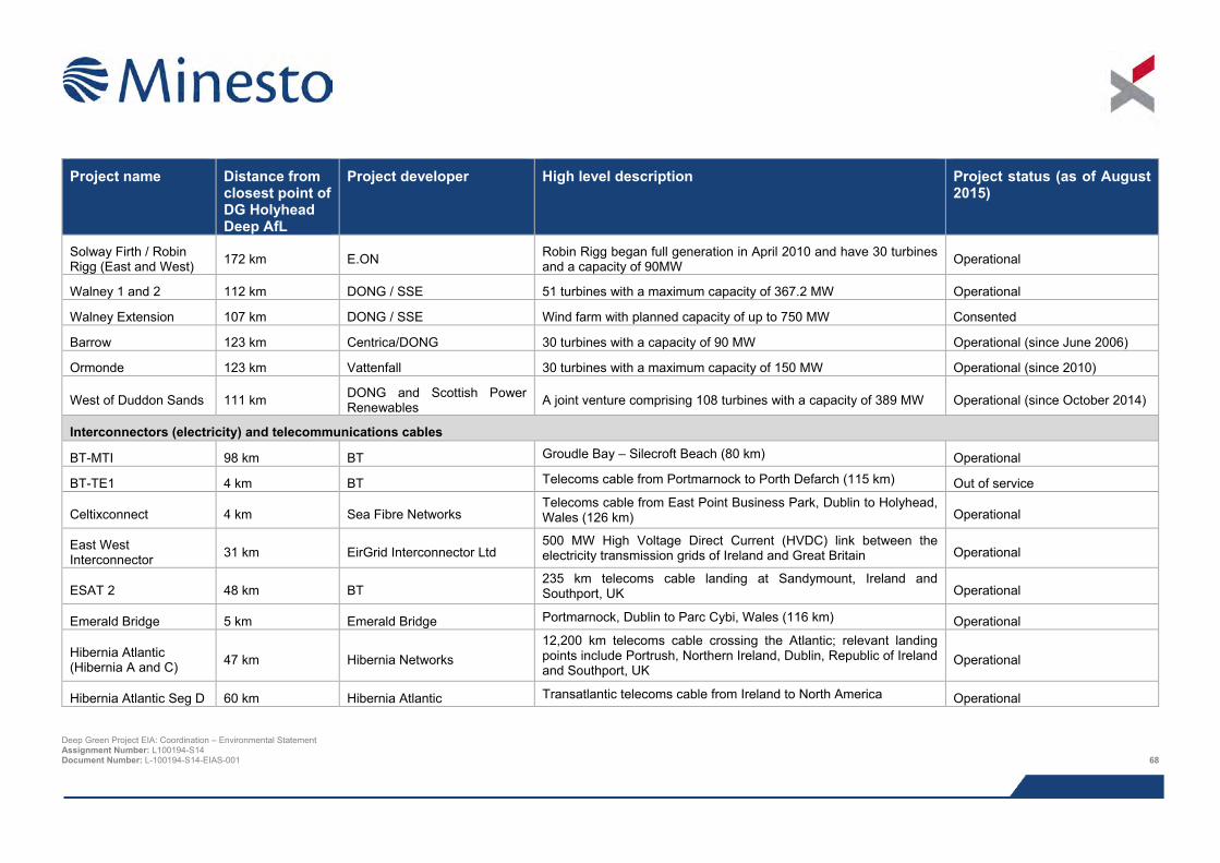
Project name Distance from
closest point of DG Holyhead Deep AfL
Project developer High level description Project status (as of August 2015)
Solway Firth / Robin Rigg (East and West) 172 km E.ON Robin Rigg began full generation in April 2010 and have 30 turbines
and a capacity of 90MW Operational
Walney 1 and 2 112 km DONG / SSE 51 turbines with a maximum capacity of 367.2 MW Operational
Walney Extension 107 km DONG / SSE Wind farm with planned capacity of up to 750 MW Consented
Barrow 123 km Centrica/DONG 30 turbines with a capacity of 90 MW Operational (since June 2006)
Ormonde 123 km Vattenfall 30 turbines with a maximum capacity of 150 MW Operational (since 2010)
West of Duddon Sands 111 km DONG and Scottish Power Renewables A joint venture comprising 108 turbines with a capacity of 389 MW Operational (since October 2014)
Interconnectors (electricity) and telecommunications cables
BT-MTI 98 km BT Groudle Bay – Silecroft Beach (80 km) Operational
BT-TE1 4 km BT Telecoms cable from Portmarnock to Porth Defarch (115 km) Out of service
Celtixconnect 4 km Sea Fibre Networks Telecoms cable from East Point Business Park, Dublin to Holyhead, Wales (126 km) Operational
East West Interconnector 31 km EirGrid Interconnector Ltd
500 MW High Voltage Direct Current (HVDC) link between the electricity transmission grids of Ireland and Great Britain Operational
ESAT 2 48 km BT 235 km telecoms cable landing at Sandymount, Ireland and Southport, UK Operational
Emerald Bridge 5 km Emerald Bridge Portmarnock, Dublin to Parc Cybi, Wales (116 km) Operational
Hibernia Atlantic (Hibernia A and C) 47 km Hibernia Networks
12,200 km telecoms cable crossing the Atlantic; relevant landing points include Portrush, Northern Ireland, Dublin, Republic of Ireland and Southport, UK
Operational
Hibernia Atlantic Seg D 60 km Hibernia Atlantic Transatlantic telecoms cable from Ireland to North America Operational
Deep Green Project EIA: Coordination – Environmental Statement Assignment Number: L100194-S14 Document Number: L-100194-S14-EIAS-001 68
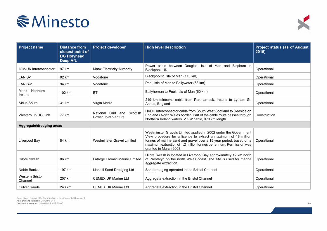
Project name Distance from
closest point of DG Holyhead Deep AfL
Project developer High level description Project status (as of August 2015)
IOM/UK Interconnector 97 km Manx Electricity Authority Power cable between Douglas, Isle of Man and Bispham in Blackpool, UK Operational
LANIS-1 82 km Vodafone Blackpool to Isle of Man (113 km) Operational
LANIS-2 94 km Vodafone Peel, Isle of Man to Ballywater (68 km) Operational
Manx – Northern Ireland 102 km BT Ballyhornan to Peel, Isle of Man (60 km) Operational
Sirius South 31 km Virgin Media 219 km telecoms cable from Portmarnock, Ireland to Lytham St. Annes, England Operational
Western HVDC Link 77 km National Grid and Scottish Power Joint Venture
HVDC Interconnector cable from South West Scotland to Deeside on England / North Wales border. Part of the cable route passes through Northern Ireland waters. 2 GW cable, 370 km length
Construction
Aggregate/dredging areas
Liverpool Bay 84 km Westminster Gravel Limited
Westminster Gravels Limited applied in 2002 under the Government View procedure for a licence to extract a maximum of 18 million tonnes of marine sand and gravel over a 15 year period, based on a maximum extraction of 1.2 million tonnes per annum. Permission was granted in March 2008.
Operational
Hilbre Swash 86 km Lafarge Tarmac Marine Limited Hilbre Swash is located in Liverpool Bay approximately 12 km north of Prestatyn on the north Wales coast. The site is used for marine aggregate extraction.
Operational
Noble Banks 197 km Llanelli Sand Dredging Ltd Sand dredging operated in the Bristol Channel Operational
Western Bristol Channel 207 km CEMEX UK Marine Ltd Aggregate extraction in the Bristol Channel Operational
Culver Sands 243 km CEMEX UK Marine Ltd Aggregate extraction in the Bristol Channel Operational
Deep Green Project EIA: Coordination – Environmental Statement Assignment Number: L100194-S14 Document Number: L-100194-S14-EIAS-001 69
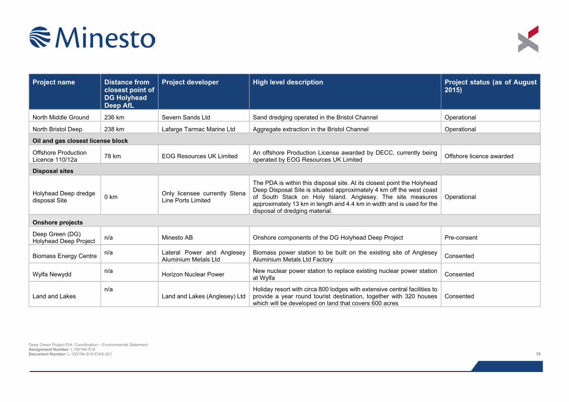
Project name Distance from
closest point of DG Holyhead Deep AfL
Project developer High level description Project status (as of August 2015)
North Middle Ground 236 km Severn Sands Ltd Sand dredging operated in the Bristol Channel Operational
North Bristol Deep 238 km Lafarge Tarmac Marine Ltd Aggregate extraction in the Bristol Channel Operational
Oil and gas closest license block
Offshore Production Licence 110/12a 78 km EOG Resources UK Limited An offshore Production License awarded by DECC, currently being
operated by EOG Resources UK Limited Offshore licence awarded
Disposal sites
Holyhead Deep dredge disposal Site 0 km Only licensee currently Stena
Line Ports Limited
The PDA is within this disposal site. At its closest point the Holyhead Deep Disposal Site is situated approximately 4 km off the west coast of South Stack on Holy Island. Anglesey. The site measures approximately 13 km in length and 4.4 km in width and is used for the disposal of dredging material.
Operational
Onshore projects
Deep Green (DG) Holyhead Deep Project n/a Minesto AB Onshore components of the DG Holyhead Deep Project Pre-consent
Biomass Energy Centre n/a Lateral Power and Anglesey Aluminium Metals Ltd
Biomass power station to be built on the existing site of Anglesey Aluminium Metals Ltd Factory Consented
Wylfa Newydd n/a Horizon Nuclear Power New nuclear power station to replace existing nuclear power station at Wylfa Consented
Land and Lakes n/a
Land and Lakes (Anglesey) Ltd Holiday resort with circa 800 lodges with extensive central facilities to provide a year round tourist destination, together with 320 houses which will be developed on land that covers 600 acres
Consented
Deep Green Project EIA: Coordination – Environmental Statement Assignment Number: L100194-S14 Document Number: L-100194-S14-EIAS-001 70
8.3.8 Decommissioning impacts The EIA regulations require the EIA process to assess impacts from decommissioning activities. Each EIA specialist has considered the potential impacts as a result of the proposed decommissioning activities (based on the high level detail available at the present time) and in general, the same conclusion has been drawn by all specialists; the impacts are broadly similar to those identified for the construction and installation stage of the Project. It was therefore not deemed necessary to discuss in detail impacts associated with decommissioning in each technical chapter of the ES. A high level assessment of potential impacts has been presented which highlights any additional impact mechanisms to those identified during the construction, installation and operational phases of the Project. In addition, it should be noted that when the Project nears the decommissioning stage and once more detail is available on the specific activities associated with decommissioning further, more detailed assessment of environmental impacts will be undertaken as part of the Decommissioning Programme.
8.3.9 Environmental management and monitoring Environmental assessment, including consultation with stakeholders, is an iterative process, which will continue beyond application submission. As part of the conditions of the Marine Licence it is likely that Minesto will be required to prepare an Environmental Management Plan (EMP) and possibly a Project Environmental Monitoring Plan (PEMP). The content of these plans will be defined by the conditions of consent.
8.3.10 Habitat Regulation Assessment (HRA) In order to inform whether an Appropriate Assessment may be required, a Habitat Regulation Assessment has been carried out for this Project in line with the requirement Article 6 of the Habitats Directive, HRA Case Law and best practice guidance. The HRA was undertaken following completion of the EIA. This was to ensure sufficient information was available to be able to make a judgement with sufficient certainty at HRA screening as to whether the Project is likely or not likely to have a significant effect on a European protected site.
Results from the HRA are presented in the separate HRA Report (Xodus, 2016) which has been submitted with this ES. The HRA Report includes results from screening and information to support a potential Appropriate Assessment of European sites (Special Areas of Conservation (SACs), Special Protection Areas (SPAs), possible SACs (pSACs) and potential SPAs (pSPAs)) where Likely Significant Effects (LSE) could not be ruled out at screening.
By carrying out the HRA towards the end of the EIA process meant that there was more information available to inform the assessment of the potential effects of the Project on a European site. This meant that those sites where significant effects are not likely to occur (conclusion no LSE) could be properly screened out from the HRA process thereby reducing the total number of sites identified as potentially requiring an Appropriate Assessment. By taking into account all available data and Project information (including mitigation measures) this approach ensures that the HRA process is robust and that any required Appropriate Assessment focuses on those sites where significant effects are most likely to occur.
A description of the HRA methodology is provided in the HRA Report.
8.4 References BSI (2015). Environmental impact assessment for offshore renewable energy projects – Guide. PD 6900:2015
Institute of Ecology and Environmental Management (IEEM) (2010). Guidelines for Ecological Impact Assessment in Britain and Ireland, Marine and Coastal. August 2010. Final Version 5.
Minesto (2013). Deep Green Project. Request to Natural Resources Wales and the Marine Management Organisation for an Opinion on the Scope of the Environmental Statement. Prepared by PMSS on behalf of Minesto. November 2013.
Natural Resources Wales (NRW) (2014). Scoping Opinion Under The Marine Works (Environmental Impact Assessment) Regulations 2007 (as amended). February 2014.
Deep Green Project EIA: Coordination – Environmental Statement Assignment Number: L100194-S14 Document Number: L-100194-S14-EIAS-001 71

Scottish Natural Heritage (SNH) (2013). A handbook on environmental impact assessment; Guidance for Competent Authorities, Consultees and others involved in the Environmental Impact Assessment Process in Scotland. 4th Edition.
Tyler-Walters H., Hiscock K., Lear D.B. & Jackson A. (2001). Identifying species and ecosystems sensitivities. Final report to the Department of Environment, Food and Rural Affairs from the Marine Life Information Network (MarLIN), Marine Biological Association of the United Kingdom, Plymouth. Contract CW0826.
Xodus (2015a). Deep Green Project EIA: Technical Studies, Fish and Shellfish Ecology. Document No. L100194-S01-TECH-004.
Xodus (2016). Deep Green Holyhead Deep – Habitats Regulations Appraisal (HRA) Report. Document number L-100194-S00-REPT-012. June 2016.
Deep Green Project EIA: Coordination – Environmental Statement Assignment Number: L100194-S14 Document Number: L-100194-S14-EIAS-001 72

This page has been intentionally left blank.
Deep Green Project EIA: Coordination – Environmental Statement Assignment Number: L100194-S14 Document Number: L-100194-S14-EIAS-001 73
9 PHYSICAL PROCESSES
Characterisation of the existing physical environment and sediment processes is based on both existing and site specific survey data. The Project Development Area (PDA) is located in the southern extent of the Holyhead Deep, with water depths ranging between 65 to 91 m. Depth-averaged mean tidal current velocities in the PDA are generally around 1 m/s, although they may exceed 2.5 m/s during spring tidal flow. The dominant flood tide direction is to the north-east, and the ebb direction is to the south-west. The seabed across the PDA comprises mainly sand and gravel, with several small, irregular patches of megarippled sand and gravel, including boulders. The sediment thickness within the PDA varies from a thin veneer in the north-east, to up to 50 m thick in the south-west. The tidal asymmetry at the Holyhead Deep favours sediment transport towards the north-east. The PDA is located within the southern half of the Holyhead Deep disposal site, so dredge disposal has been deposited in the vicinity of the PDA for many years, however, modelling studies and geophysical surveys of the site have shown that sediments quickly disperse across the wider region.
If a drilled DGU foundation solution is selected for the Project, a small quantity of drill cuttings may be released into the marine environment. The environment into which the drill cuttings will be released is highly energetic, so they will, for the most part, become widely dispersed into the surrounding waters, bringing about a localised and temporary increase in turbidity and very little in the way of perceptible sediment deposition.
The presence of soft sediments within the PDA means that there is the potential for scour to occur. The deep water at the DGU deployment area means that wave action is unlikely to influence scour. There is potential for some limited areas of current-induced scour around the barge (or similar such surface platform) anchors and DGU foundation structure and if required scour protection will be installed around the edge of the foundation. The impacts of scour protection are assessed in other chapters of the ES e.g. benthic ecology.
9.1 Introduction The potential effects of the Project on physical processes are assessed in this chapter. The following specialists have contributed to the assessment:
> SEACAMS4 data provided to Minesto (Johnsson, pers. comm.) – tidal model simulations, seabed sediment grab surveys, geophysical surveys;
> Potter (2014) – sediment transport modelling;
> Bibby HydroMap (2015) – seabed survey, video footage analysis, biotope mapping, seabed survey reporting; and
> Xodus – baseline description, impact assessment and Environmental Statement (ES) chapter write up.
The table below provides a list of all the supporting studies which relate to the physical processes impact assessment (Table 9.1). All supporting studies are provided on the accompanying CD.
The impact assessment presented herein draws upon output from other impact assessments within this ES; where that information is used to inform assessment, reference to the relevant ES chapter is given.
Table 9.1 Supporting studies
Details of study
Holyhead Deep Disposal Site Characterisation Report (Xodus, 2014)
Offshore Geophysical Survey Report (Bibby HydroMap, 2015)
4 SEACAMS is a partnership between Bangor, Swansea and Aberystwyth Universities, whose objective is to integrate and expand research and business opportunities in the marine and coastal sector in Wales. Deep Green Project EIA: Coordination – Environmental Statement Assignment Number: L100194-S14 Document Number: L-100194-S14-EIAS-001 74
9.2 Area of assessment The focus of this physical processes assessment is to assess potential impacts on physical processes and sediment dynamics in the proposed Deep Green Utility (DGU) unit deployment area, as shown in Figure 9.1.
> Project Development Area (PDA):
o This is the area of seabed in which the DGU unit will be deployed. The exact siting of the device within the PDA has not yet been determined, but of the 4 km2 total area available, only a small fraction will be developed for the Project (see Figure 1.2 in the Chapter 1: Introduction).
> Study area:
o This is the area which incorporates the proposed DGU deployment area and immediate vicinity. None of the impacts in this chapter are predicted to extend beyond the PDA as impacts to currents, waves and sediment transport which often create the need for a wider study area were deemed negligible during scoping.
9.3 Legislation, policy and guidance The EIA Regulations stipulate a requirement to assess the impacts of a project on water quality and sediment. The Water Environment and Water Services (Wales) Act 2003, which implements the Water Framework Directive (WFD), should also be considered, with respect to River Basin Management Plans (RBMP) coastal water bodies. Information on current WFD RBMP status is summarised from the NRW Ynys Môn Management Catchment Summary (NRW, 2014a). Bathing water quality is monitored at identified locations in the UK to protect human health and the environment and should therefore be considered in this assessment (NRW, 2014b). There are no specific legislative controls relevant to the scope of the physical processes and sediment dynamics impact assessment. However there is guidance relevant to the offshore wind and marine renewables industries, which can provide useful parallels:
> Offshore Wind Farms. Guidance Note for Environmental Impact Assessment in Respect of FEPA and CPA Requirements. (Cefas, 2004);
> Guidelines for data acquisition to support marine environmental assessments of offshore renewable energy projects (Cefas, 2012);
> Assessment of the Significance of Changes to the Inshore Wave Regime as a consequence of an Offshore Wind Array (Cefas, 2005);
> Coastal Process Modelling for Offshore Windfarm Environmental Impact Assessment (COWRIE, 2009);
> Review of Cabling Techniques and Environmental Effects applicable to the Offshore Windfarm Industry (BERR 2008);
> Potential effects of offshore wind developments on coastal processes. (ABPmer and Metoc for DTI (now DECC) 2002); and
> Surfers Against Sewage (2009) Guidance on environmental impact assessment of offshore renewable energy development on surfing resources and recreation.
The Cefas guidelines highlight that direct impacts on hydrodynamics and sediment dynamics should be considered, along with secondary effects including water and benthic ecology (Chapter 10).
Deep Green Project EIA: Coordination – Environmental Statement Assignment Number: L100194-S14 Document Number: L-100194-S14-EIAS-001 75
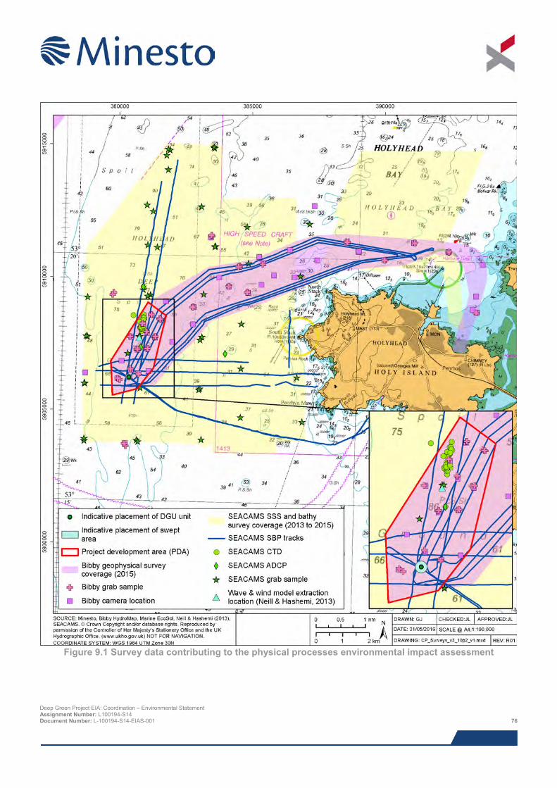
Figure 9.1 Survey data contributing to the physical processes environmental impact assessment
Deep Green Project EIA: Coordination – Environmental Statement Assignment Number: L100194-S14 Document Number: L-100194-S14-EIAS-001 76
9.4 Scoping and consultation Scoping and consultation have been ongoing throughout the EIA and played an important part in ensuring the scope of the baseline characterisation work and impact assessment have been appropriate to the Project and the requirements of the regulators and their advisors.
Table 9.2 below summarises all consultation activities carried out relevant to physical processes. Relevant comments from the EIA Scoping Opinion are summarised in Table 9.3.
Table 9.2 Consultation activities undertaken in relation to physical processes
> Date > Stakeholder > Consultation > Topic / specific issue 15/11/2013 NRW, Cefas, Natural Resources
Wales, Isle of Anglesey County Council, Holyhead Port Authority, Maritime and Coastguard Agency, National Air Traffic Services, Civil Aviation Authority, Royal Society for the Protection of Birds, Royal Yachting Association, Trinity Lighthouse Service, Royal Commission on the Ancient and Historical Monuments of Wales, Cadw, Marine Enforcement Officers, Welsh Government Energy Branch, The Crown Estate
Scoping report Overall Project scoping.
04/06/2014 NRW Consultation meeting No major issues identified on this topic as no protected sites.
25/06/2014 NRW Email Geophysical survey scope of work submitted to NRW for their review.
26/08/2014 Cefas Consultation meeting The Project will have no major impacts aside from the usual issues associated with export cable landfall (future phase of Project when grid connected).
21/05/2015 & 26/05/2016
General public Public exhibitions Public event held to allow members of the public to comment on overall Project and provide updates on the EIA.
Deep Green Project EIA: Coordination – Environmental Statement Assignment Number: L100194-S14 Document Number: L-100194-S14-EIAS-001 77
Table 9.3 Scoping comments in relation to physical processes
> Name of organisation
> Key concerns > Response > ES section in which the specific issue is addressed
NRW Due to the coarse nature of the seabed the application needs to clearly state how any cabling will be buried or attached to the seabed and the amount of cable protection required.
This application is for deployment of a single DGU device only in the PDA with no export cable and therefore not relevant.
n/a
NRW It is important that the ES addresses any inter-relationships between changes in marine processes and other receptors.
Inter-relationships between changes in marine processes and other receptors have been stated in this chapter. References to the relevant chapters have been included in the text, where impacts on the noted receptors are discussed.
Section 9.8.1
9.5 Baseline description This section provides a description of the baseline environment with respect to physical processes and sediment dynamics, against which the potential impacts associated with this Project have been assessed. The baseline description has been developed through the synthesis of surveys and desk based studies.
9.5.1 Desk based study As part of the desk based study for the assessment of impacts in relation to the physical environment, baseline data and information have been collected from the following sources:
> British Geological Survey (BGS) seabed sediment data;
> Coasts and seas of the United Kingdom, Region 12 Wales (Barne et al., 1995); and
> Howarth (2005) – technical report on the hydrography of the Irish Sea conducted as part of the Strategic Environmental Assessment (SEA) process.
9.5.2 Survey data In addition to the available published literature, field surveys have been undertaken that provide input to the physical processes impact assessment. Their location and coverage are summarised in Figure 9.1 and survey objectives and data gathered described below:
> Geophysical survey of the PDA (Bibby HydroMap, 2015):
o In June 2015, Bibby HydroMap Limited undertook a study to conduct a detailed geophysical survey of the PDA to provide information on bathymetry, shallow geology, seabed features and magnetic anomalies;
> Environmental survey of the PDA (Bibby HydroMap, 2015):
o In June 2015, Bibby HydroMap Limited were commissioned by Minesto to conduct an environmental survey of the PDA to provide information on seabed habitats and biotopes and species of conservational interest;
> Geophysical surveys in the vicinity of the Holyhead Deep disposal site (Johnsson, pers. comm.):
Deep Green Project EIA: Coordination – Environmental Statement Assignment Number: L100194-S14 Document Number: L-100194-S14-EIAS-001 78
o Between 2013 and 2014, SEACAMS undertook numerous high-resolution multibeam bathymetry
surveys and sediment grab sample surveys covering the majority of the Holyhead Deep disposal site as part of their ongoing research strategy; and
> Data analysis and numerical modelling of the Holyhead Deep disposal site (Potter, 2014):
o Potter (2014) investigated the Holyhead Deep disposal site using the following approaches:
Sediment transport modelling to simulate the behaviour of dredge spoil following deposition on the seabed;
Analysis of geophysical data to identify features on the seabed potentially related to dumping; and
Analysis of remote sensing data to determine the effect of disposal of total suspended matter.
9.5.3 Designated features Numerous statutory and non-statutory designated sites in the vicinity of the Project area relevant to this assessment are detailed in Table 9.4 and shown in Figure 9.2.
Many of these sites are outside the Project study area, but have been shown to give context for the kinds of features along the length of coast, and to demonstrate the distance these sites are from the Project.
Table 9.4 Designated or sensitive sites within the vicinity of the Project and of relevance to the physical processes
Site name Designation Reason for site designation / relevance Distance from PDA
Caernarfon Bar North Coastal water body
Welsh coastal water body 3.4 km
Holy Island Coast SPA & SAC SPA listed for supporting a breeding and over wintering Chough population, which depend on the diverse mix of habitats at the site.
SAC designated for Vegetated sea cliffs of the Atlantic and Baltic Coasts and European dry heaths.
5 km
South Stack Cliffs RSPB Reserve Listed for supporting breeding populations of guillemots, razorbills and puffins, which depend on the cliff habitat at the site.
5 km
Holyhead Bay Coastal water body
Welsh coastal water body 8.7 km
Porth Dafarch Bathing water Bacterial water quality monitoring for public health 8.7 km
Trearddur Bay None Indicative surf spot (Magic Seaweed, 2015) 10.8 km
Trearddur Bay Bathing water Bacterial water quality monitoring for public health 11 km
Porth Diana SSSI Listed for rare plant, coastal heath and rock outcrops 11.2 km
Beddmanarch-Cymyran
SSSI Listed for mudflats and sandflats with large areas of seagrass and areas of saltmarsh. Also supports rare dune heathland
11.4 km
Glannau Rhoscolyn SSSI Listed for stretches of cliffs, sea arches and caves. 11.5 km
Silver Bay None Indicative surf spot (Magic Seaweed, 2015) 11.5 km
Anglesey Inland Sea Shellfish Site
Bivalve mollusc production area
Listed for it being an area of bivalve mollusc production 12 km
Borth Wen Bathing water Bacterial water quality monitoring for public health 14 km Deep Green Project EIA: Coordination – Environmental Statement Assignment Number: L100194-S14 Document Number: L-100194-S14-EIAS-001 79
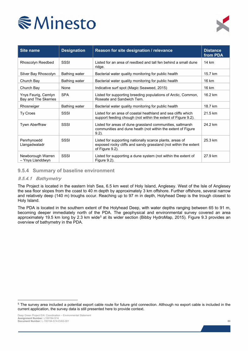
Site name Designation Reason for site designation / relevance Distance
from PDA Rhoscolyn Reedbed SSSI Listed for an area of reedbed and tall fen behind a small dune
ridge. 14 km
Silver Bay Rhoscolyn Bathing water Bacterial water quality monitoring for public health 15.7 km
Church Bay Bathing water Bacterial water quality monitoring for public health 16 km
Church Bay None Indicative surf spot (Magic Seaweed, 2015) 16 km
Ynys Feurig, Cemlyn Bay and The Skerries
SPA Listed for supporting breeding populations of Arctic, Common, Roseate and Sandwich Tern.
16.2 km
Rhosneiger Bathing water Bacterial water quality monitoring for public health 18.7 km
Ty Croes SSSI Listed for an area of coastal heathland and sea cliffs which support feeding chough (not within the extent of Figure 9.2).
21.5 km
Tywn Aberffraw SSSI Listed for areas of dune grassland communities, saltmarsh communities and dune heath (not within the extent of Figure 9.2).
24.2 km
Penrhynoedd Llangadwaladr
SSSI Listed for supporting nationally scarce plants, areas of exposed rocky cliffs and sandy grassland (not within the extent of Figure 9.2).
25.3 km
Newborough Warren – Ynys Llanddwyn
SSSI Listed for supporting a dune system (not within the extent of Figure 9.2).
27.9 km
9.5.4 Summary of baseline environment 9.5.4.1 Bathymetry The Project is located in the eastern Irish Sea, 6.5 km west of Holy Island, Anglesey. West of the Isle of Anglesey the sea floor slopes from the coast to 40 m depth by approximately 3 km offshore. Further offshore, several narrow and relatively deep (140 m) troughs occur. Reaching up to 97 m in depth, Holyhead Deep is the trough closest to Holy Island.
The PDA is located in the southern extent of the Holyhead Deep, with water depths ranging between 65 to 91 m, becoming deeper immediately north of the PDA. The geophysical and environmental survey covered an area approximately 19.5 km long by 2.3 km wide5 at its wider section (Bibby HydroMap, 2015). Figure 9.3 provides an overview of bathymetry in the PDA.
5 The survey area included a potential export cable route for future grid connection. Although no export cable is included in the current application, the survey data is still presented here to provide context. Deep Green Project EIA: Coordination – Environmental Statement Assignment Number: L100194-S14 Document Number: L-100194-S14-EIAS-001 80
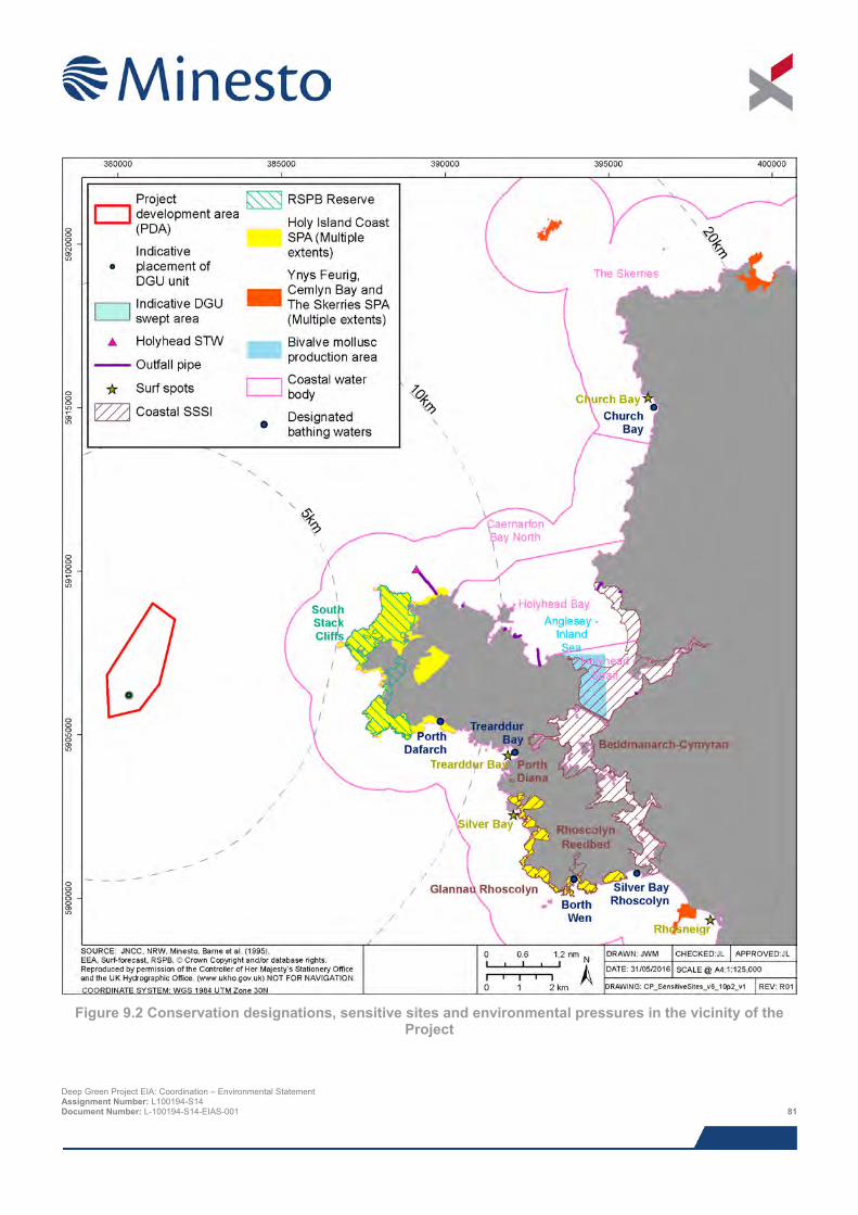
Figure 9.2 Conservation designations, sensitive sites and environmental pressures in the vicinity of the
Project
Deep Green Project EIA: Coordination – Environmental Statement Assignment Number: L100194-S14 Document Number: L-100194-S14-EIAS-001 81
Figure 9.3 Bathymetry in vicinity of the Project (Johnsson, pers. comm.; Bibby HydroMap, 2015)
Deep Green Project EIA: Coordination – Environmental Statement Assignment Number: L100194-S14 Document Number: L-100194-S14-EIAS-001 82
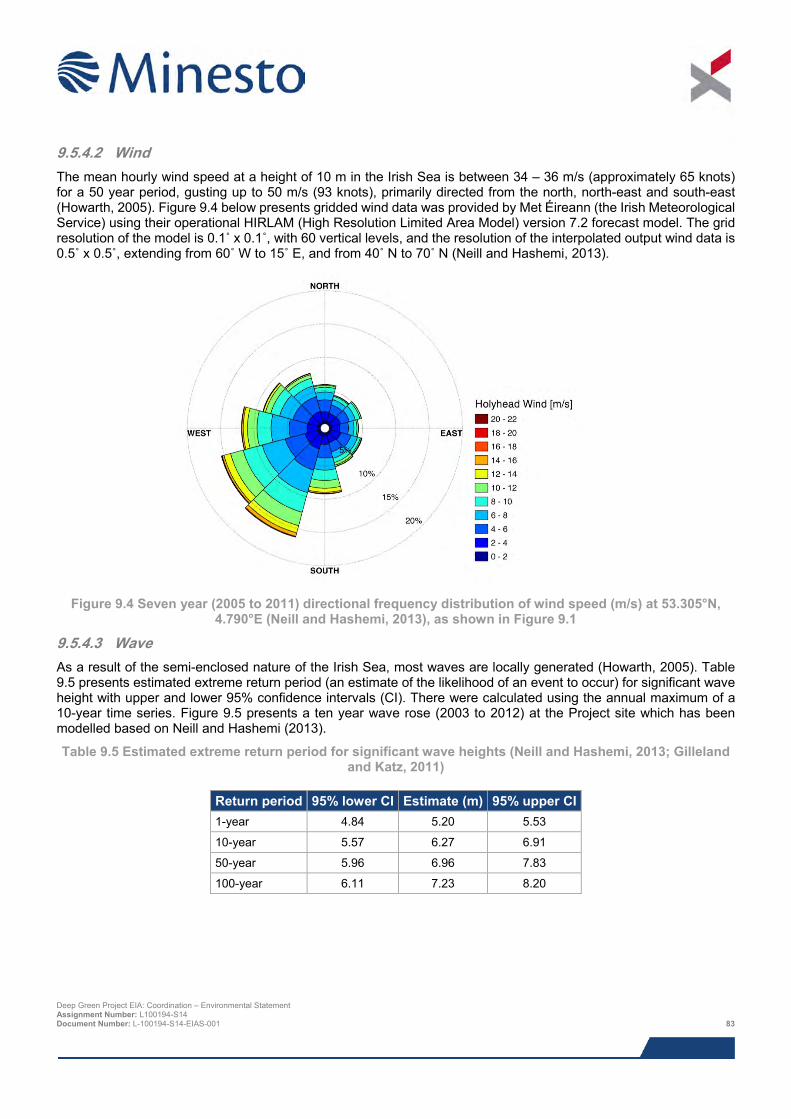
9.5.4.2 Wind The mean hourly wind speed at a height of 10 m in the Irish Sea is between 34 – 36 m/s (approximately 65 knots) for a 50 year period, gusting up to 50 m/s (93 knots), primarily directed from the north, north-east and south-east (Howarth, 2005). Figure 9.4 below presents gridded wind data was provided by Met Éireann (the Irish Meteorological Service) using their operational HIRLAM (High Resolution Limited Area Model) version 7.2 forecast model. The grid resolution of the model is 0.1˚ x 0.1˚, with 60 vertical levels, and the resolution of the interpolated output wind data is 0.5˚ x 0.5˚, extending from 60˚ W to 15˚ E, and from 40˚ N to 70˚ N (Neill and Hashemi, 2013).
Figure 9.4 Seven year (2005 to 2011) directional frequency distribution of wind speed (m/s) at 53.305°N,
4.790°E (Neill and Hashemi, 2013), as shown in Figure 9.1
9.5.4.3 Wave As a result of the semi-enclosed nature of the Irish Sea, most waves are locally generated (Howarth, 2005). Table 9.5 presents estimated extreme return period (an estimate of the likelihood of an event to occur) for significant wave height with upper and lower 95% confidence intervals (CI). There were calculated using the annual maximum of a 10-year time series. Figure 9.5 presents a ten year wave rose (2003 to 2012) at the Project site which has been modelled based on Neill and Hashemi (2013).
Table 9.5 Estimated extreme return period for significant wave heights (Neill and Hashemi, 2013; Gilleland and Katz, 2011)
Return period 95% lower CI Estimate (m) 95% upper CI 1-year 4.84 5.20 5.53
10-year 5.57 6.27 6.91
50-year 5.96 6.96 7.83
100-year 6.11 7.23 8.20
Deep Green Project EIA: Coordination – Environmental Statement Assignment Number: L100194-S14 Document Number: L-100194-S14-EIAS-001 83
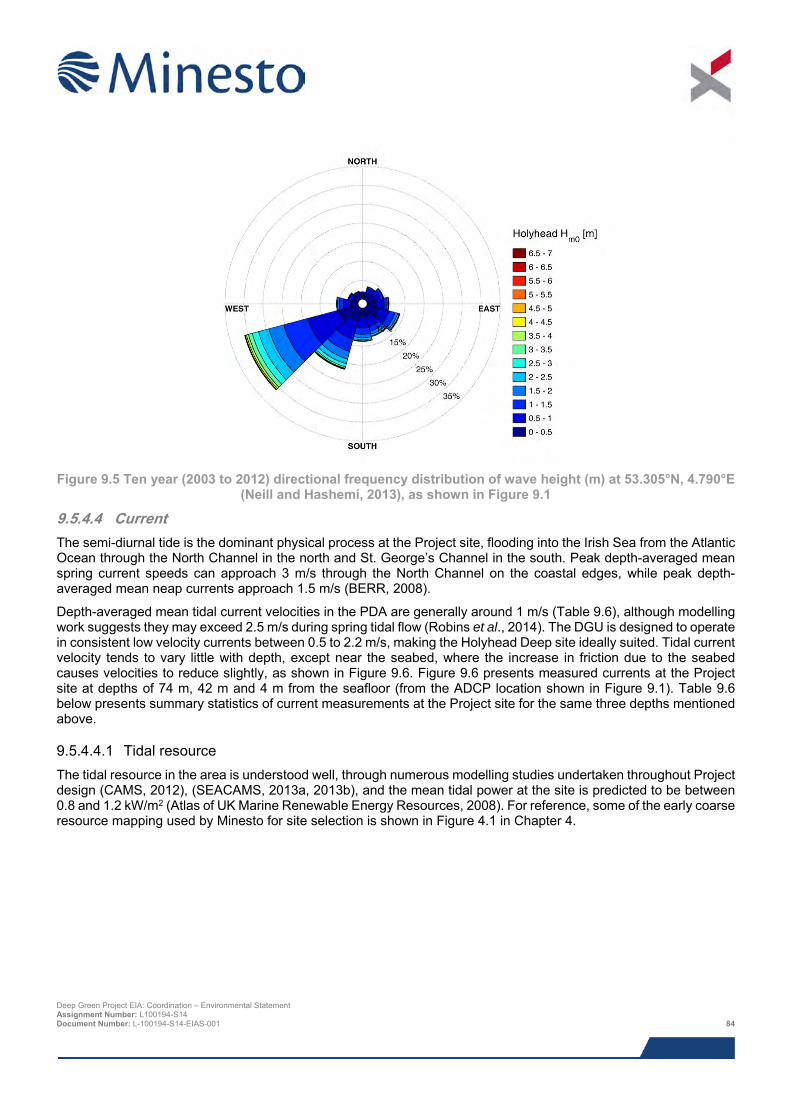
Figure 9.5 Ten year (2003 to 2012) directional frequency distribution of wave height (m) at 53.305°N, 4.790°E
(Neill and Hashemi, 2013), as shown in Figure 9.1
9.5.4.4 Current The semi-diurnal tide is the dominant physical process at the Project site, flooding into the Irish Sea from the Atlantic Ocean through the North Channel in the north and St. George’s Channel in the south. Peak depth-averaged mean spring current speeds can approach 3 m/s through the North Channel on the coastal edges, while peak depth-averaged mean neap currents approach 1.5 m/s (BERR, 2008).
Depth-averaged mean tidal current velocities in the PDA are generally around 1 m/s (Table 9.6), although modelling work suggests they may exceed 2.5 m/s during spring tidal flow (Robins et al., 2014). The DGU is designed to operate in consistent low velocity currents between 0.5 to 2.2 m/s, making the Holyhead Deep site ideally suited. Tidal current velocity tends to vary little with depth, except near the seabed, where the increase in friction due to the seabed causes velocities to reduce slightly, as shown in Figure 9.6. Figure 9.6 presents measured currents at the Project site at depths of 74 m, 42 m and 4 m from the seafloor (from the ADCP location shown in Figure 9.1). Table 9.6 below presents summary statistics of current measurements at the Project site for the same three depths mentioned above.
9.5.4.4.1 Tidal resource The tidal resource in the area is understood well, through numerous modelling studies undertaken throughout Project design (CAMS, 2012), (SEACAMS, 2013a, 2013b), and the mean tidal power at the site is predicted to be between 0.8 and 1.2 kW/m2 (Atlas of UK Marine Renewable Energy Resources, 2008). For reference, some of the early coarse resource mapping used by Minesto for site selection is shown in Figure 4.1 in Chapter 4.
Deep Green Project EIA: Coordination – Environmental Statement Assignment Number: L100194-S14 Document Number: L-100194-S14-EIAS-001 84
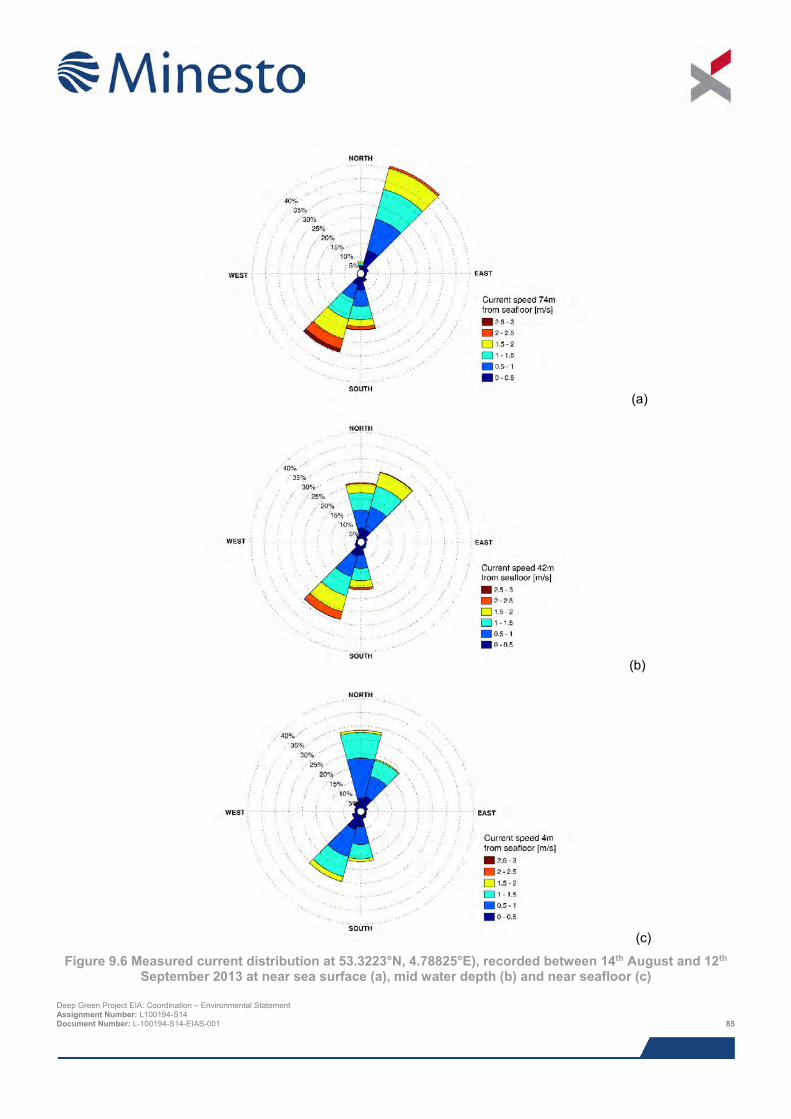
(a)
(b)
(c)
Figure 9.6 Measured current distribution at 53.3223°N, 4.78825°E), recorded between 14th August and 12th September 2013 at near sea surface (a), mid water depth (b) and near seafloor (c)
Deep Green Project EIA: Coordination – Environmental Statement Assignment Number: L100194-S14 Document Number: L-100194-S14-EIAS-001 85
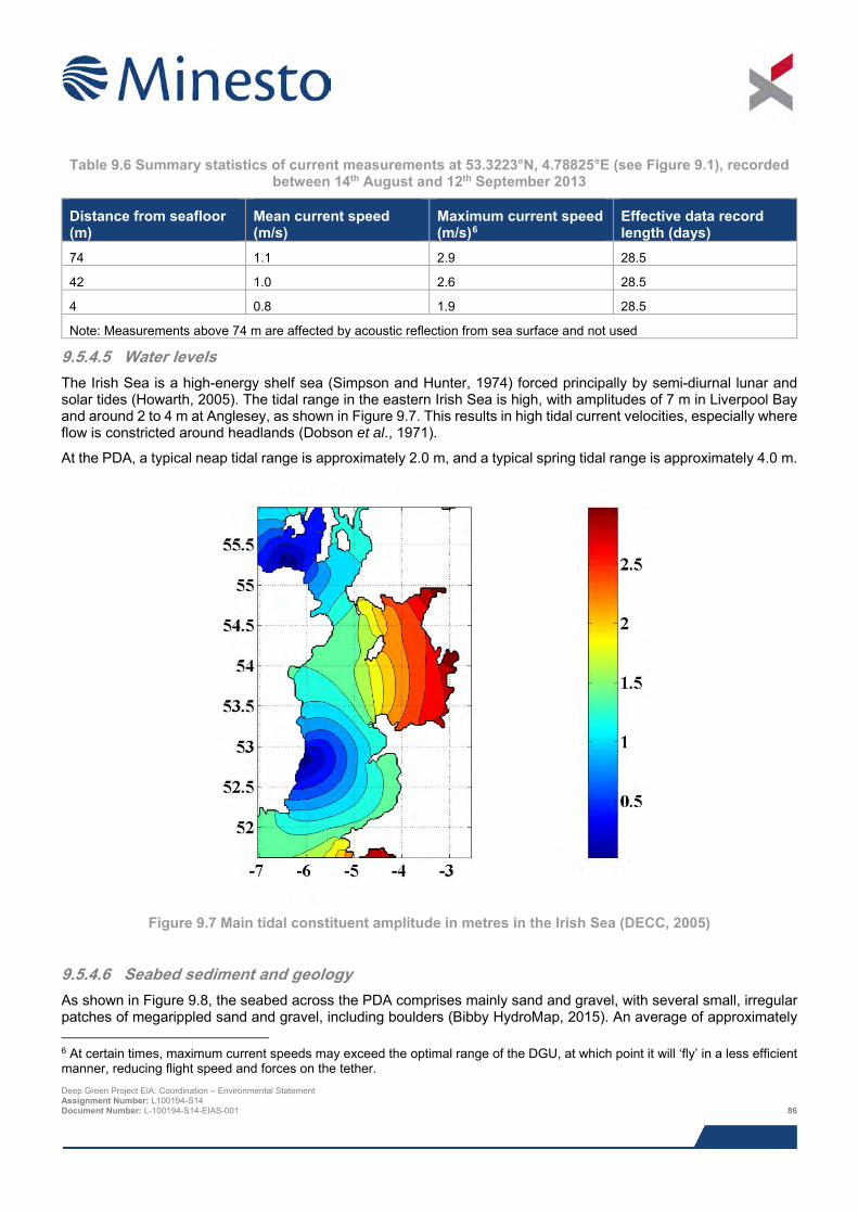
Table 9.6 Summary statistics of current measurements at 53.3223°N, 4.78825°E (see Figure 9.1), recorded
between 14th August and 12th September 2013
Distance from seafloor (m)
Mean current speed (m/s)
Maximum current speed (m/s)6
Effective data record length (days)
74 1.1 2.9 28.5
42 1.0 2.6 28.5
4 0.8 1.9 28.5
Note: Measurements above 74 m are affected by acoustic reflection from sea surface and not used
9.5.4.5 Water levels The Irish Sea is a high-energy shelf sea (Simpson and Hunter, 1974) forced principally by semi-diurnal lunar and solar tides (Howarth, 2005). The tidal range in the eastern Irish Sea is high, with amplitudes of 7 m in Liverpool Bay and around 2 to 4 m at Anglesey, as shown in Figure 9.7. This results in high tidal current velocities, especially where flow is constricted around headlands (Dobson et al., 1971).
At the PDA, a typical neap tidal range is approximately 2.0 m, and a typical spring tidal range is approximately 4.0 m.
Figure 9.7 Main tidal constituent amplitude in metres in the Irish Sea (DECC, 2005)
9.5.4.6 Seabed sediment and geology As shown in Figure 9.8, the seabed across the PDA comprises mainly sand and gravel, with several small, irregular patches of megarippled sand and gravel, including boulders (Bibby HydroMap, 2015). An average of approximately
6 At certain times, maximum current speeds may exceed the optimal range of the DGU, at which point it will ‘fly’ in a less efficient manner, reducing flight speed and forces on the tether. Deep Green Project EIA: Coordination – Environmental Statement Assignment Number: L100194-S14 Document Number: L-100194-S14-EIAS-001 86

1.6 boulders per 100 m2 was noted across the PDA, with the exception of an area near the south-eastern limits, where the density averages 4.6 boulders per 100 m2. As shown in Figure 9.9, sediment thickness within the PDA varies from a veneer in localised areas to the north-northeast, to up to 50 m at the extreme south-western extent of the area.
In the vicinity of the PDA seabed sediments are generally coarse (muddy sandy gravels). The BGS seabed sediment published data suggest three types of sediment cover exist within the Holyhead Deep disposal site, ‘Sandy gravel’, ‘Rock and sediment’, and ‘Rock’. From interrogating site specific geophysical survey data (Bibby HydroMap, 2015) sandy gravels predominate in the eastern half of the site, as well as in patches in the west, where the rock and sediment is predominant. Sediment thickness peaks at approximately 50 m to the west of the PDA, but is much shallower at <10 m to the east of the PDA.
Deep Green Project EIA: Coordination – Environmental Statement Assignment Number: L100194-S14 Document Number: L-100194-S14-EIAS-001 87
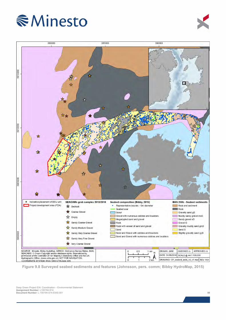
Figure 9.8 Surveyed seabed sediments and features (Johnsson, pers. comm; Bibby HydroMap, 2015)
Deep Green Project EIA: Coordination – Environmental Statement Assignment Number: L100194-S14 Document Number: L-100194-S14-EIAS-001 88
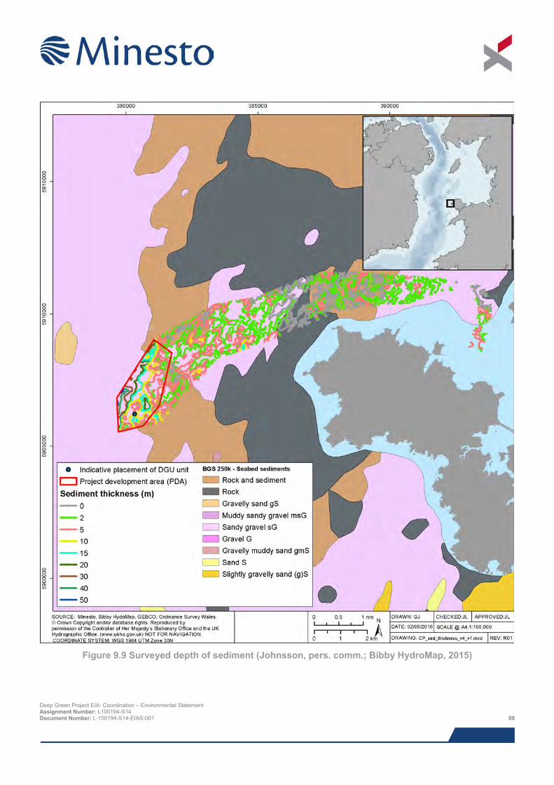
Figure 9.9 Surveyed depth of sediment (Johnsson, pers. comm.; Bibby HydroMap, 2015)
Deep Green Project EIA: Coordination – Environmental Statement Assignment Number: L100194-S14 Document Number: L-100194-S14-EIAS-001 89
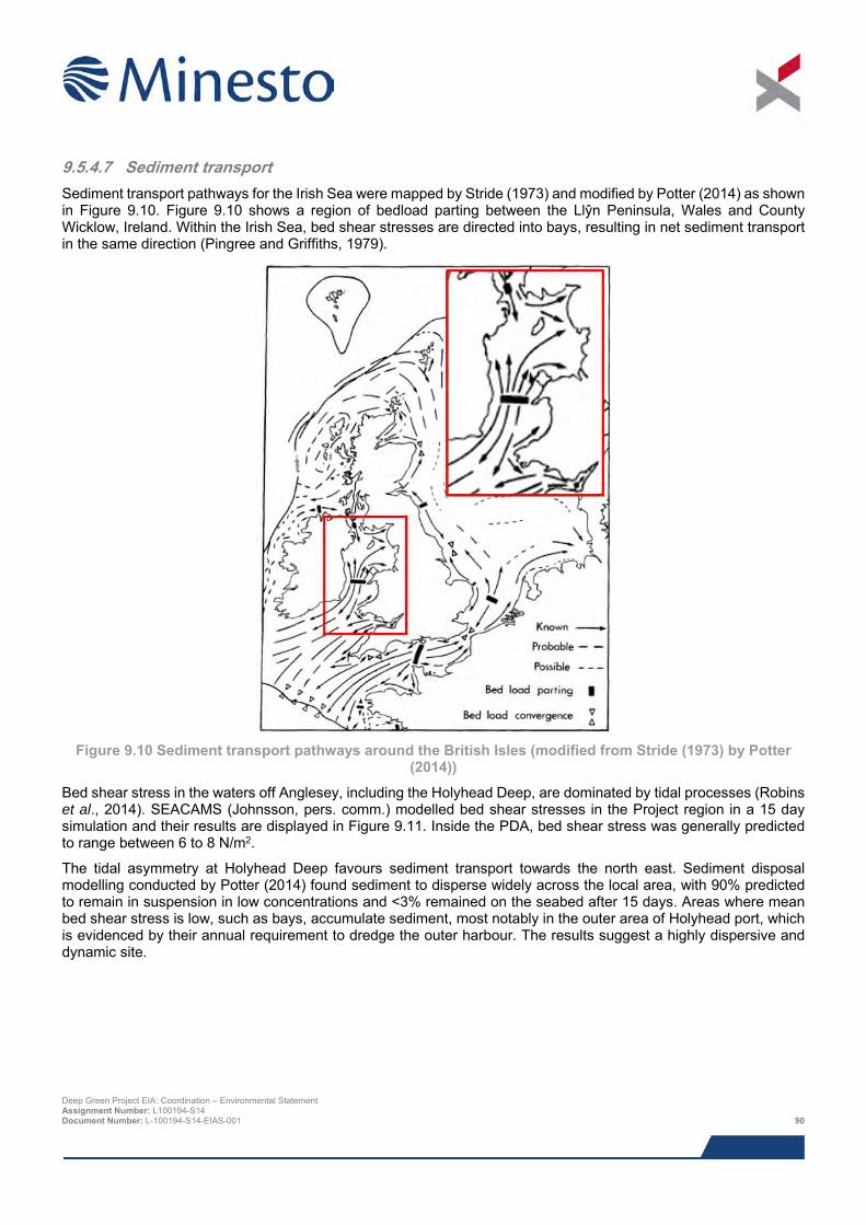
9.5.4.7 Sediment transport Sediment transport pathways for the Irish Sea were mapped by Stride (1973) and modified by Potter (2014) as shown in Figure 9.10. Figure 9.10 shows a region of bedload parting between the Llŷn Peninsula, Wales and County Wicklow, Ireland. Within the Irish Sea, bed shear stresses are directed into bays, resulting in net sediment transport in the same direction (Pingree and Griffiths, 1979).
Figure 9.10 Sediment transport pathways around the British Isles (modified from Stride (1973) by Potter
(2014))
Bed shear stress in the waters off Anglesey, including the Holyhead Deep, are dominated by tidal processes (Robins et al., 2014). SEACAMS (Johnsson, pers. comm.) modelled bed shear stresses in the Project region in a 15 day simulation and their results are displayed in Figure 9.11. Inside the PDA, bed shear stress was generally predicted to range between 6 to 8 N/m2.
The tidal asymmetry at Holyhead Deep favours sediment transport towards the north east. Sediment disposal modelling conducted by Potter (2014) found sediment to disperse widely across the local area, with 90% predicted to remain in suspension in low concentrations and <3% remained on the seabed after 15 days. Areas where mean bed shear stress is low, such as bays, accumulate sediment, most notably in the outer area of Holyhead port, which is evidenced by their annual requirement to dredge the outer harbour. The results suggest a highly dispersive and dynamic site.
Deep Green Project EIA: Coordination – Environmental Statement Assignment Number: L100194-S14 Document Number: L-100194-S14-EIAS-001 90
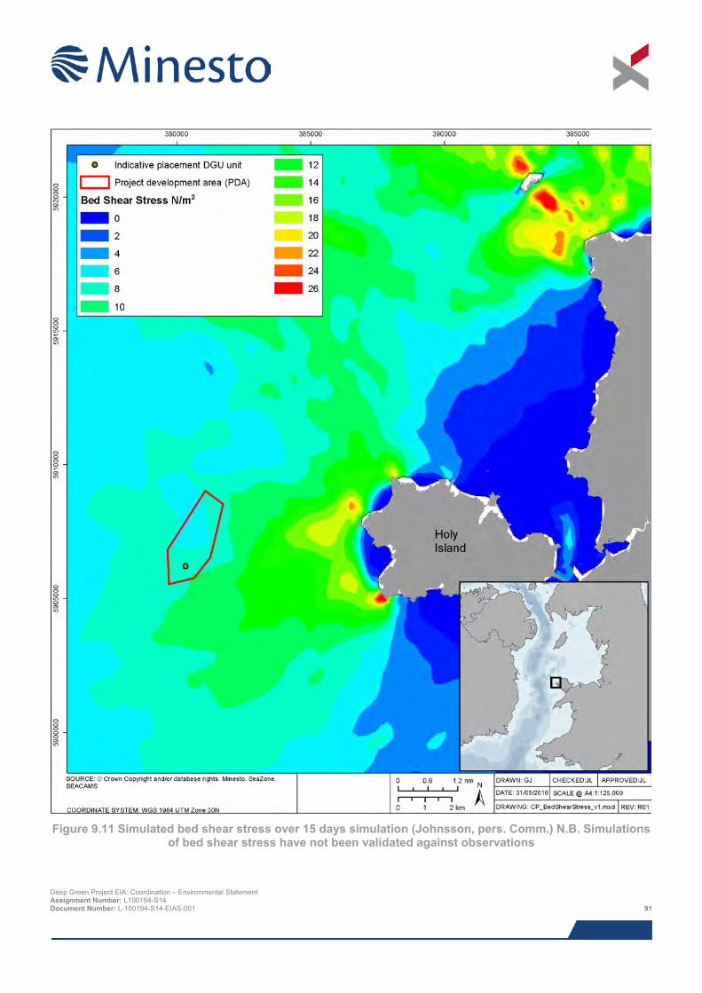
Figure 9.11 Simulated bed shear stress over 15 days simulation (Johnsson, pers. Comm.) N.B. Simulations
of bed shear stress have not been validated against observations
Deep Green Project EIA: Coordination – Environmental Statement Assignment Number: L100194-S14 Document Number: L-100194-S14-EIAS-001 91
9.5.4.8 Coastal description Holy Island is characterised by hard rock cliffs on the seaward facing frontages interspersed with small sandy bays. The western coastline of Holy Island comprises predominantly rocky cliffs except for Porth Dafarch beach and Trearddur Bay. The northern coastline is also predominantly rocky but also comprises human development, due to Holyhead port. Moving east from Holyhead port, the coastline remains rocky until Penrhos beach, as shown in Figure 9.12. The eastern coastline of Holy Island is dominated by the Alaw Estuary which comprises coastal salt marshes, mud-flats and shallow coastal waters.
The northern and western coastlines of Holy Island experience very little sediment movement along the coast except for interspersed shoreline exposures of eroding glacial till. The steep exposed faces indicate ongoing, albeit extremely slow, erosion providing sand and gravel to the beaches and bays.
9.5.4.9 Water quality Within 20 km of the PDA there are a total of six areas classified as bathing waters (NRW, 2014b). All of these sites passed the bathing water quality standard with the six sites achieving “Excellent” since classification was awarded. Refer to Table 9.4 for specific distances of the bathing water sites from the Project.
9.5.5 Data gaps and uncertainties Publications and data relevant to the region have been reviewed which, when combined with the site-specific surveys, provide a comprehensive baseline of the costal processes and sediment dynamics of the Project and surrounding area.
Deep Green Project EIA: Coordination – Environmental Statement Assignment Number: L100194-S14 Document Number: L-100194-S14-EIAS-001 92
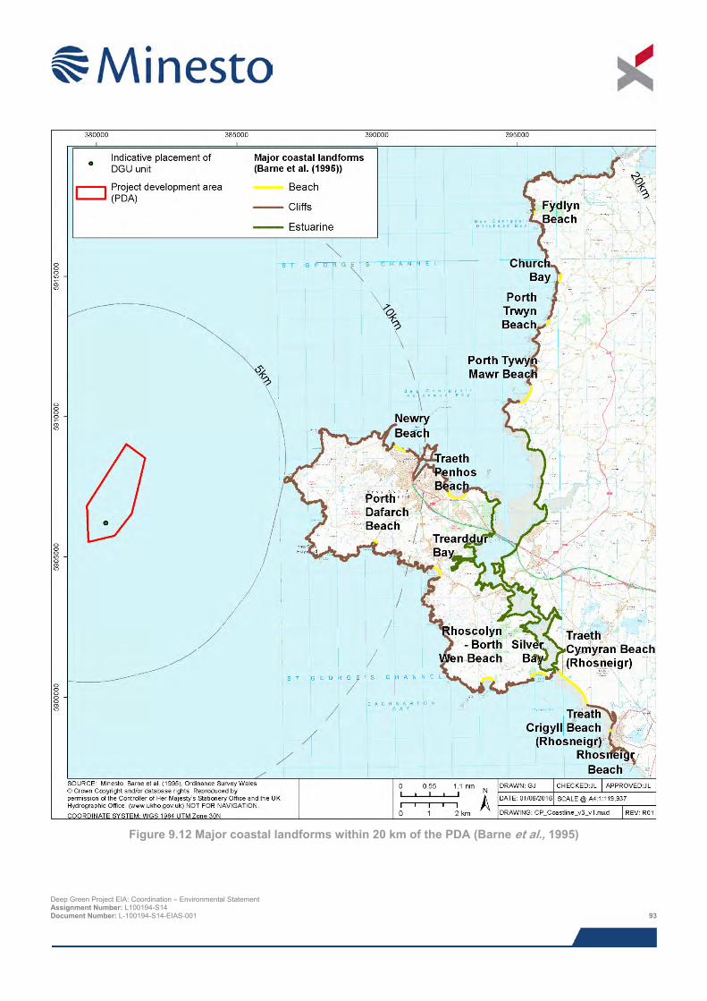
Figure 9.12 Major coastal landforms within 20 km of the PDA (Barne et al., 1995)
Deep Green Project EIA: Coordination – Environmental Statement Assignment Number: L100194-S14 Document Number: L-100194-S14-EIAS-001 93
9.6 Impact assessment
9.6.1 Overview This assessment covers all impacts (relevant to the PDA) identified during scoping, as well as any further potential impacts that have been highlighted as the EIA has progressed. It should be noted that impacts are not necessarily relevant to all Project stages.
The list below indicates all of the direct and indirect impacts assessed in the physical processes chapter and indicates the Project stages to which they relate. Cumulative impacts are discussed in Section 9.11.
> Impacts during construction and installation period:
> Effect of DGU foundation installation on water quality.
> Impacts during operation and maintenance:
o Introduction of scour from barge (or similar such surface platform) anchors; and
o Introduction of scour to the PDA.
The following impacts were scoped out of the assessment during EIA scoping:
> Effects on wave climate;
> Effects on local currents; and
> Effects on offshore sediment transport and morphology.
Potential effects on the available tidal resource were subsequently scoped out on the basis that the presence of a single 0.5 MW DGU operating mid-water column in water depths of over 90 m and almost 7 km from shore will have no discernible impact on the tidal resource in the area. The DGU will generate a small wake, and there will be modifications to the near-field flow field around the DGU as it moves through the water, but the open water location, the water depth and the size of the device would make it very difficult to measure any differences to tidal resource in the region. Modelling studies of much larger tidal arrays (e.g. MeyGen 86 MW array (MeyGen, 2014) and TVL 200 MW array (TVL, 2015)) have shown negligible difference to resource beyond the near-field, with each development being located in much shallower water and much closer to shore where changes could potentially be felt at the coast and seabed.
Interactions with the resource of the nearby WADZ will be minimal. Firstly, because as previously described the overall impact from the Project on tidal resource will be minimal. Secondly, due to the clockwise/anticlockwise flood/ebb of the tidal currents around Anglesey, the Minesto Project and the WADZ largely occupying their own separate tidal stream 'channels'. Tidal resource could theoretically be impacted upstream or downstream of a tidal array development by wake effects or flow divergence created by a tidal device (e.g. were the WADZ to be located either north or south of the Project location), but in this case the tidal currents around Anglesey (for example as shown in Robins et al. (2014)), means neither project is upstream or downstream of the other.
The assessment of impacts on physical processes was a desk-based exercise making use of Project specific survey information on the nature of the seabed and metocean conditions, informed by detailed modelling studies.
9.6.2 Assessment criteria The EIA process and methodology are described in detail in Chapter 8. Project specific criteria have been developed for the sensitivity and vulnerability of the receptor, and the likelihood and magnitude of impact (including duration, frequency, seasonality and geographic extent) as detailed in Section 8.3, whilst topic specific criteria have been developed for the value of the receptor (as defined in Table 9.7).
The sensitivity, vulnerability and value of receptor are combined with the likelihood and magnitude of impact using expert judgement to arrive at a consequence for each impact under consideration; the significance of impact is derived directly from the consequences ranking. The definitions for level of impact and how they relate to significance are presented in Section 8.3.5. Deep Green Project EIA: Coordination – Environmental Statement Assignment Number: L100194-S14 Document Number: L-100194-S14-EIAS-001 94
Table 9.7 Criteria for value of receptor
Value of receptor Definition Very high Receptor of international importance (e.g. United Nations Educational, Scientific and Cultural
Organisation (UNESCO) World Heritage Site (WHS)).
High Receptor of national importance (e.g. Site of Special Scientific Interest (SSSI), Geological Conservation Review (GCR) site).
Medium Receptor of regional importance.
Low Receptor of local importance.
Negligible Receptor of very low importance, no specific value or concern.
9.6.3 Design envelope This assessment considers the Project parameters which are predicted to result in the greatest environmental impact. This approach ensures that impacts of a greater adverse significance would not arise should any other development scenario be taken forward in the final scheme design. With regards to the assessment of physical processes impacts the assessment comprises:
> A single DGU foundation comprising either a gravity based structure (approximately 12 m x 25 m footprint), pin piled (up to three piles of 3 m diameter) or monopiled (one pile of up to 4 m in diameter), with piles installed by drilling or vibro-hammering or combination of both, resulting in the release of up to 141.4 m3 of spoil per pile or 424.2 m3 of spoil per DGU;
> 200 m of bare subsea umbilical (100 mm width) lying on the seabed; and
> A barge (or similar such surface platform) moored using a four to eight point catenary system (with marker buoys) for five years.
9.7 Impacts during construction and installation period
9.7.1 Impact 9.1 Effect of DGU foundation installation on water quality The worst case scenario with regards to the release of drilling cuttings during installation and construction will be the use of pin piled tripod foundations. This involves:
> Drilling of three piles for a single DGU. Each pile is likely to be no greater than 20 m in length and have a maximum diameter of 3 m. The maximum quantity of drill cuttings that may be released into the marine environment is predicted to be 424.2 m3 for a single DGU;
> Seawater and bentonite are likely to be used as the drilling fluid to lubricate the drill bit and aid in the removal of cuttings – the lubricant will be discharged along with the cuttings; and
> The drill cuttings are likely to consist of a fluid paste with larger fragments up to pebbled sized ‘flakes’, and the bentonite may form a very fine sediment suspension.
The environment into which the drill cuttings will be released is highly energetic, so they will, for the most part, become widely dispersed into the surrounding waters, bringing about a localised and temporary increase in turbidity and very little in the way of perceptible sediment deposition. A dredge disposal modelling study for the Holyhead Deep disposal site showed sediments quickly disperse across the wider region (Potter, 2014). This was corroborated by the multibeam data also collected as part of the study, which showed no evidence of spoil mounds anywhere within the survey location, and grab samples showed extremely limited fine sediment fractions at the disposal site. This as an indication that almost all dumped sediment has left the disposal site, either in the upper water column during disposal or as a benthic plume following impact with the seabed.
The release of drill cuttings will also be highly intermittent and of short duration, before the drill rig moves to another location. Each pile will result in the discharge of only 141.4 m3 cuttings and this will take place over a number of days Deep Green Project EIA: Coordination – Environmental Statement Assignment Number: L100194-S14 Document Number: L-100194-S14-EIAS-001 95
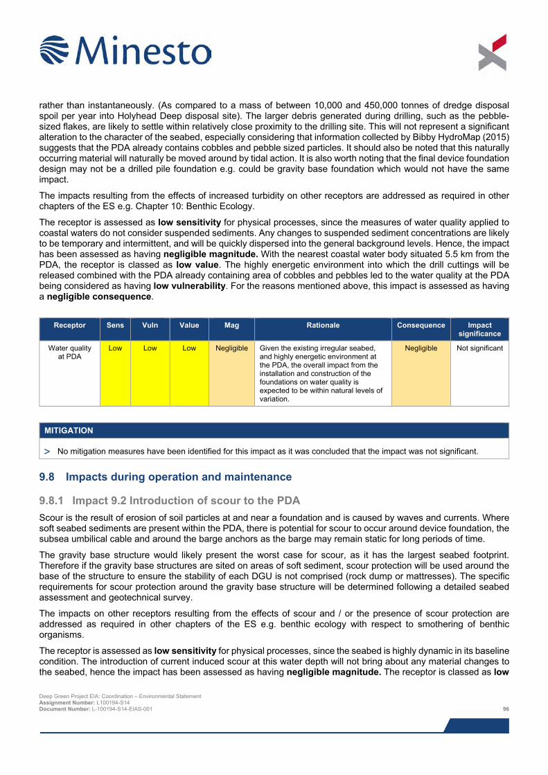
rather than instantaneously. (As compared to a mass of between 10,000 and 450,000 tonnes of dredge disposal spoil per year into Holyhead Deep disposal site). The larger debris generated during drilling, such as the pebble-sized flakes, are likely to settle within relatively close proximity to the drilling site. This will not represent a significant alteration to the character of the seabed, especially considering that information collected by Bibby HydroMap (2015) suggests that the PDA already contains cobbles and pebble sized particles. It should also be noted that this naturally occurring material will naturally be moved around by tidal action. It is also worth noting that the final device foundation design may not be a drilled pile foundation e.g. could be gravity base foundation which would not have the same impact.
The impacts resulting from the effects of increased turbidity on other receptors are addressed as required in other chapters of the ES e.g. Chapter 10: Benthic Ecology.
The receptor is assessed as low sensitivity for physical processes, since the measures of water quality applied to coastal waters do not consider suspended sediments. Any changes to suspended sediment concentrations are likely to be temporary and intermittent, and will be quickly dispersed into the general background levels. Hence, the impact has been assessed as having negligible magnitude. With the nearest coastal water body situated 5.5 km from the PDA, the receptor is classed as low value. The highly energetic environment into which the drill cuttings will be released combined with the PDA already containing area of cobbles and pebbles led to the water quality at the PDA being considered as having low vulnerability. For the reasons mentioned above, this impact is assessed as having a negligible consequence.
Receptor Sens Vuln Value Mag Rationale Consequence Impact
significance
Water quality at PDA
Low Low Low Negligible Given the existing irregular seabed, and highly energetic environment at the PDA, the overall impact from the installation and construction of the foundations on water quality is expected to be within natural levels of variation.
Negligible Not significant
MITIGATION
> No mitigation measures have been identified for this impact as it was concluded that the impact was not significant.
9.8 Impacts during operation and maintenance
9.8.1 Impact 9.2 Introduction of scour to the PDA Scour is the result of erosion of soil particles at and near a foundation and is caused by waves and currents. Where soft seabed sediments are present within the PDA, there is potential for scour to occur around device foundation, the subsea umbilical cable and around the barge anchors as the barge may remain static for long periods of time.
The gravity base structure would likely present the worst case for scour, as it has the largest seabed footprint. Therefore if the gravity base structures are sited on areas of soft sediment, scour protection will be used around the base of the structure to ensure the stability of each DGU is not comprised (rock dump or mattresses). The specific requirements for scour protection around the gravity base structure will be determined following a detailed seabed assessment and geotechnical survey.
The impacts on other receptors resulting from the effects of scour and / or the presence of scour protection are addressed as required in other chapters of the ES e.g. benthic ecology with respect to smothering of benthic organisms.
The receptor is assessed as low sensitivity for physical processes, since the seabed is highly dynamic in its baseline condition. The introduction of current induced scour at this water depth will not bring about any material changes to the seabed, hence the impact has been assessed as having negligible magnitude. The receptor is classed as low
Deep Green Project EIA: Coordination – Environmental Statement Assignment Number: L100194-S14 Document Number: L-100194-S14-EIAS-001 96
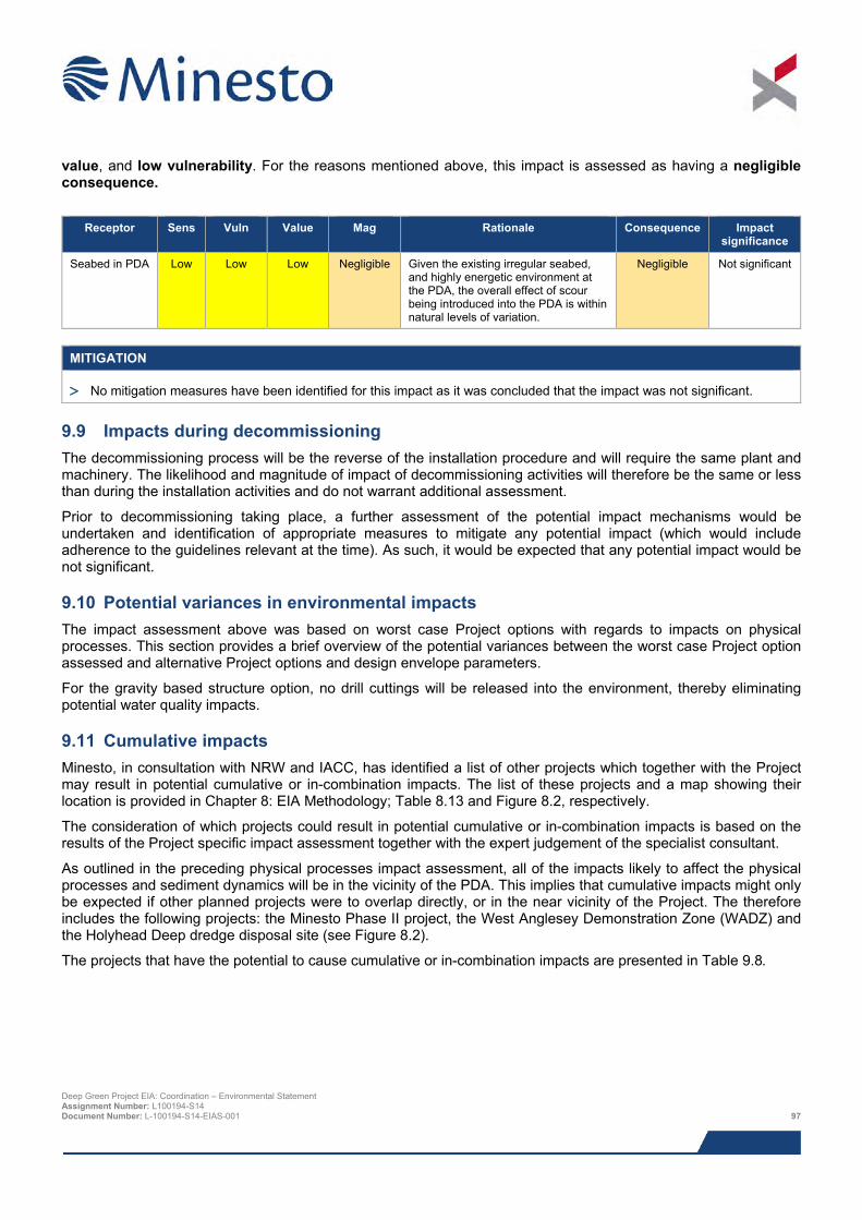
value, and low vulnerability. For the reasons mentioned above, this impact is assessed as having a negligible consequence.
Receptor Sens Vuln Value Mag Rationale Consequence Impact
significance
Seabed in PDA Low Low Low Negligible Given the existing irregular seabed, and highly energetic environment at the PDA, the overall effect of scour being introduced into the PDA is within natural levels of variation.
Negligible Not significant
MITIGATION
> No mitigation measures have been identified for this impact as it was concluded that the impact was not significant.
9.9 Impacts during decommissioning The decommissioning process will be the reverse of the installation procedure and will require the same plant and machinery. The likelihood and magnitude of impact of decommissioning activities will therefore be the same or less than during the installation activities and do not warrant additional assessment.
Prior to decommissioning taking place, a further assessment of the potential impact mechanisms would be undertaken and identification of appropriate measures to mitigate any potential impact (which would include adherence to the guidelines relevant at the time). As such, it would be expected that any potential impact would be not significant.
9.10 Potential variances in environmental impacts The impact assessment above was based on worst case Project options with regards to impacts on physical processes. This section provides a brief overview of the potential variances between the worst case Project option assessed and alternative Project options and design envelope parameters.
For the gravity based structure option, no drill cuttings will be released into the environment, thereby eliminating potential water quality impacts.
9.11 Cumulative impacts Minesto, in consultation with NRW and IACC, has identified a list of other projects which together with the Project may result in potential cumulative or in-combination impacts. The list of these projects and a map showing their location is provided in Chapter 8: EIA Methodology; Table 8.13 and Figure 8.2, respectively.
The consideration of which projects could result in potential cumulative or in-combination impacts is based on the results of the Project specific impact assessment together with the expert judgement of the specialist consultant.
As outlined in the preceding physical processes impact assessment, all of the impacts likely to affect the physical processes and sediment dynamics will be in the vicinity of the PDA. This implies that cumulative impacts might only be expected if other planned projects were to overlap directly, or in the near vicinity of the Project. The therefore includes the following projects: the Minesto Phase II project, the West Anglesey Demonstration Zone (WADZ) and the Holyhead Deep dredge disposal site (see Figure 8.2).
The projects that have the potential to cause cumulative or in-combination impacts are presented in Table 9.8.
Deep Green Project EIA: Coordination – Environmental Statement Assignment Number: L100194-S14 Document Number: L-100194-S14-EIAS-001 97
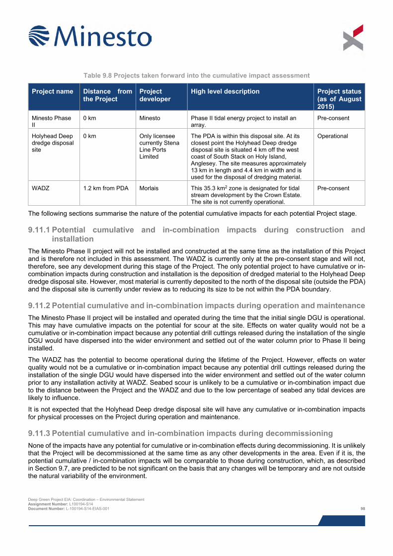
Table 9.8 Projects taken forward into the cumulative impact assessment
Project name Distance from the Project
Project developer
High level description Project status (as of August 2015)
Minesto Phase II
0 km Minesto Phase II tidal energy project to install an array.
Pre-consent
Holyhead Deep dredge disposal site
0 km Only licensee currently Stena Line Ports Limited
The PDA is within this disposal site. At its closest point the Holyhead Deep dredge disposal site is situated 4 km off the west coast of South Stack on Holy Island, Anglesey. The site measures approximately 13 km in length and 4.4 km in width and is used for the disposal of dredging material.
Operational
WADZ 1.2 km from PDA Morlais This 35.3 km2 zone is designated for tidal stream development by the Crown Estate. The site is not currently operational.
Pre-consent
The following sections summarise the nature of the potential cumulative impacts for each potential Project stage.
9.11.1 Potential cumulative and in-combination impacts during construction and installation
The Minesto Phase II project will not be installed and constructed at the same time as the installation of this Project and is therefore not included in this assessment. The WADZ is currently only at the pre-consent stage and will not, therefore, see any development during this stage of the Project. The only potential project to have cumulative or in-combination impacts during construction and installation is the deposition of dredged material to the Holyhead Deep dredge disposal site. However, most material is currently deposited to the north of the disposal site (outside the PDA) and the disposal site is currently under review as to reducing its size to be not within the PDA boundary.
9.11.2 Potential cumulative and in-combination impacts during operation and maintenance The Minesto Phase II project will be installed and operated during the time that the initial single DGU is operational. This may have cumulative impacts on the potential for scour at the site. Effects on water quality would not be a cumulative or in-combination impact because any potential drill cuttings released during the installation of the single DGU would have dispersed into the wider environment and settled out of the water column prior to Phase II being installed.
The WADZ has the potential to become operational during the lifetime of the Project. However, effects on water quality would not be a cumulative or in-combination impact because any potential drill cuttings released during the installation of the single DGU would have dispersed into the wider environment and settled out of the water column prior to any installation activity at WADZ. Seabed scour is unlikely to be a cumulative or in-combination impact due to the distance between the Project and the WADZ and due to the low percentage of seabed any tidal devices are likely to influence.
It is not expected that the Holyhead Deep dredge disposal site will have any cumulative or in-combination impacts for physical processes on the Project during operation and maintenance.
9.11.3 Potential cumulative and in-combination impacts during decommissioning None of the impacts have any potential for cumulative or in-combination effects during decommissioning. It is unlikely that the Project will be decommissioned at the same time as any other developments in the area. Even if it is, the potential cumulative / in-combination impacts will be comparable to those during construction, which, as described in Section 9.7, are predicted to be not significant on the basis that any changes will be temporary and are not outside the natural variability of the environment.
Deep Green Project EIA: Coordination – Environmental Statement Assignment Number: L100194-S14 Document Number: L-100194-S14-EIAS-001 98
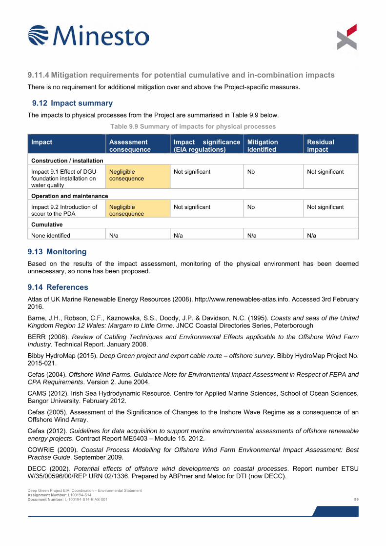
9.11.4 Mitigation requirements for potential cumulative and in-combination impacts There is no requirement for additional mitigation over and above the Project-specific measures.
9.12 Impact summary The impacts to physical processes from the Project are summarised in Table 9.9 below.
Table 9.9 Summary of impacts for physical processes
Impact Assessment consequence
Impact significance (EIA regulations)
Mitigation identified
Residual impact
Construction / installation
Impact 9.1 Effect of DGU foundation installation on water quality
Negligible consequence
Not significant No Not significant
Operation and maintenance
Impact 9.2 Introduction of scour to the PDA
Negligible consequence
Not significant No Not significant
Cumulative
None identified N/a N/a N/a N/a
9.13 Monitoring Based on the results of the impact assessment, monitoring of the physical environment has been deemed unnecessary, so none has been proposed.
9.14 References Atlas of UK Marine Renewable Energy Resources (2008). http://www.renewables-atlas.info. Accessed 3rd February 2016.
Barne, J.H., Robson, C.F., Kaznowska, S.S., Doody, J.P. & Davidson, N.C. (1995). Coasts and seas of the United Kingdom Region 12 Wales: Margam to Little Orme. JNCC Coastal Directories Series, Peterborough
BERR (2008). Review of Cabling Techniques and Environmental Effects applicable to the Offshore Wind Farm Industry. Technical Report. January 2008.
Bibby HydroMap (2015). Deep Green project and export cable route – offshore survey. Bibby HydroMap Project No. 2015-021.
Cefas (2004). Offshore Wind Farms. Guidance Note for Environmental Impact Assessment in Respect of FEPA and CPA Requirements. Version 2. June 2004.
CAMS (2012). Irish Sea Hydrodynamic Resource. Centre for Applied Marine Sciences, School of Ocean Sciences, Bangor University. February 2012.
Cefas (2005). Assessment of the Significance of Changes to the Inshore Wave Regime as a consequence of an Offshore Wind Array.
Cefas (2012). Guidelines for data acquisition to support marine environmental assessments of offshore renewable energy projects. Contract Report ME5403 – Module 15. 2012.
COWRIE (2009). Coastal Process Modelling for Offshore Wind Farm Environmental Impact Assessment: Best Practise Guide. September 2009.
DECC (2002). Potential effects of offshore wind developments on coastal processes. Report number ETSU W/35/00596/00/REP URN 02/1336. Prepared by ABPmer and Metoc for DTI (now DECC). Deep Green Project EIA: Coordination – Environmental Statement Assignment Number: L100194-S14 Document Number: L-100194-S14-EIAS-001 99
DECC (2005). Strategic Environmental Assessment (SEA) 6 – Irish Sea: Hydrography of the Irish Sea. POL Internal Document 174 on behalf of the Department of Energy and Climate Change. 2005.
Dobson, M.R., Evans, W.E., & James, K.H. (1971). The sediments on the floor of the southern Irish Sea. Marine Geology. 11, 27-69.
Gilleland E. & Katz R. W. (2011). New software to analyse how extremes change over time. Eos. 92(2), 13-14.
Howarth, M.J. (2005). Hydrography of the Irish Sea SEA6 Technical Report. POL internal Document No.174, Proudman Oceanographic Laboratory, Liverpool.
Johnsson (2015). pers. comm. Minesto, SEACAMS Project Manager.
Magic Seaweed (2015). Interactive UK surf spot map. http://magicseaweed.com/ [Accessed 22/10/2015].
MeyGen (2014). Environmental Statement. http://www.meygen.com/the-company/reports-and-documents/ [Accessed 05/02/2016]
NRW (2014a). Ynys Môn Management Catchment Summary. https://naturalresources.wales/media/3213/ynys-m%C3%B4n-management-catchment.pdf [Accessed 24/08/2015].
NRW (2014). Wales bathing water report 2014. https://naturalresources.wales/media/3880/wales-bathing-water-report-2014.pdf, [Accessed 24/08/2015].
Neill S. P. & Hashemi M. R. (2013). Wave power variability over the northwest European shelf seas. Applied Energy. 106, 31-46.
Pingree, P.E. & Griffiths, D.K. (1979). Sand transport paths around the British Isles resulting from M2 and M4 tidal interactions. Journal of the Marine Biological Association of the United Kingdom. 59(2), 497-513.
Potter, D. (2014). A multi-disciplinary investigation of the fate of disposed dredge spoil at Holyhead Deep, Anglesey. A thesis submitted in partial fulfilment of the requirements of the Degree of MSc in Applied Marine Geoscience. Bangor University.
Robins, P.E., Neill, S.P., & Lewis, M.J. (2014). Impact of tidal-stream arrays in relation to the natural variability of sedimentary processes. Renewable Energy. 72, 311-321.
SEACAMS (2013a). Site selection for the inset DGU tidal power plant - Interim Report. January 2013.
SEACAMS (2013b). Site selection for the inset DGU tidal power plant - Interim Report. February 2013.
Simpson, J.H., & Hunter, J.R., (1974). Fronts in the Irish Sea. Nature. 250, 404-406.
Stride, A.H. (1973). Sediment transport by the North Sea. In: North Sea Science. (ed. E.D. Goldberg), Cambridge: The M.I.T. Press. 101-130.
Surfers Against Sewage (2009). Guidance on environmental impact assessment of offshore renewable energy development on surfing resources and recreation.
The Kingfisher Information Service (2015). Offshore Renewable & Cable Awareness project http://www.kisorca.eu/ [Accessed 02/09/2015].
Tidal Ventures Limited (TVL) (2015). Environmental Statement. http://www.tidalventures.com/contact.html#downloads [Accessed on 05/02/2016]
Xodus (2014). Holyhead Deep disposal site: characterisation and assessment of capacity to accommodate Minesto AfL. 17th November 2014. L-100194-S06-REPT-001
National Oceanic and Atmospheric Administration (NOAA) (2015). Office of Response and Restoration.http://response.restoration.noaa.gov/oil-and-chemical-spills/oil-spills/resources/small-diesel-spills.html [accessed on 28/08/2015].
Petersen, J. K., & Malm, T. (2006). Offshore windmill farms: threats to or possibilities for the marine environment. AMBIO: A Journal of the Human Environment, 35(2), 75–80.
Deep Green Project EIA: Coordination – Environmental Statement Assignment Number: L100194-S14 Document Number: L-100194-S14-EIAS-001 100
Potter, D. (2014). A multi-disciplinary investigation of the fate of disposed dredge spoil at Holyhead Deep, Anglesey. A thesis submitted in partial fulfilment of the requirements of the Degree of MSc in Applied Marine Geoscience. Bangor University.
Qvarfordt, S., Kautsky, H., & Malm, T. (2006). Development of fouling communities on vertical structures in the Baltic Sea. Estuarine, Coastal and Shelf Science, 67(4), 618–628.
Rees, E. I. S. (2005). Assessment of the status of horse mussel (Modiolus modiolus) beds in the Irish Sea off NW Anglesey. DTI SEA6 Sub-contract report.
Robinson, K., Ramsay, K., Lindenbaum, C., Walker, P., Frost, N., Vittorio, M. & Wright, A. (2011). Habitat Mapping for Conservation and Management of the Southern Irish Sea (HABMAP). III: Modelling and mapping extension study. CCW Science Report No.951. 102pp + Appendices.
Tillin, H.M., Hull, S.C., Tyler-Walters, H. (2010). Development of a Sensitivity Matrix (pressures MCZ/MPA features). Report to the Department of Environment, Food and Rural Affairs from ABPMer, Southampton and the Marine Life Information Network (MarLIN) Plymouth: Marine Biological Association of the UK. .Defra Contract No. MB0102 Task 3A, Report No. 22.
UK Marine SAC (2015). Online resource available from: http://www.ukmarinesac.org.uk/communities/biogenic-reefs/br1_1.htm [accessed on 27/07/15].
Vincent, M.A., Atkins, S.M., Lumb, C.M., Golding, N., Lieberknecht, L.M. & Webster, M. (2004). Marine nature conservation and sustainable development - the Irish Sea Pilot. Report to Defra by the Joint Nature Conservation Committee, Peterborough.
Wentworth, C.K. (1922). A grade scale and class terms for clastic sediments. Journal of Geology. 30, pp 377-392.
Whomersley, P. & Picken, G. B. (2003). Long-term dynamics of fouling communities found on offshore installations in the North Sea. Journal of the Marine Biological Association of the UK, 83(5), 897–901.
Wyn, G., Brazier, P., Birch, K., Bunker, A., Cooke, A., Jones, M. Lough, N., McMath, M. and Roberts, S. (2006). CCW Handbook for Marine Intertidal Phase 1 Survey and Mapping. Countryside Council for Wales. Xodus (2016). Deep Green Holyhead Deep – Habitats Regulations Appraisal (HRA) Report. Document number L-100194-S00-REPT-012. June 2016.
Deep Green Project EIA: Coordination – Environmental Statement Assignment Number: L100194-S14 Document Number: L-100194-S14-EIAS-001 101
10 BENTHIC ECOLOGY
The baseline benthic environment has been characterised using site-specific survey data and information obtained during a detailed desk-based literature review. Through scoping, it was identified that the benthic environment may be adversely affected by the following impact mechanisms:
> Direct physical disturbance and loss of habitat;
> Release of drill cuttings and fluid;
> Pollution of the water and sediment environment through the disturbance of existing contaminated sediments;
> Introduction of invasive non-native species (INNS);
> Pollution from accidental events;
> Modified hydrodynamic regime and sediment dynamics; and
> Colonisation of introduced hard substrata.
The seabed in the PDA comprises mainly sand and gravel, with several small irregular patches of megarippled sand and gravel, including boulders. Survey data revealed that the benthos was dominated by two biotope complexes: SS.SMx.OMx (Offshore circalittoral mixed sediment) and SS.SMX.IMx (Infralittoral mixed sediment). Several small patches of Sabellaria spinulosa encrusted circalittoral rock were identified, but none were considered to represent Annex I biogenic reef. A large area of Annex I stony reef was identified to the east of the PDA, which very slightly encroached within its boundaries. In addition, numerous biotopes in and around the PDA fall into the priority habitat ‘subtidal sands and gravels’.
Primarily on the basis of the extremely small impact footprint and highly dispersive environment found in the Project area, all but one impact were assessed as not significant without the need for additional mitigation. Anglesey is known to be a hot spot for invasive non-native species (INNS), and as such, special precautions have been stipulated to ensure that Project activities do not contribute to the spread of INNS on the north Wales coast. Additional mitigation has also been suggested to reduce the risk and consequence of pollution from accidental events.
With respect to cumulative impacts, the extremely small footprint of the Project will not make a significant contribution to overall habitat take in the region.
10.1 Introduction The potential effects of the Project on benthic ecology are assessed in this chapter. The following specialists have contributed to the assessment:
> Bibby Hydromap - seabed survey, video footage analysis, biotope mapping and seabed survey reporting; and
> Xodus - baseline description, impact assessment and Environmental Statement (ES) chapter write up.
The table below provides a list of all the supporting studies which relate to benthic ecology.
Table 10.1 Supporting studies
Details of study Environmental Baseline Report (CMACS, 2015a)
Habitat Assessment Report (CMACS, 2015b)
Offshore Geophysical Survey Report (Bibby HydroMap, 2015)
The impact assessment presented herein draws upon output from other impact assessments within this ES; where that information is used to inform assessment, reference to the relevant ES chapter is given. Deep Green Project EIA: Coordination – Environmental Statement Assignment Number: L100194-S14 Document Number: L-100194-S14-EIAS-001 102
10.2 Area of assessment Benthic organisms generally have low mobility, so only those populations that exist directly within the footprint of the impact mechanisms associated with the Project have the potential to be affected. Therefore, this impact assessment chapter focuses on the area that will be directly impacted by the DGU foundation and other seabed infrastructure e.g. barge (or similar such surface platform) anchors and the adjacent areas that may be affected by indirect impacts, such as sediment suspension and resettlement. Where appropriate, a larger impact area has been considered, for example, in relation to the potential introduction of non-native marine species.
The following areas are referred to in this impact assessment chapter:
> Agreement for Lease (AfL) area:
o The area of the seabed that has been leased from The Crown Estate covering an area of 9.1 km2;
> Project Development Area (PDA):
o This is the area of seabed in which the DGU units will be deployed. The exact siting of the device within the PDA has not yet been determined, but of the 4 km2 total area available, only a small fraction will be developed for the Project (see below);
> Indicative Deployment Area (IDA):
o This is the 0.034 km2 area of seabed covered by this Project (a single DGU unit), at an as yet undetermined location somewhere within the PDA;
> Project area (see Figure 1.2 in Chapter 1: Introduction),
o Generic term used to describe the PDA and surrounding area; and
> Survey area:
o Area covered by site-specific surveys, which comprises the PDA and a potential export cable route for future grid connection. Although no export cable is included in the current application, the survey data is still discussed here to provide context.
10.3 Legislation, policy and guidance In addition to the general legislation and policy guidance set out in Chapter 3: Planning and Legislative Requirements the following is of particular relevance to the assessment of impacts on benthic ecology:
> EU Habitats Directive (Directive 92/43/EEC) and associated habitats regulations;
o The Conservation of Habitats and Species Regulations 2010 - implements habitats and species protection requirements of the Habitats Directive in Wales and England on land and inshore waters (within 12 nm);
> Marine and Coastal Access Act 2009 - provides the legal mechanism to help ensure clean, healthy, safe, productive and biologically diverse oceans and seas;
> UK Biodiversity Action Plan and UK Post-2010 Biodiversity Framework;
o The UK BAP was succeeded by the UK-Post 2010 Biodiversity Framework in July 2012, which focuses work at the country level;
o Welsh ‘BAP’ habitats are now protected under Section 42 of the Natural Environment and Rural Communities (NERC) Act as ‘Priority habitats’; and
> The Convention for the Protection of the Marine Environment of the North East Atlantic (known as the OSPAR Convention).
In addition to the above, the Institute of Ecology and Environmental Management (now the Chartered Institute of Ecology and Environmental Management, CIEEM) developed guidance for ecological impact assessment in Britain Deep Green Project EIA: Coordination – Environmental Statement Assignment Number: L100194-S14 Document Number: L-100194-S14-EIAS-001 103
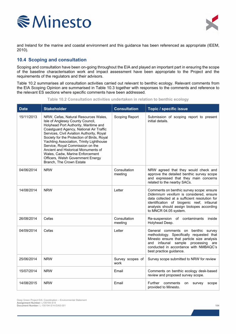
and Ireland for the marine and coastal environment and this guidance has been referenced as appropriate (IEEM, 2010).
10.4 Scoping and consultation Scoping and consultation have been on-going throughout the EIA and played an important part in ensuring the scope of the baseline characterisation work and impact assessment have been appropriate to the Project and the requirements of the regulators and their advisors.
Table 10.2 summarises all consultation activities carried out relevant to benthic ecology. Relevant comments from the EIA Scoping Opinion are summarised in Table 10.3 together with responses to the comments and reference to the relevant ES sections where specific comments have been addressed.
Table 10.2 Consultation activities undertaken in relation to benthic ecology
Date Stakeholder Consultation Topic / specific issue
15/11/2013 NRW, Cefas, Natural Resources Wales, Isle of Anglesey County Council, Holyhead Port Authority, Maritime and Coastguard Agency, National Air Traffic Services, Civil Aviation Authority, Royal Society for the Protection of Birds, Royal Yachting Association, Trinity Lighthouse Service, Royal Commission on the Ancient and Historical Monuments of Wales, Cadw, Marine Enforcement Officers, Welsh Government Energy Branch, The Crown Estate
Scoping Report Submission of scoping report to present initial details.
04/06/2014 NRW Consultation meeting
NRW agreed that they would check and approve the detailed benthic survey scope and expressed that they main concerns related to the nearby SACs.
14/08/2014 NRW Letter Comments on benthic survey scope: ensure Didemnum vexillum is considered, ensure data collected at a sufficient resolution for identification of biogenic reef, infaunal analysis should assign biotopes according to MNCR 04.05 system.
26/08/2014 Cefas Consultation meeting
Re-suspension of contaminants inside Holyhead Deep.
04/09/2014 Cefas Letter General comments on benthic survey methodology. Specifically requested that Minesto ensure that particle size analysis and infaunal sample processing are conducted in accordance with NMBAQC’s best practice guidance.
25/06/2014 NRW Survey scopes of work
Survey scope submitted to NRW for review
15/07/2014 NRW Email Comments on benthic ecology desk-based review and proposed survey scope.
14/08/2015 NRW Email Further comments on survey scope provided to Minesto.
Deep Green Project EIA: Coordination – Environmental Statement Assignment Number: L100194-S14 Document Number: L-100194-S14-EIAS-001 104
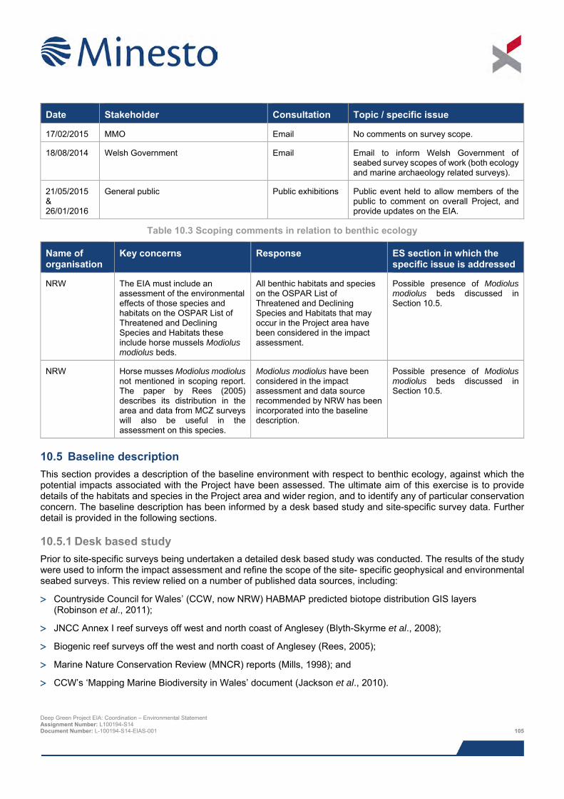
Date Stakeholder Consultation Topic / specific issue
17/02/2015 MMO Email No comments on survey scope.
18/08/2014 Welsh Government Email Email to inform Welsh Government of seabed survey scopes of work (both ecology and marine archaeology related surveys).
21/05/2015 & 26/01/2016
General public Public exhibitions Public event held to allow members of the public to comment on overall Project, and provide updates on the EIA.
Table 10.3 Scoping comments in relation to benthic ecology
Name of organisation
Key concerns Response ES section in which the specific issue is addressed
NRW The EIA must include an assessment of the environmental effects of those species and habitats on the OSPAR List of Threatened and Declining Species and Habitats these include horse mussels Modiolus modiolus beds.
All benthic habitats and species on the OSPAR List of Threatened and Declining Species and Habitats that may occur in the Project area have been considered in the impact assessment.
Possible presence of Modiolus modiolus beds discussed in Section 10.5.
NRW Horse musses Modiolus modiolus not mentioned in scoping report. The paper by Rees (2005) describes its distribution in the area and data from MCZ surveys will also be useful in the assessment on this species.
Modiolus modiolus have been considered in the impact assessment and data source recommended by NRW has been incorporated into the baseline description.
Possible presence of Modiolus modiolus beds discussed in Section 10.5.
10.5 Baseline description This section provides a description of the baseline environment with respect to benthic ecology, against which the potential impacts associated with the Project have been assessed. The ultimate aim of this exercise is to provide details of the habitats and species in the Project area and wider region, and to identify any of particular conservation concern. The baseline description has been informed by a desk based study and site-specific survey data. Further detail is provided in the following sections.
10.5.1 Desk based study Prior to site-specific surveys being undertaken a detailed desk based study was conducted. The results of the study were used to inform the impact assessment and refine the scope of the site- specific geophysical and environmental seabed surveys. This review relied on a number of published data sources, including:
> Countryside Council for Wales’ (CCW, now NRW) HABMAP predicted biotope distribution GIS layers (Robinson et al., 2011);
> JNCC Annex I reef surveys off west and north coast of Anglesey (Blyth-Skyrme et al., 2008);
> Biogenic reef surveys off the west and north coast of Anglesey (Rees, 2005);
> Marine Nature Conservation Review (MNCR) reports (Mills, 1998); and
> CCW’s ‘Mapping Marine Biodiversity in Wales’ document (Jackson et al., 2010).
Deep Green Project EIA: Coordination – Environmental Statement Assignment Number: L100194-S14 Document Number: L-100194-S14-EIAS-001 105
10.5.2 Survey data 10.5.2.1 Minesto commissioned subtidal environmental characterisation survey Minesto commissioned CMACS (2015b) to undertake a subtidal survey of the PDA7, comprising benthic grabs and underwater camera survey (video and stills). Before the survey was undertaken, CMACS (2015b) interpreted sidescan mosaics and multibeam bathymetry data collected by Bibby HydroMap in June 2015 to differentiate seabed habitats in the Project area. Sampling stations for general seabed classification purposes were spread throughout the survey area to ensure representative coverage of all predicted habitats identified in the review of geophysical data. Where the geophysical data pointed towards the possible existence of Annex I habitats, specific targeted sampling stations were added. In addition, some reference stations were added outside of the core survey area to contextualise the other samples and to serve as control locations, should they be required for any future monitoring work. The overall aims of the survey campaign were as follows:
> To characterise and describe the spatial distribution of seabed habitats in the Deep Green Holyhead Deep PDA;
> To document the presence of any seabed features or species of conservation interest; and
> To quantify any contaminants present in the surface sediments.
10.5.3 Subtidal water depths and sediments 10.5.3.1 Regional context The Irish Sea has the form of a relatively shallow basin with depths ranging from 20 – 100 m over considerable areas. To the west of the Irish Sea exists a deeper channel running north-south, connecting the Irish Sea to the Celtic Sea via St George’s Channel and the Malin Shelf via the North Channel (Vincent et al., 2004). The Irish Sea hosts a diverse array of seabed types. Gravelly sediments occur extensively across a broad central belt (usually in areas exposed to strong tidal currents); mobile sands and megaripples occur off the coast of the Isle of Man, in Liverpool Bay, Cardigan Bay and in St George’s Channel; muddy sediments are present at two areas in the northern half and areas of exposed bedrock occur locally in the North Channel and between Anglesey and the Isle of Man (Boelens et al., 1999).
The seabed off the northwest coast of Anglesey is largely defined by the presence of an extensive platform of hard pre-Cambrian rock, which extends north-westerly to approximately 25 km offshore. The seabed therefore tends to be characterised by patches of either exposed bedrock, or bedrock thinly overlain by boulders and lag gravel (Rees, 2005). There are also intermittent ribbons of sand, where the remnants of glacial moraines or other protruding features baffle currents. Overall, it is an area of coarse tide-scoured rough ground where the structuring role of sand is as much as an abrasive as it is a sedimentary habitat (Rees, 2005). The rock platform reaches a maximum depth of approximately 50 m, but the area is notable for several depressions with depths exceeding 100 m, one of which being the Holyhead Deep where the Project will be deployed.
10.5.3.2 Site-specific details Multibeam data revealed that bathymetry across the PDA ranges from a minimum of 65.0 m below LAT, on an irregular rocky outcrop near the north-eastern edge of the site, to a maximum of 88.0 m below LAT in a localised depression within a broad, deep channel feature running north-north-east to south-south-west, across the central section of the PDA.
Based on side-scan sonar mosaics and multibeam bathymetry data, Bibby HydroMap (2015) determined that the seabed across the PDA comprises mainly sand and gravel, with several small irregular patches of megarippled sand and gravel, including boulders. This was corroborated by particle size analysis of grab samples obtained in the PDA, which revealed that two sediment types exist there – sandy gravel and muddy sandy gravel (according to British Geological Survey (BGS) classification).
7 The survey area is larger than the area under consideration in this chapter as it includes a potential future cable corridor for the potential future array. Data from the entire survey area has been presented in this chapter to provide useful context for the PDA. Deep Green Project EIA: Coordination – Environmental Statement Assignment Number: L100194-S14 Document Number: L-100194-S14-EIAS-001 106
CMACS (2015b) combined the geophysical data collected by BibbbyHydroMap (2015) with the sediment grab data and results from the drop down camera deployments to delineate the different seabed habitats in the survey area. Their results are presented in Figure 10.1. The vast majority of the PDA was identified as coarse seabed, with several small patches of ‘Sabellaria – not reef’.
10.5.4 Subtidal species and biotopes 10.5.4.1 Regional context The biology of the Irish Sea has been well studied in specific areas, but historic studies have tended to focus on impact studies or have been very geographically focussed or linked to industrial activities (Blyth-Skyrme et al., 2008). In general, studies in the Irish Sea off the north and west coast of Anglesey have described coarse sediment communities strongly influenced by the high tidal currents that operate in the area (Mackie et al., 1995). Survey work undertaken as part of the BIOMÔR benthic biodiversity studies in the southern Irish Sea revealed that two main faunal assemblages occur off the north and west coasts of Anglesey, both of which are widely represented in the central Irish Sea:
> A Deep Venus community equivalent to SS.SMx.OMx.Po.PoVen (Polychaete-rich deep Venus community in offshore mixed sediments biotope) in The Marine Habitat Classification; and
> A Deep Venus/Hard community, which has no exact equivalent in the Marine Habitat Classification, but it closely related to SS.Smx (Sublittoral mixed sediment biotope complex).
The area directly off the west coast of Anglesey was characterised as ‘Hard Ground’ in the BIOMÔR project. This area was surveyed by Rees (2005) using side-scan sonar, grab and dredge sampling and visual observations using a sledge mounted camera in attempt to map horse mussel Modiolus modiolus reefs. The sidescan sonar confirmed that the seabed here is a complex mosaic of habitats comprising platforms of bedrock exposures overlain with patches of boulders, cobbles and other lag deposits, which made it considerably more difficult to detect the Modiolus beds or bioherms. Nevertheless, the side-scan images revealed several instances of features suggestive of Modiolus beds and significant numbers of live Modiolus were encountered in the dredge and grabs samples at certain locations. No samples were taken within the Holyhead Deep; however, Rees (2005) noted that samples from a similar depression located to the northwest of the Anglesey rock platform contained a much richer fauna that the surrounding areas, with larger Modiolus and large numbers of Glycymeris spp., which appeared to be preyed upon by Asterias rubens. Through the combined analysis of physical samples, video and photographs, Rees (2005) concluded that Modiolus off the north and west coast of Anglesey tend to occur in small patches and clumps as opposed to the semi-continuous beds observed elsewhere, such as the Lleyn Peninsula. No spat were detected and the length frequency distributions indicated that little recruitment had taken place in the preceding years, suggesting this species may be declining in the area.
Rees (2005) also considered the possible presence of Sabellaria spp. reefs in the area. Sabellaria spinulosa is widespread in the parts of the Irish Sea with lag gravels, with individual worms attaching to stones and shells, and there are well developed biogenic reefs off the north coast of Anglesey (Rees pers. Obs. cited on the UK Marine SACs website (UK Marine SAC, 2015). Conversely, Sabellaria alveolata is notable by its absence off the coast of Anglesey, although there are well developed reefs on the north side of the Lleyn Peninsula (UK Marine SAC, 2015). In the 2005 Modiolus surveys Rees (2005) detected nine occurrences of Sabellaria spinulosa in a crust/proto-reef form and one occurrence of ‘apparent reef’, located approximately 11.5 km north of the DG Holyhead Deep site.
Deep Green Project EIA: Coordination – Environmental Statement Assignment Number: L100194-S14 Document Number: L-100194-S14-EIAS-001 107
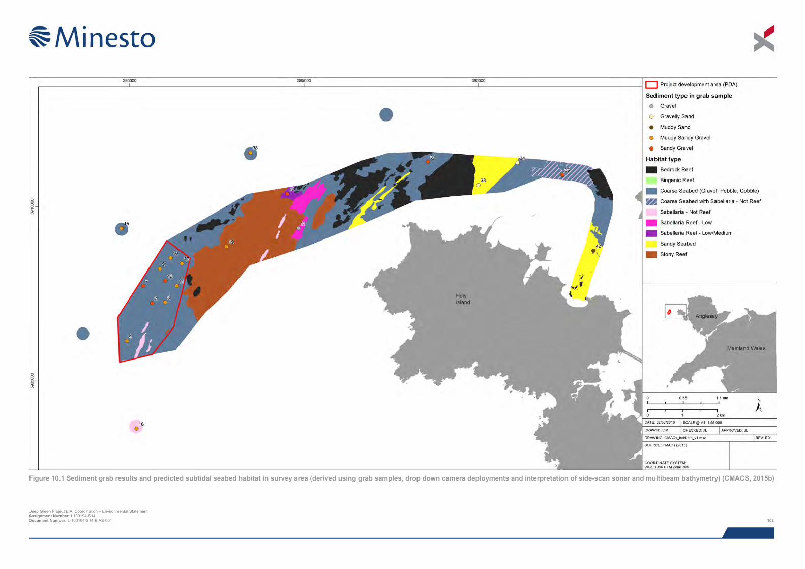
Deep Green Project EIA: Coordination – Environmental Statement Assignment Number: L100194-S14 Document Number: L-100194-S14-EIAS-001 108
Figure 10.1 Sediment grab results and predicted subtidal seabed habitat in survey area (derived using grab samples, drop down camera deployments and interpretation of side-scan sonar and multibeam bathymetry) (CMACS, 2015b)

This page has been intentionally left blank.
Deep Green Project EIA: Coordination – Environmental Statement Assignment Number: L100194-S14 Document Number: L-100194-S14-EIAS-001 109
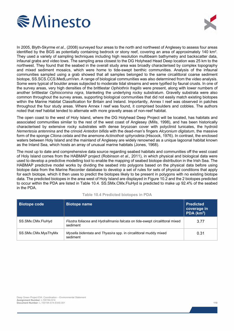
In 2005, Blyth-Skyrme et al., (2008) surveyed four areas to the north and northwest of Anglesey to assess four areas identified by the BGS as potentially containing bedrock or stony reef, covering an area of approximately 140 km2. They used a variety of sampling techniques including high resolution multibeam bathymetry and backscatter data, infaunal grabs and video tows. The sampling area closest to the DG Holyhead Head Deep location was 25 km to the northwest. They found that the seabed in the overall study area was broadly characterised by complex topography and mixed sediment mosaics, which were home to tide-swept benthic communities. Analysis of the infaunal communities sampled using a grab showed that all samples belonged to the same circalittoral coarse sediment biotope, SS.SCS.CCS.MedLumVen. A range of biological communities was also determined from the video analysis. Some were typical of boulder areas subjected to moderate tidal streams and were typified by faunal crusts. In one of the survey areas, very high densities of the brittlestar Ophiothrix fragilis were present, along with lower numbers of another brittlestar Ophiocomina nigra, blanketing the underlying rocky substratum. Gravelly substrata were also common throughout the survey areas, supporting biological communities that did not easily match existing biotopes within the Marine Habitat Classification for Britain and Ireland. Importantly, Annex I reef was observed in patches throughout the four study areas. Where Annex I reef was found, it comprised boulders and cobbles. The authors noted that reef habitat tended to alternate with more gravelly areas of non-reef habitat.
The open coast to the west of Holy Island, where the DG Holyhead Deep Project will be located, has habitats and associated communities similar to the rest of the west coast of Anglesey (Mills, 1998), and has been historically characterised by extensive rocky substrates with dense bryozoan cover with polyclinid tunicates, the hydroid Nemertesia antennina and the crinoid Antedon bifida with the dead-man’s fingers Alcyonium digitatum, the massive form of the sponge Cliona celata and the anemone Actinothoë sphyrodeta (Hiscock, 1976). In contrast, the enclosed waters between Holy Island and the mainland of Anglesey are widely renowned as a unique lagoonal habitat known as the Inland Sea, which hosts an array of unusual marine habitats (Jones, 1968).
The most up to date and comprehensive data source regarding seabed habitats and communities off the west coast of Holy Island comes from the HABMAP project (Robinson et al., 2011), in which physical and biological data were used to develop a predictive modelling tool to enable the mapping of seabed biotope distribution in the Irish Sea. The HABMAP predictive model works by dividing the seabed into polygons based on the physical data before using biotope data from the Marine Recorder database to develop a set of rules for sets of physical conditions that apply for each biotope, which it then uses to predict the biotopes likely to be present in polygons with no existing biotope data. The predicted biotopes in the area west of Holy Island are displayed in Figure 10.2 and the 2 biotopes predicted to occur within the PDA are listed in Table 10.4. SS.SMx.CMx.FluHyd is predicted to make up 92.4% of the seabed in the PDA.
Table 10.4 Predicted biotopes in PDA
Biotope code Biotope name Predicted coverage in PDA (km2)
SS.SMx.CMx.FluHyd Flustra foliacea and Hydrallmania falcata on tide-swept circalittoral mixed sediment
3.77
SS.SMx.CMx.MysThyMx Mysella bidentata and Thyasira spp. in circalittoral muddy mixed sediment
0.31
Deep Green Project EIA: Coordination – Environmental Statement Assignment Number: L100194-S14 Document Number: L-100194-S14-EIAS-001 110
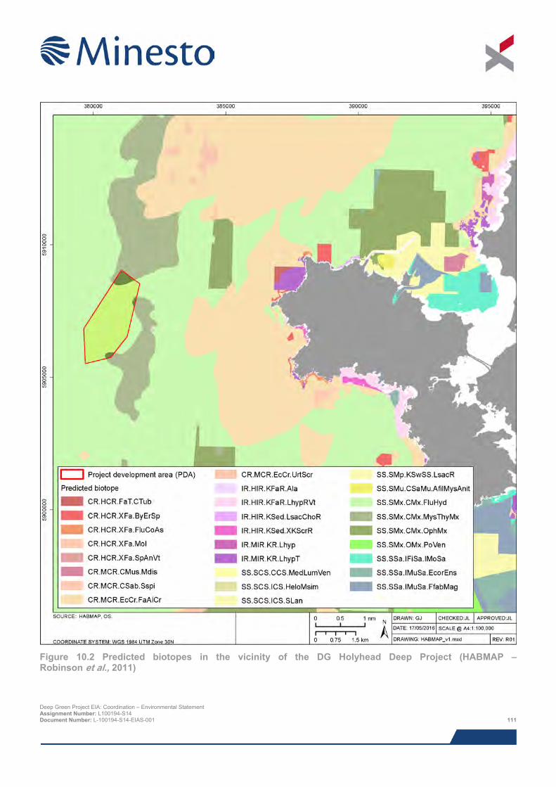
Figure 10.2 Predicted biotopes in the vicinity of the DG Holyhead Deep Project (HABMAP – Robinson et al., 2011) Deep Green Project EIA: Coordination – Environmental Statement Assignment Number: L100194-S14 Document Number: L-100194-S14-EIAS-001 111
10.5.4.2 Site-specific details CMACS (2015b) undertook a benthic ecological characterisation survey in June/July 2015 in order to characterise and describe the spatial distribution of seabed habitats in the survey area (including a potential future export cable corridor) using a combination of benthic grabs and underwater camera surveys. Results obtained from the potential future cable corridor have been included here to improve the description of the wider area around the PDA, but it should be noted that none of these habitats will be directly affected by the Project.
10.5.4.2.1 Infaunal grabs A total of 13,078 individuals from 318 taxa were identified in the 23 grabs samples taken in the survey area. Sampling stations within the PDA tended to have higher abundance than elsewhere, but the highest abundance was recorded at Station 38 (outside the PDA), where 2,140 individuals from 75 taxa were recorded. Infaunal8 communities were generally dominated by annelid worms and molluscs, followed by crustacea (primarily barnacles). At Stations 32 and 35, located close to shore, high numbers of molluscs were encountered, which was primarily attributable to two bivalve species – Nucula nitidosa and Abra alba. Elsewhere, annelids were by far the most abundant organisms. More than 46% of annelids were identified as Sabellaria spp., mostly Sabellaria spinulosa.
The infaunal data were subjected to two multivariate analytical techniques: SIMPROF, to assign stations into groups that are significantly different from one another; and SIMPER, to determine which species contribute to the similarity within groups and dissimilarity between groups. Variability between stations was high so there was a low level of similarity between stations within station groups. Station groups did not show any geographical trend, with many groups containing stations from various locations within the survey area. The SIMPER analysis revealed that the similarity that did exist between the various stations was driven by a relatively high abundance of S. spinulosa and the highly aggregative ascidian (sea squirt) Dendrodoa grossularia.
Overall, the infaunal communities in the PDA, as well as the wider area included in the survey, were found to be typical of offshore sands and gravels, with a high degree of species richness and diversity. The habitat was classified as being a best fit for the ‘Deep Venus’ complex on coarse gravelly sediments with patches of Sabellaria spinulosa biotope north-east of the PDA, both of which are species rich communities that can be highly variable over time.
10.5.4.2.2 Camera survey CMACS (2015) analysed the camera survey images to classify habitat and identify visible fauna. Still images were obtained at all of the sampling stations shown in Figure 10.3 except for Station 12. Video footage was obtained at this station, so habitat characterisation was still possible.
The large majority of images showed a seabed of vey coarse sediment, predominantly pebble and gravel, but with varying proportions of cobble, boulder, sand and shells of dead bivalves. In the PDA, the seabed consisted mainly of pebble and gravel with sand and/or cobble at a few stations and a relatively small area supporting aggregations of S. spinulosa. The seabed outside the PDA to the east consisted of coarser particles and small areas of exposed bedrock. Bedrock became more prevalent further to the east in the PDA and was interspersed with areas of pebble and gravel as well as biogenic reef. Even further east, there were finer sediments including areas of predominantly sand, but also an area of pebble and gravel supporting encrusting growths of S. spinulosa and another area of exposed bedrock.
Epifauna was variable but generally sparse (with a few exceptions) and was principally made up of scour tolerant taxa including various anemones, hydroids, erect bryozoa and epifaunal polychaetes.
10.5.4.2.3 Biotope classification The results from camera survey image were interpreted in conjunction with the results of the infaunal grab analysis in order to assign biotopes according to Connor et al., (2004) and the side-scan mosaic was then used to extrapolate the boundaries of each biotope within the PDA. The biotopes identified are listed in Table 10.5 and their distribution across the survey area are displayed in Figure 10.3. Photographic examples of each biotope obtained during the survey are displayed in Figure 10.4a-c.
8Animals that live within the substrata at the bottom of a body of water. Deep Green Project EIA: Coordination – Environmental Statement Assignment Number: L100194-S14 Document Number: L-100194-S14-EIAS-001 112
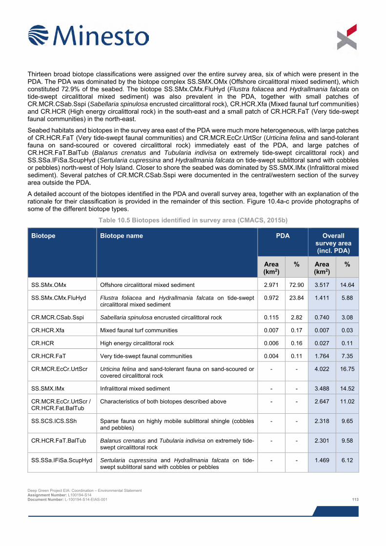
Thirteen broad biotope classifications were assigned over the entire survey area, six of which were present in the PDA. The PDA was dominated by the biotope complex SS.SMX.OMx (Offshore circalittoral mixed sediment), which constituted 72.9% of the seabed. The biotope SS.SMx.CMx.FluHyd (Flustra foliacea and Hydrallmania falcata on tide-swept circalittoral mixed sediment) was also prevalent in the PDA, together with small patches of CR.MCR.CSab.Sspi (Sabellaria spinulosa encrusted circalittoral rock), CR.HCR.Xfa (Mixed faunal turf communities) and CR.HCR (High energy circalittoral rock) in the south-east and a small patch of CR.HCR.FaT (Very tide-swept faunal communities) in the north-east.
Seabed habitats and biotopes in the survey area east of the PDA were much more heterogeneous, with large patches of CR.HCR.FaT (Very tide-swept faunal communities) and CR.MCR.EcCr.UrtScr (Urticina felina and sand-tolerant fauna on sand-scoured or covered circalittoral rock) immediately east of the PDA, and large patches of CR.HCR.FaT.BalTub (Balanus crenatus and Tubularia indivisa on extremely tide-swept circalittoral rock) and SS.SSa.IFiSa.ScupHyd (Sertularia cupressina and Hydrallmania falcata on tide-swept sublittoral sand with cobbles or pebbles) north-west of Holy Island. Closer to shore the seabed was dominated by SS.SMX.IMx (Infralittoral mixed sediment). Several patches of CR.MCR.CSab.Sspi were documented in the central/western section of the survey area outside the PDA.
A detailed account of the biotopes identified in the PDA and overall survey area, together with an explanation of the rationale for their classification is provided in the remainder of this section. Figure 10.4a-c provide photographs of some of the different biotope types.
Table 10.5 Biotopes identified in survey area (CMACS, 2015b)
Biotope Biotope name PDA Overall survey area (incl. PDA)
Area (km2)
% Area (km2)
%
SS.SMx.OMx Offshore circalittoral mixed sediment 2.971 72.90 3.517 14.64
SS.SMx.CMx.FluHyd Flustra foliacea and Hydrallmania falcata on tide-swept circalittoral mixed sediment
0.972 23.84 1.411 5.88
CR.MCR.CSab.Sspi Sabellaria spinulosa encrusted circalittoral rock 0.115 2.82 0.740 3.08
CR.HCR.Xfa Mixed faunal turf communities 0.007 0.17 0.007 0.03
CR.HCR High energy circalittoral rock 0.006 0.16 0.027 0.11
CR.HCR.FaT Very tide-swept faunal communities 0.004 0.11 1.764 7.35
CR.MCR.EcCr.UrtScr Urticina felina and sand-tolerant fauna on sand-scoured or covered circalittoral rock
- - 4.022 16.75
SS.SMX.IMx Infralittoral mixed sediment - - 3.488 14.52
CR.MCR.EcCr.UrtScr / CR.HCR.Fat.BalTub
Characteristics of both biotopes described above - - 2.647 11.02
SS.SCS.ICS.SSh Sparse fauna on highly mobile sublittoral shingle (cobbles and pebbles)
- - 2.318 9.65
CR.HCR.FaT.BalTub Balanus crenatus and Tubularia indivisa on extremely tide-swept circalittoral rock
- - 2.301 9.58
SS.SSa.IFiSa.ScupHyd Sertularia cupressina and Hydrallmania falcata on tide-swept sublittoral sand with cobbles or pebbles
- - 1.469 6.12
Deep Green Project EIA: Coordination – Environmental Statement Assignment Number: L100194-S14 Document Number: L-100194-S14-EIAS-001 113
Biotope Biotope name PDA Overall
survey area (incl. PDA)
Area (km2)
% Area (km2)
%
CR.LCR.BrAsAntAsh Antedon spp., solitary ascidians and fine hydroids on sheltered circalittoral rock
- - 0.165 0.69
SS.SMx.OMx / CR.MCR.CSab.Sspi
Characteristics of both biotopes described above - - 0.138 0.58
10.5.4.2.4 Biotopes predicted to occur inside PDA SS.SMX.OMx (Offshore circalittoral mixed sediment)
The majority of the stations in the PDA (2, 4, 5, 7, 8, 11, 12 and 13) were characterised by a seabed of coarse particles, comprising mainly pebbles with variable portions of cobble and sand. These, and as well as two reference stations west and north of the Project area (14 and 39, respectively) and a single station in wider survey area (41) exhibited similar characteristics, and were classified under the SS.SMX.OMx biotope complex. An example image obtained at Station 7 is displayed in Figure 10.4b.
The biotope complex occurs in offshore circalittoral habitats with slightly muddy mixed gravelly sand and stones or shell. It is often highly diverse with a high number of infaunal polychaete and bivalve species. Animal communities in this habitat are closely related to offshore gravels and coarse sands and in some areas populations of the horse mussel Modiolus modiolus may develop in these habitats. Only one biotope is currently described under this biotope complex.
SS.SMX.CMx.FluHyd (Flustra foliacea and Hydrallmania falcata on tide-swept circalittoral mixed sediment)
The seabed at three stations inside the PDA (6, 9 and 10) was heavily encrusted with a faunal turf, and all of them supported a small amount of hornwrack Flustra folicea. Other sessile fauna observed at these stations included sea anemones (Sagartia sp. and Urticina sp.), serpulid worms, the hydroid Nemertesia antennina and a sabellid worm at Station 9. An example image obtained at Station 10 is displayed in Figure 10.4 b.
This biotope represents part of a transition between sand-scoured circalittoral rock where the epifauna is conspicuous enough to be considered as a biotope and a sediment biotope where an infaunal sample is required to characterise it and is possibly best considered an epibiotic overlay. Flustra foliacea and the hydroid Hydrallmania falcata characterise this biotope; lesser amounts of other hydroids such as Sertularia argentea, Nemertesia antennina and occasionally Nemertesia ramose, occur where suitably stable hard substrata is found. The anemone Urticina feline and the soft coral Alcyonium digitatum may also characterise this biotope. Barnacles Balanus crenatus and tube worms Pomatoceros triqueter may be present and the robust bryozoans Alcyonidium diaphanum and Vesicularia spinosa appear amongst the hydroids at a few sites. Sabella pavonina and Lanice conchilega may be occasionally found in the coarse sediment around the stones.
CR.MCR.CSab.Sspi (Sabellaria spinulosa encrusted circalittoral rock)
There were only five stations where S. spinulosa occurred in sufficient abundance to be classified as this biotope: 1, 16 (classified as a combined biotope due to sediments– see below), 22, 24 and 27. Images generally showed a few aggregations of Sabellaria sp., mostly on coarse particles such as cobble and pebble but with some sand and possibly bedrock. Only Stations 22, 24 and 27, located outside of the PDA, were deemed to have sufficient abundance and elevation of Sabellaria aggregations to be considered as reef. An example image obtained at Station 24 is displayed in Figure 10.4 a.
This biotope is typically found encrusting the upper faces of wave-exposed and moderately wave-exposed circalittoral bedrock, boulders and cobbles subject to strong/moderately strong tidal streams in areas with high turbidity. The crusts formed by the sandy tubes of the polychaete worm Sabellaria spinulosa may even completely cover the rock, binding the substratum together to form a crust. A diverse fauna may be found attached to, and sometimes obscuring Deep Green Project EIA: Coordination – Environmental Statement Assignment Number: L100194-S14 Document Number: L-100194-S14-EIAS-001 114
the crust, often reflecting the character of surrounding biotopes. Bryozoans such as Flustra foliacea, Pentapora foliacea and Alcyonidium diaphanum, anemones such as Urticina felina and Sagartia elegans, the polychaete Pomatoceros triqueter, Alcyonium digitatum, the hydroid Nemertesia antennina and echinoderms such as Asterias rubens and Crossaster papposus may all be recorded within this biotope.
CR.HCR.Xfa (Mixed faunal turf communities)
This biotope was only identified at Station 3 in the south-east of the PDA and was assigned due to the dense coverage of sessile epifauna, primarily hydroids and bryozoans. CMACS were unable to provide further definition of the biotope because they were unable to identify the hydroids and bryozoans from the imagery obtained. An example image obtained at Station 3 is displayed in Figure 10.4 a.
This biotope complex occurs on wave-exposed circalittoral bedrock and boulders, subject to tidal streams ranging from strong to moderately strong. This complex is characterised by its diverse range of hydroids (Halecium halecinum, Nemertesia antennina and Nemertesia ramosa), bryozoans (Alcyonidium diaphanum, Flustra foliacea, Bugula flabellata and Bugula plumosa) and sponges (Scypha ciliata, Pachymatisma johnstonia, Cliona celeta, Raspailia ramosa, Esperiopsis fucorum, Hemimycale columella and Dysidea fragilis) forming an often dense, mixed faunal turf. There are nine known biotopes within this biotope complex, but it was not possible to establish which of the nine exist in the survey area.
CR.HCR.FaT (Very tide-swept faunal communities)
Stations 17 and 18 immediately west of the PDA were assigned this broad classification according to the presence of bedrock, but could not be taken any down to biotope level owing to the low diversity and abundance of the fauna. Interpretation of the geophysical data suggested that a small patch occurred inside the PDA. An example image obtained at Station 18 is displayed in Figure 10.4 a.
This biotope complex occurs in wave-exposed, tide-swept narrows and straits on circalittoral bedrock and boulders. The biotopes within this complex are characterised by a high abundance of the robust hydroid Tubularia indivisa. The anemones Sagartia elegans, Actinothoe sphyrodeta, Urticina felina, Corynactis viridis and Metridium senile are all found within this complex. Other species present in this high-energy complex are the sponges Esperiopsis fucorum and Pachymatisma johnstonia, the bryozoans Alcyonidium diaphanum and Flustra foliacea, Cancer pagurus, Sertularia argentea and Asterias rubens. Within this complex, two biotopes have been identified: BalTub and CTub.
CR.HCR (High energy circalittoral rock)
A small area of seabed in the south-east of the PDA could not be defined down to the biotope/biotope complex resolution, so instead was categorised as the habitat type high energy circalittoral rock.
This habitat typically occurs on extremely wave-exposed to exposed circalittoral bedrock and boulders subject to strong tidal streams. The high energy levels found within this habitat complex are reflected in the fauna typically recorded, including the sponges Pachymatisma johnstonia, Halichondria panicea, Esperiopsis fucorum and Myxilla incrustans, and characteristic dense carpets of the hydroid Tubularia indivisa.
10.5.4.2.5 Biotopes identified within wider survey area outside in PDA CR.HCR.FaT.BalTub (Balanus crenatus and Tubularia indivisa)
At Stations 23 and 25 and the reference Station 38, it was possible to refine the aforementioned CR.HCR.FaT biotope complex down to the biotope level based on the abundance of barnacles. However, this should be considered a ‘best-fit’, as opposed to a true match, because the epifauna at these stations was not as diverse as the biotope description suggests. Habitat at these stations was a mixture of boulder, cobble, pebble and gravel. An example image obtained at Station 23 is displayed in Figure 10.4 a.
This biotope typically occurs on upward-facing, extremely tide-swept, circalittoral bedrock, boulders and cobbles found in a broad spectrum of wave-exposures. It is characterised by a few species that are capable of maintaining a foothold in strong tides. These species either form a flat, adherent crust in the case of the barnacle Balanus crenatus, or have strong attachment points and are flexible, bending with the tide, such as the turf of the hydroid Tubularia indivisa. Other species able to tolerate these very strong tides, or just situated slightly out of the main force of the current, include the sponge Halichondria panicea, the robust hydroid Sertularia argentea and current-tolerant
Deep Green Project EIA: Coordination – Environmental Statement Assignment Number: L100194-S14 Document Number: L-100194-S14-EIAS-001 115
anemones such as Sagartia elegans, Urticina felina and Metridium senile. Mobile species such as the starfish Asterias rubens, the crab Cancer pagurus and the whelk Nucella lapillus may also be present.
CR.MCR.EcCr.UrtScr / CR.HCR.FaT.BalTub (see above and below for full name of each)
At Stations 26, 28 and 29 there was a slightly richer epifauna than at Stations 19, 20 and 21, with characteristics of CR.MCR.EcCr.UrtScr, but also some that matched CR.HCR.FaT.BalTub. To account for this, the stations in question were classified as a combination of the two biotopes. An example image obtained at Station 28 is displayed in Figure 10.4 a.
CR.MCR.EcCr.UrtScr (Urticina felina and sand-tolerant fauna on sand-scoured or covered circalittoral rock)
This biotope was assigned to Stations 19, 20, 21 and part of Station 32. Epifauna was generally sparse and was characterised by scour-tolerant taxa such as dahlia anemone, keelworms (Serpulidae) and barnacles. An example image obtained at Station 21 is displayed in Figure 10.4 a.
This biotope typically occurs on tide-swept circalittoral bedrock, rock adjacent to mobile sand/gravel in gullies, and cobbles on gravel and sand, characterised by scour-tolerant robust species. Although many of these species are found on subtidal rock, they tend to occur in larger numbers in these highly sand-influenced conditions. The dominant species by far is the anemone Urticina felina which commonly occurs on rocks at the sand-rock interface, where the scour levels are at a maximum and few species can tolerate this abrasion. The sponge Ciocalypta penicillus is also very characteristic of shifting sand-covered rock. This biotope is only occasionally recorded as a separate entity, because its extent is typically restricted to a very narrow band of rock at the sediment interface. Only occasionally does it cover a large extent of rock (e.g. where the wave action is strong enough to cause sand abrasion well up the rock face or where the rock is low-lying). More often, this scoured zone is recorded as part of whatever biotope occurs on the nearby hard substrata.
CR.LCR.BrAs.AntAsH (Antedon spp., solitary ascidians and fine hydroids on sheltered circalittoral rock)
This biotope was only assigned to Station 36. The sheltered conditions were highlighted by the presence of a layer of fine sediment over the bedrock. The epifauna was quite limited, and the characterising brachiopods were not observed (although these are typically notoriously difficult to see in camera images) but there were numerous feather stars Antedon bifida and lightbulb sea squirt Clavelina lepadiformis which gave a best match for this biotope. An example image obtained at Station 36 is displayed in Figure 10.4 b.
This biotope is typically found on silty boulder or rock slopes, in the sheltered parts of sealochs, subject to weak or very weak tidal currents. The seabed consists of smooth, silty bedrock or boulders, often as outcrops on mixed muddy sediment. A wide range of encrusting species may be found, including the brachiopod Neocrania anomala, the saddle oyster Pododesmus patelliformis, encrusting red algae and polychaetes (Pomatoceros triqueter and Protula tubularia). Other conspicuous species include crinoids on the tops of boulders (Antedon bifida, commoner in shallower water and Antedon petasus, commoner in deeper water), scattered solitary and colonial ascidians (Ascidia mentula, Ascidia virginea, Corella parallelogramma, Clavelina lepadiformis and Ciona intestinalis) and tufts of fine hydroids (Kirchenpaueria pinnata, Nemertesia antennina, Obelia dichotoma and Halceum halecinum).
SS.SCS.ICS.SSh (Sparse fauna on highly mobile sublittoral shingle (cobbles and pebbles))
At Stations 30 and 31 the seabed was characterised by clean pebbles and gravel, with an apparent lack of fine sediment, suggesting that the sediment is mobile. At one station, there were cobbles the largest of which supported growths of mussels, which were probably Musculus discors and dahlia anemone were also present. The mussels were not at sufficient density to base a biotope classification on and the general lack of epifauna led to SS.SCS.ICS.SSh being assigned to this station. An example image obtained at Station 30 is displayed in Figure 10.4 b.
This biotope tends to occur in sublittoral clean shingle and pebble habitats with a lack of conspicuous fauna. It is characterised by unstable, rounded pebbles and stones (as opposed to sub-angular cobbles, which are often found lying on or embedded in other sediment) that are strongly affected by tidal steams and/or wave action can support few animals and are consequently faunally impoverished. The species composition of this biotope may be highly variable seasonally and is likely to comprise low numbers of robust polychaetes or bivalves with occasional epibiota including echinoderms and crustacea such as Liocarcinus spp. and Pagurus spp. In more settled periods there may be colonisation by anemones such as Urticina felina and small populations of hydroids and bryozoa. Deep Green Project EIA: Coordination – Environmental Statement Assignment Number: L100194-S14 Document Number: L-100194-S14-EIAS-001 116
SS.SMX.IMx (Infralittoral mixed sediment)
The biotope complex was identified at Stations 33, 24, 35 and 37, the survey sample locations closest inshore. Epifauna at these stations was sparse, but more conspicuous that at Station 30, which, combined with the presence of fine sediments and relatively shallow depths at these locations, led to the conclusion that these should be classified under the SS.SMX.IMx biotope complex. An example image obtained at Station 34 is displayed in Figure 10.4 b.
The biotope is typically found in shallow mixed sediments in fully marine or near fully marine conditions, supporting various animal-dominated communities, with relatively low proportions of seaweeds. The habitat may include well mixed muddy gravelly sands or very poorly sorted mosaics of shell, cobbles and pebbles embedded in mud, sand or gravel. Due to the quite variable nature of the sediment type, a widely variable array of communities may be found, including those characterised by bivalves (SMX.VsenAsquAps, SMX.CreAsAn, and SMX.Ost), polychaetes (SMX.SpavSpAn) and file shells (SMX.Lim).
SS.SSA.IFiSa.ScupHyd (Sertularia cupressina and Hydrallmania falcata on tide-swept sublittoral sand with cobbles or pebbles)
Imagery obtained at Station 32, located directly north of Holy Island, revealed a seabed dominated by sand, gravel and dead bivalve shells, supporting diverse epifauna dominated by hydroids. An example image obtained at Station 32 is displayed in Figure 10.4 b.
This biotope tends to occur in shallow sands with cobbles and pebbles, exposed to strong tidal streams, with conspicuous colonies of hydroids, particularly Hydrallmania falcata and to a lesser extent Sertularia cupressina and S. argentea. These hydroids are tolerant to periodic submergence and scour by sand.
SS.SMX.Omx / CR.MCR.Csab (Offshore circalittoral mixed sediment /Circalittoral Sabellaria reefs)
At Station 22 the seabed had many characteristics of the offshore sediments seen elsewhere (particularly in the PDA) but also had some seabed coverage of Sabellaria aggregations, so the seabed at this station was classified as a combination of the two biotopes.
CR.MCR.CSab.Sspi / SS.SBR.PoR.SSpiMx (see above and below for full name of each)
At Station 16 the seabed was made up of finer sediment than the stations discussed in the previous section and the community shared many features with the subtidal sediment biotope SS.SBR.PoR.SSpiMx, so was classified as a combined biotope.
Deep Green Project EIA: Coordination – Environmental Statement Assignment Number: L100194-S14 Document Number: L-100194-S14-EIAS-001 117
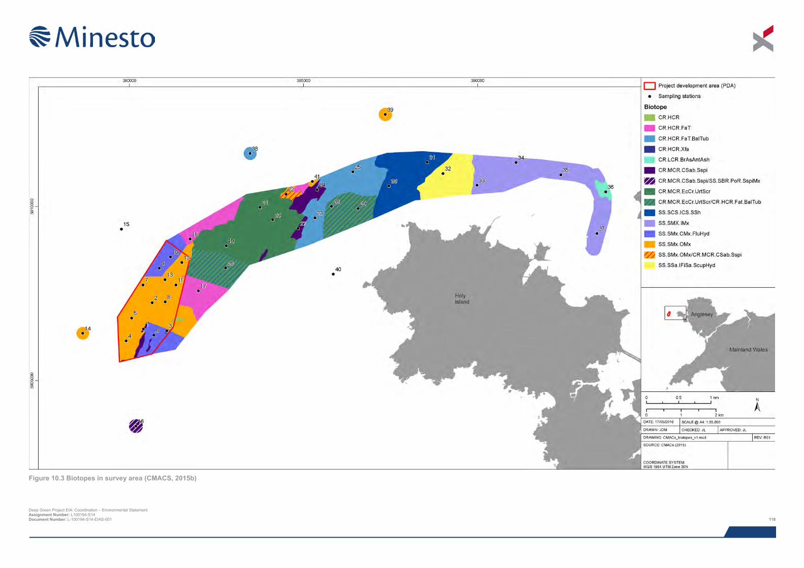
Deep Green Project EIA: Coordination – Environmental Statement Assignment Number: L100194-S14 Document Number: L-100194-S14-EIAS-001 118
Figure 10.3 Biotopes in survey area (CMACS, 2015b)

This page has been intentionally left blank.
Deep Green Project EIA: Coordination – Environmental Statement Assignment Number: L100194-S14 Document Number: L-100194-S14-EIAS-001 119
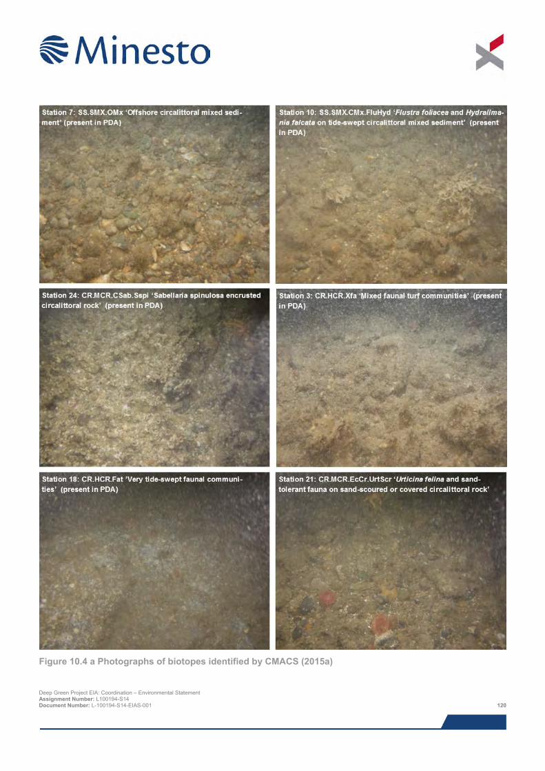
Figure 10.4 a Photographs of biotopes identified by CMACS (2015a)
Deep Green Project EIA: Coordination – Environmental Statement Assignment Number: L100194-S14 Document Number: L-100194-S14-EIAS-001 120
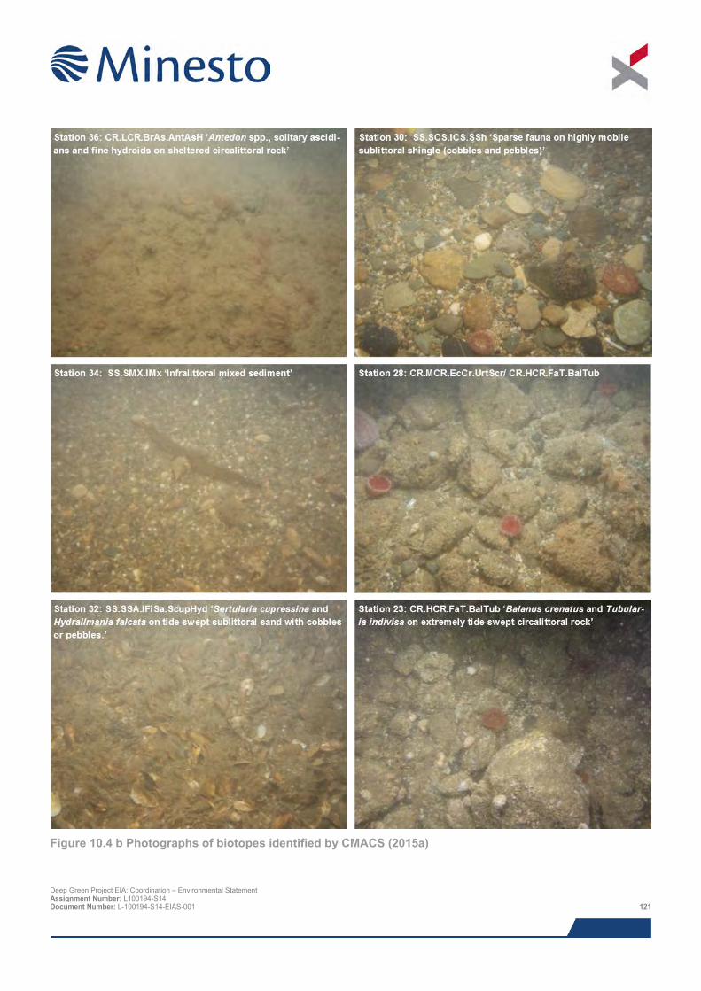
Figure 10.4 b Photographs of biotopes identified by CMACS (2015a)
Deep Green Project EIA: Coordination – Environmental Statement Assignment Number: L100194-S14 Document Number: L-100194-S14-EIAS-001 121
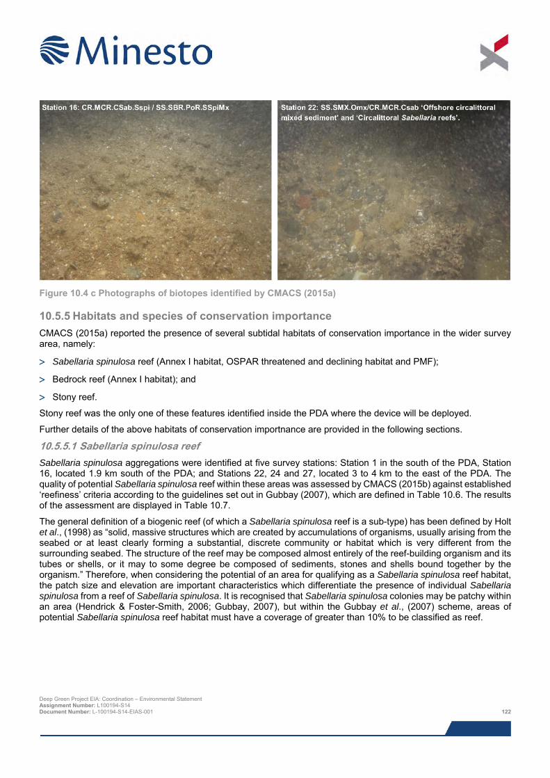
Figure 10.4 c Photographs of biotopes identified by CMACS (2015a)
10.5.5 Habitats and species of conservation importance CMACS (2015a) reported the presence of several subtidal habitats of conservation importance in the wider survey area, namely:
> Sabellaria spinulosa reef (Annex I habitat, OSPAR threatened and declining habitat and PMF);
> Bedrock reef (Annex I habitat); and
> Stony reef.
Stony reef was the only one of these features identified inside the PDA where the device will be deployed.
Further details of the above habitats of conservation importnance are provided in the following sections.
10.5.5.1 Sabellaria spinulosa reef Sabellaria spinulosa aggregations were identified at five survey stations: Station 1 in the south of the PDA, Station 16, located 1.9 km south of the PDA; and Stations 22, 24 and 27, located 3 to 4 km to the east of the PDA. The quality of potential Sabellaria spinulosa reef within these areas was assessed by CMACS (2015b) against established ‘reefiness’ criteria according to the guidelines set out in Gubbay (2007), which are defined in Table 10.6. The results of the assessment are displayed in Table 10.7.
The general definition of a biogenic reef (of which a Sabellaria spinulosa reef is a sub-type) has been defined by Holt et al., (1998) as “solid, massive structures which are created by accumulations of organisms, usually arising from the seabed or at least clearly forming a substantial, discrete community or habitat which is very different from the surrounding seabed. The structure of the reef may be composed almost entirely of the reef-building organism and its tubes or shells, or it may to some degree be composed of sediments, stones and shells bound together by the organism.” Therefore, when considering the potential of an area for qualifying as a Sabellaria spinulosa reef habitat, the patch size and elevation are important characteristics which differentiate the presence of individual Sabellaria spinulosa from a reef of Sabellaria spinulosa. It is recognised that Sabellaria spinulosa colonies may be patchy within an area (Hendrick & Foster-Smith, 2006; Gubbay, 2007), but within the Gubbay et al., (2007) scheme, areas of potential Sabellaria spinulosa reef habitat must have a coverage of greater than 10% to be classified as reef.
Deep Green Project EIA: Coordination – Environmental Statement Assignment Number: L100194-S14 Document Number: L-100194-S14-EIAS-001 122
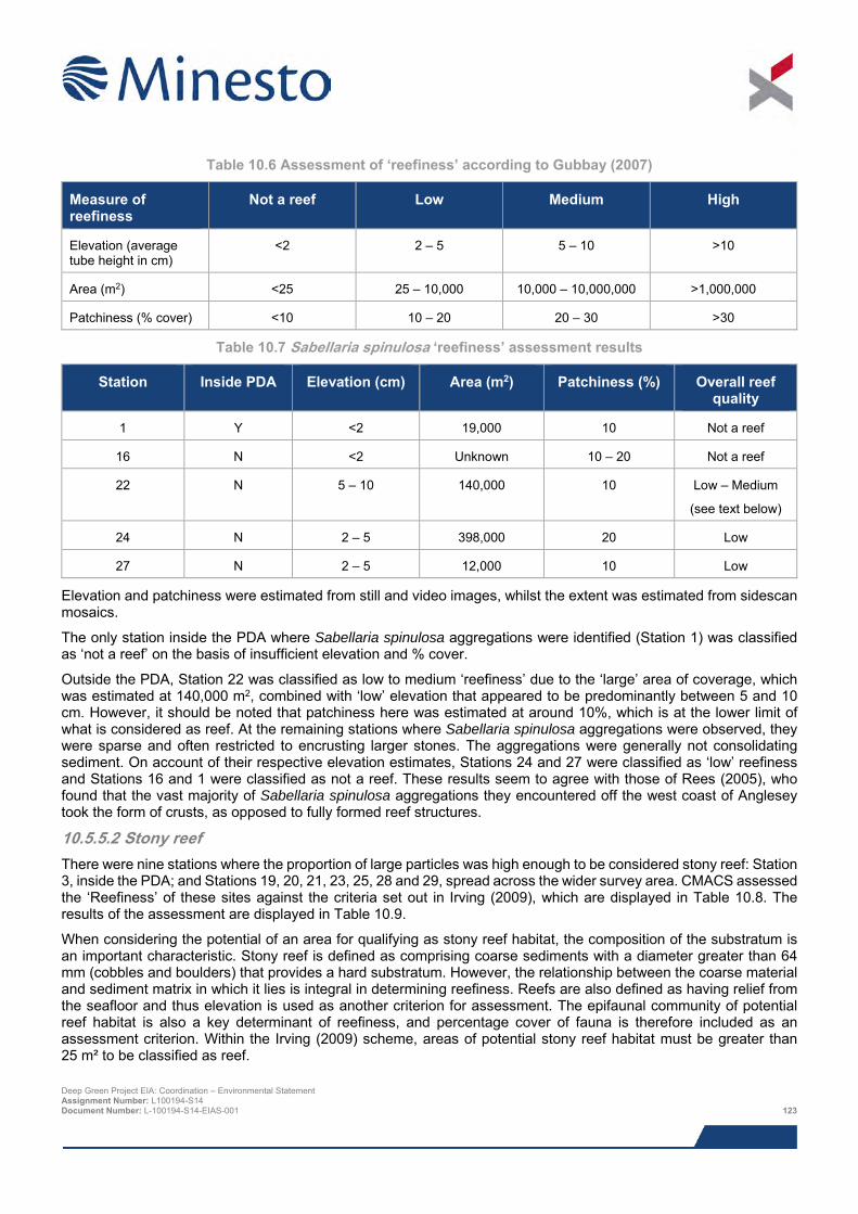
Table 10.6 Assessment of ‘reefiness’ according to Gubbay (2007)
Measure of reefiness
Not a reef Low Medium High
Elevation (average tube height in cm)
<2 2 – 5 5 – 10 >10
Area (m2) <25 25 – 10,000 10,000 – 10,000,000 >1,000,000
Patchiness (% cover) <10 10 – 20 20 – 30 >30
Table 10.7 Sabellaria spinulosa ‘reefiness’ assessment results
Station Inside PDA Elevation (cm) Area (m2) Patchiness (%) Overall reef quality
1 Y <2 19,000 10 Not a reef
16 N <2 Unknown 10 – 20 Not a reef
22 N 5 – 10 140,000 10 Low – Medium
(see text below)
24 N 2 – 5 398,000 20 Low
27 N 2 – 5 12,000 10 Low
Elevation and patchiness were estimated from still and video images, whilst the extent was estimated from sidescan mosaics.
The only station inside the PDA where Sabellaria spinulosa aggregations were identified (Station 1) was classified as ‘not a reef’ on the basis of insufficient elevation and % cover.
Outside the PDA, Station 22 was classified as low to medium ‘reefiness’ due to the ‘large’ area of coverage, which was estimated at 140,000 m2, combined with ‘low’ elevation that appeared to be predominantly between 5 and 10 cm. However, it should be noted that patchiness here was estimated at around 10%, which is at the lower limit of what is considered as reef. At the remaining stations where Sabellaria spinulosa aggregations were observed, they were sparse and often restricted to encrusting larger stones. The aggregations were generally not consolidating sediment. On account of their respective elevation estimates, Stations 24 and 27 were classified as ‘low’ reefiness and Stations 16 and 1 were classified as not a reef. These results seem to agree with those of Rees (2005), who found that the vast majority of Sabellaria spinulosa aggregations they encountered off the west coast of Anglesey took the form of crusts, as opposed to fully formed reef structures.
10.5.5.2 Stony reef There were nine stations where the proportion of large particles was high enough to be considered stony reef: Station 3, inside the PDA; and Stations 19, 20, 21, 23, 25, 28 and 29, spread across the wider survey area. CMACS assessed the ‘Reefiness’ of these sites against the criteria set out in Irving (2009), which are displayed in Table 10.8. The results of the assessment are displayed in Table 10.9.
When considering the potential of an area for qualifying as stony reef habitat, the composition of the substratum is an important characteristic. Stony reef is defined as comprising coarse sediments with a diameter greater than 64 mm (cobbles and boulders) that provides a hard substratum. However, the relationship between the coarse material and sediment matrix in which it lies is integral in determining reefiness. Reefs are also defined as having relief from the seafloor and thus elevation is used as another criterion for assessment. The epifaunal community of potential reef habitat is also a key determinant of reefiness, and percentage cover of fauna is therefore included as an assessment criterion. Within the Irving (2009) scheme, areas of potential stony reef habitat must be greater than 25 m² to be classified as reef. Deep Green Project EIA: Coordination – Environmental Statement Assignment Number: L100194-S14 Document Number: L-100194-S14-EIAS-001 123
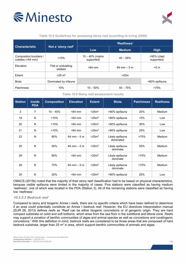
Table 10.8 Guidelines for assessing stony reef according to Irving (2009)
Characteristic Not a ‘stony reef’ ‘Reefiness’
Low Medium High
Composition boulders / cobbles (>64 mm) <10% 10 – 40% (matrix
supported) 40 – 95% >95% (clast supported)
Elevation Flat or undulating seabed <64 mm 64 mm – 5 m >5 m
Extent <25 m2 >25m
Biota Dominated by infauna >80% epifauna
Patchiness 10% 10 – 50% 50 – 75% >75%
Table 10.9 Stony reef assessment results
Station Inside PDA
Composition Elevation Extent Biota Patchiness Reefiness
3 Y 10 – 40% <64 mm >25m2 >80% epifauna 20% Medium
19 N <10% <64 mm >25m2 <80% epifauna 10% Low
20 N <10% <64 mm >25m2 <80% epifauna 30% Low
21 N <10% <64 mm >25m2 <80% epifauna 25% Low
23 N 80% 64 mm – 5 m >25m2 Likely epifauna dominated
>75% Medium
25 N 50% 64 mm – 5 m >25m2 Likely epifauna dominate
50% Medium
28 N 80% <64 mm >25m2 Likely epifauna dominate
>75% Medium
29 N 70% 64 mm – 5 m >25m2 Likely epifauna dominate
>75% Medium
35 N 20% <64 mm >25m2 <80% epifauna 20% Low
CMACS (2015b) noted that the majority of their stony reef classification had to be based on physical characteristics, because visible epifauna were limited in the majority of cases. Five stations were classified as having medium ‘reefiness’, one of which was located in the PDA (Station 3). All of the remaining stations were classified as having low ‘reefiness’.
10.5.5.3 Bedrock reef Compared to stony and biogenic Annex I reefs, there are no specific criteria which have been defined to determine if an area could potentially constitute an Annex I bedrock reef. However, the EU directives interpretation manual (EUR 28, 2013) defines reefs as “Reef can be either biogenic concretions or of geogenic origin. They are hard compact substrata on solid and soft bottoms, which arise from the sea floor in the sublittoral and littoral zone. Reefs may support a zonation of benthic communities of algae and animal species as well as concretions and corallogenic concretions.” With this definition in mind, bedrock reefs are considered to be those areas that are composed of hard bedrock substrata, larger than 25 m2 in area, which support benthic communities of animals and algae.
Deep Green Project EIA: Coordination – Environmental Statement Assignment Number: L100194-S14 Document Number: L-100194-S14-EIAS-001 124
CMACS (2015b) identified potential bedrock reef at four stations, none of which were inside the PDA: Stations 17 and 18, adjacent to the PDA; Station 32, directly north of Holy Island; and Station 36, close to the coast of Anglesey. The substratum at Station 32 was certainly patchy to some degree, since both sedimentary and bedrock biotopes were identified at this station. The associated fauna at all four stations was neither rich nor diverse, typically consisting of scattered dahlia anemones with sparse hydroids, sponges and barnacles.
10.5.5.4 Other habitats and species of conservation importance Possible M. modiolus reef
Sidescan sonar records in the area around Station 41, half way between the PDA and Holy Island, indicated that horse mussel Modiolus modiolus reef may have been present in the area, but no reef was identified in the seabed imagery obtained at this location. Indeed, no live M. modiolus were recorded, and only two empty shells from this species were observed. A few Sabellaria spinulosa tubes were seen, but these were too sparse to be considered reef, and the seabed at this station was ultimately classified as SS.SMX.OMX.
The grab sample from Station 24, located just south of station 41, yielded 11 small individual M. modiolus corresponding to a density of 110 individuals/m2 and Station 33, immediately north of Holy Island, yielded 70 individuals/m2. Both of these density levels are high enough to be considered potential reef. However, Station 24 was dominated by the S. spinulosa community and there was no evidence from the camera survey that any M. modiolus aggregations existed at either station. No M. modiolus were encountered inside the PDA. CMACS (2015b) concluded that it is likely that the M. modiolus they encountered were individuals growing on the coarse sediments interspersed with the S. spinulosa aggregations. This is supported by the work conducted by Rees (2005), who concluded that M. modiolus off the north and west coast of Anglesey tend to occur in small patches and clumps as opposed to continuous beds (see Section 10.5.3.1 for further details).
10.5.5.5 Habitats and species of principal importance in Wales Following the UK Post-2010 Biodiversity Framework, which succeed the UK Biodiversity Action Plan (UK BAP), the UK BAP list of priority habitats and species was used to draw up statutory lists of habitats and species of principal importance in Wales under Section 42 of the NERC Act 2006. These are referred to as Section 42 habitats or Section 42 species throughout the remainder of this chapter.
Two habitats of principal importance (i.e. Section 42 habitats) have the potential to occur in the Project area:
> Tide-swept channels; and
> Subtidal sands and gravels.
The ‘Tide-swept channels’ habitat occurs in areas close to the PDA, for instance, between The Skerries and mainland Anglesey, which is a few miles to the north-east. However, CMACS (2015b) concluded that this habitat is very unlikely to occur within the PDA because they did not observe the diverse array of epifauna that is typical of this habitat in any of their seabed imagery.
The ‘Subtidal sands and gravels’ habitat encompasses the majority of sediments observed in the PDA. It should be noted that subtidal sands and gravels are the most common subtidal habitats in the UK, and are widespread across the British Isles and Europe.
10.5.5.6 Marine Conservation Zones (MCZs) There are no MCZs within close proximity to or potentially impacted by the proposed Project. The closest MCZ is over 100 km to the north east.
10.5.5.7 Special Areas of Conservation (SACs) There are three SAC with marine components on the west coast of Anglesey relevant to benthic ecology, and one offshore SAC (Figure 10.5). The distance of these designations from the PDA and primary reason for their designation are displayed below in Table 10.10.
Deep Green Project EIA: Coordination – Environmental Statement Assignment Number: L100194-S14 Document Number: L-100194-S14-EIAS-001 125
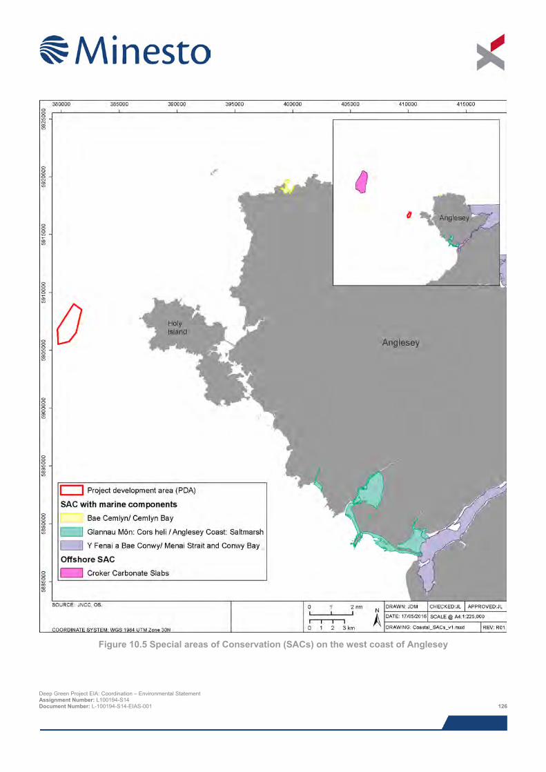
Figure 10.5 Special areas of Conservation (SACs) on the west coast of Anglesey
Deep Green Project EIA: Coordination – Environmental Statement Assignment Number: L100194-S14 Document Number: L-100194-S14-EIAS-001 126
Table 10.10 SACs in the vicinity of the PDA
SAC name Distance from PDA (km)
Primary reason for selection
Bae Cemlyn / Cemlyn Bay 20 Coastal lagoons
Glannau Môn: Cors heli / Anglesey Coast
25 Salicornia and other annuals colonizing mud and sand
Atlantic salt meadows
Y Fenai a Bae Conwy/ Menai Strait and Conwy Bay
35 Sandbanks which are slightly covered by sea water all the time
Mudflats and sandflats not covered by seawater at low tide
Reefs
Croker Carbonate Slabs 30 Submarine structures made by leaking gases
10.5.6 Sediment quality and contamination The PDA is located within the existing boundaries of the Holyhead Deep disposal site (ISO40), which has been in active use since the mid-1980s. The PDA also intersects a closed disposal site located within the southernmost portion of the extant Holyhead Deep site (Holyhead South (IS041)), and is just over 1 km from another closed disposal site (Holyhead East (IS042)), whose boundary adjoins the south-east boundary of the Holyhead Deep site. This raises concerns that the seabed in the area could contain elevated levels of metals and hydrocarbons. In order to understand this potential issue, Minesto has done the following:
> Examined recent dredge spoil monitoring data (obtained as a dredge disposal licence condition);
> Examined the results of a modelling study looking at fate of dredged material deposited in the Holyhead Deep; and
> Commissioned sediment contaminants analyses of grab samples obtained within the survey area.
These are summarised in the following sections.
10.5.6.1 Contaminants in dredging waste All recent (since at least 2009) dredge spoil disposal at the Holyhead Deep disposal site has been by Stena Line Ports Limited, primarily as a result of the requirement to maintain the depth of the channel used for entrance and exit to and from Holyhead Port. It is currently the only licensee, under licence 13/10/ML, which grants permission to deposit a quantity not exceeding 99,000 mt/year up until June 6th 2016. The locations and quantities of Stena Line Ports Limited’s dredge disposal activities since 2009 are shown in Figure 10.6. Only one of the disposal events occurred inside the bounds of the PDA (see Figure 10.6). Potter (2014) determined that the material dredged from the harbour is in the silt range, defined as 0.0039 to 0.0625 mm on the Wentworth scale (Wentworth, 1922).
As a condition of their licence to dispose of maintenance dredging spoil, Stena Line Ports Limited were required to undertake sediment contaminant sampling in the area to be dredged. Sampling was undertaken at five stations in March 2013 and the results are displayed in Table 10.11, alongside ‘Action Levels9’ used by Cefas as part of its ‘weight of evidence’ approach to assessing dredged material and its suitability for disposal to sea.
9 The Cefas Action Levels are used as part of a ‘weight of evidence’ approach to assessing the suitability of material for disposal at sea, but are not themselves statutory standards. The majority of the materials assessed against these standards arise from dredging activities, but Action Levels can be used to assist in the determination of any contamination present in sediments in the vicinity of the Project. The Cefas guidance indicates that, in general, contaminant levels below Action Level 1 are not considered to be of concern and are, therefore, likely to be approved for disposal at sea. Material with contaminant levels above Action Level 2 are generally considered to be unsuitable for disposal at sea. Dredged material with contaminant levels between Action Levels 1 and 2 requires further consideration and testing before a decision can be made. Deep Green Project EIA: Coordination – Environmental Statement Assignment Number: L100194-S14 Document Number: L-100194-S14-EIAS-001 127
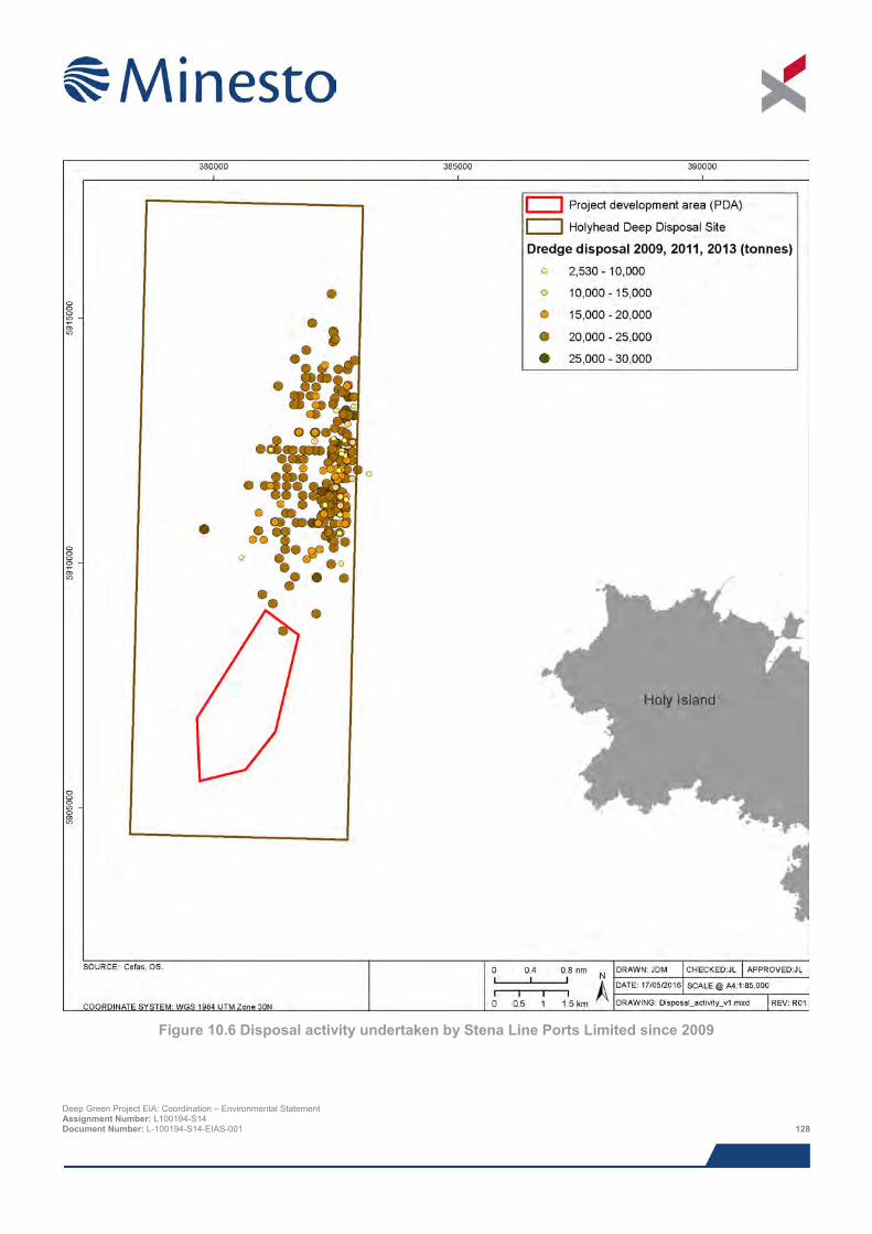
Figure 10.6 Disposal activity undertaken by Stena Line Ports Limited since 2009
Deep Green Project EIA: Coordination – Environmental Statement Assignment Number: L100194-S14 Document Number: L-100194-S14-EIAS-001 128
The dredged material from Holyhead Harbour exceeded Action Level 1 for Chromium (Cr) at one site and Lead (Pb) at another, but the samples means remained below Action Level 1. Action Level 1 for Nickel (Ni) was exceeded in all individual samples, and therefore, also in the sample mean. The tins analysis shows that the results are below limits of detection and are therefore at very low levels. The hydrocarbons results show elevated levels above Cefas Action Level 1 of most determinands at two of the five sampling stations and elevated levels above Cefas Action Level 1 for some of the determinands at the other three sampling stations. In its advice to NRW regarding the most recent Marine Licence renewal (Cefas reference number: MCU13/10), Cefas stated ‘The results show that where Cefas Action Level 1 was exceeded it was only marginally over the action limit and the material is acceptable for disposal to sea.’
Table 10.11 Contaminants levels in samples of material to be dredged from Holyhead Harbour (provided to Minesto by Stena Line Ports Ltd) and action levels used by Cefas as part of a ‘weight of evidence’
approach to assessing dredged material and its suitability for disposal to sea (mg/kg Dry Weight (ppm))
Contaminant / compound
Holyhead Harbour sample (mean of five samples)
Action Level 1 Action Level 2
As 11.03 ppm 20 ppm 100 ppm
Hg 0.11 ppm 0.3 ppm 3 ppm
Cd 0.12 ppm 0.4 ppm 5 ppm
Cr 35.33 ppm* 40 ppm 400 ppm
Cu 17.67 ppm 40 ppm 400 ppm
Ni 29.33 ppm** 20 ppm 500 ppm
Pb 38.67 ppm* 50 ppm 500 ppm
Zn 88.67 ppm 130 ppm 800 ppm
Organotins; TBT, DBT, MBT < level of detection 0.1 ppm 1 ppm
PCBs (sum of ICES 7) No data 0.01 ppb -
PCBs (sum of 25 congeners) No data 0.01 ppb 0.2 ppb
DDT No data 0.001 ppb -
Dieldrin No data 0.005 ppb -
* = one of the five samples exceeded Action Level 1; ** = sample mean (n =5) exceeded Action Level 1
10.5.6.2 Fate of dredged material As part of a SEACAMS study at Bangor University, Potter (2014) investigated the likely fate of the dredge spoil disposed of by Stena Line Ports Limited as a result of its maintenance dredging works at Holyhead harbour using the following approaches:
> Numerical modelling to simulate the behaviour of dredge spoil following deposition on the seabed;
> Analysis of geophysical data to identify features on the seabed potentially related to dumping; and
> Analysis of remote sensing data to determine the effect of disposal of total suspended matter (TSM).
The numerical modelling used a finite-element, morphodynamic, free-surface ocean model (TELEMAC Modelling System v6.1) to model tidal flows and sediment transport in the vicinity of the dumping site in the northern region of
Deep Green Project EIA: Coordination – Environmental Statement Assignment Number: L100194-S14 Document Number: L-100194-S14-EIAS-001 129
the disposal site10. In order to determine the effect of varying hydrodynamic conditions, the model was started under a different tidal state i.e. spring/neap and flood/ebb. Each model run lasted 15 days and modelled the disposal of approximately 150,360,000 m3 of sediment (between 176 and 530 times the annual volumes that are actually dumped at the site). The following bullet points provide a summary of the numerical modelling exercise:
> All disposed sediment was found to leave the disposal site in all of the runs;
> The tidal asymmetry at Holyhead Deep favours sediment transport toward the northeast;
> Sediment was found to disperse widely across the model grid with over 90 % predicted to remain in suspension in low concentrations across the model area, particularly along the Welsh coast, where areas of low suspended sediment load transport (4 x 10⁻⁶ to > 4 x 10⁻⁵ ms-2) were observed in all model runs;
> Only a small percentage of disposed sediment remained on the seabed after 15 days (between 2.263% and 2.342%), and this was spread over much of the Irish Sea;
> Accumulations of sediment were found in bays where mean bed shear stress was low (< 0.9 Nm-2) and the residual tidal currents were directed into the bay. The greatest accumulations were observed around the Anglesey and North Wales coast, notably in the outer area of Holyhead harbour i.e. the location from which the material is dredged; and
> Some sediment was predicted to travel beyond the model grid, particularly to the south, towards the Celtic Sea (despite tidal asymmetry favouring transport toward the northeast).
These results indicate that the Holyhead Deep is a highly dispersive site from which disposed material will rapidly be distributed across the wider region. This was corroborated by the multibeam data also collected as part of the study, which showed no evidence of spoil mounds anywhere within the survey location. Similarly, grab samples showed extremely limited fine sediment fractions at the disposal site (maximum of 1.1 %). Potter (2014) interprets this as an indication that almost all dumped sediment has left the disposal site, either in the upper water column during disposal or as a benthic plume following impact with the seabed. The author highlights that comparably rapid regeneration of seabed morphology has been observed at dispersive sites elsewhere, whilst measurable changes in seabed morphology have been observed at less dispersive sites (Potter, 2014).
10.5.6.3 Site-specific contaminants analysis In order to determine the sediment quality and contamination levels in the PDA and wider survey area, Minesto commissioned CMACS (2015b) to conduct chemical analysis of the sediment grab samples obtained in the survey area in July 2015. In order to contextualise the results of the contaminant testing they have been presented alongside the following recognised guidelines and action levels:
> Canadian Sediment Quality Guidelines for the Protection of Aquatic Life (Canadian Council of Ministers of the Environment, 2002); and
> Cefas Action Levels for the disposal of dredged material (Cefas, 2014) – see explanation in Section 10.5.6.1.
The Canadian Sediment Quality Guidelines involved the derivation of Interim marine Sediment Quality Guidelines (ISQGs) or Threshold Effect Levels (TEL) and Probable Effect Levels (PEL) (CCME, 2002). These values are not statutory standards and were designated specifically for Canada, but in the absence of suitable alternatives it has become commonplace for these guidelines to be used by regulatory and statutory bodies in the UK, and elsewhere, as part of a ‘weight of evidence’ approach.
It should also be noted that they were designed specifically for Canada and based on the protection of pristine environments and therefore considered a more precautionary suite of sediment quality criteria.
Selected Canadian guidelines are presented in Table 10.12, and comprise two assessment levels. The lower level is referred to as the TEL and represents the concentration below which adverse biological effects are expected to
10 The model restricted disposal activity to the northern portion of the site because this is where evidence has shown that almost all disposal occurs, but this also has the benefit of reflecting a scenario in which the southern half of the disposal site is removed to accommodate the DG Holyhead Deep AfL. Deep Green Project EIA: Coordination – Environmental Statement Assignment Number: L100194-S14 Document Number: L-100194-S14-EIAS-001 130
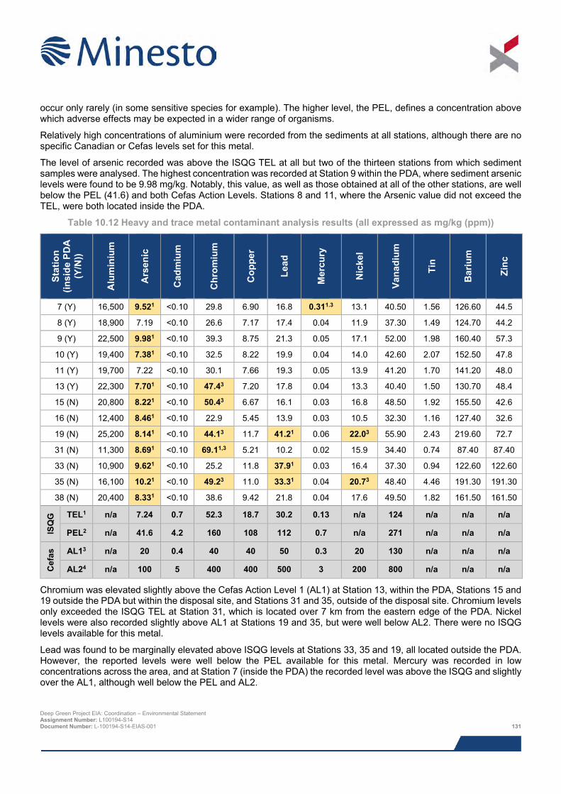
occur only rarely (in some sensitive species for example). The higher level, the PEL, defines a concentration above which adverse effects may be expected in a wider range of organisms.
Relatively high concentrations of aluminium were recorded from the sediments at all stations, although there are no specific Canadian or Cefas levels set for this metal.
The level of arsenic recorded was above the ISQG TEL at all but two of the thirteen stations from which sediment samples were analysed. The highest concentration was recorded at Station 9 within the PDA, where sediment arsenic levels were found to be 9.98 mg/kg. Notably, this value, as well as those obtained at all of the other stations, are well below the PEL (41.6) and both Cefas Action Levels. Stations 8 and 11, where the Arsenic value did not exceed the TEL, were both located inside the PDA.
Table 10.12 Heavy and trace metal contaminant analysis results (all expressed as mg/kg (ppm))
Stat
ion
(insi
de P
DA
(Y
/N))
Alu
min
ium
Ars
enic
Cad
miu
m
Chr
omiu
m
Cop
per
Lead
Mer
cury
Nic
kel
Vana
dium
Tin
Bar
ium
Zinc
7 (Y) 16,500 9.521 <0.10 29.8 6.90 16.8 0.311.3 13.1 40.50 1.56 126.60 44.5
8 (Y) 18,900 7.19 <0.10 26.6 7.17 17.4 0.04 11.9 37.30 1.49 124.70 44.2
9 (Y) 22,500 9.981 <0.10 39.3 8.75 21.3 0.05 17.1 52.00 1.98 160.40 57.3
10 (Y) 19,400 7.381 <0.10 32.5 8.22 19.9 0.04 14.0 42.60 2.07 152.50 47.8
11 (Y) 19,700 7.22 <0.10 30.1 7.66 19.3 0.05 13.9 41.20 1.70 141.20 48.0
13 (Y) 22,300 7.701 <0.10 47.43 7.20 17.8 0.04 13.3 40.40 1.50 130.70 48.4
15 (N) 20,800 8.221 <0.10 50.43 6.67 16.1 0.03 16.8 48.50 1.92 155.50 42.6
16 (N) 12,400 8.461 <0.10 22.9 5.45 13.9 0.03 10.5 32.30 1.16 127.40 32.6
19 (N) 25,200 8.141 <0.10 44.13 11.7 41.21 0.06 22.03 55.90 2.43 219.60 72.7
31 (N) 11,300 8.691 <0.10 69.11,3 5.21 10.2 0.02 15.9 34.40 0.74 87.40 87.40
33 (N) 10,900 9.621 <0.10 25.2 11.8 37.91 0.03 16.4 37.30 0.94 122.60 122.60
35 (N) 16,100 10.21 <0.10 49.23 11.0 33.31 0.04 20.73 48.40 4.46 191.30 191.30
38 (N) 20,400 8.331 <0.10 38.6 9.42 21.8 0.04 17.6 49.50 1.82 161.50 161.50
ISQ
G TEL1 n/a 7.24 0.7 52.3 18.7 30.2 0.13 n/a 124 n/a n/a n/a
PEL2 n/a 41.6 4.2 160 108 112 0.7 n/a 271 n/a n/a n/a
Cef
as AL13 n/a 20 0.4 40 40 50 0.3 20 130 n/a n/a n/a
AL24 n/a 100 5 400 400 500 3 200 800 n/a n/a n/a
Chromium was elevated slightly above the Cefas Action Level 1 (AL1) at Station 13, within the PDA, Stations 15 and 19 outside the PDA but within the disposal site, and Stations 31 and 35, outside of the disposal site. Chromium levels only exceeded the ISQG TEL at Station 31, which is located over 7 km from the eastern edge of the PDA. Nickel levels were also recorded slightly above AL1 at Stations 19 and 35, but were well below AL2. There were no ISQG levels available for this metal.
Lead was found to be marginally elevated above ISQG levels at Stations 33, 35 and 19, all located outside the PDA. However, the reported levels were well below the PEL available for this metal. Mercury was recorded in low concentrations across the area, and at Station 7 (inside the PDA) the recorded level was above the ISQG and slightly over the AL1, although well below the PEL and AL2.
Deep Green Project EIA: Coordination – Environmental Statement Assignment Number: L100194-S14 Document Number: L-100194-S14-EIAS-001 131
Cadmium, copper, tin, vanadium barium and zinc were detected in samples from all thirteen stations, but were present at low levels, well below the quoted ISQG levels and Cefas action levels.
Total hydrocarbon concentrations in the sediment samples were relatively low at all sites, ranging from 11 µg/g to 60 µg/g.
In summary, contaminant testing of the material dredged from Holyhead Port, which is the only known current user of the Holyhead Deep disposal site, shows that contaminant levels only marginally exceed Cefas AL1, and as such, the material is deemed suitable for depositing at sea. Detailed sediment transport modelling suggests that the Holyhead Deep site is highly dispersive, and that only very small quantities of deposited material are likely remain inside the disposal site, whilst the vast majority is spread widely over much of the Irish Sea. Finally, contaminant analysis conducted on grab samples obtained in parts of the survey area that fall both within and without the Holyhead Deposal site showed that certain contaminants exceeded ISQG TEL and Cefas AL1, but none exceeded the PEL or AL2. The exceedances were recorded at stations both within and well beyond the boundaries of the Holyhead Deep disposal site. Total hydrocarbon concentrations were low across all sites.
10.5.7 Data gaps and uncertainties Publications and survey reports relevant to the region have been reviewed which, when combined with the site-specific surveys, provide a comprehensive baseline of the subtidal ecology throughout the Project and its wider area.
10.6 Impact assessment
10.6.1 Overview This assessment covers all impacts identified during scoping, as well as any further potential impacts that have been highlighted as the EIA has progressed. It should be noted that impacts are not necessarily relevant to all Project stages.
The list below indicates all of the direct and indirect impacts assessed in the benthic ecology section and indicates the project stages to which they relate. Cumulative impacts are discussed in Section 10.11.
> Impacts during construction and installation period:
o Direct physical disturbance and loss of habitat;
o Release of drill cuttings and fluid;
o Pollution of water and sediment environment through disturbance of existing contaminants;
o Introduction of INNS;
o Pollution from accidental events;
> Impacts during operation and maintenance:
o Modified hydrodynamic regime and sediment dynamics; and
o Colonisation of introduced hard substrata.
The following impacts were scoped out of the assessment during EIA scoping:
> Pollution due to leaks and spills from DGU – the inventories involved are so small as to be negligible, particularly in light of the highly energetic environment, which will rapidly dilute and disperse small volumes of pollutant;
> Electromagentic Field (EMF) emissions – the export cable from the DGU will be linked to a barge on the surface, occupying the water column as opposed to seabed. As such, there will no mechanism by which the EMF emissions from the cable can affect the benthos.
Deep Green Project EIA: Coordination – Environmental Statement Assignment Number: L100194-S14 Document Number: L-100194-S14-EIAS-001 132
> Anti-fouling - the antifoul treatment applied to DGU will not leach into the surrounding environment. Hence, it will
only affect species that happen to settle on the treated equipment, so species inhabiting the existing environment will remain unaffected, and do not require further consideration.
The assessment of impacts on benthic is a desk based assessment utilising Project specific survey data. No other specialist impact assessment studies have been required to inform the impact assessment.
10.6.2 Assessment criteria The EIA process and methodology are described in detail in Chapter 8. Project specific criteria have been developed for the sensitivity and vulnerability of the receptor, and the likelihood and magnitude of impact (including duration, frequency, seasonality and geographic extent) as detailed in Section 8.3, whilst topic specific criteria have been developed for the value of the receptor (as defined in Table 10.13).
The sensitivity, vulnerability and value of receptor are combined with the likelihood and magnitude of impact using expert judgement to arrive at a consequence for each impact under consideration; the significance of impact is derived directly from the consequences ranking (Section 8.3.5). The definitions for level of impact and how they relate to significance are presented in Section 8.3.5.1.
Table 10.13 Criteria for value of receptor for benthic ecology
Value of receptor Definition Very high Receptor of very high importance or rarity, such as those designated under international
legislation (e.g. EU Habitats Directive), those that form qualifying interests of internationally designated sites, a high density of numerous Priority Marine Feature species or habitats, that comprise an internationally important proportion of that habitat, or receptors that are internationally recognised as globally threatened (e.g. IUCN red list).
High Receptor of high importance or rarity, such as those designated under national legislation, those that form qualifying interests of nationally designated sites, a moderate density of numerous Priority Marine Feature species or habitats, habitats that comprise a nationally important proportion of that habitat, or receptors which contribute to an international site but which are not listed as qualifying interests.
Medium Receptor of medium importance or rarity, such as those which are designated under regional initiatives, presence of Annex I habitats or Annex II species of the European Habitats Directive, species present in regionally important numbers, species/assemblages which contribute to a national site but which are not listed as qualifying interests, species occurring within international/national sites but are not crucial to the integrity of the site, species listed as priority species in the UKBAP, or one or more Priority Marine Feature species or habitats.
Low Receptor which is reasonably common throughout the UK, no features that would meet the criteria for sites of local value but nevertheless has some biodiversity value, and any other receptor of local conservation interest (e.g. LBAP species).
Negligible Receptor of very low importance, such as those which are generally abundant around the UK with no specific local value and no identified conservation concern.
10.6.3 Design envelope This assessment considers the Project parameters which are predicted to result in the greatest environmental impact. This approach ensures that impacts of a greater adverse significance would not arise should any other development scenario be taken forward in the final scheme design. Unless otherwise stated, the assessment has considered the maximum amount of infrastructure that may be located on the seabed, this comprises:
> DGU foundation – one 12 m x 25 m GBS with a total footprint of 300 m2 represents worst case in terms of direct physical disturbance/habitat loss, pin piled tripod using three 20 m x 3 m piles is worst case in terms of releasing drill cuttings (maximum volume of 424.2 m3);
> Scour protection – maximum of 15 m2 around the foundation structure;
Deep Green Project EIA: Coordination – Environmental Statement Assignment Number: L100194-S14 Document Number: L-100194-S14-EIAS-001 133
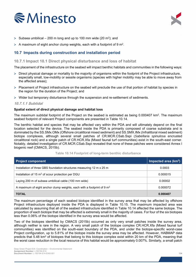
> Subsea umbilical – 200 m long and up to 100 mm wide (20 m2); and
> A maximum of eight anchor clump weights, each with a footprint of 9 m2.
10.7 Impacts during construction and installation period
10.7.1 Impact 10.1 Direct physical disturbance and loss of habitat The placement of the infrastructure on the seabed will impact benthic habitats and communities in the following ways:
> Direct physical damage or mortality to the majority of organisms within the footprint of the Project infrastructure, especially small, low-mobility or sessile organisms (species with higher mobility may be able to move away from the affected areas);
> Placement of Project infrastructure on the seabed will preclude the use of that portion of habitat by species in the region for the duration of the Project; and
> Wider but temporary disturbance through the suspension and re-settlement of sediments.
10.7.1.1 Subtidal Spatial extent of direct physical damage and habitat loss
The maximum subtidal footprint of the Project on the seabed is estimated as being 0.000407 km2. The maximum seabed footprint of relevant Project components are presented in Table 10.14.
The benthic habitat and species that may be affected vary within the PDA and will ultimately depend on the final location selected for the device. The seabed inside the PDA is primarily composed of coarse substrata and is dominated by the SS.SMx.OMx (Offshore circalittoral mixed sediment) and SS.SMX.IMx (Infralittoral mixed sediment) biotope complexes, although several small patches of CR.MCR.CSab.Sspi (Sabellaria spinulosa encrusted circalittoral rock) and a single patch of CR.HCR.Xfa (Mixed faunal turf communities) exist in the south-east corner. Notably, detailed investigation of CR.MCR.CSab.Sspi revealed that none of these patches were considered Annex I biogenic reef (CMACS, 2015b).
Table 10.14 Footprint of long-term benthic disturbance
Project component Impacted area (km2)
Installation of three GBS foundation structures measuring 12 m x 25 m 0.0003
Installation of 15 m2 of scour protection per DGU 0.000015
Laying 200 m of subsea umbilical cable (100 mm wide) 0.00002
A maximum of eight anchor clump weights, each with a footprint of 9 m2 0.000072
TOTAL 0.000407
The maximum percentage of each seabed biotope identified in the survey area that may be affected by offshore Project infrastructure deployed inside the PDA is displayed in Table 10.15. The maximum impacted area was calculated by assuming that all of the seabed infrastructure identified in Table 10.14 affected the same biotope. The proportion of each biotope that may be affected is extremely small in the majority of cases. For four of the six biotopes less than 0.06% of the biotope identified in the survey area would be affected.
Two of the biotopes identified by CMACS (2015b) occurred as only very small patches inside the survey area, although neither is rare in the region. A very small patch of the biotope complex CR.HCR.Xfa (Mixed faunal turf communities) was identified on the south-east boundary of the PDA, and under the biotope-specific worst-case Project configuration, up to 5.81% of the biotope inside the survey area may be affected. However, HABMAP data predicts that 5.48 km2 of biotopes that belong to this biotope complex exist within 20 km of the PDA, meaning that the worst case reduction in the local resource of this habitat would be approximately 0.007%. Similarly, a small patch
Deep Green Project EIA: Coordination – Environmental Statement Assignment Number: L100194-S14 Document Number: L-100194-S14-EIAS-001 134
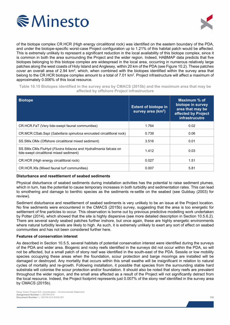
of the biotope complex CR.HCR (High energy circalittoral rock) was identified on the eastern boundary of the PDA, and under the biotope-specific worst-case Project configuration up to 1.21% of this habitat patch would be affected. This is extremely unlikely to represent a significant reduction in the local availability of this biotope complex, since it is common in both the area surrounding the Project and the wider region. Indeed, HABMAP data predicts that five biotopes belonging to this biotope complex are widespread in the local area, occurring in numerous relatively large patches along the west coasts of Holy Island and Anglesey, within 20 km of the PDA (see Figure 10.2). These patches cover an overall area of 2.94 km2, which, when combined with the biotopes identified within the survey area that belong to the CR.HCR biotope complex amount to a total of 7.01 km2. Project infrastructure will affect a maximum of approximately 0.006% of this local resource.
Table 10.15 Biotopes identified in the survey area by CMACS (2015b) and the maximum area that may be affected by offshore Project infrastructure
Biotope Extent of biotope in survey area (km2)
Maximum % of biotope in survey area that may be
affected by Project infrastrucutre
CR.HCR.FaT (Very tide-swept faunal communities) 1.764 0.02
CR.MCR.CSab.Sspi (Sabellaria spinulosa encrusted circalittoral rock) 0.739 0.06
SS.SMx.OMx (Offshore circalittoral mixed sediment) 3.516 0.01
SS.SMx.CMx.FluHyd (Flustra foliacea and Hydrallmania falcata on tide-swept circalittoral mixed sediment) 1.412 0.03
CR.HCR (High energy circalittoral rock) 0.027 1.51
CR.HCR.Xfa (Mixed faunal turf communities) 0.007 5.81
Disturbance and resettlement of seabed sediments
Physical disturbance of seabed sediments during installation activities has the potential to raise sediment plumes, which in turn, has the potential to cause temporary increases in both turbidity and sedimentation rates. This can lead to smothering and damage to benthic species as the sediments re-settle on the seabed (see Gubbay (2003) for review).
Sediment disturbance and resettlement of seabed sediments is very unlikely to be an issue at the Project location. No fine sediments were encountered in the CMACS (2015b) survey, suggesting that the area is too energetic for settlement of fine particles to occur. This observation is borne out by previous predictive modelling work undertaken by Potter (2014), which showed that the site is highly dispersive (see more detailed description in Section 10.5.6.2). There are several sandy seabed patches further inshore, but once again, these are highly energetic environments where natural turbidity levels are likely to high. As such, it is extremely unlikely to exert any sort of effect on seabed communities and has not been considered further here.
Features of conservation interest
As described in Section 10.5.5, several habitats of potential conservation interest were identified during the surveys of the PDA and wider area. Biogenic and rocky reefs identified in the surveys did not occur within the PDA, so will not be affected, but a small patch of stony reef was identified in the south-east of the PDA. Sessile or low mobility species occupying these areas when the foundation, scour protection and barge moorings are installed will be damaged or destroyed. Any mortality that occurs within this small swathe will be insignificant in relation to natural cycles of mortality and re-growth. Following installation, it possible that species from the surrounding stable hard substrata will colonise the scour protection and/or foundation. It should also be noted that stony reefs are prevalent throughout the wider region, and the small area affected as a result of the Project will not significantly detract from the local resource. Indeed, the Project footprint represents just 0.007% of the stony reef identified in the survey area by CMACS (2015b). Deep Green Project EIA: Coordination – Environmental Statement Assignment Number: L100194-S14 Document Number: L-100194-S14-EIAS-001 135
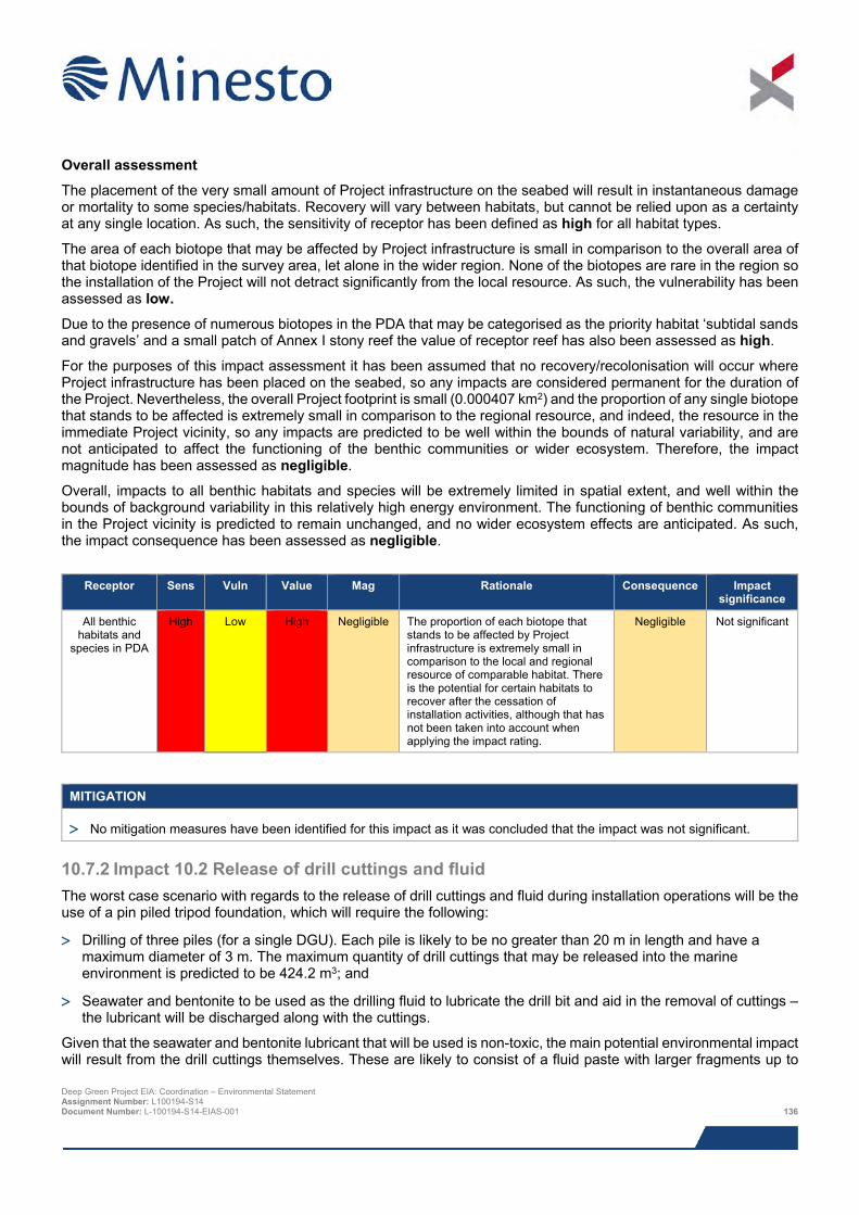
Overall assessment
The placement of the very small amount of Project infrastructure on the seabed will result in instantaneous damage or mortality to some species/habitats. Recovery will vary between habitats, but cannot be relied upon as a certainty at any single location. As such, the sensitivity of receptor has been defined as high for all habitat types.
The area of each biotope that may be affected by Project infrastructure is small in comparison to the overall area of that biotope identified in the survey area, let alone in the wider region. None of the biotopes are rare in the region so the installation of the Project will not detract significantly from the local resource. As such, the vulnerability has been assessed as low.
Due to the presence of numerous biotopes in the PDA that may be categorised as the priority habitat ‘subtidal sands and gravels’ and a small patch of Annex I stony reef the value of receptor reef has also been assessed as high.
For the purposes of this impact assessment it has been assumed that no recovery/recolonisation will occur where Project infrastructure has been placed on the seabed, so any impacts are considered permanent for the duration of the Project. Nevertheless, the overall Project footprint is small (0.000407 km2) and the proportion of any single biotope that stands to be affected is extremely small in comparison to the regional resource, and indeed, the resource in the immediate Project vicinity, so any impacts are predicted to be well within the bounds of natural variability, and are not anticipated to affect the functioning of the benthic communities or wider ecosystem. Therefore, the impact magnitude has been assessed as negligible.
Overall, impacts to all benthic habitats and species will be extremely limited in spatial extent, and well within the bounds of background variability in this relatively high energy environment. The functioning of benthic communities in the Project vicinity is predicted to remain unchanged, and no wider ecosystem effects are anticipated. As such, the impact consequence has been assessed as negligible.
Receptor Sens Vuln Value Mag Rationale Consequence Impact
significance
All benthic habitats and
species in PDA
High Low High Negligible The proportion of each biotope that stands to be affected by Project infrastructure is extremely small in comparison to the local and regional resource of comparable habitat. There is the potential for certain habitats to recover after the cessation of installation activities, although that has not been taken into account when applying the impact rating.
Negligible Not significant
MITIGATION
> No mitigation measures have been identified for this impact as it was concluded that the impact was not significant.
10.7.2 Impact 10.2 Release of drill cuttings and fluid The worst case scenario with regards to the release of drill cuttings and fluid during installation operations will be the use of a pin piled tripod foundation, which will require the following:
> Drilling of three piles (for a single DGU). Each pile is likely to be no greater than 20 m in length and have a maximum diameter of 3 m. The maximum quantity of drill cuttings that may be released into the marine environment is predicted to be 424.2 m3; and
> Seawater and bentonite to be used as the drilling fluid to lubricate the drill bit and aid in the removal of cuttings – the lubricant will be discharged along with the cuttings.
Given that the seawater and bentonite lubricant that will be used is non-toxic, the main potential environmental impact will result from the drill cuttings themselves. These are likely to consist of a fluid paste with larger fragments up to Deep Green Project EIA: Coordination – Environmental Statement Assignment Number: L100194-S14 Document Number: L-100194-S14-EIAS-001 136
pebbled sized ‘flakes’. The primary mechanism by which these could induce impacts in benthic communities is through physical settlement on the seabed, causing disturbance and smothering. Elevated turbidity resulting from drilling activities may also elicit impacts, primarily through blocking the respiratory and/or feeding structures of benthic organisms.
As summarised in the previous section (and examined in detail in Potter (2014)), the Holyhead Deep is a highly dispersive site, and as such, is likely to widely disperse the vast majority of drill cuttings into the wider region, bringing about a temporary and localised increase in turbidity and little in the way of perceptible sediment deposition. Indeed, the distinct lack of finer sediment fractions across the PDA is indicative of an environment where the hydrodynamic regime prevents the settlement of all but the largest sediment particles. This has been shown to be the case with dredging waste disposed of close to the PDA, which is deposited in far greater quantities than would be produced during drilling and is subsequently transported away from the site leaving no evidence that the disposal event had occurred (Potter, 2014). This contrasts with less dispersive sites, where clearly define mounds from where disposal activity has occurred. The release of drill cuttings will also be highly intermittent, occurring for a maximum of several hours per TSS, before the drill rig moves to another location.
The larger debris generated during drilling (likely to be pebble-sized flakes) will settle within relatively close proximity of the drilling site. These deposits have the potential to damage or destroy fauna wherever they settle. Notwithstanding the initial physical disturbance, this will not represent a significant alteration to the character of the seabed, firstly because of the small area involved, and secondly, because the deposits are likely to be somewhat similar to the coarse seabed that makes up the majority of the PDA, which already consists of comparably sized cobbles, pebbles and gravel. It should also be noted that such material will naturally be moved around by tidal action, so organisms are likely to be well adapted to routine disturbances such as those that would be caused by the settlement of large fragments of drilling debris, which can be considered as falling within the realms of natural disturbance processes.
Sessile or low mobility species located within the drill sites will be subject to physical disturbance, damage and mortality as a result of the deposition of larger drill cuttings fragments that are not transported off site by tidal action. The deposited material is highly likely to be rapidly recolonised within short timeframes, and as such, the sensitivity of receptor is assessed as low.
The biotopes identified inside the PDA are widely represented inside immediate vicinity and local area, so the no noticeably effect on benthic ecosystem functioning as a result of the drilling activity undertaken as part of the Project. Long-term impacts will be well within the bounds of natural variation, so the vulnerability of receptor has been assessed as low.
None of the biotopes identified inside the PDA were of any particular conservation interest outside of their categorisation as the priority habitat ‘subtidal sands and gravels’. Therefore, the value of receptor has been assessed as medium.
As discussed above, the only likely impact mechanism associated with drilling activity in the PDA is the deposition of larger fragments in the immediate vicinity of the drill site. The activity will be limited to several hours per location and generate only a small amount of material. The proportion of habitat likely to be affected is extremely small, so the impact magnitude has been assessed as minor.
Overall, impacts to benthic communities are anticipated to be well within the level of natural variation in the area and there is a high chance of rapid recovery. As such, the impact consequence has been assessed as negligible and not significant.
Deep Green Project EIA: Coordination – Environmental Statement Assignment Number: L100194-S14 Document Number: L-100194-S14-EIAS-001 137
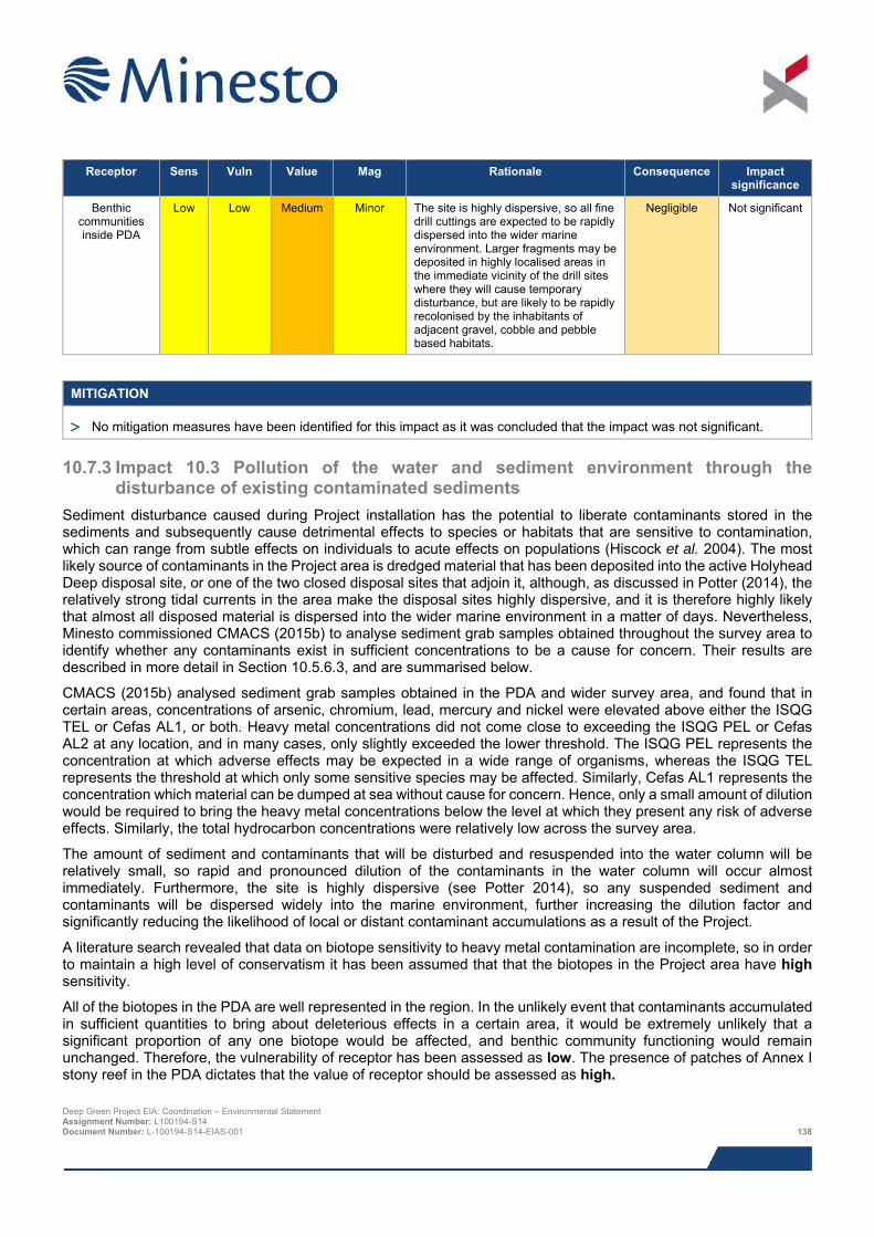
Receptor Sens Vuln Value Mag Rationale Consequence Impact
significance
Benthic communities inside PDA
Low Low Medium Minor The site is highly dispersive, so all fine drill cuttings are expected to be rapidly dispersed into the wider marine environment. Larger fragments may be deposited in highly localised areas in the immediate vicinity of the drill sites where they will cause temporary disturbance, but are likely to be rapidly recolonised by the inhabitants of adjacent gravel, cobble and pebble based habitats.
Negligible Not significant
MITIGATION
> No mitigation measures have been identified for this impact as it was concluded that the impact was not significant.
10.7.3 Impact 10.3 Pollution of the water and sediment environment through the disturbance of existing contaminated sediments
Sediment disturbance caused during Project installation has the potential to liberate contaminants stored in the sediments and subsequently cause detrimental effects to species or habitats that are sensitive to contamination, which can range from subtle effects on individuals to acute effects on populations (Hiscock et al. 2004). The most likely source of contaminants in the Project area is dredged material that has been deposited into the active Holyhead Deep disposal site, or one of the two closed disposal sites that adjoin it, although, as discussed in Potter (2014), the relatively strong tidal currents in the area make the disposal sites highly dispersive, and it is therefore highly likely that almost all disposed material is dispersed into the wider marine environment in a matter of days. Nevertheless, Minesto commissioned CMACS (2015b) to analyse sediment grab samples obtained throughout the survey area to identify whether any contaminants exist in sufficient concentrations to be a cause for concern. Their results are described in more detail in Section 10.5.6.3, and are summarised below.
CMACS (2015b) analysed sediment grab samples obtained in the PDA and wider survey area, and found that in certain areas, concentrations of arsenic, chromium, lead, mercury and nickel were elevated above either the ISQG TEL or Cefas AL1, or both. Heavy metal concentrations did not come close to exceeding the ISQG PEL or Cefas AL2 at any location, and in many cases, only slightly exceeded the lower threshold. The ISQG PEL represents the concentration at which adverse effects may be expected in a wide range of organisms, whereas the ISQG TEL represents the threshold at which only some sensitive species may be affected. Similarly, Cefas AL1 represents the concentration which material can be dumped at sea without cause for concern. Hence, only a small amount of dilution would be required to bring the heavy metal concentrations below the level at which they present any risk of adverse effects. Similarly, the total hydrocarbon concentrations were relatively low across the survey area.
The amount of sediment and contaminants that will be disturbed and resuspended into the water column will be relatively small, so rapid and pronounced dilution of the contaminants in the water column will occur almost immediately. Furthermore, the site is highly dispersive (see Potter 2014), so any suspended sediment and contaminants will be dispersed widely into the marine environment, further increasing the dilution factor and significantly reducing the likelihood of local or distant contaminant accumulations as a result of the Project.
A literature search revealed that data on biotope sensitivity to heavy metal contamination are incomplete, so in order to maintain a high level of conservatism it has been assumed that that the biotopes in the Project area have high sensitivity.
All of the biotopes in the PDA are well represented in the region. In the unlikely event that contaminants accumulated in sufficient quantities to bring about deleterious effects in a certain area, it would be extremely unlikely that a significant proportion of any one biotope would be affected, and benthic community functioning would remain unchanged. Therefore, the vulnerability of receptor has been assessed as low. The presence of patches of Annex I stony reef in the PDA dictates that the value of receptor should be assessed as high. Deep Green Project EIA: Coordination – Environmental Statement Assignment Number: L100194-S14 Document Number: L-100194-S14-EIAS-001 138
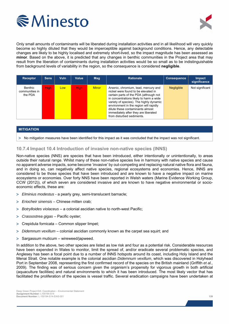
Only small amounts of contaminants will be liberated during installation activities and in all likelihood will very quickly become so highly diluted that they would be imperceptible against background conditions. Hence, any detectable changes are likely to be highly localised and extremely short-lived, so the impact magnitude has been assessed as minor. Based on the above, it is predicted that any changes in benthic communities in the Project area that may result from the liberation of contaminants during installation activities would be so small as to be indistinguishable from background levels of variability in the region, so the consequence is considered negligible.
Receptor Sens Vuln Value Mag Rationale Consequence Impact
significance
Benthic communities in
the PDA
High Low High Minor Arsenic, chromium, lead, mercury and nickel were found to be elevated in certain parts of the PDA (although not in concentrations likely to harm a wide variety of species). The highly dynamic environment in the region will rapidly dilute these contaminants almost immediately after they are liberated from disturbed sediments.
Negligible Not significant
MITIGATION
> No mitigation measures have been identified for this impact as it was concluded that the impact was not significant.
10.7.4 Impact 10.4 Introduction of invasive non-native species (INNS) Non-native species (NNS) are species that have been introduced, either intentionally or unintentionally, to areas outside their natural range. Whilst many of these non-native species live in harmony with native species and cause no apparent adverse impacts, some become ‘invasive’ by out-competing and replacing natural native flora and fauna, and in doing so, can negatively affect native species, regional ecosystems and economies. Hence, INNS are considered to be those species that have been introduced and are known to have a negative impact on marine ecosystems or economies. Over forty NNS have been reported in Welsh waters (Marine Evidence Working Group, CCW (2012)), of which seven are considered invasive and are known to have negative environmental or socio-economic effects, these are:
> Elminius modestus - a pearly grey, semi-translucent barnacle;
> Eriocheir sinensis – Chinese mitten crab;
> Botrylloides violaceus – a colonial ascidian native to north-west Pacific;
> Crassostrea gigas – Pacific oyster;
> Crepidula fornicata – Common slipper limpet;
> Didemnum vexillum – colonial ascidian commonly known as the carpet sea squirt; and
> Sargassum muticum – wireweed/japweed.
In addition to the above, two other species are listed as low risk and four as a potential risk. Considerable resources have been expended in Wales to monitor, limit the spread of, and/or eradicate several problematic species, and Anglesey has been a focal point due to a number of INNS hotspots around its coast, including Holy Island and the Menai Strait. One notable example is the colonial ascidian Didemnum vexillum, which was discovered in Holyhead Port in September 2008, representing the first confirmed record of the species on the British mainland (Griffith et al., 2009). The finding was of serious concern given the organism’s propensity for vigorous growth in both artificial (aquaculture facilities) and natural environments to which it has been introduced. The most likely vector that has facilitated the proliferation of the species is vessel traffic. Several eradication campaigns have been undertaken at
Deep Green Project EIA: Coordination – Environmental Statement Assignment Number: L100194-S14 Document Number: L-100194-S14-EIAS-001 139
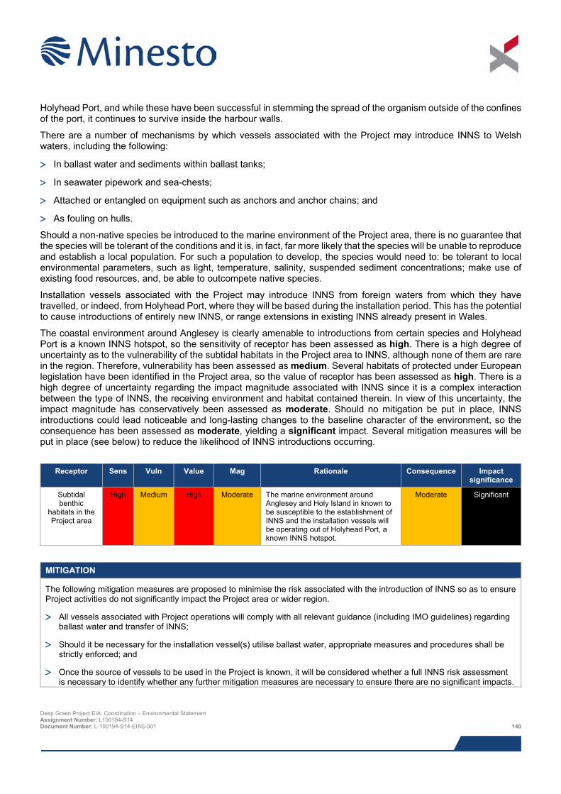
Holyhead Port, and while these have been successful in stemming the spread of the organism outside of the confines of the port, it continues to survive inside the harbour walls.
There are a number of mechanisms by which vessels associated with the Project may introduce INNS to Welsh waters, including the following:
> In ballast water and sediments within ballast tanks;
> In seawater pipework and sea-chests;
> Attached or entangled on equipment such as anchors and anchor chains; and
> As fouling on hulls.
Should a non-native species be introduced to the marine environment of the Project area, there is no guarantee that the species will be tolerant of the conditions and it is, in fact, far more likely that the species will be unable to reproduce and establish a local population. For such a population to develop, the species would need to: be tolerant to local environmental parameters, such as light, temperature, salinity, suspended sediment concentrations; make use of existing food resources, and, be able to outcompete native species.
Installation vessels associated with the Project may introduce INNS from foreign waters from which they have travelled, or indeed, from Holyhead Port, where they will be based during the installation period. This has the potential to cause introductions of entirely new INNS, or range extensions in existing INNS already present in Wales.
The coastal environment around Anglesey is clearly amenable to introductions from certain species and Holyhead Port is a known INNS hotspot, so the sensitivity of receptor has been assessed as high. There is a high degree of uncertainty as to the vulnerability of the subtidal habitats in the Project area to INNS, although none of them are rare in the region. Therefore, vulnerability has been assessed as medium. Several habitats of protected under European legislation have been identified in the Project area, so the value of receptor has been assessed as high. There is a high degree of uncertainty regarding the impact magnitude associated with INNS since it is a complex interaction between the type of INNS, the receiving environment and habitat contained therein. In view of this uncertainty, the impact magnitude has conservatively been assessed as moderate. Should no mitigation be put in place, INNS introductions could lead noticeable and long-lasting changes to the baseline character of the environment, so the consequence has been assessed as moderate, yielding a significant impact. Several mitigation measures will be put in place (see below) to reduce the likelihood of INNS introductions occurring.
Receptor Sens Vuln Value Mag Rationale Consequence Impact
significance
Subtidal benthic
habitats in the Project area
High Medium High Moderate The marine environment around Anglesey and Holy Island in known to be susceptible to the establishment of INNS and the installation vessels will be operating out of Holyhead Port, a known INNS hotspot.
Moderate Significant
MITIGATION
The following mitigation measures are proposed to minimise the risk associated with the introduction of INNS so as to ensure Project activities do not significantly impact the Project area or wider region.
> All vessels associated with Project operations will comply with all relevant guidance (including IMO guidelines) regarding ballast water and transfer of INNS;
> Should it be necessary for the installation vessel(s) utilise ballast water, appropriate measures and procedures shall be strictly enforced; and
> Once the source of vessels to be used in the Project is known, it will be considered whether a full INNS risk assessment is necessary to identify whether any further mitigation measures are necessary to ensure there are no significant impacts.
Deep Green Project EIA: Coordination – Environmental Statement Assignment Number: L100194-S14 Document Number: L-100194-S14-EIAS-001 140
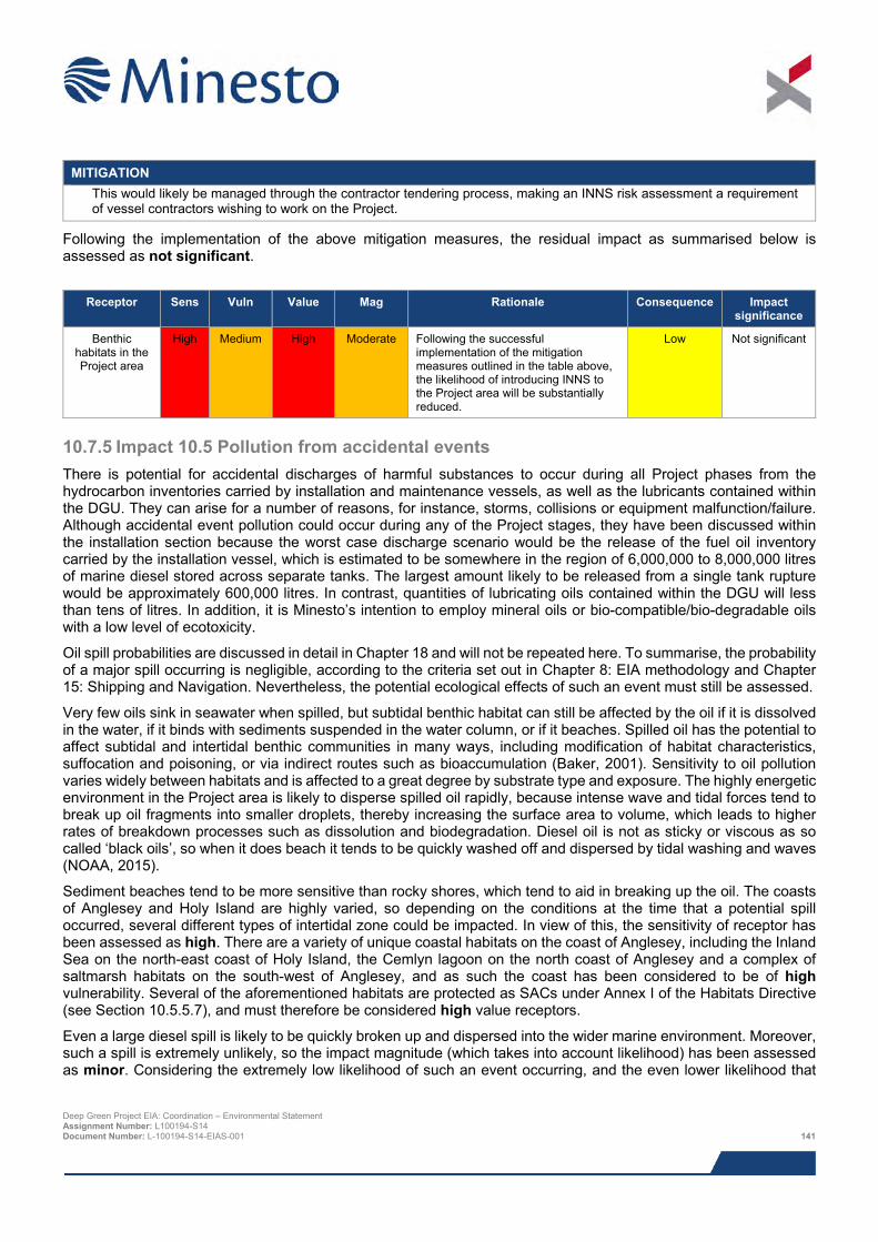
MITIGATION
This would likely be managed through the contractor tendering process, making an INNS risk assessment a requirement of vessel contractors wishing to work on the Project.
Following the implementation of the above mitigation measures, the residual impact as summarised below is assessed as not significant.
Receptor Sens Vuln Value Mag Rationale Consequence Impact
significance
Benthic habitats in the Project area
High Medium High Moderate Following the successful implementation of the mitigation measures outlined in the table above, the likelihood of introducing INNS to the Project area will be substantially reduced.
Low Not significant
10.7.5 Impact 10.5 Pollution from accidental events There is potential for accidental discharges of harmful substances to occur during all Project phases from the hydrocarbon inventories carried by installation and maintenance vessels, as well as the lubricants contained within the DGU. They can arise for a number of reasons, for instance, storms, collisions or equipment malfunction/failure. Although accidental event pollution could occur during any of the Project stages, they have been discussed within the installation section because the worst case discharge scenario would be the release of the fuel oil inventory carried by the installation vessel, which is estimated to be somewhere in the region of 6,000,000 to 8,000,000 litres of marine diesel stored across separate tanks. The largest amount likely to be released from a single tank rupture would be approximately 600,000 litres. In contrast, quantities of lubricating oils contained within the DGU will less than tens of litres. In addition, it is Minesto’s intention to employ mineral oils or bio-compatible/bio-degradable oils with a low level of ecotoxicity.
Oil spill probabilities are discussed in detail in Chapter 18 and will not be repeated here. To summarise, the probability of a major spill occurring is negligible, according to the criteria set out in Chapter 8: EIA methodology and Chapter 15: Shipping and Navigation. Nevertheless, the potential ecological effects of such an event must still be assessed.
Very few oils sink in seawater when spilled, but subtidal benthic habitat can still be affected by the oil if it is dissolved in the water, if it binds with sediments suspended in the water column, or if it beaches. Spilled oil has the potential to affect subtidal and intertidal benthic communities in many ways, including modification of habitat characteristics, suffocation and poisoning, or via indirect routes such as bioaccumulation (Baker, 2001). Sensitivity to oil pollution varies widely between habitats and is affected to a great degree by substrate type and exposure. The highly energetic environment in the Project area is likely to disperse spilled oil rapidly, because intense wave and tidal forces tend to break up oil fragments into smaller droplets, thereby increasing the surface area to volume, which leads to higher rates of breakdown processes such as dissolution and biodegradation. Diesel oil is not as sticky or viscous as so called ‘black oils’, so when it does beach it tends to be quickly washed off and dispersed by tidal washing and waves (NOAA, 2015).
Sediment beaches tend to be more sensitive than rocky shores, which tend to aid in breaking up the oil. The coasts of Anglesey and Holy Island are highly varied, so depending on the conditions at the time that a potential spill occurred, several different types of intertidal zone could be impacted. In view of this, the sensitivity of receptor has been assessed as high. There are a variety of unique coastal habitats on the coast of Anglesey, including the Inland Sea on the north-east coast of Holy Island, the Cemlyn lagoon on the north coast of Anglesey and a complex of saltmarsh habitats on the south-west of Anglesey, and as such the coast has been considered to be of high vulnerability. Several of the aforementioned habitats are protected as SACs under Annex I of the Habitats Directive (see Section 10.5.5.7), and must therefore be considered high value receptors.
Even a large diesel spill is likely to be quickly broken up and dispersed into the wider marine environment. Moreover, such a spill is extremely unlikely, so the impact magnitude (which takes into account likelihood) has been assessed as minor. Considering the extremely low likelihood of such an event occurring, and the even lower likelihood that
Deep Green Project EIA: Coordination – Environmental Statement Assignment Number: L100194-S14 Document Number: L-100194-S14-EIAS-001 141
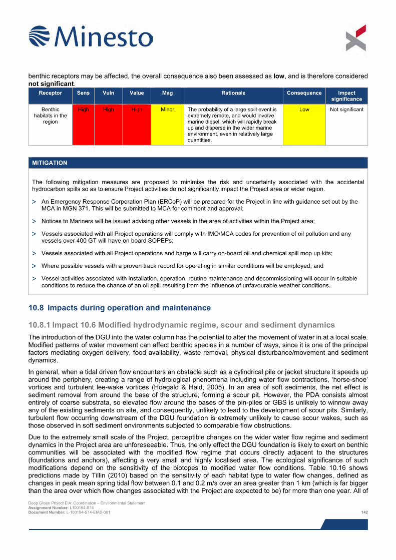
benthic receptors may be affected, the overall consequence also been assessed as low, and is therefore considered not significant.
Receptor Sens Vuln Value Mag Rationale Consequence Impact significance
Benthic habitats in the
region
High High High Minor The probability of a large spill event is extremely remote, and would involve marine diesel, which will rapidly break up and disperse in the wider marine environment, even in relatively large quantities.
Low Not significant
MITIGATION
The following mitigation measures are proposed to minimise the risk and uncertainty associated with the accidental hydrocarbon spills so as to ensure Project activities do not significantly impact the Project area or wider region.
> An Emergency Response Corporation Plan (ERCoP) will be prepared for the Project in line with guidance set out by the MCA in MGN 371. This will be submitted to MCA for comment and approval;
> Notices to Mariners will be issued advising other vessels in the area of activities within the Project area;
> Vessels associated with all Project operations will comply with IMO/MCA codes for prevention of oil pollution and any vessels over 400 GT will have on board SOPEPs;
> Vessels associated with all Project operations and barge will carry on-board oil and chemical spill mop up kits;
> Where possible vessels with a proven track record for operating in similar conditions will be employed; and
> Vessel activities associated with installation, operation, routine maintenance and decommissioning will occur in suitable conditions to reduce the chance of an oil spill resulting from the influence of unfavourable weather conditions.
10.8 Impacts during operation and maintenance
10.8.1 Impact 10.6 Modified hydrodynamic regime, scour and sediment dynamics The introduction of the DGU into the water column has the potential to alter the movement of water in at a local scale. Modified patterns of water movement can affect benthic species in a number of ways, since it is one of the principal factors mediating oxygen delivery, food availability, waste removal, physical disturbance/movement and sediment dynamics.
In general, when a tidal driven flow encounters an obstacle such as a cylindrical pile or jacket structure it speeds up around the periphery, creating a range of hydrological phenomena including water flow contractions, ‘horse-shoe’ vortices and turbulent lee-wake vortices (Hoegald & Hald, 2005). In an area of soft sediments, the net effect is sediment removal from around the base of the structure, forming a scour pit. However, the PDA consists almost entirely of coarse substrata, so elevated flow around the bases of the pin-piles or GBS is unlikely to winnow away any of the existing sediments on site, and consequently, unlikely to lead to the development of scour pits. Similarly, turbulent flow occurring downstream of the DGU foundation is extremely unlikely to cause scour wakes, such as those observed in soft sediment environments subjected to comparable flow obstructions.
Due to the extremely small scale of the Project, perceptible changes on the wider water flow regime and sediment dynamics in the Project area are unforeseeable. Thus, the only effect the DGU foundation is likely to exert on benthic communities will be associated with the modified flow regime that occurs directly adjacent to the structures (foundations and anchors), affecting a very small and highly localised area. The ecological significance of such modifications depend on the sensitivity of the biotopes to modified water flow conditions. Table 10.16 shows predictions made by Tillin (2010) based on the sensitivity of each habitat type to water flow changes, defined as changes in peak mean spring tidal flow between 0.1 and 0.2 m/s over an area greater than 1 km (which is far bigger than the area over which flow changes associated with the Project are expected to be) for more than one year. All of Deep Green Project EIA: Coordination – Environmental Statement Assignment Number: L100194-S14 Document Number: L-100194-S14-EIAS-001 142
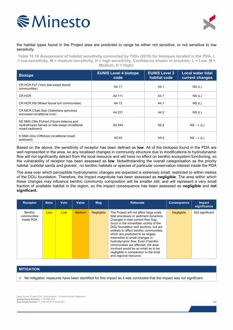
the habitat types found in the Project area are predicted to range be either not sensitive, or not sensitive to low sensitivity.
Table 10.16 Assessment of habitat sensitivity conducted by Tillin (2010) for biotopes located in the PDA. L = low sensitivity, M = medium sensitivity, H = high sensitivity. Confidence shown in brackets: L = Low, M =
Medium, H = High).
Biotope EUNIS Level 4 biotope code
EUNIS Level 3 habitat code
Local water tidal current changes
CR.HCR.FaT (Very tide-swept faunal communities) A4.11 A4.1 NS (L)
CR.HCR A4.111 A4.1 NS (L)
CR.HCR.Xfa (Mixed faunal turf communities) A4.13 A4.1 NS (L)
CR.MCR.CSab.Sspi (Sabellaria spinulosa encrusted circalittoral rock) A4.221 A4.2 NS (L)
SS.SMX.CMx.FluHyd (Flustra foliacea and Hydrallmania falcata on tide-swept circalittoral mixed sediment)
A5.444 A5.2 NS – L (L)
S.SMX.Omx (Offshore circalittoral mixed sediment) A5.45 A5.4 NS – L (L)
Based on the above, the sensitivity of receptor has been defined as low. All of the biotopes found in the PDA are well represented in the area, so any localised changes in community structure due to modifications to hydrodynamic flow will not significantly detract from the local resource and will have no effect on benthic ecosystem functioning, so the vulnerability of receptor has been assessed as low. Notwithstanding the overall categorisation as the priority habitat ‘subtidal sands and gravels’, no benthic habitats or species of particular conservation interest inside the PDA
The area over which perceptible hydrodynamic changes are expected is extremely small, restricted to within metres of the DGU foundation. Therefore, the impact magnitude has been assessed as negligible. The area within which these changes may influence benthic community composition will be smaller still, and will represent a very small fraction of available habitat in the region, so the impact consequence has been assessed as negligible and not significant.
Receptor Sens Vuln Value Mag Rationale Consequence Impact
significance
Benthic communities inside PDA
Low Low Medium Negligible The Project will not affect large scale tidal processes or sediment dynamics. Changes in tidal current flow may occur in the immediate vicinity of the DGU foundation and anchors, but are unlikely to affect benthic communities, which are predicted to be largely insensitive to small changes in hydrodynamic flow. Even if benthic communities are affected, the area involved would be so small as to be negligible in comparison to the local and regional resource.
Negligible
Not significant
MITIGATION
> No mitigation measures have been identified for this impact as it was concluded that the impact was not significant.
Deep Green Project EIA: Coordination – Environmental Statement Assignment Number: L100194-S14 Document Number: L-100194-S14-EIAS-001 143
10.8.2 Impact 10.7 Colonisation of introduced hard substrata As described in Section 10.7.1, the placement of DGU foundation structure and subsea umbilical will lead to the addition of a maximum of 0.000407 km2 of novel, hard substrata, (discounting the vertical surfaces of the DGU foundation), which is expected to employ some sort anti-fouling system.
The introduction of new hard substrata in the marine environment will usually be followed by rapid colonisation by various organisms (Peterson & Malm, 2006; BERR, 2008). The factors that determine development and maintenance of the subsequent communities are complex, with community structure driven by a combination of pre- and post-recruitment processes (Caley et al., 1996; Menge, 2000), which in turn are affected by many factors, including location, local biodiversity, inclination of substrata in the water column, surface complexity, nearest existing hard substrata communities and the season during which the substrata is introduced (Qvarfordt et al., 2006; Peterson & Malm, 2006; Langhamer et al., 2009). The rough surface of the GBS is likely to facilitate rapid colonisation, unless it is treated in some way to inhibit colonisation. Following initial colonisation, succession processes are generally thought to occur for a maximum of five years before reaching community stability (Whomersley & Picken 2003; Peterson & Malm 2006; Langhamer et al., 2009).
There are a range of potential ecological impacts associated with the colonisation of hard substrata in the marine environment. When hard structures are introduced into soft sediment dominated areas, they tend to be colonised by species that are not representative of those that naturally occur in the area, and may thereby act as stepping stones for invasive non-native species (INNS) (Bulleri & Airoldi, 2005). In the case of the PDA, and indeed the wider region, hard substrata in the form of exposed bedrock and large cobbles and pebbles are widely prevalent, so the habitat provided by GBS surfaces and scour protection is not considered novel, and therefore, does not offer INNS any kind of habitat that is not already available to them. When the introduced substrata reflects that which already exists in the area, it would be expected to be colonised by species that already exist in the region.
Another potential issue is the accumulation of nutrients and organic material at the base of turbine structures that results from the attached communities (Maar et al., 2009). This has brought about measurable changes in the seabed communities immediately surrounding offshore wind turbine foundations in soft sediment habitat in the Belgian part of the North Sea (Degraer et al., 2012; Coates et al., 2011). Such effects are extremely unlikely in the PDA due to the energetic tidal conditions, which will quickly remove any deposited matter. In addition, biofouling of the vertical structures will be most likely be intermittently removed to reduce the overall weight-loading of the foundations, as well as to facilitate routine inspections.
Overall, the addition of hard surfaces in the form of the GBS and scour protection will not introduce novel substrata to the PDA, where there is already a preponderance of exposed bedrock and coarse substrata comprising cobbles, pebbles and gravel. Therefore, Project infrastructure will most likely be colonised by species characteristic of the area, so the sensitivity of receptor is considered low. There is very little scope for this to affect existing benthic habitats and negative effects on biogeochemical processes through the accumulation of organic matter falling from turbine attached communities are extremely unlikely because high tidal flows will remove organic matter more quickly than it is able to build up. Consequently, the vulnerability of receptor has been assessed as low. Due to the presence of Annex I and priority habitats in the PDA, the sensitivity of receptor must be considered high.
The total area of hard substratum that will be introduced as a result of the Project infrastructure is extremely small. Therefore the impact magnitude is considered negligible. The most likely outcome is that introduced substrates will be recolonised by species from the area, and there will be no net positive or negative effect, especially considering the small area involved. As such, the overall consequence is considered negligible and not significant.
Deep Green Project EIA: Coordination – Environmental Statement Assignment Number: L100194-S14 Document Number: L-100194-S14-EIAS-001 144
Receptor Sens Vuln Value Mag Rationale Consequence Impact
significance
Benthic species and
habitats in PDA
Low Low High Negligible The overall footprint of introduced substrata is extremely small. The type of introduced substrata is representative of existing habitat in the area and is therefore likely to be colonised by a suite of species that already exist in the region. The energetic environment found in the PDA makes accumulation of nutrients at the base of foundation structure very unlikely.
Negligible Not significant
MITIGATION
> No mitigation measures have been identified for this impact as it was concluded that the impact was not significant.
10.9 Impacts during decommissioning The decommissioning process will be the reverse of the installation procedure and will require the same equipment and vessels (with the exception of the barge). The likelihood and magnitude of impact of decommissioning activities will therefore be the same or less than during the installation activities and do not warrant additional assessment.
Prior to decommissioning taking place, a further assessment of the potential impact mechanisms would be undertaken and identification of appropriate measures to mitigate any potential impact (which would include adherence to the guidelines relevant at the time). As such, it would be expected that any potential impact would be not significant.
10.10 Potential variances in environmental impacts The impact assessment above was based on worst case Project options with regards to impacts on benthic ecology. This section provides a brief overview of the potential variances between the worst case Project option assessed and alternative Project options and design envelope parameters.
With respect to the physical disturbance and habitat loss, two design factors may reduce the impacts described in Section 10.7.1. The worst case assessment assumed the use of a GBS, which will have a nominal footprint of 300 m2 (12 m x 25 m). Should the pin-piled method be selected, this would be reduced to 21.21 m2 (assuming three pin piles for a tripod, maximum diameter of 3 m). The footprint of monopile foundation is smaller still, since a single pile with a maximum diameter of 4 m would be installed, impacting a maximum seabed area of 12.57 m2.
The support structure choice will also affect the quantity of drill cuttings that are produced. The worst case assessment for this impact assumed that the pin-pile method would be used, which would generate 424.2 m3 of cuttings. The monopile method would reduce the overall quantity of drill cuttings to 251.33 m3 and no drill cuttings would be produced should the GBS method be adopted. However, considering the high energy environment, the intermittent nature of drilling and the relatively small quantities of drill material involved, the magnitude for the worst case scenario was predicted to be so small that reductions in the quantity released would have little or no bearing on the environmental impact magnitude, which is already considered to be of only minor magnitude.
None of the other impacts assessed here would be significantly affected by changes in design parameters.
10.11 Cumulative impacts Minesto, in consultation with NRW and IACC, has identified a list of other projects which together with the Project, may result in potential cumulative or in-combination impacts. The list of these projects and a map showing their location is provided in Chapter 8: EIA methodology; Table 8.13 and Figure 8.2, respectively.
Deep Green Project EIA: Coordination – Environmental Statement Assignment Number: L100194-S14 Document Number: L-100194-S14-EIAS-001 145
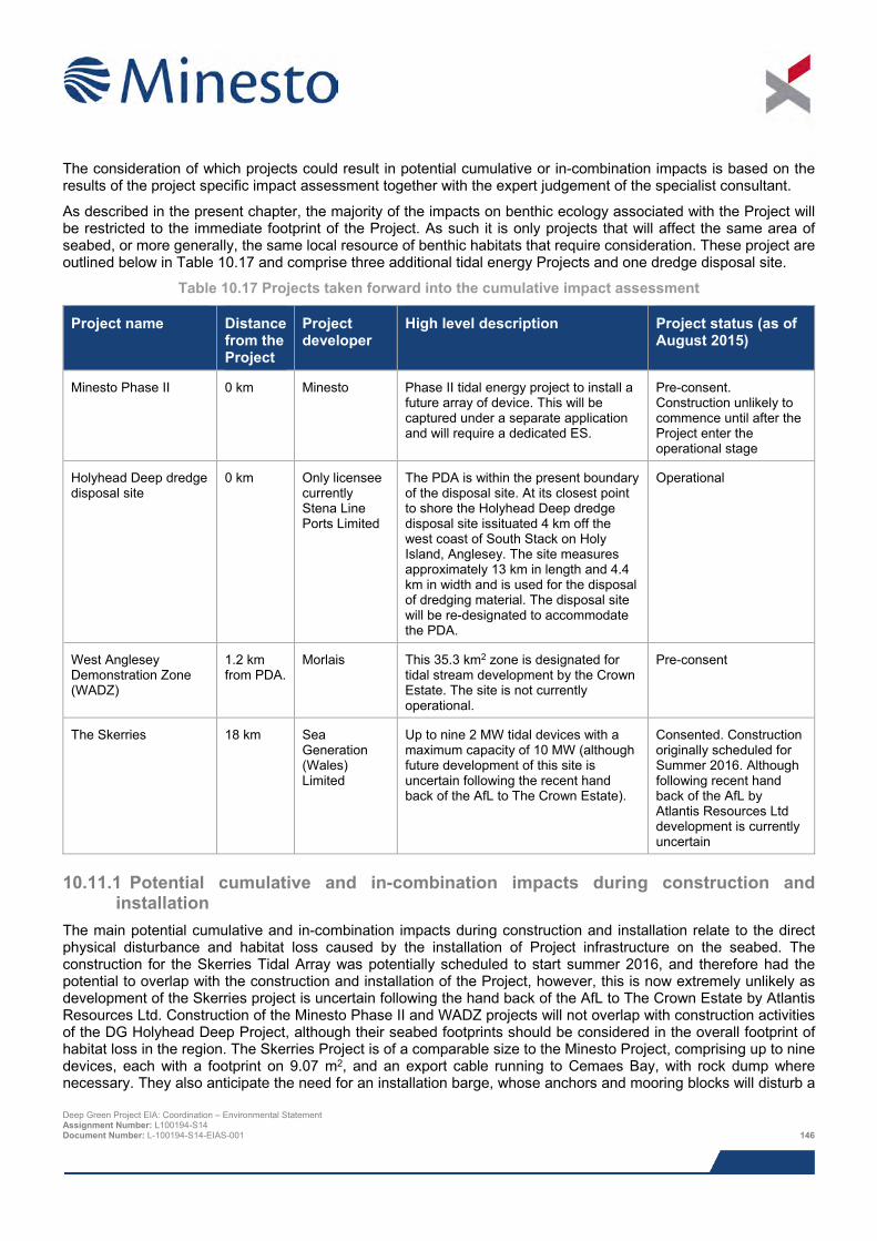
The consideration of which projects could result in potential cumulative or in-combination impacts is based on the results of the project specific impact assessment together with the expert judgement of the specialist consultant.
As described in the present chapter, the majority of the impacts on benthic ecology associated with the Project will be restricted to the immediate footprint of the Project. As such it is only projects that will affect the same area of seabed, or more generally, the same local resource of benthic habitats that require consideration. These project are outlined below in Table 10.17 and comprise three additional tidal energy Projects and one dredge disposal site.
Table 10.17 Projects taken forward into the cumulative impact assessment
Project name Distance from the Project
Project developer
High level description Project status (as of August 2015)
Minesto Phase II 0 km Minesto Phase II tidal energy project to install a future array of device. This will be captured under a separate application and will require a dedicated ES.
Pre-consent. Construction unlikely to commence until after the Project enter the operational stage
Holyhead Deep dredge disposal site
0 km Only licensee currently Stena Line Ports Limited
The PDA is within the present boundary of the disposal site. At its closest point to shore the Holyhead Deep dredge disposal site issituated 4 km off the west coast of South Stack on Holy Island, Anglesey. The site measures approximately 13 km in length and 4.4 km in width and is used for the disposal of dredging material. The disposal site will be re-designated to accommodate the PDA.
Operational
West Anglesey Demonstration Zone (WADZ)
1.2 km from PDA.
Morlais This 35.3 km2 zone is designated for tidal stream development by the Crown Estate. The site is not currently operational.
Pre-consent
The Skerries 18 km Sea Generation (Wales) Limited
Up to nine 2 MW tidal devices with a maximum capacity of 10 MW (although future development of this site is uncertain following the recent hand back of the AfL to The Crown Estate).
Consented. Construction originally scheduled for Summer 2016. Although following recent hand back of the AfL by Atlantis Resources Ltd development is currently uncertain
10.11.1 Potential cumulative and in-combination impacts during construction and installation
The main potential cumulative and in-combination impacts during construction and installation relate to the direct physical disturbance and habitat loss caused by the installation of Project infrastructure on the seabed. The construction for the Skerries Tidal Array was potentially scheduled to start summer 2016, and therefore had the potential to overlap with the construction and installation of the Project, however, this is now extremely unlikely as development of the Skerries project is uncertain following the hand back of the AfL to The Crown Estate by Atlantis Resources Ltd. Construction of the Minesto Phase II and WADZ projects will not overlap with construction activities of the DG Holyhead Deep Project, although their seabed footprints should be considered in the overall footprint of habitat loss in the region. The Skerries Project is of a comparable size to the Minesto Project, comprising up to nine devices, each with a footprint on 9.07 m2, and an export cable running to Cemaes Bay, with rock dump where necessary. They also anticipate the need for an installation barge, whose anchors and mooring blocks will disturb a Deep Green Project EIA: Coordination – Environmental Statement Assignment Number: L100194-S14 Document Number: L-100194-S14-EIAS-001 146
small area of the seabed. The Skerries ES reports that the predominant habitat in the development area is comparable to the survey area assessed for this Project, with cobble and pebble habitat together with exposed bedrock. The overall area of habitat that the two projects will affect is small in comparison to the amount of comparable habitat identified in the survey area, let alone the wider regional area, so no significant impacts should occur. Minesto and Morlais are currently investigating options to share the future export cable; which will reduce the footprint of both projects and ensure that any habitat loss associated with these upcoming projects is kept to a minimum.
Concurrent construction activity in the Project area and at the Skerries could lead to the simultaneous release of drill cuttings (if drilled is required for both projects), which may elevate suspended sediment concentrations beyond what they would be if the Projects were constructed at separate times. It is expected that the strong tidal conditions that prevail around the west coast of Anglesey would rapidly transport the sediment widely throughout the region, making the accumulation of sediment extremely unlikely. Any changes to water turbidity due to simultaneous drilling would be expected to be extremely short-lived for the same reasons. The disturbance caused by large drilling fragments will be highly localised and small in extent, so there is no potential for cumulative/in-combination impacts. Overall, the likelihood of simultaneous construction cumulatively impacting vulnerable benthic communities in the area is extremely low, and is considered not significant. Disposal activity at the Holyhead Deep disposal site could also contribute to intermittent and temporary elevations in turbidity, although as detailed by Potter (2014), the dispersive nature of the site is such that almost all of the material will be very quickly dispersed into the wider marine environment.
The likelihood of pollution from accidental events, as well as the introduction of INNS to the marine environment increases with each additional project because the number of vessels entering and exiting the area will also increase. However, assuming that other developments in the area make the same commitments to follow relevant guidelines as made herein, the probability of this occurring should remain extremely low, so the cumulative impact is still predicted to be not significant.
10.11.2 Potential cumulative and in-combination impacts during operation and maintenance
There are two main impacts that have the potential to act in-combination with other developments in the region; these are:
> Modified hydrodynamic regime and sediment dynamics; and
> Presence of new hard substrata (and potential stepping stone effects for INNS).
The extremely small scale of the Project makes it extremely unlikely effects on hydrodynamic processes and sediment dynamics would be sufficiently large to interact with other developments in the region. Indeed, all of the impacts assessed in Chapter 9: Physical Processes suggest that any effects of the Project on the hydrodynamic regime will be extremely localised and insignificant in a regional context. Localised scour around the devices might be expected, but any interaction between projects is extremely unlikely.
As discussed in Section 10.8.2, the new hard substrata introduced in the form of the DGU foundation structure and potential scour protection will be subject to colonisation processes, which begin inward migration and settlement of larvae and spores. Although the majority of benthic organisms that occur in the region are sessile or have relatively low mobility, many have a planktonic larval phase during which larvae are dispersed by water movement, before settling. The planktonic larval duration is the principal factor that control dispersion distance, and for many species this can exceed 30 days, which allows them to travel large distances, sometimes being advected between entire regions (Gallego et al., 2013). Macrolagal spore distribution operates in a broadly similar fashion. Thus, the larvae/spores that settle on a particular substratum may have travelled from relatively distant locations, implying that existing developments in the region may supply larvae/spores that settle on the Project infrastructure, and, by the same logic, communities that develop on Project infrastructure may supply larvae/spores to new hard substrata introduced during future developments.
This type of stepping stone benthic community development might be expected to be most pronounced where the various projects represent the only available hard substrata in the area i.e. where there are multiple projects built in a predominantly soft sediment region. However, the region surrounding the Project site contains mainly hard Deep Green Project EIA: Coordination – Environmental Statement Assignment Number: L100194-S14 Document Number: L-100194-S14-EIAS-001 147
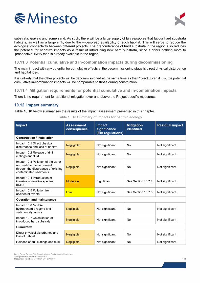
substrata, gravels and some sand. As such, there will be a large supply of larvae/spores that favour hard substrata habitats, as well as a large sink, due to the widespread availability of such habitat. This will serve to reduce the ecological connectivity between different projects. The preponderance of hard substrata in the region also reduces the potential for negative impacts as a result of introducing new hard substrata, since it offers nothing more to ‘prospective’ INNS than is already available in the region.
10.11.3 Potential cumulative and in-combination impacts during decommissioning The main impact with any potential for cumulative effects at the decommissioning stage is direct physical disturbance and habitat loss.
It is unlikely that the other projects will be decommissioned at the same time as the Project. Even if it is, the potential cumulative/in-combination impacts will be comparable to those during construction.
10.11.4 Mitigation requirements for potential cumulative and in-combination impacts There is no requirement for additional mitigation over and above the Project-specific measures.
10.12 Impact summary Table 10.18 below summarises the results of the impact assessment presented in this chapter.
Table 10.18 Summary of impacts for benthic ecology
Impact Assessment consequence
Impact significance (EIA regulations)
Mitigation identified
Residual impact
Construction / installation
Impact 10.1 Direct physical disturbance and loss of habitat Negligible Not significant No Not significant
Impact 10.2 Release of drill cuttings and fluid Negligible Not significant No Not significant
Impact 10.3 Pollution of the water and sediment environment through the disturbance of existing contaminated sediments
Negligible Not significant No Not significant
Impact 10.4 Introduction of invasive non-native species (INNS)
Moderate Significant See Section 10.7.4 Not significant
Impact 10.5 Pollution from accidental events Low Not significant See Section 10.7.5 Not significant
Operation and maintenance
Impact 10.6 Modified hydrodynamic regime and sediment dynamics
Negligible Not significant No Not significant
Impact 10.7 Colonisation of introduced hard substrata Negligible Not significant No Not significant
Cumulative
Direct physical disturbance and loss of habitat Negligible Not significant No Not significant
Release of drill cuttings and fluid Negligible Not significant No Not significant
Deep Green Project EIA: Coordination – Environmental Statement Assignment Number: L100194-S14 Document Number: L-100194-S14-EIAS-001 148
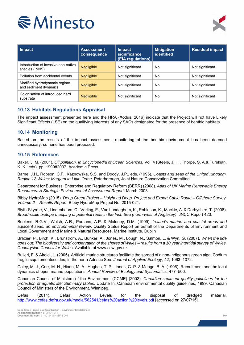
Impact Assessment
consequence Impact significance (EIA regulations)
Mitigation identified
Residual impact
Introduction of invasive non-native species (INNS) Negligible Not significant No Not significant
Pollution from accidental events Negligible Not significant No Not significant
Modified hydrodynamic regime and sediment dynamics Negligible Not significant No Not significant
Colonisation of introduced hard substrata Negligible Not significant No Not significant
10.13 Habitats Regulations Appraisal The impact assessment presented here and the HRA (Xodus, 2016) indicate that the Project will not have Likely Significant Effects (LSE) on the qualifying interests of any SACs designated for the presence of benthic habitats.
10.14 Monitoring Based on the results of the impact assessment, monitoring of the benthic environment has been deemed unnecessary, so none has been proposed.
10.15 References Baker, J. M. (2001). Oil pollution. In Encyclopedia of Ocean Sciences, Vol. 4 (Steele, J. H., Thorpe, S. A.& Turekian, K. K., eds), pp. 1999ñ2007. Academic Press.
Barne, J.H., Robson, C.F., Kaznowska, S.S. and Doody, J.P., eds. (1995). Coasts and seas of the United Kingdom. Region 12 Wales: Margam to Little Orme. Peterborough, Joint Nature Conservation Committee
Department for Business, Enterprise and Regulatory Reform (BERR) (2008). Atlas of UK Marine Renewable Energy Resources: A Strategic Environmental Assessment Report. March 2008.
Bibby HydroMap (2015). Deep Green Project – Holyhead Deep. Project and Export Cable Route – Offshore Survey, Volume 2 – Results Report. Bibby HydroMap Project No. 2015-021.
Blyth-Skyrme, V., Lindenbaum, C., Verling, E., Van Landeghem, K., Robinson, K., Mackie, A. & Darbyshire, T. (2008). Broad-scale biotope mapping of potential reefs in the Irish Sea (north-west of Anglesey). JNCC Report 423.
Boelens, R.G.V., Walsh, A.R., Parsons, A.P. & Maloney, D.M. (1999). Ireland's marine and coastal areas and adjacent seas: an environmental review. Quality Status Report on behalf of the Departments of Environment and Local Government and Marine & Natural Resources. Marine Institute. Dublin
Brazier, P., Birch, K., Brunstrom, A., Bunker, A., Jones, M., Lough, N., Salmon, L. & Wyn, G. (2007). When the tide goes out: The biodiversity and conservation of the shores of Wales – results from a 10 year intertidal survey of Wales. Countryside Council for Wales. Available at www.ccw.gov.uk
Bulleri, F. & Airoldi, L. (2005). Artificial marine structures facilitate the spread of a non-indigenous green alga, Codium fragile ssp. tomentosoides, in the north Adriatic Sea. Journal of Applied Ecology, 42, 1063–1072.
Caley, M. J., Carr, M. H., Hixon, M. A., Hughes, T. P., Jones, G. P. & Menge, B. A. (1996). Recruitment and the local dynamics of open marine populations. Annual Review of Ecology and Systematics, 477–500.
Canadian Council of Ministers of the Environment (CCME) (2002). Canadian sediment quality guidelines for the protection of aquatic life: Summary tables. Update In: Canadian environmental quality guidelines, 1999, Canadian Council of Ministers of the Environment, Winnipeg.
Cefas (2014). Cefas Action Levels for the disposal of dredged material. http://www.cefas.defra.gov.uk/media/562541/cefas%20action%20levels.pdf [accessed on 27/07/15]. Deep Green Project EIA: Coordination – Environmental Statement Assignment Number: L100194-S14 Document Number: L-100194-S14-EIAS-001 149
CMACS (2015a). Deep Green Project Holyhead Deep benthic technical report. Report to Xodus Group. CMACS Job Number: 3279
CMACS (2015b). Deep Green Project – Holyhead Deep. Habitat Assessment Report. CMACS Job Number: J3279.
Coates, D., Vanaverbeke, J., Rabaut, M., & Vincx, M. (2011). Soft-sediment macrobenthos around offshore wind turbines in the Belgian Part of the North Sea reveals a clear shift in species composition. Retrieved from https://biblio.ugent.be/publication/2918335.
Degraer, S., Brabant, R., & Rumes, B. (2012). Offshore wind farms in the Belgian part of the North Sea: Heading for an understanding of environmental impacts. Retrieved from http://www.vliz.be/IMIS/imis.php?module=ref&refid=218670.
EUR 28 (2013). Interpretation Manual of European Union Habitats. April 2013 European Commission.
Griffith, K., Mowat, S., Holt, R.H.F., Ramsay, K., Bishop, J.D.D., Lambert, G. and Jenkins, S.R. (2009). First records in Great Britain of the invasive colonial ascidian Didemnum vexillum Kott, 2002. Aquatic Invasions 4, 581–590.
Gubbay, S. (2007). Defining and managing Sabellaria spinulosa reefs: Report of an inter-agency workshop. Joint Nature Conservation Committee, 2007.
Hendrick, V.J. & Foster-Smith, R.L. (2006). Sabellaria spinulosa reef: a scoring system for evaluating ‘reefiness’ in the context of the Habitats Directive. Journal of the Marine Biological Association UK, 86, 665-677.
Hiscock, K. (1976). The influence of water movements on the ecology of sublittoral rocky areas. PhD thesis, University College of North Wales, Bangor.
Hiscock, K., Langmead, O. & Warwick, R. (2004). Identification of seabed indicator species from time-series and other studies to support implementation of the EU Habitats and Water Framework Directives. Report to the Joint Nature Conservation Committee and the Environment Agency from the Marine Biological Association. Plymouth: Marine Biological Association. JNCC Contract F90-01-705. 109 pp.
Høgedal, M. & Hald, T. (2005). Scour assessment and design for monopile foundations for offshore wind turbines. Proceedings Copenhagen Offshore Wind, Copenhagen, 26-28 October 2005.
Irving, R. (2009). The identification of the main characteristics of stony reef habitats under the Habitats Directive. Summary report of an inter-agency workshop 26-27 March 2008. Peterborough: JNCC Report No.432, 2009. ISSN 0963-8091.
Jackson, A. & Hiscock, K. (2008). Sabellaria spinulosa. Ross worm. Marine Life Information Network: Biology and Sensitivity Key Information Sub-programme [on-line]. Plymouth: Marine Biological Association of the United Kingdom [cited 28/07/2015]. Available from: http://www.marlin.ac.uk/specieshabitats.php?speciesID=4278.
Jackson, E.L., Langmead, O., Evans, J., Wilkes, P., Seeley, B., Lear D. and Tyler-Walter, H. (2010). Mapping Marine Benthic Biodiversity in Wales. CCW Contract Science Reports Report No: 913, 88pp, Countryside Council for Wales, Bangor.
Joint Nature Conservation Committee (JNCC) (1996). Guidelines for selection of biological SSSIs: intertidal marine habitats and saline lagoons. Peterborough.
Joint Nature Conservation Committee (JNCC) (2010). UKSeaMap 2010 - predictive mapping of seabed habitats. On-line resource - http://jncc.defra.gov.uk/ukseamap [accessed: 27/05/14]
Jones, W.E. (1968). The marine biology of Anglesey. In: Natural history of Anglesey, ed. by W.E. Jones, 136–164. Llangefni, Anglesey Antiquarian Society.
Jones, W.E. (1983). The distribution of marine life around Anglesey. Porcupine Newsletter, 2 (7), 165–168.
Langhamer, O., Wilhelmsson, D., & Engström, J. (2009). Artificial reef effect and fouling impacts on offshore wave power foundations and buoys–a pilot study. Estuarine, Coastal and Shelf Science, 82(3), 426–432.
Maar, M., Bolding, K., Petersen, J. K., Hansen, J. L. S., & Timmermann, K. (2009). Local effects of blue mussels around turbine foundations in an ecosystem model of Nysted off-shore wind farm, Denmark. Journal of Sea Research, 62(2–3), 159–174. Deep Green Project EIA: Coordination – Environmental Statement Assignment Number: L100194-S14 Document Number: L-100194-S14-EIAS-001 150
Mackie, A.S.Y., Oliver, P.G., & Rees, E.I.S. (1995). Benthic biodiversity in the southern Irish Sea. Studies in Marine Biodiversity and Systematics from the National Museum of Wales. BIOMÔR Reports, 1. 263 pp.
Marine Evidence Working Group, CCW (2012). Marine Invasive Non-Native Species. http://www.google.co.uk/url?sa=t&rct=j&q=&esrc=s&source=web&cd=3&ved=0CDkQFjAC&url=http%3A%2F%2Fwww.ccw.gov.uk%2Flandscape--wildlife%2Fmanaging-land-and-sea%2Fidoc.ashx%3Fdocid%3D77f9ac5e-fe93-4109-adcf-13782375ecdb%26version%3D-1&ei=eAD2U8PYJKLU0QXEv4CYCw&usg=AFQjCNEkxhERJY4TvyhG0Eb1YDb6x0LBZw&sig2=ZJPp1wUTpdi9dKzWZG95Zw&bvm=bv.73231344,d.d2k [Accessed on: 21/08/14].
Menge, B. A. (2000). Top-down and bottom-up community regulation in marine rocky intertidal habitats. Journal of Experimental Marine Biology and Ecology, 250(1), 257–289.
Mills, D.J.L. (1998). Cardigan Bay and north Wales (Cwm-yr-Eglwys, Newport Bay to Rhôs-on Sea) (MNCR Sector 10). In: Marine Nature Conservation Review. Benthic marine ecosystems of Great Britain and the north-east Atlantic, ed. by K. Hiscock, 297–314. Peterborough, Joint Nature Conservation Committee. (Coasts and seas of the United Kingdom. MNCR series).
National Oceanic and Atmospheric Administration (NOAA) (2015). Office of Response and Restoration.http://response.restoration.noaa.gov/oil-and-chemical-spills/oil-spills/resources/small-diesel-spills.html [accessed on 28/08/2015].
Petersen, J. K., & Malm, T. (2006). Offshore windmill farms: threats to or possibilities for the marine environment. AMBIO: A Journal of the Human Environment, 35(2), 75–80.
Potter, D. (2014). A multi-disciplinary investigation of the fate of disposed dredge spoil at Holyhead Deep, Anglesey. A thesis submitted in partial fulfilment of the requirements of the Degree of MSc in Applied Marine Geoscience. Bangor University.
Qvarfordt, S., Kautsky, H., & Malm, T. (2006). Development of fouling communities on vertical structures in the Baltic Sea. Estuarine, Coastal and Shelf Science, 67(4), 618–628.
Rees, E. I. S. (2005). Assessment of the status of horse mussel (Modiolus modiolus) beds in the Irish Sea off NW Anglesey. DTI SEA6 Sub-contract report.
Robinson, K., Ramsay, K., Lindenbaum, C., Walker, P., Frost, N., Vittorio, M. & Wright, A. (2011). Habitat Mapping for Conservation and Management of the Southern Irish Sea (HABMAP). III: Modelling and mapping extension study. CCW Science Report No.951. 102pp + Appendices.
Tillin, H.M., Hull, S.C., Tyler-Walters, H. (2010). Development of a Sensitivity Matrix (pressures MCZ/MPA features). Report to the Department of Environment, Food and Rural Affairs from ABPMer, Southampton and the Marine Life Information Network (MarLIN) Plymouth: Marine Biological Association of the UK. .Defra Contract No. MB0102 Task 3A, Report No. 22.
UK Marine SAC (2015). Online resource available from: http://www.ukmarinesac.org.uk/communities/biogenic-reefs/br1_1.htm [accessed on 27/07/15].
Vincent, M.A., Atkins, S.M., Lumb, C.M., Golding, N., Lieberknecht, L.M. & Webster, M. (2004). Marine nature conservation and sustainable development - the Irish Sea Pilot. Report to Defra by the Joint Nature Conservation Committee, Peterborough.
Wentworth, C.K. (1922). A grade scale and class terms for clastic sediments. Journal of Geology. 30, pp 377-392.
Whomersley, P. & Picken, G. B. (2003). Long-term dynamics of fouling communities found on offshore installations in the North Sea. Journal of the Marine Biological Association of the UK, 83(5), 897–901.
Wyn, G., Brazier, P., Birch, K., Bunker, A., Cooke, A., Jones, M. Lough, N., McMath, M. and Roberts, S. (2006). CCW Handbook for Marine Intertidal Phase 1 Survey and Mapping. Countryside Council for Wales.
Xodus (2016). Deep Green Holyhead Deep – Habitats Regulations Appraisal (HRA) Report. Document number L-100194-S00-REPT-012. June 2016.
Deep Green Project EIA: Coordination – Environmental Statement Assignment Number: L100194-S14 Document Number: L-100194-S14-EIAS-001 151
11 MARINE MAMMALS AND MEGAFAUNA
Following an in-depth review of the literature relating to marine mammals in the Irish Sea and site-specific surveys conducted as part of the Sustainable Expansion of the Applied Coastal and Marine Sectors (SEACAMS) project it was determined that two of the seven species regularly recorded in the Irish Sea are likely to be present in the Project area: harbour porpoise and grey seal. There appear to be localised hotspots for harbour porpoise off the north and west of Anglesey, in particular around Point Lynas and South Stack, including the Deep Green Holyhead Deep site, and this has been recognised with the proposal to designate the north Anglesey marine area as a Special Area of Conservation (SAC) for harbour porpoise. Bottlenose dolphin were identified as a species that may occur in the area, albeit with a lower likelihood, but it is likely that a proportion of the dolphins in the vicinity of Holy Island may be part of a wider Cardigan Bay / west Wales population and could be considered as belonging to the Cardigan Bay SAC and Lleyn Peninsula and the Sarnau SAC. There is also a slim possibility that several other marine mammal species have the potential to be present, including minke whale, common dolphin, Risso’s dolphin and harbour seal, as well as basking shark and marine turtles, however these species were all were assessed as being unlikely visitors to the Project area.
Marine mammals could potentially be affected via several mechanisms, namely turbidity caused by construction works, noise caused by construction works and vessels, possible pollution events due to leaks or spills from vessels or the DGU unit, physical interactions with installation vessels, operational support vessels or vessel/barge (or similar such surface platform) mooring systems, and physical interactions with the DGU unit or its tether.
The receptors sensitive to the potential impacts listed above are those that have been identified as likely to occur within the Project area. However, species are predicted to infrequently interact with the DGU, especially considering the short period during which construction works will be undertaken and the extremely small size of the Project.
The potential effects on the Project (primarily due to its extremely small scale) are likely to be highly limited in temporal and spatial extent, and as such, are unlikely to affect any marine mammal species, much less induce population level effects. Through extensive stakeholder consultation, physical interactions with the DGU was highlighted as the most concerning potential impact mechanism; however, a bespoke collision risk modelling exercise conducted to inform the impact assessment revealed that the number of marine mammals passaging the DGU deployment area that would be necessary to cause population level effects was far higher than any of the literature/site-surveys suggest is possible. Overall, no significant impacts for any of the species that may occur in the Project area were identified.
11.1 Introduction The potential impacts of the Project on marine mammals and megafauna (defined as cetaceans, pinnipeds, basking sharks and turtles) are assessed in this chapter. The following specialists have contributed to the assessment:
> SMRU Consulting – collision risk simulation modelling and reporting for marine mammals; and
> Xodus – baseline description, underwater noise propagation modelling, impact assessment and Environmental Statement (ES) chapter write up.
Table 11.1 provides a list of all the supporting studies which relate to the marine mammals and megafauna impact assessment. All supporting studies are provided on the accompanying CD.
Table 11.1 Supporting studies
Details of study Collision Risk Simulation Modelling: Marine Mammals and Deep Green Device at Holyhead Deep (SMRU Consulting, 2015) Underwater Noise Modelling (Xodus, 2015a) Fish and Shellfish Ecology Technical Note (Xodus, 2015b)
This impact assessment also draws on output from other impact assessments within this ES. Where specific information is used to inform assessment, reference to the relevant ES chapter is given. Deep Green Project EIA: Coordination – Environmental Statement Assignment Number: L100194-S14 Document Number: L-100194-S14-EIAS-001 152
11.2 Area of assessment The focus of the impact assessment presented in this chapter is the potential impacts of the Project on marine mammals, basking sharks and marine turtles using the Project area and adjacent waters. Given the variation in species’ behaviour and the range over which their populations can be found, potential impacts have been set in the context of a wider study area over which animals encountered in the Project area are thought to occur and the regional populations to which those species belong.
The following areas referred to in this impact assessment include:
> Project area (see Figure 1.2 in the Chapter 1: Introduction), which comprises the proposed offshore project development area (PDA) (within which the DGU will be sited); and
> Study area – Different species of marine megafauna have different home ranges (i.e. area within which they move to feed, breed etc.) so the study area for each species assessed differs. Broadly, however, ‘study area’ is used to mean the local population to which the species found in the Project area belong (for marine mammals, this is also known as the relevant ‘marine mammal management unit’ and is described further in Section 11.5).
11.3 Legislation, policy and guidance An integral aspect of the assessment of potential impacts on marine mammal ecology is the identification of habitats and species of conservation importance in the Project area and assessment of potential impacts on these species. There are a number of different statutes and guidance that are relevant in this regard; these are listed below:
> The Conservation of Habitats and Species Regulations 2010 (the ‘Habitats Regulations’). These regulations consolidate the amendments made to the Conservation (Natural Habitats, &c.) Regulations 1994 in respect of England and Wales. These Regulations transpose the European Commission (EC) Council Directive 92/43/EEC on the conservation of natural habitats and of wild fauna and flora (the ‘Habitats Directive’) into national law;
> Wildlife and Countryside Act 1981 (as amended);
> Conservation of Seals Act 1970; and
> The Marine and Coastal Access Act 2009.
Article 3 of the Habitats Directive requires that a network of protected sites be established for a number of habitats and species listed in Annex I and Annex II respectively of the Directive. With regards to marine mammals, this means that SACs must be designated for bottlenose dolphin, harbour porpoise and the grey and harbour seal, since these are the marine mammal species listed in Annex II of the Directive. Further information on protected sites, including on the recent proposed SACs for harbour porpoise, is given in Section 11.5.11.
Additionally, all species of cetacean and marine turtle occurring in UK waters are listed in Annex IV (species of community interest in need of strict protection) of the Habitats Directive as European Protected Species (EPS) where the deliberate killing, disturbance or the destruction of these species or their habitat is banned (this is reflected in their inclusion on Schedule 2 of the Habitats Regulations). Under the Habitats Regulations, which applies to territorial waters out to 12 nm (22 km), two native species of cetacean are listed in Annex II; these are the bottlenose dolphin Tursiops truncatus and the harbour porpoise Phocoena phocoena.
Cetaceans together with basking sharks and marine turtles are also listed in Schedule 5 of the Wildlife and Countryside Act 1981 which prohibits their deliberate killing, injuring or disturbance. The Countryside and Rights of Way Act 2000 makes amendments to the Wildlife and Countryside Act 1981, including the addition of 'reckless' acts to species protection which make it an offence to intentionally or recklessly disturb a cetacean. Although not afforded the strict protection of EPS through the Habitats Directive, pinniped species occurring in UK waters are listed in Annex V (and hence Schedule 3 of the Habitats Regulations) such that they are defined as species of community interest and taking in the wild may thus be subject to management measures.
In addition to the legislative protection afforded to cetaceans and pinnipeds, species of cetacean occurring regularly in UK waters are designated as UK Biodiversity Action Plan (UKBAP) species, as is the harbour seal. Harbour porpoise are named on the Isle of Anglesey County Council’s (IACC) LBAP. Twenty five cetacean and one seal species (the harbour seal) are listed as species Features of Conservation Importance (Natural England/JNCC, 2010). Deep Green Project EIA: Coordination – Environmental Statement Assignment Number: L100194-S14 Document Number: L-100194-S14-EIAS-001 153
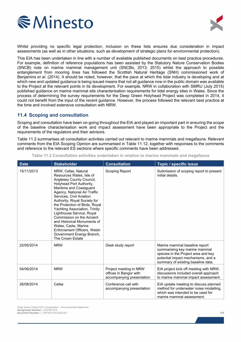
Whilst providing no specific legal protection, inclusion on these lists ensures due consideration in impact assessments (as well as in other situations, such as development of strategic plans for environmental protection).
This EIA has been undertaken in line with a number of available published documents on best practice procedures. For example, definition of reference populations has been assisted by the Statutory Nature Conservation Bodies (SNCB) note on marine mammal management unit (SNCBs, 2013; 2015) whilst the approach to possible entanglement from mooring lines has followed the Scottish Natural Heritage (SNH) commissioned work of Benjamins et al. (2014). It should be noted, however, that the pace at which the tidal industry is developing and at which new and updated guidance is being issued means that not all guidance now in the public domain was available to the Project at the relevant points in its development. For example, NRW in collaboration with SMRU (July 2015) published guidance on marine mammal site characterisation requirements for tidal energy sites in Wales. Since the process of determining the survey requirements for the Deep Green Holyhead Project was completed in 2014, it could not benefit from the input of the recent guidance. However, the process followed the relevant best practice at the time and involved extensive consultation with NRW.
11.4 Scoping and consultation Scoping and consultation have been on-going throughout the EIA and played an important part in ensuring the scope of the baseline characterisation work and impact assessment have been appropriate to the Project and the requirements of the regulators and their advisors.
Table 11.2 summarises all consultation activities carried out relevant to marine mammals and megafauna. Relevant comments from the EIA Scoping Opinion are summarised in Table 11.12, together with responses to the comments and reference to the relevant ES sections where specific comments have been addressed.
Table 11.2 Consultation activities undertaken in relation to marine mammals and megafauna
Date Stakeholder Consultation Topic / specific issue 15/11/2013 NRW, Cefas, Natural
Resources Wales, Isle of Anglesey County Council, Holyhead Port Authority, Maritime and Coastguard Agency, National Air Traffic Services, Civil Aviation Authority, Royal Society for the Protection of Birds, Royal Yachting Association, Trinity Lighthouse Service, Royal Commission on the Ancient and Historical Monuments of Wales, Cadw, Marine Enforcement Officers, Welsh Government Energy Branch, The Crown Estate
Scoping Report Submission of scoping report to present initial details.
22/05/2014 NRW Desk study report Marine mammal baseline report summarising key marine mammal species in the Project area and key potential impact mechanisms, and a summary of existing baseline data.
04/06/2014 NRW Project meeting in NRW offices in Bangor with accompanying presentation
EIA project kick off meeting with NRW, discussions included overall approach to marine mammal impact assessment.
26/08/2014 Cefas Conference call with accompanying presentation
EIA update meeting to discuss planned method for underwater noise modelling, which was intended to be used for marine mammal assessment.
Deep Green Project EIA: Coordination – Environmental Statement Assignment Number: L100194-S14 Document Number: L-100194-S14-EIAS-001 154
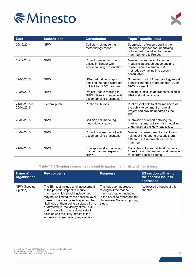
Date Stakeholder Consultation Topic / specific issue 09/12/2014 NRW Collision risk modelling
methodology report Submission of report detailing the intended approach for undertaking collision risk modelling for marine mammals for this Project.
17/12/2014 NRW Project meeting in NRW offices in Bangor with accompanying presentation
Meeting to discuss collision risk modelling approach document, and revised marine mammal EIA methodology, taking into account consultation.
19/05/2015 NRW HRA methodology report detailing intended approach to HRA for NRW comment
Submission of HRA methodology report detailing intended approach to HRA for NRW comment.
20/05/2015 NRW Project update meeting in NRW offices in Bangor with accompanying presentation
Meeting to discuss approach detailed in HRA methodology report.
21/05/2015 & 26/01/2016
General public Public exhibitions Public event held to allow members of the public to comment on overall Project and provide updates on the EIA.
23/06/2015 NRW Collision risk modelling methodology report
Submission of report detailing the marine mammal collision risk modelling undertaken at the Holyhead Deep.
03/07/2015 NRW Project conference call with accompanying presentation
Meeting to present results of collision risk modelling, and to present overall EIA and HRA approach for marine mammals.
24/07/2015 NRW Email/phone discussion with marine mammal expert at NRW
Consultation to discuss best methods for estimating marine mammal passage rates from species counts.
Table 11.3 Scoping comments relevant to marine mammals and megafauna
Name of organisation
Key concerns Response ES section with which the specific issue is addressed
NRW (Scoping Opinion)
The ES must include a full assessment of the potential impact to marine mammals which should include, but may not be limited to: the baseline level of use of the area by such species, the likelihood of them being displaced from, or attracted to, the vicinity of the DGU during operation, the residual risk of collision and the likely effects of the scheme on mammalian prey species.
This has been addressed throughout the marine mammal chapter, including in the baseline report and the Underwater Noise supporting study.
Addressed throughout this chapter
Deep Green Project EIA: Coordination – Environmental Statement Assignment Number: L100194-S14 Document Number: L-100194-S14-EIAS-001 155
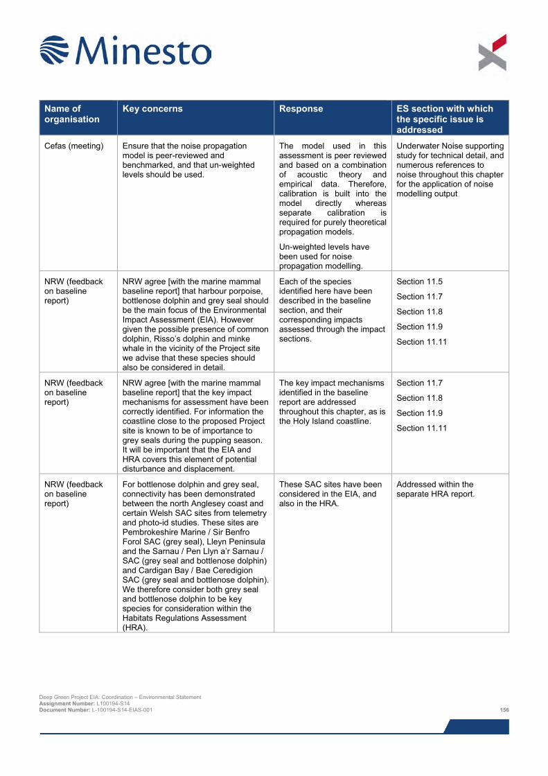
Name of organisation
Key concerns Response ES section with which the specific issue is addressed
Cefas (meeting) Ensure that the noise propagation model is peer-reviewed and benchmarked, and that un-weighted levels should be used.
The model used in this assessment is peer reviewed and based on a combination of acoustic theory and empirical data. Therefore, calibration is built into the model directly whereas separate calibration is required for purely theoretical propagation models.
Un-weighted levels have been used for noise propagation modelling.
Underwater Noise supporting study for technical detail, and numerous references to noise throughout this chapter for the application of noise modelling output
NRW (feedback on baseline report)
NRW agree [with the marine mammal baseline report] that harbour porpoise, bottlenose dolphin and grey seal should be the main focus of the Environmental Impact Assessment (EIA). However given the possible presence of common dolphin, Risso’s dolphin and minke whale in the vicinity of the Project site we advise that these species should also be considered in detail.
Each of the species identified here have been described in the baseline section, and their corresponding impacts assessed through the impact sections.
Section 11.5
Section 11.7
Section 11.8
Section 11.9
Section 11.11
NRW (feedback on baseline report)
NRW agree [with the marine mammal baseline report] that the key impact mechanisms for assessment have been correctly identified. For information the coastline close to the proposed Project site is known to be of importance to grey seals during the pupping season. It will be important that the EIA and HRA covers this element of potential disturbance and displacement.
The key impact mechanisms identified in the baseline report are addressed throughout this chapter, as is the Holy Island coastline.
Section 11.7
Section 11.8
Section 11.9
Section 11.11
NRW (feedback on baseline report)
For bottlenose dolphin and grey seal, connectivity has been demonstrated between the north Anglesey coast and certain Welsh SAC sites from telemetry and photo-id studies. These sites are Pembrokeshire Marine / Sir Benfro Forol SAC (grey seal), Lleyn Peninsula and the Sarnau / Pen Llyn a’r Sarnau / SAC (grey seal and bottlenose dolphin) and Cardigan Bay / Bae Ceredigion SAC (grey seal and bottlenose dolphin). We therefore consider both grey seal and bottlenose dolphin to be key species for consideration within the Habitats Regulations Assessment (HRA).
These SAC sites have been considered in the EIA, and also in the HRA.
Addressed within the separate HRA report.
Deep Green Project EIA: Coordination – Environmental Statement Assignment Number: L100194-S14 Document Number: L-100194-S14-EIAS-001 156
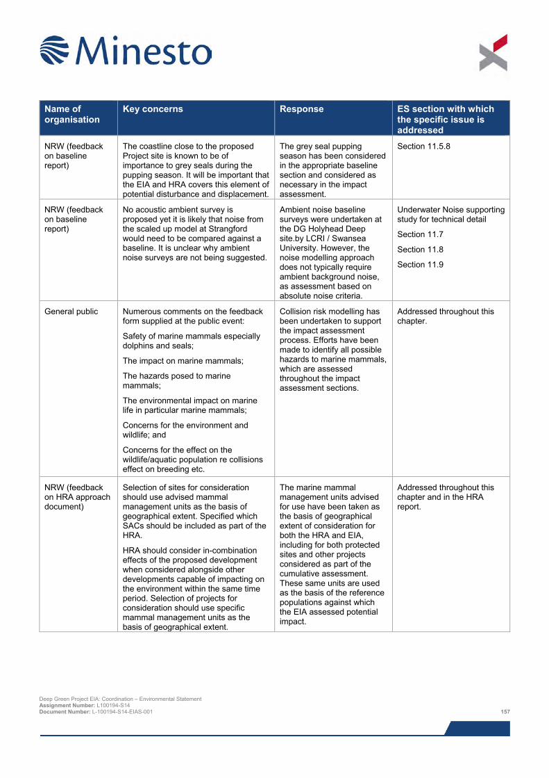
Name of organisation
Key concerns Response ES section with which the specific issue is addressed
NRW (feedback on baseline report)
The coastline close to the proposed Project site is known to be of importance to grey seals during the pupping season. It will be important that the EIA and HRA covers this element of potential disturbance and displacement.
The grey seal pupping season has been considered in the appropriate baseline section and considered as necessary in the impact assessment.
Section 11.5.8
NRW (feedback on baseline report)
No acoustic ambient survey is proposed yet it is likely that noise from the scaled up model at Strangford would need to be compared against a baseline. It is unclear why ambient noise surveys are not being suggested.
Ambient noise baseline surveys were undertaken at the DG Holyhead Deep site.by LCRI / Swansea University. However, the noise modelling approach does not typically require ambient background noise, as assessment based on absolute noise criteria.
Underwater Noise supporting study for technical detail
Section 11.7
Section 11.8
Section 11.9
General public Numerous comments on the feedback form supplied at the public event:
Safety of marine mammals especially dolphins and seals;
The impact on marine mammals;
The hazards posed to marine mammals;
The environmental impact on marine life in particular marine mammals;
Concerns for the environment and wildlife; and
Concerns for the effect on the wildlife/aquatic population re collisions effect on breeding etc.
Collision risk modelling has been undertaken to support the impact assessment process. Efforts have been made to identify all possible hazards to marine mammals, which are assessed throughout the impact assessment sections.
Addressed throughout this chapter.
NRW (feedback on HRA approach document)
Selection of sites for consideration should use advised mammal management units as the basis of geographical extent. Specified which SACs should be included as part of the HRA.
HRA should consider in-combination effects of the proposed development when considered alongside other developments capable of impacting on the environment within the same time period. Selection of projects for consideration should use specific mammal management units as the basis of geographical extent.
The marine mammal management units advised for use have been taken as the basis of geographical extent of consideration for both the HRA and EIA, including for both protected sites and other projects considered as part of the cumulative assessment. These same units are used as the basis of the reference populations against which the EIA assessed potential impact.
Addressed throughout this chapter and in the HRA report.
Deep Green Project EIA: Coordination – Environmental Statement Assignment Number: L100194-S14 Document Number: L-100194-S14-EIAS-001 157
11.5 Baseline description
11.5.1 Introduction In order to accurately predict potential local scale impacts on marine mammals associated with the proposed Project it is important to acquire as much site-specific information as possible. However, the species in question have extremely high levels of mobility, with populations that may span the entire Irish Sea region, and beyond. As such, it is therefore also necessary to consider information regarding distribution and abundance at a regional level.
The following key data sources have been used in this review:
> Sustainable Expansion of the Applied Coastal and Marine Sectors (SEACAMS) vessel-based visual and acoustic marine mammal surveys off west Anglesey, incorporating the DG Holyhead Deep site (SEACAMS, 2015);
> Studies of marine mammal in Welsh high tidal waters (including visual and acoustic survey data and satellite tagging of grey seals) commissioned by the Welsh Assembly Government (Thompson, 2012; Gordon et al., 2011) (Figure 11.1);
> A three year study of harbour porpoise distribution around the north coast of Anglesey (Shucksmith et al., 2009) (Figure 11.1);
> Aerial surveys of UK marine mammals commissioned by the Department of Energy and Climate Change (DECC, 2009);
> Surveys of the Irish Sea Zone conducted by The Crown Estate (TCE) and additional site surveys conducted by The Celtic Array11 (The Celtic Array, 2014);
> Small Cetacean Abundance in the North Sea and Adjacent waters (SCANS) II data (Hammond et al., 2013) – these data were obtained in 2005 via shipboard and aerial surveys of the North Sea and European Atlantic continental shelf waters, using line transect sampling methods. Subsequently, density surface modelling was used to generate broad scale predictions of distribution and abundance;
> The Welsh Cetacean Atlas, including sightings data from Countryside Council for Wales (CCW), Joint Nature Conservation Committee (JNCC), European Seabirds at Sea (ESAS), WDC (Whale and Dolphin Conservation) and Marine Awareness North Wales (Baines & Evans, 2012);
> Department of Energy and Climate Change (DECC) commissioned seal telemetry studies in north Wales (Hammond et al., 2005a);
> CCW/NRW seal monitoring data (e.g. Westcott & Stringell, 2004; Stringell et al., 2013);
> Scientific Advice on Matters Related to the Management of Seal Populations reports (SCOS, 2014);
> Online biological databases including National Biodiversity Network, Shark trust and TURTLE annual reports; and
> Relevant Seawatch Foundation publications.
The spatial coverage (in relation to the study area) of the key studies used to inform this baseline is displayed in Figure 11.1.
In recognition of the amount of existing baseline data covering the Project location and the small scale of the Project itself, Minesto consulted with NRW on the need for dedicated site-specific surveys. It was concluded that any such surveys were unnecessary to inform the impact assessment based on the proposed impact assessment and collision risk assessment methodology proposed (see Section 11.8.5).
11.5.2 Regional context A total of twenty cetacean and two pinniped species have been recorded in the Irish Sea (Baines & Evans 2012). Of these, the majority are considered to be rare, scarce or occasional visitors, whilst others have been documented only
11 A 50/50 joint venture between Centrica Renewable Energy Ltd and DONG Energy Ltd. Deep Green Project EIA: Coordination – Environmental Statement Assignment Number: L100194-S14 Document Number: L-100194-S14-EIAS-001 158
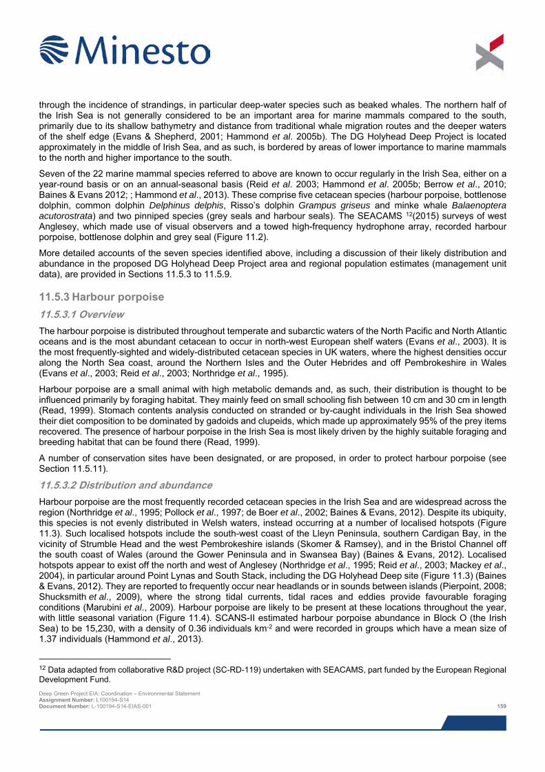
through the incidence of strandings, in particular deep-water species such as beaked whales. The northern half of the Irish Sea is not generally considered to be an important area for marine mammals compared to the south, primarily due to its shallow bathymetry and distance from traditional whale migration routes and the deeper waters of the shelf edge (Evans & Shepherd, 2001; Hammond et al. 2005b). The DG Holyhead Deep Project is located approximately in the middle of Irish Sea, and as such, is bordered by areas of lower importance to marine mammals to the north and higher importance to the south.
Seven of the 22 marine mammal species referred to above are known to occur regularly in the Irish Sea, either on a year-round basis or on an annual-seasonal basis (Reid et al. 2003; Hammond et al. 2005b; Berrow et al., 2010; Baines & Evans 2012; ; Hammond et al., 2013). These comprise five cetacean species (harbour porpoise, bottlenose dolphin, common dolphin Delphinus delphis, Risso’s dolphin Grampus griseus and minke whale Balaenoptera acutorostrata) and two pinniped species (grey seals and harbour seals). The SEACAMS 12(2015) surveys of west Anglesey, which made use of visual observers and a towed high-frequency hydrophone array, recorded harbour porpoise, bottlenose dolphin and grey seal (Figure 11.2).
More detailed accounts of the seven species identified above, including a discussion of their likely distribution and abundance in the proposed DG Holyhead Deep Project area and regional population estimates (management unit data), are provided in Sections 11.5.3 to 11.5.9.
11.5.3 Harbour porpoise 11.5.3.1 Overview The harbour porpoise is distributed throughout temperate and subarctic waters of the North Pacific and North Atlantic oceans and is the most abundant cetacean to occur in north-west European shelf waters (Evans et al., 2003). It is the most frequently-sighted and widely-distributed cetacean species in UK waters, where the highest densities occur along the North Sea coast, around the Northern Isles and the Outer Hebrides and off Pembrokeshire in Wales (Evans et al., 2003; Reid et al., 2003; Northridge et al., 1995).
Harbour porpoise are a small animal with high metabolic demands and, as such, their distribution is thought to be influenced primarily by foraging habitat. They mainly feed on small schooling fish between 10 cm and 30 cm in length (Read, 1999). Stomach contents analysis conducted on stranded or by-caught individuals in the Irish Sea showed their diet composition to be dominated by gadoids and clupeids, which made up approximately 95% of the prey items recovered. The presence of harbour porpoise in the Irish Sea is most likely driven by the highly suitable foraging and breeding habitat that can be found there (Read, 1999).
A number of conservation sites have been designated, or are proposed, in order to protect harbour porpoise (see Section 11.5.11).
11.5.3.2 Distribution and abundance Harbour porpoise are the most frequently recorded cetacean species in the Irish Sea and are widespread across the region (Northridge et al., 1995; Pollock et al., 1997; de Boer et al., 2002; Baines & Evans, 2012). Despite its ubiquity, this species is not evenly distributed in Welsh waters, instead occurring at a number of localised hotspots (Figure 11.3). Such localised hotspots include the south-west coast of the Lleyn Peninsula, southern Cardigan Bay, in the vicinity of Strumble Head and the west Pembrokeshire islands (Skomer & Ramsey), and in the Bristol Channel off the south coast of Wales (around the Gower Peninsula and in Swansea Bay) (Baines & Evans, 2012). Localised hotspots appear to exist off the north and west of Anglesey (Northridge et al., 1995; Reid et al., 2003; Mackey et al., 2004), in particular around Point Lynas and South Stack, including the DG Holyhead Deep site (Figure 11.3) (Baines & Evans, 2012). They are reported to frequently occur near headlands or in sounds between islands (Pierpoint, 2008; Shucksmith et al., 2009), where the strong tidal currents, tidal races and eddies provide favourable foraging conditions (Marubini et al., 2009). Harbour porpoise are likely to be present at these locations throughout the year, with little seasonal variation (Figure 11.4). SCANS-II estimated harbour porpoise abundance in Block O (the Irish Sea) to be 15,230, with a density of 0.36 individuals km-2 and were recorded in groups which have a mean size of 1.37 individuals (Hammond et al., 2013).
12 Data adapted from collaborative R&D project (SC-RD-119) undertaken with SEACAMS, part funded by the European Regional Development Fund. Deep Green Project EIA: Coordination – Environmental Statement Assignment Number: L100194-S14 Document Number: L-100194-S14-EIAS-001 159
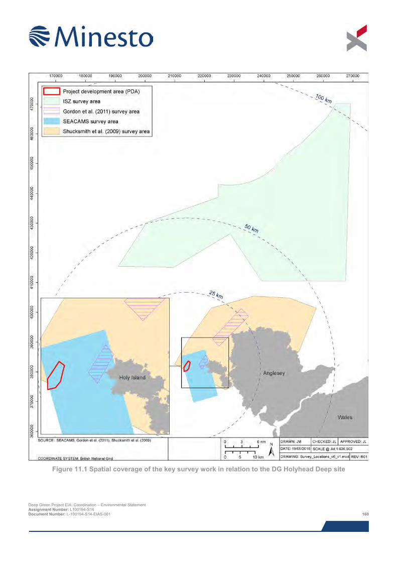
Figure 11.1 Spatial coverage of the key survey work in relation to the DG Holyhead Deep site
Deep Green Project EIA: Coordination – Environmental Statement Assignment Number: L100194-S14 Document Number: L-100194-S14-EIAS-001 160
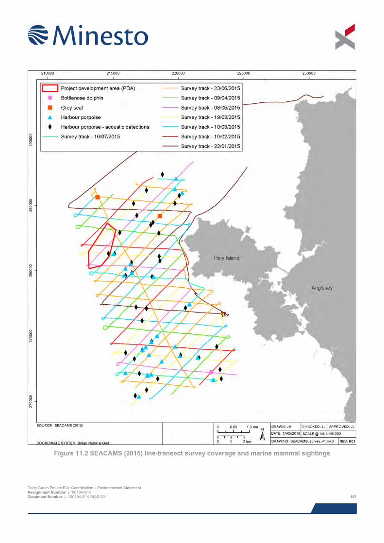
Figure 11.2 SEACAMS (2015) line-transect survey coverage and marine mammal sightings
Deep Green Project EIA: Coordination – Environmental Statement Assignment Number: L100194-S14 Document Number: L-100194-S14-EIAS-001 161
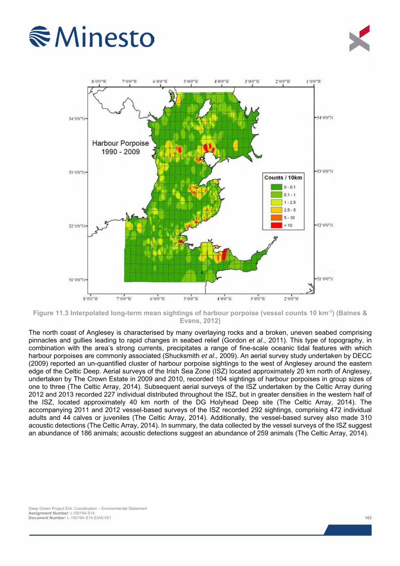
Figure 11.3 Interpolated long-term mean sightings of harbour porpoise (vessel counts 10 km-1) (Baines &
Evans, 2012)
The north coast of Anglesey is characterised by many overlaying rocks and a broken, uneven seabed comprising pinnacles and gullies leading to rapid changes in seabed relief (Gordon et al., 2011). This type of topography, in combination with the area’s strong currents, precipitates a range of fine-scale oceanic tidal features with which harbour porpoises are commonly associated (Shucksmith et al., 2009). An aerial survey study undertaken by DECC (2009) reported an un-quantified cluster of harbour porpoise sightings to the west of Anglesey around the eastern edge of the Celtic Deep. Aerial surveys of the Irish Sea Zone (ISZ) located approximately 20 km north of Anglesey, undertaken by The Crown Estate in 2009 and 2010, recorded 104 sightings of harbour porpoises in group sizes of one to three (The Celtic Array, 2014). Subsequent aerial surveys of the ISZ undertaken by the Celtic Array during 2012 and 2013 recorded 227 individual distributed throughout the ISZ, but in greater densities in the western half of the ISZ, located approximately 40 km north of the DG Holyhead Deep site (The Celtic Array, 2014). The accompanying 2011 and 2012 vessel-based surveys of the ISZ recorded 292 sightings, comprising 472 individual adults and 44 calves or juveniles (The Celtic Array, 2014). Additionally, the vessel-based survey also made 310 acoustic detections (The Celtic Array, 2014). In summary, the data collected by the vessel surveys of the ISZ suggest an abundance of 186 animals; acoustic detections suggest an abundance of 259 animals (The Celtic Array, 2014).
Deep Green Project EIA: Coordination – Environmental Statement Assignment Number: L100194-S14 Document Number: L-100194-S14-EIAS-001 162
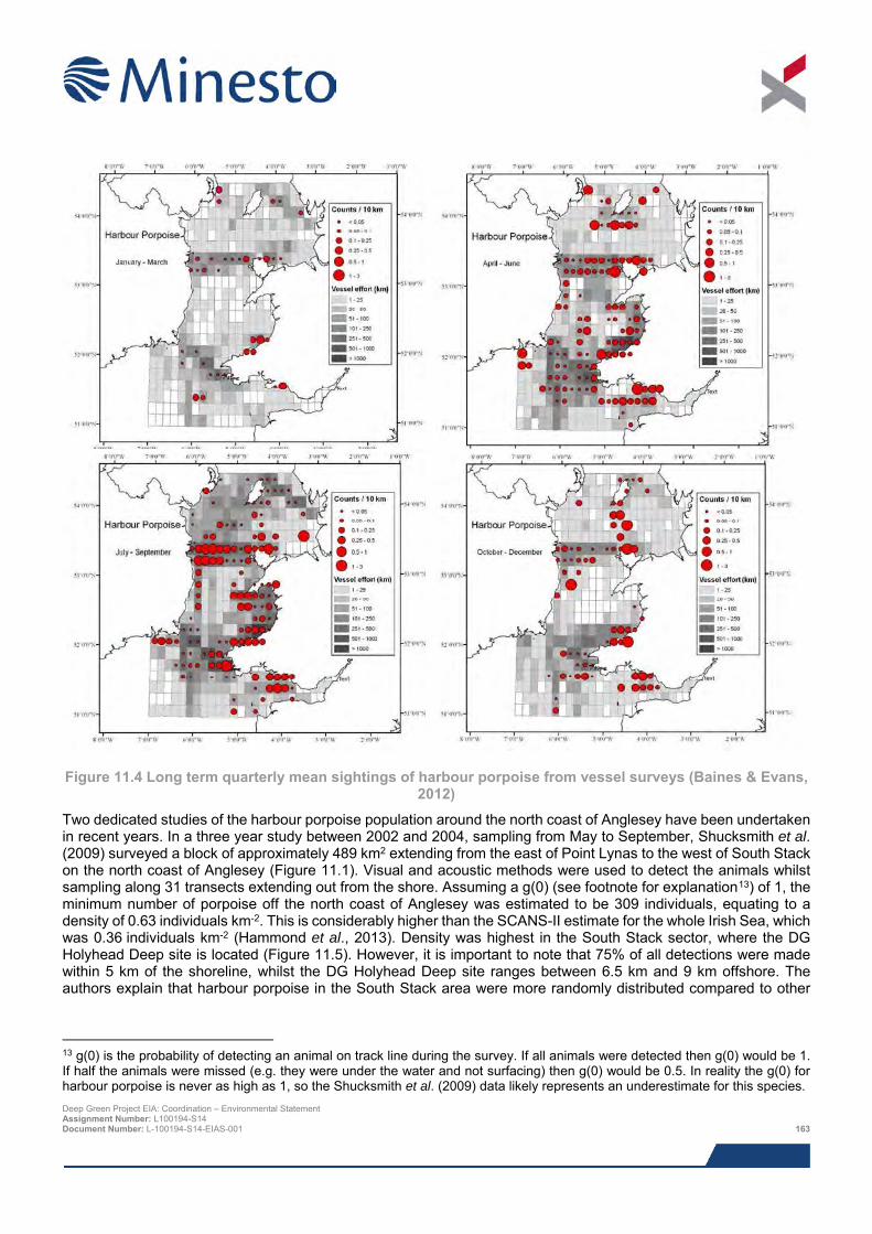
Figure 11.4 Long term quarterly mean sightings of harbour porpoise from vessel surveys (Baines & Evans,
2012)
Two dedicated studies of the harbour porpoise population around the north coast of Anglesey have been undertaken in recent years. In a three year study between 2002 and 2004, sampling from May to September, Shucksmith et al. (2009) surveyed a block of approximately 489 km2 extending from the east of Point Lynas to the west of South Stack on the north coast of Anglesey (Figure 11.1). Visual and acoustic methods were used to detect the animals whilst sampling along 31 transects extending out from the shore. Assuming a g(0) (see footnote for explanation13) of 1, the minimum number of porpoise off the north coast of Anglesey was estimated to be 309 individuals, equating to a density of 0.63 individuals km-2. This is considerably higher than the SCANS-II estimate for the whole Irish Sea, which was 0.36 individuals km-2 (Hammond et al., 2013). Density was highest in the South Stack sector, where the DG Holyhead Deep site is located (Figure 11.5). However, it is important to note that 75% of all detections were made within 5 km of the shoreline, whilst the DG Holyhead Deep site ranges between 6.5 km and 9 km offshore. The authors explain that harbour porpoise in the South Stack area were more randomly distributed compared to other
13 g(0) is the probability of detecting an animal on track line during the survey. If all animals were detected then g(0) would be 1. If half the animals were missed (e.g. they were under the water and not surfacing) then g(0) would be 0.5. In reality the g(0) for harbour porpoise is never as high as 1, so the Shucksmith et al. (2009) data likely represents an underestimate for this species. Deep Green Project EIA: Coordination – Environmental Statement Assignment Number: L100194-S14 Document Number: L-100194-S14-EIAS-001 163
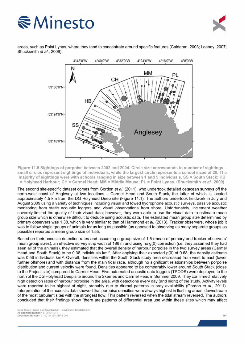
areas, such as Point Lynas, where they tend to concentrate around specific features (Calderan, 2003; Leeney, 2007; Shucksmith et al., 2009).
Figure 11.5 Sightings of porpoise between 2002 and 2004. Circle size corresponds to number of sightings – small circles represent sightings of individuals, while the largest circle represents a school sized of 20. The majority of sightings were with schools ranging in size between 1 and 5 individuals. SS = South Stack; HB = Holyhead Harbour; CH = Carmel Head; MM = Middle Mouse; PL = Point Lynas. (Shucksmith et al., 2009)
The second site-specific dataset comes from Gordon et al. (2011), who undertook detailed cetacean surveys off the north-west coast of Anglesey at two locations – Carmel Head and South Stack, the latter of which is located approximately 4.5 km from the DG Holyhead Deep site (Figure 11.1). The authors undertook fieldwork in July and August 2009 using a variety of techniques including visual and towed hydrophone acoustic surveys, passive acoustic monitoring from static acoustic loggers and visual observations from shore. Unfortunately, inclement weather severely limited the quality of their visual data; however, they were able to use the visual data to estimate mean group size which is otherwise difficult to deduce using acoustic data. The estimated mean group size determined by primary observers was 1.38, which is very similar to that of Hammond et al. (2013). Tracker observers, whose job it was to follow single groups of animals for as long as possible (as opposed to observing as many separate groups as possible) reported a mean group size of 1.55.
Based on their acoustic detection rates and assuming a group size of 1.5 (mean of primary and tracker observers’ mean group sizes), an effective survey strip width of 186 m and using no g(0) correction (i.e. they assumed they had seen all of the animals), they estimated that the overall density of harbour porpoise in the two survey areas (Carmel Head and South Stack) to be 0.38 individuals km-2. After applying their expected g(0) of 0.68, the density estimate was 0.56 individuals km-2. Overall, densities within the South Stack study area decreased from west to east (lower further offshore) and with distance from the main tidal race, although no significant relationships between porpoise distribution and current velocity were found. Densities appeared to be comparably lower around South Stack (close to the Project site) compared to Carmel Head. Five automated acoustic data loggers (TPODS) were deployed to the north of the DG Holyhead Deep site around the Skerries and Carmel Head in Summer 2009. They confirmed relatively high detection rates of harbour porpoise in the area, with detections every day (and night) of the study. Activity levels were reported to be highest at night, probably due to diurnal patterns in prey availability (Gordon et al., 2011). Interpretation of the acoustic data showed that porpoise densities were always highest in flushing areas, downstream of the most turbulent sites with the strongest flow. This pattern reversed when the tidal stream reversed. The authors concluded that their findings show “there are patterns of differential area use within these sites which may affect Deep Green Project EIA: Coordination – Environmental Statement Assignment Number: L100194-S14 Document Number: L-100194-S14-EIAS-001 164
collision risk and could also potentially be used to reduce it”. This may provide some indication that the specific DG Holyhead Deep location, deliberately sited in deep water with lower tidal stream velocity, might be less important to harbour porpoise compared to nearby locations with high tidal velocities and turbulent flow. The final aspect of the Gordon et al. (2011) study was the deployment of a unique system of vertical hydrophones in an attempt to elucidate patterns in the use of the water column by harbour porpoise. They determined that harbour porpoise use the entire water column, but tend to spend more time near the seabed, possibly to feed on benthic prey items.
Of the 42 marine mammal sightings recorded by SEACAMS (2015) in the west Anglesey area (Figure 11.2), 39 were harbour porpoise. This corresponds to a rate of 1.88 sightings per hour. SEACAMS (2015) report that the spatial distribution of sightings of harbour porpoise appears to be relatively well spread across the survey area. Specifically within the DG Holyhead Deep site, from approximately 26 km of survey effort there was only one recording of harbour porpoise (detected acoustically), although further harbour porpoise sightings have been recorded close to the DG Holyhead Deep site (SEACAMS, 2015).
Considering its status as the most common cetacean in the Irish Sea and considering the results of local surveys, it seems likely that the DG Holyhead Deep Project site is well-used by harbour porpoise, although relative densities suggest the site is not amongst the areas of highest importance in the Irish Sea.
11.5.3.3 Harbour porpoise management unit Three management units have been agreed for the harbour porpoise: the North Sea, West Scotland and the Celtic and Irish Seas (SNCBs, 2015). Harbour porpoise abundance in the Celtic and Irish Seas has been estimated as 104,965 (95% CI: 56,774 – 193,065). However, it is important to recognise that movement of animals between management units is likely; this is further considered in the assessment sections of this chapter.
11.5.4 Bottlenose dolphin 11.5.4.1 Overview Bottlenose dolphin have a worldwide distribution (Reid et al., 2003) and are distributed throughout UK shelf waters, often close to shore; two of the largest aggregations are found in the Moray Firth (north-east Scotland) and Cardigan Bay (Wales). This species inhabits UK waters throughout the year, but in most coastal areas the greatest numbers are recorded between May and October (Evans et al., 2003, Reid et al., 2003).
Bottlenose dolphin predate a wide variety of benthic and pelagic fish species, as well as cephalopods. In the north-east Atlantic their diet is known to include haddock, saithe, blue whiting, mullet, salmon and bass (Santos et al., 2001; Reid et al., 2003). In the Irish Sea, stomach contents analysis has only been conducted on three individuals (Couperus, 1995; O’Brien & Berrow, 2006). These analyses demonstrated that bottlenose dolphin in the Irish Sea have a highly variable diet comprising horse mackerel, hake, mackerel, poor cod, pollock, whiting and saithe. Such wide variation points toward a highly opportunistic feeding mode, although research in Australia has shown that when presented with a choice, they will preferentially feed on certain types of prey, particularly those with a high fat content (Corkeron et al., 1990).
A number of conservation sites have been designated in order to protect bottlenose dolphin (see Section 11.5.11).
11.5.4.2 Local distribution and abundance Bottlenose dolphin are regularly observed in the Irish Sea, predominantly in the coastal waters between Cardigan Bay and Anglesey (Mackey et al., 2004; Pesante et al., 2008a; Pesante et al., 2008b), although low numbers have been reported offshore in St George’s Channel and further south-west (Figure 11.6). The main concentrations appear to occur in south Cardigan Bay, further north below the Lleyn Peninsula and to the north and west of Anglesey. Baines & Evans (2012) noted seasonal changes in bottlenose dolphin group size and distribution in the Irish Sea. Figure 11.7 shows sightings data by season. During the summer the dolphins were more frequently recorded in smaller groups and close to shore in Cardigan Bay, whereas during the winter they disperse more widely, usually northwards, and where they tend to form larger groups than during the summer months. Despite this apparent pattern, bottlenose dolphins are still frequently observed across much of the Welsh coast throughout the year. Pesante et al. (2008a) suggest that their preference for Cardigan Bay is a result of the shallow bathymetry and diverse benthic habitats, in addition to the fact that significant numbers of salmonids pass through the bay during migration. Bottlenose dolphins have an extended breeding season, so observations of calves occur throughout the year, with Deep Green Project EIA: Coordination – Environmental Statement Assignment Number: L100194-S14 Document Number: L-100194-S14-EIAS-001 165
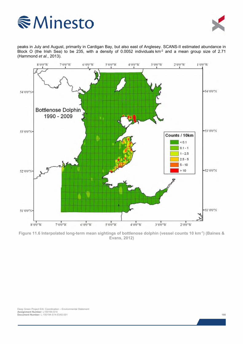
peaks in July and August, primarily in Cardigan Bay, but also east of Anglesey. SCANS-II estimated abundance in Block O (the Irish Sea) to be 235, with a density of 0.0052 individuals km-2 and a mean group size of 2.71 (Hammond et al., 2013).
Figure 11.6 Interpolated long-term mean sightings of bottlenose dolphin (vessel counts 10 km-1) (Baines &
Evans, 2012)
Deep Green Project EIA: Coordination – Environmental Statement Assignment Number: L100194-S14 Document Number: L-100194-S14-EIAS-001 166
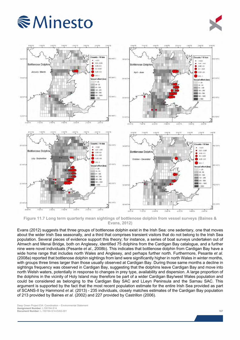
Figure 11.7 Long term quarterly mean sightings of bottlenose dolphin from vessel surveys (Baines &
Evans, 2012)
Evans (2012) suggests that three groups of bottlenose dolphin exist in the Irish Sea: one sedentary, one that moves about the wider Irish Sea seasonally, and a third that comprises transient visitors that do not belong to the Irish Sea population. Several pieces of evidence support this theory; for instance, a series of boat surveys undertaken out of Almwch and Menai Bridge, both on Anglesey, identified 75 dolphins from the Cardigan Bay catalogue, and a further nine were novel individuals (Pesante et al., 2008b). This indicates that bottlenose dolphin from Cardigan Bay have a wide home range that includes north Wales and Anglesey, and perhaps further north. Furthermore, Pesante et al. (2008a) reported that bottlenose dolphin sightings from land were significantly higher in north Wales in winter months, with groups three times larger than those usually observed at Cardigan Bay. During those same months a decline in sightings frequency was observed in Cardigan Bay, suggesting that the dolphins leave Cardigan Bay and move into north Welsh waters, potentially in response to changes in prey type, availability and dispersion. A large proportion of the dolphins in the vicinity of Holy Island may therefore be part of a wider Cardigan Bay/west Wales population and could be considered as belonging to the Cardigan Bay SAC and LLeyn Peninsula and the Sarnau SAC. This argument is supported by the fact that the most recent population estimate for the entire Irish Sea provided as part of SCANS-II by Hammond et al. (2013) - 235 individuals, closely matches estimates of the Cardigan Bay population of 213 provided by Baines et al. (2002) and 227 provided by Castrillon (2006).
Deep Green Project EIA: Coordination – Environmental Statement Assignment Number: L100194-S14 Document Number: L-100194-S14-EIAS-001 167
Clearly this species is far less abundant than the harbour porpoise and this is reflected in the results from a variety of site surveys conducted in the vicinity of the DG Holyhead Deep Project. DECC-commissioned aerial surveys of the entire UK encountered 52 bottlenose dolphins, which were concentrated primarily around Cardigan Bay, with an un-quantified ‘few’ sightings around Anglesey (DECC, 2009). Vessel surveys conducted between 2011 and 2013 by the Celtic Array reported four sightings, three of which were on the western edge of the Irish Sea Zone. At a more local scale, Gordon et al. (2011) encountered just one bottlenose dolphin during vessel surveys, located several kilometres south of South Stack, whilst observations made from shore were limited to a single observation off Carmel Head, approximately 18 km north-west of the DG Holyhead Deep Project.
Of the 42 marine mammal sightings recorded by SEACAMS (2015) in the west Anglesey area (Figure 11.2), only one was bottlenose dolphin. This corresponds to a rate of 0.05 sightings per hour. Specifically within the DG Holyhead Deep site, from the approximately 26 km of survey effort, no bottlenose dolphins were recorded and only a single sighting was recorded from the entire survey area (375 km of survey effort). This was in the far south-east of the survey area (SEACAMS, 2015).
Considering the above, it seems extremely unlikely that the Project is located in an area of particular importance to bottlenose dolphins, but the small number of observations to the west of demonstrate that their presence cannot be ruled out.
11.5.4.3 Bottlenose dolphin management units Seven units were agreed by the SNCBs for the bottlenose dolphin in UK waters. Current advice from the UK SNCBs (2015) is that impact assessments should be made against the Irish Sea MMMU, which has an abundance estimate of 397 individuals (95% CI: 362 - 414).
11.5.5 Common dolphin 11.5.5.1 Overview The common dolphin is among the most abundant of the world’s cetacean species and is distributed worldwide (Evans et al., 2003; Reid et al., 2003), occurring most commonly in the British Isles along the Atlantic seaboard, including south-west England, south-west Wales, the south and west coasts of Ireland, the Sea of Hebrides and the Minch, as well as the deep waters off north-west Scotland (Weir et al., 2001; Evans et al., 2003; Reid et al., 2003; Evans, 2008).
Common dolphins feed on a range of epipelagic14 and mesopelagic15 fish, shrimps and squid, and especially schooling fish such as mackerel, sprat, pilchard and blue whiting (Reid et al., 2003), although the specific composition of their diet is known to change seasonally. No Irish Sea specific data on their diet exists, but it is thought to reflect that the typical diet for this species in the north-east Atlantic (Evans, 1994; Hassani et al., 1997). Brophy (2003) examined the stomach contents of individuals caught in tuna nets and discovered that the majority of prey items were either cephalopods or crustaceans. In contrast to this, Couperus (1995) identified mackerel, horse-mackerel, hake and pearlsides as the main prey items in the stomachs of dolphins by-caught south-west of Ireland.
11.5.5.2 Local distribution and abundance The distribution of the common dolphin is largely offshore and primarily in the southern Irish Sea around St George’s Channel (Figure 11.8). This is thought be driven by the dolphins association with the Celtic Sea Front, a frontal system with high levels of primary productivity (Reid et al., 2003; Bush, 2006). As can be seen in Figure 11.8, the high density areas extend toward the coast of west Pembrokeshire, whereas the density of common dolphins further north are for the most part very low, with patches of medium densities offshore toward the Isle of Man. This species is thought to a summer visitor only, with the exception of the Celtic Deep, where it persists until around November (Figure 11.9) (Baines & Evans, 2012). The SCANS-II abundance estimate for common/striped dolphins in Block O (the Irish Sea) was 826 individuals, at a density of 0.0018 individuals km-2 (Hammond et al., 2013). However, an
14 Inhabiting the oceanic zone within which there is sufficient sunlight for photosynthesis to occur (usually from the surface to approximately 200 m). 15 Inhabiting the oceanic zone that lies beneath the epipelagic, within which some light penetrates, but not enough for photosynthesis to occur (usually 200 – 1,000 m). Deep Green Project EIA: Coordination – Environmental Statement Assignment Number: L100194-S14 Document Number: L-100194-S14-EIAS-001 168
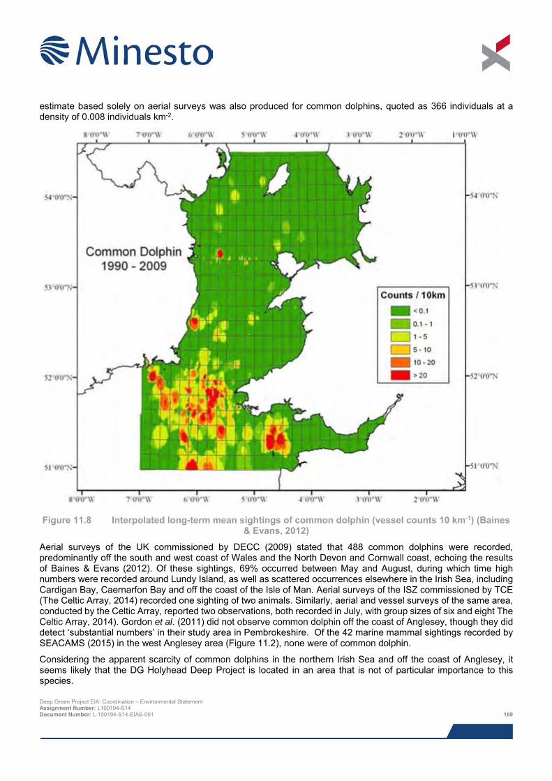
estimate based solely on aerial surveys was also produced for common dolphins, quoted as 366 individuals at a density of 0.008 individuals km-2.
Figure 11.8 Interpolated long-term mean sightings of common dolphin (vessel counts 10 km-1) (Baines
& Evans, 2012)
Aerial surveys of the UK commissioned by DECC (2009) stated that 488 common dolphins were recorded, predominantly off the south and west coast of Wales and the North Devon and Cornwall coast, echoing the results of Baines & Evans (2012). Of these sightings, 69% occurred between May and August, during which time high numbers were recorded around Lundy Island, as well as scattered occurrences elsewhere in the Irish Sea, including Cardigan Bay, Caernarfon Bay and off the coast of the Isle of Man. Aerial surveys of the ISZ commissioned by TCE (The Celtic Array, 2014) recorded one sighting of two animals. Similarly, aerial and vessel surveys of the same area, conducted by the Celtic Array, reported two observations, both recorded in July, with group sizes of six and eight The Celtic Array, 2014). Gordon et al. (2011) did not observe common dolphin off the coast of Anglesey, though they did detect ‘substantial numbers’ in their study area in Pembrokeshire. Of the 42 marine mammal sightings recorded by SEACAMS (2015) in the west Anglesey area (Figure 11.2), none were of common dolphin.
Considering the apparent scarcity of common dolphins in the northern Irish Sea and off the coast of Anglesey, it seems likely that the DG Holyhead Deep Project is located in an area that is not of particular importance to this species. Deep Green Project EIA: Coordination – Environmental Statement Assignment Number: L100194-S14 Document Number: L-100194-S14-EIAS-001 169
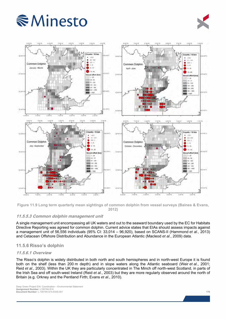
Figure 11.9 Long term quarterly mean sightings of common dolphin from vessel surveys (Baines & Evans,
2012)
11.5.5.3 Common dolphin management unit A single management unit encompassing all UK waters and out to the seaward boundary used by the EC for Habitats Directive Reporting was agreed for common dolphin. Current advice states that EIAs should assess impacts against a management unit of 56,556 individuals (95% CI: 33,014 – 96,920), based on SCANS-II (Hammond et al., 2013) and Cetacean Offshore Distribution and Abundance in the European Atlantic (Macleod et al., 2009) data.
11.5.6 Risso’s dolphin 11.5.6.1 Overview The Risso’s dolphin is widely distributed in both north and south hemispheres and in north-west Europe it is found both on the shelf (less than 200 m depth) and in slope waters along the Atlantic seaboard (Weir et al., 2001; Reid et al., 2003). Within the UK they are particularly concentrated in The Minch off north-west Scotland, in parts of the Irish Sea and off south-west Ireland (Reid et al., 2003) but they are more regularly observed around the north of Britain (e.g. Orkney and the Pentland Firth; Evans et al., 2010).
Deep Green Project EIA: Coordination – Environmental Statement Assignment Number: L100194-S14 Document Number: L-100194-S14-EIAS-001 170
In British waters their diet comprises octopus, cuttlefish and small bottom-dwelling squid (Reid et al., 2003) and the limited research that has addressed their feeding ecology suggests they feed mainly at night (Cockcroft et al., 1993). Stomach contents analyses of individuals from the Irish Sea have not been conducted, but analysis of a single individual that beached off the coast of Devon in 1982 revealed a diet of squid, cuttlefish and octopus (Clarke & Pascoe, 1985). Risso’s dolphin are usually observed in small groups of around five individuals (Berrow et al., 2010), but larger groups of 6-12 have been observed in the UK (Reid et al., 2003).
11.5.6.2 Local distribution and abundance In Welsh waters, Risso’s dolphin have a somewhat localised distribution, occurring along a band running south-west to north-east that includes Pembrokeshire, the Lleyn Peninsula, and Anglesey, as well as the south-east coast of Ireland and around the Isle of Man (Figure 11.10). Baines & Evans (2012) state that this density pattern has remained relatively stable over the 19 year survey period upon which their discussion is based. Some authors have suggested that their distribution can in some cases be linked to the presence of Modiolus (northern horse mussel) beds, and in some case have been observed feeding on this bivalve (Evans, 2008; Evans & Hintner, 2010). Whilst their spatial distribution is relatively consistent, their densities vary throughout the year, being sighted from Welsh coasts in summer (Figure 11.11). At other times the species distributes more widely and can be found offshore as well as in coastal waters. Risso’s dolphin are known to breed in the area and there have been observations of young of the year in Pembrokeshire, Bardsey Island and Anglesey (Baines & Evans, 2012). Risso’s dolphin abundance was not calculated during SCANS-I or SCANS-II due to a lack of sightings, and no other abundance estimates exist for UK waters.
In a ten-year photo-identification study, 133 Risso’s dolphin were observed off Bardsey Island in Cardigan Bay, Wales (de Boer et al., 2013). The aerial surveys of UK waters undertaken on behalf of DECC (2009) reported two observations of Risso’s dolphin off the west coast of Anglesey. The first, recorded in late-June 2008 was 2.5 km offshore, whilst the second, recorded early-August 2008 was 35 km offshore. Similarly, TCE-commissioned aerial surveys of the ISZ off the north coast of Anglesey encountered four separate groups of Risso’s dolphin in August 2009, located in the western section of the zone, approximately 35 km north of the DG Holyhead Deep Site (The Celtic Array, 2014). Additional vessel based surveys of the ISZ undertaken by the Celtic Array reported only three sightings (The Celtic Array, 2014). Neither Gordon et al. (2011) nor Shucksmith et al. (2009) made any mention of Risso’s dolphin observations during their studies of the north Anglesey coast.
Of the 42 marine mammal sightings recorded by SEACAMS (2015) in the west Anglesey area (Figure 11.2), none were of Risso’s dolphin.
Considering the above, it is unlikely that the Project area is of particular importance to this species, though it is possible that they could use the area on occasion.
11.5.6.3 Risso’s dolphin management units A single management unit encompassing all UK waters and out to the seaward boundary used by the EC for Habitats Directive Reporting was agreed for Risso’s dolphin. However, there is currently no abundance estimate available for this species (SNCBs, 2015).
Deep Green Project EIA: Coordination – Environmental Statement Assignment Number: L100194-S14 Document Number: L-100194-S14-EIAS-001 171
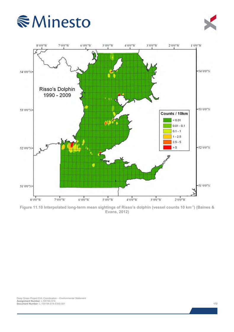
Figure 11.10 Interpolated long-term mean sightings of Risso’s dolphin (vessel counts 10 km-1) (Baines &
Evans, 2012)
Deep Green Project EIA: Coordination – Environmental Statement Assignment Number: L100194-S14 Document Number: L-100194-S14-EIAS-001 172
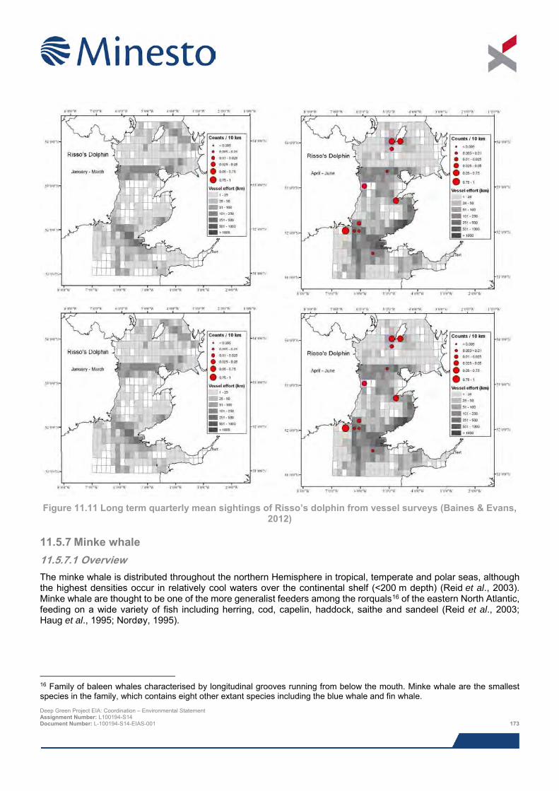
Figure 11.11 Long term quarterly mean sightings of Risso’s dolphin from vessel surveys (Baines & Evans,
2012)
11.5.7 Minke whale 11.5.7.1 Overview The minke whale is distributed throughout the northern Hemisphere in tropical, temperate and polar seas, although the highest densities occur in relatively cool waters over the continental shelf (<200 m depth) (Reid et al., 2003). Minke whale are thought to be one of the more generalist feeders among the rorquals16 of the eastern North Atlantic, feeding on a wide variety of fish including herring, cod, capelin, haddock, saithe and sandeel (Reid et al., 2003; Haug et al., 1995; Nordøy, 1995).
16 Family of baleen whales characterised by longitudinal grooves running from below the mouth. Minke whale are the smallest species in the family, which contains eight other extant species including the blue whale and fin whale. Deep Green Project EIA: Coordination – Environmental Statement Assignment Number: L100194-S14 Document Number: L-100194-S14-EIAS-001 173
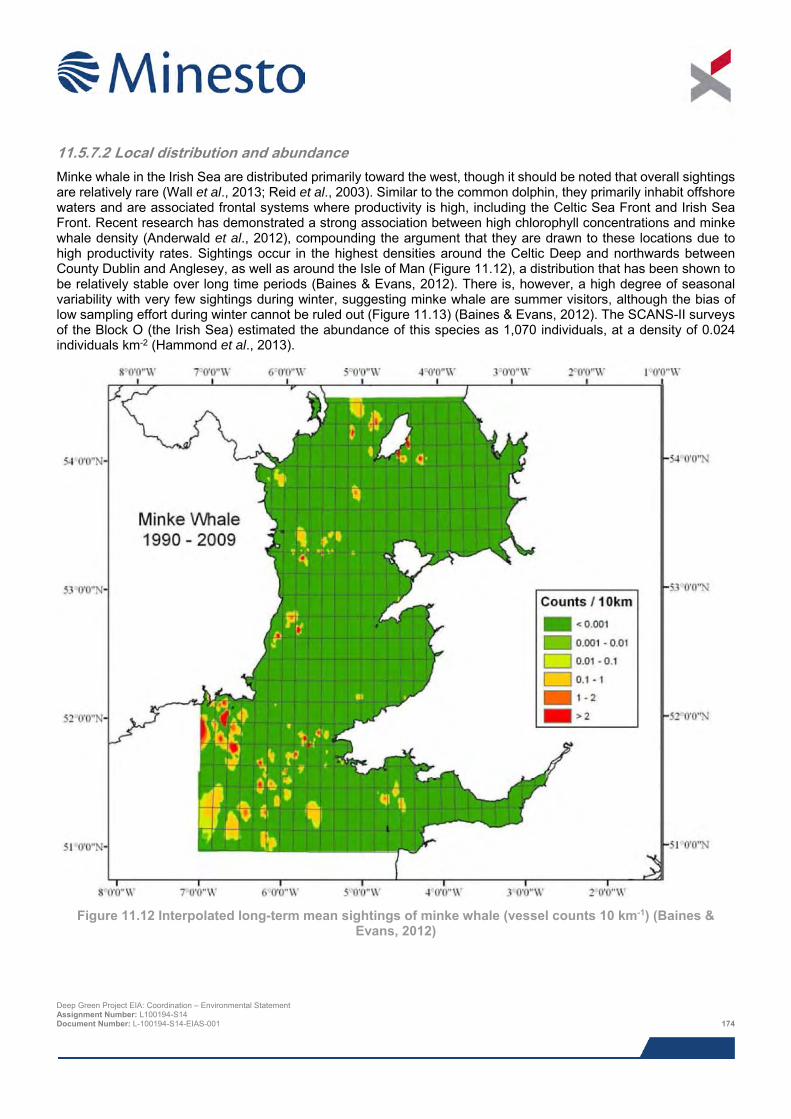
11.5.7.2 Local distribution and abundance Minke whale in the Irish Sea are distributed primarily toward the west, though it should be noted that overall sightings are relatively rare (Wall et al., 2013; Reid et al., 2003). Similar to the common dolphin, they primarily inhabit offshore waters and are associated frontal systems where productivity is high, including the Celtic Sea Front and Irish Sea Front. Recent research has demonstrated a strong association between high chlorophyll concentrations and minke whale density (Anderwald et al., 2012), compounding the argument that they are drawn to these locations due to high productivity rates. Sightings occur in the highest densities around the Celtic Deep and northwards between County Dublin and Anglesey, as well as around the Isle of Man (Figure 11.12), a distribution that has been shown to be relatively stable over long time periods (Baines & Evans, 2012). There is, however, a high degree of seasonal variability with very few sightings during winter, suggesting minke whale are summer visitors, although the bias of low sampling effort during winter cannot be ruled out (Figure 11.13) (Baines & Evans, 2012). The SCANS-II surveys of the Block O (the Irish Sea) estimated the abundance of this species as 1,070 individuals, at a density of 0.024 individuals km-2 (Hammond et al., 2013).
Figure 11.12 Interpolated long-term mean sightings of minke whale (vessel counts 10 km-1) (Baines &
Evans, 2012)
Deep Green Project EIA: Coordination – Environmental Statement Assignment Number: L100194-S14 Document Number: L-100194-S14-EIAS-001 174
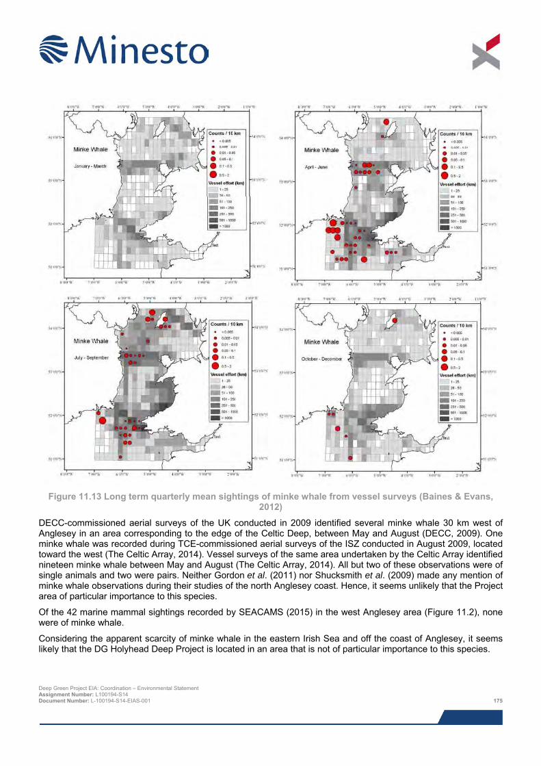
Figure 11.13 Long term quarterly mean sightings of minke whale from vessel surveys (Baines & Evans,
2012)
DECC-commissioned aerial surveys of the UK conducted in 2009 identified several minke whale 30 km west of Anglesey in an area corresponding to the edge of the Celtic Deep, between May and August (DECC, 2009). One minke whale was recorded during TCE-commissioned aerial surveys of the ISZ conducted in August 2009, located toward the west (The Celtic Array, 2014). Vessel surveys of the same area undertaken by the Celtic Array identified nineteen minke whale between May and August (The Celtic Array, 2014). All but two of these observations were of single animals and two were pairs. Neither Gordon et al. (2011) nor Shucksmith et al. (2009) made any mention of minke whale observations during their studies of the north Anglesey coast. Hence, it seems unlikely that the Project area of particular importance to this species.
Of the 42 marine mammal sightings recorded by SEACAMS (2015) in the west Anglesey area (Figure 11.2), none were of minke whale.
Considering the apparent scarcity of minke whale in the eastern Irish Sea and off the coast of Anglesey, it seems likely that the DG Holyhead Deep Project is located in an area that is not of particular importance to this species.
Deep Green Project EIA: Coordination – Environmental Statement Assignment Number: L100194-S14 Document Number: L-100194-S14-EIAS-001 175
11.5.7.3 Minke whale management units A single management unit encompassing all UK waters and out to the seaward boundary used by the EC for Habitats Directive Reporting was agreed for minke whale (SNCBs, 2015). The abundance estimate for this single unit 23,528 (95% CI: 13,989 – 39,572), based on data derived from SCANS-II (Hammond et al., 2013) and Cetacean Offshore Distribution and Abundance in the European Atlantic (Macleod et al., 2009).
11.5.8 Grey seal 11.5.8.1 Overview Grey seals occur only in the north Atlantic and in the Barents and Baltic Seas, with their main concentrations located along the Canadian and US eastern seaboards and in north-east Europe (SCOS, 2014). The UK contains around 38% of the total world breeding population of grey seals, and 88% of those breed in Scotland with major concentrations in the Outer Hebrides and in Orkney (SCOS, 2014). There exists a clockwise cline in mean birth date around the UK coast such that the majority of pups in south west Britain are born between August and September, whilst in north and west Scotland they are born in between September and late November, and on the eastern English coast the majority of pupping occurs between early November and mid-December (SCOS, 2014).
Grey seals feed mostly on the seabed on small demersal fish species, primarily in water depths of less than 100 m. In the UK their diet includes sandeels, whitefish, flatfish and some cephalopods (Kiely et al., 2000; SCOS, 2014). Species of the genus Trisopterus (bib, Norway pout, poor cod), plaice and whiting are thought to be the primary components of their diet in the western areas of the Irish Sea (Kiely et al., 2000). Strong (1996) examined faecal-samples sourced from welsh haul-out sites and determined that dominant prey items included gadoids and flatfish.
A number of conservation sites have been designated in order to protect grey seals (see Section 11.5.11).
11.5.8.2 Local distribution and abundance Grey seals are common and widely distributed across Welsh waters (Figure 11.14 and Figure 11.15), which hold approximately 90% of the Irish Sea breeding population, estimated to be somewhere in the region of 5,000 – 7,000 animals (Kiely et al., 2000). Grey seal distribution appears to be more restricted and coastal during winter months, most likely a reflection of time spent breeding and pupping in these areas (Figure 11.15). There are three key aspects of their distribution and use of the Irish Sea that need to be understood in order to adequately assess any potential impacts associated with the DG Holyhead Deep Project: breeding haul-outs, non-breeding haul-outs and at-sea distribution.
Of the two pinniped species found in the UK, grey seal is the only species that breeds on the Welsh coast. Breeding occurs in caves and small coves on offshore islands and less accessible parts of the mainland coast. The most important areas for pup production are north-west Pembrokeshire, in particular on Ramsey Island in south-west Wales, but also extending south toward Skomer Island and north toward Ceredigion (Strong et al., 2006; Baines et al., 1995). In addition to these, a number of smaller breeding aggregations exist around the Lleyn Peninsula and the coast of Anglesey. Westcott & Stringell (2004) conducted a full census of grey seal distribution and abundance in north Wales between July 2002 and April 2003; they recorded 110 pups in north Wales, of which 74 were born in sea cave sites and 36 at open beach sites. The North Stack coast, approximately 6 km west off the proposed landfall search area was found to be the second most important pupping locality in the North Wales region. The majority of sites here were found to be used only during breeding, peaking between September and March, during which numbers usually exceeding 10, but reaching as high as 37 in September. Typically at least a third of these were seal pups during breeding seasons. As described below, Ogof Arw and Ogof Morlo, two sites on the North Stack coast, were used throughout the year. Stringell et al. (2013) provided a pup production estimate in north Wales of 91 (95% CI: 70-112).
The areas identified above as important breeding haul-outs also tend to be used year round as non-breeding haul-outs for moulting and during feeding trips (Westcott, 2002; Westcott & Stringell, 2003; Westcott & Stringell, 2004; Baines & Evans, 2012). Additionally, there are a number of other sites used only as non-breeding haul-outs, notably the West Hoyle Sandbank in the Dee Estuary, where in excess of 800 individuals have been counted (Hilbre Island Bird Observatory unpublished data cited in Baines & Evans, 2012). Westcott & Stringell (2004) highlight that two sites closest to the DG Holyhead Deep site, the North Stack Coast and Carmel Head, comprised a relatively high proportion of pups, signifying that the sites are ‘heavily used during the breeding season but little outside that time’. Deep Green Project EIA: Coordination – Environmental Statement Assignment Number: L100194-S14 Document Number: L-100194-S14-EIAS-001 176
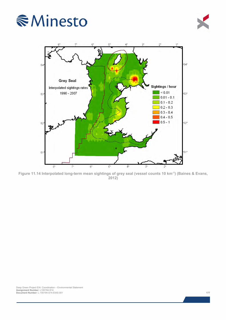
Figure 11.14 Interpolated long-term mean sightings of grey seal (vessel counts 10 km-1) (Baines & Evans,
2012)
Deep Green Project EIA: Coordination – Environmental Statement Assignment Number: L100194-S14 Document Number: L-100194-S14-EIAS-001 177
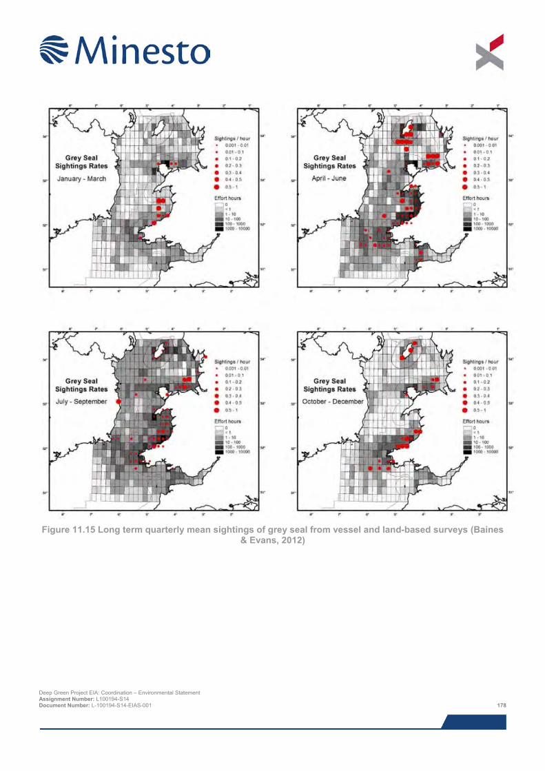
Figure 11.15 Long term quarterly mean sightings of grey seal from vessel and land-based surveys (Baines
& Evans, 2012)
Deep Green Project EIA: Coordination – Environmental Statement Assignment Number: L100194-S14 Document Number: L-100194-S14-EIAS-001 178
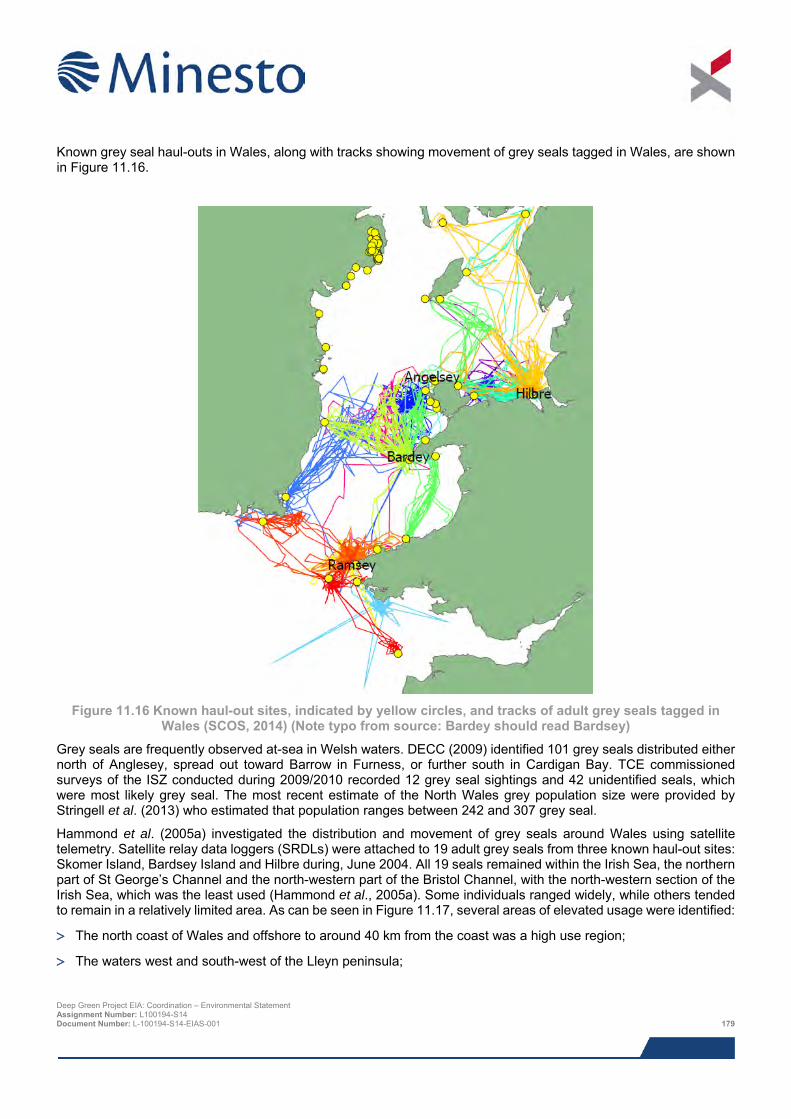
Known grey seal haul-outs in Wales, along with tracks showing movement of grey seals tagged in Wales, are shown in Figure 11.16.
Figure 11.16 Known haul-out sites, indicated by yellow circles, and tracks of adult grey seals tagged in
Wales (SCOS, 2014) (Note typo from source: Bardey should read Bardsey)
Grey seals are frequently observed at-sea in Welsh waters. DECC (2009) identified 101 grey seals distributed either north of Anglesey, spread out toward Barrow in Furness, or further south in Cardigan Bay. TCE commissioned surveys of the ISZ conducted during 2009/2010 recorded 12 grey seal sightings and 42 unidentified seals, which were most likely grey seal. The most recent estimate of the North Wales grey population size were provided by Stringell et al. (2013) who estimated that population ranges between 242 and 307 grey seal.
Hammond et al. (2005a) investigated the distribution and movement of grey seals around Wales using satellite telemetry. Satellite relay data loggers (SRDLs) were attached to 19 adult grey seals from three known haul-out sites: Skomer Island, Bardsey Island and Hilbre during, June 2004. All 19 seals remained within the Irish Sea, the northern part of St George’s Channel and the north-western part of the Bristol Channel, with the north-western section of the Irish Sea, which was the least used (Hammond et al., 2005a). Some individuals ranged widely, while others tended to remain in a relatively limited area. As can be seen in Figure 11.17, several areas of elevated usage were identified:
> The north coast of Wales and offshore to around 40 km from the coast was a high use region;
> The waters west and south-west of the Lleyn peninsula;
Deep Green Project EIA: Coordination – Environmental Statement Assignment Number: L100194-S14 Document Number: L-100194-S14-EIAS-001 179
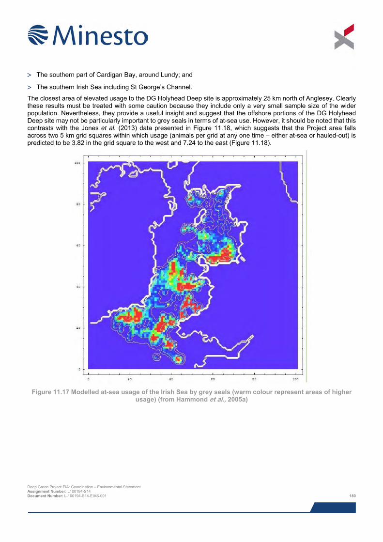
> The southern part of Cardigan Bay, around Lundy; and
> The southern Irish Sea including St George’s Channel.
The closest area of elevated usage to the DG Holyhead Deep site is approximately 25 km north of Anglesey. Clearly these results must be treated with some caution because they include only a very small sample size of the wider population. Nevertheless, they provide a useful insight and suggest that the offshore portions of the DG Holyhead Deep site may not be particularly important to grey seals in terms of at-sea use. However, it should be noted that this contrasts with the Jones et al. (2013) data presented in Figure 11.18, which suggests that the Project area falls across two 5 km grid squares within which usage (animals per grid at any one time – either at-sea or hauled-out) is predicted to be 3.82 in the grid square to the west and 7.24 to the east (Figure 11.18).
Figure 11.17 Modelled at-sea usage of the Irish Sea by grey seals (warm colour represent areas of higher
usage) (from Hammond et al., 2005a)
Deep Green Project EIA: Coordination – Environmental Statement Assignment Number: L100194-S14 Document Number: L-100194-S14-EIAS-001 180
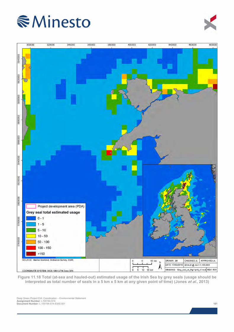
Figure 11.18 Total (at-sea and hauled-out) estimated usage of the Irish Sea by grey seals (usage should be
interpreted as total number of seals in a 5 km x 5 km at any given point of time) (Jones et al., 2013)
Deep Green Project EIA: Coordination – Environmental Statement Assignment Number: L100194-S14 Document Number: L-100194-S14-EIAS-001 181
Thompson (2012) undertook a grey seal tagging study in Autumn 2009 and 2010 in which GPS tags were attached to newly weaned pups at breeding beaches close to high tidal current sites at the Skerries, Bardsey Island and Ramsey Island. Pups spent an initial period foraging close to their natal beaches before dispersing more widely. All of the seals eventually moved south to Cardigan Bay, Ireland or south-west England, albeit via highly variable routes. For example, one seal tagged at Anglesey spent extensive periods feeding in the ISZ before heading south to the Scilly Isles and one seal ranged as far west as Brittany. Figure 11.19 shows the movements of 5 seals tagged at the Skerries over a 5 week period. Importantly, all five animals appeared to frequently visit the area just offshore of Holy Island, close the DG Holyhead Deep site. Gordon et al. (2011), whose research in harbour porpoise distribution formed part of the same overarching piece of work as the Thompson (2012) study, observed multiple grey seal sightings from shore, though these were all from Carmel Head, to the north of the DG Holyhead Deep site.
The GPS trackers also gave information on depth profiles, showing that the seals spend the majority of their time at the surface or close to the maximum dive depth, usually the seabed. However, there was some variability in dive profile, with some representing typical flat bottom dives and others probably representing travelling dives in which the depth profile was much more variable.
Of the 42 marine mammal sightings recorded by SEACAMS (2015) in the west Anglesey area (Figure 11.2), only 2 were of grey seal. This corresponds to a rate of 0.10 sightings per hour. Specifically within the DG Holyhead Deep site, the approximately 26 km of survey effort has not recorded any grey seal, although the two sightings from the 375 km of total survey effort have been recorded in the north of the survey area within which the DG Holyhead Deep sits (SEACAMS, 2015).
Based on the data regarding grey seal use of the Irish Sea and Welsh coast presented here, it is unlikely that the Project area represents a particularly important area in the context of the Irish Sea. However, these is evidence to suggest that the site may be used by both adult and juvenile grey seal, and that the nearby coast may be of importance to a small number of animals during the breeding season.
11.5.8.3 Grey seal management unit In total, 11 management units have been defined for the grey seal, with a greater number in Scotland than elsewhere in the UK. The Irish Sea falls into the south and west England and Wales management unit, which is estimated as 6,000 seals based on a pup count of 1,900 (SNCBs, 2013). These figures are based on a number of survey programmes ranging from 1994 to 2003 and 2007.
Deep Green Project EIA: Coordination – Environmental Statement Assignment Number: L100194-S14 Document Number: L-100194-S14-EIAS-001 182
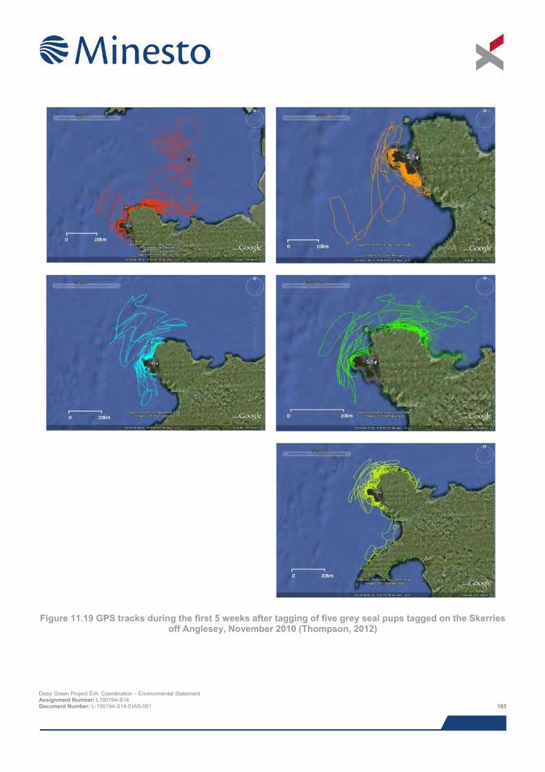
Figure 11.19 GPS tracks during the first 5 weeks after tagging of five grey seal pups tagged on the Skerries
off Anglesey, November 2010 (Thompson, 2012)
Deep Green Project EIA: Coordination – Environmental Statement Assignment Number: L100194-S14 Document Number: L-100194-S14-EIAS-001 183
11.5.9 Harbour seal 11.5.9.1 Overview Harbour seals have a circumpolar distribution with 30% of the European population found in UK waters. 79% of the UK population is distributed around the west coast, the Hebrides and the Northern Isles of Scotland, 16% around England and 5% in Northern Ireland (SCOS, 2014). SCOS (2014) provide no estimate for Wales because there are no established haul-out sites for harbour seals, which are the primary means by which these population estimates are calculated. They are present in UK waters year-round. Pups are born during the summer in June and July, and during this period they disperse and females spend a high proportion of time ashore with their pups (SCOS, 2014). They moult in August (SCOS, 2014).
Harbour seals take a wide range of prey species including small pelagic and demersal fish such as whiting, saithe, pollock and haddock, as well as cephalopods (SCOS, 2014). Harbour seals usually forage within 40 to 50 km of their haul-out sites (SCOS, 2014).
11.5.9.2 Local distribution and abundance The Irish Sea is not known to be an important area for harbour seal and animal densities here have been shown to be extremely low (Figure 11.20). The total population of harbour seal around Anglesey and the north Wales coast has been estimated at approximately 5 - 15 individuals (Hammond et al., 2005b).
Aerial surveys undertaken by DECC (2009) encountered no harbour seals in the Irish Sea. Similarly, surveys of the ISZ conducted by the Celtic Array reported no harbour seal sightings (The Celtic Array, 2014). Neither Shucksmith et al. (2009) nor Gordon et al. (2011) observed harbour seals in their surveys of the Anglesey coast. This is corroborated by the Jones et al. (2013) data presented in Figure 11.20, which suggests that the Project site falls across two 5 km grid squares within which usage (animals per grid at any one time – either at-sea or hauled-out) is predicted to be 0.0016 in the grid square to the west and 0.0024 to the east (Figure 11.20).
Of the 42 marine mammal sightings recorded by SEACAMS (2015) in the west Anglesey area (Figure 11.2), none were of harbour seal.
Based on the above, it is extremely unlikely that the Project site represents an important area for this species.
11.5.9.3 Harbour seal management unit In total, 11 management units have been defined for the harbour seal, with a greater number in Scotland than elsewhere in the UK. These are the same management units areas used for grey seal. The Irish Sea falls into the south and west England and Wales management unit, which is estimated as 35 individuals based on surveys undertaken between 2007 and 2013 (SCOS, 2014; note that this is an increase of 15 animals on the SNCB guidance from 2013).
Deep Green Project EIA: Coordination – Environmental Statement Assignment Number: L100194-S14 Document Number: L-100194-S14-EIAS-001 184
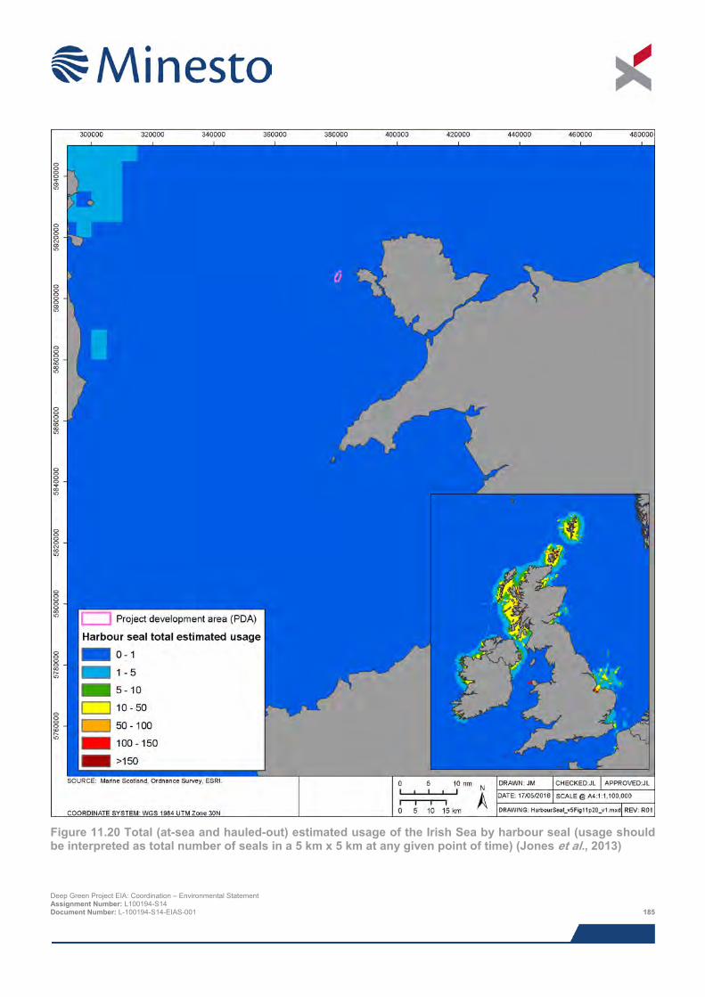
Figure 11.20 Total (at-sea and hauled-out) estimated usage of the Irish Sea by harbour seal (usage should be interpreted as total number of seals in a 5 km x 5 km at any given point of time) (Jones et al., 2013)
Deep Green Project EIA: Coordination – Environmental Statement Assignment Number: L100194-S14 Document Number: L-100194-S14-EIAS-001 185
11.5.10 Other marine megafauna 11.5.10.1 Basking sharks Basking sharks depend on areas of deeper water that supply high productivity. They are characterised by slow growth, large size (individuals can measure up to 12 m in length) and late sexual maturity. There are three basking shark hotspots in the UK; the Minch, the Isle of Man and Cornwall (Bloomfield and Soldant, 2008). However, in the rest of UK waters, including other areas of the Irish Sea, basking sharks have historically been recorded in low numbers with only 1 to 10 sightings per year according to the Basking Shark Watch 20 year report (Bloomfield and Soldant, 2008). They typically appear along the west coast of the UK from May to October as they follow plankton blooms. Two records were obtained from the Shark Trust database relating to sightings of basking shark in Welsh waters. One, from 23rd September 2008, was a record of a dead basking shark found at Holyhead Marina. The other was a recoded sighting of a basking shark, off the coast at Rhiw, Wales on the 10th July 2015 (Shark Trust, 2015). No sightings of basking shark were recorded in the Project area during the SEACAMS survey (SEACAMS, 2015). From 1987 to 2006 there have been fewer than 10 basking shark sightings in the general vicinity surrounding the Project area (Bloomfield and Solandt, 2008) and of these, four sightings occurred within 20 to 30 km: three off the north coast of Anglesey in deeper waters and one approximately 10 km east along the coast from the Project site (Minesto, 2013). The latest analysis of basking shark sightings reported by Solandt and Chassin (2014) confirms earlier work that the Minch, the Isle of Man and Cornwall are the main hotspots for basking shark activity in UK waters.
11.5.10.2 Marine turtles There are five species of marine turtle found in UK waters, green turtle Chelonia mydas, hawksbill turtle Eretmochelys imbricata, Kemp's ridley turtle Lepidochelys kempii, leatherback turtle Dermochelys coriacea and loggerhead turtle Caretta caretta. Of these, leatherback turtles are the most commonly recorded (Penrose & Gander, 2015). Of the 52 records of marine turtles made across the UK and Eire, seven were made in Wales (six leatherback and one loggerhead turtle). No records were made of turtles (alive or stranded) within the vicinity of the Project area in 2014. The closest sightings were made off the coast of Pembrokeshire (six) and Ceredigion (two). No sightings of marine turtles were recorded in the Project area during the SEACAMS survey (SEACAMS, 2015).
11.5.11 Conservation One requirement under the Habitats Directive is the designation and protection of areas essential to the life and reproduction of Annex II species, achieved through the implementation of SACs, which form part of a wider ecological network of European importance, referred to as the Natura 2000 network. Species/features listed on Annex II relevant to a particular site are subjected to ‘Global Assessment’ under Annex III of the Habitats Directive, and are subsequently defined as:
> Grade A: Outstanding examples of a feature in a European context;
> Grade B: Excellent examples of a feature, significantly above the threshold for Sites of Special Scientific Interest (SSSI)/Areas of Special Scientific Interest (ASSI) notification, but of somewhat lower value than Grade A;
> Grade C: Excellent examples of a feature which are of at least national importance (i.e. usually above the threshold for SSSI/ASSI notification on terrestrial sites, but not significantly so); and
> Grade D: Features of below SSSI quality occurring on SACs.
Species graded A-B are the primary reason for a site’s selection and designation; species graded C are qualifying features that were not the primary reason for selection, but nonetheless require protection and consideration in an appropriate assessment. Finally, species graded D are non-qualifying features categorised as a non-significant presence. These do not need to be considered in an appropriate assessment and are not specifically protected by the SAC; however, in the case of marine mammals, they are still likely to be afforded protection under a wealth of other legislation.
A summary of the SACs that are directly relevant to marine mammals is provided below in Table 11.4, and their locations are displayed in Figure 11.21. Two SACs are currently designated for marine mammals as a primary reason:
Deep Green Project EIA: Coordination – Environmental Statement Assignment Number: L100194-S14 Document Number: L-100194-S14-EIAS-001 186
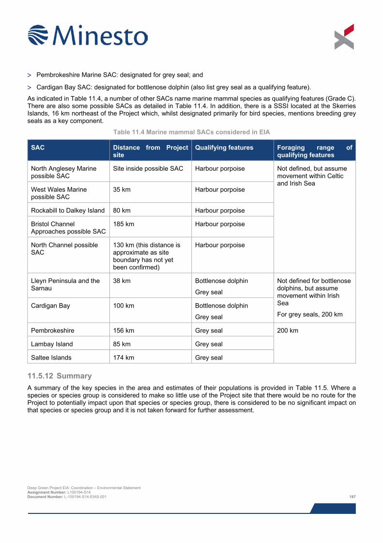
> Pembrokeshire Marine SAC: designated for grey seal; and
> Cardigan Bay SAC: designated for bottlenose dolphin (also list grey seal as a qualifying feature).
As indicated in Table 11.4, a number of other SACs name marine mammal species as qualifying features (Grade C). There are also some possible SACs as detailed in Table 11.4. In addition, there is a SSSI located at the Skerries Islands, 16 km northeast of the Project which, whilst designated primarily for bird species, mentions breeding grey seals as a key component.
Table 11.4 Marine mammal SACs considered in EIA
SAC Distance from Project site
Qualifying features Foraging range of qualifying features
North Anglesey Marine possible SAC
Site inside possible SAC Harbour porpoise Not defined, but assume movement within Celtic and Irish Sea
West Wales Marine possible SAC
35 km Harbour porpoise
Rockabill to Dalkey Island 80 km Harbour porpoise
Bristol Channel Approaches possible SAC
185 km Harbour porpoise
North Channel possible SAC
130 km (this distance is approximate as site boundary has not yet been confirmed)
Harbour porpoise
Lleyn Peninsula and the Sarnau
38 km Bottlenose dolphin
Grey seal
Not defined for bottlenose dolphins, but assume movement within Irish Sea
For grey seals, 200 km Cardigan Bay 100 km Bottlenose dolphin
Grey seal
Pembrokeshire 156 km Grey seal 200 km
Lambay Island 85 km Grey seal
Saltee Islands 174 km Grey seal
11.5.12 Summary A summary of the key species in the area and estimates of their populations is provided in Table 11.5. Where a species or species group is considered to make so little use of the Project site that there would be no route for the Project to potentially impact upon that species or species group, there is considered to be no significant impact on that species or species group and it is not taken forward for further assessment.
Deep Green Project EIA: Coordination – Environmental Statement Assignment Number: L100194-S14 Document Number: L-100194-S14-EIAS-001 187
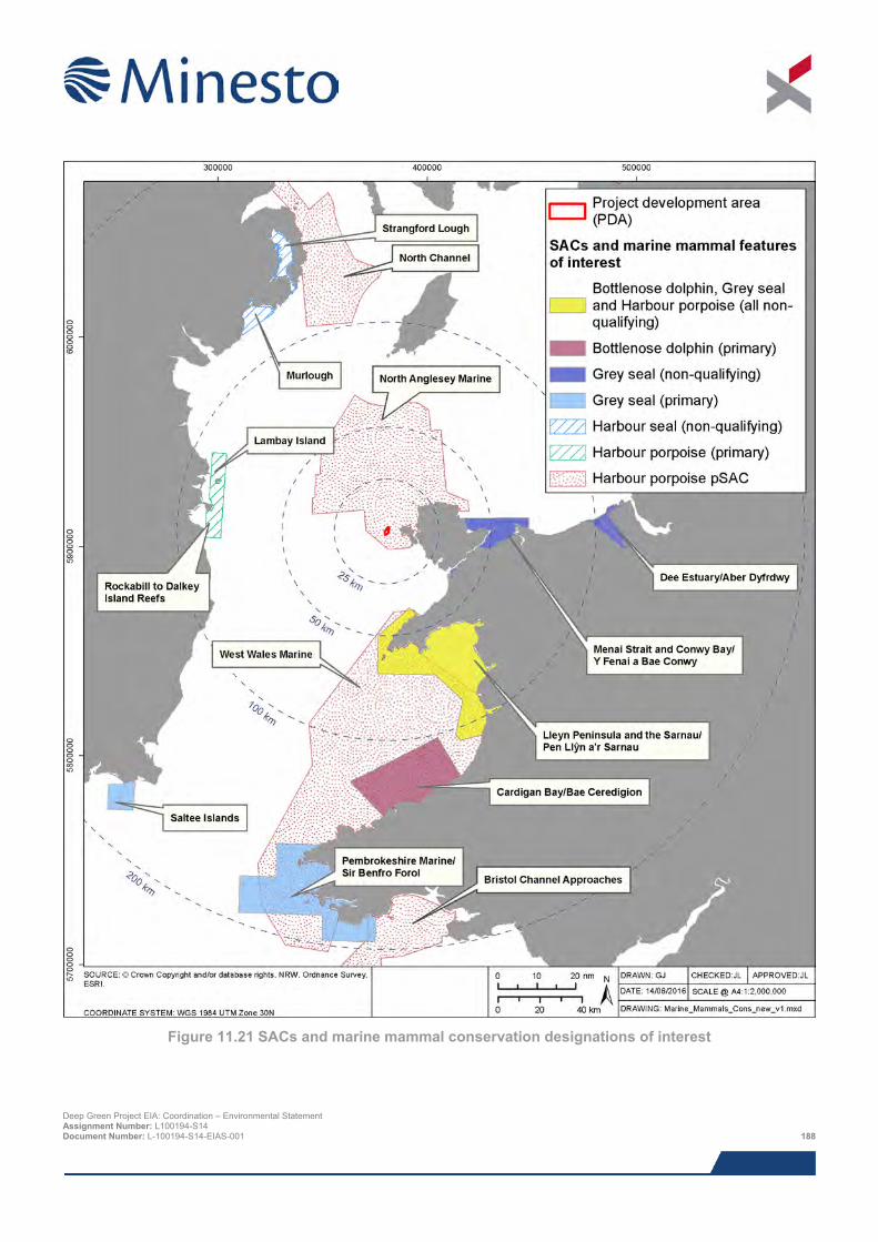
Figure 11.21 SACs and marine mammal conservation designations of interest
Deep Green Project EIA: Coordination – Environmental Statement Assignment Number: L100194-S14 Document Number: L-100194-S14-EIAS-001 188
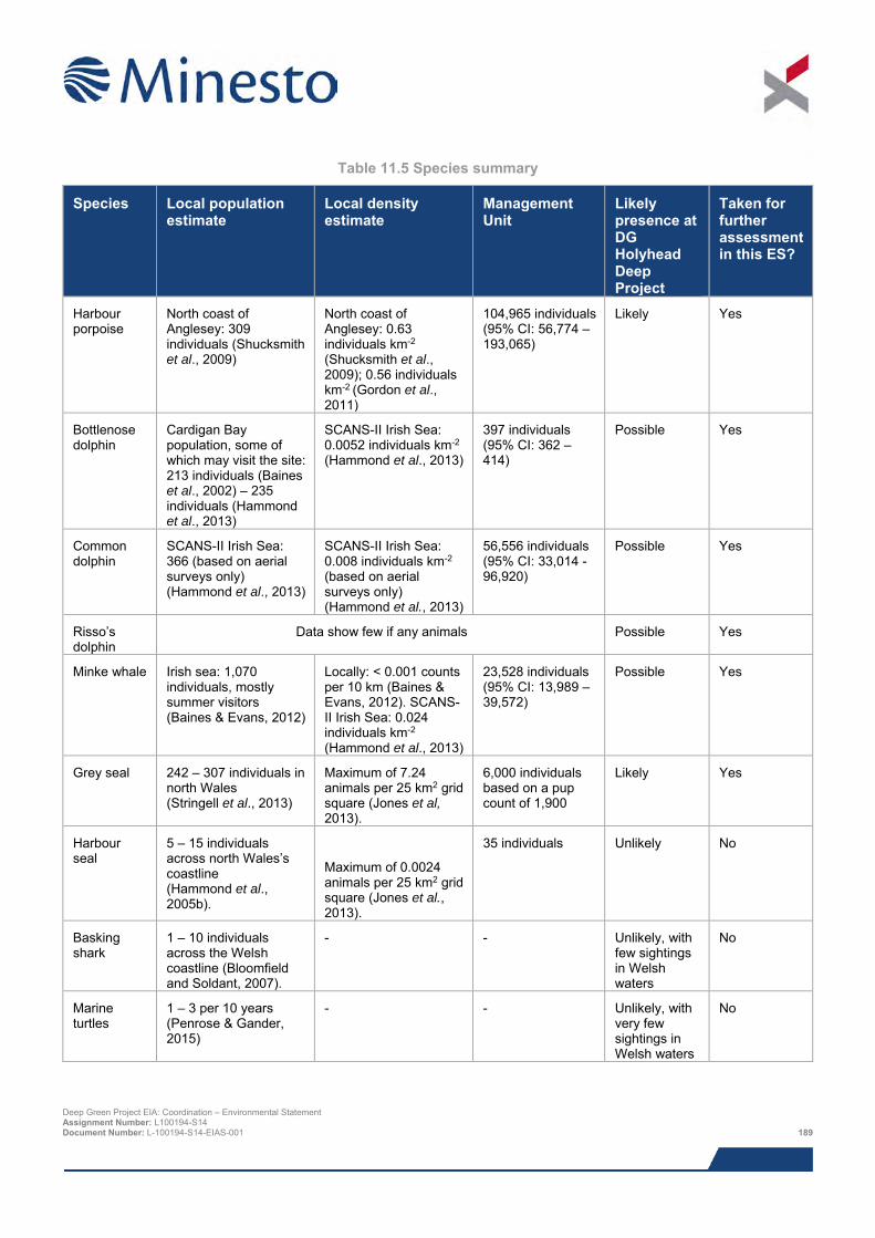
Table 11.5 Species summary
Species Local population estimate
Local density estimate
Management Unit
Likely presence at DG Holyhead Deep Project
Taken for further assessment in this ES?
Harbour porpoise
North coast of Anglesey: 309 individuals (Shucksmith et al., 2009)
North coast of Anglesey: 0.63 individuals km-2 (Shucksmith et al., 2009); 0.56 individuals km-2 (Gordon et al., 2011)
104,965 individuals (95% CI: 56,774 – 193,065)
Likely Yes
Bottlenose dolphin
Cardigan Bay population, some of which may visit the site: 213 individuals (Baines et al., 2002) – 235 individuals (Hammond et al., 2013)
SCANS-II Irish Sea: 0.0052 individuals km-2 (Hammond et al., 2013)
397 individuals (95% CI: 362 – 414)
Possible Yes
Common dolphin
SCANS-II Irish Sea: 366 (based on aerial surveys only) (Hammond et al., 2013)
SCANS-II Irish Sea: 0.008 individuals km-2 (based on aerial surveys only) (Hammond et al., 2013)
56,556 individuals (95% CI: 33,014 -96,920)
Possible Yes
Risso’s dolphin
Data show few if any animals Possible Yes
Minke whale Irish sea: 1,070 individuals, mostly summer visitors (Baines & Evans, 2012)
Locally: < 0.001 counts per 10 km (Baines & Evans, 2012). SCANS-II Irish Sea: 0.024 individuals km-2
(Hammond et al., 2013)
23,528 individuals (95% CI: 13,989 – 39,572)
Possible Yes
Grey seal 242 – 307 individuals in north Wales (Stringell et al., 2013)
Maximum of 7.24 animals per 25 km2 grid square (Jones et al, 2013).
6,000 individuals based on a pup count of 1,900
Likely Yes
Harbour seal
5 – 15 individuals across north Wales’s coastline (Hammond et al., 2005b).
Maximum of 0.0024 animals per 25 km2 grid square (Jones et al., 2013).
35 individuals Unlikely No
Basking shark
1 – 10 individuals across the Welsh coastline (Bloomfield and Soldant, 2007).
- - Unlikely, with few sightings in Welsh waters
No
Marine turtles
1 – 3 per 10 years (Penrose & Gander, 2015)
- - Unlikely, with very few sightings in Welsh waters
No
Deep Green Project EIA: Coordination – Environmental Statement Assignment Number: L100194-S14 Document Number: L-100194-S14-EIAS-001 189
11.6 Impact assessment
11.6.1 Overview This assessment covers all impacts identified during EIA scoping, as well as any further potential impacts that have been highlighted as the EIA has progressed. It should be noted that impacts are not necessarily relevant to all Project stages.
The list below indicates all of the direct and indirect impacts assessed in the marine mammals and megafauna section and indicates the project stages to which they relate. Cumulative impacts are discussed in Section 11.11.
> Impacts during construction and installation period:
o Increased turbidity;
o Noise and the associated risk of injury and disturbance, including habitat exclusion and barrier effects;
o Pollution from accidental events;
o Physical interaction with vessels (including corkscrew injury);
o Entanglement with mooring systems;
o Cumulative/in-combination impacts
> Impacts during operation and maintenance:
o Noise and the associated risk of injury and disturbance, including habitat exclusion and barrier effects;
o Pollution from accidental events;
o Physical interaction with vessels (including corkscrew injury);
o Entanglement with mooring systems;
o Physical interaction with DGU (collision risk); and
o Cumulative/in-combination impacts
The following impacts were scoped out of the assessment:
> Corkscrew injuries - Recent research has indicated that there is now incontrovertible evidence that corkscrew injuries can be caused by grey seal predation on weaned grey seal pups (reported from the Isle of May). Furthermore, there have been recent observations of an adult male grey seal killing and eating young harbour seals in Germany. Based on these recent findings the regulators and Statutory Nature Conservation Bodies (SNCBs) now consider that it is very likely that the use of vessels with ducted propellers are unlikely to pose any increased risk to seals over and above normal shipping activities.
> Entanglement of marine mammals in mud mat anchor lines – the mud mat anchor lines will be taut, close to the seabed and restricted to the immediate vicinity of the foundation itself, so the risk of entanglement is considered sufficiently small to be scoped out of the impact assessment.
> It has been determined that there will be no significant changes to the distribution or abundance of potential prey species (Xodus, 2015a). As such, the potential for indirect effects resulting from changes in prey availability are considered unlikely and are not considered further.
This impact assessment has been undertaken as a desk-based assessment utilising the Project-specific baseline review, supplemented by survey data collected by SEACAMS, in addition to technical studies covering collision risk simulation modelling (SMRU Consulting, 2015) and noise propagation modelling (Xodus, 2015b).
Deep Green Project EIA: Coordination – Environmental Statement Assignment Number: L100194-S14 Document Number: L-100194-S14-EIAS-001 190
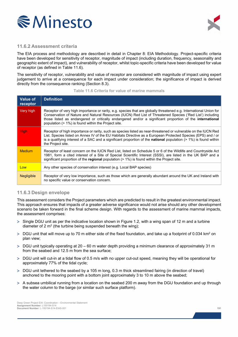
11.6.2 Assessment criteria The EIA process and methodology are described in detail in Chapter 8: EIA Methodology. Project-specific criteria have been developed for sensitivity of receptor, magnitude of impact (including duration, frequency, seasonality and geographic extent of impact), and vulnerability of receptor, whilst topic-specific criteria have been developed for value of receptor (as defined in Table 11.6).
The sensitivity of receptor, vulnerability and value of receptor are considered with magnitude of impact using expert judgement to arrive at a consequence for each impact under consideration; the significance of impact is derived directly from the consequence ranking (Section 8.3).
Table 11.6 Criteria for value of marine mammals
Value of receptor
Definition
Very high Receptor of very high importance or rarity, e.g. species that are globally threatened e.g. International Union for Conservation of Nature and Natural Resources (IUCN) Red List of Threatened Species (‘Red List’) including those listed as endangered or critically endangered and/or a significant proportion of the international population (> 1%) is found within the Project site.
High Receptor of high importance or rarity, such as species listed as near-threatened or vulnerable on the IUCN Red List. Species listed on Annex IV of the EU Habitats Directive as a European Protected Species (EPS) and / or is a qualifying interest of a SAC and a significant proportion of the national population (> 1%) is found within the Project site.
Medium Receptor of least concern on the IUCN Red List, listed on Schedule 5 or 6 of the Wildlife and Countryside Act 1981, form a cited interest of a Site of Special Scientific Interest (SSSI), are listed in the UK BAP and a significant proportion of the regional population (> 1%) is found within the Project site.
Low Any other species of conservation interest (e.g. Local BAP species)
Negligible Receptor of very low importance, such as those which are generally abundant around the UK and Ireland with no specific value or conservation concern.
11.6.3 Design envelope This assessment considers the Project parameters which are predicted to result in the greatest environmental impact. This approach ensures that impacts of a greater adverse significance would not arise should any other development scenario be taken forward in the final scheme design. With regards to the assessment of marine mammal impacts, the assessment comprises:
> Single DGU unit as per the indicative location shown in Figure 1.2, with a wing span of 12 m and a turbine diameter of 2 m2 (the turbine being suspended beneath the wing);
> DGU unit that will move up to 70 m either side of the fixed foundation, and take up a footprint of 0.034 km2 on plan view;
> DGU unit typically operating at 20 – 60 m water depth providing a minimum clearance of approximately 31 m from the seabed and 12.5 m from the sea surface;
> DGU unit will cut-in at a tidal flow of 0.5 m/s with no upper cut-out speed, meaning they will be operational for approximately 77% of the tidal cycle;
> DGU unit tethered to the seabed by a 105 m long, 0.3 m thick streamlined fairing (in direction of travel) anchored to the mooring point with a bottom joint approximately 3 to 10 m above the seabed;
> A subsea umbilical running from a location on the seabed 200 m away from the DGU foundation and up through the water column to the barge (or similar such surface platform).
Deep Green Project EIA: Coordination – Environmental Statement Assignment Number: L100194-S14 Document Number: L-100194-S14-EIAS-001 191
> Four DGU foundation options comprising either a gravity based structure, mud mat foundation, pin piled (up to
three piles of 3 m diameter) or monopiled (one pile of up to 4 m in diameter), with piles installed by drilling or vibro-hammering or combination of both, resulting in the release of up to 424.2 m3 of spoil;
> A barge (or similar such surface platform) moored using a four to eight point catenary system (with marker buoys) for up to five years;
> Vessel requirement during installation:
o DP vessel or underslung barge (depending on foundation selection)– up to five days;
o Anchor handler tug or multicat to deploy barge moorings – approximately one week;
o Tug to transport barge to/from site – one day per transfer but multiple transfers expected;
o Support vessel with ROV capabilities to attach tether to foundation – less than one week; and
o LARS support vessel to transport, launch and recover DGU – daily during final few weeks of installation period and crossover into operational period;
> Vessel requirement during operations:
o Barge (or similar such surface platform) – up to five years – worst-case permanently present on site during this period, but highly unlikely to remain on-site throughout winter months;
o LARS support vessel to launch and recover DGU and perform guard vessel duty – approximately once per week for up to five years, but could be present daily during final few weeks of installation/first few weeks of operation.
o Tug to transport barge to/from site – one day per transfer but multiple transfers expected throughout operational period (up to five years); and
o Additional service/maintenance vessel, potentially with DP – a maximum of six days per year.
11.6.4 Data gaps and uncertainties As part of the baseline desk study and collision risk modelling, extensive review work was undertaken to define marine mammal presence in the Project area and wider marine environment. Combined with some site-specific survey data gathered by SEACAMS, a robust baseline is available for the impact assessment and no data gaps regarding species use of the Project site are considered to be present.
However, uncertainties are present regarding some of the potential impact mechanisms:
> Collision risk;
o The potential for collision, injurious or otherwise, between large marine animals (such as marine mammals) and the DGU is the key environmental uncertainty in this assessment. The actual magnitude of the hypothetical issue is likely to become clearer as the tidal energy sector develops, but because of the low number of currently active devices and the lack of established commercial scale deployments, data derived from monitoring programmes to directly quantify encounter and collision risk are limited at this time;
o A full collision model (i.e. providing an estimate of collision rate) is not yet possible due to limited understanding and evidence on the actual responses of animals to the presence of the DGU. However, in order to inform this assessment it has been possible to undertake device specific modelling in order to quantify how often marine mammals may ‘encounter’ the device. The estimate of the potential interaction rate is intended to provide an understanding of the scale of the issue and sensitivity to physical and behavioural parameters;
o It is also important to note that while encounter rates can help gain a perspective on potential collision rates, especially when data on responsive movements eventually becomes available, collisions themselves are likely to result in a wide range of injuries from trivial to fatal. Although the relationship between strikes and injury for marine mammals is not well understood, when considering encounter
Deep Green Project EIA: Coordination – Environmental Statement Assignment Number: L100194-S14 Document Number: L-100194-S14-EIAS-001 192
rates it is important that it is not assumed that all encounters lead to collisions and that all collisions will result in the death or fatal injury of the animals involved;
The uncertainties around these impact mechanisms have been considered when defining sensitivity, vulnerability and value of receptor and magnitude of impact.
11.7 Impacts during construction and installation
11.7.1 Impact 11.1 Turbidity Increased turbidity can occur during installation activities that disturb the seabed, as fine particles travel from the disturbed area, swept by tidal currents, or activities which release particulates into the water column (e.g. drilling). Disturbance of seabed sediments or release of particulates could cause localised and short term increases in turbidity and therefore reduced visibility for marine mammals. Increased turbidity may affect the foraging ability of marine mammals, principally grey seals who are dependent upon visual cues to track prey (Scottish Executive, 2007).
The magnitude of the impact will depend on the high number of variables involved in determining both background and Project-caused suspended sediment levels and turbidity. The DGU will be sited in an area of gravel, sandy gravels exposed bedrock and thus there is likely to be very little sediment that could be moved into the water column (see Chapter 10: Benthic Ecology). However, drill spoil from the drilled piles represents an additional source of suspended sediment. Based on maximum spoil of 141.4 m3 per pile and an expected installation time of 1.3 days per pile, the discharge rate is expected to be approximately 6 m3 per hour. At this rate it is likely, given the high energy environment into which they will be discharged, that spoil will be dispersed rapidly and any elevated turbidity in the immediate vicinity of the discharge point will be very short lived. Chapter 10: Benthic Ecology and Chapter 9: Physical Processes have determined that any increase in turbidity or suspended sediment levels is expected to be temporally and spatially restricted, largely due to the small volumes released and the high energy environment.
Whilst foraging success of seals is considered to be at some risk with increased turbidity (e.g. Weiffen et al., 2006), many seals inhabit areas of almost persistent turbidity (such as the southern North Sea and The Wash and Thames Estuary on the south east coast of England) and it would seem unlikely that slightly increased turbidity over a short period of time would be a hindrance to long-term foraging ability. In addition, whilst seals are known to use eyesight for finding prey and navigating, they can successfully hunt in unlit waters (e.g. Jessopp et al., 2013). Porpoises and dolphins use echolocation regularly when foraging and are unlikely to be impacted by temporary increases in turbidity (e.g. Nowacek, 2005).
The sensitivity of grey seals is considered to be low on the basis that they are able to survive and successfully hunt in dark or semi-permanently turbid waters. Increased turbidity associated with the Project is anticipated to be short-lived and highly localised, so the magnitude of effect is defined as low. Although the receptor value is high, the vulnerability is considered to be low, so impacts are considered to be of low consequence, and therefore not significant.
The cetacean species of interest do not rely extensively on eyesight for hunting and navigation to the same extent and are therefore considered to be of negligible sensitivity. There is no mechanism by which the temporary and localised elevation in turbidity that may be caused by the Project could affect this receptor, so the overall impact consequence is considered to be negligible and not significant.
Deep Green Project EIA: Coordination – Environmental Statement Assignment Number: L100194-S14 Document Number: L-100194-S14-EIAS-001 193
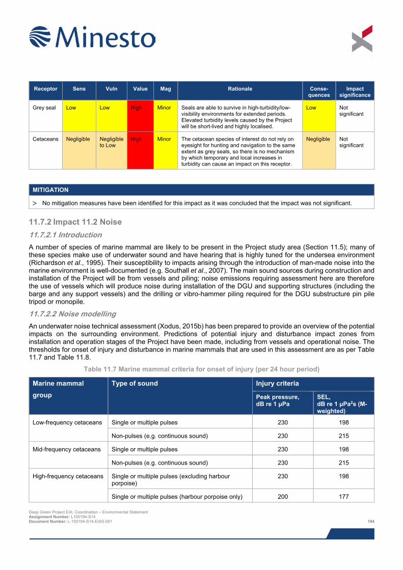
Receptor Sens Vuln Value Mag Rationale Conse-quences
Impact significance
Grey seal Low Low High Minor Seals are able to survive in high-turbidity/low-visibility environments for extended periods. Elevated turbidity levels caused by the Project will be short-lived and highly localised.
Low Not significant
Cetaceans Negligible Negligible to Low
High Minor The cetacean species of interest do not rely on eyesight for hunting and navigation to the same extent as grey seals, so there is no mechanism by which temporary and local increases in turbidity can cause an impact on this receptor.
Negligible Not significant
MITIGATION
> No mitigation measures have been identified for this impact as it was concluded that the impact was not significant.
11.7.2 Impact 11.2 Noise 11.7.2.1 Introduction A number of species of marine mammal are likely to be present in the Project study area (Section 11.5); many of these species make use of underwater sound and have hearing that is highly tuned for the undersea environment (Richardson et al., 1995). Their susceptibility to impacts arising through the introduction of man-made noise into the marine environment is well-documented (e.g. Southall et al., 2007). The main sound sources during construction and installation of the Project will be from vessels and piling; noise emissions requiring assessment here are therefore the use of vessels which will produce noise during installation of the DGU and supporting structures (including the barge and any support vessels) and the drilling or vibro-hammer piling required for the DGU substructure pin pile tripod or monopile.
11.7.2.2 Noise modelling An underwater noise technical assessment (Xodus, 2015b) has been prepared to provide an overview of the potential impacts on the surrounding environment. Predictions of potential injury and disturbance impact zones from installation and operation stages of the Project have been made, including from vessels and operational noise. The thresholds for onset of injury and disturbance in marine mammals that are used in this assessment are as per Table 11.7 and Table 11.8.
Table 11.7 Marine mammal criteria for onset of injury (per 24 hour period)
Marine mammal group
Type of sound Injury criteria
Peak pressure, dB re 1 μPa
SEL, dB re 1 μPa2s (M-weighted)
Low-frequency cetaceans Single or multiple pulses 230 198
Non-pulses (e.g. continuous sound) 230 215
Mid-frequency cetaceans Single or multiple pulses 230 198
Non-pulses (e.g. continuous sound) 230 215
High-frequency cetaceans Single or multiple pulses (excluding harbour porpoise)
230 198
Single or multiple pulses (harbour porpoise only) 200 177 Deep Green Project EIA: Coordination – Environmental Statement Assignment Number: L100194-S14 Document Number: L-100194-S14-EIAS-001 194
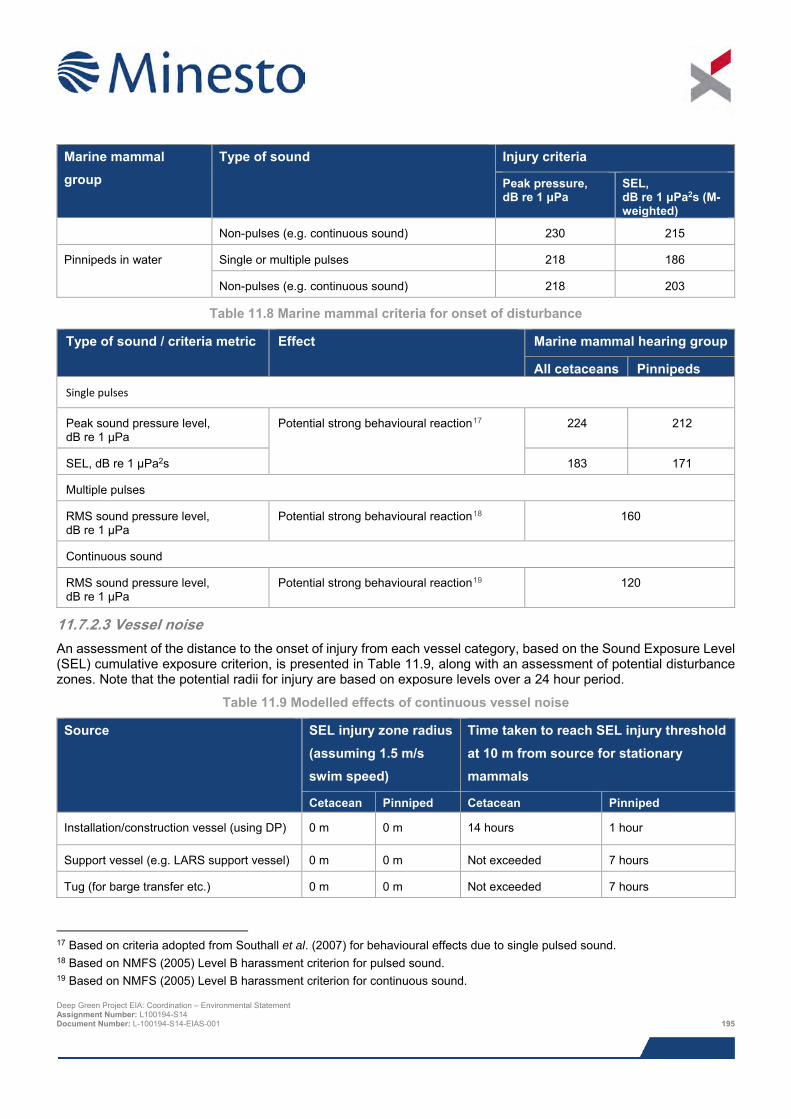
Marine mammal group
Type of sound Injury criteria
Peak pressure, dB re 1 μPa
SEL, dB re 1 μPa2s (M-weighted)
Non-pulses (e.g. continuous sound) 230 215
Pinnipeds in water Single or multiple pulses 218 186
Non-pulses (e.g. continuous sound) 218 203
Table 11.8 Marine mammal criteria for onset of disturbance
Type of sound / criteria metric Effect Marine mammal hearing group
All cetaceans Pinnipeds Single pulses
Peak sound pressure level, dB re 1 μPa
Potential strong behavioural reaction17 224 212
SEL, dB re 1 μPa2s 183 171
Multiple pulses
RMS sound pressure level, dB re 1 μPa
Potential strong behavioural reaction18 160
Continuous sound
RMS sound pressure level, dB re 1 μPa
Potential strong behavioural reaction19 120
11.7.2.3 Vessel noise An assessment of the distance to the onset of injury from each vessel category, based on the Sound Exposure Level (SEL) cumulative exposure criterion, is presented in Table 11.9, along with an assessment of potential disturbance zones. Note that the potential radii for injury are based on exposure levels over a 24 hour period.
Table 11.9 Modelled effects of continuous vessel noise
Source SEL injury zone radius (assuming 1.5 m/s swim speed)
Time taken to reach SEL injury threshold at 10 m from source for stationary mammals
Cetacean Pinniped Cetacean Pinniped
Installation/construction vessel (using DP) 0 m 0 m 14 hours 1 hour
Support vessel (e.g. LARS support vessel) 0 m 0 m Not exceeded 7 hours
Tug (for barge transfer etc.) 0 m 0 m Not exceeded 7 hours
17 Based on criteria adopted from Southall et al. (2007) for behavioural effects due to single pulsed sound. 18 Based on NMFS (2005) Level B harassment criterion for pulsed sound. 19 Based on NMFS (2005) Level B harassment criterion for continuous sound. Deep Green Project EIA: Coordination – Environmental Statement Assignment Number: L100194-S14 Document Number: L-100194-S14-EIAS-001 195

11.7.2.4 Injury from vessel noise It is clear that there is minimal likelihood of marine mammals sustaining physiological damage to hearing as a result of the vessels proposed for use in this Project. Based on an animal swimming at a constant speed of 1.5 m/s from the source of construction activity noise, the noise modelling shows that injury to marine mammals will not occur for any of the vessels. It should be noted that this is a worst-case result, given that movement speeds for marine mammals have been recorded well in excess of the 1.5 m/s modelled. Even if a mammal was to stay stationary in the vicinity of construction operations, a cetacean would need to stay within a radius of 10 m from even the noisiest vessel for a period of 7 hours in order to exceed the Southall et al. (2007) criteria, whilst pinniped species would need to stay within a 10 m radius for a minimum of 1 hour.
In reality, it is likely that marine mammals would only spend a short amount of time in the vicinity of vessels. For example, the vessels will be moving in most cases and animals would have to follow the vessel to remain within the potential impact area. If this were likely to cause discomfort to an animal, which could lead to injury, the animal would be expected not to follow the vessel. Given that remaining in sufficiently close proximity to the vessel to experience injury is unlikely, marine mammals are likely to experience no injury from noise from the presence of vessels.
11.7.2.5 Potential disturbance ranges from vessel noise and what these potential disturbance ranges mean for the animals and populations
The noise modelling indicates that disturbance zones could extend out to 4,000 m for the quieter vessels and out to a maximum of 14,000 m for the louder vessels (Table 11.10).
Table 11.10 Estimated disturbance ranges for marine mammals from vessel noise
Source / vessel Estimated range for onset of disturbance
Installation/construction vessel (using DP) 14,000 m Support vessels (including barge support tug) 4,000 m
Disturbance for continuous noise, such as that emitted from vessels, is considered likely to start to occur at 120 dB re 1 μPa (rms), a level defined by the National Marine Fisheries Service (NMFS, 2005) as having the potential to disturb a marine mammal by causing disruption of behavioural patterns, including, but not limited to, migration, breathing, nursing, breeding, feeding, or sheltering but which does not have the potential to injure. The predicted impact zone is therefore a level at which onset of impact is expected; not all animals estimated to experience noise sufficiently loud to disturb would actually be expected to be disturbed by such noise. Additionally, the 120 dB re 1 μPa rms sound pressure level criterion is within the range of typical baseline noise levels in the area. There is already some degree of anthropogenic noise from vessels (e.g. from ferries and dredge disposal vessels) and it is therefore possible that marine mammals could be more habituated to vessel noise than in less heavily trafficked areas. Consequently, these predicted ranges for onset of disturbance should be viewed as very precautionary.
To understand the residual impact on animals experiencing disturbance to normal behaviour, it is important to consider a number of factors, including the size and location of the potential disturbance zone (larger areas mean a greater potential to interact with a greater number of animals) and length of time for which the sound source will be present (the longer the period the greater potential to have significant effects). Behavioural changes such as moving away from an area for short periods of time, reduced surfacing time, masking of communication signals or echolocation clicks, vocalisation changes and separation of mothers from offspring for short periods, do not necessarily imply that detrimental effects will result for the animals involved (JNCC, 2010). Temporarily affecting a small proportion of a population would be unlikely to cause population level effects and would be considered trivial disturbance (i.e. not significant disturbance). In contrast, affecting a large proportion may be considered non-trivial disturbance (i.e. could be significant disturbance).
In terms of the size of the potential disturbance zone for marine mammals, this would be limited to 4,000 m from the installation support vessels (including barge transfer tug) and 14,000 m from the installation vessel. The noise modelling indicates that the installation vessel is likely to be the source of the largest zone of potential behavioural disturbance within the Project. However, the threshold for disturbance has been set at a level that has the potential to disturb an animal; it does not imply that all animals experiencing those noise levels will be disturbed to any degree, which is likely to reduce the number potentially impacted. It is likely that a number of marine mammals could be present within this zone and could therefore experience some disturbance to normal behaviour. It is important to note Deep Green Project EIA: Coordination – Environmental Statement Assignment Number: L100194-S14 Document Number: L-100194-S14-EIAS-001 196
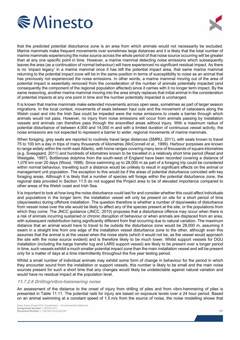
that the predicted potential disturbance zone is an area from which animals would not necessarily be excluded. Marine mammals make frequent movements over sometimes large distances and it is likely that the total number of marine mammals experiencing the noise source across the whole period of that noise source occurring will be greater than at any one specific point in time. However, a marine mammal detecting noise emissions which subsequently leaves the area (as a continuation of normal behaviour) will have experienced no significant residual impact. As there is no ‘impact legacy’ in a marine mammal once it has left the potential impact area, that same marine mammal returning to the potential impact zone will be in the same position in terms of susceptibility to noise as an animal that has previously not experienced the noise emissions. In other words, a marine mammal moving out of the area of potential impact is essentially removed from the consideration of the number of animals potentially impacted (and consequently the component of the regional population affected) since it carries with it no longer term impact. By the same reasoning, another marine mammal moving into the area simply replaces that initial animal in the consideration of potential impacts at any one point in time and the number potentially impacted is unchanged.
It is known that marine mammals make extended movements across open seas, sometimes as part of larger season migrations. In the local context, movements of seals between haul outs and the movement of cetaceans along the Welsh coast and into the Irish Sea could be impeded were the noise emissions to create a barrier through which animals would not pass. However, no injury from noise emissions will occur from animals passing by installation vessels and animals can therefore pass through the ensonified areas without injury. With a maximum radius of potential disturbance of between 4,000 and 14,000 m and with a limited duration of continuous vessel activity, the noise emissions are not expected to represent a barrier to wider, regional movements of marine mammals.
When foraging, grey seals are reported to routinely travel large distances (SMRU, 2011), with seals known to travel 75 to 100 km a day in trips of many thousands of kilometres (McConnell et al., 1999). Harbour porpoises are known to range widely within the north east Atlantic, with home ranges covering many tens of thousands of square kilometres (e.g. Sveegaard, 2011) and hundreds of kilometres known to be travelled in a relatively short time period (Read and Westgate, 1997). Bottlenose dolphins from the south-west of England have been recorded covering a distance of 1,076 km over 20 days (Wood, 1998). Since swimming up to 28,000 m as part of a foraging trip could be considered within normal behaviour, travelling such a distance would be unlikely to result in significant effects on the animal or management unit population. The exception to this would be if the areas of potential disturbance coincided with key foraging areas. Although it is likely that a number of species will forage within the potential disturbance zone, the regional data provided in Section 11.5 do not suggest the Project area to be of elevated importance compared to other areas of the Welsh coast and Irish Sea.
It is important to look at how long the noise disturbance could last for and consider whether this could affect individuals and populations in the longer term; the installation vessel will only be present on site for a short period of time (days/weeks) during offshore installation. The question therefore is whether a number of days/weeks of disturbance from vessel noise over the site would be likely to affect any of the species present at the site, or the populations from which they come. The JNCC guidance (JNCC, 2010) proposes that a disturbance offence may occur when there is a risk of animals incurring sustained or chronic disruption of behaviour or when animals are displaced from an area, with subsequent redistribution being significantly different from that occurring due to natural variation. The maximum distance that an animal would have to travel to be outside the disturbance zone would be 28,000 m, assuming it swam in a straight line from one edge of the installation vessel disturbance zone to the other, although even this assumes that the animal is at the vessel when the noise starts (which it would not be, as the vessel would approach the site with the noise source evident) and is therefore likely to be much lower. Whilst support vessels for DGU installation (including the barge transfer tug and LARS support vessel) are likely to be present over a longer period in time, such vessels exhibit a much smaller potential impact zone than the main installation vessel and will be present only for a matter of days at a time intermittently throughout the five year testing period.
Whilst a small number of individual animals may exhibit some form of change in behaviour for the period in which they encounter sound from the installation or support vessels, this number is likely to be small and the main noise sources present for such a short time that any changes would likely be undetectable against natural variation and would have no residual impact at the population level.
11.7.2.6 Drilling/vibro-hammering noise An assessment of the distance to the onset of injury from drilling of piles and from vibro-hammering of piles is presented in Table 11.11. The potential radii for injury are based on exposure levels over a 24 hour period. Based on an animal swimming at a constant speed of 1.5 m/s from the source of noise, the noise modelling shows that Deep Green Project EIA: Coordination – Environmental Statement Assignment Number: L100194-S14 Document Number: L-100194-S14-EIAS-001 197
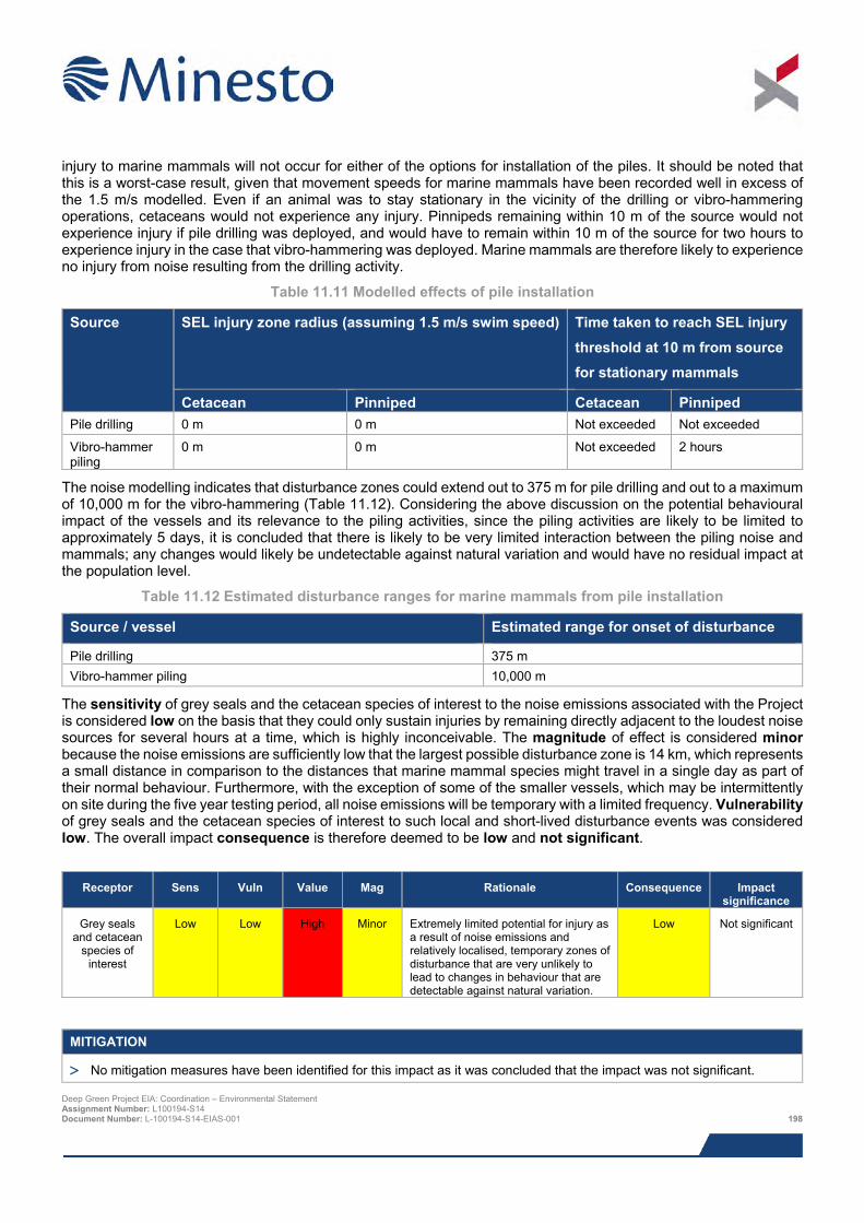
injury to marine mammals will not occur for either of the options for installation of the piles. It should be noted that this is a worst-case result, given that movement speeds for marine mammals have been recorded well in excess of the 1.5 m/s modelled. Even if an animal was to stay stationary in the vicinity of the drilling or vibro-hammering operations, cetaceans would not experience any injury. Pinnipeds remaining within 10 m of the source would not experience injury if pile drilling was deployed, and would have to remain within 10 m of the source for two hours to experience injury in the case that vibro-hammering was deployed. Marine mammals are therefore likely to experience no injury from noise resulting from the drilling activity.
Table 11.11 Modelled effects of pile installation
Source SEL injury zone radius (assuming 1.5 m/s swim speed) Time taken to reach SEL injury threshold at 10 m from source for stationary mammals
Cetacean Pinniped Cetacean Pinniped Pile drilling 0 m 0 m Not exceeded Not exceeded
Vibro-hammer piling
0 m 0 m Not exceeded 2 hours
The noise modelling indicates that disturbance zones could extend out to 375 m for pile drilling and out to a maximum of 10,000 m for the vibro-hammering (Table 11.12). Considering the above discussion on the potential behavioural impact of the vessels and its relevance to the piling activities, since the piling activities are likely to be limited to approximately 5 days, it is concluded that there is likely to be very limited interaction between the piling noise and mammals; any changes would likely be undetectable against natural variation and would have no residual impact at the population level.
Table 11.12 Estimated disturbance ranges for marine mammals from pile installation
Source / vessel Estimated range for onset of disturbance
Pile drilling 375 m Vibro-hammer piling 10,000 m
The sensitivity of grey seals and the cetacean species of interest to the noise emissions associated with the Project is considered low on the basis that they could only sustain injuries by remaining directly adjacent to the loudest noise sources for several hours at a time, which is highly inconceivable. The magnitude of effect is considered minor because the noise emissions are sufficiently low that the largest possible disturbance zone is 14 km, which represents a small distance in comparison to the distances that marine mammal species might travel in a single day as part of their normal behaviour. Furthermore, with the exception of some of the smaller vessels, which may be intermittently on site during the five year testing period, all noise emissions will be temporary with a limited frequency. Vulnerability of grey seals and the cetacean species of interest to such local and short-lived disturbance events was considered low. The overall impact consequence is therefore deemed to be low and not significant.
Receptor Sens Vuln Value Mag Rationale Consequence Impact
significance
Grey seals and cetacean
species of interest
Low Low High Minor Extremely limited potential for injury as a result of noise emissions and relatively localised, temporary zones of disturbance that are very unlikely to lead to changes in behaviour that are detectable against natural variation.
Low Not significant
MITIGATION
> No mitigation measures have been identified for this impact as it was concluded that the impact was not significant. Deep Green Project EIA: Coordination – Environmental Statement Assignment Number: L100194-S14 Document Number: L-100194-S14-EIAS-001 198
11.7.3 Impact 11.3 Pollution from accidental events There is potential for accidental release from vessels to occur as a result of collision during installation activities (this is discussed in further detail in Chapter 18: Hydrocarbon and Chemical Releases). The release of a large inventory of fuel oil from a vessel is considered to represent the greatest potential accidental pollution event from installation operations. The total oil inventory for the large installation vessel that may be required for the installation activities is likely to be in the region of 6 – 8,000,000 litres of marine diesel stored in a number of separate tanks with a worst case spill from a single tank rupture likely to be 600,000 litres. The effect of a release of fuel will vary depending on a wide range of factors including the volume and type of fuel released and the sea and weather conditions at the time of the spill. Effects will also be dependent on the presence of environmental sensitivities in the path of the spill (i.e. marine mammals being present in the vicinity of the spill).
Given the presence of marine mammals in the Project area, it is likely that some individuals would come into contact with a spill, potentially ingesting the fuel and experiencing toxic effects. For example, seals have been shown to develop conjunctivitis, corneal abrasion, and swollen eyelid membranes (Nijkamp et al., 2004). However, the spatial extent of such a release would be limited (i.e. it would not be on the scale of an oil and gas industry spill from an oil well blowout or a pipeline rupture) and the fuel type involved would be dispersed quickly in the marine environment. As such, few animals would be expected to come into direct contact with such a release. Animals that did and which were not immediately overwhelmed would be able move out of the immediate area of pollution until the incident had passed. Evidence from some of the better-studied oil spills, such as the Braer incident in Shetland in 1993, is a useful proxy, although given the much greater volumes release in that incident they should be viewed as not directly comparable with an incident which may occur from the Project. Of the Braer oil tanker incident, Kingston (1999) reports that seal mortality was less than 10.
The main potential route for impact is likely to be on grey seal haul out sites, since an aversion by seals to the pollutant which may be accumulating at the haul out may displace them from the preferred haul out sites. Whilst, the North Stack coast, approximately 6 km west of the proposed landfall search area, is thought to be an important pupping locality in the North Wales region, many of the main pupping sites are located in south-west Wales, outwith the likely impact zone of any accidental release.
The Maritime and Coastguard Agency (MCA) (2014) report only four releases of mineral oil pollutants, which includes diesel fuel, from vessels within the Irish Sea area in 2013 (the latest year for which statistics are available) and only 7 in 2012. The MCA (2014) also report that there were no recorded release of chemicals from vessels in 2013 or 2012.
Grey seals have the potential to be displaced from preferred haul out sites as a result of beached oil and are thus considered to be of medium sensitivity. The magnitude of effect is assessed as minor on the basis that spills are highly unlikely and that spilled oil would involve relatively small volumes of marine diesel that would break up and disperse rapidly. Grey seals are considered to be of low vulnerability to spilled oil since the short-term displacement and sub-lethal effects such to a limited number of individuals are unlikely to lead to population level impacts. Furthermore, the majority of important pupping sites are located well outwith the likely impact zone. Overall the impact consequence is considered low and not therefore not significant.
Cetaceans are considered to be of low sensitivity to pollution on the basis that they do not use haul out sites and therefore cannot be affected by beached oil. Hence, the overall impact is considered to be low and therefore not significant.
Deep Green Project EIA: Coordination – Environmental Statement Assignment Number: L100194-S14 Document Number: L-100194-S14-EIAS-001 199
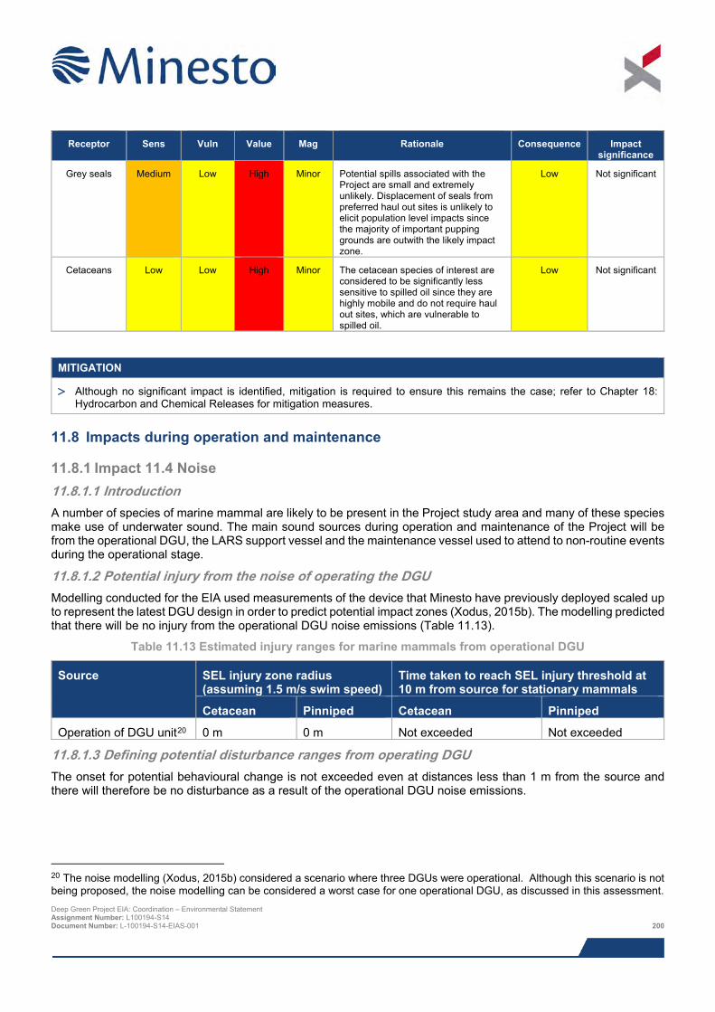
Receptor Sens Vuln Value Mag Rationale Consequence Impact
significance
Grey seals Medium Low High Minor Potential spills associated with the Project are small and extremely unlikely. Displacement of seals from preferred haul out sites is unlikely to elicit population level impacts since the majority of important pupping grounds are outwith the likely impact zone.
Low Not significant
Cetaceans Low Low High Minor The cetacean species of interest are considered to be significantly less sensitive to spilled oil since they are highly mobile and do not require haul out sites, which are vulnerable to spilled oil.
Low Not significant
MITIGATION
> Although no significant impact is identified, mitigation is required to ensure this remains the case; refer to Chapter 18: Hydrocarbon and Chemical Releases for mitigation measures.
11.8 Impacts during operation and maintenance
11.8.1 Impact 11.4 Noise 11.8.1.1 Introduction A number of species of marine mammal are likely to be present in the Project study area and many of these species make use of underwater sound. The main sound sources during operation and maintenance of the Project will be from the operational DGU, the LARS support vessel and the maintenance vessel used to attend to non-routine events during the operational stage.
11.8.1.2 Potential injury from the noise of operating the DGU Modelling conducted for the EIA used measurements of the device that Minesto have previously deployed scaled up to represent the latest DGU design in order to predict potential impact zones (Xodus, 2015b). The modelling predicted that there will be no injury from the operational DGU noise emissions (Table 11.13).
Table 11.13 Estimated injury ranges for marine mammals from operational DGU
Source SEL injury zone radius (assuming 1.5 m/s swim speed)
Time taken to reach SEL injury threshold at 10 m from source for stationary mammals
Cetacean Pinniped Cetacean Pinniped
Operation of DGU unit20 0 m 0 m Not exceeded Not exceeded
11.8.1.3 Defining potential disturbance ranges from operating DGU The onset for potential behavioural change is not exceeded even at distances less than 1 m from the source and there will therefore be no disturbance as a result of the operational DGU noise emissions.
20 The noise modelling (Xodus, 2015b) considered a scenario where three DGUs were operational. Although this scenario is not being proposed, the noise modelling can be considered a worst case for one operational DGU, as discussed in this assessment. Deep Green Project EIA: Coordination – Environmental Statement Assignment Number: L100194-S14 Document Number: L-100194-S14-EIAS-001 200
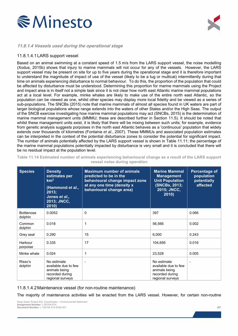
11.8.1.4 Vessels used during the operational stage
11.8.1.4.1 LARS support vessel Based on an animal swimming at a constant speed of 1.5 m/s from the LARS support vessel, the noise modelling (Xodus, 2015b) shows that injury to marine mammals will not occur for any of the vessels. However, the LARS support vessel may be present on site for up to five years during the operational stage and it is therefore important to understand the magnitude of impact of use of the vessel (likely to be a tug or multicat) intermittently during that time on animals experiencing disturbance to normal behaviour. To do this, the proportion of the population that could be affected by disturbance must be understood. Determining this proportion for marine mammals using the Project and impact area is in itself not a simple task since it is not clear how north east Atlantic marine mammal populations act at a local level. For example, minke whales are likely to make use of the entire north east Atlantic, so the population can be viewed as one, whilst other species may display more local fidelity and be viewed as a series of sub-populations. The SNCBs (2015) note that marine mammals of almost all species found in UK waters are part of larger biological populations whose range extends into the waters of other States and/or the High Seas. The output of the SNCB exercise investigating how marine mammal populations may act (SNCBs, 2015) is the determination of marine mammal management units (MMMU; these are described further in Section 11.5). It should be noted that whilst these management units exist, it is likely that there will be mixing between such units; for example, evidence from genetic analysis suggests porpoises in the north east Atlantic behaves as a 'continuous' population that widely extends over thousands of kilometres (Fontaine et al., 2007). These MMMUs and associated population estimates can be interpreted in the context of the potential disturbance zones to consider the potential for significant impact. The number of animals potentially affected by the LARS support vessel is shown in Table 11.11; the percentage of the marine mammal populations potentially impacted by disturbance is very small and it is concluded that there will be no residual impact at the population level.
Table 11.14 Estimated number of animals experiencing behavioural change as a result of the LARS support vessel noise during operation
Species Density estimates per km2
(Hammond et al., 2013; Jones et al., 2013; JNCC, 2010)
Maximum number of animals predicted to be in the behavioural change impact zone at any one time (density x behavioural change area)
Marine Mammal Management
Unit Population (SNCBs, 2013; 2015; JNCC,
2010)
Percentage of population potentially
affected
Bottlenose dolphin
0.0052 0 397 0.066
Common dolphin
0.018 1 56,566 0.002
Grey seal 0.290 15 6,000 0.243
Harbour porpoise
0.335 17 104,695 0.016
Minke whale 0.024 1 23,528 0.005
Risso’s dolphin
No estimate available due to few animals being recorded during regional surveys
- No estimate available due to few animals being recorded during regional surveys
-
11.8.1.4.2 Maintenance vessel (for non-routine maintenance) The majority of maintenance activities will be enacted from the LARS vessel. However, for certain non-routine Deep Green Project EIA: Coordination – Environmental Statement Assignment Number: L100194-S14 Document Number: L-100194-S14-EIAS-001 201
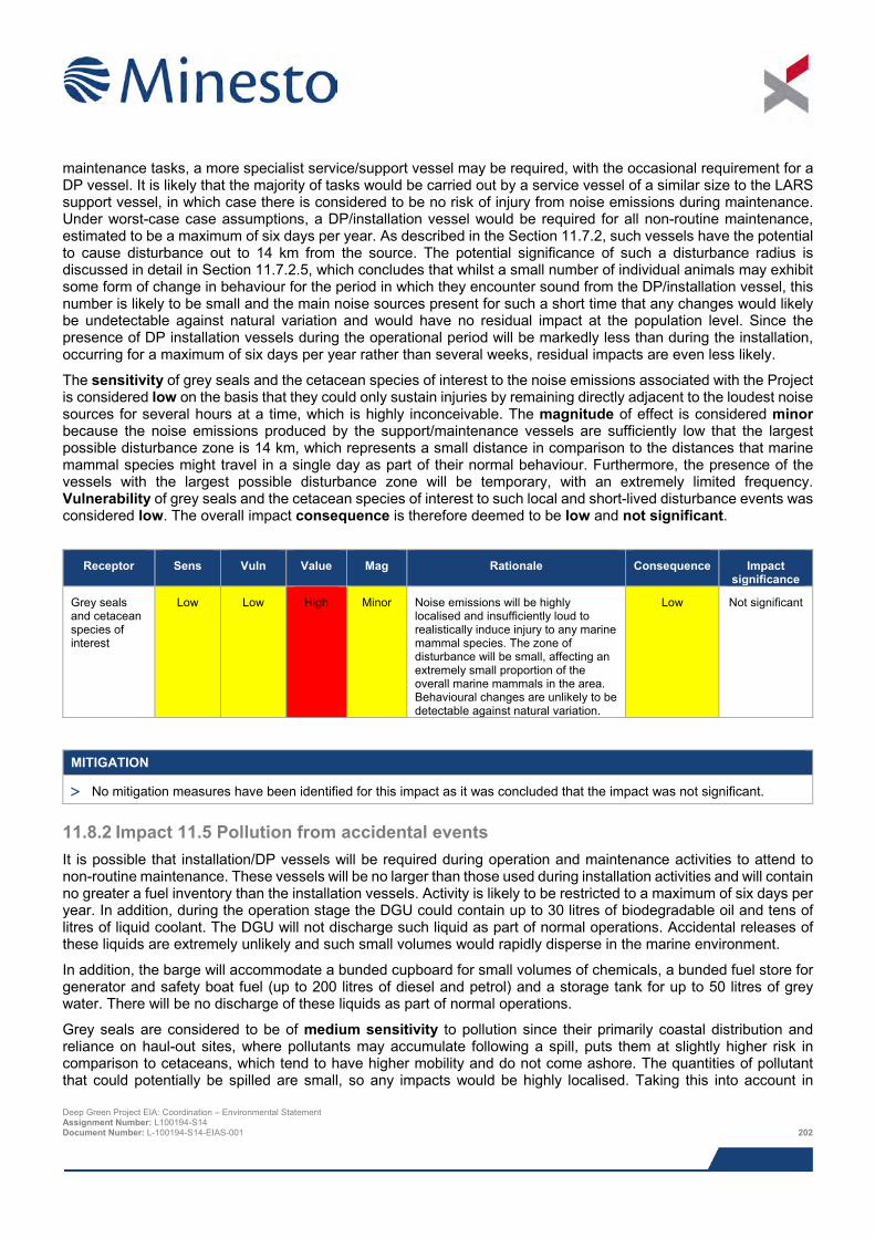
maintenance tasks, a more specialist service/support vessel may be required, with the occasional requirement for a DP vessel. It is likely that the majority of tasks would be carried out by a service vessel of a similar size to the LARS support vessel, in which case there is considered to be no risk of injury from noise emissions during maintenance. Under worst-case case assumptions, a DP/installation vessel would be required for all non-routine maintenance, estimated to be a maximum of six days per year. As described in the Section 11.7.2, such vessels have the potential to cause disturbance out to 14 km from the source. The potential significance of such a disturbance radius is discussed in detail in Section 11.7.2.5, which concludes that whilst a small number of individual animals may exhibit some form of change in behaviour for the period in which they encounter sound from the DP/installation vessel, this number is likely to be small and the main noise sources present for such a short time that any changes would likely be undetectable against natural variation and would have no residual impact at the population level. Since the presence of DP installation vessels during the operational period will be markedly less than during the installation, occurring for a maximum of six days per year rather than several weeks, residual impacts are even less likely.
The sensitivity of grey seals and the cetacean species of interest to the noise emissions associated with the Project is considered low on the basis that they could only sustain injuries by remaining directly adjacent to the loudest noise sources for several hours at a time, which is highly inconceivable. The magnitude of effect is considered minor because the noise emissions produced by the support/maintenance vessels are sufficiently low that the largest possible disturbance zone is 14 km, which represents a small distance in comparison to the distances that marine mammal species might travel in a single day as part of their normal behaviour. Furthermore, the presence of the vessels with the largest possible disturbance zone will be temporary, with an extremely limited frequency. Vulnerability of grey seals and the cetacean species of interest to such local and short-lived disturbance events was considered low. The overall impact consequence is therefore deemed to be low and not significant.
Receptor Sens Vuln Value Mag Rationale Consequence Impact
significance
Grey seals and cetacean species of interest
Low Low High Minor Noise emissions will be highly localised and insufficiently loud to realistically induce injury to any marine mammal species. The zone of disturbance will be small, affecting an extremely small proportion of the overall marine mammals in the area. Behavioural changes are unlikely to be detectable against natural variation.
Low Not significant
MITIGATION
> No mitigation measures have been identified for this impact as it was concluded that the impact was not significant.
11.8.2 Impact 11.5 Pollution from accidental events It is possible that installation/DP vessels will be required during operation and maintenance activities to attend to non-routine maintenance. These vessels will be no larger than those used during installation activities and will contain no greater a fuel inventory than the installation vessels. Activity is likely to be restricted to a maximum of six days per year. In addition, during the operation stage the DGU could contain up to 30 litres of biodegradable oil and tens of litres of liquid coolant. The DGU will not discharge such liquid as part of normal operations. Accidental releases of these liquids are extremely unlikely and such small volumes would rapidly disperse in the marine environment.
In addition, the barge will accommodate a bunded cupboard for small volumes of chemicals, a bunded fuel store for generator and safety boat fuel (up to 200 litres of diesel and petrol) and a storage tank for up to 50 litres of grey water. There will be no discharge of these liquids as part of normal operations.
Grey seals are considered to be of medium sensitivity to pollution since their primarily coastal distribution and reliance on haul-out sites, where pollutants may accumulate following a spill, puts them at slightly higher risk in comparison to cetaceans, which tend to have higher mobility and do not come ashore. The quantities of pollutant that could potentially be spilled are small, so any impacts would be highly localised. Taking this into account in Deep Green Project EIA: Coordination – Environmental Statement Assignment Number: L100194-S14 Document Number: L-100194-S14-EIAS-001 202
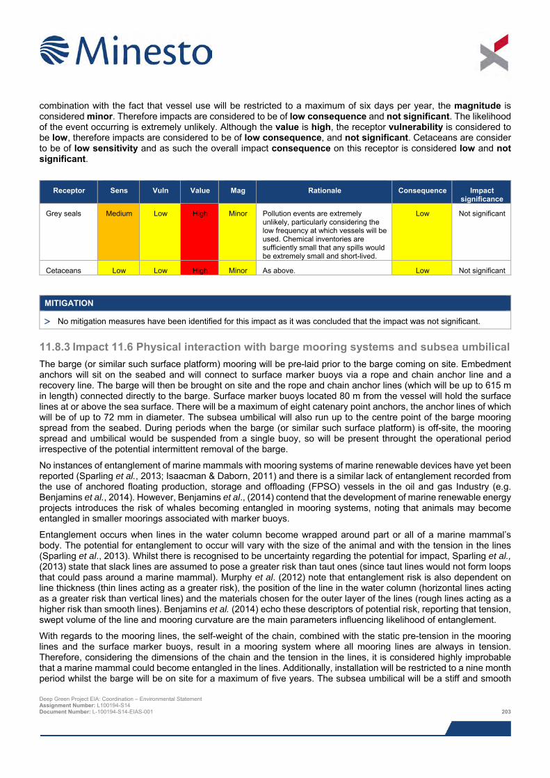
combination with the fact that vessel use will be restricted to a maximum of six days per year, the magnitude is considered minor. Therefore impacts are considered to be of low consequence and not significant. The likelihood of the event occurring is extremely unlikely. Although the value is high, the receptor vulnerability is considered to be low, therefore impacts are considered to be of low consequence, and not significant. Cetaceans are consider to be of low sensitivity and as such the overall impact consequence on this receptor is considered low and not significant.
Receptor Sens Vuln Value Mag Rationale Consequence Impact
significance
Grey seals Medium Low High Minor Pollution events are extremely unlikely, particularly considering the low frequency at which vessels will be used. Chemical inventories are sufficiently small that any spills would be extremely small and short-lived.
Low Not significant
Cetaceans Low Low High Minor As above. Low Not significant
MITIGATION
> No mitigation measures have been identified for this impact as it was concluded that the impact was not significant.
11.8.3 Impact 11.6 Physical interaction with barge mooring systems and subsea umbilical The barge (or similar such surface platform) mooring will be pre-laid prior to the barge coming on site. Embedment anchors will sit on the seabed and will connect to surface marker buoys via a rope and chain anchor line and a recovery line. The barge will then be brought on site and the rope and chain anchor lines (which will be up to 615 m in length) connected directly to the barge. Surface marker buoys located 80 m from the vessel will hold the surface lines at or above the sea surface. There will be a maximum of eight catenary point anchors, the anchor lines of which will be of up to 72 mm in diameter. The subsea umbilical will also run up to the centre point of the barge mooring spread from the seabed. During periods when the barge (or similar such surface platform) is off-site, the mooring spread and umbilical would be suspended from a single buoy, so will be present throught the operational period irrespective of the potential intermittent removal of the barge.
No instances of entanglement of marine mammals with mooring systems of marine renewable devices have yet been reported (Sparling et al., 2013; Isaacman & Daborn, 2011) and there is a similar lack of entanglement recorded from the use of anchored floating production, storage and offloading (FPSO) vessels in the oil and gas Industry (e.g. Benjamins et al., 2014). However, Benjamins et al., (2014) contend that the development of marine renewable energy projects introduces the risk of whales becoming entangled in mooring systems, noting that animals may become entangled in smaller moorings associated with marker buoys.
Entanglement occurs when lines in the water column become wrapped around part or all of a marine mammal’s body. The potential for entanglement to occur will vary with the size of the animal and with the tension in the lines (Sparling et al., 2013). Whilst there is recognised to be uncertainty regarding the potential for impact, Sparling et al., (2013) state that slack lines are assumed to pose a greater risk than taut ones (since taut lines would not form loops that could pass around a marine mammal). Murphy et al. (2012) note that entanglement risk is also dependent on line thickness (thin lines acting as a greater risk), the position of the line in the water column (horizontal lines acting as a greater risk than vertical lines) and the materials chosen for the outer layer of the lines (rough lines acting as a higher risk than smooth lines). Benjamins et al. (2014) echo these descriptors of potential risk, reporting that tension, swept volume of the line and mooring curvature are the main parameters influencing likelihood of entanglement.
With regards to the mooring lines, the self-weight of the chain, combined with the static pre-tension in the mooring lines and the surface marker buoys, result in a mooring system where all mooring lines are always in tension. Therefore, considering the dimensions of the chain and the tension in the lines, it is considered highly improbable that a marine mammal could become entangled in the lines. Additionally, installation will be restricted to a nine month period whilst the barge will be on site for a maximum of five years. The subsea umbilical will be a stiff and smooth Deep Green Project EIA: Coordination – Environmental Statement Assignment Number: L100194-S14 Document Number: L-100194-S14-EIAS-001 203
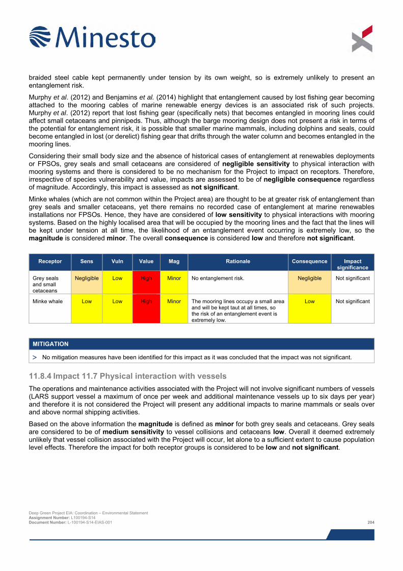
braided steel cable kept permanently under tension by its own weight, so is extremely unlikely to present an entanglement risk.
Murphy et al. (2012) and Benjamins et al. (2014) highlight that entanglement caused by lost fishing gear becoming attached to the mooring cables of marine renewable energy devices is an associated risk of such projects. Murphy et al. (2012) report that lost fishing gear (specifically nets) that becomes entangled in mooring lines could affect small cetaceans and pinnipeds. Thus, although the barge mooring design does not present a risk in terms of the potential for entanglement risk, it is possible that smaller marine mammals, including dolphins and seals, could become entangled in lost (or derelict) fishing gear that drifts through the water column and becomes entangled in the mooring lines.
Considering their small body size and the absence of historical cases of entanglement at renewables deployments or FPSOs, grey seals and small cetaceans are considered of negligible sensitivity to physical interaction with mooring systems and there is considered to be no mechanism for the Project to impact on receptors. Therefore, irrespective of species vulnerability and value, impacts are assessed to be of negligible consequence regardless of magnitude. Accordingly, this impact is assessed as not significant.
Minke whales (which are not common within the Project area) are thought to be at greater risk of entanglement than grey seals and smaller cetaceans, yet there remains no recorded case of entanglement at marine renewables installations nor FPSOs. Hence, they have are considered of low sensitivity to physical interactions with mooring systems. Based on the highly localised area that will be occupied by the mooring lines and the fact that the lines will be kept under tension at all time, the likelihood of an entanglement event occurring is extremely low, so the magnitude is considered minor. The overall consequence is considered low and therefore not significant.
Receptor Sens Vuln Value Mag Rationale Consequence Impact
significance
Grey seals and small cetaceans
Negligible Low High Minor No entanglement risk. Negligible Not significant
Minke whale Low Low High Minor The mooring lines occupy a small area and will be kept taut at all times, so the risk of an entanglement event is extremely low.
Low Not significant
MITIGATION
> No mitigation measures have been identified for this impact as it was concluded that the impact was not significant.
11.8.4 Impact 11.7 Physical interaction with vessels The operations and maintenance activities associated with the Project will not involve significant numbers of vessels (LARS support vessel a maximum of once per week and additional maintenance vessels up to six days per year) and therefore it is not considered the Project will present any additional impacts to marine mammals or seals over and above normal shipping activities.
Based on the above information the magnitude is defined as minor for both grey seals and cetaceans. Grey seals are considered to be of medium sensitivity to vessel collisions and cetaceans low. Overall it deemed extremely unlikely that vessel collision associated with the Project will occur, let alone to a sufficient extent to cause population level effects. Therefore the impact for both receptor groups is considered to be low and not significant.
Deep Green Project EIA: Coordination – Environmental Statement Assignment Number: L100194-S14 Document Number: L-100194-S14-EIAS-001 204
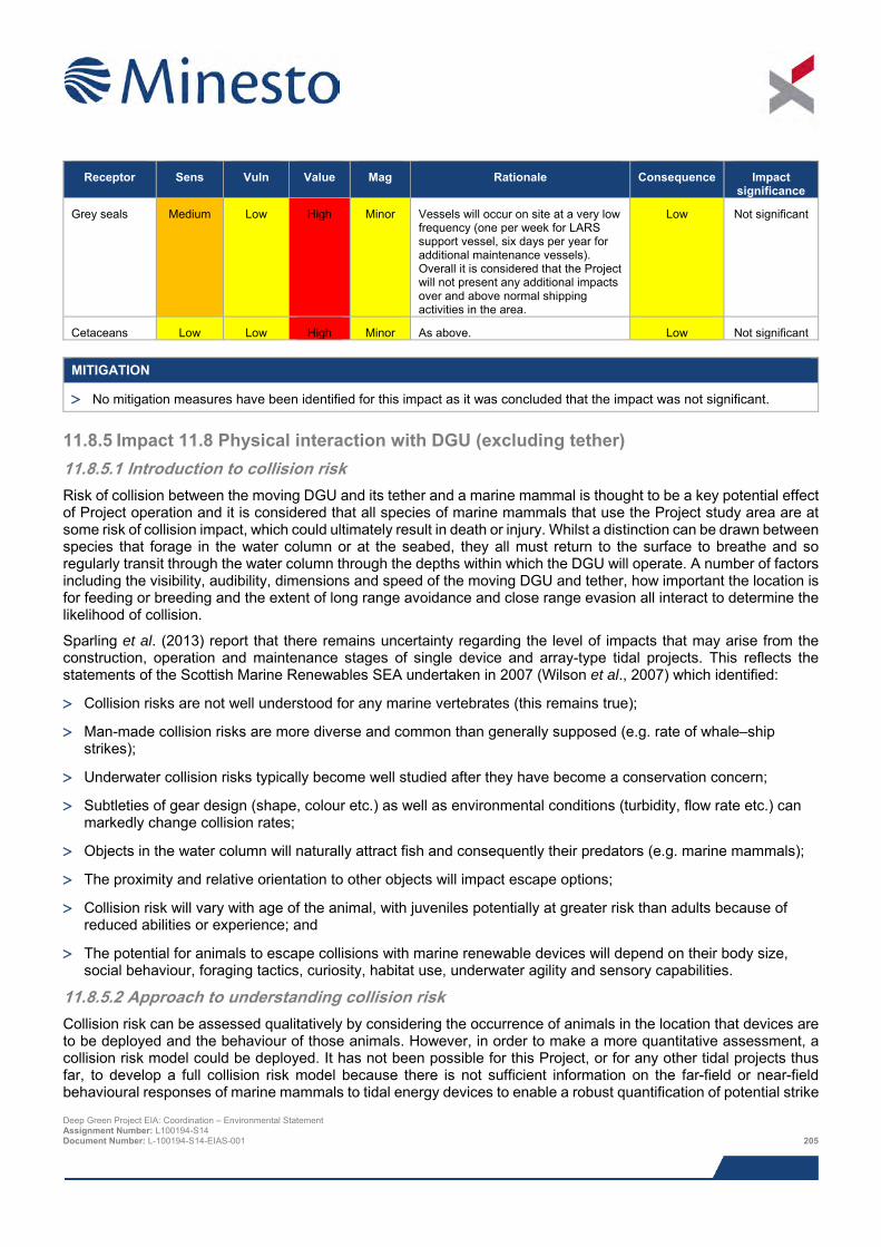
Receptor Sens Vuln Value Mag Rationale Consequence Impact
significance
Grey seals Medium Low High Minor Vessels will occur on site at a very low frequency (one per week for LARS support vessel, six days per year for additional maintenance vessels). Overall it is considered that the Project will not present any additional impacts over and above normal shipping activities in the area.
Low Not significant
Cetaceans Low Low High Minor As above. Low Not significant
MITIGATION
> No mitigation measures have been identified for this impact as it was concluded that the impact was not significant.
11.8.5 Impact 11.8 Physical interaction with DGU (excluding tether) 11.8.5.1 Introduction to collision risk Risk of collision between the moving DGU and its tether and a marine mammal is thought to be a key potential effect of Project operation and it is considered that all species of marine mammals that use the Project study area are at some risk of collision impact, which could ultimately result in death or injury. Whilst a distinction can be drawn between species that forage in the water column or at the seabed, they all must return to the surface to breathe and so regularly transit through the water column through the depths within which the DGU will operate. A number of factors including the visibility, audibility, dimensions and speed of the moving DGU and tether, how important the location is for feeding or breeding and the extent of long range avoidance and close range evasion all interact to determine the likelihood of collision.
Sparling et al. (2013) report that there remains uncertainty regarding the level of impacts that may arise from the construction, operation and maintenance stages of single device and array-type tidal projects. This reflects the statements of the Scottish Marine Renewables SEA undertaken in 2007 (Wilson et al., 2007) which identified:
> Collision risks are not well understood for any marine vertebrates (this remains true);
> Man-made collision risks are more diverse and common than generally supposed (e.g. rate of whale–ship strikes);
> Underwater collision risks typically become well studied after they have become a conservation concern;
> Subtleties of gear design (shape, colour etc.) as well as environmental conditions (turbidity, flow rate etc.) can markedly change collision rates;
> Objects in the water column will naturally attract fish and consequently their predators (e.g. marine mammals);
> The proximity and relative orientation to other objects will impact escape options;
> Collision risk will vary with age of the animal, with juveniles potentially at greater risk than adults because of reduced abilities or experience; and
> The potential for animals to escape collisions with marine renewable devices will depend on their body size, social behaviour, foraging tactics, curiosity, habitat use, underwater agility and sensory capabilities.
11.8.5.2 Approach to understanding collision risk Collision risk can be assessed qualitatively by considering the occurrence of animals in the location that devices are to be deployed and the behaviour of those animals. However, in order to make a more quantitative assessment, a collision risk model could be deployed. It has not been possible for this Project, or for any other tidal projects thus far, to develop a full collision risk model because there is not sufficient information on the far-field or near-field behavioural responses of marine mammals to tidal energy devices to enable a robust quantification of potential strike Deep Green Project EIA: Coordination – Environmental Statement Assignment Number: L100194-S14 Document Number: L-100194-S14-EIAS-001 205
rates (e.g. Thompson et al., 2013). Since collision risk can be thought of as a function of encounter rate and the probabilities of marine mammal avoidance and evasion, modelling of encounter rates was considered an appropriate substitute to inform this EIA. This approach has been followed for other projects, including the MeyGen Tidal Energy Project (MeyGen, 2012), the Skerries Tidal Stream Array EIA (SeaGen, 2011) the Torr Head Tidal Energy project (TVL, 2015) and for the deployment of the Minesto 1:4 scale DGU in Strangford Lough.
SMRU Marine (2014) previously developed a fully simulated collision risk assessment model for a 1:4 scale version of the DGU with respect to harbour seals at the Strangford Lough site. SMRU Consulting (2015) redeveloped the collision risk modelling (CRM) framework for a DGU unit at the Holyhead Deep. The CRM framework makes use of real DGU (kite and tether) movement data collected by Minesto under different tidal conditions21 (0.50 m/s, 0.80 m/s, 1.10 m/s and 1.66 m/s) to understand the potential for encounter at various states of the tide and hence states of operation of the DGU. The probability of encounter of the device or tether relative to swimming speed of marine mammals and to the anchoring position of the DGU (seabed vs surface) were also considered. For each of the four tidal current speeds, animals were modelled moving with a range of swimming speeds relative to the current. Each set of simulations generated a probability of collision between animals and the kite and tether. Full details of the input parameters and methodology are available in SMRU Consulting (2015).
In order to provide context for the CRM exercise, SMRU Consulting (2015) undertook further work to assess the population level consequences of the range of collision rates predicted by the CRM exercise. This allows an exploration of the level of collision risk that could theoretically occur without a significant impact on marine mammal populations in the long term.
The technical reviews of available data on marine mammals, summarised in Section 11.5, highlighted a number of marine mammal species that are likely to make use of the Project area to varying degrees. In discussion with NRW, the CRM assessment has considered harbour porpoise, grey seals and bottlenose dolphin. However, common dolphin, Risso’s dolphin and minke whale have also been considered qualitatively within this assessment.
11.8.5.3 How species behave around tidal devices Wilson et al. (2007) report that responses to tidal devices are likely to occur on two spatial scales; at long range marine mammals have the option to avoid the area of device placement (i.e. swim around) and at closer range they can evade specific units (i.e. dodge or swerve). Little is known yet about behavioural reactions but detection distances can be determined (Wilson et al., 2007). Given the audibility of the operating DGU, it is likely that marine mammals will be able to detect the DGU above background noise, at least in the vicinity of the DGU. Marine mammals are thus likely to be able to recognise the presence of the noise source (the DGU) and will have time on any approach to this noise source to ready an avoidance response.
Where marine mammals do not take avoidance measures at longer ranges, they are likely to come close to the DGU. In terms of reactions on approaching the DGU, marine mammals ordinarily encounter obstacles in the water column and are clearly adept at dodging or swerving those obstacles, whether they are stationary (such as the seabed) or moving (like predators or vessels). In daytime and clear waters, underwater structures may be visible at ranges of tens of meters and hence give sufficient warning for visual species to exhibit avoidance and evasion if necessary (Wilson et al., 2007). Collision risk is expected to be greater for devices deployed in regions of moderate to high turbidity, or if the energy devices increase turbidity, because of reduced visibility (Scottish Executive, 2007), but it is known that the water column in the Project study area does not hold a high sediment content and it is not likely that the turbines will resuspend any sediment themselves (see Chapter 9: Physical Processes).
Some understanding of how marine mammals react around devices may be derived from existing tidal projects; the DGU installed by Minesto in Strangford Lough provides some useful insight. A one in four (1:4) scale version of the DGU was installed in 2013 and remains deployed. A Marine Mammal Observer (MMO) must be present whenever the device is in operation. Sighting data collected by the MMO deployed onboard a test platform prior to operation of the device, and during operation of the device itself, is available between February 2013 and June 2014. During the
21 These four tidal conditions were chosen to best represent the distribution of current speeds at the Holyhead Deep. Speeds above 1.66 m/s were not considered, since SMRU Consulting have demonstrated a clear relationship that collision risk decreases as current speed (or animal speed, which is positively correlated with current speed) increases. Thus, collision probabilities for 1.66 m/s can be considered overestimates of collision probabilities at higher current speeds. Deep Green Project EIA: Coordination – Environmental Statement Assignment Number: L100194-S14 Document Number: L-100194-S14-EIAS-001 206
pre-operational stage, when the device was neither present nor in operation, 55 seals were recorded 50 m or less from the DGU location. When the DGU was present and operating, only 3 seals were recorded 50 m or less from the DGU, representing a decrease of approximately 95%. The closest approach recorded was 50 m, and no incidences of collision were reported with the DGU (although the device did shut down for approaches less than 50 m).
As noted by SCOS (2014), the only other substantial direct information on interactions with tidal turbines remains that collected in Strangford Narrows in Northern Ireland where a long term study of seal populations and seal foraging movements has been carried out during the development and deployment stage of the SeaGen device, a large twin rotor tidal turbine (Lonergen et al., in review). Data from telemetry and acoustic studies in Strangford Lough suggest that there may be a degree of local avoidance by marine mammals of operating turbines, though no reduction in overall seal or harbour porpoise transit rates through the narrows in which the turbine is located (Royal Haskoning, 2011). For example, there was evidence of a redistribution of harbour seals during turbine operation over approximately 250 m around the turbine. Although Royal Haskoning (2011) suggest that this change in distribution is probably of little biological significance, it indicates that harbour seals may well be detecting the presence of the turbine and responding to it to ensure no collision. Royal Haskoning (2011) state that this pattern of avoidance was similar regardless of whether the turbine was operating or not operating, suggesting that it was not a direct result of noise produced by the operating turbine, nor necessarily related to moving turbine rotors, and instead may have been due to the presence of the structure, or, importantly from a collision perspective, a learned ‘habit’ of avoidance.
Interestingly, monitoring of the SeaGen device showed that seals transited at a relatively higher rate during periods of slack tide. As Royal Haskoning (2011) note, this would clearly have the effect of reducing collision risk if seals were preferentially transiting during periods when the turbine was not operating.
SCOS (2013) report the results of a recent DECC-funded project utilising the SeaGen deployment in Strangford Lough to measure the underwater proximity and frequency of seals around the turbine using active sonar. The results of this showed 109 sonar targets classified as marine mammals (these were likely to be harbour seals) at a detection rate of approximately 5.9 per day. The ranges that marine mammals were detected suggest that animals do move in close proximity to the tidal turbine both when it was operational (minimum range of 9.9 m) and non-operational (minimum range of 8.4 m). Quite clearly animals are approaching tidal turbines, including whilst operational, but the results of the carcass recovery, strain gauge and other studies above suggest a near, or complete, absence of collisions between animals and devices. Interestingly, Sparling et al. (2013) note that no marine mammals were recorded during video monitoring of the OpenHydro Open Centre Turbine (OCT) device whilst operational at EMEC, although the authors note that the monitoring was not specifically designed to determine the potential for marine mammal interactions.
As part of the deployment of a single Tidal Generation Limited (TGL) tidal device at the Falls of Warness EMEC test site in Orkney, TGL placed strain gauges in the blades of the turbine to monitor impact between objects in the water column and the device, with the main aim being to determine whether marine mammals had made contact with the device (TGL, 2011, in MeyGen, 2012). The monitoring and extensive processing and post-processing analysis of data collected during a nine day monitoring period across a range of tidal states showed no evidence of any marine mammal impact on the blades of the device (TGL, 2011, in MeyGen, 2012). Concurrent with the analysis, there were no reported sightings of injured or dead marine mammals in the locality of the turbine test site (TGL, 2011, in MeyGen, 2012).
What appears evident from the limited data currently available is that animals that are using the water around tidal turbines are likely to encounter those turbines in some form, be that physical encounter or a detection. However, an encounter is not the same as a collision; whilst it could lead to a collision, this would only be possible if the animal in question does not take appropriate avoidance or evasive action. As they are highly mobile underwater, marine mammals have the capacity to avoid and evade marine turbine devices provided they have the ability to detect the objects, perceive them as a threat and then take appropriate action at long or short range (e.g. Gordon et al., 2011). Since there is no information on the degree to which marine mammals will actually make appropriate manoeuvres (as highlighted early in the development of tidal energy by Wilson et al., 2007), predicted encounter rates must be very carefully interpreted as a worst case scenario.
11.8.5.4 Results from the CRM exercise In order to provide context for the CRM outputs, SMRU Consulting (2015) assessed the population consequences of a range of collision rates. The approach taken was to first calculate the magnitude of collisions (with both the kite Deep Green Project EIA: Coordination – Environmental Statement Assignment Number: L100194-S14 Document Number: L-100194-S14-EIAS-001 207
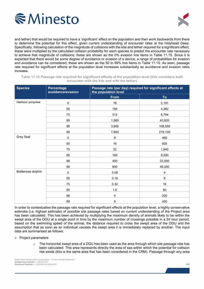
and tether) that would be required to have a ‘significant’ effect on the population and then work backwards from there to determine the potential for this effect, given current understanding of encounter rates at the Holyhead Deep. Specifically, following calculation of the magnitude of collisions with the kite and tether required for a significant effect, these were multiplied by the calculated collision probability for each species to predict the encounter rate necessary to achieve that magnitude of collisions; these are shown as the 0% evasion line items in Table 11.15. Since it is expected that there would be some degree of avoidance or evasion of a device, a range of probabilities for evasion and avoidance can be considered; these are shown as the 50 to 99% line items in Table 11.15. As seen, passage rate required for significant effects at the population level increases substantially as avoidance and evasion rates increase.
Table 11.15 Passage rate required for significant effects at the population level (this considers both encounter with the kite and with the tether)
Species Percentage avoidance/evasion
Passage rate (per day) required for significant effects at the population level
From To Harbour porpoise 0 78 2,191
50 156 4,382
75 312 8,764
95 1,560 43,820
98 3,900 109,550
99 7,800 219,100 Grey Seal 0 8 460
50 16 920
75 32 1,840
95 160 9,200
98 400 23,000
99 800 46,000 Bottlenose dolphin 0 0.08 4
50 0.16 8
75 0.32 16
95 1.6 80
98 4 200
99 8 400
In order to contextualise the passage rate required for significant effects at the population level, a highly conservative estimate (i.e. highest estimate) of possible site passage rates based on current understanding of the Project area has been calculated. This has been achieved by multiplying the maximum density of animals likely to be within the swept area of the DGU at a single point in time by the maximum number of crossings possible in a 24 hour period, based on the swimming speed of the animal, the distance required to cross the swept area of the DGU and the assumption that as soon as an individual vacates the swept area it is immediately replaced by another. The input data are summarised as follows:
> Project parameters
o The horizontal swept area of a DGU has been used as the area through which site passage rate has been calculated. This area represents directly the area of sea within which the potential for collision risk exists (this is the same area that has been considered in the CRM). Passage through any area
Deep Green Project EIA: Coordination – Environmental Statement Assignment Number: L100194-S14 Document Number: L-100194-S14-EIAS-001 208
of sea outwith this area would not result in any risk of collision since animals would not encounter the device. It should be noted that use of this swept area in the calculations represents a highly conservative approach since the horizontal swept area has been defined as a circle around the device whose radius is the length of the tether, whereas in reality, an operating DGU will occupy a very small proportion of this circle during a given tidal state.
> Abundance/density
o As recommended by NRW during consultation, in order to maintain a high level of precaution the starting point for calculating site passage rates for cetaceans has been taken as the upper 95% confidence interval (CI) population estimate for the SCANS-II survey block within which the Project is sited (Block O). Use of the upper 95% CI population estimate instead of the mean population estimate results in a much larger population estimate being considered in the calculations, resulting in a higher predicted density and thus a higher site passage rate. By way of example in these calculations, for harbour a population estimate of 203,500 animals is used (the upper 95% CI value) instead of 15,230 animals (the mean value).
o As the SCANS-II surveys did not record pinnipeds, the starting point for grey seals is the analogous (i.e. similarly conservative) upper 95% CI at-sea usage density estimates provided by Jones et al. (2013).
> Animal movement
o Site passage rates were calculated by first determining the maximum number of site passages a single animal could make through the swept area of the DGU in one day (since this is the unit used to display the CRM output). This approach assumes that an animal enters the swept area of a single DGU and swims across the diameter of the DGU swept area circle, a distance of 225 m. It was assumed that on leaving the swept area, each animal unit would immediately be replaced by another. For consistency, the average swim speeds used in the CRM were used to calculate the maximum number of possible crossings.
Table 11.16 shows the input data and the estimated worst case (i.e. highest) daily site passage rates in the context of the passage rates required for significant effects at the population level (as detailed in Table 11.15). Considering the information presented earlier in this chapter on avoidance and evasion (Section 11.8.5.3), it is likely that avoidance rates will be at the upper end of the scale described in Table 11.15 and Table 11.16). Experience from other tidal project EIA and consultation with regulators and their advisers suggests that 98% avoidance is not unreasonable to assume. Assuming 98% avoidance for the DGU, between 3,900 and 109,550 individual harbour porpoise would be required to pass through the DGU device area on a daily basis for there to be any significant population effects. For grey seals, making similar assumptions on avoidance would mean that between 400 and 23,000 passages would be required through the DGU device area on a daily basis for there to be any significant population effects. For bottlenose dolphins, an assumption of 98% avoidance would mean that between 4 and 200 passages of individuals would be required to pass through the DGU device area on a daily basis for there to be any significant population effects. As can be seen for harbour porpoise, bottlenose dolphin and grey seals, based on the predicted site passage rates through the swept area of the device there is no potential for significant population level assuming the avoidance rate considered most likely (i.e. 98%). This statement holds true even assuming lower levels of avoidance for all species, including assuming no avoidance at all for harbour porpoise (down to 0% for harbour porpoise, 25% for grey seal and, reflecting the smaller population against which potential impacts are assessed, approximately 84% for bottlenose dolphin).
It is important to additionally consider that the passage rate required for significant effects at the population level is based on the probability of collision (with the tether or kite) calculated from four tidal states, all of which would result in the device operating. In reality, it is expected that the tidal conditions will be unsuitable for DGU unit operation for 23% of the tidal cycle (i.e. tidal flow will be below the 0.5 m/s cut-in speed). As such, 23% of passages through the operational area of the device would, instead of encountering an operation device, encounter a device that is static and held close to the seabed. Such a static device would be expected to present no real collision risk and the passage rates required for significant effects at the population level detailed in the paragraphs and tables above will be underestimates of the number of animals that must pass through the site for there to be any potential for significant negative impact at the population level. Deep Green Project EIA: Coordination – Environmental Statement Assignment Number: L100194-S14 Document Number: L-100194-S14-EIAS-001 209
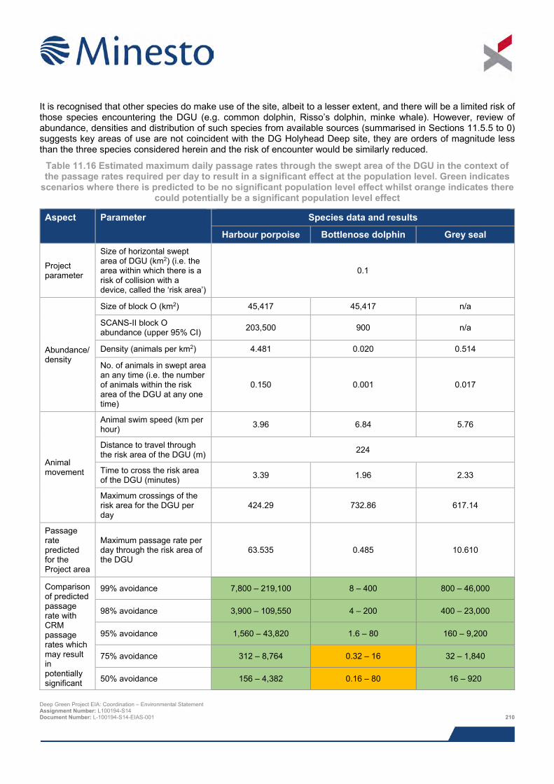
It is recognised that other species do make use of the site, albeit to a lesser extent, and there will be a limited risk of those species encountering the DGU (e.g. common dolphin, Risso’s dolphin, minke whale). However, review of abundance, densities and distribution of such species from available sources (summarised in Sections 11.5.5 to 0) suggests key areas of use are not coincident with the DG Holyhead Deep site, they are orders of magnitude less than the three species considered herein and the risk of encounter would be similarly reduced.
Table 11.16 Estimated maximum daily passage rates through the swept area of the DGU in the context of the passage rates required per day to result in a significant effect at the population level. Green indicates
scenarios where there is predicted to be no significant population level effect whilst orange indicates there could potentially be a significant population level effect
Aspect Parameter Species data and results
Harbour porpoise Bottlenose dolphin Grey seal
Project parameter
Size of horizontal swept area of DGU (km2) (i.e. the area within which there is a risk of collision with a device, called the ‘risk area’)
0.1
Abundance/ density
Size of block O (km2) 45,417 45,417 n/a
SCANS-II block O abundance (upper 95% CI) 203,500 900 n/a
Density (animals per km2) 4.481 0.020 0.514
No. of animals in swept area an any time (i.e. the number of animals within the risk area of the DGU at any one time)
0.150 0.001 0.017
Animal movement
Animal swim speed (km per hour) 3.96 6.84 5.76
Distance to travel through the risk area of the DGU (m) 224
Time to cross the risk area of the DGU (minutes) 3.39 1.96 2.33
Maximum crossings of the risk area for the DGU per day
424.29 732.86 617.14
Passage rate predicted for the Project area
Maximum passage rate per day through the risk area of the DGU
63.535 0.485 10.610
Comparison of predicted passage rate with CRM passage rates which may result in potentially significant
99% avoidance 7,800 – 219,100 8 – 400 800 – 46,000
98% avoidance 3,900 – 109,550 4 – 200 400 – 23,000
95% avoidance 1,560 – 43,820 1.6 – 80 160 – 9,200
75% avoidance 312 – 8,764 0.32 – 16 32 – 1,840
50% avoidance 156 – 4,382 0.16 – 80 16 – 920
Deep Green Project EIA: Coordination – Environmental Statement Assignment Number: L100194-S14 Document Number: L-100194-S14-EIAS-001 210
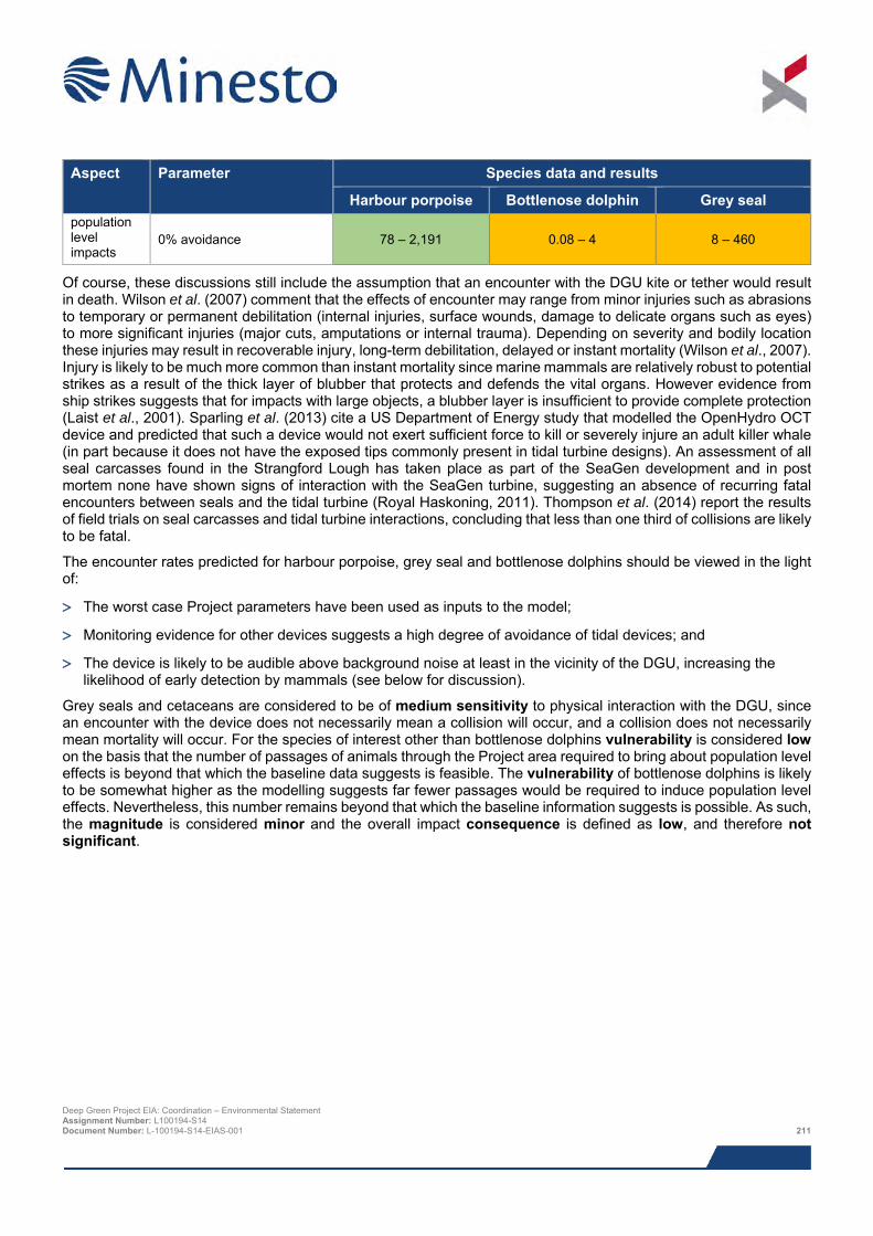
Aspect Parameter Species data and results
Harbour porpoise Bottlenose dolphin Grey seal population level impacts
0% avoidance 78 – 2,191 0.08 – 4 8 – 460
Of course, these discussions still include the assumption that an encounter with the DGU kite or tether would result in death. Wilson et al. (2007) comment that the effects of encounter may range from minor injuries such as abrasions to temporary or permanent debilitation (internal injuries, surface wounds, damage to delicate organs such as eyes) to more significant injuries (major cuts, amputations or internal trauma). Depending on severity and bodily location these injuries may result in recoverable injury, long-term debilitation, delayed or instant mortality (Wilson et al., 2007). Injury is likely to be much more common than instant mortality since marine mammals are relatively robust to potential strikes as a result of the thick layer of blubber that protects and defends the vital organs. However evidence from ship strikes suggests that for impacts with large objects, a blubber layer is insufficient to provide complete protection (Laist et al., 2001). Sparling et al. (2013) cite a US Department of Energy study that modelled the OpenHydro OCT device and predicted that such a device would not exert sufficient force to kill or severely injure an adult killer whale (in part because it does not have the exposed tips commonly present in tidal turbine designs). An assessment of all seal carcasses found in the Strangford Lough has taken place as part of the SeaGen development and in post mortem none have shown signs of interaction with the SeaGen turbine, suggesting an absence of recurring fatal encounters between seals and the tidal turbine (Royal Haskoning, 2011). Thompson et al. (2014) report the results of field trials on seal carcasses and tidal turbine interactions, concluding that less than one third of collisions are likely to be fatal.
The encounter rates predicted for harbour porpoise, grey seal and bottlenose dolphins should be viewed in the light of:
> The worst case Project parameters have been used as inputs to the model;
> Monitoring evidence for other devices suggests a high degree of avoidance of tidal devices; and
> The device is likely to be audible above background noise at least in the vicinity of the DGU, increasing the likelihood of early detection by mammals (see below for discussion).
Grey seals and cetaceans are considered to be of medium sensitivity to physical interaction with the DGU, since an encounter with the device does not necessarily mean a collision will occur, and a collision does not necessarily mean mortality will occur. For the species of interest other than bottlenose dolphins vulnerability is considered low on the basis that the number of passages of animals through the Project area required to bring about population level effects is beyond that which the baseline data suggests is feasible. The vulnerability of bottlenose dolphins is likely to be somewhat higher as the modelling suggests far fewer passages would be required to induce population level effects. Nevertheless, this number remains beyond that which the baseline information suggests is possible. As such, the magnitude is considered minor and the overall impact consequence is defined as low, and therefore not significant.
Deep Green Project EIA: Coordination – Environmental Statement Assignment Number: L100194-S14 Document Number: L-100194-S14-EIAS-001 211
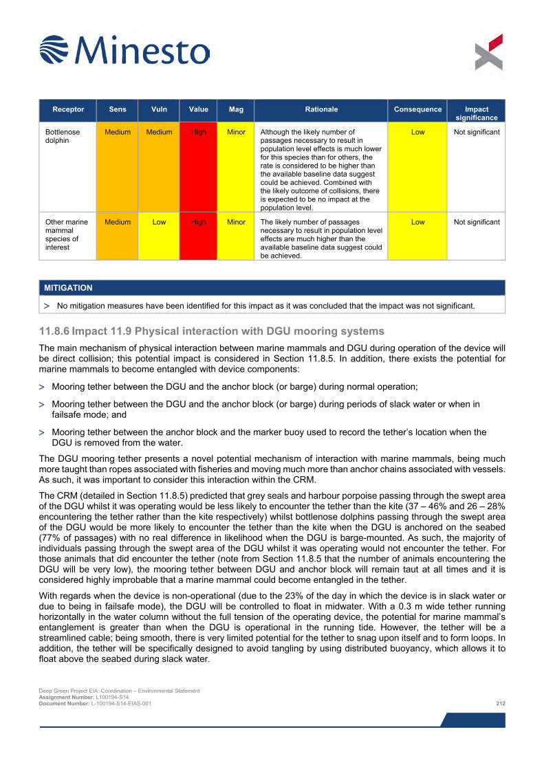
Receptor Sens Vuln Value Mag Rationale Consequence Impact
significance
Bottlenose dolphin
Medium Medium High Minor Although the likely number of passages necessary to result in population level effects is much lower for this species than for others, the rate is considered to be higher than the available baseline data suggest could be achieved. Combined with the likely outcome of collisions, there is expected to be no impact at the population level.
Low Not significant
Other marine mammal species of interest
Medium Low High Minor The likely number of passages necessary to result in population level effects are much higher than the available baseline data suggest could be achieved.
Low Not significant
MITIGATION
> No mitigation measures have been identified for this impact as it was concluded that the impact was not significant.
11.8.6 Impact 11.9 Physical interaction with DGU mooring systems The main mechanism of physical interaction between marine mammals and DGU during operation of the device will be direct collision; this potential impact is considered in Section 11.8.5. In addition, there exists the potential for marine mammals to become entangled with device components:
> Mooring tether between the DGU and the anchor block (or barge) during normal operation;
> Mooring tether between the DGU and the anchor block (or barge) during periods of slack water or when in failsafe mode; and
> Mooring tether between the anchor block and the marker buoy used to record the tether’s location when the DGU is removed from the water.
The DGU mooring tether presents a novel potential mechanism of interaction with marine mammals, being much more taught than ropes associated with fisheries and moving much more than anchor chains associated with vessels. As such, it was important to consider this interaction within the CRM.
The CRM (detailed in Section 11.8.5) predicted that grey seals and harbour porpoise passing through the swept area of the DGU whilst it was operating would be less likely to encounter the tether than the kite (37 – 46% and 26 – 28% encountering the tether rather than the kite respectively) whilst bottlenose dolphins passing through the swept area of the DGU would be more likely to encounter the tether than the kite when the DGU is anchored on the seabed (77% of passages) with no real difference in likelihood when the DGU is barge-mounted. As such, the majority of individuals passing through the swept area of the DGU whilst it was operating would not encounter the tether. For those animals that did encounter the tether (note from Section 11.8.5 that the number of animals encountering the DGU will be very low), the mooring tether between DGU and anchor block will remain taut at all times and it is considered highly improbable that a marine mammal could become entangled in the tether.
With regards when the device is non-operational (due to the 23% of the day in which the device is in slack water or due to being in failsafe mode), the DGU will be controlled to float in midwater. With a 0.3 m wide tether running horizontally in the water column without the full tension of the operating device, the potential for marine mammal’s entanglement is greater than when the DGU is operational in the running tide. However, the tether will be a streamlined cable; being smooth, there is very limited potential for the tether to snag upon itself and to form loops. In addition, the tether will be specifically designed to avoid tangling by using distributed buoyancy, which allows it to float above the seabed during slack water.
Deep Green Project EIA: Coordination – Environmental Statement Assignment Number: L100194-S14 Document Number: L-100194-S14-EIAS-001 212
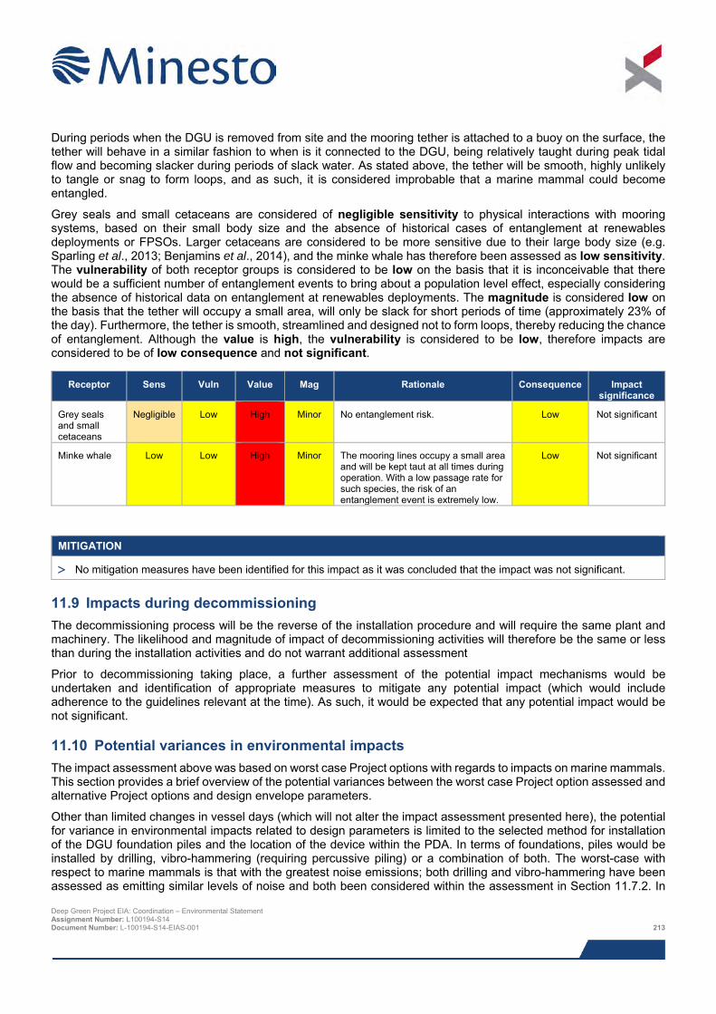
During periods when the DGU is removed from site and the mooring tether is attached to a buoy on the surface, the tether will behave in a similar fashion to when is it connected to the DGU, being relatively taught during peak tidal flow and becoming slacker during periods of slack water. As stated above, the tether will be smooth, highly unlikely to tangle or snag to form loops, and as such, it is considered improbable that a marine mammal could become entangled.
Grey seals and small cetaceans are considered of negligible sensitivity to physical interactions with mooring systems, based on their small body size and the absence of historical cases of entanglement at renewables deployments or FPSOs. Larger cetaceans are considered to be more sensitive due to their large body size (e.g. Sparling et al., 2013; Benjamins et al., 2014), and the minke whale has therefore been assessed as low sensitivity. The vulnerability of both receptor groups is considered to be low on the basis that it is inconceivable that there would be a sufficient number of entanglement events to bring about a population level effect, especially considering the absence of historical data on entanglement at renewables deployments. The magnitude is considered low on the basis that the tether will occupy a small area, will only be slack for short periods of time (approximately 23% of the day). Furthermore, the tether is smooth, streamlined and designed not to form loops, thereby reducing the chance of entanglement. Although the value is high, the vulnerability is considered to be low, therefore impacts are considered to be of low consequence and not significant.
MITIGATION
> No mitigation measures have been identified for this impact as it was concluded that the impact was not significant.
11.9 Impacts during decommissioning The decommissioning process will be the reverse of the installation procedure and will require the same plant and machinery. The likelihood and magnitude of impact of decommissioning activities will therefore be the same or less than during the installation activities and do not warrant additional assessment
Prior to decommissioning taking place, a further assessment of the potential impact mechanisms would be undertaken and identification of appropriate measures to mitigate any potential impact (which would include adherence to the guidelines relevant at the time). As such, it would be expected that any potential impact would be not significant.
11.10 Potential variances in environmental impacts The impact assessment above was based on worst case Project options with regards to impacts on marine mammals. This section provides a brief overview of the potential variances between the worst case Project option assessed and alternative Project options and design envelope parameters.
Other than limited changes in vessel days (which will not alter the impact assessment presented here), the potential for variance in environmental impacts related to design parameters is limited to the selected method for installation of the DGU foundation piles and the location of the device within the PDA. In terms of foundations, piles would be installed by drilling, vibro-hammering (requiring percussive piling) or a combination of both. The worst-case with respect to marine mammals is that with the greatest noise emissions; both drilling and vibro-hammering have been assessed as emitting similar levels of noise and both been considered within the assessment in Section 11.7.2. In
Receptor Sens Vuln Value Mag Rationale Consequence Impact significance
Grey seals and small cetaceans
Negligible Low High Minor No entanglement risk. Low Not significant
Minke whale Low Low High Minor The mooring lines occupy a small area and will be kept taut at all times during operation. With a low passage rate for such species, the risk of an entanglement event is extremely low.
Low Not significant
Deep Green Project EIA: Coordination – Environmental Statement Assignment Number: L100194-S14 Document Number: L-100194-S14-EIAS-001 213
terms of the locations of the device within the PDA, these are not fixed and could change prior to installation. However, the specific location of the device within the PDA will not affect the assessments undertaken here, since they consider marine mammal use of the PDA as a whole, rather than solely the locations of the device as currently proposed. As such, the worst-case potential impacts with regards foundation and device siting have been assessed.
11.11 Cumulative and in-combination impacts
11.11.1 Overview Minesto, in consultation with NRW and IACC, has identified a list of other projects which together with the Project may result in potential cumulative or in-combination impacts. The list of these projects and a map showing their location is provided in Chapter 8: EIA Methodology; Table 8.13 and Figure 8.2 respectively. The extent of the area within which projects have been selected is based on current understanding of how marine mammal populations are geographically structured within marine mammal management units (Section 11.5).
The identification of which projects could result in potential cumulative or in-combination impacts is based on results from the Project specific impact assessment, together with the expert judgement of the specialist consultant. Based on information presently available in the public domain, those projects for which there is a potential for cumulative or in-combination impacts from a marine mammal perspective are listed below:
> All marine renewable energy projects, including the adjacent proposed West Anglesey Demonstration Zone (WADZ) (for tidal devices) and Phase II Minesto DG Holyhead Deep Project;
> All offshore wind projects;
> Interconnectors and telecommunications cables at pre-operational stages;
> Oil and gas activities;
> All disposal sites, including the Holyhead Deep disposal site within which the proposed Project is located; and
> All aggregate/dredging areas.
The following sections summarise the nature of the potential cumulative and in-combination impacts for each potential Project stage.
11.11.2 Potential cumulative and in-combination impacts during construction and installation
The main potential cumulative and in-combination impact during construction and installation is related to noise emissions. During this stage, the noise emissions from this Project could overlap with noise emissions from any stage of any other relevant project.
There is no injury impact from noise emissions from the Project unless animals spend a number of hours within ten metres of installation activities and there will be no cumulative impact with other developments in that respect. The disturbance impact ranges from installation vessels for other projects are likely to be of a similarly small scale as predicted for the Project and therefore the scope for cumulative impact is minimal since each project will be restricted to disturbing a limited range of behaviours in a few animals in a few areas for a short amount of time. In terms of installation of the devices themselves, piling for numerous large diameter wind turbines or large—scale seismic acquisition for oil and gas development is likely to dwarf the relatively small behavioural impact ranges from installation of the Project. The main responsibility for reducing impacts over these large ranges will lie with the developers of such large-scale developments, which will be affected through the relevant EIA processes.
Given the size of the MMMUs (Section 11.5), it is likely that one or more of the projects described in Chapter 8: EIA Methodology will be at installation stage during the construction and installation of the Project, and a number of projects are already at operational stage. However, projects close to the DG Holyhead Deep site for which there is the potential for overlap between respective potential noise disturbance zones from vessels are not expected to be at installation stage at the same time as the Project and there is not likely to actually be any overlap that could increase noise emissions sufficiently to cause injury. It is still the case, however, that the cumulative impact of Deep Green Project EIA: Coordination – Environmental Statement Assignment Number: L100194-S14 Document Number: L-100194-S14-EIAS-001 214

construction and installation of the Project with noise emissions from all other projects within a species’ MMMU will ensonify a larger proportion of sea area (and thus potential foraging areas). However, the home ranges of the cetaceans using the Project area are part of much wider areas (which may extend to the full extent of the relevant marine mammal management unit) and as a result it is unlikely that cumulative impacts of temporary disruption to normal behaviour in a small area (which is the worst case) from installation and construction of the Project will have an impact magnitude of anything greater than minor.
11.11.3 Potential cumulative and in-combination impacts during operation and maintenance
Whilst installation noise emissions will be temporary for the relatively short installation period, operational noise is a continuous emission throughout the operational life cycle. However, operation noise emission from the DGU is predicted to result in no injury impact to any marine mammal (Section 11.8.1) and to have the potential to affect behaviour within only 1 m of the device; in this respect, cumulative and in-combination impacts with any other project are unlikely. Although a maintenance vessel will be required during the operational stage, the vessel will be on site for approximately 18 days per year and there is considered little potential for any cumulative or in-combination impact with any other project.
The collision impact assessment highlights that there may be a risk to a proportion of some marine mammal populations from the presence and operation of the DGUs; the potential for this risk to be intolerable at the population level may be increased should other projects also represent a risk of collision. There are ten further tidal projects of interest in terms of cumulative and in-combination impacts:
> Mull of Galloway (Atlantis Resources Ltd) – 146 km;
> North Devon Demonstration Zone (Wave Hub Ltd) – 233 km;
> Ramsey Sound (Tidal Energy Ltd) – 160 km;
> Skerries22 – 18 km;
> South Pembrokeshire Demonstration Zone (Wave Hub Ltd) – 200 km;
> St David’s Head (Tidal Energy Developments South Wales Ltd) – 158 km;
> Strangford Lough: Minesto Phase I (Minesto) – 130 km;
> Strangford Lough: SeaGen (SeaGeneration Ltd and recently acquired by Atlantis Resources Ltd) – 128 km;
> WADZ (Morlais) – 1.2 km west of the PDA; and
> DG Holyhead Deep Phase II (Minesto) – within Project AfL.
Only two of the ten projects listed above are currently operational (the Minesto Phase I and the SeaGen deployments in Strangford Lough), which makes defining the risks posed by the other Projects difficult. Evidence from the two operational projects shows that no collision events have occurred since their deployment, however, these are both single device projects and thus, not entirely representative of the larger arrays proposed for the majority of the other projects. There is currently little information regarding the potential collision risk posed by these projects. The ES for the Skerries development, one of the closest projects to the DG Holyhead Deep site, concluded that few, if any animals, would collide with devices in the proposed development (SeaGen, 2011), whilst the Ramsey Sound development (located in south Wales) did not quantify collision risk for the one device being proposed.
With an absence of information on which to base collision risk for almost all the other projects, quantification of this impact for those specific projects is implausible and will remain so until site-specific encounter predictions for other project locations are publicly available. As such, a comment on the potential for cumulative and in-combination impact from collision risk must be made in a qualitative manner at this stage. Considering the very small number of animals that are likely to encounter the single DGU proposed in this Project it is likely that the bigger arrays proposed will result in increased potential for collisions compared to this Project, and the potential for cumulative risk introduced
22 The future development of this project is uncertain following the hand back of the AfL to The Crown Estate in March 2016. Deep Green Project EIA: Coordination – Environmental Statement Assignment Number: L100194-S14 Document Number: L-100194-S14-EIAS-001 215
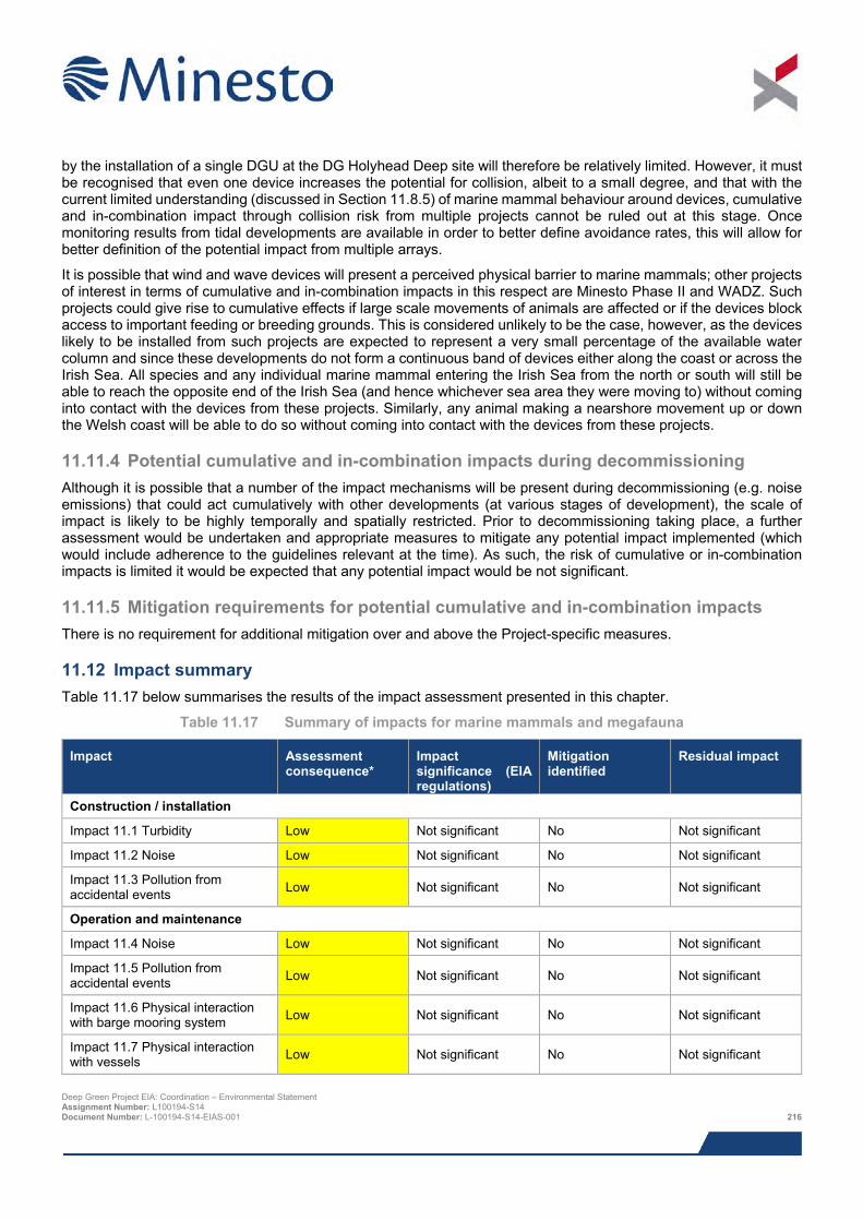
by the installation of a single DGU at the DG Holyhead Deep site will therefore be relatively limited. However, it must be recognised that even one device increases the potential for collision, albeit to a small degree, and that with the current limited understanding (discussed in Section 11.8.5) of marine mammal behaviour around devices, cumulative and in-combination impact through collision risk from multiple projects cannot be ruled out at this stage. Once monitoring results from tidal developments are available in order to better define avoidance rates, this will allow for better definition of the potential impact from multiple arrays.
It is possible that wind and wave devices will present a perceived physical barrier to marine mammals; other projects of interest in terms of cumulative and in-combination impacts in this respect are Minesto Phase II and WADZ. Such projects could give rise to cumulative effects if large scale movements of animals are affected or if the devices block access to important feeding or breeding grounds. This is considered unlikely to be the case, however, as the devices likely to be installed from such projects are expected to represent a very small percentage of the available water column and since these developments do not form a continuous band of devices either along the coast or across the Irish Sea. All species and any individual marine mammal entering the Irish Sea from the north or south will still be able to reach the opposite end of the Irish Sea (and hence whichever sea area they were moving to) without coming into contact with the devices from these projects. Similarly, any animal making a nearshore movement up or down the Welsh coast will be able to do so without coming into contact with the devices from these projects.
11.11.4 Potential cumulative and in-combination impacts during decommissioning Although it is possible that a number of the impact mechanisms will be present during decommissioning (e.g. noise emissions) that could act cumulatively with other developments (at various stages of development), the scale of impact is likely to be highly temporally and spatially restricted. Prior to decommissioning taking place, a further assessment would be undertaken and appropriate measures to mitigate any potential impact implemented (which would include adherence to the guidelines relevant at the time). As such, the risk of cumulative or in-combination impacts is limited it would be expected that any potential impact would be not significant.
11.11.5 Mitigation requirements for potential cumulative and in-combination impacts There is no requirement for additional mitigation over and above the Project-specific measures.
11.12 Impact summary Table 11.17 below summarises the results of the impact assessment presented in this chapter.
Table 11.17 Summary of impacts for marine mammals and megafauna
Impact Assessment consequence*
Impact significance (EIA regulations)
Mitigation identified
Residual impact
Construction / installation
Impact 11.1 Turbidity Low Not significant No Not significant
Impact 11.2 Noise Low Not significant No Not significant
Impact 11.3 Pollution from accidental events Low Not significant No Not significant
Operation and maintenance
Impact 11.4 Noise Low Not significant No Not significant
Impact 11.5 Pollution from accidental events Low Not significant No Not significant
Impact 11.6 Physical interaction with barge mooring system Low Not significant No Not significant
Impact 11.7 Physical interaction with vessels Low Not significant No Not significant
Deep Green Project EIA: Coordination – Environmental Statement Assignment Number: L100194-S14 Document Number: L-100194-S14-EIAS-001 216
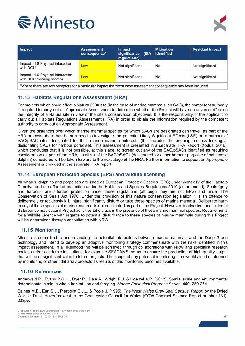
Impact Assessment
consequence* Impact significance (EIA regulations)
Mitigation identified
Residual impact
Impact 11.8 Physical interaction with DGU Low Not significant No Not significant
Impact 11.9 Physical interaction with DGU mooring system Low Not significant No Not significant
*Where there are two receptors for a particular impact the worst case assessment consequence has been included
11.13 Habitats Regulations Assessment (HRA) For projects which could affect a Natura 2000 site (in the case of marine mammals, an SAC), the competent authority is required to carry out an Appropriate Assessment to determine whether the Project will have an adverse effect on the integrity of a Natura site in view of the site’s conservation objectives. It is the responsibility of the applicant to carry out a Habitats Regulations Assessment (HRA) in order to obtain the information required by the competent authority to carry out an Appropriate Assessment.
Given the distances over which marine mammal species for which SACs are designated can travel, as part of the HRA process, there has been a need to investigate the potential Likely Significant Effects (LSE) on a number of SAC/pSAC sites designated for their marine mammal interests (this includes the ongoing process looking at designating SACs for harbour porpoise). This assessment is presented in a separate HRA Report (Xodus, 2016), which concludes that it is not possible, at this stage, to screen out any of the SAC/pSACs identified as requiring consideration as part of the HRA, so all six of the SAC/pSACs (designated for either harbour porpoise of bottlenose dolphin) considered will be taken forward to the next stage of the HRA. Further information to support an Appropriate Assessment is provided in the separate HRA report.
11.14 European Protected Species (EPS) and wildlife licensing All whales, dolphins and porpoises are listed as European Protected Species (EPS) under Annex IV of the Habitats Directive and are afforded protection under the Habitats and Species Regulations 2010 (as amended). Seals (grey and harbour) are afforded protection under these regulations (although they are not EPS) and under The Conservation of Seals Act 1970. Under the provision of this nature conservation legislation it is an offence to deliberately or recklessly kill, injure, significantly disturb or take these species of marine mammal. Deliberate harm to any of these species of marine mammal is not anticipated as part of the Project. However, inadvertent or accidental disturbance may occur if Project activities take place in the presence of these marine mammal species. Requirements for a Wildlife Licence with regards to potential disturbance to these species of marine mammals during this Project will be determined through consultation with NRW.
11.15 Monitoring Minesto is committed to understanding the potential interactions between marine mammals and the Deep Green technology and intend to develop an adaptive monitoring strategy commensurate with the risks identified in this impact assessment. In all likelihood this will be achieved through collaborations with NRW and specialist research bodies and/or academic institutions, for example SEACAMS, so as to ensure the production of high-quality output that will be of significant value to future projects. The scope of any potential monitoring plan would also be informed by monitoring of other tidal array projects as results of this monitoring becomes available.
11.16 References Anderwald P., Evans P.G.H., Dyer R., Dale A., Wright P.J. & Hoelzel A.R. (2012). Spatial scale and environmental determinants in minke whale habitat use and foraging. Marine Ecological Progress Series, 450, 259-274.
Baines M.E., Earl S.J., Pierpoint C.J.L. & Poole J. (1995). The West Wales Grey Seal Census. Report by the Dyfed Wildlife Trust, Haverfordwest to the Countryside Council for Wales (CCW Contract Science Report number 131). 238pp.
Deep Green Project EIA: Coordination – Environmental Statement Assignment Number: L100194-S14 Document Number: L-100194-S14-EIAS-001 217
Baines M.E. & Evans P.G.H. (2012). Atlas of the marine mammals of Wales. CCW Monitoring Report No. 68, 139pp.
Baines M.E., Reichelt M., Evans P.G.H. & Shepherd B. (2002). Comparison of the abundance and distribution of harbour porpoises (Phocoena phocoena) and bottlenose dolphins (Tursiops truncatus) in Cardigan Bay, UK. Pp. 12.13. In: Abstracts, 16th Annual Conference of the European Cetacean Society, 7-11 April, Liège, Belgium.
Benjamins S., Harnois V., Smith H.C.M., Johanning L., Greenhill L., Carter C. & Wilson B. (2014). Understanding the potential for marine megafauna entanglement risk from renewable marine energy developments. Scottish Natural Heritage Commissioned Report No. 791.
Berrow S.D., Whooley P., O’Connell M. & Wall D. (2010). Irish cetacean review (2000-2009). Irish Whale and Dolphin Group, 60pp.
Bloomfield A. & Solandt J.L. (2008). The Marine Conservation Society Basking Shark Watch 20-year report (1987-2006).
Brophy J.T. (2003). The diet of the common dolphin (Delphinus delphis L.) in Irish waters. Unpublished MSc thesis, National University of Ireland, Cork. Bush, 2006
Bush N. (2006). Spatial use by common dolphins in relation to habitat features in the Celtic Sea. MSc Thesis, University of Wales Bangor. 97pp. http://www.seawatchfoundation.org.uk/wp-content/uploads/2012/08/Natalie-Bush-thesis1.pdf [Accessed 5th May 2014].
Calderan S.V. (2003). Fine-scale temporal distribution by harbour porpoise (Phocoena phocoena) in North Wales: acoustic and visual survey techniques. In School of Biological Sciences. University of Wales, Bangor, Bangor, Wales.
Castrillon J. (2006). Population size of bottlenose dolphins (Tursiops truncatus) in Cardigan Bay (Special Area of Conservation), Wales. MSc Thesis, University of Javeriana, Colombia. 67pp. http://www.seawatchfoundation.org.uk/wp-content/uploads/2012/08/Juliana-Castrillon-thesis.pdf [Accessed 5th May 2014].
Clarke M.R. & Pascoe P.L. (1985). The stomach contents of a Risso’s dolphin (Grampus griseus) stranded in Thurlestone, South Devon (England, UK). Journal of the Marine Biological Association of the UK, 65(3), 663-666.
Cockcroft V.G., Haschick S.L. & Klages N.T.W. (1993). The diet of Risso’s dolphin, Grampus griseus (Cuvier, 1812), from the east coast of South Africa. Z. Saugertierkunde, 58, 286-293.
Corkeron P.J., Bryden M.M. & Hedstrom K.E. (1990). Feeding by bottlenose dolphins in association with trawling operations in Moreton Bay, Australia. The bottlenose dolphin, 329-336.
Couperus A.S. (1995). Interactions between Dutch midwater trawl and Atlantic white-sided dolphins (Lagenorhynchus acutus) southwest of Ireland. Journal of Northwest Atlantic Fishery Science, 22, 209-18.
de Boer M.N., Morgan-Jenks M., Taylor M. & Simmonds M.P. (2002). The small cetaceans of Cardigan Bay. British Wildlife, 13(4), 246-254.
de Boer M.N., Clark J., Leopold M.F., Simmonds M.P. & Reijnders P.J.H. (2013). Photoidentification methods reveal seasonal and long-term site-fidelity of Risso’s dolphins in shallow waters (Cardigan Bay, Wales). Open Journal of Marine Science, 3, 66-75.Deaville A., Brownlow A., Penrose R., Smith B., Barnett J., Perkins M. & Jepson P. (2013) Turning the screw: shipstrike in UK stranded cetaceans. Abstract submitted to and presentation made at the 27th European Cetacean Society Conference, Setubal, Portugal.
Department of Energy and Climate Change (DECC) (2009). Distribution of Cetaceans, Seals, Turtles, Sharks and Ocean Sunfish recorded from Aerial Surveys 2001- 2008. https://www.gov.uk/government/uploads/system/uploads/attachment_data/file/196494/OES_TechRep_non__avian_species.pdf [Accessed 25th August 2015].
Evans P.G.H. (2008). Whales, porpoises and dolphins. Order Cetacea in Harris, S & Yalden, DW (eds) Mammals of the British Isles. Handbook, 4th Ed. The Mammal Society, Southampton. pp. 655-780.
Evans P.G.H. (2012). Recommended management units for marine mammals in Welsh waters. CCW Policy Research Report No. 12/1.
Deep Green Project EIA: Coordination – Environmental Statement Assignment Number: L100194-S14 Document Number: L-100194-S14-EIAS-001 218
Evans P.G.H., Anderwald P. & Baines M.E. (2003). UK Cetacean Status Review. Report to English Nature and the Countryside Council for Wales. Sea Watch Foundation, Oxford, 160pp.
Evans P.G.H., Baines M.E. & Coppock J. (2010). Abundance and behaviour of cetaceans and basking sharks in the Pentland Firth and Orkney waters. Report by Hebog Environmental Ltd & Seawatch Foundation. Scottish Natural Heritage Commissioned Report (iBids and Project ID 1052).
Evans P.G.H. & Hintner K. (2010). A Review of the Direct and Indirect Impacts of Fishing Activities on Marine Mammals in Welsh Waters. CCW Policy Research Report No. 104. 160pp.
Evans P.G.H. & Shepherd B. (2001). Cetaceans in Liverpool Bay and Northern Irish Sea. Sea Watch Foundation, Oxford, 20pp.
Evans W.E. (1994). Common dolphin (Delphinus delphis Linnaeus, 1758). In Handbook of Marine Mammals, Volume 5: Dolphins. Academic Press, London.
Fontaine M.C., Tolley K.A., Siebert U., Gobert S., Lepoint G., Bouquegneau J-M. & Das K. (2007). Long-term feeding ecology and habitat use in harbour porpoises Phocoena phocoena from Scandinavian waters inferred from trace elements and stable isotopes. BMC Ecol. 2007; 7: 1.
Gordon J., Thompson D., Leaper R., Gillespie D., Pierpoint C., Calderan S., Macaulay J. & Gordon T. (2011). Studies of Marine Mammals in Welsh High Tidal Energy Waters. Produced on behalf of the Welsh Assembly Government. Document reference: JER3688R110408JG Phase 2.
Hammond P.S., Aarts G. & Matthiopoulos J.D. (2005a). Distribution and movements of grey seals around wales. SMRU contract report to Geotek.
Hammond P.S., Northridge S.P., Thompson D., Gordon C.D., Hall A.J., Aarts G. & Matthiopoulos J. (2005b). Background information on marine mammals for Strategic Environmental Assessment 6. Consultation document for the UK Department of Trade and Industry's offshore energy Strategic Environmental Assessment programme, 73pp.
Hammond P.S., Macleod K., Berggren P., Borchers D.L., Burt L., Cañadas A., Desportes G., Donovan G.P., Gilles A., Gillespie D., Gordon J., Hiby L., Kuklik I., Leaper R., Lehnert K., Leopold M., Lovell P., Øien N., Paxton C.G.M., Ridoux V., Rogan E., Samarra F., Scheidat M., Sequeira M., Siebert U., Skov H., Swift R., Tasker M.L., Teilmann J., Van Canneyt O. & Vázquez J.A. (2013). Cetacean abundance and distribution in European Atlantic shelf waters to inform conservation and management. Biological Conservation, 164, 107-122.
Hassani S., Antoine L. & Ridoux V. (1997). Diets of albacore, Thynnus alalunga, and dolphins, Delphinus delphis and Stenella coeruleoalba, caught in the northeast Atlantic albacore drift-net fishery: a progress report. Journal of Northwest Atlantic Fishery Science, 22, 119-123.
Haug T., Lindstrøm U., Nilssen K.T., Røttingen I. & Skaug H.J. (1995). Diet and food availability for north east Atlantic minke whales, Balaenoptera acutorostrata. International Whaling Commission Report No. SC/47/NA2.
Isaacman L. & Daborn G. (2011) Pathways of Effects for Offshore Renewable Energy in Canada. Report to Fisheries and Oceans Canada. Acadia Centre for Estuarine Research (ACER) Publication No. 102, Acadia University, Wolfville, NS, Canada. 70 pp.
Jessopp M., Cronin M. & Hart T. (2013). Habitat-Mediated Dive Behavior in Free-Ranging Grey Seals. PLoS ONE. 8(5), e63720. doi:10.1371/journal.pone.0063720.
Joint Nature Conservation Council (JNCC) (2010). The protection of marine European Protected Species from injury and disturbance - Guidance for the marine area in England and Wales and the UK offshore marine area, June 2010.
Jones E., McConnell B., Sparling C. & Matthiopoulos J. (2013). Grey and harbour seal usage maps. Task MR 5 (part). Sea Mammal Research Unit Report to Scottish Government. 28/08/2013 Version 2150.
Kiely O., Lidgard D., McKibben M., Connolly N. & Baines M. (2000). Grey seals: Status and monitoring in the Irish and Celtic Seas. Maritime Ireland/Wales INTERREG Report No. 3.
Kingston, P. (1999) Recovery of the marine environment following the Braer spill, Shetland. http://www.ioscproceedings.org/doi/pdf/10.7901/2169-3358-1999-1-103 [Accessed 12/09/2015].
Deep Green Project EIA: Coordination – Environmental Statement Assignment Number: L100194-S14 Document Number: L-100194-S14-EIAS-001 219
Laist D.W., Knowlton A.R., Mead J.G., Collet A.S. & Podesta M. (2001). Collisions between ships and whales. Marine Mammal Science. 17, 35 - 75.
Leeney R. (2007). Distribution and abundance of harbour porpoises and other cetaceans in Roaringwater Bay, Co. Cork. Report to the National Parks and Wildlife Service, 1-23.
Mackey M., Perales I Giménez D. & Ó Cadhla O. (2004). SEA678 Data Report for Offshore Cetacean Populations. Published by: Coastal & Marine Resources Centre, University College Cork.
Macleod K., Burt M.L., Cañadas A., Rogan E., Santos B., Uriarte A., Van Canneyt O., Vázquez J.A. & Hammond P.S. (2009). Design-based estimates of cetacean abundance in offshore European Atlantic waters. Appendix I in the Final Report of the Cetacean Offshore Distribution and Abundance in the European Atlantic. 16pp.
Marubini F., Gimona A., Evans P.G.H., Wright P.J. & Pierce G.J. (2009). Habitat preferences and interannual variability in occurrence of the harbour porpoise Phocoena phocoena off northwest Scotland. Marine Ecological Progress Series, 381, 297-310.
Maritime and Coastguard Agency (MCA) (2014). Annual survey of reported discharges attributed to vessels and offshore oil and gas installations operating in the United Kingdom pollution control zone 2013.
McConnell B.J., Fedak M.A., Lovell P. & Hammond P.S. (1999) Movements and foraging of grey seals in the North Sea. Journal of Applied Ecology, 36, 573-590.
MeyGen (2012). MeyGen tidal energy project – phase 1. Environmental Statement.
Minesto (2013). Deep Green Project. Request to Natural Resources Wales and the Marine Management Organisation for an Opinion on the Scope of the Environmental Statement. November 2013.
Murphy S., Tougaard J., Wilson B., Benjamins S., Haelters J., Lucke K., Werner S., Brensing K., Thompson D., Hastie G., Geelhoed S., Braeger S., Lees G., Davies I., Graw K-U & Pinn E. (2012). Assessment of the marine renewables industry in relation to marine mammals: synthesis of work undertaken by the ICES Working Group on Marine Mammal Ecology (WGMME). http://tethys.pnnl.gov/sites/default/files/publications/Murphy%20et%20al.%202012.pdf [Accessed 13th August 2014].
Natural England/Joint Nature Conservation Committee (2010). Marine Conservation Zone Project: Ecological Network Guidance. http://jncc.defra.gov.uk/PDF/100705_ENG_v10.pdf [Accessed 25th August 2015].
Nijkamp N., Clumpner C., Thomas T. & Conroy J. (2004). A guide to oiled wildlife response planning. IPIECA report series. Volume 13.
National Marine Fisheries Service (NMFS) (2005). Scoping Report for NMFS EIS for the National Acoustic Guidelines on Marine Mammals.
Nordøy E.S., Folkow L.P., Mårtensson P.E. & Blix A.S. (1995). Food requirements of north-east Atlantic minke whales. In Whales, seals, fish and man (Eds. A.S. Blix, L. Walløe and Ø. Ulltang). p307- 317. Elsevier, Amsterdam.
Northridge S.P., Tasker M.L., Webb A. & Williams J.M. (1995). Distribution and relative abundance of harbour porpoises, white-beaked dolphins and minke whales around the British Isles. ICES Journal of Marine Science, 52, 55-66.
Nowacek D.P. (2005). Acoustic ecology of foraging bottlenose dolphins (Tursiops truncatus), habitat-specific use of three sound types. Marine Mammal Science, 21(4), 587-602.
O’Brien J. & Berrow S.D. (2006). Seaweed ingestion by a bottlenose dolphin. Irish Naturalists’ Journal, 28(8), 338-339.
Penrose R.S. & Gander L.R. (2015). British Isles & Republic of Ireland Marine Turtle Strandings & Sightings Annual Report 2014. http://www.strandings.com/Graphics%20active/2014%20Turtle%20Annual%20Strandings%20Report.pdf [Accessed 7th August 2015].
Pesante G., Evans P.G.H., Anderwald P., Powell D. & McMath M. (2008a). Connectivity of bottlenose dolphins in Wales: North Wales photo-monitoring. CCW Marine Monitoring Report No. 62, 42pp.
Deep Green Project EIA: Coordination – Environmental Statement Assignment Number: L100194-S14 Document Number: L-100194-S14-EIAS-001 220
Pesante G., Evans P.G.H., Baines M.E. & McMath M. (2008b). Abundance and life history parameters of bottlenose dolphin in Cardigan Bay: monitoring 2005-2007. CCW Marine Monitoring Report No. 61, 81pp.
Pierpoint C. (2008). Harbour porpoise (Phocoena phocoena) foraging strategy at a high energy, near-shore site in south-west Wales, UK. Journal of the Marine Biological Association of the UK, 88, 1167-1173.
Pollock C.M., Reid J.B., Webb A. & Tasker M. (1997). The distribution of seabirds and cetaceans in the waters around Ireland JNCC Report No 267. Joint Nature Conservation Committee, Peterborough, UK.
Read A.J. (1999). Harbour porpoise Phocoena phocoena (Linnaeus, 1758). In Handbook of marine mammals 6: 323–355. Academic Press.
Read A.J. & Westgate A.J. (1997) Monitoring the movements of harbour porpoises (Phocoena phocoena) with satellite telemetry. Marine Biology, 130, 315-322.
Reid J.B., Evans P.G.H. & Northridge S. (2003). Atlas of cetacean distribution in north-west European waters. Joint Nature Conservation Committee, Peterborough.
Richardson W., Greene C., Malme C. & Thomson D. (1995) Marine Mammals and Sound. Academic Press.
Royal Haskoning (2011). SeaGen Environmental Monitoring Programme Final Report. http://www.marineturbines.com/sites/default/files/SeaGen-Environmental-Monitoring-Programme-Final-Report.pdf [Accessed 12th September 2015].
Sustainable Expansion of the Applied Coastal and Marine Sectors (SEACAMS) (2015). Vessel-based marine mammal surveys off West Anglesey. Report by SEACAMS for Minesto. July, 2015.
Santos M.B., Pierce G.J., Patterson I.A.P., Ross H.M. & Mente E. (2001). Stomach contents of bottlenose dolphins (Tursiops truncatus) in Scottish waters. Journal of the Marine Biological Association of the UK, 81, 873- 878.
Scottish Executive (2007). Scottish marine SEA. Environmental report section C SEA assessment: Chapter C9 marine mammals.
Southall B.L., Bowles A.E., Ellison W.T., Finneran J.J., Gentry R.L., Greene Jr C.R. & Kastak D. (2007). Marine Mammal Noise-Exposure Criteria: Initial Scientific Recommendations. Aquatic Mammals, 33(4), 411-521.
Special Committee on Seals (SCOS) (2013). Scientific Advice on Matters Related to the Management of Seal Populations: 2013. http://www.smru.st-andrews.ac.uk/documents/1803.pdf [Accessed 12th September 2015].
Special Committee on Seals (SCOS) (2014). Scientific Advice on Matter Related to the Management of Seal Populations: 2014. http://www.smru.st-and.ac.uk/documents/2589.pdf [Accessed 7th August 2015].
Shark Trust (2015) Shark sighting database. http://www.sharktrust.org/en/sightings/page [Accessed 7th August 2015].
Shucksmith R., Jones N.H., Stoyle G.W., Davies A & Dicks E.F. (2009). Abundance and distribution of the harbour porpoise (Phocoena phocoena) on the north coast of Anglesey, Wales UK. Journal of the Marine Biological Association of the United Kingdom, 89(5), 1051-1058.
SeaGeneration (2011). The Skerries Tidal Stream Array. Environmental Statement.
Sea Mammal Research Unit (SMRU) (2011). Utilisation of space by grey and harbour seals in the Pentland Firth and Orkney waters. Scottish Natural Heritage Commissioned Report No. 441.
SMRU Consulting (2015). Collision risk simulation modelling: marine mammals and Deep Green device at Holyhead Deep – final report. Report number SMRUC-MIN-2015-007 provided to Minesto UK Ltd, June 2015 (unpublished).
SMRU Marine (2014). Collision risk simulation modelling: harbour seals and Deep Green device at Strangford Lough. Report number smrum-min-2014-011. Provided to Minesto UK Ltd, October 2014 (unpublished).
Solandt J.L. & Chassin E. (2014). Marine Conservation Society Basking Shark Watch. Overview of data from 2009 to 2013. http://www.mcsuk.org/downloads/wildlife/basking_sharks/Basking%20Shark%20Report%202009_2013%20Summary.pdf [Accessed 27/05/2016].
Deep Green Project EIA: Coordination – Environmental Statement Assignment Number: L100194-S14 Document Number: L-100194-S14-EIAS-001 221
Sparling C.E., Coram A.J., McConnell B., Thompson D., Hawkins K.R. & Northridge S.P. (2013) Paper Three: Mammals. Wave & Tidal Consenting Position Paper Series.
Statutory Nature Conservation Bodies (SNCBs) (2013). Management units for marine mammals in UK waters. Cover note prepared by the UK Statutory Nature Conservation Bodies.
Statutory Nature Conservation Bodies (SNCBs) (2015). Management units for cetaceans in UK waters (January 2015). Note prepared by the JNCC on behalf of the UK Statutory Nature Conservation Bodies.
Stringell T.B., Millar C.P., Sanderson W.G., Westcott S.M. & McMath A.J. (2013). When aerial surveys will not do: grey seal pup production in cryptic habitats of Wales. Journal of the Marine Biological Association of the United Kingdom, 94(6), 1155-1159.
Strong P. (1996). The west Wales grey seal diet study. CCW Contract Science Report No. 132.
Strong P.G., Lerwill J., Morris S.R. & Stringell T.B. (2006). Pembrokeshire marine SAC grey seal monitoring 2005. CCW Marine Monitoring Report No. 26, 51pp.
Sveegaard S. (2011). Spatial and temporal distribution of harbour porpoises in relation to their prey. http://www2.dmu.dk/pub/phd_sign.pdf [Accessed 27/05/16].
The Celtic Array (2014). Round 3 Irish Sea Zone: Rhiannon Wind Farm. Stage 2 – Preliminary Environmental Information – Volume 1 – Main Technical Report. http://www.smru.st-and.ac.uk/documents/366.pdf [Accessed 01/11/2015].
Thompson D. (2012). Movements and Diving Behaviour of Grey Seals. Produced on behalf of the Welsh Assembly Government. Document Reference: JER3688 R 120712 HT Annex 1 In Gordon, J., Thompson, D., Leaper, R., Gillespie, D., Pierpoint, C., Calderan, S., Macaulay, J. and Gordon, T. (2011). Assessment of risk to marine mammals from underwater marine renewable devices in Welsh waters. RPS Report No. JER3688.
Thompson D., Culloch R. & Milne R. (2013). Current state of knowledge of the extent, causes and population effects of unusual mortality events in Scottish seals. Sea Mammal Research Unit Report to Scottish Government April 2013 [Version 1000].
Thompson D., Brownlow A., Onoufriou J. & Moss S. (2014). Collision risk and impact study: field tests of turbine blade-seal carcass collisions. Report by the Sea Mammal Research Unit, University of St Andrews, for Scottish Natural Heritage and Marine Scotland.
TVL (2015) Torr Head Tidal Project. Environmental Statement
Wall D., Murray C., O'Brien J., Kavanagh L., Wilson C., Ryan C., Glanville B., Williams D., Enlander I., O'Connor I., McGrath D., Whooley P. and Berrow S. (2013). Atlas of the distribution and relative abundance of marine mammals in Irish offshore waters 2005 - 2011. Irish Whale and Dolphin Group, Merchants Quay, Kilrush, Co Clare. ISBN 0- 9540552-7-6.
Weiffen M., Möller B., Mauck B. & Dehnhardt G. (2006). Effect of water turbidity on the visual acuity of harbour seals (Phoca vitulina). Vision research, 46(11), 1777-1783
Weir C.R., Pollock C., Cronin C. & Taylor S. (2001). Cetaceans of the Atlantic Frontier, north and west of Scotland. Continental Shelf Research, 21, 1047-1071.
Westcott S.M. (2002). The distribution of grey seals (Halichoerus grypus) and census of pup production in North Wales, 2001. CCW Contract Science Report No. 499, 140pp.
Westcott S.M. & Stringell T.B. (2003). Grey seal pup production for North Wales, 2002. Countryside Council for Wales. Marine Mammal Monitoring Report No. 5 5pp
Westcott S.M. & Stringell T.B. (2004). Grey Seal distribution and abundance in North Wales 2002-2004. Countryside Council for Wales. Marine Monitoring Report No. 13. 80 pp.
Wilson B., Batty R.S., Daunt F. & Carter C. (2007). Collision risks between marine renewable energy devices and mammals, fish and diving birds. Report to the Scottish Executive. Scottish Association for Marine Science, Oban.
Deep Green Project EIA: Coordination – Environmental Statement Assignment Number: L100194-S14 Document Number: L-100194-S14-EIAS-001 222

Wood C.J. (1998). Movement of bottlenose dolphins around the south-west coast of Britain. Journal of Zoology, 246(2), 155-163.
Xodus (2015a). Deep Green Project EIA: Technical Studies, Underwater Noise Modelling. Document No. L-100194-S01-TECH-006.
Xodus (2015b). Deep Green Project EIA: Technical Studies, Fish and Shellfish Ecology. Document No. L100194-S01-TECH-004.
Xodus (2016). Deep Green Holyhead Deep – Habitats Regulations Assessment (HRA) Report. Document number L-100194-S00-REPT-012. June 2016.
Deep Green Project EIA: Coordination – Environmental Statement Assignment Number: L100194-S14 Document Number: L-100194-S14-EIAS-001 223
12 OFFSHORE ORNITHOLOGY
This chapter examines the potential impacts on ornithology from installing and operating a single Deep Green Utility (DGU) unit in the 0.04 km2 Indicative Project Area including the presence of a fixed barge (or similar such surface platform) for up to five years.
> Scoping and consultation identified that four seabird receptors could potentially be affected by the Project, namely the regional breeding populations of common guillemot, razorbill, puffin and gannet. Based on a cautious interpretation of the results of boat-based ESAS and aerial survey previously undertaken to the west of Anglesey, and taking into consideration recent population trends, the Indicative Project Area is shown to have no more than low importance as a foraging area for these receptors.
> The Project could potentially cause disturbance to and displacement of seabirds effectively leading to a localised reduction in the availability of foraging habitat. Collisions between diving birds with the operational DGU unit and surface pollution from accidental contamination incidents could potentially cause seabird mortality. The potential for collision mortality was evaluated using encounter rate modelling (NRP, 2016).
> It is concluded that disturbance and displacement impacts will have negligible significance for all receptors examined. This conclusion is reached mainly due to the combination of negligible effect magnitude (i.e. low numbers of individuals predicted to be affected) and low receptor vulnerability.
> It is concluded that the impact of accidental pollution incidents on receptors will have negligible significance for all seabird receptors. This conclusion is reached despite some receptors having a high sensitivity to surface pollution and is contingent on the strict compliance with the various embedded mitigation measures designed to reduce the risk of occurrence and scale of accidental contamination incidents.
> Using cautious assumptions regarding average seabird density, connectivity to regional breeding colonies and behavioural avoidance (90%), it is predicted that small numbers of common guillemot and razorbill (on average approx. 16 adults and 2 adults per year respectively) from regional breeding populations could be killed annually through collision mortality; numbers that are negligible in the context of assumed baseline regional annual mortality (13,013 adults and 416 adults per year respectively). The predicted annual number of collision deaths of puffin and gannet is well below one adult per year and therefore trivial. Given that the four receptors examined all have a medium to long term increasing population status, it is concluded that the impact of collision mortality will have negligible significance for the receptors.
> Although no significant impacts have been identified, attention is drawn to the importance of the embedded mitigation measures aimed at ensuring that the risk of accidental contamination incidents occurring is extremely low and, should any incidents occur, that they are small in scale and effectively contained and cleaned up.
> An examination of the potential for the Project to contribute to cumulative and in combination impacts with other projects concludes that the Project could contribute in a small way to a potential cumulative minor magnitude collision mortality impact on the regional populations of common guillemot and razorbill, however this is unlikely to be significant given the medium to long term increasing population status of these receptors.
12.1 Introduction The potential effects of the Project on seabirds are assessed in this chapter. The DG Holyhead Deep Indicative Project Area (IPA) is used for foraging throughout the year by a number of common seabird species. Through scoping and consultation the species populations that could be plausibly affected by the Project were identified as common guillemot, razorbill, Atlantic puffin and northern gannet. The receptors examined in the assessments are the regional breeding populations of these species as defined by their breeding season foraging range.
Through consultation the potential effects that could affect the seabird receptor populations were identified as, disturbance, displacement, underwater collision between seabirds and the device, pollution from accidental events, indirect effects and the potential for these effects to act cumulatively and in-combination. The potential impacts of these effects are assessed.
Deep Green Project EIA: Coordination – Environmental Statement Assignment Number: L100194-S14 Document Number: L-100194-S14-EIAS-001 224
The Project is small in terms of the number of proposed tidal devices (just a single device will be deployed and operated for a maximum period of five years) and the geographical extent of its deployment (corresponding to a circular area of only 225 m in diameter). Furthermore, as will be shown, the offshore site does not have high importance to seabirds. For these reasons there is rather limited potential for the Project to impact seabird populations. The extent and detail of the assessments presented here for ornithology are considered to be proportional to that merited by the potential for seabirds to be affected.
The following specialists have contributed to the assessment:
> Xodus – initial baseline description; and
> Natural Research (Projects) Ltd – interpretation of baseline information, Encounter Rate Modelling (ERM), quantification of potential displacement and disturbance effects, impact assessment impact assessment and Environmental Statement (ES) chapter write up.
A list of all the supporting studies which relate to the ornithological impact assessment is presented in Table 12.1. All supporting studies are provided on the accompanying CD.
Table 12.1 Supporting studies
Details of study Deep Green Project EIA: Work Pack 1 – Offshore Ornithology Baseline (Xodus, 2014)
Deep Green Holyhead Deep Project: Seabird population information and collision risk to diving seabirds (NRP, 2016)
12.2 Area of assessment The focus of the impact assessment is the potential impacts on seabirds using the IPA and adjacent waters.
The following areas are referred to in this impact assessment:
> Project Development Area (PDA) (Figure 1.2):
o This is the area of seabed in which the DGU unit will be deployed. The exact siting of the device within the PDA has not yet been determined, but of the 4 km2 total area available, only a very small fraction will be developed for the Project (see below);
> The Indicative Project Area (IPA):
o For the purposes of the ornithology impact assessment this is an area of approximately 0. 04 km2
(Figure 12.1). The DGU unit has an footprint comprising a circle of 225 m diameter.
> The IPA buffered to 1 km:
o An area of approximately 3.9 km2 (Figure 12.1). This is the area used for the assessment of disturbance and displacement impacts (i.e. anticipated impact footprint). The extent of this area for assessment of these effects is highly precautionary as it is unlikely that seabirds will show responses to these effects as far as 1 km away from a source.
Seabirds are highly mobile, and the individuals using the area of assessment will be from populations using much wider areas. For the purposes of assessment seabird receptor populations are defined on the basis of breeding season Mean Maximum Foraging Range (MMFR) (NRP, 2016; Thaxter et al., 2012).
No dedicated baseline seabird surveys were undertaken, rather baseline information of seabird density in the vicinity of the IPA were extracted from the results of generic seabird surveys covering the seas off North Wales (Kober, 2010; WWT, 2009; JNCC ESAS database, Xodus, 2014; NRP, 2016). Due to its very small size, sampling intensity within the IPA site by these generic studies was low. Therefore to provide a more robust measure of density, the estimates of density used to inform the assessment were based on the results reported for an area corresponding to the IPA buffered to approximately 5 km (full details in NRP, 2016), as shown in Figure 12.1.
Deep Green Project EIA: Coordination – Environmental Statement Assignment Number: L100194-S14 Document Number: L-100194-S14-EIAS-001 225
12.3 Legislation, policy and guidance An integral aspect of the assessment of potential impacts on ornithology is the identification of species of conservation importance in the IPA and assessment of potential impacts on such species. There are a number of different statutes and guidance that are relevant in this regard these are listed below:
In addition to the EIA regulations, key legislation for ornithological interest includes:
> The Conservation of Habitats and Species Regulations 2010; and
> Wildlife and Countryside Act 1981 (as amended).
The Habitats Regulations, implement the requirements of the EU Wild Birds Directive implement the Habitats Directive and the Birds Directive in relation to England and Wales as far as the limit of territorial waters (usually 12 nautical miles) and aims to provide a comprehensive scheme of protection for all wild bird species naturally occurring in the EU. To meet the requirements outlined in Article 4 of the Birds Directive, particular emphasis is given to the protection of habitat for rare (i.e. as listed under Annex I) as well as migratory species via the establishment of a coherent network of Special Protection Areas (SPAs) comprising the most important territories for these species.
Plans or projects which are likely to have a significant impact on an SPA (and other European sites) either individually or in combination with other plans or projects (and are not connected with the management of the site) are subject to an ‘appropriate assessment’ under Article 6(3) of the EC Habitats Directive.
The Wildlife and Countryside Act (WCA) protects wildlife within the terrestrial environment and inshore waters (0 to 12 nm (22 km)) within Great Britain.
Guidance on ornithological assessments for tidal energy developments was derived from the following sources:
> Guidelines for ecological impact assessment in Britain and Ireland – Marine and Coastal (IEEM, 2010); and
> Draft guiding principles for cumulative impacts assessment (CIA) in offshore windfarms (Renewable UK, 2013).
12.4 Scoping and consultation Scoping and consultation have been on-going throughout the EIA and played an important part in ensuring the scope of the baseline characterisation work and impact assessment have been appropriate to the Project and the requirements of the regulators and their advisors.
Table 12.2 summarises all consultation activities carried out relevant to offshore ornithology.
Deep Green Project EIA: Coordination – Environmental Statement Assignment Number: L100194-S14 Document Number: L-100194-S14-EIAS-001 226
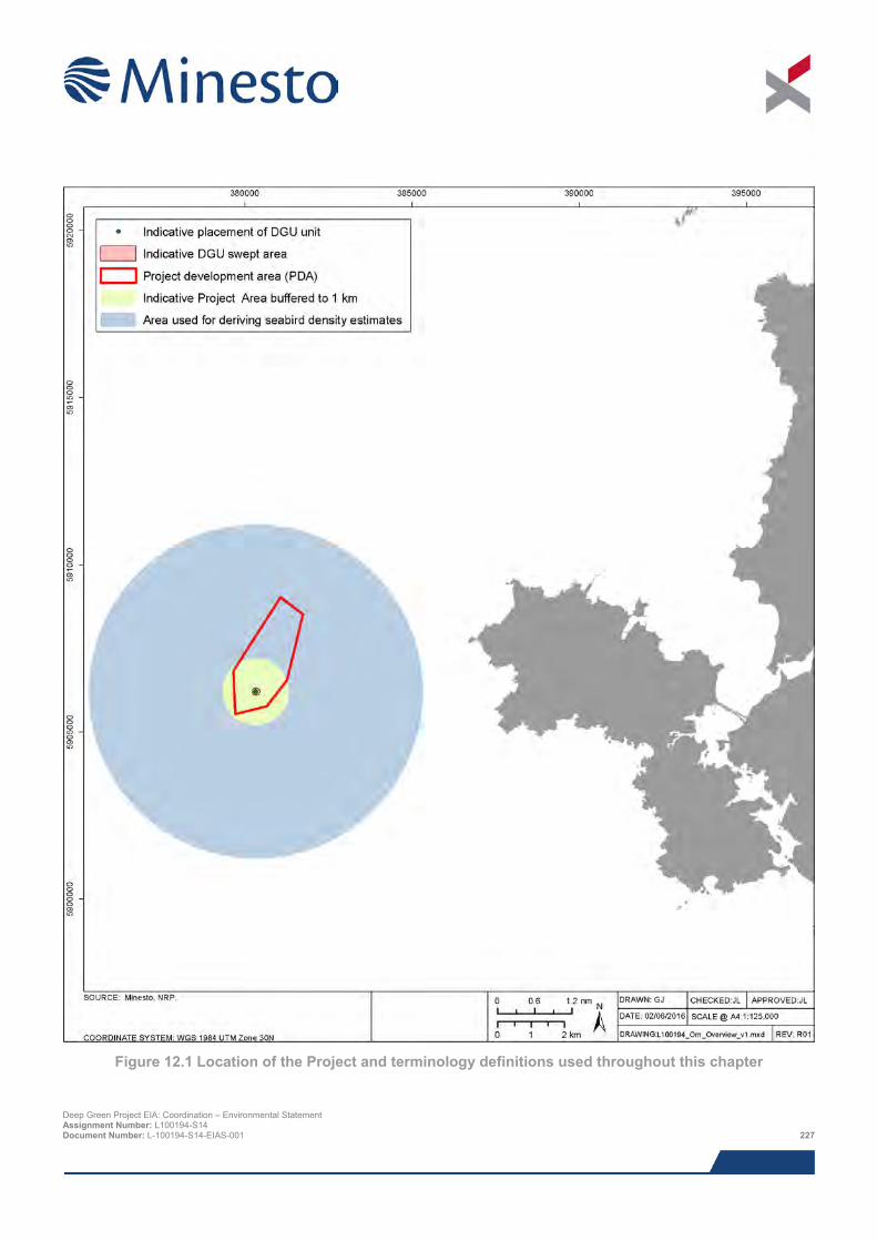
Figure 12.1 Location of the Project and terminology definitions used throughout this chapter
Deep Green Project EIA: Coordination – Environmental Statement Assignment Number: L100194-S14 Document Number: L-100194-S14-EIAS-001 227
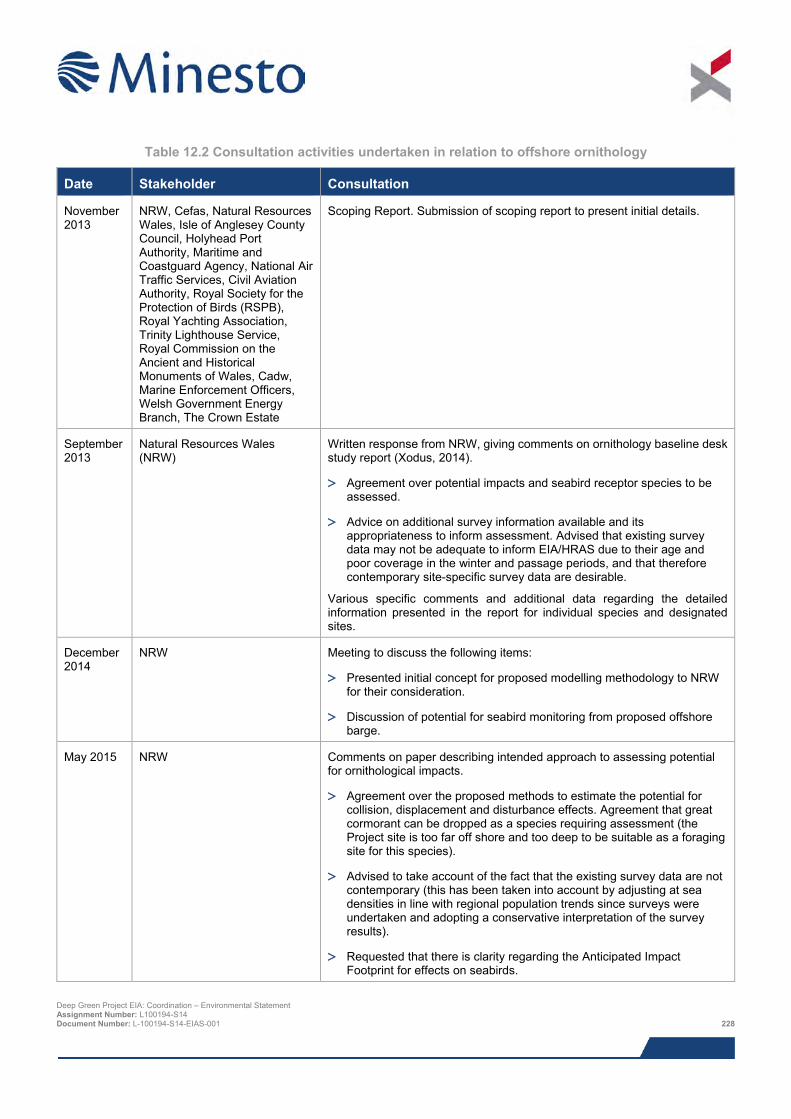
Table 12.2 Consultation activities undertaken in relation to offshore ornithology
Date Stakeholder Consultation
November 2013
NRW, Cefas, Natural Resources Wales, Isle of Anglesey County Council, Holyhead Port Authority, Maritime and Coastguard Agency, National Air Traffic Services, Civil Aviation Authority, Royal Society for the Protection of Birds (RSPB), Royal Yachting Association, Trinity Lighthouse Service, Royal Commission on the Ancient and Historical Monuments of Wales, Cadw, Marine Enforcement Officers, Welsh Government Energy Branch, The Crown Estate
Scoping Report. Submission of scoping report to present initial details.
September 2013
Natural Resources Wales (NRW)
Written response from NRW, giving comments on ornithology baseline desk study report (Xodus, 2014).
> Agreement over potential impacts and seabird receptor species to be assessed.
> Advice on additional survey information available and its appropriateness to inform assessment. Advised that existing survey data may not be adequate to inform EIA/HRAS due to their age and poor coverage in the winter and passage periods, and that therefore contemporary site-specific survey data are desirable.
Various specific comments and additional data regarding the detailed information presented in the report for individual species and designated sites.
December 2014
NRW Meeting to discuss the following items:
> Presented initial concept for proposed modelling methodology to NRW for their consideration.
> Discussion of potential for seabird monitoring from proposed offshore barge.
May 2015 NRW Comments on paper describing intended approach to assessing potential for ornithological impacts.
> Agreement over the proposed methods to estimate the potential for collision, displacement and disturbance effects. Agreement that great cormorant can be dropped as a species requiring assessment (the Project site is too far off shore and too deep to be suitable as a foraging site for this species).
> Advised to take account of the fact that the existing survey data are not contemporary (this has been taken into account by adjusting at sea densities in line with regional population trends since surveys were undertaken and adopting a conservative interpretation of the survey results).
> Requested that there is clarity regarding the Anticipated Impact Footprint for effects on seabirds.
Deep Green Project EIA: Coordination – Environmental Statement Assignment Number: L100194-S14 Document Number: L-100194-S14-EIAS-001 228
Date Stakeholder Consultation
May 2015 & January 2016
Local stakeholders Public event held to allow members of the public to comment on overall Project and to provide updates on the EIA.
12.5 Baseline description Baseline information required for the impact assessment is information on the density of seabirds occurring in the vicinity of the IPA, the likely connectivity between birds using this area and breeding colonies, the size of the receptor populations potentially affected and the current status of these populations.
12.5.1 Desk based study The main sources of data that were reviewed as part of the desk study are summarised in Table 12.3.
Table 12.3 Desk based studies
Topic Principle sources Supporting document report Species sensitivity to potential effects of tidal devices and associated activities.
Furness et al., 2012 Xodus, 2014.
ESAS and aerial surveys WWT, 2011; Kober et al., 2010; CCW, 2011
Xodus, 2014; NRP, 2016
Seabird breeding season mean maximum foraging range
Thaxter et al., 2012 Xodus, 2014; NRP, 2016
Receptor population status JNCC NRP, 2016 Species-specific information on diving behaviour
Thaxter et al., 2010; Spencer, 2012; Ropert-Coudert, 2009; Watanuki et al., 2006
NRP, 2016
ERM Wilson et al., 2007; EMEC, 2013 Xodus, 2014; NRP, 2016 Connectivity with nature conservation sites designated for sea birds
Thaxter et al., 2012 Xodus, 2014
Screening on the basis of species’ sensitivity to potential effects (Furness et al., 2012) and their habitat selection was used to identify those species which could plausibly be affected. Owing to the combination of a very small IPA (in the context of the areas used by potential seabird receptor populations) and as only a single DGU unit is proposed, no site-specific ornithology surveys were undertaken to inform the Project’s impact assessment. Instead data from surveys undertaken previously that include the vicinity of the IPA together with information on regional population trends since the surveys were undertaken were used to estimate the current value of the area to seabirds.
Sites of conservation interest of importance to relevant seabirds are shown in Figure 12.2 and Figure 12.3.
Deep Green Project EIA: Coordination – Environmental Statement Assignment Number: L100194-S14 Document Number: L-100194-S14-EIAS-001 229
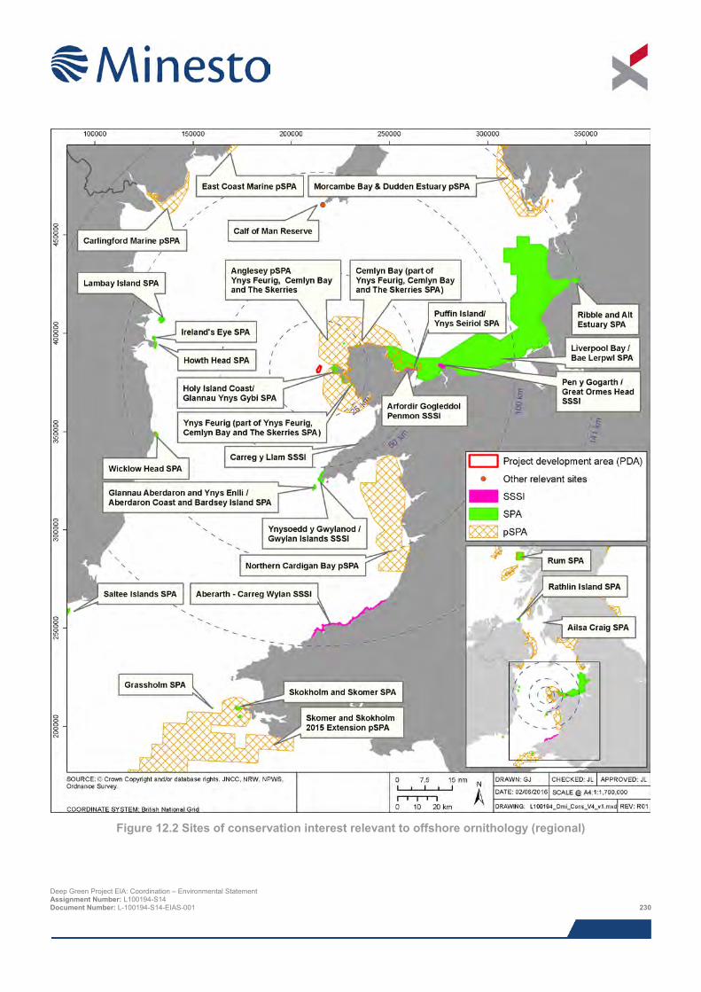
Figure 12.2 Sites of conservation interest relevant to offshore ornithology (regional)
Deep Green Project EIA: Coordination – Environmental Statement Assignment Number: L100194-S14 Document Number: L-100194-S14-EIAS-001 230
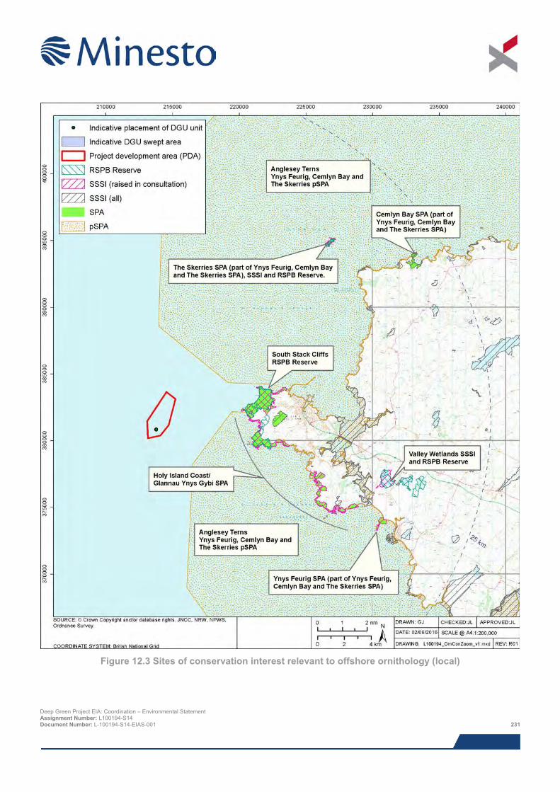
Figure 12.3 Sites of conservation interest relevant to offshore ornithology (local)
Deep Green Project EIA: Coordination – Environmental Statement Assignment Number: L100194-S14 Document Number: L-100194-S14-EIAS-001 231
12.5.2 Description of specific receptors The description of specific receptors focuses only on those species considered to be specifically at risk from the proposed project. A wider regional baseline is presented in Xodus (2014) Offshore Ornithology Baseline.
The species accounts that follow are shortened versions of the species accounts in NRP (2016). Information on typical foraging distances from breeding colonies derived from tagging studies (Thaxter et al., 2012) is used to give an indication of the likely geographic spread of source colonies of birds using the vicinity of the IPA and to define a species’ regional breeding population. Outside the breeding season there is typically greater uncertainty about the exact origin of the birds present due to fewer studies at this time of year. Nevertheless for all four species examined there is increasing evidence of widespread and often long-distance movements outside the breeding season and typically with considerable mixing of populations from different breeding areas (Wernham et al., 2002; Furness, 2014).
12.5.2.1 Common guillemot Common guillemot is by far the most numerous of the species examined, and occurs commonly throughout the year in the vicinity of the IPA. This species makes surface dives to forage in mid-water depths, typically attaining depths of between 10 and 60 m below the surface (Thaxter et al., 2010; Barret and Furness, 1990; Tremblay et al., 2003). Furness et al. (2012) rate this species as potentially having a high overall sensitivity to the effects of tidal energy developments. This is largely on account of the apparent potential for collision strikes with tidal devices; sensitivity to disturbance and displacement is categorised as low.
Common guillemots typically disperse widely away from breeding areas during the non-breeding period, and at this time there is extensive mixing of breeding populations (Wernham et al., 2002). However, some adults return to breeding colonies during the autumn and winter (Harris & Wanless, 1990).
For assessment purposes the regional breeding population is defined, on the basis of MMFR, as all birds breeding in Gwynedd, Isle of Man Co. Dublin and Co. Wicklow, these being the areas that lie within or just beyond the MMFR distance of 84 km (Thaxter et al., 2012). The Seabird 2000 census, the most recent comprehensive survey, counted a total of 90,968 guillemots attending colonies in these areas. Using a colony attendance correction factor of 1.34 (Mitchell et al., 2004), the size of the regional breeding population at the time of Seabird 2000 is estimated at 121,897 adults. Breeding numbers in Wales increased by approx. 75% between the Seabird 2000 census and 2013 (JNCC, 2014). This suggests that the size of the regional breeding population is currently around 213,320 adults, and this figure is used for assessment purposes.
Based on previous survey work, and before adjusting for recent population change, the estimated at-sea densities of guillemots in the vicinity of the Project site was approx. 1 bird/km2 in the colony-attendance part of the breeding season (April to July), 3 birds/km2 in the post-breeding season (August and September) and slightly less than 1 bird/km2 in the non-breeding season (October to March) (NRP, 2016). The JNCC population trends analysis shows that since these surveys were undertaken (mostly in the late 1980s and early 1990s), breeding numbers in Wales have increased approximately three fold. It follows that at-sea densities, at least in the breeding season, will have risen similarly.
For assessment purposes for all times of year it assumed that the realistic worst case scenario is average and peak densities in the vicinity of the Project site of 4 birds/km2 and 8 birds/km2 respectively, and that all birds are from the regional breeding population. These assumptions are precautionary as densities for most of the time are likely to be substantially lower, and outside the breeding season a proportion of birds are likely to originate from colonies outside the defined breeding region. The densities assumed for assessment purposes lie approximately in the middle of the range of common guillemot densities reported by for seas around the UK and are about typical in the context of densities reported for seas around Wales Kober et al. (2010).
Breeding common guillemot are a qualifying feature at several SPAs that lie within this species’ MMFR distance (84 km) from the IPA, the potential effects of the Project on the common guillemot feature at these SPAs is examined in detail in the Project’s HRA report (Xodus, 2016). In addition, there are two SSSI’s in North Wales that are not also designated as SPAs and for which common guillemot is listed as a feature. These are Carreg y Llam SSSI, which is 41 km from the IPA and has 9,770 breeding adults (Seabird 2000 count corrected for colony attendance rate) and Pen y Gogarth/Great Orme Head SSSI which is 70 km from the IPA and has 1,903 breeding adults (Seabird 2000 count corrected for colony attendance rate). Deep Green Project EIA: Coordination – Environmental Statement Assignment Number: L100194-S14 Document Number: L-100194-S14-EIAS-001 232
12.5.2.2 Razorbill Razorbills occur throughout the year in the vicinity of the Project site. This species typically makes relatively shallow dives in search of small fish prey, with dives depths rarely exceeding 30 m below the surface (Thaxter et al., 2010; Barret and Furness, 1990; Dall’Antonia et al., 2001). Furness et al. (2012) rate this species as potentially having a high overall sensitivity to tidal energy developments. This is on account of the apparent potential for collision strikes with tidal devices; sensitivity to disturbance and displacement is categorised as low.
Razorbills typically disperse widely away from breeding areas during the non-breeding period, mainly to more southerly areas such as the seas off France and Spain. During the non-breeding season razorbills using the Project site are likely to originate from more northern breeding areas such as Scotland and especially Iceland (Wernham et al., 2002).
For assessment purposes the regional breeding population is defined, on the basis of MMFR, as all birds breeding in Gwynedd. Two Gwynedd colonies, Bardsey Island and Great Orme, lie up to 10 km beyond the MMFR distance (48.5 km) from the Project site but are well within the MMFR distance plus one standard deviation (83.5 km) Thaxter et al. (2012).
The Seabird 2000 census counted a total of 2,959 birds at the Gwynedd colonies (Mitchell et al., 2007). Using a colony attendance factor of 1.34 (Mitchell et al., 2007), the size of the regional breeding population at the time of the Seabird 2000 census is estimated at 3,965 adults. Monitoring at sample colonies shows there has been negligible change in numbers since the Seabird 2000 census (JNCC, 2014) and therefore this number is considered to be a reasonable estimate of the current size of the regional population.
Based on previous survey work, and before adjusting for any population change, the estimated at-sea densities of razorbills was approx. 0.3 bird/km2 in the colony-attendance part of the breeding season (April to July), 1.9 birds/km2 in the post-breeding season (August and September) and 0.3 bird/km2 in the non-breeding season (October to March) (NRP, 2016). However, the JNCC population trends analysis shows that since these surveys were undertaken (mostly in the late 1980s and early 1990s), breeding numbers in Wales have increased by approximately 75%, with the main period of increase being in the late 1990s and before the Seabird 2000 census. It follows that at-sea densities, at least in the breeding season, will have risen similarly.
For assessment purposes for all times of year it assumed that the realistic worst case scenario is average and peak densities in the vicinity of the Project site of 1 birds/km2 and 3 birds/km2 respectively and that all birds are from the regional breeding population. These assumptions are highly precautionary because the survey evidence indicates that during the non-breeding season (October to March) densities are likely to be below 0.5 bird/km2 and that a substantial proportion of individuals are likely to originate from breeding colonies outside North Wales.
The densities assumed for assessment purposes lie approximately in the middle of the range of razorbill densities reported for seas around the UK, and are about typical in the context of densities reported for seas around Wales Kober et al. (2010).
Breeding razorbill are not a qualifying feature at any SPAs that lie within this species’ MMFR distance (48.5 km) from the IPA, but razorbill are found at nearby Holy Island Coast SAC (approximately 1,200 individuals) and at the South Stack RSPB reserve. Razorbills are also a key feature of the Pen y Gogarth / Great Orme’s Head SSSI, and there is an additional colony of Razorbill on Carreg y Llam, which comprises a population of 695 individuals though these are not a feature of the SSSI (NRW, 2014). Breeding razorbill are a qualifying feature at two SPAs within this species’ MaxFR distance (90 km) from the IPA, Irelands’ Eye (85 km from IPA) and Lambay Island IPA (83 km from IPA). The potential effects of the Project on the Atlantic puffins at these sites is examined in detail in the Project’s HRA report (Xodus, 2016).
12.5.2.3 Atlantic puffin Puffins occur throughout the year in the vicinity of the Project site. This species typically makes relatively shallow dives in search of small fish prey, with dives depths rarely exceeding 25 m below the surface (Spencer, 2012; Barrett and Furness, 1990). Furness et al. (2012) rate this species as potentially having a medium overall sensitivity to tidal energy developments. This is on account of the apparent potential for collision strikes with tidal devices; sensitivity to disturbance and displacement is categorised as low.
Deep Green Project EIA: Coordination – Environmental Statement Assignment Number: L100194-S14 Document Number: L-100194-S14-EIAS-001 233
Puffins typically disperse widely away from breeding areas during the non-breeding period and at this time there is extensive mixing of breeding populations (Wernham et al., 2002).
For assessment purposes the regional breeding population is defined, on the basis of MMFR, as all birds breeding in Gwynedd, Isle of Man and Co. Dublin. All these areas are comfortably within the MMFR of 105 km (Thaxter et al., 2012). The Seabird 2000 census counted a total of 1,536 Apparently Occupied Burrows (AOBs) in the defined region (AOBs) (Mitchell et al., 2007). Assuming a single breeding pair per AOB, the size of the regional breeding population at the time of the Seabird 2000 census is estimated at 3,072 adults.
No information on recent breeding trends in North Wales is available. However, it is known that the successful rat eradication programme at Puffin Island (east of Anglesey) has led to the recent re-establishment of breeding puffins on this island though numbers remain very small (8 pairs in 2010, http://www.puffinisland.org.uk/meet-the-birds). In South Wales, after a period of approximate stability from the mid-1980s to the early-2000’s numbers at, Skomer Island, Dyfed, (Wales’s largest colony) increased by approximately 50% between 2007 and 2013 (JNCC, 2014). For assessment purposes it is assumed that numbers in the defined breeding region showed a similar increasing trend in this period and that therefore the regional breeding population is currently around 4,608 adults. It should be noted that, much more so than all the other species considered here, breeding puffin are inherently difficult to census accurately and year-to-year variation in counts may only crudely reflect actual population changes.
Based on previous survey work, and before adjusting for recent population change, the estimated at-sea densities of puffins was approx. 0.3 bird/km2 in the colony-attendance part of the breeding season (April to August), and 0.2 bird/km2 in the non-breeding season (September to March) (NRP, 2016). Based on the population trend observed at Skomer Island (JNCC, 2014) it is reasonable to assume that at-sea densities of puffin off Wales in the breeding season are likely to have increased since the time when ESAS survey data were collected, mostly in the 1980s and 1990s. It is assumed that on average at-sea densities have increased by 50% since the surveys were undertaken.
For assessment purposes for all times of year it assumed that the realistic worst case scenario is average and peak densities in the vicinity of the Project site of 0.5 birds/km2 and 1.0 birds/km2 respectively and that all birds are from the regional breeding population. These assumptions are highly precautionary because the survey evidence indicates that during the non-breeding season (September to March) densities are likely to be below 0.2 bird/km2 and that a substantial proportion of individuals are likely to originate from breeding colonies outside North Wales.
The densities assumed for assessment purposes lie in the lower part of the range of puffin densities reported for seas around the UK and, with the exception of breeding season densities the vicinity of Skomer Island, are about typical in the context of densities reported for seas around Wales Kober et al. (2010).
Breeding puffins are a qualifying feature at several SPAs that lie within this species’ MMFR distance (105.4 km) from the IPA and a potential SPA (Skomer, Skokholm and the seas off Pembrokeshire) within the species’ MaxFR (200 km) from the IPA. The potential effects of the Project on the Atlantic puffins at these sites is examined in detail in the Project’s HRA report (Xodus, 2016). In addition, puffin are known to breed at nearby South Stack RSPB reserve, and are a key feature of two SSSIs within their MMFR. These include Ynysoedd y Gwylanod / Gwylan Islands SSSI (approximately 56 km from the Project site) and Ynys Seiriol / Puffin Island SSSI in Anglesey (approximately 50 km from the Project site). Ynys y Gwylanod SSSI had 759 AOBs at the most recent count, there are also large colonies of Puffin on the Skerries which had 415 AOB at the last count in 2013, and there is also a small colony on Holyhead coast which had 15 AOBs (NRW, 2014).
12.5.2.4 Northern gannet Gannets occur throughout the year in the vicinity of the Project site. This species typically plunge dives to catch fish prey, with dives depths rarely exceeding 15 m below the surface (Ropert-Coudert et al., 2009). Furness et al. (2012) rate this species as potentially having a low overall sensitivity to tidal energy developments.
Gannets typically disperse widely away from breeding areas, mainly to more southerly areas, during the non-breeding period and at this time there is extensive mixing of breeding populations (Wernham et al., 2002).
For assessment purposes the regional breeding population is defined, on the basis of the MMFR of 229 km (Thaxter et al., 2012), as birds breeding at the major colonies of Grassholm (Dyfed, 179 km) and Ailsa Craig (south west Scotland, 220 km) and at four small colonies, namely Scar Rock (Solway Firth, 152 km), Lambay Island (Co. Dublin, 83 km), Ireland’s Eye (Co. Dublin, 85 km) and Great Saltee (Co. Wexford, 175 km).
Deep Green Project EIA: Coordination – Environmental Statement Assignment Number: L100194-S14 Document Number: L-100194-S14-EIAS-001 234
The Seabird 2000 census counted a total of 70,260 Apparently Occupied Sites (AOSs) at these colonies (Mitchell et al., 2007). Multiplying the number of AOSs by two, the size of the regional breeding population at the time of the Seabird 2000 census is estimated at 140,520 adults. Between 2004 and 2009 the numbers of gannets breeding at the Grassholm colony (by far the largest colony in the region) increased by approximately 22% (JNCC, 2014). The present day regional population size is assumed to be 25% greater than at the time of the Seabird 2000 census, at 175,650 adults.
Based on previous survey work, and before adjusting for recent population change, the estimated at-sea densities of gannets was approx. 0.3 bird/km2 in the breeding season (April to September) and 0.15 bird/km2 in the non-breeding season (October to March) (NRP, 2016).
Based on the population trend (JNCC, 2014) it is reasonable to assume that at-sea densities of gannet off Wales in the breeding season are likely to have increased since the time when ESAS survey data were collected, mostly in the 1980s and 1990s. It is assumed that on average at-sea densities have increased by 25% since the surveys were undertaken.
For assessment purposes for all times of year it assumed that the realistic worst case scenario is average and peak densities in the vicinity of the Project site of 0.5 birds/km2 and 1.0 birds/km2 respectively and that all birds are from the regional breeding population. These assumptions are highly precautionary because the survey evidence indicates that during the non-breeding season (October to March) densities are likely to be below 0.2 bird/km2 and that a substantial proportion of individuals are likely to originate from breeding colonies outside the defined breeding region.
The densities assumed for assessment purposes lie in the lower part of the range of gannet densities reported for seas around the UK and, with the exception of the vicinity of Grassholm, are about typical in the context of densities reported for seas around Wales in general Kober et al. (2010).
Northern gannet are a qualifying feature at three SPAs that lie within this species’ MMFR distance (230 km) from the IPA. These include Grassholm SPA, Ireland’s Eye SPA and Lambay Island SPA. The potential effects of the Project on the northern gannets featured at these SPAs is examined in detail in the Project’s HRA report (Xodus, 2016).
12.5.3 Summary of baseline environment Four potentially sensitive seabird receptor populations are identified that could plausibly be affected by the Project, namely the regional breeding populations of common guillemot, razorbill, Atlantic puffin and northern gannet.
12.5.4 Data gaps and uncertainties The lack of contemporary survey data adds to uncertainty. This is overcome by correcting previous density assessments for recent population change. The survey uncertainty is greatest for the non-breeding period. However in general species are less vulnerable to effects in the autumn and winter as they are not spatially constrained by breeding activities nor have the additional energetic demands imposed by provisioning chicks and moulting.
Time-at-depth data specific to the Project site are not available for any species, and thus time-at-depth data from elsewhere, and all from breeding season studies, were used in the ERM to estimate collision risk. It is very unlikely that Project site-specific data would be so different that it would have more than a minor effect on model outputs.
There is currently no empirical information on the effectiveness of behavioural avoidance by diving seabirds to reduce collision risk or what proportion of collisions lead to death or serious injury. In light of this, and in keeping with the desire for assessment to be precautionary, a relatively low ‘avoidance rate’ (90%) is assumed for assessment purposes.
12.6 Impact assessment
12.6.1 Overview This assessment covers all impacts identified during scoping, as well as any further potential impacts that have been highlighted as the EIA has progressed. It should be noted that impacts are not necessarily relevant to all Project stages.
Deep Green Project EIA: Coordination – Environmental Statement Assignment Number: L100194-S14 Document Number: L-100194-S14-EIAS-001 235
The list below indicates all of the direct and indirect impacts assessed in this chapter in relation of offshore ornithology, and indicates the Project stages to which they relate. Cumulative impacts are discussed in Section 12.6.
> Collision risk between DGU device and diving seabirds;
> Disturbance from vessels and other operations;
> Displacement from infrastructure;
> Pollution from accidental events;
> Indirect effects from changes in habitat and prey; and
> Cumulative and in-combination impacts.
No impacts were scoped out of the assessment during EIA scoping. Lighting was not considered in scoping but is scoped out. The only lighting proposed is that which would be required on the barge to comply with navigation lighting requirements, occasional floodlighting to extend winter working hours, and on rare occasions, floodlighting to facilitate 24 hour working, although this is not part of planned operations. Such short-term, irregular and highly localised periods of floodlighting is not likely to impact seabirds species and has not been considered any further.
12.6.2 Anticipated impact footprint The assessment considers the geographical area over which impacts from the Project may affect birds, i.e. the anticipated impact footprint (AIF). The definition of the AIFs used for the ornithology impact assessment purposes is based on a conservative interpretation of the best information available on the likely response by species to a potential effect. The area over which an impact may affect a species will vary according to the nature of the effect and the sensitivity of the species to that effect.
Collisions between diving birds and the DGU unit clearly cannot occur beyond the DGU unit, therefore the AIF for this collision risk impact is limited to the Project site; the estimation of collision risk is based on the average density of birds present (NRP, 2016). The other potential impact sources may affect birds at some distance from the source of the effect. Disturbance and displacement effects are assumed to affect birds up to 1 km from the source, so for these effects the AIF is defined as the area contained within a IPA buffered to 1 km (i.e., a 1 km buffer around the DGU unit) and the assessment based on the proportion of the regional breeding population estimated to occur in this area. The proportion of for each species’ regional breeding population that would occur within the 1 km buffer AIF is examined for a range of densities in Table 12.4.
In Table 12.4 the values for the estimated present day mean density and peak density are indicated by green and blue shading respectively; the blue-shaded peak density values are used for the assessment of disturbance and displacement.
12.6.3 Assessment criteria The EIA process and methodology are described in detail in Chapter 8: EIA Methodology. Project specific criteria have been developed for magnitude of impact (including duration, frequency, seasonality and geographic extent) as detailed in Section 8.3.
The classification of receptor sensitivity used for impact assessment adopts the results of the reviews by Furness et al. (2012) and Wiens et al. (1995) into the sensitivity of seabird species to various impacts, as summarised in Table 12.5.
Topic specific criteria were developed for receptor vulnerability (Table 12.6). Information on both receptor sensitivity, impact magnitude (in the context of relative to receptor population size and range, and receptor population status is required to determine receptor vulnerability.
Deep Green Project EIA: Coordination – Environmental Statement Assignment Number: L100194-S14 Document Number: L-100194-S14-EIAS-001 236
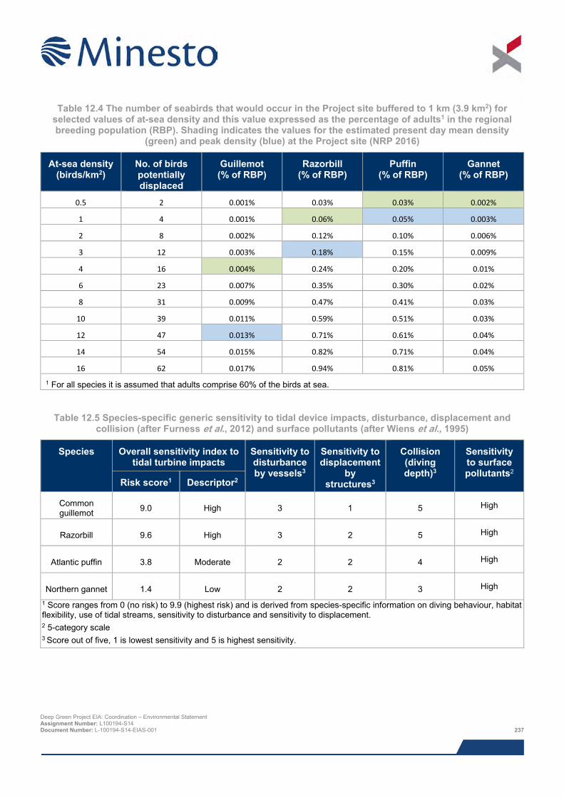
Table 12.4 The number of seabirds that would occur in the Project site buffered to 1 km (3.9 km2) for
selected values of at-sea density and this value expressed as the percentage of adults1 in the regional breeding population (RBP). Shading indicates the values for the estimated present day mean density
(green) and peak density (blue) at the Project site (NRP 2016)
At-sea density (birds/km2)
No. of birds potentially displaced
Guillemot (% of RBP)
Razorbill (% of RBP)
Puffin (% of RBP)
Gannet (% of RBP)
0.5 2 0.001% 0.03% 0.03% 0.002%
1 4 0.001% 0.06% 0.05% 0.003%
2 8 0.002% 0.12% 0.10% 0.006%
3 12 0.003% 0.18% 0.15% 0.009%
4 16 0.004% 0.24% 0.20% 0.01%
6 23 0.007% 0.35% 0.30% 0.02%
8 31 0.009% 0.47% 0.41% 0.03%
10 39 0.011% 0.59% 0.51% 0.03%
12 47 0.013% 0.71% 0.61% 0.04%
14 54 0.015% 0.82% 0.71% 0.04%
16 62 0.017% 0.94% 0.81% 0.05% 1 For all species it is assumed that adults comprise 60% of the birds at sea.
Table 12.5 Species-specific generic sensitivity to tidal device impacts, disturbance, displacement and collision (after Furness et al., 2012) and surface pollutants (after Wiens et al., 1995)
Species Overall sensitivity index to tidal turbine impacts
Sensitivity to disturbance by vessels3
Sensitivity to displacement
by structures3
Collision (diving depth)3
Sensitivity to surface pollutants2
Risk score1 Descriptor2
Common guillemot 9.0 High 3 1 5 High
Razorbill 9.6 High 3 2 5 High
Atlantic puffin 3.8 Moderate 2 2 4 High
Northern gannet 1.4 Low 2 2 3 High
1 Score ranges from 0 (no risk) to 9.9 (highest risk) and is derived from species-specific information on diving behaviour, habitat flexibility, use of tidal streams, sensitivity to disturbance and sensitivity to displacement. 2 5-category scale 3 Score out of five, 1 is lowest sensitivity and 5 is highest sensitivity.
Deep Green Project EIA: Coordination – Environmental Statement Assignment Number: L100194-S14 Document Number: L-100194-S14-EIAS-001 237
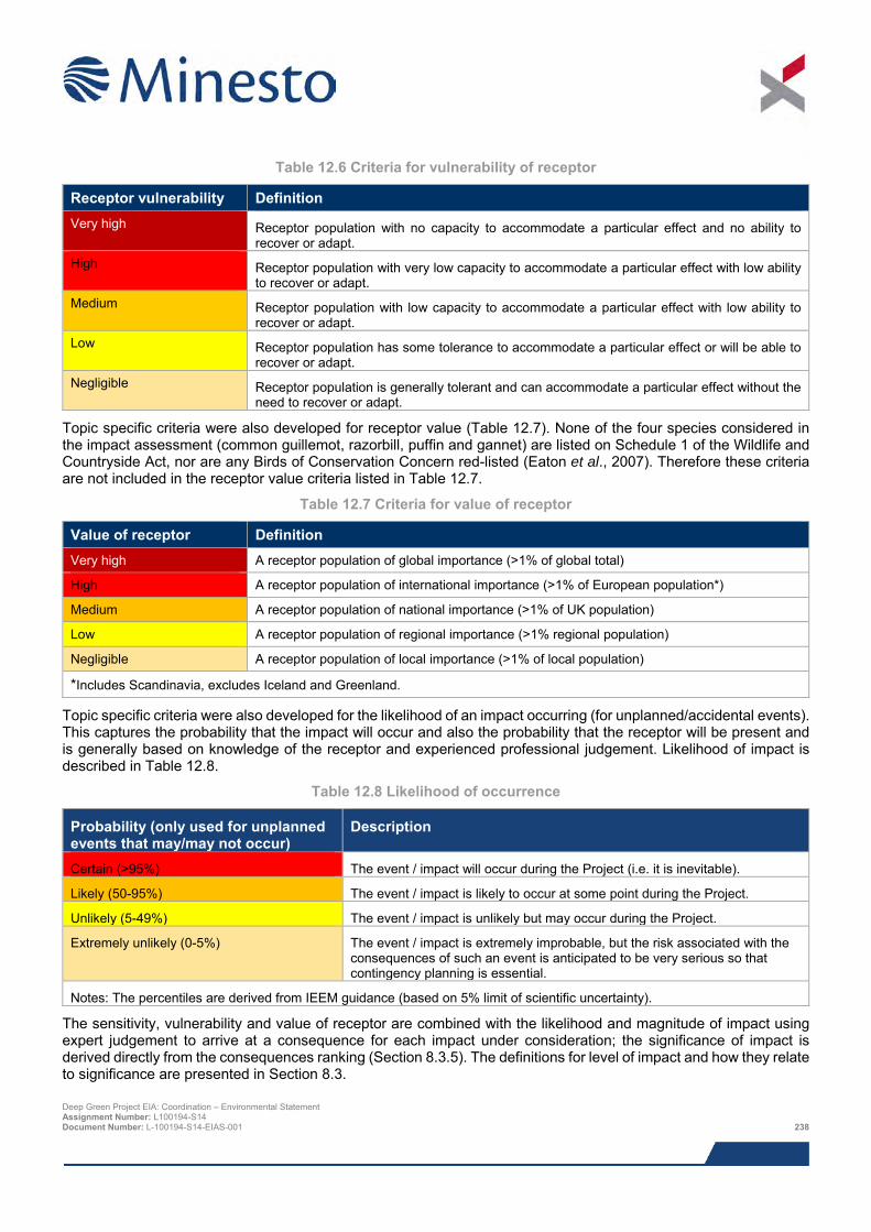
Table 12.6 Criteria for vulnerability of receptor
Receptor vulnerability Definition Very high Receptor population with no capacity to accommodate a particular effect and no ability to
recover or adapt. High Receptor population with very low capacity to accommodate a particular effect with low ability
to recover or adapt. Medium Receptor population with low capacity to accommodate a particular effect with low ability to
recover or adapt. Low Receptor population has some tolerance to accommodate a particular effect or will be able to
recover or adapt. Negligible Receptor population is generally tolerant and can accommodate a particular effect without the
need to recover or adapt.
Topic specific criteria were also developed for receptor value (Table 12.7). None of the four species considered in the impact assessment (common guillemot, razorbill, puffin and gannet) are listed on Schedule 1 of the Wildlife and Countryside Act, nor are any Birds of Conservation Concern red-listed (Eaton et al., 2007). Therefore these criteria are not included in the receptor value criteria listed in Table 12.7.
Table 12.7 Criteria for value of receptor
Value of receptor Definition Very high A receptor population of global importance (>1% of global total)
High A receptor population of international importance (>1% of European population*)
Medium A receptor population of national importance (>1% of UK population)
Low A receptor population of regional importance (>1% regional population)
Negligible A receptor population of local importance (>1% of local population)
*Includes Scandinavia, excludes Iceland and Greenland.
Topic specific criteria were also developed for the likelihood of an impact occurring (for unplanned/accidental events). This captures the probability that the impact will occur and also the probability that the receptor will be present and is generally based on knowledge of the receptor and experienced professional judgement. Likelihood of impact is described in Table 12.8.
Table 12.8 Likelihood of occurrence
Probability (only used for unplanned events that may/may not occur)
Description
Certain (>95%) The event / impact will occur during the Project (i.e. it is inevitable).
Likely (50-95%) The event / impact is likely to occur at some point during the Project.
Unlikely (5-49%) The event / impact is unlikely but may occur during the Project.
Extremely unlikely (0-5%) The event / impact is extremely improbable, but the risk associated with the consequences of such an event is anticipated to be very serious so that contingency planning is essential.
Notes: The percentiles are derived from IEEM guidance (based on 5% limit of scientific uncertainty).
The sensitivity, vulnerability and value of receptor are combined with the likelihood and magnitude of impact using expert judgement to arrive at a consequence for each impact under consideration; the significance of impact is derived directly from the consequences ranking (Section 8.3.5). The definitions for level of impact and how they relate to significance are presented in Section 8.3. Deep Green Project EIA: Coordination – Environmental Statement Assignment Number: L100194-S14 Document Number: L-100194-S14-EIAS-001 238
12.6.4 Design envelope This assessment considers the Project parameters which are predicted to result in the greatest environmental impact. This approach ensures that impacts of a greater adverse significance would not arise should any other Project scenario be taken forward in the final scheme design. With regards to the assessment of ornithological impacts the assessment comprises:
> For common guillemot the worst case scenario (based on ERM output) is the DGU unit operated in normal mode, as illustrated in Chapter 5: Project Description, Figure 5.3;
> For razorbill, puffin and gannet the worst case scenario (based on ERM output) is the DGU unit operated in upside-down mode, as illustrated in Chapter 5: Project Description, Figure 5.35. Although the DGU unit operates in the same part of the water column irrespective of operational mode, upside-down mode introduces additional risk for these species because of the increased potential exposure to tether collisions in shallow water; and
> Presence of the barge (or similar such surface platform) for up to five years.
12.6.5 Data gaps and uncertainties When undertaking the impact assessment the following uncertainties have been identified:
> Collision avoidance rate
o There is currently a lack of information on the effectiveness of avoidance and evasion behaviour by diving birds to operating tidal stream devices of all types (including DGU units) and the consequences, if any, to a bird should it be involved in a collision event. This topic and the question of what avoidance rate is appropriate for the impact assessment are examined in detail in NRP (2016).
The uncertainty around collision impact mechanisms have been considered when defining sensitivity of receptor and magnitude of effect.
For all other potential effects there are considered to be no significant gaps or uncertainties relating to the outputs of analyses or assessment methods that compromise the ability to undertake robust assessment of impacts. Small uncertainties are overcome by adopting precautionary assumptions assessments so that assessment conclusions err on the side of caution.
12.7 Impacts during construction and installation period
12.7.1 Impact 12.1 Disturbance from vessels Construction and installation activities (hereafter referred to as the construction stage), especially those involving fast moving vessels, have the potential to disturb foraging seabirds. This stage of the Project will take place over a number of weeks, and is predicted to involve surface vessels working in the IPA. Disturbance would involve a series of temporary events over the short term. Disturbance would have two proximate effects on the birds affected. First, it would temporarily displace birds from the vicinity of the disturbance and is thus akin to temporary habitat loss, effectively depriving them of foraging habitat. However, all receptor populations have very large foraging areas (thousands of km2) available to them. Second, disturbance may result in birds having less time to forage and cause them to expend additional energy, for example if they are flushed and have to relocate. The effects on time/energy budgets are not likely to result in adult mortality, but could lead to a reduction in provisioning chick rates for the individuals affected and thereby potentially lead to a reduction in productivity.
Disturbance would occur throughout the IPA but at any one time would be spatially limited to the proximity where vessels are operating, i.e. only part of the IPA. Vessels moving between their embarkation port and the IPA would also have the potential to disturb seabirds, but this would be relatively infrequent (e.g. typically one vessel movement per day), and result in very short term and spatially limited disturbance as a vessel passed through an area.
Deep Green Project EIA: Coordination – Environmental Statement Assignment Number: L100194-S14 Document Number: L-100194-S14-EIAS-001 239
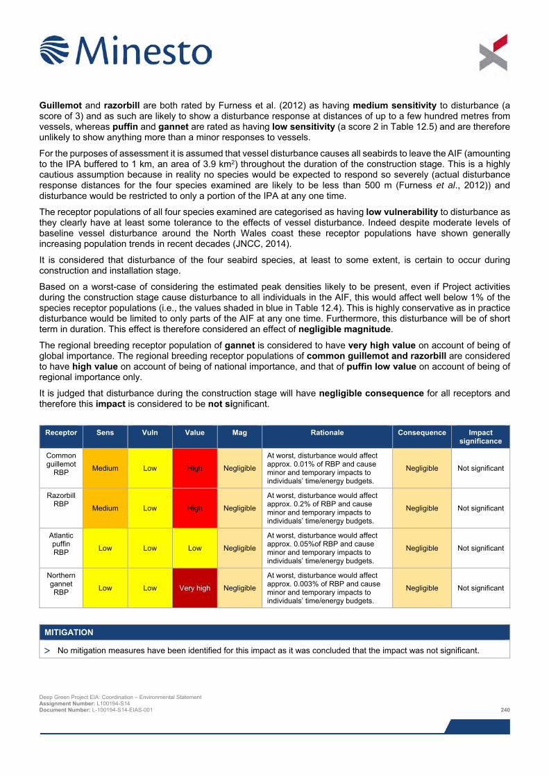
Guillemot and razorbill are both rated by Furness et al. (2012) as having medium sensitivity to disturbance (a score of 3) and as such are likely to show a disturbance response at distances of up to a few hundred metres from vessels, whereas puffin and gannet are rated as having low sensitivity (a score 2 in Table 12.5) and are therefore unlikely to show anything more than a minor responses to vessels.
For the purposes of assessment it is assumed that vessel disturbance causes all seabirds to leave the AIF (amounting to the IPA buffered to 1 km, an area of 3.9 km2) throughout the duration of the construction stage. This is a highly cautious assumption because in reality no species would be expected to respond so severely (actual disturbance response distances for the four species examined are likely to be less than 500 m (Furness et al., 2012)) and disturbance would be restricted to only a portion of the IPA at any one time.
The receptor populations of all four species examined are categorised as having low vulnerability to disturbance as they clearly have at least some tolerance to the effects of vessel disturbance. Indeed despite moderate levels of baseline vessel disturbance around the North Wales coast these receptor populations have shown generally increasing population trends in recent decades (JNCC, 2014).
It is considered that disturbance of the four seabird species, at least to some extent, is certain to occur during construction and installation stage.
Based on a worst-case of considering the estimated peak densities likely to be present, even if Project activities during the construction stage cause disturbance to all individuals in the AIF, this would affect well below 1% of the species receptor populations (i.e., the values shaded in blue in Table 12.4). This is highly conservative as in practice disturbance would be limited to only parts of the AIF at any one time. Furthermore, this disturbance will be of short term in duration. This effect is therefore considered an effect of negligible magnitude.
The regional breeding receptor population of gannet is considered to have very high value on account of being of global importance. The regional breeding receptor populations of common guillemot and razorbill are considered to have high value on account of being of national importance, and that of puffin low value on account of being of regional importance only.
It is judged that disturbance during the construction stage will have negligible consequence for all receptors and therefore this impact is considered to be not significant.
Receptor Sens Vuln Value Mag Rationale Consequence Impact
significance
Common guillemot
RBP Medium Low High Negligible
At worst, disturbance would affect approx. 0.01% of RBP and cause minor and temporary impacts to individuals’ time/energy budgets.
Negligible Not significant
Razorbill RBP Medium Low High Negligible
At worst, disturbance would affect approx. 0.2% of RBP and cause minor and temporary impacts to individuals’ time/energy budgets.
Negligible Not significant
Atlantic puffin RBP Low Low Low Negligible
At worst, disturbance would affect approx. 0.05%of RBP and cause minor and temporary impacts to individuals’ time/energy budgets.
Negligible Not significant
Northern gannet RBP Low Low Very high Negligible
At worst, disturbance would affect approx. 0.003% of RBP and cause minor and temporary impacts to individuals’ time/energy budgets.
Negligible Not significant
MITIGATION
> No mitigation measures have been identified for this impact as it was concluded that the impact was not significant.
Deep Green Project EIA: Coordination – Environmental Statement Assignment Number: L100194-S14 Document Number: L-100194-S14-EIAS-001 240
12.7.2 Impact 12.2 Pollution from accidental events The release of oil and other marine pollutants could have lethal and sub-lethal effects on seabirds and their prey. The potential for seabirds to be adversely affected by oil pollution is well known. For example, the release of a relatively modest quantity (ca 300 tonnes) of fuel oil from container ship MSC Napoli in Lyme Bay in 2007 resulted in the death or injury of at least 3,000 seabirds (Law, 2008).
A special aspect of accidental release of contaminants, especially oil, is that they can be spread by wind and currents over very large areas and thus potentially affect birds in areas up to many tens of kilometres away from the source. For this reason it is not possible to define an AIF, except in a very broad sense, though the area that might be affected will depend on the size of the event, the type of contaminant involved and the prevailing weather conditions. It is also reasonable to conclude, based on the MSC Napoli incident, that even quite modest accidental releases of oil can affect large areas. For these reasons, the emphasis is on preventing accidental release of contaminants and having the appropriate contingency plans and equipment in place to rapidly respond and instigate containment and clean-up operations.
The quantities of potential pollutants such as oil contained in the DGU unit is negligible, therefore the potential for accidental pollution predominantly arise from the potential risk of collisions involving the Project vessels, the barge and other vessels. These risks are assessed in detail in Chapter 18: Hydrocarbon and Chemical Releases. Safety zones during the construction and installation stage will reduce the likelihood of an incident.
Although no significant impacts have been identified, due to the high sensitivity of all species considered, mitigation measures have been identified that will be employed to ensure potential impacts are minimised, as detailed in Chapter 14: Shipping and Navigation, and Chapter 18: Hydrocarbon and Chemical Releases
Wiens et al. (1995) rates common guillemot, razorbill, puffin and gannet as having high sensitivity to surface pollutants. The receptor populations of all four species examined clearly have at least some tolerance to this effect. For example, these receptor populations have shown generally increasing population trends in recent decades (JNCC, 2014) despite the effects of the existing background level of marine pollution incidents. In all case the receptor populations are spread over very wide geographic areas (on the basis of MMFR). However, common guillemot and razorbill have important breeding colonies on Holy Island, approx. 6.5 km to the east of the Project site, and given prevailing westerly wind directions, these receptors are therefore considered to have medium vulnerability to contamination incidents. Gannet and puffin do not have important colonies locally, and are therefore considered to have low vulnerability to this impact for the (small) scale of an accidental contamination event, should it occur.
It is considered that pollution from accidents is extremely unlikely to occur during construction and installation stage.
As a result of the embedded best practice and mitigation described above, the worst case impact of the accidental release of contaminants during the construction and installation stage on regional seabird populations is assessed as short-term, unlikely to occur and at worst would affect only a small proportion of the population, it is therefore categorised as an impact of negligible magnitude.
The regional breeding receptor population of gannet is considered to have very high value on account of being of global importance. The regional breeding receptor populations of common guillemot and razorbill are considered to have high value on account of being of national importance, and that of puffin low value on account of being of regional importance only.
It is judged that the risk of pollution events during the construction stage will have negligible consequence for all receptors and therefore this impact is considered to be not significant.
Deep Green Project EIA: Coordination – Environmental Statement Assignment Number: L100194-S14 Document Number: L-100194-S14-EIAS-001 241
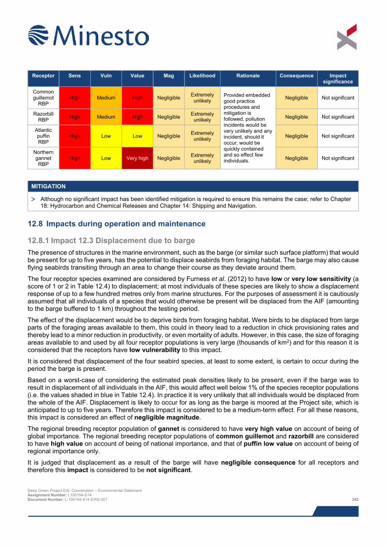
Receptor Sens Vuln Value Mag Likelihood Rationale Consequence Impact
significance
Common guillemot
RBP High Medium High Negligible Extremely
unlikely Provided embedded good practice procedures and mitigation is followed, pollution incidents would be very unlikely and any incident, should it occur, would be quickly contained and so effect few individuals.
Negligible Not significant
Razorbill RBP High Medium High Negligible Extremely
unlikely Negligible Not significant
Atlantic puffin RBP
High Low Low Negligible Extremely unlikely Negligible Not significant
Northern gannet RBP
High Low Very high Negligible Extremely unlikely Negligible Not significant
MITIGATION
> Although no significant impact has been identified mitigation is required to ensure this remains the case; refer to Chapter 18: Hydrocarbon and Chemical Releases and Chapter 14: Shipping and Navigation.
12.8 Impacts during operation and maintenance
12.8.1 Impact 12.3 Displacement due to barge The presence of structures in the marine environment, such as the barge (or similar such surface platform) that would be present for up to five years, has the potential to displace seabirds from foraging habitat. The barge may also cause flying seabirds transiting through an area to change their course as they deviate around them.
The four receptor species examined are considered by Furness et al. (2012) to have low or very low sensitivity (a score of 1 or 2 in Table 12.4) to displacement; at most individuals of these species are likely to show a displacement response of up to a few hundred metres only from marine structures. For the purposes of assessment it is cautiously assumed that all individuals of a species that would otherwise be present will be displaced from the AIF (amounting to the barge buffered to 1 km) throughout the testing period.
The effect of the displacement would be to deprive birds from foraging habitat. Were birds to be displaced from large parts of the foraging areas available to them, this could in theory lead to a reduction in chick provisioning rates and thereby lead to a minor reduction in productivity, or even mortality of adults. However, in this case, the size of foraging areas available to and used by all four receptor populations is very large (thousands of km2) and for this reason it is considered that the receptors have low vulnerability to this impact.
It is considered that displacement of the four seabird species, at least to some extent, is certain to occur during the period the barge is present.
Based on a worst-case of considering the estimated peak densities likely to be present, even if the barge was to result in displacement of all individuals in the AIF, this would affect well below 1% of the species receptor populations (i.e. the values shaded in blue in Table 12.4). In practice it is very unlikely that all individuals would be displaced from the whole of the AIF. Displacement is likely to occur for as long as the barge is moored at the Project site, which is anticipated to up to five years. Therefore this impact is considered to be a medium-term effect. For all these reasons, this impact is considered an effect of negligible magnitude.
The regional breeding receptor population of gannet is considered to have very high value on account of being of global importance. The regional breeding receptor populations of common guillemot and razorbill are considered to have high value on account of being of national importance, and that of puffin low value on account of being of regional importance only.
It is judged that displacement as a result of the barge will have negligible consequence for all receptors and therefore this impact is considered to be not significant.
Deep Green Project EIA: Coordination – Environmental Statement Assignment Number: L100194-S14 Document Number: L-100194-S14-EIAS-001 242
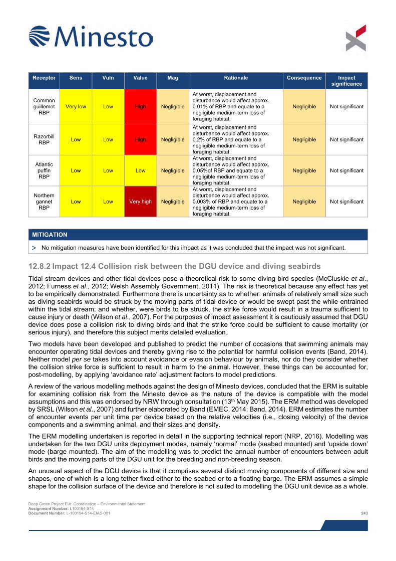
Receptor Sens Vuln Value Mag Rationale Consequence Impact
significance
Common guillemot
RBP Very low Low High Negligible
At worst, displacement and disturbance would affect approx. 0.01% of RBP and equate to a negligible medium-term loss of foraging habitat.
Negligible Not significant
Razorbill RBP Low Low High Negligible
At worst, displacement and disturbance would affect approx. 0.2% of RBP and equate to a negligible medium-term loss of foraging habitat.
Negligible Not significant
Atlantic puffin RBP
Low Low Low Negligible
At worst, displacement and disturbance would affect approx. 0.05%of RBP and equate to a negligible medium-term loss of foraging habitat.
Negligible Not significant
Northern gannet RBP
Low Low Very high Negligible
At worst, displacement and disturbance would affect approx. 0.003% of RBP and equate to a negligible medium-term loss of foraging habitat.
Negligible Not significant
MITIGATION
> No mitigation measures have been identified for this impact as it was concluded that the impact was not significant.
12.8.2 Impact 12.4 Collision risk between the DGU device and diving seabirds Tidal stream devices and other tidal devices pose a theoretical risk to some diving bird species (McCluskie et al., 2012; Furness et al., 2012; Welsh Assembly Government, 2011). The risk is theoretical because any effect has yet to be empirically demonstrated. Furthermore there is uncertainty as to whether: animals of relatively small size such as diving seabirds would be struck by the moving parts of tidal device or would be swept past the while entrained within the tidal stream; and whether, were birds to be struck, the strike force would result in a trauma sufficient to cause injury or death (Wilson et al., 2007). For the purposes of impact assessment it is cautiously assumed that DGU device does pose a collision risk to diving birds and that the strike force could be sufficient to cause mortality (or serious injury), and therefore this subject merits detailed evaluation.
Two models have been developed and published to predict the number of occasions that swimming animals may encounter operating tidal devices and thereby giving rise to the potential for harmful collision events (Band, 2014). Neither model per se takes into account avoidance or evasion behaviour by animals, nor do they consider whether the collision strike force is sufficient to result in harm to the animal. However, these things can be accounted for, post-modelling, by applying ‘avoidance rate’ adjustment factors to model predictions.
A review of the various modelling methods against the design of Minesto devices, concluded that the ERM is suitable for examining collision risk from the Minesto device as the nature of the device is compatible with the model assumptions and this was endorsed by NRW through consultation (13th May 2015). The ERM method was developed by SRSL (Wilson et al., 2007) and further elaborated by Band (EMEC, 2014; Band, 2014). ERM estimates the number of encounter events per unit time per device based on the relative velocities (i.e., closing velocity) of the device components and a swimming animal, and their sizes and density.
The ERM modelling undertaken is reported in detail in the supporting technical report (NRP, 2016). Modelling was undertaken for the two DGU units deployment modes, namely ‘normal’ mode (seabed mounted) and ‘upside down’ mode (barge mounted). The aim of the modelling was to predict the annual number of encounters between adult birds and the moving parts of the DGU unit for the breeding and non-breeding season.
An unusual aspect of the DGU device is that it comprises several distinct moving components of different size and shapes, one of which is a long tether fixed either to the seabed or to a floating barge. The ERM assumes a simple shape for the collision surface of the device and therefore is not suited to modelling the DGU unit device as a whole.
Deep Green Project EIA: Coordination – Environmental Statement Assignment Number: L100194-S14 Document Number: L-100194-S14-EIAS-001 243
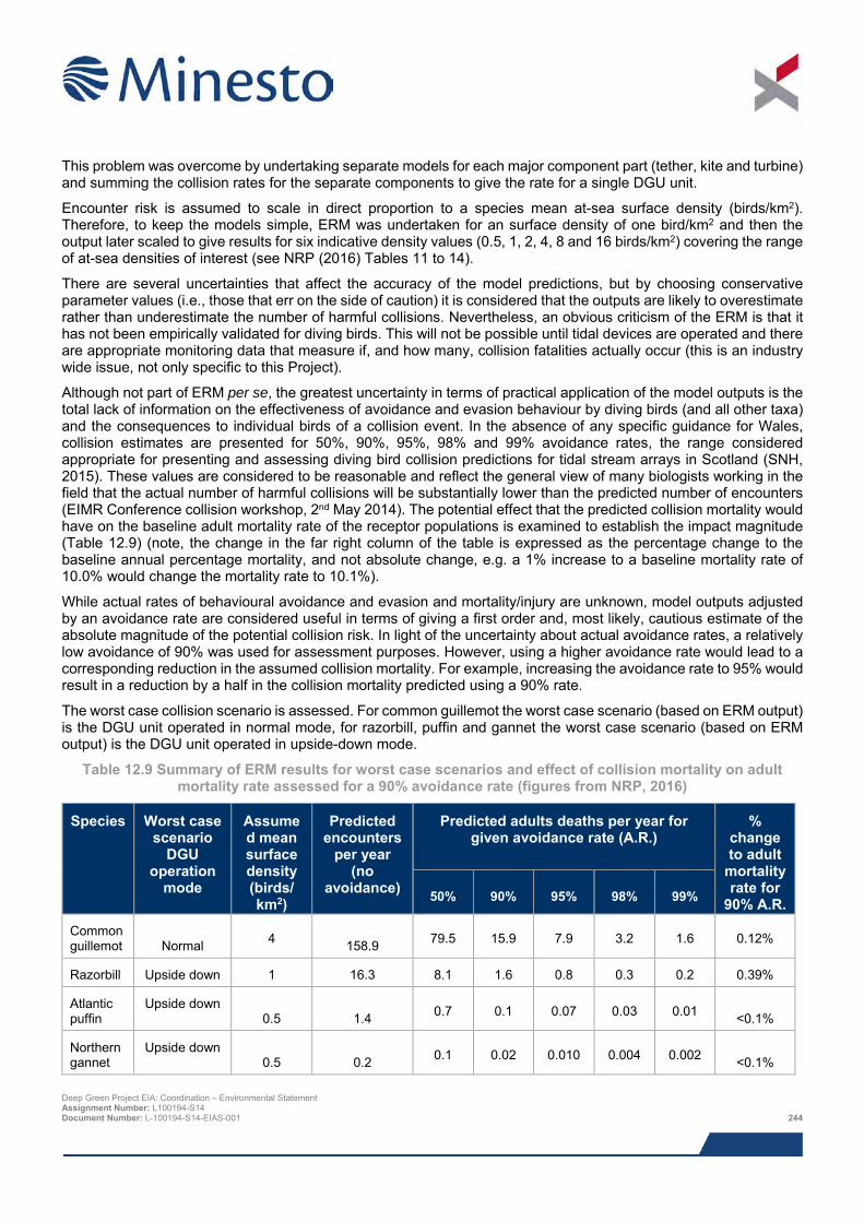
This problem was overcome by undertaking separate models for each major component part (tether, kite and turbine) and summing the collision rates for the separate components to give the rate for a single DGU unit.
Encounter risk is assumed to scale in direct proportion to a species mean at-sea surface density (birds/km2). Therefore, to keep the models simple, ERM was undertaken for an surface density of one bird/km2 and then the output later scaled to give results for six indicative density values (0.5, 1, 2, 4, 8 and 16 birds/km2) covering the range of at-sea densities of interest (see NRP (2016) Tables 11 to 14).
There are several uncertainties that affect the accuracy of the model predictions, but by choosing conservative parameter values (i.e., those that err on the side of caution) it is considered that the outputs are likely to overestimate rather than underestimate the number of harmful collisions. Nevertheless, an obvious criticism of the ERM is that it has not been empirically validated for diving birds. This will not be possible until tidal devices are operated and there are appropriate monitoring data that measure if, and how many, collision fatalities actually occur (this is an industry wide issue, not only specific to this Project).
Although not part of ERM per se, the greatest uncertainty in terms of practical application of the model outputs is the total lack of information on the effectiveness of avoidance and evasion behaviour by diving birds (and all other taxa) and the consequences to individual birds of a collision event. In the absence of any specific guidance for Wales, collision estimates are presented for 50%, 90%, 95%, 98% and 99% avoidance rates, the range considered appropriate for presenting and assessing diving bird collision predictions for tidal stream arrays in Scotland (SNH, 2015). These values are considered to be reasonable and reflect the general view of many biologists working in the field that the actual number of harmful collisions will be substantially lower than the predicted number of encounters (EIMR Conference collision workshop, 2nd May 2014). The potential effect that the predicted collision mortality would have on the baseline adult mortality rate of the receptor populations is examined to establish the impact magnitude (Table 12.9) (note, the change in the far right column of the table is expressed as the percentage change to the baseline annual percentage mortality, and not absolute change, e.g. a 1% increase to a baseline mortality rate of 10.0% would change the mortality rate to 10.1%).
While actual rates of behavioural avoidance and evasion and mortality/injury are unknown, model outputs adjusted by an avoidance rate are considered useful in terms of giving a first order and, most likely, cautious estimate of the absolute magnitude of the potential collision risk. In light of the uncertainty about actual avoidance rates, a relatively low avoidance of 90% was used for assessment purposes. However, using a higher avoidance rate would lead to a corresponding reduction in the assumed collision mortality. For example, increasing the avoidance rate to 95% would result in a reduction by a half in the collision mortality predicted using a 90% rate.
The worst case collision scenario is assessed. For common guillemot the worst case scenario (based on ERM output) is the DGU unit operated in normal mode, for razorbill, puffin and gannet the worst case scenario (based on ERM output) is the DGU unit operated in upside-down mode.
Table 12.9 Summary of ERM results for worst case scenarios and effect of collision mortality on adult mortality rate assessed for a 90% avoidance rate (figures from NRP, 2016)
Species Worst case scenario
DGU operation
mode
Assumed mean surface density (birds/ km2)
Predicted encounters
per year (no
avoidance)
Predicted adults deaths per year for given avoidance rate (A.R.)
% change to adult
mortality rate for
90% A.R. 50% 90% 95% 98% 99%
Common guillemot Normal 4 158.9 79.5 15.9 7.9 3.2 1.6 0.12%
Razorbill Upside down 1 16.3 8.1 1.6 0.8 0.3 0.2 0.39%
Atlantic puffin
Upside down 0.5 1.4 0.7 0.1 0.07 0.03 0.01 <0.1%
Northern gannet
Upside down 0.5 0.2 0.1 0.02 0.010 0.004 0.002 <0.1%
Deep Green Project EIA: Coordination – Environmental Statement Assignment Number: L100194-S14 Document Number: L-100194-S14-EIAS-001 244
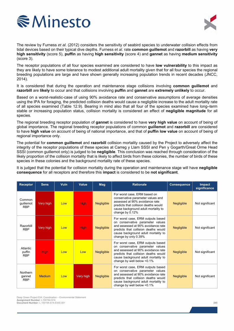
The review by Furness et al. (2012) considers the sensitivity of seabird species to underwater collision effects from tidal devices based on their typical dive depths. Furness et al. rate common guillemot and razorbill as having very high sensitivity (score 5), puffin as having high sensitivity (score 4) and gannet as having medium sensitivity (score 3).
The receptor populations of all four species examined are considered to have low vulnerability to this impact as they are likely to have some tolerance to modest additional adult mortality given that for all four species the regional breeding populations are large and have shown generally increasing population trends in recent decades (JNCC, 2014).
It is considered that during the operation and maintenance stage collisions involving common guillemot and razorbill are likely to occur and that collisions involving puffin and gannet are extremely unlikely to occur.
Based on a worst-realistic-case of using 90% avoidance rate and conservative assumptions of average densities using the IPA for foraging, the predicted collision deaths would cause a negligible increase to the adult mortality rate of all species examined (Table 12.9). Bearing in mind also that all four of the species examined have long–term stable or increasing population status, collision mortality is considered an effect of negligible magnitude for all species.
The regional breeding receptor population of gannet is considered to have very high value on account of being of global importance. The regional breeding receptor populations of common guillemot and razorbill are considered to have high value on account of being of national importance, and that of puffin low value on account of being of regional importance only.
The potential for common guillemot and razorbill collision mortality caused by the Project to adversely affect the integrity of the receptor populations of these species at Carreg y Llam SSSI and Pen y Gogarth/Great Orme Head SSSI (common guillemot only) is judged to be negligible. This conclusion was reached through consideration of the likely proportion of the collision mortality that is likely to affect birds from these colonies, the number of birds of these species in these colonies and the background mortality rate of these species.
It is judged that the potential for collision mortality during the operation and maintenance stage will have negligible consequence for all receptors and therefore this impact is considered to be not significant.
Receptor Sens Vuln Value Mag Rationale Consequence Impact
significance
Common guillemot
RBP Very high Low High Negligible
For worst case, ERM based on conservative parameter values and assessed at 90% avoidance rate predicts that collision deaths would cause background adult mortality to change by 0.12%
Negligible Not significant
Razorbill RBP Very high Low High Negligible
For worst case, ERM outputs based on conservative parameter values and assessed at 90% avoidance rate predicts that collision deaths would cause background adult mortality to change by only 0.39%
Negligible Not significant
Atlantic puffin RBP
High Low Low Negligible
For worst case, ERM outputs based on conservative parameter values and assessed at 90% avoidance rate predicts that collision deaths would cause background adult mortality to change by well below <0.1%
Negligible Not significant
Northern gannet RBP
Medium Low Very high Negligible
For worst case, ERM outputs based on conservative parameter values and assessed at 90% avoidance rate predicts that collision deaths would cause background adult mortality to change by well below <0.1%
Negligible Not significant
Deep Green Project EIA: Coordination – Environmental Statement Assignment Number: L100194-S14 Document Number: L-100194-S14-EIAS-001 245
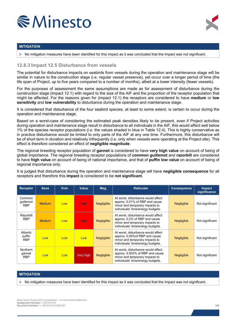
MITIGATION
> No mitigation measures have been identified for this impact as it was concluded that the impact was not significant.
12.8.3 Impact 12.5 Disturbance from vessels The potential for disturbance impacts on seabirds from vessels during the operation and maintenance stage will be similar in nature to the construction stage (i.e. regular vessel presence), yet occur over a longer period of time (the life span of Project, up to five years compared to a number of months), albeit at a lower intensity (fewer vessels).
For the purposes of assessment the same assumptions are made as for assessment of disturbance during the construction stage (impact 12.1) with regard to the size of the AIF and the proportion of the receptor population that might be affected. For the reasons given for (impact 12.1) the receptors are considered to have medium or low sensitivity and low vulnerability to disturbance during the operation and maintenance stage.
It is considered that disturbance of the four seabird species, at least to some extent, is certain to occur during the operation and maintenance stage.
Based on a worst-case of considering the estimated peak densities likely to be present, even if Project activities during operation and maintenance stage result in disturbance to all individuals in the AIF, this would affect well below 1% of the species receptor populations (i.e. the values shaded in blue in Table 12.4). This is highly conservative as in practice disturbance would be limited to only parts of the AIF at any one time. Furthermore, this disturbance will be of short term in duration and relatively infrequently (i.e. only when vessels were operating at the Project site). This effect is therefore considered an effect of negligible magnitude.
The regional breeding receptor population of gannet is considered to have very high value on account of being of global importance. The regional breeding receptor populations of common guillemot and razorbill are considered to have high value on account of being of national importance, and that of puffin low value on account of being of regional importance only.
It is judged that disturbance during the operation and maintenance stage will have negligible consequence for all receptors and therefore this impact is considered to be not significant.
Receptor Sens Vuln Value Mag Rationale Consequence Impact
significance
Common guillemot
RBP Medium Low High Negligible
At worst, disturbance would affect approx. 0.01% of RBP and cause minor and temporary impacts to individuals’ time/energy budgets.
Negligible Not significant
Razorbill RBP Medium Low High Negligible
At worst, disturbance would affect approx. 0.2% of RBP and cause minor and temporary impacts to individuals’ time/energy budgets.
Negligible Not significant
Atlantic puffin RBP Low Low Low Negligible
At worst, disturbance would affect approx. 0.05%of RBP and cause minor and temporary impacts to individuals’ time/energy budgets.
Negligible Not significant
Northern gannet RBP Low Low Very high Negligible
At worst, disturbance would affect approx. 0.003% of RBP and cause minor and temporary impacts to individuals’ time/energy budgets.
Negligible Not significant
MITIGATION
> No mitigation measures have been identified for this impact as it was concluded that the impact was not significant.
Deep Green Project EIA: Coordination – Environmental Statement Assignment Number: L100194-S14 Document Number: L-100194-S14-EIAS-001 246
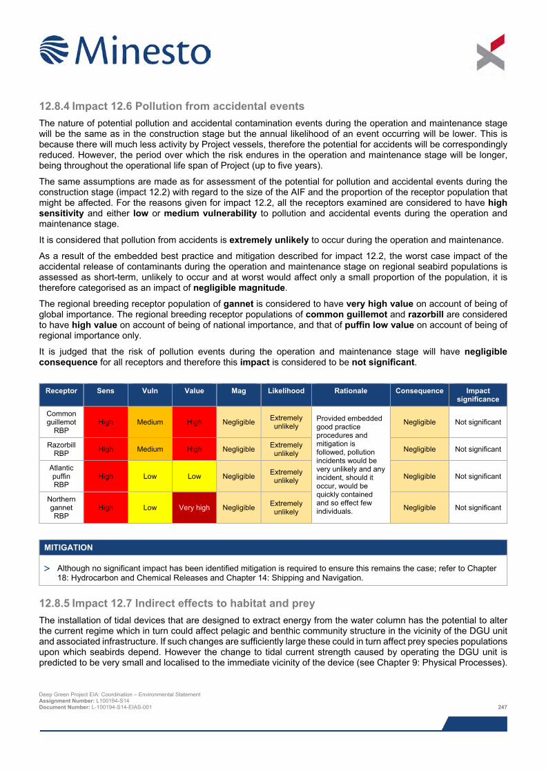
12.8.4 Impact 12.6 Pollution from accidental events The nature of potential pollution and accidental contamination events during the operation and maintenance stage will be the same as in the construction stage but the annual likelihood of an event occurring will be lower. This is because there will much less activity by Project vessels, therefore the potential for accidents will be correspondingly reduced. However, the period over which the risk endures in the operation and maintenance stage will be longer, being throughout the operational life span of Project (up to five years).
The same assumptions are made as for assessment of the potential for pollution and accidental events during the construction stage (impact 12.2) with regard to the size of the AIF and the proportion of the receptor population that might be affected. For the reasons given for impact 12.2, all the receptors examined are considered to have high sensitivity and either low or medium vulnerability to pollution and accidental events during the operation and maintenance stage.
It is considered that pollution from accidents is extremely unlikely to occur during the operation and maintenance.
As a result of the embedded best practice and mitigation described for impact 12.2, the worst case impact of the accidental release of contaminants during the operation and maintenance stage on regional seabird populations is assessed as short-term, unlikely to occur and at worst would affect only a small proportion of the population, it is therefore categorised as an impact of negligible magnitude.
The regional breeding receptor population of gannet is considered to have very high value on account of being of global importance. The regional breeding receptor populations of common guillemot and razorbill are considered to have high value on account of being of national importance, and that of puffin low value on account of being of regional importance only.
It is judged that the risk of pollution events during the operation and maintenance stage will have negligible consequence for all receptors and therefore this impact is considered to be not significant.
Receptor Sens Vuln Value Mag Likelihood Rationale Consequence Impact
significance
Common guillemot
RBP High Medium High Negligible Extremely
unlikely Provided embedded good practice procedures and mitigation is followed, pollution incidents would be very unlikely and any incident, should it occur, would be quickly contained and so effect few individuals.
Negligible Not significant
Razorbill RBP High Medium High Negligible Extremely
unlikely Negligible Not significant
Atlantic puffin RBP
High Low Low Negligible Extremely unlikely Negligible Not significant
Northern gannet RBP
High Low Very high Negligible Extremely unlikely Negligible Not significant
MITIGATION
> Although no significant impact has been identified mitigation is required to ensure this remains the case; refer to Chapter 18: Hydrocarbon and Chemical Releases and Chapter 14: Shipping and Navigation.
12.8.5 Impact 12.7 Indirect effects to habitat and prey The installation of tidal devices that are designed to extract energy from the water column has the potential to alter the current regime which in turn could affect pelagic and benthic community structure in the vicinity of the DGU unit and associated infrastructure. If such changes are sufficiently large these could in turn affect prey species populations upon which seabirds depend. However the change to tidal current strength caused by operating the DGU unit is predicted to be very small and localised to the immediate vicinity of the device (see Chapter 9: Physical Processes).
Deep Green Project EIA: Coordination – Environmental Statement Assignment Number: L100194-S14 Document Number: L-100194-S14-EIAS-001 247
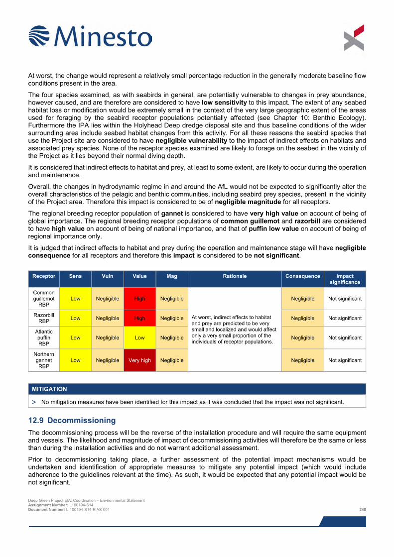
At worst, the change would represent a relatively small percentage reduction in the generally moderate baseline flow conditions present in the area.
The four species examined, as with seabirds in general, are potentially vulnerable to changes in prey abundance, however caused, and are therefore are considered to have low sensitivity to this impact. The extent of any seabed habitat loss or modification would be extremely small in the context of the very large geographic extent of the areas used for foraging by the seabird receptor populations potentially affected (see Chapter 10: Benthic Ecology). Furthermore the IPA lies within the Holyhead Deep dredge disposal site and thus baseline conditions of the wider surrounding area include seabed habitat changes from this activity. For all these reasons the seabird species that use the Project site are considered to have negligible vulnerability to the impact of indirect effects on habitats and associated prey species. None of the receptor species examined are likely to forage on the seabed in the vicinity of the Project as it lies beyond their normal diving depth.
It is considered that indirect effects to habitat and prey, at least to some extent, are likely to occur during the operation and maintenance.
Overall, the changes in hydrodynamic regime in and around the AfL would not be expected to significantly alter the overall characteristics of the pelagic and benthic communities, including seabird prey species, present in the vicinity of the Project area. Therefore this impact is considered to be of negligible magnitude for all receptors.
The regional breeding receptor population of gannet is considered to have very high value on account of being of global importance. The regional breeding receptor populations of common guillemot and razorbill are considered to have high value on account of being of national importance, and that of puffin low value on account of being of regional importance only.
It is judged that indirect effects to habitat and prey during the operation and maintenance stage will have negligible consequence for all receptors and therefore this impact is considered to be not significant.
Receptor Sens Vuln Value Mag Rationale Consequence Impact
significance
Common guillemot
RBP Low Negligible High Negligible
At worst, indirect effects to habitat and prey are predicted to be very small and localized and would affect only a very small proportion of the individuals of receptor populations.
Negligible Not significant
Razorbill RBP Low Negligible High Negligible Negligible Not significant
Atlantic puffin RBP
Low Negligible Low Negligible Negligible Not significant
Northern gannet RBP
Low Negligible Very high Negligible Negligible Not significant
MITIGATION
> No mitigation measures have been identified for this impact as it was concluded that the impact was not significant.
12.9 Decommissioning The decommissioning process will be the reverse of the installation procedure and will require the same equipment and vessels. The likelihood and magnitude of impact of decommissioning activities will therefore be the same or less than during the installation activities and do not warrant additional assessment.
Prior to decommissioning taking place, a further assessment of the potential impact mechanisms would be undertaken and identification of appropriate measures to mitigate any potential impact (which would include adherence to the guidelines relevant at the time). As such, it would be expected that any potential impact would be not significant.
Deep Green Project EIA: Coordination – Environmental Statement Assignment Number: L100194-S14 Document Number: L-100194-S14-EIAS-001 248
12.10 Potential variances in environmental impacts The impact assessment above was based on worst case Project options with regards to impacts on ornithology. This section provides a brief overview of the potential variances between the worst case Project option assessed and alternative Project options and design envelope parameters.
The presence of the barge (or similar such surface platform) is considered to be the only likely cause of displacement. Project scenarios in which no barge is deployed or the period of barge deployment is reduced would result in correspondingly reduced levels of displacement. Other potential variance in impact will be restricted to limited changes in vessel days, and is not predicted to result in greater impacts than those already assessed.
12.11 Cumulative impacts This section describes other works that might be taking place in the vicinity of the Project that could result in cumulative and in-combination impacts.
Minesto, in consultation with NRW and IACC, has identified a list of other projects which together with the Project may result in potential cumulative or in-combination impacts. The list of these projects and a map showing their location is provided in Chapter 8: EIA Methodology; Table 8.13 and Figure 8.2, respectively.
The consideration of which projects from this list could result in potential cumulative or in-combination impacts is based on the results of the Project specific impact assessment together with the expert judgement of the specialist consultant. Having examined the information presently available in the public domain, the projects for which there is considered to be potential for cumulative or in-combination impacts are those listed below.
> Minesto Phase II tidal array;
> Skerries Tidal Array; and
> West Anglesey Demonstration Zone (WADZ).
In addition to these tidal sites, all the projects listed in Chapter 8: EIA Methodology; Table 8.13 that involve vessel-based activities have potential to cause pollution and contamination incidents from accidents. Therefore for this impact, all projects are considered to potentially contribute to a wider cumulative impact.
The receptor species populations initially included for examination of cumulative and in-combination impacts are the same as those examined during the EIA, namely common guillemot, razorbill, puffin and gannet. These are species were identified through scoping and consultation and were screened in because of the anticipated occurrence of individuals in the AIF combined with their relatively high predicted sensitivity to the potential effects tidal energy projects (Table 12.5). The following sections summarise the nature of the potential cumulative impacts for each potential Project stage.
Disturbance, displacement and indirect changes to habitat and prey caused by the Project in isolation are impact sources considered to be so localised and of such a limited magnitude and significance that it is inconceivable these would significantly contribute to a cumulative impact for any receptor. Therefore the potential for these Project impacts to contribute to multi-project cumulative or in-combination impacts on the receptor populations is not considered further.
Cumulative accidental contamination is considered for common guillemot and razorbill for all Project stages on account of these receptors’ high vulnerability to this impact and relatively close proximity of the projects to breeding colonies on Holy Island. A cumulative impact for puffin and gannet receptors from accidental contamination is not considered plausible because their populations are large and dispersed over a very large foraging area and they do not breed locally in important numbers.
The potential for a cumulative collision impact is considered to only be of relevance during the operation and maintenance stage and only for common guillemot and razorbill. For puffin and gannet, the impact of collision risk from the Project in isolation is of such a limited magnitude that it is inconceivable that it would significantly contribute to a cumulative impact for any receptor.
Table 12.10 identifies the combinations of impacts and Project stages for which cumulative assessment for each receptor is presented. Deep Green Project EIA: Coordination – Environmental Statement Assignment Number: L100194-S14 Document Number: L-100194-S14-EIAS-001 249
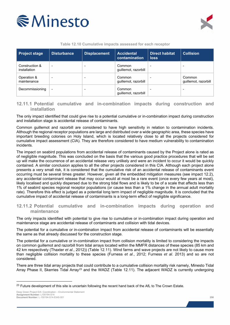
Table 12.10 Cumulative impacts assessed for each receptor
Project stage Disturbance Displacement Accidental contamination
Direct habitat loss
Collision
Construction & installation
- - Common guillemot, razorbill
- -
Operation & maintenance
- - Common guillemot, razorbill
- Common guillemot, razorbill
Decommissioning - - Common guillemot, razorbill
- -
12.11.1 Potential cumulative and in-combination impacts during construction and installation
The only impact identified that could give rise to a potential cumulative or in-combination impact during construction and installation stage is accidental release of contaminants.
Common guillemot and razorbill are considered to have high sensitivity in relation to contamination incidents. Although the regional receptor populations are large and distributed over a wide geographic area, these species have important breeding colonies on Holy Island, which is located relatively close to all the projects considered for cumulative impact assessment (CIA). They are therefore considered to have medium vulnerability to contamination incidents.
The impact on seabird populations from accidental release of contaminants caused by the Project alone is rated as of negligible magnitude. This was concluded on the basis that the various good practice procedures that will be set up will make the occurrence of an accidental release very unlikely and were an incident to occur it would be quickly contained. A similar conclusion applies to all the other projects considered in this CIA. Although each project alone presents a very small risk, it is considered that the cumulative risk of an accidental release of contaminants event occurring must be several times greater. However, given all the embedded mitigation measures (see impact 12.2), any accidental contaminant release that may occur would at most be a rare event (once every few years at most), likely localised and quickly dispersed due to the strong tidal flows and is likely to be of a scale that affects less than 1% of seabird species regional receptor populations (or cause less than a 1% change in the annual adult mortality rate). Therefore this effect is judged as a potential long term impact of negligible magnitude. It is concluded that the cumulative impact of accidental release of contaminants is a long-term effect of negligible significance.
12.11.2 Potential cumulative and in-combination impacts during operation and maintenance
The only impacts identified with potential to give rise to cumulative or in-combination impact during operation and maintenance stage are accidental release of contaminants and collision with tidal devices.
The potential for a cumulative or in-combination impact from accidental release of contaminants will be essentially the same as that already discussed for the construction stage.
The potential for a cumulative or in-combination impact from collision mortality is limited to considering the impacts on common guillemot and razorbill from tidal arrays located within the MMFR distances of these species (85 km and 42 km respectively (Thaxter et al., 2012)) (Table 12.11). Wind farms and wave projects are not likely to cause more than negligible collision mortality to these species (Furness et al., 2012; Furness et al. 2013) and so are not considered.
There are three tidal array projects that could contribute to a cumulative collision mortality risk namely, Minesto Tidal Array Phase II, Skerries Tidal Array23 and the WADZ (Table 12.11). The adjacent WADZ is currently undergoing
23 Future development of this site is uncertain following the recent hand back of the AfL to The Crown Estate. Deep Green Project EIA: Coordination – Environmental Statement Assignment Number: L100194-S14 Document Number: L-100194-S14-EIAS-001 250
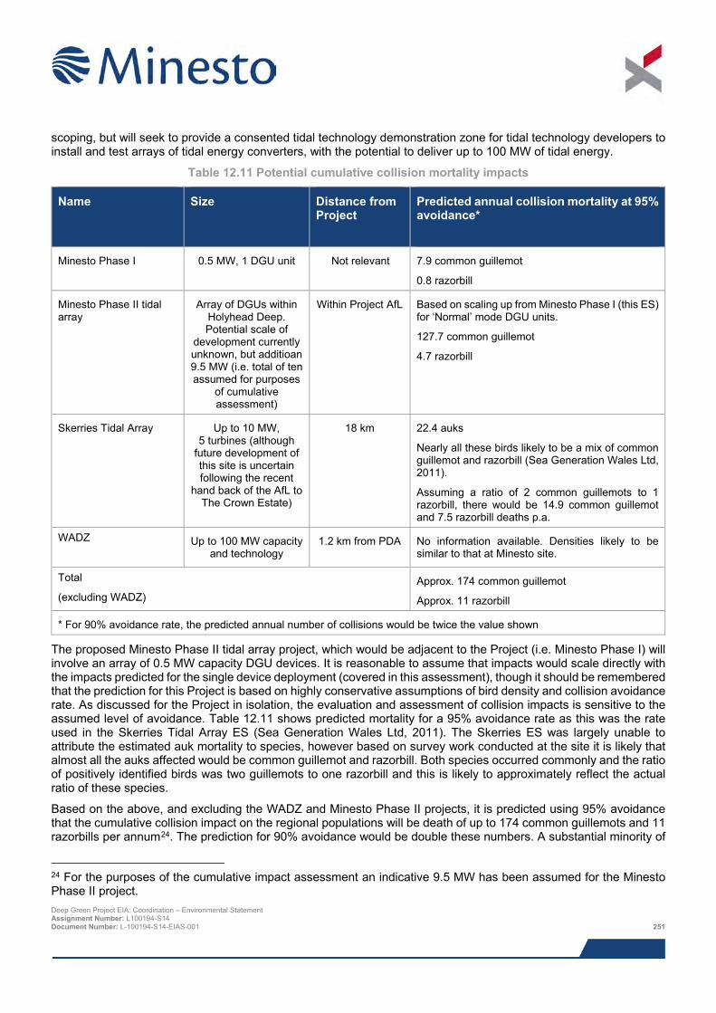
scoping, but will seek to provide a consented tidal technology demonstration zone for tidal technology developers to install and test arrays of tidal energy converters, with the potential to deliver up to 100 MW of tidal energy.
Table 12.11 Potential cumulative collision mortality impacts
Name Size Distance from Project
Predicted annual collision mortality at 95% avoidance*
Minesto Phase I 0.5 MW, 1 DGU unit Not relevant 7.9 common guillemot
0.8 razorbill
Minesto Phase II tidal array
Array of DGUs within Holyhead Deep. Potential scale of
development currently unknown, but additioan 9.5 MW (i.e. total of ten assumed for purposes
of cumulative assessment)
Within Project AfL Based on scaling up from Minesto Phase I (this ES) for ‘Normal’ mode DGU units.
127.7 common guillemot
4.7 razorbill
Skerries Tidal Array Up to 10 MW, 5 turbines (although
future development of this site is uncertain following the recent
hand back of the AfL to The Crown Estate)
18 km 22.4 auks
Nearly all these birds likely to be a mix of common guillemot and razorbill (Sea Generation Wales Ltd, 2011).
Assuming a ratio of 2 common guillemots to 1 razorbill, there would be 14.9 common guillemot and 7.5 razorbill deaths p.a.
WADZ
Up to 100 MW capacity
and technology 1.2 km from PDA No information available. Densities likely to be
similar to that at Minesto site.
Total
(excluding WADZ) Approx. 174 common guillemot
Approx. 11 razorbill
* For 90% avoidance rate, the predicted annual number of collisions would be twice the value shown
The proposed Minesto Phase II tidal array project, which would be adjacent to the Project (i.e. Minesto Phase I) will involve an array of 0.5 MW capacity DGU devices. It is reasonable to assume that impacts would scale directly with the impacts predicted for the single device deployment (covered in this assessment), though it should be remembered that the prediction for this Project is based on highly conservative assumptions of bird density and collision avoidance rate. As discussed for the Project in isolation, the evaluation and assessment of collision impacts is sensitive to the assumed level of avoidance. Table 12.11 shows predicted mortality for a 95% avoidance rate as this was the rate used in the Skerries Tidal Array ES (Sea Generation Wales Ltd, 2011). The Skerries ES was largely unable to attribute the estimated auk mortality to species, however based on survey work conducted at the site it is likely that almost all the auks affected would be common guillemot and razorbill. Both species occurred commonly and the ratio of positively identified birds was two guillemots to one razorbill and this is likely to approximately reflect the actual ratio of these species.
Based on the above, and excluding the WADZ and Minesto Phase II projects, it is predicted using 95% avoidance that the cumulative collision impact on the regional populations will be death of up to 174 common guillemots and 11 razorbills per annum24. The prediction for 90% avoidance would be double these numbers. A substantial minority of
24 For the purposes of the cumulative impact assessment an indicative 9.5 MW has been assumed for the Minesto Phase II project. Deep Green Project EIA: Coordination – Environmental Statement Assignment Number: L100194-S14 Document Number: L-100194-S14-EIAS-001 251
these birds will not be adults from the regional breeding populations. The baseline adult mortality for these regional breeding populations is estimated at 13,013 common guillemot deaths and 416 razorbill deaths per year (NRP, 2016). Depending on the species and the avoidance rate used, and taking into consideration that not all birds killed would be adults of the regional breeding populations, it is predicted that the cumulative mortality would increase the regional population baseline mortality rate by between approx. 1% and 5%. It is concluded that cumulative collision mortality impacts should be rated as an impact of low consequence.
12.11.3 Potential cumulative and in-combination impacts during decommissioning The only impact identified with potential to give rise to cumulative or in-combination impact during the decommissioning stage is accidental release of contaminants and the potential for this will be essentially the same as that already discussed for the construction stage.
12.11.4 Mitigation requirements for potential cumulative and in-combination impacts The cumulative impact assessment identifies that accidental release of contaminants has greater potential than any other impact to cause adverse effect on seabird populations. This conclusion highlights the paramount importance that all measures designed to prevent accidental release are strictly adhered to and that projects have the appropriate contingency plans and equipment in place for dealing with incidents. Furthermore, these protocols should be subject to regular review and the risks to birds periodically reassessed in light of operational experience.
There is no requirement for additional mitigation over and above the Project-specific measures.
12.12 Habitat Regulations Asessment Under the Conservation (Natural Habitats, &c.) Regulations 1994 (as amended) legislation it is a requirement that Habitat Regulations Assessment (HRA) is undertaken to determine if the Project could impact on the integrity of any European Sites designated for its ornithological features. The results of HRA for birds, in which the impacts on Special Protection Areas (SPAs), potential SPAs (pSPAs) and Ramsar sites are considered, are presented in the HRA Report (Xodus, 2016).
The requirement for HRA for ornithology is contingent on showing that there is potential for at least low connectivity between a particular SPA qualifying feature and the Project site, and that the feature is vulnerable to the likely impacts of the Project. The Project is not connected to nor necessary for the management of any European Sites designated for its ornithological features. However the IPA and its vicinity is used by several species of seabirds for foraging and these may include birds that are from populations that are qualifying features of designated SPA colonies. Therefore the IPA may provide a role as a supporting habitat for some qualifying species from certain designated sites.
The HRA Report concludes that there are three species that require assessment of LSE, namely razorbill, common guillemot and Atlantic puffin.
For breeding common guillemot and razorbill there is potential for connectivity between the IPA and Lambay Island SPA (Co. Dublin, 84 km away) and with Ireland’s Eye SPA (Co. Dublin, 85 km away). Furness et al. (2012) consider common guillemot and razorbill to have high sensitivity to the potential effects of tidal array developments and therefore the possibility the Project could have a LSE on the breeding common guillemot and razorbill features at these two SPAs could not be ruled out at the initial screening stage. Connectivity for razorbill is likely to be weak on the basis that the distance between the IPA and SPAs of interest is greater than their MMFR, but less than their Maximum Foraging Range (MaxFR).
For breeding puffin there is potential for connectivity with Lambay Island SPA (Co. Dublin, 84 km away) and weak connectivity with Skomer and Skokholm SPA (Dyfed, 176 km), Saltee Islands SPA (Co. Wicklow, 180 km) and Skomer, Skokholm and the seas of Pembrokeshire potential SPA (180 km), all of which are beyond the species’ MMFR, but less than their MaxFR. Furness et al. (2012) consider puffin to have moderate sensitivity to the potential effects of tidal array developments and therefore the possibility the Project could have a LSE on the breeding puffin feature at these three SPAs could not be ruled out at the initial screening stage.
Additional information is provided in the HRA Report to undertake an Appropriate Assessment to test if the Project could compromise the Conservation Objectives the five SPAs identified above.
Deep Green Project EIA: Coordination – Environmental Statement Assignment Number: L100194-S14 Document Number: L-100194-S14-EIAS-001 252
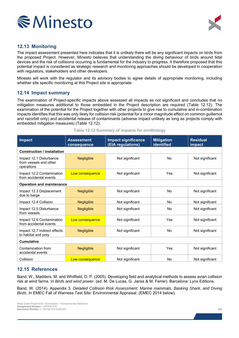
12.13 Monitoring The impact assessment presented here indicates that it is unlikely there will be any significant impacts on birds from the proposed Project. However, Minesto believes that understanding the diving behaviour of birds around tidal devices and the risk of collisions occurring is fundamental for the industry to progress. It therefore proposed that this potential impact is considered as strategic research and monitoring approaches should be developed in cooperation with regulators, stakeholders and other developers.
Minesto will work with the regulator and its advisory bodies to agree details of appropriate monitoring, including whether site specific monitoring at this Project site is appropriate.
12.14 Impact summary The examination of Project-specific impacts above assessed all impacts as not significant and concludes that no mitigation measures additional to those embedded in the Project description are required (Table 12.12). The examination of the potential for the Project together with other projects to give rise to cumulative and in-combination impacts identifies that this was only likely for collision risk (potential for a minor magnitude effect on common guillemot and razorbill only) and accidental release of contaminants (adverse impact unlikely as long as projects comply with embedded mitigation measures) (Table 12.12).
Table 12.12 Summary of impacts for ornithology
Impact Assessment consequence
Impact significance (EIA regulations)
Mitigation identified
Residual impact
Construction / installation
Impact 12.1 Disturbance from vessels and other operations
Negligible Not significant No Not significant
Impact 12.2 Contamination from accidental events
Low consequence Not significant Yes Not significant
Operation and maintenance
Impact 12.3 Displacement due to barge
Negligible Not significant No Not significant
Impact 12.4 Collision Negligible Not significant No Not significant
Impact 12.5 Disturbance from vessels
Negligible Not significant No Not significant
Impact 12.6 Contamination from accidental events
Low consequence Not significant Yes Not significant
Impact 12.7 Indirect effects to habitat and prey
Negligible Not significant No Not significant
Cumulative
Contamination from accidental events
Negligible Not significant Yes Not significant
Collision Low consequence Not significant No Not significant
12.15 References Band, W., Madders, M. and Whitfield, D. P. (2005). Developing field and analytical methods to assess avian collision risk at wind farms. In Birds and wind power. (ed. M. De Lucas, G. Janss & M. Ferrer). Barcelona: Lynx Editions.
Band, W. (2014). Appendix 3. Detailed Collision Risk Assessment: Marine mammals, Basking Shark, and Diving Birds. In EMEC Fall of Warness Test Site: Environmental Appraisal. (EMEC 2014 below).
Deep Green Project EIA: Coordination – Environmental Statement Assignment Number: L100194-S14 Document Number: L-100194-S14-EIAS-001 253
Barrett, R.T & Furness, R.W. (1990). The prey and diving depths of seabirds on Hornoey, North Norway after a decrease in the Barents Sea capelin stocks. Ornis Scandinavica. 21: 179-186.
CCW (2011). Natural heritage evidence to support strategic planning for marine renewable energy. Smith, K., Briggs, J., Hamer, J., Hill, A. and Walker, P. CCW Policy Research Report No 11/3. June 2011.
Dall’Antonia, L., Gudmundsson, G.A. & Benvenuti, S. (2001). Time allocation and foraging pattern of chick-rearing razorbills in northwest Iceland. The Condor 103: 469-480.
EMEC (2014). EMEC Fall of Warness Test Site: Environmental Appraisal. European Marine Energy Centre.
Furness, R. W., Wade, H. M., Robbins, A. M. C., and Masden, E. A. (2012). Assessing the sensitivity of seabird populations to adverse effects from tidal stream turbines and wave energy devices. - ICES Journal of Marine Science, 69: 1466-1479.
Furness, R. 2014. Final Draft (2014). Biologically appropriate, species-specific, geographic non-breeding season population estimates for seabirds. Unpublished report MacArthur Green Ltd.
Harris, M.P. and Wanless, S. (1990). Moult and autumn colony attendance of auks. British Birds 83: 55-66.
Institute of Ecology and Environmental Management (IEEM) (2010). Guidelines for ecological impact assessment in Britain and Ireland – Marine and Coastal. Institute of Ecology and Environmental Management.
Joint Nature Conservation Committee (JNCC) (2014). Seabird Population Trends and Causes of Change: 1986-2013 Report (http://www.jncc.defra.gov.uk/page-3201). Joint Nature Conservation Committee. Updated August 2014. Accessed August 2015.
Kober, K., Webb, A., Win, I., Lewis, M., O’Brien, S., Wilson, L. J., & Reid, J. B. (2010). An analysis of the numbers and distribution of seabirds within the British Fishery Limit aimed at identifying areas that qualify as possible marine SPAs. JNCC Report No. 431. Joint Nature Conservation Committee.
McCluskie, A.E., Langston R.H.W. & Wilkinson N.I. (2012). Birds and wave and tidal stream energy: an ecological review.
Mitchell, P.I., Newton S.F., Ratcliffe, N. and Dunnn, T.E. (2004). Seabird populations of Britain and Ireland. Christopher Helm, London.
Natural Research Projects (NRP) (2016). Deep Green Holyhead Deep Project: Seabird population information and collision risk to diving seabirds. Report to Minesto Ltd.
Natural Resources Wales (NRW) (2014). NRW Response to Marine Mammals and Offshore Ornithology Baseline Reports. DWR/2042262. September 2014.
Renewable UK (2013). (Draft) Guiding principles for cumulative impacts assessment (CIA) in offshore windfarms.
Ropert-Coudert, Y., Daunt, F., Kato, A., Ryan, P.G., Lewis, S., Kobayashi, K. Mori, Y., Gre´millet, D., and Wanless, S. (2009). Underwater wingbeats extend depth and duration of plunge dives in northern gannets Morus bassanus. J. Avian Biol. 40: 380_387.
Sea Generation Wales Ltd (2011). The Skerries Tidal Array Environmental Statement. Sea Generation (Wales) Ltd.
Spencer, S.M. (2012). Diving behaviour and identification of sex of breeding Atlantic puffins, and nest-site characteristics of alcids on Petit Manan Island, Maine. Thesis.
Thaxter, C. B., Wanless, S., Daunt, F., Harris, M. P., Benvenuti, S., Watanuki, Y., and Hamer, K. C. (2010). Influence of wing loading on the trade-off between pursuit-diving and flight in common guillemot and razorbills. Journal of Experimental Biology, 213, 1018–1025.
Thaxter, C.B., Lascelles, B., Sugar, K., Cook, A.S.C.P., Roos, S., Bolton, M., Langston, R.H.W. & Burton, N.H.K. (2012). Seabird Foraging Ranges as a Preliminary Tool for Identifying Candidate Marine Protected Areas. Biological Conservation 156: 53-61.
Deep Green Project EIA: Coordination – Environmental Statement Assignment Number: L100194-S14 Document Number: L-100194-S14-EIAS-001 254
Tremblay, Y., Cherel, Y., Oremus, M., Tveraa, T. & Chastel, O. (2003). Unconventional ventral attachment of time-depth recorders as a new method for investigating time budget and diving behaviour of seabirds. Journal of Experimental Biology 206: 1929-1940.
Watanuki, Y., Wanless, S., Harris, M., Lovvorn, J. R., Miyazaki, M., Tanaka, H. and Sato, K. (2006). Swim speeds and stroke patterns in wing-propelled divers: a comparison among alcids and a penguin. Journal of Experimental Biology 209, 1217-1230.
Welsh Assembly Government (2011). Assessment of Risk to Diving Birds from Underwater Marine Renewable Devices in Welsh Water. Phase 1 – Desktop Review of Birds in Welsh Waters and Preliminary Risk Assessment. Availble from: http://www.marineenergypembrokeshire.co.uk/wp-content/uploads/2010/03/MRESF-Stage-2-Diving-Birds-and-Underwater-Renewable-Devices-Desk-Top-Review.pdf [Accessed 20/11/2015].
Wiens, J.A. and Parker, K.R. (1995). Analyzing the effects of accidental environmental impacts: approaches and assumptions. Ecological Applications 5: 1069-1083.
Wernham, C.V., Toms, M.P., Marchant, J.H., Clark, J.A., Siriwardena, G.M. and Baillie, S.R. eds (2002). The Migration Atlas: movements of the birds of Britain and Ireland. T. & A.D. Poyser, London.
Wilson, B. Batty, R. S., Daunt, F. & Carter, C. (2007). Collision risks between marine renewable energy devices and mammals, fish and diving birds. Report to the Scottish Executive. Scottish Association for Marine Science, Oban.
Wildfowl & Wetlands Trust (WWT) (2009). Aerial Surveys of Waterbirds in the UK: 2007/08 Final Report. Accessed via https://www.gov.uk/government/uploads/system/uploads/attachment_data/file/196490/OES_Aerial_Surveys_2007_08.pdf (accessed 13/05/2014).
Xodus (2014). Deep Green Project EIA: Work Pack 1 – Offshore Ornithology Baseline. Document no. L-100194-S03-REPT-002-A01. December 2015.
Xodus (2016). Deep Green Holyhead Deep – Habitats Regulations Assessment (HRA) Report. Document number L-100194-S00-REPT-012. June 2016.
Deep Green Project EIA: Coordination – Environmental Statement Assignment Number: L100194-S14 Document Number: L-100194-S14-EIAS-001 255
13 FISHERIES
The presence of a single Deep Green Utility (DGU) unit, the barge (or similar such surface platform) and its potential safety zone, will impact a small area used for fishing around Holy Island. A desk based study supported by consultation activities indicated that there will be some loss of access to fishing grounds during construction and installation and operation of the Project, amounting to a monetary value of just under £800 per year. The key commercial fisheries likely to be impacted employ static gear and target whelks in the offshore Project development area (PDA). Fisheries closer inshore e.g. recreational and lobster fisheries will not be impacted by the proposed Project. Impacts in the PDA will affect fisheries throughout the life of the Project, i.e. a maximum of five years. Mitigation measures for the Project include the use of a Fisheries Liaison Officer (FLO) during construction, the likely use of 500 m safety zones around the development site and barge during construction, testing and decommissioning, and potentially during operations. In addition there will be ongoing communication with fishermen regarding the location of the subsea infrastructure enabling them to avoid risk.
13.1 Introduction The potential effects of the Project on fisheries are assessed in this chapter. The following specialists have contributed to the assessment:
> AWJ Marine – preliminary investigation of potential economic impacts on fishing; and
> Xodus – baseline description, impact assessment and Environmental Statement (ES) chapter write up.
The table below provides a list of all the supporting studies which relate to the fisheries impact assessment. All supporting studies are provided on the accompanying CD.
Table 13.1 Supporting studies
Details of study Fish Ecology technical report (Xodus, 2015a)
Preliminary Evaluation: Economic Impacts on Fishing (AWJ Marine, 2015)
Navigational Risk Assessment (Anatec, 2015)
Underwater Noise technical report (Xodus, 2015b)
The impact assessment presented herein draws upon output from other impact assessments within this ES; where that information is used to inform assessment, reference to the relevant ES chapter is given.
13.2 Area of assessment The focus of the impact assessment is the potential impacts on fisheries using the PDA and adjacent waters. There is variation in the spatial extent of different fishing gear and the spatial distribution of target species. Potential impacts have therefore been set in the context of a wider study area over which fisheries encountered in the vicinity of the Project are thought to range.
The following areas are referred to in this impact assessment:
> Agreement for Lease (AfL) area:
o The area of the seabed that has been leased from The Crown Estate covering an area of 9.1 km2;
> Project Development Area (PDA):
o This is the area of seabed in which the DGU unit will be deployed. The exact siting of the device within the PDA has not yet been determined, but of the 4 km2 total area available, only a very small fraction will be developed for the Project (see below);
> Indicative Deployment Area (IDA): Deep Green Project EIA: Coordination – Environmental Statement Assignment Number: L100194-S14 Document Number: L-100194-S14-EIAS-001 256
o This is the 0.034 km2 area of seabed covered by this Project (single DGU unit) which is planned to
be installed in spring/summer 2017 and will be somewhere within the PDA; and
> Safety Zone area:
o Safety zones are expected to be in place around installation vessels and the barge (or similar such surface platform). Each safety zone could be up to 500 m in radius occupying an area of 0.84 km2, but it is not envisaged that more than one safety zone would ever be needed at any one time.
13.3 Legislation, policy and guidance In addition to the general legislation and policy guidance set out in Chapter 3: Planning and Legislative Requirements, the following is of particular relevance to the assessment of impact on fisheries:
> The Welsh Government’s Byelaw 9 (Annex 2) prohibits fishing with vessels exceeding 12 m in length (subject to certain exemptions) in the sea 0 to 6 nautical mile (nm)25 (0 to 11.1 km) from the shore (Welsh Government, 2014);
> Scallop Fishing (Wales) Order (2010) bans scallop dredging within one nautical mile of the Welsh coast;
> Best Practice Guidance for Fishing Industry Financial and Economic Impact Assessments - guidelines based on outputs from a technical workshop organised by the UK Fisheries Economics Network (UFEN and Seafish, 2012);
> FLOWW Best Practice Guidance for Offshore Renewables Developments: Recommendations for Fisheries Liaison (January 2014); and
> Guidance on Commercial Fisheries Mitigation and Opportunities from Offshore Wind commissioned by Collaborative Offshore Wind Research into the Environment (COWRIE), (Blyth-Skyrme, 2010).
The Welsh Government is understood to have been working on an Order to update the restrictions currently in force under Byelaw 9, but these have not yet been implemented.
13.4 Scoping and consultation Scoping and consultation have been ongoing throughout the EIA and played an important part in ensuring the scope of the baseline characterisation work and impact assessment have been appropriate to the Project and the requirements of the regulators and their advisors.
Table 13.2 summarises all consultation activities carried out relevant to fisheries. Relevant comments from the EIA Scoping Opinion are summarised below:
> The Welsh Government have jurisdiction for Welsh fisheries management, therefore consultation with the Welsh Government Fisheries Department must be undertaken.
Table 13.2 Consultation activities undertaken in relation to fisheries
Date Stakeholder Consultation Topic / specific issue
15/11/2014 NRW, Cefas, Natural Resources Wales, Isle of Anglesey County Council, Holyhead Port Authority, Maritime and Coastguard Agency, National Air Traffic Services, Civil Aviation Authority, Royal Society for the Protection of Birds, Royal
Scoping Report Submission of scoping report to present initial details.
25 The PDA is located less than 6 nm (11.1 km) from shore, and therefore located within the area from which vessels exceeding 12 m in length are excluded. Deep Green Project EIA: Coordination – Environmental Statement Assignment Number: L100194-S14 Document Number: L-100194-S14-EIAS-001 257
Date Stakeholder Consultation Topic / specific issue
Yachting Association, Trinity Lighthouse Service, Royal Commission on the Ancient and Historical Monuments of Wales, Cadw, Marine Enforcement Officers, Welsh Government Energy Branch, The Crown Estate
10/02/2015 North Wales Fishermen’s Cooperative
Consultation meeting, email correspondence and telephone conversations with FLO
Concern that the Project will prevent fishing in the area
10/02/2015 Welsh Fishermen’s Federation
Consultation meeting, email correspondence and telephone conversations with FLO
Concern that the Project will prevent fishing in the area
10/02/2015 Bangor Mussel Producers Association
Consultation meeting, email correspondence and telephone conversations with FLO
Concern that the Project will prevent fishing in the area
23/04/2015 Charter Angling and angling representatives
Consultation meeting and email correspondence with FLO
Interest in how the Project might affect angling.
21/05/2015 & 26/01/2016 General public Public exhibitions Public events held to allow members of the public to comment on overall Project, and provide updates on the EIA.
18/08/2015 Welsh Government, Welsh Fishermen's Association, North Wales Fishermen’s Cooperative Ltd
Email correspondence with FLO
Consultation over accuracy of revised whelk potting maps produced for report.
24/08/2015 Welsh Government, Welsh Fishermen's Association, North Wales Fishermen’s Cooperative Ltd
Email correspondence with FLO
Further consultation over accuracy of revised whelk potting maps produced for report.
13.5 Baseline description The baseline comprises a desk based review of fishing activity in the vicinity of the PDA supplemented with information gained during consultation with relevant fishermen.
13.5.1 Desk based study Data sources used to determine the fisheries baseline are detailed in
Deep Green Project EIA: Coordination – Environmental Statement Assignment Number: L100194-S14 Document Number: L-100194-S14-EIAS-001 258
Table 13.3 Publicly available data sources used to inform the baseline description of fisheries in the
vicinity of the PDA
Data Date Description Restrictions MMO (2015a) landings values (£) and liveweight (tonnes)
2009-2013
Landings and effort data for UK vessels of all sizes landing from ICES Rectangle 35E5 for the period 2009-2013
Low resolution data
FishMap Môn fishing activity around Anglesey
2011-2012
Spatial data showing the distribution of various commercial and recreational fisheries around Anglesey by gear type following surveys from 48 commercial fishers, 543 recreational sea anglers and potters and 26 charter boat operators
Does not differentiate between different target species
Countryside Council for Wales fishing activity
2000-2005
Spatial data showing the distribution of different fisheries around Wales
Data not available for mapping or generating maps for use
Welsh Government vessel register
2014 Current Vessel Register List for UK and foreign vessels by home port, admin port and vessel length
Does not specify the target species/gear type utilised by vessels
MMO (2015b) landings values (£) and effort (time fished)
2009-2013
Vessel Monitoring System (VMS) datasets for UK vessels >15 m at the International Council for the Exploration of the Sea (ICES) statistical sub rectangle level
Currently VMS is only required for vessels over 15 m in length
13.5.2 Description of commercial fisheries This section provides an overview of the different types of fisheries operating in the Irish Sea around Anglesey and Holy Island in order to inform the impact assessment.
13.5.2.1 Key Commercial species Landings data from 2010 to 201426 from ICES rectangle 35E5 (for vessels of all lengths), within which the Project is located are shown in Table 13.4. The top four species of the highest value have been highlighted in red.
Table 13.4 presents landings values by species illustrating that whelks constitute a significant percentage of the value (£) and liveweight (tonnes) landed from this area and all of the top four landed species (highlighted in red) are shellfish.
The most important fisheries active in the vicinity of the PDA are those for whelks, king scallops, lobsters, queen scallops, prawns and mussels. Whelks, lobsters and prawns are caught using pots and traps whilst king and queen scallops are targeted by dredgers and, in the case of queen scallops, beam trawlers. The activity of these fisheries in and around the PDA is discussed further in the following sections.
26 Data available at the time of undertaking the impact assessment (late 2015). Deep Green Project EIA: Coordination – Environmental Statement Assignment Number: L100194-S14 Document Number: L-100194-S14-EIAS-001 260
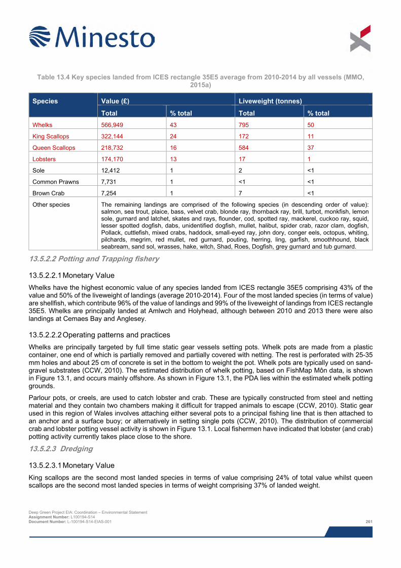
Table 13.4 Key species landed from ICES rectangle 35E5 average from 2010-2014 by all vessels (MMO,
2015a)
Species Value (£) Liveweight (tonnes)
Total % total Total % total Whelks 566,949 43 795 50
King Scallops 322,144 24 172 11
Queen Scallops 218,732 16 584 37
Lobsters 174,170 13 17 1
Sole 12,412 1 2 <1
Common Prawns 7,731 1 <1 <1
Brown Crab 7,254 1 7 <1
Other species The remaining landings are comprised of the following species (in descending order of value): salmon, sea trout, plaice, bass, velvet crab, blonde ray, thornback ray, brill, turbot, monkfish, lemon sole, gurnard and latchet, skates and rays, flounder, cod, spotted ray, mackerel, cuckoo ray, squid, lesser spotted dogfish, dabs, unidentified dogfish, mullet, halibut, spider crab, razor clam, dogfish, Pollack, cuttlefish, mixed crabs, haddock, small-eyed ray, john dory, conger eels, octopus, whiting, pilchards, megrim, red mullet, red gurnard, pouting, herring, ling, garfish, smoothhound, black seabream, sand sol, wrasses, hake, witch, Shad, Roes, Dogfish, grey gurnard and tub gurnard.
13.5.2.2 Potting and Trapping fishery
13.5.2.2.1 Monetary Value Whelks have the highest economic value of any species landed from ICES rectangle 35E5 comprising 43% of the value and 50% of the liveweight of landings (average 2010-2014). Four of the most landed species (in terms of value) are shellfish, which contribute 96% of the value of landings and 99% of the liveweight of landings from ICES rectangle 35E5. Whelks are principally landed at Amlwch and Holyhead, although between 2010 and 2013 there were also landings at Cemaes Bay and Anglesey.
13.5.2.2.2 Operating patterns and practices Whelks are principally targeted by full time static gear vessels setting pots. Whelk pots are made from a plastic container, one end of which is partially removed and partially covered with netting. The rest is perforated with 25-35 mm holes and about 25 cm of concrete is set in the bottom to weight the pot. Whelk pots are typically used on sand-gravel substrates (CCW, 2010). The estimated distribution of whelk potting, based on FishMap Môn data, is shown in Figure 13.1, and occurs mainly offshore. As shown in Figure 13.1, the PDA lies within the estimated whelk potting grounds.
Parlour pots, or creels, are used to catch lobster and crab. These are typically constructed from steel and netting material and they contain two chambers making it difficult for trapped animals to escape (CCW, 2010). Static gear used in this region of Wales involves attaching either several pots to a principal fishing line that is then attached to an anchor and a surface buoy; or alternatively in setting single pots (CCW, 2010). The distribution of commercial crab and lobster potting vessel activity is shown in Figure 13.1. Local fishermen have indicated that lobster (and crab) potting activity currently takes place close to the shore.
13.5.2.3 Dredging
13.5.2.3.1 Monetary Value King scallops are the second most landed species in terms of value comprising 24% of total value whilst queen scallops are the second most landed species in terms of weight comprising 37% of landed weight.
Deep Green Project EIA: Coordination – Environmental Statement Assignment Number: L100194-S14 Document Number: L-100194-S14-EIAS-001 261
13.5.2.3.2 Operating patterns and practices King and queen scallops are both amongst the most landed species from ICES rectangle 35E5, both of which are targeted by dredges (though queen scallops can also be targeted by otter trawls or toothless dredges). For dredging, vessels tow one (astern) or two (either side) beams onto which a number of dredges are attached. The number of dredges used depends on vessel size, engine power and winch capacity. It is unlikely that scallop dredgers will be active in the PDA. As shown in Figure 13.2 there is an exclusion zone for scallop dredgers within 1 nm (1.9 km) from the coast. This is due to the Scallop Fishing (Wales) Order, 2010, which excludes certain areas from scallop dredging. In addition to this, vessels greater than 12 m in length are restricted to only fishing beyond 6 nm (11.1 km) from shore (exemptions discussed in Section 13.3) and will therefore not be present in the PDA.
Whilst scallop dredgers under 10 m in length do fish in Welsh waters, there is no evidence of them operating in the PDA area, based on FishMap Môn (2014) data and feedback from consultees. Figures 13.3 and 13.4 highlight the PDA in relation to king and queen scallop dredging grounds respectively. This distribution of scallop dredging is further supported by the Sea Fishing Atlas of Wales (CCW, 2010) and has been corroborated through the consultation process.
13.5.2.4 Other fisheries Landings data (Table 13.4) indicate that sole, brown crab and common prawns are also key species landed from ICES rectangle 35E5. Brown crabs are discussed in Section 13.5.3.2 as they are targeted simultaneously with lobster using pots. As discussed in AWJ Marine (2015) no trawling or netting fisheries are active within or in the vicinity of the PDA, thus sole landings are not discussed further here. Common prawns are typically targeted in pots close to shore over the winter months, outwith the PDA.
13.5.2.5 Seasonality Fishing activity occurs all year round for different species as shown in Table 13.5, which highlights the seasonal distribution of fishing activities for the key species in the vicinity of the PDA.
Table 13.5 Seasonal pattern of fishing activities in the vicinity of the PDA (AWJ Marine, 2015)
Species Jan Feb Mar Apr May Jun Jul Aug Sep Oct Nov Dec Whelks
King scallop
Queen Scallop
Lobsters
Shaded = fishing activity
Deep Green Project EIA: Coordination – Environmental Statement Assignment Number: L100194-S14 Document Number: L-100194-S14-EIAS-001 262
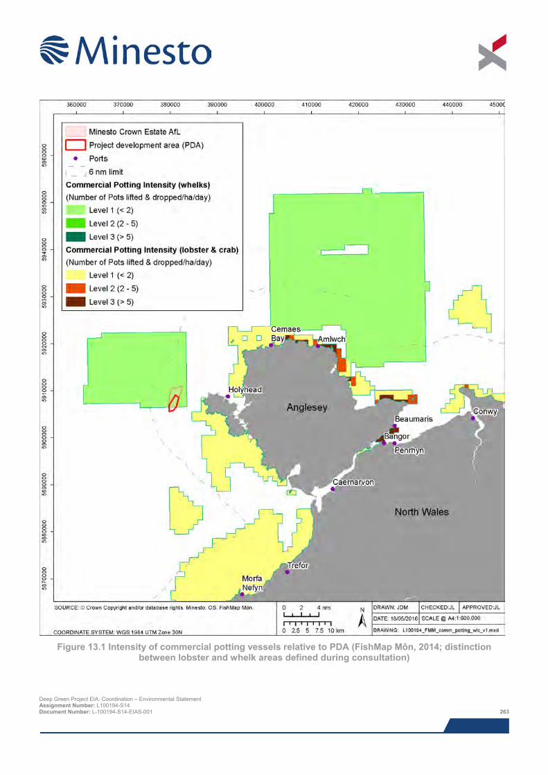
Figure 13.1 Intensity of commercial potting vessels relative to PDA (FishMap Môn, 2014; distinction
between lobster and whelk areas defined during consultation)
Deep Green Project EIA: Coordination – Environmental Statement Assignment Number: L100194-S14 Document Number: L-100194-S14-EIAS-001 263
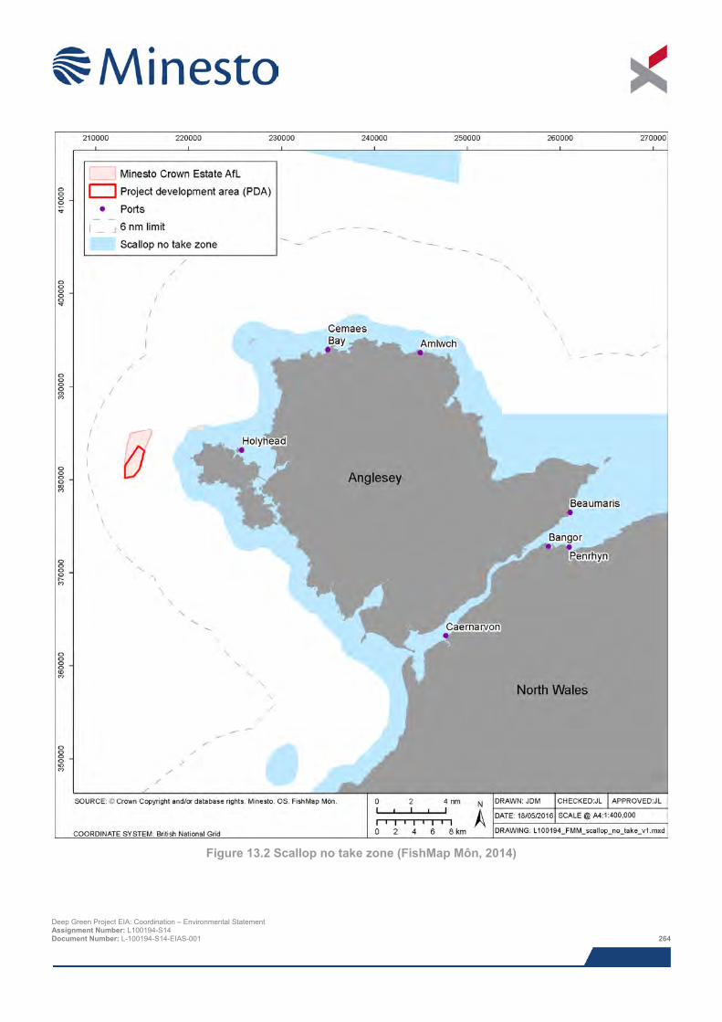
Figure 13.2 Scallop no take zone (FishMap Môn, 2014)
Deep Green Project EIA: Coordination – Environmental Statement Assignment Number: L100194-S14 Document Number: L-100194-S14-EIAS-001 264
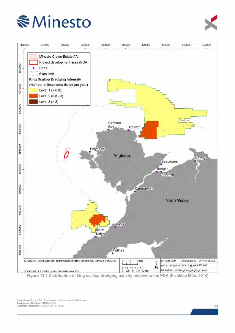
Figure 13.3 Distribution of king scallop dredging activity relative to the PDA (FishMap Môn, 2014)
Deep Green Project EIA: Coordination – Environmental Statement Assignment Number: L100194-S14 Document Number: L-100194-S14-EIAS-001 265
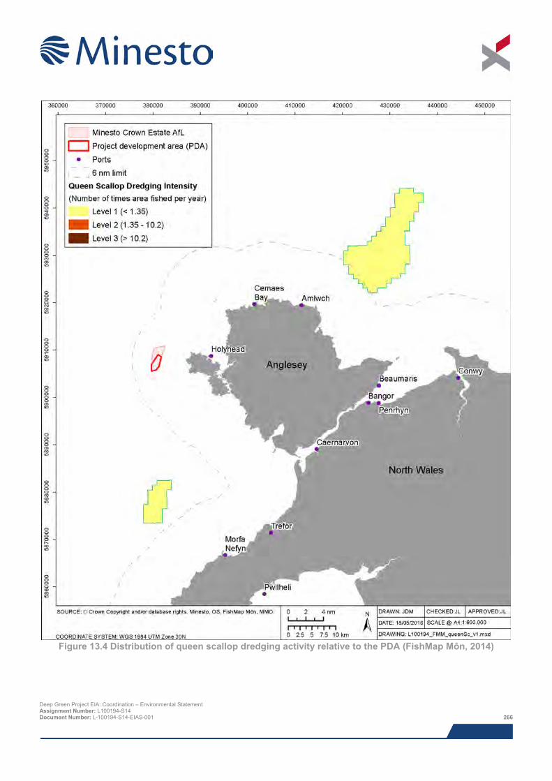
Figure 13.4 Distribution of queen scallop dredging activity relative to the PDA (FishMap Môn, 2014)
Deep Green Project EIA: Coordination – Environmental Statement Assignment Number: L100194-S14 Document Number: L-100194-S14-EIAS-001 266

13.5.2.6 Fishing vessels The majority of fishing vessels active in the vicinity of the PDA are under 10 m in length. Of the vessels registered to ports within 50 km of Holyhead port, 59 out of 72 are under 10 m (Table 13.6). Vessels smaller than 10 m are rarely at sea for more than 24 hours on any one trip and thus tend to fish close to their home port. Even the largest vessels in this class size tend to work inshore, generally within 6 nm (11.1 km) of the coast and rarely further than 12 nm (22.2 km) offshore. Rough weather and hazardous waters such as those around the vicinity of the PDA can limit or prevent them from fishing or navigating safely.
Small vessels that operate from the port of Holyhead, and possibly some from Cemaes Bay and Amlwch, are likely to operate in the vicinity of the PDA. Welsh Government officers report that, of the 38 vessels currently operating from Holyhead, approximately 20 are potting vessels.
Table 13.6 Number of vessels registered to ports in the vicinity of the PDA (Welsh Government, 2015)
Home Port Distance from the AfL (km)
Number of Vessels
< 10 m(a) 10-12 m(a) >12 m(b) Total Holyhead 11 32 3 3 38
Amlwch 32.5 5 1 0 6
Anglesey(c) 18 7 0 1 8
Cemaes Bay 23.5 6 1 1 8
Beaumaris 46.5 1 0 0 1
Caernarvon 38 3 0 0 3
Bangor 45 5 1 1 7
Penrhyn 47 0 0 1 1
Total n/a 59 6 7 72
(a) Vessels within this size group most likely to be observed in and around PDA (b) Vessel within this size group unlikely to fish in vicinity of the PDA due to local laws and capacity to fish further offshore (c) There is no ‘Anglesey’ port thus this data comprises an amalgamation of landings into small ports and slips in Anglesey
As discussed in Section 13.3 fishing by vessels over 12 m in length is prohibited within 6 nm (11.1 km) of the coast, and therefore larger vessels (other than three across north Wales which have historic fishing rights) will not be present in the vicinity of the PDA.
During the spring and summer vessel surveys (see Chapter 15: Navigation and Shipping) no fishing vessels transited through the PDA.
13.5.3 Angling and recreational fisheries Sea angling, shore angling, recreational potting and hand gathering of shellfish also occur around Holy Island and in the vicinity of the PDA. As shown in Figure 13.5, Figure 13.6, Figure 13.7 and Figure 13.8 these fisheries are absent from the AfL area and PDA.
Deep Green Project EIA: Coordination – Environmental Statement Assignment Number: L100194-S14 Document Number: L-100194-S14-EIAS-001 267
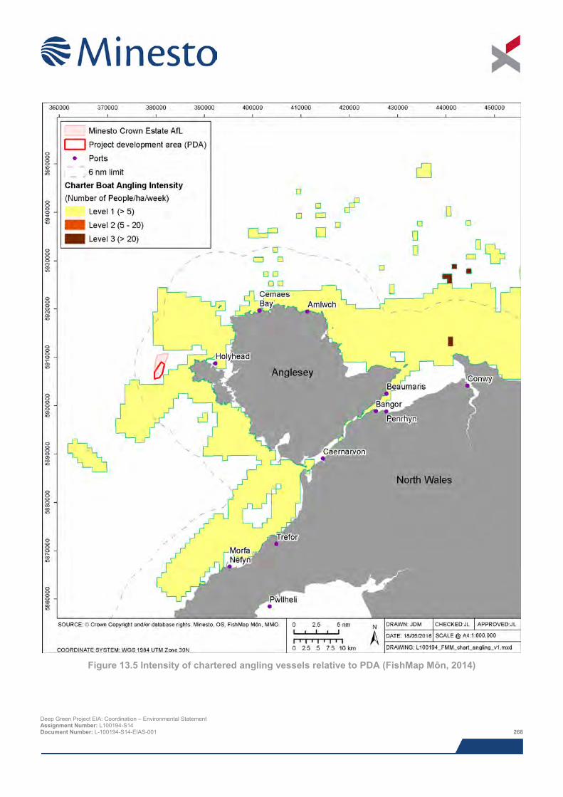
Figure 13.5 Intensity of chartered angling vessels relative to PDA (FishMap Môn, 2014)
Deep Green Project EIA: Coordination – Environmental Statement Assignment Number: L100194-S14 Document Number: L-100194-S14-EIAS-001 268
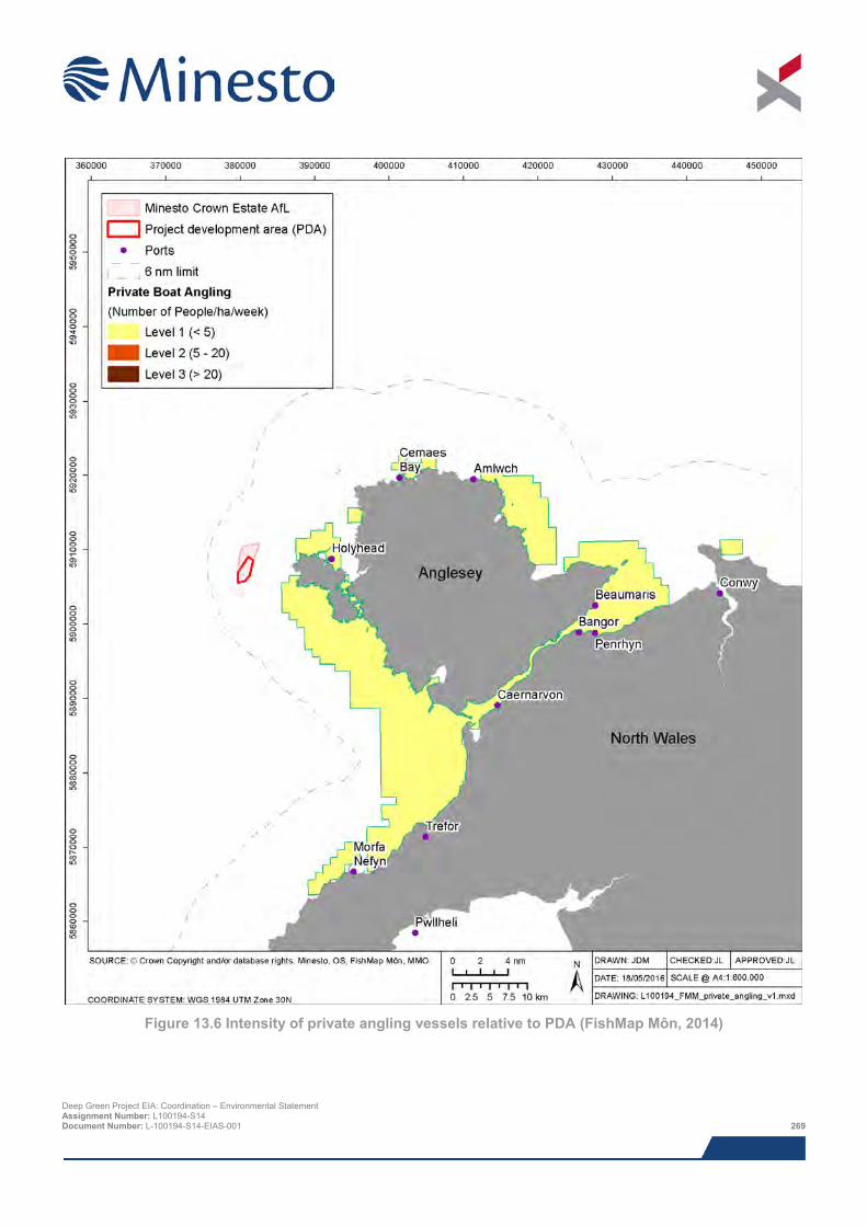
Figure 13.6 Intensity of private angling vessels relative to PDA (FishMap Môn, 2014)
Deep Green Project EIA: Coordination – Environmental Statement Assignment Number: L100194-S14 Document Number: L-100194-S14-EIAS-001 269
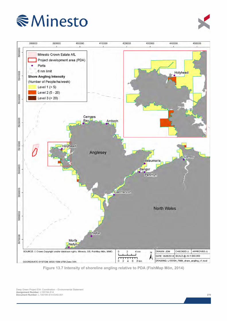
Figure 13.7 Intensity of shoreline angling relative to PDA (FishMap Môn, 2014)
Deep Green Project EIA: Coordination – Environmental Statement Assignment Number: L100194-S14 Document Number: L-100194-S14-EIAS-001 270
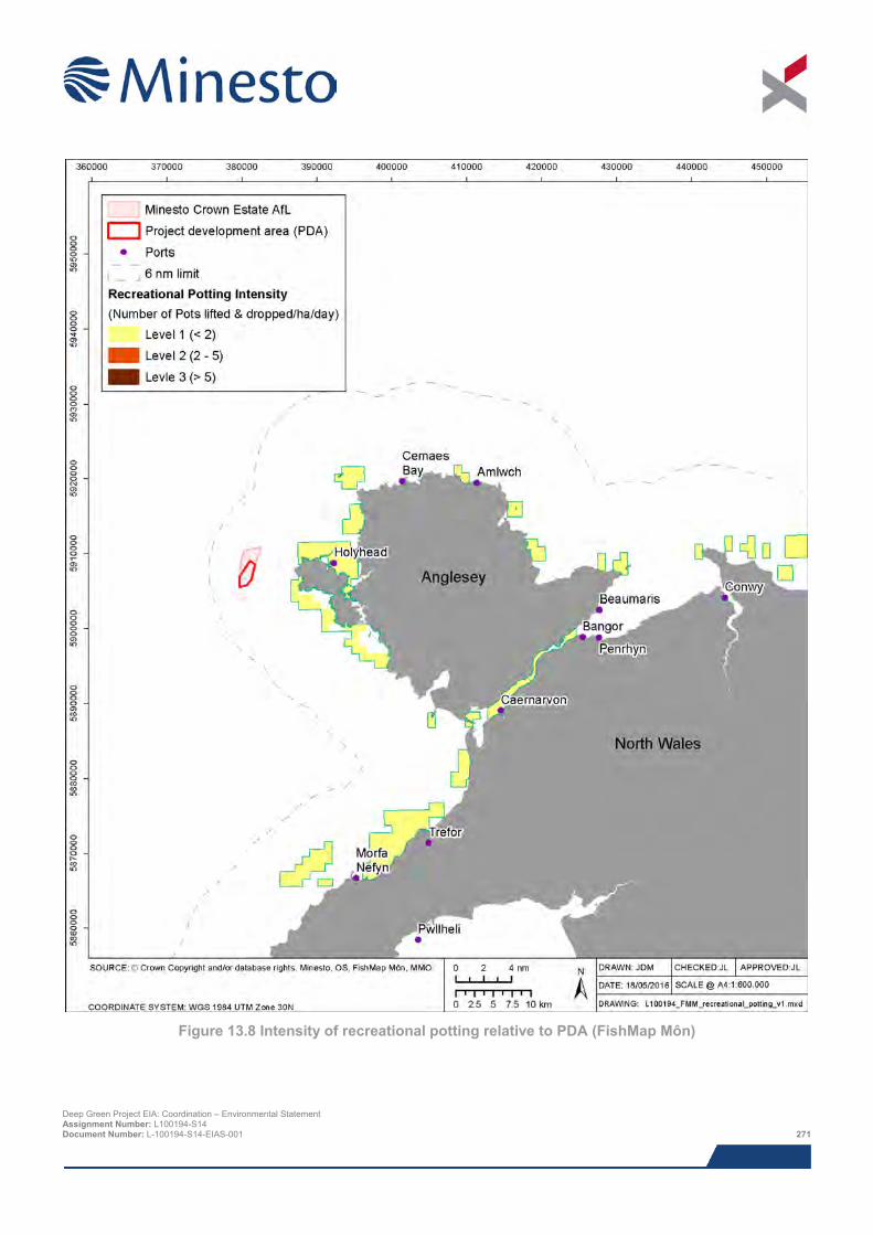
Figure 13.8 Intensity of recreational potting relative to PDA (FishMap Môn)
Deep Green Project EIA: Coordination – Environmental Statement Assignment Number: L100194-S14 Document Number: L-100194-S14-EIAS-001 271
13.5.4 Summary of baseline environment Within the PDA some commercial fishing activity takes place, primarily whelk potting. Although scallop dredging is important in the region it does not occur in the PDA and therefore is not considered further in the impact assessment. Neither are the fisheries located inshore of the PDA that will be unaffected by the proposed Project activities, other than vessel movements to and from the PDA (these will not add significantly to current vessel traffic in the area).
13.5.5 Data gaps and uncertainties Analysis of the data and information sources used for the commercial fisheries assessment are subject to the qualifications, limitations, sensitivities and gaps discussed below. Despite these minor limitations the published data supported by consultation is considered to have generated a robust baseline against which impacts can be assessed.
> Vessel Monitoring System (VMS) - based statistics – data describing the spatial distribution of commercial fishing are available for VMS records for the over 15 m fishing fleet (these data include landings value, tonnage and effort). These data are of limited value for this Project, as vessels larger than 12 m are not permitted to fish in the PDA, and there are no VMS records for these smaller vessels.
> MMO landings data (2015a) – all commercial fish and shellfish landings are recorded by the Marine Management Organisation (MMO), for vessels of all sizes. Landings declarations require that fishermen specify the ICES rectangle within which they caught the fish being landed. The port at which the landings are made is also recorded. These data therefore provide an indication of the weight and value of each fish species caught in a particular sea area.
> FishMap Môn – although FishMap Môn data distinguishes between gear types utilised it does not consistently specify the target species. This is the case for pot fisheries, which target both whelks and lobsters, both key species caught in the vicinity of the PDA. This shortcoming has been addressed through stakeholder comments during the consultation process.
13.6 Impact assessment
13.6.1 Overview This assessment covers all impacts identified during scoping, as well as any further potential impacts that have been highlighted as the EIA has progressed. It should be noted that impacts are not necessarily relevant to all phases of the Project. Cumulative and in-combination impacts are discussed in Section 13.10.
The key impact assessed is loss of access to fishing grounds in the IDA and safety zones during construction / installation / commission, operation and maintenance and decommissioning.
The following impacts were scoped out of the assessment:
> Change in abundance of target species; as the area of impact is small it is unlikely that fish and shellfish species will be significantly impacted as a result of increased sediment in the water column or as a result of smothering. Noise emissions are unlikely to be fatal to fish and shellfish species, as discussed in the fish ecology supporting study (Xodus, 2015a) and the underwater noise technical report (Xodus, 2015b) and therefore do not require further assessment;
> Snagging risks are covered in the Navigational Risk Assessment (Anatec, 2015) and Chapter 14: Shipping and Navigation; and
> Vessel collision risk which is covered in the Navigational Risk Assessment (Anatec, 2015) and Chapter 14: Shipping and Navigation.
The assessment of impacts on fisheries was a desk-based exercise making use of Project specific data.
Deep Green Project EIA: Coordination – Environmental Statement Assignment Number: L100194-S14 Document Number: L-100194-S14-EIAS-001 272
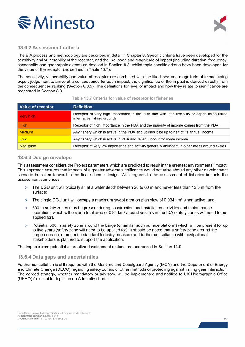
13.6.2 Assessment criteria The EIA process and methodology are described in detail in Chapter 8. Specific criteria have been developed for the sensitivity and vulnerability of the receptor, and the likelihood and magnitude of impact (including duration, frequency, seasonality and geographic extent) as detailed in Section 8.3, whilst topic specific criteria have been developed for the value of the receptor (as defined in Table 13.7).
The sensitivity, vulnerability and value of receptor are combined with the likelihood and magnitude of impact using expert judgement to arrive at a consequence for each impact; the significance of the impact is derived directly from the consequences ranking (Section 8.3.5). The definitions for level of impact and how they relate to significance are presented in Section 8.3.
Table 13.7 Criteria for value of receptor for fisheries
Value of receptor Definition
Very high Receptor of very high importance in the PDA and with little flexibility or capability to utilise alternative fishing grounds.
High Receptor of high importance in the PDA and the majority of income comes from the PDA
Medium Any fishery which is active in the PDA and utilises it for up to half of its annual income
Low Any fishery which is active in PDA and reliant upon it for some income
Negligible Receptor of very low importance and activity generally abundant in other areas around Wales
13.6.3 Design envelope This assessment considers the Project parameters which are predicted to result in the greatest environmental impact. This approach ensures that impacts of a greater adverse significance would not arise should any other development scenario be taken forward in the final scheme design. With regards to the assessment of fisheries impacts the assessment comprises:
> The DGU unit will typically sit at a water depth between 20 to 60 m and never less than 12.5 m from the surface;
> The single DGU unit will occupy a maximum swept area on plan view of 0.034 km2 when active; and
> 500 m safety zones may be present during construction and installation activities and maintenance operations which will cover a total area of 0.84 km2 around vessels in the IDA (safety zones will need to be applied for).
> Potential 500 m safety zone around the barge (or similar such surface platform) which will be present for up to five years (safety zone will need to be applied for). It should be noted that a safety zone around the barge does not represent a standard industry measure and further consultation with navigational stakeholders is planned to support the application.
The impacts from potential alternative development options are addressed in Section 13.9.
13.6.4 Data gaps and uncertainties Further consultation is still required with the Maritime and Coastguard Agency (MCA) and the Department of Energy and Climate Change (DECC) regarding safety zones, or other methods of protecting against fishing gear interaction. The agreed strategy, whether mandatory or advisory, will be implemented and notified to UK Hydrographic Office (UKHO) for suitable depiction on Admiralty charts.
Deep Green Project EIA: Coordination – Environmental Statement Assignment Number: L100194-S14 Document Number: L-100194-S14-EIAS-001 273
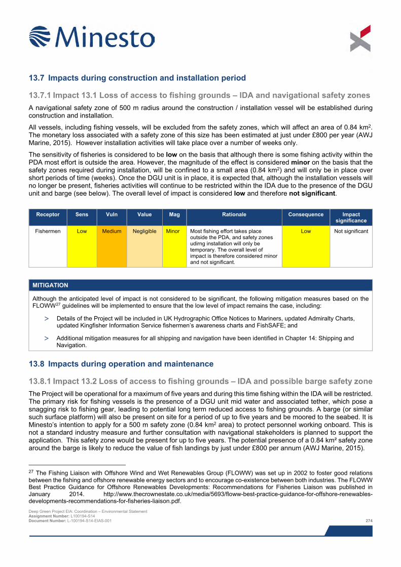
13.7 Impacts during construction and installation period
13.7.1 Impact 13.1 Loss of access to fishing grounds – IDA and navigational safety zones A navigational safety zone of 500 m radius around the construction / installation vessel will be established during construction and installation.
All vessels, including fishing vessels, will be excluded from the safety zones, which will affect an area of 0.84 km2. The monetary loss associated with a safety zone of this size has been estimated at just under £800 per year (AWJ Marine, 2015). However installation activities will take place over a number of weeks only.
The sensitivity of fisheries is considered to be low on the basis that although there is some fishing activity within the PDA most effort is outside the area. However, the magnitude of the effect is considered minor on the basis that the safety zones required during installation, will be confined to a small area (0.84 km2) and will only be in place over short periods of time (weeks). Once the DGU unit is in place, it is expected that, although the installation vessels will no longer be present, fisheries activities will continue to be restricted within the IDA due to the presence of the DGU unit and barge (see below). The overall level of impact is considered low and therefore not significant.
Receptor Sens Vuln Value Mag Rationale Consequence Impact
significance
Fishermen Low Medium Negligible Minor Most fishing effort takes place outside the PDA, and safety zones udirng installation will only be temporary. The overall level of impact is therefore considered minor and not significant.
Low Not significant
MITIGATION
Although the anticipated level of impact is not considered to be significant, the following mitigation measures based on the FLOWW27 guidelines will be implemented to ensure that the low level of impact remains the case, including:
> Details of the Project will be included in UK Hydrographic Office Notices to Mariners, updated Admiralty Charts, updated Kingfisher Information Service fishermen’s awareness charts and FishSAFE; and
> Additional mitigation measures for all shipping and navigation have been identified in Chapter 14: Shipping and Navigation.
13.8 Impacts during operation and maintenance
13.8.1 Impact 13.2 Loss of access to fishing grounds – IDA and possible barge safety zone The Project will be operational for a maximum of five years and during this time fishing within the IDA will be restricted. The primary risk for fishing vessels is the presence of a DGU unit mid water and associated tether, which pose a snagging risk to fishing gear, leading to potential long term reduced access to fishing grounds. A barge (or similar such surface platform) will also be present on site for a period of up to five years and be moored to the seabed. It is Minesto’s intention to apply for a 500 m safety zone (0.84 km2 area) to protect personnel working onboard. This is not a standard industry measure and further consultation with navigational stakeholders is planned to support the application. This safety zone would be present for up to five years. The potential presence of a 0.84 km² safety zone around the barge is likely to reduce the value of fish landings by just under £800 per annum (AWJ Marine, 2015).
27 The Fishing Liaison with Offshore Wind and Wet Renewables Group (FLOWW) was set up in 2002 to foster good relations between the fishing and offshore renewable energy sectors and to encourage co-existence between both industries. The FLOWW Best Practice Guidance for Offshore Renewables Developments: Recommendations for Fisheries Liaison was published in January 2014. http://www.thecrownestate.co.uk/media/5693/floww-best-practice-guidance-for-offshore-renewables-developments-recommendations-for-fisheries-liaison.pdf. Deep Green Project EIA: Coordination – Environmental Statement Assignment Number: L100194-S14 Document Number: L-100194-S14-EIAS-001 274
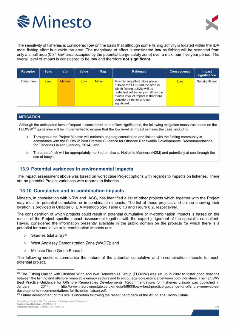
The sensitivity of fisheries is considered low on the basis that although some fishing activity is located within the IDA most fishing effort is outside the area. The magnitude of effect is considered low as fishing will be restricted from only a small area (0.84 km2 area occupied by the potential barge safety zone) over a maximum five year period. The overall level of impact is considered to be low and therefore not significant.
Receptor Sens Vuln Value Mag Rationale Consequence Impact
significance
Fishermen Low Medium Low Minor Most fishing effort takes place outside the PDA and the area in which fishing activity will be restricted will be very small, so the overall level of impact is therefore considered minor and not significant.
Low Not significant
MITIGATION
Although the anticipated level of impact is considered to be of low significance, the following mitigation measures based on the FLOWW28 guidelines will be implemented to ensure that the low level of impact remains the case, including:
> Throughout the Project Minesto will maintain ongoing consultation and liaison with the fishing community in accordance with the FLOWW Best Practice Guidance for Offshore Renewable Developments: Recommendations for Fisheries Liaison (January, 2014); and
> The area of risk will be appropriately marked on charts, Notice to Mariners (N2M) and potentially at sea through the use of buoys.
13.9 Potential variances in environmental impacts The impact assessment above was based on worst case Project options with regards to impacts on fisheries. There are no potential Project variances with regards to fisheries.
13.10 Cumulative and in-combination impacts Minesto, in consultation with NRW and IACC, has identified a list of other projects which together with the Project may result in potential cumulative or in-combination impacts. The list of these projects and a map showing their location is provided in Chapter 8: EIA Methodology; Table 8.13 and Figure 8.2, respectively.
The consideration of which projects could result in potential cumulative or in-combination impacts is based on the results of the Project specific impact assessment together with the expert judgement of the specialist consultant. Having considered the information presently available in the public domain on the projects for which there is a potential for cumulative or in-combination impacts are:
> Skerries tidal array29;
> West Anglesey Demonstration Zone (WADZ); and
> Minesto Deep Green Phase II.
The following sections summarise the nature of the potential cumulative and in-combination impacts for each potential project.
28 The Fishing Liaison with Offshore Wind and Wet Renewables Group (FLOWW) was set up in 2002 to foster good relations between the fishing and offshore renewable energy sectors and to encourage co-existence between both industries. The FLOWW Best Practice Guidance for Offshore Renewables Developments: Recommendations for Fisheries Liaison was published in January 2014. http://www.thecrownestate.co.uk/media/5693/floww-best-practice-guidance-for-offshore-renewables-developments-recommendations-for-fisheries-liaison.pdf. 29 Future development of this site is uncertain following the recent hand back of the AfL to The Crown Estate. Deep Green Project EIA: Coordination – Environmental Statement Assignment Number: L100194-S14 Document Number: L-100194-S14-EIAS-001 275
13.10.1 Potential cumulative and in-combination impacts during construction and
installation Cumulative and in-combination impacts on commercial fisheries include disturbance and displacement of the fishing fleet to alternative fishing grounds by project-specific construction safety zones and operational restrictions.
There is potential for safety zones to be employed for the construction and installation of each project which could be up to a maximum radius of 500 m.
Based on the information currently available on construction schedules for the other projects it is not likely there will be concurrent construction activities and therefore no cumulative or in-combination impacts are anticipated.
13.10.2 Potential cumulative and in-combination impacts during operation and maintenance
During operation and maintenance of the Project fishing will be restricted from the area where the DGU unit, its mooring system and the barge (or similar such surface platform) are present (up to 0.034 km2) for a period of up to five years (Phase I). If the Project proves successful and a future array of DGU units is installed (Phase II), this area will increase. Temporary safety zones may also be in place during maintenance works for Phase II.
There may be fishing restrictions associated with the Skerries and WADZ projects, although this is presently uncertain. The distance between the proposed WADZ project and the DG Holyhead Deep PDA is 1.2 km at the closest point. Thus, it is likely that the in-combination effects will result in a larger sea area being unavailable for local fishermen. The WADZ AfL area is approximately 35.3 km2, although the area within which tidal energy device will be deployed is currently unknown, but likely to be only a small proportion of the total AfL area. Large areas of sea will remain available for fishing activity to take place outside the areas where fishing is likely to be restricted. It is also worth noting that different fisheries use the Holyhead Deep compared to the WADZ and Skerries areas, which are shallower water areas and support inshore fisheries, and therefore different fisheries will be impacted by these other projects.
The distance between the Skerries renewable energy project and the IDA for the Project is over 20 km. Although the in-combination effects of these projects will result in a larger sea area being unavailable for fishing, this would still amount to no more than 4.7 km2, and impacts on commercial fishing would therefore remain very slight.
13.10.3 Potential cumulative and in-combination impacts during decommissioning At present it is unknown whether there will be concurrent decommissioning activities, however impacts are likely to be similar or less severe than those during construction and installation and following decommissioning areas from which fishing has been restricted will become available again for fishing.
13.10.4 Mitigation requirements for potential cumulative and in-combination impacts There is no requirement for additional mitigation over and above the Project-specific measures proposed in Sections 13.7 and 13.8.
13.11 Impact summary
Impact Assessment consequence
Impact significance (EIA regulations)
Mitigation identified
Residual impact
Construction / installation
Impact 13.1 Loss of access to fishing grounds – IDA
Low consequence Not significant No Not significant
Operation and maintenance
Impact 13.2 Loss of access to fishing grounds – IDA
Low consequence Not significant No Not significant
Deep Green Project EIA: Coordination – Environmental Statement Assignment Number: L100194-S14 Document Number: L-100194-S14-EIAS-001 276
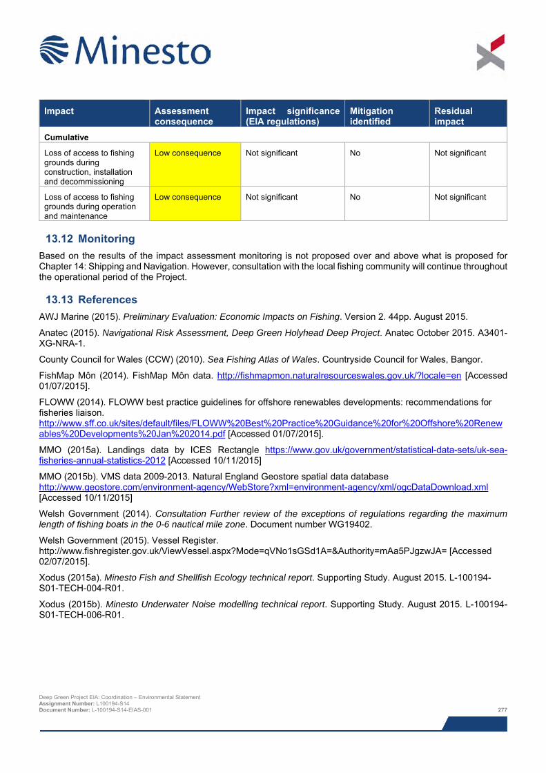
Impact Assessment
consequence Impact significance (EIA regulations)
Mitigation identified
Residual impact
Cumulative
Loss of access to fishing grounds during construction, installation and decommissioning
Low consequence Not significant No Not significant
Loss of access to fishing grounds during operation and maintenance
Low consequence Not significant No Not significant
13.12 Monitoring Based on the results of the impact assessment monitoring is not proposed over and above what is proposed for Chapter 14: Shipping and Navigation. However, consultation with the local fishing community will continue throughout the operational period of the Project.
13.13 References AWJ Marine (2015). Preliminary Evaluation: Economic Impacts on Fishing. Version 2. 44pp. August 2015.
Anatec (2015). Navigational Risk Assessment, Deep Green Holyhead Deep Project. Anatec October 2015. A3401-XG-NRA-1.
County Council for Wales (CCW) (2010). Sea Fishing Atlas of Wales. Countryside Council for Wales, Bangor.
FishMap Môn (2014). FishMap Môn data. http://fishmapmon.naturalresourceswales.gov.uk/?locale=en [Accessed 01/07/2015].
FLOWW (2014). FLOWW best practice guidelines for offshore renewables developments: recommendations for fisheries liaison. http://www.sff.co.uk/sites/default/files/FLOWW%20Best%20Practice%20Guidance%20for%20Offshore%20Renewables%20Developments%20Jan%202014.pdf [Accessed 01/07/2015].
MMO (2015a). Landings data by ICES Rectangle https://www.gov.uk/government/statistical-data-sets/uk-sea-fisheries-annual-statistics-2012 [Accessed 10/11/2015]
MMO (2015b). VMS data 2009-2013. Natural England Geostore spatial data database http://www.geostore.com/environment-agency/WebStore?xml=environment-agency/xml/ogcDataDownload.xml [Accessed 10/11/2015]
Welsh Government (2014). Consultation Further review of the exceptions of regulations regarding the maximum length of fishing boats in the 0-6 nautical mile zone. Document number WG19402.
Welsh Government (2015). Vessel Register. http://www.fishregister.gov.uk/ViewVessel.aspx?Mode=qVNo1sGSd1A=&Authority=mAa5PJgzwJA= [Accessed 02/07/2015].
Xodus (2015a). Minesto Fish and Shellfish Ecology technical report. Supporting Study. August 2015. L-100194-S01-TECH-004-R01.
Xodus (2015b). Minesto Underwater Noise modelling technical report. Supporting Study. August 2015. L-100194-S01-TECH-006-R01.
Deep Green Project EIA: Coordination – Environmental Statement Assignment Number: L100194-S14 Document Number: L-100194-S14-EIAS-001 277

This page has been intentionally left blank.
Deep Green Project EIA: Coordination – Environmental Statement Assignment Number: L100194-S14 Document Number: L-100194-S14-EIAS-001 278
14 NAVIGATION AND SHIPPING
Project specific marine traffic surveys, in addition to longer-term desk top study, have been carried out in order to characterise the baseline shipping and navigation environment. A total of four commercial main routes (maximum of nine vessel transits per day) were identified within the study area, two of which transit to / from Holyhead Harbour. Commercial traffic (high speed craft, cargo vessels, passenger vessels, tanker vessels, tugs and dredging / underwater ops vessels) represented the majority of marine traffic recorded throughout both the summer (85.0% of marine traffic within study area) and spring (87.4% of marine traffic within study area) surveys. In addition a number of small vessels (recreational and fishing) were also recorded. An average of three recreational vessels per day were recorded throughout the summer survey. Throughout the spring survey an average of one recreational vessel every two days was recorded. A total of eight recreational vessels were recorded intersecting the project development area (PDA). The most frequently recorded fishing vessel gear types recorded throughout both the summer and spring surveys were: pots and traps (45.5% of fishing vessel activity) and mechanised dredging (22.7% of fishing vessel activity). The majority (64.0%) of fishing vessel activity was recorded in the spring survey, when an average of one unique fishing vessel per day was recorded. An average of one unique fishing vessel every two days was recorded in the summer survey. Overall it can be concluded that the PDA has been carefully sited in order to minimise the potential impact on shipping and navigation. The PDA has been sited to avoid interaction with the busy commercial traffic routes to the north (vessel movements associated with Holyhead harbour) and west (vessel movements associated with the Off Skerries TSS) and also avoids the movement of small craft (fishing and recreational vessels) in close proximity to the coast. Over the entire survey period, only 1.7% of marine traffic recorded intersected the PDA.
The shipping and navigation impact assessment has been carried out in line with the IMO’s Formal Safety Assessment (FSA) process and the DECC / MCA Guidelines. Impacts were identified during the Navigation Risk Assessment (NRA) hazard review workshop, from expert opinion as well as any further potential impacts highlighted throughout consultation. No high (unacceptable) risks were identified following the implementation of both embedded and additional (enhanced) mitigation measures. It can be concluded that the greatest risk is presented when the barge (or similar such surface platform) is on-site. However, with the implementation of both embedded and additional mitigation measures the risk of the barge is deemed to be acceptable. During periods when the barge is not present on site, the overall risk is anticipated to reduce. This is largely due to the minimum under water clearance of 12.5 m which puts the device out of reach of interaction for the vast majority of vessels most of the time.
14.1 Introduction This chapter summarises the work undertaken by Anatec Limited (hereby referred to as Anatec) to identify the existing vessel activity and navigational features in the vicinity of the Project for construction, operation and maintenance and decommissioning phases. The shipping and navigation chapter considers all vessels navigating within the waters in proximity to the Project including recreational craft, commercial ferries, commercial traffic, commercial fishing vessels, marine aggregate extraction vessels, military vessel transits and emergency response activities, it then goes on to assess the impacts to shipping and navigation receptors in line with the following guidance.
The risk assessment principally follows the Department of Energy and Climate Change (DECC) Risk Assessment Methodology (DECC, 2005) and the Maritime and Coastguard Agency’s (MCA) Marine Guidance Note 371 (MGN 371) including any subsequent updates (at the time of authoring of the NRA)30 approved by the Nautical Offshore Renewable Energy Liaison (NOREL) committee.
Due to the specific methodology required by maritime regulators, shipping and navigation, as a receptor has been assessed within this chapter under a different methodology to that used within other chapters of this Environmental Statement (ES). However the methodology is similar to the Environmental Impact Assessment (EIA) process, it is
30 MGN 371 was replaced by MGN 543 in January 2016. However, MGN 371 is referenced in this report as it was the relevant guidance at the time of preparing the NRA and ES, which are the basis of this report. Deep Green Project EIA: Coordination – Environmental Statement Assignment Number: L100194-S14 Document Number: L-100194-S14-EIAS-001 279
centred on risk management and requires a submission which demonstrates that sufficient controls are, or would be, in place for the assessed risk to be reduced to As Low as Reasonably Practicable (ALARP).
The potential impacts of the Project on shipping and navigation are assessed in this chapter. The following specialists have contributed to the assessment:
> Anatec – marine traffic survey data provision and analysis, baseline description, impact assessment and Environmental Statement (ES) chapter write up.
The table below provides a list of all the supporting studies which relate to the shipping and navigation impact assessment. All supporting studies are provided on the accompanying CD.
The NRA considered potential risks associated with both the PDA and potential export cable route and for a project of up to 32 years duration. However as this application is concerned with a single DGU deployed in the PDA for up to 5 years and no export cable to shore, the results relevant to the PDA only have been presented in this ES chapter.
Table 14.1 Supporting studies
Details of study
Navigational Risk Assessment (Anatec, 2015a)
Marine Traffic Survey Report – Spring 2015 (Anatec, 2015b)
Marine Traffic Survey Report – Summer 2014 (Anatec, 2014)
The impact assessment presented herein draws upon output from other impact assessments within this ES; where that information is used to inform assessment, reference to the relevant ES chapter is given.
14.2 Area of assessment The study area is based on a 5 nautical mile (nm) (9.3 km) buffer around the proposed project development area (PDA). This buffer has been used as it is considered best practice for navigational risk assessment and it presents sufficient area to capture the relevant information for the Project in terms of baseline data.
The study area, relative to the PDA is illustrated in Figure 14.1.
For the purposes of the cumulative impact assessment the study area has been extended where applicable to encompass vessel routeing.
14.3 Legislation, policy and guidance This section outlines the legislation, policy and guidance relevant to the assessment of potential impacts on shipping and navigation.
14.3.1 International In the UK, national procedures comply as a minimum with the following international standards and recommended practices which are referred to in this chapter, namely:
> International Regulations for Preventing Collisions at Sea 1972 (COLREGS), as implemented in the UK through Marine Shipping Notices; and
> International Association of Marine Aids to Navigation and Lighthouse Authorities (IALA) – Marking of Man-Made Offshore Structures O-139 Edition 2 (IALA, 2013).
Deep Green Project EIA: Coordination – Environmental Statement Assignment Number: L100194-S14 Document Number: L-100194-S14-EIAS-001 280
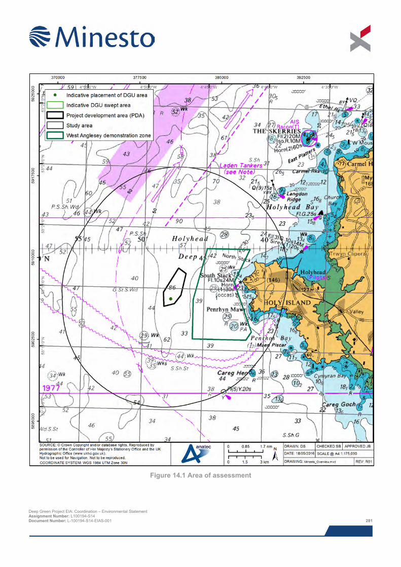
Figure 14.1 Area of assessment
Deep Green Project EIA: Coordination – Environmental Statement Assignment Number: L100194-S14 Document Number: L-100194-S14-EIAS-001 281
14.3.2 Guidance The guidance documents used during the assessment are:
> Maritime and Coastguard Agency (MCA) Marine Guidance Notice 371 (MGN 371 Merchant + Fishing) Offshore Renewable Energy Installations (OREIs) Guidance on UK Navigational Practice, Safety and Emergency Response Issues (MCA, 2008a);
> Department of Energy and Climate Change (DECC) in Association with MCA - Guidance on the Assessment of Offshore Renewable Energy Installations - Methodology for Assessing Marine Navigational Safety and Emergency Response Risks of Offshore Renewable Energy Installations (DECC, 2013);
> Guidelines for Formal Safety Assessment (FSA) for use in the IMO rule-making process – MSC83/INF.2 (IMO, 2002);
> MCA Marine Guidance Notice 372 (MGN 372 M+F) Offshore Renewable Energy Installations (OREIs) Guidance to Mariners Operating in the Vicinity of UK OREIs (MCA, 2008b);
> MCA Under Keel Clearance Policy Paper – Guidance to Developers in Assessing Minimum Water Depth Over Tidal Devices (NOREL, 2014); and
> Royal Yachting Association (RYA) – The RYA’s Position on Offshore Renewable Energy Developments: Paper 3 – Tidal Energy (RYA, 2013).
14.4 Scoping and consultation The following table (Table 14.2) presents consultation responses in relation to shipping and navigation for the Project received through the scoping process and other consultation undertaken with relevant stakeholders.
Table 14.2 Summary of consultation
Consultee (Date) Comment Natural Resources Wales (NRW)
(4th June 2014)
> Stated that Trinity House Lighthouse Services (THLS) and MCA should be consulted.
> Stated that the MCA MGN 371 should be considered throughout production of NRA and ES and MGN checklist completed.
NRW and Marine Management Organisation (MMO)
(25th June 2014)
> MMO queried how maintenance would be carried out when the barge is not present and this should be considered throughout the NRA and ES.
> Discussions held on requirement of safety zones.
> MMO stated that THLS and MCA should be consulted.
Cruising Association
(22nd April 2015) > Queried if any design issues had arisen throughout testing of the device at the Strangford
Lough site.
> Queried if there was potential for the DGU’s wing span to increase from the 12 m currently being considered.
> Queried if the DGU could snag on the seabed and if the tether was buoyant.
> Queried what would happen if the DGU were to break free from the tether.
> Queried if there would be an onshore control room with monitoring of the site.
> Queried if the movement of the DGU in the water could cause any surface disturbance.
> Stated that most yachts on long distance passages (north – south) keep to the western extent of the Irish Sea near the coast of Ireland.
Deep Green Project EIA: Coordination – Environmental Statement Assignment Number: L100194-S14 Document Number: L-100194-S14-EIAS-001 282
Consultee (Date) Comment
> Stated that in a UK wide context, the area is a relatively low density area for recreational activity.
> No concerns regarding operation of the DGU given ample under water clearance. Only issue could arise during device failure.
> Main concern is the presence of the barge, given the length of time it is planned to be on site, and construction vessels movements. Provided barge is appropriately lit and marked is not a major issue.
Chamber of Shipping
(22nd April 2015) > Queried if both modes of operations (tethered to barge and fixed to seabed) could be used at
the Deep Green site and if the application would cover both.
> Queried how the device would be depicted on Admiralty charts.
> Noted there are occasions of vessels not following the Off Skerries TSS. Recommended carrying out analysis of draughts of these vessels whilst on passage.
> Stated that under keel clearance did not appear to be too big an issue based on the traffic characteristics.
> Stated that the potential hazard of device failure, including consideration for if the device would sink or float and recovery of the device should be assessed.
THLS
(22nd April 2015) > THLS queried if the barge would be manned at all times, noting that the sea area off Holyhead
is known to have large swells. THLS indicated that the barge when on location would probably be marked as an offshore structure – Morse ‘U’ with 10 nm (18.5 km) or 15 nm (27.8 km) range.
> THLS highlighted that if the device broke free from its tether the DGU may lie in the entrance to Holyhead. Also as the tether is buoyant up to 20 m of it could float on the surface.
> THLS indicated that when the DGU unit is off location a special mark, with flashing yellow light, should be included on the buoy attached to the tether.
> THLS stated that a risk-based case would need to be made to support a safety zone application.
> THLS stated that further consideration needs to be given to how personnel would access the barge and if the barge will be equipped with radar, Automatic Identification System (AIS), visual lookout, AIS Aid to Navigation (AtoN) etc.
> THLS suggested consulting Liverpool Port as a lot of traffic passing the site is on transit to Liverpool. (Liverpool Port were sent a consultation note about the Project but did not reply).
> THLS suggested checking to see if any passenger vessel tracks which deviated to the south had encountered other vessels. THLS stated that passenger vessels are well equipped, well managed and with good crew so should not be a major concern provided they are aware of the Project.
> THLS questioned if the position of the DGU in the water could be altered to mitigate the risk of a drifting vessel allision.
> THLS stated that for the barge operation tug availability will be a key factor in a potential drifting collision scenario.
> THLS referred to an incident in which a vessel grounded at Raynes Jetty (April 2012). (Further details of incident provided in Section 15.9 of the NRA).
> THLS suggested checking if there are any periods of special activity when the area is much busier, such as an annual race or regatta.
Deep Green Project EIA: Coordination – Environmental Statement Assignment Number: L100194-S14 Document Number: L-100194-S14-EIAS-001 283
Consultee (Date) Comment
> Kayaking was noted from the surveys but this was taking place very close to shore. It is not thought to be an issue for the site which is over three nautical miles from the nearest land at Holy Island.
> THLS commented that the site seemed to be well positioned in a less challenging area between the main flows of traffic.
> During operations when no barge is present, marker buoys on the surface could themselves create a hazard for the sake of marking something subsurface which is well out of the way. If the minimum clearance of 12.5 m is guaranteed, it is probably sufficient to mark the depths on charts.
> THLS summarised that from a navigational viewpoint, the proposed area looked good, the technology looked good, and that the only significant issues were construction and periods with the barge in place, especially when people are onboard the barge.
MCA and RYA
(23rd April 2015) > MCA queried the trajectory of the DGU and how this is maintained.
> MCA queried if the barge would be manned.
> MCA indicated that MGN 371 was being updated and consulted upon through NOREL. This update would be consolidated version incorporating recent guidance such as the MCA Policy paper on the under keel clearance. (Note: Replacement MGN 543 published in January 2016.)
> MCA noted that the tether is planned to be 100 m long and located in 85 m of water and therefore queried if it could present a collision risk when on the surface.
> MCA queried what mechanisms are in place to prevent the DGU from moving higher in the water.
> MCA queried where monitoring of the DGU would take place.
> Chart depiction was discussed and it was suggested that the location of the DGU could be presented in a different colour to emphasise risk.
> The Wylfa Nuclear Power station was noted as a potential cumulative issue as it could lead to increased traffic which differs from the normal traffic seen in the area.
> MCA stated that marking and lighting of the barge will be an important mitigation. Discussions were held on the use of cardinal marks and the potential risk these marks may present.
> RYA stated they did not have any immediate concerns as the underwater clearance was adequate.
> RYA summarised key issues from Policy Paper on Tidal Energy: under keel clearance and operational safety zones. Justification would be required for the use of operational safety zones, along with details on monitoring and enforcement.
> RYA have no issue with standard safety zones during construction.
> MCA agreed that a risk-based case would need to be made to support a safety zone application.
> MCA stated that near shore area known to be heavily used by kayakers but very few in proximity to PDA.
> MCA stated that the area was lightly trafficked and that clearance of 12.5 m seemed adequate for the traffic.
> MCA stated main issue would be component failure of the device (i.e. if it was floating on surface) as it would be difficult to mark and light.
Deep Green Project EIA: Coordination – Environmental Statement Assignment Number: L100194-S14 Document Number: L-100194-S14-EIAS-001 284
Consultee (Date) Comment
> MCA stated that ferries may anchor off Holyhead.
14.5 Baseline description The following sub-sections (Sections 14.5.1 and 14.5.2) summarise the data used to inform the baseline description from a shipping and navigation perspective. Following this, specific shipping and navigation receptors are summarised, Section 14.5.3 onwards.
14.5.1 Desk based study The following data sources have been used throughout desk based study to inform the shipping and navigation baseline description:
> Maritime incident data from the Marine Accident Investigation Branch (2004 to 2013) and the Royal National Lifeboat Institute (2005 to 2014);
> Fishing Vessel Satellite Data (2009) provided by the MMO;
> Fishing Vessel Sightings Data (2005 to 2008) provided by the MMO;
> Ministry of Defence (MOD) exercise areas and explosives dumping grounds (charted information);
> Locations of existing oil and gas platforms and other associated infrastructure such as pipelines and drilling wells from UK Deal (2014);
> Oil and gas fields and 28th Round license blocks from UK Deal (2014);
> Royal Yachting Association (RYA) UK Coastal Atlas of Recreational Boating (RYA, 2009);
> Designated anchorage areas (charted information);
> Marine Environmental High Risk Areas (MEHRAs) from Department for Transport (DfT, 2006) and Particularly Sensitive Sea Areas (PSSAs) from MCA;
> Admiralty Sailing Directions (NP 37);
> UK Admiralty Charts issued by United Kingdom Hydrographic Office (UKHO);
> UK Coastal Atlas of Recreational Boating (2009) and associated GIS data;
> Marine aggregate extraction areas (TCE, 2014) and British Marine Aggregate Producers Association (BMAPA) dredger transit routes (BMAPA, 2014); and
> Wind, wave and tidal data for the area were used as an input for the collision and allision risk modelling process. This is presented in Section 9 of the NRA (Anatec, 2015a).
14.5.2 Survey data As part of the baseline data collection process, two dedicated shore based marine traffic surveys were carried out between August 2014 (14 days summer) and March 2015 (14 days spring), total effective duration of 28 days, in order to account for seasonal and tidal fluctuations in shipping activity.
Both AIS and radar track data (non-AIS), supplemented with visual observation, of vessel movements was gathered. The objective of the survey was to identify the vessel activity both within, and adjacent to, the Project.
AIS is required to be fitted aboard all vessels engaged on international voyages of 300 gross tonnage (GT) and upwards, cargo vessels of 500 GT and upwards not engaged on international voyages and passenger vessels (carrying 12 or more passengers) irrespective of size built on or after the 1st July 2002. During the marine traffic survey, fishing vessels greater than or equal to 15 m in length were required to carry AIS. Deep Green Project EIA: Coordination – Environmental Statement Assignment Number: L100194-S14 Document Number: L-100194-S14-EIAS-001 285
Non-AIS vessels were recorded during the survey by Automatic Radar Plotting Aids (ARPAs). This radar track data was supplemented by manual observation of vessels within visual range to obtain information on type and size. Non-AIS vessels tended to be smaller craft (i.e. recreational vessels and fishing vessels less than 15 m in length).
Dedicated marine traffic survey reports, which summarise the methodology used and detailed analysis of the survey data, are provided on the accompanying CD.
14.5.3 Navigational features Figure 14.2 illustrates the existing navigational features in proximity to the PDA. The closest of these is the Off Skerries Traffic Separation Scheme (TSS), located approximately 2.2 nm (4.1 km) north of the PDA. The Off Skerries TSS is established for vessels rounding the north-west coast of Anglesey. The scheme is IMO-adopted and Rule 10 of The International Regulations for Preventing Collisions at Sea (Colregs) applies. It is noted within the Pilot Book that laden tankers should avoid the area between the south-east boundary of the scheme and the coast. The north bound lane of the TSS is in closest proximity to the PDA.
The Holyhead Harbour pilot boarding station is located approximately 5.0 nm (9.3 km) north-east of the PDA. Holyhead Harbour itself is located approximately 5.5 nm (10.2 km) east of the PDA and is the closest port. Holyhead Harbour operates a conventional and high speed cargo and passenger ferry services, including Roll on Roll off (RoRo), to Dublin (Ireland). There are also facilities for handling marine diesel oil and general cargoes at a deep water berth. The approach to the Outer Harbour is dredged to 8.0 m and the inner harbour has a maintained depth of 5.5 m, but is liable to silting. Pilotage is compulsory for all vessels over 40 m in length. The pilot boards at the pilot boarding station located approximately 1.5 nm (2.8 km) north-west of the break water. All vessels, except small craft, entering or leaving Holyhead Harbour are required to follow the TSS at the entrance of the harbour. Furthermore, all vessels (excluding small craft) should not pass within 0.1 nm (185 m) of the breakwater head. Holyhead Marina is located within the harbour and primarily used by recreational vessels. Further details on Holyhead Marina vessel arrivals information can be found in Section 14.5.6.
There are a number of anchorage areas, which have been identified from Admiralty charts and the Pilot Book for the area, in proximity to the PDA. The closest anchorage areas to the PDA are summarised in Table 14.3.
Table 14.3 Summary of anchorages
Anchorage Distance from PDA (nm)
Distance from PDA (km)
Description
Holyhead New Harbour
4.8 8.9 Sheltered anchorage can be obtained in New Harbour west of the fairway. However space is limited by small craft moorings and Holyhead Marina in the southwest of New Harbour.
Trearddur Bay
5.3 9.8 Trearddur Bay lies at the head of Penrhos Bay and affords temporary anchorage in offshore winds. Moorings are laid in the bay. It should be noted that South Stack Light may be obscured within Penrhos Bay.
Holyhead Bay
6.2 11.5 Holyhead Bay affords an anchorage in offshore winds. Anchoring within the fairways of the Harbour is not permitted.
Deep Green Project EIA: Coordination – Environmental Statement Assignment Number: L100194-S14 Document Number: L-100194-S14-EIAS-001 286
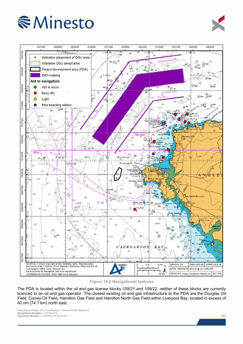
Figure 14.2 Navigational features
The PDA is located within the oil and gas license blocks 109/21 and 109/22, neither of these blocks are currently licenced to an oil and gas operator. The closest existing oil and gas infrastructure to the PDA are the Douglas Oil Field, Conwy Oil Field, Hamilton Gas Field and Hamilton North Gas Field within Liverpool Bay, located in excess of 40 nm (74.1 km) north east. Deep Green Project EIA: Coordination – Environmental Statement Assignment Number: L100194-S14 Document Number: L-100194-S14-EIAS-001 287
There are no licensed aggregate extraction areas in the vicinity of the PDA. The closest licensed aggregate extraction area to the PDA is Area 457 (Liverpool Bay), owned and operated by Westminster Gravels Ltd., located approximately 44 nm (81.5 km) northeast of the PDA. Two BMAPA transit routes pass to the west of the PDA, associated with the north bound and south bound lanes of the Off Skerries TSS. Overall it can be concluded that there is limited movement of dredgers in the vicinity of the PDA.
The PDA is located within the Holyhead Deep disposal site which is used for dredge material from Holyhead harbour. The site has been used by several parties since the mid-1980s up until the present day. In recent years, since 2009, only Stena Line Ports Limited has used the disposal site and it is currently the only licensee, under licence 13/10/ML. This grants Stena Line Ports Limited permission to deposit a quantity not exceeding 99,000 tonnes per year up until 6 June 2016. The utilisation of this area of the disposal site is low however and it is possible that the site will be reduced in size by 50%.
Two subsea cables pass approximately 2.1 nm (3.9 km) and 2.5 nm (4.6 km) to the south of the PDA. The closest of these (2.1 nm (3.9 km) south) is the “Emerald Bridge Fibres” fibre optic cable stretching from Holyhead to Clonshaugh (Ireland). The cable is owned and operated by Zayo Group and ESB Telecoms and came into service in December 2012. The second cable (located 2.5 nm (4.6 km) south) is the “CeltixConnect” fibre optic cable stretching from Holyhead to Dublin (Ireland). The cable is owned and operated by AquaComms and came into service in January 2012.
The West Anglesey Demonstration Zone (WADZ), with a total area of 10.3 nm2 (35.3 km2) is a tidal demonstration site leased to Morlais, located approximately 0.6 nm (1.2 km) east of the PDA. Morlais has been appointed by Menter Môn (a social enterprise delivering projects across North Wales in various sectors) as the managers of the WADZ. The WADZ is currently in the early planning stage and therefore few details are known on the final design of the zone. Minesto is in a close collaboration with Morlais to promote tidal development in north Wales31.
The Anglesey Skerries Tidal Array site, with a total area of 0.2 nm2 (0.4 km2) is a planned tidal site located approximately 9.6 nm (17.8 km) north east of the PDA. It is planned the array will consist of up to five SeaGen S 2 MW devices developed by MCT. However, following the recent hand back of the AfL to The Crown Estate the potential future development of this site is uncertain.
The Aberporth military practice and exercise area (Area D201B) is located approximately 7.0 nm (13.0 km) west of the PDA and used as a firing practice area. Although no restrictions are placed on the right to transit the firing practice areas at any time, mariners are advised to exercise particular caution whilst in an area. Exercises and firing only take place when the areas are considered to be clear of all shipping.
There are no Marine Environmental High Risk Areas (MEHRAs) in the vicinity of the PDA. The closest MEHRA is in excess of 90 nm (167 km) from PDA. MEHRAs are areas that have been identified by the UK Government, as having environmental sensitivity and at high risk of pollution from ships. The Government expects mariners to take note of MEHRAs and either keep well clear or, where this is not practicable, exercise an even higher degree of care than usual when passing nearby. The Western European Waters PSSA is located approximately 76 nm (141 km) south of the PDA. Particularly Sensitive Sea Areas (PSSAs) are areas that need special protection through action by the IMO because of its significance for recognised ecological, socio-economic or scientific reasons which may be vulnerable to damage by international maritime activities.
There are no charted wrecks within the PDA. The closest charted wreck to the PDA lays approximately 1.6 nm (3.0 km) south of the PDA with a clearance of 29.0 m (LAT). There are two protected wrecks within 10 nm (18.5 km) of the PDA:
> The wreck of the SS Castilian lies close off the north western side of the East Platters. Owing to the presence of unstable explosives, the wreck is considered to be a potential danger to life and property and a 500 m radius prohibited area has been established; and
> The wreck of the HMY Mary lies south west of The Skerries. The HMY Mary was the first Royal Yacht of the Royal Navy, built in 1660. The HMY Mary sank in 1675 whilst on passage from Dublin to Chester whilst
31 The WADZ development area was updated late in 2015 and its description as presented in this ES chapter reflects the updated area. However the NRA assumed the ‘old’ development area. Deep Green Project EIA: Coordination – Environmental Statement Assignment Number: L100194-S14 Document Number: L-100194-S14-EIAS-001 288
navigating in thick fog. Owing to the wrecks historical and archaeological importance, a 100 m radius prohibited area has been established.
14.5.4 Marine traffic surveys Figure 14.3 and Figure 14.4 present vessel tracks, colour-coded by vessel type, recorded throughout the summer 2014 and spring 2015 marine traffic surveys, respectively. During the summer and spring marine traffic surveys there was an average of 34 vessel transits per day (summer) and 30 unique vessels per day (spring) within the study area, excluding partial days associated with survey set-up and demobilisation. In terms of vessels intersecting the PDA, an average of one unique vessel every two days was recorded intersecting the PDA throughout both the summer and spring surveys. Over the entire survey period, only 1.7% of marine traffic recorded intersected the PDA. The vast majority of traffic was recorded to the north of the PDA (on passage to / from Holyhead) and to the west (on approach to the Off Skerries TSS). This reflects that the PDA has been carefully sited in order to minimise the potential impact on shipping and navigation: The PDA has been sited to avoid interaction with the busy commercial traffic routes to the north (vessel movements associated with Holyhead harbour) and west (vessel movements associated with the Off Skerries TSS) and also avoids the movement of small craft (fishing and recreational vessels) in close proximity to the coast.
Throughout the summer and spring survey periods the vessel type distribution did not vary significantly. The most frequently recorded vessel types within the study area were:
> Passenger vessels, representing 46.5% of marine traffic throughout summer and 48.5% throughout spring;
> Cargo vessels, representing 15.0% of marine traffic throughout summer and 17.3% throughout spring; and
> High speed craft, representing 14.1% of marine traffic throughout summer and 11.6% throughout spring.
The high proportion of passenger vessels and high speed craft can be attributed to the high level of commercial ferry activity with multiple daily transits from Holyhead to Dublin. Further details on commercial ferry activity can be found in Section 14.5.5.
In terms of seasonality, there was a marked decrease in the level of recreational traffic between the summer and spring survey periods (decrease of 9.2%). This follows the typical seasonal pattern of recreational vessel activity with higher levels of activity associated with the fairer weather summer months.
During both summer and spring surveys, the average length of vessels passing within 5 nm (9.3 km) of the PDA was 148 m. The longest vessels were recorded to the north of the PDA on transit to / from Holyhead. All vessels recorded inshore of the PDA were small craft (<100 m in length). A number of large vessels (>150 m) were also recorded aligning with the TSS to the west of the PDA.
During summer and spring surveys, the average draught of vessels passing within 5 nm (9.3 km) of the PDA was 5.7 m and 5.3 m respectively. The deepest draught vessels were recorded to the west of the PDA on approach to the Off Skerries TSS. A number of large vessels (>5 m draught) were also recorded aligning on transit to / from Holyhead to the north of the PDA. All vessels recorded inshore of the PDA were small fishing and recreational vessels, which are likely to have a draught of less than 4 m.
The main destinations for vessels passing within 5 nm (9.3 km) of the PDA throughout the summer and spring surveys were nearby principal ports such as Holyhead (34.6% in summer and 38.9% in spring), Dublin (32.6% in summer and 28.5% in spring) and Liverpool (13.3% in summer and 14.9% in spring). The high number of commercial ferries, transiting between Holyhead and Dublin, accounts for the prevalence of these destinations within the data.
Deep Green Project EIA: Coordination – Environmental Statement Assignment Number: L100194-S14 Document Number: L-100194-S14-EIAS-001 289
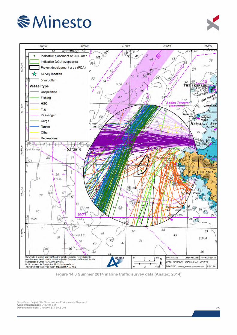
Figure 14.3 Summer 2014 marine traffic survey data (Anatec, 2014)
Deep Green Project EIA: Coordination – Environmental Statement Assignment Number: L100194-S14 Document Number: L-100194-S14-EIAS-001 290
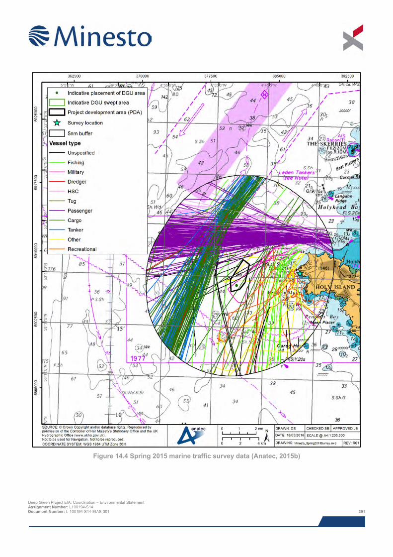
Figure 14.4 Spring 2015 marine traffic survey data (Anatec, 2015b)
Deep Green Project EIA: Coordination – Environmental Statement Assignment Number: L100194-S14 Document Number: L-100194-S14-EIAS-001 291
14.5.5 Commercial traffic A total of four commercial shipping routes pass in proximity to the PDA, with a number of routes transiting to / from Holyhead. Commercial traffic (high speed craft, cargo vessels, passenger vessels, tanker vessels, tugs and dredging / underwater ops vessels) represented the majority of marine traffic recorded throughout both the summer (85.0% of marine traffic within study area) and spring (87.4% of marine traffic within study area) surveys. The identification of main shipping routes was undertaken for the study area based on the principles defined in MGN 371 for both the summer and spring marine traffic marine traffic survey data. Figure 14.5 illustrates the mean position of these main commercial shipping routes relative to the PDA and Table 14.4 provides a summary of these routes.
Table 14.4 Main commercial shipping routes
Route number Destination Vessel type Number of vessels 1. Holyhead to Dublin 85% Passenger
15% High Speed Craft 9 transits per day
2. Dublin to Holyhead 85% Passenger 15% High Speed Craft
9 transits per day
3. Northbound Off Skerries TSS Traffic 60% Cargo 35% Tanker
5% Other
7 transits per day
4. Raynes Jetty Traffic (Inshore of Off Skerries TSS) 100% Cargo 1-2 transits per week
The Stena Line and Irish Ferries Holyhead to Dublin ferry services are represented by both Route 1 (westbound Holyhead to Dublin) and Route 2 (eastbound Dublin to Holyhead). Both conventional RoRo passenger ferries (85% of traffic) and high speed craft (15% of traffic) were recorded operating on Route 1 and Route 2 and an average of 9 vessel transits per day was recorded on each route.
Traffic using the Off Skerries TSS is represented by Route 3. An average of seven vessels per day was recorded using the northbound lane of the Off Skerries TSS throughout the summer and spring marine traffic surveys. The majority of vessels utilising the Off Skerries TSS were cargo vessels (60%) and tankers (35%). Other vessel types recorded using the TSS were fishing vessels, tugs, passenger vessels, high speed craft and other vessels. However these vessel types each represented less than 1.0% of the total traffic. The average speed of vessels utilising the north bound lane of the TSS throughout the summer and spring surveys was 11.4 knots. The closest point of approach of a vessel using the Off Skerries TSS to the PDA was approximately 1.2 nm (2.2 km).
Route 4 represents traffic transiting to / from Raynes Jetty. Raynes Jetty is used to export limestone aggregates from Raynes Quarry and is located within Colwyn Bay. The jetty is owned and operated by CEMEX. However, vessels transiting to / from the jetty are third party vessels and not affiliated with CEMEX. Typically vessels up to 5,000 tonnes are loaded. Throughout the summer and spring traffic surveys, a total of seven vessel transits to / from Raynes Jetty by four unique vessels was recorded. Four of these vessel tracks passed in close proximity to the PDA, choosing to pass inshore of the Off Skerries TSS. It was typical for these vessels to have a deeper draught whilst transiting from Raynes Jetty, following the collection of aggregate material and increase in overall vessel tonnage. Outbound destinations from Raynes Jetty included Tilbury, Shoreham and Ringaskiddy (Ireland). All vessels recorded transiting to / from Raynes Jetty were less than 100 m in length.
Deep Green Project EIA: Coordination – Environmental Statement Assignment Number: L100194-S14 Document Number: L-100194-S14-EIAS-001 292
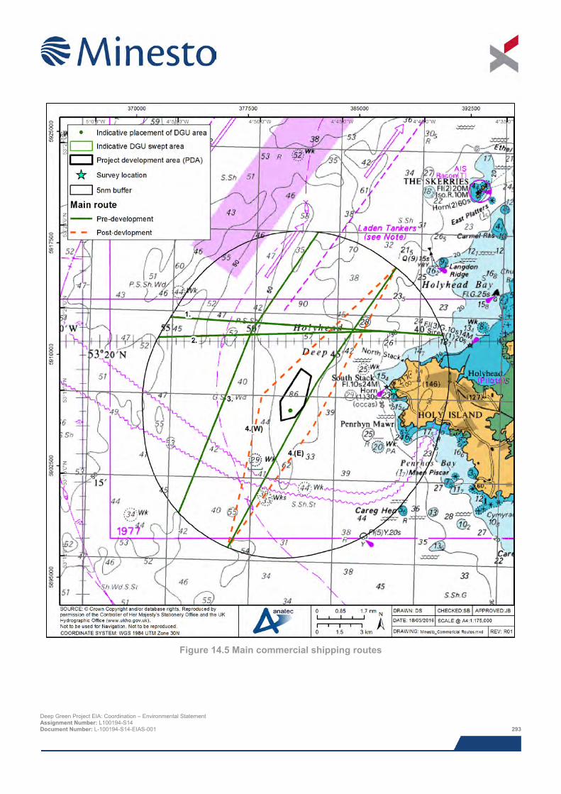
Figure 14.5 Main commercial shipping routes
Deep Green Project EIA: Coordination – Environmental Statement Assignment Number: L100194-S14 Document Number: L-100194-S14-EIAS-001 293
Following the commencement of the construction, deviations would be required for Route 4. It is possible that vessels operating on Route 4 may choose to navigate both to the east and west of the DGU following its installation depending on prevailing weather and tidal conditions and potential interaction with other marine traffic. They may also choose to use the Off Skerries TSS, which some do at present (Route 3). Illustrations of the anticipated shift in the mean route position of Route 4 are presented in Figure 14.5. The worst case deviation for Route 4, west of the DGU, corresponds to an increase of 0.51 nm (944 m) (4.29% of the total route length within the study area) and a time increase of approximately 3 minutes.
14.5.6 Recreational vessel activity During the summer and spring marine traffic survey, a total of 43 unique recreational vessels were recorded, the majority of which (82.0%) were recorded throughout the summer survey. Figure 14.6 presents the tracks of recreational vessels recorded throughout both the summer 2014 and spring 2015 marine traffic surveys. An average of three recreational vessels per day were recorded throughout the summer survey. During the spring survey an average of one recreational vessel every two days was recorded. A total of eight recreational vessels were recorded intersecting the PDA. The majority of recreational vessel activity was recorded inshore of the PDA.
Based on the RYA published data (RYA, 2009), the PDA lies within a recognised general sailing area. A medium-use recreational cruising route, which passes from Cahore Point (Ireland) to Anglesey, intersects the south east extent of the PDA. The RYA published data shows a good agreement with the marine traffic survey data collected, with the bulk of recreational activity concentrated in the sea area inshore of the PDA. In terms of facilities, the nearest club is Holyhead Sailing Club, located approximately 5.0 nm (9.3 km) east of the PDA. The closest marina is Holyhead Marina. The closest training centre is Anglesey School of Sailing, located within Holyhead.
Vessel arrivals data, between 2008 and 2014, has been provided by Holyhead Marina for use within the ES in order to assess long-term trends in vessel movements. In addition to recreational vessels, Holyhead Marina is used by a small number of larger other vessels (e.g. wind farm support, police and survey vessels). Between 2008 and 2014 vessel arrivals at Holyhead Marina have decreased slightly. However there has been variation in the total number of vessel arrivals throughout the period analysed with periods of increased vessel arrivals (e.g. 2008 to 2010) and periods of decreased vessel arrivals (e.g. 2010 to 2012). The most recent trend from 2012 to 2014 has seen a small increase in total vessel arrivals.
The peak period for vessel arrivals at Holyhead Marina is between May and August, accounting for 68.2% of all vessel arrivals. Throughout July (the busiest month), an average of 237 vessels berthed at Holyhead Marina between 2008 and 2014. Overall it can be concluded that the monthly distribution of vessel arrivals at Holyhead Marina coincides with the traditional seasonality of recreational vessel activity, with a high level of activity recorded throughout the fairer weather summer months and a low level of activity recorded throughout the winter months.
Vessels between 8 to 12 m in length were the most frequently sized vessel to berth at Holyhead Marina, accounting for 61.1% of all vessel arrivals. Overall it can be concluded that the vast majority of vessel arrivals at Holyhead Marina were small vessels, with approximately 98.7% of vessel arrivals less than 20 m in length.
Deep Green Project EIA: Coordination – Environmental Statement Assignment Number: L100194-S14 Document Number: L-100194-S14-EIAS-001 294
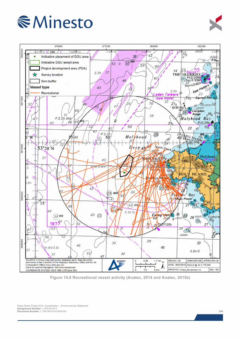
Figure 14.6 Recreational vessel activity (Anatec, 2014 and Anatec, 2015b)
Deep Green Project EIA: Coordination – Environmental Statement Assignment Number: L100194-S14 Document Number: L-100194-S14-EIAS-001 295
At the hazard review workshop it was noted that there are several recreational races which occur in the area. The following races were mentioned:
> Round Anglesey Race – a one day non-stop circumnavigation of Anglesey (occurs annually, date varies yearly);
> The Holyhead Traditional Sail Festival – organised by the Old Gaffers’ Association (occurs annually, final weekend in August);
> Holyhead Festival – located around Newry Beach, Holyhead (occurs annually, final full weekend in July); and
> Holyhead Sailing Club Regatta – (occurred in June 2015, other dates unconfirmed).
It is noted that during these dates and periods of other recreational sailing races, there may be an increase in recreational activity in the vicinity. However, only a minority of recreational vessels participating in such events will carry AIS and therefore analysis of AIS data for these events would not be likely to be fully representative.
It was also raised during the hazard review workshop that kayakers are known to use the sea area surrounding Anglesey. Throughout the marine traffic surveys kayaking was observed in very close proximity to the shoreline. This was corroborated by the MCA who stated that the near shore area is known to be used by kayakers but it is not likely to occur in proximity to the PDA.
14.5.7 Fishing vessel activity Fishing vessel activity was monitored during the both the summer and spring survey periods on both AIS and radar. Where possible, fishing vessels tracked by radar were identified by visual observation. In most cases it was possible to identify the primary gear type of the fishing vessel but not the vessel name or Port Letter Number (PLN).
Figure 14.7 presents the tracks of fishing vessels, colour-coded by gear type, recorded throughout both the summer 2014 and spring 2015 marine traffic surveys. The most frequently recorded fishing vessel gear types throughout both the summer and spring surveys were: pots & traps (45.5% of fishing vessel activity) and mechanised dredging (22.7% of fishing vessel activity). It should be noted that for a proportion (22.7%) of fishing vessels recorded throughout the surveys, the gear type could not be established. Fishing vessels employing pots & traps were recorded exclusively inshore of the PDA, in close proximity to the shoreline. The majority (64.0%) of fishing vessel activity was recorded in the spring survey, when an average of one unique fishing vessel per day was recorded. An average of one unique fishing vessel every two days was recorded in the summer survey. Overall, it can be concluded that the vast majority of fishing vessels were recorded inshore of the PDA. No fishing vessels were recorded intersecting the PDA.
The majority (78.6%) of fishing vessel transits were recorded travelling in excess of six knots and therefore were unlikely to be directly engaged in fishing operations. Furthermore, the minority of fishing vessels recorded travelling at less than six knots were small potting vessels and thus were likely to be transiting against the tide, hence the low vessel speed. It can therefore be concluded that direct fishing in the study area is very limited. This was corroborated throughout consultation with local stakeholders, see Section 14.4.
Data on fishing vessel sightings were obtained from the MMO, which monitors the fishing industry in UK waters, through the deployment of patrol vessels and surveillance aircraft. Each patrol logs the positions and details of fishing vessels within the area being patrolled. All vessels are logged, irrespective of size, provided they can be identified by their port letter number.
Deep Green Project EIA: Coordination – Environmental Statement Assignment Number: L100194-S14 Document Number: L-100194-S14-EIAS-001 296
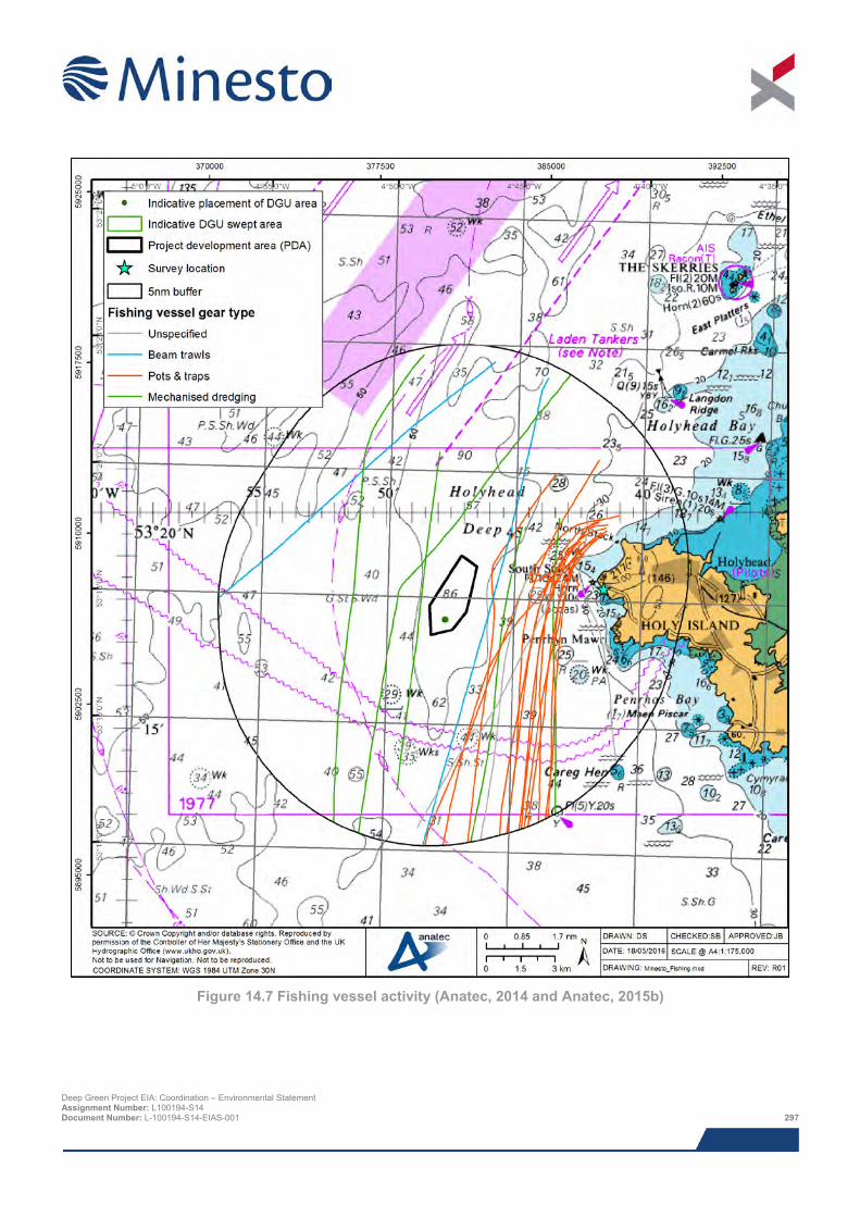
Figure 14.7 Fishing vessel activity (Anatec, 2014 and Anatec, 2015b)
Deep Green Project EIA: Coordination – Environmental Statement Assignment Number: L100194-S14 Document Number: L-100194-S14-EIAS-001 297
The most frequently sighted fishing vessel gear type was pots and traps, representing 84.1% of all sightings. The majority of fishing vessels sighted were steaming on passage (61.4%) or actively engaged in fishing (36.4%). The majority of fishing vessels sighted in close proximity to the PDA were steaming on passage, with only two sightings within 1.5 nm (2.8 km) recorded actively engaged in fishing. All fishing vessels sighted within the study area were UK-registered.
The MMO also operates a satellite-based vessel monitoring system. The vessel monitoring system is used, as part of the sea fisheries enforcement programme, to track the positions of fishing vessels of 15 m length and over in UK waters. It is also used to track all UK registered fishing vessels globally.
Vessel position reports are typically received every two hours. The data covers all EU countries within British Fisheries Limits and there are reciprocal agreements with certain non-EU countries, e.g., Norway and Faroe Islands for the provision of vessel position data. Vessels used exclusively for aquaculture and operating exclusively within territorial baselines (within the maximum extent of low-water around coastlines) are exempt.
The latest available satellite data set (2009) has been analysed. The most frequently recorded gear type was pots and traps, representing 41.8% of satellite positions recorded throughout 2009. Scallop dredgers were also frequently recorded, representing 29.2% of satellite positions recorded. The majority (92.6%) of fishing vessels recorded by satellite were UK registered. Other nationalities recorded include: Belgium (3.7%), Ireland (2.0%) and Netherlands (1.0%). Throughout 2009, the majority (73.5%) of fishing vessel activity was recorded throughout the months of January to May.
Consultation undertaken with fishing stakeholders at all stages of the Project, including the hazard review workshop, was also considered within the impact assessment. Information (which included consultation with fishermen) was also available from the Fisheries work (Chapter 13) carried out and was also considered within the impact assessment. A summary of the relevant information extracted from the Chapter 13: Fisheries can be found in Section 15.6.4 of the NRA.
14.5.8 Port activity Holyhead Harbour is the nearest principal port to the PDA located approximately 5.5 nm (10.2 km) east. Holyhead Harbour operates a conventional and high speed cargo and passenger ferry services (Stena Line and Irish Ferries Holyhead to Dublin) and also contains a well-used recreational marina. Port statistics published by the Department for Transport (DfT) indicate an average of 3,075 commercial vessel arrivals per annum between 1994 and 2013. It should be noted that the DfT statistics have limitations (all vessels not included in count) but are considered illustrative of general trends. Furthermore, vessel arrival information for Holyhead Marina, between 2008 and 2014, indicate an average of 1,246 vessel arrivals per annum, the majority of which are typically recorded throughout the summer months.
Throughout the summer and spring marine traffic surveys, a number of vessels (average of one vessel per day) were recorded at anchor within the harbour limits of Holyhead Harbour. Passenger vessels were the most frequently recorded vessel type at anchor, representing 68.0% of vessel anchoring activity. Tankers also represent a significant (24.0%) proportion of vessel anchoring activity. This tanker activity comprised of fuel bunkering vessels (M/T Keewhit) delivering fuel to both the Stena Line and Irish Ferries vessels. It was indicated during consultation that bunkering vessels visit Holyhead Harbour approximately every two weeks to deliver fuel to passenger vessels, with multiple anchoring movements occurring throughout this period.
All vessels associated with the Project shall operate from Holyhead harbour and therefore there will be a resultant increase in traffic to and from Holyhead.
14.5.9 Emergency response A review of the assets adjacent to the PDA indicates that the closest search and register helicopter base, is located at Caernarfon Airport, approximately 19.4 nm (35.9 km) south east of the PDA. The base is operated by The Bristow Group and operations commenced on the 1st July 2015. This base utilises the Sikorsky S-92 helicopter, which has a maximum speed of 145 knots and a radius of action of approximately 250nm, which easily covers the PDA.
The RNLI maintains a fleet of over 340 lifeboats of various types at 236 stations around the coast of the UK and Ireland. At each of these stations crew and Inshore Lifeboats (ILB) and/or All Weather Lifeboats (ALB) are available Deep Green Project EIA: Coordination – Environmental Statement Assignment Number: L100194-S14 Document Number: L-100194-S14-EIAS-001 298
on a 24 hour basis throughout the year. From consultation with the RNLI and analysis of historical RNLI call out data, the Holyhead ALB would be most likely to respond to an incident in the vicinity of the PDA. The Severn Class lifeboat, operated at Holyhead lifeboat station, has a maximum speed of 25 knots and range of 250 nm (463 km) and therefore the PDA is well within the range of the lifeboat.
14.5.10 Maritime incidents Maritime incident data from the Marine Accident Investigation Branch (MAIB) (2004 to 2013) and Royal National Lifeboat Institution (RNLI) (2005 to 2014) have been analysed in order to provide a general indication as to whether the sea area surrounding the PDA is currently a low or high risk area in terms of maritime incidents. It should be noted that the same incident may be recorded within both the MAIB and RNLI data.
A total of 15 unique incidents involving 16 vessels were reported to the MAIB within the study area throughout the ten year period analysed, corresponding to an average of approximately one to two incidents per year. No incidents were reported within the PDA.
The most common incident types recorded by the MAIB within the study area were machinery failure (seven incidents; 46.7%), hazardous incident (two incidents; 13.3%) and capsize / listing (two incidents; 13.3%). The most frequently recorded vessel types involved in incidents were: Fishing vessels (six; 37.5%), other commercial vessels (e.g. tugs and survey vessels) (six; 37.5%) and cargo vessels (two; 12.5%),
A total of 204 launches to 202 unique incidents were recorded by the RNLI (excluding hoaxes and false alarms) within the study area throughout the ten year period analysed, corresponding to an average of approximately 20 incidents per year. No incidents were reported within the PDA.
The main causes of incidents to which the RNLI responded were person in danger (41.7%) and machinery failure (32.4%). The most common casualty types requiring assistance were recreational vessels, including by type, power boats (28.9%), yachts (13.7%) and other recreational vessels (2.9%). Person in danger (33.3%) and personal craft (11.3%) also represent a significant proportion of RNLI incidents. Personal craft include jet skis, kayaks, canoes and rowing boats.
The majority of incidents were responded to by the Trearddur B-class inshore lifeboat (33.8%) and the Holyhead Severn class all-weather lifeboat (33.3%). The Holyhead and Trearddur D-class inshore lifeboats (18.1% and 14.2% respectively) also responded to a significant proportion of incidents within the study area. The majority of incidents in the vicinity of the Minesto PDA were responded to by the Holyhead all-weather lifeboat (Severn Class).
The majority of incidents (73.5%) responded to by the RNLI were recorded throughout summer (May to September) which coincides with the peak period for recreational and leisure activity. Approximately 76.0% of incidents were recorded between the hours of 10:00 to 18:00, corresponding to an average of 17 incidents per year during these hours.
14.5.11 Data gaps and uncertainties The range of both the AIS and radar systems (which were used during the surveys) varied depending on a number of factors, including the prevailing weather and atmospheric conditions. For the majority of the time, the radar tracked targets up to 12 nm (22.2 km) from the survey location and some targets beyond 20 nm (37.0 km). The AIS range was typically at least 25 nm (46.3 km) during the survey period. Therefore the radar and AIS data collected provided comprehensive coverage of vessel movements within the entire study area.
It is recognised that small vessel activity is variable and dependent on numerous factors including weather conditions, tides, seasonal factors, and in the case of fishing vessels, quotas and the migration of fish species.
The two 14 day maritime traffic surveys encompass seasonal fluctuations in shipping activity and account for a range of tidal conditions. This is consistent with the minimum of four weeks as specified in MGN 371. Variability has been taken into account as far as possible by using seasonally and tidally varied surveys, long-term desk-based research, and consultation with local stakeholders to inform an up-to-date baseline.
Deep Green Project EIA: Coordination – Environmental Statement Assignment Number: L100194-S14 Document Number: L-100194-S14-EIAS-001 299
14.6 Impact assessment
14.6.1 Overview Following establishment of the baseline conditions and an understanding of the Project activities, it is possible to assess the potential impacts from the proposed development. The range of impacts considered is based on impacts identified during the NRA hazard review workshop, expert opinion and any further potential impacts that have been highlighted throughout consultation as the NRA has progressed.
The list below indicates all of the direct and indirect impacts to be covered as part of the impact assessment for this topic and identifies the relevant phases under which each impact will be assessed32. The list also identifies where potential interactions between impacts and inter-relationships between receptors and EIA topics are likely to occur. Cumulative and in-combination impacts are discussed in Section 14.11.
> Impacts during construction and installation period:
o Increased passing vessel to vessel collision risk due to displacement;
o Passing vessel to works vessel collision;
o Restricted SAR capability and oil spill response;
o Dropped object;
o Man overboard;
> Impacts during operation and maintenance:
o Increased passing vessel to vessel collision risk due to displacement;
o Restricted SAR capability and oil spill response;
o Powered vessel allision with moored barge;
o Drifting vessel allision with moored barge;
o Powered vessel allision with submerged tidal device;
o Drifting vessel allision with submerged tidal device;
o Fishing gear interaction with subsea equipment within site (interaction with Chapter 13: Fisheries);
> Impacts during decommissioning:
o Increased passing vessel to vessel collision risk due to displacement;
o Passing vessel to works vessel collision;
o Restricted SAR capability and oil spill response;
o Dropped object; and
o Man overboard.
14.6.2 Assessment criteria The shipping and navigation impact assessment has been carried out in line with the IMO’s Formal Safety Assessment (FSA) process and the DECC / MCA Guidelines (see NRA for full details).
Impacts have been categorised using the frequency and consequence categories defined in Table 14.5 and 14.6, respectively. The categorisation was carried out based on the discussion at the hazard review workshop involving local stakeholders, together with the baseline data analysis, expert opinion and other consultation. This methodology
32 As previously noted the NRA considered both ODA and potential export cable route. The results presented in this ES chapter relate to the PDA only, as this application is for a single device in the PDA only which will not be grid connected. Deep Green Project EIA: Coordination – Environmental Statement Assignment Number: L100194-S14 Document Number: L-100194-S14-EIAS-001 300
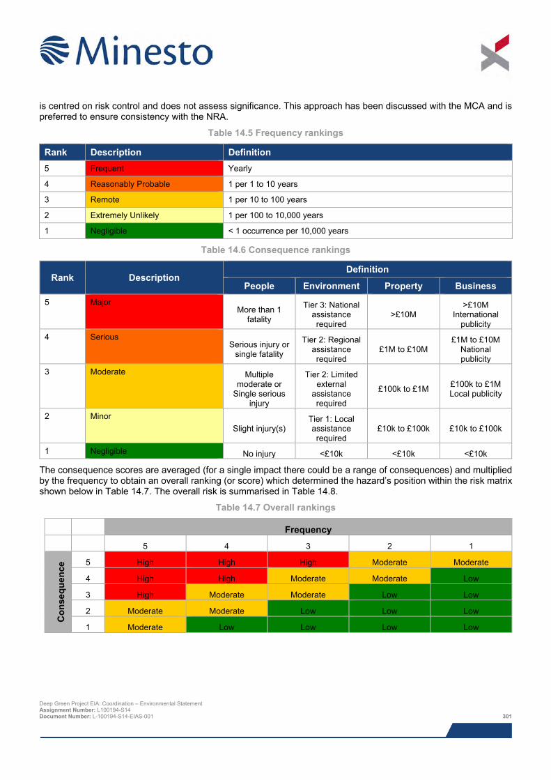
is centred on risk control and does not assess significance. This approach has been discussed with the MCA and is preferred to ensure consistency with the NRA.
Table 14.5 Frequency rankings
Rank Description Definition 5 Frequent Yearly
4 Reasonably Probable 1 per 1 to 10 years
3 Remote 1 per 10 to 100 years
2 Extremely Unlikely 1 per 100 to 10,000 years
1 Negligible < 1 occurrence per 10,000 years
Table 14.6 Consequence rankings
Rank Description Definition
People Environment Property Business 5 Major
More than 1 fatality
Tier 3: National assistance required
>£10M >£10M
International publicity
4 Serious Serious injury or
single fatality
Tier 2: Regional assistance required
£1M to £10M £1M to £10M
National publicity
3 Moderate Multiple moderate or
Single serious injury
Tier 2: Limited external
assistance required
£100k to £1M £100k to £1M Local publicity
2 Minor Slight injury(s)
Tier 1: Local assistance required
£10k to £100k £10k to £100k
1 Negligible No injury <£10k <£10k <£10k
The consequence scores are averaged (for a single impact there could be a range of consequences) and multiplied by the frequency to obtain an overall ranking (or score) which determined the hazard’s position within the risk matrix shown below in Table 14.7. The overall risk is summarised in Table 14.8.
Table 14.7 Overall rankings
Frequency
5 4 3 2 1
Con
sequ
ence
5 High High High Moderate Moderate
4 High High Moderate Moderate Low
3 High Moderate Moderate Low Low
2 Moderate Moderate Low Low Low
1 Moderate Low Low Low Low
Deep Green Project EIA: Coordination – Environmental Statement Assignment Number: L100194-S14 Document Number: L-100194-S14-EIAS-001 301
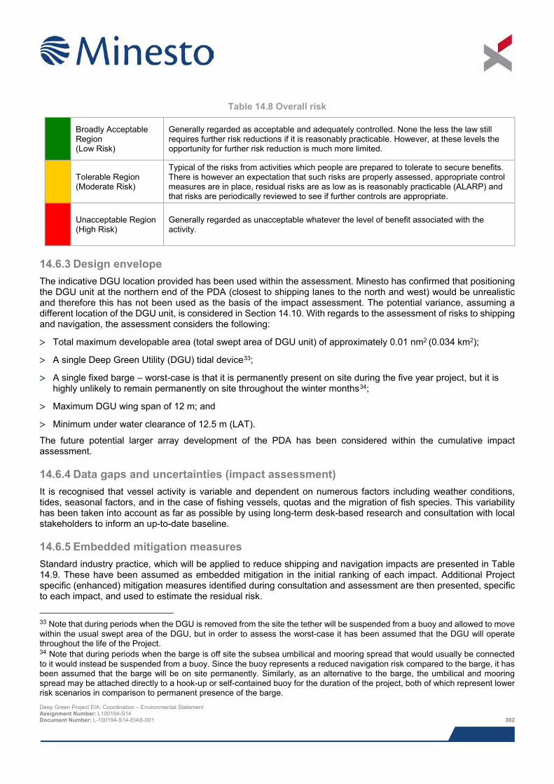
Table 14.8 Overall risk
Broadly Acceptable Region (Low Risk)
Generally regarded as acceptable and adequately controlled. None the less the law still requires further risk reductions if it is reasonably practicable. However, at these levels the opportunity for further risk reduction is much more limited.
Tolerable Region (Moderate Risk)
Typical of the risks from activities which people are prepared to tolerate to secure benefits. There is however an expectation that such risks are properly assessed, appropriate control measures are in place, residual risks are as low as is reasonably practicable (ALARP) and that risks are periodically reviewed to see if further controls are appropriate.
Unacceptable Region (High Risk)
Generally regarded as unacceptable whatever the level of benefit associated with the activity.
14.6.3 Design envelope The indicative DGU location provided has been used within the assessment. Minesto has confirmed that positioning the DGU unit at the northern end of the PDA (closest to shipping lanes to the north and west) would be unrealistic and therefore this has not been used as the basis of the impact assessment. The potential variance, assuming a different location of the DGU unit, is considered in Section 14.10. With regards to the assessment of risks to shipping and navigation, the assessment considers the following:
> Total maximum developable area (total swept area of DGU unit) of approximately 0.01 nm2 (0.034 km2);
> A single Deep Green Utility (DGU) tidal device33;
> A single fixed barge – worst-case is that it is permanently present on site during the five year project, but it is highly unlikely to remain permanently on site throughout the winter months34;
> Maximum DGU wing span of 12 m; and
> Minimum under water clearance of 12.5 m (LAT).
The future potential larger array development of the PDA has been considered within the cumulative impact assessment.
14.6.4 Data gaps and uncertainties (impact assessment) It is recognised that vessel activity is variable and dependent on numerous factors including weather conditions, tides, seasonal factors, and in the case of fishing vessels, quotas and the migration of fish species. This variability has been taken into account as far as possible by using long-term desk-based research and consultation with local stakeholders to inform an up-to-date baseline.
14.6.5 Embedded mitigation measures Standard industry practice, which will be applied to reduce shipping and navigation impacts are presented in Table 14.9. These have been assumed as embedded mitigation in the initial ranking of each impact. Additional Project specific (enhanced) mitigation measures identified during consultation and assessment are then presented, specific to each impact, and used to estimate the residual risk.
33 Note that during periods when the DGU is removed from the site the tether will be suspended from a buoy and allowed to move within the usual swept area of the DGU, but in order to assess the worst-case it has been assumed that the DGU will operate throughout the life of the Project. 34 Note that during periods when the barge is off site the subsea umbilical and mooring spread that would usually be connected to it would instead be suspended from a buoy. Since the buoy represents a reduced navigation risk compared to the barge, it has been assumed that the barge will be on site permanently. Similarly, as an alternative to the barge, the umbilical and mooring spread may be attached directly to a hook-up or self-contained buoy for the duration of the project, both of which represent lower risk scenarios in comparison to permanent presence of the barge. Deep Green Project EIA: Coordination – Environmental Statement Assignment Number: L100194-S14 Document Number: L-100194-S14-EIAS-001 302
Table 14.9 Embedded mitigation measures
Industry standard mitigation measure
Definition
Application and use of navigational safety zone up to 500 m during construction / decommissioning and significant periods of maintenance.
During the construction and decommissioning phases of the device, as well as where exceptional, major maintenance work is required, a 500 m navigational safety zone around the location in which construction / decommissioning activity is taking place is proposed. Any application(s) for safety zone(s) will be made to DECC under Section 95 and Schedule 16 of the Energy Act 2004, and the Electricity (Offshore Generating Stations) (Safety Zones) (Application Procedures and Control of Access) Regulations 2007. (Note, it is also Minesto’s intention to apply for a safety zone around the barge to protect personnel working onboard. This is not a standard industry measure and further consultation with navigational stakeholders is planned to support the application.)
Compliance with IMO conventions including COLREGs and SOLAS.
Compliance to ensure that standard levels of navigation and vessel safety continue to be adhered to by all receptors during all phases.
Emergency response and co-operation plan.
An Emergency Response and Co-operation Plan (ERCoP) shall be developed and implemented for the construction, operation and maintenance and decommissioning phases of the development. The ERCoP will be based on the standard MCA template and will consider the potential for self-help capability as part of the ongoing process. This will include cooperation with UK National Contingency Plan. ERCoPs are initially discussed with the MCA Search and Rescue and Navigational Safety Branches and then completed in consultation with the relevant Coastguard Operations Centre (CGOC) for the area. As an example, the ERCoP should include company details and contact details (for routine and emergency situations), co-operation arrangements between Minesto and the relevant CGOC, details on how information would be passed on during emergency situations, shut down and device control requirements, details of what is to be built, information about vessels and activities on-site (updated regularly), contact details for the CGOC, information about nearby SAR facilities including surface craft rescue resources and airborne rescue resources and planned response to pollution events.
Charting of the PDA. The DGU and barge location will be marked on relevant nautical charts in line with the UK Hydrographic Office (UKHO) standards. These areas have generally been marked on charts with the site boundary, name of the development and an additional note reading: “Extensive testing of tidal energy devices both above and below the surface, takes place in his area. Yellow buoys can temporarily be established near experimental devices to mark work in progress. Mariner should exercise caution whilst navigating in this area and obtain local knowledge.”
International Association of Lighthouse Authorities (IALA) Guidance and Aids to Navigation.
Structure(s) within the PDA will be marked and lit in accordance with IALA Recommendation O-139 on the Marking of Man-Made Offshore Structures (IALA, 2013) but may also include the use of other visual and sound aids to navigation as agreed with THLS.
Marine pollution contingency planning. Creation of an ERCoP, in line with guidance from the relevant CGOC, for use throughout all phases of the development to account for the potential of a marine pollution incident. This shall include co-operation with UK National Contingency Plan.
Compliance with MGN 371. Device will be designed in accordance with Marine Guidance Note (MGN) 371 (MCA, 2008a), where practicable, noting the differences in the technology compared to a typical offshore wind farm, which may affect aspects such as requirements in an emergency situation. Any amendments to MGN 371 that are made post-consent may be considered retrospectively.
Monitoring by AIS. The PDA will continue to have either shore based or structure based AIS monitoring that can be reviewed when required by regulators. This is a passive system (operational for assessment only). The requirement is likely to last throughout the construction period and one further year.
Deep Green Project EIA: Coordination – Environmental Statement Assignment Number: L100194-S14 Document Number: L-100194-S14-EIAS-001 303
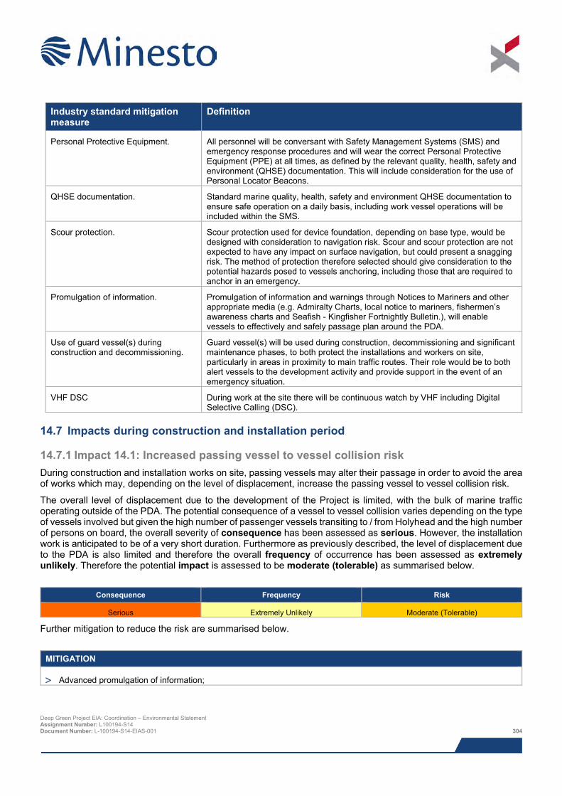
Industry standard mitigation measure
Definition
Personal Protective Equipment. All personnel will be conversant with Safety Management Systems (SMS) and emergency response procedures and will wear the correct Personal Protective Equipment (PPE) at all times, as defined by the relevant quality, health, safety and environment (QHSE) documentation. This will include consideration for the use of Personal Locator Beacons.
QHSE documentation. Standard marine quality, health, safety and environment QHSE documentation to ensure safe operation on a daily basis, including work vessel operations will be included within the SMS.
Scour protection. Scour protection used for device foundation, depending on base type, would be designed with consideration to navigation risk. Scour and scour protection are not expected to have any impact on surface navigation, but could present a snagging risk. The method of protection therefore selected should give consideration to the potential hazards posed to vessels anchoring, including those that are required to anchor in an emergency.
Promulgation of information. Promulgation of information and warnings through Notices to Mariners and other appropriate media (e.g. Admiralty Charts, local notice to mariners, fishermen’s awareness charts and Seafish - Kingfisher Fortnightly Bulletin.), will enable vessels to effectively and safely passage plan around the PDA.
Use of guard vessel(s) during construction and decommissioning.
Guard vessel(s) will be used during construction, decommissioning and significant maintenance phases, to both protect the installations and workers on site, particularly in areas in proximity to main traffic routes. Their role would be to both alert vessels to the development activity and provide support in the event of an emergency situation.
VHF DSC During work at the site there will be continuous watch by VHF including Digital Selective Calling (DSC).
14.7 Impacts during construction and installation period
14.7.1 Impact 14.1: Increased passing vessel to vessel collision risk During construction and installation works on site, passing vessels may alter their passage in order to avoid the area of works which may, depending on the level of displacement, increase the passing vessel to vessel collision risk.
The overall level of displacement due to the development of the Project is limited, with the bulk of marine traffic operating outside of the PDA. The potential consequence of a vessel to vessel collision varies depending on the type of vessels involved but given the high number of passenger vessels transiting to / from Holyhead and the high number of persons on board, the overall severity of consequence has been assessed as serious. However, the installation work is anticipated to be of a very short duration. Furthermore as previously described, the level of displacement due to the PDA is also limited and therefore the overall frequency of occurrence has been assessed as extremely unlikely. Therefore the potential impact is assessed to be moderate (tolerable) as summarised below.
Consequence Frequency Risk
Serious Extremely Unlikely Moderate (Tolerable)
Further mitigation to reduce the risk are summarised below.
MITIGATION
> Advanced promulgation of information;
Deep Green Project EIA: Coordination – Environmental Statement Assignment Number: L100194-S14 Document Number: L-100194-S14-EIAS-001 304
MITIGATION
> Enhanced planning of work activities, including pre-defined routeing of construction vessels to / from the construction site and designation of dedicated waiting / anchorage areas for construction vessels;
> Port liaison;
> Vessel selection and auditing; and
> Works vessel co-ordination.
Based on applying the enhanced, Project specific mitigation measures in addition to following standard industry practice, the overall consequence and frequency of occurrence are expected to reduce but remain within the same bands; additional mitigation measures have been provided as a precautionary approach to ensure this remains the case. Therefore, the overall residual risk is moderate (tolerable) as summarised in below.
Consequence Frequency Risk
Serious Extremely Unlikely Moderate (Tolerable)
14.7.2 Impact 14.2: Passing vessel collision with works vessel During works on site, passing (third party) vessels could collide with works vessels engaged in construction / installation activities of the Project. At times these works vessels could also be restricted in manoeuvrability.
A number of moderately busy commercial routes pass in proximity to the PDA as summarised in Section 14.5.5. Furthermore, a number of fishing and recreational vessels were recorded on transit passing inshore of the PDA. However, the highest density areas of marine traffic were recorded in excess of 1.0 nm (1.9 km) from the PDA.
During construction it is standard practice to implement a safety zone of up to 500 m radius covering the area of the site in which construction activities are taking place at a given time. This can be indicated by appropriate markings and lights being displayed by the work vessel as well as AIS broadcasts to indicate when the vessel is restricted in manoeuvrability. A guard vessel is normally also present to monitor the safety zone.
The potential risk of a passing vessel collision with works vessel has been ranked based on discussions held at the hazard review workshop, review of baseline data, expert opinion and stakeholder consultation. The overall consequence is dependent on a number of factors including the type of vessel involved in the collision and the nature of the collision itself and could range from minor damage to the vessel to penetration damage to vessel resulting in severe damage and thus potential loss of life. The overall consequence is considered to be moderate. The overall frequency of occurrence is considered to be extremely unlikely given the embedded mitigations in place including the presence of a guard vessel and construction safety zones. Therefore the potential impact is assessed to be moderate (tolerable) as summarised below.
Consequence Frequency Risk
Moderate Extremely Unlikely Moderate (Tolerable)
Further mitigation to reduce the risk are summarised below.
MITIGATION
> Advanced promulgation of information;
> Enhanced planning of work activities, including pre-defined routeing of construction vessels to / from the construction site and designation of dedicated waiting / anchorage areas for construction vessels;
> Port liaison;
Deep Green Project EIA: Coordination – Environmental Statement Assignment Number: L100194-S14 Document Number: L-100194-S14-EIAS-001 305
MITIGATION
> Vessel selection and auditing; and
> Works vessel co-ordination.
Based on applying the enhanced, Project specific mitigation measures in addition to following standard industry practice, the overall consequence and frequency of occurrence are expected to reduce but remain within the same bands; additional mitigation measures have been provided as a precautionary approach to ensure this remains the case. Therefore, the overall residual risk is moderate (tolerable) as summarised below.
Consequence Frequency Risk
Moderate Extremely Unlikely Moderate (Tolerable)
14.7.3 Impact 14.3: Restricted SAR capability and oil spill response During works on site, there is potential for the presence of works vessels (which may be restricted in manoeuvrability) and ongoing construction / installation activities to restrict the overall provision of search and rescue resources.
Due to the size of the development there will be a limited increase in vessel movements within the area. However any increase in movement will be controlled though the marine coordination centre thus reducing the risk of an incident involving a works vessel occurring. In addition, the onsite guard vessel throughout the construction phase will be able to forewarn passing vessel of ongoing construction works further reducing the risk of an incident. Furthermore, all works vessels shall be equipped with a level of emergency response equipment to facilitate a degree of self-help appropriate for the development. The self-help capability, as well as liaison agreements with emergency response providers, shall be detailed within the ERCoP.
The overall severity of consequence during the construction and installation phase is considered to be minor, due to the embedded mitigations in place (marine coordination centre, onsite guard vessel, ERCoP and provision of self-help facilities). Furthermore the close proximity of national facilities such as the RNLI Holyhead and Trearddur lifeboat stations reduces the potential consequence. The overall frequency of occurrence will be extremely unlikely due to the limited scale of the development, provision of self-help facilities and mitigation measures to limit the risk of an incident occurring (marine coordination centre and onsite guard vessel). The potential impact is assessed to be low (broadly acceptable) as summarised below.
Consequence Frequency Risk
Minor Extremely Unlikely Low (Broadly Acceptable)
Further mitigation to reduce the risk are summarised below.
MITIGATION
> Means of rescuing personnel from water, e.g., support vessel and/or fast response craft;
> Monitoring of marine traffic during construction and installation; and
> Ability to control depth of DGU.
Based on applying the enhanced, Project specific mitigation measures in addition to following standard industry practice, the overall consequence and frequency of occurrence are expected to reduce but remain within the same bands; additional mitigation measures have been provided as a precautionary approach to ensure this remains the case. Therefore, the overall residual risk is low (broadly acceptable) as summarised below.
Deep Green Project EIA: Coordination – Environmental Statement Assignment Number: L100194-S14 Document Number: L-100194-S14-EIAS-001 306
Consequence Frequency Risk
Minor Extremely Unlikely Low (Broadly Acceptable)
14.7.4 Impact 14.4: Dropped object During construction and installation works there is potential for an object to be accidentally dropped into the sea. The overall severity of consequence varies depending on the overall size and buoyancy of the dropped object, with large buoyant objects presenting the highest risk to passing vessels. It was indicated throughout consultation that during operation of the demonstration device at Strangford Lough there have only been isolated incidents of small and non-buoyant objects (e.g. spanners) being dropped.
The overall severity of consequence is considered to be negligible, given the likelihood that any dropped objects are likely to be very small in size. However, the overall frequency of occurrence is assessed to be reasonably probable. The potential impact is assessed to be low (broadly acceptable) as summarised below with no further mitigation measures required due to the low level of risk presented to shipping and navigation by a dropped object.
Consequence Frequency Risk
Negligible Reasonably Probable Low (Broadly Acceptable)
14.7.5 Impact 14.5: Man overboard During construction and installation works, there is potential for a man overboard incident given the increased level of activity and number of personnel. The risk was ranked based on discussion at the hazard review workshop, review of baseline data and stakeholder consultation. The overall severity of consequence is considered to be serious due to the potential for loss of life following a man overboard incident. However, the overall frequency of occurrence is assessed to be remote. The potential impact is assessed to be moderate (tolerable) as summarised below.
Consequence Frequency Risk
Serious Remote Moderate (Tolerable)
Further mitigation to reduce the risk are summarised below.
MITIGATION
> Means of rescuing personnel from water, e.g., support vessel and/or fast response craft; and
> Use of personal locator beacons.
Based on applying the enhanced, Project specific mitigation measures, in addition to following standard industry practice, the overall residual risk can be reduced to low (broadly acceptable), as summarised below.
Consequence Frequency Risk
Minor Remote Low (Broadly Acceptable)
14.8 Impacts during operation and maintenance
14.8.1 Impact 14.6: Powered vessel allision with moored barge During the operational (testing) phase of the Project (anticipated to be up to 5 years), it is planned that a fixed barge, tethered to the seabed, will be located on site and a DGU operated from the barge. As a result of the physical presence of the fixed barge there is potential for a transiting vessel (under power) to allide with the fixed barge. It is projected that the fixed barge will be approximately 50 m in length and have a beam of 12 m. It is highly likely that Deep Green Project EIA: Coordination – Environmental Statement Assignment Number: L100194-S14 Document Number: L-100194-S14-EIAS-001 307
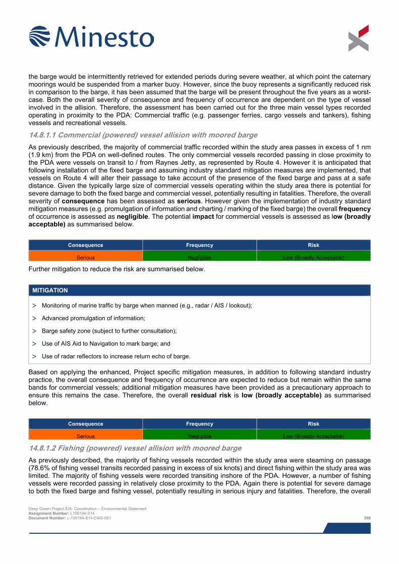
the barge would be intermittently retrieved for extended periods during severe weather, at which point the caternary moorings would be suspended from a marker buoy. However, since the buoy represents a significantly reduced risk in comparison to the barge, it has been assumed that the barge will be present throughout the five years as a worst-case. Both the overall severity of consequence and frequency of occurrence are dependent on the type of vessel involved in the allision. Therefore, the assessment has been carried out for the three main vessel types recorded operating in proximity to the PDA: Commercial traffic (e.g. passenger ferries, cargo vessels and tankers), fishing vessels and recreational vessels.
14.8.1.1 Commercial (powered) vessel allision with moored barge As previously described, the majority of commercial traffic recorded within the study area passes in excess of 1 nm (1.9 km) from the PDA on well-defined routes. The only commercial vessels recorded passing in close proximity to the PDA were vessels on transit to / from Raynes Jetty, as represented by Route 4. However it is anticipated that following installation of the fixed barge and assuming industry standard mitigation measures are implemented, that vessels on Route 4 will alter their passage to take account of the presence of the fixed barge and pass at a safe distance. Given the typically large size of commercial vessels operating within the study area there is potential for severe damage to both the fixed barge and commercial vessel, potentially resulting in fatalities. Therefore, the overall severity of consequence has been assessed as serious. However given the implementation of industry standard mitigation measures (e.g. promulgation of information and charting / marking of the fixed barge) the overall frequency of occurrence is assessed as negligible. The potential impact for commercial vessels is assessed as low (broadly acceptable) as summarised below.
Consequence Frequency Risk
Serious Negligible Low (Broadly Acceptable)
Further mitigation to reduce the risk are summarised below.
MITIGATION
> Monitoring of marine traffic by barge when manned (e.g., radar / AIS / lookout);
> Advanced promulgation of information;
> Barge safety zone (subject to further consultation);
> Use of AIS Aid to Navigation to mark barge; and
> Use of radar reflectors to increase return echo of barge.
Based on applying the enhanced, Project specific mitigation measures, in addition to following standard industry practice, the overall consequence and frequency of occurrence are expected to reduce but remain within the same bands for commercial vessels; additional mitigation measures have been provided as a precautionary approach to ensure this remains the case. Therefore, the overall residual risk is low (broadly acceptable) as summarised below.
Consequence Frequency Risk
Serious Negligible Low (Broadly Acceptable)
14.8.1.2 Fishing (powered) vessel allision with moored barge As previously described, the majority of fishing vessels recorded within the study area were steaming on passage (78.6% of fishing vessel transits recorded passing in excess of six knots) and direct fishing within the study area was limited. The majority of fishing vessels were recorded transiting inshore of the PDA. However, a number of fishing vessels were recorded passing in relatively close proximity to the PDA. Again there is potential for severe damage to both the fixed barge and fishing vessel, potentially resulting in serious injury and fatalities. Therefore, the overall
Deep Green Project EIA: Coordination – Environmental Statement Assignment Number: L100194-S14 Document Number: L-100194-S14-EIAS-001 308
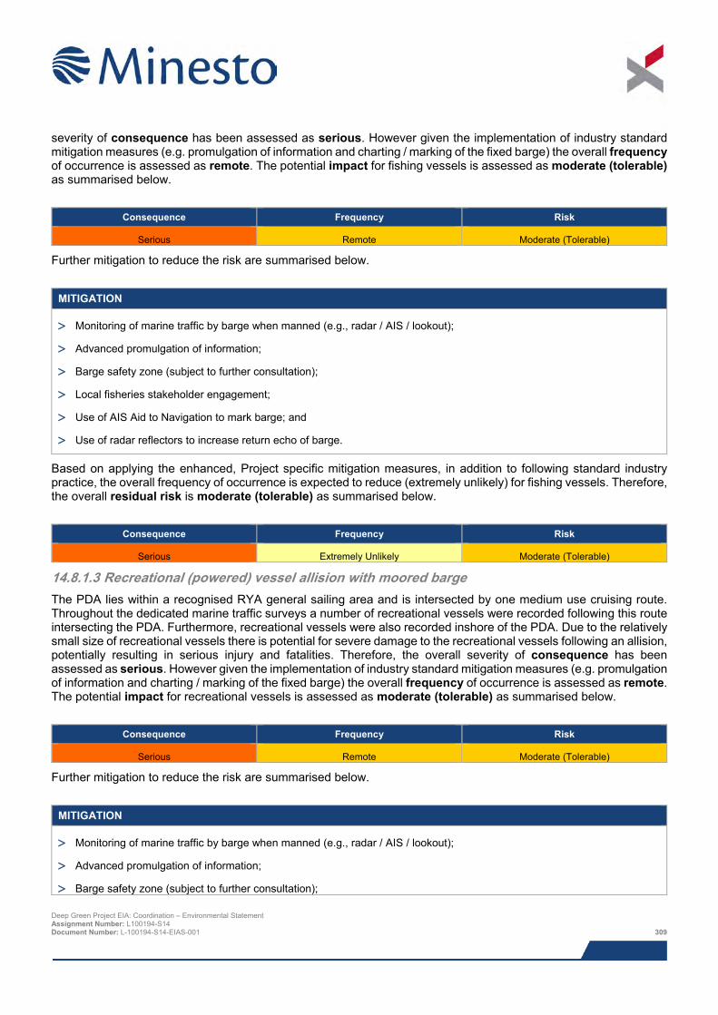
severity of consequence has been assessed as serious. However given the implementation of industry standard mitigation measures (e.g. promulgation of information and charting / marking of the fixed barge) the overall frequency of occurrence is assessed as remote. The potential impact for fishing vessels is assessed as moderate (tolerable) as summarised below.
Consequence Frequency Risk
Serious Remote Moderate (Tolerable)
Further mitigation to reduce the risk are summarised below.
MITIGATION
> Monitoring of marine traffic by barge when manned (e.g., radar / AIS / lookout);
> Advanced promulgation of information;
> Barge safety zone (subject to further consultation);
> Local fisheries stakeholder engagement;
> Use of AIS Aid to Navigation to mark barge; and
> Use of radar reflectors to increase return echo of barge.
Based on applying the enhanced, Project specific mitigation measures, in addition to following standard industry practice, the overall frequency of occurrence is expected to reduce (extremely unlikely) for fishing vessels. Therefore, the overall residual risk is moderate (tolerable) as summarised below.
Consequence Frequency Risk
Serious Extremely Unlikely Moderate (Tolerable)
14.8.1.3 Recreational (powered) vessel allision with moored barge The PDA lies within a recognised RYA general sailing area and is intersected by one medium use cruising route. Throughout the dedicated marine traffic surveys a number of recreational vessels were recorded following this route intersecting the PDA. Furthermore, recreational vessels were also recorded inshore of the PDA. Due to the relatively small size of recreational vessels there is potential for severe damage to the recreational vessels following an allision, potentially resulting in serious injury and fatalities. Therefore, the overall severity of consequence has been assessed as serious. However given the implementation of industry standard mitigation measures (e.g. promulgation of information and charting / marking of the fixed barge) the overall frequency of occurrence is assessed as remote. The potential impact for recreational vessels is assessed as moderate (tolerable) as summarised below.
Consequence Frequency Risk
Serious Remote Moderate (Tolerable)
Further mitigation to reduce the risk are summarised below.
MITIGATION
> Monitoring of marine traffic by barge when manned (e.g., radar / AIS / lookout);
> Advanced promulgation of information;
> Barge safety zone (subject to further consultation); Deep Green Project EIA: Coordination – Environmental Statement Assignment Number: L100194-S14 Document Number: L-100194-S14-EIAS-001 309
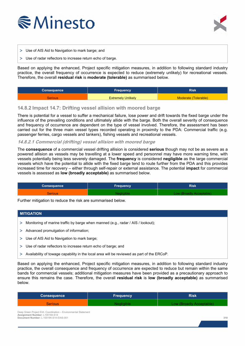
> Use of AIS Aid to Navigation to mark barge; and
> Use of radar reflectors to increase return echo of barge.
Based on applying the enhanced, Project specific mitigation measures, in addition to following standard industry practice, the overall frequency of occurrence is expected to reduce (extremely unlikely) for recreational vessels. Therefore, the overall residual risk is moderate (tolerable) as summarised below.
Consequence Frequency Risk
Serious Extremely Unlikely Moderate (Tolerable)
14.8.2 Impact 14.7: Drifting vessel allision with moored barge There is potential for a vessel to suffer a mechanical failure, lose power and drift towards the fixed barge under the influence of the prevailing conditions and ultimately allide with the barge. Both the overall severity of consequence and frequency of occurrence are dependent on the type of vessel involved. Therefore, the assessment has been carried out for the three main vessel types recorded operating in proximity to the PDA: Commercial traffic (e.g. passenger ferries, cargo vessels and tankers), fishing vessels and recreational vessels.
14.8.2.1 Commercial (drifting) vessel allision with moored barge The consequence of a commercial vessel drifting allision is considered serious though may not be as severe as a powered allision as vessels may be travelling at a lower speed and personnel may have more warning time, with vessels potentially being less severely damaged. The frequency is considered negligible as the large commercial vessels which have the potential to allide with the fixed barge tend to route further from the PDA and this provides increased time for recovery – either through self-repair or external assistance. The potential impact for commercial vessels is assessed as low (broadly acceptable) as summarised below.
Consequence Frequency Risk
Serious Negligible Low (Broadly Acceptable)
Further mitigation to reduce the risk are summarised below.
MITIGATION
> Monitoring of marine traffic by barge when manned (e.g., radar / AIS / lookout);
> Advanced promulgation of information;
> Use of AIS Aid to Navigation to mark barge;
> Use of radar reflectors to increase return echo of barge; and
> Availability of towage capability in the local area will be reviewed as part of the ERCoP.
Based on applying the enhanced, Project specific mitigation measures, in addition to following standard industry practice, the overall consequence and frequency of occurrence are expected to reduce but remain within the same bands for commercial vessels; additional mitigation measures have been provided as a precautionary approach to ensure this remains the case. Therefore, the overall residual risk is low (broadly acceptable) as summarised below.
Consequence Frequency Risk
Serious Negligible Low (Broadly Acceptable) Deep Green Project EIA: Coordination – Environmental Statement Assignment Number: L100194-S14 Document Number: L-100194-S14-EIAS-001 310
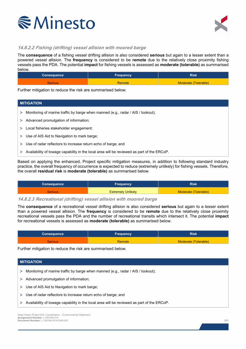
14.8.2.2 Fishing (drifting) vessel allision with moored barge The consequence of a fishing vessel drifting allision is also considered serious but again to a lesser extent than a powered vessel allision. The frequency is considered to be remote due to the relatively close proximity fishing vessels pass the PDA. The potential impact for fishing vessels is assessed as moderate (tolerable) as summarised below.
Consequence Frequency Risk
Serious Remote Moderate (Tolerable)
Further mitigation to reduce the risk are summarised below.
MITIGATION
> Monitoring of marine traffic by barge when manned (e.g., radar / AIS / lookout);
> Advanced promulgation of information;
> Local fisheries stakeholder engagement;
> Use of AIS Aid to Navigation to mark barge;
> Use of radar reflectors to increase return echo of barge; and
> Availability of towage capability in the local area will be reviewed as part of the ERCoP.
Based on applying the enhanced, Project specific mitigation measures, in addition to following standard industry practice, the overall frequency of occurrence is expected to reduce (extremely unlikely) for fishing vessels. Therefore, the overall residual risk is moderate (tolerable) as summarised below.
Consequence Frequency Risk
Serious Extremely Unlikely Moderate (Tolerable)
14.8.2.3 Recreational (drifting) vessel allision with moored barge The consequence of a recreational vessel drifting allision is also considered serious but again to a lesser extent than a powered vessel allision. The frequency is considered to be remote due to the relatively close proximity recreational vessels pass the PDA and the number of recreational transits which intersect it. The potential impact for recreational vessels is assessed as moderate (tolerable) as summarised below.
Consequence Frequency Risk
Serious Remote Moderate (Tolerable)
Further mitigation to reduce the risk are summarised below.
MITIGATION
> Monitoring of marine traffic by barge when manned (e.g., radar / AIS / lookout);
> Advanced promulgation of information;
> Use of AIS Aid to Navigation to mark barge;
> Use of radar reflectors to increase return echo of barge; and
> Availability of towage capability in the local area will be reviewed as part of the ERCoP.
Deep Green Project EIA: Coordination – Environmental Statement Assignment Number: L100194-S14 Document Number: L-100194-S14-EIAS-001 311
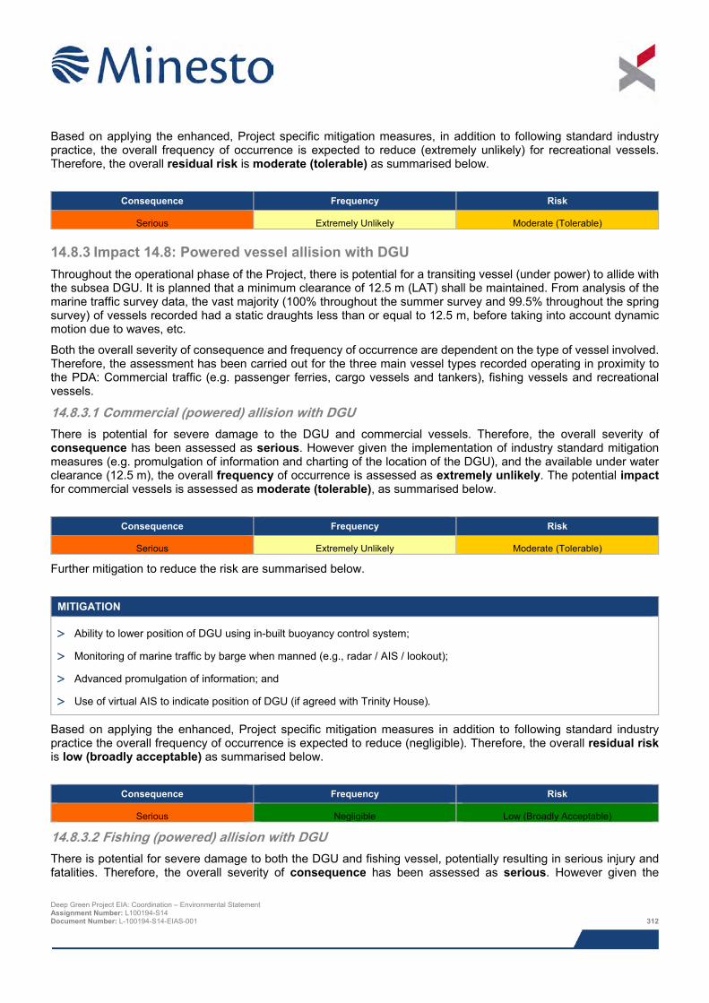
Based on applying the enhanced, Project specific mitigation measures, in addition to following standard industry practice, the overall frequency of occurrence is expected to reduce (extremely unlikely) for recreational vessels. Therefore, the overall residual risk is moderate (tolerable) as summarised below.
Consequence Frequency Risk
Serious Extremely Unlikely Moderate (Tolerable)
14.8.3 Impact 14.8: Powered vessel allision with DGU Throughout the operational phase of the Project, there is potential for a transiting vessel (under power) to allide with the subsea DGU. It is planned that a minimum clearance of 12.5 m (LAT) shall be maintained. From analysis of the marine traffic survey data, the vast majority (100% throughout the summer survey and 99.5% throughout the spring survey) of vessels recorded had a static draughts less than or equal to 12.5 m, before taking into account dynamic motion due to waves, etc.
Both the overall severity of consequence and frequency of occurrence are dependent on the type of vessel involved. Therefore, the assessment has been carried out for the three main vessel types recorded operating in proximity to the PDA: Commercial traffic (e.g. passenger ferries, cargo vessels and tankers), fishing vessels and recreational vessels.
14.8.3.1 Commercial (powered) allision with DGU There is potential for severe damage to the DGU and commercial vessels. Therefore, the overall severity of consequence has been assessed as serious. However given the implementation of industry standard mitigation measures (e.g. promulgation of information and charting of the location of the DGU), and the available under water clearance (12.5 m), the overall frequency of occurrence is assessed as extremely unlikely. The potential impact for commercial vessels is assessed as moderate (tolerable), as summarised below.
Consequence Frequency Risk
Serious Extremely Unlikely Moderate (Tolerable)
Further mitigation to reduce the risk are summarised below.
MITIGATION
> Ability to lower position of DGU using in-built buoyancy control system;
> Monitoring of marine traffic by barge when manned (e.g., radar / AIS / lookout);
> Advanced promulgation of information; and
> Use of virtual AIS to indicate position of DGU (if agreed with Trinity House).
Based on applying the enhanced, Project specific mitigation measures in addition to following standard industry practice the overall frequency of occurrence is expected to reduce (negligible). Therefore, the overall residual risk is low (broadly acceptable) as summarised below.
Consequence Frequency Risk
Serious Negligible Low (Broadly Acceptable)
14.8.3.2 Fishing (powered) allision with DGU There is potential for severe damage to both the DGU and fishing vessel, potentially resulting in serious injury and fatalities. Therefore, the overall severity of consequence has been assessed as serious. However given the
Deep Green Project EIA: Coordination – Environmental Statement Assignment Number: L100194-S14 Document Number: L-100194-S14-EIAS-001 312
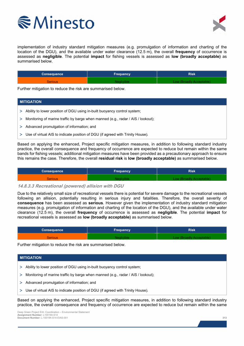
implementation of industry standard mitigation measures (e.g. promulgation of information and charting of the location of the DGU), and the available under water clearance (12.5 m), the overall frequency of occurrence is assessed as negligible. The potential impact for fishing vessels is assessed as low (broadly acceptable) as summarised below.
Consequence Frequency Risk
Serious Negligible Low (Broadly Acceptable)
Further mitigation to reduce the risk are summarised below.
MITIGATION
> Ability to lower position of DGU using in-built buoyancy control system;
> Monitoring of marine traffic by barge when manned (e.g., radar / AIS / lookout);
> Advanced promulgation of information; and
> Use of virtual AIS to indicate position of DGU (if agreed with Trinity House).
Based on applying the enhanced, Project specific mitigation measures, in addition to following standard industry practice, the overall consequence and frequency of occurrence are expected to reduce but remain within the same bands for fishing vessels; additional mitigation measures have been provided as a precautionary approach to ensure this remains the case. Therefore, the overall residual risk is low (broadly acceptable) as summarised below.
Consequence Frequency Risk
Serious Negligible Low (Broadly Acceptable)
14.8.3.3 Recreational (powered) allision with DGU Due to the relatively small size of recreational vessels there is potential for severe damage to the recreational vessels following an allision, potentially resulting in serious injury and fatalities. Therefore, the overall severity of consequence has been assessed as serious. However given the implementation of industry standard mitigation measures (e.g. promulgation of information and charting of the location of the DGU), and the available under water clearance (12.5 m), the overall frequency of occurrence is assessed as negligible. The potential impact for recreational vessels is assessed as low (broadly acceptable) as summarised below.
Consequence Frequency Risk
Serious Negligible Low (Broadly Acceptable)
Further mitigation to reduce the risk are summarised below.
MITIGATION
> Ability to lower position of DGU using in-built buoyancy control system;
> Monitoring of marine traffic by barge when manned (e.g., radar / AIS / lookout);
> Advanced promulgation of information; and
> Use of virtual AIS to indicate position of DGU (if agreed with Trinity House).
Based on applying the enhanced, Project specific mitigation measures, in addition to following standard industry practice, the overall consequence and frequency of occurrence are expected to reduce but remain within the same Deep Green Project EIA: Coordination – Environmental Statement Assignment Number: L100194-S14 Document Number: L-100194-S14-EIAS-001 313
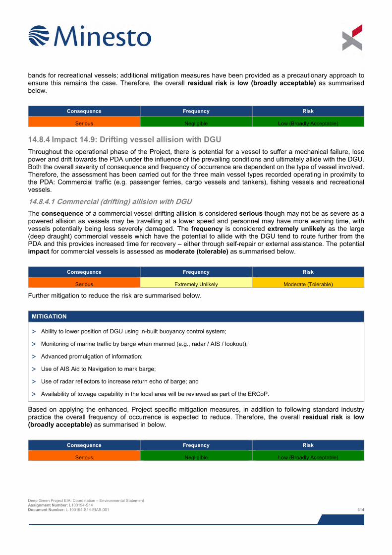
bands for recreational vessels; additional mitigation measures have been provided as a precautionary approach to ensure this remains the case. Therefore, the overall residual risk is low (broadly acceptable) as summarised below.
Consequence Frequency Risk
Serious Negligible Low (Broadly Acceptable)
14.8.4 Impact 14.9: Drifting vessel allision with DGU Throughout the operational phase of the Project, there is potential for a vessel to suffer a mechanical failure, lose power and drift towards the PDA under the influence of the prevailing conditions and ultimately allide with the DGU. Both the overall severity of consequence and frequency of occurrence are dependent on the type of vessel involved. Therefore, the assessment has been carried out for the three main vessel types recorded operating in proximity to the PDA: Commercial traffic (e.g. passenger ferries, cargo vessels and tankers), fishing vessels and recreational vessels.
14.8.4.1 Commercial (drifting) allision with DGU The consequence of a commercial vessel drifting allision is considered serious though may not be as severe as a powered allision as vessels may be travelling at a lower speed and personnel may have more warning time, with vessels potentially being less severely damaged. The frequency is considered extremely unlikely as the large (deep draught) commercial vessels which have the potential to allide with the DGU tend to route further from the PDA and this provides increased time for recovery – either through self-repair or external assistance. The potential impact for commercial vessels is assessed as moderate (tolerable) as summarised below.
Consequence Frequency Risk
Serious Extremely Unlikely Moderate (Tolerable)
Further mitigation to reduce the risk are summarised below.
MITIGATION
> Ability to lower position of DGU using in-built buoyancy control system;
> Monitoring of marine traffic by barge when manned (e.g., radar / AIS / lookout);
> Advanced promulgation of information;
> Use of AIS Aid to Navigation to mark barge;
> Use of radar reflectors to increase return echo of barge; and
> Availability of towage capability in the local area will be reviewed as part of the ERCoP.
Based on applying the enhanced, Project specific mitigation measures, in addition to following standard industry practice the overall frequency of occurrence is expected to reduce. Therefore, the overall residual risk is low (broadly acceptable) as summarised in below.
Consequence Frequency Risk
Serious Negligible Low (Broadly Acceptable)
Deep Green Project EIA: Coordination – Environmental Statement Assignment Number: L100194-S14 Document Number: L-100194-S14-EIAS-001 314
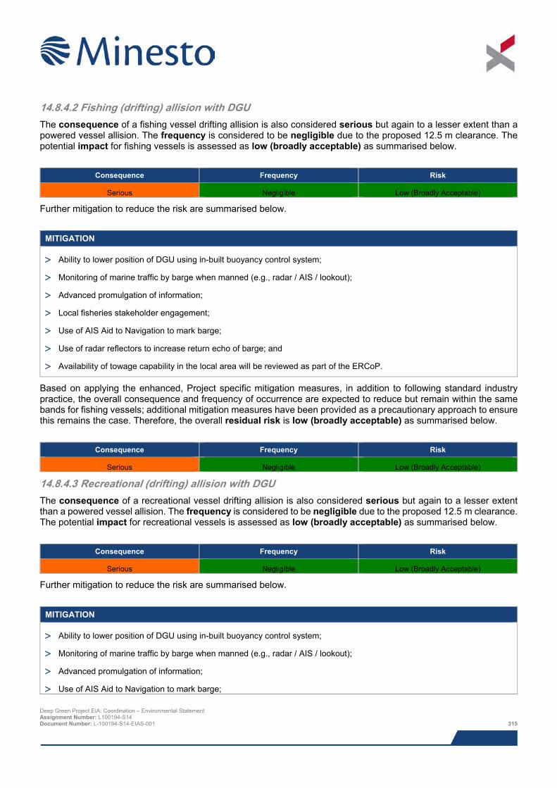
14.8.4.2 Fishing (drifting) allision with DGU The consequence of a fishing vessel drifting allision is also considered serious but again to a lesser extent than a powered vessel allision. The frequency is considered to be negligible due to the proposed 12.5 m clearance. The potential impact for fishing vessels is assessed as low (broadly acceptable) as summarised below.
Consequence Frequency Risk
Serious Negligible Low (Broadly Acceptable)
Further mitigation to reduce the risk are summarised below.
MITIGATION
> Ability to lower position of DGU using in-built buoyancy control system;
> Monitoring of marine traffic by barge when manned (e.g., radar / AIS / lookout);
> Advanced promulgation of information;
> Local fisheries stakeholder engagement;
> Use of AIS Aid to Navigation to mark barge;
> Use of radar reflectors to increase return echo of barge; and
> Availability of towage capability in the local area will be reviewed as part of the ERCoP.
Based on applying the enhanced, Project specific mitigation measures, in addition to following standard industry practice, the overall consequence and frequency of occurrence are expected to reduce but remain within the same bands for fishing vessels; additional mitigation measures have been provided as a precautionary approach to ensure this remains the case. Therefore, the overall residual risk is low (broadly acceptable) as summarised below.
Consequence Frequency Risk
Serious Negligible Low (Broadly Acceptable)
14.8.4.3 Recreational (drifting) allision with DGU The consequence of a recreational vessel drifting allision is also considered serious but again to a lesser extent than a powered vessel allision. The frequency is considered to be negligible due to the proposed 12.5 m clearance. The potential impact for recreational vessels is assessed as low (broadly acceptable) as summarised below.
Consequence Frequency Risk
Serious Negligible Low (Broadly Acceptable)
Further mitigation to reduce the risk are summarised below.
MITIGATION
> Ability to lower position of DGU using in-built buoyancy control system;
> Monitoring of marine traffic by barge when manned (e.g., radar / AIS / lookout);
> Advanced promulgation of information;
> Use of AIS Aid to Navigation to mark barge;
Deep Green Project EIA: Coordination – Environmental Statement Assignment Number: L100194-S14 Document Number: L-100194-S14-EIAS-001 315
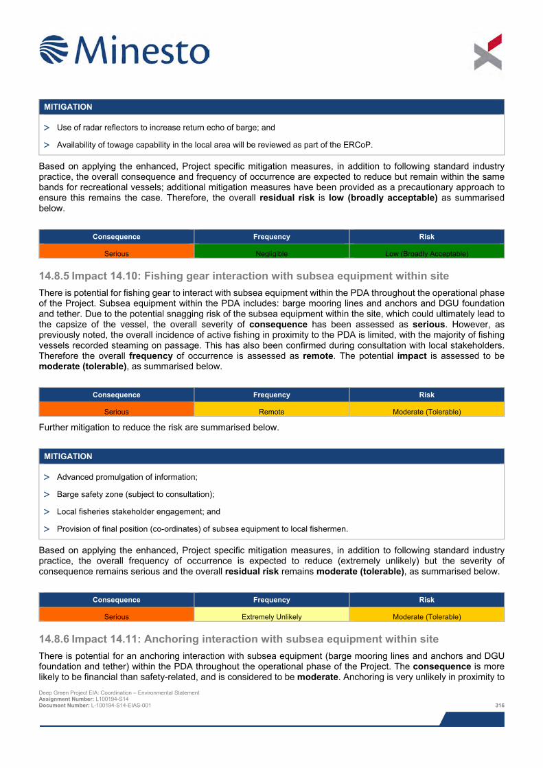
MITIGATION
> Use of radar reflectors to increase return echo of barge; and
> Availability of towage capability in the local area will be reviewed as part of the ERCoP.
Based on applying the enhanced, Project specific mitigation measures, in addition to following standard industry practice, the overall consequence and frequency of occurrence are expected to reduce but remain within the same bands for recreational vessels; additional mitigation measures have been provided as a precautionary approach to ensure this remains the case. Therefore, the overall residual risk is low (broadly acceptable) as summarised below.
Consequence Frequency Risk
Serious Negligible Low (Broadly Acceptable)
14.8.5 Impact 14.10: Fishing gear interaction with subsea equipment within site There is potential for fishing gear to interact with subsea equipment within the PDA throughout the operational phase of the Project. Subsea equipment within the PDA includes: barge mooring lines and anchors and DGU foundation and tether. Due to the potential snagging risk of the subsea equipment within the site, which could ultimately lead to the capsize of the vessel, the overall severity of consequence has been assessed as serious. However, as previously noted, the overall incidence of active fishing in proximity to the PDA is limited, with the majority of fishing vessels recorded steaming on passage. This has also been confirmed during consultation with local stakeholders. Therefore the overall frequency of occurrence is assessed as remote. The potential impact is assessed to be moderate (tolerable), as summarised below.
Consequence Frequency Risk
Serious Remote Moderate (Tolerable)
Further mitigation to reduce the risk are summarised below.
MITIGATION
> Advanced promulgation of information;
> Barge safety zone (subject to consultation);
> Local fisheries stakeholder engagement; and
> Provision of final position (co-ordinates) of subsea equipment to local fishermen.
Based on applying the enhanced, Project specific mitigation measures, in addition to following standard industry practice, the overall frequency of occurrence is expected to reduce (extremely unlikely) but the severity of consequence remains serious and the overall residual risk remains moderate (tolerable), as summarised below.
Consequence Frequency Risk
Serious Extremely Unlikely Moderate (Tolerable)
14.8.6 Impact 14.11: Anchoring interaction with subsea equipment within site There is potential for an anchoring interaction with subsea equipment (barge mooring lines and anchors and DGU foundation and tether) within the PDA throughout the operational phase of the Project. The consequence is more likely to be financial than safety-related, and is considered to be moderate. Anchoring is very unlikely in proximity to Deep Green Project EIA: Coordination – Environmental Statement Assignment Number: L100194-S14 Document Number: L-100194-S14-EIAS-001 316
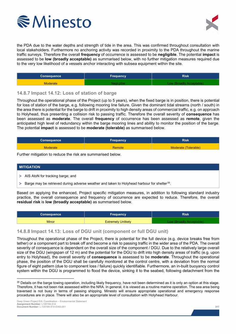
the PDA due to the water depths and strength of tide in the area. This was confirmed throughout consultation with local stakeholders. Furthermore no anchoring activity was recorded in proximity to the PDA throughout the marine traffic surveys. Therefore the overall frequency of occurrence is assessed to be negligible. The potential impact is assessed to be low (broadly acceptable) as summarised below, with no further mitigation measures required due to the very low likelihood of a vessels anchor interacting with subsea equipment within the site.
Consequence Frequency Risk
Moderate Negligible Low (Broadly Acceptable)
14.8.7 Impact 14.12: Loss of station of barge Throughout the operational phase of the Project (up to 5 years), when the fixed barge is in position, there is potential for loss of station of the barge, e.g. following mooring line failure. Given the dominant tidal streams (north / south) in the area there is potential for the barge to drift in proximity to high density areas of commercial traffic, e.g. on approach to Holyhead, thus presenting a collision risk to passing traffic. Therefore the overall severity of consequence has been assessed as moderate. The overall frequency of occurrence has been assessed as remote, given the anticipated high level of redundancy within the barge mooring lines and ability to monitor the position of the barge. The potential impact is assessed to be moderate (tolerable) as summarised below.
Consequence Frequency Risk
Moderate Remote Moderate (Tolerable)
Further mitigation to reduce the risk are summarised below.
MITIGATION
> AIS AtoN for tracking barge; and
> Barge may be retrieved during adverse weather and taken to Holyhead harbour for shelter35.
Based on applying the enhanced, Project specific mitigation measures, in addition to following standard industry practice, the overall consequence and frequency of occurrence are expected to reduce. Therefore, the overall residual risk is low (broadly acceptable) as summarised below.
Consequence Frequency Risk
Minor Extremely Unlikely Low (Broadly Acceptable)
14.8.8 Impact 14.13: Loss of DGU unit (component or full DGU unit) Throughout the operational phase of the Project, there is potential for the full device (e.g. device breaks free from tether) or a component part to break off and become a risk to passing traffic in the wider area of the PDA. The overall severity of consequence is dependent on the overall size of the component / DGU. Due to the relatively large overall size of the DGU (wingspan of 12 m) and the potential for the DGU to drift into high density areas of traffic (e.g. upon entry to Holyhead), the overall severity of consequence is assessed to be moderate. Throughout the operational phase, the position of the DGU shall be carefully monitored at the control centre, with a deviation from the normal figure of eight pattern (due to component loss / failure) quickly identifiable. Furthermore, an in-built buoyancy control system within the DGU is programmed to flood the device, sinking it to the seabed, following detachment from the
35 Details on the barge towing operation, including likely frequency, have not been determined as it is only an option at this stage. Therefore, it has not been risk assessed within the NRA. In general, it is viewed as a routine marine operation. The sea area being traversed is not busy in terms of passing shipping. Minesto will ensure appropriate operational and emergency response procedures are in place. There will also be an appropriate level of consultation with Holyhead Harbour. Deep Green Project EIA: Coordination – Environmental Statement Assignment Number: L100194-S14 Document Number: L-100194-S14-EIAS-001 317
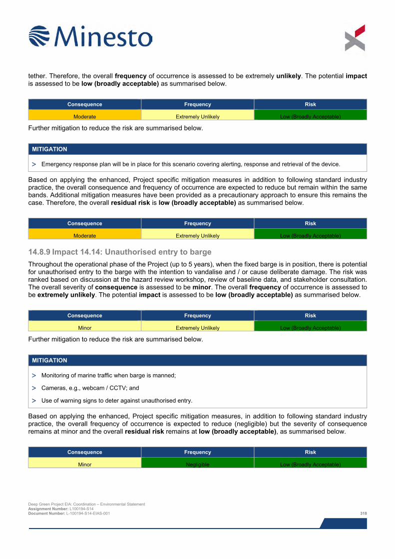
tether. Therefore, the overall frequency of occurrence is assessed to be extremely unlikely. The potential impact is assessed to be low (broadly acceptable) as summarised below.
Consequence Frequency Risk
Moderate Extremely Unlikely Low (Broadly Acceptable)
Further mitigation to reduce the risk are summarised below.
MITIGATION
> Emergency response plan will be in place for this scenario covering alerting, response and retrieval of the device.
Based on applying the enhanced, Project specific mitigation measures in addition to following standard industry practice, the overall consequence and frequency of occurrence are expected to reduce but remain within the same bands. Additional mitigation measures have been provided as a precautionary approach to ensure this remains the case. Therefore, the overall residual risk is low (broadly acceptable) as summarised below.
Consequence Frequency Risk
Moderate Extremely Unlikely Low (Broadly Acceptable)
14.8.9 Impact 14.14: Unauthorised entry to barge Throughout the operational phase of the Project (up to 5 years), when the fixed barge is in position, there is potential for unauthorised entry to the barge with the intention to vandalise and / or cause deliberate damage. The risk was ranked based on discussion at the hazard review workshop, review of baseline data, and stakeholder consultation. The overall severity of consequence is assessed to be minor. The overall frequency of occurrence is assessed to be extremely unlikely. The potential impact is assessed to be low (broadly acceptable) as summarised below.
Consequence Frequency Risk
Minor Extremely Unlikely Low (Broadly Acceptable)
Further mitigation to reduce the risk are summarised below.
MITIGATION
> Monitoring of marine traffic when barge is manned;
> Cameras, e.g., webcam / CCTV; and
> Use of warning signs to deter against unauthorised entry.
Based on applying the enhanced, Project specific mitigation measures, in addition to following standard industry practice, the overall frequency of occurrence is expected to reduce (negligible) but the severity of consequence remains at minor and the overall residual risk remains at low (broadly acceptable), as summarised below.
Consequence Frequency Risk
Minor Negligible Low (Broadly Acceptable)
Deep Green Project EIA: Coordination – Environmental Statement Assignment Number: L100194-S14 Document Number: L-100194-S14-EIAS-001 318
14.9 Impacts during decommissioning Throughout the decommissioning of the Project the potential impacts associated with the decommissioning of the Project are considered to be similar, or of a reduced magnitude, to those described above (Section 14.7) for the construction phase.
A full decommissioning plan would be submitted and approved at least four months prior to carrying out any decommissioning works.
14.10 Potential variances in environmental impacts The impact assessment above was based on the Project parameters summarised in Section 14.6.3 with regards to impacts on shipping and navigation. This section provides a brief overview of the potential variances between the Project parameters assessed and alternative Project options and design envelope parameters.
14.10.1 Location of DGU unit If the location of the DGU unit and associated barge were to differ from the indicative location assessed, the overall risk could potentially change. In the worst case scenario, if the DGU unit and barge were to be positioned within the western or northern extremities of the PDA, in closer proximity to high density traffic routes, the overall risk of the following impacts would increase:
> Impact 14.6: powered vessel allision with moored barge;
> Impact 14.7: drifting vessel allision with moored barge;
> Impact 14.8: powered vessel allision with DGU;
> Impact 14.9: drifting vessel allision with DGU;
> Impact 14.12: loss of station of barge; and
> Impact 14.13: loss of DGU unit (component or full DGU unit).
However the increased risk is still considered to be tolerable to shipping and navigation following the implementation of both embedded and additional mitigation measures.
14.10.2 Minimum underwater clearance If the minimum under water clearance of the DGU unit were to differ from the 12.5 m assessed, the overall risk would change: If the minimum underwater clearance were to increase (>12.5 m), the overall risk would decrease. Conversely, if the minimum underwater clearance were to decrease (<12.5 m), the overall risk would increase. The overall risk of the following impacts would be affected by a change to the minimum underwater clearance:
> Impact 14.8: powered vessel allision with DGU; and
> Impact 14.9: drifting vessel allision with DGU.
It should be noted that Minesto has confirmed that the minimum underwater clearance is set to 12.5 m, and most of the time will be significantly greater. Therefore it is considered that the impact assessment carried out (assuming 12.5 m underwater clearance) is conservative (worst “realistic” case). The only exception (other than the device being instructed to go to the surface for planned maintenance) would be if the failsafe did not operate following a malfunction, which is designed to make the device hover in midwater. This would represent an unplanned event, and an alert would be received from the surfaced device to allow a rapid response to be carried out.
14.10.3 Barge The barge is planned to be in place throughout the operational phase of the Project and was seen to dominate the impacts as it poses a surface navigation hazard to all passing vessels. As a worst-case it has been assumed the barge could be in place for up to five years.
Deep Green Project EIA: Coordination – Environmental Statement Assignment Number: L100194-S14 Document Number: L-100194-S14-EIAS-001 319
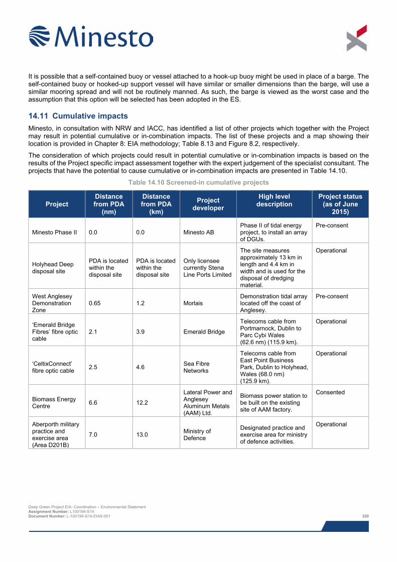
It is possible that a self-contained buoy or vessel attached to a hook-up buoy might be used in place of a barge. The self-contained buoy or hooked-up support vessel will have similar or smaller dimensions than the barge, will use a similar mooring spread and will not be routinely manned. As such, the barge is viewed as the worst case and the assumption that this option will be selected has been adopted in the ES.
14.11 Cumulative impacts Minesto, in consultation with NRW and IACC, has identified a list of other projects which together with the Project may result in potential cumulative or in-combination impacts. The list of these projects and a map showing their location is provided in Chapter 8: EIA methodology; Table 8.13 and Figure 8.2, respectively.
The consideration of which projects could result in potential cumulative or in-combination impacts is based on the results of the Project specific impact assessment together with the expert judgement of the specialist consultant. The projects that have the potential to cause cumulative or in-combination impacts are presented in Table 14.10.
Table 14.10 Screened-in cumulative projects
Project Distance from PDA
(nm)
Distance from PDA
(km) Project
developer High level
description Project status
(as of June 2015)
Minesto Phase II 0.0 0.0 Minesto AB Phase II of tidal energy project, to install an array of DGUs.
Pre-consent
Holyhead Deep disposal site
PDA is located within the disposal site
PDA is located within the disposal site
Only licensee currently Stena Line Ports Limited
The site measures approximately 13 km in length and 4.4 km in width and is used for the disposal of dredging material.
Operational
West Anglesey Demonstration Zone
0.65 1.2 Morlais Demonstration tidal array located off the coast of Anglesey.
Pre-consent
‘Emerald Bridge Fibres’ fibre optic cable
2.1 3.9 Emerald Bridge
Telecoms cable from Portmarnock, Dublin to Parc Cybi Wales (62.6 nm) (115.9 km).
Operational
‘CeltixConnect’ fibre optic cable 2.5 4.6 Sea Fibre
Networks
Telecoms cable from East Point Business Park, Dublin to Holyhead, Wales (68.0 nm) (125.9 km).
Operational
Biomass Energy Centre 6.6 12.2
Lateral Power and Anglesey Aluminum Metals (AAM) Ltd.
Biomass power station to be built on the existing site of AAM factory.
Consented
Aberporth military practice and exercise area (Area D201B)
7.0 13.0 Ministry of Defence
Designated practice and exercise area for ministry of defence activities.
Operational
Deep Green Project EIA: Coordination – Environmental Statement Assignment Number: L100194-S14 Document Number: L-100194-S14-EIAS-001 320
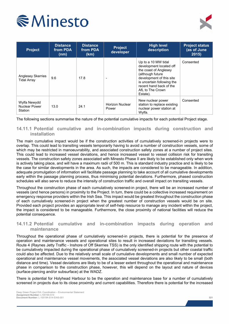
Project Distance from PDA
(nm)
Distance from PDA
(km) Project
developer High level
description Project status
(as of June 2015)
Anglesey Skerries Tidal Array 9.6 17.8 -
Up to a 10 MW tidal development located off the coast of Anglesey (although future development of this site is uncertain following the recent hand back of the AfL to The Crown Estate).
Consented
Wylfa Newydd Nuclear Power Station
13.0 24.1 Horizon Nuclear Power
New nuclear power station to replace existing nuclear power station at Wylfa.
Consented
The following sections summarise the nature of the potential cumulative impacts for each potential Project stage.
14.11.1 Potential cumulative and in-combination impacts during construction and installation
The main cumulative impact would be if the construction activities of cumulatively screened-in projects were to overlap. This could lead to transiting vessels temporarily having to avoid a number of construction vessels, some of which may be restricted in manoeuvrability, and associated construction safety zones at a number of project sites. This could lead to increased vessel deviations, and hence increased vessel to vessel collision risk for transiting vessels. The construction safety zones associated with Minesto Phase II are likely to be established only when work is actively taking place, and will have a maximum radii of 500 m. This is standard industry practice and is likely to be the case for similar developments in the area. As such, the impacts are considered to be manageable. In addition, adequate promulgation of information will facilitate passage planning to take account of all cumulative developments early within the passage planning process, thus minimising potential deviations. Furthermore, phased construction schedules will also serve to reduce the intensity of construction traffic and overall impact on transiting vessels.
Throughout the construction phase of each cumulatively screened-in project, there will be an increased number of vessels (and hence persons) in proximity to the Project. In turn, there could be a collective increased requirement on emergency response providers within the Irish Sea. This impact would be greatest throughout the construction phase of each cumulatively screened-in project when the greatest number of construction vessels would be on site. Provided each project provides an appropriate level of self-help resource to manage any incident within the project, the impact is considered to be manageable. Furthermore, the close proximity of national facilities will reduce the potential consequence.
14.11.2 Potential cumulative and in-combination impacts during operation and maintenance
Throughout the operational phase of cumulatively screened-in projects, there is potential for the presence of operation and maintenance vessels and operational sites to result in increased deviations for transiting vessels. Route 4 (Raynes Jetty Traffic - Inshore of Off Skerries TSS) is the only identified shipping route with the potential to be cumulatively impacted during the operational phase of cumulatively screened-in projects but other coastal traffic could also be affected. Due to the relatively small scale of cumulative developments and small number of expected operational and maintenance vessel movements, the associated vessel deviations are also likely to be small (both distance and time). Vessel deviations are likely to be of a lesser extent throughout the operational and maintenance phase in comparison to the construction phase, however, this will depend on the layout and nature of devices (surface-piercing and/or subsurface) at the WADZ.
There is potential for Holyhead Harbour to be the operation and maintenance base for a number of cumulatively screened in projects due to its close proximity and current capabilities. Therefore there is potential for the increased Deep Green Project EIA: Coordination – Environmental Statement Assignment Number: L100194-S14 Document Number: L-100194-S14-EIAS-001 321
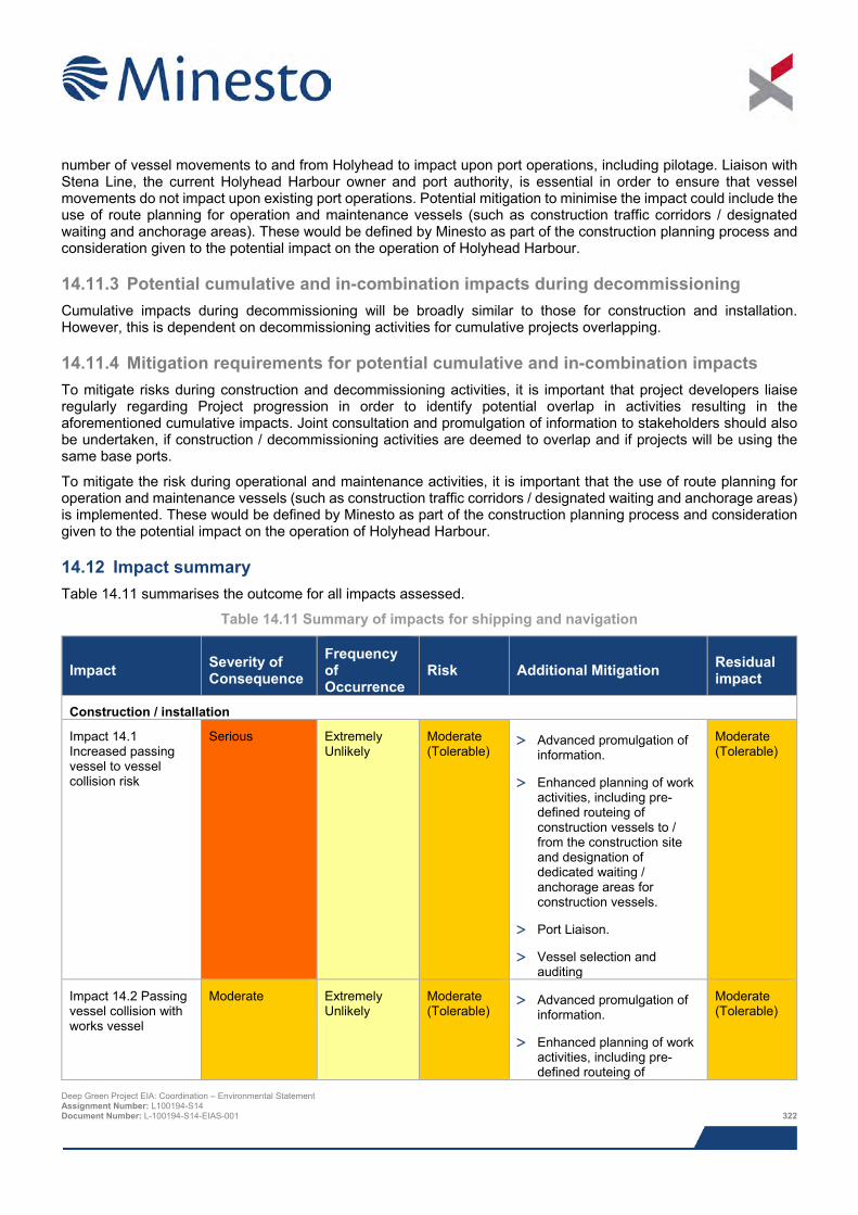
number of vessel movements to and from Holyhead to impact upon port operations, including pilotage. Liaison with Stena Line, the current Holyhead Harbour owner and port authority, is essential in order to ensure that vessel movements do not impact upon existing port operations. Potential mitigation to minimise the impact could include the use of route planning for operation and maintenance vessels (such as construction traffic corridors / designated waiting and anchorage areas). These would be defined by Minesto as part of the construction planning process and consideration given to the potential impact on the operation of Holyhead Harbour.
14.11.3 Potential cumulative and in-combination impacts during decommissioning Cumulative impacts during decommissioning will be broadly similar to those for construction and installation. However, this is dependent on decommissioning activities for cumulative projects overlapping.
14.11.4 Mitigation requirements for potential cumulative and in-combination impacts To mitigate risks during construction and decommissioning activities, it is important that project developers liaise regularly regarding Project progression in order to identify potential overlap in activities resulting in the aforementioned cumulative impacts. Joint consultation and promulgation of information to stakeholders should also be undertaken, if construction / decommissioning activities are deemed to overlap and if projects will be using the same base ports.
To mitigate the risk during operational and maintenance activities, it is important that the use of route planning for operation and maintenance vessels (such as construction traffic corridors / designated waiting and anchorage areas) is implemented. These would be defined by Minesto as part of the construction planning process and consideration given to the potential impact on the operation of Holyhead Harbour.
14.12 Impact summary Table 14.11 summarises the outcome for all impacts assessed.
Table 14.11 Summary of impacts for shipping and navigation
Impact Severity of Consequence
Frequency of Occurrence
Risk Additional Mitigation Residual impact
Construction / installation
Impact 14.1 Increased passing vessel to vessel collision risk
Serious Extremely Unlikely
Moderate (Tolerable)
> Advanced promulgation of information.
> Enhanced planning of work activities, including pre-defined routeing of construction vessels to / from the construction site and designation of dedicated waiting / anchorage areas for construction vessels.
> Port Liaison.
> Vessel selection and auditing
Moderate (Tolerable)
Impact 14.2 Passing vessel collision with works vessel
Moderate Extremely Unlikely
Moderate (Tolerable)
> Advanced promulgation of information.
> Enhanced planning of work activities, including pre-defined routeing of
Moderate (Tolerable)
Deep Green Project EIA: Coordination – Environmental Statement Assignment Number: L100194-S14 Document Number: L-100194-S14-EIAS-001 322
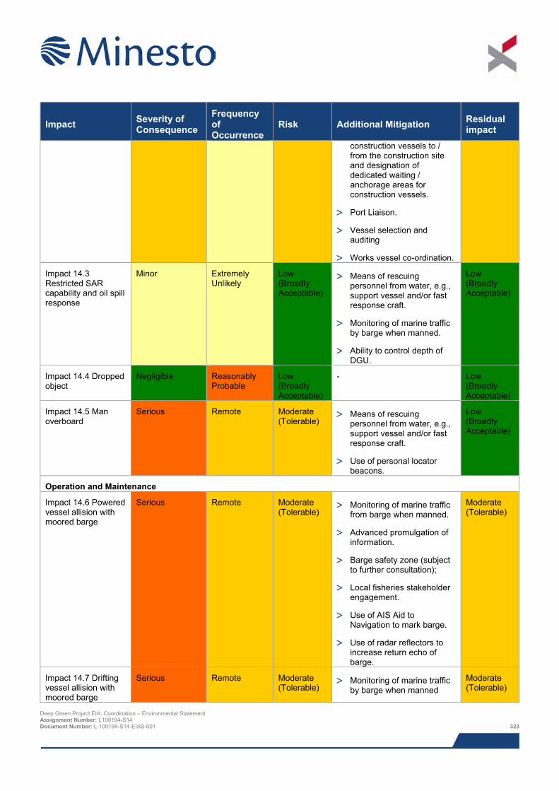
Impact Severity of Consequence
Frequency of Occurrence
Risk Additional Mitigation Residual impact
construction vessels to / from the construction site and designation of dedicated waiting / anchorage areas for construction vessels.
> Port Liaison.
> Vessel selection and auditing
> Works vessel co-ordination.
Impact 14.3 Restricted SAR capability and oil spill response
Minor Extremely Unlikely
Low (Broadly Acceptable)
> Means of rescuing personnel from water, e.g., support vessel and/or fast response craft.
> Monitoring of marine traffic by barge when manned.
> Ability to control depth of DGU.
Low (Broadly Acceptable)
Impact 14.4 Dropped object
Negligible Reasonably Probable
Low (Broadly Acceptable)
- Low (Broadly Acceptable)
Impact 14.5 Man overboard
Serious Remote Moderate (Tolerable)
> Means of rescuing personnel from water, e.g., support vessel and/or fast response craft.
> Use of personal locator beacons.
Low (Broadly Acceptable)
Operation and Maintenance
Impact 14.6 Powered vessel allision with moored barge
Serious Remote Moderate (Tolerable)
> Monitoring of marine traffic from barge when manned.
> Advanced promulgation of information.
> Barge safety zone (subject to further consultation);
> Local fisheries stakeholder engagement.
> Use of AIS Aid to Navigation to mark barge.
> Use of radar reflectors to increase return echo of barge.
Moderate (Tolerable)
Impact 14.7 Drifting vessel allision with moored barge
Serious Remote Moderate (Tolerable)
> Monitoring of marine traffic by barge when manned
Moderate (Tolerable)
Deep Green Project EIA: Coordination – Environmental Statement Assignment Number: L100194-S14 Document Number: L-100194-S14-EIAS-001 323
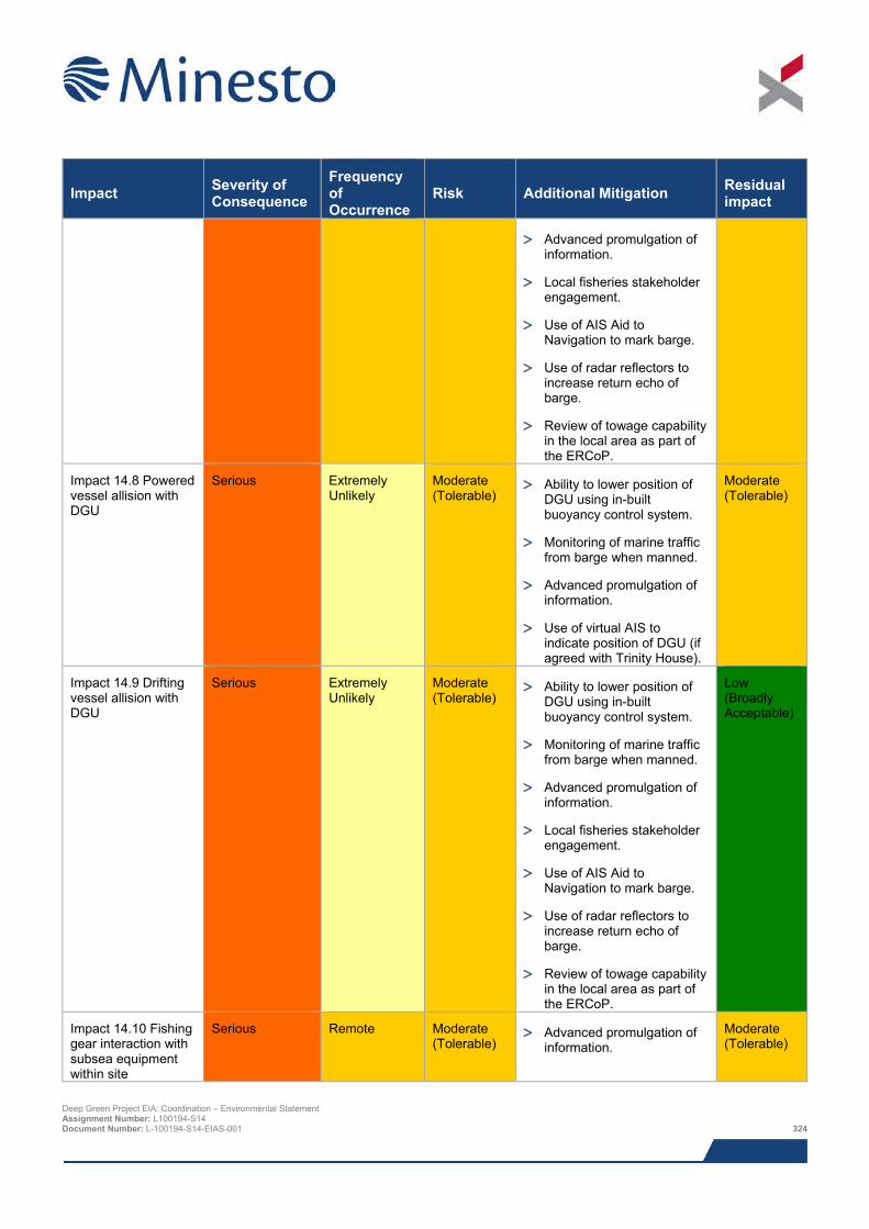
Impact Severity of Consequence
Frequency of Occurrence
Risk Additional Mitigation Residual impact
> Advanced promulgation of information.
> Local fisheries stakeholder engagement.
> Use of AIS Aid to Navigation to mark barge.
> Use of radar reflectors to increase return echo of barge.
> Review of towage capability in the local area as part of the ERCoP.
Impact 14.8 Powered vessel allision with DGU
Serious Extremely Unlikely
Moderate (Tolerable)
> Ability to lower position of DGU using in-built buoyancy control system.
> Monitoring of marine traffic from barge when manned.
> Advanced promulgation of information.
> Use of virtual AIS to indicate position of DGU (if agreed with Trinity House).
Moderate (Tolerable)
Impact 14.9 Drifting vessel allision with DGU
Serious Extremely Unlikely
Moderate (Tolerable)
> Ability to lower position of DGU using in-built buoyancy control system.
> Monitoring of marine traffic from barge when manned.
> Advanced promulgation of information.
> Local fisheries stakeholder engagement.
> Use of AIS Aid to Navigation to mark barge.
> Use of radar reflectors to increase return echo of barge.
> Review of towage capability in the local area as part of the ERCoP.
Low (Broadly Acceptable)
Impact 14.10 Fishing gear interaction with subsea equipment within site
Serious Remote Moderate (Tolerable)
> Advanced promulgation of information.
Moderate (Tolerable)
Deep Green Project EIA: Coordination – Environmental Statement Assignment Number: L100194-S14 Document Number: L-100194-S14-EIAS-001 324
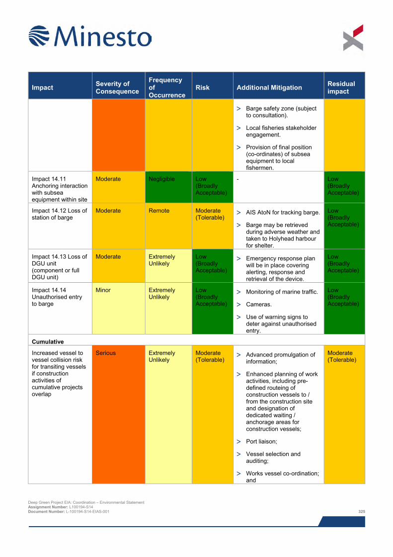
Impact Severity of Consequence
Frequency of Occurrence
Risk Additional Mitigation Residual impact
> Barge safety zone (subject to consultation).
> Local fisheries stakeholder engagement.
> Provision of final position (co-ordinates) of subsea equipment to local fishermen.
Impact 14.11 Anchoring interaction with subsea equipment within site
Moderate Negligible Low (Broadly Acceptable)
- Low (Broadly Acceptable)
Impact 14.12 Loss of station of barge
Moderate Remote Moderate (Tolerable)
> AIS AtoN for tracking barge.
> Barge may be retrieved during adverse weather and taken to Holyhead harbour for shelter.
Low (Broadly Acceptable)
Impact 14.13 Loss of DGU unit (component or full DGU unit)
Moderate Extremely Unlikely
Low (Broadly Acceptable)
> Emergency response plan will be in place covering alerting, response and retrieval of the device.
Low (Broadly Acceptable)
Impact 14.14 Unauthorised entry to barge
Minor Extremely Unlikely
Low (Broadly Acceptable)
> Monitoring of marine traffic.
> Cameras.
> Use of warning signs to deter against unauthorised entry.
Low (Broadly Acceptable)
Cumulative
Increased vessel to vessel collision risk for transiting vessels if construction activities of cumulative projects overlap
Serious Extremely Unlikely
Moderate (Tolerable)
> Advanced promulgation of information;
> Enhanced planning of work activities, including pre-defined routeing of construction vessels to / from the construction site and designation of dedicated waiting / anchorage areas for construction vessels;
> Port liaison;
> Vessel selection and auditing;
> Works vessel co-ordination; and
Moderate (Tolerable)
Deep Green Project EIA: Coordination – Environmental Statement Assignment Number: L100194-S14 Document Number: L-100194-S14-EIAS-001 325
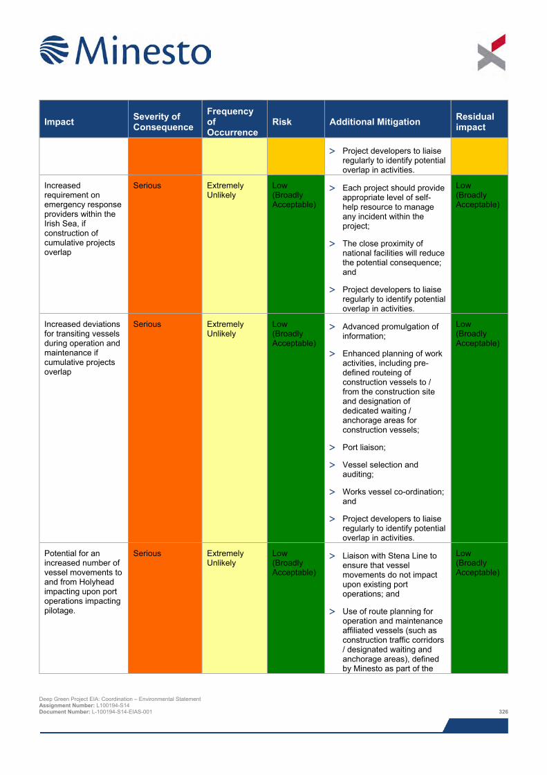
Impact Severity of Consequence
Frequency of Occurrence
Risk Additional Mitigation Residual impact
> Project developers to liaise regularly to identify potential overlap in activities.
Increased requirement on emergency response providers within the Irish Sea, if construction of cumulative projects overlap
Serious Extremely Unlikely
Low (Broadly Acceptable)
> Each project should provide appropriate level of self-help resource to manage any incident within the project;
> The close proximity of national facilities will reduce the potential consequence; and
> Project developers to liaise regularly to identify potential overlap in activities.
Low (Broadly Acceptable)
Increased deviations for transiting vessels during operation and maintenance if cumulative projects overlap
Serious Extremely Unlikely
Low (Broadly Acceptable)
> Advanced promulgation of information;
> Enhanced planning of work activities, including pre-defined routeing of construction vessels to / from the construction site and designation of dedicated waiting / anchorage areas for construction vessels;
> Port liaison;
> Vessel selection and auditing;
> Works vessel co-ordination; and
> Project developers to liaise regularly to identify potential overlap in activities.
Low (Broadly Acceptable)
Potential for an increased number of vessel movements to and from Holyhead impacting upon port operations impacting pilotage.
Serious Extremely Unlikely
Low (Broadly Acceptable)
> Liaison with Stena Line to ensure that vessel movements do not impact upon existing port operations; and
> Use of route planning for operation and maintenance affiliated vessels (such as construction traffic corridors / designated waiting and anchorage areas), defined by Minesto as part of the
Low (Broadly Acceptable)
Deep Green Project EIA: Coordination – Environmental Statement Assignment Number: L100194-S14 Document Number: L-100194-S14-EIAS-001 326
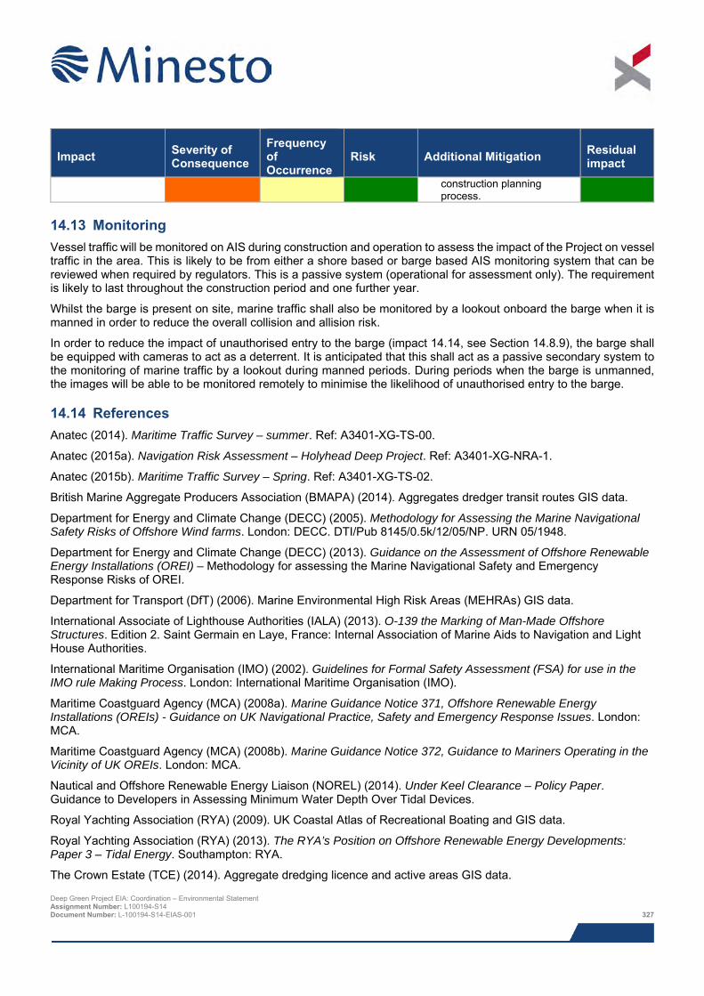
Impact Severity of Consequence
Frequency of Occurrence
Risk Additional Mitigation Residual impact
construction planning process.
14.13 Monitoring Vessel traffic will be monitored on AIS during construction and operation to assess the impact of the Project on vessel traffic in the area. This is likely to be from either a shore based or barge based AIS monitoring system that can be reviewed when required by regulators. This is a passive system (operational for assessment only). The requirement is likely to last throughout the construction period and one further year.
Whilst the barge is present on site, marine traffic shall also be monitored by a lookout onboard the barge when it is manned in order to reduce the overall collision and allision risk.
In order to reduce the impact of unauthorised entry to the barge (impact 14.14, see Section 14.8.9), the barge shall be equipped with cameras to act as a deterrent. It is anticipated that this shall act as a passive secondary system to the monitoring of marine traffic by a lookout during manned periods. During periods when the barge is unmanned, the images will be able to be monitored remotely to minimise the likelihood of unauthorised entry to the barge.
14.14 References Anatec (2014). Maritime Traffic Survey – summer. Ref: A3401-XG-TS-00.
Anatec (2015a). Navigation Risk Assessment – Holyhead Deep Project. Ref: A3401-XG-NRA-1.
Anatec (2015b). Maritime Traffic Survey – Spring. Ref: A3401-XG-TS-02.
British Marine Aggregate Producers Association (BMAPA) (2014). Aggregates dredger transit routes GIS data.
Department for Energy and Climate Change (DECC) (2005). Methodology for Assessing the Marine Navigational Safety Risks of Offshore Wind farms. London: DECC. DTI/Pub 8145/0.5k/12/05/NP. URN 05/1948.
Department for Energy and Climate Change (DECC) (2013). Guidance on the Assessment of Offshore Renewable Energy Installations (OREI) – Methodology for assessing the Marine Navigational Safety and Emergency Response Risks of OREI.
Department for Transport (DfT) (2006). Marine Environmental High Risk Areas (MEHRAs) GIS data.
International Associate of Lighthouse Authorities (IALA) (2013). O-139 the Marking of Man-Made Offshore Structures. Edition 2. Saint Germain en Laye, France: Internal Association of Marine Aids to Navigation and Light House Authorities.
International Maritime Organisation (IMO) (2002). Guidelines for Formal Safety Assessment (FSA) for use in the IMO rule Making Process. London: International Maritime Organisation (IMO).
Maritime Coastguard Agency (MCA) (2008a). Marine Guidance Notice 371, Offshore Renewable Energy Installations (OREIs) - Guidance on UK Navigational Practice, Safety and Emergency Response Issues. London: MCA.
Maritime Coastguard Agency (MCA) (2008b). Marine Guidance Notice 372, Guidance to Mariners Operating in the Vicinity of UK OREIs. London: MCA.
Nautical and Offshore Renewable Energy Liaison (NOREL) (2014). Under Keel Clearance – Policy Paper. Guidance to Developers in Assessing Minimum Water Depth Over Tidal Devices.
Royal Yachting Association (RYA) (2009). UK Coastal Atlas of Recreational Boating and GIS data.
Royal Yachting Association (RYA) (2013). The RYA’s Position on Offshore Renewable Energy Developments: Paper 3 – Tidal Energy. Southampton: RYA.
The Crown Estate (TCE) (2014). Aggregate dredging licence and active areas GIS data. Deep Green Project EIA: Coordination – Environmental Statement Assignment Number: L100194-S14 Document Number: L-100194-S14-EIAS-001 327

This page has been intentionally left blank.
Deep Green Project EIA: Coordination – Environmental Statement Assignment Number: L100194-S14 Document Number: L-100194-S14-EIAS-001 328
15 MARINE ARCHAEOLOGY AND CULTURAL HERITAGE
Data to inform this chapter was obtained via various archives databases including the UK Hydrographic Office, Cadw (the Welsh Government's historic environment service), Royal Commission on the Ancient and Historical Monuments of Wales, Gwynedd Archaeological Trust Historic Environment Record, and following geophysical survey of the Project Development Area (PDA).
There are few known archaeological features located within the footprint of the PDA; therefore this assessment will primarily focus on the potential archaeological resource that may exist but is not yet known. This chapter also evaluates the setting of terrestrial heritage assets whose setting may be affected by the proposed Project, and provides an overview of the seascape character of this area of Anglesey.
The archaeological resource discussed in this assessment is summarised as follows:
> Two cut and fill features of palaeogeographic potential;
> Potential for in situ or derived prehistoric archaeological material;
> Twenty-one geophysical anomalies of possible anthropogenic origin (A2s);
> Potential for shipwrecks dating from the Mesolithic to the modern period;
> Potential for aircraft crash sites and associated material dating from the 20th century and in particular to World War II; and
> Fourteen designated and five undesignated terrestrial heritage assets located within the Zone of Theoretical Visibility generated by the Project.
Mitigation strategies have been identified to avoid, reduce or minimise the potential for impact to heritage assets located in the PDA and to the setting of terrestrial sites situated within the Zone of Theoretical Visibility for the Project. The instigation of such strategies will ultimately reduce the impacts on marine cultural heritage and the setting of terrestrial sites, resulting in no significant impact.
Mitigation strategies include:
> Assessment of any palaeoenvironmental material recovered;
> Avoidance through micrositing of recorded unidentified geophysical anomalies;
> Implementation of a Protocol for Archaeological Discoveries for the reporting of archaeological discoveries made during the course of the Project; and
> Mitigation measures against visual impact on settings will concur with those as delivered in Chapter 16: SLVIA.
All aspects of any further archaeological work will be detailed within a Written Scheme of Investigation, which will be prepared prior to the initiation of any Project works.
15.1 Introduction This chapter of the Environmental Statement (ES) describes the existing environment with regard to Marine Archaeology and Cultural Heritage and assesses the potential impacts of the offshore components of the proposed DG Holyhead Deep Project (hereafter referred to as ‘the Project’).
The potential effects of the Project on offshore Marine Archaeology and Cultural Heritage are assessed in this section. The following specialists have contributed to the assessment:
> Bibby HydroMap – undertook offshore geophysical surveys using sidescan sonar, sub-bottom profiler, multibeam echosounder and magnetometer;
Deep Green Project EIA: Coordination – Environmental Statement Assignment Number: L100194-S14 Document Number: L-100194-S14-EIAS-001 329
> Wessex Archaeology – compiled the offshore marine archaeological desk-based assessment including an EIA,
analysed Bibby HydroMap’s geophysical survey data, and prepared this ES chapter; and
> SLR Consulting Limited – provided methodology and supporting drawings with reference to the Seascape, Landscape and Visual assessment.
Table 15.1 below provides a list of all the supporting studies that relate to the Marine Archaeology and Cultural Heritage impact assessment. All supporting studies are provided on the accompanying CD.
Table 15.1 Supporting studies
Details of study Deep Green Holyhead Deep Tidal Project – Offshore Marine Archaeological Desk-Based Assessment (Wessex Archaeology, 2015)
Geophysical Survey Operations Report (Bibby HydroMap, 2015a)
Offshore Geophysical Survey Report and associated geotechnical data (Bibby Hydromap, 2015b)
The impact assessment presented herein draws upon output from other impact assessments within this ES; where that information is used to inform assessment, reference to the relevant ES chapter is given.
The supporting Offshore Marine Archaeological Desk-Based Assessment (Wessex Archaeology, 2015), hereafter referred to as the ‘Offshore Archaeological DBA’, should be read in conjunction with this chapter. The Offshore Archaeological DBA comprised a desk-based study of the environmental baseline for offshore and intertidal archaeology alongside an analysis of available marine geophysical data within a study area that encompasses the PDA footprint and a potential export cable corridor to mean high water springs (MHWS). As the current application is concerned with a single DGU device only deployed in the PDA (and no grid connection onshore), only the issues associated with the PDA area are presented in this chapter. The Offshore Archaeological DBA has also included consideration of the local seascape of the study area, alongside an assessment of the setting of heritage assets with potential intervisibility with the Project.
This chapter presents a summary of the baseline environment detailed in the Offshore Archaeological DBA focussed on the PDA. It also provides an assessment of the potential impacts from the proposed Project (as defined in Chapter 5: Project Description) on both marine archaeological receptors and the setting of terrestrial heritage assets with respect to the proposed Project. Where appropriate, mitigation measures have been proposed to minimise the effects of potential impact.
15.2 Area of assessment The baseline study identified archaeological assets in the PDA (Wessex Archaeology, 2015). The focus of the impact assessment is the potential impacts on the marine archaeology and cultural heritage within the PDA footprint. Important receptors whose centre points are located beyond the PDA footprint but whose dimensions do intersect the PDA have also been included in the assessment.
The impact on setting of terrestrial heritage assets extends to the limit of the Zone of Theoretical Visibility (ZTV), the parameters of which have been provided by SLR Consulting, whereby intervisibility exists between heritage assets and the offshore components of the Project. Only the ZTV present within a 10 km buffer of the PDA footprint was assessed, as undertaken for the SLVIA (Chapter 16).
The potential effects of all direct impacts resulting from the proposed Project will be confined to the local archaeological resource (i.e. that in the immediate footprint of the PDA). The potential effects of the proposed Project upon the setting of heritage assets is considered in relation to the wider landscape, as defined by the ZTV. Potential cumulative effects have been reviewed within an arbitrary 3 km buffer of the PDA.
The following areas are referred to in this impact assessment:
> Project area (refer to Figure 1.2 in Chapter 1: Introduction), which comprises the proposed offshore device deployment area i.e. the PDA;
Deep Green Project EIA: Coordination – Environmental Statement Assignment Number: L100194-S14 Document Number: L-100194-S14-EIAS-001 330
> Geophysical survey area36 – shown in Figure 15.1;
> DBA Study Area – the area considerd in the DBA, which includes the PDA and potential future cable corridor associated with a potential future array of devices, plus a further 1 km buffer zone. The extent of the DBA Study Area is shown in Figure 15.1;
> Assessment of setting Study Area – this area comprises the ZTV generated by the proposed Project within a 10 km buffer area of the PDA footprint, as illustrated in Figure 15.1; and
> Cumulative assessment Study Area – an area extending 3 km from the footprint of the PDA, as illustrated in Figure 15.1.
15.3 Legislation, policy and guidance A summary of legislation and guidance relevant to the marine archaeological environment is outlined below. More comprehensive details are provided in the Offshore Archaeological DBA (Wessex Archaeology, 2015).
15.3.1 Global legislation and policy > The World Heritage Convention 1972 – provides for the identification, protection, conservation and presentation
of cultural and natural sites of ‘outstanding universal value’ for inscription on the World Heritage List. The Convention sets out the duties of States Parties in identifying potential sites and their role in protecting and preserving them. By signing the Convention, each country pledges to conserve not only the World Heritage sites situated on its territory, but also to protect its national heritage. The 1972 UNESCO World Heritage Convention was ratified by the UK in 1984 and the UK currently has 28 World Heritage Sites;
> United Nations Convention on the Law of the Sea 1982 – this was ratified by the UK in 1997. Article 303 stipulates that ‘states have the duty to protect objects of an archaeological and historical nature found at sea and shall co-operate for this purpose’. Article 303 also provides for coastal states to exert a degree of control over the archaeological heritage to 24 nautical miles, though the UK has not introduced any measures to implement this right;
> International Council of Monuments and Sites Charter on the Protection and Management of Underwater Cultural Heritage 1996 (the Sofia Charter) – the Charter upon which the Annex of the UNESCO Convention is largely based includes a series of statements regarding best practice, intending ‘to ensure that all investigations are explicit in their aims, methodology and anticipated results so that the intention of each project is transparent to all’. The UK is a member of the International Council of Monuments and Sites; and
> UNESCO Convention on the Protection of the Underwater Cultural Heritage 2001 – the UNESCO Convention was concluded in 2001, and is a comprehensive attempt to codify the law internationally with regards to underwater archaeological heritage. The UK abstained in the vote on the final draft of the Convention; however, it has stated that it has adopted the Annex of the Convention, which governs the conduct of archaeological investigations, as best practice for archaeology. Although the UK is not a signatory, the convention entered into force on 2nd January 2009 having been signed or ratified by 20 member states.
36 The geophysical survey area is larger than the area under consideration in this Chapter as it includes a potential future cable corridor for the potential future array. Only data relevant to the deployment of a single DGU in the PDA has been presented in this impact assessment. Deep Green Project EIA: Coordination – Environmental Statement Assignment Number: L100194-S14 Document Number: L-100194-S14-EIAS-001 331
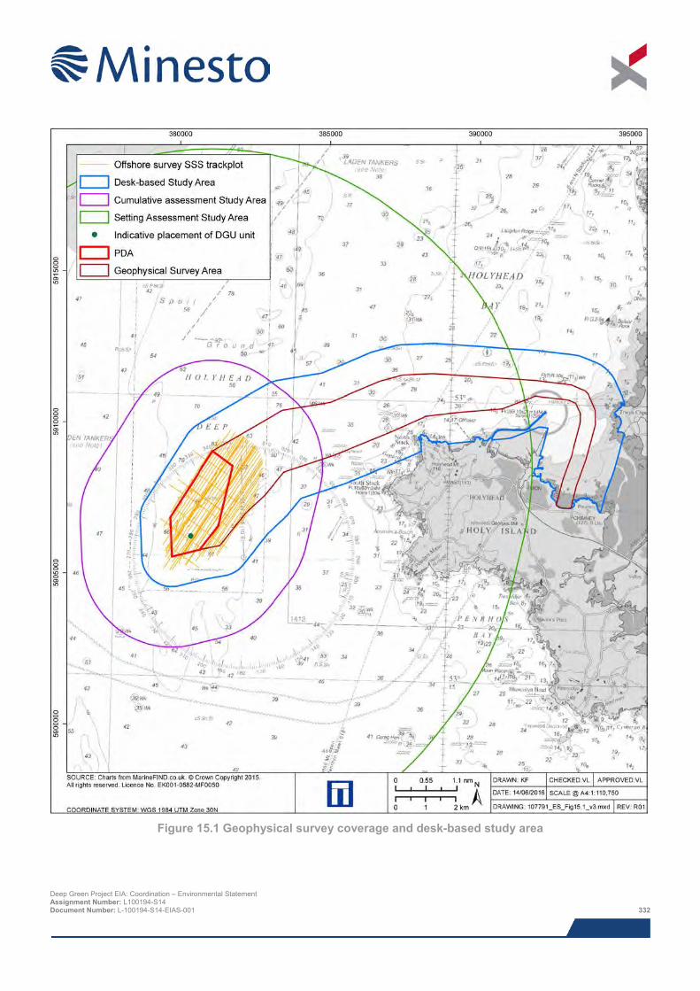
Figure 15.1 Geophysical survey coverage and desk-based study area
Deep Green Project EIA: Coordination – Environmental Statement Assignment Number: L100194-S14 Document Number: L-100194-S14-EIAS-001 332
15.3.2 European legislation and policy > European Convention on the Protection of the Archaeological Heritage (Revised) 1992 (the Valletta Convention)
– this was ratified by the UK Government in 2000 and came into force in 2001. The convention binds the UK to implement protective measures for the archaeological heritage within the jurisdiction of each party, including sea areas. Insofar as the UK exerts jurisdiction over the Continental Shelf, then it would appear that the provisions of the Valletta Convention apply to that jurisdiction; and
> European Landscape Convention 2000 – this became binding in the UK from 1st March 2007. Its principal clauses require the Government to protect and manage landscapes and to integrate landscape into regional and town planning policies including its cultural, environmental, agricultural, social and economic policies. The Convention applies to the entire territory of the UK and includes land, inland water and marine areas. It is not regarded as applying to sea areas regulated by the UK that lie beyond territorial waters.
15.3.3 UK legislation The PDA is located within the Welsh Territorial Sea (up to 12 nautical miles (nm) (22.2 km)) from the Welsh coast. Cadw (the Welsh Government's historic environment service) administers the responsibilities of the Ministers of the Welsh Assembly Government with regard to archaeological and built heritage matters, which extend offshore to the 12 nm (22.2 km) territorial limit. The relevant pieces of legislation from which direct responsibilities arise are as follows:
> The Protection of Wrecks Act 1973: Section One – wrecks and wreckage of historical, archaeological or artistic importance can be protected by way of designation. It is an offence to carry out certain activities in a defined area surrounding a wreck that has been designated, unless a licence for those activities has been obtained;
> The Protection of Wrecks Act 1973: Section Two – this provides protection for wrecks that are designated as dangerous due to their contents and is administered by the Maritime and Coastguard Agency (MCA) through the Receiver of Wreck (RoW);
> The Ancient Monuments and Archaeological Areas Act 1979 – a primarily land based Act, but in recent years it has also been used to provide some level of protection for underwater sites. Scheduled Monuments and Areas of Archaeological Importance are afforded statutory protection by the Secretary of State, and consent is required for any major works. The law is administered by Historic England and the Department of Culture, Media and Sport;
> The Merchant Shipping Act 1995 – this Act sets out the procedures for determining the ownership of underwater finds that turn out to be ‘wreck’, defined as any flotsam, jetsam, derelict and lagan found in or on the shores of the sea or any tidal water. It includes ship, aircraft, hovercraft, parts of these, their cargo or equipment. If any such finds are brought ashore, the salvor is required to give notice to the RoW that he/she has found or taken possession of them and, as directed by the Receiver, either hold them pending the Receiver’s order or deliver them to the Receiver. The act is administered by the MCA;
> The Protection of Military Remains Act 1996 – under this Act all aircraft that have crashed in military service are automatically protected. Maritime vessels lost during military service are not automatically protected although the Ministry of Defence (MoD) has powers to protect any vessel that was in military service when lost. The MoD can designate ‘controlled sites’ around wrecks whose position is known and can designate named vessels as ‘protected places’ even if the position of the wreck is not known. It is not necessary to demonstrate the presence of human remains at either ‘controlled sites’ or ‘protected places’;
> The Planning (Wales) Act 2015 – this Act was passed on the 6th July 2015 and makes provision for the preparation and revision of a new National Development Framework for Wales and the production of Strategic Development Plans. Although planning law only applies within the territory of local authorities, which generally extends only to Mean Low Water (MLW), Cadw is fully aware of the significance of seabed prehistory and submerged landscapes, and the importance of a seamless approach to protection;
Deep Green Project EIA: Coordination – Environmental Statement Assignment Number: L100194-S14 Document Number: L-100194-S14-EIAS-001 333
> The Future Generations Act 2015 – this defines sustainable development as ‘the process of improving the
economic, social, environmental and cultural well-being of Wales’ with the promotion and protection of culture as part of one of its seven well-being goals; and
> The Historic Environment (Wales) Act 2016 (further details are presented in 15.3.3.1) – this forms part of a suite of legislation, policy, advice and guidance that makes improvements to the existing systems for the protection and sustainable management of the Welsh historic environment.
There are four regional archaeological trusts in Wales that have advisory roles to Cadw; the Project area is covered by Gwynedd Archaeological Trust.
15.3.3.1 National Planning Policy in Wales and the Historic Environment (Wales) Act 2016 Although this ES is only concerned with the Project, terrestrial policy and legislation is relevant with regards to the setting of terrestrial cultural heritage assets.
Planning Policy Wales (PPW), edition 7, was published by the Welsh Government in March 2002 and updated in July 2014. This document is the principal national guidance on the importance, management and safeguarding of the historic environment within the planning process in Wales, and provides advice on all aspects of planning policy in Wales. PPW is supplemented by a series of Technical Advice Notes (TANs) and Circulars issued by the Welsh Office and the National Assembly of Wales. PPW, the TANs, Circulars and policy clarification letters comprise national planning policy in Wales.
The aforementioned Circulars, as well as Chapter 6 of PPW, will be updated in the light of forthcoming discussion on the historic environment, as part of the adoption of a new Historic Environment (Wales) Act 2016 and as part of the development of the new National Development Framework for Wales. The Historic Environment (Wales) Act became law on 21st March 2016. In conjunction with this Cadw have started to prepare several policy, advice and guidance documents relating to managing the historic environment which will be subject to amendment as the provisions of the Act alter and will be subject to full public consultation before adoption. This includes Technical Advice Note 24: Historic Environment which will provide guidance on local development plans, designated assets and archaeological remains
15.3.3.2 Welsh Maritime Policy Seas, Shores and Coastal Areas: Maritime Policy (Countryside Council for Wales, 1996) covers cultural heritage, historic landscapes and amenity issues. It also stresses the need for sustainable development and holistic management.
15.3.4 Guidance Relevant guidance for offshore development includes:
> The Code of Practice for Seabed Developers, Joint Nautical Archaeology Policy Committee (JNAPC, 2006);
> Historic Environment Guidance for the Offshore Renewable Energy Sector (Wessex Archaeology, 2007);
> Historic Environment Guidance for Wave and Tidal Energy (Firth, 2013);
> Guidance for Assessment of Cumulative Impacts on the Historic Environment from Offshore Renewable Energy (COWRIE, 2008); and
> Offshore Geotechnical Investigations and Historic Environment Analysis: Guidance for the Renewable Energy Sector (COWRIE, 2011).
15.3.4.1 2.4 Local planning policy and guidance In addition to the National and Local legislative framework, guidance relating to the proposed development within the marine historic environment has been published in Wales and in the UK. This assessment was undertaken in a manner consistent with available advice, including:
> Conservation Principles for the Sustainable Management of the Historic Environment in Wales (Cadw, 2011);
Deep Green Project EIA: Coordination – Environmental Statement Assignment Number: L100194-S14 Document Number: L-100194-S14-EIAS-001 334
> Guidelines for Landscape and Visual Impact Assessment, third edition (The Landscape Institute, 2013);
> Historic Environment Good Practice Advice in Planning Note 3 – The Setting of Heritage Assets (Historic England, 2015);
> Seeing the History in the View (Historic England, 2011);
> The Isle of Anglesey Area of Outstanding Natural Beauty – Management Plan Review 2015 – 2019 (IACC, 2015); and
> Standard and Guidance for Historic Environment Desk-based Assessment (Chartered Institute for Archaeologists, 2014).
15.4 Scoping and consultation Scoping and consultation have been on-going throughout the EIA and played an important part in ensuring the scope of the baseline characterisation work and impact assessment are appropriate to the Project and the requirements of the regulators and their advisors.
Minesto wrote to formally request a scoping opinion on 15th November 2013 in accordance with the Marine Works (Environmental Impact Assessment) Regulations 2007 (as amended) and the Electricity Works (Environmental Impact Assessment) Regulations (England and Wales) 2000 (as amended). The following organisations were contacted with regards to the Scoping Report, although not all responded:
> Advisory Committee on Historic Wrecks;
> Cadw;
> The Crown Estate;
> Gwynedd Archaeological Trust (GAT);
> IACC;
> Joint Nautical Archaeology Policy Committee;
> Maritime Coastguard Agency and Receiver of Wreck; and
> UK Hydrographic Office.
Relevant comments from the opinions provided by Natural Resources Wales (NRW) via the Marine Licencing Team (MLT), and the Marine Management Organisation (MMO) are summarised below.
In their response dating to 30th January 2014, the MMO confirms that the Project will require an EIA to identify potential environmental impacts arising during the construction, operation and maintenance on physical, biological and human receptors.
The MLT within NRW consulted the following organisations with historic environment interest that received the scoping opinion request:
> NRW;
> IACC;
> Maritime and Coastguard Agency;
> RCAHMW;
> Cadw; and
> The Crown Estate.
As a result the MLT recommended, in their response dating to 28th February 2014, that:
Deep Green Project EIA: Coordination – Environmental Statement Assignment Number: L100194-S14 Document Number: L-100194-S14-EIAS-001 335
> Historic environment assessments need to be conducted using Coflein (online access to National Monuments of
Wales) and Archwilio (online access to the Historic Environment Record of Gwynedd Archaeological Trust);
> Consultations on the historic environment must be undertaken with Cadw, the RCAHMW and GAT;
> Potential impacts on archaeology must include special consideration on the potential impacts of the tethering system and preparation of the seabed to accept the gravity based foundation. The potential impact of the installation and the operation of the device on archaeology must also be assessed (e.g. anchoring for Jack-up vessels); and
> New surveys may need to be undertaken with suitable coverage and resolution for archaeological assessment purposes, through discussion with Cadw and the RCAHMW.
In July 2014 the geophysical, geotechnical, benthic ecology and marine archaeology Scope of Work was sent to GAT, RCAHMW, and Wessex Archaeology for review; relevant responses are summarised below.
On 6th August 2014, GAT made the following comments:
> Including details of the archaeological contractor and how they will interact with the survey team;
> Using RCAHMW records;
> Using relevant HER data;
> Including more detail regarding how the geotechnical logs will be archaeologically reviewed; and
> Query regarding the implementation of an archaeological protocol for grab samples;
On 30th July 2014, the RCAHMW made the following comments regarding the Scope of Work:
> The Crown Estate Historic Environment Guidance Note for the Offshore Renewable Energy Sector and their archaeological guidelines for grab sampling should be used;
> Agree that the sidescan sonar resolution to 0.1 m should be used, as it will help pick up smaller archaeological objects;
> Suggest asking contractors to complete a 'box' of survey runs around any wreck sites;
> Advise that new wreck sites get video/stills coverage; and
> Query as to who is the appointed contractor.
On 26th August 2014, Wessex Archaeology made the following comments:
> The report contains no mention of a submerged prehistoric and palaeolandscape assessment, therefore the survey specifications should also include for the archaeological interpretation of sub-bottom profiler data;
> Current specification is acceptable for archaeological purposes, but is not acceptable for UXO;
> Comment on survey line spacing and recommendation of 200% survey coverage for archaeology;
> Suggested that the vibrocorer take duplicate cores with the second being retained unopened for archaeological/palaeoenvironmental purposes; and
> Seabed photography could be interpreted if deemed necessary.
Scoping advice was incorporated into the survey Scope of Work where appropriate for this stage of the ES, but the geotechnical aspects originally proposed were removed from the final survey scope, to be delayed until Minesto has a more detailed cable route (relevant to the potential future array only and not this application for a single DGU deployment in the PDA).
Following the Scoping Report request, Xodus wrote to formally request a Screening Opinion on 15th January 2015 in accordance with Regulation 5 of the Town and Country Planning (Environmental Impact Assessment) (England
Deep Green Project EIA: Coordination – Environmental Statement Assignment Number: L100194-S14 Document Number: L-100194-S14-EIAS-001 336
and Wales) Regulations 1999 (as amended). Comments from the IACC relevant to the Project are summarised below:
> Incorporate a Landscape and Seascape Character assessment and including possible cumulative impacts with other projects e.g. energy infrastructure proposals in the locality; and
> The significance of Landscape and Visual Effects would be assessed through a Landscape37 and Visual impact assessment and any ES will need to include a Landscape and Visual Impact Assessment (LVIA). The LVIA will need to follow the Guidelines for Landscape and Visual Impact Assessment. The LVIA should also have regard to the possible cumulative effects of the proposed Project with the area to be assessed.
With reference to SLVIA, Dave Jump from IACC made the following observation:
> The important outward views from Holyhead Mountain Conservation Area (CA) are towards the Holyhead Great Breakwater and Holyhead Bay beyond and that the rising Mountain between the edge of the CA and the deep water site actually screens from view the area of the Project site where the deep water kits will be submerged and the barge will be moored.
Public exhibitions were held at Holyhead Town Hall on 21st May 2015 and 26th January 2016, which gave the local community and stakeholders the opportunity to comment on all aspects of the Project and allowed for updates on the EIA to be provided.
15.5 Baseline description The baseline description for the marine historic environment was informed by a desk-based assessment whereby various sources of data relating to maritime and aviation losses were collated. These data was assessed alongside a series of geophysical surveys by Bibby HydroMap (refer to Section 15.1).
The synthesised results of this assessment are presented in the Offshore Archaeological DBA (Wessex Archaeology, 2015), and are summarised below and illustrated on Figure 15.2, Figure 15.4 and Figure 15.6 whereby each identified marine historic receptor and terrestrial heritage asset is located alongside its unique reference number preceded by WA (in the text only).
The main themes relevant to the marine archaeology and cultural heritage assessment are:
> Submerged prehistory;
> Seabed features, including maritime sites and aviation sites;
> Setting of heritage assets; and
> Seascape character.
15.5.1 Desk based study In order to inform the Offshore Archaeological DBA, the following sources were interrogated:
> UKHO records of wrecks and obstructions;
> Records from the National Monuments Record of Wales (NMRW) curated by the RCAHMW;
> Records from GAT Historic Environment Record (HER), comprising a database of all recorded archaeological sites, findspots, and archaeological events;
> Statutory designation datasets maintained by Cadw – no records are present in the PDA;
> Online historic environment resources, such as Coflein and Archwilio; and
> Relevant documentary sources and grey literature held by Wessex Archaeology.
37 Which in the case of this particular Project also includes seascape. Deep Green Project EIA: Coordination – Environmental Statement Assignment Number: L100194-S14 Document Number: L-100194-S14-EIAS-001 337
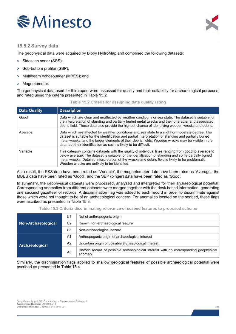
15.5.2 Survey data The geophysical data were acquired by Bibby HydroMap and comprised the following datasets:
> Sidescan sonar (SSS);
> Sub-bottom profiler (SBP);
> Multibeam echosounder (MBES); and
> Magnetometer.
The geophysical data used for this report were assessed for quality and their suitability for archaeological purposes, and rated using the criteria presented in Table 15.2.
Table 15.2 Criteria for assigning data quality rating
Data Quality Description Good Data which are clear and unaffected by weather conditions or sea state. The dataset is suitable for
the interpretation of standing and partially buried metal wrecks and their character and associated debris field. These data also provide the highest chance of identifying wooden wrecks and debris.
Average Data which are affected by weather conditions and sea state to a slight or moderate degree. The dataset is suitable for the identification and partial interpretation of standing and partially buried metal wrecks, and the larger elements of their debris fields. Wooden wrecks may be visible in the data, but their identification as such is likely to be difficult.
Variable This category contains datasets with the quality of individual lines ranging from good to average to below average. The dataset is suitable for the identification of standing and some partially buried metal wrecks. Detailed interpretation of the wrecks and debris field is likely to be problematic. Wooden wrecks are unlikely to be identified.
As a result, the SSS data have been rated as ‘Variable’, the magnetometer data have been rated as ‘Average’, the MBES data have been rated as ‘Good’, and the SBP (pinger) data have been rated as ‘Good’.
In summary, the geophysical datasets were processed, analysed and interpreted for their archaeological potential. Corresponding anomalies from different datasets were merged together with the desk based information, generating one succinct gazetteer of records. A discrimination flag was added to each record in order to discriminate against those which were not thought to be of an archaeological concern. For anomalies located on the seabed, these flags were ascribed as presented in Table 15.3.
Table 15.3 Criteria discriminating relevance of seabed features to proposed scheme
Non-Archaeological U1 Not of anthropogenic origin
U2 Known non-archaeological feature
U3 Non-archaeological hazard
Archaeological
A1 Anthropogenic origin of archaeological interest
A2 Uncertain origin of possible archaeological interest
A3 Historic record of possible archaeological interest with no corresponding geophysical anomaly
Similarly, the discrimination flags applied to shallow geological features of possible archaeological potential were ascribed as presented in Table 15.4.
Deep Green Project EIA: Coordination – Environmental Statement Assignment Number: L100194-S14 Document Number: L-100194-S14-EIAS-001 338
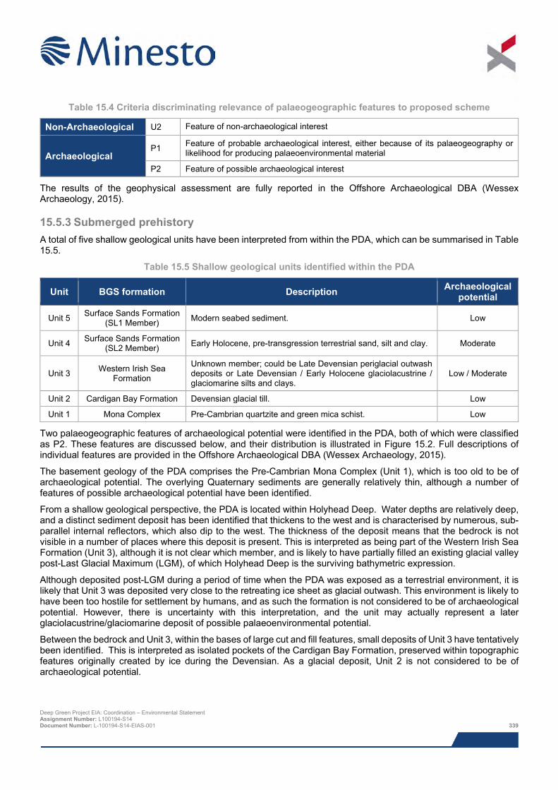
Table 15.4 Criteria discriminating relevance of palaeogeographic features to proposed scheme
Non-Archaeological U2 Feature of non-archaeological interest
Archaeological P1 Feature of probable archaeological interest, either because of its palaeogeography or
likelihood for producing palaeoenvironmental material
P2 Feature of possible archaeological interest
The results of the geophysical assessment are fully reported in the Offshore Archaeological DBA (Wessex Archaeology, 2015).
15.5.3 Submerged prehistory A total of five shallow geological units have been interpreted from within the PDA, which can be summarised in Table 15.5.
Table 15.5 Shallow geological units identified within the PDA
Unit BGS formation Description Archaeological potential
Unit 5 Surface Sands Formation (SL1 Member) Modern seabed sediment. Low
Unit 4 Surface Sands Formation (SL2 Member) Early Holocene, pre-transgression terrestrial sand, silt and clay. Moderate
Unit 3 Western Irish Sea Formation
Unknown member; could be Late Devensian periglacial outwash deposits or Late Devensian / Early Holocene glaciolacustrine / glaciomarine silts and clays.
Low / Moderate
Unit 2 Cardigan Bay Formation Devensian glacial till. Low
Unit 1 Mona Complex Pre-Cambrian quartzite and green mica schist. Low
Two palaeogeographic features of archaeological potential were identified in the PDA, both of which were classified as P2. These features are discussed below, and their distribution is illustrated in Figure 15.2. Full descriptions of individual features are provided in the Offshore Archaeological DBA (Wessex Archaeology, 2015).
The basement geology of the PDA comprises the Pre-Cambrian Mona Complex (Unit 1), which is too old to be of archaeological potential. The overlying Quaternary sediments are generally relatively thin, although a number of features of possible archaeological potential have been identified.
From a shallow geological perspective, the PDA is located within Holyhead Deep. Water depths are relatively deep, and a distinct sediment deposit has been identified that thickens to the west and is characterised by numerous, sub-parallel internal reflectors, which also dip to the west. The thickness of the deposit means that the bedrock is not visible in a number of places where this deposit is present. This is interpreted as being part of the Western Irish Sea Formation (Unit 3), although it is not clear which member, and is likely to have partially filled an existing glacial valley post-Last Glacial Maximum (LGM), of which Holyhead Deep is the surviving bathymetric expression.
Although deposited post-LGM during a period of time when the PDA was exposed as a terrestrial environment, it is likely that Unit 3 was deposited very close to the retreating ice sheet as glacial outwash. This environment is likely to have been too hostile for settlement by humans, and as such the formation is not considered to be of archaeological potential. However, there is uncertainty with this interpretation, and the unit may actually represent a later glaciolacustrine/glaciomarine deposit of possible palaeoenvironmental potential.
Between the bedrock and Unit 3, within the bases of large cut and fill features, small deposits of Unit 3 have tentatively been identified. This is interpreted as isolated pockets of the Cardigan Bay Formation, preserved within topographic features originally created by ice during the Devensian. As a glacial deposit, Unit 2 is not considered to be of archaeological potential.
Deep Green Project EIA: Coordination – Environmental Statement Assignment Number: L100194-S14 Document Number: L-100194-S14-EIAS-001 339
Two individual features interpreted as being Unit 4 were identified within the PDA (Figure 15.2). These were both interpreted as cut and fill features cut into either Unit 1, Unit 2 or Unit 3, and were interpreted as remnant terrestrial sediments deposited between the LGM and the Holocene transgression.
These features are generally characterised by a relatively poorly defined, shallow basal reflector and a single phase of chaotic or unstructured fill. They can be distinctly seen cutting into the underlying sediments (e.g. WA7501, Figure 15.3) and may be associated with older channel features.
These features were generally identified on more than one survey line, but do not appear to represent coherent, extensive channel features. As such, they are interpreted to be scattered pockets of terrestrial sediment and may contain a range of sediment fills, such as sand, silt and clay.
Due to the interpreted age and terrestrial nature of these sediments, they are considered to be of possible archaeological potential, and could contain both in situ and derived archaeological artefacts alongside preserved palaeoenvironmental material depending on the sediment type.
Unit 5 is the modern seabed sediment, which offshore generally comprises a thin veneer of sediment, although is worked into sand waves and ridges in isolated areas. As a modern deposit, Unit 5 is not considered to be of archaeological potential in itself, although it has the potential to cover wreck sites and other debris where it is worked into larger, mobile bedforms.
15.5.3.1 Potential for prehistoric archaeology Evidence of human occupation for in excess of 700,000 years has been previously recorded at sites around the UK (Parfitt et al., 2005, Parfitt et al., 2010). During this period of time, fluctuations in the relative sea level due to repeated glacial/interglacial cycles have likely resulted in the PDA being periodically sub-aerially exposed. This will have permitted the movement of Pleistocene animals and may have facilitated occupation and exploitation by early hominins (humans and their early ancestors).The presence of Palaeolithic cave sites along the North Wales coast indicate that such occupation of the area during times of low relative sea level was potentially possible.
By the Mesolithic period, gradual relative sea level rise would have probably placed much of the area either on the coastline or just offshore (Shennan and Horton, 2002). The Mesolithic record of the British Isles suggests a strong relationship between human activity and coasts, wetlands, rivers and streams. These areas provide rich sources of food and resources for these hunter/gatherer groups, as well as important transport routes inland or between islands. Any surviving sedimentary deposits from this period could potentially contain both in situ and derived artefacts from a time when these coastal and littoral landscapes, now submerged by the sea, were utilised intensively by human populations.
There are currently no known submerged prehistoric sites within the PDA. However, despite the erosive actions of glacial ice and outwash, and the marine transgressions that followed, there is the potential for archaeological evidence of these occupations within the PDA. The palaeogeographic interpretation has revealed five shallow geological units within the PDA, of which one (Unit 4) is of possible archaeological potential, and one (Unit 3) is of uncertain archaeological potential.
The uncertainty with the interpretation of Unit 3 arises from the known complexity of the Western Irish Sea Formation, which comprises three separate members (or facies) representing different time periods and depositional environments (Jackson et al., 1995).
The lowest facies (Chaotic Facies) is an unsorted deposit of mud, sand, cobbles and boulders, which likely formed during the LGM as an ice proximal glaciomarine or glaciolacustrine deposit. This age and environment indicate this facies is unlikely to be of archaeological potential. However, the interpreted Western Irish Sea Formation deposits identified within the study area are structured, containing numerous sub-parallel internal reflectors, not chaotic, and so are unlikely to represent the Chaotic Facies.
The middle facies (Prograded Facies) is a series of tabular stratified sands containing prograding reflectors which are generally found infilling previous erosive features, such as the Holyhead Deep. These are expected to be glacial outwash deposits created very close to the ice front during deglaciation, and again are not interpreted to be of archaeological potential. The Unit 3 deposits identified within the PDA appear to match the description of this facies most closely.
Deep Green Project EIA: Coordination – Environmental Statement Assignment Number: L100194-S14 Document Number: L-100194-S14-EIAS-001 340
However, the upper facies (Mud Facies) of the Western Irish Sea Formation is also characterised in seismic data by sub-parallel internal reflectors. This facies generally comprises silts and clays, and is interpreted as an ice distal glaciolacustrine or glaciomarine deposit. The facies often contains gas accumulations (not identified within the PDA), suggesting the presence of preserved organic material which may be of palaeoenvironmental importance.
It should be noted that no seabed sampling (e.g. borehole or vibrocore) logs have been consulted during this assessment, and the interpretation has been based on seismic character and previous (e.g. British Geological Survey) information alone. The sediment types present within the proposed stratigraphy and the identified features can only be confirmed by direct sampling. To determine the archaeological potential of Unit 3, it is proposed that the logs of any future borehole or vibrocore sampling be made available for assessment by a suitably qualified archaeologist, and any samples of interest be made available for geoarchaeological recording.
The nature of the two individual features of Unit 4 (7500 and 7501, Figure 15.2) identified within the PDA are similarly unconfirmed. Although it is more likely that they represent terrestrial deposits than Unit 3, and as such are considered of higher archaeological potential, the nature of the sediments within each feature is likely to differ. As such, it is again recommended that any logs from future seabed sampling be made available to Wessex Archaeology, and sample be made available for geoarchaeological recording if possible.
Deep Green Project EIA: Coordination – Environmental Statement Assignment Number: L100194-S14 Document Number: L-100194-S14-EIAS-001 341
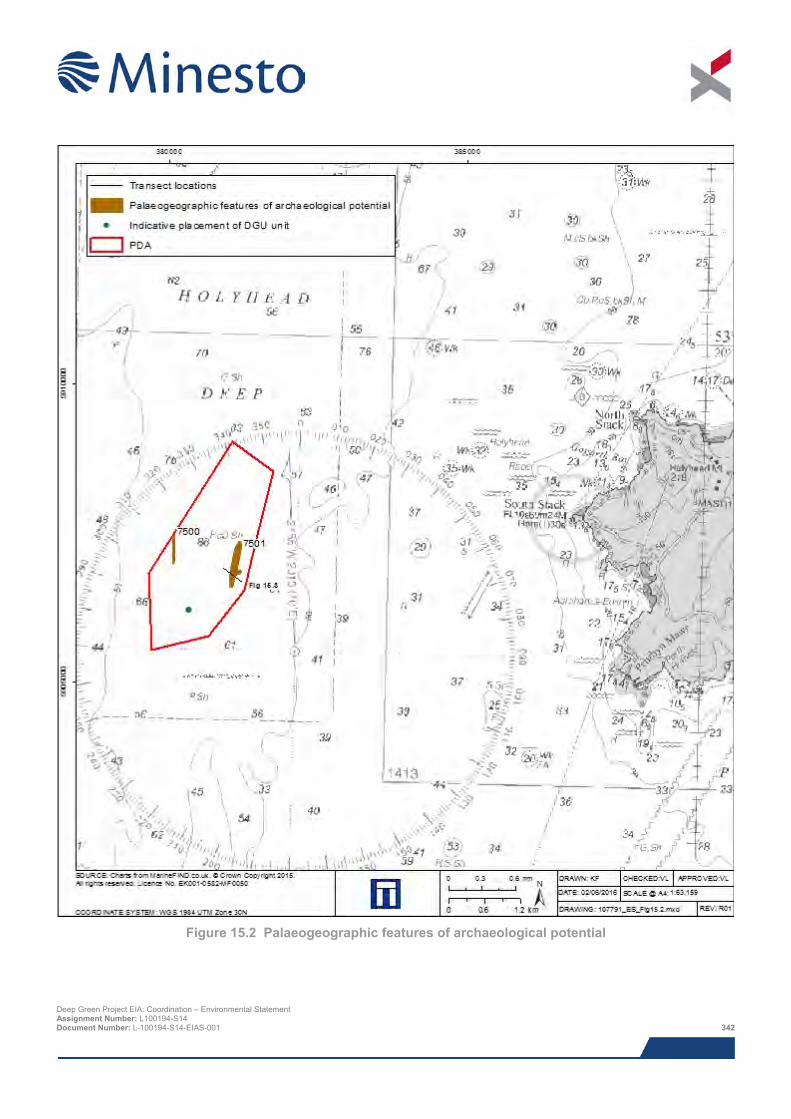
Figure 15.2 Palaeogeographic features of archaeological potential
Deep Green Project EIA: Coordination – Environmental Statement Assignment Number: L100194-S14 Document Number: L-100194-S14-EIAS-001 342
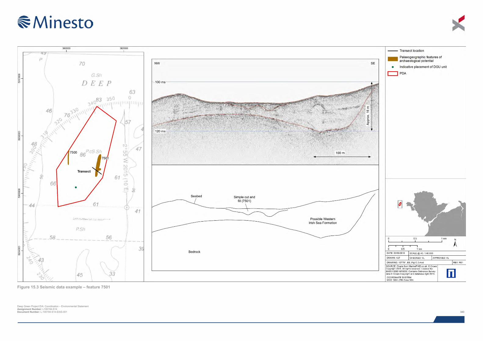
Figure 15.3 Seismic data example – feature 7501
Deep Green Project EIA: Coordination – Environmental Statement Assignment Number: L100194-S14 Document Number: L-100194-S14-EIAS-001 343

This page has been intentionally left blank.
Deep Green Project EIA: Coordination – Environmental Statement Assignment Number: L100194-S14 Document Number: L-100194-S14-EIAS-001 344
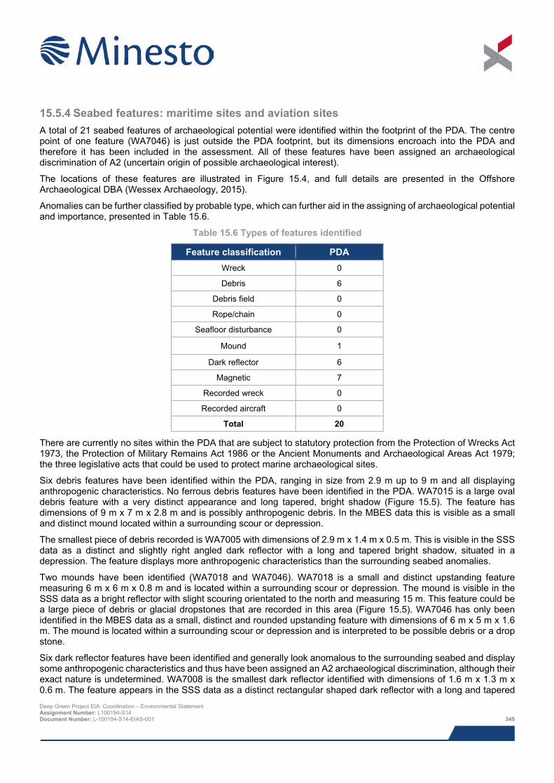
15.5.4 Seabed features: maritime sites and aviation sites A total of 21 seabed features of archaeological potential were identified within the footprint of the PDA. The centre point of one feature (WA7046) is just outside the PDA footprint, but its dimensions encroach into the PDA and therefore it has been included in the assessment. All of these features have been assigned an archaeological discrimination of A2 (uncertain origin of possible archaeological interest).
The locations of these features are illustrated in Figure 15.4, and full details are presented in the Offshore Archaeological DBA (Wessex Archaeology, 2015).
Anomalies can be further classified by probable type, which can further aid in the assigning of archaeological potential and importance, presented in Table 15.6.
Table 15.6 Types of features identified
Feature classification PDA Wreck 0
Debris 6
Debris field 0
Rope/chain 0
Seafloor disturbance 0
Mound 1
Dark reflector 6
Magnetic 7
Recorded wreck 0
Recorded aircraft 0
Total 20
There are currently no sites within the PDA that are subject to statutory protection from the Protection of Wrecks Act 1973, the Protection of Military Remains Act 1986 or the Ancient Monuments and Archaeological Areas Act 1979; the three legislative acts that could be used to protect marine archaeological sites.
Six debris features have been identified within the PDA, ranging in size from 2.9 m up to 9 m and all displaying anthropogenic characteristics. No ferrous debris features have been identified in the PDA. WA7015 is a large oval debris feature with a very distinct appearance and long tapered, bright shadow (Figure 15.5). The feature has dimensions of 9 m x 7 m x 2.8 m and is possibly anthropogenic debris. In the MBES data this is visible as a small and distinct mound located within a surrounding scour or depression.
The smallest piece of debris recorded is WA7005 with dimensions of 2.9 m x 1.4 m x 0.5 m. This is visible in the SSS data as a distinct and slightly right angled dark reflector with a long and tapered bright shadow, situated in a depression. The feature displays more anthropogenic characteristics than the surrounding seabed anomalies.
Two mounds have been identified (WA7018 and WA7046). WA7018 is a small and distinct upstanding feature measuring 6 m x 6 m x 0.8 m and is located within a surrounding scour or depression. The mound is visible in the SSS data as a bright reflector with slight scouring orientated to the north and measuring 15 m. This feature could be a large piece of debris or glacial dropstones that are recorded in this area (Figure 15.5). WA7046 has only been identified in the MBES data as a small, distinct and rounded upstanding feature with dimensions of 6 m x 5 m x 1.6 m. The mound is located within a surrounding scour or depression and is interpreted to be possible debris or a drop stone.
Six dark reflector features have been identified and generally look anomalous to the surrounding seabed and display some anthropogenic characteristics and thus have been assigned an A2 archaeological discrimination, although their exact nature is undetermined. WA7008 is the smallest dark reflector identified with dimensions of 1.6 m x 1.3 m x 0.6 m. The feature appears in the SSS data as a distinct rectangular shaped dark reflector with a long and tapered Deep Green Project EIA: Coordination – Environmental Statement Assignment Number: L100194-S14 Document Number: L-100194-S14-EIAS-001 345
bright shadow. The feature is situated in a slight depression and looks anomalous to the surrounding seabed (Figure 15.5).
The largest identified dark reflector feature is WA7007 with dimensions of 5.3 m x 0.2 m x 0.1 m. This is visible in the SSS data as a long, thin and linear feature with a distinct edge and short but well-defined shadow, this looks more anthropogenic than the surrounding seabed anomalies.
The magnetometer results across the entire survey area have been greatly affected by the geological conditions across the site. Strong north-west to south-east magnetic trends can be seen throughout the survey. These are caused by the highly magnetic Tertiary igneous dyke swarm that extends out from Holyhead into the Irish Sea. As a result of this identifying individual and small magnetic anomalies in the data is made difficult and potential anomalies of archaeological potential could be masked by background geological magnetic noise.
Seven magnetic anomalies have been identified in the PDA; these have no SSS or multibeam bathymetry seabed features associated with them, and as such have the potential to be buried ferrous debris and therefore have an A2 archaeological discrimination assigned to them. The magnetic anomalies range in size from 6 nT38 (WA7056) up to 17 nT (WA7050) and have been interpreted to be possible buried ferrous debris features. Furthermore, three of the magnetic anomalies (WA7055, WA7056 and WA7058) are located within 250 m of the proposed position for the kite centre point.
The potential for currently uncharted remains to exist within the PDA should not be discounted. It is conceivable that any number of the 21 geophysical anomalies classified as A2s may represent wreck or aircraft related debris, or equally be natural anomalies of no anthropogenic origin.
15.5.4.1 Potential for maritime sites There is potential for previously undiscovered shipwrecks dating from the Mesolithic period to the present day to be uncovered within the PDA. The UK has a long and illustrious maritime history; the result of a complex tapestry of maritime and coastal activities shaped by divergent forms of water transport and sea use since at least the Mesolithic period. Over time, considerable shipping activity is likely to have passed through the PDA, suggesting the potential for losses en-route. The potential for the discovery of unknown wrecks is fully explored in the Offshore Archaeological DBA (Wessex Archaeology, 2015).
The records for shipping losses provide additional documentary evidence for the potential discovery of sites and findspots relating to maritime activity within the PDA. Documentary losses represent potential loss locations and do not (except by chance) relate to actual seabed remains. Although there are no documented losses recorded within the PDA, there is the potential that some of the 21 geophysical anomalies of possible anthropogenic origin may represent wreck material relating, whereby their geophysical signatures were not clear enough to enable their nature to be fully understood. Although the potential exists that a number may represent wreckage or related debris, it is equally possible that they may also represent features of non-archaeological interest or non-anthropogenic origin.
15.5.4.2 Potential for aviation sites There is potential for the discovery of currently uncharted aircraft crash sites dating to the 20th and 21st centuries in the PDA. This potential is explored in greater detail in the Offshore Archaeological DBA (Wessex Archaeology, 2015).
In recent years, numerous aircraft wrecks have been discovered as a result of aggregate dredging operations and during survey work associated with wind farm development around the UK. It is becoming increasingly clear that these remains not only survive on the seabed, but are fairly widespread.
Although the records of aircraft losses at sea are extensive, they are seldom tied to exact locations. Aircraft remains on the seabed are also often ephemeral and not easily distinguishable in standard geophysical surveys. As a result, sites have historically been infrequently charted and identified.
The potential for modern aircraft remains to exist within the PDA is signified by the NMRW record relating to a Consolidated B-24J Liberator that was lost off Holyhead Mountain 22nd December 1944 after running out of fuel. The site is designated as a Protected Place under the Protection of Military Remains Act 1986.
38 Nano tesla; magnetic field strength measurement unit. Deep Green Project EIA: Coordination – Environmental Statement Assignment Number: L100194-S14 Document Number: L-100194-S14-EIAS-001 346
Any number of the currently unidentified 21 geophysical anomalies of possible anthropogenic origin could also represent the remains of crashed aircraft. Conversely these anomalies may represent anthropogenic anomalies of non-archaeological interest.
15.5.5 Setting of heritage assets The proposed Project will not have any impact on the setting of any of the marine heritage assets. The sites of these assets cannot be experienced from land and due to the generally limited visibility within UK waters, the experience of setting at the site is likely to be limited to the immediate vicinity. Therefore, the assessment of impact to the marine heritage assets will not be discussed further in this ES.
However, offshore energy projects do have the potential to alter the setting of terrestrial heritage assets and in accordance with Planning Policy Wales, edition 7, July 2014, Chapter 6: Conserving the Historic Environment, consideration should be given to the impact of development on the setting of heritage assets. Cadw’s Conservation Principles (2011) states that the setting of an asset comprises ‘the surroundings in which a historic asset is experienced in its local context, embracing present and past relationships to the adjacent landscape’.
Guidance on the assessment of potential development impacts on heritage assets in Wales has been prepared as part of the Historic Environment (Wales) Act 2016. Technical Advice Note 24 (TAN 24) provides an understanding of the policy, advice and guidance that complements the legislation. The document outlines a suggested approach to setting assessment. Key points from TAN 24 include:
> The definition of the setting of a historic asset is the surroundings in which it is experienced;
> Elements of a setting may make a positive or negative contribution to the significance of an asset, may affect the ability to appreciate that significance or may be neutral;
> Setting always forms part of the aesthetic value of a historic asset and can contribute to the other heritage values;
> Consideration needs to be given to how the proposed Project will appear in views out of and looking towards the historic asset, and in views where the proposed Project and the historic asset are juxtaposed;
> The assessment needs to be made by visiting significant viewpoints and visualising the form and appearance of the proposed Project within its landscape; and
> When making this assessment, the proposed situation will be compared to the existing and not against some past scenario.
Deep Green Project EIA: Coordination – Environmental Statement Assignment Number: L100194-S14 Document Number: L-100194-S14-EIAS-001 347
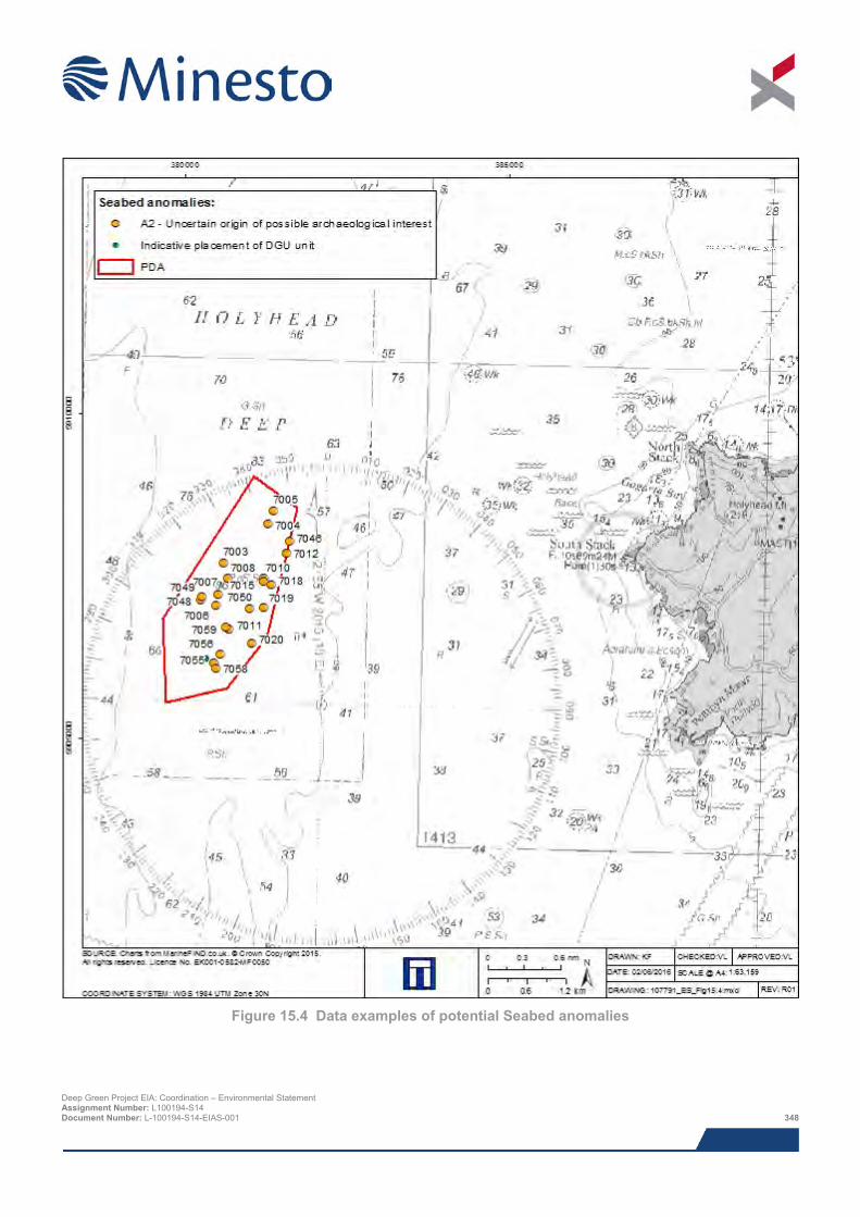
Figure 15.4 Data examples of potential Seabed anomalies
Deep Green Project EIA: Coordination – Environmental Statement Assignment Number: L100194-S14 Document Number: L-100194-S14-EIAS-001 348
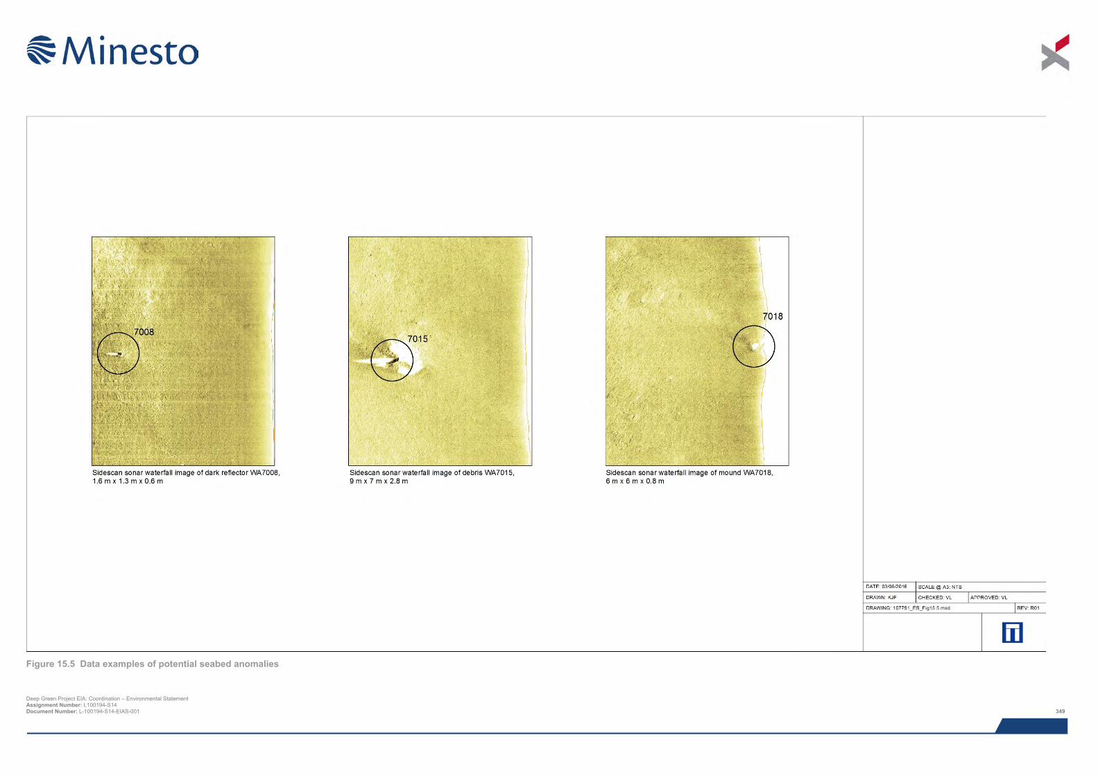
Figure 15.5 Data examples of potential seabed anomalies
Deep Green Project EIA: Coordination – Environmental Statement Assignment Number: L100194-S14 Document Number: L-100194-S14-EIAS-001 349

This page has been intentionally left blank.
Deep Green Project EIA: Coordination – Environmental Statement Assignment Number: L100194-S14 Document Number: L-100194-S14-EIAS-001 350
The assessment employed a GIS-based viewshed analysis in order to aid the identification of those designated heritage assets and relevant undesignated heritage assets whose setting may be affected by the Project proposals. Additional designated or undesignated heritage assets that were not highlighted by the viewshed analysis, but which nevertheless shared intervisibility with the PDA, or that may be affected by non-visual effects resulting from the proposed Project, were also included.
As a result of this exercise, the heritage assets that may be impacted by the Project include:
> Six prehistoric Scheduled Ancient Monuments (SAMs):
o Gogarth Bay round cairn (WA2001);
o Enclosed Hut Circle Settlement at Capel Llochwydd (WA2002);
o Caer y Twr hillfort (WA2003);
o Holyhead Mountain unenclosed hut circle settlement (WA2004);
o Dinas Porth Ruffydd hillfort (WA2005); and
o Penrhos Feilw standing stones (WA2006).
> Eight Grade II Listed Buildings:
o Enclosure walls at South Stack Lighthouse (WA2007);
o Storehouse at South Stack Lighthouse (WA2008);
o Former oil store at South Stack Lighthouse (WA2009);
o Former powder magazine for fog signalling station and enclosure walls (WA2010);
o South Stack Lighthouse and former keepers' accommodation (WA2011);
o Ellen's Tower (WA2012);
o Tan-Y-Cytiau, House (WA2013); and
o Ffynnon-Y-Wrach, Holy Well (WA2014).
> Five undesignated heritage assets:
o Holyhead Telegraph Station (WA2015);
o Capel Llochwydd (WA2016);
o Henborth Old Harbour (WA2017);
o Gorsedd Gwlwm Tumulus (WA2018); and
o Rectangular Structure, North Stack (WA2019).
The location of these heritage assets is illustrated on Figure 15.6.
Following the identification of potentially sensitive heritage receptors to the proposed Project, a site visit was undertaken. The visit enabled a full assessment of the potential impact on the assets and assessed whether other heritage assets may be impacted that were not previously identified. The site visit was carried out on 14th and 15th October 2015. The setting of the assets and relation to the area of sea occupied by the proposed Project was photographically recorded. The weather at the time of the survey was fine and visibility was good.
Photomontages produced as part of Chapter 16: SLVIA were used to support the settings assessment.
Deep Green Project EIA: Coordination – Environmental Statement Assignment Number: L100194-S14 Document Number: L-100194-S14-EIAS-001 351
15.5.6 Seascape Character Assessment 15.5.6.1 Anglesey Seascape Character Assessment In 2013, a local level Seascape Character Assessment was undertaken for the Anglesey/Snowdonia coastlines (Fiona Fyfe Associates with Countryside and Bangor University (SEACAMS), 2014) commissioned by IACC. The assessment divides the area into Seascape Character Types (SCTs) that are areas of recognisable character that occur across the Study Area, and Seascape Character Areas (SCAs) that are geographically-distinct areas with a unique sense of place, and comprise different combinations of SCTs (ibid.).
The PDA falls into one SCA: West of Anglesey (SCA 31). The SCA is summarised below with characteristics relevant to this assessment.
> Rocky seabed with moderate energy environment in the eastern part;
> Further offshore the seabed becomes deeper and dominated by sediment, although patches of rock remain;
> A treacherous coastline containing many offshore rocks and the patterns of wrecks reflect this, including wartime losses;
> Holyhead Mountain is a prominent landmark onshore and gives a strong sense of place and orientation; and
> There is a long and continuing tradition of maritime communications, particularly with Ireland.
15.5.6.2 Regional Seascape Assessment The PDA is situated within two Regional Seascape Units (RSUs): RSU 8 – Carmel Head to Holyhead Mountain and North Stack; and RSU 9 – Holyhead Mountain, North Stack to Penrhyn Mawr (Briggs and White, 2009). Each RSU is summarised below with characteristics relevant to this assessment.
> RSU 8 – Carmel Head to Holyhead Mountain and North Stack:
o Holyhead Mountain is the dominant landform with rocky cliffs around North Stack;
o Holyhead is a busy ferry port with a large harbour and protective seawall. The tall chimney stack of the aluminium smelter is prominent to the south of Holyhead;
o The west facing coastline is exposed but partly sheltered by Holy Island to the west and south;
o Views to and from respective landforms; and
o Principal cultural associations with the town and port of Holyhead and its links with Ireland.
> RSU 9 – Holyhead Mountain, North Stack to Penrhyn Mawr:
o An indented and precipitous west and north-west facing rocky coast with high cliffs backed by Holyhead Mountain and exposed island headlands;
o Semi-natural vegetation on Holyhead Mountain and Penrhyn Mawr with pastoral farming elsewhere;
o Limited settlement;
o The sea is exposed and open with large waves; and
o Long open views across the Irish Sea and from ferries.
Deep Green Project EIA: Coordination – Environmental Statement Assignment Number: L100194-S14 Document Number: L-100194-S14-EIAS-001 352
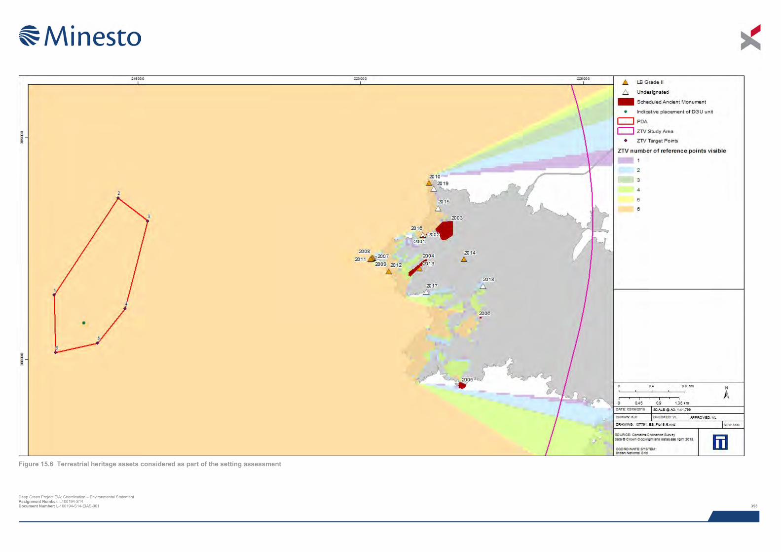
Figure 15.6 Terrestrial heritage assets considered as part of the setting assessment
Deep Green Project EIA: Coordination – Environmental Statement Assignment Number: L100194-S14 Document Number: L-100194-S14-EIAS-001 353

This page has been intentionally left blank.
Deep Green Project EIA: Coordination – Environmental Statement Assignment Number: L100194-S14 Document Number: L-100194-S14-EIAS-001 354
15.5.7 Summary of baseline environment The archaeological resource in the PDA is summarised as follows:
> Two cut and fill features of palaeogeographic potential;
> A total of 21 geophysical anomalies of possible anthropogenic origin (A2);
> Potential for in situ or derived prehistoric archaeological material across the PDA;
> Potential for shipwreck remains dating from the Mesolithic to the modern period;
> Potential for aircraft crash sites and associated material dating from the 20th century and in particular to World War II; and
> Fourteen designated terrestrial heritage assets and five undesignated heritage assets located within the ZTV, and whose setting may be affected by the proposed Project.
15.5.8 Data gaps and uncertainties 15.5.8.1 Archaeological records Data used to compile this report consists of primary geophysical survey data and secondary information derived from a variety of sources, only some of which have been directly examined for the purposes of this assessment. The assumption is made that the secondary data, as well as that derived from other secondary sources, is reasonably accurate.
The records held by the UKHO, Cadw, RCAHMW, GAT HER and other utilised sources are not a record of all surviving cultural heritage assets, rather a record of the discovery of a wide range of archaeological and historical components of the marine historic environment. The information held by these sources is not complete and does not preclude the subsequent discovery of further elements of the historic environment that are, at present, unknown. In particular this relates to sub-surface archaeological features.
15.5.8.2 Geophysical data The magnetometer results across the entire survey area have been greatly affected by the geological conditions present caused by the highly magnetic Tertiary igneous dyke swarm that extends out from Holyhead into the Irish Sea. As a result of this identifying individual and small magnetic anomalies in the data is made difficult and potential anomalies of archaeological potential could be masked by background geological magnetic noise.
No seabed sampling (e.g. borehole or vibrocore) logs have been consulted during this assessment, and the palaeogeographic interpretation was based on seismic character and previous (e.g. British Geological Survey) information alone. The sediment types present within the proposed stratigraphy and the identified features can only be confirmed by direct sampling.
15.6 Impact assessment
15.6.1 Overview The National Policy Statement for Renewable Energy Infrastructure (EN-3; Department of Energy and Climate Change, 2011) identified that heritage assets can be affected by offshore development in two ways:
> From the direct effect of the physical siting of the project; and
> From indirect changes to the physical marine environment.
The Historic Environment Guidance for Wave and Tidal Energy (Firth, 2013) considers that the most significant adverse effects of tidal energy development on the historic environment are likely to occur during the construction phase, but effects are also possible prior to construction, and during the operation and decommissioning phases.
Deep Green Project EIA: Coordination – Environmental Statement Assignment Number: L100194-S14 Document Number: L-100194-S14-EIAS-001 355

The nature of the effect listed above, and the types of impact that may occur during the construction, operation and decommissioning of the Project are discussed below. Cumulative impacts are discussed in Section 15.10.
15.6.1.1 Direct Archaeological receptors may be buried within seabed sediments or may rest upon the seafloor, either with or without height. As such, direct impacts to archaeological receptors can occur during any development or related activity that makes contact with the sea floor or cuts through seabed deposits. Archaeological receptors with height, such as wrecks, may also be impacted by development or activities that occur within the water column.
The implementation of the proposed Project is anticipated to entail the following sources of ground disturbance:
> Seabed preparation prior to the installation of DGU unit foundation;
> Installation of the DGU foundation using one of four options (Gravity Base Structure (GBS), pin piled tripod foundation, monopile foundation or mud mat foundation);
> Use of vessels’ anchors when mooring; and
> Increased marine traffic as a result of Project activities including the continuous presence of one barge (or similar such surface platform) for a period of up to five years that may cause loss of the visual integrity of a terrestrial designated or undesignated heritage asset.
15.6.1.2 Indirect Indirect impacts may occur as a result of changes to prevailing physical processes caused by the proposed Project. In general, receptors exposed to marine processes will deteriorate faster than those buried within seabed sediments.
Aspects of the Project that result in increased sediment cover may afford additional protection to receptors, thereby causing a positive beneficial effect.
Aspects of the Project that result in increased scouring or removal of sediment cover may expose previously buried receptors thereby increasing the rate of deterioration.
Potential indirect impacts include:
> Interruption of sediment transport causing potential increase or decrease in protection to an asset; and
> Effects of scouring at the site of the DGU unit foundation and the vessel anchors including the moored barge.
15.6.1.3 Scoped out impacts The potential for indirect impacts to affect the marine archaeology and cultural heritage assets, as a result of scouring or sediment dynamics, is not considered to be significant based on the results of the Physical Processes assessment (Chapter 9) and have therefore been scoped out of this assessment. The assessment concludes that the overall effect of impacts relevant to this assessment is within natural levels of variation and as a result the impact significance is not significant.
The decision to scope sediment deposition out of the marine archaeology assessment is based on the existing irregular seabed and highly energetic environment at the PDA that will result in minimal perceptible sediment deposition. Any changes to suspended sediment concentrations are likely to be temporary and intermittent, and will be quickly dispersed into the background levels.
Furthermore, the decision to scope scouring out of this assessment is based on the statement that since the seabed is highly dynamic and due to the water depth within the PDA the introduction of current induced scour will not result in any material changes to the seabed. Scour protection is recommended for use around the base of the DGU unit foundation positioned in soft sediment and this in turn will further protect potential marine archaeological assets present in the area from the effects of scour.
Deep Green Project EIA: Coordination – Environmental Statement Assignment Number: L100194-S14 Document Number: L-100194-S14-EIAS-001 356
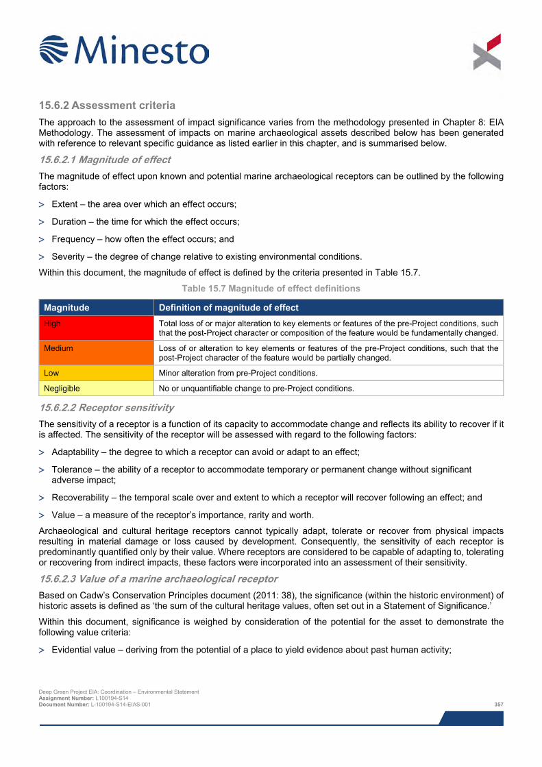
15.6.2 Assessment criteria The approach to the assessment of impact significance varies from the methodology presented in Chapter 8: EIA Methodology. The assessment of impacts on marine archaeological assets described below has been generated with reference to relevant specific guidance as listed earlier in this chapter, and is summarised below.
15.6.2.1 Magnitude of effect The magnitude of effect upon known and potential marine archaeological receptors can be outlined by the following factors:
> Extent – the area over which an effect occurs;
> Duration – the time for which the effect occurs;
> Frequency – how often the effect occurs; and
> Severity – the degree of change relative to existing environmental conditions.
Within this document, the magnitude of effect is defined by the criteria presented in Table 15.7.
Table 15.7 Magnitude of effect definitions
Magnitude Definition of magnitude of effect High Total loss of or major alteration to key elements or features of the pre-Project conditions, such
that the post-Project character or composition of the feature would be fundamentally changed.
Medium Loss of or alteration to key elements or features of the pre-Project conditions, such that the post-Project character of the feature would be partially changed.
Low Minor alteration from pre-Project conditions.
Negligible No or unquantifiable change to pre-Project conditions.
15.6.2.2 Receptor sensitivity The sensitivity of a receptor is a function of its capacity to accommodate change and reflects its ability to recover if it is affected. The sensitivity of the receptor will be assessed with regard to the following factors:
> Adaptability – the degree to which a receptor can avoid or adapt to an effect;
> Tolerance – the ability of a receptor to accommodate temporary or permanent change without significant adverse impact;
> Recoverability – the temporal scale over and extent to which a receptor will recover following an effect; and
> Value – a measure of the receptor’s importance, rarity and worth.
Archaeological and cultural heritage receptors cannot typically adapt, tolerate or recover from physical impacts resulting in material damage or loss caused by development. Consequently, the sensitivity of each receptor is predominantly quantified only by their value. Where receptors are considered to be capable of adapting to, tolerating or recovering from indirect impacts, these factors were incorporated into an assessment of their sensitivity.
15.6.2.3 Value of a marine archaeological receptor Based on Cadw’s Conservation Principles document (2011: 38), the significance (within the historic environment) of historic assets is defined as ‘the sum of the cultural heritage values, often set out in a Statement of Significance.’
Within this document, significance is weighed by consideration of the potential for the asset to demonstrate the following value criteria:
> Evidential value – deriving from the potential of a place to yield evidence about past human activity;
Deep Green Project EIA: Coordination – Environmental Statement Assignment Number: L100194-S14 Document Number: L-100194-S14-EIAS-001 357
> Historical value – deriving from the ways in which past people, events and aspects of life can be connected
through a place to the present. It tends to be illustrative or associative;
> Aesthetic value – deriving from the ways in which people draw sensory and intellectual stimulation from a place; and
> Communal value – deriving from the meanings of a place for the people who relate to it, or for whom it figures in their collective experience or memory. Communal values are closely bound up with historical (particularly associative) and aesthetic values, but tend to have additional and specific aspects.
In order to identify the heritage values of an asset, its history, fabric and character must be understood. Then the relative significance of the different values can be considered.
With regards to assessing the value of shipwrecks, the following criteria listed in Historic England’s Designation Selection Guide for Ships and Boats (2012) can be used to assess an asset in terms of its value:
> Period;
> Rarity;
> Documentation;
> Group value;
> Survival/condition; and
> Potential.
These aspects help to characterise each asset whilst also comparing them to other similar assets. The criteria also enable the potential to contribute to knowledge, understanding and outreach to be assessed.
The value of known archaeological and cultural heritage assets were assessed on a five point scale using professional judgement informed by criteria provided in Table 15.8 below.
Deep Green Project EIA: Coordination – Environmental Statement Assignment Number: L100194-S14 Document Number: L-100194-S14-EIAS-001 358
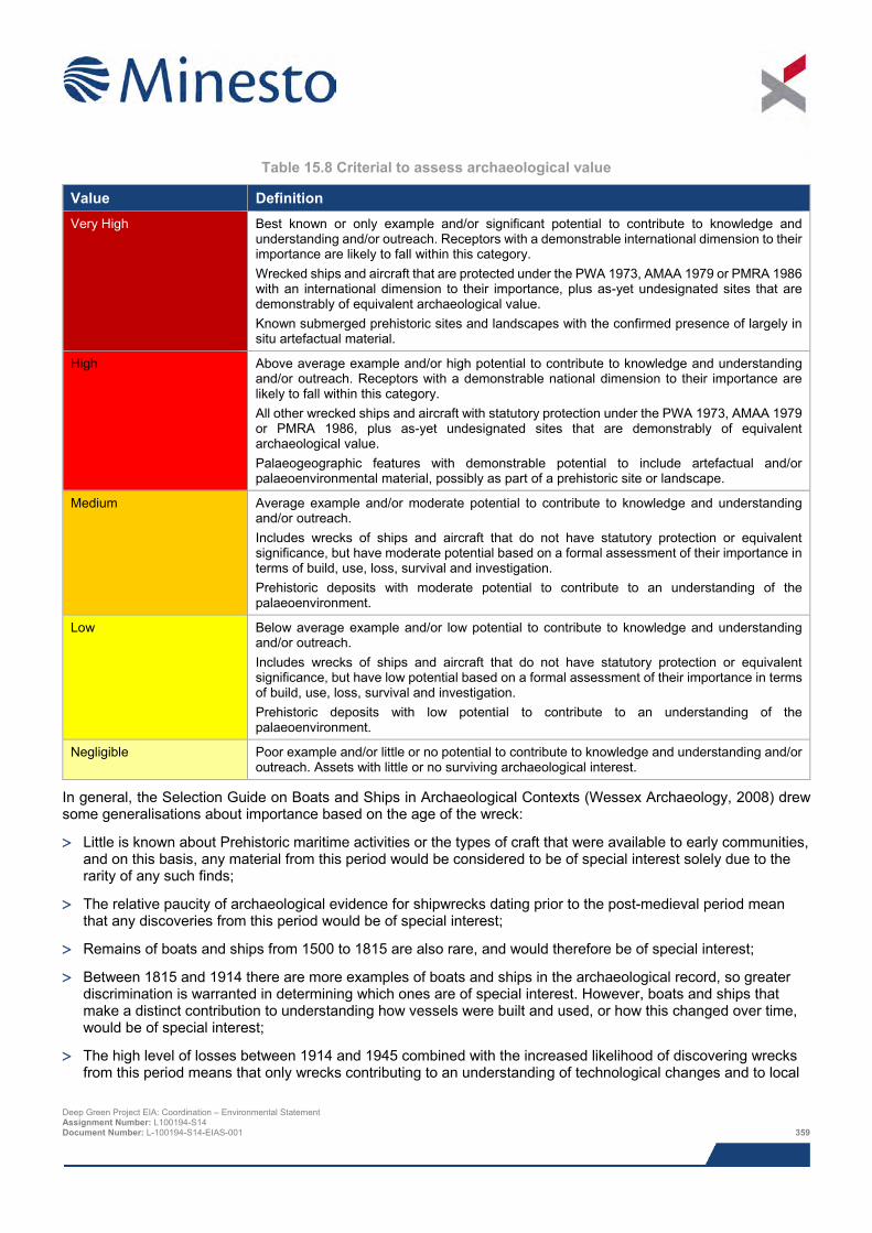
Table 15.8 Criterial to assess archaeological value
Value Definition Very High Best known or only example and/or significant potential to contribute to knowledge and
understanding and/or outreach. Receptors with a demonstrable international dimension to their importance are likely to fall within this category. Wrecked ships and aircraft that are protected under the PWA 1973, AMAA 1979 or PMRA 1986 with an international dimension to their importance, plus as-yet undesignated sites that are demonstrably of equivalent archaeological value. Known submerged prehistoric sites and landscapes with the confirmed presence of largely in situ artefactual material.
High Above average example and/or high potential to contribute to knowledge and understanding and/or outreach. Receptors with a demonstrable national dimension to their importance are likely to fall within this category. All other wrecked ships and aircraft with statutory protection under the PWA 1973, AMAA 1979 or PMRA 1986, plus as-yet undesignated sites that are demonstrably of equivalent archaeological value. Palaeogeographic features with demonstrable potential to include artefactual and/or palaeoenvironmental material, possibly as part of a prehistoric site or landscape.
Medium Average example and/or moderate potential to contribute to knowledge and understanding and/or outreach. Includes wrecks of ships and aircraft that do not have statutory protection or equivalent significance, but have moderate potential based on a formal assessment of their importance in terms of build, use, loss, survival and investigation. Prehistoric deposits with moderate potential to contribute to an understanding of the palaeoenvironment.
Low Below average example and/or low potential to contribute to knowledge and understanding and/or outreach. Includes wrecks of ships and aircraft that do not have statutory protection or equivalent significance, but have low potential based on a formal assessment of their importance in terms of build, use, loss, survival and investigation. Prehistoric deposits with low potential to contribute to an understanding of the palaeoenvironment.
Negligible Poor example and/or little or no potential to contribute to knowledge and understanding and/or outreach. Assets with little or no surviving archaeological interest.
In general, the Selection Guide on Boats and Ships in Archaeological Contexts (Wessex Archaeology, 2008) drew some generalisations about importance based on the age of the wreck:
> Little is known about Prehistoric maritime activities or the types of craft that were available to early communities, and on this basis, any material from this period would be considered to be of special interest solely due to the rarity of any such finds;
> The relative paucity of archaeological evidence for shipwrecks dating prior to the post-medieval period mean that any discoveries from this period would be of special interest;
> Remains of boats and ships from 1500 to 1815 are also rare, and would therefore be of special interest;
> Between 1815 and 1914 there are more examples of boats and ships in the archaeological record, so greater discrimination is warranted in determining which ones are of special interest. However, boats and ships that make a distinct contribution to understanding how vessels were built and used, or how this changed over time, would be of special interest;
> The high level of losses between 1914 and 1945 combined with the increased likelihood of discovering wrecks from this period means that only wrecks contributing to an understanding of technological changes and to local
Deep Green Project EIA: Coordination – Environmental Statement Assignment Number: L100194-S14 Document Number: L-100194-S14-EIAS-001 359
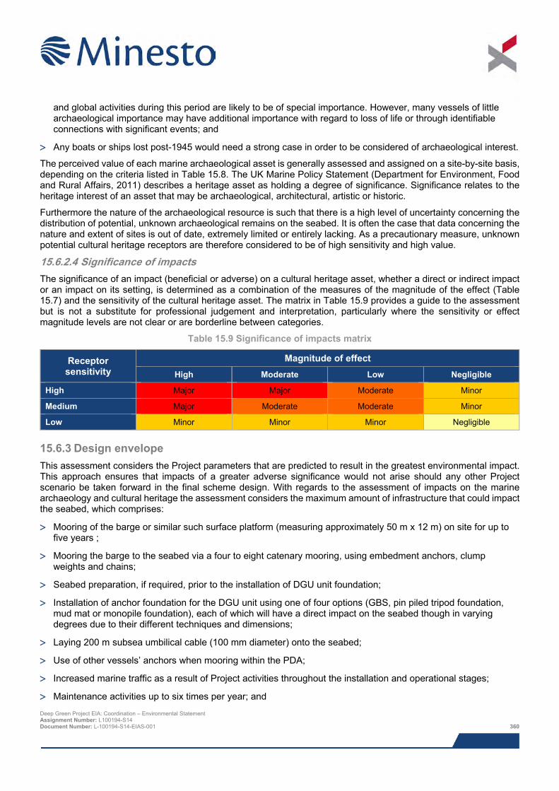
and global activities during this period are likely to be of special importance. However, many vessels of little archaeological importance may have additional importance with regard to loss of life or through identifiable connections with significant events; and
> Any boats or ships lost post-1945 would need a strong case in order to be considered of archaeological interest.
The perceived value of each marine archaeological asset is generally assessed and assigned on a site-by-site basis, depending on the criteria listed in Table 15.8. The UK Marine Policy Statement (Department for Environment, Food and Rural Affairs, 2011) describes a heritage asset as holding a degree of significance. Significance relates to the heritage interest of an asset that may be archaeological, architectural, artistic or historic.
Furthermore the nature of the archaeological resource is such that there is a high level of uncertainty concerning the distribution of potential, unknown archaeological remains on the seabed. It is often the case that data concerning the nature and extent of sites is out of date, extremely limited or entirely lacking. As a precautionary measure, unknown potential cultural heritage receptors are therefore considered to be of high sensitivity and high value.
15.6.2.4 Significance of impacts The significance of an impact (beneficial or adverse) on a cultural heritage asset, whether a direct or indirect impact or an impact on its setting, is determined as a combination of the measures of the magnitude of the effect (Table 15.7) and the sensitivity of the cultural heritage asset. The matrix in Table 15.9 provides a guide to the assessment but is not a substitute for professional judgement and interpretation, particularly where the sensitivity or effect magnitude levels are not clear or are borderline between categories.
Table 15.9 Significance of impacts matrix
Receptor sensitivity
Magnitude of effect High Moderate Low Negligible
High Major Major Moderate Minor
Medium Major Moderate Moderate Minor
Low Minor Minor Minor Negligible
15.6.3 Design envelope This assessment considers the Project parameters that are predicted to result in the greatest environmental impact. This approach ensures that impacts of a greater adverse significance would not arise should any other Project scenario be taken forward in the final scheme design. With regards to the assessment of impacts on the marine archaeology and cultural heritage the assessment considers the maximum amount of infrastructure that could impact the seabed, which comprises:
> Mooring of the barge or similar such surface platform (measuring approximately 50 m x 12 m) on site for up to five years ;
> Mooring the barge to the seabed via a four to eight catenary mooring, using embedment anchors, clump weights and chains;
> Seabed preparation, if required, prior to the installation of DGU unit foundation;
> Installation of anchor foundation for the DGU unit using one of four options (GBS, pin piled tripod foundation, mud mat or monopile foundation), each of which will have a direct impact on the seabed though in varying degrees due to their different techniques and dimensions;
> Laying 200 m subsea umbilical cable (100 mm diameter) onto the seabed;
> Use of other vessels’ anchors when mooring within the PDA;
> Increased marine traffic as a result of Project activities throughout the installation and operational stages;
> Maintenance activities up to six times per year; and Deep Green Project EIA: Coordination – Environmental Statement Assignment Number: L100194-S14 Document Number: L-100194-S14-EIAS-001 360
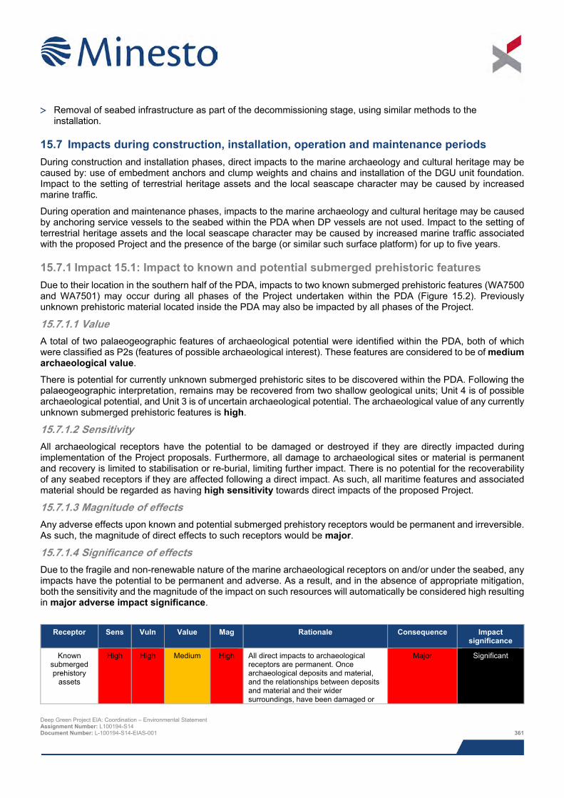
> Removal of seabed infrastructure as part of the decommissioning stage, using similar methods to the
installation.
15.7 Impacts during construction, installation, operation and maintenance periods During construction and installation phases, direct impacts to the marine archaeology and cultural heritage may be caused by: use of embedment anchors and clump weights and chains and installation of the DGU unit foundation. Impact to the setting of terrestrial heritage assets and the local seascape character may be caused by increased marine traffic.
During operation and maintenance phases, impacts to the marine archaeology and cultural heritage may be caused by anchoring service vessels to the seabed within the PDA when DP vessels are not used. Impact to the setting of terrestrial heritage assets and the local seascape character may be caused by increased marine traffic associated with the proposed Project and the presence of the barge (or similar such surface platform) for up to five years.
15.7.1 Impact 15.1: Impact to known and potential submerged prehistoric features Due to their location in the southern half of the PDA, impacts to two known submerged prehistoric features (WA7500 and WA7501) may occur during all phases of the Project undertaken within the PDA (Figure 15.2). Previously unknown prehistoric material located inside the PDA may also be impacted by all phases of the Project.
15.7.1.1 Value A total of two palaeogeographic features of archaeological potential were identified within the PDA, both of which were classified as P2s (features of possible archaeological interest). These features are considered to be of medium archaeological value.
There is potential for currently unknown submerged prehistoric sites to be discovered within the PDA. Following the palaeogeographic interpretation, remains may be recovered from two shallow geological units; Unit 4 is of possible archaeological potential, and Unit 3 is of uncertain archaeological potential. The archaeological value of any currently unknown submerged prehistoric features is high.
15.7.1.2 Sensitivity All archaeological receptors have the potential to be damaged or destroyed if they are directly impacted during implementation of the Project proposals. Furthermore, all damage to archaeological sites or material is permanent and recovery is limited to stabilisation or re-burial, limiting further impact. There is no potential for the recoverability of any seabed receptors if they are affected following a direct impact. As such, all maritime features and associated material should be regarded as having high sensitivity towards direct impacts of the proposed Project.
15.7.1.3 Magnitude of effects Any adverse effects upon known and potential submerged prehistory receptors would be permanent and irreversible. As such, the magnitude of direct effects to such receptors would be major.
15.7.1.4 Significance of effects Due to the fragile and non-renewable nature of the marine archaeological receptors on and/or under the seabed, any impacts have the potential to be permanent and adverse. As a result, and in the absence of appropriate mitigation, both the sensitivity and the magnitude of the impact on such resources will automatically be considered high resulting in major adverse impact significance.
Receptor Sens Vuln Value Mag Rationale Consequence Impact
significance
Known submerged prehistory
assets
High High Medium High All direct impacts to archaeological receptors are permanent. Once archaeological deposits and material, and the relationships between deposits and material and their wider surroundings, have been damaged or
Major Significant
Deep Green Project EIA: Coordination – Environmental Statement Assignment Number: L100194-S14 Document Number: L-100194-S14-EIAS-001 361
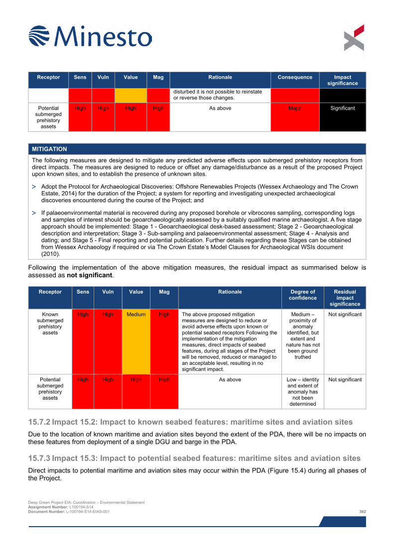
Receptor Sens Vuln Value Mag Rationale Consequence Impact
significance disturbed it is not possible to reinstate or reverse those changes.
Potential submerged prehistory
assets
High High High High As above Major Significant
MITIGATION
The following measures are designed to mitigate any predicted adverse effects upon submerged prehistory receptors from direct impacts. The measures are designed to reduce or offset any damage/disturbance as a result of the proposed Project upon known sites, and to establish the presence of unknown sites.
> Adopt the Protocol for Archaeological Discoveries: Offshore Renewables Projects (Wessex Archaeology and The Crown Estate, 2014) for the duration of the Project; a system for reporting and investigating unexpected archaeological discoveries encountered during the course of the Project; and
> If palaeoenvironmental material is recovered during any proposed borehole or vibrocores sampling, corresponding logs and samples of interest should be geoarchaeologically assessed by a suitably qualified marine archaeologist. A five stage approach should be implemented: Stage 1 - Geoarchaeological desk-based assessment; Stage 2 - Geoarchaeological description and interpretation; Stage 3 - Sub-sampling and palaeoenvironmental assessment; Stage 4 - Analysis and dating; and Stage 5 - Final reporting and potential publication. Further details regarding these Stages can be obtained from Wessex Archaeology if required or via The Crown Estate’s Model Clauses for Archaeological WSIs document (2010).
Following the implementation of the above mitigation measures, the residual impact as summarised below is assessed as not significant.
Receptor Sens Vuln Value Mag Rationale Degree of confidence
Residual impact
significance
Known submerged prehistory
assets
High High Medium High The above proposed mitigation measures are designed to reduce or avoid adverse effects upon known or potential seabed receptors Following the implementation of the mitigation measures, direct impacts of seabed features, during all stages of the Project will be removed, reduced or managed to an acceptable level, resulting in no significant impact.
Medium – proximity of
anomaly identified, but
extent and nature has not been ground
truthed
Not significant
Potential submerged prehistory
assets
High High High High As above Low – identity and extent of anomaly has
not been determined
Not significant
15.7.2 Impact 15.2: Impact to known seabed features: maritime sites and aviation sites Due to the location of known maritime and aviation sites beyond the extent of the PDA, there will be no impacts on these features from deployment of a single DGU and barge in the PDA.
15.7.3 Impact 15.3: Impact to potential seabed features: maritime sites and aviation sites Direct impacts to potential maritime and aviation sites may occur within the PDA (Figure 15.4) during all phases of the Project.
Deep Green Project EIA: Coordination – Environmental Statement Assignment Number: L100194-S14 Document Number: L-100194-S14-EIAS-001 362
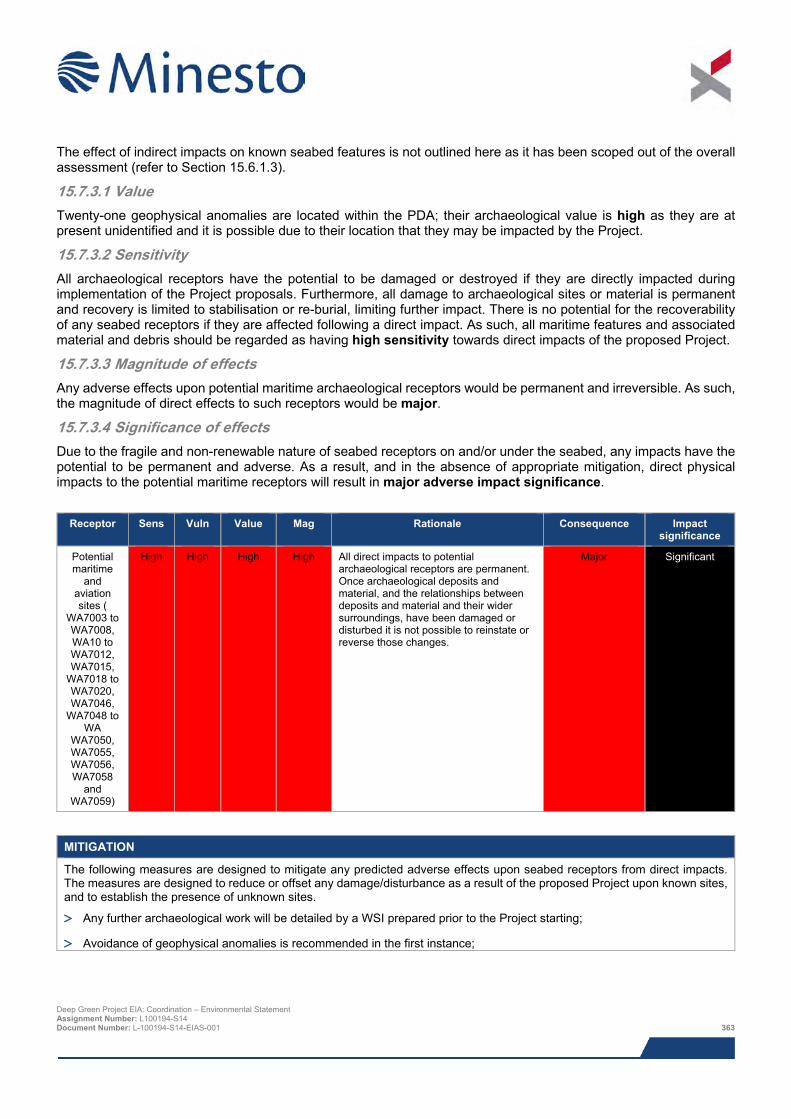
The effect of indirect impacts on known seabed features is not outlined here as it has been scoped out of the overall assessment (refer to Section 15.6.1.3).
15.7.3.1 Value Twenty-one geophysical anomalies are located within the PDA; their archaeological value is high as they are at present unidentified and it is possible due to their location that they may be impacted by the Project.
15.7.3.2 Sensitivity All archaeological receptors have the potential to be damaged or destroyed if they are directly impacted during implementation of the Project proposals. Furthermore, all damage to archaeological sites or material is permanent and recovery is limited to stabilisation or re-burial, limiting further impact. There is no potential for the recoverability of any seabed receptors if they are affected following a direct impact. As such, all maritime features and associated material and debris should be regarded as having high sensitivity towards direct impacts of the proposed Project.
15.7.3.3 Magnitude of effects Any adverse effects upon potential maritime archaeological receptors would be permanent and irreversible. As such, the magnitude of direct effects to such receptors would be major.
15.7.3.4 Significance of effects Due to the fragile and non-renewable nature of seabed receptors on and/or under the seabed, any impacts have the potential to be permanent and adverse. As a result, and in the absence of appropriate mitigation, direct physical impacts to the potential maritime receptors will result in major adverse impact significance.
Receptor Sens Vuln Value Mag Rationale Consequence Impact
significance
Potential maritime
and aviation sites (
WA7003 to WA7008, WA10 to WA7012, WA7015,
WA7018 to WA7020, WA7046,
WA7048 to WA
WA7050, WA7055, WA7056, WA7058
and WA7059)
High High High High All direct impacts to potential archaeological receptors are permanent. Once archaeological deposits and material, and the relationships between deposits and material and their wider surroundings, have been damaged or disturbed it is not possible to reinstate or reverse those changes.
Major Significant
MITIGATION
The following measures are designed to mitigate any predicted adverse effects upon seabed receptors from direct impacts. The measures are designed to reduce or offset any damage/disturbance as a result of the proposed Project upon known sites, and to establish the presence of unknown sites.
> Any further archaeological work will be detailed by a WSI prepared prior to the Project starting;
> Avoidance of geophysical anomalies is recommended in the first instance;
Deep Green Project EIA: Coordination – Environmental Statement Assignment Number: L100194-S14 Document Number: L-100194-S14-EIAS-001 363
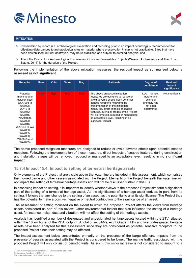
MITIGATION
> Preservation by record (i.e. archaeological excavation and recording prior to an impact occurring) is recommended for offsetting disturbances to archaeological sites or material where preservation in situ is not practicable. Sites that have been destabilised, but not destroyed, may be re-stabilised and subject to detailed analysis; and
> Adopt the Protocol for Archaeological Discoveries: Offshore Renewables Projects (Wessex Archaeology and The Crown Estate, 2014) for the duration of the Project.
Following the implementation of the above mitigation measures, the residual impact as summarised below is assessed as not significant.
Receptor Sens Vuln Value Mag Rationale Degree of confidence
Residual impact
significance
Potential maritime and aviation sites (WA7003 to
WA7008, WA10 to WA7012, WA7015,
WA7018 to WA7020, WA7046,
WA7048 to WA WA7050, WA7055, WA7056,
WA7058 and WA7059)
High High High High The above proposed mitigation measures are designed to reduce or avoid adverse effects upon potential seabed receptors Following the implementation of the mitigation measures, direct impacts of seabed features, during all stages of the Project will be removed, reduced or managed to an acceptable level, resulting in no significant impact.
Low – identity, nature and extent of
anomaly has not been
determined
Not significant
The above proposed mitigation measures are designed to reduce or avoid adverse effects upon potential seabed receptors. Following the implementation of these measures, direct impacts of seabed features, during construction and installation stages will be removed, reduced or managed to an acceptable level, resulting in no significant impact.
15.7.4 Impact 15.4: Impact to setting of terrestrial heritage assets Only elements of the Project that are visible above the water line are included in this assessment, which comprises the moored barge and other vessels associated with the Project. Elements of the Project beneath the water line will not impact the setting of terrestrial heritage assets and will not be discussed further in this ES.
In assessing impact on setting, it is important to identify whether views to the proposed Project site form a significant part of the setting of a terrestrial heritage asset. As the significance of a heritage asset derives, in part, from its setting, it follows that any change to the setting of an asset has the potential to alter its significance. The Project thus has the potential to make a positive, negative or neutral contribution to the significance of an asset.
The assessment of setting focussed on the extent to which the proposed Project affects the views from heritage assets considered as part of this review. Other environmental factors that also influence the setting of a heritage asset, for instance, noise, dust and vibration, will not affect the setting of the heritage assets.
Analysis has identified a number of designated and undesignated heritage assets located within the ZTV, situated within the 10 km buffer of the PDA footprint. A total of six SAMs, eight Grade II LBs and five undesignated heritage assets have been analysed for this assessment since they are considered as potential sensitive receptors to the proposed Project since their setting may be affected.
The impact assessment below concentrates primarily on the presence of the barge offshore. Impacts from the presence of vessels associated with the Project is considered to be lower. The marine traffic associated with the proposed Project will only consist of periodic visits. As such, this minor increase is not considered to amount to a Deep Green Project EIA: Coordination – Environmental Statement Assignment Number: L100194-S14 Document Number: L-100194-S14-EIAS-001 364
change to the setting of any of the heritage receptors assessed. Marine traffic already exists in the sea off the west coast of Holy Island and therefore a small amount of very occasional additional traffic would not constitute a change in the character or appearance of this setting.
The heritage assets assessed are described in the Offshore Archaeological DBA (Wessex Archaeology, 2015).
15.7.4.1 Value The archaeological value of the six SAMs is considered to be high due to their important designation, whereas the value of the eight LBs is considered to be medium. The archaeological value of the undesignated sites ranges from low to medium.
15.7.4.2 Sensitivity The effect of the presence of the barge is temporary (up to five years). The effect is also, and with regard to terrestrial heritage assets, entirely non-physical. Therefore any change to the setting of the heritage assets that causes harm to the value of an asset, even that of a high magnitude, is entirely reversible. The recovery would be instantaneous with the cessation of construction activity. Consequently the sensitivity of all the heritage assets assessed is considered to be low.
15.7.4.3 Magnitude of effect The magnitude of effect of the Project on the value of heritage assets through change to their setting was assessed during the walkover survey. The walkover survey concluded that of the 19 heritage assets assessed, the Project would result in a change to the setting of seven. TAN 24 states that for any development within the setting of a historic asset certain factors need to be considered and weighed in the assessment. These include the expected lifespan of the Project which in the case of the Project primarily consists of the barge being utilised for up to five years. Effects will occur throughout this maximum five year period but following the removal of the barge the effects will cease.
A detailed discussion of the effects of the of the Project on the settings of the heritage assets with reference to the SLVIA photomontages is given in the Offshore Archaeological DBA (Wessex Archaeology, 2015)
The SLVIA chapter (Chapter 16) determined that the proposed moored barge would only comprise a small element of the overall view obtained from the terrestrial landscape, and as a result the likelihood of significant effects occurring in relation to seascape, landscape and visual receptors are remote. Therefore it has been concluded that the magnitude of effect for heritage assets with the Project in their setting would be negligible; these sites are located between 5.6 km and 7.4 km from the eastern extent of the PDA. For the remaining heritage assets for which the Project is not in their setting the magnitude of effect was considered to be none; these are located between 5.6 km and 8 km from the eastern extent of the PDA. The assets are listed in the table below.
15.7.4.4 Significance of effect A negligible magnitude of effect was identified for the SAM the Gogarth Bay Cairn (WA2001) a heritage asset of high significance. As such the significance of effect will be Minor.
A negligible magnitude of effect was identified for the SAM the Caer y Twr Hillfort (WA2003) a heritage asset of high significance. As such the significance of effect will be Minor.
A negligible magnitude of effect was identified for the SAM the Holyhead Mountain unenclosed hut circle settlement (WA2004) a heritage asset of high significance. As such the significance of effect will be Minor.
A negligible magnitude of effect was identified for the Grade II LB South Stack Lighthouse (WA2011) a heritage asset of medium significance. As such the significance of effect on this asset will be Minor.
A negligible magnitude of effect was identified for the Grade II LB Ellen’s Tower (WA2012) a heritage asset of medium significance. As such the significance of effect on this asset will be Minor.
A negligible magnitude of effect was identified for the Grade II LB the former powder magazine for a fog signalling station and enclosure walls (WA2010) a heritage asset of medium significance. As such the significance of effect will be Minor.
Deep Green Project EIA: Coordination – Environmental Statement Assignment Number: L100194-S14 Document Number: L-100194-S14-EIAS-001 365
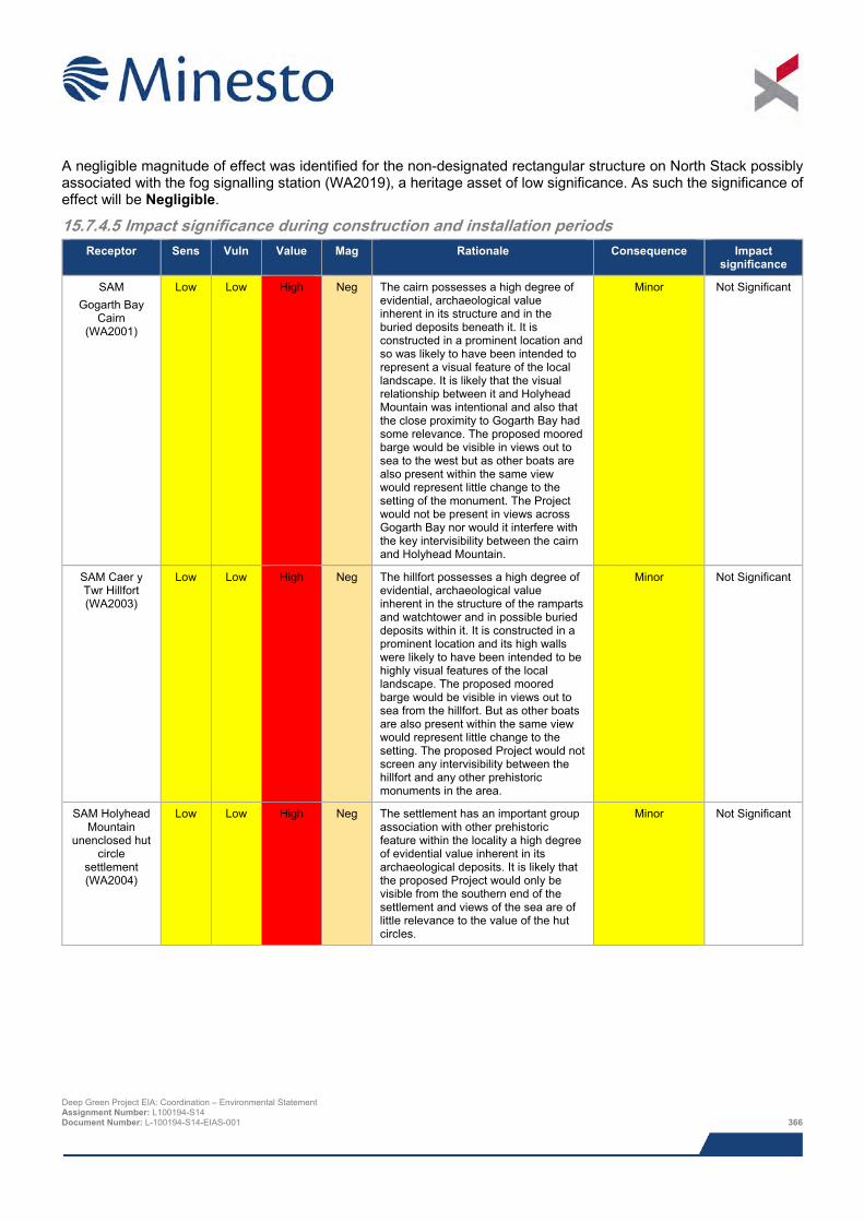
A negligible magnitude of effect was identified for the non-designated rectangular structure on North Stack possibly associated with the fog signalling station (WA2019), a heritage asset of low significance. As such the significance of effect will be Negligible.
15.7.4.5 Impact significance during construction and installation periods Receptor Sens Vuln Value Mag Rationale Consequence Impact
significance
SAM Gogarth Bay
Cairn (WA2001)
Low Low High Neg The cairn possesses a high degree of evidential, archaeological value inherent in its structure and in the buried deposits beneath it. It is constructed in a prominent location and so was likely to have been intended to represent a visual feature of the local landscape. It is likely that the visual relationship between it and Holyhead Mountain was intentional and also that the close proximity to Gogarth Bay had some relevance. The proposed moored barge would be visible in views out to sea to the west but as other boats are also present within the same view would represent little change to the setting of the monument. The Project would not be present in views across Gogarth Bay nor would it interfere with the key intervisibility between the cairn and Holyhead Mountain.
Minor Not Significant
SAM Caer y Twr Hillfort (WA2003)
Low Low High Neg The hillfort possesses a high degree of evidential, archaeological value inherent in the structure of the ramparts and watchtower and in possible buried deposits within it. It is constructed in a prominent location and its high walls were likely to have been intended to be highly visual features of the local landscape. The proposed moored barge would be visible in views out to sea from the hillfort. But as other boats are also present within the same view would represent little change to the setting. The proposed Project would not screen any intervisibility between the hillfort and any other prehistoric monuments in the area.
Minor Not Significant
SAM Holyhead Mountain
unenclosed hut circle
settlement (WA2004)
Low Low High Neg The settlement has an important group association with other prehistoric feature within the locality a high degree of evidential value inherent in its archaeological deposits. It is likely that the proposed Project would only be visible from the southern end of the settlement and views of the sea are of little relevance to the value of the hut circles.
Minor Not Significant
Deep Green Project EIA: Coordination – Environmental Statement Assignment Number: L100194-S14 Document Number: L-100194-S14-EIAS-001 366
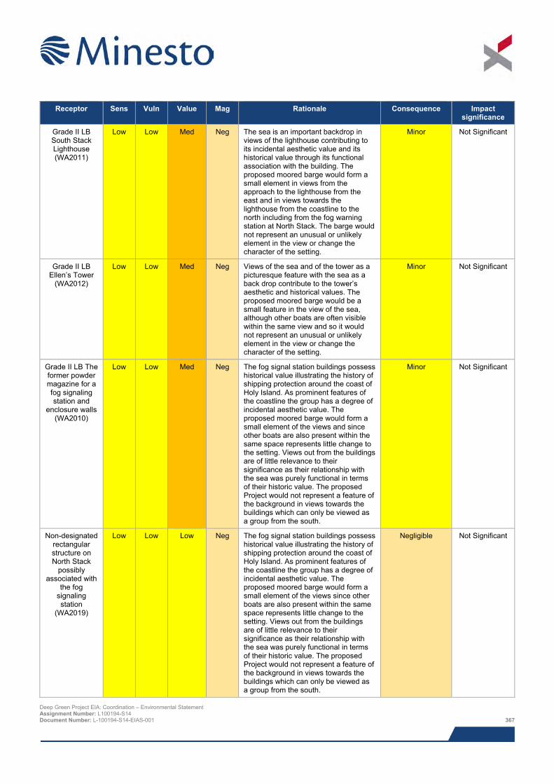
Receptor Sens Vuln Value Mag Rationale Consequence Impact
significance
Grade II LB South Stack Lighthouse (WA2011)
Low Low Med Neg The sea is an important backdrop in views of the lighthouse contributing to its incidental aesthetic value and its historical value through its functional association with the building. The proposed moored barge would form a small element in views from the approach to the lighthouse from the east and in views towards the lighthouse from the coastline to the north including from the fog warning station at North Stack. The barge would not represent an unusual or unlikely element in the view or change the character of the setting.
Minor Not Significant
Grade II LB Ellen’s Tower
(WA2012)
Low Low Med Neg Views of the sea and of the tower as a picturesque feature with the sea as a back drop contribute to the tower’s aesthetic and historical values. The proposed moored barge would be a small feature in the view of the sea, although other boats are often visible within the same view and so it would not represent an unusual or unlikely element in the view or change the character of the setting.
Minor Not Significant
Grade II LB The former powder magazine for a fog signaling station and
enclosure walls (WA2010)
Low Low Med Neg The fog signal station buildings possess historical value illustrating the history of shipping protection around the coast of Holy Island. As prominent features of the coastline the group has a degree of incidental aesthetic value. The proposed moored barge would form a small element of the views and since other boats are also present within the same space represents little change to the setting. Views out from the buildings are of little relevance to their significance as their relationship with the sea was purely functional in terms of their historic value. The proposed Project would not represent a feature of the background in views towards the buildings which can only be viewed as a group from the south.
Minor Not Significant
Non-designated rectangular structure on North Stack
possibly associated with
the fog signaling station
(WA2019)
Low Low Low Neg The fog signal station buildings possess historical value illustrating the history of shipping protection around the coast of Holy Island. As prominent features of the coastline the group has a degree of incidental aesthetic value. The proposed moored barge would form a small element of the views since other boats are also present within the same space represents little change to the setting. Views out from the buildings are of little relevance to their significance as their relationship with the sea was purely functional in terms of their historic value. The proposed Project would not represent a feature of the background in views towards the buildings which can only be viewed as a group from the south.
Negligible Not Significant
Deep Green Project EIA: Coordination – Environmental Statement Assignment Number: L100194-S14 Document Number: L-100194-S14-EIAS-001 367
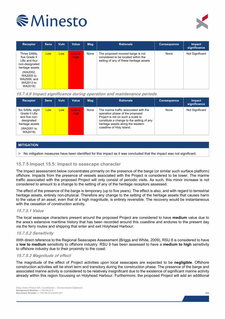
Receptor Sens Vuln Value Mag Rationale Consequence Impact
significance
Three SAMs, five Grade II LBs and four
non-designated heritage assets
(WA2002, WA2005 to
WA2009, and WA2013 to WA2018)
Low Low Low to High
None The proposed moored barge is not considered to be located within the setting of any of these heritage assets
None Not Significant
15.7.4.6 Impact significance during operation and maintenance periods Receptor Sens Vuln Value Mag Rationale Consequence Impact
significance
Six SAMs, eight Grade II LBs and five non-designated
heritage assets (WA2001 to WA2019)
Low Low Low to High
None The marine traffic associated with the operation phase of the proposed Project is not on such a scale to constitute a change to the setting of any heritage assets along the western coastline of Holy Island.
None Not Significant
MITIGATION
> No mitigation measures have been identified for this impact as it was concluded that the impact was not significant.
15.7.5 Impact 15.5: Impact to seascape character The impact assessment below concentrates primarily on the presence of the barge (or similar such surface platform) offshore. Impacts from the presence of vessels associated with the Project is considered to be lower. The marine traffic associated with the proposed Project will only consist of periodic visits. As such, this minor increase is not considered to amount to a change to the setting of any of the heritage receptors assessed.
The effect of the presence of the barge is temporary (up to five years). The effect is also, and with regard to terrestrial heritage assets, entirely non-physical. Therefore any change to the setting of the heritage assets that causes harm to the value of an asset, even that of a high magnitude, is entirely reversible. The recovery would be instantaneous with the cessation of construction activity.
15.7.5.1 Value The local seascape characters present around the proposed Project are considered to have medium value due to the area’s extensive maritime history that has been recorded around this coastline and endures to the present day via the ferry routes and shipping that enter and exit Holyhead Harbour.
15.7.5.2 Sensitivity With direct reference to the Regional Seascapes Assessment (Briggs and White, 2009), RSU 8 is considered to have a low to medium sensitivity to offshore industry. RSU 9 has been assessed to have a medium to high sensitivity to offshore industry due to their proximity to the coast.
15.7.5.3 Magnitude of effect The magnitude of the effect of Project activities upon local seascapes are expected to be negligible. Offshore construction activities will be short term and transitory during the construction phase. The presence of the barge and associated marine activity is considered to be relatively insignificant due to the existence of significant marine activity already within this region focussing on Holyhead Harbour. Furthermore, the proposed Project will add an additional
Deep Green Project EIA: Coordination – Environmental Statement Assignment Number: L100194-S14 Document Number: L-100194-S14-EIAS-001 368
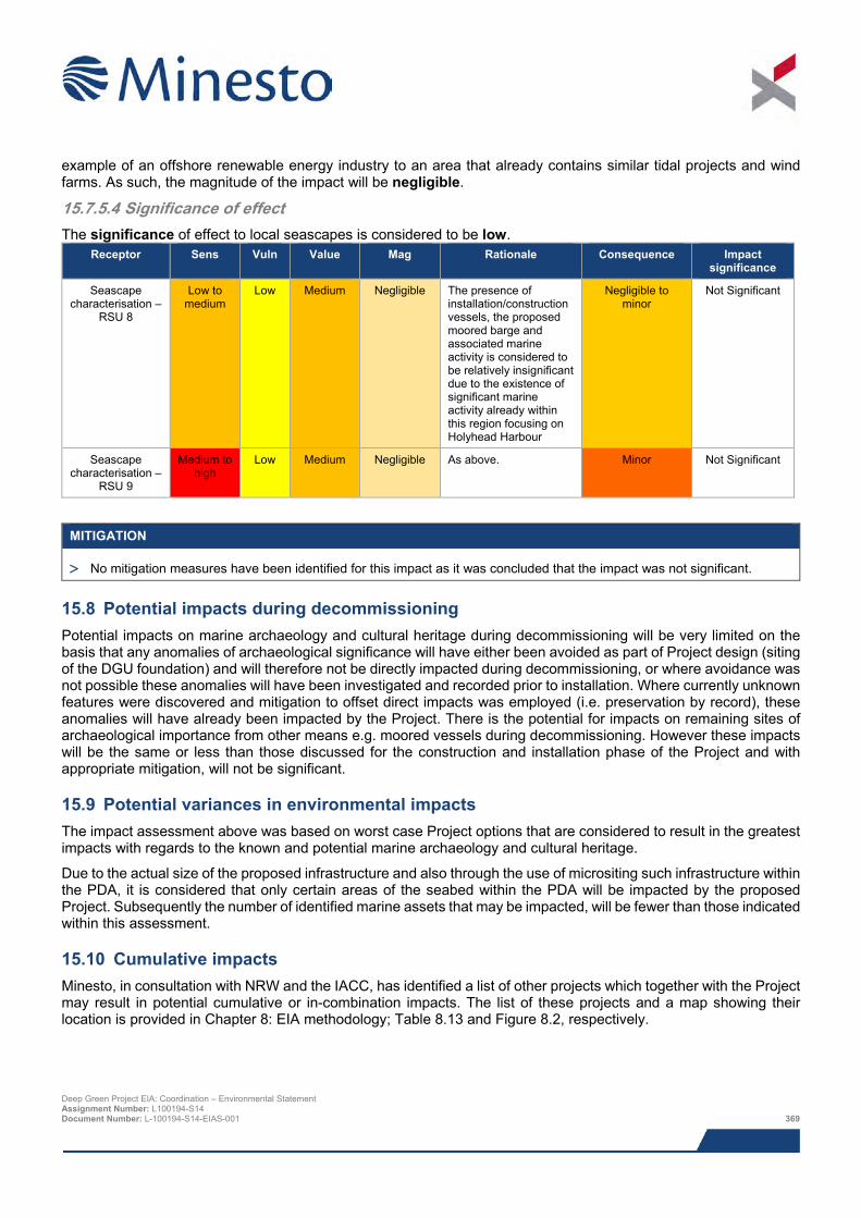
example of an offshore renewable energy industry to an area that already contains similar tidal projects and wind farms. As such, the magnitude of the impact will be negligible.
15.7.5.4 Significance of effect The significance of effect to local seascapes is considered to be low.
Receptor Sens Vuln Value Mag Rationale Consequence Impact significance
Seascape characterisation –
RSU 8
Low to medium
Low Medium Negligible The presence of installation/construction vessels, the proposed moored barge and associated marine activity is considered to be relatively insignificant due to the existence of significant marine activity already within this region focusing on Holyhead Harbour
Negligible to minor
Not Significant
Seascape characterisation –
RSU 9
Medium to high
Low Medium Negligible As above. Minor Not Significant
MITIGATION
> No mitigation measures have been identified for this impact as it was concluded that the impact was not significant.
15.8 Potential impacts during decommissioning Potential impacts on marine archaeology and cultural heritage during decommissioning will be very limited on the basis that any anomalies of archaeological significance will have either been avoided as part of Project design (siting of the DGU foundation) and will therefore not be directly impacted during decommissioning, or where avoidance was not possible these anomalies will have been investigated and recorded prior to installation. Where currently unknown features were discovered and mitigation to offset direct impacts was employed (i.e. preservation by record), these anomalies will have already been impacted by the Project. There is the potential for impacts on remaining sites of archaeological importance from other means e.g. moored vessels during decommissioning. However these impacts will be the same or less than those discussed for the construction and installation phase of the Project and with appropriate mitigation, will not be significant.
15.9 Potential variances in environmental impacts The impact assessment above was based on worst case Project options that are considered to result in the greatest impacts with regards to the known and potential marine archaeology and cultural heritage.
Due to the actual size of the proposed infrastructure and also through the use of micrositing such infrastructure within the PDA, it is considered that only certain areas of the seabed within the PDA will be impacted by the proposed Project. Subsequently the number of identified marine assets that may be impacted, will be fewer than those indicated within this assessment.
15.10 Cumulative impacts Minesto, in consultation with NRW and the IACC, has identified a list of other projects which together with the Project may result in potential cumulative or in-combination impacts. The list of these projects and a map showing their location is provided in Chapter 8: EIA methodology; Table 8.13 and Figure 8.2, respectively.
Deep Green Project EIA: Coordination – Environmental Statement Assignment Number: L100194-S14 Document Number: L-100194-S14-EIAS-001 369
The consideration of which projects could result in potential cumulative or in-combination impacts is based on the results of the Project specific impact assessment together with the expert judgement of the specialist consultant. The projects that have the potential to cause cumulative or in-combination impacts are presented in Table 8.13.
The projects considered for cumulative and in-combination impacts on the marine historic environment include:
> West Anglesey Demonstration Zone (WADZ); and
> Minesto Phase II tidal array.
15.10.1 Potential cumulative and in-combination impacts during construction, operation and maintenance, and decommissioning
The potential projects identified above include the WADZ and the Minesto Phase II tidal array. The former is located 1.2 km to the east of the PDA and is currently at the pre-consent stage, and the latter forms the second phase of this Project with the installation of an array of devices within the Project AfL (Agreement for Lease) area.
This chapter assesses the potential impacts as a result of the current proposed Project i.e a single DGU deployed in the PDA and associated barge (with no export cable / grid connection). Minesto Phase II will be assessed within its own EIA . The potential for cumulative and in-combination impacts from the Minesto Phase II tidal array is considered to be negligible. This is primarily due to the localised nature of the identified impacts of the Project on known marine historic receptors, and the reduction in the potential for significant impacts through the proposed mitigation measures.
Although the WADZ is located in relatively close proximity to the PDA, the known and potential marine historic receptors within the PDA will not be subject to direct impacts as there is no geographical overlap.
15.10.2 Mitigation requirements for potential cumulative and in-combination impacts There is no requirement for additional mitigation over and above the Project-specific measures.
15.11 Impact summary The summary of impacts for the known and potential marine archaeology and cultural heritage present within and in proximity to the proposed Project is presented in Table 15.10 below.
Deep Green Project EIA: Coordination – Environmental Statement Assignment Number: L100194-S14 Document Number: L-100194-S14-EIAS-001 370
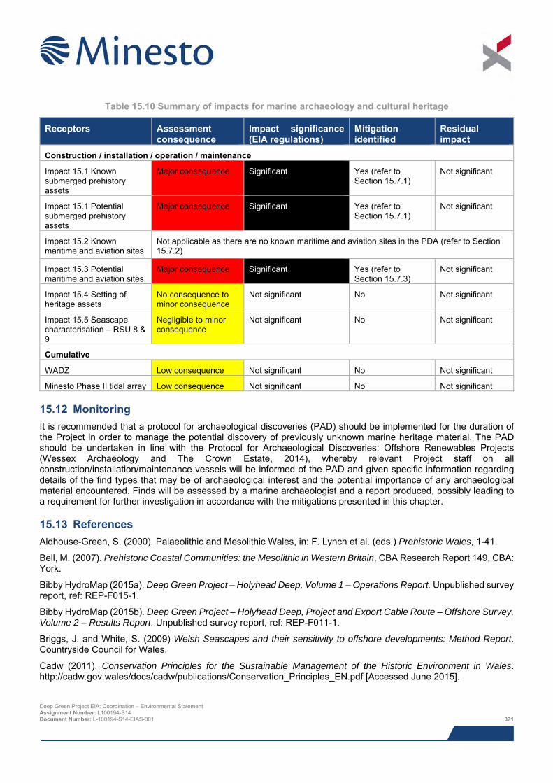
Table 15.10 Summary of impacts for marine archaeology and cultural heritage
Receptors Assessment consequence
Impact significance (EIA regulations)
Mitigation identified
Residual impact
Construction / installation / operation / maintenance
Impact 15.1 Known submerged prehistory assets
Major consequence Significant Yes (refer to Section 15.7.1)
Not significant
Impact 15.1 Potential submerged prehistory assets
Major consequence Significant Yes (refer to Section 15.7.1)
Not significant
Impact 15.2 Known maritime and aviation sites
Not applicable as there are no known maritime and aviation sites in the PDA (refer to Section 15.7.2)
Impact 15.3 Potential maritime and aviation sites
Major consequence Significant Yes (refer to Section 15.7.3)
Not significant
Impact 15.4 Setting of heritage assets
No consequence to minor consequence
Not significant No Not significant
Impact 15.5 Seascape characterisation – RSU 8 & 9
Negligible to minor consequence
Not significant No Not significant
Cumulative
WADZ Low consequence Not significant No Not significant
Minesto Phase II tidal array Low consequence Not significant No Not significant
15.12 Monitoring It is recommended that a protocol for archaeological discoveries (PAD) should be implemented for the duration of the Project in order to manage the potential discovery of previously unknown marine heritage material. The PAD should be undertaken in line with the Protocol for Archaeological Discoveries: Offshore Renewables Projects (Wessex Archaeology and The Crown Estate, 2014), whereby relevant Project staff on all construction/installation/maintenance vessels will be informed of the PAD and given specific information regarding details of the find types that may be of archaeological interest and the potential importance of any archaeological material encountered. Finds will be assessed by a marine archaeologist and a report produced, possibly leading to a requirement for further investigation in accordance with the mitigations presented in this chapter.
15.13 References Aldhouse-Green, S. (2000). Palaeolithic and Mesolithic Wales, in: F. Lynch et al. (eds.) Prehistoric Wales, 1-41.
Bell, M. (2007). Prehistoric Coastal Communities: the Mesolithic in Western Britain, CBA Research Report 149, CBA: York.
Bibby HydroMap (2015a). Deep Green Project – Holyhead Deep, Volume 1 – Operations Report. Unpublished survey report, ref: REP-F015-1.
Bibby HydroMap (2015b). Deep Green Project – Holyhead Deep, Project and Export Cable Route – Offshore Survey, Volume 2 – Results Report. Unpublished survey report, ref: REP-F011-1.
Briggs, J. and White, S. (2009) Welsh Seascapes and their sensitivity to offshore developments: Method Report. Countryside Council for Wales.
Cadw (2011). Conservation Principles for the Sustainable Management of the Historic Environment in Wales. http://cadw.gov.wales/docs/cadw/publications/Conservation_Principles_EN.pdf [Accessed June 2015].
Deep Green Project EIA: Coordination – Environmental Statement Assignment Number: L100194-S14 Document Number: L-100194-S14-EIAS-001 371
Chartered Institute for Archaeologists (2014). Standard and Guidance for Historic Environment Desk-based Assessment. http://www.archaeologists.net/sites/default/files/node-files/CIfAS&GDBA_2.pdf [Accessed June 2015].
Countryside Council for Wales (CCW) (1996). Seas, Shores and Coastal Areas: Maritime Policy. Countryside Council for Wales, Bangor.
COWRIE (2008). Guidance for Assessment of Cumulative Impacts on the Historic Environment from Offshore Renewable Energy.
COWRIE (2011). Offshore Geotechnical Investigations and Historic Environment Analysis: Guidance for the Renewable Energy.
Department for Environment, Food and Rural Affairs (Defra) (2011). UK Marine Policy Statement.
Fiona Fyfe Associates with Countryside and Bangor University (SEACAMS) (2013). Anglesey and Snowdonia Seascape Character Assessment.
Firth, A. (2013). Historic Environment Guidance for Wave and Tidal Energy. Published by Fjordr Ltd on behalf of Historic England, Historic Scotland and Cadw.
Historic England (2011). Seeing the History in the View. https://content.historicengland.org.uk/images-books/publications/seeing-history-view/seeing-history-in-view.pdf/ [Accessed June 2015].
Historic England (2012). Designation Selection Guide for Ships and Boats.
Historic England (2015). Historic Environment Good Practice Advice in Planning Note 3 – The Setting of Heritage Assets. https://content.historicengland.org.uk/images-books/publications/gpa3-setting-of-heritage-assets/gpa3.pdf/ [Accessed June 2015].
Hodgson, J. M. (1997). Soil Survey Field Handbook, Harpenden, Soil Survey Technical Monograph No. 5. Cranfield, UK.
Isle of Anglesey County Council (IACC) (2015). The Isle of Anglesey Area of Outstanding Natural Beauty – Management Plan Review 2015 – 2019. http://www.anglesey.gov.uk/Journals/2015/04/29/a/g/h/aonb-draft-management-plan-29-4-2015.pdf [Accessed June 2015].
Jackson, D. I., Jackson, A. A., Evans, D., Wingfield, R. T. R., Barnes, R. P. and Arthur, M. J. (1995). The Geology of the Irish Sea, British Geological Survey United Kingdom Offshore Report. London HMSO.
The Joint Nautical Archaeology Policy Committee (1995, 1998). Code of Practice for Seabed Development. www.jnapc.org.uk/jnapc_brochure_may_2006.pdf [Accessed November 2015].
Joint Nautical Archaeology Policy Committee (2006). JNAPC Code of Practice for Seabed Development. The Crown Estate.
The Landscape Institute (2013). Guidelines for Landscape and Visual Impact Assessment, Third Edition.
Murphy, K. (2002). The Archaeological Resource: Chronological Overview to 1500 AD, in: A. Davidson (ed.) The Coastal Archaeology of Wales, CBA Research Report 131, Cadw and CBA: York, pp.45-64.
Parfitt, SA., Barendregt, R.W., Breda, M., Candy, I., Collins, M.J., Coope, G.R., Durbidge, P., Field, M.H., Lee, J.R., Lister, A.M., Mutch, R., Penkman, K.E.H., Preece, R.C., Rose, J., Stringer, C.B., Symmons, R., Whittaker, J.E., Wymer J.J. and Stuart, A.J. (2005). The earliest record of human activity in northern Europe. Nature 438: 1008–1012.
Parfitt, S.A., Ashton, N.M., Lewis, S.G., Abel, R.L., Coope, G.R., Field, M.H., Gale, R., Hoare, P.G., Larkin, N.R., Lewis, M.D., Karloukovski, V., Maher, B.A., Peglar, S.M., Preece, R.C., Whitaker, J.E. & Stringer, C.B. (2010). Early Pleistocene human occupation at the edge of the boreal zone in northwest Europe, Nature 466: 229–33.
Planning Policy Wales (2014). Planning Policy Wales (Edition 7, July 2014). Welsh Assembly Government. http://gov.wales/docs/desh/publications/140731planning-policy-wales-edition-7-en.pdf [Accessed June 2015].
Shennan, I., and Horton, B. (2002).Holocene Land- and Sea-Level Changes in Great Britain. Journal of Quaternary Science, 17(5-6): 511-526.
Deep Green Project EIA: Coordination – Environmental Statement Assignment Number: L100194-S14 Document Number: L-100194-S14-EIAS-001 372
Wessex Archaeology (2007). Historic Environment Guidance for the Offshore Renewable Energy Sector. Commissioned by COWRIE Ltd.
Wessex Archaeology (2008). Selection Guide: Boats and Ships in Archaeological Contexts. Unpublished report.
Wessex Archaeology (2010). Model Clauses for Archaeological Written Schemes of Investigation: Offshore Renewables Projects. Prepared on behalf of The Crown Estate. http://www.thecrownestate.co.uk/media/5514/model-clauses-for-archaeological-written-schemes-of-investigation.pdf [Accessed December 2015].
Wessex Archaeology (2015). Deep Green Holyhead Deep Tidal Project – Onshore Historic Environment Desk-Based Assessment. Unpublished report reference 107791.03.
Wessex Archaeology and The Crown Estate (2014). Protocol for Archaeological Discoveries: Offshore Renewables Projects.
Deep Green Project EIA: Coordination – Environmental Statement Assignment Number: L100194-S14 Document Number: L-100194-S14-EIAS-001 373

This page has been intentionally left blank.
Deep Green Project EIA: Coordination – Environmental Statement Assignment Number: L100194-S14 Document Number: L-100194-S14-EIAS-001 374
16 SEASCAPE, LANDSCAPE AND VISUAL IMPACT ASSESSMENT
The proposed Deep Green Holyhead Deep project is positioned in a sensitive location in relation to potential effects on seascape/landscape character and visual amenity. This is reflected in the designation of the closest part of the Isle of Anglesey as an Area of Outstanding Natural Beauty and the coastline is designated as Heritage Coast. These designations both reflect the scenic quality of the seascape/landscape and as a consequence draw visitors for outdoor recreation and enjoyment of the local character, as well as a number of local residents living along the coastline. The published seascape/landscape character assessment information for the Study Area analysed reinforces these sensitivities and is identifies the associated special qualities.
The key potential changes that would result from the project relate to the introduction of a barge (or similar such surface platform), which would be moored over 5 km from the north-west coastline of Holy Island. This would be a temporary and reversible change, with all longer term elements (e.g. the Deep Green Utility units) positioned below the surface of the sea. Vessel movements are a common and typical component of the existing baseline and this, together with the distance from the coastline and the temporary and reversible nature of the change, would limit potential effects. Overall no significant effects on seascape/landscape character and visual amenity are predicted to occur as a result of the Project.
16.1 Introduction This chapter examines the potential seascape, landscape and visual effects of the proposed Deep Green (DG) Holyhead Deep Project (the Project). Figures which form part of the seascape, landscape and visual impact assessment (SLVIA) are included with this chapter, which include detail in relation to the baseline, a zone of theoretical visibility, and photographs and visualisations from key viewpoints.
The production of this chapter has been guided by the Guidelines for Landscape and Visual Impact Assessment (GLVIA) (Landscape Institute and Institute of Environmental Management and Assessment, 2013) and is described in paragraph 1.1 and GLVIA as follows:
‘Landscape and Visual Impact Assessment (LVIA) is a tool used to identify and assess the significance of and the effects of change resulting from development on both the landscape as an environmental resource in its own right and on people's views and visual amenity.’
The SLVIA has been undertaken by SLR Consulting. This work has comprised analysis of the baseline environment, visibility analysis, field survey, viewpoint photography, preparation of visualisations and analysis of potential landscape and visual effects.
It was originally intended to prepare a detailed seascape, landscape and visual impact assessment for the Project. The components of the Project have evolved and the current application is for a single DGU unit (ahead of a future grid connected array). Therefore only offshore elements in the proposed Project Development Area (PDA) (see Figures 1.2 and 16.2) are covered in the assessment. The only offshore elements that will be visible and therefore have the greatest potential to affect visual amenity and the perception of landscape character are the barge and surrounding buoys. Continual review of the likely assessment findings through field work observations, modelling of the Project and the preparation of visualisations for key viewpoints on Holy Island identified that significant effects are very unlikely to occur. This work demonstrated that the relative scale of the barge and surrounding buoys would be limited. In addition, this would comprise a vessel in the sea in a location where such features are a common and integral part of the baseline. On this basis a limited assessment has been prepared and this approach is considered proportionate and pragmatic, and allows the findings of the assessment process to be communicated succinctly.
16.2 Area of assessment The SLVIA for the Project focuses on a 10 km study area extending from the PDA. This has been defined to ensure that the closest part of coastline is included in the study area. This size of study area has been informed by the preparation of a zone of theoretical visibility (ZTV), as included in Figure 16.9 and Figure 16.10. The appropriateness of the size of the study area has also been considered through the review of visualisations for the selected viewpoints. On the basis of this analysis, and the likely effects of the Project, 10 km is considered to be an appropriate study area. The location and extent of the study area is shown in map based figures in this chapter. Deep Green Project EIA: Coordination – Environmental Statement Assignment Number: L100194-S14 Document Number: L-100194-S14-EIAS-001 375
16.3 Legislation, policy and guidance Key policy and guidance that has informed this assessment includes:
> Guidelines for Landscape and Visual Impact Assessment (GLVIA) (Landscape Institute and Institute of Environmental Management and Assessment, 2013);
> LANDMAP Information for the relevant aspect areas;
> Anglesey and Snowdonia Seascape Character Assessment (Fiona Fyfe Associates with Countryscape and SEACAMS for Natural Resources Wales (NRW), Snowdonia National Park, Anglesey Area of Outstanding Natural Beauty and Isle of Anglesey County Council (IACC), August 2013);
> Anglesey Landscape Strategy (The IACC, update 2011);
> The Isle of Anglesey Areas of Outstanding Natural Beauty; Management Plan Review 2015 to 2020 (The IACC and NRW);
> The Isle of Anglesey Areas of Outstanding Natural Beauty; Management Plan 2009 to 2014 (The IACC and the Countryside Council for Wales, now NRW);
> Landscape Character Assessment: Guidance for England and Scotland (The Countryside Agency and SNH, 2002);
> An Approach to Landscape Character Assessment (Natural England, October 2014);
> Guide to Best Practice in Seascape Assessment (Countryside Council for Wales, Brady Shipman Martin and University College Dublin, 2001);
> Seascape and Visual Impact Assessment Guidance for Offshore Wind Farm Developers (DTI, 2005);
> Photography and Photomontage in Landscape and Visual Impact Assessment, Landscape Institute Advice Note 01/11 (Landscape Institute, 2011); and
> Visual Representation of Wind Farms (Scottish Natural Heritage, 2014).
A detailed review of the local policy context has not been undertaken as part of this assessment due the scale and nature of potential effects. However, key designations their qualities and potential relationship with the Project have been identified and reviewed in the baseline description section below (Section 15.5).
16.4 Scoping and consultation The table below summarises key consultation activities carried out relevant to the SLVIA.
Deep Green Project EIA: Coordination – Environmental Statement Assignment Number: L100194-S14 Document Number: L-100194-S14-EIAS-001 376
Table 16.1 Consultation activities undertaken in relation to SLVIA
Date Stakeholder Consultation Topic / specific issue
28 February 2014 NRW Scoping Opinion Landscape and seascape is covered in this correspondence, however it only includes points of clarification and correction. No guidance on the expectation in relation to what should be covered in the Environmental Statement (ES) was provided.
16 February 2015 IACC, Department of Environment and Technical Services
Screening Opinion Identifies that significant effects are unlikely to arise. These should be assessed through a landscape and visual impact assessment.
17 February 2015 NRW Screening Opinion Makes reference to protected landscape, specifically the Ynys Mn Area of Outstanding Natural Beauty
10 March 2015 IACC Screening Opinion Generic reference made to potential landscape impacts that may arise.
21/05/2015 & 26/01/2016 General public Public exhibitions Public events held to allow members of the public to comment on overall Project, and provide updates on the EIA.
Subsequent informal telephone conversations took place between SLR Consulting and NRW and IACC in June 2015. It was intended to follow these discussions with a written exchange to agree the detailed scope of the SLVIA. However, the evolving nature of the Project prevented this taking place, and in the intervening time, a greater understanding of the limited potential landscape and visual effects of the Project has developed.
16.5 Baseline description This section provides a general description of the landscape and visual context of the Project. The location and extent of the Project is shown in Figure 16.2. This analysis is only intended to provide a summary of the baseline context, reflecting the statements already made and the overall assertion that the potential effects are expected to be limited and not significant. This approach has been taken to ensure that the assessment highlights key sensitivities and reflects the value placed on the local seascape and landscape, but also ensure that the detail includes in proportionate and reasonable. The key considerations include:
> Local seascape/landscape character, focussing on the Anglesey and Snowdonia Seascape Character Assessment (Fiona Fyfe Associates et al, 2013);
> LANDMAP Aspect Areas;
> Key designations, including the Isle of Anglesey Area of Natural Beauty and Heritage Coast associated with Holy Island; and
> Key visual receptors within the study area.
Deep Green Project EIA: Coordination – Environmental Statement Assignment Number: L100194-S14 Document Number: L-100194-S14-EIAS-001 377
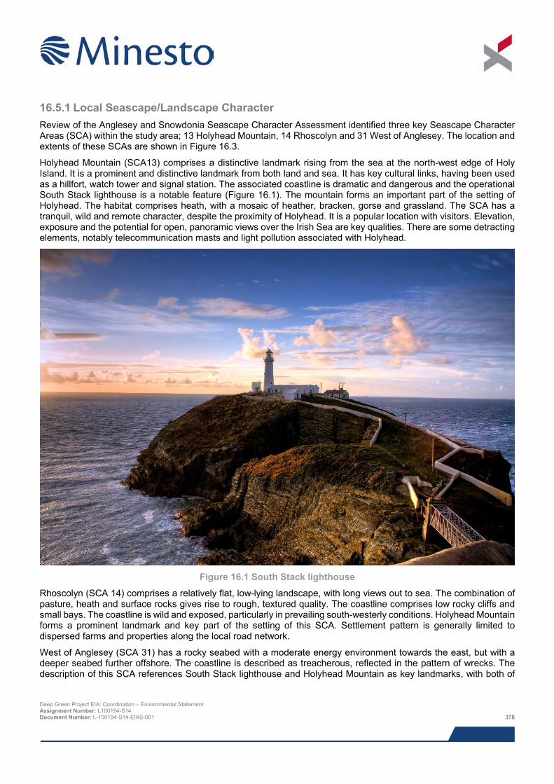
16.5.1 Local Seascape/Landscape Character Review of the Anglesey and Snowdonia Seascape Character Assessment identified three key Seascape Character Areas (SCA) within the study area; 13 Holyhead Mountain, 14 Rhoscolyn and 31 West of Anglesey. The location and extents of these SCAs are shown in Figure 16.3.
Holyhead Mountain (SCA13) comprises a distinctive landmark rising from the sea at the north-west edge of Holy Island. It is a prominent and distinctive landmark from both land and sea. It has key cultural links, having been used as a hillfort, watch tower and signal station. The associated coastline is dramatic and dangerous and the operational South Stack lighthouse is a notable feature (Figure 16.1). The mountain forms an important part of the setting of Holyhead. The habitat comprises heath, with a mosaic of heather, bracken, gorse and grassland. The SCA has a tranquil, wild and remote character, despite the proximity of Holyhead. It is a popular location with visitors. Elevation, exposure and the potential for open, panoramic views over the Irish Sea are key qualities. There are some detracting elements, notably telecommunication masts and light pollution associated with Holyhead.
Figure 16.1 South Stack lighthouse
Rhoscolyn (SCA 14) comprises a relatively flat, low-lying landscape, with long views out to sea. The combination of pasture, heath and surface rocks gives rise to rough, textured quality. The coastline comprises low rocky cliffs and small bays. The coastline is wild and exposed, particularly in prevailing south-westerly conditions. Holyhead Mountain forms a prominent landmark and key part of the setting of this SCA. Settlement pattern is generally limited to dispersed farms and properties along the local road network.
West of Anglesey (SCA 31) has a rocky seabed with a moderate energy environment towards the east, but with a deeper seabed further offshore. The coastline is described as treacherous, reflected in the pattern of wrecks. The description of this SCA references South Stack lighthouse and Holyhead Mountain as key landmarks, with both of
Deep Green Project EIA: Coordination – Environmental Statement Assignment Number: L100194-S14 Document Number: L-100194-S14-EIAS-001 378
these contributing to sense of place and orientation. The SCA is associated with a long and continuing tradition of maritime activities, including commercial shipping, passenger ferries and fishing.
It is acknowledged that landscape character areas have also been defined and these are included in the Management Plan Review 2015 to 2019. However, these are broadly consistent with the land based seascape character units described above. Therefore no further consideration has been given to these in this assessment.
16.5.2 LANDMAP Aspect Areas The following provides an overview of the five LANDMAP Aspects and the corresponding Aspect Areas. The location and extent of the Aspect Areas in relation to the Project are shown Figure 16.4 to Figure 16.8.
16.5.2.1 Cultural Landscape The majority of Cultural Landscape Aspect Areas are evaluated as being outstanding. The key Aspect Area that lies within the study area is Holyhead Mountain. This extends beyond Holyhead Mountain itself and applies to much of the north-western part of Holy Island. The outstanding evaluation relates to the way this landscape forms a backdrop to Holyhead and how it comprises the first sight of Wales for people travelling to Wales from Ireland by ferry. Other Cultural Heritage Aspect Areas within the study area are typically evaluated at being outstanding due to the settlement pattern and tourism value attached.
16.5.2.2 Geological Landscape The land based part of the study area comprises a mosaic of different Aspect Areas. Those evaluated as outstanding and high include South Stack-Holyhead Coast, South Stack (east of South Stack itself) and Holyhead Mountain.
16.5.2.3 Historic Landscape Almost the entire land-based part of the study area is evaluated as being outstanding. This comprises two aspect areas; Holy Island/South Stack and Holyhead. The evaluation for Holy Island/South Stack relates to the historic settlement and agricultural uses, also including relic pre-historic ceremonial sites. Holyhead is recognised for its historical and recent settlement, with the description outlining how this Aspect Area has evolved from pre-historic to current times.
16.5.2.4 Landscape Habitats There is a wide range of Aspect Areas within the north-western part of Holy Island. The evaluation of these habitats varies from outstanding to low. Those evaluated as outstanding typically comprise the unimproved habitats, including heath and coastal habitats. Aspect Areas with lower evaluation comprise improved agricultural landscape and settlement.
16.5.2.5 Visual and Sensory The majority of the north-west part of Holy Island is evaluated as outstanding and high. Those assessed as outstanding comprise Holyhead Mountain and the coastline in the vicinity of South Stack and North Stack, with the analysis focussing on the dramatic and relatively remote character, the relationship with the coastline sea and associated expansive views are key elements. The land south and south-west of Holyhead is evaluated as high, whilst this landscape is less dramatic than further north-west it still comprises an attractive rural landscape, with coastal views noted as a particular component.
16.5.3 Key Designations The Anglesey Coast AONB was designated in 1996 and covers an area of approximately 221 km2 (approximately one third of the island). It is almost continuous around the coastline, with only occasional breaks including Holyhead. The AONB is characterised by sea cliffs/coastal edge and islands. Inland it is primarily a working landscape, with agriculture being the predominant land use. Tourism is a key employer on the island, with people attracted to the beaches and coastal landscape. The AONB also includes areas that are designated at a national and international level for their ecological value. The land is mainly managed by farmers, however there are also areas managed by other organisations including CCW, the Wildlife Trust and The National Trust. The primary objective of the AONB designation is the protection and preservation of landscape character, quality and features from inappropriate Deep Green Project EIA: Coordination – Environmental Statement Assignment Number: L100194-S14 Document Number: L-100194-S14-EIAS-001 379
development. The location and extent of the AONB in relation the Project is shown in Figure 16.2, Figure 16.9 and Figure 16.10.
The Anglesey AONB Management Plan 2009 – 2014 (within section 3; The State of the Anglesey AONB Report) refers to an increased focus on energy development on the island and identifies this as a potential pressure on the AONB. This report identifies key special qualities of this landscape. Of particular relevance to this assessment are those special qualities that relate to the landscape and recreation/access to land and water:
> Coastal landscape features;
> Expansive views;
> Peace and tranquillity;
> Public Rights of Way (including the Isle of Anglesey Coastal Path); and
> Accessible land and water.
The State of the Anglesey AONB Report describes the potential impact of different activities, including economic activities and development. The overall aim of the AONB designation is to protect the landscape from change that would have an adverse impact on its character, distinctiveness and special qualities.
Sections 4 and 5 of the Anglesey AONB Management Plan (Vision and Strategy respectively) reinforce the need to conserve and enhance the landscape. These sections also reflect on the positive contribution that the local community and economic activities can make to the AONB. The Action Plan (section 6) sets out the policies and actions that will be implemented to achieve the vision and strategy. The key elements of the Action Plan that are directly relevant to the proposed Project and this assessment are as follows:
> Countryside and Coastal Character (CCC) 1, particularly CCC 1.1 which promotes the use of LANDMAP for the assessment of landscape character and evaluation of proposed developments;
> CCC 3, which establishes that proposals for new development need to be assessed rigorously and stresses the importance of good design, with reference to the Supplementary Planning Guidance Note Design Guide For The Urban & Rural Environment (IACC, adopted March 2008), with section 30 of this guidance note relating to development within the AONB; and
> CLC 2 relates to renewable energy and expresses support for proposals that are of an appropriate scale.
The Isle of Anglesey Area of Outstanding Natural Beauty Management Plan Review 2015-2020 (Isle of Anglesey AONB and NRW) covers comparable themes and sensitivities. This document identifies the objectives relating to energy development on the Isle of Anglesey, also noting the potential influence this could have on the AONB.
As well as the AONB, the north-west coastline of Holy Island is one of three sections of the Anglesey coastline that is designated as Heritage Coast. The aim of this designation being to preserve the character, quality and features of the coastline. Part of the reason for the Heritage Coast designation is to protect the undeveloped character of these locations. The designation of this section of coast as Heritage Coast reinforces the AONB and reflects the special qualities of this landscape.
There are three Conservation Areas within the study area; Holyhead Mountain, Holyhead Beach and Holyhead Central. All of these are positioned towards the edge of the study area and the ZTV demonstrates that the barge would not be visible from any of these Conservation Areas due to the intervening landform. Therefore no further consideration has been given to these Conservation Areas in this assessment.
No other landscape designations have been identified that apply to the site or are located within close proximity. The Register of Historic Landscapes in Wales has been consulted during the preparation of this assessment. This has identified that there are no Registered Parks and Garden, or broader Landscapes of Outstanding or Special Historic Interest in Wales lie within or close to the study area.
Deep Green Project EIA: Coordination – Environmental Statement Assignment Number: L100194-S14 Document Number: L-100194-S14-EIAS-001 380
16.5.4 Landscape Value Overall, through the review of local seascape/landscape character, LANDMAP Aspect Areas and key designations it can be concluded that this landscape is highly valued. The overriding factors are the AONB and Heritage Coast designation, but these are backed up by the other evaluations of the baseline landscape.
16.5.5 Key Visual Receptors The study area includes a wide range of land and sea based visual receptors. The land based part of the study area is popular with locals and visitors, drawn by the scenic qualities of the seascape/landscape. Key specific visual receptors include local residents and visitors to the coastline (including South Stack lighthouse and the RSPB visitor centre at South Stack cliffs). Holyhead Mountain is an obvious draw, and provides open panoramic views over the surrounding area. The Isle of Anglesey Coastal Path, which also forms part of the Wales Coast Path, provides opportunities along most of the coastline. Access Land occurs at various places around the coastline, further facilitating public access.
Residential receptors within the study area are generally fairly limited, with the pattern of such properties being dispersed and low density. Holyhead is the notable exception, with this settlement lying on the western edge of the study area. Trearddur comprises a key local centre and tourist destination, lying just outside the western edge of the study area.
It is a popular and relatively busy area of sea, resulting in a range of offshore visual receptors. Such receptors include people on recreational vessels together with passenger ferries, commercial shipping and fishing vessels. Anglesey and Holy Island are obvious focal points for such receptors and this is noted in the character assessment and LANDMAP Aspect Areas.
16.6 Impact assessment
16.6.1 Overview This assessment considers the potential effects on seascape, landscape and visual receptors identified in the analysis of the baseline description above.
16.6.2 Assessment criteria In line with the Guidelines for Landscape and Visual Impact Assessment (Third Edition, Landscape Institute and Institute of Environmental Management and Assessment, 2013) landscape (and seascape) impacts are defined as relating to changes in the fabric, character and quality of the landscape as a result of the proposed Project. Visual impacts relate to changes in the available views of the landscape and are therefore impacts on people and their perceptions.
The SLVIA considers the potential impacts of the Project on the seascape/landscape and visual amenity within the study area. It is broadly be based on relevant and accepted guidance, and draws on information provided by statutory consultees, current landscape planning policies and other relevant documentation, a computer-based visibility analysis and fieldwork observations.
The general approach to the SLVIA has included the following key tasks:
> Desk study;
> Field survey and viewpoint photography;
> Establishing baseline landscape/seascape and visual context;
> Assessment of potential landscape/seascape and visual impacts, including cumulative assessment.
Whilst this assessment is based on the GLVIA, no specific assessment criteria are defined in this section. Consideration has been given to the susceptibility and value of seascape/landscape and visual receptors. However, following field survey work and the preparation of visualisations, it was very apparent that the likelihood of any
Deep Green Project EIA: Coordination – Environmental Statement Assignment Number: L100194-S14 Document Number: L-100194-S14-EIAS-001 381
significant effects occurring is very remote due to the nature, location and relative scale of elements of the Project that are likely to influence seascape/landscape character and visual amenity. Therefore, in order to present a proportionate assessment the following sections describe specific key tasks and elements that have informed these judgements.
16.6.3 Zone of Theoretical Visibility A Zone of Theoretical Visibility (ZTV) has been prepared for the PDA. In order to demonstrate the maximum theoretical visibility, this is based on reference points around the edge of the PDA which reflect the maximum expected height of main structure of the barge – that is, 4 m above sea level. Chart Datum, is 3.05 m below Ordnance Datum at Holyhead and the highest astronomical tide level is 6.33 m, resulting in the highest sea level relative to Ordnance Datum being 3.28 m. Therefore the ZTV is based on reference points of 4 m above this sea level (7.28 m AOD) and an observer height of 1.75 m above ground. The ZTV for the PDA is presented in Figure 16.9 and Figure 16.10.
The ZTV is prepared using a digital terrain model (DTM) based on Ordnance Survey (OS) Terrain 5 data, which comprises a 5 m grid respectively. The Project site was provided in WGS 1984 projection. The Ordnance Survey mapping and Terrain 5 data use the British National Grid as their map projection, which is based on the OSGB 1936 datum. Therefore it was necessary to transform the locations of offshore elements/the extent of the PDA into British National Grid. This transformation was undertaken using the OSGB 1936 to WGS1984 Petroleum transformation.
The ZTV has been presented at a two scales, both Figure 16.9 and Figure 16.10 show the location and extent of key designations that are relevant to the SLVIA:
> Figure 16.9 shows the predicted pattern of visibility at a scale that allow the location of the PDA to be shown together with Holy Island and part of the Isle of Anglesey, including the number of reference points predicted to be seen.
> Figure 16.10 presents the ZTV at a slightly larger scale map base allowing more detailed evaluation of potential visibility in relation to key local features and elements on Holy Island.
16.6.4 Visualisations The visualisations supporting the SLVIA (Figures 16.11 to 16.13) have been presented in order to provide a view of the Project within its seascape/landscape context and assist the assessor in determining the change and resultant effect on the viewpoint location.
The photomontages have been prepared through the use of Adobe Photoshop, LSS and presented using CorelDraw. This approach allows the DGUs to be accurately positioned and scaled in relation to the photograph/panorama. For each visualisation, the tide level has been placed at the approximate level based on tide predictions from the UK Hydrographic Office.
The presentation of graphics material requires careful consideration in order to prepare a visualisation that provides an accurately scaled depiction of the Project for use at the viewpoint location. Visualisations have been presented at A3 size for ease of viewing. These comprise:
> A cylindrically projected panorama (wireframe) illustrating the proposal, presented alongside an identically sized panorama of the existing view. This format shows the wider landscape context within which the offshore development site will sit.
> Illustrations of the proposal (wireframe placed over the photograph) using a horizontal angle of view of c. 27 degrees to reflect the proportions of a 75 mm lens (based on a full frame 35 mm format digital SLR camera). This image has been extracted from the panoramic images referred to above.
The presentation of the visualisations is based on the guidance provided in Photography and Photomontage in Landscape and Visual Impact Assessment (Landscape Institute Advice Note 01/11), Visual Representation of Wind Farms (Scottish Natural Heritage, 2014). The visualisations should be used in the field at the viewpoint location. The images should be curved in an arc and viewed at a distance of approximately 300 mm or 812.5 mm. It should be noted that in reality neither photographs nor visualisations can convey a view exactly as it would be seen by the Deep Green Project EIA: Coordination – Environmental Statement Assignment Number: L100194-S14 Document Number: L-100194-S14-EIAS-001 382

human eye. There is a minor discrepancy between the foreground landform in shown in the photograph and visualisation for Viewpoint 1. Review of this suggests that there may be minor differences in the digital terrain model compared with the local landform included in the photograph, but these are minor and have no influence on the assessment judgements.
16.6.5 Design envelope This assessment considers the Project parameters which are predicted to result in the greatest environmental impact. This approach ensures that impacts of a greater adverse significance are unlikely to arise should any other development scenario be taken forward in the final scheme design. It is also relevant to consider the most likely scenario and this is reflected in the design parameters used to inform the preparation of visualisations, however it is expected that changes to this scenario are unlikely to alter the conclusions of this assessment.
It is anticipated that the DGU would be deployed in the southern part of the offshore PDA shown in Figure 16.2. No elements of the DGU would be seen above water, however a barge will be required within the PDA during the five year Project. Therefore, the SLVIA will focus on the presence and visibility of this barge within the PDA. The barge would be present continually during the initial operation/testing phase, but as testing progresses it may not be on site full time.
It is anticipated that the barge (or similar such surface platform) will be moored to four to eight buoys. There may be an additional buoy to which the DGU tether will be attached during periods when the DGU is taken off site, as well as buoy from which the mooring spread and subsea unbilical would be suspended from during period when the barge is off site. The buoys are likely to be yellow in colour and lit at night (visibility of not less than five nautical miles) in conformance with guidance from Trinity House and the International Association of Marine Aids to Navigation and Lighthouse Authorities (IALA) (ALA Recommendation O-139 on The Marking of Man-Made Offshore Structures, Edition 2, December 2013 and IALA Recommendation E-108 on The Surface Colours used as Visual Signals on Aids to Navigation, Edition 3, May 2013) to ensure that key elements are conspicuous to marine traffic. The main structure of the barge is expected to extend to approximately 4 m above the waterline, and would be 50 m long by 12 m wide. There could also be a crane on the barge, which would extend to over 4 m. However, this would represent a relatively slender structure and is therefore expected to be less conspicuous than the main superstructure of the barge. In addition, the crane is only expected to be in operation for up to two hours per day.
Normal offshore operations would take place during daylight hours, therefore floodlighting would typically be avoided. However, floodlighting will be required on the barge to allow safe working conditions during hours of darkness, and at times this may involve periods of 24 hour working. As the proposed Project will involve periods of testing, the duration of operations that may take place during hours of darkness are uncertain, but it is anticipated this will be unlikely to exceed 30 nights per year and later afternoon periods during winter months. The requirement for working in hours of darkness is also likely to reduce as the testing progresses.
To ensure that the maximum potential zone of theoretical visibility (ZTV) has been prepared on the basis of the outermost extent of PDA and the maximum height of the main structure of the barge (excluding the crane). The sea level has also been placed at 3.28 m relative to Ordnance Datum to ensure this maximises the relative height of the barge and therefore the ZTV depicts the greatest likely extent of theoretical visibility.
For the purpose of the visualisations, the most realistic scenario is to link the position of the barge with the likely location of the Deep Green Utility units (DGUs).To ensure the assessment considered a likely worst case, this has been positioned on the eastern side of the DGU unit so that it is placed closer to the coastline. The specific detail of the barge is not known at present, so the visualisations are based on a block model reflecting its expected dimensions. The barge has been coloured red (the entire structure) to ensure that it is as visible as possible. Four buoys have been included in the visualisations. These have been coloured yellow as this is in conformance with the guidance referenced above and is the likely requirement of the relevant navigation authorities and consultees.
16.7 Impacts during construction, installation and operation
16.7.1 Visibility analysis Analysis of the ZTV identifies that potential visibility of the barge within the PDA will be focussed along the western fringes of Holy Island, particularly between North Stack and Penrhyn Mawr, and between Trearddur Bay and Bay Deep Green Project EIA: Coordination – Environmental Statement Assignment Number: L100194-S14 Document Number: L-100194-S14-EIAS-001 383
and Rhoscolyn Head. Typically the coastal cliffs truncate potential visibility, although the ZTV highlights locations where potential visibility extends further inland due to rising ground e.g. Holyhead Mountain and in the vicinity of Penrhosfeilw. The ZTV also indicates that there would be theoretical visibility from parts of the Isle of Anglesey located further to the east. However, such locations are positioned in the region of 10 km or greater from the closest part of the PDA, which will greatly limit the perception of any change in views. The ZTV demonstrates that the offshore Project site would be visible from boat traffic on the sea in all directions.
Key views of the offshore elements of the proposed Project from the Isle of Anglesey Coast are expected to be between North Stack and Penrhyn Mawr. This would be the closest section of coastline to the PDA and the openness of the seascape/landscape affords clear views over the sea to the west.
16.7.2 Potential effects on seascape/landscape 16.7.2.1 Sensitivity of seascape/landscape character Given the limited level of changes associated with the Project, a detailed analysis of seascape/landscape sensitivity has not been undertaken. The following analysis presents a potentially cautious approach to the analysis sensitivity and this has been applied in a relatively generic way rather than analysing each character area in more detail.
Analysis of the baseline context has identified the high value that is placed on much of the landscape/seascape within the study area. The sensitivity of seascape/landscape to change is also dependent of its susceptibility to change, with consideration of the nature and characteristics of the proposed Project. Theoretically, much of the seascape/landscape within the study area is highly susceptible due to factors such as its scenic quality openness, remoteness and limited extent of development. However, the key visible component of the Project, and therefore those most likely to affect the perception of character, comprises the barge. Vessels in the Irish Sea are an established part of the baseline context and therefore influence potential susceptibility. In addition, the duration of the Project (up to five years), together with the reversibility of the elements of the scheme that have potential to influence the perception of character, are also key factors.
Overall it is considered that the susceptibility of the seascape/landscape to the type of changes proposed (based on the factors described above) is medium. Combining this with the value attached to the landscape it is considered that the overall sensitivity of the seascape/landscape to the Project is medium to medium/high.
16.7.2.2 Potential effects on seascape/landscape resource Effects on the qualities and characteristics of the seascape as a result of the offshore elements will be limited in extent and visible changes will be reversible on completion of the Project. The DGU will be attached to either the underside of the barge or foundation secured to the seabed and no parts of these will pierce the surface of the sea. All visible components will be removed and the visual characteristics of the seascape/landscape will revert to pre-development conditions following completion of the Project. The Project is only expected to be present for up to five years and the barge may not be present on site for the entire Project period. All key changes to the baseline seascape context would be reversible. The visible components of the Project would comprise a barge, in a location where boat movements are a common occurrence. It addition, the barge would only be approximately 4 m in overall height (above the water) and be positioned over 5 km from the closest part of the coastline.
In the context of offshore location, the barge would comprise a typical structure. The only factor that would alter this is its fixed position. However, as stated above, the duration of the changes and the reversibility of the visible components would influence the overall magnitude of change and any potential effects. The relatively low height of the barge, compared with key local landmarks and reference points, means that is not expected that this component of the Project would challenge any of the features that are identified in the baseline assessment e.g. perception of Holyhead Mountain.
Combined, these factors mean that it is considered that there would be no significant adverse effects on the seascape/landscape resource. It is anticipated that the magnitude of change would be negligible and, assuming a level of sensitivity of medium to high, potential effects on the seascape resource are expected to be minor.
Deep Green Project EIA: Coordination – Environmental Statement Assignment Number: L100194-S14 Document Number: L-100194-S14-EIAS-001 384
16.7.2.3 Potential effects on designations Potential effects on the quality and setting of designated landscapes within the study area have been considered, including the Isle of Anglesey AONB, Heritage Coast on the north-west edge of Holy Island. The key special qualities of the AONB that have greatest potential to be influenced by the Project are:
Expansive views – the barge would be present in views, forming a small element in an expansive panorama. This change would only occur for up to five years and would be reversible on completion of the Project;
Peace and tranquillity - the introduction of the Project in the local context has the potential to influence peace and tranquillity. This would be through the presence of the barge and also the lighting that would be used intermittently. Potential adverse effects would be mitigated in several ways, including the temporary and reversible nature of the change, the consistency with existing boat traffic around this part of Anglesey and the intervening distance between the coastline and the PDA. Overall the potential change and consequential effect on this quality would be very limited;
Public Rights of Way (including the Isle of Anglesey Coastal Path); elements of the Project would be seen from Public Rights of Way on the Isle of Anglesey, however any effects would be mitigated due to the reasons stated above. In addition, there would be no direct changes or effects on any Public Rights of Way as a consequence of the Project; and
Accessible land and water – the Project would exclude marine traffic from a small area of the Irish Sea, however this would apply to a very small part of open water and restriction on any activities would be very limited.
Consistent with the analysis of seascape/landscape character, reflecting on the key special qualities outlined above, overall it is anticipated that the potential effects of the Project on relevant seascape/landscape designations, including the AONB, would be very limited and not significant.
16.7.3 Potential effects on visual amenity Visual receptors in and beyond the study area have been considered as part of the assessment, including potential effects of the Project on settlements, transport routes and recreational receptors in the study area. This has included analysis of the potential extent of visibility of the barge, as set out in Section 16.7.1. In addition, three specific viewpoints have also been assessed, with these locations being reflective of the views seen by visual receptors.
The three viewpoints selected are illustrated by Figure 16.11 to Figure 16.13 and their locations shown in Figure 16.9 and Figure 16.10. The locations selected are;
> Holyhead Mountain (Viewpoint 1, Figure 16.11 A and B);
> Minor road above South Stack (Viewpoint 2, Figure 16.12 A and B); and
> The Range (Viewpoint 3, Figure 16.13 A and B).
While there are differences in location there are also key consistent themes. All locations allow open views over the adjacent landscape and Irish Sea beyond. Expansive views are experienced at each location. The scenic quality and relatively remote location is also evident. While the viewpoints selected do not specifically represent any views from residential properties, overall they reflect the types of views that could be obtained by such receptors close to the coastline.
The barge would be seen in a comparable way at each viewpoint. It would comprise a small element in the overall view that can be obtained. All elements would be seen below the horizon, with the sea forming the backdrop. The intervening distance has considerable influence on the relative scale of the barge and greatly diminishes its prominence. This distance also means that it is likely that the associated buoys would be difficult to discern. It is anticipated that lights would be visible at night, including navigation lights on the buoys and floodlighting of the barge.
The Project would introduce new elements into the baseline context and there would be potential for adverse impacts on visual amenity. However, the extent of these potential impacts will be limited by landform, relative scale of the structures compared with elements of the existing environment. The limited timeframe of the Project and its reversible characteristics also influences the potential change and effect on visual amenity.
Deep Green Project EIA: Coordination – Environmental Statement Assignment Number: L100194-S14 Document Number: L-100194-S14-EIAS-001 385

Visual receptors within the study area are considered to be of high sensitivity, reflecting the value placed on the landscape they are positioned within and their activity/occupation. However, the potential magnitude would be greatly diminished due to the factors outlined above. Therefore it is anticipated that the potential magnitude of change is likely to be negligible and the potential effect minor. Overall, it is expected that the effect on visual amenity would not be significant.
While no specific offshore viewpoints have been included in the assessment, it is anticipated that any assessment judgements would be consistent with the above. The barge would comprise a relatively small scale element in a location where frequent vessel movements form an established part of the baseline. These factors combined with the temporary and reversible nature of the changes means any effects are not expected to be significant.
16.8 Impacts during decommissioning The decommissioning process will be the reverse of the installation procedure and will require the same plant and machinery. The likelihood and magnitude of impact of decommissioning activities will therefore be the same or less than during the installation activities and do not warrant additional assessment.
16.9 Potential variances in environmental impacts The key factors that could result in variance to the assessment judgements stated is the position of the DGU and barge within the PDA, together with the detailed form and appearance of the barge. All parts of the PDA are positioned over 5 km from the closest part of the coastline, therefore separation distance from land based receptors would be comparable with those factored into the assessment. While the form and detail of the barge may vary from that considered in this assessment, providing the overall dimensions remain consistent the potential for any variance in assessment judgement would be limited.
Notwithstanding these potential variances, other factors such as permanence and reversibility would remain consistent with those already stated. Therefore, the potential for the assessment judgements to vary greatly are limited.
16.10 Cumulative impacts A number of developments that may have cumulative effects in relation to the Project have been identified through consultation. Review of these has identified that the key development that has the potential to result in cumulative effects in combination with the Project is the West Anglesey Demonstration Zone (WADZ). It is understood this scheme is at an early development stage and the detail is uncertain, however the scoping report for WADZ identifies the potential for surface piercings structures. In addition, the overall extent of the WADZ is much greater than the Project and therefore associated effects are likely to be greater than the Deep Green Holyhead Deep project. While there is potential for a the Deep Green Holyhead Deep Project to result in a cumulative seascape, landscape or visual effect in combination with WADZ, the limited effects identified in this appraisal is likely to mean that its contribution to potential cumulative effects would be similarly limited and not significant.
16.11 Impact summary This assessment has identified that the local context of the Project includes a range of seascape, landscape and visual receptors that are valued and sensitive to potential developments. Notably much of the land based part of the study area is designated as an AONB and the coastline is designated as Heritage Coast. These designations both reflect the scenic quality of the seascape/landscape and as a consequence draw visitors for outdoor recreation and enjoyment of the local character.
However, analysis that forms part of this assessment has identified that the potential changes to this context as a result of the Project would be limited and the likelihood significant effects occurring in relation to seascape, landscape and visual receptors are remote, as clearly indicated by the visualisations prepared as part of the SLVIA. This conclusion has been reached based on a combination of the relative location, scale and nature of the elements of the Project that have the potential to change the baseline. In addition, the temporary and reversible nature of these changes would also greatly influence the potential for significant adverse effects to occur.
Deep Green Project EIA: Coordination – Environmental Statement Assignment Number: L100194-S14 Document Number: L-100194-S14-EIAS-001 386
16.12 References Countryside Council for Wales, Brady Shipman Martin and University College Dublin (2001). Guide to Best Practice in Seascape Assessment, Maritime Ireland/Wales INTERREG 1994-1999.
Enviros Consulting (2005). Seascape and Visual Impact Assessment Guidance for Offshore Wind Farm Developers, DTI.
Fiona Fyfe Associates with Countryscape and SEACAMS (August 2013). Anglesey and Snowdonia Seascape Character Assessment, Natural Resources Wales, Snowdonia National Park, Anglesey Area of Outstanding Natural Beauty and Isle of Anglesey County Council. International Association of Marine Aids to Navigation and Lighthouse Authorities (December 2013). IALA Recommendation O-139 on The Marking of Man-Made Offshore Structures, Edition 2.
International Association of Marine Aids to Navigation and Lighthouse Authorities (May 2013). IALA Recommendation E-108 on The Surface Colours used as Visual Signals on Aids to Navigation, Edition 3.
Isle of Anglesey County Council (update 2011) Anglesey Landscape Strategy.
Isle of Anglesey County Council and the Countryside Council for Wales (now Natural Resources Wales). The Isle of Anglesey Areas of Outstanding Natural Beauty; Management Plan 2009 to 2014.
Isle of Anglesey County Council and Natural Resources Wales. The Isle of Anglesey Areas of Outstanding Natural Beauty; Management Plan Review 2015 to 2020.
Landscape Institute (2011). Photography and Photomontage in Landscape and Visual Impact Assessment, Landscape Institute Advice Note 01/11.
Landscape Institute and Institute of Environmental Management and Assessment (2013). Guidelines for Landscape and Visual Impact Assessment (GLVIA 3), Third Edition, Routledge, Abingdon.
Natural Resources Wales. LANDMAP Information.
Natural England (October 2014) An Approach to Landscape Character Assessment.
Scottish Natural Heritage (2014). Visual Representation of Wind Farms.
The Countryside Agency (now Natural England) and Scottish Natural Heritage (2002). Landscape Character Assessment: Guidance for England and Scotland.
Deep Green Project EIA: Coordination – Environmental Statement Assignment Number: L100194-S14 Document Number: L-100194-S14-EIAS-001 387

This page has been intentionally left blank.
Deep Green Project EIA: Coordination – Environmental Statement Assignment Number: L100194-S14 Document Number: L-100194-S14-EIAS-001 388
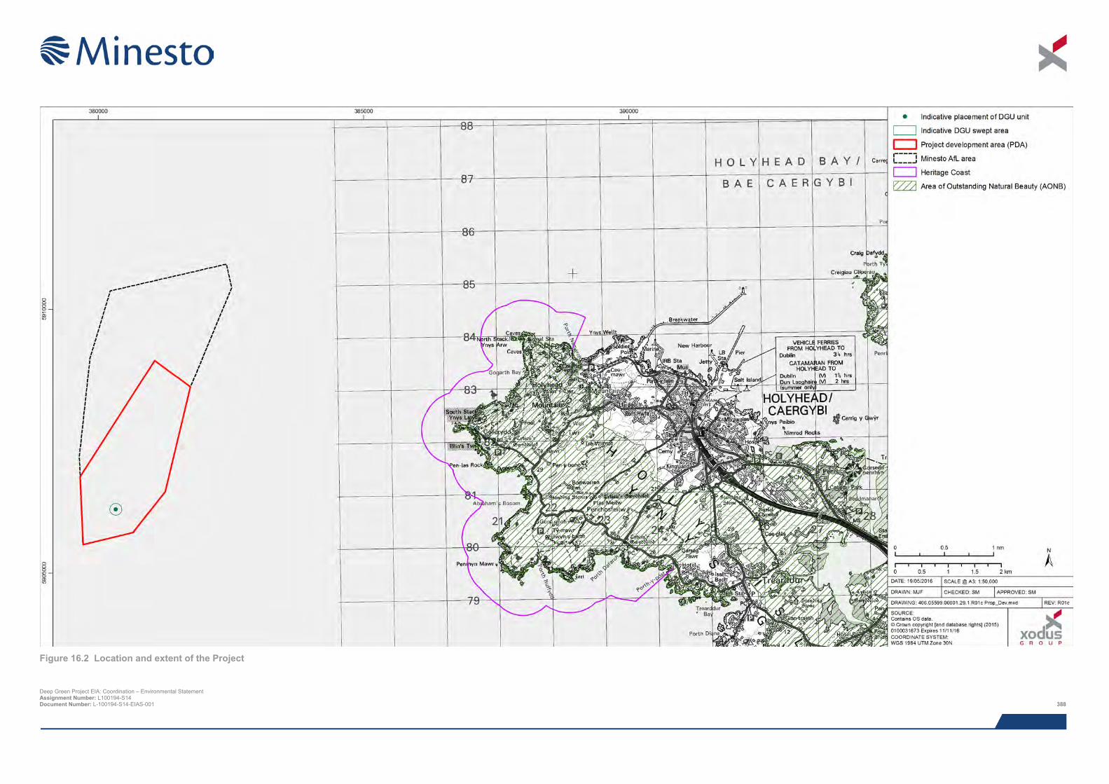
Deep Green Project EIA: Coordination – Environmental Statement Assignment Number: L100194-S14 Document Number: L-100194-S14-EIAS-001 388
Figure 16.2 Location and extent of the Project

This page has been intentionally left blank.
Deep Green Project EIA: Coordination – Environmental Statement Assignment Number: L100194-S14 Document Number: L-100194-S14-EIAS-001 390
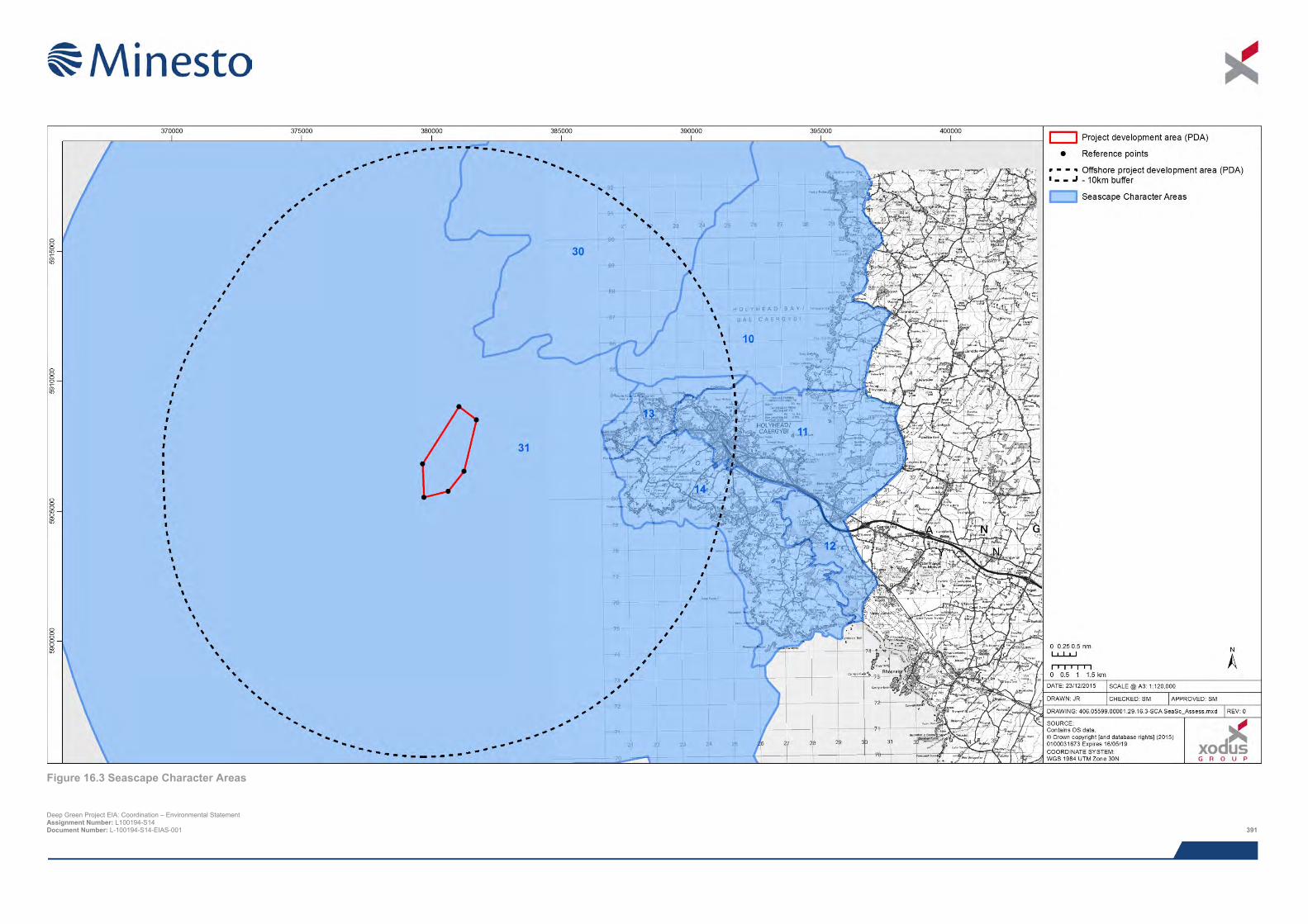
Figure 16.3 Seascape Character Areas
Deep Green Project EIA: Coordination – Environmental Statement Assignment Number: L100194-S14 Document Number: L-100194-S14-EIAS-001 391

This page has been intentionally left blank.
Deep Green Project EIA: Coordination – Environmental Statement Assignment Number: L100194-S14 Document Number: L-100194-S14-EIAS-001 392
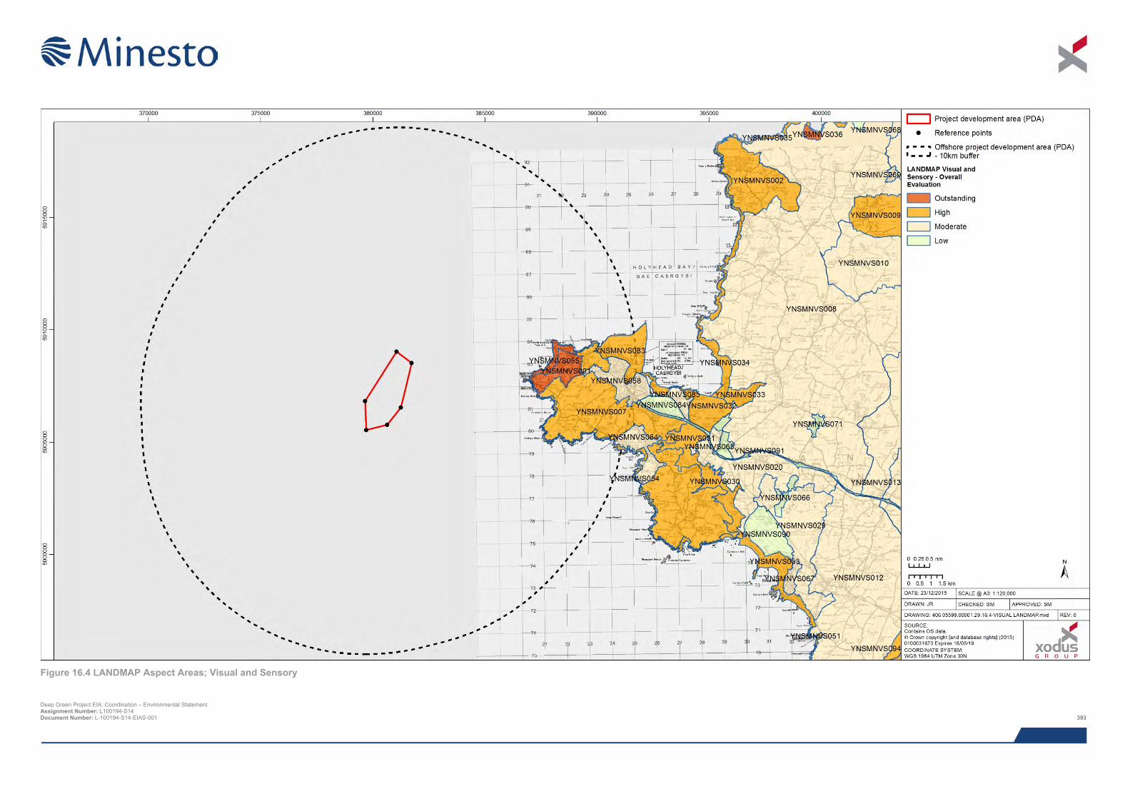
Figure 16.4 LANDMAP Aspect Areas; Visual and Sensory
Deep Green Project EIA: Coordination – Environmental Statement Assignment Number: L100194-S14 Document Number: L-100194-S14-EIAS-001 393

This page has been intentionally left blank.
Deep Green Project EIA: Coordination – Environmental Statement Assignment Number: L100194-S14 Document Number: L-100194-S14-EIAS-001 394
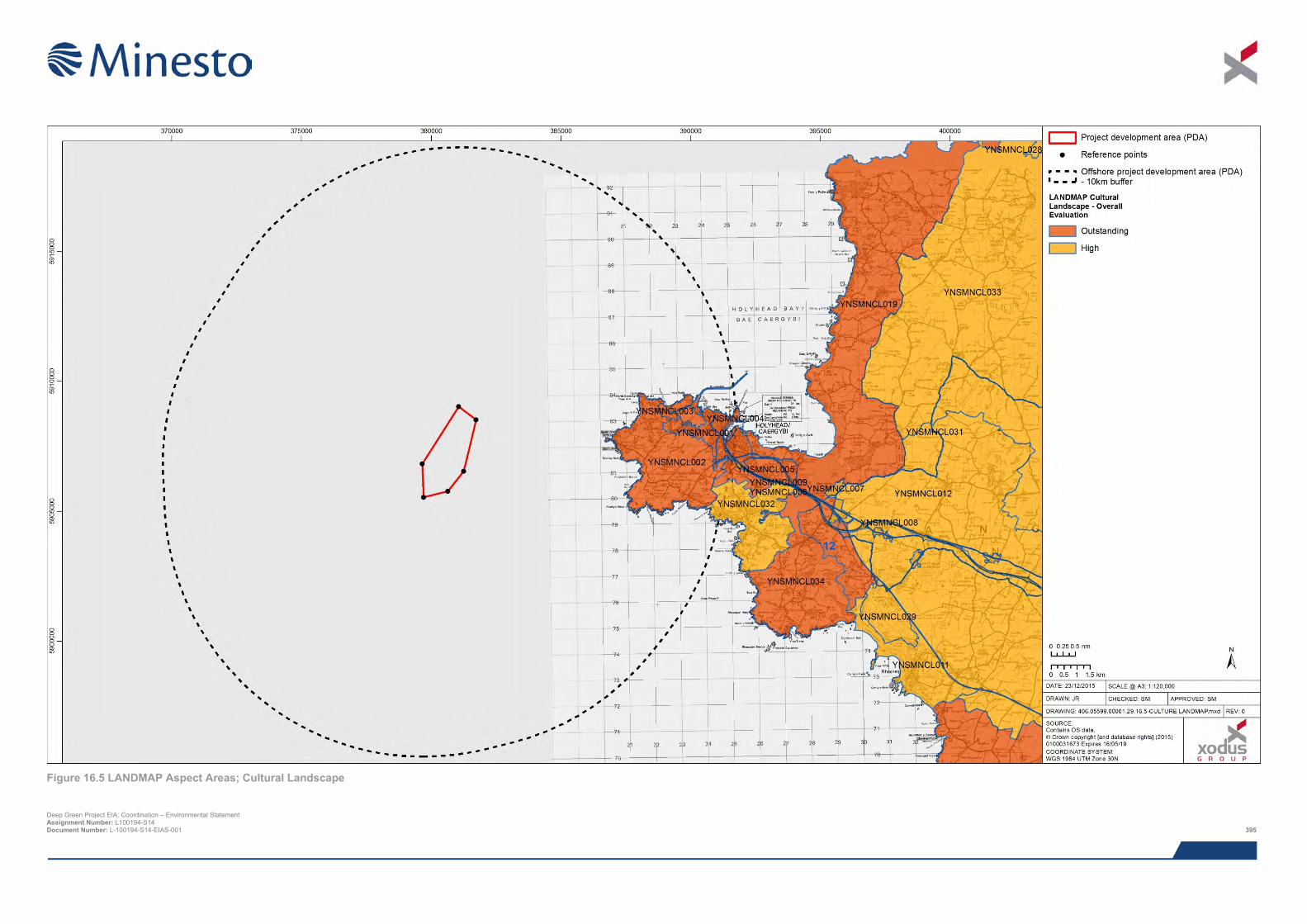
Figure 16.5 LANDMAP Aspect Areas; Cultural Landscape
Deep Green Project EIA: Coordination – Environmental Statement Assignment Number: L100194-S14 Document Number: L-100194-S14-EIAS-001 395

This page has been intentionally left blank.
Deep Green Project EIA: Coordination – Environmental Statement Assignment Number: L100194-S14 Document Number: L-100194-S14-EIAS-001 396
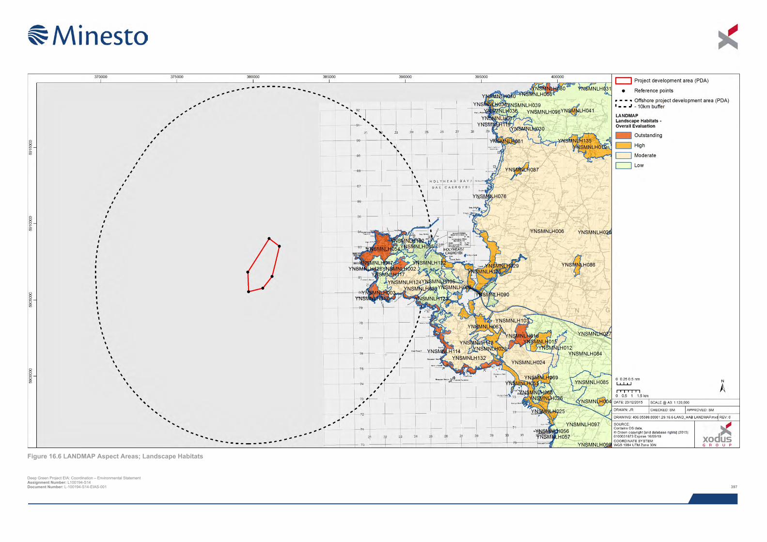
Figure 16.6 LANDMAP Aspect Areas; Landscape Habitats
Deep Green Project EIA: Coordination – Environmental Statement Assignment Number: L100194-S14 Document Number: L-100194-S14-EIAS-001 397

This page has been intentionally left blank.
Deep Green Project EIA: Coordination – Environmental Statement Assignment Number: L100194-S14 Document Number: L-100194-S14-EIAS-001 398
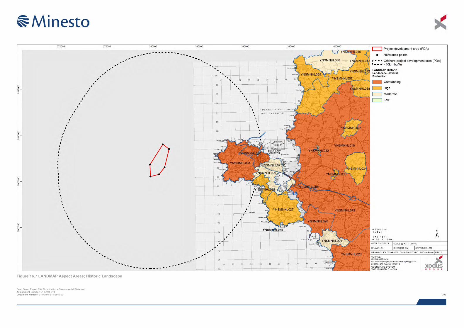
Figure 16.7 LANDMAP Aspect Areas; Historic Landscape
Deep Green Project EIA: Coordination – Environmental Statement Assignment Number: L100194-S14 Document Number: L-100194-S14-EIAS-001 399

This page has been intentionally left blank.
Deep Green Project EIA: Coordination – Environmental Statement Assignment Number: L100194-S14 Document Number: L-100194-S14-EIAS-001 400
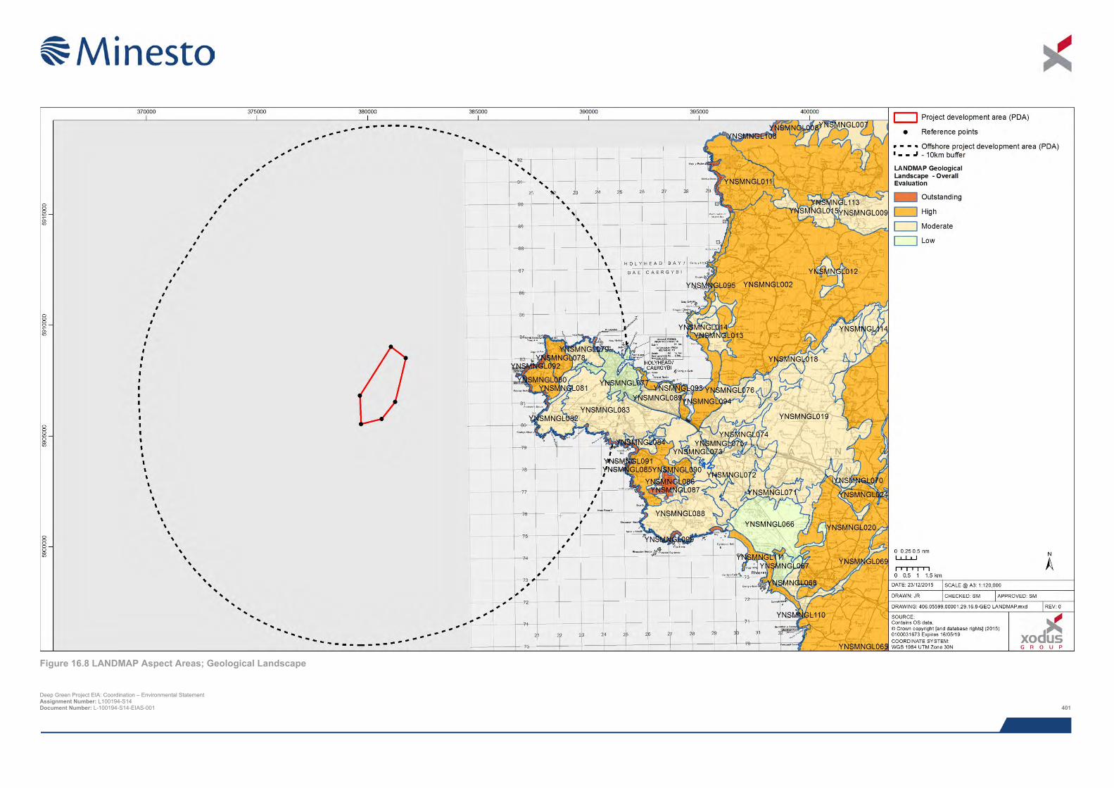
Figure 16.8 LANDMAP Aspect Areas; Geological Landscape
Deep Green Project EIA: Coordination – Environmental Statement Assignment Number: L100194-S14 Document Number: L-100194-S14-EIAS-001 401

This page has been intentionally left blank.
Deep Green Project EIA: Coordination – Environmental Statement Assignment Number: L100194-S14 Document Number: L-100194-S14-EIAS-001 402
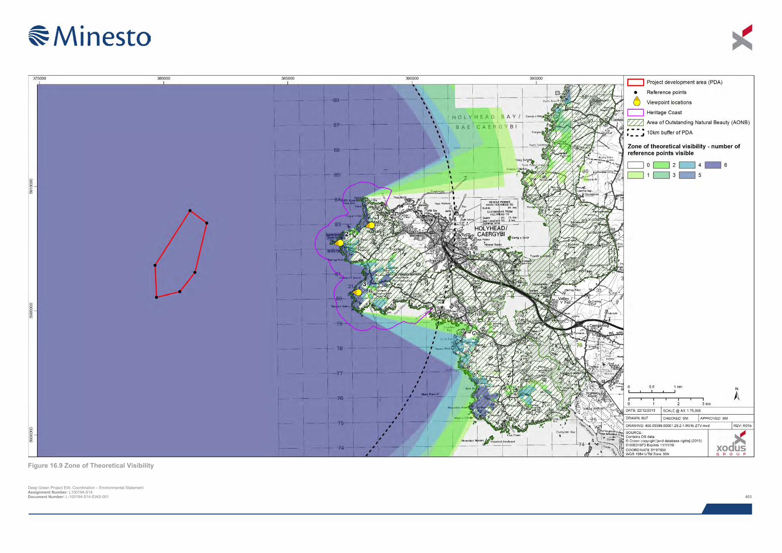
Figure 16.9 Zone of Theoretical Visibility
Deep Green Project EIA: Coordination – Environmental Statement Assignment Number: L100194-S14 Document Number: L-100194-S14-EIAS-001 403

This page has been intentionally left blank.
Deep Green Project EIA: Coordination – Environmental Statement Assignment Number: L100194-S14 Document Number: L-100194-S14-EIAS-001 404
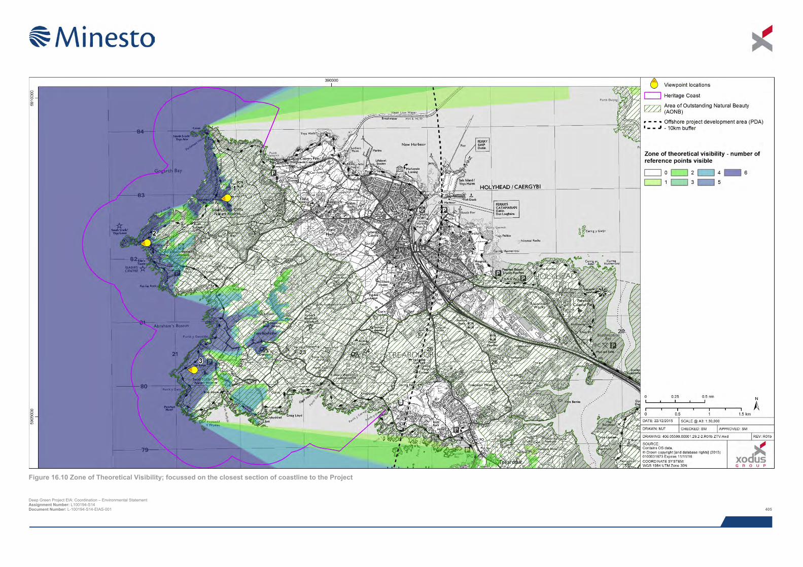
Figure 16.10 Zone of Theoretical Visibility; focussed on the closest section of coastline to the Project
Deep Green Project EIA: Coordination – Environmental Statement Assignment Number: L100194-S14 Document Number: L-100194-S14-EIAS-001 405

This page has been intentionally left blank.
Deep Green Project EIA: Coordination – Environmental Statement Assignment Number: L100194-S14 Document Number: L-100194-S14-EIAS-001 406
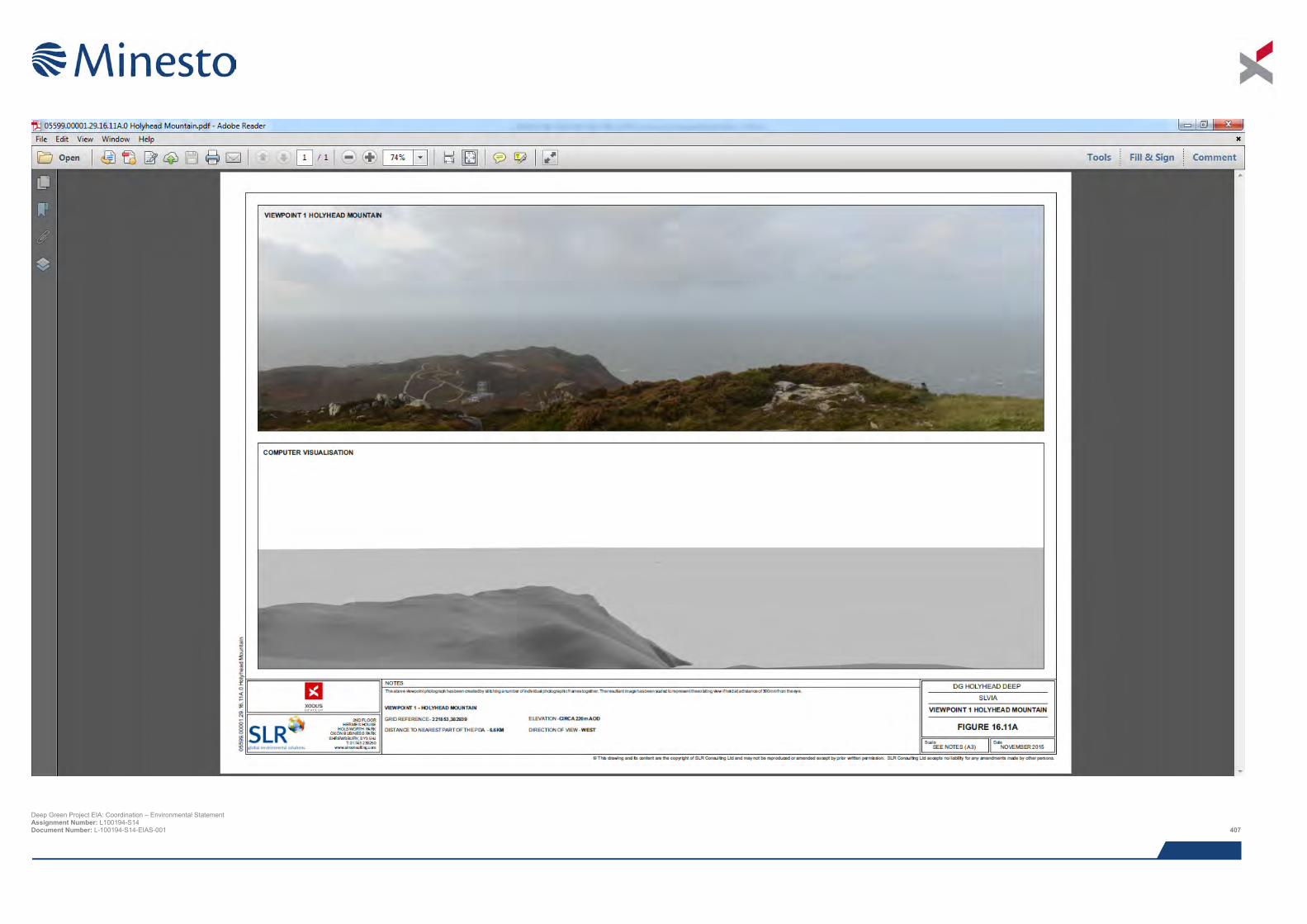
Deep Green Project EIA: Coordination – Environmental Statement Assignment Number: L100194-S14 Document Number: L-100194-S14-EIAS-001 407

This page has been intentionally left blank.
Deep Green Project EIA: Coordination – Environmental Statement Assignment Number: L100194-S14 Document Number: L-100194-S14-EIAS-001 408
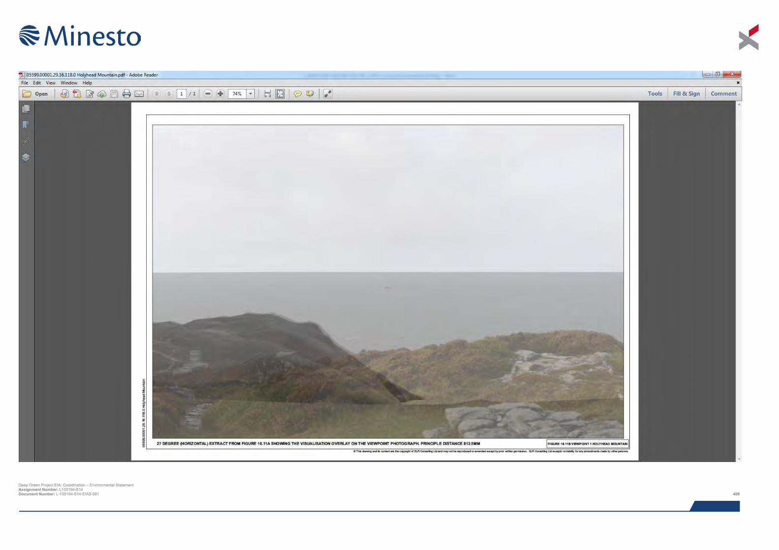
Deep Green Project EIA: Coordination – Environmental Statement Assignment Number: L100194-S14 Document Number: L-100194-S14-EIAS-001 409

This page has been intentionally left blank.
Deep Green Project EIA: Coordination – Environmental Statement Assignment Number: L100194-S14 Document Number: L-100194-S14-EIAS-001 410
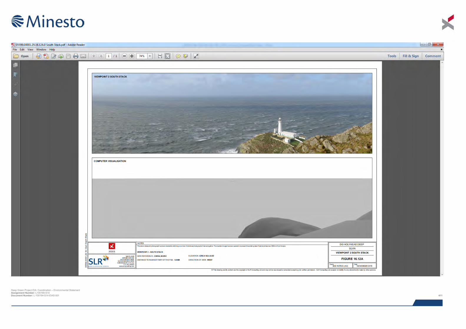
Deep Green Project EIA: Coordination – Environmental Statement Assignment Number: L100194-S14 Document Number: L-100194-S14-EIAS-001 411

This page has been intentionally left blank.
Deep Green Project EIA: Coordination – Environmental Statement Assignment Number: L100194-S14 Document Number: L-100194-S14-EIAS-001 412
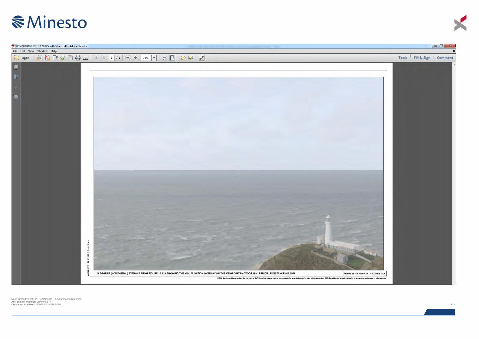
Deep Green Project EIA: Coordination – Environmental Statement Assignment Number: L100194-S14 Document Number: L-100194-S14-EIAS-001 413

This page has been intentionally left blank.
Deep Green Project EIA: Coordination – Environmental Statement Assignment Number: L100194-S14 Document Number: L-100194-S14-EIAS-001 414
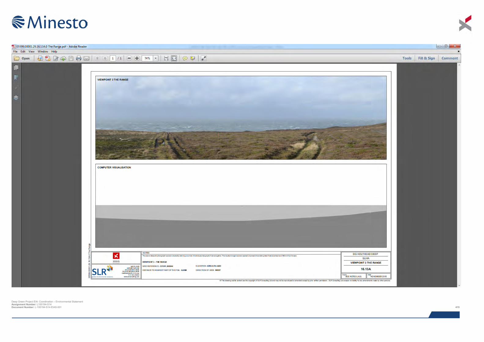
Deep Green Project EIA: Coordination – Environmental Statement Assignment Number: L100194-S14 Document Number: L-100194-S14-EIAS-001 415

This page has been intentionally left blank.
Deep Green Project EIA: Coordination – Environmental Statement Assignment Number: L100194-S14 Document Number: L-100194-S14-EIAS-001 416
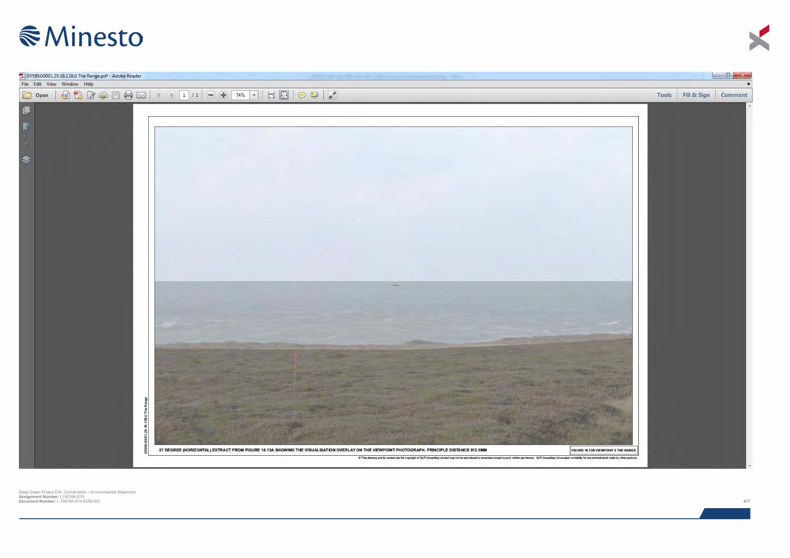
Deep Green Project EIA: Coordination – Environmental Statement Assignment Number: L100194-S14 Document Number: L-100194-S14-EIAS-001 417

This page has been intentionally left blank.
Deep Green Project EIA: Coordination – Environmental Statement Assignment Number: L100194-S14 Document Number: L-100194-S14-EIAS-001 418
17 SOCIO-ECONOMIC
This chapter presents the results from the assessment of impacts on socio-economic conditions in Anglesey, North Wales and Wales and recreation and tourism activities on Anglesey.
Although Anglesey is a popular tourist and visitor destination, known for its high scenic value, it is currently experiencing high levels of unemployment and, in 2013 had the lowest Gross Value Added (GVA) per head (based on income) in the UK. This is mainly as a direct result of the closure the Anglesey Aluminium smelting plant in Holyhead and the Welsh County Lamb Abattoir. With the impending closure of the Wylfa nuclear power station, the main employment opportunities are currently limited to Holyhead ferry port, agriculture and local tourism.
However, following the UK Government’s announcement to develop a new nuclear power station on land adjacent to the existing Wylfa site (Wylfa Newydd), the Island of Anglesey County Council (IACC) established its Energy Island Programme. The main objective of this programme, which includes marine energy, is to establish Anglesey as a major energy hub, resulting in the creation of jobs and building an economy worth up to £12 billion.
The DG Holyhead Deep Project will not replace the large number of jobs lost with the closure of the Aluminium smelting works and impending closure of the Wylfa nuclear power station. However, it is predicted that, through the creation of number of permanent full time jobs at the Minesto Head Quarters (HQ) in Holyhead and temporary, short term jobs during construction, the Project will have a minor, but positive impact in terms of local job creation and GVA.
The sourcing of local services, facilities, vehicles and supplies and local manufacture and supply of foundation structures will also have a minor positive impact on the local supply chain and will make a minor positive contribution towards stimulating longer term growth and investment in Anglesey as a hub for marine energy as set out in the Anglesey Energy Island Programme.
Anglesey is also an important location for recreation and tourism, attracting between 1.5 and 2 million visitors per year. Although a number of key recreational activities take place either on the coast or in coastal waters, potential interactions these activities and the Project are limited. Potential impacts on these activities due to disturbance or displacement are assessed to be negligible and not significant. Although the barge (or similar such surface platform) will be moored within the DGU deployment area for a period of up to five years, potential impacts on the visual amenity or character of the Anglesey Area of Outstanding Natural Beauty (AONB) designation, which extends along much of the Anglesey coastline, will be minor and are unlikely to result in any reductions in visitors to the area.
Potential economic impacts from new tourism activities for boat operators are considered to be positive, although the impact is only considered to be minor and not significant.
17.1 Introduction This chapter focuses specifically on assessing the impacts of the Minesto Deep Green (DG) Holyhead Deep Project (the Project) on local, regional and national socio-economic conditions including local employment and job creation, impacts on the local economy based on spend (Gross Value Added (GVA)), impacts on local supply chains and recreation and tourism. Where necessary, reference is made to other impact assessments carried out as part of this Environmental Impact Assessment (EIA) e.g. fisheries, shipping and navigation and the seascape, landscape and visual impact assessment (SLVIA). However, it is not the intention of this chapter to reproduce information from these chapters. For example, the socio-economic impact of the Project on fisheries is assessed in the Chapter 13: Fisheries and is only referred to in this chapter as part of the assessment of wider socio-economic impacts.
The assessment has been undertaken by Xodus and draws on the outputs from other studies carried out as part of the Environmental Impact Assessment (EIA) as listed in Table 17.1 below. All supporting studies are provided on the accompanying CD.
Deep Green Project EIA: Coordination – Environmental Statement Assignment Number: L100194-S14 Document Number: L-100194-S14-EIAS-001 419
Table 17.1 Supporting studies
Details of study Preliminary Evaluation: Economic Impacts on Fishing (AWJ Marine, 2015)
Navigational Risk Assessment (Anatec, 2015)
17.2 Area of assessment Although this Environmental Statement (ES) covers the offshore Project only, socio-economic impacts will be experienced both onshore and offshore (e.g. recreation and tourism). With regard to assessing potential socio-economic impacts of the Project, the assessment covers the following geographical areas:
> Local – Isle of Anglesey Local Authority;
> Regional – North Wales including local authorities of Isle of Anglesey, Gwynedd, Conwy, Denbighshire, Flintshire and Wrexham; and
> National – Wales.
17.3 Legislation, policy and guidance In the absence of specific legislation or statutory guidance relating to the assessment of socio-economic impacts, most assessments, in general, adopt approaches which tend to follow the UK Guidance (the Green Book), other relevant guidance (e.g. Turner et al., 2010) and other policy documents e.g. National Policy Statements. However, in light of increasing development in the marine environment, specific guidance has recently been prepared by the Marine Management Organisation (MMO) for marine licencing staff who are involved in the implementation of marine planning policies for socio-economics, tourism and seascape. A summary of this guidance, together with other existing recognised guidance and other relevant planning, policy and strategy documents is provided below.
17.3.1 The Green Book The Green Book (2003), re-published in 2011, is the HM Treasury’s guidance tool for undertaking appraisal and evaluation in Central Government (HM Treasury, 2011). It provides techniques, and identifies economic, financial, social and environmental issues to be considered, as part of the assessment of central government policies, programmes or projects. The process for appraisal and evaluation is based on a series of steps comprising: Step 1 – Justifying Action; Step 2 – Setting Objectives; Step 3 – Options Appraisal; Step 4: Developing and Implementing a solution; and Step 5 – Evaluation.
17.3.2 Other relevant guidance documents In 2010 a number of documents were published providing guidance on the requirements for social and economic assessment under the Marine Strategy Framework Directive (MSFD). These included the Economic and Social Analysis for the Initial Assessment for MSFD prepared by the European Commission (EC) and An Introduction to Socio-Economic Assessment within a Marine Strategy Framework (Turner et al., 2010). The EC guidance document focuses on the level of economic and social analysis required under the MSFD and potential methods for carrying out economic and social analysis including the identification of relevant data sources that can be used to inform the analysis. The report by Turner et al., 2010 provides detail on various approaches to carrying out socio-economic assessments including the concept of the ecosystem services approach aside other recognised methodologies including Cost Benefit Analysis (CBA), Cost Effectiveness Analysis (CEA) and Multi-Criteria Analysis (MCA).
In July 2014, the Marine Management Organisation (MMO) published guidance for staff involved in marine licensing to support the implementation of marine planning policies for socio-economics, tourism and seascape. The guidance is specifically focused on assisting marine licensing officers with making determinations on licence applications, in line with agreed objectives within the Marine Policy Statement (MPS), and thus support the implementation of marine planning (MMO, 2014). As well as looking at links between socio-economic impact assessment other assessment processes (e.g. Water Framework Directive (WFD) requirements, Habitat Regulations Assessment (HRA) and EIA),
Deep Green Project EIA: Coordination – Environmental Statement Assignment Number: L100194-S14 Document Number: L-100194-S14-EIAS-001 420

the guidance also makes reference to the application of the ecosystem services approach as described by Turner et al., 2010) noting it may be necessary to combine this approach with other recognised approaches to quantify impacts.
In January 2015, the Social and Economic Sub-Group of the Productive Seas Evidence Group published a report on the Social and Economic Assessment Requirements for Development Projects Affecting the Marine Environment (Productive Seas Evidence Group, 2015). This report further examines the application of the ecosystem services approach to socio-economic assessment, concluding that while this approach may be appropriate for strategic marine planning purposes, there remains a significant lack of guidance on project level social and economic impact assessment and that while the “Green Book” provides a starting point for designing project level methodologies for marine developments, a comprehensive standardised framework that supports consistent and proportionate assessment methods still needs to be developed in this area.
17.3.3 Marine Policy Statement (MPS) The aim of the UK Marine Policy Statement (MPS), which was prepared under the Marine and Coastal Access Act (MCAA) 2009 and formally adopted in March 2011, is to bring together information and policies on the multiple uses of the marine area, together with spatial and temporal data for the water column and the seabed. Prepared by all UK administrations (UK Government, The Scottish Government, the Welsh Assembly Government and the Northern Ireland Executive) it provides the framework for the preparation of national and regional marine plans across the UK and provides the basis against which sustainable licensing decisions will be made until such times as regional and national marine plans are in place.
The UK MPS sets out a number of key strategic priorities for the UK's waters. These include promoting sustainable economic development of marine and coastal areas and ensuring sustainable use of marine resources to address local social and economic issues and highlights the importance of marine renewables in meeting these priorities.
17.3.4 Energy Wales: A Low Carbon Transition Delivery Plan In March 2014, the Welsh Government issued its Delivery Plan setting out how it plans to develop the proposals set out in its Energy Wales: A Low Carbon Transition published in 2012 (Welsh Government, 2014a).
Energy Wales: A Low Carbon Transition (2012) set out in high level terms, the economic, social and environmental opportunities for Wales relating to low carbon energy generation. The Delivery Plan identifies areas of greatest opportunity where activities are to be prioritised. The Delivery Plan identifies a number of key areas of focus including Anglesey Energy Island, with emphasis on the massive opportunities for Anglesey and North Wales associated with the proposed new nuclear power station at Wylfa (Wylfa Newydd), offshore wind and tidal stream energy, with particular reference to the Skerries tidal array project (although future development of this site is uncertain following the recent hand back of the AfL to The Crown Estate).
In terms of specific focus on marine energy, the Delivery Plan identifies that, with 1,200 km of coastline, a number of deep sea ports, accessible grid infrastructure and equalisation of the 5 Renewable Obligation Certificates (ROCs) for wave and tidal projects across the UK from 2013 to 2017, Wales has significant potential for meeting current and future requirements of the marine energy industry. From an economic perspective, based on results from a study carried out by the Welsh Government in 2013, the plan identified that 300 MW of marine energy could lead to the creation of up to 8,500 person years of employment over the next decade, while development of 1 GW of marine energy could generate up to 23,500 person-years of employment in the next 10 to 20 years.
Due to uncertainty around the approach to be taken by The Crown Estate (TCE) to the test and demonstration zones and the creation of third party management arrangements at the time that the Delivery Plan was produced, Marine Energy is identified as an Area for Further Development rather than a specific Delivery Theme. A number of key Priorities for Action have still been identified for this sector including:
> Providing support to TCE in the process of developing Welsh test and demonstration zones, leasing and the 3rd party management arrangements;
> Make available all environmental data and a clear route for filling identified gaps;
> Develop our policy to further maximise the opportunities for marine energy through the Enterprise Zones in the Haven Waterway, Pembrokeshire and Anglesey;
Deep Green Project EIA: Coordination – Environmental Statement Assignment Number: L100194-S14 Document Number: L-100194-S14-EIAS-001 421
> Developing funding routes through the EU structural funds by prioritising support to those areas identified
in studies that have been informed through stakeholder consultations, such as Marine Energy Infrastructure Studies;
> Achieve a streamlining of the consenting regimes in Wales by continuing to engage with partners, in particular NRW;
> Review the current skills needs and gaps in the marine industry in Wales;
> Work with developers to develop the supply chain; and
> Maximise the opportunities for stimulating innovation in marine energy identified through the Marine Energy Technology Innovation Needs Assessment by developing a programme of work with key stakeholders.
17.3.5 Anglesey Energy Island Programme In July 2011, the UK Government identified in its National Policy Statement for Energy, a site near the Wylfa nuclear power station on Anglesey as a possible site for a new nuclear power station (Wylfa Newydd). This announcement is seen as critical for long term economic prosperity and building a sustainable future for Anglesey and North Wales. As such, following the announcement, the Anglesey Energy Island Programme was introduced 2012. The programme is a collective effort between several stakeholders within the public and private sector working to put Anglesey at the forefront of energy research and development, production and servicing (Isle of Anglesey Council (IACC), 2015a).
It is estimates that the Anglesey Energy Island Programme, which is run from the Economic Development Unit of the Isle of Anglesey County Council (IACC), could contribute nearly £12 billion to the Anglesey and North Wales economy over the period from 2012 to 2027. As well as the direct economic benefits associated with a possible new nuclear power station, the programme will also be a vehicle for employment growth and development opportunities across the energy sector including, in addition to nuclear, wind, tidal, biomass and solar; and beyond into housing, transport and tourism and leisure (IACC, 2015b).
17.3.6 Anglesey Destination Management Plan 2012 – 2016 Delivery Plan (2012) This plan presents a number of strategic objectives for promoting Anglesey as a tourist destination. These include objectives and actions to enhance and manage the coastal resource through enhanced access to the coast, enhanced coastal management, enhancing the coastal path and protecting the coastal and rural environment.
17.3.7 Joint Local Development Plan Anglesey & Gywnedd (2011 – 2026) Anglesey and Gwynedd Councils decided to work together to prepare their Joint Local Development Plan (the Plan). The Plan sets out the Councils local land use planning policy framework over a 15 year period. This includes key policies on sustainable development, economic growth, employment and enterprise and tourism as well as policies on housing, environmental protection (natural and historic) and climate change. In addition to identifying specific locations / areas for development, the Plan also sets out a series of strategic and detailed policies which will be used to guide new development and determine planning applications.
The overarching vision of the Plan is to “strengthen communities in Gwynedd and Anglesey”. The Anglesey Energy Island Programme forms a core part of this vision and is seen as being essential to transform the Island’s economy in the future and provide a long term and sustainable quality of life for Anglesey residents, with the ultimate aim for Anglesey and Gwynedd, by 2026, to be recognised as a leading location for a variety of renewable and low carbon energy sectors and knowledge based industries.
A number of strategic policies have been set out to facilitate the sustainable development of Wylfa Newydd and other major strategic projects brought forward under the umbrella of Anglesey Energy Island Programme. These include Strategic Policy PS7: Renewable Energy Technology where “the Councils will seek to ensure that the Plan area wherever feasible and viable realises its potential as a leading area for initiatives based on renewable or low carbon energy technologies by promoting the development of renewable energy technologies”; Strategic Policy PS8 which focuses on proposals for large infrastructure projects and Strategic Policy PS9 which is specific to Wylfa Newydd and focuses on promoting development under the umbrella of Anglesey Energy Island Programme. Policies included
Deep Green Project EIA: Coordination – Environmental Statement Assignment Number: L100194-S14 Document Number: L-100194-S14-EIAS-001 422
in the Plan build on both the Anglesey Energy Island Programme and previous policies for the economic regeneration of Anglesey set out in the Anglesey Economic Regeneration Strategy 2007 to 2015.
17.3.8 Planning Policy Wales (PPW) – Edition 7 July 2014 Planning Policy Wales (PPW) sets out land use planning policies of the Welsh Government (Welsh Government, 2014b). It is supplemented by a series of Technical Advice Notes (TANs). Those relevant to the socio-economic aspects of this Project are discussed below.
PPW translates the Welsh Governments commitment to sustainable development. As a National policy document, the policies set out in PPW provide the framework for the preparation of local development plans. They are also a material consideration in the determination of planning applications for individual developments.
Chapter 7 of PPW sets out specific planning policies for economic development which is defined as the development of land and buildings for activities that generate wealth, jobs and incomes. As well as traditional employment land uses (e.g. offices, research and development, industry and warehousing) and other land uses such as retail, leisure, tourism and public services, it is recognised that the construction and energy sectors are also important to the economy and therefore also sensitive to planning policy. Section 7.4 focuses on promoting the low carbon economy, business and technology clusters and social enterprises, highlighting that local planning authorities should support a shift towards a low carbon economy.
17.3.9 Technical Advice Note (TAN) 23: Economic Development (2014) TAN 23 sets out high level planning objectives and key considerations relating to economic development (Welsh Government, 2014c). However, whilst it is acknowledged that the whole-economy contribution to economic growth is important, this TAN only focuses on the traditional land use B classes where development must be planned in a sustainable way. The importance of ensuring the planning system also supports the low carbon economy is noted. However, there is no specific information on land use planning considerations associated with renewable energy related economic development.
17.4 Scoping and consultation Consultation has been ongoing throughout the EIA and played an important part in ensuring the scope of the baseline characterisation work and impact assessment have been appropriate to the Project and the requirements of the regulators and their advisors.
Relevant comments on socio-economics, recreation and tourism received from the EIA Scoping Opinions provided by Natural Resources Wales (NRW) and the IACC are summarised below:
> The assessment should make reference to the Anglesey & Gwynedd Joint Local Development Plan. It is anticipated that this Plan will be adopted by the end of 2016.
> The development plan comprises of the Gwynedd Structure Plan (1993) and the Ynys Môn Local Plan (1996). The stopped Unitary Development Plan (2005) is a material planning consideration for development control purposes. Legislation still secures a presumption in favour of development in accordance with the development plan for the area unless material considerations indicate otherwise. However, given the age of the existing development plan and the stopped UDP, it would also be advisable to refer to Planning Policy Wales and relevant Technical Advice Notes (TANs);
> The assessment should also consider:
o The Anglesey Destination Management Action Plan (2013) (http://www.anglesey.gov.uk/business/destination-anglesey/destination-management-action-plan/); and
o Anglesey Energy Island Programme (http://www.anglesey.gov.uk/business/energy-island/).
> Depending on the number of jobs potentially created and timing of construction stage there may be a need to consider cumulative impact on accommodation stock (private rented properties & tourism (e.g. bed and breakfast, guest houses);
Deep Green Project EIA: Coordination – Environmental Statement Assignment Number: L100194-S14 Document Number: L-100194-S14-EIAS-001 423
> The ES should contain details with regards to a worker profile breakdown to cover each stage of
development (i.e. during construction, operation and decommissioning). This should include number of workers (direct & indirect), types of jobs; and
> The ES should also address how local jobs will be created and outline whether up-skilling of the local workforce will be required to ensure that local people can capitalise on these jobs. The EIA should also consider supply chain opportunities.
The public event held by Minesto in Holyhead Town Hall in May 2015 allowed local stakeholders and members of the local community to comment on the Project. A questionnaire was supplied giving a chance for attendees to leave feedback. Of the 150+ visitors who attended, 25 completed a feedback questionnaire. The feedback received on the Project was generally positive, especially in relation to socio-economics, for instance:
> When asked “What are your views on the proposed Deep Green Holyhead Deep Project?”, 92% were either very supportive or supportive, while the remaining 8% were undecided; and
> The one particular comment made in relation to socio-economics was: “I hope very much it will benefit the local community of Holy Island and the wider community of North Wales.”
In January 2016 Minesto held another public consultation event to update the local community on Project progress, including updates on Project design that had occurred since the last public event and it disseminate the results of the EIA. Again feedback received on the Project was generally positive.
17.5 Baseline description
17.5.1 Desk based study A desk based study was carried out to identify the social, economic, recreation and tourism conditions of the Project area (local, regional and national). The main sources of data reviewed as part of this desk based study are listed in Table 17.2 below.
Table 17.2 Data sources used to inform the description of socio-economic conditions and recreation and tourism activities in the Project study area
Data source Description
Office of National Statistics (ONS, 2014) Gross Value Added (GVA) (£ per head) and total £ for area
Population – Mid-Year Population Estimates (2014) for Anglesey, North Wales, Wales and UK
Nomis – Official Labour Market Statistics (Nomis, 2015a, 2015b)
Labour market profiles for Anglesey and North Wales including population statistics
Welsh Government – StatWales (StatWales, 2015)
Regional economic and labour market profile for North Wales (including Anglesey)
Visit Anglesey website (Visit Anglesey, 2015) Recreation and tourism activities on Anglesey – includes links to providers of tourism / recreation activities
Visit Wales website (Visit Anglesey, 2015) Recreation and tourism activities in Wales including Anglesey
No surveys or additional studies have been carried out as part of this assessment.
17.5.2 Socio-economic baseline conditions Anglesey is a large island located off the coast of North Wales. It is renowned for its high environmental and scenic value. Being predominately rural and agricultural it remains relatively undeveloped and boasts 100s of km of unspoilt coastline and beautiful landscapes.
Deep Green Project EIA: Coordination – Environmental Statement Assignment Number: L100194-S14 Document Number: L-100194-S14-EIAS-001 424
The largest town is Holyhead, a historically industrial town, and the home of the Anglesey Aluminium Metals (AAM) Ltd smelting plant which ceased operations in 2009 with the loss of nearly 400 jobs. The Aluminium Powder Company Ltd (APOCO) now operate a facility in the eastern end of the AAM site, producing aluminium powders and granules. In January 2016 it was announced that following the purchase of the former Anglesey Aluminium site by Orthios, a large biomass plant and eco-park will be built, which will create more than 1,700 jobs. The development will see more than 500 permanent jobs and 1,200 construction jobs brought to the area before 2018. The plant will process waste wood to create power, with heat generated used to farm prawns and grow vegetables.
The other main source of employment in Holyhead is the ferry port which serves as a major transport route to Ireland. Other towns on Anglesey include Llangefni, which is located in the centre of the Island and Amlwch on the north east coast, both of which are small towns that are heavily reliant on tourism and agriculture as the main sources of local employment.
The island also accommodates the Royal Air Force station RAF Valley and the Wylfa nuclear power station. While the existing nuclear power plant is in the process of being closed down, the island has received a significant boost following UK Government announcement that it is considering the adjacent site as a possible location for a new nuclear power station, referred to as Wylfa Newydd. Plans for development of the site are being taken forward by Hitachi, referred to as the Horizon Project. If the project goes ahead (subject to gaining a Development Consent Order (DCO) under the Planning Act 2008) it could be worth £5.7bn to the Welsh economy.
The main transport links to Anglesey include the A55 which links Holyhead to Chester on the Wales / England border and the main North Wales train line which directly links Holyhead to anywhere in the UK via Chester, Warrington or Manchester. There is also direct access to Ireland via the Holyhead ferry service.
With direct transport links from Liverpool, Manchester and rest of north west England, Anglesey is a popular tourist destination with an estimated 1.5 to 2 million people visiting each year. In addition to key places of interest to visit e.g. castles, county houses, RSPB South Stack Visitor Centre and Anglesey Zoo, the island is also a popular location for a range of recreational pursuits such as sailing, angling, cycling, walking, wind surfing, kayaking and jet skiing.
17.5.2.1 Population Based on the Office of National Statistics (ONS) mid-year population estimates, in 2014 Anglesey had a population of 70,169. This is an increase of 0.37% on the 2011 census population of 69,913. Of the 2014 population, 41,141 are of working age (16 to 64), which is a 2.73% reduction on the 2011 working age population which was 42,294.
This reduction in working age population is attributed to two factors; one being limited employment opportunities on the island, resulting in people of a working age having to seek employment elsewhere outside Anglesey; the other being a combination of a generally ageing population and the attractiveness of the Island as a retirement location. However, 2014 mid-year population estimates indicate that there has also been a reduction in the size of the working age population across North Wales and Wales when compared to the UK as a whole which has increased by 0.23%. A summary of the population statistics for Anglesey compared to the rest of North Wales, Wales and UK is provided in Table 17.3
Table 17.3 Population statistics for Anglesey, North Wales, Wales and UK (Source: ONS, 2014)
Population Anglesey North Wales Wales UK
All (2014) 70,169 694,038 3,092,036 64,596,752
All (2011) 69,913 688,417 3,063,758 63,285,145
% Change +0.37 +0.82 +0.92 +2.07
Working age (16 – 64) (2014)
41,141 418,129 1,922,448 41,036,530
Working age (16 – 64) (2011)
42,294 425,710 1,941,524 40,944,079
% Change -2.73 -1.78 -0.98 +0.23
Deep Green Project EIA: Coordination – Environmental Statement Assignment Number: L100194-S14 Document Number: L-100194-S14-EIAS-001 425
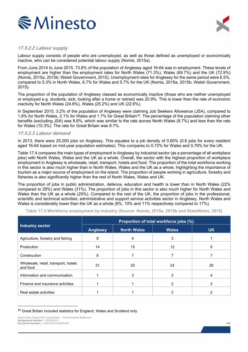
17.5.2.2 Labour supply Labour supply consists of people who are unemployed, as well as those defined as unemployed or economically inactive, who can be considered potential labour supply (Nomis, 2015a).
From June 2014 to June 2015, 73.8% of the population of Anglesey aged 16-64 was in employment. These levels of employment are higher than the employment rates for North Wales (71.3%), Wales (69.7%) and the UK (72.9%) (Nomis, 2015a, 2015b; Welsh Government, 2015). Unemployment rates for Anglesey for the same period were 6.5%, compared to 5.3% in North Wales, 6.7% for Wales and 5.7% for the UK (Nomis, 2015a, 2015b; Welsh Government, 2015).
The proportion of the population of Anglesey classed as economically inactive (those who are neither unemployed or employed e.g. students, sick, looking after a home or retired) was 20.9%. This is lower than the rate of economic inactivity for North Wales (24.6%), Wales (25.2%) and UK (22.6%).
In September 2015, 3.2% of the population of Anglesey were claiming Job Seekers Allowance (JSA), compared to 1.8% for North Wales, 2.1% for Wales and 1.7% for Great Britain39. The percentage of the population claiming other benefits (excluding JSA) was 8.8%, which was similar to the rate across North Wales (8.7%) and less than the rate for Wales (10.3%). The rate for Great Britain was 8.7%.
17.5.2.3 Labour demand In 2013, there were 25,000 jobs on Anglesey. This equates to a job density of 0.60% (0.6 jobs for every resident aged 16-64 based on mid-year population estimates). This compares to 0.72% for Wales and 0.79% for the UK.
Table 17.4 compares the main types of employment in Anglesey by industrial sector (as a percentage of all workplace jobs) with North Wales, Wales and the UK as a whole. Overall, the sector with the highest proportion of workplace employment in Anglesey is wholesale, retail, transport, hotels and food. The proportion of the total workforce working in this sector is also much higher than in North Wales, Wales and the UK as a whole, highlighting the importance of tourism as a major source of employment on the island. The proportion of people working in agriculture, forestry and fisheries is also significantly higher than the rest of North Wales, Wales and UK.
The proportion of jobs in public administration, defence, education and health is lower than in North Wales (22% compared to 29%) and Wales (31%). The proportion of jobs in this sector is also much higher for North Wales and Wales than the UK as a whole (25%). Compared to the rest of the UK, the proportion of jobs in the professional, scientific and technical activities; administrative and support service activities sector in Anglesey, North Wales and Wales is considerably lower than the UK as a whole (8%, 10% and 11% respectively compared to 17%).
Table 17.4 Workforce employment by industry (Source: Nomis, 2015a, 2015b and StatsWales, 2015)
Industry sector Proportion of total workforce jobs (%)
Anglesey North Wales Wales UK
Agriculture, forestry and fishing 8 4 3 1
Production 14 15 12 9
Construction 8 7 7 7
Wholesale, retail, transport, hotels and food 31 25 24 26
Information and communication 1 3 3 4
Finance and insurance activities 1 1 2 3
Real estate activities 1 1 2 2
39 Great Britain included statistics for England, Wales and Scotland only. Deep Green Project EIA: Coordination – Environmental Statement Assignment Number: L100194-S14 Document Number: L-100194-S14-EIAS-001 426
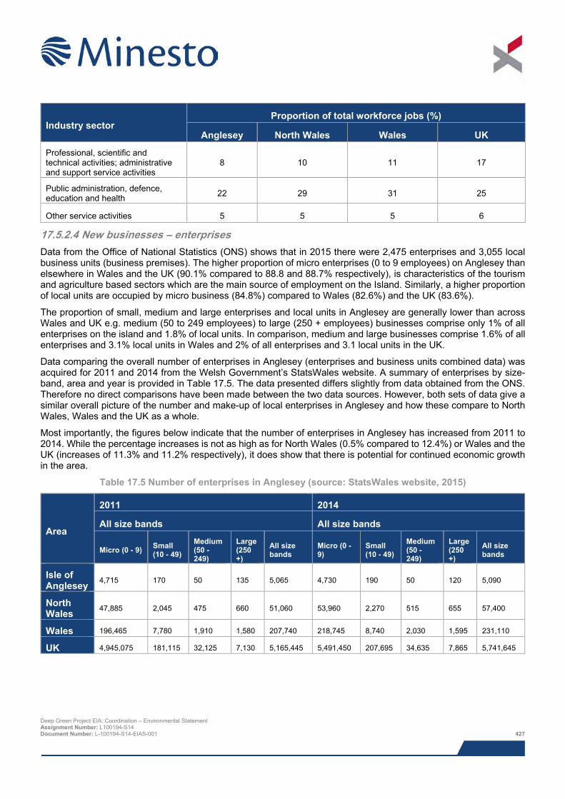
Industry sector Proportion of total workforce jobs (%)
Anglesey North Wales Wales UK
Professional, scientific and technical activities; administrative and support service activities
8 10 11 17
Public administration, defence, education and health 22 29 31 25
Other service activities 5 5 5 6
17.5.2.4 New businesses – enterprises Data from the Office of National Statistics (ONS) shows that in 2015 there were 2,475 enterprises and 3,055 local business units (business premises). The higher proportion of micro enterprises (0 to 9 employees) on Anglesey than elsewhere in Wales and the UK (90.1% compared to 88.8 and 88.7% respectively), is characteristics of the tourism and agriculture based sectors which are the main source of employment on the Island. Similarly, a higher proportion of local units are occupied by micro business (84.8%) compared to Wales (82.6%) and the UK (83.6%).
The proportion of small, medium and large enterprises and local units in Anglesey are generally lower than across Wales and UK e.g. medium (50 to 249 employees) to large (250 + employees) businesses comprise only 1% of all enterprises on the island and 1.8% of local units. In comparison, medium and large businesses comprise 1.6% of all enterprises and 3.1% local units in Wales and 2% of all enterprises and 3.1 local units in the UK.
Data comparing the overall number of enterprises in Anglesey (enterprises and business units combined data) was acquired for 2011 and 2014 from the Welsh Government’s StatsWales website. A summary of enterprises by size-band, area and year is provided in Table 17.5. The data presented differs slightly from data obtained from the ONS. Therefore no direct comparisons have been made between the two data sources. However, both sets of data give a similar overall picture of the number and make-up of local enterprises in Anglesey and how these compare to North Wales, Wales and the UK as a whole.
Most importantly, the figures below indicate that the number of enterprises in Anglesey has increased from 2011 to 2014. While the percentage increases is not as high as for North Wales (0.5% compared to 12.4%) or Wales and the UK (increases of 11.3% and 11.2% respectively), it does show that there is potential for continued economic growth in the area.
Table 17.5 Number of enterprises in Anglesey (source: StatsWales website, 2015)
Area
2011 2014
All size bands All size bands
Micro (0 - 9) Small (10 - 49)
Medium (50 - 249)
Large (250 +)
All size bands
Micro (0 - 9)
Small (10 - 49)
Medium (50 - 249)
Large (250 +)
All size bands
Isle of Anglesey 4,715 170 50 135 5,065 4,730 190 50 120 5,090
North Wales 47,885 2,045 475 660 51,060 53,960 2,270 515 655 57,400
Wales 196,465 7,780 1,910 1,580 207,740 218,745 8,740 2,030 1,595 231,110
UK 4,945,075 181,115 32,125 7,130 5,165,445 5,491,450 207,695 34,635 7,865 5,741,645
Deep Green Project EIA: Coordination – Environmental Statement Assignment Number: L100194-S14 Document Number: L-100194-S14-EIAS-001 427
17.5.2.5 Gross Value Added (GVA) Based on data from the ONS, in 2013 Anglesey had a GVA of £797 million which equated to £11,368 per head. This was the lowest GVA in the UK. In comparison, GVA for North Wales was £11,731 million which equates to £16,953 per head. This was similar to Wales (£16,893 per head) but much lower than the GVA for the UK which was £23,394. By contrast other authorities in North Wales have seen increases in GVA, with GVA per head in Gwynedd increasing from £16,711 in 2012 to £17,889 in 2013 and GVA in Flintshire and Wrexham at £19,422 in 2013 (Welsh Government, 2015).
The low GVA for Anglesey has been mainly attributed to the loss of well paid jobs following the closure of the Anglesey aluminium smelting plant as well as major job losses at the Welsh Country Foods lamb abattoir (Daily Post, December 2104). Other contributing factors include higher proportion of elderly residents and net commuting from Anglesey (Welsh Government, 2015).
While GVA in North Wales may only be 72.5% of the UK average, Gross Disposable Household Income (GDHI) at £15,856 per head was 90.3% of the UK average and is higher than the Wales average of 87.8% (Welsh Government, 2015). GDHI for Anglesey was £15,601 which is higher than the average for Wales (£15,413).
17.5.2.6 Supply chain and business development – marine renewables According to the Marine Energy in Wales – Investment, Jobs, Supply Chain report by Marine Energy Pembrokeshire (MEP) (2015), the renewable marine energy industry has already had a positive effect on the “Low Carbon Economy” in Wales, providing green jobs and growth in a challenging economic climate. The report concludes that technology and project developers to date have spent £34.5 million on marine energy projects in Wales, helping to create over 174 person years of employment. The MEP report also argues that the Welsh supply chain has been involved in this new sector at levels of almost 50 percent for tidal stream and 60 percent for wave energy (MEP, 2015).
In terms of supply chain opportunities for marine energy on Anglesey, a key focus of the Energy Island Programme is to promote Anglesey as a hub for marine energy by ensuring local supply chains are in place to support the growth and development of Anglesey’s marine energy industry. Anglesey has already made significant progress in this area having secured two of the Agreement for Lease (AfL) sites awarded by The Crown Estate (TCE) in July 2014 for tidal demonstration and development projects.
One of the AfL areas was awarded to Minesto for the DG Holyhead Deep Project which is the focus of this assessment. The other AfL was awarded to Morlais for the West Anglesey Demonstration Zone (WADZ). Unlike the Minesto site which is a project specific development site, the aim of the WADZ is to further encourage and accelerate development of tidal technologies. Covering an area of 35.3 km2 to the south west of Holy Island it has been identified by Morlais as having potential for up to 100 MW installed in the next decade (up to 2025) based on a range of projects from test demonstration projects of around 3 MW to full scale commercial arrays up to 30 MW.
In addition to the TCE awarded sites, Anglesey also accommodates the consented Anglesey Skerries Tidal Array site. The site, which has a total area of 0.4 km2 is located approximately 17.8 km north east of the PDA. The awarded consent is for the installation and operation of up to five SeaGen 2 MW devices. However, following the recent hand back of the AfL to The Crown Estate the potential future development of this site is uncertain.
17.5.3 Recreation and tourism In addition to its high scenic value and high quality natural environment (most of the island’s coastline is designated as an Area of Outstanding Natural Beauty (AONB)), Anglesey is also a popular visitor destination for people involved in outdoor recreation activities and pursuits. Some of the features are shown in Figure 17.1.
The island boasts its own coastal path which extends for 125 miles / 200 km around most of the Islands coastline. The path is mainly a walking path, although there are sections of the path that are suitable for cyclists and horse riders. Section 12 of the coastal path (Trearddur Bay to Valley) extends around the entire coastline of Holy Island.
There are a number of local businesses on Anglesey and Holy Island that specialise in providing a wide range of sea and coast based activities including coasteering, rock climbing, abseiling, sea kayaking, canoeing, windsurfing, kite surfing, sea level traversing, gorge scrambling, canyoning, tyrolean traverse, orienteering, raft building, adventure boat rides and wildlife tours (e.g. to South Stack) (Visit Anglesey, 2015).
Deep Green Project EIA: Coordination – Environmental Statement Assignment Number: L100194-S14 Document Number: L-100194-S14-EIAS-001 428
Anglesey is also an important location for diving, and is one of only two locations in the UK to hold an annual week long Scuba Fest. There are a number of sites of interest for diving located off the coast of Holy Island. These include the ship wreck Primrose Hill which is located in waters off South Stack, and ship wreck SS Kyle Firth which is located between Porth Dafarch beach (south coast) and South Stack. Other key dive sites of interest include SS Missouri and ship wreck Hermine both in waters off the coast at Trearddur Bay also on the south coast of Holy Island (Visit Anglesey, 2015).
As discussed in Chapter 13: Fisheries, a range of recreational fishing occurs around the coast of Holy Island including sea angling, shore angling, recreational handlining and potting, and hand gathering of shellfish.
The PDA is also located within a recognised general sailing area. The nearest harbour facility to the PDA is Holyhead Sailing Club, which is based in the historic Holyhead harbour located approximately 9.3 km to the east of the PDA. Other recreational facilities include Holyhead Marina and the Anglesey School of Sailing, also located in Holyhead, and the Treaddur Bay Sailing Club, which is extremely busy in summer months. During the marine traffic surveys carried out as part of the Project Navigational Risk Assessment (NRA) an average of three recreational vessels per day were recorded in the marine survey area throughout the summer survey. This reduced to an average of one vessel every two days during the spring survey. However, only eight vessels were recorded intercepting the PDA, with the majority of recreational activity occurring inshore of the PDA.
As noted in Chapter 14: Shipping and Navigation, there are a number of annual recreational sailing race events that take place in the waters around Holy Island. These include the Round Anglesey Race, the Holyhead Traditional Sail Festival (usually end of August), Holyhead Festival (usually end of July) and various regattas held by the Holyhead Sailing Club. The sailing club has over 600 members and moorings for up to 170 boat and provides racing at all levels for yachts, squib keelboats and dinghy classes, including toppers. The marine traffic surveys also observed high levels of sea kayaking in very close proximity to the shoreline (outside the proposed device deployment area). The Maritime and Coastguard Agency (MCA) confirmed that sea kayakers are known to use the nearshore area in the vicinity of the PDA, but are not likely to be present in the PDA.
Other places of interest on Holy Island include the South Stack Lighthouse and RSPB Visitor Centre, Breakwater Country Park, located to the west of Holyhead, Holyhead Golf Course and sandy beaches at Porth Dafarch and Trearddur Bay (see Figure 17.1). In addition to the sailing events, Anglesey also supports a number of annual sporting events including the Anglesey leg of the Endurance Life Coastal Trail Series, an annual two week walking event and the Tour de Môn, which is a 106 mile cycling sportive. All these events are located either at, or include various stretches of the Anglesey and Holy Island coastline.
17.5.4 Summary of baseline environment Being predominantly agricultural and located on the periphery of North Wales, employment opportunities on Anglesey are fairly limited. Following closure of the Aluminium smelting works in 2009, the Welsh County Lamb Abattoir and the impending closure of the Wylfa nuclear power station, the main sources of employment are currently in tourism or the ferry port at Holyhead. Consequently, Gross Value Added (based on income) is low, with GVA per head recorded as being the lowest in the UK in 2013. The lack of employment opportunities has resulted in a net flow of working age members of the population off the island. This, combined with Anglesey being highly regarded as a retirement location due to its scenic qualities, has resulted in an ageing population.
However, with the Anglesey Energy Island Programme, it is anticipated that Anglesey will, in the long term become a major energy hub, resulting in the creation of jobs and building an economy worth up to £12 billion.
Anglesey is also an important location for tourism, attracting between 1.5 and 2 million visitors per year. The ability for the area to provide access to a wide range outdoor, marine and coastal based activities and pursuits is a key part of the islands recreation and tourism industry.
17.5.5 Data gaps and uncertainties No data gaps or uncertainties identified.
Deep Green Project EIA: Coordination – Environmental Statement Assignment Number: L100194-S14 Document Number: L-100194-S14-EIAS-001 429
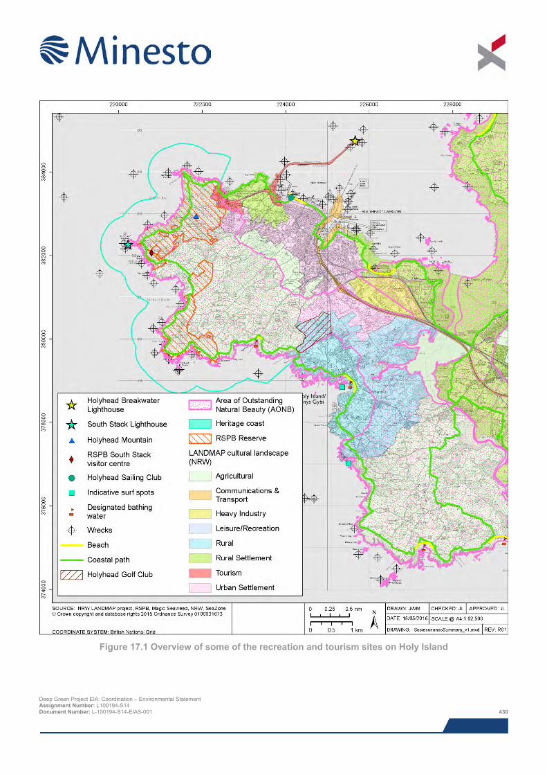
Figure 17.1 Overview of some of the recreation and tourism sites on Holy Island
Deep Green Project EIA: Coordination – Environmental Statement Assignment Number: L100194-S14 Document Number: L-100194-S14-EIAS-001 430
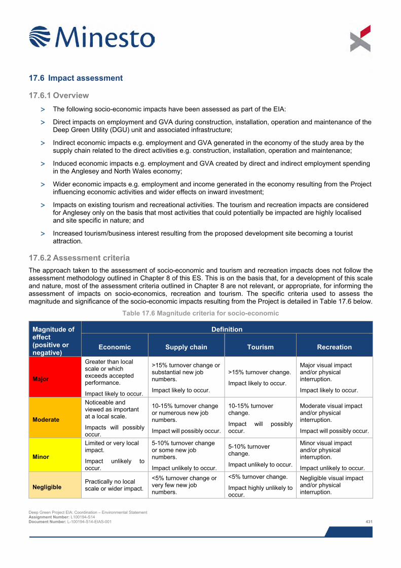
17.6 Impact assessment
17.6.1 Overview > The following socio-economic impacts have been assessed as part of the EIA:
> Direct impacts on employment and GVA during construction, installation, operation and maintenance of the Deep Green Utility (DGU) unit and associated infrastructure;
> Indirect economic impacts e.g. employment and GVA generated in the economy of the study area by the supply chain related to the direct activities e.g. construction, installation, operation and maintenance;
> Induced economic impacts e.g. employment and GVA created by direct and indirect employment spending in the Anglesey and North Wales economy;
> Wider economic impacts e.g. employment and income generated in the economy resulting from the Project influencing economic activities and wider effects on inward investment;
> Impacts on existing tourism and recreational activities. The tourism and recreation impacts are considered for Anglesey only on the basis that most activities that could potentially be impacted are highly localised and site specific in nature; and
> Increased tourism/business interest resulting from the proposed development site becoming a tourist attraction.
17.6.2 Assessment criteria The approach taken to the assessment of socio-economic and tourism and recreation impacts does not follow the assessment methodology outlined in Chapter 8 of this ES. This is on the basis that, for a development of this scale and nature, most of the assessment criteria outlined in Chapter 8 are not relevant, or appropriate, for informing the assessment of impacts on socio-economics, recreation and tourism. The specific criteria used to assess the magnitude and significance of the socio-economic impacts resulting from the Project is detailed in Table 17.6 below.
Table 17.6 Magnitude criteria for socio-economic
Magnitude of effect (positive or negative)
Definition
Economic Supply chain Tourism Recreation
Major
Greater than local scale or which exceeds accepted performance.
Impact likely to occur.
>15% turnover change or substantial new job numbers.
Impact likely to occur.
>15% turnover change.
Impact likely to occur.
Major visual impact and/or physical interruption.
Impact likely to occur.
Moderate
Noticeable and viewed as important at a local scale.
Impacts will possibly occur.
10-15% turnover change or numerous new job numbers.
Impact will possibly occur.
10-15% turnover change.
Impact will possibly occur.
Moderate visual impact and/or physical interruption.
Impact will possibly occur.
Minor
Limited or very local impact.
Impact unlikely to occur.
5-10% turnover change or some new job numbers.
Impact unlikely to occur.
5-10% turnover change.
Impact unlikely to occur.
Minor visual impact and/or physical interruption.
Impact unlikely to occur.
Negligible Practically no local scale or wider impact.
<5% turnover change or very few new job numbers.
<5% turnover change.
Impact highly unlikely to occur.
Negligible visual impact and/or physical interruption.
Deep Green Project EIA: Coordination – Environmental Statement Assignment Number: L100194-S14 Document Number: L-100194-S14-EIAS-001 431
Magnitude of effect (positive or negative)
Definition
Economic Supply chain Tourism Recreation
Impact highly unlikely to occur.
Impact highly unlikely to occur.
Impact highly unlikely to occur.
17.6.3 Data gaps and uncertainties No data gaps or uncertainties have been identified.
17.7 Assessment of impacts
17.7.1 Direct, indirect and induced impacts on employment and GVA It is expected that construction, installation, operation and maintenance of the Project will potentially result in the following potential direct, indirect and induced impacts on employment, GVA and supply chain in Anglesey, North Wales and Wales:
In terms of potential impacts on employment a total of 7 direct Full Time Equivalent (FTE) jobs have already been recruited at the Minesto Head Quarters (HQ) in Holyhead. By 2018, pending successful performance of the 0.5 MW Project Minesto will create additional job opportunities in the areas of project management, engineering, assembly, construction and installation, testing, operations, maintenance and servicing.
In terms of potential impacts on the supply chain:
> It is envisioned that there will be opportunities to upskill the local work force for the tasks required.
> In terms of the HQ’s, Minesto plans to source services, facilities, vehicles and office goods locally which will have a positive impact on the local supply chain in Holyhead and Anglesey;
> Assembly of the DGU unit will also take place on Anglesey (Holyhead). Minesto will be sourcing a local assembly hall for this activity;
> Although it is expected that the main DGU unit will be manufactured in Minesto’s plant in Gothenburg, Sweden, Minesto will be looking for businesses in Wales to manufacture and supply the foundation structures and other sub-sea components for this Project;
> Minesto also plan to source spare parts locally;
> Minesto has also identified that local knowledge and experience that already exists in Wales from the offshore wind industry and other energy industries including wave and tidal, will also be an essential part of the wider supply chain (North Wales and Wales);
> Where necessary, Minesto will also look to draw on knowledge, skills and experience from the tidal industry from suppliers across the UK; and
> Minesto also plan to continue to engage with Bangor University through Knowledge Partner Transfer (KPT) collaborations, thesis, student work and other research. This enables students from Bangor University to graduate from either degree courses or PhDs, with knowledge and experience of marine renewable energy. This knowledge and experience can be capitalised on by Wales and the UK as the demand for marine renewable energy expertise on a global scale increases.
In terms of economic investment and potential impacts on GVA a potential investment of £10 million is associated with the Project.
There may be a small impact on accommodation stock, but given the size of the Project, this is expected to be small.
Overall, it can be concluded that the Project will have a number of minor but positive impacts in terms of local employment and GVA in Anglesey. There will also be a number of minor positive indirect and induced impacts on Deep Green Project EIA: Coordination – Environmental Statement Assignment Number: L100194-S14 Document Number: L-100194-S14-EIAS-001 432
employment and GVA at a regional (North Wales), National (Wales) and UK level. In the context of the large number of jobs lost with the closure of the Aluminium smelting works and impending closure of the Wylfa nuclear power station, the Project and associated local investment will make a positive contribution towards creating new employment opportunities on Anglesey and stimulating longer term growth and investment in Anglesey as a hub for marine energy as set out in the Anglesey Energy Island Programme.
17.7.2 Impacts on tourism and recreation As described in the baseline description, there are a number of recreational activities that take place in the vicinity of the PDA, either in the coastal and nearshore waters or within the PDA. Potential impacts on recreational fishing and recreational sailing have been assessed to be not significant (Chapter 13: Fisheries and 14: Shipping and Navigation). Potential impacts discussed in Chapter 14: Shipping & Navigation also cover adventure boat rides and wildlife tours. Although sea kayakers are unlikely to be present in the PDA, there is potential for them to experience low levels of disruption / possible reduced access to waters from additional vessel presence. However, these impacts are expected to be short-term, temporary and minor and therefore not significant.
Potential impacts on other coastal and marine recreational activities such as coasteering, rock climbing, abseiling, canoeing, windsurfing, kite surfing, sea level traversing, gorge scrambling, canyoning, tyrolean traverse, orienteering, and raft building will be negligible and not significant on the basis that most activities are concentrated on the coast or in the marine area close to the coastline and inshore of the PDA.
Chapter 16: Seascape, Landscape and Visual Impact Assessment (SLVIA) concluded that although the barge (which will be moored on site for up to five years) will potentially be visible from all of the assessed viewpoints (see Section 16.7.3), it would comprise a small element in the overall view that can be obtained. The intervening distance between viewpoints on Holy Island and the barge will have a considerable influence on its relative scale and will greatly diminish its prominence. Furthermore, the barge would comprise a relatively small scale element in a location where frequent vessel movements form an established part of the baseline. These factors combined with the temporary and reversible nature of the changes mean potential impacts on local seascape and landscape character (including the Anglesey Area AONB) and visual amenity will be not significant. It is therefore considered unlikely that impacts on the character of the AONB or a loss in scenic view quality off the west coast of Holy Island due to the presence of the barge will result in any reductions in visitors to the area. Potential impacts on recreation and tourism are therefore also considered to be negligible and not significant.
Potential economic impacts from new tourism activities for boat operators are considered to be positive, although the impact is only considered to be minor and not significant.
17.8 Cumulative impacts As discussed previously, the Project has the potential to make a contribution to the creation of a marine hub on Anglesey and the wider ‘Low Carbon Economy’ of Wales. Table 17.7 list all projects in Anglesey and Wales, which combined have the potential to secure Wales’ position as a leading location for the development of marine renewables as well as other low carbon energy sectors and knowledge based industries.
The combined development of the Minesto DG Holyhead Deep Project (this Project), together with Minesto Phase II, development of the WADZ and the Skerries Project (if this project is ever developed) is expected to bring a number of benefits to Anglesey in terms of job creation, generation of GVA and marine energy supply chain capability and expertise through a Anglesey based marine energy hub. At a local level key benefits to local organisations and businesses will include use of local services for the installation, operation and ongoing maintenance of the tidal devices e.g. local engineers, divers, boat suppliers and handlers. There will also be a range of potential opportunities associated with longer term development of the facilities at Holyhead port to service the projects during both installation and operation (potential leading operations & maintenance base).
By building on this local expertise, these projects will help to ensure that, as the marine energy market continues to grow, Anglesey is in a prime position to become a recognised exporter of core marine energy skills, experience and knowledge.
Deep Green Project EIA: Coordination – Environmental Statement Assignment Number: L100194-S14 Document Number: L-100194-S14-EIAS-001 433
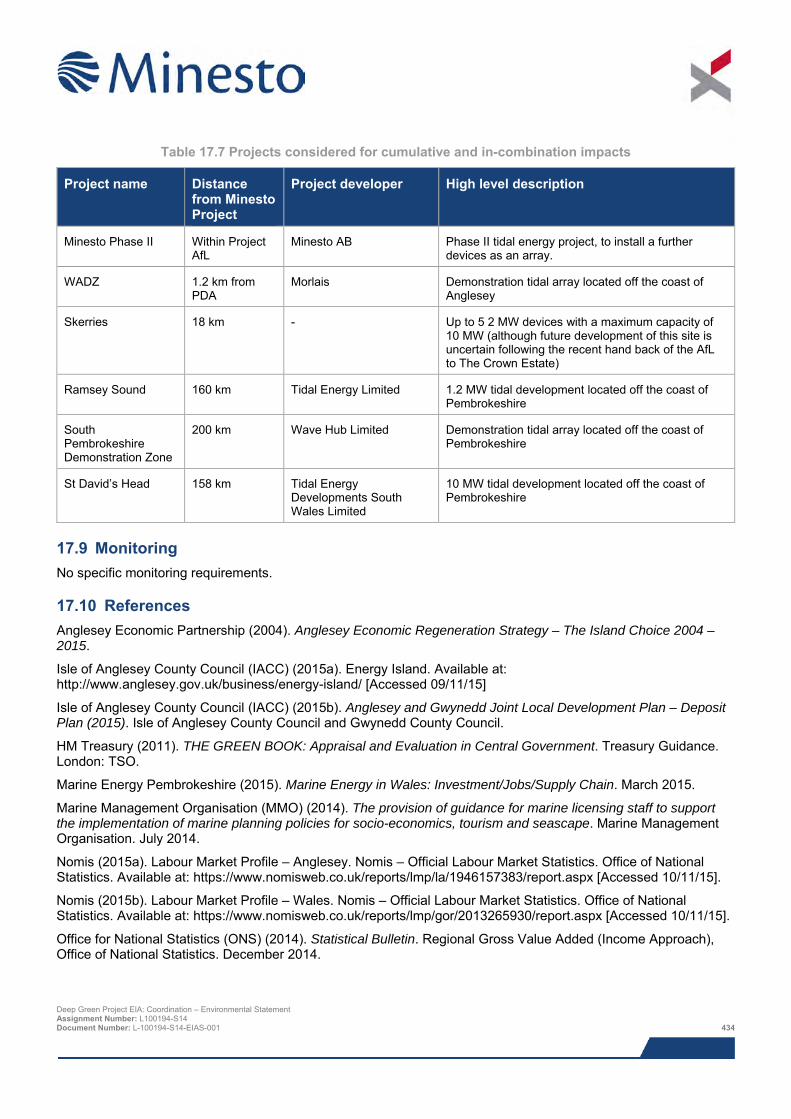
Table 17.7 Projects considered for cumulative and in-combination impacts
Project name Distance from Minesto Project
Project developer High level description
Minesto Phase II Within Project AfL
Minesto AB Phase II tidal energy project, to install a further devices as an array.
WADZ 1.2 km from PDA
Morlais Demonstration tidal array located off the coast of Anglesey
Skerries 18 km - Up to 5 2 MW devices with a maximum capacity of 10 MW (although future development of this site is uncertain following the recent hand back of the AfL to The Crown Estate)
Ramsey Sound 160 km Tidal Energy Limited 1.2 MW tidal development located off the coast of Pembrokeshire
South Pembrokeshire Demonstration Zone
200 km Wave Hub Limited Demonstration tidal array located off the coast of Pembrokeshire
St David’s Head 158 km Tidal Energy Developments South Wales Limited
10 MW tidal development located off the coast of Pembrokeshire
17.9 Monitoring No specific monitoring requirements.
17.10 References Anglesey Economic Partnership (2004). Anglesey Economic Regeneration Strategy – The Island Choice 2004 – 2015.
Isle of Anglesey County Council (IACC) (2015a). Energy Island. Available at: http://www.anglesey.gov.uk/business/energy-island/ [Accessed 09/11/15]
Isle of Anglesey County Council (IACC) (2015b). Anglesey and Gwynedd Joint Local Development Plan – Deposit Plan (2015). Isle of Anglesey County Council and Gwynedd County Council.
HM Treasury (2011). THE GREEN BOOK: Appraisal and Evaluation in Central Government. Treasury Guidance. London: TSO.
Marine Energy Pembrokeshire (2015). Marine Energy in Wales: Investment/Jobs/Supply Chain. March 2015.
Marine Management Organisation (MMO) (2014). The provision of guidance for marine licensing staff to support the implementation of marine planning policies for socio-economics, tourism and seascape. Marine Management Organisation. July 2014.
Nomis (2015a). Labour Market Profile – Anglesey. Nomis – Official Labour Market Statistics. Office of National Statistics. Available at: https://www.nomisweb.co.uk/reports/lmp/la/1946157383/report.aspx [Accessed 10/11/15].
Nomis (2015b). Labour Market Profile – Wales. Nomis – Official Labour Market Statistics. Office of National Statistics. Available at: https://www.nomisweb.co.uk/reports/lmp/gor/2013265930/report.aspx [Accessed 10/11/15].
Office for National Statistics (ONS) (2014). Statistical Bulletin. Regional Gross Value Added (Income Approach), Office of National Statistics. December 2014.
Deep Green Project EIA: Coordination – Environmental Statement Assignment Number: L100194-S14 Document Number: L-100194-S14-EIAS-001 434

Productive Seas Evidence Group (2015). Social and economic assessment requirements for development projects affecting the marine environment. A report for the Productive Seas Evidence Group prepared by the Social and Economic Assessment Sub-Group. January 2015.
StatWales (2015). Active Business Enterprises by area and year. Available at: https://statswales.wales.gov.uk/Catalogue/Business-Economy-and-Labour-Market/Businesses/Business-Demography/activebusinessenterprises-by-area-year [Accessed 09/11/15].
Turner et al., (2010). An Introduction to Socio-Economic Assessment within a Marine Strategy Framework.
Visit Anglesey (2015). Available at: http://www.visitanglesey.co.uk/en/things-to-do/ [Accessed 20/11/2015].
Welsh Government (2014a). Energy Wales: A Low Carbon Transition Delivery Plan. March 2014.
Welsh Government (2014b). Planning Policy Wales Edition 7. July 2014.
Welsh Government (2014c). Technical Advice Note (TAN) 23: Economic Development. 2014.
Welsh Government (2015). Statistical Bulletin. Regional economic & labour market profile – North Wales. October 2015.
Deep Green Project EIA: Coordination – Environmental Statement Assignment Number: L100194-S14 Document Number: L-100194-S14-EIAS-001 435

This page has been intentionally left blank.
Deep Green Project EIA: Coordination – Environmental Statement Assignment Number: L100194-S14 Document Number: L-100194-S14-EIAS-001 436
18 HYDROCARBON AND CHEMICAL RELEASES
This chapter of the ES assesses the potential hydrocarbon and chemical spill events that may occur as a result of the Project. The events assessed are oil spills from vessels and leaks of fluid associated with the DGU unit.
The consequence of a large hydrocarbon and chemical spill could be severe, however, the likelihood of such a large scale event is extremely unlikely. The largest hydrocarbon inventory associated with the Project is the fuel stored on the installation vessels, which will only be on site for a matter of weeks during installation the occasional day during operations. No heavy oils will be used at any stage of the Project, so spills of all sizes are anticipated to break up, dilute and disperse rapidly.
Minesto will have appropriate procedures and plans in place to ensure the risk of any spill is minimised and in the unlikely event of a spill, the consequence minimised.
18.1 Introduction The chapter deals with the potential effects of accidental hydrocarbon and chemical releases that could occur as a result of the Project. Whilst EIA is primarily concerned with ‘likely significant effects’, accidental events, which by their nature are not likely, have nonetheless been included in the process because of the potentially significant effects that they could cause. This chapter provides a description of the nature of the potential accidental spill events that may occur, estimates the likelihood of their occurrence and identifies mitigation and management measures to reduce the overall risk of their occurrence and/or reduce the severity of their consequences should they occur.
The following specialists have contributed to the assessment:
> Anatec Limited – vessel spill risk assessment as part of the Navigation Risk Assessment (NRA); and
> Xodus – baseline description, impact assessment and Environmental Statement (ES) chapter write up.
> The table below provides a list of all the supporting studies which relate to the potential hydrocarbon and chemical spill impact assessment. All supporting studies are provided on the accompanying CD.
Table 18.1 Supporting studies
Details of study Navigation Risk Assessment: Deep Green Holyhead Deep Project (Anatec, 2015)
The impact assessment presented herein draws upon output from other impact assessments within this ES; where that information is used to inform assessment, reference to the relevant ES chapter is given. Where appropriate the potential impacts of hydrocarbon and chemical releases have been assessed for different ecological receptors other topic specific ES chapters e.g. Chapter 10: Benthic Ecology, Chapter 11: Marine Mammals and Megafauna and Chapter 12: Offshore Ornithology.
18.2 Area of assessment The assessment of potential impacts of accidental hydrocarbon or chemical releases covers the entire offshore Project area, i.e. the Project Development Area (PDA). The assessment also considers impacts on the waters surrounding the PDA. Specific boundaries have not been defined for the overall area of assessment on the basis that the extent of the offshore environment potentially affected depends upon a wide range of factors including type and quantity of pollutant, dispersal rates and patterns, and persistence of a pollutant in the environment.
The following area is referred to in this impact assessment:
> Project Development Area (PDA):
o This is the area of seabed in which the DGU units will be deployed. The exact siting of the device within the PDA has not yet been determined, but of the 4 km2 total area available, only a very small area will be affected by the Project (based on the horizontal swept area on the DGU device).
Deep Green Project EIA: Coordination – Environmental Statement Assignment Number: L100194-S14 Document Number: L-100194-S14-EIAS-001 437
18.3 Legislation, policy and guidance There is no specific legislation or published guidance regarding the scope of the assessment of accidental and non-routine events. However, several EU Directives do focus on protecting specific aspects of the marine and coastal water environment and are therefore relevant to this chapter. These include:
> The Marine Strategy Framework Directive (see Chapter 3: Policy and Legislation for further details);
> Shellfish Waters Directive; and
> Water Framework Directive.
Minesto is committed to minimising the risk and potential consequences of accidental events as far as possible, and as such, will adhere strictly to the following:
> The International Convention for the Prevention of Pollution from ships (MARPOL), which covers pollution of the marine environment by ships or accidental causes;
> Regulation 37 of Annex I of MARPOL, which requires that all ships of 400 gross tonnage (GT) or more carry an approved Shipboard Oil Pollution Emergency Plan (SOPEP); and
> The Environment Agency (EA) Pollution Prevention Guidelines (PPG) 1, which provides general guidance on prevention of pollution, PPG 5 provides guidelines for construction and maintenance work on, in or near water, PPG6 covers working at construction and demolition sites, PPG 21 covers the production of emergency pollution incident response plans to deal with accidents, spillages and fires, and PPG 22 for incident response and dealing with spills (in waters out to 3 nm (5.5 km)). Whist these documents provide useful reference material for good practice, it should be noted that the EA no longer officially provides good practice guidance. The aforementioned PPGs now exist on the National Archives and their validity will be reviewed by the EA as part of the UK Government’s ‘smarter guidance project’.
18.4 Scoping and consultation Scoping and consultation have been ongoing throughout the EIA and played an important part in ensuring the scope of the baseline characterisation work and impact assessment are appropriate to the Project and the requirements of the regulators and their advisors.
Table 18.2 summarises all consultation activities carried out relevant to potential hydrocarbon and chemical releases. Following discussions about the scope of the EIA with both Natural Resources Wales (NRW) and Cefas, no specific issues regarding potential hydrocarbons and chemicals were raised. Relevant Scoping Opinion issues are summarised in Table 18.3, together with responses to the comments and reference to the sections in which they are addressed.
Table 18.2 Consultation activities undertaken in relation to potential hydrocarbon and chemical releases
Date Stakeholder Consultation Topic/ specific issue 15/11/2013 NRW, Cefas, Natural
Resources Wales, Isle of Anglesey County Council, Holyhead Port Authority, Maritime and Coastguard Agency, National Air Traffic Services, Civil Aviation Authority, Royal Society for the Protection of Birds, Royal Yachting Association, Trinity Lighthouse Service, Royal Commission on the Ancient and Historical Monuments of Wales, Cadw, Marine Enforcement Officers, Welsh
Scoping Report Submission of scoping report to present initial details.
Deep Green Project EIA: Coordination – Environmental Statement Assignment Number: L100194-S14 Document Number: L-100194-S14-EIAS-001 438
Date Stakeholder Consultation Topic/ specific issue
Government Energy Branch, The Crown Estate
04/06/2014 NRW Consultation meeting Scope and methodology of EIA including potential hydrocarbon and chemical releases
11/12/2014 Cefas Consultation meeting Scope and methodology of EIA including potential hydrocarbon and chemical releases
21/05/2015 & 26/01/2016 General public Public exhibitions Public events held to allow members of the public to comment on overall Project and to provide updates on EIA
Table 18.3 Scoping comments relevant to potential hydrocarbon and chemical releases
Name of organisation Key concerns Response ES section with which the specific issue is addressed
NRW Pollution prevention: “the ES must make reference Environment Agency Pollution Prevention Guides (PPGs), in particular PPG5 (works and maintenance in or near water) and PPG6 (working at construction and demolition sites)”.
Specified guidance included in the legislation guidance section of this chapter.
Section 18.3
18.5 Baseline description Chapter 7: Environmental Overview provides an overview of the environmental characteristics of the Project area and surrounding region. More detailed information on specific receptors that may be impacted by accidental releases is provided in the following chapters:
> Benthic organisms and habitats (Chapter 10: Benthic Ecology);
> Marine mammals (Chapter 11: Marine Mammal and Megafauna);
> Seabirds (Chapter 12: Offshore Ornithology); and
> Bathing beaches (Chapter 9: Physical Processes and Chapter 17: Socio-economic).
18.6 Impact assessment
18.6.1 Overview This assessment covers all impacts identified during the EIA. It should be noted that impacts are not necessarily relevant to all Project stages.
The list below indicates all of the direct and indirect impacts assessed in the potential hydrocarbon and chemical spill section and indicates the Project stages to which they relate. Cumulative impacts are discussed in Section 18.9.
> Oil spills from vessels including the barge (or similar such surface platform) during all stages of the Project; and
Deep Green Project EIA: Coordination – Environmental Statement Assignment Number: L100194-S14 Document Number: L-100194-S14-EIAS-001 439
> Leak of fluid associated with DGU units, during the operational stage of the Project.
The assessment of impacts associated with potential hydrocarbon and chemical releases was a desk-based exercise making use of Project-specific data and published data on the probability / likelihood of different types of accidental events. In addition, as part of the NRA (Anatec, 2015; Appendix C) a Consequence Assessment was undertaken to estimate the probability of an oil spill occurring as a result of a vessel collision.
18.6.2 Assessment criteria The EIA process and methodology are described in detail in Chapter 8: EIA Methodology. Project specific criteria have been developed for the sensitivity and vulnerability of the receptor, and the magnitude of impact (including duration, frequency, seasonality and geographic extent) as detailed in Section 8.3. In the case of accidental/unplanned events the likelihood of occurrence must also be taken into consideration, so topic specific criteria for defining the likelihood of accidental events are provided below in Table 18.4. It should also be noted that sensitivity criteria for specific receptors are provided in the relevant chapters (see list in Section 18.5).
Table 18.4 Likelihood definitions for accidental events
Likelihood Definition Frequent Yearly.
Event likely to occur more than once on the facility.
Reasonably probable 1 occurrence per 1 per 10 years. Could occur within the lifetime of the development.
Remote 1 occurrence per 10 to 100 years. Event could occur within the life of 10 similar facilities. Has occurred at similar facilities.
Extremely unlikely 1 occurrence per 100 to 10,000 years. Similar event has occurred somewhere in the industry or similar industry but not likely to occur with current practices and procedures.
Negligible < 1 occurrence per 10,000 years. Has never occurred within industry or similar industry, but theoretically possible.
The sensitivity, vulnerability and value of receptor are combined with the likelihood and magnitude of impact using expert judgement to arrive at a consequence for each impact under consideration; the significance of impact is derived directly from the consequences ranking (Section 8.3.5). The definitions for level of impact and how they relate to significance are presented in Section 8.3.
Deep Green Project EIA: Coordination – Environmental Statement Assignment Number: L100194-S14 Document Number: L-100194-S14-EIAS-001 440
Table 18.5 Criteria for value of receptor
Value of receptor Definition Very high Receptor of very high importance or rarity, such as those designated under international
legislation (e.g. EU Habitats Directive) or those that are internationally recognised as globally threatened (e.g. IUCN red list).
High Receptor of high importance or rarity, such as those which are designated under national legislation, and/or ecological receptors such as UKBAP priority species with nationally important populations in the study area, and species that are near-threatened or vulnerable on the IUCN red list.
Medium Receptor of moderate value or regional importance, and/or ecological receptors listed as of least concern on the IUCN red list but which form qualifying interests on internationally designated sites, or which are present in internationally important numbers.
Low Receptor of low local importance and/or ecological receptors such as species which contribute to a national site, are present in regionally
Negligible Receptor of very low importance, such as those which are generally abundant around the UK with no specific value or conservation concern.
18.6.3 Design envelope This assessment considers the Project parameters which are predicted to result in the greatest environmental impact. This approach ensures that impacts of a greater adverse significance would not arise should any other development scenario be taken forward in the final scheme design. With regards to the assessment of impacts relating to potential hydrocarbon and chemical releases the assessment comprises:
> The DGU unit will contain an inventory of approximately 30 litres of biodegradable hydraulic oil;
> The DGU unit will contain an inventory of tens of litres of liquid coolant;
> The barge will accommodate a bunded fuel store holding approximately 200 litres of diesel for the generator and support vessel;
> The barge will accommodate small volumes of chemicals in a basic workshop, bunded in a COSHH cupboard;
> The maximum total oil inventory for a large installation vessel or DP vessel will be approximately 8,000,000 litres of marine diesel stored across a number of separate tanks. A worst case spill from the rupture of a single tank is likely to be approximately 600,000 litres of marine diesel;
> Vessel requirement during installation:
o DP vessel or underslung barge (depending on foundation selection)– approximately five days;
o Anchor handler tug or multicat to deploy barge moorings – approximately one week;
o Tug to transport barge to/from site – one day per transfer but multiple transfers expected;
o Support vessel with ROV capabilities to attach tether to foundation – less than one week; and
o LARS support vessel to transport, launch and recover DGU – daily during final few weeks of installation period and crossover into operational period;
> Vessel requirement during operations:
o Barge – up to five years – worst-case permanently present on site during this period, but highly unlikely to remain permanently on-site throughout winter months;
o LARS support vessel to launch and recover DGU, perform guard vessel duty and routine maintenance – approximately once per week for up to five years, but could be present daily during final stages of installation/first few weeks of operation.
Deep Green Project EIA: Coordination – Environmental Statement Assignment Number: L100194-S14 Document Number: L-100194-S14-EIAS-001 441
o Tug to transport barge to/from site – one day per transfer but multiple transfers expected
throughout operational period (up to five years); and
o Additional service/maintenance vessel – a maximum of six days per year.
18.6.4 Data gaps and uncertainties Given the non-routine nature of accidental events there are a number of uncertainties associated with assessing potential impacts. Where available, Project data on relevant inventories have been used in calculating spillage volumes in the event of an accident. Some relevant published data exists which has also been used in assessing the impacts of accidental events e.g. frequency of vessel collisions and the environmental consequences of this.
Where uncertainty remains over an impact this has been accounted for in the likelihood of an event occurring. However, for most impacts the measures in place to prevent accidents from happening and the frequency of such accidents is well understood.
18.7 Impacts during all Project stages (installation, operation and decommissioning)
18.7.1 Impact 18.1 Oil spills from vessels and barge Oil may enter the marine environment from natural seepage and/or accidental spills from ships and ship based activities, and from the inventory stored on the barge (or similar such surface platform). Oil spills can have a number of environmental impacts. Actual effects will vary depending on a wide range of factors including the volume and type of oil spilt and the sea and weather conditions at the time of the spill. Diesel is considered non-persistent oil that evaporates rapidly from the surface of the sea. An accidental spill of diesel fuel from a vessel or the barge would result in a diesel slick on the sea surface. The slick would disperse and degrade rapidly as a result of wave, current, microbial and photolytic action. The effects will be dependent on the presence of environmental sensitivities in the path of the spill. In a dynamic environment such as the Project location, oil spills will be rapidly dispersed, limiting its potential effects in time and space. However, it should be considered that a spill associated with the Project will never be further than 6.5 km from the coast, so beaching of oil has some potential to occur.
Potential sources of oil spills from installation vessels for the Project and the barge include:
> Upsets in the treatment system for bilge water;
> Loss of containment in a storage tank (e.g. of lubrication oils, fuel oil, or chemicals); and
> Damage to a fuel bunker caused by a collision, grounding or fire.
The best available data indicates that the most frequently recorded spills from vessels offshore are associated with upsets in the bilge treatment systems and the losses are usually small (UKOAA, 2006). This type of loss typically results in tens of litres of fuel being lost to the receiving environment.
An oil spill in the Project area could affect a range of receptors, primary amongst which are:
> Benthic organisms and habitats (Chapter 10: Benthic Ecology);
> Marine mammals (Chapter 11: Marine Mammal and Megafauna); and
> Seabirds (Chapter 9: Physical Processes and Chapter 12: Offshore Ornithology).
Specific impacts of oil spill on the receptors listed above are described in the relevant ES chapters. For the purpose of this assessment the full range of potential receptors in the Project and surrounding area (sea and coast) have been taken into account and have been assessed as high sensitivity. Many species that have the potential to be affected by accidental spills are internationally protected (e.g. several marine mammal and seabird species), so the receptor is considered high value.
The vulnerability of the different receptors in the Project area are defined in the relevant topic specific chapters. The receptors with the highest vulnerability to potential oil spills are the nationally important guillemot and razorbill breeding colonies on Holy Island, which have been assessed as being of medium vulnerability (see Section 12.7.2).
Deep Green Project EIA: Coordination – Environmental Statement Assignment Number: L100194-S14 Document Number: L-100194-S14-EIAS-001 442
The maximum potential hydrocarbon spill would arise from the rupture of a single fuel tank on the installation/DP vessel, which could lead to the instantaneous release of up to 600,000 litres of diesel into the marine environment. This type of vessel will only be present on site for a short period during installation. Support vessels and tugs will be present intermittently throughout the Project, but have much smaller fuel inventories. The barge also represents a potential spill source since it will accommodate a bunded fuel store holding approximately 200 litres of diesel for the generator and support vessel.
A Consequences Assessment was undertaken by Anatec (2015) (see Appendix C of NRA) to provide an estimate of the overall impact of the Project on the environment through oil spills, taking into account the probability of vessel collision with the barge, together with the probability that a spill would occur following the collision. The assessment made use of historical statistics to compare collision frequency with the average quantities spilled per vessel (rather than the worst case that is presented in this ES). Detailed data on spills resulting from contact between vessels and stationary barges were unavailable, so a conservative estimate that 50% of collisions result in a spill was employed (compared to 13% for ship collisions and 39% for laden tanker collisions). Anatec (2015) concluded that ‘the overall increase in pollution estimated due to the [Project] is minimal compared to the historical average pollution quantities from marine accidents in UK waters”. They estimate that the amount of oil spilled per year due to the impact of the development would be equivalent 0.0011 tonnes of oil per year (1.1 kg) in the base case, or 0.0017 tonnes (1.7 kg) in the future case (which conservatively assumes a 50% increase in all traffic over lifetime of the Project i.e. a maximum period of five years).
Diesel is highly volatile, so a large proportion of the spill will rapidly disperse through evaporation, as well as wave, current, microbial and photolytic action. Spilled diesel is typically entirely degraded within timeframes of one or two months (NOAA, 2015). It is also much lighter than water (specific gravity is between 0.83 and 0.88, compared to 1.03 for seawater), so it is extremely unlikely to sink and accumulate on the seabed. Nevertheless, some diesel will remain on the sea surface as a dull or dark film, and considering that the areas that vessels will operate in will be 6.5 km or less from shore, there is the potential for some diesel to beach. However, diesel oil is not as sticky or viscous as so called black oils, so when it does beach it tends to be washed off quickly by waves and tidal flushing (NOAA, 2015). Taking all of this into account, it is clear that even the largest potential diesel spill associated with the Project will be short-lived and relatively localised, and is therefore considered to be of moderate magnitude. Smaller spills in the order on tens of litres will cover a much smaller area and will disperse more rapidly, and as such are considered to be of minor magnitude.
In order to assess the overall impact consequence and significance, all of the above must be viewed in light of the likelihood of such spills occurring. As part of the NRA undertaken by Anatec (2015), collision/allision modelling was undertaken to estimate the likelihood of accidents occurring as a result of the Project, which revealed the following:
> Whilst the barge and DGU are present on site there is predicted to be an increase in major collision / allision40 frequency of 1 in 32,410 years under present case conditions and one in 21,607 years under future case41 conditions. The majority of this risk is associated with the barge.
According to the criteria presented in Table 18.4, the likelihood of such an event is classified as negligible.
The model predictions are corroborated by best available data, which suggest that the likelihood of a large spill resulting from an installation or support vessel tank rupture is extremely unlikely (incident rate of one per 13,067 vessel years (DETR, 1999)). Available data also suggest that the likelihood a smaller loss of inventory events involving tens of litres of hydrocarbon suggest is remote (UKOOA, 2006).
Considering the extremely low likelihood of a large spill and the relatively short time period over which marine diesel is able to persist in the marine environment, the overall consequence is considered low and not significant. Small spills are unlikely and will be break up and dilute so rapidly that they are extremely unlikely to cause any ill effects, and as such, are considered to be negligible and not significant.
40 Collision between a vessel and a fixed object. 41 Both ‘present case’ and ‘future case include the Project, but the ‘future case’ assumes a conservative 50% increase in all traffic over the life of the Project. Deep Green Project EIA: Coordination – Environmental Statement Assignment Number: L100194-S14 Document Number: L-100194-S14-EIAS-001 443
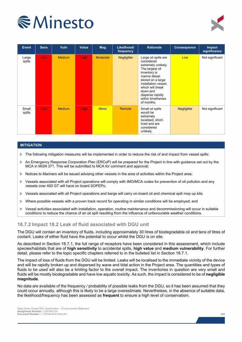
Event Sens Vuln Value Mag Likelihood/
frequency Rationale Consequence Impact
significance
Large spills
High Medium High
Moderate Negligible Large oil spills are considered extremely unlikely. The largest oil inventory is marine diesel stored on a large installation vessel, which will break down and disperse rapidly within timeframes of months.
Low Not significant
Small spills
High Medium High Minor Remote Small oil spills would be extremely localised, short-lived and are considered unlikely.
Negligible Not significant
MITIGATION
> The following mitigation measures will be implemented in order to reduce the risk of and impact from vessel spills:
> An Emergency Response Corporation Plan (ERCoP) will be prepared for the Project in line with guidance set out by the MCA in MGN 371. This will be submitted to MCA for comment and approval;
> Notices to Mariners will be issued advising other vessels in the area of activities within the Project area;
> Vessels associated with all Project operations will comply with IMO/MCA codes for prevention of oil pollution and any vessels over 400 GT will have on board SOPEPs;
> Vessels associated with all Project operations and barge will carry on-board oil and chemical spill mop up kits;
> Where possible vessels with a proven track record for operating in similar conditions will be employed; and
> Vessel activities associated with installation, operation, routine maintenance and decommissioning will occur in suitable conditions to reduce the chance of an oil spill resulting from the influence of unfavourable weather conditions.
18.7.2 Impact 18.2 Leak of fluid associated with DGU unit The DGU will contain an inventory of fluids, including approximately 30 litres of biodegradable oil and tens of litres of coolant. Leaks of either fluid have the potential to occur whilst the DGU is on site.
As described in Section 18.7.1, the full range of receptors have been considered in this assessment, which include species/habitats that are of high sensitivity to accidental spills, high value and medium vulnerability. For further detail, please refer to the topic specific chapters referred to in the bulleted list in Section 18.7.1.
The impact of loss of fluids from the DGU will be limited. Leaks will be localised to the immediate vicinity of the device and will be rapidly broken up and dispersed by wave and tidal action in the Project area. The quantities and types of fluids to be used will also be a limiting factor to the overall impact. The inventories in question are very small and fluids will be mostly biodegradable and have low aquatic toxicity. As such, the impact is considered to be of negligible magnitude.
No data are available of the frequency / probability of possible leaks from the DGU, so it has been assumed that they could occur annually, although this is likely to be a large overestimate. Nevertheless, in the absence of suitable data, the likelihood/frequency has been assessed as frequent to ensure a high level of conservatism.
Deep Green Project EIA: Coordination – Environmental Statement Assignment Number: L100194-S14 Document Number: L-100194-S14-EIAS-001 444
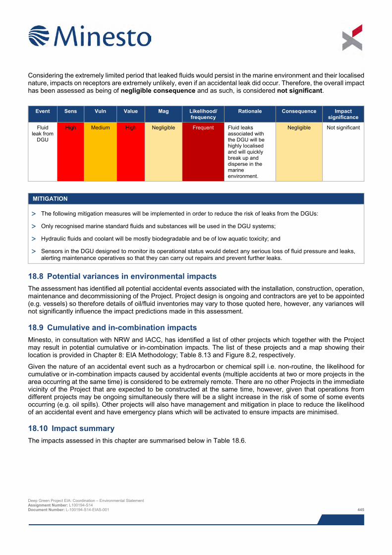
Considering the extremely limited period that leaked fluids would persist in the marine environment and their localised nature, impacts on receptors are extremely unlikely, even if an accidental leak did occur. Therefore, the overall impact has been assessed as being of negligible consequence and as such, is considered not significant.
Event Sens Vuln Value Mag Likelihood/
frequency Rationale Consequence Impact
significance
Fluid leak from
DGU
High Medium High Negligible Frequent Fluid leaks associated with the DGU will be highly localised and will quickly break up and disperse in the marine environment.
Negligible Not significant
MITIGATION
> The following mitigation measures will be implemented in order to reduce the risk of leaks from the DGUs:
> Only recognised marine standard fluids and substances will be used in the DGU systems;
> Hydraulic fluids and coolant will be mostly biodegradable and be of low aquatic toxicity; and
> Sensors in the DGU designed to monitor its operational status would detect any serious loss of fluid pressure and leaks, alerting maintenance operatives so that they can carry out repairs and prevent further leaks.
18.8 Potential variances in environmental impacts The assessment has identified all potential accidental events associated with the installation, construction, operation, maintenance and decommissioning of the Project. Project design is ongoing and contractors are yet to be appointed (e.g. vessels) so therefore details of oil/fluid inventories may vary to those quoted here, however, any variances will not significantly influence the impact predictions made in this assessment.
18.9 Cumulative and in-combination impacts Minesto, in consultation with NRW and IACC, has identified a list of other projects which together with the Project may result in potential cumulative or in-combination impacts. The list of these projects and a map showing their location is provided in Chapter 8: EIA Methodology; Table 8.13 and Figure 8.2, respectively.
Given the nature of an accidental event such as a hydrocarbon or chemical spill i.e. non-routine, the likelihood for cumulative or in-combination impacts caused by accidental events (multiple accidents at two or more projects in the area occurring at the same time) is considered to be extremely remote. There are no other Projects in the immediate vicinity of the Project that are expected to be constructed at the same time, however, given that operations from different projects may be ongoing simultaneously there will be a slight increase in the risk of some of some events occurring (e.g. oil spills). Other projects will also have management and mitigation in place to reduce the likelihood of an accidental event and have emergency plans which will be activated to ensure impacts are minimised.
18.10 Impact summary The impacts assessed in this chapter are summarised below in Table 18.6.
Deep Green Project EIA: Coordination – Environmental Statement Assignment Number: L100194-S14 Document Number: L-100194-S14-EIAS-001 445
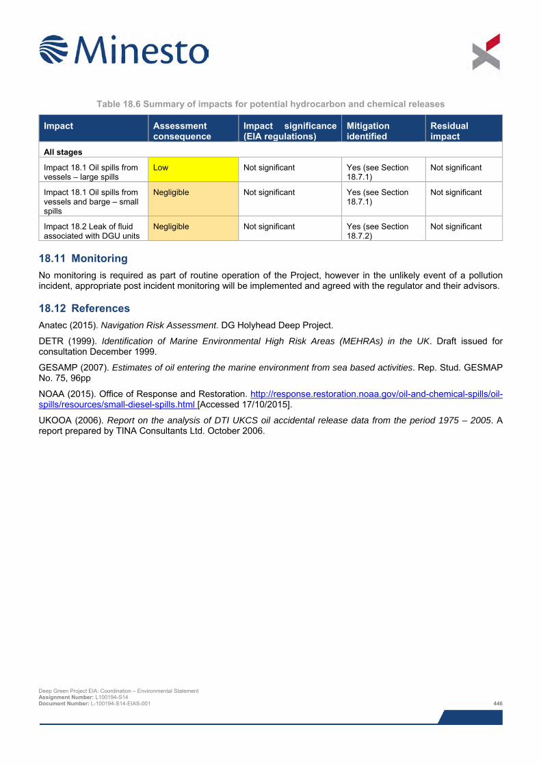
Table 18.6 Summary of impacts for potential hydrocarbon and chemical releases
Impact Assessment consequence
Impact significance (EIA regulations)
Mitigation identified
Residual impact
All stages
Impact 18.1 Oil spills from vessels – large spills
Low Not significant Yes (see Section 18.7.1)
Not significant
Impact 18.1 Oil spills from vessels and barge – small spills
Negligible Not significant Yes (see Section 18.7.1)
Not significant
Impact 18.2 Leak of fluid associated with DGU units
Negligible Not significant Yes (see Section 18.7.2)
Not significant
18.11 Monitoring No monitoring is required as part of routine operation of the Project, however in the unlikely event of a pollution incident, appropriate post incident monitoring will be implemented and agreed with the regulator and their advisors.
18.12 References Anatec (2015). Navigation Risk Assessment. DG Holyhead Deep Project.
DETR (1999). Identification of Marine Environmental High Risk Areas (MEHRAs) in the UK. Draft issued for consultation December 1999.
GESAMP (2007). Estimates of oil entering the marine environment from sea based activities. Rep. Stud. GESMAP No. 75, 96pp
NOAA (2015). Office of Response and Restoration. http://response.restoration.noaa.gov/oil-and-chemical-spills/oil-spills/resources/small-diesel-spills.html [Accessed 17/10/2015].
UKOOA (2006). Report on the analysis of DTI UKCS oil accidental release data from the period 1975 – 2005. A report prepared by TINA Consultants Ltd. October 2006.
Deep Green Project EIA: Coordination – Environmental Statement Assignment Number: L100194-S14 Document Number: L-100194-S14-EIAS-001 446
19 OTHER SEA USERS
The Project Development Area (PDA) is located within the Holyhead Deep disposal site so activity within the site could be restricted as a result of the Project, however, in all likelihood the boundary of the disposal site will be re-designated such that it no longer encompasses the AfL.
With regards to sea users other than those using the disposal site, fisheries have been assessed in Chapter 13; shipping and navigation in Chapter 14 and tourism and recreation in Chapter 17 and no significant impacts are predicted.
Cumulative and in-combination impacts resulting from this Project and the West Anglesey Demonstration Zone (WADZ) are not expected, since the inshore area within which the WADZ is located supports different fisheries, shipping and recreational activities compared to the deeper and more distant offshore waters of the Holyhead Deep where the Project is located.
19.1 Introduction The potential effects of the Project on other sea users are assessed in this chapter. The following specialists have contributed to the assessment:
> Anatec – carried out Navigational Risk Assessment (NRA); and
> Xodus – Holyhead Deep disposal site characterisation and assessment of capacity to accommodate Minesto AfL, baseline description, impact assessment and Environmental Statement (ES) chapter write up.
The table below provides a list of all the supporting studies which relate to the other sea users impact assessment. All supporting studies are provided on the accompanying CD.
Table 19.1 Supporting studies
Details of study Holyhead Deep disposal site: characterisation and assessment of capacity to accommodate Minesto AfL (Xodus, 2014)
Navigational Risk Assessment (Anatec, 2015)
The impact assessment presented herein draws upon output from other impact assessments within this ES; where that information is used to inform assessment, reference to the relevant ES chapter is given.
19.2 Area of assessment The focus of the impact assessment is the potential impacts on other sea users using the Project area and adjacent waters.
The following areas are referred to in this impact assessment and illustrated in Figure 1.2:
> Agreement for Lease (AfL) area:
o The area of the seabed that has been leased from The Crown Estate covering an area of 9.1 km2;
> Project Development Area (PDA):
o This is the area of seabed in which the DGU unit will be deployed. The exact siting of the device within the PDA has not yet been determined, but of the 4 km2 total area available, only a small fraction will be developed for the Project (see below);
> Project area (see Figure 1.2 in the Chapter 1: Introduction), which comprises the PDA.
Deep Green Project EIA: Coordination – Environmental Statement Assignment Number: L100194-S14 Document Number: L-100194-S14-EIAS-001 447

19.3 Legislation, policy and guidance No additional legislation or policy has been identified as being of relevance to this Environmental Impact Assessment (EIA) topic over and above that identified in Chapter 3: Planning and Legislative Requirements.
19.4 Scoping and consultation Scoping and consultation have been ongoing throughout the EIA and played an important part in ensuring the scope of the baseline characterisation work and impact assessment have been appropriate to the Project and the requirements of the regulators and their advisors.
Table 19.2 summarises all consultation activities carried out relevant to other sea users. Relevant comments from the EIA Scoping Opinion are summarised in Table 19.3, together with responses to the comments and reference to the relevant ES sections where specific comments have been addressed.
Table 19.2 Consultation activities undertaken in relation to other sea users
Date Stakeholder Consultation Topic / specific issue
15/11/2013 NRW, Cefas, Natural Resources Wales, Isle of Anglesey County Council, Holyhead Port Authority, Maritime and Coastguard Agency, National Air Traffic Services, Civil Aviation Authority, Royal Society for the Protection of Birds, Royal Yachting Association, Trinity Lighthouse Service, Royal Commission on the Ancient and Historical Monuments of Wales, Cadw, Marine Enforcement Officers, Welsh Government Energy Branch, The Crown Estate
Scoping Report Submission of scoping report to present initial details.
3rd March 2015 Natural Resources Wales
Cefas
Discussion regarding the Holyhead Deep Disposal Site Characterisation Assessment
Holyhead Deep Disposal Site IS040
17th November 2014 Natural Resources Wales
Cefas
The Crown Estate
Submission of Holyhead Deep Disposal Site Characterisation Assessment
Holyhead Deep Disposal Site IS040
21/05/2015 & 26/01/2016 General public Public exhibitions Public events held to allow members of the public to comment on overall Project and provide updates on EIA.
Deep Green Project EIA: Coordination – Environmental Statement Assignment Number: L100194-S14 Document Number: L-100194-S14-EIAS-001 448
Table 19.3 Scoping comments relevant to other sea users
Name of organisation Key concerns Response
ES Section with which the specific issue is addressed
Natural Resources Wales Holyhead Deep Disposal Site
The impacts on the disposal site have been assessed in a separate report required to support potential re-designation of the site boundary and the EIA.
19.5.1
And Xodus 2014 report
19.5 Baseline description The following section describes the baseline with regards to other sea users not previously discussed in other chapters within the ES. It has been compiled from available published data and information obtained during consultation.
19.5.1 Disposal sites The AfL is located within the boundaries of Holyhead Deep disposal site IS040. This site is used to dispose of dredged material from a number of locations with an average of 85,000 tonnes of material being deposited of each year. The disposal site is 13 km in length and 4.4 km in width. The total area covered is a 57.5 km2 rectangle. The AfL is located in the southern half of the disposal site covering an area of 9.2 km2 whilst the PDA is in the southern half of the AfL and covers 4 km2, or approximately 7% of the disposal site area as shown in Figure 19.1.
In the past seven companies have used Holyhead Deep disposal site, however since 2009 only one company has utilised it; Stena Line Ports Limited. This company is currently the only licensee of the site and have permission to dispose of up to 99,000 tonnes per year until 6th June 2016. Licences are obtained from Natural Resources Wales (NRW) and there is high inter-annual variability in the mass of deposits at the sire ranging from 451,129 tonnes deposited in 1995 to no material deposited in some years. All material entering the site is either capital dredge spoil or maintenance dredge spoil. The disposal of capital dredge spoil is infrequent but quantities are typically large, exceeding 100,000 tonnes in three out of five events. Maintenance dredge spoil is disposed of more frequently in lower quantities and has never exceeded 100,000 tonnes in a single year. Maintenance disposal spoil primarily results from maintenance dredging around Holyhead Harbour which occurs at a maximum frequency once every two years (Potter, 2014). The majority of material is disposed of halfway up the eastern limit of the dredging disposal site presumably because this is the shortest steaming distance from Holyhead harbour. The majority of the disposal locations are in the northern half of the Holyhead Deep disposal site however some deposits have been made within the AfL. One dredge disposal location from the years 2009, 2011 and 2013 is within the PDA border.
Numerical modelling has been used to determine the fate of disposed materials. The modelling determined that all disposed sediment was found to leave the disposal site in all of the runs and the tidal asymmetry at Holyhead Deep favours sediment transport towards the north east. It was predicted that over 90% of sediment would remain in suspension in low concentrations. Only a small percentage of disposed sediment remained on the seabed after 15 days and this was spread out over much of the Irish Sea. Accumulations of sediment were found in bays where mean bed shear stress was low and the residual tidal currents were directed into the bay. These results are suggestive of a highly dispersive site from which material will rapidly be disturbed across the wider region (Xodus, 2014).
The PDA also intersects with a closed disposal site, Holyhead South (IS041), located within the southernmost portion of the extant Holyhead Deep site, and is just over 1 km from the Holyhead East (IS042) disposal site (also closed), whose boundary adjoins the south-east boundary of the Holyhead Deep site.
Deep Green Project EIA: Coordination – Environmental Statement Assignment Number: L100194-S14 Document Number: L-100194-S14-EIAS-001 449
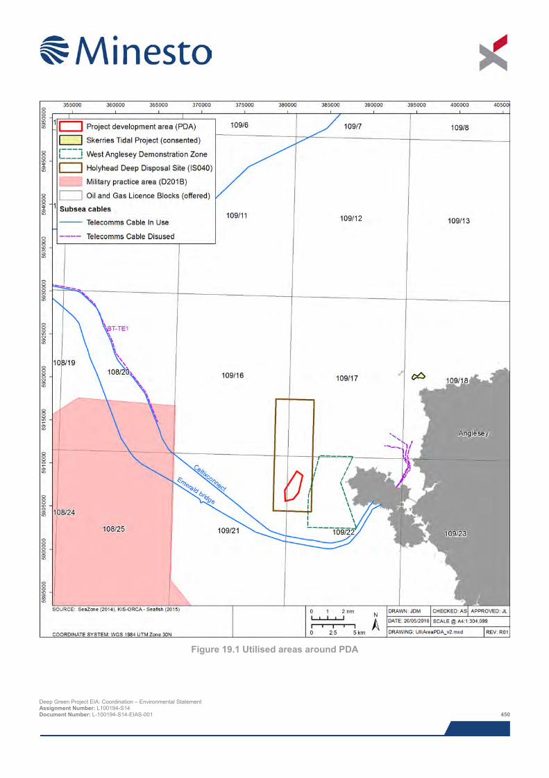
Figure 19.1 Utilised areas around PDA
Deep Green Project EIA: Coordination – Environmental Statement Assignment Number: L100194-S14 Document Number: L-100194-S14-EIAS-001 450
19.5.2 Existing subsea cables and pipelines There are two active telecommunication cables to the south of the PDA. The closest of these is the ‘Emerald Bridges Fibres’ fibre optic cable stretching from Holy Island to Clonshaugh in Ireland. It passes 3.9 km to the south of the PDA. The cable is owned and operated by Zayo Group and ESB Telecoms and came into service in December 2012. The second cable is 4.4 km to the south of the PDA and is the ‘CeltixConnect’ fibre optic cable stretching from Holy Island to Dublin, Ireland. The cable is owned and operated by AquaComms and came into service in January 2012. There is a disused telecommunication cable which ends 17 km to the north west of the PDA (Figure 19.1).
There are three out of service BT cables which come into Holyhead harbour as shown in Figure 19.1, these will not be impacted by activities associated with the Project. The cables are Holyhead – Dublin No. 1 and 2, both of which are coaxial42 cables that were installed in 1947 and went out of service in 1984. The third cable is a sea earth cable, likely associated with the coax cables which lands at the same location.
There are no active or inactive hydrocarbon pipelines in the vicinity of the PDA (Figure 19.2).
19.5.3 Military practice and exercise area There is one Ministry of Defence (MoD) training area in the vicinity of the PDA, located approximately 13 km to the west as shown in Figure 19.1. It is the Aberporth practice and exercise area and is used as a firing practice area. No restrictions are placed on the right to transit the firing practice areas at any time however mariners are advised to exercise particular caution whilst in the area. Exercises and firing only take place when the areas are considered to be clear of all shipping.
19.5.4 Unexploded ordinance (UXO) There are a number of areas within the Irish Sea that may present a risk of UXO. The proposed Project is not located within any known minefields although there is a risk that munitions from minefield areas could have migrated into the PDA over time.
The PDA is located in an area with the potential for munitions to be present as a result of artillery range activities along the coast of Anglesey.
Therefore there is potential for the presence of UXO in the PDA from historical military practice exercises and training and a legacy from two world wars. While no UXO’s were identified during the benthic survey photography, a number of anomalies were identified in the geophysical data review carried out to inform the marine archaeology assessment (Chapter 15). A detailed study on the potential presence of UXO will be carried out once the final positioning of the DGU unit is known.
19.5.5 Oil and gas infrastructure There are currently no oil and gas installations within 80 km of the PDA. The AfL is located in UKCS Blocks 109/21 and 109/22. None of these Blocks were awarded to operators in the 28th Licensing Round. The closest existing oil and gas infrastructure to the PDA are the Conwy oil field (80 km north east), Douglas Oil Field (83 km north east), Hamilton Gas Field (92 km north east) and Hamilton North Gas Field within Liverpool Bay (94 km north east), as shown in Figure 19.2.
19.5.6 Dredging There are no licenced aggregate extraction areas in the vicinity of the PDA. The closest licenced aggregate extraction area is Area 457 in Liverpool Bay which is approximately 82 km north east of the PDA. The transit routes and shipping associated with Area 457 are discussed in Chapter 14: Shipping and Navigation.
42 Type of cable common for data communications. Deep Green Project EIA: Coordination – Environmental Statement Assignment Number: L100194-S14 Document Number: L-100194-S14-EIAS-001 451
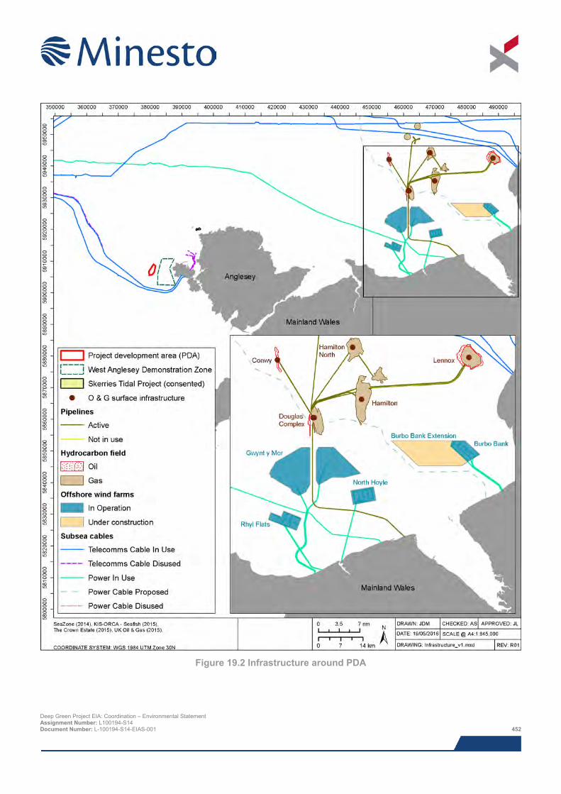
Figure 19.2 Infrastructure around PDA
Deep Green Project EIA: Coordination – Environmental Statement Assignment Number: L100194-S14 Document Number: L-100194-S14-EIAS-001 452
19.5.7 Renewable energy projects There are two potential renewable energy projects close to the PDA: the West Anglesey Demonstration Zone (WADZ) and Skerries Anglesey (Figure 19.1). The Skerries Anglesey development being taken forward to development by Sea Generation Wales Ltd (a development company set up by Marine Current Turbines) has been consented. However, following the recent acquisition of Marine Current Turbines by Atlantis Resources Ltd and the hand back of the Skerries AfL to The Crown Estate in March 2016, the future development of this tidal site is currently uncertain. The WADZ, located immediately east of the PDA, is currently pre-consent.
There are no offshore wind farms in the vicinity of the PDA, the closest ones being located over 80 km to the east of the PDA, three of which are operational and two of which are under construction. The Rhyl Flats, North Hoyle and Burbo Bank are operational and Gwynt y Môr and Burbo Bank Extension are under construction as shown in Figure 19.2 (The Crown Estate, 2015).
19.5.8 Carbon capture and storage (CCS) There are no carbon capture and storage sites in the vicinity of the PDA.
19.6 Impact assessment
19.6.1 Overview This assessment covers all impacts identified during scoping, as well as any further potential impacts that have been highlighted as the EIA has progressed. It should be noted that impacts are not necessarily relevant to all construction, operation and decommissioning aspects of the Project.
Based on the baseline information presented above, the list below indicates the other sea users that could be impacted by the proposed Project. Cumulative and in-combination impacts are discussed in Section 13.10.
> Loss of access to Holyhead Deep disposal site IS040 (construction/installation, operation and maintenance and decommissioning); and
> Inadvertent interaction with UXO.
The potential impacts due to the presence of the two closed disposal sites (with regards to disturbance of potentially contaminated sediments) has been assessed in Chapter 10: Benthic Ecology.
Impacts on the following receptors were scoped out of the other sea users assessment:
> Impacts on the WADZ. Despite being located only 1.2 km from the PDA the construction, installation and operation of the Minesto DG Holyhead Deep Project will not directly impact the WADZ. Consideration of potential cumulative impacts are addressed in section 19.10;
> Impacts on the Skerries Anglesey Tidal Array, due to it being located 18 km from the PDA;
> Interaction with out of use subsea cables, due to them being located a minimum of 3.8 km from the PDA;
> Impacts on the MoD training ground, due to it being located 13 km from the PDA;
> Impacts on oil and gas infrastructure due to the closest being located over 81 km from the PDA;
> Impacts on dredging sites, due to the closes being located over 80 km from the PDA;
> Impacts on offshore wind projects, due to the closest being located over 80 km from the PDA; and
> Impacts on active subsea cables south of the PDA as they are 3.9 km away from the PDA.
The assessment of impacts on other sea users was a desk-based exercise making use of Project specific data.
Deep Green Project EIA: Coordination – Environmental Statement Assignment Number: L100194-S14 Document Number: L-100194-S14-EIAS-001 453
19.6.2 Assessment criteria The EIA process and methodology are described in detail in Chapter 8. Specific criteria have been developed for the sensitivity and vulnerability of the receptor, and the likelihood and magnitude of impact (including duration, frequency, seasonality and geographic extent) as detailed in Section 8.3, whilst topic specific criteria have been developed for the value of the receptor (as defined in Table 19.4).
The sensitivity, vulnerability and value of receptor are combined with the likelihood and magnitude of impact using expert judgement to arrive at a consequence for each impact; the significance of the impact is derived directly from the consequence ranking (Section 8.3.5). The definitions for level of impact and how they relate to significance are presented in Section 8.3.
Table 19.4 Criteria for value of receptor for other sea users
Value of receptor Definition
Very high Receptor of very high importance in the Project area and with little flexibility or capability to utilise alternative areas for activities.
High Any receptor of high importance in the Project area and the majority of activities occur within the Project area
Medium Any receptor which is active in the Project area and utilises it for up to half of its annual activities
Low The receptor is active in Project area and reliant upon it for some activities.
Negligible Receptor not typically present in the Project area.
19.6.3 Design envelope This assessment considers the Project parameters which are predicted to result in the greatest environmental impact. This approach ensures that impacts of a greater adverse significance would not arise should any other development scenario be taken forward in the final scheme design. With regards to the assessment of other sea users impacts the assessment comprises:
> AfL area of 9.1 km2;
> PDA area of 4 km2;
> The DGU unit will occupy a maximum swept area of 0.034 km2;
> Barge or similar such surface platform (with safety zone of 0.84 km2, subject to further consultation) moored on site and associated support vessel for up to five years;
> Increased vessel activity in AfL during construction and installation; and
> Maximum operational period of five years.
The impacts from potential alternative development options are addressed in Section 13.9.
19.6.4 Data gaps and uncertainties With regard to the operational stage of the Project, further consultation is still required with the Maritime and Coastguard Agency (MCA) and the Department of Energy and Climate Change (DECC) regarding safety zones, or other methods of protecting against unnecessary impacts. Of particular note is the potential safety zone around the barge, which is not a standard industry measure and will require further consultation with navigational stakeholders as appropriate. The agreed strategy, whether mandatory or advisory, will be implemented and notified to UK Hydrographic Office (UKHO) for suitable depiction on Admiralty charts.
Deep Green Project EIA: Coordination – Environmental Statement Assignment Number: L100194-S14 Document Number: L-100194-S14-EIAS-001 454
19.7 Impacts during construction and installation period
19.7.1 Impact 13.1 Loss of access to Holyhead Deep disposal site IS040 The disposal site is primarily used to dispose of material from dredging channels into Holyhead Harbour. In all likelihood, the boundaries of the disposal site will have been re-designated to exclude the Minesto AfL area by the time construction takes place, so there will be no potential for interactions between the disposal site users and construction works. The implications of reducing the size of the disposal site is assessed in a report produced by Xodus (2014), which demonstrates that the carrying capacity of the site is more than sufficient to accommodate a reduction in size. Assuming the disposal site boundaries have not been re-designated when construction works commence, all vessels, including the users of the disposal site, will be excluded from the temporary safety zones established around construction vessels and the barge (see Chapter 14: Shipping and Navigation). However, as detailed in Xodus (2014), usage patterns from 2009, 2011 and 2013 show that deposits are typically made in the northern half of the site and do not overlap with the PDA as shown in Figure 19.3. Therefore restriction of access to the southern half of the disposal site during construction (if in fact the site boundary hasn’t been re-designated to exclude the PDA at that time) is highly unlikely to adversely impact users of the disposal site, who almost exclusively use of the northern half of the site and deposit volumes of material that are well below the maximum quantities that can be sustained by the site (Xodus, 2014).
The carrying capacity of the site will be reduced as a result of restrictions upon dumping locations resulting from the redesignation of the site, or enforcement of safety zones. However, a modelling study shows that this is unlikely to present an issue since the site currently receives between 176 and 530 times less than it has the potential to remove (Potter, 2014). Hence, even a 50% reduction in the size of the site is extremely unlikely to affect its carrying capacity enough to have implications based on current disposal patterns and volumes. The sensitivity is assessed as low as the majority of the disposal site (assuming the boundary hasn’t been re-designated) will remain functional during construction and the vulnerability is low as the effects are short term (construction is expected to last up to two years). The value is also assessed as low as the majority of activity in the disposal site does not overlap the PDA. The magnitude of the effect is minor and the consequence low, therefore the impact is assessed as not significant.
Receptor Sens Vuln Value Mag Rationale Consequence Impact
significance
Users of Holyhead
Deep disposal site
IS040
Low Low Low Minor Most deposits are made outside the PDA and few companies have licenses to use the disposal site. The construction stage is anticipated to last a few months during which access to the disposal grounds will be disrupted (if the boundaries of the site haven’t been re-designated).
Low Not significant
MITIGATION
The following mitigation measure is suggested to remove the potential for impacts on the disposal site:
> In all likelihood the boundary of the disposal site will be re-designated such that it no longer encompasses the AfL. Xodus carried out a study on the feasibility of halving the size of the disposal lease site such that the AfL do not overlap; the study concluded that reducing the disposal site area by 50% would have no significant impact on the usage patterns or dispersal patterns of the disposed material.
> Minesto plan to work closely with Stena Line and other users of the Holyhead Deep disposal site to ensure that any disruptions are minimised, and at the same time, ensure that disposal events do not have undue effects on the operation of the DGUs.
Deep Green Project EIA: Coordination – Environmental Statement Assignment Number: L100194-S14 Document Number: L-100194-S14-EIAS-001 455
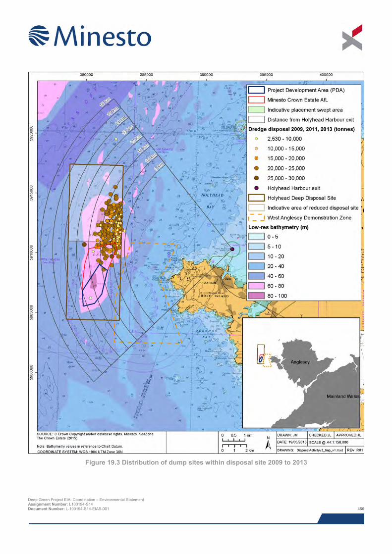
Figure 19.3 Distribution of dump sites within disposal site 2009 to 2013
Deep Green Project EIA: Coordination – Environmental Statement Assignment Number: L100194-S14 Document Number: L-100194-S14-EIAS-001 456
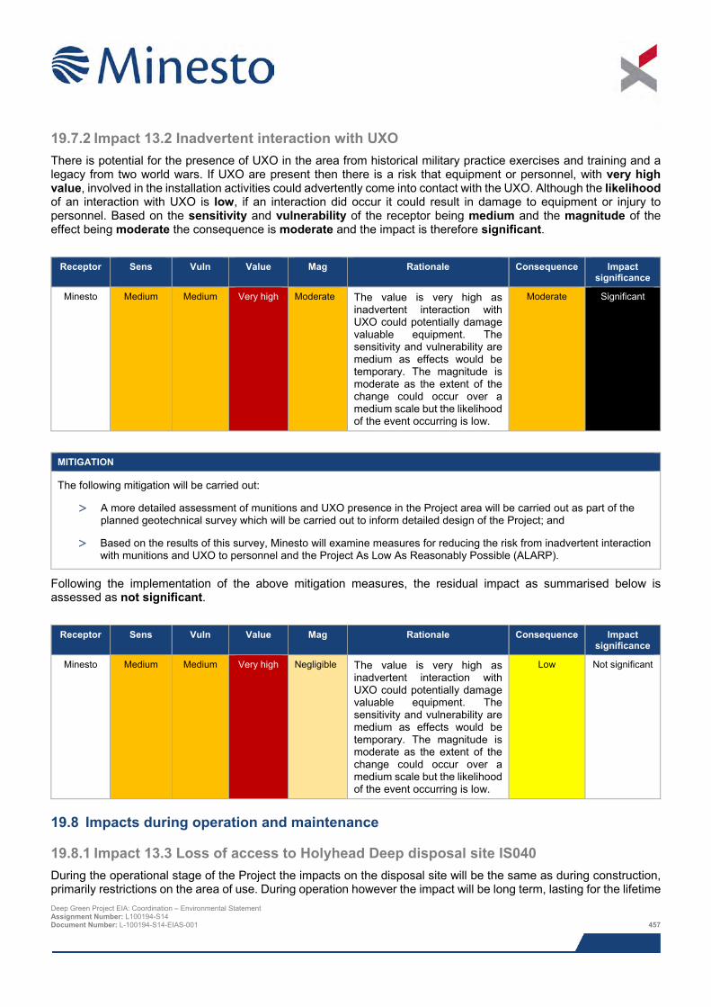
19.7.2 Impact 13.2 Inadvertent interaction with UXO There is potential for the presence of UXO in the area from historical military practice exercises and training and a legacy from two world wars. If UXO are present then there is a risk that equipment or personnel, with very high value, involved in the installation activities could advertently come into contact with the UXO. Although the likelihood of an interaction with UXO is low, if an interaction did occur it could result in damage to equipment or injury to personnel. Based on the sensitivity and vulnerability of the receptor being medium and the magnitude of the effect being moderate the consequence is moderate and the impact is therefore significant.
Receptor Sens Vuln Value Mag Rationale Consequence Impact
significance
Minesto Medium Medium Very high Moderate The value is very high as inadvertent interaction with UXO could potentially damage valuable equipment. The sensitivity and vulnerability are medium as effects would be temporary. The magnitude is moderate as the extent of the change could occur over a medium scale but the likelihood of the event occurring is low.
Moderate Significant
MITIGATION
The following mitigation will be carried out:
> A more detailed assessment of munitions and UXO presence in the Project area will be carried out as part of the planned geotechnical survey which will be carried out to inform detailed design of the Project; and
> Based on the results of this survey, Minesto will examine measures for reducing the risk from inadvertent interaction with munitions and UXO to personnel and the Project As Low As Reasonably Possible (ALARP).
Following the implementation of the above mitigation measures, the residual impact as summarised below is assessed as not significant.
Receptor Sens Vuln Value Mag Rationale Consequence Impact
significance
Minesto Medium Medium Very high Negligible The value is very high as inadvertent interaction with UXO could potentially damage valuable equipment. The sensitivity and vulnerability are medium as effects would be temporary. The magnitude is moderate as the extent of the change could occur over a medium scale but the likelihood of the event occurring is low.
Low Not significant
19.8 Impacts during operation and maintenance
19.8.1 Impact 13.3 Loss of access to Holyhead Deep disposal site IS040 During the operational stage of the Project the impacts on the disposal site will be the same as during construction, primarily restrictions on the area of use. During operation however the impact will be long term, lasting for the lifetime Deep Green Project EIA: Coordination – Environmental Statement Assignment Number: L100194-S14 Document Number: L-100194-S14-EIAS-001 457
of the Project (i.e. up to five years). As described in Section 19.7.1, disposal events in the Holyhead Deep are distributed almost exclusively toward the north of the site, and annual quantities of disposed material are substantially below the maximum carrying capacity of the site. This together with the fact that the boundaries of the disposal site will in all likelihood be re-designated to exclude the Minesto AfL area means that users of the site are extremely unlikely to be affected by the Project.
The sensitivity and value remain low however the vulnerability is assessed as medium and the magnitude of the impact is considered moderate as the effects are long term. The consequence is low and the impact is not significant.
Receptor Sens Vuln Value Mag Rationale Consequence Impact
significance
Users of Holyhead
Deep disposal site
IS040
Low Medium Low Moderate The PDA is rarely used for disposing spoil and disposal site boundaries in all likelihood will be re-designated, but the impact will have a long term effect.
Low Not Significant
MITIGATION
The following mitigation measure is suggested to remove the potential for impacts on the disposal site:
> In all likelihood the boundary of the disposal site will be re-designated such that it no longer encompasses the AfL. Xodus carried out a study on the feasibility of halving the size of the disposal lease site such that the AfL do not overlap; the study concluded that reducing the disposal site area by 50% would have no significant impact on the usage patterns or dispersal patterns of the disposed material.
> Minesto plan to work closely with Stena Line and other users of the Holyhead Deep disposal site to ensure that any disruptions are minimised, and at the same time, ensure that disposal events do not have undue effects on the operation of the DGUs.
19.9 Potential variances in environmental impacts There are no potential Project variances with regards to other sea users, as the full PDA has been assessed.
19.10 Cumulative and in-combination impacts Minesto, in consultation with NRW and IACC, has identified a list of other projects which together with the Project may result in potential cumulative or in-combination impacts. The list of these projects and a map showing their location is provided in Chapter 8: EIA methodology; Table 8.13 and Figure 8.2, respectively.
The consideration of which projects could result in potential cumulative or in-combination impacts is based on the results of the Project specific impact assessment together with the expert judgement of the specialist consultant. Having considered the information presently available in the public domain on the project for which there is a potential for cumulative or in-combination impacts, the key projects for which there is potential for cumulative and in-combination impacts are the WADZ and Minesto Phase II (future potential array).
The Minesto Phase II Project and the WADZ are likely to be operational simultaneously. As the AfL for both projects overlaps the current licenced area of the Holyhead Deep IS040 disposal site it may face cumulative impacts from the two projects. The utilisation of this area of the disposal site is low however and in all likelihood the disposal site boundary will be re-designated such that the site will be reduced in size by 50%. If the site is reduced in size the operational phases of the two projects will not affect activities at and users of the disposal site.
It may be that during construction of these two projects, the presence of increased vessel activity in the area could result in some minor interference to vessels going to and from the disposal site, however the mitigation proposed in Chapter 14: Shipping and Navigation will manage vessel activity to ensure impacts are not significant.
Deep Green Project EIA: Coordination – Environmental Statement Assignment Number: L100194-S14 Document Number: L-100194-S14-EIAS-001 458
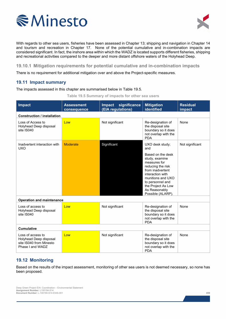
With regards to other sea users, fisheries have been assessed in Chapter 13; shipping and navigation in Chapter 14 and tourism and recreation in Chapter 17. None of the potential cumulative and in-combination impacts are considered significant. In fact, the inshore area within which the WADZ is located supports different fisheries, shipping and recreational activities compared to the deeper and more distant offshore waters of the Holyhead Deep.
19.10.1 Mitigation requirements for potential cumulative and in-combination impacts There is no requirement for additional mitigation over and above the Project-specific measures.
19.11 Impact summary The impacts assessed in this chapter are summarised below in Table 19.5.
Table 19.5 Summary of impacts for other sea users
Impact Assessment consequence
Impact significance (EIA regulations)
Mitigation identified
Residual impact
Construction / installation
Loss of Access to Holyhead Deep disposal site IS040
Low Not significant Re-designation of the disposal site boundary so it does not overlap with the PDA
None
Inadvertent interaction with UXO
Moderate Significant UXO desk study; and
Based on the desk study, examine measures for reducing the risk from inadvertent interaction with munitions and UXO to personnel and the Project As Low As Reasonably Possible (ALARP).
Not significant
Operation and maintenance
Loss of access to Holyhead Deep disposal site IS040
Low Not significant Re-designation of the disposal site boundary so it does not overlap with the PDA
None
Cumulative
Loss of access to Holyhead Deep disposal site IS040 from Minesto Phase I and WADZ
Low
Not significant Re-designation of the disposal site boundary so it does not overlap with the PDA
None
19.12 Monitoring Based on the results of the impact assessment, monitoring of other sea users is not deemed necessary, so none has been proposed.
Deep Green Project EIA: Coordination – Environmental Statement Assignment Number: L100194-S14 Document Number: L-100194-S14-EIAS-001 459
19.13 References Anatec (2015). Navigation Risk Assessment Deep Green Holyhead Deep Project. Document number A3401-XG-NRA-1.
Potter, D. (2014). A multi-disciplinary investigation of the fate of disposed dredge spoil at Holyhead Deep, Anglesey. A thesis submitted in partial fulfilment of the requirements of the Degree of MSc in Applied Marine Geoscience. Bangor University.
Xodus (2014). Deep Green Project EIA: Coordination Holyhead Deep disposal site: characterisation and assessment of capacity to accommodate Minesto AfL. Document number L-100194-S06-REPT-001.
Deep Green Project EIA: Coordination – Environmental Statement Assignment Number: L100194-S14 Document Number: L-100194-S14-EIAS-001 460
20 ENVIRONMENTAL MANAGEMENT AND MONITORING
20.1 Introduction This chapter provides a summary of all topic specific mitigation, monitoring and management measures identified through the impact assessment process.
The potential impacts of the Project on the environment have been assessed through the Environmental Impact Assessment (EIA), including the assessment of impacts on protected habitats and species, and Navigation Risk Assessment (NRA).The results are presented in this Environmental Statement (ES) and accompanying NRA report. Both the EIA and NRA have indicated that it is necessary to manage the Project and implement specific mitigation measures to ensure the Project is sustainable in addition to avoiding or reducing any on-going effects on the environment resulting from the Project.
20.2 Environmental Management Plan (EMP) EIA, including consultation with stakeholders, is an iterative process that will continue beyond application submission. The primary mechanism for ensuring that the environmental assessment continues and that all environmental issues are addressed throughout the lifetime of the Project is through the Project Environmental Management Plan (EMP) which will be implemented as part of the overall Operational Management System for the Project.
The EMP will provide the overarching framework for on-site environmental management for the protection of environmental interests. It will be a working document which details consent conditions, the commitments outlined in the ES and the parties responsible for the implementation of the contents of the EMP.
The EMP will be developed and implemented in agreement with the relevant stakeholders, including Natural Resources Wales (NRW) and their statutory advisors following the successful award of Project consent. This is necessary to ensure that all ES mitigation commitments, consent conditions and environmental monitoring requirements are implemented as required.
20.2.1 Proposed structure and content of EMP The EMP will be based on information included in this ES and conditions of the Marine Licence. It will include the following:
> Outline management and reporting structure, policies, roles and responsibilities for all licensee (Minesto) personnel. It will also cover, contractors and sub-contractors including for example pre-mobilisation audits for vessels, vehicles and equipment to be used in the Project; audits and monitoring of contractors environmental procedures and environmental awareness training;
> Mitigation measures as identified in the ES;
> Topic specific management plans setting out how mitigation measures will be implemented/adhered to during construction and operation including relevant sections of the Construction Method Statement (CMS);
> Pollution prevention measures and contingency plans;
> Waste management measures;
> Measures to prevent introduction of non-native marine species; and
> Reporting mechanisms including updates on construction activity, any environmental issues encountered and how these have been addressed.
As a working document, any updates or amendments to the EMP will be submitted to NRW as appropriate for agreement.
Deep Green Project EIA: Coordination – Environmental Statement Assignment Number: L100194-S14 Document Number: L-100194-S14-EIAS-001 461

20.2.2 Mitigation Where the EIA has identified potentially significant impacts, mitigation measures have been proposed. Such measures should remove, reduce or manage the effect to a point where the residual significance of that impact is reduced to an acceptable level. For some EIA topics where the assessment concluded that certain impacts would not be significant, some mitigation has also been recommended in order to ensure that the impacts remain insignificant.
All mitigation measures committed to during the EIA and detailed in topic specific chapters of the ES are summarised in Table 20.1.
These commitments will be implemented as part of the Project through communication with the Project Team and any contractors with whom Minesto engages. Contractors will implement the requirements of the EMP through their own Environment Management Plan (EMP) and / or Construction Environment Management Plan (CEMP).
Table 20.1 Mitigation measures
EIA topic Mitigation Physical processes None.
Benthic ecology The following mitigation measures are proposed to minimise the risk associated with the introduction of INNS as to ensure Project activities do not significantly impact the Project area or wider region:
> All vessels associated with Project operations will comply with all relevant guidance (including IMO guidelines) regarding ballast water and transfer of INNS;
> Should it be necessary for the installation vessel(s) utilise ballast water, appropriate measures and procedures shall be strictly enforced; and
> Once the source of vessels to be used in the Project is known, it will be considered whether a full INNS risk assessment is necessary to identify whether any further mitigation measures are necessary to ensure there are no significant impacts. This would likely be managed through the contractor tendering process, making an INNS risk assessment a requirement of vessel contractors wishing to work on the Project.
The mitigation measure detailed in the Hydrocarbon and chemical spills and Shipping and navigation sections of this table will minimise the risk and uncertainty associated with accidental spills to ensure that Project activities do not significantly impact the benthic receptors in the Project area or wider region.
Marine mammals and megafauna
The mitigation measure detailed in the Hydrocarbon and chemical spills and Shipping and navigation sections of this table will minimise the risk and uncertainty associated with accidental spills to ensure that Project activities do not significantly impact the marine mammals in the Project area or wider region.
Offshore ornithology The mitigation measure detailed in the ‘Hydrocarbon and chemical spills’ and ‘Shipping and navigation’ sections of this table will minimise the risk and uncertainty associated with accidental spills to ensure that Project activities do not significantly impact the seabirds in the Project area or wider region.
Fisheries Although no significant impacts relating to loss of access to fishing grounds have been predicted, the following mitigation have been proposed in order to ensure impacts remain insignificant:
> Details of the Project will be included in UK Hydrographic Office Notices to Mariners, updated Admiralty Charts, updated Kingfisher Information Service fishermen’s awareness charts and FishSAFE;
> The area of risk will be appropriately marked on charts, Notice to Mariners (N2M) and potentially at sea through the use of buoys;
> Throughout the Project Minesto will maintain ongoing consultation and liaison with the fishing community in accordance with the FLOWW Best Practice Guidance for Offshore Renewable Developments: Recommendations for Fisheries Liaison; and
Deep Green Project EIA: Coordination – Environmental Statement Assignment Number: L100194-S14 Document Number: L-100194-S14-EIAS-001 462
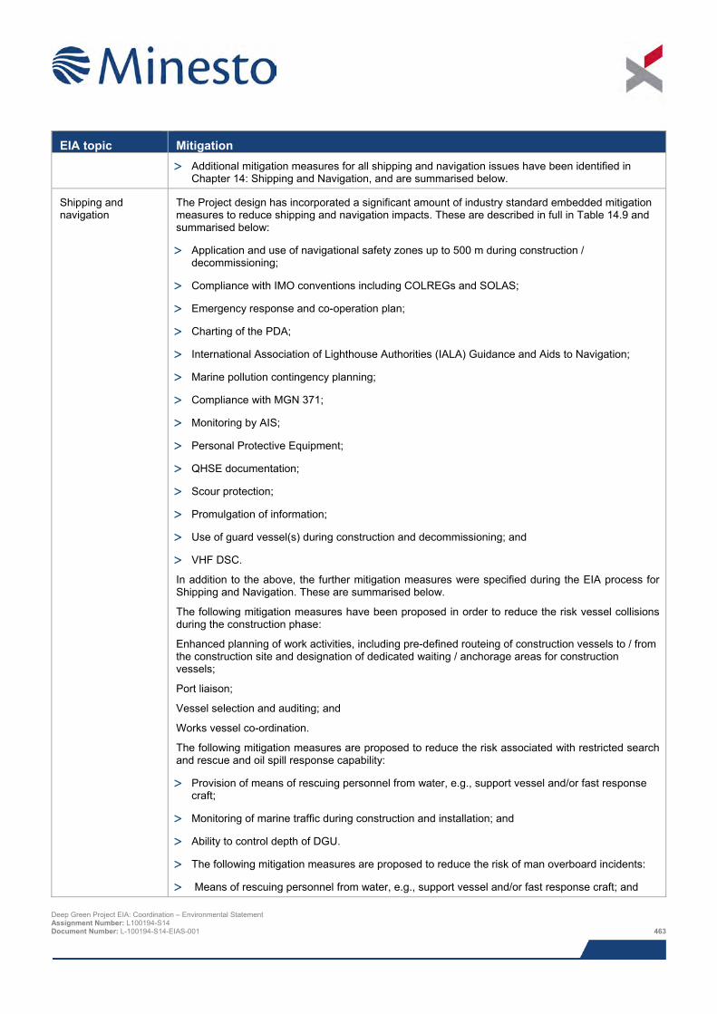
EIA topic Mitigation
> Additional mitigation measures for all shipping and navigation issues have been identified in Chapter 14: Shipping and Navigation, and are summarised below.
Shipping and navigation
The Project design has incorporated a significant amount of industry standard embedded mitigation measures to reduce shipping and navigation impacts. These are described in full in Table 14.9 and summarised below:
> Application and use of navigational safety zones up to 500 m during construction / decommissioning;
> Compliance with IMO conventions including COLREGs and SOLAS;
> Emergency response and co-operation plan;
> Charting of the PDA;
> International Association of Lighthouse Authorities (IALA) Guidance and Aids to Navigation;
> Marine pollution contingency planning;
> Compliance with MGN 371;
> Monitoring by AIS;
> Personal Protective Equipment;
> QHSE documentation;
> Scour protection;
> Promulgation of information;
> Use of guard vessel(s) during construction and decommissioning; and
> VHF DSC.
In addition to the above, the further mitigation measures were specified during the EIA process for Shipping and Navigation. These are summarised below.
The following mitigation measures have been proposed in order to reduce the risk vessel collisions during the construction phase:
Enhanced planning of work activities, including pre-defined routeing of construction vessels to / from the construction site and designation of dedicated waiting / anchorage areas for construction vessels;
Port liaison;
Vessel selection and auditing; and
Works vessel co-ordination.
The following mitigation measures are proposed to reduce the risk associated with restricted search and rescue and oil spill response capability:
> Provision of means of rescuing personnel from water, e.g., support vessel and/or fast response craft;
> Monitoring of marine traffic during construction and installation; and
> Ability to control depth of DGU.
> The following mitigation measures are proposed to reduce the risk of man overboard incidents:
> Means of rescuing personnel from water, e.g., support vessel and/or fast response craft; and
Deep Green Project EIA: Coordination – Environmental Statement Assignment Number: L100194-S14 Document Number: L-100194-S14-EIAS-001 463
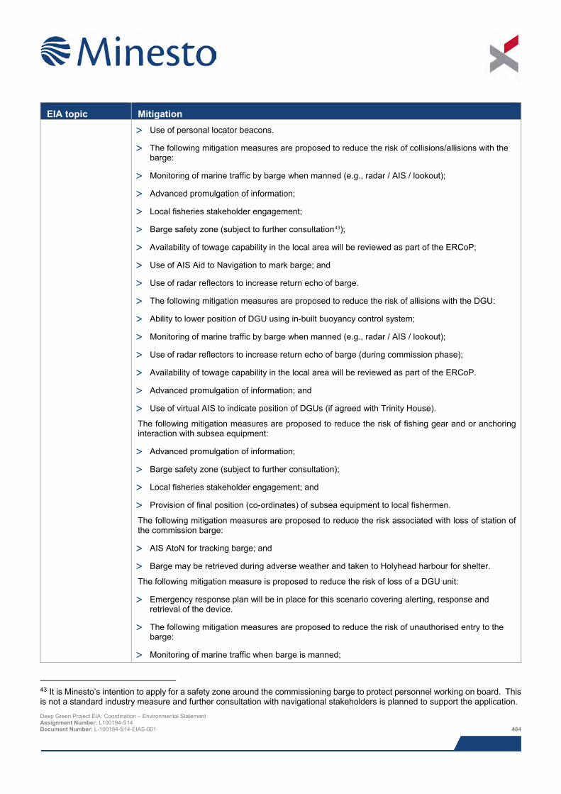
EIA topic Mitigation
> Use of personal locator beacons.
> The following mitigation measures are proposed to reduce the risk of collisions/allisions with the barge:
> Monitoring of marine traffic by barge when manned (e.g., radar / AIS / lookout);
> Advanced promulgation of information;
> Local fisheries stakeholder engagement;
> Barge safety zone (subject to further consultation43);
> Availability of towage capability in the local area will be reviewed as part of the ERCoP;
> Use of AIS Aid to Navigation to mark barge; and
> Use of radar reflectors to increase return echo of barge.
> The following mitigation measures are proposed to reduce the risk of allisions with the DGU:
> Ability to lower position of DGU using in-built buoyancy control system;
> Monitoring of marine traffic by barge when manned (e.g., radar / AIS / lookout);
> Use of radar reflectors to increase return echo of barge (during commission phase);
> Availability of towage capability in the local area will be reviewed as part of the ERCoP.
> Advanced promulgation of information; and
> Use of virtual AIS to indicate position of DGUs (if agreed with Trinity House).
The following mitigation measures are proposed to reduce the risk of fishing gear and or anchoring interaction with subsea equipment:
> Advanced promulgation of information;
> Barge safety zone (subject to further consultation);
> Local fisheries stakeholder engagement; and
> Provision of final position (co-ordinates) of subsea equipment to local fishermen.
The following mitigation measures are proposed to reduce the risk associated with loss of station of the commission barge:
> AIS AtoN for tracking barge; and
> Barge may be retrieved during adverse weather and taken to Holyhead harbour for shelter.
The following mitigation measure is proposed to reduce the risk of loss of a DGU unit:
> Emergency response plan will be in place for this scenario covering alerting, response and retrieval of the device.
> The following mitigation measures are proposed to reduce the risk of unauthorised entry to the barge:
> Monitoring of marine traffic when barge is manned;
43 It is Minesto’s intention to apply for a safety zone around the commissioning barge to protect personnel working on board. This is not a standard industry measure and further consultation with navigational stakeholders is planned to support the application. Deep Green Project EIA: Coordination – Environmental Statement Assignment Number: L100194-S14 Document Number: L-100194-S14-EIAS-001 464
EIA topic Mitigation
> Cameras, e.g., webcam / CCTV; and
> Use of warning signs to deter against unauthorised entry.
The following mitigation measures are proposed to reduce the risk of potential cumulative and in-combination impacts:
> During construction and decommissioning activities, it is important that project developers liaise regularly regarding project progression in order to identify potential overlap in activities resulting in the aforementioned cumulative impacts. Joint consultation and promulgation of information to stakeholders should also be undertaken, if construction / decommissioning activities are deemed to overlap and if projects will be using the same base ports.
> During operational and maintenance activities, it is important that the use of route planning for operation and maintenance vessels (such as construction traffic corridors / designated waiting and anchorage areas) is implemented. These would be defined by Minesto as part of the construction planning process and consideration given to the potential impact on the operation of Holyhead Harbour.
Marine archaeology and cultural heritage
The following measures are designed to mitigate any predicted adverse effects upon submerged prehistory receptors from direct impacts. The measures are designed to reduce or offset any damage/disturbance as a result of the proposed Project upon known sites, and to establish the presence of unknown sites.
> Adopt the Protocol for Archaeological Discoveries: Offshore Renewables Projects (Wessex Archaeology and The Crown Estate, 2014, cited in Chapter 15) for the duration of the Project; a system for reporting and investigating unexpected archaeological discoveries encountered during the course of the Project; and
> If palaeoenvironmental material is recovered during any proposed borehole or vibrocores sampling, corresponding logs and samples of interest should be geoarchaeologically assessed by a suitably qualified marine archaeologist. A five stage approach should be implemented: Stage 1 - Geoarchaeological desk-based assessment; Stage 2 - Geoarchaeological description and interpretation; Stage 3 - Sub-sampling and palaeoenvironmental assessment; Stage 4 - Analysis and dating; and Stage 5 - Final reporting and potential publication. Further details regarding these Stages can be obtained from Wessex Archaeology if required or via The Crown Estate’s Model Clauses for Archaeological WSIs document (2010, cited in Chapter 15).
The following measures are designed to mitigate any predicted adverse effects upon seabed receptors from direct impacts. The measures are designed to reduce or offset any damage/disturbance as a result of the proposed Project upon known sites, and to establish the presence of unknown sites.
> Any further archaeological work will be detailed by a Written Scheme of Investigation (WSI) prepared prior to the Project starting;
> Avoidance of geophysical anomalies is recommended in the first instance; Preservation by record (i.e. archaeological excavation and recording prior to an impact occurring) is recommended for offsetting disturbances to archaeological sites or material where preservation in situ is not practicable. Sites that have been destabilised, but not destroyed, may be re-stabilised and subject to detailed analysis; and
> Adopt the Protocol for Archaeological Discoveries: Offshore Renewables Projects (Wessex Archaeology and The Crown Estate, 2014, cited in Chapter 15) for the duration of the Project.
Landscape, seascape and visual
None.
Socio-economic None.
Hydrocarbon and chemical spills
The following mitigation measures will be implemented in order to reduce the risk of and impact from vessel spills:
Deep Green Project EIA: Coordination – Environmental Statement Assignment Number: L100194-S14 Document Number: L-100194-S14-EIAS-001 465
EIA topic Mitigation
> An Emergency Response Corporation Plan (ERCoP) will be prepared for the Project in line with guidance set out by the MCA in MGN 371. This will be submitted to MCA for comment and approval;
> Notices to Mariners will be issued advising other vessels in the area of activities within the Project area;
> Vessels associated with all Project operations will comply with IMO/MCA codes for prevention of oil pollution and any vessels over 400 GT will have on board SOPEPs;
> Vessels associated with all Project operations and barge will carry on-board oil and chemical spill mop up kits;
> Where possible vessels with a proven track record for operating in similar conditions will be employed; and
> Vessel activities associated with installation, operation, routine maintenance and decommissioning will occur in suitable conditions to reduce the chance of an oil spill resulting from the influence of unfavourable weather conditions.
The following mitigation measures will be implemented in order to reduce the risk of leaks from the DGU:
> Only recognised marine standard fluids and substances will be used in the DGU systems;
> Hydraulic fluids and coolant will be mostly biodegradable and be of low aquatic toxicity; and
> Sensors in the DGU designed to monitor its operational status would detect any serious loss of fluid pressure and leaks, alerting maintenance operatives so that they can carry out repairs and prevent further leaks.
Other sea users The following mitigation measures will be implemented to reduce potential impacts associated with interactions with other sea users during construction and operation of the Project:
> Re-designation of the Holyhead Deep disposal site boundary so it does not overlap with the PDA;
> Ongoing liaison with Stena Line and other users of the Holyhead Deep disposal site to ensure that any disruptions are minimised; and
> Ongoing liaison with Morlais during Project development.
The following mitigation measures will be implemented to reduce potential impacts associated inadvertent interactions with UXO:
> UXO desk study; and
> Based on the desk study, examine measures for reducing the risk from inadvertent interaction with munitions and UXO to personnel and the Project As Low As Reasonably Possible (ALARP).
20.2.3 Compliance monitoring A monitoring programme will be designed by Minesto to track and assess the performance of the mitigation measures to ensure that they meet their regulatory and corporate requirements and to update and improve the programme where necessary.
20.3 Environmental Monitoring Strategy (EMS) Due to the emerging and ever evolving nature of the tidal energy industry there are some potential impacts that have yet to be verified by operational monitoring. Where single devices have been installed and environmental impacts monitored, Minesto has made use of relevant available data e.g. post installation monitoring carried out for the 1:4
Deep Green Project EIA: Coordination – Environmental Statement Assignment Number: L100194-S14 Document Number: L-100194-S14-EIAS-001 466
scale prototype device deployed in Strangford Lough. However Minesto recognises that there is little data currently available and its application to the assessment of tidal arrays is limited.
Through the EIA processes for the DG Holyhead Deep Project, Minesto has identified two approaches to monitoring:
> Where Minesto identifies monitoring requirements for the Project, specific monitoring protocols will be developed in consultation with the regulators and their advisors e.g. shipping and navigation; and
> Where uncertainties in the assessment are identified that are considered to be of strategic importance to the development of the tidal energy industry, Minesto would wish to engage with the wider industry, regulators, their advisors and stakeholders through the involvement on working groups or similar forums e.g. ORJIP in order to assist with developing strategic monitoring programmes for the benefit of future projects in Wales, elsewhere in the UK and the wider tidal industry.
Minesto’s ambition is to understand the interaction between the DG Holyhead Deep Project and the environment as much as possible. The intention is to continue to seek collaborative projects with academic institutions and marine professionals on a wide field of tasks.
20.3.1 Overview of monitoring carried out in Strangford Lough At the time of application submission Minesto had deployed a 1:4 scale device deployed in Strangford Lough. As part of this deployment, post installation monitoring has been undertaken in order to develop a better understanding of the interactions between DGU and the marine environment. These monitoring studies include:
> Environmental Assessment Study – Queen’s University Belfast (QUB);
> Marine Mammal Observations;
> Collision Risk Modelling;
> Habitats Regulation Assessment (HRA);
> Noise Measurements; and
> Marine Mammal Detections Sonar System (MMDS).
A summary of these studies is provided below:
> Environmental Assessment Study – QUB: In order to minimise the environmental impact of the testing facility in Strangford Lough QUB performed environmental assessment studies at the very beginning of the project. This helped Minesto to choose the most suitable place for the test site.
> Marine Mammal Observations: A Marine Mammal Observer (MMO) is on watch at all times when the device is in operation. If a marine mammal is detected within 50 m of device operations cease immediately. No strikes have been recorded since the 1:4 scale device is in operation. All data recorded by the MMO is sent monthly to the Department of the Environment Northern Ireland.
> Collision Risk Modelling: This model used real device operations data under different tidal conditions. The simulation assessed the potential of collisions between the device and the harbour seals at the test site. Simulation results indicated that a relatively low number of collisions are predicted to occur.
> Habitats Regulation Assessment (HRA): Report that considered the project’s potential to have a Likely Significant Effect on the harbour seal feature, thus affecting the integrity of the Strangford Lough Special Area of Conservation population.
> Noise Measurements: Minesto and QUB carried out noise measurement which provided and optimised the required equipment to perform these measurements. Minesto will use the results of the analysis to get a better understanding of the interaction between the device and the marine mammals.
> Marine Mammal Detections Sonar System (MMDS): Several investigations have been carried out in order to find the right sonar device for a MMDS system at the test site. The development of the system will include not
Deep Green Project EIA: Coordination – Environmental Statement Assignment Number: L100194-S14 Document Number: L-100194-S14-EIAS-001 467
only the marine mammal detection but it will also stop the device if one or more marine mammals enter the operational area of the power plant.
20.3.2 Proposed monitoring for the DG Holyhead Deep Project For most EIA topics where it is concluded that there will be no significant impacts, no specific monitoring has been proposed. Where potentially significant impacts have been identified e.g. for shipping and navigation and marine archaeology, proposals to monitor these potential impacts and the effectiveness of proposed mitigation have been set out in the relevant ES chapters and are summarised in Table 20.2.
Although no significant impacts were identified with regards for the potential for collision impacts with marine mammals, there is still a level of uncertainty surrounding interactions between marine mammals and tidal devices. Minesto recognises the importance of monitoring marine mammal interactions with tidal devices not only to confirm the predictions that there would be no significant impacts and also to help increase knowledge and understanding of these interactions in order to help inform the continuing development of the tidal energy Projects worldwide.
Table 20.2 Proposed monitoring
EIA topic Mitigation
Physical processes No monitoring proposed.
Benthic ecology No monitoring proposed.
Marine mammals and megafauna Minesto is committed to understanding the potential interactions between marine mammals and the Deep Green technology and intend to develop an adaptive monitoring strategy commensurate with the risks identified in this impact assessment. In all likelihood this will be achieved through collaborations with NRW and specialist research bodies and/or academic institutions, for example SEACAMS, so as to ensure the production of high-quality output that will be of significant value to future projects. The scope of the any potential monitoring plan would also be informed by monitoring of other tidal array projects as results of this monitoring becomes available.
Offshore ornithology The impact assessment indicates that it is unlikely there will be any significant impacts on birds from the proposed Project. However, Minesto believes that understanding the diving behaviour of birds around tidal devices and the risk of collisions occurring is important for the industry to progress. It therefore proposed that this potential impact is considered as strategic research and monitoring approaches should be developed in cooperation with regulators, stakeholders and other developers.
Minesto will work with the regulator and its advisory bodies to agree details of appropriate monitoring, including whether site specific monitoring at this Project site is appropriate.
Fisheries No monitoring over and above what is proposed for shipping and navigation (see below) is proposed. However, consultation with the local fishing community will continue throughout the operational period of the Project.
Shipping and navigation Vessel traffic will be monitored on AIS during construction and operation to assess the impact of the Project on vessel traffic in the area. This is likely to be from either a shore based or barge based AIS monitoring system that can be reviewed when required by regulators. This is a passive system (operational for assessment only). The requirement is likely to last throughout the construction period and one further year.
Whilst the barge is present on site, marine traffic shall also be monitored by a lookout onboard the barge when it is manned in order to reduce the overall collision and allision risk.
Deep Green Project EIA: Coordination – Environmental Statement Assignment Number: L100194-S14 Document Number: L-100194-S14-EIAS-001 468
EIA topic Mitigation
In order to reduce the impact of unauthorised entry to the barge (impact 14.16, see Section 14.8.11), the barge shall be equipped with cameras to act as a deterrent. It is anticipated that this shall act as a passive secondary system to the monitoring of marine traffic by a lookout during manned periods. During periods when the barge is unmanned, the images shall be monitored remotely to minimise the likelihood of unauthorised entry to the barge.
Marine archaeology and cultural heritage
A protocol for archaeological discoveries (PAD) to be implemented for the duration of the Project in order to manage the potential discovery of previously unknown marine heritage material. The PAD should be undertaken in line with the Protocol for Archaeological Discoveries: Offshore Renewables Projects (Wessex Archaeology and The Crown Estate, 2014), whereby relevant Project staff on all construction/installation/maintenance vessels will be informed of the PAD and given specific information regarding details of the find types that may be of archaeological interest and the potential importance of any archaeological material encountered. Finds will be assessed by a marine archaeologist and a report produced, possibly leading to a requirement for further investigation in accordance with the mitigations presented in this chapter.
Landscape, seascape and visual No monitoring proposed.
Socio-economic No monitoring proposed.
Hydrocarbon and chemical spills No monitoring is proposed as part of routine operation of the Project, however in the unlikely event of a pollution incident, appropriate post incident monitoring will be implemented and agreed with the regulator and their advisors.
Other sea users No monitoring over and above what is proposed for Shipping and navigation (see above).
20.4 Interface with contractors Contractor management is an important element of the Project and Minesto expect contractors to demonstrate a high level of environmental awareness, including suitable environmental management.
The EMP and responsibilities for environmental standards and procedures will be included as part of Contractor’s invitations to tender. This will ensure all contractors adhere to the requirements of the EMP.
Pre mobilisation audits will also be carried out as standard for all vessels, vehicles or equipment that will be used in the Project. This will ensure compliance with Minesto’s environmental management procedures and documentation.
Environmental commitments, objectives and targets identified for the Project will be communicated to all Contractors through contractual conditions. Contractor performance will be measured against these commitments.
20.5 Environmental awareness and training Minesto is committed to ensuring that all personnel who perform or manage Project work, that has the potential to have significant effects on the environment, receive appropriate training. All personnel, including contractors, engaged in work that also has the potential to impact the environment will be fully audited and monitored to ensure that they have the appropriate procedures in place to manage their environmental responsibilities.
Deep Green Project EIA: Coordination – Environmental Statement Assignment Number: L100194-S14 Document Number: L-100194-S14-EIAS-001 469
ACRONYMS AND UNITS
Acronym/unit Definition % Percent
£ Great Britain Pound Sterling
€ Euros
° Arc degrees
°C Degrees Celsius
µg Micrograms
AAM Anglesey Aluminium Metals
AC Alternating Current
ADCP Acoustic Doppler Current Profiler
AEZ Archaeological Exclusion Zone
AfL Agreement for Lease
AIF Anticipated Impact Footprint
AIS Automatic Identification System
ALARP As Low As Reasonably Practicable
ALPOCO Aluminium Powder Company
AMAA Ancient Monuments and Archaeological Areas Act
AOB Apparently Occupied Burrow
AOD Above Ordinance Datum
AONB Area of Outstanding Natural Beauty
AOS Apparently Occupied Site
APOCO Aluminium Powder Company Ltd
AQMA Air Quality Management Areas
ARPA Automatic Radar Plotting Aid
atm Atmospheres
AtoN Aid to Navigation
AWL All Weather Lifeboats
B.C. Before Christ
BGS British Geological Survey
BMAPA British Marine Aggregate Producers Association
bn Billion
BOCC Birds of Conservation Concern
BT British Telecom
CA Conservation Area
CBA Cost Benefit Analysis
CCC Countryside and Coastal Character
Deep Green Project EIA: Coordination – Environmental Statement Assignment Number: L100194-S14 Document Number: L-100194-S14-EIAS-001 470
Acronym/unit Definition CCS Carbon Capture and Storage
CCTV Closed Circuit Television
CCW Countryside Council for Wales
CEA Cost Effectiveness Analysis
Cefas Centre for Environment, Fisheries & Aquaculture Science
CEMP Construction Environmental Management Plan
CI Confidence Interval
CIA Cumulative Impact Assessment
CIEEM Chartered Institute of Ecology and Environmental Management
CIM Collections, Infrastructure and Markets
cm Centimetres
CMS Construction Method Statement
COLREGS International Regulations for Preventing Collisions at Sea
COSHH Control of Substances Hazardous to Health
COWRIE Collaborative Offshore Wind Research into the Environment
CPA Coastal Protection Act
CPO Chief Planning Officers
CRM Collision Risk Modelling
DAM Development Advice Map
dB re 1 μPa Decibels re one micropascal
dB re 1 μPa2s Decibels re one micropascal-squared-seconds
DBA Desk Based Assessment
DCO Development Consent Order
DECC Department of Energy and Climate Change
DEFRA Department for Environment, Food and Rural Affairs
DfT Department for Transport
DG Deep Green
DGO Deep Green Ocean
DGU Deep Green Utility
DP Dynamic Positioning / Dynamically Positioned
DSC Digital Selective Calling
DTM Digital Terrain Model
EA Environment Agency
EC European Commission
EIA Environmental Impact Assessment
EMEC European Marine Energy Centre
Deep Green Project EIA: Coordination – Environmental Statement Assignment Number: L100194-S14 Document Number: L-100194-S14-EIAS-001 471
Acronym/unit Definition EMF Electromagnetic Field
EMP Environmental Management Plan
EMS Environmental Management System
EOG Enron Oil and Gas
EPS European Protected Species
ERCoP Emergency Response Corporation Plan
ERM Encounter Rate Modelling
ES Environmental Statement
ESAS European Seabirds at Sea
EU European Union
FEPA Food and Environmental Protection Act
FLO Fisheries Liaison Officer
FLOWW Fishing Liaison with Offshore Wind and Wet Renewables
FPSO Floating production, Storage and Offloading
FSA Formal Safety Assessment
ft Feet
FTE Full Time Equivalent
g Grams
GAT Gwynedd Archaeological Trust
GBS Gravity Base Structure
GCR Geological Conservation Review
GDHI Gross Disposable Household Income
GES Good Environmental Status
GIS Geographical Information System
GLVIA Guidelines for Landscape and Visual Impact Assessment
GPD Gross Domestic Product
GPS Global Positioning System
GT Gross Tonnage
GVA Gross Value Added
GW Gigawatt
GWh Gigawatt hours
HER Historic Environment Record
HM Her Majesty’s
HMY Her Majesty’s Yacht
HQ Head Quarters
HRA Habitats Regulations Assessment
Deep Green Project EIA: Coordination – Environmental Statement Assignment Number: L100194-S14 Document Number: L-100194-S14-EIAS-001 472

Acronym/unit Definition HVDC High Voltage Direct Current
IACC Isle of Anglesey County Council
IALA International Association of Marine Aids to Navigation and Lighthouse Authorities
ICES International Council for the Exploration of the Sea
ICPC International Cable Protection Committee
IDA Indicative Deployment Area
IEEM Institute of Ecology and Environmental Management
IEMA Institute of Environmental Management and Assessment
ILB Inshore Lifeboats
IMO International Maritime Organisation
INNS Invasive Non-Native Species
IPA Indicative Project Area
IPO Initial Public Offering
IROPI Imperative Reason of Overriding Public Interest
ISQG Interim Marine Sediment Quality Guideline
ISZ Irish Sea Zone
IUCN International Union for Conservation of Nature
JNCC Joint Nature Conservation Committee
JSA Job Seekers Allowance
k Thousand
kg Kilograms
km Kilometres
KPT Knowledge Partner Transfer
kW Kilowatt
LARS Launch and Recovery System
LAT Lowest Astronomical Tide
LBAP Local Biodiversity Action Plan
LCRI Low Carbon Research Institute
LDP Local Development Plan
LGM Last Glacial Maximum
LSE Likely Significant Effect
LVIA Landscape and Visual Impact Assessment
m Metres
M Million
m/s Metres per second
m2 Square metres
Deep Green Project EIA: Coordination – Environmental Statement Assignment Number: L100194-S14 Document Number: L-100194-S14-EIAS-001 473

Acronym/unit Definition m3 Cubic metres
MAIB Marine Accident Investigation Branch
MARPOL International Convention for the Prevention of Pollution from ships
MaxFR Maximum Foraging Range
MBES Multibeam echosounder
MCA Maritime and Coastguard Agency
MCA Multi-Criteria Analysis
MCAA Marine and Coastal Access Act
MCT Marine Current Turbines
MCZ Marine Conservation Zone
MEHRA Marine Environmental High Risk Area
MEP Marine Energy Pembrokeshire
mg Milligrams
MGN Marine Guidance Note
MHWS Mean High Water Springs
MLT Marine Licensing Team
MLW Mean Low Water
MLWS Mean Low Water Springs
mm Millimetres
MMDS Marine Mammal Detections Sonar System
MMFR Mean Maximum Foraging Range
MMMU Marine Mammal Management Unit
MMO Marine Mammal Observer
MMO Marine Management Organisation
MNCR Marine Nature Conservation Review
MNR Marine Nature Reserve
MoD Ministry of Defence
MPA Marine Protected Area
MPS Marine Policy Statement
MRCC Maritime Rescue Coordination Centre
MSC Military Sealift Command
MSFD Marine Strategy Framework Directive
mt Metric tonnes
MW Megawatt
N North
N/m2 Newton per square metre
Deep Green Project EIA: Coordination – Environmental Statement Assignment Number: L100194-S14 Document Number: L-100194-S14-EIAS-001 474

Acronym/unit Definition N2M Notice to Mariners
NERC Natural Environment and Rural Communities
nm Nautical miles
nm2 Square nautical miles
NMBAQC NE Atlantic Biological Analytical Quality Control Scheme
NMPW National Marine Plan for Wales
NMRW National Monuments Record of Wales
NNS Non-Native Species
NOREL Nautical Offshore Renewable Energy Liaison
NRA Navigational Risk Assessment
NRP Natural Research Projects
NRW Natural Resources Wales
nT Nano tesla
NTS Non-technical Summary
OCT Open Centre Turbine
ONS Office of National Statistics
OREI Offshore Renewable Energy Installation
ORJIP Offshore Renewables Joint Industry Programme
OS Ordinance Survey
OSGB Ordinance Survey Great Britain
OSPAR Oslo/Paris convention (for the Protection of the Marine Environment of the North-East Atlantic)
PAD Protocol for Archaeological Discoveries
PDA Project Development Area
PEL Probable Effect Level
PEMP Project Environmental Monitoring Plan
PLN Port Letter Number
PMF Priority Marine Feature
PMRA Protection of Military Remains Act
ppb Parts per billion
PPE Personal Protective Equipment
PPG Pollution Prevention Guidelines
ppm Parts per million
PPS Planning Policy Statements
PPW Planning Policy Wales
PSSA Particularly Sensitive Sea Area
PWA Protection of Wrecks Act Deep Green Project EIA: Coordination – Environmental Statement Assignment Number: L100194-S14 Document Number: L-100194-S14-EIAS-001 475
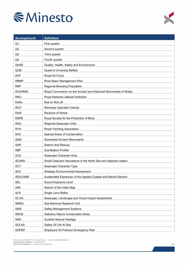
Acronym/unit Definition Q1 First quarter
Q2 Second quarter
Q3 Third quarter
Q4 Fourth quarter
QHSE Quality, Health, Safety and Environment
QUB Queen’s University Belfast
RAF Royal Air Force
RBMP River Basin Management Plan
RBP Regional Breeding Population
RCAHMW Royal Commission on the Ancient and Historical Monuments of Wales
RNLI Royal National Lifeboat Institution
RoRo Roll on Roll off
ROV Remotely Operated Vehicle
RoW Receiver of Wreck
RSPB Royal Society for the Protection of Birds
RSU Regional Seascape Units
RYA Royal Yachting Association
SAC Special Areas of Conservation
SAM Scheduled Ancient Monuments
SAR Search And Rescue
SBP Sub-Bottom Profiler
SCA Seascape Character Area
SCANS Small Cetacean Abundance in the North Sea and Adjacent waters
SCT Seascape Character Type
SEA Strategic Environmental Assessment
SEACAMS Sustainable Expansion of the Applied Coastal and Marine Sectors
SEL Sound Exposure Level
SIM Search of the Index Map
SLR Single Lens Reflex
SLVIA Seascape, Landscape and Visual Impact Assessment
SMRU Sea Mammal Research Unit
SMS Safety Management Systems
SNCB Statutory Nature Conservation Body
SNH Scottish Natural Heritage
SOLAS Safety Of Life At Sea
SOPEP Shipboard Oil Pollution Emergency Plan
Deep Green Project EIA: Coordination – Environmental Statement Assignment Number: L100194-S14 Document Number: L-100194-S14-EIAS-001 476

Acronym/unit Definition SPA Special Protection Area
SRDL Satellite Relay Data Loggers
SS Steam Ship
SSC Suspended Sediment Concentrations
SSE Scottish and Southern Energy
SSS Sidescan Sonar
SSSI Sites of Special Scientific Interest
TAN Technical Advice Note
TCE The Crown Estate
TEL Threshold Effects Level
TGL Tidal Generation Limited
THLS Trinity House Lighthouse Service
TSM Total Suspended Matter
TSS Traffic Separation Scheme
UDP Unitary Development Plan
UK United Kingdom
UKBAP United Kingdom Biodiversity Action Plan
UKCS United Kingdom Continental Shelf
UKHO United Kingdom Hydrographic Office
UNESCO United Nations Educational, Scientific and Cultural Organisation
US United States
UTM Universal Transverse Mercator
UXO Unexploded Ordnance
V Volts
VHF Very High Frequency
VMS Vessel Monitoring System
WA Wessex Archaeology
WADZ West Anglesey Demonstration Zone
WCA Wildlife and Countryside Act
WDC Whale and Dolphin Conservation
WEFO Welsh European Funding Office
WFD Water Framework Directive
WGS World Geodetic System
WHS World Heritage Site
WSI Written Scheme of Investigation
ZTV Zone of Theoretical Visibility
Deep Green Project EIA: Coordination – Environmental Statement Assignment Number: L100194-S14 Document Number: L-100194-S14-EIAS-001 477
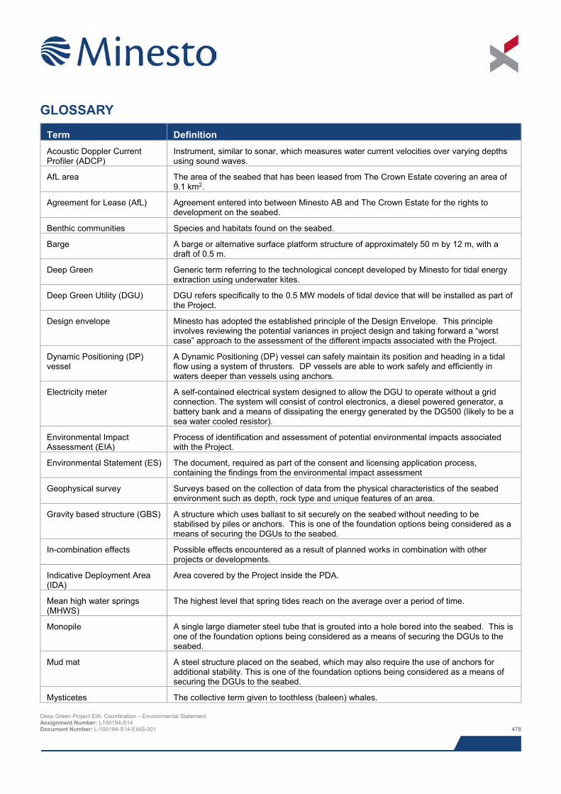
GLOSSARY
Term Definition Acoustic Doppler Current Profiler (ADCP)
Instrument, similar to sonar, which measures water current velocities over varying depths using sound waves.
AfL area The area of the seabed that has been leased from The Crown Estate covering an area of 9.1 km2.
Agreement for Lease (AfL) Agreement entered into between Minesto AB and The Crown Estate for the rights to development on the seabed.
Benthic communities Species and habitats found on the seabed.
Barge A barge or alternative surface platform structure of approximately 50 m by 12 m, with a draft of 0.5 m.
Deep Green Generic term referring to the technological concept developed by Minesto for tidal energy extraction using underwater kites.
Deep Green Utility (DGU) DGU refers specifically to the 0.5 MW models of tidal device that will be installed as part of the Project.
Design envelope Minesto has adopted the established principle of the Design Envelope. This principle involves reviewing the potential variances in project design and taking forward a “worst case” approach to the assessment of the different impacts associated with the Project.
Dynamic Positioning (DP) vessel
A Dynamic Positioning (DP) vessel can safely maintain its position and heading in a tidal flow using a system of thrusters. DP vessels are able to work safely and efficiently in waters deeper than vessels using anchors.
Electricity meter A self-contained electrical system designed to allow the DGU to operate without a grid connection. The system will consist of control electronics, a diesel powered generator, a battery bank and a means of dissipating the energy generated by the DG500 (likely to be a sea water cooled resistor).
Environmental Impact Assessment (EIA)
Process of identification and assessment of potential environmental impacts associated with the Project.
Environmental Statement (ES) The document, required as part of the consent and licensing application process, containing the findings from the environmental impact assessment
Geophysical survey Surveys based on the collection of data from the physical characteristics of the seabed environment such as depth, rock type and unique features of an area.
Gravity based structure (GBS) A structure which uses ballast to sit securely on the seabed without needing to be stabilised by piles or anchors. This is one of the foundation options being considered as a means of securing the DGUs to the seabed.
In-combination effects Possible effects encountered as a result of planned works in combination with other projects or developments.
Indicative Deployment Area (IDA)
Area covered by the Project inside the PDA.
Mean high water springs (MHWS)
The highest level that spring tides reach on the average over a period of time.
Monopile A single large diameter steel tube that is grouted into a hole bored into the seabed. This is one of the foundation options being considered as a means of securing the DGUs to the seabed.
Mud mat A steel structure placed on the seabed, which may also require the use of anchors for additional stability. This is one of the foundation options being considered as a means of securing the DGUs to the seabed.
Mysticetes The collective term given to toothless (baleen) whales. Deep Green Project EIA: Coordination – Environmental Statement Assignment Number: L100194-S14 Document Number: L-100194-S14-EIAS-001 478
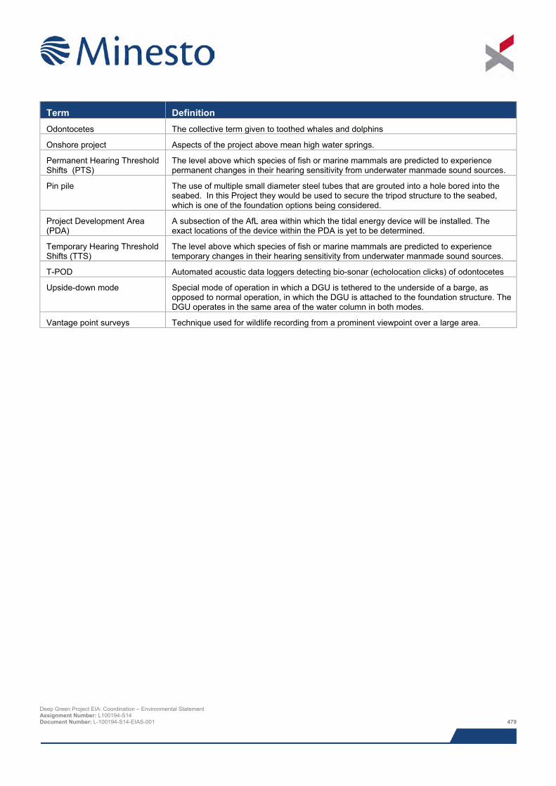
Term Definition Odontocetes The collective term given to toothed whales and dolphins
Onshore project Aspects of the project above mean high water springs.
Permanent Hearing Threshold Shifts (PTS)
The level above which species of fish or marine mammals are predicted to experience permanent changes in their hearing sensitivity from underwater manmade sound sources.
Pin pile The use of multiple small diameter steel tubes that are grouted into a hole bored into the seabed. In this Project they would be used to secure the tripod structure to the seabed, which is one of the foundation options being considered.
Project Development Area (PDA)
A subsection of the AfL area within which the tidal energy device will be installed. The exact locations of the device within the PDA is yet to be determined.
Temporary Hearing Threshold Shifts (TTS)
The level above which species of fish or marine mammals are predicted to experience temporary changes in their hearing sensitivity from underwater manmade sound sources.
T-POD Automated acoustic data loggers detecting bio-sonar (echolocation clicks) of odontocetes
Upside-down mode Special mode of operation in which a DGU is tethered to the underside of a barge, as opposed to normal operation, in which the DGU is attached to the foundation structure. The DGU operates in the same area of the water column in both modes.
Vantage point surveys Technique used for wildlife recording from a prominent viewpoint over a large area.
Deep Green Project EIA: Coordination – Environmental Statement Assignment Number: L100194-S14 Document Number: L-100194-S14-EIAS-001 479