Embed Size (px)
Citation preview

March 2014
Environmental Statement Chapter 13 Fish and Shellfish Ecology Application Reference: 6.13

DOGGER BANK TEESSIDE A & B
F-OFC-CH-013 Issue 4.1 © 2014 Forewind Chapter 13 Page ii
Cover photograph: Installation of turbine foundations in the North Sea

DOGGER BANK TEESSIDE A & B
F-OFC-CH-013 Issue 4.1 © 2014 Forewind Chapter 13 Page iii
Document Title Dogger Bank TeessideA & B
Environmental Statement – Chapter 13
Fish and Shellfish Ecology
Forewind Document Reference F-OFC-CH-013 Issue 4.1
Date March 2014
Drafted by Brown & May Marine Ltd edited by Royal HaskoningDHV
Checked by Ben Orriss
Date / initials check
28 February 2014
Approved by Angela Lowe
Date / initials approval
28 February 2014
Forewind Approval
Date / Reference approval Gareth Lewis 26 February 2014

DOGGER BANK TEESSIDE A & B
F-OFC-CH-013 Issue 4.1 © 2014 Forewind Chapter 13 Page iv
Title: Dogger Bank Teesside A & B Environmental Statement Chapter 13 Fish and Shellfish Ecology
Contract No. (if applicable) Onshore Offshore
Document Number: F-OFC-CH-013
Issue No: 4.1
Issue Date: 28 February 2014
Status: Issued for 1st. Technical Review Issued for 2nd. Technical Review
Issued for PEI3 Issued for DCO
Prepared by: Brown & May Marine Ltd (edited by Royal HaskoningDHV)
Checked by: Ben Orriss
Approved by: Angela Lowe
Signature / Approval meeting
Gareth Lewis
Approval Date: 26 February 2014
Revision History
Date Issue No. Remarks / Reason for Issue Author Checked Approved
05 August 2013
1 Issued for 1st Technical Review BMM/TR JL AL
28 August 2013
1.2 Issued for 2nd
Technical Review BMM/TR AL AL
10 September 2013
2 Issued for Quality Review BMM/TR AL RH
25 September 2013
2.1 Submitted for Approval BMM/TR AL AL
08 October 2013
3 PEI 3 BMM/TR
AL AL
18 February 2014
4 Pre-DCO Submission Review BMM/TR
BLO AL
28 February 2014
4.1 DCO Submission BMM/TR
BLO AL

DOGGER BANK TEESSIDE A & B
F-OFC-CH-013 Issue 4.1 © 2014 Forewind Chapter 13 Page v
Table of Contents
1. Introduction ................................................................................................................... 1
2. Guidance and Consultation ........................................................................................... 2
2.1. Legislation, policy and guidance ......................................................................... 2
2.2. Consultation ........................................................................................................ 3
3. Methodology ............................................................................................................... 25
3.1. Study area......................................................................................................... 25
3.2. Characterisation of the existing environment – methodology ............................ 28
3.3. Assessment of impacts - methodology ............................................................. 39
4. Existing Environment .................................................................................................. 49
4.1. Regional context ............................................................................................... 49
4.2. Overview of findings from site specific surveys ................................................. 53
4.3. Principal fish and shellfish species identified .................................................... 63
5. Assessment of Impacts – Worst case Definitions ....................................................... 84
5.1. General ............................................................................................................. 84
5.2. Realistic worst case scenarios .......................................................................... 84
5.3. Construction scenarios ..................................................................................... 93
5.4. Operation scenarios .......................................................................................... 94
5.5. Decommissioning scenarios ............................................................................. 94
6. Impacts during Construction ....................................................................................... 95
6.1. General ............................................................................................................. 95
6.2. Temporary physical disturbance/loss of seabed habitat – direct effects ........... 95
6.3. Temporary physical disturbance/loss of seabed habitat – impacts on fish and
shellfish ............................................................................................................. 96
6.4. Suspended sediment concentrations .............................................................. 104
6.5. The effect of increased suspended sediment concentration and sediment re-
deposition........................................................................................................ 108
6.6. Release of sediment contaminants through seabed disturbance-effects ........ 124
6.7. Release of sediment contaminants through seabed disturbance-impacts ...... 125
6.8. Construction noise - effects............................................................................. 130

DOGGER BANK TEESSIDE A & B
F-OFC-CH-013 Issue 4.1 © 2014 Forewind Chapter 13 Page vi
6.9. Construction noise - impacts ........................................................................... 138
6.10. Construction noise impact assessment summary ........................................... 150
7. Impacts during Operation .......................................................................................... 152
7.1. General ........................................................................................................... 152
7.2. Permanent loss of habitat - effects .................................................................. 152
7.3. Permanent loss of habitat - impacts ................................................................ 153
7.4. Permanent loss of habitat impact assessment summary ................................ 155
7.5. Introduction of hard substrate-effects .............................................................. 156
7.6. Introduction of hard substrate-impacts ............................................................ 159
7.7. Introduction of hard substrate impact assessment summary .......................... 161
7.8. Increases in suspended sediment concentration and sediment re-deposition
due to scour associated with foundations - effects .......................................... 161
7.9. Increases in suspended sediment concentration and sediment re-deposition
due to scour associated with foundations - impacts ........................................ 162
7.10. Electromagnetic fields (EMF) - effects ............................................................ 164
7.11. Electromagnetic fields (EMF) - Impacts .......................................................... 167
7.12. EMF impact assessment summary ................................................................. 175
7.13. Operational noise-effects ................................................................................ 175
7.14. Operational noise- impacts ............................................................................. 176
7.15. Operational noise impact assessment summary ............................................. 176
7.16. Changes to fishing activity .............................................................................. 177
7.17. Changes to fishing activity impact assessment summary ............................... 178
8. Impacts during Decommissioning ............................................................................. 179
9. Inter-relationships...................................................................................................... 180
10. Cumulative Impacts ................................................................................................... 181
10.1. CIA Strategy and screening ............................................................................ 181
10.2. Cumulative impact of Dogger Bank Teesside A & B, Dogger Bank Creyke Beck
and Dogger Bank Teesside C & D. ................................................................. 196
10.3. Temporary physical disturbance/loss of seabed habitat ................................. 196
10.4. Suspended sediment and sediment re-deposition .......................................... 197
10.5. Construction noise .......................................................................................... 203
10.6. Permanent habitat loss ................................................................................... 204
DOGGER BANK TEESSIDE A & B
F-OFC-CH-013 Issue 4.1 © 2014 Forewind Chapter 13 Page vii
10.7. Summary......................................................................................................... 205
10.8. The cumulative impact of Dogger Bank Teesside A & B, Dogger Bank Creyke
Beck, Dogger Bank Teesside C and D and other projects outside the Dogger
Bank Zone....................................................................................................... 208
10.9. Dogger Bank Teesside A & B, Dogger Bank Creyke Beck, Dogger Bank
Teesside C & D and marine conservation areas ............................................. 212
11. Transboundary Issues ............................................................................................... 215
11.1. General ........................................................................................................... 215
12. Summary ................................................................................................................... 216
13. References ................................................................................................................ 219
Table of Tables
Table 2.1 NPS assessment requirements ................................................................ 2
Table 2.2 Summary of consultation and issues raised by consultees ...................... 4
Table 3.1 Site specific surveys .............................................................................. 31
Table 3.2 Geographic frame of reference .............................................................. 42
Table 3.3 VERs identified in the study area and their valuation ............................. 43
Table 3.4 Sensitivity of a receptor .......................................................................... 46
Table 3.5 Magnitude of effect ................................................................................ 47
Table 3.6 Overall impact resulting from each combination of receptor sensitivity
and the magnitude of effect on it ............................................................ 47
Table 4.1 Species composition of the North Central and South-eastern North Sea
fish communities (after Harding et al. 1986)........................................... 50
Table 4.2 Species with defined spawning and nursery grounds within or in the
vicinity of Dogger Bank Teesside A & B and the Dogger Bank Teesside
A & B Export Cable Corridor (based on Coull et al. 1998 and Ellis et al.
2012) ...................................................................................................... 59

DOGGER BANK TEESSIDE A & B
F-OFC-CH-013 Issue 4.1 © 2014 Forewind Chapter 13 Page viii
Table 4.3 Principal diadromous migratory species relevant to Dogger Bank
Teesside A & B and the Dogger Bank Teesside A & B Export Cable
Corridor .................................................................................................. 60
Table 4.4 Principal elasmobranch species of conservation interest potentially
present in the Wind Farm and Export Cable Corridor Study Areas ........ 61
Table 4.5 Commercial fish species of conservation interest potentially present in
the Wind Farm and Export Cable Corridor Study Areas ........................ 62
Table 4.6 Ecology distribution and commercial importance of key fish and shellfish
in all study areas .................................................................................... 65
Table 5.1 Types of impacts per project area and their potential effects on fish and
shellfish .................................................................................................. 85
Table 5.2 Key design parameters forming the realistic worst case scenarios for the
assessment of impacts on fish and shellfish ecology per wind farm
project area (Source Dogger Bank Teesside A & B CPD –Issue 3) ....... 87
Table 6.1 Maximum persistence of sediment thickness over the 30-day simulation
period for installation of conical GBS #1 foundations ........................... 107
Table 6.2 Sensitivity to smothering, increased suspended sediment concentrations
and displacement of shellfish species (Source: MarLIN 2012) ............ 123
Table 6.3 Seabed disturbance impact assessment summary .............................. 127
Table 6.4 Increased suspended sediment concentration and deposition impact
assessment summary .......................................................................... 129
Table 6.5 Summary of injury criteria used for fish ................................................ 134
Table 6.6 Summary of behavioural criteria for generic fish species ..................... 134
Table 6.7 Estimated impact ranges for pelagic and demersal fish in Dogger Bank
Teesside A ........................................................................................... 136
Table 6.8 Estimated impact ranges for pelagic and demersal fish in Dogger Bank
Teesside B ........................................................................................... 136
Table 6.9 Construction noise impact assessment summary ................................ 151
Table 7.1 Permanent loss of habitat impact assessment summary ..................... 156

DOGGER BANK TEESSIDE A & B
F-OFC-CH-013 Issue 4.1 © 2014 Forewind Chapter 13 Page ix
Table 7.2 Introduction of hard substrate impact assessment summary ............... 161
Table 7.3 Increases in suspended sediment concentration and sediment re-
deposition due to scour associated with foundations impact assessment
summary .............................................................................................. 163
Table 7.4 Averaged magnetic field strength values from AC cables .................... 165
Table 7.5 Averaged magnetic field strength values from DC cables above and
horizontally along the seabed assuming 1m burial (Normandeau et al.
2011) .................................................................................................... 166
Table 7.6 Species found in UK coastal waters for which there is evidence of a
response to E fields. Gill et al. (2005) ................................................. 166
Table 7.7 Species found in UK waters for which there is evidence of a response to
B fields. ................................................................................................ 167
Table 7.8 EMF impact assessment summary ...................................................... 175
Table 7.9 Operational noise impact assessment summary .................................. 177
Table 7.10 Changes to fishing activity impact assessment summary .................... 178
Table 9.1 Fish and shellfish ecology inter-relationships ....................................... 180
Table 10.1 Potential cumulative impacts (impact screening) ................................. 183
Table 10.2 Cumulative Impact Assessment screening for fish ecology (project
screening) ............................................................................................ 185
Table 10.3 Cumulative impact assessment summary ............................................ 205
Table 12.1 Summary of potential impacts on fish and shellfish ecology ................ 216
Table of Figures
Figure 3.1 Dogger Bank Teesside A & B Study Areas ............................................ 27
Figure 3.2 Location of offshore otter and beam trawl survey sampling locations .... 32
Figure 3.3 Pelagic survey transects and location of pelagic trawl tows ................... 35
Figure 3.4 Location of April 2013 potting survey fleets............................................ 38

DOGGER BANK TEESSIDE A & B
F-OFC-CH-013 Issue 4.1 © 2014 Forewind Chapter 13 Page x
Figure 3.5 Location of April 2013 trammel netting stations .................................... 41
Figure 4.1 Distribution of three fish communities of the North Sea, based on
average catches of the fifty most abundant species in the English
Groundfish Survey in the years 1982-1986 (Adapted from ICES 2005) . 52
Figure 4.2 Relative abundance of sandeel by station and species (individuals
caught per hour) in Tranches A and B ................................................... 57
Figure 6.1 Location for sediment deposition modelling studies ........................................ 106
Figure 6.2 Average modelled suspended sediment concentration over the
simulation period of 30 days ................................................................ 113
Figure 6.3 Maximum suspended sediment concentrations over the simulation period
of 30 days ............................................................................................ 114
Figure 6.4 Herring spawning grounds (after Coull et al. 1998) and average sediment
deposition thickness over the 30 day simulation period ....................... 115
Figure 6.5 Herring spawning grounds (after Coull et al. 1998) and maximum
sediment deposition thickness over the 30 day simulation period ........ 116
Figure 6.6 Sandeel specific survey results and average sediment deposition
thickness over the 30 day simulation period ........................................ 117
Figure 6.7 Sandeel specific survey results and maximum sediment deposition
thickness over the 30 day simulation period ........................................ 118
Figure 6.8 Comparative indication of the extent of behavioural impact ranges on
pelagic fish assuming 2300 kilojoule (kJ) and 3000kJ hammer energies
............................................................................................................. 133
Figure 6.9 Dogger Bank Teesside A noise ranges for a single pile construction
(max. hammer energy 2300kJ) in relation and herring spawning grounds
(Coull et al. 1998) ................................................................................. 144
Figure 6.10 Dogger Bank Teesside A noise ranges for a single pile construction
(max. hammer energy 2300kJ), in relation to Danish VMS (2007-2011)
............................................................................................................. 145

DOGGER BANK TEESSIDE A & B
F-OFC-CH-013 Issue 4.1 © 2014 Forewind Chapter 13 Page xi
Figure 6.11 Dogger Bank Teesside B noise ranges for a single pile construction
(max. hammer energy 2300kJ) in relation to herring spawning grounds
(Coull et al. 1998) ................................................................................. 146
Figure 6.12 Dogger Bank Teesside B noise ranges for a single piling operation (max.
hammer energy 2300kJ), in relation to Danish VMS (2007-2011) ....... 147
Figure 10.1 Dogger Bank Teesside A & B, Dogger Bank Teesside C & D, Dogger
Bank Creyke Beck A & B and their Export Cable Corridors ................. 200
Figure 10.2 Danish sandeel fishing, satellite VMS density (average 2007-2011) ... 201
Figure 10.3 Herring spawning grounds (after Coull et al. 1998) .............................. 202
Figure 10.4 Map of the North Sea with an illustration of the noise generated from pile
driving at various potentially concurrently occurring construction projects
in relative proximity to Dogger Bank Teesside A and Dogger Bank
Teesside B ........................................................................................... 207
Figure 10.5 Dredging areas in the vicinity of Dogger Bank Teesside A & B and
herring spawning grounds .................................................................... 210
Figure 10.6 Dredging areas in the vicinity of Dogger Bank Teesside and density of
Danish fishing (satellite VMS average 2007-2011) .............................. 211
Figure 10.7 Proposed fisheries management sectors within the Dogger Bank cSAC ...
............................................................................................................. 214
Table of Appendices
Appendix 5A Underwater Noise Modelling Technical Report
Appendix 9A Marine Physical Processes Assessment of Effects Technical Report
Appendix 12A Tranche B and Export Cable Corridor Benthic Survey Report
Appendix 12B Tranche A Benthic Survey report
Appendix 13A Fish and Shellfish Ecology Technical Report
Appendix 13B Tranche B Fish and Shellfish Characterisation Survey
Appendix 13C Nearshore Fish and Shellfish Surveys

DOGGER BANK TEESSIDE A & B
F-OFC-CH-013 Issue 4.1 © 2014 Forewind Chapter 13 Page xii
Appendix 13D Tranche A Fish and Shellfish Characterisation Survey
Appendix 13E Pelagic Fish Survey Report
Appendix 13F Sandeel Survey Report
Appendix 13G Habitats Disturbance Calculations Report
Appendix 15A Commercial Fisheries Technical Report

DOGGER BANK TEESSIDE A & B
F-OFC-CH-013 Issue 4.1 Chapter 13 Page 1 © 2014 Forewind
1. Introduction
1.1.1. This chapter of the Environmental Statement (ES) describes the existing
environment with regard to fish and shellfish ecology and assesses the potential
impacts of Dogger Bank Teesside A & B and Dogger Bank Teesside A & B
Export Cable Corridor during the construction, operation and decommissioning
phases. Where the potential for significant impacts is identified, mitigation
measures and residual impacts are presented.
1.1.2. The description draws on original site specific and regional data collection as
well as published data and grey literature. Other chapters related to this
assessment include:
Chapter 5 Project Description
Chapter 9 Marine Physical Processes;
Chapter 10 Marine Water and Sediment Quality;
Chapter 12 Marine and Intertidal Ecology;
Chapter 14 Marine Mammals; and
Chapter 15 Commercial Fisheries.
1.1.3. The information presented in this chapter is based on a technical report
authored by Brown & May Marine Limited and Precision Marine Survey Limited
(PMSL) which is available in full as Appendix 13A Fish and Shellfish Ecology
Technical Report. Brown and May Marine Ltd also undertook the impact
assessment presented in Sections 6 to 11.

DOGGER BANK TEESSIDE A & B
F-OFC-CH-013 Issue 4.1 Chapter 13 Page 2 © 2014 Forewind
2. Guidance and Consultation
2.1. Legislation, policy and guidance
2.1.1. The assessment of potential impacts upon fish and shellfish ecology has been
made with specific reference to the relevant National Policy Statements (NPS).
These are the principal decision making documents for Nationally Significant
Infrastructure Projects (NSIP). Those relevant to Dogger Bank Teesside A & B
are:
Overarching NPS for Energy (EN-1) (Department of Energy and Climate
Change (DECC) 2011a); and
National Policy Statement for Renewable Energy Infrastructure (EN-3),
July 2011.
2.1.2. The specific assessment requirements for fish and shellfish ecology, as detailed
in the NPS, are summarised in Table 2.1 together with an indication of the
paragraph numbers of the ES chapter where each is addressed. Where any
part of the NPS has not been followed within the assessment an explanation as
to why the requirement was not deemed relevant, or has been met in another
manner, is provided.
Table 2.1 NPS assessment requirements
NPS requirement NPS reference ES reference
There is the potential for the construction and decommissioning phases, including activities occurring both above and below the seabed, to interact with seabed sediments and therefore have the potential to impact fish communities, migration routes, spawning activities and nursery areas of particular species. In addition, there are potential noise impacts, which could affect fish during construction and decommissioning and to a lesser extent during operation.
Paragraph 2.6.73 Section 6.4 – suspended sediment concentration Section 6.6 – 6.8 Noise Sections 7.11-7.12 Section 10.5
The applicant should identify fish species that are the most likely receptors of impacts with respect to, feeding areas, spawning grounds, nursery grounds and migration routes.
Paragraph 2.6.74 Section 4.2
Mitigation measures should consider the reduction of electromagnetic field effects from export cables and working practices during construction to reduce the impact on fish communities.
Paragraphs 2.6.75 to 2.6.77
Section 7.8 – 7.10
2.1.3. The principal guidance documents and information used to inform the
assessment of potential impacts on fish and shellfish ecology are as follows:
Centre for Environment, Fisheries and Aquaculture Science (Cefas)
Guidance note for Environmental Impact Assessment in respect of Food

DOGGER BANK TEESSIDE A & B
F-OFC-CH-013 Issue 4.1 Chapter 13 Page 3 © 2014 Forewind
and Environment Protection Act (FEPA) and Coast Protection Act (CPA)
requirements. Version 2 – June 2004; and
Guidelines for Data Acquisition to Support Marine Environmental
Assessments of Offshore Renewable Energy Projects (Judd 2012).
2.2. Consultation
2.2.1. To inform the ES, Forewind has undertaken a thorough pre-application
consultation process, which has included the following key stages:
Scoping Report submitted to the Planning Inspectorate (May 2012);
Scoping Opinion received from the Planning Inspectorate (June 2012);
First stage of statutory consultation (in accordance with sections 42 and 47
of the Planning Act 2008) on Preliminary Environmental Information (PEI) 1
(May 2012); and
Second stage of statutory consultation (in accordance with sections 42, 47
and 48 of the Planning Act 2008) on the draft ES designed to allow for
comments before final application to the Planning Inspectorate.
2.2.2. In between the statutory consultation periods, Forewind consulted specific
groups of stakeholders on a non-statutory basis to ensure that they had an
opportunity to inform and influence the development proposals. Consultation
undertaken throughout the pre-application development phase has informed
Forewind’s design decision making and the information presented in this
document. Further information detailing the consultation process is presented in
Chapter 7 Consultation. A Consultation Report is also provided alongside this
ES, as part of the overall planning submission.
2.2.3. A summary of the consultation carried out at key stages throughout the project,
of particular relevance to fish and shellfish ecology is presented in Table 2.2.
This table only includes the key items of consultation that have defined the
assessment. A considerable number of comments, issues and concerns raised
during consultation have been addressed in meetings with consultees and
hence have not resulted in changes to the content of the ES. In these cases,
the issue in question has not been captured in Table 2.2. A full explanation of
how the consultation process has shaped the ES, as well as tables of all
responses received during the statutory consultation periods, is provided in the
Consultation Report.

DOGGER BANK TEESSIDE A & B
F-OFC-CH-013 Issue 4.1 Chapter 13 Page 4 © 2014 Forewind
Table 2.2 Summary of consultation and issues raised by consultees
Consultee Date Comments Contents Action taken/output ES Reference
MMO (section 42 consultation on the draft ES, statutory)
20 December 2013 Advised that Ellis et al. 2012 and Coull et al. 1998 be used to define spawning and nursery grounds in addition to Ellis et al. 2010.
Ellis et al. 2010 is referenced in this chapter as it provides a comprehensive description of the datasets used to derive mapping layers for the distribution of eggs and larvae of fish and shellfish. Ellis et al. 2010 and Ellis et al. 2012 are considered to provide the same information on the spatial extent of spawning and nursery habitats, albeit in different formats. Coull et al. 1998 is referenced throughout this chapter and is also reviewed in Appendix 13A Shellfish Ecology Technical Report.
Appendix 13A Fish and Shellfish Ecology Technical Report. Section 3.2 and 4.2
Advised that the current ICES advice for herring in the North Sea be considered.
Current ICES advice is reviewed.
Section 6.3 See also: Appendix 13A Fish and Shellfish Ecology Technical Report: Section 6.2.
Advised that the northern section of the herring spawning area should not be disturbed through the peak spawning period (mid-Aug to mid-Oct) and that it is not necessary to restrict activity during the whole spawning period.
Comments noted. Section 4.2

DOGGER BANK TEESSIDE A & B
F-OFC-CH-013 Issue 4.1 Chapter 13 Page 5 © 2014 Forewind
Consultee Date Comments Contents Action taken/output ES Reference
Advised that data from the International Herring Larval Survey (IHLS) should be considered over a series of years.
IHLS data for the ten year period 2002-2011 is presented.
Appendix 13A Fish and Shellfish Ecology Technical Report Figure 6.40 – Figure 6.48
Requested the application be supported by specific sandeel surveys to cover the whole project and not just the area described by the fishery.
Additional text provided in 3.2.20 Section 3.2
Queried the methodology for estimating spatial extent of sandeel and herring habitat.
The approach used to estimate the spatial extent of sandeel and herring habitat is based on the approach of Jensen et al. 2011 and is further described in Appendix 13G Habitats disturbance calculations report.
Section 6.3
Request clarification on the methodology to define the spatial extent of habitat.
Additional text added to paragraph 6.3.31. See also Appendix 13G Habitats disturbance calculations report.
Section 6.3

DOGGER BANK TEESSIDE A & B
F-OFC-CH-013 Issue 4.1 Chapter 13 Page 6 © 2014 Forewind
Consultee Date Comments Contents Action taken/output ES Reference
Clarification requested to whether the impact assessment for sediment includes deposition from disposal.
Additional information provided in 6.4.14
Chapter 9 Marine Physical Processes
Requested further information on piling durations.
Updated information in Table 5.1.
Section 5.1
Queried whether noise impacts to sandeels during their period of dormancy were assessed.
Additional information added to 6.8.5
Section 6.8.
Suggested a consistent naming convention with ‘sandeels’ used when referring to more than one species of sandeel.
Chapter updated in line with the naming convention used in the international body of literature
Amended throughout
Suggested Nephrops be listed as of ‘regional’ importance and not just ‘local’.
Valuation of Nephrops amended to ‘regional’.
Sections 3.3, 6.3 and 6.5

DOGGER BANK TEESSIDE A & B
F-OFC-CH-013 Issue 4.1 Chapter 13 Page 7 © 2014 Forewind
Consultee Date Comments Contents Action taken/output ES Reference
Requested further detail on the distribution of brown crab in the western North Sea.
Update to Table 4.6. Figure 6.70 in Appendix 13A Fish and Shellfish Ecology Technical Report also provided to show C. pagurus distribution in the central North Sea.
Section 4.6
Suggested reference to The Marine Life Information Network (MarLIN) sensitivity assessment for Nephrops be reviewed. MarLIN concluded that Nephrops have a ‘high’ tolerance to substrate loss.
Chapter updated. Section 6.3
Additional information requested regarding the effects of sediment on the nursery habitat of Nephrops.
Additional text added Section 6.5
Suggested ovigerous brown crab are likely to be more sensitive to re-deposition of fine sediment as they are effectively sessile whilst brooding their egg mass.
Additional text added. Section 6.5
Advised that the chapter be updated to recognise that brown crab is of regional importance.
Comments accepted. Section 7.11

DOGGER BANK TEESSIDE A & B
F-OFC-CH-013 Issue 4.1 Chapter 13 Page 8 © 2014 Forewind
Consultee Date Comments Contents Action taken/output ES Reference
Requested clarification on whether unbundling of cables has been considered.
Cables are to be assumed unbundled as a worst case scenario. Table 5.2 updated and text added to clarify in this chapter.
Section 3.3
JNCC/Natural England (section 42 consultation on the draft ES, statutory)
20 December 2013 Noted that the maximum area for physical disturbance/habitat loss during construction was inconsistent.
Amendment made. Section 6.2
Suggested the relative distribution of sediment should be provided for the inshore area close to landfall and the export cable.
Information on the inshore area and export cable study area is provided in Section 6.4.16
Section 6.4
Requested clarification on the figures quoted for the total area of preferred habitat within the Dogger Bank SA1 sandeel management area.
Methodology used to derive the estimates of sandeel habitat are provided in Appendix 13G Habitats disturbance calculations report
Section 6.3
Clarification requested on the maximum sediment thickness used in modelling.
Comments noted Section 6.5

DOGGER BANK TEESSIDE A & B
F-OFC-CH-013 Issue 4.1 Chapter 13 Page 9 © 2014 Forewind
Consultee Date Comments Contents Action taken/output ES Reference
Requested clarification on information provided based on the reference Bone & Moore 2008 on larvae.
Clarification provided in Section 6.5.9
Section 6.5
Requested information on where hard structures are likely to be introduced along the export cable corridor.
Addressed in Section 7.2 and 7.3 and detailed in Table 5.2
Sections 7.5 and 7.6
Raised questions regarding sensitivity of Nephrops in relation to physical disturbance to their spawning and nursery grounds, given their mobility and occupation of burrows.
Report updated with habitat preference and the spawning and nursery areas for Nephrops based on Coull et al. 1998 and Ellis et al. 2012.
Section 3.3 & Section 4.2
Suggests a review of MarLIN information for Nephrops sensitivity and recoverability i.e. in relation to suspended sediment on eggs, larvae and adult.
Report updated to include information from MarLIN.
Section 6.3 & Section 6.5
EPIC Regeneration Consultants LLP for Hartlepool Fishermen’s Society Ltd. (section 42 consultation on the draft ES, statutory)
20 December 2013 The inshore element of the Export Cable Corridor shows an area of the highest concentration over a known Nephrops habitat.
The importance of Nephrops in inshore areas is noted in Table 4.6.
Section 4.6

DOGGER BANK TEESSIDE A & B
F-OFC-CH-013 Issue 4.1 Chapter 13 Page 10 © 2014 Forewind
Consultee Date Comments Contents Action taken/output ES Reference
Concerned that so little is understood about the impact of EMF and heating effects from HVDC cabling on commercial fish stocks and any potential for EMF to create barriers to fish stock migration.
Comments noted. A review of the EMF impacts and effects is provided.
Section 7.10- 7.12 See also Chapter 5 Project Description Section 3
Request for further information on the use of bundling of cables to mitigate the effects of EMF on receptors.
Text to clarify has been added Section 3.3 (See also Section 7.10)
Request further information on the research undertaken by Bochert and Zettler, (2004) as cited.
Comments noted. Further text has been added to clarify.
Section 7.11
Lack of seabed samples inadequate given there are previously used spoil dumping areas in proximity.
Contaminant concentrations along the cable corridor are described in paragraph 6.6.4.
See also Chapter 10 Marine Water and Sediment Quality Section 6.6
MMO/Cefas (Meeting)
10 April 2013 Meeting to discuss the approach to methodology and impact assessment for Dogger Bank Teesside A & B. Presentation on results of the fish and shellfish characterisation surveys in Tranche B. Cefas indicated that grey gurnard were not currently considered to be a species of interest but this position may change in the future if the species becomes increasingly commercially important. Presentation of the sandeel survey results showing some concentration of sandeels in Dogger Bank Teesside A and very low densities of sandeels in Dogger Bank Teesside B. Cefas indicated that sandeels in Tranche B must be included for assessment. Presentation of herring survey results showing no evidence of spawning activity on the historic
N/A

DOGGER BANK TEESSIDE A & B
F-OFC-CH-013 Issue 4.1 Chapter 13 Page 11 © 2014 Forewind
Consultee Date Comments Contents Action taken/output ES Reference
spawning grounds near Tranche B. JNCC/Natural England (written response)
17 December 2012 Written response from JNCC Natural England with reference to the Habitat Regulations Assessment (HRA) Screening Report. In reference to protected fish species linked to Special Protection Area (SPA) greater clarity is needed with reference to; The impact of construction of the Dogger Bank Teesside A & B Export Cable Corridor and landfall; The impact from the use of scour protection (rock protection); Determining the thresholds of suspended sediment concentrations over which there may be an impact on the respiratory and reproductive functions of sensitive fish species; The potential impact on habitats supporting fish species (i.e. Special Area of Conservation (SAC) sites and fish species) in relation to the export cable and potential rock protections needs to be considered; and A consideration of the potential impact of the development on allis and twaite shad and river and sea lamprey should be included in the assessment.
This has been addressed in sections 6-8 of this chapter and in the HRA draft report HRA Appendix B.
Section 6 – 8
MMO (written response) 17 December 2012 Written response from MMO to Forewind in relation to the herring spawning and sandeel report sent by Forewind and the discussions in relation to these species during the 15/08/2012 meeting with MMO/Cefas. Specific Comments:
The results of the PSA have been included within this ES chapter. Data on sandeel derived from 2m beam trawl sampling has also been included within
Section 6- 8

DOGGER BANK TEESSIDE A & B
F-OFC-CH-013 Issue 4.1 Chapter 13 Page 12 © 2014 Forewind
Consultee Date Comments Contents Action taken/output ES Reference
The addition of PSA data has been noted; The data with regard to sandeel is improved for Tranche A and the inclusion of the 2m beam trawl data is useful and the acknowledgment of the limitations of this data has been noted; With regards to the sandeel data all the information must be pulled together to create a vulnerability assessment within Tranche A (this could be used to identify the higher abundance of sandeel within Tranches A & B and those sites surrounding them). A further sandeel survey for Tranche A is not required as Forewind have reduced the boundary to exclude most of the sandeel ground to the west and the information provided does characterise the area, with the additional 2m beam trawl and PSA data; The inclusion of herring PSA data is useful. We agree that limited spawning is likely to take place within the Dogger Bank region and the spawning ground is likely to be historic. Therefore there is no need for further surveys for Tranche A; The southern portion of Area B (where four PSA samples have high gravel content) must be avoided for construction during the spawning season using engineering solutions. This is due to the proximity to spawning ground to the south and the historic and low level occurrence of spawning in the vicinity. This may change if there is a change in the state and use of the spawning ground;
Appendix 13A Fish and Shellfish Ecology Technical Report. All available data on sandeel (fisheries, surveys and sediment type) have been integrated to inform the impact assessment on this species. The presence of gravelly areas within Dogger Bank Teesside A & B and the wider area has been taken into account in the undertaking of the impact assessment in the former herring grounds Section 6-8 of this chapter. The potential for construction noise to have an impact on herring spawning in the former grounds (under the assumption these are recolonized) has been included in the impact assessment Within Section 6 to 8 in this chapter. It should be noted that it is assumed that the MMO response referencing Dogger Bank Teesside B is assumed to be an error and to mean Dogger Bank Teesside A as this is the area which has four PSA samples of high gravel content and which is closest to the historic herring spawning area.

DOGGER BANK TEESSIDE A & B
F-OFC-CH-013 Issue 4.1 Chapter 13 Page 13 © 2014 Forewind
Consultee Date Comments Contents Action taken/output ES Reference
Given captured herring in the survey, they are likely to be in vicinity at spawning time – therefore impact of noise should be fully considered; and Herring are spawning in cable corridor – therefore the impact assessment should fully consider this for laying cable – the engineering solution will not be decided until post consent, although we recommend that this is scheduled for outside the spawning period and one month lead in before to allow settlement of the spawning grounds.
Similarly, the potential use of the inshore area of the Dogger Bank Teesside A & B Export Cable Corridor for herring spawning has been included for assessment in Sections 6 to 8 of this chapter.
JNCC/Natural England (written response)
17 December 2012 As an output from the Dogger Bank Teesside A & B Workshop of the 10th of April 2012 and the discussions held in relation to the fisheries survey results from the first years sampling, the MMO have produced the following response in consultation with our advisors Cefas. One of the outcomes from the meeting was to discuss whether continued adult herring sampling (acoustic and trawl) was a suitable approach for the developer to collect data in order to potentially avoid a temporal piling restriction for herring. A sampling regime for sandeel was also discussed. In addition, herring surveying and modelling parameters, liaison with pelagic fisheries and to obtain landings data, sandeel sample areas and need for PSA to aid identification of habitat were all outlined.
Production of a sandeel and herring key impacts and baseline information report to be submitted to the MMO for further discussion on key issues in relation to these species. This included the integration of PSA data, sandeel survey results, sandeel fisheries data and recent larval surveys carried out on the Dogger Bank, including the distribution of herring larvae in the area (van Damme et al. 2011). This report was sent to the MMO/Cefas on 13th August 2012. Extensive consultation has been undertaken with UK and non-UK fishing fleets which operate in the Dogger Bank area. In addition, landings and VMS data
This chapter, Chapter 15 Commercial Fisheries and Appendix 15A Commercial Fisheries Technical Report.

DOGGER BANK TEESSIDE A & B
F-OFC-CH-013 Issue 4.1 Chapter 13 Page 14 © 2014 Forewind
Consultee Date Comments Contents Action taken/output ES Reference
were obtained to further describe UK and non-UK fishing activity in the area (See Chapter 15 Commercial Fisheries). The information provided in Appendix 15A Commercial Fisheries Technical Report has been cross-referenced in to inform the assessment on sandeel and herring within this chapter.
MMO (Written response) 12 September 2012 Comments on the survey reports sent by Forewind to the MMO on the 09/03/2012. The reports reviewed above provide good information on the survey methodology and species captured. We appreciate that the data has been presented in a standardised format. For the pelagic survey previous advice suggested and we maintain the advice that the survey coverage should cover the entire site (especially if a larval survey is not carried out), not just spawning grounds identified by the Coull et al. (1998) spawning maps in order to highlight if herring are found across the site and potentially identify if they are in spawning state. The fish ecology EIA methodology submitted alongside the above is appropriate. Comments on April 10th 2012 Environmental Workshop - A point was raised about whether Forewind needed to continue with the adult herring surveys. If as suggested, a herring larval
Production of a sandeel and herring key impacts and baseline information report to be submitted to the MMO for further discussion on key issues in relation to these species. This included integration of PSA data, sandeel survey results, sandeel fisheries data and recent larval surveys carried out in the Dogger Bank, including the distribution of herring larvae in the area (Van Damme et al. 2011). This report was sent to the MMO/Cefas on 13th August 2012.
N/A

DOGGER BANK TEESSIDE A & B
F-OFC-CH-013 Issue 4.1 Chapter 13 Page 15 © 2014 Forewind
Consultee Date Comments Contents Action taken/output ES Reference
survey is conducted, the need for the adult herring surveys can be reviewed.
MMO/Cefas (Meeting) 15 August 2012 Meeting to discuss the main concerns in relation to spawning herring and sandeel after MMO/Cefas review of the sandeel and herring key impacts and baseline information report sent for consultation by Forewind (report sent by Forewind on 13th August 2012).
Feedback provided by MMO/Cefas in a written response (12/09/2012).
N/A
MMO/Cefas (Meeting)
15 August 2012 Migratory fish such as salmon and sea trout use the study area to transit through. Consideration must be given to these when assessing the impact of the works on fish.
The ecology of migratory species such as salmonids and eels is considered within the technical report. Where available (e.g. for salmon and sea trout) Environment Agency data describing historical and contemporary patterns in the size and timing of runs in those rivers in the vicinity of the Dogger Bank Teesside A & B Export Cable Corridor has been included. Information on the North East net fishery and associated data has been included within Appendix 15A Commercial Fisheries Technical Report.
Sections 4.3, 6.5, 6.7

DOGGER BANK TEESSIDE A & B
F-OFC-CH-013 Issue 4.1 Chapter 13 Page 16 © 2014 Forewind
Consultee Date Comments Contents Action taken/output ES Reference
MMO (Meeting) 25 July 2012 Workshop to discuss the main concerns in relation to fish and shellfish, particularly sandeel and spawning herring. Presentation of the preliminary results of the sandeel survey. Presentation of current state of knowledge in relation to herring and the use of the former spawning grounds in the Dogger Bank area. Presentation of results of preliminary noise modelling.
Feedback from the regulator provided in relation to the key areas discussed in the workshop (See MMO written response 25/07/2012 below).
N/A
MMO (Meeting) 06 July 2012 Meeting with research team to gather information on IMARES current research on the effect of piling noise on fish larvae.
IMARES feedback, information and suggested research publications have been included within this chapter and in the corresponding impact assessment Section 6 to 8.
Appendix 13A
MMO (written response to scoping)
22nd June 2012 As mentioned previously for Dogger Bank Creyke Beck: a short-snouted seahorse was caught in the Dogger Bank area, (Pinnegar et al, 2008). This is a species of conservation importance and relevant considerations should be observed.
The record of a short-snouted seahorse specimen was noted in Appendix 13A Fish and Shellfish Ecology Technical Report (Section 5.5).
Section 4.2, 4.3
JNCC (written response to scoping)
19th June 2012 JNCC and Natural England defer to Cefas as the lead adviser on fish and shellfish and provide the following comments in addition. Impacts on Biodiversity Action Plan (BAP) species http://www.ukbap.org.uk/ should be considered.
Impacts on BAP species are identified and included in the assessment
Tables 4.5 and 4.6. Section 6-7

DOGGER BANK TEESSIDE A & B
F-OFC-CH-013 Issue 4.1 Chapter 13 Page 17 © 2014 Forewind
Consultee Date Comments Contents Action taken/output ES Reference
Electromagnetic Fields, identifies the proposed use of High Voltage Direct Current (HVDC) system for export cables. We highlight that this is new technology and as such there is limited expertise and existing knowledge on the electromagnetic impacts upon fish and shellfish. Therefore we agree this should be assessed in detail within the ES. We recommend that further consultation is undertaken to agree the detail and scope of that assessment.
The effect of EMF on fish and shellfish is assessed
Section 7.11
10.2.10 identifies the provision of artificial habitat for fish and shellfish. As outlined in our former comments on Benthic ecology the assessment should consider the potential facilitation of spread of species not previously found in the area, including non-native species. In addition, the removal of this habitat during decommissioning
The impact of the introduction of artificial reef habitat is considered.
Section 7.5
Guisborough Town Council (written response to scoping)
11th June 2012 The Town Council would suggest that the damage to the Bank itself caused by excavation and vibration during installation and operation would be significant. Therefore it seems essential to the Town Council that before any invasive work takes place the current environmental status is established. This should cover estimates of the range and variety of fish and other flora and fauna in their various life cycles.
The assessment considers the impacts on eggs, larvae, juveniles and adults of fish and shellfish.
Section 6 -7
Environment Agency (written response to scoping opinion)
01 June 2012 Migratory fish such as salmon and sea trout use the study area to transit through. Consideration must be given to these when assessing the impact of the works on fish.
Impacts on diadromous species (including salmon) are assessed in this chapter
Section 6 -7

DOGGER BANK TEESSIDE A & B
F-OFC-CH-013 Issue 4.1 Chapter 13 Page 18 © 2014 Forewind
Consultee Date Comments Contents Action taken/output ES Reference
Whilst a desktop study has identified most of the main commercial fish species utilising the area. In the Dogger Bank Project One scoping report, (p63), the MMO highlighted that further investigation of Electromagnetic Fields (EMF) through the EIA in context of High Voltage Direct Current (HVDC) cables. However, there is no mention of elasmobranchs or consideration of EMF in the offshore PEI1. It is recommended that this is addressed and any impacts considered and mitigation measures proposed i.e. cable depth, EMF emissions etc. Commercial finfish fishing in the area appears to have been adequately covered, but there is no mention of shellfisheries. The corridor cuts across Bridlington Bay and this area is important for crab and lobster fisheries. A full impact assessment addressing these issues should be carried out in consultation with the local fishing industry.
The potential for EMF derived from the export cable and array cables have been addressed in the Section 7 of this chapter including potential impacts on elasmobranch species. The Dogger Bank Teesside A & B Export Cable Corridor does not pass through Bridlington Bay although it does transect grounds which record significant shellfish landings. Therefore, (in addition to finfish) a review of shellfisheries has is included within this report. Potential impacts associated with the construction, operational and decommissioning phase of Dogger Bank Teesside A & B have been assessed for both, finfish and shellfish species within Sections 6-8 in this chapter). The potential impacts of Dogger Bank Teesside A & B on commercial fishing are assessed in Chapter 15 Commercial Fisheries.
Sections 7.8 – 7.9
IPC Scoping Report - Opinion
June 2012 Spawning grounds and nursery areas for several fish and shellfish species are found within the Scoping Envelope. These include UK Biodiversity Action Plan protected species and commercially important fish species as identified in Table 10.1. Annex II diadramous fish species and features of conservation interest under the Marine Conservation Process are also located
Spawning grounds and nursery areas of commercially important fish and shellfish, diadromous/migratory species and those of conservation interest is presented in Appendix 13A Fish and Shellfish Ecology Technical
Section 5.4 Appendix 13A Fish and Shellfish Ecology Technical Report
DOGGER BANK TEESSIDE A & B
F-OFC-CH-013 Issue 4.1 Chapter 13 Page 19 © 2014 Forewind
Consultee Date Comments Contents Action taken/output ES Reference
within the Scoping Envelope. Report.
The Scoping Report identifies that there is a lack of evidence and scientific knowledge relating to the impact of EMF upon marine benthic community and anticipates that this potential impact assessment may not be feasible. However, the Secretary of State notes the comments in the joint response from Natural England/JNCC that there is a lack of knowledge about the effects and impacts of High Voltage Direct Current (HVDC) and therefore considers that this assessment should be scoped into the EIA
The impact of EMF on fish and shellfish is assessed.
Section 7.11
The studies must include consideration of the impacts upon migratory fish such as salmon and sea trout.
Salmon and sea trout are assessed in this ES.
Section 6.9 and Section 7.11
The evaluation of the impacts should interrelate with the assessment of commercial fisheries.
Chapter 15 Commercial Fisheries is cross-referenced in this ES.
Cefas/JNCC (Workshop)
10 April 2012 Meeting with Dr. Henrik Mosegaard (Head of fish population dynamics and Genetics, DTU) to discuss sandeel ecology on the Dogger Bank and the most appropriate sandeel sampling methodology and timings.
The feedback obtained in relation to survey gear, timing and sandeel ecology was taken into account for definition of the sandeel specific survey methodology.
Section 3 Sections 6 - 8
Institute for Marine Resources and Ecosystem Studies (IMARES) (Meeting)
02 February 2012 MMO formal response to the “Dogger Bank Fish Ecology Wind Farm Project-Fish Survey methodology submitted by Forewind to the MMO on the 18th April 2011. Response included: Information on herring spawning, survey methods, the International Council for the
The MMO written response in relation to the herring spawning sampling methodologies could not be taken into account for the undertaking of the herring survey, as the response from the MMO was received after the survey had been completed.
Section 3

DOGGER BANK TEESSIDE A & B
F-OFC-CH-013 Issue 4.1 Chapter 13 Page 20 © 2014 Forewind
Consultee Date Comments Contents Action taken/output ES Reference
Exploration of the Sea (ICES) International Herring Larval Survey (IHLS) and stock recovery; The MMO and its advisors Cefas suggest that as no current larvae data for the Dogger Bank has been collected, similar methodology to the IHLS (Ichthyoplankton surveys section) could be employed to determine the present level of herring spawning at the proposed Dogger Bank wind farm site. The collection of this data, together with analysis of sediment type (see ichthyoplankton PSA analysis) would inform the advice given with regard to any potential temporal piling restrictions. Information on how ichthyoplankton surveys and particle size analysis could be valuable; and Information on sandeel and suggestions relating to survey methodology.
However in relation to the above data collected by IMARES in 2011 (van Damme et al. 2011) was used to inform the ichthyoplankton and herring spawning assessment (see Section 6 -- 8 in this chapter of the ES). The advice given on the sandeel survey methodology was taken into account for survey planning. The results of the PSA derived from grab samples from the benthic survey undertaken in Tranche A together with British Geological Survey (BGS) sediment data have been integrated in to this report and the impact assessment within this chapter, in respect of both, sandeel and herring.
MMO (PEI1 Response)
20 January 2012 Presentation of fish ecology assessment methodology and planned surveys to support the EIA to Cefas. Discussion of Cefas written responses received (email 21st July 2011) included: -Use of 30km buffer zone around the site as sampling area of herring survey and night sampling; -Need of more than one herring survey to be undertaken and discussion on the former status of the Dogger Bank spawning grounds;
The 30km buffer zone during the herring survey was used as a conservative indication of the distance at which piling noise may result in behavioural responses in herring. This is supported by the results of the noise modelling presented in Section 6.6 of this chapter (21.5km was the maximum modelled range of behavioural responses for pelagic fish).
Sections 6.6 – 6.8 Sections 7.11, 7.12

DOGGER BANK TEESSIDE A & B
F-OFC-CH-013 Issue 4.1 Chapter 13 Page 21 © 2014 Forewind
Consultee Date Comments Contents Action taken/output ES Reference
-The need to survey wider areas than those depicted by the Danish fishing grounds in the sandeel survey and the need of substrate data to support the findings of the survey; -Discussion of nearshore survey methodology; -Presentation of noise modelling methodology and assumptions; and -Presentation of herring spawning and sandeel survey methodologies.
The suitability for the herring survey to be carried out at night was agreed. Information to support the current former status of the Dogger Bank herring spawning grounds is provided within Section 4 of this chapter. During the sandeel survey, in addition to areas of high sandeel fishing activity, sampling was undertaken in the wider area (Tranche A and Tranche B). The outputs of the Particle Size Analysis (PSA) from grab samples collected during the benthic survey have been integrated in the Impact Assessment (Sections 6 to 8 of this chapter of the ES).
DTU-Aqua (Meeting) 22 November 2011 A wide variety of species have at least part of their life cycle in the area. It would therefore be advisable to have quarterly surveys to adequately describe the seasonal variation of species. It is also important to remember that spawning ranges will vary, temporally and spatially, from one year to another.
Three fish characterisation surveys were carried out (August, October and April 2012) within Tranche A as agreed with Cefas (16/08/2012 meeting).
Section 4.2
MMO (Written response) 19 October 2011 A short-snouted seahorse was caught in the Dogger Bank area (Pinnegard et al. 2008). This is a species of conservation value and relevant considerations should be observed.
The record of a short-snouted seahorse specimen was noted in Appendix 13A Report Fish and Shellfish Ecology Technical report (Section 5.5). This species was not recorded in the
Section 4.2, 4.3
DOGGER BANK TEESSIDE A & B
F-OFC-CH-013 Issue 4.1 Chapter 13 Page 22 © 2014 Forewind
Consultee Date Comments Contents Action taken/output ES Reference
surveys carried out in Tranche A and Tranche B and along the Dogger Bank Creyke Beck and Dogger Bank Teesside A & B Export Cable Corridors.
Cefas (Meeting) 16 August 2011 We would recommend that separate demersal and pelagic (with acoustic support) surveys are considered. We endorse the use of gear types operated by fishermen in the area, also, we recommend, if possible, using the local fishing community and fishing methods to survey the area.
Both demersal and pelagic fish surveys were undertaken within Tranche A and Tranche B in order to appropriately characterise the fish assemblage in the area.
Section 4.2, 4.3
Marine Management Organisation (MMO) (IPC Scoping Opinion) MMO/Centre for Environment Fisheries and Aquaculture Science (Cefas) Cefas (E-mail)
01 November 2010 18 April 2011 21 July 2011
The Environmental Impact Assessment (EIA) must include an assessment of the environmental effects of those species and habitats on the Oslo and Paris Conventions (OSPAR) list of Threatened and Declining species.
Species included in the OSPAR list have been included for assessment within Appendix 13A Fish and Shellfish Ecology Technical report Section 5.5.
Sections 6 - 9
Joint Nature Conservation Committee (JNCC) (IPC Scoping Opinion)
01 November 2010
Dogger Bank Wind Farm Project - Fish Ecology Survey Methodology”, was submitted by Forewind to the MMO and its advisors, Cefas.
The MMO provided a formal response on 19/10/2011) – see below.
Section 4.2
Cefas preliminary feedback in relation to the proposed fish ecology survey methodology: The overall approach to sampling appears to be well conceived and the proposed surveys are considered to provide a good characterisation and an adequate baseline of the area to inform the EIA.
A meeting was arranged with Cefas (16/08/2011) to discuss the key points raised in their email response (21/07/2011). See Appendix 13A Fish and Shellfish Ecology Technical report Section 5.3 for details on survey methodology.
Section 4.2

DOGGER BANK TEESSIDE A & B
F-OFC-CH-013 Issue 4.1 Chapter 13 Page 23 © 2014 Forewind
Consultee Date Comments Contents Action taken/output ES Reference
The Dogger Bank is an area of high fishing value because there is a high diversity of species inhabiting the area, stages in their life cycle and at various times of year. For this reason we strongly recommend that quarterly surveys would be needed to fully represent this species diversity and enable an adequate impact assessment to be carried out. Furthermore, Cefas recommend using local fishing community to gain information on fishing methods, populations and create communication channels with potentially affected fishermen. Other recommendations: Referential evidence is necessary to support the reason for choosing 30km buffer to account for ‘typical piling noise ranges and typical significant behavioural responses of fish’; In relation to pelagic trawl sampling, for the method to fully work acoustic data needs to be recorded and analysed in addition to sampling data. In addition, ideally the whole area would need to be surveyed and not just the ‘Coull et al. 1998 ‘area. Several surveys would need to be carried out throughout the spawning season and over several years to properly address the timing and extent of peak spawning; Explain the justification behind surveying herring at night; and It is proposed the sandeel survey is carried out at night time during the beam and otter trawl survey cruises in March.

DOGGER BANK TEESSIDE A & B
F-OFC-CH-013 Issue 4.1 Chapter 13 Page 24 © 2014 Forewind
Consultee Date Comments Contents Action taken/output ES Reference
Suggest the use of International Beam Trawl Survey (IBTS) data to characterise the area.
IBTS and Dutch Beam Trawl Survey (BTS) data have been used to inform the Fish and Shellfish Technical Report.
Section 4.2
Marine Management Organisation (MMO) (IPC Scoping Opinion)
01 November 2010 Sandeel is abundant and not necessarily adequately sampled using demersal or pelagic gear.
Sandeel was sampled using a modified scallop dredge as agreed during consultation with MMO/Cefas and Dr. Henrik Mosegaard (DTU-Aqua).
Section 4.2
Joint Nature Conservation Committee (JNCC)
01 November 2010 Both European eel and smelt are listed as Marine Conservation Zone (MCZ) features of conservation importance and both have been known to occur within the cable corridor. Net Gain will therefore be considering their inclusion in a possible MCZ.
The potential for diadromous species (including European eel and smelt) to transit areas relevant to the Dogger Bank Teesside A & B Export Cable Corridor has been included in Section 6 and 7. The occurrence of smelt in the vicinity of the Dogger Bank Teesside A & B Export Cable Corridor is considered less likely than for Dogger Bank Teesside A & B, as the species is less abundant in rivers and estuaries further north such as the Tees and Esk.
Section 6 -7

DOGGER BANK TEESSIDE A & B
F-OFC-CH-013 Issue 4.1 Chapter 13 Page 25 © 2014 Forewind
3. Methodology
3.1. Study area
3.1.1. For the purposes of this assessment, two study areas have been defined
(Figure 3.1). These are as follows:
The wind farm specific study area (Wind Farm Study Area) comprising the
six International Council for the Exploration of the Sea (ICES) rectangles
which tranches A and B overlap and where Dogger Bank Teesside A & B
is located (38F1, 38F2, 38F3, 39F1, 39F2 and 38F3); and
The Dogger Bank Teesside A & B Export Cable Corridor specific study
area (Export Cable Corridor Study Area) which comprises the four ICES
rectangles in which the Dogger Bank Teesside A & B Export Cable
Corridor is located (38E8, 38E9, 38F0 and 38F1).
3.1.2. The Dogger Bank Teesside A& B Export Cable Corridor Study Area is further
split into two areas:
Dogger Bank Teesside A & B Offshore Export Cable Corridor Study Area –
ICES rectangles 38F0 and 38F1; and
Dogger Bank Teesside A &B Inshore Export Cable Corridor Study Area –
ICES rectangles 38E8 and 38E9
3.1.3. The study areas defined above are aimed at providing context in terms of the
location of the Dogger Bank Teesside A & B and of the Dogger Bank Teesside
A & B Export Cable Corridor. Each ICES rectangle designates a standard
spatial unit for referencing fisheries data. The ICES rectangle grid system
provides a geographical context for the interpretation of commercial fisheries
information and ICES survey data. Where required, wider areas are used for
the purposes of the fish and shellfish assessment (i.e. distribution of spawning
grounds, migration routes).

DOGGER BANK TEESSIDE A & B
F-OFC-CH-013 Issue 4.1 Chapter 13 Page 26 © 2014 Forewind

36F0 36F1 36F2 36F3
37F0 37F1 37F2 37F3
36E9
38F0 38F1 38F338F2
37E9
39F0 39F1 39F2 39F3
38E9
40F0 40F1 40F2 40F3
39E9
40E940E8
39E8
38E8
37E8
36E8
41F341F241F141F041E941E8
35E9 35F0 35F1 35F335F235E8
200000
200000
250000
250000
300000
300000
350000
350000
400000
400000
450000
450000
500000
500000
550000
550000
5950
000
5950
000
6000
000
6000
000
6050
000
6050
000
6100
000
6100
000
6150
000
6150
000
6200
000
6200
000
¯
LEGEND
0 20 4010
KilometresData Source:Study Areas © Brown & May Marine 2013ICES Rectangles © ICES 2012Background bathymetry image derived in part from TCarta data © 2009
The concepts and information contained in this documentare the copyright of Forewind. Use or copying of thedocument in whole or in part without the written permissionof Forewind constitutes an infringement of copyright. Forewind does not warrant that this document is definitivenor free of error and does not accept liability for any losscaused or arising from reliance upon information provided herein.
DOGGER BANK TEESSIDE A & B
F-OFL-MA-241
Figure 3.1 Dogger Bank Teesside A & Band export cable corridor study areas
DRAWING NUMBER:
VER DATE1 10/09/2013
REMARKS CheckedDraft
DRAWING TITLE
PROJECT TITLE
WGS84 UTM31NA31:1,300,000 DATUM PROJECTIONSCALE PLOT SIZE
DrawnLW TR
Dogger Bank ZoneTranche boundaryDogger Bank Teesside ADogger Bank Teesside BDogger Bank Teesside A & B Export CableCorridorTemporary works areaICES rectanglesCable route study areaWind farm study area
2 07/10/2013 PEI3 LW TR3 14/02/2014 DCO Submission LW TR


DOGGER BANK TEESSIDE A & B
F-OFC-CH-013 Issue 4.1 Chapter 13 Page 28 © 2014 Forewind
3.2. Characterisation of the existing environment – methodology
Sources of data and information
3.2.1. The principal sources of data and information used to inform this chapter include
the results of the following surveys:
Adult and juvenile fish site specific characterisation surveys (Forewind)
(Appendix 13B, 13D);
Site specific pelagic fish, sandeel, epibenthic (epifaunal) and benthic
surveys (Forewind) (Appendices 13E, 13F, 12A and 12B respectively);
Inshore shellfish surveys (Forewind) (Appendix 13C);
Inshore trammel net surveys (Forewind) (Appendix 13C);
International Bottom Trawl Survey (IBTS) (2003-2012);
International Herring Larval Survey (IHLS) (2003-2012) ; and
Ichthyoplankton surveys undertaken in the North Sea (van Damme et al.
2011).
3.2.2. The site specific surveys undertaken by Forewind are described in further detail
on the following pages.
3.2.3. Other sources of data include:
MMO landings data (weight and value) by species for the period 2008 -
2012 (MMO 2013);
Appendix 15A. This document includes consultation with commercial
fishermen;
Cefas publications and ICES publications;
Distribution of spawning and nursery grounds as defined in Coull et al.
(1998) (Fisheries Sensitivity Maps in British Waters) and in Ellis et al. 2010
- Mapping spawning and nursery areas of species to be considered in
Marine Protected Areas (Marine Conservation Zones);
Collaborative Offshore Wind Research into the Environment (COWRIE)
(2005, 2007, 2009) reports;
Results of monitoring programmes undertaken in operational wind farms in
the UK and other European countries;
Dogger Bank Creyke Beck ES Chapter 13 Fish and Shellfish Ecology; and
Other relevant research publications, as identified in Section 13
(References) of this chapter.
Distribution of spawning and nursery grounds
3.2.4. The description of spawning and nursery grounds provided in this document is
primarily based on the information presented in Ellis et al. (2010) and Coull et al.
(1998). These two publications are acknowledged as standards that present
information on the widest potential distribution of spawning and nursery grounds

DOGGER BANK TEESSIDE A & B
F-OFC-CH-013 Issue 4.1 Chapter 13 Page 29 © 2014 Forewind
of common fish and shellfish species in UK waters, and as such, they are
comprehensively referenced throughout this chapter. Ellis et al. (2010) and Ellis
et al. (2012) provide the same data and information albeit in different formats.
The earlier version is referenced in this chapter as it provides a more
comprehensive description of the datasets used to derive the layers for mapping
the distribution of eggs and larvae of fish and shellfish.
3.2.5. These are useful in identifying broad spawning and nursery grounds, but not the
exact definition of the boundaries of spawning and nursery grounds, particularly
in the context of the relatively small footprint occupied by both Dogger Bank
Teesside A & B and the Dogger Bank Teesside A & B Export Cable Corridor. In
the case of Ellis et al. (2010, 2012) however, it should be recognised that the
spawning grounds have been defined using the boundaries of the grid
rectangles in which larval surveys have been undertaken and as such are
unlikely to represent the actual areas of specific spawning grounds. Also, the
spawning grounds given in Coull et al. (1998) are the result of overlaying
research and literature, much of it historic, from a number of sources.
3.2.6. Similarly, the spawning times given in these publications represent the
maximum duration of spawning on a species/stock basis. When considered in a
localised context, the duration of the main spawning events may be
considerably shorter than given in Ellis et al. (2010) and Coull et al. (1998). The
spawning times of 27 populations of Atlantic herring compiled by Sinclair and
Tremblay (1984), show that, while each population of herring has its own
seasonally fixed spawning period, individual populations spawn for a short
period of time of only a few weeks duration. In a study of a number of European
herring stocks, Iles (1964) found that the duration of Stage VI (i.e. “running ripe”)
lasted between one and five days. Norwegian spring spawning herring spend
from one to seven days at the spawning site (Axelsen et al. 2000, Skaret et al.
2003). Therefore, Banks herring may spawn over a period that occurs between
late August and October, but the duration of the spawning period itself will be
limited to a few weeks or less. There is no evidence from IHLS surveys, MIK
surveys, (MIK nets are specific types of net used for larval surveys), IBTs
surveys or commercial landings to suggest that mature Banks herring are
continually spawning over the entire period of August 1st to October 31st.
3.2.7. The relative abundance of small larvae (<10mm) in IHLS surveys conducted
between 2002 and 2011 is presented in Figure 6.40 – Figure 6.48 of
Appendix 13A.
Landings data and knowledge gaps
3.2.8. Landings data presented in this report are based on MMO data by species and
ICES rectangle. For the purposes of this document only landings by UK vessels
(irrespective of port of landing) have been included. MMO data is compiled
annually, 2012 data is used in this document.
3.2.9. The Dogger Bank area also supports important non-UK fisheries and, therefore,
any fisheries data used in this chapter may not fully represent the overall
importance of some species to non-UK fishing interests. Data on non-UK
fishing activity is described in detail in Chapter 15 and has been cross-
referenced in this chapter where appropriate.

DOGGER BANK TEESSIDE A & B
F-OFC-CH-013 Issue 4.1 Chapter 13 Page 30 © 2014 Forewind
3.2.10. Landings statistics are used to provide an indication of the principal species
targeted in a specific area but they cannot provide a complete picture of the
relative abundance and distribution of fish and shellfish. Other factors such as
market forces, environmental conditions and fisheries legislation influence the
level of exploitation of a given species. In addition, knowledge of the
distribution, behaviour and ecology of some fish and shellfish species is sparse
at best and, in some cases, non-existent. This is particularly relevant to a
number of migratory species, such as lampreys and salmonids, some of which
are of conservation importance.
3.2.11. It is recognised that there are gaps in the understanding of the distribution,
behaviour and ecology of certain fish and shellfish species. This is particularly
evident for a number of migratory species including several species of known
conservation importance (e.g. lampreys and salmonids). Knowledge gaps often
relate to migration routes and use of discrete sea areas such as those within
Dogger Bank Teesside A & B and the Dogger Bank Teesside A & B Export
Cable Corridor.
International Bottom Trawl Survey (IBTS)
3.2.12. IBTS data has been accessed from the DATRAS on-line database (DATRAS
2013) which contains haul information and biological data from all surveys
conducted by the ICES IBTS sampling programme. Since 1997 these surveys
have employed a standardised fishing method using a Grande Ouverture
Verticale (GOV) trawl to sample a series of fixed stations, twice per year in the
1st and 3rd quarters (ICES 2010c). The species abundance data presented in
this report refers to the average number of fish per standardised 30 minute haul
during IBTS North Sea surveys 1992 to 2011.
International Herring Larval Survey (IHLS)
3.2.13. IHLS data was accessed via the ICES Data Portal (ICES 2013a). The IHLS
surveys routinely collect information on the size, abundance and distribution of
herring Clupea harengus larvae in the North Sea. The values for larval
abundance presented in this report refer to the number of herring larvae in the
smallest reported size category (<10mm total length) caught per square metre at
each site sampled. Sites were sampled fortnightly in the 3rd quarter in each year
between 2002 and 2012.
Site specific surveys
3.2.14. In order to inform the fish and shellfish baseline characterisation a number of
surveys were undertaken in and around tranches A and B and along the Dogger
Bank Teesside A & B Export Cable Corridor in 2012 and 2013. The site specific
surveys are listed in Table 3.1. The survey methodologies adopted were
devised in consultation with Cefas and the MMO.
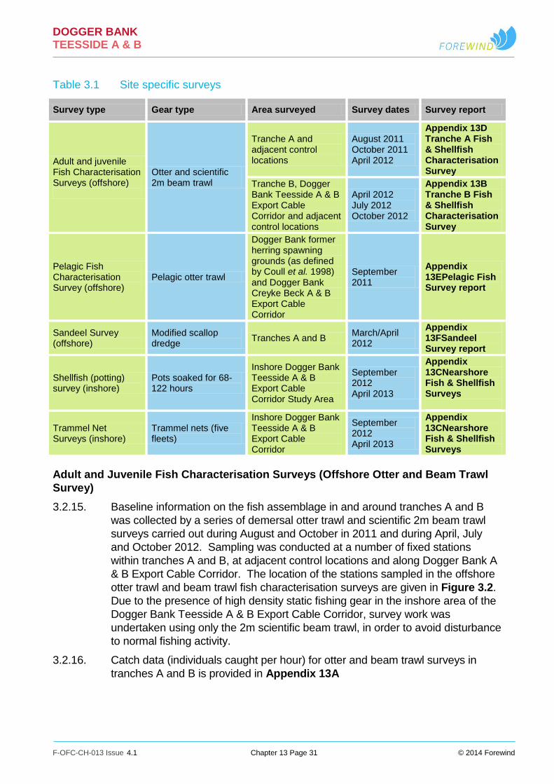
DOGGER BANK TEESSIDE A & B
F-OFC-CH-013 Issue 4.1 Chapter 13 Page 31 © 2014 Forewind
Table 3.1 Site specific surveys
Survey type Gear type Area surveyed Survey dates Survey report
Adult and juvenile Fish Characterisation Surveys (offshore)
Otter and scientific 2m beam trawl
Tranche A and adjacent control locations
August 2011 October 2011 April 2012
Appendix 13D Tranche A Fish & Shellfish Characterisation Survey
Tranche B, Dogger Bank Teesside A & B Export Cable Corridor and adjacent control locations
April 2012 July 2012 October 2012
Appendix 13B Tranche B Fish & Shellfish Characterisation Survey
Pelagic Fish Characterisation Survey (offshore)
Pelagic otter trawl
Dogger Bank former herring spawning grounds (as defined by Coull et al. 1998) and Dogger Bank Creyke Beck A & B Export Cable Corridor
September 2011
Appendix 13EPelagic Fish Survey report
Sandeel Survey (offshore)
Modified scallop dredge
Tranches A and B March/April 2012
Appendix 13FSandeel Survey report
Shellfish (potting) survey (inshore)
Pots soaked for 68-122 hours
Inshore Dogger Bank Teesside A & B Export Cable Corridor Study Area
September 2012 April 2013
Appendix 13CNearshore Fish & Shellfish Surveys
Trammel Net Surveys (inshore)
Trammel nets (five fleets)
Inshore Dogger Bank Teesside A & B Export Cable Corridor
September 2012 April 2013
Appendix 13CNearshore Fish & Shellfish Surveys
Adult and Juvenile Fish Characterisation Surveys (Offshore Otter and Beam Trawl
Survey)
3.2.15. Baseline information on the fish assemblage in and around tranches A and B
was collected by a series of demersal otter trawl and scientific 2m beam trawl
surveys carried out during August and October in 2011 and during April, July
and October 2012. Sampling was conducted at a number of fixed stations
within tranches A and B, at adjacent control locations and along Dogger Bank A
& B Export Cable Corridor. The location of the stations sampled in the offshore
otter trawl and beam trawl fish characterisation surveys are given in Figure 3.2.
Due to the presence of high density static fishing gear in the inshore area of the
Dogger Bank Teesside A & B Export Cable Corridor, survey work was
undertaken using only the 2m scientific beam trawl, in order to avoid disturbance
to normal fishing activity.
3.2.16. Catch data (individuals caught per hour) for otter and beam trawl surveys in
tranches A and B is provided in Appendix 13A

XWXWXWXWXWXWXWXWXWXWXW
XWXWXWXWXWXWXWXW
XW XW XW XWXWXWXW
XWXWXWXW
XW
XWXWXWXW
XW
XWXW XWXWXWXWXWXW XWXW XW
XWXWXWXWXWXWXWXWXWXWXW
XW XWXW XWXWXW
XW
XW XW
XWXW
XWXW
XW
XW XW XW XWXW
XW
XWXWXWXWXW
XWXW XW
XWXW
XW
OT99OT98 OT97 OT96
OT95
OT94OT93
OT92OT91OT45
OT44
OT43OT42
OT39OT38
OT37OT36
OT90
OT89
OT88OT87
OT86OT85OT84
OT83 OT82 OT81 OT80OT79 OT78 OT77
OT76OT75 OT74 OT73
OT72OT71OT70OT69OT68
OT67OT66OT65OT64OT63 OT41
OT40
OT35OT34
OT33OT32
OT31
OT30OT29
OT28OT27
OT26OT25
OT24OT23
OT22OT21OT20
OT19 OT18 OT17 OT16 OT15OT14
OT13 OT12
OT11
OT10OT09
OT08OT07
OT06OT05OT04OT03OT02OT01
OT121
OT120OT119
OT118OT117
OT116
OT100
250000
250000
300000
300000
350000
350000
400000
400000
450000
450000
500000
500000
550000
550000
5950
000
5950
000
6000
000
6000
000
6050
000
6050
000
6100
000
6100
000
6150
000
6150
000
6200
000
6200
000
¯
LEGEND
0 20 4010
KilometresData Source:Survey Locations © Brown & May Marine, 2013Background bathymetry image derived in part from TCarta data © 2009
The concepts and information contained in this documentare the copyright of Forewind. Use or copying of thedocument in whole or in part without the written permissionof Forewind constitutes an infringement of copyright. Forewind does not warrant that this document is definitivenor free of error and does not accept liability for any losscaused or arising from reliance upon information provided herein.
DOGGER BANK TEESSIDE A & B
F-OFL-MA-242
Figure 3.2 Location of offshore otter andbeam trawl survey sampling locations
DRAWING NUMBER:
VER DATE1 10/09/2013
REMARKS CheckedDraft
DRAWING TITLE
PROJECT TITLE
WGS84 UTM31NA31:1,200,000 DATUM PROJECTIONSCALE PLOT SIZE
DrawnLW TR
Dogger Bank ZoneTranche boundaryDogger Bank Teesside ADogger Bank Teesside BDogger Bank Teesside A & B Export CableCorridorTemporary works area
Otter and beam survey locationsXW Export cable corridorXW ControlXW Tranche A & B
2 07/10/2013 PEI3 LW TR3 14/02/2014 DCO Submission LW TR

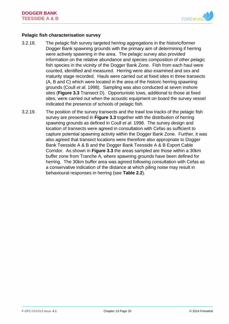
DOGGER BANK TEESSIDE A & B
F-OFC-CH-013 Issue 4.1 Chapter 13 Page 33 © 2014 Forewind
Pelagic fish characterisation survey
3.2.18. The pelagic fish survey targeted herring aggregations in the historic/former
Dogger Bank spawning grounds with the primary aim of determining if herring
were actively spawning in the area. The pelagic survey also provided
information on the relative abundance and species composition of other pelagic
fish species in the vicinity of the Dogger Bank Zone. Fish from each haul were
counted, identified and measured. Herring were also examined and sex and
maturity stage recorded. Hauls were carried out at fixed sites in three transects
(A, B and C) which were located in the area of the historic herring spawning
grounds (Coull et al. 1998). Sampling was also conducted at seven inshore
sites (Figure 3.3 Transect D). Opportunistic tows, additional to those at fixed
sites, were carried out when the acoustic equipment on board the survey vessel
indicated the presence of schools of pelagic fish.
3.2.19. The position of the survey transects and the trawl tow tracks of the pelagic fish
survey are presented in Figure 3.3 together with the distribution of herring
spawning grounds as defined in Coull et al. 1998. The survey design and
location of transects were agreed in consultation with Cefas as sufficient to
capture potential spawning activity within the Dogger Bank Zone. Further, it was
also agreed that transect locations were therefore also appropriate to Dogger
Bank Teesside A & B and the Dogger Bank Teesside A & B Export Cable
Corridor. As shown in Figure 3.3 the areas sampled are those within a 30km
buffer zone from Tranche A, where spawning grounds have been defined for
herring. The 30km buffer area was agreed following consultation with Cefas as
a conservative indication of the distance at which piling noise may result in
behavioural responses in herring (see Table 2.2).

DOGGER BANK TEESSIDE A & B
F-OFC-CH-013 Issue 4.1 Chapter 13 Page 34 © 2014 Forewind
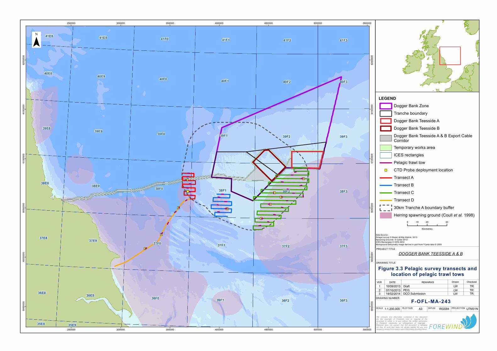
36F0 36F1
37F0 37F1 37F2
36F236E9
38F0 38F1 38F2
37E9
39F0 39F1 39F2
38E9
40F0 40F1 40F2
39E9
40E940F3
39F3
38F3
37F3
36F3
40E8
39E8
38E8
37E8
41F2
36E8
41F141F0 41F341E941E8
35E935E8
250000
250000
300000
300000
350000
350000
400000
400000
450000
450000
500000
500000
550000
550000
5950
000
5950
000
6000
000
6000
000
6050
000
6050
000
6100
000
6100
000
6150
000
6150
000
6200
000
6200
000
¯
LEGEND
0 20 4010
Kilometres
Data Source:Pelagic survey © Brown & May Marine, 2013Spawning Grounds © Cefas 2012ICES Rectangles © ICES 2012Background bathymetry image derived in part from TCarta data © 2009
The concepts and information contained in this documentare the copyright of Forewind. Use or copying of thedocument in whole or in part without the written permissionof Forewind constitutes an infringement of copyright. Forewind does not warrant that this document is definitivenor free of error and does not accept liability for any losscaused or arising from reliance upon information provided herein.
DOGGER BANK TEESSIDE A & B
F-OFL-MA-243
Figure 3.3 Pelagic survey transects andlocation of pelagic trawl tows
DRAWING NUMBER:
VER DATE1 10/09/2013
REMARKS CheckedDraft
DRAWING TITLE
PROJECT TITLE
WGS84 UTM31NA31:1,200,000 DATUM PROJECTIONSCALE PLOT SIZE
DrawnLW TR
Dogger Bank ZoneTranche boundaryDogger Bank Teesside ADogger Bank Teesside BDogger Bank Teesside A & B Export CableCorridorTemporary works areaICES rectanglesPelagic trawl towCTD Probe deployment locationTransect ATransect BTransect CTransect D30km Tranche A boundary bufferHerring spawning ground (Coull et al. 1998)
2 07/10/2013 PEI3 LW TR3 14/02/2014 DCO Submission LW TR


DOGGER BANK TEESSIDE A & B
F-OFC-CH-013 Issue 4.1 Chapter 13 Page 36 © 2014 Forewind
Sandeel specific survey
3.2.20. A specific survey for sandeel was undertaken in tranches A and B in March
2012 using a standard sandeel dredge, the design of which was based on
consultation with the internationally recognised experts in sandeel research,
Prof. Henrik Mosegaard (DTU Aqua) and Dr Peter Wright (Marine Scotland).
The methodology for the survey was agreed in consultation with the MMO and
the full results of the survey are provided in Appendix 13F Sandeel Survey
Report and are summarised below.
3.2.21. A total of 110 stations were sampled, 47 of which were located in Tranche A, 20
in Tranche B and 43 at adjacent control areas. Given the patchy distribution of
sandeel and the large area to be surveyed, the sampling effort was
concentrated in the vicinity of known fishing grounds, since the level of
commercial fishing activity is considered to reflect sandeel habitat distribution
(Jensen 2001; van der Kooij et al. 2008; Jensen and Christensen 2008;
Mosegaard, H. Pers. Comm. November 2011). Stations outside the main
fishing grounds were also sampled, although less intensively. Annual ICES
surveys provide the most consistently reliable indicator of the biological status of
sandeel and herring stocks in the region which encompasses the development
area.
Inshore shellfish surveys
3.2.22. The inshore shellfish survey was carried out over two four-day periods in
September 2012 and April 2013, with soak periods ranging from 68 to 122
hours. The location of the stations sampled is given in Figure 3.4. Two fleets
were positioned across the inshore cable corridor (2 and 4) and three at
adjacent control locations (1, 3 and 5). A summary of the results of the survey is
given in Appendix 13A.

DOGGER BANK TEESSIDE A & B
F-OFC-CH-013 Issue 4.1 Chapter 13 Page 37 © 2014 Forewind

S2
S1S4
S5
S3
250000
250000
6050
000
6050
000
¯
LEGEND
0 52.5
KilometresData Source:Survey Locations © Brown & May Marine, 2013Background bathymetry image derived in part from TCarta data © 2009
The concepts and information contained in this documentare the copyright of Forewind. Use or copying of thedocument in whole or in part without the written permissionof Forewind constitutes an infringement of copyright. Forewind does not warrant that this document is definitivenor free of error and does not accept liability for any losscaused or arising from reliance upon information provided herein.
DOGGER BANK TEESSIDE A & B
F-OFL-MA-244
Figure 3.4 Location of potting fleets(April 2013)
DRAWING NUMBER:
VER DATE1 24/09/2013
REMARKS CheckedDraft
DRAWING TITLE
PROJECT TITLE
WGS84 UTM31NA31:200,000 DATUM PROJECTIONSCALE PLOT SIZE
DrawnLW TR
Dogger Bank Teesside A & B Export CableCorridorTemporary works areaShellfish fleets spring 2013
2 07/10/2013 PEI3 LW TR3 14/02/2014 DCO Submission LW TR


DOGGER BANK TEESSIDE A & B
F-OFC-CH-013 Issue 4.1 Chapter 13 Page 39 © 2014 Forewind
Trammel net surveys
3.2.23. Five fleets of trammel nets were deployed, with one fleet ‘shot’ close to the
shore along each of the proposed cable routes, a second was laid along the
mid-section of the inshore cable route, to account for varying depth and habitat,
and two fleets ‘shot’ randomly within the central nearshore region, but within
comparable water depths, to act as a controls. The location of the stations
sampled is given in Figure 3.5. Two fleets were positioned across the inshore
cable corridor (2 and 3) and three at adjacent control locations (1, 4 and 5). A
summary of the results of the trammel net surveys is provided in Appendix 13A.
3.3. Assessment of impacts - methodology
Assigning value to a species
3.3.1. It is a relatively straightforward matter to assign value to species that are
assigned a specific biodiversity value as a function of international or national
legislation or local, regional or national conservation plans. However, only a
very small proportion of marine species are afforded protection under the
existing legislative or policy framework and, in the majority of cases it is
necessary to devise values for species based on an alternative set of valuation
criteria.
3.3.2. In assigning value to a species, it is necessary to define the geographical
framework precisely and to accommodate a range of factors that may potentially
influence the definition of value including species distribution, the geographical
extent of spawning and nursery areas, migratory behaviour, commercial value
and the size and/or conservation status of the stock or population. Furthermore,
evaluation must also assess the importance of the functional role of the species.
For example, some species may not have a specific conservation value in
themselves, but may be functionally linked to a feature of high conservation
value (e.g., prey species for protected bird or marine mammal species).
Identifying Valued Ecological Receptors (VERs)
3.3.3. The following table shows the criteria used to classify valued ecological
receptors (VERs) within the geographic frame of reference applicable to the
Dogger Bank Teesside A & B project area (Table 3.2).

DOGGER BANK TEESSIDE A & B
F-OFC-CH-013 Issue 4.1 Chapter 13 Page 40 © 2014 Forewind

N 5bN 5a
N 4bN 4aN 3bN 3a
N 2bN 2a
N 1bN 1a
240000
240000
250000
250000
260000
260000
270000
270000
280000
280000
290000
290000
6040
000
6040
000
6050
000
6050
000
6060
000
6060
000
6070
000
6070
000
6080
000
6080
000
¯
LEGEND
0 52.5
KilometresData Source:Survey Locations © PMSL, 2013Background bathymetry image derived in part from TCarta data © 2009
The concepts and information contained in this documentare the copyright of Forewind. Use or copying of thedocument in whole or in part without the written permissionof Forewind constitutes an infringement of copyright. Forewind does not warrant that this document is definitivenor free of error and does not accept liability for any losscaused or arising from reliance upon information provided herein.
DOGGER BANK TEESSIDE A & B
F-OFL-MA-266
Figure 3.5 Location of April 2013 gillnetting stations
DRAWING NUMBER:
VER DATE1 08/10/2013
REMARKS CheckedPEI3
DRAWING TITLE
PROJECT TITLE
WGS84 UTM31NA31:200,000 DATUM PROJECTIONSCALE PLOT SIZE
DrawnLW TR
Dogger Bank Teesside A & B Export CableCorridorTemporary works areaGillnetting sites (spring 2013)
2 14/02/2014 DCO Submission LW TR


DOGGER BANK TEESSIDE A & B
F-OFC-CH-013 Issue 4.1 Chapter 13 Page 42 © 2014 Forewind
Table 3.2 Geographic frame of reference
Value of the VER Criteria used to assign VER value
International Receptors protected under international law.
National Receptors protected under national law;
UK BAP priority species (including grouped action plans) and Nationally Important Marine Species that have nationally important populations within the Export Cable Corridor Study area and wind farm study area, particularly in the context of species that may be rare or threatened in the UK; and
Receptors with nationally important spawning/nursery/feeding/overwintering grounds and/or migratory routes in the area of the development.
Regional UK BAP priority species (including grouped action plans) or Nationally Important Marine Species that have regionally important populations and are locally widespread and/or abundant within the area of development;.
Receptors listed as conservation priorities in regional plans;
Receptors that are of commercial value to the fisheries of the central North Sea;
Receptors that form an important prey item for other species of conservation or commercial value and that are key components of the fish assemblages within the fish and shellfish study area; and
Receptors with regionally important spawning/ nursery/ feeding/ overwintering grounds and/or migratory routes in the area of the development.
Local Species which are not protected under conservation legislation but are of commercial importance forming a key component of the fish assemblages within the study area;
Receptors with no defined spawning/ nursery/ feeding/ overwintering grounds and/or migratory routes in the area of the development; and
The species is common throughout the UK and forms a component of the fish assemblages in the fish and shellfish study area.
3.3.4. A number of Valued Ecological Receptors (VERs) have been identified within
the Wind Farm Study Area and Dogger Bank Teesside A & B Export Cable
Corridor Study Area using information provided by the fish and shellfish
characterisation surveys as detailed in Appendix 13A. Table 3.3 presents a
description of these VERs and their valuation.

DOGGER BANK TEESSIDE A & B
F-OFC-CH-013 Issue 4.1 Chapter 13 Page 43 © 2014 Forewind
Table 3.3 VERs identified in the study area and their valuation
VER Valuation Importance within the fish and shellfish study area and justification
Demersal fish species
Sandeel1
Ammodytes spp Regional UK BAP species and a nationally important marine
feature;
Commercially important species;
Occurs throughout the study area and high abundance recorded in the western sector of Tranche A;
High intensity spawning areas occurs within study area;
Low intensity nursery areas occurs within study area; and
Key prey species for fish, birds and marine mammals.
Plaice Pleuronectes platessa
Regional UK BAP species;
Commercially important species;
Highly abundant throughout the study area;
Low/High intensity spawning areas in vicinity of study area; and
Low intensity nursery areas in vicinity of study area.
Dab Limanda limanda
Regional Abundant throughout the study area; and
Common by-catch species in commercial fisheries.
Whiting Merlangius merlangus
Regional Commercially important species;
Moderate/high abundance in the study area; and
Low intensity spawning areas in vicinity of study area.
Cod Gadus morhua
Regional UK BAP species, listed by OSPAR as threatened and/or declining and listed as vulnerable on the IUCN Red List;
Commercially important species;
Low abundance throughout the study area;
Low intensity spawning areas in vicinity of study area; and
Low/high intensity nursery areas in vicinity of study area.
Lemon Sole Microstomus kitt
Local Commercially fished;
Moderately abundant throughout the study area;
Spawning areas (undefined intensity) in the vicinity of the study area; and
Nursery areas (undefined intensity) in the vicinity of the study area.
Sole Solea solea
Local UK BAP species;
Commercially important species;
Recorded in low numbers in Tranche B; and
Low intensity nursery grounds in the vicinity of the study area.
Other demersal species
Local Includes grey gurnard Eutrigla gurnardus and solenette Buglossidium gluteum (key characterising species of the fish assemblage) and small demersal species;
No information on spawning or nursery habitats;
Little or no commercial importance;
Not listed under nature conservation legislation; and
1 Sandeel is a bentho-pelagic species but are included with demersal species here. For the purposes of this
assessment the term “lesser sandeel” refers to Ammodytes marinus while the family name “Ammodytidae” (as used by ICES in the context of SA1 sandeel stock assessments) refers to the five species of sandeel that occur in the North Sea i.e lesser sandeel Ammodytes marinus Raitt, sandeel Ammodytes tobianus, smooth sandeel Gymnammodytes semisquamatus, greater sandeel Hyperoplus lanceolatus and Corbin’s sandeel Hyperoplus immaculatus.

DOGGER BANK TEESSIDE A & B
F-OFC-CH-013 Issue 4.1 Chapter 13 Page 44 © 2014 Forewind
VER Valuation Importance within the fish and shellfish study area and justification
Likely prey items for fish, bird and marine mammal species.
Elasmobranchs Local Species include thornback ray Raja clavata, spurdog Squalus acanthius, starry smoothhound Mustelas asterias and lesser spotted dogfish Scyliorhinus canicula. Many elasmobranch species listed as UK BAP species or listed by OSPAR as threatened and/or declining;
All recorded as occurring in study area in low numbers;
Study area situated within low intensity nursery area for spurdog, otherwise no defined elasmobranch spawning or nursery areas in the vicinity; and
Low commercial value.
Pelagic fish species
Herring Clupea harengus
Regional UK BAP species and nationally important marine species;
Commercially important species;
Low/moderate abundance in the vicinity of the study area;
Active and historic spawning areas within the vicinity of the study area;
Low/high intensity nursery habitats within the study area; and
Key prey species for birds and marine mammals.
Sprat Sprattus sprattus
Regional Commercially important species. Low abundance recorded in the study area;
Important prey species for bird and marine mammal species;
Spawning areas (undefined intensity) present within vicinity of the study area; and
Nursery areas (undefined intensity) present within the vicinity of the study area.
Mackerel Scomber scombrus
Local UK BAP species and nationally important marine feature.
Commercially important species;
Seasonal distribution, with moderate abundance; recorded in study area during summer;
Spawning grounds (undefined intensity) within the vicinity of the study area; and
Nursery area (low intensity) within the vicinity of the study area.
Other Pelagic Species
Local Species include horse mackerel Trachurus trachurus and bass Dicentrarchus labrax which were recorded at low abundances; and
Not considered to be commercially important in the study area.
Migratory fish species
River and Sea Lamprey Lampetra fluviatilis Petromyzon marinus
International UK BAP priority species; and
Sea lamprey listed by OSPAR as declining and/or threatened.
Other Migratory Fish Species
Regional to National Atlantic salmon Salmo salar, sea trout Salmo trutta, European eel Anguilla anguilla and European smelt Osmerus eperlanus may transit the study area;

DOGGER BANK TEESSIDE A & B
F-OFC-CH-013 Issue 4.1 Chapter 13 Page 45 © 2014 Forewind
VER Valuation Importance within the fish and shellfish study area and justification
Atlantic salmon commercially fished in inshore area in the vicinity of the Export Cable Corridor Study Area;
Atlantic salmon listed as Annex II species; and
Sea trout, European eel and European smelt are all listed as UK BAP priority species and European eel is listed as critically endangered on the IUCN Red List.
Shellfish species
Nephrops Local Most valuable of all commercial shellfish species in the study area;
Spawning and nursery areas in vicinity of the study area: and
Distribution is substrate specific and determined by presence of soft muds/sand.
Brown (Edible) crab Cancer pagurus
Regional Abundant shellfish species in the vicinity of the Export Cable Corridor Study Area;
Important commercial species; and
Likely to overwinter within the study area and potential nursery habitat in inshore areas.
Lobster Homarus gammarus
Local High commercial value; and
Possible nursery habitat in inshore areas.
Impact pathways
3.3.5. For each potential effect, the impact assessment identifies key receptors and
implements a systematic approach to understand the impact pathways and the
level of impacts on given receptors. The process considers the following:
The sensitivity of a receptor to an effect; and
The magnitude of the effect.
Sensitivity of a receptor
3.3.6. Sensitivity relates to the capacity of a VER to accommodate change and the
ability to recover if affected (Table 3.2). Sensitivity is a function is of the
following factors (see Chapter 4 EIA Process):
Vulnerability - is the probability that a VER will be exposed to a stressor to
which it is sensitive (sensu Tyler-Walters and Jackson 1999);
Recoverability - The likely recoverability of a VER from disturbance or
damage is dependent on its ability to regenerate, regrow, recruit or
recolonize, depending on the extent of damage incurred and hence its
intolerance; and
Value - (see Section 3.3.1) for a description of the approach used to assign
value to receptors).
3.3.7. For the purposes of assessments in this chapter, value is assigned to the
majority of fish and shellfish receptors, according to their relative worth at the
stock/population level, hence the sensitivity of a receptor is generally considered
in terms of capacity of the stock or population of a given species to adapt,
tolerate and recover from anticipated impacts, as discussed further in Sections
6, 7 and 8.

DOGGER BANK TEESSIDE A & B
F-OFC-CH-013 Issue 4.1 Chapter 13 Page 46 © 2014 Forewind
3.3.8. Table 3.4 below presents the parameters for the various levels of sensitivity
shown when value is taken into account. In this way, value is applied inherently
within the definition of sensitivity assigned to a species for a particular impact
throughout the impact assessment. Defined examples presented in the table
may not be appropriate for all receptors and therefore, this is applied throughout
the impact assessment on a species by species basis, using the information
presented in the existing environment and based on expert judgement.
Table 3.4 Sensitivity of a receptor
Sensitivity
Definition Note: Receptor in this instance refers to the stock/population of a species of fish or shellfish, rather than the individual, and sensitivity to the stocks ability to recover from anticipated impacts.
Negligible Locally important receptors with low vulnerability and medium to high recoverability.
Receptor is not vulnerable to impacts regardless of value/importance.
Low Nationally and internationally important receptors with low vulnerability and high recoverability.
Regionally important receptors with low vulnerability and medium to high recoverability.
Locally important receptors with medium to high vulnerability and low recoverability.
Medium Nationally and internationally important receptors with medium vulnerability and medium recoverability.
Regionally important receptors with medium to high vulnerability and low recoverability.
Locally important receptors with high vulnerability and no ability for recovery.
High Nationally and internationally important receptors with high vulnerability and no/low recoverability.
Regionally important receptors with high vulnerability and no recoverability.
Magnitude of effect
3.3.9. The magnitude of the effect is a function of the spatial extent, duration and
timing (seasonality and/or frequency of occurrence) of the anticipated effect.
Expert judgement was employed to consider and evaluate the likely effect on
the species, population and habitat identified as a VER (Table 3.3).
3.3.10. The magnitude levels presented below are indicative of combinations of the four
factors noted above which could lead to the magnitude presented. Other
options could fall within each level of magnitude and this is applied throughout
the assessment based on expert judgement. Table 3.5 is intended to provide
indicative scenarios which might lead to the magnitudes presented.

DOGGER BANK TEESSIDE A & B
F-OFC-CH-013 Issue 4.1 Chapter 13 Page 47 © 2014 Forewind
Table 3.5 Magnitude of effect
Magnitude Definition Note: Baseline levels refer to the defined stock/population of the species
Negligible Very localised effects;
Very short term duration;
Low or high frequency; and
Resulting in small or medium changes to environmental and ecological baselines.
Low Localised effects;
Short or long term duration;
Low or high frequency; and
Resulting in small changes relative to baseline levels. or
Effects occurring over larger areas;
Short term;
Low frequency; and
Resulting in small or medium changes to environmental and ecological baseline levels.
Medium Effects occurring over large areas;
Short term and high frequency; and
Resulting in medium changes to environmental and ecological baseline levels.
High Effects occurring over large areas;
Long term and high frequency; and
Resulting in medium to high changes to environmental and ecological baseline levels.
Overall impact
3.3.11. The significance of an effect upon a VER is a function of the magnitude of the
effect and the sensitivity of the receptor where the sensitivity of the receptor is
also linked to the value of the VER. The impact assessment matrix combining
levels of magnitude and sensitivity is given below (Table 3.6). Potential impacts
identified within the assessment as “major” or “moderate” can be regarded as
significant in terms of the EIA regulations and are, where possible, avoided or
reduced through mitigation
Table 3.6 Overall impact resulting from each combination of receptor sensitivity and the magnitude of effect on it
Receptor sensitivity
Magnitude of effect
High Medium Low Negligible
High Major Major Moderate Minor
Medium Major Moderate Minor Minor
Low Moderate Minor Minor Negligible
Negligible Minor Minor Negligible Negligible

DOGGER BANK TEESSIDE A & B
F-OFC-CH-013 Issue 4.1 Chapter 13 Page 48 © 2014 Forewind
Embedded mitigation
3.3.12. In addition to the mitigation measures identified throughout the impact
assessment sections of this chapter, the following embedded mitigation has also
been considered in deriving the level of residual impacts.
3.3.13. Cables will be buried where feasible, or protected, thereby reducing the potential
effects of EMF on sensitive fish and shellfish receptors (see Chapter 5 for
further details on EMF).
3.3.14. During construction, 24 hour working practices may be employed. This could
reduce the overall construction time and the total duration over which impacts on
fish and shellfish from construction activities could occur.

DOGGER BANK TEESSIDE A & B
F-OFC-CH-013 Issue 4.1 Chapter 13 Page 49 © 2014 Forewind
4. Existing Environment
4.1. Regional context
Finfish
4.1.1. The distribution of fish communities in the North Sea is broadly related to
changes in water depth and temperature (Daan et al. 1990). In shallow waters
(50-100m depth) in the central and northern North Sea (ICES Divisions IVa and
IVb) the fish assemblages are dominated by haddock Melanogrammus
aeglefinus, whiting, herring, dab and plaice. At greater depths (100-200m),
Norway pout Trisopterus esmarkii dominate (ICES 2005).
4.1.2. The southern North Sea (ICES Division IVc) is generally shallower with
dominant fish species more characteristic of inshore waters (<50m depth) such
as plaice, sole Solea solea, dab, whiting, and non-commercial species such as
lesser weever Echiichthys vipera, grey gurnard and solenette. In addition,
species poorly sampled by trawls, such as sandeel and sand gobies are also
abundant (ICES 2005c).
4.1.3. Based on catches of the fifty most abundant fish species found in English
groundfish surveys (1982-1986), Harding et al. (1986) divided the fish
assemblage of the North Sea into three community groups: the shelf edge
community, the North Central community, and the Southeastern community.
The spatial distribution of these communities is illustrated in Figure 4.1, together
with ICES Divisions.
4.1.4. Dogger Bank Teesside A & B falls within the Southeastern community, being
immediately adjacent to the boundary of North Central community defined in
Harding et al. 1986. The Dogger Bank Teesside A & B Export Cable Corridor
falls partly in the Southeastern fish community with the longest section
traversing the North Central community.
4.1.5. The principal fish species associated with the North Central and Southeastern
communities provided in Table 4.1. Haddock, whiting, cod Gadus morhua,
Norway pout, saithe Pollachius virens and dab are the principal species of the
North Central community; whilst dab, whiting, grey gurnard, horse mackerel
Trachurus trachurus, plaice and cod are the principal species in the
Southeastern community.
4.1.6. Research on benthic fish assemblages on the Dogger Bank from a survey
undertaken in 2006 (Sell et al. 2007) found grey gurnard, dab and, to a lesser
extent, plaice, to be the dominant species in GOV otter trawl samples. In 2m
beam trawl samples, solenette, scaldfish Arnoglossus laterna, dab, sand goby
and snake pipefish Entelurus aequoreus were the five most abundant species,
with dab, solenette, lemon sole Microstomus kitt, scaldfish and plaice being the
dominant species in terms of weight.

DOGGER BANK TEESSIDE A & B
F-OFC-CH-013 Issue 4.1 Chapter 13 Page 50 © 2014 Forewind
Table 4.1 Species composition of the North Central and South-eastern North Sea fish communities (after Harding et al. 1986)
North Central Community Southeastern Community
Species Percentage by weight
Species Percentage by weight
Haddock 42.4 Dab 21.8
Whiting 13.9 Whiting 21.6
Cod 9.2 Grey Gurnard 12.8
Norway pout 4.7 Horse Mackerel 10.1
Saithe 4.5 Plaice 6.3
Dab 3.7 Cod 5.5
Remainder 21.6 Remainder 21.9
4.1.7. The fish assemblage within Dogger Bank Teesside A & B is, therefore, expected
to be similar to that described above in Harding et al. (1986) for the North
Central and Southeastern fish communities and in Sell et al. (2007) for the
Dogger Bank.
Shellfish Distribution
4.1.8. The North Sea supports important stocks of several commercially exploited
shellfish species including Nephrops, Nephrops norvegicus, king scallop Pecten
maximus, European lobster Homarus gammarus, edible crab Cancer pagurus,
velvet crab Necora puber, common whelk Buccinium undatum, brown shrimp
Crangon crangon and pink shrimp Pandalus montagui. The majority of these
species are distributed throughout all three North Sea areas and it is therefore
not possible to classify distributions in the same manner as for fish communities
(e.g. after Harding et al.1986; see above). General distribution of key shellfish
species in the North Sea is described in Appendix 13A Section 5.2. The
ecology of key species common to Dogger Bank Teesside A & B and Dogger
Bank Teesside A & B Export Cable Corridor is summarised in Table 4.2.

DOGGER BANK TEESSIDE A & B
F-OFC-CH-013 Issue 4.1 Chapter 13 Page 51 © 2014 Forewind

Vb1bVb2
Vb1b
VIa
VIIa
IVb
IVa
IIIa
IVc
-200000
-200000
0
0
200000
200000
400000
400000
600000
600000
800000
800000
5800
000
5800
000
6000
000
6000
000
6200
000
6200
000
6400
000
6400
000
6600
000
6600
000
6800
000
6800
000¯
LEGEND
0 50 10025
KilometresData Source:Fish Communities © Brown & May Marine 2013ICES Rectangles © ICES 2012Background bathymetry image derived in part from TCarta data © 2009
The concepts and information contained in this documentare the copyright of Forewind. Use or copying of thedocument in whole or in part without the written permissionof Forewind constitutes an infringement of copyright. Forewind does not warrant that this document is definitivenor free of error and does not accept liability for any losscaused or arising from reliance upon information provided herein.
DOGGER BANK TEESSIDE A & B
F-OFL-MA-245
Figure 4.1 Distribution of three fish communitiesof the North Sea based on the English Groundfish
Survey 1982-1986 (adapted from ICES 2005)
DRAWING NUMBER:
VER DATE1 10/09/2013
REMARKS CheckedDraft
DRAWING TITLE
PROJECT TITLE
WGS84 UTM31NA31:4,500,000 DATUM PROJECTIONSCALE PLOT SIZE
DrawnLW TR
Dogger Bank ZoneTranche boundaryDogger Bank Teesside ADogger Bank Teesside BDogger Bank Teesside A & B Export CableCorridorTemporary works areaICES sea area
North Sea fish communities (ICES 2005)North central communityShelf edge communitySoutheastern community
2 07/10/2013 PEI3 LW TR3 14/02/2014 DCO Submission LW TR


DOGGER BANK TEESSIDE A & B
F-OFC-CH-013 Issue 4.1 Chapter 13 Page 53 © 2014 Forewind
4.2. Overview of findings from site specific surveys
Adult and juvenile fish characterisation surveys (Offshore otter and beam trawl survey)
4.2.1. Grey gurnard, dab, plaice and whiting had the highest catch rates in all otter
trawl surveys in tranches A and B while other species were caught in
comparatively low numbers.
4.2.2. In beam trawl surveys, the most abundant species in Tranche A was solenette,
dab, lesser sandeel and sand goby whereas in Tranche B solenette, dab and
sand goby dominated the catch. Lesser sandeel was considerably less
abundant in Tranche B than recorded in Tranche A.
Pelagic fish characterisation survey (pelagic otter trawl)
4.2.3. Five pelagic species were recorded during the survey: sprat Sprattus sprattus,
herring, mackerel Scomber scombrus, anchovy Engraulis encrasicolus and
garfish Belone belone in addition to several demersal fish species. The number
of individuals caught and catch rates by species and transect are shown in
Appendix 13A Table 5.7. The full results of the pelagic fish survey are provided
in Appendix 13E and Appendix 13A Table 5.7. Sprat was the species caught
in greatest numbers, particularly in Transect C (32,047 individuals).
4.2.4. Herring were found in two of the four transects sampled, with 11,673 individual
herring recorded in Transect C whereas only one individual was recorded in
Transect B. The majority of the herring caught were ‘virgin’ juvenile fish. As
described in Appendix 13E the pelagic survey was undertaken during the
spawning season of the Banks herring stock (August-October). The pelagic
survey was specifically designed to sample herring from those areas in the
vicinity of the development designated as spawning grounds by Coull et al.
(1998) and Ellis et al. (2010). The pelagic survey was conducted during
September in order to maximize the likelihood of capturing individuals in peak
spawning condition, however only young, immature herring were recorded in
survey samples. The temperatures and salinities recorded during the survey
correspond with those when large herring spawning aggregations are expected
to occur. No herring in spawning condition or recovering from spawning was
found over the historic herring grounds of the Dogger Bank. This suggests that
there was no herring spawning activity in this area either during the time of the
survey, or during the period immediately prior to the commencement of the
survey.
4.2.5. Mackerel was recorded in all four transects, occurring in the highest numbers in
transects A and B. Other fish species caught during the pelagic survey were all
demersal species and caught in relatively small numbers with the exception of
whiting. Large numbers of whiting (2,482 fish) were caught along the inshore
corridor (Transect D).

DOGGER BANK TEESSIDE A & B
F-OFC-CH-013 Issue 4.1 Chapter 13 Page 54 © 2014 Forewind
Sandeel specific survey
4.2.6. Three species of sandeel were recorded: lesser sandeel, greater sandeel
Hyperoplus lanceolatus and smooth sandeel Gymnammodytes semisquamatus.
Of these, lesser sandeel was the dominant species in the majority of stations
and accounted for 98.2% of the total sandeel catch.
4.2.7. Sandeel was found in highest numbers in stations located along the western
boundary of Tranche A. This species was also relatively abundant within
Tranche A at stations to the west of Dogger Bank Teesside B. Fewer sandeel
were present in Tranche B and were mainly concentrated in the central sector
and at two sites along the eastern boundary of Dogger Bank Teesside A
(Figure 4.2).
Inshore shellfish (potting) survey
4.2.8. Edible crab was the most numerous of all species recorded. Moderate numbers
of lobster and velvet crab were caught at both inshore cable and control
stations. The hermit crab Pagurus bernhardus did not appear in autumn
samples but was present in reasonably large numbers in samples from April
2013.
Trammel net survey
4.2.9. Edible crab was the most abundant species in samples, followed by dab and
cod. Lesser spotted dogfish Scyliorhinus canicula was caught in both sampling
periods but was more numerous in the spring survey compared to that
undertaken during autumn.
4.2.10. Single specimens of thornback ray Raja clavata were recorded in both sampling
periods at sites along the cable route and one spotted ray Raja montagui was
caught in the inshore area in April 2013.
4.2.11. One lesser sandeel was caught in the inshore area in April 2013.
Landings data - commercial fish and shellfish species
4.2.12. The principal commercial fish and shellfish species caught in the Wind Farm and
Dogger Bank Teesside A & B Export Cable Corridor Study Areas by UK
registered vessels is provided in Appendix 13A, Section 5.4. This information
has been used to provide an indication of the main species of commercial
importance found within the development, although without the inclusion of non-
UK landings data from the Dogger Bank area the weights and values provided in
Appendix 13B and 13D may underestimate the degree of exploitation.
Wind Farm Study Area
4.2.13. Plaice ranked highest in terms of both landed weight and value followed by
sandeel and dab. Turbot Scophthalmus maximus and lemon sole are amongst
the principal species landed by value. The highest landings are recorded in
ICES rectangle 39F3 along the eastern boundary of Tranche B.

DOGGER BANK TEESSIDE A & B
F-OFC-CH-013 Issue 4.1 Chapter 13 Page 55 © 2014 Forewind
4.2.14. In addition, other species, including sprat, haddock, cod, gurnard, sole, whiting,
brill Scophthalmus rhombus, monkfish Lophius spp. and hake Merluccius
merluccius are of commercial importance in the Wind Farm Study Area. These
species are among the top 20 species landed by weight and value. Landings of
elasmobranch and shellfish are comparatively low. In the Wind Farm Study
Area spurdog Squalus acanthias was the most abundant elasmobranch landed.
Shellfish landings were dominated by Nephrops and whelk.

DOGGER BANK TEESSIDE A & B
F-OFC-CH-013 Issue 4.1 Chapter 13 Page 56 © 2014 Forewind

39F239F1
38F238F1
40F240F1
39F3
38F3
40F3
400000
400000
450000
450000
500000
500000
6100
000
6100
000
6150
000
6150
000
¯
LEGEND
0 10 205
KilometresData Source:Relative catch rate © Brown & May Marine 2013ICES Rectangles © ICES 2012Background bathymetry image derived in part from TCarta data © 2009
The concepts and information contained in this documentare the copyright of Forewind. Use or copying of thedocument in whole or in part without the written permissionof Forewind constitutes an infringement of copyright. Forewind does not warrant that this document is definitivenor free of error and does not accept liability for any losscaused or arising from reliance upon information provided herein.
DOGGER BANK TEESSIDE A & B
F-OFL-MA-246
Figure 4.2 Relative abundance of sandeelby station and species (individuals
caught per hour) in tranches A and B
DRAWING NUMBER:
VER DATE1 10/09/2013
REMARKS CheckedDraft
DRAWING TITLE
PROJECT TITLE
WGS84 UTM31NA31:550,000 DATUM PROJECTIONSCALE PLOT SIZE
DrawnLW TR
Dogger Bank ZoneTranche boundaryDogger Bank Teesside ADogger Bank Teesside BDogger Bank Teesside A & B Export CableCorridorTemporary works areaICES rectanglesSandeel dredge location
2 11/10/2013 PEI3 LW TR
TotalRelative catch rate by species
Raitt's SandeelSmooth SandeelGreater Sandeel
101005001,000
10,000
3 14/02/2014 DCO Submission LW TR


DOGGER BANK TEESSIDE A & B
F-OFC-CH-013 Issue 4.1 Chapter 13 Page 58 © 2014 Forewind
Export Cable Corridor Study Area
4.2.16. Whiting, Nephrops and haddock are the three main species landed by weight
from the Export Cable Corridor Study Area. However, catch composition varies
considerably between ICES rectangles. For example, herring accounts for a
relatively high percentage of the landings by weight in ICES rectangle 38F0
while landings of plaice dominate catches from ICES rectangle 38F1. Landings
by weight for cod and sprat caught in rectangles 38E9 and 39F0 are also
comparatively high. The most valuable species caught in the Export Cable
Corridor Study Area are Nephrops and lobster. Whiting, cod, haddock and
plaice are the four most valuable fish species. Whiting is also targeted in this
area by French registered vessels (see Appendix 15A).
Species with defined spawning and nursery grounds
4.2.17. A number of fish species have defined spawning and nursery grounds within
and in the vicinity of Dogger Bank Teesside A & B and the Dogger Bank
Teesside A & B Export Cable Corridor. These are listed in Table 4.2, based on
information provided in Ellis et al. (2012) and Coull et al. (1998).
4.2.18. In addition to the species listed below, other fish and shellfish species may
spawn or use Dogger Bank Teesside A & B and/or the Dogger Bank Teesside A
& B Export Cable Corridor as a nursery ground. The ecology of the principal fish
and shellfish species identified in the Wind Farm and Export Cable Corridor
Study Areas, including spawning, is described in further detail below.

DOGGER BANK TEESSIDE A & B
F-OFC-CH-013 Issue 4.1 Chapter 13 Page 59 © 2014 Forewind
Table 4.2 Species with defined spawning and nursery grounds within or in the vicinity of Dogger Bank Teesside A & B and the Dogger Bank Teesside A & B Export Cable Corridor (based on Coull et al. 1998 and Ellis et al. 2012)
Species Spawning Grounds Spawning Season (Month) Nursery Grounds
Dogger Bank Teesside A
Dogger Bank Teesside B
Dogger Bank Teesside A & B Export Cable Corridor
J F M A M J J A S O N D
Dogger Bank Teesside A
Dogger Bank Teesside B
Dogger Bank Teesside A & B Export Cable
Herring -Banks stock
* * * *
Cod * *
Plaice * * * *
Whiting
Sole * * Lemon sole
N/A N/A
Sandeel
Mackerel * * *
Sprat * *
Nephrops * * *
Hake N/A Blue Whiting
N/A
Anglerfish N/A
Ling N/A
Spurdog N/A
Tope N/A N/A
Key
High Intensity
Low Intensity
Undefined Intensity
Spawning Period
* Peak Spawning Period
Former/Historic Grounds
* Grounds in the vicinity but not within the Project
N/A Insufficient information available

DOGGER BANK TEESSIDE A & B
F-OFC-CH-013 Issue 4.1 Chapter 13 Page 60 © 2014 Forewind
Species of conservation interest
Diadromous migratory species
4.2.19. A number of diadromous species of conservation importance may transit the
Wind Farm and Export Cable Corridor Study Areas as part of their migration or
foraging activity (see Table 4.3).
Table 4.3 Principal diadromous migratory species relevant to Dogger Bank Teesside A & B and the Dogger Bank Teesside A & B Export Cable Corridor
Common Name
Scientific name
Conservation Status
UK BAP OSPAR IUCN Red list
Bern Convention
Habitats Directive
European eel
Anguilla anguilla
Critically endangered
- -
Allis shad Alosa alosa
Least concern
Twaite shad
Alosa fallax -
Least concern
Sea lamprey
Petromyzon marinus
Least concern
River lamprey
Lampetra fluviatilis -
Least concern
Salmon Salmo salar
Lower risk/least concern
Sea trout Salmo trutta -
Least concern
- -
Smelt Osmerus esperlanus -
Least concern
- -
4.2.20. The diadromous species listed are expected to transit Dogger Bank Teesside A
& B on an occasional basis. Some may regularly cross the Dogger Bank
Teesside A & B Export Cable Corridor as part of their migration and/or transit
adjacent areas as part of their foraging activity.
Elasmobranchs
4.2.21. Sharks and rays have slow growth rates and low reproductive output compared
to other species groups (Camhi et al. 1998). This results in slow rates of stock
increase and low resilience to fishing mortality (Holden 1974). Directed fisheries
have caused stock collapse for many species (Musick 2005), although at
present, mortality in mixed-species and by-catch fisheries appears to be a more
significant threat (Bonfil 1994). As a result the stocks of most elasmobranch
species are currently at low levels and spatial management measures have
been introduced to protect the remaining stocks (ICES 2008a).

DOGGER BANK TEESSIDE A & B
F-OFC-CH-013 Issue 4.1 Chapter 13 Page 61 © 2014 Forewind
4.2.22. A summary of the principal species with conservation status and/or declining
stocks potentially using the Dogger Bank Teesside A&B Wind Farm and Dogger
Bank Teesside A&B Export Cable Corridor Study Areas is given in Table 4.4.
Table 4.4 Principal elasmobranch species of conservation interest potentially present in the Wind Farm and Export Cable Corridor Study Areas
Other Species of Conservation Interest
4.2.23. A number of species commercially exploited in the North Sea and expected to
be found in the Wind Farm and Export Cable Corridor Study Areas are of
conservation interest, being listed as UK BAP priority species. These are
shown in Table 4.5. Where applicable, other conservation designations’
status (OSPAR and IUCN) are also given.
Common Name
Scientific Name
Present in Dogger Bank Teesside fish characterisation surveys
Conservation Status
UK BAP OSPAR IUCN Red List
Basking shark Cetorhinus maximus
x Vulnerable
Smooth-hounds Mustelus asterias/M. mustelus
- - Least concern/ Vulnerable
Spurdog Squalus acanthias
Vulnerable
Thresher shark Alopias vulpinus
x - - Vulnerable
Tope Galeorhinus galeus
x - Vulnerable
Blonde ray Raja brachyura
- - Near Threatened
Cuckoo ray Leucoraja naevus
x - - Least concern
Common Skate Complex
Dipturus intermedia/
x Critically endangered
Dipturus flossada Dipturus flossada
x - Least concern
Spotted ray Raja montagui -
Near Threatened
Thornback ray Raja clavata x - Endangered
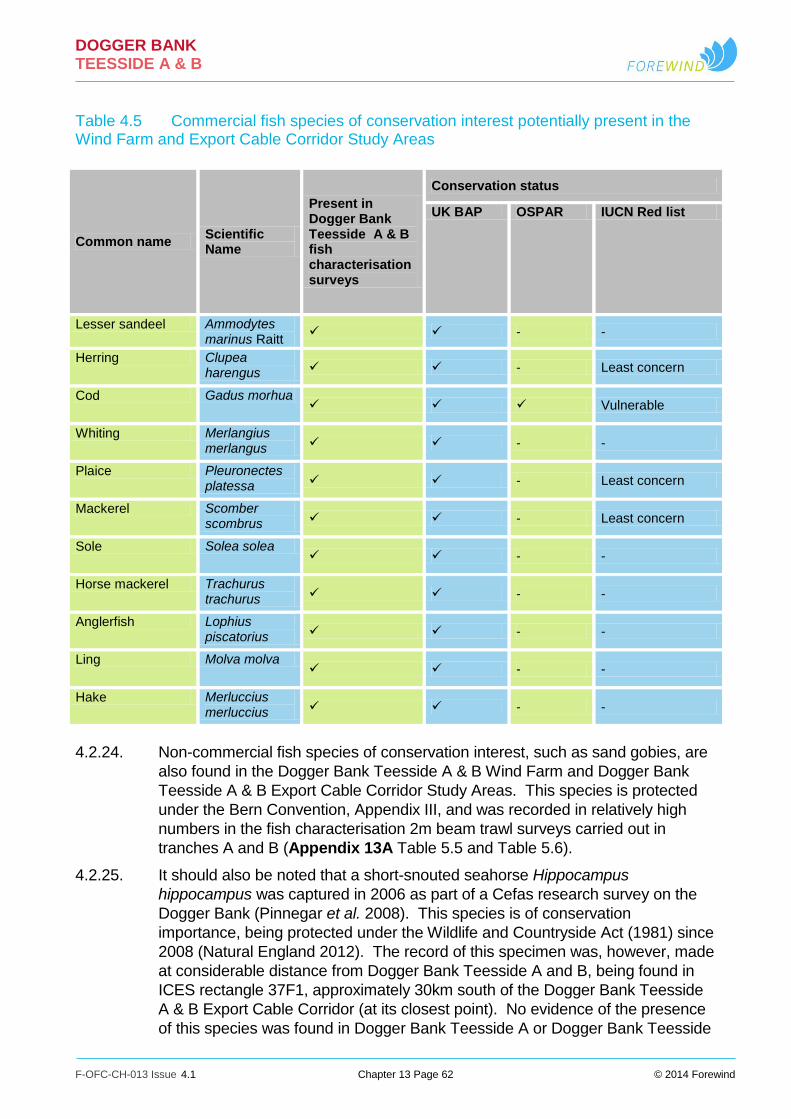
DOGGER BANK TEESSIDE A & B
F-OFC-CH-013 Issue 4.1 Chapter 13 Page 62 © 2014 Forewind
Table 4.5 Commercial fish species of conservation interest potentially present in the Wind Farm and Export Cable Corridor Study Areas
4.2.24. Non-commercial fish species of conservation interest, such as sand gobies, are
also found in the Dogger Bank Teesside A & B Wind Farm and Dogger Bank
Teesside A & B Export Cable Corridor Study Areas. This species is protected
under the Bern Convention, Appendix III, and was recorded in relatively high
numbers in the fish characterisation 2m beam trawl surveys carried out in
tranches A and B (Appendix 13A Table 5.5 and Table 5.6).
4.2.25. It should also be noted that a short-snouted seahorse Hippocampus
hippocampus was captured in 2006 as part of a Cefas research survey on the
Dogger Bank (Pinnegar et al. 2008). This species is of conservation
importance, being protected under the Wildlife and Countryside Act (1981) since
2008 (Natural England 2012). The record of this specimen was, however, made
at considerable distance from Dogger Bank Teesside A and B, being found in
ICES rectangle 37F1, approximately 30km south of the Dogger Bank Teesside
A & B Export Cable Corridor (at its closest point). No evidence of the presence
of this species was found in Dogger Bank Teesside A or Dogger Bank Teesside
Common name Scientific Name
Present in Dogger Bank Teesside A & B fish characterisation surveys
Conservation status
UK BAP OSPAR IUCN Red list
Lesser sandeel Ammodytes marinus Raitt
- -
Herring Clupea harengus - Least concern
Cod Gadus morhua Vulnerable
Whiting Merlangius merlangus - -
Plaice Pleuronectes platessa - Least concern
Mackerel Scomber scombrus - Least concern
Sole Solea solea - -
Horse mackerel Trachurus trachurus - -
Anglerfish Lophius piscatorius - -
Ling Molva molva - -
Hake Merluccius merluccius - -

DOGGER BANK TEESSIDE A & B
F-OFC-CH-013 Issue 4.1 Chapter 13 Page 63 © 2014 Forewind
B or along the Dogger Bank Teesside A & B Export Cable Corridor in any
survey work.
Key species in the food web
4.2.26. Fish that occur in the Wind Farm and Export Cable Corridor Study Areas such
as sandeel, herring and sprat are key species linking trophic levels in the North
Sea (Furness 2002). They are both major predators of zooplankton and also
the principal prey of many top predators such as birds, marine mammals and
piscivorous fish.
4.2.27. Sandeel is most vulnerable to predation when in transit to, or feeding in the
water column (Hobson 1986; Furness 2002; van der Kooij et al. 2008) and it is
also during this free-swimming period that they are targeted by commercial
pelagic trawlers (van der Kooij et al. 2008). Sandeel constitute an important
prey species for a number of fish predators such as herring, salmon, sea trout,
cod, haddock, whiting, grey gurnard, saithe, mackerel, horse mackerel and
starry ray as well as squid (Collins & Pierce 1996; Mills et al. 2003; Greenstreet
et al. 1998; Wright & Kennedy 1999; ICES 2005c; ICES 2006; ICES 2008a;
ICES 2009b; ICES 2010b; Walters 2010; Walters 2011). Salmon post smolts
are known to largely feed on small fish such as 0-group sandeel (Haugland et al.
2006). Marine mammals such as common seals (ICES 2006; Thompson et al.
2003), grey seals (McConnell et al. 1999), harbour porpoise (Santos et al. 2005;
Thompson et al. 2007) and minke whale (Olsen & Holst 2001; Pierce et al.
2004) also feed on sandeel.
4.2.28. Sandeel is a key component of the diet of many birds, such as kittiwake,
razorbill, puffin, common tern, arctic tern, European shag, great skua and
common guillemot, all of which are known to rely on sandeel consumption
during the breeding season (Wright and Bailey 1993; Furness 1999; Wanless et
al. 1998; Wanless et al. 1999; Wanless 2005).
4.2.29. Herring is an important prey species for fish such as whiting, cod, mackerel and
horse mackerel (ICES 2008b; ICES 2005b; ICES 2005c). Predation mortality of
one year old herring in the North Sea is mainly as a result of consumption by
cod, whiting, saithe and seabirds, Younger herring (0-group individuals) are
largely preyed upon by horse mackerel (ICES 2008b). Herring egg mats are
also known to attract a number of predators such as spurdog, haddock,
mackerel, lemon sole and other herring (de Groot 1980; Mills et al. 2003;
Haugland et al. 2006; Skaret et al. 2002; Richardson et al. 2011).
4.2.30. Similarly, sprat is important as prey to other fish species including cod, grey
gurnard, herring, sandeel, spurdog, horse mackerel, mackerel, sea trout Salmo
trutta and whiting (ICES 2005b; ICES 2009) and many seabirds (Wanless et al.
2005). In addition, as described for sandeel, both herring and sprat are also
known to be important in the diet of marine mammals such as seals and harbour
porpoise (Santos & Pierce 2003; Wood 2001; Santos et al. 2004).
4.3. Principal fish and shellfish species identified
4.3.1. A full review of the ecology of the principal fish and shellfish species identified in
the area of Dogger Bank Teesside A & B and the Dogger Bank Teesside A & B

DOGGER BANK TEESSIDE A & B
F-OFC-CH-013 Issue 4.1 Chapter 13 Page 64 © 2014 Forewind
Export Cable Corridor on the basis of their commercial importance, relative
abundance in the area, role in the ecosystem and conservation status provided
in Appendix 13A, Section 6. The following table (Table 4.6) summarises the
key information provided in Appendix 13A which is considered to be relevant to
the impact assessment.

DOGGER BANK TEESSIDE A & B
F-OFC-CH-013 Issue 4.1 Chapter 13 Page 65 © 2014 Forewind
Table 4.6 Ecology distribution and commercial importance of key fish and shellfish in all study areas
Species and conservation status
Distribution Ecology Exploitation Management Local distribution
Demersal Species
Sandeel Ammodytes marinus UK BAP priority species
Abundant and widespread but patchy throughout the North Sea, Mainly Ammodytes marinus (Lesser sandeel). Site specific demersal spawners found on the edge of sandbanks in medium coarse sand sediments (particle size >0.25mm - <2mm).
Bentho-pelagic or semi pelagic. Important prey species for piscivorous fish, seabirds and marine mammals. Abundance related to population dynamics of predatory finfish. Diurnal and seasonal movements between seabed and water column. Buried at night and feed during daylight in spring and summer but buried all winter except for spawning (Nov-Feb). Eggs demersal, larvae pelagic (1-3 months duration).
Dogger Bank contributes 65% to entire North Sea catch during 2003-2009 (ICES 2010). Fishing from March to June with a peak in May and coincides with feeding season. Fishing grounds represent the main population distribution (van der Kooij et al. 2008). Fishing is concentrated on the western boundary of the zone (Tranche A).
Resilient population recovers once fishery is closed (Greenstreet et al. 2000). Seven subpopulations defined by ICES. Dogger Bank Teesside A & B and Dogger Bank Teesside A & B Export Cable Corridor fall within SA1 area (ICES 2010). Recruitment thought to be low generally therefore catch recommended at no more than 23,000 tonnes.
See Appendix 13A Fish and Shellfish Ecology Technical Report Figure 6.6 for distribution within Dogger Bank Teesside A & B and the Dogger Bank Teesside A & B Export Cable Corridor Areas within Dogger Bank Teesside A & B suitable for sandeel settlement Through Particle Size Analysis (PSA) of grab samples (Appendix 13A Fish and Shellfish Ecology Technical Report Figure 6.7).
Plaice Pleuronectes platessa UK BAP priority species IUCM red list status ‘Least concerned’.
Widely distributed in the North Sea, sandy substrates at depths between 10-50m. Seasonal migrations from winter spawning areas south of Dogger Bank Zone to
Spawning widespread in southern North Sea in winter. Egg production around the Dogger Bank is diffuse.
Principal commercial species caught mainly by Dutch beam trawlers also Danish seines and gillnets. Caught within Wind Farm Study Area and
Two stage multiannual plan for plaice (and sole) adopted by EU Council in 2007. Stock considered to be in good condition.
Dogger Bank Teesside A & B and Dogger Bank Teesside A & B Export Cable Corridor fall within spawning grounds of low intensity (Ellis et al. 2012). Western edge of Dogger Bank Teesside A overlaps high intensity spawning area. Common in survey catches in tranches A and B and

DOGGER BANK TEESSIDE A & B
F-OFC-CH-013 Issue 4.1 Chapter 13 Page 66 © 2014 Forewind
Species and conservation status
Distribution Ecology Exploitation Management Local distribution
summer feeding grounds 250km to the north (Hunter et al. 2003). Coastal and inshore waters important juvenile nursery areas. Juveniles move offshore after the age of one year.
Dogger Bank Teesside A & B Export Cable Corridor Study Area.
Dogger Bank Teesside A & B Export Cable Corridor.
Dab Limanda limanda
Wide distribution in North Sea depths 20-40m. Abundant off the Danish coast and south of Dogger Bank Teesside A & B development.
Seasonal migration of adults inshore in summer. Spawning occurs between April and June. Food generally bottom-living invertebrates e.g. crustaceans, polychaetes and molluscs (Wheeler 1978; Ruiz 2008d).
High landings by value and weight recorded in the Wind Farm Study Area.
ICES advice for catches not to increase for 2012 and 2013 (ICES 2012).
Survey data show higher numbers in Tranche A than B. Lower numbers in the Wind Farm Study Area and the Dogger Bank Teesside A & B Offshore Export Cable Corridor Study Area.
Sole Solea solea UK BAP priority species
Widely distributed in shallow southern North Sea, on sandy and muddy substrate between 1-70m depths.
Feed on small crustacean, molluscs, polychaetes and echinoderms (ICES 2005). Spawning usually inshore from March to June with a peak in April.
Low landings by weight from the Wind Farm Study Area.
ICES advice that the landings should not exceed 14,000 tonnes.
Not caught in Wind Farm Study Area. No overlap in spawning areas except the southern boundary of Dogger Bank Teesside A and the Inshore Dogger Bank Teesside A & B Export Cable Corridor Study Area overlap a low intensity spawning area.
Lemon sole Microstomas kitt
Frequently found on offshore Banks between 40 to 200m on sand and gravelly substrates.
Feed on benthic prey including polychaetes, crustacean and molluscs and echinoderms (Wheeler 1978; Rogers and Stocks 2001). Widespread spawning between April and September (Coull et al. 1998 Wheeler 1978).
Forms part of a mixed flat fish fishery using beam and otter trawling. Commercially important in the Dogger Bank Teesside A & B Export Cable Corridor Study Area
ICES advice is that catch should not increase although no formal assessment of sole in EU waters is undertaken.
Inshore Export Cable Corridor Study Area overlaps with spawning and nursery grounds.

DOGGER BANK TEESSIDE A & B
F-OFC-CH-013 Issue 4.1 Chapter 13 Page 67 © 2014 Forewind
Species and conservation status
Distribution Ecology Exploitation Management Local distribution
and northern areas of the Wind farm Study Area.
Grey gurnard Eutrigla gurnardus
Found at depths to 140m associated with offshore area such as the Dogger Bank. Commonly found between 20-50m. Abundant at sites to the north and east of the Wind Farm Study Area.
Food includes benthic crustacea, brown and pink shrimp, small crab and fish such as gobies and dragonet. Migrate from the central western North Sea to southern areas to spawn and form semi pelagic aggregations to northwest of Dogger Bank in winter.
Mainly taken as by-catch in demersal fisheries from Wind Farm Study Area and Export Cable Corridor Study Area.
No formal management for EU populations.
Very few individuals were captured at sites within Tranche A or Tranche B, where Dogger Bank Teesside A & B are located. Large numbers of grey gurnard were also found at sites in the vicinity of the Offshore Dogger Bank Teesside A & B Export Cable Corridor Study Area.
Whiting Merlangius merlangus UK BAP Priority species
Bentho-pelagic species found in shallow water 30-100m on mud and gravel but also sandy rocky substrate. Wide distribution throughout the North Sea. Whiting tend to be present in relatively high numbers to the east and south of the Dogger Bank Zone and in the vicinity of the Dogger Bank Teesside A & B Export Cable Corridor. Relatively few whiting were recorded within tranches A and B.
Feed entirely on fish, such as Norway pout, sprat sandeel, and juvenile herring cod and haddock. Immature stages feed on euphausiids, mysids and carngonid shrimp (Hislop et al. 1991; ICES 2005; Wheeler 1978). During the night they primarily feed on bottom-dwelling prey, whilst feeding on pelagic prey during daylight (ICES 2005). Spawning takes place from February to June (Coull et al. 1998) but mostly in spring, in shallow water (Wheeler 1978).
Generally considered to be of secondary commercial importance. Caught in large numbers throughout the entire North Sea; however, large quantities of the catch tend to be discarded (ICES 2005).
Reference points for whiting are not defined but ICES is currently developing and evaluating a management plan for this stock. ICES advice is for landings not to exceed 26,000 tonnes.
Dogger Bank Teesside A & B and the Dogger Bank Teesside A & B Export Cable Corridor fall within defined spawning and nursery grounds for whiting, which is one of the main species landed within the Dogger Bank Teesside A & B Export Cable Corridor Study Area.
DOGGER BANK TEESSIDE A & B
F-OFC-CH-013 Issue 4.1 Chapter 13 Page 68 © 2014 Forewind
Species and conservation status
Distribution Ecology Exploitation Management Local distribution
Cod Gadus morhua UK BAP Priority species OSPAR list of threatened and/or declining species IUCN defines the status of the species as “Vulnerable”.
Cod is widely distributed in the North Sea (Heessen 1993), being found mainly from shallow coastal waters to the shelf edge (200m depth), South of the Dogger Bank, adult cod migrate southward for spawning during autumn and north again to feeding grounds in the spring (ICES 2005).
Food is mainly copepods for young stages and fish species when adults (Wilding and Heard 2004; Wheeler 1978; Arnett and Whelan 2001).
Cod is, in general terms, of secondary commercial importance in the Wind Farm Study Area.
ICES has advised that landings of cod in the North Sea, Eastern Channel and Skagerrak should not exceed 25,441 tonnes in 2013.
Dogger Bank Teesside A & B and the Dogger Bank Teesside A & B Export Cable Corridor are located at considerable distance from areas of high cod egg production.
Turbot Scophthalmus maximus
Found on sandy, gravel or shell gravel and occasionally muddy substrates or areas of mixed sand and rocks (Walters 2008) from 20m to 800m. Found throughout the North Sea and within the Dogger Bank Zone Project.
Visual feeders on other benthic fishes and small pelagic species (ICES 2011a) including sandeel, sprat, herring, whiting, pouting, occasionally flatfish species, dragonets and gobies (Wheeler 1987). Migrations recorded from the nursery grounds in the south-eastern part to more northerly areas. Adult turbot are more tolerant of the colder conditions in the northern areas of the North Sea than juveniles (ICES 2011a).
A valuable by-catch in the fishery for flatfish and demersal species (ICES 2011a). The highest landings for this species are recorded in rectangle 38F2 where Dogger Bank Teesside A & B are located.
ICES have advised for 2012 and 2013 on the basis of precautionary consideration that catches should not increase.
Found in low numbers in the otter trawl surveys carried out in tranches A and B. They are of commercial importance in the Wind Farm Study Area where they record the second highest landings by value after plaice.
Other demersal species Appendix 13A Fish and Shellfish Ecology Technical Report describes the ecology of haddock, angler fish, ling, blue whiting, and hake. These species are either found in low numbers, are not of great commercial importance or were not recorded in large numbers in the fish and shellfish surveys.

DOGGER BANK TEESSIDE A & B
F-OFC-CH-013 Issue 4.1 Chapter 13 Page 69 © 2014 Forewind
Species and conservation status
Distribution Ecology Exploitation Management Local distribution
Non-commercial species. Scaldfish, lesser weever, pogge Agonus cataphractus and common dragonet Callionymus lyra were found in small numbers in the fish surveys. Solenette and species of goby also form an important component of the fish assemblage although they are not of commercial importance. Solonette were found in both Dogger Bank Teesside A & B but this varied seasonally and sand goby was one of the most abundant species caught in the surveys in the Dogger Bank Teesside A & B Export Cable Corridor Study Area.
Pelagic species
Herring Clupea harengus UK BAP priority species
Herring are widely distributed throughout the Northwest and Northeast Atlantic. Herring occur throughout the North Sea but 1-group herring are generally restricted to within the 100m depth contour. Adult fish are found mostly on the continental shelf to depths of 200m. The distribution of herring from IBTS surveys is shown in Appendix 13A Fish and Shellfish Ecology Technical Report Figure 6.34.
Mainly feed on calanid copepods during their early juvenile life, and also consume euphausids, hyperiid amphipods, juvenile sandeel, sea-squirts (Oikopleura spp.) and fish eggs. Larger herring predominantly consume copepods in conjunction with small fish, arrow worms and ctenophores (ICES 2005). Herring move to the central and northern North Sea to feed in spring (Corten 2001). Herring is an important prey species for piscivorous fish, marine mammals and seabirds.
One of the most important pelagic species in the North Sea and has been intensively exploited for centuries.
The distribution of herring spawning and nursery grounds in relation to the location of Dogger Bank Teesside A & B and the Export Cable Corridor is shown in Appendix 13A Fish and Shellfish Ecology Technical Report Figure 6.35 as defined by Coull et al. 1998 and Ellis et al. (2012). Dogger Bank Teesside A & B and the Dogger Bank Teesside A & B Export Cable Corridor fall within broad low intensity herring nursery grounds. The Dogger Bank Teesside A & B Export Cable Corridor falls within the defined Flamborough coastal herring spawning grounds. Herring grounds have been defined in the vicinity of Dogger Bank Teesside A & B.
Sprat Sprattus sprattus
Abundant in shallow waters. Widely distributed in the North Sea, being most abundant south of the Dogger Bank and in the Kattegat (ICES 2005).
Main prey items include copepods, cladocerans, sea-squirts, bivalve larvae, mysids and euphausids (Maes and Ollevier 2002, ICES 2005). Sprat is an important food resource for a number of commercially
As suggested by fisheries statistics, the Wind Farm and the Dogger Bank Teesside A & B Export Cable Corridor Study Areas do not support
No specific management measures for this species.
Dogger Bank Teesside A & B and the Dogger Bank Teesside A & B Export Cable Corridor fall within the broad spawning and nursery grounds defined for sprat. Caught in greatest numbers in the pelagic survey particularly along Transect C.

DOGGER BANK TEESSIDE A & B
F-OFC-CH-013 Issue 4.1 Chapter 13 Page 70 © 2014 Forewind
Species and conservation status
Distribution Ecology Exploitation Management Local distribution
Generally remain within the 50m depth contours and are more common in inshore waters.
important predatory fish and sea birds. Spawning in the North Sea is thought to primarily occur from May to August, peaking between May and June (Coull et al. 1998) in both coastal waters and up to 100km offshore, in deep basins (Whitehead 1986, Nissling et al. 2003). Females spawn repeatedly in batches throughout the spawning season (Milligan 1986). Eggs and larvae are pelagic and so subject to larval drift, moving into coastal nursery areas as juvenile (Hinrichsen et al. 2005, Nissling et al. 2003).
important sprat fisheries.
Mackerel Scomber scombrus UK BAP priority species IUCN Red List of Threatened Species, Least concern’
Widespread in the North Sea overwintering in deep water on the edge of the continental shelf. Migration is south in spring to the central North Sea after which they mix with fish from the western stock on the feeding grounds in the southern Norwegian Sea and the northern North Sea, before returning to over-
Mackerel feed on large quantities of pelagic crustaceans and also prey on schools of smaller fish, particularly sprat, herring and sandeel (Wheeler 1978). They are important as a food resource for larger pelagic predators, including sharks and marine mammals and a variety of seabirds (ICES 2005).
Landings data does not suggest this species to be of particular commercial importance in the Wind Farm and Export Cable Corridor Study Areas. Chapter 15 Commercial Fisheries, however, indicates that mackerel is targeted by French trawlers over certain sections
ICES advice for 2013 suggests that the existing measures to protect North Sea spawning mackerel should remain in place. On the basis of the Norway, Faroe Islands, and EU management plan ICES suggest that the catches in 2013 be between 497,000 and
Dogger Bank Teesside A & B and the Dogger Bank Teesside A & B Export Cable Corridor fall within the broad spawning and nursery grounds defined for this species.

DOGGER BANK TEESSIDE A & B
F-OFC-CH-013 Issue 4.1 Chapter 13 Page 71 © 2014 Forewind
Species and conservation status
Distribution Ecology Exploitation Management Local distribution
wintering areas (ICES 2005).
of the Dogger Bank Teesside A & B Export Cable Corridor Study Area.
542,000 tonnes (ICES 2012a).
Horse mackerel Trachurus trachurus UK BAP Priority species
Southern species with a northerly limit in the northern North Sea.
Food for juveniles is planktonic larvae, adults feed on fish species such as juvenile herring, cod and whiting.
Not of particular importance.
No formal management advice.
Low numbers caught in otter trawls in tranches A and B.
Elasmobranchs
Thornback ray Raja clavata OSPAR list of threatened and/or declining species IUCN Red List of Threatened Species ‘Near Threatened’
Most abundant in the south-western North Sea, particularly in the Outer Thames Estuary and The Wash (ICES 2005, ICES 2008b).
No information. Thornback ray is commercially important in the North Sea being the dominant ray species in commercial landings (ICES 2005). Landings of this species in both the Wind Farm and Dogger Bank Teesside A & B Export Cable Corridor Study Areas are, however, comparatively low (see values for grouped category “skates and rays”.
A single thornback ray was recorded in two of the three otter trawl surveys carried out in Tranche B and within the Dogger Bank Teesside A & B Export Cable Corridor Study Area. In addition, a thornback ray was found in the trammel net surveys carried out in the Inshore Dogger Bank Teesside A & B Export Cable Corridor Study Area.

DOGGER BANK TEESSIDE A & B
F-OFC-CH-013 Issue 4.1 Chapter 13 Page 72 © 2014 Forewind
Species and conservation status
Distribution Ecology Exploitation Management Local distribution
Spotted ray Raja montagui OSPAR list of threatened and/or declining species IUCN Red List of Threatened Species “Least Concern”
Spotted ray is most commonly found in moderately deep water, mainly between 60m and 120m and on sandy substrates (Wheeler 1978). Species is poorly represented in the area of the Dogger Bank and therefore it is not expected to be found in high numbers within the Dogger Bank Teesside A & B Export Cable Corridor Study Area and the Wind Farm Study Areas.
No information. Considered of secondary importance in UK landings in comparison to thornback ray. Usually landed together with thornback ray and blonde ray by the Dutch beam trawl fleet (ICES 2007).
No formal management measures.
Found in the otter trawl surveys of tranches A and B and the Dogger Bank Teesside A & B Export Cable Corridor Study Area as well as in the trammel net surveys in low numbers.
Blonde ray Raja brachyura IUCN Red List of Threatened Species ‘Near Threatened’
Common in inshore waters (14m to 146m) off southern and western England less frequent in the North Sea and Celtic Sea (Ellis et al. 2005).
Food is a wide range of crustaceans, worms and fish, particularly herring, sprat, pouting, sandeel and sole (Wheeler 1978).
Considered of secondary importance in UK landings data in comparison to thornback ray and is also landed, together with thornback ray and spotted ray, by the Dutch beam trawl fleet (ICES 2007).
No formal management measures.
Not caught within any Study Area and not recorded in either the inshore trammel net or the offshore trawl surveys.
Other ray species Starry ray, cuckoo ray (IUCN Red List as Least Concern), undulate ray (UK BAP priority species and IUCN Red List as Endangered) – were all either recorded in very low numbers or not at all in the fishing surveys. For further details see Appendix 13A Fish and Shellfish Ecology Technical Report Section 6.3.

DOGGER BANK TEESSIDE A & B
F-OFC-CH-013 Issue 4.1 Chapter 13 Page 73 © 2014 Forewind
Species and conservation status
Distribution Ecology Exploitation Management Local distribution
Lesser spotted dogfish Scyliorhinus canicula
Widespread and abundant along the southern and western seaboards of the British Isles at depths of 6m to 308m, showing a patchy distribution in the North Sea (Ellis et al. 2005).
Generally found in the shallow sublittoral on muddy and sandy substrates to depths up to 100m (Pizzolla 2008).
They were found in very low numbers in the otter trawl surveys undertaken within tranches A and B, and were also present at stations sampled along the Dogger Bank Teesside A & B Export Cable Corridor Study Area. This species was, however, found in relatively high numbers in the trammel net survey carried out in the inshore area.
Smoothhound Mustelus spp. IUCN Red List of Threatened Species ‘Least Concern’
Widely distributed around the British Isles in waters of 10m to 200m depth. They are, however, more abundant along the southern and western coast of the UK with high catch rates recorded in the outer Thames Estuary and Bristol Channel (Ellis et al. 2005). Smoothhound are found less frequently than starry smoothhounds and have been rarely recorded in the North Sea (Ellis et al. 2005).
They feed primarily on crustaceans, including hermit crabs, edible crabs, shore crabs, small lobsters and squat crabs (Wheeler 1978).
Their average abundance in IBTS survey catches is shown in Appendix 13A Fish and Shellfish Ecology Technical Report Figure 6.58. Smoothhound was found at otter trawl sites in Tranche B and within the Dogger Bank Teesside A & B Export Cable Corridor Study Area. This species was also found in inshore trammel net surveys (see Appendix 13A Fish and Shellfish Ecology Technical Report Table 5.9).
Spurdog Squalus acanthias IUCN Red List of
Now most abundant in the western North Sea and off the isles of Orkney and
Opportunistic feeders that take a wide range of predominantly pelagic prey. Important fish prey includes
Exploitation reduced substantially in recent years due to decreasing quota
In 2010, the TAC for spurdog was set to zero, landings were
Spurdog is the principal elasmobranch species recorded in commercial landings from the Wind Farm Study Area and the Dogger Bank Teesside A

DOGGER BANK TEESSIDE A & B
F-OFC-CH-013 Issue 4.1 Chapter 13 Page 74 © 2014 Forewind
Species and conservation status
Distribution Ecology Exploitation Management Local distribution
Threatened Species, ‘Vulnerable’
Shetland (ICES 2005). Present at depths between 15m and 528m (Ellis et al. 2005) near the sea bed on soft substrates but also near the surface (Wheeler 1978).
herring, sprat, small gadoids, sandeel, and mackerel; however, crustaceans (swimming crabs, hermit crabs and euphausids), squid and ctenophores also represent important prey to this species (ICES 2005).
allocations (Ellis et al. 2009).
however still permitted under a by-catch TAC, provided certain conditions were met (ICES 2011b). In 2011, the TAC for spurdog was retained at zero and no landings (including by-catch) were permitted (ICES 2011b).
& B Export Cable Corridor Study Area. They are located within defined low intensity nursery grounds. Recorded in otter trawl surveys undertaken in tranches A and B.
Tope Galeorhinus galeus
UK BAP priority species IUCN Red List of Threatened Species “Vulnerable”
Regularly recorded around the British Isles (Ellis et al. 2005). They are generally found in shallow waters down to 200m living in small schools close to the sea bed, although when actively feeding they can be found in mid-water (Wheeler 1978).
They eat a variety of fish, including pilchards, herring, anchovies, smelt, hake, cod sole, mackerel and gobies. They also consume invertebrates such as squid, octopus, crabs and marine snails (Shark Trust 2010). The location and temporal stability of specific parturition grounds are not well established for this viviparous species (Ellis et al. 2012).
- - Tope were not recorded in any of the fish characterisation surveys carried out in tranches A and B. Low intensity nursery grounds, have, however been defined for this species to the south of the Dogger Bank Zone overlapping with the southern section of the Wind Farm Study Area (Figure 6.60).
Basking shark Cetorhinus maximus UK BAP priority species OSPAR list of threatened and/or
Basking sharks migrate from the western English Channel in spring to western Scottish waters, where they spend the summer
- - Basking shark is of conservation importance being protected under the Wildlife and Countryside Act, 1981.
Sightings of this species in coastal waters in the Wind Farm and Dogger Bank Teesside A & B Export Cable Corridor Study Areas are generally rare (Bloomfield and Soland 2006). High sightings density areas are found off the west coast of Scotland, around

DOGGER BANK TEESSIDE A & B
F-OFC-CH-013 Issue 4.1 Chapter 13 Page 75 © 2014 Forewind
Species and conservation status
Distribution Ecology Exploitation Management Local distribution
declining species. IUCN Red List of Threatened Species “Vulnerable”.
and early autumn before moving offshore between November and March (Evans et al. 2011). Whilst they are rare off the east coast of England they may occasionally transit the Dogger Bank Teesside A & B Wind Farm and Dogger Bank Teesside A & B Export Cable Corridor Study Areas.
the Isle of Man, all around the south west of England, and along the middle of the western half of the English Channel (Bloomfield and Soland 2006). Three sightings were however recorded during aerial surveys conducted in September 2010 (Lat 55.066809 Long 2.498298), September (Lat 55.741304 Long 3.220443) and November 2011 (Lat 55.069800 Long 1.742822) indicating that the species may occasionally transit the Dogger Bank Teesside A &B Wind Farm and Dogger Bank Teesside A & B Export Cable Corridor Study Areas.
Migratory diadromous species
European eel Anguilla anguilla UK BAP species and assessed as IUCN Red List of Threatened Species “Critically Endangered” Listed in Appendix II of the Convention for International Trade in Endangered Species of Wild Fauna and
Present in nearly all rivers throughout England, although numbers have declined dramatically in recent years. The main fisheries for eels are based in lowland areas in southern and eastern England. Eels are present in both the River Esk and River Tees (situated north and south of the Dogger Bank
Catadromous migratory species. Spawning is thought to occur in the Sargasso Sea, with the newly hatched larvae being transported back towards the European coast by prevailing currents. They metamorphose into glass eels as they arrive on the continental shelf, and subsequently become pigmented ‘elvers’ (Aarestrup et al. 2009; Potter and Dare 2003). Adults are thought to migrate to sea
Levels of commercial exploitation are generally low in the North Eastern Environment Agency Region with a total catch of 160kgs of adult eels reported from 8 commercial licenses issued in 2010 (Environment Agency 2010). There is at least one commercial fyke netter targeting eels in the tidal section of
Protected species. Recruitment of juvenile eels of the European stock is currently very low, with the decline in the eel stock being internationally recognised as a conservation priority. ICES indicate that the stock continues in decline (ICES 2011c).
It is likely that eels occasionally transit the area of Dogger Bank Teesside A & B and the Dogger Bank Teesside A & B Export Cable Corridor. This is likely to be of increased relevance to the Dogger Bank Teesside A & B Export Cable Corridor given the position of the Esk and Tees relative to the cable landfall.

DOGGER BANK TEESSIDE A & B
F-OFC-CH-013 Issue 4.1 Chapter 13 Page 76 © 2014 Forewind
Species and conservation status
Distribution Ecology Exploitation Management Local distribution
Flora (CITES) Teesside A & B Export Cable Landfall, respectively). Currently only targeted commercially in the Tees.
from August to December. Glass eels arrive at coastal waters from February to March and migrate upstream as elvers from May until September (Environment Agency 2011b). Little known about the sea phase.
the River Tees (Walmsey and Pawson 2007).
Sea and River lamprey Petromyzon marinus and Lampetra fluviatilis UK BAP Priority List. Annexes II and V of the EU Habitats Directive Appendix III of the Bern Convention IUCN Red List of Threatened Species “Least Concern”
Distribution is largely dictated by the host (Waldman et al. 2008). At sea, Sea lamprey feed on a variety of marine mammals and fish, including, shad, herring, Pollack Pollachius pollachius, salmon, cod, haddock and basking sharks (Kelly and King 2001; ter Hofstede et al. 2008). The rarity of capture in coastal and estuarine waters suggests that sea lampreys are solitary feeders and widely dispersed at sea. It is possible that sea lamprey often feed in deeper offshore waters as they have been caught at considerable depths
Both species are parasitic anadromous migratory species, both spawn in fresh water in spring or early summer, followed by a larval phase (ammocoetes) spent in suitable silt beds in streams and rivers (Laughton and Burns 2003). All individuals die after spawning (Maitland 2003a). Ammocoetes can spend several years in these silt beds, feeding on organic detritus and eventually transforming into adults from late summer onwards (Laughton and Burns 2003). After transformation, river and sea lampreys migrate to sea, where they use their suckers to attach to other fish (Maitland 2003a). After several years in the marine environment the adults return to fresh water to spawn (Laughton and Burns 2003).
Not exploited. Protected species. Both species are recorded in the River Tees (situated north of the Dogger Bank Teesside A & B Export Cable landfall). Although not recorded in the River Esk it is likely that even if they do not spawn in-river both species are present occasionally as the river has a run of salmon and sea trout which are a common host/prey type. There is, therefore, potential for sea and river lamprey to occasionally transit the Dogger Bank Teesside A & B Export Cable Corridor and/or Dogger Bank Teesside A & B as part of their foraging or migratory behaviour.

DOGGER BANK TEESSIDE A & B
F-OFC-CH-013 Issue 4.1 Chapter 13 Page 77 © 2014 Forewind
Species and conservation status
Distribution Ecology Exploitation Management Local distribution
(4100m water depth) (Moore et al. 2003).
Atlantic salmon and sea trout Salmo salar Salmo trutta UK BAP priority species Annex ll of the EU Habitats Directive
Of the 80 rivers in which salmon are recorded, 64 are ‘designated principal salmon rivers’. The performance of salmon stocks in these rivers is assessed against conservation limits (CL) which are identified by a target number of eggs deposited during spawning to ensure the status of the population remains favourable (Environment Agency & Cefas, 2012). A number of the remaining rivers such as the Severn and Yorkshire Ouse support salmon populations in the early stages of recovery but are not currently designated as principal salmon rivers. Those rivers
Anadromous migratory species which utilises both freshwater and marine habitats during its life cycle Spawning occurs in the upper reaches of rivers during late autumn and winter when females cut nests (Redds). Larvae hatch in spring, go through the fry to parr stage by the first summer. After one to five years in freshwater they go through smoltification and as smolts (March to June) migrate down the river to the sea. Adults return to natal rivers to spawn.
Declared rod and line catches of both salmon and sea trout have increased almost continually since the mid-1990s and numbers of recorded salmon were an order of magnitude greater in 2011 than during the 1980s to mid- 1990s. Salmon and sea trout from the Esk and Tees are exploited by the North East drift net fishery which operates along the coast of Yorkshire and Northumberland. This fishery is the most significant extant commercial salmon and sea trout fishery in England and Wales (see Appendix 15A Commercial Fisheries Technical Report). The
As per conservation status.
The Dogger Bank Teesside A & B Export Cable Corridor landfall is situated between two designated ‘principal salmon rivers’; the Yorkshire Esk to the South and the Tees immediately to the north.

DOGGER BANK TEESSIDE A & B
F-OFC-CH-013 Issue 4.1 Chapter 13 Page 78 © 2014 Forewind
Species and conservation status
Distribution Ecology Exploitation Management Local distribution
which are suitable for salmon will in most, if not all, cases also support stocks of sea trout.
majority of salmon from this fishery result from the Northumbrian area, which accounts for 74% to 96% of the total.
Allis and Twaite shad Alosa alosa Alosa fallax UK BAP priority fish species Annex ll of the EU Habitats Directive
Occurring mainly in shallow coastal waters and estuaries, with a preference for water 10m to 20m deep. There are no known spawning sites for allis shad in Britain, though both sub-adults and sexually mature adults are still regularly found around the British coast (Maitland and Lyle 1995). Spawning stocks of the twaite shad are only found in a few rivers in and around the southern Welsh border (JNCC 2007).
Anadromous migratory species, Migration into fresh water occurs during late spring (April to June) along the coast to higher, middle watercourses of rivers to spawn from mid-May to mid-July (Maitland and Hatton-Ellis 2003; Acolas et al. 2004; Patberg et al. 2005). The majority of Allis shad die after spawning.
Not exploited. As per protected species.
Species have not been recorded in any river in the vicinity of the Dogger Bank Teesside A & B Export Cable Corridor. Given the offshore location of Dogger Bank Teesside A & B, it is not expected that these two species will be present in the sites. They may, however, occasionally transit the inshore area of the Dogger Bank Teesside A & B Export Cable Corridor.
Smelt Osmerus eperlanus UK BAP Priority Species
Little is known about the distribution and likely spawning potential of smelts within English estuaries. Maitland (2003b) reports the
Anadromous species which congregate in estuaries during the winter, entering rivers from February to April to spawn. After spawning the adults return to sea whilst the juveniles remain in
Despite being widely distributed throughout the North Atlantic and European waters, they are considered to be
Not expected that the species will be to be present in Dogger Bank Teesside A or Dogger Bank Teesside B due to the rarity of smelt in rivers e.g. Tees and Esk and due to their restricted marine migration. For the same reasons smelt are not expected to regularly transit the

DOGGER BANK TEESSIDE A & B
F-OFC-CH-013 Issue 4.1 Chapter 13 Page 79 © 2014 Forewind
Species and conservation status
Distribution Ecology Exploitation Management Local distribution
occurrence of smelt in Yorkshire rivers within the Humber River Basin District. Species is believed to have been extirpated from the Tees as early as the 1930s (Maitland 2003b).
the estuary for the remainder of the summer (Barnes 2008f). During their marine phase they are most commonly found next to river mouths and in estuaries (Wheeler 1978).
threatened in UK waters.
Dogger Bank Teesside A & B Export Cable Corridor.
Shellfish
Edible crab Cancer pagurus
The results of suture tagging experiments carried out off the Norfolk coast (Edwards 1979) suggest a northerly long-distance movement of mature females.
Found on bedrock including under boulders, mixed coarse grounds and offshore in muddy sand (Neal and Wilson 2008). The movement of female crabs is related to their reproductive cycle. After pairing and mating (July-September) and subsequent spawning (October-December), egg bearing (“berried”) females move to offshore over-wintering grounds to hatch their eggs. However despite overwintering in hollows of sand and gravel, they are not necessarily confined to such areas, and eggs may be hatched over a wide variety of sediment types from fine sands to pebbles. A chart showing the relative
Commercially important in the Dogger Bank Teesside A & B Inshore Export Cable Corridor Study Area (ICES rectangles 38E8 and 38E9), where they support important commercial fisheries (see Chapter 15 Commercial Fisheries).
Most abundant species found during the shellfish (potting) survey carried out in the Dogger Bank Teesside A & B Inshore Export Cable Corridor Study Area. Also recorded in the epibenthic (epifaunal) survey and at otter trawl survey sites in Tranche A, Tranche B and the Dogger Bank Teesside A & B Export Cable Corridor The highest larval densities occurred offshore to the south west of Dogger Bank Teesside A & B. Larvae were also recorded in the Inshore Export Cable Corridor Study Area and in the northern section of Tranche A, although at comparatively low densities.

DOGGER BANK TEESSIDE A & B
F-OFC-CH-013 Issue 4.1 Chapter 13 Page 80 © 2014 Forewind
Species and conservation status
Distribution Ecology Exploitation Management Local distribution
distribution of C.pagurus in the Central North Sea based on IBTS survey data is provided in Appendix 13A Fish and Shellfish Ecology Technical Report.
Velvet crab Necora puber
Primarily found on rock and stone substrates inter-tidally and in shallow waters (Wilson 2008).
Gained in commercial importance in recent years and landings are recorded from the Dogger Bank Teesside A & B Inshore Export Cable Corridor Study Area, particularly in rectangles 38E8 and 38E9.
Generally caught in relatively moderate numbers in the shellfish (potting) survey carried out in the Dogger Bank Teesside A & B Inshore Export Cable Corridor Study Area. In Tranche A they were found in relatively high numbers during the epibenthic (epifaunal) survey, with a total of 193 individuals recorded in stations sampled (Appendix 12B Tranche A Benthic Survey Report). In Tranche B catch rates were low (Appendix 12A Tranche B and Export Cable Corridor Benthic Survey Report).
Lobster Hommarus gammarus
Widely distributed along the Eastern Atlantic coasts of Europe and are found in most areas of the British Isles, particularly off rocky coastlines (Bennett et al. 2006). Most abundant in crevices in which to shelter or hide. Also found in sandy areas with rocky outcrops under which they can burrow (Beard and
Not known to undertake extensive alongshore or on/offshore migrations but more localised movements driven by local competition for food or the need to move to a different habitat as their size increases (Pawson et al. 1995). Tagging experiments carried out in the south coast of England (Smith et al. 2001) found that 95% of recaptured lobsters moved less than 3.8km from their original position over periods of 862 days. Berried
High commercial importance in the Dogger Bank Teesside A & B Export Cable Corridor Study Area and are the second most valuable species landed.
A total of 163 lobsters were caught during the inshore potting survey (Appendix 13A Fish and Shellfish Ecology Technical Report Table 5.8) but were not recorded offshore in the otter trawl surveys.

DOGGER BANK TEESSIDE A & B
F-OFC-CH-013 Issue 4.1 Chapter 13 Page 81 © 2014 Forewind
Species and conservation status
Distribution Ecology Exploitation Management Local distribution
McGregor 1991).
females generally appear from September to December in areas where lobsters are normally present. Little is known about the distribution and abundance of lobster larvae.
Other shellfish species
Whelks Buccinum undatum
The distribution of juvenile whelks tends to be limited to areas close to the adult stock (Lockwood 2005). Juveniles hatch from demersal egg cases as developed individuals (Hancock 1967).
Commonly found around the British coasts on soft substrates in sub-tidal areas and occasionally in intertidal fringes (Ager et al. 2008).
Of commercial importance in the UK. Landings data suggest that they are of secondary commercial importance in Dogger Bank Teesside A & B and the Dogger Bank Teesside A & B Export Cable Corridor. The highest landings for this species are recorded in the Wind Farm Study Area, particularly in rectangle 39F3.
Caught in relatively small numbers in Tranche B. No whelks were recorded in the potting survey carried out in the Dogger Bank Teesside A & B Inshore Export Cable Corridor Study Area (see Appendix 13B Tranche B Fish and Shellfish Characterisation Survey).
Scallops Pectinidae spp
Both species are found on a variety of substrate types, from rocks and stones to fine silty mud, although they are most abundant in areas with rocky
King scallops are generally sedentary and usually found recessed in the sediment with the upper (left) valve level with the substrate, whilst queen scallops lay on top of the substratum and are considered to be a more
Landings of King scallop from the Export Cable Corridor Study Area are of moderate importance in terms of weight and value scallop dredgers
Queen scallops are also expected to occur in the Dogger Bank Teesside A & B Wind Farm and Dogger Bank Teesside A & B Export Cable Corridor Study Areas. They were recorded in relatively low numbers as part of otter trawl surveys in tranches A and B.

DOGGER BANK TEESSIDE A & B
F-OFC-CH-013 Issue 4.1 Chapter 13 Page 82 © 2014 Forewind
Species and conservation status
Distribution Ecology Exploitation Management Local distribution
outcrops or boulders on silty sand mixed with shell substrates (Pawson 1995; Franklin et al. 1980, Brand 2006). They, however, differ in their propensity and ability to swim.
mobile species (Jenkins et al. 2003).
have been recorded in low numbers in inshore grounds to the south of the Dogger Bank Teesside A & B Export Cable Corridor (see Appendix 15A Commercial Fisheries Technical Report).
Nephrops The distribution of Nephrops is limited by the extent of cohesive muddy sediment suitable for burrow construction. Sediment type also appears to affect the structure of Nephrops populations, with areas of fine sediment being characterised by the presence of large-bodied individuals and low population densities, and areas of sandier mud showing higher population densities and Nephrops smaller in size (Howard 1989).
Nephrops are opportunistic predators feeding on crustaceans, molluscs, polychaetes and echinoderms (Parslow-Williams et al. 2002).
Nephrops are of commercial importance particularly north and west of the Dogger Bank in the Central North Sea, along the northeast coast of England, the eastern coast of Scotland, and on the Fladen ground in the northern North Sea (Rogers and Stocks 2001). As shown by landings data (Section 5.4).
Nephrops is of only moderate importance in the Wind Farm Study Area (Appendix 13A Fish and Shellfish Ecology Technical Report Table 5.13 and Table 5.14). In the Export Cable Corridor Study Area, however, landings of Nephrops are considerably higher and this species is ranked first by value and in terms of landed weight (Appendix 13A Fish and Shellfish Ecology Technical Report Table 5.15 and Table 5.16).

DOGGER BANK TEESSIDE A & B
F-OFC-CH-013 Issue 4.1 Chapter 13 Page 83 © 2014 Forewind
Species and conservation status
Distribution Ecology Exploitation Management Local distribution
Shrimp Brown shrimp Common shrimp Pink shrimp Palaemon spp. Crangon crangon Palaemon serratus Pandalus montagui
Pink shrimp is common in the North Sea at depths between 20 to100m (Ruiz 2008a). The species is typically associated hard substrates and Sabellaria spinulosa reef (Warren and Sheldon 1967) but may also occur over sand, mud and gravel substrates.
Brown shrimp has very high productivity and is an important food source for many birds, fish and crustaceans and is commercially exploited for human consumption (Neal 2008). Pink shrimp diet consists principally of small polycheates, hydroids, copepods and other small invertebrates (Ruiz 2008d). Migration to deeper offshore waters for spawning occurs during October and November (Ruiz, 2008d). Recorded during benthic (epifaunal) surveys not in high numbers (Appendix 12A Tranche B and Export Cable Corridor Benthic Survey Report and Appendix 12B Tranche A Benthic Survey Report).
MMO landings data records no significant landings of shrimp species either in the Dogger Bank Teesside A & B Wind Farm or Dogger Bank Teesside A & B Export Cable Corridor Study Areas. .
Brown shrimp and the common shrimp were found in relatively high numbers in the benthic (epifaunal) surveys (Appendix 12A Tranche B and Export Cable Corridor Benthic Survey Report and Appendix 12B Tranche A Benthic Survey Report).

DOGGER BANK TEESSIDE A & B
F-OFC-CH-013 Issue 4.1 Chapter 13 Page 84 © 2014 Forewind
5. Assessment of Impacts – Worst case Definitions
5.1. General
5.1.1. This section establishes a realistic worst case scenario for each category of
impact as the basis for the subsequent impact assessment. This involves both
a consideration of the relative timing of construction and operation of Dogger
Bank Teesside A & B, as well as the particular design parameters of each
project that define the Rochdale Envelope2 for this particular assessment.
5.1.2. Full details of the range of development options being considered by Forewind
are provided within Chapter 5. For the purpose of the fish and shellfish ecology
impact assessment, the type of construction, operation and decommissioning
activities that may result in potential effects on fish and shellfish receptors are
outlined in Table 5.1. The key design parameters that form the realistic worst
case scenarios for each category of impact are listed in Table 5.2. Only those
design parameters with the potential to influence the level of impact are
identified.
5.1.3. The realistic worst case scenarios identified here also apply to the cumulative
impact assessment. When the worst case scenarios for the project in isolation
do not result in the worst case for cumulative impacts, this is addressed within
the cumulative section of this chapter (see Section 11) and summarised in
Chapter 33 Cumulative Impact Assessment.
5.2. Realistic worst case scenarios
5.2.1. The key design parameters that form the realistic worst case scenarios for each
category of impact are set out in Table 5.2.
2 As described in Chapter 5 the term ‘Rochdale Envelope’ refers to case law (R.V. Rochdale MBC Ex Part C
Tew 1999 “the Rochdale case”). The ‘Rochdale Envelope’ for a project outlines the realistic worst case scenario or option for each individual impact, so that it can be safely assumed that all lesser options will have less impact.

DOGGER BANK TEESSIDE A & B
F-OFC-CH-013 Issue 4.1 Chapter 13 Page 85 © 2014 Forewind
Table 5.1 Types of impacts per project area and their potential effects on fish and shellfish
Impact type Potential Impact Potential effects on fish and shellfish
Construction
Installation of cables and foundations Temporary physical disturbance to seabed habitat and temporary habitat loss.
Lethal effects on eggs and larvae;
Physical disturbance to fish and shellfish; and
Direct mortality of sessile and burrowing species.
Increased suspended sediment concentrations and increased levels of sediment re-deposition.
Temporary disturbance to biologically sensitive areas such as foraging, nursery or spawning grounds caused by deposition of fine particulates;
Potential smothering of gills/eggs/larvae of sensitive fish and shellfish within the plume;
Temporary reduction in availability of phytoplankton for planktivorous species; and
Temporary increase in turbidity resulting in a reduction in the foraging ability of sight-dependent predators.
Piling activity
Construction noise. Lethal/traumatic damage to sensitive fish and shellfish receptors; and
Disturbance to foraging and spawning behaviour.
Operation
Presence of foundations, cables and scour/cable protection
Permanent net reduction of existing seabed habitat due to the construction footprint.
Permanent net reduction in foraging/spawning/nursery areas for fish and shellfish habitat.
Changes in fishing activity. As described in Chapter 15 Commercial Fisheries.
Operational noise. Disturbance to foraging and spawning behaviour.
Presence of inter-array and export cables
EMF and heat emissions from sub-sea cables. Behavioural changes - elasmobranchs, diadromous species, other fish species (e.g. cod and plaice) and shellfish.
Introduction of hard substrate Increase in available habitat due to the introduction of artificial structures.
Permanent habitat and community changes for sensitive fish and shellfish; and
Potential net increase in abundance and biodiversity resulting from the creation of artificial reef habitat.

DOGGER BANK TEESSIDE A & B
F-OFC-CH-013 Issue 4.1 Chapter 13 Page 86 © 2014 Forewind
Decommissioning
Removal of cable and foundations Noise and vibration;
Physical disturbance to seabed;
Increased suspended sediment concentrations and sediment deposition; and
Removal of artificial habitat.
Similar effects to those described for construction.

DOGGER BANK TEESSIDE A & B
F-OFC-CH-013 Issue 4.1 Chapter 13 Page 87 © 2014 Forewind
Table 5.2 Key design parameters forming the realistic worst case scenarios for the assessment of impacts on fish and shellfish ecology per wind farm project area (Source Dogger Bank Teesside A & B CPD –Issue 3)
Potential effect Design parameters for the worst case scenario Rationale
Construction
Physical disturbance and temporary habitat loss (for each project).
Maximum footprint of permanent habitat loss assessed as 21.72km2 which represents 3.28% of the
overall area of Dogger Bank Teesside A (main site and Export Cable Corridor) and 20.83km2 which
represents 3.01% of Dogger Bank Teesside B (main site and Export Cable Corridor).
Seabed prepared area for 200 (6MW) x GBS foundations (0.845km2);
Residual mounds of sediment left in situ following seabed preparation/disposal of drill arisings (0.657km
2);
Seabed prepared areas for five x met-masts (0.019km2);
Seabed prepared area for four x collector stations (0.032km2);
Seabed prepared area for one x converter station (0.016km2);
Seabed prepared area for two x accommodation platforms (0.032km2);
Jack up barge seabed footprint for 200 turbines (1.008km2);
Anchor footprint from foundation installation (0.372km2);
Anchor footprint from WTG and topside installation of up to 950 km of inter array cables (with worst-case disturbance width via jetting of 10m) (0.093km
2);
Installation of up to 320 km of inter platform cables (with worst-case disturbance width via jetting of 10m) (3.20km
2);
Installation of up to 950km of inter-array cables (with worst-case disturbance width via jetting of 10m) (9.50km
2);
Installation of up to 573 km (Teesside A) and 484 km (Teesside B) of export cables (with worst-case disturbance width via jetting of 10m (Teesside A 5.73km
2) (Teesside B 4.84km
2);
and
Anchor footprint from export cable installation (0.176km2)
Construction buoys (0.034 km2).
All values shown here are for Teesside A alone. For Teesside A and Teesside B combined, values should be doubled apart from export cable disturbances where different cable lengths for Teesside A and Teesside B = different impact footprints. Export cables are assumed to be unbundled. Greatest footprint of temporary habitat disturbance via seabed preparation for Gravity Base Structure (GBS) foundations.
Release of contaminants from disturbed sediment
As above As above
Underwater noise –piling events
Maximum construction period six years, minimum three years.
Total duration of construction noise: maximum of 4056 hours.
Maximum of 600 piling operations per year for wind turbine, plus up to 188 for other structures.
Installation of multi-leg pin piles will result in the greatest associated noise impact ranges, however, given the significantly

DOGGER BANK TEESSIDE A & B
F-OFC-CH-013 Issue 4.1 Chapter 13 Page 88 © 2014 Forewind
Potential effect Design parameters for the worst case scenario Rationale
Maximum of two simultaneous piling operations.
Both concurrent and sequential phasing are included in the worst case scenario
Cumulative – a maximum of six projects in simultaneous construction (with two piling operations per project), a total of 12 rigs.
higher number of piling events associated with installation of jackets/multipole foundations (up to six piling events per foundation) in comparison to monopoles ( one piling event per foundation) this option has been considered worst case. The worst case scenario considers that temporal disturbance (i.e. maximum duration) from construction noise has a greater effect on fish and shellfish than the maximum noise range disturbance (i.e. maximum spatial effects).
Multi-leg pin piles No. of installations per project: 200;
No. piles per installation: six;
Maximum no. impact driven piles: 1200;
Pile diameter: 3.5m;
Indicative penetration depth: 60m;
Time per pile (excluding soft-starts): three hrs;
Maximum hammer blow energy: 2300kJ; and
Total duration: 3600 hrs.
Met masts No. of installations per project: five;
Maximum number impact-driven piles per foundation: four;
Total no piles: 20;
Pile diameter: 3.5m;
Max penetration: 52m;
Time per pile (excluding soft-starts): three hrs;
Maximum hammer blow energy: 1900kJ; and
Total duration: 60 hrs.
Offshore collector platforms No. of installations per project: four;
Max impact-driven piles per foundation: 24;
Total no piles: 96;
Pile diameter: 2.75m;
Max penetration: 60m;
Time per pile (excluding soft-starts): three hrs;
Hammer blow energy: 1900kJ; and
Total duration: 288 hours.
Offshore converter No. of installations per project: one;
Max impact-driven piles per foundation: 12;
Total no piles: 12;
Pile diameter: 2.75m;
Max penetration: 70m;
Time per pile (excluding soft-starts): three hrs;

DOGGER BANK TEESSIDE A & B
F-OFC-CH-013 Issue 4.1 Chapter 13 Page 89 © 2014 Forewind
Potential effect Design parameters for the worst case scenario Rationale
Hammer blow energy: 1900 kJ; and
Total duration: 36 hrs.
Offshore accommodation platform
No. installations per project: two;
Max impact-driven piles per foundation: 12;
Total no. piles: 24;
Pile diameter: 2.75m;
Time per pile (excluding soft-starts): three hrs;
Max penetration: 70m;
Hammer blow energy: 1900 kJ; and
Total duration: 72 hrs.
Suspended sediment
Drill arisings from drilling monopoles
All sediment arising from seabed preparation is assumed to be side cast; and
Releases 553,000m3 of sediment over the entire
construction period.
As described in Chapter 9 Marine Physical Processes the worst case scenario is for the installation of 12m monopoles with conical GBS foundations (with the largest base plate of 55m) since these require the largest area of seabed preparation.
Cable trenching Maximum trench dimensions 1.5m wide x 3m deep; and
Releases 972,000m3 of sediment over the entire
construction period.
Worst case scenario assumes that the whole volume of sediment from the excavated trench is released for dispersion, regardless of excavation method.
Sediment deposition Conical GBS foundation Number of foundations 120 x 10MW WTGs. As described in Chapter 9 Marine Physical Processes.

DOGGER BANK TEESSIDE A & B
F-OFC-CH-013 Issue 4.1 Chapter 13 Page 90 © 2014 Forewind
Potential effect Design parameters for the worst case scenario Rationale
Operation
Introduction of hard substrate
The introduction of new hard structures with a maximum surface area provided by the following project infrastructure:
200 x GBS foundations;
GBS foundations for five x met-masts;
GBS foundations for four x collector stations;
GBS foundation for one x converter station;
GBS foundation for two x accommodation blocks;
Inter-array cable protection (incl. cable ends);
Inter-platform cable protection;
Inter-platform cable crossings;
Export cable protection; and
Export cable crossings.
Permanent habitat and community changes for sensitive fish and shellfish. The maximum volume of introduced hard substrate results from the installation of conical GBS foundations and maximum rock berm protection footprint. Total net volume of introduced hard substrate (rock berm) per project: maximum 7,495,928m3.
EMF Inter-Array cable HVAC cable
950km of 33k to 72.5kV (minimum burial of 0m). The HVAC scenario provides the maximum EMF output for each project. Maximum of 400kV HVAC cable. Minimal burial depth of 0m. Worst case estimate for length of unburied cable is 168.5km for Dogger Bank Teesside A and 150.9km for Dogger Bank Teesside B. Worst case estimate for length of unburied inter-array and platform cables =20%.
Inter-Platform cable HVAC cable
Maximum of eight cables with a total length of 320km of 132-400kV (minimum burial of 0m)
HVAC cable Maximum of cables with a total length of 320km of 132-400kV (minimum burial of 0m).
Export cable HVDC cable
Dogger Bank Teesside Project A max total length: 573km.
Dogger Bank Teesside Project B max total length: 484km.
Unbundled cables.

DOGGER BANK TEESSIDE A & B
F-OFC-CH-013 Issue 4.1 Chapter 13 Page 91 © 2014 Forewind
Potential effect Design parameters for the worst case scenario Rationale
Operation
Suspended sediment and sediment re-deposition
Conical GBS foundation 200 x 6MW turbines with minimum spacing. As described in Chapter 9 Marine Physical Processes the worst case scenario layout is a grid of foundations that fills each project area providing maximum potential for creation of high suspended sediment plumes.
Scour Typical operational scour volume: 3-29m3 per foundation.
Typical operational scour plan area: 26-85m2.
Worst case operational scour volumes for the conical GBS foundations.
Operational noise WTG 200 x 6MW turbines with minimum spacing (750m). This was deemed to represent worst case due to the increased number of wind turbines, and the closer spacing, resulting in greater summation of the noise.
Operation and Maintenance vessels
Maximum of 26 vessels per project per year.
Permanent loss of seabed habitat resulting from installation of artificial structures (including foundations, cable protection, scour protection and vessel moorings)
Maximum footprint of permanent habitat loss assessed as 6.407.509km2 which represents 0.97% of the overall area of Dogger Bank Teesside A (main site and Dogger Bank Teesside A & B Export Cable Corridor) and 6.13km
2 which represents 0.89% of Dogger Bank Teesside B.
GBS foundations * for 200 10MW WTGs (1.005km2);
GBS foundations for five x met-masts (0.023km2);
GBS foundations for four x collector stations (0.036km2);
GBS foundation for one x converter station (0.017km2);
GBS foundation for two x accommodation blocks (0.035km2);
Footprint of 10 x vessel moorings and buoy chains (0.470km2);
Inter-array cable protection (incl. cable ends) (1.000km2);
Inter-platform cable protection (1.000km2);
Inter-platform cable crossings (0.147km2);
Export cable protection 2.570km2 (Dogger Bank Teesside A) /2.300km
2 (Dogger Bank
Teesside B); and
Export cable crossings (0.098km2).
The worst case scenario for loss of seabed habitat assumes the maximum seabed footprint and maximum area of permanent habitat loss. Maximum footprint incorporates the foundation type with the largest foundation footprint and jetting as the cable burial technique which causes the largest area of seabed disturbance.

DOGGER BANK TEESSIDE A & B
F-OFC-CH-013 Issue 4.1 Chapter 13 Page 92 © 2014 Forewind
Potential effect Design parameters for the worst case scenario Rationale
Operation
* all footprints for foundations inclusive of scour protection.
Changes in fishing activity
As described in Chapter 15 Commercial Fisheries.
Decommissioning
Noise Similar to construction.
Loss of species As per details (above) for loss of permanent habitat during operation. Assume that all project infrastructure above seabed level will be removed during decommissioning.
Increased suspended sediment concentration and sediment deposition
As per details (above) for increased suspended sediment concentration and sediment. Any effects produced during decommissioning will be less than those described during the construction phase due to absence of seabed preparation or pile drilling, which are the main sources of increased suspended sediment concentration during the construction phase.
Temporary disturbance to habitats via removal of cables
Removal of up to 950km of inter array cables;
Removal of up to 320km of inter platform cables; and
Removal of up to 573km of export cables.
Assume that all cables will be removed during decommissioning.

DOGGER BANK TEESSIDE A & B
F-OFC-CH-013 Issue 4.1 Chapter 13 Page 93 © 2014 Forewind
5.3. Construction scenarios
5.3.1. The specific timing of the construction of Dogger Bank Teesside A & B will be
determined post consent and, therefore, a Rochdale Envelope approach has
been undertaken for the EIA. There are a number of key principles relating to
how the two projects will be built, and that form the basis of the Rochdale
Envelope (see Chapter 5). These are:
The two projects may be constructed at the same time, or at different
times;
If built at different time, either project could be built first;
If built at different times with the first project taking six years, then second
project taking six years, with a six month overlap gives 11 years and six
months duration of continuous construction;
Offshore construction will commence no sooner than 18 months post
consent, but must start within seven years and finish within thirteen years
of consent (as an anticipated condition of the development consent order);
and
Assuming a maximum construction period of six years for each project, and
taking the above into account, the maximum construction period over
which the offshore construction of Dogger Bank Teesside A & B could take
place is eleven and a half years.
5.3.2. To determine which offshore construction scenario is the worst realistic case for
a given receptor, two types of effect exist with the potential to cause a maximum
level of impact on a given receptor:
Maximum duration effects; and
Maximum peak effects.
5.3.3. To ensure that the Rochdale Envelope incorporates all of the possible
construction scenarios (as outlined in Chapter 5), both the maximum duration
effects and the maximum peak effects have been considered for each receptor.
Furthermore, the option to construct each project in isolation is also considered
(‘Build A in isolation’ and ‘Build B in isolation’), enabling the assessment to
identify any differences between the two scenarios. The three construction
scenarios for Dogger Bank Teesside A & B that have been considered within the
fish and shellfish ecology assessment are therefore:
Build A or Build B in isolation;
Build A & B concurrently – provides the worst ‘peak’ impact and maximum
working footprint; and
Build A then Build B (sequential) – provides the worst ‘duration’ of impact.
5.3.4. For each potential impact only the worst case construction scenario for two
Dogger Bank Teesside A & B projects is presented. In the case of the fish and
shellfish ecology assessment, it has been assumed that sequential rather than
concurrent construction of the two projects constitutes the worst case scenario.
This would result in fish and shellfish receptors being disturbed for up to 11

DOGGER BANK TEESSIDE A & B
F-OFC-CH-013 Issue 4.1 Chapter 13 Page 94 © 2014 Forewind
years and six months as opposed to up to six years if concurrent construction
was undertaken. Given the proximity of Dogger Bank Teesside A & B and their
relative homogeneity in terms of the fish and shellfish assemblage, this scenario
would potentially affect the largest number of year classes and spawning events
of relevant species. On this basis, this scenario is considered to have the
greatest potential to result in detrimental impact on fish and shellfish receptors.
5.3.5. As such, the construction scenarios presented within the impact assessment
sections of this chapter (Section 6) are:
Single project – either Dogger Bank Teesside A or Dogger Bank Teesside
B being built in isolation; and
Two projects – sequential Dogger Bank Teesside A or Dogger Bank
Teesside B being built then a gap and the construction of the other
commencing.
5.3.6. Each potential impact listed above, has been assessed separately for Dogger
Bank Teesside A, Dogger Bank Teesside B, Dogger Bank Teesside A & B
combined. Where relevant, potential effects have also been described
separately for the Dogger Bank Teesside A & B Export Cable Corridor. It should
be noted that given the relative homogeneity of Dogger Bank Teesside A & B
and to a lesser extent, the Dogger Bank Teesside A & B Export Cable Corridor
in terms of the presence of key fish and shellfish receptors, where relevant, it
has been assumed that the assessment carried out for Dogger Bank Teesside A
also applies to Dogger Bank Teesside B, Dogger Bank Teesside A & B, and in
some instances the Dogger Bank Teesside A & B Export Cable Corridor.
5.4. Operation scenarios
5.4.1. Chapter 5 provides details of the operational scenarios for Dogger Bank
Teesside A & B. Flexibility is required to allow for the following three scenarios:
Dogger Bank Teesside A to operate on its own;
Dogger Bank Teesside B to operate on its own, and
For the two projects to operate concurrently.
5.4.2. As set out under the construction scenarios above, where relevant, it has been
assumed that the assessment carried out for Dogger Bank Teesside A also
applies to Dogger Bank Teesside B, Dogger Bank Teesside A & B and in some
instances the Dogger Bank Teesside A & B Export Cable Corridor.
5.5. Decommissioning scenarios
5.5.1. Chapter 5 provides details of the decommissioning scenarios for Dogger Bank
Teesside A & B. Exact decommissioning arrangements will be detailed in a
Decommissioning Plan (which will be drawn up and agreed with DECC prior to
construction), however for the purpose of this assessment it is assumed that
decommissioning of Dogger Bank Teesside A & B could be conducted
separately, or at the same time.

DOGGER BANK TEESSIDE A & B
F-OFC-CH-013 Issue 4.1 Chapter 13 Page 95 © 2014 Forewind
6. Impacts during Construction
6.1. General
6.1.1. The following potential impacts associated with the construction phase are
assessed below:
Direct effects of temporary disturbance to the seabed potentially resulting
in displacement and physiological damage to fish and shellfish;
Indirect effects of increased suspended sediment concentrations and
sediment re-deposition resulting from temporary seabed disturbance; and
Indirect effects of underwater noise caused by installation activities.
6.1.2. It is recognised that, in addition to the potential impacts identified above, a
progressive loss of seabed habitat will occur as construction works advance and
wind farm related infrastructure is progressively installed. Since it is expected
that the full impacts of the introduction of hard substrate will be most apparent
during the operation phase rather than during construction, the introduction of
hard substrate is assessed with other operational impacts in Section 7 of this
chapter.
6.1.3. It should also be noted that the assessment of impacts during construction takes
account of any relevant embedded mitigation as identified in Section 3.3.
6.2. Temporary physical disturbance/loss of seabed habitat – direct effects
6.2.1. Physical disturbance resulting from cable installation and seabed preparation for
foundations (for example, the placement and deployment of jack up vessel legs)
will potentially affect fish and shellfish, particularly species of limited mobility.
However, during this activity, habitat disturbance/loss will be temporary,
localised and potentially reversible.
6.2.2. A maximum area 21.7 km2 of seabed habitat within Dogger Bank Teesside A
and 20.87km2 of seabed habitat within Dogger Bank Teesside B will be
temporarily disturbed or lost during the construction phase of each project (see
Table 5.2). During the construction period, potential disturbance is expected to
be localised and of relatively short duration. Considering the relatively small
area directly affected and the intermittent and reversible nature of the effect, the
magnitude of temporary seabed disturbance during construction activities for
Dogger Bank Teesside A, Dogger Bank Teesside B and Dogger Bank Teesside
A & B is considered to be low.
6.2.3. The deployment of jetting or ploughing techniques provides the worst case
scenario for the installation of the unbundled cables in the Dogger Bank
Teesside A & B Export Cable Corridor. These methods would potentially disturb
a total area of 5.73 km2 of seabed habitat for Dogger Bank Teesside A and 4.84
km2 for Dogger Bank Teesside B (see Table 5.2). Given that the area of

DOGGER BANK TEESSIDE A & B
F-OFC-CH-013 Issue 4.1 Chapter 13 Page 96 © 2014 Forewind
seabed disturbance is relatively small and the disturbance is temporary,
reversible as well as localised in extent, the magnitude of temporary habitat
disturbance due to installation of the cable corridor is considered to be low.
6.2.4. The potential impacts of the construction phase on the benthos have been
considered for assessment in Chapter 12.
6.3. Temporary physical disturbance/loss of seabed habitat – impacts on fish and shellfish
Direct impacts on eggs and larvae
6.3.1. Since, by definition, pelagic organisms are resident in the water column, it is not
anticipated that there will be an effect-receptor interaction between pelagic fish
eggs, pelagic fish or pelagic shellfish larval receptors and the effect of temporary
physical disturbance /loss of seabed habitat. Since there is no apparent impact
pathway for temporary physical disturbance/ loss of seabed habitat to impact on
pelagic eggs and larvae they are scoped out of the assessment.
6.3.2. Lesser sandeel spawn on the seabed in the vicinity of their burrows between
December and January. The benthic eggs are adhesive and attach themselves
to grains of sand. Currents often cover the eggs with sand to a depth of a few
centimetres, but laboratory experiments have shown that the eggs are still
capable of developing normally and they hatch as soon as the current uncovers
them again (Winslade, 1971). Buried eggs experience reduced current flow and
lower oxygen tension which may result in delaying the hatching period but this is
considered to be a necessary adaptation to their continued survival in a dynamic
environment (Hassel et al. 2004). Eggs hatch in February and March (Wright
and Bailey 1996) and the larvae are planktonic. Juvenile sandeel adopt a
demersal habit after two to five months (Conway et al. 1997). Construction
activities resulting in disturbance or loss of the preferred habitat for sandeel has
the potential to impact on the stock of the Dogger Bank SA1 sandeel stock (see
Appendix 13A for a description of North Sea sandeel stocks and the ICES
stock management designations for sandeel).
6.3.3. The Banks herring stock spawns in the North Sea between August and October.
The demersal eggs are deposited over coarse sand and gravel and adhere to
the substrate, forming dense mats several centimetres thick. In parts the spawn
may be very dense and Bowers (1969) has reported it to be up to nine eggs
deep in the thickest parts. Both Bowers (1969) and Parrish et al. (1959) have
noted that the eggs in the bottom layers of such patches are less advanced in
development than those in the surface layers, although there appears to be little
difference in mortality between layers. Thus although the eggs may not be
buried in the substrate they may be just as effectively 'buried' under other eggs
where they are likely to experience lower oxygen concentrations and flow rates
of water. The spawn of Blackwater herring may be uncovered for up to 1.5
hours at extreme low water springs and normal hatching can occur after
exposure of the eggs to the atmosphere for seven hours (Winslade 1971). This
suggests that the observed ability of the eggs to withstand low oxygen
concentrations by retardation of development may be related to the conditions
they experience during development. Winslade (1971) proposes that, where the

DOGGER BANK TEESSIDE A & B
F-OFC-CH-013 Issue 4.1 Chapter 13 Page 97 © 2014 Forewind
eggs are several layers deep, the slower development of those in the bottom
layers would ensure that they did not hatch until after those in the surface layers.
Eggs typically hatch into pelagic larvae within seven to ten days, depending on
the water temperature. It is anticipated that disturbance or loss of herring
spawning habitat, particularly in the inshore Flamborough spawning grounds,
has the potential to affect herring eggs and larvae. This is further discussed in
section 6.3.24 and the current ICES advice for herring in the North Sea is
described in section 6.2.1 of Appendix 13A.
6.3.4. The eggs of the principal shellfish species in the Dogger Bank Zone, such as
edible crab, lobster, and Nephrops remain attached to the abdomen of
ovigerous females until hatching. Egg-bearing edible crabs and Nephrops
typically remain buried in sediment for periods ranging from four to nine months,
depending on the species. There is evidence to suggest that trawling for
Nephrops can result in substantial egg loss through abrasion (Chapman and
Ballantyne 1980) while the rate of egg loss is increased for berried velvet crabs
that sustain physical damage during capture (Norman and Jones 1993).
However, shellfish have adopted a reproductive strategy of high egg production
to compensate for losses during egg extrusion and the extended incubation
period (McQuaid et al. 2009).
6.3.5. Depending on the temporal and spatial extent of construction activities the
resultant temporary physical disturbance of the seabed may affect eggs laid on
the seabed by benthic spawning fish as well as the egg masses of shellfish such
as Nephrops, lobsters and edible crab.
Dogger Bank Teesside A
6.3.6. The total area of Dogger Bank Teesside A is 662.07km2 (including the 1km
temporary works buffer). Up to 15.33km2 (2.32%) of temporary seabed habitat
loss/disturbance is predicted to occur during the construction period (Table 5.2),
representing a comparatively small area of the extensive fish spawning and
nursery areas of the majority of benthic species potentially affected by
construction activities, therefore the scale of the potential effect-receptor
interaction is anticipated to be small.
6.3.7. With the exception of sandeel and herring, the majority of benthic fish egg
receptors are deemed to be of low vulnerability, high recoverability and of local
or regional importance within the study area. The sensitivity of these receptors
is, therefore, deemed to be low. The magnitude of the effect is considered to be
low, therefore the effect on benthic fish egg receptors is considered to result in a
minor adverse impact.
6.3.8. Sandeel is a demersal spawner and the results of fish and shellfish
characterisation surveys show that they are patchily distributed in tranches A
and B. According to generalised maps of Coull et al. (1998) and Ellis et al.
(2010), Dogger Bank Teesside A & B fall within a high intensity spawning
grounds for sandeel. However the results of the sandeel specific survey
showed that the distribution of lesser sandeel was patchy within the project
boundary, and the abundance of this species was lower in Tranche B compared
to that found in Tranche A (see Appendix 13A). The spatial extent of sandeel
habitat can also be inferred from the distribution of Danish VMS data (Jensen et

DOGGER BANK TEESSIDE A & B
F-OFC-CH-013 Issue 4.1 Chapter 13 Page 98 © 2014 Forewind
al. 2011) and although the fishing grounds are believed to represent the major
areas of sandeel distribution in the North Sea it is reasonable to expect that
smaller patches of additional suitable habitat exist (Bergstad et al. 2001).
Danish VMS data as a proxy for sandeel distribution indicates that there are no
areas of preferred sandeel habitat within Dogger Bank Teesside A and that only
71km2 of suitable habitat is present within Dogger Bank Teesside B (see
Appendix 13G). Although the sandeel specific survey recorded the presence of
lesser sandeel at sites within Dogger Bank Teesside A & B, the Danish VMS
data suggests that their distribution is sufficiently patchy that commercial
sandeel fishing is not presently viable within Tranche B. Sandeel eggs are
considered to be receptors of medium vulnerability, medium recoverability and
of regional importance the sensitivity of sandeel eggs is considered to be
medium. As previously mentioned, the magnitude of the effect is low, resulting
in an assessment of minor adverse impact.
6.3.9. An estimated area of 168.46km2 of the south eastern sector of Dogger Bank
Teesside A overlaps with the historic herring spawning ground (Appendix 13G).
No active herring spawning has been recorded in this area since the late1970s.
The total area of the historic ground as defined by Coull et al. (1998) is
estimated as 14,858 km2 therefore the maximum area of the historic grounds
potentially affected by physical disturbance/habitat loss is equivalent to 1.13% of
the total historic spawning area of the Banks herring stock. Physical disturbance
of benthic herring egg mats during construction activities may potentially result
in decreased egg survival. The spatial and temporal extent of the effect is
proportionally small and the level of effect-receptor interaction is considered to
be negligible and the magnitude is anticipated to be low.
6.3.10. Given that there is currently no spawning occurring in the historic spawning
grounds (but allowing for the possibility that recolonisation may potentially occur
at some future date) herring eggs are deemed to be of low vulnerability, medium
recoverability and of regional importance, therefore the sensitivity of these
receptors is considered to be low. When their sensitivity is considered in context
of the low magnitude of the effect, the impact of temporary physical disturbance,
loss of seabed habitat on herring eggs is assessed as minor adverse.
6.3.11. Shellfish have limited mobility and may not be capable of escaping construction
activities causing physical disturbance to the seabed. In particular, the egg
masses of ovigerous (egg-bearing) species would be potentially vulnerable to
physical damage from construction activities. Considering that any potential
physical disturbance is of a relatively short duration and the impact occurs in an
offshore area where shellfish densities are low, the level of effect-receptor
interaction is expected to be small. Shellfish eggs are considered to be
receptors of low vulnerability, high recoverability and of regional importance
within the study area. The sensitivity of these receptors is therefore considered
to be low. As previously stated, the magnitude of the effect is low; therefore the
resulting impact is assessed as minor adverse.
Dogger Bank Teesside B
6.3.12. The total area of Dogger Bank Teesside B is 692.97km2 (including the 1km
temporary works buffer). Temporary seabed habitat loss/disturbance predicted

DOGGER BANK TEESSIDE A & B
F-OFC-CH-013 Issue 4.1 Chapter 13 Page 99 © 2014 Forewind
to occur during the construction period represents a comparatively small area of
the extensive fish spawning and nursery areas of the majority of benthic species
potentially affected by construction activities, therefore the scale of the potential
effect-receptor interaction is anticipated to be small (Table 5.2).
6.3.13. Benthic fish egg receptors, with the exclusion of herring and sandeel, are
deemed to be of low vulnerability, high recoverability and of local to regional
importance within the study area and therefore their sensitivity is deemed to be
low. The magnitude of the effect is considered to be low, therefore the effect of
temporary loss of seabed habitat on benthic fish eggs is considered to result in a
minor adverse impact.
6.3.14. Sandeel is a demersal spawner and the results of fish and shellfish
characterisation surveys show that they are patchily distributed in tranches A
and B. Dogger Bank Teesside B falls within a high intensity spawning habitat for
sandeel. However, the proportion of spawning habitat for sandeel potentially
affected by temporary physical disturbance/habitat loss is 0.56% of the
estimated total area of preferred habitat for the Dogger Bank sandeel stock in
the central North Sea SA1 management area (see Appendix 13A). Given the
proportionally small area involved, the scale of the effect-receptor interaction at
the stock/population level is small and the magnitude of the effect is judged to
be low.
6.3.15. Sandeel eggs are receptors of medium vulnerability, medium recoverability and
of regional importance therefore the sensitivity of sandeel eggs is considered to
be medium. As previously mentioned, the magnitude of the effect is low, and
the impact is anticipated to be minor adverse.
6.3.16. Dogger Bank Teesside B does not overlap with the historic herring spawning
grounds and therefore no impact is expected to occur as a result of Dogger
Bank Teesside B construction.
Dogger Bank Teesside A & B
6.3.17. As described above for Dogger Bank Teesside A and Dogger Bank Teesside B.
Dogger Bank Teesside A & B Export Cable Corridor
6.3.18. Up to 10.57km2 of temporary physical disturbance/ seabed habitat loss is
predicted to result from installation of the Dogger Bank Teesside A & B Export
Cable Corridor (Table 5.2). It is expected that only a relatively small proportion
of the extensive fish spawning and nursery areas of the majority of demersal fish
species in the regional area will be affected and the scale of the effect-receptor
interaction is anticipated to be small. The magnitude of the effect is considered
to be low.
6.3.19. With the exception of sandeel and herring, the majority of benthic fish egg
receptors are deemed to be of low vulnerability, high recoverability and of local
or regional importance within the study area. The sensitivity of these receptors
is therefore considered to be low and the effect of temporary loss of seabed
habitat on benthic fish eggs is considered to result in a minor adverse impact.
6.3.20. Sandeel spawn in the areas where they reside and fish and shellfish
characterisation surveys found that adult sandeels are present in the area of the

DOGGER BANK TEESSIDE A & B
F-OFC-CH-013 Issue 4.1 Chapter 13 Page 100 © 2014 Forewind
Dogger Bank Teesside A & B Export Cable Corridor. Trenching of the Dogger
Bank Teesside A & B Export Cable Corridor will potentially traverse through
22.6km of sandeel preferred habitat, resulting in temporary physical disturbance/
habitat loss of 59km2 or 0.47% of the total available sandeel spawning habitat of
the Dogger Bank SA1 sandeel stock (Appendix 13A Figure 6.7 and Figure 6.8).
Since the level of disturbance at the stock/population level is proportionally
negligible, the level of effect-receptor interaction is anticipated to be negligible
and the magnitude judged to be low. Sandeel eggs are receptors of medium
vulnerability, medium recoverability and of regional importance therefore the
sensitivity of sandeel eggs is considered to be medium. As previously
mentioned, the magnitude of the effect is low, resulting in an assessment of
minor adverse impact.
6.3.21. The Dogger Bank Teesside A & B Export Cable Corridor traverses a length of
27km through the inshore Flamborough herring spawning area as defined by
Coull et al. (1998). Assuming trenching as a worst case scenario, the cable
corridor will potentially impact an area of 0.84km2, equivalent to less than 0.01%
of the total area of the inshore Flamborough spawning grounds. It is anticipated
that the level of effect-receptor interaction will be negligible given the small
proportion of herring spawning habitat potentially affected by construction
activities (Figure 6.4 and Figure 6.5).
6.3.22. ICES (2013) advises that the North Sea stock of autumn spawning herring is
currently in a low productivity phase as the survival ratio between newly hatched
larvae and recruits have been lower than during the years prior to 2001.
6.3.23. ICES stock advice (ICES 2013) considers that herring spawning and nursery
areas can be sensitive and vulnerable to certain anthropogenic influences such
as marine aggregate dredging.
6.3.24. The Dogger Bank Teesside A & B Export Cable will impact an estimated area
equivalent of 0.01% of the total area of the Flamborough spawning grounds.
Furthermore the duration of the effect will be short term and it is not expected
that cable burial will materially alter the substrate composition. Therefore unlike
aggregate dredging, there will not be a significant loss of spawning area. As a
result, herring eggs are deemed to be receptors of low vulnerability, medium
recoverability and of regional importance, therefore their sensitivity is considered
to be low. Combined with the low magnitude of the effect, the impact of
temporary physical disturbance/loss on herring eggs is considered to be minor
adverse.
6.3.25. The Dogger Bank Teesside A & B Inshore Export Cable Corridor Study Area
traverses a coastal area where shellfish such as Nephrops, edible crab, lobsters
and velvet crab support valuable commercial fisheries. As outlined in Section
6.3.4, temporary physical disturbance to the seabed habitat may adversely
impact on the egg masses of ovigerous/over-wintering females. Shellfish eggs
are considered to be receptors of medium vulnerability, high recoverability and
of regional importance within the study area. The sensitivity of these receptors
is therefore considered to be low. As previously stated, the magnitude of the
effect is low, therefore the resulting impact is minor adverse.

DOGGER BANK TEESSIDE A & B
F-OFC-CH-013 Issue 4.1 Chapter 13 Page 101 © 2014 Forewind
Adult and juvenile fish and shellfish
6.3.26. Potential direct impacts on adult and juvenile fish and shellfish can take the form
of physical disturbance to foraging and over-wintering habitats and lethal
damage or physical trauma caused by contact with construction gear.
6.3.27. In general, mobile fish (such as herring) are expected to be able to avoid
temporary disturbance. Sandeel, however, is a relatively sedentary species,
remaining in burrows during the winter months. Due to their preference for sand
habitats with a weight fraction of silt and clay less than 2%, their distribution is
patchy but widespread throughout the North Sea. Van Deurs et al. (2008) found
no evidence for anthropogenic disturbance of sandeel habitats by offshore beam
trawling. In addition a reduction in the silt and clay fraction of sediment following
the construction of the Horns Rev Offshore Wind Farm resulted in a short term
increase in the density of juvenile and adult sandeel (Van Deurs et al. 2012).
However, ICES has advised that sandeel is vulnerable to localised depletion
and while some evidence suggests that they can recolonise rapidly in some
areas (Greenstreet et al. 2010), particular banks may take years to recover
(ICES 2010).
6.3.28. During the consultation process, the MMO responded that “…there may be
some degree of adverse impact on resident sandeel during the construction
phase, particularly if construction takes place during and for a period after
spawning” and further “but given the relatively lower numbers of sandeel
seemingly present, coupled with the comparatively small geographically area in
question, the overall impact on sandeel distribution in the long term is likely to be
minimal. Thus, no further mitigation is required at this time” (11/06/2013, case
reference: REN329).
6.3.29. Since most shellfish species are less mobile than fish species this makes them
potentially vulnerable to the effects of construction activities. It should however,
be considered that commercially targeted decapods such as crab, lobster and
Nephrops are mobile, active predator/scavengers with relatively large body
sizes. For example, the Marine Life Information Network (MarLIN) reports
sensitivity scores for some shellfish species3 which reflect their tolerance of
habitat disturbance (see Table 6.3). Edible crab are rated as having a low
sensitivity score for physical disturbance due to their tolerance to displacement
and their high population recoverability rates. Ovigerous over-wintering females
are vulnerable to physical disruption due to their habit of remaining buried and
relatively immobile during the brooding period. However those that escape
physical impacts will quickly recolonise the remaining habitat (Bennett 1995).
Similarly, Nephrops is assigned a low MarLIN sensitivity score to physical
disturbance as a consequence of its high recovery rate. The impact on
Nephrops of temporary loss/ physical disturbance is assessed in 6.3.33 and
6.3.39. Nephrops have a high level of tolerance to disturbance and generally
demonstrate a rapid recovery following displacement. Nephrops will re-establish
burrows within two days provided they do not sustain physical damage (Marrs et
al. 1998). A significant proportion of burrows on a given ground are likely to be
unoccupied as Nephrops are known to move between these sites (Chapman
3 Note that MarLIN only provides sensitivity scores for VER’s of crab and Nephrops

DOGGER BANK TEESSIDE A & B
F-OFC-CH-013 Issue 4.1 Chapter 13 Page 102 © 2014 Forewind
and Rice 1971). Experimental research in the Bay of Biscay on Nephrops has
shown a relatively high discard survival rate, demonstrating that 62% of
individuals classified as ‘moribund’ returned to ‘healthy’ within three days of re-
submersion in the field. That these samples could have been in the in the cod
end of the trawl for potentially up to one hr 55 minutes and on deck (out of the
water) from 12 minutes to hours 10 minutes, suggests that Nephrops is
relatively robust to physical disturbance. In this study it was also found that
females had a higher survival rate than males (Mehault, et al. 2011). Given that
the main Nephrops fishery is to the north of the Dogger Bank Teesside A & B
Export Cable Corridor, it is anticipated that the proportion of Nephrops habitat
affected is likely to be small in the context of the wider availability of suitable
habitat in the central North Sea.
Dogger Bank Teesside A
6.3.30. Most mobile fish species are expected to avoid areas of physical disturbance
and move to adjacent areas where there is no physical disturbance or temporary
loss of seabed habitat. The potential level of interaction between the effect and
the receptor is anticipated to be small. With the exception of sandeel and
shellfish, most juvenile and adult fish receptors in the study area are deemed to
be of low vulnerability, high recoverability and of local to international
importance. The sensitivity of these receptors to physical disturbance/temporary
loss of seabed habitat is low. As previously described, the magnitude of the
effect is low and the impact is assessed to be minor adverse.
6.3.31. Sandeel is patchily distributed in the vicinity of Dogger Bank Teesside A. The
highest densities occur along the western boundary of Tranche A, outside the
footprint of the foundation layout of Dogger Bank Teesside A & B. The
distribution of sandeel fishing effort indicates that there is widespread availability
of preferred habitat adjacent to areas which may sustain temporary loss of
seabed habitat. Their foraging habitat is widespread, covering approximately
5% of the total area of the North Sea and there is evidence to suggest that there
is considerable mixing within fishing grounds at scales less than 28km (Jensen
et al. 2011). The total area of preferred sandeel habitat within the Dogger Bank
SA1 sandeel management area is estimated to be approximately 12,675km2
(see Appendix13G). Evidence from Particle Size Analysis of grab samples
from Dogger Bank Teesside A indicates the presence of preferred sandeel
habitat (see Appendix 13A) and lesser sandeel were present in
characterisation surveys. However, the low level of commercial fishing activity
in this area suggests that the relative abundance of sandeel is low and their
distribution is patchy. Note that all estimates of the spatial extent of preferred
sandeel habitat presented above are based on the approach of Jensen et al.
(2011) and are further discussed in Appendix 13G. The limitations of this
methodology are acknowledged by Jensen et al. (2011) and apply to the
estimates of preferred sandeel habitat presented in this assessment.
6.3.32. Considering the relatively low abundance of sandeel in Dogger Bank Teesside
A, the degree of effect-receptor interaction is anticipated to be small. Juvenile
and adult sandeel is considered to be a receptor of medium vulnerability, high
recoverability and of regional importance therefore the sensitivity is considered

DOGGER BANK TEESSIDE A & B
F-OFC-CH-013 Issue 4.1 Chapter 13 Page 103 © 2014 Forewind
to be medium. When considered in terms of the low magnitude of effect which
has been assigned to temporary physical disturbance/loss of seabed habitat, the
impact on sandeel is considered to be minor adverse.
6.3.33. The principal shellfish species potentially present in Dogger Bank Teesside A
include edible crab, lobster, velvet crab, whelk, King scallops Pecten maximus
and Nephrops. In all cases, these species are typically more abundant in the
vicinity of the inshore section of the Dogger Bank Teesside A & B Export Cable
Corridor. As described previously, Nephrops, lobster and crab are of particular
commercial importance in this area. While shellfish have limited mobility to
avoid the direct effects of construction activities, they have a high level of
tolerance to disturbance and they generally demonstrate a rapid recovery
following displacement (see Table 6.3). In this case, shellfish are considered to
be receptors of moderate vulnerability, high recoverability and of local to
regional importance within the study area. The sensitivity of shellfish receptors
is deemed to be low. Since the magnitude of the effect is low, the impact of the
temporary physical disturbance/loss of seabed habitat on shellfish is predicted to
be minor adverse.
Dogger Bank Teesside B
6.3.34. As described above for Dogger Bank Teesside A.
Dogger Bank Teesside A & B
6.3.35. As described above for Dogger Bank Teesside A and Dogger Bank Teesside B.
Dogger Bank Teesside A & B Export Cable Corridor
6.3.36. As described above for Dogger Bank Teesside A for adult and juvenile fish with
the exception of sandeel and shellfish which are discussed below.
6.3.37. As described in Appendix 13F, the total area of preferred sandeel habitat within
the Dogger Bank SA1 sandeel management area is estimated to be
approximately 12,675km2 and the estimated area affected by trenching of the
Dogger Bank Teesside A & B Export Cable Corridor is 59km2, equivalent to
0.47% of the total estimated area of preferred sandeel habitat within SA1. It is
anticipated that temporary physical disturbance/ seabed habitat loss will affect a
negligible proportion of the total SA1 sandeel population.
6.3.38. Considering the relatively low abundance of sandeel in the vicinity of the Dogger
Bank Teesside A & B Export Cable Corridor, the degree of effect-receptor
interaction is anticipated to be small. Juvenile and adult sandeel are considered
to be receptors of low vulnerability, high recoverability and of regional
importance therefore their sensitivity is considered to be low. When considered
in terms of the low magnitude of impact assigned to temporary physical
disturbance/loss of seabed habitat, the impact on sandeel is assessed to be
minor adverse.
6.3.39. Shellfish support a number of important commercial fisheries in the vicinity of the
Dogger Bank Teesside A & B Export Cable Corridor (see Appendix 15A). The
relative area of temporary physical disturbance/seabed habitat loss is small,
compared to the wide distribution of these shellfish species in inshore areas in
the region therefore the level of effect-receptor interaction is expected to be

DOGGER BANK TEESSIDE A & B
F-OFC-CH-013 Issue 4.1 Chapter 13 Page 104 © 2014 Forewind
small. Shellfish are considered to be receptors of moderate vulnerability, high
recoverability and of regional importance within the study area. The sensitivity
of shellfish receptors is therefore considered to be low. When considered in
terms of the low magnitude of the effect, the overall impact is assessed as
minor adverse.
6.4. Suspended sediment concentrations
Drilling and trenching
6.4.1. The physical disturbance of the seabed associated with construction works,
particularly seabed preparation and/or drilling to facilitate foundation installation
in addition to cable installation methods such as jetting or ploughing will cause
increased concentrations of suspended sediment and subsequent sediment re-
deposition.
6.4.2. Suspended sediment concentrations and re-deposition thicknesses associated
with seabed preparation for installation of conical GBS foundations and drilling
to facilitate 12m monopole foundation installation are modelled in Chapter 9.
Chapter 9 shows drill arisings resulting from the installation of 12m monopoles
with GBS foundations to be the worst case scenario for increased suspended
sediment concentrations and sediment deposition from the plume.
6.4.3. For the purposes of plume modelling it is assumed that drill arisings for
monopole installation will contain the following proportions of sediment size:
55% of the drilling volume will comprise sands (100% of which will disaggregate)
and 28.7% will comprise silt and clay (70% of which will disaggregate). The
remaining 16.3% of sediment will not disaggregate into its constituent particles
and so will settle rapidly to the seabed without entering the sediment plume.
6.4.4. For export cable trench excavation, different techniques including jetting,
ploughing, trenching, cutting, mass flow excavation and pre-sweeping
(dredging) may be used. For the purposes of modelling, a conservative
approach regardless of technique used is taken, where it is assumed that the
whole volume of sediment from the trench dimension is released for dispersion.
6.4.5. The predicted worst case spatial extent and levels of increased suspended
sediment concentrations and sediment re-deposition for drilling of 12m
monopoles and installation export cable by trenching are summarised below.
Suspended sediment concentrations from drilling and trenching
6.4.6. The background level of suspended sediment concentrations in the study area
is typically 2mg/l (see Chapter 9). The results of coastal processes modelling,
as described in Chapter 9, predict that maximum concentrations of suspended
sediment in the bottom layer, greater than 200mg/l, will occur within the
foundation layout and within a band approximately 1km and 11km on either side
of the cable route. Maximum suspended sediment concentrations, measured
outwards from the foundation layout, reduce to background levels of 2mg/l at
distances of 40 km to the north and 40km to the south.
6.4.7. Maximum suspended sediment concentrations of 100-200 mg/l occur at two
localised positions along the Dogger Bank Teesside A & B Export Cable

DOGGER BANK TEESSIDE A & B
F-OFC-CH-013 Issue 4.1 Chapter 13 Page 105 © 2014 Forewind
Corridor, near the coast and 50km offshore. Average suspended sediment
concentrations are typically less than 100mg/l along the majority of the route of
the Dogger Bank Teesside A & B Export Cable Corridor and maximum
concentrations gradually reduce with distance from the Dogger Bank Teesside A
& B Export Cable Corridor, until they are predicted to be 2mg/l (background
level), up to 32km to the north and up to 18km south of the corridor.
6.4.8. Over a 30 day simulation period, a predicted sediment concentration of 50-
100mg/l extended from the modelled layout along a 20km long, 9km wide band,
adjacent to and north of the in-Zone cable route. Relatively small changes in
average suspended sediment concentrations of up to 10mg/l are predicted
along the Dogger Bank Teesside A & B Export Cable Corridor.
6.4.9. Suspended sediment concentrations of 2mg/l (i.e. background levels) are
exceeded more than 90% of the simulation period time at distances up to 15km
southwest of the centre of the foundations.
Sediment re-deposition from drilling and trenching
6.4.10. The maximum change in deposition of 5-50mm is predicted within the confines
of the foundation layout reducing to less than 5mm along the Dogger Bank
Teesside A & B Export Cable Corridor. Away from the centre of the foundations
and along the export corridor, predicted maximum deposition reduces to 0.5mm
up to 25km north of the corridor and outside the Zone.
6.4.11. Average deposition between 1mm and 5mm would occur within the confines of
the foundations and up to 14km north of the centre of the layout, decreasing to
less than 0.5mm at distances greater than 15km from the centre of the layout in
the same direction.
6.4.12. The maximum length of time that sediment maintains thicknesses greater than
10mm, 7mm, 3mm and 1mm, based on time series of the plume over 30 days
from points modelled at five selected points in the western section of Dogger
Bank Teesside B are given in Table 6.1.

!
!
!
!
!P5
P4
P3
P2P1
250000
250000
300000
300000
350000
350000
400000
400000
450000
450000
500000
500000
550000
550000
5950
000
5950
000
6000
000
6000
000
6050
000
6050
000
6100
000
6100
000
6150
000
6150
000
6200
000
6200
000
¯
LEGEND
0 20 4010
KilometresData Source:Modelling © Danish Hydraulic Institute, 2012Background bathymetry image derived in part from TCarta data © 2009
The concepts and information contained in this documentare the copyright of Forewind. Use or copying of thedocument in whole or in part without the written permissionof Forewind constitutes an infringement of copyright. Forewind does not warrant that this document is definitivenor free of error and does not accept liability for any losscaused or arising from reliance upon information provided herein.
DOGGER BANK TEESSIDE A & B
F-OFL-MA-247
Figure 6.1 Location of sediment deposition modelling studies
DRAWING NUMBER:
VER DATE1 20/09/2013
REMARKS CheckedDraft
DRAWING TITLE
PROJECT TITLE
WGS84 UTM31NA31:1,200,000 DATUM PROJECTIONSCALE PLOT SIZE
DrawnLW TR
Dogger Bank ZoneTranche boundaryDogger Bank Teesside ADogger Bank Teesside BDogger Bank Teesside A & B Export CableCorridorTemporary works area
!Sediment thickness time series analysispoint
2 07/10/2013 PEI3 LW TR3 14/02/2014 DCO Submission LW TR


DOGGER BANK TEESSIDE A & B
F-OFC-CH-013 Issue 4.1 Chapter 13 Page 107 © 2014 Forewind
Table 6.1 Maximum persistence of sediment thickness over the 30-day simulation period for installation of conical GBS #1 foundations
Point
Maximum thickness (mm)
Maximum continuous time of sediment thickness (days)
Thickness at end of simulation (mm)
>10mm >7mm >3mm >1mm
P1 13.26 0.75 1.50 4.25 7.33 <0.1
P2 3.11 0 0 0.25 0.92 <0.1
P3 1.35 0 0 0 0.25 <0.1
P4 1.26 0 0 0 0.08 <0.1
P5 1.00 0 0 0 0.08 <0.1
6.4.13. Within the foundation layout (Point P1), sediment thicknesses greater than
1mm persist for 7.33 days while thicknesses greater than 7mm and 10mm occur
continuously for a maximum of 1.50 and 0.75 days, respectively. At Point P2,
approximately 20km west-southwest of the foundation layout, the longest period
for predicted sediment thicknesses to exceed 1mm is 0.92 days. Deposition
thicknesses, during the simulation period, exceed 1mm for 0.25 days at Point
P3, located outside the western boundary of the Dogger Bank Zone, in an area
characterised by high sandeel concentrations. At Point P4 (located mid-way
along Dogger Bank Teesside A & B Export Cable Corridor) and at Point P5
(approximately 20km from the coast), deposition thicknesses never exceed
1mm. At the end of the 30 day simulation period, predicted deposition
thicknesses at all sites is less than 0.1mm.
6.4.14. The fate of side cast sediment resulting from seabed preparation is described in
Appendix 9A. For installation of a conical GBS, on average about 62% of the
sediment (2,279m3) less than 0.18mm is suspended in the plume model and
38% greater than 0.18mm remains (1,396m3) at the source position as a
residual side cast mound. The non-suspended sediment will be distributed over
the wider area of the seabed in the form of a sand wave with similar
characteristics to existing natural sand waves. The mud fraction and the fraction
of sand less than 0.18mm are assumed to disperse in the plume but the 0.18-
0.25mm component will deposit at the source position. This means that the
sediment deposited at the source position will contain no mud regardless of how
much mud the drill arisings contained at the initial time of dispersal. The median
particle size distribution of the sediment deposited at the source position (i.e. >
0.18mm) will not be significantly different from the existing surrounding seabed
sediments and will remain within the fine sand classification.
6.4.15. Considering that maximum suspended sediment concentrations are broadly
confined within the foundation layout and significant sediment thicknesses (i.e.
7-10mm) persist for only short periods of time (0.75-1.50 days), the magnitude
of increased suspended sediment concentrations and sediment re-deposition for
Dogger Bank Teesside A, Dogger Bank Teesside B and Dogger Bank Teesside
A & B is considered to be low.
6.4.16. Coastal processes modelling indicates that the maximum suspended sediment
level along the entire length of the Dogger Bank Teesside A & B Export Cable
Corridor will not exceed background levels, with the exception of the bottom

DOGGER BANK TEESSIDE A & B
F-OFC-CH-013 Issue 4.1 Chapter 13 Page 108 © 2014 Forewind
layer (<2m above the seabed) within the first 2.5 km of the landfall site
(maximum suspended sediment levels of ≤150mg/l) as well as the bottom layer
(<10m above the seabed) at the point where the cable connection meets the
western edge of Tranche A (maximum suspended sediment levels >200mg/l).
Taking into account the small overall increases in suspended sediment
concentrations, the small areas affected by sediment re-deposition and the short
persistence of such thicknesses within the Dogger Bank Teesside A & B Export
Cable Corridor, the magnitude of the effect of increased suspended sediment
concentrations and sediment re-deposition is considered to be low.
6.5. The effect of increased suspended sediment concentration and sediment re-deposition.
Impact on eggs and larvae
6.5.1. Eggs and larvae are considered to be less tolerant to increased suspended
sediment concentrations than later life stages and larvae are generally
considered to be more sensitive than eggs (Appleby and Scarratt 1989). Most
of the fish species identified as having spawning habitats within the study area
are pelagic spawners, producing pelagic eggs that remain within the water
column. After hatching, the larvae undergo a planktonic phase of variable
duration, ranging from weeks to months depending on the species, during which
time they can be transported vast distances before metamorphosing into adults.
It is anticipated that the eggs and larvae of pelagic spawners and the pelagic
larvae of demersal spawners will be more vulnerable to the effects of increased
suspended sediment concentrations compared to the effects of sediment
redeposition.
6.5.2. It is anticipated that the eggs of demersal spawning species, such as herring
and sandeel, will be more vulnerable to the effects of sediment deposition and
smothering compared to the eggs of pelagic spawners, such as cod, whiting,
plaice, sole and sprat.
6.5.3. A laboratory study by Kiørboe et al. (1981) established that herring eggs
suffered no adverse effects from continuous exposure to suspended sediment
concentrations as high as 300 mg/l and they could tolerate short term exposure
at levels up to 500 mg/l. The study concluded that herring eggs suffered no
harmful effects from suspended sediment concentrations far in excess of the
maximum levels expected from mining, dredging and similar operations.
Studies carried out on eggs of freshwater and estuarine herring eggs hatching at
suspended sediment concentrations as high as 7000mg/l (Griffin et al. 2009)
suggested that the attachment of sediment particles on herring eggs may lead to
retarded development and reduced larval survival rates at sediment
concentrations as low as 250 mg/l.
6.5.4. The burial of herring eggs under a thin layer of sediment has been reported to
result in substantial egg mortality (Messieh et al. 1981). Herring are substrate
specific spawners and deposition of sediment on the seabed could potentially
result in a temporary loss of spawning grounds, in the event that sediment
deposition resulted in significant changes to the characteristics of the substrate.
This could affect herring stocks assuming they were unable to locate their

DOGGER BANK TEESSIDE A & B
F-OFC-CH-013 Issue 4.1 Chapter 13 Page 109 © 2014 Forewind
normal grounds and deposited their eggs on sub-optimal sites instead (De Groot
1980).
6.5.5. Sandeel eggs have an adhesive surface and small sediment particles released
as a result of construction activities may stick to eggs, reducing the diffusion of
oxygen and potentially resulting in increased egg mortality (Engel-Sørensen and
Skyt 2001). However, Winslade (1971) showed that sandeel eggs are typically
buried to a depth of a few centimetres and they are adapted to survive in
conditions of reduced current flow and decreased oxygen levels by delaying the
hatching period until they are subsequently uncovered by the current.
6.5.6. Berried crustaceans (e.g., brown crab, lobster and Nephrops) are likely to be
more vulnerable to smothering as the eggs carried by these species require
regular aeration. However, as females of all three species are ovigerous the
potential for eggs to be impacted by increased suspended sediment
concentrations/sediment deposition will be partially influenced by the
response/tolerance of the adult to these impacts. Marine Life Information
Network (MarLIN) sensitivity scores to increased suspended sediment
concentrations and smothering are assessed as low for both Nephrops and
edible crab (see Table 6.5), which is in part due to their mobile nature. The
MarLIN benchmark for Nephrops assumes that this species is tolerant to
smothering to a depth of 5cm for a period of 30 days. The results of coastal
processes modelling (see Chapter 9) indicates that Nephrops nursery and
spawning areas will not be subject to sediment levels of this depth or
persistence.
6.5.7. Increased levels of turbidity may potentially result in fine silt particles adhering to
the gills of larvae causing suffocation (de Groot 1980). Rönnbäck and
Westerberg (1996) found that the mortality of cod eggs increased at suspended
sediment concentrations above 100 mg/l.
6.5.8. Many species of larvae use their sight to locate prey. If increasing turbidity
results in a loss of visual acuity, there is potential for increased suspended
sediment concentrations to have a detrimental effect on larval foraging success.
Johnston and Wildish (1981) investigated the effect of increased levels of
suspended sediment on the feeding rate of different size classes of larval
herring. Larval herring consumed significantly fewer food items at
concentrations of 20 mg/l and smaller larvae were more affected by increased
levels of suspended sediment than were larger larvae. Boehlert and Morgan
(1985), in a study which exposed Pacific herring Clupea harengus pallasi larvae
to suspensions of estuarine sediment and volcanic ash at concentrations
ranging from 0 to 8000 mg/l, found that maximum feeding incidence and
intensity occurred at levels of suspension of either 500mg/l for sediment or
1000mg/l for volcanic ash and that feeding decreased at greater concentrations.
6.5.9. Larvae of species such as herring, plaice, sole, turbot, and cod are thought to
sight their prey at a distance of only a few millimetres (Bone and Moore 2008).
There is evidence to suggest that suspended sediment may enhance feeding by
providing a visual contrast to prey items on the small perceptive scale used by
the larvae. In addition larval residence in turbid environments such as estuaries
may serve to reduce predation from larger visual planktivores, while searching

DOGGER BANK TEESSIDE A & B
F-OFC-CH-013 Issue 4.1 Chapter 13 Page 110 © 2014 Forewind
ability in the small larval perceptive field is not decreased (Bone and Moore
2008).
6.5.10. In a feeding study of larval assemblages in the southern North Sea, Pérez-
Domínguez and Vogel (2010) found that the presence of larval sandeel was
correlated with high levels of suspended particulate matter, including silt. The
absence of silt in their stomach contents indicated that sandeel larvae were able
to successfully target prey items in turbid environments.
Dogger Bank Teesside A
6.5.11. A number of pelagic and demersal fish species are expected to use the area of
Dogger Bank Teesside A as a spawning and/or nursery ground. Eggs and
larvae of the majority of fish species present in the area are distributed over
large areas in comparison to those areas where high suspended sediment
concentrations may potentially occur.
6.5.12. Results of modelling presented in Chapter 9 predict that, within an average
water depth of 34m, the maximum levels of suspended sediment are confined to
a base layer confined within 10m of the seabed and within 4m of the surface.
The model predicts that the suspended sediment concentration will not exceed
15mg/l in a stratified mid-layer comprising approximately 58% of a 34m deep
cross-section of the water column.
6.5.13. As a result, assuming uniform vertical distribution of fish eggs and larvae, the
model predicts that the sediment plume could potentially affect ~50% the fish
egg and larvae receptors present in the water column. Realistically, the level of
temporal and spatial interaction between the effect of elevated suspended
sediment concentrations and fish egg and larval receptors will depend on the
extent of diurnal vertical migration, larval behaviour and the presence of stable
retention zones in the study area. However, this interaction is anticipated to be
localised and temporary.
6.5.14. The effect of sediment re-deposition has the potential to affect species such as
herring and sandeel which deposit benthic eggs on or in the substrate. As
described in the Appendix 13A, the defined herring spawning grounds in the
area of Dogger Bank Teesside A are not currently active but they may be
potentially re-colonised in the future. Given the outputs of physical processes
modelling (Chapter 9), there is potential for some sediment deposition to occur
within discrete areas of the historic grounds (Figure 6.4 and Figure 6.5). The
survival and development of herring eggs has been reported to be unaffected by
suspended sediment concentrations considerably higher than the maximum
levels anticipated for Dogger Bank Teesside A. Conversely, smothering is likely
to be detrimental in the short term (Birklund & Wijsman 2005). Considering that
only a small proportion of the total area of historic spawning grounds will
potentially be affected by increased levels of sediment redeposition, the degree
of effect-receptor interaction is considered to be low.
6.5.15. Assuming that the historic spawning ground is re-colonized, herring eggs are
deemed to be receptors of low vulnerability, medium recoverability and of
regional importance, therefore the sensitivity of these receptors is considered to

DOGGER BANK TEESSIDE A & B
F-OFC-CH-013 Issue 4.1 Chapter 13 Page 111 © 2014 Forewind
be low. As previously described the magnitude of the effect is considered to be
low, therefore the impact is assessed as minor adverse.
6.5.16. Dogger Bank Teesside A is situated within an area designated as a high
intensity sandeel spawning and nursery ground. During construction, maximum
sediment deposition thickness is not expected to exceed 5mm and this will
reduce to negligible levels within 30 days. It is not anticipated that sediment
deposition during the construction phase will result in changes to the substrate
characteristics in the study area. Less than 1% of high density, sandeel
spawning habitat is anticipated to be affected by increased suspended sediment
concentrations and sediment re-deposition (Figure 6.6 and Figure 6.7). It is
considered that the effect will be intermittent, short-term and will temporarily
affect a proportionally small percentage of the eggs and larvae of the of Dogger
Bank SA1 sandeel population.
6.5.17. Considering the limits of the spatial and temporal extent of the effect of
suspended sediment concentrations in areas where sandeel eggs are expected
to occur, the level of effect-receptor interaction is anticipated to be small.
Sandeel eggs are deemed to be receptors of low vulnerability, medium
recoverability and of regional importance therefore the sensitivity of sandeel
eggs is considered to be low. As previously described the magnitude of the
effect is considered to be low therefore the impact is assessed as minor
adverse.
Dogger Bank Teesside B
6.5.18. As per Dogger Bank Teesside A with the exception of herring (see below).
6.5.19. Modelling studies on the potential effects of construction on sediment processes
(see Chapter 9) show that there is little potential for herring eggs in the former
spawning grounds to be affected by sediment re-deposition (Figure 6.4 and
Figure 6.5). The degree of interaction between sediment deposition and herring
eggs is considered to be small. Assuming that the historic ground is re-
colonised, herring eggs are deemed to be receptors of low vulnerability, medium
recoverability and of regional importance, therefore the sensitivity of these
receptors is considered to be low. As previously described, the magnitude of
the effect is considered to be low therefore the impact is assessed as minor
adverse.

DOGGER BANK TEESSIDE A & B
F-OFC-CH-013 Issue 4.1 Chapter 13 Page 112 © 2014 Forewind

250000
250000
300000
300000
350000
350000
400000
400000
450000
450000
500000
500000
550000
550000
5950
000
5950
000
6000
000
6000
000
6050
000
6050
000
6100
000
6100
000
6150
000
6150
000
6200
000
6200
000
¯
LEGEND
0 20 4010
KilometresData Source:Modelling © Danish Hydraulic Institute, 2013Background bathymetry image derived in part from TCarta data © 2009
The concepts and information contained in this documentare the copyright of Forewind. Use or copying of thedocument in whole or in part without the written permissionof Forewind constitutes an infringement of copyright. Forewind does not warrant that this document is definitivenor free of error and does not accept liability for any losscaused or arising from reliance upon information provided herein.
DOGGER BANK TEESSIDE A & B
F-OFL-MA-248
Figure 6.2 Average modelled suspended sediment concentration over the simulation
period of 30 days
DRAWING NUMBER:
VER DATE1 08/10/2013
REMARKS CheckedPEI3
DRAWING TITLE
PROJECT TITLE
WGS84 UTM31NA31:1,200,000 DATUM PROJECTIONSCALE PLOT SIZE
DrawnLW TR
Dogger Bank ZoneTranche boundaryDogger Bank Teesside ADogger Bank Teesside BDogger Bank Teesside A & B Export CableCorridorTemporary works area
Suspended sediment concentration kg/m³Above 0.2000.100 - 0.2000.050 - 0.1000.020 - 0.0500.010 - 0.0200.005 - 0.0100.002 - 0.005Below 0.002
2 14/02/2014 DCO Submission LW TR


250000
250000
300000
300000
350000
350000
400000
400000
450000
450000
500000
500000
550000
550000
5950
000
5950
000
6000
000
6000
000
6050
000
6050
000
6100
000
6100
000
6150
000
6150
000
6200
000
6200
000
¯
LEGEND
0 20 4010
KilometresData Source:Modelling © Danish Hydraulic Institute, 2013Background bathymetry image derived in part from TCarta data © 2009
The concepts and information contained in this documentare the copyright of Forewind. Use or copying of thedocument in whole or in part without the written permissionof Forewind constitutes an infringement of copyright. Forewind does not warrant that this document is definitivenor free of error and does not accept liability for any losscaused or arising from reliance upon information provided herein.
DOGGER BANK TEESSIDE A & B
F-OFL-MA-249
Figure 6.3 Maximum modelled suspended sediment concentration over the simulation
period of 30 days
DRAWING NUMBER:
VER DATE1 08/10/2013
REMARKS CheckedPEI3
DRAWING TITLE
PROJECT TITLE
WGS84 UTM31NA31:1,200,000 DATUM PROJECTIONSCALE PLOT SIZE
DrawnLW TR
Dogger Bank ZoneTranche boundaryDogger Bank Teesside ADogger Bank Teesside BDogger Bank Teesside A & B Export CableCorridorTemporary works area
Suspended sediment concentration kg/m³Above 0.2000.100 - 0.2000.050 - 0.1000.020 - 0.0500.010 - 0.0200.005 - 0.0100.002 - 0.005Below 0.002
2 14/02/2014 DCO Submission LW TR


250000
250000
300000
300000
350000
350000
400000
400000
450000
450000
500000
500000
550000
550000
5950
000
5950
000
6000
000
6000
000
6050
000
6050
000
6100
000
6100
000
6150
000
6150
000
6200
000
6200
000
¯
LEGEND
0 20 4010
KilometresData Source:Modelling © Danish Hydraulic Institute, 2013Spawning Grounds © Cefas, 2012Background bathymetry image derived in part from TCarta data © 2009
The concepts and information contained in this documentare the copyright of Forewind. Use or copying of thedocument in whole or in part without the written permissionof Forewind constitutes an infringement of copyright. Forewind does not warrant that this document is definitivenor free of error and does not accept liability for any losscaused or arising from reliance upon information provided herein.
DOGGER BANK TEESSIDE A & B
F-OFL-MA-250
Figure 6.4 Herring spawning grounds andaverage sediment deposition thickness over the
30 day simulation period
DRAWING NUMBER:
VER DATE1 08/10/2013
REMARKS CheckedPEI3
DRAWING TITLE
PROJECT TITLE
WGS84 UTM31NA31:1,200,000 DATUM PROJECTIONSCALE PLOT SIZE
DrawnLW TR
Dogger Bank ZoneTranche boundaryDogger Bank Teesside ADogger Bank Teesside BDogger Bank Teesside A & B Export CableCorridorTemporary works areaHerring spawning ground (Coull et al. 1998)
Sediment thickness (m)Above 0.10000.0500 - 0.10000.0100 - 0.05000.0050 - 0.01000.0010 - 0.00500.0005 - 0.00100.0001 - 0.0005Below 0.0001
2 14/02/2014 DCO Submission LW TR


250000
250000
300000
300000
350000
350000
400000
400000
450000
450000
500000
500000
550000
550000
5950
000
5950
000
6000
000
6000
000
6050
000
6050
000
6100
000
6100
000
6150
000
6150
000
6200
000
6200
000
¯
LEGEND
0 20 4010
KilometresData Source:Modelling © Danish Hydraulic Institute, 2013Spawning Grounds © Cefas, 2012Background bathymetry image derived in part from TCarta data © 2009
The concepts and information contained in this documentare the copyright of Forewind. Use or copying of thedocument in whole or in part without the written permissionof Forewind constitutes an infringement of copyright. Forewind does not warrant that this document is definitivenor free of error and does not accept liability for any losscaused or arising from reliance upon information provided herein.
DOGGER BANK TEESSIDE A & B
F-OFL-MA-251
Figure 6.5 Herring spawning grounds andmaximum sediment deposition thickness over
the 30 day simulation period
DRAWING NUMBER:
VER DATE1 08/10/2013
REMARKS CheckedPEI3
DRAWING TITLE
PROJECT TITLE
WGS84 UTM31NA31:1,200,000 DATUM PROJECTIONSCALE PLOT SIZE
DrawnLW TR
Dogger Bank ZoneTranche boundaryDogger Bank Teesside ADogger Bank Teesside BDogger Bank Teesside A & B Export CableCorridorTemporary works areaHerring spawning ground (Coull et al. 1998)
Sediment thickness (m)Above 0.10000.0500 - 0.10000.0100 - 0.05000.0050 - 0.01000.0010 - 0.00500.0005 - 0.00100.0001 - 0.0005Below 0.0001
2 14/02/2014 DCO Submission LW TR


SD110
SD108
SD107
SD106SD105
SD104
SD103SD102SD101SD100
SD099
SD098SD096
SD094
SD089
SD088
SD085
SD079
SD078
SD075 SD073
SD068
SD067
SD066
SD065
SD064
SD063
SD062
SD061
SD060
SD059
SD058
SD057
SD056
SD055SD054
SD053
SD052SD051
SD050
SD049SD048
SD047SD046
SD045
SD044SD043
SD042SD041 SD040 SD039
SD035
SD033
SD032SD031
SD026SD025
SD024 SD023
SD019SD018
SD017SD016
SD015SD014SD013
SD012 SD008SD007SD006
SD003
400000
400000
450000
450000
500000
500000
6100
000
6100
000
6150
000
6150
000
¯
LEGEND
0 10 205
KilometresData Source:Modelling © Danish Hydraulic Institute, 2013Catch rate © Brown & May Marine, 2013Background bathymetry image derived in part from TCarta data © 2009
The concepts and information contained in this documentare the copyright of Forewind. Use or copying of thedocument in whole or in part without the written permissionof Forewind constitutes an infringement of copyright. Forewind does not warrant that this document is definitivenor free of error and does not accept liability for any losscaused or arising from reliance upon information provided herein.
DOGGER BANK TEESSIDE A & B
F-OFL-MA-252
Figure 6.6 Sandeel specific survey resultsand average sediment deposition thickness over
the 30 day simulation period
DRAWING NUMBER:
VER DATE1 11/10/2013
REMARKS CheckedPEI3
DRAWING TITLE
PROJECT TITLE
WGS84 UTM31NA31:550,000 DATUM PROJECTIONSCALE PLOT SIZE
DrawnLW TR
Dogger Bank ZoneTranche boundaryDogger Bank Teesside ADogger Bank Teesside BDogger Bank Teesside A &B Export Cable CorridorTemporary works areaSandeel dredge location
Sediment thickness (m)Above 0.10000.0500 - 0.10000.0100 - 0.05000.0050 - 0.01000.0010 - 0.00500.0005 - 0.00100.0001 - 0.0005Below 0.0001
Relative catch rate byspecies
101005001,000
10,000
2 14/02/2014 DCO Submission LW TR


SD110
SD108
SD107
SD106SD105
SD104
SD103SD102SD101SD100
SD099
SD098SD096
SD094
SD089
SD088
SD085
SD079
SD078
SD075 SD073
SD068
SD067
SD066
SD065
SD064
SD063
SD062
SD061
SD060
SD059
SD058
SD057
SD056
SD055SD054
SD053
SD052SD051
SD050
SD049SD048
SD047SD046
SD045
SD044SD043
SD042SD041 SD040 SD039
SD035
SD033
SD032SD031
SD026SD025
SD024 SD023
SD019SD018
SD017SD016
SD015SD014SD013
SD012 SD008SD007SD006
SD003
400000
400000
450000
450000
500000
500000
6100
000
6100
000
6150
000
6150
000
¯
LEGEND
0 10 205
KilometresData Source:Modelling © Danish Hydraulic Institute, 2013Catch rate © Brown & May Marine, 2013Background bathymetry image derived in part from TCarta data © 2009
The concepts and information contained in this documentare the copyright of Forewind. Use or copying of thedocument in whole or in part without the written permissionof Forewind constitutes an infringement of copyright. Forewind does not warrant that this document is definitivenor free of error and does not accept liability for any losscaused or arising from reliance upon information provided herein.
DOGGER BANK TEESSIDE A & B
F-OFL-MA-253
Figure 6.7 Sandeel specific survey resultsand maximum sediment deposition thickness
over the 30 day simulation period
DRAWING NUMBER:
VER DATE1 11/10/2013
REMARKS CheckedPEI3
DRAWING TITLE
PROJECT TITLE
WGS84 UTM31NA31:550,000 DATUM PROJECTIONSCALE PLOT SIZE
DrawnLW TR
Dogger Bank ZoneTranche boundaryDogger Bank Teesside ADogger Bank Teesside BDogger Bank Teesside A &B Export Cable CorridorTemporary works areaSandeel dredge location
Sediment thickness (m)Above 0.10000.0500 - 0.10000.0100 - 0.05000.0050 - 0.01000.0010 - 0.00500.0005 - 0.00100.0001 - 0.0005Below 0.0001
Relative catch rate byspecies
101005001,000
10,000
2 14/02/2014 DCO Submission LW TR


DOGGER BANK TEESSIDE A & B
F-OFC-CH-013 Issue 4.1 Chapter 13 Page 119 © 2014 Forewind
Dogger Bank Teesside A & B
6.5.20. As for Dogger Bank Teesside A.
Dogger Bank Teesside A & B Export Cable Corridor
6.5.21. Eggs and larvae are distributed over large sea areas in comparison to regions
where high suspended sediment concentrations may potentially result from
construction activities. In addition, most of the fish species expected in the area
have pelagic eggs and larvae which drift with the currents. As a result, fish eggs
and larvae would only be exposed to the highest concentrations of suspended
sediment on a short term, temporary basis. In addition, only a small proportion
of the eggs and larvae of a given species would be expected to interact with the
sediment plume (Figure 6.2 and Figure 6.3). In light of the small degree of
interaction, eggs and larvae are, in general terms, considered to be receptors of
low vulnerability, medium recoverability and regional importance; therefore they
are deemed to be of low sensitivity. The magnitude of the effect is considered to
be low therefore effect of suspended sediment concentrations is considered to
result in a minor adverse impact.
6.5.22. The Dogger Bank Teesside A & B Offshore Export Cable Corridor Study Area
traverses an area of both high and low intensity sandeel spawning and nursery
habitat. There are no defined sandeel spawning or nursery habitats in the
vicinity of the Dogger Bank Teesside A & B Inshore Export Cable Corridor Study
Area. Maximum sediment deposition thickness in the immediate area of the
cable route is not expected to exceed 5-10 mm with an average deposition
thickness up to 1mm in localised areas. Interaction between sediment
deposition and sandeel eggs is therefore only expected to occur over the
relatively small areas depicted in Figure 6.6 and Figure 6.7. Sandeel eggs in
the vicinity of the Dogger Bank Teesside A & B Offshore Export Cable Corridor
Study Area are considered to be receptors of low vulnerability, medium
recoverability and of regional importance therefore the sensitivity of these
receptors is deemed to be low. Given that the magnitude of the effect is low, the
effect of sediment re-deposition is considered to result in a minor adverse
impact.
6.5.23. The Dogger Bank Teesside A & B Inshore Export Cable Corridor Study Area is
located within currently active herring spawning grounds. There is, therefore,
potential for sediment re-deposition to occur in areas where herring eggs have
been, or are to be laid. In this context, the availability of suitable spawning
substrate in the wider area, together with the small areas expected to be
affected within the Dogger Bank Teesside A & B Export Cable Corridor Study
Area should be taken in to account. The spatial extent of the inshore spawning
area as defined by Coull et al. (1998) is 10,512 km2, of which 0.003% will be
affected by export cable installation. The potential degree of spatial and
temporal effect-receptor interaction is anticipated to be low (Figure 6.4 and
Figure 6.5). Taking this low level of spatial overlap into account, the effect-
receptor interaction is considered to be negligible. Herring eggs are deemed to
be receptors of low vulnerability, medium recoverability and of regional
importance, therefore their sensitivity is considered to be low. With the low

DOGGER BANK TEESSIDE A & B
F-OFC-CH-013 Issue 4.1 Chapter 13 Page 120 © 2014 Forewind
magnitude of the effect, the impact of sediment re-deposition on herring eggs is
minor adverse.
6.5.24. Increased suspended sediment concentrations within the Dogger Bank
Teesside A & B Export Cable Corridor (a potential spawning habitat for brown
crab and lobster) will only affect a small area at any one time and will be
temporary in nature. Increased suspended sediment concentrations are
anticipated to affect only a small area of the Nephrops nursery habitat as
defined by Coull et al, 1998 (see Appendix 15A) in the vicinity of Dogger Bank
Teesside A & B, therefore the level of effect-receptor interaction is anticipated to
be low. Shellfish eggs and larvae are considered to be receptors of low
vulnerability, high recoverability and of local or regional importance in the study
area. Taking the above into account, the sensitivity of eggs and larvae to
increased suspended sediment concentrations is considered to be low. Given
that the magnitude of the effect is also considered to be low, the impact is
assessed as minor adverse.
Impacts on adult and juvenile fish
6.5.25. Sandeel is expected to have some tolerance to periodic sediment deposition
since the species habitat is subject to naturally occurring sediment re-
suspension and deposition in the high energy environment of the Dogger Bank
Zone (Macer 1966; Wright et al. 2000).
6.5.26. The effect of increased suspended sediment concentrations on juvenile and
adult fish varies depending on anatomical parameters such as gill dimensions
and on the size and shape of sediment particles. Potential effects of suspended
sediment on fish include clogging of gills, abrasion of the body surface, reduced
sight avoidance and/or death (Engell- Sørensen & Skyt 2001; Appleby &
Scarratt 1989).
6.5.27. In general terms, concentrations of suspended sediment have to be on the scale
of milligram per litre (mg/l) to cause avoidance reactions in juvenile and adult
fish. For lethal effects to occur, concentrations of suspended sediment have to
be on the scale of grams per litre (g/l) (Engell- Sørensen and Skyt 2001). It
should be noted, however, that effects of increased suspended sediment
concentrations on marine organisms not only relate to the level of suspended
sediment concentration to which an individual is exposed but also the duration of
the exposure time to a given concentration (Newcombe and Jensen 1996).
Dogger Bank Teesside A
6.5.28. The principal fish species identified in the existing baseline report
(Appendix 13A) are mobile and are expected to be able to move away from
areas where high increased suspended sediment concentrations may occur.
Suspended sediment concentrations are, therefore, considered to only have
potential to result in short term disturbance to juvenile and adult fish (including
migratory species). In addition, as suggested for eggs and larvae, the
distribution ranges of juvenile and adult fish are very wide in the context of the
small areas expected to be affected by high increased suspended sediment
concentrations (Figure 6.2 and Figure 6.3). As a result, the degree of
interaction between juvenile and adult fish and increased suspended sediment

DOGGER BANK TEESSIDE A & B
F-OFC-CH-013 Issue 4.1 Chapter 13 Page 121 © 2014 Forewind
concentrations is considered to be low. Adult and juvenile fish are therefore
considered receptors of low sensitivity. The magnitude of the effect is assessed
as low and the impact is anticipated to be minor adverse.
6.5.29. In the particular case of sandeel, in addition to increased suspended sediment
concentration related impacts, there might be potential for sediment re-
deposition to have an effect on buried sandeel, potentially resulting in
suffocation and/or behavioural impacts (i.e. whether they leave the sediment
due to reduced oxygen levels). As mentioned above for sandeel eggs, however,
taking the location of Dogger Bank Teesside A relative to areas where high
sandeel densities are known to occur, the potential for sediment re-deposition to
take place over high density sandeel areas is unlikely (Figure 6.6 and
Figure 6.7). In light of the above interaction the sandeel is considered to be a
receptor of low vulnerability, medium recovery and regional importance,
therefore they are considered to be of low sensitivity. The magnitude of the
effect is considered to be low resulting in a minor adverse impact.
Dogger Bank Teesside B
6.5.30. The assessment of the impact of increased suspended sediment concentrations
on adult and juvenile fish given above for Dogger Bank Teesside A also applies
to Dogger Bank Teesside B. Adult and juvenile fish are considered to be
receptors of low sensitivity and, coupled with low magnitude; the effect of
increased suspended sediment concentration is assessed to result in a minor
adverse impact.
6.5.31. As for Dogger Bank Teesside A, in addition to increased suspended sediment
concentrations, there may be potential for sediment re-deposition to have an
effect on buried sandeel. It should be noted that the western boundary of
Dogger Bank Teesside B is located approximately 10km distance from high
density sandeel grounds. There is, therefore, potential for a higher degree of
effect-receptor interaction than that described above for Dogger Bank Teesside
A in relation to sediment re-deposition and buried sandeel (Figure 6.6 and
Figure 6.7).
6.5.32. Research by Behrens et al. (2007) on the oxygenation in the burrows of sandeel
Ammodytes tobianus found that the oxygen penetration depth at the sediment
interface was only a few millimetres. Sandeel was, however typically buried in
anoxic sediments at depths of 1-4 cm. In order to respire, buried sandeel
appear to induce an advective transport through the permeable interstice and
form an inverted cone of porewater with 93% oxygen saturation in front of the
mouth. Behrens et al. (2007) found that when sandeel were exposed to
decreasing oxygen tensions they gradually approached the sediment surface.
This research suggests that if the re-deposited sediment is sufficiently coarse,
buried sandeel may continue to respire while remaining buried in the sediment.
In the worst case scenario that the sediment re-deposited is fine and of sufficient
thickness to prevent respiration, sandeel would be expected to move closer to
the surface and/or emerge into the water column making them more easily
vulnerable to predation.
6.5.33. Furthermore, once they are in the water column they may be unable to bury in
adjacent areas if the substrate is unsuitable. The area of high density grounds

DOGGER BANK TEESSIDE A & B
F-OFC-CH-013 Issue 4.1 Chapter 13 Page 122 © 2014 Forewind
where fine sediment may be re-deposited would, however, be comparatively
small in the context of the overall distribution of high density sandeel areas on
and around the Dogger Bank (Dogger Bank SA1). Modelling (see Chapter 9)
carried out in high density sandeel areas in the vicinity of the western boundary
of Dogger Bank Teesside B, predicts very small deposition thicknesses to occur
in that area (max. thickness of 1.0 mm) and it is anticipated that there is little
potential for such small levels of fine sediment thickness to prevent respiration in
buried sandeel.
6.5.34. Juvenile and adult sandeel are considered to be receptors of medium
vulnerability, medium recoverability and of regional importance therefore their
sensitivity is considered to be medium. When considered in terms of the low
magnitude of effect assigned to suspended sediment concentration and
deposition, the impact on sandeel is assessed to be minor adverse.
Dogger Bank Teesside A & B
6.5.35. As for Dogger Bank Teesside B.
Dogger Bank Teesside A & B Export Cable Corridor
6.5.36. The areas where a greater increase in suspended sediment concentrations and
re-deposition is expected to occur along the Dogger Bank Teesside A & B
Export Cable Corridor will be very small in relation to the wide distribution
ranges of the fish species present in the area. Adult and juvenile fish are mobile
and will be able to temporarily use undisturbed adjacent areas (Figure 6.2 and
Figure 6.3). They are considered receptors of low vulnerability, high
recoverability and of local to regional importance resulting in low sensitivity. The
magnitude of the effect is considered to be low and the impact of increased
suspended sediment concentrations and sediment re-deposition is assessed as
minor adverse.
6.5.37. Sandeel is not particularly abundant within the Dogger Bank Teesside A & B
Export Cable Corridor Study Area and therefore the potential degree of effect-
receptor interaction will be very small. On this basis sandeel is considered to be
of low vulnerability, high recoverability and of regional importance. Sandeel is
deemed to be a receptor of low sensitivity and considering that the magnitude of
the effect is low, the impact is assessed as minor adverse.
Shellfish
6.5.38. The principal shellfish species potentially present in Dogger Bank Teesside A,
Dogger Bank Teesside B and the Dogger Bank Teesside A & B Export Cable
Corridor include Nephrops, edible crab, lobster, velvet crab and scallops.
Although these species (with the exception of scallops) are mobile
scavenger/predators, they may have a reduced capacity to avoid the areas of
highest suspended sediment concentrations when compared with fish species.
The effect of smothering on ovigerous brown crab is included as part of the
assessment of the effect of sediment redeposition on shellfish eggs in section
6.5.23. It should be noted in this context, that the principal shellfish identified
are expected to be more abundant in areas relevant to the Dogger Bank
Teesside A & B Export Cable Corridor Study Area (where they support
important fisheries) rather than in the Wind Farm Study Area.

DOGGER BANK TEESSIDE A & B
F-OFC-CH-013 Issue 4.1 Chapter 13 Page 123 © 2014 Forewind
6.5.39. The ability of filter feeders such as scallops to feed may be affected by
increased suspended sediment concentrations. Experiments carried out in New
Zealand with the scallop Pecten novaezelandiae found that, for a period of time
less than a week, this species coped with suspended sediment concentrations
below 250mg/l, whilst for periods greater than a week suspended sediment
concentrations above 50 mg/l may have led to decreased growth (Nicholls et al.
2003). Studies undertaken by Navarro and Widdows (1997) found a significant
negative relationship between the clearance rate of cockle Cerastoderma edule
and suspended sediment concentrations. Filtration rates increased until
300mg/l, at which level, filtration rates abruptly declined to very low values at
570 mg/l.
6.5.40. It should be noted that the largest single cause of mortality in invertebrates
associated with sediments is generally attributable to the effects of sediment
deposition, and not from suspended sediment concentration per se. The most
obvious impact of deposited sediments is that of smothering in non-motile
species (Appleby and Scarratt 1989).
Dogger Bank Teesside A
6.5.41. Examples of the degree of sensitivity to smothering and increased suspended
sediment concentration for the principal shellfish species identified in the
Appendix 13A, for which the Marine Life Information Network (MarLIN)
provides species specific information are given in Table 6.2 (MarLIN 2012).
Table 6.2 Sensitivity to smothering, increased suspended sediment concentrations and displacement of shellfish species (Source: MarLIN 2012)
Receptor
Sensitivity to smothering
Sensitivity to increased suspended sediment concentrations
Sensitivity to displacement
Common Name Latin name
Nephrops Nephrops norvegicus
Not sensitive (high confidence)
Not sensitive (low confidence)
Very low (high confidence)
Edible Crab Cancer pagurus Very low (high confidence)
Low (very low confidence)
Not sensitive (moderate confidence)
King scallop Pecten maximus Low (low confidence)
Low (moderate confidence)
Not sensitive (not relevant)
(Associated level of confidence for each sensitivity assessment shown in brackets)
6.5.42. The MarLIN sensitivity scores for the principal shellfish species potentially
present in Dogger Bank Teesside A indicate that tolerance and recoverability
from the effects of smothering, displacement and increased suspended
sediment concentrations varies considerably between species. However, many
of these MarLIN scores are associated with low levels of confidence and
therefore must be treated with caution.
6.5.43. Given that construction activities will be localised and of relatively short duration
the level of effect-receptor interaction is small. Given that shellfish generally
demonstrate reasonable tolerance to suspended sediment and sediment
deposition they are considered to be receptors of low vulnerability, high

DOGGER BANK TEESSIDE A & B
F-OFC-CH-013 Issue 4.1 Chapter 13 Page 124 © 2014 Forewind
recoverability and of local or regional importance. The sensitivity of shellfish is
deemed to be low. The magnitude of the effect of increased suspended
sediment concentrations and sediment re-deposition is considered to be low,
therefore the impact is assessed as minor adverse.
Dogger Bank Teesside B
6.5.44. As described above for Dogger Bank Teesside A.
Dogger Bank Teesside A & B
6.5.45. As described above for Dogger Bank Teesside A and Dogger Bank Teesside B.
Dogger Bank Teesside A & B Export Cable Corridor
6.5.46. The principal shellfish species identified in the existing environment baseline
are, in general terms, expected to be relatively abundant within and/or in the
vicinity of the Dogger Bank Teesside A & B Export Cable Corridor. The inshore
section particularly supports important commercial fisheries (Nephrops, crab and
lobster). As shown in Table 6.2 shellfish species have reasonable tolerance
and recoverability to effects of smothering and increased suspended sediment
concentrations, although confidence in these data are low
6.5.47. Taking into account the small areas potentially affected by increased suspended
sediment concentrations and sediment re-deposition resulting from cable
installation activities, the degree of spatial and temporal interaction between
shellfish species and increased suspended sediment concentration and
sediment re-deposition will be very small. In light of this but also recognising
that information is limited, shellfish species are considered as receptors of
medium vulnerability, high recoverability and of local or regional importance,
therefore their sensitivity is deemed to be low. Since the magnitude of
increased suspended sediment concentration and sediment re-deposition is
considered to be low the impact is anticipated to be minor adverse.
6.6. Release of sediment contaminants through seabed disturbance-effects
6.6.1. Any such events therefore will have varying levels of effect dependent on the
species present and pollutants involved.
6.6.2. The description of contaminant levels within the main Dogger Bank Teesside A
& B wind farm sites and the export cable corridor is presented in Chapter 12.
The results of site-specific surveys indicate that the levels of contaminants in the
offshore wind farm areas where sediment re-suspension concentrations are
predicted to be the largest due to cable and foundation installation is relatively
low i.e. the majority of the contaminant levels are below the Cefas Action Level 1
and Canadian Sediment Quality Guidelines TEL values.
6.6.3. Within the wind farm area, PCBS and organotins are below their respective
limits of detection. All hydrocarbons (with the exception of naphthalene at three
stations) and all metals (with the exception of CR, Cu and Ni at three stations
and Mn at four stations) are all below published threshold levels, where
available. In general, contaminants can be considered to be at background
levels for the area.

DOGGER BANK TEESSIDE A & B
F-OFC-CH-013 Issue 4.1 Chapter 13 Page 125 © 2014 Forewind
6.6.4. Sediment concentrations of the organotin Tributyltin (TBT) is below the limit of
detection at all sampled stations and PCB concentrations were representative of
the wider area. Concentrations of hydrocarbons and metals display
considerable variation along the cable corridor route. Highest total
hydrocarbons are recorded at stations closest inshore while lower
concentrations were generally observed at stations further offshore. A similar
trend is evident for metals with several metals, including Cr, Cu and Ni recording
relatively high concentrations above comparison threshold levels.
6.6.5. Based on the assessment in Chapter 9 the worst-case scenario with respect to
amounts of material released into the water column from seabed preparation
and/or drilling of foundations and subsequent formation of residual mounds of
this material on the seabed), arises via installation of 12m monopole
foundations.
6.6.6. This method of foundation installation will result in a worst case volume of
6,220m3 of drill arisings being released at the sea surface, of which 37%
(2,301m3) is expected to be deposited in the immediate vicinity of the release
points without entering any sediment plume. The release of contaminants such
as naphthalene and metals from the relatively small proportion of fines in the
sediments is expected to disperse rapidly with the tide and/or currents and
therefore increased bio-availability resulting in adverse toxological effects to fish
and shellfish receptors is not expected.
6.7. Release of sediment contaminants through seabed disturbance-impacts
Dogger Bank Teesside A
6.7.1. There is the potential for fish and shellfish receptors to be adversely affected by
the release of contaminants in the sediments through preparation works for the
installation of foundations and cable laying operations.
6.7.2. The sensitivity of fish and shellfish receptors to sediment contaminants will vary
depending on a range of factors including species and life stage. Pollutants may
result in a range of potentially lethal and sub-lethal effects on sensitive fish eggs
and larvae (Westerhagen 1988) including delayed hatching, reduced hatching
success and abnormal development (Bunn et al. 2000).
6.7.3. Adult fish are less likely to be affected by marine pollution due to their increased
mobility. Recent research indicates that variation in some physico-chemical
factors (salinity, temperature, pH) or variables that co-vary with these factors
(e.g. wave activity or grain size) have a much greater influence on fish
assemblages than anthropogenic stressors such as contamination (McKinley et
al. 2011).
6.7.4. The effect of potential contaminant re-mobilisation is predicted to be of local
spatial extent, short term duration and intermittent. The magnitude is
considered to be negligible due to the much lower levels of sediments likely to
be mobilised via construction in this area compared to levels of sediment
release within the main wind farm sites via seabed preparation associated with
foundations.

DOGGER BANK TEESSIDE A & B
F-OFC-CH-013 Issue 4.1 Chapter 13 Page 126 © 2014 Forewind
6.7.5. The fish and shellfish receptors are deemed to be of low to medium vulnerability,
high recoverability and local to international importance in the study area. The
sensitivity of the receptors is therefore, considered to be low to medium. The
impact on fish and shellfish receptors will therefore be of negligible or minor
adverse significance.
Dogger Bank Teesside B
6.7.6. As described above for Dogger Bank Teesside A.
Dogger Bank Teesside A & B
6.7.7. As described above for Dogger Bank Teesside A and Dogger Bank Teesside B.
Dogger Bank Teesside A & B Export Cable Corridor
6.7.8. In contrast to the high energy offshore environments, those fish and shellfish
species which are dependent on intertidal habitats may be more susceptible to
release of sediment bound contaminants due to the lower dispersion rates within
these areas. Resuspension of contaminated sediments may have the potential
to affect juvenile fish species and shellfish (e.g., intertidal crustaceans and
cockles), although the extent of this impact is expected to be limited.
6.7.9. Modelling outputs predict that the maximum suspended sediment concentration
of 100-200mg/l occurs in two discrete areas along the cable corridor, one near
the coast and the other about 50km offshore. Values remain above background
levels up to a distance of 50km to the north and 45km to the south of the
corridor. Average values along the export cable corridor only increase up to
10mg/l above background along the entire length of the route
6.7.10. The effect of potential contaminant re-mobilisation along the export cable
corridor is predicted to be of local spatial extent, short term duration and
intermittent. Although contaminant levels are higher in the nearshore cable area
compared to the offshore wind farm sites (see paragraph 6.6.4), the magnitude
of any potential contaminant re-mobilisation effect is anticipated to be low due to
the potentially lower levels of sediment resulting from cable installation activities.
6.7.11. The fish and shellfish receptors are deemed to be of low to medium vulnerability,
high recoverability and local to international importance in the study area. The
sensitivity of the receptors is therefore, considered to be low to medium and the
effect on fish and shellfish receptors will therefore be minor adverse.
6.7.12. A summary of the impact assessment for seabed disturbance is given in
Table 6.3 and Table 6.4 below.

DOGGER BANK TEESSIDE A & B
F-OFC-CH-013 Issue 4.1 Chapter 13 Page 127 © 2014 Forewind
Table 6.3 Seabed disturbance impact assessment summary
Potential Effect
Magnitude*
Receptor
Sensitivity Impact
Dogger Bank Teesside A
Dogger Bank Teesside B
Dogger Bank Teesside A & B
Dogger Bank Teesside A & B Export Cable Corridor
Dogger Bank Teesside A
Dogger Bank Teesside B
Dogger Bank Teesside A & B
Dogger Bank Teesside A & B Export Cable Corridor
Temporary physical disturbance/ loss of seabed habitat
Low
Eggs and larvae of pelagic fish spawners
Negligible Negligible Negligible Negligible Negligible Negligible Negligible Negligible
Eggs and larvae of demersal fish spawners
Low Low Low Low Minor adverse Minor adverse
Minor adverse
Minor adverse
Eggs and larvae of sandeel
Medium Medium Medium Medium Minor adverse Minor adverse
Minor adverse
Minor adverse
Eggs and larvae of herring
Low Low Low Low Minor adverse Minor adverse
Minor adverse
Minor adverse
Eggs and larvae of shellfish
Low Low Low Low Minor adverse Minor adverse
Minor adverse
Minor adverse

DOGGER BANK TEESSIDE A & B
F-OFC-CH-013 Issue 4.1 Chapter 13 Page 128 © 2014 Forewind
Potential Effect
Magnitude*
Receptor
Sensitivity Impact
Dogger Bank Teesside A
Dogger Bank Teesside B
Dogger Bank Teesside A & B
Dogger Bank Teesside A & B Export Cable Corridor
Dogger Bank Teesside A
Dogger Bank Teesside B
Dogger Bank Teesside A & B
Dogger Bank Teesside A & B Export Cable Corridor
Adult and juvenile fish
Low Low Low Low Minor adverse Minor adverse
Minor adverse
Minor adverse
Sandeel Medium Medium Medium Low Minor adverse Minor adverse
Minor adverse
Minor adverse
Shellfish Low Low Low Low Minor adverse Minor adverse
Minor adverse
Minor adverse
Release of sediment contaminants through seabed disturbance
Negligible Fish and Shellfish
Low/ Medium
Low/ Medium
Low/ Medium
-
Negligible/Minor adverse
Negligible/ Minor adverse
Negligible/ Minor adverse
Negligible/ Minor adverse
Low Fish and Shellfish - - -
Low/ Medium
Minor adverse Minor adverse
Minor adverse
Minor adverse
*Applies to Dogger Bank Teesside A, Dogger Bank Teesside B, Dogger Bank Teesside A & B and the Dogger Bank Teesside A & B Export Cable Corridor

DOGGER BANK TEESSIDE A & B
F-OFC-CH-013 Issue 4.1 Chapter 13 Page 129 © 2014 Forewind
Table 6.4 Increased suspended sediment concentration and deposition impact assessment summary
Potential Effect
Magnitude*
Receptor
Sensitivity Impact
Dogger Bank Teesside A
Dogger Bank Teesside B
Dogger Bank Teesside A & B
Dogger Bank Teesside A & B Export Cable Corridor
Dogger Bank Teesside A
Dogger Bank Teesside B
Dogger Bank Teesside A & B
Dogger Bank Teesside A & B Export Cable Corridor
Increased suspended sediment concentrations and sediment re-deposition
Low
Fish Eggs and larvae (general)
Low Low Low Low Minor adverse
Minor adverse Minor adverse
Minor adverse
Herring eggs Medium Medium Medium Low Minor adverse
Minor adverse Minor adverse
Minor adverse
Sandeel eggs Low Low Low Low Minor adverse
Minor adverse Minor adverse
Minor adverse
Adult and juvenile fish (general)
Low Low Low Low Minor adverse
Minor adverse Minor adverse
Minor adverse
Sandeel
Medium Medium Medium Low Minor adverse
Minor adverse Minor adverse
Minor adverse
Shellfish Low Low Low Low Minor adverse
Minor adverse Minor adverse
Minor adverse
*Applies to Dogger Bank Teesside A, Dogger Bank Teesside B, Dogger Bank Teesside A & B and the Dogger Bank Teesside A & B Export Cable Corridor

DOGGER BANK TEESSIDE A & B
F-OFC-CH-013 Issue 4.1 Chapter 13 Page 130 © 2014 Forewind
6.8. Construction noise - effects
6.8.1. Noise can affect fish in a number of ways ranging from lethal injury and hearing
impairment to behavioural reactions and auditory masking (Nedwell et al. 2007).
Construction related activities including; impact pile driving for installation of pin
piles and monopoles; rock placement for scour protection; dredging associated
with seabed preparation for installation of gravity bases; and cable laying related
activities, will all generate underwater noise. Of these, impact pile driving
generates the most noise for the longest period of time thereby potentially
resulting in the most detrimental impact on fish and shellfish. For this reason,
the impact assessment presented below focuses on pile driving as the worst
case scenario for noise based on the noise modelling undertaken by the
National Physical Laboratory (NPL) provided in Appendix 5A Underwater
Noise Technical Report.
6.8.2. Different fish species have different hearing capabilities due to their diversity in
hearing structures. For classification purposes, the terms hearing specialist and
hearing generalist are commonly used. This classification is independent of
taxonomic grouping being based on a species’ hearing capability. Hearing
specialists possess a physiological coupling between the swim bladder and the
inner ear resulting in high sound pressure sensitivity and low hearing thresholds.
Hearing generalists typically demonstrate poor hearing sensitivity. Hearing
generalists can be further categorised as species lacking gas-filled structures
and species possessing a swim bladder but lacking specialised coupling
mechanisms (Thomsen et al. 2006).
6.8.3. Hearing specialists present in Dogger Bank Teesside A & B and the Dogger
Bank Teesside A & B Export Cable Corridor include species such as herring and
sprat. The majority of the species present in these areas, however, are hearing
generalists, including commercially important species, such as plaice, sole, and
sandeel. This categorisation can also be extended to most species of
conservation interest encountered within the study areas (see Section 3.1). In
diadromous species such as Atlantic salmon, sea trout and European eel the
swim bladder has no direct connection to the ear and is not thought to play a
significant role in the hearing of these species (Hawkins & Johnstone 1978;
Popper & Fay 2003). Other species lacking a swim bladder, such as
diadromous lampreys and elasmobranchs are also considered to be hearing
generalists (Gill et al. 2010).
6.8.4. The undertaking of noise related impact assessments on a species specific
basis is complicated because fish hearing capabilities have been documented
for a limited number of species (Hastings & Popper 2005; Nedwell et al. 2004).
As a result, extrapolation of hearing capabilities between different species,
particularly those which are taxonomically distant should be undertaken with the
greatest caution (Hastings & Popper 2005). Therefore, given the current lack of
knowledge on species specific hearing abilities generic (non-species specific)
criteria were used to model the ranges at which injury and behavioural
responses are expected to occur in fish. The criteria used to describe the
impact ranges of injury and behavioural effects in fish are shown in Figure 6.8
and Table 6.5.

DOGGER BANK TEESSIDE A & B
F-OFC-CH-013 Issue 4.1 Chapter 13 Page 131 © 2014 Forewind
6.8.5. Sandeel is assumed to be resident in the sediment during noise events.
Behrens et al. (2007) have demonstrated that dormant sandeel move from their
burrows in response to low levels of oxygen saturation. A study on the effect of
seismic events on sandeel has shown that sandeel density is not influenced by
high sound pressure levels (Hassel et al. 2004).
6.8.6. Any assessment on the effect of the displacement of dormant sandeels by noise
would have to assume a worst case that a significant proportion were either
eaten by predators or else have used up so much of their stored energy
reserves that they all starved before their spring foraging period, although there
is a lack of information on the bioenergetics costs or likelihood of predation in
the literature. Their sensitivity would be rated as medium (i.e. Regionally
important receptors with medium to high vulnerability and low recoverability), the
magnitude is low so the significance is considered to be minor adverse.

DOGGER BANK TEESSIDE A & B
F-OFC-CH-013 Issue 4.1 Chapter 13 Page 132 © 2014 Forewind
400000
400000
450000
450000
500000
500000
6100
000
6100
000
6150
000
6150
000
¯
LEGEND
0 10 205
KilometresData Source:Modelling © NPL Management, 2013Spawning Grounds © Cefas, 2012Background bathymetry image derived in part from TCarta data © 2009
The concepts and information contained in this documentare the copyright of Forewind. Use or copying of thedocument in whole or in part without the written permissionof Forewind constitutes an infringement of copyright. Forewind does not warrant that this document is definitivenor free of error and does not accept liability for any losscaused or arising from reliance upon information provided herein.
DOGGER BANK TEESSIDE A & B
F-OFL-MA-254
Figure 6.8 Comparative indication of the extent ofbehavioural impact ranges on pelagic fish assuming
2300 kilojoule (kJ) and 3000kJ hammer energies
DRAWING NUMBER:
VER DATE1 07/10/2013
REMARKS CheckedPEI3
DRAWING TITLE
PROJECT TITLE
WGS84 UTM31NA31:550,000 DATUM PROJECTIONSCALE PLOT SIZE
DrawnLW TR
Dogger Bank ZoneTranche boundaryDogger Bank Teesside ADogger Bank Teesside BDogger Bank Teesside A & B Export CableCorridorTemporary works areaHerring spawning ground (Coull et al. 1998)
PalegicDogger Bank Teesside A 2300kJ footprint (level)
168173
Dogger Bank Teesside A 3000kJ footprint (level)168173
DemersalDogger Bank Teesside A 2300kJ footprint (level)
168173
Dogger Bank Teesside A 3000kJ footprint (level)168173
2 20/02/2014 DCO Submission LW TR

DOGGER BANK TEESSIDE A & B
F-OFC-CH-013 Issue 4.1 Chapter 13 Page 134 © 2014 Forewind
Table 6.5 Summary of injury criteria used for fish
Species
Dual injury criteria (PTS)
Peak SPL**(dB re 1 μPa)4 SEL*** (dB re 1 μPa² s)
5
Fish* (Popper et al. 2006 and Carlson et al. 2007)
206 187
* Applicable to all fish species with a mass of over 2g. ** Sound Pressure Level *** Sound Exposure Level
6.8.8. The impact ranges estimated for possible moderate to strong avoidance are
stated as an impact range spread. Possible moderate to strong avoidance
reactions (Table 6.6) occur within a specific noise range (i.e. 168-173 Peak SPL
(dB re 1 μPa). Fish are expected to exhibit changes in swimming and schooling
behaviour within this range. This impact range also reflects the inherent
uncertainty in the response due to differences in species, sex, age and
condition, as well as the influence of stressors to which the fish is or has been
exposed. The response of the fish may also depend on the reasons and drivers
for the fish being in the area (i.e. feeding, spawning). For example, in a study of
the reaction by spawning herring to a survey vessel (Skaret et al. 2005), it was
found that the impetus to engage in reproductive activity at the spawning site
overruled avoidance reactions in herring.
Table 6.6 Summary of behavioural criteria for generic fish species
Potential Response
Behavioural response criteria for generic fish species
Peak SPL (dB re 1 μPa)
Possible moderate to strong avoidance (McCauley et al. 2000)
168-173*
Startle response or C-turn reaction (Pearson et al. 1992)
200
*These levels have been established from seismic airgun and should therefore only be applied for impulsive sound sources for fish that are sensitive to sound below around 500Hz
6.8.9. Whilst species specific modelling was not undertaken, the behavioural impact on
fish was modelled in terms of fish in mid-water (pelagic fish) and fish that dwell
near or on the seabed (demersal fish). Sound pressures near the seabed are
generally lower and result in smaller impact ranges than in mid-water (see
Appendix 5A).
6.8.10. Modelling was undertaken at a number of locations within Dogger Bank
Teesside A & B. The outputs of the noise modelling carried out are given in
Table 6.7 and Table 6.8 for Teesside A & Teesside B, respectively. These
show impact ranges in terms of both injury and behavioural effects for pelagic
4 SPL: Sound Pressure Level, measure of the received acoustic energy at the receptor. Unit: dB re 1 μPa2•s
5 SEL: Sound Exposure Level: Sound Exposure Level, a measure of the received acoustic energy at the
receptor. Unit: dB re 1 μPa2•s

DOGGER BANK TEESSIDE A & B
F-OFC-CH-013 Issue 4.1 Chapter 13 Page 135 © 2014 Forewind
and demersal fish using different hammer energies (300kJ, 1900kJ, 2300kJ and
3000kJ).
6.8.11. As defined in Table 5.2, for the purposes of defining the worst case scenario for
Dogger Bank Teesside A and Dogger Bank Teesside B, it has been considered
that the installation of the maximum number of turbines (200 x 6MW) in each
project and the use of jacket foundations on pin piles (needing up to six piles per
foundation) requiring a hammer blow energy of 2300kJ constitutes the worst
case. This contrasts with the noise range of 3000kJ hammer blow energy
required to install a single foundation for 12m monopoles which affects a slightly
wider area but requires only a single piling event per foundation. The spatial
extent of the noise impact range from multi-leg pin piling is slightly less than
monopiling but extends over a considerably longer period of time, given the
need to install six piles for each foundation.
6.8.12. Furthermore, and as shown in Table 6.6 above, the difference in the spatial
extent of the impact ranges between 2300kJ and 3000kJ blow energies is
relatively small. This is further illustrated in Figure 6.8 which shows the worst
case total area (footprint) impacted by noise during the whole construction
phase of Dogger Bank Teesside A at levels at which behavioural impacts are
expected in pelagic fish. As shown, the total noise footprint of the construction
phase will be only marginally greater if 3000kJ hammer blow energy is deployed
to install 12m monopole foundations.
6.8.13. It should be noted, that in addition to the turbines, up to four offshore collector
platforms and one offshore converter platform will be installed in each Dogger
Bank Teesside A & B wind farm project and pile driving may also be required to
install these structures depending on the foundation type. The maximum
hammer blow energy required for installing offshore structure foundations is
1900kJ. Further to the offshore collector and offshore platforms, up to five
meteorological data masts may also be installed in each Dogger Bank Teesside
A & B wind farm project. The highest hammer energy required for installation of
these would be 1900kJ, if monopile foundations are used.

DOGGER BANK TEESSIDE A & B
F-OFC-CH-013 Issue 4.1 Chapter 13 Page 136 © 2014 Forewind
Table 6.7 Estimated impact ranges for pelagic and demersal fish in Dogger Bank Teesside A
Impact criterion
Estimated impact ranges for fish in Dogger Bank Teesside A
Fish in midwater (Pelagic) Fish in near or on the seabed (Demersal)
300kJ 1900kJ 2300kJ 3,000kJ 300kJ 1900kJ 2300kJ 3,000kJ
Instantaneous injury/PTS (peak pressure level 206 dB re 1 μPa)
<100m <200m <200m <200m <100m <200m <200m <200m
Startle response (peak pressure level 200 dB re 1 μPa)
<100m <500m <500m <600m <100m <500m <500m <600m
Possible avoidance of area*(peak pressure level 168 -173 dB re 1 μPa)
3.8 – 8.5km 8.0-17.5km 10.0-19.0km 10.0-21.0km 3.0 – 6.6km 6.5-14.0km 7.0-15.5km 7.5-17.0km
Table 6.8 Estimated impact ranges for pelagic and demersal fish in Dogger Bank Teesside B
Impact criterion
Estimated impact ranges for fish in Dogger Bank Teesside B
Fish in midwater (Pelagic) Fish in near or on the seabed (Demersal)
300kJ 1900kJ 2300kJ 3,000kJ 300kJ 1900kJ 2300kJ 3,000kJ
Instantaneous injury/PTS (peak pressure level 206 dB re 1 μPa)
<100m <200m <200m <250m <100m <200m <200m <250m
Startle response (peak pressure level 200 dB re 1 μPa)
<200m ~400m or less
<500m <600m <200m <400m <500m <600m
Possible avoidance of area*(peak pressure level 168 -173 dB re 1 μPa)
4.0 – 8.0km 8.5-18.5km 9.5-19.5km 10.0 – 21.0km
3.2– 7km 11.0-26.5 km
7.5-15.5km 8.0 – 17.5km
*Some particularly insensitive species of fish might only exhibit avoidance behaviour at lesser ranges
DOGGER BANK TEESSIDE A & B
F-OFC-CH-013 Issue 4.1 Chapter 13 Page 137 © 2014 Forewind
6.8.14. The assessment of construction noise related effects given below also takes
account of the possibility of two simultaneous pile driving activities taking place
in each Dogger Bank Teesside A & B wind farm project (see Table 5.1) (for fish
receptors the worst case is considered to be when the two simultaneous piling
operations are separated by the maximum distance possible within a project).
As described in Appendix 5A the instantaneous sound pressure level from two
pile driving events is highly unlikely to increase the peak noise level. The size of
the impacted area where simultaneous pile driving takes place would, therefore,
only be dependent on the separation between installation vessels. Where
simultaneous pile driving takes place in adjacent locations, the small increase in
the spatial extent of the effect would largely be compensated by the resulting
reduction in the duration of the effect.
6.8.15. As shown in Table 6.7 and Table 6.8 above, potential instantaneous injury
impact ranges for fish, based on the onset of auditory tissue damage, are
relatively small. These ranges would only be of the order of tens (at the onset of
soft-start piling at hammer energies of 300kJ) to a few hundred metres.
Assuming 2,300kJ hammer energies, ranges are predicted to be less than 150m
at Dogger Bank Teesside A and Dogger Bank Teesside B. Taking the
intermittent and short term nature of pile driving activity and the small areas
where lethal/injury impacts could occur, the magnitude of injury/lethal
construction noise related effects is considered to be negligible for Dogger Bank
Teesside A, Dogger Bank Teesside B and Dogger Bank Teesside A & B. It
should be noted that, as stated in Chapter 5 and Section 3.3 above soft-start
piling will be used allowing marine organisms to flee the immediate vicinity of the
piles before the highest noise levels are reached.
6.8.16. In terms of behavioural impacts the underwater noise modelling shows that
startle responses or C-turn reactions (which indicate a very strong avoidance
reaction to sound) are unlikely to occur at ranges beyond 450m from the pile for
1900kJ hammer energies (Table 6.7 and Table 6.8). At the onset of a soft-start
(300kJ) this range would likely be less than 100m. The impact ranges for
disturbance or avoidance where moderate to strong avoidance may occur (i.e.
changes in swimming and schooling behaviour) are considerably larger. For
2300kJ hammer energies the ranges are predicted to be 9km to 16.5km for
Dogger Bank Teesside A and 9km to 19km for Dogger Bank Teesside B for fish
in mid-water and 7km to 13.5km for Dogger Bank Teesside A and 9km to 19km
for Dogger Bank Teesside B for hearing species dwelling near or on the seabed.
At the onset of a soft-start these ranges are estimated to be 3km to 7.5km for
Dogger Bank Teesside A and 4km and 9km for Dogger Bank Teesside B (taking
minimum and maximum ranges for demersal and pelagic fish, respectively).
6.8.17. Taking the relatively small range at which behavioural responses are expected
in fish), particularly in the case of startle responses, together with the short term
and intermittent nature of pile driving across the construction period, the
magnitude of behavioural effects on fish is considered to be low. This is
considered to be the case for Dogger Bank Teesside A, Dogger Bank Teesside
B and Dogger Bank Teesside A & B.

DOGGER BANK TEESSIDE A & B
F-OFC-CH-013 Issue 4.1 Chapter 13 Page 138 © 2014 Forewind
6.8.18. In the case of the Dogger Bank Teesside A & B Export Cable Corridor, pile
driving will not be required. However, a number of cable installation related
activities, such as, vessel movement, dredging, trenching and rock dumping for
cable protection, will generate underwater noise (Nedwell & Howell 2004). The
levels of noise associated with these are, however, negligible in comparison to
pile driving (Appendix 5A). Although there may be potential for behavioural
responses such as avoidance reactions to occur, these would only take place in
close proximity to where construction operations are taking place at a given
time. The magnitude of construction noise related effects associated with export
cable installation works is, therefore, considered to be negligible.
6.9. Construction noise - impacts
Lethal/Injury Effects - Impacts on adult and juvenile fish
6.9.1. Fish mortality would only be likely to occur in immediate proximity to the pile. It
should be noted, however, that adult and juvenile fish are mobile and hence
able to flee the localised areas where lethal and injury effects may occur.
Furthermore, the use of a soft-start will allow fish to move away from the pile
before the highest noise levels are reached, further reducing the potential for
lethal/injury impacts to occur.
Dogger Bank Teesside A
6.9.2. Juvenile and adult fish are expected to avoid the localised areas where the
highest noise levels will be reached during piling activity in the area of Dogger
Bank Teesside A. The potential for juvenile and adult fish to be exposed to
lethal levels of noise is considered to be small and the effect-receptor interaction
is correspondingly small. Juvenile and adult fish are receptors of low
vulnerability, medium recoverability and of local to regional importance; they are
considered to have low sensitivity to the effects of underwater noise. The
magnitude of the effect is considered to be negligible and impact is assessed to
be negligible.
Dogger Bank Teesside B
6.9.3. As assessed above for Dogger Bank Teesside A.
Dogger Bank Teesside A & B
6.9.4. As described above for Dogger Bank Teesside A.
Dogger Bank Teesside A & B Export Cable Corridor
6.9.5. There is little potential for noise associated with Dogger Bank Teesside A & B
Export Cable Corridor installation per se to result in lethal/injury effects on fish.
Due to small overlap of habitat and noise produced during construction, the
effect-receptor interaction is likely to be small. As a result, the majority of adult
and juvenile fish species in the cable corridor are considered as receptors of low
vulnerability, medium recoverability and of local to regional importance. Their
sensitivity to lethal/injury noise related effects is expected to be low and when
considered together with the negligible magnitude of the effect, the impact is
assessed to be negligible.

DOGGER BANK TEESSIDE A & B
F-OFC-CH-013 Issue 4.1 Chapter 13 Page 139 © 2014 Forewind
6.9.6. Diadromous species migrating either to or from the river Tees and Esk (and to a
lesser extent other rivers) have an increased potential to be impacted by noise
generated during export cable installation. Due to the position of the Dogger
Bank Teesside A & B Export Cable Corridor in relation to the Esk and Tees
migration is likely to be affected in inshore areas. Diadromous species are
assessed to be receptors of medium vulnerability, medium recoverability and of
national importance. Their sensitivity is deemed to be medium. However, cable
installation is of relatively short duration and levels of associated noise are
considerably less than those generated during piling. The magnitude of the
effect is considered to be negligible and the impact minor adverse.
Lethal/Injury Effects - Impacts on larvae
6.9.7. Early life stages, such as non-swimming larvae, will not be able to flee the
vicinity of the foundations during pile driving and hence are more likely to be
exposed to higher noise levels than the mobile juvenile and adult life stages.
6.9.8. Consultation was undertaken with IMARES which is currently involved in a
number of research projects to improve the knowledge of the effects of pile
driving noise on fish, with a particular focus on fish larvae (Table 2.2).
6.9.9. Research on sole larvae (Bolle et al. 2011) did not find significant effects at a
cumulative SEL of 206 dB and suggested that the assumption of 100% mortality
within a radius of 1000m around a piling site (used in the Appropriate
Assessment of Dutch offshore wind farms (Prins et al. 2009) was too
precautionary for this species. It was stated that the results should not be
extrapolated to fish larvae in general, as inter-specific differences in vulnerability
to sound exposure may occur. It is also recognised that this study was focused
on the potential lethal effects of sound exposure and not on any physiological,
behavioural or morphological effects or on determining the likelihood of survival
in the long term. The results do, however, suggest that previous assumptions in
relation to the lethal impact of noise on larvae are likely to be over-precautionary
and should be revised. Taking the relatively small areas around each pile
driving operation where larval mortality may potentially occur and the short term
and intermittent nature of pile driving, the magnitude of the effect is considered
to be negligible.
6.9.10. The distribution of larvae of a given species extends over wide areas at a given
time. These are comparatively large in comparison to areas where lethal effects
could occur in larvae. In addition, risk of mortality due to prolonged noise
exposure would be reduced as a result of larval drift, (as larvae will for the most
not be exposed to the highest noise levels for extended periods of time). Taking
the above into account, and the limited research available on the implications of
the effect of piling noise on larval stages, they therefore are considered to be
receptors of high vulnerability, low recoverability and of regional importance,
resulting in medium sensitivity. The magnitude of the effect is considered to be
negligible; therefore, lethal/injury noise related effects are assessed to result in a
minor adverse impact.
Dogger Bank Teesside B
6.9.11. As assessed above for Dogger Bank Teesside A.
DOGGER BANK TEESSIDE A & B
F-OFC-CH-013 Issue 4.1 Chapter 13 Page 140 © 2014 Forewind
Dogger Bank Teesside A & B
6.9.12. As assessed above for Dogger Bank Teesside A.
Dogger Bank Teesside A & B Export Cable Corridor
6.9.13. Pile driving will not be required for cable installation and it is not expected that
noise associated with cable installation activities has the potential to result in
lethal effects on larvae. Larvae are deemed to be receptors of low vulnerability,
medium recoverability and of regional importance. Therefore the sensitivity of
larvae is low and considered in terms of the negligible magnitude of the effect,
injury/lethal effects associated with export cable installation noise are
considered to result in a negligible impact.
Behavioural effects - Disturbance to spawning fish and nursery grounds
6.9.14. Spawning and nursery grounds have been defined for a number of both pelagic
and demersal species within and in the vicinity of Dogger Bank Teesside A,
Dogger Bank Teesside B and the Dogger Bank Teesside A & B Export Cable
Corridor (see Appendix 13A). There is, therefore, potential for juveniles and
spawning fish to be disturbed by noise generated during the construction phase.
Dogger Bank Teesside A
6.9.15. The majority of the fish species for which spawning and nursery grounds have
been defined within and in the vicinity of Dogger Bank Teesside A are pelagic
spawners able to use large sea areas for spawning. Although these areas vary
depending on the species under consideration they are very large in relation to
the ranges at which behavioural effects are expected to occur. The degree of
interaction between juveniles, spawning fish and noise levels at which
behavioural effects associated with pile driving noise may occur will, therefore,
be small. Taking this into account, fish species with defined spawning and
nursery grounds within and in the vicinity of Dogger Bank Teesside A are
considered as receptors of low vulnerability, medium recoverability and regional
importance; with low sensitivity. Together with the low magnitude of the effect,
the effect of construction noise in terms of disturbance to spawning and nursery
grounds considered to result in a minor adverse impact on these species.
6.9.16. Exceptions to this are the species which spawn on specific substrates, namely,
herring and sandeel. Herring spawn in areas of coarse sand and gravel while
sandeel distribution is dependent on suitable substrate for burrowing and the
adult distribution typically corresponds with their spawning habitat.
6.9.17. In the particular case of herring, given the small areas where startle responses
in pelagic fish are predicted (<450m) and the distance from Dogger Bank
Teesside A to the inshore spawning grounds, there is little potential for noise
levels at which strong behavioural reactions would occur to disturb the active
herring spawning grounds. Possible avoidance of the area may, however, occur
at greater ranges and potentially overlap with the historic grounds to the south of
Dogger Bank Teesside A (Figure 6.9). As shown, however, these noise levels
would only overlap a proportionally small section of these historic spawning
grounds. In light of this and the uncertainties in relation to the potential for the
spawning grounds to be re-colonised in the future, spawning herring are

DOGGER BANK TEESSIDE A & B
F-OFC-CH-013 Issue 4.1 Chapter 13 Page 141 © 2014 Forewind
considered to be receptors of medium vulnerability, medium recoverability and
regional importance resulting in medium sensitivity. The magnitude of the effect
is low, therefore, it is anticipated that construction noise will result in a minor
adverse impact on spawning herring.
6.9.18. It is anticipated that the effect-receptor interaction for sandeel will be small.
There is little potential for a significant overlap between high density sandeel
areas and areas where possible noise avoidance may occur (peak pressure
level 168-173 dB re 1 µPa) (see Figure 6.10). Furthermore, field experiments
(Hessel et al. 2003; 2004), in which sandeel was exposed to seismic shooting
for a period of 2.5 days, found no difference in the abundance of sandeel and
only moderate behavioural reactions were detected. Taking the above into
account, sandeel is considered to be a receptor of low vulnerability, high
recoverability and regional importance. The low sensitivity of this species
combined with the low magnitude of the effect of results in a minor adverse
impact for construction noise.
Dogger Bank Teesside B
6.9.19. In general terms, the assessment provided above for Dogger Bank Teesside A
also applies to Dogger Bank Teesside B. Therefore the effect of construction
noise in terms of disturbance to spawning and nursery grounds is considered to
result in a minor adverse impact.
6.9.20. In the particular case of herring, as shown in Figure 6.11 below, noise levels
triggering avoidance reactions by pelagic fish will not impact on the active
inshore spawning area but noise may potentially affect a small proportion of the
total area of the historic herring spawning grounds. In view of this small
interaction and acknowledging that the spawning grounds may be recolonised at
some future date, herring are considered receptors of low vulnerability, medium
recoverability and regional importance resulting in medium sensitivity. The
magnitude of the effect is considered to be low and therefore the impact is
minor adverse.
6.9.21. In the case of sandeel, as shown in Figure 6.12 noise levels at which possible
avoidance is predicted to occur in pelagic fish may reach a small high density
sandeel area in close vicinity to Dogger Bank Teesside B. It should be noted,
however, that only localised areas will be affected at a given time and that the
high density sandeel area on the western Dogger Bank Zone boundary will
remain unaffected. Sandeel may tolerate exceptional levels of noise such as
seismic shooting. As described above sandeel were exposed to seismic
shooting for a period of 2.5 days and only moderate behavioural reactions were
detected Hessel et al. (2003, 2004). Sandeel is therefore considered to be a
receptor of medium vulnerability, high recoverability and regional importance.
The medium sensitivity of this species considered in terms of the low magnitude
of the effect of results in a minor adverse impact.
Dogger Bank Teesside A & B Export Cable Corridor
6.9.22. As previously mentioned, the noise levels associated with the Dogger Bank
Teesside A & B Export Cable Corridor installation will be negligible in
comparison to noise generated by pile driving. There is, however, potential for

DOGGER BANK TEESSIDE A & B
F-OFC-CH-013 Issue 4.1 Chapter 13 Page 142 © 2014 Forewind
noise associated with cable installation to result in avoidance of the area
immediately adjacent to where works are taking place. The spawning and
nursery grounds of fish species are comparatively wide in this context and,
therefore, fish species with spawning and nursery grounds in the area of the
export cable are considered to have low vulnerability, medium recoverability and
local or regional importance such that they are receptors of low sensitivity. With
the magnitude of effect considered to be negligible the impact of cable
installation related noise is assessed to be negligible.
6.9.23. The Dogger Bank Teesside A & B Export Cable Corridor traverses the northern
boundary of an inshore area of active herring spawning grounds. The area of
the Flamborough inshore grounds as defined by Coull et al. (1998) is estimated
as 10,512km2. The cable corridor affects an estimated 0.003% of the total area
of the spawning grounds therefore the effect-receptor interaction is expected to
be negligible. However, herring are substrate specific spawners and therefore
are limited by the availability of a suitable substrate in which to spawn. It is
anticipated that underwater noise may potentially interrupt herring aggregation
behaviour and some spawning herring may be deterred from depositing their
eggs over suitable substrate. For these reasons, spawning herring are deemed
to be receptors of low vulnerability, medium recoverability and regional
importance. Taking the above into account, they are considered to be receptors
of low sensitivity. The magnitude of the effect is considered to be low and the
impact of cable installation related noise is assessed to be minor adverse.
Behavioural effects - disturbance to migration
6.9.24. There are a number of species which may transit the area of Dogger Bank
Teesside A, Dogger Bank Teesside B and the Dogger Bank Teesside A & B
Export Cable Corridor during migration. This includes diadromous migratory
species such as eel, salmon and sea trout, but also includes elasmobranchs
and demersal and pelagic fish species which undertake smaller scale seasonal
migrations to feeding and spawning grounds.

DOGGER BANK TEESSIDE A & B
F-OFC-CH-013 Issue 4.1 Chapter 13 Page 143 © 2014 Forewind

250000
250000
300000
300000
350000
350000
400000
400000
450000
450000
500000
500000
6000
000
6000
000
6050
000
6050
000
6100
000
6100
000
6150
000
6150
000
6200
000
6200
000
¯
LEGEND
0 10 205
KilometresData Source:Modelling © NPL Management, 2013Herring Larvae © IHLS, 2013Spawning Grounds © Cefas, 2012Background bathymetry image derived in part from TCarta data © 2009
The concepts and information contained in this documentare the copyright of Forewind. Use or copying of thedocument in whole or in part without the written permissionof Forewind constitutes an infringement of copyright. Forewind does not warrant that this document is definitivenor free of error and does not accept liability for any losscaused or arising from reliance upon information provided herein.
DOGGER BANK TEESSIDE A & B
F-OFL-MA-255
Figure 6.9 Dogger BankTeesside A noise ranges fora single pile construction (hammer energy 2300kJ)
in relation to herring spawning grounds
DRAWING NUMBER:
VER DATE1 07/10/2013
REMARKS CheckedPEI3
DRAWING TITLE
PROJECT TITLE
WGS84 UTM31NA31:1,000,000 DATUM PROJECTIONSCALE PLOT SIZE
DrawnLW TR
Dogger Bank ZoneTranche boundaryDogger Bank Teesside ADogger Bank Teesside BDogger Bank Teesside A & B Export Cable CorridorTemporary works areaHerring spawning ground (Coull et al. 1998)
Dogger Bank Teesside A 2300kJ palegic footprint (level)168173
Dogger Bank Teesside A 2300kJ palegic pile (level)168173
Herring larvae - 201101 - 100101 - 10001001 - 25002501 - 5000
5001 - 7500
> 7500
2 20/02/2014 DCO Submission LW TR


250000
250000
300000
300000
350000
350000
400000
400000
450000
450000
500000
500000
6000
000
6000
000
6050
000
6050
000
6100
000
6100
000
6150
000
6150
000
6200
000
6200
000
¯
LEGEND
0 10 205
KilometresData Source:Modelling © NPL Management, 2013VMS © Ministeriet for Fødevarer, Landbrug og Fiskeri, 2014
The concepts and information contained in this documentare the copyright of Forewind. Use or copying of thedocument in whole or in part without the written permissionof Forewind constitutes an infringement of copyright. Forewind does not warrant that this document is definitivenor free of error and does not accept liability for any losscaused or arising from reliance upon information provided herein.
DOGGER BANK TEESSIDE A & B
F-OFL-MA-256
Figure 6.10 Dogger BankTeesside A noise rangesfor a single pile construction (hammer energy 2300kJ), in relation to Danish VMS (2008-2012)
DRAWING NUMBER:
VER DATE1 07/10/2013
REMARKS CheckedPEI3
DRAWING TITLE
PROJECT TITLE
WGS84 UTM31NA31:1,000,000 DATUM PROJECTIONSCALE PLOT SIZE
DrawnLW TR
Dogger Bank ZoneTranche boundaryDogger Bank Teesside ADogger Bank Teesside BDogger Bank Teesside A & B Export CableCorridorTemporary works area
Danish sandeel satellite (VMS) density0 to 23 to 56 to 1011 to 2021 to 4041 to 80Over 80
Dogger Bank Teesside A 2300kJ demersal footprint(level)
168173
Dogger Bank Teesside A 2300kJ demersal pile (level)168173
2 20/02/2014 DCO Submission LW TR


250000
250000
300000
300000
350000
350000
400000
400000
450000
450000
500000
500000
6000
000
6000
000
6050
000
6050
000
6100
000
6100
000
6150
000
6150
000
6200
000
6200
000
¯
LEGEND
0 10 205
KilometresData Source:Modelling © NPL Management, 2013Herring larvae © IHLS, 2013Spawning Grounds © Cefas, 2012Background bathymetry image derived in part from TCarta data © 2009
The concepts and information contained in this documentare the copyright of Forewind. Use or copying of thedocument in whole or in part without the written permissionof Forewind constitutes an infringement of copyright. Forewind does not warrant that this document is definitivenor free of error and does not accept liability for any losscaused or arising from reliance upon information provided herein.
DOGGER BANK TEESSIDE A & B
F-OFL-MA-257
Figure 6.11 Dogger Bank Teesside B noise rangesfor a single pile construction (hammer energy
2300kJ) in relation to herring spawning grounds
DRAWING NUMBER:
VER DATE1 07/10/2013
REMARKS CheckedPEI3
DRAWING TITLE
PROJECT TITLE
WGS84 UTM31NA31:1,000,000 DATUM PROJECTIONSCALE PLOT SIZE
DrawnLW TR
Dogger Bank ZoneTranche boundaryDogger Bank Teesside ADogger Bank Teesside BDogger Bank Teesside A & B Export Cable CorridorTemporary works areaHerring spawning ground (Coull et al. 1998)
Dogger Bank Teesside B 2300kJ palegic footprint (level)168173
Dogger Bank Teesside B 2300kJ palegic pile (level)168173
Herring larvae - 201101 - 100101 - 10001001 - 25002501 - 5000
5001 - 7500
> 7500
2 20/02/2014 DCO Submission LW TR


250000
250000
300000
300000
350000
350000
400000
400000
450000
450000
500000
500000
6000
000
6000
000
6050
000
6050
000
6100
000
6100
000
6150
000
6150
000
6200
000
6200
000
¯
LEGEND
0 10 205
KilometresData Source:Modelling © NPL Management, 2013VMS © Ministeriet for Fødevarer, Landbrug og Fiskeri, 2014
The concepts and information contained in this documentare the copyright of Forewind. Use or copying of thedocument in whole or in part without the written permissionof Forewind constitutes an infringement of copyright. Forewind does not warrant that this document is definitivenor free of error and does not accept liability for any losscaused or arising from reliance upon information provided herein.
DOGGER BANK TEESSIDE A & B
F-OFL-MA-258
Figure 6.12 Dogger Bank Teesside B noise rangesfor a single pile construction (hammer energy 2300kJ), in relation to Danish VMS (2008-2012)
DRAWING NUMBER:
VER DATE1 07/10/2013
REMARKS CheckedPEI3
DRAWING TITLE
PROJECT TITLE
WGS84 UTM31NA31:1,000,000 DATUM PROJECTIONSCALE PLOT SIZE
DrawnLW TR
Dogger Bank ZoneTranche boundaryDogger Bank Teesside ADogger Bank Teesside BDogger Bank Teesside A & B Export CableCorridorTemporary works area
Danish sandeel satellite (VMS) density0 to 23 to 56 to 1011 to 2021 to 4041 to 80Over 80
2 20/02/2014 DCO Submission LW TR
Dogger Bank Teesside B 2300kJ demersal footprint(level)
168173
Dogger Bank Teesside B 2300kJ demersal pile (level)168173


DOGGER BANK TEESSIDE A & B
F-OFC-CH-013 Issue 4.1 Chapter 13 Page 148 © 2014 Forewind
Dogger Bank Teesside A
6.9.25. As described in Appendix 13A, diadromous species are only expected to be
found occasionally in the area of Dogger Bank Teesside A. Given the distance
between Dogger Bank Teesside A and the coast, these species will not be
disturbed by construction noise immediately prior to entering, nor immediately
after leaving natal rivers.
6.9.26. Assuming that diadromous species and other migratory species occasionally
transit Dogger Bank Teesside A then there is a potential for short term,
localised, disturbance to migration if fish encounter noise levels that induce
avoidance reactions. Given the relatively constricted ranges at which these
reactions occur, it is expected that in the event of such disturbance fish would be
able to utilise the wider area for migration.
6.9.27. In light of these considerations, the degree of effect-receptor interaction is
considered to be small. Diadromous and other fish species potentially migrating
through Dogger Bank Teesside A are therefore assigned a receptor sensitivity of
low based on their low vulnerability, high recoverability and national/international
importance. Given the low magnitude assigned to construction noise,
behavioural effects on diadromous species and elasmobranchs are assessed to
result in a minor adverse impact.
Dogger Bank Teesside B
6.9.28. As assessed above for Dogger Bank Teesside A.
Dogger Bank Teesside A & B
6.9.29. As described above for Dogger Bank Teesside A.
Dogger Bank Teesside A & B Export Cable Corridor
6.9.30. Due to the position of the Dogger Bank Teesside A & B Export Cable Corridor
relative to rivers such as the Tees and Esk there is an increased potential for
diadromous species, such as salmon, sea trout and eel to be affected by noise
associated with installation of the Dogger Bank Teesside A & B Export Cable
Corridor. This is due to the position of the cable landfall relative to the mouths of
these rivers and the tendency for migration close to the coast during some
stages of the life history of these species. For these reasons diadromous
species are assigned a receptor sensitivity of medium based on their medium
vulnerability, medium recoverability and national/international importance. With
the magnitude of the effect considered to be low the impact is considered to be
minor adverse.
Behavioural effects of noise on prey species/feeding
6.9.31. The principal fish and shellfish species found in Dogger Bank Teesside A,
Dogger Bank Teesside B and the Dogger Bank Teesside A & B Export Cable
Corridor feed on a combination of invertebrate and fish prey. They may,
therefore, be affected if construction results in decreased feeding opportunities
(e.g. if the availability of prey is reduced due to behavioural responses of prey
species to noise).
DOGGER BANK TEESSIDE A & B
F-OFC-CH-013 Issue 4.1 Chapter 13 Page 149 © 2014 Forewind
Dogger Bank Teesside A
6.9.32. The fish assemblages and the benthic communities are relatively homogenous
across Dogger Bank Teesside A and adjacent areas. If prey is temporarily
displaced as a result of piling noise, fish will be able to find suitable prey in
adjacent areas. In addition, as indicated in Chapter 12, significant adverse
effects (above minor) on benthic ecology are not predicted to occur as a result of
the construction phase of Dogger Bank Teesside A, Dogger Bank Teesside B
and the Dogger Bank Teesside A & B Export Cable Corridor.
6.9.33. Taking the above into account, prey species are considered to be of low
vulnerability, medium recoverability and local to regional importance. Their
sensitivity is low and considered in terms of the low magnitude of the effect of
construction noise on prey species and feeding behaviour in the Dogger Bank
Teesside A area, the impact is assessed to be minor adverse.
Dogger Bank Teesside B
6.9.34. As assessed above for Dogger Bank Teesside A.
Dogger Bank Teesside A & B
6.9.35. As assessed above for Dogger Bank Teesside A.
Behavioural effect of noise on shellfish
6.9.36. Shellfish are generally of limited mobility and, when in close proximity to
construction activities, they may be exposed to potentially significant noise
levels.
6.9.37. The principal shellfish VERs present in Dogger Bank Teesside A, Dogger Bank
Teesside B and the Dogger Bank Teesside A & B Export Cable Corridor include
Nephrops, edible crab and lobster. Other species such as whelks, scallops,
brown shrimp and other brown shrimp species such as Crangon almanni which
occur in the study area were not assigned VER status but are they are referred
to in the following section.
6.9.38. The hearing mechanism of invertebrate species is currently not well understood,
however, they are generally assumed to be less sensitive to noise than fish, due
to the lack of a swim bladder. Research on the effect of noise on species such
as the common prawn Palaemon serratus and the longfin squid Loligo pealeii,
however, found these species to be sensitive to acoustic stimuli and it has been
suggested that they may be able to detect sound similarly to most fish, via their
statocysts (Lovell et al. 2005; Mooney et al. 2010).
6.9.39. Given the limited information currently available on shellfish hearing
mechanisms, a conservative approach has been taken which assumes that the
noise modelling carried out for fish, also applies to shellfish species. The
limitations of the current available information in relation to the hearing ability of
shellfish species, particularly in the case of molluscs such as whelks and
scallops (both commercial species found in the area), which may be
considerably less sensitive to noise than crustaceans, are however fully
recognised.

DOGGER BANK TEESSIDE A & B
F-OFC-CH-013 Issue 4.1 Chapter 13 Page 150 © 2014 Forewind
Dogger Bank Teesside A
6.9.40. The principal shellfish species found in Dogger Bank Teesside A have wide
distribution ranges. The areas where lethal and behavioural impacts associated
with pile driving may occur are comparatively small and the effect-receptor
interaction is also considered to be small. Shellfish species are considered to
be receptors of low vulnerability, high recoverability and of local to regional
value. The sensitivity of the receptor is considered to be low and in conjunction
with the associated low magnitude, the effect of construction noise is considered
to result in a minor adverse impact.
Dogger Bank Teesside B
6.9.41. As assessed above for Dogger Bank Teesside A.
Dogger Bank Teesside A & B
6.9.42. As assessed above for Dogger Bank Teesside A.
Dogger Bank Teesside A & B Export Cable Corridor
6.9.43. Nephrops, crab and lobster are targeted by the commercial fishery in the inshore
area. There is potential for shellfish larvae to be present within and/or in the
vicinity of the Dogger Bank Teesside A & B Export Cable Corridor. The noise
associated with installation of the Dogger Bank Teesside A & B Export Cable
Corridor potentially may result in behavioural reactions in fish and shellfish.
However, it is anticipated that behavioural responses would be limited to the
area close proximity to any construction activity. These areas are proportionally
very small in the context of the wide distribution of shellfish larvae in the region.
The effect-receptor interaction is expected to be small. Shellfish are deemed to
be receptors of low vulnerability, high recoverability and of local to regional
value. The sensitivity of the receptor is considered to be low and in conjunction
with the associated low magnitude, the effect of construction noise is considered
to result in a minor adverse impact.
6.10. Construction noise impact assessment summary
6.10.1. A summary of the construction noise impact assessment is given in Table 6.9
below.

DOGGER BANK TEESSIDE A & B
F-OFC-CH-013 Issue 4.1 Chapter 13 Page 151 © 2014 Forewind
Table 6.9 Construction noise impact assessment summary
Potential Effect
Magnitude*
Receptor
Sensitivity Impact
Dogger Bank Teesside A, Dogger Bank Teesside B and Dogger Bank Teesside A & B
Dogger Bank Teesside A & B Export Cable Corridor
Dogger Bank Teesside A
Dogger Bank Teesside B
Dogger Bank Teesside A & B
Dogger Bank Teesside A & B Export Cable Corridor
Dogger Bank Teesside A
Dogger Bank Teesside B
Dogger Bank Teesside A & B
Dogger Bank Teesside A & B Export Cable Corridor
Construction noise
Negligible
Negligible Fish
Adult and juvenile fish
Low Low Low Low Negligible Negligible Negligible Negligible
Larvae Medium Medium Medium Low Minor adverse
Minor adverse
Minor adverse
Negligible
Behavioural Low Adult and juvenile fish
Low Low Low Low Minor adverse
Minor adverse
Minor adverse
Negligible
Herring Medium Medium Medium Medium Minor adverse
Minor adverse
Minor adverse
Minor adverse
Sandeel Low Medium Medium Low Minor adverse
Minor adverse
Minor adverse
Minor adverse
Diadromous species
Low Low Low Medium Minor adverse
Minor adverse
Minor adverse
Minor adverse
Other fish species
Low Low Low Medium Minor adverse
Minor adverse
Minor adverse
Minor adverse
Prey species/
Prey speciesfeeding
Fish in general
Low Low Low Low Minor adverse
Minor adverse
Minor adverse
Negligible
General Shellfish
Low Low Low Low Minor adverse
Minor adverse
Minor adverse
Negligible

DOGGER BANK TEESSIDE A & B
F-OFC-CH-013 Issue 4.1 Chapter 13 Page 152 © 2014 Forewind
7. Impacts during Operation
7.1. General
7.1.1. The following potential impacts associated with the operational phase are
assessed below:
Loss of habitat;
Introduction of hard substrate;
EMF;
Operational noise; and
Changes to fishing activity.
7.1.2. In the Dogger Bank Teesside A & B Export Cable Corridor only EMF and loss of
habitat related effects are considered relevant during the operational phase.
7.1.3. It should also be noted that the assessment of impacts during operation takes
account of any relevant embedded mitigation as identified in Section 3.3.
7.2. Permanent loss of habitat - effects
7.2.1. The introduction of foundations and, where required, scour protection will result
in a permanent loss of seabed habitat for the duration of the operational phase.
As described in Chapter 12 the greatest net loss of seabed would result from
the introduction of 200 GBS foundations in each Dogger Bank Teesside A & B
wind farm project.
7.2.2. In addition to turbine foundations, further loss of habitat will result from the
footprint of the foundations of up to five met masts, four collector substations,
one converter substation, two accommodation blocks per Dogger Bank
Teesside A & B wind farm project, cable protection of array and inter-platform
cables where required, cable crossings and vessel moorings. The worst case
net loss of seabed is anticipated to be 3.77km2 per Dogger Bank Teesside A &
B wind farm project (Table 5.2).
7.2.3. In the particular case of the export cable the loss of seabed habitat may occur
during the operational phase as a result of cable protection measures and
crossings. This is estimated to cover a worst case area of 2.67km2.
7.2.4. The worst case scenario for total permanent loss of seabed habitat is 6.44 km2,
equivalent to a maximum of 1.15% of the total area of each Dogger Bank
Teesside A & B wind farm project (Table 5.2).
7.2.5. The loss of seabed described above (all footprints for foundations are inclusive
of scour protection) and any associated loss of habitat will be constant and last
for the duration of the operational phase. Given its small spatial extent,
however, it is considered to result in an effect of low magnitude. This is
considered to be the case for Dogger Bank Teesside A, Dogger Bank Teesside

DOGGER BANK TEESSIDE A & B
F-OFC-CH-013 Issue 4.1 Chapter 13 Page 153 © 2014 Forewind
B, Dogger Bank Teesside A & B and for the Dogger Bank Teesside A & B
Export Cable Corridor.
7.3. Permanent loss of habitat - impacts
Dogger Bank Teesside A
7.3.1. The installation of turbine foundations, scour protection and cable protection has
the potential to result in the permanent removal of fish and shellfish habitat. The
majority of fish and shellfish species present in Dogger Bank Teesside A have
wide distribution ranges and comparatively large spawning, nursery and feeding
areas within the region. They are, therefore, expected to remain unaffected by
the small predicted loss of seabed and the effect-receptor interaction is
anticipated to be small. Most fish and shellfish receptors in the study area are
deemed to be of low vulnerability, high recoverability and of local or regional
importance therefore they are considered to be of low sensitivity. The effect of
loss of habitat on fish and shellfish species is therefore expected to result in a
minor adverse impact.
7.3.2. Sandeel is substrate specific, requiring the presence of an adequate sandy
substrate in which to burrow. As suggested by fisheries data and the results of
the sandeel survey carried out in tranches A and B, they are present within
Dogger Bank Teesside A. This area however supports very small numbers of
sandeel in the context of the Dogger Bank SA1. The degree of interaction
between loss of habitat associated with Dogger Bank Teesside A and sandeel is
therefore considered to be very small. Taking this into account sandeel is
considered to be a receptor of medium vulnerability, medium recoverability and
regional value, therefore a receptor of medium sensitivity. Together with the low
magnitude of the effect, the loss of habitat is considered to result in a minor
adverse impact.
7.3.3. It should be noted that specific post-construction monitoring for sandeel
undertaken at Horns Rev Offshore Wind Farm has not found evidence of a long
term effect on the sandeel population seven years after construction (Stenberg
et al. 2011).
7.3.4. In the case of herring, Dogger Bank Teesside A overlaps a small area of former
herring spawning grounds (as defined by Coull et al. 1998). As suggested by
the distribution of sediment types within the study area, there is potential for
discrete areas of suitable herring spawning substrate to occur within Dogger
Bank Teesside A. If re-colonisation of the former herring spawning grounds
occurs, there may be potential for these coarse sediment and gravelly areas to
be lost. The potential loss of spawning grounds, however, is proportionally small
in the context of the extent of available gravelly areas in the vicinity of Dogger
Bank Teesside A. It should also be noted that the presence of coarse sediment
in a given area does not necessarily constitute a preferred herring spawning
ground.
7.3.5. Taking the potential extent of interaction described above into account, herring
are considered receptors of medium vulnerability, medium recoverability and
regional value, therefore they are deemed to be receptors of medium sensitivity.
DOGGER BANK TEESSIDE A & B
F-OFC-CH-013 Issue 4.1 Chapter 13 Page 154 © 2014 Forewind
The magnitude of the effect is considered to be low therefore the impact of loss
of habitat is considered to be minor adverse.
Dogger Bank Teesside B
7.3.6. As described above for Dogger Bank Teesside A, the fish and shellfish species
present in Dogger Bank Teesside B have wide distribution ranges, being able to
use comparatively large areas for spawning, nursery and feeding. They are,
therefore, expected to remain unaffected by the small predicted loss of seabed
and are considered to be receptors of low vulnerability, medium recoverability
and of regional value, therefore they are deemed to be receptors of low
sensitivity. The impact of loss of habitat on fish and shellfish species is
therefore expected to be minor adverse.
7.3.7. Fisheries data and the results of the sandeel survey carried out in tranches A
and B show that sandeel are expected to be found within Dogger Bank Teesside
B. This area is, however, very small in the context of the distribution of sandeel
in the wider Dogger Bank SA1. Forewind have taken the presence of sandeel
into account when defining the western boundary of tranche A (Section 3.3). In
this respect, sandeel species are, therefore, considered receptors of medium
vulnerability, medium recoverability and regional importance, therefore they are
deemed to be receptors of medium sensitivity and the effect of loss of habitat is
considered to result in a minor adverse impact. As previously mentioned for
Dogger Bank Teesside A, the wide distribution of high density sandeel areas
outside Dogger Bank Teesside B should be noted in this context (see
Appendix 13A).
7.3.8. In the case of herring, Dogger Bank Teesside B does not fall within the defined
former herring spawning grounds or their immediate vicinity (Coull et al. 1998).
It is recognised, however, that there is potential for discrete suitable herring
spawning substrate to be found within Dogger Bank Teesside B as suggested
by the distribution of sediment types within Dogger Bank Teesside B (see
Appendix 13A). As described above for Dogger Bank Teesside A, the potential
loss of spawning grounds associated with this is very small in the context of the
extent of available gravelly areas on the Dogger Bank and the extent of the
former spawning grounds (see Appendix 13A). Furthermore the presence of
adequate coarse sediment does not necessarily imply that herring will use a
given area for spawning.
7.3.9. Taking the above into account together with the distance from Dogger Bank
Teesside B to the defined former herring spawning grounds (Coull et al. 1998),
herring are considered receptors of low vulnerability, medium recoverability and
regional value, therefore sensitivity is deemed to be low. The impact of the loss
of spawning habitat is considered to result in a minor adverse impact.
Dogger Bank Teesside A & B
7.3.10. As assessed above for Dogger Bank Teesside A and Dogger Bank Teesside B.
Dogger Bank Teesside A & B Export Cable Corridor
7.3.11. The loss of seabed habitat associated with the Dogger Bank Teesside A & B
Export Cable Corridor during the operational phase is very small in the context

DOGGER BANK TEESSIDE A & B
F-OFC-CH-013 Issue 4.1 Chapter 13 Page 155 © 2014 Forewind
of the distribution of fish and shellfish species present in the area of the export
cable, including areas used for spawning, as nursery, feeding or overwintering
grounds. With respect to this small interaction, fish and shellfish are therefore
considered receptors of low vulnerability, medium recoverability and local to
international importance, therefore they are receptors of medium sensitivity.
Since the magnitude of effect is low the loss of habitat is considered to result in
a minor adverse impact.
7.3.12. In the particular case of spawning herring, as previously mentioned, they are
substrate specific spawners, needing the presence of an adequate substrate on
which to lay their eggs. The Dogger Bank Teesside A & B Inshore Export Cable
Corridor Study Area falls within known active herring spawning grounds and,
therefore, there may be potential for a loss of spawning grounds to occur
associated with the Dogger Bank Teesside A & B Export Cable Corridor.
However the small spatial extent of the Dogger Bank Teesside A & B Export
Cable Corridor it is considered to result in an effect of low magnitude. As shown
in Appendix 13A the extent of the defined grounds, and of coarse sediment and
gravelly areas within those grounds, is very wide in comparison to the potential
loss of habitat associated with export cable protection during the operation
phase. Taking the above into account it is considered that there will be a low
degree of interaction between the active herring spawning grounds and areas
where the export cable may be protected during the operational phase. Herring
are therefore considered receptors of medium vulnerability, medium
recoverability and regional importance and therefore of medium sensitivity. The
effect of loss of spawning habitat on herring is considered to result in a minor
adverse impact.
7.3.13. Sandeel is present in the vicinity of the Dogger Bank Teesside A & B Export
Cable Corridor. The proportional loss of sandeel habitat to the introduction of
hard substrate is small compared to the extensive area occupied by the Dogger
Bank SA1 sandeel population in the North Sea. However displaced sandeel
may be vulnerable to increased levels of predation or unable to relocate
successfully. The level of interaction is considered to be medium and given the
small spatial extent of the Dogger Bank Teesside A & B Export Cable Corridor
an effect of low magnitude is assigned. Sandeel is considered to be a receptor
of medium vulnerability, medium recoverability and regional importance. The
species is deemed to be a receptor of medium sensitivity and the effect of the
loss of spawning habitat is anticipated to result in a minor adverse impact.
7.4. Permanent loss of habitat impact assessment summary
7.4.1. The loss of habitat impact assessment on fish and shellfish species is
summarised in Table 7.1 below.

DOGGER BANK TEESSIDE A & B
F-OFC-CH-013 Issue 4.1 Chapter 13 Page 156 © 2014 Forewind
Table 7.1 Permanent loss of habitat impact assessment summary
Potential effect
Magnitude of effect
Receptor
Receptor sensitivity Impact
Dogger Bank Teesside A, B and Dogger Bank Teesside A & B
Dogger Bank Teesside A
Dogger Bank Teesside B
Dogger Bank Teesside A & B
Dogger Bank Teesside A & B Export Cable Corridor
All areas
Permanent loss of habitat
Low Fish and Shellfish in general
Low Low Low Low Minor adverse
Sandeel Medium Medium Medium Medium
Herring Medium Medium Medium Medium
7.5. Introduction of hard substrate-effects
7.5.1. Dogger Bank Teesside A and Dogger Bank Teesside B are located in a
predominantly soft seabed environment. The sub-surface sections of turbine
towers, the foundations and where required, the placement of scour and cable
protection material will result in the introduction of hard substrate in areas
previously characterised by the presence of soft sediment.
7.5.2. The introduced hard substrate is expected to be colonised by a number of
organisms, including a range of encrusting and attaching species such as
ascidians, bryozoans and bivalve molluscs (Chapter 12). This is likely to
increase local species diversity as well as the abundance and biomass of
epifaunal organisms.
7.5.3. The increase in diversity and productivity of seabed communities may have an
effect on fish, resulting in either attraction or increased productivity (Hoffman et
al. 2000). The potential for marine structures, whether man-made or natural, to
attract and concentrate fish is well documented (Sayer et al. 2005; Bohnsack,
1989; Bohnsack and Sutherland 1985). Whether these structures act only to
attract and aggregate fish or actually increase biomass is, however, currently
unclear.
7.5.4. During post-construction monitoring work at Horns Rev Offshore Wind Farm, it
was estimated that the introduction of hard substrate resulted in 60 times
increased food availability for fish and other organisms in the wind farm area
compared to the native infaunal biomass (Leonhard and Pedersen 2005). A
succession in the number of fish species was observed when comparing the
results of surveys undertaken in March and in September. It was suggested
that this could be a result of seasonal migrations of fish species to the turbine
site for foraging. Bib Trisopterus luscus and schools of cod were observed,
presumably partly feeding on crustaceans on the scour protection. Other
species such as rock gunnel Pholis gunnellus and dragonet were commonly
found inhabiting caves and crevices between the stones. In addition, pelagic
and semi-pelagic fish such as sprat, mackerel and lesser sandeel seemed to be
more frequently recorded than previously (Leonhard & Pedersen 2005).

DOGGER BANK TEESSIDE A & B
F-OFC-CH-013 Issue 4.1 Chapter 13 Page 157 © 2014 Forewind
7.5.5. Andersson et al. (2009) compared the epibenthic colonisation of concrete and
steel experimental pillars with natural areas and sampled fish assemblages.
The study found overall higher abundance and species numbers on the pillars
(with no difference between steel and concrete pillars) compared to the
surrounding soft bottom habitats. A reef effect was detected in species such as
two-spotted goby Gobiusculus flavescens and goldsinny wrasse Ctenolabrus
rupestris. This preference was, however, not observed on bottom-dwelling
species such as gobies.
7.5.6. Studies carried out in operational wind farms in Sweden (Wilhelmsson et al.
2006) found greater fish abundances in the vicinity of the wind turbines than in
surrounding areas and no evidence of associated effects in terms of diversity.
On the monopiles of the wind turbines, however, the structure of the fish
community found was different, with the total fish abundance being greater and
diversity lower than in the surrounding seabed.
7.5.7. The Horns Rev Offshore Wind Farm monitoring follow-up report recently
published (Stenberg et al. 2011) examined the changes in the fish community
seven years after construction. This report suggests that the introduction of
hard substrate has resulted in minor changes in the fish community and species
diversity. Fish community changes were observed due to changes in densities
of the most commonly occurring fish, whiting and dab. However, this reflected
the general trend of these fish populations in the North Sea.
7.5.8. The introduction of hard substrate was, however, found to result in higher
species diversity close to each turbine with a clear (horizontal) distribution,
which was most pronounced in the autumn, when most species occurred. New
reef habitat fish such as goldsinny wrasse, viviparous eelpout Zoarces
viviparous and lumpsucker Cyclopterus lumpus were found to establish
themselves on the introduced reef area. In the particular case of sandeel, it
should be noted that sandeel specific monitoring carried out in Horns Rev
Offshore Wind Farm suggests that the construction of the wind farm has not
resulted in a detrimental long-term effect on the overall occurrence of sandeel in
the area (Stenberg et al. 2011).
7.5.9. A review of the short term ecological effects of the offshore wind farm Egmond
aan Zee (OWEZ) in the Netherlands, based on two year post-construction
monitoring (Lindeboom et al. 2011) found minor effects upon fish assemblages,
especially near the monopiles, and it was suggested that species such as cod
may find shelter within the wind farm. At OWEZ, a study of the residence time
and behaviour of sole and cod was also undertaken (Winter et al. 2010). Some
sole were found in the wind farm area for periods of up to several weeks during
the growing season, suggesting there was no large scale avoidance of the wind
turbines. Evidence of sole being attracted to monopile habitats was, however,
not found. For cod, it was found that at least part of the juvenile population,
spend long periods within the wind farm. Near-turbine fish observations carried
out at OWEZ (Couperus et al. 2010) using high resolution sonar suggest that
fish around the monopiles exhibit relatively stationary behaviour and occur in
loose aggregations rather than dense schools. The aggregations found in the
study area consisted primarily of horse mackerel and cod.

DOGGER BANK TEESSIDE A & B
F-OFC-CH-013 Issue 4.1 Chapter 13 Page 158 © 2014 Forewind
7.5.10. Similarly, the results of fish monitoring programmes carried out in operational
wind farms in the UK do not suggest that major changes in fish species
composition, abundance or distribution have occurred. At North Hoyle, a
change in the diversity of organisms or the species composition of the benthic
and demersal community was not found. The annual post-construction beam
trawl surveys indicated that most of the fish species considered were broadly
comparable to previous years and within the long-term range. Some species
showed recent increases and decreases, but broadly mirrored regional trends
(Cefas 2009). At Barrow offshore wind farm, pre and post-construction otter
trawl survey results from the wind farm area showed similar patterns of
abundance, with the most frequently caught fish being dab, plaice, whiting and
lesser spotted dogfish. Results from control locations showed a similar pattern,
and found no significant differences between the catches of the two most
abundant species (dab and plaice) before and after installation of the wind farm.
No differences were found between the numbers caught at control locations and
within the wind farm area after the wind farm was constructed (Cefas 2009).
7.5.11. Langhamer and Wilhelmsson (2009) carried out a field experiment to study the
potential for fish and crabs to colonise wave energy foundations and the effects
of manufactured holes. This study recorded a significantly higher abundance of
fish and crabs on the foundations compared to the surrounding soft substrate.
7.5.12. It is likely that the greatest potential for positive effects exists for crustacean
species, such as crab and lobster, due to expansion of their natural habitats
(Linley et al. 2007) and the creation of additional refuge areas. Where
foundations and scour protection are placed within areas of sandy and coarse
sediments, this will represent novel habitat and new potential sources of food in
these areas and could potentially extend the habitat range of some shellfish
species. Post-construction monitoring surveys at the Horns Rev Offshore Wind
Farm noted that the hard substrates were used as a hatchery or nursery
grounds for several species, and was particularly successful for brown crab.
7.5.13. Linley et al. (2007) suggest that the introduction of wind farm related structures
could extend the distribution of some shellfish mobile species such as crabs and
lobsters, as a result of increased habitat opportunities. At Horns Rev Offshore
Wind Farm, for example, it was found during post construction monitoring that
the wind farm site was being used as a nursery area by juvenile edible crabs
(Leonhard and Pedersen 2005). Colonisation of structures by commercial
shellfish species has also been reported at the artificial reef constructed in Poole
Bay in 1989, where attraction and fidelity was demonstrated for lobster and
edible crabs within three weeks of construction (Collins et al. 1992; Jensen et al.
1994). In addition, evidence of reproductive activity for a number of shellfish
species such as spider crabs, velvet crabs and presence of berried female
lobster was also found (Jensen et al. 1992).
7.5.14. Based on the experience at Horns Rev Offshore Wind Farm and Poole Bay,
Linley et al. (2007) suggested that edible crab may be among the early
colonisers of operational wind farms. Experiments to study the potential for fish
and crabs to colonise wave energy foundations and the effects of manufactured
holes (Langhamer & Wilhelmsson 2009) recorded a significantly higher

DOGGER BANK TEESSIDE A & B
F-OFC-CH-013 Issue 4.1 Chapter 13 Page 159 © 2014 Forewind
abundance of fish and crabs on the foundations compared to the surrounding
soft substrate.
7.5.15. The colonisation of the new habitats may potentially lead to the introduction of
non-native and invasive species. With respect to fish and shellfish populations,
this may have indirect adverse effects on shellfish populations as a result of
competition. However, no non-native species were identified as present in the
area during the site-specific surveys. Some of the more common non-native
species that are now found in the waters of the UK such as the slipper limpet
Crepidula fornicata and the Chinese mitten crab Eriocheir sinensis prefer more
estuarine conditions and more sheltered, lower energy environments. There is
little evidence of adverse effects resulting from colonisation of other offshore
wind farms by non-native species; the post construction monitoring report for the
Barrow offshore wind farm demonstrated no evidence of invasive or alien
species on or around the monopiles (EMU 2008a), and a similar study of the
Kentish Flats monopiles only identified slipper limpet (EMU 2008b). A more
recent survey of wrecks on the Dogger Bank showed that the predominant
species found were typical of a North Sea rocky reef in moderate to strong
currents (Envision 2011). The main species found included the coral (dead
mans fingers) Alcyonium digitatum, plumose anemone Metridium senile, cod,
lobster, edible crab, tube worm Spirobranchus sp. and various ascidians.
7.6. Introduction of hard substrate-impacts
7.6.1. The impact of the introduction of hard substrate is predicted to be of local spatial
extent, long term duration (for the life-time of Dogger Bank Teesside A & B),
continuous and irreversible (during the lifetime of Dogger Bank Teesside A & B).
The impact is expected to have direct and indirect effects on fish and shellfish
receptors. The magnitude of effect is considered to be low for Dogger Bank
Teesside A, Dogger Bank Teesside B and Dogger Bank Teesside A & B.
7.6.2. It is anticipated that any hard substrate associated with cable protection in the
Dogger Bank Teesside A & B Export Cable Corridor will only be introduced in
discrete areas and will not be continuous along large lengths of the Dogger
Bank Teesside A & B Export Cable Corridor. The magnitude of effect of the
introduction of hard substrate in this case is therefore considered to be
negligible.
Dogger Bank Teesside A
7.6.3. As suggested by the findings of the above monitoring studies, there may be
potential for Dogger Bank Teesside A & B to be used as nursery and spawning
area and/or provide shelter and increased feeding opportunities to some fish
and shellfish species.
7.6.4. The dominant natural substrate character of the construction area, (e.g., soft
sediment or hard rocky seabed), will determine the number of new species
found on the introduced vertical hard surface and associated scour protection.
When placed on an area of seabed which is already characterised by rocky
substrates, few species will be added to the area, but the increase in total hard
substrate could sustain higher abundance (Andersson & Öhman 2010).
Conversely, when placed on a soft seabed, most of the colonising fish will be

DOGGER BANK TEESSIDE A & B
F-OFC-CH-013 Issue 4.1 Chapter 13 Page 160 © 2014 Forewind
from rocky (or other hard bottom) habitats, thus the overall diversity of the area
will increase (Andersson et al. 2009).
7.6.5. The introduction of hard substrate has the potential to result in minor effects on
fish and shellfish; typically on an individual species basis rather than on the fish
and shellfish assemblage as a whole. Fish and shellfish are therefore
considered to be receptors of medium vulnerability, medium recoverability and
of local to international value. The sensitivity of the receptors is deemed to be
medium. Considering the low magnitude of the effect of the introduction of hard
substrate on fish and shellfish species, the impact is assessed as minor.
Whether this impact is beneficial or adverse will depend on the particular
species in question.
7.6.6. In the event that there is a requirement for the seabed to be returned to its
original condition prior to the installation of Dogger Bank Teesside A & B
infrastructure, any beneficial effects arising from the introduction of hard
substrate will be removed during the decommissioning phase.
Dogger Bank Teesside B
7.6.7. As assessed above for Dogger Bank Teesside A.
Dogger Bank Teesside A & B
7.6.8. As assessed above for Dogger Bank Teesside A.
Dogger Bank Teesside A & B Export Cable Corridor
7.6.9. Cable protection may be required in discrete areas along the Dogger Bank
Teesside A & B Export Cable Corridor. The introduction of hard substrate is not
expected to be spatially continuous and will have little potential to result in
aggregation effects and/or changes to the fish and shellfish assemblage of the
area. Fish and shellfish are therefore considered as receptors of low
vulnerability, medium recoverability and of local to regional value. The
sensitivity of the receptors is therefore deemed to be low. When considered in
terms of the negligible effect, the impact of the introduction of hard substrate
associated with the Dogger Bank Teesside A & B Export Cable Corridor and the
impact is assessed to be negligible.
7.6.10. In terms of hard substrate resulting in a loss of suitable substrate for herring
spawning, the worst case proportional loss of spawning area (assuming that the
total length of the cable corridor is protected) is anticipated to be 0.81km2,
equivalent to 0.008% of the total area of the inshore Flamborough herring
spawning grounds.
7.6.11. The introduction of hard substrate has the potential to result in a loss 1.67km2 of
habitat and spawning area for sandeel, equivalent to 0.006% of the total area of
suitable habitat within the SA1 management area.
7.6.12. Fish and shellfish (including herring and sandeel) are therefore considered as
receptors of low vulnerability, medium recoverability, and of local to regional
importance and therefore their sensitivity to the introduction of hard substrate
associated with the Dogger Bank Teesside A & B Export Cable Corridor is
deemed to be low. As the magnitude of the effect is negligible, and the impact is
assessed to be negligible.

DOGGER BANK TEESSIDE A & B
F-OFC-CH-013 Issue 4.1 Chapter 13 Page 161 © 2014 Forewind
7.7. Introduction of hard substrate impact assessment summary
7.7.1. A summary of the introduction of hard substrate impact assessment is given in
Table 7.2.
Table 7.2 Introduction of hard substrate impact assessment summary
Potential effect
Magnitude of effect
Receptor
Receptor sensitivity Impact
Dogger Bank Teesside A, B and Dogger Bank Teesside A & B
Dogger Bank Teesside A & B Export Cable Corridor
Dogger Bank Teesside A, B and Dogger Bank Teesside A & B
Dogger Bank Teesside A & B Export Cable Corridor
Dogger Bank Teesside A, B and Dogger Bank Teesside A & B
Dogger Bank Teesside A & B Export Cable Corridor
Introduction of hard substrate
Low Negligible Fish and shellfish (general)
Medium Low Minor adverse
Negligible
7.8. Increases in suspended sediment concentration and sediment re-deposition due to scour associated with foundations - effects
7.8.1. Over the period of operation, there is the potential for creation of sediment
plumes caused by seabed scour around non-scour protected wind turbine
foundations after they have been installed. No potential operational effects are
considered for the export and inter-array cables since they will be buried or
surface-layed and protected where cable burial is not feasible and protrude (with
armouring) only a small distance above the seabed.
7.8.2. In Chapter 9 the effect of scour on sediment transport was modelled using a
worst case scenario with a gridded layout of 6MW conical GBS#1 foundations at
their minimum 750m spacing with a wider spaced grid of foundations across the
rest of each Dogger Bank Teesside A & B wind farm project, including platforms,
meteorological masts and vessel moorings. Two scenarios were tested as the
worst case for plume dispersion using a minimum construction period of two
years. These are a scenario after one year when 200 foundations are
operational subject to a 30-day simulation including a one-year storm, and a
scenario after two years when all 400 foundations are operational and subject to
a 30-day simulation including a larger 50-year storm. This modelling scenario is
actually based on Dogger Bank Teesside A & B being constructed together (400
turbine foundations in total, 200 constructed each year; 100 in Dogger Bank
Teesside A and Dogger Bank Teesside B respectively).
7.8.3. The results show that the maximum suspended sediment concentration after
one year of operation at any time throughout the 30-day simulation period was
predicted to be 50-100mg/l above natural background levels (2mg/l). Maximum
concentrations reduce to background levels up to approximately 37km from the
project boundaries. The highest average suspended sediment concentration

DOGGER BANK TEESSIDE A & B
F-OFC-CH-013 Issue 4.1 Chapter 13 Page 162 © 2014 Forewind
was 10-20mg/l reducing to background levels up to approximately 28km from
the project boundaries.
7.8.4. After two years, the maximum concentration was predicted to increase to
greater than 200mg/l in areas up to 20km long and 6km wide along the
boundaries of the projects. Across the whole of both projects, maximum
suspended sediment concentrations were greater than 20mg/l reducing to
background levels (2mg/l) up to approximately 54km from the project
boundaries. The highest average concentrations after two years were 10-
50mg/l within the projects and up to 19km outside their boundaries. Average
concentrations reduce to background levels (2mg/l) up to approximately 36km
from the project boundaries.
7.8.5. After one year, maximum sediment deposition of 0.1-0.5mm occurs within both
projects during the 30-day simulation period, reducing to 0.1mm up to
approximately 30km outside the project boundaries. Average deposition was
predicted to be mainly less than 0.1mm. Time series of bed thickness show that
throughout the footprint the maximum within the foundation layout doesn’t
exceed 0.7mm. The predicted bed thickness at the end of the 30-day simulation
period was effectively zero across much of the depositional area.
7.8.6. After two years, maximum deposition of 0.5-5mm occurs across each project
with deposition reducing to less than 0.1mm up to 35km from the boundaries.
Average deposition is predicted to be 0.5-5mm between the projects reducing to
less than 0.1mm up to approximately 23km outside the project boundaries..
Time series of bed thickness show that the thickness within the foundation
layout may exceed 1mm continuously for up to 3.00 days. The predicted bed
thickness at the end of the 30-day simulation period was less than 0.1mm
across much of the depositional area.
7.8.7. A comparison of operational scour volumes with naturally occurring release of
sediment during a one-year storm shows that predicted scour volumes are five
times less than half the volume that would be suspended without the
foundations in place. For a 50-year storm, scour volumes are six times less
than the volumes that would be suspended without the foundations in place
during a storm of the same magnitude.
7.9. Increases in suspended sediment concentration and sediment re-deposition due to scour associated with foundations - impacts
Dogger Bank Teesside A
7.9.1. The modelled outputs from Chapter 9 predict that concentrations of suspended
sediment and levels of sediment re-deposition during the operational phase
(Table 7.3) will be less than the potential effects of suspended sediment
concentrations and sediment re-deposition described for the construction phase
(see Table 6.4). The magnitude of the effect is judged to be low.
7.9.2. The sensitivity of fish and shellfish receptors to suspended sediment and
sediment deposition are described previously in Section 6.5. Any such events
will have varying levels of effect dependent on the species and life history stage

DOGGER BANK TEESSIDE A & B
F-OFC-CH-013 Issue 4.1 Chapter 13 Page 163 © 2014 Forewind
of the species. The sensitivity of fish and shellfish receptors is considered to be
low to medium. The significance of the impact is assessed to be minor
adverse.
Dogger Bank Teesside B
7.9.3. As described above for Dogger Bank Teesside A (see Table 7.3).
Dogger Bank Teesside A & B
7.9.4. As described above for Dogger Bank Teesside A and Dogger Bank Teesside B
(see Table 7.3).
Table 7.3 Increases in suspended sediment concentration and sediment re-deposition due to scour associated with foundations impact assessment summary
Potential effect
Magnitude of effect
Receptor
Receptor sensitivity Impact
Dogger Bank Teesside A, B and Dogger Bank Teesside A & B
Dogger Bank Teesside A & B Export Cable Corridor
Dogger Bank Teesside A, B and Dogger Bank Teesside A & B
Dogger Bank Teesside A & B Export Cable Corridor
Dogger Bank Teesside A, B and Dogger Bank Teesside A & B
Dogger Bank Teesside A & B Export Cable Corridor
Increases in suspended sediment concentration and sediment re-deposition due to scour associated with foundations
Low - Fish and shellfish (general)
Low/ Medium
- Minor adverse
-
DOGGER BANK TEESSIDE A & B
F-OFC-CH-013 Issue 4.1 Chapter 13 Page 164 © 2014 Forewind
7.10. Electromagnetic fields (EMF) - effects
7.10.1. Molluscs, crustaceans, elasmobranch fish and teleost fish are able to detect
applied or modified magnetic fields. Species for which there is evidence of a
response to E and B fields include elasmobranches (sharks, skates and rays),
river lamprey, sea lamprey, cod (E field only), European eel, plaice and Atlantic
salmon (Gill et al. 2005). Data on the use that marine species make of these
capabilities is limited, although it can be inferred that the life functions supported
by an electric sense may include detection of prey, predators or conspecifics to
assist with feeding, predator avoidance, and social or reproductive behaviours.
Life functions supported by a magnetic sense may include orientation, homing,
and navigation to assist with long or short-range migrations or movements (Gill
et al. 2005; Normandeau et al. 2011). Therefore, the EMF emitted by subsea
cables may interfere with these functions in areas where the cable EMF levels
are detectable by the organism. This may cause an expenditure of energy in
moving to areas which may not be suitable for finding either prey species or
members of the same species, or in moving away from areas where predators
are mistakenly located.
7.10.2. As previously mentioned the potential effects associated with EMF will be
mitigated through the use of armoured array and export cables. In addition,
cables will be buried where feasible, further mitigating potential EMF associated
impacts on fish and shellfish receptors. In instances where adequate burial
cannot be achieved, alternative protection measures, as described in
Chapter 5, will be used.
7.10.3. A number of different cabling options are included in the project description for
array and export cables. For the purposes of defining the worst case scenario
the highest rating option for each type of cable and the maximum cabling length
are considered to constitute the worst case, as this is expected to result in the
strongest associated fields and total area affected. A summary of the
parameters used in the assessment for each cable type is given below.
Array cables per project
Inter-Array cables
Alternating Current (AC) three core cable of maximum voltage 72.5kV;
Maximum length of cabling: 950km; and
Protected with concrete mattresses, pipes, half pipes or cable clips where
burial is not feasible.
Inter-Platform cables
High Voltage Alternating Current (HVAC) cables of maximum voltage
400kV;
Maximum number of cables: eight;
Maximum length of cabling: 320km; and
Protected with rock placement, concrete mattresses, steel bridging or
concrete bridging where burial is not feasible.

DOGGER BANK TEESSIDE A & B
F-OFC-CH-013 Issue 4.1 Chapter 13 Page 165 © 2014 Forewind
7.10.4. AC cables generate an electric field (E) and a magnetic field (B). The total E
field cancels itself out to a large extent and the remaining E is shielded by the
metallic sheath and cable armour. The B fields generated by AC cables are,
however, constantly changing. The varying B produce associated induced
electric fields (iE), therefore both B and iE will be generated by inter array cables
during the operational phase of Dogger Bank Teesside A & B.
7.10.5. Export cables per project:
HVDC of maximum voltage of 550kV;
Maximum number of cables: one pair (two cables per circuit);
Maximum length of export cable Dogger Bank Teesside A: 573km
Maximum length of export cable Dogger Bank Teesside B: 484km
Protected with rock burial, concrete mattresses, pipes, half-pipes, or cable
clips where burial is not feasible.
7.10.6. Unlike AC cables, iE fields will not be produced directly by Direct Current (DC)
cables. In the marine environment, however, organisms and tidal streams will
pass through the static B field and this will indirectly result in the production of an
iE field. As a result, both B and iE fields will also be produced during the
operational life of the export cables. It should be noted, that in the particular
case of DC cables, if these are bundled, the strength of the B field will be
significantly reduced.
7.10.7. The strength of the B fields generated by both AC and DC cables decreases
exponentially, horizontally and vertically, with distance from the source. An
indication of this is given for AC and DC cables in Table 7.4 and Table 7.5
respectively. These show averaged predicted magnetic fields at intervals above
and horizontally along the seabed for a number of AC and DC projects, as
provided in Normandeau et al. (2011). Since the strength of the magnetic field
decreases with distance from the source, the potential effect of EMF on fish and
shellfish will likely be influenced by the position of particular species in the water
column and water depth.
Table 7.4 Averaged magnetic field strength values from AC cables
Distance (m) above seabed
Magnetic field strength (μT)
Horizontal distance (m) from cable
0 4 10
0 7.85 1.47 0.22
5 0.35 0.29 0.14
10 0.13 0.12 0.08

DOGGER BANK TEESSIDE A & B
F-OFC-CH-013 Issue 4.1 Chapter 13 Page 166 © 2014 Forewind
Table 7.5 Averaged magnetic field strength values from DC cables above and horizontally along the seabed assuming 1m burial (Normandeau et al. 2011)
Distance (m) above seabed
Magnetic field strength (μT)
Horizontal distance (m) from cable
0 4 10
0 78.27 5.97 1.02
5 2.73 1.92 0.75
10 0.83 0.74 0.46
7.10.8. Although cable burial does not completely mitigate B or iE fields, it reduces
exposure of electromagnetically sensitive species to the strongest EMF that
exist at the ‘skin’ of the cable, owing to the physical barrier of the substratum
(OSPAR 2008). In instances where adequate burial cannot be achieved, it is
anticipated that alternative protection, as described in Chapter 5, will be used.
Fish and shellfish species will, therefore, not be directly exposed to the strongest
EMF as a result of the physical barrier provided by either cable burial or cable
protection.
7.10.9. Given the EMF related effects may potentially occur in a relatively small area,
limited to the immediate vicinity of the cables, the magnitude of the effect of
EMF is considered to be low for Dogger Bank Teesside A, Dogger Bank
Teesside B, Dogger Bank Teesside A & B and for the Dogger Bank Teesside A
& B Export Cable Corridor.
7.10.10. A summary of species for which there is evidence of a response to E and B
fields is provided in Table 7.6 and Table 7.7 as provided in Gill et al. (2005)
Table 7.6 Species found in UK coastal waters for which there is evidence of a response to E fields. Gill et al. (2005)
Species / species groups Latin name
Elasmobranchs
Lesser Spotted Dogfish Scyliorhinus canicula
Blue shark Prionace glauca
Thornback ray Raja clavata
Round ray Rajella fyllae
Agnatha
River lamprey Lampetra fluviatilis
Sea lamprey Petromyzon marinus
Teleosts
European eel Anguilla anguilla
Cod Gadus morhua
Plaice Pleuronectes platessa
Atlantic salmon Salmo salar

DOGGER BANK TEESSIDE A & B
F-OFC-CH-013 Issue 4.1 Chapter 13 Page 167 © 2014 Forewind
Table 7.7 Species found in UK waters for which there is evidence of a response to B fields.
Species / species groups Latin name
Elasmobranchs
All elasmobranchs possess the ability to detect magnetic fields
Agnatha
River lamprey Lampetra fluviatilis
Sea lamprey Petromyzon marinus
Teleosts
European eel Anguilla anguilla
Plaice Pleuronectes platessa
Atlantic salmon Salmo salar
Sea trout Salmo trutta
Yellowfin tuna Thunnus albacares
Crustaceans
Lobster, crabs, shrimps and prawns Specific cases non-UK Decapoda: Crangon crangon Isopoda: Idotea baltica Amphipoda: Talorchestia martensii ,Talitrus saltator
Molluscs
Snails, bivalves and squid Specific case non-UK Nudibranch: Tritonia diomedea (Willows 1999)
7.11. Electromagnetic fields (EMF) - Impacts
7.11.1. The principal species groups potentially present in Dogger Bank Teesside A,
Dogger Bank Teesside B and the Dogger Bank Teesside A & B Export Cable
Corridor for which there is evidence of a response to EMF are as follows:
Elasmobranchs;
Diadromous migratory species: European eel, river and sea lamprey and
salmon and sea trout;
Other fish species: cod and plaice; and
Shellfish species.
Elasmobranchs
7.11.2. Elasmobranchs are the major group of organisms known to be electrosensitive.
They possess specialised electroreceptors called Ampullae of Lorenzini. These
species naturally detect bioelectric emissions from prey, conspecifics and
potential predators/competitors (Gill et al. 2005). They are also known to either

DOGGER BANK TEESSIDE A & B
F-OFC-CH-013 Issue 4.1 Chapter 13 Page 168 © 2014 Forewind
detect magnetic fields using their electronsensory systems or through a yet-to-
be described magnetite receptor system (Normandeau et al. 2011). Magnetic
field detection is thought to be used as a means of orientation in
elasmobranches, however, evidence for magnetic orientation by sharks and
rays is limited to date (Meyer et al. 2005) and there is currently debate on the
actual mechanisms used (Johnsen and Lohmann 2005).
7.11.3. Elasmobranchs may be confused by anthropogenic E field sources that lie
within similar ranges to natural bioelectric fields. Both attraction and repulsion
reactions have been observed associated with E-fields in elasmobranch
species. Gill and Taylor (2001) found limited laboratory based evidence that the
lesser spotted dogfish avoids DC E-fields at emission intensities similar to those
predicted from offshore wind farm AC cables. The same fish were attracted to
DC emissions at levels predicted to emanate from their prey. Laboratory studies
have found both AC and DC artificial electric fields stimulated feeding responses
in elasmobranchs (Kalmijn 1982; Tricas and Sisneros 2004; Kimber et al. 2011).
Research by Gill et al. (2009) found that lesser spotted dogfish were more likely
to be found within the zone of EMF emissions, and some thornback ray showed
increased movement around the cable when the cable was switched on.
Responses were, however, unpredictable and did not always occur, appearing
to be species dependent and individual specific. Recent research on lesser
spotted dogfish (Kimber et al. 2011) suggests that although they possess the
ability to distinguish certain artificial E fields, sharks are either unable to
distinguish, or showed no preference between similar strength, anthropogenic
(dipole) and natural (live crab) DC E fields.
7.11.4. Information gathered as part of the monitoring programme undertaken at Burbo
Bank suggest that certain elasmobranch species (sharks, skates and rays) do
feed inside the wind farm and demonstrated that they are not excluded during
periods of low power generation (Cefas 2009). Monitoring at Kentish Flats
found an increase in thornback ray, smooth hound and other elasmobranchs
during post construction surveys in comparison to surveys before construction.
It appeared, however, that there was no discernible difference between the data
for the wind farm site and reference areas, including population structure
changes. It was therefore concluded that the population increase observed was
unlikely to be related to the operation of the wind farm (Cefas 2009).
Dogger Bank Teesside A
7.11.5. Few sharks and rays were captured in fish characterisation surveys and their
relative abundance in the vicinity of Dogger Bank Teesside A is considered to
be low. However, elasmobranchs typically have wide distribution ranges and
defined nursery grounds for spurdog and tope overlap with both Dogger Bank
Teesside A and Dogger Bank Teesside B. Therefore, there is considerable
potential for these species to transit Dogger Bank Teesside A.
7.11.6. EMF produced by the array cables is expected to result in temporary
behavioural reactions, rather than long term impacts on feeding, migration or
confusion in elasmobranch species. A medium level of interaction between
elasmobranchs and EMF is therefore expected. Elasmobranch species are
considered as receptors of medium vulnerability, medium recoverability and

DOGGER BANK TEESSIDE A & B
F-OFC-CH-013 Issue 4.1 Chapter 13 Page 169 © 2014 Forewind
local value, therefore they are receptors of medium sensitivity. As previously
defined, the magnitude of the effect is considered to be low. EMF related effects
are therefore assessed to result in a minor adverse impact.
Dogger Bank Teesside B
7.11.7. As described for Dogger Bank Teesside A.
Dogger Bank Teesside A & B
7.11.8. The assessment for both Dogger Bank Teesside A and Dogger Bank Teesside
B individually also applies to Dogger Bank Teesside A & B combined.
7.11.9. As described in detail in Appendix 13A, a number of elasmobranch species are
expected to be found along the Dogger Bank Teesside A & B Export Cable
Corridor. Starry smoothhound, lesser spotted dogfish, spotted ray and
thornback ray were all recorded in the Dogger Bank Teesside A & B Inshore
Export Cable Corridor Study Area in trammel net surveys. In addition, the
Dogger Bank Teesside A & B Export Cable Corridor falls within the wide nursery
grounds defined for spurdog.
7.11.10. Elasmobranchs are expected to make limited use of the Dogger Bank Teesside
A & B Export Cable Corridor Study Area in the context of their wide distribution
ranges. In addition, EMF associated with export cables are only expected to
result in temporary behavioural reactions, rather than long term impacts on
feeding, migration or confusion. In light of this, elasmobranchs are considered
to be receptors of medium vulnerability, medium recoverability and local value;
therefore they are receptors of medium sensitivity. The magnitude of the effect
is assessed as low and EMF is anticipated to result in a minor adverse impact.
Diadromous migratory species
7.11.11. European eel possess magnetic material of biogenic origin of a size suitable for
magnetoreception (Hanson et al. 1984; Hanson and Walker 1987; Moore and
Riley 2009) and are thought to use the geomagnetic field for orientation
(Karlsson 1985). In addition, their lateral line has been found to be slightly
sensitive to electric current (Berge 1979; Vriens and Bretschneider 1979).
Research carried out on salmon and sea trout also indicates that these species
are able to respond to magnetic fields (Formicki et al. 2004; Tanski et al. 2005;
Sadowski et al. 2007; Formicki and Winnicki 2009). The presence of magnetic
material suitable for magnetoreception has been found in Atlantic salmon
(Moore et al. 1990), as has the ability of this species to respond to electric fields
(Rommel and McLeave 1973).
7.11.12. Lampreys possess ampullary electroreceptors that are sensitive to weak, low-
frequency electric fields (Bodznick and Northcutt 1981; Bodznick and Preston
1983); however, information on the use that they make of the electric sense is
limited. It is likely however that they use it in a similar way as elasmobranchs to
detect prey, predators or conspecifics and potentially for orientation or
navigation (Normandeau et al. 2011).
Dogger Bank Teesside A
7.11.13. Dogger Bank Teesside A is located 196km offshore, therefore it is expected that
diadromous migratory species will not be subject to EMF associated with array

DOGGER BANK TEESSIDE A & B
F-OFC-CH-013 Issue 4.1 Chapter 13 Page 170 © 2014 Forewind
cables prior to river entry or immediately after leaving rivers. They may,
however, occasionally transit Dogger Bank Teesside A, and there is, therefore,
potential for EMF associated with the array to affect these species during
migration and/or feeding activity.
7.11.14. As previously mentioned, the strength of E and B fields decreases quickly with
distance to the source, hence potential effects on movement and behaviour in
salmonids, likewise in other pelagic species, would be closely linked to the
proximity of the fish to the source of EMF. Gill and Bartlett (2010) suggest that
any potential EMF associated effect on the migration of salmon and sea trout is
dependent on the depth of water and the proximity of natal rivers to
development sites. The migration of Atlantic salmon in the Baltic Sea for
example seems to continue unaffected, despite the presence of a number of
operating HVDC cables in the path of the migration route (Walker 2001). The
level of effect-receptor interaction between EMF associated with the array
cables and salmon and sea trout is considered to be small. These species are
considered to be receptors of medium vulnerability, medium recoverability and
regional to national importance therefore they are deemed to be of medium
sensitivity. The magnitude of the effect is considered to be low therefore the
effect of EMF on salmonids is assessed to result in a minor adverse impact.
7.11.15. As suggested above for salmonids, European eel may also occasionally transit
Dogger Bank Teesside A as part of their migration. A number of studies have
been carried out in relation to the migration of eels and the effects of EMF
derived from offshore wind farm cables. Experiments undertaken at the
operational wind farm of Nysted detected barrier effects. However, correlation
analysis between catch data and data on power production showed no
indication that the observed effects were attributable to EMF. Furthermore,
mark and recapture experiments showed that eels did cross the export cable
(Hvidt et al. 2005). Similarly research by Westerberg (1999) on HVDC cables
and eel migration found some effects associated with the magnetic disturbance
were likely to occur although the consequences appeared to be small. In
addition, no indication was found that the cable constituted a permanent
obstacle to migration, either for adult eels or for elvers.
7.11.16. Further research, where 60 migrating silver eels were tagged with ultrasonic
tags and released north of a 130 kV AC cable, found swimming speeds were
significantly lower around the cable than in areas to the north and south
(Westerberg and Lagenfelt 2008). It was noted that no details on the behaviour
during passage over the cable were recorded and possible physiological
mechanisms explaining the phenomenon were unknown. Based on the results
of Westerberg and Lagenfelt (2008) before publication, Öhman et al. (2007)
suggested that even if an effect on migration was demonstrated, the effect was
small, and on average the delay caused by the passage was approximately 30
minutes. Based on the above, a medium degree of interaction between EMF
and European eel is expected to occur. European eel are therefore considered
to be receptors of medium vulnerability, medium recoverability and national
importance, therefore they are deemed to be of medium sensitivity. The
magnitude of the effect is considered to be low thus EMF related effects are
assessed to result in a minor adverse impact.

DOGGER BANK TEESSIDE A & B
F-OFC-CH-013 Issue 4.1 Chapter 13 Page 171 © 2014 Forewind
7.11.17. The information available to date on the response lamprey have to E fields is
limited. Chung-Davidson (2008) found that weak electric fields may play a role
in their reproduction and it was suggested that electrical stimuli provoke different
behaviour in feeding-stage and spawning-stage sea lampreys. Lampreys
spawn in freshwater therefore will only be exposed to EMF if migration routes to
freshwater spawning sites cross areas with EMF influence. The degree of
interaction between lampreys and EMF is anticipated to be very small.
Lampreys are considered of low vulnerability, medium recoverability and
international importance, therefore they are deemed to be of low sensitivity and
effects associated with EMF are assessed to result in a minor adverse impact.
Dogger Bank Teesside B
7.11.18. As assessed above for Dogger Bank Teesside A.
Dogger Bank Teesside A & B
7.11.19. As assessed above for Dogger Bank Teesside A.
Dogger Bank Teesside A & B Export Cable Corridor
7.11.20. Diadromous species are more likely to cross export cables than array cables,
particularly in the Inshore Dogger Bank Teesside A & B Export Cable Corridor
Study Area. The Dogger Bank Teesside A & B Export Cable Corridor landfall is
situated between two designated ‘principal salmon rivers’; the Yorkshire Esk to
the south and the Tees immediately to the north. Both of these rivers support
populations of salmonids. However, given the distance between the landfall site
and the mouths of the Esk and the Tees, it is not expected that diadromous
species will be subject to the effect of EMF prior to or immediately after leaving
the rivers.
7.11.21. The effect-receptor interaction for diadromous species is anticipated to be low.
Salmon and sea trout are considered to be receptors of low vulnerability,
medium recoverability and national importance, therefore they are deemed to be
receptors of low sensitivity. The magnitude of the effect is low and the effect of
EMF on salmonids is, therefore, assessed to result in a minor adverse impact.
7.11.22. European eel is considered as a receptor of low vulnerability, medium
recoverability and national value, therefore European eel is deemed to be a
receptor of low sensitivity. The magnitude of the effect is low and the impact
associated with EMF is considered to be minor adverse.
7.11.23. Lampreys are considered as receptors of low vulnerability, medium
recoverability and international value, therefore they are deemed to be receptors
of low sensitivity. The magnitude of the effect is low and the impact associated
with EMF is considered to be minor adverse.
Other Fish Species
7.11.24. Further to the species described above, as shown in Table 7.6 and Table 7.7
there is some evidence of a response to EMF in other fish species, such as cod
and plaice VERs (Gill et al. 2005).

DOGGER BANK TEESSIDE A & B
F-OFC-CH-013 Issue 4.1 Chapter 13 Page 172 © 2014 Forewind
Dogger Bank Dogger Bank Teesside A
7.11.25. The results of post-construction monitoring carried out in operational wind farms
do not suggest that EMF have resulted in significant detrimental impacts on
these species. Lindeboom et al. (2011) suggests that the presence of the
foundations and scour protection and potential changes in the fisheries related
to offshore wind farm development would have the most impact upon fish
species. Similarly, Leonhard and Pedersen (2006) indicate that noise from the
wind turbines and EMF from cabling do not seem to have a major impact on fish
and other mobile organisms attracted to the hard bottom substrates for foraging,
shelter and protection. In line with this, research carried out at the Nysted
offshore wind farm (Denmark), focused on detecting and assessing possible
effects of EMF on fish during power transmission, and found no differences in
the fish community composition after the wind farm was operational (Hvidt et al.
2005). Whilst effects on the distribution and migration of four species were
observed (European eel, flounder, cod and Baltic herring), it was recognised that
the results were likely to be valid on a very local scale, and only on the individual
level, and that an impact on a population or community level was likely to be
very limited.
7.11.26. Taking the above into account, it is expected that EMF will only result in short
term, temporary behavioural effects on these species. All other fish and
shellfish receptors are deemed to be of low vulnerability and are of local to
regional importance in the fish and shellfish study area. The sensitivity of these
receptors is therefore, considered to be low. Magnitude is deemed to be low
therefore the impact is assessed as minor adverse.
Dogger Bank Teesside B
7.11.27. As assessed above for Dogger Bank Teesside A.
Dogger Bank Teesside A & B
7.11.28. As assessed above for Dogger Bank Teesside A.
Dogger Bank Teesside A & B Export Cable Corridor
7.11.29. There is some evidence of a response to EMF in teleost species such as cod
and plaice. The results of monitoring programmes carried out in operational
wind farms do not suggest that EMF have resulted in a detrimental impact on
these species. Leonhard and Pedersen (2006) indicate that EMF from cabling
do not seem to have a major impact on fish and other mobile organisms
attracted to the hard bottom substrates for foraging, shelter and protection.
7.11.30. It is therefore expected that EMF will at worst, result in short term, temporary
behavioural effects on these species. The “other fish species” receptor group
are deemed to be of low vulnerability and are of local to regional importance in
the study area. The sensitivity of these receptors is therefore, considered to be
low. Magnitude is deemed to be low therefore the impact is assessed as
minor adverse.
Shellfish
7.11.31. Research on the ability of marine invertebrates to detect EMF has been limited.
Although there is no direct evidence of effects to invertebrates from undersea

DOGGER BANK TEESSIDE A & B
F-OFC-CH-013 Issue 4.1 Chapter 13 Page 173 © 2014 Forewind
cable EMF (Normandeau et al. 2011), the ability to detect magnetic fields has
been studied for some species and there is evidence in some of a response to
magnetic fields, including molluscs and crustaceans (Table 7.6).
7.11.32. Crustacea, including lobster and crabs, have been shown to demonstrate a
response to B fields, with the spiny lobster Panulirus argus shown to use a
magnetic map for navigation (Boles and Lohmann; 2003). However, it is
uncertain if other crustaceans including commercially important brown crab and
European lobster are able to respond to magnetic fields in this way. Limited
research undertaken with the European lobster found no neurological response
to magnetic field strengths considerably higher than those expected directly over
an average buried power cable (Normandeau et al. 2011; Ueno et al. 1986).
Indirect evidence from post construction monitoring programmes undertaken in
operational wind farms do not suggest that the distribution of potentially
magnetically sensitive species of crustaceans or molluscs have been affected
by the presence of submarine power cables and associated magnetic fields.
Dogger Bank Teesside A
7.11.33. The principal shellfish species identified in Appendix 13A appear to be more
abundant in areas closer to shore, making them more relevant to the Dogger
Bank Teesside A & B Export Cable Corridor than within the boundaries of
Dogger Bank Teesside A. Species such as brown shrimp and velvet crab have,
however, been found within Tranche A in relatively high numbers. Other
species such as edible crab and queen scallop have also been found
occasionally during survey work within Tranche A.
7.11.34. Research undertaken by Bochert and Zettler (2004), where a number of
species, including the brown shrimp and mussels Mytilus edulis both found in
UK waters, were exposed to a static magnetic field of 3.7mT for several weeks,
found no differences in survival between experimental and control animals. The
effect of EMF on shellfish is, therefore, expected to be limited to behavioural
responses.
7.11.35. The role of the magnetic sense in invertebrates has been hypothesised to
function in relation to orientation, navigation and homing, using geomagnetic
cues (Cain et al. 2005; Lohmann et al. 2007). Research undertaken on the
Caribbean spiny lobster Panulirus argus (Boles and Lohmann 2003) suggests
that this species derives positional information from the Earth’s magnetic field
which is used during long distance migration. Nephrops and European lobster
belong to the same taxonomic family (Nephropidae) and neither are known to
undertake significant long distance migrations. Indeed limited research
undertaken with the European lobster found no neurological response to
magnetic field strengths considerably higher than those expected directly over
an average buried power cable (Ueno et al. 1986; Normandeau et al. 2011).
7.11.36. Indirect evidence from monitoring programmes undertaken in operational wind
farms do not suggest that the distribution of potentially magnetically sensitive
species of crustaceans or molluscs have been affected by the presence of
submarine power cables and associated magnetic fields. In this context,
however, the lack of shellfish specific EMF monitoring programmes should be
recognised. As a result of the information provided above shellfish species are

DOGGER BANK TEESSIDE A & B
F-OFC-CH-013 Issue 4.1 Chapter 13 Page 174 © 2014 Forewind
considered receptors of low vulnerability, medium recoverability and local
regional importance. Their sensitivity is low, the magnitude is low and EMF
related effects are assessed to result in a minor adverse impact.
Dogger Bank Teesside B
7.11.37. As assessed above for Dogger Bank Teesside A.
Dogger Bank Teesside A & B
7.11.38. As assessed above for Dogger Bank Teesside A.
Dogger Bank Teesside A & B Export Cable Corridor
7.11.39. The degree of interaction between shellfish species and B fields associated with
the Dogger Bank Teesside A & B Export Cable Corridor is expected to be very
small. Whilst some species may use the earth’s magnetic field for orientation,
there is no evidence to date to suggest that EMF associated with offshore wind
farms have potential to result in significant effects on shellfish species. Indirect
evidence from monitoring programmes undertaken in operational wind farms do
not suggest that the distribution of potentially magnetically sensitive species of
crustaceans or molluscs have been affected by the presence of submarine
power cables and associated B fields. Research undertaken by Bochert and
Zettler (2004), where a number of commercially important shellfish species such
as brown shrimp and mussels were exposed to a static magnetic field of 3.7 mT
for several weeks. This field strength was chosen to represent a maximum
value which could be emitted by cables associated with offshore wind farms and
is considerably higher than the averaged values outlined in Table 7.4 and
Table 7.5 (Normandeau et al. 2011). The experiment tested both long term
survival and fitness (measured by condition and gonosomatic indices) in
experimental and control animals and found no significant differences between
treatments. The functional role of the magnetic sense in invertebrates is
hypothesized to be for orientation, navigation and homing using geomagnetic
cues (Cain et al. 2005; Lohmann et al. 2007). As a result of research
undertaken by Bochert and Zettler (2004), in addition to that of Normandeau et
al. (2011) and Ueno et al. 1986, it is assumed that Nephrops will not be
impacted by EMF.
7.11.40. There is a general lack of information and research on the potential changes in
water/sediment temperature as a result of the installation of sub-sea power
cables. When electric energy is transported, increased temperature of the cable
surface can sometimes lead to subsequent warming of the surrounding
environment. The two main types of offshore cable used in the offshore wind
sector are HVAC and HVDC. In general, thermal radiation can be expected to
be greater for HVAC cables than for HVDC cables at equal transmission rates
(OSPAR commission; 2009). This is because transmission losses for HVDC
cables are significantly lower than for HVAC cables. Field measurements
carried out to assess thermal radiation from wind farm cables at the Nysted wind
farm (Denmark) showed an average variation of 0.8K directly above (25cm) an
installed 132kV HVAC cable relative to a control site. Less deviation was found
in lateral locations (30cm to the side) indicating attenuation was rapid within the
sediment (Meibner et al. 2007). Measurements at the sediment surface

DOGGER BANK TEESSIDE A & B
F-OFC-CH-013 Issue 4.1 Chapter 13 Page 175 © 2014 Forewind
however were the same as ambient conditions suggesting little heating effect on
the overlying water column. Therefore, it is not expected that temperature
radiation as a result of EMF will impact shellfish species in the area.
7.11.41. Taking the degree of interaction between shellfish receptors and the effect of
EMF, and the fact that shellfish are receptors of low vulnerability, medium
recoverability and local importance. Their sensitivity is low, the magnitude is low
and the impact is therefore anticipated to be minor adverse.
7.12. EMF impact assessment summary
7.12.1. A summary of the EMF impact assessment is given in Table 7.8.
Table 7.8 EMF impact assessment summary
Potential effect
Effect magnitude
Receptor
Receptor sensitivity Impact
Dogger Bank Teesside A, B Dogger Bank Teesside A & B Dogger Bank Teesside A & B Export Cable Corridor
Dogger Bank Teesside A, B Dogger Bank Teesside A & B
Dogger Bank Teesside A & B Export Cable Corridor
All areas
EMF
Low
Elasmobranchs Medium Minor adverse
Diadromous migratory species
Salmon and sea trout
Medium Medium
European sea eel
Medium Medium
Lamprey Low Low
7.13. Operational noise-effects
7.13.1. The main source of noise during operation originates from the wind turbines
gearbox and generator. In addition, noise would also result from surface
vessels servicing the wind farm. The radiated levels from the wind turbines are
low and the spatial extent of the potential effect on marine receptors is generally
considered to be small and unlikely to result in injury. Measurements of
operational noise at a series of UK wind farm sites (Nedwell et al. 2007) found
that in general, the noise levels generated were very low, being only marginally
above ambient noise levels.
7.13.2. In this context a major contribution to the ambient noise would result from sea-
state, which would be expected to increase as the wind turbine rotational speed
increases with wind speed. Increased ambient noise may, therefore, exceed
wind turbine noise (Tougaard and Henriksen 2009). Furthermore, considering
the operational noise of the wind farm and any associated service vessels, the
ambient noise levels within Dogger Bank Teesside A and Dogger Bank

DOGGER BANK TEESSIDE A & B
F-OFC-CH-013 Issue 4.1 Chapter 13 Page 176 © 2014 Forewind
Teesside B would be expected to be lower than those present in the vicinity of
the shipping lanes to the north and south.
7.13.3. Given the low noise levels predicted, any risk of significant behavioural
disturbance on fish would be limited to the area immediately surrounding the
wind turbine, which represents a very small proportion of the area of Dogger
Bank Teesside A & B. Similarly, the combined area affected taking account of
Dogger Bank Teesside A & B would be small.
7.13.4. Taking the above into account, the magnitude of the effect of operational noise
on fish and shellfish receptors is considered to be low for Dogger Bank Teesside
A, Dogger Bank Teesside B and Dogger Bank Teesside A & B.
7.14. Operational noise- impacts
Dogger Bank Teesside A
7.14.1. Research by Wahlberg and Westerberg (2005) found that operational noise did
not have any destructive effect upon the hearing ability of fish, even within
distances of a few meters. It was estimated that fish would only be consistently
scared away from wind turbines at ranges shorter than 4m and only at high wind
speeds (higher than 13 m/s).
7.14.2. Post-construction monitoring of hard substrate communities at Horns Rev
Offshore Wind Farm (Leonhard and Pedersen 2005) found, based on
comparisons with fish fauna on shipwrecks in other parts of the North Sea, that
there was great similarity in the species observed, including benthic species.
The authors note that there was no indication that noise or vibrations from the
wind turbines had any impacts on the fish community. This is in line with the
findings of post construction monitoring carried out in other wind farms
described in the ‘Introduction of Hard Substrate’ section above (i.e. Winter et al.
2010; Stenberg et al. 2011; Lindeboom et al. 2011; Couperus et al. 2010).
7.14.3. Taking the above into account it is reasonable to assume that the effect of
operational noise on fish and shellfish will be limited and the level of interaction
is low. Fish and shellfish receptors are therefore, considered to be of low
vulnerability, high recoverability and of local to international value. The
sensitivity of these receptors is deemed to be low and in the context of the low
magnitude of the operational noise, the effect is assessed to result in a minor
adverse impact.
Dogger Bank Teesside B
7.14.4. As assessed above for Dogger Bank Teesside A.
Dogger Bank Teesside A & B
7.14.5. As assessed above for Dogger Bank Teesside A.
7.15. Operational noise impact assessment summary
7.15.1. A summary of the operational noise impact assessment on fish and shellfish
receptors is given below in Table 7.9

DOGGER BANK TEESSIDE A & B
F-OFC-CH-013 Issue 4.1 Chapter 13 Page 177 © 2014 Forewind
Table 7.9 Operational noise impact assessment summary
Potential effect
Magnitude
Receptor
Sensitivity Impact
Dogger Bank Teesside A, B and Dogger Bank Teesside A & B
Dogger Bank Teesside A, B and Dogger Bank Teesside A & B
Dogger Bank Teesside A, B and Dogger Bank Teesside A & B
Operational noise
Low Fish and shellfish (general)
Low Minor adverse
7.16. Changes to fishing activity
7.16.1. Changes to fishing activity as a result of the installation of Dogger Bank
Teesside A and Dogger Bank Teesside B could potentially affect fish and
shellfish species. Primarily this would be species commercially targeted and/or
caught as by-catch, although a wider range of organisms may also be affected
due to changes in seabed communities associated with seabed disturbance.
Physical disturbance of habitat arising from the passage of fishing gear over the
seabed occurs in a number of ways (Kaiser et al. 2003):
Disturbance to upper layers of seabed causing short-term re-suspension of
sediment, re-mineralisation of nutrients and contaminants, and re-sorting of
sediment particles;
Direct removal, damage, displacement or death of a proportion of the
animals and plants living in or on the seabed;
A short term attraction of carrion consumers into the path of fishing gear;
and
The alteration of habitat structure.
7.16.2. A reduction in fishing activity in Dogger Bank Teesside A & B may benefit
seabed communities, this could in turn have a positive effect on fish and
shellfish species, provided the productivity of the area increases. In addition,
target and by-catch species would be positively affected through a direct
decrease in fishing mortality on a site specific basis. The potential displacement
of fishing into other sensitive areas should, however, be recognised.
7.16.3. As indicated in Chapter 15 there may be potential for some decrease in fishing
effort within Dogger Bank Teesside A and Dogger Bank Teesside B during the
operational phase. In the case of the Dogger Bank Teesside A & B Export
Cable Corridor it is expected that fishing activities will continue at levels similar
to those prior to cable installation (see Chapter 15, paragraph 8.2.35). Taking
the relatively small levels of change expected in fishing activity during the
operational phase, the magnitude of the effect is considered to be low. This is
considered to be the case for Dogger Bank Teesside A, Dogger Bank Teesside
B and Dogger Bank Teesside A & B Export Cable Corridor.
7.16.4. The sensitivity of fish and shellfish species to changes in fishing activity will vary
depending on the species under consideration and where fishing effort is
displaced to. It is not possible however to undertake a detailed assessment at
this early stage. It is considered that if there is a small to medium degree of

DOGGER BANK TEESSIDE A & B
F-OFC-CH-013 Issue 4.1 Chapter 13 Page 178 © 2014 Forewind
interaction between fish and shellfish receptors then the effect may occur. Fish
and shellfish receptors are therefore expected to, at worst, be of medium
vulnerability, medium recoverability and regional importance, therefore they are
deemed to be of medium sensitivity. The magnitude is considered to be low as
a result the effect associated with changes to fishing activity is not anticipated to
result in an impact above minor adverse.
7.17. Changes to fishing activity impact assessment summary
7.17.1. A summary of the changes to fishing activity impact assessment is given in
Table 7.10.
Table 7.10 Changes to fishing activity impact assessment summary
Potential effect
Magnitude of effect
Receptor
Receptor sensitivity
Impact
Dogger Bank Teesside A, B and Dogger Bank Teesside A & B
Dogger Bank Teesside A, B and Dogger Bank Teesside A & B
Dogger Bank Teesside A, B and Dogger Bank Teesside A & B
Changes to fishing activity Low Fish and shellfish (general)
Medium Minor adverse

DOGGER BANK TEESSIDE A & B
F-OFC-CH-013 Issue 4.1 Chapter 13 Page 179 © 2014 Forewind
8. Impacts during Decommissioning
8.1.1. The principal potential effects on fish and shellfish species associated with
decommissioning are as follows:
Physical disturbance of seabed habitat;
Increased suspended sediment concentrations and increased sediment
deposition;
Noise; and
Loss of artificial habitat/colonising structures.
8.1.2. For the purposes of this assessment and in the absence of detailed information
on decommissioning schedules and methodologies at this early stage, it is
assumed that any impacts derived from the decommissioning phase will at worst
be of no greater impact than those during the construction. Impacts during
construction are not anticipated to be greater than minor adverse.
8.1.3. As indicated in Chapter 5 it is currently envisaged that piled foundations would
be cut below seabed level with the protruding section being removed. In the
case of GBS foundations it may be preferable to leave the structures on the
seabed to preserve the marine habitat that has been established there during
the operational phase, subject to discussion with key stakeholders and
regulators. This may also be the case in terms of removal of scour protection.
8.1.4. Foundation cutting or dredging and seabed disturbance resulting from removal
of cables and cable protection may cause short-term increases in suspended
sediment concentrations, however since there will be no need for seabed
preparation or pile drilling, and considering the possibility that cables will be left
in situ, any increase in suspended sediment concentration will be less than that
described for the construction phase.
8.1.5. It should be noted that pile driving is not expected to be required during
decommissioning. As a result, noise related effects associated with this phase
are expected to be considerably below those previously assessed for the
construction phase.

DOGGER BANK TEESSIDE A & B
F-OFC-CH-013 Issue 4.1 Chapter 13 Page 180 © 2014 Forewind
9. Inter-relationships
9.1.1. The assessment of the impacts arising from construction, operation and
decommissioning of Dogger Bank Teesside A, Dogger Bank Teesside B and the
Dogger Bank Teesside A & B Export Cable Corridor given above, indicates that
impacts on receptors addressed in other ES chapters may potentially further
contribute to the impacts assessed on fish and shellfish species and vice versa.
The objective of this section is to identify where the accumulation of residual
impacts on a single receptor, and the relationship between those impacts, gives
rise to a need for additional mitigation.
9.1.2. The principal linkages identified are summarised in Table 9.1 below. No inter-
relationships have been identified where an accumulation of residual impacts on
fish and shellfish ecology gives rise to a need for additional mitigation.
Table 9.1 Fish and shellfish ecology inter-relationships
Inter-relationship Relevant sections Linked chapters
Impacts on seabed habitats
Impact assessment sections 6 - 8
Chapter 9 Marine Physical Processes
Chapter 12 Marine and Intertidal Ecology
Impacts on commercial species
Commercial species have been taken into account across the whole of this chapter.
Chapter 15 Commercial Fisheries
Impacts on fish species due to pollutants from sediment and accidental spillage as well as an increase in turbidity
Impact assessment Section 6.2 and throughout Chapter 10 Marine Water and Sediment Quality
Chapter 10 Marine Water and Sediment Quality
Effects on key prey species Key prey species have been taken in to account across both Appendix 13A: Fish and Shellfish Technical Report and throughout this chapter.
Chapter 14 Marine Mammals
Chapter 11 Marine and Coastal Ornithology
Chapter 12 Marine and Intertidal Ecology

DOGGER BANK TEESSIDE A & B
F-OFC-CH-013 Issue 4.1 Chapter 13 Page 181 © 2014 Forewind
10. Cumulative Impacts
10.1. CIA Strategy and screening
10.1.1. This section describes the cumulative impact assessment for fish ecology,
taking into consideration other plans, projects and activities. A summary of the
cumulative assessment is presented in Chapter 33
10.1.2. Forewind has developed a strategy (the ‘CIA Strategy’) for the assessment of
cumulative impacts in consultation with a number of statutory stakeholders,
including the MMO. Further details of the approach to CIA that has been
adopted for this ES are provided in Chapter 4.
10.1.3. In its simplest form the strategy involves consideration of:
Whether impacts on a receptor can occur on a cumulative basis between
the wind farm project(s) subject to the application(s) and other wind farm
projects, activities and plans in the Dogger Bank Zone (either consented or
forthcoming); and
Whether impacts on a receptor can occur on a cumulative basis with other
activities, projects and plans outwith the Dogger Bank Zone (e.g. other
offshore wind farm developments), for which sufficient information
regarding location and scale exist.
10.1.4. In this manner, the assessment considers (where relevant) the potential for
cumulative impacts in the following sequence:
The cumulative impacts associated with Dogger Bank Teesside A & B and
the Dogger Bank Teesside A & B Export Cable Corridor and Dogger Bank
Creyke Beck A & B and Dogger Bank Teesside C & D including their
respective Export Cable Corridors;
The cumulative effects of Dogger Bank Teesside A & B, Dogger Bank
Creyke Beck and Dogger Bank Teesside C & D with other planned,
consented or under construction wind farm developments outside of the
Dogger Bank Zone; and
The cumulative effects of Dogger Bank Teesside A & B, Dogger Bank
Creyke Beck and Dogger Bank Teesside C & D with other planned,
consented or under construction wind farm developments outside the
Dogger Bank Zone and other future installations, regulated activities such
as aggregate dredging and possible marine conservation areas which may
exclude or restrict commercial fishing activities.
10.1.5. The strategy recognises that data and information sufficient to undertake an
assessment will not be available for all potential projects, activities, plans and/or
parameters, and seeks to establish the ‘confidence’ we can have in the data and
information available.

DOGGER BANK TEESSIDE A & B
F-OFC-CH-013 Issue 4.1 Chapter 13 Page 182 © 2014 Forewind
10.1.6. In order to identify the activities, projects and plans to take forward in the
detailed assessment that follows, a two-step screening process is undertaken:
Impact screening (Table 10.1): consideration of the potential for each
impact, as assessed for Dogger Bank Teesside A & B in isolation, to
contribute to a cumulative impact both within and outwith the Dogger Bank
Zone. This step also involves an appraisal of the confidence in the
information available to inform the screening decision (following the
methodology set out in Chapter 4); and
Project screening (Table 10.2): the identification of the actual individual
plans, projects and activities that may result in cumulative impacts for
inclusion in the CIA. In order to inform this, Forewind has produced an
exhaustive list of plans, projects and activities occurring within a very large
study area encompassing the greater North Sea and beyond (referred to
as the ‘CIA Project List’, see Chapter 4). The list has been appraised,
based on the confidence Forewind has in being able to undertake an
assessment from the information and data available, enabling individual
plans, projects and activities to be screened in or out.
10.1.7. Installed infrastructure including wind farms, oil and gas installations and sub-
sea cables are considered to form part of the existing environment and are not
considered in the following assessment. Similarly, military activities are also
considered to be part of the existing environment to which fish and shellfish are
currently exposed, and therefore have not been included in the current
assessment.
10.1.8. In addition to the above, the potential impact of Dogger Bank Teesside A & B
with possible marine conservation areas (which may exclude or restrict
commercial fishing activities) is discussed separately at the end of this section.
10.1.9. The potential impacts considered for cumulative assessment are those
associated with the construction phase:
Temporary disturbance of seabed; and
Construction noise.
10.1.10. Cumulative effects derived from the operational phase (loss of habitat,
introduction of hard substrate, operational noise and EMF), have not been
considered for assessment of cumulative impacts with other
developments/activities, given the limited and site specific nature of the
predicted impacts as demonstrated in the Dogger Bank Creyke Beck specific
impact assessment given above (see Section 6).
10.1.11. In the particular case of impacts associated with the decommissioning phase,
given the limitations in relation to final decommissioning methodologies, not only
in relation to Dogger Bank Teesside A & B, but other projects included in this
assessment, potential effects associated with this phase have not been
considered for the purposes of the cumulative impact assessment.
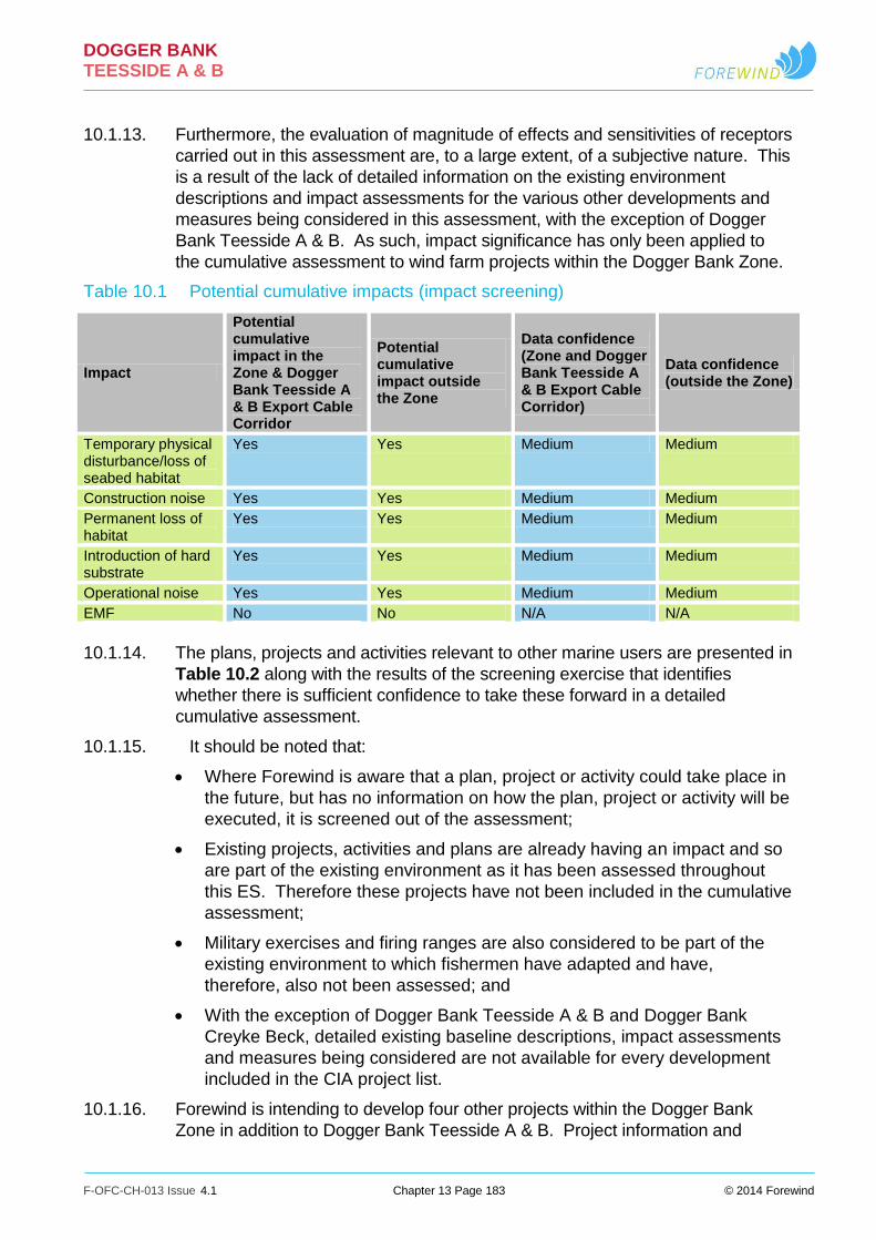
DOGGER BANK TEESSIDE A & B
F-OFC-CH-013 Issue 4.1 Chapter 13 Page 183 © 2014 Forewind
10.1.13. Furthermore, the evaluation of magnitude of effects and sensitivities of receptors
carried out in this assessment are, to a large extent, of a subjective nature. This
is a result of the lack of detailed information on the existing environment
descriptions and impact assessments for the various other developments and
measures being considered in this assessment, with the exception of Dogger
Bank Teesside A & B. As such, impact significance has only been applied to
the cumulative assessment to wind farm projects within the Dogger Bank Zone.
Table 10.1 Potential cumulative impacts (impact screening)
Impact
Potential cumulative impact in the Zone & Dogger Bank Teesside A & B Export Cable Corridor
Potential cumulative impact outside the Zone
Data confidence (Zone and Dogger Bank Teesside A & B Export Cable Corridor)
Data confidence (outside the Zone)
Temporary physical disturbance/loss of seabed habitat
Yes Yes Medium Medium
Construction noise Yes Yes Medium Medium
Permanent loss of habitat
Yes Yes Medium Medium
Introduction of hard substrate
Yes Yes Medium Medium
Operational noise Yes Yes Medium Medium
EMF No No N/A N/A
10.1.14. The plans, projects and activities relevant to other marine users are presented in
Table 10.2 along with the results of the screening exercise that identifies
whether there is sufficient confidence to take these forward in a detailed
cumulative assessment.
10.1.15. It should be noted that:
Where Forewind is aware that a plan, project or activity could take place in
the future, but has no information on how the plan, project or activity will be
executed, it is screened out of the assessment;
Existing projects, activities and plans are already having an impact and so
are part of the existing environment as it has been assessed throughout
this ES. Therefore these projects have not been included in the cumulative
assessment;
Military exercises and firing ranges are also considered to be part of the
existing environment to which fishermen have adapted and have,
therefore, also not been assessed; and
With the exception of Dogger Bank Teesside A & B and Dogger Bank
Creyke Beck, detailed existing baseline descriptions, impact assessments
and measures being considered are not available for every development
included in the CIA project list.
10.1.16. Forewind is intending to develop four other projects within the Dogger Bank
Zone in addition to Dogger Bank Teesside A & B. Project information and

DOGGER BANK TEESSIDE A & B
F-OFC-CH-013 Issue 4.1 Chapter 13 Page 184 © 2014 Forewind
boundaries are available for Dogger Bank Creyke Beck and Dogger Bank
Teesside C & D, which are shown in Figure 10.1.
10.1.17. Dogger Bank Teesside A & B comprise two wind farms, each with a generating
capacity of up to 1.2GW, which will connect into the national grid at Lackenby
substation. Dogger Bank Teesside A & B will have a total generating capacity of
up to 2.4GW. Dogger Bank Teesside C & D will comprise two wind farms, each
with a generating capacity of up to 1.2GW, which will connect into the national
grid just south of the Tees Estuary. Dogger Bank Teesside C & D will have a
total generating capacity of up to 2.4GW.
10.1.18. Dogger Bank Creyke Beck will comprise two wind farms (Creyke Beck A and
Creyke Beck B), each with a generating capacity of up to 1.2GW, and will
connect to the existing National Grid substation at Creyke Beck, in the East
Riding of Yorkshire. Dogger Bank Creyke Beck A & B will have a total
generating capacity of up to 2.4GW. As suggested in Chapter 9, the worst case
scenario in terms of increased suspended sediments would be for all six projects
to be constructed at the same time over a six-year period.

DOGGER BANK TEESSIDE A & B
F-OFC-CH-013 Issue 4.1 Chapter 13 Page 185 © 2014 Forewind
Table 10.2 Cumulative Impact Assessment screening for fish ecology (project screening)
Type of project Project title Project status
Predicted construction/ development period
Distance from Dogger Bank Dogger Bank Teesside (km)
Confidence in project details
Confidence in project data
Carried forward to cumulative impact assessment?
Rationale for where no cumulative impact is expected
Offshore wind farm
Dogger Bank Creyke Beck
Pre-Application Construction may start from 2016
Dogger Bank Teesside A approximately 35. Dogger Bank Teesside B approx. 5
High High Yes N/A
Offshore wind farm
Dogger Bank Teesside C & D
Potential Not confirmed Dogger Bank Teesside A approximately 27. Dogger Bank Teesside B approx. 8
High High Yes N/A
Offshore wind farm
Hornsea Project One
Pre-consent Project One may start construction 2015
Approx. 64 to the south of Dogger Bank Teesside A
Medium Medium Yes N/A
Offshore wind farm
Hornsea Project Two
Potential Not confirmed Approx. 59 to the south of Dogger Bank Teesside A
Medium Medium Yes N/A
Offshore wind farm
Hornsea Zone – other future development
Potential Not confirmed Not confirmed Low Low No Low confidence in project details and data
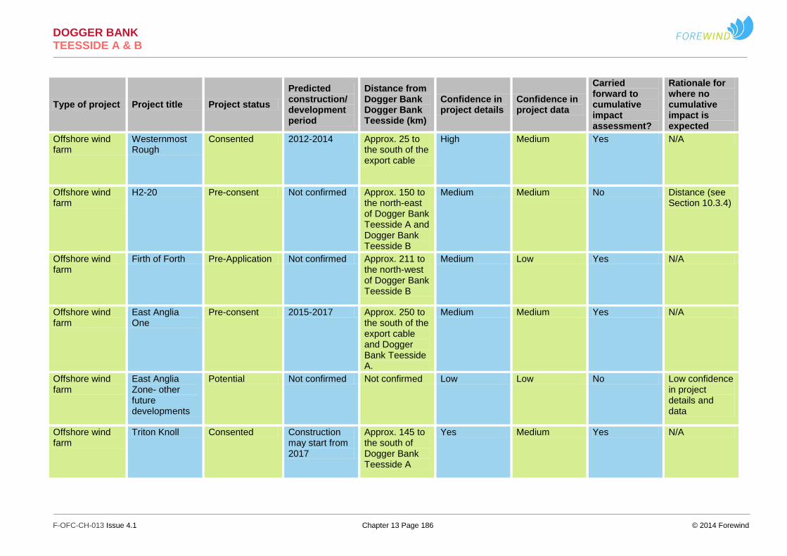
DOGGER BANK TEESSIDE A & B
F-OFC-CH-013 Issue 4.1 Chapter 13 Page 186 © 2014 Forewind
Type of project Project title Project status
Predicted construction/ development period
Distance from Dogger Bank Dogger Bank Teesside (km)
Confidence in project details
Confidence in project data
Carried forward to cumulative impact assessment?
Rationale for where no cumulative impact is expected
Offshore wind farm
Westernmost Rough
Consented 2012-2014 Approx. 25 to the south of the export cable
High Medium Yes N/A
Offshore wind farm
H2-20 Pre-consent Not confirmed Approx. 150 to the north-east of Dogger Bank Teesside A and Dogger Bank Teesside B
Medium Medium No Distance (see Section 10.3.4)
Offshore wind farm
Firth of Forth Pre-Application Not confirmed Approx. 211 to the north-west of Dogger Bank Teesside B
Medium Low Yes N/A
Offshore wind farm
East Anglia One
Pre-consent 2015-2017 Approx. 250 to the south of the export cable and Dogger Bank Teesside A.
Medium Medium Yes N/A
Offshore wind farm
East Anglia Zone- other future developments
Potential Not confirmed Not confirmed Low Low No Low confidence in project details and data
Offshore wind farm
Triton Knoll Consented Construction may start from 2017
Approx. 145 to the south of Dogger Bank Teesside A
Yes Medium Yes N/A

DOGGER BANK TEESSIDE A & B
F-OFC-CH-013 Issue 4.1 Chapter 13 Page 187 © 2014 Forewind
Type of project Project title Project status
Predicted construction/ development period
Distance from Dogger Bank Dogger Bank Teesside (km)
Confidence in project details
Confidence in project data
Carried forward to cumulative impact assessment?
Rationale for where no cumulative impact is expected
Aggregate extraction
Area 466 Application area Awaiting decision
Approx. 3 to the north of Dogger Bank Teesside B
Medium Medium Yes N/A
Aggregate extraction
Area 485 Application area Not confirmed Approx. 5 to the south-west of the Dogger Bank Teesside A and 20 south of the export cable
Medium Medium Yes N/A
Aggregate extraction
Area 448 Application area Not confirmed Approx. 50 to the south-west of the export cable
Medium Medium No Distance & subsequent low likelihood of interaction (see Section 10.4)
Aggregate extraction
Area 449 Application area Not confirmed Approx. 50 to the south-west of the export cable
Medium Medium No As above
SACs with Marine Components
Dogger Bank Potential cSAC In consultation 0 Medium Medium Yes N/A
SACs with Marine Components
North Norfolk Sandbanks & Saturn Reef
Potential cSAC In consultation 104 Medium Medium Yes N/A
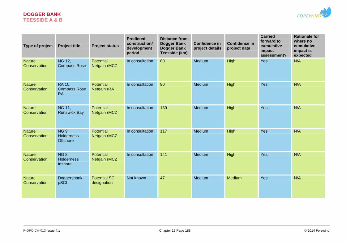
DOGGER BANK TEESSIDE A & B
F-OFC-CH-013 Issue 4.1 Chapter 13 Page 188 © 2014 Forewind
Type of project Project title Project status
Predicted construction/ development period
Distance from Dogger Bank Dogger Bank Teesside (km)
Confidence in project details
Confidence in project data
Carried forward to cumulative impact assessment?
Rationale for where no cumulative impact is expected
Nature Conservation
NG 12, Compass Rose
Potential Netgain rMCZ
In consultation 80 Medium High Yes N/A
Nature Conservation
RA 10, Compass Rose RA
Potential Netgain rRA
In consultation 90 Medium High Yes N/A
Nature Conservation
NG 11, Runswick Bay
Potential Netgain rMCZ
In consultation 139 Medium High Yes N/A
Nature Conservation
NG 9, Holderness Offshore
Potential Netgain rMCZ
In consultation 117 Medium High Yes N/A
Nature Conservation
NG 8, Holderness Inshore
Potential Netgain rMCZ
In consultation 141 Medium High Yes N/A
Nature Conservation
Doggersbank pSCI
Potential SCI designation
Not known 47 Medium Medium Yes N/A

DOGGER BANK TEESSIDE A & B
F-OFC-CH-013 Issue 4.1 Chapter 13 Page 189 © 2014 Forewind
Type of project Project title Project status
Predicted construction/ development period
Distance from Dogger Bank Dogger Bank Teesside (km)
Confidence in project details
Confidence in project data
Carried forward to cumulative impact assessment?
Rationale for where no cumulative impact is expected
Nature Conservation
NG 7, Markham’s Triangle
Potential Netgain rMCZ
In consultation 84 Medium High Yes N/A
Nature Conservation
Klaverbank pSCI
Potential SCI designation
Unknown 74 High Medium Yes N/A
Nature Conservation
NG 6, Silver Pit Potential Netgain rMCZ
In consultation 136 Medium High Yes N/A
Nature Conservation
NG 5, Lincs Belt
Potential Netgain rMCZ
In consultation 162 Medium High Yes N/A
Nature Conservation
RA 6, Dogs Head Sandbanks
Potential Netgain rRA
In consultation 204 Medium High Yes N/A
Nature Conservation
NG 2, Cromer Shoal Chalk Beds
Potential Netgain rMCZ
In consultation 188 Medium High Yes N/A

DOGGER BANK TEESSIDE A & B
F-OFC-CH-013 Issue 4.1 Chapter 13 Page 190 © 2014 Forewind
Type of project Project title Project status
Predicted construction/ development period
Distance from Dogger Bank Dogger Bank Teesside (km)
Confidence in project details
Confidence in project data
Carried forward to cumulative impact assessment?
Rationale for where no cumulative impact is expected
Nature Conservation
RA 1, North Norfolk Blue Mussel Beds
Potential Netgain rRA
In consultation 196 Medium High Yes N/A
Nature Conservation
NG 1b, Orford Inshore
Potential Netgain rMCZ
In consultation 280 Medium High Yes N/A
Nature Conservation
Outer Banks/Zeeuwse Banken
Potential Dutch MPA's
In consultation 327 Low High Yes N/A
Nature Conservation
Coastal Sea/Kustzee
Potential Dutch MPA's
In consultation 280 Low High Yes N/A
Nature Conservation
Brown Ridge Potential Dutch MPA's
In consultation 212 Low High Yes N/A
Nature Conservation
RA 7, Seahenge Peat and Clay
Potential Netgain rRA
In consultation 210 Medium High Yes N/A

DOGGER BANK TEESSIDE A & B
F-OFC-CH-013 Issue 4.1 Chapter 13 Page 191 © 2014 Forewind
Type of project Project title Project status
Predicted construction/ development period
Distance from Dogger Bank Dogger Bank Teesside (km)
Confidence in project details
Confidence in project data
Carried forward to cumulative impact assessment?
Rationale for where no cumulative impact is expected
Nature Conservation
RA 5, Blakeney Seagrass
Potential Netgain rRA
In consultation 198 Medium High Yes N/A
Nature Conservation
Frisian Front Potential Dutch MPA's
In consultation 171 Medium High Yes N/A
Nature Conservation
Borkham Reef Potential Dutch MPA's
In consultation 266 Low High Yes N/A
Nature Conservation
Central Oyster Grounds
Potential Dutch MPA's
In consultation 112 Low High Yes N/A
Nature Conservation
Gas Leaks Potential Dutch MPA's
In consultation 157 Low High Yes N/A
Nature Conservation
NG 10, Castle Ground
Potential Netgain rMCZ
In consultation 134 Medium High Yes N/A
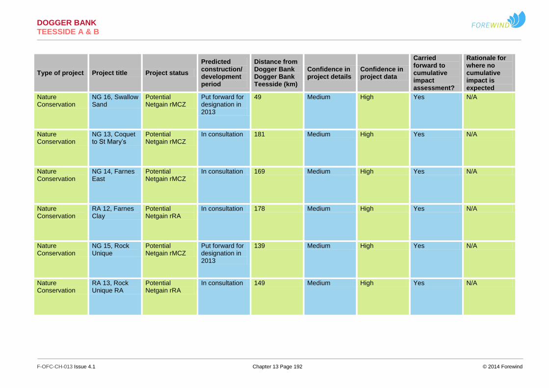
DOGGER BANK TEESSIDE A & B
F-OFC-CH-013 Issue 4.1 Chapter 13 Page 192 © 2014 Forewind
Type of project Project title Project status
Predicted construction/ development period
Distance from Dogger Bank Dogger Bank Teesside (km)
Confidence in project details
Confidence in project data
Carried forward to cumulative impact assessment?
Rationale for where no cumulative impact is expected
Nature Conservation
NG 16, Swallow Sand
Potential Netgain rMCZ
Put forward for designation in 2013
49 Medium High Yes N/A
Nature Conservation
NG 13, Coquet to St Mary’s
Potential Netgain rMCZ
In consultation 181 Medium High Yes N/A
Nature Conservation
NG 14, Farnes East
Potential Netgain rMCZ
In consultation 169 Medium High Yes N/A
Nature Conservation
RA 12, Farnes Clay
Potential Netgain rRA
In consultation 178 Medium High Yes N/A
Nature Conservation
NG 15, Rock Unique
Potential Netgain rMCZ
Put forward for designation in 2013
139 Medium High Yes N/A
Nature Conservation
RA 13, Rock Unique RA
Potential Netgain rRA
In consultation 149 Medium High Yes N/A

DOGGER BANK TEESSIDE A & B
F-OFC-CH-013 Issue 4.1 Chapter 13 Page 193 © 2014 Forewind
Type of project Project title Project status
Predicted construction/ development period
Distance from Dogger Bank Dogger Bank Teesside (km)
Confidence in project details
Confidence in project data
Carried forward to cumulative impact assessment?
Rationale for where no cumulative impact is expected
Nature Conservation
NG 17, Fulmar Potential Netgain rMCZ
In consultation 110 Medium High Yes N/A
Nature Conservation
Scottish MCZ project A
MCZ recommendation for site designations
In consultation 205 Medium Low Yes N/A
Nature Conservation
Scottish MCZ project B
MCZ recommendation for site designations
In consultation 325 Medium Low Yes N/A
Nature Conservation
Scottish MCZ project C
MCZ recommendation for site designations
In consultation 535 Medium Low Yes N/A
Nature Conservation
Scottish MCZ project D
MCZ recommendation for site designations
In consultation 594 Medium Low Yes N/A
Nature Conservation
RA 6, Dogs Head Sandbanks
Potential Netgain rRA
In consultation 178 Medium High Yes N/A

DOGGER BANK TEESSIDE A & B
F-OFC-CH-013 Issue 4.1 Chapter 13 Page 194 © 2014 Forewind
Type of project Project title Project status
Predicted construction/ development period
Distance from Dogger Bank Dogger Bank Teesside (km)
Confidence in project details
Confidence in project data
Carried forward to cumulative impact assessment?
Rationale for where no cumulative impact is expected
Nature Conservation
Western Fladen (WFL)
Proposed Nature Conservation MPA
In consultation 435 Medium High Yes N/A
Nature Conservation
South-east Fladen (SEF)
Proposed Nature Conservation MPA
In consultation 372 Medium High Yes N/A
Nature Conservation
North-east Faroe Shetland Channel (NEF)
Proposed Nature Conservation MPA
In consultation 845 Medium High Yes N/A
Nature Conservation
Faroe-Shetland sponge belt (FSS)
Proposed Nature Conservation MPA
In consultation 719 Medium High Yes N/A
Nature Conservation
Norwegian boundary sediment plain (NSP)
Proposed Nature Conservation MPA
In consultation 342 Medium High Yes N/A
Nature Conservation
Turbot Bank (TBB)
Proposed Nature Conservation MPA
In consultation 338 Medium High Yes N/A

DOGGER BANK TEESSIDE A & B
F-OFC-CH-013 Issue 4.1 Chapter 13 Page 195 © 2014 Forewind
Type of project Project title Project status
Predicted construction/ development period
Distance from Dogger Bank Dogger Bank Teesside (km)
Confidence in project details
Confidence in project data
Carried forward to cumulative impact assessment?
Rationale for where no cumulative impact is expected
Nature Conservation
East of Gannet and Montrose Fields (EGM)
Proposed Nature Conservation MPA
In consultation 258 Medium High Yes N/A
Nature Conservation
Firth of Forth Banks Complex (FOF)
Proposed Nature Conservation MPA
In consultation 301 Medium High Yes N/A
Nature Conservation
Southern Trench (STR)
MPA search location
In consultation 413 Medium High Yes N/A
Nature Conservation
Bancs des Flandres
Potential SCI designation
In consultation 428 Medium High Yes N/A
Nature Conservation
Pobie Bank Reef
Candidate SAC In consultation 636 Medium High Yes N/A

DOGGER BANK TEESSIDE A & B
F-OFC-CH-013 Issue 4.1 Chapter 13 Page 196 © 2014 Forewind
10.2. Cumulative impact of Dogger Bank Teesside A & B, Dogger Bank Creyke Beck and Dogger Bank Teesside C & D.
10.2.1. The CIA adopts an additive approach whereby the cumulative effects of the
following interactions are progressively assessed:
The cumulative impacts associated with Dogger Bank Teesside A & B and
the Dogger Bank Teesside A & B Export Cable Corridor and Dogger Bank
Creyke Beck and Dogger Bank Teesside C & D, including their respective
Export Cable Corridors;
The cumulative effects of Dogger Bank Teesside A & B and Dogger Bank
Teesside C & D with other planned, consented or under construction wind
farm developments outside of the Dogger Bank Zone; and
The cumulative effects of Dogger Bank Teesside A & B, Dogger Bank
Creyke Beck and Dogger Bank Teesside C & D with other planned,
consented or under construction wind farm developments outside the
Dogger Bank Zone and other future installations, regulated activities such
as aggregate dredging and possible marine conservation areas which may
exclude or restrict commercial fishing activities.
10.3. Temporary physical disturbance/loss of seabed habitat
10.3.1. There is potential for cumulative temporary habitat loss to occur as a result of
construction operations within the Dogger Bank Teesside A & B, Dogger Bank
Creyke Beck and Dogger Bank Teesside C & D sites. The worst case scenario
is for construction activities occurring within all six project areas simultaneously.
The proportional area of temporary disturbance/habitat loss within all sites is
expected to be of a similar magnitude. The cumulative effect will be highly
localised, with only a relatively small proportion of habitat disturbance /loss
occurring at any one time.
10.3.2. The cumulative effect of temporary physical disturbance/habitat loss will be of
medium duration, intermittent and reversible and the magnitude is considered to
be low.
10.3.3. Most fish species are predicted to have a relatively low level of vulnerability to
temporary habitat loss, though sandeel and other demersal spawning species
and shellfish species, both of which have specific habitat resource requirements
are deemed to be more sensitive to this type of disturbance.
10.3.4. In the context of sandeel spawning habitat, the cumulative habitat loss may
potentially result in a loss of up to 0.52% of the available preferred sandeel
habitat within the Dogger Bank SA1 management area.
10.3.5. Temporary disturbance/habitat loss within the inshore Flamborough herring
spawning grounds resulting from the installation of export cables has the
potential to affect a maximum area equivalent to 0.02% of the total Flamborough
inshore spawning grounds. The methodology used to derive estimates of the
spatial extent of the overlap of the development site with herring spawning
DOGGER BANK TEESSIDE A & B
F-OFC-CH-013 Issue 4.1 Chapter 13 Page 197 © 2014 Forewind
areas) is described in Appendix 13G. Estimates of the area of herring
spawning grounds in the vicinity of the development site are based on the
mapping layers presented in Coull et al. (1998). The limitations of the data sets
used to provide these mapping layers are acknowledged by Coull et al. (1998)
and, by extension, these limitations apply to the overlap estimates presented in
this assessment.
10.3.6. Cumulative effects of temporary disturbance/habitat loss may potentially affect
brown crab and lobster populations in the inshore areas but it is anticipated that
these effects will be limited in their spatial and temporal extent and the
proportion of the available habitat affected is predicted to be small.
10.3.7. Most fish and shellfish receptors in the fish and shellfish study area are deemed
to be of low vulnerability, high recoverability and of local to international
importance within the fish and shellfish study area. The sensitivity of these
receptors is therefore considered to be low and the impact is assessed as
minor adverse.
10.3.8. Sandeel and herring are deemed to be of medium vulnerability, medium
recoverability and of regional importance within the fish and shellfish study area.
The sensitivity of these receptors is therefore considered to be medium and the
impact is assessed as minor adverse.
10.3.9. Edible crab and European lobster are deemed to be of low vulnerability, high
recoverability and of regional importance within the fish and shellfish study area.
The sensitivity of these receptors is therefore considered to be low and the
impact is assessed as minor adverse.
10.4. Suspended sediment and sediment re-deposition
10.4.1. Cumulative effects, in terms of seabed disturbance, will be restricted to
interaction of sediment plumes and sediment deposition on the seabed. Given
the potential worst case construction programme, cumulative effects may arise if
the construction of foundations in different projects is synchronous and the
plumes that are created by the construction overlap spatially. If a similar
construction sequence is adopted for sets of foundations in the other Dogger
Bank projects at the same time as Dogger Bank Teesside B, then the respective
plumes may potentially interact, to create a larger overall plume, with higher
suspended sediment concentration and, potentially, a greater depositional
footprint on the seabed.
10.4.2. Given that the maximum thickness of sediment that remained deposited on the
seabed at the end of the 30-day simulation period for Dogger Bank Teesside A
& B was less than 0.1mm (for conical GBS, 12m monopole and 10m monopole
scenarios), the potential for accumulating persistently thick sequences of
sediment due to plume interaction is low. This assumes that the worst case
methodology used for Dogger Bank Teesside B, is duplicated for Dogger Bank
Teesside A, Dogger Bank Creyke Beck and Dogger Bank Teesside C & D.
10.4.3. Taking the above into account the magnitude of the effect of increased
suspended sediment concentrations resulting from simultaneous construction of
Dogger Bank Teesside A and Dogger Bank Teesside B, Dogger Bank Creyke

DOGGER BANK TEESSIDE A & B
F-OFC-CH-013 Issue 4.1 Chapter 13 Page 198 © 2014 Forewind
Beck and Dogger Bank Teesside C and D, is considered to be low, as
previously assessed for Dogger Bank Teesside A & B (Section 5.1) .
10.4.4. Given the wide distribution ranges of fish and shellfish and eggs and larvae in
comparison to the areas potentially affected and, in the particular case of adult
and juvenile fish, their ability to avoid areas of elevated suspended sediment
concentrations, the interaction between the effect and receptors will be small.
In this respect they are considered to be receptors of low vulnerability, medium
recoverability and local to regional value therefore they are deemed to be
receptors of low sensitivity (Table 6.5). Any potential cumulative impact is
therefore assessed to be minor adverse.
10.4.5. Sandeel and herring are considered of higher sensitivity given their dependence
on the presence of an adequate substrate in which to deposit their eggs. An
indication of the distribution of high density areas for sandeel is given in
Figure 10.2 based on Danish sandeel fishing density satellite (VMS) data
(average 2007-2011). As shown, Dogger Bank Teesside A and Dogger Bank
Teesside B are located at considerable distance from high sandeel density
areas but there is potential for construction activities in Dogger Bank Teesside C
and D to have a greater impact on preferred habitat areas for sandeel.
However, in the context of the large area of preferred habitat for sandeel
available within the Dogger Bank SA1 sandeel management area, the degree of
effect-receptor interaction is not expected to vary substantially from that
presented in Section 6 for Dogger Bank Teesside A and Dogger Bank Teesside
B. Sandeel is therefore considered of medium vulnerability, medium
recoverability and regional importance, therefore their sensitivity is deemed to
be medium. As a result of the low magnitude, seabed disturbance related
effects are assessed to result in a minor adverse impact.
10.4.6. In the particular case of herring, Dogger Bank Teesside A & B is located in the
immediate vicinity of the historic spawning grounds (Figure 10.3). Assuming
those grounds are re-colonised by the time that construction activity is taking
place, there may be potential for disturbance via sediment re-deposition to occur
on herring eggs. The large areas available for spawning which are undisturbed
in relation to the areas potentially affected by elevated suspended sediment
concentrations and sediment deposition should be noted in this context. Taking
the potential interaction into account herring are considered of medium
vulnerability, medium recoverability and regional importance therefore their
sensitivity is deemed to be medium. The cumulative impact of temporary
seabed disturbance on spawning herring is assessed to be minor adverse.

DOGGER BANK TEESSIDE A & B
F-OFC-CH-013 Issue 4.1 Chapter 13 Page 199 © 2014 Forewind

250000
250000
300000
300000
350000
350000
400000
400000
450000
450000
500000
500000
550000
550000
5950
000
5950
000
6000
000
6000
000
6050
000
6050
000
6100
000
6100
000
6150
000
6150
000
6200
000
6200
000
¯
LEGEND
0 20 4010
KilometresData Source:Background bathymetry image derived in part from TCarta data © 2009
The concepts and information contained in this documentare the copyright of Forewind. Use or copying of thedocument in whole or in part without the written permissionof Forewind constitutes an infringement of copyright. Forewind does not warrant that this document is definitivenor free of error and does not accept liability for any losscaused or arising from reliance upon information provided herein.
DOGGER BANK TEESSIDE A & B
F-OFL-MA-259
Figure 10.1 Dogger Bank Teesside A & B,Dogger Bank Teesside C & D, Dogger Bank
Creyke Beck A & B and export cable corridors
DRAWING NUMBER:
VER DATE1 20/09/2013
REMARKS CheckedDraft
DRAWING TITLE
PROJECT TITLE
WGS84 UTM31NA31:1,200,000 DATUM PROJECTIONSCALE PLOT SIZE
DrawnLW TR
Dogger Bank ZoneTranche boundaryDogger Bank Creyke Beck ADogger Bank Creyke Beck BDogger Bank TeessideDogger Bank Teesside BDogger Bank Teesside CDogger Bank Teesside DDogger Bank Teesside A & B Export CableCorridorDogger Bank Teesside A & B temporaryworks areaDogger Bank Creyke Beck Export CableCorridorDogger Bank Creyke Beck temporary worksareaDogger Bank Teesside C & D Export CableCorridor
2 07/10/2013 PEI3 LW TR3 14/02/2014 DCO Submission LW TR


466/1
485/1 485/2
514/3514/1
200000
200000
250000
250000
300000
300000
350000
350000
400000
400000
450000
450000
500000
500000
550000
550000
600000
600000
650000
650000
700000
700000
750000
750000
5850
000
5850
000
5900
000
5900
000
5950
000
5950
000
6000
000
6000
000
6050
000
6050
000
6100
000
6100
000
6150
000
6150
000
6200
000
6200
000
6250
000
6250
000
6300
000
6300
000¯
LEGEND
0 20 4010
KilometresData Source:Aggregate Areas © The Crown Estate, 2013VMS © Ministeriet for Fødevarer, Landbrug og Fiskeri, 2014
The concepts and information contained in this documentare the copyright of Forewind. Use or copying of thedocument in whole or in part without the written permissionof Forewind constitutes an infringement of copyright. Forewind does not warrant that this document is definitivenor free of error and does not accept liability for any losscaused or arising from reliance upon information provided herein.
DOGGER BANK TEESSIDE A & B
F-OFL-MA-260
Figure 10.2 Danish sandeel fishing,satellite VMS density (average 2008-2012)
DRAWING NUMBER:
VER DATE1 07/10/2013
REMARKS CheckedPEI3
DRAWING TITLE
PROJECT TITLE
WGS84 UTM31NA31:2,000,000 DATUM PROJECTIONSCALE PLOT SIZE
DrawnLW TR
Dogger Bank ZoneTranche boundaryDogger Bank Creyke Beck ADogger Bank Creyke Beck BDogger Bank Teesside ADogger Bank Teesside BDogger Bank Teesside CDogger Bank Teesside DDogger Bank Teesside A & B Export Cable CorridorDogger Bank Teesside A & B temporary works areaDogger Bank Creyke Beck Export Cable CorridorDogger Bank Creyke Beck temporary works areaDogger Bank Teesside C & D Export Cable CorridorICES sandeel areaAggregate application area
Danish sandeel satellite (VMS) density0 to 23 to 56 to 1011 to 2021 to 4041 to 80Over 80
2 14/02/2014 Pre-DCO Submission LW TR


250000
250000
300000
300000
350000
350000
400000
400000
450000
450000
500000
500000
550000
550000
5950
000
5950
000
6000
000
6000
000
6050
000
6050
000
6100
000
6100
000
6150
000
6150
000
6200
000
6200
000
¯
LEGEND
0 20 4010
KilometresData Source:Spawning Grounds © Cefas, 2012Background bathymetry image derived in part from TCarta data © 2009
The concepts and information contained in this documentare the copyright of Forewind. Use or copying of thedocument in whole or in part without the written permissionof Forewind constitutes an infringement of copyright. Forewind does not warrant that this document is definitivenor free of error and does not accept liability for any losscaused or arising from reliance upon information provided herein.
DOGGER BANK TEESSIDE A & B
F-OFL-MA-261
Figure 10.3 Herring spawning grounds
DRAWING NUMBER:
VER DATE1 20/09/2013
REMARKS CheckedDraft
DRAWING TITLE
PROJECT TITLE
WGS84 UTM31NA31:1,200,000 DATUM PROJECTIONSCALE PLOT SIZE
DrawnLW TR
Dogger Bank ZoneTranche boundaryDogger Bank Creyke Beck ADogger Bank Creyke Beck BDogger Bank Teesside ADogger Bank Teesside BDogger Bank Teesside CDogger Bank Teesside DDogger Bank Teesside A & B Export CableCorridorDogger Bank Teesside A & B temporaryworks areaDogger Bank Creyke Beck Export CableCorridorDogger Bank Creyke Beck temporary worksareaDogger Bank Teesside C & D Export CableCorridorHerring spawning ground (Coull et al. 1998)
2 07/10/2013 PEI3 LW TR3 14/02/2014 DCO Submission LW TR

DOGGER BANK TEESSIDE A & B
F-OFC-CH-013 Issue 4.1 Chapter 13 Page 203 © 2014 Forewind
10.5. Construction noise
10.5.1. Impact piling during construction is the activity with the potential to result in the
most detrimental impact on fish and shellfish species. Sequential construction
of Dogger Bank Teesside A, Dogger Bank Teesside B, Dogger Bank Creyke
Beck A & B and Dogger Bank Teesside C & D, has been considered the worst
case scenario in relation to fish and shellfish receptors. This would result in the
construction phase taking place for up to 11 years and six months. As
presented in Section 6 injury or lethal effects associated with piling noise would
only occur at very small ranges and are therefore not considered further in the
cumulative assessment. The assessment below is therefore focused on the
potential for cumulative impacts at the behavioural level to occur.
10.5.2. The worst case spatial range of disturbance resulting from two pile driving
operations per project taking place at Dogger Bank Teesside A, Dogger Bank
Teesside B, Dogger Bank Creyke Beck A & B and Dogger Bank Teesside C & D
is shown in Figure 10.4 (based on a larger 2300kJ hammer being used as this
is the worst case for 10+MW jacket foundations and hence provides the biggest
spatial range). It should be noted that piling can occur on a maximum of two
piles at any one time per project and that a maximum of 12 piling rigs can be in
use across the Dogger Bank Zone at any one time (Chapter 5). This means
that for Dogger Bank Teesside A & B, Dogger Bank Teesside C & D and Dogger
Bank Creyke Beck A & B construction could occur concurrently with two piling
vessels active in each project.
10.5.3. In order to assess the worst case scenario (maximum spatial range and longest
duration) it is assumed that construction of the first of Dogger Bank Teesside A
& B’s projects commences within 18 months of consent (as soon as possible)
and lasts for a duration of six years (the longest possible duration). It is further
assumed that another Dogger Bank Teesside project starts seven years post
consent (as late as possible) and lasts for as long as possible (six years, as
construction must be completed 13 years post consent). Another assumption is
that concurrent construction of the Dogger Bank Creyke Beck A & B, Dogger
Bank Teesside A & B and Dogger Bank Teesside C & D projects being
considered will take six years (maximum construction period) and will be
constructed in a way which ensures constant piling in the Zone through the
simultaneous construction of Dogger Bank Teesside A & B, Dogger Bank
Teesside C & D and Dogger Bank Creyke Beck A & B.
10.5.4. Taking the relatively small ranges of behavioural response impact associated
with concurrent pile driving operations, and the intermittent and short term
nature of pile driving activity, the magnitude of the effect is considered to be low.
10.5.5. As described for Dogger Bank Teesside A & B, the distribution of most fish and
shellfish species (including spawning, nursery and feeding areas) is wide in
relation to the areas where behavioural reactions may be triggered by piling
noise at a given time. The potential interaction between the effects of noise and
fish and shellfish receptors is small due to their wide spatial distribution. Fish
and shellfish (with the exception of sandeel and herring) are considered to be
receptors of low vulnerability, medium recoverability and of local to regional

DOGGER BANK TEESSIDE A & B
F-OFC-CH-013 Issue 4.1 Chapter 13 Page 204 © 2014 Forewind
importance; they are considered to have low sensitivity to the effects of
underwater noise. The magnitude is anticipated to be low therefore the
cumulative impact is assessed to be minor adverse.
10.5.6. In the particular case of herring, assuming the former grounds are re-colonised
by the time that construction activity is taking place, as assessed for Dogger
Bank Teesside A & B above (Section 6) avoidance of small sections of the
former grounds resulting from pile driving activity at Dogger Bank Teesside A &
B may occur. This would however only be the case during installation of
foundations in the vicinity of the grounds. In addition, impact ranges at which
behavioural responses would be expected will only overlap with a small section
of the defined former grounds. Taking the medium degree of interaction as
described above into account, spawning herring are considered receptors of
medium vulnerability, medium recoverability and regional value. They are
deemed to be receptors of medium sensitivity. The effect of construction noise
on spawning herring is therefore assessed to result in a minor adverse impact.
This should, however, be taken in the context of the extent of suitable substrate
for herring spawning in other areas and on the relatively wide extension of the
former spawning grounds.
10.5.7. With respect to sandeel, Dogger Bank Teesside C & D is located in areas which
may potentially support higher densities of sandeel than either Dogger Bank
Creyke Beck A & B or Dogger Bank Teesside A & B. However, given the spatial
extent of preferred habitat available within the SA1 management area, the area
affected by construction noise is proportionally small. The assessment carried
out for Dogger Bank Teesside A (Section 6) is considered to apply in cumulative
terms. Sandeel is therefore considered of medium sensitivity and the
cumulative impact is assessed to be minor adverse.
10.6. Permanent habitat loss
10.6.1. Cumulative long term habitat loss is predicted to occur as a result of the
presence of all offshore wind farm structures (i.e., foundations, scour protection
and cable protection). The maximum adverse scenario for permanent habitat
loss assumes the minimum amount of cable burial (although it is unlikely that the
maximum amount of cable protection will be required) and the maximum
foundation footprint i.e. GBS foundations inclusive of scour protection.
10.6.2. In assessment terms, it is difficult to quantify the cumulative effect of permanent
habitat loss of seabed habitat. However, as described in Chapter 12,
comparable seabed habitats are relatively widespread throughout the central
North Sea and the loss is not anticipated to impact on ecosystem function. The
magnitude of the impact is considered to be low.
10.6.3. Sensitivities of fish and shellfish receptors in the fish and shellfish study area to
long term habitat loss are summarised in Section 7. Most fish and shellfish
receptors in the fish and shellfish study area are deemed to be of low
vulnerability, high recoverability and of local to international importance within
the fish and shellfish study area. The sensitivity of these receptors is therefore
considered to be low. The impact is assessed as minor adverse.

DOGGER BANK TEESSIDE A & B
F-OFC-CH-013 Issue 4.1 Chapter 13 Page 205 © 2014 Forewind
10.6.4. The fish and shellfish species considered to be most vulnerable to habitat loss
are demersal spawning species such as sandeel and herring which have
specific spawning habitat requirements. In addition, sandeel have specific
habitat resource requirements with a preference for sediment with high sand low
silt content. In relation to the potential impact on sandeel habitats the project
boundaries intentionally avoid the area of high density sandeel in the western
section of Tranche A in order to minimise the potential impact of the Dogger
Bank Zone. This will minimise the potential effects on the sandeel, the sandeel
fishery and also on predators such as seabirds, marine mammals and other fish
which exploit sandeel as a key prey species (see Chapter 6 Site Selection and
Alternatives).
10.6.5. The Flamborough herring spawning ground is not expected to be affected by
long term habitat loss since the proportion of seabed affected is negligible
compared to the total area designated as herring spawning habitat by Coull et
al. 1998.
10.6.6. Cumulative effects on sandeel are also likely to be small given that the relative
area of sandeel habitat lost represents such a small proportion of the total area
of available sandeel habitat within the SA1 management area.
10.6.7. Sandeel and herring are deemed to be receptors of medium vulnerability,
medium recoverability and of regional importance, therefore their sensitivity is
deemed to be medium. The impact is assessed as minor adverse.
10.6.8. Cumulative effects on shellfish species as a result of permanent habitat loss are
not anticipated to have a negative effect. There is the potential for the
introduction of hard substrate and the formation of artificial reefs to result in
positive effects for edible crab and lobster. Shellfish receptors are deemed to be
of medium vulnerability, high recoverability and of regional importance within the
fish and shellfish study area. The sensitivity of these receptors is therefore
considered to be medium. The impact is assessed as minor adverse.
10.7. Summary
10.7.1. The cumulative impact assessment described above for Dogger Bank Teesside
A & B, Dogger Bank Teesside C & D and Dogger Bank Creyke Beck A & B is
summarised in Table 10.3 below.
Table 10.3 Cumulative impact assessment summary
Potential effect Effect magnitude Receptor Receptor sensitivity
Cumulative impact
Temporary physical disturbance/loss of seabed habitat
Low
Fish and shellfish in general
Low Minor adverse
Herring Medium Minor adverse
Sandeel Medium Minor adverse
Shellfish Low Minor adverse

DOGGER BANK TEESSIDE A & B
F-OFC-CH-013 Issue 4.1 Chapter 13 Page 206 © 2014 Forewind
Potential effect Effect magnitude Receptor Receptor sensitivity
Cumulative impact
Suspended sediment and sediment re-deposition
Low Fish and shellfish in general
Low Minor adverse
Herring Medium Minor adverse
Sandeel Medium Minor adverse
Construction noise Low Fish and shellfish in general
Low Minor adverse
Herring Medium Minor adverse
Sandeel Medium Minor adverse
Permanent loss of seabed habitat
Low Fish and shellfish in general
Low Minor adverse
Herring Medium Minor adverse
Sandeel Medium Minor adverse
Shellfish Medium Minor adverse

200000
200000
250000
250000
300000
300000
350000
350000
400000
400000
450000
450000
500000
500000
550000
550000
600000
600000
650000
650000
700000
700000
750000
750000
5850
000
5850
000
5900
000
5900
000
5950
000
5950
000
6000
000
6000
000
6050
000
6050
000
6100
000
6100
000
6150
000
6150
000
6200
000
6200
000
6250
000
6250
000
6300
000
6300
000¯
LEGEND
0 20 4010
Kilometres
Data Source:UK offshore wind farms © The Crown Estate, 2014Non-UK offshore wind farms © Marine Find, 2013Modelling © NPL Management, 2013
The concepts and information contained in this documentare the copyright of Forewind. Use or copying of thedocument in whole or in part without the written permissionof Forewind constitutes an infringement of copyright. Forewind does not warrant that this document is definitivenor free of error and does not accept liability for any losscaused or arising from reliance upon information provided herein.
DOGGER BANK TEESSIDE A & B
F-OFL-MA-262
Figure 10.4 Noise generation from piledriving at other projects in relative proximity
to Dogger Bank Teesside A & B
DRAWING NUMBER:
VER DATE1 07/10/2013
REMARKS CheckedPEI3
DRAWING TITLE
PROJECT TITLE
WGS84 UTM31NA31:2,000,000 DATUM PROJECTIONSCALE PLOT SIZE
DrawnLW TR
Dogger Bank ZoneTranche boundaryDogger Bank Creyke Beck ADogger Bank Creyke Beck BDogger Bank Teesside ADogger Bank Teesside BDogger Bank Teesside CDogger Bank Teesside DDogger Bank Teesside A & B ExportCable CorridorDogger Bank Teesside A & B temporaryworks areaDogger Bank Creyke Beck Export CableCorridorDogger Bank Creyke Beck temporaryworks areaDogger Bank Teesside C & D ExportCable Corridor
Wind energy projectRound 1Round 2Round 3Round 3 zoneNon-UK wind farm development
2 14/02/2014 DCO Submission LW TR


DOGGER BANK TEESSIDE A & B
F-OFC-CH-013 Issue 4.1 Chapter 13 Page 208 © 2014 Forewind
10.8. The cumulative impact of Dogger Bank Teesside A & B, Dogger Bank Creyke Beck A & B, Dogger Bank Teesside C & D and other projects outside the Dogger Bank Zone
Seabed disturbance due to sediment deposition
10.8.1. As indicated in Chapter 9 the following proposed wind farm projects have been
taken into account for cumulative assessment in terms of temporary disturbance
of the seabed during construction:
Project One Hornsea Offshore Wind Farm;
Westermost Rough; and
H2-20 offshore wind farm (German sector of the North Sea).
10.8.2. As stated in Chapter 9 it is unlikely that the construction plumes of Project One
Hornsea Wind Farm would interact with the construction plumes of Dogger Bank
Teesside A & B, Dogger Bank Teesside C & D and Dogger Bank Creyke Beck A
& B. There is therefore little potential for cumulative impacts on fish and
shellfish receptors to occur.
10.8.3. Sediment plumes associated with installation of the Dogger Bank Teesside A &
B, Dogger Bank Teesside C & D and Dogger Bank Creyke Beck A & B Export
Cable Corridors may potentially interact with construction plumes of Westermost
Rough if both are synchronous. As stated in Chapter 9, however, this potential
interaction is not expected to result in significant effect. It is, therefore,
considered that there is little potential for cumulative impacts on fish and
shellfish receptors to occur.
10.8.4. In the particular case of the H2-20 offshore wind farm, given its distance to
Dogger Bank Teesside A & B (approx.150km east-northeast of Dogger Bank
Teesside A & B), Chapter 9 concluded that there is not potential for cumulative
effects in relation to seabed disturbance during construction to occur. As a
result cumulative impacts associated with this are not expected on fish and
shellfish receptors.
10.8.5. There may be potential for aggregate dredging taking place in the vicinity of
Dogger Bank Teesside A & B, Dogger Bank Teesside C & D and Dogger Bank
Creyke Beck A & B to result in a cumulative impact on fish and shellfish
receptors resulting from the effects of seabed disturbance.
10.8.6. The following dredging areas have been included for assessment of cumulative
impacts:
Aggregates Area 466: Located at the northern boundary of Dogger Bank
Teesside B;
Aggregates Dredging Area 485: Located approximately 25km south west of
Dogger Bank Teesside A and 20km south of the Dogger Bank Teesside A
& B Export Cable Corridor; and
DOGGER BANK TEESSIDE A & B
F-OFC-CH-013 Issue 4.1 Chapter 13 Page 209 © 2014 Forewind
Aggregate Dredging Areas 448 and 449: Located at the entrance of the
Humber Estuary, approximately 50km to the south-southwest of the
Dogger Bank Teesside A & B Export Cable Corridor.
10.8.7. The location of these areas are shown in relation to the distribution of herring
and spawning grounds and high density areas for sandeel is given in
Figure 10.5 and Figure 10.6.
10.8.8. Areas 466 and 485 are located in known high density areas for sandeel
(Figure 10.6). Area 485 also falls within a discrete section of the former herring
spawning grounds, whilst Areas 448 and 449 are both located within the
currently active inshore herring spawning grounds (Figure 10.5).
10.8.9. As indicated in Chapter 9 analysis of time series of sediment deposition from
the Dogger Bank Teesside A & B worst case construction plume at the southern
corner of Area 466 shows that sediment thickness at any time is generally less
than 1mm. Occasionally, sediment is thicker than 1mm and can be continuously
greater than 1mm for a maximum period of 42 hours. Sediment deposition out
of the Dogger Bank Teesside A & B construction plume would have little effect
on the characteristics of the seabed sediment in Area 466. With regards to Area
485, it was assumed that the dredging process and sequencing is similar to that
at Area 466.
10.8.10. In the particular case of dredging areas 448 and 449, as suggested in
Chapter 9 it is unlikely that any interaction with the sediment plume associated
with the Dogger Bank Teesside A & B, Dogger Bank Teesside C & D and
Dogger Bank Creyke Beck A & B cable installation will occur, given the small
size of the plume generated by the cable and the low likelihood that the cable
will be excavated on the same day as the aggregate extraction is being
undertaken.
10.8.11. Taking the above into account it is not considered that dredging activities will
contribute significantly to the cumulative impact effect on fish and shellfish in
general, nor in the particular case of spawning herring and sandeel. Therefore
no cumulative impact is anticipated.
Noise
10.8.12. As presented in Appendix 5A, the spatial range of potential behavioural effects
associated with pile driving noise on fish were modelled for the following wind
farms located in the proximity of the Dogger Bank Teesside A & B, Dogger Bank
Teesside C & D and Dogger Bank Creyke Beck A & B:
Firth of Forth;
East Anglia;
Hornsea; and
Triton Knoll.

466/1
485/1 485/2
514/3514/1
250000
250000
300000
300000
350000
350000
400000
400000
450000
450000
500000
500000
550000
550000
5950
000
5950
000
6000
000
6000
000
6050
000
6050
000
6100
000
6100
000
6150
000
6150
000
6200
000
6200
000
¯
LEGEND
0 20 4010
KilometresData Source:Spawning Grounds © Cefas, 2012Aggregate Areas © The Crown Estate, 2013Background bathymetry image derived in part from TCarta data © 2009
The concepts and information contained in this documentare the copyright of Forewind. Use or copying of thedocument in whole or in part without the written permissionof Forewind constitutes an infringement of copyright. Forewind does not warrant that this document is definitivenor free of error and does not accept liability for any losscaused or arising from reliance upon information provided herein.
DOGGER BANK TEESSIDE A & B
F-OFL-MA-263
Figure 10.5 Dredging areas in thevicinity of Dogger Bank Teesside A & B
and herring spawning grounds
DRAWING NUMBER:
VER DATE1 20/09/2013
REMARKS CheckedDraft
DRAWING TITLE
PROJECT TITLE
WGS84 UTM31NA31:1,200,000 DATUM PROJECTIONSCALE PLOT SIZE
DrawnLW TR
Dogger Bank ZoneTranche boundaryDogger Bank Creyke Beck ADogger Bank Creyke Beck BDogger Bank Teesside ADogger Bank Teesside BDogger Bank Teesside CDogger Bank Teesside DHerring spawning ground (Coull et al. 1998)Dogger Bank Teesside A & B Export CableCorridorDogger Bank Teesside A & B temporaryworks areaDogger Bank Creyke Beck Export CableCorridorDogger Bank Creyke Beck temporary worksareaDogger Bank Teesside C & D Export CableCorridorAggregate application area
2 07/10/2013 PEI3 LW TR3 14/02/2014 DCO Submission LW TR

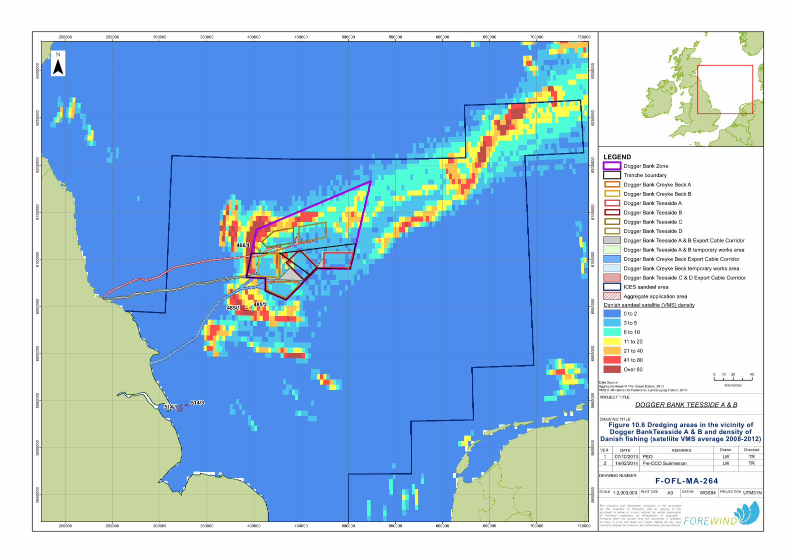
466/1
485/1 485/2
514/3514/1
200000
200000
250000
250000
300000
300000
350000
350000
400000
400000
450000
450000
500000
500000
550000
550000
600000
600000
650000
650000
700000
700000
750000
750000
5850
000
5850
000
5900
000
5900
000
5950
000
5950
000
6000
000
6000
000
6050
000
6050
000
6100
000
6100
000
6150
000
6150
000
6200
000
6200
000
6250
000
6250
000
6300
000
6300
000¯
LEGEND
0 20 4010
KilometresData Source:Aggregate Areas © The Crown Estate, 2013VMS © Ministeriet for Fødevarer, Landbrug og Fiskeri, 2014
The concepts and information contained in this documentare the copyright of Forewind. Use or copying of thedocument in whole or in part without the written permissionof Forewind constitutes an infringement of copyright. Forewind does not warrant that this document is definitivenor free of error and does not accept liability for any losscaused or arising from reliance upon information provided herein.
DOGGER BANK TEESSIDE A & B
F-OFL-MA-264
Figure 10.6 Dredging areas in the vicinity ofDogger BankTeesside A & B and density of
Danish fishing (satellite VMS average 2008-2012)
DRAWING NUMBER:
VER DATE1 07/10/2013
REMARKS CheckedPEI3
DRAWING TITLE
PROJECT TITLE
WGS84 UTM31NA31:2,000,000 DATUM PROJECTIONSCALE PLOT SIZE
DrawnLW TR
Dogger Bank ZoneTranche boundaryDogger Bank Creyke Beck ADogger Bank Creyke Beck BDogger Bank Teesside ADogger Bank Teesside BDogger Bank Teesside CDogger Bank Teesside DDogger Bank Teesside A & B Export Cable CorridorDogger Bank Teesside A & B temporary works areaDogger Bank Creyke Beck Export Cable CorridorDogger Bank Creyke Beck temporary works areaDogger Bank Teesside C & D Export Cable CorridorICES sandeel areaAggregate application area
Danish sandeel satellite (VMS) density0 to 23 to 56 to 1011 to 2021 to 4041 to 80Over 80
2 14/02/2014 Pre-DCO Submission LW TR


DOGGER BANK TEESSIDE A & B
F-OFC-CH-013 Issue 4.1 Chapter 13 Page 212 © 2014 Forewind
10.8.13. The outputs of the noise modelling undertaken for these developments, is given
in Figure 10.4. This illustrates the extent of behavioural disturbance for fish in
mid water.
10.8.14. As shown, assuming simultaneous piling at the closest locations from other wind
farm developments to Dogger Bank Teesside A & B, Dogger Bank Teesside C
& D and Dogger Bank Creyke Beck A & B there will not be spatial overlap of
noise levels at which behavioural reactions may occur in pelagic fish. In the
unlikely event that simultaneous piling was happening at all of the locations
modelled above, the total area affected at behavioural levels would still be
relatively small in the context of the wide distribution ranges (including
spawning, nursery grounds and feeding grounds) of fish and shellfish receptors
and any simultaneous disturbance would be temporary and very short term.
10.8.15. As described in Appendix 5A and summarised below, in addition to pile driving
associated with wind farm installation, shipping, oil and gas related activities and
dredging may further contribute to wind farm related noise.
10.8.16. Shipping density local to Dogger Bank Teesside A & B, Dogger Bank Teesside
C & D and Dogger Bank Creyke Beck A & B is generally lower than closer
inshore or in some of the surrounding areas, including areas to the south.
Commercial shipping, fishing and dredging all radiate substantially lower noise
levels compared to impact piling and are unlikely to increase the risk of
physiological damage to marine fauna compared to the construction of Dogger
Bank Teesside A & B, Dogger Bank Teesside C & D and Dogger Bank Creyke
Beck A & B and other wind farms alone. In general, noise generated by
transiting surface vessels will result in a very small contribution to the overall
noise level resulting from impact pile driving activities.
10.8.17. It is therefore not considered that additional noise associated with other activities
has potential to significantly contribute to the cumulative impact of noise on fish
and shellfish species associated with the Dogger Bank Teesside A & B, Dogger
Bank Teesside C & D and Dogger Bank Creyke Beck A & B and other wind farm
developments.
10.9. Dogger Bank Teesside A & B, Dogger Bank Creyke Beck, Dogger Bank Teesside C & D and marine conservation areas
10.9.1. Dogger Bank Teesside A & B, Dogger Bank Teesside C & D and Dogger Bank
Creyke Beck A & B fall within an area currently outlined as the Dogger Bank
candidate Special Area of Conservation (cSAC). Conservation measures
associated with the introduction of marine conservation areas may result in a
beneficial cumulative impact on fish and shellfish receptors on a site specific
area, particularly if fishing activity in the area changes substantially from
measures which may be implemented. However, the potential for fishing effort
to be displaced into sensitive areas should be noted in this context.

DOGGER BANK TEESSIDE A & B
F-OFC-CH-013 Issue 4.1 Chapter 13 Page 213 © 2014 Forewind
10.9.3. Figure 10.7 shows a chart reproduced from a paper prepared on behalf of the
Danish, Dutch, English and German fishermen organisations titled “Fisheries
Spatial Management Measures for the Dogger Bank SAC: Fishing Industry
Amendment Proposal”. The sections marked in purple are those proposed by
the fishing industry to be under fisheries management within which towed
bottom gears are prohibited from operating. The potential for a likely beneficial
impact on target species and benthic habitats associated with the exclusion of
towed gear should be noted. As described in Chapter 15 although the
proposed sectors overlap the majority of Dogger Bank Creyke Beck A & B, and
small sections of Dogger Bank Teesside A & B and Dogger Bank Teesside C &
D the areas proposed by the fishing industry may not be adopted. Furthermore,
the proposed sectors align with the areas which the UK, Danish and German
VMS and UK surveillance suggest sustain low levels of fishing activity.

200000
200000
250000
250000
300000
300000
350000
350000
400000
400000
450000
450000
500000
500000
550000
550000
600000
600000
5900
000
5900
000
5950
000
5950
000
6000
000
6000
000
6050
000
6050
000
6100
000
6100
000
6150
000
6150
000
6200
000
6200
000
6250
000
6250
000¯
LEGEND
0 20 4010
KilometresData Source:Management Sectors © NFFO 2012Background bathymetry image derived in part from TCarta data © 2009
The concepts and information contained in this documentare the copyright of Forewind. Use or copying of thedocument in whole or in part without the written permissionof Forewind constitutes an infringement of copyright. Forewind does not warrant that this document is definitivenor free of error and does not accept liability for any losscaused or arising from reliance upon information provided herein.
DOGGER BANK TEESSIDE A & B
F-OFL-MA-265
Figure 10.7 Proposed fisheries management sectors within
Dogger Bank cSAC
DRAWING NUMBER:
VER DATE1 20/09/2013
REMARKS CheckedDraft
DRAWING TITLE
PROJECT TITLE
WGS84 UTM31NA31:1,500,000 DATUM PROJECTIONSCALE PLOT SIZE
DrawnLW TR
Dogger Bank ZoneTranche boundaryDogger Bank TeessideDogger Bank Teesside BDogger Bank Teesside A & B Export CableCorridorTemporary works areacSAC proposed no trawl zonesDogger Bank cSAC
2 07/10/2013 PEI3 LW TR3 14/02/2014 DCO Submission LW TR


DOGGER BANK TEESSIDE A & B
F-OFC-CH-013 Issue 4.1 Chapter 13 Page 215 © 2014 Forewind
11. Transboundary Issues
11.1. General
11.1.1. The distribution of fish and shellfish species is independent of national
geographical boundaries. The impact assessment presented in this section has
therefore been undertaken taking account of the distribution of fish stocks and
populations irrespective of political limits. As a result it is considered that the
assessment of transboundary effects is already integrated in the assessment
given above.
11.1.2. The location of Dogger Bank Teesside A & B is an important consideration with
respect to potential transboundary effects. Although Dogger Bank Teesside A &
B does not lie in international waters the eastern boundary of the Dogger Bank
Zone is synonymous with the international boundary bordering Dutch and
German waters. Also of note is that the eastern boundary of Dogger Bank
Teesside A is in close proximity to an international boundary with The
Netherlands.
11.1.3. With regard to the effects of noise (namely from percussive piling, Section 6.6),
the assessment has shown that behavioural impacts (including spawning
behaviour) are not anticipated beyond 13.5km and 19km from the noise source.
With regard to the potential effects of increased suspended sediment
concentrations and deposition of sediment on the seabed (Section 6.4), the
assessment indicates that any transboundary effects would be negligible. All
other potential impacts, such as loss of habitat, will be contained within or in
close proximity to the project boundaries, and no significant transboundary
effects are anticipated.

DOGGER BANK TEESSIDE A & B
F-OFC-CH-013 Issue 4.1 Chapter 13 Page 216 © 2014 Forewind
12. Summary
12.1.1. This chapter of the ES has provided a characterisation of the existing fish and
shellfish environment based on both existing and site specific survey data. As
discussed in Sections 6, 7 and 8 of this chapter fish and shellfish may be
affected as a result of temporary physical disturbance during construction, and
permanent loss of habitat during operation of Dogger Bank Teesside A & B. All
residual impacts identified for fish and shellfish ecology are minor adverse or
negligible, with no significant residual impacts. Table 12.1 provides a summary
of the potential impacts on fish and shellfish arising from the realistic worst case
scenarios set out in Table 5.2 earlier in the chapter.
Table 12.1 Summary of potential impacts on fish and shellfish ecology
Description of impact
Receptor
Residual impact
Dogger Bank Teesside A
Dogger Bank Teesside B
Dogger Bank Teesside A & B
Dogger Bank Teesside A & B Export Cable Corridor
Construction / decommissioning phase
Temporary physical disturbance/ loss of seabed habitat
Eggs and larvae of pelagic fish spawners
Negligible Negligible Negligible Negligible
Eggs and larvae of demersal fish spawners
Minor adverse
Minor adverse
Minor adverse
Minor adverse
Eggs and larvae of sandeel
Minor adverse
Minor adverse
Minor adverse
Minor adverse
Eggs and larvae of herring
Minor adverse
Minor adverse
Minor adverse
Minor adverse
Eggs and larvae of shellfish
Minor adverse
Minor adverse
Minor adverse
Minor adverse
Adult and juvenile fish
Minor adverse
Minor adverse
Minor adverse
Minor adverse

DOGGER BANK TEESSIDE A & B
F-OFC-CH-013 Issue 4.1 Chapter 13 Page 217 © 2014 Forewind
Description of impact
Receptor
Residual impact
Dogger Bank Teesside A
Dogger Bank Teesside B
Dogger Bank Teesside A & B
Dogger Bank Teesside A & B Export Cable Corridor
Sandeel Minor adverse
Minor adverse
Minor adverse
Minor adverse
Shellfish Minor adverse
Minor adverse
Minor adverse
Minor adverse
Increased suspended sediment concentrations and sediment re-deposition
Eggs and larvae (general)
Minor adverse
Minor adverse
Minor adverse
Minor adverse
Herring eggs Minor adverse
Minor adverse
Minor adverse
Minor adverse
Sandeel eggs Minor adverse
Minor adverse
Minor adverse
Minor adverse
Adult and juvenile fish (general)
Minor adverse
Minor adverse
Minor adverse
Minor adverse
Sandeel Minor adverse
Minor adverse
Minor adverse
Minor adverse
Shellfish Minor adverse
Minor adverse
Minor adverse
Minor adverse
Construction noise
Adult and juvenile fish
Negligible Negligible Negligible Negligible
Larvae Minor adverse
Minor adverse
Minor adverse
Negligible
Fish in general Minor adverse
Minor adverse
Minor adverse
Negligible
Herring Minor adverse
Minor adverse
Minor adverse
Minor adverse
Sandeel Minor adverse
Minor adverse
Minor adverse
Minor adverse
Diadromous species
Minor adverse
Minor adverse
Minor adverse
Minor adverse
Other fish species Minor adverse
Minor adverse
Minor adverse
Minor adverse
Fish in general Minor adverse
Minor adverse
Minor adverse
Negligible
Shellfish Minor adverse
Minor adverse
Minor adverse
Negligible

DOGGER BANK TEESSIDE A & B
F-OFC-CH-013 Issue 4.1 Chapter 13 Page 218 © 2014 Forewind
Description of impact
Receptor
Residual impact
Dogger Bank Teesside A
Dogger Bank Teesside B
Dogger Bank Teesside A & B
Dogger Bank Teesside A & B Export Cable Corridor
Operational Phase
Loss of habitat Fish and shellfish in general
Minor adverse
Sandeel
Herring
Introduction of hard substrate
Fish and shellfish (general)
Minor adverse
Minor adverse
Minor adverse
Negligible
EMF
Elasmobranchs
Minor adverse
Salmon and sea trout
European eel
Lamprey
Other fish
Shellfish
Operational noise Fish and shellfish (general)
Minor adverse N/A
Changes to fishing activity
Fish and shellfish (general)
Minor adverse N/A

DOGGER BANK TEESSIDE A & B
F-OFC-CH-013 Issue 4.1 Chapter 13 Page 219 © 2012 Forewind
13. References
Aarestrup, K. Økland, F. Hansen, M.M. Righton, D. Gargan, P. Castonguay, M. Bernatchez,
L. Howey, P. Sparholt, H. Pedersen, M.I. and McKinley, R.S. 2009. Oceanic spawning
migration of the European eel (Anguilla anguilla). Science 325, pp. 1660.
Acolas, M. L. Begout Anras, M. L. Veron, V. Jourdan, H. Sabatie, M. R. and Bagliniere, J. L.
2004. An assessment of the upstream migration and reproductive behaviour of allis shad
(Alosa alosa L.) using acoustic tracking. ICES Journal of Marine Science 61, pp. 1291-1304.
Ager, O. 2008. Buccinum undatum. Common whelk. Marine Life Information Network:
Biology and Sensitivity Key Information Sub-programme [on-line]. Plymouth: Marine
Biological Association of the United Kingdom. Available at:
http://www.marlin.ac.uk/speciesinformation.php?speciesID=2815 [Accessed 17 September
2012].
Amara, R. Mahe, K. LePape, O. and Desroy, N. 2004. Growth, feeding and distribution of
the solenette Buglossidium luteum with particular reference to habitat preference. Journal of
Sea Research 51(3-4), pp. 211-217.
Andersson, M.H. Berggren, M. Wilhelmsson, D. and Ohman, M.C. 2009. Epibenthic
colonization of concrete and steel pilings in a cold-temperate embayment: a field
experiment. Helgoland Marine Research 63 (3), pp. 249-260.
Appleby, J.P. and Scarratt, D.J. 1989. Physical effects of suspended solids on marine an
estuarine fish and shellfish with special reference to ocean dumping: a literature review.
Canadian Technical Report of Fisheries and Aquatic Science No.1681.
Arnett, R.T.P. and Wheland, J. 2001. Comparing the diet of cod (Gadus morhua) and grey
seals (Halichoerus grypus): and investigation of secondary ingestion. Journal of Marine
Biological Association of the UK 81,pp. 365-366.
Bannister, R.C.A. Addison, J.T. and Lovewell, S.R.J. 1994. Growth, movement, recapture
rate and survival of hatchery-reared lobsters (Homarus gammarus Linneaus, 1758) released
into the wild on the English East coast. Crustaceana 67(2), pp.156-172.
DOGGER BANK TEESSIDE A & B
F-OFC-CH-013 Issue 4.1 Chapter 13 Page 220 © 2012 Forewind
Barnes, M. 2008a. Eutrigla gurnardus. Grey gurnard. Marine Life Information Network:
Biology and Sensitivity Key Information Sub-programme [on-line]. Plymouth: Marine
Biological Association of the United Kingdom. Available at:
http://www.marlin.ac.uk/speciesinformation.php?speciesID=3327. [Accessed 13 June 2012].
Barnes, M. 2008b. Merlangius merlangus. Whiting. Marine Life Information Network: Biology
and Sensitivity Key Information Sub-programme [on-line]. Plymouth: Marine Biological
Association of the United Kingdom. Available at:
http://www.marlin.ac.uk/speciesinformation.php?speciesID=3794. [Accessed 19 September
2012].
Barnes, M. 2008c. Melanogrammus aeglefinus. Haddock. Marine Life Information Network:
Biology and Sensitivity Key Information Sub-programme [on-line]. Plymouth: Marine
Biological Association of the United Kingdom. [cited 20/09/2012]. Available at:
http://www.marlin.ac.uk/speciesinformation.php?speciesID=3783. [Accessed 20 September
2012].
Barnes, M. 2008d. Micromesistius poutassou. Blue whiting. Marine Life Information Network:
Biology and Sensitivity Key Information Sub-programme [on-line]. Plymouth: Marine
Biological Association of the United Kingdom. Available at:
http://www.marlin.ac.uk/speciesinformation.php?speciesID=3808. [Accessed 27 September
2012].
Barnes, M. 2008e. Merluccius merluccius. European Hake. Marine Life Information Network:
Biology and Sensitivity Key Information Sub-programme [on-line]. Plymouth: Marine
Biological Association of the United Kingdom. Available at:
http://www.marlin.ac.uk/speciesinformation.php?speciesID=3797. [Accessed: 27 September
2012].
Barnes, M. 2008f. Osmerus eperlanus. European smelt. Marine Life Information Network:
Biology and Sensitivity Key Information Sub-programme [on-line]. Plymouth: Marine
Biological Association of the United Kingdom. Available at:
http://www.marlin.ac.uk/speciesinformation.php?speciesID=3993. [Accessed: 11 September
2012].
Beard, T.W. and McGregor, M. 1991. Storage and care of live lobsters. Ministry of
Agriculture, Fisheries and Food. Laboratory Leaflet Number: 66.
Beare, D. Rijnsdorp, A. Van Kooten, T. Fock, H. Schroeder, A. Kloppman, M. Witbaard, R.
Meesters, E. Schulze, T. Blaesbjerg, M, Damm, U. and Quirijns, F. 2010. Study for the
Revision of the plaice box- Final Report. IMARES Report Number C002/10.

DOGGER BANK TEESSIDE A & B
F-OFC-CH-013 Issue 4.1 Chapter 13 Page 221 © 2012 Forewind
Behrens, J.W. Stahl, H.J. Steffensen, J.F. and Glud, R.N. 2007. Oxygen dynamics of buried
lesser sandeel Ammodytes tobianus (Linnaeus 1785): mode of ventilation and oxygen
requiremetns. J.Exp.Bio. 210 (6), pp.1006-14.
Bennett, D.B. 1995. Factors in the life history of the edible crab (Cancer pagurus L.) that
influence modelling and management. ICES Marine Science Symposium 199, pp. 89-98.
Bennett, D. Nichols, J and Huntington, T. 2006. Certification Report for NESFC Lobster
Fishery. Moody Marine Ltd. Ref.802020 vl.
Berge, J.A. 1979 The perception of weak electric A.C. currents by the European eel,
Anguilla anguilla. Comparative Biochemistry and Physiology. Part A. Physiology. 62(4), pp.
915-919.
Bergstad O.A., Hoines A.S. and Kruger J.E.M. 2001. Spawning time, age and size at
maturity, and fecundity of sandeel, Ammodytes marinus, in the north-eastern North Sea and
in unfished coastal waters off Norway. Aquatic Living Resources 14(5), pp. 293-301.
Birklund, J. Wijsman, J.W.M. 2005. Agregate extraction: A review on the ecological
functions. DHI water and environment report Z3297.
Birtwell, I.K. 1999. The effects of sediment on fish and their habitat. Fisheries and Oceans
Canada. Canadian Stock Assessment Secretariat. Research Document 99/139.
Bloomfield, A. and Solandt, J.L., 2006. Basking Shark Watch 20 year report (1987-2006).
The Marine Conservation Society. Available at:
http://www.mcsuk.org/downloads/wildlife/basking_sharks/BSW20%20Report.pdf [Accessed
19 September 2012].
Bochert, R. and Zettler, M.L. 2004. Long -term exposure of several marine benthic animals
to static magnetic fields. Bioelectromagnetics 25, pp. 498-502.
Bodznick, D. and Preston, D.G.1983. Physiological characterization of electroreceptors in
the lampreys Ichthyomyzon uniscuspis and Petromyzon marinus. Journal of Comparative
Physiology 152, pp. 209-217.
Bodznick, D. and Northcutt, R.G.1981. Electroreception in lampreys: evidence that the
earliest vertebrates were electroreceptive. Science 212, pp. 465-467.

DOGGER BANK TEESSIDE A & B
F-OFC-CH-013 Issue 4.1 Chapter 13 Page 222 © 2012 Forewind
Boehlert, G.W. and Morgan, J. B. 1985. Turbidity enhances feeding abilities of larval Pacific
herring, Clupea harengus pallasi. Hydrobiologia 123, pp. 161-170.
Bohnsack, J.A. 1989. Are high densities of fishes at artificial reefs the result of habitat
limitation or behavioural preference? Bull. Mar. Sci. 44, pp. 631-645.
Bohnsack, J.A. and Sutherland, D.L.1985. Artificial reef research: a review with
recommendations for future priorities. Bull. Mar. Sci. 37, pp. 11-39.
Bolle, L.J. de Jong, C.A.F. Bierman, S. de Haan, D. Huijer, T. Kaptein, D. Lohman, M.
Tribuhl, S. van Beek. P. van Damme, C.J.G. van den Berg, F. vand der Heul, J. van
Keeken, O. Wessels, P. and Winter, E. 2011. Effect of piling noise on the survival of fish
larvae (pilot study). Shortlist Masterplan Wind. Report number C092/22. IMARES.
Bone, Q. and Moore, R.H. 2008. Biology of Fish. Third edition. Taylor and Francis Group
Bonfil, R.1994. Overview of world elasmobranch fisheries. FAO Fisheries Technical Paper
No 341, pp. 119.
Bolle, L.J., de Jong, C.A.F., Bierman, S., de Haan, D., Huijer, T., Kaptein, D., Lohman, M.,
Tribuhl, S., van Beek., P., van Damme, C.J.G., van den Berg, F., vand der Heul, J., van
Keeken, O., Wessels, P., and Winter, E. 2011. Effect of piling noise on the survival of fish
larvae (pilot study). Shortlist Masterplan Wind. Report number C092/22. IMARES.
Boles, L.C. and Lohmann, K.J. 2003. True navigation and magnetic maps in spiny lobsters.
Nature 421, pp. 60-63.
Brand, A. R. 2006. Scallop ecology: distribution and behaviour In: “Scallops: biology ecology
and aquaculture”. S.E. Shumway and G.J. Parsons (eds), Elsevier Press, pp. 651-744.
Brander, K.M. 1975. The population dynamics and biology of cod (Gadus morhua) in the
Irish Sea. PhD thesis, University of East Anglia, Norwich. Cited in- Hutchinson W.F,
Carvalho G.R, Rogers S.I 2001 Marked genetic structuring in localised spawning
populations of cod Gadus morhua in the North Sea and adjoining waters as revealed by
microsatellites. Mar. Ecol. Prog. Ser. 223, pp. 251–260.
Burt, G.J. and Millner, R.S. 2008. Movements of sole in the southern North Sea and eastern
English Channel from tagging studies (1955-2004). Sci.Ser.Tech.Rep. 44, Cefas, Lowestoft.

DOGGER BANK TEESSIDE A & B
F-OFC-CH-013 Issue 4.1 Chapter 13 Page 223 © 2012 Forewind
Cain, S.D. Boles, L.C. Wang, J.H. and Lohmann, K.J. 2005. Magnetic orientation and
navigation in marine turtles, lobsters and molluscs: Concepts and conundrums. Integrative
and Comparative Biology 45, pp. 539-546.
Camhi, M. Fowler, S. Musick, J. Brautigam A. and Fordham S. 1998. Sharks and their
relatives: Ecology and Conservation. Occasional Paper of the IUCN Species Survival
Commission Occas. Pap. No. 20.
Carlson, T. Hastings, M. and Popper, A. N. 2007. Memorandum – Update on
Recommendations for Revised Interim Sound Exposure Criteria for Fish during Pile Driving
Activities, sent to California Dept. of Trans and Washington Dept. of Trans.
Cefas. 2004. Offshore Wind Farms: Guidance Note for Environmental Impact Assessment in
Respect of FEPA and CPA Requirements, June 2004.
Cefas. 2009. Strategic review of offshore wind farm monitoring data associated with FEPA
licence conditions. Fish. Contract ME1117.
Chapman, C. J. and A. L. Rice 1971. Some direct observations on the ecology and
behaviour of the Norway lobster Nephrops norvegicus. Marine Biology 10(4): 321-329.
Chapman, C.J. and Ballantyne, K.A. 1980. Some observations on the fecundity of Norway
lobsters in Scottish waters.International Council for the Exploration of the Seas Council
Meeting Papers, C.M.1980/K:25.
Chung-Davidson, Y. Bryan, M.B. Teeter, J. Bedore, C.N. and Li, W. 2008 Neuroendocrine
and behavioural responses to weak electric fields in adult sea lampreys (Petromyzon
marinus). Hormones and Behaviour. 54 (1), pp. 34-40.
Collins, K.J. Jensen, A.C. and Lockwood, A.P.M. 1992. Stability of a coal waste artificial
reef. Chemical Ecology 6: 79-93. In:- Pickering, H. and Whitmarsh, D. 1997. Artificial reefs
and fisheries exploitation: a review of the attraction versus production debate, the influence
of design and its significance for policy. Fisheries Research 31, pp. 39-59.
Conway, D. V. P. Coombs, S. H. and Smith, C. 1997. Vertical distribution of fish eggs and
larvae in the Irish Sea and southern North Sea. ICES J. Mar. Sci. 54(1), pp. 136-147.
Corten, A. 2001. Herring and Climate. Changes in the distribution of North Sea herring due
to climate fluctuations. PhD Thesis. University of Groningen.

DOGGER BANK TEESSIDE A & B
F-OFC-CH-013 Issue 4.1 Chapter 13 Page 224 © 2012 Forewind
Coull, K. A., Johnstone, R., and Rogers, S.I. 1998. Fisheries Sensitivity Maps in British
Waters. UKOOA Ltd.
Couperus, B. Winter, E. van Keeken, O. van Kooten, T. Tribuhl, S. and Burggraaf, D. 2010.
Use of high resolution sonar for ner-turbine fish observations (DISSON) – We@Sea 2007-
002. IMARES Report number C138/10.
De Groot, S.J. 1980. The consequences of marine gravel extraction on the spawning of
herring, Clupea harengus Linné. Journal of Fisheries Biology, 16, pp. 605-611.
DATRAS 2013 Online database. Available at: http://datras.ices.dk (Accessed May 2013).
Department of Energy and Climate Change. 2011a. Overarching National Policy Statement
for Energy (EN1). July 2011.
Department of Energy and Climate Change. 2011b. National Policy Statement for
Renewable Energy (EN3). July 2011.
DEFRA. 2010 Eel Management plans for the United Kingdom. Overview for England and
Wales. Available at:
http://archive.defra.gov.uk/foodfarm/fisheries/documents/fisheries/emp/overview.pdf
Accessed 11 September 2012.
DEFRA. 2007. Science and research projects. Determination of the size at maturity of the
whelk Buccinium undatum in English waters Avaliable at
http://randd.defra.gov.uk/Default.aspx?Menu=Menu&Module=More&Location=None&Compl
eted=2&ProjectID=17916. Acessed 31 May 2013.
Dulvy, N.K. Notobartolo di Sciara, G. Serena, F. Tinti, F. Ungaro, N. Mancusi, C. and Ellis, J.
2006 Dipturus batis. In: IUCN 2011. IUCN Red List of Threatened Species. Version 2011.2.
Available at: (www.iucnredlist.org. Accessed 22 March 2012).
Eastwood, P. D. and Meaden, G. J. 2000. Spatial modelling of spawning habitat suitability
for the sole (Solea solea L.) in the eastern English Channel and southern North Sea. ICES.
Theme Session (N) on Spatial and Temporal Patterns in Recruitment Processes
CM2000/N:05.
Eaton, D.R. Brown, J. Addison, J.T. Milligan, S.P. and Fernand, L.J. 2003. Edible crab
(Cancer pagurus) larvae surveys off the east coast of England: implications for stock
structure. Fisheries Research 65(1), pp.191-199.

DOGGER BANK TEESSIDE A & B
F-OFC-CH-013 Issue 4.1 Chapter 13 Page 225 © 2012 Forewind
Edwards, E. 1979. The Edible Crab and its fishery in British Waters. Fishing News Books
Ltd. Farnham, Surrey, England.
Ellis, J.R.A. Cruz-Martinez, A. Rackham, B.D. and Rogers, S.I. 2005. The distribution of
Chondrichthyan Fishes Around the British Isles and Implications for Conservation. J.
Northw. Atl. Fish. Sci. 35, pp.195-223.
Ellis, J. Doran, S. Dunlin, G. Hetherington, S. Keable, J. and Skea, N. 2009. Programme 9:
Spurdog in the Irish Sea. Final Report. Fisheries Science Partnership.
Ellis, J. R. Milligan, S. Readdy, L. South, A. Taylor, N. and Brown, M. 2010. Mapping
spawning and nursery areas of species to be considered in Marine Protected Areas (Marine
Conservation Zones). Cefas, Lowestoft.
Ellis, J.R. Milligan, S.P. Readdy, L. Taylor, N. and Brown, M.J. 2012. Spawning and nursery
grounds of selected fish species in UK waters. Sci. Ser. Tech. Rep., Cefas Lowestoft 147,
pp. 56.
Emu Limited. 2012. Dogger Bank Offshore Wind Farm (Tranche A, Cable route and
Nearshore) Benthic Ecology Characterisation Survey. Report for Forewind, September
2012.
Engell-Sørensen, K. and Skyt, P.H. 2001. Evaluation of the Effect of Sediment Spill from
Offshore Wind Farm Construction on Marine Fish. – Report to SEAS, Denmark, pp. 18.
Environment Agency, 2012. Provisional salmon and sea trout rod catch summary 2011.
Available online at: www.environment-
agency.gov.uk/static/documents/Lesiure/Rod_CR_Summary_2011_pdf Accessed on
22/6/2013
Environment Agency 2011. Facts and figures about eels. Available at:
http://www.environmentagency.gov.uk/homeandleisure/recreation/fishing/38023.aspx.
Accessed 22 August 2011.
Evans, P.G.H. Baines, M.E. and Coppock, J. 2011. Abundance and behaviour of cetaceans
and basking sharks in the Pentland Firth and Orkney Waters. Report by Hebog
Environmental Ltd & Sea Watch Foundation. Scottish Natural Heritage Commissioned
Report no.419.

DOGGER BANK TEESSIDE A & B
F-OFC-CH-013 Issue 4.1 Chapter 13 Page 226 © 2012 Forewind
Folk, R.L. 1954. The distinction between grain size and mineral composition in sedimentary
rocks. Journal of Geology 62, pp. 344-359.
Formicki, K. Sadowski, M. Tanski, A. Korzelecka-Orkisz, A. and Winnicki, A. 2004.
Behaviour of trout (Salmo trutta L.) larvae and fry in a constant magnetic field. Journal of
Applied Ichthyology 20, pp. 290-294.
Formicki, K. and Winnicki, A. 2009. Reactions of fish embryos and larvae to constant
magnetic fields. Italian Journal of Zoology. 65, pp. 479-482.
Fox,C. Taylor, M. Dickey-Collas, M. Fossum, P. Kraus, G. Rohlf N. Munk, P. van Damme,
C.J.G. Bolle, L.J. Maxwell, D.L and Wright, P.J. 2008. Mapping the spawning grounds of
North Sea cod (Gadus morhua) by direct and indirect means. Proc.R.Soc.B. 275, pp. 1543-
1548.
Franklin A. Pickett G. D. Connor P. M. 1980. The Scallop and its fishery in England and
Wales. Laboratory leaflet No. 51.
Furness, R.W. 2002. Management implications of interactions between fisheries and
sandeel-dependent seabirds and seals in the North Sea. ICES Journal of Marine Science
59, pp. 261-269.
Furness R. W.1999.Towards defining a sandeel biomass limit for successful breeding by
seabirds. In P.J. Wright and F.M. Kennedy, 1999. Proceedings of a workshop held at FRS
Marine Laboratory Aberedeen 22-24 February 1999. Fisheries Research Services Report
No 12/99.
Gill, A.B. and Bartlett, M. 2010. Literature review on the potential effects of electromagnetic
fields and subsea noise from marine renewable energy developments on Atlantic salmon,
sea trout and European eel. Scottish Natural Heritage Commissioned Report No.401.
Gill, A.B. Gloyne-Phillips, I. Neal, K.J. and Kimber, J.A. 2005. The Potential Effects of
Electromagnetic Fields generated by Sub-Sea Power Cables associated with Offshore Wind
Farm Development on Electrically and Magnetically Sensitive Marine Organism- a Review.
COWRI.E. 1.5 Electromagnetic Fields Review. Final Report. COWRIE-EM FIELD 2-06-
2004.

DOGGER BANK TEESSIDE A & B
F-OFC-CH-013 Issue 4.1 Chapter 13 Page 227 © 2012 Forewind
Gill, A.B. Huang, Y. Gloyne-Philips, I. Metcalfe, J. Quayle, V. Spencer, J. and Wearmouth,
V. 2009. COWRIE 2.0 Electromagnetic Fields (EMF) Phase 2: EMF-sensitive fish response
to EM emissions from sub-sea electricity cables of the type used by the offshore renewable
energy industry. Commissioned by COWRIE Ltd (project reference COWRIE-EMF-1-06
Gill, A.B. & Taylor, H. 2001. The potential effects of electromagnetic fields generated by
cabling between offshore wind turbines upon elasmobranch fishes, Countryside Council for
Wales, Contract Science Report 488.
Greenstreet, S.P.R. 2007. Variation in the abundance and distribution of sandeels and
clupeids in the Wee Bankie/Marr Bank region of the north-western North Sea over the
period 1997 to 2003. Fisheries Research Services Internal Report No: 25/07.
Greenstreet, S. Fraser, H. Piet, G. Robinson, L. Callaway, R. Reiss, H. Ehrich, S. Kroncke, I.
Craeymeersh, J. Lancaster, J. Jorgensen, L. and Goffin, A. 2007. Species composition,
diversity, biomass and production of the demersal fish community of the North Sea.
Fisheries Research Services Collaborative Report NO.07/07.
Greenstreet, S.P.R. Holland, G.J. Guirey, E.J. Armstrong, E. Fraser, H.M. and Gibb, I. M.
2010. Combining hydroacoustics seabed survey and grab sampling techniques to assess
local sandeel population abundance. ICES Journal of Marine Science 67, pp. 971-984.
Griffin, F.J. Sith, E. H. Vines, C.A. and Cherr, G.A. 2009. Impacts of suspended sediments
on fertilization embryonic development, and early larval life stages of the Pacific herring,
Clupea pallasi. Biological Bulletin 216, pp.175-187.
Hamerlynck, O. and Cattrijsse, A. 1994. The food of Pomatochistus minutus (Pisces,
Gobiidae) in Belgian coast waters, and a comparison with the food of ists potential
competitor P. Lozanoi. Journal of Fish Biology 44, pp. 753-771.
Hancock, D. 1967. Ministry of Agriculture, Fisheries and Food; Whelks. Laboratory Leaflet
(new series) No. 15, Fisheries Laboratory, Burnham on Crouch, Essex, England.
Hanson, M. Karlsson, l. Westerberg, H. 1984 Magnetic material in European eel (Anguilla
anguillla L.) Comparative Biochemistry and Physiology Part A. Physiology 77(2), pp. 221-
224.
Hanson, M. and Walker, M.A. 1987 Magnetic particles in European eel (Anguilla anguilla)
and carp (Cyprinus carpio). Magnetic susceptibility and remanence. Journal of Magnetism
and Magnetic Materials 66(1), pp. 1-7.

DOGGER BANK TEESSIDE A & B
F-OFC-CH-013 Issue 4.1 Chapter 13 Page 228 © 2012 Forewind
Harding, D., Woolner, L., and Dann, J. 1986. The English groundfish surveys in the North
Sea, 1977–85. ICES CM 1986/G:13. 8 pp. In- ICES, 2005. The North Sea fish community
ICES FishMap.
Hassel, A. Knutsen, T. Dalen, J. Løkkeborg, S. Skaar, K.Østensen, Ø. Haugland, E. K.
Fonn, M. Høines, A. and Misund, O. A. 2003. Reaction of sandeel to seismic shooting: a
field experiment and fishery statistics study. Institute of Marine Research, Fisken og Havet
4, pp. 63.
Hassel, A. Knutsen, T. Dalen, J. Skaar, K. Løkkeborg, S. Misund, O.A. Oivind, O. Fonn, M.
and Haugland, E.K. 2004. Influence of seismic shooting on the lesser sandeel (Ammodytes
marinus), ICES Journal of Marine Science 61,pp.1165-1173.
Hastings, M.C. and Popper, A.N. 2005. Effects of sound on fish. Report to the California
Department of Transportation Contract No. 43A0139. Task Order 1.
Heath, M.R. Rasmussen, J. Bailey, M.C. Dunn, J. Fraser, J. Gallego, A. Hay, S.J. Inglis, M.
Robinson, S. 2011. Larval mortality rates and population dynamics of Lesser Sandeel
(Ammodytes marinus) in the northwestern North Sea. Journal of Marine Systems 93, pp. 47-
57.
Heessen, H.J.L 1993. The distribution of Cod (Gadus morhua) in the North Sea. NAFO Sci.
Counc. Studies 18, pp.56-65.
Heessen, H.J.L. and Daan, N. 1996. Longterm trends in ten non-target North Sea fish
species. ICES Journal of Marine Science 53, pp. 1063-1078.
Hinrichsen, H‐H. Kraus, G. Voss, R. Stepputtis, D. and Baumann, H.2005. The general
distribution pattern and mixing probability of Baltic sprat juvenile populations. Journal of
Marine Systems 58, pp. 52 – 66.
Hislop, JR.G. Robb, A.P. Bell, M.A. and Armstrong, D.W. 1991 The diet and food
consumption of whiting (Merlangius merlangus) in the North Sea. ICES, J. Mar. Sci. 48(2),
pp.139-156.
Hobson, E.S. 1986. Predation on the Pacific sand lance, A. hexapterus (Pisces:
Ammodytidae) during the transition between day and night in southeastern Alaska. Copeia
1, pp. 223–226.

DOGGER BANK TEESSIDE A & B
F-OFC-CH-013 Issue 4.1 Chapter 13 Page 229 © 2012 Forewind
Hoffman, E. Astrup, J. Larsen, F. and Munch-Petersen, S. 2000 Effects of marine windfarms
on the distribution of fish, shellfish and marine mammals in the Horns Rev area.
Baggrundsrapport nr 24 to ELSAMPROJEKT A/S: 42p.
Holden, M. J.1974. Problems in the rational exploitation of elasmobranch populations and
some suggested solutions. Sea Fisheries Research (F. R. Harden Jones, ed). Elek: London,
pp. 117-137.
Holland, G.J. Greenstreet, S.P.R. Gibb, I.M. Fraser, H.M. and Robertson, M.R. 2005.
Identifying sandeel Ammodytes marinus sediment habitat preferences in the marine
environment. Mar. Ecol. Prog.Ser. 303, pp. 269-282.
Holt, T.J. Rees, E.I.S. Hawkins, R. and Seed, R. 1998 Biogenic Reefs (Volume IX): An
overview of dynamic and sensitivity characteristics for conservation of marine SACs.
Scottish Association for Marine Science (UK Marine SACs Project), Available
at:http://www.ukmarinesac.org.uk/pdfs/biogreef.pdf. [Accessed 19 December 2012]
Howard, F.G.1989. The Norway Lobster. Scottish Fisheries Information Pamphlet Number 7
1989 (Second Edition) ISSN 03099105.
Hunter, E. Buckley, A.A. Stewart, C. and Metcalfe, J.D. 2005. Repeated seasonal migration
by a thornback ray in the southern North Sea. Journal of Marine Biological Association of the
UK, 85, pp.1199-1200.
Hunter, E. Metcalfe, J.D. Reynolds, J. 2003. Migration route and spawning fidelity by North
Sea plaice. Proc. R. Soc. Lond. B. 270, pp. 2097-2103.
Hvidt, C.B. Kaustrup, M. Leonhard, S.B. and Pedersen, J. 2005. Fish along the cable trace.
Nysted Offshore Wind Farm. Final Report 2004.
ICES 2013a. Online data portal. Available at http://eggsandlarvae.ices.dk (Accessed May
2013).
ICES 2013b. Report of the Herring Assessment Group for the Area South of 620N, 12-21
March 2013. ICES CM.2013/ACOM:06.
ICES. 2012a. Report of the ICES Advisory Committee, 2012. ICES Advice, Book 6 North
Sea.

DOGGER BANK TEESSIDE A & B
F-OFC-CH-013 Issue 4.1 Chapter 13 Page 230 © 2012 Forewind
ICES. 2012b. Report of the ICES Advisory Committee, 2012. ICES Advice, Book 5. The
Celtic Sea and West of Scotland.
ICES Advice, 2012. Sandeel real-time monitoring assessment. Special request, Advice May
2012. Report of the ICES Advisory Committee, 2012. ICES Advice, Book 6 North Sea.
ICES. 2011a. Report of the ICES Advisory Committee, 2011. ICES Advice, Book 6 North
Sea.
ICES. 2011b. Report of the Working Group on Elasmobranch Fishes (WGEF). Available at:
http://www.ices.dk/reports/ACOM/2011/WGEF/wgef_Sect_02_Spurdog.pdf. [Accessed on
23 March 2012.
ICES. 2011c. Report of the ICES Advisory Committee, 2011. ICES Advice, Book 9.
ICES. 2010a. Report of the ICES Advisory Committee, 2010. ICES Advice, 2010. Books 6
North Sea.
ICES. 2010b. Report of the Herring Assessment Working Group for the Area South of 62n
(HAWG), 15 - 23 March 2010, ICES Headquarters, Copenhagen, Denmark. 688 pp.
ICES. 2009. Report of the Working Group of Multispecies Assessment Methods (WGSAM),
5- 9 October 2009. ICES Headquarters, Copenhagen. ICES CM 2008/RMC:06.113 pp.
ICES. 2008a. North Sea-Ecosystems overview. ICES Advice 2008. Book 6.
ICES. 2008b. Report of the Working Group on Multispecies Assessment Methods
(WGSAM), 6–10 October 2008, ICES Headquarters, Copenhagen. ICES CM 2008/RMC:06.
113 pp.
ICES .2007. Report of the Working Group on Elasmobranch Fishes (WGEF). 22-27 June
Galway, Ireland. ICES CM 2007/ACFM:27. 318 pp.
ICES. 2005a. ICES FishMap. Available online at:
http://www.ices.dk/marineworld/fishmap/ices/. Accessed 08/08/2012.
ICES. 2005b. Report of the Study Group of Multispecies Assessment ni the North Sea
(SGMSNS), 5 -8 April 2005, ICES Headquarters. ICES CM 2005/D:06.163 pp.

DOGGER BANK TEESSIDE A & B
F-OFC-CH-013 Issue 4.1 Chapter 13 Page 231 © 2012 Forewind
ICES.2005c. Report of the Planning Group on North Sea Cod and Plaice Egg Surveys in the
North Sea (PGEGGS), 10 -12 May 2005, Lowestoft, UK. ICES CM 2005/G:11. 85pp.
ICES. 2012. Report of the Working Group on the Assessment of Demersal Stocks in the
North Sea and Skagerrak (WGNSSK), 27April -3 May 2012, ICES Headquarters,
Copenhagen. ICES CM 2012/ACOM:13.1346 pp.
Institute for Ecology and Environmental Management (IEEM) (2010) Guidelines for
ecological impact assessment in Britain and Ireland, Marine and coastal. Final Document –
pp. 71.
Iglésias, S.P. Toulho at, L. and Sellos, D.Y. 2010. Taxonomic confusion and market
mislabelling of threatened skates: important consequences for their conservation status.
Aquatic Conservation: Marine and Freshwater Ecosystems 20, Pp. 319–333.
IHLS 2009 data : ICES HAWG, 2010. ICES Herring Assessment Working Group Report
2010.
IHLS 2010 data : ICES HAWG, 2011. ICES Herring Assessment Working Group Report
2011.
Jenkins, S.R. Lart, W. Vause, B.J. and Brand, A.R. 2003. Seasonal swimming behaviour in
the queen scallop (Aequipecten opercularis) and its effect on dredge fisheries. Journal of
Experimental Marine Biology and Ecology 289, pp. 163-179.
Jensen, A.C. Collins, K.L. Free, E.K. and Bannister, R.C.A.1994. Lobster (Homarus
gammarus) movement on an artificial reef: the potential use of artificial reefs for stock
enhancement. Proceedings of the Fourth International Workshop on Lobster Biology and
Management, 1993. Crustaceana 67(2),.pp. 1994.
Jensen, A. C. Collins, K.L. Lockwood, A.P.M., and Mallinson, L.1992. Artificial reefs and
lobsters: The Poole Bay Project. In: Proceedings of the 23rd Annual Shellfish Conference,
19-20 May 1992. The Shellfish Association of Great Britain, London, pp. 69-84. Cited In-
Jensen H. 2001. Settlement dynamics in the lesser sandeel Ammodytes marinus in the
NorthSea. PhD Thesis, University of Aberdeen.
Jensen, H. and Christensen, A. 2008. RECLAIM. Resolving Climatic Impacts on fish stocks.
Specific Targeted Research Project on: Modernisation and sustainability of fisheries,
including aquaculture-based production systems. 1.6 Report of WP1. Chapter 18-Sandeel.
DOGGER BANK TEESSIDE A & B
F-OFC-CH-013 Issue 4.1 Chapter 13 Page 232 © 2012 Forewind
Jensen H. Rindorf A. Wright, P.J. and Mosegaard, H. 2011. Inferring the location and scale
of mixing between habitat areas of lesser sandeel through information from the fishery.
ICES Journal of Marine Science 68(1), pp. 43–51.
JNCC. 2011. Principal salmon and sea trout rivers in England and Wales . Available at:
http://www.jncc.gov.uk. [Accessed on 31 May 2011].
JNCC. 2007. Joint Nature Conservation Committee. Second Report by the UK under Article
17 on the implementation of the Habitats Directive from January 2011 to December 2006.
Peterborough. Available at: www.jncc.gov.uk/article17. [Accessed at 31 May 2011].
Johnsen, S. and Lohmann, K. J. 2005. The physics and neurobiology of magnetoreception.
Nature Reviews Neuroscience 6, pp. 703-712.
Johnston, D.W. and Wildish, D.J. 1981. Avoidance of dredge spoil by herring (Clupea
harengus). Bulletin of Environmental Contamination and Toxicology. 26, pp. 307-314. Cited
in Engell-Sørensen 2001.
Johnston, D.W and Wildish, D.J. 1982. Affect of suspended sediment on feeding larval
herring (Clupea harengus harengus L.). Bulletin of Environmental Contamination and
Toxicology 29, pp. 261-267.
Judd, A. 2012. Guidelines for data acquisition to support marine environmental assessments
of offshore renewable energy projects. Cefas contract report: ME5403-Module 15.
Kaiser, M.J. Collie, J.S. Hall, S.J. Jennings, S. and Poiner, I.R. 2003. Impacts of fishing gear
on marine benthic habitats. In: Responsible Fisheries in the Marine Ecosystem. CABI
Publishing, Wallingford, pp. 197-217.
Kalmijn, A.J. 1982. Electric and magnetic field detection in elasmobranch fishes. Science
218, pp. 916-918.
Karlsson, L. 1985. Behavioural responses of European silver eels (Anguilla anguilla) to the
geomagnetic field. Helgolander Meeresuntersuchungen 39, pp. 71-8.
Kelly, F. L. and King, J. J. 2001. A review of the ecology and distribution of three lamprey
species, Lampetra fluviatilis (L), Lampetra planeri (L.), and Petromyzon marinus (L.): a
context for conservation and biodiversity considerations in Ireland. Biology and
Environment: Proceedings of the Royal Irish Academy.101B(3), pp. 165-185.

DOGGER BANK TEESSIDE A & B
F-OFC-CH-013 Issue 4.1 Chapter 13 Page 233 © 2012 Forewind
Keltz, S and Bailey, N. 2012. Fish and shellfish stocks 2012. Marine Scotland science, the
Scottish Government.Avialble at: http://www.scotland.gov.uk/Resource/0039/00392455.pdf.
[Acessed 30 May 2013].
Kennedy, F.M. 1999. Proceedings of a workshop held at FRS Marine Laboratory Aberedeen
22-24 February 1999. Fisheries Research Services Report No 12/99.
Kimber, J.A. Sims, D.W. Bellamy, P.H. and Gill, A.B. 2011. The ability of a benthic
elasmobranch to discriminate between biological and artificial electric fields. Marine Biology
158(1), pp. 1-8.
Langham, N.P.E. 1971.The distribution and abundance of larval sand-eels (Ammodytidae )
in Scottish waters. Journal of the Marine Biological Association of the United Kingdom 51,
pp. 697-707. Cited In: Jensen et al. 2003.
Langhamer, O. and Wihelmsson, D. 2009. Colonisation of fish and crabs of wave energy
foundations and the effects of manufactured holes - a field experiment. Marine
Environmental Research 68(4), pp. 151-157.
Laughton, R. and Burns, S. 2003. Assessment of sea lamprey distribution and abundance in
the River Spey: Phase III. Scottish Natural Heritage Commissioned Report No. 043
(ROAME No. F02AC604).
Lawler, A. Firmin, C. Bell, E. 2006. Programme 14: Yorkshire Coast Crustacea, Fisheries
Science Partnership: 2006/7, Cefas, Lowestoft
Leonhard, S.B. and Pedersen, J. 2006. Benthic communities at Horns Rev before, during
and after Construction of Horn Rev Offshore Wind Farm Vattenfall Report Number: Final.
Report/Annual report 2005, pp. 134.
Leonhard, S.B and Pedersen, J. 2005. Hard bottom substrate monitoring Horns Rev
Offshore Wind Farm. Annual Status Report 2004.
Limpenny, S.E. Barrio Froján, C. Cotterill, C. Foster-Smith, R.L. Pearce, B. Tizzard, L.
Limpenny, D.L. Long, D. Walmsley, S.Kirby, S. Baker, K. Meadows, W.J. Rees, J. Hill, J.
Wilson, C. Leivers, M. Churchley, S. Russell, J. Birchenough, A.C. Green, S.L. and Law,
R.J. 2011. The East Coast Regional Environmental Characterisation. Cefas Open report
08/04.pp. 287.

DOGGER BANK TEESSIDE A & B
F-OFC-CH-013 Issue 4.1 Chapter 13 Page 234 © 2012 Forewind
Lindeboom, H.J. Kouwenhoven, H.J. Bergman, M.J.N. Bouma, S. Brasseur, S. Daan, R.Fijn,
R.C. de Haan, D. Dirksen, S. van Hal, R. Lambers, R.H.R. ter Hofsted, R. Krijgsveld, K.L.
Leopold, M. and Scheidat, M. 2011. Short-term ecological effects of an Offshore Wind Farm
in the Dutch coastal zone: a compilation. Environ. Res. Lett. 6.
Lockwood, S. J. 2005. A strategic environmental assessment of the fish and shellfish
resources with respect to proposed offshore wind farms in the Eastern Irish Sea. Coastal
Fisheries Conservation and Management Colwyn Bay.
Lohmann, K.J. Lohmann, M.F. and Putman, N.F.2007. Magnetic maps in animals: nature
GPS’s. The Journal of Experimental Biology 210, pp. 3697-3705.
Linley, E.A.S. Wilding, T.A. Hawkins, A. J.S. and Mangi, S. 2007. Review of the reef effects
of offshore wind farm structures and their potential for enhancement and mitigation. Report
from PML Applications Ltd and the Scottish Association for Marine Science to the
Department for Business, Enterprise and Regulatory Reform (BERR), Contract No.
RFA/005/0029P.
Lovell, J. M. Findlay, M.M. Moate, R.M. and Yan, H.Y. 2005. The Hearing Abilities of the
Prawn Palaemon serratus. Comparative Biochemistry and Physiology Part A 140, pp. 89-
100..
Macer, C.T. 1965. The distribution of larval sand eels (Ammodytidae) in the southern North
Sea. Journal of the Marine Biological Association of the United Kingdom 45, pp. 187e207.
Cited in Jensen et al. 2003.
MacMullen, P.H. 1983. The fishery of the velvet swimming crab- Necora puber. Seafish.
MAFF Commission. Technical Report No SR218.
Maes, J. and Ollevier, F. 2002. Size structure and feeding dynamics in estuarine clupeid fish
schools: field evidence for the school trap hypothesis. Aquatic Living Resources 15, pp.211-
216.
Maitland, P. S. 2003a. Ecology of the River Brook and Sea Lamprey. Conserving Natura
2000 Rivers Ecology Series No. 5. English Nature, Peterborough
Maitland, P. S. 2003b. The status of smelt Osmerus eperlanus in England. Report no. 516.
English Nature, Peterborough.

DOGGER BANK TEESSIDE A & B
F-OFC-CH-013 Issue 4.1 Chapter 13 Page 235 © 2012 Forewind
Maitland, P. S. and Hatton-Ellis, T. W. 2003. Ecology of the Allis and Twaite Shad.
Conserving Natura 2000 Rivers Ecology Series No. 3. English Nature, Peterborough.
Maitland, P. S. and Lyle, A. A.1995. Shad and smelt in the Cree Estuary, SW Scotland.
Report to Scottish Natural Heritage, Edinburgh.
Malcolm, I.A. Godfrey, J. and Youngson, A.F. 2010. Review of migratory routes and
behaviour of Atlantic salmon, sea trout and European eel in Scotland’s coastal environment:
implications for the development of marine renewables. Environmental Research Institute,
Thurso. Published by Marine Scotland Science. ISSN:2043-7722.
MarLIN, 2012. Available at: http://www.marlin.ac.uk/. [Accessed on 25 June 2012].
McCauley, R. D. Fewtrell, J. Duncan, A. J. Jenner, C. Jenner, M-N. Penrose, J. D. Prince, R.
I. T. Adhitya, A. Murdoch, J. and McCabe, K. 2000. Marine seismic surveys – A study of
environmental implications. Appea Journal, pp. 692-708.
McQuaid, N. Briggs, R.P. and Roberts, D. 2009. Fecundity of Nephrops norvegicus from
the Irish Sea. Journal of the Marine Biological Association of the United Kingdom, vol 89
(6), no. 6, pp. 1181-1188
Méhault, S., Morandeau, F., Fifas, S. 2011. Discarded Nephrops survival after trawling.
Working document for ICES Nephrops working group. IFREMER Report of project
PRESPO, pp. 15.
Messieh, S. N. Wildish, D. J. and Peterson, R. H. 1981. Possible impact from dredging and
soil disposal on the Miramichi Bay Herring Fishery. Can. Tech. Rep. Fish. Aquat. Sci. 1008,
pp. 33. Cited in- Engell-Sørensen, K. and Skyt, P.H. 2001. Evaluation of the effect of
sediment spill from offshore wind farm construction on marine fish. Report to SEAS,
Denmark, pp. 18.
Meyer, C. G. Holland, K. N. and Papastamatiou, Y. P. 2005. Sharks can detect changes in
the geomagnetic field. Journal of the Royal Society Interface 2, pp. 129-13.
Milligan, S. P. 1986. Recent studies on the spawning of sprat (Sprattus sprattus L.) in the
English Channel. Fisheries Research Technical Report no. 83.

DOGGER BANK TEESSIDE A & B
F-OFC-CH-013 Issue 4.1 Chapter 13 Page 236 © 2012 Forewind
Mooney, T.A. Hanlon, R.T. Christensen-Dalsgaard, J. Madsen, P.T. Ketten, D.R. and
Nachtigall, P.E. 2010. Sound detection by the longfin squid (Loligo pealeii) studied with
auditory evoked potentials: Sensitivity to low-frequency particle motion and not pressure.
The Journal of Experimental Biology 213, pp. 3748-3759.
Moore, A. Freake, S.M. and Thomas, I.M. 1990. Magnetic particles in the lateral line of the
Atlantic Salmon (Salmo salar L.). Philosophical Transactions: Biological Sciences
329(1252), pp. 11-15.
Moore, A. and Riley, W.D. 2009. Magnetic particles associated with the lateral line of the
European eel Anguilla anguilla. Journal of Fish Biology 74(7), pp. 1629-1634.
Moore, J. A. Hartel, K. E. Craddock, J. E. and Galbraith, J. K. 2003. An annotated list of
deepwater fishes from off the New England region, with new area records. Northeastern
Naturalist 10(2), pp.159–248.
Musick, J. A. 2005. Management techniques for elasmobranch fisheries. FAO Fisheries
Technical paper 474. 2008.
Natural England. 2012. Seahorses and seagrass FAQ. Natural England. Available at:
http://www.naturalengland.org.uk/regions/south_west/ourwork/seahorses.aspx#6 .
[Accessed 15 June 2012].
Natural England. 2010. The Dee Estuary European Marine Site. Natural England & the
Countryside Council for Wales‟ advice given under Regulation 33(2) of the Conservation
(Natural Habitats &c.) Regulations 1994.
Navarro, J.M. and Widdows, J. 1997. Feeding physiology of Cerastoderma edule (L.) in
response to a wide range of seston concentrations. Marine Ecology Progress Series 152,
pp. 175-186.
Neal, K. and Wilson, E. 2008. Cancer pagurus. Edible crab. Marine Life Information
Network: Biology and Sensitivity Key Information Sub-programme [on-line]Plymouth: Marine
Biological Association of the United Kingdom[cited 31/08/2012] Available at:
http://www.marlin.ac.uk/speciesfullreview.php?speciesID=2872. [Accessed 31 May 2012].
Neal, K. 2008. Brown shrimp. Marine Life Information Network: Biology and Sensitivity Key
Information Sub-programme [on-line] Plymouth: Marine Biological Association of the United
Kingdom[cited 25/09/2012] Available at:
http://www.marlin.ac.uk/taxonomyidentification.php?speciesID=3078. [Accessed 31 May
2012].

DOGGER BANK TEESSIDE A & B
F-OFC-CH-013 Issue 4.1 Chapter 13 Page 237 © 2012 Forewind
Nedwell, J. and Howell, D. 2004. A review of offshore wind related underwater noise
sources. Report No. 544 R 0308. Report Commissioned by COWRIE.
Nedwell, J.R. Edwards, B. Turnpenny, A.W.H. and Gordon, J, 2004. Fish and marine
mammal audiograms: A summary of available information. Subacoustech Report ref:
534R0214.
Nedwell, J.R. Parvin, S.J. Edwards, B. Workman, R. Borkker, A.G. and Kynoch, J.E. 2007.
Measurement and interpretation of underwater noise during construction and operation of
offshore windfarms in UK waters. Subacoustech Report No. 544R0738 to COWRIE ltd.
ISBN: 978-0-9554279-5-4.
Newcombe, C. P. and J. O. T. Jensen. 1996. Channel suspended sediment and fisheries: a
synthesis for quantitative assessment of risk and impact. North American Journal of
Fisheries Management 16, pp. 693-727.
Nicholls, P. Hewitt, J. and Haliday, J. 2003. Effects of suspended sediment concentrations
on suspension and deposit feeding marine macrofauna. NIWA Client Report ARC03267.
Nissling, A. Muller, A. Hinrichsen, H.-H. 2003. Specific gravity and vertical distribution of
sprat (Sprattus sprattus) eggs in the Baltic Sea. Fish Biol 63, pp. 280–299.
Norman, C. P. and M. B. Jones (1993). Reproductive ecology of the velvet swimming crab,
Necora puber (Brachyura: Portunidae), at Plymouth. Journal of the Marine Biological
Association of the United Kingdom, 73, pp 379-389. doi:10.1017/S0025315400032938.
Normandeau, E., Tricas, T. and Gill, A. 2011. Effects of EMF from undersea power cables
on elasmobranchs and other marine species. U.S. Depart. of the Interior, Bureau of Ocean
Energy Management, Regulation and Enforcement, Pacific OCS Region, Camarillo, CA.
OCS Study BOEMRE 2011-09.
Öhman, C. Sigray, P. and Westerberg, H. 2007. Offshore windmills and the effects of
electromagnetic fields on fish Royal Swedish Academy of Science. Ambio 36(8), pp. 630-
633.
OSPAR. 2008. Background document on potential problems associated with power cables
other than those for oil and gas activities. OSPAR Commission. Biodiversity Series.

DOGGER BANK TEESSIDE A & B
F-OFC-CH-013 Issue 4.1 Chapter 13 Page 238 © 2012 Forewind
Parslow-Williams, P. Goodheir, C. Atkinson, R.J.A. and Taylor, A.C. 2002. Feeding
energetics of the Norway lobster, Nephrops norvegicus in the Firth of Clyde, Scotland.
Ophelia 56, pp. 101-120.
Patberg, W. de Leeuw, J. J. Winter, H. V. 2005. Verspreiding van rivierprik, zeeprik, fint en
elft in Nederland na 1970. Nederlands Instituut voor Visserij Onderzoek (RIVO) BV. Rapport
Nummer: C004/05.
Pawson, M. G. 1995. Biogeographical identification of English Channel fish and shellfish
stocks. Fisheries Research technical report No 99.
Payne, M. R. Hatfield, E. M. C. Dickey-Collas, M. Falkenhaug, T. Gallego, A. Gröger, J.
Licandro, P. Llope, M. Munk, P. Röckmann, C. Schmidt, J. O. and Nash, R. D. M. 2009.
Recruitment in a changing environment: the 2000s North Sea herring recruitment failure.
ICES Journal of Marine Science 66, pp. 272–277.
Pearson, W. H. Skalski, J. R. and Malme, C. I. 1992. Effects of sounds from a geophysical
survey device on behaviour of captive rockfish (Sebastes spp.). Can. J. Fish. Aquat. Sci. 49,
pp. 1343-1356.
Pickering, H. and Whitmarsh, D., (1997) Artificial reefs and fisheries exploitation: a review of
the attraction versus production debate, the influence of design and its significance for
policy. Fisheries Research 31, pp. 39-59.
Pinnegar, J.K. Stelzenmuller, V. Van der Kooij, J. Engelhard, G.H. Garrick-Maidment, N. and
Righton, D.A. 2008. Occurrence of the short-snouted seahorse Hippocampus hippocampus
in the central North Sea. Cybium 32(4), pp. 343-346.
Pizzolla, P. 2008. Scyliorhinus canicula. Small-spotted catshark. Marine Life Information
Network: Biology and Sensitivity Key Information Sub-programme [on-line]. Plymouth:
Marine Biological Association of the United Kingdom. Available at:
http://www.marlin.ac.uk/speciesinformation.php?speciesID=4319. [Accessed 22 March
2012].
Popper A. Carlson T. J. Hawkins, A. D. Southall B. D. and Gentry R. L. 2006. Interim Criteria
for injury of Fish Exposed to a pile Driving Operation: A white Paper, available from
http://www.wsdot.wa.gov/NR/rdonlyres/84A6313A-9297-42C9-BFA6-
750A691E1DB3/0/BA_PileDrivingInterimCriteria.pdf, 200
Potter E. C. E. and Dare, P.J. 2003. Research on migratory salmonids, eel and freshwater
fish stocks and fisheries. Sci. Ser. Tech Rep., Cefas Lowestoft, 119: 64pp.

DOGGER BANK TEESSIDE A & B
F-OFC-CH-013 Issue 4.1 Chapter 13 Page 239 © 2012 Forewind
Prins, T.C., van Beek J.K.L., Bolle, L.J. (2009) Modelschatting van de effecten van heien
voor offshore windmolenparken op de aanvoer van vislarven naar Natura 2000. Deltares
rapport Z4832
Proctor, N. V. 2005. Crustacean Stock Assessment at the Aldbrough Gas Storage Facility,
Aldbrough. Report to Scottish & Southern Energy. Institute of Estuarine and Coastal
Studies, University of Hull.
Rabaut, M., van de Morteel L., Vincx, M and Degraer, S. 2010. Biogenic reefs as structuring
factor in Pleuronectes platessa (Plaice) nursery.Journal of Sea Resarch 64. 2010. 102-106
Reeve, A. 2007. Solea solea. Sole. Marine Life Information Network: Biology and Sensitivity
Key Information Sub-programme [on-line]. Plymouth: Marine Biological Association of the
United Kingdom. Available at: www.marlin.ac.uk/speciesinformation.php?speciesID=4347.
[Accessed 8 March 2012].
Reeve, A. 2008. Lophius piscatorius. Angler fish. Marine Life Information Network: Biology
and Sensitivity Key Information Sub-programme [on-line]. Plymouth: Marine Biological
Association of the United Kingdom. Available at:
http://www.marlin.ac.uk/speciesinformation.php?speciesID=3728. [Accessed 27 September
2012].
Riley, K. 2007. Pomatoschistus minutus. Sand goby. Marine Life Information Network:
Biology and Sensitivity Key Information Sub-programme [on-line]. Plymouth: Marine
Biological Association of the United Kingdom. Available at:
http://www.marlin.ac.uk/speciesimportance.php?speciesID=4182. [Accessed 21 March
2012].
Robertson, M. J., Scunton, R.S., Gregory, R.S., Clarke, K.D., 2006. Effect of suspended
sediment on freshwater fish and fish habitat. Canadian Technical Report of fisheries and
Aquatic Sciences, 2644, pp. 37.
Rogers, S. and Stocks, R. 2001. North Sea Fish and Fisheries. Technical Report TR_003.
Strategic Environmental Assessment-SEA2.
Rommel, S.A. and McCleave, J.D.1973. Prediction of Oceanic Electric Fields in relation to
fish migration. ICES Journal of Marine Science. 35(1), pp. 27-31.
Rönbäck, P. and Westerberg, H. 1996. Sedimenteffekter på pelagiska fiskägg och
gulesäckslarver. Fiskeriverket, Kustlaboratoriet, Frölunda, Sweden. Cited in Engell-

DOGGER BANK TEESSIDE A & B
F-OFC-CH-013 Issue 4.1 Chapter 13 Page 240 © 2012 Forewind
Sørensen, K. and Skyt, P.H., (2001) Evaluation of the effect of sediment spill from offshore
wind farm construction on marine fish. Report to SEAS, Denmark: pp.18.
Rowley, S. 2008. Molva molva. Ling. Marine Life Information Network: Biology and
Sensitivity Key Information Sub-programme [on-line]. Plymouth: Marine Biological
Association of the United Kingdom. Available at:
http://www.marlin.ac.uk/speciesinformation.php?speciesID=3826. [Accessed 27 September
2012].
Rowley, S. and Wilding, C. 2008. Ammodytes tobianus. Lesser sandeel. Marine Life
Information Network: Biology and Sensitivity Key Information Sub-programme [on-line].
Plymouth: Marine Biological Association of the United Kingdom. Available at:
http://www.marlin.ac.uk/speciesinformation.php?speciesID=2480. [Accessed 10 February
2012].
Ruiz, A. 2007a. Pleuronectes platessa. Plaice. Marine Life Information Network: Biology and
Sensitivity Key Information Sub-programme [on-line]. Plymouth: Marine Biological
Association of the United Kingdom. Available at:
http://www.marlin.ac.uk/speciesinformation.php?speciesID=4144. [Accessed on
08/03/2012].
Ruiz, A. 2007b. Buglossidium luteum. Solenette. Marine Life Information Network: Biology
and Sensitivity Key Information Sub-programme [on-line]. Plymouth: Marine Biological
Association of the United Kingdom. Available at:
http://www.marlin.ac.uk/speciesinformation.php?speciesID=2817. [Accessed 27 September
2012].
Ruiz, A. 2008c. Limanda limanda. Dab. Marine Life Information Network: Biology and
Sensitivity Key Information Sub-programme [on-line]. Plymouth: Marine Biological
Association of the United Kingdom. [cited 28/08/2012]. Available at:
http://www.marlin.ac.uk/speciesinformation.php?speciesID=3675
Ruiz, A. 2008d. Pandalus montagui. Pink shrimp. Marine Life Information Network: Biology
and Sensitivity Key Information Sub-programme [on-line]. Plymouth: Marine Biological
Association of the United Kingdom. [cited 31/05/2013]. Available from:
http://www.marlin.ac.uk/speciesinformation.php?speciesID=4034
Sadowski, M.A., Winnicki, A., Formicki, K., Sobocinski, A. and Tanski, A., (2007) The effect
of Magnetic Field on permeability of egg shells of Salmonids Fishes. Acta ichthyologica et
piscatoria 37, pp. 129-135.

DOGGER BANK TEESSIDE A & B
F-OFC-CH-013 Issue 4.1 Chapter 13 Page 241 © 2012 Forewind
Santos, M.B. and Pierce, G.J. 2003. The diet of Harbour porpoise (Phocoena phocoena) in
the North East Atlantic. Oceanography and Marine Biology: An Annual Review 2003, 41, pp.
355-390.
Santos, M.B., Pierce, G.J., Learmonth, J.A., Reid, R.J., Ross, H.M., Patterson, I.A.P., Reid,
D.G. and Beare, D.2004. Variability in the diet of h arbour porpoises (Phocoena phocoeana).
Marine Mammal Science. 20(1), pp. 1-27.
Sayer, M. D. J., Magill, S., H., Pitcher, T. J., Morisette, L. and Ainsworth,C. 2005.
Simulation-based investigations of fishery changes as affected by the scale and design of
artificial habitats. Journal of Fish Biology 67 (Supplement B), pp. 218-243.
Schmidt, J. O., van Damme, C. J. G., Rockmann, C. and Dickey-Collas, M. 2009.
Recolonisation of spawning grounds in a recovering fish stock: recent changes in North Sea
herring. Sci. Mar 73(S1), pp.153-157.
Schmidt, J., Rohlf, N. and Groger, J. 2008. Report of the Herring Larvae Surveys in the
North Sea in 2007/2008.
Seed, R. 1969 The ecology of Mytilus edulis on exposed rocky shores. Oecologia 3, pp. 317
- 350
Sell, A.F., Kroncke, I. and Ehrich, S. 2007. Linking the diversity of fish assemblages to
habitat structure: A study on Dogger Bank (North Sea). ICES CM 2007/E:18.
Skaret, G., Axelsen, B.E., Nottestad, L., Ferno, A. and Johannessen, A.2005. The behaviour
of spawning herring in relation to a survey vessel. ICES Journal of Marine Science. 62 (6),
pp. 1061-1064.
Shark Trust, 2009. Common Skate Factsheet. Available at:
http://www.sharktrust.org/content.asp?did=33255. [Accessed on 18/06/2012].
Shark Trust. 2010. An Illustrated Compendium of Sharks, Skates, Rays and Chimaera.
Chapter 1: The British Isles and Northeast Atlantic. Part 2: Sharks.
Shelley, J. 2012. Habitats Regulations Assessment of the North East Coast Limitation of Net
Licences Order 2012. Supporting Technical Report. Impact on Anadromous fishes: Atlantic
Salmon (Salmo salar). Environment Agency

DOGGER BANK TEESSIDE A & B
F-OFC-CH-013 Issue 4.1 Chapter 13 Page 242 © 2012 Forewind
Smith I.P, Jensen A. C., Collins K.J. and Mattey E.L. 2001. Movement of wild European
lobsters Homarus gammarus in natural habitat. Marine Ecology–Progress Series 222, pp.
177-186.
Stenberg, C., van Deurs, M., Stottrup, J., Mosegaard, H, Grome, T., Dinesen, G.,
Christensen, A., Jensen, H, Kaspersen, M., Berg, C.W., Leonhard, S.B., Skov, H.,
Pedersen, J., Hvidt, C.B. and Kaustrup, M. 2011. Effect of the Hors Rev 1 Offshore Wind
Farm on Fish Communities. Follow-up Seven Years after Construction. DTU Aqua Report
NO 246-2011.
Tanski, A., Formicki, k. Korzelecka-Orkisz, A. and Winnicki, A. 2005. Spatial orientation of
fish embryos in magnetic field. Electronic Journal of Ichthyology 1, pp. 14.
Teal, L.R. 2011. The North Sea fish community: past, present and future. Background
document for the 2011 National Nature Outlook. Wageningen, Wettelijke Onderzoekstaken
Natuur & Milieu, WOtwerkdocument256. 64 p.
ter Hofstede, R. H., Winter, H. V. and Bos, O. G. 2008. Distribution of fish species for the
generic Appropriate Assessment for the construction of offshore wind farms. IMARES
Report C050/08.
Thompson, B.M. Lawler, A.R. and Bennett, D.B. 1995. Estimation of the spatial distribution
of spawning crabs (Cancer pagurus) using larval surveys in the English Channel. ICES Mar.
Sci. Symp., 199, pp. 139-150.
Thomsen, F. Ludemann, K. Kafemann, R and Piper, W. 2006 Effects of offshore wind farm
noise on marine mammals and fish, Biola, Hamburg, Germany on behalf of COWRIE Ltd.
Tougaard, J. and Henriksen, O.D. 2009. Underwater noise from three types of oofshore
wind turbines.: Estimation of impact zones for harbor porpoises and harbor seals. J. Acoust.
Soc. Am., 126, pp. 11-14.
Tricas, T.C. and Sisneros, J.A. 2004. Ecological functions and adaptations of the
elasmobranch electrosense. In: The Senses of Fishes: Adaptations for the Reception
ofNatural Stimuli (Ed. By von der Emde, G., Mogdans, J. & Kapoor, B.G.), pp. 308-329. New
Delhi, India: Narosa Publishing House.
Tyler-Walters H, 2008. Mytilus edulis. Common mussel. Marine Life Information Network:
Biology and Sensitivity Key Information Sub-programme [on-line]. Plymouth: Marine
Biological Association of the United Kingdom. [cited 22/05/2013]. Available at:
http://www.marlin.ac.uk/speciesfullreview.php?speciesID=3848. [Acessed on 30/05/2013].

DOGGER BANK TEESSIDE A & B
F-OFC-CH-013 Issue 4.1 Chapter 13 Page 243 © 2012 Forewind
Ueno, S.P., Lovsund, P. and Ober, P.A.1986. Effect of time-varying magnetic fields on the
action potential in lobster giant axon. Medical and Biological Engineering and Computing 24.
van Damme, C.J.G., Hoek, R., Beare, D., Bolle, L.J., Bakker, C., van Barneveld, E.,
Lohman, M., os-Koomen, E., Nijssen, P., Pennock, I. and Tribuhl, S. 2011. Shortlist Master
plan Wind Monitoring fish eggs and larvae in the Southern North Sea; Final Report . Report
number C098/11.
van Deurs, M., van Hal, R., Jensen, H., Tomczak, M.T. and Dolmer, P. 2008. A spatially and
temporally explicit analysis of beam-trawling on sandeel fishing grounds in the North Sea.
North Atlantic Case Study Appendix 1. A study part of the EU project INEXFISH financed by
the RTD programme “Specific Support to Policies”, FP6 2004-SSP-4 “Integrating and
Strengthening the European Research Area”.
van der Kooij, J., Scott, B.E. and Mackinson, S. 2008. The effects of environmental factors
on daytime sandeel distribution and abundance on the Dogger Bank. Journal of Sea
Research 60, pp. 201-209.
Vandendriessche, S., Derweduwen, J and Hostens, K. 2012. Chapter 5: Project Description-
Monitoring the effects of offshore wind farms on the epifauna and demersal fish fauna of
soft-bottom sediment. In-Degraer, S., Brabant, and Rumes.B. 2012. Offshore wind farms in
the Belgian part of the North Sea: Heading for an understanding of environmental impacts.
Royal Belgian Institute of Natural Science, Management Unit of the North Sea Mathematical
Methods, Marine ecosystem management unit. 155pp. annexes.
Vriens, A.M. and Bretschneider, F.1979. The electrosensitivity of the lateral line of the
European eels, Anguillla anguillla L. Journal of Physiology. 75 (4), pp. 341-342.
Wageningen Ur, (2012a). International Bottom Trawl surveys (IBTS) Results. 2010.
Available online at: http://orca.wur.nl/surveys/survey_report_IBTS_2010/. [Accessed on
07/03/2012[.
Wageningen Ur, (2012b). Beam Trawl surveys (BTS) Results. 2010. Available online at:
http://orca.wur.nl/surveys/survey_report_BTS_2010/. [Accessed on 07/03/2012].
Wahlberg, M. and Westerberg, H., (2005). Hearing in fish and their reactions to sounds from
offshore wind farms. Marine Ecology Progress Series. 288, pp. 295-309.
Waldman, J., Grunwald, C. and Wirgin, I. 2008. Sea lamprey Petromyzon marinus: an
exception to the rule of homing in anadromous fishes. Biol. Lett. 4, pp. 659–662.

DOGGER BANK TEESSIDE A & B
F-OFC-CH-013 Issue 4.1 Chapter 13 Page 244 © 2012 Forewind
Walters, H.T.2008. Psetta maxima. Turbot. Marine Life Information Network: Biology and
Sensitivity Key Information Sub-programme [on-line]. Plymouth: Marine Biological
Association of the United Kingdom. Available at:
http://www.marlin.ac.uk/speciesinformation.php?speciesID=4218. [Accessed 7 September
2012].
Walmsley S.A. and Pawson, M.G., 2007. The coastal fisheries of England and Wales, Part
V: a review of their status 2005–6. Sci. Ser. Tech Rep., Cefas Lowestoft, 140, pp. 83.
Wanless, S., Wright, P.J., Harris, M.P. and Elston, D. A. 2005. Evidence for decrease in size
of lesser sandeel Ammodytes marinus in a North Sea aggregation over a 30-yr period. Mar
Ecol Prog Ser Vol. 279, pp. 237–246.
Wanless S., Harris M. and Rothery P.1999. Intra-and Inter-Seasonal Variation in Sandeel,
Ammodytes marinus Consumption by Kittiwakes, Rissa tridactyla on the Isle of May and
Long-term Changes in Numbers, Reproductive Output and Adult Survival. In: Wright, P.J.
and Bailey, M. C. 1996.
Wanless, S., Harris, M. P., and Greenstreet, S. P. R.1998. Summer sandeel consumption by
seabirds breeding in the Firth of Forth, south-east Scotland. – ICES Journal of Marine
Science 55, pp. 1141–1151.
Warren, P.J and Sheldon R. W. 1967. Feeding and migration patterns of the pink shrimp
Pandalus montagui, in the estuary of the River Crouch, Essex, England. Journal of the
Fisheries Research Board of Canada 24 (3), pp. 569–580.
Weinert, M., Floeter, J, Kroncke, I. and Sell, A.F. 2010. The role of prey composition for the
condition of grey gurnard (Eutrigla gurnardus). Journal of Applied Ichthyology. 26
(Supplement s1), pp. 78-84.
Westerberg, H. and Lagenfelt, I. 2008. Sub-Sea Power Cables and the Migration Behaviour
of the European Eel. Fisheries Management and Ecology 15 (1-5), pp. 369-375.
Wheeler, A. 1978. Key to the fishes of Northern Europe. Frederik Warne (Publishers) Ltd,
London.
Whitehead, P.J.P., Bauchot, M.-L., Hureau, J.-C., Neilsen, J., and Tortonese, E. 1986.
Clupeidae. In Fishes of the North-eastern Atlantic and the Mediterranean Volume I.
UNESCO, Paris, pp. 268-281.

DOGGER BANK TEESSIDE A & B
F-OFC-CH-013 Issue 4.1 Chapter 13 Page 245 © 2012 Forewind
Whitehead, P.J.P., Bauchot, M.-L., Hureau, J.-C., Neilsen, J., and Tortonese, E., (1986)
Clupeidae. In Fishes of the North-eastern Atlantic and the Mediterranean Volume I.
UNESCO, Paris, pp. 268-281.
Wilding., C. and Heard, J. 2004. Gadus morhua. Atlantic cod. Marine Life Information
Network: Biology and Sensitivity Key Information Sub-programme [on-line]. Plymouth:
Marine Biological Association of the United Kingdom. [cited 21/03/2012]. Available from:
http://www.marlin.ac.uk/speciesinformation.php?speciesID=3359. [Accessed 221 March
2012].
Wilhelmsson, D., Malm, T. Ohman, M.C. 2006. The influence of offshore windpower on
demersal fish. ICES Journal of Marine Science 63(5), pp. 775-784.
Wilson, E. 2008. Necora puber. Velvet swimming crab. Marine Life Information Network:
Biology and Sensitivity Key Information Sub-programme [on-line]. Plymouth: Marine
Biological Association of the United Kingdom. Available at:
http://www.marlin.ac.uk/speciesinformation.php?speciesID=3858. [Accessed 14 September
2012].
Winter, HR., Aarts, G. and van Keeken, O.A. 2010. Residence time and behaviour of sole
and cod in the Offshore Wind farm Egmond aan Zee (OWEZ). IMARES Report number
OWEZ_R_265-TI_20100916.
Winslade, P.,R. 1971. The Behavioural and Embryological Investigations of the lesser
sandeel, Ammodytes marinus Raitt. PhD Thesis. University of East Anglia.
Wood, S.A. 2001. Summary of harbour seal (Phoca vitulina concolor) food habits in Mid-
coast Maine: Summer 2000. Report to MERI: 1-11. Marine Environ. Research Institute.
Wright, P.J., Jensen, H., and Tuck, I. 2000. The influence of sediment type on the
distribution of the lesser sandeel Ammodytes marinus. J.Sea.Res. 44, pp. 243-256.
Wright, P.J. and Bailey, M. C. 1996. Timing of hatching in Ammodytes marinus from
Shetland waters and its significance to early growth and survivorship. Marine Biology, 126,
pp.143-152. Cited in Jensen et al. 2003.


