Embed Size (px)
Citation preview

Fire Weather Service Level Specification
Season 2021-2022 Severe Weather Environmental Prediction Services

Published by the Bureau of Meteorology
© Commonwealth of Australia 2022 This work is copyright. Apart from any use as permitted under the Copyright Act 1968, no part may be reproduced without prior written permission from the Bureau of Meteorology. Requests and inquiries concerning reproduction and rights should be addressed to the Communication Section, Bureau of Meteorology, GPO Box 1289, Melbourne 3001. Requests for reproduction of material from the Bureau website should be addressed to AMDISS, Bureau of Meteorology, at the same address.

Fire Weather Service Level Specification (SLS)
i
Revision history
Date Version Description Author 18/5/2021 0.1 • Initial Draft Craig Earl-Spurr
25/6/2021 0.2 • Advanced Draft for internal consultation Craig Earl-Spurr
13/01/2022 0.3 • Update based on internal and external feedback
Bradley Santos

Fire Weather Service Level Specification (SLS)
ii
Release history
Date Version Status Audience Approval
11/02/2022 1.0 Official All GM_EPS
Review Status
The Fire Weather SLS is reviewed annually and amended, if necessary, before the start of the southern fire season.
Reviewer Date Reviewed Version Reviewed
Evan Morgan 3/2/2022 1.0
Release Signatories
Approval Name Signature Date
GM_EPS Jeff Perkins Version 1.0 11/02/2022

Fire Weather Service Level Specification (SLS)
iii
Contact details
Evan Morgan, Manager Severe Weather Bureau of Meteorology GPO Box 1289 MELBOURNE VIC 3001 Phone: 03 9669 4048 Email: [email protected]

Fire Weather Service Level Specification (SLS)
iv
Table of Contents
1 Introduction .................................................................................................................... 8 Purpose 8
Scope 9
Authority 9
Distribution 9
2 National Fire Weather Services ................................................................................... 10 Partnerships 10
Fire Weather Season 11
Area of Responsibility 11
Dissemination of products 11
Briefing Services 12
Outposted Meteorologists 12
Portable Automatic Weather Stations 12
Communication and adoption activities 12
Service Continuity 12
3 Quality Assurance and Performance ........................................................................... 13 Hazard Services Forum 13
Performance Statistics and Reporting 13
Post Event Review Management 13
Forecaster Training and Competency 13
4 National Fire Weather Product Schedule ..................................................................... 14 Routine Services 15
Non-Routine Services 23
5 Appendix 1: Fire Danger Ratings and Fire Danger Indices .......................................... 29 Grassland Fire Danger Index 29
Forest Fire Danger Index 29
Moorland Fire Danger 30
Fire Danger Rating 31
Determining District Fire Danger Rating 31
6 Appendix 2 Fire Weather District Maps ........................................................................ 33 7 Appendix 3: Product Samples ...................................................................................... 41
Fire Danger Ratings 41
Fire Weather Forecast 42
Fire Weather Warning 46
Incident Weather Forecast 47
Wind Change Chart 51
8 Appendix 4: Product Identifiers .................................................................................... 52

Fire Weather Service Level Specification (SLS)
v
List of Tables
Table 1: National Fire Weather SLS Distribution List ..................................................................................................................................... 9
Table 2 Local fire weather season ..................................................................................................................................... 11
Table 3 Fire Danger Ratings Issue Times (Local) ..................................................................................................................................... 17
Table 4 Fire Weather Forecast Issue Times (Local) ..................................................................................................................................... 18
Table 5 Wind Change Chart issue times (Local) ..................................................................................................................................... 27
Table 6 Drought Index used in Drought Factor calculations ..................................................................................................................................... 30
Table 7 Fire Danger Indices and corresponding Fire Danger Ratings ..................................................................................................................................... 31
Table 8 Product ID and description for text-based forecasts ..................................................................................................................................... 52
Table 9 Product ID and descriptions of complementary graphics ..................................................................................................................................... 61
List of Figures
Figure 1 - Total Warning System ..................................................................................................................................... 8
Figure 2 Fire Danger seasons across Australia ..................................................................................................................................... 11
Figure 3 New South Wales Fire Weather Districts ..................................................................................................................................... 33
Figure 4 Northern Territory Fire Weather Districts ..................................................................................................................................... 34
Figure 5 Queensland Fire Weather Districts ..................................................................................................................................... 35
Fire Weather Service Level Specification (SLS)
vi
Figure 6 South Australia Fire Weather Districts ..................................................................................................................................... 36
Figure 7 Tasmania Fire Weather Districts ..................................................................................................................................... 37
Figure 8 Victoria Fire Weather Districts ..................................................................................................................................... 38
Figure 9 Western Australia Fire Weather Districts ..................................................................................................................................... 39
Figure 10 South West WA Fire Weather Districts ..................................................................................................................................... 40

Fire Weather Service Level Specification (SLS)
vii
List of acronyms used in this Service Level Specification
ACT Australian Capital Territory
ADFD Australian Digital Forecast Database
AFAC Australasian Fire and Emergency Service Authorities Council
AGL Above Ground Level
ASL Above Sea Level
BMTC Bureau of Meteorology Training Centre
BNHCRC Bushfire and Natural Hazards Cooperative Research Centre
cHaines Continuous Haines Index
DF Drought Factor
EMA Emergency Management Australia
FDI Fire Danger Index
FDR Fire Danger Rating
FFDI Forest Fire Danger Index
GFDI Grassland Fire Danger Index
HAZMAT Hazardous Materials
HMA Hazard Management Agency
HSF Hazard Services Forum
ID Identification (numbers or codes)
IWF Incident Weather Forecast
KBDI Keetch-Byram Drought Index
MaxFDI Maximum Fire Danger Index
MFDI Moorland Fire Danger Index
MSDI Mount Soil Dryness Index
MSL Mean Sea Level
NSW New South Wales
NT Northern Territory
NWP Numerical Weather Prediction
PERM Post Event Review Management
PSG Predictive Services Group
QLD Queensland
SA South Australia
SES State Emergency Service
SLS Service Level Specification
SOP Standard Operating Procedures
TAL Thunderstorm Activity Level
TAS Tasmania
VIC Victoria
WA Western Australia
Fire Weather Service Level Specification (SLS)
8
Purpose
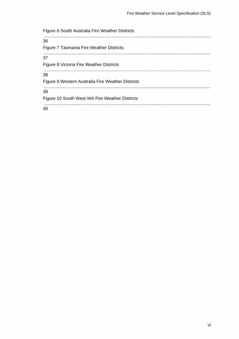
The purpose of the Service Level Specification (SLS) is to document the fire weather services provided by the Bureau of Meteorology (the Bureau). The Total Warning System1 recognises that a fully effective warning service is multi-faceted in nature and its development and operation involves input from several agencies each with specialised roles to play. It is vital that the agencies involved work in close cooperation through all stages of developing and operating the system. The services described here are the Bureau’s contribution to the Total Warning System for fire weather.
Figure 1 - Total Warning System
The Bureau’s role in the fire weather warning system is focussed on monitoring and prediction, message construction and communicating threats and impacts associated with weather conditions that influence fire behaviour to Government, industry, and the community. The Bureau also contributes to activities designed to strengthen organisational readiness and build community resilience and participates in the planning and coordination of activities with disaster mitigation agencies.
1 https://knowledge.aidr.org.au/media/5972/warnings-handbook.pdf, pg. 10
1 Introduction

Fire Weather Service Level Specification (SLS)
9
Scope
The scope of the SLS is the Bureau's publicly available fire weather services and additional services provided to support emergency management. The SLS details what the Bureau does and when it does it, to provide fire weather services. How the Bureau produces fire weather services is addressed in an internal Bureau document National Fire Weather Standard Operating Procedures (SOP).
Authority
The Meteorology Act, 1955 (Cth) gives the Bureau a number of functions including to take
observations, forecast the weather and issue warnings for weather conditions including those
likely to give rise to bush fires. The Intergovernmental Agreement on the Provision of Bureau
of Meteorology Hazard Services to the States and Territories (IGA) confirms the roles and
responsibilities of the Bureau and State and Territory governments and local governments.
The Bureau has responsibility for the provision of forecasting and warning services for weather
conditions likely to give rise to bush fires. The responsibility for bush fire preparation, response
and warning of bush fires lies with State and Territory governments and local governments.
The Schedule 2 of the IGA details the nationally agreed fire weather services.
The Bureau of Meteorology Fire Weather Service Level Specification is issued by the General
Manager Environmental Prediction Services under the authority of the Director of Meteorology.
Distribution
Table 1: National Fire Weather SLS Distribution List
National and State agencies
• Australasian Fire and Emergency Services Authorities Council (AFAC) – Predictive Services Group (PSG)
• Western Australia Department of Fire and Emergency Services (DFES)
• Western Australia Department of Biodiversity Conservation and Attractions, Parks and Wildlife Service (DBCA PWS)
• Queensland Fire and Emergency Services (QFES)
• Queensland Parks and Wildlife Service (QPWS)
• Queensland Inspector General Emergency Management
• Bushfires NT
• Northern Territory Police, Fire and Emergency Services (PFES)
• Emergency Management Australia (EMA)
• New South Wales Rural Fire Service (NSW RFS)
• Australian Capital Territory Emergency Services Authority (ACT ESA)
• Australian Capital Territory Rural Fire Service (ACT RFS)
• Australian Capital Territory Parks and Conservation (ACT PCS)
• South Australia Country Fire Service (CFS)
• Tasmania Fire Service
• Tasmania Parks and Wildlife Service
• Victoria Country Fire Authority (CFA)
• Emergency Management Victoria (EMV)
• Victoria Department of Environment, Land, Water and Planning (DELWP)
• Fire Rescue Victoria
• Victoria State Emergency Service
• Victoria Police

Fire Weather Service Level Specification (SLS)
10
The Bureau's fire weather services provide the Australian community and emergency management with essential fire weather forecasts and warnings that are timely and accurate. To do this, the Bureau has formed partnerships with emergency management organisations, other government authorities and media across the country to ensure that forecasts are fit-for-purpose and are broadly distributed in a timely manner.
The fire weather service is designed to inform the community and counter-disaster organisations of weather conditions that will lead to dangerous fire conditions and to manage fire in the landscape. An important secondary role is to assist local media and state or territory emergency services with public education programs, and to advise on meteorological aspects of fire weather disaster preparedness and planning.
Partnerships
Partnerships underpin the delivery of effective fire weather services to the Australian community. The Bureau has formed partnerships with emergency management organisations, other government authorities and media across the country to ensure that forecasts are fit-for-purpose and are broadly distributed in a timely manner. The partnerships with State and Territory Governments and local government are formalised through the IGA which clarifies and confirms responsibilities across the total warning system. Specifically, the Bureau, States and Territories agreed to work together to mutually develop and maintain national standards for warnings of bush fires and Fire Danger Ratings. State and Territory governments have responsibility for determination of Fire Danger Ratings using fuel load information determined by the jurisdictions and forecast weather provided by the Bureau.
2 National Fire Weather Services

Fire Weather Service Level Specification (SLS)
11
Fire Weather Season
The season of peak fire danger varies across the country due to different climatic zones. The
below figure broadly illustrates when peak fire danger occurs.
Routine fire weather products are issued during the local fire weather season as detailed in
Table 2. For those jurisdictions that do not issue fire weather products year-round, the dates
are indicative, the commencement and cessation of the service will be agreed between the
Bureau and local fire agencies on a season-by-season basis.
Table 2 Local fire weather season
State NSW/ACT NT Qld SA Tas Vic WA
Season Oct-Mar Year
round
Year
round
Oct-Apr Oct-
May
Nov-
Apr
Year
round
Area of Responsibility
The Bureau's fire weather services cover all Australian states, mainland territories and nearby offshore islands.
Dissemination of products
Publicly available Bureau fire weather products are transmitted via the Bureau's website and
app. Products for fire agencies are transmitted by email, registered user web services and
ftp.
Figure 2 Fire Danger seasons across Australia

Fire Weather Service Level Specification (SLS)
12
Briefing Services
The Bureau will provide briefings to Emergency Management partners to assist planning,
response, and coordination. The format, timing and frequency of briefings will be agreed
through Memorandum of Understanding (MOU) and Service Orders with each Emergency
Management agency.
Outposted Meteorologists
The Bureau has arrangements with several fire agencies to provide services through an outposted meteorologist to support operational awareness and communication. In each instance, the services provided will be agreed between the Bureau and the fire agency and are provided on a cost recovery basis.
Portable Automatic Weather Stations
The Bureau supports fire agencies by ingesting and displaying data from agency owned and
operated Portable Automatic Weather Stations (PAWS) into observational product suites.
Communication and adoption activities
In addition to issuing products through standard communication channels (e.g., website, app, email), the Bureau undertakes a range of complementary communication and adoption activities in partnership with emergency management agencies. These activities are aimed to increase the uptake and effectiveness of the forecasts and warnings and ensure consistent weather safety messages are provided to the community. This includes community and industry preparedness briefings, social media campaigns and the Bureau's Fire Weather Knowledge Centre web pages. During the season this extends to joint press conferences and media interviews, as well as continuing social media public safety campaigns and community and industry briefings.
Service Continuity
The Bureau maintains service continuity through its Business Continuity Plan. Most pertinent
to Fire Weather services is the built-in redundancy of being able to transfer operations
between offices as required.
To maintain service continuity, the Bureau uses a large and diverse range of observational
and forecast data in the delivery of its fire weather services. This provides redundancy if any
data source is unavailable during operations and ensures all products and services are
based on the best available information at all times.

Fire Weather Service Level Specification (SLS)
13
Hazard Services Forum
The IGA established the Hazards Services Forum (HSF) in 2018. The HSF facilitates consultation with State and Territory operational emergency service agencies to guide current and future strategic development of the Bureau of Meteorology’s hazard services. In particular, to enable the States and Territories to request and prioritise changes to the Standard Services and to refer services that could be considered Supplementary Services to the Bureau for consideration. The HSF also assist with the process of consulting on modifications to Services Schedules.
Performance Statistics and Reporting
All official forecast and warning products are verified against available observations and compiled into routine reports. Following fires that have had a significant impact on community safety and/or livelihoods, the Bureau may prepare a report on the meteorological aspects surrounding the event and forecast performance as part of its post event review process.
Post Event Review Management
The Bureau conducts an internal Post Event Review Management (PERM) process after fire events that have had a significant community or operational impact. The insights and recommendations gained from these post event reviews are used to improve processes, systems and services delivered by the Bureau. Depending on the impact from a fire event, the PERM process may include a debrief with external partners. Upon request, the Bureau also contributes to post incident reviews conducted by emergency services and government.
Forecaster Training and Competency
The Bureau delivers a fire weather training and competency-based assessment program for meteorologists. This program ensures that staff involved in analysing and forecasting fire weather have the qualifications, training and demonstrated ability to provide a high standard of fire weather services to the Australian community.
3 Quality Assurance and Performance
Fire Weather Service Level Specification (SLS)
14
Fire weather services provided by the Bureau utilise gridded forecast data covering the entire Australian domain. The service utilises several Fire Danger Indices and corresponding Fire Danger Ratings at point locations and at a District level. State and Territory fire agencies are responsible for providing the Bureau with fuel data (fuel curing and fuel load) to calculate forecast and observed fire danger indices. Detailed information on how the Fire Danger Indices and Ratings are determined is included in Appendix 1: Fire Danger Ratings and Fire Danger Indices. For a complete listing of Fire Weather Districts, see Appendix 2 Fire Weather District Maps. Unless otherwise noted, all issue times in this document are quoted as local time for the relevant jurisdiction and time of year.
4 National Fire Weather Product Schedule

Fire Weather Service Level Specification (SLS)
15
Routine Services
Australian Seasonal Bushfire Outlook
Commissioners and Chief Officers Strategic Committee (CCOSC) releases the Australian
Seasonal Bushfire Outlook quarterly. It is used by fire authorities to make strategic decisions for year-round fire management such as resource planning and prescribed fire management to reduce the negative impacts of bushfire. The Bureau contributes Recent Conditions and Climate Outlook information within a bushfire context to assist in the production of the Seasonal Bushfire Outlook.

Fire Weather Service Level Specification (SLS)
16
Australian Digital Forecast Database
The Bureau's Real-time Data Services provide tailored delivery of real-time Bureau of Meteorology products including datasets such as numerical output grids, satellite and radar data and web map service layers. Part of these services is the Australian Digital Forecast Database (ADFD) which includes grids that are relevant to Fire Weather, providing detailed forecast information across all States and mainland Territories. These grids are available all year round. The ADFD files are updated routinely twice per day at around 6am and 6pm local time and updated at other times as required. ADFD grids are not necessarily updated at the same time as other fire weather forecasts and warnings, as priority is given to updating the forecasts and warnings issued directly to the public through the media or web. Further details, including information on data bundles, can be found at http://reg.bom.gov.au/reguser/ or http://reg.bom.gov.au/catalogue/adfdUserGuide.pdf.

Fire Weather Service Level Specification (SLS)
17
Fire Danger Ratings
Purpose
A 4-day summary of Fire Danger Ratings for each Fire Weather District is provided to the
public for awareness of the extent to which weather conditions will enhance fire related risks,
and to assist with agency tactical planning. The Fire Danger Ratings are issued in
consultation with the fire agency.
Issue and Validity times
Issue times are summarised in Table 3 and the following validity applies for each product.
Fire Danger Ratings – 4 Day valid for the next 4 days when issued in the afternoon and valid
for the current day and following 3 days when issued in the morning.
Table 3 Fire Danger Ratings Issue Times (Local)
State Afternoon Issue Morning Issue
NSW/ACT 4:15 pm 5:05 am
NT 4:00 pm 5:00 am
QLD 4:00 pm n/a
SA 4:05 pm n/a
TAS 4:00 pm n/a
VIC 4:00 pm 5:30 am
WA 4:10 pm 4:35 am
The Fire Danger Ratings are available on the web at,
NSW: http://www.bom.gov.au/nsw/forecasts/fire-danger-ratings.shtml
NT: http://www.bom.gov.au/nt/forecasts/fire-danger-ratings.shtml
QLD: http://www.bom.gov.au/qld/forecasts/fire-danger-ratings.shtml
SA: http://www.bom.gov.au/sa/forecasts/fire-danger-ratings.shtml
TAS: http://www.bom.gov.au/tas/forecasts/fire-danger-ratings.shtml
VIC: http://www.bom.gov.au/vic/forecasts/fire-danger-ratings.shtml
WA: http://www.bom.gov.au/wa/forecasts/fire-danger-ratings.shtml

Fire Weather Service Level Specification (SLS)
18
Fire Weather Forecast
Purpose
The Fire Weather Forecast provides district level, and preselected point location information
to fire agencies of forecast weather parameters that are of greatest consequence to fire
ignition, suppression and behaviour.
Issue and Validity times
Fire Weather Forecasts are issued each afternoon during the Fire Weather season at the
times in Table 4. A separate product is issued for each of the following 4 days, with a
morning update for the current day issued in some states.
When more than 1% of the grid cells in a fire weather district exceed 50 MaxFDI, or at the
request of the fire agency, a preliminary issue for the following day will be provided to
agencies in the relevant state. In SA, a verbal briefing is provided to the State Duty
Commander by the embedded met or by the FHAQ EP team when the embedded met is not
on duty.
Table 4 Fire Weather Forecast Issue Times (Local)
State/Territory Preliminary Issue Afternoon Issue Morning Issue
NSW By 12:00 pm (if catastrophic
FDR forecast for Day 1),
otherwise by 2:00 pm
4:15 pm 6:00 am
ACT By 2:00 pm 4:00 pm 6:00 am
NT By 12:30pm 4:00 pm 5:30 am
QLD By 2:00 pm 4:00 pm n/a
SA 4:00 pm (Day 1)
4:30 pm (Days 2-4)
n/a
TAS By 12:00 pm 4:00 pm n/a
VIC By 12:30 pm 4:00 pm 6:30 am
WA By 12:00 pm 4:00 pm 4:30 am
Amendment Criteria for Fire Weather Forecasts and Warnings
Fire Weather Forecasts will be monitored and, in consultation with fire agencies, updated in accordance with the below criteria. If earlier than 11:30 am local time,
• New observance of FFDI or GFDI exceeding 50 Severe (or FFDI exceeding 38 Very High in Tasmania) for a period of 1 hour or more, and it is expected to persist for at least an hour, or high confidence of severe fire danger rating affecting more than 10%

Fire Weather Service Level Specification (SLS)
19
of the district for at least an hour (38 Very High in Tasmania) in place of a lower fire danger rating.
• New observance of FFDI exceeding 100 or GFDI exceeding 150 Catastrophic for a period of 1 hour or more and is expected to persist for at least an hour, or high confidence of catastrophic fire danger rating affecting more than 10% of the district for at least an hour in place of a lower fire danger rating.
• High confidence that previously forecast Catastrophic fire danger rating will not be met. This means that all grid points within the district must be below the catastrophic fire danger rating threshold.
• High confidence that previously forecast Severe (or 38 Very High in Tasmania) fire danger rating will not be met. This means that all grid points within the district must be below the severe (or 38 very high for Tasmania) fire danger rating threshold.
• A significantly earlier or later timing of a major wind change.
Fire Weather Forecasts for the current day will not be updated after 11:30am.
Content
• Date/Time
• District Summary, including. o Fire Danger Index o Fire Danger Rating o Percentage Coverage o Fire Weather Warning
• Text Forecast
• District Weather Elements, including. o TAL2 o cHaines3 o Probability Rain >5mm o 1500m Wind (km/h) o 3000m Wind (km/h) o Mixing Height (m)4
• Detailed District Forecast, including. o Fuel Type o District FDI o Percentage Coverage, Start Time, and duration for significant thresholds.
• Location Forecasts at Time of Maximum Fire Danger, including. o Time o Temperature
2 TAL (Thunderstorm Activity Level): A spatial forecast for thunderstorms. 0 for no thunderstorms, 1 for isolated thunderstorms, 2 for scattered thunderstorms, 3 for widespread thunderstorms. 3 cHaines: The continuous Haines Index (C-Haines) is a measure of the humidity and (in)stability of the atmosphere. The index ranges up to about 13 (very dry and unstable) but by definition has no specified lower bounds. C-Haines can link vertical atmospheric stability and humidity with erratic fire behaviour, potentially highlighting states where intensely burning fires have an increased probability of producing a significant convective column that could lead to long distance spotting and sudden changes in fire spread due to erratic local winds. 4 The height in metres above mean sea level to which the atmosphere is uniform with respect to heat energy.

Fire Weather Service Level Specification (SLS)
20
o Relative Humidity o Wind Direction Speed and Gust Strength o Fuel State Data o Wind Change Direction, Speed, Gust Strength and Timing
Notes
1. A suite of images providing a graphical overview of the Fire Weather Forecast are provided to agencies, displaying spatial and temporal variance in finer detail, see Appendix 4 for a full list of images. A subset of these images (labelled 'External') is available to the public via the Bureau's website.
2. In Western Australia and the Northern Territory, Fire Weather Forecasts are available to the public for Day 1 of the afternoon issue (current day of morning issue) via the Bureau's website.

Fire Weather Service Level Specification (SLS)
21
Fire Weather Bulletin
Purpose
The Fire Weather Bulletin displays real time weather observations and associated FDR/FDI
calculations along with the details of the maximum FDI observed since local midnight. It is
provided to Fire Agencies to assist with situational awareness and monitoring actual weather
conditions.
Content
• Update Time
• Explanatory notes
• Table of observations sorted by district summarising the following;
o Station
o Drought Factor (where applicable)
o Grass Curing
o Grass Load
o Current Observations
▪ Time
▪ Temperature
▪ Dew Point Temperature
▪ Relative Humidity
▪ Wind Direction
▪ Wind Speed
▪ Wind Gust
▪ Corresponding FDR/FDI
o Max FDI since local midnight (repeated for each relevant FDI in the state)
▪ Time
▪ Temperature
▪ Dew Point Temperature
▪ Relative Humidity
▪ Wind Direction
▪ Wind Speed
▪ Wind Gust
▪ Corresponding FDR/FDI
▪ Missing Data Flag

Fire Weather Service Level Specification (SLS)
22
Ground Moisture Data
The Bureau provides Ground Moisture Data to fire agencies to assist with strategic planning.
The data is calculated by applying dryness or drought indices to observational data and can
be viewed on registered user pages and is presented in tabular and/or graphical formats,
depending on the jurisdiction.
Fire Weather Service Level Specification (SLS)
23
Non-Routine Services
Fire Weather Warning
Purpose
The Bureau issues fire weather warnings to alert the community that weather conditions are likely to make the suppression or control of fires difficult.
Issue criteria, Times and Validity
Fire Weather Warnings for a district are issued when the District Fire Danger Rating is Severe or greater (see Appendix 1: Fire Danger Ratings and Fire Danger Indices). They are issued no later than 4:15pm in the afternoon for either the remainder of the current day and/or the following day, with a 5:00am morning update covering the remainder of the current day.
Amendment Criteria for Fire Weather Forecasts and Warnings
Fire Weather Warnings will be monitored and updated as needed at any time of day, in consultation with local fire agencies. See Section 4.1.4 Fire Weather Forecast for more detail on amendment criteria.
Content
• Issue time
• Weather Situation
• Validity time
• Fire Danger Rating and affected districts
• Community Alerts (referenced to Emergency Service Organisation)
• Next issue time
Notes
1. In Tasmania, Fire Weather Warnings will be issued when the District FDR/FDI is Very High/38 or greater
2. In consultation with fire agencies, some discretion can be applied for the issuance of a Fire Weather Warning when the FDI 50 / FDR Severe District Fire Danger Rating (FDI 38 / FDR Very High in Tasmania) criterion is not satisfied.

Fire Weather Service Level Specification (SLS)
24
Incident Weather Forecasts
Purpose
Incident Weather Forecasts (IWF) are site-specific forecasts issued to assist with tactical decision making in operations. IWF are only provided to designated fire agencies and are only provided for fire (uncontrolled fires/bushfires or prescribed/hazard reduction burns) or HAZMAT operations.
IWF Requests
IWF are requested by a designated fire agency through the Bureau's online IWF request system. Any subsequent issues of an IWF require additional requests to be submitted via the online request system. During periods of large request volumes, the Bureau's Fire Weather Meteorologists will liaise with the relevant fire agencies to clarify and prioritise forecast requirements.
Issue and Validity Times
For urgent requests, usually those associated with bushfires, the IWF is issued as soon as possible and within one hour of receiving the request. Otherwise, an IWF is issued in accordance with the requested (or agreed) forecast start time. IWF validity should be included in the request and can be 6hr, 12hr, 18hr, 24hr or 30hr from the forecast start time. If no validity period is included in the request, a 12hr forecast will be issued. An IWF request also has the option to include an outlook for up to 4 days ahead. A 4-day outlook will only be included when specifically requested (see notes below).
Amendment Criteria for Incident Weather Forecasts
IWF will be monitored and updated if one or more of the following criteria are observed and forecast to persist or there is an equivalent change in forecast conditions.
• Change in the likelihood of thunderstorms affecting the incident site.
• Change in the timing of a thunderstorm affecting the incident site.
• Change in the timing of a wind change by 1 hour or more.
• Change in temperature of 5 degrees, or agency specified temperature requirement.
• Change in dew point temperature of 5 degrees, or agency specified dew point temperature requirement.
• Change in relative humidity of 20, or agency specified relative humidity requirement.
• Change in wind speed of 20 km/h, or agency specified wind speed requirement.
• Change in wind direction of 45 degrees for wind speeds greater than 20 km/h, or agency specified wind speed requirement.
These criteria apply only to the validity period of an IWF, no amendments will be issued for changes to outlook days.
Content
• Incident Details, including o Issue Time o Incident Type o Forecast Location o Latitude/Longitude

Fire Weather Service Level Specification (SLS)
25
o Elevation (metres ASL) o Fuel Type o Form Number o Request Number o Fax Number o Contact Phone o Contact Name o Email
• Significant wind changes and uncertainties
• Thunderstorm potential, precipitation, cloud, and uncertainties
• Spatial variation of conditions and other important information
• Validity Time
• Fuel State Data
• Tabular details including o Local Time o Temperature o Dewpoint temperature o Relative Humidity o 10m Wind Direction, Speed and Gust Strength o 1000m AGL Wind Direction and Speed o FDI o Mixing Height o cHaines o TAL
• Notes on information in table
• Notes on taking observations and liaising with forecasters.
• 2m wind, 10m wind and Beaufort Scale conversion table The 4-day outlook component (if requested) includes.
• Text summary for each relevant day
• Fuel State and Precipitation data, including. o Fuel Type o FDI Type o Max Drought Factor o Max Curing Value o Max Grass Fuel Load o Precipitation in the previous 48 hours o Hours since precipitation at 00:00
• Tabular data at time of maximum fire danger and time of minimum fire danger, including.
o Time o Temperature o Dewpoint temperature o Relative Humidity o 10m Wind Direction, Speed and Gust Strength o 1000m AGL Wind Direction and Speed o FDI o Mixing Height MSL
• Daily summary of maximum cHaines, TAL, Probability of rain >5mm
Notes
1. After submitting a request through the online system fire agency staff are required to call the fire weather forecaster to confirm receipt of the request.

Fire Weather Service Level Specification (SLS)
26
2. In NSW, outlooks will be included by default for IWF with 1 day included for Hazard Reduction and 3 days for Wildfire or Section 44
3. In Queensland, South Australia, and Western Australia, the 4-day outlook can be requested as a separate product to the standard IWF.

Fire Weather Service Level Specification (SLS)
27
Wind Change Chart
Purpose
A Wind Change Chart is provided to fire agencies in New South Wales, South Australia, and Victoria to advise of the forecast time of a significant wind change to assist operations.
Issue criteria, Times and Validity
A Wind Change Chart service is issued on days when a significant, trackable synoptic wind change is expected and at least one district in the relevant state has a forecast District Fire Danger Index reaching the threshold in Table 5. The validity will be up to 15 hours. Forecasts will be reissued according to the frequency in Table 5 and cease when conditions no longer pose a significant threat to any ongoing fire.
Table 5 Wind Change Chart issue times (Local)
State/Territory District FDI Threshold First Issue Update frequency
NSW 25 8:30 am 6 hourly (see Notes)
SA 50 No later than 10am 3 hourly
Vic 35 When wind change is observed over the state
3 hourly
Amendment Criteria
If the position of the wind change is significantly different to the forecast position (defined as more than 1 hour faster or slower than forecast within the next 3 hours), or the difference is likely to impact fire agencies. In NSW the following criteria are used:
• For well-defined southerly changes over coastal areas if the revised timing is >1 hour faster/slower than previously forecast.
• For changes over the inland and ranges if the revised timing is >2 hours faster/slower than previously forecast.
Content
The Wind Change Chart consists of a graphic showing a recent observed location of the wind change and forecast locations of the wind change at 3 hour increments out to a maximum of 15 hours from the issue time, accompanied by supporting text.
Notes
1. Following consultation with fire agencies, the service may be activated when FDI triggers are not met. Typically, this would be when there are going fires of concern.
2. In South Australia, the criteria for issuing only applies to the southern half of the state. 3. On high end days (e.g. when the fire danger is expected to be Extreme or
Catastrophic), the wind change chart will be issued every three hours, with forecast change positions 12 hours ahead, until discussion with the fire agencies indicates that conditions no longer pose a threat
4. A Wind Change Chart will be issued if the change is crossing a district with Severe (or higher) rating, rather than any district in the state. For example, if the change only affects the southeast, but there is Severe ratings in the NE, a WCC would not be issued.

Fire Weather Service Level Specification (SLS)
28
Smoke Modelling
The Australian Smoke Dispersion System (ASDS) is available to fire agencies in New South
Wales and Victoria and is provided on a cost recovery basis. It combines bushfire, fuel
reduction burn and atmospheric data with weather and chemical transport models to
estimate the likely concentration and distribution of smoke at ground level from a range of
sources.
Features of the service include:
• Probabilities of FFDI/GFDI exceeding critical fire danger thresholds for the next 6 days.
• Point-specific ensemble fire weather information for the next 6 days for specified
locations at 3-hourly intervals.
• Gridded ventilation parameters for the next 3 days using an 11 km grid at 4-hourly
intervals.
• Gridded pollution forecasts for the next 3 days.
• Verification of hourly pollution from 21 EPA monitoring sites in Victoria.
• Gridded pollutions forecasts for the next 24 hours at hourly intervals for planned burn
sites, based on the size and fuel of the burn.
• Pollution forecasts for the next 24 hours at hourly intervals for specific locations.

Fire Weather Service Level Specification (SLS)
29
Grassland Fire Danger Index
The CSIRO-modified McArthur Mark 4 Grassland Fire Danger Meter. The specific
algorithm used is:
GFDI = expe(-1.523+1.027*ln(Q) - 0.009432*(100-C) 1.536 + 0.02764*T + 0.6422*(V) 0.5 -
0.2205*(RH) 0.5 )
Where:
GFDI = Grassland Fire Danger Index
Q = fuel quantity (t/ha)
C = degree of curing (%)
T = air temperature (°C)
V = 10-minute mean wind speed at 10 metres (km/h)
RH = relative humidity (%)
Curing is a measure of the percentage of dead material in a grassland environment. A
curing value of 0% represents totally green vegetation and 100% represents totally dry
vegetation.
Curing data and fuel quantity are determined by State and Territory fire agencies.
Forest Fire Danger Index
The McArthur Mark 5 Forest Danger Meter. The specific algorithm is:
FFDI = e^(ln(2)−0.45+0.987*ln(DF)−0.0345*RH+0.0338*T+0.0234*V
Where:
DF = Drought Factor (dimensionless number between 0 and 10)
T = air temperature (°C)
V = 10-minute mean wind speed at 10 metres (km/h)
For FFDI, the fuel component is the Drought Factor (DF).
The Drought Factor (DF) is a measure of the short-term dryness (or dryness of fine
fuels) in a forest. It estimates the proportion (in tenths) of the fine fuels (< 6mm) in a
forest that will burn in a fire. DF = 0 all fuels wet, no fires possible, DF = 5 half the fine
fuel will burn, DF = 10 all fuels dry and ready to burn, including peat and logs.
Drought Factor is derived from different indices for different parts of the country,
summarised in table 6.
5 Appendix 1: Fire Danger Ratings and Fire Danger Indices

Fire Weather Service Level Specification (SLS)
30
Table 6 Drought Index used in Drought Factor calculations
State/Territory Seasonal Drought Index
NSW Keetch-Byram Drought Index (KBDI)
NT n/a
QLD Keetch-Byram Drought Index (KBDI)
SA Mount Soil Dryness Index (MSDI)
TAS Mount Soil Dryness Index (MSDI)
VIC Keetch-Byram Drought Index (KBDI)
WA Keetch-Byram Drought Index (KBDI)
Both the Keetch-Byram Drought Index (KBDI) and Mount Soil Dryness Index (MSDI)
are measures of the long-term dryness (dryness of heavy fuels) of the forest. They
estimate the amount of rainfall (in mm) needed to saturate the soil profile. KBDI/MSDI
= 0 when the ground is saturated. KBDI/MSDI = 200 represents extremely dry
conditions or soil that is completely devoid of moisture.
Moorland Fire Danger
A Moisture Factor, Mf, is defined as: Mf = Hf + Rf,
Where Hf, Humidity Factor, is:
Hf = exp(1.660 + 0.0214*(relative humidity) – 0.0292*(dewpoint temperature))
And Rf, Rainfall Factor, is:
Rf = 67.128 * ( 1- exp(-3.132 * rain )) * exp(-0.0858 * (hours since rain))
Here, Rf is assumed to be: Rf = Rf_to_9am + Rf_since_9am
For implementation within the fire weather forecast system, the validity time for the
forecast is assumed to be 3pm, and (hours since rain) for Rf_to_9am is 6, while (hours
since rain) for Rf_since_9am is assumed 0.
This gives:
Rf_to_9am = 40.117 * (1 – exp(-3.132 * (rain 24 hours to 9am)))
Rf_since_9am = 67.128 * (1 – exp(-3.132 * (rain since 9am)))
The Productivity of a site, Prod, is either “low”, 1, or “medium”, 2. For fire weather
calculations, assume Prod = 2.
Windspeed for moorland calculations is the speed 2 metres above ground, assumed to
be 2/3 of the standard (forecast) 10 metre windspeed.
The probability of ignition, prob, of a fire is:
Prob = 1/(1 + exp(-(-1 + 0.68 * windspeed -0.07 * Mf +-0.0037 * windspeed * Mf + 2.10
* Prod)))

Fire Weather Service Level Specification (SLS)
31
If prob < 0.3, then the moorland FDI is set to 0, otherwise.
FDI = 0.65 * exp( 1.02 * ln( ROS)),
where ROS, the rate of spread of the fire, is:
ROS = 0.678 * exp( 1.312 * ln(windspeed)) * exp(-0.0243 * Mf) * (1 – exp(- 0.116*age))
Age here is the time since last burning and is assumed in the operational
implementation to be ten years. Thus, ROS becomes:
ROS = 0.678 * exp( 1.312 * ln( windspeed )) * exp(-0.0243 * Mf) * 0.687
Fire Danger Rating
Fire Danger Ratings are assigned according to the corresponding Fire Danger Index
values in Table 7.
Table 7 Fire Danger Indices and corresponding Fire Danger Ratings
Rating GFDI FFDI Moorland FDI
Low/Moderate 0-11 0-11 0-11
High 12-24 12-24 12-24
Very High 25-49 25-49 25-49
Severe 50-99 50-74 50-74
Extreme 100-149 75-99 75-99
Catastrophic 150+ 100+ 100+
Notes
1. In Western Australia High is 12-31 for both GFDI and FFDI. Very High is 32-49 for both GFDI and FFDI.
2. In Western Australia Severe is 50-74, Extreme 75-99 and Catastrophic is 100+ for GFDI. 3. In Victoria, Catastrophic is known as Code Red and the Emergency Management
Commissioner determines whether a Code Red is determined for GFDI values 150+ and FFDI values 100+. A Code Red may also be declared based on other criteria such as the number of going fires
Determining District Fire Danger Rating
1) Fire Danger Indices are calculated according to the relevant FDI formulas for each forecast grid cell at hourly time intervals.
2) The Maximum FDI (MaxFDI) across each day is determined for each grid cell, according to the relevant fuel type (as advised by local fire agencies).
3) The Maximum FDR is determined for each grid cell based on the MaxFDI, corresponding FDR and relevant fuel type.
4) The highest Maximum FDR met or exceeded by at least 10% of grid cells in a district determines the Fire Danger Rating for that District.
5) The local Hazard Management Agency (HMA) responsible for fire weather has absolute discretion to vary the District Fire Danger Rating from the value

Fire Weather Service Level Specification (SLS)
32
determined by this method. Liaison arrangements between the Bureau and agencies for the final determination of District Fire Danger Ratings are agreed to at a local level.

Fire Weather Service Level Specification (SLS)
33
6 Appendix 2 Fire Weather District Maps
Figure 3 New South Wales Fire Weather Districts

Fire Weather Service Level Specification (SLS)
34
Figure 4 Northern Territory Fire Weather Districts

Fire Weather Service Level Specification (SLS)
35
Figure 5 Queensland Fire Weather Districts

Fire Weather Service Level Specification (SLS)
36
Figure 6 South Australia Fire Weather Districts

Fire Weather Service Level Specification (SLS)
37
Figure 7 Tasmania Fire Weather Districts

Fire Weather Service Level Specification (SLS)
38
Figure 8 Victoria Fire Weather Districts

Fire Weather Service Level Specification (SLS)
39
Figure 9 Western Australia Fire Weather Districts

Fire Weather Service Level Specification (SLS)
40
Figure 10 South West WA Fire Weather Districts
Fire Weather Service Level Specification (SLS)
41
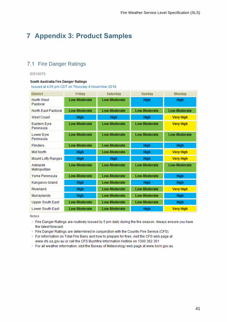
Fire Danger Ratings
7 Appendix 3: Product Samples

Fire Weather Service Level Specification (SLS)
42
Fire Weather Forecast

Fire Weather Service Level Specification (SLS)
43

Fire Weather Service Level Specification (SLS)
44

Fire Weather Service Level Specification (SLS)
45

Fire Weather Service Level Specification (SLS)
46
Fire Weather Warning

Fire Weather Service Level Specification (SLS)
47
Incident Weather Forecast

Fire Weather Service Level Specification (SLS)
48

Fire Weather Service Level Specification (SLS)
49

Fire Weather Service Level Specification (SLS)
50

Fire Weather Service Level Specification (SLS)
51
Wind Change Chart

Fire Weather Service Level Specification (SLS)
52
Table 8 Product ID and description for text-based forecasts
Product ID Description
Fire Weather Forecasts for NSW
IDN10017 Day 0/1 Preliminary Forecast
IDN10018 Day 0/1 Forecast
IDN10020 Day 1/2 Outlook
IDN10021 Day 2/3 Outlook
IDN10022 Day 3/4 Outlook
Fire Weather Forecasts for ACT
IDN29199 Day 0/1 Preliminary Forecast
IDN29200 Day 0/1 Forecast
IDN29201 Day 1/2 Outlook
IDN29202 Day 2/3 Outlook
IDN29203 Day 3/4 Outlook
Fire Danger Ratings NSW/ACT
IDN65068 1 Day
IDN10016 4 Days
Warnings NSW/ACT
IDN22000 NSW Fire Weather Warning 1
IDN22001 NSW Fire Weather Warning 2
IDN22200 ACT Fire Weather Warning
Wind Change Chart NSW/ACT
IDN65171 Frontal Analysis Chart
IDN65233 Frontal Analysis Chart – Landscape
Incident Weather Forecasts NSW/ACT
IDN30100 Incident Weather Forecast 1
IDN30200 Incident Weather Forecast 2
IDN30300 Incident Weather Forecast 3
IDN30400 Incident Weather Forecast 4
IDN30500 Incident Weather Forecast 5
IDN30600 Incident Weather Forecast 6
IDN30700 Incident Weather Forecast 7
IDN30800 Incident Weather Forecast 8
IDN30900 Incident Weather Forecast 9
IDN31000 Incident Weather Forecast 10
IDN31100 Incident Weather Forecast 11
IDN31200 Incident Weather Forecast 12
IDN31300 Incident Weather Forecast 13
8 Appendix 4: Product Identifiers

Fire Weather Service Level Specification (SLS)
53
IDN31400 Incident Weather Forecast 14
IDN31500 Incident Weather Forecast 15
IDN31600 Incident Weather Forecast 16
IDN31700 Incident Weather Forecast 17
IDN31800 Incident Weather Forecast 18
IDN31900 Incident Weather Forecast 19
IDN32000 Incident Weather Forecast 20
IDN32100 Incident Weather Forecast 21
IDN32200 Incident Weather Forecast 22
IDN32300 Incident Weather Forecast 23
IDN32400 Incident Weather Forecast 24
IDN32500 Incident Weather Forecast 25
IDN32600 Incident Weather Forecast 26
IDN32700 Incident Weather Forecast 27
IDN32800 Incident Weather Forecast 28
IDN32900 Incident Weather Forecast 29
IDN33000 Incident Weather Forecast 30
IDN33100 Incident Weather Forecast 31
IDN33200 Incident Weather Forecast 32
IDN33300 Incident Weather Forecast 33
IDN33400 Incident Weather Forecast 34
IDN33500 Incident Weather Forecast 35
IDN33600 Incident Weather Forecast 36
IDN33700 Incident Weather Forecast 37
IDN33800 Incident Weather Forecast 38
IDN33900 Incident Weather Forecast 39
IDN34000 Incident Weather Forecast 40
IDN34100 Incident Weather Forecast 41
IDN34200 Incident Weather Forecast 42
IDN34300 Incident Weather Forecast 43
IDN34400 Incident Weather Forecast 44
IDN34500 Incident Weather Forecast 45
IDN34600 Incident Weather Forecast 46
IDN34700 Incident Weather Forecast 47
IDN34800 Incident Weather Forecast 48
IDN34900 Incident Weather Forecast 49
IDN35000 Incident Weather Forecast 50
Fire Weather Bulletin NSW/ACT
IDN60036 Fire Weather Bulletin
Fire Weather Forecasts NT
IDD10720 Day 0/1 Preliminary Forecast
IDD10721 Day 0/1 Forecast
IDD10722 Day 1/2 Outlook
IDD10723 Day 2/3 Outlook
IDD10724 Day 3/4 Outlook

Fire Weather Service Level Specification (SLS)
54
Fire Danger Ratings NT
IDD10730 1 Day
IDD10731 4 Days
Warnings NT
IDD20320 Fire Weather Warning 1
IDD20330 Fire Weather Warning 2
Incident Weather Forecasts NT
IDD20340 Incident Weather Forecast 1
IDD20341 Incident Weather Forecast 2
IDD20342 Incident Weather Forecast 3
IDD20343 Incident Weather Forecast 4
IDD20344 Incident Weather Forecast 5
IDD20345 Incident Weather Forecast 6
IDD20346 Incident Weather Forecast 7
IDD20347 Incident Weather Forecast 8
IDD20348 Incident Weather Forecast 9
IDD20349 Incident Weather Forecast 10
IDD20351 Incident Weather Forecast 11
IDD20352 Incident Weather Forecast 12
IDD20353 Incident Weather Forecast 13
IDD20354 Incident Weather Forecast 14
IDD20355 Incident Weather Forecast 15
IDD20356 Incident Weather Forecast 16
IDD20357 Incident Weather Forecast 17
IDD20358 Incident Weather Forecast 18
IDD20359 Incident Weather Forecast 19
IDD20360 Incident Weather Forecast 20
Fire Weather Bulletin NT
IDD65015 Fire Weather Bulletin
Fire Weather Forecasts QLD
IDQ13014 Day 0/1 Preliminary Forecast
IDQ13010 Day 0/1 Forecast
IDQ13011 Day 1/2 Outlook
IDQ13012 Day 2/3 Outlook
IDQ13013 Day 3/4 Outlook
Fire Danger Ratings QLD
IDQ13015 Fire Danger Ratings 1 Day
IDQ13016 Fire Danger Ratings 4 Days
Warnings QLD
IDQ20035 Fire Weather Warning 1
IQD20036 Fire Weather Warning 2
Incident Weather Forecasts QLD
IDQ20100 Incident Weather Forecast 1
IDQ20101 Incident Weather Forecast 2

Fire Weather Service Level Specification (SLS)
55
IDQ20102 Incident Weather Forecast 3
IDQ20103 Incident Weather Forecast 4
IDQ20104 Incident Weather Forecast 5
IDQ20105 Incident Weather Forecast 6
IDQ20106 Incident Weather Forecast 7
IDQ20107 Incident Weather Forecast 8
IDQ20108 Incident Weather Forecast 9
IDQ20109 Incident Weather Forecast 10
IDQ20110 Incident Weather Forecast 11
IDQ20111 Incident Weather Forecast 12
IDQ20112 Incident Weather Forecast 13
IDQ20113 Incident Weather Forecast 14
IDQ20114 Incident Weather Forecast 15
IDQ20115 Incident Weather Forecast 16
IDQ20116 Incident Weather Forecast 17
IDQ20117 Incident Weather Forecast 18
IDQ20118 Incident Weather Forecast 19
IDQ20119 Incident Weather Forecast 20
Incident Weather 4 Day Forecasts QLD
IDQ20140 Incident Weather 4 Day Forecast 1
IDQ20141 Incident Weather 4 Day Forecast 2
IDQ20142 Incident Weather 4 Day Forecast 3
IDQ20143 Incident Weather 4 Day Forecast 4
IDQ20144 Incident Weather 4 Day Forecast 5
IDQ20145 Incident Weather 4 Day Forecast 6
IDQ20146 Incident Weather 4 Day Forecast 7
IDQ20147 Incident Weather 4 Day Forecast 8
IDQ20148 Incident Weather 4 Day Forecast 9
IDQ20149 Incident Weather 4 Day Forecast 10
IDQ20150 Incident Weather 4 Day Forecast 11
IDQ20151 Incident Weather 4 Day Forecast 12
IDQ20152 Incident Weather 4 Day Forecast 13
IDQ20153 Incident Weather 4 Day Forecast 14
IDQ20154 Incident Weather 4 Day Forecast 15
IDQ20155 Incident Weather 4 Day Forecast 16
IDQ20156 Incident Weather 4 Day Forecast 17
IDQ20157 Incident Weather 4 Day Forecast 18
IDQ20158 Incident Weather 4 Day Forecast 19
IDQ20159 Incident Weather 4 Day Forecast 20
Fire Weather Bulletin QLD
IDQ60130 Fire Weather Bulletin
Fire Weather Forecasts SA
IDS65310 Day 0/1 Preliminary Forecast
IDS65006 Day 0/1 Forecast
IDS65307 Day 1/2 Outlook

Fire Weather Service Level Specification (SLS)
56
IDS65308 Day 2/3 Outlook
IDS65309 Day 3/4 Outlook
Fire Danger Ratings SA
IDS10069 1 Day
IDS10070 4 Day
Warnings SA
IDS20290 Fire Weather Warning 1
IDS20299 Fire Weather Warning 2
Wind Change Chart SA
IDS20310 Severe Wx Front/Wind Change Forecast Map
Incident Weather Forecasts SA
IDS20311 Incident Weather Forecast 1
IDS20312 Incident Weather Forecast 2
IDS20313 Incident Weather Forecast 3
IDS20314 Incident Weather Forecast 4
IDS20315 Incident Weather Forecast 5
IDS20316 Incident Weather Forecast 6
IDS20317 Incident Weather Forecast 7
IDS20318 Incident Weather Forecast 8
IDS20319 Incident Weather Forecast 9
IDS20320 Incident Weather Forecast 10
IDS20330 Incident Weather Forecast 11
IDS20331 Incident Weather Forecast 12
IDS20332 Incident Weather Forecast 13
IDS20333 Incident Weather Forecast 14
IDS20334 Incident Weather Forecast 15
IDS20335 Incident Weather Forecast 16
IDS20336 Incident Weather Forecast 17
IDS20337 Incident Weather Forecast 18
IDS20338 Incident Weather Forecast 19
IDS20339 Incident Weather Forecast 20
Incident Weather 4 Day Forecasts SA
IDS20321 Incident Weather 4 Day Forecast 1
IDS20322 Incident Weather 4 Day Forecast 2
IDS20323 Incident Weather 4 Day Forecast 3
IDS20324 Incident Weather 4 Day Forecast 4
IDS20325 Incident Weather 4 Day Forecast 5
IDS20326 Incident Weather 4 Day Forecast 6
IDS20327 Incident Weather 4 Day Forecast 7
IDS20328 Incident Weather 4 Day Forecast 8
IDS20329 Incident Weather 4 Day Forecast 9
IDS20343 Incident Weather 4 Day Forecast 10
Fire Weather Bulletin SA
IDS60086 Fire Weather Bulletin

Fire Weather Service Level Specification (SLS)
57
Fire Weather Forecasts TAS
IDT13134 Day 0/1 Preliminary Forecast
IDT13130 Day 0/1 Forecast
IDT13131 Day 1/2 Outlook
IDT13132 Day 2/3 Outlook
IDT13133 Day 3/4 Outlook
Fire Danger Ratings TAS
IDT13151 4 Days
IDT13150 1 Day
Warnings TAS
IDT31100 Fire Weather Warning 1
IDT31200 Fire Weather Warning 2
Incident Weather Forecasts TAS
IDT31000 Incident Weather Forecast 1
IDT31005 Incident Weather Forecast 2
IDT31010 Incident Weather Forecast 3
IDT31015 Incident Weather Forecast 4
IDT31020 Incident Weather Forecast 5
IDT31025 Incident Weather Forecast 6
IDT31030 Incident Weather Forecast 7
IDT31035 Incident Weather Forecast 8
IDT31040 Incident Weather Forecast 9
IDT31045 Incident Weather Forecast 10
IDT31050 Incident Weather Forecast 11
IDT31055 Incident Weather Forecast 12
IDT31060 Incident Weather Forecast 13
IDT31065 Incident Weather Forecast 14
IDT31070 Incident Weather Forecast 15
IDT31075 Incident Weather Forecast 16
IDT31080 Incident Weather Forecast 17
IDT31085 Incident Weather Forecast 18
IDT31090 Incident Weather Forecast 19
IDT31095 Incident Weather Forecast 20
Fire Weather Bulletin TAS
IDT60011 Fire Weather Bulletin
Fire Weather Forecasts VIC
IDV22010 Day 0/1 Preliminary Forecast
IDV18560 Day 0/1 Forecast
IDV18570 Day 1/2 Outlook
IDV18580 Day 2/3 Outlook
IDV18590 Day 3/4 Outlook
Fire Danger Ratings VIC
IDV18550 1 Day

Fire Weather Service Level Specification (SLS)
58
IDV18555 4 Days
Warnings VIC
IDV22000 Fire Weather Warning 1
IDV22001 Fire Weather Warning 2
Wind Change Chart VIC
IDV65059 Forecast Wind Change Chart for Victoria
Incident Weather Forecasts VIC
IDV31050 Incident Weather Forecast 1
IDV31150 Incident Weather Forecast 2
IDV31250 Incident Weather Forecast 3
IDV31350 Incident Weather Forecast 4
IDV31450 Incident Weather Forecast 5
IDV31550 Incident Weather Forecast 6
IDV31650 Incident Weather Forecast 7
IDV31750 Incident Weather Forecast 8
IDV31760 Incident Weather Forecast 9
IDV31770 Incident Weather Forecast 10
IDV31780 Incident Weather Forecast 11
IDV31790 Incident Weather Forecast 12
IDV31800 Incident Weather Forecast 13
IDV31810 Incident Weather Forecast 14
IDV31820 Incident Weather Forecast 15
IDV31830 Incident Weather Forecast 16
IDV31840 Incident Weather Forecast 17
IDV31850 Incident Weather Forecast 18
IDV31860 Incident Weather Forecast 19
IDV31870 Incident Weather Forecast 20
Fire Weather Bulletin VIC
IDV60236 Fire Weather Bulletin
Fire Weather Forecasts for Southwest Land Division WA
IDW15230 Day 0/1 Preliminary Forecast
IDW15000 Day 0/1 Forecast
IDW15200 Day 1/2 Outlook
IDW15210 Day 2/3 Outlook
IDW15220 Day 3/4 Outlook
Fire Weather Forecasts for Central and Eastern WA
IDW15540 Day 0/1 Preliminary Forecast
IDW15500 Day 0/1 Forecast
IDW15510 Day 1/2 Outlook
IDW15520 Day 2/3 Outlook
IDW15530 Day 3/4 Outlook
Fire Weather Forecasts for Northern WA
IDW15340 Day 0/1 Preliminary Forecast
IDW15300 Day 0/1 Forecast
IDW15310 Day 1/2 Outlook

Fire Weather Service Level Specification (SLS)
59
IDW15320 Day 2/3 Outlook
IDW15330 Day 3/4 Outlook
Fire Danger Ratings WA
IDW13050 1 Day
IDW15100 4 Day
Warnings WA
IDW30000 Fire Weather Warning 1
IDW30100 Fire Weather Warning 2
IDW38900 Fire Weather Warning 3
Incident Weather Forecasts WA
IDW30500 Incident Weather Forecast 1
IDW30600 Incident Weather Forecast 2
IDW30700 Incident Weather Forecast 3
IDW30800 Incident Weather Forecast 4
IDW30900 Incident Weather Forecast 5
IDW31000 Incident Weather Forecast 6
IDW31100 Incident Weather Forecast 7
IDW31200 Incident Weather Forecast 8
IDW31250 Incident Weather Forecast 9
IDW31260 Incident Weather Forecast 10
IDW31400 Incident Weather Forecast 11
IDW31500 Incident Weather Forecast 12
IDW31600 Incident Weather Forecast 13
IDW31700 Incident Weather Forecast 14
IDW31800 Incident Weather Forecast 15
IDW31900 Incident Weather Forecast 16
IDW32000 Incident Weather Forecast 17
IDW32050 Incident Weather Forecast 18
IDW32060 Incident Weather Forecast 19
IDW32070 Incident Weather Forecast 20
IDW32080 Incident Weather Forecast 21
IDW32090 Incident Weather Forecast 22
IDW32100 Incident Weather Forecast 23
IDW32110 Incident Weather Forecast 24
IDW32120 Incident Weather Forecast 25
IDW32130 Incident Weather Forecast 26
IDW32140 Incident Weather Forecast 27
IDW32150 Incident Weather Forecast 28
IDW32160 Incident Weather Forecast 29
IDW32170 Incident Weather Forecast 30
IDW32172 Incident Weather Forecast 32
IDW32173 Incident Weather Forecast 33
IDW32174 Incident Weather Forecast 34
IDW32175 Incident Weather Forecast 35
IDW32176 Incident Weather Forecast 36

Fire Weather Service Level Specification (SLS)
60
IDW32177 Incident Weather Forecast 37
IDW32178 Incident Weather Forecast 38
IDW32179 Incident Weather Forecast 39
IDW32180 Incident Weather Forecast 40
Incident Weather 4 Day Forecasts WA
IDW32200 Incident Weather 4 Day Forecast 1
IDW32210 Incident Weather 4 Day Forecast 2
IDW32220 Incident Weather 4 Day Forecast 3
IDW32230 Incident Weather 4 Day Forecast 4
IDW32240 Incident Weather 4 Day Forecast 5
IDW32250 Incident Weather 4 Day Forecast 6
IDW32260 Incident Weather 4 Day Forecast 7
IDW32270 Incident Weather 4 Day Forecast 8
IDW32280 Incident Weather 4 Day Forecast 9
IDW32290 Incident Weather 4 Day Forecast 10
IDW32300 Incident Weather 4 Day Forecast 11
IDW32310 Incident Weather 4 Day Forecast 12
IDW32320 Incident Weather 4 Day Forecast 13
IDW32330 Incident Weather 4 Day Forecast 14
IDW32340 Incident Weather 4 Day Forecast 15
IDW32350 Incident Weather 4 Day Forecast 16
IDW32360 Incident Weather 4 Day Forecast 17
IDW32370 Incident Weather 4 Day Forecast 18
IDW32380 Incident Weather 4 Day Forecast 19
IDW32390 Incident Weather 4 Day Forecast 20
Fire Weather Bulletin WA
IDW60018 Fire Weather Bulletin

Fire Weather Service Level Specification (SLS)
61
Table 9 Product ID and descriptions of complementary graphics
Product ID Description
Fire Weather Outlook Images - Internal NSW/ACT
IDN65319 Preliminary Hours FDI > 50 Day 0/1
IDN65320 Day 0/1 Hours FDI > 50
IDN65321 Day 1/2 Hours FDI > 50
IDN65322 Day 2/3 Hours FDI > 50
IDN65323 Day 3/4 Hours FDI > 50
Fire Weather Outlook Images NSW/ACT
IDN65309 Max Fire Danger - Preliminary Day 0/1
IDN65310 Max Fire Danger - Day 0/1
IDN65311 Max Fire Danger - Day 1/2
IDN65312 Max Fire Danger - Day 2/3
IDN65313 Max Fire Danger - Day 3/4
Fire Weather Outlook Images - External NSW/ACT
IDN65406 Max Forest FDI - Day 0/1
IDN65334 Max Grassland FDI - Day 0/1
Fire Weather Outlook Images NT
IDD65445 Max Grassland FDI - Preliminary Day 0/1
IDD65421 Max Grassland FDI - Day 0/1
IDD65422 Max Grassland FDI - Day 1/2
IDD65423 Max Grassland FDI - Day 2/3
IDD65424 Max Grassland FDI - Day 3/4
IDD65435 Hours GFDI Above 50 - Preliminary Day 0/1
IDD65431 Hours GFDI Above 50 - Day 0/1
IDD65432 Hours GFDI Above 50 - Day 1/2
IDD65433 Hours GFDI Above 50 - Day 2/3
IDD65434 Hours GFDI Above 50 - Day 3/4
Fire Weather Outlook Images - External NT
IDD65446 Max Grassland FDI - Day 0/1
Fire Weather Outlook Images QLD
IDQ65505 Max Forest FDI - Preliminary Day 0/1
IDQ65501 Max Forest FDI - Day 0/1
IDQ65502 Max Forest FDI - Day 1/2
IDQ65503 Max Forest FDI - Day 2/3
IDQ65504 Max Forest FDI - Day 3/4
IDQ65515 Hours FFDI Above 50 - Preliminary Day 0/1
IDQ65511 Hours FFDI Above 50 - Day 0/1
IDQ65512 Hours FFDI Above 50 - Day 1/2
IDQ65513 Hours FFDI Above 50 - Day 2/3
IDQ65514 Hours FFDI Above 50 - Day 3/4
IDQ65525 Max Grassland FDI - Preliminary Day 0/1
IDQ65521 Max Grassland FDI - Day 0/1
IDQ65522 Max Grassland FDI - Day 1/2
IDQ65523 Max Grassland FDI - Day 2/3

Fire Weather Service Level Specification (SLS)
62
IDQ65524 Max Grassland FDI - Day 3/4
IDQ65535 Hours GFDI Above 50 - Preliminary Day 0/1
IDQ65531 Hours GFDI Above 50 - Day 0/1
IDQ65532 Hours GFDI Above 50 - Day 1/2
IDQ65533 Hours GFDI Above 50 - Day 2/3
IDQ65534 Hours GFDI Above 50 - Day 3/4
IDQ65539 Max Fire Danger Index - Preliminary Day 0/1
IDQ65540 Max Fire Danger Index - Day 0/1
IDQ65541 Max Fire Danger Index - Day 1/2
IDQ65542 Max Fire Danger Index - Day 2/3
IDQ65543 Max Fire Danger Index - Day 3/4
Fire Weather Outlook Images - External QLD
IDQ65506 Max Forest FDI - Day 0/1
IDQ65526 Max Grassland FDI - Day 0/1
Fire Weather Outlook Images SA
IDS65421 Day 0/1 Max GFDI
IDS65422 Day 1/2 Max GFDI
IDS65423 Day 2/3 Max GFDI
IDS65424 Day 3/4 Max GFDI
IDS65425 Preliminary Day 0/1 Max GFDI
IDS65401 Day 0/1 Max FFDI
IDS65406 Max Forest Fire Danger Day 0/1 External
IDS65402 Day 1/2 Max FFDI
IDS65403 Day 2/3 Max FFDI
IDS65404 Day 3/4 Max FFDI
IDS65405 Preliminary Day 0/1 Max FFDI
IDS65431 Day 0/1 Max GFDI Hrs > 50
IDS65432 Day 1/2 Max GFDI Hrs > 50
IDS65433 Day 2/3 Max GFDI Hrs > 50
IDS65434 Day 3/4 Max GFDI Hrs > 50
IDS65435 Preliminary Day 0/1 Max GFDI Hrs > 50
IDS65411 Day 0/1 Max FFDI Hours > 50
IDS65412 Day 1/2 Max FFDI Hrs > 50
IDS65426 Max Grassland FDI - Day 0/1 External
IDS65413 Day 2/3 Max FFDI Hrs > 50
IDS65414 Day 3/4 Max FFDI Hrs > 50
IDS65415 Preliminary Day 0/1 MaxFFDI Hrs > 50
Fire Weather Outlook Images TAS
IDT65425 Max Moorland FDI - Preliminary Day 0/1
IDT65421 Max Moorland FDI - Day 0/1
IDT65422 Max Moorland FDI - Day 1/2
IDT65423 Max Moorland FDI - Day 2/3
IDT65424 Max Moorland FDI - Day 3/4
IDT65435 Hours MFDI Above 25 - Preliminary Day 0/1
IDT65431 Hours MFDI Above 25 - Day 0/1

Fire Weather Service Level Specification (SLS)
63
IDT65432 Hours MFDI Above 25 - Day 1/2
IDT65433 Hours MFDI Above 25 - Day 2/3
IDT65434 Hours MFDI Above 25 - Day 3/4
IDT65405 Max Forest FDI - Preliminary Day 0/1
IDT65401 Max Forest FDI - Day 0/1
IDT65402 Max Forest FDI - Day 1/2
IDT65403 Max Forest FDI - Day 2/3
IDT65404 Max Forest FDI - Day 3/4
IDT65415 Hours FFDI Above 25 - Preliminary Day 0/1
IDT65411 Hours FFDI Above 25 - Day 0/1
IDT65412 Hours FFDI Above 25 - Day 1/2
IDT65413 Hours FFDI Above 25 - Day 2/3
IDT65414 Hours FFDI Above 25 - Day 3/4
IDT65441 Max Grass FDI - Day 0/1
IDT65442 Max Grass FDI - Day 1/2
IDT65443 Max Grass FDI - Day 2/3
IDT65444 Max Grass FDI - Day 3/4
IDT65445 Max Grass FDI - Preliminary Day 0/1
IDT65450 Hours GFDI Above 25 - Day 0/1
IDT65451 Hours GFDI Above 25 - Day 1/2
IDT65452 Hours GFDI Above 25 - Day 2/3
IDT65453 Hours GFDI Above 25 - Day 3/4
IDT65454 Hours GFDI Above 25 - Preliminary Day 0/1
Fire Weather Outlook Images - External TAS
IDT65426 Max Moorland FDI - Day 0/1
IDT65406 Max Forest FDI - Day 0/1
IDT65446 Max Grass FDI - Day 0/1
Fire Weather Outlook Images VIC
IDV65401 Day 0/1 Max Forest FDI
IDV65411 Day 0/1 Hours FFDI > 50
IDV65402 Day 1/2 Max Forest FDI
IDV65412 Day 1/2 Hours FFDI > 50
IDV65403 Day 2/3 Max Forest FDI
IDV65413 Day 2/3 Hours FFDI > 50
IDV65404 Day 3/4 Max Forest FDI
IDV65414 Day 3/4 Hours FFDI > 50
IDV65421 Day 0/1 Max Grassland FDI
IDV65431 Day 0/1 Hours GFDI > 50
IDV65422 Day 1/2 Max Grassland FDI
IDV65432 Day 1/2 Hours GFDI > 50
IDV65423 Day 2/3 Max Grassland FDI
IDV65433 Day 2/3 Hours GFDI > 50
IDV65424 Day 3/4 Max Grassland FDI
IDV65434 Day 3/4 Hours GFDI > 50
Fire Weather Outlook Images - External VIC

Fire Weather Service Level Specification (SLS)
64
IDV65406 Max Forest FDI - Day 0/1
IDV65426 Max Grassland FDI - Day 0/1
Fire Weather Outlook Images WA
IDW65309 Max Fire Danger - Preliminary Day 0/1
IDW65310 Max Fire Danger - Day 0/1
IDW65311 Max Fire Danger - Day 1/2
IDW65312 Max Fire Danger - Day 2/3
IDW65313 Max Fire Danger - Day 3/4
Fire Weather Outlook Images for Northern WA
IDW65425 Max Grassland FDI - Preliminary Day 0/1
IDW65421 Max Grassland FDI - Day 0/1
IDW65422 Max Grassland FDI - Day 1/2
IDW65423 Max Grassland FDI - Day 2/3
IDW65424 Max Grassland FDI - Day 3/4
IDW65435 Hours GFDI Above 32 - Preliminary Day 0/1
IDW65431 Hours GFDI Above 32 - Day 0/1
IDW65432 Hours GFDI Above 32 - Day 1/2
IDW65433 Hours GFDI Above 32 - Day 2/3
IDW65434 Hours GFDI Above 32 - Day 3/4
IDW65445 Hours GFDI Above 50 - Preliminary Day 0/1
IDW65441 Hours GFDI Above 50 - Day 0/1
IDW65442 Hours GFDI Above 50 - Day 1/2
IDW65443 Hours GFDI Above 50 - Day 2/3
IDW65444 Hours GFDI Above 50 - Day 3/4
IDW65465 Max Forest FDI - Preliminary Day 0/1
IDW65461 Max Forest FDI - Day 0/1
IDW65462 Max Forest FDI - Day 1/2
IDW65463 Max Forest FDI - Day 2/3
IDW65464 Max Forest FDI - Day 3/4
IDW65475 Max FFDI Hours > 32 - Preliminary Day 0/1
IDW65471 Max Forest FDI Hours > 32 - Day 0/1
IDW65472 Max Forest FDI Hours > 32 - Day 1/2
IDW65473 Max Forest FDI Hours > 32 - Day 2/3
IDW65474 Max Forest FDI Hours > 32 - Day 3/4
IDW65485 Max FFDI Hours > 50 - Preliminary Day 0/1
IDW65481 Max Forest FDI Hours > 50 - Day 0/1
IDW65482 Max Forest FDI Hours > 50 - Day 1/2
IDW65483 Max Forest FDI Hours > 50 - Day 2/3
IDW65484 Max Forest FDI Hours > 50 - Day 3/4
Fire Weather Outlook Images for Northern WA - External
IDW65451 Max Grassland FDI - Day 0/1
IDW65491 Max Forest FDI - Day 0/1
Fire Weather Outlook Images for Southern WA
IDW65430 Max Grassland FDI - Preliminary Day 0/1
IDW65426 Max Grassland FDI - Day 0/1

Fire Weather Service Level Specification (SLS)
65
IDW65427 Max Grassland FDI - Day 1/2
IDW65428 Max Grassland FDI - Day 2/3
IDW65429 Max Grassland FDI - Day 3/4
IDW65440 Hours GFDI Above 32 - Preliminary Day 0/1
IDW65436 Hours GFDI Above 32 - Day 0/1
IDW65437 Hours GFDI Above 32 - Day 1/2
IDW65438 Hours GFDI Above 32 - Day 2/3
IDW65439 Hours GFDI Above 32 - Day 3/4
IDW65450 Hours GFDI Above 50 - Preliminary Day 0/1
IDW65446 Hours GFDI Above 50 - Day 0/1
IDW65447 Hours GFDI Above 50 - Day 1/2
IDW65448 Hours GFDI Above 50 - Day 2/3
IDW65449 Hours GFDI Above 50 - Day 3/4
IDW65470 Max FFDI - Preliminary Day 0/1
IDW65466 Max Forest FDI - Day 0/1
IDW65467 Max Forest FDI - Day 1/2
IDW65468 Max Forest FDI - Day 2/3
IDW65469 Max Forest FDI - Day 3/4
IDW65480 Max FFDI Hours > 32 - Preliminary Day 0/1
IDW65476 Max Forest FDI Hours > 32 - Day 0/1
IDW65477 Max Forest FDI Hours > 32 - Day 1/2
IDW65478 Max Forest FDI Hours > 32 - Day 2/3
IDW65479 Max Forest FDI Hours > 32 - Day 3/4
IDW65490 Max FFDI Hours > 50 - Preliminary Day 0/1
IDW65486 Max Forest FDI Hours > 50 - Day 0/1
IDW65487 Max Forest FDI Hours > 50 - Day 1/2
IDW65488 Max Forest FDI Hours > 50 - Day 2/3
IDW65489 Max Forest FDI Hours > 50 - Day 3/4
Fire Weather Outlook Images for Southern WA - External
IDW65452 Max Grassland FDI - Day 0/1
IDW65492 Max Forest FDI Day 0/1