Embed Size (px)
Citation preview

This article was downloaded by: [National Forest Service Library]On: 28 April 2014, At: 07:33Publisher: Taylor & FrancisInforma Ltd Registered in England and Wales Registered Number: 1072954 Registered office: MortimerHouse, 37-41 Mortimer Street, London W1T 3JH, UK
FisheriesPublication details, including instructions for authors and subscription information:http://www.tandfonline.com/loi/ufsh20
Flood Effects on Road–Stream CrossingInfrastructure: Economic and Ecological Benefits ofStream Simulation DesignsNathaniel Gillespiea, Amy Unthankb, Lauren Campbellb, Paul Andersonb, RobertGubernickc, Mark Weinholdd, Daniel Cenderellie, Brian Austinf, Daniel McKinleyf, SusanWellsg, Janice Rowanh, Curt Orvish, Mark Hudyi, Alison Bowdenj, Amy Singlerk, EileenFretzl, Jessica Levinem & Richard Kirnn
a USDA Forest Service, 3SE Yates Building, 201 14th Street, SW, Washington, DC 20250.E-mail:b USDA Forest Service, Washington, DCc USDA Forest Service, Duluth, MNd USDA Forest Service, Glenwood Springs, COe USDA Forest Service, Fort Collins, COf USDA Forest Service, Green Mountain National Forest, Rutland, VTg U.S. Fish and Wildlife Service, Arlington, VAh U.S. Fish and Wildlife Service, Hadley, MAi U.S. Geological Survey, Reston, VAj The Nature Conservancy, Boston, MAk American Rivers, Northampton, MAl American Rivers, Washington, DCm The Nature Conservancy, Keene Valley, NYn Vermont Fish and Wildlife Department, Roxbury, VTPublished online: 26 Feb 2014.
To cite this article: Nathaniel Gillespie, Amy Unthank, Lauren Campbell, Paul Anderson, Robert Gubernick, MarkWeinhold, Daniel Cenderelli, Brian Austin, Daniel McKinley, Susan Wells, Janice Rowan, Curt Orvis, Mark Hudy,Alison Bowden, Amy Singler, Eileen Fretz, Jessica Levine & Richard Kirn (2014) Flood Effects on Road–StreamCrossing Infrastructure: Economic and Ecological Benefits of Stream Simulation Designs, Fisheries, 39:2, 62-76, DOI:10.1080/03632415.2013.874527
To link to this article: http://dx.doi.org/10.1080/03632415.2013.874527
PLEASE SCROLL DOWN FOR ARTICLE
Taylor & Francis makes every effort to ensure the accuracy of all the information (the “Content”) containedin the publications on our platform. However, Taylor & Francis, our agents, and our licensors make norepresentations or warranties whatsoever as to the accuracy, completeness, or suitability for any purpose ofthe Content. Any opinions and views expressed in this publication are the opinions and views of the authors,and are not the views of or endorsed by Taylor & Francis. The accuracy of the Content should not be reliedupon and should be independently verified with primary sources of information. Taylor and Francis shallnot be liable for any losses, actions, claims, proceedings, demands, costs, expenses, damages, and other

liabilities whatsoever or howsoever caused arising directly or indirectly in connection with, in relation to orarising out of the use of the Content.
This article may be used for research, teaching, and private study purposes. Any substantial or systematicreproduction, redistribution, reselling, loan, sub-licensing, systematic supply, or distribution in anyform to anyone is expressly forbidden. Terms & Conditions of access and use can be found at http://www.tandfonline.com/page/terms-and-conditions
Dow
nloa
ded
by [
Nat
iona
l For
est S
ervi
ce L
ibra
ry]
at 0
7:33
28
Apr
il 20
14

Fisheries • Vol 39 No 2 • February 2014 • www.fisheries.org 62
Efecto de las inundaciones en la infraestructura de pasadizos fluviales: beneficios económicos y ecológicos de los diseños de simulación de arroyosRESuMEN: el diseño de simulación de arroyos es un enfoque geomórfico, de ingeniería y con consideraciones ecosistémicas en el que se crean pasadizos erigiendo un canal natural y dinámico entre arroyos a través de estruc-turas de paso similares en dimensiones y características al canal natural adyacente, permitiendo así el paso irrestricto de organismos acuáticos, debris y agua durante distintas condiciones de flujo, incluyendo inundaciones. Se llevó a cabo un caso de estudio retrospectivo acerca de los éxitos y fracasos de la construcción de pasadizos entre arroyos en la parte alta de la cuenca del Río Blanco y el parque Nacional Montaña Verde, en Vermont, justo después de las inundaciones sucedidas tras el paso de la tormenta tropical Irene, en agosto de 2011. El daño fue en gran parte evitado en dos pasadizos donde se implementó el diseño de simu-lación de arroyos, no así en distintos pasadizos que fueron construidos mediante el diseño hidráulico tradicional, en los que el daño fue extensivo. El análisis de costos sugiere que incrementos relativamente pequeños en la inversión inicial, destinados a implementar un diseño de simulación de arroyos, dan como resultado considerables beneficios sociales y económicos. Se presentan recomendaciones que podrán ayudar tanto a las agencias como los participantes genuinamente interesados en el tema, a mejorar los pasa-dizos fluviales mediante un incremento en la coordinación que promueva las metodologías del diseño de simulación de arroyos, aumento de los fondos y la flexibilidad de las agencias y participantes para actualizar aquellos pasa-dizos cuya resiliencia a las inundaciones haya fallado y expandir los talleres de capacitación dirigidos a partici-pantes federales, estatales y locales.
FEATURE
Flood Effects on Road–Stream Crossing Infrastructure: Economic and Ecological Benefits of Stream Simulation Designs
Nathaniel GillespieuSDA Forest Service, 3SE Yates Building, 201 14th Street, SW, Washing-ton, DC 20250. E-mail: [email protected]
Amy unthank, Lauren Campbell, and Paul AndersonuSDA Forest Service, Washington, DC
Robert GubernickuSDA Forest Service, Duluth, MN
Mark WeinholduSDA Forest Service, Glenwood Springs, CO
Daniel CenderelliuSDA Forest Service, Fort Collins, CO
Brian Austin and Daniel McKinleyuSDA Forest Service, Green Mountain National Forest, Rutland, vT
Susan Wellsu.S. Fish and Wildlife Service, Arlington, vA
Janice Rowan and Curt Orvisu.S. Fish and Wildlife Service, Hadley, MA
Mark Hudyu.S. Geological Survey, Reston, vA
Alison BowdenThe Nature Conservancy, Boston, MA
Amy SinglerAmerican Rivers, Northampton, MA
Eileen FretzAmerican Rivers, Washington, DC
Jessica LevineThe Nature Conservancy, Keene valley, NY
Richard Kirnvermont Fish and Wildlife Department, Roxbury, vT
ABSTRACT: Stream simulation design is a geomorphic, engi-neering, and ecologically based approach to designing road–stream crossings that creates a natural and dynamic channel through the crossing structure similar in dimensions and char-acteristics to the adjacent natural channel, allowing for unim-peded passage of aquatic organisms, debris, and water during various flow conditions, including floods. A retrospective case
study of the survival and failure of road–stream crossings was conducted in the upper White River watershed and the Green Mountain National Forest in Vermont following record flooding from Tropical Storm Irene in August 2011. Damage was largely avoided at two road–stream crossings where stream simulation design was implemented and extensive at multiple road–stream crossings constructed using traditional undersized hydraulic de-signs. Cost analyses suggest that relatively modest increases in initial investment to implement stream simulation designs yield substantial societal and economic benefits. Recommendations
Dow
nloa
ded
by [
Nat
iona
l For
est S
ervi
ce L
ibra
ry]
at 0
7:33
28
Apr
il 20
14
Fisheries • Vol 39 No 2 • February 2014 • www.fisheries.org 63
are presented to help agencies and stakeholders improve road–stream crossings, including increasing coordination to adopt stream simulation design methodology, increasing funding and flexibility for agencies and partners to upgrade failed crossings for flood resiliency, and expanding training workshops target-ing federal, state, and local stakeholders.
BACKGROuND
Hundreds of thousands of road–stream crossings exist in the United States (Coffman et al. 2005), and fragmentation of aquatic habitat from road–stream crossings has a well-doc-umented impact on salmonids and aquatic diversity (Rieman et al. 1997; Hudy et al. 2005), including eastern Brook Trout (Salvelinus fontinalis). In the past decade, the U.S. Department of Agriculture Forest Service (USFS) surveys of national forests in Virginia, Washington, Oregon, and Alaska indicated that half to two-thirds of road–stream crossings were barriers to fish pas-sage at some life stage (Coffman 2005; Heller 2007). Research in the Northeast (Nislow et al. 2011) demonstrated that stream sections located above impassable culverts had fewer than half the number of fish species and less than half the total fish abun-dance compared to stream sections above and below passable culverts.
During storm events, road–stream crossings may fail cata-strophically when floodwaters exceed the hydraulic capacity of a culvert and/or sediment and debris plug the culvert. The
subsequent damage to road infrastructure and adjacent property can deliver large pulses of sediment to stream channels (Furniss et al. 1997; Nelson et al. 2012). In many forest environments, the dominant failure mechanisms for road–stream crossings are wood and sediment accumulation at the inlet, typically initiated by small woody debris (e.g., twigs, sticks, and branches) not much longer than the culvert diameter and often not exceeding the width of the channel (Cafferata et al. 2004; Flanagan 2004). Researchers have linked observed increases in flood frequen-cies and intensities in the Northeast to anthropogenic climate change and have cautioned that current infrastructure require-ments will need to be reevaluated based on new flood-risk in-formation (Spierre and Wake 2010). Culvert failure probability during flood events can be reduced through appropriate sizing and configuration (Furniss et al. 1997; Flanagan et al. 1998), particularly when replacing undersized structures with appropri-ately designed culverts and bridges (Furniss et al. 1998).
In addition to causing severe impacts to human safety, property, and infrastructure, large flood events have profound effects on wild trout and aquatic biota due to higher water veloc-ities and increased sedimentation (Trombulak and Frissell 2000; Angermeier et al. 2004). Numerous studies have linked abun-dance of age-0 trout to the timing and magnitude of flood events (e.g., Seegrist and Gard 1972; Carline and McCullough 2003; Warren et al. 2009). Though young fish are often more suscep-tible to loss during flood events, high mortality of adult trout has been documented as well (Carline and McCullough 2003). In
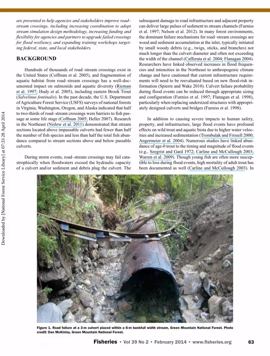
Figure 1. Road failure at a 3-m culvert placed within a 6-m bankfull width stream, Green Mountain National Forest. Photo credit: Dan McKinley, Green Mountain National Forest.
Dow
nloa
ded
by [
Nat
iona
l For
est S
ervi
ce L
ibra
ry]
at 0
7:33
28
Apr
il 20
14

Fisheries • Vol 39 No 2 • February 2014 • www.fisheries.org 64
the absence of barriers, however, habitat is recolonized in sev-eral years by individual fish from metapopulations (e.g., Dolloff et al. 1994; Letcher et al. 2007; Nislow et al. 2011). Studies of several wild Brook Trout populations by the Vermont Fish and Wildlife Department (VFWD) in the White River, Mad River, and Dog River watersheds found that flooding from Tropical Storm Irene reduced total trout populations to 33%–58% of pre-flood levels (Kirn 2012). Barring anthropogenic alteration of in-stream habitat with heavy machinery, Brook Trout populations would be expected to return to preflood population structure within 2–3 years (Kirn 2012). Studies by Dolloff et al. (1994) in North Carolina and Carline and McCullough (2003) in West Virginia indicate that though individual habitat units changed, overall habitat composition and complexity persisted and in some cases improved after floods.
The upper White River watershed was selected as a case study for this article because of the extensive flood damage experienced in five valley towns during Tropical Storm Irene (Irene) on August 27–28, 2011, a portion of which was related to failure of undersized hydraulic design road–stream crossings and associated road damage incurred by communities beyond the structure replacement costs (Figure 1). The extensive dam-age to culverts on town lands adjacent to the Green Mountain National Forest (GMNF) allowed for comparison of crossing failures and associated impacts between older traditional hy-draulic designs and newer stream simulation designs (Stream Simulation Working Group [SSWG] 2008). Before Irene struck, two stream simulation designs had just been completed in the watershed adjacent to the upper White River and in a nearby wa-tershed within the Connecticut River basin that sustained similar precipitation levels and flood damage. An additional crossing that approached stream simulation design standards within the upper White River watershed on the GMNF avoided damage as well. Survival of these three GMNF road–stream crossings designed for aquatic passage highlights the broader benefits of ecologically beneficial stream crossing designs, including re-duced rates of crossing failure and storm damage to roads and property, reduced costs of road maintenance, and reduced likeli-hood of adverse impact to communities and businesses caused by flood damage. The U.S. Fish and Wildlife Service (USFWS), which has been active across the watershed in post-storm re-sponse with local partners such as the White River Partnership (WRP), has used fish passage as its primary objective when partnering on upgrading road–stream crossings. It employs a range of ecologically beneficial approaches to achieve aquatic organism passage and improved flood resiliency, including the stream simulation design method (J. Rowan, USFWS, personal communication).
ROAD–STREAM CROSSING DESIGN APPROACHES
Aquatic organism passage (AOP) at road–stream crossings has been the subject of engineering, fisheries, hydrology, and wildlife specialists’ concern for many decades, beginning with federal and state agencies involved in fish management and road and highway construction in Alaska, California, Oregon, Idaho,
and Washington (Orsborn et al. 2002; Clarkin et al. 2005). Prior to the 1970s, a hydraulic design approach to road–stream cross-ings focused on efficiently conveying flood flows with mini-mal or no concern for the movement and habitat needs of fish (Figure 2a). In the 1970s and 1980s, hydraulic design structures were modified to create hydraulic conditions that allowed for passage of adult fish including fishways, baffles, and weirs (Fig-ure 2b; Cenderelli et al. 2011). Structures substantially narrower than the width of the adjacent natural channel, however, were only partially successful in allowing passage for the targeted adult fish species, and they did not address the passage needs of multiple species occupying the stream corridor at different life stages and flow conditions. Into the 1990s, hydraulic engineers continued to study and provide design advice to agency fisher-ies biologists. As Endangered Species Act listings for Pacific Coast salmonids increased in the 1990s and understanding of river and stream geomorphology among agency staff improved, inventories of road system crossings and design improvements to provide passage of all aquatic species, not just adult salmon and trout, increased. Recognizing the limitations of hydraulic design approaches for meeting the passage needs of multiple species occupying the stream corridor at different life stages and flow conditions, a stream simulation design approach was developed (Figures 2c–2e).
Gradually, federal agencies such as the USFS, USFWS, Natural Resources Conservation Service, Bureau of Land Man-agement, and National Oceanic and Atmospheric Administra-tion developed or recognized fish passage programs specific to road–stream crossings. In recognition of the pervasive problem of undersized culverts inhibiting the passage of aquatic organ-isms, wood, sediment, and debris across the country’s vast road network, especially on public lands, the USFS and other agency technical specialists convened a cadre of hydrologists, water-shed scientists, geomorphologists, road engineers, and fisher-ies biologists who further developed and refined the concept of stream simulation design in the 1990s (SSWG 2008; Cenderelli et al. 2011). In 2008, the USFS identified stream simulation de-sign as its preferred approach for all national forest road–stream crossings on fish-bearing streams and integral to meeting the in-tent of the Clean Water Act (to restore and maintain the chemi-cal, physical, and biological integrity of the nation’s waters; 33 U.S.C. § 1251(a)) and the Endangered Species Act (to provide a means whereby the ecosystems upon which endangered species and threatened species depend may be conserved 16 U.S.C. § 1531(b)) (USFS 2008).
STREAM SIMuLATION DESIGN
Stream simulation designs are recognized as more effective in facilitating juvenile and adult fish and other AOP than tradi-tional culvert designs (House et al. 2005; Cenderelli et al. 2011) or low-water fords (Bouska and Paukert 2011). The premise of stream simulation design is that by creating channel dimensions and characteristics through a road–stream crossing that are simi-lar to those in the natural channel, fish and other aquatic organ-isms will experience no greater difficulty moving through the
Dow
nloa
ded
by [
Nat
iona
l For
est S
ervi
ce L
ibra
ry]
at 0
7:33
28
Apr
il 20
14

Fisheries • Vol 39 No 2 • February 2014 • www.fisheries.org 65
Figure 2. An ecological connectivity and flood resilience continuum for different design approaches at road-stream crossings (adapted from SSWG, 2008). The stream-floodplain simulation design (top graphic) provides passage for all aquatic and terrestrial species all at flow levels and minimal interference of stream and floodplain processes, resulting in greater ecological connectivity and flood resiliency. The stream simulation design (middle graphic) provides for fully functioning floodplain processes, passing floodwater, sediment and woody debris and all aquatic species for a broad range of flows. The hydraulic design for flood capacity (bottom graphic) only provides for partial functioning of stream processes, impedes passage of some floodwaters, sediment, and woody debris during high flows, and impedes passage of most aquatic species for most flows, consequently providing low ecological connectivity and flood resiliency.
a
b
c
d
e
Dow
nloa
ded
by [
Nat
iona
l For
est S
ervi
ce L
ibra
ry]
at 0
7:33
28
Apr
il 20
14

Fisheries • Vol 39 No 2 • February 2014 • www.fisheries.org 66
structure than if the crossing did not exist (SSWG 2008). Stream simulation crossings are designed to maintain geomorphic and hydrologic continuity with the adjacent natural channel by building a “design channel” through a road–stream crossing structure with gradients, cross-sectional widths and shapes, bed forms, flow depths, and sediment size characteristics that are similar to those of a stable, nearby reference channel (SSWG 2008). The stream simulation design approach is applicable on any channel type or gradient and in most environmental set-tings (Cenderelli et al. 2011). To avoid constricting flood flows, the width of a stream simulation design structure is equivalent to or exceeds the bankfull width of the natural channel. For channels with wide, adjacent floodplains, the stream simulation approach recommends installing floodplain relief culverts to facilitate partial floodplain flow continuity through the road fill and reduce the con-centration of water through the main crossing structure during floods greater than bankfull flow. The replace-ment structure type and size, which can include a bridge or variety of culvert configurations, are determined by the stream simulation channel dimensions as well as any projected vertical and lateral adjustments of the stream over the service life of the structure. The mobility of the constructed channel bed material as well as the stability of key particles used to build grade controls in the bed of the road–stream crossing structure are analyzed to ensure that they have properties (mobility and stability) similar to those in the natural reference channel (Cenderelli et al. 2011).
The proposed design structure is also evaluated to provide sufficient hydraulic capacity and passage of de-bris during the 100-year recurrence interval design flood. Stream simulation structures are required to have head-water-to-depth ratios less than 0.8, meaning that adequate space exists between the 100-year flood elevation and the top of the road–stream crossing structure (Figures 3 and 4). This clearance provides room for debris transport and reduces the likelihood of ponding or backwatering on the upstream side of the crossing, which can create pressur-ized flow within the structure during large-magnitude floods. Observations and analyses of stream simulation structures show that the headwater-to-depth ratio for the 100-year design flood discharge is typically between 0.5 and 0.7. In other words, stream simulation structures typi-cally have the ability to convey water and debris through the structure for flows well in excess of the 100-year flood. A road–stream crossing sized using the stream simulation method reduces or eliminates backwatering or ponding at the inlet during floods and makes those areas less prone to sediment and debris accumulation. Like a natural channel, a stream simulation channel is able to adjust its dimensions in response to a wide range of floods and sediment or wood inputs without compromising the movement needs of aquatic organisms or the hydraulic capacity of the structure (Gubernick and Bates 2003; Cen-derelli et al. 2011).
Figure 3. Sparks Brook road-stream crossing located on the Green Mountain Na-tional Forest, showing (a) original hydraulic design pipe-arch built in late 1960’s, with a 2.5 m span and 1.9 m rise; (b) stream simulation design open-bottom arch structure built in 2010 with 4.5 m span, 1.62 m rise and footers extending 2.7 m below channel bed; (c) replacement structure after Irene flood. The blue line illustrates the actual peak flood water-surface elevation as well as the estimated peak flood elevation if the original culvert had been in place. Photo credit: Dan McKinley, Green Mountain National Forest.
Dow
nloa
ded
by [
Nat
iona
l For
est S
ervi
ce L
ibra
ry]
at 0
7:33
28
Apr
il 20
14

Fisheries • Vol 39 No 2 • February 2014 • www.fisheries.org 67
Figure 4. Typical hydraulic design double culvert over Jenny Coolidge Brook, May 2010. Green Mountain National Forest showing estimated height of 100-flood design discharge in red. Photo credit: Brian Austin, Green Mountain National Forest.
The hydraulic capacity design method differs from the stream simulation design method in fundamental ways (Figure 5). Stream simulation design determines the size of the structure based on the physical dimensions of the natural channel first and foremost and evaluates hydraulic capacity as a secondary check to ensure sufficient conveyance of the 100-year flood with additional clearance for debris transport. In contrast, tra-ditional hydraulic design methods give no consideration of the actual physical dimensions of the natural channel when sizing the road–stream crossing structure. Hydraulic design structures are sized to pass a design flood (e.g., Q10 flood, Q25 flood, Q100 flood) with headwater-to-depth ratios typically at 1.0 or greater (Hotchkiss and Frei 2007). Design flood discharge es-timates are usually determined using regional regression equa-tions that typically have standard error estimates greater than 40%. Additionally, regional regression equations used to predict design discharge were typically developed for larger drainages and are not necessarily applicable to small drainages, which add to the uncertainty of the discharge estimates. Recent analyses and predictions under a changing climate suggest that the set of return interval floods underlying hydraulic capacity designs are no longer valid. In New England, trends in measures of precipi-tation intensity (Huntington et al. 2009) and frequency of larger precipitation events increased by 85% since 1948 (Madsen and Wilcox 2012), and the recent record-breaking storm events such as Tropical Storms Irene, Lee, and Sandy (Douglas and Fairbank 2011) and the projected increases in total annual pre-cipitation (Intergovernmental Panel on Climate Change 2007) and rain on snow events (Douglas and Fairbank 2011) strongly suggest the need for changing flood discharge estimates.
COST COMPARISON OF TRADITIONAL HYDRAuLIC vS. STREAM SIMuLATION DESIGNS
There continue to be significant challenges to designing and installing road–stream crossings for aquatic organism passage and flood resilience. The choice of a suitable design method to replace a failed road–stream crossing is almost always influ-enced by budgetary constraints, but the true cost of a crossing failure is rarely considered. The cost of a failure includes not only the cost to replace the structure itself but also the cost to replace other affected infrastructure and property (e.g., roads, houses) and delay costs from disruption in commerce and travel. These delay costs are often not considered in the replacement cost because they are experienced by traffic users, homeown-ers, and businesses and are not a direct expense to an agency’s budget (Perrin and Jhaveri 2004). Failures during a major flood can be particularly problematic for towns because emergency replacement costs are generally higher than planned replace-ment costs. The loss of a road–stream crossing or associated damage to road infrastructure also threatens human health and safety by creating hazards and disrupting access by emergency services. Lastly, widespread road closures and detours can be detrimental to the tourism industry by creating the perception that the area is not “open for business,” as was the case across much of Vermont during the fall foliage season following Irene (Lunderville 2011).
Stream simulation design options typically have higher up-front installation costs than traditional hydraulic designs,
Dow
nloa
ded
by [
Nat
iona
l For
est S
ervi
ce L
ibra
ry]
at 0
7:33
28
Apr
il 20
14

Fisheries • Vol 39 No 2 • February 2014 • www.fisheries.org 68
Figure 5. Stream simulation design culvert at Jenny Coolidge Brook, installed in June 2010, showing height of 100-year design discharge in red and height of Tropical Storm Irene flood level in blue. Photo credit: Brian Austin, Green Mountain National Forest.
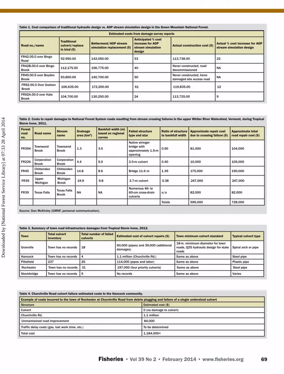
making them appear less economical, particularly for highway and road maintenance departments facing chronic budget short-falls. The installation cost of a structure (e.g., bottomless arch culvert) designed using the stream simulation approach varies with the type and size of the crossing selected and project site characteristics. Data from across the northwest United States suggest that a 50% increase in structure width results in a 20%–33% increase in total project cost (Gubernick 2011). A review of 2008 GMNF cost comparisons (Table 1) for the traditional and stream simulation designs on the GMNF found that stream sim-ulation designs increased construction costs between 9% and 22%. Though a $20,788 cost increase is significant, as was the case for the Bingo Road crossing, this increase quickly becomes more economical when compared to costs exceeding $100,000 on road repairs after a flood (Tables 2–4).
Long-term maintenance and replacement costs should also be considered. Hydraulic designs (Figures 2a and 3) that con-strict the stream channel can incur a yearly maintenance cost from debris removal and pose a greater risk of unexpected replacement costs from failure during large magnitude floods (Furniss et al. 1997). In contrast, stream simulation designs that span the bankfull channel (Figures 2c–2e and 4) have demon-strated minimal or no annual maintenance costs and are flood resilient and are likely to last longer than their projected service life (Long 2010). Galvanized steel culverts installed using the stream simulation design method have an anticipated service life of 50 to 75 years because the constructed stream channel
bed and margins protect the structure from abrasion as bed load moves through the crossing. By comparison, traditional galva-nized steel culverts installed using the hydraulic design method typically last 25 to 50 years depending on the gauge of steel, water chemistry, and rate of abrasion by bed load movement (State of Idaho 1965). An agency or landowner should weigh the higher installation cost of using a stream simulation design method with the long-term costs of likely repeated replacement and repair of undersized culverts (Long 2010).
TROPICAL STORM IRENE CASE STuDY
On August 27–28, 2011, Tropical Storm Irene brought sig-nificant rainfall to much of New England and eastern New York, with many areas receiving over 16 cm of rain (Vermont Agency of Natural Resources 2011) that caused considerable damage throughout the Northeast United States. Over the 42-hour period across New England, total rainfall reached over 30 cm in many locations, inundating entire watersheds and drainage basins si-multaneously. Record river levels were reached at 37 stream gages in New York, eight stream gages in Vermont and western Massachusetts, five stream gages in New Hampshire, and at least one stream gage in Connecticut and Maine. Flow mag-nitudes exceeded predicted 100-year discharge in many catch-ments. For example, the gage on the Ayers Brook at Randolph, Vermont, with a 79-km2 drainage area and flow record of 71 years, recorded a peak discharge that greatly exceeded the 500-year flood flow estimate (Lunderville 2011).
Dow
nloa
ded
by [
Nat
iona
l For
est S
ervi
ce L
ibra
ry]
at 0
7:33
28
Apr
il 20
14
Fisheries • Vol 39 No 2 • February 2014 • www.fisheries.org 69
Table 2. Costs to repair damages to National Forest System roads resulting from stream crossing failures in the upper Whiter River Watershed, Vermont, during Tropical Storm Irene, 2011.
Forest road no.
Road name Stream name
Drainage area (km2)
Bankfull width (m) based on regional curves
Failed structure type and size
Ratio of structure to bankfull width
Approximate repair cost due to crossing failure ($)
Approximate total road repair cost ($)
FR394 Townsend Brook
Townsend Brook 1.3 3.0
Native stringer bridge with approximately 1.5-m opening
0.50 81,000 104,000
FR226 Corporation Brook
Corporation Brook 4.4 5.0 2.0-m culvert 0.40 10,000 105,000
FR45 Chittenden Brook
Chittenden Brook 14.8 8.6 Bridge 11.6 m 1.35 175,000 190,000
FR35 Upper Michigan
Michigan Brook 19.9 9.8 3.7-m culvert 0.38 247,000 247,000
FR39 Texas Falls Texas Falls Brook NA NA
Numerous 46- to 60-cm cross-drain culverts
n/a 82,000 82,000
Totals 595,000 728,000
Source: Dan McKinley (GMNF, personal communication).
Table 3. Summary of town road infrastructure damages from Tropical Storm Irene, 2012.
Town Total culvert inventory
Total number of failed culverts Estimated cost of culvert repairs ($) Town minimum culvert standard Typical culvert type
Granville Town has no records 18 60,000 (pipes) and 39,000 (additional damages)
18-in. minimum diameter for town roads, Q25 hydraulic design for state roads
Spiral arch or pipe
Hancock Town has no records 4 1.1 million (Churchville Rd.) Same as above Steel pipePittsfield 237 25 114,000 (pipes and labor) Same as above Plastic pipe
Rochester Town has no records 31 197,000 (four priority culverts) Same as above Steel pipe
Stockbridge Town has no records 5 No records Same as above Varies
Table 4. Churchville Road culvert failure estimated costs to the Hancock community.
Example of costs incurred to the town of Rochester at Churchville Road from debris plugging and failure of a single undersized culvert Structure Estimated cost ($)Culvert 0 (no damage to culvert)Churchville Rd. 1.1 million
Unmaintained road improvement 84,000
Traffic delay costs (gas, lost work time, etc.) To be determined
Total cost 1,184,000+
Table 1. Cost comparison of traditional hydraulic design vs. AOP stream simulation design in the Green Mountain National Forest.
Estimated costs from damage survey reports
Road no./nameTraditional culvert/replace in kind ($)
Betterment/AOP stream simulation replacement ($)
Anticipated % cost increase for AOP stream simulation design
Actual construction cost ($) Actual % cost increase for AOP stream simulation design
FR42.05.0 over Bingo Road 92.950.00 142,050.00 53 113,738.00 22
FR42B.00.0 over Bingo Brook 112,175.00 156,775.00 40 Never constructed, road
decommissioned NA
FR49.00.5 over Boyden Brook 93,800.00 140,700.00 50 Never constructed, Irene
damaged site access road NA
FR92.00.0 Over Goshen Brook 106,635.00 172,200.00 61 119,835.00 12
FR92A.00.0 over Hale Brook 104,700.00 130,250.00 24 113,725.00 9
Dow
nloa
ded
by [
Nat
iona
l For
est S
ervi
ce L
ibra
ry]
at 0
7:33
28
Apr
il 20
14

Fisheries • Vol 39 No 2 • February 2014 • www.fisheries.org 70
Commercial, residential, and transportation infrastructure across the region was significantly damaged from high water, debris, and erosion. Flood damage was the most severe along tributaries to Lake Champlain in Vermont and the Adirondacks of northeastern New York, as well as in the Connecticut River Valley in western Massachusetts, New Hampshire, and Ver-mont. Thirteen towns in Vermont became isolated from bridge and culvert washouts (Lunderville 2011). The state of Vermont incurred damage to over 200 state road segments and 200 state bridges, and towns reported over 2,000 road segments, 277 bridges, and nearly 1,000 culverts damaged or destroyed by flooding from Irene. Vermont went into disaster mode and state and federal emergency management agencies began respond-ing to 225 of Vermont’s 251 municipalities (Lunderville 2011). Across the state, there were multiple instances where undersized culverts failed. This type of widespread infrastructure dam-age from large flood events and the persistence of undersized road–stream crossings is not unique and has occurred across the country in Maine, New York, Massachusetts, Pennsylvania, both South and North Dakota, and Alaska (J. Rowan, USFWS, personal communication).
DAMAGES IN THE uPPER WHITE RIvER WATERSHED
The White River is Vermont’s fourth largest subbasin, draining an area of 1,839 km2 within the Connecticut River Basin (Figure 6). Elevation ranges from 1,067 m along the spine of the Green Mountains at the western edge of the watershed to approximately 183 m at the confluence with the Connecticut River on the eastern edge of the watershed (Ruddell et al. 2007). As the longest undammed tributary to the Connecticut River, the White River has been very important to state and federal ef-forts aimed at revitalizing Atlantic Salmon (Salmo salar) popu-lations (WRP 2012). The White River watershed was designated as a Special Focus Area of the USFWS Silvio O. Conte National Fish and Wildlife Refuge in part because the watershed provides nursery and rearing habitat for juvenile Atlantic Salmon and po-tential spawning habitat for adults (WRP 2012). Eastern Brook Trout are the dominant species in the headwater tributaries and are a focus of USFWS and USFS aquatic connectivity and habi-tat restoration efforts.
The upper White River main stem comprises approxi-mately 38.6 km of stream extending from the headwaters of the White River in Ripton to the confluence with the Tweed River in Stockbridge (Ruddell et al. 2007). The five valley towns of Stockbridge, Rochester, Hancock, Pittsfield, and Granville are located along the upper White River and bordered to the west by the GMNF. Each town has its own independent government and town populations range from 298 to 1,139 (U.S. Census Bureau 2010). The GMNF includes 40% of the upper White River watershed north of Stockbridge. Development occupies approximately 5% of the watershed and has occurred mostly along the river corridor and has negatively impacted water qual-ity and aquatic habitat (WRP 2012).
Between 2004 and 2007, the VFWD inventoried 1,501 road–stream crossings statewide on streams greater than 2.4 m bankfull width. It found that that only 5.3% provided full pas-sage of aquatic organisms, and nearly 91% significantly con-stricted the natural channel width (structure width to bankfull width ratio less than 0.75). A subset of the inventory is located in the upper White River subbasin. Of the 43 culverts surveyed, 15 failed during Tropical Storm Irene, provided either reduced or no AOP, and had culvert width to bankfull width ratios rang-ing from 0.27 to 0.90, with an average of 0.54. Based partially on the inventory data, in 2009 the VFWD produced AOP guide-lines for the state that identified stream simulation design as its preferred approach for road–stream crossings (VFWD 2012).
On the entire GMNF, Irene damaged 40 km of transporta-tion infrastructure at an estimated repair cost of $6.4 million. In the upper White River watershed, the GMNF suffered $728,000 in road damage, with an estimated 70% due to debris plugging at road–stream crossings (Table 2). Three of four road–stream crossings that failed were hydraulic designs with crossing width to bankfull width ratios less than 0.52. These undersized hy-draulic culverts were also identified aquatic organism passage barriers. The fourth crossing, a bridge over Chittenden Brook located on an alluvial fan (a natural depositional zone), was constructed in 2010 with a span greater than bankfull width for increased flood capacity and AOP. During Irene, large bank failures upstream delivered a tremendous amount of woody de-bris downstream, which settled on the alluvial fan and plugged the bridge, causing the stream to overtop the bridge and wash out the bridge approach—the design failure point—leaving the bridge undamaged. The Chittenden Brook example underscores how no road–stream crossing design can guarantee avoidance of damages during large floods but that site location and adopting an ecological approach with flood resiliency as a primary objec-tive can reduce infrastructure damage considerably.
The towns of Rochester, Hancock, Pittsfield, and Granville suffered damage to or complete loss of 70 road–stream cross-ings. These communities were left isolated without power and water for three days due to road damage and road–stream cross-ing washouts. Following a presidential disaster declaration, the towns were eligible to apply for financial assistance through the Federal Emergency Management Agency’s (FEMA) Public Assistance Grant Program for the repair or restoration of in-frastructure and facilities to predisaster condition (Lunderville 2011). Coauthor Campbell met with either the road foreman or town administrator for each of these towns during April 2012 to obtain flood impact information (Table 3). Where possible, they provided Irene-induced crossing failure information, such as culvert size and location, cost data from FEMA project work-sheets, and descriptions of major failures.
The towns of Rochester and Hancock provided several spe-cific examples of extensive impacts from the failure of a single road–stream crossing. The failure of a 3.4-m-diameter culvert at Nason Brook in Rochester resulted in an estimated $1 million in damages to Woodlawn Cemetery. During Irene, the culvert became plugged with debris and then redirected a large volume
Dow
nloa
ded
by [
Nat
iona
l For
est S
ervi
ce L
ibra
ry]
at 0
7:33
28
Apr
il 20
14

Fisheries • Vol 39 No 2 • February 2014 • www.fisheries.org 71
Figure 6. Upper White River watershed study area.
Dow
nloa
ded
by [
Nat
iona
l For
est S
ervi
ce L
ibra
ry]
at 0
7:33
28
Apr
il 20
14

Fisheries • Vol 39 No 2 • February 2014 • www.fisheries.org 72
of water onto the cemetery grounds, unearthing 50 caskets and strewing their remains throughout downtown Rochester (Davis 2011). The USFWS and the WRP are currently working with FEMA and Rochester to replace the failed culvert. The cost for this culvert to be upgraded to a flood resilient 9.7-m bridge is approximately $50,000, which the USFWS was able to obtain specific to this site at a lower than average cost.
In Hancock, on Churchville Road, a 3.6-m-diameter steel pipe, originally designed to pass a 25-year recurrence interval flood, failed and resulted in long-term travel disruption and major damage costs. Though the culvert itself remained intact, the floodwaters overtopped it and washed out more than 350 m of Churchville Road, which was not replaced until August 2012, with a repair cost of approximately $1 million. A nearby unmaintained road had to be upgraded in order for residents to regain access to the main highway, at a cost of approximately $84,000, with residents bearing the cost of driving an additional 2 miles each way to reach Vermont Route 100. The total cost of the culvert failure and associated damage is at least $1,184,000, excluding traffic and delay costs (Table 4). In both examples, had the culverts been appropriately sized, it is unlikely that these damages would have been as disruptive and costly.
THE LINK BETWEEN AQuATIC ORGANISM PASSAGE AND FLOOD RESILIENCE
In contrast to the extensive damage experienced by towns in the Vermont case study, two stream simulation design cul-verts that were installed on the GMNF before Irene not only survived the storm but incurred no maintenance or replacement costs. USFS fisheries and engineering staff had targeted the upgrade of these two hydraulically designed pipes on Forest Service roads for replacement in 2010 and 2011 because they were barriers to the upstream movement of eastern Brook Trout and other aquatic organisms and because they were identified as a risk for debris plugging and failure in large storm events. These two crossings located on Sparks Brook (Figure 3), im-mediately adjacent to the upper White River watershed, and on Jenny Coolidge Brook (Figures 4 and 5), also in the Connecticut River Basin, were designed to span the bankfull dimensions of the natural channel, resulting in structures with sufficient hy-draulic capacity to convey flows in excess of the Q100 peak flow while providing additional headwater clearance for debris transport. Preliminary hydraulic analysis of Jenny Coolidge Brook estimates peak storm discharges during Irene exceeded the 500 year recurrence interval (R. Gubernick, USFS, personal communication). In addition, on Joe Smith Brook in the upper White River watershed, a hydraulic design culvert was recently replaced with a Q100 bottomless arch to provide greater flood capacity and a natural bottom for AOP. Though this road–stream crossing upgrade was not strictly a stream simulation design with regard to gradient, channel banks, and substrate size, the structure still spanned the bankfull dimensions of the natural channel and it also survived Irene undamaged. Three additional stream simulation crossings located on GMNF listed in Table 1 were still in the early stages of construction when Irene hit and were not included in the flood resiliency analysis but will allow
for a more robust comparative analysis with traditional culvert designs during future floods.
Though additional monitoring is needed, other examples demonstrate the flood resilience of road–stream crossings de-signed for aquatic organism passage across the region impacted by Irene. In Worthington, Massachusetts, a double 3-m box culvert, which prevented Brook Trout and resident darter pas-sage on a 9-m bankfull section of Bronson Brook, a tributary of the Westfield River, catastrophically failed in an August 2003 storm. A 12-m arch culvert replacement has since survived sev-eral major storms, including Tropical Storm Irene, without dam-age to the structure, road or adjacent stream banks (A. Singler, American Rivers, personal communication). In Hancock, New York, between 1996 and 2005 three flood events caused dam-age to an undersized and perched pipe culvert on Big Hollow Creek, which was a barrier to trout movement. In those 9 years, Delaware County spent over $70,000 to repair damages to the culvert as well as the road and adjacent ditches. In addition, the detour length associated with closure of the road for repairs was 18 miles. Late in 2005, with hazard mitigation funding assis-tance from FEMA, the county installed a more ecologically ben-eficial three-sided concrete box culvert with a natural bottom, designed to convey a 100-year storm and provide fish passage at all flow levels, for a cost of $143,000. The improved crossing has survived seven federally declared flood disasters, including Irene, without significant damage since its replacement in 2005 (W. Reynolds, Delaware County Department of Public Works, personal communication).
The flood resilience of stream simulation designs has been documented during significant flow events elsewhere. On the Siuslaw National Forest on the Oregon coast, eight stream simu-lation design crossings installed in 2003 have weathered floods up to a 20- and 25-year recurrence interval range. Though ad-justment of the streambed constructed beneath the road crossing ranged from negligible to significant, all eight crossings have maintained AOP, successfully passed sediment and debris, and avoided any infrastructural damage (B. Ellis-Sugai, USFS, per-sonal communication). In southeast Alaska, the Tongass Na-tional Forest installed 93 stream simulation design crossings since 1998 (94% installed between 2000 and 2005) that have survived flood events in the estimated 25- to 50-year recurrence interval range without major failure and have maintained fish passage to state standards at 98% of locations (J. McDonell, USFS, personal communication).
BARRIERS TO IMPLEMENTING ECOLOGICALLY BENEFICIAL ROAD–STREAM CROSSINGS
Extreme events such as Tropical Storm Irene can create a window of opportunity for increased investment in disaster mitigation; however, for the towns in the White River Valley, existing regulations and funding mechanisms hindered the replacement of damaged road–stream crossings to increase aquatic organism passage and flood resilience. Under the Pub-lic Assistance Program, FEMA funds between 75% and 90%
Dow
nloa
ded
by [
Nat
iona
l For
est S
ervi
ce L
ibra
ry]
at 0
7:33
28
Apr
il 20
14

Fisheries • Vol 39 No 2 • February 2014 • www.fisheries.org 73
of the estimated cost for a culvert replacement if it passes the “50% rule” (a structure is eligible for replacement if the repair cost exceeds 50% of the replacement cost). Otherwise, FEMA provides financial assistance at the 75%–90% rate to repair the original structure but not necessarily the costs to repair roads or other structures damaged by the culvert failure. In some cases, the culvert itself may remain in place while the road fails, but because the culvert is technically undamaged it will not pass the 50% rule. For example, Hancock was ineligible to receive public assistance funds to replace the Churchville Road culvert because the structure survived the flood but was eligible to re-ceive public assistance funds to repair the road damaged by the plugged culvert. When a culvert is eligible for replacement, FEMA only provides financial assistance to rebuild the struc-ture to its predisaster condition or up to passing the Q25 with 0.3-m clear space and 0.61-m embedment. If a town chooses to upgrade a failed culvert and does not have specific guidance from a state natural resources agency, FEMA reimburses the estimated cost of repairing or replacing the original culvert and the town must bear the cost difference for the upgrade. Towns face difficulties meeting these rules and simultaneously funding the additional costs to upgrade to stream simulation designs in the midst of expensive disaster recovery efforts.
Towns and counties may apply for funding to replace or upgrade road–stream crossings through FEMA’s Hazard Mit-igation Grant Program (HMGP), but this grant money is not available until 6 months after the disaster declaration, and total funding made available is not determined until a full year after the disaster. The amount of money available through this pro-gram is based upon the total amount paid out under emergency assistance in the months following the declared disaster. More important, the state prioritizes use of the funds and may not nec-essarily include road–stream crossing upgrades among eligible projects. Applying for HMGP funding requires a cost–benefit analysis and a demonstration of three historic losses at the site (Munroe and Crosby 2012). In order to meet this requirement, towns need to maintain detailed records of previous failures. FEMA does not maintain an accessible database of this informa-tion. In addition, FEMA only requires that project worksheets be kept by an applicant for three years from the date the state closes a grant (FEMA 2011), decreasing the likelihood that towns have the necessary information for HMGP eligibility if previous failures occurred before that time period.
Based on the information we observed, local governments face significant barriers to upgrading undersized road–stream crossings that obstruct aquatic organism passage and present chronic failure risks. These impediments include inconsistent and poorly defined crossing standards and limitations on FEMA assistance for structure upgrades and replacements. For exam-ple, three separate hydraulic standards apply to the towns in the upper White River watershed. The 1998 Vermont Department of Transportation Hydraulics Manual (VTrans 2001) requires state highway crossings to have a minimum design capacity of Q50 and town highway and local road crossings to have a minimum
of Q25. The Vermont Department of Transportation revised the Town Road and Bridge Standards in 2011 to recommend that towns adopt a 45.7-cm-diameter and a Q25 conveyance as their minimum requirement for new road–stream crossings, allowing for structures to span less than half of bankfull width. For a stream alteration general permit, the Vermont Agency of Natural Resources requires crossings to be at least 1.2 times bankfull width, although applicants can apply for an individual permit to include a smaller crossing. Following Tropical Storm Irene, FEMA allowed a minor increase in culvert size of 0.3 m for debris and 0.61 m for embedment and replaced to the lowest standard adopted by an individual town. Because Pitts-field had recently changed the town culvert standard to 46 cm, it was eligible to upgrade eighteen 38-cm diameter culverts to 46-cm-diameter pipes under FEMA’s Public Assistance fund-ing. Granville did not upgrade its town culvert standard and was only eligible to replace 13 of 18 destroyed culverts with in-kind replacements funded through FEMA’s Public Assistance program. The observation that all documented failed crossings in the study area had crossing width–to–bankfull width ratios of less than one and that these crossings met state minimum criteria underscores the need for a revised approach to achieve greater flood resiliency.
Economic justification for traditional hydraulic design has focused on short-term costs and not long-term persistence. The economic, societal, and natural resource costs of these failed road–stream crossings and the adjacent infrastructure are not included in up-front cost calculations. At the federal, state, and municipal levels, the increased benefits of building ecologically beneficial crossings for AOP and greater flood resiliency are not calculated. Time constraints and pressures to reopen failed roads and return emergency services to communities generally drive quick repair of infrastructure to a working condition rather than long-term flood resiliency.
Other cultural and political factors impede a systematic ap-proach to replacing culverts and road crossings to ecologically beneficial standards. In Vermont and across New England, inde-pendent town governance and highway departments discourage application of uniform techniques and the effective transfer of skills and training in river dynamics, engineering, hydraulics, and aquatic ecology needed to design and build flood resilient road–stream crossings. In addition, the misperception that “fish-friendly” crossings have no economic or societal benefit outside of natural resource protection is commonly heard in New Eng-land following flood events.
RECOMMENDATIONS
Based on the upper White River watershed case study, the following recommendations are presented to federal and state agencies, communities, and nongovernmental organizations in order to better integrate ecological objectives into road–stream crossing design and provide more effective flood resiliency across the country.
Dow
nloa
ded
by [
Nat
iona
l For
est S
ervi
ce L
ibra
ry]
at 0
7:33
28
Apr
il 20
14

Fisheries • Vol 39 No 2 • February 2014 • www.fisheries.org 74
Prioritization • Target “repeat offenders”: Before the next major storm, re-
place undersized culverts that have caused extensive road and property damage and/or failed more than once. This will require better record-keeping by communities.
• Identify priority sites at a watershed scale for aquatic health or critical populations and road–stream crossings that have high social significance; for example, high-volume traffic, major commuting delays, provision of critical emergency services, etc. In southeastern Massachusetts, The Nature Conservancy and a regional planning agency collaborated to identify key locations in the transportation network where both river continuity and public welfare were impacted by existing structures; these were included in the Regional Transportation Plan as priorities for improvement (South-eastern Massachusetts Metropolitan Planning Organization 2012).
Regulatory
• Work with FEMA and affected agencies to address regula-tory road blocks to restoring infrastructure that would be more resilient to flood events in future years.
• Coordinate among federal and state agencies, including FEMA, the Natural Resources Conservation Service, state emergency management, departments of transportation, and environmental agencies to adopt as a standard the lat-est technologies that incorporate multidisciplinary, ecologi-cally beneficial approaches to road–stream crossing such as stream simulation design.
• Change regulatory preference for in-kind emergency re-pair to upgrading road-crossing structures based on flood resiliency through strong guidance on interpreting FEMA Sections 404 and 406 funding, particularly the definition of what constitutes a road–stream crossing failure. It is cur-rently common practice to reuse clearly undersized culverts that have been washed out by a flood and simply rebuild the road with new materials.
• Consider changes to language in U.S. Army Corps of Engi-neers 404 Nationwide Permit process to provide more pre-scription for ecologically beneficial road–stream crossing criteria consistent with the intent of the Clean Water Act, which requires the protection and restoration of the physical, chemical, and biological integrity of the nation’s waters.
• Adopt consistent state and town standards for road–stream crossings that incorporate AOP concerns and increased flood resiliency. FEMA replaces structures to the lowest standard adopted by the local government.
Funding
• Adopt an incident command structure for flood-affected areas modeled after the National Incident Management System approach to wildfires and other disasters impact-ing communities and/or regions. Place high priority on de-ployment of an interagency flood response “Strike Team”
composed of fluvial restoration, engineering, and fisheries experts to flood-affected regions immediately (see Sidebar).
• Allow other federal agencies to contribute to the state and town cost shares of 12.5% typically required by FEMA for projects that serve a role in providing multiple benefits and flood resilience. Higher upfront project costs are an impedi-ment to towns when they are forced to replace many struc-tures at once.
• Increase Hazard Mitigation Grant Program share beyond the current 10%–15% of total cost of disaster reimbursement monies.
• Use a collaborative whole watershed approach similar to the USFWS’s Irene recovery effort when prioritizing road–stream crossing upgrades in order to leverage resources, focus efforts, and address impacts at the watershed scale (see Sidebar).
Education and Future Research
• Expand interagency workshops to increase understanding of ecologically beneficial approaches to road–stream cross-ing design, true life cycle costs analysis, and river dynamic principles modeled after the highly successful USFS stream simulation design and USFWS fish-friendly crossing work-shops. Target state and county transportation, engineering staff, and heavy equipment operators who are routinely contracted for postflood remediation work. Consider devel-opment of an interagency-approved certification program for such workshop attendees for ecologically beneficial ap-proaches to designing and constructing road–stream cross-ings.
• Conduct further research of life cycle cost analysis for fed-eral and state reimbursement criteria for failed structures to include likelihood of failure based on crossing width : bank-full width ratio.
• Track crossing failures and crossing : bankfull width ratios nationally to help agencies better understand failure causes and identify trends of failure associated with this metric (Perrin and Jhaveri 2004).
In summary, this article makes the case that adoption of the stream simulation design approach provides multiple benefits to communities, state, and federal governments, particularly as extreme weather events become a more common occurrence. Road–stream crossing infrastructure represents large invest-ments that are currently susceptible to catastrophic failure dur-ing large flood events, resulting in significant economic and societal costs to communities. This case study suggests that investing in stream simulation designs with flood resiliency as a primary objective has the potential to reduce these economic and societal costs through reduced failure rates and lower main-tenance costs while maintaining important ecological values. Increased interagency coordination and prioritization of geo-morphic, engineering, and ecologically based designs for road–stream crossings are needed across federal, state, county, and municipal scales to help prevent a recurrence of this kind of extreme damage and disruption experienced by Vermont and much of New England following Tropical Storm Irene.
Dow
nloa
ded
by [
Nat
iona
l For
est S
ervi
ce L
ibra
ry]
at 0
7:33
28
Apr
il 20
14

Fisheries • Vol 39 No 2 • February 2014 • www.fisheries.org 75
uSFWS AND MOBILIzATION OF A PILOT “STRIKE TEAM”
In September 2011, the USFWS Northeast Region mobilized various technical field staff for immediate post-emergency engineering and technical support for fish passage and stream restoration recovery needs fol-lowing Tropical Storm Irene in Vermont and New York. The USFWS dedicated roughly $132,600 to the upper White River watershed response, including $32,584 for staff time through the month of October 2011 and $100,000 in project funding to the local grassroots orga-nization the White River Partnership (WRP) that focused on the town of Rochester through an agreement funded by the National Fish Passage Program. Based on previous surveys to prioritize aquatic organism passage needs for Atlantic Salmon and eastern Brook Trout in collabora-tion with the WRP, the USFWS staff provided review of nine road–stream crossing sites, restoration of two sites, data collection on four other sites, and a technical review of all projects. The USFWS has already developed de-sign plans to restore fish passage at five additional sites in Rochester. The upgrades involve replacing traditional hydraulic designs with bottomless arch culverts that ex-ceed measured bankfull width, as well as the diameter of the standard Q25 hydraulic design width by a range of 1.3 to 2.4 times and the flow area of the Q25 hydraulic design by 2.4 times on average. In all cases the USFWS provided towns with design plans to improve both fish passage and flood resilience in conjunction with repair and cost estimates from FEMA.
In the case of the upper White River watershed, the USFWS response to local communities was enhanced through partnership with the USFS GMNF, which pro-vided additional technical expertise and project fund-ing. Identification, organization, and deployment of interagency as well as intra-agency strike teams in col-laboration with local and state governments and non-government organizations has the potential to increase response capability in terms of speed and duration, provide for comprehensive support across broader geo-graphic areas, and establish continuity from the federal government to local governments. Yet efforts to address a larger storm or respond to a wider area of damage would have exhausted agency capacity to deliver criti-cal services, underscoring the need for coordinated in-teragency deployment of technical experts to respond to flood-damaged communities.
REFERENCES
Angermeier, P. L., A. P. Wheeler, and A. E. Rosenberger. 2004. A conceptual framework for assessing impacts of roads on aquatic biota. Fisheries 29(12):19–29.
Bouska, W. W., and C. P. Paukert. 2010. Road crossing designs and their impact on fish assemblages of Great Plains streams. Transactions of the American Fisheries Society 139:214–222.
Cafferata, P., T. Spittler, M. Wopat, G. Bundros, and S. Flanagan. 2004. Designing water-course crossings for passage of 100-Year flood flows, wood, and sediment. California Forestry Report No. 1. Sacramento, California.
Carline, R. F., and B. J. McCullough. 2003. Effects of floods on brook trout populations in the Monongahela National Forest, West Virginia. Transactions of the American Fisher-ies Society 132:1014–1020.
Cenderelli, D. A., K. Clarkin, R. A. Gubernick, and M. Weinhold. 2011. Stream simulation for aquatic organism passage at road–stream crossings. Journal of the Transportation Research Board 2203:36–45.
Clarkin, K., A. Connor, M. J. Furniss, B. Gubernick, M. Love, K. Moynan, and S. W. Musser. 2005. National inventory and assessment procedure for identifying barriers to aquatic organism passage at road–stream crossings. USDA Forest Service, San Dimas Technology and Development Center, San Dimas, California.
Coffman, J. S. 2005. Evaluation of a predictive model for upstream fish passage through culverts. Master’s thesis. James Madison University, Harrisonburg, Virginia.
Coffman, S., M. Minter, J. Zug, D. Nuckols, C. Roghair, and C. Dolloff. 2005. Fish passage status of road–stream crossings on selected National Forests in the Southern Region. Unpublished file report. U.S. Department of Agriculture, Southern Research Station, Center for Aquatic Technology Transfer, Blacksburg, Virginia.
Davis, M. 2011. Irene Flood rips open cemetery in Rochester. Vermont Public Radio. Avail-able: www.vpr.net/news_detail/91833/irene-floods-rip-open-cemetery-in-rochester. (September 2012).
Dolloff, C. A., P. A. Flebbe, and M. D. Owen. 1994. Fish habitat and fish population in a southern Appalachian watershed before and after Hurricane Hugo. Transactions of the American Fisheries Society 123:668–678.
Douglas, E., and C. Fairbank. 2011. Is precipitation in New England becoming more ex-treme? A statistical analysis of extreme rainfall in Massachusetts, New Hampshire, and Maine and updated estimates of the 100-year storm. Journal of Hydrologic Engineer-ing 16:203–217.
FEMA (Federal Emergency Management Agency). 2011. Frequently asked questions, FEMA Public Assistance Program 4022-DR-VT. Available: www.vlct.org/assets/News/Irene/FEMA-PA_Program-FAQs.pdf. (September 2012).
Flanagan, S. A. 2004. Woody debris transport through low-order stream channels of north-west California—implications for road–stream crossing failure. Master’s thesis. Hum-boldt State University, Humboldt, California.
Flanagan, S. A., M. J. Furniss, S. Theisen, M. Love, K. Moore, and J. Ory. 1998. Methods for inventory and environmental risk assessment of road drainage crossings. USDA Forest Service Technology and Development Program 9877-1809-SDTDC. San Dimas Technology & Development Center, San Dimas, California.
Furniss, M. J., M. Love, and S. A. Flanagan. 1997. Diversion potential at road stream crossings. USDA Forest Service Technology and Development Program 9777-1814-SDTDC. San Dimas Technology & Development Center, San Dimas, California.
Furniss, M. J., T. S. Ledwith, M. A. Love, B. McFadin, and S. A. Flanagan. 1998. Response of road–stream crossings to large flood events in Washington, Oregon, and Northern California. USDA Forest Service, Technology and Development Program. 9877-1806-SDTDC. San Dimas Technology & Development Center, San Dimas, California.
Gubernick, R. 2011. Flood damage assessment: Green Mountain National Forest. Region 9 TST. USDA Forest Service, internal publication.
Gubernick, R., and K. Bates. 2003. Designing culverts for aquatic organism passage: stream simulation culvert design. International Conference of Ecology and Transportations Proceedings, Lake Placid, New York.
Heller, D. 2007. A strategic approach for the identification and correction of fish passage on National Forest lands in the Pacific Northwest. Page 187 in C. Leroy Irwin, Debra Nelson, and K. P. McDermott, editors. Proceedings of the 2007 International Confer-ence on Ecology and Transportation. Center for Transportation and the Environment, North Carolina University, Raleigh, North Carolina.
Hotchkiss, R. H., and C. M. Frei. 2007. Design for fish passage at roadway–stream cross-ings: synthesis report. U.S. Department of Transportation, Publication No. FHWA-HIF-97-033. Federal Highway Administration, McLean, Virginia.
House, M. R., M. R. Pyles, and D. White. 2005. Velocity distributions in streambed simula-tion culverts used for fish passage. Journal of the American Water Resources Associa-tion 41:209–217.
Hudy, M., T. M. Thieling, N. Gillespie, and E. P. Smith. 2005. distribution, status and perturbations to Brook Trout within the eastern United States. Final report to the steer-ing committee of the Eastern Brook Trout Joint Venture. Trout Unlimited, Arlington, Virginia.
Huntington, T. G., A. D. Richardson, K. J. McGuire, and K. Hayhoe. 2009. Climate and hy-drological changes in the northeastern United States: recent trends and implications for forested and aquatic ecosystems. Canadian Journal of Forest Research 39(2):199–212.
Intergovernmental Panel on Climate Change. 2007. Climate Change 2007: the physical science basis. Contribution of Working Group I to the Fourth Assessment Report of the Intergovernmental Panel on Climate Change. Pages 75–76 in S. Solomon, D. Qin, and M. Manning, editors. Cambridge University Press, Cambridge, United Kingdom, and New York, New York.
Kirn, R. 2012. Impacts to stream habitat and wild trout populations in Vermont following
Dow
nloa
ded
by [
Nat
iona
l For
est S
ervi
ce L
ibra
ry]
at 0
7:33
28
Apr
il 20
14

Fisheries • Vol 39 No 2 • February 2014 • www.fisheries.org 76
Tropical Storm Irene. Vermont Fish and Wildlife Department Annual Report, Project No. F-36-R-14. Vermont Fish & Wildlife Department, Montpelier, Vermont.
Letcher, B. H., K. H. Nislow, J. A. Coombs, M. J. O’Donnell, and T. L. Dubreuil. 2007. Population response to habitat fragmentation in a stream-dwelling brook trout popula-tion. PLOS One 2(11):e1139. DOI: 10.1371/journal.pone. 0001139.
Long, S. 2010. The economics of culvert replacement: fish passage in eastern Maine. Natu-ral Resources Conservation Service, Maine. Available: ftp://ftp-fc.sc.egov.usda.gov/Economics/Technotes/EconomicsOfCulvertReplacement.pdf. (October 2013).
Lunderville, N. 2011. Irene recovery report. A stronger future. A report to the governor of Vermont. State of Vermont, Montpelier, Vermont.
Madsen, T., and N. Wilcox. 2012. When it rains, it pours: global warming and the increase in extreme precipitation from 1948 to 2011. Environment Texas Research and Policy Center. Available: http://www.frontiergroup.org/sites/default/files/reports/When%20It%20Rains,%20It%20Pours%20vUS.pdf. (October 2013).
Munroe, D., and C. Crosby. 2012. After Irene: Adaptation, Policy, and Management. Mid-dlebury College, Spring Environmental Studies Seminar. Available: www.middlebury.edu/sustainability/news-events/news/2012/NL12/node/423397. (September 2012).
Nelson, N., R. Cissel, T. Black, C. Luce, and B. Staab. 2012. Legacy Roads and Trails Monitoring Project: road decommissioning in the Granite Creek watershed, Umatilla National Forest. U.S. Forest Service, Rocky Mountain Research Station, Boise, Idaho. Available: www.fs.fed.us/GRAIP/downloads/case_studies/LegacyRoadsUmatillaNF_Granite2008DecomissionFinalReport.pdf. (July 2012).
Nislow, K. H., M. Hudy, B. H. Letcher, and E. P. Smith. 2011. Variation in local abundance and species richness of stream fishes in relation to dispersal barriers: implications for management and conservation. Freshwater Biology 56:2135–2144.
Orsborn, J. F., M. Witecki, and J. Toohey. 2002. Culvert design flows for fish passage and structural safety in East Cascade and Blue Mountain streams. Prepared for Wash-ington State Department of Transportation and in cooperation with U.S. Department of Transportation, Federal Highway Administration. Research Project T1804, Task Order 4. Available: http://www.wsdot.wa.gov/research/reports/fullreports/545.2.pdf. (October 2013).
Perrin, J., and C. S. Jhaveri. 2004. The economic costs of culvert failures. Prepared for the Transportation Research Board. Transportation Research Board 2004 Annual Meet-ing, Utah.
Rieman, B. E., D. C. Lee, and R. F. Thurow. 1997. Distribution, status, and likely future trends of bull trout within the Columbia River and Klamath River basins. North Ameri-can Journal of Fisheries Management 17:1111–1125.
Ruddell, D., E. McLane, and B. Machin. 2008. Upper White River Corridor Plan. White River Partnership. Royalton Village, Vermont.
Seegrist, D. W., and R. Gard. 1972. Effects of floods on trout in Sagehen Creek, California. Transactions of the American Fisheries Society 101:478–482.
Southeastern Massachusetts Metropolitan Planning Organization (SMMPO). 2012. En-vironmental coordination and climate change. Pages 16-1–16-7 in 2012 Regional Transportation Plan. SMMPO, Taunton, Massachusetts. Available: http://www.srpedd.org/manager/external/ckfinder/userfiles/files/Transportation/Regional%20Transporta-tion%20Plan/full_tplan2012.pdf. (January 2014).
Spierre, S., and C. Wake. 2010. Trends in extreme precipitation events for the Northeast-ern United States 1948–2007. Carbon Solutions New England. Available: http://www.amwa.net/galleries/climate-change/2010_NortheastExtremePrecip.pdf. (September 2013).
State of Idaho. 1965. A study of the durability of metal pipe culverts. State of Idaho Depart-ment of Highways, Research Project No. 16, Boise, Idaho.
Stream Simulation Working Group (SSWG). 2008. Stream simulation: an ecological ap-proach to designing road–stream crossings. San Dimas Technological Development Center, San Dimas, California.
Trombulak, S. C., and C. A. Frissell. 2000. Review of ecological effects of roads on ter-restrial and aquatic communities. Conservation Biology 14:18–30.
U.S. Census Bureau. 2010. 2010 Census interactive population search. Available: 2010.census.gov/2010census/popmap/ipmtext.php?fl=50. (August 2012).
USDA Forest Service. 2008. Consistent national guidance for aquatic passage designs. USDA Forest Service, File Code 7700/2600, Washington, D.C.
Vermont Agency of Natural Resources. 2011. Lessons from Irene: building flood resil-iency as we rebuild. Available: http://www.anr.state.vt.us/anr/climatechange/Pubs/Irene_Facts.pdf. (October 2013).
Vermont Department of Transportation (VTrans). 2001. Hydraulics Manual. Vermont Agency of Transportation, Montpelier, Vermont.
Vermont Fish and Wildlife Department (VFWD). 2012. Fisheries programs. Available: www.vtfishandwildlife.com/fisheries_AOP.cfm. (October 2012).
Warren, D. R., A. G. Ernst, and B. P. Baldigo. 2009. Influence of spring floods on year-class strength of fall- and spring-spawning salmonids in Catskill Mountain streams. Transactions of the American Fisheries Society 138:200–210.
WRP (White River Partnership). 2012. About the White River watershed. Available: www.whiteriverpartnership.org/index.php/watershed. (April 2012).
[email protected] 1.866.303.2837 www.ecoanalysts.com BIOASSESSMENT SERVICES
Zooplankton Field Sampling
Data Analysis & Repor ngElectroshing Equipment Rental
Larval Fish316B ServicesBenthic InvertebratesFish Stomach Analysis
AQUATIC
From the Archives
The efforts of the United States in reference to the introduction of use-ful food fishes should not be lim-ited to the salmonidae already men-tioned (to which the various species of trout, salmon, white-fish and smelts belong) and to the shad, as many other kinds yet remain for consideration. The land-locked salmon, the European char and the smelt, will be available for all ponds or lakes of a certain extent and temperature. In these they will pass the greater part of their time, running up into the tributaries or outlets to spawn. The great Dan-ube salmon, which sometimes reaches the weight of 100 pounds, would find a perfectly suitable residence in the Mississippi river and its tributaries, feeding on the worthless chubs, suck-ers and cat fish so abundant therein. The alewife can be propagated to a much greater extent than at present. The sterlet, a kind of small sturgeon found in the Volga and in Russia, is esteemed far beyond the turbot, will thrive in the Mississippi valley and in the lakes. The gourami, an East In-dia fish, can be placed to great advan-tage in the mill-dams, ponds, etc., of the south, thriving as it does in very warm water and feeding entirely on vegetable matter. It attains a weight of twenty pounds or more, grows with great rapidity, and is unsurpassed in the excellence of its flesh.
Spencer F. Baird (1873): National Fish Culture, Transactions of the American Fisheries Society, 2:1, 25-32.
Dow
nloa
ded
by [
Nat
iona
l For
est S
ervi
ce L
ibra
ry]
at 0
7:33
28
Apr
il 20
14