Embed Size (px)
Citation preview

October 21, 2014
RPA Inc. T55 University Ave. Suite 501 I Toronto, ON, Canada M5J 2H7 I + 1 (416) 947 0907 www.rpacan.com
FORTRESS MINERALS CORP.
TECHNICAL REPORT ON THEMINERAL RESOURCE ESTIMATE,FRUTA DEL NORTE PROJECT,ECUADOR
NI 43-101 Report
Qualified Persons:Luke Evans, M.Sc., P.Eng.David Ross, M.Sc., P.Geo.Brenna Scholey, P.Eng.

Report Control Form Document Title Technical Report on the Mineral Resource Estimate, Fruta del
Norte Project, Ecuador
Client Name & Address
Fortress Minerals Corp. Suite 2000 885 West Georgia Street Vancouver, B.C. V6C 3E8
Document Reference
Project # 2326
Status & Issue No.
FINAL Version
Issue Date October 21, 2014 Lead Authors Luke Evans
David Ross Brenna Scholey
(Signed) (Signed) (Signed)
Peer Reviewers Deborah McCombe Reno Pressacco
(Signed) (Signed)
Project Manager Approval David Ross (Signed)
Project Director Approval Deborah McCombe
(Signed)
Report Distribution Name No. of Copies Client RPA Filing 1 (project box)
Roscoe Postle Associates Inc.
55 University Avenue, Suite 501 Toronto, ON M5J 2H7
Canada Tel: +1 416 947 0907
Fax: +1 416 947 0395 [email protected]

www.rpacan.com
Fortress Minerals Corp. – Fruta del Norte Project, Project # 2326
Technical Report NI 43-101 – October 21, 2014 Page i
TABLE OF CONTENTS PAGE
1 SUMMARY ...................................................................................................................... 1-1 Executive Summary ....................................................................................................... 1-1 Technical Summary ....................................................................................................... 1-6
2 INTRODUCTION ............................................................................................................. 2-1
3 RELIANCE ON OTHER EXPERTS ................................................................................. 3-1
4 PROPERTY DESCRIPTION AND LOCATION ................................................................ 4-1 Location ......................................................................................................................... 4-1 Mineral Tenure............................................................................................................... 4-1
5 ACCESSIBILITY, CLIMATE, LOCAL RESOURCES, INFRASTRUCTURE AND PHYSIOGRAPHY ............................................................................................................... 5-1
6 HISTORY ........................................................................................................................ 6-1 Project Ownership ......................................................................................................... 6-1 Exploration and Development History ............................................................................ 6-1 Historical Resource Estimates ....................................................................................... 6-8
7 GEOLOGICAL SETTING AND MINERALIZATION .......................................................... 7-1 Regional Geology .......................................................................................................... 7-1 Property Geology ........................................................................................................... 7-4 Alteration ..................................................................................................................... 7-10 Weathering .................................................................................................................. 7-10 Geochronology ............................................................................................................ 7-11 Regional Structure ....................................................................................................... 7-13 Deposit-Scale Structure ............................................................................................... 7-13 Mineralization .............................................................................................................. 7-16
8 DEPOSIT TYPES ............................................................................................................ 8-1
9 EXPLORATION ............................................................................................................... 9-1 Grids and Surveys ......................................................................................................... 9-1 Geological and Structural Mapping ................................................................................ 9-3 Geochemistry................................................................................................................. 9-3 Geophysics .................................................................................................................... 9-4 Petrology, Mineralogy and Other Research Studies ....................................................... 9-6 Other Exploration Prospects .......................................................................................... 9-6
10 DRILLING .................................................................................................................... 10-1 Drilling Methods and Equipment .................................................................................. 10-4 Logging Procedures ..................................................................................................... 10-5 Collar Surveys ............................................................................................................. 10-5 Downhole Surveys ....................................................................................................... 10-6 Core Recovery ............................................................................................................. 10-7

www.rpacan.com
Fortress Minerals Corp. – Fruta del Norte Project, Project # 2326
Technical Report NI 43-101 – October 21, 2014 Page ii
Deposit Drilling ............................................................................................................. 10-8 Geotechnical Drilling .................................................................................................. 10-12 Metallurgical Sampling Programs............................................................................... 10-13 RPA Comments on Drilling Programs ........................................................................ 10-13
11 SAMPLE PREPARATION, ANALYSES AND SECURITY ............................................ 11-1 Sampling Method and Approach .................................................................................. 11-1 Sample Preparation ..................................................................................................... 11-2 Sample Analysis .......................................................................................................... 11-4 Bulk Density Measurements ........................................................................................ 11-6 Quality Assurance and Quality Control ........................................................................ 11-6
12 DATA VERIFICATION ................................................................................................. 12-1 Scott Wilson RPA Audit of Mineral Resource and Mineral Reserve Estimates ............. 12-1 Site Visit and Core Review........................................................................................... 12-1 Checks on Assay Data by Other Consultants .............................................................. 12-2
13 MINERAL PROCESSING AND METALLURGICAL TESTING ..................................... 13-1 Introduction .................................................................................................................. 13-1 Mineralogy ................................................................................................................... 13-4 Metallurgical Testing .................................................................................................... 13-6
14 MINERAL RESOURCE ESTIMATE ............................................................................. 14-1 Summary ..................................................................................................................... 14-1 Resource Database ..................................................................................................... 14-1 Database Re-projection ............................................................................................... 14-3 Geological Interpretation and 3D Solids ....................................................................... 14-3 Compositing ................................................................................................................. 14-9 Cutting High-Grade Values ........................................................................................ 14-10 Statistical Analysis ..................................................................................................... 14-13 Variography ............................................................................................................... 14-14 Interpolation Parameters ............................................................................................ 14-17 Density ...................................................................................................................... 14-25 Block Model ............................................................................................................... 14-25 Cut-off Grade ............................................................................................................. 14-26 Classification ............................................................................................................. 14-27 Mineral Resource Reporting ...................................................................................... 14-32 Mineral Resource Validation by Kinross ..................................................................... 14-33 Mineral Resource Validation by RPA ......................................................................... 14-34
15 MINERAL RESERVE ESTIMATE ................................................................................ 15-1
16 MINING METHODS ..................................................................................................... 16-1
17 RECOVERY METHODS .............................................................................................. 17-1
18 PROJECT INFRASTRUCTURE .................................................................................. 18-1
19 MARKET STUDIES AND CONTRACTS ...................................................................... 19-1
20 ENVIRONMENTAL STUDIES, PERMITTING, AND SOCIAL OR COMMUNITY IMPACT ......................................................................................................................................... 20-1

www.rpacan.com
Fortress Minerals Corp. – Fruta del Norte Project, Project # 2326
Technical Report NI 43-101 – October 21, 2014 Page iii
Environmental Studies ................................................................................................. 20-1 Project Permitting ........................................................................................................ 20-2 Social or Community Requirements ............................................................................. 20-3
21 CAPITAL AND OPERATING COSTS .......................................................................... 21-1
22 ECONOMIC ANALYSIS............................................................................................... 22-1
23 ADJACENT PROPERTIES .......................................................................................... 23-1
24 OTHER RELEVANT DATA AND INFORMATION ........................................................ 24-1
25 INTERPRETATION AND CONCLUSIONS .................................................................. 25-1
26 RECOMMENDATIONS................................................................................................ 26-1
27 REFERENCES ............................................................................................................ 27-1
28 DATE AND SIGNATURE PAGE .................................................................................. 28-1
29 CERTIFICATE OF QUALIFIED PERSON .................................................................... 29-1
LIST OF TABLES PAGE
Table 1-1 Summary of Mineral Resources – October 21, 2014 ......................................... 1-3 Table 1-2 Proposed Phase 1 Budget ................................................................................ 1-5 Table 4-1 List of Mining Concessions ............................................................................... 4-5 Table 6-1 Historical Mineral Resource Estimate for Kinross as at December 31, 2012 ..... 6-9 Table 6-2 Historical Mineral Reserve Estimate as at December 31, 2012 ....................... 6-10 Table 6-3 Historical Mineral Resource Estimate for the Bonza-Las Peñas Deposit as at January 13, 2005 .............................................................................................................. 6-10 Table 7-1 Summary Stratigraphy ...................................................................................... 7-5 Table 9-1 Summary of Geochemical Sampling 2011-2013 ............................................... 9-3 Table 10-1 Summary of Drilling Campaigns .................................................................... 10-2 Table 10-2 Sample Drill Results for Selected Sections ................................................... 10-9 Table 10-3 Summary of Geotechnical Drilling Programs ............................................... 10-12 Table 11-1 Summary of QA/QC Submittals .................................................................... 11-6 Table 13-1 Summary of Studies...................................................................................... 13-2 Table 13-2 Mineralogical Summary (2009) ..................................................................... 13-5 Table 13-3 Summary of Composite Samples and Assays............................................... 13-6 Table 13-4 FDN Sample Composition............................................................................. 13-9 Table 13-5 Summary of Key Testwork Results ............................................................. 13-10 Table 14-1 Summary of Mineral Resources – October 21, 2014 ..................................... 14-1 Table 14-2 Disintegration Analysis for Domain Xp_Ip (Gold) ........................................ 14-11 Table 14-3 Summary of Cutting Levels ......................................................................... 14-12 Table 14-4 Cut and Uncut Composite Statistics ............................................................ 14-13 Table 14-5 Variogram Models for XP_IP and XH_VN ................................................... 14-17 Table 14-6 Block Grade Interpolation Parameters for Gold ........................................... 14-18 Table 14-7 Block Grade Interpolation Parameters for Silver ......................................... 14-19 Table 14-8 Permitted Composites by Domain for Gold ................................................. 14-19 Table 14-9 Permitted Composites by Domain for Silver ................................................ 14-20 Table 14-10 Density Data Summary Statistics .............................................................. 14-25

www.rpacan.com
Fortress Minerals Corp. – Fruta del Norte Project, Project # 2326
Technical Report NI 43-101 – October 21, 2014 Page iv
Table 14-11 Mineral Resources by Domain – October 21, 2014 ................................... 14-32 Table 14-12 Mineral Resources by Cut-off Grade – October 21, 2014 .......................... 14-33 Table 20-1 Community Engagement .............................................................................. 20-3 Table 26-1 Proposed Phase 1 Budget ............................................................................ 26-2
LIST OF FIGURES PAGE
Figure 4-1 Location Map ................................................................................................... 4-2 Figure 4-2 Concession Map .............................................................................................. 4-7 Figure 4-3 Surface Rights Map ......................................................................................... 4-9 Figure 7-1 District Geology of the Cordillera del Cóndor ................................................... 7-2 Figure 7-2 Compilation of Geochronology Data .............................................................. 7-12 Figure 7-3 Surface Geology of the FDN and Bonza-Las Peñas Areas ............................ 7-18 Figure 7-4 Typical Cross Section Through the Fruta del Norte Deposit........................... 7-19 Figure 7-5 Examples of Visible Gold and Epithermal Vein/Breccia Textures ................... 7-20 Figure 9-1 Aeromagnetic Signature, FDN Deposit Area .................................................... 9-5 Figure 9-2 Exploration Targets in the FDN Area ............................................................... 9-8 Figure 10-1 Drill Hole Collar Plan .................................................................................... 10-3 Figure 10-2 Cross Section 9,583,200N ......................................................................... 10-10 Figure 11-1 Workflow for Geological Logging of Drill Core .............................................. 11-2 Figure 11-2 Example of a Blank sample Control Chart ................................................... 11-7 Figure 11-3 Example of a CRM Control Chart ................................................................. 11-9 Figure 11-4 Scatterplot of Coarse Reject Duplicate Results .......................................... 11-11 Figure 13-1 Simplified GFL Flowsheet ............................................................................ 13-3 Figure 14-1 Level Plan with Domain Wireframes and Drill Hole Traces .......................... 14-5 Figure 14-2 Vertical Cross Section 2925FS with Domain Wireframes and Drill Hole Traces ......................................................................................................................................... 14-6 Figure 14-3 Vertical Cross Section 2325FS with Domain Wireframes and Drill Hole Traces ......................................................................................................................................... 14-7 Figure 14-4 Longitudinal Section with Domain Wireframes and Drill Hole Traces ........... 14-8 Figure 14-5 Histograms of Sample Lengths .................................................................... 14-9 Figure 14-6 Histogram and Probability Plots for Domain Xp_Ip (Gold) .......................... 14-12 Figure 14-7 Xh_Vn Domain Au Downhole Variogram ................................................... 14-15 Figure 14-8 Xh_Vn Domain Au Direction 1 Variogram .................................................. 14-15 Figure 14-9 Xh_Vn Domain Au Direction 2 Variogram .................................................. 14-16 Figure 14-10 Xh_Vn Domain Au Direction 3 Variogram ................................................ 14-16 Figure 14-11 Level Plan 1155 Block Grade Estimate .................................................... 14-21 Figure 14-12 Vertical Cross Section 2325FS with Block Grades ................................... 14-22 Figure 14-13 Vertical Cross Section 2925FS with Block Grades ................................... 14-23 Figure 14-14 Longitudinal Section with Block Grades ................................................... 14-24 Figure 14-15 Level Plan 1155 Classification ................................................................. 14-28 Figure 14-16 Vertical Cross Section 2325FS Classification .......................................... 14-29 Figure 14-17 Vertical Cross Section 2925FS Classification .......................................... 14-30 Figure 14-18 Longitudinal Section Classification ........................................................... 14-31 Figure 23-1 Adjacent Properties ..................................................................................... 23-4

www.rpacan.com
Fortress Minerals Corp. – Fruta del Norte Project, Project # 2326
Technical Report NI 43-101 – October 21, 2014 Page 1-1
1 SUMMARY EXECUTIVE SUMMARY Roscoe Postle Associates Inc. (RPA) was retained by Fortress Minerals Corp. (Fortress) to
audit an existing Mineral Resource estimate and prepare a supporting independent Technical
Report on the Fruta del Norte Project (FDN or the Project) located in the Cordillera del
Condor region of Zamora–Chinchipe province, southeastern Ecuador in connection with the
proposed acquisition of the Project from Kinross Gold Corporation (Kinross). The purpose of
this report is to support the disclosure of Mineral Resources. This Technical Report
conforms to NI 43-101 Standards of Disclosure for Mineral Projects. RPA visited the Project
from April 6 to 9, 2010. RPA considers that this site visit remains valid, as no material
changes of a scientific or technical nature have occurred on the Project in relation to the
preparation of a Mineral Resource estimate since that time.
Aurelian Resources Corporation Ltd., a private company, acquired a land package
subsequently called the “Cordillera del Condor” Project, in southern Ecuador, that was
subsequently vended into Aurelian Resources Inc. (Aurelian), a TSX-Venture listed company
in 2003. Kinross acquired 100% of Aurelian via takeover in September 2008, and Aurelian
was delisted from the Toronto Stock Exchange in October 2008. Kinross quickly proceeded
with the advancement and development of FDN and completed a Feasibility Study in 2012,
optimization studies in 2012 and 2013, and a Conceptual Mining Study in 2013. In 2013,
after two years of negotiations with the Government of Ecuador, Kinross and the
Government were unable to agree on certain key economic and legal terms. As a result of
the unsuccessful negotiations between Kinross and the Government of Ecuador, Kinross, in
a news release issued on June 10, 2013, announced that it would not proceed with further
development of FDN.
On October 21, 2014, Fortress announced that it had entered into the Share Purchase
Agreement pursuant to which Fortress will acquire all the issued and outstanding shares of
Aurelian, a wholly owned subsidiary of Kinross, holding a 100% interest in the Project for an
aggregate amount of US$240 million. As consideration for the acquisition, Fortress will pay
Kinross an aggregate of US$240 million, which will be satisfied by delivery of a combination
of not less than US$100 million in cash and Common Shares having an aggregate issue

www.rpacan.com
Fortress Minerals Corp. – Fruta del Norte Project, Project # 2326
Technical Report NI 43-101 – October 21, 2014 Page 1-2
price of up to US$140 million. Upon closing of the acquisition, the Project will have 18
months remaining under the Economic Evaluation stage, stipulated under Ecuadorian mining
law. Fortress will be required, within that 18 month period, to make a production decision
and to finalize negotiations on an Exploitation Agreement and Investment Protection
Agreement in order to obtain an exploitation permit.
As well, following receipt of confirmation from the Government of Ecuador (GOE) that
Fortress was an acceptable potential purchaser of the Fruta del Norte Project, Fortress and
the GOE settled the form of transaction agreement (the Purchaser GOE Agreement)
pursuant to which the GOE will agree to support the development by Fortress of the Project.
Under the Purchaser GOE Agreement, Fortress will agree to pursue development of the
Project, including committing to approximately US$42 million work plan, to be completed in
the 18 month period following the acquisition.
CONCLUSIONS
The FDN deposit is an intermediate sulphidation epithermal gold-silver deposit measuring
1,670 m along strike, 700 m down dip, and generally ranging between 150 m and 300 m
wide. The top of the deposit is located beneath approximately 200 m of post-mineralization
cover rocks. The eastern and western limits of the deposit are defined by two faults which
together form part of the Bonza-Las Peñas fault system which is thought to control the gold-
silver mineralization. The southern limits of the mineralization along the fault system have
not been defined.
Diamond drilling has outlined mineralization that demonstrates three-dimensional continuity,
thickness, and grades that can potentially be extracted economically. The protocols for
drilling, sampling, analysis, security, and database management meet industry accepted
practices. The drill hole database and geology models are suitably accurate and robust for
resource modelling. The block model was validated by RPA and is acceptable for reporting
Mineral Resources.
Mineralogical and metallurgical studies have shown that the gold-silver mineralization is
largely free-milling in character, but contains a refractory component. A number of
engineering studies were completed by Kinross and the current preferred processing
scenario includes a gravity circuit followed by flotation to produce a gold-silver concentrate
and leaching of the flotation tailings (GFL).

www.rpacan.com
Fortress Minerals Corp. – Fruta del Norte Project, Project # 2326
Technical Report NI 43-101 – October 21, 2014 Page 1-3
Mineral Resources for the FDN deposit were estimated using drill hole data available to
October 21, 2014 and are presented in Table 1-1. At a cut-off grade of 3.4 g/t Au, Indicated
Mineral Resources are estimated to total 23.5 million tonnes at an average grade of 9.59 g/t
Au and 12.9 g/t Ag for a total of 7.26 million ounces of gold and 9.73 million ounces of silver.
Inferred Mineral Resources are estimated to total 14.5 million tonnes at an average grade of
5.46 g/t Au and 2.55 g/t Ag for a total of 2.55 million ounces of gold and 5.27 million ounces
of silver. The Mineral Resources are contained within four main geological domains. There
are no Mineral Reserves currently estimated on the Project
TABLE 1-1 SUMMARY OF MINERAL RESOURCES – OCTOBER 21, 2014 Fortress Minerals Corp. – Fruta del Norte Project
Category Tonnage Grade Contained Metal Grade Contained Metal
(Mt) (g/t Au) (Moz Au) (g/t Ag) (Moz Ag) Indicated 23.5 9.59 7.26 12.9 9.73 Inferred 14.5 5.46 2.55 11.3 5.27
Notes:
1. CIM definitions were followed for the classification of Mineral Resources. 2. Mineral Resources are estimated at a cut-off grade of 3.4 g/t Au. 3. The cut-off grade is calculated at a long-term gold price of $1,400 per ounce. 4. The Mineral Resource estimate uses drill hole data available as of October 21, 2014. 5. Bulk density ranges from 2.62 t/m3 to 2.73 t/m3. 6. Mineral Resources that are not Mineral Reserves do not have demonstrated economic viability. 7. Numbers may not add due to rounding.
A significant amount of work has been completed on various development scenarios for
FDN. This work includes over 152,000 m of drilling, metallurgical testwork, the completion of
pre-feasibility and feasibility studies, and subsequent optimizations studies. These
engineering studies have shown that FDN has the technical and economic potential to be a
viable mining operation, however, in June 2013 Kinross announced that it would not proceed
with further development and removed the FDN Mineral Resources and Mineral Reserves
from its annual statement.
Due to the availability of the large volume of work that has been completed to date, RPA
believes that Fortress should initiate the engineering studies and field programs that will
culminate in the completion of a Feasibility Study.
Fortress has identified a number of risks relating to the Project. RPA has reviewed these
risks and is of the opinion that the following can potentially impact the proposed exploration

www.rpacan.com
Fortress Minerals Corp. – Fruta del Norte Project, Project # 2326
Technical Report NI 43-101 – October 21, 2014 Page 1-4
program and the Mineral Resources. As Fortress has not carried out a Feasibility Study,
RPA believes that the impact of these risks on the potential economic viability or continued
viability of the Project cannot be determined until such a study has been completed.
• The Project is located in Ecuador and therefore subject to certain risks and possible political and economic instability.
• Fortress may be adversely affected by governmental amendments or changes to mining laws, regulations, and requirements in Ecuador and the possibility of increased government participation in the mining sector or renegotiation of existing agreements.
• There can be no assurance that all permits which Fortress may require for exploration and development of its properties will be obtainable on reasonable terms or on a timely basis.
• Environmental hazards may exist at FDN which will be unknown to Fortress and which have been caused by previous or existing owners or operators of the Project or surrounding areas, including artisanal miners.
RECOMMENDATIONS RPA recommends that Fortress proceed to an advanced engineering study (Feasibility
Study) on the Project. Permitting activities and completion of the decline and underground
deposit definition drilling program should also be advanced. Exploration for additional gold-
silver deposits can also be accomplished by surface-based drilling programs. Specific goals
include:
Gather Information in Support of Advanced Engineering Study This portion of the program will include:
• Metallurgical testwork
• Hydrogeological drilling and studies
• Geotechnical drilling and studies
• Mine planning and mine backfill studies
• Tailings studies
Complete the Exploration Decline and Underground Drilling Complete 2,000 m of development and approximately 20,000 m of drilling to upgrade the
confidence of the southern portion of the Mineral Resource into the Indicated Resource
category. This campaign will also provide:

www.rpacan.com
Fortress Minerals Corp. – Fruta del Norte Project, Project # 2326
Technical Report NI 43-101 – October 21, 2014 Page 1-5
• Geomechanical information for use in geotechnical studies
• Hydrogeological information for use in mine planning
• Sample material for additional metallurgical testwork
Update, Amend and Complete Necessary Permits
• Amend the Environmental Impact Statement (EIS) to incorporate the GFL flowsheet.
• Update the advanced exploration permits, decline and FDN program permits, as well as other ancillary permits.
Complete Advanced Engineering Study
• Update previous studies and incorporate the Gravity/Flotation/Leach (GFL) process flowsheet.
Exploration on High Priority Concessions
• Drilling of approximately 30,000 m.
• Targets include geochemical anomalies on the Princesa, Emperador, and La Zarza Concessions.
• Regional and detailed structural geological mapping.
• Geochemical sampling on the remaining Project concessions.
Fortress has prepared a budget of US$49.5 million over the next 16 to 18 months. RPA has
reviewed the budget and concurs that there are sufficient funds to cover the
recommendations in this report (Table 1-2).
TABLE 1-2 PROPOSED PHASE 1 BUDGET Fortress Minerals Corp. – Fruta del Norte Project
Item Amount
(millions US$) Advanced Engineering Study including metallurgical testwork, geotechnical and hydrogeological studies, mine backfill studies
15.0
Underground development (2,000 m at $5,000/m) 10.0 Underground exploration drilling (20,000 m at $200/m total cost) 4.0 Permitting and Social and Environmental Studies 1.0 Regional Exploration (30,000 m at $350/m total cost) 11.0 Office and La Peña Camp 4.0 Sub-total 45.0 Contingency (10%) 4.5 Total 49.5

www.rpacan.com
Fortress Minerals Corp. – Fruta del Norte Project, Project # 2326
Technical Report NI 43-101 – October 21, 2014 Page 1-6
TECHNICAL SUMMARY PROPERTY DESCRIPTION AND LOCATION FDN is located in the Cordillera del Condor region of Zamora–Chinchipe province,
southeastern Ecuador. Some concessions extend into the adjacent province of Morona–
Santiago. The city of Loja is located about 80 km west-southwest of the Project. Vehicle
access from Loja is via a 150 km long paved highway to the town of Los Encuentros. A 40
km long gravel road connects Los Encuentros to the Project.
LAND TENURE The Project consists of 36 concessions, which cover an area of approximately 86,000 ha and
44 surface rights lots covering approximately 3,960 ha. Both the concessions and surface
rights lots are located in southeastern Ecuador, largely in the province of Zamora–Chinchipe,
with some in Morona–Santiago province. The La Zarza concession, which hosts the FDN
deposit, is located between 781000mE and 773000mE, 9575900mN and 9585000mN of
UTM Zone 17S (PSAD 1956 datum). Concessions are registered in the name of Aurelian
Ecuador S.A., currently a wholly-owned subsidiary of Kinross.
EXISTING INFRASTRUCTURE The Las Peñas camp, which currently exists on the Project, includes:
• Offices and camp facilities including dining and sleeping quarters for 250 people
• Southern portal and decline and associated waste storage area
• Core storage and sample preparation facilities
• Warehousing and maintenance facilities
• Waste and water treatment facilities
• Helicopter pad and fuel storage
• Communications
• Medical facilities
• Fuel storage
Power to the camp is supplied from the local grid, but there is a 1 MW power generator on
site for back-up power. The site is serviced by a gravel road from Highway 45 and there are
several gravel roads on site including three permanent bridges.

www.rpacan.com
Fortress Minerals Corp. – Fruta del Norte Project, Project # 2326
Technical Report NI 43-101 – October 21, 2014 Page 1-7
HISTORY Aurelian Resources Corporation Ltd., a private company, acquired a land package
subsequently called the “Cordillera del Condor” Project, in southern Ecuador, that was
subsequently vended into Aurelian, a TSX-Venture listed company, in 2003. Exploration
activities by Aurelian resulted in the discovery of the Bonza – Las Peñas deposit in 2004.
Continued exploration work resulted in the discovery of the Fruta del Norte deposit in 2006.
Kinross acquired 100% of Aurelian via a corporate takeover in September 2008, and
Aurelian was delisted from the Toronto Stock Exchange in October 2008.
A Mining Mandate, which was passed by the Constitutional Assembly on April 18, 2008,
halted all major-company activity in Ecuador. Consequently, drilling activities were
suspended at that time. New mining regulations were passed in November 2009, and drilling
activities were permitted to restart. Kinross completed a number of engineering studies
including a Prefeasibility Study in 2010 and a Feasibility Study in 2011 that included recovery
of gold and silver using a pressure oxidation (POX) based process flowsheet. Evaluation of
an alternative process flowsheet that incorporated gravity recovery, followed by flotation and
leaching of flotation tailings resulted in Kinross supplanting the originally selected process
flowsheet. After more than two years of negotiations on Exploitation and Investment
Protection Agreements for the Project, Kinross announced its decision to cease development
of the Project in June 2013.
On October 21, 2014, Fortress announced that it had entered into the Share Purchase
Agreement pursuant to which Fortress will acquire all the issued and outstanding shares of
Aurelian, a wholly owned subsidiary of Kinross.
GEOLOGY AND MINERALIZATION The FDN deposit is located within a 150 km long copper-gold metallogenic sub-province
located in the Cordillera del Cóndor. The mineralization is hosted within Jurassic age
volcanic rocks assigned to the Misahuallí Formation. The eastern and western limits of the
deposit are defined by two faults which together form part of the Bonza-Las Peñas fault
system that is thought to control the gold-silver mineralization.
The Misahuallí Formation is dominated by a thick sequence of light greyish-green to dark
green hornblende-plagioclase-phyric andesites and basaltic andesites, feldspar porphyritic
andesitic intrusives, locally voluminous phreatic breccia zones, and lesser planar intrusions.

www.rpacan.com
Fortress Minerals Corp. – Fruta del Norte Project, Project # 2326
Technical Report NI 43-101 – October 21, 2014 Page 1-8
The FDN mineralization is classified as an intermediate sulphidation epithermal deposit
based on the dominant sulphides and reduced fluid chemistry. The mineralization is
characterized by intense, multi-phase quartz-sulphide ± carbonate stockwork veining and
brecciation over broad widths, typically between 100 m and 150 m wide in the coherent
central and northern parts of the system where the grades are highest. Hydrothermal
alteration consists primarily of a silica (quartz, chalcedony)–illite–pyrite (±marcasite)–
carbonate mineral assemblage formed by relatively low acidity fluids.
EXPLORATION STATUS Fortress has yet to conduct exploration or development work on the Project. Historic
exploration has included drilling, line cutting, mapping, geochemistry, and both ground and
airborne geophysics.
Drilling on the Project totals 380 core holes for approximately 152,000 m. Of this total, 236
core holes totalling approximately 113,000 m were completed at the FDN deposit. In
addition, there is an exploration drift that extends approximately 600 m into the Southern
area of the FDN deposit, which will be used for underground exploration of the Southern area
and to access the main orebody. A number of exploration targets that offer good potential for
the discovery of additional gold-silver mineralization are present on the mining concessions.
MINERAL RESOURCES Kinross provided RPA with a GEMS project that included the drill hole database, wireframes
of the domain boundaries, and a complete block model. The block model was created for
the Mineral Resource estimate of December 31, 2010. RPA reviewed all aspects of the
resource model, made some minor adjustments, calculated an updated cut-off grade, and
reported the Mineral Resources.
Geological domains are used to control block modelling processes such as block grade
estimates and density assignments. Domains are interpreted as zones with relatively
uniform grade statistics and geology. The FDN deposit was divided into four main geologic
domains based on lithology, alteration, and grade. Each domain is distinctive in
mineralogical, textural, and geochemical character as well as in gold distribution:
1. The Xp_Ip domain is the phreatomagmatic breccia.
2. The Xh_Vn domain is the hydrothermal eruption breccia.

www.rpacan.com
Fortress Minerals Corp. – Fruta del Norte Project, Project # 2326
Technical Report NI 43-101 – October 21, 2014 Page 1-9
3. The M_South volcanic domain is located to the south of Xp_Ip and Xh_Vn.
4. The Silica_Halo envelopes the top and bottom of the three other domains.
Grade interpolations for gold and silver were made using an Ordinary Kriging algorithm and
using search strategies individually adapted to each domain. The search ellipses generally
have the same orientations, striking north-northeast, dipping west, and plunging north-
northeast. A two pass approach was used, with the first pass search ranges approximately
equivalent to the variogram ranges at 80% of the sill. The first pass used a minimum of two
drill holes. The second pass used a larger search with a one hole minimum.
Mineral Resources were classified into the Indicated or Inferred categories based on drill
hole spacing and the apparent continuity of mineralization. Variography has suggested a
range of 35 m at 75% of the total sill. Infill drilling in 2010 was designed at 35 m spacing. In
general, areas of 35 m spacing or shorter were classified as Indicated Mineral Resources.
Parts of Xh_Vn and Xp_Ip were classified as Indicated Mineral Resources while all of the
M_South and Silica_Halo domains were classified as Inferred. Due to the lack of actual
exposures of mineralization for inspection on the surface or underground, there are no
Measured Resources at this time. There are no Mineral Reserves currently estimated on the
Project.
ENVIRONMENTAL, PERMITTING AND SOCIAL CONSIDERATIONS Kinross obtained Environmental Licence 269 in July 2010, which allowed Kinross to carry out
advanced surface exploration activities on the La Zarza concession where part of the FDN
deposit is located. In January 2011, Environmental Licence 269 was updated to include
underground exploration activities through the construction and operation of the south
decline. This decline has been advanced to a length of approximately 600 m. The licence
also authorized Kinross to expand and modify the Las Peñas camp, including the
construction of one bridge and road improvements.
Environmental Licence 842, was issued in July 2011, which allowed Kinross to carry out
advanced surface exploration activities on five additional concessions, including Colibrí,
where much of the plant infrastructure will potentially be located. This licence allowed
Kinross to construct a bridge across the Machinaza River, and would also allow Kinross to
complete construction of a 22 km exploration access road to connect the Colibrí concession
to the La Zarza concession.

www.rpacan.com
Fortress Minerals Corp. – Fruta del Norte Project, Project # 2326
Technical Report NI 43-101 – October 21, 2014 Page 1-10
Kinross had applied for and received a number of permits for FDN. RPA notes that most
permits related to the plant were granted under the assumption of a POX plant, however,
GFL was selected to be the preferred process scenario as a result of a Ranking Study that
was carried out in 2012 and updated in 2013 by Kinross as part of its optimization process.
Amendments to the permits, in particular the Plant EIA permits, will be required to take into
account the change of preferred flowsheet.

www.rpacan.com
Fortress Minerals Corp. – Fruta del Norte Project, Project # 2326
Technical Report NI 43-101 – October 21, 2014 Page 2-1
2 INTRODUCTION Roscoe Postle Associates Inc. (RPA) was retained by Fortress Minerals Corp. (Fortress) to
audit an existing Mineral Resource estimate and prepare a supporting independent Technical
Report on the Fruta del Norte Project (FDN or the Project) located in the Cordillera del
Condor region of Zamora–Chinchipe province, southeastern Ecuador in connection with the
proposed acquisition of the Project from Kinross Gold Corporation (Kinross). The purpose of
this report is to support the disclosure of Mineral Resources. This Technical Report
conforms to NI 43-101 Standards of Disclosure for Mineral Projects.
Aurelian Resources Corporation Ltd., a private company, acquired a land package
subsequently called the “Cordillera del Condor” Project, in southern Ecuador, that was
subsequently vended into Aurelian Resources Inc. (Aurelian), a TSX-Venture listed company
in 2003. Kinross acquired 100% of Aurelian via takeover in September 2008, and Aurelian
was delisted from the Toronto Stock Exchange in October 2008. Kinross proceeded with the
advancement and development of FDN and completed a Feasibility Study in 2012,
optimization studies in 2012 and 2013, and a Conceptual Mining Study in 2013. In 2013,
after two years of negotiations with the Government of Ecuador, Kinross and the
Government were unable to agree on certain key economic and legal terms. As a result of
the unsuccessful negotiations between Kinross and the Government of Ecuador, Kinross, in
a news release issued on June 10, 2013, announced that it would not proceed with further
development of FDN (Kinross, 2013).
On October 21, 2014, Fortress announced that it had entered into the Share Purchase
Agreement pursuant to which Fortress will acquire all the issued and outstanding shares of
Aurelian, a wholly owned subsidiary of Kinross, holding a 100% interest in the Project for an
aggregate amount of US$240 million. As consideration for the acquisition, Fortress will pay
Kinross an aggregate of US$240 million, which will be satisfied by delivery of a combination
of not less than US$100 million in cash and Common Shares having an aggregate issue
price of up to US$140 million. Upon closing of the acqusition, the Project will have 18
months remaining under the Economic Evaluation stage, stipulated under Ecuadorian mining
law. Fortress will be required, within that 18 month period, to make a production decision
and to finalize negotiations on an Exploitation Agreement and Investment Protection
Agreement in order to obtain an exploitation permit.

www.rpacan.com
Fortress Minerals Corp. – Fruta del Norte Project, Project # 2326
Technical Report NI 43-101 – October 21, 2014 Page 2-2
As well, following receipt of confirmation from the Government of Ecuador (GOE) that
Fortress was an acceptable potential purchaser of the Fruta del Norte Project, Fortress and
the GOE settled the form of transaction agreement (the Purchaser GOE Agreement)
pursuant to which the GOE will agree to support the development by Fortress of the Project.
Under the Purchaser GOE Agreement, Fortress will agree to pursue development of the
Project, including committing to approximately US$42 work plan, to be completed in the 18
month period following the acquisition.
Fortress is a publicly held Canadian company whose shares are listed for trading on the NEX
board of the TSX Venture Exchange under the symbol "FST.H".
SOURCES OF INFORMATION A site visit was carried out by Mr. Luke Evans, M.Sc., P.Eng., RPA Principal Geologist and
Executive Vice President – Geology and Resource Estimation, from April 6 to 9, 2010. Mr.
Evans was accompanied by then Kinross Director, Technical Services, Don Cameron and
then Kinross Manager, Mining Engineering, Doug Moore. Messrs. Cameron and Moore are
no longer with Kinross. RPA considers that this site visit remains valid, as no material
changes of a scientific or technical nature have occurred on the Project in relation to the
preparation of a Mineral Resource estimate since that time.
Technical documents, data, and reports were obtained from Kinross personnel during
several meetings in June and July of 2014. These data included two Gemcom GEMS
projects which formed the basis for the Mineral Resource estimate, and numerous
engineering studies.
Discussions or email communications were held with the following personnel:
• Ron Hochstein, Chairman and Director, Fortress • Peter Bourke, P.Eng., Director, Underground Mining, Kinross • Guido Lenarduzzi, Vice President, Corporate Development, Kinross • Peter Eunson, Director, Corporate Development, Kinross • John Sims, Vice President of Technical Services, Corporate Resources & Reserves,
Kinross • Laura Karrei-Gupta, P.Geo., Manager, Resource Geology, Kinross • Barry Gillies, Chief of Exploration, Kinross Minera Chile • Ricardo Mena-Patri, Director, Process Metallurgy, Kinross

www.rpacan.com
Fortress Minerals Corp. – Fruta del Norte Project, Project # 2326
Technical Report NI 43-101 – October 21, 2014 Page 2-3
Mr. Evans, Mr. David Ross, M.Sc., P.Geo., RPA Principal Geologist, and Ms. Brenna
Scholey, P.Eng., RPA Senior Metallurgist, are the Qualified Persons taking responsibility for
this report. They were assisted by Mr. Reno Pressacco, M.Sc.(A), P.Geo., RPA Principal
Geologist. Messrs. Evans and Ross share responsibility for all sections of this report except
section 13. Ms. Scholey is responsible for section 13.
The documentation reviewed, and other sources of information, are listed at the end of this
report in Section 27 References.

www.rpacan.com
Fortress Minerals Corp. – Fruta del Norte Project, Project # 2326
Technical Report NI 43-101 – October 21, 2014 Page 2-4
LIST OF ABBREVIATIONS Units of measurement used in this report conform to the metric system. All currency in this
report is US dollars (US$) unless otherwise noted.
a annum kWh kilowatt-hour A ampere L litre bbl barrels lb pound btu British thermal units L/s litres per second °C degree Celsius m metre C$ Canadian dollars M mega (million); molar cal calorie m2 square metre cfm cubic feet per minute m3 cubic metre cm centimetre µ micron cm2 square centimetre MASL metres above sea level d day µg microgram dia diameter m3/h cubic metres per hour dmt dry metric tonne mi mile dwt dead-weight ton min minute °F degree Fahrenheit µm micrometre ft foot mm millimetre ft2 square foot mph miles per hour ft3 cubic foot MVA megavolt-amperes ft/s foot per second MW megawatt g gram MWh megawatt-hour G giga (billion) oz Troy ounce (31.1035g) Gal Imperial gallon oz/st, opt ounce per short ton g/L gram per litre ppb part per billion Gpm Imperial gallons per minute ppm part per million g/t gram per tonne psia pound per square inch absolute gr/ft3 grain per cubic foot psig pound per square inch gauge gr/m3 grain per cubic metre RL relative elevation ha hectare s second hp horsepower st short ton hr hour stpa short ton per year Hz hertz stpd short ton per day in. inch t metric tonne in2 square inch tpa metric tonne per year J joule tpd metric tonne per day k kilo (thousand) US$ United States dollar kcal kilocalorie USg United States gallon kg kilogram USgpm US gallon per minute km kilometre V volt km2 square kilometre W watt km/h kilometre per hour wmt wet metric tonne kPa kilopascal wt% weight percent kVA kilovolt-amperes yd3 cubic yard kW kilowatt yr Year

www.rpacan.com
Fortress Minerals Corp. – Fruta del Norte Project, Project # 2326
Technical Report NI 43-101 – October 21, 2014 Page 3-1
3 RELIANCE ON OTHER EXPERTS This report has been prepared by Roscoe Postle Associates Inc. (RPA) for Fortress Minerals
Corp. (Fortress). The information, conclusions, opinions, and estimates contained herein are
based on:
• Information available to RPA at the time of preparation of this report,
• Assumptions, conditions, and qualifications as set forth in this report, and
• Data, reports, and other information supplied by Kinross, Fortress and other third party sources.
For the purpose of this report, RPA has relied on ownership information provided by
Fortress. Fortress has relied on an opinion by Pérez Bustameante & Ponce dated July 4,
2014 with respect to the ownership and status of the Project concessions and on an opinion
by ARCOM dated July 22, 2013 in respect of the surface rights. These opinions are relied
upon in Section 4 and the Summary of this report. RPA has not researched property title
surface rights or mineral rights for the Fruta del Norte Project and expresses no opinion as to
the ownership status of the Project.
Except for the purposes legislated under provincial securities laws, any use of this report by
any third party is at that party’s sole risk.

www.rpacan.com
Fortress Minerals Corp. – Fruta del Norte Project, Project # 2326
Technical Report NI 43-101 – October 21, 2014 Page 4-1
4 PROPERTY DESCRIPTION AND LOCATION LOCATION FDN is located in the Cordillera del Condor region of Zamora–Chinchipe province,
southeastern Ecuador (Figure 4-1). Some concessions extend into the adjacent province of
Morona–Santiago. The city of Loja is located about 80 km west-southwest of the Project.
The closest community to the deposit is the village of San Antonio, which is approximately
nine kilometres southwest of the Project.
The La Zarza concession, which hosts the FDN deposit, is located between 781000mE and
773000mE, 9575900mN and 9585000mN of UTM Zone 17S (PSAD 1956 datum).
MINERAL TENURE
MINING LEGISLATION IN ECUADOR Mining in Ecuador is governed by the Ecuadorian Mining Law promulgated during 2009 and
an amendment to the Mining Act promulgated in July 2013. This legislation differentiates
between small, medium, and large scale mines, and provides for a three stage exploration
phase, comprising Initial Exploration, Advanced Exploration and Economic Evaluation, of up
to 12 years, followed by an Exploitation Phase. The total life of a new concession is set at 25
years.
Once the Initial Exploration phase has been completed, and prior to initiating an Advanced
Exploration phase, the Mining Law provides for a mandatory relinquishment of a part of the
total area of the concession, although the amount required to be relinquished is not defined.
The concessionaire has the option to request a change of phase for a given concession at
any time, however, it would not be possible to maintain a mining concession without entering
into the Exploitation phase within twelve years after the first grant of the concession title.

dam
dam
QUITO
78°
0°
2°
2°
76°80°
4°
0°
2°
2°
4°
78° 76°80°
Río Ca t amayo
Río
Zam
ora
Río
Chi
ra
RíoTig
re
RíoPa
staza
Marañón
Río
Río
Paute
Río
Chinchipe
Río
Río
Río
Mo
ron
a
Río Pastaza
Río
Sa
nti
go
Cen
ep
a
Corrientes
Río
Corrientes
Golfo deGuayaquil
Río
Mira
Río Curaray
Río
Qui
jos
Río Santiago
Río San Miguel
Río Aguarico
Río Coca
Esm
erald
asRío
Río Guayllabamba
RíoPindoyacu
Río
RíoNapo
Río Napo
Río
Quin
in
dé
a
PACIFIC
OCEAN
Río
Patía
Río
Mira
Río Caquetá
RíoPutum
ayo
RíoPutum
ayo
RíoPutumayo
Río
Perip
a
RíoNapo
RíoCura
ray
RíoToachi
San Juan
Río
Ma
gdal
ena
Río Chone
Salado
EmbalseDaule-Peripa
RepresaLa Esperanza
RíoBabahoyo
Río
Daule
Estero
Guaya
sR
ío
Cana
l de
Jam
bel
í
Pan-A
merican
Hig
hw
ay
Pan-A
merican
Hig
hw
ay
Pan-A
mer
ic
anHig
hway
Highway
Am
eric
an
Hig
hw
ay
Pan-American
Pan
-
Barbacoas
Tumaco
ValdezSan
LorenzoLa Tola
Otavalo
ElCarmen
Baeza
Shushuindi
Sangolquí
Machachi
Cayambe
Alausí
Guamote
MilagroBucay
Vinces Ventanas
Montalvo
Baños
Sucúa
Playas
San Miguel
PuertoColón
Muisne
RosaZárate
Chone
Bahía de Caráquez
Tosagua
Jipijapa
Salinas
Naranjal
Balzar
Pedernales
Cojimíes
Posorja
Saraguro
Sullana
Huancabamba SanIgnacio
Paita
Talara
Borja
Subteniente Castro
Andoas
Suyo
Macará
Zumba
Huaquillas
Catacocha
Gualaquiza
General LeonidasPlaza Gutiérrez
Catamayo
Puerto Bolívar
Pasaje
Zorritos
TresEsquinas
Florencia
Mocoa
OritoIpiales
Altamira
Pitalito
Puerto El Carmende Putumayo
P Asísuerto
Marsella
Tarqui
Pavayacu
Bocana
Pantoja
Río Tigre
NuevoRocafuerte
Cononaco
Pasto
Popayán
Montecristi
Piura
Tumbes
La LibertadDurán
Quevedo
Manta
VelascoIbarra
Santa Elena
SantoDomingo
de losColorados
Latacunga
Tulcán
Ibarra
Esmeraldas
Tena
PuertoFrancisco
de Orellana
Nueva Loja
Riobamba
AmbatoPortoviejo
Guayaquil
Babahoyo
Guaranda
Macas
Cuenca
Azogues
Zamora
Machala
Loja
Puyo
EquatorEquatorEquator
Puná
Isla deLa Plata
Isla Santa Clara
Isla
C O L O M B I A
E C U A D O R
P E R U
FRUTA DEL NORTE
ZAMORA-
CHINCHIPE
N
0 50 100 Kilometres
0 50 100 Miles
Legend:
International oundaryB
Road
Major irportA
Province (provincia) Capital
National apitalC
Railroad (some segmentsof the rail network may be inoperable)
Pan-American Highway
Town
October 2014
Transverse Mercator Projection;
Central Meridian 78°07’W
Fruta del Norte Project
Location Map
Fortress Minerals Corp.
Zamora-Chinchipe Province, Ecuador
Figure 4-1
4-2
www.rpacan.com
www.rpacan.com
Fortress Minerals Corp. – Fruta del Norte Project, Project # 2326
Technical Report NI 43-101 – October 21, 2014 Page 4-3
The Government remains the owner of the mineral rights and the concessionaire is granted
authorization to carry out mining activities to exploit the minerals within the concession. The
shares of the concessionaire may be transferred without prior approval by the Ministry of
Non-Renewable Natural Resources, although notice is required to be given. The transfer of
any mineral rights over the concession or contractual rights requires the prior approval of the
Ministry.
Kinross has acquired approximately 4,000 ha of privately held surface rights in order to
facilitate the Project construction.
Certain obligations must be met by the concessionaire and non-compliance can lead to the
cancellation of the concession. These obligations include:
• the payment of prescribed fees, royalties and, or other levies and taxes; and,
• filing of annual reports detailing exploration activity and production. Production reports are required on or before January 15 and July 15 each year; exploration reports are required by March 31.
Concessions can also be cancelled for:
• misrepresentation of the concession’s development stage,
• commencement of mining activities prior to grant of the requisite permits, and,
• in the event of severe environmental damage, irreparable damage to Ecuadorian cultural heritage or the violation of human rights.
A concessionaire who loses a mining concession due to a breach of one or more legal or
contractual obligations cannot have a concession in the same area (whether in whole or in
part) for a period of three years, following the expiry date of the concession.
Prior to entering the Exploitation phase, the holder must enter into either an Exploitation
Agreement or a Mining Services Agreement. The Exploitation Agreement is a broadly
defined contract, intended to cover technical, economic, environmental and social aspects,
as well as performance standards.
The fiscal regime established for large scale gold mines is based on existing legislation, in
combination with individually negotiated terms as set forth in the Exploitation Agreement and
Investment Protection Agreement between the GOE and the Concessionaire. Certain of the

www.rpacan.com
Fortress Minerals Corp. – Fruta del Norte Project, Project # 2326
Technical Report NI 43-101 – October 21, 2014 Page 4-4
below rates and prices for FDN are based on the terms as last negotiated between the GOE
and Kinross, prior to Kinross’ withdrawal from the Project. While these are expected to form
the basis for the Exploitation Agreement and Investment Protection Agreement to be entered
into between the GOE and Fortress, until such agreements are finalized, there can be no
assurance that these will be the agreed terms.
• The payment of royalties of at least 5%, and no more than 8%. The royalty for FDN increases from 5% to 8% as the gold price increases from US$1,500/oz to US$2,000/oz. Royalties are payable on net income after deducting allowable expenses incurred during the smelting, refining and transportation processes, and after deducting windfall taxes if applicable. For FDN, an advance royalty payment of US$65.0 million is to be paid in two installments. The first installment of US$40.0 million is to be paid upon signing of the Exploitation Agreement. The second installment of US$25.0 million is paid upon satisfaction of certain conditions by the Government of Ecuador (GOE). This advance royalty is credited against future annual royalty payments.
• Payment of a windfall tax in the event that gold prices exceed a base price which for FDN has been set at US$2,200/oz indexed monthly to inflation (based on the United States Consumer Price Index (CPI)). The windfall tax amounts to 70% of the difference between the sales price achieved and the base price, and is only payable once the project’s capital investment has been recouped.
• Payment of 15% of pre-tax profits as profit-sharing, with 12% being payable to the
government and 3% to employees. These payments are an eligible deduction against income in calculating corporation taxes payable.
As well as the Ministry of Non-Renewable Natural Resources and the Mining Regulatory and
Control Agency, there are a number of different public entities that may participate in the
execution of mining activities. Depending upon what activities a mining company wishes to
carry out, the approval from one or more of the different entities may be required.
FDN MINING CONCESSIONS The Project consists of 36 mining concessions, which cover an area of approximately 86,000
ha located in southeastern Ecuador, largely in the province of Zamora–Chinchipe, with some
in Morona–Santiago province. The majority of the concessions form a large contiguous
block that extends from the Rio Nangaritza eastward to the international border with Peru.
Concessions are registered in the name of Aurelian Ecuador S.A., currently a wholly-owned
subsidiary of Kinross. Table 4-1 summarizes the existing concession details and Figure 4-2
shows the land tenure map.

TABLE 4-1 LIST OF MINING CONCESSIONS Fortress Minerals Corp. – Fruta del Norte Project
Concession Code
Concession Name
Original Applicant
ClaimFiling Date
Date Concession Granted
Title Registration Date
Owner TransferDate Province Hectares Expiry Current Phase
2121 LA ZARZA Aurelian 13.01.2003 05.02.2004 09.02.2004 Aurelian N/A Zamora 3,087.00 03.10.2031 Economic Evaluation
500588 EMPERADOR 1 Keith M. Barron 31.05.2002 24.06.2002 24.06.2002 Aurelian 10.10.2002 Zamora 681.60 05.16.2031 Advanced Exploration
500590 EMPERADORA Amlatminas S.A./ Keith M. Barron
06.06.2001 12.09.2001 03.10.2001 Aurelian 10.10.2002 Zamora 236.39 05.16.2031 Advanced Exploration
500688 SOBERANA Keith M. Barron 12.07.2002 20.08.2002 22.08.2002 Aurelian 10.10.2002 Zamora 4,900.00 05.27.2032 Initial Exploration*
500689 MARQUES Keith M. Barron 10.05.2001 16.05.2001 16.05.2001 Aurelian 10.10.2002 Zamora 4,900.00 06.06.2032 Initial Exploration*
500690 SOBERANO Keith M. Barron 20.04.2001 16.05.2001 16.05.2001 Aurelian 10.10.2002 Zamora 4,650.00 06.06.2032 Initial Exploration*
500691 REY Keith M. Barron 25.02.2002 29.04.2002 27.05.2002 Aurelian 10.10.2002 Zamora 16.57 05.27.2032 Initial Exploration*
500692 CABALLERO Keith M. Barron 25.02.2002 20.05.2002 06.06.2002 Aurelian 10.10.2002 Zamora 396.24 06.06.2032 Initial Exploration*
500693 MARQUESA Aurelian 21.04.2003 11.06.2003 25.06.2003 Aurelian N/A Zamora 3,909.70 06.06.2032 Initial Exploration*
500696 BARON Aurelian 11.10.2002 29.10.2002 30.10.2002 Aurelian N/A Zamora 4,850.00 05.27.2032 Initial Exploration*
500697 BARONESA Aurelian 11.10.2002 29.10.2002 29.10.2002 Aurelian N/A Zamora 3,000.00 05.27.2032 Initial Exploration*
500699 PRINCESA Aurelian 04.12.2003 03.02.2004 06.02.2004 Aurelian N/A Zamora 4,707.02 06.06.2032 Advanced Exploration
500700 DUQUE Keith M. Barron 01.03.2002 20.05.2002 06.06.2002 Aurelian 11.10.2002 Zamora 3,748.94 06.06.2032 Advanced Exploration
500701 PRINCIPE Keith M. Barron 01.03.2002 20.05.2002 06.06.2002 Aurelian 10.10.2002 Zamora 1,320.00 06.06.2032 Initial Exploration*
500702 DUQUESA Keith M. Barron 10.04.2002 20.05.2002 06.06.2002 Aurelian 10.10.2002 Zamora 2,319.32 05.27.2032 Advanced Exploration
500703 VIZCONDE Keith M. Barron 21.02.2002 20.05.2002 06.06.2002 Aurelian 10.10.2002 Zamora 2,588.33 06.06.2032 Initial Exploration*
500704 REINA Keith M. Barron 25.02.2002 29.04.2002 27.05.2002 Aurelian 10.10.2002 Zamora 4,692.05 06.06.2032 Initial Exploration*
500706 CACIQUE 1 Keith M. Barron 25.02.2002 29.04.2002 27.05.2002 Aurelian 10.10.2002 Zamora 150.00 06.06.2032 Initial Exploration*
500707 CACIQUE Keith M. Barron 18.04.2002 24.06.2002 25.06.2002 Aurelian 10.10.2002 Zamora 800.00 06.06.2032 Initial Exploration*
ww
w.rpacan.com
Fo
rtress Min
erals Co
rp. – F
ruta d
el No
rte Pro
ject, Pro
ject # 2326 T
echn
ical Rep
ort N
I 43-101 – October 21, 2014
Pag
e 4-5

Concession Code
Concession Name
Original Applicant
ClaimFiling Date
Date Concession Granted
Title Registration Date
Owner TransferDate Province Hectares Expiry Current Phase
500717 REINA ISABEL Aurelian 13.01.2003 05.02.2004 09.02.2004 Aurelian N/A Zamora 50.00 06.06.2032 Initial Exploration*
500718 VIZCONDE 1 Aurelian 27.01.2003 05.02.2004 09.02.2004 Aurelian N/A Zamora 300.00 06.06.2032 Initial Exploration*
500719 CABALLERO 1 Aurelian 14.04.2003 05.02.2004 09.02.2004 Aurelian N/A Zamora 459.00 06.06.2032 Initial Exploration*
500727 ALBERTO Aurelian 10.04.2003 05.02.2004 09.02.2004 Aurelian N/A Zamora 3,799.86 06.25.2032 Initial Exploration*
500728 VICTORIANA Aurelian 22.08.2003 09.10.2003 05.11.2003 Aurelian N/A Zamora 4,470.00 06.25.2032 Initial Exploration*
500734 LAS ORQUIDEAS Aurelian 05.12.2003 03.02.2004 06.02.2004 Aurelian N/A Zamora 4,898.00 06.24.2032 Initial Exploration*
500755 SACHAVACA Keith M. Barron 21.02.2002 20.05.2002 06.06.2002 Aurelian 10.10.2002 Zamora 4,000.00 08.21.2032 Advanced Exploration
500756 GUACAMAYO Keith M. Barron 21.02.2002 20.05.2002 06.06.2002 Aurelian 10.10.2002 Zamora 3,290.15 08.22.2032 Initial Exploration*
500764 COLIBRI 1 Aurelian 04.12.2003 05.02.2004 06.02.2004 Aurelian N/A Zamora 2,415.00 10.30.2032 Advanced Exploration
500765 COLIBRI Keith M. Barron 25.02.2002 20.05.2002 06.06.2002 Aurelian 10.10.2002 Zamora 1,775.28 10.29.2032 Advanced Exploration
501389 COLIBRI 2 Aurelian 18.09.2012 17.06.2013 03.07.2013 Aurelian N/A Zamora 83.00 19.01.2036 Advanced Exploration
500799 MAICU 1 Keith M. Barron 25.02.2002 20.05.2002 06.06.2002 Aurelian 10.10.2002 Zamora 843.84 09.02.2034 Initial Exploration*
500800 MAICU 2 Keith M. Barron 25.02.2002 20.05.2002 06.06.2002 Aurelian 10.10.2002 Zamora 3,236.34 09.02.2034 Initial Exploration*
500810 MAICU 3 Keith M. Barron 10.04.2002 20.05.2002 06.06.2002 Aurelian 10.10.2002 Zamora 974.00 09.02.2034 Initial Exploration*
500823 MAICU 5 Keith M. Barron 21.02.2002 29.04.2002 27.05.2002 Aurelian 10.10.2002 Zamora 2,724.00 09.02.2034 Initial Exploration*
500826 MAICU 4 Keith M. Barron 12.07.2002 20.08.2002 21.08.2002 Aurelian 10.10.2002 Zamora 83.00 09.02.2034 Initial Exploration*
500846 MAICU 6 Keith M. Barron 21.02.2002 20.05.2002 06.06.2002 Aurelian 12.10.2002 Zamora 1,596.00 05.11.2033 Initial Exploration*
Note: (*) Concessions in which a phase change from Initial Exploration to Advanced Exploration was requested by Aurelian during Q2 of 2014, and are still pending government approval.
Fo
rtress Min
erals Co
rp. – F
ruta d
el No
rte Pro
ject, Pro
ject # 2326 T
echn
ical Rep
ort N
I 43-101 – October 21, 2014
Pag
e 4-6
ww
w.rpacan.com

El ZarzaWildlife Refuge
Romerillos Bajo
RomerillosAlto
Zamora (air strip)
Patchicutza
GuayzimiChinapintza
Cumbaratza
Zumbi
MayaycuAlto
Mayaycu
Yantzaza
Los Encuentros
El Cisne
Paquisha
PaquishaAlto
San Antonoi
Machinaza AltoSantaLucia
Pangui
Condor Mirador
San Marcosde Tundayme Alto
Patchicutza Bajo
Fruta del NorteDeposit
ECUADOR
Bonzas-Las PenasDeposit
730,000 mE 740,000 mE9,5
20,0
00 m
N9,5
30,0
00 m
N9,5
50,0
00 m
N9,5
40,0
00 m
N9,5
60,0
00 m
N9,5
70,0
00 m
N9,5
90,0
00 m
N9,5
80,0
00 m
N9,6
10,0
00 m
N9,6
00,0
00 m
N750,000 mE 760,000 mE 770,000 mE 780,000 mE 790,000 mE 800,000 mE
9,5
20,0
00 m
N9,5
30,0
00 m
N9,5
50,0
00 m
N9,5
40,0
00 m
N9,5
60,0
00 m
N9,5
70,0
00 m
N9,5
90,0
00 m
N9,5
80,0
00 m
N9,6
10,0
00 m
N9,6
00,0
00 m
N
730,000 mE 740,000 mE 750,000 mE 760,000 mE 770,000 mE 780,000 mE 790,000 mE 800,000 mE
Project Concessions
Legend:
Towns and Settlements
Road
0 5 20
Kilometres
10 15
N
October 2014 Source: Kinross, 2014.
Fruta del Norte Project
Concession Map
Fortress Minerals Corp.
Zamora-Chinchipe Province, Ecuador
Figure 4-2
4-7
www.rpacan.com

www.rpacan.com
Fortress Minerals Corp. – Fruta del Norte Project, Project # 2326
Technical Report NI 43-101 – October 21, 2014 Page 4-8
A number of surface rights have been acquired in support of major Project infrastructure
items such as the mine surface buildings, processing plant, tailings storage area, and office
and accommodation facilities (Figure 4-3). In all, they total 44 lots with a total area of
3,960.76 ha. An annual lease payment in the amount of approximately $130,000 is due for
the military lease while the rural land taxes for the remainder of the lots total approximately
$41,000 per year.
The El Zarza wildlife refuge located within the concession area, southwest of the FDN
deposit, is part of the National System of Protected Areas (SNAP). The limits of the refuge
were defined in 2012 by the Ministry of Environment. According to Mining Law Article 25,
Protected Areas, the extraction of non-renewable resources in protected areas is prohibited.
However, resources may be exploited in exceptional cases following a substantiated request
from the President of the Republic of Ecuador, and a prior declaration of national interest by
the National Assembly, in accordance with the provisions of Article 407 of the Constitution of
the Republic of Ecuador. The El Zarza refuge is a “Forest reserve”, only one level below a
national park, it is therefore highly unlikely that concessions would ever be authorized within
the limits of the refuge. FDN is not expected to be impacted by the refuge, as it is located
outside of the refuge boundary.
All of the current concession titles were replaced in accordance with the Sixth Transitional
Provision of the new General Mining Regulations. The substitution of mining concession
titles is an administrative process. All concession titles are in the Initial Exploration phase,
except for Emperador 1, Emperadora, Princesa, Duque, Duquesa, Sachavaca, Colibrí 1,
Colibrí and Colibrí 2, which are in the Advanced Exploration phase, and La Zarza, which is in
the Economic Evaluation phase. A phase change to Advanced Exploration for the remaining
concession titles that are in the Initial Exploration Phase was requested during the second
quarter of 2014 and is still pending government approval. The term of the new concession
title is equal to the number of years remaining as from the date the new concession is
granted to the expiry date of the old concession title.

767,500 mE 775,000 mE770,000 mE 780,000 mE772,500 mE 777,500 mE
9,5
85,0
00 m
N9,5
80,0
00 m
N9,5
75,0
00 m
N9,5
70,0
00 m
N
9,5
85,0
00 m
N9,5
80,0
00 m
N9,5
75,0
00 m
N9,5
70,0
00 m
N
9,5
87,5
00 m
N9,5
82,5
00 m
N9,5
77,5
00 m
N9,5
72,5
00 m
N
9,5
87,5
00 m
N9,5
82,5
00 m
N9,5
77,5
00 m
N9,5
72,5
00 m
N
767,500 mE 775,000 mE770,000 mE 780,000 mE772,500 mE 777,500 mE
Easements
Legend:
Populated Centres
Mineral Concessions
Streams
Roads
Option to Purchase
Surface Rights
0 1000 5000
Metres
2000 3000 4000
N
October 2014 Source: Kinross, 2014.
Fruta del Norte Project
Surface Rights Map
Fortress Minerals Corp.
Zamora-Chinchipe Province, Ecuador
Figure -4 3
4-9
www.rpacan.com

www.rpacan.com
Fortress Minerals Corp. – Fruta del Norte Project, Project # 2326
Technical Report NI 43-101 – October 21, 2014 Page 4-10
According to Fortress, all reporting and financial obligations required to maintain the
concessions in good standing have been met. These include:
• Payment of the annual patents. Based on the current status of each concession title, the annual patent fees are estimated at $940,000.
• Submittal of the annual exploration reports (for exploration concessions) or the biannual exploitation reports.
• Biannual royalty payments (for concessions under the exploitation phase).
• Compliance with other permit obligations (environmental licences, water permits, etc.).
A 1% net revenue royalty is payable on production from the La Zarza concession to a third
party. There are no royalties, back-in rights, payments, or other encumbrances in favour of
Kinross.
Current environmental liabilities are restricted to reclamation obligations for the Las Peñas
camp, portal, and decline and to grids, roads, and drill pads established to support
exploration activity.
Fortress reports that Advanced Exploration permits for areas in the La Zarza, Colibrí,
Princesa, and Emperador concessions require updates in order to allow surface drilling
programs to be carried out. These also include active water use permits. Fortress also
reports that the mine environmental licence has been issued. A more detailed summary of
the permitting status is presented in Section 20 of this report.
RPA is not aware of any other significant factors and risks that may affect access, title, or the
right or ability to perform the proposed work program on the Project other than those
presented in Sections 1 and 25 of this report. A summary of Kinross’ view of the risks of the
recent changes has been presented in the 2012 Annual Information Form (Kinross, 2012a).
An analysis of the investment climate in the country has also been presented by the US
Department of State (2013).

www.rpacan.com
Fortress Minerals Corp. – Fruta del Norte Project, Project # 2326
Technical Report NI 43-101 – October 21, 2014 Page 5-1
5 ACCESSIBILITY, CLIMATE, LOCAL RESOURCES, INFRASTRUCTURE AND PHYSIOGRAPHY ACCESSIBILITY The nearest city to FDN is Loja, the fourth largest city in Ecuador, with a population of
approximately 180,000. The Project is located approximately 190 road-kilometres from Loja,
and 80 km east-northeast of the town. The closest serviced town is Los Encuentros, and the
closest village is San Antonio.
Vehicle access from Loja is via a 150 km long paved highway (Highway 45) to the town of
Los Encuentros, where Kinross maintains an office supporting its activities in the region. A
40 km long gravel road connects Los Encuentros to the Project.
A bridge across the Rίo Zamora at Los Encuentros connects the provincial highway to
secondary gravel roads and scattered hamlets in the highlands south and east of the river.
The La Zarza concession is accessed at its southwestern corner by a spur from the
Paquisha Alto gravel road to the hamlet of San Antonio on the Rio Blanco, where Kinross
maintains the Las Peñas exploration camp.
Loja has daily scheduled air service from the national capital Quito, as well as from
Ecuador’s largest city and port Guayaquil. Maintained military airstrips at Zamora and
Gualaquiza are available for use by chartered airplane and rendezvous with helicopters, for
air access to FDN and the nearby Las Peñas exploration camp. The Las Peñas camp is the
base for exploration activities at FDN.
CLIMATE As a result of its location near the equator and moderate elevation of 1,450 masl, daily
average temperatures are fairly constant at approximately 16ºC. Annual precipitation is
about 3,000 mm.

www.rpacan.com
Fortress Minerals Corp. – Fruta del Norte Project, Project # 2326
Technical Report NI 43-101 – October 21, 2014 Page 5-2
Lower average daily temperatures and higher monthly rainfalls prevail at higher elevations
such as are found on the La Zarza concession. Some exploration activities may be curtailed
for short periods during the rains.
Based on the experiences of Aurelian and Kinross, RPA expects that any future mining
activity will be conducted year round.
LOCAL RESOURCES AND INFRASTRUCTURE Currently on the Project is the Las Peñas camp, which includes:
• Office and camp facilities including dining and sleeping quarters for 250 people
• Southern portal and decline and associated waste storage area
• Core storage and sample preparation facilities
• Warehousing and maintenance facilities
• Waste and water treatment facilities
• Helicopter pad and fuel storage
• Communications
• Medical facilities
• Fuel storage
Power to the camp is supplied from the local grid but there is a 1 MW power generator on
site for back-up power. Kinross had signed a letter of intent with the government of Ecuador
and EcuaCorriente to jointly construct a shared power transmission line connecting the FDN
and Mirador projects to the Ecuadorian national grid. The transmission line was to be jointly
funded by Kinross and EcuaCorriente based on their pro rata power demands, with
construction and operation to be managed by the State’s electrical authority. The project is
currently being permitted. While the letter of intent has expired, Kinross believes that it could
be reactivated at an appropriate time.
The site is serviced by a gravel road from Highway 45 and there are several gravel roads on
site. A new 15.4 km long access road is required to link the site location to the existing
Ecuadorian road system (Highway 45) near the town of Los Encuentros. To efficiently
access all areas of the Project, a network of internal roads will also be required.

www.rpacan.com
Fortress Minerals Corp. – Fruta del Norte Project, Project # 2326
Technical Report NI 43-101 – October 21, 2014 Page 5-3
Access to the Project site for imported construction materials such as steel and pipe, and
mining and process equipment is best obtained from the port of Bolivar (Puerto Bolivar)
located about 400 km by road to the west of FDN. It is presently used primarily for export of
bananas, but the port has a large staging area and it is reported that the port authority plans
to install two container cranes with a 100 t capacity in the near future. In addition, it was
reported that vessels have been unloaded at the port handling equipment up to 200 t.
The port of Guayaquil, located 215 km north of Puerto Bolivar, is a more modern and better-
equipped facility but the additional distance, numerous small towns, 30 bridges (most
designed for a maximum load of 48 t), overhead structures, toll stations, and power lines
make it less attractive. Guayaquil may be useful for the importation of select equipment,
operating supplies, consumables, or materials if it proves to be practical for economic or
schedule reasons.
The terrain surrounding the FDN deposit is adequate for all contemplated construction of
administration, camp, mine, plant, tailings, and waste rock disposal facilities. The potential
mine site (process plant, stockpile and mine portal areas) has been designed to be both
compact and environmentally sound.
Due to the road access, port capacity, abundant water, and the proposed plan for electrical
power supply, RPA is of the opinion that there are no insurmountable infrastructure issues
with respect to development of the Project.
Workforce for any potential mining activity could be sourced from the local area, however,
the workforce would require dedicated training programs.
PHYSIOGRAPHY The Cordillera del Condor is a mountain system located east of, and parallel to, the axis of
the Andes Mountains. It defines the international border with Peru in southeastern Ecuador.
The Cordillera del Condor consists of heavily dissected, steep ridges that rise from the Rio
Zamora and Rio Nangaritza valleys (about 850 masl) to sharp ridges and flat-topped mesas,
up to 2,400 masl, which lie along the border. The majority of the Project area, including the
La Zarza concession, lies in the highlands south of the Rio Zamora and east of Rio
Nangaritza, both of which flow into the Amazon river drainage system.

www.rpacan.com
Fortress Minerals Corp. – Fruta del Norte Project, Project # 2326
Technical Report NI 43-101 – October 21, 2014 Page 5-4
Tropical rain forest canopies cover most of the region except where cleared for agriculture in
the river valleys and adjacent slopes. The flat-topped mesas along the border are covered
by low shrub and heath lands. More than 50 cm of composting vegetation commonly
overlies several tens of metres of saprolite. Landslides are common, transporting soil,
weathered bedrock, and vegetation down slope to locally expose relatively fresh rock on hill
slopes. Variably weathered bedrock is also locally exposed in mountain streams within
ravines.

www.rpacan.com
Fortress Minerals Corp. – Fruta del Norte Project, Project # 2326
Technical Report NI 43-101 – October 21, 2014 Page 6-1
6 HISTORY PROJECT OWNERSHIP The La Zarza concession was optioned by Minera Climax del Ecuador (Climax), a subsidiary
of Climax Mining Ltd. of Australia, from Amlatminas S.A. (Amlatminas) in 1997. The option
was terminated in 1998, and the concession reverted to Amlatminas. Aurelian purchased the
concession from Amlatminas in 2002.
Aurelian Resources Corporation Ltd., a private company, acquired the land package and
renamed it the “Cordillera del Condor” Project, and subsequently vended it into Aurelian
Resources Inc., a TSX-Venture listed company in 2003. Kinross acquired 100% of Aurelian
via a corporate takeover in September 2008, and Aurelian was delisted from the Toronto
Stock Exchange in October 2008.
A Mining Mandate, which was passed by the Constitutional Assembly of Ecuador on April 18,
2008, halted all mining-related exploration activity in Ecuador. New mining regulations were
passed in November 2009, and Kinross’ operations in Ecuador were permitted to restart.
Kinross continued with the advancement of the Project through to the Feasibility Study stage
but elected not to proceed with further development of the Project in June 2013.
On October 21, 2014, Fortress announced that it had entered into the Share Purchase
Agreement pursuant to which Fortress will acquire all the issued and outstanding shares of
Aurelian, a wholly owned subsidiary of Kinross, holding a 100% interest in the Project.
EXPLORATION AND DEVELOPMENT HISTORY
PRE-AURELIAN The Cordillera del Condor was first explored by Spanish conquistadors in 1562. There is
evidence that the indigenous peoples mined both hard rock and alluvial gold in the area.
Spanish mining activity ceased about 1620, following conflict with local Indian tribes that had
been enslaved to work in the mines.

www.rpacan.com
Fortress Minerals Corp. – Fruta del Norte Project, Project # 2326
Technical Report NI 43-101 – October 21, 2014 Page 6-2
Artisanal alluvial miners began to prospect the Cordillera del Condor as early as 1935, both
in Peruvian and Ecuadorian territory.
Minerales del Ecuador S.A. (Minerosa) held two mining concessions in northern Zamora
Chinchipe between 1986 and 1992. The "Zarza-2" concession (9,910 ha) targeted alluvial
deposits along the Rios Machinaza and Blanco. The D concession (56,000 ha) covered the
Guisme and other alluvial gold occurrences along Rio Chuchumbleza about 30 km to the
north of Zarza-2.
Exploration by Minerosa from 1986 through 1992 consisted of establishment of a base camp,
transportation of equipment to support alluvial mining, stream sediment sampling, and test
pits excavated into alluvial terraces. Rock chip sampling, geological mapping, and four
Acker drill holes (15 m to 20 m long) was completed to evaluate primary gold mineralization
exposed in the Quebrada Astudillo, the site of the Ubewdy prospect.
Mr. A. Gatsalov, a former member of the USSR foreign-service based in Quito, acquired
majority control of Refusid S.A., the parent company of Minerosa in mid-1993. The Zarza-2
concession was subsequently reformulated as the La Zarza concession, reduced in size to
2,997 ha, and transferred in 1994 to Amlatminas, which was wholly-owned by Mr. Gatsalov.
In 1996, Amlatminas contracted a one-month long reconnaissance exploration program,
comprising generation of a topographic base map, stream sediment (15 samples) and rock
chip sampling (152 samples), and geological mapping, in and near Quebrada Astudillo. Brief
field assessments were undertaken by a number of companies in support of potential option
agreements over the Project.
Two areas of the Project, Ubewdy and Bonza–Las Peñas, were the subject of artisanal
mining during the period 1993–1996. A small group of miners led by ex-Minerosa geologist,
A. Cardenas, started sluicing alluvial materials from the Quebrada Astudillo area in 1996.
Following the discovery of gold-bearing quartz vein float, operations shifted to processing
gold-anomalous colluvium and in situ quartz veins. A total of 900 g gold was extracted over
eight months of operations at this site. This is the only record of artisanal production for the
Project.

www.rpacan.com
Fortress Minerals Corp. – Fruta del Norte Project, Project # 2326
Technical Report NI 43-101 – October 21, 2014 Page 6-3
Modern exploration of the La Zarza concession began in 1996 with reconnaissance sampling
by Climax. Climax optioned the concession from Amlatminas in March 1997 and began a
more extensive exploration program.
Work completed by Climax included gridding (138 line km), geological mapping, stream
sediment sampling (208 samples), regional and infill soil sampling (1,380 auger samples),
rock chip and grab sampling (480 samples), test pits (658 pits), trenching (874 m; 223
samples), adit channel sampling at Bonza (seven adits; 72 samples), Induced Polarization
(IP) geophysical surveying (73.8 line km of gradient array, 2.15 line km of dipole and 36.5
line km of magnetometer), and core drilling programs (22 drill holes for 3,562 m; 16 at
Bonza–Las Peñas and six at Ubewdy) on the La Zarza concession.
Work was primarily conducted over the Ubewdy (Ubewdy North), Bonza (Las Peñas),
Princesa (Jardin del Condor), Rio Negra, and Tranca Loma prospects, where precious and
base metal anomalies were defined in areas that displayed features such as quartz veins
with pyrite and local silicification and brecciation or clay–silica–pyrite alteration. The IP
survey outlined a strong co-incident resistivity and chargeability anomaly above silicified
conglomerates of the Suarez Formation. No drill testing was performed, and the concession
reverted to Amlatminas in early 1999.
Following the departure of Climax, artisanal miners recommenced bedrock operations at Las
Peñas, and started similar mining operations at Aguas Mesas Norte and Sur. Exploration
and exploitation of alluvial deposits on the Rios Zarza, Machinaza, and Blanco continued
during Climax’s tenure.
AURELIAN Aurelian commenced work in late 2002 with confirmation chip sampling (20 grab samples).
During the period 2003–2005, Aurelian completed outcrop examination, gridding, geological
mapping, regional geochemical stream sediment sampling, rock chip, channel and grab
sampling of outcrop, artisanal workings and trenches, a magnetometer and IP geophysical
survey, and core drilling of prospects that either were known previously through Climax’s
work before 1999, or were discovered by artisanal miners in the period 1999 to 2002.
Core drilling in 2004 comprised 28 holes (6,918 m) at the Bonza–Las Peñas prospect. The
work culminated in a first-time Mineral Resource estimate by Micon International Limited

www.rpacan.com
Fortress Minerals Corp. – Fruta del Norte Project, Project # 2326
Technical Report NI 43-101 – October 21, 2014 Page 6-4
(Micon) under NI 43-101 for the Bonza–Las Peñas area (Hennessey and Puritch, 2005).
The Bonza-Las Peñas deposit is centred at a UTM northing of approximately 9,581,750N,
approximately 1,500 m south of the FDN deposit.
In 2004–2005, a geological re-interpretation led to a decision to drill test the Climax IP
anomaly within the Suarez Formation. Three holes were drilled in early 2006. Hole CP-06-
049 encountered predominantly altered Misahuallí volcanic and contained no significant
mineralization. Hole CP-06-050 encountered silica-marcasite altered Suárez conglomerate
with slightly anomalous gold values that confirmed the root of the outcrop alteration. The
third hole, CP-06-051, intersected silicified andesite with banded epithermal veinlets, visible
gold, and assay results averaging 4.14 g/t Au and 8.5 g/t Ag over 237.3 m. This was the
discovery hole. The FDN deposit is located approximately 1,500 m to the north of the
Bonza-Las Peñas deposit and is centred at a UTM northing of approximately 9,583,500N
and an easting of approximately 778300E.
Between 2006 and 2008, the exploration programs at FDN comprised 128 core holes,
geological modelling and genesis studies, metallurgical testwork, and initial geotechnical
investigations.
A first-time Mineral Resource estimate for the FDN deposit was prepared for Aurelian in late
2007 (Hennessey et al., 2007).
Regional exploration during the same time period continued and comprised additional soil,
rock chip and grab sampling, geological and structural mapping, genesis and modelling
studies, and geophysical surveys.
As of September 30, 2008, Kinross had acquired all of the issued and outstanding shares of
Aurelian pursuant to its friendly takeover bid offer dated July 28, 2008 (as amended by notice
of extension dated September 4, 2008 and September 17, 2008). On October 3, 2008, the
common shares of Aurelian were delisted from the Toronto Stock Exchange.
Further exploration was carried out and a new resource estimate was prepared for Kinross.

www.rpacan.com
Fortress Minerals Corp. – Fruta del Norte Project, Project # 2326
Technical Report NI 43-101 – October 21, 2014 Page 6-5
KINROSS GOLD CORPORATION Kinross’ studies on FDN included Mineral Resource updates, a Pre-feasibility Study (PFS),
which was filed on SEDAR, and a Feasibility Study (FS), which was not publicly disclosed.
In addition, Kinross carried out a number of internal studies, including a Ranking Study to
identify optimization opportunities and a Conceptual Mining Study to establish a production
rate and a preliminary production schedule. An advanced exploration program was begun in
2013 but not completed due to Kinross’ decision not to proceed with the Project.
MINERAL RESOURCE UPDATE Upon acquiring FDN, Kinross undertook an extensive exploration program upon restart of
exploration activities following conclusion of the Mining Mandate and passage of new mining
regulations. In 2009, with an additional 128 drill holes completed within the FDN geologic
domains, Kinross prepared an updated Mineral Resource estimate. This was later updated in
2012, which is summarized in the “Historical Resource Estimates” section below and is
based on an additional 91 holes drilled in 2009 and 2010.
PREFEASIBILITY STUDY Additional drilling after the May 6, 2009 data cut-off date added 91 new drill holes to the FDN
database (36 drill holes in 2009 and 55 drill holes in 2010). A Technical Report was
prepared in December 2010 in which an updated Mineral Resource estimate was disclosed
on behalf of Kinross (Henderson, 2010). The results from a Pre-feasibility Study (PFS) that
had been proceeding concurrently (Hatch, 2010) were incorporated into that Technical
Report, which was filed on the SEDAR website. The PFS concluded that the Project had a
positive net present value of cash flows and acceptable internal rate of return. On this basis,
Kinross declared a first-time Mineral Reserve estimate for the Project. The Mineral Reserve
was later updated in 2012 and is summarized in the “Historical Resource Estimate” section
below.
The PFS scope included design of a process plant and underground mine in two phases to
treat the available non-refractory ore via a whole ore carbon-in-leach (WOCIL) process circuit
in Phase 1 and defer installation of the whole-ore pressure oxidation (WOPOX) plant for
processing the refractory ore until Phase 2. The capacity of the Phase 1 WOCIL process
plant was designed at 2,500 tpd to support the underground mine plan on non-refractory ore.
The capacity of the Phase 2 WOPOX process plant was doubled to 5,000 tpd to maximize
the mine extraction rate that could be achieved with truck access to the mine through a

www.rpacan.com
Fortress Minerals Corp. – Fruta del Norte Project, Project # 2326
Technical Report NI 43-101 – October 21, 2014 Page 6-6
single decline. The resource block model used in the mine planning was developed by
Kinross, with support from Micon. The study also included various mine trade-off studies on
mine access and ventilation and process trade-off studies comparing various oxidation
processes including concentrate biological oxidation, concentrate roasting and WOPOX, and
concentrate pressure oxidation (POX). WOPOX was selected as the preferred alternative
based on a discounted cash flow analysis and considering the risks and opportunities
associated with each processing option. The study scope included all necessary
infrastructure such as power, access roads, permanent accommodation camp, shops,
administration building, tailings storage facility (TSF), water treatment plants and all other
facilities required to support a remote mine and process plant.
In 2011, an additional 3,496 m were drilled around FDN. This included a long exploration
hole to test the west side of the West Fault at depth (FN3490e01 – 1,096 m), seven
geotechnical holes (1,044 m) to test the South Portal area, and three holes (FN 3835d01,
FN3835d02, FN4150d01 – 1,356 m) to test the north strike extension of FDN. Results from
the west exploration hole and most northerly exploration hole were negative. The two north
stepout holes confirmed mineralization in this area. The portal geotechnical holes confirmed
previously known Bonza mineralization and justified additional Bonza North exploration
drilling.
FEASIBILITY STUDY In 2011, Kinross contracted Hatch to complete a Feasibility Study (FS) for the Project, and
the study was completed in February 2012 (Hatch, 2012). The geological resource model,
mine design, mine production schedule, Mineral Resource statement, and Mineral Reserve
statement were prepared by Kinross. The mining infrastructure design and engineering was
primarily developed in the Hatch Sudbury office. Klohn Crippen Berger (KCB) designed the
TSF under a direct contract to Kinross. Hatch estimated the initial and sustaining capital for
the TSF based on the design, drawings, and quantities supplied by KCB. The geomechanics
and hydrology were completed by Itasca Consulting (Itasca), of Sudbury and Denver
respectively, under contract to Kinross. The landfill design and engineering was prepared by
Entrix, and Hatch estimated the landfill based on design, drawings, and quantities from
Entrix. The FS report was not publicly disclosed.
The scope of the FS included design of an underground mine and a process plant in two
phases to treat the available non-refractory ore in Phase 1 and defer installation of the

www.rpacan.com
Fortress Minerals Corp. – Fruta del Norte Project, Project # 2326
Technical Report NI 43-101 – October 21, 2014 Page 6-7
WOPOX plant for processing the refractory ore until Phase 2. The capacity of the process
plant for Phase 1 was designed at a minimum 2,500 tpd through a WOCIL process circuit to
support the underground mine plan on non-refractory ore. The capacity of the process plant
for Phase 2 was increased to 5,000 tpd, which is considered the maximum achievable by
truck transport of ore via a single decline. The resource block model used in the mine
planning was developed by Kinross. The study scope included all necessary infrastructure
such as power, access roads, permanent accommodation camp, shops, administration
building, TSF, water treatment plants, and all other facilities required to support a remote
mine and process plant. A take-off study completed in support of the FS analyzed several
additional potential processing alternatives to WOPOX, including gravity followed by flotation
and roasting (GFR), gravity followed by flotation and leach of flotation tailings (GFL), and
gravity followed by flotation and bio-leaching (GFBL).
RANKING STUDY In early 2012, Kinross carried out a project review to identify optimization opportunities.
GFL was identified as an attractive alternative to WOPOX. The GFL option is commonly
practiced in the mining industry and simplified the mine plan by eliminating segregated
mining and provides a robust operation. GFL did not require selective mining and facilitated
early ounce production by targeting high value stopes whereas the CIL/POX option required
segregated ore, thus increasing the initial waste development and complexity of mining. The
GFL flowsheet also reduced construction and operating risks and reduced overall plant site
size.
Based on its findings, Kinross decided to continue with a second phase of optimization
consisting of a ranking study to compare the 5,000 tpd POX option in the FS with three GFL
throughput options: 3,000 tpd, 4,000 tpd, and 5,000 tpd. The Ranking Study concluded that
the best alternative was to proceed with the 5,000 tpd GFL flowsheet as the new base case.
UPDATED RANKING STUDY An update to the Ranking Study (the Update Study) was completed in June 2013 (Hatch,
2013). The report summarized the findings from a cost re-assembly exercise on the 5,000
tpd GFL option. A “virtual” cost estimate had been developed in the ranking study completed
in March 2013, however, Kinross considered that the costs were not suitable for stand-alone
economic assessment.

www.rpacan.com
Fortress Minerals Corp. – Fruta del Norte Project, Project # 2326
Technical Report NI 43-101 – October 21, 2014 Page 6-8
The main objective of the Update Study was to re-assemble capital cost, operating cost, and
sustaining capital using the FS completed by Hatch in February 2012 as the base, and
substituting selected costs from other sources that superseded the FS.
CONCEPTUAL MINING STUDY In conjunction with the Update Study, Kinross commissioned a Conceptual Mining Study for
the Project, which was completed in July 2013. The primary objective of the study was to
establish a production rate or range, and a preliminary schedule on what the deposit may
deliver, given the current level of technical knowledge and other project constraints, such as
the remote location and a largely unskilled workforce. Later, equipment requirements and
operating and capital costs were also incorporated into the scope (Kinross, 2013b).
The results of the Conceptual Mining Study indicated that a 3,500 tpd scenario was the most
optimal while maintaining a high rate of production in the early years of the mine.
Just prior to completion of the Conceptual Mining Study, as described above, Kinross
announced that it will not proceed with further development of the Project in a news release
issued on June 10, 2013 (Kinross, 2013).
ADVANCED EXPLORATION PROGRAM Prior to its June 2013 decision to terminate activities on the Project, Kinross had begun an
advanced exploration program. The objective of the program was to carry out an
underground-based deposit delineation drilling program that focused primarily on the
southern portion of the FDN deposit. While a total of approximately 600 m of advance had
been completed, no drilling was carried out.
HISTORICAL RESOURCE ESTIMATES The most recent Mineral Resource and Mineral Reserve estimates for the FDN deposit were
prepared by Kinross and presented in its 2012 Annual Report (Kinross, 2012b). In June
2013, Kinross announced that it would not proceed with further development and removed
the FDN Mineral Resources and Mineral Reserves from its annual statement.
The Kinross 2012 Mineral Resource estimate is summarized in Table 6-1. Fortress is
treating the estimate as historic in nature as it was prepared prior to Fortress entering into an

www.rpacan.com
Fortress Minerals Corp. – Fruta del Norte Project, Project # 2326
Technical Report NI 43-101 – October 21, 2014 Page 6-9
agreement to acquire the Project. This historical estimate is relevant as it provides an
indication of the mineralization on the Project and is reliable as it was prepared by a Qualified
Person and follows CIM definition standards. A Qualified Person has not done sufficient
work to classify the historical estimate as current Mineral Resources. This historical resource
estimate is superseded by the current Mineral Resource estimate described in Section 14 of
this Technical Report.
TABLE 6-1 HISTORICAL MINERAL RESOURCE ESTIMATE FOR KINROSS AS AT DECEMBER 31, 2012
Fortress Minerals Corp. – Fruta del Norte Project Gold Silver
Classification Tonnes (000)
Grade (g/t Au)
Oz Au (000)
Grade (g/t Ag)
Oz Ag (000)
Indicated 4,266 4.89 671 10.3 1,412 Inferred 22,093 5.13 3,645 10.4 7,359 Notes:
1. Historical Mineral Resources were estimated using a gold price of US$1,200/oz Au and US$26/oz Ag. 2. The break-even cut-off grade is 2.7 g/t Au. 3. Historical Mineral Resources were classified in accordance with the CIM Definition Standards for Mineral
Resources and Mineral Reserves. 4. Historical Mineral Resources are exclusive of Historical Mineral Reserves. 5. Numbers may not add due to rounding. 6. Mineral Resources that are not Mineral Reserves do not have demonstrated economic viability.
The Kinross 2012 Mineral Reserve estimate is summarized in Table 6-2. This historical
estimate is relevant as it provides an indication of the mineralization on the property and is
reliable as it was prepared by a Qualified Person and follows CIM definitions. Fortress is
treating the estimate as historic in nature as it was prepared prior to Fortress entering into an
agreement to acquire a 100% interest in the Project. RPA notes that many of the
assumptions regarding mining method, processing route and recoveries, operating costs,
and commodity prices used to support the estimate were appropriate for the time period but
may no longer remain valid. A review and updating of the input parameters by a Qualified
Person would be required to verify the historical estimate as a current Mineral Reserve. A
Qualified Person has not done sufficient work to classify the historical estimate as current
Mineral Reserves.

www.rpacan.com
Fortress Minerals Corp. – Fruta del Norte Project, Project # 2326
Technical Report NI 43-101 – October 21, 2014 Page 6-10
TABLE 6-2 HISTORICAL MINERAL RESERVE ESTIMATE AS AT DECEMBER 31, 2012
Fortress Minerals Corp. – Fruta del Norte Project Gold Silver Classification Tonnes
(000) Grade
(g/t Au) Oz Au (000)
Grade (g/t Ag)
Oz Ag (000)
Probable 25,440 8.21 6,715 11.0 9,004 Notes:
1. Historical Mineral Reserves were estimated using a gold price of US$1,200/oz Au and US$22.00/oz Ag. 2. The project scope considered a Phase 1 stage using a WOCIL process flowsheet followed by a Phase 2
stage utilizing a WOPOX process flowsheet. 3. The break-even cut-off grades are 4.3 g/t Au for Phase 1 and 3.1 g/t Au for Phase 2. Process recoveries
were estimated at 89.4% for Phase 1 and 96.7% for Phase 2. 4. Historical Mineral Reserves were classified in accordance with the CIM Definition Standards for Mineral
Resources and Mineral Reserves. 5. Historical Mineral Reserves include mining dilution and mining recovery. 6. Numbers may not add due to rounding.
A Mineral Resource estimate for the Bonza-Las Peñas deposit was prepared in 2005 in
which the conceptual scope envisioned extraction by means of open pit mining methods
followed by recovery of gold and silver by means of heap leaching (Table 6-3, Hennessey
and Puritch, 2005).
Fortress is treating the Bonza-Las Peñas estimate as historic in nature and the estimate
should not be relied upon as the Qualified Person has not verified it. RPA notes that many of
the assumptions used to support the estimate were appropriate for the time period but may
no longer remain valid.
TABLE 6-3 HISTORICAL MINERAL RESOURCE ESTIMATE FOR THE BONZA-LAS PEÑAS DEPOSIT AS AT JANUARY 13, 2005
Fortress Minerals Corp. – Fruta del Norte Project
Gold Silver Classification Tonnes
(000) Grade
(g/t Au) Oz Au (000)
Grade (g/t Ag)
Oz Ag (000)
Inferred 15,030 1.07 517 11.6 5,606 Notes:
1. Historical Mineral Resources were estimated using a gold price of US$400/oz Au. 2. The break-even cut-off grade is 0.75 g/t Au Equivalent (1 gram of gold equal to 75 grams of silver). 3. Historical Mineral Resources were classified in accordance with the CIM Definition Standards for Mineral
Resources and Mineral Reserves. 4. Numbers may not add due to rounding.
PAST PRODUCTION There has been no production from the Project in the past.

www.rpacan.com
Fortress Minerals Corp. – Fruta del Norte Project, Project # 2326
Technical Report NI 43-101 – October 21, 2014 Page 7-1
7 GEOLOGICAL SETTING AND MINERALIZATION The following descriptions are mostly excerpted directly from Hatch (2010).
REGIONAL GEOLOGY Located in the Sub-Andean Zone of southern Ecuador at elevations ranging from 1,400 m to
2,000 m, the FDN epithermal gold-silver deposit forms part of a 150 km long northeast-
southwest trending copper-gold metallogenic sub-province of Jurassic age located in the
Cordillera del Cóndor and adjoining areas of southern Ecuador. The Cordillera del Cóndor
had received very little attention in terms of mineral exploration by modern standards prior to
the early 1990s. Prior to the year 2000, a geological map of the Cordillera del Cóndor did not
exist until a 1:1,000,000 scale geological compilation was published after collaboration
between Ecuadorian geologists and the British Geological Survey.
There is no geological survey in Ecuador that undertakes the systematic mapping of the
country by quadrants. Conversely, the Peruvian side of the cordillera was systematically
mapped at 1:100,000 scale by the Peruvian geological survey (INGEMMET) in 1996. The
first (non-published) composite geological map of the Cordillera del Cóndor was compiled in
2008 with field data shared between Corriente Resources Inc. (Corriente) and Aurelian. The
core area of this map is shown simplified on Figure 7-1.
The FDN deposit is hosted within Jurassic volcanic rocks assigned to the Misahuallí
Formation, a melange of volcanics, volcaniclastics/epiclastics and intrusives, that range in
composition from alkali basalt to dacite and outcrop as approximately north-south aligned
supra-crustal pendants within the largely contemporaneous Zamora Batholith. The
physiography of the batholith defines the larger part of the Cordillera del Cóndor.

770,000 mE9,6
00,0
00 m
N790,000 mE780,000 mE
9,5
70,0
00 m
N9,5
80,0
00 m
N9,5
90,0
00 m
N9,5
50,0
00 m
N9,5
60,0
00 m
N
Surficial Deposits
Alluvial sediments
Sedimentary Rocks
Hollin Formation quartz arenites
Suarez Formation epiclastics and volcaniclastics
Santiago Formation marine sediments alteredto calc silicate hornfels
Volcanic Rocks
Chinapintza dacite porphyry
Fruta hornblende andesite
Misahaulli Formation andesites, basalticandesites, dacites and alkali basalts
Plutonic Rocks
Sandia copper gold porphyry body
Zamora Batholith
Fault
International Border
Epithermal Au/Ag Deposit
Legend:
MIRADOR NORTE Cu/Au
MIRADOR Cu/Au
October 2014
Note:FDN=Fruta del Norte Deposit.
Source: Kinross Gold Corp., 2010.
Fruta del Norte Project
District Geology of theCordillera del Cóndor
Fortress Minerals Corp.
Zamora-Chinchipe Province, Ecuador
Figure 7-1
7-2
www.rpacan.com

www.rpacan.com
Fortress Minerals Corp. – Fruta del Norte Project, Project # 2326
Technical Report NI 43-101 – October 21, 2014 Page 7-3
Straddling the eastern foothills of the Andes Mountains and underlying the upper reaches of
the Amazon rainforest, the Cordillera del Cóndor abuts the Paleozoic to Mesozoic
metamorphic basement rocks of the Cordillera Real to the west and the mostly Mesozoic
sedimentary units of the Santiago Basin to the east. The composite I-type Zamora Batholith
(intruded between 170 to 190 Ma) shows a north-northeast elongation axis that parallels the
Ecuadorian Andes for over 200 km. The batholith is considered to be the plutonic expression
of a Jurassic subduction-related continental magmatic arc established on the western margin
of the Amazon craton. In the area of FDN, it comprises phases of monzonite, diorite, and
granodiorites with local porphyritic and aplitic dikes and breccia zones. The latter are
important in the Mirador copper-gold porphyry and other copper deposits of the Corriente
Porphyry Copper Belt located approximately 30 km north of FDN. The batholith and
Misahuallí Formation are unconformably overlain by discontinuous mesa-like outliers of
Hollín Formation quartz arenite up to 110 m high, fronted by impressive vertical
escarpments.
Oriented north-south and strike-persistent for up to 80 km, the Las Peñas Fault Zone is an
important component of the FDN mineralized system and throughout the Cordillera del
Cóndor, as demonstrated by epithermal and lesser mesothermal mineral occurrences and
deposits. A step-over along the predominantly sinistral strike-slip fault zone led to the
development of a pull-apart basin wherein the FDN deposit developed at the northeastern
corner. The Suárez pull-apart basin is filled with conglomerate-dominated epiclastics,
volcaniclastics, and lesser lavas that constitute the Suárez Formation, underneath which the
FDN deposit is buried.
The Cordillera del Cóndor district displays a diversity of mineralization styles and deposit
types. The mineralized corridor of the Cordillera del Cóndor and contiguous Corriente
Copper Belt consists of numerous and sometimes spatially juxtaposed porphyry copper,
copper-gold skarn, and epithermal gold-silver deposits related to metallogenesis within
Jurassic arc-related plutonic and attendant volcanic host units, later subjected to Andean
tectonics. Known nearby mineralized districts with significant production or considered to
have significant resource potential include the Nambija gold skarn, the Mirador porphyry
copper-gold deposit, and the Chinapintza/Jerusalem epithermal gold-silver systems located
31 km southwest of FDN.

www.rpacan.com
Fortress Minerals Corp. – Fruta del Norte Project, Project # 2326
Technical Report NI 43-101 – October 21, 2014 Page 7-4
PROPERTY GEOLOGY The FDN deposit is hosted by the Misahuallí Formation andesites and feldspar porphyry
intrusions between strands of the Las Peñas Fault Zone (the East and West fault zones).
The deposit is situated in high relief terrain serrated by the Machinaza and Rio Blanco
drainages which incise the stratigraphy of the cover sequences and expose the uppermost
parts of the Misahuallí Formation.
Since FDN lies buried beneath 130 m to 400 m of Suárez and Hollín Formation cover, many
aspects of the structure, stratigraphy, and geological history of the deposit are interpreted
from drill core. A significant amount of resource drilling was necessarily conducted from the
highest stratigraphic standpoint in the resource area, characterized by a step-faulted Hollín
mesa overlying locally silica sulphide-rich Suárez Formation conglomerates which slope into
the Machinaza River. In this section, the principal litho-stratigraphic units covering and
hosting the FDN deposit are considered in their stratigraphic order in line with the summary
stratigraphy presented in Table 7-1.
Frequent references are made herein to the key host and cover lithologies by survey line or
section (i.e., the UTM grid on which drilling was planned and executed), in particular the
longitudinal changes that are observed in structure and mineralization throughout FDN.
These lines are abbreviated xx00N and so on.

www.rpacan.com
Fortress Minerals Corp. – Fruta del Norte Project, Project # 2326
Technical Report NI 43-101 – October 21, 2014 Page 7-5
TABLE 7-1 SUMMARY STRATIGRAPHY Fortress Minerals Corp. – Fruta del Norte Project
Age Formation Member Thickness (m) Description
Early
Cre
tace
ous Hollín
Upper Sandstone >60 Quartz sandstone; white, variable yellow brown and banded red- brown-purple iron staining
Middle ≈20 Grey to black mudstone and siltstone, minor sandstone beds
Lower Sandstone ≈25 Quartz sandstone; white, variable yellow brown and red brown iron staining
Late
~~~~~~~~~~~~~~~~ Regional Unconformity ~~~~~~~~~~~~~~~
Jura
ssic
Suarez
Fruta Andesite ≈250 Massive, light green to green-grey, fine-grained to feldspar-hornblende porphyritic lava with exposed columnar joints
Upper Mixed ≈250 Rhythmically bedded mudstone, siltstone, sandstone and conglomerate; lower contact is defined where polymict basal conglomerate becomes subordinate
Machinaza Tuff ≈20
Brown to grayish to whitish massive beds, very fine-grained with feldspar (minor hornblende and quartz) phenocrysts (<5mm); distinctive texture and color differs from associated sedimentary beds. Strongly magnetic
Lower Conglomerate ≈220
Massively bedded, immature (rounding, size and composition of clasts) polylithic conglomerate; matrix to clast-supported clasts (up to >1m core lengths) of andesite, andesite porphyry, medium-grained granitoid, black mudstone and rare epithermal quartz vein and sinter fragments; minor interbeds of sandstone and Machinaza Tuff
~~~~~~~~~~~~~~~~~ Local Unconformity ~~~~~~~~~~~~~~~~
Misahuallí
Sinter-Mud Pool Facies <20
Laminated to disaggregated pearl white to grey opal-A sinter, locally enriched in deep green celadonite. Includes dark grey sandy relict mud pool, geyserite deposits and surficial hydrothermal breccias
Mid
~~~~~~~~~~~~~ Local Unconformity ~~~~~~~~~~~~
Andesite ? Dark green, massive, aphanitic to feldspar-hornblende porphyritic andesite; includes volcanic breccia; typically strongly altered at FDN; grades to feldspar porphyry
THE HOLLÍN FORMATION The Lower Cretaceous Hollín Formation sandstone outcrops as the prominent discontinuous
mesas that typify the geography of the Cordillera del Cóndor. These mesas are often fronted
by impressive vertical escarpments at elevations between 1,600 m and 2,400 m.
East of FDN and northward along the Corriente Copper Belt, the mesas form the top of a
prominent east-facing escarpment which defines the border with Peru. The Hollín
stratigraphy typically exhibits a horizontal to sub-horizontal attitude attaining a thickness of
between 100 m and 110 m along the mesa highs. A tongue-shaped mesa of Hollín
Formation separates the known extent of FDN from the Bonza-Las Peñas deposit to the
south. Throughout the Cordillera del Cóndor, the Hollín unconformably overlies the Jurassic

www.rpacan.com
Fortress Minerals Corp. – Fruta del Norte Project, Project # 2326
Technical Report NI 43-101 – October 21, 2014 Page 7-6
volcanic/plutonic suites and represents a continent-wide marine transgression subsequent to
the peneplanation of the proto-Sub-Andean zone.
The Hollín is composed predominantly of stacked cross-bedded quartz sandstones, thinner
intervals of interbedded mudstone and sandstone with subordinate shales and associated
thin (typically two to five centimetres) seams of high vitrinite coals and dark organic
mudstones. Throughout the Cordillera, the Hollín stratigraphy is disrupted by major north
and north-northwest trending lineaments and is locally tilted by up to 7º due to regional uplift
and residual activity along the Las Peñas Fault Zone and other fault zones which intersect it.
While Hollín mesas are absent south of FDN, the extent of Hollín cover increases markedly
north and east of the deposit with broad discontinuous mesas separated by narrow gorges
that often define the traces of major faults. Tilting of the Hollín Formation above the Las
Peñas Fault Zone has been used to define the edge of the fault zone itself.
THE SUÁREZ FORMATION The Suárez Formation is the volcano-sedimentary sequence which unconformably overlies
the Misahuallí Formation, essentially burying and preserving the FDN epithermal system.
The fault-disrupted facies architecture of the Suárez Formation is characterized by four
distinct stratigraphic sub-units listed in stratigraphic sequence as follows:
1. the Fruta Andesite;
2. the Mixed Sequence (upper member);
3. the Machinaza Tuff Member; and
4. the Polymict Basal Conglomerate (lower member).
Spatially, the Suárez Formation is confined to the namesake pull-apart basin which extends
over a surface area of approximately 26.4 km²; is 2.2 km wide east to west, and is at least 12
km in length, north to south. At FDN, the Suárez Formation is up to 400 m thick where it lies
west of the West Fault, thinning to the east and disappearing at the East Fault Zone. The
formation thins and wedges out to the north at the northern termination of the FDN deposit.
Basin-wide, the Suárez shows a consistently mappable change upward from a deep green,
massive, polymict coarse-pebble conglomerate of the lower member to the thinly bedded
upper mixed member which consists of >50% sandstone, siltstone, and mudstone and
subordinate conglomerate horizons. The lower conglomerate underlies and forms the

www.rpacan.com
Fortress Minerals Corp. – Fruta del Norte Project, Project # 2326
Technical Report NI 43-101 – October 21, 2014 Page 7-7
eastern boundary of the basin over the entire length of FDN. The mixed member
consistently overlies the 100 m to 250 m of lower conglomerate and thickens to the west.
The finer grained sequence thins eastward, disappearing before the eastern basin margin.
The ignimbrite-like Machinaza Tuff Member is light grey to brown, varying from well indurated
to poorly consolidated and strongly magnetic. This reliable, basin-wide marker horizon is
hosted within the Basal Conglomerate.
The eruption of the Fruta Andesite attests to renewed intermediate volcanism similar in
composition to the Misahuallí Formation andesite subsequent to epiclastics/ volcaniclastic
basin fill. The unmineralized and unaltered Fruta Andesite is unaffected by faults in the
vicinity of FDN. This massive hornblende, plagioclase-phyric lava flow exhibits columnar
jointing along the banks of the Machinaza River and locally contains irregular enclaves of
dioritic/monzonitic rock similar to the Zamora Batholith. The Fruta Andesite directly overlies
the upper mixed member but does not occur in contact with lower conglomerate or east of
the West Fault Zone (with one exception around 3500N). In addition, there is a gap in the
Fruta Andesite alongside the West Fault Zone between 3100N and 3400N. The andesite
clearly thickens or dips southward from 3100N, while the lesser thickness of the northern
mass likely reflects post-Cretaceous erosion.
SINTER AND MUD-POOL FACIES One of the most remarkable features of the FDN epithermal system is the preservation of a
spatially extensive sinter carapace located above the deposit. Sinter is a feature diagnostic
of modern epithermal systems where silica-rich fluids emanate as hot springs at the Earth’s
surface and are therefore the highest level manifestation of an epithermal system and
consequently the first feature to be removed by erosion. Most epithermal gold-silver deposits
that have been recognized show some degree of erosion and ancient sinters are typically
poorly preserved in the geological record. The presence of a preserved sinter carapace at
FDN is thus a clear indication that the deposit was not significantly affected by erosion.
Moreover, the near complete preservation of the sinter carapace, hydrothermal explosion
breccias, and genetically related domains deeper down in the epithermal system points to
the genesis of the FDN mineralized fluids in a manner akin to the active geothermal systems
venting along the Taupo Volcanic Zone of New Zealand.

www.rpacan.com
Fortress Minerals Corp. – Fruta del Norte Project, Project # 2326
Technical Report NI 43-101 – October 21, 2014 Page 7-8
The fault-disrupted sinter facies is located at the unconformable contact between the Suárez
Formation and the underlying Misahuallí Formation. The two metre to five metre thick
laminated silica sinter is typically white to pearly, composed of chalcedonic to opaline silica,
with nodular, algal growth (stromatolite-like) and other biogenic or sedimentary features that
are well preserved. Although typified by a laminated facies, a disaggregated facies is equally
common. The sinter is locally stained with bands and discordant vein-like bodies of deep
green celadonite (iron rich smectite) and veinlets or stockworks of chalcedony locally
penetrate the carapace.
THE MISAHUALLÍ FORMATION The FDN epithermal deposit is hosted in volcanic and volcaniclastic rocks assigned to the
Misahuallí Formation, with the top of the system extending into the base of overlying Suárez
Formation sediments. The Misahuallí Formation occurs as north-south aligned inliers within
the Zamora Batholith, but other outcrops are known in the north of Ecuador in the Napo
Dome.
At FDN, the Misahuallí Formation locally outcrops as heavily damaged wall rocks between
parallel strands of the Las Peñas Fault Zone. Chalcedonic and manganese carbonate veins
and stockworks in the Misahuallí, together with chalcedonic breccias as float, are the main
mineralized indications at surface of the epithermal system below. Chalcedonic veins with
surface widths of up to 0.5 m are locally exposed in the Machinaza River just south of FDN.
The base of the Misahuallí has not been intersected by drilling at FDN.
The Misahuallí Formation is dominated by a thick sequence of light greyish-green to dark
green hornblende-plagioclase-phyric andesites and basaltic andesites, feldspar porphyritic
andesitic intrusives, locally voluminous phreatic breccia zones, and lesser planar intrusions.
Subordinate amounts of intraformational volcanogenic sandstones and other breccias are
also present.
THE FOOTWALL FELDSPAR PORPHYRY A distinct, medium-grained feldspar porphyry body lies northwards from section 3200N. This
and other distinctive medium- to coarse-grained dikes and large intrusive bodies flanking the
Misahuallí Formation are presumed to be phases of the composite early to late Jurassic
Zamora Batholith. The often illite-pyrite to silica-pyrite altered, dark to light grey feldspar
porphyry (dacite) contains 30% to 60% phenocrysts, mainly plagioclase with subordinate

www.rpacan.com
Fortress Minerals Corp. – Fruta del Norte Project, Project # 2326
Technical Report NI 43-101 – October 21, 2014 Page 7-9
amphibole and biotite. The feldspar porphyry outcrops east of the East Fault Zone and
underlies the Suárez Formation in the downthrown block to the west. The contact with the
typical fine-grained hornblende-phyric Misahuallí Formation andesites is locally sharp and
commonly chilled. The intrusive contact dips between 65º and 70º to the west where it is not
heavily fault-disrupted.
Drill hole data suggests that the intrusion is lensoid in shape, elongated north-south, and
forms the footwall to the andesitic volcanic sequence. In places, multiple planar intrusions
cut the volcanics at the contact which is almost entirely masked by intense veining and
mineralization between sections 3200N through 3800N. High grade crustiform-colloform
veining is best developed at and above the intrusive contact in this segment of the deposit.
The footwall porphyry narrows north of section 3900N where drilling indicates that it is also
fault-disrupted and truncated. It is difficult to trace the porphyry intrusive south of line 3200N
where a complex mixture of volcanics and intrusions prevails rather than one coherent body.
It appears that the unit trends eastward away from the mineralization. The intrusion appears
to be at its widest through the central section of FDN, where the eastern margin of the
porphyry has not yet been defined.
The feldspar porphyry intrusion may have originated as a crypto-dome emplaced through an
actively accumulating volcanic pile, or alternatively, may be a contemporaneous sub-volcanic
intrusion. The rheological contrast between intrusive and finer-grained volcanic units to the
west appears to have resulted in enhanced dilation and hydrothermal fluid flow along and
adjacent to the contact during tectonism in the Las Peñas Fault Zone.
PHREATIC BRECCIA The phreatomagmatic breccia is the most prevalent breccia-type at FDN. It consists of pale
grey to white sub-rounded to sub-angular and often heavily illitized fragments of both
feldspar porphyry and hornblende-phyric andesite, supported in a fine grain silica-illite-pyrite
± carbonate altered rock-flour matrix. The dominant clast type reflects the host rock in which
the breccia developed. Where the breccia occurs wholly within the feldspar porphyry, clasts
are exclusively of that material. Conversely, where the breccia was emplaced along the
feldspar porphyry/andesite contact, the breccia is polymictic. Where the breccia cross-cuts
both rock units, it becomes progressively richer in host rock clasts with increasing distance
from the lithological contact.

www.rpacan.com
Fortress Minerals Corp. – Fruta del Norte Project, Project # 2326
Technical Report NI 43-101 – October 21, 2014 Page 7-10
Epithermal veins are best developed along or adjacent to the breccia-wall rock contacts and
can be very poorly developed within the rock flour matrix dominant breccia itself. Breccia
zones are best developed on the east side of the deposit near the intrusive/volcanic contact
where it attains a stratigraphic height of some hundreds of metres and continues beyond the
current depth of drilling.
ALTERATION Hydrothermal alteration consists primarily of a silica (quartz, chalcedony)–illite–pyrite
(±marcasite)–carbonate mineral assemblage formed by relatively low acidity fluids. The
intensity of alteration is such that it is often difficult to conclusively discern the protolith given
the levels of textural destruction. Overall, the deposit exhibits an alteration zonation
downwards from the barren hot spring lithofacies (sinter-mud pool) at or near the
Suárez/Misahuallí contact into underlying silicified zones. Although the age relationships are
complex, due to repeated hydrothermal pulses, silica-pyrite alteration generally grades
downward and outward into silica-illite-pyrite alteration and therein to silica-illite–pyrite-
carbonate alteration assemblages. Illite is replaced by smectite in the upper parts, most
notably within the hot spring lithofacies. Sericite is also locally identified at depth, indicative
of higher temperature alteration. Rarer kaolinite has been observed in veins and fractures
high up in the system.
WEATHERING Evidence for erosion of the FDN mineralized system is limited to the existence of sinter clasts
(up to one metre wide) and related chalcedonic vein fragments intercepted in drill holes
through the lower member of the Suárez Formation. In the cover sequences, particularly the
Suárez, the upper 20 m to 30 m of drill holes encounter very strongly weathered saprolite
locally, continuing through zones of fracture oxidation to about 50 m.
Pyrite, marcasite, and other sulphides in the altered Misahuallí Andesite and in the Suárez
Formation below this depth are commonly fresh. Within the mineralized andesite, bright red
iron oxide is rarely observed coating pyrite in veins or breccias, but its appearance suggests
hypogene rather than supergene processes. Rust-orange iron oxide staining is common in
the matrix of unsilicified Suárez conglomerate overlying the FDN block, while patches of red-
brown staining occur locally in fine-grained mudstones of the Suárez lower member above

www.rpacan.com
Fortress Minerals Corp. – Fruta del Norte Project, Project # 2326
Technical Report NI 43-101 – October 21, 2014 Page 7-11
the FDN block and West Fault. There is no textural evidence for appreciable weathering of
the upper Misahuallí contact prior to Suárez Formation deposition, however, it is noted that
this surface is moderately to strongly silicified in most holes. Minor clay-rich veins and
epithermal quartz veins locally cut the Suárez Formation proximal to the West Fault.
Silicification of the conglomerate appears to extend upward away from the West Fault. The
light colour and clay-rich aspect of fine-grained lower member beds may similarly reflect
hydrothermal alteration of Suárez Formation units above the mineralized FDN panel and the
West Fault.
GEOCHRONOLOGY Samples of hydrothermal minerals (molybdenite, marcasite, adularia) and igneous units were
selected and submitted by Dr. Peter Stewart for radiometric isotope (Re/Os) dating to
Colorado State University and to the University of British Columbia for argon-argon and
uranium-lead age dating (Stewart, 2007). The geochronological scheme for the
hydrothermal alteration, host units, cover sequences, and main intrusive phases is depicted
graphically in Figure 7-2.

marcasite
marcasite (duplicate)
amphibole
amphibole
amphibole
adularia
adularia
adularia
plagioclase
whole rock71.0 ± 2.2
78.92 ± 0.48
169 ± 1
160.1 ± 0.2
159.5 ± 2
161 ± 3
156 ± 4
154.6 ± 1.0
158 ± 6
156.3 ± 1.1
porphyry style hydrothermal event inMisahualli andesite south of FDN
intrusion of feldspar porphyry (FDN footwall)into Misahualli Formation
paragenetically late veinletin epithermal vein
hydrothermal mineralizationin Suarez Formation conglomerate(interpreted age in red)
post-hydrothermaleruption of Fruta andesite
intrusion of El Tigre diorite (=Zamora batholith?)
thermal resetting of plagioclasein Fruta andesite
thermal resetting ofAr in feldspar in
FDN epithermal veins?
intrusion of late tectonicmafic dike in Penas fault zone
cause of thermal resetting?
apx Late Jurassic, error guessimates
Re Os
?
Re Os
Re Os
Re Os
Ar Ar
Ar Ar
Ar Ar
Ar Ar
Ar Ar
Ar Ar
Ar Ar
Ar Ardifferent samplesof common origin
180
Ar Ar
Age (Ma)
U Pb
1 2
68.63 ± 0.44
67.62 ± 0.38
63.52 ± 0.47
68 ± 11
amphibole
marcasite
zircon
molybdenite
80100120140160 60
replicate analysesof one sample
late Jurassichydrothermal activity:
1) porphyry ca. 170 Ma &2) epithermal ca. 160 Ma?
pre-ca. 155-157 Ma
JURASSIC CRETACEOUS
CRETACEOUS CENOZOIC
October 2014 Source: Hennessey and Puritch, 2005.
Fruta del Norte Project
Compilation ofGeochronology Data
Fortress Minerals Corp.
Zamora-Chinchipe Province, Ecuador
Figure 7-2
7-12
www.rpacan.com

www.rpacan.com
Fortress Minerals Corp. – Fruta del Norte Project, Project # 2326
Technical Report NI 43-101 – October 21, 2014 Page 7-13
REGIONAL STRUCTURE Uplift and denudation of the Cordillera del Cóndor exposed large areas of the Zamora
Batholith before deposition of the Early to Mid-Cretaceous cover. The subsequent
subduction-related Andean orogeny deformed the Sub-Andean units into a back-arc fold and
thrust belt. The terrain is heavily dissected by north and north-northeast striking lineaments
most evident by the differential elevation, tilt, and separation (and subsequent erosional
retrogression) they impose on the Cretaceous stratigraphy. The resultant canyons, gorges,
and escarpments which define the present relief of the cordillera are thus the expression of
post-Cretaceous tectonism in the region.
The location of FDN at the intersection of the north-trending Las Peñas Fault Zone, the Rio
Blanco Fault, and other east-west orientated lineaments attests to the distinct structural
context of the epithermal system, which is assumed to have been localized along a pre-
cursor normal fault during the incipient stages of pull-apart basin evolution. Collectively, the
faults that define the pull-apart basin are inferred to have undergone complex histories of
normal, reverse, and strike-slip motion, although kinematic criteria for the amount, direction,
and relative history of displacements have yet to be determined. Offset stratigraphy
demonstrates a normal sense of dip-slip displacement governed primarily by extension of the
pull-apart basin. In particular, post-Cretaceous faulting has displaced the Hollín Formation in
such a fashion to incur an apparent horst and graben-like relief throughout the Cordillera del
Cóndor with a substantial range of stratigraphic height imposed on individual Hollín mesas in
excess of one kilometre.
DEPOSIT-SCALE STRUCTURE At deposit scale, fault zones with a range of inclinations, orientations, offsets, fabrics, and
mineral associations were defined through trenching and road cuts prior to the discovery of
FDN. Geophysical data (magnetic and IP) were effectively used in enhancing interpretations
as to the strike continuity and orientations of faults and their associations with epithermal and
porphyry systems around FDN.
Faults defined through drilling at FDN range in width from one metre to more than 100 m and
comprise tabular to lenticular zones of foliated and non-foliated assemblages of granular
gouge, clay gouge, and crudely foliated breccia exhibiting various particle sizes, and/or shear
www.rpacan.com
Fortress Minerals Corp. – Fruta del Norte Project, Project # 2326
Technical Report NI 43-101 – October 21, 2014 Page 7-14
fabrics (e.g., foliated gouge), with locally wider zones or panels of damaged wall rock that
show fracturing, brecciation, and associated vein networks. The deposit is bounded between
sub-parallel strands of the Las Peñas Fault Zone and is truncated by the post-mineral, sub-
vertical (east-dipping) West Fault along the entire 1.3 km of drill-defined strike.
The FDN deposit is closed off to the north where the West and East faults converge. The
West Fault forms a distinct hard boundary or grade break defining the western limits of the
deposit which dips moderately to steeply west, wedging out against the West Fault down dip.
Epithermal mineralization is limited to the east of the West Fault. The pre-epithermal
feldspar porphyry body, located in the central part of the deposit, deflects the fault zones in
the area of highest grades.
Normal or reverse faulting is best indicated where the Suárez Formation strata are displaced
vertically between adjacent drill holes. The sense (normal or reverse motion) and amount of
displacement on the West Fault and other structures have important implications in
exploration, especially if mineralization is truncated by post-mineral faulting in the West Fault
Zone.
THE WEST FAULT The three metre to five metre wide West Fault cuts the Misahuallí Formation as a band of
foliated gouge and cataclasite, flanked by non-coherent breccias and fractured rocks. The
West Fault is generally sub-vertical to steeply east-dipping and north-striking. West-side-
down displacement of the Suárez/Misahuallí Formation contact, Machinaza tuff and the
upper mixed member, and abrupt truncation of mineralization and epithermal alteration occur
across this fault, consistent with sedimentation during normal faulting in the extensional
Suárez pull-apart basin.
The West and Central faults abruptly truncate and displace the mineral zones of FDN.
However, the West Fault also appears to represent a ‘growth fault’ active during basin
sedimentation with offset of Suárez Formation beds decreasing upward from the base. In
addition, the West Fault appears to have been one of the principal structural controls on
main-stage hydrothermal flow (the western up-flow zone). Weak silicification and barren,
mainly black chalcedony within this structure also indicate pulses of late-stage fluids.

www.rpacan.com
Fortress Minerals Corp. – Fruta del Norte Project, Project # 2326
Technical Report NI 43-101 – October 21, 2014 Page 7-15
THE CENTRAL FAULT The Central Fault displaces the FDN system between the West Fault and East Fault Zone.
The causes of abrupt truncations and vertical displacements of mineral zones from lines
3100N to 3500N were first recognized as being due to post-mineral tectonism which
continues southward to line 2900N, based in part on the correlation of sinter at different
elevations. The fault appears to steepen northward from east-dipping in the south to vertical
at line 3500N. Abundant quartz chalcedony veining originates at approximately 3500N,
about where the Central Fault crosses the feldspar porphyry. North-northeast striking and
west dipping vein zones fill either a splay of the Central Fault or the fault itself, which may
have continued to swing to the east. The Central Fault is truncated by, or merges with, the
West Fault at line 3700N.
The Central Fault is defined by post-mineral brecciation and displacement of mineral zones
and epithermal veins, including the high grade core. Correlations become increasingly
ambiguous along strike north and south as the structures appear to deviate from the north
trend. Gold grade tends to be higher near the Central Fault on most sections. This
relationship and the local north-northwest trend indicate this may be part of the extension
fractures formed and mineralized during the main epithermal stage. The Central Fault
appears to have focused hydrothermal activity in the up-flow region at the south end of the
feldspar porphyry. Flexure of the Central Fault and its mergence with the West Fault
contributed to the repeated hydrothermal events in this region. Post-hydrothermal
compression reactivated the Central Fault and modified the overall geometry of the deposit.
THE EAST FAULT ZONE The East Fault Zone forms a 50 m to 100 m wide zone of parallel faults separated by
somewhat more competent rock characterized by fractured Misahuallí Formation andesite
and feldspar porphyry. The quantities of foliated gouge and cataclasite for the East Fault are
minor compared to the West Fault Zone, hindering vertical correlation of specific faults
strands. Projections of individual faults upward into the Suárez Formation are poorly
constrained due to a lack of drill holes, but west-side-down displacements are indicated.
The location of FDN between faults related to basin extension is one of the prime
considerations for the distribution of mineral zones in the deposit. The disposition of these
zones, their gold-silver grades, and their spatial inter-relationships are controlled by two fault-

www.rpacan.com
Fortress Minerals Corp. – Fruta del Norte Project, Project # 2326
Technical Report NI 43-101 – October 21, 2014 Page 7-16
related zones wherein epithermal fluid flow was focused. The principal western up-flow zone
is oriented north-south and is moderate to steeply west dipping. The eastern up-flow zone
has a north-northwest strike, a vertical to steep easterly dip and extends south to become the
Bonza-Las Peñas-Ubewdy epithermal system, where it exits the basin. Although it has an
extensive strike extent (more than three kilometres) the Bonza-Las Peñas structure does not
appear to have been as dilatant as its western counterpart and contains much more disperse
mineralization of lower grade. The western up-flow zone is of paramount importance, since
the majority of the mineral resource is associated with it. At the centre of the FDN deposit
(line 3400N) the two up-flow zones converge and it is here that the deposit contains the
highest grades. The intersection also marks a mineralogical change, with the system
transitioning from manganese-carbonate-rich to manganese-carbonate-barren and quartz
dominated styles. At the southern end where the two systems diverge, it becomes apparent
that there are slight differences in geochemistry, with the western up-flow zone generally
higher in arsenic and antimony and the eastern up-flow zone containing higher silver (or
silver:gold ratios), manganese, lead, and zinc.
MINERALIZATION The FDN mineralization is classified as an intermediate sulphidation epithermal deposit
based on the dominant sulphides and deduced fluid chemistry. The abundance of
manganese-rich carbonate and the elevated base metal content are consistent with an
intermediate sulphidation state.
The mineralization is characterized by intense, multi-phase quartz-sulphide ± carbonate
stockwork veining and brecciation over broad widths, typically between 100 m and 150 m
wide in the coherent central and northern parts of the system where the grades are highest.
Mineralized shoots are typically present within dilatant zones developed along inflections of
vein strike or dip where the geometry permits maximum opening at the time of mineralization.
Zones of high-grade mineralization appear to be strongest and most consistent in the zone of
boiling, brecciation, and fracturing localized along faults and the feldspar porphyry contact.
Multi-phase, colloform, and banded quartz-carbonate-(adularia)-(rhodochrosite)-(base metal)
veins in the central and lower portions of the zone enhance grade, and visible gold is seen in
many of these. At the base of the deposit, most high-grade mineralization appears to be
associated with these discrete veins. To the south, the epithermal system broadens and the
vein intensity disperses, attaining an overall width of 330 m but with a corresponding drop in

www.rpacan.com
Fortress Minerals Corp. – Fruta del Norte Project, Project # 2326
Technical Report NI 43-101 – October 21, 2014 Page 7-17
grade and an increase in the Au:Ag ratio. The mineralized envelope extends up to 700 m
vertically and has a strike length of 1.67 km north to south. However, the cumulative strike
length increases significantly to 3.5 km further south when taking into account the Bonza–
Las Peñas deposit and its disperse continuation towards Ubewdy (Figures 7-3 and 7-4).
The mineralogy of FDN consists of chalcedonic to crystalline quartz, manganese-carbonates
(manganoan calcite with lesser kutnahorite, rhodonite, and rhodochrosite), calcite, adularia,
barite, marcasite, pyrite, as well as subordinate sphalerite, galena, chalcopyrite with trace
tetrahedrite, and other silver sulphosalts. Rare accessory minerals that have been identified
(with varying degrees of confidence) include cinnabar, meta-cinnabar (both restricted to
sinter), alabandite (only at depth), stibnite and arsenopyrite (both restricted to the basal
Suárez Formation), pyrrhotite, hematite, proustite/pyrargyrite, acanthite, native silver,
freibergite, boulangerite and jamesonite and their oxidized products, valentinite or
senarmontite.
The bulk of the gold is microscopic and associated with quartz, carbonates, and sulphides.
Much of the gold is “free milling”, but the mineralization is moderately refractory, with
approximately 40% of the gold locked in sulphides. However, coarse visible gold is common.
Individual gold grains range from discrete specks <0.1 mm to “broccoli-like” arborescent
crystals >10 mm across. Visible gold occurs in all mineralized zones, in quartz or carbonate,
as well as within pyrite or silver sulphosalt clusters.
A preliminary microprobe investigation of only a few samples shows that gold fineness is
typically lower in the northern segment, roughly 750, whereas grains in the central segment
have fineness values in excess of 900 (pure gold is 1,000). Silver sulphosalts are therefore
interpreted to contain a percentage of the silver, enhancing the silver:gold ratios to
approximately 1:1 in the upper part of the system. At depth and to the south, the system
becomes increasingly silver-rich relative to gold, with silver:gold ratios climbing to 10:1. The
increasing silver is also associated with increasing zinc and lead assays.
Examples of vein and breccia textures are provided in Figure 7-5.

N
777,500 mE
9,5
84,0
00 m
N
779,000 mE778,000 mE
9,5
82,5
00 m
N9,5
83,0
00 m
N9,5
83,5
00 m
N9,5
81,0
00 m
N9,5
81,5
00 m
N
778,500 mE
9,5
82,0
00 m
N
9,5
84,0
00 m
N9,5
82,5
00 m
N9,5
83,0
00 m
N9,5
83,5
00 m
N9,5
81,0
00 m
N9,5
81,5
00 m
N9,5
82,0
00 m
N
Bonza-Las Peñas
Fruta del Norte
777,500 mE 779,000 mE778,000 mE 778,500 mE
October 2014 Source: Kinross Gold Corp., 2010.
Fruta del Norte Project
Surface Geology of theFruta del Norte and
Bonza-Las Peñas Areas
Fortress Minerals Corp.
Zamora-Chinchipe Province, Ecuador
Figure 7-3
7-18
www.rpacan.com

Geological Units
Faults
1500 m
CP
96
92
CP
06
66
64
CP
07
95
96
CP
07
120
SECTION 9583600NWest
EA
ST
FA
ULTW
ES
TFA
ULT
East
1400 m
1300 m
1200 m
1100 m
1000 m
900 m
Hollin Formation
Fruta Andesite
Suarez Formation
SINTER
420.35 m
347.47 m
420.35 m418.49 m
427.02 m
500 m
Misahualli Formation
Fine grained andesite
Feldspar porphyry
Mineral Domains
Chalcedony-marcasite
Crustiform-colloform
Chalcedony veinlets
0 50
Metres
100 150 200
October 2014 Source: Kinross Gold Corp., 2010.
Fruta del Norte Project
Typical Cross SectionThrough the
Fruta del Norte Deposit
Zamora-Chinchipe Province, Ecuador
Fortress Minerals Corp.
Figure 7-4
7-19
www.rpacan.com

www.rpacan.com
Fortress Minerals Corp. – Fruta del Norte Project, Project # 2326
Technical Report NI 43-101 – October 21, 2014 Page 7-20
FIGURE 7-5 EXAMPLES OF VISIBLE GOLD AND EPITHERMAL VEIN/BRECCIA TEXTURES

www.rpacan.com
Fortress Minerals Corp. – Fruta del Norte Project, Project # 2326 Technical Report NI 43-101 – October 21, 2014 Page 7-21
Figure 7-5 Continued
(from Hennessey et al., 2007)
www.rpacan.com
Fortress Minerals Corp. – Fruta del Norte Project, Project # 2326 Technical Report NI 43-101 – October 21, 2014 Page 7-22
For the purposes of Mineral Resource estimation, the FDN deposit was divided into four
main geologic domains based on lithology, alteration, and grade. Each domain is distinctive
in mineralogical, textural, and geochemical character as well as in gold distribution:
5. The Xp_Ip domain is the phreatomagmatic breccia.
6. The Xh_Vn domain is the hydrothermal eruption breccia.
7. The M_South volcanic domain is located to the south of Xp_Ip and Xh_Vn.
8. The Silica_Halo envelopes the top and bottom of the three other domains.
The four zones are believed to represent distinct hydrothermal events starting with the Xp-lp
domain which is associated with late porphyry events. This was followed by the silica-
(arsenopyrite)-marcasite alteration associated with hydrothermal brecciation (Xh) in the up-
flow zone centred on section 3400N and “mushrooming” out below the Suarez unconformity.
The later stage quartz carbonate phase (Vn) appears to have formed in the northern section
of the deposit, wrapping partially around a flexure in the feldspar porphyry contact. Xh and
Vn were grouped together for resource domaining purposes.
www.rpacan.com
Fortress Minerals Corp. – Fruta del Norte Project, Project # 2326
Technical Report NI 43-101 – October 21, 2014 Page 8-1
8 DEPOSIT TYPES The following description of the deposit type was excerpted from Henderson (2010).
The setting, alteration mineralogy and mineralization characteristics of the FDN deposit are
consistent with an intermediate sulphidation epithermal system as defined in Hedenquist et
al. (2000). Some deposits with mostly low-sulphidation characteristics with respect to their
alteration mineral assemblages have sulphide mineral assemblages that represent a
sulphidation state between that of high-sulphidation and low-sulphidation deposits. Such
deposits tend to be more closely spatially associated with intrusions, and Hedenquist et al.
(2000) suggest the term “intermediate sulphidation” for these deposits.
Intermediate sulphidation epithermal systems are typically hosted in arc-related andesitic and
dacitic rocks. Mineralization is silver and base metal rich, and associated with Mn-
carbonates and barite. Typical sulphide assemblages in intermediate sulphidation
epithermal systems consist of tennantite, tetrahedrite, hematite–pyrite–magnetite, pyrite,
chalcopyrite, and iron-poor sphalerite. Quartz can be massive or display cocks-comb
textures. Sericite is common as an alteration mineral, but the adularia that is more typical of
low sulphidation systems, is rare to absent. Fluid inclusion salinities range from 3% to 20%
sodium chloride or equivalent.
The FDN deposit and the prospects that have been identified in close proximity to the deposit
are classified as intermediate sulphidation-style epithermal systems on the basis of:
• The abundance of manganese-rich carbonate at FDN and the elevated base metal content (typically as iron-poor sphalerite and subsidiary tetrahedrite and chalcopyrite), are consistent with an intermediate sulphidation state.
• The extensional tectonic setting of mineralizing fluid emplacement and the affiliation with intermediate magma types also complements the classification in terms of redox states.
• Multiphase quartz–sulphide, carbonate stockwork veining, and brecciation over broad widths. Veins typically exhibit space-filling epithermal textures including intricate crustiform–colloform banding, and cockade and bladed calcite textures.
• Mineralization comprises free gold or refractory gold in sulphides, and is typically silver rich.

www.rpacan.com
Fortress Minerals Corp. – Fruta del Norte Project, Project # 2326
Technical Report NI 43-101 – October 21, 2014 Page 8-2
• Alteration comprises silica–pyrite alteration that grades outward and downward to silica–illite–pyrite alteration, and then to a silica (quartz, chalcedony)–illite–pyrite (±marcasite), carbonate mineral assemblage.
• Sulphide assemblages include hematite–pyrite–magnetite and pyrite. Arsenopyrite, chalcopyrite, sphalerite, and galena have also been noted.

www.rpacan.com
Fortress Minerals Corp. – Fruta del Norte Project, Project # 2326
Technical Report NI 43-101 – October 21, 2014 Page 9-1
9 EXPLORATION Fortress has only recently entered into an agreement to acquire, subject to the satisfaction of
certain conditions, a 100% interest in FDN and has yet to conduct exploration work. A brief
summary of the exploration history of the Project has been provided in Section 6, History.
Details of the exploration work carried out by Aurelian can be found in Hennessey et al.
(2007). Further details regarding the exploration work carried out by Kinross have been
summarized by Henderson (2010) and are excerpted below.
GRIDS AND SURVEYS The Kinross exploration grid consisted of a north–south cut baseline with 100 m spaced
east–west cut lines. The grid is based on UTM coordinates (PSAD 1956 datum, zone 17S).
References to section lines are often abbreviated to xx00N from the UTM northing 958xx00
metres north.
The survey network used in the FDN drilling campaigns was implemented in May 2004 using
differential global positioning system instrument (GPS) survey observations by a Canadian
consultant surveyor. The datum used in the survey network was originally the Peruvian
PSAD56 (Provisional South American) system applied to zone 17S. Most data has been
subsequently projected to UTM Zone 17S using the using the EGM96 geoid to reference
elevation as described below.
In February 2008, Aurelian contracted Network Mapping UK to conduct a light detection and
ranging (LiDAR)/orthophotographic survey of a priority area in the Project encompassing 402
km². An integral part of the LiDAR survey was the establishment of an independent survey
network using long (>1 hour) static observation sessions by way of a dual frequency
differential (DGPS) receiver.
A ground control point at Las Peñas camp was established (rebar-enforced concrete
monument), guaranteeing a fixed “zero point” designated as “GCP-01” (Ground Control
Point-01). An Instituto Geográfico Militar (IGM) tie-in consisted of more than three hours of
static GPS observation, set-up on IGM point Los Encuentros-1 located 17.59 km west–
northwest of Las Peñas, established (by the IGM) at Escuela Gabriela Mistral, in the village

www.rpacan.com
Fortress Minerals Corp. – Fruta del Norte Project, Project # 2326
Technical Report NI 43-101 – October 21, 2014 Page 9-2
of Los Encuentros, Zamora. The Los Encuentros-1 data was purchased from the Instituto
Geográfico Militar in Quito. A tie-in to the International GPS System (IGS) was performed by
the AUSPOS processing engine of the University of New South Wales, Australia. This is a
system by which GPS geodetic observations are submitted and then calculated/calibrated
using nearby IGS GPS stations.
When a comparison was made with the network established in 2004, it was found that
substantial differences existed in XYZ coordination of the Cóndor Project survey network, as
much as 6 m in X, 5.7 m in Y, and 13.8 m in Z. These offsets are not entirely uniform across
the Project area; hence collar data are not internally consistent.
As part of the PFS, Kinross resurveyed 159 of the 165 drill hole collars. In addition, Leiva
Engineering of Quito (Leiva) duplicated the northings and eastings of 25 road monuments
and some of the old hole collars that had been surveyed by Kinross. It was found that the
Kinross surveys corrected to an ellipsoid surface as opposed to EGM96 mean sea level; this
resulted in the Leiva surveys having a 20 m difference to those of Kinross. As modelling
efforts had started using the ellipsoidal-corrected elevations, new infill-hole Z coordinates
had a 20 m constant addition to keep consistent with the original database.
Since completion of the resource model, all collar coordinates have been recalculated in the
EGM96 system. Leiva has also established additional regional geodetic points in Colibrí and
Emperado to support future studies.
The topographic surface (DTM) used in the 2007 resource estimate was created from 3,003
points collected during the surveying of a 100 x 100 m grid across FDN, drill hole collars,
roads and trails, and traverses between 2005 and 2007. A larger DTM was acquired from
IGM in 2005, which encompasses an area of 79.8 km². LiDAR data was acquired in
February 2008 from a helicopter-mounted scanner. Although data were used for PFS
purposes, the LiDAR survey quality is not acceptable for detailed studies, and the contractor
has been unable to rectify the work.
In 2010, Kinross commissioned Walsh Consultants (Walsh) to reprocess the data with the
purpose of reconstituting contours with corrected elevations. The LiDAR topography,
orthophotos, Kinross survey, and Leiva surveys have good agreement in northings and
eastings; however Walsh used the ellipsoidal-corrected elevations as a base reference.

www.rpacan.com
Fortress Minerals Corp. – Fruta del Norte Project, Project # 2326
Technical Report NI 43-101 – October 21, 2014 Page 9-3
GEOLOGICAL AND STRUCTURAL MAPPING Geological and structural mapping have been completed at regional (1:25000 scale) to
prospect scale (1:2000). Map results were used to identify areas of quartz veining,
silicification, and sulphide outcrop that warranted additional work.
Data from remote sensing, geophysics, geological mapping, and drilling were integrated to
build a picture of the regional fault configurations. Analysis of Radarsat data showed that
major topographic lineaments and regional geological contacts commonly trend north to
south and northeast to southwest. The gaps in Cretaceous cover depicted from Radarsat
are interpreted to coincide with pre- and/or post-Cretaceous fault zones. Geophysical data
also defined a north–south orientated fabric in proximity to FDN. A more complex picture of
lineament configurations was revealed from high resolution Ikonos images where drainage
patterns in particular showed systematically-corrugated traces that may reflect localized
offsets of the regional fault/lineament fabric.
GEOCHEMISTRY Soil, channel, adit, grab, and rock sampling were used to evaluate mineralization potential
and generate drill targets. Approximately 17,000 surface samples have been taken over the
Project area to the end of 2010. Surface sampling was used as a first-pass exploration tool
to identify areas of geochemical anomalism; some of these anomalies remain to be followed
up. A summary of samples taken after 2010 is presented in Table 9-1.
TABLE 9-1 SUMMARY OF GEOCHEMICAL SAMPLING 2011-2013 Fortress Minerals Corp. – Fruta del Norte Project
Year 2011 2012 2013 Type Rock Soil Rock Soil Rock Soil Concession La Zarza 174 992 280 187 Sachavaca 302 550 14 Princesa 360 1,254 325 1,187 Emperador 1 309 824 25 Emperadora 189 444 25 Total 662 1,804 1,011 3,447 187
For more information about these samples, see Section 11 of this Technical Report.

www.rpacan.com
Fortress Minerals Corp. – Fruta del Norte Project, Project # 2326
Technical Report NI 43-101 – October 21, 2014 Page 9-4
GEOPHYSICS
GROUND GEOPHYSICS Ground geophysical programs completed to date include gradient array IP, resistivity, and
dipole-dipole array surveys. Surveys have been used to delineate intrusive rocks, remnantly
magnetized volcanic rocks, faults, basin fill, and pyrite-rich zones at depth.
AIRBORNE GEOPHYSICS A high sensitivity aeromagnetic and radiometric survey totalling 3,270 line-km was completed
in 2012 over the Emperadora, Emperador 1, Princesa, La Zarza, Sachavaca, Colibrí, part of
Duque, Duquesa, Reina, Baronesa, Marques, Marquesa, Barón, and Colibrí 1 concessions.
The survey was carried out by New-Sense Geophysics Limited located in Markham, Ontario,
Canada. The survey collected magnetic and radiometric data at a mean flight height of 30 m
and a mean line spacing of 100 m using an Astar 350BA helicopter with a fix mount stinger
assembly with a Cesium magnetometer mounted on it (Ellis, 2012). The magnetic data were
collected using a KMAG4 magnetometer and the radiometric data were collected using the
RS-500 Airborne Spectrometer with an RSX-5 detector pack.

28158
28121
28100
28087
28077
2806928062
28055
28048
28039
28030
28020
28010
27999
27988
2797527960
27939
27896
RTP FDN
Reduced to PoleAeromagnetics
nt
0 10
Kilometres
2.5 5 7.5
N
October 2014 Source: Ellis, 2012.
Fruta del Norte Project
Aeromagnetic SignatureFDN Deposit Area
Fortress Minerals Corp.
Zamora-Chinchipe Province, Ecuador
Figure 9-1
9-5
www.rpacan.com

www.rpacan.com
Fortress Minerals Corp. – Fruta del Norte Project, Project # 2326
Technical Report NI 43-101 – October 21, 2014 Page 9-6
PETROLOGY, MINERALOGY AND OTHER RESEARCH STUDIES Geological and exploration model reviews were undertaken by external consultants during
2006–2009. Work completed included review of the geology and exploration potential of the
FDN deposit area and adjacent exploration targets, a textural and mineralogical zoning study
of the deposit, and development of a synoptic view of the geology and genesis of the FDN
epithermal system.
Preliminary microprobe studies have been completed to support gold fineness assessments.
Mineralogical studies were commissioned during 2007 to verify minerals associated with
veining, in particular to determine the presence of adularia.
Samples of hydrothermal minerals (molybdenite, marcasite, and adularia) and igneous units
were selected and submitted for radiometric isotope dating to Colorado State University
(Re/Os) and the University of British Columbia (Ar40/Ar39, U/Pb). A description of the
geochronology of the FDN deposit was provided in Section 7 of this report.
Extensive mineralogical and mineral deportment studies were also completed as part of the
PFS and FS described in Section 6 of this report.
An underground exploration program was begun by Kinross, and the decline advanced
approximately 600 m (734 m of total development) prior to Kinross’ June 2013 decision to
cease activities on the Project.
OTHER EXPLORATION PROSPECTS Significant drilling has been undertaken in the FDN region pre and post FDN discovery in
2006. The Las Peñas structural corridor has provided the focus for exploration with several
targets drilled in the Zarza concession between Climax’s exploration program, which was
initiated in 1996, and the present time. Exploration in the Las Peñas structural belt remains
the priority undertaking in the region, even more so after the discovery of the FDN gold-silver
deposit. Exploration in 2011 continued to focus in the Las Peñas structural belt, more
specifically in the Kinross-Aurelian La Zarza, Princesa, Sachavaca, and Colibrí concessions
where epithermal and possibly mesothermal systems were targeted. Additionally, although

www.rpacan.com
Fortress Minerals Corp. – Fruta del Norte Project, Project # 2326
Technical Report NI 43-101 – October 21, 2014 Page 9-7
historically not a principle commodity focus of Kinross or Aurelian, stand-alone, porphyry-
hosted deposits, both associated with and proximal to the Las Peñas belt, provided
secondary tier objectives for future exploration programs. Among epithermal targets
earmarked for further exploration are the Ubewdy, Barbasco and Emperador plays, all of
which have received some previous work and, with regard to porphyry potential, Tanca-
Loma, Camp, and Sandia and to some extent the previously mentioned Emperador target
area.
First-pass soil, stream sediment, and geophysical anomalies remain to be followed up on the
ground. Second-order soil and outcrop anomalies require additional sampling and drill
testing. Existing prospects outlined below remain prospective, and will be subject to initial or
infill drill testing where warranted. The most prospective epithermal targets are currently
considered to be the Ubewdy, Barbasco, and Emperado targets. Porphyry-style targets that
warrant additional work include the Tranca-Loma, Camp, and Sandia targets (Figure 9-2).
Descriptions of the major prospects and exploration targets in this section are excerpted from
Henderson (2010).

776,000 mE 778,000 mE 780,000 mE
9,5
78,0
00 m
N9,5
80,0
00 m
N9,5
84,0
00 m
N9,5
74,0
00 m
N9,5
76,0
00 m
N
MARQUESA
PRINCESA
LA ZARZA
DUQUE
DUQUESA
PITAJAYASACHAVACA
COLIBRI
782,000 mE
9,5
82,0
00 m
N
9,5
78,0
00 m
N9,5
80,0
00 m
N9,5
84,0
00 m
N9,5
74,0
00 m
N9,5
76,0
00 m
N9,5
82,0
00 m
N
776,000 mE 778,000 mE 780,000 mE
Deposit Au
Prospect Cu
Legend:
Target Cu
Target Au
Prospect Au
DDH Location
Concessions
Targets by Exploration Level
0 500
Metres
1000 1500 2000
N
October 2014 Source: Kinross Gold Corp., 2010.
UTM Zone 17,Southern Hemisphere (PSAD56)
Fruta del Norte Project
Exploration Targets in theFruta del Norte Area
Fortress Minerals Corp.
Zamora-Chinchipe Province, Ecuador
Figure 9-2
9-8
www.rpacan.com

www.rpacan.com
Fortress Minerals Corp. – Fruta del Norte Project, Project # 2326
Technical Report NI 43-101 – October 21, 2014 Page 9-9
BONZA-LAS PEÑAS The Bonza–Las Peñas exploration prospect is located immediately south of FDN, and
comprises the low-grade strike continuation of FDN south along the Peñas Fault Zone. The
prospect consists of epithermal stockwork veining and breccias hosted within the Las Peñas
Fault Zone by silica–sericite–pyrite-altered andesitic volcanics of the Misahuallí Formation.
Mineralization appears to form two zones, a “high-grade” zone and a “low grade” zone. The
high-grade zone, which ranges from 25 m to 60 m in width, is sub-vertical and strikes at
350º, is contained within a broader low grade zone of similar orientation and averaging about
100 m in width. Mineralization defined to date is approximately 725 m long, up to 80 m wide
and, in places, open at depth.
Mineralization comprises discrete quartz veins, quartz stockworks, cataclastic breccias,
pyritic gouge, hydrothermal breccias, silicified pyritic zones, shatter breccias cemented by
sulphides, and possible magmatic-rooted intrusive breccia pipes. There is abundant
evidence of multiple hydrothermal events, and any of the above mineralization types can
mutually crosscut. In places quartz veins can be followed crosscutting the zones, but more
often the veins have been tectonically milled and pulled apart into individual fragments. The
gross pattern of mineralization is a network of anastomosing or “basket weave” shear planes
and slickensides surrounding otherwise intact pieces of country rock.
Quartz veins are variable in size but can be up to five metres thick. There are various vein
types: massive white quartz, white comb-textured quartz, banded chalcedonic quartz, black
cherty quartz, and rhythmically banded crustiform and colloform-textured chalcedony and
rhodochrosite. In places, silica replacement of carbonate minerals is evident.
Within Bonza–Las Peñas, there are anomalous to significant concentrations of arsenic,
antimony, manganese, zinc, mercury, lead and copper in addition to the gold and silver
mineralization. Sphalerite and galena are locally abundant and the former can be yellow-
brown or a dark red-brown. Both are typically crosscutting and late in the paragenetic
history.

www.rpacan.com
Fortress Minerals Corp. – Fruta del Norte Project, Project # 2326
Technical Report NI 43-101 – October 21, 2014 Page 9-10
UBEWDY Exploration in 2005 defined a corridor of epithermal mineralization that continues southward
from the Bonza–Las Peñas deposit. Drill intercepts at the Ubewdy prospect indicate that
anomalous gold values are present. A limited amount of underground drifting was done by
artisanal miners in 2000.
FDN EXTENSIONS The FDN East prospect comprises a broad zone of low-grade epithermal mineralization that
starts approximately 300 m east of the FDN deposit and is characterized by weak epithermal
quartz–carbonate–sulphide stockwork veining and brecciation in andesite (often porphyritic)
and within panels of the feldspar porphyry.
Drill testing returned low-grade anomalous gold and silver values.
AGUAS MESAS NORTE AND SUR The Aguas Mesas Norte prospect is a 95 m long trench located approximately three
kilometres south of the FDN deposit which has exposed a quartz vein and pyritic clay gouge
zone. This trench had supplied feed for three small Chilean-type mills operated until August
2004 by artisan miners. Within the trench, north–northwest-striking, white, quartz–pyrite
veinlets, 2 cm to 10 cm thick, are exposed in a light grey to whitish, very fine-grained host
rock at the south end of the trench. This rock is moderately silicified and contains 1% to 2%
pyrite as disseminations and coating sub-vertical fractures (the latter is now largely iron
oxide). Fine- to very fine-grained, anhedral and fine-grained euhedral pyrite occurs in
veinlets and host rocks. At one end of the trench, the artisan miners have developed
underground workings on two levels, accessed by a portal from the trench.
Aguas Mesas Sur, approximately one kilometre further south, is a zone of quartz veins and
quartz stockwork which was also mined for gold via trenches and underground workings, in
the period circa 2000 to 2004. The workings expose mainly white siliceous material of
uncertain form with white sericite and/or clay-rich matrix and moderate limonite-brown
staining.
Pyrite is absent in some exposures, but up to 3% very fine-grained disseminations are
observed locally. The host rock appears to be a volcanic rock.

www.rpacan.com
Fortress Minerals Corp. – Fruta del Norte Project, Project # 2326
Technical Report NI 43-101 – October 21, 2014 Page 9-11
PAPAYA The Papaya prospect is a copper-gold anomaly located approximately 0.9 km north-
northeast of FDN, on the Las Peñas Fault Zone. Boulders of quartz-chalcopyrite-bornite
veining locally contain coarse visible gold in a dull grey to blackened amorphous silica matrix.
Sub-cropping quartz veins 5 cm to 25 cm wide trend approximately azimuth 340° and occur
in close proximity to, or as survivor clasts or larger panels within, well-developed cohesive
gouge zones which define strands of the Las Peñas Fault Zone. Gold assays from float and
sub-crop returned encouraging gold and copper values.
East-directed drill holes intercepted a number of broad zones (tens of metres true width), of
crystalline quartz-sulphide veining hosted in Misahuallí Formation andesites that have been
intensely propylitized. The andesite is locally heavily disrupted by wide (5 m to 15 m) gouge
and breccia zones that hampered drilling operations to the extent that two holes were lost
close to or upon completion. Quartz monzonite porphyry dikes cut the andesites but are not
as intensely propylitized as the andesitic host.
Zones of intermediate argillic alteration, along with widely spaced pyrite and anhydrite
veinlets at depth, are suggestive of porphyry-style mineralization. The abundant
chalcopyrite–bornite in surface samples is indicative of hypogene copper mineralization while
the presence of chalcocite–covellite is most likely a supergene enrichment product.
The Papaya prospect is thought to contain two types of quartz veins, one mesothermal and
intrusion-related, and the other of epithermal origin.
TRANCA-LOMA PORPHYRY The Tranca–Loma porphyry occurs on the eastern margin of the Bonza–Las Peñas deposit
as a northwest-trending copper porphyry system that has been traced for over two kilometres
in length and across 600 m in width. The extent of the mineralization remains open along
both strike directions. Shallow drilling has intersected disperse, often low grade porphyry
copper mineralization.
PUENTE-PRINCESA The Puente-Princesa prospect is a quartz vein and stockwork zone that is structurally hosted
along the eastern contact of the Zamora Batholith and has been traced for about one

www.rpacan.com
Fortress Minerals Corp. – Fruta del Norte Project, Project # 2326
Technical Report NI 43-101 – October 21, 2014 Page 9-12
kilometre. Elevated precious and base metal values have been returned from sampling of
epithermal-style mineralization.
BARBASCO Sulphides have been observed in Suárez Formation conglomerate, which appears to overlie
an inter-basin andesite very similar to the Fruta Andesite at FDN. The Suárez Formation is
flanked by andesites of the Misahuallí Formation to the east (presumably this also occurs
below the Suárez formation basin fill sediments) and the Zamora Batholith to the west.
Drainages flanking the Barbasco prospect area have shed large quantities of fine, angular
gold, the source of which has not been identified. The structural setting is considered
favourable for development of a FDN-style deposit.

www.rpacan.com
Fortress Minerals Corp. – Fruta del Norte Project, Project # 2326
Technical Report NI 43-101 – October 21, 2014 Page 10-1
10 DRILLING Fortress has only recently entered into an agreement to acquire, subject to the satisfaction of
certain conditions, a 100% interest in FDN and has yet to conduct drilling on the FDN deposit
or elsewhere on the property. A description of the historical drilling that has been carried out
from 1997 onwards is provided in Henderson (2010), portions of which are excerpted below.
Drill campaigns completed between 1997 and present comprised 380 core holes for
approximately 152,351 m, completed at FDN and a number of exploration prospects by
Kinross and prior property owners. Of this total, 236 core holes (112,956 m) were completed
at FDN.
A Mining Mandate, which was passed by the Constitutional Assembly of Ecuador on April 18,
2008 halted all major-company activity in Ecuador. Consequently, Kinross’ drilling activities
were suspended at that time. New mining regulations were passed in November 2009, and
drilling activities were permitted to restart.
In 2011, an additional 3,496 m was drilled around FDN by Kinross. This included a long
exploration hole to test the west side of the West Fault at depth (FN3490e01 – 1,096 m),
seven geotechnical holes (1,044 m) to test the South Portal area, and three holes (FN
3835d01, FN3835d02, FN4150d01 – 1,356 m) to test the north strike extension of FDN
(Table 10-1). In 2012, four holes were completed to test targets at the FDN deposit and six
holes were completed on the Sachavaca concession. A drill hole collar plan for the drilling
carried out in the vicinity of the FDN deposit is presented in Figure 10-1.
Drill programs have been completed primarily by contract drill crew, supervised by geological
staff of the Project operator at the time. Where programs are referred to by company name,
that company was the Project manager at the time of drilling, and was responsible for data
collection.

www.rpacan.com
Fortress Minerals Corp. – Fruta del Norte Project, Project # 2326
Technical Report NI 43-101 – October 21, 2014 Page 10-2
TABLE 10-1 SUMMARY OF DRILLING CAMPAIGNS Fortress Minerals Corp. – Fruta del Norte Project
Deposit Prospect
Number of Drill Holes
Total Length (m)
Start Date of Drilling
Last Date Drilled
Aguas Mesas Norte 13 1,374 11/11/2003 10/28/2004
Aguas Mesas Sur 6 437 10/28/2003 11/10/2003
Bonza 46 13,004 6/11/1997 4/4/2008
El Tigre 12 3,730 4/22/2007 8/18/2007
Fruta del Norte 221 106,808 2/8/2006 8/15/2010
La Negra 2 1,273 3/23/2008 4/27/2008
Las Arenas 9 5,636 9/3/2006 3/22/2008
Papaya 6 2,730 8/13/2007 11/2/2007
Peñas 26 4,878 6/21/1997 10/5/2005
Puente 9 1,267 9/15/2004 10/26/2004
Tranca Loma 3 650 5/19/2005 7/6/2005
Ubewdy 6 967 6/27/1997 4/23/2005
Fruta del Norte 11 3,496 01/01/2011 31/12/2011
Fruta del Norte 4 2,652 01/01/2012 31/12/2012
Sachavaca 6 3,449 01/01/2012 31/12/2012
Total 380 152,351

95
82
00
0N
,,
95
82
50
0N
,,
95
83
00
0N
,,
95
83
50
0N
,,
777,500 E 778,000 E 778,500 E 779,000 E
95
82
00
0N
,,
95
82
50
0N
,,
95
83
00
0N
,,
95
83
50
0N
,,
777,500 E 778,000 E 778,500 E 779,000 E
Xh - Vn Domain
M South Domain
Xp - Ip Domain
Drill Hole Trace
East F
au
lt
West F
au
lt
0 100 500
Metres
200 300 400
N
October 2014
Fruta del Norte Project
Drill Hole Collar Plan
Fortress Minerals Corp.
Zamora-Chinchipe Province, Ecuador
Figure 10-1
10-3
www.rpacan.com

www.rpacan.com
Fortress Minerals Corp. – Fruta del Norte Project, Project # 2326
Technical Report NI 43-101 – October 21, 2014 Page 10-4
DRILLING METHODS AND EQUIPMENT
CLIMAX DRILL PROGRAMS Four phases of core drilling on the La Zarza concession conducted by Climax were
contracted to Connors Perforaciones S.A. The programs used a portable 20HH drill that
could be dismantled and hand carried, and was capable of drilling up to 150 m of HQ-sized
core (63.5 mm core diameter) or to 300 m depth with NQ-sized core (47.6 mm).
Core holes were collared with HQ-size casings, and usually reduced to NQ2 before
terminating at depths ranging from 50.9 m (LZD-03) to 323.7 m (LZD-19). All drill holes were
drilled toward azimuth 090° except LZD-03 to -05 which had 270° azimuths and LZD-07 with
an azimuth of 075°. Dip angles of the drill hole collars varied from 45° to 70°.
The core was photographed (only holes LZD-18 to LZD-22 of phase 4), geotechnical and
geological features were logged, the core cut in half with a diamond saw and sampled on
site.
AURELIAN AND KINROSS DRILL PROGRAMS Drill contractors used on the Project by Aurelian included:
• Paragon del Ecuador S. A. (Cuenca, Ecuador); Hydrocore rig;
• Kluane Drilling (Vancouver, Canada) Hydrocore rig;
• SFP-Drilling (Lima, Peru); skid-mounted Longyear-70; Christiansen CS-1000;
• Major Drilling (Val d’Or, Canada); two Boyles-37 drill rigs; ATV5000 tractor-mounted machine;
• Choque Drilling, (Cuzco, Peru); Longyear-38;
• Roman Drill (Ecuador); Hydrocore-2000.
Rigs were initially transported along the trails to individual drill platforms by man-power
following delivery by truck to San Antonio. From 2007, all remote-operating man-portable
rigs deployed on the Project were lifted/air-supported by ICARO Helicopters when needed.

www.rpacan.com
Fortress Minerals Corp. – Fruta del Norte Project, Project # 2326
Technical Report NI 43-101 – October 21, 2014 Page 10-5
The core diameters varied according to the rig type; the majority of core, however, ranges
from HQ (63.5 mm diameter) to NQ (47.6 mm) with lesser HQ3–NQ3 (for geotechnical
purposes), NTW (56 mm) and BTW (42 mm).
Drilling operations at FDN involved rig set-ups using collar inclinations ranging between -45°
and -84°, the majority of which were drilled from west to east (towards azimuth 090°). Most
drill holes were collared west of the West Fault.
The drill holes were collared with tri-cone or HQ/NTW tools and reduced as necessary to NQ
or BTW depending on the rig specifications. This generally occurred at a depth range of
between 280 m and 350 m, depending on the ground conditions, drill hole inclinations, and
operator skill. Many of the drill pads were used consecutively to fan-drill on section either up
or down dip along the mineralized system before stepping out to infill on an adjacent section.
Core was delivered onto a V-shaped landing iron on the wooden deck that comprises the rig
working area. Core extracted from the inner tube (typically in discontinuous 3 m lengths) was
fitted on the landing iron before being assembled and depth-marked (with wooden tags) into
slots in HQ or NQ core boxes. The core trays were lined with plastic to prevent the loss of
fine material from the core barrel. Core boxes were secured by either covering with lids
fastened by loops of rubber inner tube or nailed shut, and hand-carried by field workers to
the Las Peñas camp where a covered core logging facility was located. Care was taken to
keep all core boxes level and top-up during transport.
LOGGING PROCEDURES There is no information on the Climax logging procedures. Hennessy and Puritch (2005)
noted that geotechnical and geological features were logged.
A description of the logging procedures carried out for the Aurelian and Kinross drilling
programs is presented in Section 11 of this report.
COLLAR SURVEYS Collar locations were not surveyed for the Climax drill holes during the drill programs.

www.rpacan.com
Fortress Minerals Corp. – Fruta del Norte Project, Project # 2326
Technical Report NI 43-101 – October 21, 2014 Page 10-6
During the 2005–2007 drill programs, drill hole collars were located by professional
Ecuadorian surveyors using a Total Station survey instrument. The holes were surveyed
during drilling, allowing an additional point to be surveyed higher up on the drill rods to give
the precise 3D drill hole orientation at the collar. Subsequent to the completion of drilling
operations, all collars were marked with a PVC tube encased in a flat basal concrete mount
on which a metal tag is affixed with the drill hole number and the coordinates.
During the same programs, the existing Climax drill collars, where they could be located,
were surveyed.
Drill holes completed since the moratorium was lifted have all been surveyed by company
personnel using Total Station survey instruments. Once X, Y, and Z collar coordinates and
vertices data were entered into an Excel spreadsheet, planimetric tolerances and the linear
closing errors were calculated. Providing these figures fall within Kinross-Aurelian tolerance
levels, which were automatically calculated by the spreadsheet, the sheet was signed by the
topographer.
DOWNHOLE SURVEYS Of the 222 core drill holes completed at FDN to August 2010, 62.6% were surveyed for
azimuth and inclination deviations using downhole digital borehole surveying instrumentation.
The remainder of drill collars were surveyed using single-shot instruments.
Core holes from the Climax programs were surveyed by either acid tests or Tropari tests.
The initial 12 Aurelian core holes were downhole surveyed by acid tests. Core hole CP-04-
13 was surveyed using a Sperry Sun downhole camera. Drill holes CP-04-14 through CP-
04-28 were surveyed by acid test at a depth of 50 m and thereafter by Tropari except for
Holes CP-04-18 and 19 which were surveyed only by acid tests. In general, the holes were
surveyed approximately every 50 m downhole and at end of hole.
Downhole surveys during 2006–2007 were conducted with either a Sperry Sun or Tropari
single shot survey instruments taking a measurement every 50 m, or a Flexit digital multi-
shot survey instrument with a reading every 30 m, down the drill hole. The instrument was
placed in a non-magnetic brass tube that projects three metres beyond the end of the drill

www.rpacan.com
Fortress Minerals Corp. – Fruta del Norte Project, Project # 2326
Technical Report NI 43-101 – October 21, 2014 Page 10-7
string. The tools give the drill hole azimuth (readable to within 1° for Sperry Sun or Tropari or
to 2 decimal places for the Flexit) and dip (readable to within 1° on the Tropari, 0.5° on the
Sperry Sun and 2 decimal places on the Flexit). The instruments were regularly checked in a
downhole survey instrument check station that was set up at the Las Peñas camp to ensure
the correct calibration was maintained.
Once downloaded, downhole deviation data was reviewed before importation into the
database. The criterion of acceptance was based on the difference between continuous dip
and azimuth readings which must remain below 3° over a 30 m distance (distance between
measurements in multi-shot modality). In a recent audit by Scott Wilson RPA (Evans et al.,
2010), the average deviation of azimuth and inclination in a population of multi-shot and
single-shot data were calculated at 1.7° and 0.9°, respectively, per 100 m.
With the arrival of skid-mounted drill rigs, Flexit and Reflex digital multi-shot survey
instruments were used to provide more accurate borehole survey measurements with a
reading on azimuth, dip, rotation angle with respect to gravity and magnetic north, intensity
and inclination of the magnetic field, and borehole temperature. These parameters were
measured every 30 m. The digital borehole survey instrumentation was enclosed in a non-
magnetic brass tube that projects three metres beyond the end of the drill string.
CORE RECOVERY No recovery data are available for the Climax drilling.
Core recovery for the Aurelian drill programs was assessed by measuring the in-box length
of core between marker blocks, along the centreline, after assembling and fitting pieces
together. These lengths were compared against the depths recorded on the marker blocks.
Recovery was calculated using the formula:
REC% = (recovered length/indicated length) * 100.
For the majority of the Aurelian drilling, recovery was typically very good in the 95% to 100%
range and commonly exceeded 98%. Occasionally, recovery appeared to exceed 100% but
this is probably due to difficulty in measurement of gouge intervals, rather than downhole
caving.

www.rpacan.com
Fortress Minerals Corp. – Fruta del Norte Project, Project # 2326
Technical Report NI 43-101 – October 21, 2014 Page 10-8
Recoveries for the Kinross drill programs have generally returned recoveries of 98% to 100%
for all rock types other than overburden, which had lower recoveries.
DEPOSIT DRILLING
DRILLING LAYOUTS The deposit was systematically drilled out on 50 to 100 m sections between lines 2500N and
3900N. The grade and mineralization intensity characteristics clearly delineated zones of
high-grade and high-tonnage mineralization in the north versus more disperse albeit locally
high-grade mineralization in the south.
Infill drilling on 50 m centres was focused over 350 m of strike between 3300N and 3600N.
The drilling tactic typically involved fan drilling from the pad collar to facilitate between 50 m
and 25 m infill before stepping out across strike to define the up or down-dip geometry.
Even though the majority of Aurelian core holes are drilled with an easterly (approximately
90°) azimuth and the dominant dip of the mineralized system is west, no single method or
percentage adequately describes the complex relationship between down hole (core) length
and the true width of the intersected mineralized zones. Drill hole inclinations vary
significantly (from -45° to -84°) and the mineralized zones have variable dips from moderate
to steep westerly to steep easterly dips. Therefore most holes intersect the zones at an
angle, and the drill hole intercept widths reported for the Project are greater than true widths.
An example of the relationship between true widths, drill intercepts, lithologies, and gold
grades for drill hole intervals in drill holes is shown on the cross-section included as Figure
10-2.
Example drill intercepts for selected cross sections along the strike of the deposit that are
illustrative of the nature of the mineralization within the Mineral Resource estimate area are
summarized in Table 10-2. The example drill holes contain non-mineralized intersections
and areas of higher-grade in lower-grade intervals.

www.rpacan.com
Fortress Minerals Corp. – Fruta del Norte Project, Project # 2326
Technical Report NI 43-101 – October 21, 2014 Page 10-9
TABLE 10-2 SAMPLE DRILL RESULTS FOR SELECTED SECTIONS Fortress Minerals Corp. – Fruta del Norte Project
Cross Section Drill Hole ID Collar
Azimuth Collar
Dip From (m)
To (m)
Interval (m)
Au (g/t)
Ag (g/t)
2700N CP-06-98 91.9 -65.1 No significant intercepts CP-07-104 90.5 -65.6 423.70 648.50 224.80 2.06 5.8 CP-07-116A 91.2 -65.4 405.50 553.20 147.70 2.37 6.6 560.00 649.70 89.70 3.27 12.6 CP-07-117 94.9 -64.6 358.10 388.88 30.78 1.02 6.2 397.88 589.44 191.56 1.84 11.9 CP-07-125 92.4 -64.3 330.60 387.70 57.10 0.9 5.4 3100N CP-06-74 91.1 -59.4 313.20 485.00 171.80 3.84 4.7 503.58 526.85 23.27 1.84 7.7 559.50 560.50 1.00 16.85 14.1 CP-06-77 87.7 -83.9 No significant intercepts CP-07-103A 91.2 -63.1 30.420 493.90 189.70 2.56 7.8 CP-07-133 85.4 -61.5 555.00 588.00 33.00 0.71 1.4 3300N CP-07-101 87.6 -53.3 254.00 518.00 264.00 5.40 8.8 CP-07-107 271.2 -60.1 265.25 473.54 208.29 6.27 10.6 CP-07-130 88.2 -59.3 250.00 422.70 172.20 7.71 8.2 3600N CP-06-92 87.8 -62.9 316.00 418.49 102.49 4.98 9.9 CP-07-95 90.8 -59.4 117.34 214.88 97.54 11.92 13.2 284.50 342.63 58.13 1.31 2.6 CP-07-96 89.8 -45.7 130.55 170.68 40.13 5.27 88.9 CP-07-120 270.1 -75.0 150.70 423.50 272.80 5.79 8.0 CP-07-123 90.6 -49.5 No significant intercepts

Faults
Misahualli andesite
Sandstone cover
Conglomerate
Buried qtz sinter
Post conglomerate andesite
Drillholes
Histograms of drillholesassays, Au g/t(bars are at at 30 g/t Au)
Legend:
0 50
Metres
100 150 200
October 2014 Source: Kinross Gold Corporation, 2010.
Fruta del Norte Project
Fortress Minerals Corp.
Zamora-Chinchipe Province, Ecuador
Cross Section 9,583,200N
Figure 10-2
10-1
0
ww
w.rp
acan
.co
m
www.rpacan.com
Fortress Minerals Corp. – Fruta del Norte Project, Project # 2326
Technical Report NI 43-101 – October 21, 2014 Page 10-11
TWIN HOLES Due to technical difficulties encountered in drilling hole CP-07-132, the hole was lost in
mineralization at a depth of 261.77 m. The rig was moved two metres north and the hole
was re-drilled as CP-07-137, and the target depth was achieved. This resulted in a “twin”
intercept of 135 m of mineralization. The grade correlation is considered to be reasonably
good, considering the nature of the mineralized system, until CP-07-137 drilled into a high
grade zone at 245 m with 14 out of 16 samples >10 g/t Au, five samples >50 g/t Au, and one
sample assaying 1,135 g/t Au. At the same depth CP-07-132 also drilled into high grade with
11 out of 16 samples >10 g/t Au, but with a maximum of only 34.8 g/t Au. It should also be
noted that the two holes had different core sizes for most of the interval, with a reduction
from HQ to NQ occurring at 153 m in hole CP-07-132 and at 253 m in hole CP-07-137 (Sims,
2012).
SCISSOR HOLES To help better define the deposit geometry, Aurelian drilled ten scissor holes. For example,
CP-06-63 on section 9583400N was designed to drill through the FDN system with an
azimuth of 270° and a dip of -63° at the collar. The hole flattened significantly, with a final
dip of -52.5° at 590 m.
The geology and grades seen in the drill hole correlate well with mineralization intercepted in
the three easterly orientated holes on that section (CP-06-57, CP-06-58, and CP-06-59).
Within the upper section of the scissor hole, vein orientations are typically mixed, indicating
the zone is a typical stockwork/breccia zone. At depth, however, the scissor hole had a
greater number of veins sub-parallel to the core axis. The current interpretation of the lower
part of the system is that it has more sheeted veins that dip towards the west and feed the
upper zone which is more brecciated. The evidence indicates that the scissor hole was
drilling down-dip. It was therefore concluded that in order to optimally intercept veins at a
high angle to core axis (the preferred orientation for sampling), the drilling of 090° oriented
holes is preferred over those oriented 270° (Sims, 2012).

www.rpacan.com
Fortress Minerals Corp. – Fruta del Norte Project, Project # 2326
Technical Report NI 43-101 – October 21, 2014 Page 10-12
GEOTECHNICAL DRILLING For the purposes of identifying potentially suitable locations for mine infrastructure, hinging
on rock mass characteristics and ground water conditions, two geomechanical drilling
campaigns were conducted in various areas (Table 10-3).
The Golder boreholes were cored HQ in their upper portions, reducing to NQ at depth, using
triple tube (HQ3 and NQ3). Logging and in-situ testing were carried out or monitored by
Golder personnel, with logistical, geological, logging and other technical support provided by
Aurelian staff. Packer testing equipment and point load testing gear were purchased by
Aurelian Resources and were stored on-site. Rock strength testing performed off-site was
conducted either at Queen’s University, Kingston, Ontario, Canada, or at the Polytechnic
University in Quito, Ecuador (Escuela Politecnica Nacional).
The Itasca boreholes were drilled using HQ3 triple tube and Reflex Act oriented core
devices. Holes were logged by Kinross geotechnical staff using Itasca procedures. Core
was systematically point load tested and representative samples were selected for
compression testwork at the same analytical facilities.
The objectives of the investigations were to provide a geotechnical model of the FDN mine
block and surrounding infrastructure and recommendations on stope geometries, mine
sequencing, and geotechnical issues to support the PFS and FS.
TABLE 10-3 SUMMARY OF GEOTECHNICAL DRILLING PROGRAMS Fortress Minerals Corp. – Fruta del Norte Project
Geotechnical Consultant
Date Area Meters Drilled
Number of Holes
Drill Type Drilling Company
Golder 2007-8 FDN 4,363 13 B-37, Hydrocore 2000
Major Drilling
Itasca 2010 FDN 2,691 7 LF70, CS1000
SFP
Itasca 2010 South Portal 1,023 6 LF70, CS1000
SFP
Klohn Crippen Berger
2010 Plant & Tailings 378 6 Acker Hill Billy Hidrosuelos
2011 Plant & Tailings 46
Total 8,455 78

www.rpacan.com
Fortress Minerals Corp. – Fruta del Norte Project, Project # 2326
Technical Report NI 43-101 – October 21, 2014 Page 10-13
METALLURGICAL SAMPLING PROGRAMS Between January and March 2010, a total of six HQ core holes were completed to obtain
sample material for metallurgical testing (drill holes CP-09-241 to 245 and FN3650m01).
From June until August 2010, three PQ holes were drilled from west to east to provide intact
large diameter core in all mineralized domains in a range of grades and elevations (drill holes
FN3600p01 to 03). The mineralized intervals were analyzed for gold and other elements
using similar methods. The samples had the same system of QA/QC samples inserted and
the assays were used in the Kinross resource database.
RPA COMMENTS ON DRILLING PROGRAMS In RPA’s opinion, the quantity and quality of the lithological, geotechnical, collar, and
downhole survey data collected in the Aurelian and Kinross exploration and infill drill
programs in the period 2006 to 2010 are sufficient to support Mineral Resource and Mineral
Reserve estimation. RPA specifically notes that:
• Core logging met industry standards for gold and silver exploration.
• Collar surveys were performed using industry-standard instrumentation.
• Downhole surveys by Aurelian were performed using industry-standard instrumentation. The acid tube down hole surveying method used for some Climax drill holes does not provide azimuth information.
• Recovery data from core drill programs were acceptable.
• Geotechnical logging of drill core met industry standards for planned underground operations.
• Drilling was normally perpendicular to the strike of the mineralization. Drill intercept widths were typically greater than true widths.
• Drill orientations for FDN were generally appropriate for the mineralization style, and have been drilled at orientations that are optimal for the orientation of mineralization for the bulk of the deposit area.
• No Climax-era drilling was used to support Mineral Resource or Mineral Reserve estimation.
• A minor amount of drilling completed since the current resource database was finalized would not have a significant impact on the Mineral Resource estimate.

www.rpacan.com
Fortress Minerals Corp. – Fruta del Norte Project, Project # 2326
Technical Report NI 43-101 – October 21, 2014 Page 11-1
11 SAMPLE PREPARATION, ANALYSES AND SECURITY SAMPLING METHOD AND APPROACH Drill core was delivered to the camp where it was labelled, photographed, logged, and
sampled under the supervision of company geologists. Data recorded on log sheets
included: rock quality designation (RQD), hardness estimates, structure, lithology, texture,
alteration, mineral assemblage, visual estimate of visible gold abundance and intensity, and
level of oxidation/weathering. Logging sheets also recorded basic drill hole data including
collar coordinates, downhole survey data, core size depths, drilling dates, and sample
number series. Occurrences of visible gold were marked on the core using wax crayons.
Figure 11-1 summarizes the FDN logging process.
After the geologist marked out the sample intervals, drill core was split along its long axis
using an electrically-powered bench saw. Areas of very soft rock were cut with a machete
and sections of very broken core were sampled using spoons. The following standard
sampling procedures were employed:
• The right hand side of the core was always sampled.
• After cutting, half the core was placed in a new plastic sample bag and half was returned to the core box.
• Between each sample, the core saw and sampling table areas were washed to ensure there was no contamination between samples.
• After cutting samples containing visible gold, a piece of quartz sandstone was partially cut to clean the diamond blade.
• Samples were clearly and securely bagged and tagged and quality control (QC) samples inserted into the sequence.
• Batches of approximately ten samples were bagged into labeled poly-weave sacks for shipment.
Most data was originally recorded on hardcopy. Technicians later enter the following in the
database: sample numbers, sequences, intervals, QA/QC data and other geological
information such as collar information, depth of drill-size reduction, dates, and drill company

www.rpacan.com
Fortress Minerals Corp. – Fruta del Norte Project, Project # 2326
Technical Report NI 43-101 – October 21, 2014 Page 11-2
details. Once the data has been entered, it is validated against original hard copies. After
validating input data, geological assistants are also obliged to sign a statement confirming
the data have been checked and are correct. Basic database checks were also carried out
by the database administrator.
FIGURE 11-1 WORKFLOW FOR GEOLOGICAL LOGGING OF DRILL CORE
SAMPLE PREPARATION Samples from the FDN drilling program were assayed by ALS Chemex Laboratories (ALS
Chemex) and Inspectorate Services (Inspectorate), each of which maintains sample
preparation facilities in Quito. ALS Chemex was used to analyze samples at its Vancouver,
GEOLOGICAL LOGGING PROCESS
BASIC GEOTECHNICAL LOGGING Geotechnical Reg. Log
-RQD-Recovery-Core size
Hard
GEOLOGICAL LOGGINGSummary Legend (GM,2009) Geological Reg Log
- Alteration type/form- Description Lithology
-Mineralization type/form-Structures type/depth/<
SAMPLING-MINERALIZATIONSamples Reg Log QA-QC
-Blank-Standard
-Field-Reject
PHOTOS LOGGING Core Box and Photos Form
-Mag. Suc.-Vein type1%-Vein type2%
-Texture-VG Count-Domain
DOMAINS LOGGINGZone defnition table (GM,2009) Domain Log
-Domain mineralization-Domain Litho
-Domain Alteration-Structures
DATA BASE QA-QC Plotting data onto cross sections
INTERPRETATION OF SECTIONSCorrelation between new holes and existing ones.
Constat updating of sections.Litho,
Mineralization and Alteration
MINERALIZATION
BULK DENSITY DETERMINATION Bulk density Reg Log.

www.rpacan.com
Fortress Minerals Corp. – Fruta del Norte Project, Project # 2326
Technical Report NI 43-101 – October 21, 2014 Page 11-3
British Columbia, Canada and Lima, Peru laboratories. Inspectorate performs its analyses in
its laboratory located in Lima, Peru. Both laboratories are ISO 9001 accredited. The sample
preparation protocols used varied over the course of the drilling program. The various
procedures used are summarized below. Drilling at FDN started with drill hole CP-06-49.
Drill hole CP-06-51 is considered the FDN discovery hole as this was the first intercept of
economic widths and grades of mineralization.
SAMPLE PREPARATION: ALS CHEMEX QUITO – HOLE CP-06-49 TO CP-06-53 (UPPER PART)
• Oven dry the sample on steel trays.
• Crush entire sample to better than 70% passing 2 mm (10 mesh).
• Riffle split 250 g.
• Pulverise the 250 g split to better than 85% passing 75 µm (200 mesh).
• 110 g pulps sent (via DHL courier) to Vancouver for analysis.
• After drill hole CP-06-53, the primary laboratory was changed to Inspectorate, on the promise of faster sample turnaround time.
SAMPLE PREPARATION: INSPECTORATE SERVICES QUITO - HOLE CP-06-53 (LOWER PART) TO CP-06-56
• Oven dry the sample on steel trays.
• Crush entire sample to better than 90% passing 2 mm (10 mesh).
• Riffle split 1,000 g.
• Pulverise 1,000 g split to better than 90% passing 100 µm (150 mesh).
• Clean sand flushes between each pulverization.
• 100 g pulps sent (via TNT courier) in Kraft bags to Peru for analysis.
As a result of continued slow assay turnaround times at Inspectorate, ALS Chemex was
again selected as the primary laboratory. Due to the amount of visible gold observed in drill
core, the preparation procedure was changed to include the pulverizing of larger splits after
the crushing stage. Quartz flushes were requested between samples.
SAMPLE PREPARATION: ALS CHEMEX QUITO - HOLE CP-06-57 TO PRESENT
• Oven dry samples on steel trays.
• Crush entire sample to better than 70% passing 2 mm (10 mesh).
• Riffle split 1,000 g.
• Pulverise 1,000 g split to better than 85% passing 75 µm (200 mesh).
• Clean pulverizers with quartz flush between samples.

www.rpacan.com
Fortress Minerals Corp. – Fruta del Norte Project, Project # 2326
Technical Report NI 43-101 – October 21, 2014 Page 11-4
• 110 g or 200 g pulps sent (via DHL) in Kraft bags to Vancouver until hole CP-07-92 and from hole CP-07-93 to the present to Lima for analysis (the pulp weight sent was increased part way through the program to improve assay turnaround time should re-assays be required).
• All remaining coarse reject and pulps are stored in ALS Chemex installations.
• Compressed air guns used to clean the crushers and pulverisers between each sample.
No sample preparation was conducted by Aurelian or Kinross personnel. In RPA’s opinion,
the sample preparation procedures at the Project are adequate for use in the estimation of
Mineral Resources. Both laboratories are independent of Aurelian, Kinross, and Fortress.
SAMPLE ANALYSIS As with the sample preparation, the assaying protocols used have varied over the course of
the drilling program. The procedures used are summarized below.
ALS Chemex Vancouver - Hole CP-06-49 to CP-06-53 (Upper Part)
• Gold was determined by 30 g fire assay with an inductively coupled plasma – atomic emission spectroscopy (ICP-AES) finish (method code AU-ICP21, assay range 0.001 to 10 g/t Au).
• If gold assays greater than 10 g/t were detected, then over-limit re-assays were completed using a 50 g fire assay with a gravimetric finish (method code AU-GRA22, assay range from 0.05 g/t Au to 1,000 g/t Au).
• Multi-element analysis were performed using a 34 element package (including silver) with an aqua regia acid digestion and ICP-AES finish (method code ME-ICP41, silver assay range from 0.2 g/t to 100 g/t). Over-limit re-assays were run for silver, zinc, lead, and copper if silver was greater than 100 ppm, Zn greater than 10,000 ppm, Pb greater than 10,000 ppm, and Cu greater than 10,000 ppm. Over-limits were completed using an aqua regia acid digestion and atomic absorption spectroscopy (AAS) finish (silver assay range from 1 ppm to 1,500 ppm).
Inspectorate Lima - Holes CP-06-53 (Lower Part) to CP-06-56
• Gold was determined by 50 g fire assay with an AAS finish (method Au FA/AAS 50 g, assay range from 0.005 g/t Au to 5 g/t Au). If the gold assay was greater than 5 g/t, then over-limit re-assays were completed using a 50 g fire assay with a gravimetric finish (assay range from 0.01 g/t Au to 1,000 g/t Au).
• Multi-element analysis were completed using a 32 element package (including silver) with an aqua regia acid digestion and ICP-AES finish (method ICP-AES 32, silver assay range from 0.2 g/t to 200 g/t).

www.rpacan.com
Fortress Minerals Corp. – Fruta del Norte Project, Project # 2326
Technical Report NI 43-101 – October 21, 2014 Page 11-5
ALS Chemex Vancouver - Holes CP-06-57 to CP-06-92
• Gold was determined by 50 g fire assay with an ICP-AES finish (method code AU-ICP22, assay range 0.001 g/t Au to 10 g/t Au). If the gold assay was greater than 10 g/t, then over-limit re-assays were completed using a 50 g fire assay with a gravimetric finish (method AU-GRA22, assay range from 0.05 g/t Au to 1,000 g/t Au).
• Multi-element analysis was completed using a 34 element package (including silver) with an aqua regia acid digestion and ICP-AES finish (method code ME-ICP41, silver assay range from 0.2 ppm to 100 ppm). For sample results with Ag greater than 100 ppm, Zn greater than 10,000 ppm, Pb greater than 10,000 ppm, and Cu greater than 10,000 ppm, over-limit re-assays were completed using aqua regia acid digestion and an AAS finish (silver assay range from 1 ppm to 1,500 ppm).
ALS Chemex Lima – Holes CP-06-93 to CP-08-236
• Gold was determined by 50 g fire assay with an ICP-AES finish (method code AU-ICP22, assay range from 0.001 g/t Au to 10 g/t Au). If the gold assay was greater than 10 g/t, then over-limit re-assays were completed using a 50 g fire assay with a gravimetric finish (method AU-GRA22, assay range from 0.05 g/t Au to 1,000 g/t Au).
• Multi-element analysis was completed using a 34 element package (including silver) with an aqua regia acid digestion and ICP-AES finish (method code ME-ICP41, silver assay range from 0.2 ppm to 100 ppm). For sample results with Ag greater than 100 ppm, Zn greater than 10,000 ppm, Pb greater than 10,000 ppm, and Cu greater than 10,000 ppm, over-limit re-assays were completed using aqua regia acid digestion and an AAS finish (silver assay range from 1 ppm to 1,500 ppm).
ALS Chemex Lima – Holes CP-09-237 to Present
• Gold was determined by 50 g fire assay with an AAS finish (method code AU-AA24, assay range from 0.005 g/t Au to 10 g/t Au). If gold assays greater than 10 g/t were detected, then over-limit re-assays were completed using a 50 g fire assay with a gravimetric finish (method AU-GRA22, assay range from 0.05 g/t Au to 1,000 g/t Au).
• Multi-element analysis was completed using a 34 element package (including silver) with an aqua regia acid digestion and ICP-AES finish (method code ME-ICP41, silver assay range from 0.2 ppm to 100 ppm). For sample results with Ag greater than 100 ppm, over-limit re-assays were completed using aqua regia acid digestion and an AAS finish (silver assay range from 1 ppm to 1,500 ppm). For holes CP-09-237, CP-09-238, CP-09-239, and CP-09-240, if Zn was greater than 10,000 ppm, Pb greater than 10,000 ppm, and Cu greater than 10,000 ppm, over-limit re-assays were completed using aqua regia acid digestion and an AAS finish. For the other holes, the upper limit was used as a value in the database.
In RPA’s opinion, the sample analysis procedures at the Project are adequate for use in the
estimation of Mineral Resources. All laboratories used are independent of Aurelian, Kinross,
and Fortress.
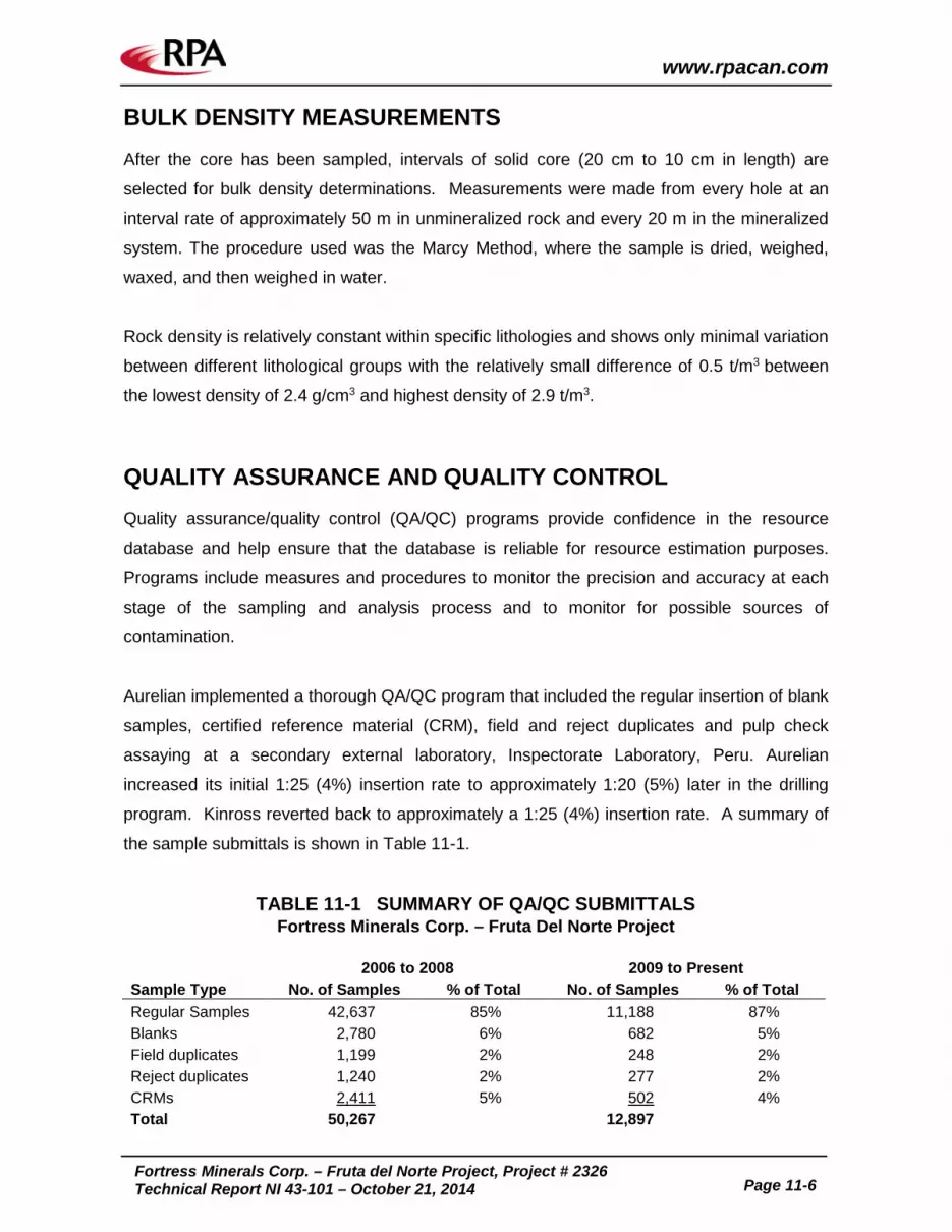
www.rpacan.com
Fortress Minerals Corp. – Fruta del Norte Project, Project # 2326
Technical Report NI 43-101 – October 21, 2014 Page 11-6
BULK DENSITY MEASUREMENTS After the core has been sampled, intervals of solid core (20 cm to 10 cm in length) are
selected for bulk density determinations. Measurements were made from every hole at an
interval rate of approximately 50 m in unmineralized rock and every 20 m in the mineralized
system. The procedure used was the Marcy Method, where the sample is dried, weighed,
waxed, and then weighed in water.
Rock density is relatively constant within specific lithologies and shows only minimal variation
between different lithological groups with the relatively small difference of 0.5 t/m3 between
the lowest density of 2.4 g/cm3 and highest density of 2.9 t/m3.
QUALITY ASSURANCE AND QUALITY CONTROL Quality assurance/quality control (QA/QC) programs provide confidence in the resource
database and help ensure that the database is reliable for resource estimation purposes.
Programs include measures and procedures to monitor the precision and accuracy at each
stage of the sampling and analysis process and to monitor for possible sources of
contamination.
Aurelian implemented a thorough QA/QC program that included the regular insertion of blank
samples, certified reference material (CRM), field and reject duplicates and pulp check
assaying at a secondary external laboratory, Inspectorate Laboratory, Peru. Aurelian
increased its initial 1:25 (4%) insertion rate to approximately 1:20 (5%) later in the drilling
program. Kinross reverted back to approximately a 1:25 (4%) insertion rate. A summary of
the sample submittals is shown in Table 11-1.
TABLE 11-1 SUMMARY OF QA/QC SUBMITTALS Fortress Minerals Corp. – Fruta Del Norte Project
2006 to 2008 2009 to Present
Sample Type No. of Samples % of Total No. of Samples % of Total Regular Samples 42,637 85% 11,188 87% Blanks 2,780 6% 682 5% Field duplicates 1,199 2% 248 2% Reject duplicates 1,240 2% 277 2% CRMs 2,411 5% 502 4% Total 50,267
12,897

www.rpacan.com
Fortress Minerals Corp. – Fruta del Norte Project, Project # 2326
Technical Report NI 43-101 – October 21, 2014 Page 11-7
BLANKS The regular submission of blank material is used to assess contamination during sample
preparation and to identify sample numbering errors. Earlier drill programs sourced blank
material from Hollin Formation sands located near Emperador. More recent programs used
Hollin rock sourced from an outcrop north of FDN.
A total of 1,478 blanks were inserted in the first 85 drill holes at FDN (CP-06-49 to CP-07-
139). Of these, 21 blanks (1.4%) returned values greater than 0.08 g/t Au and two returned
values over 1 g/t Au (from holes CP-06-51 and 57). The maximum value received for a blank
is 1.62 g/t Au. The anomalous assay values are interpreted to have been caused either by
contamination at the laboratory or by a sample switch. After drill hole CP-06-58, Aurelian
changed the sample preparation procedure so that quartz washes are performed in order to
clean the crusher between sample processing (Hennessey and Stewart, 2007). Results are
graphed on Figure 11-2.
FIGURE 11-2 EXAMPLE OF A BLANK SAMPLE CONTROL CHART
Blank assays that exceed ten times the detection limit are determined to have fallen into the
criterion which shows possible contamination and/or sample switches. Batch re-analysis
rarely resulted in changes to assay data and the sources of errors were quickly confined to
either sample switching or contamination. Out of 682 blanks assayed, eight samples were
considered to be contaminated with a maximum assay value of 0.212 g/t Au and five blanks
were deemed to be affected either by contamination or of sample mixing with a high assay
0.001
0.01
0.1
1
10
1322
32…
1382
1313
8338
1381
1313
6214
1347
42…
1347
1413
4664
1320
2813
0764
1305
1413
3138
1350
4013
5240
1353
4013
2615
1309
89…
1309
1412
5138
1264
1313
3589
1337
5813
7190
…13
7080
1340
4006
3386
0633
1213
7563
1323
7713
0195
1303
1313
0170
1300
4112
6761
1265
6414
0115
1333
1413
3288
1256
63…
1256
1313
6896
…13
6881
1409
6514
0640
1407
1514
1623
1397
6313
9713
1395
2313
8638
1387
5713
6533
1366
4013
5653
1356
6413
1725
1315
1213
1787
1285
4613
9141
1441
9714
1013
…14
1036
1412
1312
5418
1342
6413
4289
1392
6213
9373
1245
3712
9819
1296
9412
4160
1245
9212
4739
1246
55
135240
125088
133589
126586
LIMIT

www.rpacan.com
Fortress Minerals Corp. – Fruta del Norte Project, Project # 2326
Technical Report NI 43-101 – October 21, 2014 Page 11-8
value of 12.7 g/t Au. In all cases where spurious sample results were returned, the entire
assay batch was re-analyzed in the 2006-2008 campaigns and ten sequential samples both
above and below the outlier in the 2009-2010 campaign. During the infill program of 2010,
sequential blank failures detected one possibly contaminated batch of 25 samples in a high
grade interval in drill hole FN3300d05. Repeated analyses under strict cleaning procedures
have confirmed the original high assays.
From 2009 until present, ALS Chemex is considered to have provided adequate preparation
and assay procedures. However, more care is required during sample registry where five
probable cases of sample switching have been identified. At 0.7%, this represents only a
small percentage of the entire assay data set.
CERTIFIED REFERENCE MATERIALS Results from the regular submission of certified reference materials (“CRMs”) are used to
identify the accuracy of specific sample batches and long-term biases associated with the
regular assay laboratory. Repeated analysis of that same standard reference material will
also demonstrate the degree of analytical precision or its drift over time. Precision testing
involves replicate analysis of the certified standard as blind unknowns at a specified
sampling frequency. The grade of the CRM to be inserted is selected by the logging
geologist based on the expected grade range of the surrounding core samples.
Prior to the drilling moratorium in 2008, CRMs were inserted at a rate of one in 20 regular
samples. Subsequent to the moratorium, the insertion rate was one CRM every 25 samples.
CRMs were sulphide matrix material with certified Au, Ag, or combined Au-Ag values and
were produced by Rocklabs of New Zealand. Twenty different CRMs were used, with
expected grades ranging from 0.8 g/t Au to 30 g/t Au. Kinross monitored results with a series
of control charts (Figure 11-3).

www.rpacan.com
Fortress Minerals Corp. – Fruta del Norte Project, Project # 2326
Technical Report NI 43-101 – October 21, 2014 Page 11-9
FIGURE 11-3 EXAMPLE OF A CRM CONTROL CHART
Note: abbreviations appearing in the legend code are given below:
UWL: Upper warning limit = 95% confidence (CRM+2SD) UCL: Upper critical limit = 99% confidence (CRM+3SD) LWL: Lower warning limit = 95% confidence (CRM-2SD) LCL: Upper critical limit = 99% confidence (CRM-3SD).
UMPIRE ANALYSIS – CHECK ASSAYS One in ten of all pulp samples dispatched from FDN since drilling restarted in 2009 were
selected for re-analysis by Inspectorate Labs of Lima, Peru (for a total of 725 samples). The
same QA/QC protocol for blank and standards insertions was used. Results from
Inspectorate tended to yield lower values as compared to ALS Chemex (2%, excluding the
two highest grade standards inserted), however, the differences were deemed to be
insignificant and no changes were made to the original database.
CHAIN OF CUSTODY AND SECURITY Once sealed, core boxes were transported from the drill to Las Peñas exploration camp. At
the camp, core was checked by geologists and stored in the core shed during the logging
and sampling process. Sample bags were sealed in plastic bags and rice sacks using
single-use plastic cable ties and then stored in a locked shed until shipment. The Las Peñas
camp had 24 hour security, which included monitoring activities in the core shed area.
Samples were then transported overland by a company driver in a light truck directly to Quito
where the custody of the samples was transferred to laboratory personnel. Signatures for
8.0
8.2
8.4
8.6
8.8
9.0
9.2
124725…138146…138171138246138270134722…131960…135073…135173132700…125145…125195125270133647…133672137098…137173134048…134123063269…063344063419137570…137645132309…130071…130121130172130221126542…140247…133347…125571…125596136796…136821136871136921141582…139521…139571139621139671136618…136643135647…135771131669…131794128548…128596128621139099…144007…141071…141196125396…125446134272…139278…139328139353124468…124093…
AU(PPM). CRM_AU. AVG_AU. UWL_AU. UCL_AU. LWL_AU. LCL_AU.

www.rpacan.com
Fortress Minerals Corp. – Fruta del Norte Project, Project # 2326
Technical Report NI 43-101 – October 21, 2014 Page 11-10
responsible parties were required at every step of the process and records were archived at
the Las Peñas camp.
Digital laboratory data was distributed to project managers and the resource database
administrator via electronic mail. That data was manually uploaded to the database where it
was automatically merged with the appropriate sample data. The resource database system
required users to be logged on to the system. Each user was assigned privileges that were
dependent on his or her duties.
FIELD AND COARSE REJECT DUPLICATE SAMPLES Field duplicates assess the variability introduced by selecting one half of the drill core versus
the other, sampling disordering, and the nugget effect. Field duplicates consisted of two
quarter-cores sampled from one sample interval and the remaining half core was retained for
reference purposes. The coarse reject duplicate samples consisted of a second pulp made
from leftover coarse reject material from the primary crushing stage. Results from the reject
duplicate QC program were used to determine if the splitting procedures were applied
consistently and were appropriate. Of the two duplicate sample types, field duplicates were
prepared and numbered at the FDN core facility. Second split reject samples must be
requested and prepared by the assaying company.
RPA recommends that the entire other half of the drill core be submitted so that both
samples have the same original volume and therefore results will better reflect the local-
grade variance.
Scatter plots for field duplicates and reject duplicates show a strong correlation of 0.96 and
0.99, respectively, and indicate a high level of confidence in laboratory practices (Figure 11-
4).

www.rpacan.com
Fortress Minerals Corp. – Fruta del Norte Project, Project # 2326
Technical Report NI 43-101 – October 21, 2014 Page 11-11
FIGURE 11-4 SCATTERPLOT OF COARSE REJECT DUPLICATE RESULTS
COMMENTS ON QA/QC RESULTS In general, the QA/QC results confirm that the gold and silver assays have achieved an
acceptable level of precision and accuracy. No significant biases are observed, nor are they
evident from the 2006 and 2007 external check assay and certified reference standard
results graphed in Hennessey and Stewart (2007) and Hatch (2010). RPA also found
QA/QC procedures acceptable for the 2010 infill program.
In RPA’s opinion, the QA/QC program as designed and implemented by Aurelian and
Kinross is adequate and the assay results within the database are suitable for use in
preparation of a Mineral Resource estimate.
y = 0.996x + 0.0113R² = 0.991
0
10
20
30
40
50
60
70
80
90
100
0 20 40 60 80 100
Dup
licat
e Sa
mpl
es (
Au
ppm
)
Regular Samples (Au ppm)

www.rpacan.com
Fortress Minerals Corp. – Fruta del Norte Project, Project # 2326
Technical Report NI 43-101 – October 21, 2014 Page 12-1
12 DATA VERIFICATION SCOTT WILSON RPA AUDIT OF MINERAL RESOURCE AND MINERAL RESERVE ESTIMATES A significant portion of the database verification was performed by Scott Wilson Roscoe
Postle Associates Inc. (Scott Wilson RPA), a predecessor company to RPA, during an audit
of the December 31, 2009 Mineral Resource and Mineral Reserve estimates. Scott Wilson
RPA’s audit was completed by Luke Evans, M.Sc., P.Eng., Dennis Bergen, P.Eng.,
Associate Principal Mining Engineer, and Holger Krutzelmann, P.Eng., Principal Metallurgist.
Mr. Evans and Mr. Bergen visited the FDN site from April 6 to 9, 2010 (Evans et al., 2010).
Data verification activities carried out by Mr. Evans included a detailed review of the standard
operating protocols, the drill hole spacing, the core diameter used, how the final collar
coordinates were determined, the downhole surveying procedures, the drill core logging
protocols, the core recovery, collection of the bulk density data, the sample layout, sample
preparation and sample security procedures, and the QA/QC protocols.
In June 2014, Kinross provided RPA a Dassault Systèmes GEOVIA GEMS (GEMS) project
containing updated drill hole database, core recovery, and density measurement files in
digital format. To reclaim the benefit of the previous data verification work related to the
2010 audit, RPA compared the updated database provided in June 2014 to the database
used for the December 31, 2009 Mineral Resource and Mineral Reserve estimate. No
significant discrepancies were identified.
SITE VISIT AND CORE REVIEW During its site visit, RPA reviewed drill core from numerous boreholes and compared
observations with assay results and descriptive log records made by Aurelian and Kinross
geologists. In addition to reviewing core, RPA examined outcrops, drill rigs, sampling
procedures, and other general exploration protocols.
www.rpacan.com
Fortress Minerals Corp. – Fruta del Norte Project, Project # 2326
Technical Report NI 43-101 – October 21, 2014 Page 12-2
CHECKS ON ASSAY DATA BY OTHER CONSULTANTS Hennessey and Stewart (2007) used a two phase verification process to check 100% of the
assay data compiled up to and including 2007 drilling. The first phase was to check all
database assays on an ongoing basis as the certificates arrived from the lab. The second
phase was to re-check 10% of the database against lab certificates.
Between late 2007 and early 2009, drilling activities were not undertaken. At the end of the
2009 and 2010 infill programs, site personnel compiled and checked all certificates against
the database for all elements. The comparison showed no errors. Kinross also did a manual
5% check of the 2010 drill assay data while at site in June 2010. No errors were identified.
RPA is of the opinion that database verification procedures for the Project comply with
industry standards and are adequate for the purposes of Mineral Resource estimation.

www.rpacan.com
Fortress Minerals Corp. – Fruta del Norte Project, Project # 2326
Technical Report NI 43-101 – October 21, 2014 Page 13-1
13 MINERAL PROCESSING AND METALLURGICAL TESTING INTRODUCTION An extensive number of studies were carried out from 2010 to 2013 for the FDN deposit in
order to identify the best processing option. Table 13-1 summarizes the evolution of the key
studies and process scenarios that have been considered. The relevant study reports have
been reviewed and referenced in this section, where applicable.
Gravity Concentration followed by Flotation and CIL (GFL) is a relatively simple process with
lower operational risk and was identified as an attractive alternative to whole ore pressure
oxidation/pressure oxidation (WOPOX/POX). A GFL processing option, at a processing rate
of 5,000 tpd (5 ktpd), was selected to be the preferred process scenario by Kinross as a
result of the Ranking Study, in comparison to WOPOX. The GFL option simplifies the mine
plan as the necessity for segregated mining is eliminated, and facilitates early gold
production by targeting high value stopes. The GFL option is simply replacement of POX
with a flotation plant as illustrated in Figure 13-1.
As a result of the Conceptual Mining Study, a production rate of 3,500 tpd (3.5 ktpd) was
identified as a more optimum production rate for the GFL option.

www.rpacan.com
Fortress Minerals Corp. – Fruta del Norte Project, Project # 2326
Technical Report NI 43-101 – October 21, 2014 Page 13-2
TABLE 13-1 SUMMARY OF STUDIES Fortress Minerals Corp. – Fruta del Norte Project
Date Study (1) Process (2) Scenario Comments 2010 PFS WOPOX followed by
CIL 3 ktpd
Feb 2011 PFS Two Phase
Construction Initial: WOCIL Year 1.5: WOPOX
2.5 ktpd 5 ktpd
On-site power
Feb 2012 FS Two Phase
Construction Initial: WOCIL Year 1.5: WOPOX
2.5 ktpd 5 ktpd
Hatch study, grid power, also referred to as POX B case
Single Phase
Construction WOPOX
5 ktpd Referred to as POX C case
Early 2012 PIP
Optimization GFR GFL GLF GFBL
GFL idenitified as financially comparable alternative to POX
May 2012 TFS GFL as alternative to
POX 5 ktpd FS modified to remove
financial and sensitive data. Technical information same as FS.
Dated Dec 2012 (completed early 2013)
Ranking Study (RS)
Three GFL options ranked against two POX options
GFL: 3 ktpd, 4 ktpd, 5 ktpd POX: POX B and C cases
GFL at 5 ktpd ranked as preferred option
June 2013 GFL Update GFL 5 ktpd Hatch study July 2013 Conceptual
Mining Study GFL 3.5 ktpd NCL study, based on RS
results Notes:
1. PFS – Pre-feasibility Study, FS – Feasibility Study, PIP – Partners in Performance, TFS – Technical Feasibility Study.
2. WOPOX – Whole Ore Pressure Oxidation, CIL – Carbon in Leach, WOCIL – Whole Ore Carbon in Leach, POX – Pressure Oxidation, GFR – Gravity Concentration followed by Flotation and Roasting, GFL – Gravity Concentration followed by Flotation and CIL, GLF – Gravity Concentration followed by CIL and Flotation, GFBL – Gravity Concentration followed by Flotation and Bioleaching.

Jaw Crusher
SAG Mill
Ball Mill
Rougher Flotation
RegrindIntensiveLeach
IL Tls Rougher Tls
1st Clnr Tls
CleanerFlotation
GravityConcentration
GravityConcentrate
FlotationConcentrate
Carbon-in-Leach
CIL TailsTo Refinery
To Refinery
October 2014 Source: Kinross Gold Corp., 2012.
Fruta del Norte Project
Simplified GFL Flowsheet
Fortress Minerals Corp.
Zamora-Chinchipe Province, Ecuador
Figure 13-1
13-3
ww
w.rp
acan
.co
m

www.rpacan.com
Fortress Minerals Corp. – Fruta del Norte Project, Project # 2326
Technical Report NI 43-101 – October 21, 2014 Page 13-4
MINERALOGY The following description of mineralogy is from the Ranking Study (Kinross, 2012c).
Four geochemically, texturally, and mineralogically distinct zones have been identified for the
FDN deposit:
• Xh_Vn: hydrothermal eruption breccia, syn-epithermal system (i.e. with clasts of veins and mineralized/altered rock)
• Xp_lp: phreatomagmatic breccia, pre-epithermal system (i.e. silica altered with clasts of volcanic and porphyry, but no epithermal vein clasts)
• M_South
• Silica_Halo
Seventy percent of the deposit is represented in the first two zones (Xh_Vn and Xp_Ip).
Mineralization at FDN is considered complex since gold and silver is contained in a wide
range of forms and carriers. The FDN deposit has five main gold forms and carriers:
• Free gold in silica gangue
• Electrum
• Gold and silver tellurides
• Fine gold particles associated with sulphides and non-sulphide material
• Refractory “solid solution” gold in sulphides, mostly pyrites and silicates
Mineralogical analysis of individual zone composites is presented in Table 13-2. Ore
characterization has changed to represent geological domains instead of
mineralogical/geometallurgical characterization; however, metallurgical testwork references
were based on four zones. In all zone composites, silicate minerals dominated the mineral
mass and pyrite was the predominant sulphide mineral. In FDN Zones 1, 2 and 4, sphalerite
was the next highest sulphide mineral in concentration. Significant carbonate was also
present in FDN Zones 1 and 2.

www.rpacan.com
Fortress Minerals Corp. – Fruta del Norte Project, Project # 2326
Technical Report NI 43-101 – October 21, 2014 Page 13-5
TABLE 13-2 MINERALOGICAL SUMMARY (2009) Fortress Minerals Corp. – Fruta del Norte Project
Gold Association (%)
Description (1) Zone 1 Zone 2 Zone 3 Zone 4 Zone 1&2 (2) Liberated Gold 45 25 24 35 35 Gold in Sulphides 14 42 7.5 15 28 Gold Associated with non-sulphide gangue 40 34 69 50 37 Pyrite Liberation
Free 77 30 76 45 53 Liberated 1.6 25 -- 18 13 In Silicates 19 44 25 37 31
Bulk Modal Analysis Carbonates 1.5 -- 0.4 1.2 0.8 Oxides 5.4 0.3 0.4 1.2 2.8 Silicates 83 96 97 97 89 Pyrite 9.1 3.3 1.9 1.1 6.2 Other Sulphides 0.5 0.3 -- 0.2 0.4
Notes:
1. Based on pulverized samples. 2. Calculated 50:50 Zone1:Zone 2 characterization used for flotation optimization.
The mineralogical analysis shows the complexity of the FDN mineralization. The
predominant gold forms and carriers change from liberated gold in Zone 1 to gold in
sulphides in Zone 2 and gold in non-sulphide material in Zones 3 and 4. The bulk of the gold
is microscopic and associated with quartz, carbonates, and sulphides. Much of the gold is
“free milling”, but the mineralization is moderately refractory with approximately 40% of the
gold locked in sulphides. Coarse visible gold is common and occurs in all mineralized zones.
Gold occurs in quartz or carbonate and within pyrite or silver sulphosalt clusters.
The sulphide content also varies systematically, with the upper central part of the system
often exceeding 20% sulphide, as alteration and in veins and brecciation, decreasing to less
than 1% in the quartz veins at the north end of the system.
Due to the complexity of the mineralization, multiple process circuits are needed to recover
gold and silver.

www.rpacan.com
Fortress Minerals Corp. – Fruta del Norte Project, Project # 2326
Technical Report NI 43-101 – October 21, 2014 Page 13-6
METALLURGICAL TESTING Metallurgical testing in support of the GFL process option was conducted by SGS Lakefield
Research Ltd. (SGS) on five composite samples that were created in 2009 and 2012. The
test program consisted of three phases:
• Phase 1 – Validation of GFL flowsheet
• Phase 2 – GFL flowsheet optimization
• Phase 3 – Downstream test work
Tests were performed in order to validate and optimize the GFL process to be used at FDN
and estimate metal recovery and operating costs.
Drill hole locations for the composite samples used during various test phases are indicated
in Table 13-3. The Zone 1&2 composite samples were prepared in 2009, while the 5 Year
Average, 5 Year Low, and 5 Year High composites and the LOM composite sample were
prepared in 2012 specifically for GFL optimization testwork and were based on the 2012
revised 5 ktpd non-constrained mine plan.
TABLE 13-3 SUMMARY OF COMPOSITE SAMPLES AND ASSAYS (1) Fortress Minerals Corp. – Fruta del Norte Project
Sample ID Drill Hole ID Stewart Zone
Weight (kg)
Composite (kg)
Au (g/t)
Ag (g/t) %S2- %CO3
Zone 1 Composite FDN1-1 CP-08-225 94.9 FDN1-2 CP-08-196 32.8 FDN1-3 CP-08-198 23.7 FDN1-4 CP-08-194 36.3 FDN1-5 CP-08-191 16.7 FDN1-6 CP-08-207 58.0 FDN1-7 CP-08-201 37.1
Total Zone 1 Composite 299.5 165.4 Zone 2 Composite
FDN2-1 CP-08-209 11.8 FDN2-2 CP-08-195 23.4 FDN2-3 CP-08-199 17.7 FDN2-4 CP-08-193 23.6 FDN2-5 CP-08-196 4.7

www.rpacan.com
Fortress Minerals Corp. – Fruta del Norte Project, Project # 2326
Technical Report NI 43-101 – October 21, 2014 Page 13-7
Sample ID Drill Hole ID Stewart Zone
Weight (kg)
Composite (kg)
Au (g/t)
Ag (g/t) %S2- %CO3
FDN2-6 CP-08-198 13.5 FDN2-7 CP-08-194 7.3 FDN2-8 CP-08-191 16.4 FDN2-9 CP-08-207 14.4
FDN2-10 CP-08-201 15.1 FDN2-11 CP-08-201 13.5 FDN2-12 CP-08-192 45.3 FDN2-13 CP-08-225 94.2
Total Zone 2 Composite 300.9 176.4 Zone 1&2 Composite (Phase 1) 341.8
5 Year Average Grade Composite (Phase 2)
CP-09-242 FDN2 8.27 5.53 4.60 2.54 0.26 CP-09-242 FDN2 6.91 6.12 7.70 2.83 0.05 CP-09-244 FDN2 7.56 6.89 7.60 1.93 0.05 CP-09241 FDN1 7.82 8.21 4.70 2.42 1.41 CP-09-241 FDN1 7.62 10.10 12.90 2.65 3.64 CP-09-241 FDN1 3.99 10.30 6.40 2.66 1.24 CP-09-242 FDN1 7.52 12.50 19.00 2.09 4.26 CP-09-242 FDN2 6.50 12.80 33.00 2.40 0.05 FN3650m01 FDN4 7.12 16.20 11.20 1.57 1.17
Total 5 Year Average Grade Composite 63.31 9.37 11.76 2.34 1.31
5 Year High Grade Composite (Phase 2) CP-09-244 FDN2 3.86 12.60 11.00 1.93 0.05 CP-09-242 FDN1 5.31 12.80 32.80 2.83 0.05 CP-09-242 FDN1 7.67 14.50 12.30 1.04 7.60 CP-09-241 FDN1 3.59 15.20 4.90 2.93 0.23 CP-09-244 FDN4 6.77 19.90 22.80 1.41 0.05
Total 5 Year High Grade Composite 31.27 15.97 16.28 2.00 1.95
5 Year Low Grade Composite (Phase 2) CP-09-242 FDN2 7.55 4.00 6.00 2.58 0.32 CP-09-244 FDN2 3.66 4.94 10.80 0.64 0.05 CP-09-242 FDN2 3.76 6.60 6.90 1.26 0.05 CP-09-241 FDN1 3.97 8.67 5.20 2.66 1.24 CP-09-242 FDN1 3.97 8.72 16.00 3.35 0.37 CP-09-242 FDN2 7.19 9.40 14.30 2.16 0.05
Total 5 Year High Grade Composite 30.10 6.97 9.89 2.19 0.32
LOM Composite (Phase 2 – 3) CP-09-242 FDN1 4.09 4.62 5.00 0.40 3.51 CP-09-241 FDN1 8.00 5.06 4.90 2.42 1.41 CP-09-242 FDN1 7.77 5.13 2.70 2.31 0.55

www.rpacan.com
Fortress Minerals Corp. – Fruta del Norte Project, Project # 2326
Technical Report NI 43-101 – October 21, 2014 Page 13-8
Sample ID Drill Hole ID Stewart Zone
Weight (kg)
Composite (kg)
Au (g/t)
Ag (g/t) %S2- %CO3
CP-09-242 FDN1 7.46 5.16 5.20 2.74 0.05 CP-09-244 FDN2 7.79 5.26 11.70 3.32 0.05 CP-09-242 FDN1 4.68 5.41 5.00 3.22 0.16 CP-09-242 FDN1 7.70 5.55 6.20 2.69 1.14 CP-09-243 FDN2 7.46 5.56 11.70 3.77 0.05 CP-09-241 FDN1 4.18 5.67 2.60 2.68 2.56 FN3650m01 FDN4 3.33 6.22 4.20 0.08 4.22 CP-09-242 FDN1 4.30 6.74 16.10 2.08 8.55 CP-09-244 FDN4 6.68 6.90 5.60 0.12 2.97 CP-09-243 FDN4 7.60 7.07 41.10 2.41 0.43 CP-09-241 FDN2 2.96 7.24 9.00 2.93 1.67 CP-09-244 FDN2 7.30 7.45 28.60 3.89 0.05 CP-09-243 FDN4 3.28 7.46 15.70 2.48 0.45 FN3650m01 FDN4 2.52 7.92 6.00 0.95 0.43 CP-09-241 FDN3 3.65 7.98 10.00 0.05 0.05 CP-09-242 FDN2 3.71 8.18 9.00 2.01 0.05 CP-09-242 FDN1 7.94 8.23 27.30 3.50 1.36 CP-09-242 FDN1 6.85 8.43 7.80 3.04 1.19 CP-09-242 FDN1 7.56 9.28 10.20 3.04 1.19 CP-09-242 FDN2 4.49 9.71 0.50 1.60 0.05 FN3650m01 FDN4 2.83 10.10 7.90 0.41 1.07 CP-09-241 FDN2 10.50 9.20 9.20 5.65 0.92 CP-09-242 FDN1 4.50 10.80 10.40 1.60 3.75 C9-09-241 FDN1 4.15 11.10 7.70 2.97 2.90 CP-09-242 FDN1 4.59 11.10 13.70 3.22 0.16 CP-09-245 FDN4 2.01 11.50 8.30 1.11 0.32 FN3650m01 FDN4 7.01 13.20 12.30 0.08 0.08 4.22 CP-09-242 FDN1 7.52 13.40 11.50 2.69 1.14 CP-09-242 FDN1 5.16 16.60 19.80 3.22 0.16 CP-09-242 FDN1 7.39 18.30 9.50 2.31 0.55
Total LOM Composite 186.96 8.48 11.54 2.54 1.32
Notes: 1. Calculated weighted average grades.
A check by RPA of the drill hole locations for each of the five composite samples used in
metallurgical testing confirmed that sampling was primarily from zones Xh_Vn and Xp_Ip. It
is unclear how the Zone 1&2 composite samples relate spatially to the current four geological
domains (Xh_Vn, Xp_Ip, M_South, and Silica_Halo) due to recent changes to the geological
domaining system. It is recommended that a drilling campaign collect fresh samples for
more metallurgical testwork in order to better define the gold and silver recoveries in the GFL
process.

www.rpacan.com
Fortress Minerals Corp. – Fruta del Norte Project, Project # 2326
Technical Report NI 43-101 – October 21, 2014 Page 13-9
Full head grade analysis of the FDN sample composites used for 2012 metallurgical test
work is shown in Table 13-4. The calculated weighted average values in Table 13-4 were
lower than the measured values from head assays. The gold head grades for all samples
are much higher than the break-even COG for gold (4.5 g/t) referenced in the Conceptual
Mining Study (NCL, 2013).
TABLE 13-4 FDN SAMPLE COMPOSITION Fortress Minerals Corp. – Fruta del Norte Project
Element Unit Zone 1&2 5 Year
Average 5 Year Low 5 Year High LOM
Au g/t 10.9 8.98 5.95 14.0 9.94 Ag g/t 15.6 9.00 9.60 17.8 16.4 S % 2.68 2.46 2.28 2.2 2.68
S2- % 2.41 -- -- -- 2.43 As % 0.01 0.03 0.04 0.05 0.06 Co % <0.01 <0.01 <0.01 <0.00 <0.01 Cu % 0.02 0.01 0.01 0.01 -- Cl g/t 90 140 100 120 240 Fe % 2.69 2.48 2.22 2.24 2.53 Ni % <0.002 <0.001 <0.001 <0.000 <0.001 Pb % 0.04 0.02 0.07 0.02 0.02 Sb % 0.01 0.01 0.01 0.01 0.01 Zn % 0.13 0.07 0.04 0.05 0.05 Bi % <0.002 <0.002 <0.002 <0.002 <0.002 Cd % <0.0005 <0.0005 <0.0005 <0.0005 <0.0005 Si % -- 38.5 40.0 37.4 35.0 Hg g/t 1.15 0.70 1.10 1.90 0.80 F % 0.04 0.04 0.06 0.04 0.05
Phase 1 bench scale test work determined that replacement of the POX circuit with a
flotation circuit resulted in high overall gold recoveries and demonstrated that GFL was a
viable option.
Phase 2 test work focused on optimization studies and an overall gold recovery of 94.8% and
an overall silver recovery of 93.2% were achieved in a locked cycle test (LCT5) performed on
a composite sample representing the average grades of gold, silver, carbonate, and sulphur
for the first five years of mine life (based on the 5 ktpd non-constrained mine plan). LCT6
was performed on a composite sample representing the average grades of gold, silver,
carbonate, and sulphur for the entire LOM and based on the 5 ktpd con-constrained mine
plan. Overall gold recovery achieved in LCT6 was 93.3%, while overall silver recovery was

www.rpacan.com
Fortress Minerals Corp. – Fruta del Norte Project, Project # 2326
Technical Report NI 43-101 – October 21, 2014 Page 13-10
92.9%. However, the mass pulls for LCT 5 (4.46%) and LCT6 (3.57%) were both under the
target of 6%. There is potential for improvement in gold recovery with a higher mass pull and
further studies should be undertaken to confirm recoveries.
A summary of key test work results from optimization studies is presented in Table 13-5.
TABLE 13-5 SUMMARY OF KEY TESTWORK RESULTS Fortress Minerals Corp. – Fruta del Norte Project
Process Parameter Units Value Gravity Target Mass Pull % 1 – 1.25
Target Recovery %Au 23 Grind Size µm 150 – 165
Flotation Rougher Feed Grind Size µm 70 Rougher Concentrate Mass Pull % 20 Cleaner Concentrate Mass Pull % 5 - 6 Cleaner Stages # 3 Rougher Concentrate Regrind µm 35 Reagents PAX, A208, MIBC Rougher pH neutral
The GFL test work produced a marketable concentrate with high sulphur and silica content
with low levels of deleterious elements making it attractive to smelters.
Global recoveries of gold and silver from the Ranking Study process design criteria for all
GFL cases were 94.7% and 90.9%, respectively. Kinross revised the gold and silver
recoveries to 93.2% and 90.9%, respectively (Hatch, 2013) and these figures were used for
reference in the Conceptual Mining Study for the 3.5 kptd GFL case.
A program of systematic GFL flowsheet optimization testwork should continue on
representative samples of the material to be mined in the production plan, with emphasis on
gold and mass recovery for a broader range of mineralized samples.

www.rpacan.com
Fortress Minerals Corp. – Fruta del Norte Project, Project # 2326
Technical Report NI 43-101 – October 21, 2014 Page 14-1
14 MINERAL RESOURCE ESTIMATE SUMMARY Kinross provided RPA with a GEMS project that included the drill hole database, wireframes
of the domain boundaries, and a complete block model. RPA reviewed all aspects of the
resource model, made some minor adjustments, calculated an updated cut-off grade, and
reported Mineral Resources.
Mineral Resources for the FDN deposit were estimated using drill hole data available to
October 21, 2014 (Table 14-1). At a cut-off grade of 3.4 g/t Au, Indicated Mineral Resources
are estimated to total 23.5 million tonnes at an average grade of 9.59 g/t Au and 12.9 g/t Ag
for a total of 7.26 million ounces of gold and 9.73 million ounces of silver. Inferred Mineral
Resources are estimated to total 14.5 million tonnes at an average grade of 5.46 g/t Au and
2.55 g/t Ag for a total of 2.55 million ounces of gold and 5.27 million ounces of silver. The
Mineral Resources are contained within four main geological domains. There are no Mineral
Reserves currently estimated on the Project.
TABLE 14-1 SUMMARY OF MINERAL RESOURCES – OCTOBER 21, 2014 Fortress Minerals Corp. – Fruta del Norte Project
Category Tonnage Grade Contained Metal Grade Contained Metal
(M t) (g/t Au) (M oz Au) (g/t Ag) (M oz Ag) Indicated 23.5 9.59 7.26 12.9 9.73 Inferred 14.5 5.46 2.55 11.3 5.27
Notes:
1. CIM definitions were followed for the classification of Mineral Resources. 2. Mineral Resources are estimated at a cut-off grade of 3.4 g/t Au. 3. The cut-off grade was calculated using a long-term gold price of $1,400 per ounce. 4. The Mineral Resource estimate uses drill hole data available as of October 21, 2014. 5. Bulk density ranges from 2.62 t/m3 to 2.73 t/m3. 6. Mineral Resources that are not Mineral Reserves do not have demonstrated economic viability. 7. Numbers may not add due to rounding.
RESOURCE DATABASE Kinross modelled the FDN resources using Dassault Systèmes GEOVIA GEMS Version 6.6
software (GEMS). Kinross provided RPA a GEMS project that included the drill hole

www.rpacan.com
Fortress Minerals Corp. – Fruta del Norte Project, Project # 2326
Technical Report NI 43-101 – October 21, 2014 Page 14-2
database plus all other resource modelling components such as wireframe and block
models.
Listed below is a summary of records for drill holes recorded in the GEMS project. The most
recent drill hole included in the database was drilled in 2010. Drill holes completed since
then are not expected to have a significant effect on the Mineral Resource model. The
central core, located in the northern half of the deposit, was drilled at 35 m to 50 m spacing,
whereas the south half of the deposit is drilled on 100 m spaced sections.
• Holes: 237 • Surveys: 3,060 • Assays: 54,629 • Composites 46,316 • Full width intercepts: 1,157 • Lithology: 7,090 • Alteration: 7,091 • Density measurements: 3,511
A total of 32 drill holes have no associated assay data since these did not intersect
mineralization. Drill holes CP-07-116, CP-07-128, CP-07-145, and CP-08-229 collapsed
during drilling and were not logged.
Five metallurgical holes, CP-09-241 to CP-09-245, have unassayed intervals that are likely
located within mineralization. These intervals were treated as “no data”, and did not
influence the block grade estimates. RPA recommends that these unassayed intervals be
assayed if the drill core is available.
All drill hole and resource model coordinates are in UTM Zone 17 South using the EGM96
geoid to reference elevation.
Section 12, Data Verification, describes the verification steps made by Kinross and RPA. In
summary, no discrepancies were identified and RPA is of the opinion that the drill hole
database is valid and suitable to estimate Mineral Resources for the Project.

www.rpacan.com
Fortress Minerals Corp. – Fruta del Norte Project, Project # 2326
Technical Report NI 43-101 – October 21, 2014 Page 14-3
DATABASE RE-PROJECTION The 2010 exploration grid was based on UTM Zone 17S coordinates using the PSAD56
datum. All data has since been re-projected to UTM Zone 17S using the using the EGM96
geoid to reference elevation. In 2010, Kinross retained Tetra Tech Wardrop (Wardrop) to
assess the impact of implementing a new datum on collar coordinates, and on the
subsequent translation of the geological interpretation (wireframes) to the new datum.
Wardrop’s assessment included various comparisons of re-surveyed holes and a visual
verification of the corrected database with the LiDAR produced surface. No significant
offsets were noted between the corrected data set and the LiDAR surface. Geological
wireframe translation was based on the average offset from the drill hole coordinates.
References to section lines are abbreviated to xx00N from the UTM northing 958xx00 metres
north.
GEOLOGICAL INTERPRETATION AND 3D SOLIDS Geological domains are used to control block modelling processes such as block grade
estimates and density assignments. Domains are interpreted as zones with relatively
uniform grade statistics and geology. Kinross used a variety of statistical and geostatistical
tools to determine the domaining criteria including:
• Length statistics to determine dominance by geologic attribute;
• Dependency test to develop baseline relationships for geologic attributes;
• Correlation matrices to link the geologic dependents to geochemical attributes;
• Principal Component Analysis (PCA) to provide the first step in the clustering of attributes for observing potential correlations;
• K-mean clustering to assign attributes into groups.
The correlation matrices defined a silicic gold bearing core that consisted of four distinct sub-
domains composed of distinctly different mineralogical, epithermal, and geochemical
signatures. Conversely, there was a negative correlation of Au mineralization with respect to
the clay alteration types that encapsulated the silicic core. Kinross used the following key
geologic associations to facilitate the sub-domaining of the FDN mineralized core:
• Lithological – Strong relationship between breccia types and Au mineralization
• Alteration – Weak relationship between Au mineralization and clay alteration
• Alteration – Strong relationship between Au mineralization and silica alteration
www.rpacan.com
Fortress Minerals Corp. – Fruta del Norte Project, Project # 2326
Technical Report NI 43-101 – October 21, 2014 Page 14-4
Both Leapfrog and GEMS software were used to build the wireframe models representing
the domains. Wireframe model of various alteration and lithology zones were first built in
Leapfrog. The second stage of the wireframe construction process was done in GEMS
software. The alteration, silicic core, and lithologic surfaces created in Leapfrog were
imported into GEMS for final solid creation (Figures 14-1 to 14-4).
The FDN deposit was divided into four main geologic domains based on lithology, alteration,
and grade. Each domain is distinctive in mineralogical, textural, and geochemical character
as well as in gold distribution.
1. The Xp_Ip domain is a phreatomagmatic breccia. It is thought to predate the epithermal system because it does not include epithermal vein clasts, although it is silica altered and includes clasts of volcanic and porphyry rocks. The Xp_Ip domain is vertical to sub-vertically oriented and elongated in the north-south direction, measuring approximately 365 m high by 120 m wide by 1,200 long. Xp_Ip and the Xh_Vn domain make up the gold core of the FDN deposit which hosts approximately 70% of the metal at FDN. It forms the eastern footwall of the deposit.
2. The Xh_Vn domain is a hydrothermal eruption breccia with abundant veining and
stockwork. It is thought to be synchronous with the epithermal system as it contains clasts of veins and both mineralized and altered wall rocks. It is vertical to sub-vertically oriented and elongated in the north-south direction, measuring approximately 360 m high by 130 m wide by 1,000 long.
3. The M_South volcanic domain is located to the south of the gold rich core made up of
the Xp_Ip and Xh_Vn domains. It is 300 m wide by 370 m high by 950 m long, elongated in the north-south direction.
4. The Silica_Halo envelops the top and bottom of the three other domains. Together
with the three other domains, the FDN deposit has a strike length of 1,670 m by 770 m in height. The Silica_Halo does not add significantly to the across strike direction.
The four zones are believed to represent distinct hydrothermal events starting with the Xp-lp
domain which is associated with late porphyry intrusion events. This was followed by the
silica-arsenopyrite-marcasite alteration associated with hydrothermal brecciation (Xh) in the
up-flow zone centred on section 3400N and “mushrooming” out below the Suarez
unconformity. The later stage quartz-carbonate phase (Vn) of the hydrothermal brecciation
event appears to have formed in the northern section of the deposit, wrapping partially
around a flexure in the feldspar porphyry contact. Xh and Vn were grouped together for
resource domaining purposes.

East F
au
lt
West F
au
lt
95
82
00
0N
,,
95
82
50
0N
,,
95
83
00
0N
,,
95
83
50
0N
,,
777,500 E 778,000 E 778,500 E 779,000 E
95
82
00
0N
,,
95
82
50
0N
,,
95
83
00
0N
,,
95
83
50
0N
,,
777,500 E 778,000 E 778,500 E 779,000 E
Xh - Vn Domain
M South Domain
Xp - Ip Domain
Drill Hole Trace
0 100 500
Metres
200 300 400
N
October 2014
Fruta del Norte Project
Level Plan withDomain Wireframes and
Drill Hole Traces
Fortress Minerals Corp.
Zamora-Chinchipe Province, Ecuador
Figure 14-1
14-5
www.rpacan.com
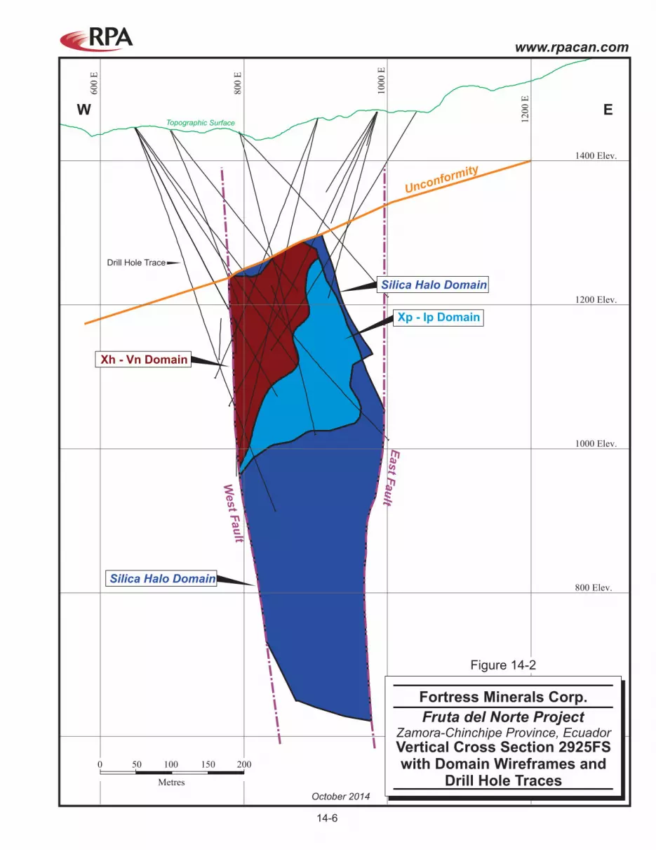
600 Elev.
800 Elev.
1000 Elev.
W E
1200 Elev.
1400 Elev.
60
0 E
80
0 E
10
00
E
12
00
E
Silica Halo Domain
Silica Halo Domain
Topographic Surface
Drill Hole Trace
Xh - Vn Domain
East F
au
lt
West F
au
lt
Unconformity
Xp - Ip Domain
0 50
Metres
100 150 200
October 2014
Fruta del Norte Project
Vertical Cross Section 2925FSwith Domain Wireframes and
Drill Hole Traces
Fortress Minerals Corp.
Zamora-Chinchipe Province, Ecuador
Figure 14-2
14-6
www.rpacan.com

60
0 E
80
0 E
10
00
E
12
00
E
14
00
E
600 Elev.
800 Elev.
1000 Elev.
1200 Elev.
1600 Elev.
1400 Elev.
W E
M South Domain
Silica Halo Domain
Topographic Surface
Drill Hole Trace
East F
au
lt
West F
au
lt
Unconform
ity
View Looking North
0 50
Metres
100 150 200
October 2014
Fruta del Norte Project
Vertical Cross Section 2325FSwith Domain Wireframes and
Drill Hole Traces
Fortress Minerals Corp.
Zamora-Chinchipe Province, Ecuador
Figure 14-3
14-7
www.rpacan.com

Unconformity
0 N 500 N 1000 N 1500 N
50
0E
lev.
10
00
Ele
v.
15
00
Ele
v.
50
0E
lev.
10
00
Ele
v.
15
00
Ele
v.
0 N 500 N 1000 N 1500 N
Xh - Vn Domain
M South Domain
Silica Halo Domain
Xp - Ip Domain
Topographic Surface
Drill Hole Trace
S NView Looking West
0 100 500
Metres
200 300 400
October 2014
Fruta del Norte Project
Longitudinal Section withDomain Wireframes and
Drill Hole Traces
Fortress Minerals Corp.
Zamora-Chinchipe Province, Ecuador
Figure 14-4
14-8
ww
w.rp
acan
.co
m

www.rpacan.com
Fortress Minerals Corp. – Fruta del Norte Project, Project # 2326
Technical Report NI 43-101 – October 21, 2014 Page 14-9
COMPOSITING The average length of assayed samples within the mineralized domains Xh_Vn, Xp_Ip, and
M_South is 0.99 m (Figure 14-5). Given the block size of 4 m by 10 m by 10 m, Kinross
chose to composite to two metre lengths for grade interpolation purposes.
Compositing was performed in Gemcom GEMS 6.3 modelling software. The processing was
done by geologic domain using intervals from a solid intercept table at two metre intervals.
To maintain sample support, the last interval of the domain composite was allowed to be
created, and was tagged as being residual. The residuals were not used in the variography
analysis but were used in the interpolation process. The composite results were also
checked for redundant entries, in an effort to minimize any adverse effects on variography
analysis. RPA recommends that the effect of the residuals less than 0.5 m be tested.
FIGURE 14-5 HISTOGRAMS OF SAMPLE LENGTHS
www.rpacan.com
Fortress Minerals Corp. – Fruta del Norte Project, Project # 2326
Technical Report NI 43-101 – October 21, 2014 Page 14-10
CUTTING HIGH-GRADE VALUES Where the assay distribution is positively skewed or approaches log-normal, erratic high-
grade assays or composite values can have a disproportionate effect on the average grade
of a deposit. One method of treating these outliers in order to reduce their influence on the
average grade is to cut or cap them at a specific grade level. In the absence of production
data to calibrate the cutting level, inspection of the assay or composite distribution can be
used to estimate a “first pass” cutting level. Kinross chose to cut composites rather than
assays. RPA recommends that the sensitivity of cutting raw assays be tested.
The FDN metal capping review consisted of disintegration analysis in conjunction with
histogram, log probability and mean variance plots. The disintegration analysis ranks the
metal data in ascending order and applies a percent change or step function of 10% to 15%
between consecutive values to determine where population breaks occur. This is used in
conjunction with the histogram and log probability plots to cross-validate the disintegration
population breaks (Table 14-2 and Figure 14-6).
The gold values for domain Xh_Vn were left uncapped. Instead, a restricted search was
applied to composites greater than 60 g/t Au as described below. A capping value was
applied to the silver grades for this domain.

www.rpacan.com
Fortress Minerals Corp. – Fruta del Norte Project, Project # 2326
Technical Report NI 43-101 – October 21, 2014 Page 14-11
TABLE 14-2 DISINTEGRATION ANALYSIS FOR DOMAIN XP_IP (GOLD) Fortress Minerals Corp. – Fruta del Norte Project

www.rpacan.com
Fortress Minerals Corp. – Fruta del Norte Project, Project # 2326
Technical Report NI 43-101 – October 21, 2014 Page 14-12
FIGURE 14-6 HISTOGRAM AND PROBABILITY PLOTS FOR DOMAIN XP_IP (GOLD)
The cutting levels applied by Kinross are summarized in Table 14-3. Statistical comparisons
are provided in subsection Statistical Analyses that follows. In order to preserve the grades
within the high grade zones with intense veining of domain Xh_Vn, Kinross chose to leave
composites uncapped, and instead applied a restricted search for gold values greater than
60.0 g/t. The restricted search dimensions are described in subsection Interpolation
Parameters.
TABLE 14-3 SUMMARY OF CUTTING LEVELS Fortress Minerals Corp. – Fruta del Norte Project
Item Gold Silver Domain Xh_Vn
Samples 9,528 9,528 Cutting Level none 148 Number Samples Cut none 25
Domain Xp_Ip Samples 6,351 6,351 Cutting Level 58.68 98.19 Number Samples Cut 11 9
Domain M_South

www.rpacan.com
Fortress Minerals Corp. – Fruta del Norte Project, Project # 2326
Technical Report NI 43-101 – October 21, 2014 Page 14-13
Item Gold Silver Samples 2,828 2,828 Cutting Level 27.38 87.83 Number Samples Cut 13 17
Domain Silica_Halo Samples 2,910 2,910 Cutting Level 27.38 87.83 Number Samples Cut 3.00 9.00
STATISTICAL ANALYSIS Assay and composite values located inside the wireframe models were tagged with domain
identifiers and exported for statistical analysis. Results were used to help verify the
modelling process. Basic statistics of both gold and silver assays are reported by domain in
Table 14-4. Note that the composites for Xh_Vn were not capped. Composite statistics are
listed for both capped and uncapped values. Composite statistics are reported after the
residual composites were removed.
TABLE 14-4 CUT AND UNCUT COMPOSITE STATISTICS
Fortress Minerals Corp. – Fruta del Norte Project
Assays (Uncapped) Composites Au (g/t) Ag (g/t) Au (g/t) Cut Au
(g/t) Ag (g/t) Cut Ag
(g/t) All domains
No. of Cases 41,658 41,658 21,617 21,617 21,617 21,617 Minimum 0.00 0 0.00 0.00 0 0 Maximum 2,447.20 1,130 1,449 1,449 671 148 Median 1.04 5 1.12 1.12 5 5 Arithmetic Mean 4.79 9 4.50 4.48 9 9 Standard Deviation 29.40 21 19.53 19.48 15 12 CV 6.13 2.3 4.34 4.35 1.7 1.4
Xh_Vn No. of Cases 18,851 18,851 9,528 9,528 9,528 9,528 Minimum 0.00 0 0.00 0.00 0 0 Maximum 2,447.20 1,130 1,449 1,449 671 148 Median 2.89 6 3.31 3.31 7 7 Arithmetic Mean 8.49 11 8.50 8.50 11 11 Standard Deviation 39.38 23 28.54 28.54 18 14 CV 4.64 2.1 3.36 3.36 1.6 1.3
Xp_Ip No. of Cases 12,402 12,402 6,351 6,351 6,351 6,351 Minimum 0.00 0 0.00 0.00 0 0

www.rpacan.com
Fortress Minerals Corp. – Fruta del Norte Project, Project # 2326
Technical Report NI 43-101 – October 21, 2014 Page 14-14
Assays (Uncapped) Composites Au (g/t) Ag (g/t) Au (g/t) Cut Au
(g/t) Ag (g/t) Cut Ag
(g/t) Maximum 538.00 578 89 59 197 98 Median 0.47 4 0.57 0.57 4 4 Arithmetic Mean 1.98 8 1.69 1.67 7 7 Standard Deviation 11.43 17 4.83 4.56 10 10 CV 5.78 2.2 2.86 2.73 1.4 1.3
M_South No. of Cases 5,695 5,695 2,828 2,828 2,828 2,828 Minimum 0.00 0 0.00 0.00 0 0 Maximum 1,535.00 688 79 27 229 88 Median 0.66 4 0.74 0.74 4 4 Arithmetic Mean 2.34 8 1.56 1.46 7 7 Standard Deviation 28.61 24 4.13 2.90 13 10 CV 12.21 3.2 2.65 2.00 1.9 1.5
Silica_Halo No. of Cases 4,710 4,710 2,910 2,910 2,910 2,910 Minimum 0.00 0 0.00 0.00 0 0 Maximum 86.10 460 52 27 383 88 Median 0.19 3 0.18 0.18 3 3 Arithmetic Mean 0.39 6 0.39 0.38 6 5 Standard Deviation 1.80 17 1.66 1.31 13 9 CV 4.65 2.7 4.25 3.47 2.3 1.7
Note. For the purpose of this analysis, most vein material was grouped with Xh_Vn. CV indicates coefficient of variation.
VARIOGRAPHY Variography was carried out within a 450 m long segment of the deposit with closely spaced
drilling, between northings 9,583,300mN and 9,583,750mN. The directions for the major,
semi-major, and minor axes were selected using a set of variogram maps generated in the
horizontal, across-strike vertical, and dip planes. Variograms for each direction were created
and modelled for each domain. A Normal Scores transformation was also used to provide
improved variograms. Figures 14-7 to 14-10 show the downhole and directional variograms
for the Xh_Vn domain. A back transformation from Normal Scores space was completed
following the variographic analysis and used as input to the Ordinary Kriging interpolation in
GEMS (Table 14-5).
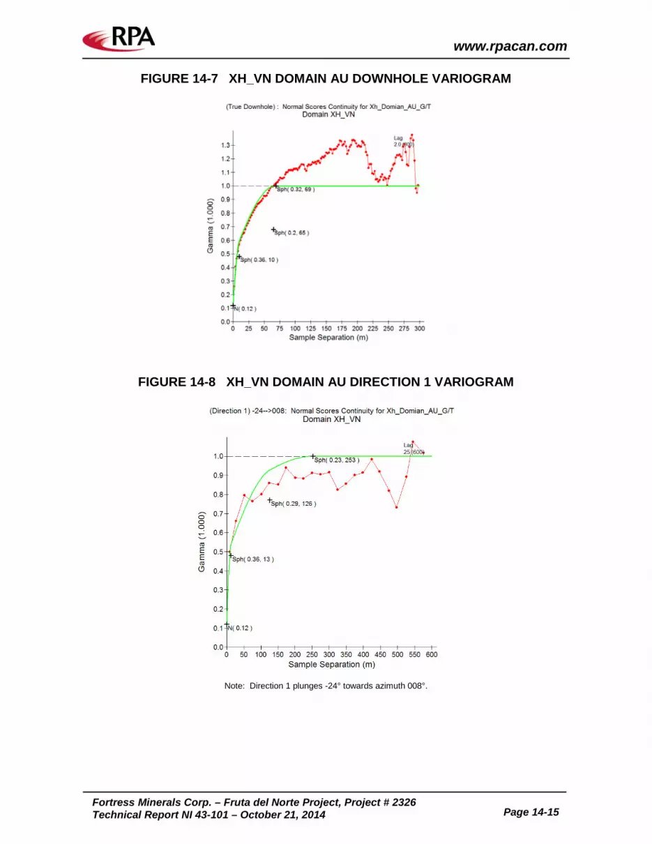
www.rpacan.com
Fortress Minerals Corp. – Fruta del Norte Project, Project # 2326
Technical Report NI 43-101 – October 21, 2014 Page 14-15
FIGURE 14-7 XH_VN DOMAIN AU DOWNHOLE VARIOGRAM
FIGURE 14-8 XH_VN DOMAIN AU DIRECTION 1 VARIOGRAM
Note: Direction 1 plunges -24° towards azimuth 008°.

www.rpacan.com
Fortress Minerals Corp. – Fruta del Norte Project, Project # 2326
Technical Report NI 43-101 – October 21, 2014 Page 14-16
FIGURE 14-9 XH_VN DOMAIN AU DIRECTION 2 VARIOGRAM
Note: Direction 2 plunges -61° towards azimuth 224°.
FIGURE 14-10 XH_VN DOMAIN AU DIRECTION 3 VARIOGRAM
Note: Direction 3 is inclined at -20° towards azimuth 285°.

www.rpacan.com
Fortress Minerals Corp. – Fruta del Norte Project, Project # 2326
Technical Report NI 43-101 – October 21, 2014 Page 14-17
TABLE 14-5 VARIOGRAM MODELS FOR XP_IP AND XH_VN Fortress Minerals Corp. – Fruta del Norte Project
Domain Xp_Ip Domain Xh_Vn
Structure Model Type Sill Range Structure Model Type Sill Range (m)
Direction 1 -23° towards 006° Direction 1 -23° towards 024°
1 Nugget 0.2 0 1 Nugget 0.19 0
2 Spherical 0.5 23.5 2 Spherical 0.44 13
3 Spherical 0.16 77 3 Spherical 0.24 126
4 Spherical 0.1 120 4 Spherical 0.13 253
Direction 2 -58 towards 231° Direction 2 -58° towards 159
1 Nugget 0.2 0 1 Nugget 0.19 0
2 Spherical 0.5 25 2 Spherical 0.44 16
3 Spherical 0.16 64 3 Spherical 0.24 69
4 Spherical 0.1 103 4 Spherical 0.13 187
Direction 3 -20° towards 285° Direction 3 -20° towards 285°
1 Nugget 0.2 0 1 Nugget 0.19 0
2 Spherical 0.5 24.5 2 Spherical 0.44 7
3 Spherical 0.16 40 3 Spherical 0.24 26
4 Spherical 0.1 53.5 4 Spherical 0.13 52
INTERPOLATION PARAMETERS Grade interpolations for gold and silver were made using the Ordinary Kriging (OK) algorithm
and using search strategies individually adapted to each domain (Tables 14-6 and 14-7).
The search ellipses generally have the same orientations, striking north-northeast, dipping
west, and plunging north-northeast. A two pass approach was used, with the first pass
search ranges approximately equivalent to the variogram ranges at 80% of the sill. The first
pass used a minimum of two drill holes. The second pass used a larger search with a one
hole minimum.
Both hard and soft boundaries were used, based on various contact analyses and the
geological interpretation by Kinross. Table 14-8 summarizes composites that were used to
estimate gold block grades within each domain. Pass 1 for Xh_Vn used composites flagged
as Xh_Vn and/or Veins. Composites flagged as vein but located within another domain
(Xp_Ip or M_South) could be used to estimate an Xh_Vn block because Xh_Vn is dominated
by vein material that could cross the domain boundaries as interpreted and created. A soft
boundary between Xh_Vn and other domains was used for the second pass to help ensure
all blocks were filled. Very few blocks were estimated around domain edges during the

www.rpacan.com
Fortress Minerals Corp. – Fruta del Norte Project, Project # 2326
Technical Report NI 43-101 – October 21, 2014 Page 14-18
second pass. Pass 1 for domain Xp_Ip used only composites flagged as Xp_Ip. A few
composites located within Xp_Ip flagged as Vein material were not used to estimate Xp_Ip
blocks. Similar to Xh_Vn, pass 2 used a soft boundary with the other domains, including the
vein material. Domain M_South used a similar strategy as Xh_Vn on the grounds that veins
extended southward from Xh_Vn into M_South. Blocks within the Silica_Halo domain used
composites from the Silica_Halo domain only.
Table 14-9 lists composites that were used to estimate silver block grades within each
domain. The interpolation parameters are mostly the same as for gold.
Figures 14-11 to 14-14 illustrate the results of the grade estimates.
TABLE 14-6 BLOCK GRADE INTERPOLATION PARAMETERS FOR GOLD Fortress Minerals Corp. – Fruta del Norte Project
Rotation (ZXZ) Ellipse Range (m)
Domain/ Pass No.
Min. No. Samples.
Max. No. Samples
Max. Samples per Hole Z X Z X Y Z
Xh_Vn Pass 1 3 8 2 75 -75 25 45 30 15
Pass 2 1 15 15 75 -75 25 250 200 100 Xp_Ip
Pass 1 3 8 2 75 -70 25 45 24 12 Pass 2 1 15 15 75 -70 25 175 130 80
M_South Pass 1 3 8 2 75 -75 25 45 30 15 Pass 2 1 8 2 75 -75 25 250 200 100
Silica_Halo Pass 1 3 8 2 75 -75 25 200 130 75
Pass 2 1 8 2 75 -75 25 200 130 75
Notes: 1. In GEMS software, a positive rotation around the Z axis is from X towards Y, and around the X axis is
from Y towards Z. 2. Capped grades were used in all domains except Xh_Vn. 3. Within the Xh_Vn domain, gold grades greater than 60 g/t were restricted to a search ellipse of 30 m by
20 m by 7 m.

www.rpacan.com
Fortress Minerals Corp. – Fruta del Norte Project, Project # 2326
Technical Report NI 43-101 – October 21, 2014 Page 14-19
TABLE 14-7 BLOCK GRADE INTERPOLATION PARAMETERS FOR SILVER Fortress Minerals Corp. – Fruta del Norte Project
Rotation (ZXZ) Ellipse Range (m)
Domain/ Pass No.
Min. No. Samples.
Max. No. Samples
Max. Samples per Hole Z X Z X Y Z
Xh_Vn Pass 1 3 8 2 75 -75 25 45 30 15
Pass 2 1 8 8 75 -75 25 250 200 100 Xp_Ip
Pass 1 3 8 2 75 -70 25 45 24 12 Pass 2 1 8 8 75 -70 25 175 130 80
M_South Pass 1 3 8 2 75 -75 25 45 30 15
Pass 2 3 8 2 75 -75 25 250 200 100 Silica_Halo
Pass 1 3 8 2 75 -75 25 45 30 15 Pass 2 1 8 2 75 -75 25 200 130 75
Note: In GEMS software, a positive rotation around the Z axis is from X towards Y, and around the X axis is from Y towards Z.
TABLE 14-8 PERMITTED COMPOSITES BY DOMAIN FOR GOLD
Fortress Minerals Corp. – Fruta del Norte Project
Composite Flag
Veins Xh_Vn Xp_Ip M_South Silica_Halo Domain Xh_Vn
Pass 1 yes yes no no no Pass 2 yes yes yes yes yes
Domain Xp_Ip Pass 1 no no yes no no Pass 2 yes yes yes yes yes
Domain M_South Pass 1 yes no no yes no Pass 2 yes yes yes yes yes
Domain Silica_Halo Pass 1 no no no no yes Pass 2 no no no no yes

www.rpacan.com
Fortress Minerals Corp. – Fruta del Norte Project, Project # 2326
Technical Report NI 43-101 – October 21, 2014 Page 14-20
TABLE 14-9 PERMITTED COMPOSITES BY DOMAIN FOR SILVER Fortress Minerals Corp. – Fruta del Norte Project
Composite Flag
Veins Xh_Vn Xp_Ip M_South Silica_Halo Domain Xh_Vn
Pass 1 yes yes no no no Pass 2 yes yes yes yes yes
Domain Xp_Ip Pass 1 no no yes no no Pass 2 yes yes yes yes yes
Domain M_South Pass 1 yes no no yes no Pass 2 yes yes yes yes yes
Domain Silica_Halo Pass 1 no no no no yes Pass 2 no no no no yes

Figure 14-13Section 2925FS
Figure 14-12Section 2325FS
95
82
00
0N
,,
95
82
50
0N
,,
95
83
00
0N
,,
95
83
50
0N
,,
777,500 E 778,000 E 778,500 E 779,000 E
95
82
00
0N
,,
95
82
50
0N
,,
95
83
00
0N
,,
95
83
50
0N
,,
777,500 E 778,000 E 778,500 E 779,000 E
Xh - Vn Domain
M South Domain
Xp - Ip Domain
Drill Hole Trace
0 100 500
Metres
200 300 400
N
< 2
2 - 3
3 - 5
> 5
Au (g/t)
NOTE:Not all blocks shown are Mineral Resources asa block grade cut-off of 3.4 g/t Au was appliedfor reporting purposes.
October 2014
Fruta del Norte Project
Level Plan 1155Block Grade Estimate
Fortress Minerals Corp.
Zamora-Chinchipe Province, Ecuador
Figure 14-11
14-21
www.rpacan.com

Figure 14-11Level Plan 1155
600 Elev.
800 Elev.
1000 Elev.
1200 Elev.
1600 Elev.
1400 Elev.
W E6
00
E
80
0 E
10
00
E
12
00
E
14
00
E
M South Domain
View Looking North
Silica Halo Domain
Topographic Surface
Drill Hole Trace
East F
au
lt
West F
au
lt
Unconform
ity
0 50
Metres
100 150 200
< 2
2 - 3
3 - 5
> 5
Au (g/t)
NOTE:Not all blocks shown are Mineral Resources asa block grade cut-off of 3.4 g/t Au was appliedfor reporting purposes.
October 2014
Fruta del Norte Project
Vertical Cross Section 2325FSwith Block Grades
Fortress Minerals Corp.
Zamora-Chinchipe Province, Ecuador
Figure 14-12
14-22
www.rpacan.com

Figure 14-11Level Plan 1155
600 Elev.
800 Elev.
1000 Elev.
W E
1200 Elev.
1400 Elev.
60
0 E
80
0 E
10
00
E
12
00
E
Silica Halo Domain
Silica Halo Domain
Drill Hole Trace
Xh - Vn Domain
East F
au
ltWest F
au
lt
Unconformity
Xp - Ip Domain
View Looking North
Topographic Surface
0 50
Metres
100 150 200
< 2
2 - 3
3 - 5
> 5
Au (g/t)
NOTE:Not all blocks shown are Mineral Resources asa block grade cut-off of 3.4 g/t Au was appliedfor reporting purposes.
October 2014
Fruta del Norte Project
Vertical Cross Section 2925FSwith Block Grades
Fortress Minerals Corp.
Zamora-Chinchipe Province, Ecuador
Figure 14-13
14-23
www.rpacan.com

0 N
200 N
400 N
600 N
800 N
1000 N
1200N
1400 N
1600 N
1800 N
2000 N
200 Elev.
400 Elev.
600 Elev.
800 Elev.
1000 Elev.
1200 Elev.
1400 Elev.
1600 Elev.
1800 Elev.
Topographic Surface
Drill Hole Trace
S N
View Looking West
< 2
2 - 3
3 - 5
> 5
Au (g/t)
NOTE:Not all blocks shown are Mineral Resources asa block grade cut-off of 3.4 g/t Au was appliedfor reporting purposes.
0 100
Metres
200 300 400
October 2014
Fruta del Norte Project
Longitudinal Sectionwith Block Grades
Fortress Minerals Corp.
Zamora-Chinchipe Province, Ecuador
Figure 14-14
14-2
4
ww
w.rp
acan
.co
m

www.rpacan.com
Fortress Minerals Corp. – Fruta del Norte Project, Project # 2326
Technical Report NI 43-101 – October 21, 2014 Page 14-25
DENSITY The resource database includes 3,511 density measurements made using the Marcy Method
as described in Section 11, Sample Preparation, Analyses and Security. Density data were
reviewed by Kinross by lithology and alteration type. Table 14-10 lists the descriptive
statistics for each of the four mineralized domains that host Mineral Resources. The average
values were assigned to the block model to convert volume to tonnes.
TABLE 14-10 DENSITY DATA SUMMARY STATISTICS Fortress Minerals Corp. – Fruta del Norte Project
Xh_Vn Xp_Ip M_South All Data No. Samples 321 335 752 3,511 Minimum (t/m3) 2.21 2.11 2.28 2.06 Maximum (t/m3) 2.98 3.08 3.01 3.08 Mean (t/m3) 2.62 2.72 2.73 2.67 Standard deviation (t/m3) 0.08 0.08 0.09 0.10 CV 0.03 0.03 0.03 0.04
Note: The density of the Silica_Halo domain was assigned using the global dataset. All data includes data outside the four domains.
BLOCK MODEL Kinross constructed two separate block models in Gemcom GEMS version 6.3 for the
interpolation process consisting of a partial model set (percentage model) and a consolidated
model. The block model is made up of 209 columns, 191 rows, and 120 levels. The model
origin (lower-left corner at highest elevation) is at UTM coordinates 777,698 mE, 9,581,760
mN and 1,700 m elevation. Each block is 4 m wide, 10 m high, and 10 m along strike. A
partial block model is used to manage blocks partially filled by mineralized rock types,
including blocks along the edges of the deposit. It includes variables for the volume
percentage of mineralized rock types contained within each block. A consolidated model
was used for display and verification purposes.
The block model contains the following information:
• domain identifiers with rock type;
• estimated grades of gold and silver inside the wireframe models;
www.rpacan.com
Fortress Minerals Corp. – Fruta del Norte Project, Project # 2326
Technical Report NI 43-101 – October 21, 2014 Page 14-26
• comparison grade models by Inverse Distance Squared (ID2) and Nearest Neighbour (NN);
• tonnage factors, in tonnes per cubic metre;
• interpolation pass number; and
• the resource classification of each block.
CUT-OFF GRADE Mineral Resources must show reasonable prospects of economic extraction. The
“reasonable prospects for economic extraction” requirement generally implies that quantity
and grade estimates meet certain economic thresholds and that mineral resources are
reported at an appropriate cut-off grade taking into account extraction scenarios and
processing recovery.
The “reasonable prospects for economic extraction” were tested based on reasonable
economic assumptions and the contemplated operational scenario. Based on the
assumptions listed below, RPA reported Mineral Resources at a block cut-off grade of 3.4 g/t
Au. Silver was not included in the cut-off grade calculation due to its relatively low grade and
small contribution to the value of the mineralization.
Parameters used to calculate the cut-off grade were based on numerous metallurgical
testwork and engineering studies which assume an underground mining method and a
processing method including a gravity circuit followed by flotation and leaching of flotation
tailings (GFL).
• Metal recovery (%): 93
• Gold price (US$/oz): 1,400
• Mining cost (US$/t milled): 53
• Processing cost (US$/t milled): 35
• G&A cost (US$/t milled): 28
• Total operating cost (US$/t milled): 116
• Royalties (%): 6
• Typical smelter terms

www.rpacan.com
Fortress Minerals Corp. – Fruta del Norte Project, Project # 2326
Technical Report NI 43-101 – October 21, 2014 Page 14-27
CLASSIFICATION Definitions for resource categories used in this report are consistent with those described by
CIM (2014) and adopted by NI 43-101. In the CIM classification, a Mineral Resource is
defined as “a concentration or occurrence of solid material of economic interest in or on the
Earth’s crust in such form, grade or quality and quantity that there are reasonable prospects
for eventual economic extraction”. Mineral Resources are classified into Measured,
Indicated, and Inferred categories. A Mineral Reserve is defined as the “economically
mineable part of a Measured and/or Indicated Mineral Resource” demonstrated by at least a
Preliminary Feasibility Study. Mineral Reserves are classified into Proven and Probable
categories. No Mineral Reserves are currently estimated for the Project.
Mineral Resources were classified into the Indicated or Inferred categories based on drill
hole spacing and the apparent continuity of mineralization (Figures 14-15 and 14-18).
Variography has suggested a range of 35 m at 75% of the total sill. Infill drilling in 2010 was
designed at 35 m spacing. In general, areas of 35 m spacing or shorter were classified into
the Indicated category. Other factors that were taken into consideration include the search
distance to the nearest composite, estimation by the first pass search ellipse, visual
examination, and general considerations of drill fan spacings. Classification was done in
GEMS software guided by a 17.5 m (for 35 m spacing) distance buffer generated in Leapfrog
software.
Parts of the Xh_Vn and Xp_Ip domains were classified as Indicated Mineral Resources. All
of the M_South and Silica_Halo domains were classified as Inferred Mineral Resources.
Due to the lack of actual exposures of mineralization for inspection on the surface or
underground, there are no Measured Resources at this time.

95
82
00
0N
,,
95
82
50
0N
,,
95
83
00
0N
,,
95
83
50
0N
,,
777,500 E 778,000 E 778,500 E 779,000 E
95
82
00
0N
,,
95
82
50
0N
,,
95
83
00
0N
,,
95
83
50
0N
,,
777,500 E 778,000 E 778,500 E 779,000 E
Xh - Vn Domain
M South Domain
Xp - Ip Domain
Drill Hole Trace
0 100 500
Metres
200 300 400
N
Area Classified as Indicated
Legend:
Area Classfied as Inferred
NOTE:Not all blocks shown are Mineral Resources asa block grade cut-off of 3.4 g/t Au was appliedfor reporting purposes.
October 2014
Fruta del Norte Project
Level Plan 1155Classification
Fortress Minerals Corp.
Zamora-Chinchipe Province, Ecuador
Figure 14-15
14-28
www.rpacan.com

600 Elev.
800 Elev.
1000 Elev.
1200 Elev.
1600 Elev.
1400 Elev.
W E6
00
E
80
0 E
10
00
E
12
00
E
14
00
E
M South Domain
Silica Halo Domain
Topographic Surface
Drill Hole Trace
East F
au
lt
West F
au
lt
Unconform
ity
0 50
Metres
100 150 200
Area Classified as Indicated
Legend:
Area Classfied as Inferred
NOTE:Not all blocks shown are Mineral Resources asa block grade cut-off of 3.4 g/t Au was appliedfor reporting purposes.
October 2014
Fruta del Norte Project
Vertical Cross Section 2325FSClassification
Fortress Minerals Corp.
Zamora-Chinchipe Province, Ecuador
Figure 14-16
14-29
www.rpacan.com
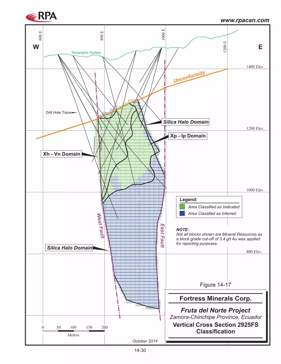
600 Elev.
800 Elev.
1000 Elev.
W E
1200 Elev.
1400 Elev.
60
0 E
80
0 E
10
00
E
12
00
E
Silica Halo Domain
Silica Halo Domain
Topographic Surface
Drill Hole Trace
Xh - Vn Domain
East F
au
lt
West F
au
lt
Unconformity
Xp - Ip Domain
0 50
Metres
100 150 200
Area Classified as Indicated
Legend:
Area Classfied as Inferred
NOTE:Not all blocks shown are Mineral Resources asa block grade cut-off of 3.4 g/t Au was appliedfor reporting purposes.
October 2014
Fruta del Norte Project
Vertical Cross Section 2925FSClassification
Fortress Minerals Corp.
Zamora-Chinchipe Province, Ecuador
Figure 14-17
14-30
www.rpacan.com

0 N
200 N
400 N
600 N
800 N
1000 N
1200N
1400 N
1600 N
1800 N
2000 N
200 Elev.
400 Elev.
600 Elev.
800 Elev.
1000 Elev.
1200 Elev.
1400 Elev.
1600 Elev.
1800 Elev.
Topographic Surface
Drill Hole Trace
S N
View Looking West
Area Classified as Indicated
Legend:
Area Classfied as Inferred
NOTE:Not all blocks shown are Mineral Resources asa block grade cut-off of 3.4 g/t Au was appliedfor reporting purposes.
0 100
Metres
200 300 400
October 2014
Fruta del Norte Project
Longitudinal SectionClassification
Fortress Minerals Corp.
Zamora-Chinchipe Province, Ecuador
Figure 14-18
14-3
1
ww
w.rp
acan
.co
m

www.rpacan.com
Fortress Minerals Corp. – Fruta del Norte Project, Project # 2326
Technical Report NI 43-101 – October 21, 2014 Page 14-32
MINERAL RESOURCE REPORTING In RPA’s opinion, the Mineral Resources as reported show reasonable prospects for
eventual economic extraction. Table 14-11 lists the Mineral Resources by domain. The
Xh_Vn domain represents 85% of the tonnage classified within the Indicated Mineral
Resource category. It also has the highest average gold grade compared to the other three
domains. More than half the tonnage in Xp_Ip is classified into the Indicated Mineral
Resource category. All of M_South and the Silica_Halo domains are classified as Inferred
Mineral Resources.
TABLE 14-11 MINERAL RESOURCES BY DOMAIN – OCTOBER 21, 2014 Fortress Minerals Corp. – Fruta del Norte Project
Category Tonnage Grade Contained
Metal Grade Contained Metal
(Mt) (g/t Au) (Moz Au) (g/t Ag) (Moz Ag) Indicated
Xh_Vn 20.0 10.01 6.42 13.0 8.34 Xp_Ip 3.6 7.26 0.83 12.0 1.38
Total Indicated 23.5 9.59 7.26 12.9 9.73
Inferred
Xh_Vn 3.1 5.65 0.56 6.0 0.60 Xp_Ip 2.8 6.27 0.57 10.0 0.91 M South 7.2 5.26 1.22 13.0 3.01 Silica Halo 1.4 4.47 0.21 16.3 0.75
Total Inferred 14.5 5.46 2.55 11.3 5.27 Notes:
1. CIM definitions were followed for the classification of Mineral Resources. 2. Mineral Resources are estimated at a cut-off grade of 3.4 g/t Au. 3. The cut-off grade was calculated using a long-term gold price of $1,400 per ounce. 4. The Mineral Resource estimate uses drill hole data available as of October 21, 2014. 5. Bulk density ranges from 2.62 t/m3 to 2.73 t/m3. 6. Mineral Resources that are not Mineral Reserves do not have demonstrated economic viability. 7. Numbers may not add due to rounding.
Table 14-12 lists Indicated and Inferred Resources at various cut-off grades. RPA
recommends using the breakeven cut-off grade of 3.4 g/t Au to report Mineral Resources.

www.rpacan.com
Fortress Minerals Corp. – Fruta del Norte Project, Project # 2326
Technical Report NI 43-101 – October 21, 2014 Page 14-33
TABLE 14-12 MINERAL RESOURCES BY CUT-OFF GRADE – OCTOBER 21, 2014 Fortress Minerals Corp. – Fruta del Norte Project
Category Tonnage Grade Contained
Metal Grade Contained Metal
(Mt) (g/t Au) (Moz Au) (g/t Ag) (Moz Ag) Indicated
6.00 14.1 12.94 5.86 15.1 6.83 5.00 17.2 11.60 6.41 14.2 7.84 4.00 20.9 10.33 6.94 13.4 8.99 3.40 23.5 9.59 7.26 12.9 9.73 2.70 27.3 8.68 7.63 12.3 10.79 2.00 31.9 7.76 7.97 11.7 12.03
Inferred 6.00 3.7 8.80 1.04 14.3 1.68 5.00 5.9 7.54 1.42 13.0 2.45 4.00 10.1 6.24 2.03 11.5 3.75 3.40 14.5 5.46 2.55 11.3 5.27 2.70 22.4 4.60 3.31 10.4 7.48 2.00 36.4 3.73 4.36 9.6 11.29
Notes:
1. CIM definitions were followed for the classification of Mineral Resources. 2. Mineral Resources are estimated at a cut-off grade of 3.4 g/t Au. 3. The cut-off grade was calculated using a long-term gold price of $1,400 per ounce. 4. The Mineral Resource estimate uses drill hole data available as of October 21, 2014. 5. Bulk density ranges from 2.62 t/m3 to 2.73 t/m3. 6. Mineral Resources that are not Mineral Reserves do not have demonstrated economic viability. 7. Numbers may not add due to rounding.
MINERAL RESOURCE VALIDATION BY KINROSS Kinross carried out a series of block model validations to test the quality of the FDN resource
estimate. No significant discrepancies were reported. Validation tests by Kinross included:
• Visual inspection comparing composite grades versus estimated block grades
• Swath plots of composites versus block grades
• Herco analysis (discrete Gaussian change of support) – statistically adjusted grade tonnage curves for comparison to primary model. Use of block variance to observe the degree of model smoothing
• Comparisons with Nearest Neighbour and Inverse Distance models.

www.rpacan.com
Fortress Minerals Corp. – Fruta del Norte Project, Project # 2326
Technical Report NI 43-101 – October 21, 2014 Page 14-34
MINERAL RESOURCE VALIDATION BY RPA The following list summarizes most of the checks performed on the resource model by RPA.
No significant issues were encountered. RPA is of the opinion that the grade estimation
approach and parameters are suitable for the style of mineralization and comply with CIM
guidelines.
• Completed visual inspection in plan and section views in comparison to the drill hole grades.
• Compared the global mean grades between the OK model and the composite statistics.
• Checked collar locations for zero/extreme values.
• Checked for reasonably similar orebody shapes used on adjacent sections.
• Checked for overlapping wireframes to determine possible double counting.
• Compared basic statistics of assays within wireframes with basic statistics of composites within wireframes for both uncut and cut values.
• Checked for reasonable compositing intervals.
• Checked for missing assay intervals and missing assay values.
• Checked that composite intervals start and stop at wireframe limits.
• Checked that all drill hole intersections with the wireframes have been fully composited.
• Checked that assigned composite rock type coding was consistent with intersected wireframe coding.
• Checked if block model size and orientation were appropriate to drilling density, mineralization, and mining method.
• Checked interpolation parameters against available variography.
• Compared block statistics (zero grade cut-off) with assay/composite basic statistics.
• Visually checked block Mineral Resource classification coding for isolated blocks.
• Visually compared block grades to drill hole composite values on sections and/or plans.
• Visually checked for grade banding, smearing of high grades, plumes of high grades, etc., on sections and/or plans.

www.rpacan.com
Fortress Minerals Corp. – Fruta del Norte Project, Project # 2326
Technical Report NI 43-101 – October 21, 2014 Page 14-35
Block model grades were visually examined and compared with composite and assay grades
in vertical cross sections and plan sections. RPA confirmed that the block grades are
reasonably consistent with local drill hole assay and composite grades.
Grade statistics for all assays, all composites, and all blocks were examined and compared
for all domains. The comparisons of average grades of assays, composites, and blocks are
reasonable in RPA’s opinion.
www.rpacan.com
Fortress Minerals Corp. – Fruta del Norte Project, Project # 2326
Technical Report NI 43-101 – October 21, 2014 Page 15-1
15 MINERAL RESERVE ESTIMATE This section is not applicable.

www.rpacan.com
Fortress Minerals Corp. – Fruta del Norte Project, Project # 2326
Technical Report NI 43-101 – October 21, 2014 Page 16-1
16 MINING METHODS This section is not applicable.

www.rpacan.com
Fortress Minerals Corp. – Fruta del Norte Project, Project # 2326
Technical Report NI 43-101 – October 21, 2014 Page 17-1
17 RECOVERY METHODS This section is not applicable.

www.rpacan.com
Fortress Minerals Corp. – Fruta del Norte Project, Project # 2326
Technical Report NI 43-101 – October 21, 2014 Page 18-1
18 PROJECT INFRASTRUCTURE This section is not applicable.

www.rpacan.com
Fortress Minerals Corp. – Fruta del Norte Project, Project # 2326
Technical Report NI 43-101 – October 21, 2014 Page 19-1
19 MARKET STUDIES AND CONTRACTS This section is not applicable.

www.rpacan.com
Fortress Minerals Corp. – Fruta del Norte Project, Project # 2326
Technical Report NI 43-101 – October 21, 2014 Page 20-1
20 ENVIRONMENTAL STUDIES, PERMITTING, AND SOCIAL OR COMMUNITY IMPACT Kinross prepared an Environment Management Plan (EMP) based on legal requirements,
company policies and procedures, preventive designs included in the project, and identified
impacts and associated risks. The EMP includes the following programs:
• Prevention and mitigation
• Waste management
• Recovery
• Contingencies
• Occupational health and safety
• Environmental education and communication
• Community relations and compensatory measures
• Closure and abandonment
• Monitoring and environmental control
Information in this section is based on available data contained within the Ranking Study
(Kinross, 2012c).
ENVIRONMENTAL STUDIES Prior to carrying out any mining activity, an Environmental Impact Statement (EIS) must be
presented to the Ministry of the Environment (MOE). In June 2011, Kinross presented a draft
EIS for the mine and a draft EIS for the process plant to the MOE. The two drafts were
reviewed by third parties prior to being subject to the public participation process.
Stakeholder comments were received from four communities (Los Encuentros, La Zarza,
Nankais, and Yantzaza) located near the Project area during the public participation process
and this information was incorporated into the studies. In July 2011, the public participation
process associated with these EIS was successfully completed by the authorities.

www.rpacan.com
Fortress Minerals Corp. – Fruta del Norte Project, Project # 2326
Technical Report NI 43-101 – October 21, 2014 Page 20-2
PROJECT PERMITTING Kinross obtained Environmental Licence 269 in July 2010, which allowed Kinross to carry out
advanced surface exploration activities on the La Zarza concession. In January 2011,
Environmental Licence 269 was updated to include underground exploration activities
through the construction and operation of the south decline. This decline has been
advanced to a length of approximately 600 m. The licence also authorized Kinross to
expand and modify the Las Peñas camp, including the construction of one bridge and road
improvements.
Environmental Licence 842 was issued in July 2011, which allowed Kinross to carry out
advanced surface exploration activities on five additional concessions, including Colibrí,
where much of the plant infrastructure will potentially be located. This allowed Kinross to
construct a bridge across the Machinaza River, and would also have allowed Kinross to
complete construction of a 22 km long exploration access road to connect the Colibrí
concession to the La Zarza concession.
Additional permits required to advance the Project include:
• To restart the south decline construction, an Environmental Management Plan (EMP) update and MOE approval will be required.
• Updated advanced exploration permit, including the forest areas.
• Proposed surface-based drilling programs
• To start the mine activities approved in the mine licence, the biotic rescue plan needs to be approved by MOE.
• Amendment to the environmental licence to reflect the new GFL process flowsheet.
• Update the environmental licence for the Project when the forest licences expire.
• Tailings storage facility permit.
• Archeological clearance, mine and plant.
• Water extraction permits.
• Power line Environmental Impact Study.
• Concentrate transportation, storage, and shipping Environmental Licence and permits.
• Quarry permit, Hollin Quarry.
• Chemical/hazardous material transportation permits
• Other minor permits from various agencies.

www.rpacan.com
Fortress Minerals Corp. – Fruta del Norte Project, Project # 2326
Technical Report NI 43-101 – October 21, 2014 Page 20-3
SOCIAL OR COMMUNITY REQUIREMENTS The southern province of Zamora-Chinchipe is one of the lesser developed parts of Ecuador.
Recent developments in physical infrastructure and incremental migration to the area is
slowly changing the demographic and economic profile of the province.
Social management plans have been developed as part of the Project’s current
environmental impact assessments, based on the mechanisms of social and community
participation. For communities surrounding FDN, such as Los Encuentros, these issues are
being addressed via the first parish development planning process. Issues include:
• Disorganized urban growth
• Poor urban waste control
• Poor potable water quality
• Contamination (small-scale mining, agriculture)
• Access to power (73% of homes)
• Poor levels of social development indicators (e.g., 67% completion of primary education, 18% completion of secondary education, 15% completion of university education and illiteracy levels up to 19%)
• Deforestation
• Poor connectivity (roads, communications, airports)
Engagement with the community and social development plans are coordinated with the
State. Some community initiatives previously undertaken are listed in Table 20-1.
TABLE 20-1 COMMUNITY ENGAGEMENT Fortress Minerals Corp. – Fruta del Norte Project
Ecuador (Region 7) Development Plan Past Initiatives
Mobility, energy, and connectivity • New bridge at San Antonio • Internet for Los Encuentros • Road safety Balanced territorial development • School infrastructure improvements • Leadership for students • Increased access to high school education for
adults • Skills training

www.rpacan.com
Fortress Minerals Corp. – Fruta del Norte Project, Project # 2326
Technical Report NI 43-101 – October 21, 2014 Page 20-4
Ecuador (Region 7) Development Plan Past Initiatives Rural development & food sovereignty • Increase farming productivity (Apeosae organic
coffee, cocoa and banana) • Cattle farming group Diversity, cultural patrimony and tourism • Shuar communities (sports day, cultural centre,
music group, school infrastructure, sanitary facilities, water supply)
• Tourism for Zamora Natural patrimony & non-renewable resources
• Engagement with artisanal and small miners
• Waste management with communities and with Zamora municipality
• Water quality project with local villages

www.rpacan.com
Fortress Minerals Corp. – Fruta del Norte Project, Project # 2326
Technical Report NI 43-101 – October 21, 2014 Page 21-1
21 CAPITAL AND OPERATING COSTS This section is not applicable.

www.rpacan.com
Fortress Minerals Corp. – Fruta del Norte Project, Project # 2326
Technical Report NI 43-101 – October 21, 2014 Page 22-1
22 ECONOMIC ANALYSIS This section is not applicable.

www.rpacan.com
Fortress Minerals Corp. – Fruta del Norte Project, Project # 2326
Technical Report NI 43-101 – October 21, 2014 Page 23-1
23 ADJACENT PROPERTIES The following sections were taken from Hennessey et al., 2007 and public domain
information. RPA has not independently verified the following information and this
information is not necessarily indicative of the mineralization at FDN.
The principal types of hydrothermal metallic mineralization in the Cordillera del Condor are
copper ± gold porphyry and epithermal precious metal vein deposits (Gemuts et al., 1992;
Gendall et al., 2000; Prodeminca, 2000).
The Pangui Porphyry Copper Belt is associated with late Jurassic phases of the Zamora
batholith (Gendall et al., 2000; Coder, 2001). The belt extends from southern Morona-
Santiago province into Zamora-Chinchipe where the southernmost known copper-gold
deposit, Mirador, was the object of detailed engineering, project planning and procurement
activities by Corriente Resources Inc. (Corriente). Corriente was acquired by Tongling
Nonferrous Metals Group Holdings Co. Ltd. and China Railway Construction Corporation
Limited in August, 2010, who have since signed Exploitation and Investment Protection
Agreements with the Government of Ecuador, and have transitioned to the Exploitation
Phase. The Mirador deposit is estimated to contain 437 million tonnes of Measured plus
Indicated Mineral Resources grading 0.61% Cu, 0.19 g/t Au, and 1.5 g/t Ag at a 0.4% Cu cut-
off grade (Sivertz et al., 2006). The Mirador deposit is situated about 30 km north of FDN.
To the south of the FDN deposit, the Santa Barbara and El Hito copper-gold prospects are
associated with dacitic plagioclase microporphyry and quartz porphyry of unknown age within
the Zamora batholith south of the Chinapintza camp on concessions held by Goldmarca Ltd.
(Litherland et al., 1994; Prodeminca, 2000).
There are two principal gold-silver mining districts in Zamora-Chinchipe province: the
Chinapintza district that lies about 32 km south of the FDN deposit, and the Nambija district
about 15 km to the west of Chinapintza (Figure 23-1).
The Nambija precious metal district consists of several Jurassic-aged skarn systems hosted
within a narrow, north-south trending belt of supracrustal units within the Zamora batholith
(Fontboté et al., 2004). Production from alluvium and bedrock in the Nambija district is

www.rpacan.com
Fortress Minerals Corp. – Fruta del Norte Project, Project # 2326
Technical Report NI 43-101 – October 21, 2014 Page 23-2
estimated to total 60 to 90 tonnes of gold (approximately 2 million to 3 million ounces;
Prodeminca, 2000). This is considered a minimum due to the large amount of informal and
poorly documented mining activity since discovery of the district in 1981 (Gemuts et al.,
1992).
Silver-gold mineralization in the Chinapintza district occurs as base metal-rich epithermal
quartz veins, breccia zones and quartz stockworks hosted mainly by northwest, and lesser
north, and northeast striking fault zones (Gemuts et al., 1992; Prodeminca, 2000). The
district is underlain by pyroclastic, hydrothermal, and tectonic breccias associated with Mid-
Cretaceous (116 to 96 Ma) dacitic to rhyolitic porphyries within the Zamora batholith.
Banded, colloform, drusy, and brecciated vein textures are defined by quartz, locally
abundant pyrite, arsenopyrite and base metal sulphides (especially sphalerite and galena)
and carbonate minerals, including the manganese carbonate, rhodochrosite. Siderite is
observed locally. Sericitic-argillic alteration and local silicification of the host rocks are
associated with veins and breccias. Electrum (approximately 35% Ag) is the principal
mineral present. Manganese, silver/gold ratios, and base metal content increase with depth
and bonanza-style veins are reported (Prodeminca, 2000). Production from small-scale
bedrock mine operations at Chinapintza was estimated by Prodeminca (2000) as 385,000 oz
gold and 5.8 million oz silver.
The Los Cuyes deposit is been estimated to contain 46.8 Mt grading 0.82 g/t Au (1.24 Moz
Au) and 6.19 g/t Ag (9.32 Moz Ag) in the Indicated Mineral Resource category. The Enma
deposit is been estimated to contain 1.0 Mt grading 2.88 g/t Au (93 Koz Au) and 32.83 g/t Ag
(1.0 Moz Ag). The Soledad deposit is estimated to contain 34.9 Mt grading 0.63 g/t Au
(704,000 oz Au) and 7.21 g/t Ag (8.1 Moz Ag) in the Indicated Mineral Resource category
and 20.0 Mt grading 0.50 g/t Au (312,000 oz Au) and 6.93 g/t Ag (4.5 Moz Ag in the Inferred
Mineral Resources category (Maynard, Jones, and Suda, 2013).
The Santa Barbara South and North deposits are estimated to contain a combined total of
364.5 Mt grading 0.54 g/t Au and 0.1% Cu (5.98 Moz Au and 804.8 Mlb Cu) in the Indicated
Mineral Resource category and 177.6 Mt grading 0.40 g/t Au and 0.1% Cu (2.3 Moz Au and
391 Mlb Cu) in the Inferred Mineral Resource category (Ecuador Gold & Copper Corp.,
2014).
www.rpacan.com
Fortress Minerals Corp. – Fruta del Norte Project, Project # 2326
Technical Report NI 43-101 – October 21, 2014 Page 23-3
The Chinapintza deposit is estimated to contain 719,000 tonnes grading 6.0 g/t Au (138,700
oz Au) in the Inferred Mineral Resource category (Maynard and Jones, 2013).
The Jerusalem deposit is a poly-metallic, intermediate sulphidation epithermal deposit
containing gold, silver, and zinc. Measured Resources at Jerusalem are estimated at
602,000 tonnes grading 12.4 g/t Au (240,000 oz Au), 90 g/t Ag (1,760,000 oz Ag) and 2.79%
Zn (16,800 tonnes Zn metal). Indicated Mineral Resources are estimated at 864,000 tonnes
grading 12.4 g/t Au (345,000 oz Au), 95 g/t Ag (2,628,000 oz Ag) and 2.56% Zn (22,200
tonnes Zn metal). Inferred Mineral Resources are estimated at 1,930,000 tonnes grading
11.5 g/t Au (710,000 oz Au), 101 g/t Ag (6,280,000 oz Ag) and 1.95% Zn (37,900 tonnes Zn
metal) (Dynasty Metals & Mining Inc., 2014). .

El ZarzaWildlife Refuge
Fruta del NorteDeposit
ECUADOR
MiradorProven 660 Mt @ 0.53% Cu and 0.17 g/t Au
Jerusalem
Measured 0.60 Mt @ 12.4 g/t Au = 239,730 oz AuIndicated 0.86 Mt @ 12.4 g/t Au = 345,370 oz AuInferred 1.9 Mt @3 11.5 g/t Au = 710,130 oz Au
Indicated 46.8 Mt @ 0.82 g/t Au = 1,23 ,000 oz Au0 5
SoledadIndicated 0 734.9 Mt @ 0.63 g/t Au = 70 ,000 oz AuInferred 0 1220. 0 Mt @ 0.47 g/t Au = 3 ,000 oz Au
Nambija
60 to 90 tonnes Au (est. past production)
125 to 155 tonnes Au (est. resource)
EnmaIn 1.0 Mt @ 2.9 g/t Au = 93,000 oz Audicated 1
Santa BarbaraIndicated 364.57 Mt @ 0.51 g/t Au = 5,978,000 oz Au
Inferred 177.30 Mt @ 0.4 g/t Au = 2,300,000 oz Au
ChinapintzaInferred 0.7 Mt @ 6.0 g/t Au = 138,700 oz Au2Los Cuyes
730,000 mE 740,000 mE9,5
20,0
00 m
N9,5
30,0
00 m
N9,5
50,0
00 m
N9,5
40,0
00 m
N9,5
60,0
00 m
N9,5
70,0
00 m
N9,5
90,0
00 m
N9,5
80,0
00 m
N9,6
10,0
00 m
N9,6
00,0
00 m
N750,000 mE 760,000 mE 770,000 mE 780,000 mE 790,000 mE 800,000 mE
9,5
20,0
00 m
N9,5
30,0
00 m
N9,5
50,0
00 m
N9,5
40,0
00 m
N9,5
60,0
00 m
N9,5
70,0
00 m
N9,5
90,0
00 m
N9,5
80,0
00 m
N9,6
10,0
00 m
N9,6
00,0
00 m
N
730,000 mE 740,000 mE 750,000 mE 760,000 mE 770,000 mE 780,000 mE 790,000 mE 800,000 mE
Project Concessions
Legend:
Village
Road
0 5 20
Kilometres
10 15
N
October 2014 Source: Fortress, 2014.
Fruta del Norte Project
Adjacent Properties
Fortress Minerals Corp.
Zamora-Chinchipe Province, Ecuador
Figure 23-1
23-4
www.rpacan.com

www.rpacan.com
Fortress Minerals Corp. – Fruta del Norte Project, Project # 2326
Technical Report NI 43-101 – October 21, 2014 Page 24-1
24 OTHER RELEVANT DATA AND INFORMATION No additional information or explanation is necessary to make this Technical Report
understandable and not misleading.

www.rpacan.com
Fortress Minerals Corp. – Fruta del Norte Project, Project # 2326
Technical Report NI 43-101 – October 21, 2014 Page 25-1
25 INTERPRETATION AND CONCLUSIONS The FDN deposit is an intermediate sulphidation epithermal gold-silver deposit measuring
1,670 m along strike, 700 m down dip, and generally ranging between 150 m and 300 m
wide. The top of the deposit is located beneath approximately 200 m of post-mineralization
cover rocks. The eastern and western limits of the deposit are defined by two faults which
together form part of the Bonza-Las Peñas fault system which is thought to control the gold-
silver mineralization. The southern limits of the mineralization along the fault system have
not been defined.
Diamond drilling has outlined mineralization that demonstrates three-dimensional continuity,
thickness, and grades that can potentially be extracted economically. The protocols for
drilling, sampling, analysis, security, and database management meet industry accepted
practices. The drill hole database and geology models are suitably accurate and robust for
resource modelling. The block model was validated by RPA and is acceptable for reporting
Mineral Resources.
Mineralogical and metallurgical studies have shown that the gold-silver mineralization is
largely free-milling in character, but contains a refractory component. A number of
engineering studies have been completed by Kinross and the current preferred processing
scenario includes a gravity circuit followed by flotation to produce a gold-silver concentrate
and leaching of the tailings (GFL).
Mineral Resources for the FDN deposit were estimated using drill hole data available to
October 21, 2014. At a cut-off grade of 3.4 g/t Au, Indicated Mineral Resources are
estimated to total 23.5 million tonnes at an average grade of 9.59 g/t Au and 12.9 g/t Ag for a
total of 7.26 million ounces of gold and 9.73 million ounces of silver. Inferred Mineral
Resources are estimated to total 14.5 million tonnes at an average grade of 5.46 g/t Au and
2.55 g/t Ag for a total of 2.55 million ounces of gold and 5.27 million ounces of silver. The
Mineral Resources are contained within four main geological domains. There are no Mineral
Reserves currently estimated on the Project.
A significant amount of work has been completed on various development scenarios for
FDN. This work includes over 154,000 m of drilling, metallurgical testwork, the completion of

www.rpacan.com
Fortress Minerals Corp. – Fruta del Norte Project, Project # 2326
Technical Report NI 43-101 – October 21, 2014 Page 25-2
pre-feasibility and feasibility studies, and subsequent optimizations studies. These
engineering studies have shown that FDN has the technical and economic potential to be a
viable mining operation, however, in June 2013 Kinross announced that it would not proceed
with further development and removed the FDN Mineral Resources and Mineral Reserves
from its annual statement.
Due to the availability of the large volume of work that has been completed to date, RPA is of
the opinion that Fortress should initiate the detailed engineering studies which will culminate
in the completion of a Feasibility Study.
Fortress has identified a number of risks relating to the Project. RPA has reviewed these
risks and is of the opinion that the following can potentially impact the proposed exploration
program and the Mineral Resources. As Fortress has not carried out a Feasibility Study,
RPA believes that the impact of these risks on the potential economic viability or continued
viability of the Project cannot be determined until such a study has been completed.
• The Project is located in Ecuador and therefore subject to certain risks and possible political and economic instability.
• Fortress may be adversely affected by governmental amendments or changes to mining laws, regulations and requirements in Ecuador and the possibility of increased government participation in the mining sector or renegotiation of existing agreements.
• There can be no assurance that all permits which Fortress may require for exploration and development of its properties will be obtainable on reasonable terms or on a timely basis.
• Environmental hazards may exist at FDN which will be unknown to Fortress and which have been caused by previous or existing owners or operators of the Project or surrounding areas, including artisanal miners.

www.rpacan.com
Fortress Minerals Corp. – Fruta del Norte Project, Project # 2326
Technical Report NI 43-101 – October 21, 2014 Page 26-1
26 RECOMMENDATIONS RPA recommends that Fortress proceed to an advanced engineering study (Prefeasibility or
Feasibility Study) on the Project. Permitting activities and completion of the decline and
underground deposit definition drilling program should also be advanced. Exploration for
additional gold-silver deposits can also be accomplished by surface-based drilling programs.
Specific goals include:
Gather Information in Support of Advanced Engineering Study This portion of the program will include:
• Metallurgical testwork and potentially a small scale pilot plant campaign
• Hydrogeological drilling and studies
• Geotechnical drilling and studies
• Mine planning and mine backfill studies
• Tailings studies
Complete the Exploration Decline and Underground Drilling Complete 2,000 m of development and approximately 20,000 m of drilling to upgrade the
confidence of the southern portion of the Mineral Resource into the Indicated Resource
category. This campaign will also provide:
• Geomechanical information for use in geotechnical studies
• Hydrogeological information for use in mine planning
• Sample material for additional metallurgical testwork
Update, Amend and Complete Necessary Permits
• Amend the EIS to incorporate the GFL flowsheet.
• Update the advanced exploration permits, decline and FDN program permits, as well as other ancillary permits.
Complete Advanced Engineering Study
• Update previous work and incorporate the Gravity/Flotation/Leach (GFL) process flowsheet.
Exploration on High Priority Concessions
• Drilling of approximately 30,000 m.

www.rpacan.com
Fortress Minerals Corp. – Fruta del Norte Project, Project # 2326
Technical Report NI 43-101 – October 21, 2014 Page 26-2
• Targets include geochemical anomalies on the Princesa, Emperador, and La Zarza Concessions.
• Regional and detailed structural geological mapping.
• Geochemical sampling on the remaining Project concessions.
Fortress has prepared a budget of US$49.5 million over the next 16 to 18 months. RPA has
reviewed the budget and concurs that there are sufficient funds to cover the
recommendations in this report (Table 26-1).
TABLE 26-1 PROPOSED PHASE 1 BUDGET Fortress Minerals Corp. – Fruta del Norte Project
Item Amount
(millions US$) Advanced Engineering Study including metallurgical testwork, geotechnical and hydrogeological studies, mine backfill studies
15.0
Underground development (2,000 m at $5,000/m) 10.0 Underground exploration drilling (20,000 m at $200/m total cost) 4.0 Permitting and Social and Environmental Studies 1.0 Regional Exploration (30,000 m at $350/m total cost) 11.0 Office and La Peña Camp 4.0 Sub-total 45.0 Contingency (10%) 4.5 Total 49.5

www.rpacan.com
Fortress Minerals Corp. – Fruta del Norte Project, Project # 2326
Technical Report NI 43-101 – October 21, 2014 Page 27-1
27 REFERENCES Aguilera, M., and Camino, B., 2008, Archeological Diagnostic of Mining Concessions in
Zamora Chinchipe: unpublished internal report prepared by the National Institute of Cultural Patrimony, May 2008.
AMEC E&C Services Inc., 2008, Preliminary Geostatistical Report: unpublished internal
report from AMEC to Kinross Gold. Canadian Institute of Mining, Metallurgy and Petroleum (CIM), 2014, CIM Definition
Standards for Mineral Resources and Mineral Reserves, May 10, 2014, http://web.cim.org/standards/MenuPage.cfm?sections=177&menu=178.
Dynasty Metals & Mining Inc., 2014, Corporate Presentation, June 2014: Unpublished
document posted on corporate web site visited August 11, 2014, 36 p. htp://www.dynastymining.com/investors/presentations/Presentacion-Revista-junio2014.pdf .
Ecuador Gold & Copper Corp., 2014, Ecuador Gold Announces an Increase of 1.6 Million
Ounces of Gold in Indicated Mineral Resources at the Condor Gold Project: News release dated March 24, 2014, 4 p.
Ellis, R. B., 2012, Review of Aeromagnetic Data, Fruta del Norte Deposit, Zamora-Chinchipe
Province, Ecuador: Unpublished internal report prepared for Kinross Gold Corporation internal use, 12 p.
Evans, L., Bergen, D., and Krutzelmann, H., 2010, Fruta Del Norte Gold-Silver Deposit
Mineral Resource Audit, Ecuador: unpublished report prepared for Kinross Gold Corporation internal use, 162 p.
Fontboté, L., Valance, J. Markowski, A. and Chiaradia, M., 2004, Oxidized Gold Skarns in
the Nambija District, Ecuador: 2004 Society of Economic Geologists Special Publication 11, pp. 341–357
Gemuts, I., Lopez, G. and Jimenez, F., 1992, Gold deposits of Southern Ecuador: Society of
Economic Geologists, Newsletter No. 11, October 1992, pp. 1, 13-16. Gendall, I. R., Quevedo, L. A., Sillitoe, R. H., Spencer, R. M., Puente, C. O., León, J. P. and
Povedo, R., 2000, Discovery of a Jurassic Porphyry Copper Belt, Pangui area, Southern Ecuador: Society of Economic Geologists, Newsletter No. 43, October 2000. pp. 1, 8-15.
Golder Associates, 2009, Preliminary Geotechnical Characterization, Fruta del Norte Gold
Project, Ecuador: unpublished report prepared for Aurelian Resources. Hall, L., 2008, Preliminary Structural Study of the Fruta del Norte Epithermal Gold Deposit:
unpublished report prepared for Aurelian Resources. Hatch Ltd., 2011, Pre-feasibility Study Report to Kinross Gold Corporation for Fruta del Norte
Project: unpublished internal study prepared by Hatch for Kinross Gold Corporation, February 11, 2011, available at www.SEDAR.com, 20 vols.

www.rpacan.com
Fortress Minerals Corp. – Fruta del Norte Project, Project # 2326
Technical Report NI 43-101 – October 21, 2014 Page 27-2
Hatch Ltd., 2012, Alternative Flowsheet Testwork Review, H332959-0000-05-124-0004, Rev. A: unpublished internal study prepared for Kinross Gold Corporation.
Hatch Ltd., 2012b, Feasibility Study Report to Kinross Gold Corporation for Fruta del Norte
Project: unpublished internal study prepared by Hatch for Kinross Gold, February 8 2012, 23 vols.
Hatch Ltd., 2013, Fruta del Norte 5000 t/d GFL Update Study Summary Report; unpublished
internal document prepared for Kinross Gold, June 18, 2013, 130 p. Hedenquist, J.W., Arribas A., Jr, and Urien-Gonzales, E., 2000, Exploration for Epithermal
Gold Deposits: Society of Economic Geologists Reviews in Economic Geology Vol 13, p. 245–277.
Hennessey, B.T., and Puritch, E., 2005, A Mineral Resource Estimate for the Bonza-Las
Peñas Deposit, Cordillera Del Condor Project, Zamora-Chinchipe Province, Southeastern Ecuador: unpublished technical report prepared by Micon International Ltd. for Aurelian Resources Inc., effective date January 13, 2005.
Hennessey, B.T., and Stewart, P.W., 2007, A Review of the Geology of, and Exploration and
Quality Control Protocols Used at the Fruta Del Norte Deposit, Cordillera Del Condor Project, Zamora-Chinchipe Province, Ecuador: unpublished technical report prepared by Micon International Ltd. for Aurelian Resources Inc., dated December 2006, effective date January 9, 2007.
Hennessey, T., Puritch, E., Gowans, R., and Leary, S., 2007, A Mineral Resource Estimate
for the Fruta Del Norte Deposit, Cordillera Del Condor Project, Zamora-Chinchipe Province, Ecuador: unpublished technical report prepared by Micon International Ltd. for Aurelian Resources Inc., effective date November 15, 2007.
Henderson, R. D., 2010, Fruta del Norte Project, Ecuador, NI 43-101 Technical Report:
Kinross Gold Corporation Unpublished Internal Document Available from the SEDAR Web Site at www.SEDAR.com, 170 p.
Kinross Gold Corporation, 2012a, Annual Information Form for the Year Ended December
31, 2012: Viewed on June 27, 2013 from the Kinross Gold Corporation Web site at http://www.kinross.com/media/244911/2012%20aif.pdf.
Kinross Gold Corporation, 2012b, Annual Report: Viewed on July 3, 2014 from the SEDAR
web site at www.SEDAR.com, 156 p. Kinross Gold Corporation, 2012c, Ranking Study, POX vs GFL: unpublished internal
document prepared, 20 Chapters, 1,096 p. Kinross Gold Corporation, 2013, Kinross Announces It Will Cease Development of Fruta del
Norte: News Release available on the Kinross Gold Corporation web site at http://www.kinross.com/media/246691/100613%20kinross%20announces%20it%20will%20cease%20development%20of%20fruta%20del%20norte.pdf.
Kinross Gold Corporation, 2014, Fruta del Norte Project Management Presentation, May 26,
2014: Kinross Gold Corporation unpublished internal document.

www.rpacan.com
Fortress Minerals Corp. – Fruta del Norte Project, Project # 2326
Technical Report NI 43-101 – October 21, 2014 Page 27-3
Leary, S., 2005, Target Assessment Report, Cóndor Project, Ecuador: unpublished internal report, Aurelian Resources.
Leary S., 2009, The Discovery and Geology of the Fruta Del Norte Epithermal Gold-Silver
Deposit, S.E. Ecuador: Drury Lecture, 2009 SME Annual Meeting & Exhibit & CMA 111th National Western Mining Conference, Denver, Colorado, February 22–29, 2009.
Litherland M., Aspden J.A., and Jemielita R.A., 1994, The Metamorphic Belts of Ecuador:
Overseas Memoir 11. BGS, Keyworth, U.K. 147 p. Maynard, Allen J., and Jones, Phillip A., 2013, NI 43-101 Technical Report on the
Chinapintza Gold Project Located in Zamora, Ecuador: Unpublished technical report prepared for Black Birch Capital Acquisition II Corp., 56 p.
Maynard, Allen J., Jones, Phillip A., and Suda, Robert U., 2013, NI 43-101 Technical Report
on the Condor Gold and Copper Project Located in Zamora, Ecuador: Unpublished technical report prepared for Ecuador Gold & Copper Corp., 121 p.
Morrison, G., 2007, A Working Model for the Fruta del Norte Hot Spring Epithermal
gold/silver Deposit: unpublished report prepared for Aurelian Resources. Mullens, P., 2003, Geological Report on Exploration at the Cordillera del Condor Project,
Zamora-Chinchipe Province, Southeastern Ecuador: unpublished technical report prepared for Aurelian Resources Inc., effective date December 16, 2003.
NCL Ingeniería y Construcción Ltda., 2013, Fruta del Norte Project Conceptual Mining Study
Rev–1 (Draft), prepared for Kinross Gold Corporation (July 2013). PRODEMINCA, 2000, Depositos Porfidicos y Epi-mesotermales Relacionados con
Intrusiones de la Cordillera del Condor: Evaluacion de Distritos Mineros del Ecuador: UCP Prodeminca Proyecto MEM BIRF 36-55 EC. Vol 5. 223 p.
Quispesivana, L., 1996, Geologja dei cuadràngulo de Huanuco: Boletin de INGEMMET.
series A, v. 75. 138 p. Roa, K.J., 2008, Geological Map and Pamphlet of the Cordillera del Cóndor , Ecuador / Perú
and Westernmost Santiago Basin, Perú: unpublished map prepared for Aurelian Resources, 2008.
Sillitoe, R.H., 2006, Comments on Geology and Potential of the Fruta Del Norte Epithermal
Gold Prospect, Ecuador: unpublished report prepared for Aurelian Resources. Sillitoe, R.H., 2007a, Further Comments on Geology and Potential of the Fruta Del Norte
Epithermal Gold Deposit, Ecuador: unpublished report prepared for Aurelian Resources. Sillitoe, R.H., 2007b, Comments of fault truncation of the Fruta Del Norte Gold Deposit and
Mineralization Style at the nearby Papaya and El Tigre Prospects, Ecuador: unpublished report prepared for Aurelian Resources.
Sims, J., 2012, Fruta del Norte Mineral Resource Report-Draft: Kinross Gold Corporation
Unpublished Internal Document, 204 p.

www.rpacan.com
Fortress Minerals Corp. – Fruta del Norte Project, Project # 2326
Technical Report NI 43-101 – October 21, 2014 Page 27-4
Sivertz, G., Ristorcelli, S., Hardy, S. and Hoffert, J. R., 2006. Technical Report Update on the Copper, Gold and Silver Resources and Pit Optimizations, Mirador Project, Ecuador: Technical report prepared for Corriente Resources Inc. by Mine Development Associates, Reno, NV, dated May 18, 2006, 143 p. including appendices.
Stewart, P. W., 2003, Geological Report on Exploration at the Cordillera Del Condor Project,
Zamora-Chinchipe Province, Southeastern Ecuador: unpublished technical report prepared for Aurelian Resources Inc., effective date April 16, 2003.
Stewart, P.W., 2009, Summary report on geological, geochronological, and geochemical
studies of the Fruta del Norte Au–Ag epithermal deposit, Cordillera del Cóndor Project Ecuador: unpublished report prepared for Kinross Gold Corporation.
Stewart, P.W. and Leary, S., 2008, The Fruta Del Norte Epithermal Gold/Silver Deposit,
South East Ecuador: Extended Abstracts, PacRim Congress, 2008, Gold Coast, Australia, November 24–26, 2008.
United States Department of State, 2013, 2013 Investment Climate Statement – Ecuador:
Report prepared by the Bureau of Economic and Business Affairs, February 2013, 12 p., Viewed on June 27, 2014 at http://www.state.gov/e/eb/rls/othr/ics/2013/204634.htm.

www.rpacan.com
Fortress Minerals Corp. – Fruta del Norte Project, Project # 2326
Technical Report NI 43-101 – October 21, 2014 Page 28-1
28 DATE AND SIGNATURE PAGE This report titled “Technical Report on the Mineral Resource Estimate for the Fruta del Norte
Project, Ecuador” and dated October 21, 2014 was prepared and signed by the following
authors:
(Signed & Sealed) “Luke Evans” Dated at Toronto, ON October 21, 2014 Luke Evans, M.Sc., P.Eng. Executive Vice President, Geology and Resource Estimation and Principal Geologist (Signed & Sealed) “David Ross” Dated at Toronto, ON October 21, 2014 David Ross, M.Sc., P.Geo. Director, Resource Estimation and Principal Geologist
(Signed & Sealed) “Brenna Scholey” Dated at Toronto, ON October 21, 2014 Brenna Scholey, P.Eng. Principal Metallurgist
www.rpacan.com
Fortress Minerals Corp. – Fruta del Norte Project, Project # 2326
Technical Report NI 43-101 – October 21, 2014 Page 29-1
29 CERTIFICATE OF QUALIFIED PERSON LUKE EVANS I, Luke Evans, M.Sc., P.Eng., as an author of this report titled “Technical Report on the Mineral Resource Estimate for the Fruta del Norte Project, Ecuador”, prepared for Fortress Minerals Corp., and dated October 21, 2014, do hereby certify that:
1. I am a Principal Geologist and Executive Vice President, Geology and Resource Estimation, with Roscoe Postle Associates Inc. of Suite 501, 55 University Ave., Toronto, ON M5J 2H7.
2. I am a graduate of University of Toronto, Ontario, Canada, in 1983 with a Bachelor of
Science (Applied) degree in Geological Engineering and Queen’s University, Kingston, Ontario, Canada, in 1986 with a Master of Science degree in Mineral Exploration.
3. I am registered as a Professional Engineer in the Province of Ontario (Reg.
#90345885). I have worked as a professional geologist for a total of 30 years since my graduation. My relevant experience for the purpose of the Technical Report is: Consulting Geological Engineer specializing in resource and reserve estimates,
audits, technical assistance, and training since 1995. Review and report as a consultant on numerous exploration and mining projects
around the world for due diligence and regulatory requirements. Senior Project Geologist in charge of exploration programs at several gold and
base metal mines in Quebec. Project Geologist at a gold mine in Quebec in charge of exploration and definition
drilling. Project Geologist in charge of sampling and mapping programs at gold and base
metal properties in Ontario, Canada.
4. I have read the definition of "qualified person" set out in National Instrument 43-101 (NI 43-101) and certify that by reason of my education, affiliation with a professional association (as defined in NI 43-101) and past relevant work experience, I fulfill the requirements to be a "qualified person" for the purposes of NI 43-101.
5. I visited the Fruta del Norte Project on April 6 to 9, 2010.
6. I share responsibility with David Ross for all sections of the Technical Report except Section 13.
7. I am independent of the Issuer applying the test set out in Section 1.5 of NI 43-101. I am also independent of the property and the property vendor, as set out in Section 3.2(b) of Appendix 3F of the TSX Venture Exchange Corporate Finance Manual.
8. I co-authored a Mineral Resource and Mineral Reserve audit of the Fruta del Norte property for Kinross Gold Corporation in 2010.
9. I have read NI 43-101, and the Technical Report has been prepared in compliance with NI 43-101 and Form 43-101F1.

www.rpacan.com
Fortress Minerals Corp. – Fruta del Norte Project, Project # 2326
Technical Report NI 43-101 – October 21, 2014 Page 29-2
10. At the effective date of the Technical Report, to the best of my knowledge, information, and belief, the Technical Report contains all scientific and technical information that is required to be disclosed to make the Technical Report not misleading.
Dated this 21st day of October, 2014 (Signed & Sealed) “Luke Evans” Luke Evans, M.Sc., P.Eng.

www.rpacan.com
Fortress Minerals Corp. – Fruta del Norte Project, Project # 2326
Technical Report NI 43-101 – October 21, 2014 Page 29-3
DAVID ROSS I, David Ross, M.Sc., P.Geo., as an author of this report entitled “Technical Report on the Mineral Resource Estimate for the Fruta del Norte Project, Ecuador”, prepared for Fortress Minerals Corp., and dated October 21, 2014, do hereby certify that:
1. I am a Principal Geologist and Director, Resource Estimation, with Roscoe Postle Associates Inc. of Suite 501, 55 University Ave., Toronto, ON, M5J 2H7.
2. I am a graduate of Carleton University, Ottawa, Canada, in 1993 with a Bachelor of
Science degree in Geology and Queen’s University, Kingston, Ontario, Canada, in 1999 with a Master of Science degree in Mineral Exploration.
3. I am registered as a Professional Geologist in the Province of Ontario (Reg. #1192). I
have worked as a geologist for a total of 20 years since my graduation. My relevant experience for the purpose of the Technical Report is: Review and report as a consultant on numerous mining and exploration projects
around the world for due diligence and regulatory requirements Exploration geologist on a variety of gold and base metal projects in Canada,
Indonesia, Chile, and Mongolia.
4. I have read the definition of "qualified person" set out in National Instrument 43-101 (NI 43-101) and certify that by reason of my education, affiliation with a professional association (as defined in NI 43-101) and past relevant work experience, I fulfill the requirements to be a "qualified person" for the purposes of NI 43-101.
5. I have not visited the Fruta del Norte property.
6. I share responsibility with Luke Evans for all sections of the Technical Report except Section 13.
7. I am independent of the Issuer applying the test set out in Section 1.5 of NI 43-101. I am also independent of the property and the property vendor, as set out in Section 3.2(b) of Appendix 3F of the TSX Venture Exchange Corporate Finance Manual.
8. I have had no prior involvement with the property that is the subject of the Technical Report.
9. I have read NI 43-101, and the Technical Report has been prepared in compliance with NI 43-101 and Form 43-101F1.
10. At the effective date of the Technical Report, to the best of my knowledge, information, and belief, the Technical Report contains all scientific and technical information that is required to be disclosed to make the Technical Report not misleading.
Dated this 21st day of October, 2014 (Signed & Sealed) “David Ross” David Ross, M.Sc., P.Geo.

www.rpacan.com
Fortress Minerals Corp. – Fruta del Norte Project, Project # 2326
Technical Report NI 43-101 – October 21, 2014 Page 29-4
BRENNA SCHOLEY I, Brenna Scholey, P.Eng., as an author of this report entitled “Technical Report on the Mineral Resource Estimate, Fruta del Norte Project, Ecuador” prepared for Fortress Minerals Corp. and dated October 21, 2014, do hereby certify that: 1. I am Principal Metallurgist with Roscoe Postle Associates Inc. of Suite 501, 55 University
Ave., Toronto, ON, M5J 2H7. 2. I am a graduate of The University of British Columbia in 1988 with a B.A.Sc. degree in
Metals and Materials Engineering. 3. I am registered as a Professional Engineer in the Province of Ontario (Reg. #90503137)
and British Columbia (Reg. #122080). I have worked as a metallurgist for a total of 25 years since my graduation. My relevant experience for the purpose of the Technical Report is: Reviews and reports as a metallurgical consultant on a number of mining
operations and projects for due diligence and regulatory requirements. Senior Metallurgist/Project Manager on numerous base metals and precious metals
studies for an international mining company. Management and operational experience at several Canadian and U.S. milling,
smelting and refining operations treating various metals, including copper, nickel and precious metals.
4. I have read the definition of "qualified person" set out in National Instrument 43-101 (NI
43-101) and certify that by reason of my education, affiliation with a professional association (as defined in NI 43-101) and past relevant work experience, I fulfill the requirements to be a "qualified person" for the purposes of NI 43-101.
5. I have not visited the Fruta del Norte Project. 6. I am responsible for preparation of Section 13 and portions of Sections 1, 25, and 26 of
the Technical Report. 7. I am independent of the Issuer applying the test set out in Section 1.5 of NI 43-101. I am
also independent of the property and the property vendor, as set out in Section 3.2(b) of Appendix 3F of the TSX Venture Exchange Corporate Finance Manual.
8. I have had no prior involvement with the property that is the subject of the Technical
Report. 9. I have read NI 43-101, and the Technical Report has been prepared in compliance with
NI 43-101 and Form 43-101F1.

www.rpacan.com
Fortress Minerals Corp. – Fruta del Norte Project, Project # 2326
Technical Report NI 43-101 – October 21, 2014 Page 29-5
10. At the effective date of the Technical Report, to the best of my knowledge, information, and belief, the sections of the Technical Report for which I am responsible contain all scientific and technical information that is required to be disclosed to make the Technical Report not misleading.
Dated 21st day of October, 2014. (Signed & Sealed) “Brenna Scholey” Brenna Scholey, P.Eng.