Embed Size (px)
Citation preview

FRASER RIVER BENCH LANDS NEIGHBOURHOOD PLAN

Fortwood Homes Ltd. and Roman Catholic Episcopal Corporation Fraser River Bench Lands – Neighbourhood Plan
EXECUTIVE SUMMARY Page i of iii
Executive Summary On behalf of Fortwood Homes Ltd and the Roman Catholic Episcopal Corporation, L&M Engineering Limited – Planning Centre is pleased to present the Fraser River Bench Lands Neighbourhood Plan for consideration by Prince George City Council. This Plan is the culmination of almost a year’s work and is reflective of the considerable generosity of the land owners in granting L&M the flexibility to explore Smart Growth design practices and to create a Neighbourhood Plan that integrates urban residential development with extensive greenspace, public parks, and trails while exploring alternative development standards. In addition, we would also like to thank the City of Prince George for allowing an innovative review process that included a Technical Design Charette that directly contributed to the quality and holistic nature of this Neighbourhood Plan. The Vision The Fraser River Bench Lands are characterized by natural features: the Fraser River, the steeply sloped escarpment, the wetlands and drainage courses, the meadows, and the large stands of fir and spruce trees. Planning for the Fraser River Bench Lands began with acknowledging these natural features, not as barriers to development, but as the basis from which to plan a complete and livable community. The policies contained in this Neighbourhood Plan integrate the City of Prince George Official Community Plan with Smart Growth planning principles with the objective of becoming a desirable place to live that is compatible with and connected to the surrounding neighbourhood while, at the same time, being uniquely the Fraser River Bench Lands. The Process Neighbourhood Plans are intended to be holistic planning processes that establish broad land use and transportation policies to guide development. Neighbourhood Plans are meant to create realistic land use policy that will provide certainty for the public, decision makers, and developers regarding how land can be developed. As required by the City of Prince George Official Community Plan, the scope of the Fraser River Bench Lands Neighbourhood Plan included:
1. Examination of Current and Surrounding Land Use. 2. Identification of Major road network. 3. Proposed Land Uses including:
o Transportation corridors including major roads, pedestrian, bicycle, and transit;
o Residential housing densities; o Commercial land allocations; o Institutional land allocations; as well as

Fortwood Homes Ltd. and Roman Catholic Episcopal Corporation Fraser River Bench Lands – Neighbourhood Plan
EXECUTIVE SUMMARY Page ii of iii
o Public use sites including parks, trails, and schools. 4. Traffic analysis estimating volume of traffic based on dwelling units. 5. Traffic analysis of the existing Level of Service of Cowart Road, as well as the
Cowart Road/Highway 16 intersection. 6. Preliminary Site Servicing
o Provision and phasing of sewer and water services; and o Storm water management.
7. Environmental Overview to identify Environmentally Sensitive Areas (provided by EDI Environmental Dynamics Inc.).
8. Geotechnical Overview including an examination of available air photographs, a review of existing geotechnical materials, and field reconnaissance (provided by Geonorth Engineering Ltd).
The planning process also included a Technical Design Charette attended by the City of Prince George, the Department of Fisheries and Oceans, the Ministry of Environment and facilitated by L&M Engineering Limited. Smart Growth and Alternative Design Standards are new to Prince George. Therefore, in an effort to explore these concepts within the context of this Neighbourhood Planning process, as well as within the context of planning, design, and development review in Prince George generally, Fortwood Homes Ltd, the Roman Catholic Episcopal Corporation and the City of Prince George decided to host a Charette. The Charette was a one-day work shop that brought together professional people involved in planning, engineering and the review of land use and development proposals to brain storm ideas of how best to implement Smart Growth principles in Prince George with the further goal of finding workable and cost effective ideas for this Neighbourhood Plan. The Charette was very effective and resulted in a Plan that balances the desires of residents, environmental considerations, and economic realities. Public participation was also an integral part of this planning process. The process involved wide-spread public information dissemination, including 702 hand delivered information packages, a public information meeting that included a presentation and open house format allowing neighbours to congregate and discuss the Plan, as well as have questions answered by both L&M Engineering and the City of Prince George. The public comments were very informative and resulted in several changes to Plan including additional traffic analysis, additional trail connections, and more detailed policy regarding tree retention throughout the proposed neighbourhood. In addition, there was considerable media interest in the planning process that included several prominent articles in local newspapers. The Plan The Fraser River Bench Lands Neighbourhood Plan is a comprehensive planning document that integrates the Official Community Plan and Smart Growth Planning principles. The plan is characterized by the following:

Fortwood Homes Ltd. and Roman Catholic Episcopal Corporation Fraser River Bench Lands – Neighbourhood Plan
EXECUTIVE SUMMARY Page iii of iii
• A mix of land uses including residential, commercial, and institutional with a range of residential density options,
• 2 Neighbourhood Parks, including a riverside park representing 19% of the total area,
• A City riverfront park extending from Malaspina Ridge to Varsity Creek, • Development of 4.7 km of trails connecting with Lower College Heights and
proposed City trails to the south, • Designed connections to the bicycle network, • A pedestrian-friendly environment that provides connections within the Bench
Lands and to surrounding neighbourhoods, • Dedication of greenways to protect environmentally sensitive areas representing
15.5% of the total area, • Completion of an Environmental Overview of the area, • A Neighbourhood Centre, • A combination of traditional and Smart Growth design standards, • Alternative Design Standards for storm water management, • Alternative Design Standards for some local roads, and • Accommodation of Transit services.
Conclusion L&M Engineering Limited – Planning is pleased to present the Fraser River Bench Lands Neighbourhood Plan to Prince George City Council and appreciates Council’s consideration. Should Council approve the Neighbourhood Plan, it is Fortwood Homes Ltd’s intention to apply for rezoning of the first phase of development in the southern area of Plan boundary with development to being in the fall of 2006. Sincerely, L&M Engineering Limited _________________________ ___________________________ Heather Oland BA, MSc. David McWalter, P.Eng. Planning Associate Principal Engineer

Fortwood Homes Ltd. and Roman Catholic Episcopal Corporation Fraser River Bench Lands – Neighbourhood Plan
FINAL Page i of iii
Table of Contents Page
1.0 Introduction 1.1. Neighbourhood Overview................................................................1 1.2. The Official Community Plan and Smart Growth ...........................2 1.3. Planning Process ..............................................................................3
1.3.1. Implementation Design Charette........................................4 1.3.2. Public Participation ...........................................................5
2.0 Current Land Uses
2.1. Land Use Policy and Regulations ...................................................7 2.2. Adjacent Land Uses ........................................................................8
2.2.1. Lower College Heights.......................................................8 2.2.2. The Fraser River .................................................................9 2.2.3. BCR Industrial Park ...........................................................9
2.3. Public Opens Space, Parks and Trails ...........................................10 2.4. Natural Environment......................................................................10 2.5. Transportation Network .................................................................11
3.0 Land Use Plan
3.1. The Official Community Plan and Smart Growth .........................12 3.2. Vision of the Fraser River Bench Lands .......................................13 3.3. Environmentally Sensitive Areas and Natural Greenspace ..........15
3.3.1 Policy Recommendations ................................................16 3.4 Parks and Trails..............................................................................17
3.4.1 Policy Recommendations ................................................20 3.5 Transportation Network ................................................................20
3.5.1 Road Network ..................................................................20 3.5.2 Pedestrian Network .........................................................23 3.5.3 Cycle Network .................................................................23 3.5.4 Transit Network ...............................................................24 3.5.5 Transportation Network Policy Recommendations ........25
3.6 Residential Land Use ...................................................................26 3.6.1 Principles of Residential Development ............................26 3.6.2 Residential Densities and Variety of Housing Options....27 3.6.3 Zoning and Smart Growth................................................31 3.6.4 Siting and Building Criteria .............................................31 3.6.5 Residential Land Use Policy Recommendations..............32

Fortwood Homes Ltd. and Roman Catholic Episcopal Corporation Fraser River Bench Lands – Neighbourhood Plan
FINAL Page ii of iii
3.7 Commercial Land Use ..................................................................33
3.7.1 Policy Recommendations ................................................33 3.8 Institutional Land Use ...................................................................34
3.8.1 School Site........................................................................34 3.8.2 Places of Worship.............................................................34 3.8.3 Policy Recommendations .................................................35
4.0 Neighbourhood Servicing
4.1. Water System.................................................................................36 4.2. Sanitary Sewer ...............................................................................37 4.3. Storm Water Management .............................................................37
4.3.1. Policy Recommendations.......................................39
5.0 Implementation ........................................................................................40

Fortwood Homes Ltd. and Roman Catholic Episcopal Corporation Fraser River Bench Lands – Neighbourhood Plan
FINAL Page iii of iii
List of Tables 1. Key Ideas of the Implementation Charette ................................................. 4 2. Land Use Summary....................................................................................14 3. Parkland and Greenspace by Property .....................................................18 4. Housing Densities .....................................................................................28 5. Ratio of Residential Development .............................................................28 6. Estimated Population of the Fraser River Bench Lands ...........................29
List of Charts 1. Fraser River Bench Lands Age/Sex Breakdowns .....................................30 Appendices A. Smart Growth Principles and Tools B. Debriefing Notes & Minutes of the Implementation Design Charette C. Public Participation Mail Out Package D. Newspaper Advertisement E. Community Survey - Summary of Comments & Input F. Design Practices for Noise Attenuation G. Environmental Overview H. Geotechnical Overview I. Preliminary Traffic Analysis (Malaspina Avenue) & Highway 16/Cowart
Road Signalized Intersection Analysis Summary J. References
List of Figures 1. Fraser River Bench Lands & Surrounding Area 2. Ownership & Developable Area 3. Land Use Plan 4. Transportation Network 5. Parks, Trails, and Greenways 6. Public Mail Out Distribution Area 7. Noise Attenuation Cross Section (Included in Appendix F)

Fortwood Homes Ltd. and Roman Catholic Episcopal Corporation Fraser River Bench Lands – Neighbourhood Plan
FINAL Page 1
1.0 Introduction The Fraser River Bench Lands (Figure 1) are located in the Southwest Sector of the City of Prince George between the Fraser River and Lower College Heights. The 106.52 hectares of land represents significant infill residential development and, as the area is unplanned, its development, as directed by Policy 6.3.18 of the City of Prince George Official Community Plan (OCP), is subject to the creation of a Neighbourhood Plan that addresses: environmentally sensitive areas, transportation network, residential housing mix and densities, commercial lands, public use sites, and trail linkages. The purpose of Neighbourhood Plans is to create a clear and comprehensive vision for areas greater than 40 hectares in order to provide certainty for residents, land owners, and developers regarding how an area can be developed. Neighbourhood Plans must balance the desires of residents, environmental considerations, and economic realities and should result in land use planning policies that can be achieved over time. They are policy documents that are intended to provide direction for land use planning rather than be used as strict regulatory tools. This document is the proposed Neighbourhood Plan for the Fraser River Bench Lands. The City of Prince George Official Community Plan endorses Growth Management as a key planning principle in order to ensure that, “…growth occurs in a planned, phased manner rather than sporadically throughout the city,” (OCP, p.15) and further direction of Prince George City Council encourages development to be planned and designed according to the principles of Smart Growth (Appendix A). The requirement of Neighbourhood Plans is part of the City’s overall Growth Management policy and the Fraser River Bench Lands Neighbourhood Plan incorporates many Smart Growth principles throughout the neighbourhood and show cases several areas within the site as Smart Growth development areas. The Fraser River Bench Lands Neighbourhood Plan has been prepared by L&M Engineering Limited in close consultation with City staff. Further input has also been provided by the general public, the Department of Fisheries and Oceans, as well as the Ministry of Environment.
1.1 Neighbourhood Overview The Fraser River Bench Lands are comprised of 4 separate legal parcels that are owned by the Roman Catholic Episcopal Corporation (RCEC), Fortwood Homes Ltd. and the City of Prince George (Figure 2). The total area is 106.52 hectares with 52.12 hectares owned by Fortwood Homes Ltd., 50.78 hectares belonging to RCEC, and 3.62 hectares owned by the City of Prince George. The area is adjacent to the existing Lower College Heights neighbourhood and is bounded on the west side by a steep escarpment, to the east by the Fraser River, to the north by Cowart Road, and to the south by undeveloped land designated by the OCP as Major Park. The area is characterized by two flat benches, large meadows, some wetlands, and is forested primarily by spruce and fir trees. There are several rights of way through the most northern parcel belonging to BC Hydro and

Fortwood Homes Ltd. and Roman Catholic Episcopal Corporation Fraser River Bench Lands – Neighbourhood Plan
FINAL Page 2
the City of Prince George, as well as an abandoned City sewage lagoon. In addition, the City of Prince George owns a small parcel of land adjacent to the Fraser River that is utilized for water well infrastructure. Although designated as Urban, with Major Park adjacent to the Fraser River, and identified as Phase 2 lands by Schedule B-1 Urban Phasing Map of the OCP, to date the property has not been subject to a development proposal for a number of reasons. Until recently, large portions of the RCEC lands were leased to the City of Prince George for the establishment of a sewage treatment facility. These leased lands have been remediated, and have now been returned to RCEC. In addition, access to the lower Fraser River Bench Lands has been extremely difficult, because of significant topographical constraints at the Cowart Road (north) end of the development. Very recently, new residential development has occurred at the southern end of the Bench Lands, which has resulted in the extension of the Malaspina Avenue collector road. With the development of the Malaspina Ridge Estates, Malaspina Avenue will now be constructed to the southern end of the subject properties. In addition, the recent purchase by Fortwood Homes Ltd. of the Remainder of District Lot 2014 has been a catalyst for a review of the development opportunities for the Fraser River Bench Lands.
1.2 The Official Community Plan and Smart Growth The City of Prince George Official Community Plan recognizes Growth Management as a key principle by which to plan communities because decision making that is guided by Growth Management will: reduce servicing costs; develop complete neighbourhoods at higher densities resulting in a more compact community; increase proximity to facilities; and provide more extensive green space (OCP, p.15). In an effort to manage growth in a sustainable manner, the City is encouraging new developments to reflect the principles of Smart Growth which is defined as,
…land use and development practices that enhance the quality of life in communities, preserve the natural environment, and save money over time. This is achieved through the comprehensive use of alternative development standards and strategies that reduce the impact of urban growth on the natural environment, integrate infrastructure into ecosystems, thus reducing its cost, and create more liveable communities that increase our enjoyment of the places where we live. Source: Smart Growth BC
As described above, Smart Growth is a combination of land use and design practices and principles that are intended to guide land use development rather than form a regulatory regime. Accomplishing Smart Growth in segments of the Fraser River Bench Lands Neighbourhood Plan will involve:

Fortwood Homes Ltd. and Roman Catholic Episcopal Corporation Fraser River Bench Lands – Neighbourhood Plan
FINAL Page 3
• Incorporating mixed land uses and alternative zoning regulations with respect to setbacks, site coverage, densities, and parking. Typically, Smart Growth zoning regulations allow for higher densities in developed areas and larger percentages of green space.
• Employing Alternative Design Standards for roadways and storm water management. These Alternative Design Standards result, overall, in less infrastructure costs, including less cost per dwelling unit for streets, utilities, and Development Cost Charges.
• The promotion of sustainable transportation choices, including the promotion of public transit, and the development of alternative cycle and pedestrian routes.
Section 3.0 of this document outlines how Smart Growth principles are mirrored in the Growth Management policies of the Official Community Plan and are reflected in the planning vision of the Fraser River Bench Lands. In addition, Appendix A provides an overview of Smart Growth principals and tools.
1.3 Planning Process This planning process has been initiated by Fortwood Homes Ltd. and RCEC with the intention of beginning land development in the southern portion of District Lot 2014 (Figure 2) in the fall of 2006. The planning process has consisted of the collection and review of background materials including: higher level plans; bylaws; and development trends as well as population projections that will influence the provision of appropriate housing types. The process has also included: consultation with government agencies and School District No. 57; field investigation; base mapping; concept development; and an Implementation Design Charette hosted by L&M Engineering Limited and attended by staff from the City of Prince George, the Ministry of Environment, and the Department of Fisheries and Oceans. In addition, a servicing brief for water, storm and sanitary services as well as a functional design for the Cowart Road/Malaspina Avenue intersection have also been provided, as have an Environmental Overview and a Geotechnical overview conducted by EDI Environmental Dynamics Inc. and GeoNorth Engineering Ltd. respectively. These overviews are included as Appendices G and H. Further, traffic counts have been conducted to determine the threshold for development on the Fraser River Bench Lands before the existing Malaspina Avenue reaches capacity and before the connection to Cowart Road must be constructed. The Neighbourhood Servicing brief is presented in Section 4.0 of this document while the proposed transportation network forms part of the Land Use section. The functional design for the Cowart Road/Malaspina Avenue intersection is presented in a separate document. In addition, detailed traffic counts were undertaken at the Highway 16/Cowart Road intersection to determine if any additional transportation network links are required to support the development. The calculations also included existing traffic and the projected growth in background traffic. The following details the process followed during the Implementation Design Charette as well as documentation of the public participation process.

Fortwood Homes Ltd. and Roman Catholic Episcopal Corporation Fraser River Bench Lands – Neighbourhood Plan
FINAL Page 4
1.3.1 Implementation Design Charette An Implementation Design Charette was held at City Hall on October 6, 2005 to discuss Smart Growth and Alternative Development Standards. Participants included staff from the City of Prince George, the Department of Fisheries and Oceans, the Ministry of Environment, and L&M Engineering Limited. Smart Growth and Alternative Design Standards are new to Prince George. Therefore, in an effort to explore these concepts within the context of this Neighbourhood Planning process, as well as within the context of planning, design, and development review in Prince George generally, the City of Prince George, L&M Engineering Limited, Fortwood Homes, and the Roman Catholic Episcopal Corporation offered to conduct an Implementation Design Charette as part of this Neighbourhood Planning process. Design Charettes can take a variety of forms, including visioning workshops, focus group discussions, and implementation design sessions and are a tool used to address urban design issues of social and civic importance in a creative way. The Implementation Charette was a one-day work shop that brought together professionals involved in planning, engineering and the review of land use and development proposals to brainstorm ideas of how best to implement Smart Growth principles in Prince George, with the further goal of finding workable and cost effective ideas for this Neighbourhood Plan. The workshop included a presentation regarding the principles of Smart Growth and how those principles are reflected in the Official Community Plan, as well as three discussion topics: (1) Planning and Creating Complete Communities; (2) Reducing the Cost of Municipal Infrastructure; and (3) Integrating Urban Development into Ecosystems. The key ideas that came out of the charette are summarized in Table 1 and the complete Minutes and Briefing Notes of the Implementation Charette are included in Appendix B.
Table 1: Key Ideas of the Implementation Charette: Discussion Topic Message Planning and Creating Complete Communities
• Development of a systemized evaluation process for Smart Growth developments will give certainty to the developer, administration, and decision makers
• Development of Comprehensive Zoning Districts will allow innovation for Alternative Development Standards
• Trail connectivity with Lower College Heights and existing and proposed trails, including the cycle network
• Design of connections from road or sidewalk to trails is very important
• Reduce situations of conflict between vehicles and pedestrians to create a more pedestrian

Fortwood Homes Ltd. and Roman Catholic Episcopal Corporation Fraser River Bench Lands – Neighbourhood Plan
FINAL Page 5
friendly environment • More local commercial can be included in the
higher density Smart Growth areas and regulated through comprehensive development zones. All local commercial development will need to be consistent with direction provided by the OCP.
Reducing the Cost of Municipal Infrastructure
• Main infrastructure issues are: lift station for sanitary and water quality for onsite infiltration of storm water
• Storm water management can be accomplished through design
• Greenways through riparian areas as part of overall storm management should be explored
• Concept of subsurface storm water disposal field may be supportable. Needs to be confirmed by detailed storm management plan and geotechnical analysis.
• This site needs to provide alternative transportation modes such as transit, cycling and pedestrian, but vehicle trip generation will still be high. Traditional collector standards need to be applied.
• Explore alternative standards on local roads. Integrating Urban development into Ecosystems
• Defining the boundary of developable area should include riparian zones and top of bank setback. This will also reduce the area required for park dedication
• An environmental consultant will be required to conduct an environmental overview
• Riparian areas do not mean “no development”. There may be segments of riparian areas that need to be kept free of development and there will be Management Areas that can include trails within the greenways
1.3.2 Public Participation The Fraser River Bench Lands Neighbourhood planning process has taken measures to ensure that members of the public are granted adequate opportunity to provide comments and concerns regarding the proposed Neighbourhood Plan. A fundamental principle of Smart Growth is to integrate public participation with development decisions (see Appendix A) and this principle is integral to ensuring the resultant plan is successful. To date, several steps have been taken to encourage expression of public opinion in the Fraser River Bench Lands planning process. On March 6th, 702 public participation

Fortwood Homes Ltd. and Roman Catholic Episcopal Corporation Fraser River Bench Lands – Neighbourhood Plan
FINAL Page 6
packages were hand delivered to neighbouring residents of the proposed plan area. These packages included an overview of the Neighbourhood Plan, notification of how to participate in the planning process, a community survey, an explanatory map of the proposed plan, where to get more information, and notice of a public information meeting (See Appendix C). In addition, notification of the public information meeting was announced in the Prince George Citizen newspaper on Wednesday, March 8 and Saturday, March 11th (See Appendix D). Information on the public participation process and the Fraser River Bench Lands Neighbourhood Plan were posted on the City of Prince George website along with an invitation for public comment. The Public Information meeting was held on the 14th of March 2006 and attended by 155 people. Present at the meeting were representatives from the City of Prince George and L&M Engineering. The meeting was formatted to begin with a presentation of the land use plan and concluded with an informal question and answer period at stations located around the meeting space. In addition to the comment surveys distributed with the public participation packages, surveys were also provided at the public information meeting. The results of the comment surveys have been categorized and included as Appendix E. Many of the public comments have been incorporated into the plan. For example, additional traffic analysis, additional trails, a reduction of residential density east of Brandon Court, and policy development regarding tree retention through the subdivision design process.

Fortwood Homes Ltd. and Roman Catholic Episcopal Corporation Fraser River Bench Lands – Neighbourhood Plan
FINAL Page 7
2.0 Current Land Uses
2.1 Land Use Policy and Regulations The Fraser River Bench Lands are undeveloped and are currently regulated by several zoning districts, Land Use Contracts, a restrictive covenant and two Official Community Plan designations. The Official Community Plan designations demonstrate the long range planning policies for the area, the zoning districts demonstrate the current permitted uses, and the restrictive covenant and land use contracts represent historical development interests. Currently, District Lot 753 REM is designated by the Official Community Plan as Urban while District Lots 2014 and 754 are primarily designated as Urban with some Major Park adjacent to the Fraser River (Figure 2). The Urban designation of the OCP is intended to,
…support development of new and infill housing in the Urban areas... These areas provide adequate land to meet the anticipated housing requirements and long-term needs of the city. The land indicated as Urban on Schedule B-1 will ultimately accommodate the majority of the projected additional 80,000 residents.
Accordingly, residential development supported by local commercial and institutional land uses, is endorsed by the OCP for the Fraser River Bench Lands. The Major Park designation of the OCP as applied to the Fraser River Bench Lands is considered a City Natural Park. City Natural Parks are intended to be,
…preserved for the enjoyment of significant natural beauty and contain a limited development of facilities. The size of these park areas is determined by the natural feature being preserved. This may include ‘greenways’ which are linear green corridors that connect natural areas and provide wildlife habitat and recreational opportunities.”
The proposed linear park and trail network adjacent to the Fraser River meets the requirements of a City Natural Park. The zoning districts currently in force on the subject properties include: GB (Greenbelt), URS-2A (Urban Residential), P-1 (Parks, Recreation, Education), and P-4A (Utility), P-4C (Solid Waste Processing and Disposal). The current zoning districts demonstrate the current permitted uses on the subject properties ranging from park and recreation uses, protection of steeply sloped lands, utilities, such as hydro; storm; sanitary; and water, as well as an abandoned sewage disposal field.
Fortwood Homes Ltd. and Roman Catholic Episcopal Corporation Fraser River Bench Lands – Neighbourhood Plan
FINAL Page 8
In addition, there is one Restrictive Covenant and two Land Use Contracts registered on District Lots 754 and 753 REM. The Restrictive Covenant is registered on both properties and prevents the properties from being developed as a replacement for Pine Valley Golf Course. This covenant automatically expires on April 2, 2006. Land Use Contracts No. M33906 and No. K28397 regulate land use, subdivision, and development on District Lot 753 REM and District Lot 754 respectively. The contracts are based on historical development intentions and can be discharged with the consent of both RCEC and Council.
2.2 Adjacent Land Uses The development of the Fraser River Bench Lands is influenced by the following surrounding land uses.
2.2.1 Lower College Heights Lower College Heights (Figure 1) is located directly west of Fraser River Bench Lands beyond a steep escarpment. The development pattern of Lower Heights is characterized primarily by homogenous single family development and is augmented with one multiple family site, approximately 100 properties zoned for two-family development, one Neighbourhood Commercial site, and some Institutional uses. The existing land use pattern for Lower College Heights is discussed below. Residential Residential land use in Lower College Heights is comprised of single family with limited two family and one multiple family development. The primary difference between the single family and two family zoning districts located in Lower College Heights is found in the permitted lot size and density regulations. The one multiple family site is located on the corner of Cowart Road and Simon Fraser Avenue and is developed as an integrated comprehensive development of single family dwellings. Commercial The only property zoned for local commercial use in the area identified on Figure 6 is located at the corner of Gladstone Drive and Domano Boulevard. The property is 0.64 hectares and is zoned C-5A (Highway Commercial). The intention of this zoning district is to accommodate the demand for a wide variety of automobile-oriented, local commercial and limited office uses for properties having direct access from urban arterial highways. The property is currently comprised of several local commercial uses.

Institutional There are three elementary schools and one secondary school in proximity of the Fraser River Bench Lands, including: College Heights Secondary; College Heights Elementary; Gladstone Elementary; and Malaspina Elementary. College Heights Elementary is a dual track French Immersion and Neighbourhood program school and is currently operating at capacity. Gladstone Elementary is closed as an elementary school, but is operating as the District Resource Centre and has leased space to the North Central Seniors’ Association, as well as providing space for the Retired Teacher’s Association. Malaspina Elementary has capacity for an additional fifty (50) students. At this time, the School District has no plans to construct another school in the area however, initial consultation with the School District has indicated that should population projections demonstrate that 300 elementary school-age children would live in the Fraser River Bench Lands, the School District would consider constructing an elementary school and would require a land area of approximately 2.4 hectares. Section 3.6.2 of this document discusses population projections for the Fraser River Bench Lands and Section 3.8.3 makes recommendations regarding institutional land use for the Bench Lands.
.2.2 The Fraser River
corporated into this planning document.
hows that the steep escarpment leading to the Fraser River precludes the risk of flooding.
.2.3 BCR Industrial Park
Fortwood Homes Ltd. and Roman Catholic Episcopal Corporation Fraser River Bench Lands – Neighbourhood Plan
FINAL Page 9
2 The Fraser River flows past the Bench Lands and is the most significant natural feature defining the development vision for the area. The proximity of the river makes the area a very desirable place to live and it means that there are many public interests that must be in For example, the plan must demonstrate continued public access to the Fraser River, as well as recognize habitat and water quality issues. As a result, this plan proposes: to retain a minimum 50 metre setback from the Top of Bank of the Fraser River to be utilized as City Park thus assuring public and wildlife access to the river; to retain natural green space surrounding watercourses, thus improving water quality and habitat; and to design the storm water system to utilize ground infiltration, also improving water quality. In addition, the Official Community indicates that a portion of the developable area is within the Flood Plain. More detailed review of Flood Plain mapping however, s
2 The BCR Industrial Park is located across the Fraser River from the Fraser River Bench Lands and is comprised of light and heavy industrial activities. It is anticipated that the noise generated from the Industrial Park may impact residential development. However, this impact can be mitigated through appropriate building construction and design as

discussed in the Design Practices for Noise Attenuation included as Appendix F. A typical cross section of the Fraser River Bench Lands in relation to the Fraser River and the BCR Industrial Park illustrates the movement of noise. The cross section demonstrates that the trees most able to buffer noise are those located within the 50 metre wide setback from the top of the Fraser River’s bank and those located at the top of the escarpment adjacent to College Heights. These trees are protected by the policies contained within this Neighbourhood Plan. Further, it is recommended that the zoning regulations developed for the Fraser River Bench Lands consider additional methods to mitigate the im
.3 Public Open Space, Parks and Trails
ernative ansportation to UNBC and downtown is a fundamental component of this plan.
.4 Natural Environment
pact of industrial noise.
2 Lower College Heights is characterized by extensive trail development as well as quality Neighbourhood Parks. As shown on Figure 1, the Fraser River Bench Lands are bordered to the south by lands designated by the Official Community Plan for the creation of a Major Riverfront Park and Recreation system and to the west by Essex Park, a lineal park developed with trails designed to the multi-use standard. In addition, to the north there is a dedicated bicycle lane along Cowart Road. Facilitating connections to the existing trails through Essex Park and to Lower College Heights, to the planned trails through the future destination park and along Parkridge Creek, as well as facilitating connections to the existing bicycle network in order to encourage alttr
2 The southern portion of the Fraser River Bench Lands is undeveloped forested lands while the northern portion includes a significantly cleared area that is developed for City of Prince George well infrastructure and hydro transmission lines. The forests are second growth with the predominant tree species being spruce and fir. The land is characterized by two benches, meadows, and some wetlands with intermittent and year-round watercourses. The most significant watercourses are the Fraser River and Varsity Creek
Fortwood Homes Ltd. and Roman Catholic Episcopal Corporation Fraser River Bench Lands – Neighbourhood Plan
FINAL Page 10

which is located at the northern end of the development area and flows east from Lower College Heights to the Fraser River. In addition, there is an unnamed swamp and wetland area at the bottom of the escarpment which flows south to the Fraser River. The wetland area is predominately man-made, and results from the development of approximately 12 storm water outfalls which discharge surface water runoff to this area of the Bench Lands. During consultation with the Ministry of Environment and the Department of Fisheries and Oceans, it was determined that this drainage area required investigation with respect to environmental values. Therefore, it was recommended that
an Environmental Overview be conducted as part of this Neighbourhood Planning process in order to identify potential areas of sensitivity and identify mitigative best practices as well as foreseeable environmental regulatory requirements related to the proposed development. This overview that can be used to facilitate the design of roads, trails, and residential properties has been conducted by EDI Environmental Dynamics Inc. and is included as Appendix G. The Fraser River Bench Lands Neighbourhood Plan demonstrates the intention of retaining a greenway along the length of the watercourse running north and south at the bottom of the escarpment, as well as along Varsity
reek and the Fraser River.
e timing of the proposed expansion of the network which should ccur when development traffic volumes begin to adversely impact the existing eighbourhood roads.
C
2.5 Transportation Network Domano Boulevard is the arterial road that connects Lower College Heights to Highway 16 and to the central area of Prince George. The main roads serving as collector roads for Lower College Heights are Simon Fraser Avenue, Gladstone Drive, Cowart Road, and Malaspina Avenue. Section 3.5 of this document discusses how the proposed development of the Fraser River Bench Lands impacts the existing transportation network, as well as thon
Fortwood Homes Ltd. and Roman Catholic Episcopal Corporation Fraser River Bench Lands – Neighbourhood Plan
FINAL Page 11

Fortwood Homes Ltd. and Roman Catholic Episcopal Corporation Fraser River Bench Lands – Neighbourhood Plan
FINAL Page 12
3.0 Land Use Plan The following section discusses the policy framework provided by the City of Prince George Official Community Plan as it pertains to the Fraser River Bench Lands Neighbourhood Plan as well as the influence of Smart Growth principles. As discussed above, Official Community Plan policy and Smart Growth principles are intended as a framework by which to measure development proposals and create land use and building regulations rather than as regulatory tools in and of themselves. Other plans and policies of the City of Prince George that have been evaluated and incorporated as part of this study are: the 1998 City Wide Trail System Master Plan; the 2000 Cycle Network Plan; the 2001 Transportation System Planning Study; the 2003 Prince George Transit System Review; and the 2004 Pedestrian Network Study. As outlined below, the City of Prince George Official Community Plan and Smart Growth principles share many common planning values and both are the basis for the creation of the Fraser River Bench Lands
, is near transit services, and offers a wide range of ousing types to all residents” (OCP, p.15). The principles and policies of the OCP that
supp t
• ing an Urban Phasing Plan within the Urban Development Boundary, ommercial areas to prevent
• rovision of a range of housing options,
evelopment in and around the city centre ng infrastructure,
• communities,
private automobile through
• l amenities of the City, and
Neighbourhood Plan.
3.1 The Official Community Plan and Smart Growth Principles Policy direction provided by the City of Prince George Official Community Plan mirrors Smart Growth principles with the clear intent to: “…develop urban residential areas in a compact manner, which maximizes the use of municipal infrastructure, creates a more pedestrian oriented communityh
or Smart Growth include:
• Establishing a clear Urban Development Boundary, Establish
• Recognizing the importance of a Strategy for Csprawl,
• Creating a “sense of place” within neighbourhoods, Encouraging the p
• Establishing ratios for low density to medium density development in new neighbourhoods,
• Encouraging higher density residential dto take maximum advantage of existi
• Encouraging small lots and clustering, Developing complete
• Ensuring provision of a range of transportation options including vehicles, transit, and bicycles,
• Encouraging reduction of reliance on theComprehensive Transportation Demand Management, Protecting the natura

Fortwood Homes Ltd. and Roman Catholic Episcopal Corporation Fraser River Bench Lands – Neighbourhood Plan
FINAL Page 13
• Requiring the preparation of Neighbourhood Plans for substantial new
s illustrated above, the following eight key principles of Smart Growth are reflected thro h
rking land base by rural
• n infrastructure into communities, ses and using land
• • nclusive neighbourhoods by ensuring that a diversity of housing types
urhood conditions, elopment fees
represent the true cost of different types of growth, and
on as well as how the specific policies of e Official Community Plan and other City policies are reflected in the plan’s proposed
land use, transportation network, and servicing.
ides a significant amount of green space, an extensive trail network, as well s being the gateway to the proposed City riverfront recreation system and Parkridge
s demonstrated on the explanatory figures, the plan for the Fraser River Bench Lands is cha t
cial, and institutional with a
• rom Malaspina Ridge to Varsity Creek,
development areas. A
ug out the Official Community Plan and include (Smart Growth BC, 2001):
• Promoting urban revitalization and a healthy wopreservation and by containing urban areas, Incorporating gree
• Creating compact, complete communities by mixing land umore efficiently, Increasing transportation choices through land use decisions, Creating iare accessible to a wide range of people of different age groups, family types and incomes,
• Maximizing the enduring benefits of developments by using resources wisely on sites and in buildings that are tailored to specific neighbo
• Supporting municipal goals through cost recovery, ensuring that dev
• Reforming administrative processes and addressing liability issues. The above principles have guided the vision created for the Fraser River Bench Lands. What follows is a discussion of the planning visith
3.2 Vision of the Fraser River Bench Lands Planning for the Fraser River Bench Lands began with acknowledging that the natural features of the area – the Fraser River, the steeply sloped escarpment, the wetlands and the drainage courses – are not barriers to development but rather are the foundation within which to create a complete, liveable neighbourhood that incorporates natural features, provaCreek Park. A
rac erized by:
• A mix of land uses including residential, commerrange of residential density options,
• 2 Neighbourhood Parks, including a riverside park, A City riverfront park extending f

Fortwood Homes Ltd. and Roman Catholic Episcopal Corporation Fraser River Bench Lands – Neighbourhood Plan
FINAL Page 14
• Development of 4.4 km of trails connecting with Lower College Heights and proposed City trails to the south,
• Designed connections to the bicycle network, • A pedestrian-friendly environment that provides connections within the Bench
eighbourhoods, ,
rt Growth design standards, • Alternative Design Standards for storm water management,
able 3 provides the land use summary of the Fraser River Bench Lands based on the entire land area. As propose iver Bench Lands is 106.52 ectares with a net developable area of 55.17 hectares, or 51.79% of the land base.
Table 2: Land Use Summary
Lands and to surrounding n• Dedication of greenways to protect environmentally sensitive areas• Completion of an Environmental Overview of the area, • A Neighbourhood Centre, • A combination of traditional and Sma
• Alternative Design Standards for some local roads, and • Accommodation of Transit services.
T
d, the Gross Area of the Fraser Rh
Area (ha) Percentage of Gro Land Use ss AreaSingle Family 32.79 30.78%Multi Family 4.67 4.38%Smart Growth Low Density 110.98 0.31%Smart Growth High Density 3.72 3.49%School 2.43 2.28%Commercial 0.58 0.54%Parks/Greenspace 36.81 34.56%Roads 14.54 13.65%Gross Area 106.52 100%Less Roads/Parks/Greenspace 51.53 48.21%Net Developable Area 55.17 51.79% The following land use policies for the Fraser River Bench Lands touch many different components of land use and development practices, including zoning regulations, subdivision and development control regulations, and design standards. For example, permitting a mix of land uses, such as local commercial combined with institutional and residential, may require an innovative, comprehensive zoning district; or designing an area within the neighbourhood with alternative road width standards may require a variance to, or amendment of, the Subdivision and Development Control bylaw. The
ecific regulatory requirements are beyond the scope of this Neighbourhood Plan,
land use management within the area covered by the Plan. The presentation of the Land Use Plan begins with the Environmentally Sensitive Areas and Natural Greenspace.
sphowever, the Official Community Plan and Neighbourhood Plan policies will help guide decisions on planning and

3.3 Environmentally Sensitive Areas and Natural Greenspace Policy 4.3.1 of the Official Community Plan discusses the Environmentally Sensitive Areas within the City as indicated on Map 2 – Sensitive Natural Areas. With respect to the Fraser River Bench Lands, Map 2 of the OCP identifies a large swamp, but does not highlight the area as being of particular environmental significance. There are, however, environmentally sensitive areas within the Fraser River Bench Lands such as: the steeply sloped escarpment on the western edge of the plan; Varsity Creek; the wetland areas, and intermittent watercourses draining toward the Fraser River. In addition, there are wildlife values in the area including bear and moose habitat. Early consultation with the Department of Fisheries and Oceans and the Ministry of Environment has indicated that there was initially insufficient information regarding the potential fisheries and other habitat and environmental values throughout the Bench Lands. As a result, an Environmental Overview has been completed as part of the Fraser River Bench Lands Neighbourhood Plan and is included in Appendix G.
Smart Growth principles dictate that healthy communities require an integration of urban development with ecosystems. This integration requires that sensitive natural features such as water bodies, water courses and habitat areas are preserved as much as possible. As the land use planning document for the Fraser River Bench Lands, this Neighbourhood Plan recognizes the importance of sensitive features and is, therefore, proposing setbacks and retention of vegetation adjacent to the Fraser River, Varsity Creek, and the other watercourses, as well as on undevelopable slopes with a grade over 20 %. This recognition is clearly demonstrated by the proposed retention of approximately 16% of the land base as natural greenspace. At the same time, the Neighbourhood Plan reinforces that the area designated for
Urban Development is not noted by Map 2: Sensitive Natural Features of the Official Community Plan as an area of particular environmental sensitivity. Figure 5 demonstrates the intention to provide greenway areas to be kept free of development beyond that of either rustic trails or natural storm water drainage utilities in order to accommodate wetlands, watercourses, and habitat corridors. Detailed design will need to be based on the environmental overview and pay particular attention to water quality,
Fortwood Homes Ltd. and Roman Catholic Episcopal Corporation Fraser River Bench Lands – Neighbourhood Plan
FINAL Page 15

Fortwood Homes Ltd. and Roman Catholic Episcopal Corporation Fraser River Bench Lands – Neighbourhood Plan
FINAL Page 16
road crossings of riparian areas, and management zones within the riparian areas, as well as retention of mature trees throughout the Neighbourhood where possible. The City is currently pursuing a Memorandum of Understanding (MOU) with the Department of Fisheries and Oceans and the Ministry of Environment in an effort to define the parameters of environmental review, as well as jurisdiction of responsibility for development approval regarding the environment. The Fraser River Bench Lands Neighbourhood Plan will be subject to this MOU if it is implemented.
3.3.1 Environmentally Sensitive Areas Policy Recommendations
1. Detailed subdivision design shall be based on the outcome of additional environmental analysis with particular attention to riparian setbacks and mitigating urban development/wildlife conflicts.
2. A minimum of 50 metres will be retained from the top of bank of the Fraser River. This area should be subject to negotiation with the City of Prince George regarding the application of Development Cost Charges or possible purchase by the City for the expansion of the Major Park as designated by the OCP.
3. A minimum 15 metre setback will be retained adjacent to the wetland areas and drainage channel located at the bottom of the slope on the western edge of the neighbourhood. This area is to be dedicated to the City of Prince George for public use and the expansion of Essex Park. An additional 15 metres of the private property designated for multiple family development on the west side of this drainage channel shall be retained as a non-disturbance area.
4. A minimum 15 metre setback will be retained from the top of bank surrounding Varsity Creek. Prior to subdivision approval, the City of Prince George will determine which lands will be dedicated to the City of Prince George. An additional 15 metres of the private property on either side of Varsity Creek shall be retained as a non-disturbance area.
5. A minimum 30 metre setback will be retained from the watercourse within Right of Way Plan 2219 between the top of bank and the high density area. A minimum 20 metre setback will be retained between the top of bank and the lower density and commercial/neighbourhood centre area. Prior to subdivision approval, the City of Prince George will determine which lands will be dedicated to the City of Prince George.
6. Any Natural Greenspace that includes, or is intended to include, public utilities ie: trails and/or storm water drainage shall be dedicated to the City of Prince George.
7. If a Memorandum of Understanding (MOU) is implemented between the City, the Department of Fisheries and Oceans, and the Ministry of Environment, new development of the Fraser River Bench Lands will be subject to the MOU.
8. Areas deemed to be too steep to be developed (with slopes in excess of 20%) shall be left natural greenspace. Prior to subdivision approval, the City of Prince George will determine which lands will be dedicated to the City of Prince George.
9. Detailed subdivision design shall include retention of mature trees where possible.

3.4 Parks and Trails The Official Community Plan considers the provision of parks and trails an essential component of our community when it states,
A key attribute to the quality of life is the significant extent of park and open space in the community and the linkages offered by trails to connect various parts of the city (OCP p. 71).
The Official Community Plan outlines a hierarchy of parks and trails that are to be included in new neighbourhoods including: City, District, and Neighbourhood Parks, as well as multi-use, local, and rustic trails. In addition, the City has the authority to require 5% of subdivided land for future park development or take cash-in-lieu to the equivalent of 5% parkland dedication. The priority for this dedication is lands that are suitable for development as City, District or Neighbourhood Parks. In recognition of the importance of lineal parks and public access to the Fraser River, this Plan has not only provided 5% parkland to be dedicated to the City, but has also allowed for 17.09 hectares of land for City Natural Park along the Fraser River representing approximately 16% of the total plan area. Some of the area shown as City park along the Fraser River is developable land (subject to constraints such as riparian protection, flood and erosion hazards, geotechnical terrain stability, and topography) and as such it is recommended that the property owners and the City of Prince George negotiate an agreement that considers the application of Development Cost Charges, potential City purchase of lands or other options with respect to the land designated for City Park exceeding 5% parkland dedication requirements.
Fortwood Homes Ltd. and Roman Catholic Episcopal Corporation Fraser River Bench Lands – Neighbourhood Plan
FINAL Page 17
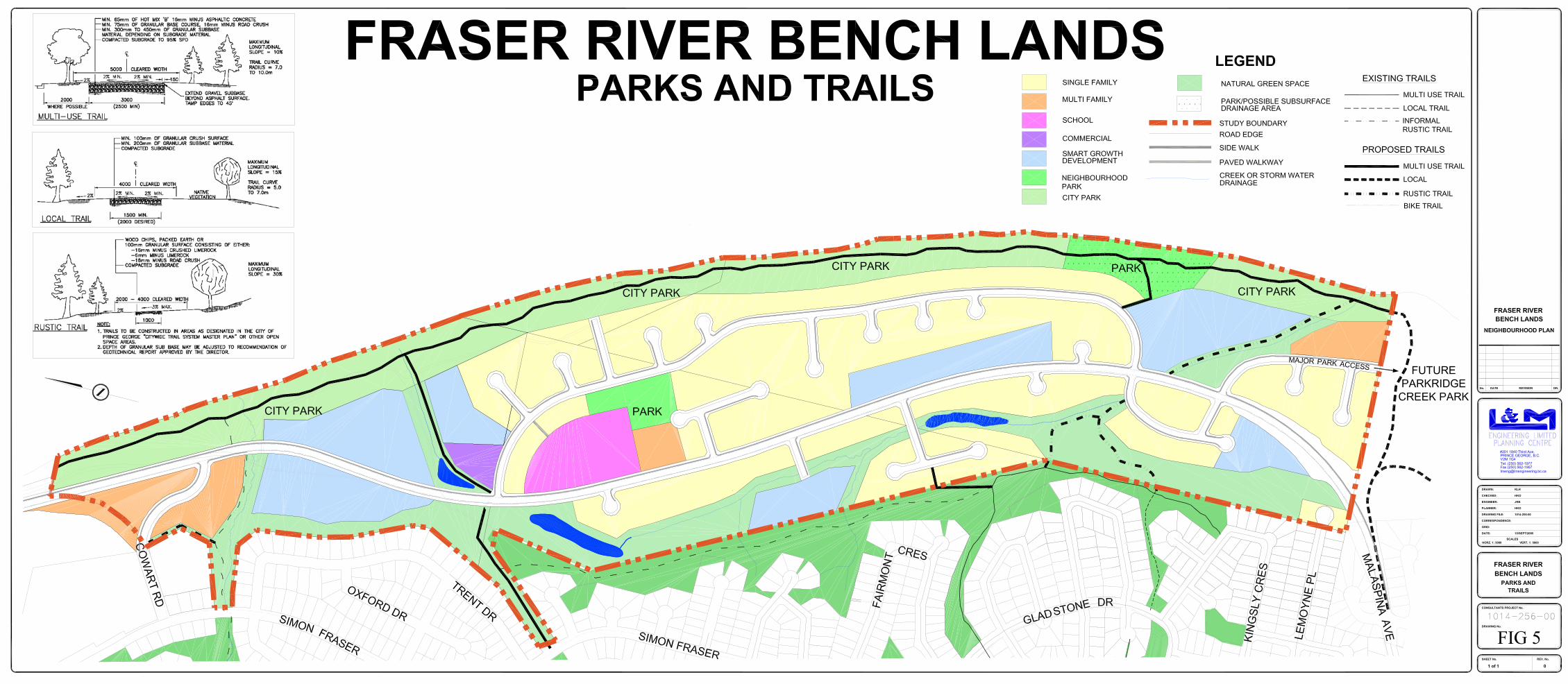
Further, as directed by the Official Community Plan, the Fraser River Bench Lands Plan is proposing to provide two (2) Neighbourhood Parks, one to be located, if possible, adjacent to an elementary school and one to be located adjacent to the Fraser River. For the Bench Lands, Neighbourhood Parks total 3.24 hectares and, in combination with the City Park along the Fraser River, the total area proposed for park is 20.33 hectares, or 19.1% of the land base which is four times the park land dedication requirement. As detailed on Figure 5: Parks, Trails, and Greenways, the location and size of the proposed Neighbourhood Parks meet the policy directives of the OCP. Table 4 illustrates the amount of land dedicated to parks and green space.
Table 3: Parkland and Greenspace by Property Land Use Fortwood
(ha) RCEC
(ha) CPG (ha)
Total (ha)
% of Total Area
City Park 7.02 7.20 2.87 17.09 16.04% Neighbourhood Park
2.71 0.53 0.00 3.24 3.04%
Green space 6.50 9.98 0.00 16.48 15.48% Total 16.23 17.71 2.87 36.81 34.56%
Figure 5 also demonstrates the extensive proposed trail system, augmented in some cases by sidewalk connections, providing connectivity between natural green spaces and built areas within the Fraser River Bench Lands as well as to adjacent areas, including Lower College Heights, Fraser River Park, and the proposed Destination Park south of the Bench Lands. As demonstrated on Figure 5, the proposed trails within the Bench Lands
Fortwood Homes Ltd. and Roman Catholic Episcopal Corporation Fraser River Bench Lands – Neighbourhood Plan
FINAL Page 18

are comprised of all three standards provided by the Official Community Plan. The trail standards are defined as follows:
• Multi-use Trail (City Trail) – is a city wide route linking major residential areas the downtown, riverfronts, destination parks, significant natural areas, regional recreation facilities and other amenities. City trails are asphalt with a trail width is 2.5 to 3.0 metres
• Local Trail – is located in natural areas, neighbourhood open spaces, greenbelts, and as secondary loops in destination regional parks and other open space areas. The trail surface is granular with a width of 1.5 to 2.0 metres.
• Rustic Trail – is located in natural settings to maximize aesthetics and trail experience. The trail is generally packed earth, crushed gravel, or granular with a width of 0.8 to 1.0 metres.
The multi-use trail network that is proposed by the 1998 City Wide Trail System Master Plan adjacent to the Fraser River is an essential link of the City’s overall trail system and will form the spine of the envisioned river front recreation area. It is therefore recommended the construction of all multi-use trails in the Fraser River Bench Lands be developed in accordance with the Capital Works Program, while the developers fund the construction of the local and rustic trail links to the multi-use trails through the Bench Lands. The allocation of park lands and the provision of biking and walking trail networks is an important element of Smart Growth. The Fraser River Bench Lands Neighbourhood Plan has given high importance to ensuring that generous open space and trails are designated to encourage active transportation, public recreation and an overall healthy community.
Fortwood Homes Ltd. and Roman Catholic Episcopal Corporation Fraser River Bench Lands – Neighbourhood Plan
FINAL Page 19

Fortwood Homes Ltd. and Roman Catholic Episcopal Corporation Fraser River Bench Lands – Neighbourhood Plan
FINAL Page 20
3.4.1 Parkland and Trail Policy Recommendations
1. Two Neighbourhood Parks shall be provided in the Fraser River Bench Lands Neighbourhood, one adjacent to the elementary school site and one adjacent to the Fraser River to form part of the overall riverfront recreation area.
2. Neighbourhood Parks shall be developed with a target of one park per 1,000 residents.
3. Within the minimum 50 metres of natural greenspace from the Top of Bank of the Fraser River, shall be located a City Park connecting the proposed Major Park with Fraser River Park and providing public access to the river.
4. The 5% parkland dedication is to be comprised of the two Neighbourhood Parks and the City Park. Any land dedicated as City Park that exceeds the 5% requirement shall be subject to negotiation between the land owner and the City of Prince George.
5. Within the minimum 50 metres of natural greenspace from the Top of Bank of the Fraser River, shall be located a trail designed to the multi-use standard.
6. The multi-use trail adjacent to the Fraser River will be linked to Lower College Heights in seven (7) places as demonstrated on Figure 5. The trail connections consist of local trail standard, rustic trail standard and sidewalk.
7. All trails other than multi-use standard shall be constructed and paid for by the developer.
8. Trails shall be planned and developed as part of each phase of subdivision with the objective of facilitating the easy movement of people throughout the neighbourhood and to adjacent areas.
3.5 Transportation Network Policy 11.6.3 of The Official Community Plan recognizes that Transportation Networks are more than simply roads, but are the means by which people manoeuvre throughout a neighbourhood and the community with the statement:
Multiple use of major transportation corridors is encouraged. Roads should be shared for various modes of transportation including vehicles, cyclists, transit, and pedestrian movement (OCP, p.85).
In addition, the OCP states that Neighbourhood Plans must address the transportation network by considering all modes of local transportation including vehicle, pedestrian, bicycle, and transit options. Figure 4 demonstrates the proposed Transportation Network for the Fraser River Bench Lands, as well as how the proposed network connects with the existing one in the adjacent area.
3.5.1 Road Network As previously discussed, one of the historical constraints with respect to the development of the Fraser River Bench Lands has been road access resulting from challenging

Fortwood Homes Ltd. and Roman Catholic Episcopal Corporation Fraser River Bench Lands – Neighbourhood Plan
FINAL Page 21
topography at both the northern and southern access points. The Bench Lands development area is long and linear with a north-south dimension of 2 kilometres, and an east-west dimension of approximately 400 metres. In addition, there is limited opportunity to connect the proposed development area to the City’s Transportation Network on the east or west sides because of the proximity of the Fraser River and the College Heights escarpment. As a result, the proposed connections to the City’s Transportation Network will be located at the north end and at the south end of the development. It is anticipated that both connections to the City’s existing transportation network will be costly because of steep escarpment grades and challenging topography. Current planning and discussions with both Fortwood and RCEC indicate that the development will most likely proceed from south to north. Thus, the first major road to be constructed will be the northwards extension of Malaspina Avenue. This extension of Malaspina Avenue will require significant earthworks within the lands owned by Fortwood, and also within the lands that are presently being developed by Malaspina Ridge. The necessary cuts and fills will be extensive and costly. As the development of the Fraser River Bench Lands proceeds, it will be necessary to extend the Malaspina Avenue collector road in a northerly direction to connect with the existing Cowart Road. The topography in the vicinity of the proposed Cowart Road/Malaspina Avenue intersection is challenging. The general area is constrained by the close proximity of the Fraser River and the existing steep gradients that are located on each side of the current Cowart Road alignment. Again, it is anticipated that this particular intersection will be costly to construct. Figure 4 illustrates the proposed alignment of the Malaspina Avenue collector road. Generally, the Malaspina Avenue collector road will consist of an extension of Malaspina Avenue from Cowart Road to the existing termination of Malaspina Avenue within the new Malaspina Ridge Subdivision. The approximate length of the proposed Malaspina Avenue collector road is 2 km and, because of the linear nature of the proposed development, a single collector road is able to service the entire development area. All of the other roads illustrated on the transportation network plan (Figure 4) will be local roads only. The proposed realignment of the Cowart Road interchange with Malaspina Avenue is illustrated on Figure 4. Conceptual plans of the proposed Cowart Road/Malaspina intersection which, in essence, will be constructed to create an improved intersection of Cowart Road with Malaspina Avenue, have been provided to the City separately from this document for review and comments. At this time, the Cowart Road/Malaspina intersection designs are preliminary; however, the work completed to date confirms that the proposed improvements are feasible. Ultimately, the new Fraser River Bench Lands neighbourhood will be linked to Highway 16 via the existing section of Cowart Road. At the present time, Cowart Road functions as a Collector Road and connects to Highway 16 West at an existing signalized intersection. The operation and functionality of this particular intersection were analyzed as part of the Neighbourhood Planning process. Detailed traffic counts were undertaken

Fortwood Homes Ltd. and Roman Catholic Episcopal Corporation Fraser River Bench Lands – Neighbourhood Plan
FINAL Page 22
during the am and pm peak periods and an intersection capacity analysis was conducted for existing traffic conditions (2006) and for future traffic projection, assuming full build out of the Bench Lands by 2021. The existing Highway 16/Cowart Road intersection operates at an acceptable Level of Service (L.O.S.) B and C during the am and pm peaks respectively. This L.O.S. confirms visual observations during the am and pm peak periods with traffic moving efficiently with little delay. In particular, the am peak westbound (Cowart Road) right-turn merge lane was operating with near free flow conditions, which were further enhanced by the platoon arrival of north bound vehicles on Highway 16. With the addition of the am peak development traffic, the capacity of the intersection is reduced to L.O.S. C. No individual movement’s L.O.S. is worse than L.O.S. D. The lane configuration at the intersection was revised to include a separate westbound left-turn slot and the signal phasing was updated to include a westbound left-turn movement. With the addition of the pm peak development traffic, the overall capacity of the intersection is reduced to L.O.S. E. The north and south bound through movement volumes are high throughout the Highway 16 corridor from Domano Boulevard to Highway 97. To reduce these volumes, alternate parallel routes are required. The future extension of Ospika Boulevard and the construction of the Ospika overpass will help reduce the traffic on Highway 16. The potential connection of Cowart Road to Lansdowne Road is another link that would greatly reduce the impact on the Highway 16 and Cowart Road intersection by providing an alternate connection from College Heights to Ferry Avenue/Highway 97 and Queensway. This link, while physically difficult to construct, will provide access to Ferry Avenue, the BCR Industrial site and the downtown core without travelling on Highway 16. Another alternative worth considering is the construction of an underpass beneath Highway 16, near the Telus building connection Cowart to Wiebe Road. In summary, to reduce the impact on the Highway 16 corridor, and to improve the Level of Service at the Highway 16/Cowart Road intersection, alternate transportation links are required. Improvements to the Cowart Road geometrics will also assist with the free flow of traffic from the Bench Lands to Highway 16. As such, there are unresolved transportation impacts caused by the development that go beyond conventional mitigation measures, and will consequently need to be studied with network modelling to identify potential solutions, including timing and funding. In order to determine the development threshold at which the connection of Malaspina Avenue to Cowart Road will be required, a traffic analysis of the critical intersection on Malaspina Avenue was prepared. Traffic counts were conducted during the weekday am and pm peaks on Malaspina Avenue near Rochester Crescent. The City prepared a Synchro traffic analysis for the Malaspina Avenue and Rochester Avenue intersection. An iterative analysis with varying levels of development was performed to determine when the operation of the intersection dropped below a Level of Service (LOS) B. It was determined that with an additional 200 vehicles, which roughly equates to an additional 200 dwelling units, the operation of the intersection dropped below LOS B. Given the assumptions made during the analysis, an additional traffic count and analysis should be performed after 150 dwelling units have been constructed and occupied to confirm the operation of the intersection and Malaspina Avenue.

Fortwood Homes Ltd. and Roman Catholic Episcopal Corporation Fraser River Bench Lands – Neighbourhood Plan
FINAL Page 23
Generally, roadworks to provide access to the subdivision will be costly. As previously noted, these roadwork costs have been one of the impediments to the development of the Fraser River Bench Lands area. The proposed Cowart Road/Malaspina Avenue intersection will be the major cost; however the extension of the existing Malaspina Avenue, including the significant cuts and fills, will also be significant. The City of Prince George has recognized that the costs of connections to the existing Transportation Network are significant. Thus, the crossing of Varsity Creek and both connections to the existing Transportation Network are identified as “extraordinary works” and are included in the City of Prince George Capital Expenditure Program. In summary, the partial funding of the expensive roadworks by the City of Prince George will improve the existing Transportation Network, and will act as a catalyst for the development of the Fraser River Bench Lands.
3.5.2 Pedestrian Network By undertaking the 2004 Pedestrian Network Study, the City of Prince George has indicated that the creation of pedestrian facilities is a priority of transportation planning. The Study notes that,
Walking is increasingly recognized as an essential and healthy transportation mode. To support walking, areas that generate walking trips and attract pedestrians need to be easy and safe for pedestrians to negotiate. As vehicle volumes and speeds increase, pedestrians are not comfortable walking without designated and safe routes. The presence of quality facilities can facilitate walking and increase safety for pedestrians. (2004 Pedestrian Network Study, p. 1)
The combination of mixed local commercial, institutional, and residential land uses connected by sidewalks, multi use trails, and greenways will create a pedestrian friendly environment within the Fraser River Bench Lands as well as link the Bench Lands to surrounding neighbourhoods. The extension of sidewalks along Cowart Road towards Highway 16 West should also be considered.
3.5.3 Cycle Network Another component of providing for multiple modes of transportation is planning for the bicycle. Providing opportunities for safe cycling is highlighted in the following excerpt from the 2000 Cycle Network Plan,
Planners and designers should work to fully integrate the bicycle into the existing transportation systems, and to encourage the acceptance of the use of the bicycle as a safe and convenient mode of transportation… Properly engineered facilities encourage the cyclist to use them because it is easy, convenient, and demonstrates that cycling has a place in the transportation network. (2000 Cycle Network Plan, p.2)

The OCP supports the Cycle Network Plan as illustrated on Map 10: Bicycle Network. The Fraser River Bench Lands Neighbourhood Plan has reflected the conceptual cycle network through the Fraser River Bench Lands, as proposed on Map 10 of the OCP, in that the extension of Malaspina Avenue will be designed to the collector standard and includes a dedicated cycle lane in both directions. As demonstrated on Figure 5: Parks & Trails, and in order to facilitate an on- and off-road cycle experience, these cycle lanes will connect to: the existing cycle lane on Cowart Road, the proposed multi use trails to Lower College Heights, and the multi-use trail through the City Park adjacent to the Fraser River.
3.5.4 Transit Network Policy 11.6.9 of the Official Community Plan states that,
New neighbourhoods shall be designed to facilitate public transit and access to transit, including the incorporation of looped roads designed to link internal residential sectors (OCP, p.86).
In combination with this policy of the OCP, the 2003 Prince George Transit Service Review outlines design standards the transit system should strive to attain:
• Service within 400 metres walking distance of 90% of all residences. • Service within 150 metres walking distance of major senior residences and other
institutional facilities. • Service within 250 metres of all future medium and high density residential
developments.
Fortwood Homes Ltd. and Roman Catholic Episcopal Corporation
The above goals are facilitated by the proposed north-south Malaspina Avenue collector road which will be centrally located within the Bench Lands area such that no residence is more than 300 metres from public transit. In addition, the majority of the medium and
Fraser River Bench Lands – Neighbourhood Plan FINAL Page 24

Fortwood Homes Ltd. and Roman Catholic Episcopal Corporation Fraser River Bench Lands – Neighbourhood Plan
FINAL Page 25
high density developments, as well as school and commercial areas, are connected directly to Malaspina Avenue.
How and when the provision of direct transit service to the Fraser River Bench Lands will be supplied will be evaluated by the City of Prince George against these criteria. However, the Fraser River Bench Lands Neighbourhood Plan must demonstrate that there are suitable pedestrian and cycle links from the Bench Lands to the existing transit service in Lower College Heights. Figure 4: Transportation Network and Figure 5: Parks and Trails, demonstrate these links. Smart Growth principles dictate the importance of providing adequate pedestrian infrastructure such as sidewalks, transit accessibility and bike lanes to encourage public health, increase social interaction and improve pedestrian safety. The Fraser River Bench Land Neighbourhood Plan supports these principles and is addressing pedestrian and public transit issues in a manner that is consistent with Smart Growth and that increases transportation choices available to the public.
3.5.5 Transportation Network Policy Recommendations
1. Malaspina Avenue shall be built to a collector standard with a 25 metre right of way (ROW) with a 13 metre wide paved surface. The road shall be designed to accommodate a bicycle lane on both sides, transit stops, and a 1.8 metre wide sidewalk on the east side of the roadway. In addition, direct driveway access to Malaspina Avenue shall be limited as much as possible.
2. The extension of Malaspina Avenue is recognized as “extraordinary works” and is included in the City of Prince George Capital Expenditure Program.
3. Malaspina Avenue shall be constructed in a northerly direction from the existing termination of Malaspina Avenue located within the new Malaspina Ridge Estates subdivision development.
4. A Traffic Analysis has been prepared which indicates that the initial development phases be limited to 200 dwelling units, until such time as Malaspina Avenue is extended northwards to connect with Cowart Road. Further traffic counts shall be conducted when the number of dwelling units reaches 150.
5. The extension of Malaspina Drive through to Cowart Road should not be permitted until comprehensive network modelling has been completed and recommendations regarding the results, including identification of possible solutions, timing, and funding are considered by all appropriate approving agencies.
6. A Traffic Analysis has been prepared which indicates that additional transportation links should be developed (i.e.: Cowart to Landsdowne) to reduce the impact on Highway 16 and to improve the Level of Service at the Highway 16 and Cowart Road intersection.
7. Any new development serviced by the northwards extension of Malaspina Avenue should allow the existing portion of Malaspina Avenue to operate at a level of service “B.”

Fortwood Homes Ltd. and Roman Catholic Episcopal Corporation Fraser River Bench Lands – Neighbourhood Plan
FINAL Page 26
8. Local subdivision roads will be built to a 10 metre wide paved standard with a sidewalk on one side.
9. Lot configurations will be designed at the subdivision stage of development. 10. Access to City of Prince George lands will be provided. 11. Alternative Development Standards for local roads shall be considered during the
subdivision phase of development. 12. During the subdivision phase of development, consideration will be given to the
creation of a safe, pedestrian-oriented environment where traffic speeds and conflicts are managed.
13. Additional pedestrian connections to the existing trail network should be encouraged at the time of subdivision.
14. Links from trails to roadways will be appropriately designed. 15. In accordance with the City’s Transit Policies, public transit shall be provided on
collector roads in the neighbourhood as warranted by demand.
3.6 Residential Land Use The proposed residential areas for the Fraser River Bench Lands are comprised of a mix of traditional and Smart Growth areas. This Neighbourhood Plan has taken its policy direction with regard to: provision of housing choices, neighbourhood character, siting criteria, provision of affordable and rental housing, and community residential facilities from the Official Community Plan. The primary differences between the Smart Growth and traditional areas are found in achievable densities, servicing and infrastructure considerations as well as in proposed zoning regulations and provision of additional green space. What follows is a description of the proposed residential component of the Fraser River Bench Lands by policy direction of the OCP and Smart Growth principles.
3.6.1 Principles of Residential Development Residential housing principles, as outlined by the Official Community Plan include: developing a compact community by increasing urban density and infilling existing neighbourhoods, providing a variety of housing options, encouraging innovative design, respecting the integrity of existing neighbourhoods, encouraging social housing, and designing liveable neighbourhoods. The Fraser River Bench Lands’ Residential policies encourage the development of a compact community by permitting secondary suites within Single Family dwellings in designated Smart Growth areas and maximizing the medium density housing development permitted by the Official Community Plan. Further, the Bench Lands represent infill development as the land is designated as Phase 2 development lands, are a logical extension of municipal infrastructure, and are the last urban designated land to be proposed for development in the Lower College Heights area of the Southwest Sector. The proposal respects the integrity of the existing Lower College Heights neighbourhood

by replicating trail and parkland development and providing connectivity through the neighbourhood, although architectural styles can be original given the topographical separation between the neighbourhoods. The discussion below demonstrates the proposed residential densities, housing options, and design standards for the Fraser River Bench Lands.
3.6.2 Residential Densities and Variety of Housing Options The OCP acknowledges that the market is showing a change in housing preferences and that this change is due, in part, to demographics and also to lifestyle choices. To be considered a complete neighbourhood, there should be adequate housing options for people in every demographic. In other words, there should be housing for students, for single working people, for families with children, for “empty-nesters”, and for seniors. There should be housing types available for different socio-economic groups as well as Community Residential facilities for those with special needs or who require assistance with daily living. The proposed Fraser River Bench Lands Neighbourhood will provide single family, medium density multiple family, and secondary suites as well as Higher and Lower Smart Growth density housing options, including: town housing, row housing, two-family, and strata opportunities. In addition, 1 out of every 200 lots will be zoned for Community Residential use, satisfying Policy 6.3.20 of the Official Community Plan.
Fortwood Homes Ltd. and Roman Catholic Episcopal Corporation Fraser River Bench Lands – Neighbourhood Plan
FINAL Page 27
Policy 6.1 of the Official Community Plan, directs potential housing mix by sector. Within the Southwest sector, the housing mix objective is:
• 65% low density residential, which includes single family and two-family dwelling units to a maximum density of 22 units per hectare.
• 35% medium density units with a
density range of 20-40 units per hectare.
This plan augments this policy direction by providing Higher and Lower Smart Growth housing mix objectives. The housing mix and density objectives of the Fraser River Bench Lands are demonstrated in Table 5 below and were calculated based on the Housing Densities objectives provided by the Official Community Plan, as well as City of Prince George Design Guidelines, 2001.

Fortwood Homes Ltd. and Roman Catholic Episcopal Corporation Fraser River Bench Lands – Neighbourhood Plan
FINAL Page 28
Table 4: Housing Densities
Residential Designation Average Density Housing Form
Low Density Residential 9.6 units/ha. Single Family and Two Family Medium Density 40 units/ha. Ground oriented town houses S.G. Lower Density 12 units/ha. Single Family, Secondary Suites, Two
Family, ground oriented town houses S.G. Higher Density 40 units/ha. Single Family, Secondary Suites, Two
Family, ground oriented town houses, up to 4 storey apartments
Figure 3 demonstrates land use within the Fraser River Bench Lands at full build out. The more detailed level of planning that will occur at the rezoning stage will result in refinement to the number and mix of units and development factors. Such details as site-specific conditions and market demand will influence the forms of medium density and Smart Growth Lower and Higher Density developments. Table 6 indicates the percentage of residential development by land area proposed for the Fraser River Bench Lands. The proposed housing mix exceeds the objectives of the Official Community Plan.
Table 5: Ratio of Residential Development
Residential Designation
Total Area (ha)
Dwelling Units / ha
Number of Dwelling Units
Single Family 32.79 9.6 315 Medium Density 4.67 40 187 S.G. Lower Density 10.98 12 132 S.G. Higher Density 3.72 40 149 Total 52.16 783
The total number of low density dwelling units is 447 (315 + 132). The total number of medium density dwelling units is 336 (187 + 149). Thus, the ratio of low density to medium density is 57 % to 43 %. This ratio exceeds the objectives of the Official Community Plan and is a reflection of the Smart Growth principles combining increased land use density with increased greenspace. Based on housing data for newer residential areas of Prince George, it is estimated that the average number of persons per household will be in the range of 2.5 to 3.2 with a blended average incorporating 2.85 for single, multiple, and smart growth residences. Table 7 shows the estimated population of the Fraser River Bench Lands to be 2,271.

Fortwood Homes Ltd. and Roman Catholic Episcopal Corporation Fraser River Bench Lands – Neighbourhood Plan
FINAL Page 29
Table 6: Estimated Population of the Fraser River Bench Lands
Residential Designation
Total Area (ha)
Dwelling Units / ha
Number of Dwelling
Units
Persons / Dwelling
Unit
Estimated Population
Single Family
32.79 9.6 315 3.2 1008
Medium Density
4.67 40 187 2.5 468
S.G. Lower Density
10.98 12 132 3.2 422
S.G. Higher Density
3.72 40 149 2.5 373
Total 52.16
783 2,271
Chart 1: Age/Sex Breakdowns (see following page) shows the age breakdown by sex of the projected population of the Fraser River Bench Lands at full build out and is illustrative in showing a snapshot of the life cycle of a neighbourhood. The largest age grouping for the Fraser River Bench Lands, for example, is in the range of 25 – 44 years, which would typically would be considered the demographic for single family homes. Correspondingly, the largest number of dwelling units is found to be in the single family dwelling category. Statistics for Chart 1 are based on the City of Prince George’s Age/Sex Breakdowns-2001 chart.

Chart 1: Fraser River Bench Lands Age / Sex Breakdowns
0
50
100
150
200
250
300
350
400
0-4 years 5-14years
15-19years
20-24years
25-44years
45-54years
55-64years
65-74years
75-84years
85+ years
MaleFemale
0-4
years 5-14 years
15-19 years
20-24 years
25-44 years
45-54 years
55-64 years
65-74 years
75-84 years
85+ years TOTAL
Male 71 182 98 75 342 179 107 57 21 4 1136 Female 68 166 92 72 376 177 94 54 28 8 1135 TOTAL 139 348 190 147 718 356 201 111 49 12 2271
Note: All totals are base on City of Prince George Age/Sex Breakdowns-2001 chart
Fortwood Homes Ltd. and Roman Catholic Episcopal Corporation Fraser River Bench Lands – Neighbourhood Plan
FINAL Page 30

Fortwood Homes Ltd. and Roman Catholic Episcopal Corporation Fraser River Bench Lands – Neighbourhood Plan
FINAL Page 31
3.6.3 Zoning and Smart Growth This plan represents significant movement toward Smart Growth development in Prince George and includes a mix of traditional and Smart Growth residential development opportunities. The areas highlighted for Smart Growth on Figure 3 present the opportunity to explore innovative zoning regulations and alternative design standards. According to Smart Growth BC,
Zoning is perhaps the single most effective tool for shaping the look, feel, and function of a community. Just as the human geography of every community has been shaped by land-uses historically determined by specific zones, so is the future shape and efficiency of our neighbourhoods open to zoning’s influence. (Smart Growth Tool Kit, p. II-24)
Smart Growth advocates that residential expansion occur in a manner that provides a range of housing types through mixed use development. Appropriate land use planning, site design and zoning regulations can assist in the creation of a more inclusive, self-sustaining and complete community. A specific discussion of possible zoning regulations that can influence Smart Growth development is beyond the scope of this study and is more appropriately considered at the rezoning stage of development. Regulatory options include: Development Permit areas, Comprehensive Development zoning districts, as well as amendments or variances to the Subdivision and Development Control bylaw. For a more complete discussion of Smart Growth Principals, please see Appendix A.
3.6.4 Siting and Building Criteria The Official Community Plan provides policy direction for siting and building criteria for medium density housing options as follows:
• Sited along arterials or collector roads at entry locations to neighbourhoods • Proximity to major parks, community facilities, schools and transit within 5 or 10
minute walking distance based on level of density, • Plan for integration with the overall neighbourhood, • Design should consider: ground oriented developments that include urban plazas
and contribute to the sense of an urban village taking advantage of view areas and river front sites; setbacks that contribute to streetscape, variations in facades, shadow and sun exposure, play areas, and safety, and
• Sited to maximize noise attenuation opportunities.

Fortwood Homes Ltd. and Roman Catholic Episcopal Corporation Fraser River Bench Lands – Neighbourhood Plan
FINAL Page 32
Figure 3: Land Use Plan for the Fraser River Bench Lands demonstrates that the siting criteria of the OCP have been incorporated, however design considerations are more appropriately considered during the rezoning and subdivision development phases. It should be noted that all multi-family developments are subject to a Residential Development Permit, the purpose of which is to ensure that the design standards are followed. In addition to the design standards outlined by the OCP, the Smart Growth Design Standards outlined below can also be incorporated into more specific development review processes.
• Different dwelling types in the same neighbourhood and even on the same street. Different family types and incomes can be accommodated in neighbourhoods that retain a ‘single family district’ feel.
• Buildings that present a friendly face to the street. Porches and trees out front, and a mix of housing types.
• 5-minute walks to transit and shops. • Interconnected streets ensure that all trips, whether in a car, on a bike, or on foot,
are made using the shortest route possible. • Reduction in paved areas and other impermeable surfaces. • Natural drainage systems where surface runoff infiltrates into the soil.
3.6.5 Residential Land Use Policy Recommendations
1. Secondary suites shall be a permitted use in single family dwelling units within Smart Growth areas.
2. Where possible, medium density housing development should be maximized to increase residential densities.
3. Variety of housing options should be provided throughout the Fraser River Bench Lands, including rental opportunities.
4. 1 of every 200 properties shall have as a permitted use Community Residential Facility.
5. Siting and building criteria for medium density housing shall be incorporated. 6. Smart Growth principles as identified in Appendix A of this plan shall be
employed where possible in developing the Smart Growth areas identified on Figure 3.
7. As recommended in the Geotechnical Overview, included as Appendix H, additional subsurface investigation will be needed prior to the future development of the area formerly containing City sewage lagoons.

Fortwood Homes Ltd. and Roman Catholic Episcopal Corporation Fraser River Bench Lands – Neighbourhood Plan
FINAL Page 33
3.7 Commercial Land Use The Fraser River Bench Lands Neighbourhood Plan identifies a single local service commercial site in the Neighbourhood Centre. The siting for this location is based on the following criteria:
• Intersection of two major roads. • Centrally located. • Adjacent to higher density land uses. • Proximity to school site and Neighbourhood Park.
The proposed Neighbourhood Centre permits commercial properties that do not exceed the 3,000 m2 site size limitation established by Policy 7.3.15 of the Official Community Plan. The intention is for the Neighbourhood Centre to include a mix of uses in the commercial area, such as; an urban plaza, community centre, or another form of community gathering place. In addition to the identified local service commercial site, the provision of mixed land uses throughout the Neighbourhood would permit those areas identified for Smart Growth to include local service commercial uses, in combination with residential uses, given that the above mentioned siting criteria can also be applied. The inclusion of commercial developments throughout the Neighbourhood will be based on market opportunities that are in keeping with Policy 7.3.15 and 7.3.16 of the Official Community Plan which limit the maximum site area to 3000 m2 and establish criteria for including commercial uses in established neighbourhoods.
3.7.1 Commercial Land Use Policy Recommendations
1. Local service commercial development shall be permitted, as identified, in the Fraser River Bench Lands Neighbourhood Centre. Permitted uses would include those accommodated within the Local Commercial land use designation as defined in the Official Community Plan, as well as forms of community gathering places such as an urban plaza or community centre.
2. Local service commercial uses may be permitted, as part of mixed use developments, in the areas identified as Smart Growth areas in Figure 3 of the Fraser River Bench Lands Neighbourhood Plan.

Fortwood Homes Ltd. and Roman Catholic Episcopal Corporation Fraser River Bench Lands – Neighbourhood Plan
FINAL Page 34
3.8 Institutional Land Use Policy 10.4.6 of the Official Community Plan directs that government institutional uses, such as hospital facilities, administrative buildings, and cultural facilities should be located in the City Centre. Therefore, the Institutional uses appropriate for the Fraser River Bench Lands include; places of worship, educational facilities, and community centres. The land use plan indicates that the Neighbourhood Centre will be comprised of the proposed school site, along with a mixed use commercial/institutional site abutting medium density, higher density, and single family land uses.
3.8.1 School Site School District No. 57 has indicated that elementary schools are constructed for a population of 300 elementary school age children. The projected population for the Fraser River Bench Lands is 2,271 with a number of dwelling units of 783. Based on the assumption, provided by the Official Community Plan, of 0.4 elementary students per housing unit, the number of elementary school age children projected for the Bench Lands is calculated to be 313. Early consultation with the School District has indicated that, given the capacity for 50 children in Malaspina Elementary School and that Gladstone Elementary could be reopened, School District No. 57 does not anticipate the need to construct a new elementary school within the Fraser River Bench Lands. In addition, the School District has indicated that College Heights Secondary School will be able to meet any future demands at the secondary school level. This land use plan has provided an area for a school site that is adjacent to a Neighbourhood Park because the projected population of elementary school children approximates the threshold of 300 students. However, given that school site planning shares similar siting requirements as for other institutional uses, such as places of worship or multiple family developments, should the school site not be required by the School District, the land could be developed for one of these alternative uses.
3.8.2 Places of Worship Policy 10.4.9 of the Official Community Plan permits places of worship to be located in any OCP designation, assuming they are sited generally in accordance with the same criteria as applied to multiple family developments. This plan provides the opportunity for an additional institutional site in the Neighbourhood Centre, and recognizes the opportunity for the areas currently designated for multi-family developments to be alternatively developed for institutional uses such as places of worship.

3.8.3 Institutional Policy Recommendations
1. A site shall be identified for an elementary school that is adjacent to a Neighbourhood Park. Should this site prove to be superfluous to the School District’s needs, the site can be utilized for residential or institutional purposes. The site can be considered for other uses when the Fraser River Bench Lands Neighbourhood reaches approximately 70% build out.
2. Until such a time that the site is proven to be superfluous to the School District’s needs, as outlined in Policy 3.8.3(1), a restrictive covenant should be placed on the future school site, restricting its use to Education Services as defined in the Zoning Bylaw.
3. Should the designated school site be required, the property shall be purchased from the land owner at market value.
4. Areas designated for multiple family housing can also be developed for institutional uses, such as places of worship.
Fortwood Homes Ltd. and Roman Catholic Episcopal Corporation Fraser River Bench Lands – Neighbourhood Plan
FINAL Page 35

Fortwood Homes Ltd. and Roman Catholic Episcopal Corporation Fraser River Bench Lands – Neighbourhood Plan
FINAL Page 36
4.0 Neighbourhood Servicing The focus of this section is to provide preliminary servicing directions to the City of Prince George, as well as to potential developers of the Fraser River Bench Lands. The proposed development area contains a number of servicing constraints, which will significantly influence the phasing and direction of development.
4.1 Water System The Fraser River Bench Lands area is contained within the City of Prince George Pressure Zone 3 (PZ3). The City of Prince George lands located within the development area contain exiting water supply wells which supply water from the Fraser River to the College Heights area. PZ3 services an elevation range of approximately 610 metres to 655 metres at a maximum day pressure in the range of 40 psi to 100 psi. This zone is supplied with water by the PW 824 water storage reservoir which is located on the future extension of Ospika Boulevard, adjacent to the Kode gravel pit. The elevations within the Fraser River Bench Lands area are in the range of 570 metres to 585 metres. Thus water pressures, before pressure reduction, would be in the range of 145 psi to 167 psi. In order to reduce the water system pressures within the proposed development area, pressure reducing valves will be required at every connection to the existing water distribution system. It is envisioned that the water distribution system within the Fraser River Bench Lands area will be connected at the north end to the existing 200 mm diameter main on Cowart Road and at the south end to the existing 200 mm diameter water main on Malaspina Avenue. In addition, it is proposed that the water distribution system be connected directly to the existing 600 mm diameter and 150 mm diameter water mains that traverse the development site in the vicinity of the City of Prince George water wells. The City of Prince George presently has the entire City water system modelled on a computer, using H20 NET software. Once detailed subdivision planning commences, the City can model the required sizes of any water main extensions within the Fraser River Bench Lands area. The model can also identify the most appropriate locations and pressure settings for the PRVs that are required. At this time, we do not envisage any major problems with the provision of water supply to the entire Bench Lands area.

Fortwood Homes Ltd. and Roman Catholic Episcopal Corporation Fraser River Bench Lands – Neighbourhood Plan
FINAL Page 37
4.2 Sanitary Sewer The Fraser River Bench Lands will contain a mixture of residential, commercial and institutional land uses. In accordance with the City of Prince George Servicing Bylaw No. 7652, 2004, all new development will be fully serviced, and all parcels will be connected to the municipal sanitary sewer collection system. At the present time, the proposed development area is traversed by an existing 600 mm diameter sanitary sewer main which connects the College Heights subdivisions with the existing sewage treatment centre. The existing 600 mm diameter sanitary sewer main is located within the BC Hydro ROW, which is located immediately behind the residences on Trent Drive. The majority of development within District Lot 753 will be able to connect directly to this existing sanitary sewer main. However, the balance of development in District Lot 754 (RCEC) and the Remainder of District Lot 2014 (Fortwood) will require construction of a major sanitary sewer lift station to convey sewage to the exiting sanitary sewer main. During preliminary discussions with the City of Prince George, it was indicated that the existing 600 mm diameter sanitary sewer main has sufficient capacity to service the entire Fraser River Bench Lands. The exact location of the required sewage lift station has not yet been determined. However, it is anticipated that the preferred location for the sewage lift station will be on the Lower Bench, in the vicinity of the City of Prince George parcel. The sanitary sewer lift station will also require a force main which will connect directly with the 600 mm diameter gravity sewer main traversing the development area. The location of the proposed sanitary sewer lift station will have to be determined at an early date in order to allow development within the Fraser River Bench Lands. It is recommended that the sanitary sewer lift station be constructed during the initial development phases, so that all sewage flows from the bench lands areas are conveyed directly to the existing sewage treatment centre. It is not recommended that a temporary sewage lift station be provided to pump sanitary sewage to the existing sanitary sewer collection system located on existing portions of Malaspina Avenue. Finally, it is understood that the existing sanitary sewer collection system in this vicinity has capacity restrictions.
4.3 Storm Water Management The Fraser River Bench Lands offers a number of constraints and opportunities with respect to the management of storm water runoff. Storm water management constraints within the Fraser River Bench Lands area include the following:
• Proximity of the development to the Fraser River, with the resultant setback provisions and habitat protection issues;

Fortwood Homes Ltd. and Roman Catholic Episcopal Corporation Fraser River Bench Lands – Neighbourhood Plan
FINAL Page 38
• Influence of the numerous storm water outfalls that discharge storm water onto the development area from the existing College Heights subdivisions.
• Location of drainage channels within the development area, which have been created as a result of the discharge of storm water from the existing College Heights subdivisions.
The previously noted constraints also provide opportunities for the developers of the Fraser River Bench Lands area. For example, the proximity of the Fraser River and the presence of existing drainage channels within the subdivision area require that significant setbacks be established. The overall land use plan illustrates a minimum setback of 50 metres from the Fraser River, and the same plan illustrates a minimum setback of 15 metres from the existing drainage courses that currently convey the College Heights storm water to the Fraser River. The net result of the generous setbacks is that the net developable area represents only 51.79% of the gross area. Parks and green space, including setbacks, amount to approximately 35% of the gross area. The high percentage of parks/green space, combined with the Smart Growth principles which include the preservation of the natural environment, will result in a very “green” development including large areas of park land and the retention of existing trees and vegetation wherever possible. Development will be less intense and storm water runoff will be significantly reduced compared to traditional subdivision development. The native soils within the Fraser River Bench Lands are generally sands and gravels overlying silt and clay with low permanently. Thus, it is anticipated that there is limited opportunity to develop sub-surface drainage disposal facilities which will minimize or eliminate the direct discharge of storm water to the Fraser River. However, it is envisaged that some of the Smart Growth development sites will have on-site storm water discharge facilities. The City of Prince George Servicing Bylaw No. 7652, 2004 requires that all new development be fully serviced and connected to the municipal storm sewer collection system. Accordingly, where on-site storm water discharge facilities cannot be constructed, each new parcel will be provided with a storm sewer connection which will be connected to storm sewers located within the adjacent road right-of-way. These storm sewers will collect all storm water runoff from the development area and direct these flows either directly to the Fraser River or alternatively to a new community subsurface drainage disposal field which will be located in the Neighbourhood Park, as illustrated in Figure 3. The proposed subsurface drainage field is located approximately 866 metres downstream of the existing City of Prince George water wells. This distance is considered a safe separation so that the subsurface drainage disposal facility will not impact existing City of Prince George water wells. In summary, the completion of a storm water management plan is required for the entire development area and will include subsurface disposal of storm water runoff should this design option be supported by detailed geotechnical review.

4.3.1. Storm Water Management Policy Recommendations
1. Directed discussion between the City of Prince George and the developer should take place with respect to the discharge of stormwater from the existing College Heights Neighbourhood onto the Bench Lands. The quality and quantity of this stormwater should be managed in order to maintain the wetland complex in the proposed development area.
Fortwood Homes Ltd. and Roman Catholic Episcopal Corporation Fraser River Bench Lands – Neighbourhood Plan
FINAL Page 39

Fortwood Homes Ltd. and Roman Catholic Episcopal Corporation Fraser River Bench Lands – Neighbourhood Plan
FINAL Page 40
5.0 Implementation The purpose of this Neighbourhood Plan is to complement the Official Community Plan as the policy framework for the development of the Fraser River Bench Lands. As such, the plan has been developed in accordance with the principles and policies of the Official Community Plan and is intended to provide clear direction to decision makers, residents, and developers regarding the vision for the Fraser River Bench Lands. As the guiding policy document, this Plan will be consulted during the rezoning and subdivision phases of development to ensure conformity with its intentions. It is recommended that the Fraser River Bench Lands Neighbourhood Plan be adopted by Prince George City Council through resolution allowing the plan to act as the policy guide rather than as a regulatory document. Adopting the plan by resolution gives Council the opportunity to consider development proposals that are inconsistent with the Plan but which Council considers to be in the public interest. Should Prince George City Council adopt the Fraser River Bench Lands Neighbourhood Plan, the next steps in the development process will include:
1. Phased rezoning applications with land use to be approved by Prince George City Council.
2. Phased subdivision applications that may also include detailed traffic, geotechnical and environmental studies.

Fortwood Homes Ltd. and Roman Catholic Episcopal Corporation Fraser River Bench Lands – Neighbourhood Plan
APPENDIX A
APPENDIX A
SMART GROWTH PRINCIPLES AND TOOLS

Fortwood Homes Ltd. and Roman Catholic Episcopal Corporation Fraser River Bench Lands – Neighbourhood Plan
APPENDIX A
What is Smart Growth? Smart Growth is a planning framework consisting of guiding principles to manage urban development in an ecologically and socially responsible manner. Smart Growth can be defined as “land use and development practices that enhance the quality of life in communities, preserve the natural environment, and save money over time” (Smart Growth Toolkit, p. I-5). The application of Smart Growth principles in planning decisions is gaining momentum in Canada and can be attributed to a better appreciation of the inherent connection between the ecological, social and built environment. A complete list of Smart Growth principles and tools is provided at the end of this appendix and the main principles and tools are elaborated on below. Principles of Smart Growth There are five central principles that guide Smart Growth development strategies and implementation tools (Smart Growth Toolkit, p. III-38-40). Growth management of urban development optimizes the use of space and structure. Smart Growth encourages infill development where these opportunities present themselves and an increase in residential/commercial densities so that the needs of residents are met without the liveability of the neighbourhood being compromised. The use of mixed use zoning policies assist in creating complete communities which can “reduce the per capita consumption of land, lower the cost of per unit infrastructure, […] reduce trip lengths, make transit more viable, increase walkability and may help preserve natural assets” (CMHC, p. 4). Efforts to make a neighbourhood a place to live, work and recreate allows for increased interaction between residents, aesthetic appeal and improved public safety and health. Practices that increase pedestrian mobility and recreational and commercial activity also create a strong sense of place and increase community pride and social responsibility. Reducing the cost of municipal infrastructure relates to proactive planning practices that consider the long-term cost benefits of optimizing space and investing in energy efficient technologies. Higher density residential areas can be achieved through the development of multiple family dwellings and through smaller lot sizing of single family dwellings, thereby reducing the costs of servicing and infrastructure. Transportation routes with narrower road widths and increased transit linkages add to the amount of space that can be dedicated to pedestrian friendly walkways and landscaping. The decrease in space allocated for residential and transportation uses allows for a higher level of greenspace and park land for recreational, aesthetic and ecological benefits. Environmentally responsible technologies such as the development of energy efficient buildings and siting, stormwater management and use of recycled building materials reduces infrastructure costs and allows for long-term cost savings that result from efficient use of energy and municipal services.

Fortwood Homes Ltd. and Roman Catholic Episcopal Corporation Fraser River Bench Lands – Neighbourhood Plan
APPENDIX A
Integrating urban development into ecosystems requires recognition of surrounding natural features and an understanding that in order for a neighbourhood to promote long term health these features should be incorporated into design and construction. Protecting ecosystems from degradation can be achieved through planning processes that reflect on harmonizing the built environment with the natural environment. Emphasis on pedestrian activity, integrated storm water infrastructure, retention of greenways, protection of riparian zones and construction of green infrastructure all assist in achieving an integrated urban-natural environment. Development that follows a participatory planning model recognizes the importance of public participation in development decisions and ensures that decision-making is reflective of both public and private interests. Opportunities to involve the public interest in the planning process can occur in a variety of ways including public notification in newspapers, online forums, public information sessions and design charettes, among others. The best method of guaranteeing that public participation will occur in the planning and design process is through legislated policy of local governments. For example, local governments can stipulate the frequency, format and process of decision-making that assist in achieving meaningful public participation. Smart Growth Tools Alternative Development Standards (ADS) allow for more flexible requirements than do traditional development standards in that ADS can manage growth in a manner supportive of Smart Growth principles. ADS can stipulate requirements for building specifications, land uses, development densities and innovative storm water management (Smart Growth BC, 2002). ADS benefit developers and municipal governments because they can increase the cost-effectiveness of infrastructural and land development costs. ADS can be promoted through a variety of development stages including planning (Official Community Plans, zoning, covenants, approval processes, etc.), engineering (construction, storm water, parking and road right-of-way standards, etc.) and parks and green space (stream stewardship standards, conservation of natural features, etc.) (Smart Growth BC, 2002). Comprehensive Development Zones differ from traditional ‘blanket’ zoning in that they are tailored to the needs of a particular site. This form of zoning allows for guidelines and development specifications to be negotiated to best suit the specific development site. Comprehensive Development Zones encourage the development of complete communities through their ability to stipulate detail in design, integrate a diversity of land uses and to incorporate sensitive natural features (West Coast Environmental Law, 2004). Development Cost Charges (DCCs) are costs imposed on new development projects to assist municipalities in servicing new growth and are to be reflective of the true capital costs of new development. The integration of Smart Growth principles can reduce the costs of new infrastructure per housing unit (Coriolis Consulting Corp., 2003, p. 49). Municipal governments can amend their DCCs to reflect the character of development
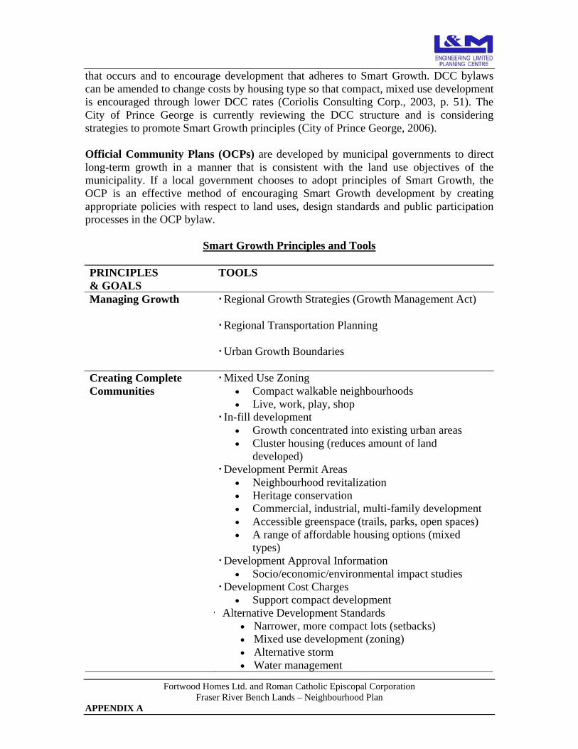
Fortwood Homes Ltd. and Roman Catholic Episcopal Corporation Fraser River Bench Lands – Neighbourhood Plan
APPENDIX A
that occurs and to encourage development that adheres to Smart Growth. DCC bylaws can be amended to change costs by housing type so that compact, mixed use development is encouraged through lower DCC rates (Coriolis Consulting Corp., 2003, p. 51). The City of Prince George is currently reviewing the DCC structure and is considering strategies to promote Smart Growth principles (City of Prince George, 2006). Official Community Plans (OCPs) are developed by municipal governments to direct long-term growth in a manner that is consistent with the land use objectives of the municipality. If a local government chooses to adopt principles of Smart Growth, the OCP is an effective method of encouraging Smart Growth development by creating appropriate policies with respect to land uses, design standards and public participation processes in the OCP bylaw.
Smart Growth Principles and Tools
PRINCIPLES & GOALS
TOOLS
Managing Growth Regional Growth Strategies (Growth Management Act)
Regional Transportation Planning
Urban Growth Boundaries
Creating Complete Communities
Mixed Use Zoning • Compact walkable neighbourhoods • Live, work, play, shop
In-fill development • Growth concentrated into existing urban areas • Cluster housing (reduces amount of land
developed) Development Permit Areas
• Neighbourhood revitalization • Heritage conservation • Commercial, industrial, multi-family development • Accessible greenspace (trails, parks, open spaces) • A range of affordable housing options (mixed
types) Development Approval Information
• Socio/economic/environmental impact studies Development Cost Charges
• Support compact development Alternative Development Standards
• Narrower, more compact lots (setbacks) • Mixed use development (zoning) • Alternative storm • Water management
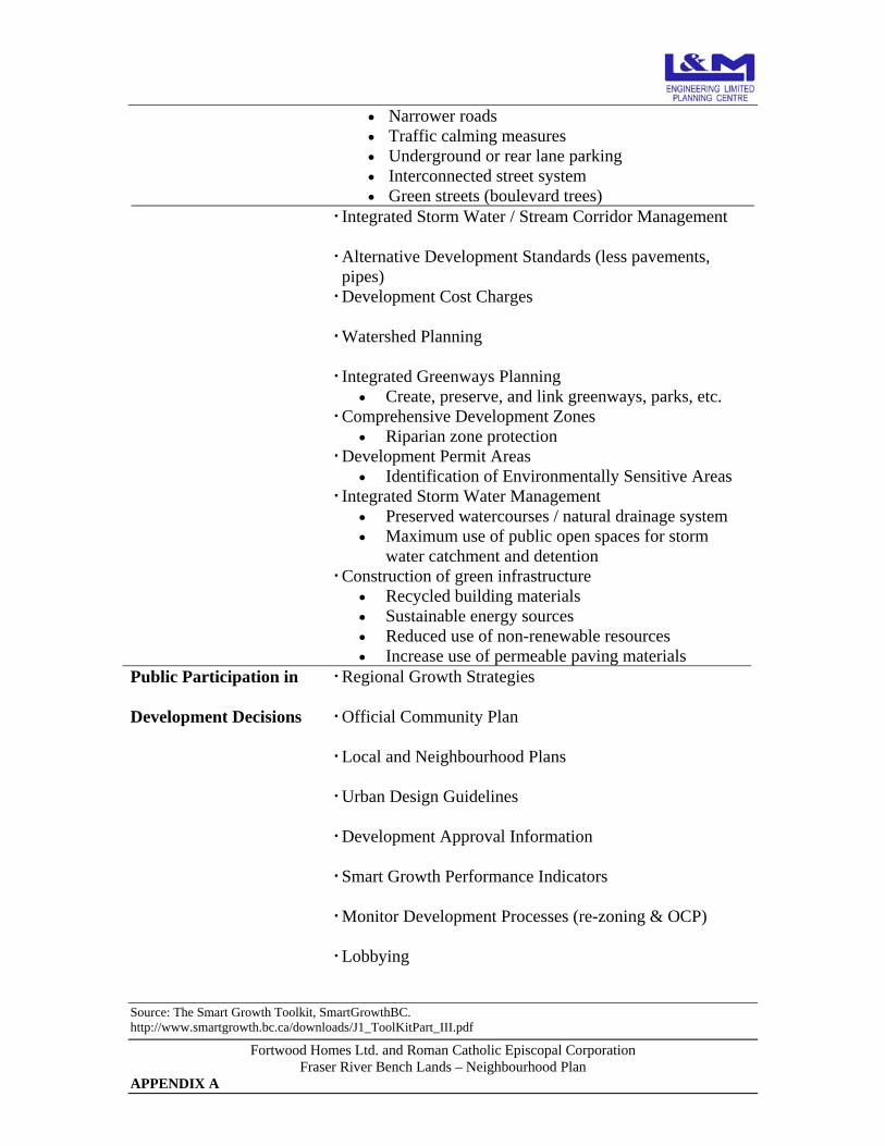
Fortwood Homes Ltd. and Roman Catholic Episcopal Corporation Fraser River Bench Lands – Neighbourhood Plan
APPENDIX A
• Narrower roads • Traffic calming measures • Underground or rear lane parking • Interconnected street system • Green streets (boulevard trees)
Integrated Storm Water / Stream Corridor Management
Alternative Development Standards (less pavements, pipes)
Development Cost Charges
Watershed Planning
Integrated Greenways Planning • Create, preserve, and link greenways, parks, etc.
Comprehensive Development Zones • Riparian zone protection
Development Permit Areas • Identification of Environmentally Sensitive Areas
Integrated Storm Water Management • Preserved watercourses / natural drainage system • Maximum use of public open spaces for storm
water catchment and detention Construction of green infrastructure
• Recycled building materials • Sustainable energy sources • Reduced use of non-renewable resources • Increase use of permeable paving materials
Public Participation in Regional Growth Strategies
Development Decisions Official Community Plan
Local and Neighbourhood Plans
Urban Design Guidelines
Development Approval Information
Smart Growth Performance Indicators
Monitor Development Processes (re-zoning & OCP)
Lobbying
Source: The Smart Growth Toolkit, SmartGrowthBC. http://www.smartgrowth.bc.ca/downloads/J1_ToolKitPart_III.pdf

Fortwood Homes Ltd. and Roman Catholic Episcopal Corporation Fraser River Bench Lands – Neighbourhood Plan
APPENDIX B
APPENDIX B
DEBRIEFING NOTES & MINUTES OF THE IMPLEMENTATION DESIGN CHARETTE
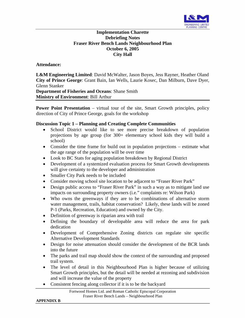
Fortwood Homes Ltd. and Roman Catholic Episcopal Corporation Fraser River Bench Lands – Neighbourhood Plan
APPENDIX B
Implementation Charette Debriefing Notes
Fraser River Bench Lands Neighbourhood Plan October 6, 2005
City Hall Attendance: L&M Engineering Limited: David McWalter, Jason Boyes, Jess Rayner, Heather Oland City of Prince George: Grant Bain, Ian Wells, Laurie Kosec, Dan Milburn, Dave Dyer, Glenn Stanker Department of Fisheries and Oceans: Shane Smith Ministry of Environment: Bill Arthur Power Point Presentation – virtual tour of the site, Smart Growth principles, policy direction of City of Prince George, goals for the workshop Discussion Topic 1 – Planning and Creating Complete Communities
• School District would like to see more precise breakdown of population projections by age group (for 300+ elementary school kids they will build a school)
• Consider the time frame for build out in population projections – estimate what the age range of the population will be over time
• Look to BC Stats for aging population breakdown by Regional District • Development of a systemized evaluation process for Smart Growth developments
will give certainty to the developer and administration • Smaller City Park needs to be included • Consider moving school site location to be adjacent to “Fraser River Park” • Design public access to “Fraser River Park” in such a way as to mitigate land use
impacts on surrounding property owners (i.e.” complaints re: Wilson Park) • Who owns the greenways if they are to be combinations of alternative storm
water management, trails, habitat conservation? Likely, these lands will be zoned P-1 (Parks, Recreation, Education) and owned by the City.
• Definition of greenway is riparian area with trail • Defining the boundary of developable area will reduce the area for park
dedication • Development of Comprehensive Zoning districts can regulate site specific
Alternative Development Standards • Design for noise attenuation should consider the development of the BCR lands
into the future • The parks and trail map should show the context of the surrounding and proposed
trail system. • The level of detail in this Neighbourhood Plan is higher because of utilizing
Smart Growth principles, but the detail will be needed at rezoning and subdivision and will increase the value of the property
• Consistent fencing along collector if it is to be the backyard

Fortwood Homes Ltd. and Roman Catholic Episcopal Corporation Fraser River Bench Lands – Neighbourhood Plan
APPENDIX B
Discussion Topic 2 – Reducing the Cost of Municipal Infrastructure
• Development Services is considering the following changes to the DCC structure: o Divide the City into distinct areas ie: Downtown, Area A (Urban Phasing
1 and 2), Area B (Urban Phasing 3 and 4), and Area C (Airport) o DCC would be based upon existing infrastructure in the different areas
and phases of the City • Other ideas to encourage more dense development as well as development where
infrastructure costs are less include: DCC based on per metre frontage, incorporating incentives for commercial developments that decrease the amount of impervious area, a credit system for developments that construct transit facilities or bike racks.
• Generally supportive of subsurface drainage, however need to be aware of the proximity of drainage to the City wells
• There is little risk with residential drainage but the risk increases for commercial, school and multifamily sites. These site will likely require oil/water separation for parking areas
• Recommendation for Subdivision Bylaw – an amendment to the bylaw that allows alternative development standards without having to apply for variances
• Servicing report to clarify disposal of drainage created by this development as well as means of accommodating existing drainage onto site from College Heights
• Design the road alignment first and then consider running the force main along the road.
• Water is not an issue because this development can link to the supply main • Main infrastructure issues are: lift station for sanitary and water quality for onsite
infiltration of storm water • Transportation Demand Management will likely not be fully utilized because the
trips to town will still be generated BUT: o Ensure transit is a viable option, include pull outs for bus on collector road o Protect bike lanes and trails – connection to Cowart Rd and cemetery trail
very important o On street bike trails on both sides of collector o Design Pedestrian friendly streets – accommodates the traffic, doesn’t
capitulate to it – minimize conflicts between cars and people
Discussion Topic 3 – Integrating Urban Development into Ecosystems
• Development of road alignment and trails needs to consider how and where to cross riparian areas
• Define riparian habitat through the natural boundary (flood plain) and top of bank for Fraser River and other water courses
• EnviroDynamics completed an Environmental overview in the area of the subject property in 2004
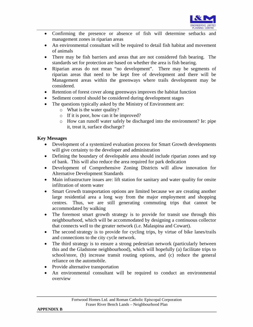
Fortwood Homes Ltd. and Roman Catholic Episcopal Corporation Fraser River Bench Lands – Neighbourhood Plan
APPENDIX B
• Confirming the presence or absence of fish will determine setbacks and management zones in riparian areas
• An environmental consultant will be required to detail fish habitat and movement of animals
• There may be fish barriers and areas that are not considered fish bearing. The standards set for protection are based on whether the area is fish bearing.
• Riparian areas do not mean “no development”. There may be segments of riparian areas that need to be kept free of development and there will be Management areas within the greenways where trails development may be considered.
• Retention of forest cover along greenways improves the habitat function • Sediment control should be considered during development stages • The questions typically asked by the Ministry of Environment are:
o What is the water quality? o If it is poor, how can it be improved? o How can runoff water safely be discharged into the environment? Ie: pipe
it, treat it, surface discharge? Key Messages
• Development of a systemized evaluation process for Smart Growth developments will give certainty to the developer and administration
• Defining the boundary of developable area should include riparian zones and top of bank. This will also reduce the area required for park dedication
• Development of Comprehensive Zoning Districts will allow innovation for Alternative Development Standards
• Main infrastructure issues are: lift station for sanitary and water quality for onsite infiltration of storm water
• Smart Growth transportation options are limited because we are creating another large residential area a long way from the major employment and shopping centres. Thus, we are still generating commuting trips that cannot be accommodated by walking
• The foremost smart growth strategy is to provide for transit use through this neighbourhood, which will be accommodated by designing a continuous collector that connects well to the greater network (i.e. Malaspina and Cowart).
• The second strategy is to provide for cycling trips, by virtue of bike lanes/trails and connections to the city cycle network.
• The third strategy is to ensure a strong pedestrian network (particularly between this and the Gladstone neighbourhood), which will hopefully (a) facilitate trips to school/store, (b) increase transit routing options, and (c) reduce the general reliance on the automobile.
• Provide alternative transportation • An environmental consultant will be required to conduct an environmental
overview

Fortwood Homes Ltd. and Roman Catholic Episcopal Corporation Fraser River Bench Lands – Neighbourhood Plan
APPENDIX B
• Riparian areas do not mean “no development”. There may be segments of riparian areas that need to be kept free of development and there will be Management areas within the greenways
• Storm Management can be accomplished through design • Trail connectivity with Lower College Heights and existing and proposed trails • More local commercial can be included in the higher density smart growth areas
and regulated through comprehensive development zones. All local commercial development will need to be consistent with direction provided by the OCP.
• Confirmation from the school district on the need for a school site. • Planning should include some of the City owned property as less land is required
for the water well infrastructure

Fortwood Homes Ltd. and Roman Catholic Episcopal Corporation Fraser River Bench Lands – Neighbourhood Plan
APPENDIX B
Implementation Charette
Minutes Fraser River Bench Lands Neighbourhood Plan
October 6, 2005 City Hall
Attendance: L&M Engineering Limited: David McWalter, Jason Boyes, Jess Rayner, Heather Oland City of Prince George: Grant Bain, Ian Wells, Laurie Kosec, Dan Milburn, Dave Dyer, Glenn Stanker Department of Fisheries and Oceans: Shane Smith Ministry of Environment: Bill Arthur o Heather & Grant’s presentation / introduction o Dave: What is the market going to look like in 5 years? Those who know should be
involved in the process. Developers and builders should be involved in this process Parks & Recreation o David: Connectivity between the old & the new… since there is so little (due to the
landscape), the trails & greenways included in the design are important. Laurie: 4 trail connectors exist between the upper & lower bench in this area:
i Existing trail as marked new design (North end) ii Hydro right-of-way iii By the 1600mm drainage pipe iv At Malaspina
Heather: Also the possibility of using sidewalks/paved pedestrian paths as trail connectors
Laurie: There is also the possibility of connecting to Fraser River Park which would be developed on the island you can see the tip of (North end of design map)… would connect to Lansdowne & downtown
Comparing the river front park to Wilson Park. The design of the river front park should take into account the complaints of residents adjacent to Wilson Park.
A School o Ian: What are the intentions of the school district and the plan’s need to
accommodate them? They seem to be sitting back, as they’re doing in the Tyner area. Heather: Description of what she was told regarding the walking distance for
kids to get to school & the amount of school aged children (300) required in a development for a school to be included.
Stats slide was discussed. Grant pointed out that the info used a combination of 2001 BC Stats & 2004 PG stats as a baseline.
Dave: The fact that we’re part of an aging community should be modelled for (type of residences they will demand)
Fortwood Homes Ltd. and Roman Catholic Episcopal Corporation Fraser River Bench Lands – Neighbourhood Plan
APPENDIX B
What are the options for the land that is designated for a school but not yet developed? (value for RCEC is a consideration/concern) i Acquired by the City who would hold it in trust ii Acquired by the School District who holds it in trust
o What level of detail is needed for this neighbourhood plan? Grant: The level of detail is laid out in the OCP and includes environmentally
sensitive areas, local/major roads, approximate lotting patterns, residential housing mix, commercial land allocations, public use sites, and trail linkages. These concept plans add value to the property.
Environment & Wildlife o Bill: Environmental Dynamics completed a environmental overview for Prince
George in 2004. Bill: it would be worth investing in a detailed environmental overview here.
Consider appropriate drainage systems, road crossings, sediment, animal movement & more.
Animal movement: lots of bears currently use the drainage storms as transportation corridors. This development means moving into higher, richer riparian areas. Animals will want to travel along the top of the river bench (always taking the higher ground). Should consider a by-law banning crab apple trees.
Greenspace & trails at Essex Park sees animal movement (all along the existing neighbourhoods).
Smart Growth o Grant: would benefit from more details upfront (would save time when plans are
being presented to council). o Grant: The whole plan should be considered Smart Growth because the key concepts
of Smart Growth are addressed throughout the site, including the mix of land uses, alternative transportation, higher density, some alternative design standards. Designing for Smart Growth does not preclude including areas of traditional neighbourhoods. Dave: People get the wrong impression of Smart Growth if they see it happening
in small parcels… Smart Growth concepts are intended to apply to entire neighbourhoods or towns. This development allows space for implementing the entire scheme.
David & others: Small pockets can be good because it allows for some of the Smart Growth principles to be implemented without scaring people off.
Commercial o Ian: Might be a draw in having a restaurant/pub backing on the river o Dan: Could bring these plans to a company such as Mr G’s and ask whether they’d
be interested in investing in a business here. o Discussion of where commercial properties should front (should people only have to
make right hand turns to enter on the way home from work?). Suggestion to focus on
Fortwood Homes Ltd. and Roman Catholic Episcopal Corporation Fraser River Bench Lands – Neighbourhood Plan
APPENDIX B
local shopping rather than commuters since they have numerous other opportunities on the way home from work.
Parks & the School o Laurie: Neighbourhood park by the river is good/ideal. In addition, a neighbourhood
park by the school is needed. This second park would fit perfectly in the corner where the school yard fronts multi-family residential; would only need to be small (optimal is 4 acres, minimal is 2 acres, Laurie would have to look into the specifics)
o David: The size of the park shaded with dark green has been estimated based on space required for subsurface drainage plus playing fields (in response to the question of whether residential land taken from somewhere else could be made up for here).
o David: Should ask the School District whether they’d like land on the connector (Malaspina Extension) or a more residential street.
o Ian: The school could be moved to the site just beside the 2.75ha waterfront park. No one objected to this suggestion as it was discussed. One concern was the removal of this land from Fortwood Homes’ development area.
Development Cost Charges (DCCs), etc o Dave: The city would have to incur costs for infrastructure where it’s hard to
maintain. o Changes being considered to the DCC structure include assigning area designations
based on the existing level of infrastructure. For example: Areas designations could be: Downtown; Area A (phases 1&2); Area B (Phases 3&4); Area c Airport The Fraser River Bench Lands would be considered Area A.
o Collecting DCCs: would be done primarily at the building stage for these areas designated single-family, multi-family & commercial). Another option is basing them on metres squared rather than per unit, as seen in
Grand Prairie and Victoria. Split DCCs between the developer (at the subdivision stage who could benefit
when creating pipes, reducing run-off, etc) and the builder (who could pay per meter square or per unit at the building permit stage).
Suggestions to incorporate some incentive into by-laws for considerations such as minimising run-off (this works for commercial but what about residential?)
Environment o Grant: Greenways containing public infrastructure, whether trails, riparian areas, or
storm water infrastructure will become the city’s responsibility o Bill: It will be important to consider the quality of water at drainage outfalls,
including oil separation. o More discussion about the designation of greenspace.
If there’s a watercourse, does there have to be a trail? Could fall under new zoning ‘P1: Park & Open Space.” Current greenbelt
designation? Dan: Would the City want to acquire the greenspace running through the centre
of the properties? Heather: Could it be considered a storm corridor?
Fortwood Homes Ltd. and Roman Catholic Episcopal Corporation Fraser River Bench Lands – Neighbourhood Plan
APPENDIX B
Dan: A ‘Hazardous Condition Development Permit Area’ with steep slope designation would control tree cutting (an issue recently as people have been cutting local greenbelts for beetle wood).
Ian: Another option may be to include the greenspace in residential lots but zone it differently (giving each lot 2 zones)
Grant: It would be in public interest and therefore the city’s interest to manage these corridors for consistence (resident spacing, sheds, logging, etc).
o Dave: Parking lots require oil separators; piping needs to be looked at for anything more than single family residential. Dave: First a watershed drainage plan is needed. Run-off should be managed at
the source. David: This watershed drainage plan should be done after the neighbourhood
plan and before subdivision. Existing wetlands and swampy areas can hopefully be considered amenities Dan: City can regulate drainage on residential lots Dave: Subdivision and Development Control By-law will be amended annually,
probably each January, to accommodate new areas, changes in wording etc. o Shane: Are channel gradients accessible to fish? It’s not important to count the
number of fish in a stream, only to ensure they are accommodated for. The only reason a stream is not considered fish bearing is if its entrance is precluded by something from a list of barriers (a standard exists).
o Bill / Shane: There are approx. 3 streams that need designated riparian areas (if the drainage wattage path is between 1.5m and 3m you’re looking at some sort of riparian protection). Forestry requires a 20m setback but that’s different from residential. Here a management zone is needed rather than a reserve zone… a greenway. Trails should be kept to the outer edges of the Greenway but it’s likely that even if
a trail isn’t designated one will appear. Bill: What conditions are the creeks in? Is there an opportunity for enhancement?
Gravelling? Opening/widening the mouth? Will passable structures be required (ex. bridges or bottomless culverts)?
Laurie: Jocelyn White who works with the City has relevant info on creeks & trails, etc.
Shane: Trail networks sometimes call for access to the river. Storm water and drainage are also considerations at the river’s edge. Encroachment on riparian areas should always be kept in mind.
o Laurie: Trail systems & connectivity should always be kept in mind o Is there any benefit for access to the water? Boat launches? Safety is a concern &
grades may prevent access. A launch South of the site may be preferred. o Conflict of interest between using existing creeks as ‘end of pipe wetlands’ and
natural enhancement areas. o Bill: Could be creative in design ideas, for example creating fish habitat at the end of
storm water drainage pipes. o Shane: Can attain storm management by design.

Fortwood Homes Ltd. and Roman Catholic Episcopal Corporation Fraser River Bench Lands – Neighbourhood Plan
APPENDIX B
Transportation o Glenn:
Curves in the road help slow people down. The Malaspina Extension doesn’t have to be straight, only continuous.
Buses should be considered for the area and the Malaspina Extension offers a good route (he’ll pass this info on for others to examine). Discussion suggested that bus use may be limited in the area and if necessary, bus users could be required to walk up to Gladstone to catch public transit. This could be combined with some alternative transit [for example, the HandiDart service connecting with regular transit, as suggested in the Transit Service Review for outlying areas].
Biking options should be examined. People supported learning more from the cycling community about what is useful or of interest to them (particularly Dave).
Suggestions for alterations to pedestrian crossings/paths near proposed school site were made to the map
Crescents are recommended over cul-de-sacs and the ‘little bumps’ seen along Malaspina Blvd.

Fortwood Homes Ltd. and Roman Catholic Episcopal Corporation Fraser River Bench Lands – Neighbourhood Plan
APPENDIX C
APPENDIX C
PUBLIC PARTICIPATION MAIL OUT PACKAGE

The Fraser River Bench Lands Neighbourhood Plan – An Opportunity to Provide Comment & Input
The L&M Engineering – Planning Centre is in the process of creating a Neighbourhood Plan for the Fraser River Bench Lands which are located in the southwest sector of the City of Prince George between the Fraser River and Lower College Heights as shown on the attached map. The development is subject to the creation of a Neighbourhood Plan that addresses: environmentally sensitive areas, provision of parks and greenspace, transportation network, residential housing mix and densities, commercial lands, public use sites, and trail linkages. The purpose of Neighbourhood Plans is to create a clear and comprehensive land use vision in order to provide certainty for residents, land owners, and developers regarding how an area can be developed. Neighbourhood Plans must balance the desires of residents, environmental considerations, and economic realities and should result in land use planning policies that can be achieved over time. The concept plan for the Fraser River Bench Lands is in keeping with the City of Prince George’s Official Community Plan (OCP) which designates development in the area for residential development and Major Park. An important part of the Neighbourhood Planning Process is public participation, particularly by neighbouring residents, and L&M Planning Centre welcomes your comments on the proposed concept plan. There are a number of ways you can provide input, including:
• Reviewing the Draft Fraser River Bench Lands Neighbourhood Plan, complete with colour plans, which is available in its entirety on the City’s web site (http://www.city.pg.bc.ca/city_services/lrp/)
• Completing the enclosed survey and returning it to L&M Planning Centre. • Attending the Neighbourhood Information Meeting to be held at Gladstone
Elementary School, 7005 Gladstone Drive, on March 14, 2006 at 7pm.
THE FRASER RIVER BENCH LANDS - HIGHLIGHTS Planning for the Fraser River Bench Lands began with acknowledging that the natural features of the area: the Fraser River, the steeply sloped escarpment, the wetlands and drainage courses are the foundation within which to create a complete and liveable neighbourhood that incorporates the existing natural features, provides a significant amount of green space, an extensive trail network, and is the gateway to the proposed City riverfront recreation system and Parkridge Creek Park.
Fortwood Homes Ltd. and Roman Catholic Episcopal Corporation Fraser River Bench Lands – Neighbourhood Plan
APPENDIX C

Fortwood Homes Ltd. and Roman Catholic Episcopal Corporation Fraser River Bench Lands – Neighbourhood Plan
APPENDIX C
The Fraser River Bench Lands Neighbourhood Plan is characterized by:
• A mix of land uses including residential, commercial, parkland, greenspace, and
institutional with a range of residential density options, • 2 Neighbourhood Parks, including a riverside park, • A City riverfront park extending from Malaspina Ridge to Varsity Creek, • Development of 4.4 km of trails connecting with Lower College Heights and
proposed City trails to the south, • Designed connections to the existing bicycle network, • A pedestrian friendly environment that provides connections within the Bench
Lands and to surrounding neighbourhoods, • Dedication of greenways to protect environmentally sensitive areas, • Completion of an Environmental Overview of the area, • A Neighbourhood Centre, • A combination of Traditional and Smart Growth design standards, • Alternative Design Standards for storm water management, and • Alternative Design Standards for some local roads.
Preparation of the Fraser River Bench Lands Neighbourhood Plan has been guided by policies contained in the City of Prince George’s OCP, as well as the principles of Smart Growth BC. The OCP is available for viewing online at http://www.city.pg.bc.ca/city_services/ocp. Copies are also available for review at the Development Services Department at City Hall. Information regarding Smart Growth development practices can be found at http://www.smartgrowth.bc.ca.
GETTING INVOLVED Survey Attached is a survey with a series of statements for your response. The responses received will help the L&M Planning Centre ensure that public input is part of the development of the land use plan. You will be best able to answer the survey questions after attending the public information meeting or reviewing the complete set of plans available on the city’s web site (http://www.city.pg.bc.ca/city_services/lrp/). Please return the survey by March 16, 2005. It can be handed in at the public information meeting, mailed, faxed or hand delivered to:
L&M Engineering Ltd – Planning Centre. #201-1840 Third Avenue
Prince George, BC.V2M 1G4 FAX: 250-562-1967

Fortwood Homes Ltd. and Roman Catholic Episcopal Corporation Fraser River Bench Lands – Neighbourhood Plan
APPENDIX C
Public Information Meeting The L&M Planning Centre will be holding a Public Information meeting on March 14th at 7pm at Gladstone Elementary School, at which time the complete concept plan for the Fraser River Bench Lands Neighbourhood will be presented. In addition, representatives from the City of Prince George and the L&M Planning Centre will be available to answer questions. APPROVAL PROCESS Following the public participation process and further review by the City of Prince George, the Fraser River Bench Lands Neighbourhood Plan will be presented to City Council for consideration of policy adoption. The date of Council’s consideration of the Plan will be posted on the City’s web site (http://www.city.pg.bc.ca/cityhall/agendas/) QUESTIONS? Contact Heather Oland Planning Associate, at L&M Engineering Ltd:
• Phone… 250-562-1977 • Fax… 250-562-1967 • Email…[email protected] , or
Grant Bain, Manager of Long Range Planning, City of Prince George • Phone…250-561-7612 • Fax…250-561-7721 • Email…[email protected]

Fortwood Homes Ltd. and Roman Catholic Episcopal Corporation Fraser River Bench Lands – Neighbourhood Plan
APPENDIX C
Fraser River Bench Lands Neighbourhood Plan – Community Survey
For each statement, please check the box that best describes your agreement or disagreement with the statement and provide any additional comments. You will be best able to respond after attending the Public Information Meeting to be held on March 14th 2006 at Gladstone Elementary School (7005 Gladstone Drive) at 7pm or by reviewing the complete set of plans available on the City’s web site (http://www.city.pg.bc.ca/cityhall/agendas/) 1. The proposed neighbourhood provides a good mix of housing choices (ie. single
family, townhouses, and apartments).
Strongly Disagree Disagree Neutral Agree Strongly Agree ________________________________________________________________________________________________________________________________________________________________________________________________________________________________________________________________________________________________________________________________________________________________________ 2. Local convenience shopping and other local commercial opportunities are a
benefit to the proposed neighbourhood.
Strongly Disagree Disagree Neutral Agree Strongly Agree ________________________________________________________________________________________________________________________________________________________________________________________________________________________________________________________________________________________________________________________________________________________________________ 3. An elementary school should be located in the neighbourhood if there is
sufficient need rather than having students travel to schools outside the neighbourhood.
Strongly Disagree Disagree Neutral Agree Strongly Agree
________________________________________________________________________________________________________________________________________________________________________________________________________________________________________________________________________________________________________________________________________________________________________

Fortwood Homes Ltd. and Roman Catholic Episcopal Corporation Fraser River Bench Lands – Neighbourhood Plan
APPENDIX C
. 4. This plan provides a generous amount of parks, trails, and greenspace as well as
good connections to the existing trail network in College Heights.
Strongly Disagree Disagree Neutral Agree Strongly Agree
________________________________________________________________________________________________________________________________________________________________________________________________________________________________________________________________________________________________________________________________________________________________________________________________________________________________________________
5. Environmentally sensitive areas and their protection are incorporated into the proposed Neighbourhood.
Strongly Disagree Disagree Neutral Agree Strongly Agree
________________________________________________________________________________________________________________________________________________________________________________________________________________________________________________________________________________________________________________________________________________________________________________________________________________________________________________ 6. The proposed road network will provide the necessary linkages to promote safe
and effective transportation through this and adjacent neighbourhoods.
Strongly Disagree Disagree Neutral Agree Strongly Agree
________________________________________________________________________________________________________________________________________________________________________________________________________________________________________________________________________________________________________________________________________________________________________________________________________________________________________________________________________________________________________________________

Fortwood Homes Ltd. and Roman Catholic Episcopal Corporation Fraser River Bench Lands – Neighbourhood Plan
APPENDIX C
7. The proposed pedestrian and cyclist links (road, sidewalk, greenspace, trail network, and connections to neighbouring areas) are sufficient and attractive enough to promote alternative transportation choices.
Strongly Disagree Disagree Neutral Agree Strongly Agree
________________________________________________________________________________________________________________________________________________________________________________________________________________________________________________________________________________________________________________________________________________________________________________________________________________________________________________ 8. Are there any issues or concerns not covered above that you want to make sure
are addressed as part of the Fraser River Bench Lands Neighbourhood planning process?
________________________________________________________________________________________________________________________________________________________________________________________________________________________________________________________________________________________________________________________________________________________________________________________________________________________________________________________________________________________________________________________________________________________________________________________________________________________________________________________________________________________________________________________________________________________________________________________________________________________________________________________________________________________________________________________________________________________________________________________________________________________________________________________________________________________________________________________________________________________________________________________________
Thank you for taking the time to respond. Please mail, hand deliver or fax (250-562-1967) your completed two-page survey to
Heather Oland at L&M Engineering – Planning Centre.


Fortwood Homes Ltd. and Roman Catholic Episcopal Corporation Fraser River Bench Lands – Neighbourhood Plan
APPENDIX D
APPENDIX D
NEWSPAPER ADVERTISEMENT

Fortwood Homes Ltd. and Roman Catholic Episcopal Corporation Fraser River Bench Lands – Neighbourhood Plan
APPENDIX D

Fortwood Homes Ltd. and Roman Catholic Episcopal Corporation Fraser River Bench Lands – Neighbourhood Plan
APPENDIX E
APPENDIX E
COMMUNITY SURVEY SUMMARY OF COMMENTS & INPUT

Fortw
ood
Hom
es L
td. a
nd R
oman
Cat
holic
Epi
scop
al C
orpo
ratio
n Fr
aser
Riv
er B
ench
Lan
ds –
Nei
ghbo
urho
od P
lan
APP
EN
DIX
E
Fras
er R
iver
Ben
ch L
ands
Nei
ghbo
urho
od P
lan
– C
omm
unity
Sur
vey
An
Opp
ortu
nity
to P
rovi
de C
omm
ent a
nd In
put
L
&M
Eng
inee
ring
Lim
ited,
For
twoo
d H
omes
and
the
Rom
an C
atho
lic E
pisc
opal
Cor
pora
tion
are
com
mitt
ed to
pub
lic
part
icip
atio
n. I
n or
der
to p
rovi
de th
e pu
blic
with
com
plet
e in
form
atio
n an
d pr
ovid
e th
e op
port
unity
for
publ
ic c
omm
ent
rega
rdin
g th
e Fr
aser
Riv
er B
ench
Lan
ds N
eigh
bour
hood
Pla
n, th
e fo
llow
ing
proc
ess w
as u
nder
take
n:
• O
n M
onda
y M
arch
6th
, L&
M E
ngin
eerin
g Lt
d. h
and-
deliv
ered
702
Com
mun
ity S
urve
ys P
acka
ges t
o re
side
nts o
f the
ne
ighb
ourh
oods
surr
ound
ing
the
Fras
er R
iver
Ben
ch L
ands
Nei
ghbo
urho
od P
lan
boun
dary
. Th
e pa
ckag
es in
clud
ed:
o
A le
tter d
escr
ibin
g th
e N
eigh
bour
hood
Pla
n pr
oces
s as w
ell a
s the
Fra
ser R
iver
Ben
ch L
ands
pro
posa
l;
o
Dire
ctio
n to
the
com
plet
e Pl
an a
vaila
ble
on th
e C
ity o
f Prin
ce G
eorg
e w
eb si
te,
o
An
invi
tatio
n to
the
Publ
ic In
form
atio
n M
eetin
g,
o
A si
te p
lan,
and
o
A
surv
ey.
o
In a
dditi
on, 1
00 su
rvey
s wer
e di
strib
uted
at t
he P
ublic
Info
rmat
ion
Mee
ting
and
mor
e w
ere
mad
e av
aila
ble
onlin
e vi
a th
e C
ity’s
web
site
. •
On
Wed
nesd
ay M
arch
8th
and
Sat
urda
y M
arch
11th
, a c
lass
ified
ad
anno
unci
ng th
e Pu
blic
Info
rmat
ion
Mee
ting
and
invi
ting
the
publ
ic to
atte
nd w
as p
ublis
hed
in th
e Pr
ince
Geo
rge
Citi
zen.
Thi
s ad
also
incl
uded
dire
ctio
n to
the
com
plet
e Pl
an a
vaila
ble
on
the
City
of P
rince
Geo
rge
web
site
. •
On
Tues
day
Mar
ch 1
4th, a
Pub
lic In
form
atio
n M
eetin
g w
as h
eld
at G
lads
tone
Ele
men
tary
Sch
ool f
rom
7-9
pm.
The
mee
ting
bega
n w
ith a
pow
er p
oint
pre
sent
atio
n by
Hea
ther
Ola
nd, M
anag
er o
f the
Pla
nnin
g C
entre
at L
&M
Eng
inee
ring
Ltd.
At t
he
conc
lusi
on o
f the
pre
sent
atio
n, th
ose
pres
ent w
ere
dire
cted
to th
ree
tabl
es a
roun
d th
e gy
mna
sium
whe
re th
eir q
uest
ions
wou
ld
be a
ddre
ssed
by
L&M
Eng
inee
ring
Ltd.
staf
f mem
bers
Hea
ther
Ola
nd B
A. M
Sc, D
avid
McW
alte
r P.E
ng Je
ssic
a R
ayne
r, an
d K
im H
attle
, as w
ell a
s City
of P
rince
Geo
rge
Park
s and
Ope
n Sp
ace
Plan
ner G
eral
d C
hris
tie.
• In
atte
ndan
ce a
t the
Pub
lic In
form
atio
n M
eetin
g w
ere
155
com
mun
ity m
embe
rs in
clud
ing
four
cou
ncil
mem
bers
, loc
al m
edia
, an
d an
upp
er le
vel U
NB
C E
nviro
nmen
tal P
lann
ing
clas
s.

Fortw
ood
Hom
es L
td. a
nd R
oman
Cat
holic
Epi
scop
al C
orpo
ratio
n Fr
aser
Riv
er B
ench
Lan
ds –
Nei
ghbo
urho
od P
lan
APP
EN
DIX
E
Gen
eral
The
mes
Est
ablis
hed
thro
ugh
the
Publ
ic P
artic
ipat
ion
proc
ess:
• Th
e ab
ility
of C
owar
t Roa
d an
d th
e in
ters
ectio
n at
Hig
hway
16
and
Cow
art R
oad
to h
andl
e in
crea
sed
traff
ic lo
ad is
a c
once
rn
for r
esid
ents
. •
Gla
dsto
ne E
lem
enta
ry S
choo
l sho
uld
be re
-ope
ned
befo
re a
new
scho
ol is
con
stru
cted
. •
Trai
ls, g
reen
spac
e, a
nd th
e re
tent
ion
of tr
ees a
re im
porta
nt to
resi
dent
s. •
Prot
ectio
n of
Env
ironm
enta
lly S
ensi
tive
Are
as is
impo
rtant
to re
side
nts.
• N
oise
gen
erat
ed fr
om th
e B
CR
site
is a
con
cern
for r
esid
ents
. Th
e fo
llow
ing
tabl
es re
pres
ent a
com
pila
tion
of th
e co
mm
ents
off
ered
by
surv
ey re
spon
dent
s, as
wel
l as L
&M
’s re
spon
ses t
o th
e co
mm
ents
. O
f the
app
roxi
mat
ely
800
plus
surv
eys d
istri
bute
d, th
ese
rem
arks
repr
esen
t the
inte
rest
s of t
he 5
2 co
mm
unity
mem
bers
w
ho re
turn
ed th
e fo
rms.

Fortw
ood
Hom
es L
td. a
nd R
oman
Cat
holic
Epi
scop
al C
orpo
ratio
n Fr
aser
Riv
er B
ench
Lan
ds –
Nei
ghbo
urho
od P
lan
APP
EN
DIX
E
Que
stio
n 1
– T
he p
ropo
sed
neig
hbou
rhoo
d pr
ovid
es a
goo
d m
ix o
f hou
sing
cho
ices
(i.e
. sin
gle
fam
ily,
tow
nhou
ses,
and
mul
tiple
fam
ily)
St
rong
ly
Dis
agre
e
Dis
agre
e
Neu
tral
Agr
ee
Stro
ngly
A
gree
No
Res
pons
e
Tot
al
8 9
9 18
6
2 52
Que
stio
ns a
nd C
omm
ents
in R
espo
nse
to Q
uest
ion
1
Com
men
ts
Freq
uenc
y R
espo
nse
Prop
osed
hou
sing
den
sity
shou
ld d
ecre
ase
9 D
ensi
ties f
ollo
w C
PG O
CP
reco
mm
enda
tions
Le
moy
ne D
rive
shou
ld n
ot b
e ex
tend
ed
1 G
eote
chni
cal S
tudi
es w
ill b
e re
quire
d
Wid
e bu
ffer
s bet
wee
n ho
mes
& st
reet
s 1
Prin
ce G
eorg
e Zo
ning
Byl
aw w
ill b
e fo
llow
ed.
Alte
rnat
ive
Dev
elop
men
t Sta
ndar
ds e
xplo
red
in S
mar
t G
row
th a
reas
H
ousi
ng fo
r sen
iors
shou
ld b
e co
nsid
ered
3
Agr
ee a
nd th
e pl
an p
rovi
des a
var
iety
of h
ousi
ng o
ptio
ns
Too
man
y ho
uses
in th
e ar
ea
2 O
nly
51%
of t
he a
rea
is to
be
deve
lope
d N
ot e
noug
h la
nd le
ft fo
r rec
reat
iona
l dev
elop
men
t and
na
tura
l spa
ce
2 35
% o
f the
are
a is
ded
icat
ed to
par
ks &
gre
ensp
ace
Hig
h de
nsity
shou
ld b
e en
cour
aged
in th
e do
wnt
own
1 Th
e pl
an in
clud
es a
mix
of h
ousi
ng d
ensi
ties
Lot s
izes
shou
ld b
e la
rger
1
The
plan
incl
udes
a v
arie
ty o
f lot
size
s inc
ludi
ng la
rger
lo
ts
Goo
d ho
usin
g m
ix p
rovi
ded
6 Th
is c
once
pt is
em
phas
ized
in th
e pl
an

Fortw
ood
Hom
es L
td. a
nd R
oman
Cat
holic
Epi
scop
al C
orpo
ratio
n Fr
aser
Riv
er B
ench
Lan
ds –
Nei
ghbo
urho
od P
lan
APP
EN
DIX
E
Que
stio
n 2
– L
ocal
con
veni
ence
shop
ping
and
oth
er lo
cal c
omm
erci
al o
ppor
tuni
ties a
re a
ben
efit
to th
e pr
opos
ed n
eigh
bour
hood
Stro
ngly
D
isag
ree
D
isag
ree
N
eutr
al
A
gree
St
rong
ly
Agr
ee
N
o R
espo
nse
T
otal
11
8
14
12
4 3
52
Q
uest
ions
and
Com
men
ts in
Res
pons
e to
Que
stio
n 2
Com
men
ts
Freq
uenc
y R
espo
nse
Lim
it co
mm
erci
al d
evel
opm
ent t
o sm
all b
usin
esse
s 5
Loca
l com
mer
cial
is li
mite
d to
300
0m2 b
y O
CP
and
the
Nei
ghbo
urho
od P
lan
Suff
icie
nt c
omm
erci
al o
ppor
tuni
ties e
xist
in W
estg
ate
&
othe
r are
as o
f Col
lege
Hei
ghts
10
Agr
ee –
the
plan
pro
vide
s for
loca
l com
mer
cial
onl
y
Leve
l of f
acili
ty m
aint
enan
ce /
appe
aran
ce
2 B
uild
ing
desi
gn a
nd la
ndsc
apin
g w
ill b
e re
quire
d A
void
liqu
or st
ores
& p
ubs
1 Sp
ecifi
c us
es w
ill b
e re
view
ed a
t tim
e of
rezo
ning
W
alki
ng d
ista
nce
from
resi
denc
es
1 C
onsi
dere
d in
pro
pose
d co
mm
erci
al lo
catio
n an
d us
e of
Sm
art G
row
th p
rinci
ples
V
iabi
lity
of c
omm
erci
al d
evel
opm
ent i
n th
is a
rea
1 Fo
r bus
ines
s ow
ners
to c
onsi
der
Hou
sing
dev
elop
men
t onl
y 1
Off
icia
l Com
mun
ity P
lan
supp
orts
lim
ited
loca
l co
mm
erci
al d
evel
opm
ent

Fortw
ood
Hom
es L
td. a
nd R
oman
Cat
holic
Epi
scop
al C
orpo
ratio
n Fr
aser
Riv
er B
ench
Lan
ds –
Nei
ghbo
urho
od P
lan
APP
EN
DIX
E
Que
stio
n 3
– A
n el
emen
tary
scho
ol sh
ould
be
loca
ted
in th
e ne
ighb
ourh
ood
if th
ere
is su
ffic
ient
nee
d ra
ther
th
an h
avin
g st
uden
ts tr
avel
to sc
hool
s out
side
the
neig
hbou
rhoo
d.
St
rong
ly
Dis
agre
e
Dis
agre
e
Neu
tral
Agr
ee
Stro
ngly
A
gree
No
Res
pons
e
Tot
al
14
3 9
16
8 2
52
Q
uest
ions
and
Com
men
ts in
Res
pons
e to
Que
stio
n 3
Com
men
ts
Freq
uenc
y R
espo
nse
Re-
open
ing
of G
lads
tone
and
use
of o
ther
loca
l sch
ools
21
Fo
r con
side
ratio
n by
the
Scho
ol B
oard
C
onsi
dera
tion
of a
hig
h sc
hool
in th
e ar
ea
2 Fo
r con
side
ratio
n by
the
Scho
ol B
oard
Fr
ench
/ En
glis
h sc
hool
1
For c
onsi
dera
tion
by th
e Sc
hool
Boa
rd
Loca
l eco
nom
y an
d its
abi
lity
to su
ppor
t thi
s 1
For c
onsi
dera
tion
by th
e Sc
hool
Boa
rd
Acc
ess i
s im
porta
nt a
nd a
scho
ol is
supp
orte
d in
this
ar
ea
3 Fo
r con
side
ratio
n by
the
Scho
ol B
oard
N
ote:
The
se su
mm
ariz
ed re
spon
ses w
ill b
e fo
rwar
ded
to S
choo
l Dis
trict
57.

Fortw
ood
Hom
es L
td. a
nd R
oman
Cat
holic
Epi
scop
al C
orpo
ratio
n Fr
aser
Riv
er B
ench
Lan
ds –
Nei
ghbo
urho
od P
lan
APP
EN
DIX
E
Que
stio
n 4
– T
his p
lan
prov
ides
a g
ener
ous a
mou
nt o
f par
ks, t
rails
, and
gre
ensp
ace
as w
ell a
s goo
d co
nnec
tions
to th
e ex
istin
g tr
ail n
etw
ork
in C
olle
ge H
eigh
ts.
Stro
ngly
D
isag
ree
D
isag
ree
N
eutr
al
A
gree
St
rong
ly
Agr
ee
N
o R
espo
nse
T
otal
16
7
4 16
8
1 52
Que
stio
ns a
nd C
omm
ents
in R
espo
nse
to Q
uest
ion
4 C
omm
ents
Fr
eque
ncy
Res
pons
e W
idth
of t
he tr
ail a
nd g
reen
spac
e al
ong
the
wes
tern
es
carp
men
t 6
An
aver
age
of 3
0m p
rovi
ded
to p
rote
ct e
scar
pmen
t
Wid
th o
f the
trai
l and
gre
ensp
ace
alon
g th
e to
p of
the
east
ern
esca
rpm
ent (
alon
g th
e riv
erba
nk)
3 A
gen
erou
s 50m
from
the
top
of th
e riv
erba
nk is
to b
e pr
otec
ted
Trai
l acc
essi
bilit
y fo
r peo
ple
with
mob
ility
con
cern
s (e
lder
ly, w
heel
chai
r use
rs, e
tc.)
3 Fo
r rev
iew
at t
he ti
me
of tr
ail d
evel
opm
ent
Tree
rete
ntio
n su
rrou
ndin
g bu
ildin
gs
3 Tr
ee re
tent
ion
on lo
ts w
ill b
e en
cour
aged
Pr
ovid
e riv
er a
cces
s 1
Prov
ided
in p
ropo
sed
plan
Po
tent
ial f
or ri
ver b
ank
eros
ion
1 A
ddre
ssed
by
the
50m
setb
ack
from
top
of b
ank
Pote
ntia
l inc
reas
e in
mot
oriz
ed re
crea
tiona
l veh
icle
use
if
a tra
il is
pav
ed b
etw
een
Tren
t Dr &
Aca
dia
Pl
1 Th
is c
an b
e ad
dres
sed
thro
ugh
desi
gn g
uide
lines
N
ot e
noug
h na
tura
l for
est a
nd g
reen
spac
e m
aint
aine
d 6
35%
of t
he la
nd w
ill b
e re
tain
ed a
s par
klan
d an
d gr
eens
pace
Po
tent
ial i
ncre
ase
in lo
cal n
oise
and
act
ivity
2
Noi
se a
ttenu
atio
n de
sign
to b
e in
corp
orat
ed
Pote
ntia
lly st
eep
grad
ient
s on
trails
con
nect
ing
the
top
esca
rpm
ent t
o th
e ar
ea b
elow
2
Rus
tic tr
ails
may
be
stee
p G
rade
s on
pave
d tra
ils w
ill b
e m
inim
ized
A
gree
d th
at th
e tra
ils a
re a
dequ
ate
& im
porta
nt
3 Em
phas
ized
in th
e N
eigh
bour
hood
Pla
n Th
e ar
eas d
esig
nate
d ar
e un
likel
y de
velo
pabl
e 6
Rip
aria
n an
d st
eep
slop
es a
re to
be
prot
ecte
d Pr
efer
red
that
the
area
rem
ain
unde
velo
ped
3 Th
e ar
ea is
des
igna
ted
Urb
an D
evel
opm
ent
Prov
isio
n of
gre
ensp
ace
behi
nd B
rend
an C
ourt
4 A
rust
ic tr
ail &
buf
fer h
as b
een
adde
d

Fortw
ood
Hom
es L
td. a
nd R
oman
Cat
holic
Epi
scop
al C
orpo
ratio
n Fr
aser
Riv
er B
ench
Lan
ds –
Nei
ghbo
urho
od P
lan
APP
EN
DIX
E
Que
stio
n 5
– E
nvir
onm
enta
lly se
nsiti
ve a
reas
and
thei
r pr
otec
tion
are
inco
rpor
ated
into
the
prop
osed
ne
ighb
ourh
ood.
Stro
ngly
D
isag
ree
D
isag
ree
N
eutr
al
A
gree
St
rong
ly
Agr
ee
N
o R
espo
nse
T
otal
19
12
6
8 7
0 52
Que
stio
ns a
nd C
omm
ents
in R
espo
nse
to Q
uest
ion
5
Com
men
ts
Freq
uenc
y R
espo
nse
Incl
ude
benc
hes a
long
trai
ls
1 Fo
r con
side
ratio
n at
the
time
of tr
ail d
evel
opm
ent
Loss
of w
ildlif
e co
rrid
ors a
nd/o
r hab
itat
16
MO
E an
d D
FO g
uide
lines
hav
e be
en in
corp
orat
ed
Wet
land
s act
as m
osqu
ito h
abita
t – c
onve
rsio
n to
pon
ds
may
redu
ce m
osqu
ito p
opul
atio
ns
1
Impa
cts o
n w
ater
way
s and
wet
land
s 6
DFO
and
MO
E gu
idel
ines
hav
e be
en in
corp
orat
ed
Wid
th o
f wet
land
s buf
fers
2
DFO
and
MFO
wer
e co
nsul
ted
with
resp
ect t
o w
ater
way
se
tbac
ks
Loss
of e
xist
ing
trails
3
4.4k
m o
f tra
ils a
re to
be
incl
uded
, ens
urin
g co
nnec
tions
to
trai
ls in
adj
acen
t nei
ghbo
urho
ods
Exte
nt o
f dev
elop
men
t (to
o m
uch)
1
OC
P de
sign
atio
ns a
re fo
llow
ed
Firs
t Nat
ions
pit
hous
es n
ear B
rend
an C
ourt
2 Fi
rst N
atio
ns c
omm
uniti
es w
ill b
e as
ked
for c
omm
ent
Prov
isio
n of
a w
ildlif
e co
rrid
or
1 In
corp
orat
ed in
the
Nei
ghbo
urho
od P
lan
Pote
ntia
l for
rive
rban
k er
osio
n 4
Add
ress
ed b
y th
e ge
nero
us 5
0m se
tbac
k En
croa
chm
ent o
n riv
er b
anks
1
Add
ress
ed b
y th
e ge
nero
us 5
0m se
tbac
k D
etai
led
envi
ronm
enta
l stu
dies
1
An
envi
ronm
enta
l ove
rvie
w is
pro
vide
d in
App
endi
x G
an
d an
env
ironm
enta
l mon
itor w
ill b
e pr
ovid
ed d
urin
g su
bdiv
isio
n G
ener
al c
omm
ents
mad
e in
supp
ort o
f the
pla
n 2

Fortw
ood
Hom
es L
td. a
nd R
oman
Cat
holic
Epi
scop
al C
orpo
ratio
n Fr
aser
Riv
er B
ench
Lan
ds –
Nei
ghbo
urho
od P
lan
APP
EN
DIX
E
Que
stio
n 6
– T
he p
ropo
sed
road
net
wor
k w
ill p
rovi
de th
e ne
cess
ary
linka
ges t
o pr
omot
e sa
fe a
nd e
ffec
tive
tran
spor
tatio
n th
roug
h th
is a
nd a
djac
ent n
eigh
bour
hood
s.
Stro
ngly
D
isag
ree
D
isag
ree
N
eutr
al
A
gree
St
rong
ly
Agr
ee
N
o R
espo
nse
T
otal
22
9
4 12
3
2 52
Que
stio
ns a
nd C
omm
ents
in R
espo
nse
to Q
uest
ion
6
Com
men
ts
Freq
uenc
y R
espo
nse
Cow
art R
oad
/ Hig
hway
16
Inte
rsec
tion
13
Traf
fic c
ount
s at i
nter
sect
ion
to b
e co
nduc
ted
Traf
fic o
n C
owar
t Roa
d 15
Tr
affic
cou
nts a
re in
pro
gres
s Im
prov
ing
acce
ss to
dow
ntow
n 1
Mal
aspi
na p
rovi
des a
ltern
ativ
e ro
ute
to d
ownt
own
Traf
fic o
n M
alas
pina
Ext
ensi
on
1 M
alas
pina
ext
ensi
on d
esig
ned
to c
olle
ctor
stan
dard
C
onne
ct M
alas
pina
or C
owar
t with
Lan
sdow
ne R
d 3
Futu
re p
ossi
bilit
y m
ay b
e in
vest
igat
ed
Spee
d of
traf
fic o
n M
alas
pina
1
Mal
aspi
na d
esig
ned
to c
olle
ctor
stan
dard
Po
tent
ial h
azar
ds re
late
d to
cre
atin
g a
stop
at t
he b
otto
m
of th
e hi
ll on
Cow
art R
oad
1 G
rade
s on
Cow
art R
oad
will
be
redu
ced
Inad
equa
te n
umbe
r of r
oads
1
Prop
osed
road
s ade
quat
ely
hand
le tr
affic
vol
umes
St
eep
slop
es
1 M
axim
um ro
ad g
rade
s will
be
6%
Prop
osed
inte
rsec
tion
of M
alas
pina
ext
ensi
on a
nd
Cow
art R
oad
3 A
num
ber o
f con
cept
s hav
e be
en re
view
ed a
nd a
fina
l co
ncep
t is y
et to
be
dete
rmin
ed
Easy
acc
ess t
o G
lads
tone
ele
men
tary
scho
ol
1 Po
ssib
le c
onne
ctio
ns to
the
exis
ting
road
net
wor
k ar
e fa
cilit
ated
and
ped
estri
an c
onne
ctio
ns p
rovi
ded
whe
re
poss
ible
Pa
rkin
g fo
r tra
il an
d pa
rk u
sers
3
Agr
ee –
Sho
uld
be p
rovi
ded
In th
e N
eigh
bour
hood
Par
k an
d in
Par
krid
ge C
reek
Par
k A
dditi
onal
brid
ge a
cros
s the
rive
r at D
oman
o B
lvd
1 O
utsi
de th
e N
eigh
bour
hood
Pla
n st
udy
area
G
ener
al c
omm
ents
mad
e in
supp
ort o
f the
pla
n 3

Fortw
ood
Hom
es L
td. a
nd R
oman
Cat
holic
Epi
scop
al C
orpo
ratio
n Fr
aser
Riv
er B
ench
Lan
ds –
Nei
ghbo
urho
od P
lan
APP
EN
DIX
E
Que
stio
n 7
– T
he p
ropo
sed
pede
stri
an a
nd c
yclis
t lin
ks (r
oad,
side
wal
k, g
reen
spac
e, tr
ail n
etw
ork,
and
co
nnec
tions
to th
e ne
ighb
ouri
ng a
reas
) are
suff
icie
nt a
nd a
ttra
ctiv
e en
ough
to p
rom
ote
alte
rnat
ive
tran
spor
tatio
n ch
oice
s.
Stro
ngly
D
isag
ree
D
isag
ree
N
eutr
al
A
gree
St
rong
ly
Agr
ee
No
Res
pons
e
Tot
al
14
12
7 9
5 5
52
Q
uest
ions
and
Com
men
ts in
Res
pons
e to
Que
stio
n 7
Com
men
ts
Freq
uenc
y R
espo
nse
Littl
e us
e of
alte
rnat
ive
trans
porta
tion
in P
rince
Geo
rge
6 Pl
an is
des
igne
d to
enc
oura
ge a
ll m
odes
of t
rans
porta
tion
Not
eno
ugh
links
are
pro
vide
d to
the
trails
in th
e ex
istin
g ne
ighb
ourh
oods
1
4 tra
il lin
ks a
re p
ropo
sed
and
1 ad
ditio
nal t
rail
link
will
be
incl
uded
in th
e re
vise
d pl
an fo
r a to
tal o
f 5 li
nks
Acc
ess t
o do
wnt
own
1 G
ood
bicy
cle
and
pede
stria
n co
nnec
tions
are
pro
vide
d in
th
is p
lan
Win
ter c
ondi
tions
and
rela
ted
limita
tions
on
alte
rnat
ive
trans
porta
tion
in P
rince
Geo
rge
3 M
aint
enan
ce is
sues
are
out
side
of t
he sc
ope
of a
ne
ighb
ourh
ood
plan
Si
dew
alks
sepa
rate
from
the
road
for p
edes
trian
s and
cy
clis
ts
2 Si
dew
alks
and
off
-roa
d tra
ils d
esig
ned
to c
ity st
anda
rds
for e
ase
of m
aint
enan
ce
Trai
ls fo
r roa
d bi
kes
1 B
ike
lane
des
igna
ted
on M
alas
pina
B
ike
acce
ss a
long
Cow
art R
oad
to d
ownt
own
1 Th
e pr
opos
ed b
ike
lane
will
con
nect
with
the
exis
ting
one
on C
owar
t Roa
d B
us ro
ute
1 Tr
ansi
t ser
vice
will
be
dete
rmin
ed b
y C
PG a
nd b
ased
on
dem
and
Roa
d lig
htin
g 1
Prov
isio
n of
ligh
ting
requ
ired
Pref
erre
d th
at th
e ar
ea re
mai
n un
deve
lope
d an
d le
ave
all
exis
ting
trails
1
The
area
is d
esig
nate
d U
rban
Dev
elop
men
t
Trai
ls a
re su
itabl
e fo
r rec
reat
ion
3 Em
phas
ized
in th
e N
eigh
bour
hood
Pla
n G
ener
al c
omm
ents
mad
e in
supp
ort o
f the
pla
n 5

Fortw
ood
Hom
es L
td. a
nd R
oman
Cat
holic
Epi
scop
al C
orpo
ratio
n Fr
aser
Riv
er B
ench
Lan
ds –
Nei
ghbo
urho
od P
lan
APP
EN
DIX
E
Que
stio
n 8
– A
re th
ere
any
issu
es o
r co
ncer
ns n
ot c
over
ed a
bove
that
you
wan
t to
mak
e su
re a
re a
ddre
ssed
as
par
t of t
he F
rase
r R
iver
Ben
ch L
ands
Nei
ghbo
urho
od p
lann
ing?
Com
men
ts
Fr
eque
ncy
Res
pons
e D
ecre
ase
in th
e va
lue
of n
eigh
bour
ing
prop
ertie
s 1
It is
our
und
erst
andi
ng th
at p
roxi
mity
to w
ell p
lann
ed
neig
hbou
rhoo
ds in
crea
se p
rope
rty v
alue
s. C
once
rn th
at th
e pl
an m
ay n
ot b
e fo
llow
ed
1 N
ext s
teps
in th
e de
velo
pmen
t app
rova
l pro
cess
incl
ude
rezo
ning
and
subd
ivis
ion
at w
hich
tim
e ad
ditio
nal r
evie
w
will
take
pla
ce
Poor
air
qual
ity in
this
low
-lyin
g ar
ea
4 A
rea
desi
gnat
ed fo
r Urb
an d
evel
opm
ent
Uns
atis
fact
ory
mee
ting
form
at
9 Pr
ovid
ed p
rese
ntat
ion
and
open
hou
se q
uest
ion
form
at
Dev
elop
in a
noth
er a
rea
(for
exa
mpl
e, tr
ade
land
with
th
e de
velo
per)
2
The
area
is d
esig
nate
d fo
r Urb
an d
evel
opm
ent
Incl
ude
inpu
t fro
m p
ast c
ounc
illor
s, m
ayor
s, se
nior
re
alto
rs, e
tc
1 A
ll m
embe
rs o
f the
pub
lic a
re w
elco
me
to p
artic
ipat
e
Pote
ntia
l for
an
incr
ease
in c
rime
to a
ccom
pany
m
ultip
le-f
amily
hou
sing
1
Crim
e Pr
even
tion
thro
ugh
Envi
ronm
enta
l Des
ign
prin
cipl
es w
ill b
e in
corp
orat
ed
Pote
ntia
l for
runo
ff in
the
sprin
g to
alte
r wet
land
s and
af
fect
new
hom
es
1 D
etai
led
geot
echn
ical
inve
stig
atio
n w
ill b
e co
mpl
eted
as
part
of su
bdiv
isio
n Po
tent
ial f
or e
rosi
on o
f the
wes
tern
esc
arpm
ent
3 D
etai
led
geot
echn
ical
inve
stig
atio
n w
ill b
e co
mpl
eted
as
part
of su
bdiv
isio
n Pi
ne b
eetle
fore
sts a
re b
eing
cle
ared
els
ewhe
re, t
his a
rea
cont
ains
few
pin
es a
nd c
ould
be
left
4 50
m o
f tre
es to
be
reta
ined
at t
op o
f ban
k of
Fra
ser R
iver
, al
l ste
eply
slop
ed la
nds a
nd 3
0m a
long
dra
inag
e co
urse
s N
oise
from
the
BC
R si
te
8 N
oise
atte
nuat
ion
will
be
part
of su
bdiv
isio
n de
sign
. Tr
ees t
hat p
rovi
de a
ny n
oise
atte
nuat
ion
are
reta
ined
al
ong
top
of b
ank
of F
rase
r Riv
er a
nd to
p of
esc
arpm
ent
Smar
t Gro
wth
Con
cept
s not
und
erst
ood
by d
evel
oper
5
Not
e: H
ere
we
have
incl
uded
onl
y co
mm
ents
that
are
not
add
ress
ed in
the
prev
ious
que
stio
ns

Hom
es L
td. a
nd R
on
Cat
hol
Fortw
ood
ma
ic E
pisc
opal
Cor
pora
tion
Fras
er R
iver
Ben
ch L
ands
– N
eigh
bour
hood
Pla
n A
PPE
ND
IX E
Sum
mar
ized
Com
men
ts su
bmitt
ed se
para
tely
from
Com
mun
ity S
urve
y
In a
dditi
on to
the
surv
eys s
ubm
itted
, 12
emai
ls a
nd le
tter
s wer
e re
ceiv
ed e
ither
by
the
City
of P
rinc
e G
eorg
e or
L&
M
Eng
inee
ring
Lim
ited.
The
follo
win
g ch
art s
umm
ariz
es th
e co
mm
ents
exp
ress
ed in
thes
e su
bmis
sion
s sev
eral
of w
hich
ex
pres
sed
no o
pini
on r
egar
ding
the
deve
lopm
ent,
but w
ere
rath
er r
eque
stin
g ad
ditio
nal i
nfor
mat
ion.
Com
men
ts
Freq
uenc
y R
espo
nse
Cow
art R
oad
/ Hig
hway
16
Inte
rsec
tion
1 Tr
affic
cou
nts a
re in
pro
gres
s Tr
affic
on
Cow
art R
oad
4 Tr
affic
cou
nts a
re in
pro
gres
s N
oise
pol
lutio
n fr
om th
e B
CR
site
4
Noi
se a
ttenu
atio
n w
ill b
e pa
rt of
subd
ivis
ion
desi
gn.
Tree
s th
at p
rovi
de a
ny n
oise
atte
nuat
ion
are
reta
ined
alo
ng to
p of
ba
nk o
f Fra
ser R
iver
and
top
of e
scar
pmen
t D
evel
opm
ent c
ould
be
loca
ted
at th
e en
d of
Dom
ano
acro
ss P
arkr
idge
Cre
ek in
stea
d 1
The
area
is d
esig
nate
d fo
r Urb
an d
evel
opm
ent
No
deve
lopm
ent p
refe
rred
3
The
area
is d
esig
nate
d fo
r Urb
an d
evel
opm
ent
Beg
in th
e de
velo
pmen
t in
area
s of h
ighe
r den
sitie
s to
faci
litat
e th
e co
st-e
ffec
tive
prov
isio
n of
pub
lic tr
ansi
t 1
The
plan
is p
ropo
sed
to b
egin
at t
he so
uthe
rn e
nd w
hich
do
es in
corp
orat
e so
me
high
er d
ensi
ty a
reas
. R
emov
e Le
moy
ne P
lace
ext
ensi
on
1 G
eote
chni
cal f
easi
bilit
y of
dev
elop
ing
this
are
a is
yet
to b
e de
term
ined
. A
por
tion
of th
is a
rea
is c
urre
ntly
zon
ed fo
r re
side
ntia
l dev
elop
men
t.
Loss
of t
ax re
venu
e 1
City
tax
reve
nue
will
incr
ease
A
n ne
w sc
hool
is n
ot n
eces
sary
2
The
land
is to
be
held
in tr
ust.
Sch
ool d
evel
opm
ent i
s the
re
spon
sibi
lity
of S
choo
l Dis
trict
No.
57
Loss
of w
ildlif
e co
rrid
ors a
nd h
abita
t 4
Som
e ha
bita
t will
be
lost
. H
owev
er, 3
5% o
f the
are
a is
re
tain
ed fo
r par
k an
d gr
eens
pace
that
pro
vide
wild
life
corr
idor
s. M
eetin
gs sh
ould
not
be
held
dur
ing
sprin
g br
eak
1 A
var
iety
of m
etho
ds to
exp
ress
opi
nion
s hav
e be
en
prov
ided
to re
side
nts.
Pref
eren
ce fo
r sur
veys
to b
e de
sign
ed a
nd d
istri
bute
d by
th
e C
ity ra
ther
than
L&
M E
ngin
eerin
g 2
The
City
of P
rince
Geo
rge
has a
ppro
ved
this
surv
ey a
nd it
s co
llect
ion
by L
&M
. Th
ey h
ave
also
bee
n fo
rwar
ded
a co
py
of a
ll co
mpl
eted
surv
eys f
or re
view
. D
etai
led
geot
echn
ical
stud
y sh
ould
be
com
plet
ed
2 D
etai
led
geot
echn
ical
stud
y pa
rt of
subd
ivis
ion
desi
gn.

Fortwood Homes Ltd. and Roman Catholic Episcopal Corporation Fraser River Bench Lands – Neighbourhood Plan
APPENDIX F
APPENDIX F
DESIGN PRACTICES FOR NOISE ATTENTUATION

Fortwood Homes Ltd. and Roman Catholic Episcopal Corporation Fraser River Bench Lands – Neighbourhood Plan
APPENDIX F
Noise Attenuation The attenuation of noise simply refers to reducing the force of sounds, in this case the sounds emitted from the BCR Industrial Area. The Fraser River Bench Lands are situated between Malaspina Boulevard and Cowart Road and front on the Fraser River. The land is designated by the Official Community Plan (OCP) as Urban and is therefore intended for residential development, while the OCP designates the land directly across the river as primarily ‘Major Industrial’ with the remainder ‘Light Industrial.’ Currently, some residents of the existing Lower College Heights Neighbourhood experience noise pollution emanating from the B.C.R. site. In addition, some areas of the Fraser River Bench Lands will also experience noise. While the average distance of major noise sources from existing College Heights development is approximately 1,000 meters, the minimum distance of major noise sources from the proposed Bench Lands development is approximately 575 metres. Figure 7 provides an overview of the noise attenuation opportunities. In order to mitigate the effects of the industrial noise a number of steps can be taken during the design phase. Noise Levels Constant noise has an impact on quality of life. The physiological and psychological effects of constant noise are highly dependent upon the quantity of noise which is measured as sound pressure level (SPL) on a logarithmic decibel (dB) scale (LaGro 2001). A number of loudness levels from common noise sources are listed in the chart below (LaGro 2001): Noise Source Loudness Levels (decibels) Gunshot 140 – 170 Jet takeoff 140 Rock concert, chain saw 110 – 120 Diesel locomotive, stereo headphones 100 Motorcycle, lawn mower 90 Conversation 60 Whisper 30 – 40 This chart offers an approximation of the decibels emitted from various sources, however it is also documented that different loudness levels are perceived by people differently. For example, some suggest that volumes reaching about 30 decibels will receive complaints (Thompson & Sorvig 2000) while others say that at approximately 15% of people can be subjected to noise levels as high as 65 dB before rating the noise as annoying (Gilchrist et all 2003). This latter assumption is based on the Schultz Curve shown in Figure 1, quantifying the relationship between noise reduction and its associated reduction in annoyance. For additional comparison, the City of Vancouver allows a maximum noise level of 85 dBA in all of its residential, commercial and industrial areas (Gilchrist et al 2003).

Continual exposure to 90 decibels or more (the level of a food blender, a noisy factory, or a small plane 1000 feet overhead) creates a threat of hearing loss for most people (Thompson & Sorvig 2000). These levels will not be present in the Fraser River Bench Lands because the noise source is too far away, however, even sounds perceived as ‘comfortably’ loud can be considered a land use impact. The impact of noise is summarised by author Dorothy Mackenzie who states that “although noise pollution is not a life-threatening or ecology-destroying environmental problem, it is an increasing source of discomfort to people.”
Figure 1. Shultz curve (after Burge 2000) Methods of Attenuation Man Made Barriers It has been estimated that in order for walls to reduce levels by a maximum of 24dB, their height must be more than four times this distance if the barrier is to be close to the receiver (Stein & Reynolds 2000), which in the case of the Fraser River Bench Lands would mean a barrier of over 5500ft. As a result, noise walls, in addition to being prohibitively expensive, are not a practical solution for the Fraser River Bench Lands. Even the addition of an earth berm would not be practical in the subject area because the intended residential area is located on an uphill slope from the noise source; a wall could never be high enough to prove effective. Vegetation Vegetation is a commonly recommended tool in noise reduction. Planting trees and a dense understory of shrubs will help to absorb some undesirable noise, as will litter on the forest floor (Stein & Reynolds 2000). Some literature claims that experiments involving wide belts of tall trees have measured attenuations of 5 to 10 decibels. Regardless of exact quantities in noise reduction, vegetation also acts to decrease the psychological perception of noise. Making an area feel quiet is an important aspect of improving the landscape. A fence or wall outside individual houses up to eye level,
Fortwood Homes Ltd. and Roman Catholic Episcopal Corporation Fraser River Bench Lands – Neighbourhood Plan
APPENDIX F

perhaps with a trellis on top, can make a significant difference in an individual’s comfort, without blocking out sun or breezes (Thompson & Sorvig 2000). At the Source While noise reduction can be achieved through mitigation design practices in the Fraser River Bench Lands, it is noted that buffers are significantly more effective if they are situated relatively close to the noise source. Commercial products are available to quiet noise from buildings, factories, chimneys, and exhaust stacks, but the cost of this truly effective sound insulation is generally avoided in preference of venting noises from architectural and engineering systems to the outdoors, protecting only the people inside (Thompson & Sorvig 2000). Page 68 of the Prince George OCP suggests that buffering through fencing and landscape screens or berms be mandatory where industrial uses occur adjacent to residential uses. Because the area intended for residential development is on the other side of the Fraser River this buffering recommendation will not apply. Distance Simply locating new development a reasonable distance from the source of the noise will aid in reducing the sound’s impact. The Fraser River Bench Lands Neighbourhood Plan refers to lands located approximately 550-1,000 metres from the source of noise pollution. Figure 2 demonstrates that a distance of 5m (60ft) between the noise source and recipient can reduce the intensity by 10 to 15 decibels (Stein & Reynolds 2000).
Fortwood Homes Ltd. and Roman Catholic Episcopal Corporation Fraser River Bench Lands – Neighbourhood Plan
APPENDIX F
Building Construction & Design The buildings where residents may be affected by noise from the industrial area should be designed and constructed with the intention of lessening the impacts of neighbouring noise. The following elements are very important for developers to consider at the design stage of the Fraser River Bench Lands Neighbourhood.
Figure 2: Distance as a factor in noise intensity (Stein & Reynolds 2000)

Fortwood Homes Ltd. and Roman Catholic Episcopal Corporation Fraser River Bench Lands – Neighbourhood Plan
APPENDIX F
Increased insulation can absorb sound (Mackenzie 1997) The total area of windows or other acoustically weaker elements be reduced Leaks around windows, doors and/or vents can be well sealed Sound attenuating properties of small building elements such as windows, doors,
roofs, and wall construction can be improved (Pandya 2001) If possible, it is recommended that windowless walls face the sources of sound.
This will make a reasonable difference because it has been found that walls facing away from the source of sound will receive approximately 3dB less noise than those facing the source (Pandya 2001)
As with other barriers, building walls can be flush with one another, overlapping where there are gaps, to prevent a direct line of sight between the noise generator and potential receptors (Gilchrist 2003)
Buildings sited such that sound reflection is avoided (Stein & Reynolds 2000) Building materials that absorb noise can be used on walls facing the industrial
area: cement or brick are options, as is the more affordable hardy-plank (cement based siding)
Where possible, ground level houses can be constructed to minimise the amount of wall area facing the noise source
Construct quiet areas, such as bedrooms, in the areas of the proposed homes that are furthest from the noise source to buffer noise (Stein & Reynolds 2000)
Other Options Traffic calming devices can contribute to noise reduction in a neighbourhood, benefiting the neighbourhood by avoiding further increase in decibel levels. Another way to reduce the impact of undesirable noise is to locate harmonious or desirable noises nearby (Thompson & Sorvig 2000):
A fountain or an urban garden can mask louder noises from farther away, as can landscape features planted specifically for the sounds they make – aspens for the shimmering rustle of their leaves or sculptures that chime or whistle musically.
These noise distractions and visually ‘softer’ surfaces work to create an environment that is perceived as acoustically softer and more pleasing (Stein & Reynolds 2000). White noise would be an interesting possibility in the future but to date has been untested for outdoor environments. An interactive white noise generator can listen to existing ambient noises then match with an opposite or complementary noise. The interactive generator will create white noise, containing all audible wavelengths, leaving us in silence. A simpler white noise generator would emit a constant low hissing or crackling that seems to fade into the background, taking some of the louder and more annoying noises with it (Thompson & Sorvig 2000). In Conclusion A number of opportunities exist to mitigate the effects of noise pollution during the design and development stages of the Fraser River Bench Lands. In recognition of local concerns regarding noise emitted from the BCR industrial site, all practical avenues for its attenuation are being explored. The most appropriate mitigation practices include

retention of vegetation barriers, building and construction and design, and local masking of outside noises. These options are explored in this review for consideration during the design phases of the Fraser River Bench Lands Neighbourhood Plan.
Figure 3. Simulated noise level limits for a new residential area in Vitoria (Spain)
Fortwood Homes Ltd. and Roman Catholic Episcopal Corporation Fraser River Bench Lands – Neighbourhood Plan
APPENDIX F

Fortwood Homes Ltd. and Roman Catholic Episcopal Corporation Fraser River Bench Lands – Neighbourhood Plan
APPENDIX F
Reference List Gilchrist, A., Allouche, E.N., and Cowan, D. Prediction and mitigation of construction noise in an urban environment. Canadian Journal of Civil Engineering, Vol.30: 659-672, 2003. LaGro, James A. Jr. Site Analysis: Linking Program and Concept in Land Planning and Design. USA: John Wiley & Sons Inc, 2001. Laurie, Michael. An Introduction to Landscape Architecture, Second Edition. New Jersey: PTR Prentice-Hall Inc, 1986. Mackenzie, Dorothy. Green Design. London: Laurence King Publishing, 1997. Panya, G.H. Urban Noise – A Need for Acoustic Planning. Environmental Monitoring and Assessment. Netherlands: Kluwer Academic Publishers. Vol.67: 379-388, 2001. Stein, Benjamin and John S. Reynolds. Mechanical and Electrical Equipment for Buildings: 9th Edition. New York: John Wiley & Sons. 2000. Thompson, William J. and Sorvig, Kim. Sustainable Landscape Construction: A Guide to Green Building Outdoors. Washington, D.C.: Island Press, 2000


Fortwood Homes Ltd. and Roman Catholic Episcopal Corporation Fraser River Bench Lands – Neighbourhood Plan
APPENDIX G
APPENDIX G
ENVIRONMENTAL OVERVIEW

ED1 ENVIRON&ENTAL DYNAMICS INC. :v<r,;tr<rt R<..rfz,#r<<, C<ZI, .<<,!:<~,ZJ. ,
ENVIRONMENTAL OVERVIEW ASSESSMEKT OF THE FR4SER RIVER
r.m\-Crr r I .T_" n T T - r . l l n n _ , . . . - - - nm D ~ . Y L ~ I L A I ~ J BUDLJ~VIJIWIY rRwSr~ r
Prepared for:
L&M ENGINEERING LTD. #201-1840 3'd Avenue
Prince George, BC V2M IGJ
Prepared by:
John Antill B.Sc., A.Ag. and Sean Staplin, B.Sc
ED1 ENVIRONMENTAL DYNAMICS INC P.O. Box 5 201 1 PG Pulpmill Road
Prince George, BC V2L 4R9
ED1 Project Number: 05-BC-0181
December 12,2005

En~ronmeotal Overview Assessment of the Fraser River Bench Lands Subdivision Project
TABLE OF CONTENTS
1.0 LIUTRODUCTION ................................................................................................. 1
2.0 PROJECT LOCATION ....................................................................................... 1
3.0 EXISTING SITE CONDITIOXS ........................................................................ 1
3.1 VEGETATION AUD BIOGEOCLIR~ATIC ECOSYSTEM CLASSIFICATIOV .............. 1 3.2 SLOPE AYD TERRAIS .......................................................................................... 2 3.3 AQUATIC AND FISHERIES RESOURCES ............................ .. ........................ 2
4.0 EXVIRONMENTALLY SENSITIVE AREAS .................................................. 3
5.0 CONSTRAINTS ON DEVELOPMENT ............................................................ 5
5.1 EXISTIKG STORM SEW-ER OUTFALLS ............................................................... 5 5.2 RECLAIMED SEWAGE TREATMENT SITE ........................................................... 6 5.3 THE FRASER RIVER AND STORM WATER FILTR~TIOU .................................. 6 5.4 CONNECTIVITY OF GREEKWAYS AND DISRUPTION OF WILDLIFE HABITAT .... 6
6.0 RECCOMENDED BEST MANAGEMENT PRACTICES (BMP'S) AND REGULATORY REQUIREMENTS .............................................................................. 7
6.1 DEFINITIONS 7 6.2 PROVIYCIAL 8 6.3 FEDERAL REGULATORY REQUIREMENTS ..................... .. .............................. 9 6.4 MUNICIPAL REGULATORY REQUIREMENT 9 6.5 BEST ~IANAGEMENT PRACTICES AYD RECO~I~IEKDATIONS ............................ 9
7.0 REFFERENCES ................................................................................................... 9
Appendix I Site Photographs Appendix I1 Overview Map Appendix I11 Historic Outfall Rankings
EDI Environmental Dynamics IIZC .

Environmental Overview Assessment of the Fraser River Bench Lands Subdivision Project
1.0 mTRODUCTION
In November 2005, ED1 Environmental Dynamics Inc. (Envil-onmental firrnmics) was retained by L&M Engineering Ltd. to conduct an environmental overview assessment for a proposed residential developnient within Prince George City Limits, located on the Fiaser X i v ~ Bench Lands iFMLj. Gii iivo separate site visits, Envii~oirmeriial Eynamics conducted reconnaissance level ground sul-veys of existing aquatic and terrestrial habitats.
This document provides a summary of the findings during the field visits, identifies potential areas of sensitivity and offers several mitigative best management practices in an attempt to minimize negative environmental impacts that may be associated with development. A list of foreseeable environmental regulatory requirements potentially related to the proposed development has also been provided. It is in~portant to consider this docurnent as an overview assessment and realize that additional studies may be required prior to finalizing development strategies or conducting any constmction activities.
2.0 PROJECT LOCATION
The proposed project is located in Southwest Prince George, BC within the College Heights Suburb. Specifically, the proposed development encompasses an area of approximately 105 hectares and is constricted by Cowatt Road to the north, the Fraser River to the east, Major Park to the south and the Lower College Heights (LCH) neighborhood to the west.
3.0 EXISTING SITE CONDITIOSS
Environmental Dynamics conducted two separate site visits during November, 2005 that involved detailed walk throughs of the proposed developnlent area. The results of the site visits are presented below. All photographs referenced in the following sections are attached in Appendix I of this document.
3.1 Vegetation and Biogeoclimatic Ecosystem Classification
As identified on the BEC subzonelvariant map for the Prince George Forest District the proposed development is located within the Moist Hot Sub-Boreal Spruce subzone (SBSmh) (AMOF, 2003). The Environnzental Dynamics site visits confirmed that the project area exhibited the typical (SBSmh) characteristics. The majority of the terrain was vegetated with a mature, mixed second growth forest. Dominant species included douglas fir (Psetldotsuga nzenziesii) and hybrid white spruce (Picea glauca x engelnzannii). Furthermore, the forest type was sub-dominated by lodgepole pine (Pinus col~torta), paper birch (Betula papyrifl.ra), and black cottonwood (Populus balsamifera ssp. trichocarpa) which are also common characteristics of the (SBSmh) (MoF, 1996).
The dominant shrub species were identified as mountain alder (Alnus tenuifolia), prickly rose (Rosa acicularis), thimblebeny (Rubus parvijlorus), willow (Salix sp.), red osier

palou sea* 'ia~a~o~ 'laq laseij ayl 01 Kl!m!roid paleqeun irayl 01 anp Zu!ieaq qsg parraju! se pag!ssela ara.% iaAyx lasaij ayl oi spuepam aql Zugaauuoa saZeu!eip ay) leql palaaypu! Kprqs ieq) JO silnsax '(9d3) aZioaf> a3uw 30 KI!~ a91 U!~~FM ICIolua~u! sa~iaysg I~A~I-M~!N~AO ue pal3npuo3 s~/wui~Xa ltquatuuonptrq POOZ UI 'pal!unI s! saliepunoq 13a10.1d pasodoid ayl u!qlt~ saZeu!ap aql ioj uo!leuuo~u! sauaqsg Zugs!xz
'uralsKs am jo sayaeai meaysuMop aql sapnpu! pue m OO* K[a)eur!xoldde s! luamdo~a~ap pasodold ayl u!qi!m passedtuoaua pZua[ weaw au .laa!x laseis aq1 ol luawdo~a~ap pasodold JO pua tuayuou am yZnolyi lsea s nop )am weays iaplo 1s.q "ur->~ p9.z e S! xaai3 31sle~
'(001 3s~) JaA!x 1ase.Id aql 01 sa!iepqq iaaxp air! qloq pue suo!laaxp lsamyinos pue lseaqpou ur Zu!mo~ 'paiou aiaM xalduroa puaIla,\\ ay) jo s~tol~lno OML iuamyalea ~37 aql Q!M paleposse sllejlno iaMas urrols ~1013 JJOUN K1uemud 'MOU meaqs ~aaurayda moy paamos pue puq JO lyZ!ay e Lq paleledas sy xa~dwoa puepam srql ~pooqioqyZ!au ~37 aqljo pea K~panp ado~s lua!pela qZtq ayl ieau 'auoz 1auo!ssaldap e tr!yl!m pale301 sy xaldmoa pue~lam aqL
'006P9S-001 (3s~) 'laaJ3 ~!SJ~A Pue 009~9~-001 (3s~) apoa paysiaal~ 'saZeu~elp pale!aosse sp pue xa~dwoa puepam e alam luamdo[a~ap pasodoid ayl u!qlym payquap! sairqeaj agenbe iueu!urop ayL wamdo~a.\ap Zu!ls!xa 01 anp uo~lelaile 3!uaZodoque JO laha1 amos 01 palaarqns uaaq aAey 11e qZnoq 'eaie Kprqs ayl u!q~!.% pag!map! slam h!~ysuas a!lertbe JO seam snoiaurnN
sa3Jnosax sa!Jaqs!j pue xlenbv
'(z qde120iOqd) iaA!x 1ase.1.~ aq) yl!.\% asuanl~uoa sl! ieau yaeai pas!su! 'lua!peiZ qZ!y e seq osle iuatudo1a.4ap 788.3 aql u! eale pue[]a.% ayl uroy %sea qlnos SMOU ley$ aZeu!aip ayl 'Klleu!j '(1 qde.Goloqd) %08 K1a)em!xoidde 3.15~
sado[s K11nZ ay1 pue p~s~au! se,% K11nZ aqL .(luawnaop syy~ ~o 1.p uo!laaS ur pap!aold SF s.vdaaJo uo!$'ugq p~!!elap e) iaA!x laseid aqlJo (V ja3) ea.rv itruwd luatudo1a~aa [e~uc7ttluoi!Au~ ur 0s aql u1q1y.u pales01 seM yaa.1,) ,Cl!s.le~ ju ilseal pa!~[nZ Kldaa1s e 'L[~ut~otl~pp~ '%SL-OP Klalc~u~xo~dde uaa,qaq lua!pa.G u! sslJe,t pue laadse lsa,%qlnoS E
sell adqs slt~~. .pooyioqqZ!>u IT.).] aql pue luawdo~a,+ap pasodo.rd ayl s.raploq ley1 adols )un!pelrl qZty 'paielaZa~ t: sefi ls.~g ay~L .saut:punoq iaak~ld ayl u!yl~.* p~g!lu3p! nia.~ suollano1 ioa~pefi palo~ara aa..ryl 'laaamolj lua~.~ad 5-0 uaaMlaq luarpeif? a5e~a.te ue Zulneq uZ!u~q L1a~t1qa~ s! yqfi a3eiral e oo patcoo[ st t:a.re iaaroid ayljo ,<lpol~?tu a[[.[,
'$ualuuoJ!,tun put:[ rpuaq yans auo u!ql!,n ~11330
01 pasodoid s! )uamdola.\ap jo aa.re aq,~ .,<a[[t?~ .12,4!~ 1ase.q ayi u!y~y.% sadols luaype.15 rprq Kg pale-redas sane,l_rai !aha! X!a<yep~ ?iq PYZ!.I~~P.IEL;I 2.r~ T'-!QX,: ?L:! '.(:;a.!>~!a~
n!euaL pue ado[^ 7.c
.siuamuol!nua la.%\-ls~ourjo sapads mpa!put [re '(snp~nnoy ratrudoldoj qn[s s,IyAap pue (v~?jliiolo~s s~tu.io.)) poo~2op

Environmental Overview Assess~nenl of the Fraser River Bench Lands Subdivision Project -
during this study that the steep gradients associated with both watercourses and their ephemeral nature, it is likely fish utilize only the lower few meters of these drainages during periods of high water.
Varsity Creek was the only watercourse within the project area that was classified as fish hearing 1L<nvironrnental Dynumicv, 2004). During the 2004 study. hvo rainbow trout (Oncor/~~rzcus tnykiss) were captured within Reach 1 of Varsity Creek using a backpack elcctrofisher.
Additional fisheries information may be required prior to commencing development activities.
3.4 Wildlife Sign~Wildlife Habitat
During the Envir.onnzentu1 I)yi~i~rnics field assessments of the project locale: numerous wildlife signs were noted. Evidence of ungulate usage such as browse markings and antler rubs were commor~ throughout the study area (Photograph 31. Fresh Moose (Alces alces) tracks were observed at many locations within the scope of the proposed development. Furthermore Mike Richardson, a conservation officer with the Ministry of Environment (MOE), commented that the study area is known to he regularly utilized by black bear (Lrrsus anzericanus), deer (Odocoileus sp.) and fox (Vulpes sp.) (Pers. Comm.; 2005).
Currently the FRBL project area provides winter cover and browse habitat for \various ungulate species as well as other furbearers. Although no nest sites were observed during either site visit; it is assumed that the forested areas including the Fraser River Environmental Development Permit Area (EDPA) would provide habitat for \various songbird and raptor species.
Additional wildlife infom~ation may he required prior to conducting development activities.
4.0 ENVIRONMEKTALLY SENSITIVE AREAS
The environmentally sensitive areas (ESA's) identified duriug the E~~vironnzental Dynanzics field assessments include the EDPA, slopes of elevated gradients and riparian zones and aquatic habitat. It is important to note that although the ESA's are not included in Section 5.0 - Constraints on Development, these areas should be considered while formulating development strategies.
EDI Envirorrmmtal Dynamics Inc.

Environn~ental Overview Assessment of the Fraser River Bench Lands Subdivision Project
4.1 Fraser River EDPA
In an effort to protect important watercoul.ses and wetlands from environmental degradation, the CPG has idcntified several areas within city limits as EDPA'S. One such EDl'A is the Frascr River and designated riparian zone adjacent to it: which is sensitive to soil erosion. scdimcnt transfer, slope instability, and possible disturbance of fish and wiidiifc habitat.
For luturc considerations the Fraser River EDPA is a 50 m zone mcasurrd from the top of' (rive?.) hunk wliich is dcfined in the Prince George Official Community Plan (OCP) as "the point closcst to active floodplain of a strcanl where a break in the slope of land occurs such that thc grade beyond the brcak is flatter than 3: 1 at any point for a minimum distance of 15 meters measured perpendicularly from the break." In keeping with this guideline tlie FRBL higher level plan entitled, The Fvaser River Bench Lands Neighbou~hood Plarr has incorporated a 50 m reserve around the banks of the l'raser River within the development area.
4.2 Elevated Gradient Slopes
Future excavation activities could lead to decreased slope stability throughout the proposed project area, particularly in the vicinity of the previously identified high gradient slopes. At a minimum, soil disturbance will elevate the risk of sediment transport and delivery to the identified watercourses within the study area. During the site assessments Environmenrcil Dynamics noted an existing area of surficial erosion, directly upslope of a storm sewer outfall, indicating the native soils may be prone to erosion (Photograph 4).
4.3 Riparian Zones and Aquatic Habitat
The riparian zones throughout the study area are an integral part of the aquatic ecosystems as they create a buffer to external development. Riparian vegetation promotes healthy watersheds, protects fish and wildlife habitat and provides a corridor for wildlife migration. Additionally, the existing riparian zones within the FRBL may provide valuable "yeen space" that will allow ecosystem preservation (Photogaph 5 ) . Important ecological values of riparian areas are listed in The Stewardship Series Access Areczr Aquatic Areas: A Guide to Sensitive Planning, Design c~ntf Managenzent and are as follows:
Support the aquatic and terrestrial food webs for fish and wildlife. Provide shelter, cover and temperature regulation for fish and wildlife. Create habitat diversity for songbirds, raptors, small mammals and other wildlife species. Provide wildlife migration corridors and linkages between critical habitats. Buffer aquatic features from pollution. Recharge ground water and aquifers.
* Stabilize banks and reduce erosion. Dissipate energy of floods.
05-BC-0181 EDI En~rirosnaentai Dynamics Inc.
Environmental Overview Assessment of the Fraser River Bench Lands Snbdivision Project
Retain water in soil during droughts.
The existlng Ncighbourhood Plan addresses the above mentioned environmental guidelines by retalnillg a substanhal percentage (36.41%) of parksigreenspace in the proposed devclopment area.
Section 3.2 of the Neighbourhood Plan also outlines a vision for the FRBL. which inciudes an altelnative desigu for stormwater managenlent. This higher level plan mill retain a 15 m buffer around the existing drainage and wetland co~nplex at the centre of the FIBI,. 11' the cxisting nrighbourhood plan is utilixcd, the numerous environmental attributes of the riparian area discussed above will thus be protected.
The 15 m rcscwc around the riparian area in the FRB1. neighbourl~ood plan meets the requirements set by the Department of Fisheries and Oceans (IIFO) in their Land Development (;rtideli..lines for the Protection of Aquatic firrhitat. The FKBL development is, for the most part, a low density (7 unitslacre)iresidcntial area. For this class of development the above DFO guidelines state that "the minimum leave strip width on each side of the watercourse should be 15 meters from the high water mark".
For the areas of high density/commercial (>7units/ka) near creeks (of which the FRBL has 6.64 ha) "the minimum leave strip width on each side of the watercourse should be 30 meters from the high water mark". For high densityicommercial development in the FRBL the current riparian reserve is 15 m. Although the DFO guidelines may be relaxed depending on biological attributes at the site, it is recommended that the 30 m reserve is applied to the high densityicommercial areas in the development.
5.0 CONSTRAINTS OH DEVELOPMEXT
The following existing environrnentalianthropogenic features may present constraints on development activities.
5.1 Existing Storm Sewer Outfalls
Environmental Dynamics noted 12 storm sewer outfalls that currently direct storm water from LCH towards the proposed project area. Through existing development these storm sewer conduits have become the primary water sources to the previously mentioned wetland complexes (Photograph 7). To maintain the stability of the aquatic and riparian ecosystems, any development should proceed with careful planning and consideration of potential environmental impacts such as; - Decreased slope stability.
e Increased soil erosion and sediment transfer into aquatic ecosystems Loss of wildlife habitat. Decreased level of infiltration of runoff. Alterations to downstream fish habitat. Decreased watershed stability. Stability of roads and drainage crossings.
Five of the twelve storm sewer outfalls were referenced in a 2002 Watershed Drainage Plan prepared by Environmental Dynamics and ;lssociated Engineering (B.C.) Ltd for the
05-BC-0181 EDIEnvironmr,rtal Dynamics Inc. 5

Environmental O~erview Assessment of the Fraser River Bench Lands Subdivision Project
CPG. Within this report five storm water outfalls that drain into the FRBL project area were assessed (outfall k 3, 5 , 27, 30. and 32). The outfalls were ranked in priority under the paramcters of erosion and sediment concerns and the receiving environment. All of these outfalls were locatcd East of the streets in LCH and drain downslope towards the two wetland complexes. Sce Appendix 111: Historical outfall Rankings for the criteria nsed dxing f i e rmking process. T2b!e ! presents a snmmay/ of ?he identified cfitfa!! upgrade priority ra~ikings.
Table 1 : Priority ranking of storm sewers draining li.om [he 1.CEI into the FRBL.
With respect to the individual storm sewer outfalls, any alterations to the existing drainages must be conducted with consideration of potential impacts to slope stability.
piim 1 _ _ - _ ~ s s ~ ~ t i ~ F G i I 3 Imperial ('rescent
3 I>elhi I'lace 7-
27 11ssex Crescent 30 I Jean l>e Hrebeuf Crcscent 1 Moderate
1 I
i
5.2 Reclaimed Sewage Treatment Site
There is little historical knowledge regarding the decommissioning of the CPG sewage treatment site; however, at the time of the Enl~ironmental Dynanzic.~ site assessment, it was noted that the area was well vegetated with grasses, willow (Salix sp.) and immature trembling aspen (Populus tretnuloides) (Photograph 6). Future development activities should proceed with the presence of this reclaimed site in mind.
- -- .. - .. . Ptiority .~ ~ for upgrading
I.ow
I ligh Low
32 Hartford Crescent
5.3 The Fraser River and Storm Water Filtration
As additional storm water generation is anticipated to result from the project and considering the project's proximity to the Fraser River, effective stornl sewer management should be developed. To address the increasingly concentrated flows and manage them in an environmentally sensitive manner, mitigation measures such as a storm water infiltration system should be considered. These systems can be environmentally beneficial to the hydrology and water quality in urbanized areas. Benefits of these systems include:
Low
Retention of runoff through ground water recharge. Filtration of contaminants within the soil layers.
* Providing recharge to local area groundwater and streams
The DFO Land Development Guidelincsfo~. tlic Protection of'.Aquatic Habitat provides a more detailed overview of storm water infiltration systems.
5.1 Connectivity of Greenways and Disruption of Wildlife Habitat
Within the proposed development the wetland complexes, drainages, and the Fraser River EDPA are recognized as having important environmental attributes that should be
05-BC-0181 EDI E~lviro~rmerrtal Dy~mmics Inc. 6

Environmental Overview Assessment of the Fraser River Bench Lands Subdivision Project
preserved within greenways. There are several ways that greenways, with carehl planning, are able to benefit natural ecosystems and urban environments (DFO, 1996).
Conservation of streams. lakes, and wetlands along with their riparian areas. * Limit.tion of developme!?! on floodp!zins and ground\v.rer recharge zrezs.
Providing areas for storm water detention and constructed wetlands. Providing vcgetation filters for sediment and pollutants. Better water quality. Providing comdors to connect flora and fauna with one another, to allow for seasonal movements in response to change. Providing a meaningful connection to nature for the people within a community.
Greenways within the proposed development area will require special attention in order to achieve the listed benefits. Of particular concern will be the presemation of wildlife habitat and migration routes.
Additionally. the preservation of mature vegetation within the Fraser River Riparian Zone above the bank of the Fraser River may provide habitat for large raptors such as osprey (Pandion haliaetus) and eagles (Haliaeetus sp.) (Pers. Comm., 2005. Brade).
6.0 RECC041ENDED BEST MANAGEMENT PRACTICES (BMP'S) AND REGVLATORY REQUIREMENTS
It is recommended that the proponents of the proposed development review the Stewardship Series documents, Access Near Aquatic Areas: A Guide to Sensitive Planning, Desigr~ crr~d kfanagement, Cornmzlnity Greenways: Linking Commtlnities to Corrr~tn, and People to Natzlre and Land Development Gzlidelines for the Protection of Aqzlatic Habitat. These documents provide numerous mitigative techniques and recommendations to retain natural values of aquatic and terrestrial ecosystems while integrating them into ecologically sensitive planning developments.
In the event that any proposed activities are to include instream work and cause a "change in and about a stream" the following legislation, referral and notification procedures should be camed out. Additionally, guidelines for general best management practices for protecting environmentally sensitive areas are listed below and should be referenced during all stages of construction.
6.1 Definitions
The following definitions are provided to clariFy site descriptions and the explanations of applicable legislation and regulations that may affect the proposed project.
Under the BC Water Act;
A stream is defined as "a natural watercourse or source of water supply, whether usually containing water or not, and a lake; river, creek, spring, ravine, swamp and gulch".

Environrrter~tal Overviev, lssess~nent of the Fraser River Bench Lands Subdivision Project
A stream channel is detincd as "the bed of a stream and the banks of a stream, whether above or below the nahlral boundary and whether usually containing water or not; including all side channels".
A Change in and ahout a stream is defined as;
a) any modification lo the nature of a strearn including the land, vegetation, natural environment or tlo\r of water within a stream, or
(b) ally activity or constiuction within the stream channel that has or may have an impact on a strearr~
As defincd in the DFO document, Access Near Aq~ratic. Areas: A Guide to Sensitive Plaltnirzg, I>e.sigii anti 12.Ia11tzg~.m~.nt;
Aquatic Habitat is n habitat unit associated with water irhich provide food and shelter and other e leme~~ts clitical to cunipletion of an organism's life cycle. Aquatic habitats include streams, wellands, marshes, bogs, estuaries, and riparian areas, as well as large fresh and sall water bodies.
Environmentally Sensitive Area FSA) is defined as an area that requires special managemeut attention to protect fish and wildlife resources and other implicit natural systems or processes. ESA's have also been broadly defined to include other scenic, historic or cultural values.
Fish Habitat includes spawning grounds and nursery, rearing, food supply and migrations areas on which fish depend directly or indirectly in order to carry out their life processes (Canada Fisheries Act sec 31.5).
Riparian Zones are the terrain directly adjacent to the normal high water level in a stream, river, lake or pond and extending to the portion of land that is directly influenced by the presence of adjacent ponded or channelized water. Riparian areas typically exeniplify a rich and diverse vegetative mosaic reflecting the influence of available surface water.
Wetlands are defined as areas of permanent or temporary standing water, characterized by the absence of channel flow and the presence of vegetation which is distinct from that in neighboring, freely drained areas. The most common types of wetlands are swamps, marshes and bogs. fens and shallow water.
6.2 Provincial Regulatory Requirements
Notification to the Ministry of Environnient (MOE), of proposed in-stream work is required under Section 9 of the BC Watw Act and Part 7 of the BC Water Act - Water Regulations.
e A notification form for instream work is available online on the Land and Waters British Columbia Inc. website: (http:llwww.lwbc.bc.ca/O3waterllicencinsection9lindex.h) under the section regarding the Water Act - Section 9.
05-BC-0181 EDI Esvironmen!aE Dynamics Inc. 8

Environmental Overview 4ssessment of the Fraser River Bench Lands Subdivision Project
All instream work that is to occur in a fish bcaring stream will have to be completed within the reduced risk timing window for species reported as present in the stream. If works arc required to proceed outside of the timing window a variance will be required form the MOE.
6.3 Federal Regulatory Requirenlents
Ilue to the possibility that the pl.oposed project may include instream work, an alteration to stream habitat niay occul.. 1;nder the Fidieries Act, Scction 3 3 1) "no person shall carly on any work or undcrtaking that results in the hamllbl alteration, disruption or destruction (HADI)) of fish habitat."; Section 36(3) states "...no person shall deposit or permit the deposit of a deleterious substance of any type in water frequented by fish...".
It is uot expected that the dcvclopmcnt of the FRBL will cause a I-IADD, however due to the scope arid close proximity to the 17raser River the DFO will have to be notified of all works pellairling to fish bearing systems.
6.4 .Municipal Regulatory Requirements
If the proposed works occur within the 50 m EDPA of the Fraser River, an Environmental Development Permit application will be required for submission to the Development Services Ileparzment (DSD) of the City of Prince George; the permit is available from the DSD at (ph: 250-561-761 I).
6.5 Best Management Practices and Reconlmendations
Due to the scope of the proposed project and limited information available for the sh~dy area the following BMP's and recommendations should be adhered to. It is important to realize that the list provided below is intended as an overview and should not be considered comprehensive. Upon commencing works, individual tasks will have a more detailed list of BMP's associated with the specific task at hand.
0 Conduct a detailed fisheries assessment to determine the habitat values associated with the watercourses throughout the property.
e Conduct a wildlife habitat assessment of the property.
a Conduct a geotechnical assessment of the property.
0 Develop a site specific Erosion and Sediment Control Plan prior to construction activities.
Develop fuel storagehandling guidelines for contractors conducting on-site works or at a minimum adhere to The Standards and Best P~.czctices for Instream Works, which lists mitigative measures for sediment control, \ egetation management, site restoration and deleterious substance controlisplll management.
7.0 REFFERENCES BC Ministry of Environment. 2005. Personal communication. Mike Richardson,
Conservation Officer.
05-BC-0181 EDI E~rvironnzental Dynamics Inc.

En\ironrnental Overview Assessment of the Fraser River Bench Lands Subdivision Project
BC Ministiy of Environment. 2005. Personal Con~munication. Bob Brade, Ecosysten~ Biologist.
BC Minishy of Environment. 2004. Water Act. Part 2: Section 9 C h a n g e s in and zb?;ou: a Skezii~.
BC Ministry oEForests. 2003. PDF H~ogeoclimatic SubzoneAiariant Mapping Field Series. Prince George Forest Region.
BC Ministry of Forests. 1996. A Field Guide for Identification and Interpretation of Ecosystems. SBSmh Subzone Summary.
BC Ministry of Water, Land and Air Protection. 2004. Standards and Best Practices fbr Instream Works.
City of Prince George. 2004. Official City Plan. Chapter 4 -Environmental Quality
Department of Fisheries and Oceans Canada. 2003. The Stewardship Series. Land Developrrlent Cl~idelines for the Protection ofAquatic I-labitat.
Department of Fisheries and Oceans Canada. 1996. The Stewardship Series. Conzmzmity Greenways: Linking Communities to Countly, and People to Nuture.
Department of Fisheries and Oceans Canada. 1997. The Stewardship Series. Access Xear Aqz~atic Areas: A Guide to Sensitive Planning, Design anif hfanagement
Department of Justice Canada. 2004. Federal Fisheries Act.
ED1 Environmental Dynamics Inc. 2002. Watershed Drainage Plans - Gladstone. Varsity and Trent Catchments.
ED1 Environmental Dynamics Inc. 2004. 2004 Fisheries Inventory within the City of Prince George.
L&bl Engineering Limited - Planning Centre, 2006. Fraser River Bench Lands Neighbourhood Plan.
Land and Water British Columbia Inc. 2004. Approval Application or Notification for Changes in and about a Stream.

Environmental Overview Assessment of the Fraser River Bench Lands Subdivision Project
APPEhDIX I Photodocumentation
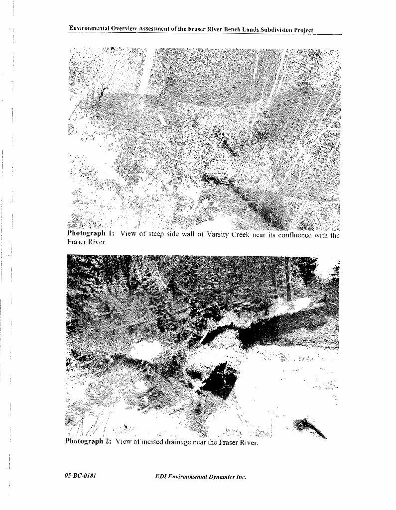


.- .- na!oq uo!sr\lpqnS sp1ie.l q211.1~ la(!~ 1.1sel~ ail) JO )naWssa?st. ka!Ala\O I~~~~am~~~~!~~~

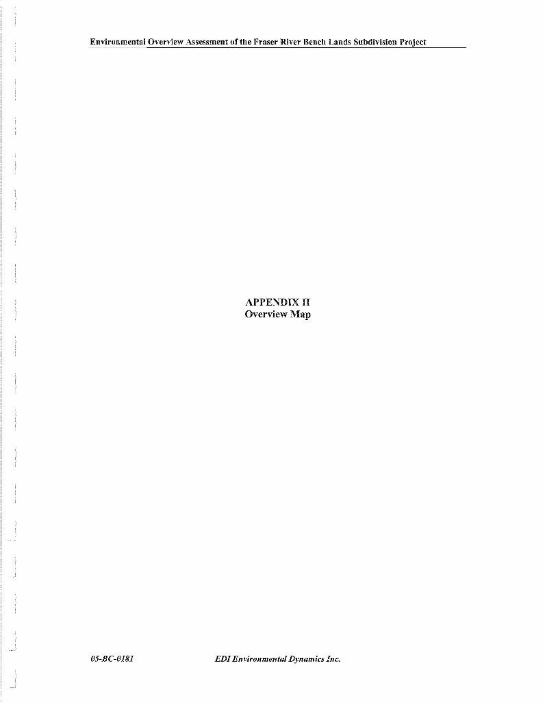
Environmental Overview Assessment of the Fraser River Bench Lands Subdivision Project
APPENDIX I1 Overview Map
EDIEr~vironmer~tal Dynamics IIIC.


Fortwood Homes Ltd. and Roman Catholic Episcopal Corporation Fraser River Bench Lands – Neighbourhood Plan
APPENDIX H
APPENDIX H
GEOTECHNICAL OVERVIEW


L&M Engineering Ltd. January 13_ 2006 Geotechnical Overview of Proposed Fraser River Bench Lands Development, Prince George, B.C. File No. K-1896
TABLE OF CONTENTS
Page No.
INTRODUCTION 1
METHODS 2
GEOLOGICAL BACKGROUND 3
ANTICIPATED SUBSURFACE CONDITIONS 3
DISCUSSION 5
GEOLOGICAL HAZARDS 6
CONCLUSIONS 7
APPENDICES
APPEXDIX A Plan Showing Development Area Drawing 1896-A1
Aerial Photo Showing Terrain Mapping Drawing 1896-A2
APPEXDIX B Report by J.M. Ryder & Associates,
Terrain Analysis Inc. Plates 1896-B1 to B3
Legend of Terrain Stability Mapping
Syn~bols Plates 1896-B4 and B5
APPENDIX C Notes Summarizing Field Observations Plate 1896-C1
Site Photographs Plate 1896-C2
L&M Engineering Limited Geotechnical Overview- of Proposed Fraser River Bench Lands Development, Pr~nce George, B.C.
January 13, 2006
FilzNo. K-1896
1.0 INTRODUCTION
Fortwood Homes and the Roman Catholic Episcopal Corporation have engaged L&M
Engineering Limited (L&M) to prepare a Seighbourhood Sector Plan of the Fraser River Bench
Lands. To assist with the development ofthe Plan, L&M commissioned GeoNorth Engineering
Ltd. to carry out an overview geotechnical assessment of the property. Our assessment follows
the format of our proposal dated September 9,2005.
The Fraser River Bench Lands development area is located in the College Heights area
of Prince George. It is bordered by Fraser River on the east, by a moderately steep slope up to
developed areas of College Heights on the west, by the boundary of DL 2014 on the south and
by Cowart Road on the north. A plan showing the development area is on Drawing 1896-A1 in
Appendix A. The Bench Lands development area is comprised of three parcels that are legally
described as follows:
DL 753, Fractional Remainder of the SE 114 - PID 014 999 978
Lot 2, DL 754; Plan 24418 - PID 008 234 680
DL 20 14 Remainder - PID 015 039 099
The first parcel noted above is presently undeveloped but was previously occupied by
municipal sewage treatment lagoons. The other two parcels are undeveloped and tree-covered.
Several rough hails cross the site.
To carry out the geotechnical overview, we commissioned Dr. J.M. Ryder, P.Geo., of
J.M. Ryder & Associates, Terrain Analysis Inc. (JMRA) to examine aerial photographs and cany
out a terrain assessment. We then carried out a field reconnaissance to ground truth the air photo
assessment a id assess surficia: soil conditions.
Page 1 of 9
GEONORTE ENGIKEERING LTD.

L&hi Engineering Limited January 13,2006 Geotechnical Overview of Prop03ed Fraser River Bench Lands Development. Prince George, B.C. FileNo. K-1896
2.0 METHODS
At our request, Dr. Ryder of JMRA reviewed aerial photos and outlined areas on the
photos that have similar genesis (geomorphology). slope and drainage characteristics. To
provide context for the aerial photo interpretation, Dr. Ryder reviewed geology reports and maps
by Geological Survey of Canada. Dr. Ryder reviewed the following aerial photographs:
Year
2000
2000
1996
1988
1988
1979
1963
1955
Flight Line
30BCB00040
30BCB00041
15BC96007
30BC88035
30BC88036
15BC79151
BC5070
BC1890
Photo Numbers
124-126, 188-190
39-42, 103-104
56-58
235-238
146-149
37-39
33-35. 66-68
7
A copy of Dr. Ryder's report is on Plates 1896-B 1 to B3 in Appendix B. A scanned copy
of the mapped aerial photo is shown on Drawing 1898-A2 in Appendix A. A legend describing
the symbols used in the aerial photo mapping is on Plates 1896-B4 and B5 in Appendix B.
OnNovember 2; 2005, personnel from our office visitedthe site to obsen~e suriicial soil
conditions in shallow, hand-dug test pits and in natural exposures. Xotes summarizing field
observations are on Plate 1896-C1 and photos taken during the field reconnaissance are on Plate
1896-CZ. in Appendix C. The locations that correspond to each of the field note sites are shown
on Drawing 1896-Al.
Page 2 of 9

L&M Engineering Limited Geotechnical Overview of Proposed Fraser River Bench Lands Development, Prince George, B.C.
January 13,2006
FileNo. K-I896
3.0 GEOLOGICAL BACKGROUND
Background to the geology of the area is provided by Geological Survey of Canada in
Bulletin 196, Glacial Geomorphology and PleistoceneHistory of Central British, 1971, and with
the accompanying Map 1288A, Surficial Geology, Prince George.
The map indicates that the Fraser River Valley is within a large meltwater or outwash
channel bound by cutbanks and terraces. Higher elevation areas adjacent to Fraser River Valley
are mapped as being underlain by glacial lake sediments, and still higher elevation areas; above
about 760 m elevation and well away from the proposed development, are mapped as being
underlain by glacial till.
At the end of the last glacial period, about 10,000 years ago; meltwater accumulated in
a large glacial lake due to the presence of unmelted glacial ice and glacial debris that blocked the
present Fraser River channel. The lake existed for several hundred years and resulted in
deposition of fine grained sand, silt and clay across the areas covered by the glacial lake. When
the dam that contained the lake was breached, the lake drained, likely catastrophically, and the
resulting runoff cut into the accumulated glacial lake sediments. The channel bottom was
typically covered with sand, gravel and cobbles. Present-day site topography is a result of the
erosion that occurred as the glacial lake drained, and a result of subsequent Fraser River erosion.
4.0 ANTICIPATED SUBSURFACE CONDITIONS
As outlined in the report by JMRA and following from the geological history outlined
above, we expect the Fraser River Bench Lands area and the adjacent higher elevation areas are
fluvial terraces that were cut into fine grained sediments of Glacial Lake Prince George. Based
on this geological model, the aerial photo interpretation and our field observations, the most
probable subsurface srratigraphy is as follows:
1. Eolian, silty, fine grained sand, over
2. Fluvial over-bank sediment consisting of silty, fine to medium grained sand, over
Page 3 of 9
L&M Engineering Limited January 13,2006 Geotechnical Overview of Proposed Fraser River Bench Lands Development. Prince George, B.C. File Ko. K-1896
3. Fluvial, layered sand and gravel, over
4. Glacial lake sediments consisting of layered silt, clay and fine grained sand; over
5. Glacial till at an unknown depth.
This stratigraphy is likely to underlie the benches as well as the slopes, although the
slopes are likely covered by a thickerblanket of fluvial sand and gravel, and possibly sand and
gravel colluvium deposited at the time the slopes were formed.
Soil unit 1, the eolian sand, was likely deposited during the period soon after Glacial
Lake Prince George drained and prior to the area being vegetated. It is likely a thin layer, in the
order of decitnetres, and is similar in coinposition to the fluvial over-bank sediment.
Soil unit 2, the tluvial over-bank sediment, is prevalent across the area, and is interpreted
as the origin ofthe surficial. fine grained sand deposits at field check sites D, E; 6 , H, I, L to 0,
Q and R.
Steep, erosional slopes at field check sites D and E provide good exposure of the
stratigraphic section. Photographs of field check site D, along with an interpretation of the soil
types, are shown on Plate 1896-C2, in Appendix C. Fluvial over-bank sediment (soil unit 2) is
interpreted to be approximately 2.0 and 1.5 nl thick at sites D and E, respectively, over fluvial
sand and gravel (soil unit 3) found to be about 2.5 m thick at both sites, covering glaciolacustrine
clayey silt (soil unit 4) to the bottoms of the exposures, approximately 5 and 4 m, respectively.
The fine grained sediments likely extend to a considerable depth below the toe of the exposed
slope.
In addition to the exposures at field check sites D and E, we also observed tluvial sand
and gravel sediments at field check sites J; P and on a hill slope between P and Q.
Page 4 of 9

L&M Engineering Limited Geotechnical Overview of Proposed Fraser River Bench Lands Development, Prince George, B.C.
January 13; 2006
File No. K-1896
The fluvial over-bank sediment typically has relatively low shear strength and low to
moderate permeability. It will typically provide adequate support for lightly loaded structures,
such as residential housing. The fine grained sand is susceptible to frost heave. is easily eroded
and is easily disturbed by pedestrian and equipment traffic. The potential for soil erosion to
occur from trails can be reduced by covering the silty, fine grained sand with a li,oht to medium-
weight, non-woven geotextile, such as Propex 4551; followed by at1 erosion-resistant granular
fill.
Fluvial sand and gravel will provide good foundation support. These types of deposits
typically have properties ofmoderate to reiatively high shear strength, high permeability and low
potential for settlement. Additional investigation will be required to determine whether these
deposits are sufficiently permeable and at sufficiently shallow depth to negate the need for
below-grade, perimeter foundation drains.
Glacial lake sediments, such as the clayey silt that underlies the granular deposits,
typically have properties of very lowpenneability, low to moderate shear strength and moderate
to high compressibility. We observed seepage from gravel over the clayey silt at field check
sites D and E. This confirms that the clayey silt has properties of low permeability aid that a
perched groundwater table exists within the fluvial sand and gravel. The aerial photos also show
standing water in a swale located at the west edge ofthe main terrace, at the toe of the niain slope
at the west boundary of the proposed development area. The standing water confirms the
presence of low permeability soil deposits in the area.
The available information indicates there is limited opportunity for subsurface disposal
of stonn water. There appears to be only a thin layer of permeable sand and gravel overlying
low permeability silt and clay. Water discharged into this thin layer is likely to mound and
might cause a s i s ~ i f i c a ~ t localised rise in the p ~ c h e d g:~~;?dwat~ table. Water that inf;,!trates
the sand and gravel layer will move laterally on top ofthe silt and clay, likely towards the Fraser
River. The groundwater will either discharge directly into the Fraser River if the silt and clay
Page 5 of 9

L&h4 Engineering Limited Geotecluiical Overview of Proposed Fraser River Bench Lalids Developme~~t, Prince Georgei B.C.
January 13,2006
File No. I<-I596
is below the level of the river or will result in seepage from open slopes; such as that shown on
Plate 1896-C2; if the silt and clay is above river level. As discussed in the following section,
subdivision development can reduce slope stability conditions where groundwater discharge
results in open-slope seepage.
The Fraser River chamlel appears to be relatively stable opposite the proposed
development area, with no large changes in the channel shape visible berween the earliest to
latest aerial photos.
6.0 GEOLOGICAL HAZAIPDS
The aerial photo interpretation by JMRA found no evidence of major or deep-seated
instability. Slopes that separate the terraces are arcuate, and similar in shape to the Fraser River
banks, indicating the slopes were formed by stream erosion, not previous instability.
The slopes that separate the flat terraces are mapped as being potentially unstable (P).
This indicates the slopes have characteristics that are similar to other slopes that are actively
unstable, but they do not exhibit any significant signs of instability. The important
characteristics include slope gradient (steeper than 50%). the potential for the slopes to be
underlain by fine grained sediments, and the presence of draws and gullies. Gullies and head-
scarps less than about 10 to 20 m across appear to have developed at several locations on the
slopes. The head-scarps mark a steep face caused by erosion or instability. There is gully
erosion at several locations, possibly related to discharge of storm runoff from areas further west
into unprotected. natural draws.
To avoid potential slopeinstability and erosion concerns, werecommend that moderately
steep slopes, those steeper than about 40%, not be developed withoutmore detailed geotechnical
assessments. We also recommend assessing areas within about 10 m of the toe of slopes steeper
than abaut 4 % piio; to development to check for eiijsioii and slope stabi!ity hazads. Alluvial
fans, located where the gullies discharge onto the flat terraces, might be subjected to overland
Page 6 of 9
L&M Engineering Limited Geotechnical Overview of Proposed Fraser River Bench Lands Development, Prince George, B.C.
January 13,2006
File No. K-1896
flow and sedimentation. These areas, marked "f' on Drawing 1896-A2, will require careful
review and design of measures to control stream flow and mitigate flood and sedimentation
hazards.
Published studies have reported that subdivision development tends to cause groundwater
levels to rise due to irrigation of lawns and gardens, leakage from water mains and cutting of
trees. Indications from this study are that a perched groundwater table and lateral groundwater
flow are likely to occur. Instability can develop due to groundwater seepage at the contact
between permeable fluvial deposits that cover fine grained glacial lake sediments. This is a
particular hazard where the natural slopes are steep, such as those along eroded draws or
erosional slopes beside the Fraser River. Ure recommend these slopes be assessed where
facilities or structures are proposed near the crest to determine the appropriate setback.
There are also on-going shallow slides on those slopes that are undermined by Fraser
River. The Bench Lands appear to be opposite a relatively stable reach of the river, but a
detailed evaluation of river erosion rates and the appropriate setback distances are beyond the
scope of this study.
We havenot examined soil conditions in the vicinity of the abandoned sewage lagoons,
but understand they were filled with soil after they were drained. The fill is unlikely to be
compacted to the typicalminimumstandard required for support ofbuilding foundations or road
embankments. Additional subsurface investigation will be needed prior to development in t h s
area.
This report presents the results of a review of aerial photos and a field recolmaissance,
and provides a11 overview of geological conditions across the proposed development area.
P.~,.+~,.L..:,. uLuLLL,u,,Lal L~,,ULL,U,,S A,.... <;+:,.- aie fa-vviiable f ~ r de;ie!opmen: as a iesidentia! s i & ~ i s i o n , wih soil
Page 7 of 9

L&hl Engineering Limited Grotrchnical Overview of Proposed Fraser River Bench Lands Development, Prince George, B.C.
Tanua~y 13,2006
File No. K-1896
stratigraphy likely to consist of 1 to 3 m of silty, fine grained sand, over severalmetres of layered
sand and gravel, over fine grained silt and clay. In-ground disposal of storm water is unlikely
to be feasible due to the apparent limited thickness of permeable sand and gravel.
Some constraints might exist, and we recommend these be investigated prior to design
and construction of the proposed residential development. The potential constraints include:
1. The potential for flooding and sediment delivery from streams and from existing stonn
drain outfalls that enter the development area from the west.
2. The potential for instability or erosion from those slopes along the western borders of the
Bench Lands area, marked as potentially unstable on Drawing 1896-A2.
3. The depth to and seasonal variability in the depth to groundwater across the site.
4. The required setback from the crest of steep, erosional slopes along the Fraser River and
the incised draws.
This report was prepared by GeoNonh Engineering Ltd. for the use of the Roman
Catholic Episcopal Corporation, Fortwood Homes and their consultants. The material in it
reflects GeoXorth Engineering's judgement in light of the information available to us at the time
of preparation. Any use which a Third Party makes of this report, or any reliance on decisions
to be made based on it. is the responsibility of such Third Parties. GeoKorth Engineering Ltd.
accepts no responsibility for damages, if any, sufferedby any Third Party as aresult of decisions
made or actions based on this report.

L&M Engineering Limited Georechnical Ovemiew of Proposed Fraser River Bench Lands Development, Prince George, B.C.
January 13,2006
FileNo. K-1896
Please call the writers if any p d s of this report need to be clarified.
Respectllly submitted, ~eviewedby,
Page 9 of 9

L&M ENGINEERING LIMITED GEOTECHNICAL OVERVIEW O F PROPOSED
FRASER RIVER BENCH LANDS DEVELOPMENT ENGINEERING LTD. 1301 YclIit8er Rood
PRINCE GEORGE, B.C. ~ ~ i r ~ c e ~ ; r a r ~ - . H(:. YJL ' i i n
PLAN SHOWING DEVELOPMENT AREA Tel (250) 564-4304 Far (250) 564-3323

GEOTECHNICAL OVERVIEW O F PROPOSED FRASER RIVER BENCH LANDS DEVELOPMENT
ENGINEERING L~D. 1301 Kalliher Road Prince Georqe, UC., V%L 558


J.M.Ryder and As&a!es, Terrain Analysis Inc. 4315 West ~ 4 ' ~ Avenue, Vancouver, British Columbia. V6S 1L3 Ph 604-736-4189 [email protected]
Dave McDougall GeoNorth Engineering Ltd. 1301: Kelliher Rd., Prince George, B.C. , V2L 5S8
November 20,2005 Our ref: GeoN 05-2 Your ref: K-1896
Notes Re: Fraser River Benchlands, Prince George
Air photos examined: : 2000: BCBO0040: 124-1 26,188-90; 2000: BCB00041: 3 9 4 2 , 103-104 (includes site but no stereo of site); 1998 BC88035: 238-235; 146-149 1996: 15BC96007: 56-58; 1979: BC7915137-39 (viewing direction --westward -- provides good views of gullies.) 1960s?? BC5070: 33-35, 66-68 (terrain mapping on 67) 1955: BC1890: 2 (no stereo)
Other information provided: Field traverse notes, sites A - R and photos: Fraser River Benchlands Land Use Plan (stated scale 1:5000 - not sure if this is correct); Orthophoto (brown with green contours) Fraser River Benchlands and area adjacent to west, 1:10 000, 5 m CI);
To provide context, 1 also referred to GSC Map 3-1969, Surficial Geology Prince George, scale: 1:250 000 by S.P.Leaming and J.E.Armstrong, 1966-67.
Terrain mapping was done on the older photos (BC5070 67) Seca~~se at this time the trees were smaller and sparser, so slope breaks and other terrain features are m ~ ~ c h easier to see than on all other photos. (The relatively large scale of the most recent photos (30BCB00040) causes the vegetation to dominate the view through the stereoscope, and terrain fea t~~res are hard to decipher.) I examined all the other photos (i.e., all those with stereo-coverage of the project area) under the stereoscope, and marked features of interest on some (see yellow tags) - rather than trying to transfer features to the mapped photos.
Landforms and Stratigraphy
The Fraser River Benchlands (proposed development) area and the adjacent upslope subdivision area consist of rlver terraces. These have been formed during postglacial time as Fraser Rivei has gradually cut down into the fine grained sediments of Glacial Lake Prince George. This mode of origin gives rise to a typical stratigraphy beneath each terrace:

top veneer of fine sand of eolian origin may be present; this would be massive and cohesionless (when dry), this was not identified specifically in the field traverse notes but could be the fine-grained sand that was found at niany of the field traverse sites (no thickness info. provided at most sites); fluvial overbank sediments: these are the thinly bedded, oxidized (tan brown) sands 1.5 to 2 m thick, identified at sites D and E (and possibly elsewhere); fluvial sand and gravel - channel deposits; 2.5 m thick at D and E; may be thicker beneath old channels on the terraces;
= glacial lake sediments consisting of bedded silt, moist, and thicker than 4 m at sites D and E; (see also photo D and my interpretation of the stratigraphy attached to the photo).
base of exposed section.
See also my interpretations in the margin of the traverse notes
The glacial lake sed~ments may well extend down to below the water level in Fraser River - as is common in other major valleys, e g., Thompson River at Ashcroft.
The stratigraphy described above also likely outcrops on the terrace scarps. although the in-situ formations will be buried by sand and gravel (colluvium) derived from the fluvial materials near the top of the slope.
Slope Stability
No evidence of major or deep-seated instability was found in the course of air photo interpretation. The scarps that separate the terraces are arcuate in places, thus slightly resembling landslide headscarps, but the horizontal curvature of the scarps is similar to that of the banks of Fraser River, indicating the scarps were formed by river erosion.
Possible headscarps of small, shallow debris slides was noted on the air photos, both within the area of interest and in nearby areas of similar terrain. (See red-dotted headscarp symbols on mapping.) These are small arcuate features (10 - 20 m across ???) Ongoing shallow sliding appears to be present on scarps currently being undercut by Fraser River.
Seepage along the contact between overlying fiuvial gravels and underlying glacial lake sediments is recorded in several places in the field traverse notes - about 4 m downslope from the terrace surface. This could be a destabilizing influence re. shallow debris slides on the scarps.
The gullies that have enlarged headward from the scarps have likely been formed by recurring debris slides and flows. Colluvial fans resulting from related debris deposition were mapped tentatively (see dotted lines) because they are inferred. They are not visible on the air photos, except for one larger fan on the upper (developed) terrace in the SW corner of the mapped area.
Most scarps and gully walls were mapped as " P - potentially unstable due to the above considerations.
PLATE 1896-82

The ground water table may be significantly closer to the surface on the lower terraces than on the upper (existing subdivision) terrace: (i) note standing water (marked in blue) in an old river channel near the back of the terrace, and (ii) the seepage zone noted above.
Notes re Hazards and Recorninendations
(a) Shallow slides on scarps: res~dences s h o ~ ~ l d not be located close to the base of scarps, especially the higher scarps. continuous forest vegetation (with understory) should be maintained on the scarps: no removal of trees to enhance views;
(b) Debris Flows: = determine if debris fans are present at the lower ends of gullies; if so, keep private
residential properties off the fan; some gullies that head into the existing development appear to have been partly filled with soil to faciliate road and trail development; failure of this fill could initiate debris flow.
(c) Potential Recession of the Outer Edge of Terraces water control measures needed to avoid excessive input of water to ground from irrigation - on both private property and parks - especially critical along edges of terraces.
= control and distribute (i.e., avoid concentration of) runoff from houses, driveways and roads.
(d) Rotational Movement of Terraces, i.e.. a terrace unit behaving as a rotational slide. This possibility is probably remote, but with saturated (?) glacial lake sediments supporting the terraces, perhaps should be considered.

EXPLANATION OF TERRAIN UNIT SYMBOLS USED IN TERRAIN STABlLlN ASSESSMENTS
TERRAIN U N i T SYMBOLS
~l.nli!ving dDTsllDtar
sur!s:e erpr*sa:on
t e x t u r e sM dm;-ope closs suriicial m c t e r i a l ~ r /
3.4 or 40%-60% / P or IV
slope coss \siabi i ty class
Erplonolary Note.
TWO letters -nay be used :a dercrbe ony rnoiarter ist ic o:her than rv i i ic ic l no:c~'.;l. Let ters 0; symbols TOY be o ~ l t t e d if inion-ation is lacking.
COMPOSITE UNITS
TWO or three g-oups a( leti?rs are used to inaica!e that t w o or tnme :ypes of ter-oin are sresen1 nitnin c n a p mi::
Cv . Rs 'nd#co!es "Cu" and "7s. are of roughly eoual extent. Cv/71 indicates t lo : "Cv ' 3s rnsre extensive thon "Rs" (abou: 2 : l or 3:2). C V / / ~ S indicates thot "3"" :s muck mare extenive tnon "7s" ( 0 2 ~ ~ : 3 : 0: 4::).
STRATIGRAPLIIC UNITS
GTOUDS 01 lellers are or-anged one obove the ather where o l e or mare kinds of suriiCci materio! l overlie 0 diiiercr! maieria: or bedrock.
$ indicates "Mv" overlies " R r " indicates "q:" 7 por t i cy burled by "Mv".
SURFlClAL MATERIALS
A onthrop~genic L lacustrne
C co:1uvi4m LC glo~:oi(ic"~:r,n-i
3 wea!hered bedrock M moraine (gocia! ti4)
E eolior 0 organic
F i1uvia1 R bedrock
iA "Active" iluviol U undiF'e-ezlioted
F~ 9:00:0i1uv:o1 W mar i re
I ice WG glaciomaiice
TEXTURE
o angular blocks g c,avel s sand b rounded boulders r o9qular rub;le T silt
d mixed fragmenls <q.b.r,a,) k cobbles c cloy
p pebbies x angular fraqmenis m mud (ill: and
SURFACE EXPRESSiON
Simple (~nidirect ianal) Slopes Moteiiol i l 8 i k n e s s
j qe~:le sIoze(s) 6-27% b blorke! (qrea:er than i n )
0 moderote slape(s) 28-49% v veneer (less than In)
k naderatey steep slo3e:s) 50-70% w vc:~obIe thickness
1 sieea sIaoe(5) >70% snope
c cons (sew greoier tho> 26%) Complex Slopes f fan ( r o p e e a a i t s o n 26%:
r, ro l i rg I lobe u undu.o!inc p ploir.
h hummocky t ter.oce
r r t g e d d dep:ess;on
GEONORTH ENGINEERING LTD. ?LATE 18'35-34

EXPLANATION OF
e
TERRAIN UNIT SYMBOLS USED IN TERRAIN STABILITY ASSESSMENTS
GEOLOGICAL PROCESS'S
snow ~ v ~ l o n c h i n g J 0~05tom0sing ohonne;
:~,oIor~b.es: 08d !rocks K kcrat processes
ovolor~hes: m2,:ar tracks L seepage
awlonches: minor tracks M meonderinc c la rne l
broicinp N nivotior
c,yo~urbclian D piping de'10t;on R rapid moss mauemen!
c3orr.el;'r.g by giocial r,el!rater R" iapil' mass movement (ini!io:ior z a l e )
g ~ l y i r q by ~ l o c i a l v.eltwa!er Ro rack fail
S,OW moss mouemer.t Rd debis f!ow
F:OW moss mcuemen: (inititotian zone: Rt debris foil
soil creep Ri iock~l i l 'e
iotercl ap~ead in a~ r i i c i a l materials Rs debris slide
ea-lhflow Rt debris tarran! rock creep 5 so:i l lurton
iotera spreod in bedrock U irn;nda:ed
slump in aurficio' rnoteriois V g u y erosion
slump-eorthfow W ~ o s h i r g
ket:led X peim31:ost processes
irregucr siruoua channel Y c0to:roph.c fi03d
Z perig1o;;a processes
SLOP5 DRAINAGE CLASSES rapidly droined i impeifeclly droinec
we; drained p 100rly droined
moderately well dralred u very p a ~ r l y droined
SLOPE STEEPNESS CLASSES
I c lass / 1 1 2 3 1 4 5 1
TERRA!N STABlLiTY CLASSES
I NO siqn8fl;ant ~ tob i l i ty Dioblems i Ii jexpectea. i I
I j ld~ror proolerns or ms!obili:y might /
haivestina or rood-buildinq. i :ore05 wit" c ~ u t i o n . Potent8oIly Unstable. T h r a 1s r.od?rc:ei Marginoily stable ground due to s e e p / P likelihood of laloslides lol lawcq t m b e i / I V 'liqh moisture or weok sail. harveitina or rood cari i ruct ion. lsoecial pi icautione neccesary. Unstable. There is a nioh likelihood of Are08 contoming natural landslide Ioroslldea fallowing timber harvestirg I V i s c o r s Very steep, poorly droined. o r rood construct;cn. I ~l'eeolv ailllled or wea* soil deoas81s.
ON-SITE SYMBOLS AND BOUNDARY LINES
Ice f lax diiectiar. indicata;~: Moss Mauemen! and Erosion Features: c r o i o"d :oil ,/? scor of recent s m c i siice P d r m : ; r s 9 soar of recent larger slide P-9 s ! r : a t : o ~ ~ SCOT of old londsiide c--q7 a
a /
, or O P grooves recent de3ris f!ow / o r # ,ine:t:on: > Cirque m
~ C C T P S escorpments, bluffs Glocio meltwater chonnels
Locat:ol a1 G:auvd 7-ouerse Eskers (known, unknowa) 0-d Fiec-Cbeck Ste -0- -erroin L n l B a ~ n d o : ~ Lires:
def lnte :o~roo.y indel;nila, opncxima:e cr gradatiano! boundary - - - - - - ossvrnea a; a-b:t-cry sourcary

L&M Engineering Ltd. January, 2006 Geotechnical Overview of Proposed Fraser River Bench Lauds Development Prince George. B.C. File No. K- 1896
FIELD TRAVERSE KOTES - 2005/11/02
Creek cut exposure, through visual inspection, is fme sand, bedded, tanbrown, damp, to 2.0 m, over sand and gravel, bedded, moist, to 4.5 m, over silt, bedded, moist to wet, to 9.5 m.
River bank exposure, through visual inspection, from slope crest to river level, is fme sand, bedded, tadbrown, damp, to 1.5 m, over sand and gravel, bedded, moist, to 4.0 m, over silt,

GEONORTH ENGINEERING LTD. 1301 Kel iher Rood. Tel, (251)) ',ti4~-4304 . .
Pr,rx:e Gaoiqc, B.C., V2L 558. l o x (250) 564-9323
L&M ENGINEERING LIMITED GEOTECHNICAL OVERVIEW OF PROPOSED
FRASER RIVER BENCH LANDS DEVELOPMENT PRINCE GEORGE, B.C.
SITE PHOTOGRAPHS TAKEN NOVEMBER 2, 2 0 0 1 FILE NO. K - 1 8 9 6 PLATE No. 1 8 9 6 - C 2

Fortwood Homes Ltd. and Roman Catholic Episcopal Corporation Fraser River Bench Lands – Neighbourhood Plan
APPENDIX I
APPENDIX I
PRELIMINARY TRAFFIC ANALYSIS (Malaspina Avenue)
&
HIGHWAY 16/COWART RD SIGNALIZED INTERSECTION ANALYSIS SUMMARY

Date: Thursday October 27 2005Location: Near Malaspina/Domano Boulevard IntersectionCounted By: Chris Slater
Eastbound Westbound Totalveh veh veh
7:00 AM 7:15 AM 13 18 317:15 AM 7:30 AM 13 27 407:30 AM 7:45 AM 11 61 727:45 AM 8:00 AM 16 45 618:00 AM 8:15 AM 18 38 568:15 AM 8:30 AM 18 33 518:30 AM 8:45 AM 43 83 1268:45 AM 9:00 AM 23 35 58
95 199 294
4:00 PM 4:15 PM 26 22 484:15 PM 4:30 PM 40 32 724:30 PM 4:45 PM 40 28 684:45 PM 5:00 PM 40 27 675:00 PM 5:15 PM 42 18 605:15 PM 5:30 PM 53 24 775:30 PM 5:45 PM 40 30 705:45 PM 6:00 PM 34 29 63
175 99 274
294 VPH
274 VPH
MALASPINA AVENUETRAFFIC COUNT
AM PEAK Volume (7:45am to 8:45pm) =
PM PEAK Volume (4:45am to 5:45pm) =
TOTAL peak hour
TOTAL peak hour
Fortwood Homes Ltd. and Roman Catholic Episcopal Corporation Fraser River Bench Lands – Neighbourhood Plan
APPENDIX I

Fortwood Homes Ltd. and Roman Catholic Episcopal Corporation Fraser River Bench Lands – Neighbourhood Plan
APPENDIX J
APPENDIX J
REFERENCES

Fortwood Homes Ltd. and Roman Catholic Episcopal Corporation Fraser River Bench Lands – Neighbourhood Plan
APPENDIX J
Reference List Carson/McCulloch & Associates. (1998). Prince George City Wide Trail System Master
Plan. City of Prince George. City of Prince George. (1980). Zoning Bylaw No. 3482. City of Prince George. City of Prince George. (2001). Official Community Plan Bylaw No. 7281. City of Prince
George. City of Prince George. (2004). Subdivision & Development Servicing Bylaw No. 7652.
City of Prince George. City of Prince George. (2006). “DCC Bylaw Update 2006.” Accessed Online from:
http://www.city.pg.bc.ca/city_services/infrastructure/dccbylaw/ Coriolis Consulting Corp. (2003). “Do Development Cost Charges Encourage Smart
Growth and High Performance Building Design? An Evaluation of Development Cost Charge Practices in British Columbia.” West Coast Environmental Law.
Hamilton Associates. (2004). City of Prince George Pedestrian Network Study. Hamilton
Associates. Smart Growth BC. (2001). The Smart Growth Toolkit. Smart Growth BC. Smart Growth BC. (2002). “Alternative Development Standards.” Accessed Online from:
http://www.smartgrowth.bc.ca/index.cfm?Group_ID=2280 UMA Engineering. (2001). 2001 Transportation Planning Study. City of Prince George. West Coast Environmental Law. (2004). “Smart Bylaws Guide- Mixing Uses-
Comprehensive Development Zoning.” Accessed Online from: http://www.wcel.org/issues/urban/sbg/Part3/mixeduse/CD-Zoning.htm