Embed Size (px)
Citation preview

109Revista de la Asociación Geológica Argentina 64 (1): 109 - 123 (2009)
INTRODUCTION
Charles Darwin made the journey fromBuenos Aires to Santa Fe by cart andhorse. After several days of work at LaBajada (presently Paraná city) he retur-ned to Buenos Airs by boat along the RíoParaná. Such a trip allowed him (surely bychance) to cross four major geographicand Quaternary geological environmentsof southeastern South America (Fig.1).The first one stretches from BuenosAires city (in fact, it begins further south)to Rosario and reaches several tens of
kilometers westwards. It is formed by aslightly elevated block characterized byEarly Pleistocene formations and margi-nal Holocene littoral deposits. Thesecond sector covers the Rosario-SantaFe road and reaches 300 km west to thehills in Córdoba. This system is a relati-vely sunken region dominated by LateQuaternary loess bounded at the northby the South American region of Chaco.The third area he visited forms thesouthwestern sector of Entre Ríos pro-vince; it is represented by a hilly landsca-pe carved into Miocene marine sedi-
ments and Early Quaternary aeolian andswampy formations. The last environ-ment Darwin recorded during his jour-ney is the Paraná river system, composedof a wide flood plain and a littoral com-plex at the mouth ("Paraná delta"), bothof them Holocene in age.In order to visualize Darwin's experien-ces, this article is organized in the samesequence of geological terrains that hefound during his journey (Darwin 1846,1945).When reading his journal or his geologi-cal observations of the region, Darwin's
FROM BUENOS AIRES TO SANTA FE: DARWIN'S OBSERVATIONS AND MODERN KNOWLEDGE
Martin IRIONDO and Daniela KRÖHLING
CONICET - Universidad Nacional del Litoral, CC 217 (3000) Santa Fe. E-mails [email protected], [email protected]
ABSTRACTDuring his historical voyage around the world, Darwin raided deeply in the South American interior, travelling over 600 kilo-meters from Buenos Aires to the north along the Río Paraná. During that journey, he crossed a vast plain characterized byaeolian sediments, something unfamiliar to a European naturalist. However, Darwin's acute observation powers and precisedescriptions are noteworthy. After more than 170 years since his visit, modern geological knowledge identifies several sectorsin the Buenos Aires-Santa Fe region. One of them (the Tertiary at La Bajada) he described admirably and others such as theParaná flood plain were brilliantly abstracted in only two sentences. In short, Darwin traversed a first sector (Buenos Aires-Rosario) characterized by aeolian and paludal Early Pleistocene sediments. From Rosario to Santa Fe the plain is formed byLate Pleistocene aeolian and fluvial units. At La Bajada (presently Paraná city) lies exposed the marine Miocene and in SWEntre Ríos is a reconstructed loess-paleosol sequence generated at the Early/Middle Pleistocene transition. The Paraná floodplain and the littoral complex at the mouth (practically not observed by Darwin) underwent rather complex Holocene episo-des.
Keywords: Ch. Darwin, Pampa, South America, Quaternary, Tertiary.
RESUMEN: De Buenos Aires a Santa Fe: observaciones de Darwin y conocimiento actual. Durante su histórico viaje alrededor del mundo,Charles Darwin incursionó profundamente en el interior de Sudamérica recorriendo más de 600 kilómetros hacia el norte deBuenos Aires a lo largo del río Paraná. Durante ese viaje, él recorrió una gran planicie caracterizada por sedimentos principal-mente eólicos, un caso poco familiar para un naturalista europeo. Sin embargo, sobresale su gran capacidad de observación yprecisión en sus descripciones. Después de más de 170 años de la visita de Darwin, el conocimiento geológico moderno haidentificado varios sectores en la región Buenos Aires-Santa Fe, uno de los cuales (el Terciario de La Bajada) él describió admi-rablemente y otros, como la llanura aluvial del Paraná, reseñó magistralmente en solo dos frases breves. En resumen, Darwinrecorrió un primer tramo (Buenos Aires-Rosario) caracterizado por sedimentos eólicos y palustres del Pleistoceno Inferior.Desde Rosario hasta Santa Fe la llanura está formada por unidades eólicas y fluviales de edad pleistocena superior. En LaBajada (hoy ciudad de Paraná) aflora el Mioceno marino y en el sudoeste de Entre Ríos se reconstruyó un sistema loess-pale-osuelos generado a lo largo de la transición Pleistoceno Inferior-Pleistoceno Medio. La llanura aluvial del Paraná y el comple-jo litoral de su desembocadura (prácticamente no observados por Darwin) sufrieron cambios dinámicos bastante complejosdurante el Holoceno.
Palabras clave: Ch. Darwin, Pampa, Sudamérica, Cuaternario, Terciario.

great observation power and exceptionalability for synthesis appear immediatelyevident, notwithstanding the limitationsof geological theory at that time. For ins-tance, the nature and origin of loess (thedominant sediment in the Pampas) wasdiscovered several decades later. It is evi-dent that Darwin did not feel comforta-ble with such "muds", "clays" and similar.In order to describe and interpret thoseextensive deposits of the plain, he prefe-rred to hold on to strata and concretionsof tosca (caliche), intercalated in the sec-tions. His skill as a paleontologist in com-parison with his abilities as a sedimento-logist is also clear.Besides, it is interesting to discover inDarwin's writings the existence of quali-fied observers - i.e., people with somescientific knowledge - among the localpopulation in those early years of Argen-tina. Some of them were British traders,but others were local inhabitants thatwere great observers of Nature.
THE GREAT DROUGHT
An interesting environmental issue wasdescribed by Darwin in relation to thetrip to Santa Fe. It was the "Gran Seca"(the great drought) that particularly af-fected the north of Buenos Aires andsouth of Santa Fe from 1827 to 1832.During those five years rain was excep-tionally scarce and the plain underwentmajor changes: vegetation disappeared,minor rivers dried up and the entirecountry took the aspect of a dusty road,dust clouds continuously dominating theair. The effect on animals was catastro-phic; cattle migrated massively to thesouth and assembled there in a giantflock; droves with thousands of wildhorses hurried furiously to the Paraná todrink and later were unable to climb backup the slippery cliff and drowned.Hundreds of thousands of animals floa-ted downstream to the Plata estuary. Afew years later Darwin observed ¨true
layers of bones¨ covering the bottom ofsome tributaries.Very probably such great drought was ashort late occurrence of the Little IceAge (LIA) climate, which was characteri-zed by a marked dryness in the Pampas(Parra 1939, Iriondo and Kröhling 1995)and ended around 1800-1810. The Spa-nish naturalist Azara also described simi-lar events in the late 18th Century. TheLittle Ice Age provoked advances of gla-ciers in the Cordillera and related proces-ses in southern South America, but didnot produce visible geological effects inthe Pampas, probably owing to its relati-vely short duration and not so severedryness.On the other hand, a longer dry periodoccurred between 3.5 and 1.4 ka BP andformed a thin aeolian mantle which co-vers the Pampas and surrounding re-gions, i.e., the San Guillermo Formation(Iriondo 1990, Fig. 2). It is an aeoliangray silt that generally tops the sedimen-tary sequence in the large interfluves.Most of the sediment is originated lo-cally, by deflation of the A-horizon ofsoils and the subsequent deposition ofdust. In Santa Fe province this mantle isformed by coarse silt with scarce propor-tions of very fine sand and clay, brow-nish gray in color (10YR 5/1). It is fria-ble, porous, permeable, and moderatelystructured. Typical thickness varies from25 to 55 cm; ceramic shards and Indianboleadora balls are included in the upperpart of this deposit at some localities.
BUENOS AIRES/ROSARIOELEVATED BLOCK
Darwin rode a 250 km long first journeyfrom Buenos Aires to Rosario in astraight northwestern direction. All thattime, the road borders the right banks ofthe Río de la Plata and Río Paraná andruns atop a 10 to 20 m high cliff. Thiscliff is almost continuous, interrupted ina few places by small Holocene estuariesof minor tributaries (Luján, Areco, Arre-cifes and others; Iriondo 2004). The cliffis tectonic in origin and exposes two
M. IRIONDO AND D. KRÖHLING110
Figure 1: Map of the regionshowing the localities visitedby Darwin.

Quaternary formations described byDarwin as "pale and red Pampean mud".Both units were identified and studiedlater in the Twentieth Century.González Bonorino (1965) refered thesections outcropping in the Buenos Airesarea as the Pampeano Formation. Ac-cording to its mineralogy, the author dif-ferentiated two zones separated by a clearboundary: the upper zone characterizedby plagioclase and illite and the lower onedominated by quartz and montmorilloni-te. Fidalgo et al. (1973) later described thePampiano Formation and Riggi et al.(1986) discriminated the Ensenada For-mation and the Buenos Aires Formationin the same sections.Both units appear along all the distanceto Rosario, but have better outcrops onthe left bank of the Paraná, in Entre Ríosprovince. Here they were defined as Pun-ta Gorda Formation (Iriondo and Kröh-ling 2008) and Hernandarias Formation(Iriondo 1980). Pale Pampean Mud/Pun-ta Gorda Formation is an Early and Mid-dle Pleistocene loess-paleosol sequence.It is composed of the Andean plagiocla-se-illite association and has an origin si-milar to the classical Last Glacial Max-imum Pampean loess (Kröhling 2001).
Both minerals were transported bysouthwesterly winds from the AndesCordillera. The Punta Gorda Formationwas deposited around 1 Ma BP duringthe most important Quaternary glacia-tion occurring in South America (Mercer1976).The Red Pampean Mud/HernandariasFormation is a large playa deposit depo-sited by the Río Uruguay at the Early-Middle Pleistocene transition. It formsthe surface of most of Entre Ríos pro-vince and below the surface reaches intoneighboring regions in Santa Fé andBuenos Aires to the southwest (Iriondo1980). The typical thickness of this for-mation varies from 20 to 40 m; it is com-posed of loam and silty loam with mont-morillonite as main clay mineral, andquartz and very fine sand containing gyp-sum at the base. More than 90 % of theclay minerals, i.e., montmorillonite, bei-dellite and nontronite, show expan-sion/contraction properties.The contact between both formations isconcordant - a feature correctly observedby Darwin, who stated: "I could clearly dis-tinguish in this fine line of cliffs horizontal linesof variation both in tint and compactness"(Darwin 1846, p. 87). As remarked by
Darwin this observation contradicts theinsistent assertion of the French natura-list d'Orbigny on the general absence ofstratification in the Pampean sediments.The academic point was then whetherthe Pampean System was diluvial or not:if stratified, not diluvial.
Baradero Section (NE Buenos Airesprovince)
The section on the Río Baradero northof the city of Baradero (100 km fromBuenos Aires), is formed by the PuntaGorda Formation (5 m thick), confor-mably overlain by the Hernandarias For-mation (Iriondo 1980, 7 m thick). Frombottom to top:0 - 1 m Punta Gorda Formation. Bed ofclayish silt, dull brown in colour, modera-tely consolidated. It contains numerousFe-oxide segregations, CaCO3 concre-tions of different sizes and large rhizo-concretions. It is interpreted as a paludaldeposit.1 - 5 m Punta Gorda Formation. Bed ofa silty grain-size composition, pale brownin colour, massive in general and in someplaces with a weak medium to coarsehorizontal stratification. Medium to highconsolidation (highly calcareous); carbo-nate (tosca) concretions. Fine rootmoulds covered by black films. The de-posit has a general aeolian origin, withlocal rill reworking and krotovinas insome places. Remains of Glyptodon werefound in the measured section. At thetop, a marked horizontal paleosurface isrecognized, locally joined to a residualmaterial of 0.60 - 0.80 m thick, with fewlocal pedogenic features.5 - 12 m Hernandarias Formation. It iscomposed of clayish silt to a silty clay,olive gray in general colour and with va-riations to brown and olive; with abun-dant large and irregular carbonate con-cretions. Frequent Fe-Mn sesquioxidesegregations appear. It is less consolida-ted than the underlying unit and is orga-nized in poorly defined coarse strata, andinterpreted as a paludal deposit. Nume-rous dessication cracks appear along all
From Buenos Aires to Santa Fe: Darwin's observations ... 111
Figure 2: Map of the SanGuillermo Formation, alate Holocene environmen-tal equivalent of Darwin´sbig drought (after Iriondo1990).

the section. The deposit includes me-dium to coarse lenticular to tabular strataof pale brown silt, with internal lamina-tion and segregated CaCO3. Such lensesare interpreted as aeolian, locally re-transported material. In some sectors ap-pear lenses of retransported botrioidalCaCO3 concretions.The forms of erosion of both forma-tions are very different and distinctivealong the river cliffs. They were alsoaffected by several gullies. Nabel et al.(1993) studied the magnetostratigraphyof two sections at Baradero, finding re-verse polarity (older than 0.78 Ma) in thelower section of the cliff. Those authorsidentified two of the lenticular paleosolsand named them El Tala (Brunhes paleo-magnetic chron) and Hisisa Geosols(Matuyama chron > 780 ka). Nabel et al.(1993) discriminated eight litoestratigra-phic units at Baradero section: units I toV interpreted as loess and paleosols de-posits and units VI to VIII associated tolimnic environments. The age of the de-posit in the region was attributed to theEnsenadense Mammal Age (Tonni et al.1999). Later, Kemp et al. (2006) recons-tructed the sequence of pedosedimen-tary processes in the same locality basedon soil science methods and identifiedpaleosols embedded in swamp and aeo-lian sediments. Their ages as recorded byluminescence methods (OSL dates rangefrom ca. 114 to 14 ka BP) differ conside-rably from previous paleomagneticresults.
San Pedro Section (NE Buenos Airesprovince)
In a quarry excavated into the Río Paranácliff at San Pedro the following sectionappears from bottom to top: a paleosoldeveloped on top of the Punta GordaFormation and truncated by erosion(1.20 m thick) and constituted by brownsilt, weakly structured in peds. It containsnumerous large root moulds generatedby the lixiviation of CaCO3 rhizoconcre-tions. Pedological features are: fine rootmoulds covered by black films, argillocu-
tans and ferriargillans. This paleosol co-rresponds to the unit G attributed byImbellone and Cumba (2003) -Geosol ElTala-Hisisa-. The Hernandarias Forma-tion forms the rest of the exposed sec-tion, with general paludal characteristicsand interbedded discontinuous soil hori-zons in the middle sector of the unit.Numerous large krotovinas appear in thisformation.
Vuelta de Obligado and Ramallo Sec-tions (NE Buenos Aires province)
The section of the cliff at Vuelta deObligado is represented by the loessicfacies of the Punta Gorda Formation(6.50 - 8 m thick), overlain by a calcrete(2.50 m thick). The unit includes a 1.30 mthick paleosol at the base, composedfrom top to bottom as follows:0 - 0.35 m B2t horizon. Brown clayish silt(7.5 YR 5/4), moderately to well structu-red in very firm, fine to medium prisms,bounded by fine fissures. Common claycutans and fine root moulds. Very fine tofine Fe-mottles and Fe-Mn oxides segre-gations frequent.0.35 - 0.57 m B3 horizon. Brown siltmoderately organized in very firm, fineto medium prisms. Scarce argillocutansand fine root moulds.0.57 - 0.87 m BC horizon. Brown silt,weakly structured in firm and fine blockypeds. Abundant very fine Fe-Mn mottlesand fine root moulds.0.87 - 1.29 m C horizon. Light brown cla-yish silt with paludal characteristics (veryfine resistant blocky peds, frequent Fe-mottles, common CaCO3 irregular andplaty concretions).At that locality, a well developed 1.5 mhigh notch appears at the base of thecliff; that feature indicates erosional ac-tion by waves during the Middle Holo-cene marine ingression. Such a featurealso appears in the same position at FrayBentos, in the Banda Oriental (Uruguay).The Río Paraná cliff at the locality ofRamallo is formed by the Punta GordaFormation, represented by the loessicstrata with frequent CaCO3 vertical platy
concretions, 2.50 to 3 m thick. The unitis covered by the paludal facies of theHernandarias Formation, with frequentCaCO3 concretions.
Arroyo Pavón and Arroyo Seco Sec-tions (Southern Santa Fe province)
Entering the territory of Santa Fe pro-vince, Darwin described a cascade abouttwenty feet high in the Pavón creek, asmall tributary of the Paraná. He recor-ded there two varieties of tosca-rock (li-mestone).Today the Pavón Cascade is located a fewhundred meters from Provincial High-way 11. The cliff downstream the casca-de begins at the base with a brown sandyaeolian deposit (1.5 m thick) covered bya loessic unit with segregated CaCO3(1.5-2 m thick). A paleosol (1 m thick) isrecognized on top of it (it very probablycorrelates with the soil exposed at thebottom of the Vuelta de Obligado sec-tion). The section ends with the loessicfacies of the Punta Gorda Formationwith abundant CaCO3 concretions (2 mthick). Some kilometers to the north, thePunta Gorda Formation forms the banksof the Arroyo Seco (9 m high at the tow-n's camping grounds); locally differentia-ted is a 3 m thick brown silty strata, palu-dal in origin.
ROSARIO/SANTA FE BLOCK
From Rosario to Santa Fe and beyond tothe north and west, stretches anothersector of the Pampas, dominated by LatePleistocene geological formations. Thelandscape is there shaped by two wides-pread aeolian units: Tezanos Pinto For-mation and San Guillermo Formation.However other units originated in fluvialenvironments have been described. Thestratigraphic sequence is the following:
Section of the Paraná cliff betweenPuerto Gaboto and Rosario (Santa Feprovince)
According to Kröhling (1999) the expo-
M. IRIONDO AND D. KRÖHLING112

sed stratigraphic column on the cliffsalong the right bank of the Paraná andCoronda rivers, between the cities ofPuerto Gaboto and Rosario, begins at thebase with the Plio-Quaternary ItuzaingóFormation, deposited by the Río Paraná.The sedimentary record of the unit isrepresented by mature and well selectedsands, typical of channel facies of a flu-vial system of high discharge. The condi-tions that favored the accumulation ofthe unit changed toward the top of theformation to a fluvial regime of lowerenergy.The Ituzaingó Formation is separated byan erosional unconformity from theoverlying Late Pleistocene Puerto SanMartín Formation, formed by the dis-continuous accumulation of fine aeoliansediments. The accumulation environ-ment was of semipermanent swamps, in-tercalated with periods of subaerial con-ditions (loess). The existence of Ck-hori-zons of truncated soils near the top ofthe unit suggests more benign condi-tions. In some sites, between the twomentioned formations there are interca-lated several paleochannels infilled withalluvial and paludal deposits. These wereformed by successive avulsions of thelast segment of an important tributary inthe region - the Río Carcarañá (TimbúesFormation).The landscape developed over the Puer-to San Martín Formation was later cove-red and smoothed during the LastGlacial Maximum by the loess of theTezanos Pinto Formation. The stratigra-phic sequence ends with the Late Ho-locene San Guillermo Formation, whichlies over the buried Holocene OptimumClimaticum soil developed on top of theloess.Darwin described the Paraná cliff in thearea of Estancia Grondona, north ofRosario and near the last and more re-cent segment of the Río Carcarañá. Theexposed section was characterized byDarwin as follows, from the base to top:“it consists of a pale yellowish clay, aboundingwith concretionary cylinders of a ferruginoussandstone”. It is interpreted as the Itu-
zaingó Formation. Darwin continues:“The rest of the cliff at Gorondona, is formedof red Pampean mud, with, in the lower part,many concretions of tosca, some stalactiformed,and with only a few in the upper part… contai-ning mammiferous remains close to its base”(Darwin 1846, p. 87). It corresponds tothe general features of the Puerto SanMartín Formation.The main characteristics of the mentio-ned formations exposed in the area visi-ted by Darwin were taken from Kröhling(1998) and are presented below:IIttuuzzaaiinnggóó FFoorrmmaattiioonn ((DDee AAllbbaa 11995533,,HHeerrbbsstt 11997711))It is composed of very fine quartz sand,sandy silt to silty clay, grayish yellow incolour (2.5Y 6/2) with variations to oliveyellow (5Y 6/3). The sediment has abun-dant ferric segregations; also the postde-positional rubefication is in general dis-cordant to the stratification. The upperpart of the unit has abundant brown Fe-sesquioxides mottles (7.5 YR 5/8), loca-lly concentrated in centimetric levels. Theconsistence of the sedimentary mass ran-ges from friable to poorly consolidatednon-calcareous. Segregations of CaCO3form irregular to botrioidal concretions.Locally, in the lower part there are plattyCaCO3 concretions forming an orthogo-nal net or ferruginous concretions of 30to 50 mm diameter. The unit is arrangedinto medium to coarse massive lenticularstrata with 7-10 m of lateral extension,with variable concentrations of very fineto medium Fe-mottles (up to 40%) andMn-segregations and mottles. Abundantfine root moulds with black segregations.In some sectors, the top of the unit ismarked by a moderately developed B ho-rizon and by calcareous concretionsbellow it. Locally, the truncated paleosolis replaced by medium cuneiform stratacomposed of fine sand, ochre-yellow incolour, that form a set with diagonal stra-tification. Upwards they are replaced bymedium horizontal strata composed ofintraclasts in a sandy matrix or by inter-nally laminated strata.This unit, represented by the fluvialchannel sedimentary facies (paludal fa-
cies is common too), outcrops at the baseof the cliff of the Río Paraná from itsjunction with the Río Coronda up to thecity of Rosario, with variable thicknessbetween 0.5 m and 4.5 m. Locally theformation is covered by the TimbúesFormation separated by an erosionalunconformity, but in general the overl-ying unit is the Puerto San MartínFormation.Main characteristics of the ItuzaingóFormation in its type area (Corrientesprovince) are presented in Georgieff etal. (2005).TTiimmbbúúeess FFoorrmmaattiioonn ((KKrrööhhlliinngg 11999988))It is composed of silty very fine to finesand, opaque orange in colour (7.5 YR7/4), with visible micaceous minerals(frequency of 5-20%). It is organized incoarse to very coarse, internally lamina-ted strata, lenticular to tabular in form,with irregular concordant to erosionalcontacts among them. Deformationalstructures are common. There are Mn-segregations, root moulds filled by sandand leaf moulds covered by Mn-films.Platty CaCO3 concretions appear at thecontact between some strata, locally for-ming a calcareous net of phreatic origin.Large elliptic krotovinas are frequent.At the Paraná cliff near the locality ofPuerto San Martín, a B horizon of a pale-osol appears at the erosional contact bet-ween the Timbúes Formation and theoverlying Tezanos Pinto Formation. It is0.30 to 0.60 m thick, reddish brown incolor and weakly to moderately structu-red in medium angular prisms.The Timbúes Formation (Late Pleisto-cene in age) outcrops at the cliff of theParaná and Coronda rivers, exhibiting athickness of 5 to 6.5 m and lateral exten-sions of tens of meters. The sedimentarycharacteristics indicate a fluvial origin forthis unit. It is interpreted according tomineralogical data as a deposit generatedby the Río Carcarañá and indicating theposition of its previous mouths in theParaná.PPuueerrttoo SSaann MMaarrttíínn FFoorrmmaattiioonn ((IIrriioonnddoo11998877))The unit is practically continuous along
From Buenos Aires to Santa Fe: Darwin's observations ... 113

the Río Paraná cliff from the mouth ofthe Río Coronda up to the city of SanLorenzo. Its thickness varies from 4 upto 10 m. The unit is overlain by the Te-zanos Pinto Formation, separated by anunconformity that indicates an irregularpaleosurface.It is a yellowish brown silty deposit, orga-nized in coarse to very coarse horizontalstrata with poorly defined contacts. AtPuerto San Martín - the type locality - thesection is as follows from bottom to top:0-0.60 m: bed composed of brownisholive silt, structured in peds, paludal inorigin. 0.60-1.60 m: bed of yellowishbrown silt, massive, aeolian in origin.1.60-2.10 m: bed formed by brownisholive silt, organized in peds and accumu-lated in a swampy environment. 2.10-3.30 m: yellowish brown loess. 3.30-4.80m: bed composed by yellowish brownsilt, moderately structured, paludal in ori-gin. 4.80-5.10 m: brownish olive silt,weakly structured, paludal in origin. 5.10-6.40 m: stratum of yellowish brown silt,weakly structured in angular peds.Locally a level with CaCO3 rhizoconcre-tions appears immediately below theerosional unconformity at the top of theunit indicating the existence of a Ck ho-rizon of truncated soils.At the Río Paraná cliff in front of thecity of San Lorenzo, two sectors can bedifferentiated: the lower one is 4 m thickand formed by olive sandy silt with com-mon ferruginous mottles. The upper partcarries calcareous precipitates of phreaticorigin. The upper sector is 7 m thick andcomposed of massive, yellowish brownsilt, including a pedogenic horizon mar-ked by CaCO3 concretions.The Puerto San Martín Formation out-crops at sectors of the Río Carcarañácliff near the town of Oliveros. On theleft bank the unit is also differentiatedinto two sectors separated by a concor-dant horizontal contact. The lower siltysector, olive in colour, comprises the Ckhorizon of a truncated paleosol. The up-per sector is represented by a brownishto reddish brown silt with diffuse crossedstratification. It includes a lenticular fine
bed formed by CaCO3 pebbles. A mode-rately structured B horizon of a trunca-ted soil tops this unit.The sedimentary unit is interpreted as acontinuous sequence of strata represen-ting a temporary swampy environmentalternated with typical aeolian facies thatsuggest an important accumulation ofdust in the region. Taking into accountthe reference of Darwin about the pre-ponderant number of fresh-water spe-cies (Polygastrica and Phytolitharia) scrapedfrom a tooth of one of the mastodonsfound in the red Pampean mud, we inferthat this corresponds to one of the cha-racteristics beds of paludal origin of thePuerto San Martín Formation.TTeezzaannooss PPiinnttoo FFoorrmmaattiioonn ((IIrriioonnddoo 11998877))This formation is the typical LGM loessof the northern Pampas that overlies thePuerto San Martín Formation, withthickness ranging between 1 and 4 m.SSaann GGuuiilllleerrmmoo FFoorrmmaattiioonn ((IIrriioonnddoo 11998877))The brownish gray silty deposit (LateHolocene in age) ends the sedimentarysequence on a truncated soil developedon top of the LGM loess.
Sections of the lower Río Carcarañá(Santa Fe province)
Darwin was right in making his observa-tions along the banks of the lower RíoCarcarañá because its basin constitutes afavorable area for research on geomor-phology and Quaternary stratigraphy ofthe northern Pampas plain (Kröhling1999).The exposed sedimentary columnof the lower Carcarañá basin revealsfluctuating environmental conditions,characterized by dry intervals associatedwith episodes of accumulation and re-mobilization of aeolian sand or dust ac-cumulation during the stages of GlacialMaximum. These alternate with humidintervals characterized by pedogenesisand the development of fluvial belts. Thesedimentary record of the lower basinwas reported by Kröhling (1999) and isexplained below (Fig. 3).CCaarrccaarraaññáá FFoorrmmaattiioonn ((KKrrööhhlliinngg 11999999))This unit is composed of very fine to
fine silty sand, and silt with very finesand, dull orange in colour (7.5 YR 6/4).It has very thick horizontal strata, notwell defined and generally with concor-dant contacts. The sediment varies inconsistency between friable and consoli-dated and it has a fine to medium blockystructure. In general, it is non-calcareous.It is affected locally by bioturbations,such as krotovinas (up to 0.75 m diame-ter) and root casts (up to 0.60 m long and0.10 m diameter). In some places sedi-mentary structures are visible. These arecharacterized by an irregular wavy pat-tern marked by differences in concentra-tions of colloidal materials, namely dissi-pation structures. This unit forms thelower sections of cliffs along the RíoCarcarañá, forming gentle to subverticalslopes, which reflect its resistance incomparison with the upper units. Themaximum outcrop thickness is approxi-mately 5.50 m. It is unconformably over-lain by the Tezanos Pinto Formation inthe interfluves and by the Lucio LopezFormation in the main fluvial valleys ofthe area.A representative section of the unit is ex-posed along the cliffs of the Río Cañadade Gómez, near the Río Carcarañá. Frombottom to top:0.00-2.00 m: Bed formed by very fine,slightly silty sand, bright reddish brownin colour when moist, with dissipationstructures. The sedimentary mass is non-calcareous and contains medium to coar-se and hard Fe-Mn sesquioxide nodules.There are rhizoconcretions of CaCO3and abundant very fine macropores.Concordant upper contact.2.00-4.50 m: Bed sedimentologicallysimilar to the underlying one, withoutsedimentary structures, and with lessresistance to erosion. Numerous CaCO3rhizoconcretions appear at the contactbetween the units. It includes krotovinasup to 0.50 m in diameter. Near the topthere is a level formed by a succession oferosional geoforms, 0.50-0.80 m wideand 0.40-0.50 m high.Relicts of a palaeosol appear disconti-nuously at the bottoms of gullies within
M. IRIONDO AND D. KRÖHLING114

the fluvial palaeovalleys of the region.Lateral variations are common in thatsoil: the structure changes from coarse tovery coarse blocky (strong) up to angularvery coarse prismatic (strong, defined bycoarse fissures, partly filled by CaCO3precipitates). The sediment is weakly cal-careous to calcareous. There are nume-rous epigenetic carbonate concretionsproduced by partial dissolution. CaCO3
concretions of phreatic origin occupycoarse fissures between peds. Locally,this level is represented by palaeogulliesfilled with retransported soil fragments.At the top of the Carcarañá Formationanother soil was developed. It is repre-sented by a poorly developed B horizon,0.40 m thick, dark brown in colour,weakly structured and containing CaCO3rhizoconcretions.
The Carcarañá Formation is Late Pleisto-cene in age (OIS 3; a TL dating in themiddle section indicates an age of 52.31± 1.2 ka BP). The mainly aeolian forma-tion is the result of the reworking by ero-sion of a dune field generated during theOIS 4. Primary structures of the dunesappear in sections located immediately tothe south of the area. Locally differentpaludal and alluvial facies of the Carca-rañá Formation are present.According to Darwin, “on the banks of theCarcarañá, a few miles distant (of the Paranácliff at Grondona; next to the Villa LaRibera -Rosario-Santa Fe road-), the lowestbed visible was pale Pampean mud, with massesof tosca-rock, in one of which I found a muchdecayed tooth of the Mastodon: above this bed,there was a thin layer almost composed of smallconcretions of white tosca, out of which I extrac-ted a well preserved, but slightly broken tooth ofToxodon Platensis: above this there was an unu-sual bed of very soft impure sandstone” (Dar-win 1846, p. 88). The section of the RíoCarcarañá described by Darwin is inter-preted as the Carcarañá Formation.TTeezzaannooss PPiinnttoo FFoorrmmaattiioonn ((IIrriioonnddoo 11998800))It is the typical Late Quaternary unit ofthe Pampas plain, composed of aeoliansilts (silt: 71-81%; clay: 13-29%; finesand: 1-6%). At the base and the top, ero-sional unconformities connect thesedeposits with the Carcarañá Formationand with the San Guillermo Formationrespectively (Kröhling 1999).A primary loess facies or aeolian facies ofthe Tezanos Pinto Formation has thegreatest areal representation, with a typi-cal outcropping thickness of 2-4 m, andmore developed on the interfluves (6-8m thick). It is a loose deposit, coarse siltwith subordinate clay and fine sand, lightbrown in colour (7.5 YR 6/4). It is a ho-mogeneous, porous and permeable de-posit with a coarse granular to medium-coarse blocky fabric. The sedimentarymass is calcareous; it contains powderyconcentrations and hard concretions ofCaCO3 (in a variable frequency; variedforms and centimetric sizes). The loessbody is crossed by fine rhizoid ramifiedcanalicula. It is stable in steep walls, in
From Buenos Aires to Santa Fe: Darwin's observations ... 115
Figure 3: General stratigraphic section of the Carcarañá river basin, typical of the Rosario-Santa Fearea (after Kröhling 1999).

parts altered by subcutaneous subfusionand shaped by columnar disjunction.TL datings gave ages of 31.69 ± 1.62 kaBP and 32.0 ka BP in samples of the aeo-lian facies of the formation in the area, at4 m below the top of the unit (LGM,OIS 2).BBuurriieedd ssooiill ((KKrrööhhlliinngg 11999999))The top of Tezanos Pinto Formation ismarked by a partially eroded soil, 0.30 -1.10 m thick, typically represented by aBt horizon. In a minor geomorphologicalunit (fluvial valleys of the region) thatsoil forms an accretionary pedocomplexof argillic horizons separated by the ac-cumulation of Andean volcanic ash,mainly concentrated by alluvial proces-ses. At the interfluves of the region, theBt-horizon is formed by a dark brown(7.5 YR 3/4) clayish silt, with intense illu-viation and formation of cutans. It has astrongly to moderately developed struc-ture in medium angular prisms, strongconsistence, with very fine and finecracks between peds. It lacks nodules ormottles, and the silt fraction is non-calca-reous. There are abundant root moulds.The lower boundary is wavy in form andwell marked. The Bt horizon is compo-sed of a dull brown (7.5 YR 5/4) slightlyclayish coarse silt. This horizon shows aweakly to moderately well-developedstructure, formed by medium blocks, ve-ry firm, limited by fine and very fine fis-sures. Nodules or mottles are absent, butfine macropores are present. The siltfraction is non-calcareous. The C hori-zon shows characteristics transitional tothe underlying loess.The buried soil was generated during theHolocene Optimum Climaticum and it isa distinct pedostratigraphic marker in dif-ferent areas of the Pampas plain.SSaann GGuuiilllleerrmmoo FFoorrmmaattiioonn ((IIrriioonnddoo 11998877))A younger loessic formation overlies theburied soil on top of the Tezanos PintoFormation, separated from it by an ero-sional unconformity. It is composed of abrownish grey (10 YR 5/1) coarse siltwith scarce proportions of very fine sandand clay. The unit is massive, friable ingeneral, porous, permeable, and modera-
tely structured in very coarse firm prismsbounded by very fine fissures. This depo-sit lacks nodules or mottles, but containsnumerous root moulds, abundant macro-pores, very fine and fine canalicula andtubes generated by bioturbation. The se-diment mass is non-calcareous. The unitis partly the product of deflation of theA horizon of the underlying soil and thesubsequent deposition of dust. The typi-cal thickness is 0.30 m, with a maximumof 0.55 m.The San Guillermo Formation generallyforms the top of the sedimentary se-quence in the natural sections of thePampas. It was deposited during a LateHolocene dry period that occurred bet-ween 3.5 and 1.4 ka BP (Iriondo 1990).Lucio Lopez Formation (Kröhling 1996)It constitutes a complex sequence diffe-rentiated into three sectors. It includes aclayish silt with scarce very fine sand (silt:58-77%; clay: 19-37%; sand: 3-6%), orga-nized in fine strata with variations incolour from olive to grey; pedogenichorizons are intercalated in the middlesection (pedocomplex). Locally, it exhi-bits high proportions of biogenic mate-rial (mainly gastropods, ostracods, dia-toms and abundant plant remains). TheLucio Lopez Formation outcrops alongthe cliffs of the main rivers of the nor-thern Pampas region, with most typicalcharacteristics and the greatest thicknesson the Río Carcarañá cliffs. The thick-ness varies from 0.50 to 5.00 m. The for-mation unconformably overlies the Car-carañá Formation in sections located in-side the fluvial valleys of the region. Thecontact indicates a palaeotopography ofchannels and gullies. In general the for-mation is covered by contemporary orrecent deposits of fluvial origin; locallythe unit forms the top of the section.The formation, with a clear paludal ori-gin, constitutes the infilling of erosionallandforms located in a recent belt of themain rivers and at the bottom of themajor fluvial palaeovalleys of the region.A TL date in the upper section of theformation (a cineritic stratum) indicatesan age of 1.32 ± 0.12 ka BP. The soil
complex of the middle section was gene-rated during the Holocene Optimum Cli-maticum. The formation was generatedduring the Holocene and possibly eventhe Late Pleistocene too.This unit correlates with the Luján For-mation defined by Fidalgo et al. (1973),representing the Late Quaternary conti-nental infilling of the fluvial valleys ofNE Buenos Aires province. Toledo(2005) presented a sequence stratigraphicmodel in the Lujan type section of thisunit, based on detailed stratigraphic ob-servations and C14 datings on mollusks.The author refered ages from > 40 ka BPto >11 ka for the Guerrero Member (flu-vial-paludal deposits or Lujanense) andages from 10.7 to 3.3 ka BP for the RíoSalado Member of the Luján Formation(grayish to whitish silty facies or Platense).Prieto et al. (2004) gave ages rangingfrom 11 to 3.5 ka BP for the Luján For-mation in the Río Luján.
LA BAJADA SECTION
The town La Bajada is located across theRío Paraná from Santa Fe. At present,that locality (nowadays Paraná) is the ca-pital city of Entre Ríos province. Sucharea is crossed by an old transcurrentfracture, the Tostado-Gualeguaychú fault,which elevated its southern block some40 m in the Middle Pleistocene (Iriondo1989), thus exposing Tertiary marinestrata. Darwin payed special attention tothose strata, collected an interesting fos-sil assemblage and made an excellentstratigraphic description of the section.Darwin quoted that "In Entre Ríos, thecliffs, estimated at between sixty and seventy feetin height, expose an interesting section: the lowerhalf consists of Tertiary strata with marineshells, and the upper half of the Pampean for-mation. The lowest bed is obliquely laminated,blackish, indurated mud, with distinct traces ofvegetable remains. Above this there is a thickbed of yellowish sandy clay, with much crystalli-zed gypsum and many shells of Ostreae,Pectens, and Arcae: above this generally comesan arenaceous crystalline limestone, but there issometimes interposed a bed, about twelve feet
M. IRIONDO AND D. KRÖHLING116

thick, of dark green, soapy clay, weathering intosmall angular fragments. The limestone, wherepurest, is white, highly crystalline, and full ofcavities: it includes small pebbles of quartz, bro-ken shells, teeth of sharks, and sometimes, as Iwas informed, large bones: it often contains somuch sand as to pass into a calcareous sandsto-ne, and in such parts the great Ostrea patagoni-ca chiefly abounds. In the upper part, the limes-tone alternates with layers of fine white sand.The shells included in these beds have beennamed for me by M. d'Orbigny (a list of fossilsfollows) - M. d'Orbigny has given a detailed des-cription of this section, but as he does not men-tion this lowest bed, it may have been concealedwhen he was there by the river. There is a consi-derable discrepancy between his description andmine, which I can only account for by the bedsthemselves varying considerably in short distan-ces" (Darwin 1846, p. 88-89).In fact, the major discrepancies betweenboth naturalists appeared because Dar-win worked in the elevated block of thefault and d'Orbigny researched in thedownthrown block, where the marinebeds appear only during low waters. Be-sides, as Darwin correctly stated, the stra-ta vary in short distances. However, Dar-win's description fits considerably wellwith the type section of the Paraná For-mation, formally defined there 150 yearslater by Iriondo (1973).The marine beds of Bajada were rena-med as Paraná Formation in the 20th
Century. This formation represents thelast widespread marine transgressionoccurring in the interior of South Ame-rica (Yrigoyen 1969, Herbst 1971, Irion-do 1973, Marengo 2005) and the Bajada-Paraná area is considered the type loca-lity. Darwin's section, indeed, can clearlybe recognized in the type section of theformation (Iriondo 1973, Fig. 4):- Both sections are composed of fivebeds and have similar thicknesses; a com-parison shows the following:- The lowest bed - Darwin (profile B ofFig. 4): Obliquely laminated, blackish, indura-ted mud, with distinct traces of plant remains. Type section: 3 m. Green quartz sand in30-50 cm thick strata, including a largeproportion of clay intraclasts, most of
them are platy angular fragments withoutrounding. Major axes of plates are para-llel to stratification planes. Mean grainsize around 0.2 mm, finer towards thebottom. Transitional upper contact.- Second bed - Darwin: Yellowish sandyclay, with much arenaceous crystalline gypsumand Ostreae.- Type section: 3 m. Massive green sand,without internal bedding, containing upto 10 cm long elliptic clay intraclasts.20% of the sediment mass is composedof chaotically distributed small platyintraclasts. Grain size around 0.25 mmwith variable dispersion, which growsupwards. Lightly cemented with CaCO3.The detachment and fall of intraclastsproduces numerous small hollows in out-crops. Neat upward contact.- Third bed - Darwin: 4 m. Dark green,soapy clay weathering into small angular frag-ments. - Type section: 6 m. Sequence of interes-tratified sand and clayish silt. The sand
bodies are short lenses with internal dia-gonal lamination, up to 1.60 m thick.Loose, quartzose and yellow in colour.Sandy bodies are generally composed of5-15 cm thick internal units with diago-nal stratification. The fine sediments areplastic, gray clayey silts, forming conti-nuous strata 1 to 30 cm thick and at least50-60 m long; internal laminae of sandare common. In parts with contorted in-ternal lamination. Silt strata conformablycover the underlying sand lenses. Grainsize of the fines is 30 microns at the bot-tom, diminishing upwards to clay-sizes.The upper section of this bed changes towhite sandstone with dune structurescontaining well preserved bivalves.Further on, the bed passes to a fine con-glomerate.- Fourth bed - Darwin: Sandy crystallinelimestone. Where purest, it is white, highlycrystalline, and full of cavities: it includes smallpebbles of quartz, broken shells, teeth of sharksand sometimes large bones: it often contains so
From Buenos Aires to Santa Fe: Darwin's observations ... 117
Figure 4: The ParanáFormation outcropping in LaBajada. A: Type profile(Iriondo 1973). B: Darwin´sprofile.

much sand as to pass into a calcareous sandsto-ne, and in such parts the great Ostrea patagoni-ca abounds (Darwin 1846, p. 89).- Type section: 1.5 m. White calcareoussandstone with dune structures and un-dulose strata. Lateral and upward enrich-ment with shells of bivalves and scarceoysters. Bivalve shells underwent an ad-vanced degree of dissolution and re-pre-cipitation, remaining often only asmoulds. Oysters are well preserved.- Fifth (upper) bed - Darwin: The limesto-ne alternates with layers of fine white sand. Type section: 5.5 m. Most of the outcropis covered by debris. The lower sector ischaracterized by white sand, incipientlycemented by the carbonate provided bythe local dissolution of shells; the uppersection is composed of fine quartz sand.Green in colour.The general scenario suggested by thesection in both approaches (Darwin´sand modern) is one of a tidal environ-ment, with subtidal sands and gravels,intertidal muds, changing tidal channelsand coastal currents. Two different sedi-mentary mechanisms can be deduced: a)Transport and accumulation of sand bytractive currents, probably from nearbybeaches if one considers the negativeskewness of the sediment. b) Floccu-lation of fines in calm environments.The fossil assemblage also points to a lit-toral/neritic position in a warm climate.A general setting of the Paraná Forma-tion is as follows: The Paraná Formationcovers an important sector of a majorgeological event occurring in the Neo-gene of South America. Around theMiddle Miocene occurred a generalizedmarine transgression in large regions ofthe continent. The Paraná Formationcomprises the portion included in theChaco-Paranense Basin, which extendsfrom the central lowlands of Argentinaat 36° lat. S northwards to the Bolivianand Paraguayan Chaco. The Miocene seawas a shallow, platform branch of theAtlantic Ocean. Mean thickness of theformation is about 100 m; the sedimentis dominantly sandy in the type area (Pa-raná; La Bajada in Darwin times) and
characterizes the upper half of the sec-tion in all the basin. The lower half appe-ars as composed of green sand.A research borehole drilled in the centerof the basin in the northern Pampas (SanGuillermo locality; 30°15'S, 61°50'W)recorded 40.5 m of the Paraná Forma-tion covered by 60.3 m of Quaternaryloessic formations (Kröhling and Iriondo2003).Following Darwin, "The upper half of thecliff in La Bajada, to a thickness of aboutthirty feet, consists of Pampean mud, of whichthe lower part is pale-coloured, and the upperpart of a brighter red… Close above the mari-ne limestone, there is a thin stratum with a con-cretionary outline of white hard tosca-rock ormarl…" Three Quaternary formationscan be recognized in that reference: Theupper one is Tezanos Pinto Formation,the main loessic deposit of the Last Gla-cial Maximum. The "lower mud" is theHernandarias Formation, an Early Pleis-tocene playa deposit of the Río Uruguay.The tosca-rock is a well developed level,which thickens southwards up to 9 m andis known as Puerto Alvear Formation.
SOUTHWESTERNENTRE RÍOS
A key area of the region is located in thesouthwestern part of Entre Ríos provin-ce and outcrops along the eastern cliff ofthe Paraná flood plain. Darwin did notstudy such outcrops, but navigated alongthem in his journey back to Buenos Ai-res. However, he made a few commentson "the Punta Gorda in Entre Ríos" (diffe-rent from the other Punta Gorda in theBanda Oriental), which is an interestingsedimentary cycle that occurred aroundone million years before present. Thatlocality is placed 60 km south of Santa Feand has the best stratigraphic section ofthe area (Fig. 5) in Entre Ríos.
Punta Gorda Section
The Quaternary geologic column of theregion (Kröhling 2001) records two welldefined aeolian sedimentation cycles. In
both cases, the main source of sedimenthas been the Andean region, that produ-ced fine materials originated by nival pro-cesses and volcanic eruptions.The older cycle, defined as the PuntaGorda Group, is composed of threeunits accumulated in paludal and sub-aereal environments during the EarlyPleistocene. The second sedimentarycycle occurred during the Late Pleisto-cene and Holocene (basically at the LastGlacial Maximum) and is the PampeanAeolian System traversed by Darwinfrom Buenos Aires to Santa Fe. It com-prises two formations accumulated insubaereal environments. A short periodof aeolian remobilization occurredduring the Late Holocene.Several episodes of pedogenesis and lo-cal erosional unconformities were recor-ded in both major sedimentation periods,particularly in the older one. The longsedimentation hiatus, covering all theMiddle Pleistocene and a half of the LatePleistocene constitutes a remarkableregional feature.Important similarities were found betwe-en both sedimentary cycles: i) the samesource of sediments; ii) the same longdistance transport agent (wind); iii) stri-king similarity in grain-size distributions;iv) scarce contribution of materials fromthe Brazilian shield and associated areasin the north.The age of the older cycle can be locatedbetween the Brunhes - Matuyama mag-netic polarity change (the Upper Matuya-ma Chron > 0.78 Ma.) and the JaramilloSubchron (1 Ma). This conclusion coin-cides with recent datings in the "GreatPatagonic Glaciation" (Ton-That et al.1999), which rendered ages from 1 Ma to1.17 Ma. The following sedimentaryunits outcrop at Punta Gorda:PPuunnttaa GGoorrddaa GGrroouupp ((IIrriioonnddoo 11998800)):: SSeeddii-mmeennttaarryy ccyyccllee 11Puerto Alvear Formation (Iriondo 1980)This is a sedimentary body accumulatedas infilling of an abandoned belt of theRío Paraná. The unit was a non-perma-nent swamp at the beginning of thePleistocene. The formation lies uncon-
M. IRIONDO AND D. KRÖHLING118

formably on the Paraná Formation (ma-rine Miocene), with a maximum thick-ness of 9 m. The most visible field featu-re is a closed net formed by CaCO3 pla-tes of phreatic origin, 0.5 to 4 cm thickwith a dominant horizontal develop-
ment. Numerous vertical large and bo-trioidal concretions indicate a post-depo-sitional remobilization of the carbonate.The clastic component of the unit is asilty clay to sandy silt with diffuse lamina-tion, light reddish brown in colour with
olive patches. Abundant Mn- and Fe se-gregations and nodules are conspicuous.This formation is divided into two mem-bers; the lower one is characterized bythick continuous partition walls, with awavy trace. The upper member includes
From Buenos Aires to Santa Fe: Darwin's observations ... 119
Figure 5: Punta Gorda section,representative of SW Entre Ríosprovince (after Iriondo and Kröhling2008).

a similar horizontal carbonate net,although formed by thinner and moreirregular platy precipitates. An internalunconformity separates both members;in some places the top of the lowermember are the Bw-and C horizons of aweakly developed paleosol. That pedoge-nic level is non-calcareous.La Juanita Formation (Iriondo 1998)This unit was formed in a paludal envi-ronment during the Early Pleistocene. Itlays unconformably on the Puerto AlvearFormation, with a typical thickness of 2to 3 m. The La Juanita Formation iscomposed of light brown to olive siltwith scarce fine sand with horizontal dif-fuse bedding. Strata are 15 to 30 cmthick, with internal lamination. Fe- andMn segregations and root moulds are lo-cally abundant. The sediment is slightlystructured in firm blocks. Concretions,which form more than 10% of the sedi-mentary mass, are rough vertical infi-llings of roots, 2 to 5 cm thick and up to20 cm long. The general tendency of theCaCO3 precipitates indicates infiltrationin a non-permanent swamp environmentwith a non-saturated bottom. There arealso infillings of horizontal fissures. Fre-quent Mn films cover the surface of con-cretions, indicating a younger age for themobilization of such oxides.Punta Gorda Formation (Iriondo and Kröhling2008)This is a brown loess characterized bypedogenesis in several levels and fre-quent local internal unconformities. Ac-cording to palaeomagnetic analyses, theage of the unit is Early Pleistocene. Car-bonatic cement is widespread in the for-mation. Local second order variations arethe rule in most outcrops. Three sectionswere described in the unit at the typelocality (Punta Gorda, Entre Ríos pro-vince). The lower one was unconforma-bly deposited over La Juanita Formationand begins with a paludal deposit com-posed of clayish silt, light brown incolour, with Fe- and Mn segregations.This is conformably overlain by a petro-calcic horizon formed by vertical cylin-drical welded concretions 50 cm high.
The central section is formed by 4 m ofhomogeneuos light brown loess, with avertical slope. A lattice pattern of CaCO3precipitates appears in the exposures.Three weak to moderate paleosols (B-and Ck horizons) were recorded at thetypical site. These soils are laterally dis-continuous as a result of uneven erosio-nal contact with the overlying loess. Theyare re-calcified from this material too.The upper section begins with a Ckmhorizon of another eroded paleosol,covered by a one meter thick paludaldeposit.TTeezzaannooss PPiinnttoo FFoorrmmaattiioonn ((IIrriioonnddoo 11998800))::SSeeddiimmeennttaarryy ccyyccllee 22The unit constitutes the Peripheral LoessBelt of the Pampean Aeolian System,which was deposited during the OIS 2(36-8 ka BP, Iriondo and Kröhling 1995).The aeolian dust was transported fromAndean sources by S and SW winds. InSW Entre Ríos province the unit is yello-wish brown loess, 2 to 3 m thick, compo-sed of powderish sandy silt, massive andfriable. OSL ages of 32 and 24 ka BPwere obtained for the loess in this region.The loess forms typical vertical slopes,with columnar disjunction. It containssmall CaCO3 concretions and frequentrhizoconcretions (15.48 ± 0.19 C14 kaBP).The unit received contributions offine sediments from the Paraná headwa-ters, located to the northeast.The clay fraction of the loess is a com-plex mixture of illite, interstratified illite-smectites and kaolinite. Illite is a pampe-an mineral whereas smectites and kaoli-nite are derived from Brazil. A partiallyeroded soil on top of the loess is repre-sented by well developed Bt-horizon andC horizons. The Bt horizon is 35 to 55cm thick, clayey silt dark brown in colour,structured in very firm prisms; argillocu-tans are frequent. The buried soil was de-veloped under humid subtropical condi-tions during the Holocene OptimumClimaticum.SSaann GGuuiilllleerrmmoo FFoorrmmaattiioonn ((IIrriioonnddoo 11998800))::SSeeddiimmeennttaarryy ccyyccllee 22The sedimentary sequence of PuntaGorda ends with an aeolian unit uncon-
formably accumulated over the erodedsoil. It is a brownish gray loess, 20 to 35cm thick, loamy to silty-loamy. This unitis the result of deflation of the A-hori-zon of the soil on top of the TezanosPinto Loess and the subsequent deposi-tion of dust. Such an event occurredfrom 3.5 to 1.4 ka BP.
THE PARANÁ FLOODPLAIN
Darwin travelled from Santa Fe back toBuenos Aires by boat along the Paranáand made some remarks about the river,its banks and fauna. Particularly, he notedthe large number of islands that are per-manently eroded and reconstructed bythe currents.In fact, according to modern geomor-phology the river flows there within alarge flood plain, approximately 600 kmlong, stretching from the Paraguay-Paraná junction (27°25'S) to south ofRosario (33°S). Downstream it passestransitionally to a well-developed Holo-cene littoral complex. The general direc-tion of the flood plain is north-south,crossing several tectonic blocks in a per-pendicular or diagonal manner This rela-tionship has generated local segmentswithin the plain, with slightly differentdirections and slopes. The width of thefloodplain varies from 13 to 45 km, withtypical values between 25 and 35 km. It iscomposed of several internal geomor-phological units, the most modern ofthem is the “bar plain”, that is developingat present (Iriondo 2007).The bar plain is a belt of large elliptic
bars composed of very fine sand, thatencloses the main channel along thewhole flood plain. This belt is perma-nently modified by erosion and sedimen-tation and has a width of 2-7 km; it isformed by islands inside the main (navi-gation) channel and sand bars juxtaposedto the margins. The large bars are crossedby minor active channels, most of themwith intense lateral migration, resulting inminor meander belts. The powerful brai-ded mainstream - with a mean discharge
M. IRIONDO AND D. KRÖHLING120
between 16,000 and 20,000 m3/sec - con-tinuously reshapes islands and banks.This is the environment described byDarwin.Other important geomorphological unitsof the flood plain are the hindered drai-nage plain and the deltas of tributaries.The hindered drainage plain was descri-bed by Darwin as a labyrinth of smallbranches separated by low islands cove-red by forest, he observed this landscapewhen crossing the flood plain from SantaFe to La Bajada. This unit is characteri-zed by a morphology of flat areas withnumerous shallow ponds, swamps andsmall adventitious channels. Such chan-nels are tortuous, active only at the begin-ning and end of floods, conveying waterinto ponds during rising and back to themain channel at low levels. The numberof ponds and shallow lakes is huge -about 5,000 according to Paira andDrago (2007). This system was genera-ted under a hydric regime different thanthe present one. The deltas of tributariesare areas of sedimentation formed insidethe flood plain during a recent dry clima-te period (from 3.5 to 1.4 ka BP, accor-ding to the latest datings). Water dischar-
ges were lower than today in all thesystem and tributaries did not reach thecollector, deposing the sediment loads inlateral positions inside the flood plain;the Paraná River itself was also smallerthen than it is today. That resulted in rela-tively short and wide delta-like sedimen-tary bodies. Most of such deltas (LosAmores, del Rey, Corrientes) are locatednorth of Santa Fe, a region not visited byDarwin owing to health problems. Te-rraces also appear in the north, in Chacoand Corrientes provinces.The sediments of the flood plain arevery homogeneous. Practically all the se-dimentary mass is composed of onlythree sedimentary facies: a) Channel fa-cies, which are composed of fine andvery fine quartz sand, generally in 10-40cm thick horizontal strata with diagonalinternal structures. Such sand was origi-nated in Mesozoic sandstones of the up-per basin and comprises the major partof the buried sediments. b) Levee facies,which are characterized by silty-clayishvery fine sand with intermediate plasti-city; ochre to greenish-gray in color, mot-tled, with numerous pores, tubes androot moulds. Gley processes are fre-
quent. c) Lake-and-swamp facies, com-posed of dark gray silt with abundantorganic matter in different degrees of de-composition. It is compact, with low po-rosity; sand and clay are scarce. A reallymodest proportion of the sediment volu-me is represented by a fourth facies, i.e.,aeolian dunes composed of very finesand, which appear in isolated spots inthe northern half of the flood plain.
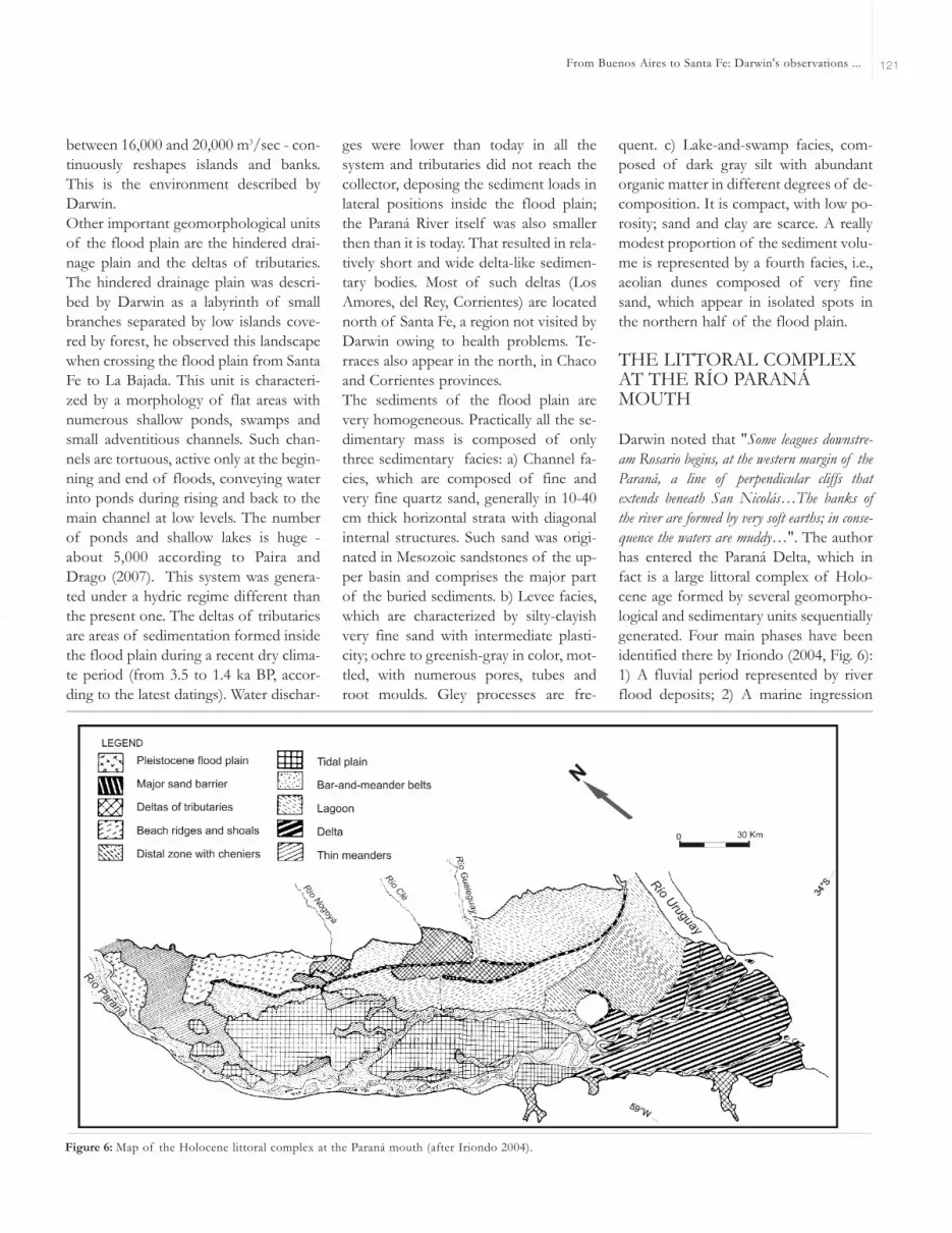
THE LITTORAL COMPLEXAT THE RÍO PARANÁMOUTH
Darwin noted that "Some leagues downstre-am Rosario begins, at the western margin of theParaná, a line of perpendicular cliffs thatextends beneath San Nicolás…The banks ofthe river are formed by very soft earths; in conse-quence the waters are muddy…". The authorhas entered the Paraná Delta, which infact is a large littoral complex of Holo-cene age formed by several geomorpho-logical and sedimentary units sequentiallygenerated. Four main phases have beenidentified there by Iriondo (2004, Fig. 6):1) A fluvial period represented by riverflood deposits; 2) A marine ingression
From Buenos Aires to Santa Fe: Darwin's observations ... 121
Figure 6: Map of the Holocene littoral complex at the Paraná mouth (after Iriondo 2004).

with development of a sand barrier, alagoon, minor tributary deltas and estua-ries and well-developed regression depo-sits; 3) An estuarine phase characterizedby extensive tidal deposits in the centralarea; and 4) The present fluvial period,with channel deposits and a deltaic unitadvancing into the Río de la Plata. Thepresent dynamics of the deltaic complexis dominated by the Paraná floods, thefloods of the Uruguay and Gualeguayrivers, Atlantic tides, and floods produ-ced by the southeasterly winds.The southeasterly wind (Sudestada), inde-ed, is a major factor in the water dyna-mics and navigation in that area anddownstream in the Río de la Plata. Thewind can be strong and blow sometimesduring several days, provoking a rise ofthe water level. Records of up to 2.5 mabove the terrain have been reported atseveral places. During such periods, navi-gation in boats and small vessels stops;surely, Darwin underwent such a meteo-rological phenomenon: "At night, the windis scantly favorable and we stop; the next dayblows a strong wind…"
COMMENTS ANDCONCLUSIONS
Undoubtedly, the short incursion of thegreat naturalist to the interior of theArgentine plains was a very modest por-tion of his famous trip around the world,with plenty of discoveries, experiencesand amazing landscapes such as Tahiti orTierra del Fuego. The attention paid byDarwin to these flat plains in his subse-quent studies was necessarily far moremodest than those devoted to the Gala-pagos Islands or the Andes Cordillera.However, the few pages dedicated to theBuenos Aires-Santa Fe journey reveal theextraordinary abilities of Darwin forkeen observation and logical thinking, inspite of the limitations of geological the-ory at that time. No real errors can benoted in his geological observationsrecorded during this journey, rather goodscience and acute synthetic descriptions.In order to make a comparison between
the geological contributions of Darwinand the present knowledge on the region,the authors of this contribution necessa-rily follow the general structure ofDarwin's books, a traveler's diary enri-ched by digressions on Science, Politicsand History.
WORKS CITED IN THE TEXT
De Alba, E. 1953. Geología del Alto Paraná -Relación con los trabajos de derrocamientoentre Ituzaingó y Posadas. Revista de la Aso-ciación Geológica Argentina 8:129-161.
Darwin, C. 1846. Geological observations onSouth America. Being the third part of thegeology of the voyage of the Beagle, underthe command of Capt. Fitzroy, R.N. duringthe years 1832 to 1836. Smith Elder and Co.280 p., London.
Darwin, C. 1945. Viaje de un naturalista alrede-dor del Mundo. Librería El Ateneo, 118 p.(Spanish translation of the second Englishedition), Buenos Aires.
Fidalgo, F., De Francesco F. and Colado, U.(1973). Geología superficial de las HojasCastelli, J.M. Cobo y Monasterio (provincia deBuenos Aires). 5° Congreso Geológico Ar-gentino (Córdoba), Actas 4: 27-39.
Georgieff, S., Anis, K., Orfeo, O., and Rizo, G.2005. Architecture of Ituzaingo Formation(Pliocene), a comparison with deposits ofParaná River, Argentina. University of Tech-nology, 8th. International Conference onFluvial Sedimentology, Abstracts: 107, Delft.
González Bonorino, F. 1965. Mineralogía de lasfracciones arcilla y limo del Pampeano en elárea de la ciudad de Buenos Aires y su signifi-cación estratigráfica y sedimentológica. Re-vista de la Asociación Geológica Argentina20: 67-148.
Herbst, R. 1971. Esquema estratigráfico de laprovincia de Corrientes. Revista de la Asocia-ción Geológica Argentina 26: 221-243.
Imbellone, P.E. and Cumba, A. 2003. Una suce-sión con paleosuelos superpuestos del Pleis-toceno medio tardío-Holoceno, zona sur de laPlata, provincia de Buenos Aires. Revista de laAsociación Argentina de Sedimentología 10:3-22, La Plata.
Iriondo, M. 1973. Análisis ambiental de la For-mación Paraná en su área tipo. Boletín de la
Asociación Geológica de Córdoba 2(1-2): 19-23.
Iriondo, M. 1980. El Cuaternario de Entre Ríos.Revista de la Asociación de Ciencias Natu-rales del Litoral 11: 125-141, Santo Tomé.
Iriondo, M. l987. Geomorfología y Cuaternariode la Provincia de Santa Fe. D'Orbignyana4: 1-54, Corrientes.
Iriondo, M. 1989. Major fractures of the Chaco-Pampa plain. Bulletin of the INQUA Neo-tectonic Commission 12: 42-46, Stockholm.
Iriondo, M. 1990. A Late Holocene dry period inthe Argentine plains. Quaternary of SouthAmerica and Antarctic Peninsula 7: 197-218.
Iriondo, M. 1998. Excursion Guide Nº3: Pro-vince of Entre Rios. International Joint FieldMeeting: Loess in Argentina: Temperate andTropical. INQUA - PASH - CLIP - UNER -CECOAL 3: 1-19, Paraná.
Iriondo, M. 2004. The littoral complex at the Pa-raná mouth. Quaternary International 114:143-154.
Iriondo, M. 2007. Geomorphology and Quater-nary of the Flood-Plain. In Iriondo, M.,Paggi, J. and Parma J. (eds.) Limnology of theMiddle Paraná River: A Subtropical Wetland,Springer Verlag, 382 p., Berlin, Heidelberg,London.
Iriondo, M. and Kröhling, D. 1995. El SistemaEólico Pampeano. Comunicaciones del Mu-seo Provincial de Ciencias Naturales "Floren-tino Ameghino" (NS) 5(1): 1-68, Santa Fe.
Iriondo, M. and Kröhling, D. 2008. Cambiosambientales en la cuenca del Uruguay (desdeel Presente hasta dos millones de años atrás).Colección Ciencia y Técnica, Ediciones UNL358 p., Santa Fe.
Kemp, R., Zárate, M, Toms, P. King, M., Sa-nabria, J. and Arguello, G. 2006. Late Quater-nary paleosols, stratigraphy and landscapeevolution in the Northern Pampa, Argentina.Quaternary Research 66: 119-132.
Kröhling, D. 1996. La Formación Lucio Lopez(Holoceno), noreste de la llanura pampeana.13° Congreso Geológico Argentino (BuenosAires), Actas 4: 69.
Kröhling, D. 1998. Geomorfología y Geologíadel Cuaternario de la cuenca del río Carca-rañá, desde la confluencia de los ríos Terceroy Cuarto, provincias de Santa Fe y Córdoba.Doctoral Thesis, Universidad Nacional deCórdoba (unpublished), 224 p., Córdoba.
M. IRIONDO AND D. KRÖHLING122

Kröhling, D. 1999. Upper Quaternary of theLower Carcarañá Basin, North Pampa, Ar-gentina. In Partridge, T., Kershaw, P. andIriondo, M. (eds.) Paleoclimates of theSouthern Hemisphere, Quaternary Interna-tional 57/58: 135-148, Oxford.
Kröhling, D. 2001. Quaternary paleosol: loessicsequences of southwestern Entre Ríos Pro-vince, Northern Pampa, Argentina. 6° Inter-national Symposium and Field Workshop onPaleopedology in Mexico City (INQUA -ISSS), Proceedings: 27-28, México.
Kröhling, D. and Iriondo, M. 2003. El loess de laPampa Norte en el Bloque de San Guillermo.Revista de la Asociación Argentina de Sedi-mentología 10(2): 137-150, La Plata.
Marengo, H. 2005. Micropaleontología y Estra-tigrafía del Mioceno Marino de la Argentina:las transgresiones de Laguna Paiva y del ¨En-trerriense-Paranense¨. Doctoral Thesis, Uni-versidad de Buenos Aires (unpublished), 150p., Buenos Aires.
Mercer, J. 1976. Glacial history of SouthernmostSouth America. Quaternary Research 6: 125-166.
Nabel, P.E., Camilión, M.C., Machado, G.A.,Spiegelman, A. and Mormeneo, L. 1993.Magneto y litoestrafigrafía de los sedimentospampeanos en los alrededores de la ciudad deBaradero, Provincia de Buenos Aires. Revista
de la Asociación Geológica Argentina 48:193-206.
Paira, A. and Drago, E. 2007. Origin, evolutionand types of flood plain water bodies. InIriondo, M., Paggi, J. and Parma, M. (eds.) TheMiddle Paraná: Limnology of a SubtropicalWetland, Springer 3: 53-82, Heidelberg.
Prieto, A., Blassi, A., De Francesco, C. and Fer-nández, C. 2004. Environmental history since11,000 C14 yr. BP of the northeastern Pam-pas, Argentina, from alluvial sequences of theLuján River. Quaternary Research 62: 146-161.
Parra, P. 1939. Diario y derrotero de sus viajes.Editorial Solar, 251 p., Buenos Aires.
Riggi, J., Fidalgo, F., Martinez, O. and Porro, N.1986. Geología de los "Sedimentos Pampea-nos" en el Partido de La Plata. Revista de laAsociación Geológica Argentina 41: 316-333.
Toledo, M. 2005. Secuencias pleistocenas "luja-nenses" en su sección tipo: Primeras datacio-nes C14 e implicancias estratigráficas, arqueo-lógicas e históricas, Luján-Jáuregui, provinciade Buenos Aires. Revista de la AsociaciónGeológica Argentina, Comunicaciones 60(2):417-424.
Tonni, E.P., Nabel, P., Cione, A.L., Etchichury,M., Tófalo, R., Scillato Yané, G., San Cris-tóbal, J., Carlini, A. and Vargas, D. 1999. TheEnsenada and Buenos Aires formations
(Pleistocene) in a quarry near La Plata, Ar-gentina. Journal of South American EarthSciences 12: 273-291.
Ton-That, T., Singer, B., Mörner, N. and Rabassa,J. 1999. Datación de lavas basálticas por Ar/Ar y geología glacial de la región del lagoBuenos Aires, prov. de Santa Cruz, Argentina.Revista de la Asociación Geológica Argentina54: 333-352.
Yrigoyen, M. 1969. Problemas estratigráficos delTerciario de Argentina. Ameghiniana 6: 315-328.
Recibido:Aceptado:
From Buenos Aires to Santa Fe: Darwin's observations ... 123


