Embed Size (px)
Citation preview
South African Archaeological Bulletin 68 (197): 27–40, 2013 27
Research Article
GEOMETRIC ROCK ART IN WESTERN SOUTH AFRICA AND ITSIMPLICATIONS FOR THE SPREAD OF EARLY HERDING
JAYSON ORTONACO Associates cc & Honorary Research Associate, University of Cape Town
E-mail: [email protected](Received January 2013. Revised March 2013)
ABSTRACTThis paper presents a series of geometric rock art sites from the aridwestern parts of South Africa. The paintings are described andcompared with similar art recorded in the Central Limpopo Basin(CLB) of northeastern South Africa. Hand prints are associated withgeometric art in the CLB but, among other things, their absence fromlarge parts of South Africa where geometric art occurs, including thearid west, suggests that this relationship may not be secure. The newsites in the west serve to expand the known distribution of geometricrock art. As in the CLB, an ascription to herders seems likely and thisexpanded distribution adds to the mounting evidence that the westernside of the country served as the main route by which the Khoekhoenmoved into the southernmost tip of Africa. However, a route south-wards through the central interior of South Africa cannot yet bediscounted.
Keywords: geometric rock art, finger-painted art, hand prints,Khoekhoen, herders, Namaqualand, Bushmanland.
INTRODUCTIONEastwood and Smith (2005) have described the non-entoptic
geometric rock art of the Central Limpopo Basin (CLB), northernSouth Africa, in considerable detail. Among other features, thetypes of motifs, pigments used and typical settings of the artwere explained. Smith and Ouzman (2004: fig. 9) mapped this
art, noting its association with the primary rivers of the SouthAfrican interior (Fig. 1). Because they aimed to provide a broadoverview, their map does not reveal the density of individualsites within (and occasionally outside) the mapped distribu-tion. Following Ouzman and Smith (2004: fig. 3) and Russell(2012: fig. 4), both of whom provided point plots, the greatestdensities lie in the eastern Karoo, Eastern Cape and Limpopoareas1.
Recent fieldwork in western South Africa has recordedseveral sites containing similar imagery and which serve toextend the known distribution of this art (Orton 2012; Orton &Webley 2012; Webley & Orton 2012). Some have been recordedbefore and even briefly mentioned in publication, but noneappears to have been illustrated. This paper thus describes andillustrates the art, its context and associated archaeology(where the latter has been studied), maps the new sites, andshows that they form part of the same geometric tradition asrecorded in the CLB. Having done this, I consider the author-ship of this art tradition, review the role of hand prints in itsunderstanding and, in light of the new evidence, reconsiderthe supposed routes of entry of herding into South Africa.
The illustrations provided here have been traced fromphotographs with scales indicated where known. Due to thepoor preservation of some parts of the paintings and theirgranite and sandstone substrates, it is probable that very slight
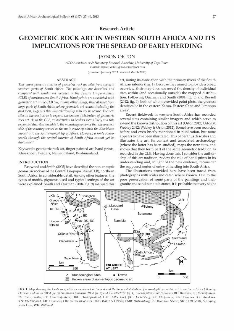
FIG. 1. Map showing the locations of all sites mentioned in the text and the known distribution of non-entoptic geometric art in southern Africa followingOuzman and Smith (2004: fig. 3); Smith and Ouzman (2004: fig. 9) and Russell (2012: fig. 4). Sites as follows: AT: /Ai tomas, BD: Brakdam, BF: Biesiesfontein,BS: Buzz Shelter, CF: Canariesfontein, DKE: Driekopseiland, HK: Hell’s Kloof, JKB: Jakkalsberg, KF: Klipfontein, KG: Kangnas, KK: Komkans,KN: KN2005/041, KR: Kromneus, OK: Oorlogskloof sites, ON: ON001 & ON002, PMB: Postmasburg, RS: Reception Shelter, SK: SK2005/084, SR: SpoegRiver Cave, WK: Wolfkraal.
inaccuracies in the reproductions will have occurred. In allcases, the motifs are related to the typology proposed by East-wood and Smith (2005: fig. 2) and all alpha-numeric motif refer-ences below refer directly to their work.
CENTRAL NAMAQUALAND SITES
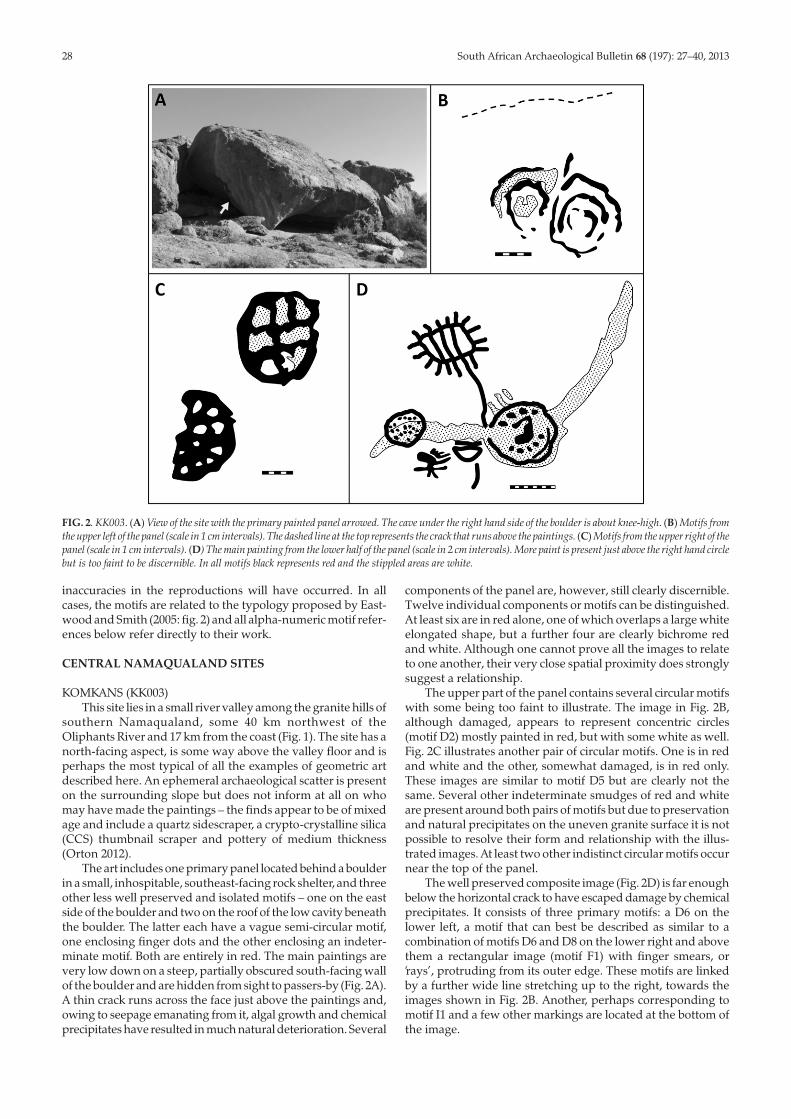
KOMKANS (KK003)This site lies in a small river valley among the granite hills of
southern Namaqualand, some 40 km northwest of theOliphants River and 17 km from the coast (Fig. 1). The site has anorth-facing aspect, is some way above the valley floor and isperhaps the most typical of all the examples of geometric artdescribed here. An ephemeral archaeological scatter is presenton the surrounding slope but does not inform at all on whomay have made the paintings – the finds appear to be of mixedage and include a quartz sidescraper, a crypto-crystalline silica(CCS) thumbnail scraper and pottery of medium thickness(Orton 2012).
The art includes one primary panel located behind a boulderin a small, inhospitable, southeast-facing rock shelter, and threeother less well preserved and isolated motifs – one on the eastside of the boulder and two on the roof of the low cavity beneaththe boulder. The latter each have a vague semi-circular motif,one enclosing finger dots and the other enclosing an indeter-minate motif. Both are entirely in red. The main paintings arevery low down on a steep, partially obscured south-facing wallof the boulder and are hidden from sight to passers-by (Fig. 2A).A thin crack runs across the face just above the paintings and,owing to seepage emanating from it, algal growth and chemicalprecipitates have resulted in much natural deterioration. Several
components of the panel are, however, still clearly discernible.Twelve individual components or motifs can be distinguished.At least six are in red alone, one of which overlaps a large whiteelongated shape, but a further four are clearly bichrome redand white. Although one cannot prove all the images to relateto one another, their very close spatial proximity does stronglysuggest a relationship.
The upper part of the panel contains several circular motifswith some being too faint to illustrate. The image in Fig. 2B,although damaged, appears to represent concentric circles(motif D2) mostly painted in red, but with some white as well.Fig. 2C illustrates another pair of circular motifs. One is in redand white and the other, somewhat damaged, is in red only.These images are similar to motif D5 but are clearly not thesame. Several other indeterminate smudges of red and whiteare present around both pairs of motifs but due to preservationand natural precipitates on the uneven granite surface it is notpossible to resolve their form and relationship with the illus-trated images. At least two other indistinct circular motifs occurnear the top of the panel.
The well preserved composite image (Fig. 2D) is far enoughbelow the horizontal crack to have escaped damage by chemicalprecipitates. It consists of three primary motifs: a D6 on thelower left, a motif that can best be described as similar to acombination of motifs D6 and D8 on the lower right and abovethem a rectangular image (motif F1) with finger smears, or‘rays’, protruding from its outer edge. These motifs are linkedby a further wide line stretching up to the right, towards theimages shown in Fig. 2B. Another, perhaps corresponding tomotif I1 and a few other markings are located at the bottom ofthe image.
28 South African Archaeological Bulletin 68 (197): 27–40, 2013
FIG. 2. KK003. (A) View of the site with the primary painted panel arrowed. The cave under the right hand side of the boulder is about knee-high. (B) Motifs fromthe upper left of the panel (scale in 1 cm intervals). The dashed line at the top represents the crack that runs above the paintings. (C) Motifs from the upper right of thepanel (scale in 1 cm intervals). (D) The main painting from the lower half of the panel (scale in 2 cm intervals). More paint is present just above the right hand circlebut is too faint to be discernible. In all motifs black represents red and the stippled areas are white.
South African Archaeological Bulletin 68 (197): 27–40, 2013 29
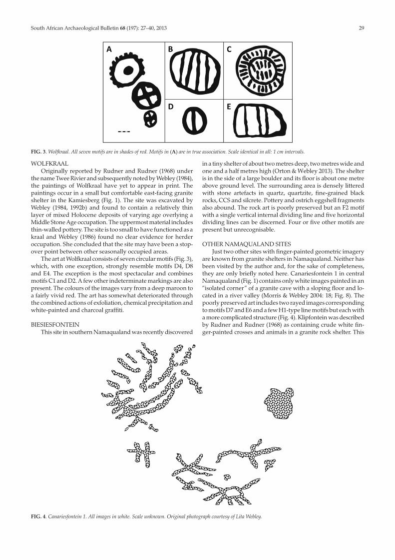
WOLFKRAALOriginally reported by Rudner and Rudner (1968) under
the name Twee Rivier and subsequently noted by Webley (1984),the paintings of Wolfkraal have yet to appear in print. Thepaintings occur in a small but comfortable east-facing graniteshelter in the Kamiesberg (Fig. 1). The site was excavated byWebley (1984, 1992b) and found to contain a relatively thinlayer of mixed Holocene deposits of varying age overlying aMiddle Stone Age occupation. The uppermost material includesthin-walled pottery. The site is too small to have functioned as akraal and Webley (1986) found no clear evidence for herderoccupation. She concluded that the site may have been a stop-over point between other seasonally occupied areas.
The art at Wolfkraal consists of seven circular motifs (Fig. 3),which, with one exception, strongly resemble motifs D4, D8and E4. The exception is the most spectacular and combinesmotifs C1 and D2. A few other indeterminate markings are alsopresent. The colours of the images vary from a deep maroon toa fairly vivid red. The art has somewhat deteriorated throughthe combined actions of exfoliation, chemical precipitation andwhite-painted and charcoal graffiti.
BIESIESFONTEINThis site in southern Namaqualand was recently discovered
in a tiny shelter of about two metres deep, two metres wide andone and a half metres high (Orton & Webley 2013). The shelteris in the side of a large boulder and its floor is about one metreabove ground level. The surrounding area is densely litteredwith stone artefacts in quartz, quartzite, fine-grained blackrocks, CCS and silcrete. Pottery and ostrich eggshell fragmentsalso abound. The rock art is poorly preserved but an F2 motifwith a single vertical internal dividing line and five horizontaldividing lines can be discerned. Four or five other motifs arepresent but unrecognisable.
OTHER NAMAQUALAND SITESJust two other sites with finger-painted geometric imagery
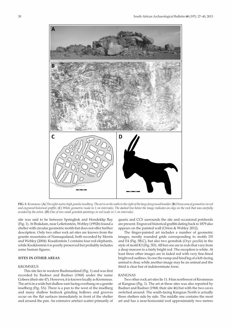
are known from granite shelters in Namaqualand. Neither hasbeen visited by the author and, for the sake of completeness,they are only briefly noted here. Canariesfontein 1 in centralNamaqualand (Fig. 1) contains only white images painted in an”isolated corner” of a granite cave with a sloping floor and lo-cated in a river valley (Morris & Webley 2004: 18; Fig. 8). Thepoorly preserved art includes two rayed images correspondingto motifs D7 and E6 and a few H1-type line motifs but each witha more complicated structure (Fig. 4). Klipfontein was describedby Rudner and Rudner (1968) as containing crude white fin-ger-painted crosses and animals in a granite rock shelter. This
FIG. 3. Wolfkraal. All seven motifs are in shades of red. Motifs in (A) are in true association. Scale identical in all: 1 cm intervals.
FIG. 4. Canariesfontein 1. All images in white. Scale unknown. Original photograph courtesy of Lita Webley.
site was said to be between Springbok and Hondeklip Bay(Fig. 1). At Brakdam, near Leliefontein, Webley (1992b) found ashelter with circular geometric motifs but does not offer furtherdescription. Only two other rock art sites are known from thegranite mountains of Namaqualand, both recorded by Morrisand Webley (2004): Kraaifontein 1 contains four red elephants,while Kookfontein 6 is poorly preserved but probably includessome human figures.
SITES IN OTHER AREAS
KROMNEUSThis site lies in western Bushmanland (Fig. 1) and was first
recorded by Rudner and Rudner (1968) under the nameGobees (their site 47). However, it is known locally as Kromneus.The art is in a wide but shallow east-facing overhang on a graniteinselberg (Fig. 5A). There is a pan to the west of the inselbergand many shallow bedrock grinding hollows and groovesoccur on the flat surfaces immediately in front of the shelterand around the pan. An extensive artefact scatter primarily of
quartz and CCS surrounds the site and occasional potsherdsare present. Engraved historical graffiti dating back to 1879 alsoappears on the painted wall (Orton & Webley 2012).
The finger-painted art includes a number of geometricimages, mostly rounded grids corresponding to motifs D5and E4 (Fig. 5B,C), but also two gemsbok (Oryx gazella) in thestyle of motif K3 (Fig. 5D). All but one are in reds that vary froma deep maroon to a fairly bright red. The exception is white. Atleast three other images are in faded red with very fine-linedbright red outlines. In one the rump and hind leg of a left-facinganimal is clear, while another image may be an animal and thethird is clear but of indeterminate form.
KANGNASTwo other rock art sites lie 11. 8 km northwest of Kromneus
at Kangnas (Fig. 1). The art at these sites was also reported byRudner and Rudner (1968; their site 46) but with the two cavesswitched around. The south-facing Kangnas North is actuallythree shelters side by side. The middle one contains the mostart and has a near-horizontal roof approximately two metres
30 South African Archaeological Bulletin 68 (197): 27–40, 2013
FIG. 5. Kromneus. (A) The eight-metre-high granite inselberg. The art is on the walls to the right of the large foreground boulder. (B) Dense area of geometrics in redand engraved historical graffiti. (C) White geometric (scale in 1 cm intervals). The dashed line below the image indicates an edge on the rock that was carefullyavoided by the artist. (D) One of two small gemsbok paintings in red (scale in 1 cm intervals).
South African Archaeological Bulletin 68 (197): 27–40, 2013 31
above a sloping rock floor. It is about 4 m deep. In front is asandy area that has been badly disturbed through modern use,but, given the low level of the site relative to what would be ariver after good rains, there may never have been any substan-tial deposit present (Orton & Webley 2012). The main sheltercontains some indeterminate shapes in thick white paint aswell as several other images in a strange dark pigment andsome in red. One of the dark images resembles motif D4 butwith the central cross created by two lines in each direction. Theother images are peculiar and too poorly preserved to enableadequate description, bar noting one white rayed image. Onetypical but very faded red geometric image resembling motif F1or F2 (Eastwood & Smith 2005) is also present. The darker imag-ery is clearly enigmatic and might even be of relatively recentorigin. The western shelter is elevated and difficult to enter andhas just one indeterminate white image on its 1 m-high hori-zontal roof. The very small eastern shelter, into which one mustcrawl, has two white images on its 0. 7 m-high roof. Historicalengravings (images and names) also occur in the site but all onthe floors of the middle and eastern shelters.
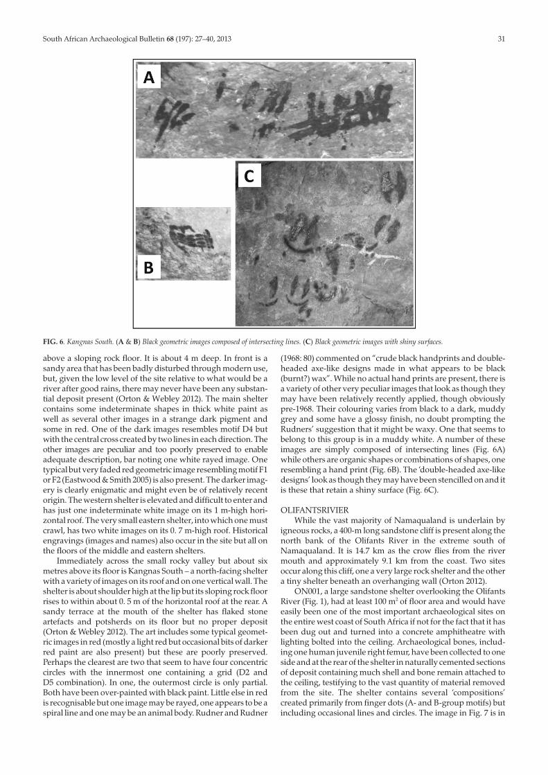
Immediately across the small rocky valley but about sixmetres above its floor is Kangnas South – a north-facing shelterwith a variety of images on its roof and on one vertical wall. Theshelter is about shoulder high at the lip but its sloping rock floorrises to within about 0. 5 m of the horizontal roof at the rear. Asandy terrace at the mouth of the shelter has flaked stoneartefacts and potsherds on its floor but no proper deposit(Orton & Webley 2012). The art includes some typical geomet-ric images in red (mostly a light red but occasional bits of darkerred paint are also present) but these are poorly preserved.Perhaps the clearest are two that seem to have four concentriccircles with the innermost one containing a grid (D2 andD5 combination). In one, the outermost circle is only partial.Both have been over-painted with black paint. Little else in redis recognisable but one image may be rayed, one appears to be aspiral line and one may be an animal body. Rudner and Rudner
(1968: 80) commented on “crude black handprints and double-headed axe-like designs made in what appears to be black(burnt?) wax”. While no actual hand prints are present, there isa variety of other very peculiar images that look as though theymay have been relatively recently applied, though obviouslypre-1968. Their colouring varies from black to a dark, muddygrey and some have a glossy finish, no doubt prompting theRudners’ suggestion that it might be waxy. One that seems tobelong to this group is in a muddy white. A number of theseimages are simply composed of intersecting lines (Fig. 6A)while others are organic shapes or combinations of shapes, oneresembling a hand print (Fig. 6B). The ‘double-headed axe-likedesigns’ look as though they may have been stencilled on and itis these that retain a shiny surface (Fig. 6C).
OLIFANTSRIVIERWhile the vast majority of Namaqualand is underlain by
igneous rocks, a 400-m long sandstone cliff is present along thenorth bank of the Olifants River in the extreme south ofNamaqualand. It is 14.7 km as the crow flies from the rivermouth and approximately 9.1 km from the coast. Two sitesoccur along this cliff, one a very large rock shelter and the othera tiny shelter beneath an overhanging wall (Orton 2012).
ON001, a large sandstone shelter overlooking the OlifantsRiver (Fig. 1), had at least 100 m2 of floor area and would haveeasily been one of the most important archaeological sites onthe entire west coast of South Africa if not for the fact that it hasbeen dug out and turned into a concrete amphitheatre withlighting bolted into the ceiling. Archaeological bones, includ-ing one human juvenile right femur, have been collected to oneside and at the rear of the shelter in naturally cemented sectionsof deposit containing much shell and bone remain attached tothe ceiling, testifying to the vast quantity of material removedfrom the site. The shelter contains several ‘compositions’created primarily from finger dots (A- and B-group motifs) butincluding occasional lines and circles. The image in Fig. 7 is in
FIG. 6. Kangnas South. (A & B) Black geometric images composed of intersecting lines. (C) Black geometric images with shiny surfaces.
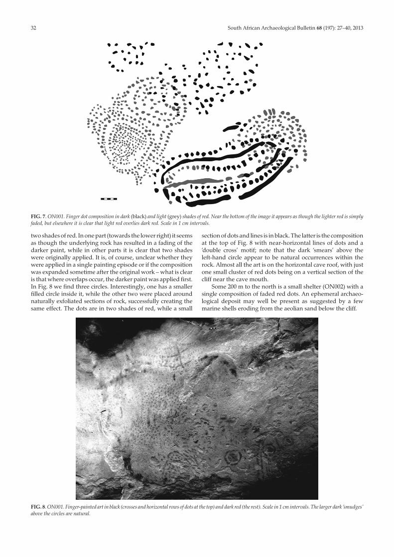
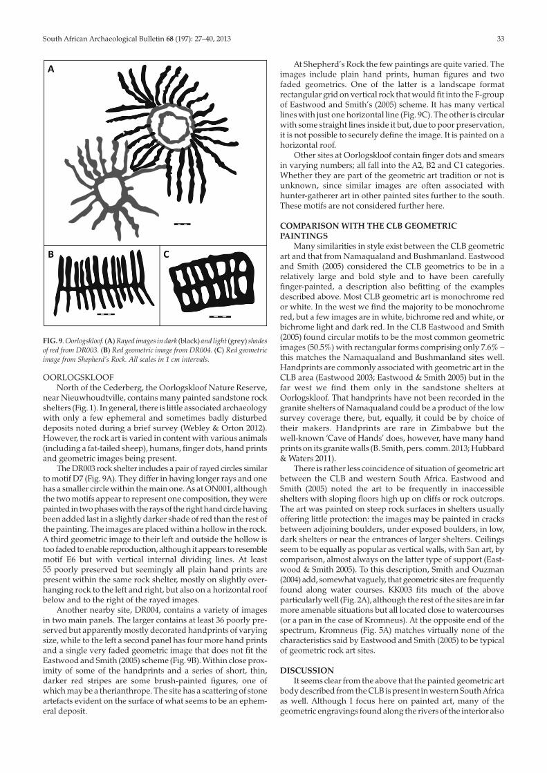
two shades of red. In one part (towards the lower right) it seemsas though the underlying rock has resulted in a fading of thedarker paint, while in other parts it is clear that two shadeswere originally applied. It is, of course, unclear whether theywere applied in a single painting episode or if the compositionwas expanded sometime after the original work – what is clearis that where overlaps occur, the darker paint was applied first.In Fig. 8 we find three circles. Interestingly, one has a smallerfilled circle inside it, while the other two were placed aroundnaturally exfoliated sections of rock, successfully creating thesame effect. The dots are in two shades of red, while a small
section of dots and lines is in black. The latter is the compositionat the top of Fig. 8 with near-horizontal lines of dots and a‘double cross’ motif; note that the dark ‘smears’ above theleft-hand circle appear to be natural occurrences within therock. Almost all the art is on the horizontal cave roof, with justone small cluster of red dots being on a vertical section of thecliff near the cave mouth.
Some 200 m to the north is a small shelter (ON002) with asingle composition of faded red dots. An ephemeral archaeo-logical deposit may well be present as suggested by a fewmarine shells eroding from the aeolian sand below the cliff.
32 South African Archaeological Bulletin 68 (197): 27–40, 2013
FIG. 7. ON001. Finger dot composition in dark (black) and light (grey) shades of red. Near the bottom of the image it appears as though the lighter red is simplyfaded, but elsewhere it is clear that light red overlies dark red. Scale in 1 cm intervals.
FIG. 8. ON001. Finger-painted art in black (crosses and horizontal rows of dots at the top) and dark red (the rest). Scale in 1 cm intervals. The larger dark ‘smudges’above the circles are natural.
South African Archaeological Bulletin 68 (197): 27–40, 2013 33
OORLOGSKLOOFNorth of the Cederberg, the Oorlogskloof Nature Reserve,
near Nieuwhoudtville, contains many painted sandstone rockshelters (Fig. 1). In general, there is little associated archaeologywith only a few ephemeral and sometimes badly disturbeddeposits noted during a brief survey (Webley & Orton 2012).However, the rock art is varied in content with various animals(including a fat-tailed sheep), humans, finger dots, hand printsand geometric images being present.
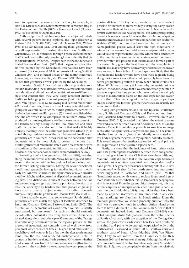
The DR003 rock shelter includes a pair of rayed circles similarto motif D7 (Fig. 9A). They differ in having longer rays and onehas a smaller circle within the main one. As at ON001, althoughthe two motifs appear to represent one composition, they werepainted in two phases with the rays of the right hand circle havingbeen added last in a slightly darker shade of red than the rest ofthe painting. The images are placed within a hollow in the rock.A third geometric image to their left and outside the hollow istoo faded to enable reproduction, although it appears to resemblemotif E6 but with vertical internal dividing lines. At least55 poorly preserved but seemingly all plain hand prints arepresent within the same rock shelter, mostly on slightly over-hanging rock to the left and right, but also on a horizontal roofbelow and to the right of the rayed images.
Another nearby site, DR004, contains a variety of imagesin two main panels. The larger contains at least 36 poorly pre-served but apparently mostly decorated handprints of varyingsize, while to the left a second panel has four more hand printsand a single very faded geometric image that does not fit theEastwood and Smith (2005) scheme (Fig. 9B). Within close prox-imity of some of the handprints and a series of short, thin,darker red stripes are some brush-painted figures, one ofwhich may be a therianthrope. The site has a scattering of stoneartefacts evident on the surface of what seems to be an ephem-eral deposit.
At Shepherd’s Rock the few paintings are quite varied. Theimages include plain hand prints, human figures and twofaded geometrics. One of the latter is a landscape formatrectangular grid on vertical rock that would fit into the F-groupof Eastwood and Smith’s (2005) scheme. It has many verticallines with just one horizontal line (Fig. 9C). The other is circularwith some straight lines inside it but, due to poor preservation,it is not possible to securely define the image. It is painted on ahorizontal roof.
Other sites at Oorlogskloof contain finger dots and smearsin varying numbers; all fall into the A2, B2 and C1 categories.Whether they are part of the geometric art tradition or not isunknown, since similar images are often associated withhunter-gatherer art in other painted sites further to the south.These motifs are not considered further here.
COMPARISON WITH THE CLB GEOMETRICPAINTINGS
Many similarities in style exist between the CLB geometricart and that from Namaqualand and Bushmanland. Eastwoodand Smith (2005) considered the CLB geometrics to be in arelatively large and bold style and to have been carefullyfinger-painted, a description also befitting of the examplesdescribed above. Most CLB geometric art is monochrome redor white. In the west we find the majority to be monochromered, but a few images are in white, bichrome red and white, orbichrome light and dark red. In the CLB Eastwood and Smith(2005) found circular motifs to be the most common geometricimages (50.5%) with rectangular forms comprising only 7.6% –this matches the Namaqualand and Bushmanland sites well.Handprints are commonly associated with geometric art in theCLB area (Eastwood 2003; Eastwood & Smith 2005) but in thefar west we find them only in the sandstone shelters atOorlogskloof. That handprints have not been recorded in thegranite shelters of Namaqualand could be a product of the lowsurvey coverage there, but, equally, it could be by choice oftheir makers. Handprints are rare in Zimbabwe but thewell-known ‘Cave of Hands’ does, however, have many handprints on its granite walls (B. Smith, pers. comm. 2013; Hubbard& Waters 2011).
There is rather less coincidence of situation of geometric artbetween the CLB and western South Africa. Eastwood andSmith (2005) noted the art to be frequently in inaccessibleshelters with sloping floors high up on cliffs or rock outcrops.The art was painted on steep rock surfaces in shelters usuallyoffering little protection: the images may be painted in cracksbetween adjoining boulders, under exposed boulders, in low,dark shelters or near the entrances of larger shelters. Ceilingsseem to be equally as popular as vertical walls, with San art, bycomparison, almost always on the latter type of support (East-wood & Smith 2005). To this description, Smith and Ouzman(2004) add, somewhat vaguely, that geometric sites are frequentlyfound along water courses. KK003 fits much of the aboveparticularly well (Fig. 2A), although the rest of the sites are in farmore amenable situations but all located close to watercourses(or a pan in the case of Kromneus). At the opposite end of thespectrum, Kromneus (Fig. 5A) matches virtually none of thecharacteristics said by Eastwood and Smith (2005) to be typicalof geometric rock art sites.
DISCUSSIONIt seems clear from the above that the painted geometric art
body described from the CLB is present in western South Africaas well. Although I focus here on painted art, many of thegeometric engravings found along the rivers of the interior also
FIG. 9. Oorlogskloof. (A) Rayed images in dark (black) and light (grey) shadesof red from DR003. (B) Red geometric image from DR004. (C) Red geometricimage from Shepherd’s Rock. All scales in 1 cm intervals.
seem to represent the same artistic tradition, for example, atsites like Driekopseiland where many motifs corresponding tothe Eastwood and Smith (2005) scheme are found (Dowson1992: 48–50; Smith & Ouzman 2004).
Authorship of rock art has long been a subject of debatewith several papers having explored the topic (Rudner &Rudner 1959; B. Smith 2006; Smith & Ouzman 2004; Willcox1959, 1960; Van Rijssen 1984, 1994). Among them, geometric artis well represented. Exploring this tradition, Smith andOuzman (2004: 511) concluded through a process of eliminationthat “Khoekhoen is the only remaining known identity that fitsthe distributional evidence.” Despite both their confidence andthat of Eastwood and Smith (2005) that the geometric traditionart was painted by the Khoekhoen, reservations have beenexpressed (Parkington et al. 2008; comments following Smith &Ouzman 2004) and informal debate on the matter continues.Interestingly, a decade earlier, Van Rijssen (1994: 174) also con-cluded that geometric art was painted by the Khoekhoen.
In western South Africa, rock art authorship is also prob-lematic. In deciding the matter, however, several factors requireconsideration: (1) fine-line and geometric art are so different instyle and content that they very likely represent differenttraditions belonging to different people (Smith & Ouzman2004; Van Rijssen 1994); (2) following mid-second millenniumAD historical records, there are three known potential authorgroups in western South Africa, hunter-gatherers, herders (inthe broadest sense) and Europeans; (3) it is well established thatfine-line art, which is so widespread in southern Africa, wasproduced by hunter-gatherers; (4) Europeans were present inthe landscape only during the last few centuries and theirgraffiti is painted in styles and colours that make it highlyunlikely that they were the authors of geometric art; and (5) asnoted above, consideration of the distributions of fine-line andgeometric art in southern Africa leads to the conclusion thatgeometric art is far more likely to belong to herders thanhunter-gatherers. It can thus be stated with a reasonable degreeof confidence that geometric tradition art was produced byherders of one sort or another (this is explored further below).
Reverting briefly to engraved art, Morris (1988), workingalong the interior rivers of South Africa, has recognised differ-ences in the content of fine line and pecked engravings withthe former lacking ‘sun-bursts’, having far fewer curvilinearmotifs, and generally having far smaller individual motifs.Early on, Willcox (1963) noted the significance of rayed circularmotifs which, he said, occurred at all pecked geometric engrav-ing sites. This distinction in subject matter between fine-lineand pecked engravings may offer support for authorship of atleast the latter style by herders, but, that pecked engravingshave such a diverse subject matter – including domesticanimals – may also be problematic (Morris 1988; Wallis 2004).
I have already noted that some western South Africangeometric art sites match the types of locations described bySmith and Ouzman (2004) and Eastwood and Smith (2005). Thedistribution of geometric art along water courses is rightlyemphasised, but any search for such art should certainlyinclude other potential areas away from rivers. Kromneus,located alongside an endorheic pan 85 km south of the OrangeRiver (the only perennial river in the region), proves that themakers of geometric art certainly moved well away fromperennial water courses at times. This pan (and others like it)would have held water only for a few months after good summerrains from the east and rendered Bushmanland useful togroups of herders seeking fresh pasture. Of course whetherherders would have lived at Kromneus for any length of time isunknown – they probably moved about between pans as the
grazing dictated. The key here, though, is that pans made itpossible for herders to move widely during the rainy seasonand to make their art far away from rivers. In Namaqualand asimilar dynamic would have operated, but with springs beingthe reliable water sources. However, the distribution of springsremains unknown and for now no comparisons can be drawn.Webley (2007) has described seasonal transhumance inNamaqualand: people would leave the high mountains inwinter for the warmer Sandveld where non-perennial streamswould flow in response to the westerly winter rains, and returnto the mountains in summer when springs would continue toprovide water. It is possible that Bushmanland formed part ofthis system but, given the heat there and the irregularity ofrainfall, this may only have been at very short notice when rainwas known to have fallen. It is perhaps more likely that theBushmanland herders would have been those regularly livingalong the Orange River – they would probably have been in abetter geographical position to know when suitable rains hadfallen. While we do not yet know why geometric art waspainted, the above shows that it was not necessarily painted inplaces occupied for long periods, but may rather have simplyserved to mark certain places on the landscape for one reasonor another. This marking of the landscape is perhapsemphasised by the fact that geometric art sites are usually notsuited to habitation.
Along with geometric art, and like Van Rijssen (1994) beforethem, Smith and Ouzman (2004) and Eastwood and Smith(2005) ascribed handprints to herders. However, Smith andOuzman (2005: 514) conceded that “given the extent of cross-over and alliance between San and Khoekhoen rock arts in theWestern Cape, it is not always possible to associate an imagesuch as the handprint exclusively with one group.“ The issue ofwhether hand prints can, in fact, confidently be associated withthis body of geometric art is, in my opinion, not fully resolved.This would suggest that further exploration of hand prints isstill required and I discuss three aspects here.
Firstly, it is clear that the incidence of hand prints varieswith a far greater spatial association between them and geomet-ric art being evident in the CLB than elsewhere, althoughManhire (1981) did note that in the Western Cape Sandveldgeometric art was often associated with finger dots and/orhand prints. The greater prevalence of handprints at CLB sitesas compared with sites further north stretching into centralAfrica suggested to Eastwood and Smith (2005: 69) that“handprints subsequently came to replace finger markings atmore southerly sites”. Whether this is a temporal or geographicalshift is not stated. From the geographical perspective, this maybe too simplistic an interpretation since hand prints occur allover the world (Manhire 1998); they might thus have beenmade by anyone, anywhere, at any time, and, in any case,finger markings are abundant in South Africa. From thetemporal perspective we should probably question why theshift was so prevalent only in southern Africa. Hand printsseem to have a different distribution in South Africa to that ofgeometric art. Indeed, Smith and Ouzman (2004:509) evennoted handprints to be “oddly absent” from the central interiorof South Africa and, with the exception of the Oorlogskloofsites, all the geometric sites described here lack hand prints. Wethus find hand prints to be strongly emphasised only in thenortheastern (Eastwood & Smith 2005), southwestern andsouthern parts of South Africa (Manhire 1998; Van Rijssen1994). Only six are known from the Drakensberg (Smith &Ouzman 2004 and references therein). Although hand printsoccur in southern and central Namibia (Vogelsang & Eichhorn2011: fig. 115), they are completely absent from the relatively
34 South African Archaeological Bulletin 68 (197): 27–40, 2013
South African Archaeological Bulletin 68 (197): 27–40, 2013 35
arid western and central parts of South Africa where herdersare best documented and we may thus need to consider thepossibility that hand prints do not relate as directly to geometricpaintings as previously considered.
Another anomaly is the incidence of plain and decoratedhand prints. In the CLB decorated hand prints are entirelyabsent (B. Smith pers. comm. 2012) and the plain prints socommonly found are confidently ascribed to the geometric arttradition (Eastwood & Smith 2005; Smith & Ouzman 2004). Inthe southwestern part of South Africa plain prints have a widedistribution essentially matching that of fine-line rock paint-ings and frequently co-occurring with them (Manhire 1998;Yates et al. 1994). Manhire (1998) thought these prints wereprobably made by hunter-gatherers. Decorated prints, on theother hand, are common in the coastal Sandveld and also occuraround the northern and eastern fringes of the CederbergMountains; they are, however, almost entirely absent from theOlifants River valley and surrounding mountains (Wiltshire2011: map 5.4.5). Yates and colleagues (1994) add further thatthe decoration in the mountains often differs in form from thatfound on the coastal plain. Since historical observations sug-gested the Khoekhoen to have favoured land good for grazing,Manhire (1998) proposed that the decorated prints were likelythose of herders, since the coastal plain and mountain fringeswould have been more suited to the keeping of domestic stockthan the mountains. This is obviously at odds with theCLB interpretation and why such a disjunction between thetwo areas should occur cannot be explained.
A third issue related to hand prints is that of colour. East-wood and Smith (2005) note that in the CLB the majority of
hand prints were made in white or yellow but that red, orangeand occasionally black prints also occurred. This is in starkcontrast to the Western Cape record where handprints werealmost always in shades of red to orange with white or blackprints being rare and yellow not occurring at all (Manhire 1998;Yates et al. 1994). Yellow paint is not uncommon in other art sothis dearth cannot be due to pigment availability. The completeabsence of hand prints from the intervening areas preventsfurther understanding of colour distributions.
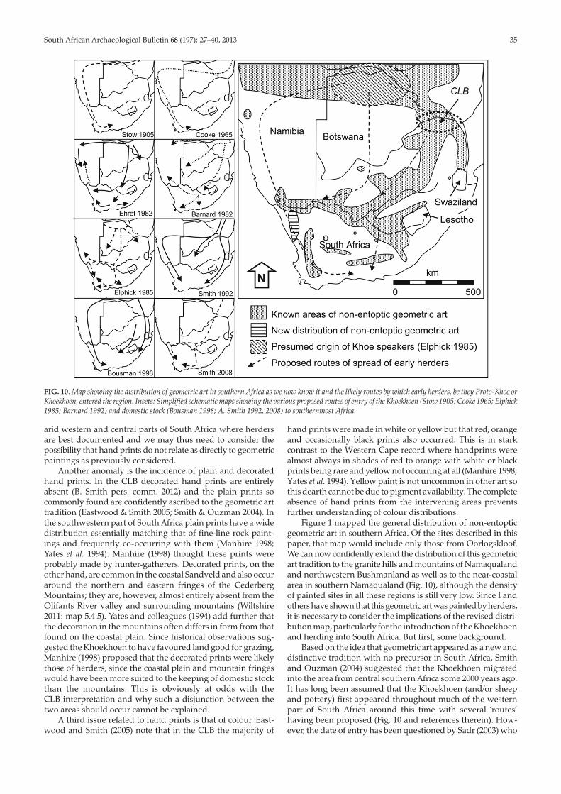
Figure 1 mapped the general distribution of non-entopticgeometric art in southern Africa. Of the sites described in thispaper, that map would include only those from Oorlogskloof.We can now confidently extend the distribution of this geometricart tradition to the granite hills and mountains of Namaqualandand northwestern Bushmanland as well as to the near-coastalarea in southern Namaqualand (Fig. 10), although the densityof painted sites in all these regions is still very low. Since I andothers have shown that this geometric art was painted by herders,it is necessary to consider the implications of the revised distri-bution map, particularly for the introduction of the Khoekhoenand herding into South Africa. But first, some background.
Based on the idea that geometric art appeared as a new anddistinctive tradition with no precursor in South Africa, Smithand Ouzman (2004) suggested that the Khoekhoen migratedinto the area from central southern Africa some 2000 years ago.It has long been assumed that the Khoekhoen (and/or sheepand pottery) first appeared throughout much of the westernpart of South Africa around this time with several ‘routes’having been proposed (Fig. 10 and references therein). How-ever, the date of entry has been questioned by Sadr (2003) who
FIG. 10. Map showing the distribution of geometric art in southern Africa as we now know it and the likely routes by which early herders, be they Proto-Khoe orKhoekhoen, entered the region. Insets: Simplified schematic maps showing the various proposed routes of entry of the Khoekhoen (Stow 1905; Cooke 1965; Elphick1985; Barnard 1992) and domestic stock (Bousman 1998; A. Smith 1992, 2008) to southernmost Africa.
sees the pottery evidence suggesting a Khoekhoen incursiononly about AD 900. This is supported by changes in lithicassemblages at Kasteelberg (Sadr 1998; Sadr et al. 2003) andElands Bay (Orton 2006) at similar dates.
Using evidence from coastal Namaqualand and drawingon the recent linguistic work of Güldemann (2008), I have dem-onstrated that the Khoekhoen may, in fact, have arrived thereduring the mid-1st millennium AD with proto-Khoe-speakinghunter-gatherers having brought sheep and pottery intowestern South Africa several centuries earlier (Orton 2012).Whether a marginally earlier wave of diffusion amonghunter-gatherers occurred remains – and perhaps always willremain – unresolved. Although cattle are less well documentedin the archaeological record, recent research suggests theywere present in Namaqualand since at least the mid-firstmillennium AD (Orton et al. 2013), perhaps arriving with theKhoekhoen. It is unfortunate that dating of rock art is at presentso difficult, but it is hoped that one day we will be able to datethese paintings and that the art may be able to make a greatercontribution to the various debates surrounding the origins ofherding in southernmost Africa.
Historical records describing the Khoekhoen and theirmaterial culture from Namaqualand abound but, despite thecontinued assumption of their presence in pre-colonial times,archaeological evidence for this has been sparse with perhapsonly sites at Jakkalsberg on the Orange River being reasonablyconvincing as ‘herder sites’ (Brink & Webley 1996; Webley1997). At Spoeg River Cave on the central Namaqualand coast,Vogel and colleagues (1997) concluded that either herders werepresent or local hunter-gatherers had successfully made thetransition to herding during the first millennium AD. However,writing later, Webley (2002) remained unconvinced of eitherinterpretation.
My work on open sites along the coast north of Spoeg RiverCave demonstrates the introduction of two new assemblagetypes within the period in question (Orton 2012). The earlierintroduction, around 2000 years ago, was of highly formalisedbacked bladelet-rich assemblages based almost exclusively onlocally available clear quartz. That they were so very differentfrom those that preceded them hints at demic migration as thereason for their appearance. These assemblages, I suggested,were left by early Khoe-speaking hunter-gatherers who movedinto the area with limited livestock (sheep) and had not yetmade the transition to a fully Khoekhoe lifestyle. Whether werefer to these people as hunters-with-stock (cf. Sadr2003: 196),early herders or even early Khoekhoen groups (as distinct fromthe later and historically attested Khoekhoen) is perhaps bestleft to future debate. A new type of stone artefact assemblageentered the landscape during the mid-first millennium AD andcame to dominate in later times. These assemblages were veryinformal and based almost exclusively on milky quartz, whichis abundant in the area. Such assemblages have elsewhere beenassociated with herders (A. Smith et al. 1991) and this seems areasonable conclusion in Namaqualand too (Orton 2012).Assemblages typical of the pre-pottery period are rare inNamaqualand within the last 2000 years but do occur (twohave been dated to the centuries immediately pre- and post-dating AD1, while four more date after the mid-first millen-nium AD); they contain backed artefacts and scrapers andgenerally have some 20% to 40% of their flaked artefactsin CCS, usually including all the retouched pieces. Owing tothe continuity expressed within them on either side of AD1,parsimony favours their being ascribed to hunter-gatherers(Orton 2012). The co-occurrence of three distinct lithic signatureswithin the last 2000 years certainly confuses matters and the
scenario I have proposed needs to be tested in other areas. Theproblem, of course, is that in other areas, specifically theNorthern Cape interior (Beaumont et al. 1995; Parsons 2007)and Vredenburg Peninsula (A. Smith et al. 1991), just two clearlithic traditions have been identified. Interestingly, as inNamaqualand, Sampson (2010) has postulated the presence ofthree co-existing economies (terming them hunter-foragers,hunters-with-sheep and herders) in the upper Seacow RiverValley but these are not identified through lithics, and for thetime being do not inform the present discussion. Given theascription of geometric tradition art to Khoekhoe herders (andperhaps also to the early Khoe groups), it thus serves as the firstclear indicator of their pre-colonial presence in the region southof the Orange River (assuming, of course, that at least some ofthe art is pre-colonial in age). I turn now to the implications ofgeometric art for the spread of herding through southernAfrica.
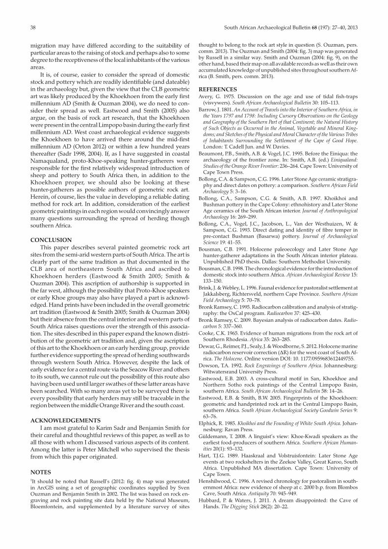
Fig. 10 indicates all the various routes by which theKhoekhoen and/or sheep and pottery are suggested to havespread into and through South Africa. With the earliest SouthAfrican sheep (from Spoeg River Cave; Table 1; Sealy & Yates1994) and cattle (from KN2005/041; Table 1; Orton et al. 2013)being from the west coast, evidence is surely mounting tosupport Namaqualand as the first route of their entry into thesouthwestern Cape. It has been argued elsewhere that thecattle date is too early to allow for them having been obtainedfrom Early Iron Age farmers in the far east of South Africa(Orton et al. 2013). Two caprine teeth are also present in an earlycontext at Buzz Shelter in the Knersvlakte (Table 1; Orton 2012),while caprines are associated with an early date at /Ai tomas inthe Richtersveld (Webley 1992b). However, given the lack ofclear stratigraphy, the presence of pits in the deposit and thevastly differing dates from similar depths in different partsof /Ai tomas, it may be prudent not to emphasise this early datewithout directly dating the relevant bones. Recently datedcaprine teeth from Leopard Cave in central Namibia (finalthree centuries BC; Pleurdeau et al. 2012) add another piece ofevidence and are in fact currently the earliest domesticatesfrom southern Africa. Cattle and sheep from Toteng in Botswanaare around 2000 years old (Robbins et al. 2005) with Toteng’scattle being the oldest from southern Africa.
Overall, pottery is perhaps not particularly helpful, since itis ubiquitous along the Namaqualand coast and associatedwith several early dates, including that from /Ai tomas (Table 1).Thus far the only early date from the central interior is from agrass tempered pot sherd (Table 1; Sadr & Sampson 2006) of thesort commonly associated with hunter-gatherers (Bollong et al.1993, 1997; Rudner 1979). Reliably dated early sheep occur onthe south coast at Blombos (Henshilwood 1996) and Hawston(Avery 1975) but, while many stone-built kraals occur in theSeacow River valley, Khoekhoe occupation there is only datedto after the mid-first millennium AD (Bollong & Sampson 1996;Bousman 1991, 1998; Hart 1989; Plug et al. 1994; Sampson 1985,2010; Sampson & Vogel 1995). In Namaqualand, the combinedevidence of stone tool assemblages and domestic stock bonesmay, for the first time, link the south coast and the OrangeRiver. The geometric rock art, if it were dated, would provideanother very important strand of evidence. I should note,again, that this discussion does not preclude the first sheep andpottery being brought into southernmost Africa through diffu-sion by indigenous hunter-gatherers ahead of herder groupswho would no doubt have been the source.
It seems then that some combination of the Elphick (1985)and Cooke (1965) routes would be the most likely, as that wouldbe the best way to explain the early presence of sheep, cattle
36 South African Archaeological Bulletin 68 (197): 27–40, 2013
South African Archaeological Bulletin 68 (197): 27–40, 2013 37
and pottery in such disparate areas as northern Namibia (e.g.Kinahan 2001; Smith & Jacobson 1995), and the western (e.g.Webley 1992a, 1997) and southern (e.g. Henshilwood 1996;Schweitzer 1979) parts of South Africa. Although evidencefrom the central interior, and in particular the Seacow Rivervalley, is lacking, I believe it may yet come to light with furtherresearch, although Sampson (2010) may disagree. It is interest-ing to note Barrow’s description of the Seacow River. He sawlong stretches of open water up to “five or six miles in length,and deep enough to have floated a line-of-battle ship”(Barrow1801:255). He also noted the surrounding plains to contain“springboks in countless troops, hartebeests, and bonteboks …quachas from fifty to a hundred in a troop were hourly seen”(Barrow 1801: 263). That the Seacow River could support somuch wild game certainly suggests that it could have been aconduit for sheep and pastoralism towards the south coast or,in Sampson’s (2010) view, northwards from the south coast.
Barrow (1801) does not state to which part of the SeacowRiver he refers, but we can probably assume such large pools tobe fairly far downstream. Sampson (2010), however, notes thepresence of many hundreds of surface water-points through-out the valley. Barrow comments on the sparsity of vegetationin the vicinity of the Sneeuberg past which he travelled on hisway into the Seacow River valley. Given that herders clearlymoved through semi-arid Namaqualand and almost certainlyNamibia, it seems quite plausible that they could have crossedsome difficult terrain between the headwaters of the SeacowRiver and those of the Groot, Sundays or Fish Rivers to thesouth – this area is certainly wetter than the far west of thecountry. Furthermore, Mitchell and colleagues (2008; Mitchell2009) have argued from the evidence of Likoeng thathunter-gatherers moved live sheep and cattle some 100to 150 km across the 3000 m high Drakensberg into highlandLesotho during the late first millennium AD. This certainlyallows for the crossing of far lower watersheds further west.Despite their scale (covering about 40 km by 60 km), thesurveys of Sampson and colleagues have only covered a part ofthe Seacow River catchment and it is suggested that newsurveys in other parts of the system and also in catchments tothe south of its watershed could yield herder archaeologyolder than what is currently on record. Further analysis of thecentral interior route may have to be delayed until such time asarchaeologists can cover these areas satisfactorily. Altogether,the Seacow River runs about 170 km from its southerly water-shed to its confluence with the Orange River. From the samewatershed the Sundays River flows about 70 km to Graaff-Reinet where it breaks free of the Great Escarpment. Both, ofcourse, have many tributary streams. I suggest, as shown inFig. 10, that the earliest South African herders moved into thecountry via Namibia, central Botswana and the CLB. From thelatter two regions they probably expanded southwestwards butI would not be surprised if early herders yet come to light in thecentral interior in one or more of the river valleys linking theOrange River with the south coast.
It is now generally accepted that the pastoralist elements(i.e. mineral-tempered pottery, sheep, cattle and the peoplethemselves) spread at different times and perhaps also at quitedifferent rates. It is important to note that the very first potteryand sheep could well have arrived in South Africa throughdiffusion and adoption by indigenous societies (Sadr 2002,2003), with a more substantial introduction occurring soonthereafter. The dating and lithic evidence from Namaqualandas outlined above suggests that the first cattle, on the otherhand, are more likely to have arrived through migration withthe Khoekhoen themselves. The rates of diffusion and/orTA
BLE
1.R
adio
carb
onda
tesr
efer
red
toin
thet
ext.
Not
etha
talth
ough
shee
pan
dgo
atar
ediff
icul
ttod
istin
guis
hin
thea
bsen
ceof
horn
core
s,sh
eep
arel
iste
dbe
caus
eear
lyid
entif
icat
ions
ofgo
atar
elac
king
.Cal
ibra
tions
cond
ucte
don
OxC
alV
ersi
on4.
2(B
ronk
-Ram
sey
1995
,200
9).T
erre
stri
alca
libra
tions
uset
heSH
CA
L04
curv
e(M
cCor
mac
etal
.200
4),w
hile
mar
ines
hell
calib
ratio
nsus
eMA
RIN
E09
(Rei
mer
etal
.200
9)an
da
aR
of13
8±
98(D
ewar
etal
.20
12).
Site
Labo
rato
ry14
Cag
eÇ
13C
Mat
eria
lC
alib
rate
dR
elev
ance
Ref
eren
ces
num
ber
at2
sigm
a(9
5.4%
)
/Ait
omas
(Ric
hter
svel
d)Pt
a-55
3019
80±
80–1
9.7
Cha
rred
bone
159
BC
–AD
317
Earl
ysh
eep
and
pott
ery
Web
ley
1992
b,pe
rs.c
omm
.201
2SK
2005
/084
(cen
tral
Nam
aqua
land
coas
t)U
GA
MS-
6608
2420
±30
–1.0
Mar
ine
shel
l19
6B
C–A
D32
5Ea
rly
pott
ery
Ort
on20
12K
N20
05/0
41(c
entr
alN
amaq
uala
ndco
ast)
OxA
-229
3316
25±
25–1
5.75
Bone
(Bos
taur
us)
AD
421–
559
Dir
ectd
ate
onca
ttle
Ort
on20
12;O
rton
etal
.201
3Sp
oeg
Riv
erC
ave
(cen
tral
Nam
aqua
land
coas
t)O
xA-3
862
2105
±65
–14.
1Bo
ne(O
vis
arie
s)35
0B
C–A
D11
5D
irec
tdat
eon
shee
pSe
aly
&Ya
tes
1994
Spoe
gR
iver
Cav
e(c
entr
alN
amaq
uala
ndco
ast)
Pta-
6749
1930
±50
–17.
9C
harc
oal
AD
6–31
3Ea
rly
pott
ery
Web
ley
2002
,per
s.co
mm
.201
2Sp
oeg
Riv
erC
ave
(cen
tral
Nam
aqua
land
coas
t)G
rA-9
029
1890
±50
Unk
now
nBo
ne(O
vis
arie
s)A
D62
–333
Dir
ectd
ate
onsh
eep
Web
ley
2002
Spoe
gR
iver
Cav
e(c
entr
alN
amaq
uala
ndco
ast)
GrA
-903
219
00±
50U
nkno
wn
Bone
(Ovi
sar
ies)
AD
55–3
25D
irec
tdat
eon
shee
pW
eble
y20
02Sp
oeg
Riv
erC
ave
(cen
tral
Nam
aqua
land
coas
t)G
rA-9
028
1900
±50
Unk
now
nBo
ne(O
vis
arie
s)A
D55
–325
Dir
ectd
ate
onsh
eep
Web
ley
2002
Rec
eptio
nSh
elte
r(K
ners
vlak
te)
OxA
-253
5318
97±
25–1
9.38
Bone
(C.a
ngul
ata)
AD
85–2
92Ea
rly
pott
ery
Ort
on20
12R
ecep
tion
Shel
ter
(Kne
rsvl
akte
)O
xA-2
5354
1840
±26
–16.
08Bo
ne(O
ryx
gaze
lla)
AD
133–
336
Earl
ypo
tter
yO
rton
2012
Buzz
Shel
ter
(Kne
rsvl
akte
)O
xA-2
4515
1921
±25
–20.
71Bo
ne(C
.ang
ulat
a)A
D76
–232
Earl
ysh
eep
Ort
on20
12Bo
unda
rySh
elte
r(c
entr
alK
aroo
)G
r-A
1356
421
60±
50U
nkno
wn
Fibr
ete
mpe
r35
5B
C–A
D18
Earl
ypo
tter
ySa
dr&
Sam
pson
2006
Haw
ston
(sou
thco
ast)
Pta-
834
1860
±60
Unk
now
nC
harc
oal
AD
68–3
17A
bove
shee
pAv
ery
1975
Haw
ston
(sou
thco
ast)
Pta-
835
1900
±40
Unk
now
nC
harc
oal
AD
77–3
82Be
low
shee
pAv
ery
1975
Blom
bos
(sou
thco
ast)
OxA
-454
319
60±
50–1
2.6
Bone
(Ovi
sar
ies)
34B
C–A
D23
7D
irec
tdat
eon
shee
pH
ensh
ilwoo
d19
96Bl
ombo
s(s
outh
coas
t)O
xA-4
544
1880
±55
-12.
9Bo
ne(O
vis
arie
s)A
D62
–344
Dir
ectd
ate
onsh
eep
Hen
shilw
ood
1996
migration may have differed according to the suitability ofparticular areas to the raising of stock and perhaps also to somedegree to the receptiveness of the local inhabitants of the variousareas.
It is, of course, easier to consider the spread of domesticstock and pottery which are readily identifiable (and dateable)in the archaeology but, given the view that the CLB geometricart was likely produced by the Khoekhoen from the early firstmillennium AD (Smith & Ouzman 2004), we do need to con-sider their spread as well. Eastwood and Smith (2005) alsoargue, on the basis of rock art research, that the Khoekhoenwere present in the central Limpopo basin during the early firstmillennium AD. West coast archaeological evidence suggeststhe Khoekhoen to have arrived there around the mid-firstmillennium AD (Orton 2012) or within a few hundred yearsthereafter (Sadr 1998, 2004). If, as I have suggested in coastalNamaqualand, proto-Khoe-speaking hunter-gatherers wereresponsible for the first relatively widespread introduction ofsheep and pottery to South Africa then, in addition to theKhoekhoen proper, we should also be looking at thesehunter-gatherers as possible authors of geometric rock art.Herein, of course, lies the value in developing a reliable datingmethod for rock art. In addition, consideration of the earliestgeometric paintings in each region would convincingly answermany questions surrounding the spread of herding thoughsouthern Africa.
CONCLUSIONThis paper describes several painted geometric rock art
sites from the semi-arid western parts of South Africa. The art isclearly part of the same tradition as that documented in theCLB area of northeastern South Africa and ascribed toKhoekhoen herders (Eastwood & Smith 2005; Smith &Ouzman 2004). This ascription of authorship is supported inthe far west, although the possibility that Proto-Khoe speakersor early Khoe groups may also have played a part is acknowl-edged. Hand prints have been included in the overall geometricart tradition (Eastwood & Smith 2005; Smith & Ouzman 2004)but their absence from the central interior and western parts ofSouth Africa raises questions over the strength of this associa-tion. The sites described in this paper expand the known distri-bution of the geometric art tradition and, given the ascriptionof this art to the Khoekhoen or an early herding group, providefurther evidence supporting the spread of herding southwardsthrough western South Africa. However, despite the lack ofearly evidence for a central route via the Seacow River and othersto its south, we cannot rule out the possibility of this route alsohaving been used until larger swathes of these latter areas havebeen searched. With so many areas yet to be surveyed there isevery possibility that early herders may still be traceable in theregion between the middle Orange River and the south coast.
ACKNOWLEDGEMENTSI am most grateful to Karim Sadr and Benjamin Smith for
their careful and thoughtful reviews of this paper, as well as toall those with whom I discussed various aspects of its content.Among the latter is Peter Mitchell who supervised the thesisfrom which this paper originated.
NOTES1It should be noted that Russell’s (2012: fig. 4) map was generatedin ArcGIS using a set of geographic coordinates supplied by SvenOuzman and Benjamin Smith in 2002. The list was based on rock en-graving and rock painting site data held by the National Museum,Bloemfontein, and supplemented by a literature survey of sites
thought to belong to the rock art style in question (S. Ouzman, pers.comm. 2013). The Ouzman and Smith (2004: fig. 3) map was generatedby Russell in a similar way. Smith and Ouzman (2004: fig. 9), on theother hand, based their map on all available records as well as their ownaccumulated knowledge of unpublished sites throughout southern Af-rica (B. Smith, pers. comm. 2013).
REFERENCESAvery, G. 1975. Discussion on the age and use of tidal fish-traps
(visvywers). South African Archaeological Bulletin 30: 105–113.Barrow, J. 1801. An Account of Travels into the Interior of Southern Africa, in
the Years 1797 and 1798: Including Cursory Observations on the Geologyand Geography of the Southern Part of that Continent; the Natural Historyof Such Objects as Occurred in the Animal, Vegetable and Mineral King-doms; and Sketches of the Physical and Moral Character of the Various Tribesof Inhabitants Surrounding the Settlement of the Cape of Good Hope.London: T. Cadell Jun. and W. Davies.
Beaumont, P.B., Smith, A.B. & Vogel, J.C. 1995. Before the Einiqua: thearchaeology of the frontier zone. In: Smith, A.B. (ed.) Einiqualand:Studies of the Orange River Frontier: 236–264. Cape Town: University ofCape Town Press.
Bollong, C.A. & Sampson, C.G. 1996. Later Stone Age ceramic stratigra-phy and direct dates on pottery: a comparison. Southern African FieldArchaeology 5: 3–16.
Bollong, C.A., Sampson, C.G. & Smith, A.B. 1997. Khoikhoi andBushman pottery in the Cape Colony: ethnohistory and Later StoneAge ceramics of the South African interior. Journal of AnthropologicalArchaeology 16: 269–299.
Bollong, C.A., Vogel, J.C., Jacobson, L., Van der Westhuizen, W. &Sampson, C.G. 1993. Direct dating and identity of fibre temper inpre-contact Bushman (Basarwa) pottery. Journal of ArchaeologicalScience 19: 41–55.
Bousman, C.B. 1991. Holocene paleoecology and Later Stone Agehunter-gatherer adaptations in the South African interior plateau.Unpublished PhD thesis. Dallas: Southern Methodist University.
Bousman, C.B. 1998. The chronological evidence for the introduction ofdomestic stock into southern Africa. African Archaeological Review 15:133–150.
Brink, J. & Webley, L. 1996. Faunal evidence for pastoralist settlement atJakkalsberg, Richtersveld, northern Cape Province. Southern AfricanField Archaeology 5: 70–78.
Bronk Ramsey, C. 1995. Radiocarbon calibration and analysis of stratig-raphy: the OxCal program. Radiocarbon 37: 425–430.
Bronk Ramsey, C. 2009. Bayesian analysis of radiocarbon dates. Radio-carbon 5: 337–360.
Cooke, C.K. 1965. Evidence of human migrations from the rock art ofSouthern Rhodesia. Africa 35: 263–285.
Dewar, G., Reimer, P.J., Sealy, J. & Woodborne, S. 2012. Holocene marineradiocarbon reservoir correction (aR) for the west coast of South Af-rica. The Holocene. Online version DOI: 10. 1177/0959683612449755.
Dowson, T.A. 1992. Rock Engravings of Southern Africa. Johannesburg:Witwatersrand University Press.
Eastwood, E.B. 2003. A cross-cultural motif in San, Khoekhoe andNorthern Sotho rock paintings of the Central Limpopo Basin,southern Africa. South African Archaeological Bulletin 58: 14–26.
Eastwood, E.B. & Smith, B.W. 2005. Fingerprints of the Khoekhoen:geometric and handprinted rock art in the Central Limpopo Basin,southern Africa. South African Archaeological Society Goodwin Series 9:63–76.
Elphick, R. 1985. Khoikhoi and the Founding of White South Africa. Johan-nesburg: Ravan Press.
Güldemann, T. 2008. A linguist’s view: Khoe-Kwadi speakers as theearliest food-producers of southern Africa. Southern African Human-ities 20(1): 93–132.
Hart, T.J.G. 1989. Haaskraal and Volstruisfontein: Later Stone Ageevents at two rockshelters in the Zeekoe Valley, Great Karoo, SouthAfrica. Unpublished MA dissertation. Cape Town: University ofCape Town.
Henshilwood, C. 1996. A revised chronology for pastoralism in south-ernmost Africa: new evidence of sheep at c. 2000 b.p. from BlombosCave, South Africa. Antiquity 70: 945–949.
Hubbard, P. & Waters, J. 2011. A dream disappointed: the Cave ofHands. The Digging Stick 28(2): 20–22.
38 South African Archaeological Bulletin 68 (197): 27–40, 2013
South African Archaeological Bulletin 68 (197): 27–40, 2013 39
Kinahan, J. 2001. Pastoral Nomads of the Namib Desert: The People HistoryForgot. Windhoek: Capital Press.
Manhire, A.H. 1981. Rock art of the Sandveld. Unpublished Honoursproject. Cape Town: University of Cape Town.
Manhire, A.H. 1998. The role of handprints in the rock art of thesouth-western Cape. South African Archaeological Bulletin 53: 98–108.
McCormac, F.G., Hogg, A.G., Blackwell, P.G., Buck, C.E., Higham, T.F.G.& Reimer, P.J. 2004. SHCal04 Southern Hemisphere Calibration 0–11.0 cal kyr BP. Radiocarbon 46: 1087–1092.
Mitchell, P.J. 2009. Hunter-gatherers and farmers: some implicationsof 1 800 years of interaction in the Maloti-Drakensberg region ofsouthern Africa. In: Ikeya, K., Ogawa, H. & Mitchell, P. (eds) Interac-tions Between Hunter-gatherers and Farmers: from Prehistory to Present:15–46. Osaka: National Museum of Ethnology.
Mitchell, P.J., Plug, I., Bailey, G. & Woodborne, S. 2008. Bringing theKalahari debate to the mountains: late first millennium AD hunter-gatherer/farmer interaction in highland Lesotho. Before Farming [On-line Version] 2008/2: article 4.
Morris, D. 1988. Engraved in place and time: a review of variability inthe rock art of the northern Cape and Karoo. South African Archaeologi-cal Bulletin 43: 109–120.
Morris, D. & Webley, L. 2004. Cultural history in and adjacent theNamaqua National Park. Unpublished report prepared for SAN-Parks. Kimberley & Grahamstown: McGregor and Albany Museums.
Orton, J. 2006. The Later Stone Age lithic sequence at Elands Bay,Western Cape, South Africa. Southern African Humanities 18(2): 1–28.
Orton, J.D. J. 2012. Late Holocene archaeology in Namaqualand, SouthAfrica: hunter-gatherers and herders in a semi-arid environment.Unpublished D. Phil. thesis. Oxford: University of Oxford.
Orton, J., Mitchell, P., Klein, R. & Steele, T. 2013. Early dates for cattlefrom Namaqualand, South Africa: implications for the origins ofherding in southern Africa. Antiquity 87: 108–120.
Orton, J. & Webley, L. 2012. Heritage impact assessment for theproposed Kangnas Wind and Solar Energy Facilities, NamakwaMagisterial District, Northern Cape. Unpublished report preparedfor Aurecon South Africa (Pty) Ltd. Diep River: ACO Associates cc.
Orton, J. & Webley, L. 2013. Heritage impact assessment for theproposed Hoekklip to Zandkopsdrift 132 kV powerline. Unpub-lished report prepared for Gibb (Pty) Ltd., Diep River: ACO Associ-ates cc.
Ouzman, S. & Smith, B. 2004. Southern Africa’s Khoekhoen herder rockart. The Digging Stick 21(3): 1–4.
Parkington, J., Morris, D. & Rusch, N. 2008. Karoo Rock Engravings. CapeTown: Creda Communications.
Parsons, I. 2007. Hunter–gatherers or herders? Reconsidering theSwartkop and Doornfontein Industries, Northern Cape Province,South Africa. Before Farming [Online Version] 2007/4: Article 3.
Pleurdeau, D., Imalwa, E., Détroit, F., Lesur J., Veldman, A., Bahain, J-J.& Marais, E. 2012. “Of Sheep and Men”: earliest direct evidence ofcaprine domestication in southern Africa at Leopard Cave (Erongo,Namibia). PLoS ONE 7(7): e40340. doi:10. 1371/journal.pone. 0040340.
Plug, I., Bollong, C.A., Hart, T.J.G. & Sampson, C.G. 1994. Context anddirect dating of pre-European livestock in the upper Seacow Rivervalley. Annals of the South African Museum 104: 31–48.
Robbins, L.H., Campbell, A.C., Murphy, M.L., Brook, G.A., Srivastava,P. & Badenhorst, S. 2005. The advent of herding in southern Africa:early AMS dates on domestic livestock from the Kalahari Desert.Current Anthropology 46: 671–677.
Reimer, P.J., Baillie, M.G.L., Bard, E., Bayliss, A., Beck, J.W., Blackwell,P.G., Bronk Ramsey, C., Buck, C.E., Burr, G.S., Edwards, R.L.,Friedrich, M., Grootes, P.M., Guilderson, T.P., Hajdas, I., Heaton, T.J.,Hogg, A.G., Hughen, K.A., Kaiser, K.F., Kromer, B., McCormac, F.G,Manning, S.W., Reimer, R.W., Richards, D.A., Southon, J.R., Talamo,S., Turney, C.S.M., van der Plicht, J. & Weyhenmeyer, C.E. 2009.IntCal09 and Marine09 radiocarbon age calibration curves, 0–50,000years cal BP. Radiocarbon 51: 1111–1150.
Rudner, J. 1979. The use of stone artefacts and pottery among theKhoisan peoples in historic and proto-historic times. South AfricanArchaeological Bulletin 34: 3–17.
Rudner, I. & Rudner, J. 1959. Who were the artists? South African Archae-ological Bulletin 14: 106–108.
Rudner, J. & Rudner, I. 1968. Rock-art in the thirstland areas. SouthAfrican Archaeological Bulletin 23: 75–89.
Russell, T. 2012. The position of Rock Art. A consideration of how GIScan contribute to the understanding of the age and authorship ofrock art. In: Smith, B., Morris, D. & Helskog, K. (eds) Working WithRock Art: 36–45. Johannesburg: Wits University Press.
Sadr, K. 1998. The first herders at the Cape of Good Hope. AfricanArchaeological Review 15: 101–132.
Sadr, K. 2002. Ancient pastoralists in the Sudan and in South Africa. In:Jennerstrasse 8 (eds) Tides of the Desert: Contributions to the Archaeologyand Environmental History of Africa in Honour of Rudolph Kuper:471–484. Koln: Heinrich-Barth-Institut.
Sadr, K. 2003. The Neolithic of southern Africa. Journal of African History44: 195–209.
Sadr, K. 2004. Feasting on Kasteelberg? Early herders on the west coastof South Africa. Before Farming 2004(3): article 2.
Sadr, K. & Sampson, C. G. 2006. Through thick and thin: early pottery insouthern Africa. Journal of African Archaeology 4: 235–252.
Sadr, K., Smith, A., Plug, I., Orton, J. & Mutti, B. 2003. Herders andforagers on Kasteelberg: interim report on excavations 1999–2002.South African Archaeological Bulletin 58: 27–32.
Sampson, C.G. 1985. Atlas of Stone Age settlement in the central andupper Seacow Valley. Memoirs of the National Museum (Bloemfontein)20: 1–116.
Sampson, C.G. 2010. Chronology and dynamics of Later Stone Ageherders in the Seacow River valley, South Africa. Journal of AridEnvironments 74: 848–848.
Sampson, C.G. & Vogel J.C. 1995. Radiocarbon chronology of LaterStone Age pottery decorations in the upper Seacow Valley. SouthernAfrican Field Archaeology 4: 84–94.
Schweitzer, F.R. 1979. Excavations at Die Kelders, Cape Province, SouthAfrica. Annals of the South African Museum 78: 101–232.
Sealy, J. & Yates, R. 1994. The chronology of the introduction ofpastoralism to the Cape, South Africa. Antiquity 68: 58–67.
Smith, A.B. 1992. Pastoralism in Africa: Origins and Development Ecology.London: Hurst.
Smith, A.B. 2008. Is absence of evidence, evidence of absence? In:Barnard, H. & Wendrich, W. (eds) The Archaeology of Mobility: OldWorld and New World Nomadism: 264–279. Los Angeles: Cotsen Insti-tute of Archaeology, UCLA, U.S.A.
Smith, A.B. & Jacobson, L. 1995. Excavations at Geduld and the appear-ance of early domestic stock in Namibia. South African ArchaeologicalBulletin 50: 3–14.
Smith, A.B., Sadr, K., Gribble, J. & Yates, R. 1991. Excavations in thesouth-western Cape, South Africa, and the archaeological identity ofprehistoric hunter-gatherers within the last 2000 years. South AfricanArchaeological Bulletin 46: 71–91.
Smith, B. 2006. Reading rock art and writing genetic history: regional-ism, ethnicity and the rock art of southern Africa. In: Soodyall, H.(ed.) The Prehistory of Africa: Tracing the Lineage of Modern Man: 76–96.Johannesburg: Jonathan Ball Publishers.
Smith, B.W. & Ouzman, S. 2004. Taking stock: identifying Khoekhoenherder rock art in southern Africa. Current Anthropology 45: 499–526.
Van Rijssen, W.J.J. 1984. South-western Cape rock art. Who paintedwhat? South African Archaeological Bulletin 39: 125–129.
Van Rijssen, W.J. 1994. Rock art: the question of authorship. In:Dowson, T.A. & Lewis-Williams, D. (eds) Contested Images: Diversity inSouthern African Rock Art Research: 159–175. Johannesburg:Witwatersrand University Press.
Vogel, J., Plug, I. & Webley, L. 1997. New dates for the introduction ofsheep into South Africa: the evidence from Spoegrivier Cave inNamaqualand. South African Journal of Science 93: 246–248.
Vogelsang, R. & Eichhorn, B. 2011. Under the Mopane Tree: HoloceneSettlement in Northern Namibia. Köln: Heinrich-Barth Institut.
Wallis, R.J. 2004. Comments on “Taking stock: identifying Khoekhoenherder rock art in southern Africa” by B. W. Smith & S. Ouzman.Current Anthropology 45: 519–520.
Webley, L.E. 1984. Archaeology and ethnoarchaeology in theLeliefontein Reserve and surrounds, Namaqualand. UnpublishedMA dissertation. Stellenbosch: University of Stellenbosch.
Webley, L. 1986. Pastoralist ethnoarchaeology in Namaqualand. In:Hall, M. & Smith, A.B. (eds) Prehistoric pastoralism in southernAfrica. South African Archaeological Society Goodwin Series 5: 57–61.

Webley, L.E. 1992a. Early evidence for sheep from Spoeg River Cave,Namaqualand. Southern African Field Archaeology 1: 3–13.
Webley, L.E. 1992b. The history and archaeology of pastoralism andhunter-gatherer settlement in the north-western Cape, South Africa.Unpublished PhD thesis. Cape Town: University of Cape Town.
Webley, L. 1997. Jakkalsberg A and B: the cultural material from twopastoralist sites in the Richtersveld, Northern Cape. Southern AfricanField Archaeology 6: 3–19.
Webley, L. 2002. The re-excavation of Spoegrivier Cave on the WestCoast of South Africa. Annals of the Eastern Cape Museums 2: 19–49.
Webley, L. 2007. Archaeological evidence for pastoralist land-use andsettlement in Namaqualand over the last 2000 years. Journal of AridEnvironments 70: 629–640.
Webley, L. & Orton, J. 2012. Archaeological impact assessment:proposed construction of chalets and associated infrastructure on
existing camp sites in the Oorlogskloof Nature Reserve, Nieuwoudt-ville, Northern Cape Province. Unpublished report prepared forIkamva Consulting. St James: ACO Associates cc.
Willcox, A.R. 1959. Hand imprints in rock paintings. South AfricanJournal of Science 55: 292–298.
Willcox, A.R. 1960. Who were the artists? Another opinion. SouthAfrican ArchaeologicalBulletin 15: 23–25.
Willcox, A.R. 1963. The Rock Art of South Africa. Johannesburg: Nelson.Wiltshire, N. 2011. Spatial analysis of archaeological sites in the Western
Cape using an integrated digital archive. Unpublished Mastersdissertation. Cape Town: University of Cape Town.
Yates, R., Parkington, J. & Manhire, A. 1994. Rock painting and historyin the south-western Cape. In: Dowson, T.A. & Lewis Williams, D.(eds) Contested Images: Diversity in Southern African Rock Art: 29–60.Johannesburg: Witwatersrand University Press.
40 South African Archaeological Bulletin 68 (197): 27–40, 2013


