Embed Size (px)
Citation preview
GUIDANCE NOTE ON STRENGTHENING
GEOSPATIAL INFORMATION SUPPORT TO
THE CENSUS IN THE ARAB REGION
2020

Preface ..........................................................................................i
Acronyms......................................................................................iii
Executive summary...........................................................................1
1. Introduction.................................................................................3
2. Methodology...............................................................................8
3. Identified gaps in GIS / geospatial information technologies in support of
the census in the arab region............................................................9
3.1 Building a statistical-geospatial infrastructure................ .................9
3.2 Use of satellite imagery / earth observation data........... . . .............11
3.3 Point-based data collection..................................................... .12
3.4 Mobile technology / handheld electronic devices......... . . .............13
3.5 Internet-based technologies......................................................14
4. Guidelines for use of GIS and geospatial information at all stages of the census....16
4.1 Practical procedures................................................................17
4.2 What is needed to support NSOs to implement guidelines .............33
5. Hybrid census approach for humanitarian situations...........................42
6. Recommendations for strengthening the use of GIS/geospatial Information
systems for census ................. . . . . . . . ...........................................47
7. Conclusion.................................................................................50
References....................................................................................52
Table of contents


i
Preface Improving national statistical systems, including the collection of national and subnational population data, was identified as a critical need by both the 2030 Agenda for Sustainable Development and the 25-year review of the International Conference on Population and Development (ICPD) in 2019. The ICPD review called for the need to modernize core demographic data collection systems, such as censuses, and that these systems “should be complemented by innovative efforts to capitalize on satellite imagery, especially when registration or conventional data-gathering is compromised.” The Nairobi Summit on ICPD25 further emphasized the importance of collecting quality and disaggregated data, especially at sub-national levels, and that innovative data solutions are critical for redressing inequalities. Similarly, the UN secretary general called for enhanced technical assistance to national statistical offices to strengthen capacities to implement the 2020 round of population and housing censuses as a fundamental priority for achieving sustainable development and the 2030 agenda.
To address the ICPD25 call for action and to achieve the 2030 Agenda, national data systems need to be supported and further strengthened. The population and housing census underpins national data ecosystems, providing critical information to inform population policies, as well as population denominators to monitor SDG indicators. However, the population and housing census is among the most complex and massive peacetime exercises a nation can undertake. It requires adequate preparation in terms of human resources, technologies, budget and logistics. Census technologies are changing rapidly, particularly in the area of geospatial technologies. Technologies available in the 2010 census round are now outdated, requiring countries to adopt new innovative approaches.
Adoption of new methods and technologies demands more preparatory time for scoping, selecting, integrating and testing the new methods. Geospatial information technologies are now being used end-to-end for population and housing censuses, from planning and updating cartography, to enumeration, to displaying census data by geographic location on maps. However, as the technology rapidly evolves, some countries need support with capacity
ii
strengthening in these various phases (planning, analysis, procurement, operational management etc.) to ensure successful implementation of a census.
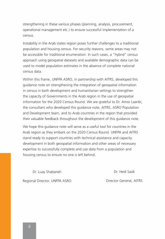
Instability in the Arab states region poses further challenges to a traditional population and housing census. For security reasons, some areas may not be accessible for traditional enumeration. In such cases, a “hybrid” census approach using geospatial datasets and available demographic data can be used to model population estimates in the absence of complete national census data.
Within this frame, UNFPA ASRO, in partnership with AITRS, developed this guidance note on strengthening the integration of geospatial information in census in both development and humanitarian settings to strengthen the capacity of Governments in the Arab region in the use of geospatial information for the 2020 Census Round. We are grateful to Dr. Amor Laaribi, the consultant who developed this guidance note, AITRS, ASRO Population and Development team, and to Arab countries in the region that provided their valuable feedback throughout the development of this guidance note.
We hope this guidance note will serve as a useful tool for countries in the Arab region as they embark on the 2020 Census Round. UNFPA and AITRS stand ready to support countries with technical assistance and capacity development in both geospatial information and other areas of necessary expertise to successfully complete and use data from a population and housing census to ensure no one is left behind.
Dr. Hedi Saidi
Director General, AITRS
Dr. Luay Shabaneh
Regional Director, UNFPA ASRO
iii
Acronyms AITRS Arab Institute for Training and Research in Statistics
CAPI Computer Assisted Personal Interviewing
CAWI Computer Assisted Web Interviewing
DESA Department of Economic and Social Affairs
EA Enumeration Area
ECA Economic Commission for Africa
ESCWA Economic and Social Commission for Western Asia
GIS Geographic Information System
GPS Global Positioning System
GNSS Global Navigation Satellite System
NMA National Mapping Agency
NSDI National Spatial Data Infrastructure
NSDS National Statistical Development Strategy
NSO National Statistical Office (Organization)
PDA Personal Digital Assistant
PII Personally Identifiable Information
SDG Sustainable Development Goal
UNFPA United Nations Population Fund
UNSD United Nations Statistics Division
UN-GGIM United Nations Global Geospatial Information Management
UAV Unmanned Aerial Vehicle

1
Executive summarySeveral governmental and private institutions have already recognized the geographic dimension of census and statistical data and its role in economic and social development. Knowing where people and things are, what the things are, and their relationship to each other, is indeed essential for evidence-based decision-making. They are particularly realizing that the integration of geospatial data with statistics provides significant benefits for their countries, by opposition to the one dimensional traditional approaches, in terms of reduction of cost and time required, as well as accuracy and quality, to collect, process and communicate information, greatly increasing the return on investment in data collection and dissemination.
For many NSOs in the developing countries and in countries in conflict, including in the Arab region, the challenges and barriers in using innovative methods and technologies, including GIS, satellite imagery and other geospatial technologies, are not only technical, but also often institutional and organizational. Thus, cooperation of both geospatial and statistical communities is particularly required to adopt and implement common standards that underpin foundations for enabling interoperability, accessing and sharing datasets, and ultimately building and developing statistical geospatial information infrastructures.
This guidance note recommends action in the following areas: • Build and develop the NSO’s GIS and the census geographic database,
recognizing that their development are fundamental for a full digital census geography programme, and for supporting the diversification of the means for census data dissemination by using web-based mapping, cloud applications and services, and mobile technology to reach a wider audience for a better appreciation of census products and statistical work in general.
• Acquire and use Earth Observations, as they constitute additional sources of data for the census and statistical activities and for implementing and monitoring the SDGs. In particular, their use with GPS and GIS is being recognized as crucial for population estimates (hybrid census) in countries with underlying humanitarian conditions.
2
• Develop acquisition mechanisms in order to reduce the significant costs of high-resolution satellite imagery, aerial photos, GPS and handheld devices, such as grouping acquisition of satellite imagery or borrowing of handheld devices.
• Build and develop a national statistical-geospatial framework to facilitate consistent production and integration approaches for geo-statistical information. UNFPA, ESCWA, and AITRS should continue to support Arab countries in building and developing their statistical-geospatial information infrastructures for the 2020 census round and the 2030 Sustainable Development Agenda.
• Develop and enhance Institutional arrangements at the national level to enforce the basic principle stating that geospatial information should be collected once and shared by many, and establish partnerships and agreements between the NSO and the national mapping organization and others, including mechanisms for data sharing.
• Build and strengthen technical and human capacities needed for sustaining the GIS-based census programme, including ensuring a continuous training to keep the census mapping staff abreast of advances in technology, and providing significant incentives to the GIS staff to retain them.
• Explore other mechanisms for empowering capacities through bilateral exchanges between countries, promotion of triangular and South-South cooperation, carrying out study visits to enhance the sharing of national experiences and practices, and organization of regional coordinated trainings and contact networks.
3
1. Introduction
1.1 BackgroundPopulation and housing censuses have been the primary source of data for policy formulation, programme development and evidence-based decision making. They are likely to remain, particularly in the majority of developing countries, including in the Arab region, as the most important source of data on the size and spatial distribution of the population and its related characteristics. Enumerating population and housing censuses, analysing the collected data, and disseminating the resulting information will be a central role within the national statistical and data ecosystems for the foreseeable future.NSOs are generally in charge of “collecting, processing, and disseminating data on a wide range of demographic, social, economic, and environmental topics”1, through population and housing censuses, surveys, registers and other administrative databases, providing the major outputs of the national statistical system. However, in some countries, NSOs are lacking capacities to provide these official statistics, and even when statistics are available, they benefit only limited users, principally governmental agencies and a few other non- governmental bodies. This creates a ‘data-gap,’ with challenges in terms of availability, accessibility or sharing of data.
In this era of data revolution, with its emerging manifestations of Big Data and Open Data, the 2030 Agenda for Sustainable Development and the 2020 round of censuses2 have become two major drivers behind increased demand, potential production and use of data, including geospatial information. The 2030 Agenda recommends indeed that Member States undertake new data acquisition and integration approaches to supply reliable, timely, accessible and usable, and disaggregated data that is essential to set priorities, make informed choices and implement better policies for sustainable development, and to ultimately ‘leave no one behind’3. Moreover,
1 See UN Principles and Recommendations – Revision 3, 2017, United Nations Publications, New York. Available at: https://unstats.un.org/unsd/publication/seriesM/Series_M67Rev3en.pdf
2 See https://unstats.un.org/unsd/demographic-social/census/censusdates/
3 See “Transforming our world: the 2030 Agenda for Sustainable Development”, at https://sustain-abledevelopment.un.org/post2015/transformingourworld

4
to address the growing demand for information on small geographic areas to monitor the development goals and indicators at local and community levels, the 2030 Agenda ‘calls out geospatial information and earth observations as key methods for tracking progress and informing people about these global development policies’4.
Due to the data revolution with the emergence of innovative and enabling technologies, geospatial data is increasingly available from various sources at lower cost, in better quality, and more easily accessible by different users. Moreover, increasing computing power has increased the availability of geo-referenced information and geospatial analysis products, and the increasing availability of user-friendly GIS tools for insightful spatial analysis. Further, compelling visualization is improving the accessibility of that dereferenced information for decision-making. Chief among the geospatial information technologies, GIS, based essentially on database management systems, enable geospatial data from diverse sources to be brought together to unleash their combined power in analysis and decision support5. With the proliferation of GPS-enabled mobile technology and hand-held electronic devices, an easier access to satellite imagery and use of geospatial technologies, as well as the pervasive web-based and crowd-sourced tools, there is a shift from traditional paper-based census data collection methods to new technology and digital-based approaches.
In recognition of the importance of geospatial information, the UN recommended the necessity for countries to keep abreast with the technological advances made, since the previous round of censuses, especially in the area of Geographic Information Systems (GIS) and Global Positioning System (GPS)6, and that for the 2020 round of censuses the adoption of GIS should be a major strategic decision7. Hence, the integration of geospatial and statistical information has become a significant way to
4 Idem.
5 See the Book: “GIS and the 2020 Census – Modernizing Official Statistics”, Esri Press, 2019.
6 GPS is one component of the Global Navigation Satellite System (GNSS), and is now the most widely used GNSS in the world.
7 See UN Principles and Recommendations – Revision 3, 2017, United Nations Publications, New York. Available at: https://unstats.un.org/unsd/publication/seriesM/Series_M67Rev3en.pdf

5
unlock new insights that would not have been possible by looking at socio-economic or geospatial data in isolation. This requires the development of a national statistical-spatial framework that take into account both the National Statistical Development Strategy (NSDS) and the National Spatial Data Infrastructure (NSDI), in accordance with what is being developed at global level.
1.2 ObjectivesUNFPA, AITRS and ESCWA are holding joint workshops, aiming to follow up on the progress of Arab Member States in developing their statistical systems; providing them with an overview and technical advice on the innovative technologies used in support of statistical activities, particularly on the strategic use of geospatial information technologies in support of the census; and advocating for their adoption and implementation in accordance with UN recommendations, taking into account the national circumstances in the Arab region.
The principal objective is to assist Member States in using appropriate technologies and developing and strengthening their capacities that can improve the quality of and access to their statistical data in support of evidence-based decision making and sustainable development.
1.3 The global statistical-geospatial framework principlesBuilding a statistical-geospatial infrastructure is increasingly recognized as an enabler for facilitating data exchange and improving the availability and timeliness of country information in support of evidence-based decision making and sustainable development. In this respect, the need for an overarching statistical-geospatial framework, as part of an overall information architecture at the national and global levels, is well recognized by both statistical and geospatial communities. They particularly recognized that when both statistical information and geospatial information are integrated within a statistical-geospatial framework, the geo-statistical results can significantly improve the quality of official statistics and population and housing censuses, and the measuring and monitoring of the sustainable development goals. In this context, the United Nations Statistical Commission and the United Nations Committee of Experts on
6
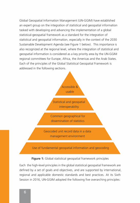
Global Geospatial Information Management (UN-GGIM) have established an expert group on the integration of statistical and geospatial information tasked with developing and advancing the implementation of a global statistical-geospatial framework as a standard for the integration of statistical and geospatial information, especially in the context of the 2030 Sustainable Development Agenda (see Figure 1 below). This importance is also recognized at the regional level, where the integration of statistical and geospatial information is considered as a key priority area by the UN-GGIM regional committees for Europe, Africa, the Americas and the Arab States. Each of the principles of the Global Statistical Geospatial Framework is addressed in the following sections.
Figure 1: Global statistical geospatial framework principles
Each the high-level principles in the global statistical geospatial framework are defined by a set of goals and objectives, and are supported by international, regional and applicable domestic standards and best practices. At its Sixth Session in 2016, UN-GGIM adopted the following five overarching principles:
Accessible & usable
Statistical and geospatial interoperability
Common geographical for dissemination of statistics
Geocoded unit record data in a data management environment
Use of fundamental geospatial information and geocoding
7
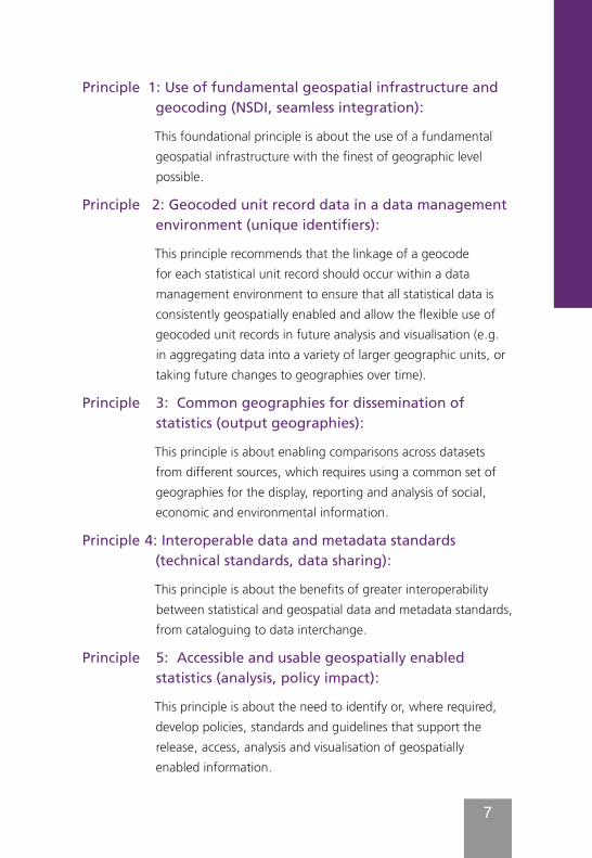
Principle 1: Use of fundamental geospatial infrastructure and geocoding (NSDI, seamless integration):
This foundational principle is about the use of a fundamental geospatial infrastructure with the finest of geographic level possible.
Principle 2: Geocoded unit record data in a data management environment (unique identifiers):
This principle recommends that the linkage of a geocode for each statistical unit record should occur within a data management environment to ensure that all statistical data is consistently geospatially enabled and allow the flexible use of geocoded unit records in future analysis and visualisation (e.g. in aggregating data into a variety of larger geographic units, or taking future changes to geographies over time).
Principle 3: Common geographies for dissemination of statistics (output geographies):
This principle is about enabling comparisons across datasets from different sources, which requires using a common set of geographies for the display, reporting and analysis of social, economic and environmental information.
Principle 4: Interoperable data and metadata standards (technical standards, data sharing):
This principle is about the benefits of greater interoperability between statistical and geospatial data and metadata standards, from cataloguing to data interchange.
Principle 5: Accessible and usable geospatially enabled statistics (analysis, policy impact):
This principle is about the need to identify or, where required, develop policies, standards and guidelines that support the release, access, analysis and visualisation of geospatially enabled information.
8
This guidance note highlights gaps in the use of GIS and geospatial information methodologies and technologies in support of census activities in the Arab region, and practical guidelines to address such gaps. The following sections outline operational guidelines that can inform practical procedures and institutional arrangements to use GIS and other geospatial information technologies at all the stages of the census, and best practices for the integration of statistical and geospatial information. The note also proposes a set of recommendations that can help address the challenges the NSOs in the Arab region are facing, including on strengthening geospatial information support to their censuses and statistical activities.
2- Methodology This guidance note is based on international recommendations and best practices in the area of GIS and geospatial information. It draws heavily on the book, “GIS and the 2020 round of census: Modernizing official statistics,”8 and on an ESCWA parliamentary paper, “The Prospects of Innovation and Technology in Official Statistics,”9 expanding on the methodological and technological options in support of census activities, with guidance to the NSOs of the Arab countries, allowing them to choose appropriate solutions while taking into account their national and local conditions.
Further, the development of this note took into consideration results from an ESCWA questionnaire on the “Experiences and Practices of Arab countries regarding the use of geospatial methodologies and technologies, and the dissemination of statistical data”10 administered in 2018, identifying the
8 Available in print and e-book. see https://esripress.esri.com/display/index.cfm?fuseaction=display&websiteID=359&moduleID=0#:~:text=GIS%20and%20the%202020%20Census%3A%20Modernizing%20Official%20Statistics%20provides%20statistical,the%20stages%20of%20a%20census
9 Some of the material compiled in this guidance note has been previously published in the aforementioned sources, as well as in other recent papers on the same subject. All of these documents were either authored or co-authored by the Consultant. See References.
10 See the ESCWA Parliamentary paper on “Prospects of innovation and technology in official statistics”. Available at https://www.unescwa.org/sites/www.unescwa.org/files/events/files/prospects_of_innovation_and_technology_in_official_statistics_1.pdf
9
priority technologies in the Arab region and where the gaps in utilizing such technology lie, with responses from 16 national institutions responsible for producing official statistics in each Arab country. This guidance note was also informed by participant discussion from a regional GIS and geospatial information in census workshop hosted by UNFPA in collaboration with AITRS and ESCWA in July, 2020. The workshop, in conjunction with the ESCWA questionnaire, helped to assess the use of geospatial information technologies in support of the census in the Arab region, as well as identify the needs, opportunities and gaps to inform capacity building programmes and technical assistance that UNFPA, ESCWA, AITRS and others could provide in this regard, which shaped the focus of this guidance note.
3. Identified gaps in GIS/ geospatial information technologies in support of the census in the arab region
This section provides an overview of the emerging technologies that are supporting the NSOs in their data collection, processing, analysis and dissemination, with a focus on those identified gaps that need to be addressed in the Arab region, including for countries with underlying humanitarian conditions.
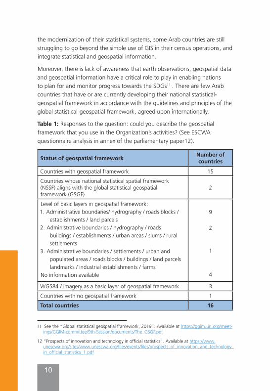
3.1 Building a statistical-geospatial infrastructureThe findings of the ESCWA survey showed that quite a number of countries in the region are struggling to build their geospatial infrastructure in support of their census and statistical activities. For example, in response to the question “Could you describe the geospatial framework that you use in the Organization’s activities?”, only two countries have a national statistical geospatial framework in accordance with the UN global statistical geospatial framework (see table 1 below). It is worth mentioning that table 1 provides a breakdown of the components of a fundamental geospatial infrastructure (basic layers, WGS84, Imagery), which is at the core of principle 1 of the GSGF (see figure 1).
While there are many national statistics offices which are already transforming, or are planning to transform their statistical systems to build a statistical-geospatial information infrastructure which can contribute to
10
the modernization of their statistical systems, some Arab countries are still struggling to go beyond the simple use of GIS in their census operations, and integrate statistical and geospatial information.
Moreover, there is lack of awareness that earth observations, geospatial data and geospatial information have a critical role to play in enabling nations to plan for and monitor progress towards the SDGs11.. There are few Arab countries that have or are currently developing their national statistical-geospatial framework in accordance with the guidelines and principles of the global statistical-geospatial framework, agreed upon internationally.
Table 1: Responses to the question: could you describe the geospatial framework that you use in the Organization’s activities? (See ESCWA questionnaire analysis in annex of the parliamentary paper12).
Status of geospatial framework Number ofcountries
Countries with geospatial framework 15Countries whose national statistical spatial framework (NSSF) aligns with the global statistical geospatial framework (GSGF)
2
Level of basic layers in geospatial framework: 1. Administrative boundaries/ hydrography / roads blocks /
establishments / land parcels 2. Administrative boundaries / hydrography / roads
buildings / establishments / urban areas / slums / rural settlements
3. Administrative boundaries / settlements / urban and populated areas / roads blocks / buildings / land parcels landmarks / industrial establishments / farms
No information available
9
2
1
4
WGS84 / imagery as a basic layer of geospatial framework 3Countries with no geospatial framework 1Total countries 16
11 See the “Global statistical geospatial framework, 2019”. Available at https://ggim.un.org/meet-ings/GGIM-committee/9th-Session/documents/The_GSGF.pdf
12 “Prospects of innovation and technology in official statistics”. Available at https://www.unescwa.org/sites/www.unescwa.org/files/events/files/prospects_of_innovation_and_technology_in_official_statistics_1.pdf
11
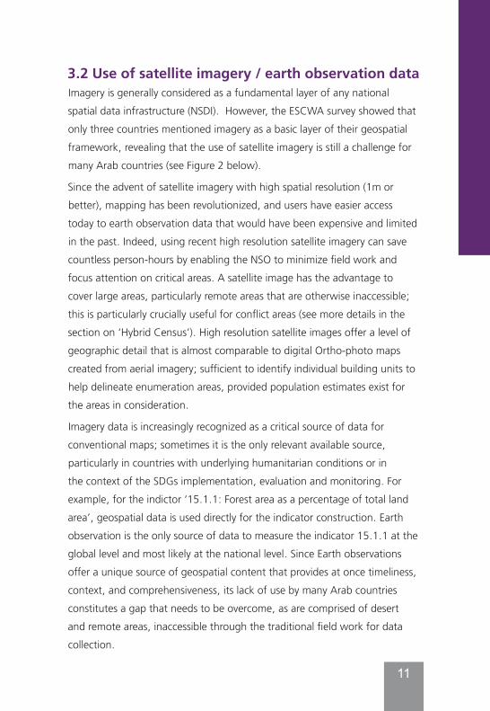
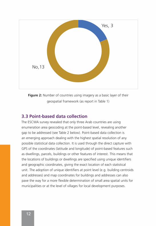
3.2 Use of satellite imagery / earth observation dataImagery is generally considered as a fundamental layer of any national spatial data infrastructure (NSDI). However, the ESCWA survey showed that only three countries mentioned imagery as a basic layer of their geospatial framework, revealing that the use of satellite imagery is still a challenge for many Arab countries (see Figure 2 below).
Since the advent of satellite imagery with high spatial resolution (1m or better), mapping has been revolutionized, and users have easier access today to earth observation data that would have been expensive and limited in the past. Indeed, using recent high resolution satellite imagery can save countless person-hours by enabling the NSO to minimize field work and focus attention on critical areas. A satellite image has the advantage to cover large areas, particularly remote areas that are otherwise inaccessible; this is particularly crucially useful for conflict areas (see more details in the section on ‘Hybrid Census’). High resolution satellite images offer a level of geographic detail that is almost comparable to digital Ortho-photo maps created from aerial imagery; sufficient to identify individual building units to help delineate enumeration areas, provided population estimates exist for the areas in consideration.
Imagery data is increasingly recognized as a critical source of data for conventional maps; sometimes it is the only relevant available source, particularly in countries with underlying humanitarian conditions or in the context of the SDGs implementation, evaluation and monitoring. For example, for the indictor ‘15.1.1: Forest area as a percentage of total land area’, geospatial data is used directly for the indicator construction. Earth observation is the only source of data to measure the indicator 15.1.1 at the global level and most likely at the national level. Since Earth observations offer a unique source of geospatial content that provides at once timeliness, context, and comprehensiveness, its lack of use by many Arab countries constitutes a gap that needs to be overcome, as are comprised of desert and remote areas, inaccessible through the traditional field work for data collection.
12
Figure 2: Number of countries using imagery as a basic layer of their
geospatial framework (as report in Table 1)
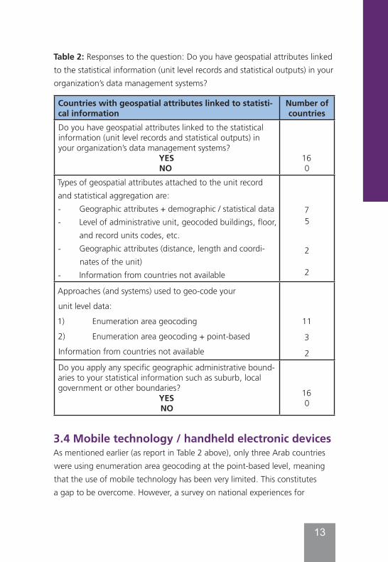
3.3 Point-based data collectionThe ESCWA survey revealed that only three Arab countries are using enumeration area geocoding at the point-based level, revealing another gap to be addressed (see Table 2 below). Point-based data collection is an emerging approach dealing with the highest spatial resolution of any possible statistical data collection. It is used through the direct capture with GPS of the coordinates (latitude and longitude) of point-based features such as dwellings, parcels, buildings or other features of interest. This means that the locations of buildings or dwellings are specified using unique identifiers and geographic coordinates, giving the exact location of each statistical unit. The adoption of unique identifiers at point level (e.g. building centroids and addresses) and map coordinates for buildings and addresses can also pave the way for a more flexible determination of small area spatial units for municipalities or at the level of villages for local development purposes.
13
ذد ا٤ت٥ذا٫ ا٤ذ دعذخذ٧ ا٤فىس ٠ىتح ؤظاظح بواسها ا٤ىو٭ ٥٩٥٤ى٨اخ :2الشول
(1 ا٤ظشاح ا١٩٤ا٬ح )٩٠ا ا٤ذشش ا٤ىاسد ا٤ظذو٣
اإلػداساخطهع التاياخ الهظذدج إلى 3.3 ٤شب آظا ؤ٫ سالسح ة٥ذا٫ شةح ي دعذخذ٧ حطذ٩اواال حذفاداالا٥٤ظ٭ح دهي ؤطشا٤ز ا٩٤عؽٮ ة
ؤخشي ذٮ ٨ا٤ظذها ظىج، ٩٨ا ١ؽ ٮ اإلػذاساخ٥ى ٨عذىي ا٤ذا٤ذش٨ض ا٤ظشا ٩٤٭او
ٮ ٨ٮ ا٤ذاه ١٩ ا ٬اؼج اا ٬هظذتش ٥ى ٨عذىي اإلػذاساخ ب٫ ط٩ ا٤تا٬اخ د٬اٯ(. ؤ ٬2ش ا٤ظذو٣ ؤ)
اظذخذا٨٧ٮ خال٣ إ٥ى دسطح ٨ٮ ا٤ذح ا١٩٤ا٬حةفىسج ٨تاؼشج، وةبػذاساخ ا٤تا٬اخ اإلػفاثح
٩٤ا٤٪ ٬ىح ٨ا ٨ش٦ ا٩٤عا٠ٮ، وى األسال، ٬ا٧ دؼذذ ا٩٤ىا )خي ا٤شك وخي ا٤ىى٣
وهزا ٭ ؤ٫ ٨ىا ا٩٤تا٬ ؤو ا٩٤عا٠ٮ ٨ؼذدج .(وا٩٤تا٬، ؤو ش ر٢٤ ٨ٮ ا٩٤ا٤٪ ا٤ها٨ح
٦١٤ وػذج بػفاثح. ا٤فؼؽ ا٩٤ى بداػح د١٩ ٮ ٨ٮ وبػذاساخ طشاح، ٨شاخ شذج اظذخذا٧ة
واػذ٤شاخ و٭اوٮ ا٩٤تا٬( ٨شا٠ض س٦ )٨ش٦ اإلػذاساخ ذ٩اد ٨ؼذداخ شذج ٥ى ٨عذىي ا٩٠ا ؤ٫
ىػذاخا٤ ػذود ٤متي ألشاك ا٤ذ٭٩ح ا٩٤ؼ٥ح٩هذ ا٤ىش ١٩ٮ ؤ٫ ا٤خشاثي ٩٥٤تا٬ وا٤٭اوٮ
اخ ؤو اسش ا٩٤عاػح ا١٩٤ا٬ح ا٤فشج ٥ىراخ ا٤ع١ا٬ح .ا٤شيا٤ت٥ذ
٬3٪؛
13ال؛
Yes, 3
No,13
13
Table 2: Responses to the question: Do you have geospatial attributes linked to the statistical information (unit level records and statistical outputs) in your organization’s data management systems?
Countries with geospatial attributes linked to statisti-cal information
Number of countries
Do you have geospatial attributes linked to the statistical information (unit level records and statistical outputs) in your organization’s data management systems?
YESNO
160
Types of geospatial attributes attached to the unit record and statistical aggregation are: - Geographic attributes + demographic / statistical data- Level of administrative unit, geocoded buildings, floor,
and record units codes, etc.- Geographic attributes (distance, length and coordi-
nates of the unit)- Information from countries not available
75
2
2
Approaches (and systems) used to geo-code your
unit level data:
1) Enumeration area geocoding
2) Enumeration area geocoding + point-based
Information from countries not available
11
3
2Do you apply any specific geographic administrative bound-aries to your statistical information such as suburb, local government or other boundaries?
YESNO
160
3.4 Mobile technology / handheld electronic devicesAs mentioned earlier (as report in Table 2 above), only three Arab countries were using enumeration area geocoding at the point-based level, meaning that the use of mobile technology has been very limited. This constitutes a gap to be overcome. However, a survey on national experiences for
13
ذد ا٤ت٥ذا٫ ا٤ذ دعذخذ٧ ا٤فىس ٠ىتح ؤظاظح بواسها ا٤ىو٭ ٥٩٥٤ى٨اخ :2الشول
(1 ا٤ظشاح ا١٩٤ا٬ح )٩٠ا ا٤ذشش ا٤ىاسد ا٤ظذو٣
اإلػداساخطهع التاياخ الهظذدج إلى 3.3 ٤شب آظا ؤ٫ سالسح ة٥ذا٫ شةح ي دعذخذ٧ حطذ٩اواال حذفاداالا٥٤ظ٭ح دهي ؤطشا٤ز ا٩٤عؽٮ ة
ؤخشي ذٮ ٨ا٤ظذها ظىج، ٩٨ا ١ؽ ٮ اإلػذاساخ٥ى ٨عذىي ا٤ذا٤ذش٨ض ا٤ظشا ٩٤٭او
ٮ ٨ٮ ا٤ذاه ١٩ ا ٬اؼج اا ٬هظذتش ٥ى ٨عذىي اإلػذاساخ ب٫ ط٩ ا٤تا٬اخ د٬اٯ(. ؤ ٬2ش ا٤ظذو٣ ؤ)
اظذخذا٨٧ٮ خال٣ إ٥ى دسطح ٨ٮ ا٤ذح ا١٩٤ا٬حةفىسج ٨تاؼشج، وةبػذاساخ ا٤تا٬اخ اإلػفاثح
٩٤ا٤٪ ٬ىح ٨ا ٨ش٦ ا٩٤عا٠ٮ، وى األسال، ٬ا٧ دؼذذ ا٩٤ىا )خي ا٤شك وخي ا٤ىى٣
وهزا ٭ ؤ٫ ٨ىا ا٩٤تا٬ ؤو ا٩٤عا٠ٮ ٨ؼذدج .(وا٩٤تا٬، ؤو ش ر٢٤ ٨ٮ ا٩٤ا٤٪ ا٤ها٨ح
٦١٤ وػذج بػفاثح. ا٤فؼؽ ا٩٤ى بداػح د١٩ ٮ ٨ٮ وبػذاساخ طشاح، ٨شاخ شذج اظذخذا٧ة
واػذ٤شاخ و٭اوٮ ا٩٤تا٬( ٨شا٠ض س٦ )٨ش٦ اإلػذاساخ ذ٩اد ٨ؼذداخ شذج ٥ى ٨عذىي ا٩٠ا ؤ٫
ىػذاخا٤ ػذود ٤متي ألشاك ا٤ذ٭٩ح ا٩٤ؼ٥ح٩هذ ا٤ىش ١٩ٮ ؤ٫ ا٤خشاثي ٩٥٤تا٬ وا٤٭اوٮ
اخ ؤو اسش ا٩٤عاػح ا١٩٤ا٬ح ا٤فشج ٥ىراخ ا٤ع١ا٬ح .ا٤شيا٤ت٥ذ
٬3٪؛
13ال؛
14
population and housing censuses of the 2010 round, conducted by UNSD in 2012, revealed that most countries reported implementation of new technologies was the most successful aspect of census-taking in the 2010 round of censuses13. Innovative technologies included the use of the Internet and hand-held devices (e.g. tablet computers) for data collection; integrated systems for field management; geospatial technologies for mapping; scanning technology; and other web-based and mobile telephony applications for dissemination.
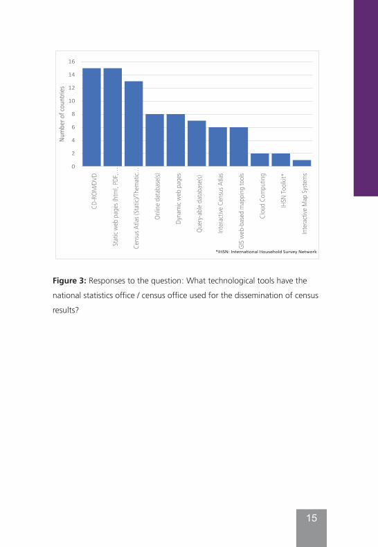
3.5 Internet-based technologiesThe ESCWA survey also demonstrated that, while most of the national statistical offices in the region have a geographic/cartographic unit with human resources and the requisite IT infrastructure dedicated for managing the geographic information system, the use of internet was limited to some basic dissemination applications (see Figure 3 below). Since many applications have become web-based, the natural trend is to benefit from the potential offered by the various internet-based technologies for census data collection and dissemination, including sharing data openly, provided their security and confidentiality are secured. Indeed, the pervasive use of Internet has contributed to the emergence of the Internet-based data collection, known as or Computer Assisted Web Interviewing (CAWI), initially as complement to other established data collection methods, but progressively has gained ground from a census to another, but few Arab countries, if any, have used CAWI.
13 See “Overview of national experiences for population and housing censuses of the 2010 round” (June 2013), prepared by the Statistics Division, available from https://unstats.un.org/unsd/censuskb20/KnowledgebaseArticle10706.aspx
15
Figure 3: Responses to the question: What technological tools have the
national statistics office / census office used for the dissemination of census
results?
16
Figure 3: Responses to the question: What technological tools have the national
statistics office / census office used for the dissemination of census results?
0
2
4
6
8
10
12
14
16
CD-R
OM/D
VD
Static
web
page
s (ht
ml, P
DF,…
Cens
us A
tlas (
Static
)/The
matic
…
Onlin
e data
base
(s)
Dyna
mic w
eb pa
ges
Query
-able
datab
ase(s
)
Intera
ctive
Cen
sus A
tlas
GIS w
eb-b
ased
map
ping t
ools
Clou
d Com
putin
g
IHSN
Toolk
it*
Intera
ctive
Map
Syste
ms
Num
ber o
f cou
ntrie
s
*IHSN: International Household Survey Network
16
4. Guidelines for Use of GIS and geospatial information at all stages of the census
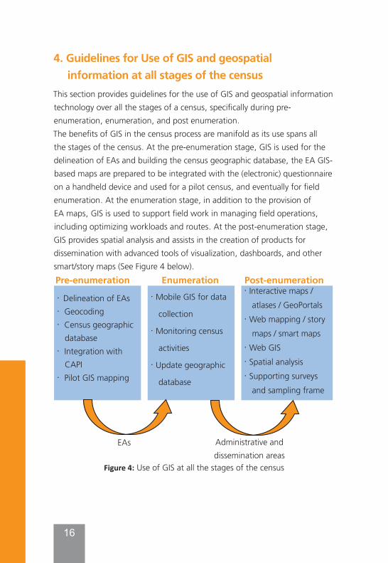
This section provides guidelines for the use of GIS and geospatial information technology over all the stages of a census, specifically during pre-enumeration, enumeration, and post enumeration. The benefits of GIS in the census process are manifold as its use spans all the stages of the census. At the pre-enumeration stage, GIS is used for the delineation of EAs and building the census geographic database, the EA GIS-based maps are prepared to be integrated with the (electronic) questionnaire on a handheld device and used for a pilot census, and eventually for field enumeration. At the enumeration stage, in addition to the provision of EA maps, GIS is used to support field work in managing field operations, including optimizing workloads and routes. At the post-enumeration stage, GIS provides spatial analysis and assists in the creation of products for dissemination with advanced tools of visualization, dashboards, and other smart/story maps (See Figure 4 below).
· Interactive maps / atlases / GeoPortals
· Web mapping / story maps / smart maps
· Web GIS· Spatial analysis· Supporting surveys
and sampling frame
· Delineation of EAs · Geocoding· Census geographic
database· Integration with
CAPI· Pilot GIS mapping
Post-enumerationEnumerationPre-enumeration
EAs Administrative anddissemination areas
Figure 4: Use of GIS at all the stages of the census
· Mobile GIS for data
collection
· Monitoring census
activities
· Update geographic
database
17
This following section summarizes all the practical procedures in terms of steps that can be followed one by one to use GIS for a national census. It is worth noting that some of the steps can be done simultaneously. These recommended steps are not carved in stone and do not require strict adherence, but rather serve as a guideline for each country to adapt to their own unique needs and circumstances in terms of infrastructure, capacities, and institutional arrangements.
4.1 Practical procedures
4.1.1 Supporting and implementing geospatial activities for the pre-enumeration phase
a- Delineation of EAs
The EA delineation process, using GIS and other geospatial information technologies, can be carried out in three main steps as follows:
1. Demarcate new and re-demarcate existing EAs through:● on-screen digitizing, editing and GIS functionality superimposing the
vector data such as:
o Administrative boundaries,
o Roads,
o Water bodies,
o Place names,
o cadastral/ parcel boundaries, and
o Other point-based features (dwellings/ buildings, schools, health facilities, landmarks, etc.)
On top of recent imagery as a backdrop, such imagery at high resolution14 should meet some criteria, to be fully suitable to census mapping operations:
14 The spatial resolution of a satellite image is measured by the size of a pixel on the ground which varies from the sub-one-meter of the most popular high-resolution systems to hundred meters for low resolution systems.
18
(i) it should be recent, preferably less than one year; (ii) Its resolution would preferably be < 1m, but not >2.5 m, for urban and rural respectively; (iii) It should contain less than 20% of cloud coverage; and (iv) Its cost should be reasonable, relatively to the whole cost of the census operations15.
● A dataset of demarcated EAs is created and maps would be produced and printed for the fieldworkers to be used for verification in the field.
2. Field verification: ● Data and maps prepared and created in the office are verified,
corrected and updated in the field.
● The EA boundary, size and shape will be verified against the set of criteria (e.g. EA boundaries should change as little as possible so data can be compared between consecutive censuses at the lowest level of geography possible, but in the event that EAs are too large for a single enumerator, they can be split, and splits should follow reference features such as roads or water bodies where possible to minimize the need to change them at a later date.
● If EAs are too small due to population decrease, they can be merged, though an alternative would be to simply have an enumerator work on two small EAs and then keep the boundaries consistent).
● The existing data on the map will be verified and updated, and any new features on the ground will be captured as well as any suggestions of changes brought to the EAs should be highlighted/annotated on the map.
● Point-based data such as dwellings/buildings and other points of interest will also be verified and captured by GNSS/GPS hand-held devices, and any changes will also be annotated.
15 See more details in the Book: “GIS and the 2020 Census – Modernizing Official Statistics”, Esri Press, 2019.
19
3. Office work to capture the verified data in the field, and thus create the final Enumeration Area / Supervisory Area maps to be used for the actual enumeration.
b- Building or updating the GIS / EA - based census geographic database
This is the process of building a geographic database which is the foundational core of any GIS. In our case, it is about a Census GIS database at the EA level (or point-based level).
● It is advised to build a comprehensive GIS-based census database that has at its foundation the smallest statistical unit for data collection, be it an enumeration area (e.g. a census tract, a block group, and a census block), a dwelling or housing unit, or an address.
● In geocoding approaches, it is preferable to develop a point-based statistical system of geocoding statistical data, enabling geospatially unit records at the individual level which is also more appropriate for a register-based census. Since the point-based approach offers the finest spatial resolution, it is also recommended for grid-based statistics. Statistical grids can be used for many purposes, such as for regional/spatial analysis and planning, research, environmental and other telecommunications purposes, as well as for population estimates for countries with underlying humanitarian conditions.
In creating the census GIS database, we start by identifying the components of a census geographic database (i.e. determine data layers to be created) and stress the different stages in its development (some of them in a parallel way), including:
● Geographic data inventory for EA delineation;
● Geographic data conversion through scanning, digitizing or use of earth observation data;
● Construction and maintenance of topology;
● Geo-referencing and geocoding geographic features, integration of various digital data;
20
● Developing conceptual database design and data models;
● Identifying accuracy requirements and standards;
● Implementation of the EA database; and
● Developing the data dictionary and metadata guidelines (including data dictionary) for quality control/quality assurance.
The census GIS database can be designed on an evolving basis by Starting with the foundational features needed for the census exercise, from which to link any other spatial information collected in subsequent phases and added to the database. For example, beside the geographic location of the building, dwelling and / or household unit, demographic statistics captured before, during and after the census are also stored in the database for the benefit of the GIS end user.
It is worth noting that the changes brought to the EAs in the third step of the delineation of EAs above can only be confirmed once all the updated data has been loaded, and together with the annotated fieldwork maps an informed decision has been made in the (GIS) office - the updated information must be included in the GIS database. The map production can then commence.
c- Integration of GIS with CAPIIntegrating GIS with CAPI is a very technical operation, which is not a core business of the NSO and it’s likely to be carried out through outsourcing. The CAPI approach, through the use of a hand-held device equipped with in-built GNSS / GPS receiver and the integration of GIS-based EA maps requires the following:
● Selection or development by an IT team of a CAPI app;
● Preparation of mobile GIS-based EA maps
● Uploading the EA maps on the handheld devices (mobile map packages to be used online or offline)
● Need for administrating tests with regard to the integration of electronic questionnaire, enumeration areas maps, GPS,
21
transmission of data functionalities, battery, etc., before embarking on the actual use of the handheld devices in the census data collection;
● Proceeding with a training prior to the deployment of mobile devices on using not only the forms and the data collection operation, but also on the basics of the device and what to do for trouble shooting and the battery life.
However, country experiences have shown that opting for the integration of CAPI with GIS also presents some challenges to be addressed such as (i) the need for administrating tests with regard to the integration of electronic questionnaire, enumeration areas maps, GPS16, and transmission of data functionalities, battery, before embarking on the actual use of the handheld devices in the census data collection; (ii) training the field workers on using not only the forms and the data collection operation, but also on the basics of the device and what to do for trouble shooting and the battery life; and (iii) thinking about ways for the redeployment of the equipment or/and re-use to avoid to offset the gains from their beneficial use for data collection.
d- Pilot GIS mapping exerciseThe pilot census serves to test in real conditions the adequacy of the entire census plan, including the cartography, and the technology applied such as the CAPI system and mobile devices.
The Pilot GIS mapping exercise include the following steps:
● In preparation of geospatial data for the Pilot, pilot areas need to be selected to represent the diversity of socio-economic and geographical conditions of the population in the country to observe the management and supervision of the field operation in real situations;
● Preparation by the GIS team and provision of each pilot EA map at the EA / building level with its related coding system and with the format required by the CAPI app;
16 For example, if the handheld device has integrated GPS and this is going to be used to capture the latitude and longitude of each housing unit, accuracy tests may need to be performed.
22
● Testing the integration of GIS with CAPI.
The results of the Pilot GIS mapping exercise need to be carefully analysed by the NSO to determine the potential modifications for the successful conduct of the actual Census, including the appropriate CAPI app to be selected and its integration with GIS.
e- Other planning activities with GISAdditional activities benefiting from the use of GIS include:
● Optimizing the EAs in using spatial analysis;
● Optimizing site placement of field offices, and asset distribution; and
● Planning for other various spatial analysis for statistical purpose (such as ‘Areas of Influence’ like for daily commuters flow; ‘Point Pattern’ or ‘Cluster Analysis’; ‘Hot Spots’ where high values are surrounded by other features with high values as well particularly useful for identifying populations at risk as well; Cartograms; ‘Thiessen Polygons’ where spatial objects (e.g. settlements) used to create areas around point data, based on the distances among points arrayed in two-dimensional space, etc.)
4.1.2 Supporting and implementing data collection and helping monitoring census activities for the enumeration phase
a- Mobile GIS for field data collectionIn support of the CAPI enumeration process, GIS-based EA maps should be uploaded onto the device, and combined with satellite or aerial images as back drop.
● This allows the enumerators to visualize the EA maps, helping them to find the correct housing units within their assigned enumeration areas in the field.
● Using the EA maps and the electronic questionnaires filled out by enumerators, along with GPS points collected on the device, allows the NSO to verify the data collected, and whether the EAs were fully covered.
23
● Ideally, once the data is transmitted to the NSO’s central data centre, the data including geocodes would be entered into the GIS census database, providing information about the progress of the census coverage (for example, in the open source side, there is survey solutions developed under the auspices of the World Bank, and in the commercial side, there are Esri’s CAPI tools: Survey123 for ArcGIS and collector).
b- Monitoring census activitiesGIS on mobile devices can be used to support field operations management, streamlining and automating field operations, such as:
● Monitoring the workflow of timely information to and from the field allowing the census mangers to be informed of the progress of the data collection while providing enumerators with updates, tracking the location of the enumerators to advise about their gaps and
● Optimizing the workload assignment as well as optimizing routes (in providing the enumerators where to go and the best route to take); and
● Monitoring the progress of census operations, including identifying trouble spots.
c- Updating EA maps/update geographic databaseGIS / GPS can be used in conjunction with imagery during the field work of the enumeration phase for a final update of the EAs for the master database.
● Traditionally, the census cartographic staff would collect the EA maps after the census and incorporate the edits into the master database; this task can be tedious and in some instances, impact the time of the census results.
● But, with the digital approach of the enumeration, this operation can be automated, provided an application is used with field edits being captured interactively.
o Editing and updates captured in this manner can be simply
24
verified and then incorporated into the database in a much more streamlined fashion.
● Updating the GIS census database would serve for post-enumeration and inter-census activities.
Below is a country experience that used massively handheld devices for their data collection:
Box1: Brazil experience with its 2010 census and use of PDAs.(with extracts drawn heavily from Zelina Bianchini article, presented at ISI, 2011)
Brazil is the largest country in both South America and Latin America with 8.5 million square kilometres, and also the most populous in the region with an estimated of 195 million people at the time of the 2010 census. The focus in this overview is on the large-scale use of hand-held electronic devices for the data collection. While this case study refers to the 2010 Census, it provides the most detail about the use of handheld devices and the integration of statistical and geospatial information, and the process and the tools used for this integration of CAPI with GIS.
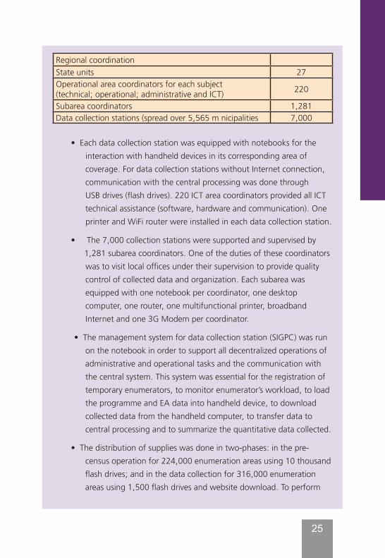
Data collection was carried out using handheld computers in a face-to-face mode interview (CAPI) and concurrently the National Address File for Statistical Purposes (CNEFE) was updated. Two types of handhelds were used (see below) which were already used in the agriculture census. Each handheld computer was equipped with an Enumeration Area Map; list of addresses developed for the EAs covered during pre-census operation; list of collective living quarters; short and long form questionnaires; GPS; and summary information collected to facilitate monitoring enumerators’ work. The following table presents some figures related to the 2010 census operation
Description FiguresHandheld computers for data collection and supervision 220,000LG-750Q (smartphones locked- Phone, 3G) 150,000MIO-P550B (already used in 2007) 70,000Laptops 8,700Printers 7,000
25
• Each data collection station was equipped with notebooks for the interaction with handheld devices in its corresponding area of coverage. For data collection stations without Internet connection, communication with the central processing was done through USB drives (flash drives). 220 ICT area coordinators provided all ICT technical assistance (software, hardware and communication). One printer and WiFi router were installed in each data collection station.
• The 7,000 collection stations were supported and supervised by 1,281 subarea coordinators. One of the duties of these coordinators was to visit local offices under their supervision to provide quality control of collected data and organization. Each subarea was equipped with one notebook per coordinator, one desktop computer, one router, one multifunctional printer, broadband Internet and one 3G Modem per coordinator.
• The management system for data collection station (SIGPC) was run on the notebook in order to support all decentralized operations of administrative and operational tasks and the communication with the central system. This system was essential for the registration of temporary enumerators, to monitor enumerator’s workload, to load the programme and EA data into handheld device, to download collected data from the handheld computer, to transfer data to central processing and to summarize the quantitative data collected.
• The distribution of supplies was done in two-phases: in the pre-census operation for 224,000 enumeration areas using 10 thousand flash drives; and in the data collection for 316,000 enumeration areas using 1,500 flash drives and website download. To perform
Regional coordinationState units 27Operational area coordinators for each subject (technical; operational; administrative and ICT) 220
Subarea coordinators 1,281Data collection stations (spread over 5,565 m nicipalities 7,000
26
backups of local databases, 28,500 flash drivers were distributed for maintenance and operational control. Management reports were prepared to control versions, updates and data transmission to the central processing. Website was used to download, to update and to perform developed programme distribution.
• Data collection: The census operation involved about 230 thousand people all over the country, including those hired on a temporary basis, and employees from the permanent staff of IBGE. In order to fulfill this enormous demand, professionals who were taking part in the 2010 census participated in a specific training chain, from a small group of instructors/trainers who in turn trained other enumerators (training of trainers).
• Among the several teaching resources available for in-class training, a highlight was the use of video classes, which guaranteed uniformity in the transmission of concepts and procedures during several steps of the training process.
• Trainees made extensive use of handheld computers, being able to develop skills related to use of such equipment as a tool. All data collection units in the 2010 census had digitized processing, which contributed to the digital inclusion of thousands of enumerators and census agents, since all of them had access to microcomputers and handheld computers.
• Enumerators were wearing a waistcoat, a badge and were carrying a handheld computer to collect information by means of a face-to-face interview with questions listed in the questionnaire form pre-selected for each occupied housing unit. Enumerators used about 190,000 handheld computers equipped with GPS receivers to collect data.
• Replacing the paper questionnaire by handheld computer allowed the introduction of editing routines that were implemented at the exact moment of completing the questionnaire, thus contributing to the quality assurance process in data collection.
27
• The use of handheld computers equipped with a GPS receiver allowed the geo-referencing of all units visited in rural areas as well as the monitoring of field operations conducted by the enumerators.
• After completing an interview, data were encrypted and could only be transferred to the IBGE through a secure network.
We can draw some lessons from this country experience. The CAPI approach, through the use of a hand-held device equipped with in-built GNSS/GPS receiver, has manifold benefits but also presents some challenges to be addressed, chief among them are the following:
(i) There is need first to pilot the integration of electronic questionnaires, enumeration areas maps, GPS17, transmission of data functionalities, battery, etc., before embarking on the actual use of the handheld devices in the census data collection;
(ii) Training staff prior to the deployment of mobile devices is critical, both on use of electronic forms and the data collection operation, but also on the basics of the device and what to do for trouble shooting and the battery life;
(iii) Given the cost of a substantial number of devices and related equipment in use for a limited time during the census exercise, consideration for leveraging their use in future data collection activities should be given, which will also be beneficial in justifying and offsetting their initial cost.
See “Statistical agencies looking to c-suite, new digital tools to address biggest challenges”.Available at https://federalnewsradio.com/technology/2017/02/statistical-agencies-looking-c-suite-new-digital-tools-address-biggest-challenges/
17 For example, if the handheld device has integrated GPS and this is going to be used to capture the latitude and longitude of each housing unit, accuracy tests may need to be performed.
28
Other country experiences in the use of handheld devices for data collection include Jordan, Egypt and Sate of Palestine in the Arab region (presented at the Virtual Workshop in July 2020 – See below an overview), Poland, Cape Verde, Senegal and many others, including the interesting case of Philippines. In the Philippines, the recent 2020 census used handheld devices, including the use of Esri CAPI apps survey123 and collector for their pilot census and in two provinces for their actual census. It’s one of the first large-populated countries to use Esri CAPI apps in a census.
Box 2: Overview on use of handheld devices in Jordan, Egypt and the State of Palestine.
Jordan conducted its census in 2015, and Egypt and Palestine in 2017, and the three countries took a geospatial digital approach, using CAPI data collection method on handheld devices, equipped with GPS.
Jordan’s Department of Statistics (DOS) cooperated with national agencies and local private companies to acquire aerial imagery and created an updated accurate base map. Using this base map with GIS, DOS delineated its EA, called census blocks, and created digital EA maps that were uploaded on the handheld devices for data collection. In this regard, DOS used 20,000 high-spec HP tablets, with 3000 more as spare. The workflow of the field operations relied on an ArcGIS platform at the central office, which was integrated with the Tablets in the field. This allowed field workers to smoothly communicate in nearly real time with their supervisors who, in turn, communicated with the central office (for security and efficiency reasons, collected data were not stored on the tablets but transmitted back to the Central Server). DOS reported that it reduced a traditional two-year process to just a two-month GIS-based one, covering the whole country for the first time, with improvement of data accuracy/quality and security.
Egypt’s statistical office the central agency for public mobilization and Statistics (CAPMAS) - implemented a new geospatial database repository, which includes point-based geographic features at the building/housing unit level. CAPMAS used 45,000 tablets which were deployed in subsequent periods of time and shared by fieldworkers to cover the whole territory, and relied also on an enterprise GIS platform at its central office. CAPMAS
29
created a geo-portal, Egy-Geo-info (geoportal.capmas.gov.eg), for census data dissemination, providing access and data sharing with both the major users and the public. CAPMAS reported the benefits of a full digital census, particularly the use of tablets enabled an effective control and simultaneous follow-up of all field operations and working teams; and ensured high levels of data quality with the instant adoption of validation rules for questionnaire completion in the field as well as quality control procedures. The Egyptian example is significant given the large geographical area and population size covered, and thus large number of enumerators needed, and the extensive quality control checks and balances employed to ensure automatic surveillance during the data collection stage.
The Palestinian Central Bureau of Statistics (PCBS) undertook the third population and housing census in 2017. PCBS worked on digitalization of a census map based on previous paper maps and updated new municipal borders and enumeration areas (EAs). Due to limited resources, EAs were uploaded on 5,000 handheld devices (high-spec HP Tablets) for data collection, and a tablet was used for enumeration of 2 EAs (each enumerator enumerated two EAs instead of one), which caused a prolongation of enumeration period. The majority of the tablets were borrowed from the Kingdom of Jordan as part of an inter-governmental agreement. Similar to Jordan’s census, the field operations relied on an ArcGIS platform at the central office, which was integrated with the handheld devices in the field. This allowed field workers to collect data on tablets and transmit it back to the Central Server, either online or offline, syncing back up with the server when connectivity was available. Thanks to the use of handheld electronic devices, GIS and GPS technologies, PCBS disseminated its census data three months after the end of the enumeration phase, and conducted a post-enumeration survey which showed better coverage compared to previous censuses. National and sub national census data were published on the PCBS website with an interactive database and electronic maps, and by using census data to support monitoring of the SDGs. The Palestine case is notable for two factors:
Using technology and GIS in a conflict situation where PCBS does not have control over all the land, where they can fully cover Jerusalem and Gaza; and
It epitomizes an interesting South-South cooperation through intergovernmental agreement between the Palestinian CBS and Jordan’s DOS.
30
4.1.3 Contributing to statistical analyses and dissemination for the post-enumeration phase
a- Interactive maps / atlases / geo portalsTo maximize the use of census results and make them available in a suitable format to the various users, a dissemination strategy should be prepared (in early stage of the census process) to be implemented through a sound dissemination programme.
NSOs should take advantage of the rise of information technology capabilities to enhance the dissemination and sharing of census data/information to reach a wider audience, including government agencies, citizens, civil society, researchers, academia, developers, and other major users.
GIS has been initially used by NSOs for the dissemination of their geographic products, mainly through maps. But, in addition to the GIS mapping capacities, NSO can use it for the following:
● Thematic maps and interactive atlases:
o Thematic maps for dissemination are generally produced not only for the major census data users, but also for a wider, non-specialist audience.
o Thematic maps in an (electronic) interactive atlas can present census data and many indicators at the country level, regions, large cities, municipalities and human settlements.
● Geo-portals are a cost-effective mechanism for marketing and continued delivery of useful census and geography products and services to a diverse user base that can go far beyond the first years after the census.
● Web mapping/ web GIS/ story maps/ smart maps:
o Web mapping is more than traditional mapping, as it is more a service by which users can choose and customize what the map will show.
o This is provided by what is depicted as smart mapping – using computation and analysis to automate the creation of maps – to accommodate the users who are not necessary familiar with GIS.
o The trend in web mapping is to cater to the needs of the users who want to create ideally interactive web maps that communicate meaningful and compelling stories from their data.
● Web GIS is being done through Web mapping which is the process of using the maps delivered by geographic information systems in the Web, where the web map is both served and consumed. But, instead of web GIS systems that try to cover everything, the now accepted best practice is to build a “story map” that answers one particular data related question or workflow.
● Spatial analysis: With the building of a geospatial census database at the EA level, GIS provides powerful tools to precede with spatial analysis, allowing the user to create various census and geographic products to be disseminated in accordance with cartographic and metadata standards.
● Supporting surveys and sampling frame
o Geospatial information is also instrumental for other statistical activities such as:
The creation of a geo-referenced national dwelling frame to identify and locate (geographic coordinates) all structures on the ground –the set-up of national register of buildings and dwellings-,
The development of business frame for use in an economic census,
The improvement of the coverage in parcel units and
The building of the national spatial data infrastructure (NSDI).
o Geospatial information supports the maintenance of these frames which are required for use as a basis for the statistical sampling frame for inter-censual surveys and future censuses.
31
Below is a country experience in the use of Internet for data collection and dissemination.
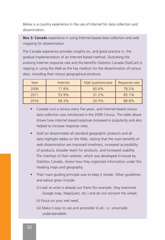
Box 3: Canada experience in using Internet-based data collection and web mapping for dissemination
The Canada experience provides insights on, and good practice in, the gradual implementation of an Internet-based method, illustrating the evolving Internet response rate and the benefits Statistics Canada (StatCan) is reaping in using the Web as the key medium for the dissemination of census data, including their census geographical products.
Year Internet Mail questionnaire Response rate2006 17.8% 60.6% 78.5%2011 53.9% 31.2% 85.1%2016 68.3% 20.5% 88.8%
• Canada runs a census every five years, and Internet-based census data collection was introduced in the 2006 Census. The table above shows how internet-based response increased in popularity and also helped to increase response rates.
• StatCan disseminates all standard geographic products and all data highlight tables on the Web, stating that the main benefits of web dissemination are improved timeliness, increased accessibility of products, broader reach for products, and increased usability. The interface of their website, which was developed in-house by Statistics Canada, shows how they organized information under the heading maps and geography.
• Their main guiding principle was to keep it simple. Other guidelines and advice given include:
(i) Look at what is already out there (for example, they examined Google map, MapQuest, etc.) and do not reinvent the wheel;
(ii) Focus on your real need;
(iii) Make it easy to use and accessible to all, i.e. universally understandable.
32
33
• Others web mapping tools include GeoSuite and census programme data viewer (CPVD). With GeoSuite (web version), users may retrieve and query data, explore the links between geographic areas, obtain information on those areas and output data in tabular format (Retrieved from: http://geosuite.statcan.gc.ca/geosuite/en/index).
• The CPDV is a recent advanced web based data visualization tool that makes statistical information more interpretable by presenting key indicators in a statistical dashboard. The CPDV makes it easy to find many places in Canada, see them on a map, and get basic geographic and socio-demographic data for those areas.
Cf: Census Programme Data Viewer, 2016 Census. Retrieved from
http://www12.statcan.gc.ca/census-recensement/2016/dp-pd/dv-vd/cpdv-vdpr/index-eng.cfm
4.2 What is needed to support NSOs to implement guidelines
The subsequent sub-sections outline what is needed to support NSOs in implementing the guidelines above, and to overcome the challenges they are facing, particularly in terms of capacity building and development in geospatial information methodologies and technologies and enhancement of institutional arrangements and cooperation.
4.2.1 Capacity development priorities in GIS/ geospatial technologies for census in the arab region
All the participating countries in the 2018 ESCWA survey and the July 2020 Workshop have expressed their interest in adopting innovative approaches to census taking, including the use of geospatial information technologies, mobile technology and the Internet. It is noted; however, that this requires strengthening of capacities and allocation of adequate resources, and that there is generally a lack of knowledge about successful experiences of other countries in the use of these innovative approaches, including the ‘hybrid censuses for country with underlying humanitarian conditions.
34
In the context of the 2020 round of censuses on population and housing censuses, cooperation among countries is highly recommended. NSOs in the Arab region are encouraged to explore and develop other innovative mechanisms for empowering capacities through bilateral exchanges between countries, triangular and South-South cooperation, and study visits to enhance the sharing of national experiences with countries with good practices, and organization of regional coordinated trainings and contact networks. It is recommended, for example, that Arab countries develop the South-south cooperation to its full potential, going beyond occasional exchanges between national statistical offices (e.g. Iraq - Egypt) and including inter-regional cooperation (e.g. Brazil with African countries) to enhance NSO capacity. For Arab countries with humanitarian conditions, they are advised to look at and emulate the experiences in ‘Hybrid Census’ of other similar conditions of countries like the case of Afghanistan (see Box 5). It is worth mentioning that UNFPA has supported most countries in the region embarking on a 2020 census to do a study tour or hold an Arab-Arab knowledge sharing workshop and will continue to do so as a priority, and to get guidance, for example, on how to handle the use of mobile devices for data collection and other supporting software applications. Other means of cooperation would include, for example, group purchasing of satellite imagery or borrowing of handheld devices, etc..18
UNFPA strategy for the 2020 round of censuses “focuses on strengthening national capacities to generate, analyse, disseminate and utilize high quality, timely, relevant, and disaggregated geo-referenced census data to inform, implement, monitor, and evaluate sustainable development policies, plans and programmes for the public good”19. This is in line with the 2030 Agenda which has explicitly called for enhancing capacity building to support national plans to implement the sustainable development goals. More specifically, Sustainable Development Goal #17 stresses that there is a need to:“By 2020, enhance capacity-building support to developing countries,
18 It is worth noting that UNFPA has supported tablet sharing among countries that are undertaking a census.
19 See “UNFPA Strategy for the 2020 Round of Population & Housing Censuses (2015-2024)”, first published in March 2017 and revised in July 2019. Available at: https://www.unfpa.org/publications/unfpa-strategy-2020-round-population-housing-censuses-2015-2024
35
including for least developed countries and small island developing States, to increase significantly the availability of high-quality, timely and reliable data disaggregated by income, gender, age, race, ethnicity, migratory status, disability, geographic location and other characteristics relevant in national contexts20”. In other words, strengthening the institutional and human capacities and capabilities for implementing, monitoring and evaluating the SDGs is of utmost urgent need.
A GIS-based census mapping programme carried out as a continuous process requires an independent geographic information unit to be set up within the National Statistical Office, with a permanent staff that can carry out the geospatial analysis and census mapping tasks spanned over all census stages and between censuses. A GIS permanent unit that is able to develop partnerships, data standards and interoperability, agreements and contracts for data collection and sharing, and cooperate with the other major actors. In the absence of in-house GIS capabilities, it becomes difficult for the NSO to make qualitative checks on the data created and delivered by the contracted companies. This often results in delivery of inaccurate and deficient data, which in turn affect the quality of the maps to be used for the census.
Using and sharing technologies to produce timely and reliable location-linked data and statistics requires increasing the capacities of national data producers and managers, chief among them the NSOs and geospatial agencies. But, building technical and human capacities needed for sustaining the GIS-based census programme requires training of census geography staff to equip them with appropriate skills in GIS that are rarely provided by an academic curriculum, and to serve all census geography/mapping needs. We need to provide training of trainers for census mapping and geospatial activities, who in turn will conduct the training of field workers, when needed. A well-trained staff and skilled staff in GIS is a key factor for the success of GIS-based census mapping projects, but in order to retain them, the NSO needs to provide significant incentives and ensure also a continuous training to keep them abreast of advances in technology.
20 Reported in E/C.20/2017/13/Add.1: National geospatial data and information systems. Available at http://ggim.un.org/ggim_20171012/ggim_committee.html
36
Capacity building for sustaining the census mapping programme requires in summary the following:
• A champion or key person(s) to promote geospatial development within the organization, and high-level management support;
• In terms of human resources, ability to provide training and support for relevant employees and management;
• Staffing needs met, including the ability to retain skilled staff and hire contractors where appropriate;
• Well-defined written contracts with vendors, consultants, partners and clients within and outside the government.
4.2.2 Enhancement of the institutional arrangements within the NSO and at the national level
For many NSOs in developing countries and in countries in conflict, including in the Arab region, the challenges and barriers in using innovative methods and technologies, including GIS and other geospatial technologies, are not only technical, but equally institutional and organizational.
Institutional arrangements for coordination within a country and cooperation of both statistical and geospatial communities is particularly required to adopt and implement common standards that are the basic foundations for enabling interoperability of data and systems, setting agreements and contracts for data collection, accessing and sharing datasets, collaboration across government at a variety of levels including national, regional, and local. All this contributes to building and developing statistical-geospatial information infrastructures which requires effective partnerships and co-operation amongst a wide variety of multi-disciplinary stakeholder partnerships in the public and private sectors and the end user communities within the country.21
Mobilizing co-operation among all stakeholders and building partnerships, right from the census planning phase, is essential in order to implement a GIS-based census mapping programme catering to the needs of all the major
21 See more details in the Book: “GIS and the 2020 Census – Modernizing Official Statistics”, Esri Press, 2019. Available as e-book and in print.
37
users. Since producing base maps is not a core business or competency of the NSO, developing a partnership for cooperation with the National Mapping Agency (NMA) can be mutually beneficial: For example, the NMA provides the NSO with base maps updated and appropriate for the census operations and, in return, the NSO provides to the mapping agency the mapping improvements derived from the census mapping fieldwork, as well as the geographic products derived from the post-census enumeration. Other examples concern the construction of a national census geographic database that can be employed beyond the census, in different sectors and for various purposes (e.g. agriculture or economic census, health information systems, utilities, etc.). Indeed, undertaking a census can provide a catalyst for the statistical and mapping agencies to work together for the benefit of both agencies and the community, as cooperation is needed for building the National Spatial Data Infrastructure (NSDI).
Data privacy and security of statistical data dissemination has been a major concern for all national statistical authorities, as one of the primary goals of confidentiality is to protect privacy by not allowing individual information to be identified, sometimes referred to as PII – personally identifiable information22. The concerns are even greater when the individual observation involves locational information and the use of sophisticated technology to access and disseminate it. It is worth noting that GIS data is generally about geographic locations and features such as addresses, coordinates, rather than data about specific individuals, and those modern GIS platforms provide the capabilities to publish data openly and securely based on the needs of the organization. Still, there is a legitimate concern involving the disclosure of confidential information through spatial display. Methods of aggregating spatial data can mitigate these concerns, but particularly disclosure methods that should be applied when the data is at the point/individual level23.
The recommendation for the country should be to put “legal, policy and institutional frameworks in place which allow effective and efficient
22 See more details in the Book: “GIS and the 2020 Census – Modernizing Official Statistics”, Esri Press, 2019. Available as e-book and in print.
23 Idem.
38
interoperability of data and information across the different national institutions which leverage geospatial information”24. This requires policy and related action plan to implement a clear data policy as the ultimate goal for developing a statistical-geospatial framework is to make data easily accessible and used by as many users as possible. Governments are required to play a central role, not only to develop and implement policies, but also to mitigate the concerns about the misuse of open data, particularly those infringing on privacy and confidentiality. One method to prepare and apply such data policies would be to conduct government-wide geospatial information consultations and evaluations to identify any practices and the issues related to them. Such consultations would involve interviews of government officials, and major users from industry, academia and the NGO community as well as reviews of laws, regulations and a sample of data sharing agreements.
Developing and enhancing institutional arrangements at the national level requires that NSOs proceed to:
• Enforce a basic principle stating that geospatial information should be collected once and shared by many, the NSO should establish agreements and mechanisms for data sharing, particularly with the national geospatial/mapping authorities;
• Facilitate data sharing through detailed documentation and metadata across user networks;
• Participate in the development of the one-stop geospatial information portal which makes government’s geospatial information accessible to and shared by agencies and the user community. The NSO gains to use this one-stop portal to disseminate its census information and extend its outreach to a larger user community;
• Set-up a permanent geospatial information unit within the National Statistical Office to be able to develop partnerships, data standards
24 See “National geospatial data and information systems” (E/C.20/2017/13/Add.1). Available at http://ggim.un.org/ggim_20171012/ggim_committee.html
39
and interoperability, agreements and contracts for data collection and sharing, and cooperate with the other major actors;
• Participate actively in building the national statistical-geospatial infrastructure since population datasets and geocoding systems, for which the NSO is custodian, are considered basic components of the fundamental geospatial infrastructure;
• Justify returns investments in GIS in designing a strategy to produce the geographical outputs suitable not only for the census enumeration, but also for the operational requirements of other data-collection activities and other user applications such as demarcation of electoral boundaries, defining catchment areas of various public services, monitoring and reporting on the Sustainable Development Goals, and more25;
• Other examples concern the selection of GIS equipment (hardware and software) that should be made considering the systems used by other government departments, allowing that the construction of a national census geospatial database can be employed in many different national contexts for numerous purposes26;
• Modernize the national statistical system to integrate and utilize geospatial information as a data source in support of the implementation, monitoring and evaluation of the SDGs.
25 See more details in the Book: “GIS and the 2020 Census – Modernizing Official Statistics”, Esri Press, 2019. Available as e-book and in print.
26 Ibid.
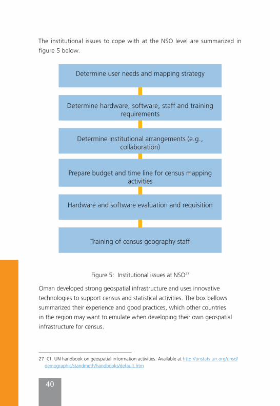
40
The institutional issues to cope with at the NSO level are summarized in figure 5 below.
Figure 5: Institutional issues at NSO27
Oman developed strong geospatial infrastructure and uses innovative technologies to support census and statistical activities. The box bellows summarized their experience and good practices, which other countries in the region may want to emulate when developing their own geospatial infrastructure for census.
27 Cf. UN handbook on geospatial information activities. Available at http://unstats.un.org/unsd/demographic/standmeth/handbooks/default.htm
Determine user needs and mapping strategy
Determine hardware, software, staff and training requirements
Determine institutional arrangements (e.g., collaboration)
Prepare budget and time line for census mapping activities
Hardware and software evaluation and requisition
Training of census geography staff
41
Box 4: Oman experience in using innovative technologies in support of census
In preparation of its census, planned for December 2020, the Sultanate of Oman is opting for an E-Census, “a national project aimed at establishing a system that integrates all statistical data of population housings and establishments based on the national administrative registers”28. Its National Centre for Statistics & Information has published the fundamental elements that distinguish its experience, and combined with the findings of the ESCWA questionnaire, they are outlined as follows:
• Oman has been building a national geospatial information infrastructure, guided by data policies, a legal framework and standards, facilitating the use and sharing of geospatial data, with respect of its ownership by the various governmental providers;
• Its National Statistical Office has developed its geospatial information capacity, providing an institutional coordination role with other national organizations, which also have geospatial information capabilities and responsibilities;
• Oman National Statistical Office has developed a Geographic Information System (GIS) based on a national geographic database, encompassing multi-sectorial datasets;
• Oman National Statistical Office has devised a dissemination strategy, with a comprehensive list of census outputs including by geographic area, with a well-defined timeline;
• Oman has adopted a range of technological tools for data dissemination, such as an interactive census atlas, online database(s), dynamic web pages, GIS web-based mapping tools, cloud computing services, and other applications for social media;
• Oman national statistical office provides metadata with census products for data quality assurance, with confidentiality and anonymization29 procedures;
28 See: https://ecensus.gov.om/?lang=en
29 Anonymization of data refers to the procedures of removing and modifying all individual
42
• Oman has a national statistical law that includes clauses ensuring confidentiality of census micro-data, as well as procedures for anonymization of census micro-data;
• On a regional level, the NSO of Oman has been active in the area of data integration, chairing at its inception the UN-GGIM: Arab States Working Group on the integration of geospatial and statistical information30.
• Oman has taken all the measures to plan and prepare for its census, including devising a strategy for dissemination at an early stage of its census project, assessing the needs of the users and what technology to be used at all the stages of the census, as well as the expected geographic products and the suitable and compelling ways to disseminate and share them with the major users and a wider public.
5. Hybrid census approach for humanitarian situations
Countries experiencing conflicts, environmental hazards, or large population displacements, may not be able to conduct a census with national coverage due to insecurity or inaccessibility. UNSD reported in Nov. 2017 that 11 countries had not scheduled a census for the 2020 Round due to conflicts and humanitarian conditions, almost half of these countries are in the Arab region.31 In countries with humanitarian situations where not all portions of the country can be enumerated the traditional way, i.e. some areas are not accessible due to conflict or natural disasters, modelled population estimates (also called a hybrid census for ease of terminology) can be used to bridge the gaps and provide a complete population count. The Hybrid Census methodology using modelled population estimates is one innovative way
identifiers (such as the name of the person, address and so forth) from digitized census micro-data.
30 See UN-GGIM:Arab States website: http://www.un-ggim-as.org/
31 https://unstats.un.org/unsd/demographic-social/census/index.cshtml#monitoring.
43
UNFPA is providing support to countries with humanitarian situations, with priority support to those countries that did not complete a census in the 2010 census round. Moreover, recently, the Statistical Commission has advocated for the development of a global statistical framework on disaster-related statistics. Reference can be made to decision 50/1162 of the fiftieth session of the United Nations Statistical Commission in March 2019, relating to a new item on disaster-related statistics, where “The Statistical Commission urged the international statistical community to expand its capacity-building efforts in statistics relating to hazardous events and disasters”.Geospatial information can bring crucial support to a hybrid census. “The goal of a hybrid census is to produce population estimates for small areas or uniform, detailed grids in the absence of a traditional national census”.32 Hybrid census requires, as a primary input, population data for a sample of small, defined areas across the country, collected through either a partial census, census-like population survey, or a specifically designed micro-census survey. Collecting data on the small areas of interest, including on their geographic location, geographic population distribution, population density, land cover, topography, and other environmental aspects, requires the use of a range of geospatial information tools, including GPS, satellite imagery, GIS and other mobile electronic devices (tablets, smart phones, etc.)33. In some countries, the majority of the country is enumerated through traditional enumeration and just small portions of the country that are inaccessible are enumerated using modelled population estimates. In other countries, the entire population may be enumerated through a micro-census survey to modelled population estimates. The approach consists of combining micro-census data such as national census data from low levels of geographically that is close by or similar in demographics to the inaccessible areas, or population counts from enumeration surveys, with geospatial data
32 UNFPA Technical Brief - New Methodology: a hybrid census to generate spatially disaggregated population estimates. Available at https://www.unfpa.org/sites/default/files/resource-pdf/Hybrid_Census_Brief_v9.pdf
33 See Box 2, p. 23 of the “UNFPA Strategy for the 2020 Round of Population & Housing Censuses (2015-2024). Available at https://www.unfpa.org/sites/default/files/pub-pdf/Census_Strategy_Final_July.pdf
44
that can be derived from satellite imagery and other sources. Statistical modelling is then used to predict population numbers in areas with no population counts. Population totals can also be produced for administrative units or for the national level by aggregating the gridded population estimates (i.e. predictions) to any traditionally enumerated population. These modelled population estimates can also generate inter-censual estimates and help update national sampling frames 34. Some gridded population datasets are already available35.The guiding methodology to be followed in a hybrid census would require, in summary, three steps36: 1. Collecting data through ‘micro census’ population enumeration – we
need to proceed with a complete count of population within small, defined areas, selected across an area of interest, through ‘micro census’ surveys, that can be collected relatively rapidly, using preferably handheld electronic devices;
2. Linking the data collected by ‘micro census’ surveys with relevant geospatial datasets, using GIS to improve the accuracy of boundary data, and facilitate the integration of geospatial data from different sources;
3. Defining the functional relationships between geospatial datasets and the population data to predict populations in un-surveyed areas, using statistical modelling. The results would provide gridded population estimates.
Since the conditions of insecurity or accessibility are prevalent in countries with underlying humanitarian conditions, satellite imagery or earth observation data is the most sought and suitable data for many reasons:
• Imagery can allow for the mapping of in-accessible areas, and in the cases of countries in conflict, may be the only relevant current data source;
34 UNFPA technical brief - new methodology: a hybrid census to generate spatially disaggregated population estimates. Available at https://www.unfpa.org/sites/default/files/resource-pdf/Hybrid_Census_Brief_v9.pdf
35 Leaving no one off the map – A guide for gridded population data for sustainable development, SDSN TReNDS, 2020. Available at https://www.sdsntrends.org/leaving-no-one-off-the-map
36 See more details in the UNFPA technical brief cited above, from which this methodology is drawn, with illustration in figure 2,
45
• Imagery can be used in base map updates and to identify new settlements. For planning and logistical purposes, it makes sense to locate areas of rapid change since the last census, or two different periods of time, and focus on them; this is what is called “change-detection” For example, census planners can identify areas that require additional fieldwork, for instance to account for new growth in areas surrounding cities;
• High-resolution images offer the ability to cover large areas, particularly areas that are otherwise inaccessible, and their providers generally have no restriction in their acquisition;
• High resolution satellite images show a level of geographic detail that is almost equivalent to digital Ortho-photo maps created from air photos, sufficient for EA delineation or any geographic boundaries needed (e.g. buildings and settlements can be automatically detected from detailed satellite imagery to provide valuable geospatial data to guide fieldworkers);
• Satellite image processing technology, using computer algorithms, can be used to then estimate population density from the layout of streets and buildings, and even help define different types of neighbourhood. For example, neat street grids and large structures often indicate wealthier areas, whereas clusters of disorganized lines can be used to identify slums and informal settlements37;
• Satellite and aerial imagery, representing the bulk of data sources being used for a hybrid census, reinforce the big overall advantage of limiting the field work, which is generally the costliest component in census mapping, and the most apprehended in counties in conflict;
• Satellite imagery allows users to identify and stratify the land by intensity of land use/land cover characteristics and, therefore, help in the construction of area sampling frames for surveys38.
37 See “Satellite images reveal gaps in global population data: Algorithms help to produce precise maps of where people in developing countries live and work”, Nature, Volume 545, May 2017. Available at https://www.nature.com/news/satellite-images-reveal-gaps-in-global-population-data-1.21957
38 See more details in “Chapter 5. cartographic preparation”. Available at http://www.fao.org/economic/the-statistics-division-ess/world-census-of-agriculture/conducting-of-
46
Box 5: Afghanistan experience in using a ‘Hybrid census’.• Afghanistan started planning in 2015 a hybrid census project to
generate geospatially disaggregated population estimates, and initiated its pilot in March 2016
o The initial pilot was conducted in three selected provinces using Socio-Demographic and Economic Survey (SDES) data, recent satellite imagery and a geospatial dataset39.
o High resolution satellite imagery, where buildings and settlement areas have been automatically detected by computer algorithms, was used.
o In October 2016, upon successful completion of the pilot phase, enumeration area counts were combined with geospatial covariates in a spatial statistical model to predict population numbers in all areas where no population data were previously available.
o The final population estimates were released in June/July 2017; population estimates were produced for all 34 provinces using 9 provinces’ SDES data and 19 provinces’ micro-census survey data.
o High resolution maps were produced for estimated disaggregated population by age and sex, and geographically to 100x100m grid squares to provide a consistent structure with other national datasets (*).
• The outcomes of the analyses showed that the accuracy assessments, at the district and province levels, measuring ‘observed vs. predicted’ population numbers had correlation coefficients of >0.95.
• To carry out this innovative project, which requires significant resources and specialists in census/ statistical analyses and geospatial information fields, the national statistics and Information authority of Afghanistan (NSIA) was heavily assisted by several international organizations, including UNFPA; World Pop at the University of Southampton, UK; Flow minder; and Bill and Melinda Gates.
(*) UNFPA technical brief - new methodology: a hybrid census to generate spatially disaggregated population estimates. Available at https://www.unfpa.org/sites/default/files/resource-pdf/Hybrid_Census_Brief_v9.pdf
agriculturalcensuses-and-surveys/chapter-5-cartographic-preparation/en/
39cf.https://unstats.un.org/unsd/undataforum/hybrid-census-to-generate-spatially-disaggregated-population-estimates/
47
In addition to the use of satellite imagery, GPS, and GIS for a hybrid census, the use of the Internet, when it is possible, provides new opportunities to reach geographic areas and population groups that are difficult to enumerate using traditional census methodology (e.g. in large countries with specific needs such as persons with disabilities, or people living in secured accommodation where access is restricted but where Internet is available)40.
6. Recommendations for strengthening the use of GIS / geospatial information systems for census
A set of action-oriented recommendations taking into account the national conditions in the Arab region, including the countries unable to conduct a census, is proposed as follows:
• It is advisable that Arab countries, like many other countries in the world, recognize geography as key to statistics, providing a structure for collecting, processing, storing, aggregating and disseminating data, and significantly improving the quality of official statistics. By embedding geography into their national systems and processes, many NSOs are contributing to the modernization of their statistics. In this regard, Arab countries are recommended to capitalize on the support UNFPA, ESCWA, AITRS are providing to their NSOs to build and develop their statistical-geospatial information infrastructures for the 2020 Census Round and the 2030 Sustainable Development Agenda.
• Many countries in the region are building or built their census geographic databases, recognizing that their developments are fundamental for a full digital census geography programme. It’s recommended to maintain these geographic databases as they offer a basis for spatial analysis which tends to become a core competency in some census offices. It is also recommended to diversify the means for census data dissemination by using web-based mapping, cloud applications and services, and mobile technology to reach a wider audience for a better appreciation of census products and statistical work in general.
40 Cf. Appendix B: Internet Response Options in Selected Population Censuses - Appendix of the book “Envisioning the 2020 Census”. Retrieved from: https://www.nap.edu/read/12865/chapter/17
48
• Arab countries have shown interest in the use of hand-held devices equipped with GPS for data collection and the Internet for dissemination. It is recommended to use mobile technology, GPS, satellite imagery, and Unmanned Aerial Vehicles (UAV) / Drones, as they are facilitating data collection at the individual level, provided we take into account the privacy / confidentiality issues. It is noted, however, that this requires strengthening of capacities and allocation of adequate resources, and a need for knowledge about successful experiences of other countries in the use of these innovative approaches. It is recommended that study visits be carried out in order to share national experiences and practices, and to get guidance, for example, on how to handle the use of mobile devices for data collection and other supporting software applications.
• Earth observations and their support to digital mapping are increasingly recognized by NSOs as important additional sources of data for their statistical activities and for implementing and monitoring the SDGs. More specifically, countries with underlying humanitarian conditions in the Arab region should be aware that the use of satellite imagery, integrated with GPS and GIS, and combined with statistical modelling, is being recognized as crucial for population estimates (hybrid census) and an innovative and alternative solution when a traditional census cannot be conducted. However, since high-resolution satellite imagery, aerial photos, GPS and handheld devices can be costly, Arab countries are recommended to develop acquisition mechanisms in order to reduce their significant costs, such as grouping acquisition of satellite imagery or borrowing of handheld devices.
• NSOs are often not custodians of base maps and other mapping products which may be difficult to acquire, but much needed for census mapping operations. In this regard, NSOs are encouraged to collaborate with respective national mapping authorities, and extend their involvement and active participation, in partnership with
49
other national authorities, in the development of a national statistical-geospatial information capacity. However, building a national geospatial infrastructure in support of census activities requires technical as well as human capacities that may not be available in some countries in the region for which they need support for their development and strengthening.
• Coordination and institutional integration between the statistical and geospatial agencies within a country is vitally important. It is noticeable; however, that institutional coordination to support statistical and geospatial integration in some Arab countries is still underdeveloped, requiring a strong political commitment. In this regard, advocacy of the benefits of linking socio-economic data to a location and the value-added from their integration should be stressed to decision and policy makers, raising their awareness to the need of national institutions for adequate resources to achieve the integration.
• Standardization and data interoperability are arguably one of today’s central development challenges, since any progress in geospatial information management and sharing of authoritative geospatial data will depend on them. The UN Expert Group on the Integration of Statistical and Geospatial Information has developed an overarching statistical-spatial framework which can significantly improve the quality of official statistics and population censuses, and support the sustainable development goals41. However, its implementation at the national level is still a challenge in most of the countries in the region. Therefore, Arab countries are encouraged to develop their national statistical-geospatial framework in accordance with the guidelines and principles agreed upon internationally, emulate other country practices, and seek support from regional and international organizations.
41 Decision by the UN Statistical Commission at its 49th session in March 2018 to establish a federated system of national and global data hubs for the SDGs. 4 Arab countries are participating in this initiative conducted by UNSD and Esri.
50
7. Conclusion Countries in the Arab region are recognizing the advantages of the use of innovative technologies at all stages of the population and housing census process. The use of these technologies is recommended for all national censuses in the region for the 2020 census round and in support of the SDGs; it is however of paramount importance to ensure these activities on a continuous basis as they are crucial for many more applications other than censuses and official statistics.
The 2030 Agenda recommends in particular that Member States undertake new data acquisition and integration approaches to supply reliable, timely, accessible and usable, and disaggregated data that is essential to make informed choices and implement better policies for sustainable development, to ultimately ‘leave no one behind’. The 2017 Cape Town global action plan for Sustainable Development Data was explicit in stating that “National Statistical Systems (NSS) face the urgent need to adapt and develop in order to meet the widening, increasing and evolving needs of data users, including for the full implementation of the 2030 Agenda for Sustainable Development”, recognizing that “capacity building is important for all countries, even more so for developing countries, particularly African countries, least developed countries, landlocked developing countries, small island developing States and middle-income countries and other countries in vulnerable situations”42.
Countries in the Arab region are indeed recommended to build, develop, and strengthen their statistical-geospatial information infrastructures in support of census and statistical activities, and recognize that the adoption of a geographic-based approach with full integration of statistical and geospatial information offers an opportunity for countries to proceed with the modernization of their national statistical systems and official statistics43,
42 Cf. “Cape Town global action plan for sustainable development data”. Available at: https://unstats.un.org/sdgs/hlg/cape-town-global-action-plan/
43 Cf. In-depth review of developing geospatial information services based on official statistics,
51
and build their capacities to be able to cope with the 2030 Sustainable Development Agenda challenges44. It is of paramount importance that countries in the region need to develop and strengthen their capacities to use geospatial information technologies in support of their censuses. The need is even greater to assist Member States in strengthening capacities for their disaster management agencies, national statistical offices, and other related contributors of data to meet geospatial requirements for a ‘hybrid census’.
This document provides NSOs in Arab countries with guidelines on how to overcome the gaps and address the challenges faced when using GIS and other geospatial information technologies in support of censuses, including in countries with humanitarian situations.
note by the United Kingdom office for national statistics, CES, 2016, ECE/CES/2016/7.
44 UNFPA Strategy for the 2020 Round of Population & Housing Censuses (2015-2024), 2017. Available at https://www.unfpa.org/publications/unfpa-strategy-2020-round-population-housing-censuses-2015-2024
52
References• “UNFPA Strategy for the 2020 Round of Population & Housing
Censuses (2015-2024)”, 2017. Available at https://www.unfpa.org/publications/unfpa-strategy-2020-round-population-housing-censuses-2015-2024
• “Evaluation of UNFPA support to population and housing census data to inform decision-making and policy formulation (2005-2014)”, Volume 1, 2016. Available at http://www.unfpa.org/evaluation
• “Evaluation of UNFPA support to population and housing census data to inform decision-making and policy formulation (2005-2014)”, Volume 2, 2016. Full report can be accessed at: http://www.unfpa.org/admin-resource/evaluation-unfpa-support-population-and-housing-census-data-inform-decision-making
• “UN Principles and Recommendations for Population and Housing Censuses - Revision 3”, 2017. (ST/ESA/STAT/SER.M/67/Rev.3). Available athttps://unstats.un.org/unsd/demographic-social/Standards-and-Methods/files/Principles_and_Recommendations/Population-and-Housing-Censuses/Series_M67rev3-E.pdf
• “2010 and 2020 World Population and Housing Census Programme”.Available at https://unstats.un.org/unsd/statcom/doc15/2015-6-Censuses-E.pdf
• “Global Statistical Geospatial Framework” (adopted at the ninth session of UN-GGIM). Available at https://ggim.un.org/meetings/GGIM-committee/9th-Session/documents/The_GSGF.pdf
• “Integrated Geospatial Information Framework (IGIF)”. Available at https://ggim.un.org/IGIF/
• “UN Handbook on Geospatial Infrastructure in Support of Census Activities”, UN Publications, New York 2009. Available at https://unstats.un.org/unsd/demographic/standmeth/handbooks/series_f103en.pdf
• UNSD, “Overview of national experiences for population and housing
53
censuses of the 2010 round, June 2013”. Available at https://unstats.un.org/unsd/censuskb20/KnowledgebaseArticle10706.aspx
• Report of the United States of America on the 2010 World Population and Housing Census Programme (E/CN.3/2012/2); and report on the results of the survey on census methods used by countries in the 2010 Census Round, available from http://unstats.un.org/unsd/demographic/sources/census/2010_PHC/docs/ReportOnSurveyFor2010Census.pdf
• “UNSD Guidelines on the use of electronic data collection technologies in population and housing censuses”, 2019. Available at https://unstats.un.org/unsd/demographic/standmeth/handbooks/data-collection-census-201901.pdf
• “Cape Town Global Action Plan for Sustainable Development Data”. Available at: https://unstats.un.org/sdgs/hlg/cape-town-global-action-plan/
• “Future trends in geospatial information management: the five to ten year vision” THIRD EDITION, 2020. Available at: https://ggim.un.org/meetings/GGIM-committee/10th-Session/documents/Future_Trends_Report_THIRD_EDITION_digital_accessible.pdf
• “Leaving no One off the Map – A Guide for Gridded Population Data for Sustainable Development”, SDSN TReNDS, 2020. Available at https://www.sdsntrends.org/leaving-no-one-off-the-map
• “GIS and the 2020 Census – Modernizing Official Statistics”, Esri Press, 2019. Available as e-book and in print.
• “In-depth review of developing geospatial information services based on official statistics”, Note by the United Kingdom Office for National Statistics, CES, 2016, ECE/CES/2016/7. Available at:https://www.unece.org/fileadmin/DAM/stats/documents/ece/ces/2016/mtg/CES_7-In-Depth_Review_Geospatial_adv_copy.pdf
• “New Technologies in Census Geographic Listing - Select Topics in International Censuses. US Census Bureau, 2015”. Available at: https://www.census.gov/content/dam/Census/library/working-
54
papers/2015/demo/new-tech-census-geo.pdf
• “New Technologies in Census Data Collection Part 2: Developing an Electronic Questionnaire - Select Topics in International Censuses. US Census Bureau, 2016”. Available at: https://www.census.gov/content/dam/Census/library/working-papers/2016/demo/stic-capi-2-developingelectronicq-final.pdf
• “Geographical Information Systems: Principles and Applications”, from Paul A. Longley, Michael F. Good child, David J. Maguire, and David W. Rhind. Longman Scientific & Technical, 1991.