Embed Size (px)
Citation preview
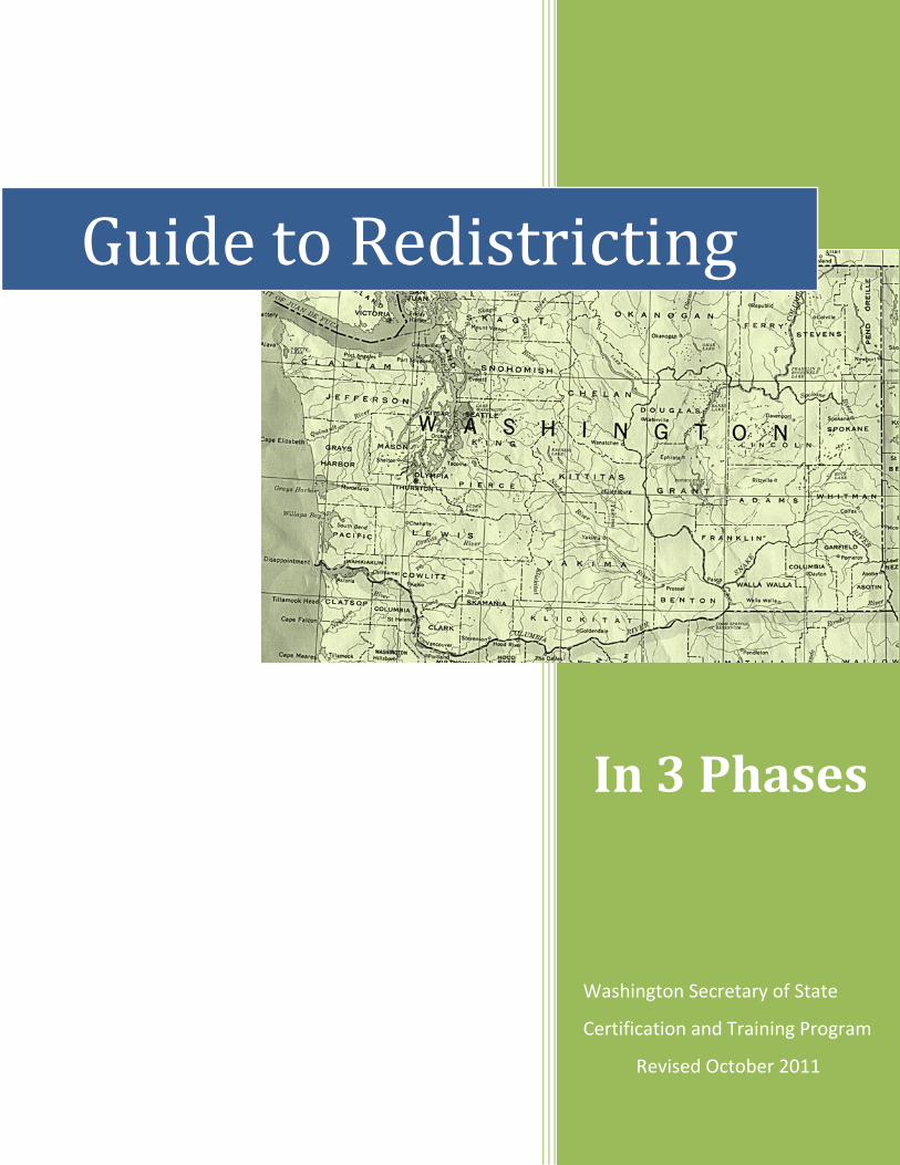
Washington Secretary of State
Certification and Training Program
Revised October 2011
Guide to Redistricting
In 3 Phases

Table of Contents
1 Introduction
3 Period for 2012 precinct changes (graph)
4 Census Benchmarks
6 Phase 1
17 Phase 2
29 Phase 3
32 Redistricting Glossary
35 Appendixes A through E
Appendix A: Laws
Appendix B: Resources
Appendix C: Examples
Appendix D: Sample of Written Procedures
Appendix E: Census Codes
The Office of the Secretary of State Certification and Training Program, and the Washington State Redistricting Commission, in partnership with Washington County Election Administrators, produced this publication. For information on this training contact: Elections Division, PO Box 40229, Olympia, WA 98504‐0229.
Guide to Redistricting – In 3 Phases
INTRODUCTION
Each decade, the US Government
conducts a census of the nation’s
population. Following the census,
boundaries change to reflect the
current population of counties, cities,
and other jurisdictions that have
internal governing districts. This guide
will assist county election
administrators in understanding the
responsibilities and tasks related to
adjusting precinct lines in response to
the US census.
This guide is organized into to three
phases of the redistricting process:
Phase 1. How can election
administrators prepare for the release
of US Census data? This phase outlines
pre-census preparations that will assist
election administrators in adjusting
district and precinct lines according to
census data.
Phase 2. How does the release of the
US Census data affect local
jurisdictions? How do jurisdictions
begin to redraw district boundaries?
This phase provides guidance for
redrawing district lines and
collaboration with minor taxing
districts.
Phase 3. How is the process finalized?
This phase details the release of State
Legislative and US Congressional district
changes and the effects on local
jurisdictions. Official adoption of new
precincts and precinct lines by the
county legislative authority, and
notification of voters, will complete the
entire process.
Who is responsible? Three different groups share
redistricting responsibilities: The State
Redistricting Commission, local
jurisdictions, and county legislative
authorities.
The State Redistricting Commission.
The commission is charged with
redrawing state legislative and US
Congressional district lines. The
commission must present a proposed
plan to the state legislature in 2012.
The state legislature has a limited ability
to alter the plan which is not official
until the legislature passes it.
Local Jurisdictions. Not all jurisdictions
must adjust their district boundaries in
Page 1
response to census data. Only those
with internal districts intended to
represent equal numbers of people are
required by law to reapportion their
districts. If boundary adjustments are
required, the new districts must
represent essentially equal shares of
the district’s population based on the
census data. Examples of districts that
may need boundary adjustments are
county commissioner/county legislative
districts, ports, PUDs, cities/towns with
wards, and school director districts.
Election administrators are not required
to assist local districts with adjusting
boundaries; however, doing so provides
an opportunity to influence where the
lines are drawn.
County Legislative Authorities. County
commissions and councils are
responsible for adjusting precinct lines
according to city boundaries and the
boundaries of congressional, state
legislative, and county legislative
districts.
Once jurisdictions have redrawn
internal district lines, voting precincts
are adjusted to match the new lines.
This is typically done in consultation
with the county election administrator.
Page 2
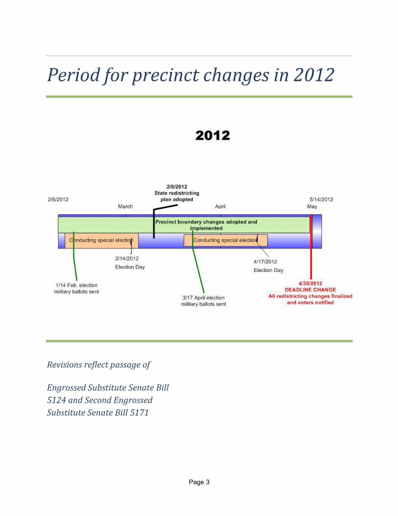
Period for precinct changes in 2012
Revisions reflect passage of Engrossed Substitute Senate Bill
5124 and Second Engrossed
Substitute Senate Bill 5171
Page 3
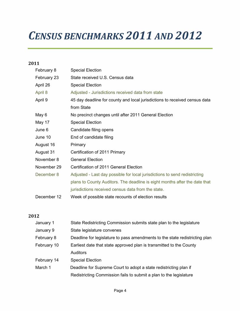
CENSUS BENCHMARKS 2011 AND 2012
2011
February 8 Special Election
February 23 State received U.S. Census data
April 26 Special Election
April 8 Adjusted - Jurisdictions received data from state
April 9 45 day deadline for county and local jurisdictions to received census data
from State
May 6 No precinct changes until after 2011 General Election
May 17 Special Election
June 6 Candidate filing opens
June 10 End of candidate filing
August 16 Primary
August 31 Certification of 2011 Primary
November 8 General Election
November 29 Certification of 2011 General Election
December 8 Adjusted - Last day possible for local jurisdictions to send redistricting
plans to County Auditors. The deadline is eight months after the date that
jurisdictions received census data from the state.
December 12 Week of possible state recounts of election results
2012
January 1 State Redistricting Commission submits state plan to the legislature
January 9 State legislature convenes
February 8 Deadline for legislature to pass amendments to the state redistricting plan
February 10 Earliest date that state approved plan is transmitted to the County
Auditors
February 14 Special Election
March 1 Deadline for Supreme Court to adopt a state redistricting plan if
Redistricting Commission fails to submit a plan to the legislature
Page 4
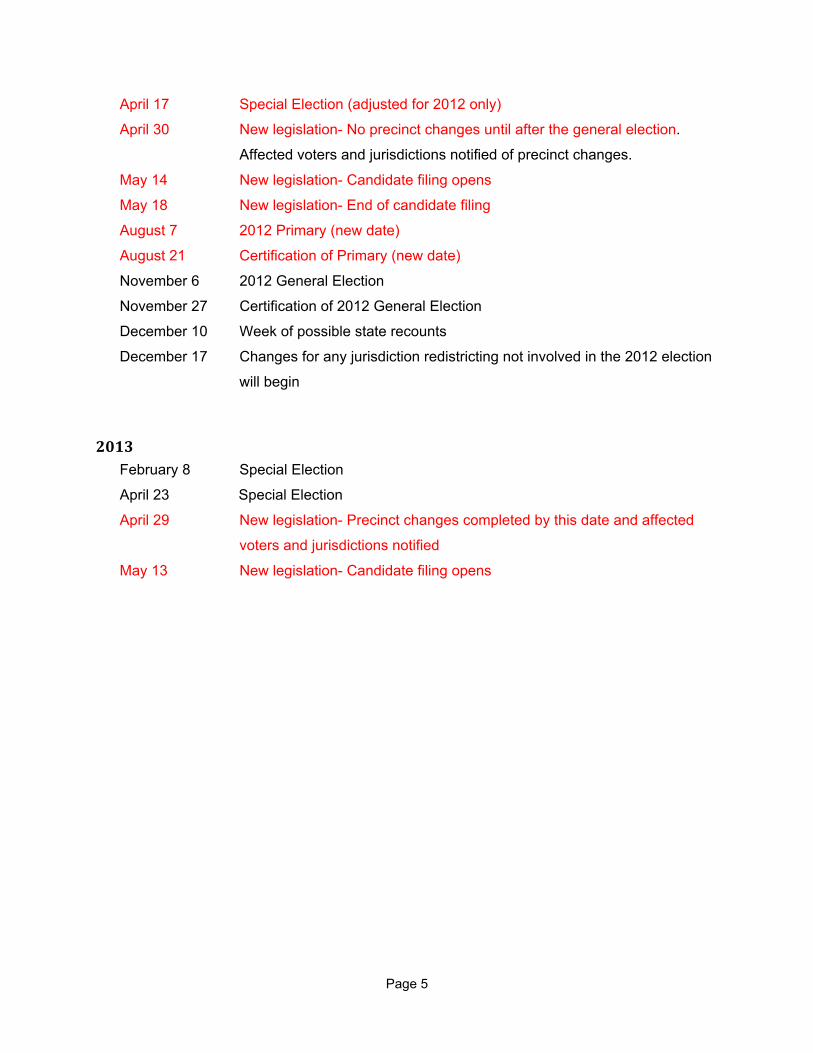
April 17 Special Election (adjusted for 2012 only)
April 30 New legislation- No precinct changes until after the general election.
Affected voters and jurisdictions notified of precinct changes.
May 14 New legislation- Candidate filing opens
May 18 New legislation- End of candidate filing
August 7 2012 Primary (new date)
August 21 Certification of Primary (new date)
November 6 2012 General Election
November 27 Certification of 2012 General Election
December 10 Week of possible state recounts
December 17 Changes for any jurisdiction redistricting not involved in the 2012 election
will begin
2013 February 8 Special Election
April 23 Special Election
April 29 New legislation- Precinct changes completed by this date and affected
voters and jurisdictions notified
May 13 New legislation- Candidate filing opens
Page 5
Phase 1: Get Ready Preparation for redistricting begins immediately. Focus on the six areas listed in this chapter to prepare your county for effective redrawing of precinct lines.
1. VOTER REGISTRATION FILES
There is a limited amount of time for county administrators to adjust precinct boundaries. The more that can be done before the final adjustments, the better. The following items are suggested steps to prepare for redistricting.
Review local district boundaries
Current information about district boundaries is essential to prepare for the 2011 local redistricting deadline. To review district and sub-district boundaries:
Take an inventory of district maps.
Verify with districts that the boundaries are still current.
Seek to obtain current district maps and legal descriptions not in your possession.
Document all information provided by each district through obtaining a signature and date from the district’s representative.
Districts required to redistrict include:
County legislative authority, port commissioner, and PUD commissioner districts.
Learn current configuration of internal district boundaries. If a port
district covers a whole county and has the same number of commissioner districts as the county legislative authority, the port district must use the same districts as the county legislative authority. If port districts encompass only part of a county, or cross county lines, the districts be redistricted separately. Counties are often able to redistribute population among these districts by simply exchanging some precincts. Understand how each district defines boundaries. Descriptions of district boundaries could be by metes and bounds, a list of precincts, or a list of census blocks. If a relationship to precincts or census blocks is used, is the list up to date? Are you aware of a district that did not redistrict after the last census? If so, advise such districts that there is a need to do so this time.
Cities and towns
Work with your cities to ensure their boundaries are accurate and that city annexations are provided to the
Page 6
proper authorities (Office of Financial Management AND Census Bureau, County Treasurer, County Auditor, county GIS department, etc.). Keep an active watch on annexations in your county; you may have to adopt these before redistricting occurs.
School districts and school director districts
Educational Service Districts (ESDs) are the official keepers of school boundaries. Contact ESDs early to obtain current information. School district boundaries were recently updated in the Census Bureau’s data; a by-product of this effort was a large number of corrections/revisions to the legal descriptions, which are pending adoption by the ESDs. ESDs should have boundary verification maps for each school district. The State Redistricting Commission has copies of these descriptions and maps as well, but is not the official source. School director district boundaries officially reside with the individual school districts. Work with your individual school districts to ensure you have accurate boundaries for director districts.
Fire districts
Use a tax map, not a service map, for reviewing street files. Not all areas are included in a fire district, and fire districts will often respond to areas that are outside the legal boundaries of the district.
Street file maintenance
Street segments are the basic building blocks for precincts and precinct splits in the voter registration system. The accuracy of voter placement in your system is only as good as the street file. Cleaning your street file now will save you time and errors when you later divide and combine precincts. Correcting the street file may also require updating voters’ addresses in the system to comply with the changes. Items to review when examining a street file:
Even/odd addresses. Review all streets to make sure that addresses are in proper jurisdiction/precinct.
Incomplete addresses. Your county’s street file may be missing one or more elements of an address.
Incorrect road types. For instance, highways and state routes are their own street type.
Missing prefix or suffix. Frequently occurs when addressing apartments and duplexes.
Missing or incomplete compass directions. For example, the direction is North instead of Northwest.
Overly long address ranges. Extended ranges allow for registrants at non-existent, undeliverable addresses. For example, a range extending from 1 to 10000.
Examine miscellaneous inconsistencies, such as:
Directional prefix or suffix. Confirm that compass directions are the same for the different segments of each street.
Road types. Is it 2nd St. or 2nd Ave.? Is it Highway 507, or Hwy 507, or State Route 507, or State Rte 507, or S.R.
Page 7
507? Find out which one passes USPS standards and use it.
Unit types. Use the correct abbreviation for apartments, spaces, units, etc. For example, the US Postal Service does not approve the use of a pound sign (#).
Identify duplicate segments:
Do you have a 2nd St. and a 2nd Ave that are really the same street or avenue? For example, whenever a street type is spelled out for one address, then abbreviated for another (e.g. Lane vs. Ln.) your street file will end up with multiple street segments for the same addresses. (If you are lucky, both duplicate segments are in the same precinct or precinct split!)
Consider these additional details when examining street files:
The Post Office does not like hyphens and apostrophes. If you find any, check that the address conforms to US Postal standards at www.USPS.com. Just because a voter writes it in the address, does not mean that it is correct.
Registrants with a separate mailing address may have incorrect or obsolete residential address information. Registrant(s) may have moved within the same area or town without updating their information.
Consider sending a mailing to all PO Box users to verify current residences.
Voters may register to vote at a business address. Try to identify and correct these registrations before redistricting.
Street file management
Feeling a sense of ownership of the information in your database can take a while, but the following hints will help.
Limit access to street file information to designated personnel only.
Devise a data entry form to log corrections needed. Then make the corrections.
Be wary of simply adding a street address the way a registrant provides it. Registrants do not always know their correct address information, especially if they are new to the area. Verify unknown or new addresses at www.USPS.com, with the Building and Planning Department, or your County Assessor.
In denser residential areas, construct segments for each block of the street. This will create a bulkier street file, but it will be more accurate.
Ideally, each block should range from the lowest to highest actual addresses.
Avoid ranges that run 0 to 99 (or 99999 for that matter).
In business/industrial areas, remove street segments unless there is a valid residence there. This will alert you to voters using their business address as a residence address.
Only add a segment for this type of address if a residence and a business coexist.
Compare your addresses to postal standards.
Review USPS Publication 28 for addressing standards.
Run your list of addresses against postal certification software. Your mailing house presorts your mailings, is able to provide a list of addresses needing normalizing. For NVRA compliance the mailing house should provide nonconforming addresses after every mailing.
When adding a new segment to the street files, check the addresses with the Post Office.
Web site address for USPS Abbreviation standards:
http://www.usps.com/ncsc/lookups/usps_abbreviations.htm .
Page 8

If “geo-coding” the addresses in your database:
Ideally, this will assign a point on the map for every address in your database. This is a good tool for crosschecking the accuracy of voter placement in the street file.
The success of geocoding will depend on the accuracy and consistency of your addresses and the quality of the road data.
Not every address will produce a match, but a large majority will. Expect an initial match rate that may only be in the 60+ percent range.
Many addresses may need minor tweaking on the name, type, direction, etc. before they will match up.
Ignore unit identifiers such as apartment or duplex numbers when geocoding.
Keep informed about new housing developments to anticipate new streets:
New residential areas may straddle old boundary lines. The Assessor will likely assign tax codes parcel by parcel in these areas.
Make a note of new streets that are going in, estimate the block ranges.
Field checking is sometimes necessary. If you are traveling around the county on business, make a point to swing by any questionable area.
Another tool that may be available to
you is the online parcel lookup (usually
available through the County Assessor’s
website).
Page 9
2. PRECINCT BOUNDARIES
Precincts are defined by RCW 29A.04.121 as “a geographical subdivision for voting purposes that is established by a county legislative authority.”
What purpose does a precinct serve?
From an election administration standpoint, precincts exist to make elections run smoothly in a fair and organized manner. Precincts organize voters into groups that share geography and political commonality. Precincts provide an orderly way of issuing the correct ballot to each voter. Under the simplest possible scenario, there would be one precinct for each ballot style—one precinct for each combination of overlapping jurisdictions and electoral districts (commissioner districts, wards, etc.). Most counties, however, have precincts that require more than one ballot style. Rules for defining precinct boundaries are found in RCW 29A.16.050; however, outside organizations may want to help determine where precinct lines are drawn. For instance, political parties may insist that precincts remain smaller than they legally need to be, for political party purposes.
Review current precinct boundaries
Start with accurate precinct lines to make the process easier. Examine your precincts and become familiar with their boundaries. Look for areas where the boundaries may be incorrect or not well described, particularly where the descriptions refer to features that no longer exist or are no longer visible.
Verify the legal descriptions are correct (write legal descriptions if they are missing).
Legal descriptions are tedious to read, and even more tedious to write. As a result, they can contain errors. It is very easy in the course of writing a legal to make a simple
directional or distance error, or even omit a part of a description.
Review legals to ensure that they are still current.
Confirm that your VR system has accurately registered all incumbents (including PCOs).
Contact the incumbent or district to make sure you have the correct address. Every so often, it comes to light that an elected official does not actually reside within the precinct or district they represent.
Request that school directors pinpoint their residence on a map. School director districts can cause issues if the VR/election management system does not define director district boundaries.
Consider creating school director sub-districts in your VR system to ensure accuracy over the next decade.
Precinct lines should follow current city/town boundaries. Check with each city to verify that current precinct lines reflect all annexations.
Tip: Keep in touch with cities to make sure you are in the loop when future annexations occur.
Identify outdated reference points:
Visible physical features used to define existing precinct lines may have disappeared. For example, a fence line is abandoned.
Parcels may have been divided and the points are no longer applicable.
If in doubt, physically visit the lines.
Page 10

Visualize the “ideal” precinct map
Create a vision of your “ideal” precinct map so you can clearly identify needed adjustments. Then prioritize and target only the precincts that need immediate attention – you have a very brief window of opportunity in 2012. This vision will help you when communicating with local officials. Examine existing precincts. Identify precincts that exist only because of current congressional, state legislative and county legislative district lines that have the potential to combine with neighboring precincts. For example, Tumwater precinct 19, trapped between a county council district and the Tumwater city limits, has no resident population. The precinct consists of a steep bluff, a road, and part of a park. The county could eliminate the precinct, without affecting any voters, if the county council district boundary corresponds with the city limits.
Consult with your county commissioners or council members about ways to avoid creating small or very oddly shaped precincts. Be prepared to discuss the advantages in cost savings and reduced confusion of candidates and voters.
Identify precincts that exceed the maximum number of registered voters
Finally, identify precinct lines that cut through parcels, dwellings, and developments. (Aerial photography, county parcel viewers, and parcel files will help identify those problem areas.)
Have the courage to review the basics. Ask questions such as:
Are names for precincts still necessary?
All precincts are required by law (RCW 29A.16.050) to have a numeric designation, and precinct numbers are easier for computers to deal with and less prone to
typographical errors. On the other hand, human beings tend to relate better to names.
Is the numbering system logical?
Many counties find it helpful to incorporate congressional or legislative district numbers and city or town codes in their precinct numbers.
If you decide to renumber precincts, do it now. Changing the numbers between censuses makes it difficult to track precinct changes.
How much change should be attempted? Time is short. If you want to change the numbering system or make adjustments to precincts in response to districts merges, think about doing so well in advance of the 2012 redistricting deadline or wait until 2013.
The next step is to draft new precinct boundaries, as you would like to see them. Identify precinct merges, splits and adjustments.
Precinct lines should meet all legal requirements.
Keep a tracking sheet of suggested changes and make notes of why these changes are desirable.
Phase 2 of this guide contains hints for drawing new precinct boundaries.
Page 11
3. STAKEHOLDERS
Identify your stakeholders and know how to contact them. Encourage stakeholders to participate. Bringing stakeholders on board early will help build confidence in you and the process. Before you advance into redistricting: Create a stakeholders list that identifies the most effective contact, mailing address, email, phone number and fax.
Districts may request past boundary information and historical data. Decide how much historical and statistical data you need to assemble.
Local jurisdictions
Contacts on your stakeholders list should include administrative office assistants, clerks, managers, and incumbents.
County legislative authority members and their staff. County commissioners and council members must adopt any new precinct boundaries. Keep them informed.
Cities. Cities/towns with wards will need to redraw ward boundary lines by the end of 2011.
School districts. School districts with internal director districts will need to have a new director district plan by the end of 2011. If there are no elections for these districts in 2012, implementation can wait until spring of 2013. Encourage districts to undertake this effort themselves or seek out a vendor that will produce usable geography.
Request that school boards inspect any materials produced by outside vendors,
to be certain the information and boundaries make sense. For example, the school board should confirm that features used as boundaries actually exist.
Public utility districts. Existing county-wide public utility districts do not have to correspond with county legislative authority district lines. All public utility districts are responsible for redrawing their own commissioner districts.
Port districts. Port districts that cover a whole county and have the same number of commissioners as the county legislative authority will use the same district lines as the county legislative authority. All other port districts are responsible for redrawing their own commissioner districts.
Fire protection districts and water-sewer districts. Some fire and water districts may have internal commissioner districts. If they do, they may need to redraw them.
Secretary of State. Although technically not a jurisdiction, the OSOS needs the information. Of course, the 2012 project on the OSOS website is a portal for data, documents, news, and other information. Both the counties and the Redistricting Commission will be using this as a one-stop shop.
Political interests
Major political party chairs and county party chairs. Precincts affect the administration of major political parties and election of precinct committee officers. County political parties should be included as stakeholders.
Page 12
It is advantageous to work with political parties before any precinct boundary changes are proposed. Last- minute surprises at a public meeting scheduled to approve new boundaries will make it difficult to meet deadlines.
The public and media. Keep media informed with press releases and interviews. Only do this if you know who to speak with and what to say.
Vendors
Technical systems. Include your voter registration vendor, mapmakers, and companies that support jurisdictions during redistricting.
Printers and mailing services.
US Postal Service. This includes your local postmasters, business design and mailing piece design experts.
County departments/support
County commissioner support staff. Be mindful of the process when asking for county commissioner support, including public hearings. Be sure to schedule meetings well in advance.
Geographic information system (GIS). Do you understand the potential workload that this process may involve? Does the GIS staff understand the project and timelines? Learn what the system can and cannot do.
County Assessor.
IT staff. Include the web support – Counties will post information on websites and link to project website
Boundary review committee. If your county has one, this committee can alert you to potential upcoming changes and provide information on enacted annexations and boundary changes.
Hints for communicating with districts
Be proactive. Techniques counties have found useful include: Communicate early and often.
Keep the appropriate stakeholders up-to-date by sending regular communications. Your vendors may not need the same information as political parties.
Alerts, updates, and FAQs will keep districts informed and your task on their minds.
Ask GIS to provide maps with census blocks to the districts.
Schedule meetings as soon as possible.
Ask for their input on the process, whenever it is appropriate. (Ask only if you intend to consider their ideas.)
Be clear. Specify the items districts need to include in their redistricting plans:
For example, maps should have legends, identifiable landmarks, north/south arrows, and the effective date.
Legal descriptions should be proofread carefully and any missing information (names of creeks, roads, etc.) supplied where possible.
Suggest possible redistricting plans (preferably two or three choices) before the districts have begun the process.
The county legislative authority may expect you to:
Schedule meetings well in advance.
Know the procedures of the board, council, or department.
Prepare all required documents.
Page 13
Keep in contact with the Clerk of the Board or its administrative assistant.
The County Auditor/Elections Division should begin gathering data in 2010:
Districts will request past boundary information and historical data. Prepare historical precinct voter total data. Keep information visual. Documents full of statistics and numbers may detail the whole picture, but are often too complex for rapid comprehension.
4. STAFFING
Will you have enough trained staff to handle redrafting precinct and jurisdiction lines while conducting spring elections in your county? Remember, the 2012 Presidential Primary may be conducted during the same period of time.
Ways to prepare staff
Share the information. Better yet, share this guide with your staff.
Create an informational “script” to help staff answer questions from the public. This will provide consistent answers and take some of the stress out of redistricting. Include rules for jurisdiction internal district changes and precinct lines.
Have the current printed manual for your voter registration system at hand. You may not always be able to access an electronic version, or your staff may be more comfortable with the printed word. If in doubt, look it up!
Train your staff in managing precincts and changing street segments in the VR/EMS. It is important that assigned staff can competently:
Run reports including totals of voters for precincts, precinct parts and totals for jurisdictions
Create, modify, and delete street segments
Delete, merge and create precincts
Add or remove jurisdictions from precincts
Create or adjust commissioner districts
Counties with GIS:
Know if you can interface the VR system with GIS
If using an out-of-department GIS service, arrange for a primary contact person. Who and how should you communicate tasks and issues?
Train staff in arranging the data
Counties without GIS:
Will your VR vendor construct a ghost of your data system to allow changes in advance of acceptance without compromising your VR data/system? Be sure that you can then ‘data dump’ the ghost copy into the real VR. If so, teach your staff how to use the ghost copy.
Do you have staff trained to read (and write) legal descriptions? Do you have staff that can redraft maps? If not, what training will they need?
Finally, assign specific tasks that include quality control.
Page 14
5. BUDGETING AND FINANCING
Adjusting precinct boundaries will cost money. Anticipate the need for additional dollars in your 2011 and 2012 budgets. Additional costs you may expect to incur include:
Additional staffing
Overtime (including attendance at district meetings)
Interfund costs for other county departments service such as GIS or IT support
Purchase or updating of software programs, such as geographic information system upgrades
Costs related to an increased number of ballot styles
Additional printing and postage costs may include:
Mailings to validate/verify existing information, such as letters to voters with post office boxes
Mandated notices to voters who have had precinct boundary changes have specific language requirements. It will be necessary to design and print special notices for the occasion along with new voter ID cards.
Copies of legal descriptions
Maps
Communication to districts
6. RECORDS RETENTION
Anticipate the records needed for redistricting in 2022. Organize folders and files, including digital and physical maps. Plan in advance which files must be kept for archival purposes:
Who should be the custodian of prime documents?
When should documents be transferred or destroyed?
Create tracking forms to record the old/new precinct and district relationships.
If you are working with a GIS department, include the department in the discussion. They
may need to retain source documentation, or, they may have ways to retain data that you do not. Consider saving a copy of your precinct shape file for each election, clearly marked with the date. Precinct-level returns do not mean much if you do not know what the precincts looked like at the time. Confirm that your map shape files use the same precinct identifiers (names and/or numbers) as your election returns.
When programming your election reporting software, number your precincts consistently from election to election.
Page 15

Page 16
Phase 2: Redistricting Local Jurisdictions Jurisdictions with internal districts intended to represent equal numbers of people must redraw
their internal districts in response to census data and population changes.
DEADLINES
April 1, 2011. State receives US Census data. April 8, 2011. Local jurisdictions received census data from the state on this date. The eight month period for jurisdictions to create a redistricting plan begins with this date. May 16, 2011. (superseded by earlier delivery).The final date that local jurisdictions could have received census data according to law. December 8, 2011. Local jurisdictions submit redistricting plans to the County Auditor on or before this date, which is eight months after the date jurisdictions received state census data. December 31, 2011. (superseded by earlier delivery of census data). The deadline that County Auditors would have obtain redistricting plans from local jurisdictions provided census data was distributed on May 16.
JURISDICTION RESPONSIBILITIES RCW 29A.76.010
If boundary adjustments are required, the reapportioned districts must represent a nearly equal distribution of the district’s population based on the census data.
Districts have eight months after receipt of census data to prepare their plan for redistricting internal boundaries.
RULES FOR REDRAWING INTERNAL OR DIRECTOR DISTRICTS RCW 29A.76
Each district is responsible for the reapportionment of internal and director districts. Rules for redistricting internal or director districts are contained in RCW 29A.76.010 and RCW 29A.76.020.
District boundaries should preserve existing communities of related and mutual interest.
The jurisdiction must ensure that there is full and reasonable public notice of its actions during the adoption of its plan. The district must hold at least one public hearing on the redistricting plan at least one week before adoption of the plan.
Page 17
Any registered voter may request the Superior Court of the county to review the plan within forty-five days of the plan’s adoption.
If the jurisdiction lies entirely within the county, that jurisdiction must provide the County Auditor accurate information describing its geographical boundaries and the boundaries of director, council, or commissioner districts.
When a city, town, or special purpose district lies in more than one county, the municipal or special purpose district must provide accurate information to the Secretary of State. This information must accurately describe the external and internal boundaries of the jurisdiction.
Jurisdictions must ensure the County Auditor and the Secretary of State are kept current with regard to external and internal district boundaries.
Rules by specific district types
Congressional districts. Article I, Section 2 of the US Constitution. Seats in the US House of Representatives are allotted to the states based on their relative population after each census. Federal law sets the total number of House seats at 435, of which nine are currently assigned to Washington (some population projections show Washington may be gaining a tenth seat after the current census, but we won’t know until the end of 2010). The US Supreme Court has held that, in the absence of very compelling reasons for deviation, Congressional Districts must be equal in population, “as nearly as is practicable”.
Legislative districts . RCW 44.05. Forty–nine districts will each encompass a population as nearly equal as practicable.
County legislative authority districts. Each district shall comprise as nearly as possible equal portions of the population of the county. Non-charter county commissioner district boundaries may only change once every four years. (RCW 36.32) The County may assign the task of preparing a redistricting plan for its
legislative authority district boundaries to a department or commission. Assignment of a commission to perform this duty will still involve the Auditor and Elections Division staff.
Port districts. RCW 53.16. If a countywide port district has the same number of commissioner districts as the county legislative authority, the commissioner districts must use the same boundaries as the county commissioner districts. (RCW 53.16.015) All other port districts will draw commissioner boundaries so that each district contains approximately equal population.
Public utility districts. RCW 54.12. Public utility commissioner district boundaries are independent of those of the county commissioner districts. Public utility commissioner district boundaries may not be changed more often than every four years, unless the external boundaries of the district have changed.
Cities and towns. RCW 35 and 35A. Not all cities and towns have council districts, or wards; but those that do will need to redraw them to maintain population equality.
School districts. RCW 28A.343. School districts with internal director districts will need to redraw them to equalize their population.
Fire protection districts and water-sewer districts. RCW 52.14 and 57.12. By default, fire districts and water districts do not have internal commissioner districts. However, both types of districts are empowered by law (RCW 52.14.013, 57.12.039) to subdivide themselves into commissioner districts (for fire districts, this requires a public vote). Check with your local fire and water districts to see if any of them have commissioner districts.
Page 18
5/6/2011 RTW
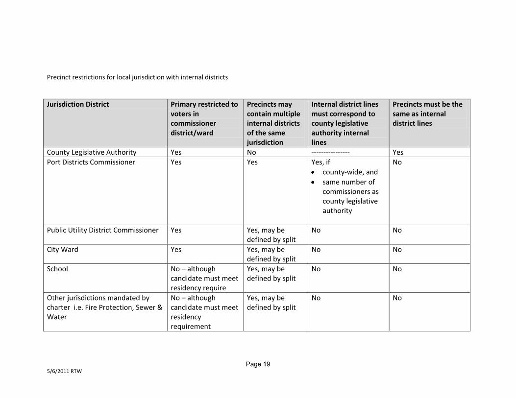
Precinct restrictions for local jurisdiction with internal districts
Jurisdiction District Primary restricted to voters in commissioner district/ward
Precincts may contain multiple internal districts of the same jurisdiction
Internal district lines must correspond to county legislative authority internal lines
Precincts must be the same as internal district lines
County Legislative Authority Yes No ---------------- Yes
Port Districts Commissioner Yes Yes Yes, if
county-wide, and
same number of commissioners as county legislative authority
No
Public Utility District Commissioner Yes Yes, may be defined by split
No No
City Ward Yes Yes, may be defined by split
No No
School No – although candidate must meet residency require
Yes, may be defined by split
No No
Other jurisdictions mandated by charter i.e. Fire Protection, Sewer & Water
No – although candidate must meet residency requirement
Yes, may be defined by split
No No
Page 19
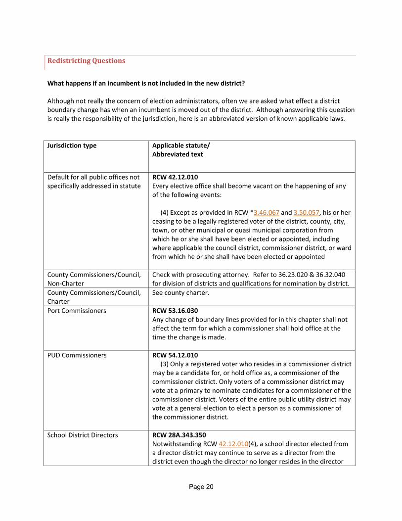
Redistricting Questions
What happens if an incumbent is not included in the new district? Although not really the concern of election administrators, often we are asked what effect a district boundary change has when an incumbent is moved out of the district. Although answering this question is really the responsibility of the jurisdiction, here is an abbreviated version of known applicable laws.
Jurisdiction type Applicable statute/ Abbreviated text
Default for all public offices not specifically addressed in statute
RCW 42.12.010 Every elective office shall become vacant on the happening of any of the following events: (4) Except as provided in RCW *3.46.067 and 3.50.057, his or her ceasing to be a legally registered voter of the district, county, city, town, or other municipal or quasi municipal corporation from which he or she shall have been elected or appointed, including where applicable the council district, commissioner district, or ward from which he or she shall have been elected or appointed
County Commissioners/Council, Non‐Charter
Check with prosecuting attorney. Refer to 36.23.020 & 36.32.040 for division of districts and qualifications for nomination by district.
County Commissioners/Council, Charter
See county charter.
Port Commissioners RCW 53.16.030 Any change of boundary lines provided for in this chapter shall not affect the term for which a commissioner shall hold office at the time the change is made.
PUD Commissioners RCW 54.12.010 (3) Only a registered voter who resides in a commissioner district may be a candidate for, or hold office as, a commissioner of the commissioner district. Only voters of a commissioner district may vote at a primary to nominate candidates for a commissioner of the commissioner district. Voters of the entire public utility district may vote at a general election to elect a person as a commissioner of the commissioner district.
School District Directors
RCW 28A.343.350 Notwithstanding RCW 42.12.010(4), a school director elected from a director district may continue to serve as a director from the district even though the director no longer resides in the director
Page 20
district, but continues to reside in the school district, under the following conditions: (1) If, as a result of redrawing the director district boundaries, the director no longer resides in the director district, the director shall retain his or her position for the remainder of his or her term of office; and
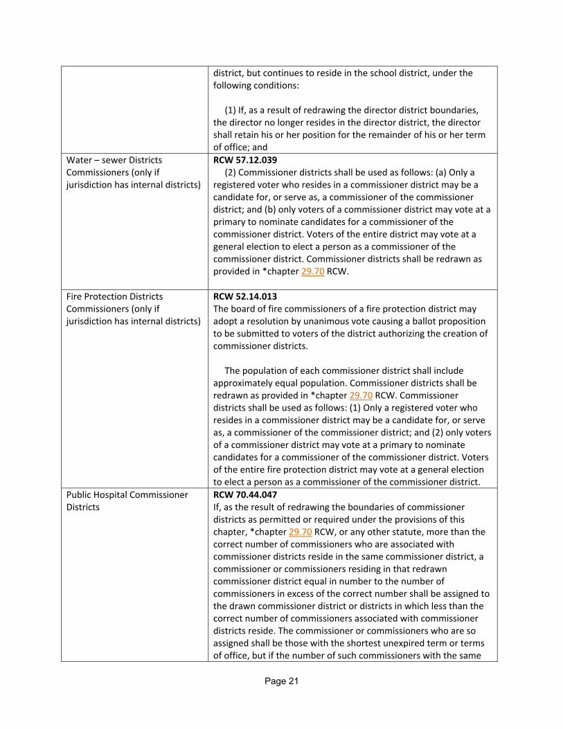
Water – sewer Districts Commissioners (only if jurisdiction has internal districts)
RCW 57.12.039 (2) Commissioner districts shall be used as follows: (a) Only a registered voter who resides in a commissioner district may be a candidate for, or serve as, a commissioner of the commissioner district; and (b) only voters of a commissioner district may vote at a primary to nominate candidates for a commissioner of the commissioner district. Voters of the entire district may vote at a general election to elect a person as a commissioner of the commissioner district. Commissioner districts shall be redrawn as provided in *chapter 29.70 RCW.
Fire Protection Districts Commissioners (only if jurisdiction has internal districts)
RCW 52.14.013 The board of fire commissioners of a fire protection district may adopt a resolution by unanimous vote causing a ballot proposition to be submitted to voters of the district authorizing the creation of commissioner districts. The population of each commissioner district shall include approximately equal population. Commissioner districts shall be redrawn as provided in *chapter 29.70 RCW. Commissioner districts shall be used as follows: (1) Only a registered voter who resides in a commissioner district may be a candidate for, or serve as, a commissioner of the commissioner district; and (2) only voters of a commissioner district may vote at a primary to nominate candidates for a commissioner of the commissioner district. Voters of the entire fire protection district may vote at a general election to elect a person as a commissioner of the commissioner district.
Public Hospital Commissioner Districts
RCW 70.44.047 If, as the result of redrawing the boundaries of commissioner districts as permitted or required under the provisions of this chapter, *chapter 29.70 RCW, or any other statute, more than the correct number of commissioners who are associated with commissioner districts reside in the same commissioner district, a commissioner or commissioners residing in that redrawn commissioner district equal in number to the number of commissioners in excess of the correct number shall be assigned to the drawn commissioner district or districts in which less than the correct number of commissioners associated with commissioner districts reside. The commissioner or commissioners who are so assigned shall be those with the shortest unexpired term or terms of office, but if the number of such commissioners with the same
Page 21

terms of office exceeds the number that are to be assigned, the board of commissioners shall select by lot from those commissioners which one or ones are assigned. A commissioner who is so assigned shall be deemed to be a resident of the commissioner district to which he or she is assigned for purposes of determining whether a position is vacant.
Page 22
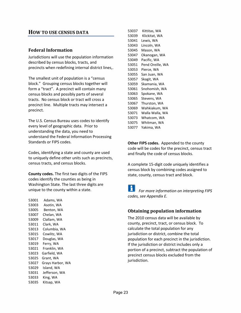
HOW TO USE CENSUS DATA
Federal Information
Jurisdictions will use the population information described by census blocks, tracts, and precincts when redefining internal district lines,. The smallest unit of population is a “census block.” Grouping census blocks together will form a “tract”. A precinct will contain many census blocks and possibly parts of several tracts. No census block or tract will cross a precinct line. Multiple tracts may intersect a precinct. The U.S. Census Bureau uses codes to identify every level of geographic data. Prior to understanding the data, you need to understand the Federal Information Processing Standards or FIPS codes. Codes, identifying a state and county are used to uniquely define other units such as precincts, census tracts, and census blocks. County codes. The first two digits of the FIPS codes identify the counties as being in Washington State. The last three digits are unique to the county within a state. 53001 Adams, WA 53003 Asotin, WA 53005 Benton, WA 53007 Chelan, WA 53009 Clallam, WA 53011 Clark, WA 53013 Columbia, WA 53015 Cowlitz, WA 53017 Douglas, WA 53019 Ferry, WA 53021 Franklin, WA 53023 Garfield, WA 53025 Grant, WA 53027 Grays Harbor, WA 53029 Island, WA 53031 Jefferson, WA 53033 King, WA 53035 Kitsap, WA
53037 Kittitas, WA 53039 Klickitat, WA 53041 Lewis, WA 53043 Lincoln, WA 53045 Mason, WA 53047 Okanogan, WA 53049 Pacific, WA 53051 Pend Oreille, WA 53053 Pierce, WA 53055 San Juan, WA 53057 Skagit, WA 53059 Skamania, WA 53061 Snohomish, WA 53063 Spokane, WA 53065 Stevens, WA 53067 Thurston, WA 53069 Wahkiakum, WA 53071 Walla Walla, WA 53073 Whatcom, WA 53075 Whitman, WA 53077 Yakima, WA
Other FIPS codes. Appended to the county code will be codes for the precinct, census tract and finally the code of census blocks. A complete 15-digit code uniquely identifies a census block by combining codes assigned to state, county, census tract and block.
For more information on interpreting FIPS
codes, see Appendix E.
Obtaining population information
The 2010 census data will be available by county, precinct, tract, or census block. To calculate the total population for any jurisdiction or district, combine the total population for each precinct in the jurisdiction. If the jurisdiction or district includes only a portion of a precinct, subtract the population of precinct census blocks excluded from the jurisdiction.
Page 23
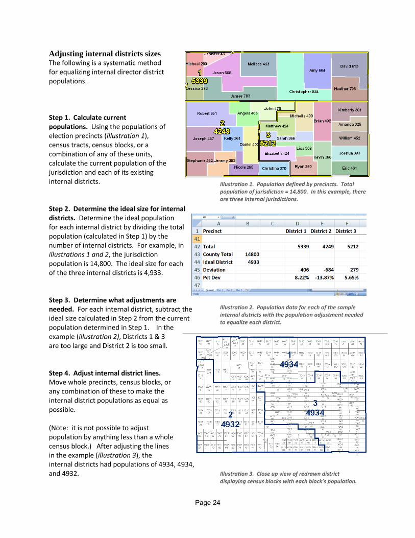
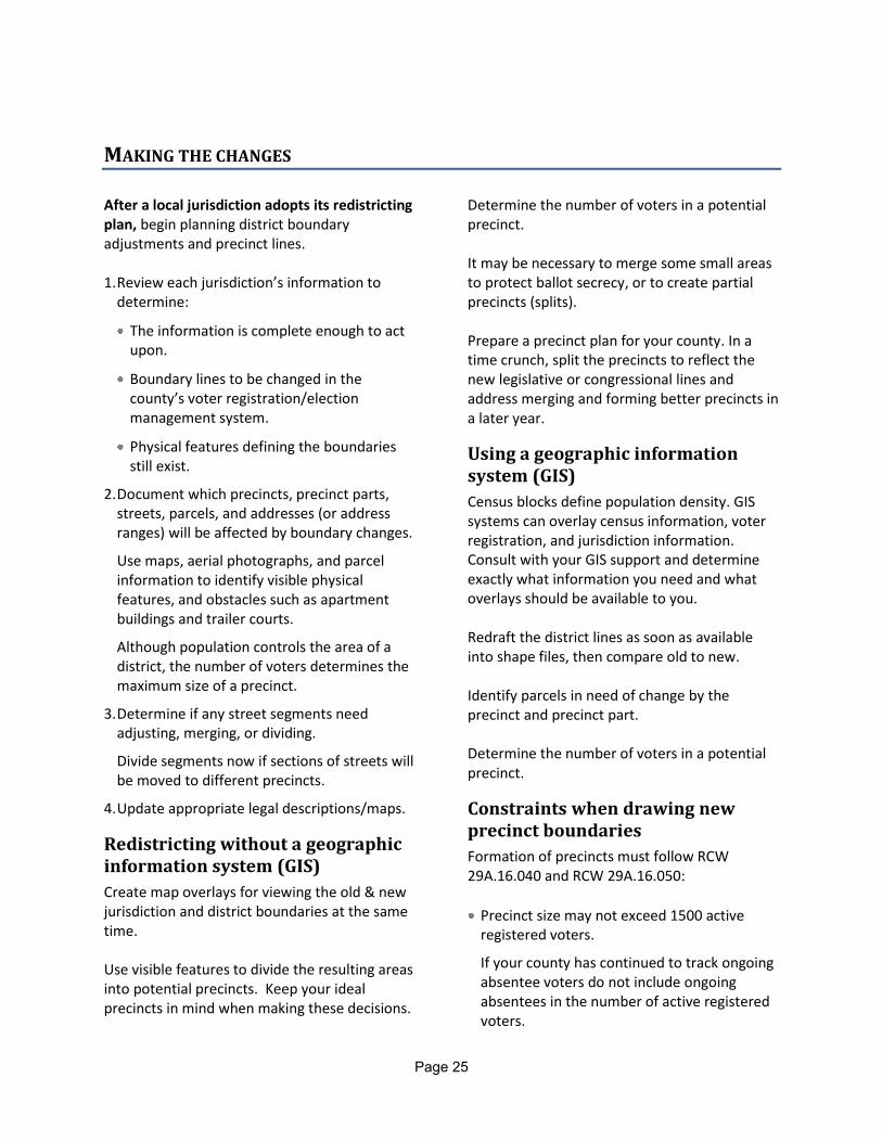
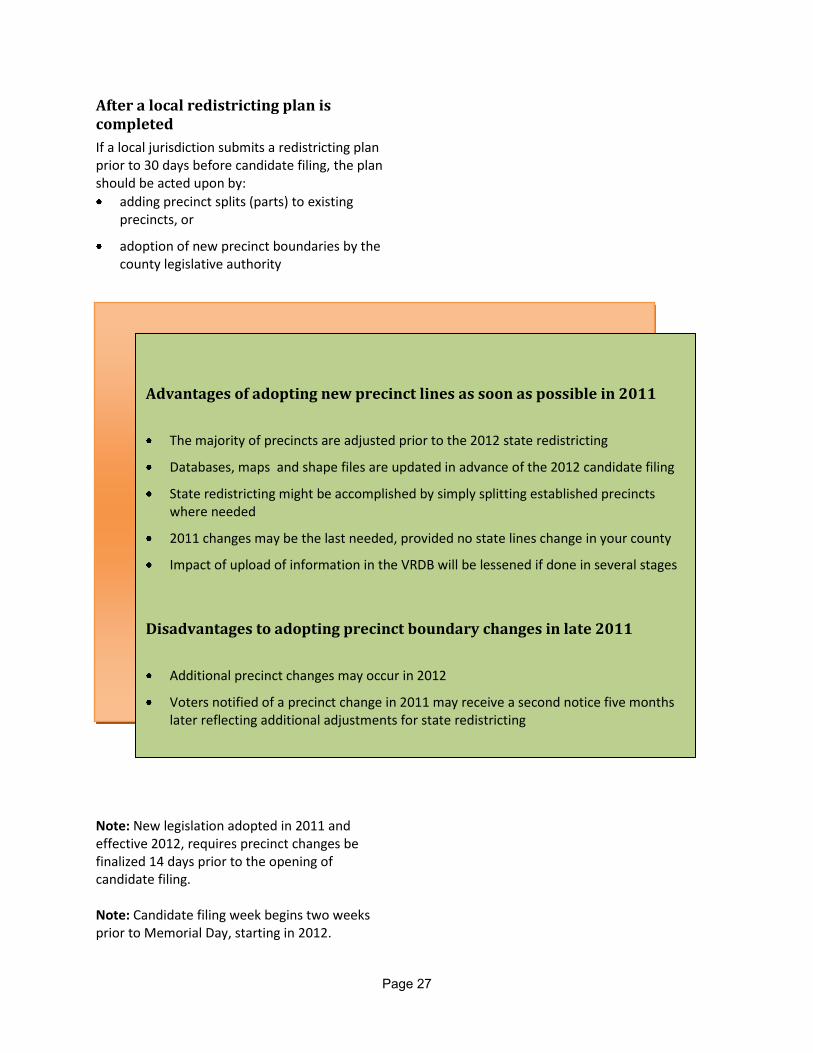
Adjusting internal districts sizes The following is a systematic method for equalizing internal director district populations. Step 1. Calculate current populations. Using the populations of election precincts (illustration 1), census tracts, census blocks, or a combination of any of these units, calculate the current population of the jurisdiction and each of its existing internal districts. Step 2. Determine the ideal size for internal districts. Determine the ideal population for each internal district by dividing the total population (calculated in Step 1) by the number of internal districts. For example, in illustrations 1 and 2, the jurisdiction population is 14,800. The ideal size for each of the three internal districts is 4,933. Step 3. Determine what adjustments are needed. For each internal district, subtract the ideal size calculated in Step 2 from the current population determined in Step 1. In the example (illustration 2), Districts 1 & 3 are too large and District 2 is too small. Step 4. Adjust internal district lines. Move whole precincts, census blocks, or any combination of these to make the internal district populations as equal as possible. (Note: it is not possible to adjust population by anything less than a whole census block.) After adjusting the lines in the example (illustration 3), the internal districts had populations of 4934, 4934, and 4932.
Illustration 1. Population defined by precincts. Total population of jurisdiction = 14,800. In this example, there are three internal jurisdictions.
Illustration 2. Population data for each of the sample internal districts with the population adjustment needed to equalize each district.
Illustration 3. Close up view of redrawn district displaying census blocks with each block’s population.
Page 24
MAKING THE CHANGES
After a local jurisdiction adopts its redistricting plan, begin planning district boundary adjustments and precinct lines. 1. Review each jurisdiction’s information to
determine:
The information is complete enough to act upon.
Boundary lines to be changed in the county’s voter registration/election management system.
Physical features defining the boundaries still exist.
2. Document which precincts, precinct parts, streets, parcels, and addresses (or address ranges) will be affected by boundary changes.
Use maps, aerial photographs, and parcel information to identify visible physical features, and obstacles such as apartment buildings and trailer courts.
Although population controls the area of a district, the number of voters determines the maximum size of a precinct.
3. Determine if any street segments need adjusting, merging, or dividing.
Divide segments now if sections of streets will be moved to different precincts.
4. Update appropriate legal descriptions/maps.
Redistricting without a geographic information system (GIS)
Create map overlays for viewing the old & new jurisdiction and district boundaries at the same time. Use visible features to divide the resulting areas into potential precincts. Keep your ideal precincts in mind when making these decisions.
Determine the number of voters in a potential precinct. It may be necessary to merge some small areas to protect ballot secrecy, or to create partial precincts (splits). Prepare a precinct plan for your county. In a time crunch, split the precincts to reflect the new legislative or congressional lines and address merging and forming better precincts in a later year.
Using a geographic information system (GIS)
Census blocks define population density. GIS systems can overlay census information, voter registration, and jurisdiction information. Consult with your GIS support and determine exactly what information you need and what overlays should be available to you. Redraft the district lines as soon as available into shape files, then compare old to new.
Identify parcels in need of change by the precinct and precinct part.
Determine the number of voters in a potential precinct.
Constraints when drawing new precinct boundaries
Formation of precincts must follow RCW 29A.16.040 and RCW 29A.16.050:
Precinct size may not exceed 1500 active registered voters.
If your county has continued to track ongoing absentee voters do not include ongoing absentees in the number of active registered voters.
Page 25

County legislative authority may mandate a smaller precinct size.
Every precinct must be wholly within:
A single congressional district
A single legislative district
A single county legislative authority district
A single city or town
Note: Incorporated and unincorporated areas must be placed in separate precincts.
Every precinct must be contiguous and as compact as possible.
Changes in boundaries of any precinct shall follow visible, physical features delineated on the most current US Census maps.
Visible features in order of preference of use might be:
Highways or major roads,
Large bodies of water – divide the water, not the shoreline,
Major irrigation systems,
Fence lines, power lines, forest access roads, and tracks,
Small streams (inconsistent feature because they may change direction or dry up), and
Ridges or valleys (not always clearly defined)
Non-visible lines may be used, when:
Required by a city/town annexation or incorporation, and the proposed precinct boundary is identical to the city/town boundary.
Following visible features would substantially impair election administration.
Designate every voting precinct by a number. Use this number for maps and apportionment of population.
Prior to final approval 1. Schedule meetings to review draft precincts,
and for final resolution adoption with:
Political parties
County legislative authority members 2. Submit draft precinct information to the
county legislative authority for discussion and revision.
Remind the authority that precincts may need to change in response to congressional and legislative boundary revisions. Use the lines in the State Redistricting Commission’s draft plan to anticipate changes.
Precinct information may be submitted as:
Maps,
Legal descriptions, or
Maps with legal descriptions.
If all precinct information is submitted in map format, be certain the maps are detailed enough to place all voters accurately.
3. Complete all revisions according to the
precinct lines adopted.
GIS Users - Forward all appropriate materials to the GIS center for mapping revisions. (The technician must update all appropriate maps including individual precinct maps, city precinct maps, and county precinct maps.) Proof changes made by GIS department.
Page 26
After a local redistricting plan is completed
If a local jurisdiction submits a redistricting plan prior to 30 days before candidate filing, the plan should be acted upon by:
adding precinct splits (parts) to existing precincts, or
adoption of new precinct boundaries by the county legislative authority
Note: New legislation adopted in 2011 and effective 2012, requires precinct changes be finalized 14 days prior to the opening of candidate filing. Note: Candidate filing week begins two weeks prior to Memorial Day, starting in 2012.
Advantages of adopting new precinct lines as soon as possible in 2011
The majority of precincts are adjusted prior to the 2012 state redistricting
Databases, maps and shape files are updated in advance of the 2012 candidate filing
State redistricting might be accomplished by simply splitting established precincts where needed
2011 changes may be the last needed, provided no state lines change in your county
Impact of upload of information in the VRDB will be lessened if done in several stages
Disadvantages to adopting precinct boundary changes in late 2011
Additional precinct changes may occur in 2012
Voters notified of a precinct change in 2011 may receive a second notice five months later reflecting additional adjustments for state redistricting
Page 27

Page 28
Phase 3: Completing the Process This phase encompasses the state redistricting process and the finalization of precinct boundary changes.
DEADLINES
JANUARY 1, 2012. Redistricting Commission submits state plan to legislature. Draft plan made available to counties JANUARY 9, 2012. State legislature convenes. FEBRUARY 8, 2012. Deadline for amending the commission’s plan. If there are no amendments, the commission’s plan goes into effect as submitted. After receipt of the boundary changes, the County Legislative Authority adjusts all affected precinct boundaries. MARCH 1, 2012. If the Redistricting Commission fails to submit a plan, the Supreme Court enters the planning process. April 30, 2012. Supreme Court must complete plan.
APRIL 30, 2012. All boundary and precinct changes must be finalized by each county 14 days prior to candidate filing (amended RCW 29A.16.040). May 14, 2012. Candidate filing week begins.
ADJUSTING PRECINCT LINES
As soon as the county legislative authority approves the final lines, you may change precincts in your VR/EMS. Of course, do this only after adoption of congressional and state legislative boundaries.
Changes in response to state redistricting
After the adoption of the state redistricting plan, proceed towards the final product.
1. Identify parcels and street segments to be moved because of congressional or legislative district lines.
2. Finalize draft precinct information using:
Maps
Written legal descriptions
Electronic files
Summary documents
Page 29
3. Submit to county legislative authority for adoption. This may take several meetings for the following actions:
Acceptance of resolution
Open public meetings
Revisions
Adoption of resolution
VR/EMS changes and clean up
Only after adoption of the precincts by the county legislative authority should you make precinct boundary changes in your voter registration information. 4. Update the street index with the correct
information for the affected precincts/groups and streets/ranges.
5. Review all materials and double check the
accuracy of the work. 6. Mail a notice as prescribed by RCW
29A.76.030 to every voter whose voting precinct has changed. An example of the Thurston County voter notice is available in Appendix C.
7. After a change to precinct boundaries in a city
or town, the county auditor shall send one copy of the map or maps delineating the new
precinct boundaries within that city or town to the city or town clerk (RCW 29A.16.050(6)). Optional: Notify the local political parties and cities of changes.
8. To the Office of the Secretary of State, send
electronic or paper copies of the descriptions and/or maps of the changes.
If a change to a precinct boundary does not follow visible, physical features, then also send the following:
A statement of the applicable exception.
A statement of the reasons why following only visible, physical features would substantially impair election administration in that area.
9. File the final documents according to your
retention plan. Old precinct maps and shape files may be sent to the Washington State Archives.
10.Retain a secondary copy of the precinct
boundaries from 2002 to present in your office file.
PRECINCT MAPS AND DOCUMENTS
Precinct maps are public records:
Maps must be available for inspection during normal office hours.
Make copies available to the public for a fee necessary to cover the cost of reproduction.
Precinct maps are records that must be maintained until replaced or obsolete.
A copy of maps must also be sent to State Archives.
Clearly label all documents with title and year. Anticipate how you will locate and identify these documents in eight years.
Retain a record of the relationship of old precincts to new precincts.
Use the same precinct numbers for maps/GIS shape files as you use for election returns and other election data. You can add a name, but always use the precinct numbers for identification.
Page 30
Additional Information 32 Glossary Appendix A: Laws
Appendix B: Resources
Appendix C: Examples
Appendix D: Sample of Written Procedures
Appendix E: Census Codes
Page 31
Redistricting Glossary
Redistricting glossary
Block boundary ‐ The features that delimit a census block. The features may be visible (a street, road, stream, shoreline, power line, etc.) or invisible (a county line, city limit, property line, imaginary extension of a street or road, etc.). Generally, the boundary of a census block must include at least one addressable feature; that is, a street or road. For data tabulation, the boundary of every legal and statistical entity recognized in the U.S. Census Bureau's standard data tabulations is a block boundary.
Block group (BG) ‐ A statistical subdivision of a census tract (or, prior to Census 2000, a block numbering area). A BG consists of all tabulation blocks whose numbers begin with the same digit in a census tract. For example, for Census 2000, BG 3 within a census tract includes all blocks numbered from 3000 to 3999. (A few BGs consist of a single block.) BGs generally contain between 300 and 3,000 people, with an optimum size of 1,500 people. The BG is the lowest‐level geographic entity for which the U.S. Census Bureau tabulates sample data from a decennial census.
Census block ‐ A geographic area bounded by visible and/or invisible features shown on a map prepared by the U.S. Census Bureau. A block is the smallest geographic entity for which the Census Bureau tabulates decennial census data.
Census designated place (CDP) ‐ A geographic entity that serves as the statistical counterpart of an incorporated place for the purpose of presenting census data for an area with a concentration of population, housing, and commercial structures that is identifiable by name, but is not within an incorporated place. CDPs usually are delineated cooperatively with state, Puerto Rico, Island Area, local, and tribal officials based on U.S. Census Bureau guidelines. For Census 2000, for the first time,
CDPs did not need to meet a minimum population threshold to qualify for the tabulation of census data.
Census tract ‐ A small, relatively permanent statistical subdivision of a county or statistically equivalent entity, delineated for data presentation purposes by a local group of census data users or the geographic staff of a regional census center in accordance with U.S. Census Bureau guidelines. Designed to be relatively homogeneous units with respect to population characteristics, economic status, and living conditions at the time they are established, census tracts generally contain between 1,000 and 8,000 people, with an optimum size of 4,000 people. Census tract boundaries are delineated with the intention of being stable over many decades, so they generally follow relatively permanent visible features. However, they may follow governmental unit boundaries and other invisible features in some instances; the boundary of a state or county (or statistically equivalent entity) is always a census tract boundary. When data are provided for American Indian entities, the boundary of a federally recognized American Indian reservation and off‐reservation trust land is always the boundary of a tribal census tract.
Federal information processing standards codes (FIPS codes) ‐ a standardized set of numeric or alphabetic codes issued by the National Institute of Standards and Technology (NIST) to ensure uniform identification of geographic entities through all federal government agencies. The entities covered include: states and statistically equivalent entities, counties and statistically equivalent entities, named populated and related location entities (such as, places and county
Page 32
Redistricting Glossary
subdivisions), and American Indian and Alaska Native areas.
MAF/TIGER Feature Class Code (MTFCC)—The MTFCC is a 5‐digit code intended to classify and describe geographic objects or features. The MTFCC replaced the Census Feature Class Code (CFCC) used before 2007 and was expanded to include features that previously did not have codes. MTFCC definitions are available in the metadata files that accompany each shapefile and relationship file.
Reapportionment – The redistribution of seats in the U.S. House of Representatives based upon the population of each state following every decennial census. All states are guaranteed at least one seat regardless of population.
Redistricting plan‐ A plan for legislative and congressional redistricting mandated by Article II, section 43 of the state Constitution.
Any change of internal boundaries determined by a local jurisdiction necessary to comply with statutory requirements for equal representation.
Tabulation geography ‐ The geographic entities for which the U.S. Census Bureau tabulates and presents data.
TIGER (Topologically Integrated Geographic Encoding and Referencing system) ‐ TIGER/Line®Shapefiles are spatial extracts from the Census Bureau's MAF/TIGER database, containing features such as roads, railroads, rivers, as well as legal and statistical geographic areas.
Urban growth area (UGA) ‐ In Washington, an "urban growth area" is delineated around each incorporated place or a group of incorporated places by state and local officials, and subsequently confirmed in state law, to control urban development. UGAs are new for Census 2010. UGAs in Census data were provided by Office of Financial Management.
Voting district (VTD) ‐ The generic name for a geographic entity ‐ such as an election district, precinct, or ward ‐ established by state, local, and tribal governments for the purpose of conducting elections. Some reviewing officials adjusted the boundaries of the voting districts (VTDs) they submitted to conform to census block boundaries for data presentation purposes, and therefore a VTD for which Census 2000 provides data might not exactly represent the legal entity; the U.S. Census Bureau refers to such VTDs as pseudo‐voting districts (pseudo‐VTDs). Such VTDs, as well as any territory for which state officials did not specify a status, are identified by a "P" in the VTD indicator field of the PL data file.
Glossary sources: U.S. Census Bureau
Appendix A
Appendix A ‐ page 1
Laws Regulating Redistricting
WA Constitution Article II Section 43 Redistricting.
(1) In January of each year ending in one, a commission shall be established to provide for the redistricting of state legislative and congressional districts.
(2) The commission shall be composed of five members to be selected as follows: The legislative leader of the two largest political parties in each house of the legislature shall appoint one voting member to the commission by January 15th of each year ending in one. By January 31st of each year ending in one, the four appointed members, by an affirmative vote of at least three, shall appoint the remaining member. The fifth member of the commission, who shall be nonvoting, shall act as its chairperson. If any appointing authority fails to make the required appointment by the date established by this subsection, within five days after that date the supreme court shall make the required appointment.
(3) No elected official and no person elected to legislative district, county, or state political party office may serve on the commission. A commission member shall not have been an elected official and shall not have been an elected legislative district, county, or state political party officer within two years of his or her appointment to the commission. The provisions of this subsection do not apply to the office of precinct committee person.
(4) The legislature shall enact laws providing for the implementation of this section, to include additional qualifications for commissioners and additional standards to govern the commission. The legislature shall appropriate funds to enable the commission to carry out its duties.
(5) Each district shall contain a population, excluding nonresident military personnel, as nearly equal as practicable to the population of any other district. To the extent reasonable, each district shall contain contiguous territory, shall be compact and convenient, and shall be separated from adjoining districts by natural geographic barriers, artificial barriers, or political subdivision boundaries. The commission's plan shall not provide for a number of legislative districts different than that established by the legislature. The commission's plan shall not be drawn purposely to favor or discriminate against any political party or group.
Appendix A
Appendix A ‐ page 2
(6) The commission shall complete redistricting as soon as possible following the federal decennial census, but no later than January 1st of each year ending in two. At least three of the voting members shall approve such a redistricting plan. If three of the voting members of the commission fail to approve a plan within the time limitations provided in this subsection, the supreme court shall adopt a plan by April 30th of the year ending in two in conformance with the standards set forth in subsection (5) of this section.
(7) The legislature may amend the redistricting plan but must do so by a two‐thirds vote of the legislators elected or appointed to each house of the legislature. Any amendment must have passed both houses by the end of the thirtieth day of the first session convened after the commission has submitted its plan to the legislature. After that day, the plan, with any legislative amendments, constitutes the state districting law.
(8) The legislature shall enact laws providing for the reconvening of a commission for the purpose of modifying a districting law adopted under this section. Such reconvening requires a two‐thirds vote of the legislators elected or appointed to each house of the legislature. The commission shall conform to the standards prescribed under subsection (5) of this section and any other standards or procedures that the legislature may provide by law. At least three of the voting members shall approve such a modification. Any modification adopted by the commission may be amended by a two‐thirds vote of the legislators elected and appointed to each house of the legislature. The state districting law shall include the modifications with amendments, if any.
(9) The legislature shall prescribe by law the terms of commission members and the method of filling vacancies on the commission.
(10) The supreme court has original jurisdiction to hear and decide all cases involving congressional and legislative redistricting.
(11) Legislative and congressional districts may not be changed or established except pursuant to this section. A districting plan and any legislative amendments to the plan are not subject to Article III, section 12 of this Constitution. [AMENDMENT 74, 1983 Substitute
Senate Joint Resolution No. 103, p 2202. Approved November 8, 1983.]
RCW 29A.16.050
(1) “Every voting precinct must be wholly within a single congressional district, a single legislative district, a single district of a county legislative authority, and, if applicable, a single city.”
Appendix A
Appendix A ‐ page 3
RCW 29A.76.010
Each county, municipal corporation and special purpose district with a governing body comprised of internal director, council, or commissioner districts to periodically redistrict its governmental unit, based on population information from the most recent federal decennial census. The only districts exempted are jurisdictions statutorily requiring land ownership as voting criteria.
By the eighth month after receipt of federal decennial census data, the governing body of a municipal corporation, county, or district must prepare a plan for redistricting its internal or director districts.
RCW 29A.76.020
(1) The legislative authority of each county and each city, town, and special purpose district which lies entirely within the county shall provide the county auditor accurate information describing its geographical boundaries and the boundaries of its director, council, or commissioner districts and shall ensure that the information provided to the auditor is kept current. (2) A city, town, or special purpose district that lies in more than one county shall provide the secretary of state accurate information describing its geographical boundaries and the boundaries of its director, council, or commissioner districts and shall ensure that the information provided to the secretary is kept current. The secretary of state shall promptly transmit to each county in which a city, town, or special purpose district is located information regarding the boundaries of that jurisdiction which is provided to the secretary.
RCW 29A.76.030
If the boundaries of any city, township, or rural precinct are changed in the manner provided by law, the county auditor shall transfer the registration cards of every registered voter whose place of residence is affected thereby to the files of the proper precinct, noting thereon the name or number of the new precinct, or change the addresses, the precinct names or numbers, and the special district designations for those registered voters on the voter registration lists of the county. It shall not be necessary for any registered voter whose residence has

Appendix A
Appendix A ‐ page 4
been changed from one precinct to another, by a change of boundary, to apply to the registration officer for a transfer of registration. The county auditor shall mail to each registrant in the new precinct a notice that his or her precinct has been changed from . . . . . . to . . . . . ., and that thereafter the registrant will be entitled to vote in the new precinct, giving the name or number.
Appendix B
Appendix B ‐ page 1
Resources
Census Bureau Geographic Data Programs for the 2010 Census
Local Update of Census Addresses LUCA
Program for local, state, and tribal governments A designated governmental representative reviews the Census Bureau’s address list and maps for their particular jurisdiction For areas with city‐style addresses (house number and street), the LUCA liaison can comment on individual addresses and alert the Bureau to addresses missing from the list Responses for 2010 due May 2008 Input verified during Address Canvassing (spring/summer of 2009)
New Construction Program
Opportunity for local and tribal jurisdictions to submit addresses for dwellings completed between Address Canvassing and Census Day (April 1, 2010) Governmental liaison submits city‐style addresses for new construction in each Census block in the jurisdiction
Participant Statistical Areas Program (PSAP)
Allows participating local governments (generally counties) to submit or revise boundaries for Census Tracts, Block Groups, Census County Divisions, and Census‐Designated Places
Tribal Statistical Areas Program (TSAP)
Allows tribal governments to submit or revise boundaries for statistical subdivisions of tribal areas (tribal tracts, tribal block groups, and CDPs)
School District Review Program (SDRP)
Ongoing program, takes place every two years
Allows states to update and correct boundary information on school districts
Handled by the Office of the Superintendent of Public Instruction, but relevant to counties because you administer school district elections and maintain precincts and splits based on school district boundaries
Boundary and Annexation Survey (BAS)
An ongoing, yearly program (winter to early spring). This is the mechanism by which the Census Bureau maintains and corrects boundary information on counties, cities and towns, and tribal areas (and, in states that have them, townships).
Appendix B
Appendix B ‐ page 2
Boundaries submitted through the BAS “trump” the address lists submitted through LUCA. The Census Bureau creates a GPS point for each housing unit. If a jurisdictional boundary is in the wrong place relative to that GPS point, that housing unit will be counted in the wrong jurisdiction!
It is very important to encourage your jurisdictions to participate in the BAS. For counties with GIS, we strongly encourage you to explore arrangements where the county completes the BAS submission on behalf of its cities and towns.
A note of caution: When completing the BAS: always check Census Bureau geography.The BAS has historically involved participants drawing on paper maps using colored pencils and census workers tracing over the pencil lines to input them into the system—we can do much better now! Inaccuracies remain in their system for many years due to jurisdictions only paying attention to new annexations and assuming the existing boundaries are correct. Due to the nature of the Census Bureau’s geographic database, ongoing improvements in spatial accuracy for one type of feature (e.g., roads, waterways) can actually cause distortions in another (non‐visible political boundaries)
Resources for Maintaining Street Files
GIS (Geographic Information System)
If your county has a GIS department, they may be willing to work with you. Some of the questions you need to ask are:
Does your county have an online viewer with all the data you need? Are they willing to add layers to it such as parcels, precincts, or districts?
Keep in mind that the site addresses on parcels may not match, or be formatted the same way as, the addresses in your data
If you are doing this with paper maps, can you get overlays of your precincts and/or districts?
Will your VR system integrate with GIS?
Can GIS geocode your addresses? Remember when geocoding addresses most addresses will generate a point on the map, but there will be some that fail (address quality and consistency will greatly affect your results!)
Free GIS viewers
ArcGIS Explorer has the ability to add and view shape files. If you have already downloaded this software, do not upgrade to the 900. The newest version is not as easy to learn.
Demo: http://www.esri.com/software/arcgis/explorer/demos.html Download: http://www.esri.com/software/arcgis/explorer/index.html
Appendix B
Appendix B ‐ page 3
Google Earth will accept not accept shape files, but will accept KML files, which are easily created from shape files (using GIS software). In addition Google Earth has aerial photography and often displays appended photographs contributed by users.
Demo and user guide: http://earth.google.com/support/bin/static.py?page=guide_toc.cs Download: http://earth.google.com/#utm_campaign=en&utm_medium=ha&utm_source=en‐ha‐na‐us‐bk‐eargen&utm_term=google%20world Assessor tax codes
Tax codes may change year by year. Be sure you are using the latest information.
U.S. Postal Service
The US Postal Service offers a variety of address quality products and publications through the official website (www.USPS.com). Publication 28 deals specifically with address quality standards. In addition the agency publishes an Election Mail User Guide.
Mailing house/service
Prior to every mass mailing, every address must be validate against the address information of the US Postal Service. Obtain a list of the addresses from the mailing house that failed validation after each mailing. Use this information to validate your voter registration addresses.
Local jurisdictions
Some cities and towns have good maps available on their website. Some jurisdictions even have annexation information posted. Contact your cities to seek their help.
Boundary Review Committees
If your county has a Boundary Review Committee, contact them for assistance in keeping current on external boundary changes.

Appendix B
Appendix B ‐ page 4
Technological Assistance
ArcGIS
County GIS viewer
Arc Explorer
Aerial photographs. Most, if not all, GIS programs or viewers have adequate imagery. Imagery for
each county is available online at http://rocky2.ess.washington.edu/data/raster/naip/index.html
Google Earth. will display KML files, which can be created from a shapefile
APPENDIX C
Appendix C – table of contents
EXAMPLES
Redistricting checklist .................................................................................................................. 1 Confirmation of current district boundaries (Thurston County) ................................................. 2 Notice of redistricting to precinct committee officers (Thurston County) ................................. 3 Notice to voters of precinct boundary change w/ identification card (Thurston County) Card side 1 ............................................................................................................... 4 Card side 2 ............................................................................................................... 5 Voting precinct alteration summary (King County 2009) ............................................................ 6 Correspondence brief sheet (King County 2009) ........................................................................ 7 2002 cost estimate summary ...................................................................................................... 8
Appendix C - page 1
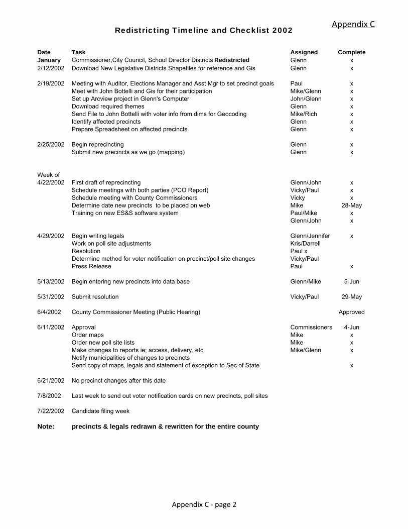
Redistricting Timeline and Checklist 2002
Date Task Assigned CompleteJanuary Commissioner,City Council, School Director Districts Redistricted Glenn x2/12/2002 Download New Legislative Districts Shapefiles for reference and Gis Glenn x
2/19/2002 Meeting with Auditor, Elections Manager and Asst Mgr to set precinct goals Paul xMeet with John Bottelli and Gis for their participation Mike/Glenn xSet up Arcview project in Glenn's Computer John/Glenn xDownload required themes Glenn xSend File to John Bottelli with voter info from dims for Geocoding Mike/Rich xIdentify affected precincts Glenn xPrepare Spreadsheet on affected precincts Glenn x
2/25/2002 Begin reprecincting Glenn xSubmit new precincts as we go (mapping) Glenn x
Week of4/22/2002 First draft of reprecincting Glenn/John x
Schedule meetings with both parties (PCO Report) Vicky/Paul xSchedule meeting with County Commissioners Vicky x
Determine date new precincts to be placed on web Mike 28-May Training on new ES&S software system Paul/Mike x Glenn/John x
4/29/2002 Begin writing legals Glenn/Jennifer x
Work on poll site adjustments Kris/DarrellResolution Paul xDetermine method for voter notification on precinct/poll site changes Vicky/PaulPress Release Paul x
5/13/2002 Begin entering new precincts into data base Glenn/Mike 5-Jun
5/31/2002 Submit resolution Vicky/Paul 29-May
6/4/2002 County Commissioner Meeting (Public Hearing) Approved
6/11/2002 Approval Commissioners 4-JunOrder maps Mike xOrder new poll site lists Mike xMake changes to reports ie; access, delivery, etc Mike/Glenn xNotify municipalities of changes to precinctsSend copy of maps, legals and statement of exception to Sec of State x
6/21/2002 No precinct changes after this date
7/8/2002 Last week to send out voter notification cards on new precincts, poll sites
7/22/2002 Candidate filing week
Note: precincts & legals redrawn & rewritten for the entire county
Appendix C
Appendix C - page 2

July 7, 20__ Dear School District Official: Enclosed you will find a map of your school district, including the director districts. We request that you review this map for accuracy. As you are aware, School Board Directors are elected at large, but serve in designated director district seats. During Filing week candidates are asked to sign off on district maps, in the location in which they live. This is one check used to ensure individual candidates are eligible to run for the seat they are filing for. An additional check is to have the school district double check and sign off on their director district map, prior to filing week. The map enclosed is for your reference, as the director districts on file with the Thurston County Auditor’s Office. Please look the map over and double check the director district boundaries. If the map is incorrect in any way, please call us immediately. Additionally, please fax back this verification form by Monday, July 18.
Thurston County Auditor’s Office Attn: Elections
2000 Lakeridge Drive SW Olympia, Washington 98502
Fax: (360)786-5223
School District Map Validation
The map of the _______________________________________________ School District, including director districts, provided by the Thurston County Auditor’s Office on July 7, 2005, is true and correct to the best of my knowledge. _________________________________ ______________________________ Printed Name Date _________________________________ ______________________________ Signature Title
Appendix C
Appendix C - page 3
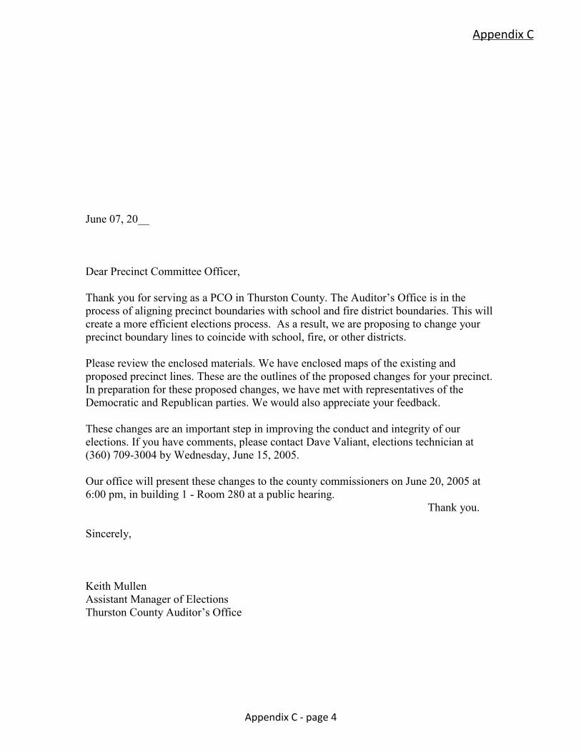
June 07, 20__ Dear Precinct Committee Officer, Thank you for serving as a PCO in Thurston County. The Auditor’s Office is in the process of aligning precinct boundaries with school and fire district boundaries. This will create a more efficient elections process. As a result, we are proposing to change your precinct boundary lines to coincide with school, fire, or other districts. Please review the enclosed materials. We have enclosed maps of the existing and proposed precinct lines. These are the outlines of the proposed changes for your precinct. In preparation for these proposed changes, we have met with representatives of the Democratic and Republican parties. We would also appreciate your feedback. These changes are an important step in improving the conduct and integrity of our elections. If you have comments, please contact Dave Valiant, elections technician at (360) 709-3004 by Wednesday, June 15, 2005. Our office will present these changes to the county commissioners on June 20, 2005 at 6:00 pm, in building 1 - Room 280 at a public hearing.
Thank you.
Sincerely, Keith Mullen Assistant Manager of Elections Thurston County Auditor’s Office
Appendix C
Appendix C - page 4
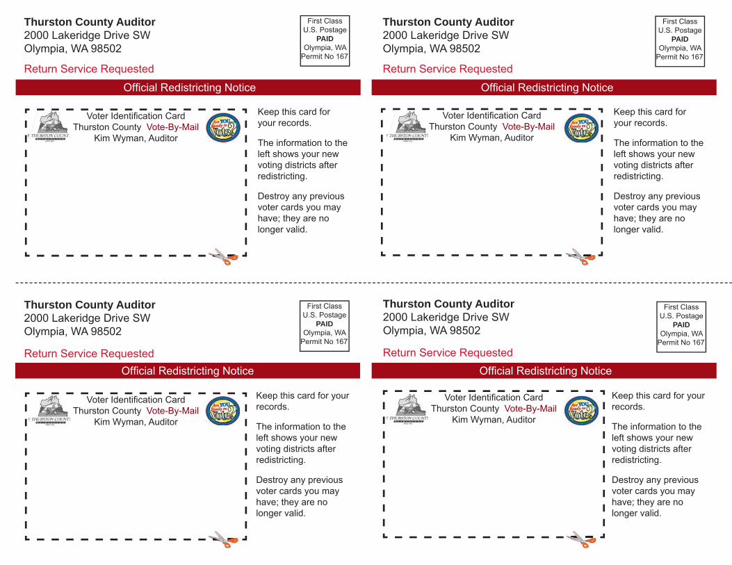
Keep this card for your records.
The information to the left shows your new voting districts after redistricting.
Destroy any previous voter cards you may have; they are no longer valid.
Thurston County Auditor2000 Lakeridge Drive SWOlympia, WA 98502
Return Service Requested
Voter Identifi cation CardThurston County Vote-By-Mail
Kim Wyman, Auditor
First ClassU.S. Postage
PAIDOlympia, WA
Permit No 167
Offi cial Redistricting Notice
Thurston County Auditor2000 Lakeridge Drive SWOlympia, WA 98502
Return Service Requested
First ClassU.S. Postage
PAIDOlympia, WA
Permit No 167
Offi cial Redistricting Notice
Keep this card for your records.
The information to the left shows your new voting districts after redistricting.
Destroy any previous voter cards you may have; they are no longer valid.
Voter Identifi cation CardThurston County Vote-By-Mail
Kim Wyman, Auditor
Thurston County Auditor2000 Lakeridge Drive SWOlympia, WA 98502
Return Service Requested
First ClassU.S. Postage
PAIDOlympia, WA
Permit No 167
Voter Identifi cation CardThurston County Vote-By-Mail
Kim Wyman, Auditor
Offi cial Redistricting Notice
Thurston County Auditor2000 Lakeridge Drive SWOlympia, WA 98502
Return Service Requested
First ClassU.S. Postage
PAIDOlympia, WA
Permit No 167
Keep this card for your records.
The information to the left shows your new voting districts after redistricting.
Destroy any previous voter cards you may have; they are no longer valid.
Voter Identifi cation CardThurston County Vote-By-Mail
Kim Wyman, Auditor
Offi cial Redistricting Notice
Keep this card for your records.
The information to the left shows your new voting districts after redistricting.
Destroy any previous voter cards you may have; they are no longer valid.
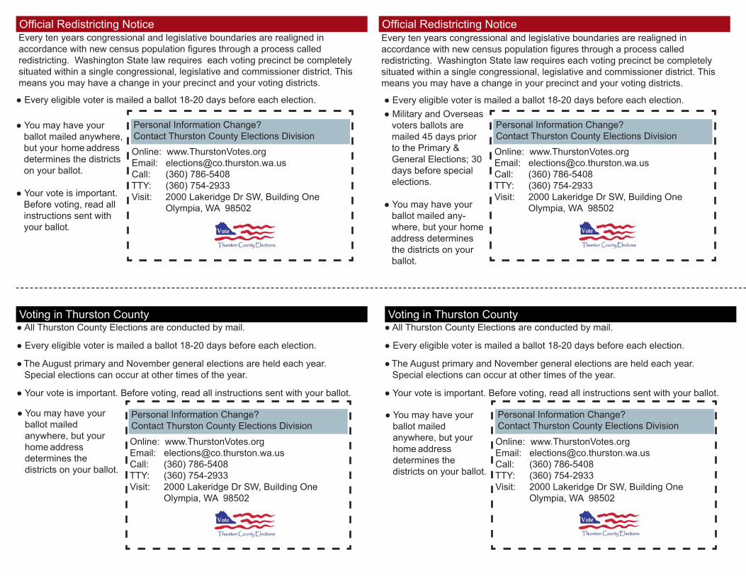
Online: www.ThurstonVotes.org Email: [email protected] Call: (360) 786-5408 TTY: (360) 754-2933 Visit: 2000 Lakeridge Dr SW, Building One Olympia, WA 98502
Offi cial Redistricting Notice
Online: www.ThurstonVotes.org Email: [email protected] Call: (360) 786-5408 TTY: (360) 754-2933 Visit: 2000 Lakeridge Dr SW, Building One Olympia, WA 98502
Online: www.ThurstonVotes.org Email: [email protected] Call: (360) 786-5408 TTY: (360) 754-2933 Visit: 2000 Lakeridge Dr SW, Building One Olympia, WA 98502
Online: www.ThurstonVotes.org Email: [email protected] Call: (360) 786-5408 TTY: (360) 754-2933 Visit: 2000 Lakeridge Dr SW, Building One Olympia, WA 98502
Every ten years congressional and legislative boundaries are realigned in accordance with new census population figures through a process called redistricting. Washington State law requires each voting precinct be completely situated within a single congressional, legislative and commissioner district. This means you may have a change in your precinct and your voting districts.
● Every eligible voter is mailed a ballot 18-20 days before each election. ● You may have your ballot mailed anywhere, but your home address determines the districts on your ballot.
● Your vote is important. Before voting, read all instructions sent with your ballot.
Voting in Thurston County
Personal Information Change? Contact Thurston County Elections Division
Offi cial Redistricting Notice
Personal Information Change? Contact Thurston County Elections Division
● Military and Overseas voters ballots are mailed 45 days prior to the Primary & General Elections; 30 days before special elections.
● You may have your ballot mailed any- where, but your home address determines the districts on your ballot.
Personal Information Change? Contact Thurston County Elections Division
● You may have your ballot mailed anywhere, but your
home address determines the districts on your ballot.
● All Thurston County Elections are conducted by mail.
● Every eligible voter is mailed a ballot 18-20 days before each election.
● The August primary and November general elections are held each year. Special elections can occur at other times of the year.
● Your vote is important. Before voting, read all instructions sent with your ballot.
Personal Information Change? Contact Thurston County Elections Division
● You may have your ballot mailed anywhere, but your
home address determines the districts on your ballot.
Every ten years congressional and legislative boundaries are realigned in accordance with new census population figures through a process called redistricting. Washington State law requires each voting precinct be completely situated within a single congressional, legislative and commissioner district. This means you may have a change in your precinct and your voting districts.
● Every eligible voter is mailed a ballot 18-20 days before each election.
Voting in Thurston County
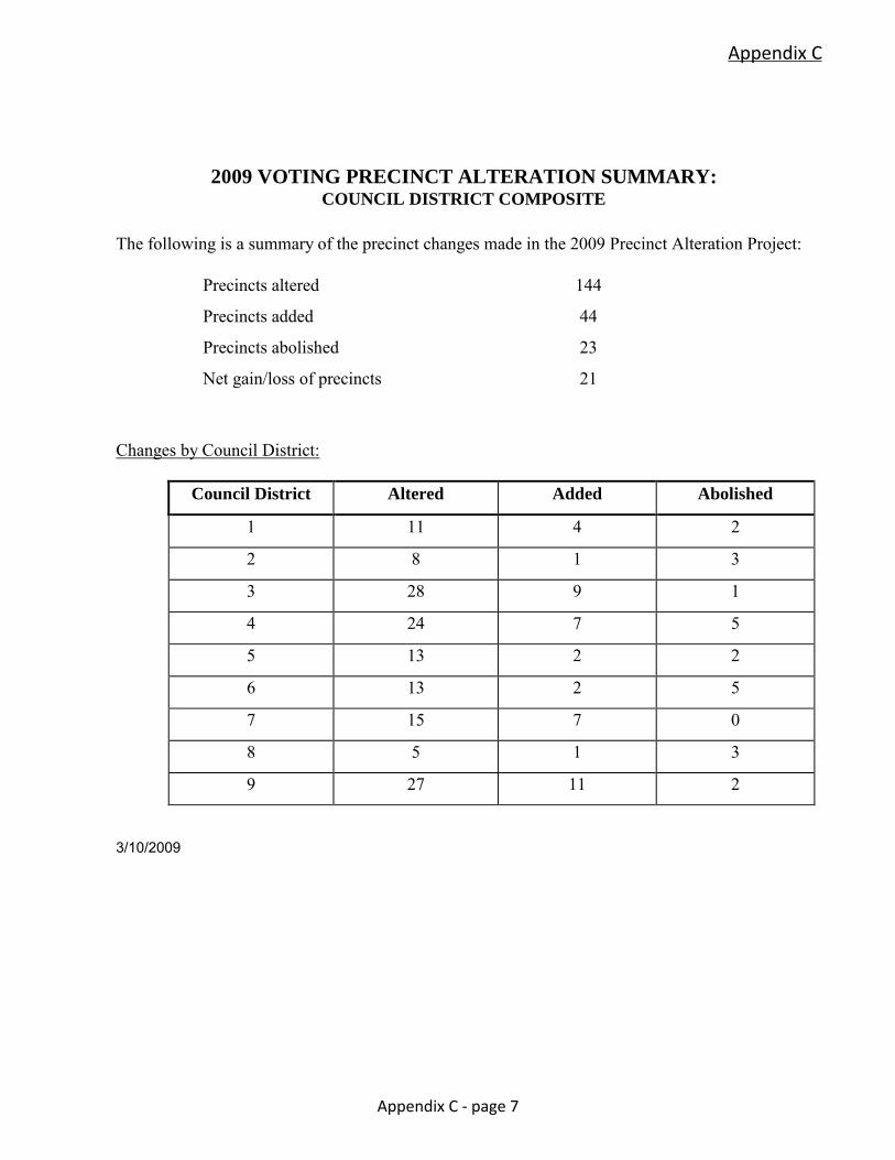
2009 VOTING PRECINCT ALTERATION SUMMARY: COUNCIL DISTRICT COMPOSITE
The following is a summary of the precinct changes made in the 2009 Precinct Alteration Project:
Precincts altered 144
Precincts added 44
Precincts abolished 23
Net gain/loss of precincts 21
Changes by Council District:
Council District Altered Added Abolished
1 11 4 2
2 8 1 3
3 28 9 1
4 24 7 5
5 13 2 2
6 13 2 5
7 15 7 0
8 5 1 3
9 27 11 2
3/10/2009
Appendix C
Appendix C - page 7
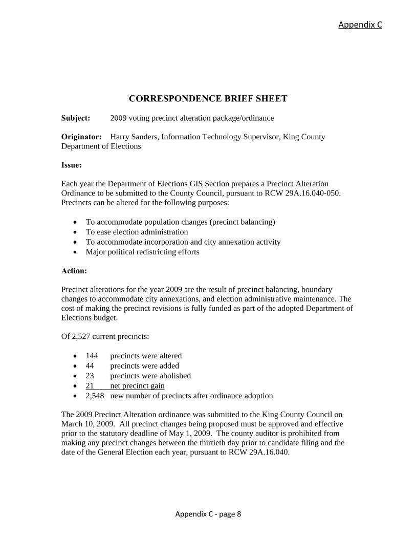
CORRESPONDENCE BRIEF SHEET Subject: 2009 voting precinct alteration package/ordinance Originator: Harry Sanders, Information Technology Supervisor, King County Department of Elections Issue: Each year the Department of Elections GIS Section prepares a Precinct Alteration Ordinance to be submitted to the County Council, pursuant to RCW 29A.16.040-050. Precincts can be altered for the following purposes:
To accommodate population changes (precinct balancing) To ease election administration To accommodate incorporation and city annexation activity Major political redistricting efforts
Action: Precinct alterations for the year 2009 are the result of precinct balancing, boundary changes to accommodate city annexations, and election administrative maintenance. The cost of making the precinct revisions is fully funded as part of the adopted Department of Elections budget. Of 2,527 current precincts:
144 precincts were altered 44 precincts were added 23 precincts were abolished 21 net precinct gain 2,548 new number of precincts after ordinance adoption
The 2009 Precinct Alteration ordinance was submitted to the King County Council on March 10, 2009. All precinct changes being proposed must be approved and effective prior to the statutory deadline of May 1, 2009. The county auditor is prohibited from making any precinct changes between the thirtieth day prior to candidate filing and the date of the General Election each year, pursuant to RCW 29A.16.040.
Appendix C
Appendix C - page 8
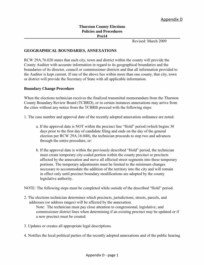
Thurston County Elections
Policies and Procedures
Pro14 Revised: March 2009 GEOGRAPHICAL BOUNDARIES, ANNEXATIONS
RCW 29A.76.020 states that each city, town and district within the county will provide the County Auditor with accurate information in regard to its geographical boundaries and the boundaries of its director, council or commissioner districts and that all information provided to the Auditor is kept current. If one of the above lies within more than one county, that city, town or district will provide the Secretary of State with all applicable information. Boundary Change Procedure When the elections technician receives the finalized transmittal memorandum from the Thurston County Boundary Review Board (TCBRD), or in certain instances annexations may arrive from the cities without any notice from the TCBRB proceed with the following steps: 1. The case number and approval date of the recently adopted annexation ordinance are noted.
a. If the approval date is NOT within the precinct line “Hold” period (which begins 30 days prior to the first day of candidate filing and ends on the day of the general election per RCW 29A.16.040), the technician proceeds to step two and advances through the entire procedure, or:
b. If the approval date is within the previously described “Hold” period, the technician must create temporary city-coded portion within the county precinct or precincts affected by the annexation and move all affected street segments into these temporary portions. The temporary adjustments must be limited to the minimum changes necessary to accommodate the addition of the territory into the city and will remain in effect only until precinct boundary modifications are adopted by the county legislative authority.
NOTE: The following steps must be completed while outside of the described “Hold” period. 2. The elections technician determines which precincts, jurisdictions, streets, parcels, and addresses (or address ranges) will be affected by the annexation.
Note: The technician must pay close attention to congressional, legislative, and commissioner district lines when determining if an existing precinct may be updated or if a new precinct must be created.
3. Updates or creates all appropriate legal descriptions. 4. Notifies the local political parties of the recently adopted annexations and of the public hearing
Appendix D
Appendix D - page 1
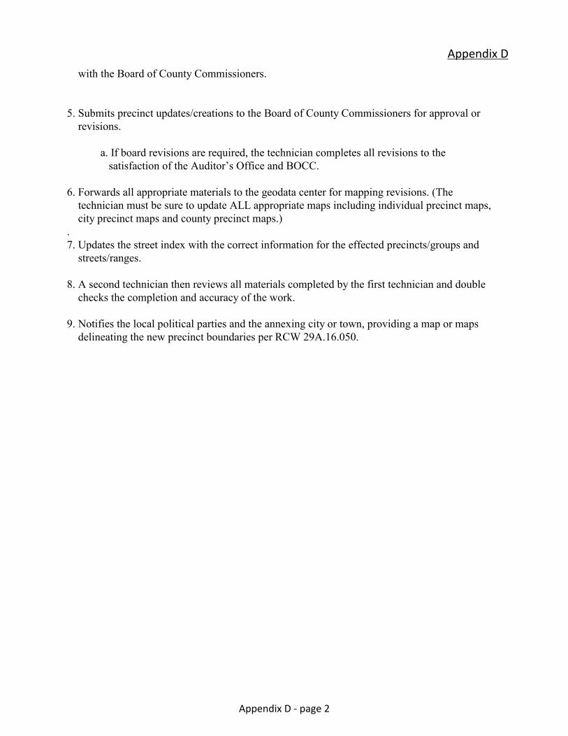
with the Board of County Commissioners. 5. Submits precinct updates/creations to the Board of County Commissioners for approval or revisions.
a. If board revisions are required, the technician completes all revisions to the satisfaction of the Auditor’s Office and BOCC. 6. Forwards all appropriate materials to the geodata center for mapping revisions. (The technician must be sure to update ALL appropriate maps including individual precinct maps, city precinct maps and county precinct maps.) . 7. Updates the street index with the correct information for the effected precincts/groups and streets/ranges. 8. A second technician then reviews all materials completed by the first technician and double checks the completion and accuracy of the work. 9. Notifies the local political parties and the annexing city or town, providing a map or maps delineating the new precinct boundaries per RCW 29A.16.050.
Appendix D
Appendix D - page 2
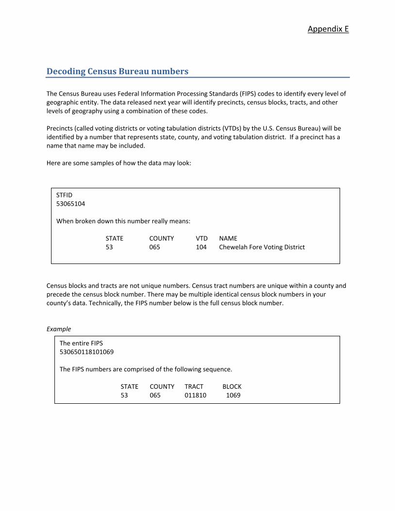
Appendix E
Decoding Census Bureau numbers The Census Bureau uses Federal Information Processing Standards (FIPS) codes to identify every level of geographic entity. The data released next year will identify precincts, census blocks, tracts, and other levels of geography using a combination of these codes. Precincts (called voting districts or voting tabulation districts (VTDs) by the U.S. Census Bureau) will be identified by a number that represents state, county, and voting tabulation district. If a precinct has a name that name may be included. Here are some samples of how the data may look:
Census blocks and tracts are not unique numbers. Census tract numbers are unique within a county and precede the census block number. There may be multiple identical census block numbers in your county’s data. Technically, the FIPS number below is the full census block number. Example
STFID 53065104 When broken down this number really means:
STATE COUNTY VTD NAME 53 065 104 Chewelah Fore Voting District
The entire FIPS 530650118101069 The FIPS numbers are comprised of the following sequence.
STATE COUNTY TRACT BLOCK 53 065 011810 1069
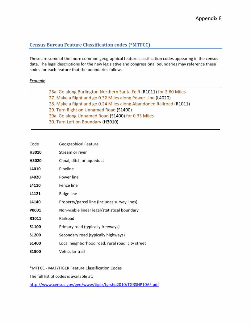
Appendix E
26a. Go along Burlington Northern Santa Fe R (R1011) for 2.80 Miles 27. Make a Right and go 0.32 Miles along Power Line (L4020) 28. Make a Right and go 0.24 Miles along Abandoned Railroad (R1011) 29. Turn Right on Unnamed Road (S1400) 29a. Go along Unnamed Road (S1400) for 0.33 Miles 30. Turn Left on Boundary (H3010)
Census Bureau Feature Classification codes (*MTFCC)
These are some of the more common geographical feature classification codes appearing in the census data. The legal descriptions for the new legislative and congressional boundaries may reference these codes for each feature that the boundaries follow. Example
Code Geographical Feature
H3010 Stream or river
H3020 Canal, ditch or aqueduct
L4010 Pipeline
L4020 Power line
L4110 Fence line
L4121 Ridge line
L4140 Property/parcel line (includes survey lines)
P0001 Non‐visible linear legal/statistical boundary
R1011 Railroad
S1100 Primary road (typically freeways)
S1200 Secondary road (typically highways)
S1400 Local neighborhood road, rural road, city street
S1500 Vehicular trail
*MTFCC ‐ MAF/TIGER Feature Classification Codes
The full list of codes is available at:
http://www.census.gov/geo/www/tiger/tgrshp2010/TGRSHP10AF.pdf

This booklet is designed to assist our local and state jurisdictions in 2012, as well as in future redistricting projects. The Secretary of Washington State welcomes your comments and edits. Please submit suggestions to: Washington State Elections Division, Certification and Training Program, PO Box 40229, Olympia, WA 98504‐0229.


