Embed Size (px)
Citation preview

at SciVerse ScienceDirect
Quaternary Science Reviews 49 (2012) 16e32
Contents lists available
Quaternary Science Reviews
journal homepage: www.elsevier .com/locate/quascirev
History of late Pleistocene glaciations in the central Sayan-Tuva Upland(southern Siberia)
Sergei G. Arzhannikov a,*, Regis Braucher b, Marc Jolivet c, Anastasia V. Arzhannikova a,Riccardo Vassallo d, Alain Chauvet e, Didier Bourlès b, Frédéric Chauvet b
a Institute of the Earth’s Crust, Russian Academy of Sciences, Siberian Branch, Lermontova 128, 664033 Irkutsk, Russian FederationbCEREGE, UMR7330, CNRS, Aix Marseille Univ., BP80, 13545 Aix en Provence, FrancecGéosciences Rennes, UMR6118, CNRS e Université Rennes 1, Campus de Beaulieu, 35042 Rennes Cedex, Franced LGCA, Universite de Savoie, Le Bourget du Lac, Francee Laboratoire Geosciences Montpellier, CNRS-UMR5243, Universite Montpellier II, Montpellier, France
a r t i c l e i n f o
Article history:Received 7 August 2011Received in revised form6 June 2012Accepted 8 June 2012Available online 16 July 2012
Keywords:Late Pleistocene glaciationsCosmogenic 10BeSouthern SiberiaEast Sayan RidgeMoraines
* Corresponding author. Tel.: þ7 3952 429534; faxE-mail address: [email protected] (S.G. Arzhann
0277-3791/$ e see front matter � 2012 Elsevier Ltd.http://dx.doi.org/10.1016/j.quascirev.2012.06.005
a b s t r a c t
This work describes the history of late Pleistocene glaciations in the central Sayan-Tuva Upland (southernSiberia). Geological and geomorphological analysis as well as 10Be surface-exposure dating revealed theglacier fluctuations in this continental area. The available published data show that the glaciers wereformed in the MIS 6 and probably survived in the MIS 5. Data are also available concerning glacialadvances in different periods of MIS 4, MIS 3 and MIS 2. ELAs were 2030e2230 m. Two distinct 10Beexposure ages groups are highlighted reflecting the time of formation of glacial deposits in the MIS 2associated to the Big Sayan Ridge outlet glaciers. The Sentsa e Sailag group (terminal moraine) hasa mean exposure age of 16.44 � 0.38 ka. The Jombolok (terminal moraine) e Jombolok (outwash plain)group has a mean exposure age of 22.80 � 0.56 ka. The last glaciation that occurred at MIS 2 is char-acterized by the absence of ice cap on the Azas volcanic Plateau and of ice field in the Todza Basin. Thethickness of the valley glacier was 300e400 m. At MIS 2, the terminal moraines were w1300e1400 ma.s.l. in the Tissa, Sentsa, Jombolok and Sailag river valleys.
� 2012 Elsevier Ltd. All rights reserved.
1. Introduction
This work presents a synthesis of the published literature onglaciations in the eastern part of the Sayan-Tuva Upland area (BigSayan Ridge, Todza Basin, Oka Plateau and Azas volcanic Plateau)(Fig. 1). Newly acquired in situ produced cosmogenic 10Be dataassociated to a detailed geomorphologic study have then been usedto constrain the chronology of the late Pleistocene glaciations inthis region.
The analysis of Quaternary glacial deposits in southern Siberiaand northern Mongolia recently provided some answers tounsolved questions on glacial sedimentation in this region(Matsera, 1993; Nemchinov et al., 1999; Krivonogov et al., 2005;Gillespie et al., 2008; Krivonogov, 2010). The ages of the glacial andlacustrine deposits were estimated and glaciations-related struc-tures were mapped (Matsera, 1993; Yarmolyuk et al., 2001;Sugorakova et al., 2003; Komatsu et al., 2007, 2009; Gillespie et al.,2008; Krivonogov, 2010).
: þ7 3952 426900.ikov).
All rights reserved.
Many geomorphological landforms resulting from late Pleisto-cene glaciers activity are preserved within the Sayan-Tuva Uplandand make it possible to reconstruct the paleoenvironment usingvarious independent approaches. For example, most of theQuaternary volcanoes in the Azas volcanic provincewere formed ina subglacial environment (Yarmolyuk et al., 2001; Sugorakova et al.,2003; Komatsu et al., 2007). Using the size, structure, morphologyand age of the tuya-volcanoes it is possible to constrain the positionand thickness of the overriding glaciers. Another example is theformation of the Darhad Lake and the geomorphic evolution of theDarhad Basin (Fig. 1). The outlet glaciers extending from the BigSayan Ridge ice field toward the south formed a glacial dam inShishid-Gol valley. Studying and dating the various lake depositsassociated to this dam allowed reconstructing the advance ofglaciers in the Darhad Basin (Krivonogov et al., 2005; Gillespie et al.,2008; Komatsu et al., 2009).
Considering the role of glaciation in the evolution of the relief ofthe Eastern Sayan, Matsera (1993) presents the data on glacial andalluvial deposits in nine cross-sections of the Todza Basin and Azasvolcanic Plateau. According to TL age estimate for burnt sub-basaltdeposits (160 ka), the glacial maximumwas after the emplacement

Fig. 1. Location map and topography of the investigated area with indications of the main orographic structures. (Topography from 90-m SRTM (Shuttle Radar TopographyMission)).
S.G. Arzhannikov et al. / Quaternary Science Reviews 49 (2012) 16e32 17
of the basaltic lava flow. No moraine deposits are found in pre-basalt sediments (Matsera, 1993).
This work intends to estimate the timing and extent of the latePleistocene glaciations around the Big Sayan Ridge (Fig.1). Differentglacial features that developed during the various Quaternaryglaciation stages were dated using in situ produced cosmogenic10Be. We especially focused on the marginal moraines in the Jom-bolok, Sentsa and Sailag river valleys. Investigations were con-ducted using cosmogenic isotopes geochronology (10Be),radiocarbon dating (14C), geomorphology, remote sensing data (90-m SRTM (Shuttle Radar Topography Mission)), 1:32,000 and1:50,000 scale aerial photographs, Landsat images, 1:200,000geological maps, 1:100,000 topographic maps, and field mapping.
2. Geographical setting and timing of glaciations: presentknowledges
The central Sayan-Tuva Upland is a key area to understand thephysical conditions and extent of glaciation in the eastern SiberianMountains and to reconstruct the late Pleistocene paleogeographyand climate of this area. In this region, the topography combinesmountain ridges, elevated plateaus and deeply incised river valleys.Within the investigation area, the Todza Basin and the southernEast Sayan Ridge are the major orographic structures. They includesmaller-scale orographic objects such as the Big Sayan Ridge, theOka Plateau and the Azas volcanic Plateau (Fig. 1).
The Big Sayan Ridge is located in the southern part of East SayanRidge, and forms the watershed between the basins of the YeniseiRiver and the Angara River. It consists of ridges and peaks (Fig. 1)with altitude varying between 2700 and 3491 m (the KropotkinRidge (3141 m), Peak Topographov (3044 m), the PogranichniiRidge (3164 m) and Monkh-Saridag Mountain (3491 m)).
The Oka Plateau, rising up to 1800e2500 m holds a centralposition therein. It is characterized by a well-preserved Cretaceouse Paleogene peneplanation surface forming the main part of theplateau (Arzhannikova et al., 2011; Jolivet et al., 2011). Owing toNeogene volcanism (Rasskazov et al., 2000), part of the plateau wascovered by basalt and did not undergo intensive denudation sincethe Miocene (Jolivet et al., 2011). The major river systems draining
the western Oka Plateau are the Jombolok, Sentsa, Tissa and Okarivers showing measured incision depth of about 700e800 m. Tothewest, the Azas volcanic Plateau is covered by an accumulation oftertiary basalt sheets, Quaternary large tuya-volcanoes (witha relative height of about 500 m and an area of about 100 km2),cone-shaped volcanoes and basalt lava flows. Farther west, theTodza Basin is the largest structure of the East Tuva region and isbounded by the Akademika Obrucheva Ridge to the south and bythe Ergak Tayga Ridge to the north (Fig. 1).
Since the second half of the 19th century many Pleistoceneglacial features have been described in the region, providing ideasof dimensional and characteristics of Pleistocene glaciers (e.g.Kropotkin, 1867; Chersky, 1881; Voieikov, 1881; De Henning-Michaelis, 1898; Peretolchin, 1908; Molchanov, 1934).
More recently, detailed glaciological studies were conductedusing remote sensing and large-scale geological survey (Obruchev,1953; Ravskii et al., 1964; Grosswald, 1965, 1987; Olyunin, 1965)which detailed the extent of piedmont glaciations in the TodzaBasin as well as mountain and valley glaciations in the East Sayanranges. The estimated ice thickness was ranging from severalhundreds of meters (East Sayan) to 1 km (Todza Basin). Glaciationswere concentrated on the axial part of the Big Sayan Ridge and onthe Azas volcanic Plateau. The altitude of the terminal moraineswas more than 930 m in the Todza Basin and more than 740 m inthe East Sayan (Grosswald, 1965; Olyunin, 1965).
New data on glacial deposits in the East Sayan Ridge andnorthern Mongolia (14C, OSL, IRSL, 10Be, thermoluminescence (TL)and palynology) allowed recognition of late Pleistocene phases ofglaciers extent corresponding to MIS 5d/5b, MIS 4, MIS 3 and MIS 2(Matsera, 1993; Nemchinov et al., 1999; Krivonogov et al., 2005;Gillespie et al., 2008; Krivonogov, 2010).
The study of glacial and sub-basalt deposits in nine cross-sections of the Bii-Khem, Sorug and Azas river valleys (Fig. 2)provided important additional information on glacier dynamics forboth late and middle Pleistocene (Matsera, 1993). In the Sorugvalley the studies have beenmade into a series of cross-sections (A)and (B) (Fig. 2) whose bottom parts are composed of solid rocks,granites covered by bright-red sandy-loamy-grussy weatheringcrust (section A), and weathered reddish-yellow pebbles with

Fig. 2. Extent of the late Pleistocene glaciations in Todza Basin, Azas volcanic Plateau, Big Sayan Ridge and Oka Plateau (adapted from Grosswald, 1965 and Olyunin, 1965). Red starse thickness of ice near volcano-tuya; yellow circles e altitude of the lateral moraines; red squares e max. altitude of the terminal moraines; red triangles e cross-sections (AeI)after Matsera (1993). Black line is a profile; A’B’ e profile of the Todza glacier; C’D’ e profile of the Tissa glacier. Black dashed line is the lateral moraine of the Tissa glacier. 1 e Sailagmoraine area; 2 e Jombolok moraine area; 3 e Sentsa moraine area; 4e8 volcanoes e tuya: 4 e Sorug-Chushku-Uzu; 5 e Shivit-Taiga; 6 e Kokhemskii; 7e Priozernyi; 8 e Ulug-Arginskii. (For interpretation of the references to color in this figure legend, the reader is referred to the web version of this article.)
S.G. Arzhannikov et al. / Quaternary Science Reviews 49 (2012) 16e3218
sandy filler overlain by variegated clays and aleurites (section B).The weathering crust and clays in both cross-sections underlie thegray boulder-pebble deposits with ferruginized sandy-gravel filleroverlain by basalt lava flowed from the Azas volcanic Plateau. Thebasalts are overlain by the moraine deposits. The spore and pollenanalysis shows pollen spectra (section A) of pine and cedar treesadmixed with those of broad-leaved trees found in the weatheringcrust and its overlying alluvial sediments. Cross-section (B) hasexhibited a rich spectrum of broad-leaved, coniferous and decid-uous plants of the Turgai flora of the Oligocene or Miocene. In theupward cross-section, thermophilic flora gives way to cold-lovingplants, and there is an increase in the quantity of pollen for Pinussilvestris, Pinus sibirica, Pisea, Betula, Larix and other species. Thepollen quantity for P. silvestris and P. sibirica at the contact betweenbasalts and alluvial sediments increases by 80e90%. The study ofother cross-sections on the Azas volcanic Plateau and Todza Basin
(section AeI, Fig. 2) has shown no glacial and glacifluvial deposits insub-basaltic deposits. The age of basalts (160 ka) overlain by themoraine deposits has been determined by TL-dating of burnt sub-basaltic deposits (section D, Fig. 2) (Matsera, 1993). According toTL age, the glacial maximum therein began after the emplacementof the basaltic lava flow (Matsera, 1993).
Gillespie et al. (2008) showed that the late Pleistocene glacia-tions in the southern East Sayan Ridge appeared to be morecomplicated than previously inferred. For example, they concludedthat the late Pleistocene glaciers around the Darhad Basin hadadvanced at least three times at 17e19 ka, 35e53 ka, and at anearlier, unconstrained period. The occurrence of middle Pleistoceneand late Pleistocene glaciations in the southern East Sayan Ridgehas also been suggested based on studies of subglacial volcanism onthe Azas volcanic Plateau (Yarmolyuk et al., 2001; Komatsu et al.,2007).

S.G. Arzhannikov et al. / Quaternary Science Reviews 49 (2012) 16e32 19
The study of a section in fluvio-lacustrine deposits 100 kmsoutheast of the Azas volcanic Plateau provided some evidences forglacial retreat in the Big Sayan Ridge. Fossil wood located17.0e17.5 m below the surface of the sediments has been dated at47,500 � 1500 years BP (14C) (Nemchinov et al., 1999) corre-sponding to MIS 3. This indicates a complete degradation of glacialice in this part of the East Sayan Ridge. Palynological evidencesattest for a considerable warming during the same period. Thesporeepollen association reflects the prevalence of woody-shrubvegetation: P. silvestris, P. sibirica, Abies, Pisea, Tsuga and others(Nemchinov et al., 1999).
High-resolution cores in Lake Kotokel (east coast of Lake Baikal)were drilled in sediments representing the last 47 ka (Bezrukovaet al., 2010). The interstadial dated at 47e30 ka is characterizedby cold and severe climatewith the predominance of xerotic steppeand tundra steppe landscapes. During that time, there were smallperiods of warming as evidenced by expansion of forest-typevegetation.
Large-scale glaciation of the southeastern East Sayan at MIS 5, 4is evidenced by red-thermoluminescence (RTL) data. The age of theMondymoraine is 79� 9 (RTL) and 70� 11 (RTL) ka (Ufimtsev et al.,2003).
Data reported in Olyunin (1965) and Grosswald (1965) indicatethat the late Pleistocene glacier ice thickness varied considerably inthe Big Sayan Ridge, Oka Plateau, Azas volcanic Plateau and TodzaBasin. This was mainly due to their location implying variabledividing-ridge orientations, size and amount of tributaries of themain glacial valleys and amount of precipitation (http://www.geogr.msu.ru).
2.1. The Kropotkin Ridge glaciation center
The Kropotkin Ridge trends SWeNE and represents thenorthern border of the Oka Plateau (Fig. 1). The maximum altitudeof the ridge is 3149 m and it displays glacial morphological featuressuch as U-shape valleys, glacier cirques andmarginal moraines. TheKropotkin Ridge glaciers that extended toward the south were15e20 km long, the largest outlet being the Jombolok glacier (dueto their present remote and highly inaccessible position, theglaciers which extended to the north and the northeast are notconsidered in this paper). The Jombolok and Sailag glaciersdescribed below are typical of the southern flank of KropotkinRidge and will serve as examples (Fig. 2).
2.1.1. Jombolok glacier featuresThe Jombolok glacier was located in the Jombolok valley (Fig. 2)
and had a length of 63 km. The averagewidth of the Jombolok valleyis 1.5e2.5 km for a depth varying from about 100 m to 800 m. Thetributaries and the ice field, located in the Kropotkin Ridge, werethe source of ice for the Jombolok glacier. In the Dede-Hutal Pass(Fig. 3a), where the Jombolok glacier deposited lateral moraines, theice was approximately 450 m thick. The lateral moraine ridges,indicative of a large glacial thickness, have been preserved upstreamfromthe terminalmoraineon the right sideof thevalley. In theDodo-Hutel Pass a lateral moraine fragment is preserved at an altitude ofw1670 m (Fig. 3a). Further down in the valley, fragments of thecorresponding lateralmoraine (based onSRTMdata) in two tributarybasins are preserved at altitudes of 1670 m and 1650 m respectively(Fig. 3a). Finally, 500m further down the valley the Jombolok glacierflowed to the adjacent valley through a lowMongoljon Pass (Fig. 3a)and left a roughly 30 m height terminal moraine.
The Jombolok marginal moraine is located 4 km the up-valley ofthe confluence of the Jombolok and Oka Rivers (Fig. 4). Its frontalpart is located at an altitude of 1300 m and its central part has beeneroded by the Jombolok River. The longitudinal profile of the
preserved fragments shows three ridges separated from each otherby small depressions (Fig. 4e). The surface of the moraine is thusarranged in a series of ridges and hollows resulting frommelting offof buried ice blocks. Some of those hollows became closed lakes.
2.1.2. Sailag glacier featuresThe Sailag valley is located in the Kropotkin Ridge and is a left
tributary of the Oka River. During the late Pleistocene glaciation itcontained a 15 km long glacier (Fig. 2). The accumulation andformation of ice occurred at an altitude of 2900e3100m. The lateralmoraine consists of a series of extended ridges or steps and hasbeen intensively washed out by the lateral tributaries of theSailag River. However, the main glacial valley still contains somewell-preserved fragments exposed at different altitude levels. Onthe right side of the valley at the mouth of the Hara-Jalga River onefragment of the right lateral moraine is preserved at an altitude of1800 m (Figs. 3b and 5b). The lowest lateral moraine is located onthe right side of the Sailag valley above the mouth of the Hara-JalgaRiver where it has an altitude of 1725 m (Figs. 3b and 5b). It can betraced downstream to an altitude of 1460 m. The left lateralmoraine shows two steps. The upper level continuous lateralmoraine extends for 3.5 km from the left tributary Tsahas River(1800 m a.s.l.) down to the left tributary Ekhe-Sagin-Sair River(1575 m a.s.l.). The lower level moraine fragment is 1300 m longand is clearly visible from 1520 m to 1440 m (a.s.l.) (Fig. 5b). Thecentral part of the marginal moraine left by the Sailag glacier hasbeenwashed out by the Sailag River, leaving only a few ridges in theOka valley. This marginal moraine, culminating 80 m above the Okavalley floor appears as a complicated system of ridges, thermokarstbasins and inter-ridges depressions.
Therefore, the study of the fragments of marginal moraines inthe Sailag valley indicates at least two-phase change of the glacierparameters, probably related to different stages of glaciation. Theabsence of marginal moraines in the valley upwards from the Sailagmarginal moraine shows a rapid glacial retreat and disappearanceduring the last glaciation.
2.2. Peak Topographov Mountain glaciation center
This area comprises a group of mountain peaks culminatingaround 2700e3000 m (a.s.l.) in the central part of the Big SayanRidge (Fig. 2). Peak Topographov Mountain was a major glaciationcenter in the late Pleistocene and from there, large glaciers wereflowing to the West and East. The Tissa, Halgin and Shuthulaiiglaciers advanced to the south into the main valley of the TissaRiver and, associated to the right tributary glaciers of the Tissa Riverformed a c. 20 km wide large ice field (Fig. 2). The Dargil, Dunda-Gol, Hoito-Gol and Ara-Shuthulaii glaciers advanced eastwardand formed the Sentsa glacier. The Kokhem glacier flowed to thesouth and then to the west as a part of the large Biihem glacier.Finally the Sorug and Izigsug glaciers were part of the major Todzaglacier. The present glaciers with marginal moraines are located inthe northern and eastern cirques of Peak Topographov Mountain.
2.2.1. Glaciation features on the Oka PlateauThe Oka Plateau is an upland with altitudes of 1800e2500 m.
According to the geological and geomorphological mapping, glacialand glacifluvial deposits are widely distributed on the surface of theOka Plateau (Geological map, N-47-XXXIV, 1971). Moraine depositsare mainly preserved at the bottom of the eastern slope of PeakTopographov Mountain, to the north and east from PogranichnyiRidge (Fig. 2). On the relief they represent 50e100 m high hills.
These sediments were deposited by glaciers moving down theeastern spurs of the Peak Topographov Mountain toward the OkaPlateau. At the piedmont, these glaciers merged and formed the

Fig. 3. Photographs (a, b, c) and 3d (d, e, f) model SRTM data and GeoEye satellite images (Google Earth) showing location and altitude of the lateral moraines. a e Jombolok valley;b e Sailag valley; c e Sentsa valley; dI,dII e Todza Basin; e e right side of Kokhem valley and tuya Priozernyi.
S.G. Arzhannikov et al. / Quaternary Science Reviews 49 (2012) 16e3220
Oka Plateau glacier. The glacier moved predominantly southeast-ward. In the southeast, the Oka Plateau glacier joined with thelargest Tissa valley glaciers of the East Sayan Ridge, forming a largeglacial field (Fig. 2). In the north, some parts of the Oka Plateau
glacier connectedwith the Sentsa glacier through the outlet glacier.To the east of the Peak TopographovMountain, on the surface of theOka Plateau there are some granitemassifs that fed small glaciers inthe late Pleistocene (Fig. 2).
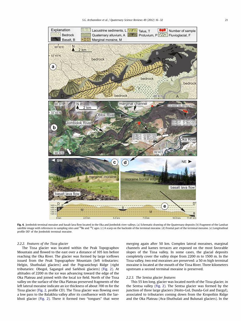
Fig. 4. Jombolok terminal moraine and basalt lava flow located in the Oka and Jombolok river valleys. (a) Schematic drawing of the Quaternary deposits (b) Fragment of the Landsatsatellite image with references to sampling sites and 10Be and 14C ages. (c) A scarp on the backside of the terminal moraine. (d) Frontal part of the terminal moraine. (e) Longitudinalprofile DD’ of the Jombolok terminal moraine.
S.G. Arzhannikov et al. / Quaternary Science Reviews 49 (2012) 16e32 21
2.2.2. Features of the Tissa glacierThe Tissa glacier was located within the Peak Topographov
Mountain and flowed to the east over a distance of 105 km beforereaching the Oka River. The glacier was formed by large iceflowsissued from the Peak Topographov Mountain (left tributaries:Helgin, Shuthulaii glaciers) and the Pogranichnyi Ridge (righttributaries: Obogol, Sagangol and Sarkhoii glaciers) (Fig. 2). Ataltitudes of 2200 m the ice was advancing toward the edge of theOka Plateau and joined with the local ice field. North of the Tissavalley on the surface of the Oka Plateau preserved fragments of theleft lateral moraine indicate an ice thickness of about 700 m for theTissa glacier (Fig. 2, profile CD). The Tissa glacier was flowing overa low pass to the Balakhta valley after its confluence with the Sar-khoii glacier (Fig. 2). There it formed two “tongues” that were
merging again after 50 km. Complex lateral moraines, marginalchannels and kames terraces are exposed on the most favorableslopes of the Tissa valley. In some cases, the glacial depositscompletely cover the valley slope from 2200 m to 1500 m. In theTissa valley, two end moraines are preserved: a 50 m high terminalmoraine is located at the mouth of the Tissa River. Three kilometersupstream a second terminal moraine is preserved.
2.2.3. The Sentsa glacier featuresThis 55 km long, glacier was located north of the Tissa glacier, in
the Sentsa valley (Fig. 2). The Sentsa glacier was formed by thejunction of three large glaciers (Hoito-Gol, Dunda-Gol and Dargyl),associated to tributaries coming down from the Kropotkin Ridgeand the Oka Plateau (Ara-Shuthulaii and Bulunaii glaciers). In the

Fig. 6. Sentsa terminal moraine. (a) Schematic drawing of the Quaternary deposits. (b)Fragment of the Landsat satellite image with references to sampling sites and 10Be and14C ages. Blue circle is the buried ice discovered in the Sentsa River valley. (Forinterpretation of the references to color in this figure legend, the reader is referred tothe web version of this article.)
Fig. 5. Sailag marginal moraines. (a) Schematic drawing of Quaternary deposits. (b)Fragment of the Landsat satellite image with references to sampling sites and 10Beages. The yellow circles indicate the altitudes of the lateral moraines. (For interpre-tation of the references to color in this figure legend, the reader is referred to the webversion of this article.)
S.G. Arzhannikov et al. / Quaternary Science Reviews 49 (2012) 16e3222
left tributary, located 2 km downstream from the mouth of theKadyr-Os River a fragment of lateral moraine sits at an altitude of1950m (Fig. 2). In the Bulunaii valley another fragment is preservedat an altitude of 1740 m and a third one is preserved at 1700 m inthe Dede-Hutel Pass (Fig. 2). Glacial deposits are also present on theleft bank of the Sentsa River at an altitude of 1600 m (Fig. 3c). Itshould be noted that in the Sentsa valley a lower level of lateralmoraines is preserved at altitudes of 1450e1500 m. The Sentsaglacier ended about 8.5 km upstream of the Sentsa river mouthwhere it left a thick marginal moraine about 8 km in length. Inthis segment, glacial deposits completely filled the Sentsa valley(Fig. 6) with a thickness of 90 m. The surface of the terminalmoraine is a complex of various ridges, hills and rounded or elon-gated depressions. The topography of the terminal moraine showsfragments of 22e45 m high ridges (above the mean surface of themoraine) oblique to the valley. The minimum and maximumaltitude of the Sentsa terminal moraine are respectively 1380 mand 1470 m.
2.2.4. Outwash plains of the Jombolok and Sentsa morainesOutwash plains are widespread in the river valleys of the Oka
Plateau. They are formed by accumulation of glacifluvial materialtransported by melt-water. A system of braided streams developswithinwhich coarse-grainedmaterial is transported and deposited.A longitudinal slope (5�) characterizes the outwash plains locatedin front of the Sentsa terminal moraine. A complex system ofbraided streams that varies in width from 1.8 to 2.5 km developedon the surface of the outwash plain. A similar relief, partly buried byyoung basaltic lava flows, is observed in the outer part of theterminal moraine in the Jombolok river valley (Fig. 4a,b). The uppersurface of the outwash plain is typically isolated between erosion
channels and the resulting difference in elevation prevented somefragments of the surface from being buried by basaltic lava flows.Those fragments are now represented by isolated “windows” ofglacifluvial deposits (Fig. 7).
2.2.5. The Kokhem glacierThis glacier was located in the KokHemvalley and corresponded
to the upper reaches of the major, 170 km long Bii-khem glacier(Fig. 2). The existence of this glacier is indicated by the Kokhemskiiand Priozernyi volcano-tuyas that formed in a subglacial environ-ment. Based on the height of the volcanoes located on both sides ofthe Kok-Khem valley, the ice thickness reaches 500 m on the Azasvolcanic Plateau and 750 m in the Kok-Khem valley. On the rightand left slopes of the Kok-Khem valley several lateral moraines areexposed below the base of the volcanoes corresponding to anestimated ice thickness of 300e350 m (Fig. 3e). Progressive down-stepping of the lateral moraines in the Kok-Khem, Tissa and Sentsavalleys illustrates the reduction of ice thickness through time.
2.3. The Azas volcanic Plateau glaciation center
The 2000 m high Azas volcanic Plateau belongs to the EastTuva volcanic province and covers an area of more than 2000 km2.Most of the large volcanoes located on the Azas volcanic Plateauwere formed in subglacial environment during the Pleistocene(Table 1). Earlier volcanoclastic series on the Azas volcanic Plateauwere described as volcanic tuffs (Grosswald et al., 1959), however

Fig. 7. Top: photograph showing a fragment of the outwash plain surface preserved in the frontal part of the Jombolok terminal moraine. The three bottom photographs present thedated boulders.
S.G. Arzhannikov et al. / Quaternary Science Reviews 49 (2012) 16e32 23
volcanic edifices were later identified as subglacial volcanoes(Grosswald, 1965; Yarmolyuk et al., 2001; Sugorakova et al.,2003).
Similar general features are observed on all the Azas volcanoes:they are located on the plateau and appear like 400e600 m hightable mountains (Fig. 8aed). Their surface is flat or dome-shapedwith abrupt, sometimes strong eroded slopes. Each volcanicedifice is formed by a basal volcanoclastic layer (70% or more of thetotal volume) capped by a lava layer. Ash cones are located on thesurface of most of the volcanoes (Sugorakova et al., 2003).
K/Ar dating of subglacial volcanoes has been performed at IGEMRAS, Novosibirsk (Yarmolyuk et al., 2001) using isotope dilutiontechnique with 38Ar tracer (Table 1). Analytical details can be foundin Yarmolyuk et al. (2001). Calculations of radiogenic 40Ar weredone assuming that initial (background) argon isotope compositionis equal to atmospheric (40Ar/36Ar h 295.5). The age errors asso-ciated to the K/Ar method are sometimes larger than the durationof the inter-glacial stages and those data thus have to be usedcarefully. Komatsu et al. (2007) noted that the morphologicallyolder volcanoes were effectively associated to the older K/Ar ages.To provide reliable indications on the age of the various latePleistocene glaciation periods, the K/Ar ages must thus be used inconjunction with the geomorphological description of the datedvolcanoes.
The 2648m high (SRTM data) tuya Kokhemskii (Figs. 8a and 9) islocated on the left side of the Kok-Khem River valley. The thicknessof the hyaloclastite layer is 300m and a K/Ar age of 150� 50 kawasobtained by Yarmolyuk et al. (2001). About 300m of ice covered theAzas volcanic Plateau during the formation of the Kokhemskiivolcano, similar to the one around the Sorug-Chushku-Uzu volcano.Once again the western slope of the volcano shows traces of glacialerosion.
Shivit-Taiga (Figs. 8b and 9) is one of the largest subglacialvolcanoes in the Azas volcanic Plateau. It has a surface area of about
100 km2 and a height of 500 m. Yarmolyuk et al. (2001) reported anage of 110 � 40 ka and 130 � 40 ka (K/Ar).
The western slopes of the Shivit-Taiga volcano were glaciated atleast once after the retreat of the Azas ice cap. Two terminalmoraines are clearly visible on aerial photographs at the toes of theShivit-Taiga (Fig. 10). The maximal altitude of the top level of thehyaloclastite is 2725 m (SRTM data), implying that the thickness ofthe ice in this area some 110 to 130 ka ago was not less than 530 m(Fig. 9).
The 2525m high (SRTM data) Sorug-Chushku-Uzu tuya (Figs. 8dand 9) is located 1 km northeast of the Shivit-Taiga volcano. Thethickness of the hyaloclastite layer is 200e250 m (Fig. 9) and the K/Ar age obtained for the volcano is 60 � 40 ka (Yarmolyuk et al.,2001). The thickness of the ice contemporaneously to the erup-tion of the Sorug-Chushku-Uzu was 200e250 m. The slopes of thevolcano are deformed by landslides and in some places the westernslope of the volcano was eroded by a glacier which formed a U-shaped valley and cirques.
The 2401 m high Priozernyi volcano is located on the right sideof the Kok-Khem valley. Its base is formed by a 300e350 m thicklayer of hyaloclastite with a K/Ar age of 75 � 40 ka (Yarmolyuket al., 2001).
The Ulug-Arginskii volcano is located in a glacial circus 5 kmsouth of the Shivit-Taiga volcano. It formed after a phase of glacialerosion which removed the volcanic series deposited on the pied-mont of the Shivit-Taiga volcano during previous eruptions. TheUlug-Arginskii volcano consists of ash and lava flows and is dated(K/Ar) at 48 � 20 ka (Yarmolyuk et al., 2001). It is a cone-shapedstructure with a diameter of 800 m, a height of 150 m anda summit altitude of 2263 m (SRTM data). The formation of thevolcano occurred in surficial environment after the retreat of theglacier on the Azas volcanic Plateau.
Morphological and age analysis of the valley basalts in the Bii-Khem River also constrain the ice retreat in this valley. No K/Ar

Table 1Types and ages of volcanic units in the study area (from Yarmolyuk et al., 2001).
N� of samples (name of volcanoes) Main types of volcanics Main mode of eruption K, % (�s) 40Arrad, ng/g (�s) Age, ka (�1.6s)
UA e 1/5 (Ulug-Arginskii vlc.) Hyaloclastite Subglacial 1.68 � 0.03 0.0056 � 0.0006 48 � 20Sch e 1/4 (Sorug-Chushku-Uzu vlc.) Hyaloclastite Subglacial 1.82 � 0.02 0.0075 � 0.0025 60 � 40Pr e 1/7 (Priozerny vlc.) Hyaloclastite Subglacial 1.54 � 0.02 0.0081 � 0.0025 75 � 40Sht e 1/1 (Shivit-Taiga vlc.) Hyaloclastite Subglacial 1.40 � 0.03 0.0104 � 0.0021 110 � 40Sht e 1/8 (Shivit-Taiga vlc.) Hyaloclastite Subglacial 1.14 � 0.03 0.0098 � 0.0015 130 � 40Pr e 3/3 (Kokhemskii vlc.) Hyaloclastite Subglacial 1.82 � 0.02 0.019 � 0.004 150 � 50
S.G. Arzhannikov et al. / Quaternary Science Reviews 49 (2012) 16e3224
age is available for these basalts but as they cover a basanit flowfrom the Ulug-Arginskii volcano they are thus younger than the48� 20 ka age obtained for this last volcano. The valley basalts haveflown along the Bii-Khem River valley on some tens of kilometers
Fig. 8. Field photographs showing the volcanoes formed on the Azas volcanic Plateau.(a, b, c, d) volcanoes erupted through ice cap. (e) Ulug-Arginskii volcano formed in theaerial environment.
and in some places lay in the river. Their thickness exceeds 50 mand they cover older glacial deposits within which some basalticdykes have been intruded (Sugorakova et al., 2003).
2.4. Pogranichnii Ridge glaciation center
This is the largest and highest orographic structure of the BigSayan Ridge (Figs. 1 and 2), with a length of 155 km and manymountain crests higher than 3000 m. Mount Monkh-Saridag,located at the eastern end of the Pogranichnii Ridge hasa maximum altitude of 3491 m. In the Pogranichnii Ridge glaciers(Obogol, Hohurjalga, Horingol, Sagangol and Sarkhoi glaciers) wereflowing toward the north-north-east and connected with the Tissaglacier. To the south-west the Tengisgol and Belin glaciers were twomajor ice tongues.
Fig. 9. Structure of volcanic edifices. Based on Sugorakova et al., 2003. 1e4 e Volcanicdeposits: 1 e Lava flows, 2 e Volcaniclastic series, 3 e Ash cones, 4 e Feeding dykes; 5e Lacustrine deposits (sandstones, gravelstones, siltstones); 6 e Lava plateau series; 7e Bedrock; 8 e Limits of volcaniclastic stratiform units; 9 e Suggested upper limit ofice.

Fig. 10. Terminal moraines on the piedmont of the Shivit-Taiga tuya. Aerialphotographs.
Table 3The reconstruction ELAs of the late Pleistocene glaciers in the Big Sayan Ridge.
Reconstructed equilibrium line altitude (m a.s.l.)
Glacier Thar (0.5) Meg Melm Mean
Tissa 2222 2222 2240 2228Sentsa 2070 2070 1950 2030Jombolok 2048 2048 2035 2043Sailag 2045 2045 2040 2043
S.G. Arzhannikov et al. / Quaternary Science Reviews 49 (2012) 16e32 25
3. Reconstruction of equilibrium line altitudes (ELA)
The palaeo ELAs have been estimated using the data obtained inthe reconstruction of glaciers in the Sailag, Jombolok, Sentsa andTissa river valleys (Tables 2 and 3). For the Big Sayan Ridge the ELAduring the late Pleistocene glaciations was determined fromMedian Elevation of Glaciers (MEG) (Meierding, 1982), Toe-to-Headwall Altitude Ratio (THAR) and Maximum Elevation ofLateral Moraines (MELM) (Andrews, 1975; Nesje and Dahl, 2000).THAR is the ratio between the toe of the glacier and the top of thevalley headwall (Leonard and Fountain, 2003). The THAR methodprovides a simple and relatively rapid way of assessing palaeo-ELA.However it requires defining the headwall limit of the studiedglacier. Based on SRTM data THAR palaeo-ELAs were calculated inthis study using ratios of 0.5 (e.g. Benn and Lehmkuhl, 2000;Gillespie et al., 2008). The MEG is the median elevation of a glacier(Meierding, 1982). MELM method is based on the idea that theuppermost altitude of an abandoned lateral moraine marks thepalaeo-ELA. Here the height of lateral moraines was estimatedusing the SRTM data, Landsat satellite images and aerial photo-graphs (1949e1964 years). The highest lateral moraine was takenas the ELA. According to these data the late Pleistocene ELAs inthe Big Sayan Ridge were most probably between 2030 m a.s.l.and 2230 m a.s.l.
4. 10Be surface exposure dating
Minimum ages of glacial deposits were obtained frommeasurements of in situ produced 10Be concentrations in quartzfrom granite and granodiorite boulders exposed within moraines
Table 2Parameters of the palaeoglaciers.
Glacier Area(km2)
Main tonguelength (km)
Morphology Min a.s.l. Max a.s.l.
Tissa 1345 105 Valley glacier 1400 3045Sentsa 474 60 Valley glacier 1420 2720Jombolok 648 66 Valley glacier 1455 2640Sailag 66 18 Valley glacier 1360 2730
and outwash plains. Samples were taken from the top of bouldersbelonging to three terminal moraines or, in one place, to thesurface of the outwash plain. The geographic position and altitudeof the samples were obtained using a portable GPS(uncertainty � 5 m). For each sample, the topographic shieldingand surface inclination were measured (Table 4). To select themost suitable sampling sites on the moraines, different parameterswere taken into account: subhorizontal surfaces, maximumdistance from the slopes (to prevent solifluction) and absence ofthermokarsts depressions.
In total, 13 samples were collected. 10 samples belong to theoutlet glaciers of the Peak Topographov Mountain ice field andthree samples to the outlet glacier of the Kropotkin Ridge ice field.Four samples (S07Be6, S07Be7, S07Be8 and S07Be9) were takenfrom the terminal moraine in the Sentsa valley (Fig. 6b). Threesamples were taken from boulders on the middle-ridge surface(S07Be13, S07Be14, S07Be15) in the Jombolok River valley (Fig. 4b)10 km north-east from the Sentsa’s samples. The terminal morainearea in the sampling site is characterized by a flat, partially forestedsurface with a slight degree of curvature. Three samples (S07Be10,S07Be11 and S07Be8) were taken from large boulders on theoutwash plain 2.5 km from the Jombolok terminal moraine (Fig. 7).The surface of the outwash plain at the sampling site is a “window”
free from basaltic lava. We assume that within those isolatedwindows, the boulders have been protected from flowing waterand thus from significant erosion. Finally, three samples werecollected in different parts of the Sailag terminal moraine (Fig. 5b).Sample S07Be16 was taken from the crest of the moraine andsamples S07Be17 and S07Be18 were taken from the inner part ofthe terminal moraine.
Quartz-rich samples were prepared for cosmogenic nuclideconcentration measurements following chemical proceduresadapted from Brown et al. (1991) and Merchel and Herpers (1999).After addition in each sample of w100 ml of an in-house 3.10e3 g/g9Be carrier solution prepared from deep-mined phenakite, 10Be and26Al measurements were performed at the French AMS NationalFacility, ASTER, located at CEREGE in Aix-en-Provence. 10Be datawere calibrated directly against the National Institute of Standardsand Technology standard reference material 4325 by using anassigned values of (2.79 � 0.03) � 10�11 and a 10Be half-life of(1.387� 0.012)� 106 (Chmeleff et al., 2010; Korschinek et al., 2010).Analytical uncertainties (reported as 1s) include uncertaintiesassociated with AMS counting statistics, AMS external error (0.5%),chemical blank measurement. Long term measurements of chem-ically processed blank yield ratios on the order of (3.0� 1.5)� 10�15
for 10Be (Arnold et al., 2010).Stone (2000) polynomial has been used to determine surficial
production rate assuming a SLHL production rate of 4.49at g�1 a�1 for 10Be. The obtained surface production rates werethen only corrected for local slope and thickness since topo-graphic shielding due to surrounding morphologies was insig-nificant for all samples. In order to determine exposure ages fromthe 10Be concentrations measured in the quartz fractions, thefollowing equation was used:

Table 4Description of samples dated by 10Be cosmogenic nuclides.
Sample Localization Diameter(m)
Latitude Longitude Altitude Topographicshielding
Stonescaling
10B at/g Exposure age (y)
SO7BE6 Sentsa valley terminal moraine 0.5 52� .6804 99� .50675 1443 0.998 3.58 253,722 � 42,628 16,050 � 2697SO7BE7 0.4 52� .68243 99� .509 1445 0.999 3.58 288,783 � 10,291 18,236 � 650SO7BE8 0.4 52� .68246 99� .50875 1453 0.999 3.61 254,954 � 15,901 15,992 � 997SO7BE9 0.4 52� .68273 99� .50905 1453 0.999 3.61 245,138 � 13,024 15,373 � 817SO7BE10 Jombolok terminal moraine front 2.0 52� .75221 99� .70855 1293 0.999 3.18 326,675 � 15,396 23,241 � 1095SO7BE11 1.2 52� .75213 99� .70725 1294 0.999 3.18 300,936 � 14,674 21,384 � 1043SO7BE12 1.4 52� .7525 99� .70508 1294 0.999 3.18 310,635 � 30,629 22,077 � 2177SO7BE13 Jombolok valley terminal moraine 0.8 52� .74003 99� .63303 1420 0.999 3.52 371,290 � 16,293 23,929 � 1050SO7BE14 0.8 52� .7398 99� .633183 1420 0.999 3.52 356,826 � 28,508 22,991 � 1837SO7BE15 0.4 52� .7397 99� .63337 1413 0.999 3.50 604,157 � 35,732 39,304 � 2325SO7BE16 Sailag valley terminal moraine 1.2 52� .777116 99� .718416 1383 0.998 3.42 925,983 � 52,619 62,078 � 3528SO7BE17 0.9 52� .777683 99� .718616 1385 0.998 3.42 227,390 � 13,519 15,040 � 894SO7BE18 0.8 52� .778333 99� .721216 1385 0.999 3.42 241,671 � 16,821 15,977 � 1112
Samples have a density of 2.5 and arew3 cm thick. Samples were crushed, sieved (0.5e1 mm) and chemically etched. Pure quartz was dissolved in HF in the presence of 9Becarrier (100 mg of 3.025� 10�3 g/g 9Be solution). Ion exchange columns (Dowex 1x8 and 50Wx8) were used to extract 10Be. 10Be/9Be ratios were measured by accelerator massspectrometry at ASTER the French National Facility (CEREGE, Aix-en-Provence). Concentrations are reported relative to NIST SRM4325 standard, using an assigned value forthe 10Be/9Be ratio of 2.79� 10�11 and a 10Be half-life of 1.387 Ma (Korschinek et al., 2010). A sea level high latitude spallation production rate of 4.49� 0.29 atoms g�1 y�1 andthe stone scaling factors (Stone, 2000) were applied. Muons scheme is based on Braucher et al. (2003).
S.G. Arzhannikov et al. / Quaternary Science Reviews 49 (2012) 16e3226
Cðx;ε;tÞ ¼ Pspall:ε
Lnþ l
:e�xLn
�1� exp
�� t�
ε
Lnþ l
���
þPm slowε
Lmsþ l
:e�x
Lms
�1� exp
�� t�
ε
Lmsþ l
���
þ Pm fastε
Lmfþ l
:e� x
Lmf
"1� exp
(� t
ε
Lmfþ l
!)#
where C(x, ε, t) is the 10Be concentration as a function of depth x (g/cm2), ε, the denudation rate (g/cm2/yr) and t the exposure time(yr); Pm_slow and Pm_Fast are the contributions due to slow and fastmuons (Braucher et al., 2003). Ln, Lms, and Lmf are the effectiveapparent attenuation lengths (g/cm2), for neutrons, slow muons,and fast muons, respectively. All calculations were performedusing attenuation lengths of 160, 1500, and 5300 g/cm2 (Braucheret al., 2003). Exposures ages do not take into account geomagneticfield and solar output changes through time since no agreementarise yet in the community; however all data are provided(Table 5) to perform such correction through the CRONUS-Earthonline calculator (http://hess.ess.washington.edu/; Balco et al.,2008).
Table 5Cosmogenic 10Be weighted mean exposure ages.
Age (a) Theoretical 95%Chi-square
ExperimChi squa
Sentsa þ Sailag group SO7BE6 16,050 � 2697 12.59 (n ¼ 7) 177.62SO7BE7 18,236 � 650SO7BE8 15,992 � 997SO7BE9 15,373 � 817SO7BE17 15,040 � 894SO7BE18 15,977 � 1112SO7BE16 62,078 � 3528
Jombolok group S07BE10 23,241 � 1095 11.07 (n ¼ 6) 50.90S07BE11 21,384 � 1043S07BE12 22,077 � 2177S07BE13 23,929 � 1050S07BE14 22,991 � 1837S07BE15 39,304 � 2325
Outliers have been discarded using a Chi-square test. Regarding the numbers of samplefreedom is calculated (Experimental value) and compared with the theoretical one givensamples are used to calculate a weighted mean exposure age; if not, outliers are rejeccalculated with the remaining samples.
4.1. Factors controlling the quality of the data
One of the main conditions for obtaining quality data is thephysical stability through time of the dated boulders. Ideally, theanalyzed boulder should be stabilized during the retreat of theglacier and its orientation in space must be fixed at that time.However, following the retreat of the glacier, the boulders areexposed to other physical processes that affect their stabilization onthe surface of the moraine. These include: erosion (bottom andlateral erosion of the river draining the moraine), solifluction andthermokarst. In order to study the influence of the abovementioned processes in our sampling sites we examined themorphology of cross sections within the terminal and lateralmoraines, the terraces, and the outwash plains. We especially focuson evidences of cryogenic deformations that reflect the dynamics ofmovement in the seasonally thawed layer. To get an information onthe post-deposition behavior of the sediments, deposits varyingfrom clay sediments to coarsely fragmented rocks were investi-gated. The following conclusions have been drawn for eachphenomena:
- Downcutting and lateral erosion of watercourses can signifi-cantly deform the surface of a moraine. However, water erosion
ental 95%re
Theoretical 95%Chi-square
Experimental 95%Chi square
Weighted mean age(analytical uncertainties)
11.07 (n ¼ 6) 11.05 16,443 � 376
Rejected
9.49 (n ¼ 5) 3.28 22,798 � 561
Rejected
s (n) per moraines, the 0.05 critical value for a Chi-square with (n � 1) degrees ofby Chi-square table. If the calculated value is lower than the theoretical one, then allted, until the distribution passes the test and the weighted mean exposure age is

S.G. Arzhannikov et al. / Quaternary Science Reviews 49 (2012) 16e32 27
is localized in a narrow sector and only destroys parts of themoraine. In this case areas of elevated moraines (especially onterminal moraines) such as their crests, are preserved, showingstable subhorizontal surfaces.
- Solifluction is a plastic-viscous flow of wetted fine sedimentsmoving down the slopes. To initiate solifluction it is necessaryto get abundant silt deposits, water and surface slopes from2e3� to 10e15� free of trees and bushes. Solifluction is wide-spread, actively developing in mountainous and lowlandtundra but rarely in the taiga. The slope exposure appears toplay a significant role in the development of solifluction. Soli-fluction in the Baikal area is located on the northern slopes. Atthe same time on the dry slopes of southern exposure soli-fluction does not develop (Romanovskii, 1993).
The Jombolok cross section (Fig. 11a) is located at the base of thesouthern slope of the Kropotkin Ridge. The 10 m thick sectionconsists of layers of sand, gravel, boulders, unsorted not roundedfragments of rocks and buried soil horizons. The lower soil horizonhas an age of 39,160 � 1620 BP (Fig. 11a) (Arzhannikov et al., 2010).By observing and studying the different depths of sediments wesaw no significant cryogenic deformation in the form of cry-oturbation and solifluction structures of the flow. In our opinion theabsence of cryogenic deformation is determined by the southernexposure slope and the occurrence of permeable sediments in mostof this section.
The Sentsa cross section I is located on the left bank of the SentsaRiver (Fig. 11b). The 3 m deep cross section of sandy sediments andburied soil has been studiedwithin the floodplain. The lower part ofthe frozen sand deposits with no visible cryogenic déformation isfound at a depth of 2.5 m.
The 1 m deep Sentsa cross section II (Fig. 11c) is located on theright bank of the Sentsa River (Fig. 6b) near the upstream slope ofthe terminal moraine. Glacial deposits strongly affected by landfireand dated at 5248 � 348 BP (SOAN Lab, Novosibirsk, Russia) arelocated at the base of the profile (Fig.11c). Above them arewhite siltand peat. No indications of solifluction or cryoturbation could befound in this profile.
The Oka cross section (Fig. 11d,e) is located 2 km south-east ofthe Jombolok terminal moraine on the left bank of the Oka River.The cross section is composed of lacustrine-fluvial deposits thatwere formed in basalt flow dammed lake in the Oka River valley.The profile is about 5 m deep and is composed of alluvial sandsleaning against the basalt flows (Fig. 11d). Because of thisgeometrical relation the age of the sand deposits cannot exceed theage of the 7000 BP basalts that blocked the Oka river (Ivanov et al.,2011). Small cracks with a displacement of 1 cm are observed in theprofile probably due to post-depositional gravitational movementson the river banks and small ice wedges. However, no large-scalecryogenic deformation could be observed.
4.1.1. ThermokarstDevelopment of thermokarst involves thawing ice sediment and
ground ice. When the ice melts, the surface subsides creatingvarious forms of meso- and microrelief. The distribution,morphology and depth of the thermokarst lakes are determined bythe cryogenic structure of the deposits (the presence and size of icederived fromvarious sources) (Romanovskii,1993). The existence ofdry and water-filled depressions on the surface of the morainereveals the formation of thermokarst during the retreat andmelting of the glacier. In the Sentsa valley, ice remains at a depth of1 m below the ground surface (Fig. 11g). Potential modern reac-tivation of thermokarst processes in the valley is indicated bychanges in the shoreline of various lakes and immersion of treesthat initially grew on the lake shores (Fig. 11f) (Arzhannikov et al.,
2010). However, the present processes are restricted to the SentsaRiver valley and do not affect the lateral moraines or terminalmoraines complex. Well-preserved large subhorizontal surfaces ontop of the moraines indicate the absence of any active thermokarstprocesses within those moraines over a long period of time,possibly since the retreat of the glacier.
Based on the above description of the various profiles, thefollowing conclusions can be drawn: 1) Permafrost and buried iceoccur in the study area; 2) Large cryogenic deformation and soli-fluction in the sections younger than 40,000 years were not found;3) Thermokarst formation processes are still active in areas wereburied ice is preserved, but they do not affect the marginalmoraines; 4) The bottom and lateral erosion of the river drainingthe moraine.
Another important factor of physical stability through time ofthe dated boulders is the original form of a marginal moraine.
Putkonen and O’Neal (2006) showed that the moraine havingsteep slope angles and sharp crest undergoes an intensive denu-dation after glacial retreat which provides smoothing of the orig-inal glacial relief and significant rejuvenation for exposure ages.This is true for single marginal ridges though there are also someother forms of a marginal moraine that have a more complex shapeand an extensive moraine surface such as multiple crestedmoraines and multi-crested push moraines (Bennett, 2001). Thestudy of the marginal moraines in the Tissa, Sentsa, Jombolok andSailag river valleys indicated that most of them do not have classicparallel arch-like recessional and terminal ridges. Terminal andrecessional moraines in the Sentsa and Jombolok river valleys arechaotic agglomerations of glacial deposits occupying the entirevalley width that is 8e10 km. The concentration of terminalmoraine deposits may be related to the fact that the glacier endoccasionally reached this area and formed the terminal morainewithin this 8e10 km during the late Pleistocene.
The fragments of marginal moraines (Sentsa, Jombolok) andoutwash plain wherefrom the samples were taken usually have anangle of their surface of no more than 1e3� and an extension of500e600 m. The relative height variation within this area is nomore than 2e3 m. The Sailag valley shows somewhat differentmorphology that involves several ridges with short crests whereinthe samples were taken.
In an effort to control the exposure ages we have used theparagenetic relationship between the moraine formation andformation of the outwash plain in the Jombolok valley. The samplestaken from the marginal moraine and the outwash plain surface, inlocations free from basaltic flow, are expected to showa similar age,and if they really do, we may strongly assert that glacial and water-glacial relief forms in this valley have the same age of formation.
5. Results
Minimum exposure ages derived from 10Be measurements arepresented in Table 4. They show that, for each moraine, surficialconcentrations are similar among boulders. Only two samples(SO7BE15 and SO7BE16 middle-ridge surface in the Jombolok Riverand crest of the Sailag terminal moraine, respectively) havesignificantly different values (these two blocks are older than therest of their respective groups). As recently reviewed by Balco(2011) the scatter in exposure ages can be due to differentprocesses (partial burial by soil, denudation, weathering, postdepositional movement .) and the strategies for identifying anddiscarding outliers are multiples. In our case, since the twoconsidered boulders (SO7BE15 and SO7BE16) are much older thantheir respective neighbors, they have been considered to bepreviously exposed and thus the excess of 10Be has been consideredto be inheritance. A more rigorous way to decipher if these two

Fig. 11. Photoraphs (a, b, c, d, e, f, g) showing the fragments of the cross-sections. A - Left side of Jombolok valley; b - Left bank of the Sentsa River; c e Right bank of the Sentsa River;dI,dII e Left side of Oka valley; e, f e Left bank of Sentsa River.
S.G. Arzhannikov et al. / Quaternary Science Reviews 49 (2012) 16e3228

S.G. Arzhannikov et al. / Quaternary Science Reviews 49 (2012) 16e32 29
samples are outliers or not, is to use a statistical procedure. Thus, tocombine and compare the different moraine exposure ages, themethod proposed by Ward and Wilson (1978) was applied. Thismethod is based on Chi square analysis. To obtain the mostadequate number of samples (n) per moraines, 0.05 critical valuefor a Chi-square with (n � 1) degrees of freedom is calculated andcompared with theoretical value given by a Chi-square table. If thecalculated value is lower than the theoretical one, then all samplesare used to calculate a weighted mean exposure age. Otherwiseoutliers are rejected until the distribution passes the test and theweighted mean exposure age is calculated with the remainingsamples (Table 5). Note that as all samples have roughly the sameanalytical uncertainty, this statistical approach tests in fact thedegree of geological scattering.
The mean weighted age for the Sentsa and Sailag group is16.44 � 0.38 ka (6 samples). One sample (S07Be10), probablyaffected by isotope inheritance from previous exposure was rejec-ted as an outlier based on a Chi-square test. Themeanweighted agefor the Jombolok group is 22.80 � 0.56 ka (5 samples). Again basedon a Chi-square test, one sample (S07Be15) was considered as anoutlier because of a cosmogenic inheritance and rejected. Accord-ing to the calculated mean ages, all these moraines formed duringMarine Isotope Stages MIS 2 (11e24 ka).
The samples (S07Be15 and S07Be16) have older exposure ages. Along-term exposure may be due to both previous glaciation stagesand exposure in situ and, subsequently, to gravity transfer from theslope to the glacier and to glacier transfer to the place of deposition.
Sample S07Be15 has been taken from the middle-ridge surfaceof the Jombolok multiple moraine. Its exposure age is39,304 � 2335 that corresponds to the period of existence ofPaleolake Darkhad (53e35 ka) and advance of the Tengisgol glacier(Gillespie et al., 2008) and to the time (39,160 � 1620) of soilhorizon formation in the Jombolok valley (Fig. 11a) lower theJombolok marginal moraine. Considering that the Big Sayan Ridgeis a single glacial point for the Tengisgol and Jombolok glaciers, thisexposure age will most likely be correlated with one of the phasesof glacier advance.
The boulder wherefrom sample S07Be15 has been taken islocated on the surface of one of the Sailag marginal moraine ridges.Its exposure age is 62,078 � 3528 that corresponds to the timeinterval of MIS 4. In this case, it is more difficult to determine causefor this older exposure age. There is a very high probability that thisboulder was re-deposited. On one hand, there could be a displace-ment of this boulder exposed previously on the slope in situ anddeposited subsequently within the marginal moraine. On the otherhand, this boulder may have been deposited in earlier phases ofglacier advance comparable with the glaciation phases duringwhich some tuyas were formed on the Azas volcanic Plateau.
6. Discussion on the history of late Pleistocene glaciations
The Late Pleistocene glaciations within the central Sayan-TuvaUpland area were non-uniform. Most of the ice was concentratedin the Big Sayan Ridge, the Azas volcanic Plateau and the TodzaBasin. Smaller glaciers developed on the Oka Plateau and in theriver valleys (Fig. 2). This palaeo-distribution of the ice correlates tothe modern distribution of precipitations (http://www.geogr.msu.ru).
Within the studied area, the present-day climate is extremelycontinental with negative mean annual temperatures. The mid-annual amount of precipitations is not uniform over the regionand the maximal value coincides with area of high altitudes withinthe Big Sayan Ridge. Due to the general eastward wind direction,precipitations occur preferentially on the western slopes. Similarlythe amount of precipitation in the Todza Bazin and on the Oka
Plateau is 3e4 times lower than in the Big Sayan Ridge. A similarprecipitation pattern can be expected for the area during the latePleistocene.
At ELA 2030 m, the solid precipitation accumulates on a largearea. This area included Big Sayan Ridge, the part of Oka Plateau andmost of Azas volcanic Plateau, which gave way to the formation oflarge ice fields and ice caps that extended into basins and alongriver valleys. One of them is the Todza ice field. It initiated throughthe merging of glaciers on the western slope of Big Sayan Ridge.Grosswald (1965) also shared the opinion that the formation of theTodza ice field is due to the extension of glaciers from the westernslope of the Big Sayan Ridge. The area of the Todza ice field wasconvex in shape, thickening (1300 m max) about 50 km from theglacier’s margin (Grosswald, 1965).
Our studies have shown that the lateral moraines found on theslopes of the Kadyr-Agy-Taiga Ridge (Figs. 2 and 3dI,II) located inthe Todza Basin may indicate the existence of nunataks during thelate Pleistocene glaciation period. The study of lateral moraines onthe range slopes in the internal ice field of the Todza Basin hasshown that the glacial maximum icewas nomore than 700-m thick(Fig. 2, profile AB). In the river valleys, the glacial maximum ice wasas thick as 700e800 m (Bii-Khem River, Tissa River).
During the late Pleistocene glacial maximum, the glacieroccupied 24,600 km2 of the investigated area with an ice thicknessof 500e700 m, and the ice had a volume of 12e17 thousand km3.Its formation occurred later than 160 ka (Matsera, 1993), probablyin MIS 6 (Gillespie et al., 2008) coeval with global cooling (Fig. 13).This period is associated with the intensification of volcanicactivity on the Azas volcanic Plateau (Yarmolyuk et al., 2001) andthe formation of the Kokhemskii and Shivit-Taiga volcanoes(Table 1, Fig. 13). The Azas ice cap was more than 530 m thickwhen the volcano erupted. By that time, the Azas ice cap probablymerged with the Peak Topographov Mountain ice field. At thesame time, the glaciers moving to the west from the Big SaynRidge and the Azas ice cap were also merged and formed the largeTodza Basin ice field. We do not have exposure ages of glacialdeposits for MIS 5, though this period might have been associatedwith subglacial eruptions of the Shivit-Taiga and Priozernyivolcanoes (Table 1, Fig. 13). When the Priozernyi volcano erupted,the thickness of the ice on the Azas volcanic Plateau had decreaseddown to 300e350 m. The existence of a large ice field on the BigSayan Ridge at the end of MIS 5 is indicated by the RTL data(Ufimtsev et al., 2003) (Fig. 13). Probable occurrence of glaciationin the Big Sayan Ridge in MIS 5d/5b was also reported byKrivonogov et al. (2005). This conclusion was based on evidencesof mountain glaciation in Pribaikalye (Krivonogov et al., 2005;Krivonogov, 2010).
At MIS 4 an ice cap was overlying the Azas volcanic Plateau and,perhaps, the Todza Basin. When the Sorug-Chushku-Uzu volcanoformed the still retreating ice was only 200e250 m thick.
There was a significant decrease in glacial ice thickness in rivervalleys of the Big Sayan Ridge and the Oka Plateau. It is likely thatpartial retreat of the glaciers in some massifs inside the Big SayanRidge occurred during the short-term warming stages. Forexample, it occurred in the upper reaches of the Khore River on thenorthern slope of the Munku-Sardyk massif (Nemchinov et al.,1999) and on the Azas volcanic plateau (Yarmolyuk et al., 2001;Sugorakova et al., 2003) (Fig. 13). During eruption of the Ulug-Arginskii volcano the ice on the plateau retreated back to thePeak Topographov Mountain, but remained in the Kok-Khem Rivervalley. Reduction of the Todza Basin ice field resulted from theretreat of the Azas ice cap. However, the decrease of the ice cap inthe Todza Basin was probably non-uniform, the Bii-khem glacier tothe south being one of the first ones tomelt. Full retreat of the ice inthe Bii-Khem valley occurred between the formation of the Sorug-

Fig. 12. Cosmogenic 10Be weighted mean exposure ages.
S.G. Arzhannikov et al. / Quaternary Science Reviews 49 (2012) 16e3230
Chushku-Uzu volcano and the emplacement of the valley basalts inthe Bii-Khem River.
According to the results reported in Nemchinov et al. (1999),Krivonogov et al. (2005) and Krivonogov (2010), the glaciation atMIS 2 was restricted and did not reach the extent of the previousglaciation. The data reported by Gillespie et al. (2008) for theDarhad Basin suggest that the glaciers at MIS 2 advanced to thepositions of those at MIS 3 (Fig. 13), even though their volume wassmaller than that of the earlier glaciers. The data from Lake Kotokelborehole show that the last glaciation in Pribaikalye took placebetween 30 and 17 ka (Fig. 13) andwas characterized by an increasein aridity and the development of a predominantly opened grassylandscape (Bezrukova et al., 2010).
We have studied four moraines in the valleys of the Tissa,Sentsa, Jombolok and Sailag rivers. A total of 13 10Be samples weretaken from three moraines and in one place from an outwash plain.Some of these samples have been combined because the Big SayanRidge was a general source of ice for the investigated glaciers.Terminal moraines had no well expressed ridges.
Fig. 13. K/Ar dates for subglacial volcanoes (black circles), exposure ages of Darhad Basin andpollen and AMS dates of Pribaikalie (black line) and RTL dates of East Sayan Ridge (black staK e Kokhemskii.
The results are separated in two age groups which reflect thetime of formation of the glacial deposits of the Big Sayan Ridgeoutlet glaciers. The Sentsa (terminal moraine)-Sailag (terminalmoraine) group has a mean age of 16.44 � 0.38 10Be ka while theJombolok (terminal moraine)-Jombolok (outwash plain) group hasa mean age of 22.80 � 0.56 10Be ka (Figs. 12 and 13).
The exposure ages obtained from these moraine samplescorrelate with the last glaciation (MIS 2).
The absence of glacial deposits down the valley from theinvestigated moraines indicates that the glacial extent in MIS 2reached the area of maximum distribution of sediments depositedduring previous glaciations.
The age of the glacial deposits or that of the geological objectsthat formed simultaneously with glaciation (volcano-tuya) doesnot define precisely the intervals of existence for glacial ice at MIS5and MIS 4 and is not continuously traced during these stages. Themost critical point is K/Ar dates that contain a significant error andmay cover large time limits. This applies especially to the youngvolcanoes. As to the ages of the glacial formations reported in
Big Sayan Ridge (black squares), 14C, IRSL, OSL dates of Darhad Basin e black rectangle,rs). Ul e Ulug-Arginskii; SCU e Sorug-Chushku-Uzu; Pr e Priozernyi; ST e Shivit-Taiga;

S.G. Arzhannikov et al. / Quaternary Science Reviews 49 (2012) 16e32 31
Bezrukova et al. (2010), Gillespie et al. (2008) and present paper,there is almost continuous presence of data on glaciation in theinvestigated area between 53 and16 thousand years ago.
The glaciers may have existed continuously during most of thelate Pleistocene, varying gradually in size. Similar conclusions werereached by Olyunin (1965) who studied the glaciers on the easternslope of Big Sayan Ridge, and by Matsera (1993) from the results ofsedimentological investigations on the western slope of Big SayanRidge. However, this is only hypothetical according to the datacurrently available. Amore complete solution to this problem needsfurther advanced study for the age of sub-glacial volcanoes of theAzas volcanic Plateau.
7. Conclusion
The Todza Basin, the Big Sayan Ridge, some parts of the OkaPlateau and the Azas volcanic Plateau as well as river valleys to thesouth of the East Sayan region were covered by a thick ice field. Inthe eastern Todza Basin, the ice was about 700 m thick while on theAzas plateau it was about 300e600 m thick, and reached about700e800 m in the valleys of the southern East Sayan.
ELAs were comprised between 2030 m a.s.l. and 2230 m a.s.l.The large ice field was probably formed before stage MIS 5, on
the Todza Basin, the Azas volcanic Plateau and the Big Sayan Ridge.Ice buildup occurred simultaneously with the formation of thevolcanoes - tuya located on the Azas volcanic Plateau. MIS 5 andMIS 4 probably do not correspond to periods of full retreat of theglaciers but rather to stages of insignificant reduction of the areaand thickness of ice. This is reflected in the morphology andstructure of the hyaloclastite made Priozernyi and Sorug-Chushku-Uzu volcanoes which were formed at this time in subglacialconditions (thickness of icew200e300 m). Significant reduction ofglaciers presumably occurred on the Azas volcanic Plateau at thetime of eruption of the Ulug-Arginskii volcano (MIS 3).
Cosmogenic 10Be was used to determine the exposure age of theboulders on different parts of the moraines and outwash plains. Amean age of 16,443 � 376 yrs was obtained for the Sentsa-Sailagmoraines and a mean age of 22,798 � 561 yrs was obtained forthe Jombolok moraine and outwash plain. A distinct feature of theglaciation at MIS 2 was the absence of ice cap on the Azas volcanicPlateau and in the Todza Basin. The thickness of the valley glacierdecreased from 700e800 m (MIS 5, 4) to 300e400 m (MIS 2).
Acknowledgments
This work was financed by the Russian Fund for Basic Researchnumber 05-05-66812, 12-05-98029, the BES Russian Academy ofSciences Fund number 4.11 and by the French-Russian ProgrammeInternational de Coopération Scientifique e Russian Fund for Basicresearch project number 4881e09-05-91052. M. Arnold, G.Aumaître and K. Keddadouche are thanked for their valuableassistance during 10Be and 26Al measurements at the ASTER AMSnational facility (CEREGE, Aix en Provence) which is supported bythe INSU/CNRS, the French Ministry of Research and HigherEducation, IRD and CEA. We are grateful to Jakob Heyman, AlanGillespie and Marie-Luce Chevalier for helpful comments toimprove the initial manuscript and Alexey Ivanov for scientificconsultation.
References
Andrews, J.T., 1975. Glacial Systems: an Approach to Glaciers and Their Environ-ments. Duxbury Press, North Scituate, Massachusetts, 191 pp.
Arnold, M., Merchel, S., Bourles, D.L., Braucher, R., Benedetti, L., Finkel, R.C.,Aumaître, G., Gottdang, A., Klein, M., 2010. The French accelerator mass
spectrometry facility ASTER: improved performance and developments.Nuclear Instruments and Methods in Physics Research B 268, 1954e1959.
Arzhannikov, S.G., Ineshin, E.M., Arzhannikova, A.V., Snopkov, S.V., 2010. Thepaleographic situation of human habitation in the river valleys in the OkaPlateau (East Sayan Ridge, Sentsa River valley). Proceedings of the Laboratory ofAncient Technologies 8, 291e302 (in Russian).
Arzhannikova, A., Arzhannikov, S., Jolivet, M., Vassallo, R., Chauvet, A., 2011. Plioceneto quaternary deformation in south east Sayan (Siberia): initiation of thetertiary compressive phase in the southern termination of the Baikal RiftSystem. Journal of Asian Earth Sciences 40, 581e594. http://dx.doi.org/10.1016/j.jseaes.2010.10.11.
Balco, G., 2011. Contributions and unrealized potential contributions of cosmogenic-nuclide exposure dating to glacier chronology, 1990e2010. Quaternary ScienceReviews 30, 3e27.
Balco, G., Stone, J., Lifton, N., Dunai, T., 2008. A simple, internally consistent, andeasily accessible means of calculating surface exposure ages and erosion ratesfrom Be-10 and Al-26 measurements. Quaternary Geochronology 3, 174e195.
Benn, D.I., Lehmkuhl, F., 2000. Mass balance and equilibrium-line altitudes inglaciers in high mountain environments. Quaternary International 65/66,15e29.
Bennett, M.R., 2001. The morphology, structural evolution and significance of pushmoraines. Earth-Science Reviews 53, 197e236.
Bezrukova, E.V., Tarasov, P.E., Solovieva, N., Krivonogov, S.K., Riedel, F., 2010. Lastglacialeinterglacial vegetation and environmental dynamics in southern Sibe-ria: chronology, forcing and feedbacks. Palaeogeography, Palaeoclimatology,Palaeoecology 296, 185e198.
Braucher, R., Brown, E.T., Bourlés, D.L., Colin, F., 2003. In situ produced 10Bemeasurements at great depths: implications for production rates by fast muons.Earth and Planetary Science Letters 211, 251e258.
Brown, E.T., Edmond, J.M., Raisbeck, G.M., Yiou, F., Kurz, M.D., Brook, E.J., 1991.Examination of surface exposure ages of Antarctic moraines using insituproduced Be-10 and Al-26. Geochimica et Cosmochimica Acta 55,2269e2283.
Chersky, I.D., 1881. On the traces of an ancient glaciation in east Siberia (a system ofthe Lena river, lake Baikal, and the Irkut, Kitoii and Belaya rivers). Proceedingsof the East-Siberian Division of the Russian Geographical Society 4/5, 2e7 (inRussian).
Chmeleff, J., von Blanckenburg, F., Kossert, K., Jakob, J., 2010. Determination of the10Be half-life by multicollector ICP-MS and liquid scintillation counting. NuclearInstruments and Methods in Physics Research Section B 268, 192e199.
De Henning-Michaelis, E.V., 1898. In north Mongolia: an expedition to the Munku-Sardyk and Kosogol in 1897. Proceedings of the East-Siberian Division of theRussian Geographical Society 29 (3) (in Russian).
Geological Map 1: 200 000, East Sayan Series, Sheet N-47-XXXIV, 1971. VSEGEI,Moscow.
Gillespie, A.R., Burke, R.M., Komatsu, G., Bayasgalan, A., 2008. Late Pleistoceneglaciers in Darhad basin, northern Mongolia. Quaternary Research 69, 169e187.
Grosswald, M.G., 1965. Geomorphological Development of the SayaneTuva Upland.Nauka, Moscow. 166 p. (in Russian).
Grosswald, M.G., 1987. The late-glacial of the Sayany-Tuva highland: morphology,and the rate of filling of ice-dammed lakes. In: Kotikov, V.M., Grosswald, M.G.(Eds.), Interaction of the Glaciation with the Atmosphere and the Ocean.Academy of Sciences of the USSR. Nauka Press, Moscow, pp. 152e170 (inRussian).
Grosswald, M.G., Stenkevich, E.N., Uflyand, A.K., 1959. New Data on the Basalts ofthe Kamsara-Biikhem River Basin, Northeast Tuva. In: Materials on RegionalGeology, vol. 5. Gosgeoltechizdat, Moscow (in Russian).
Ivanov, A.V., Arzhannikov, S.G., Demonterova, E.I., Arzhannikova, A.V., Orlova, L.A.,2011. Jom-Bolok Holocene volcanic field in the East Sayan Mts., Siberia, Russia:structure, style of eruptions, magma compositions and the first radiocarbondating results. Bulletin of Volcanology 73, 1279e1294. http://dx.doi.org/10.1007/s00445-011-0485-9.
Jolivet, M., Arzhannikov, S., Arzhannikova, A., Chauvet, A., Vassallo, R., Braucher, R.,2011. Geomorphic Mesozoic and Cenozoic evolution in the Oka-Jombolokregion (East Sayan ranges, Siberia). Journal of Asian Earth Sciences. http://dx.doi.org/10.1016/j.jaes.2011.09.017.
Komatsu, G., Arzhannikov, S.G., Arzhannikova, A.V., Ershov, K., 2007. Geomor-phology of subglacial volcanoes in the Azas plateau, the Tuva Republic, Russia.Geomorphology 88, 312e328.
Komatsu, G., Arzhannikov, S.G., Gillespie, A.R., Burke, R.M., Miyamoto, H.,Baker, V.R., 2009. Quaternary paleolake formation and cataclysmic floodingalong the upper Yenisei River. Geomorphology 104, 143e164.
Korschinek, G., Bergmaier, A., Faestermann, T., Gerstmann, U.C., Knie, K., Rugel, G.,Wallner, A., Dillmann, I., Dollinger, G., Lierse von Gostomski, ch., Kossert, K.,Maitia, M., Poutivtsev, M., Remmert, A., 2010. A new value for the half-life of 10Be by heavy-ion elastic recoil detection and liquid scintillation counting.Nuclear Instruments and Methods in Physics Research Section B 268, 187e191.
Krivonogov, S.K., 2010. Late Pleistocene to Holocene Sedimentation in the Basins ofthe Baikal Rift Zone. Summary of the Thesis for the Degree of Doctor of Geologyand Mineralogy, Irkutsk, p. 32 (in Russian).
Krivonogov, S.K., Sheinkman, V.S., Mistryukov, A.A., 2005. Ice damming of theDarhad paleolake (Northern Mongolia) during the late Pleistocene. QuaternaryInternational 136, 83e94.
Kropotkin, P.A., 1867. A trip to the Oka post. Proceedings of the Siberian Division ofthe Russian Geographical Society 9/10, 1e94 (in Russian).

S.G. Arzhannikov et al. / Quaternary Science Reviews 49 (2012) 16e3232
Leonard, K.C., Fountain, A.G., 2003. Map-based methods for estimating glacierequilibrium-line altitudes. Journal of Glaciology 49 (166), 329e336.
Matsera, A.V., 1993. Relief-forming role of glaciations in the eastern Sayan.Geomorphology 3, 84e92.
Meierding, T.C., 1982. Late Pleistocene glacial equilibrium-line altitudes in theColorado front range: a comparison of methods. Quaternary Research 18,289e310.
Merchel, S., Herpers, U., 1999. An update on radiochemical separation techniquesfor the determination of long-lived radionuclides via accelerator mass spec-trometry. Radiochimica Acta 84, 215e219.
Molchanov, I.A., 1934. East Sayan. In: Outlines of geology of Siberia, vol. 5. Izd-voAkad. Nauk SSSR, p. 81 (in Russian).
Nemchinov, V.G., Budaev, R.T., Rezanov, I.N., 1999. Pleistocene glaciations of theeastern Sayan Mountains. Antropozoikum 23, 11e15.
Nesje, A., Dahl, S.O., 2000. Glaciers and Environmental Change. Oxford UniversityPress, New York, New York, p 203.
Obruchev, S.V., 1953. Eastern part of the Sayan-Tuva upland in the quaternary.Proceedings of the All-Union Geographical Society 85 (5), 533e546 (inRussian).
Olyunin, V.N., 1965. Neotectonics and Glaciation of East Sayan. Nauka, Moscow, p128. (in Russian).
Peretolchin, S.P., 1908. Glaciers of the Munku-Sardyk ridge. Proceedings of theTomsk Technological Institute 9 (1), 89 (in Russian).
Putkonen, J., O’Neal, M., 2006. Degradation of unconsolidated quaternary landformsin the western North America. Geomorphology 75, 408e419.
Rasskazov, S.V., Logatchev, N.A., Brandt, I.S., Brandt, S.B., Ivanov, A.V., 2000.Geochronology and Geodynamics of the Late Cenozoic. Nauka, Novosibirsk, p288. (in Russian).
Ravskii, E.I., Aleksandrova, L.P., Vangengeim, E.A., Gerbova, V.G., Golubeva, L.V.,1964. Anthropogenic Deposits in the Southern East Siberia. Nauka, Moscow, p280. (in Russian).
Romanovskii, N.N., 1993. Fundamentals of Cryogenic Lithosphere. University ofMoscow Press, Moscow, p 336. (in Russian).
Stone, J.O., 2000. Air pressure and cosmogenic isotope production. Journal ofGeophysical Research 105, 23753e23759.
Sugorakova, A.M., Yarmolyuk, V.V., Lebedev, V.I., 2003. Cenozoic volcanism of Tuva.Tuva Institute of Integrated Resource Development SB RAS, Kyzyl, p 92. (inRussian).
Ufimtsev, G.F., Perevalov, A.V., Rezanova, V.P., Kulagina, N.V., Mashuk, I.M.,Shetnikov, A.A., Rezanov, I.N., Shibanova, I.V., 2003. Radiothermoluminescencedating of quaternary sediments of the Tunka rift. Russian Geology andGeophysics 44 (3), 224e229.
Voieikov, A.I., 1881. Climatological conditions of glacial phenomena: past andpresent. Proceedings of the Mineralogical Society 2, 16 (in Russian).
Ward, G.K., Wilson, S.R., 1978. Procedures for comparing and combining radio-carbon age determinations: a critique. Archaeometry 20, 19e31.
Yarmolyuk, V.V., Lebedev, V.I., Sugorakova, A.M., Bragin, V.Y., Litasov, Y.D.,Prudnikov, S.T., Arakelyants, M.M., Lebedev, V.A., Ivanov, V.G., Kozlovskii, A.M.,2001. The Eastern Tuva region of neovolcanism in Central Asia: stages, productsand types of volcanic activity. Volcanology and Seismology 3, 3e32 (in Russian).


