Embed Size (px)
Citation preview

Limnetica, 29 (2): x-xx (2011)Limnetica, 30 (2): 273-292 (2011)c© Asociacion Iberica de Limnologıa, Madrid. Spain. ISSN: 0213-8409
Longitudinal connectivity in hydromorphological quality assessmentsof rivers. The ICF index: A river connectivity index and its applicationto Catalan rivers
Carolina Sola*1, Marc Ordeix2, Quim Pou-Rovira2, Nuria Sellares2, Aida Queralt3, MonicaBardina1, Anna Casamitjana1 and Antoni Munne1
1 Agencia Catalana de l’Aigua, Departament de Territori i Sostenibilitat de la Generalitat de Catalunya. Carrerde Provenca, 204-208. 08036 Barcelona, Catalunya.2 Centre d’Estudis dels Rius Mediterranis, Museu Industrial del Ter. Passeig del Ter, 2. 08560 Manlleu, Catalunya([email protected]).3 United Research Services Espana, S.L. Carrer d’Urgell, 143, 4a planta. 08036 Barcelona, Catalunya([email protected]).
∗ Corresponding author: [email protected]
Received: 24/3/2010 Accepted: 8/2/2011
ABSTRACT
Longitudinal connectivity in hydromorphological quality assessments of rivers. The ICF index: A river connectivityindex and its application to Catalan rivers
The Water Framework Directive urges assessment of river continuity as an input for the evaluation of hydromorphologicalquality. The existence of transverse obstacles in river beds has serious ecological consequences because it blocks the naturalflow of water, sediments and biota, and this is considered one of the major causes of declines in many continental fish species.The index of river connectivity (ICF, from the Catalan name Index de Connectivitat Fluvial) evaluates obstacle effects onfish movement alone and does not take into account other elements affected by the obstacles. However, it can be used as acomplementary element in hydromorphological condition assessments.The index is based on comparison of obstacle and fish pass (if any) characteristics with the capabilities of the fishes potentiallypresent in the considered river section to overcome the obstacle. In this study, we present a new version of the ICF improvedfrom its earlier version that was tested by different consultants and research centres for several obstacles from 2006 to 2009.The new version of the ICF is divided into three blocks that encompass assessment of (1) the obstacle and (2) the fish pass (ifany) as well as (3) the estimation of certain modulators. Finally, the ICF classifies connectivity into five levels from very goodto bad depending on the degree of permeability for different fish groups. This new version of the ICF has been tested for 101transverse obstacles in rivers in Catalonia (NE Iberian Peninsula) both with and without fish passes, obtaining representationof the five expected quality levels (from very good to bad), and it is considered coherent with the real permeability of theobstacles. Its ease of application compared to in situ measurements of fish movements and the detailed information recordedby the index make it a very useful tool for the diagnosis of the longitudinal connectivity of rivers and for guiding measures forhydromorphological quality improvement.
Key words: Fish migration, transversal barriers, fish passes, hydromorphological assessment, Water Framework Directive,connectivity.
RESUMEN
La conectividad fluvial en la evaluacion de las condiciones hidromorfologicas de los rıos. El ındice ICF: Un ındice deconectividad fluvial y su aplicacion a los rıos catalanes
La Directiva Marco del Agua define que para evaluar la calidad hidromorfologica de los rıos hay que valorar, entre otrosfactores, la continuidad fluvial. La existencia de obstaculos transversales al cauce fluvial tiene importantes consecuenciasecologicas, y se considera una de las causas principales del declive de muchas especies continentales de peces. Por ellose ha disenado el Indice de Conectividad Fluvial (ICF), que aunque solo considera los peces y no otros compartimentos
274 Sola et al.
afectados (agua y sedimentos), puede ser utilizado como parte integrante del protocolo completo de evaluacion de la calidadhidromorfologica de los rıos en Catalunya (protocolo HIDRI).El ICF se basa en la comparacion de las caracterısticas de un determinado obstaculo y de los dispositivos de paso parapeces (si dispone de ellos) con las capacidades para superarlo de las distintas especies de peces autoctonos potencialmentepresentes en el tramo. En este estudio se presenta una version mejorada del ICF, que ha sido probada por distintos equiposde consultorıas y centros de investigacion entre 2006 y 2009. La nueva version consta de tres grandes bloques que incluyen laevaluacion de (1) el obstaculo, (2) el o los dispositivos de paso de peces, en caso que los haya, y (3) la estimacion de distintosmoduladores. Finalmente, el ICF clasifica el nivel de conectividad en cinco rangos, de muy bueno a malo, en funcion delgrado de franqueabilidad para los distintos grupos de especies potencialmente presentes en el tramo. La nueva version delICF ha sido aplicada en 101 obstaculos transversales de distintos rıos de Catalunya (NE de la penınsula Iberica), con y sindispositivos de paso para peces. En los resultados se encuentran representados los cinco rangos de calidad posibles (desdemuy bueno a malo), resultados que se consideran coherentes con la permeabilidad real del obstaculo. Su facil aplicacion, encomparacion con la evaluacion in situ de los movimientos de los peces, ası como los detalles de la informacion recogida enlas hojas de campo, sugieren que el ICF es una buena herramienta tanto para diagnosticar la conectividad longitudinal comopara orientar las medidas a tomar para la mejora de la calidad hidromorfologica.
Palabras clave: Migracion de peces, barreras transversales, dispositivos de paso para peces, calidad hidromorfologica,Directiva Marco del Agua, conectividad.
INTRODUCTION
The existence of transverse obstacles in riverspreventing water, sediments and fauna from flow-ing has important ecological consequences be-cause the hydromorphological and biologicalconditions of the ecosystem are directly or in-directly affected (Cowx & Welcomme, 1998).The total or partial retention of water andsediments leads to loss or alteration of waterhabitats upstream and downstream the obstacle(Larinier, 2001), and it has effects on the distribu-tion, abundance and survival of species present.These obstacles represent barriers to the migra-tion of many aquatic and semi-aquatic species,and thus, they have direct effects on popula-tion biology, such as causing local extinctionsdue to a lack of dispersion and recolonisation,genetic isolation, impediments to reproduction,and non-accessibility to feeding resources andshelter areas (Lucas & Baras, 2001). Poor riverconnectivity is considered one of the main rea-sons for declines in many continental Iberianfish species (Sostoa, 1990; Elvira et al., 1998a;Aparicio et al., 2000; Encina et al., 2001; Lucas& Baras, 2001; Casals, 2005; Santo, 2005), Eu-ropean species (Brusle & Quignard, 2001; Lar-inier, 2001; Kroes et al., 2006) and species from
other continents (Jungwirth et al., 1998; Thorn-craft & Harris, 2000; Marmulla & Welcomme,2002). Although some species can complete theirlife cycle in highly fragmented rivers when theyhave free space, they carry out much longermigrations (Geeraerts et al., 2007).
Conservation of fish diversity is one of themost critical issues with respect to preservingglobal European biodiversity (Zitek et al., 2008).This issue is gaining prominence not only be-cause of the declines of some commercial fishspecies, such as eels (Anguilla anguilla), but alsobecause of the increasing environmental sensi-tivity of society related to improving the eco-logical quality of ecosystems in general andthe mobility of aquatic fauna in particular. Re-establishment of river connectivity has also be-come a legal requirement under the Water Frame-work Directive (WFD, 2000/60/EC; EC, 2000)and the European Plan for Eel Recovery (Regu-lation 1100/2007; EC, 2007), and it is extremelyimportant for the maintenance of the conserva-tion status of many freshwater species includedin the nature 2000 network (Habitats Directive92/43/CEE; EC, 1992).
Recovery of river connectivity by restoringthe different components affected by a specificobstacle (water, sediments and biota) can be
Longitudinal connectivity in hydromorphological quality assessments 275
achieved by the total or partial demolition ofthe obstacle in some cases (Marmulla & Wel-comme, 2002; Amstrong et al., 2004; Kroes etal., 2006). However, this type of solution canbe difficult to accomplish because many timesthe obstacles present in a river play an importantrole for human society, such as weirs to generatehydroelectric power, extraction to provide watersupplies, or other elements considered to be as-sociated with cultural heritage. In such cases, im-provement of river connectivity is usually centredon aquatic fauna, and it consists of putting intoplace a device or solution (hereafter, fish passes)to assist the fish fauna in travelling upstream.
Installation of a fish pass at an obstacle doesnot guarantee the effective re-establishment ofriver connectivity for fishes because its function-ality depends on fish pass construction criteria, itsmaintenance and management, and its suitabil-ity for the fauna and the type of river where itis installed. Evaluation of fish pass effectivenesscan be conducted by directly or indirectly esti-mating the permeability rate of every fish speciesusing different methodologies (Lucas & Baras,2001; Travade & Larinier, 2002; Marmulla &Welcomme, 2002; Roni, 2005; Santo, 2005; Or-deix et al., 2011). These techniques require fishpopulation surveys and application of markingand recapture methods in some cases. Addition-ally, they depend on previous knowledge regard-ing species phenology because fish movementsin rivers are usually concentrated in particularseasons (Rodrıguez-Ruiz & Granado-Lorencio,2006), and the application of a specific methoddepends on many other factors (Lucas & Baras,2001). These methods are relatively expensive andrequire long-term monitoring, which makes theirapplication to an entire catchment very difficult.
Longitudinal connectivity has been poorly stud-ied on the Iberian Peninsula. For example, in theCatalan region, the few existing studies have evalu-ated only a small fraction of the existing obstacles(Elvira et al., 1998a; Elvira et al., 1998b) or havedealt with very specific areas (Catalan et al., 1997;Ordeix et al., 2009a). However, a recent studyidentified over a thousand infrastructure projectsin Catalonia that could alter longitudinal con-nectivity in these rivers, whichwere mainly large
dams (over 15 m in height), weirs (under 15 m),crossings, gauging stations, bed sills and roadand railway bridge pillars, (ACA, 2005; Ordeixet al., 2006; Ordeix et al., 2011), and only 78 fishpasses were found among all of these obstacles.
A preliminary step in prioritising the restora-tion of river longitudinal connectivity is evalu-ation of the degree of impact of structures thatmight generate discontinuity and the efficiencyof existing fish passes. Furthermore, this is alsoa requirement of the WFD, as it specifies thatriver connectivity is one of the hydromorpholog-ical elements that must be evaluated within anecological status assessment. However, obtain-ing estimations of fish permeability rates throughspecifically designed surveys for each individualobstacle found in a water agency domain is pro-hibitive in terms of cost and effort, especially ifthis must be repeated periodically. Moreover, itis also important to take into account that fishspecies can encounter many obstacles during mi-gration, and all of them must be evaluated. In thiscontext, the development of a simple indicator al-lowing estimation of obstacle permeability (withor without fish passes) without requiring biologi-cal samples is quite urgently needed.
Although different hydromorphological qualityindices exist (Boon et al., 1997 & 1998; Raven etal., 1998; Agences de l’Eau, 2002; Fleischhacker& Hern, 2002; Pedersen & Baattrup-Pedersen,2003; Buffagni et al., 2005; CEN, 2010), riverlongitudinal connectivity has always been poorlyassessed. Thus, the ICF (from the Catalan nameIndex de Connectivitat Fluvial-river connectiv-ity index) was designed as part of a procedure toassess the hydromorphological quality of Cata-lan rivers (HIDRI protocol-ACA, 2006). Appli-cation of this index by several consultancies andresearch centres (Ferrer et al., 2009; Ordeix et al.,2006; Rocaspana et al., 2009) revealed the ex-istence of deficiencies that yielded a final resultthat did not coincide with real longitudinal con-nectivity evaluated independently. Therefore, thepresent study aims to present a new version of theICF capable of correcting the identified deficien-cies. We will compare results obtained using boththe new and old versions of the index for 101 ob-stacles in different Catalan river catchments and

276 Sola et al.
comment on the application of the new ICF ver-sion for the diagnosis and improvement of hydro-morphological quality in rivers.
METHODOLOGY
Basis of the ICF
The aim of the ICF is to carry out a preliminaryevaluation of the permeability of river longitu-dinal obstacles and of fish passes (if any) asso-ciated with those obstacles. It must be born inmind that the ICF is not a method that assessesreal obstacle permeability but instead makes anapproximation through a simple but strict metho-dology to estimate the chance of fish fauna beingaltered, especially upstream. The ICF is basedon comparison between the physical character-istics of the obstacle and the fish pass (if any)and the swimming and/or jumping skills relatedto travelling upstream of the potential fish faunapresent in the river section evaluated. Then, theindex discriminates each infrastructure based onthe chance it can be crossed by all species, onlyby some species, or by no species. Thus, the ap-plication of the ICF could be complementary toin situ assessment of fish permeability by meansof fish capture, marking and recapture, or otherfish survey methods. Moreover, the ICF is notdesigned to assess how the obstacle alters lon-gitudinal connectivity regarding sediment or wa-ter movement, which must be evaluated by otherspecific methods, such as compliance with theenvironmental flow regime (ACA, 2006) or in-dicators of hydrological alteration (Ricther et al.,1996; Martınez & Fernandez, 2006; Martınez &Fernandez, 2007) of water. It is also importantto highlight that the index evaluates the degreeof connectivity based on the hydrological condi-tions of the time at which the inspection is per-formed, which should be representative of thenormal conditions of the evaluated river section.
To apply the ICF, a series of steps must befollowed: (1) the potential fish fauna in the riversection must be determined; (2) the fish faunamust be classified according to the ability to over-come obstacles in some of the proposed groups
(Table 1); (3) the obstacle andfish pass (if any) willbe classified and different characteristics of thesestructures will be measured; (4) the capacity ofpotentially presentfish to overcome obstacles willbe contrasted with the characteristics measuredin thefield,which will provide afirst indication ofwhichfish groups would be able to overcome theobstacle; and (5) some final modulators will bechecked toobtain thefinal value of the ICF.
Ichthyofauna classification
The capacity of river fishes to overcome trans-verse obstacles depends on their species, age,size, physical condition, and other physiologi-cal factors (e.g., health, feeding, and reproductivecondition, accumulated tiredness) as well as onexternal factors, such as water temperature andvelocity, moon cycles and seasons (Reiser & Pea-cock, 1985; Larinier et al., 1994; Lucas & Baras,2001; Marmulla & Welcomme, 2002). All of thismakes extrapolation of fish pass requirements fordifferent individuals within a particular speciesrather difficult, and it is even more difficult whencompiling different fish species into one group.However, as the ICF is intended to be a strict butpractical method, the average individual size foreach species is considered together with infor-mation for Catalan fish fauna regarding jumpingcapacity, swimming power and creeping capac-ity, which are all considered important factors forovercoming obstacles (Larinier et al., 1994; Reiser& Peacock, 1985; Jungwirth et al., 1998; Thorn-craft & Harris, 2000; Lucas & Baras, 2001; Mar-mulla & Welcomme, 2002; Amstrong et al., 2004).
Finally, classification of different native fishspecies in rivers from Catalonia was performedaccording to the most recent taxonomic clas-sification available (Kottelat & Freyhof, 2007;Leunda et al., 2009) and included four majorgroups corresponding to seaside species (G1),eels and similar species (G2), cyprinidae andsimilar species (G3) and trout and similar species(G4). Although this classification has been per-formed for fish species present in Catalan rivers(Table 1), it could be easily adapted to aquaticfauna for other geographical regions.

Longitudinal connectivity in hydromorphological quality assessments 277
Table 1. Grouping of the most characteristic fish species in Catalan continental waters that was used in the design of the ICFaccording to their ability to overcome obstacles and their presence in different types of river sections. Agrupacion de las especiesde peces mas caracterısticas de las aguas continentales catalanas, usadas para el diseno del ICF, en funcion de su capacidad parasuperar obstaculos y su presencia en diferentes tramos de la red fluvial.
Group Definition Present species
Group 1(G1)-Littoralsand similar
Migratory species (anadromous or amphidromous) with short or long distancemovements, with a moderate or low capacity to overcome obstacles
Group 1a (G1a) Large species, with a moderate capacity to overcome obstacles Alosa alosaAlosa fallaxLiza ramadaChelon labrosusMugil cephalus
Group 1b (G1b) Small or benthic species, with a low capacity to overcome obstacles Atherina boyeriPlatichthys flesusPetromyzon marinus
Group 2(G2)-eels andsimilar
Migratory species (catadromous), with long distance movements and highcapacity to overcome obstacles but not able to jump
Anguilla anguilla
Group 3(G3)-cyprinidaeand similar
Intra-river migratory species (potamodromous) with a moderate or lowcapacity to overcome obstacles
Group 3a (G3a) Large species, with a moderate capacity to overcome obstacles Barbus meridionalisBarbus haasiLuciobarbus graellsiiSqualius laietanusParachondrostoma miegiiCottus hispaniolensis
Group 3b (G3b) Small species, with little capacity to overcome obstacles Phoxinus bigerriPhoxinus phoxinusBarbatula quinardiSalaria fluviatilisCobitis sp.Achondrostoma arcasiiGasterosteus aculeatus
Group 4(G4)-trout andsimilar
Intra-river migratory species (potamodromous) with a high capacity toovercome obstacles, by swimming and/or jumping
Salmo trutta
Classification of obstacles
The ICF can be applied to any engineered infras-tructure in rivers representing a longitudinal ob-stacle to fish movement. This index classifies in-frastructures into three main groups according totheir general morphology: (1) structures that wa-ter passes over by creating a small waterfall (e.g.,dams or weirs; Fig. 1a), (2) structures in whichwater passes through one or several holes, with orwithout a small waterfall (e.g., culverts or holedcrossings; Fig. 1b) and (3) structures with verylittle slope, where water passes over the struc-
ture but does not generate a small waterfall (e.g.,low slope weirs, bed sills or sediment stabilisa-tion barriers; Fig. 1c).
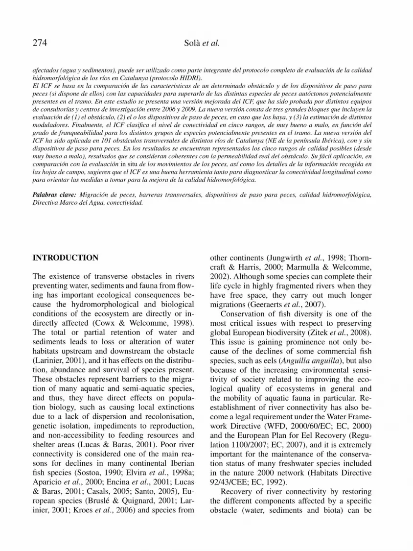
Fish pass classification
According to international standards (Larinier etal., 1994; Thorncraft & Harris, 2000; Marmulla& Welcomme, 2002; Amstrong et al., 2004;Kroes et al., 2006), improving river longitudi-nal connectivity can be performed by means oftwo major kinds of solutions: (1) restoration solu-tions, which aim to improve the water quality or

278 Sola et al.
A)
h
z
TW
Tz
h
z
TW
Tz
C)B)
h
z
Tzd
h
z
Tzd
Figure 1. Illustrations and measurements of transverse obstacle types to which the ICF can be applied (d, h, TW, Tz and z as in block1 in the appendix). A) Structures where water passes over the obstacle creating a small waterfall (weir type); B) structures wherewater passes through one or several holes, with or without a small waterfall (culvert type); C) structures with a very low slope, wherewater passes over and does not generate any small waterfall. Esquemas de las distintas tipologıas de obstaculos transversales al rıodonde es de aplicacion el ICF (d, h, TW, Tz y z como en el bloque 1 del apendice). A) Estructuras donde el agua pasa por encimacreando un salto (tipo azud); B) Estructuras donde el agua pasa por uno o varios orificios, con o sin salto (tipo vado agujereado);C) Estructuras con muy poca pendiente donde el agua resbala por encima y no genera salto.
river habitats through total or partial eliminationof obstacles; (2) rehabilitation solutions, whichfocus on the installation of different types of fishpasses and fish protection systems that preventfish from entering derivation canals; or manage-ment solutions, such as implementation of en-vironmental flow regimes or sustainable man-agement of regulation floodgates. With respectto calculation of the ICF, the index disregardsthe evaluation of restoration or management so-lutions and focuses essentially on fish passes,categorising them into three main groups ac-cording to their morphology. The first group iscomprised of close-to-nature facilities, such asfish ramps, bed ramps, lateral rivers or canals(Fig. 2a). These devices attempt to imitate thenatural habitat in a specific river section. They arelow-sloped canals or ramps with different sizesof blocks and stones allowing fish to move up-stream and downstream. They can be placed atriverside locations (lateral rivers or canals) orin the main channel, either occupying its wholewidth (bed ramps) or only a part of it (rampsfor fish). The second group consist of broad-spectrum technical fish passes, where differenti-ation is made between longitudinal staircase sec-tion devices (Fig. 2b) and devices in which thelongitudinal section has the appearance of a ramp(Fig. 2c). The index can be applied to any otherassimilated structure in both cases. The longitu-dinal staircase section devices, such as pool fishpasses (with or without a small waterfall, or withlateral slots), are based on division of a water-
fall into small waterfalls, preferably under 10 cm,inciting fish to jump from one pool to the next.These pools can be separated by cross-walls withcentral or lateral orifices allowing passage with-out jumping or by submerged holes in whichbenthic fish dwellers, creepers or modest swim-mers can pass. The device in which the longi-tudinal section has the appearance of a ramp iscomprised of baffle-type fish passes (such as de-flectors or retarders), which allow the obstacle’sheight to be overcome along a slope that is rela-tively higher than the river but includes physicalelements that decrease water speed. Finally, thethird group of fish passes contains mechanisedor specific technical pass devices, such as gates,lifts, locks and fish pumps, or devices specific toone or few species, such as eel ramps.
Application of the ICF index
Previous knowledge-Desk work
To apply the ICF, before afield visit is conducted,the potential nativefish fauna must be known andclassified according to the criteria shown inTable 1,so that the fish groups that are potentially presentcan be determined. Subsequently, the timing of asampling trip must be planned according to theriver flow (see Basis of the ICF for details).
Completion of field data sheets-Field work
The field sheet for application of the ICF is di-vided into three blocks (see appendix). Blocks 1

Longitudinal connectivity in hydromorphological quality assessments 279
A)
z
B)
z
hPh
C)
z
z
Figure 2. Illustrations and measurements of the different fishpasses to which the ICF can be applied (h, Ph and z as in block2 in the appendix). A) Fish passes close to natural conditions,such as fish ramps, lateral rivers or canals, or similar devices; B)broad-spectrum technical solutions such as pool sequences orsimilar structures; C) broad-spectrum technical solutions suchas baffle type fish passes (deflectors, retarders) or similar struc-tures. Esquemas de algunas de las distintas tipologıas de dis-positivos de paso de peces donde es de aplicacion el ICF (h, Phy z como en el bloque 2 del apendice). A) Dispositivos de pasocercanos a la naturaleza: rampas para peces, canales o rıoslaterales, o dispositivos asimilables; B) Dispositivos de pasotecnicos de amplio espectro: estanques sucesivos o asimilables;C) Dispositivos de paso tecnicos de amplio espectro: deflec-tores, ralentizadores, o asimilables.
and 2 make reference to evaluation of the obsta-cle and fish pass, respectively. Different charac-teristics need to be measured for each type ofobstacle or fish pass (if any). For each of them,a limiting value is given (maximum or mini-mum) for each of the groups of pre-establishednative fishes (Table 1). To the right of thesevalues, there is an empty space that must befilled out in the field with the real value of themeasurement for the obstacle or device. Thisvalue will preferably be measured, but if thisis not possible, it can be estimated and spec-ified on the field sheet. Block 3 includes dif-ferent modulators from the results obtained inblocks 1 and 2. It also must be filled out inthe field by marking all entries accomplished forthe obstacle, the device/s and the riverside. Fi-nally, it must be born in mind that any otherrelevant data, such as the sampling date, nameof the obstacle and/or obstacle code, location,geographical coordinates, and incidence, mustalso be recorded; however, we do not includethese data in these forms.
Block 1-Obstacle evaluation
Once the typology has been chosen for the obstacleout of the three possible types (Fig. 1), differentcharacteristics will be measured or estimated, andthe results will be written in the spaces on theright. For all types of obstacles, the morphology ofriver banks and riversides will also be evaluated.Surveyors will have to make a decision regardingwhether they are suitable for determined creepingfish species to pass (i.e., eels) based on whetherrough margins (e.g., presence of vegetation, roots,substrate heterogeneity), short slopes that are nottoo steep and particular humidity conditions exist(Larinier et al, 1994; Marmulla & Welcomme,2002; Amstrong et al., 2004). Moreover, surveyorsmust record whether water passes over or insidethe obstacle; if there is no water movement, theobstacle must be considered impermeable (exceptto eels, if they can creep along riversides).
For dams, weirs or similar obstacles (Fig. 1a),surveyors need to take into account the followingparameters. First, the height of the jump must bemeasured from the water surface at the bottom part

280 Sola et al.
of the jump to the highest point of the weir. Ifthere is no water movement, the average weirheight will be recorded. Second, the pool depthlocated immediately before the jump must be de-termined. This is extremely important for the fishto acquire impulse for their jump. A successfuljump requires the water depth to be proportionalto the height of the jump fishes must face. Third,the top width of the obstacle must be measured orestimated, although it is not directly valued in theindex. Fourth, there must be a minimum depth ofwater on top of the obstacle to allow fish to swim,provided that the completion is wide enough(over 50 cm); if not, a low flow will be sufficient.
For culverts or similar obstacles (Fig. 1b), sur-veyors need to measure the following characteris-tics. First, water velocity inside the fish pass mustbe measured. Due to a smaller section inside theculvert and to a lack of roughness, water velocitytends to increase a great deal and to be homoge-neous all along a crossing, which makes the pas-sage of fish very difficult or even impedes it alto-gether (Larinier, 2002a). Second, pass diameter,or height and width if its form is mainly squareor rectangular, must be determined. Here thereare three different cases: (1) there is a waterfallat the end of the pass; (2) water flows through theholes without any waterfall; and (3) water occu-pies the entire section of the hole (loading pipe).Third, the water depth inside the pass should al-low fish species to swim. Fourth, if a small wa-terfall is generated, surveyors need to measurejumping height (Fig. 1a). Finally, surveyors willalso need to assess pool depth before the jump.
For low slope weirs or similar obstacles(Fig. 1c), surveyors will assess only the rampslope, water velocity at the ramp, and presence ofturbulence at the base of the ramp, which mightprevent fish from travelling up the obstacle. Onceall measurements have been performed, survey-ors are asked to compare field results and limitingcharacteristics for each fish group, so that theycan determine which fish groups are able to over-come the obstacle. These groups will be markedat the end of block 1 and block 2 and at the be-ginning of block 3.
Block 2-Fish pass evaluation
In the second block, all existing fish passes mustbe classified into the categories included in theICF and then separately evaluated. If there ismore than one fish pass, different sheets willbe filled out for each of them, while if there isno pass, this should also be noted on the sheet.First, some general information on the fish passconditions needs to be recorded regarding anyobstruction impeding fish from passing at theentrance, the exit or within the pass. These ob-structions can be temporary, being caused by thepresence of tree trunks or a poor maintenance,or they can be caused by construction failures. Ifthere is no water flowing, we must also considerthis to represent an obstruction.
For fish passes that are close to natural condi-tions (Fig. 2a), four characteristics will be eval-uated: first, the ramp slope; second, the watervelocity in the fastest transect; third, the mini-mum average water depth in the section, eval-uating whether there is sufficient depth for ev-ery fish group; and finally, the water depth inthe pool located immediately before the jumpif there are waterfalls.
In broad-spectrum fish passes (Fig. 2b) fivecharacteristics need to be evaluated. The firstis pool surface area, as a minimum pool size isneeded to dissipate energy to avoid whirlpoolformation and to sufficiently diminish turbu-lence. Pool size is also related to the amount offlow and, in some cases, to the existence of rest-ing areas for fishes. Second, fish passes from onepool to the next need to be evaluated. Fish movefrom one pool to another through lateral slots,notches or submerged orifices in the cross-wallsthat separate the different pools as well as byovercoming small waterfalls. In this regard, slotwidth and the maximum and average waterfallheight formed between on pool and the next (un-evenness) need to be measured. Third, pool depthalso needs to be measured, as a certain depth isrequired to overcome a jump if there is one, or toallow swimming, resting and energy dissipation.Fourth, water velocity between pools must be de-

Longitudinal connectivity in hydromorphological quality assessments 281
termined because this is one of the main lim-iters for swimming fish. Finally, surveyors needto qualitatively assess whether there is strong tur-bulence inside pools.
In broad-spectrum technical passes, such asbaffle fish passes (Fig. 2c), the limiting charac-teristics that surveyors need to evaluate are slope,water depth and water velocity, while the evalua-tion of gates, lifts, locks and pumps could implya much more complex analysis (preferably per-formed by means of in situ monitoring), and thus,the ICF only evaluates their presence positively.Finally, to evaluate eel ramps, limiting charac-teristics such as slope, water velocity and widthshould be considered by the surveyors.
Block 3-Modulators and final score
The ICF score from blocks 1 and 2 can be 75, 50,25 or 0 depending on whether an obstacle with orwithout a fish pass is permeable to all potentialfish groups, only to some groups, only to one fishgroup or if it is not permeable to any group, re-spectively, considering all subgroups (G1a, G1b,G2, G3a, G3b, G4) separately. When there isonly one potential fish group, as in high moun-tain streams (for example, G4, in a trout river),the maximum score (75) will be assigned if fishcan pass and the minimum (0) if they cannot pass.If there are only two potential groups in a sec-tion and only one of them can pass, a score of 50points will be given. This score is then modulatedbased on inspection of complementary attributes(block 3) that make reference to additional char-acteristics of the obstacle, the fish pass, orfish migration downstream, and which may oc-cur in a different hydrological situation thanthat of the sampling day.
The modulators considered for the obstacleare positive when water passes over one or bothsides of the obstacle generating a lateral riverflow, especially in high flow situations, which canbe suitable for fish to pass, and when the obstacleis not very steep (slope < 45 %) and its surfaceis rough and irregular. The modulators are neg-ative when any overhanging structure is presentat any point within the infrastructure. Regard-ing fish passes, the ICF includes 2 positive and 4
negative modulators. The first positive modulatoris the presence of a natural substrate inside thefish pass with similar characteristics to the sub-strate in the river (this increases the possibilityof reducing the speed of water in some areas andcreates small sitting areas). The second positivemodulator is the existence of an appropriate en-trance location, which must be easily found byfishes and is preferably located as close as pos-sible to the obstacle (Larinier, 2002b). This in-cludes the existence of an appealing flow (a “call”flow) either in the fish pass or close to it and theabsence of dead areas between the entrance andthe obstacle. In lateral rivers or canals, the impos-sibility of placing the entrance close to the obsta-cle must be solved by increasing the amount offlow through the fish pass (Larinier, 2002c). Thefirst negative modulator is an inappropriate loca-tion of the fish pass that hinders or prevents fishentry, and the second is fish pass width, which isconsidered inefficient if it is narrower than 1/20of the river’s width. The third negative modulatoris based on the need for management activity orconstant maintenance of the fish pass to guaran-tee its efficiency, e.g., associated with passes withgates or partition walls, or those with a tendencyto accumulate debris affecting the water or fishpass. Finally, fish passes that are in bad conditionor damaged are also considered negatively.
The last set of modulators deals with fish mi-gration downstream and include 2 positive and2 negative modulators. The first positive modula-tor addresses the existence of a low-rise fall and asufficient water depth in the pool below the obsta-cle to warrant a safe migration downstream for allfish groups or a close-to-nature fish pass (rampsand lateral rivers or canals). The second is the ex-istence of mechanisms (mechanical, light, soundor electrical) to prevent or minimise the entranceof fish into derivation canals. The first negativemodulator is the absence of mechanisms to pre-vent entrance into derivation canals, and the sec-ond is the possibility of migration occurring overthe obstacle with any risk of mortality for fish.Allentries accomplished will be marked in the threegroups of modulators, and the values will be addedor deducted from the score obtained in block 1 and2,with the minimum final score being 0.

282 Sola et al.
Table 2. Quality classes and score ranges of the ICF index and general interpretation. Clases de calidad y rangos de puntuacionesde calidad del ındice ICF e interpretacion general.
Range Quality Interpretation
≥ 95 Very Good All the potentially present groups of fish can pass in nearly any hydrological situation. Absence of obstaclesfor fishes or existence of a partial or total demolition of an obstacle.
75-94 Good The majority of the potentially present fish groups can pass in nearly any hydrological situation. Presence ofa small obstacle or with a good fish pass.
50-74 Moderate The majority or some of the potentially present fish groups can pass, in any or in some hydrologicalsituations. Presence of a relatively permeable obstacle for fishes with too specific or little functional fishpass.
25-49 Poor Only one or few species of the potentially present fish groups can pass, and in determined hydrologicalsituations. Presence of an obstacle with very specific or very little functional fish pass.
< 25 Bad No species of the potentially present fish groups or only some in very exceptional hydrological situationscan pass. Presence of a quite big obstacle without any fish pass/es or with little or non functional fish pass.
ICF index results
ICF index values range from 0 to 110, whichcan classify obstacles into five quality levels, asshown in Table 2. The ICF considers an obstacleas permeable if there is/are one or more effec-tive fish passes (very good ICF) allowing 95 % ofall species and individuals to pass through (bothupstream and downstream) that correctly oper-ate under approximately 95 % of the flow condi-tions known for each site (Mallen-Cooper, 1993in Thorncraft & Harris, 2000). In contrast, theICF considers an obstacle or a fish pass not tobe permeable (bad ICF) when it does not allowany species or only allows some individuals topass through under exceptional hydrological sit-uations. A wide range of intermediate situationscanbe described, which are integrated in the otherthree ICF categories (good, moderate and poor).
Changes introduced in this new version ofthe ICF index
The first ICF version published was developedunder a general evaluation protocol for the hydro-morphological quality in rivers developed by theAgencia Catalana de l’Aigua (HIDRI-protocol;ACA, 2006). The structure in the new version ofthe ICF has been changed with the aim of mak-ing it simpler and facilitating the calculation ofthe different blocks. Thus, fish are grouped infour groups instead of the five groups in the orig-inal version, and large littoral species with better
swimming skills are separated from small speciesinto groups 1a and 1b, respectively. Moreover, wesubstituted the need to obtain partial results inthe two first blocks regarding the obstacle typol-ogy and fish pass by obtaining a joint, provisionalpunctuation in the third block. A slight modi-fication of the limiting values for fish groups,both for obstacles and for fish passes, has alsobeen included. Finally, the punctuation obtainedwithin the first two blocks is weighted with a se-ries of modulators to obtain the final score, andthe quality of the categories obtained is inter-preted in this new version.
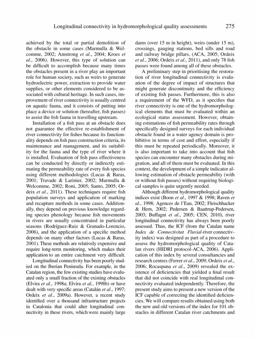
ICF application in Catalonia
The ICF was tested in 101 infrastructures in dif-ferent Catalan rivers, mainly in the Ebro (37 %)and Garona (29 %), followed by the Ter (15 %)and Llobregat (12 %), with only between 1 and 3infrastructures visited in the Muga, Daro, Torderaand Besos rivers (Fig. 3). More than 80 % ofthese infrastructures were weirs (0.5 and 10 mheight), with the rest being bridge and railwaybases, gauging stations and large dams (> 10 m).Moreover, 80 of these infrastructures were as-sociated with some kind of restoration solutionor fish pass. Over half of these solutions (54 %)belonged to broad-spectrum technical solutions,such as sequences of pools (Fig. 2b) both withand without waterfalls between pools or with lat-eral slots, while 13 % belonged to technical solu-tions, such as baffle fishways (Fig. 2c), and 8 %

Longitudinal connectivity in hydromorphological quality assessments 283
Figure 3. Potential distribution of native continental species in the Catalan area grouped according to their capacity to overcomeobstacles (Table 1: modified from ACA, 2006) and locations of the obstacles evaluated in the present study ( : obstacles with fish pass;: obstacles without fish pass). Distribucion potencial de las especies de peces continentales autoctonas de Catalunya, agrupadas
segun su capacidad para superar obstaculos (Tabla 1: modificado a partir de ACA, 2006) y localizacion de los obstaculos evaluadosen el presente estudio ( : obstaculos con dispositivos de paso para peces; : obstaculos sin dispositivos de paso para peces).
were close to natural solutions (ramps; Fig. 2a).Two lifts for fishes and 4 slides or flat rampswere also identified. Furthermore, 14 obstacleswere partially demolished, which represents asolution different from a fish pass; these caseswere assimilated into a broad-spectrum technicalsolution with a longitudinal stair-shaped sectionregarding ICF calculations. For each infrastruc-ture, both the old (ACA, 2006) and new versionsof the ICF were calculated.
RESULTS
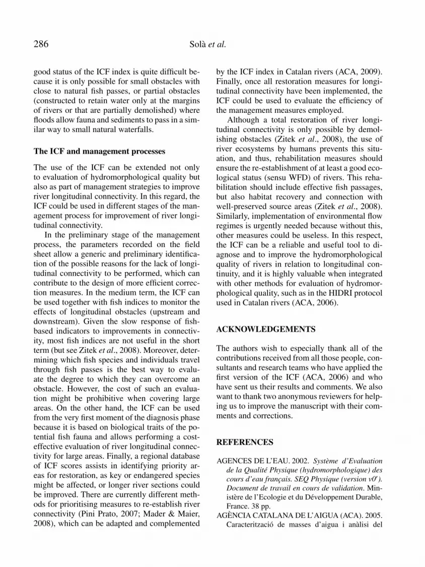
Application of the new ICFversion to 101 obstacleswith and without fish passes in rivers from Catalo-nia resulted in obstacles being represented in all fivequality classes of river connectivity (Fig. 4), whilethe old version of the ICF yielded no obstacles inthe very good quality class. The main differencebetween the two versions was that when using theold ICF, over half of the obstacles were classified

284 Sola et al.
0
68
0
3
17
1248
17
12
1511
25
0
68
)B)A
D)C)0
6
0
7
8
High Good Moderate Poor Bad
0
3
17
1248
17
12
1511
25
0
6
0
7
8
)B)A
D)C)
Figure 4. Quality classification of the 101 obstacles evaluatedwith (A) the old version of the ICF (ACA, 2006) for obstacleswith fish passes, (B) the new version of the ICF for obstacleswith fish passes, (C) the old version of the ICF for obstacleswithout fish passes and (D) the new version of the ICF for ob-stacles without fish passes. Clasificacion en rangos de calidadde los 101 obstaculos evaluados con (A) version antigua delICF (ACA, 2006) aplicada en los obstaculos con dispositivosde paso para peces, (B) version actual, presentada aquı, apli-cada en los obstaculos con dispositivos de paso para peces,(C) version antigua del ICF (ACA, 2006) aplicada en obstacu-los sin dispositivos de paso para peces, y (D) version actualaplicada en obstaculos sin dispositivos de paso para peces.
into the bad quality class, despite the existenceof fish passes, and only 9 of them achieved agood connectivity classification, while the newversion discriminated better among the qualityclasses, and more than 20 % of the obstaclesat least achieved a good quality classification(Fig. 4). Additionally, 17 obstacles even achieveda very good connectivity classification becausethey were partial or small obstacles associatedwith fish passes close to natural conditions.
The differences in the connectivity assessmentbetween the two ICF versions mainly appearedfor those obstacles with fish passes because ob-stacles withoutfish passes were classified into thesame quality class by both versions (Fig. 4).The new ICF version considerably increased theclassification quality of obstacles with fish passes(Fig. 4). Table 3 shows the results for 17 of the101 obstacles evaluated, which represent the di-versity of obstacles and fish passes evaluated.
DISCUSSION
The results of the present study show that the newICF version generally increases the final scoreof those obstacles with fish passes in compari-son with the score obtained using the old version.Moreover, the results obtained with the new ICFversion could be considered coherent with the de-gree of real permeability of the obstacles (with orwithout fish passes). In this regard, seven obsta-cles with different fish pass typologies were mon-itored with in situ measurements of fish faunamovements (Ordeix et al., 2009b & 2011), yield-ing results completely coincident with the evalu-ation of the new ICF version (see Ordeix et al.,2011). In contrast, the evaluations of connectiv-ity for fish in Catalan rivers conducted by severalconsultants and research centres (Ferrer et al.,2009; Ordeix et al., 2006; Rocaspana et al., 2009)through calculation of the old ICF version (ACA,2006) might have yielded negative skewed resultsfor obstacles with fish passes.
The ICF and the WFD
River longitudinal connectivity is one of the hy-dromorphological quality attributes required bythe WFD to evaluate hydromorphological qual-ity, but despite the many methods that have beendeveloped for assessing the integrity of hydro-logical and morphological conditions, there arehardly any such methods for river longitudinalconnectivity. The more widely used methods forassessing hydromorphological conditions in Eu-ropean rivers, such as the River Habitat Surveyin the United Kingdom (Raven et al., 1998), itsadaptation to Italy (Buffagni et al., 2005), theSystem for Evaluating Rivers for Conservation inScotland (Boon et al., 1997 & 1998), the Systemed’Evaluation de la Qualite Physique in France(Agences de l’Eau, 2002), the Large River Sur-vey in Germany (Fleischhacker & Hern, 2002),the Danish Stream Habitat Index in Denmark(Pedersen & Baattrup-Pedersen, 2003), and eventhe recently approved CEN rule (European Com-mittee for Standardization-CEN, 2010), recordthe presence of transverse obstacles, but they donot quantify the degree to which the obstacles

Longitudinal connectivity in hydromorphological quality assessments 285
Table 3. Results from application of the old and the new versions of the ICF to 17 obstacles with and without fish passes in Catalanrivers (original data obtained from Ordeix et al., 2006). Ejemplos de resultados del ICF, antiguo y nuevo, obtenidos con variastipologıas de obstaculos de los rıos de Catalunya, sin o con dispositivos de paso para peces (datos originales de Ordeix et al., 2006).
Stream name Location Obstacle Fish pass Fish pass description ICF ICF
Old version New version
Ter Vilanova de Sau Hydropower station, dam> 10 m
Non-existent Bad Bad
Ter Manlleu Hydropower station, weir< 10 m
Non-existent Bad Bad
Ter Camprodon Collector crossing the river Non-existent Poor Poor
Ter Ulla Agricultural, weir < 10 m Non-existent Poor Poor
Daro Gualta Culvert Non-existent Good Good
Gurri Gurb Culvert Non-existent Poor Poor
Meder Vic Bed sill Non-existent Poor Poor
Congost La Garriga Bed sill Non-existent Good Good
Garona Vielha Bed sill Restoration Partial demolition Moderate Very good
Muga Castellod’Empuries
Gauging station Close to nature Fish ramp Poor Good
Daro La Bisbald’Emporda
Bridge base Close to nature Bed ramp Good Very good
Noguera Pallaresa Sort Hydropower station, weir< 10 m
Broad-spectrum Following pools with smallwaterfalls
Bad Moderate
Llobregat Castellbisbal Gauging station Broad-spectrum Following pools with smallwaterfalls
Bad Bad
Garona Les Bed sill Broad-spectrum Baffle type (deflectors) Bad Good
Riu de la Llosa Lles de Cerdanya Bridge base Broad-spectrum Baffle type (deflectors) Bad Bad
Aigua de Valls Guixers Agricultural, weir < 10 m Broad-spectrum Baffle type (retarders) Bad Poor
Santa Magdalena Llavorsı Hydropower station, dam> 10 m
Mechanized or sp.solution
Lifts for fishes Moderate Good
affect river connectivity for fishes. This studyshows that the new ICF version improves longi-tudinal connectivity assessment for fishes com-pared to the older version, and thus it constitutesan appropriate method for evaluation of longitu-dinal connectivity. Furthermore, the ICF discrim-inates five permeability classes, which assists inthe integration of this method with other hydro-morphological quality elements within the con-text of the WFD. For example, this is the case inthe HIDRI evaluation protocol (ACA, 2006), inwhich the ICF is integrated with other methodsto evaluate other hydrological and morphologi-cal river attributes. Finally, the scores from all ofthe different blocks can yield valuable and pre-cise information on the type and magnitude of theproblems caused by each obstacle, and as a con-
sequence, could be used to appropriately orientmeasures and priorities.
As defined in the WFD, a very good statusregarding longitudinal connectivity can only beachieved when the migration of aquatic organ-isms and sediment transport are not altered (EC,2000). In most cases, the existence of an ob-stacle transverse to the river affects species mi-gration and/or sediment transport in some way.Even with fish pass solutions considered to beeffective, the complete integrity of populationsis not ensured because long-term effects are un-known. In this regard, it has been pointed outthat delays in overcoming an obstacle can leadto reduced migration rates, increase fish fatigueand limit certain fish sizes (Porcher & Travade,2002). It is for this reason that achieving a very
286 Sola et al.
good status of the ICF index is quite difficult be-cause it is only possible for small obstacles withclose to natural fish passes, or partial obstacles(constructed to retain water only at the marginsof rivers or that are partially demolished) wherefloods allow fauna and sediments to pass in a sim-ilar way to small natural waterfalls.
The ICF and management processes
The use of the ICF can be extended not onlyto evaluation of hydromorphological quality butalso as part of management strategies to improveriver longitudinal connectivity. In this regard, theICF could be used in different stages of the man-agement process for improvement of river longi-tudinal connectivity.
In the preliminary stage of the managementprocess, the parameters recorded on the fieldsheet allow a generic and preliminary identifica-tion of the possible reasons for the lack of longi-tudinal connectivity to be performed, which cancontribute to the design of more efficient correc-tion measures. In the medium term, the ICF canbe used together with fish indices to monitor theeffects of longitudinal obstacles (upstream anddownstream). Given the slow response of fish-based indicators to improvements in connectiv-ity, most fish indices are not useful in the shortterm (but see Zitek et al., 2008). Moreover, deter-mining which fish species and individuals travelthrough fish passes is the best way to evalu-ate the degree to which they can overcome anobstacle. However, the cost of such an evalua-tion might be prohibitive when covering largeareas. On the other hand, the ICF can be usedfrom the very first moment of the diagnosis phasebecause it is based on biological traits of the po-tential fish fauna and allows performing a cost-effective evaluation of river longitudinal connec-tivity for large areas. Finally, a regional databaseof ICF scores assists in identifying priority ar-eas for restoration, as key or endangered speciesmight be affected, or longer river sections couldbe improved. There are currently different meth-ods for prioritising measures to re-establish riverconnectivity (Pini Prato, 2007; Mader & Maier,2008), which can be adapted and complemented
by the ICF index in Catalan rivers (ACA, 2009).Finally, once all restoration measures for longi-tudinal connectivity have been implemented, theICF could be used to evaluate the efficiency ofthe management measures employed.
Although a total restoration of river longi-tudinal connectivity is only possible by demol-ishing obstacles (Zitek et al., 2008), the use ofriver ecosystems by humans prevents this situ-ation, and thus, rehabilitation measures shouldensure the re-establishment of at least a good eco-logical status (sensu WFD) of rivers. This reha-bilitation should include effective fish passages,but also habitat recovery and connection withwell-preserved source areas (Zitek et al., 2008).Similarly, implementation of environmental flowregimes is urgently needed because without this,other measures could be useless. In this respect,the ICF can be a reliable and useful tool to di-agnose and to improve the hydromorphologicalquality of rivers in relation to longitudinal con-tinuity, and it is highly valuable when integratedwith other methods for evaluation of hydromor-phological quality, such as in the HIDRI protocolused in Catalan rivers (ACA, 2006).
ACKNOWLEDGEMENTS
The authors wish to especially thank all of thecontributions received from all those people, con-sultants and research teams who have applied thefirst version of the ICF (ACA, 2006) and whohave sent us their results and comments. We alsowant to thank two anonymous reviewers for help-ing us to improve the manuscript with their com-ments and corrections.
REFERENCES
AGENCES DE L’EAU. 2002. Systeme d’Evaluationde la Qualite Physique (hydromorphologique) descours d’eau francais. SEQ Physique (version v0′).Document de travail en cours de validation. Min-istere de l’Ecologie et du Developpement Durable,France. 38 pp.
AGENCIA CATALANA DE L’AIGUA (ACA). 2005.Caracteritzacio de masses d’aigua i analisi del

Longitudinal connectivity in hydromorphological quality assessments 287
risc d’incompliment dels objectius de la Directivamarc de l’aigua (2000/60/CE) a Catalunya (con-ques intra i intercomunitaries), en complimentals articles 5, 6 i 7 de la Directiva. Departamentde Medi Ambient i Habitatge, Generalitat de Cata-lunya. 860 pp. Available in internet: http://aca-web.gencat.cat/aca/appmanager/aca/aca? nfpb=true&pageLabel=P1206154461208200586461.
AGENCIA CATALANA DE L’AIGUA (ACA). 2006.HIDRI. Protocolo para la valoracion de la cali-dad hidromorfologica de los rıos. Departament deMedi Ambient i Habitatge, Generalitat de Cata-lunya. 158 pp. Available in internet: http://aca-web.gencat.cat/aca/appmanager/aca/aca? nfpb=true&pageLabel=P1206254461208200588613#fragment-1.
AGENCIA CATALANA DE L’AIGUA (ACA). 2009.Trabajos para la redaccion de las “Bases tecnicaspara el desarrollo del Programa de Medidas en-focado a la mejora de la conectividad fluvial enCatalunya”. Departament de Medi Ambient i Ha-bitatge, Generalitat de Catalunya. Available in in-ternet: http://www.gencat.cat/aca.
AMSTRONG, G. S., M. W. APHRAHAMIAN, G. A.FEWINGS, P. J. GOUGH, N. A. READER & P.V. VARALLO. 2004. Environment Agency FishPass Manual: Guidance Notes on the Legislation,Selection and Approval of Fish Passes in Englandand Wales. Environment Agency. Wales. UnitedKingdom. 313 pp.
APARICIO, E., M. J. VARGAS, J. M. OLMO & A.SOSTOA. 2000. Decline of native freshwaterfishes in a Mediterranean watershed on the IberianPeninsula. Environmental Biology of Fishes, 59(1):11–19.
BOON P. J., N. T. H. HOLMES, P. S. MAITLAND,T. A. ROWALL & J. DAVIES. 1997. A system forevaluating rivers for conservation (SERCON): de-velopment structure and function. In: FreshwaterQuality: Defining the Indefinable? P. J. Boon & D.L. Howell (eds.): 299–326. The Stationery Office,Edimburgh. Scotland. United Kingdom.
BOON, P. J., J. WILKINSON & J. MARTIN. 1998.The application of SERCON (System for Evalu-ating Rivers for Conservation) to a selection ofrivers in Britain. Aquatic Conservation, Marineand Freshwater Ecosystems, 8: 597–616.
BUFFAGNI, A., M. CIAMPITIELLO & S. ERBA.2005. Il rilevamento idromorfologico e degli habi-tat fluviali nel contesto della Direttiva Europeasulle Acque (WFD): principi e schede di appli-
cazione del metodo CARAVAGGIO. Notiziariodei Metodi Analitici, 2: 32–46.
BRUSLE, J. & J. P. QUIGNARD. 2001. Biologiedes poissons d’eau douce europeens. EditionsTec&Doc. Paris. France. 625 pp.
CASALS, F. 2005. Les comunitats ıctiques dels riusmediterranis: relacions amb les condicions ambien-tals. Ph.D. Thesis. University of Barcelona. 353pp.
CATALAN, J., R. VILALTA, B. WEITZMANN, C.PIGEM, M. VENTURA, R. ARANDA & E. CO-MAS. 1997. L’obra hidraulica en els Pirineus.Avaluacio, correccio i prevencio de l’impactemediambiental. ENHER, FECSA i Fundacio LaCaixa. Barcelona. Catalonia. 583 pp.
CEN. 2010. EN 15843:2010 Water quality-Guidancestandard on determining the degree of modificationof river hydromorphology.
COWX, I. G. & R. L.WELCOMME (eds.). 1998. Re-habilitation of rivers for fish. Food and AgricultureOrganization of the United Nations (FAO) by Fish-ing News Books (Blackwell Science Ltd). Oxfordand Northampton, United Kingdom. 260 pp.
EC. 1992. Council Directive 92/43/EEC of 21 May1992 on the conservation of natural habitats andof wild fauna and flora.
EC. 2000. Directive 2000/60/EC of the European Par-liament and of the Council of 23 October 2000 es-tablishing a framework for Community action inthe field of water policy. Official Journal of the Eu-ropean Communities.
EC. 2007. Council Regulation (EC) No 1100/2007 of18 September 2007 establishing measures for therecovery of the stock of European eel.
ELVIRA, B., G. G. NICOLA & A. ALMODOVAR.1998a. Impacto de las obras hidraulicas en la ic-tiofauna. Dispositivos de paso para peces en laspresas de Espana. Coleccion tecnica. OrganismoAutonomo de Parques Naturales. Ministerio deMedio Ambiente. Madrid. Spain. 208 pp.
ELVIRA, B., G. G. NICOLA, & A. ALMODOVAR.1998b. Sistemas de paso para peces en presas.Centro de Estudios y Experimentacion de ObrasPublicas. Madrid. Spain. 116 pp.
ENCINA, L., A. RODRIGUEZ, C. GRANADO & C.ESCOT. 2001. Gestion y evaluacion de embalses:estudio de las poblaciones de peces. Servicio dePublicaciones de la Universidad de Sevilla. Se-villa. Spain. 224 pp.
FERRER, D., R. GARCIA & L. XIFRA. 2009. Estudide la connectivitat longitudinal del riu Fluvia i laseva aplicacio per a la gestio de l’anguila euro-

288 Sola et al.
pea (Anguilla anguilla) (Technical report). Univer-sity of Girona. 290 pp. Available in internet: http://dugi-doc.udg.edu/bitstream/10256/1733/1/1%20MEM%C3%92RIA.pdf.
FLEISHHACKER, T. & K. HERN. 2002. Ecomor-phological survey of Large Rivers. German FederalInstitute of Hydrology. Koblenz. Germany. 41 pp.
GEERAERTS, C., M. OVIDIIO, H. VERBIEST, D.BUYSSE, J. COECK, C. BELPAIRE & J. C.PHILIPPART. 2007. Mobility of individual roachRutilus rutilus (L.) in three weir-fragmented Bel-gian rivers. Hydrobiologia, 582: 143–153.
JUNGWIRTH, M., S. SCHMUTZ & S. WEISS (eds).1998. Fish migration and Fish Bypasses. FishingNews Books, Blackwell Science Ltd. Cambridge.United Kingdom. 438 pp.
KOTTELAT, M. & J. FREYHOF. 2007. Handbook ofEuropean Freshwater Fishes. Publications Kotte-lat. Cornol. Switzerland. 646 pp.
KROES, M. J., P. GOUGH, H. WANNINGEN, P. P.SCHOLLEMA, M. ORDEIX & D. VESELY.2006. From sea to source. Practical guidance forthe restoration of fish migration in EuropeanRivers. Interreg IIIC Project “Community Rivers”.Hunze en Aa’s Water Board. Groningen, TheNetherlands. 119 pp.
LARINIER, M. 2001. Environmental issues, damsand fish migration. In: Dams, fish and fisheries.Opportunities, challenges and conflict resolution.G. Marmulla (ed.): 45–89. Food and AgricultureOrganization of the United Nations (FAO), Rome,Italy.
LARINIER, M. 2002a. Fish passages through cul-verts, rock weirs and estuarine obstructions. Bull.Fr. Peche Piscic. 346 suppl.: 119–134.
LARINIER, M. 2002b. Location of fishways. Bull. Fr.Peche Piscic. 346 suppl.: 39–53.
LARINIER, M. 2002c. Pool fishways, pre-barragesand natural bypass channels. Bull. Fr. Peche Pis-cic. 346 suppl.: 54–82.
LARINIER, M., J. P. PORCHER, F. TRAVADE & C.GOSSET. 1994. Passes a poissons. Expertise etconception des ouvrages de franchissement. Col-lection Mise au point. Conseil Superieur de laPeche. Parıs. 336 pp.
LEUNDA, P. M., B. ELVIRA, F. RIBEIRO, R. MI-RANDA, J. OSCOZ, M. J. ALVES & M. J. COL-LARES PEREIRA. 2009. International Standard-ization of Common Names for Iberian EndemicFreshwater Fishes. Limnetica, 28 (2): 189–202.
LUCAS, M. C. & E. BARAS. 2001. Migration ofFreshwater Fishes. Blackwell Science. Oxford,United Kingdom. 420 pp.
MADER, H. & C. MAIER. 2008. A method for pri-oritizing the reestablishment of river continuity inAustrian rivers. Hydrobiologia, 609: 277–288.
MALLEN-COOPER, M. 1993. Proceedings of theworkshop on fish passage in Australia. FisheriesResearch Institute. Cornulla. Australia. 21 pp.
MARMULLA, G. & R. L. WELCOMME (eds.).2002. Fish passes. Design, dimensions and moni-toring. Food and Agriculture Organization of theUnited Nations (FAO) & Deutscher Verband furWasserwirtschaft und Kulturvau (DVWK). Roma.Italy. 118 pp.
MARTINEZ, C. & J. A. FERNANDEZ. 2006. Indi-ces de Alteracion Hidrologica en ecosistemas flu-viales. Monografıas CEDEX. Ministerio de Fo-mento-Ministerio de Medio Ambiente. Madrid.Spain. 178 pp.
MARTINEZ, C. & J. A. FERNANDEZ. 2007. Indicesde Alteracion Hidrologica (IAH): una nueva me-todologıa para la caracterizacion de la integridadhidro-ecologica de los rıos. Proceedings of the IICongreso sobre Restauracion de rıos y humedales.Tarragona. Catalonia.
ORDEIX, M., Q. POU-ROVIRA, N. SELLARES, A.MUNNE, J. PAGES & C. SOLA. 2006. Avaluaciodels dispositius de pas per a peixos per a l’analiside la connectivitat als rius de Catalunya. AgenciaCatalana de l’Aigua, Departament de Medi Am-bient i Habitatge, Generalitat de Catalunya. 289 pp.Available in internet: http://www.gencat.cat/aca.
ORDEIX, M., J. VAN HERK, H. WANNINGEN, C.PINTOR & C. DURAN. 2009a. Asistencia tecnicapara el estudio de propuestas de mejora de la conec-tividad para los peces en la parte baja del rıo Ebro.CERM, Centre d’Estudis dels Rius Mediterranis-Museu Industrial del Ter, LINKit Consult & Wan-ningen Water Consult. Done for the ConfederacionHidrografica del Ebro. Zaragoza. Spain. 48 pp.Available in internet: http://www.gencat.cat/aca.
ORDEIX, M., Q. POU-ROVIRA, N. SELLARES, A.MUNNE, M. BARDINA, C. SOLA & J. PAGES.2009b. Avaluacio de l’eficacia de sis dispositiusde pas per a peixos dels rius de Catalunya. Anys2006-2009. Treballs preliminars a la redacciodel Pla de Millora de la Connectivitat fluvial aCatalunya. Agencia Catalana de l’Aigua, Depar-

Longitudinal connectivity in hydromorphological quality assessments 289
tament de Medi Ambient i Habitatge, Generalitatde Catalunya. 189 pp. Available in internet: http://www.gencat.cat/aca.
ORDEIX, M., Q. POU-ROVIRA, N. SELLARES, M.BARDINA, A. CASAMITJANA, C. SOLA & A.MUNNE. 2011. Fish passes assessment in therivers of Catalonia (NE Iberian Peninsula). A casestudy of weirs associated to hydropower plants andgauging stations. Limnetica, 30(2), 405–426.
PEDERSEN, M. L. & A. BAATTRUP-PEDERSEN.2003. National monitoring programme 2003-2009.Assessment methods manual. Technical Reportno. 21. National Environmental Research Instituteof Denmark. 73 pp.
PINI PRATO, E. 2007. Descrittori per interventi diripristino della continuita fluviale: Indici di Prioritadi Intervento. Biologia Ambientale, 21 (1): 9–16.
PORCHER, J. P. & F. TRAVADE. 2002. Fishways:biological basis, limits and legal considerations.Bull. Fr. Peche Piscic., 346 suppl.: 9–20.
RAVEN, P. J., N. T. H. HOLMES, F. H. DAWSON,P. J. A. FOX, M. EVERARD, I. R. FOZZARD& K. J. ROUEN. 1998. River Habitat Quality-the physical character of rivers and streams in theUK and Isle of Man. Environment Agency. Bristol.United Kingdom. 85 pp.
REISER, D. W. & R. T. PEACOCK. 1985. A tech-nique for assessing upstream fish passage prob-lems at small-scale hydropower developments.Symposium on small hydropower and fisheries.American Fisheries Society, Western Division,Bethesda, Maryland: 423–432.
RICHTER, B. D., J. V. BAUMGARTNER, J. PO-WEL & D. P. BRAUN. 1996. A method for assess-ing hydrologic alteration within ecosystems. Con-servation Biology, 10: 1163–1174.
ROCASPANA, R., R. GUILLEM & C. POU. 2009.
Estudi sobre la connectivitat ecologica en la xarxahidrografica del Parc Natural de l’Alt Pirineu. ParcNatural de l’Alt Pirineu. Departament de MediAmbient i Habitatge. Generalitat de Catalunya.66 pp. Available in internet: http://www20.gencat.cat/portal/site/parcsnaturals/menuitem.5fed2e7f93c785920161fea3b0c0e1a0/?vgnextoid=03c5bbf557a9b210VgnVCM1000008d0c1e0aRCRD&vgnextchannel=03c5bbf557a9b210VgnVCM1000008d0c1e0aRCRD&vgnextfmt=default.
RODRIGUEZ-RUIZ, A. & C. GRANADO-LOREN-CIO. 2006. Spawning period and migration ofthree species of cyprinids in a stream with Mediter-ranean regimen (SW Spain). Journal of Fish Biol-ogy, 41(4): 545–556.
RONI, P. (ed.) 2005. Monitoring Stream and Water-shed Restoration. American Fisheries Society.Bethesda, Maryland, EUA. 350 pp.
SANTO, M. 2005. Dispositivos de passagem parapeixes em Portugal. Direccao-Geral dos RecursosFlorestais. Editideias-Edicao e Producao, Lda. Lis-boa. Portugal. 137 pp.
SOSTOA, A. (ed.). 1990. Peixos. Historia Naturaldels Paısos Catalans, 11. Enciclopedia Catalana,SA. Barcelona. Catalonia. 487 pp.
THORNCRAFT, G. & J. H. HARRIS. 2000. FishPassage and Fishways in New South Wales: a Sta-tus Report. Centre for Freshwater Ecology, Can-berra, Australia. 32 pp.
TRAVADE, F. & M. LARINIER. 2002. Monitoringtechniques for fishways. Bull. Fr. Peche Piscic.,346 suppl.: 166–180.
ZITEK, A., S. SCHMUTH & M. JUNGWIRTH.2008. Assessing the efficiency of connectivitymeasures with regard to the EU-Water FrameworkDirective in a Danube-tributary system. Hydrobi-ologia, 609: 139–161.

GE
NE
RA
LC
ON
DIT
ION
,F
OR
AN
YT
YP
EO
FO
BS
TA
CL
E
Mea
sure
do
res
tim
ate
d
va
lues
Pa
ram
eter
Co
nd
itio
nG
1a
G3
a
G1
b
G3
bG
2G
4S
tru
ctu
re
Riv
er
ban
km
orp
ho
log
yS
uit
able
for
cree
pin
gfi
shsp
ecie
s(i
.e.
eel)
No
ta
pp
lica
ble
No
ta
pp
lica
ble
Pas
sN
ot
ap
pli
cab
le
Wat
er f
low
No
wat
er p
asse
so
ver
or
insi
de
the
ob
stac
leN
ot
pas
sN
ot
pas
sN
ot
ap
pli
cab
leN
ot
pas
s
DA
MS
,W
EIR
S O
RS
IMIL
AR
(wa
ter
can
pa
sso
ver
them
by
crea
tin
ga
sm
all
wa
terf
all
)
Mea
sure
do
res
tim
ate
d
va
lues
Pa
ram
eter
Co
nd
itio
nT
hre
sho
ldG
1a
G3
a
G1
b
G3
bG
2G
4S
tru
ctu
re
Heig
ht
of
the
jum
p-h
- (c
m)
max
30
20
20
75
Po
ol
dep
thb
efo
reth
eju
mp
-z
- (c
m)
min
.h
x1
.4h
x1
.4In
dif
fere
nt
hx
1.2
5
To
pw
idth
-T
W-
(cm
)It
isno
t d
irec
tly
evalu
ated
--
--
-
Ifto
pw
idth
(T
W)
50
cm
min
.
Ifto
pw
idth
(T
W)
>50
cm
min
.1
01
01
10
CU
LV
ER
TS
OR
SIM
ILA
RO
BS
TA
CL
ES
(wa
ter
pa
sses
thro
ug
h t
he
ob
sta
cle
,w
ith
or
wit
ho
ut
asm
all
wa
terf
all
)
Mea
sure
do
res
tim
ate
d
va
lues
Pa
ram
eter
Co
nd
itio
nT
hre
sho
ldG
1a
G3
a
G1
b
G3
bG
2G
4S
tru
ctu
re
Wat
er v
elo
cit
y
(m/s
)m
ax.
20
.51
.72
.4
Ifa
small
wat
erfa
ll i
sgenera
ted
min
.5
05
05
05
0
Ifw
ater
dro
ps
wit
ho
ut
gener
atin
gan
yw
aterf
all
min
.
Wat
er o
ccup
ies
all
the
sect
ion
of
the
ho
le
Wat
er d
epth
insi
de
the
pas
s-T
z-
(cm
)m
in1
01
01
10
Jum
pin
gheig
ht
-h-
(cm
)If
asm
all
wat
erfa
ll i
sgenera
ted
max.
20
15
15
55
Po
ol
dep
thb
efo
reth
eju
mp
-z-
(cm
)If
asm
all
wat
erfa
ll i
sgenera
ted
min
.h
x1
.4h
x1
.4In
dif
fere
nt
hx
1.2
5
LO
WS
LO
PW
EIR
SO
RS
IMIL
AR
(wa
ter
slip
so
ver
the
ob
sta
cle
wit
ho
ut
asm
all
wa
terf
all
)
Mea
sure
do
res
tim
ate
d
va
lues
Pa
ram
eter
Co
nd
itio
nT
hre
sho
ldG
1a
G3
a
G1
b
G3
bG
2G
4S
tru
ctu
re
Slo
pe
- (%
)m
ax.
20
%2
0%
45
%3
0%
Wat
er v
elo
cit
y(m
/s)
max.
20
.51
.72
.4
Turb
ule
nce
sA
bse
nce
of
stro
ng
turb
ule
nce
Ma
rka
llfi
shg
ro
up
sth
at
mig
ht
pa
ssth
eo
bst
acl
e,
wh
en
all
co
nd
itio
ns
are
met
:
ICF
- R
iver
con
nec
tiv
ity
in
dex
BL
OC
K 1
-O
BS
TA
CL
E E
VA
LU
AT
ION
Pas
sd
iam
eter
,o
rheig
ht
and
wid
th-d
-(c
m)
Lim
itin
gv
alu
esp
er
gro
up
Wat
er d
epth
at t
op
-T
z-
(cm
)W
ater
flo
w
No
gro
up
sca
np
ass
30
All
gro
up
sca
np
ass
Lim
itin
gv
alu
esp
er
gro
up
Lim
itin
gv
alu
esp
er
gro
up
Ap
pen
dix
.F
ield
shee
t m
odel
for
the
appli
cati
on o
f th
e IC
F i
ndex

Write the number and type of fish passes: No fish pass present:
GENERAL CONDITION, FOR ANY TYPE OF FISH PASSES
Measured or
estimated
values
Parameter ConditionG1a
G3a
G1b
G3bG2 G4 Facility
Entrance from downstream Obstructed or no water flow
Exit to upstream Obstructed or no water flow
Inside the fish pass Obstructed or no water flow
BLOCK 2a - CLOSE TO NATURE FACILITIES
Fish ramps, bed ramps, lateral rivers or canals
Measured or
estimated
values
Parameter Condition ThresholdG1a
G3a
G1b
G3bG2 G4 Facility
Slope (%) Write the maximum present value max. 20% 20% 45% 30%
Water velocity (m/s) Write the maximum present value max. 2 0.5 1.7 2.4
Water depth inside the fish pass - z - (cm) Write the maximum present value min. 10 10 1 10
Pool depth before the jump -z- (cm) If there are waterfalls min. h x 1.4 h x 1.4 Indifferent h x 1.25
BLOCK 2b - BROAD-SPECTRUM FISH PASSES
Pool type (with or without small waterfalls, or with lateral slots) (stair-shaped longitudinal section)
Measured or
estimated
values
Parameter Condition ThresholdG1a
G3a
G1b
G3bG2 G4 Facility
Pool dimensions (m2) min. 0,25 0,16 0,25 0,25
Width of (lateral) slots (cm) If there are slots min. 15 15 15 15
Average waterfall height - h - (cm) If there are waterfalls max. 20 10 10 20
Maximum waterfall height - h - (cm) If there are waterfalls max. 30 20 20 75
If there are waterfalls min. 60 60 10 60
If there are not waterfalls min. 50 50 1 50
Pool depth before the jump - z - (cm) If there are waterfalls min. h x 1.4 h x 1.4 Indifferent h x 1.25
Water velocity (m/s) If there are not waterfalls max. 2 0.5 1.7 2.4
Strong turbulence
Baffle type (ramp-shaped section)
Measured or
estimated
values
Parameter Condition ThresholdG1a
G3a
G1b
G3bG2 G4 Facility
Slope (%) max. 20% 20% 45% 30%
Water depth - z - (cm) min. 10 10 1 10
Water velocity (m/s) max. 2 0.5 1.7 2.4
BLOCK 2c - TECHNICAL AND MECHANIZED OR VERY SPECIFICFISH
Gates, lifts, locks and fish pumps
Measured or
estimated
values
Parameter Condition ThresholdG1a
G3a
G1b
G3bG2 G4 Facility
Functional gates, lifts, locks or fish pumps Yes Yes Yes Yes
Eel ramps (or other equivalent fish passes)
Measured or
estimated
values
Parameter Condition ThresholdG1a
G3a
G1b
G3bG2 G4 Facility
Slope (%) max. Not applicable Not applicable 45% Not applicable
Water velocity (m/s) max. Not applicable Not applicable 1.7 Not applicable
Width (cm) min. Not applicable Not applicable 20 Not applicable
Mark all fish groups that might pass the fish pass, when all conditions are met:
Water depth in the pools - Pz - (cm)
Limiting values per group
Limiting values per group
Limiting values per group
Limiting values per group
Absence
Limiting values per group
Not pass
Not pass
Not pass
ICF - River connectivity index
BLOCK 2 - FISH PASS EVALUATION

Mark the potentially present fish groups at the analyzed section:G1a
G3a
G1b
G3bG2 G4
Mark the fish groups that can overcome the obstacle (block 1):
Mark the fish groups that can pass inside the fish pass (block 2):
75
50
25
0
MODULATORS (check only the options that meet):
+ 5
+ 5
- 5
+ 10
+ 5
- 5
- 5
- 5
- 10
+ 5
+ 5
- 5
- 5
FINAL SCORE:
BLOCK 3 - MODULATORS AND FINAL SCORE
Obstacle +Fish passes
Obstaclecomplements
All groups of potentially present fish can pass
Presence of a natural substrate, with similar characteristics to the one in the river, inside the fishpass
Wrong location of the entrance (from downstream to upstream)
No groups of potentially present fish can pass
If there are any derivation canal, it does not exist any mechanism avoiding or minimizing theentrance of fish into the derivation canal
Only in low slope obstacles (<45%), if its surface is rough and irregular
Correct location of the fish pass entrance (from downstream to upstream)
Downstreammigration
Downstream migration directly through the obstacle is possible but with risk of injury or death(i.e. fall of more than 10 m)
Fish can migrate downstream safely and directly through the obstacle (i.e., low height obstacle(<10m), sufficient water depth, or close to nature fish pass)
If there is any derivation canal, it exists some mechanisms avoiding or minimizing the entranceof fish into derivation canals (mechanical, light, sound or electrical), or if there is not derivationcanal
Width of the wet part of the fish pass below 1/20 average width of the river in this area
Some groups of potentially present fish can pass
Only one group of potentially present fish can pass
Fish passcomplements
ICF - River connectivity index
The morphology of the evaluated point allows, in high flows situation or temporarily, water topass through one or both sides, allowing the fish to go upstream
Presence of any overhanging structure at any point of the infrastructure
Fish pass with gates or cross-walls that need a constant maintenance to guarantee itsfunctionality
Fish pass in a bad condition of preservation or maintenance
PROVISIONAL SCORE (select one option based on the total fish groups present that can potentially
overcome the obstacle and / or fish pass):