Embed Size (px)
Citation preview
lable at ScienceDirect
Journal of South American Earth Sciences 63 (2015) 360e374
Contents lists avai
Journal of South American Earth Sciences
journal homepage: www.elsevier .com/locate/ jsames
Inverse steptoes in Las Bombas volcano, as an evidence of explosivevolcanism in a solidified lava flow field. Southern Mendoza-Argentina
Corina Risso a, *, Claudia Prezzi b, María Julia Orgeira b, Francisco Nullo c,Liliana Margonari a, Karoly N�emeth d
a Departamento de Geología-IGEBA-Facultad de Ciencias Exactas y Naturales, Universidad de Buenos Aires e Intendente Güiraldes 2160 e CiudadUniversitaria, Pabell�on II, Buenos Aires, C1428EG, Argentinab Departamento de Geología-IGEBA-FCEN-UBA-CONICET, Argentinac Newphoenix SRL., Argentinad Massey University, CS-IAE, Volcanic Risk Solutions, New Zealand
a r t i c l e i n f o
Article history:Received 7 October 2014Received in revised form28 July 2015Accepted 14 August 2015Available online 17 August 2015
Keywords:SteptoesKipukaScoria conesLava fieldPhreatomagmatismMagnetic anomalies
* Corresponding author.E-mail address: [email protected] (C. Risso).
http://dx.doi.org/10.1016/j.jsames.2015.08.0070895-9811/© 2015 Elsevier Ltd. All rights reserved.
a b s t r a c t
Here we describe the unusual genesis of steptoes in Las Bombas volcano- Llancanelo Volcanic Field (LVF)(Pliocene e Quaternary), Mendoza, Argentina. Typically, a steptoe forms when a lava flow envelops a hill,creating a well-defined stratigraphic relationship between the older hill and the younger lava flow.
In the Llancanelo Volcanic Field, we find steptoes formed with an apparent normal stratigraphicrelationship but an inverse age-relationship. Eroded remnants of scoria cones occur in “circular de-pressions” in the lava field. To express the inverse age-relationship between flow fields and depression-filled cones here we define this landforms as inverse steptoes.
Magnetometric analysis supports this inverse age relationship, indicating reverse dipolar magneticanomalies in the lava field and normal dipolar magnetization in the scoria cones (e.g. La Bombas).Negative Bouguer anomalies calculated for Las Bombas further support the interpretation that the scoriacones formed by secondary fracturing on already solidified basaltic lava flows.
Advanced erosion and mass movements in the inner edge of the depressions created a perfectlyexcavated circular depression enhancing the “crater-like” architecture of the preserved landforms.
Given the unusual genesis of the steptoes in LVF, we prefer the term inverse steptoe for these land-forms. The term steptoe is a geomorphological name that has genetic implications, indicating an olderhill and a younger lava flow. Here the relationship is reversed.
© 2015 Elsevier Ltd. All rights reserved.
1. Introduction
Volcanism in the Andean region is attributed to the subductionof the oceanic Nazca plate below the South American plate (Isackset al., 1982) (Fig. 1A).
The Nazca plate subducts to the east under the Southern Vol-canic Zone with an angle of c. 30� and with seismicity at averagedepths of 90e100 km under the volcanic arc (Ya~nez et al., 2002).The volcanic arc along the Andes comprises closely-spaced vol-canoes that are still active (e.g: Calbuco volcano 2015; Cord�onCaulle volcano 2011e2012; Chait�en volcano 2008, etc.).
Behind the active Andean volcanic arc the volcanic development
of the 60,000 km2 Payenia back-arc province has been suggested tobe linked to the differential movements of the subducting Nazcaplate and the overriding South American plate (e.g. Mu~noz et al.,1989; Kay et al., 2006; Mazzarini et al., 2008; Folguera et al.,2009; Ramos and Folguera, 2011; Gudnason et al., 2012).
The name Payenia volcanic province, given to the area byPolanski (1954), has been used in more recent papers (e.g. Germaet al., 2010; Ramos and Kay, 2006. Gudnason et al., 2012;Quidelleur et al., 2009; etc.) and it can be divided from south tonorth in Rio Colorado Volcanic Field, Payún Matrú Volcanic Field,Nevado Volcanic Field, Llancanelo Volcanic Field and Northernsegment (Gudnason et al., 2012; Folguera et al., 2009) or DiamanteVolcanic Field (Morales Volosín, 2015).
The activity in the area is represented by large composite vol-canoes such as Payún Matrú, Payún Liso and Cerro Nevado thathave produced evolved volcanic material including the large

Fig. 1. A: Location map of South America and Argentina, highlighting the Southern Volcanic Zone (SVZ) and the subduction of the Nazca plate beneath the South American plate. B:Map of Llancanelo Volcanic Field (LVF) and Payún Matru Volcanic Field (PMVF) with location of Las Bombas Volcano.
C. Risso et al. / Journal of South American Earth Sciences 63 (2015) 360e374 361
caldera forming eruptions of Payún Matrú (Llambías, 1966;Bermúdez, 1988; Ramos and Kay, 2006; Folguera et al., 2009;Germa et al., 2010). Surrounding the larger volcanoes there aretwo volcanic fields represented by monogenetic scoria cones ofalmost exclusively basaltic composition often aligned andconcentrated in small clusters: the Llancanelo and Payún MatrúVolcanic Fields (Fig. 1A and B).
Volcanism in Payenia encompasses activity from the Pliocene(Kay et al., 2006; Lambías et al., 2010; Gudnason et al., 2012) to theyoungest activity within the Payún Matrú caldera (Escorial delMatrú), dated at 7 ± 1 ka (Germa et al., 2010).
The Llancanelo Volcanic Field (LVF), (Figs. 1B, 2A and 5E) coversan area of 10,700 km2 in the south-eastern region of the province ofMendoza, Argentina, between latitudes 35� 390 and 35� 500 S andlongitudes 69� and 69�300 W, approximately 200 km east of thetrench in the Southern Volcanic Zone (Fig. 1A).
In addition, south of the LVF, the Payún Matrú Volcanic Field(PMVF) surrounds the Payún Matrú shield volcano (Fig. 1B). ThePayún Matrú shield is a complex volcano with an 8 � 6.5 km widesummit caldera, with trachybasalts (hawaiites) to trachytes lavaflows, domes, coulees and extensive pyroclastic flow deposits(Hernando et al., 2014; Hernando et al., 2012; Llambías, 1966;Gonz�alez Díaz, 1972; Ramos and Key, 2006). 40Ar/39Ar radiometricdating shows that the PayúnMatrú volcano has been active since atleast 700.6 ± 10.6 ka (Hernando et al., 2014) and should be
considered an active but dormant volcano. The youngest activitywithin the caldera has been dated at 7 ± 1 ka (Germa et al., 2010).
Volcanic activity in the LVF (Fig. 1B) was primarily of Hawaiianand Strombolian type, resulting in at least 150 scoria and/or lavaspatter cones with edifice heights ranging from 50 to 150 m, craterdiameters ranging between 150 and 200 m, and slope anglesvarying between 16 and 27� (Inbar and Risso, 2001). Preservedpyroclastic deposits of the scoria and spatter cones are typicallycoarse ash and lapilli that consist of red, scoriaceous pyroclasts withcommon meter-sized ballistic bombs and blocks of vesicular anddegassed spindle-shaped pyroclasts. Both, large vesicular, spindle-shaped lava bombs and blocks as well as bread crusted bombs andblocks with a diameter up to 3.5 m, are common.
In well-drained areas with large volumes of near-surface and/orground water, tuff rings and/or maar volcanoes form (Martin andN�emeth, 2004). The presence of subordinate phreatomagmaticvolcanoes in a volcanic field could indicate variations in hydroge-ology of the volcanic field, or variations of the water saturationstate of the sub-surface sediments or rock units over time (Aranda-Gomez and Luhr, 1996; Gutman, 2002). Such variations are alsonoted to take place during the total life span of a volcanic fieldresulting age-clustered volcanoes dominated by eruption stylesrelated more to dry versus wet external eruptive environments(Kereszturi et al., 2011; Kereszturi and N�emeth, 2012).
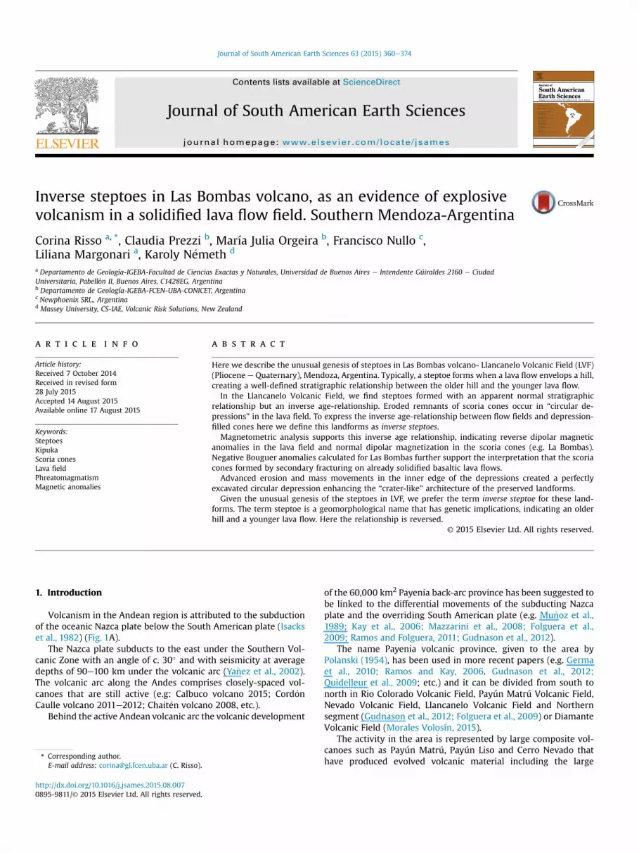
The Las Bombas (LB) volcano is located in the low-lying regions
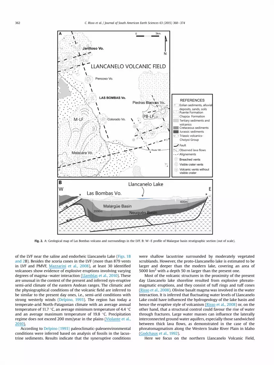
Fig. 2. A: Geological map of Las Bombas volcano and surroundings in the LVF. B: WeE profile of Malargue basin stratigraphic section (out of scale).
C. Risso et al. / Journal of South American Earth Sciences 63 (2015) 360e374362
of the LVF near the saline and endorheic Llancanelo Lake (Figs. 1Band 2B). Besides the scoria cones in the LVF (more than 879 ventsin LVF and PMVF, Mazzarini et al., 2008), at least 30 identifiedvolcanoes show evidence of explosive eruptions involving varyingdegrees of magmaewater interaction (Llambías et al., 2010). Theseare unusual in the context of the present and inferred syn-eruptivesemi-arid climate of the eastern Andean ranges. The climatic andthe physiographical conditions of the volcanic field are inferred tobe similar to the present day ones, i.e., semi-arid conditions withstrong westerly winds (Delpino, 1993). The region has today atemperate-arid North-Patagonian climate with an average annualtemperature of 11.7 �C, an average minimum temperature of 4.4 �Cand an average maximum temperature of 19.8 �C. Precipitationregime does not exceed 200 mm/year in the plains (Violante et al.,2010).
According to Delpino (1993) paleoclimatic-paleoenvironmentalconditions were inferred based on analysis of fossils in the lacus-trine sediments. Results indicate that the syneruptive conditions
were shallow lacustrine surrounded by moderately vegetatedscrublands. However, the proto-Llancanello lake is estimated to belarger and deeper than the modern lake, covering an area of5000 km2 with a depth 50 m larger than the present one.
Most of the volcanic structures in the proximity of the presentday Llancanelo lake shoreline resulted from explosive phreato-magmatic eruptions, and they consist of tuff rings and tuff cones(Risso et al., 2008). Olivine basalt magmawas involved in the waterinteraction. It is inferred that fluctuating water levels of LlancaneloLake could have influenced the hydrogeology of the lake basin andhence the eruptive style of volcanism (Risso et al., 2008) or, on theother hand, that a structural control could favour the rise of waterthrough fractures. Large water masses can influence the laterallyinterconnected groundwater aquifers, especially those sandwichedbetween thick lava flows, as demonstrated in the case of thephreatomagmatism along the Western Snake River Plain in Idaho(Godchaux et al., 1992).
Here we focus on the northern Llancanelo Volcanic Field,

C. Risso et al. / Journal of South American Earth Sciences 63 (2015) 360e374 363
particularly in LB volcano (Figs. 1B, 4B and 5A and E). LB volcano isan eroded but still recognizable scoria cone located in a circulardepression, suggesting that it was there when the lava flow fieldformed, and, therefore the lava flow engulfed it completely, like anisland in a sea of lava. While this explanation seems reasonable, thecommon presence of similar landforms in this part of the fieldjustified the need to establish correctly the stratigraphic relation-ship between lava flow fields and these circular features on it.
Lava often flows around hills or mountains, forming a volcanicmorphology known as steptoe, or in the Hawaiian language kipuka.As defined, a steptoe is “An isolated hill or mountain of older rocksurrounded by a lava flow. Syn: dagala” (Bates and Jackson, 1980). Aclear example of steptoe is seen in Fig. 4A and C, with an olderpyroclastic cone surrounded by a younger lava flow. These “islands”have been called steptoes, dagalas or kipukas. This landform isnamed after Steptoe Butte, a quartzite protrusion over 400 millionyears old, jutting out of the 15e7 million year old Columbia RiverBasalts near Colfax, Washington, U.S.A. (Easterbrook, 2003). Thesteptoe hill or mountain is assumed to be older than the sur-rounding lava flow.
In this paper, we explore these morphologies identified insouthwest Mendoza province closely resembling steptoes with thedifference that they have their central cones suspected to beyounger than the surrounding lava flow fields and thus could bedefined as inverse steptoes, (Fig. 4B), i.e. where the surrounding lavaflow is older than the pyroclastic cone. With the aim of testing thetiming of cone formation and lava flow field emplacement, as wellas to understand the 3D architecture of these volcanoes-within-circular-features, geological mapping and geophysical studieswere completed including detailed topographic, magnetic andgravimetric land surveys.
Perhaps detailed and well located radiometric analysis mayanswer this uncertainty, but here we try to use geological andgeophysical data to explain this situation.
2. Geologic setting
High-density scoria cone fields are those containing largenumber of closely spaced scoria cones erupted over a relativelyshort period of time (e.g. large number of volcanoes per area). Suchvolcanic fields are common in intra-continental regions such as theSan Francisco Volcanic Field, Arizona (Conway et al., 1997), PaliAike, Argentina (Mazzarini and D'Orazio, 2003), or Al Haruj in Libya(Martin and N�emeth, 2006).
The eruption of extensive Pliocene to Recent back-arc lava fieldsin southeastern Mendoza province (LVF and PMVF, Fig. 1B) areinterpreted to be linked to the melting of hydrated mantle after atransient episode of Neogene shallow subduction (Ramos and Kay,2006). In Pliocene to Quaternary times, a return to steeper sub-duction, with more pronounced steepening to the north, ended thearc-like magmatism in the foreland far east of the trench (Ramosand Kay, 2006). This was followed by widespread Pliocene toQuaternary mafic volcanism with a progressively more intraplate-like chemical signature that is best explained by the steepeningof the subducted slab (Kay, 2002; Ramos and Kay, 2006).
Vent density distribution is strongly conditioned by pre-existingcrustal anisotropies (Hernando et al., 2014; Bermúdez et al., 1993).The overall EeW vent density distribution in PMVF is controlled bypre-existing crustal structures (Mazzarini et al., 2008; Llambíaset al., 2010; Hernando et al., 2014). In the central zone of Payeniathe volcanic eruptions formed NWeSE vent alignments, reachingup to 60 km in longitude (Bermúdez et al., 1993), and were relatedto reactivation of Paleozoic faults of the volcanic basement(Llambías et al., 2010). Eruptions in the LVF have NWeSE trendingalignments, as shown in the alignment of vents both east and west
of Llancanelo lake (Delpino, 1987; Ninci, 1993) (Figs. 1B and 5E).The rocks of LVF are alkaline olivine basalts, with a silica content
ranging between 46 and 52% and Na2O þ K2O ranging between 3.5and 6% (Bermúdez et al., 1993). The homogeneous alkali-basaltcomposition of the back-arc lavas indicates a low degree of differ-entiation and relatively short travel time from deep mantle sources(Bermúdez and Delpino, 1989; Bermúdez et al., 1993). Volcanicactivity started in the early Pliocene and probably continued untilthe last thousands of years, including the Chapúa, Puente andTromen Formations (Nullo et al., 2005). The eruptive products ofthe youngest (Holocene) volcanism (Tromen Formation) is notrepresented in the LVF.
The back-arc basalts of the LVF are the uppermost basin-fillingformations of a tectonic depression defined by the Tertiary Malar-güe Basin (Fig. 2B). The basin is characterized by differentiallyelevated basement blocks of Permotriassic mesosillicic and acidvolcanics. The basement, structure, and different sedimentary unitsfilling the Tertiary Malargüe and the Mesozoic Neuqu�en Basins areshown in Fig. 2B. The eastern and western limits of the MalargüeBasin are defined by NW-SE-trending fault lines (see * in Fig. 2B).The western fault is more or less parallel to the ±153� trendingvolcano alignment formed by the Jarilloso, Pencoso, Las Bombas,and Colorado volcanoes (Fig. 2A). The eastern fault is parallel to theeastern margin of the present-day shoreline of Llancanelo Lake(Figs. 1B and 2B). The uppermost basin filling formations, uncon-formable with the underlying units, are the back-arc basaltsgrouped into the older Chapúa Formation and the younger PuenteFormation (Nullo et al., 2005).
Basalts of Chapúa Formation (Nullo et al., 2005), are of a glossyblack colour, with texture that goes from vesicular at the top todense, non-vesicular at its base. Extensive, fresh-looking lava flowsare predominantly pahoehoe type, with tumuli, ropy lava and oc-casional lava tubes and skylights (Bermúdez y Delpino, 1989;N�emeth et al., 2008), and subordinate aa type. The source of theseextensive lava flows is unknown due to the lack of a mappablerelationship between lava flows and volcanic edifices as a result ofadvanced erosion. Chapúa Formation has been generated by suc-cessive overlapping (37e40 m thick) lava flow units and forms thedepositional and palaeo surface upon which most of the new andyounger volcanoes (such as Las Bombas, Pencoso, Colorado, etc. inFigs. 2A and 5 AeE) formed.
Overlying the previous rock units is the Puente Formation (Nulloet al., 2005), which also consists of extensive lava flows related tovolcanic cones that are still recognizable. The Puente Formationbasalts are well-exposed in Malacara's lava flow (Fig. 2A, M-LF) andin Piedras Blancas' final lava flow (Fig. 2A, PB-LF).
Las Bombas volcano is formed on a basaltic plateau of the oldestChapúa Formation. Its pyroclastic products belong to the youngerPuente Formation. Chapúa and Puente olivine basalts are similar,differing only in size of phenocrysts and groundmass. Basalts ofChapúa Formation have 30% phenocrysts (Bermúdez et al., 1993;Risso et al., 2008), and olivine phenocrysts reach 6 mm (Figs. 3Aand 6D). The rock textures of Puente Formation basalts are quasiaphiric, with 1e5% phenocrysts (Figs. 3B and 7A, C and D)(Bermúdez et al., 1993; Risso et al., 2008), with considerableamounts of coarse euhedral olivine crystals (1e3 mm) in apilotaxic-subophitic, sometimes intersertal, groundmass ofplagioclase and titanoaugite, epidote and pale-brown sideromelaneglass.
New radiometric and cosmogenic ages can partially help tounderstand the sequence of volcanic events west of Llancanelolake.
The sample dated by Gudnason et al. (2012) from Cerro Jarilloso,is 0.16 ± 0.07Ma (40Ar- 39Ar) and would be representative in age formuch of the latest volcanic activity in the area. This is confirmed by

Fig. 3. A: Photocmicrograph in plane polarized light showing greater pilotaxic texture with larger olivine (Ol) and plagioclase (Pg) phenochrysts of Chapúa rocks. B: Photo-cmicrograph in transmitted light showing pilotaxic texture cuasi aphiric with vesicles (V) partially filled with zeolites and olivine (Ol) microphenochrysts in basalt rocks of PuenteFormation.
C. Risso et al. / Journal of South American Earth Sciences 63 (2015) 360e374364
the 40Ar- 39Ar ages of Espanon (2010) of 0.12 ± 0.13 Ma and0.40 ± 0.07 Ma for the dated Llancanelo lavas sampled west of theLlancanelo lake. However, location of sampled sites is notcompletely accurate.
Cosmogenic surface exposure ages were obtained from sampleLL3 (tumulus in pahoehoe lava, 1.5 km southwest of LBV,73,7 ± 1.1 ka 3He and 49.7 ± 2.2 ka 21Ne) (Espanon et al., 2014).
Taking into account that ages determined by different methods(cosmogenic and radiometric) cannot be directly compared, wedecided to consider the more traditionally used Ar/Ar data.
Risso et al. (2008) related Cerro Jarilloso and Las Bombas vol-cano to a single volcanic event occurred along the same lineament(Fig 2). Thus, we assign an approximate age of 0.16 Ma to the
Fig. 4. A: Steptoe or Kipuka in the PMVF. Older cinder cones (white arrow) surrounded by “aIn this case the volcano is younger than the environs lava flows C: Image from Google EarthOlder scoria cone covered by pine forests surrounded by younger lava flows with scarce vdifferent in age. In these case the depression is due to degradation of the cone (Hasenaka
volcanic activity of Las Bombas. The surrounding lavas could havean age comparable to the 0.40 Ma age reported by Espanon (2010)and assigned by Gudnason et al. (2012) to the Llancanelo lavassampled west of the Lake Llancanelo. If these correlations areadequate, they support our model of a younger volcano surroundedby older lavas.
3. Scoria cones of the LVF
Scoria cones are the most common manifestation of subaerialsmall-volume, short-lived volcanism on Earth and are generallyconsidered to be a result of mild explosive eruption of maficmagmas in a short period (weeks to months), (Vespermann and
a” younger lava flow. B: Las Bombas volcano surrounded by pahoehoe lava flows in LVF.shows a scoria cone 17 km NE of Paricutín volcano in the Trans-Mexican Volcanic Belt.egetation. See the depression around the cone similar as in Las Bombas volcano, butand Carmichael, 1985).

Fig. 5. A: Las Bombas Volcano. B: Pencoso Volcano. C: Colorado Volcano D: Jarilloso Volcano. E: General view of Las Bombas, Pencoso, Colorado and Jarilloso volcanoes with “circularpattern” (dotted white line) in the LVF. LVF comprise the entiere image, excluding the southwest side with outcrops of white Cretaceous limestones and darker Miocene andesites.Images from Google Earth.
C. Risso et al. / Journal of South American Earth Sciences 63 (2015) 360e374 365
Schmincke, 2000). Scoria cones are commonly formed from rela-tively simple eruptions, but there is evidence of exceptionally long-lived cinder cone activity such as the Paricutin volcano in Mexico(Foshag and Gonzalez, 1956). In spite of the long eruption duration,scoria cones are generally defined as monogenetic volcanoes(Kereszturi and N�emeth, 2012). Monogenetic traditionally refers tovolcanoes that erupt only once during their eruptive history(Walker, 1993; Valentine and Gregg, 2008; N�emeth, 2010).
The volcanic cones of the LVF are predominatly scoria cones andsubordinate tuff rings and tuff cones. The scoria cones studied are
located in a volcano alignment formed by the Jarilloso, Pencoso, LasBombas, and Colorado volcanoes (Fig. 2A); Las Bombas (LB) is themost representative of this group.
The measured morphometric parameters of scoria cones aregiven in Table 1.
Jarilloso, Pencoso, Las Bombas, and Colorado volcano are small-volume (<0.027 km3) scoria cones, following the equation of atruncated cone used in D�oniz-P�aez et al. (2008). Their height-widthratio is about 1:5 to 1:16 and is compatible with scoria conesdocumented by Heiken (1971) and D�oniz-P�aez et al. (2012).
Fig. 6. A: Las Bombas volcano in the center, surrounded by a slight depression and the “older lavas” at the far end (red arrows). Red arrows mark the edge of the Chapúa Fm. aroundthe cone. Dotted red line shows part of the “older lavas” front at bottom in Fig. 6A and on foreground in Fig. 6B. B: Shrubs and sands cover the “circular depression” around LasBombas cone. C: Front view of the “oldest lava” flows and shrubs-sands of the circular depression around the cone. D: detail of the black vesiculated pahoehoe lavas surrounding thevolcano. Cactus as scale. (For interpretation of the references to colour in this figure legend, the reader is referred to the web version of this article.)
C. Risso et al. / Journal of South American Earth Sciences 63 (2015) 360e374366
The scoria cones are approximately circular in map view, andfew are breached (e.g. a not entire well-defined crater rim) towardN and NE. They have small central bowl-shaped craters, excludingthe Colorado volcano which is more eroded than the others andwithout an identifiable crater (Fig. 5C). The cones in the LVF aremoderately preserved with well-developed rills and sands coveringthe gentle slopes. Slope angle values are less than 20� (Table 1) (asmeasured by a combination of topographic cross sections, orientedfield photography and spot elevation measurements applyingtrigonometric consideration). The cones are composed of coarse-grained red scoriaceous lapilli, blocks and bombs.
The textural characteristics of the pyroclasts of scoria cones,such as their high vesicularity, fluidal shape, and their dark, oftenred colour, indicate a magmatic degassing and fragmentation his-tory due to explosive eruptions (Vergniolle et al., 1996; Vergniolleand Brandeis, 1996; Vergniolle and Manga, 2000; Jaupart andVergniolle, 1988), commonly referred to as Strombolian-styleexplosive eruptions.
The usual intercalation of scoria beds in the studied scoria conesof the LVF, with welded fall deposits and/or clastogenic lava flows,indicates a sudden and common change in eruption style fromStrombolian to Hawaiian and vice versa (Valentine and Gregg,2008; Sumner, 1998) reflecting variable volcanic conduit
dynamics in the course of the eruption. Lava spatter near the vent,typically along the crater rim of the studied cones form stronglywelded, agglutinated, red, slightly bedded sequences with largespindle or highly vesicular fluidal shaped bombs.
4. Phreatomagmatic volcanoes of the LVF
While the volcanic cones of the LVF are predominantly scoriacones, some have been identified as products of phreatomagmaticeruptive phases as inferred by their pyroclastic products (Rissoet al., 2008). Volcanoes with some thin basal or inter-bedded py-roclastic units that indicate explosive phreatomagmatic phases or acomplete pyroclastic succession typical for tuff rings and tuff conesprimarily formed are located in the northwest and northeast low-lying regions of the LVF nearby the present day Llancanelo Lakesuch as Malacara, Piedras Blancas and Carapacho volcanoes(Figs. 1B and 2A). To date, no phreatomagmatic volcanoes havebeen identified in the PMVF.
To distinguish the pyroclastic units formed due to phreato-magmatic explosive eruptions from pure magmatic fragmentation-driven explosive eruptions in the LVF, a characteristic colour dif-ference, grain size distribution difference, and bedforms typical forpyroclastic density current transportation and deposition were

Fig. 7. Reddish basalts of Puente Formation. A: basalt blocks and red spindle bombs. B: Photo taken from the top of Las Bombas volcano to the South. In foreground there are redblocks and bombs (yellow arrow). It in half, the volcano is located in a slight circular depression (orange dot) filled with sand and grass. In the background (red arrow) the 3 mshoulder of “older lavas”. C: Blocks and bombs with lower crystallinity and large and elongated vesiculation. D: skin of congealed lava formed on the exterior of the bombs duringthe molten state. (For interpretation of the references to colour in this figure legend, the reader is referred to the web version of this article.)
Table 1Cone parameters. Cone height: Hco, basal width of cone: Wco, crater diameter: Wcr,slope angle: a, cone volume: Vco.
Volcano Hco Wco(m) Wcr(m) a (�) Vco(km3) Hco/Wco
Colorado 33 520 e 16 e 0.06 ¼ 1:16Las Bombas 50 330 129 23 0,0085 0.15 ¼ 1:6Pencoso 53 552 235 19 0,0274 0.09 ¼ 1:11Jarilloso 97 1059 240 20 0,0284 0.09 ¼ 1:11
C. Risso et al. / Journal of South American Earth Sciences 63 (2015) 360e374 367
used. In addition, themorphometry of the volcanoes were also usedto distinguish volcanoes formed due to magmatic versus phreato-magmatic explosive eruptions. Volcanoes with wide craters andlow slope angles (normally less than 15�) with matrix-rich tuff andlapilli tuff sequences were inferred to be tuff rings such as thePiedras Blancas volcano (Figs. 2A and 5E).
The Piedras Blancas volcano (Figs. 1B and 2A) is a 140 m-hightuff ring measured from its base to its crater rim crest. The tuff ringcrater is 1150 m in diameter, with a circular shape breached to theW-NW (Fig. 2A) and a small breached nested scoria cone inside it.Its latest volcanic activity produced massive bluish aa lava flows(Fig. 2A see PB-LF) with rubbly levee-margins in the SW side of thevent. These lava flows reached a distance of up to 2 km NW fromtheir source. The main pyroclastic cone consists of a 90 m-thick,monotonous, yellowish-grey scoriaceous pyroclastic fall and surgedeposit. Beds dip outward radially away from the vent at 24e28�
(Risso et al., 2008).
5. Las Bombas volcano
Scoria cones, like Las Bombas, (LB) volcano (Figs. 1B, 2A and 5A),are by far the most common type of volcanoes in the LVF. LB is asmall pyroclastic cone that is no more than 50 m in height (Fig. 6A)and covered by sand, grass and small bushes. It has a breachedcrater towards the east. Rills and gullies are not well-developed and
white aeolian siliciclastic sand and acidic volcanic ash from the1932 A.D. Quizapu eruption cover its gentle slopes. The cone base tocrater diameter ratio (Hco/Wco) is 0.15 (Table 1), consistent with aratio expected for scoria cones (D�oniz-P�aez et al., 2012; Fornaciaiet al., 2012; Gilichinsky et al., 2010; Inbar et al., 2011; Kereszturiet al., 2013; Kereszturi et al., 2012; Kervyn et al., 2012).
Although the volcano is covered by sand and shrubs, scatteredbanded basalt blocks (13e40 cm diameter) and reddish bombshave been observed from the middle slope to the top of the cone(Fig. 7B, yellow arrow). Blocks and bombs have lower crystallinityand large (eg: 3 � 0.8 cm) and oriented vesicles (Fig. 7C).
At the eastern flank, and typically along the crater rim of thecone, there are many agglutinated bombs and spindle-shapedfluidal bombs (Fig. 7A). Some of these reddish bombs have a thinskin of quenched lava indicating they were molten state uponlanding on the depositional surface (Fig. 7D). Bombs and blocksfrom the top of LB volcano are solidified lava spatters that landed onthe surface in a molten state allowing agglutination of the spatter,suggesting periods of high eruption rates. These observations areconsistent with a Hawaiian-style eruption.
LB is located in a slight circular depression filled with sand andgrass (Fig. 7B, orange dot), as are the Pencoso, the Colorado and theJarilloso volcanoes (Fig. 5AeE). The depression averages 1.13 km indiameter at the LB volcano (Figs. 5A and 8A and B). A detailed mapof the LB volcano and its surroundings remarking the distributionof older lavas and the pattern of the circular depression and ledgearound the cone is shown on Fig. 8A. Fig. 8B is a sideway view of thedepression, showing in the foreground the slope of LB volcano, thedepression around the volcano (Fig. 5A), and in the background the3 m shoulder of older lavas (Fig. 7B, red arrow). All contacts arecovered by vegetation or buried by sand (Fig. 6B and C). A ledge isespecially well-preserved in the southern sector of the LB volcano,in Pencoso and Jarilloso volcanoes and to the SE in the Coloradovolcano (Fig. 5, BeE). Such circular depression has also been foundin other volcanoes of LVF such as around the Pencoso cone (1.19 km

Fig. 8. A: Detailed map of Las Bombas volcano and its surroundings remarking the distribution of “older” lavas and the pattern of the circular depression and ledge around the cone.B: is an sideway view of the depression, showing in the foreground the slope of Las Bombas volcano, secondly the depression around the cone and the shoulder of black Chapúabasalts. Image of Google Earth.
C. Risso et al. / Journal of South American Earth Sciences 63 (2015) 360e374368
in diameter, Fig. 5B), Colorado volcano (1.37 km in diameter, Fig. 5C)and Jarilloso cone (2.31 km in diameter, Fig. 5D).
As described previously, the Chapúa basalts, the “older basalts”,are black (Fig. 6C and D), extensive (Fig. 2A) and are predominantlyof pahoehoe type in the LVF, with tumuli, ropy lava and occasionallava tubes and skylights. Chapúa's basalts have 30% large olivinephenocrysts (6 mm) (Fig. 3A). In contrast, the Puente basalts (“theyounger”) are quasi aphiric, with 1e5% phenocrysts of euhedralolivine crystals (1e3 mm) and forms predominantly aa lava flows(Fig.s. 7AeD and 3B). The above outlined petrographic differencebetween the older Chapúa and younger Puente basalts allow us toeasily distinguish one type of basalts from the other and use thistextural information as a field tool to establish stratigraphic re-lationships between lava fields hosting the circular depressions andcoherent lava bodies associated with cones filling the same de-pressions Fig. 6D (Chapúa) from Fig. 7 A, B and C (Puente).
These “circular landforms” around the scoria cones caught ourattention because they seemed to be very common lava fieldsfeatures in other localities such as those reported from the Qua-ternary Trans-Mexican Volcanic Belt, (see Fig. 4C) where youngerlava flows surround older cinder cones. The problem is that thelocations reported here differ from those described elsewhere byhaving a reverse stratigraphic relationship between the cones andthe lava fields hosting the “circular depression”. Based on the rocktextural data, the depressions documented here are hosting ayounger cone and best described as an inverse steptoe.
6. Geophysical studies
In order to geophysically characterize the study area and test thegenetic relationship and stratigraphic order between extensive lavafields surrounding the volcanoes, geophysical methods wereemployed to describe the detailed topographic architecture (Fig. 9),the magnetic and gravimetric signatures of the LB volcano and itsrelationship with the flow field-building lavas. Also paleomagneticstudies (Fig. 10) were carried out in order to infer the chronologicorder of the genetic processes. If the central cones were youngerthan the surrounding lava flow field, samples obtained from suchsurrounding lava flow should have registered random directions ofthe characteristic remanent magnetizations (ChRMs) due to thefracturing and the consequent scattering of the resulting blocks. Onthe contrary, if the central cones were older than the surroundinglava flow field, directions of the characteristic remanent magneti-zations registered by samples collected from such surrounding lavaflow field should be parallel after tilt correction. The appliedmethodology is described in detail in appendix 1.
The magnetic survey shows two dipolar magnetic anomalies(Fig. 11). One of them corresponds to the basaltic pahoehoe flowsforming the border of the circular pattern associated with LB
volcano. This dipolar anomaly presents a minimum ~of �200 nT tothe north of the profile and a maximum ~ of 1900 nT to the south(Fig. 11, black arrows). Ten oriented hand samples from this basalticflow were taken for natural remnant magnetization (NRM) in-tensity measurements in the laboratory, using a SQUID 2G SSRcryogenic magnetometer. The intensity of the NRM has an averagevalue of 11,378 mA/m. This intensity of the NRMwould control oneof the detected dipolar magnetic anomalies, which is of reversecharacter. Such magnetic signature indicates that these basaltscooled during a period in which the polarity of the geomagneticfield was opposite to the present one. The other dipolar magneticanomaly, located in the centre of the profile, is closely associatedwith the scoria cone (Fig.11). It presents a maximum ~ of 1700 nT tothe north of the profile and a minimum ~ of �100 nT to the south(Fig. 11, red arrows), being of normal polarity. This anomaly wouldsuggest that the formation of the scoria cone occurred during aperiod in which the polarity of the geomagnetic field was like thepresent one.
The complete Bouguer anomaly presents a minimumvalue ~ of �5 mGal, which correlates perfectly with the maximumheight of the scoria cone (~50 m) (Fig. 11). This negative anomalyindicates the existence of a mass deficit below the cone. All therocks described in the area correspond to basaltic flows. Althoughtextural differences or different lithofacies (of the same composi-tion) (i.e. spatter vs coherent lavas) could exist, the correspondingdensity contrast would not be enough as to produce the detectedcomplete Bouguer anomaly. Therefore, the negative anomaly couldbe satisfactorily explained by means of the existence of secondaryfractures below the cone generated during the volcanic eruption.
As was previously mentioned, if the central cones were youngerthan the surrounding lava flow field, the ChRMs should haveregistered random directions due to hydrothermal activity, hightemperatures, fracturing and the consequent scattering of theresulting blocks, etc. On the other hand, if the central cones wereolder than the surrounding lava flow field, directions of ChRMsshould be parallel after tilt correction. Isolated ChRMs have positiveand negative inclinations, and show a noticeable dispersion.Consequently, the fold test (McFadden, 1990) is indeterminate.However, the tilt corrected final mean direction presents a largerconfidence interval than the uncorrected one. This fact wouldindicate that the central cones are younger than the surroundinglava flow field.
Our results suggest that the volcanic processes in the area tookplace in two separate events during distinct time spans. The oldestone occurred during a period in which the polarity of thegeomagnetic field was opposite to the present one. The reverselymagnetized basaltic flows, which form the border of the studiedcircular depression, were assigned to Chapúa Formation (seeIntroduction and Geologic Setting). Considering these facts and the

Fig. 9. Detailed topography surveyed in the field of Las Bombas volcano and its surrounding “circular pattern”. The location of the magnetic and gravity profile presented in Fig. 11 isalso shown (AB).
Fig. 10. Map showing location of collected hand samples. b) Equal angle stereoplot showing tilt corrected ChRMs directions. c) Equal angle stereoplot showing ChRMs directionswithout tilt correction. Open symbols: negative inclination, Black symbols: positive inclination.
C. Risso et al. / Journal of South American Earth Sciences 63 (2015) 360e374 369
age model proposed in this contribution, such basaltic flows couldhave solidified during the reverse subchron Bermuda in the chronBrunhes (around 0.4 Ma, Chanell et al., 2012) (e.g. Lanza andMeloni, 2006). On the other hand, according to the geological ob-servations (see Introduction and Geologic Setting), the youngestvolcanic event associated with the formation of the scoria cone,responsible for the normal dipolar magnetic anomaly detected,
should have occurred during the normal polarity of the Bruhneschron (<0.7 Ma).
7. Results and discussion
Consequently, the results of the geological and geophysicalstudies carried out here suggest that the scoria cone located in the

-400-2000
200400600800100012001400160018002000
0 100 200 300 400 500 600 700 800
Distance (m)
Mag
netic
Ano
mal
y (n
T)
143014351440144514501455146014651470147514801485149014951500
0 100 200 300 400 500 600 700 800
Distance (m)
Topo
grap
hy (m
)
-5
-4.5
-4
-3.5
-3
-2.5
-2
-1.5
-1
-0.5
0
0 100 200 300 400 500 600 700 800
Distance (m)
Bou
guer
Ano
mal
y (m
Gal
)
A B
A B
A B
Fig. 11. Top: Magnetic anomaly (nT) detected across Las Bombas volcano and its surrounding “circular pattern” along AB profile (black arrows: indicate minimum and maximumvalues of the reverse dipolar magnetic anomaly corresponding to the border of the “circular pattern”; red arrows: indicate minimum and maximum values of the normal dipolarmagnetic anomaly associated with the scoria cone). Middle: The corresponding topography along AB profile is shown. Bottom: Complete Bouguer Anomaly (mGal) detected acrossLas Bombas volcano and its surrounding “circular pattern” along AB profile. (For interpretation of the references to colour in this figure legend, the reader is referred to the webversion of this article.)
C. Risso et al. / Journal of South American Earth Sciences 63 (2015) 360e374370
3 m shoulder circular depression, surrounded by the lava flows, areyounger than the surrounding lava flows. Similar circular featureshave been described elsewhere such as “neck in a basin” (NIB)landform that is proposed for volcanic structures characterized bynearly circular to elliptical open basins, located near the headwater
of small streams or drainages, which contain small volcanic necksand/or erosion remnants of one (or more) cinder cones (Aranda-Gomez et al., 2010). NIB landforms are typically 400e1000 m indiameter and 30e100 m deep and are invariably surrounded bysteep walls cut into one or more basaltic lava flows (Aranda-Gomez

C. Risso et al. / Journal of South American Earth Sciences 63 (2015) 360e374 371
et al., 2010). NIB landforms lack evidence for a primary volcano-genic origin through either collapse or youthful eruptive activity.NIB landforms are erosional features where the central feederdyke- and neck-dominated part of an older scoria cone that wasengulfed by a younger lava flow has been preserved after differ-ential erosion, that removed the outer less welded and more looseportion of the older scoria cone once acted as a barrier for theengulfing younger lava flows (Aranda-Gomez et al., 2010).
In contrast, the inverse steptoes identified at LVF such as the LBvolcano, are strikingly different from the NIB landforms. First, thecentral portion of the preserved scoria cones are fairly intact, andthere is clear evidence of the presence of still standing volcaniccones and craters. The geological and geophysical evidence alsoindicates a reverse chronological order; the volcano in thedepression is younger than the surrounding flow fields andtherefore the feature cannot be a NIB.
The LB volcanic edifice, although partially eroded, is still pre-served and its cone flank clearly sits on a circular depression aroundthe cone filled by sand.
The gravity survey indicated a significant negative Bougueranomaly beneath the scoria cones, suggesting presence of lowdensity material beneath the centre part of the depression that canbe interpreted as mass deficit. This can be explained if the lava flowthat currently surrounds the scoria cones has been fracturedsignificantly, giving place for a future younger scoria cone to emergein the newly formed depression. Another possible explanation couldbe that the roots of the cone have been partially refilled with low-density material. A logical explanation could be that an initialphreatic explosive eruption cut through the older basalt lava flowfield that formed an initial depression and later on a scoria coneerupted into that depression. Unfortunately, there is no outcroppingpyroclastic succession that would support this interpretation.However, the formation of the depression must be associated withthe formation of the volcanic events that formed the basin infillingscoria cones. It is very unlikely that the relationship between thedepression and the scoria cone is coincidental.
Fig. 12. Geological sketch (out of scale) showing the development of the “circular pattern”pyroclastic cones and successive pahoehoe lava flows. 2: A long period of intense degradasolidified lava succession. 4: The explosive disruption potentially opened up new fracturephreatomagmatic explosive event triggered the eruption. 6: When the fracturing, decomprescould built a new cone. 7: A new volcano was born: Las Bombas volcano. 8: A new period of dwith a scoria cone of reduced size surrounded by a small sedimentary basin (“Circular patt
A possible explanation for this peculiar feature is outlined inFig. 12.
We can presume that Hawaiian-Strombolian style explosiveeruptions occurred with the formation of pyroclastic cones andsuccessive pahoehoe lava flows (Fig. 12-1). During a long period ofintense erosion by eolian and minor fluvial processes a significantremoval of these cones took place (Fig. 12-2). A new batch ofmagmawas rising, causing the fracturing of the older solidified lavasuccession (Fig.12-3). The explosive disruption could have occurreddue to a sudden degassing of the rising magma in the near surface,which potentially opened up new fractures and gravitationallydestabilised the older solidified lava flows (Fig. 12-4). Perhaps wecannot rule out an initial phreatic explosive event triggered by theexplosive interaction between magma and water that was trappedbetween solidified lava flow units (Fig. 12-5). When the fracturing,decompression and sudden discharge of fractured blocks due to theexplosion ended, the magma built a new cone in the newly formeddepression on the solidified lava surface (Fig. 12-6). The depositsproduced prior to the magmatic eruptions are not preserved in thecircular zones around the cone and the old solid flows, perhaps dueto extreme arid and windy conditions (Fig. 12-7). A new period ofdegradation of the cone by climatic forces took place leading to thepresent day scenario, with a scoria cone of reduced size where coneheights range between 20 and 100 m and slope angles (17e21�)much lower than the ones of young scoria cones expected to have.The modification of the cone geometry (height and width) overtime opened a gap between the cone and the old lava flows,allowing it to function as a small sedimentary basin around thecone, collecting eolian as well as sheetwash deposits from the newcone (Fig. 12-8). From the air, these depressions look circular(“circular patterns”) and surrounding relatively young scoria conesas it can be seen in (Fig. 5E).
8. Conclusions
The results of the geophysical studies carried out in this work,
during time.1: Hawaiian-Strombolian style eruptions occurred with the formation oftion eroded the cones. 3: A new batch of magma caused the fracturation of the olders and gravitationally destabilised the older solidified lava flows. 5: Perhaps an initialsion and sudden discharge of fractured blocks due to explosion ended, the newmagmaegradation of the cone by climatic forces took place leading to the present day scenario,ern”) around the cone.

C. Risso et al. / Journal of South American Earth Sciences 63 (2015) 360e374372
support the model proposed here for the formation of the “circularpatterns” that surround the scoria cones located along lineamentsin the Llancanelo Volcanic Field, Mendoza, Argentina.
Such “circular patterns” would have been formed by fracturingof the older basaltic lava flows associated with reverse dipolarmagnetic anomalies. These older lava flows, due to their reversepolarity and their textural similarities to older lava flows, areassigned to the Chapúa Formation and are inferred to be the sameage. The fracturing of these flow sheets were inferred to be causedeither by the sudden degassing of a newly intruded youngermagma beneath the thick (~40 m) sheet flows, or by a short-livedsingle phreatic explosion caused by the interaction of the risingmagma and water trapped between the older lava sheets.
The scoria cone preserved in depressions in the lava flow fieldswere inferred to be younger than the flow field as being normalmagnetic polarity their flows. The negative complete Bougueranomalies beneath the scoria cones suggest mass deficit. Thisanomaly could indicate the presence of fracture zones in the oldbasaltic lava flows by the rejuvenated magma intrusions or theexistence of low density volcanic rocks corresponding to the rootsof the scoria cone.
The young scoria cones were subsequently eroded, reducingtheir cone heights and slope angles to the level slightly emergingabove the surrounding lava flow fields. Along the circular features,steep cliffs developed in the pre-cone lava flows where enhancederosion created a distinct basin-like zone. The identified morpho-logical features of the circular basin-like, scoria cone-filled land-forms indicate that to establish a chronological order betweenevents in a lava flow and scoria cone dominated volcanic field is acomplex process. In addition, extensive lava flow fields can act as aseal under subsequently intruding magma degassing can providegas accumulation may trigger sudden decompression and un-roofing or could facilitate sudden explosive interaction betweenrising magma and trapped water tables.
Acknowledgements
Diurnal variation of the geomagnetic field was generously pro-vided by Prof. Dr. Francisco Ruíz from Zonda Magnetic Observatory(San Juan, Argentina). Logistical help by the Direcci�on de Turismode Malargüe, and the Direcci�on de Recursos Naturales Renovablesde la Provincia de Mendoza for provided excellent field workconditions. This study was undertaken within the framework ofprojects granted by ANPCyT (PICT2013-1950) and Buenos AiresUniversity (UBACyT 643/10).
We thank Paul Baldauf (Nova S.U.) for their suggestions and theassistance in the linguistic correction of the manuscript. Journalreviewers, Managing Editor and Technical Editor suggestionsgreatly improved the quality of this report.
Appendix 1
A number of 451 topographic points were surveyed with aConstructor SP 571145130 Total Station (Fig. 9). The same equip-ment and methodology has been used in another studies (see:Prezzi et al., 2012; Acevedo et al., 2012). The obtained values weregridded applying the minimum curvature algorithm using theSurface Mapping System software Surfer of Golden Software Inc.This method results in a statistically valid grid of estimated valuesfrom unevenly distributed data (e.g. Briggs, 1974; Smith andWessel, 1990).
Total magnetic field was measured along an approximately NeSprofile across LB volcano and the surrounding depression (Fig. 9),using a Geometrics 856 proton precession magnetometer with anequidistance of 10 m between stations. Data obtained were
corrected for the diurnal variations in the Earth's magnetic field,and the corresponding IGRF (International Geomagnetic ReferenceField) value was subtracted (e.g. Lanza and Meloni, 2006).
Relative gravity measurements were made using a ZLS BurrisStandard gravity meter along the same profile (Fig. 9), with anequidistance of 20m between stations and a precision of 0.01mGal.The survey was not tied to an absolute gravity station. Thegeographic location of each measured gravity station was deter-mined with the Constructor SP 571145130 total station. Currentstandards for reduction of observed gravity to Bouguer anomaly,established by the U.S. Geological Survey (USGS) and the NorthAmerican Gravity Database Committee, were applied through theuse of the spreadsheet for reduction of raw data to the Bougueranomaly developed by Holom and Oldow (2007). With the addi-tional use of solid earth tide and terrain corrections, the completeBouguer anomaly was calculated. This spreadsheet (Holom andOldow, 2007) calculates the corrections for instrument drift, aswell as the DC shift (i.e., constant value added or subtracted toobserved gravity values) for multiple-day gravity surveys.
To make these corrections, we measured relative gravity in thesame base station several times a day during the survey. Theaverage instrument drift correction in each station was of approx-imately of 0.01 mGal. To calculate height and Bouguer spherical capcorrections, the height above the WGS84 reference ellipsoid foreach station was measured using the Constructor SP 571145130total station with a precision of 0.05 m. Earth tide correction wascalculated with the software TSoft version 2.1.15 and entered in thespreadsheet of Holom and Oldow (2007). Finally, terrain correctionwas performed using as input the topographic grid obtained fromthe detailed topography survey and also entered in the spreadsheetof Holom and Oldow (2007). The maximum terrain correction wasof 0.542 mGal, with an average value of 0.075 mGal.
In the case of paleomagnetic studies, hand samples werecollected from the Chapúa Fm. The paleomagnetic samples wereoriented using magnetic and solar compasses. A total of 10 handsamples were obtained distributed around the Las Bombas volcano(Fig. 10). Magnetization was measured using a 2G Enterprisescryogenic magnetometer. Detailed alternating fields demagnetiza-tion techniques were applied. 18 steps up to fields of 120 mT wereperformed. Characteristic remanent magnetizations (ChRMs) wereisolated using principal components analysis (Kirschvink, 1980)when linear trends of vector end points were identified. The cor-responding final-mean direction was determined applying Fisher's(1953) statistics.
References
Acevedo, R., Rabassa, M., Ponce, J., Martínez, O., Orgeira, M., Prezzi, C., Corbella, H.,Gonz�alez-Guillot, M., Rocca, M., Subías, I. Y, V�asquez, C., 2012. The Bajada delDiablo astrobleme-strewn field, Argentine Patagonia: extending the explorationto surrounding areas. Geomorphology 169e170, 151e164. http://dx.doi.org/10.1016/j.geomorph.2012.04.020.
Aranda-Gomez, J.J., Luhr, J.F., 1996. Origin of the Joya Honda maar, San Luis Potosi,Mexico. J. Volcanol. Geotherm. Res. 74 (1e2), 1e18.
Aranda-Gomez, J.J., Housh, T.B., Luhr, J.F., Noyola-Medrano, C., Rojas-Beltran, M.A.,2010. Origin and formation of neck in a basin landform: examples from theCamargo volcanic field, Chihuahua (Mexico). J. Volcanol. Geotherm. Res. 197(1e4), 123e132. http://dx.doi.org/10.1016/j.jvolgeores.2009.08.004.
Bates, R., Jackson, J., 1980. Glossary of Geology, second ed. American GeologicalInstitute.
Bermúdez, A. Y, Delpino, D., 1989. La Provincia Bas�altica Andino Cuyana (35e37�L.S.Rev. la Asoc. Geol. Argent. 44, 35e55.
Bermúdez, A., Delpino, D., Frey, F., Saal, A., 1993. Los basaltos de retroarco extra-andinos. In: Ramos, V. (Ed.), Geología y Recursos Naturales de Mendoza e 12�
Congreso Geol�ogico. Relatorio, pp. 161e172, 1(13).Bermúdez, A., 1988. Geología y petrología de las formaciones ígneas cenozoicas del
Volc�an Nevado y �areas adyacentes. UNLP-FCN. Thesis, (Unpublished).Briggs, I.C., 1974. Machine contouring using minimum curvature. Geophysics 39 (1),
39e48.Chanell, J.E.T., Hodell, D.A., Curtis, J.H., 2012. ODP Site 1063 (Bermuda Rise)

C. Risso et al. / Journal of South American Earth Sciences 63 (2015) 360e374 373
revisited: oxygen isotopes, excursions and paleointensity in the Brunhes Chron.Geochem. Geophys. Geosystems 13 (2).
Conway, F.M., Ferrill, D.A., Hall, C.M., Morris, A.P., Stamatakos, J.A., Connor, C.B.,Halliday, A.N., Condit, C., 1997. Timing of basaltic volcanism along the MesaButte fault in the San Francisco volcanic Field, Arizona, from 40Ar/39Ar dates:Implications for longevity of cinder cone alignments. J. Geophys. Res. 102 (B1),815e824.
Delpino, D., 1987. Erupciones bas�alticas a trav�es de fracturas en el retroarco andino(35�e36� LS) Mendoza, Argentina. In: International Symposium of AndeanVolcanism, vol. IV, pp. 233e237 (San Miguel de Tucum�an).
Delpino, D., 1993. Fu�e el Sur mendocino similar a Hawaii? Evidencias del pasadopara entender el presente. In: 1� Jornadas Nacionales de Vulcanología, MedioAmbiente y Defensa Civil. Secretaria de Mineria, Mendoza, pp. 67e77.
D�oniz-P�aez, J., Romero, C., Coello, E., Guill�en, C., S�anchez, N., García-Cacho, L.,García, A., 2008. Morphological and statistical characterisation of recent maficvolcanismo in Tenerife (Canary islands, Spain). J. Volcanol. Geotherm. Res. 173,185e195. http://dx.doi.org/10.1016/j.jvolgeores.2007.12.046.
D�oniz-P�aez, J., Romero-Ruiz, C., Sanchez, N., 2012. Quantitative size classification ofscoria cones: the case of Tenerife (Canary Islands, Spain). Phys. Geogr. 33 (6),514e535. http://dx.doi.org/10.2747/0272-3646.33.6.514.
Easterbrook, D., 2003. In: Quaternary Geology of the United States: INQUA 2003Field Guide Volume. Geological Society of America, p. 438.
Espanon, V.R., 2010. Cosmogenic 21Ne and 3He Dating and Geochemistry of YoungBasaltic Lavas from Southern Mendoza, Argentina. Unpublished Master Thesis,University of Wollongong.
Espanon, V.E., Honda, M., Chivas, A.R., 2014. Cosmogenic 3He and 21Ne surfaceexposure dating of young basalts from Southern Mendoza, Argentina. Quat.Geochronol. 19, 76e86.
Folguera, A., Naranjo, J.A., Orihashi, Y., Sumino, H., Nagao, K., 2009. Retroarcvolcanism in the northern San Rafael Block (34�e35� 300S), southern CentralAndes: occurrence, age, and tectonic setting. J. Volcanol. Geotherm. Res. 186,169e185.
Fornaciai, A., Favalli, M., Karatson, D., Tarquini, S., Boschi, E., 2012. Morphometry ofscoria cones, and their relation to geodynamic setting: a DEM-based analysis.J. Volcanol. Geotherm. Res. 217, 56e72. http://dx.doi.org/10.1016/j.jvolgeores.2011.12.012.
Foshag, W.F., Gonzalez, R.J., 1956. Birth and development of Paricutin volcano,Mexico. U. S. Geol. Surv. Bull. 965-D, 355e489.
Germa, A., Quidelleur, X., Gillot, P.Y., Tchilinguirian, P., 2010. Volcanic evolution ofthe back-arc Pleistocene Payun Matru volcanic field (Argentina). J. S. Am. EarthSci. 29, 717e750. http://dx.doi.org/10.1016/j.jsames.2010.01.002.
Gilichinsky, M., Melnikov, D., Melekestsev, I., Zaretskaya, N., Inbar, M., 2010.Morphometric measurements of cinder cones from digital elevation models ofTolbachik volcanic field, central Kamchatka. Can. J. Remote Sens. 36 (4),287e300. http://dx.doi.org/10.5589/m10-049.
Godchaux, M.M., Bonnichsen, B., Jenks, M.D., 1992. Types of phreatomagmaticvolcanoes in the western snake river Plain, Idaho, USA. J. Volcanol. Geotherm.Res. 52 (1e3), 1e25.
Gonz�alez Díaz, E.F., 1972. Descripci�on Geol�ogica de la Hoja 30d, Payún Matrú,Servicio Nacional Minero Geol�ogico. Bol. (Buenos Aires) 130, 1e92.
Gudnason, J., Holm, P.M., Søager, N., Llambías, E., 2012. Geochronology of the latePliocene to recent volcanic activity in the Payenia back-arc volcanic province,Mendoza Argentina. J. S. Am. Earth Sci. 37, 191e201.
Gutman, J.T., 2002. Strombolian and effusive activity as precursors to phreato-magmatism: eruptive sequence at maars of the Pinacate volcanic field, Sonora,Mexico. J. Volcanol. Geotherm. Res. 113 (1e2), 345e356.
Hasenaka, T., Carmichael, I., 1985. The cinder cones of Michoac�an-Guanajuato,Central Mexico: their age, volume and distribution, and magma discharge rate.J. Volcanol. Geotherm. Res. 25, 105e124.
Heiken, G., 1971. Tuff rings: examples from the fort rock-christmas Lake ValleyBasin, south Central Oregon. J. Geophys. Res. 76 (23), 5615e5626.
Hernando, I.R., Llambías, E.J., Gonz�alez, P.D., Sato, K., 2012. Volcanic stratigraphy andevidence of magma mixing in the quaternary Payun Matru volcano, Andeanbackarc in western Argentina. Andean Geol. 39 (1), 158e179.
Hernando, I.R., Franzese, J.R., Llambías, E., Petrinovic, I.A., 2014. Vent distribution inthe quaternary Payún Matrú volcanic Field, western Argentina: Its relation totectonics and crustal structures. Tectonophysics 622, 122e134.
Holom, D., Oldow, D., 2007. Gravity reduction spreadsheet to calculate the Bougueranomaly using standardized methods and constants. Geosphere 3 (2), 86e90.http://dx.doi.org/10.1130/GES00060.1.
Inbar, M., Risso, C., 2001. A morphological and morphometric analysis of a highdensity cinder cone volcanic field e Payún Matru, south-central Andes,Argentina. Z. für Geomorphol. 45, 321e343.
Inbar, M., Gilichinsky, M., Melekestsev, I., Melnikov, D., Zaretskaya, N., 2011.Morphometric and morphological development of Holocene cinder cones: afield and remote sensing study in the Tolbachik volcanic field, Kamchatka.J. Volcanol. Geotherm. Res. 201 (1e4), 301e311. http://dx.doi.org/10.1016/j.jvolgeores.2010.07.013.
Isacks, B., Jordan, T., Allmendinger, R., Ramos, V., 1982. La segmentaci�on tect�onica delos Andes Centrales y su relaci�on con la placa de Nazca subductada. Congr.Latinoam. Geol. Actas III, 587e606 (Buenos Aires).
Jaupart, C., Vergniolle, S., 1988. Laboratory models of Hawaiian and Strombolianeruptions. Nature 331, 58e60.
Kay, S., 2002. Magmatic sources, tectonic setting and causes of Tertiary to recentPatagonian plateau magmatism (36�S to 52�S latitude). Actas del XV Congr.
Geol. Argent. Calafate. Actas III, 95e100.Kay, S.M., Burns, W.M., Copeland, P., Mancilla, O., 2006. Upper Cretaceous to Ho-
locene magmatism and evidence for transient Miocene shallowing of the An-dean subduction zone under the northern Neuqu�en Basin. In: Kay, S.M.,Ramos, V.A. (Eds.), Evolution of an Andean Margin: a Tectonic and MagmaticView from the Andes to the Neuqu�en Basin (35�e39� S Latitude). GeologicalSociety of America. Geological Society of America, Colorado, pp. 19e60. SpecialPaper, 407.
Kereszturi, G., N�emeth, K., 2012. Monogenetic basaltic volcanoes: genetic classifi-cation, growth, geomorphology and degradation. In: N�emeth, K. (Ed.), Updatesin Volcanology e New Advances in Understanding Volcanic Systems. InTechOpen, Rijeka, Croatia, ISBN 978-953-51-0915-0, pp. 3e89 doi:10.5772/51387.
Kereszturi, G., N�emeth, K., Csillag, G., Balogh, K., Kov�acs, J., 2011. The role of externalenvironmental factors in changing eruption styles of monogenetic volcanoes ina Mio/Pleistocene continental volcanic field in western Hungary. J. Volcanol.Geotherm. Res. 201 (1e4), 227e240. http://dx.doi.org/10.1016/j.jvolgeores.2010.08.018.
Kereszturi, G., Jordan, G., N�emeth, K., D�oniz-P�aez, J.F., 2012. Syn-eruptivemorphometric variability of monogenetic scoria cones. Bull. Volcanol. 74,2171e2185. http://dx.doi.org/10.1007/s00445-012-0658-1.
Kereszturi, G., Geyer, A., Marti, J., Nemeth, K., Doniz-Paez, F.J., 2013. Evaluation ofmorphometry-based dating of monogenetic volcanoes-a case study from Ban-das del Sur, Tenerife (Canary Islands). Bull. Volcanol. 75, 734. http://dx.doi.org/10.1007/s00445-013-0734-1.
Kervyn, M., Ernst, G.G.J., Carracedo, J.C., Jacobs, P., 2012. Geomorphometric vari-ability of “monogenetic” volcanic cones: evidence from Mauna Kea, Lanzaroteand experimental cones. Geomorphology 136 (1), 59e75. http://dx.doi.org/10.1016/j.geomorph.2011.04.009.
Lanza, R., Meloni, A., 2006. The Earth's Magnetic Field. Springer, New York, p. 267.Llambías, E.J., 1966. Geología y petrología del volc�an Payún Matrú, Mendoza. Acta
Geol. Lilloana, San Miguel Tucum�an 7, 265e310.Llambías, E.J., Bertotto, G., Risso, C., y Hernando, I., 2010. El volcanismo cuaternario
en el retroarco de Payenia: una revisi�on. Rev. la Asoc. Geol. Argent. 67 (2),278e300.
Martin, U., N�emeth, K., 2004. Mio/Pliocene phreatomagmatic volcanism in thewestern Pannonian Basin. In: Geologica Hungarica, Series Geologica, Budapest,vol. 26, p. 198.
Martin, U., N�emeth, K., 2006. How Strombolian is a “Strombolian” scoria cone?Some irregularities in scoria cone architecture from the Transmexican volcanicBelt, near Volc�an Ceboruco, (Mexico) and Al Haruj (Libya). J. Volcanol. Geo-therm. Res. 155 (1e2), 104e118. http://dx.doi.org/10.1016/j.jvolgeores.2006.02.012.
Mazzarini, F., D'Orazio, M., 2003. Spatial distribution of cones and satellite-detectedlineaments in the Pali Aike volcanic field (southernmost Patagonia): insightsinto the tectonic setting of a Neogene rift system. J. Volcanol. Geotherm. Res.125 (3e4), 291e305.
Mazzarini, F., Fornaciai, A., Bistacchi, A. Y, Pasquar�e, F., 2008. Fissural volcanism,polygenetic volcanic fields, and crustal thickness in the Payen volcanic complexon the central AndesAndes Foreland (Mendoza, Argentina). G3, 9 (9). http://dx.doi.org/10.1029/2008GC002037.
Morales Volosin, M.S., 2015. Geología del Complejo Volc�anico El Pozo, Mendoza-Argentina. Trabajo Final de Licenciatura. FCEN-UBA (Unpublished).
Mu~noz, J., Stern, C.R., Bermudez, A., Delpino, D., Dobbs, M.F., Frey, F.A., 1989. Elvolcanismo Plio-Cuarternario a traves de los 38� y 39� sur de los Andes. Rev. laAsoc. Geol. Argent. 44, 270e286.
N�emeth, K., 2010. Monogenetic volcanic fields: origin, sedimentary record, andrelationship with polygenetic volcanism. In: Ca~n�on-Tapia, E., Szak�acs, A. (Eds.),What Is a Volcano? GSA Special Papers Volume 470, Geological Society ofAmerica, pp. 43e67. GSA Special Papers, 470.
N�emeth, K., Haller, M., Martin, U., Risso, C., Massaferro, G., 2008. Morphology of lavatumuli from Patagonia (Argentina), mendoza (Argentina) and Al-Haruj (Libya).Z. fur Geomorphol. 52 (2), 181e194. http://dx.doi.org/10.1127/0372-8854/2008/0052-0181.
Ninci, C., 1993. Fotointerpretaci�on geol�ogica del �area volc�anica sudoriental deMalargüe (Provincia de Mendoza). Gerencia de Exploraci�on Comisi�on Nacionalde Energía At�omica, pp. 1e45. Unpublished Report.
Nullo, F.E., Stephens, G., Combina, A., Dimieri, L., Baldauf, P., y Bouza, P., 2005. Hojageol�ogica 3569-III/3572-IV Malargüe, Provincia de Mendoza. Servicio Geol�ogicoMinero Argentino. Instituto de Geología y Recursos Minerales, Buenos Aires,p. 90. ISSN 0328e2333.
Polanski, J., 1954. Rasgos geomorfol�ogicos del territorio de la provincia de Mendoza:Ministerio Economía, Instituto Investigaciones econ�omicas y tecnol�ogicas.Cuad. Investig. Estud. 4, 4e10.
Prezzi, C., Orgeira, M., Acevedo, R., Ponce, J., Martinez, O., Rabassa, J., Corbella, H.,V�asquez, C., Gonz�alez-Guillot, M., y Subías, I., 2012. Geophysical characteriza-tion of two circular structures of Bajada del Diablo (Argentina): indication ofimpact origin. Phys. Earth Planet. Inter. 192e193, 21e34. http://dx.doi.org/10.1016/j.pepi.2011.12.004.
Quidelleur, X., Carlut, J., Tchilinguirian, P., Germa, A., Gillot, P., 2009. Paleomagneticdirections from mid-latitude sites in the southern hemisphere (Argentina):contributions to time averaged field models. Phys. Earth Planet. Inter. 172,199e209.
Ramos, V.A., Folguera, A., 2011. Payenia volcanic province in the Southern Andes: anappraisal of an exceptional quaternary tectonic setting. J. Volcanol. Geotherm.Res. 201, 53e64.

C. Risso et al. / Journal of South American Earth Sciences 63 (2015) 360e374374
Ramos, V.A., Kay, S.M., 2006. Overview of the tectonic evolution of southern CentralAndes of Mendoza and Neuqu�en (35�-39�S lat). In: Kay, S.M., Ramos, V.A. (Eds.),Evolution of an Andean Margin: a Tectonic and Magmatic View from the Andesto the Neuqu�en Basin (35�-39�S Lat). Geological Society of America, GeologicalSociety of America Special Paper, vol. 407, pp. 1e17.
Risso, C., Nemeth, K., Combina, A.M., Nullo, F., Drosina, M., 2008. The role ofphreatomagmatism in a Plio-Pleistocene high-density scoria cone field: Llan-canelo volcanic field (Mendoza), Argentina. J. Volcanol. Geotherm. Res. 169(1e2), 61e86. http://dx.doi.org/10.1016/j.volgeores.2007.08.007.
Smith, W.H.F., Wessel, P., 1990. Gridding with continuous curvature Splines inTension. Geophysics 55 (3), 293e305.
Sumner, J.M., 1998. Formation of clastogenic lava flows during fissure eruption andscoria cone collapse: the 1986 eruption of Izu-Oshima Volcano, eastern Japan.Bull. Volcanol. 60, 195e212.
Valentine, G.A., Gregg, T.K.P., 2008. Continental basaltic volcanoes e processes andproblems. J. Volcanol. Geotherm. Res. 177, 857e873. http://dx.doi.org/10.1016/j.jvolgeores.2008.01.050.
Vergniolle, S., Brandeis, G., 1996. Strombolian explosions .1. A large bubble breakingat the surface of a lava column as a source of sound. J. Geophys. Res. Solid Earth101, 20433e20447.
Vergniolle, S., Manga, M., 2000. Hawaiian and Strombolian Eruptions. In:Sigurdsson, H., Houghton, B.F., McNutt, S.R., Rymer, H., Stix, J. (Eds.), Encyclo-pedia of Volcanoes. Academic Press, pp. 447e461.
Vergniolle, S., Brandeis, G., Mareschal, J.C., 1996. Strombolian explosions .2. Eruptiondynamics determined from acoustic measurements. J. Geophys. Res. Solid Earth101, 20449e20466.
Vespermann, D., Schmincke, H.-U., 2000. Scoria cones and tuff rings. In:Sigurdsson, H., Houghton, B.F., McNutt, S.R., Rymer, H., Stix, J. (Eds.), Encyclo-pedia of Volcanoes. Academic Press, pp. 683e694.
Violante, R., Osella, A., de la Vega, M., Rovere, E., Osterrieth, M., 2010. Paleoenvir-onmental reconstruction in the western lacustrine plain of Llancanelo Lake,Mendoza, Argentina. J. S. Am. Earth Sci. 29, 650e664. http://dx.doi.org/10.1016/j.jsames.2009.12.001.
Walker, G.P.L., 1993. Basaltic-volcano systems. In: Prichard, H.M., Alabaster, T.,Harris, N.B.W., Nearly, C.R. (Eds.), Magmatic Processes and Plate Tectonics,Geological Society, London, Special Publications, vol. 76, pp. 3e38.
Ya~nez, G., Cembrano, J., Pardo, M., Ranero, C., Selles, D., 2002. The challenger- JuanFern�andez-Maipo major tectonic transition of the Nazca-Andean subductionsystem at 33e34� S; geodynamic evidence and implications. J. S. Am. Earth Sci.15 (1), 23e38.
![[Argentine Consensus of Congenital Toxoplasmosis]](https://img.pdfslide.net/doc/110x75/634f5256eb0b18f1440ac9d0/argentine-consensus-of-congenital-toxoplasmosis.jpg)


