Embed Size (px)
Citation preview
KARATEPE : THIRD CAMPAIGN*
by
U. BAHADIR ALKIM (Istanbul)
The third season's work at Karatepe', conducted under the joint auspices of the Turkish Historical Society, the Department of Museums and Antiquities, and the Faculty of Letters of Istan-bul University, lasted from September 17 th to November 15 th, 1948. The expedition consisted of Prof. Dr. H. Th Bossert, Docent Dr. U. Bahad~ r Alk~ m, Dr. Nihal Ongunsu, Lütfi Özin (architect), Ibrahim Süzen ( surveyor ) , and Mustafa Kalaç. Dr. Franz Stein-herr, to whom we are indebted, worked at Karatepe during a part of the season voluntarily. The work falls under two headings: Excavations and Exploratory Excursions 3.
* Lectur.- delivered to the 4 th Turkish Historical Congress (10-14 th No-
vember 1948. Ankara). No alterations have been made or contemplated in the
text of this lecture whose publication has been somewhat delayed. Meanwhile
the Preliminary Report of the first three seasons excavations has been published
(cf. H. Th. Bossert — U. Bahad~ r Alk~ m — H Çambel and associates, Karatepe
kaz~ lar~ , birinci ön-rapor [Ausgrabungen auf dem Karatepe], Ankara 1950,
Turkish and German).
We take this opportunity to note that the results of the fourth (1949) and
fifth (1950) seasons' work have afforded reason to modify in some respects the
conclusions reached in the present article.
For the informative reports of the first season's work cf. U. Bahad~r Alk ~ m : Karatepe Kaz~ s~, Belleten, vol, XII ( 1948 ), pp. 241 - 248 ( Excavations
at Karatepe, ib~ d. pp. 249 - 255 ) ; Halet Çambel : Orientalia, N. S. 17 ( 1948 ),
pp. 530 - 531 ; H. Th. Bossert : Die Welt des Orients, vol. I (1948), pp. 250-25 l.
For a preliminary report cf. U. Bahad~ r Alk~ m : Karatepe Kaz~ s~~~~~~~ arkeolojik sonuçlar~~ ( Les resultats archeologiques ries fouilles de Karatepe ) - lecture de-
livered to the XXI et International Congress of Orientalists - , Belleten, vol.
XII (1948), pp. 533 - 547.
2 For the informative report of the second and third seasons' excava-
tions see U. Bahad~r Alk ~ m : Oçüncii mevsim Karatepe çal~~malar~, Belleten,
vol. XIII (1949), pp. 363 - 370 ( Third Season's Work at Karatepe, ibid. pp.
371 - 374 ).
3 For unfailing helpfulness and courtesy shown to us during our third
KARATEPE: THIRD CAMPAIGN 543
I. EXCAVATION
A. At Karatepe
Excavation was undertaken on the summit of the hill, on the north slope, and at the west postern gate ; supplementary work was carried out at the upper entrance building and at some of the towers on the outer enceinte.
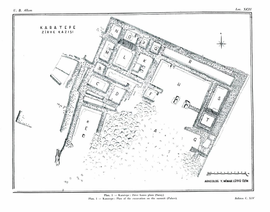
I. Excavation on the summit : During the first campaign, in-vestigations had revealed a stretch of wall 24 m. long, running NW-SE, near the top of the hill, and, 13 m. to the south of this wall, four bases of basalt 4. Suspecting the existence of an impor-tant building, this year we undertook an excavation at this point ( Plan 1). The area in question was thickly covered with scrub, immediately beneath the roots of which we found native rock at a maximum depth of 0.40 m. The excavation, conducted under great difficulties, brought to light the foundations of a building containing numerous small chambers.
On its SE side is a narrow entrance ( Plan 1 G), through which a narrow ramp leads into an open court surrounded by small chambers. The floor of this court was formed by levelling the natural rock and filling in the remaining hollows with small stones.
The four basalt bases are in line with the NE wall connecting chamber H with the courtyard ; they appear to be either founda-tions of a doorway, or, more likely, column supports. Each support consists of two blocks ; the supports, when found, were 1.50 m. apart, but we suspect that they were not in situ, and that the interval was originally larger. We think it possible that there was here a building of bit-hilâni form (Plan 1, H; fig. 1).
To facilitate the roofing of the wider chambers columns were employed. Supports for such columns were found in the chamber adjoining chamber H on the NW (Plan 1, K; fig. 2) and in anot-
season's work, our thanks are due to the Kaymakam, municipal officials and
people of Kadirli, to the yillagers of K~ zyusuflu, Bahad~ rl~~ and Karatepe, and
in partic~dar to Dr. Ismail Hakk~~ Sayman of Kadirli, ~ükrü Erdem, Education
Officer at Ceyhan, ~evki Akbulut senior master in the Sakarya Prin~ ary School at
Ceyhan, and Dr. Sedat Bar~ .
4 cf. Belleten, yol. XII (1948) , plate CXVII, 1•K/23-24.
544 U. BAHADIR ALKIM
her chamber on the SW side of the court (Plan 1, E). These sup-ports are of basalt ; the columns themselves were presumably of wood.
In the building we found large quantities of local pottery of coarse clay, lightly baked and very fragile, as well as sherds of fine workmanship showing Cypriot influence. Small finds were restricted to a few fragmentary querns of basalt and some pieces of vessels also of basalt.
Outside the SW wall of chamber S, a water-channel cut in the rock deserves notice.
We believe that this building, constructed at the dominating point of the hill, was of considerable importance ; but its ruined condition, combined with the absence of small finds, prevents us from determining its nature. A palace, a temple, or a military headquarters are all possible ; b a palace appears to be most likely. In the architectural style of this palace we observe not only native Anatolian, but also north-west Mesopotamian elements.
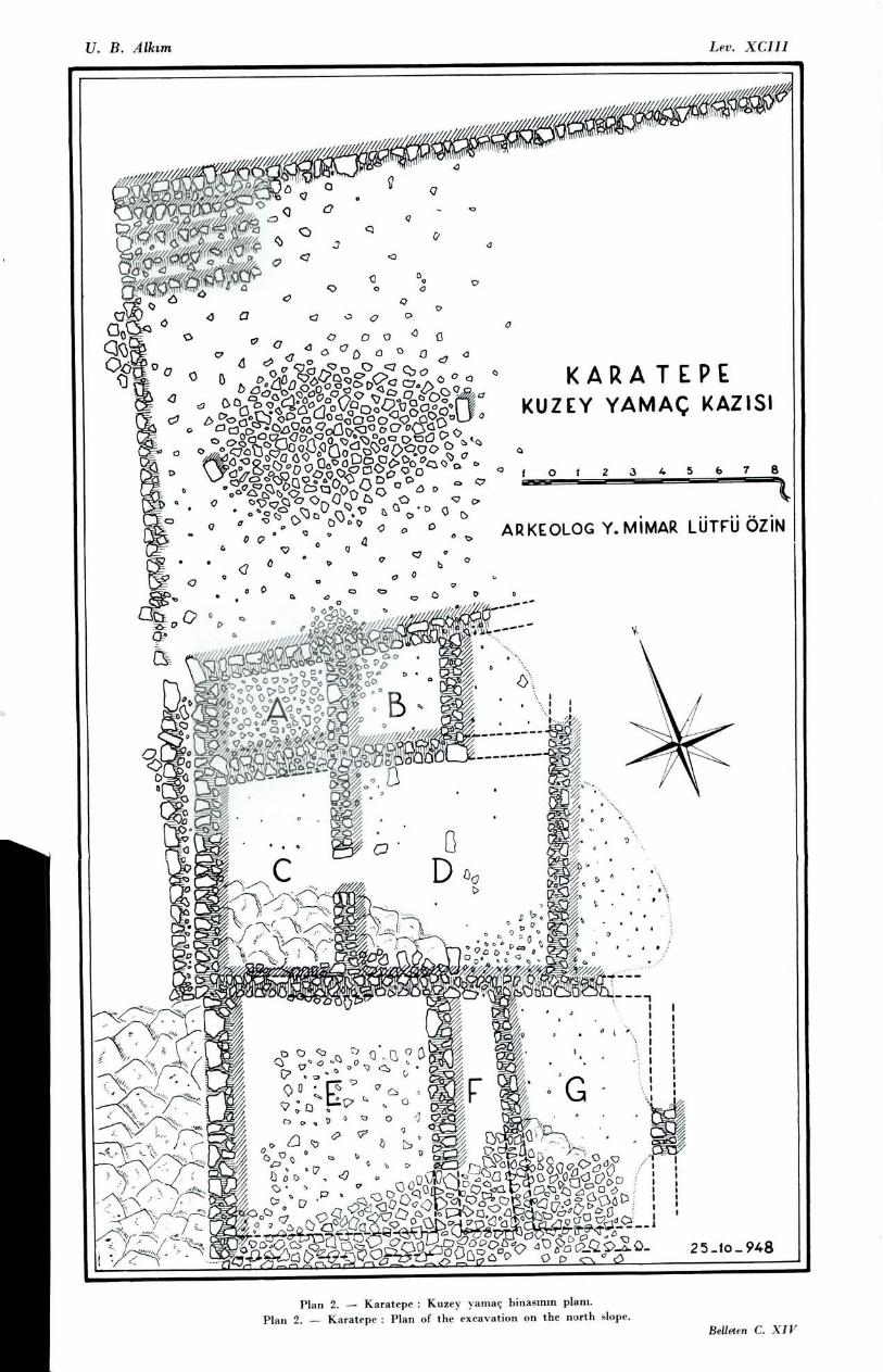
2. Excavation on the north slope : During the first campaign, a long stretch of wall, running N-S, was observed 5 on the north slope (fig. 3) of Karatepe; excavation at this point during the third campaign revealed the foundations of numerous small cham-bers belonging to a large building. As the southern extremity of the building lies 6.5 m. higher than the northern, and its Mris
has been washed down the hillside by the rain-water, nothing but foundations came to light (Plan 2, fig. 4).
At the N end of this building is a short flight of stone steps, at the head of which is a filling of small stones forming a level space. Lying on this level space we found a rectangular worked block of greyish brown basalt. Whether this in situ or not is hard to determine ; but in any case it is not likely to have rolled a great distance to its present position. It may be a foundation block for a doorway, or perhaps rather the support for a wooden column. Five metres from this base was found another of the same ma-terial, this time in situ. the steps, The level platform and the co-lumn-bases suggest that the principal entrance was on this side, but the advanced state of ruin prevents a definite decision.
5 cf. Belleten, vo!. XII (1948) , plate CXVII, I-K/31-34.
KARATEPE: THIRD CAMPAIGN 545
To the south of this platform is a series of small chambers ( Plan 2, A, B, C, D, E, F, G ), of irregular rectangular shape . Their floors are formed in some cases of the natural rock, in others of stones of varying sizes (average measurment 0.05-0.15 m.). Inside the chambers an abundance of coarse local pottery, and a number of pithoi admitting of reconstruction, came to light (figs. 5, 6). In chamber B was found a very well preserved basalt dish with three feet. Chambers C and D communicated with each other by a door (fig. 7).
The walls of this building rest directly on the rock. Their lower parts are constructed of local limestone, the blocks being mostly of large size. The upper portions were no doubt of mud brick.
No small finds whatever were made. At the upper and the lower entrance buildings also, small finds were very scarce. This circumstance suggests that the occupation of Karatepe was not of long duration. It is possible that when the site was destroyed by fire, the inhabitants took away their valuables with them. The total absence of finds belonging to any later period shows that Karatepe was never again a centre of civilisation.
This large complex of building on the north slope evidently extends a great distance to the east; but as the season was ending, and prospects of new and important discoveries were not good, the excavation was brought to a close. In future cam-paigns we intend to determine the limits of the complex.
3. Excavation at the postern gate: A small sounding made du-ring the first campaign at this point had revealed the foundations of a gateway, with three basalt blocks set side by side, and had shown that the gate was protected on the north-side by one of the towers in the wall° ; but owing to the ruinous condition of the wall it was uncertain whether a similar tower stood also on the south. Towards the end of the recent campaign, excavation was undertaken (figs. 8,9), and disclosed outside the gate a door-socket belonging to the gate and a frag-ment of a relief (?). Digging was carried down to the foundation of the wall, at a depth of from 1.5 to 2.0 m., and it was seen that
6) u. B. Alk ~ m, Belleten, yol. XII (1948), p. 250 and. 535.
Belletin, C. XIV. 35
546 U. BAHADIR ALKIM
the gate adjoins the wall on either side. Inside and to the east of
the gate, a wall was revealed. The close of the campaign pu,
an end to this excavation. Between this gate and the building on
the summit is a thick layer of soil ; this, and the fact that a
fragment of a relief was found in front of the gate, and that the wall
runs eastwards, suggests the possibility that on this steepish
slope there may exist a building decorated with orthostats ; the
discovery during the first campaign of a fragmentary inscription
in Hittite hieroglyphs at a point SW of the building on the
summit, and numerous worked basalt blocks close by, goes to
strengthen this possibility. We intend next year to undertake a
more thorough excavation of the area inside the postern gate.
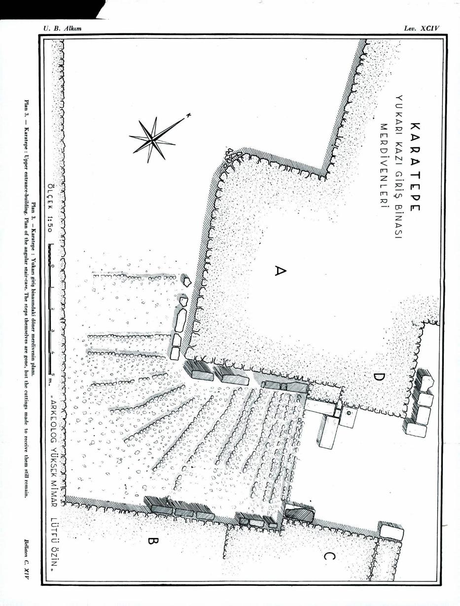
Supplementary work in the Upper Excavation arca : In the
passage• way of the upper entrance-building several steps had
been observed 7. A thorough investigation was undertaken during
the third season's work, and brought to light a staircase (Plan, ~li),
which begins at the point where the ramp ends opposite the
middle of tower A, and continues the whole length of the
passageway as far as the first gate, making a right-angled turn
round the towers (figs. 10-11). The existence of a right- angled
stairway in the eighth century B. C. is a remarkable phenomenon.
Wall and towers: As a result of this season's investiga-
tions, a total of twenty-eight towers has been counted in the
circuit of the outer enceinte.
B. On Domuztepe (Fig~s. 12-13).
On the east bank of the river Ceyhan directly opposite Ka-
ratepe, our previous investigations 8 had shown 9 the existence of
a fortification wall probably contemporary with Karatepe, and of
various ruins (fig. 14) inside and outside this wall (fig. 15). A statue-
base decorated with a pair of bulls (fig. 16, 17) , and half a
7 cf. Belirten, yol. XII ( 1948 ) , plate CXVII, 1/13 - 14 and plate CXIX, fig. 5.
9 H. Th. Bosaert and U. Babad~r Alk~m : Karatepe Il. pp. 28-29. 9
ef. U. B. Alk~ m : The Excayations at Karatepe, Belirten, yol. XII (1948), 254 - 255.
KARATEPE: THIRD CAMPAION 547
relief showing a God (?) standing on a sphinx (figs. 18, 19) had also been discovered °°. This year two soundings were made ".
1. In the SW corner of Domuztepe we had seen during the first campaign a fragment of a portal-lion, and had wondered if it might be in .s":£ and mark the position of an entrance. A test made here during the third campaign (fig. 20) revealed a gate-way 1.80 m. wide, adjoined on either side by the main wall, which is here of remarkably careless workmanship. The gate is appro-ached from the outside (south) by one step. A door-socket belonging to the gateway was found 6,1 the left-hand side.
The right side of the door is formed by a lion (fig. 21), the iett by the smoothed surface of the natural rock. The wall on the left is totallv destroyed, but the beds for the wall - extend eastward for 16.5 m., forming the inner wall of a corner tower projecting to the south, af ter which it turns to the north. This wall is 1 m. thick on the average.
The existing portion of the portal-lion, of greyish brown basalt, is 0.93 m. long and 0.83 m. high (maximum dimensions); only the hind paws and part of the tail are preserved, depicted in
bas-relief 0.02 m. in height. We failed to find the remaining parts.
To judge by the style, this lion may well be of the late Hit-tite period. The incised maricings on the hind legs and the detailed rendering of the paws indicate comparatively careful workmanship. The portal lions at Karatepe are, by contrast, in high relief and in general of careless workmanship and lacking in detail.
The question arises whether this lion gate is original and
i° On a first examination, made in an unfavourabie light, it was sur-
mised that the figure stood on a Ban ( ef. Karatepe II, p. 29). Receot scrutiny
has shown that a figure ( god ? ) wearing a long skirted robe stands OD a
sphinx ; the latter is represented with a lion's body and buman head (see figs.
18, 19 ). The relief was evidently forrned of two blocks ; a projection on the
flat upper surface of our relief no doubt served to secure it firmly
to the upper portion which we werc not able ta find. Anothcr projection
of triangular shape on the side of the block had prest~maWy the same
purpose.
II U. B. Alk~m, üçüncü mevsim Karatepe çal~~malar!, Belleten, vol. XIII
(1949), p. 373.
548 U. BAHADIR ALKIM
contemporary with Karatepe, or whether ancient building ma-
terial from another and earlier fortress was reused at Domuztepe
and the lion made its way there with this material. Since
Roman pottery was found both inside and outside this small
entrance with its single lion, we thought it possible that the
building might date from the Roman period.
2. On learning of the existence of two fragments of relief 12
hidden among dense trees and undergrowth at a point some 350
m. NE of Domuztepe, we visited the spot, and finding there
Cyclopean walls and the fragments mentioned, decided to undertake
a trial excavation on a small scale. After clearing an area 60 x 30 m.
( cf. fig. 14 ), our trenches revealed the foundations of badly
ruined Cyclopean walls, whose plan could not be determined,
resting directly on the Latural rock. This excavation produced
three more fragments of relief, which proved to belong to one and
the same slab. Restoration proved possible, and a remarkable
design emerged ( figs. 22, 23 ). On either side of a Tree of Life
is a man in kneeling posture, wearing a cap and a short kilt.
Above the tree is a winged sun- disc similar to one we found at
Karatepe. The relief after restoration ( by Prof. Bossert and Lütfi
özin ), measures 1.10 X 1.50 x 0.30 m. The prominent nose and
almost non-existent chin of the man on the left are reminiscent of
certain facial types at Karatepe. We think it probable that this
relief is contemporary with the sculptures of Karatepe, and is
not in its original position, but was either brought here when the
rough walls were built at a later date, or prepared here and
never erected.
At Domuztepe itself, and for a space of 2 - 3 km. around it,
is a thick vein of basalt 13, which in the part where we excavated
rises here and there above ground. On a rock some 6 m. north
of the point where we found the lower portion of the relief seen
12 OUr attention was drawn to one fragment of these reliefs by Isa Ta~-
k~n of the village of Çerçioglu ( formerly Çerçiu~ak~~ ) some 3 km. north of
Domuztepe. Isa Ta~k~ n subsequently became a member of our working party,
and I should like to «press my thanks to him for his hep.
is On the 1 : 800,000 geological map published by the Turkish Mine-
ralogical Institute ( Ankara 1944, Sheet VII, Malatya ) this vein of basalt is
not shown.
KARATEPE: THIRD CAMPAIGN 549
in fig. 22, we sew what appeared to be an unfinished head ; and on another rock a few paces to the south are regular incisions made for the purpose of cutting the blocks. There was apparently a stone-quarry or a workshop here, and the basalt blocks at Karatepe evidently came from Domuztepe.
As no inscription has yet been found at Domuztepe, we can make no final decision as to the date of this site. Nevertheless, the sculptures found there lead us to believe that its original occu-pation dates to the late Hittite period, and in all probability was contemporary with Karatepe ( ca. ninth and eighth century B. C.). Our own opinion is that Karatepe and Domuztepe, situa-ted opposite one another on two natural hills in an excellent strategic situation, are fortified posts belonging to the Danunians. The fact that the basalt used at Karatepe was brought from Domuztepe makes it most unlikely that the latter was a frontier post hostile to the Danunians.
Domuztepe, after suffering violent destruction, was later exten-sively reoccupied by the Romans. Large scale excavation on the site would involve great expense, which in our opinion would be unlikely to be adequately rewarded. We hope that in future cam-paigns we shall return to Domuztepe for further investigations.
11. EXPLORATORY EXCURSIONS
This year as in previous years 14, our plan of work included excursions to determine the lines of communication from Karatepe to the north and south, and the existence or non-existence of other contemporary sites. While other members of the. party (Prof. Dr. H. Th. Bossert, Dr. Nihal
14 After the discoverv of Karatepe, the first excursion in the neighbour-
hood was untertaken by Prof. H. Th. Bossert and the present writer in the
spring of 1947 (ef. Karatepe, Kadirli and its Environments, Istanbul 1947). On
that occasion we travelled from Mehmetli as far as Çiçeklidere, but as only a
very short time was available, a few monuments only were recorded ; among
these may be mentioned Çcm kalesi and a rock-cut altar in its vicinity, and a
rock-relief of Roman date. A second excursion was made during the first exca-
vation season (see B. Alk~m, Belleten. vol. XII. 1948, p. 255), and had as its
chief result the discovery at Hemite of a rock relief of the Hittite Imperial
period. This rock sculpture was brought to our notice by Kemal Gökçeli of Hemite
550 U. BAHADIR ALKIM
Ongunsu, ~brahim Süzen and Dr. Franz Steinherr) were exploring to the south, the present writer, accompanied by Ekrem Ku~çu 15, schoolmaster at Kadirli, investigated the region to the north. We were fortunate enough to discover a road ( cf. maps, 1, 2 ) of considerable importance for the historical geography of Anato-lia, and were abh. to trace its course, which is marked by a series of ruins of various periods. As the roads connecting Kara-tepe with Central Anatolia are obliged to follow the passes over the Anti-Taurus, we confined our attention to these; we elected to travel on horseback-a principal mode of transport in antiquity.
Two main highroads connecting central and south-eas-tern Asla Minor have long been known; one of these crosses the pass of Gülek, commonly called the Cilician Gates, while the other descends via Kayseri, Saimbeyli (Hac~ n), Feke and Kozan (Sis).
In the district that concerns us there are three passes. The first of these, the pass of Meryemçil (fig. 26) lies 20 km. south of Göksun (Cocussus) and some 80 km. north of Karatepe. The second, Mazgaç, is 28 km. south-west of Göksun, and the third, Ba~da~~ (fig. 25) 25 km. further in the same direction (see map 1 ). The road that reaches Göksun by way of the pass of Mer-yemçil is called "Akyol„ (locally pronounced A~yol == The White Road); Karatepe lies on this road. Another road runs up to Göksun over the passes of Ba~da~~ and Mazgaç ; this is the road that we were able to identify by the ruins and various monuments that mark its course. We had already, in the spring of 1947, begun to investigate this road with Prof. Bossert; accordingly, we decided this year to complete this investigation first, and to leave the Akyol for a future occasion.
(village 15 km. south-west of Karatepe) and was visited by Prof. Bossert and
the writer in early November 1947, when copies, squeezes and photographs
were taken. For the district in question see the map in Belleten, yol. XII (1948),
Pl. CXIII. The Hemite relief, together with an Ara~naie inscription also fou~~d
there by us, will shortly be published separately by Prof. Bossert and Prof.
Dupont -Sommer. 15 We desire to renew our thanks to Ekrem Ku~çu for his companionship
on this ezcursion. His important services in connectio~i with the discovery of
Karatepe have already been materially rewarded by the Turkish Historical
Society.
KARATEPE : TH1RD CAMPAIGN 551
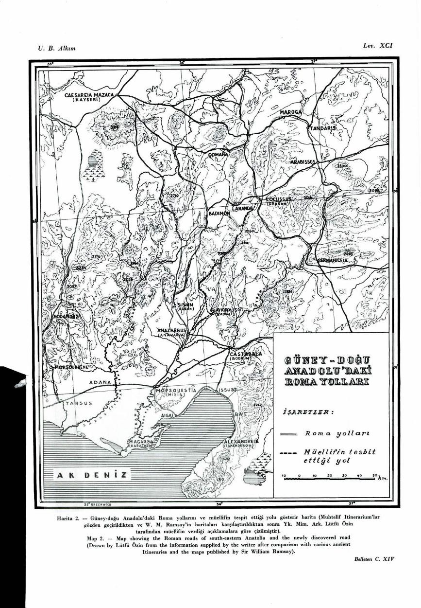
The purpose of the present article is to describe briefiy this newly discovered road. It runs from Anavarza(Anazarbus) to Göksun by way of Mehmetli, the Kesik suyu valley, the Pürülge valley, the Çiçeklidere valley, the pass of Ba~da~, the valley of the Savrun river, Dokurcun, Uçuk, the pass of Mazgaç, Küçük Çamurlu, Büyük Çamurlu and Ta~oluk, thus providing communication between eastern Cilicia and Cappadocia.
None of the European travellers and scholars of the 19 th and 20 th eenturies-W. Francis Ainsworth, Sir Charles Wilson, Major Bennet, J. R. S. Sterrett, H. Kiepert, W. M. Ramsay, D. G. Hogarth, Hugo Grothe, and Hans Rott- found his way into this part of the Anti-Taurus, or crossed the passes of Ba~da~~ and Mazgaç. W. F. Ainsworth, in his account of the "El~ phrates Expedition„ , devotes a chapter to the Cilician and Syrian Gates, and names several passes connecting Cilicia and Cappadoeia, but these do not include Ba~da~~ and Mazgaç '6. S. Sterrett in 1884 visited Göksun and copied a number of inscriptions there, but to the south of this place he penetrated only as far as Ta~oluk (6 km. to the south) and De~irmendere (15 km. to the south-east) 17.
D. G. Hogarth and W. M. Ramsay in 1890 came to Göksun from Adana by way of Kozan, Kiraz bel, Hac~ n (Sairr~ be-yli), Gezbel, Kemer, Yalak and Kekliko~lu, but went on in the direction of Elbistan without exploring to the south 18. H. Rott mentions a number of passes in the Anti-Taurus, but not Ba~da~~ or Mazgaç '9. Sir Charles Wilson observes that a road goes by Ta~oluk and Geben to the castle Marianchil (Meryemçil) and from there on to Kars (Kadirli), but he too makes no mention of the road from Göksun by way of Mazgaç and Ba~da~~ to Çukur-
16 William Francis Ainsworth : A Personal Narrative of the Euphrates
Expedition, vol. I, London 1888, pp. 112-124.
17 J. R. Sitli~~gton Sterrett: An Epigraphical Journey in Asia Minor (Papers
of the American School of Classical Studies at Athens, yol. 11), Boston 1888,
pp. 240-248 (Roman milestones), and pp. 248-252 (other inscriptions).
19 D. G. Hogarth and J. R. Munro: Modern and Ancient Roaris in Eastern
Asia Minor (Supplementary Papers of the Royal Geographical Society, from
yol. ili), London 1893, see the map.
19 Hans Rott and associates: Kleinasiatische Denkmaeler au3
Pamphylien. Kappadolcien und Lykien, Leipzig 1908, See the arehaeological map.
552 U. BAHADIR ALKIM
ova 20. Hugo Grothe travelled in the Anti-Taurus from September
1906 till January 1907; he visited Göksun and recorded several
inscriptions, but went on to the north-east without following
our route". Von der Osten in 1929 travelled in the neighbour-
hood of Mara~, but did not visit our district". Ramsay, relying
on various ancient authorities, shows the road from Anavarza
Anazarbus, Ayn Zarb) to Göksun (Cocusus, Cocussus; in Arme-
nian times Coxon) as follows : Anazarbus-Sisium- Badimon-
Laranda-Cocussus". Kiepert's map does not mark the road that
we took, but shows the Anavarza-Göksun road as passing by
Sis, Feke and Ham ". In fact, this road has to take a devious
course owing to the very mountainous character of the region.
Turning now to the ancient authorities, the Itinerarium Anto-ninianum (ca. 300 A. D.) shows the Cocussus-Anazarbus road as
passing by Laranda, Badimon, Praetorium, Flaviada 25 ; and the Tabula Peutingeriana (fourth [7] century A. D.) is in virtual agree-
ment with this ". Evidently at this period our newly discovered
road was not in great use. Indeed being rather narrow in places,
and in winter deeply buried under snow, it does not afford
easy passage for troops or for large caravan trains. Nevertheless,
20 Major General Sir Charles Wilson : Handbook for Travellers in Asia Minor, Transeaucasia, Persia etc., London 1903, pp. 270-271.
Il Hugo Grothe : Meine Vorderasienexpedition, 1907, yol. I. (Die fachwiss-
enschaftlichen Ergebnisse) , Leipzig 1911. See the epigraphical chapter by Johann ohler, p. LXXXV.
22 Hans Henning von der Osten, Ezplorations bi Hittite Asia Minor 1929 (01C, No. 8), Chicago 1930, p. 79 ff.
" W. M. Ramsey : The Historical Geogrnphy of Asia Minor (Royal Geog-
raphical Society-Supplementary Papers, vol. IV), London 1890, passim and the mal~,.
24 See H. Kiepert's 1 : 400,000 map, sheet C IV Kaiserije. On the other haad,
the publications of the other 19 th century explorers, Barth, Hamilton, Mordtmann,
Ch. Texier etc. make no reference to the road and passes discovered by na, as these lay outside the area of their investigations.
25 See for example ltinerarium Antonini et Hierosolymitanum (published by G. Partley and M. Pinder), Berolini MDCCXLVIII, tab. I.
26 Cf. W. M. Ramsey : Historieal Geography of Asia Minor, p. 280.
KARATEPE : THIRD CAMPAIGN 553
the numerous monuments of prehistoric, late classical and medi-eval date found along this road and described below, show that it was by no means entirely neglected.
A. General DeacriptIon of the course of the road
Starting from Anavarza in a north-easterly direction the road reaches Mehmetli after some 32 km.; 4 km. further to the north - west, it enters the valley of the Kesik suyu, which continues north-westward as far as Ta~köprü. Here the Kesik suyu descending from the north and the Pürülge deresi from the north-east, unite their streams. The road continues to follow the valley, which turns tO the north-east and now bears the name of Pürülge vadisi; after 4 km. it is called Çiçekli deresi and continues in the same direction, rising gradually, for some 14 km. to the pass of Ba~.-da~~ (altitude ca. 1400 m.). Here we observed traces of a wall barring the pass; to judge by the style of its masonry, this wall is of comparatively recent date. North and south of the pass we saw graves with tall unhewn stones at head and foot ; according to the inhabitants of Ba~da~, who come there during the summer, these were the tombs of various Turko-man tribesmen who once fought for the possession of the pass.
From Ba~da~~ the road descends for 2 km., stili bearing north-east, then curves round to the south-east, and after another 2 km., drops into the upper valley of the river Savrun. Following the course of this valley it rises to the north-east, and after pas-sing Dokurcun, Su Çat~~ and Savrun Gözü reaches the pass of Mazgaç (altitude ca. 1650 m.). From Ba~da~~ to Mazgaç by the road is about 32 km. The climb to the Mazgaç pass from the south is not particularly stiff, buf the descent on the north is exceedingly steep. As at Ba~da~, we noticed remains of a wall barring the pass, and tombs on either side of it. Beyond Mazgaç the road enters another valley, descending by Küçük Çamurlu, Büyük Çamurlu and Ta~oluk to the plain of Göksun, and so to Göksun itself.
Along this road between Anavarza and Göksun we observed a prehistoric rock-carving, the ruins of four inhabited sites whose origins date back to late classical times, numerous ruins of buil. dings, three Greek rock-cut inscriptions of Roman date, a number
554 U. BAHADIR ALKIM
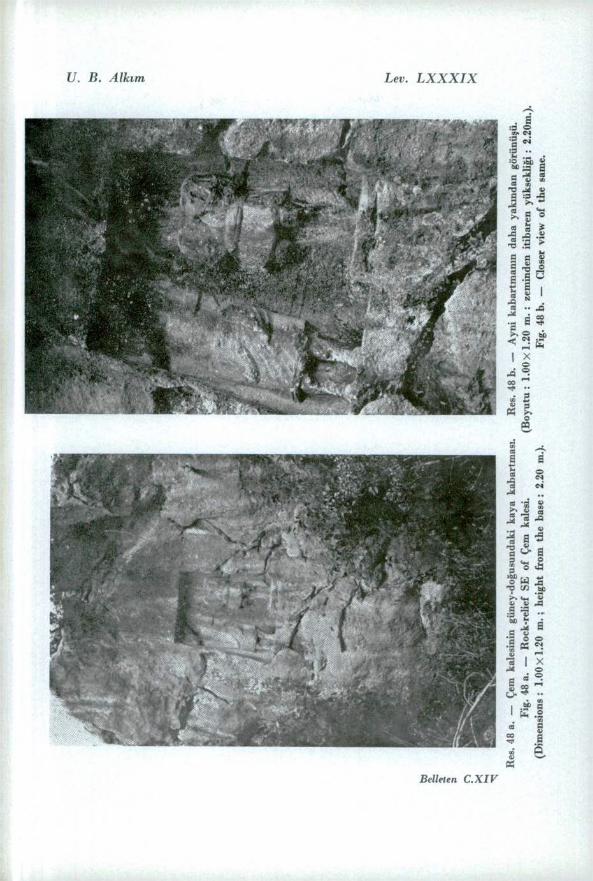
of Greek funerary inscriptions, and eight mediaeval fortresses of var-ying sizes. Add to these a rock-relief of Roman date (fig. 48 a - b) and a few tomb inscriptions found at the southern end of the road during an excursion made with Prof. Bossert in 1947, and the sum total of assorted monuments is not inconsiderable I may add that, from its beginning until it enters the plain of Göksun, the entire course of the road lies along valleys hemmed in on either sade by high, thickly-wooded mountains ; the scenery (lig. 24) is irnpressive in the extreme.
I pass to a brief description of the individual monuments.
B. Prehistoric Rock - Carving
30 km. north - west of Kadirli, carved on the natural rock some 250 m. south of the fortress of Kalkan, an assortment of animais of the deer and mountain-goat variety (averaging 0.12 m. in length by 0.10 m. in height), and other rather larger petroglyphs may be discerried (figs. 27-28).
They cover a considerable space, some 2 x 4 m., but have suffered severely from exposure to the weather. On a second rock 10 n~ . to the west in the same alignment, we saw other smiar carvings. Between the first and the second rocks is a wide fissure ; it is possible that originally both belor~ ged to a single extensive rock-earving, and were subsequently split by an earthquake or other natural force. On this same rock are a number of other cuttings forming patterns; these are pro-bably of later date. In addit ~ on, treasure-hunters have left pick-marks on the rock and have hacked a hole at its base.
We think it too early yet to pronounce defir~ itely on the date of these carvings at Kalkan". Are they of the late Paleo-l~thic Age, or rather contemporary with those at Bozk ~ r 28 and
27 Photographs of the rock-carvings at Kalkan have been kindly examined by Prof. Dr. ~evket A. Kansu, Director of the Anthropological and Ethnolo-gical lnstitute of Ankara University, and by Dr. Muzaffer S. ~enyürek, Dr. Seniha Tunakan and Dr. K~ l ~ ç Kökten of the same lnstitute. Our most sincere thanks are due to them for the illuminating comments with which they have furnished na.
See Gaffer Totaysalg~ r Konyada eski izerler aramalar~ ndan, No. 3, Konya 1937, p. 47 ff.; H. Th. Bossert, Altanatolien, Berlin 1942, Fig. 1116.
U. B. Alk~m
Lev. LXXXV
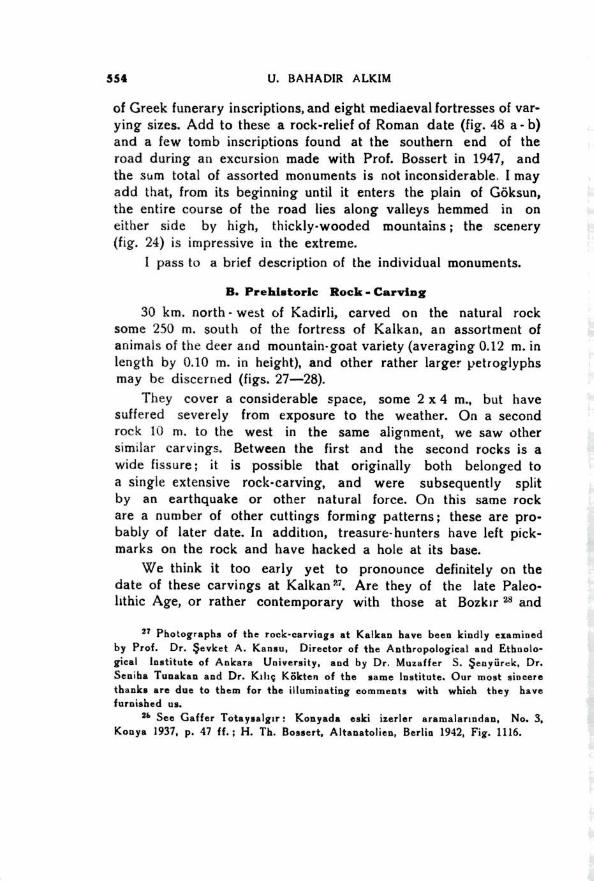
IRes. 42 — Göksun Merkez Ilkokulunda muhafaza edilmekte olan yaz~tlardan biri.
Fig. 42 — Inscription now in the Primary School at Göksün.
Res. 43 — Ayni okulda muhafaza edilmekte olan di~er bir yan~t.
Fig. 43 — Inscription now in the Primary School at Göksun.
Belleten C. X/V
Lev. L XXX V/ U. B. Alk~m
Belleten C. XIV
U. B. Alk ~m
Lev. LXXX V//
Res. 46 — Kurucaören : Mezar steli (beyaz mermerden : boyu : 80
em., geni~li~i : 39 em., kal~nl~~~~ 10 em.). Fig. 46 — Funeral stele at Kurucaören (of white n~arble, length :
80 em., width : 39 em., breadth : 10 em.). Belleten C. XIV
Lev. LXXXVIII U. B. Alk ~m
Res. 47 c. — Ayni ba~~n ba~ka bir
görünü~ü.
Fig. 47 c. — Another view of the
same head (length: 17 cm., breadth:
13 cm., height 12 cm.).
Res. 47 a. — Göksun : Nuri Kaya'nm özel
kolleksiyonundaki bir Roma ba~~~ (beyaz
mermerden. boyu : 17 cm., geni~li~i: 13 cm.,
yüksekli~i : 12 cm.).
Fig. 47 a. — Göksun : White marble head of
Roman date in the collection of Nuri Kaya.
Res. 47 b. — Ayni ba~~n yandan görünü~ü.
Fig. 47 b. — Side view of the same head.
Belleten C. XIV
Res
. 48 a
. —
U. B. Alk~m
Lev. LXXXIX
Benden C.XIV


U. B. Alk~m
Ler. XC
36"
7' 3: 36 N~~
SAIM BEYL ~~
G ÖKSUN ~ cocussus~~
:
A RP
BUYUR ç Anu R Lu
x ü 'UN
Bew
Ip>
L ~~ N
(TA ~OLUK
(NIZILKALC)
illirr.
FEKE
~~çi~ii~::(~~~ c
mAzÇ .E ,i,,,..4.) + AK OLUN
./ , A A 4. 6-~~ iRKAR TALNAYA
5Av1 v ~zGözüN ,
uçu .
11
TA~KOPM3M
KARAPINAR..j. ii EB i;
, ~~
KOZLUMEZAR,,,
BAGDA~~EU,?../-~,
ÇIÇE DERE • -4' ESERI
..F., 47 0KA6 NAN
‘, Ç ,M
4:I TuRUNÇA.0
"2
1
yl7ç ~ el~ii- ....
ENCAvuR ~UDILINGI
li
C. DOKUPCUN
(T3~l~ TALI MEZAR)
TEMR ~ YEL ~~ 7 ~ NAR
KALE ANDIRIN
/5 •
1'...
.
.. Illil O-
6>
6,
2
d
A ~~ 0
_. ''' US ne~~
\s
—0 •
KOZAN r
ANAVARZA ANAIIRLUIN
CINANS 3
ME Ku~~
93 U~UFiZZETTIN
Bae~~e K ADI ril.1 r~Av~ oPoub?) ill
,
KUMRAL' ~i i
K 1RATEP •DOMUZTEPE ,. A 16 10HARUN ~ VE
a~rl ~zour . 02 KUTU
?"- ,
_„.......0,--"`'
Oill . 14EMITE IRL I
.1, O RUM
~~
0 OSMANIYE I
',....-"i"-'' _.-----------
GÖKSUN'U GÜNEY ANADOLU'YA
BADLIYAN GEÇ~DI VE BU GEÇ~TTEKI
MUHTELIF ÇAGLARA A~T ESERLERI
GÖSTERIR HAR~TA
~~ARE TLER :
Z. .6 ESER BULUNAN NE VK~1ER
Iii L1(~YCIK VE YA KlikjK KAMER
6 K4 YA YAZITLARI (YUNANC4)
21 KAYA ol-5(w," (p~tui.sroai,o
L GEÇ 411717 Z4M4MN4 417 HARARE
8 MEZAR YAZ17L4R1(YUNANLA)
e; ROMA DEVRINE AIT 11ARABE VEYA 81514
KALINT151
Bal GEÇ-ANTIK DEVRE 417 UARA8E VEYA 81KA
--
C EYWAN
KAL~N Y ~S1
Cill R0N4 DEVAYKE 417 OLUP _SONRAKI ÇA~/AL
DA itiVELER GÖRMÜ~~ 114R48E V114 BIKA K.411N7151
D KAYA KA8ARTP1451 (ROP1A ÇA~!)
I
7 1/. n KAYA KA84RTAIASI (wirio
--------- -siRKELi '<= /61 Y.1 MEZAR! (RONA)
C. KAZA NERKEzi
O BUCAK
/5. KÖY 0
— ~oSE
----- ARABA YOLU DÖRTYOL
PAYLKA
/9. 3( Geçit- VfVd at,
AK DENIZ
~s Z
GREENWICI.1 GdRE
6 BOLU
30
Harita 1. — Dr. L'. Bahad~r Alk~m'~n takip etti~i yolu ve bu yol üzerinde tespit etti~i eserleri gösterir harita
(Müellifin verdi~i aç~klamalara göre Karatepe mimari Lütfü Özin taraf~ndan çizilmi~tir).
Map 1. — Map showing the road followed by the writer and the monuments discovered on the road
(Drawn by Lütfü Özin, the architect of the Karatepe Expedition. Material supplied by the writer).
Belleten C. X/V
U. B. .A lk~m Lev. XCI
Harita 2. — Güney-do~u Anadolu'daki Roma yollar~n~~ ve müellifin tespit etti~i yolu gösterir harita (Muhtelif Itinerariumlar
gözden geçirildikten ve W. M. Ramsay'in haritalar' kar~~fa~tir~ld~ktan sonra Yk. Mim. Ark. Lütfü özin
taraf~ndan müellifin verdi~i aç~klamalara göre çizilmi~tir).
Map 2. — Map showing the Roman roads of south-eastern Anatolia and the newly discovered road
(Drawn by Lütfü özin from the information supplied by the writer after comparison with various ancient Itineraries and the maps published by Sir William Ramsay).
Belleten C. XI V
B. .4Ih~~n
Lev. XCII
Plan. 1 — Karatepe : Zirve kaz~s~~ plan~~ (Saray)
Plan. 1 — Karatepe : Plan of the excavation on the summit (Palace).
Belleten C. XIV
o
c2
o
c-.1 O e
o o
o
c..0,c5,cp,4,,c.?,,,..?o ,o,,,,. o .<1 - 4:5, 0 ,3-4), o o, , c:,.. o oc.
0 vc2fnci %Aock,,Qo ,0 g o co:, 1 .:J b ("C' Cljatz).5 '.°C%-•,---05 Lj-.1) '3- 20J3 0.::;(3,c7008)~% <>.
C3 C3°C6C7C9Cja\-/b°,1c341°41110 .4%. /n°01z7 C> 30.. ‘/6,'"' 01'0 C? / °c•Cf~̀.C:Paae<243°01?"\)04,RDCP°.C:),C>.Z.V
O ,~~ '3 -C3 gc/ t:5 o o
I*1::=,
o° e '''57 <«2 0 " o
tZ7 C. c)
et
, ,., ts .... o
v c, ,z~~• o
c, v C> t) 0 ov ° O o
«. O o O o Q 4
o o o O . o
o c2 Q o
e <2 e
<> o <7 e
o e
O~~ ,, b b
O O
0 O sj o, "'
O O -, :" / /
v~,1 110, lir".,P3‘4 ‘v,.epö jlo.1'11L4;» - e
0* t'. c " -4' o ver D 4 174E%
,,0 (7,,,
-.5'1) 004.t4t~ C‘
0 D 4,9 d t, o ...., O ...—~leav
° • C:3 $ ° •
_rla_ ;'l' ,C7. . ' • ~~.... lie -i
IW?
''''‘ 1‘ k •‘ Al "IkL. ? . t' I. 4
• er
1P•A." . 'Ni, ), J& • .::".....„4 ,
ik ~x~~r o. . 0,4 ...._:.",,..
o.,:f7.• .
1110 (.3 :1
D
t.
"i 11=4
o
go:»
D O ,4) 0 5' O o c~ o o o o
c:! 0 cz? 7 o o O o
ARKEOLOG Y. MIMAR LÜTFÜ ÖZ ~ N
~~ . .
------- -
KARA TEPE
KUZEY YAMAÇ KAZISI
1 O 1 2 3 4 5 6 7
~//
alit.Iro:E l~Wj~' O ° , . ''' • o b 0 „
so•-ro~~ yr.. • 0 o ,o D 9
e o -•• , •• ,Vo <,,77.".oi,~03 ' • 4/ .". /27
17;-‘20t.• fi :4r~f~4ZKZ ' ,1: l'ela 94:"3,..4; elne. ,' .• il i ~• ir ii,..:-..-s 'il
*— , Ir
iii
0. 17.4
46711-
r D 0 Ç:s .0 Q O rr'd
/A
0
tl° e) '-'C O '' u ° '9 C:~~ t, •
(Nt: I •
9
v . E
V
e, , C]
V t) o ° ° r~~ o '3
4 e ç? b 'b,
• (-)0 a t, 10 C? <3c1 ("Cpc;cYai~~i .4 ° o
o3 bt1,831'
• 0 z~~
ro 10(2),,,
c.oQ (Z, C3 C-7 000 Dc'-20c,obao bn
l-9°C tr;'ö Ç,
(:? S7oc'-1 53v C:j °c:s L3k-a; t)C:Dç:2* ac7C2c3t>bz2{34 O Q C3Q. Q O CZ:W <2'n
2 5 -10 - 94 8
74 . e 4 I
4 0
°
/ / -------
U. B. Alk~m
Lev. XCIII
Plan 2. — Karatepe : Kuzey yamaç binas~n~n plan~.
Plan 2. — Karatepe : Plan of the excavation on the north slope. Benet, 11 C. \'
Lev. XCIV U. B. Alktm
c.~~ , , .
Cw," C") r`l '''', ''', •sk...)7• ":k, :'. . ,.. •.> ,..,...~. . ,2 . ,›
: J. ,) ''' <.3 ° ; I '.' f' • . • .
. . . .
KARATEPE: THIRD CAMPAIGN 555
Pirun 29 ? The latter have recently been compared by Kurt Bittel
with the rock and stone designs found in Erivan, Persia, Meso-
potamia and Palestine, and dated to the early Bronze Age.
Can the Kalkan carvings be of this date too? To these questions
detailed examination by expert prehistorians will, we are confi-
dent, provide a convincing answer. These carvings are merely
surface-finds, and it is our intention in future to dig in the
neighbourhood with a prehistorian ; the discovery of prehistoric
implements would settle the question of date once for al!.
C. Architectural Remains of various Periods
Along the road we found the ruins of four inhabited sites
and six buildings of greater or less size.
a) Inhabite d sites.
Kuruca Ören, hes on a natural hill 2 km. north-east of
Mehmetli. I visited this site with Prof. Bossert in 1947 ; several
funerary inscriptions that we found there were published in our
second Preliminary Report 3". This year I paid a second visit, and
discovered a funeral stele that we had previously overlooked
(below p. 558 and fig. 46). Both from the inscriptions and from
the architectural remains it is evident that these ruins date back
to the late Roman period.
In the Pürülge valley 29 km. north-west of Kadirli
among the woods on the east bank of the Pürülge stream, is a
second site covering an area approximately 200 X 300 m. (fig. 29).
It appears that this site was reoccupied in late, probably medie-
val times with reuse of ancient material which I should judge
to be of the late Roman period. The ancient buildings have
in some cases received later additions ( fig. 30 ), which
confirms the suggestion of subsequent reoccupation. We saw no
inscriptions.
Dokurcun, on a ridge on the east side of the Savrun
valley, 15 km. south of the pass of Mazgaç and 1 km. from the
29 E. Pittard; Gravures en Anatolie, Archvie Suisse d'Anthropologqie ge-
nerale VIII, 1939, p. 118; M. Pfannenstiel, D~e Altsteinzeitlichen Kulturen
Anatoliens, Berlin 1941, p. 18.
3° Cf. H. Th. Bossert and U. B. Alk~ m : Karatepe II, p. 23 and Figs.
84 - 89, 197 - 200, 202.
556 U. BAHADIR ALKIM
road, is a small site, which from the style of its buildings, I should take t() be also of late ,<oman date ( fig. 31).
4. Ta~oluk, 6 km. south - west of Göksun. There was a fairly considerable settlement, as appears both from the inscriptions and from the abundant architectural fragments. We learned from the villagers that while they were digging fo, ndations near the village fountain, a number of inscribed stones had come to light, but had very properly been covered up again by order of the Kaymakam of Göksun. We proeeeded to the spot in question, and on a course of well-squared blocks forming the lower wall of a large building we saw a tong inscripton in Latin, partly buried in the earth. To dig it out would have required more time and equipment than was at our disposal ; we therefore reluctantly abandoned it.
b) Ruined Buildings.
5.5 km. north-west of Mehmetli we saw two ruined buildings standing one on each bank of the Kesik deresi ( fig. 33). They are apparently of medieval or e ven later date. Their purpose cannot be definitely determined ; but their isolated position on either side of the stream, and their windows in the form of embrasures, suggest they may have been in nature of watch - towers.
At Turun çlu, 9.5 km. north-west of Mehmetli, are two more buildings similary situated on either bank of the Kesik deresi. Their badly ruined condition prevents a decision as to their date, but the presence close by of squared building-blocks may indicate the late Roman period.
At Ta~köprü, about 2 km. north of Turunçlu, where the Pürülge joins the Kesik deresi, is a building, whose massive, well-squared blocks take its origin back to the Roman period ; at a later date it underwent alteration. We also saw a rock-tomb of Roman date about 1 km. north of Ta~köprü.
About 4 km. north-east of Ta~köprü we saw another ruined building which, from the style of its construction, is plainly medieval.
On a natural hill called Gâvurkirildiki, some 10 km. south of the pass of Mazgaç, is a ruined church ( fig. 3 2), apparently
KARATEPE : THIRD CAMPAIGN 557
of late Roman date. Gâvurk ~ r~ ld~~~~ lies to the north-east of the point where Ç~~~arsuyu and the Savrun Gözü unite their waters in the little plain of Su Çat~.
6. At Savrun Gözü, 5.5 km. north-east of Mazgaç is a ruined building dating evidently to the Middle Ages.
D. Fortresses
Eight of these are stili to be seen along the road from Anavarza to Göksun.
1. Çem Kale, about 45 km. north of Anavar~a, visited by me with Prof. Bossert 3' in 1947. The castle stands on a steep bluff overlooking the entire plain of Kadirli and Kozan. its origi~~~ dates back to Roman times " , but it was more used in the middle ages, as is evident from the method of construction. It commands no view to the west or north of the road.
2. Kalkankale, built on the summit of a rocky hill, commands an exceiient view of the road from the west and south west. It lies 15 km. south west of Ba~da~. While its own date is medieval, to the west of the fortress, outside its enceinte, are the remains of stone built Roman buildings. Amongst the latter we saw part of a sarcophagus decorated on one of its long sides with two birds facing each other.
3. Esenlikale, 4 km. south of the pass of Mazgaç, has a fine view to the south-east of the road. It is medieval, and has under-gone various repairs and alterations. It is the best preserved of alt the fortresses along the road ( fig. 34).
4. Approx~ mately 2.5 km. north of Dokurcun and 15 km. south west of Mazgaç, on the ridge to the west of the road, is a small medieval fortress. It lies back about 1.5 km. from the road, and commands a view to the south.
5. Su Çat: Kalesi, 4.5 km. north-east of the fortress just mentioned to the east of the road, where the plain of Su Çat-begins, and about 1 km. from the road, is marked by its style of construction as medieval. It dominates the country to the north.
31 Cf. Karatepe Il, p. 23, and Figs. 92 - 97. 32 loe. eit. , p. 24 and Figs. 102, 104, 105.
558 U. BAHADIR ALKIM
Akoluk Kalesi, a medieval lortress on a precipitous rock about 4 km. north-east of Mazgaç, commands a fine prospect to the north.
Çiri~~ Kale, some 6 km. north-east of Mazgaç, is badly ru-ined. Tnis too is medieval, and looks to the north and west.
K~z~l Kale or Arpal~k Kale, 16 km. north-east of Mazgaç, also medieval, has a fine view over the plain of Göksun, but does not overlook our road.
E. Inacriptions ~~ figs. 35-45)
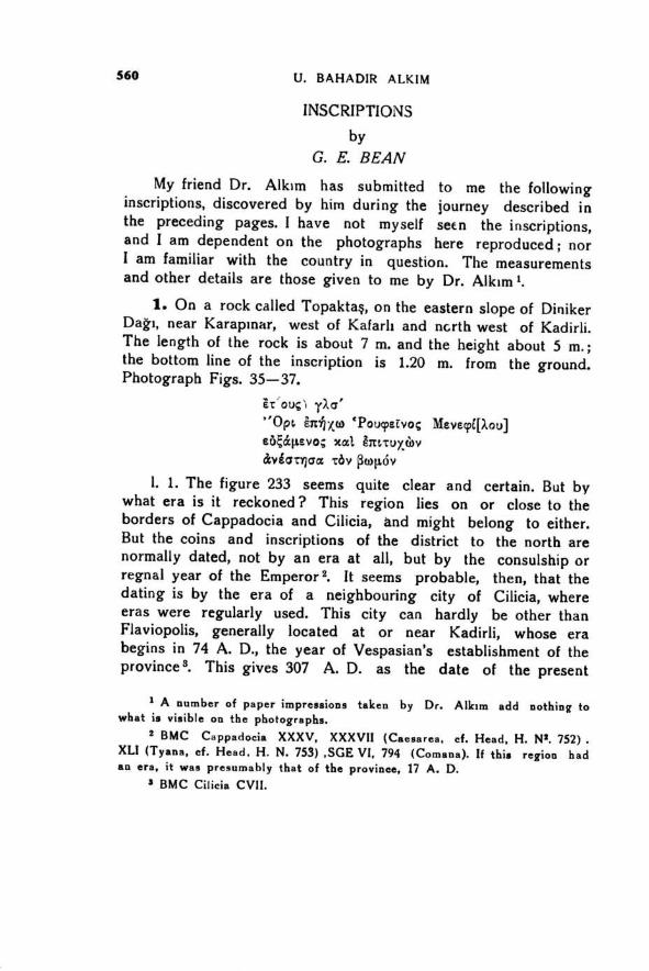
These form a not unimportant part our discoveries. The photographs taken by us were submitted to Mr. G. E. Bean of the C~ ssical Phiiology Department of Istanbul University ; his notes, for which onr oest thanks are due, are to be found at the end ot the present report. As the inscriptions themselves are discussed there, I confine myself here to a short archaeological note on the rock-inscription ( figs. 35 - 37 ) of Topakta~~ (Karap~ nar).
Topakta~~ is a mass of rock some 7 X 10 m., situated on the east slope of Diniker Da~~~ (40 km. from Anavarza). To the left of the inscription a number of steps are cut in the rock; evi-dently we have bere a stepped altar, as is indeed plain from the inscription (see p. 560 below). At a point higher up the
hillside, some 2 km. to the north, we learned of the existence of other rock-cut steps, c.11ed K~zlar Oturak' ; we were not able to visit the spot, but from the description giyen us this too would appear to be an altar. A third example is known north of Çem Kale 33 ; obviously the rock-cut altar was a popular type in this part of Cilicia.
F. Sculpture
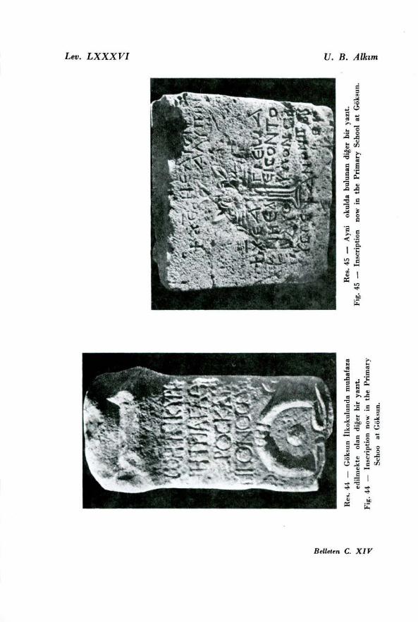
Funerai stele found at Kuruca Ören ( fig. 46 ) broken in three parts : measurements, 0.39 X 0.80 X 0.10 m. (Roman).
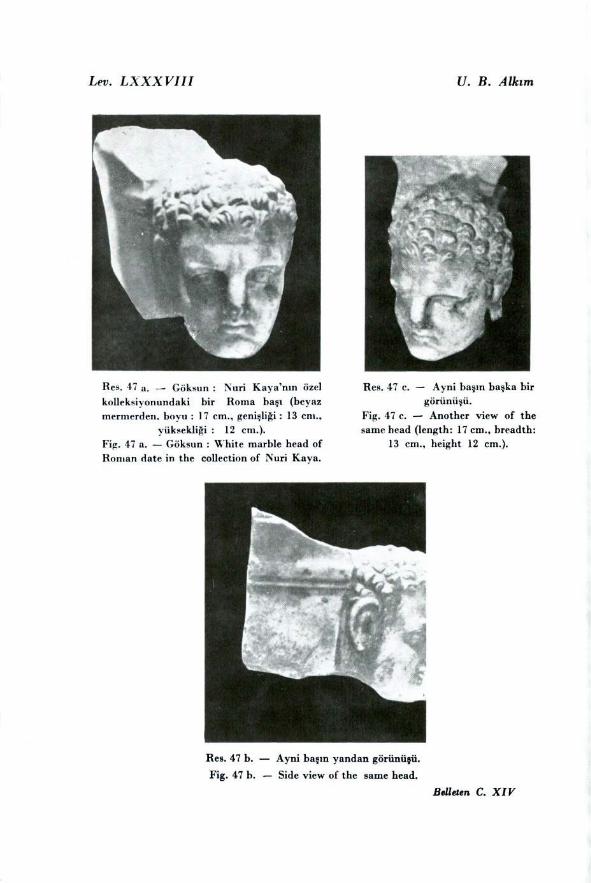
White marble head, in the private collection of Nuri Kaya at Göksun measurements, 0.13 X 0.17 X 0.12 m. From the holes at the base and at the back it seems that this head was employed for some architectural purpose (fig. 47 a-c, Roman).
33 loc. cit. p. 24 and fig. 101.
KARATEPE : THIRD CAMPAIGN 559
3. Rock-relief south of Çem Kale, described in our second
Preliminary Report (fig. 48 a- b) 34.
The total length of this road from Anavarza to Göksun is
about 115 km. The existence throughout its course of so many
and such varied monuments, of which the earliest are prehistoric,
shows that the road, affording as it does communication between
Cappadocia and eastern Cilicia, was in use at a variety of
periods. It should however be observed that, being narrower and
more difficult than the main passes, it is likely to have been more
sparingly used. It is stili followed to-day by the peasants of Çukuro-
va when they go up to their summer quarters in the direction of
Göksun. The numerous medieval castles protecting the road show
that at that period it possessed a considerable strategic and
commercial importance, and must have carried a good deal of
traffic. We saw no evidence that it was used in the time of the
Ottoman Empire in the Otto man records 35 ; but there can be no
doubt that during the Celdli Rebellions the passes of Ba~da~, Maz-
gaç and Meryemçil were important strong points. The difficult and
thickly wooded nature of the country, and in particular its inse-
cure condition down to the time of the Turkish Republic is, we
feel sure, the pr~ ncipal reason why European travellers never
penetrated here. The third season's work at Karatepe did not produce such
brilliant results as the first, but has at least thrown new light
upon one aspeet of the historical geography of Anatolia. Next
season we hope to explore the "Akyol„ connecting Karatepe
with the region to the north.
I should like to point out that this report is purely of a
preliminary nature, and that a detailed account both of the season's
work at Karatepe and Domuztepe and of the discoveries made on this journey is now in course of preparation.
34 IOC. Cit pp. 23 - 24 and Figs. 98 100.
35 Franz Taeschne= : Das Anatolische Wegenetz nach Osmanischen Quel-
len, yol. 1. Leipzig 1925, see the map ; in the second volume of the szme work
(Leipzig 1929) the author gives the hat of the various roads whicn lead from
Gökstio (pp. 28 f. , 33 f. , 36 and Pl. 49) but does not mention our road.
560 U. BAHADIR ALKIM
INSCRIPTIONS
by
G. E. BEAN
My friend Dr. Alk ~ m has submitted to me the following inscriptions, discovered by him during the journey described in the preceding pages. I have not myself se€n the inscriptions, and I am dependent on the photographs here reproduced; nor I am familiar with the country in question. The measurements and other details are those giyen to me by Dr. Alk ~ m °.
1. On a rock called Topakta~, on the eastern slope of Diniker Da~~, near Karap~ nar, west of Kafarl~~ and nerth west of Kadirli. The length of the rock is about 7 m. and the height about 5 m.; the bottom line of the inscription is 1.20 m. from the ground. Photograph Figs. 35-37.
ou; y)scs' "Opt, ̀Poucpe-~:vo.; Mevecpt[Xou] sii,;&[~evo; xat rrt...cl~ x~i~ v dc“crmaa tdv (3(~)1.1.6v
1. 1. The figure 233 seems quite clear and certain. But by what era is it reckoned ? This region lies on or close to the borders of Cappadocia and Cilicia, and might belong to either. But the coins and inscriptions of the district to the north are normally dated, not by an era at al!, but by the consulship or regnal year of the Emperor 2. It seems probable, then, that the dating is by the era of a neighbouring city of Cilicia, where eras were regularly used. This city can hardly be other than Flaviopolis, generally located at or near Kadirli, whose era begins in 74 A. D., the year of Vespasian's establishment of the province 3. This gives 307 A. D. as the date of the present
1 A number of paper impressions taken by Dr. Alk~ m add nothing to what is visible on the photographs.
2 BMC Cappadocia XXXV, XXXVII (Caesarea, cf. Head, H. N2. 752) . XLI (Tyana, ef. Head, H. N. 753) ,SGE VI, 794 (Comana). if this region had an era, it was presumably that of the provinee, 17 A. D.
3 BMC Cilicia CVII.
KARATEPE: THIRD CAMPAIGN 561
inscription. The indication therefore is that the district in ques-tion belonged to Cilicia rather than to Cappadocia.
1. 2. The letters OPI are clear, and there is nothing in front of them; nor does 1.1 seem to have contained anything besides the date. I take OPI accordingly as the dative of bpoç, rather than as the end of a longer word. ~Spc Trx-Ici~ , as it stands, means `to the Echoing Mountain'; but 7-c•fixcl~~ ~s much more l~ kely, especially in v~ ew of I. 3, to be a m ~ sspelling of Tz-~pt6(1.), a very common epithet alt over Anatolia 4. The mountain is presumably that on which the inscription stands, Diniker Da~~.
4. For the altar see Dr. Alk~ m's description above p.558.
The present inscription is reminiscent of the series of dedi- cations M~rcp 3eq btyptöo? near Yuvaca in neighbouring Pam- phylia (SEG VI, 718-23).
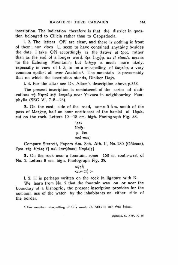
On the east side of the road, some 5 km. south of the pass of Mazg-aç, half an hour north-east of the hamlet of Uçuk, cut on the rock. Letters 10-18 cm. high. Photograph Fig. 38.
(ipot. Mc~Ec• p.. htt.
ax6 ton)
Compare Sterrett, Papers Am. Sch. Ath. II, No. 280 (Göksun), r~ic kyIceç ?] xat eec~ t[dxon] Mccpta[ç]
On the rock near a fountain, some 150 m. south-west of No. 2. Letters 8 cm. high. Photograph Fig. 39.
Tr~rr
1. 2. H is perhaps written on the rock in ligature with N. We learn from No. 2 that the fountain was on or near the
boundary of a bishopric; the present inscription provides for the common use of the water by the inhabitants on either side of the border.
4 For another misspelling of this word, el. SEG II 709, ega' iTc(xf..o.
Belleten, C. XIV, F. 36
562 U. BAHADIR ALKIM
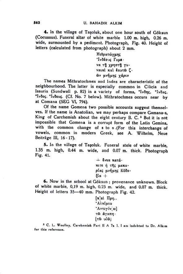
In the village of Ta~oluk, about one hour south of Göksun (Cocussus). Funeral altar of white marble 1.00 m. high, 0.26 m. wide, surmounted by a pediment. Photograph, Fig. 40. Height of letters (calculated from photograph) about 2 mm.
Mcepa-rdixmç 'Iv6go.); Polis • VCC Tl) xp~go-c yu• vaLxt x2t hute• C• 6~v t~.v151.~igç xi~p~,v
The names Mithratochmes and Indes are characteristic of the neighbourhood. The latter is especially common in Cilicia and Isauria (Sundwall p. 82) in a variety of forms, "Iv5-5, "IvSaç, "IvSoç, "IvSouc. (Cf. No. 7 below). Mithratochmes occurs near by at Comana (SEG vi, 794).
Of the name Gomena two possible accounts suggest themsel-ves. If the name is Anatolian, we may perhaps compare Gamana-s, King of Carchemish about the eight century B. C. 5 But it is not impossible that Gomena is a corrupt form of the Latin Gemina, with the common change of e to o .(For this interchange of vowels, common in modern Greek, see A. Wilhelm, Neue Be~ trâge III, 16 - 17).
In the village of Ta~oluk. Funeral stele of white marble, 1.35 m. high, 0.44 m. wide, and 0.07 m. thick. Photograph Fig. 41. •
gvba %azd~ - 'UTE p.cocz•
pla; ti.v~5p.riç FASo• Ct:c
Now in the school at Göksun ; provenance unknown. Block of white marble, 0,19 m. high, 0.23 m. wide, and 0.07 m. thick. Height of letters 35-40 mm. Photograph Fig. 42.
Ex ~xt. 'AXxip.Qu 'AvtLy6v;w] TG> ltyccwq •
[TG) ufa~ j
5 C. L. Woolley, Carehemish Port II A 7a 1. I am indebted to Dr. Alk ~ m for this reference.
KARATEPE : THIRD CAMPA1GN 563
1. 1. Perhaps i. e. Prima. 1. 5. Slight traces of letters on the stone.
Now in the school at Göksun; provenance unknown. Block of white marble, 0.22 m. high, 0.23 m. wide, and 0.06 m. thick.
Photograph Fig. 43. "Iv3r)ç KLXcxX- 6ou ? Ia-maev MIL Kedca. ac~* ? µvi] ir~N
Iyex~x
I. 1. For the name Indes see above No. 4. The second name is doubtful. Kilaloas appears a perfectly possible name: cf. KOL% KiX),Lç, KLXX6xç et sim. (Sundwal pp. 105-6). But other readings are not excluded; there may be a letter tost at the end of
the line. 1. 3. Meis and Kbedasis are familiar names in southern Ana-
tolia. KeLgSc~aL is perhaps a variant form of the latter ; I there-fore read MIL KeLf3dcSaaLy as a double name. For the clash of
dative and accusat~ ve compare Ramsay Studies in E. Roman
Provinces p. 226. 1. 3, 'Av-cLox(SL nt.v~rv itoXur76Ic~, and Anderson's
note ad loc. Other readings are poss~ ble, e. g. MeLx€L,3&SacrLy as a
single name, or even MIL x,?; ^IpcSoc~Ly. The marks on the stone below 1.5. appear to have no con-
nection with the inscription.
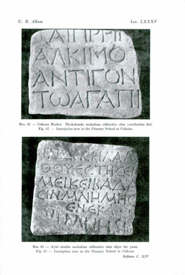
Now in the school at Göksun; provenance unknown. Marble altar 0.44 m. high, 0.24 m. wide, and 0.21 m. thick. Height of letters (calcuiated from photograph) 5-7 em. Photog-raph Fig. 44.
Zdil: xupf pyrpl ' Ayc~~ --~r; • [p.'Er»ç xal 'A[v]- r(yovo; M ?
The reading in 1.4 is dubious. Mas is a not uncommon name in this region, both as male and as female (Sundwall p. 138);
but the shape of the mu is different from that in 1. 2, nor
have the other alphas the broken bar. Inspection of the stone
itself is needed.
564 U. BAHADIR ALKIM
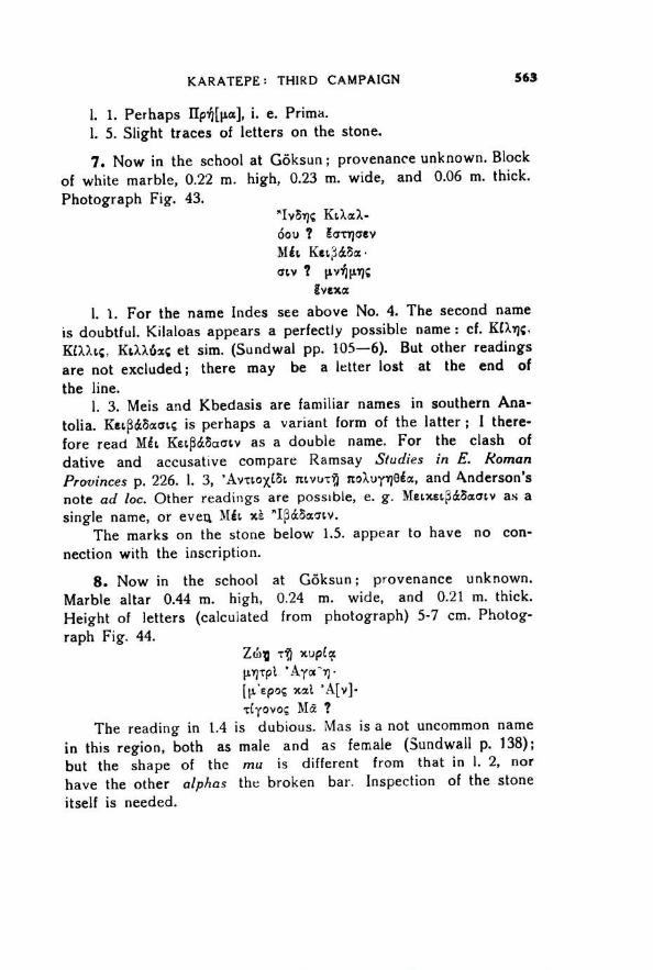
9. Now in the garden of the school at Göksun. Marble block 0.75 m. high, 0.77 m. wide, and 0.52 m. th~ ck. Photograph Fig. 45.
xfpLar HEAION 'A). ört t. v
x pt,t;€ "Ayce Xh.50V 16.
V al_~ M.k6V 3o- 0 ZZ+1;1 2,vov rc(pecs():Szep)ov
1. 1. 1 do not understand HEAION, wiless it be a mangled form of X«crov. 'A.2.tirtcv may be for 'AX~irccov or for 'AX~irmv, both of which are known as proper names: ''AXursoç and 'AXtr~ttoc also occur (SEG III, 421, IV, 654, VI, 146, VIII, 230 etc.).
The chief interest of the foregoing inscriptions is per-haps the slight indication that they furnish as to the boundary between Cilicia and Cappadocia. Topakta~~ (see No. 1 above) seems to belong to Cilicia, wh ~ le No. 4 appears connected rather with the region to the north. The border may therefore have lain between Topakta~~ and Ta~oluk. In this area are two passes, those of Bakda~~ and Mazgaç; of these, the latter is considerably the more important.
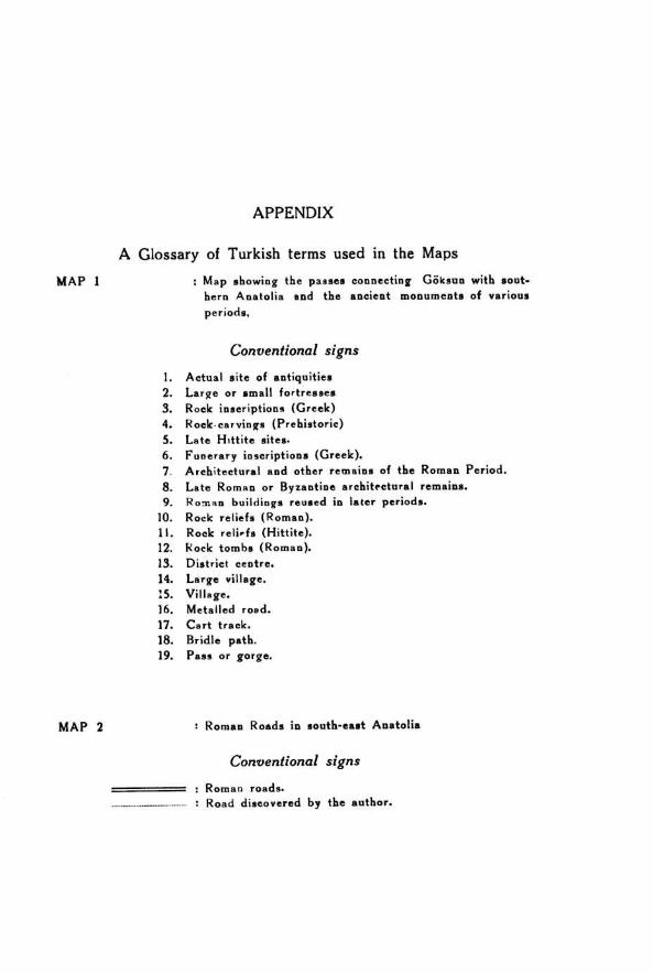
APPENDIX
A Glossary of Turkish terms used in the Maps
MAP 1
Map showing the passes connecting Göksun with sout- hern Anatolia and the ancient monuments of various
periods,
Conventional signs
Actual site of antiquities
Large or small fortresses
Rock inscriptiong (Greek)
Rock•carvings (Prehistoric)
Late H ~ ttite sites.
Funerary inscriptions (Greek).
Architectural and other remains of the Roman Period.
Late Roman or Byzantine architectural remains.
Roman buildings reused in Iater periods.
Rock reliefs (Roman). Rock relit-fs (Hittite). Rock tombs (Roman).
District centre. Large village.
Village. Metalled road.
Cart track. Bridle path. Pass or gorge.
MAP 2 Roman Roads in south-east Anatolia
Conventional signs
: Roman roads. : Road discovered by the author.


