Embed Size (px)
Citation preview
KSM PROJECT
ASSESSMENT REPORT
With Respect to
the Application by Seabridge Gold Inc.
for an Environmental Assessment Certificate
pursuant to the Environmental Assessment Act, S.B.C. 2002, c.43
Prepared by:
Environmental Assessment Office
June 2014

Preface
The Environmental Assessment Office (EAO) manages the assessment of proposed
major projects in British Columbia (BC), as required by the Environmental Assessment
Act (Act). The process includes:
opportunities for the involvement of all interested parties;
consultations with First Nations and treaty nations;
technical studies to identify and examine potential significant adverse effects;
strategies to prevent or reduce adverse effects; and,
development of comprehensive reports summarizing input and findings.
At the conclusion of each environmental assessment, EAO provides a comprehensive
assessment report (Assessment Report), and makes recommendations to the Minister
of Environment and, for mine proposals, to the Minister of Energy and Mines. The
Ministers may decide to certify a project, decline to certify a project, or require further
assessment.
This Assessment Report considers the potential for the KSM Project (proposed Project)
to cause significant adverse environmental, economic, social, heritage and health
effects. It identifies measures to prevent or reduce adverse effects, and sets out EAO’s
analysis and conclusions. It also documents the work undertaken by EAO to consult
and accommodate First Nations and treaty nations, in keeping with the
Supreme Court of Canada's direction in Haida v. Minister of Forests and related case
law.
Information and records relating to environmental assessments are available on the
EAO website at www.eao.gov.bc.ca. Questions or comments can be directed to:
Environmental Assessment Office
PO Box 9426 Stn Prov Govt
Victoria BC V8W 9V1
Phone: 250 356-7441
Fax: 250 356-7477
Email: [email protected]
Table of Contents
SUMMARY OF THE ASSESSMENT REPORT ........................................................................17
PART A – INTRODUCTION AND BACKGROUND ..................................................................19
1 Purpose of the Report ...................................................................................................19
2 Project Overview ............................................................................................................19
2.1 Proponent ...............................................................................................................19
2.2 Project Location ......................................................................................................20
2.3 Project Description ..................................................................................................22
2.3.1 Key Changes to the Design of the Proposed Project due to the EA
Process ....................................................................................................... 25
3 Assessment Process .....................................................................................................27
3.1 Provincial EA Process – Major Milestones ..............................................................27
3.2 Public Consultation .................................................................................................28
3.3 First Nations Consultation .......................................................................................30
3.4 Nisga’a Nation Consultation ....................................................................................30
PART B – ASSESSMENT OF POTENTIAL EFFECTS, MITIGATION, AND SIGNIFICANCE OF
RESIDUAL EFFECTS .....................................................................................................31
4 General ...........................................................................................................................31
4.1 Assessment Methodology .......................................................................................31
4.1.1 Assessment of Potential Significant Adverse Effects Methodology .............. 31
4.1.2 Cumulative Effects....................................................................................... 32
4.1.3 Ensuring the Crown’s Duties to Consult and Accommodate First
Nations ........................................................................................................ 34
4.1.4 Ensuring the Crown’s Obligations to Uphold the Terms of the NFA ............. 34
4.1.5 Spatial Boundaries ...................................................................................... 34
4.1.6 Temporal Boundaries .................................................................................. 34
5 Assessment of Potential Environmental Effects .........................................................36
5.1 Overview of the Water Setting in the Proposed Project Area ..................................36
5.1.1 Mine Site ..................................................................................................... 38
5.1.2 PTMA .......................................................................................................... 40
5.2 Surface Water Quality .............................................................................................43
5.2.1 Background Information .............................................................................. 43
5.2.2 Project Issues and Effects and Proposed Mitigation Identified in the
Application ................................................................................................... 45
5.2.3 Project Issues and Effects and Proposed Mitigation Identified During
Application Review ...................................................................................... 61
5.2.4 Residual Effects and Significance Analysis ................................................. 75
5.2.5 Significance Determination .......................................................................... 83
5.2.6 Cumulative Effects....................................................................................... 84
5.2.7 Certainty ...................................................................................................... 85
5.2.8 Conclusion .................................................................................................. 89
5.3 Surface Water Quantity ...........................................................................................89
5.3.1 Background Information .............................................................................. 89
5.3.2 Project Issues and Effects and Proposed Mitigation Identified in the
Application ................................................................................................... 91
5.3.3 Project Issues and Effects and Proposed Mitigation Identified During
Application Review ...................................................................................... 99
5.3.4 Residual Effects and Significance Analysis ............................................... 102
5.3.5 Significance Determination ........................................................................ 105
5.3.6 Cumulative Effects..................................................................................... 106
5.3.7 Certainty .................................................................................................... 107
5.3.8 Conclusion ................................................................................................ 107
5.4 Groundwater ......................................................................................................... 107
5.4.1 Background Information ............................................................................ 107
5.4.2 Project Issues, Effects and Proposed Mitigation in the Application ............ 109
5.4.3 Project Issues and Effects and Proposed Mitigation Identified During
Application Review .................................................................................... 114
5.4.4 Residual Effects and Significance Analysis ............................................... 118
5.4.5 Significance Determination ........................................................................ 124
5.4.6 Cumulative Effects..................................................................................... 125
5.4.7 Certainty .................................................................................................... 125
5.4.8 Conclusion ................................................................................................ 126
5.5 Fish and Aquatic Habitat ....................................................................................... 127
5.5.1 Background Information ............................................................................ 127
5.5.2 Project Issues and Effects and Proposed Mitigation Identified in the
Application ................................................................................................. 129
5.5.3 Project Issues and Effects and Proposed Mitigation Identified During
Application Review .................................................................................... 134
5.5.4 Residual Effects Significance Evaluation ................................................... 143
5.5.5 Significance Determination ........................................................................ 151
5.5.6 Cumulative Effects..................................................................................... 153
5.5.7 Certainty .................................................................................................... 153
5.5.8 Conclusion ................................................................................................ 156
5.6 Wetlands ............................................................................................................... 156
5.6.1 Background Information ............................................................................ 156
5.6.2 Project Issues and Effects and Proposed Mitigation Identified in the
Application ................................................................................................. 157
5.6.3 Project Issues and Effects and Proposed Mitigation Identified During
Application Review .................................................................................... 160
5.6.4 Residual Effects and Significance Analysis ............................................... 161
5.6.5 Significance Determination ........................................................................ 164
5.6.6 Cumulative Effects..................................................................................... 165
5.6.7 Certainty .................................................................................................... 165
5.6.8 Conclusion ................................................................................................ 165
5.7 Terrestrial Ecosystems ......................................................................................... 166
5.7.1 Background Information ............................................................................ 166
5.7.2 Project Issues and Effects and Proposed Mitigation Identified in the
Application ................................................................................................. 168
5.7.3 Project Issues and Effects and Proposed Mitigation Identified During
Application Review .................................................................................... 169
5.7.4 Residual Effects Significance Analysis ...................................................... 171
5.7.5 Significance Determination ........................................................................ 175
5.7.6 Cumulative Effects..................................................................................... 175
5.7.7 Certainty .................................................................................................... 176
5.7.8 Conclusion ................................................................................................ 176
5.8 Geohazards .......................................................................................................... 176
5.8.1 Background Information ............................................................................ 176
5.8.2 Project Issues and Effects and Proposed Mitigation Identified in the
Application ................................................................................................. 177
5.8.3 Project Issues and Effects and Proposed Mitigation Identified During
Application Review .................................................................................... 178
5.8.4 Residual Effects and Cumulative Effects ................................................... 180
5.8.5 Conclusion ................................................................................................ 180
5.9 Wildlife and Wildlife Habitat ................................................................................... 180
5.9.1 Background Information ............................................................................ 180
5.9.2 Project Issues and Effects and Proposed Mitigation Identified in the
Application ................................................................................................. 188
5.9.3 Project Issues and Effects and Proposed Mitigation Identified During
Application Review .................................................................................... 196
5.9.4 Residual Effects Significance Analysis ...................................................... 200
5.9.5 Significance Determination ........................................................................ 203
5.9.6 Cumulative Effects..................................................................................... 203
5.9.7 Certainty .................................................................................................... 204
5.9.8 Conclusion ................................................................................................ 204
6 Assessment of Potential Economic Effects ............................................................... 204
6.1 Economic Effects .................................................................................................. 204
6.1.1 Background Information ............................................................................ 204
6.1.2 Project Issues and Effects and Proposed Mitigation Identified in the
Application ................................................................................................. 207
6.1.3 Project Issues and Effects and Proposed Mitigation Identified During
Application Review .................................................................................... 211
6.1.4 Residual Effects ........................................................................................ 212
6.1.5 Conclusion ................................................................................................ 212
7 Assessment of Potential Social Effects ..................................................................... 212
7.1 Social Effects ........................................................................................................ 212
7.1.1 Background Information ............................................................................ 212
7.1.2 Project Issues and Effects and Proposed Mitigation Identified in the
Application ................................................................................................. 215
7.1.3 Project Issues and Effects and Proposed Mitigation Identified During
Application Review .................................................................................... 219
7.1.4 Residual Effects Significance Analysis ...................................................... 220
7.1.5 Significance Determination ........................................................................ 223
7.1.6 Cumulative Effects..................................................................................... 224
7.1.7 Certainty .................................................................................................... 224
7.1.8 Conclusion ................................................................................................ 225
8 Assessment of Potential Heritage Effects .................................................................. 225
8.1 Archaeological and Heritage Resources ............................................................... 225
8.1.1 Background Information ............................................................................ 225
8.1.2 Project Issues and Effects and Proposed Mitigation Identified in the
Application ................................................................................................. 226
8.1.3 Project Issues and Effects and Proposed Mitigation Identified During
Application Review .................................................................................... 226
8.1.4 Residual Effects Significance Analysis ...................................................... 227
8.1.5 Significance Determination ........................................................................ 228
8.1.6 Cumulative Effects..................................................................................... 228
8.1.7 Certainty .................................................................................................... 229
8.1.8 Conclusion ................................................................................................ 229
9 Assessment of Potential Health Effects ..................................................................... 229
9.1 Human Health ....................................................................................................... 229
9.1.1 Background Information ............................................................................ 229
9.1.2 Project Issues and Effects and Proposed Mitigation Identified in the
Application ................................................................................................. 229
9.1.3 Project Issues and Effects and Proposed Mitigation Identified During
Application Review .................................................................................... 231
9.1.4 Residual Effects Significance Analysis ...................................................... 236
9.1.5 Significance Determination ........................................................................ 239
9.1.6 Cumulative Effects..................................................................................... 239
9.1.7 Certainty .................................................................................................... 239
9.1.8 Conclusion ................................................................................................ 239
10 Assessment of Potential Road Use Effects ............................................................... 240
10.1 Transportation ....................................................................................................... 240
10.1.1 Background Information ............................................................................ 240
10.1.2 Project Issues and Effects and Proposed Mitigation Identified in the
Application ................................................................................................. 244
10.1.3 Project Issues and Effects and Proposed Mitigation Identified During
Application Review .................................................................................... 253
10.1.4 Residual Effects Significance Analysis ...................................................... 259
10.1.5 Significance Determination ........................................................................ 267
10.1.6 Cumulative Effects..................................................................................... 268
10.1.7 Certainty .................................................................................................... 270
10.1.8 Conclusion ................................................................................................ 271
11 Environmental Management Plans ............................................................................. 272
12 PART C – FIRST NATIONS CONSULTATION ............................................................. 274
12.1 Gitanyow Nation ................................................................................................... 274
12.1.1 Gitanyow Nation Occupation and Use of Proposed Project Area ............... 274
12.1.2 Gitanyow Nation Traditional Use of the Proposed Project Area ................. 277
12.1.3 Consultation with Gitanyow Nation ............................................................ 278
12.1.4 Analysis of Potential Impacts from the Proposed Project on the March
2012 Gitanyow Lax’yip Land Use Plan ...................................................... 307
12.1.5 Potential Impacts to Gitanyow Nation Aboriginal Interests and
Measures to Mitigate or Accommodate Impacts ........................................ 307
12.1.6 Conclusions Regarding Gitanyow Nation ................................................... 326
12.2 Gitxsan Nation (including wilp Skii km Lax Ha) ..................................................... 365
12.2.1 Gitxsan Nation Overview ........................................................................... 365
12.2.2 Traditional Use of the Proposed Project Area by Gitxsan Nation
(including wilp Skii km Lax Ha) .................................................................. 368
12.2.3 Gitxsan Nation Aboriginal Rights and Title (including wilp Skii km Lax
Ha) ............................................................................................................ 372
12.3 Consultation with Gitxsan Nation .......................................................................... 374
12.3.1 Gitxsan Nation involvement with EAO ....................................................... 374
12.3.2 Wilp Skii km Lax Ha involvement with EAO ............................................... 382
12.3.3 Gitxsan Nation involvement with Proponent............................................... 391
12.3.4 Wilp Skii km Lax Ha involvement with Proponent ...................................... 393
12.3.5 Potential Impacts to Gitxsan Nation Interests (including wilp Skii km
Lax Ha) and Measures to Mitigate or Accommodate Impacts .................... 395
12.3.6 Conclusions Regarding Gitxsan Nation (including wilp Skii km Lax Ha) ..... 402
12.4 Tahltan Nation ...................................................................................................... 402
12.4.1 Tahltan Nation Overview ........................................................................... 402
12.4.2 Tahltan Nation’s Traditional Use of the Proposed Project Area ................. 405
12.4.3 Tahltan Nation’s Aboriginal Interests ......................................................... 406
12.5 Consultation with the Tahltan Nation ..................................................................... 408
12.5.1 EAO’s involvement with the Tahltan Nation ............................................... 408
12.5.2 Proponent’s Involvement with the Tahltan Nation ...................................... 419
12.5.3 Potential Impacts to Tahltan Nation Interests and Measures to Mitigate
or Accommodate Impacts .......................................................................... 422
12.5.4 Conclusions Regarding Tahltan Nation ...................................................... 428
13 PART D – NISGA’A NATION CONSULTATION ........................................................... 429
13.1 Introduction and Purpose ...................................................................................... 429
13.2 Nisga’a 8e Assessment ........................................................................................ 430
13.2.1 Lands ........................................................................................................ 430
13.2.2 Access ....................................................................................................... 431
13.2.3 Water......................................................................................................... 433
13.2.4 Fisheries .................................................................................................... 435
13.2.5 Wildlife and Migratory Birds ....................................................................... 441
13.2.6 Vegetation Resources ............................................................................... 448
13.2.7 Archaeological and Cultural Heritage ........................................................ 450
13.2.8 EAO’s Conclusions on NFA 8e Assessment .............................................. 452
13.3 Nisga’a 8f Assessment ......................................................................................... 453
13.3.1 Economic Well-being ................................................................................. 454
13.3.2 Social Well-being ....................................................................................... 463
13.3.3 Cultural Well-being .................................................................................... 470
14 PART E – CONCLUSIONS ........................................................................................... 476
Appendices
APPENDIX 1 Issues Tracking Tables
APPENDIX 2 Certified Project Description and Table of Conditions
APPENDIX 3 Working Group Members
List of Tables
Table 1: Summary of Changes to the Proposed Project during the Pre-Application Stage ........25
Table 2: EAO Application Review Open Houses .......................................................................29
Table 3: Description of each Phase of the Proposed Project .....................................................35
Table 4: Description of Mine Site Surface Water Assessment Points ........................................39
Table 5: Description of PTMA Surface Water Assessment Points .............................................42
Table 6: Predicted Average Water Quality in Sulphurets Creek Compared with BCWQG and
Current Water Quality at SC3 ....................................................................................................48
Table 7: Predicted Average Water Quality Compared with BCWQG and Current Water Quality
at UR1 ......................................................................................................................................51
Table 8: Predicted Average Water Quality in Unuk River Compared with BCWQG and Current
Water Quality at UR2 ................................................................................................................52
Table 9: Predicted Average Water Quality in Treaty Creek Compared with BCWQG and Current
Water Quality at TRC2 ..............................................................................................................55
Table 10: Predicted Average Water Quality in Teigen Creek Compared with BCWQG and
Current Water Quality at TEC2 .................................................................................................57
Table 11: Current Water Quality at BIR2 Compared with BCWQG ............................................58
Table 12: Predicted Selenium Concentrations with Additional Selenium Mitigation at Sulphurets
Creek (SC3) ..............................................................................................................................64
Table 13: Predicted Selenium Concentrations with Additional Selenium Mitigation at Unuk River
(UR1) ........................................................................................................................................64
Table 14: Predicted Selenium Concentrations with Additional Selenium Mitigation at Unuk River
(UR2) ........................................................................................................................................65
Table 15: EAO's Significance Analysis for Surface Water Quality .............................................77
Table 16: EAO's Significance Analysis for Surface Water Quantity ......................................... 102
Table 17: EAO's Significance Analysis for Groundwater ......................................................... 120
Table 18: Fish and Aquatic Habitat VCs, Watersheds and Habitat Types ............................... 127
Table 19: Stream Habitat and Wetland Ecosystem Losses in the PTMA ................................. 143
Table 20: EAO's Significance Analysis for Fish and Aquatic Habitat ....................................... 144
Table 21: Area of Wetland Loss (Maximum Extent of Disturbance) in Baseline Study Area .... 162
Table 22: Summary of Predicted Residual Wetland Function Alteration and Degradation Effects
............................................................................................................................................... 162
Table 23: EAO's Significance Analysis for Wetlands ............................................................... 163
Table 24: Area of Valued Component Project-specific Vegetation Loss and Degradation at End
of Operation Phase – Local Study Area Assessment .............................................................. 172
Table 25: EAO's Significance Analysis for Terrestrial Ecosystems .......................................... 173
Table 26: Moose Habitat Loss and Alteration due to the Proposed Project ............................. 189
Table 27: Mountain Goat Habitat Loss and Alteration due to the Proposed Project ................. 189
Table 28: Grizzly Bear Habitat Loss and Alteration due to the Proposed Project..................... 190
Table 29: Black Bear Habitat Loss and Alteration due to the Proposed Project ....................... 190
Table 30: Wetland Bird, Cavity nesting Waterfowl and Riverine Bird Habitat Loss and Alteration
due to the Proposed Project .................................................................................................... 191
Table 31: Summary of Disruption of Movement Effects on Wildlife VCs .................................. 193
Table 32: EAO's Significance Analysis for Wildlife and Wildlife Habitat ................................... 200
Table 33: Summary of Economic Impacts of the Proposed Project for Construction and
Operation ................................................................................................................................ 207
Table 34: Proposed Project-Specific Employment Effects ....................................................... 215
Table 35: Project-specific Effects on Income ........................................................................... 216
Table 36: EAO’s Significance Analysis for Potential Social Effects .......................................... 220
Table 37: EAO's Significance Analysis for Potential Heritage Effects ...................................... 227
Table 38: EAO's Significance Analysis for Potential Health Effects ......................................... 237
Table 39: Total Average Annual One-way Trips by Route by KSM Project Phase ................... 243
Table 40: Sources of Moose Mortality per Year....................................................................... 248
Table 41: EAO's Significance Analysis for Potential Road Use Effects .................................... 259
Table 42: Predicted Number of Traffic Collisions per Year: Baseline vs. Cumulative Traffic .... 270
Table 43: EAO Analysis of Potential Effects from the Proposed KSM Project on the Gitanyow
Lax’yip Land Use Plan………………………………………………………………………………...329
List of Figures
Figure 1: Regional Map of the Proposed Project Location .........................................................21
Figure 2: Proposed Project Layout at the End of Operation.......................................................24
Figure 3: Steps to Determine Residual Effects and Cumulative Effects .....................................33
Figure 4: Watersheds in the Region of the Proposed Project ....................................................37
Figure 5: Proposed Mine Site Water Management ....................................................................39
Figure 6: Surface Water Assessment Points for the Proposed Mine Site ..................................40
Figure 7: Proposed Water Management at the PTMA ...............................................................41
Figure 8: Spatial boundaries of the Surface Water Effects Assessment for the PTMA ..............42
Figure 9: Confluence of the Sulphurets Creek and the Unuk River............................................47
Figure 10: Hydrograph of Average Monthly Flows at Sulphurets Creek (SC3) ..........................93
Figure 11: Hydrograph of Average Monthly Flows at Unuk River (UR2) ....................................94
Figure 12: Hydrograph of Average Monthly Flows at North Treaty Creek (NTR2) .....................96
Figure 13: Hydrograph of Average Monthly Flows at Treaty Creek (TRC2) ...............................97
Figure 14: Hydrograph of Average Monthly Flows at South Teigen Creek (STE3) ....................97
Figure 15: Hydrograph of Average Monthly Flows at Teigen Creek (TEC2) ..............................98
Figure 16: End of Operation and Post-closure (200 Years) Plume under North Cell and Seepage
Recovery Area (Cross-section through Tailings and Seepage Dams) and Hydraulic Containment
............................................................................................................................................... 111
Figure 17: Wetland Baseline Study Area and Mapped Wetland Sites ..................................... 158
Figure 18: Wildlife Local and Regional Study Areas ................................................................ 182
Figure 19: Moose Observed during Baseline Surveys and High Quality Winter Habitat .......... 184
Figure 20: Social and Economic Local Study Area Communities ............................................ 206
Figure 21: Areas from which Proposed Project Infrastructure may be Viewed ........................ 214
Figure 22: Transportation Routes ............................................................................................ 242
Figure 23: Historic, Current and Future Traffic Volumes on Highway 37 and 37A ................... 245
Figure 24: Moose Sensitivity Analysis Results ........................................................................ 249
Figure 25: Potential Cumulative One-Way Trips per Day as a Result of KSM and Other Projects
............................................................................................................................................... 269
Figure 26: Proposed KSM Project and Gitanyow Nation Traditional Territory .......................... 276
Figure 27A: Proposed KSM Project and Skii km Lax Ha and Gitxsan Nation Traditional
Territories (source: Proponent’s Application and based on information supplied by First Nations)
............................................................................................................................................... 366
Figure 27b: Proposed KSM Project and Skii km Lax Ha Traditional Territory (source: EAO’s preliminary strength of claim analysis for Skii km Lax Ha)………………………………………..367
Figure 27c: Proposed KSM Project – Transportation Corridor Overlap with Traditional Territories of wilp Sakum Higookxw and wilp Gaxsbgabaxs (source: EAO’s preliminary strength of claim analysis)………………………………………………………………………………………………...368
Figure 1: Proposed KSM Project and Tahltan Nation’s Asserted Traditional Territory……….404
Acronyms Used in this Report
Act: British Columbia Environmental Assessment Act, S.B.C. 2002, c. 43.
AADT: Annual average daily traffic
AEMP: Aquatic Effects Monitoring Plan
AIA: Archaeological Impact Assessment
AIR: Application Information Requirements
ARD: Acid rock drainage
ARR: British Columbia Ministry of Aboriginal Relations and Reconciliation
BAFA: Boreal Altai Fescue Alpine
BC: British Columbia
BCWQG: British Columbia Water Quality Guidelines
BEC: Biogeoclimatic Ecosystem Classification
BIR2: Bell-Irving River (downstream of the confluence with Treaty Creek)
BSA: Baseline Study Area
CCAR: Coulter Creek Access Road
CCME: Canadian Council of Ministers of the Environment
CDA: Canadian Dam Association
CEA Agency: Canadian Environmental Assessment Agency
CIL: carbon-in-leach
CMA: Coastal Mountain- Heather Alpine
COPC: Contaminants/ chemicals of Potential Concern
COSEWIC: Committee on the Status of Endangered Wildlife in Canada
CPD: Certified Project Description
CWH: Coastal Western Hemlock
DFO: Department of Fisheries and Oceans Canada
DNA: Deoxyribonucleic acid
EA: Environmental Assessment
EAO: British Columbia Environmental Assessment Office
EC: Environment Canada
EMP: Environmental Management Plan
ESCIA: Environmental, Social and Cultural Impact Assessment
ESSF: Engelmann Spruce-Subalpine Fir
FLNR: British Columbia Ministry of Forests, Lands and Natural Resource
Operations
FKH: Forrest Kerr Hydro
GDP: Gross Domestic Product
GHCO: Gitanyow Hereditary Chief’s Office
GLUP: Gitanyow Lax’yip Land Use Plan
ha: Hectare
HC: Health Canada

HEP: Hydroelectric power
Hwy: Highway
ICH: Interior Cedar Hemlock
km: Kilometre
KSM: Proposed Kerr-Sulphurets-Mitchell Copper/Gold Mine Project
kV: Kilovolt
L/s: Litres per second
LOU: letter of understanding
LSA: Local Study Area
m: Metre(s)
MCH: McLymont Creek Hydro
MDT: Mitchell Diversion Tunnels
MEM: British Columbia Ministry of Energy and Mines
MH: Mountain Hemlock
ML: Metal Leaching
MMER: Metal Mining Effluent Regulations
MOE: British Columbia Ministry of Environment
MOTI: British Columbia Ministry of Transportation and Infrastructure
MTDT: McTagg Twinned Diversion Tunnels
MTT: Mitchell-Treaty Twinned Tunnels
NAG: Non-acid generating
NFA: Nisga’a Final Agreement
NLG: Nisga’a Lisims Government
NTL: Northwest Transmission Line
NTR2: North Treaty Creek (just before confluence with Treaty Creek)
NWA: Nass Wildlife Area
OGMA: Old Growth Management Areas
OPC: Mitchell Ore Preparation Complex
PAG: Potentially acid-generating
PEM: Predictive Ecosystem Mapping
pH: measure of the acidity or basicity of an aqueous solution
PM2.5: Particulate matter less than 2.5 microns in diameter
PTMA: Processing and Tailings Management Area
PY: Person years
RSA: Regional Study Area
RSF: Rock Storage Facility
SARA: Species at Risk Act
SC3: Sulphurets Creek (downstream of the fish barrier, 1300 m upstream of the
Unuk River)
SeMP: Selenium Management Plan
SeTP: Selenium Treatment Plant
SSWQO: Site Specific Water Quality Objectives
STE3: South Teigen Creek (just before confluence with Teigen Creek)
TCAR: Treaty Creek Access Road
TCC: Tahltan Central Council
TDI: Tolerable daily intake
TEC2: Teigen Creek (downstream of the confluence with South Teigen Creek)
TEM: Terrestrial Ecosystem Mapping
THREAT: Tahltan Heritage Resources Environmental Assessment Team
TMF: Tailings Management Facility contained in the Processing and Tailings
Management Area
TOC: Table of Conditions
TRC2: Treaty Creek (downstream of the confluence with North Treaty Creek and
below the initial dilution zone)
UR1: Unuk River (downstream of the confluence with Sulphurets Creek)
UR2: Unuk River (just before United States border)
US: United States
UWR: Ungulate Winter Range
VC: Valued Component(s)
WARS: Wildlife Accident Reporting System
WHA: Wildlife Habitat Area
WMP: Water Management Plan
WSD: Water Storage Dam
WSF: Water Storage Facility
WTP: Water Treatment Plant
KSM Project Final Draft Assessment Report – June 2014
17
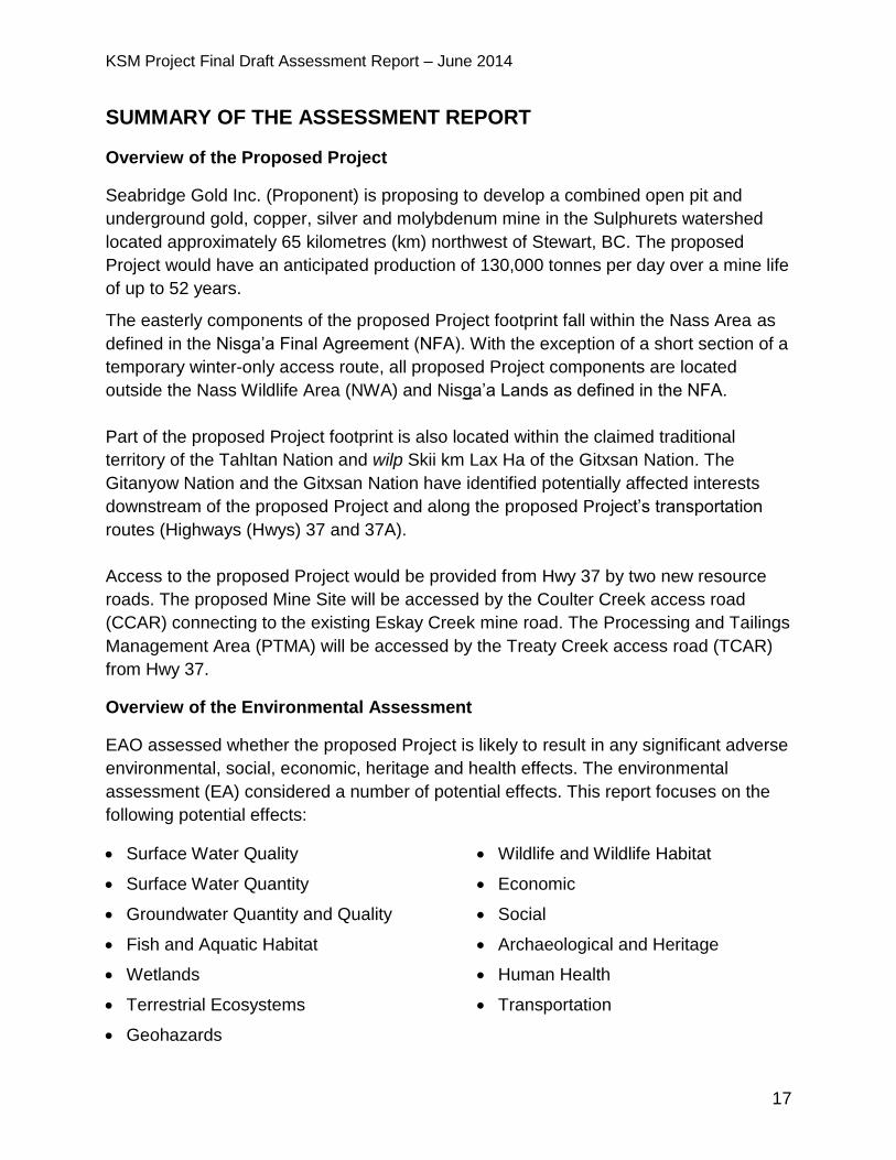
SUMMARY OF THE ASSESSMENT REPORT
Overview of the Proposed Project
Seabridge Gold Inc. (Proponent) is proposing to develop a combined open pit and
underground gold, copper, silver and molybdenum mine in the Sulphurets watershed
located approximately 65 kilometres (km) northwest of Stewart, BC. The proposed
Project would have an anticipated production of 130,000 tonnes per day over a mine life
of up to 52 years.
The easterly components of the proposed Project footprint fall within the Nass Area as
defined in the Nisga’a Final Agreement (NFA). With the exception of a short section of a
temporary winter-only access route, all proposed Project components are located
outside the Nass Wildlife Area (NWA) and Nisga’a Lands as defined in the NFA.
Part of the proposed Project footprint is also located within the claimed traditional
territory of the Tahltan Nation and wilp Skii km Lax Ha of the Gitxsan Nation. The
Gitanyow Nation and the Gitxsan Nation have identified potentially affected interests
downstream of the proposed Project and along the proposed Project’s transportation
routes (Highways (Hwys) 37 and 37A).
Access to the proposed Project would be provided from Hwy 37 by two new resource
roads. The proposed Mine Site will be accessed by the Coulter Creek access road
(CCAR) connecting to the existing Eskay Creek mine road. The Processing and Tailings
Management Area (PTMA) will be accessed by the Treaty Creek access road (TCAR)
from Hwy 37.
Overview of the Environmental Assessment
EAO assessed whether the proposed Project is likely to result in any significant adverse
environmental, social, economic, heritage and health effects. The environmental
assessment (EA) considered a number of potential effects. This report focuses on the
following potential effects:
Surface Water Quality Wildlife and Wildlife Habitat
Surface Water Quantity Economic
Groundwater Quantity and Quality Social
Fish and Aquatic Habitat Archaeological and Heritage
Wetlands Human Health
Terrestrial Ecosystems Transportation
Geohazards
KSM Project Final Draft Assessment Report – June 2014
18
Surface water quality was one of the key issues discussed during the EA, and in
particular, the effects of selenium on water quality. See section 5.1 and 5.2 for a
complete description of the issue, proposed mitigation and EAO’s conclusions.
EAO assessed relevant issues raised by First Nations and the Nisga’a Nation during the
course of the EA and whether the Crown has fulfilled its obligations for consultation and
accommodation and with respect to its obligations under the NFA. This Assessment
Report, EAO’s Nisga’a Nation Report and First Nations Consultation Report is provided
to the responsible Ministers for consideration in their decision of whether or not to issue
an EA Certificate for the proposed Project.
KSM Final Assessment Report – June 2014
19
PART A – INTRODUCTION AND BACKGROUND
1 Purpose of the Report
The purpose of this Report is to summarize the procedures and findings of the EA
conducted on the application (Application) by the Proponent for an EA Certificate for the
proposed Project. EAO is required to prepare this Report for provincial Ministers who
are responsible for making a decision on the proposed Project under section 17 of the
Act. For mine projects, the deciding Ministers are the Minister of the Environment and
the Minister of Energy and Mines.
This Report:
describes the proposed Project, provincial EA process, and consultations undertaken during the EA;
describes EAO’s requirements under the NFA and its assessment pursuant to those requirements;
identifies the potential environmental, economic, social, heritage and health effects of the proposed Project and how the Proponent proposes to mitigate effects;
identifies the residual effects after mitigation;
identifies the conditions developed during the EA; and
sets out conclusions based on the proposed Project’s potential for significant adverse residual effects.
This Report does not replicate the content presented in the Application. The Application
and supplemental information provided by the Proponent during the EA and the
Working Group’s responses to that information and the Working Group meeting
summary notes are posted on EAO’s website. These documents, together with the
issues tracking tables appended to this Report, provide additional detail to support this
Report and EAO’s conclusions. EAO is satisfied with all of the Proponent responses
provided in the issues tracking tables.
2 Project Overview
2.1 Proponent
The Proponent for the proposed Project is Seabridge Gold Inc., a publicly traded
company, with common shares trading on the Toronto Stock Exchange in Canada and
on the New York Stock Exchange in the United States (US).

KSM Final Assessment Report – June 2014
20
2.2 Project Location
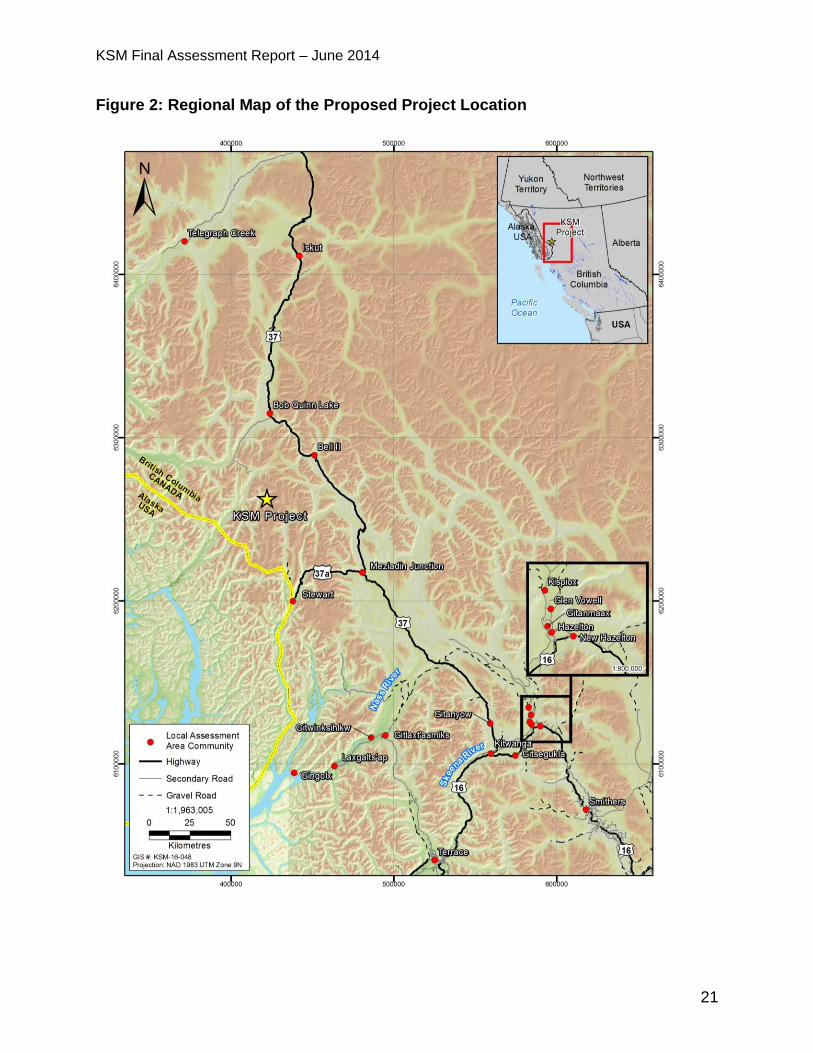
The proposed Project is located on Crown land approximately 65 km northwest of
Stewart and 35 km northeast of the BC-Alaska border (Figure 1). The mine tenure
includes approximately 60,000 hectares (ha).
KSM Final Assessment Report – June 2014
21
Figure 2: Regional Map of the Proposed Project Location
KSM Final Assessment Report – June 2014
22
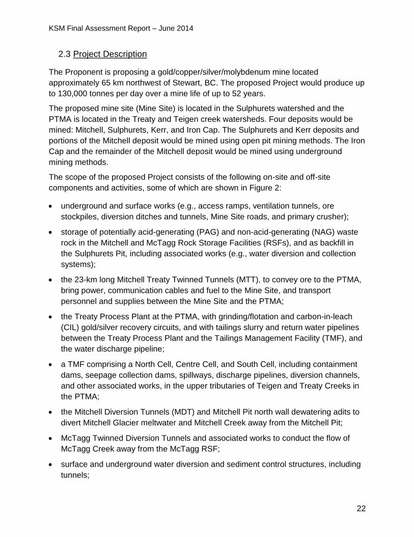
2.3 Project Description
The Proponent is proposing a gold/copper/silver/molybdenum mine located
approximately 65 km northwest of Stewart, BC. The proposed Project would produce up
to 130,000 tonnes per day over a mine life of up to 52 years.
The proposed mine site (Mine Site) is located in the Sulphurets watershed and the
PTMA is located in the Treaty and Teigen creek watersheds. Four deposits would be
mined: Mitchell, Sulphurets, Kerr, and Iron Cap. The Sulphurets and Kerr deposits and
portions of the Mitchell deposit would be mined using open pit mining methods. The Iron
Cap and the remainder of the Mitchell deposit would be mined using underground
mining methods.
The scope of the proposed Project consists of the following on-site and off-site
components and activities, some of which are shown in Figure 2:
underground and surface works (e.g., access ramps, ventilation tunnels, ore
stockpiles, diversion ditches and tunnels, Mine Site roads, and primary crusher);
storage of potentially acid-generating (PAG) and non-acid-generating (NAG) waste
rock in the Mitchell and McTagg Rock Storage Facilities (RSFs), and as backfill in
the Sulphurets Pit, including associated works (e.g., water diversion and collection
systems);
the 23-km long Mitchell Treaty Twinned Tunnels (MTT), to convey ore to the PTMA,
bring power, communication cables and fuel to the Mine Site, and transport
personnel and supplies between the Mine Site and the PTMA;
the Treaty Process Plant at the PTMA, with grinding/flotation and carbon-in-leach
(CIL) gold/silver recovery circuits, and with tailings slurry and return water pipelines
between the Treaty Process Plant and the Tailings Management Facility (TMF), and
the water discharge pipeline;
a TMF comprising a North Cell, Centre Cell, and South Cell, including containment
dams, seepage collection dams, spillways, discharge pipelines, diversion channels,
and other associated works, in the upper tributaries of Teigen and Treaty Creeks in
the PTMA;
the Mitchell Diversion Tunnels (MDT) and Mitchell Pit north wall dewatering adits to
divert Mitchell Glacier meltwater and Mitchell Creek away from the Mitchell Pit;
McTagg Twinned Diversion Tunnels and associated works to conduct the flow of
McTagg Creek away from the McTagg RSF;
surface and underground water diversion and sediment control structures, including
tunnels;
KSM Final Assessment Report – June 2014
23
the Mitchell Ore Preparation Complex (OPC), which includes facilities for rock
crushing, ore storage, fuel storage and an electrical substation;
a Water Storage Facility (WSF), both dam and reservoir, located on Mitchell Creek,
with a Water Treatment Plant (WTP) situated downstream, to collect contact water
from various water diversions, storage and treatment facilities;
explosives manufacturing plants and storage facilities;
CCAR connecting to the existing Eskay Creek mine road;
TCAR from Hwy 37 to PTMA;
temporary Frank Mackie Glacier access route from the existing Granduc Mine road
to the Mine Site during early construction;
ten construction camps, with associated works, and two operating camps, one each
at the Mine Site and the PTMA, including administration facilities, maintenance
facilities, and fuel and other materials storage, as well as domestic sewage
treatment and disposal;
the Upper Sulphurets and McTagg hydroelectric plants and associated penstocks,
located in Sulphurets and Gingras Creeks;
a 29-km long, 287- kilovolt (kV) transmission line from Hwy 37 along the TCAR to
the PTMA, and continuing via the MTT to the Mine Site, with related substations,
access roads, stream crossings and associated construction and maintenance
activities;
an ore concentrate storage facility and truck load-out at the PTMA, and trucking
along Hwys 37 and 37A to the port of Stewart for offshore shipment;
transport of ore processing reagents to the PTMA, and explosives and reagents to
the Mine Site, via Hwys 37 and 37A and through the MTT; and
other ancillary works or activities associated with the proposed Project.
KSM Final Assessment Report – June 2014
24
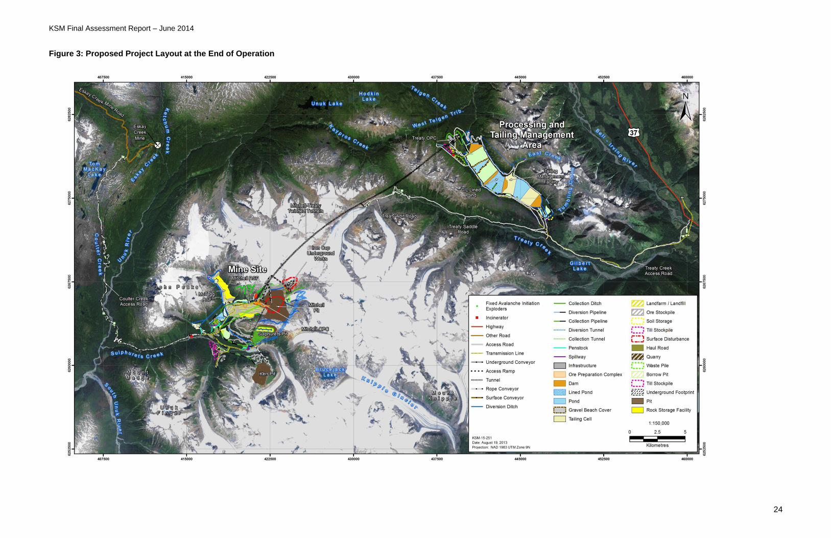
Figure 3: Proposed Project Layout at the End of Operation
KSM Final Assessment Report – June 2014
25
2.3.1 Key Changes to the Design of the Proposed Project due to the EA Process
Changes during the Pre-Application Stage
Based on comments provided by the Working Group and the public during the pre-
Application stage, the Proponent made several changes to the proposed Project design
to minimize or avoid potential adverse effects on the environment and Nisga’a Nation
and First Nations interests. These changes were incorporated into the proposed Project
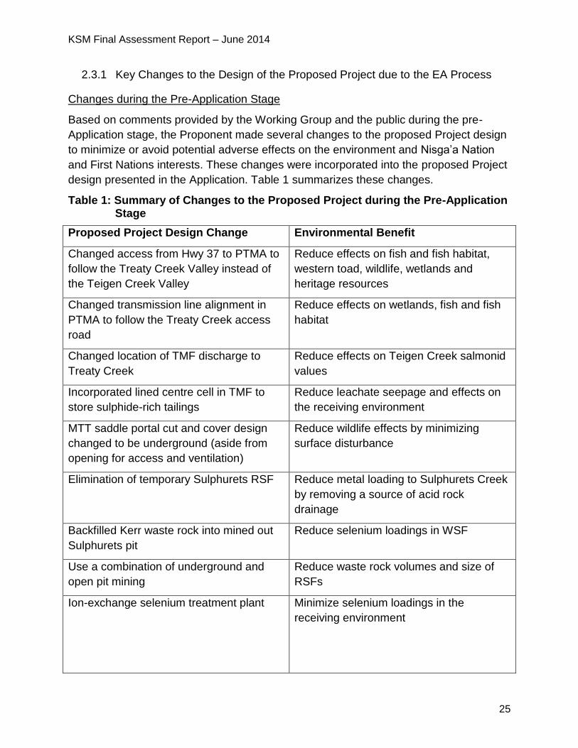
design presented in the Application. Table 1 summarizes these changes.
Table 1: Summary of Changes to the Proposed Project during the Pre-Application Stage
Proposed Project Design Change Environmental Benefit
Changed access from Hwy 37 to PTMA to
follow the Treaty Creek Valley instead of
the Teigen Creek Valley
Reduce effects on fish and fish habitat,
western toad, wildlife, wetlands and
heritage resources
Changed transmission line alignment in
PTMA to follow the Treaty Creek access
road
Reduce effects on wetlands, fish and fish
habitat
Changed location of TMF discharge to
Treaty Creek
Reduce effects on Teigen Creek salmonid
values
Incorporated lined centre cell in TMF to
store sulphide-rich tailings
Reduce leachate seepage and effects on
the receiving environment
MTT saddle portal cut and cover design
changed to be underground (aside from
opening for access and ventilation)
Reduce wildlife effects by minimizing
surface disturbance
Elimination of temporary Sulphurets RSF Reduce metal loading to Sulphurets Creek
by removing a source of acid rock
drainage
Backfilled Kerr waste rock into mined out
Sulphurets pit
Reduce selenium loadings in WSF
Use a combination of underground and
open pit mining
Reduce waste rock volumes and size of
RSFs
Ion-exchange selenium treatment plant Minimize selenium loadings in the
receiving environment
KSM Final Assessment Report – June 2014
26
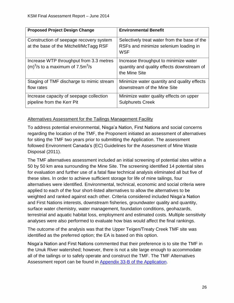
Proposed Project Design Change Environmental Benefit
Construction of seepage recovery system
at the base of the Mitchell/McTagg RSF
Selectively treat water from the base of the
RSFs and minimize selenium loading in
WSF
Increase WTP throughput from 3.3 metres
(m)3/s to a maximum of 7.5m3/s
Increase throughput to minimize water
quantity and quality effects downstream of
the Mine Site
Staging of TMF discharge to mimic stream
flow rates
Minimize water quantity and quality effects
downstream of the Mine Site
Increase capacity of seepage collection
pipeline from the Kerr Pit
Minimize water quality effects on upper
Sulphurets Creek
Alternatives Assessment for the Tailings Management Facility
To address potential environmental, Nisga’a Nation, First Nations and social concerns
regarding the location of the TMF, the Proponent initiated an assessment of alternatives
for siting the TMF two years prior to submitting the Application. The assessment
followed Environment Canada’s (EC) Guidelines for the Assessment of Mine Waste
Disposal (2011).
The TMF alternatives assessment included an initial screening of potential sites within a
50 by 50 km area surrounding the Mine Site. The screening identified 14 potential sites
for evaluation and further use of a fatal flaw technical analysis eliminated all but five of
these sites. In order to achieve sufficient storage for life of mine tailings, four
alternatives were identified. Environmental, technical, economic and social criteria were
applied to each of the four short-listed alternatives to allow the alternatives to be
weighted and ranked against each other. Criteria considered included Nisga’a Nation
and First Nations interests, downstream fisheries, groundwater quality and quantity,
surface water chemistry, water management, foundation conditions, geohazards,
terrestrial and aquatic habitat loss, employment and estimated costs. Multiple sensitivity
analyses were also performed to evaluate how bias would affect the final rankings.
The outcome of the analysis was that the Upper Teigen/Treaty Creek TMF site was
identified as the preferred option; the EA is based on this option.
Nisga’a Nation and First Nations commented that their preference is to site the TMF in
the Unuk River watershed; however, there is not a site large enough to accommodate
all of the tailings or to safely operate and construct the TMF. The TMF Alternatives
Assessment report can be found in Appendix 33-B of the Application.
KSM Final Assessment Report – June 2014
27
Application Review Stage Supplemental Information and Design Changes
To respond to comments raised by the Working Group during the review of the
Application, the Proponent prepared a number of supplementation technical
memorandums and reports. The memorandums focused largely on comments related to
surface water and groundwater quality and quantity, and transportation effects on
wildlife, fish and aquatic resources. The Proponent also prepared a report to assess the
potential effects of a dam failure and a report summarizing the results of rare plant
surveys. The supplemental technical memorandums and reports provided by the
Proponent during the Application review are posted on EAO’s website.
Based on the comments received during the Application review stage, design changes
include a Selenium Treatment Plant (SeTP) to be commissioned by the fifth year of
operation rather than Year 27 of operation, the installation of the seepage recovery
facility at the base of the Mitchell/McTagg RSF, and an increase in the capacity of the
Kerr Pit water management systems.
3 Assessment Process
3.1 Provincial EA Process – Major Milestones
The EA process started on April 25, 2008, when EAO issued an Order to this effect under section 10 of the Act. (http://a100.gov.bc.ca/appsdata/epic/html/deploy/epic_document_322_26122.html)
On November 6, 2009, EAO issued an Order under section 11 of the Act which defined the scope of the proposed Project, as well as the procedures and methods for conducting the review. (http://a100.gov.bc.ca/appsdata/epic/html/deploy/epic_document_322_31718.html)
On September 29, 2011 and November 30, 2012, EAO issued Orders under section 13 of the Act which changed the scope of the proposed Project, added additional First Nations to be consulted, and modified the timeline requirements for concurrent review. (http://a100.gov.bc.ca/appsdata/epic/html/deploy/epic_document_322_33717.html http://a100.gov.bc.ca/appsdata/epic/html/deploy/epic_document_322_35237.html)
On January 31, 2011, EAO approved and issued the final Application Information Requirements (AIR) to the Proponent. (http://a100.gov.bc.ca/appsdata/epic/html/deploy/epic_project_doc_list_322_p_tor.html)
On January 30, 2013, in advance of the Proponent submitting their Application for evaluation, EAO extended the time limit for the evaluation by 15 days, under section 24(4) of the Act. This change was at the request of the Proponent to allow reviewers additional time to screen the Application against the AIR. (http://a100.gov.bc.ca/appsdata/epic/html/deploy/epic_document_322_35308.html)
KSM Final Assessment Report – June 2014
28
On March 28, 2013, the Proponent submitted their initial Application for evaluation.
On May 13, 2013, EAO extended the time limit for the evaluation of the Application, by 21 days under section 24(4) of the Act. This change was at the request of the Proponent to allow reviewers additional time to screen the Application against the AIR. (http://a100.gov.bc.ca/appsdata/epic/html/deploy/epic_document_322_35580.html)
On June 3, 2013, EAO determined that the Application contained the information required by the AIR. EAO indicated that the Application review period would commence when the Proponent provided the required copies of the Application. (http://a100.gov.bc.ca/appsdata/epic/html/deploy/epic_document_322_35670.html)
On August 12, 2013, the Proponent submitted the required copies of the Application for distribution to Working Group members, and the Application review began. (http://a100.gov.bc.ca/appsdata/epic/html/deploy/epic_project_doc_list_322_r_com.html)
On December 20, 2013, the Proponent requested a 30-day extension to the Application review period, which EAO granted under section 24(4) of the Act. (http://a100.gov.bc.ca/appsdata/epic/html/deploy/epic_document_322_36793.htmlIn March 2014, EAO granted the Proponent’s request for a 45-day extension to the Application review period under section 24(4) of the Act. (http://a100.gov.bc.ca/appsdata/epic/documents/p322/1393517077765_c5f2516f2ecc8e7abfb3adf6d1ac893d01de38d7c0a30d4f1cfca6513acdb124.pdf and http://a100.gov.bc.ca/appsdata/epic/html/deploy/epic_document_322_37358.html)
On April 25, 2014, EAO extended the time limit for the Application review by 49 days under section 24(4) of the Act. (http://a100.gov.bc.ca/appsdata/epic/documents/p322/1398812740966_87bca46469be339bff095126033203932b3affe29adda2896c6229837cfc9cb2.pdf)
On June 20, 2014, EAO extended the time limit for the Application review by eight days under section 24(4) of the Act.
On June 20, 2014, EAO referred the proposed Project to Ministers for decision.
3.2 Public Consultation
EAO invited public comments on the draft AIR for the proposed Project from June 25,
2010, to July 26, 2010, and held open houses in Terrace, Smithers, Stewart and Dease
Lake, BC, which were attended by a total of 41 people. The key issues raised by the
public during these open houses and through the online public comment period
included:
effects of the proposed Project on water quality and quantity;
effects on wildlife and wildlife habitat and fish and fish habitat;
concerns about accidents and malfunctions and reclamation; and

KSM Final Assessment Report – June 2014
29
support for the proposed Project, including the associated economic and
employment benefits.
Stakeholder concerns raised included: concerns with socio-economic baseline data,
interest in local training programs, and socio-economic effects of the proposed Project.
EAO received two comments on the draft AIR, stating support for the proposed Project
due to the economic and employment benefits.
At the commencement of Application review, the Application was posted on EAO’s
website at
http://a100.gov.bc.ca/appsdata/epic/html/deploy/epic_project_doc_list_322_r_app.html.
The Application was made available to the public in local libraries in Smithers, Terrace,
Stewart, Dease Lake and Hazelton, BC.
A 45-day public comment period on the Application was held from September 6, 2013 to
October 21, 2013. The public comment period and open house were advertised in four
local newspapers in the week prior to the open house.
Table 2 shows the open houses held by EAO during the Application review period and
the number of attendees. The open houses provided information about the provincial
and federal EA processes and the proposed Project.
Table 2: EAO Application Review Open Houses
Community Iskut Telegraph
Creek
Terrace Smithers Stewart
Date September
25, 2013
September
26, 2013
October 1,
2013
October 2,
2013
October 9,
2013
Attendees 5 10 9 33 24
The main issues raised during the open houses and through the online public comment
period included:
support for the proposed Project, specifically related to job creation and support
for regional economies;
concerns regarding water quality, specifically focused on impacts downstream on
the Unuk River, impacting fish and water quality in the US; and
concerns regarding impacts on wildlife and wildlife habitat.
A total of 94 comments were received during the public comment period. The comments
and the Proponent’s responses are contained in the public issues tracking table in the
Proponent’s Public Consultation Report.
KSM Final Assessment Report – June 2014
30
Late in the Application review stage, concerns were raised by Alaskan commercial and
sport fishing groups, businesses, communities, tribes, conservation groups and
individuals. Concerns were centered around potential effects to salmon and the
significant commercial, sport and customary and traditional fisheries the Unuk River
supports, as well as potential impacts to Alaskan seafood and tourism marketing efforts.
State of Alaska and federal US representatives participated in the EA as members of
the Working Group.
3.3 First Nations Consultation
Part of the proposed Project footprint is located within the claimed traditional territory of
the Tahltan Nation and wilp Skii km Lax Ha of the Gitxsan Nation. Gitanyow Nation and
Gitxsan Nation have identified potentially affected interests downstream of the proposed
Project and along the proposed Project’s transportation routes on Hwys 37 and 37A.
Tahltan Nation, wilp Skii km Lax Ha, Gitxsan Nation and Gitanyow Nation participated in
the appropriate technical Working Groups, were kept fully informed of progress of the
EA, and were provided with all information that was sent to the Working Group.
Part C of this Report provides the following: a detailed review of First Nations
consultations, EAO conclusions with respect to the consultation process, the potential
for impacts to asserted aboriginal rights, and accommodations.
3.4 Nisga’a Nation Consultation
The easterly components of the proposed Project fall within the Nass Area as defined in
the NFA. With the exception of a short section of a temporary winter-only access route
and the transportation corridors, all proposed Project components are located outside
the NWA and Nisga’a Lands as defined in the NFA. Nisga’a Nation, (as represented by
Nisga’a Lisims Government (NLG)) participated in the technical Working Group and
Transportation Working Group1. NLG was kept fully informed of the progress of the EA
and was provided with all information that was sent to the Working Groups.
A separate Nisga’a Nation Report provides a detailed review of Nisga’a Nation
consultations and EAO conclusions with respect to the obligations under Chapter 10 of
the NFA. That Report is located in Part D of this document.
1 EAO initially established a Transportation Working Group specific to the proposed Project. However, in
response to concerns expressed by First Nations and others, EAO established a Hwy 37 Advisory Group to examine the effects of multiple projects. The Advisory Group was initially co-chaired by EAO and the BC Ministry of Transportation and Infrastructure (MOTI) and later by EAO and the BC Ministry of Forests, Lands and Natural Resource Operations (FLNR) under a new title, the Northwest Wildlife and Environmental Management Advisory Group.
KSM Final Assessment Report – June 2014
31
PART B – ASSESSMENT OF POTENTIAL EFFECTS, MITIGATION, AND
SIGNIFICANCE OF RESIDUAL EFFECTS
4 General
4.1 Assessment Methodology
4.1.1 Assessment of Potential Significant Adverse Effects Methodology
In undertaking this evaluation, EAO assessed whether the Project as proposed is likely
to have significant adverse environmental, economic, social, heritage and health effects,
including cumulative impacts, having regard to the mitigation measures proposed in the
Application or otherwise developed through the EA process. This section is intended as
a summary of the methodology followed by EAO (see EAO’s Valued Component (VC)
Guidelines for further information
(http://www.eao.gov.bc.ca/pdf/EAO_Valued_Components_Guideline_2013_09_09.pdf)2
To determine what may constitute a “significant” residual cumulative effect, EAO uses
the following definitions3:
Context refers primarily to the current and future sensitivity and resilience of the VC to
change caused by the project. Consideration of context draws heavily on the description
of existing conditions of the VC, which reflect cumulative effects of other projects and
activities that have been carried out, and especially information about the impact of
natural and human-caused trends in the condition of the VC.
Magnitude refers to the expected size or severity of the residual effect. When
evaluating magnitude of residual effects, the proportion of the VC affected within the
spatial boundaries is considered and the relative effect (e.g., relative to natural annual
variation in the magnitude of the VC or other relevant characteristic).
Extent refers to the spatial scale over which the residual effect is expected to occur.
Duration refers to the length of time the residual effect persists (which may be longer
than the duration of the physical work or activity that gave rise to the residual effect).
Reversibility pertains to whether or not the residual effect on the VC can be reversed
once the physical work or activity causing the disturbance ceases.
2 Note that this methodology differs from the methodology described in the AIR for the proposed Project.
3 This is generally consistent with the analysis used in federal EAs under the Canadian Environmental
Assessment Act, although EAO has added the factor of “likelihood”.
KSM Final Assessment Report – June 2014
32
Frequency refers to how often the residual effect occurs and is usually closely related
to the frequency of the physical work or activity causing the residual effect.
Likelihood refers to whether or not a residual effect is likely to occur. This may be
influenced by a variety of factors, such as the likelihood of a causal disturbance
occurring or the likelihood of mitigation being successful.
Significance is determined for both the residual effects of the project and the cumulative
effects. Once the residual effect prediction has been described in terms of significance
and likelihood, the level of confidence is explained in each prediction. The level of
confidence is typically based on expert judgment, and should characterize the level of
uncertainty associated with both the significance and likelihood determinations.
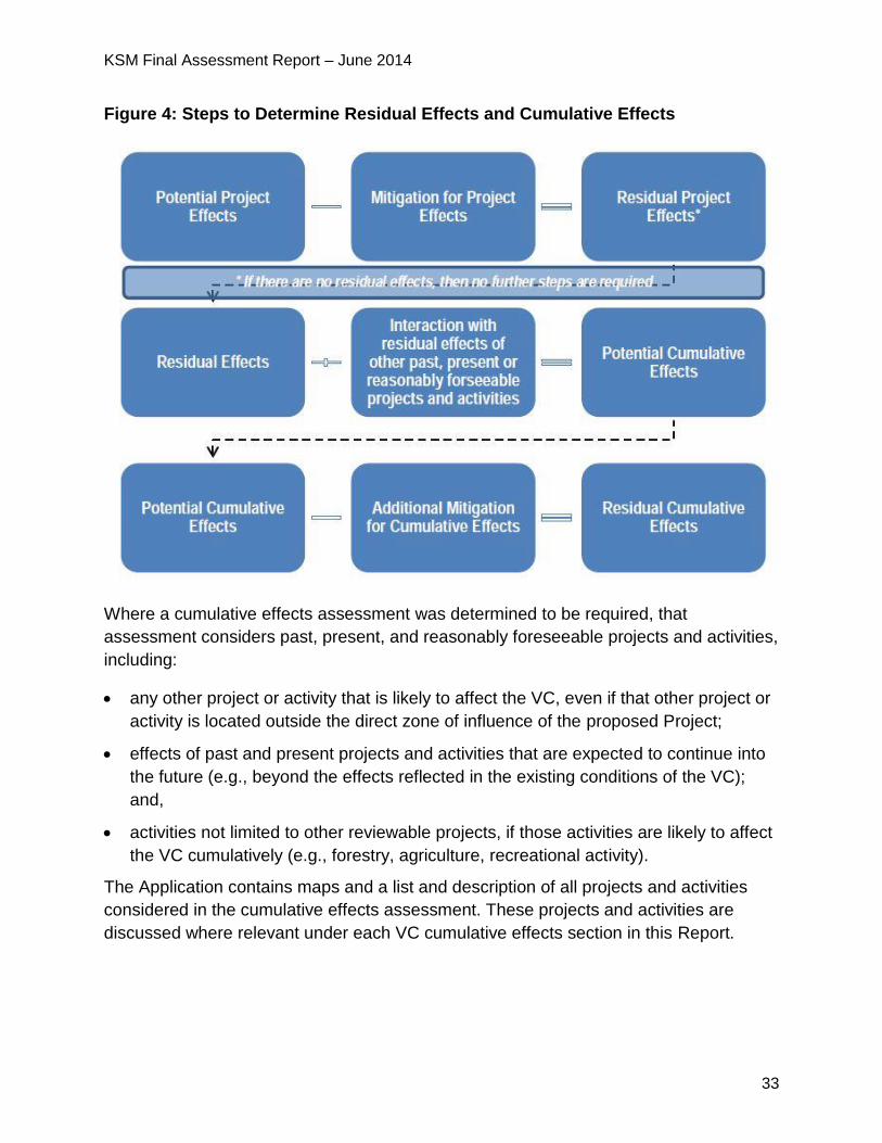
4.1.2 Cumulative Effects
If any residual adverse effects are predicted, the need for a cumulative effects
assessment must be considered (see figure 3).
An evaluation of the predicted residual effects of the project is required to determine
whether any cumulative interaction with the residual effects of other projects and
activities is considered likely to occur. If no cumulative interaction is considered likely,
those residual effects need not be carried forward into a cumulative effects assessment.
KSM Final Assessment Report – June 2014
33
Figure 4: Steps to Determine Residual Effects and Cumulative Effects
Where a cumulative effects assessment was determined to be required, that
assessment considers past, present, and reasonably foreseeable projects and activities,
including:
any other project or activity that is likely to affect the VC, even if that other project or
activity is located outside the direct zone of influence of the proposed Project;
effects of past and present projects and activities that are expected to continue into
the future (e.g., beyond the effects reflected in the existing conditions of the VC);
and,
activities not limited to other reviewable projects, if those activities are likely to affect
the VC cumulatively (e.g., forestry, agriculture, recreational activity).
The Application contains maps and a list and description of all projects and activities
considered in the cumulative effects assessment. These projects and activities are
discussed where relevant under each VC cumulative effects section in this Report.
KSM Final Assessment Report – June 2014
34
4.1.3 Ensuring the Crown’s Duties to Consult and Accommodate First Nations
EAO is also required to ensure that the honour of the Crown is discharged by ensuring
appropriate consultation and accommodation of First Nation interests in respect of the
decision by Ministers as to whether to issue an EA Certificate. First Nations’ comments
and interests in terms of consultation and specific consideration of the Crown’s duty to
consult and accommodate First Nations’ interests are specifically factored into the
analysis in Part C of this Report. There is often considerable overlap between the
interests of First Nations and the assessment of environmental, economic, social,
heritage and health effects. First Nations’ comments and interests that directly relate to
the environmental, economic, social, heritage and health assessments are discussed in
Part B of this Report.
4.1.4 Ensuring the Crown’s Obligations to Uphold the Terms of the NFA
EAO is also required to ensure that the Crown’s obligations under the NFA are met. In
addition to specific treaty interests, there is also considerable overlap between the
Nisga’a Nation interests and the assessment of environmental, economic, social,
heritage and health effects. As a result, Nisga’a Nation comments and interests in terms
of consultation are specifically addressed in EAO’s Nisga’a Nation Consultation Report
in Part D. The NFA can be found at http://www.nnkn.ca/files/u28/nis-eng.pdf.
4.1.5 Spatial Boundaries
The Proponent’s Application contains details on the spatial extent of the study area
boundaries for assessing potential Project impacts. The Application includes several
figures which depict the study areas for specific disciplines. Spatial boundaries are
identified under each VC in this Report.
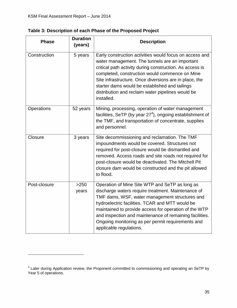
4.1.6 Temporal Boundaries
Temporal boundaries are the time periods considered in the effects assessment, which
take into account the phases of the proposed Project and the timelines of human
actions. Details are provided in the Proponent’s Application. Table 3 below illustrates
the phases of the proposed Project and activities associated with each phase.
KSM Final Assessment Report – June 2014
35
Table 3: Description of each Phase of the Proposed Project
Phase Duration
(years) Description
Construction 5 years Early construction activities would focus on access and
water management. The tunnels are an important
critical path activity during construction. As access is
completed, construction would commence on Mine
Site infrastructure. Once diversions are in place, the
starter dams would be established and tailings
distribution and reclaim water pipelines would be
installed.
Operations 52 years Mining, processing, operation of water management
facilities, SeTP (by year 274), ongoing establishment of
the TMF, and transportation of concentrate, supplies
and personnel.
Closure 3 years Site decommissioning and reclamation. The TMF
impoundments would be covered. Structures not
required for post-closure would be dismantled and
removed. Access roads and site roads not required for
post-closure would be deactivated. The Mitchell Pit
closure dam would be constructed and the pit allowed
to flood.
Post-closure >250
years
Operation of Mine Site WTP and SeTP as long as
discharge waters require treatment. Maintenance of
TMF dams, WSF, water management structures and
hydroelectric facilities. TCAR and MTT would be
maintained to provide access for operation of the WTP
and inspection and maintenance of remaining facilities.
Ongoing monitoring as per permit requirements and
applicable regulations.
4 Later during Application review, the Proponent committed to commissioning and operating an SeTP by
Year 5 of operations.
KSM Final Assessment Report – June 2014
36
5 Assessment of Potential Environmental Effects
5.1 Overview of the Water Setting in the Proposed Project Area
Water was one of the key issues discussed in the EA for the proposed Project. While
water is clearly linked and connected to a variety of VCs (e.g., fish and aquatic habitat,
wildlife, and human health), for the purposes of the EA these VCs are discussed
separately. In particular, this Report breaks water down into its separate components of
quality and quantity of both surface water and groundwater at the Mine Site and the
PTMA. The reason for this is because these proposed Project components occupy
different drainages (the PTMA is in the Bell Irving/Nass and the Mine Site is located in
the Unuk watershed, which drains into Alaska) and the potential and type of effects are
different.
This section of the Report provides background information on the proposed Project
components and water management at the Mine Site and PTMA and highlights some of
the key factors discussed and referenced throughout this report. Water is discussed as
surface water quality and quantity and groundwater quantity and quality for both the
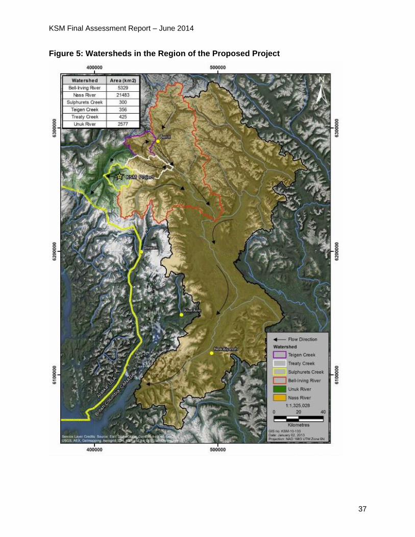
Mine Site and the PTMA. Figure 4 identifies the watersheds and direction of water flows
in the region of the proposed Project.
KSM Final Assessment Report – June 2014
37
Figure 5: Watersheds in the Region of the Proposed Project
KSM Final Assessment Report – June 2014
38
5.1.1 Mine Site
The Mine Site is centered around the mining of four deposits (Kerr, Sulphurets, Mitchell
and Iron Cap). It is located within the valleys of Mitchell Creek, McTagg Creek and
Sulphurets Creek. Sulphurets Creek is a main tributary of the Unuk River, which flows to
the Pacific Ocean via Alaska.
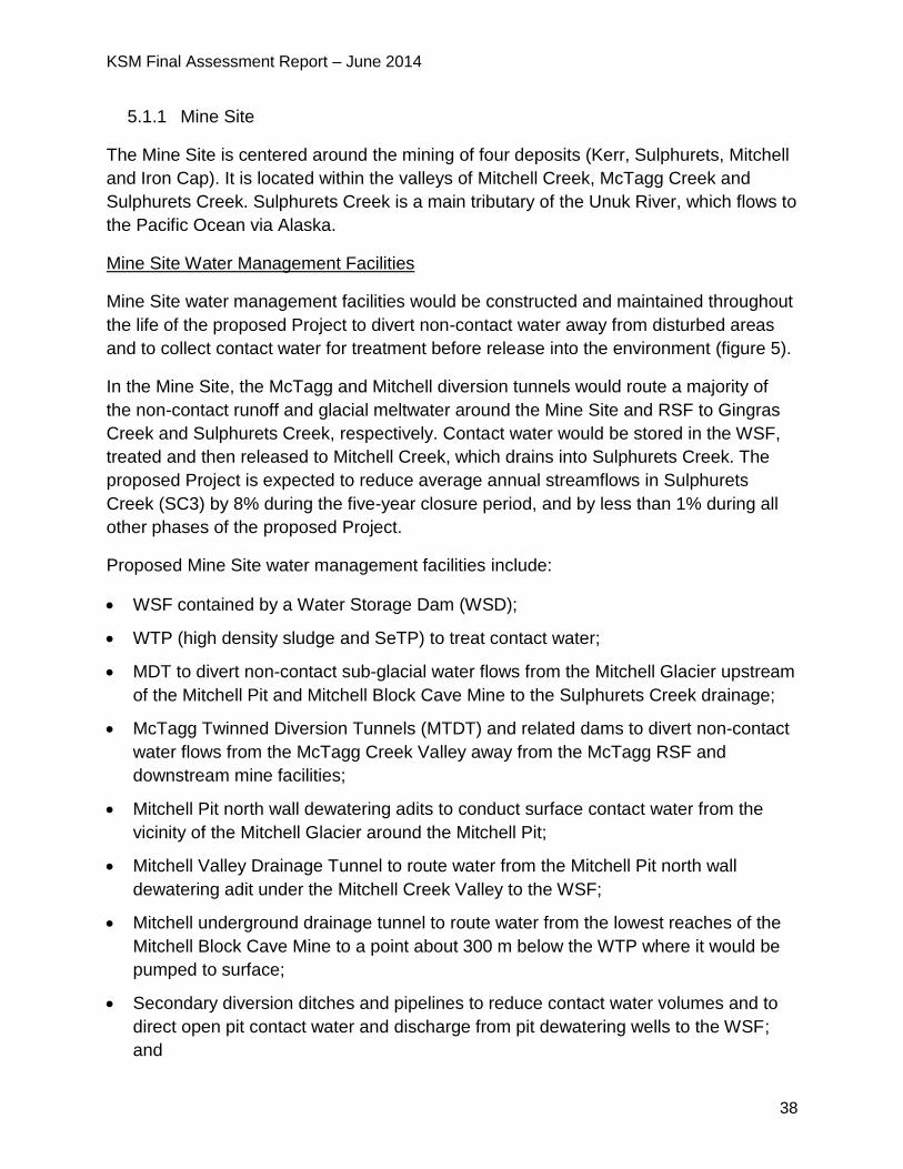
Mine Site Water Management Facilities
Mine Site water management facilities would be constructed and maintained throughout
the life of the proposed Project to divert non-contact water away from disturbed areas
and to collect contact water for treatment before release into the environment (figure 5).
In the Mine Site, the McTagg and Mitchell diversion tunnels would route a majority of
the non-contact runoff and glacial meltwater around the Mine Site and RSF to Gingras
Creek and Sulphurets Creek, respectively. Contact water would be stored in the WSF,
treated and then released to Mitchell Creek, which drains into Sulphurets Creek. The
proposed Project is expected to reduce average annual streamflows in Sulphurets
Creek (SC3) by 8% during the five-year closure period, and by less than 1% during all
other phases of the proposed Project.
Proposed Mine Site water management facilities include:
WSF contained by a Water Storage Dam (WSD);
WTP (high density sludge and SeTP) to treat contact water;
MDT to divert non-contact sub-glacial water flows from the Mitchell Glacier upstream
of the Mitchell Pit and Mitchell Block Cave Mine to the Sulphurets Creek drainage;
McTagg Twinned Diversion Tunnels (MTDT) and related dams to divert non-contact
water flows from the McTagg Creek Valley away from the McTagg RSF and
downstream mine facilities;
Mitchell Pit north wall dewatering adits to conduct surface contact water from the
vicinity of the Mitchell Glacier around the Mitchell Pit;
Mitchell Valley Drainage Tunnel to route water from the Mitchell Pit north wall
dewatering adit under the Mitchell Creek Valley to the WSF;
Mitchell underground drainage tunnel to route water from the lowest reaches of the
Mitchell Block Cave Mine to a point about 300 m below the WTP where it would be
pumped to surface;
Secondary diversion ditches and pipelines to reduce contact water volumes and to
direct open pit contact water and discharge from pit dewatering wells to the WSF;
and
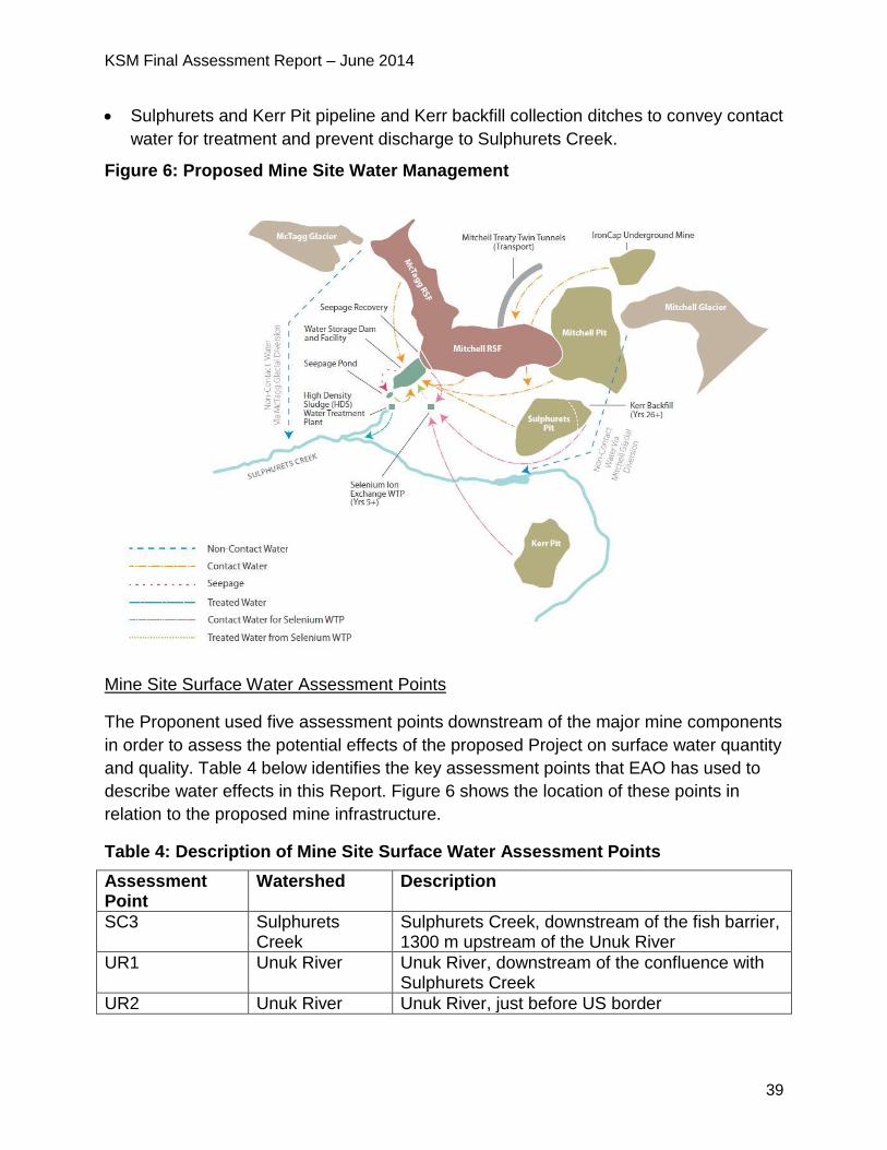
KSM Final Assessment Report – June 2014
39
Sulphurets and Kerr Pit pipeline and Kerr backfill collection ditches to convey contact
water for treatment and prevent discharge to Sulphurets Creek.
Figure 6: Proposed Mine Site Water Management
Mine Site Surface Water Assessment Points
The Proponent used five assessment points downstream of the major mine components
in order to assess the potential effects of the proposed Project on surface water quantity
and quality. Table 4 below identifies the key assessment points that EAO has used to
describe water effects in this Report. Figure 6 shows the location of these points in
relation to the proposed mine infrastructure.
Table 4: Description of Mine Site Surface Water Assessment Points
Assessment Point
Watershed Description
SC3 Sulphurets Creek
Sulphurets Creek, downstream of the fish barrier, 1300 m upstream of the Unuk River
UR1 Unuk River Unuk River, downstream of the confluence with Sulphurets Creek
UR2 Unuk River Unuk River, just before US border
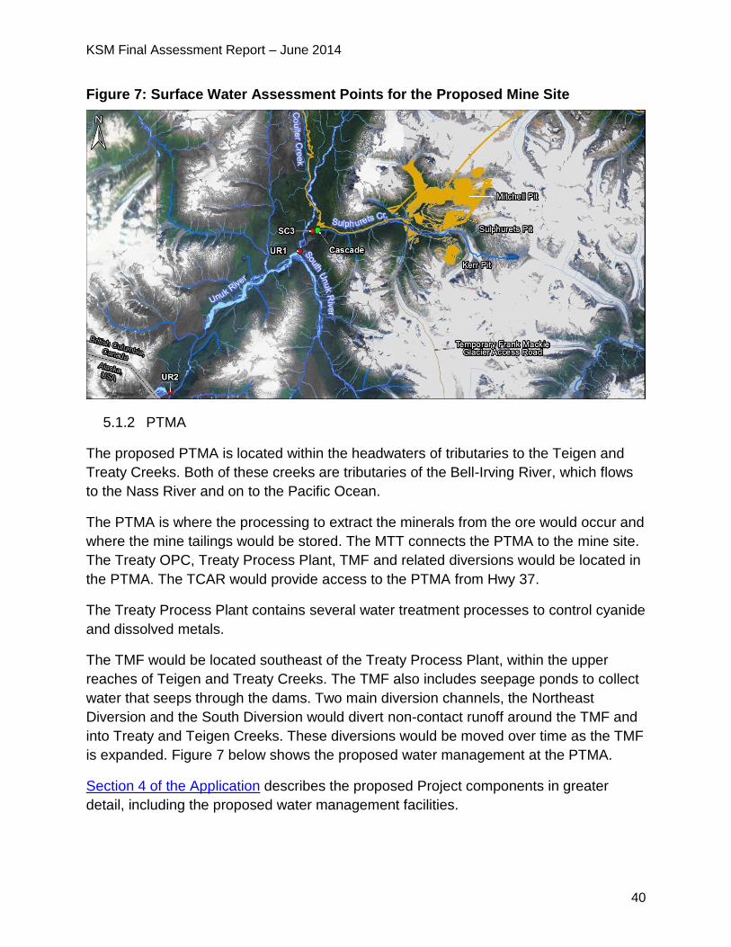
KSM Final Assessment Report – June 2014
40
Figure 7: Surface Water Assessment Points for the Proposed Mine Site
5.1.2 PTMA
The proposed PTMA is located within the headwaters of tributaries to the Teigen and
Treaty Creeks. Both of these creeks are tributaries of the Bell-Irving River, which flows
to the Nass River and on to the Pacific Ocean.
The PTMA is where the processing to extract the minerals from the ore would occur and
where the mine tailings would be stored. The MTT connects the PTMA to the mine site.
The Treaty OPC, Treaty Process Plant, TMF and related diversions would be located in
the PTMA. The TCAR would provide access to the PTMA from Hwy 37.
The Treaty Process Plant contains several water treatment processes to control cyanide
and dissolved metals.
The TMF would be located southeast of the Treaty Process Plant, within the upper
reaches of Teigen and Treaty Creeks. The TMF also includes seepage ponds to collect
water that seeps through the dams. Two main diversion channels, the Northeast
Diversion and the South Diversion would divert non-contact runoff around the TMF and
into Treaty and Teigen Creeks. These diversions would be moved over time as the TMF
is expanded. Figure 7 below shows the proposed water management at the PTMA.
Section 4 of the Application describes the proposed Project components in greater
detail, including the proposed water management facilities.
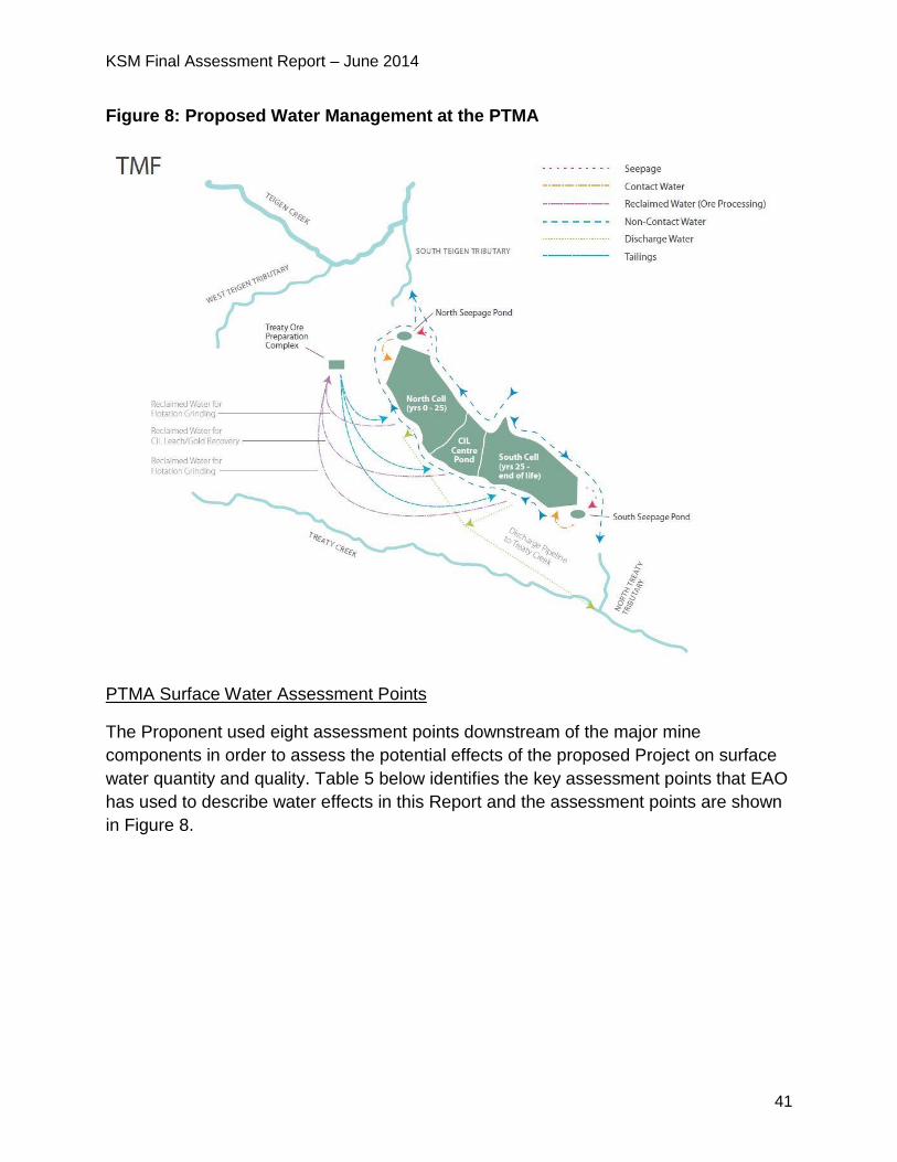
KSM Final Assessment Report – June 2014
41
Figure 8: Proposed Water Management at the PTMA
PTMA Surface Water Assessment Points
The Proponent used eight assessment points downstream of the major mine
components in order to assess the potential effects of the proposed Project on surface
water quantity and quality. Table 5 below identifies the key assessment points that EAO
has used to describe water effects in this Report and the assessment points are shown
in Figure 8.
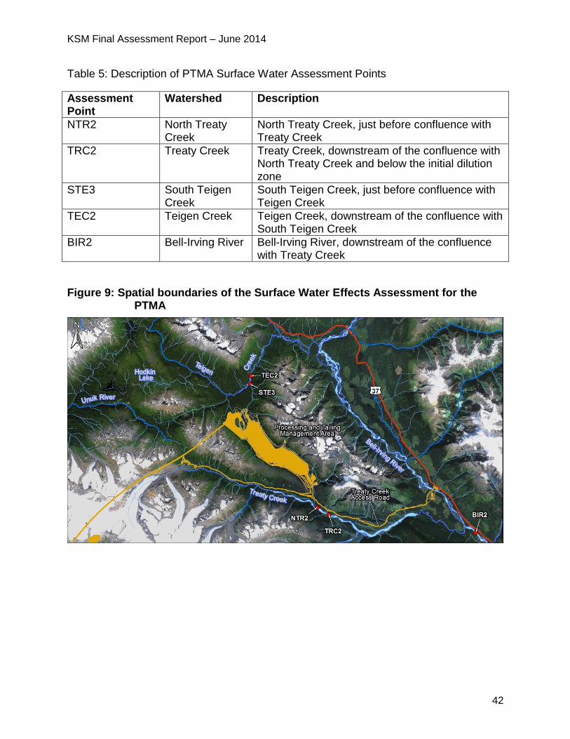
KSM Final Assessment Report – June 2014
42
Table 5: Description of PTMA Surface Water Assessment Points
Assessment Point
Watershed Description
NTR2 North Treaty Creek
North Treaty Creek, just before confluence with Treaty Creek
TRC2 Treaty Creek Treaty Creek, downstream of the confluence with North Treaty Creek and below the initial dilution zone
STE3 South Teigen Creek
South Teigen Creek, just before confluence with Teigen Creek
TEC2 Teigen Creek Teigen Creek, downstream of the confluence with South Teigen Creek
BIR2 Bell-Irving River Bell-Irving River, downstream of the confluence with Treaty Creek
Figure 9: Spatial boundaries of the Surface Water Effects Assessment for the PTMA
KSM Final Assessment Report – June 2014
43
5.2 Surface Water Quality
5.2.1 Background Information
The Local Study Area (LSA) for surface water covers 108,100 ha and includes the
Sulphurets, Teigen and Treaty Creek watersheds. It was based on the footprint of the
proposed Project and associated activities that could cause downstream effects.
The Regional Study Area (RSA) covers 386,612 ha and includes those watersheds that
could potentially be affected by the proposed Project, including the Mitchell-Sulphurets-
Unuk system, Teigen-Snowbank-Bell-Irving system and Treaty-Bell-Irving system.
Water quality baseline data from 2007 to 2012 was included in the Application to
characterize the natural variation in streams and rivers in the baseline study area and to
examine the areas potentially affected by the proposed Project. The Proponent
analyzed water quality samples for a number of parameters (e.g., pH, hardness and
turbidity), nutrients, cyanides, total organic carbon, and total and dissolved metals,
using the best available detection limits. As part of the water quality studies, the
Proponent conducted selenium speciation analysis5 and toxicity tests.
The Proponent’s water quality model was used to predict the concentrations and
transport of chemicals and metals both within the proposed Project footprint and in
downstream surface waters that would receive direct effluent discharge and/ or seepage
from proposed Project components. Background laboratory investigations and pilot
plant studies were used to estimate future water quality.
The Proponent developed water balances for the “base case” (or average year) and for
a “variable case” that incorporated extreme events including up to a 1-in-100-year dry
event and a 1-in-200-year wet event. The two geochemical loading scenarios that were
considered are the “expected case,” which was represented by the average of the
particular geochemical source term, and the “upper case,” which was represented by
the 95th percentile6 of the particular geochemical source term.
5 Selenium is an essential nutrient required by healthy organisms and occurs within nature in many
forms. Exposure to too much selenium can result in potential biological effects, which may affect the
viability of individual organisms. Speciation analysis is required to identify baseline conditions and to
differentiate between those forms of selenium present in simulated feed water in pilot water treatment
tests which can be removed through conventional water treatment systems (e.g. selenite can be removed
during high-density sludge water treatment) and those which require more complex treatment systems
(e.g. selenate is not removed by high density sludge water treatment).
6 The 95th percentile is the value (or score) below which 95 percent of the observations may be found.
KSM Final Assessment Report – June 2014
44
The Proponent identified potential residual effects on water quality through toxicity
testing of effluent and by calculating hazard quotients for predicted water quality
parameters. Calculation of hazard quotients was used to determine the potential for a
chemical to cause toxicity in receiving environment receptors (such as aquatic life, or
fish or wildlife species). Hazard quotients were calculated as the ratio of the predicted
concentration of a chemical to the relevant guideline or background value. The
Application states that a hazard quotient of greater than 1.0 relative to both guideline
limits and baseline concentrations may indicate a potential for toxic effects in receptors,
while a hazard quotient of less than 1.0 relative to either guideline limits or baseline
concentrations is not considered to pose additional toxic risk to receptors.
Mine Site Current Water Quality
The Application states that Mitchell and Sulphurets Creeks have total and dissolved
metal concentrations that are frequently higher than levels set in BC Water Quality
Guidelines (BCWQG) for the protection of freshwater aquatic life. This is due to high
suspended sediment loads due to glacier-fed streams and acid and metal leaching from
naturally-occurring minerals in the bedrock associated with the ore deposit.
The Proponent’s studies identified several forms of selenium in the Mine Site LSA. Of
particular note was that selenium in its most oxidized form, selenate, was predominantly
present in seeps at the Kerr deposit, while some seeps in the Mitchell Valley
predominantly contained selenium as selenite. Selenium in the receiving environment
was typically in the form of selenate including in Mitchell, Sulphurets, and Gingras
Creeks and in the Unuk River.
PTMA Current Water Quality
In the PTMA LSA the Proponent observed guideline exceedances in the
Snowbank/Teigen watershed for total and dissolved aluminum, total cadmium and total
chromium. In the Treaty/Bell-Irving watershed the Proponent observed guideline
exceedances for dissolved aluminum, total cadmium, total chromium, total copper, total
iron and total zinc. Low selenium concentrations (frequently below BCWQG) were
observed at the PTMA.
A full discussion on surface water quality can be found in Chapter 14 of the Proponent’s
Application posted on EAO’s website at:
http://a100.gov.bc.ca/appsdata/epic/html/deploy/epic_document_322_35959.html.
KSM Final Assessment Report – June 2014
45
5.2.2 Project Issues and Effects and Proposed Mitigation Identified in the
Application
Mine Site and PTMA
The Proponent identified the following sources of key potential water quality effects:
Metal Leaching (ML)/Acid Rock Drainage (ARD) — ML/ARD has the potential to
degrade surface water quality through oxidation and leaching processes of disturbances
associated with construction activities (including camps, access roads, diversion
structures, tunnels, borrow areas and quarries) and mining operations (including open
pits, underground block caves, waste rock and tailings). Disturbances that are not
adequately reclaimed may impact water quality during closure and post-closure.
Effluent discharge — Effluent discharges from nine proposed temporary water treatment
plants (six at the Mine Site and three at the PTMA) and the main Mine Site WTP have
the potential to change surface water quality, with improved conditions for some water
quality parameters and the potential for increased concentrations for parameters not
treated by the high-density sludge process (such as selenium).
Seepage — Despite the installation of seepage collection dams and ponds, seepage
may escape downstream from the WSF and TMF. Seepage may also occur from water
treatment sludge management facilities on the McTagg RSF.
Other Potential Effects
Leaching of blasting residues — Nitrogen loading to watercourses from blasting
residues used outside the catchments of the WSF and the TMF has the potential to
affect surface water quality during construction, operations and for some period of time
after closure. The Application states baseline total nitrogen concentrations are low in
streams in the proposed Project area. Nitrogen loading may increase the potential for
eutrophication in nitrogen-limited aquatic systems if the supply of phosphorus and other
micronutrients is sufficient for primary production.
Sedimentation and erosion — Surface disturbance at the Mine Site and the PTMA
would increase sedimentation and erosion of soils. Recovery from sedimentation would
be more rapid in high velocity streams than in wetlands or lakes. The Application reports
that many streams and rivers in the proposed Project area have naturally high sediment
loads of glacial origin, and would not be as affected as clear, low-velocity streams.
There is potential for sedimentation and erosion during all phases of mining.
Sewage — Sewage discharge to the receiving environment from personnel camps has
the potential to affect water quality during both construction and operation, primarily
through nutrient loading. Twelve construction camps would be equipped with sewage
treatment facilities that include secondary treatment, with effluent discharged either to
surface water or other approved ground locations. The Application reports that the camp
KSM Final Assessment Report – June 2014
46
sewage treatment plants are designed to produce effluent quality that is consistent with
reclaimed water.
Accidental spills — Spills of hazardous materials such as petroleum products, reagents
or concentrate could occur at all proposed Project phases, linked to unplanned events
or accidents.
Atmospheric deposition — Dust deposition from blasting and other mining activities has
the potential to affect surface water quality during all proposed Project phases. The
Proponent’s air quality modeling results were used to assess the effect of dust
deposition on surface water quality.
Predicted Water Quality in the Mine Site
Tables 6, 7, and 8 show a number of baseline and predicted concentrations, including
selenium, at three assessment points at the Mine Site. The predicted concentrations
include additional mitigation commitments and model refinements as a result of the
Application review. The first assessment point is Sulphurets Creek below the fish
barrier, 1300 m upstream of the Unuk River (SC3), the second is the Unuk River
downstream of the confluence with Sulphurets Creek (UR1) and the third is the Unuk
River just before the US border (UR2). The tables show predicted water quality for four
points in time over the life of the proposed Project. Predictions are compared to current
water quality (minimum, average, and maximum values) as well as to BCWQG.
Predictions for those parameters in the red boxes exceed BCWQG, values highlighted
in yellow meet BCWQG but are within 10% of the BCWQG, and those in green boxes
are less than guidelines.
The photograph below shows the confluence with the Unuk River and Sulphurets
Creek, and highlights the influence of the current natural water quality in the Sulphurets
watershed on the Unuk River. It also illustrates that surface water quality effects are
noticeable downstream of SC3 until sufficient dilution occurs with the mixing of water in
the Unuk River.
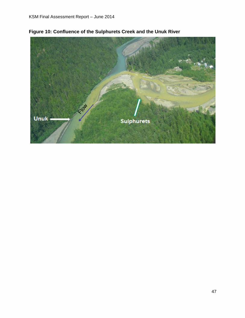
KSM Final Assessment Report – June 2014
47
Figure 10: Confluence of the Sulphurets Creek and the Unuk River
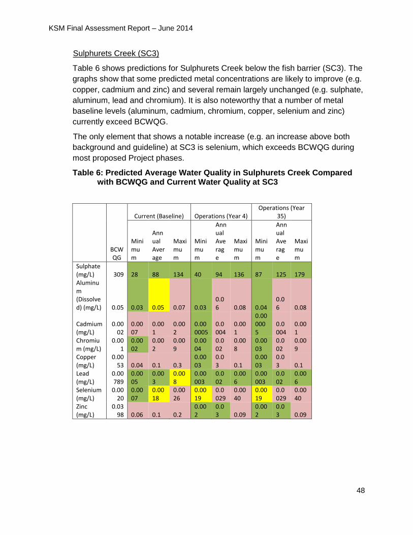
KSM Final Assessment Report – June 2014
48
Sulphurets Creek (SC3)
Table 6 shows predictions for Sulphurets Creek below the fish barrier (SC3). The
graphs show that some predicted metal concentrations are likely to improve (e.g.
copper, cadmium and zinc) and several remain largely unchanged (e.g. sulphate,
aluminum, lead and chromium). It is also noteworthy that a number of metal
baseline levels (aluminum, cadmium, chromium, copper, selenium and zinc)
currently exceed BCWQG.
The only element that shows a notable increase (e.g. an increase above both
background and guideline) at SC3 is selenium, which exceeds BCWQG during
most proposed Project phases.
Table 6: Predicted Average Water Quality in Sulphurets Creek Compared with BCWQG and Current Water Quality at SC3
BCWQG
Current (Baseline) Operations (Year 4) Operations (Year
35)
Minimum
Annual Average
Maximum
Minimum
Annual Average
Maximum
Minimum
Annual Average
Maximum
Sulphate (mg/L) 309 28 88 134 40 94 136 87 125 179 Aluminum (Dissolved) (mg/L) 0.05 0.03 0.05 0.07 0.03
0.06 0.08 0.04
0.06 0.08
Cadmium (mg/L)
0.0002
0.0007
0.001
0.002
0.000005
0.0004
0.001
0.000005
0.0004
0.001
Chromium (mg/L)
0.001
0.0002
0.002
0.009
0.0004
0.002
0.008
0.0003
0.002
0.009
Copper (mg/L)
0.0053 0.04 0.1 0.3
0.0003
0.03 0.1
0.0003
0.03 0.1
Lead (mg/L)
0.00789
0.0005
0.003
0.008
0.00003
0.002
0.006
0.00003
0.002
0.006
Selenium (mg/L)
0.0020
0.0007
0.0018
0.0026
0.0019
0.0029
0.0040
0.0019
0.0029
0.0040
Zinc (mg/L)
0.0398 0.06 0.1 0.2
0.002
0.03 0.09
0.002
0.03 0.09
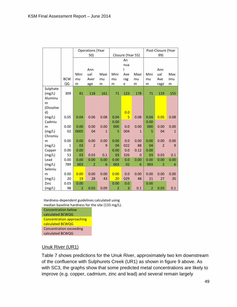
KSM Final Assessment Report – June 2014
49
Operations (Year 50) Closure (Year 55)
Post-Closure (Year 99)
BCWQG
Minimum
Annual Average
Maximum
Minimum
Annual Average
Maximum
Minimum
Annual Average
Maximum
Sulphate (mg/L) 309 81 118 161 71 123 178 71 119 155 Aluminum (Dissolved) (mg/L) 0.05 0.04 0.06 0.08 0.04
0.05 0.08 0.04 0.05 0.08
Cadmium (mg/L)
0.0002
0.000005
0.0004
0.001
0.00000
5 0.0
004 0.00
1
0.00000
5 0.00
04 0.00
1 Chromium (mg/L)
0.001
0.0003
0.002
0.009
0.0004
0.0022
0.0088
0.0004
0.002
0.009
Copper (mg/L)
0.0053
0.0003 0.03 0.1
0.0003
0.0326
0.120
0.0003 0.03 0.1
Lead (mg/L)
0.00789
0.00003
0.002
0.006
0.00003
0.002
0.006
0.00003
0.002
0.006
Selenium (mg/L)
0.0020
0.0019
0.0028
0.0043
0.0020
0.0029
0.0048
0.0021
0.0027
0.0035
Zinc (mg/L)
0.0398
0.002 0.03 0.09
0.002
0.03 0.1
0.002 0.03 0.1
Hardness-dependent guidelines calculated using median baseline hardness for the site (133 mg/L). Concentration below calculated BCWQG
Concentration approaching calculated BCWQG
Concentration exceeding calculated BCWQG
Unuk River (UR1)
Table 7 shows predictions for the Unuk River, approximately two km downstream
of the confluence with Sulphurets Creek (UR1) as shown in figure 9 above. As
with SC3, the graphs show that some predicted metal concentrations are likely to
improve (e.g. copper, cadmium, zinc and lead) and several remain largely
KSM Final Assessment Report – June 2014
50
unchanged (e.g. sulphate, aluminum and chromium). As with SC3, it is also
noteworthy that a number of metal baseline levels (aluminum, cadmium,
chromium, copper, and zinc) currently exceed BCWQG.
The only element that shows an increase above both background concentrations
and BCWQG at UR1 is selenium, which exceeds BCWQG during most proposed
Project phases for the maximum predicted water quality, but annual average
values are predicted to meet BCWQG.
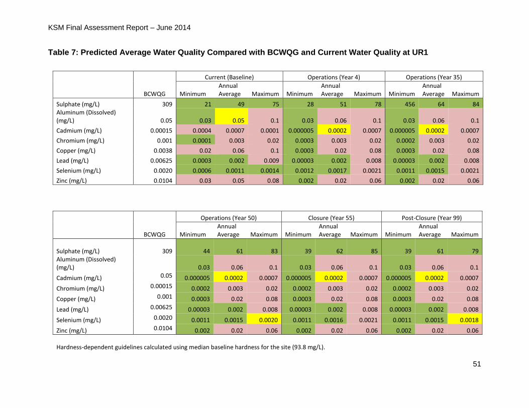
KSM Final Assessment Report – June 2014
51
Table 7: Predicted Average Water Quality Compared with BCWQG and Current Water Quality at UR1
BCWQG
Current (Baseline) Operations (Year 4) Operations (Year 35)
Minimum Annual Average Maximum Minimum
Annual Average Maximum Minimum
Annual Average Maximum
Sulphate (mg/L) 309 21 49 75 28 51 78 456 64 84 Aluminum (Dissolved) (mg/L) 0.05 0.03 0.05 0.1 0.03 0.06 0.1 0.03 0.06 0.1
Cadmium (mg/L) 0.00015 0.0004 0.0007 0.0001 0.000005 0.0002 0.0007 0.000005 0.0002 0.0007
Chromium (mg/L) 0.001 0.0001 0.003 0.02 0.0003 0.003 0.02 0.0002 0.003 0.02
Copper (mg/L) 0.0038 0.02 0.06 0.1 0.0003 0.02 0.08 0.0003 0.02 0.08
Lead (mg/L) 0.00625 0.0003 0.002 0.009 0.00003 0.002 0.008 0.00003 0.002 0.008
Selenium (mg/L) 0.0020 0.0006 0.0011 0.0014 0.0012 0.0017 0.0021 0.0011 0.0015 0.0021
Zinc (mg/L) 0.0104 0.03 0.05 0.08 0.002 0.02 0.06 0.002 0.02 0.06
BCWQG
Operations (Year 50) Closure (Year 55) Post-Closure (Year 99)
Minimum Annual Average Maximum Minimum
Annual Average Maximum Minimum
Annual Average Maximum
Sulphate (mg/L)
309 44 61 83 39 62 85 39 61 79 Aluminum (Dissolved) (mg/L)
0.03 0.06 0.1 0.03 0.06 0.1 0.03 0.06 0.1
Cadmium (mg/L) 0.05 0.000005 0.0002 0.0007 0.000005 0.0002 0.0007 0.000005 0.0002 0.0007
Chromium (mg/L) 0.00015 0.0002 0.003 0.02 0.0002 0.003 0.02 0.0002 0.003 0.02
Copper (mg/L) 0.001 0.0003 0.02 0.08 0.0003 0.02 0.08 0.0003 0.02 0.08
Lead (mg/L) 0.00625 0.00003 0.002 0.008 0.00003 0.002 0.008 0.00003 0.002 0.008
Selenium (mg/L) 0.0020 0.0011 0.0015 0.0020 0.0011 0.0016 0.0021 0.0011 0.0015 0.0018
Zinc (mg/L) 0.0104 0.002 0.02 0.06 0.002 0.02 0.06 0.002 0.02 0.06
Hardness-dependent guidelines calculated using median baseline hardness for the site (93.8 mg/L).
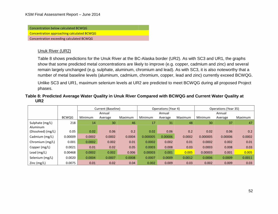
KSM Final Assessment Report – June 2014
52
Concentration below calculated BCWQG
Concentration approaching calculated BCWQG
Concentration exceeding calculated BCWQG
Unuk River (UR2)
Table 8 shows predictions for the Unuk River at the BC-Alaska border (UR2). As with SC3 and UR1, the graphs
show that some predicted metal concentrations are likely to improve (e.g. copper, cadmium and zinc) and several
remain largely unchanged (e.g. sulphate, aluminum, chromium and lead). As with SC3, it is also noteworthy that a
number of metal baseline levels (aluminum, cadmium, chromium, copper, lead and zinc) currently exceed BCWQG.
Unlike SC3 and UR1, maximum selenium levels at UR2 are predicted to meet BCWQG during all proposed Project
phases.
Table 8: Predicted Average Water Quality in Unuk River Compared with BCWQG and Current Water Quality at UR2
BCWQG
Current (Baseline) Operations (Year 4) Operations (Year 35)
Minimum Annual Average Maximum Minimum
Annual Average Maximum Minimum
Annual Average Maximum
Sulphate (mg/L) 218 14 30 46 17 31 48 30 37 47 Aluminum (Dissolved) (mg/L) 0.05 0.02 0.06 0.2 0.02 0.06 0.2 0.02 0.06 0.2
Cadmium (mg/L) 0.00009 0.0002 0.0002 0.0004 0.000005 0.00006 0.0002 0.000005 0.00006 0.0002
Chromium (mg/L) 0.001 0.0002 0.002 0.01 0.0002 0.002 0.01 0.0002 0.002 0.01
Copper (mg/L) 0.0021 0.01 0.02 0.05 0.0003 0.008 0.03 0.0003 0.008 0.03
Lead (mg/L) 0.00468 0.0002 0.002 0.006 0.00003 0.001 0.005 0.00003 0.001 0.005
Selenium (mg/L) 0.0020 0.0004 0.0007 0.0008 0.0007 0.0009 0.0012 0.0006 0.0009 0.0011
Zinc (mg/L) 0.0075 0.01 0.02 0.04 0.002 0.009 0.03 0.002 0.009 0.03
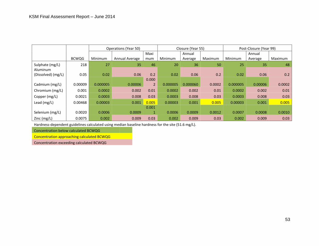
KSM Final Assessment Report – June 2014
53
Operations (Year 50) Closure (Year 55) Post-Closure (Year 99)
BCWQG Minimum Annual Average Maximum Minimum
Annual Average Maximum Minimum
Annual Average Maximum
Sulphate (mg/L) 218 27 35 46 20 36 50 25 35 48 Aluminum (Dissolved) (mg/L) 0.05 0.02 0.06 0.2 0.02 0.06 0.2 0.02 0.06 0.2
Cadmium (mg/L) 0.00009 0.000005 0.00006 0.000
2 0.000005 0.000060 0.0002 0.000005 0.00006 0.0002
Chromium (mg/L) 0.001 0.0002 0.002 0.01 0.0002 0.002 0.01 0.0002 0.002 0.01
Copper (mg/L) 0.0021 0.0003 0.008 0.03 0.0003 0.008 0.03 0.0003 0.008 0.03
Lead (mg/L) 0.00468 0.00003 0.001 0.005 0.00003 0.001 0.005 0.00003 0.001 0.005
Selenium (mg/L) 0.0020 0.0006 0.0009 0.001
1 0.0006 0.0009 0.0012 0.0007 0.0008 0.0010
Zinc (mg/L) 0.0075 0.002 0.009 0.03 0.002 0.009 0.03 0.002 0.009 0.03
Hardness-dependent guidelines calculated using median baseline hardness for the site (51.6 mg/L).
Concentration below calculated BCWQG
Concentration approaching calculated BCWQG
Concentration exceeding calculated BCWQG
KSM Final Assessment Report – June 2014
54
Predicted Water Quality in the TMF
The Proponent used a water quality model to generate predictions of TMF water quality
for all proposed Project phases. The North and South Cell ponds would store the
cumulative geochemical load from the PTMA prior to discharge. Each cell, when active,
is designed to store tailings water from the tailings stream plus surplus water from the
lined Centre Cell prior to discharge to the receiving environment.
The Application predicts that during closure and post-closure, concentrations of
parameters of concern would decrease substantially in the TMF cells, due to dilution
from surface runoff and precipitation. The Application states that improved water quality
in the North Cell by Year 30 (approximately five years after its decommissioning) would
allow discharge to North Treaty Creek by pipeline year-round and improved water
quality in the South Cell would allow discharge to North Treaty Creek year-round by
Year 57.
Tables 9, 10 and 11 show metal concentrations at three assessment points downstream
of the PTMA: the first is Treaty Creek (TRC2), downstream of the confluence with North
Treaty Creek and below an initial dilution zone where effluent from the TMF is
discharged into Treaty Creek and is considered to be fully mixed; the second is Teigen
Creek (TEC2), downstream of the confluence of South Teigen Creek; and the third is
BIR2, a point downstream of the confluence of Treaty Creek and the Bell Irving River.
BIR2 was picked to capture the influence of any discharged effluent from the proposed
Project on the Bell Irving and Nass Rivers.
The tables show predicted water quality for five time points over the life of the proposed
Project. The predicted concentrations include model refinements added during the
Application review. Predictions are compared to current water quality (annual minimum,
average, and maximum values), as well as to BCWQG. Predictions for those
parameters in the red boxes exceed BCWQG, values highlighted yellow meet BCWQG
but are within 10% of the BCWQG, and those in green boxes are less than guidelines.
Treaty Creek (TRC2)
Table 9 shows water quality predictions for Treaty Creek (TRC2). The table shows that
water quality predictions are, for the most part, unchanged as a result of the TMF for all
proposed Project phases. A number of parameters currently exceed BCWQG, cadmium
being of particular note.
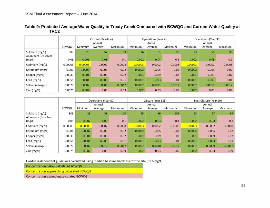
KSM Final Assessment Report – June 2014
55
Table 9: Predicted Average Water Quality in Treaty Creek Compared with BCWQG and Current Water Quality at TRC2
BCWQG
Current (Baseline) Operations (Year 4) Operations (Year 35)
Minimum Annual Average Maximum Minimum
Annual Average Maximum Minimum
Annual Average Maximum
Sulphate (mg/L) 309 23 57 99 26 61 98 23 58 98 Aluminum (Dissolved) (mg/L) 0.05 0.001 0.03 0.1 0.002 0.04 0.1 0.002 0.03 0.1
Cadmium (mg/L) 0.00003 0.00003 0.0002 0.0008 0.00003 0.0002 0.0008 0.00003 0.0002 0.0008
Chromium (mg/L) 0.001 0.0003 0.005 0.02 0.0002 0.005 0.02 0.0002 0.005 0.02
Copper (mg/L) 0.0033 0.001 0.009 0.02 0.001 0.009 0.02 0.001 0.009 0.02
Lead (mg/L) 0.0058 0.0001 0.003 0.01 0.0001 0.003 0.01 0.0001 0.003 0.01
Selenium (mg/L) 0.0020 0.0007 0.0009 0.0017 0.0007 0.0011 0.0017 0.0007 0.0010 0.0017
Zinc (mg/L) 0.0075 0.002 0.03 0.09 0.002 0.03 0.09 0.002 0.03 0.09
BCWQG
Operations (Year 50) Closure (Year 55) Post-Closure (Year 99)
Minimum Annual Average Maximum Minimum
Annual Average Maximum Minimum
Annual Average Maximum
Sulphate (mg/L) 309 23 58 100 25 59 101 23 57 99 Aluminum (Dissolved) (mg/L) 0.05 0.002 0.03 0.1 0.002 0.03 0.1 0.002 0.03 0.1
Cadmium (mg/L) 0.00003 0.00003 0.0002 0.0008 0.00003 0.0002 0.0008 0.00003 0.0002 0.0008
Chromium (mg/L) 0.001 0.0002 0.005 0.02 0.0002 0.005 0.02 0.0002 0.005 0.02
Copper (mg/L) 0.0033 0.001 0.009 0.02 0.001 0.009 0.02 0.001 0.009 0.02
Lead (mg/L) 0.0058 0.0001 0.003 0.01 0.0001 0.003 0.01 0.0001 0.003 0.01
Selenium (mg/L) 0.0020 0.0007 0.0010 0.0017 0.0007 0.0010 0.0017 0.0007 0.0009 0.0017
Zinc (mg/L) 0.0075 0.002 0.03 0.09 0.002 0.03 0.09 0.002 0.03 0.09
Hardness-dependent guidelines calculated using median baseline hardness for the site (51.6 mg/L).
Concentration below calculated BCWQG
Concentration approaching calculated BCWQG
Concentration exceeding calculated BCWQG

KSM Final Assessment Report – June 2014
56
Teigen Creek (TEC2)
Table 10 shows water quality predictions for Teigen Creek (TEC2). The table shows
that current water quality in Teigen Creek downstream of the TMF meets most BCWQG
parameters. Water quality is predicted to, for the most part, remain unchanged as a
result of the TMF for all proposed Project phases.
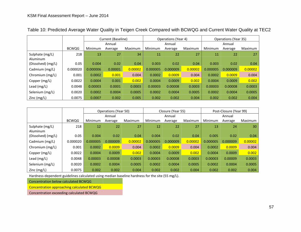
KSM Final Assessment Report – June 2014
57
Table 10: Predicted Average Water Quality in Teigen Creek Compared with BCWQG and Current Water Quality at TEC2
BCWQG
Current (Baseline) Operations (Year 4) Operations (Year 35)
Minimum Annual Average Maximum Minimum
Annual Average Maximum Minimum
Annual Average Maximum
Sulphate (mg/L) 218 13 27 34 11 22 27 11 22 27 Aluminum (Dissolved) (mg/L) 0.05 0.004 0.02 0.04 0.003 0.02 0.04 0.003 0.02 0.04
Cadmium (mg/L) 0.000020 0.000006 0.00001 0.00002 0.000005 0.000009 0.00002 0.000005 0.000009 0.00002
Chromium (mg/L) 0.001 0.0002 0.001 0.004 0.0002 0.0009 0.004 0.0002 0.0009 0.004
Copper (mg/L) 0.0022 0.0004 0.001 0.002 0.0004 0.0009 0.002 0.0004 0.0009 0.002
Lead (mg/L) 0.0048 0.00003 0.0001 0.0003 0.00003 0.00008 0.0003 0.00003 0.00008 0.0003
Selenium (mg/L) 0.0020 0.0002 0.0004 0.0005 0.0002 0.0004 0.0005 0.0002 0.0004 0.0005
Zinc (mg/L) 0.0075 0.0007 0.002 0.005 0.002 0.002 0.004 0.002 0.002 0.004
BCWQG
Operations (Year 50) Closure (Year 55) Post-Closure (Year 99)
Minimum Annual Average Maximum Minimum
Annual Average Maximum Minimum
Annual Average Maximum
Sulphate (mg/L) 218 12 22 27 12 22 27 13 24 30 Aluminum (Dissolved) (mg/L) 0.05 0.004 0.02 0.04 0.004 0.02 0.04 0.005 0.02 0.04
Cadmium (mg/L) 0.000020 0.000005 0.000009 0.00002 0.000005 0.000009 0.00002 0.000005 0.000009 0.00002
Chromium (mg/L) 0.001 0.0002 0.0009 0.004 0.0002 0.0009 0.004 0.0002 0.0009 0.004
Copper (mg/L) 0.0022 0.0004 0.0009 0.002 0.0004 0.0009 0.002 0.0004 0.0009 0.002
Lead (mg/L) 0.0048 0.00003 0.00008 0.0003 0.00003 0.00008 0.0003 0.00003 0.00009 0.0003
Selenium (mg/L) 0.0020 0.0002 0.0004 0.0005 0.0002 0.0004 0.0005 0.0002 0.0004 0.0005
Zinc (mg/L) 0.0075 0.002 0.002 0.004 0.002 0.002 0.004 0.002 0.002 0.004
Hardness-dependent guidelines calculated using median baseline hardness for the site (55 mg/L).
Concentration below calculated BCWQG
Concentration approaching calculated BCWQG
Concentration exceeding calculated BCWQG
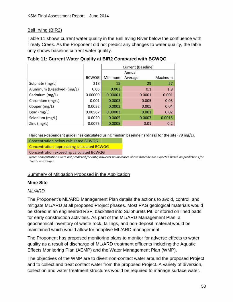
KSM Final Assessment Report – June 2014
58
Bell Irving (BIR2)
Table 11 shows current water quality in the Bell Irving River below the confluence with
Treaty Creek. As the Proponent did not predict any changes to water quality, the table
only shows baseline current water quality.
Table 11: Current Water Quality at BIR2 Compared with BCWQG
BCWQG
Current (Baseline)
Minimum Annual Average Maximum
Sulphate (mg/L) 218 15 29 57 Aluminum (Dissolved) (mg/L) 0.05 0.003 0.1 1.8 Cadmium (mg/L) 0.00009 0.00001 0.0001 0.001 Chromium (mg/L) 0.001 0.0003 0.005 0.03 Copper (mg/L) 0.0032 0.0003 0.005 0.04 Lead (mg/L) 0.00567 0.00003 0.001 0.02 Selenium (mg/L) 0.0020 0.0005 0.0007 0.0015 Zinc (mg/L) 0.0075 0.0005 0.01 0.2
Hardness-dependent guidelines calculated using median baseline hardness for the site (79 mg/L). Concentration below calculated BCWQG
Concentration approaching calculated BCWQG Concentration exceeding calculated BCWQG Note: Concentrations were not predicted for BIR2; however no increases above baseline are expected based on predictions for
Treaty and Teigen.
Summary of Mitigation Proposed in the Application
Mine Site
ML/ARD
The Proponent’s ML/ARD Management Plan details the actions to avoid, control, and
mitigate ML/ARD at all proposed Project phases. Most PAG geological materials would
be stored in an engineered RSF, backfilled into Sulphurets Pit, or stored on lined pads
for early construction activities. As part of the ML/ARD Management Plan, a
geochemical inventory of waste rock, tailings, and non-deposit material would be
maintained which would allow for adaptive ML/ARD management.
The Proponent has proposed monitoring plans to monitor for adverse effects to water
quality as a result of discharge of ML/ARD treatment effluents including the Aquatic
Effects Monitoring Plan (AEMP) and the Water Management Plan (WMP).
The objectives of the WMP are to divert non-contact water around the proposed Project
and to collect and treat contact water from the proposed Project. A variety of diversion,
collection and water treatment structures would be required to manage surface water.
KSM Final Assessment Report – June 2014
59
Selenium Management
Mitigation to address potentially elevated selenium levels in effluent includes
segregation of Kerr waste rock7, which has the potential to leach selenium, as backfill in
the mined out Sulphurets Pit, as well as a SeTP to treat drainage from the Kerr waste
rock. Waste rock from the Kerr Pit would be backfilled into the mined out Sulphurets Pit
between Years 27 and 50 and the backfilled Sulphurets Pit would be lined, dewatered
and the water routed by pipeline to the SeTP.
The Application and additional response memo describes the details of the Proponent’s
selenium management strategies which are summarized here. It is important to note
that the selenium treatment proposed in the Application is conceptual and has not been
proven at a large scale. In the Application, the Proponent proposed to commission a
SeTP at year 27 of operations. Later during the Application review stage, the Proponent
committed to commission a SeTP at the Mitchell WSF by the fifth year of operations.
Further discussion of the effectiveness and reliability of the proposed selenium
treatment is discussed in section 5.2.3.
At the SeTP the treated effluent would then be routed to the WSF for further treatment.
The Application reports that ion exchange selenium treatment is considered the most
technically feasible option, primarily due to the high water volumes that must be treated,
the terrain and climatic constraints at the Mine Site, the high removal efficiency rates
(treatment to 1 µg/L), and the relatively small sludge volumes achieved by this
technology.
The Application reports that even with these mitigation measures, total selenium
concentrations are predicted to be higher than both baseline concentrations and
BCWQG (0.002 mg/L) during all proposed Project phases in Sulphurets Creek. In the
Application, total selenium concentrations at SC3 are predicted to increase throughout
the operation phase, and to range from 0.0016 to 0.0076 mg/L. These predictions do
not consider additional mitigations proposed during the EA review and further discussed
in sections below.
The Proponent’s AEMP provides for monitoring of selenium concentrations and
adaptive management if effects on aquatic life are identified.
7 Selenium in the Kerr waste rock was a key issue during the EA because, in order to transport waste
rock from the Kerr Pit via conveyor, the rock has to be crushed to a smaller size than other waste rock, resulting in more area of the rock being exposed to oxidation and therefore increased potential for mobilization of selenium.
KSM Final Assessment Report – June 2014
60
Seepage
The Proponent proposes seepage collection measures to mitigate potential effects on
surface water quality due to seepage below and through dams at all proposed Project
phases.
At the Mine Site, a 25-m high lined rockfill seepage dam would be installed downstream
of the WSD to collect seepage from the WSF. Four seepage interception tunnels within
the abutments of the WSD would route seepage to the seepage collection dam. Two
seepage collection tunnels would be located immediately upstream of the seepage dam
grout curtain. Seepage collected in this dam would be routed directly to the WTP or the
WSF.
PTMA
The Application states seepage from the TMF would be contained by the steep
hydraulic gradients on the valley slopes. Seepage and runoff water from each tailings
dam would be collected at downstream seepage collection dams and pumped back to
the TMF. Collection sumps located upstream of the seepage dams would settle solids
transported by runoff or produced by dam construction activities. These sediments
would be transported back into the TMF.
The Application reports that the hydrogeological modeling demonstrates that the North,
Southeast, and Saddle seepage collection dams would be effective at minimizing the
seepage of contact groundwater into the receiving environment.
Mine Site and PTMA
Effluent Discharge and Monitoring
The Application states that mitigation of potential surface water quality effects linked to
effluent quality would be achieved through water treatment and scheduling discharge to
mimic the stream flow rates at all proposed Project phases. Proposed water treatment
includes temporary construction-phase water treatment plants, the Mine Site WTP, a
SeTP and reduction of metal concentrations by pH-adjustment in the Treaty Process
Plant.
The WTP would use a high-density sludge lime water treatment process. The water
treatment infrastructure includes the WTP building, lime silos, a sludge winter storage
building and a secure sludge landfill area. During construction the sludge would be
stored in the secure landfill and a winter sludge storage building. During operations, the
sludge would be dewatered, trucked to the Mitchell OPC, and transported via the MTT
to the Process Plant and eventually buried with the tailings in the TMF. After mine
closure, the sludge would be trucked to the RSFs where it would be permanently stored
in cells constructed on the RSFs surface.
The Application reports that staging discharge to mimic the stream flow rates in
KSM Final Assessment Report – June 2014
61
Sulphurets and Treaty Creeks takes advantage of natural dilution capacity, and avoids
or minimizes changes to water quality during the low-flow winter and early spring
periods.
The Proponent has committed to effluent quality monitoring as described in the AEMP.
Proponent Identification of Residual Effects on Surface Water Quality
The Proponent identified the following residual effects on surface water quality due to
ML/ARD, leaching of blasting residues, and sedimentation and erosion, taking into
account proposed mitigation measures. Below is further discussion of selenium effects
at the Mine Site and PTMA.
Mine Site
Total selenium concentrations in Sulphurets Creek are predicted to be higher
than both baseline concentrations and BCWQG (0.002 mg/L) at all proposed
Project phases.
Selenium concentrations in the Unuk River are predicted to increase throughout
the operations phase, and range from 0.001 to 0.0021 mg/L at assessment point
UR1 and 0.001 to 0.0012 mg/L at site UR2. Maximum predicted selenium
concentrations at site UR1 are predicted to exceed BCWQG during most
proposed Project phases but annual averages are predicted to meet BCWQG.
PTMA
Negligible increases in selenium concentrations in South Teigen Creek over
background were predicted during operations, closure and post-closure.
5.2.3 Project Issues and Effects and Proposed Mitigation Identified During
Application Review
During the review of the Application, additional issues were raised by the agencies,
NLG, First Nations and the public. These issues, the Proponent responses and EAO’s
assessment of the adequacy of responses are detailed in Appendix 1. The
Certified Project Description (CPD) and Table of Conditions (TOC) (Appendix 2) contain
specific mitigation measures, which would be legally enforceable if an EA Certificate is
issued.
The main themes of the issues raised included:
concerns that the conceptual WMP presented in the Application was not specific
enough to quantify the water quality effects from contact water, including runoff
and seepage from the TMF and PAG material stored in the RSFs;
concerns with water balance and water quality modelling methods and analysis,
and in particular how accurate the models were in representing baseline flow
KSM Final Assessment Report – June 2014
62
conditions and assessing potential water quality effects over the life of the
proposed Project;
concerns with the level of conservatism in the source terms used in water quality
modelling and potential for water quality to be worse than predicted, thus
requiring additional and/or earlier treatment;
concerns relating to the SeTP, uncertainty of predictions and long-term effects of
selenium in the environment; and
concerns related to the scale of the proposed Project, the natural constraints of
the topography and climatic setting, and the potential water quality effects due to
failure of designed facilities for waste rock storage and water storage,
management and treatment.
Examples of specific concerns are outlined below.
Mine Site
Selenium
A number of Working Group members raised concerns about the feasibility and
resulting uncertainty related to the proposed selenium treatment method, noting the
proposed selenium treatment systems are not currently proven at the scale required
for the proposed Project and are presented as largely conceptual systems. BC
Ministry of Energy and Mines (MEM) required detailed information from the
Proponent on the design of the system to demonstrate treatment can be effectively,
reliably and economically achieved for the proposed Project.
o In response, the Proponent provided additional details regarding the
selenium treatment method and pilot tests. They noted that initial research
work has been completed and that a full-scale pilot plant was in the process
of being constructed for a southeast coal project. The Proponent asserts that
ion exchange is proven technology for removal of selenium.
o The Proponent submitted a draft Selenium Management Plan (SeMP) with
the goal of better understanding potential risks that selenium may pose to
the aquatic receiving environment. It was prepared as a proactive approach
to identifying selenium as a potential concern, and to address specific
comments received during the EA.
NLG provided numerous comments on the draft SeMP, including the statement
that substantially more work is required to demonstrate that releases of selenium
from the proposed Project will not have residual effects.
o The Proponent committed to the implementation of a comprehensive
monitoring program (water, sediment, tissue metals) in the receiving
environment downstream of the TMF and the development of a food chain
KSM Final Assessment Report – June 2014
63
model in order to better understand the movement and uptake of selenium
by biota in the aquatic environment.
MEM stated that the ion exchange selenium treatment system remains unproven.
MEM requires a preliminary engineering design of the system to assess its
technical and economic feasibility. To complete this preliminary engineering,
performance data from a pilot study or similar full-scale operations were
considered necessary.
Proponent Response to Selenium Concerns
During the latter stage of the EA, the Proponent proposed specific new conditions to
address selenium treatment concerns, which included:
the Proponent will operate and complete a pilot plant evaluation of the selenium
treatment approach using local Mitchell Creek water modified to represent expected
conditions for the Mitchell/McTagg RSF seepage within one year of the issuance of
an EA Certificate. A report describing the results of the pilot evaluation must be
submitted to MEM, EAO and the BC Ministry of Environment (MOE) within 12
months of completion of the evaluation;
the Proponent must construct a seepage water collection system at the base of the
McTagg/Mitchell RSF;
the Proponent must, by the fifth year of operations, construct and commission a
SeTP at the Mitchell WSF. The plant must have a capacity of 500 litres per second
(L/s) and be capable of treating water collected from both the McTagg/Mitchell RSF
and from Sulphurets and Kerr pits as a contingency to manage selenium levels that
might be higher than expected; and
The Proponent will pay the University of British Columbia at least $36,500, on March
1 of each year during the 2015-2017 years, to support a research program at the
University of British Columbia to investigate potential methods to treat selenium
using conventional high-density sludge technology.
The Proponent provided new water quality models for selenium at SC3, UR1 and UR2
with the additional selenium treatment in year five of operations (as represented by 500
L/s in the table below) and compared these values against the baseline and expected
case, as provided in the Application. The tables show that with additional selenium
mitigation, predicted selenium concentrations would exceed BCWQG at SC3 and meet
BCWQG at UR1 and UR2 during operations, closure and post-closure.
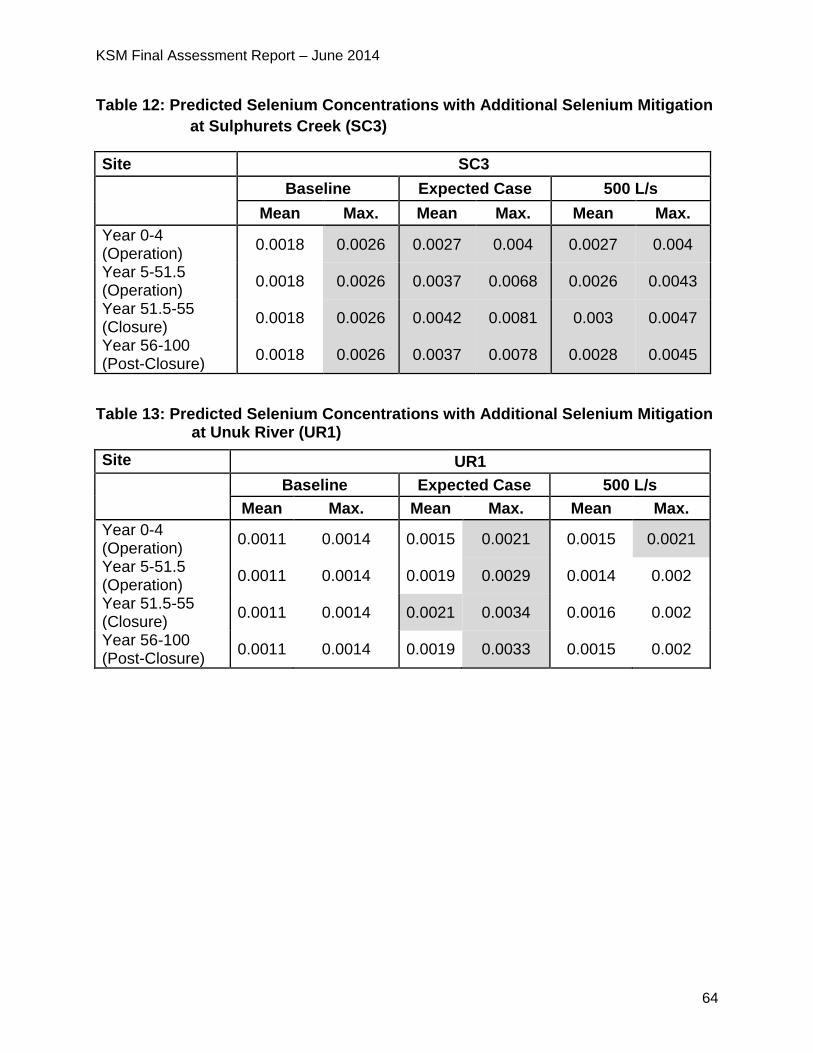
KSM Final Assessment Report – June 2014
64
Table 12: Predicted Selenium Concentrations with Additional Selenium Mitigation
at Sulphurets Creek (SC3)
Site SC3
Baseline Expected Case 500 L/s
Mean Max. Mean Max. Mean Max.
Year 0-4 (Operation)
0.0018 0.0026 0.0027 0.004 0.0027 0.004
Year 5-51.5 (Operation)
0.0018 0.0026 0.0037 0.0068 0.0026 0.0043
Year 51.5-55 (Closure)
0.0018 0.0026 0.0042 0.0081 0.003 0.0047
Year 56-100 (Post-Closure)
0.0018 0.0026 0.0037 0.0078 0.0028 0.0045
Table 13: Predicted Selenium Concentrations with Additional Selenium Mitigation at Unuk River (UR1)
Site UR1
Baseline Expected Case 500 L/s
Mean Max. Mean Max. Mean Max.
Year 0-4 (Operation)
0.0011 0.0014 0.0015 0.0021 0.0015 0.0021
Year 5-51.5 (Operation)
0.0011 0.0014 0.0019 0.0029 0.0014 0.002
Year 51.5-55 (Closure)
0.0011 0.0014 0.0021 0.0034 0.0016 0.002
Year 56-100 (Post-Closure)
0.0011 0.0014 0.0019 0.0033 0.0015 0.002
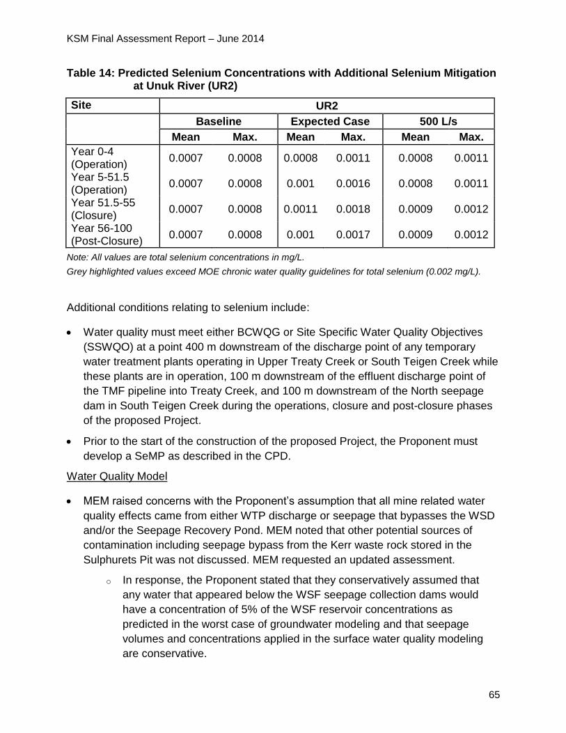
KSM Final Assessment Report – June 2014
65
Table 14: Predicted Selenium Concentrations with Additional Selenium Mitigation at Unuk River (UR2)
Site UR2
Baseline Expected Case 500 L/s
Mean Max. Mean Max. Mean Max.
Year 0-4 (Operation)
0.0007 0.0008 0.0008 0.0011 0.0008 0.0011
Year 5-51.5 (Operation)
0.0007 0.0008 0.001 0.0016 0.0008 0.0011
Year 51.5-55 (Closure)
0.0007 0.0008 0.0011 0.0018 0.0009 0.0012
Year 56-100 (Post-Closure)
0.0007 0.0008 0.001 0.0017 0.0009 0.0012
Note: All values are total selenium concentrations in mg/L.
Grey highlighted values exceed MOE chronic water quality guidelines for total selenium (0.002 mg/L).
Additional conditions relating to selenium include:
Water quality must meet either BCWQG or Site Specific Water Quality Objectives
(SSWQO) at a point 400 m downstream of the discharge point of any temporary
water treatment plants operating in Upper Treaty Creek or South Teigen Creek while
these plants are in operation, 100 m downstream of the effluent discharge point of
the TMF pipeline into Treaty Creek, and 100 m downstream of the North seepage
dam in South Teigen Creek during the operations, closure and post-closure phases
of the proposed Project.
Prior to the start of the construction of the proposed Project, the Proponent must
develop a SeMP as described in the CPD.
Water Quality Model
MEM raised concerns with the Proponent’s assumption that all mine related water
quality effects came from either WTP discharge or seepage that bypasses the WSD
and/or the Seepage Recovery Pond. MEM noted that other potential sources of
contamination including seepage bypass from the Kerr waste rock stored in the
Sulphurets Pit was not discussed. MEM requested an updated assessment.
o In response, the Proponent stated that they conservatively assumed that
any water that appeared below the WSF seepage collection dams would
have a concentration of 5% of the WSF reservoir concentrations as
predicted in the worst case of groundwater modeling and that seepage
volumes and concentrations applied in the surface water quality modeling
are conservative.
KSM Final Assessment Report – June 2014
66
o As discussed in section 5.4.3, the Proponent also submitted an additional
memo regarding the WSF Seepage Management and Monitoring Plan. The
memo provides a more expansive list of the potential seepage mitigation
measures which could be used to further reduce seepage from the water
storage facility.
o The Proponent indicated that seepage bypass from the Sulphurets Pit
Backfill (above the treatment capacity of the SeTP proposed in the
Application) was included in the expected case water quality model.
After reviewing the Proponent’s response, MEM noted that the predicted
seepage quantity from the WSF are at the limit of the groundwater flow model’s
precision. Since this aspect of the water quality modelling is so critical to the
overall assessment of downstream water quality effects, MEM requested a
technical memo which explained the rationale used for the WSF seepage water
quality model. MEM also requested an updated sensitivity analysis on seepage
rates from the WSF and the predicted concentrations at SC3 and downstream in
the Unuk River if seepage was higher than predicted.
o The Proponent conducted the requested additional sensitivity analysis which
showed that potential effects to the downstream environment do not
substantively change from conclusions derived from the expected case
model in the Application.
MEM and MOE were concerned that the Proponent’s assumptions regarding
seepage collection at the base of the Mitchell and McTagg RSFs were optimistic.
o In response, the Proponent conducted a Selenium Seepage Concept Study
that showed that seepage collection at the base of the RSFs is possible.
MEM stated that the design is highly conceptual and additional information would
be required to evaluate the feasibility of this concept. MEM is prepared to defer
this issue to permitting. However, MEM stated that the successful construction
and long-term operation of the seepage collection system is key to the
conclusions of the effects assessment.
MOE stated concerns with the proposed potential selenium treatment rates being
able to handle the estimated infiltration through the RSFs during the winter low-
flow months that would need to be addressed during permitting.
MEM and MOE were concerned about the Proponent’s assumption that water to be
diverted from under the Mitchell glacier, which was simulated using a mixture of
McTagg (without significant mineralization) and mineralized Mitchell Valley seeps,
would not be representative. Higher concentrations in diverted water could lead to
degradation of water quality in Sulphurets Creek. The Proponent proposes to divert
KSM Final Assessment Report – June 2014
67
non-contact water from under the Mitchell Glacier and surrounding areas located
upstream of the proposed Mitchell Open Pit and Block Cave Mine into Sulphurets
Creek via a tunnel.
o In response to this concern, EAO added a condition that the Proponent must
determine, and MOE and MEM must approve the sub-glacial water quality of
the Mitchell glacier before construction.
Reviewers raised concerns with the hazard quotient approach used by the
Proponent, specifically the methodology used to “screen” and therefore not assess
certain parameters.
o In response the Proponent submitted a detailed memorandum regarding the
derivation and application of hazard quotients for predicted water quality
parameters for the proposed Project and model uncertainties. In order to
address comments requesting comparison of like terms (i.e. mean to mean,
or maximum to maximum), the Proponent used an alternative screening
process that considered both BCWQG and existing baseline water quality
conditions. The Proponent found that the conclusions made in the
Application remained unchanged despite this alternative screening process.
After reviewing the memorandum, NLG raised concerns over the benchmarks
used to calculate hazard quotients used by the Proponent, stating the definition
of baseline was not conservative.
o In response, the Proponent recalculated the benchmarks using the approach
recommended by NLG (i.e. use of 95% upper confidence of the mean) and
found that the approach used by the Proponent in the memo was more
conservative; the approach recommended by NLG would not have changed
the screening results.
MOE reviewed the concerns expressed by other reviewers as well as the
Proponent response and questioned the Proponent’s use of the chosen
screening process, stating that it is not intended for an EA
Contaminants/chemicals of Potential Concern (COPC) screening tool.
EC commented that the methods used to assess sub-lethal toxicity to salmonids,
along with the results presented in the Application, are acceptable and consistent
with expectations set out in the AIR.
o EAO re-reviewed the information presented in the Application, the
subsequent December 19, 2013 memo from the Proponent on hazard
quotient methods, additional information from the Proponent on the baseline
and predicted concentrations of COPCs which were screened out using the
alternative screening method, and Working Group comments. As a result of
KSM Final Assessment Report – June 2014
68
this re-review, EAO concluded that the Proponent’s decision to not carry
these COPCs into the effects assessment was appropriate at the EA level.
EAO recognizes that additional information may be required by MOE at the
Environmental Management Act permitting stage with respect to this issue
should an EA Certificate be issued for the proposed Project.
A number of reviewers raised concerns with both the assumptions and source
terms8 used in the Proponent’s water quality model. Specifically they were
concerned about implications for long-term water treatment and increased
uncertainties related to water quality effects. More specifically:
o MEM was concerned with the Proponent’s relatively small data set used to
characterize the geochemical properties of very large volumes of mine
waste rock. MEM required the Proponent to conduct additional sampling in
the portions of the mine where significant quantities of undefined waste
rock occur due to limited drilling samples. In the absence of this, MEM
requested additional sensitivity analysis for water quality effects.
o MEM noted concerns that geochemical loading from the Mitchell Pit walls
was not included as a source of loading to the water storage facility. This
may have resulted in lower predicted concentrations for the pit lake water
than included in the water quality model.
o MEM was concerned that nitrogen loadings from blasting materials
predicted by the water quality model are not considered conservative and
loads would be expected to be up to a factor of two times greater than
predicted by the current model. MEM asked that the water quality model
be re-run with more appropriate nitrogen source terms.
o MOE and MEM also raised concerns about the assumptions the
Proponent made regarding the internal temperature of the waste RSF and
the resulting effects to seepage water quality. Both agencies felt the
numbers were not conservative enough and that these uncertainties have
implications for water treatment. If the waste rock temperatures were
elevated, resulting in higher than predicted levels of acidity or the selenium
was underestimated in the source terms, water quality could be worse
than predicted, which could result in selenium treatment being required
sooner than year 27 and/or additional conventional water treatment
facilities being constructed.
8 “Source terms” represent the amount and rate of a contaminant released to the environment from a
specific proposed Project component over a specific period of time.
KSM Final Assessment Report – June 2014
69
o In response to the above noted concerns raised by MOE and MEM, the
Proponent responded with sensitivity analyses of the following water quality
model assumptions:
o increased source terms for Mitchell waste rock units MEM identified
as needing further characterization;
o addition of Mitchell Pit walls at closure (Mitchell Pit walls during
operation were already included in the expected case water quality
model); and
o increased nitrogen source terms.
o The results of the sensitivity analyses did not change the conclusions of the
water quality effects assessment at stations downstream of the WSF.
o The Proponent responded to MOE with a sensitivity analysis of three internal
RSF temperatures used in the water quality model to determine downstream
effects. The higher temperatures meant increased concentrations of
elements in the WSF but they noted that the proposed water treatment plant
controls the concentrations of most elements prior to discharge to the
receiving environment.
MEM and MOE requested additional sensitivity analysis to assess the risk to
downstream water quality from uncertainty associated with the predicted source
terms and scaling factors.
o The Proponent completed additional analysis for MEM using an RSF internal
temperature of 25°C and 35°C. They noted the results showed little variation
in the predicted water quality in the downstream environment with varying
temperature. The Proponent’s additional analysis showed the potential
effects to the downstream environment do not substantively change from
conclusions derived from the expected case model in the Application and
other sensitivity analysis completed during the EA. This highlighted the
importance of maximum concentration solubility controls used in the water
quality modeling.
MEM raised concerns with the potential for nitrogen loading from waste rock to affect
water quality, stating that the Proponent did not use appropriate nitrogen source
terms in their water quality model.
o In response, the Proponent conducted additional sensitivity analysis that
showed that increasing nitrate loading from waste rock by a factor of two
increases predicted maximum nitrate concentrations and nitrogen loadings
to the WSF by a factor of two. Based on the updated water quality
predictions, mean nitrate concentrations are expected to be below the
KSM Final Assessment Report – June 2014
70
chronic 30-day BCWQG at SC3 and maximum predicted nitrate
concentrations are expected to be below the acute maximum BCWQG at
SC3.
MEM concluded that careful management of explosives and a nitrate
management plan (required through a Mines Act permit and EA condition) will be
needed during operations to minimize nitrate release.
Some reviewers raised concerns with the Proponent’s assumption of optimal
operations of all mitigation measures, noting that the Proponent did not conduct
an analysis of upset conditions. MOE asked for a model scenario showing an
upset condition (e.g. surface diversion failure during a 1:200 wet year) for the
WSF and related water treatment systems.
o The Proponent submitted a memorandum providing an example of an upset
condition and water quality predictions. The Proponent notes that when
considering the mitigation and management measures that would be in
place during the various phases of the proposed Project, it is unlikely that
this upset condition would occur. The result of this scenario showed that the
maximum modelled copper and selenium concentrations would exceed
BCWQG at SC3, UR1 and UR2.
Reviewers also noted concerns about the effectiveness of water management
structures that would move water from the Sulphurets Creek valley to the WSF.
The concerns centered on the effects of a worst case scenario event involving
the spill of untreated water. They noted that the Proponent’s model assumes that
water collection structures are 100% effective.
o The Proponent stated that the model included efficiencies less than 100%
for water diversion structures.
o The Proponent also increased the size of the pipeline which moves water
collected from the mined-out Kerr open pit to the WSF to withstand and
operate during a 1-in-200 year peak flow event during the operations,
closure and post closure phases of the proposed Project. EAO added this as
a condition in the CPD.
Long-Term Risks
A number of reviewers raised concerns with the long-term water management
aspects of the proposed Project. Gitanyow raised concerns with the potential for
long-term risks due to the cost of, and the operation and maintenance of, the water
treatment systems in perpetuity. Gitanyow was particularly concerned about the
adequacy of security funds and bonding to implement the closure and post-closure
requirements.
KSM Final Assessment Report – June 2014
71
o The Proponent responded that it is the responsibility of the Chief Inspector
of Mines at MEM to set the amount and form of the security for mine
reclamation, and to provide protection of, and mitigation of damage to,
watercourses and cultural heritage resources affected by the mine. The
security would be based on the activities required post-closure and will
include the operation of the water treatment plant and monitoring.
o The Proponent also stated that the WTP would have seven stand alone,
parallel plants that would be available if there is a failure in one of them and
the WTP design includes redundancies so it is unlikely that all systems
would be compromised long-term. There is also buffer capacity in the WSF
in the event that the WTP has to be stopped momentarily.
MEM recognized that the scale of the proposed Project’s long-term water
treatment liabilities is large and would be considered when bonding requirements
are establish at permitting.
PTMA
Water Quality
MEM, NLG and Tahltan raised concerns with the Proponent’s estimates of chemical
loading to South Teigen Creek. NLG was concerned that the Proponent’s water
quality model did not account for some of the source load that leaves the TMF.
Tahltan and MOE also raised concerns with potential selenium loadings to Treaty
Creek and impacts to water and sediment quality in Treaty Creek and Bell-Irving
River.
o In response, the Proponent presented a model showing groundwater flow
pathways and plumes from the TMF area groundwater model built for the
EA. The modeling results indicate that the seepage from all the tailings cells
will be physically and hydraulically contained in the west and the east by the
steep valley slopes. In the north, however, the transport modeling results
indicate that some contact groundwater (as diluted seepage) in low
concentrations (0.1-4% of the flotation tailings) could potentially discharge
into South Teigen Creek within about 50 m beyond the north seepage
collection dam.
o EAO added the following two conditions to address this concern:
o water quality must meet either BCWQG or SSWQO at a point 100 m
downstream of the effluent discharge point on Treaty Creek and
100 m downstream of the last point of control on South Teigen Creek;
and

KSM Final Assessment Report – June 2014
72
o the proposed Project must be designed to enable the addition of
collection infrastructure and treatment facilities that could be used to
treat discharge from the TMF including seepage if monitoring
indicates that additional measures are required to meet the above
condition or the requirements set out in the Environmental
Management Act or Mines Act permits.
NLG raised concerns about the proposed 800 m long mixing zone in Treaty Creek
downstream from the point of tailings pond discharge and the potential effect of
concentrated discharge water in localized areas along the mixing zone. NLG
suggested treatment of tailings pond water prior to discharge to Treaty Creek as a
mitigation option.
MOE also raised concerns with the proposed 800 m long mixing zone in Treaty
Creek. MOE policy for initial dilution zone characterization indicates that the
location of guideline or objective attainment may extend up to 100 m from the
source of effluent discharge. Acute toxicity to aquatic organisms must not occur
within the initial dilution zone and chronic toxicity to aquatic organisms cannot
occur at the edge of the initial dilution zone.
o In response the Proponent committed to an engineered solution to shorten
the distance of the mixing zone to a maximum length of 100 m.
o In addition, the Proponent committed to, and EAO required through a new
condition, that water quality must meet either BCWQG or SSWQO at a point
400 m downstream of the discharge point of any temporary water treatment
plants operating in Upper Treaty Creek or South Teigen Creek, while these
plants are in operation, 100 m downstream of the effluent discharge point of
the TMF pipeline into Treaty Creek and 100 m downstream of the North
seepage dam in South Teigen Creek during the operations, closure and
post-closure phases of the proposed Project.
MOE raised concerns with the condition to meet BCWQG or SSWQO within
100 m downstream, stating that the condition will likely be difficult to meet. The
requirement for a 100 m initial dilution zone could require extensive engineering
of the stream channels to meet the objective, which could in turn, potentially have
unforeseen impacts on fish habitat. MOE stated that the issue of identifying the
end of initial dilution zones is generally determined during permitting on a case
by case basis. MOE stated that there are other elements of this condition that are
not consistent with MOE policy regarding the use of SSWQO. SSWQO are not
likely the best tool to use, rather Science Based Environmental Benchmarks are
the preferred method.
MEM raised concerns with the uncertainty associated with the predicted rate of
KSM Final Assessment Report – June 2014
73
seepage from the TMF and the assumption that all seepage is captured by the
seepage dams. MEM requested that a sensitivity analysis be conducted on
downstream water quality effects and mitigation planning be updated where
required.
o The Proponent’s conducted the sensitivity analysis which showed that the
potential effects to the downstream environment do not substantively change
from conclusions derived from the expected case model in the Application.
In response to concerns about seepage and water discharged from the TMF,
NLG recommended the following condition for the EA Certificate, which EAO
included:
o water quality must meet either BCWQG or SSWQO at a point 400 m
downstream of the discharge point of any temporary water treatment plants
operating in Upper Treaty Creek or South Teigen Creek, while these plants
are in operation, and 100 m downstream of the effluent discharge point of
the TMF pipeline into Treaty Creek and 100 m downstream of the North
seepage dam in South Teigen Creek during the operations, closure and
post-closure phases of the proposed Project.
MEM was concerned that the Proponent did not assess the potential effects of
tailings porewater9 on seepage. MEM noted that tailings porewater can be a major
contributor to TMF seepage.
NLG was also concerned that the potential effect of WTP sludge on tailings
porewater concentrations was not incorporated into the PTMA water quality
model.
o In response the Proponent responded that tailings porewater was modelled
as equivalent to the overlying pondwater.
o The Proponent’s additional analysis results indicate that an appropriate
source term was included in the water quality model and that the potential
effects to the receiving environment are not substantively sensitive to the
seepage rate under the North Main Dam or the porewater source terms.
NLG was not satisfied with the Proponent’s additional analysis and
recommended that more conservative source concentrations be used in the
modelling. NLG recommended that the seepage water quality be the greater of
the process water, tailings pond water quality and the saturated column leachate
water quality for each COPC.
9 the water occupying the spaces between tailings particles
KSM Final Assessment Report – June 2014
74
o In response, the Proponent conducted additional sensitivity analyses for
seepage bypassing the North seepage recovery dam. In these sensitivities,
the concentration of the bypass seepage water was modelled as 100% of
the maximum concentration observed in the rougher tailings subaqueous
columns. These additional model runs indicate that the water quality in
South Teigen Creek is not substantially sensitive to the tailings porewater
concentration or the flow rates.
Mine Site and PTMA
Dam Breach or Failure
Working Group members including MEM, NLG, Tahltan First Nation and Gitanyow
Nation raised concerns about the potential effects of a catastrophic failure including
a dam breach or failure and the significant environmental impacts to water quality
and fish habitat and the persistence of these effects.
o In response, the Proponent submitted a detailed report entitled, Dam
Failures Effects Assessment. The report reviewed the types of effects on key
VCs in the event of a dam failure. Two dam failure modes (a “rainy-day”
event which assumed water going over the top of the dam and a “sunny-day”
event which assumed a slump) and ten scenarios (e.g. August, December,
low flow, high flow) were examined for effects on flow and inundation, water
quality, sedimentation, fish and aquatic habitat, and indirect effects on the
current use of lands and resources for traditional purposes. Four dams (i.e.
the North, Splitter, Saddle, and Southeast dams) in the TMF of the PTMA,
and the WSD for the WSF in the Mine Site were investigated. Dam failures
scenarios were conducted in accordance with industry standard methods as
identified in the Canadian Dam Association (CDA) Dam Safety Guidelines
(the Guidelines; CDA 2007) for dam failure and inundation studies.
o The Proponent states that in view of the mitigations and design processes
presented in the Dam Failures Effects Assessment Report that show the
extremely low likelihood of failure, it can be seen that the hypothetical failure
scenarios examined in the dam failure effects assessments of piping and
flood overtopping dam failures do not correspond to reasonably conceivable
events.
o Although unlikely, the Proponent reviewed the types of effects on key VCs in
the event of dam failure. Potential dam failure scenarios in the PTMA would
result in rapid transport of water and tailings to downstream reaches. The
release would follow existing stream transport and deposition mechanisms
and be catastrophic due to the volume and rapid timeframe of the release. A
failure of the WSD would involve the flooding and inundation of Mitchell
KSM Final Assessment Report – June 2014
75
Creek, Sulphurets Creek, and Unuk River with untreated water. Short-term
exceedances of water quality guidelines were predicted in the Bell-Irving,
Nass, and Unuk rivers.
o Changes in sediment quality could lead to changes in the suitability of
the aquatic habitat for fish and other organisms, and could affect the
health of organisms that live in close association to the sediment (e.g.
benthic fish or invertebrates).
o Generally, the deposition or slumping of tailings would not lead to
substantial changes in the concentration of most metals in sediments
downstream of the North Dam or Southeast Dam. Degradation of water
quality would not persist for long after the initial flood event. Any long-
term effects following a failure of the North Dam or Southeast Dam
would be more likely linked to loss or alteration of habitat rather than
metal toxicity in aquatic organisms.
o It is likely that some mortality of fish or other aquatic life may occur due
to acute toxicity if the Saddle Dam were to fail, although this would be
tempered somewhat by the relatively short exposure duration of the
tailings water.
o The Proponent predicts that it is unlikely that human health would be
affected from effects to drinking water in the event of a dam failure. Any
effects would be short-term and reversible.
5.2.4 Residual Effects and Significance Analysis
Mine Site
Residual surface water quality effects are predicted from the following sources:
effluent discharge from the WTP;
seepage of untreated water from the WSF;
leaching of blasting residues (e.g. pre-production ore stockpiles, waste rock,
Sulphurets Pit) causing nitrogen loading;
sedimentation and erosion of soils and overburden materials;
leaching of blasting residues along the CCAR causing nitrogen loading; and
ML/ARD along the CCAR and areas outside of the WSF catchment.
The proposed Mine Site has the potential to change surface water quality in Sulphurets
Creek, which drains into the Unuk River. For some parameters, water quality is
predicted to improve as a result of water treatment (e.g. cadmium, copper and zinc) or
KSM Final Assessment Report – June 2014
76
remain similar to baseline (e.g. dissolved aluminum), but other parameters are predicted
to increase in concentration (e.g. selenium). Residual effects are from effluent discharge
from the Mine Site WTP with predicted selenium concentrations at SC3 above BCWQG
during the operation, closure and post-closure phases of the proposed Project.
Total selenium concentrations at assessment point SC3 are predicted to be higher than
both baseline concentrations and BCWQG (0.002 mg/L) at all proposed Project phases.
Selenium concentrations at assessment point UR2 were predicted to stay below
BCWQG throughout all proposed Project phases, and no residual effects are predicted
for water quality in the Unuk River in Alaska.
The residual effects along the CCAR are represented below in the significance analysis
along with the residual effects along the TCAR as the effects are the same along the
access roads. These effects include sedimentation and erosion, leaching of blasting
residues causing nitrogen loading and ML/ARD.
PTMA
The proposed PTMA has the potential to degrade water quality in North Treaty, South
Teigen, Treaty, and Teigen Creeks, which drain into the Bell-Irving River.
Residual surface water quality effects are predicted linked to:
effluent discharge from the TMF;
sedimentation and erosion of soils and overburden materials;
leaching of blasting residues along the TCAR causing nitrogen loading; and
ML/ARD along the TCAR and areas outside of the TMF catchment.
While selenium concentrations were occasionally greater than baseline concentrations
during operation, closure and post-closure, no concentrations were predicted that would
exceed BCWQG in North Treaty, Treaty and South Teigen Creeks.
EAO added a condition requiring water quality to meet either BCWQG or SSWQO at a
point 100 m downstream of the effluent discharge point on Treaty Creek and 100 m
downstream of the last point of control on South Teigen Creek. The Proponent’s water
quality models for both Teigen and Treaty Creeks show this condition can be met. EAO
notes that predicted water quality at those points meets BCWQG and, for most
parameters, is within the natural range of variability (i.e. less than the 95th percentile of
baseline conditions). Considering both of these points are more than 10 km upstream of
their confluence with the Bell-Irving River, and there is significant dilution in both Treaty
and Teigen Creeks, there would be no residual effect on surface water quality in the
Bell-Irving River.
KSM Final Assessment Report – June 2014
77
The residual effects of the TCAR and CCAR are represented below in the significance
analysis, as the effects are the same for both access roads. These effects include
sedimentation and erosion, leaching of blasting residues causing nitrogen loading and
ML/ARD.
EAO has undertaken the following significance analysis on the residual adverse effects
on surface water quality.
Table 15: EAO's Significance Analysis for Surface Water Quality
Factor Rationale
Context Mine Site
At (and downstream of) the Mine Site, metal leaching due to current
naturally-occurring ARD has led to total and dissolved metal
concentrations in Mitchell and Sulphurets Creeks that are frequently
higher than levels set in BCWQG for the protection of freshwater
aquatic life. These streams have a poor productive capacity.
No fish are located in Mitchell or Sulphurets Creeks upstream of the
cascades on Sulphurets Creek. A small section of Sulphurets Creek
between the cascade and the Unuk River has some resident Dolly
Varden.
The Unuk River crosses the BC-Alaska Border 35 km downstream
of the proposed Mine Site. The Unuk River supports all five Pacific
salmon species and oolichan making it an important sustenance
and commercial fishery river to BC First Nations and federally
recognized Tribes in Alaska.
PTMA
Treaty Creek water quality reflects sediment loading from glacial
melt and mineralization in the upper reaches. Cadmium, chromium,
copper, iron and zinc frequently exceed BCWQG in Treaty Creek.
Streams located adjacent to the PTMA generally have higher
productive capacity than those at the Mine Site. Whereas
Sulphurets Creek has poor existing water quality and a significant
fish barrier located far downstream from the Mine Site, Treaty and
Teigen Creeks have populations of a number of salmon species and
resident Dolly Varden. North Treaty and South Teigen fish
populations are limited to Dolly Varden. These creeks in turn drain
KSM Final Assessment Report – June 2014
78
into the Bell-Irving River, which in turn drains into the Nass River.
The Nass and Bell-Irving Rivers support extremely important
populations of oolichan (located primarily close to the mouth of the
River and not significantly upstream of Fishery Bay), all five species
of Pacific salmon and other salmonids, such as steelhead and trout.
Access to healthy populations of these fish are a treaty right of
Nisga’a Nation and support aboriginal rights fisheries for other First
Nations such as the Tahltan, Gitxsan and Gitanyow Nations. These
fish also contribute to valuable commercial fisheries.
Magnitude Mine Site
Selenium
Modeled selenium concentrations would exceed BCWQG for the
protection of freshwater aquatic life in lower Sulphurets Creek, but
would meet BCWQG at UR1. These effects are predicted to occur
during the operation, closure and post-closure phases. This residual
effect is of moderate magnitude, since selenium levels in the lower
Sulphurets and in a small portion of the Unuk would exceed both
baseline levels and guideline levels. The change in this area is also
beyond the range of natural variation.
Selenium levels are predicted to meet BCWQG in the Unuk River
and at the BC-Alaska Border, 35 km downstream of the proposed
Mine Site, hence the magnitude is rated low at this point.
Other Metals
Other metals, such as copper, lead, cadmium and zinc are
predicted to improve in Sulphurets Creek and the Unuk River due to
proposed water treatment and the elevated baseline metal levels.
PTMA
With the condition that water quality must meet either BCWQG or
SSWQO at a point 400 m downstream of the discharge point of any
temporary water treatment plants operating in Upper Treaty Creek
or South Teigen Creek, while these plants are in operation, and
100 m downstream of the effluent discharge point of the TMF
pipeline into Treaty Creek, and 100 m downstream of the North
seepage dam in South Teigen Creek during the operations, closure
KSM Final Assessment Report – June 2014
79
and post closure phases of the proposed Project, the magnitude of
the surface water quality effect in these creeks is considered low.
The low magnitude rating takes into account that while there are
some minor changes in water quality relative to baseline, the
predicted water quality is below BCWQG which would, by definition,
be protective of the aquatic environment.
Any effects on the Bell-Irving River or Nass River are predicted to
be negligible.
Effects along Access Road Corridors
The magnitude of residual sedimentation effects is rated moderate,
since total suspended solids levels are likely to exceed water quality
guidelines as well as the range of natural variation during periods of
construction.
The magnitude of ML/ARD and blasting residual effects is rated low
to moderate depending on the drainage, because, while detectable
relative to baseline conditions, these effects are likely to be within
the range of natural variation and/or be below water quality
guidelines. No concentrations that exceed baseline or guideline
levels are predicted for the receiving environment downstream of
the proposed PTMA.
Extent Mine Site
The geographic extent of residual effects of changes to water
quality is landscape, although there are some minimal effects
detectable downstream of LSA boundaries. In particular, maximum
selenium levels in the Unuk River at the BC-Alaska border, 35 km
from the Mine Site are predicted to meet BCWQG during all
proposed Project phases.
PTMA
The extent of the effect is landscape because it will be confined to
the LSA and effects are not expected to occur downstream in
Teigen and Treaty Creeks and in the Bell-Irving and Nass Rivers.
Effects along Access Road Corridors
The extent of sedimentation effects is landscape as increased total
KSM Final Assessment Report – June 2014
80
suspended solids is likely to be confined to the LSA.
All other residual water quality effects along road corridors are rated
of landscape extent. Nitrogen loading along access road corridors
will be confined to the LSA.
Duration Mine Site
The duration of water quality effects is far future (i.e. in perpetuity)
as effluent discharge from the Mine Site is proposed from the
construction phase into the post-closure phase. The effects come
with both initial release of metal and non-metal water quality
parameters and with the longer term onset of ML/ARD. These
effects would require long-term water treatment as a key mitigation.
PTMA
The duration of the effect is long-term, slowly improving after mining
operations cease until such time (the prediction is within a decade)
that water from the TMF meets water quality discharge
requirements and can be discharged without treatment.
Effects along Access Road Corridors
Sedimentation effects and water quality effects along access road
corridors are rated of short duration. These effects are expected to
occur primarily during construction.
Reversibility Mine Site
Water quality effects are expected to occur into the far future. EAO
notes that natural ML and ARD processes do account for a
significant portion of the elevated metals and elements in areas
around the Mine Site.
Discharges from both conventional high density sludge water
treatment and selenium treatment are expected to be required into
the far future. Given the time frames involved and the scale of
disturbance, effects on the mine side should be considered
irreversible.
PTMA
Any water quality effects of TMF discharge would begin to diminish
KSM Final Assessment Report – June 2014
81
within several decades after the end of mining and milling
operations and are expected to stabilize at some point in the future
due to increased dilution from precipitation and removal of diversion
structures in the TMF.
Diminished water quality would still be present from TMF seepage
and water management may be required over the long-term to
ensure water quality in the receiving environment is not affected.
Water quality effects are considered reversible in the long term.
Effects along Access Road Corridors
Sedimentation effects and water quality effects along access road
corridors are considered reversible in the short term through the
implementation of the Proponent’s sediment control measures.
KSM Final Assessment Report – June 2014
82
Frequency Mine Site
Water quality effects would be generated from the WTP effluent
being discharged into the Mitchell Creek, which drains into
Sulphurets Creek. Water quality effects downstream of the
proposed Mine Site would be continuous lasting through post-
closure.
PTMA
The frequency is continuous within the initial dilution zone in Treaty
Creek, but water is expected to be sufficiently diluted that effects
beyond that point are negligible. Water quality effects from any
seepage which bypasses seepage collection facilities would also be
continuous, as this seepage is expected to be diluted by
groundwater. This is expected to be the case throughout operations,
closure and post closure.
Effects along Access Road Corridors
Effects along access road corridors due to sedimentation are
sporadic and intermittent and would primarily be related to high
precipitation events and periods of peak disturbance.
Likelihood
Mine Site
Likelihood is rated high for water quality degradation effects. However, given that
predicted water concentrations are close to BCWQG and in recognition that further work
will be required during the joint Environmental Management Act and Mines Act
permitting process, as well as the Proponent’s commitment to implement a
comprehensive AEMP, a SeMP and water treatment, EAO considers the likelihood of
water quality degradation downstream of the Mine Site WTP to be low to moderate at all
proposed Project phases.
The only exception is the high likelihood of water quality degradation within lower
Sulphurets Creek as modeled selenium concentrations would exceed both baseline
concentrations and BCWQG for the protection of freshwater aquatic life.
KSM Final Assessment Report – June 2014
83
Water quality effects related to catastrophic failure of the water storage facility dam are
considered very unlikely.
PTMA
Likelihood is rated low for water quality degradation effects downstream of the TMF
during all phases, since metal and non-metal concentrations in effluent must meet
BCWQG or SSWQO and are predicted to be very similar to baseline concentrations.
5.2.5 Significance Determination
Mine Site
EAO has considered the values in the receiving environment, and in particular the fact
that water from the proposed Project eventually flows into the US. In additional to the
potential for landscape effects and some minimal effects detectable downstream of LSA
boundaries, EAO notes current water quality in Sulphurets Creek and Unuk River
currently contains elevated levels of numerous metals and elements due to naturally
occurring processes and the significant mineralization of the area. EAO has also
considered the moderate magnitude of the predicted water quality effects as well as the
far future duration and continual nature of effects.
These conclusions have been informed by water quality and treatment commitments
developed by the Proponent and added to the TOC by EAO. In particular, EAO
considered effects related to selenium and the challenges posed by emerging selenium
treatment technology. The condition that requires the Proponent to have a fully
operational SeTP (500 L/s capacity) by year five of the operation phase was a key
consideration in developing conclusions.
EAO also notes that the Proponent has committed to implementing a comprehensive
AEMP as well as a SeMP. EAO recognizes the details of these programs will be
considered in greater depth during the joint Environmental Management Act and
Mines Act permitting process.
Considering the above analysis and having regard to the conditions for mitigation of
water quality impacts including mine water management and water treatment identified
in the TOC and the CPD (which would become legally binding as part of an EA
Certificate), EAO is satisfied that the proposed Project is not likely to have significant
adverse effects on water quality downstream of Sulphurets Creek (SC3) once sufficient
dilution has occurred at the Mine Site. This significance conclusion is qualified in the
certainty section.
PTMA
EAO has considered the values in the receiving environment in Treaty and Teigen
KSM Final Assessment Report – June 2014
84
Creeks, and the fact that water from the proposed TMF drains into the Bell-Irving and
Nass Rivers with high fish values. In addition to the landscape level of effects, EAO
notes current water quality in both Treaty and Teigen Creeks frequently has elevated
levels of metals and elements due to natural mineralization in the area. EAO has also
considered the low magnitude of the predicted water quality effects as well as the long-
term and continual nature of effects. EAO notes that any water quality effects of TMF
discharge would stabilize and diminish in the future due to increased dilution from
precipitation.
The conditions for effective water treatment and water management, specifically
meeting BCWQG and/or SSWQO during the operations, closure and post- closure
phases of the proposed Project, are very important to ensuring the proposed Project will
not cause significant adverse residual effects and are central to EAO’s conclusions.
EAO also notes that modeled information presented during the EA indicates these
objectives can be met.
EAO also notes that the Proponent has committed to implementing a comprehensive
AEMP as well as a SeMP. EAO recognizes the details of these programs will be
considered in greater depth during the joint Environmental Management Act and Mines
Act permitting process.
Considering the above analysis and having regard to the conditions for mitigation of
water quality impacts identified in the TOC and the CPD (which would become legally
binding as part of an EA Certificate), EAO is satisfied that the proposed Project is not
likely to have significant adverse effects on water quality at and downstream of the
PTMA. This significance conclusion is qualified in the certainty section.
Effects along Access Road Corridors
EAO considered the moderate magnitude effects of sedimentation and low magnitude
effects of ML/ARD and increased nitrogen loading along the access road corridors. EAO
considered the landscape extent, short duration, sporadic and intermittent frequency
and high likelihood of the effects. EAO considered the Proponent’s sediment and
erosion control mitigation and adaptive management measures. Considering the above
analysis and having regard to the conditions identified in the TOC and the CPD (which
would become legally binding as part of an EA Certificate), EAO is satisfied that the
proposed Project is not likely to have significant adverse effects on water quality along
the access road corridors.
5.2.6 Cumulative Effects
EAO considered cumulative surface water quality effects of the proposed Project with
those of the past Eskay Creek and Sulphurets Projects, as well as the proposed
KSM Final Assessment Report – June 2014
85
Brucejack Mine Project. Any currently detectable residual surface water effects of the
Eskay and Sulphurets Projects would be reflected in the baseline data for the proposed
Project.
The Brucejack Mine Project layout and WMP are not yet defined in sufficient detail to
form a reliable basis for assessing cumulative surface water quality effects. The
Brucejack Mine Project is predicted to result in local, low-magnitude direct surface water
quality effects in the Sulphurets/Unuk drainages. The Application reports that some
additional selenium may be contributed by the Brucejack Mine Project. However,
predicted cumulative effects on surface water quality would not alter the significance
descriptor ratings assigned to predict residual direct proposed Project effects.
Cumulative selenium concentrations in the Sulphurets/Unuk watershed are not
expected to exceed proposed Project-specific predictions. No residual cumulative
surface water quality effects are predicted.
5.2.7 Certainty
Mine Site
Reviewers raised concerns with uncertainties in the Proponent’s predicted water quality
effects, focusing on a number of topics which are discussed below. The common theme
in reviewers’ comments relate to the scale of the proposed Project, the topography, the
collect-and-treat design and the reliance on water treatment in perpetuity.
To address these uncertainties, the Proponent modeled a range of scenarios in order to
consider variations in geochemistry combined with both the average water balance
based on five years of baseline data plus a variety of extreme dry and wet year
scenarios. The Proponent has stated that this sensitivity analysis confirmed that base
case predictions are reasonably reliable.
EAO notes that the conclusions in the effects assessment rely on the mitigations being
effective in perpetuity.
Viability of the Selenium Treatment
While there are a number of pilot projects underway and full scale SeTPs are currently
being planned, the type of selenium treatment systems proposed by the Proponent are
not currently proven. As such they are considered largely conceptual systems which
have not been demonstrated to work on a scale proposed by the Proponent. As a result,
the viability of large scale ion-exchange selenium treatment systems should be
considered an uncertainty with the proposed Project, especially given the reliance on
these treatment systems to meet downstream water quality targets.
EAO recognizes that the Proponent has committed to having a fully operable, full-scale
KSM Final Assessment Report – June 2014
86
SeTP in place by year five of operations; should an EA Certificate be issued, this would
be a legally binding condition. EAO also notes that this condition could possibly be met
using other treatment systems as opposed to ion exchange technology. However, any
treatment system would have to be piloted and proven to be feasible to meet the
treatment target of 1 µg/L.
There is also uncertainty related to the effectiveness of the Mitchell/McTagg RSF
seepage collection system for selenium treatment. Additional information would be
required at permitting to demonstrate feasibility of the upper drain system.
Baseline Water Quality under Mitchell Glacier
The Proponent proposes to divert fresh, non-contact water from under the Mitchell
Glacier and surrounding areas and move it via a tunnel into Sulphurets Creek. This
significant volume of water would be required to sufficiently dilute water in Sulphurets
Creek in order to meet downstream water quality targets. Testing water from under a
glacier is challenging and the Proponent has used a mixture of water from McTagg
Creek (also glacier-fed) and mineralized seeps in the Mitchell Valley. There is some
uncertainty around this assumption, and, should water quality be worse than what has
been modeled, there may be an underestimation of selenium concentrations and other
loadings.
To address this uncertainty, EAO has added a condition that, should an EA Certificate
be issued, the Proponent must collect and test the water under the Mitchell Glacier and
confirm water quality model assumptions with MOE within two years of an EA Certificate
being issued.
Waste Rock Source Terms and Implications for Water Treatment
In some areas of the Mine Site, the Proponent used relatively small data sets to
estimate the geochemical properties of large volumes of rock. As a result, there is
uncertainty around the metal leaching potential of some waste rock materials.
Reviewers noted uncertainty associated with the assumptions the Proponent used to
model the internal temperatures of the waste rock dump. A greater internal temperature
could result in waste rock becoming acidic more quickly than predicted and reacting
with more materials. This creates greater uncertainty around the quality of the water
seeping from under the waste rock, with selenium being of particular concern.
EAO notes that these issues create uncertainty regarding downstream water quality
predictions. EAO also notes that, towards the end of the review period and in response
to these uncertainties, the Proponent committed to collecting seepage from the waste
RSF and moving this water through a large selenium treatment facility if required. This

KSM Final Assessment Report – June 2014
87
commitment would become a legally enforceable condition should an EA Certificate be
issued. EAO has discussed the uncertainties regarding large scale selenium treatment
above.
Water Storage Facility
The Proponent proposes to construct a large WSD in the Mitchell Valley to collect runoff
and contact water from mining operations. Water stored behind the dam would be of
poor quality and would be directed through a high-density sludge water treatment plant
prior to being discharged into Mitchell Creek below the dam. The Proponent’s water
quality predictions rely on very low seepage rates through the WSD and an effective
seepage collection and pump back system that would operate into the far future. While
the Proponent has presented designs for a highly engineered dam as well as a series of
additional mitigation options, reviewers have commented that the seepage rate of 1 L/s
appears optimistic and noted uncertainties with the predictions as well as the fact that
downstream water quality is dependent upon the facilities operating as planned.
Sublethal Effects
BCWQG are developed to address the most sensitive species within the aquatic
receiving environment. However EAO recognizes there is not perfect knowledge of all
species and the type of effects that could occur from long-term exposure to an increase
in metals (such as selenium in the case of the Sulphurets/Unuk drainages) or other
elements over baseline levels or to exposure to multiple metals and elements in
combination. Notwithstanding this uncertainty, EAO accepts these guidelines as the
best technical information on effects which is currently available to decision makers.
Dam Failures Effects
Considering the mitigations and design processes developed for the WSD, there is very
low likelihood of a catastrophic failure including a dam breach and the associated
significant environmental impacts to water quality. The certainty is high that the rigorous
design standards and oversight associated with dam construction, operation, monitoring
and surveillance will result in a very low likelihood of catastrophic dam failure.
KSM Final Assessment Report – June 2014
88
PTMA
TMF Seepage
The Proponent’s groundwater models predict that much of the seepage from TMF will
“daylight” and be captured in seepage collection ponds below the north and south dams
as opposed to moving into the regional groundwater environment. This is based on an
understanding that there is a strong physical and hydraulic containment of the TMF due
to the local topography with steep valley slopes. This natural containment is central to
the Proponent’s predictions that water quality in both Teigen and Treaty Creeks will not
substantially change and will not have significant adverse effects on VCs. While EAO
notes there is inherent uncertainty in any predictive water quality model, EAO also notes
the Proponent has very robust baseline data for the area around the TMF and that there
are a range of engineering solutions to address seepage in excess of those predicted;
as a result, there is a moderate to high degree of certainty around seepage predictions.
TMF Water Quality
The Proponent’s predictions show that based on dilution from precipitation and
decommissioning of diversion structures, the supernatant water in the TMF should be
suitable to discharge to the receiving environment within approximately ten years of
closure. This prediction is based on a number of assumptions, such as dilution, source
term information, an understanding of the geochemistry of the ore from the Mine Site,
as well as the ability of the TMF to store excess water that can be held and only
discharged during appropriate flow periods. There is a moderate degree of certainty
regarding the ability to discharge suitable water within the predicted timeframes in the
Application. EAO also notes that, to address uncertainties, the Proponent has
committed to, and EAO has added, a condition that, should an EA Certificate be issued,
water quality at a point 100 m downstream of the effluent discharge point on Treaty
Creek and 100 m downstream of the last point of control on South Teigen Creek, and
400 m downstream of the discharge point of any temporary water treatment plants
operating in Upper Treaty Creek or South Teigen Creek will meet BCWQG or SSWQO.
MOE has raised concerns with the ability of the Proponent to meet BCWQG or SSWQO
within such a short initial dilution zone. MOE also stated that they prefer to use SSWQO
for larger water bodies rather than single source streams. The Proponent has also
indicated that, should water not be suitable for discharge, they can use the existing mill
infrastructure to treat water prior to discharge into Treaty Creek. EAO has added a
condition which would require the proposed Project to be constructed in a way to enable
the addition of a water treatment plant to treat water prior to it entering Treaty Creek.
KSM Final Assessment Report – June 2014
89
Sublethal Effects
BCWQG are developed to address the most sensitive species within the aquatic
receiving environment. However EAO recognizes there is not perfect knowledge of all
species and the type of effects that could occur from long term exposure to an increase
in metals or other elements over baseline levels or to exposure to multiple metals and
elements in combination. Notwithstanding this uncertainty, EAO accepts these
guidelines as the best technical information on effects which is currently available to
decision makers.
Dam Failures Effects
Considering the mitigations and design processes developed for the TMF, there is a
very low likelihood of a catastrophic failure including a dam breach and the associated
significant environmental impacts to water quality. The certainty is high that the rigorous
design standards and oversight associated with dam construction, operation, monitoring
and surveillance will result in a very low likelihood of catastrophic dam failure.
5.2.8 Conclusion
Mine Site
Considering the above analysis and having regard to the conditions identified in the
TOC and the CPD (which would become legally binding as a condition of an EA
Certificate), EAO is satisfied that the proposed Project is not likely to have significant
adverse effects on surface water quality downstream of Sulphurets Creek (SC3) at the
Mine Site.
PTMA
Considering the above analysis and having regard to the conditions identified in the
TOC and the CPD (which would become legally binding as a condition of an EA
Certificate), EAO is satisfied that the proposed Project is not likely to have significant
adverse effects on surface water quality at and downstream of the PTMA.
5.3 Surface Water Quantity
5.3.1 Background Information
The following VCs were selected for surface water quantity:
streamflows within the PTMA — intended to represent surface water quantity at the
LSA scale;
streamflows within the Mine Site — intended to represent surface water quantity at
the LSA scale;
KSM Final Assessment Report – June 2014
90
streamflows within the Bell-Irving River — intended to represent surface water
quantity at the RSA scale; and,
streamflows within the Unuk River (including at the BC-Alaska border) — intended to
represent surface water quantity at the RSA scale.
The LSA and RSA for surface water quantity is the same as for surface water quality.
The Proponent conducted separate surface water quantity assessments for the Mine
Site and PTMA components of the LSA.
The Proponent’s surface water quantity baseline program comprised two components:
a surface water hydrology program and a glacier monitoring program. The baseline
surface water quantity program focused on creeks that could potentially be affected by
the proposed Project development. The glacier monitoring program provided
information on the rates of down-wasting10 and terminus retreat11 of the Mitchell Glacier,
as well as seasonal and annual mass balance estimates and flow velocities.
The Proponent utilized data collected from specially installed on-site hydrometric
stations in conjunction with a regional analysis prepared for long-term hydrometric data
from Water Survey of Canada hydrometric stations to determine water quantity
characteristics. The Proponent established eleven hydrological monitoring sites within
the Unuk River and Sulphurets Creek (Unuk-Sulphurets) watersheds to obtain baseline
hydrologic information on watersheds potentially affected by the Mine Site. Likewise,
nine hydrometric stations were installed within the Treaty Creek and Teigen Creek
watersheds to collect baseline hydrologic data on potentially affected watersheds in the
PTMA.
The Proponent used regional data analysis as the primary basis for assessing effects
on the magnitude of peak and low flows.
The Proponent developed a water balance model to simulate water quantity conditions
within the LSA and RSA, and to provide a framework for decision and risk analysis. The
results from the model were used to estimate infrastructure parameters such as flows,
pond volumes and pond surface elevations, as well as the effects of the proposed
Projects on annual flow volumes and monthly flow distributions.
10 The thinning of a glacier due to the melting of ice.
11 A decrease in the length of a glacier compared to a previous point in time. As ice in a glacier is always
moving forward, its terminus retreats when more ice is lost at the terminus to melting and/or calving than reaches the terminus. During retreat, ice in a glacier does not move back up the valley.
KSM Final Assessment Report – June 2014
91
Mine Site
The Proponent used a number of assessment points downstream of the major mine
components in order to assess the potential effects of the proposed Project on surface
water quantity and quality. Table 4 and figure 6 in section 5.1.1 identifies the key
assessment points that EAO has used to describe water effects in this report and the
location of these points in relation to the proposed mine infrastructure.
PTMA
The Proponent used a number of assessment points downstream of the major PTMA
components in order to assess the potential effects of the proposed Project on surface
water quantity and quality. Table 5 and figure 8 in section 5.1.2 identifies the key
assessment points that EAO has used to describe water effects in this Report.
A full discussion on surface water quantity can be found in the Proponent’s Application
section 13 posted on EAO’s website at:
http://a100.gov.bc.ca/appsdata/epic/html/deploy/epic_document_322_35959.html
5.3.2 Project Issues and Effects and Proposed Mitigation Identified in the
Application
Key surface water quantity issues discussed in the Proponent’s Application included
potential impacts at all proposed Project phases on annual flow volumes, monthly flow
distribution, peak flow and low flows. During each proposed Project phase, water from
different sub-catchments of the Mine Site and the PTMA would be stored in large
reservoirs, or collected and diverted through ditches, diversion channels and tunnels.
The Application states the following effects from the water management system:
change of flow pathways and alteration of catchment areas in the LSA; and
change of flow volumes in sub-catchments, specifically affecting annual, monthly,
peak and low flows.
Mine Site
At the Mine Site, contact water from the open pits, block caves and RSFs would be
collected and routed to the WSF, for eventual treatment in the WTP. The MDT and
MTDT will route most of the non-contact runoff and glacial meltwater around the open
pits, block caves and RSFs. During the first 30 years of operation, while the Mitchell
deposit is being mined as an open pit, the MDT will also divert Mitchell Glacier
meltwater to Gingras Creek that drains into Sulphurets Creek. This diversion and
collection of water would cause changes in annual, monthly, peak and low flows
particularly in on-site catchments, as described below and represented in the
hydrographs of SC3 and UR2 in figures 10 and 11.
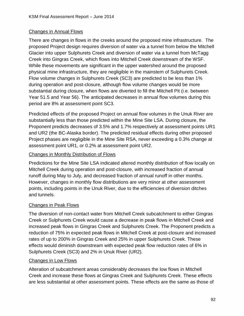
KSM Final Assessment Report – June 2014
92
Changes in Annual Flows
There are changes in flows in the creeks around the proposed mine infrastructure. The
proposed Project design requires diversion of water via a tunnel from below the Mitchell
Glacier into upper Sulphurets Creek and diversion of water via a tunnel from McTagg
Creek into Gingras Creek, which flows into Mitchell Creek downstream of the WSF.
While these movements are significant in the upper watershed around the proposed
physical mine infrastructure, they are negligible in the mainstem of Sulphurets Creek.
Flow volume changes in Sulphurets Creek (SC3) are predicted to be less than 1%
during operation and post-closure, although flow volume changes would be more
substantial during closure, when flows are diverted to fill the Mitchell Pit (i.e. between
Year 51.5 and Year 56). The anticipated decreases in annual flow volumes during this
period are 8% at assessment point SC3.
Predicted effects of the proposed Project on annual flow volumes in the Unuk River are
substantially less than those predicted within the Mine Site LSA. During closure, the
Proponent predicts decreases of 3.5% and 1.7% respectively at assessment points UR1
and UR2 (the BC-Alaska border). The predicted residual effects during other proposed
Project phases are negligible in the Mine Site RSA, never exceeding a 0.3% change at
assessment point UR1, or 0.2% at assessment point UR2.
Changes in Monthly Distribution of Flows
Predictions for the Mine Site LSA indicated altered monthly distribution of flow locally on
Mitchell Creek during operation and post-closure, with increased fraction of annual
runoff during May to July, and decreased fraction of annual runoff in other months.
However, changes in monthly flow distributions are very minor at other assessment
points, including points in the Unuk River, due to the efficiencies of diversion ditches
and tunnels.
Changes in Peak Flows
The diversion of non-contact water from Mitchell Creek subcatchment to either Gingras
Creek or Sulphurets Creek would cause a decrease in peak flows in Mitchell Creek and
increased peak flows in Gingras Creek and Sulphurets Creek. The Proponent predicts a
reduction of 75% in expected peak flows in Mitchell Creek at post-closure and increased
rates of up to 200% in Gingras Creek and 25% in upper Sulphurets Creek. These
effects would diminish downstream with expected peak flow reduction rates of 6% in
Sulphurets Creek (SC3) and 2% in Unuk River (UR2).
Changes in Low Flows
Alteration of subcatchment areas considerably decreases the low flows in Mitchell
Creek and increase these flows at Gingras Creek and Sulphurets Creek. These effects
are less substantial at other assessment points. These effects are the same as those of
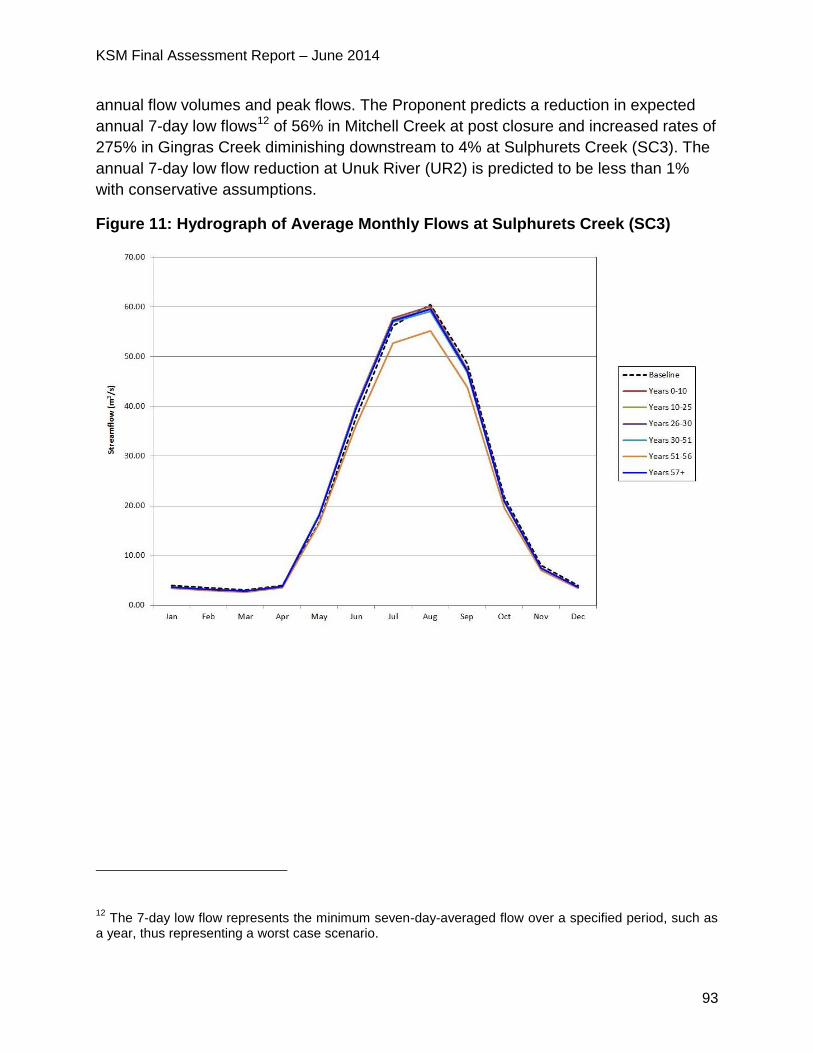
KSM Final Assessment Report – June 2014
93
annual flow volumes and peak flows. The Proponent predicts a reduction in expected
annual 7-day low flows12 of 56% in Mitchell Creek at post closure and increased rates of
275% in Gingras Creek diminishing downstream to 4% at Sulphurets Creek (SC3). The
annual 7-day low flow reduction at Unuk River (UR2) is predicted to be less than 1%
with conservative assumptions.
Figure 11: Hydrograph of Average Monthly Flows at Sulphurets Creek (SC3)
12 The 7-day low flow represents the minimum seven-day-averaged flow over a specified period, such as
a year, thus representing a worst case scenario.
KSM Final Assessment Report – June 2014
94
Figure 12: Hydrograph of Average Monthly Flows at Unuk River (UR2)
Mitchell Glacier
The Application notes that the proposed Project has the potential to affect the terminus
of the Mitchell Glacier by the development of the Mitchell Pit, depending on the rates of
glacier retreat. The Proponent anticipates that by Year 10, the Mitchell Glacier would
have retreated enough to create a sufficient setback from the Mitchell Pit for the
construction of the Stage 2 inlet. The Application reports that if this assumption is not
the case, the toe of the glacier would be excavated to allow mining with a sufficient
safety setback of the ice from the pit edge. Proposed project-related dust generation
could result in dusting of the glacier surface, which could affect rates of surface ice melt.
However, the Application concludes that it is expected the proposed Project related
effects on the Mitchell Glacier would be minor and any changes in the mass balance
and rate of retreat during the proposed Project life would be much more heavily
influenced by natural factors such as climate.
PTMA
At the PTMA, surface water quantity would be most affected by the TMF, and the
system of diversions that would route non-contact water around its three cells.
From Year 1 to Year 25, the TMF’s North Cell and the carbon-in-leach Cell will be in
operation. Diversions will carry non-contact water to South Teigen and North Treaty
Creeks. Excess flows in the North Cell will be pumped via discharge pipeline to Treaty
KSM Final Assessment Report – June 2014
95
Creek until Year 45, after which it is expected that water quality will satisfy receiving
environment criteria, allowing discharge to South Teigen Creek via a spillway. Between
Years 25 and 30, the TMF South Cell will be brought online, and will then operate until
Year 51.5, with excess water discharged to Treaty Creek. During post-closure, all
diversion channels except those associated with the seepage dams will be
decommissioned and runoff will report to the reclaimed TMF. During reclamation, the
pre-existing flow patterns within the TMF valley will be re-established. Water will be
discharged to North Treaty Creek and South Teigen Creek.
These diversions would cause changes in annual, monthly, peak and low flows,
particularly in on-site catchments as described below and represented in the
hydrographs of North Treaty Creek just before confluence with Treaty Creek (NTR2),
Treaty Creek downstream of the confluence with North Treaty Creek and below the
initial dilution zone (TRC2), South Teigen Creek just before the confluence with Teigen
Creek (STE3) and Teigen Creek downstream of the confluence with South Teigen
Creek (TEC2) in figures 12-15.
Changes in Annual Flows
The Proponent predicts a reduction in annual flow volumes of 75% in North Treaty
Creek during closure, diminishing downstream to 2% at Treaty Creek due to the
diversion channels, tunnels and TMF that would alter flow pathways and drainage
areas. In the Teigen Creek drainage, a maximum annual flow reduction of 5% is
predicted at assessment point TEC2. In addition, post-closure effects include a 1%
reduction in flows at Teigen Creek (TEC2) and a 0.1% reduction of flow at Treaty Creek
TRC2.
Predicted residual effects on annual flow volumes on the Bell-Irving River are
substantially less than those in the PTMA LSA. The predicted reduction in annual flow
volumes is 0.2% at assessment point BIR2. Predicted post-closure effects are
negligible.
Changes in Monthly Distribution of Flows
Noticeable but comparatively minor changes to flow distribution on North Treaty Creek
(between Year 25 and 50), and to a lesser extent, on South Teigen Creek with
decreasing effects downstream including those in the Bell-Irving River are expected.
These changes are attributable to diversion efficiencies, evaporation and storage of
water in the TMF ponds.
Changes in Peak Flows
Increased peak flows are predicted in North Treaty and South Teigen Creeks due to
diversion channels that reduce natural flood attenuation effects. These effects diminish
downstream in Treaty and Teigen Creeks. The Proponent predicts a 38% increase in
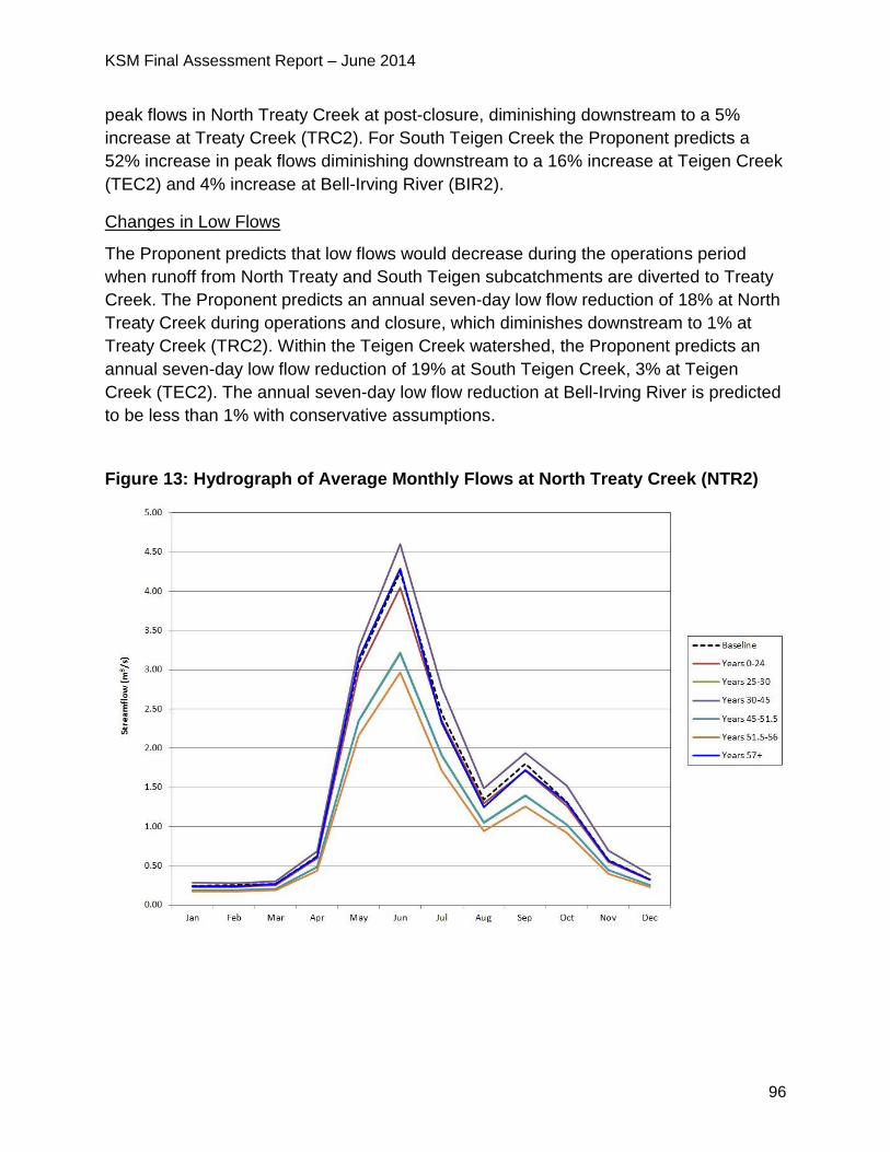
KSM Final Assessment Report – June 2014
96
peak flows in North Treaty Creek at post-closure, diminishing downstream to a 5%
increase at Treaty Creek (TRC2). For South Teigen Creek the Proponent predicts a
52% increase in peak flows diminishing downstream to a 16% increase at Teigen Creek
(TEC2) and 4% increase at Bell-Irving River (BIR2).
Changes in Low Flows
The Proponent predicts that low flows would decrease during the operations period
when runoff from North Treaty and South Teigen subcatchments are diverted to Treaty
Creek. The Proponent predicts an annual seven-day low flow reduction of 18% at North
Treaty Creek during operations and closure, which diminishes downstream to 1% at
Treaty Creek (TRC2). Within the Teigen Creek watershed, the Proponent predicts an
annual seven-day low flow reduction of 19% at South Teigen Creek, 3% at Teigen
Creek (TEC2). The annual seven-day low flow reduction at Bell-Irving River is predicted
to be less than 1% with conservative assumptions.
Figure 13: Hydrograph of Average Monthly Flows at North Treaty Creek (NTR2)
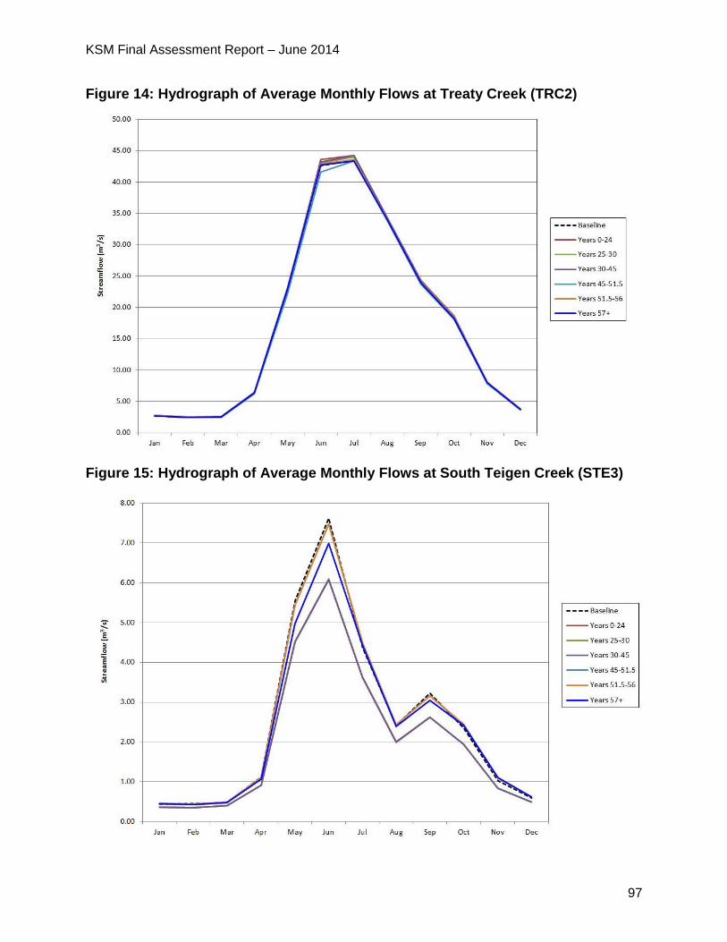
KSM Final Assessment Report – June 2014
97
Figure 14: Hydrograph of Average Monthly Flows at Treaty Creek (TRC2)
Figure 15: Hydrograph of Average Monthly Flows at South Teigen Creek (STE3)
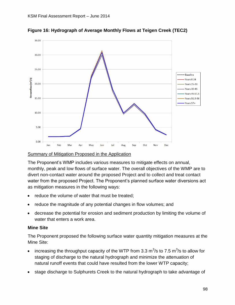
KSM Final Assessment Report – June 2014
98
Figure 16: Hydrograph of Average Monthly Flows at Teigen Creek (TEC2)
Summary of Mitigation Proposed in the Application
The Proponent’s WMP includes various measures to mitigate effects on annual,
monthly, peak and low flows of surface water. The overall objectives of the WMP are to
divert non-contact water around the proposed Project and to collect and treat contact
water from the proposed Project. The Proponent’s planned surface water diversions act
as mitigation measures in the following ways:
reduce the volume of water that must be treated;
reduce the magnitude of any potential changes in flow volumes; and
decrease the potential for erosion and sediment production by limiting the volume of
water that enters a work area.
Mine Site
The Proponent proposed the following surface water quantity mitigation measures at the
Mine Site:
increasing the throughput capacity of the WTP from 3.3 m3/s to 7.5 m3/s to allow for
staging of discharge to the natural hydrograph and minimize the attenuation of
natural runoff events that could have resulted from the lower WTP capacity;
stage discharge to Sulphurets Creek to the natural hydrograph to take advantage of
KSM Final Assessment Report – June 2014
99
natural assimilative capacity, thereby avoiding or minimizing changes to water
quality during the low-flow winter and early spring periods. This measure should also
minimize any changes to the monthly flow distribution;
divert non-contact meltwater from the Mitchell Glacier via sub-glacial inlets into
diversion tunnels for discharge into Sulphurets Creek, and from the McTagg Glacier,
to Gingras Creek; and
route non-contact water via diversion channels into either the MDT or the MTDT or
directly to Mitchell Creek downstream of the WTP. Diversion channels would be
shotcreted13 or paved with an asphalt liner, if necessary to reduce water losses in
rock-based sections.
PTMA
The Proponent proposes the following surface water quantity mitigation measures at the
PTMA:
install non-contact diversion ditches on both valley walls to direct flow north into
Teigen Creek via South Teigen Creek. This would supplement flows that could
potentially be altered by the TMF footprint. The East Diversion Tunnel would divert
flows from the East Creek catchment to South Teigen Creek up to a maximum of 2
m3/s; and
restrict discharge to the receiving environment from the TMF to surplus water from
the flotation tailings ponds. Store effluent during the winter low-flow periods and
schedule discharge release during the high flow period (May 15 to October 15) of
each year to mimic the stream flow rates.
5.3.3 Project Issues and Effects and Proposed Mitigation Identified During
Application Review
During the review of the Application, additional issues were raised by the agencies,
NLG, First Nations and the public. These issues, the Proponent responses and EAO’s
assessment of the adequacy of responses are detailed in Appendix 1. The CPD and
TOC (Appendix 2) contain specific mitigation measures, which would be legally
enforceable if an EA Certificate is issued.
Many reviewers expressed concerns with the complex water management system,
13 Shotcrete is concrete (or sometimes mortar) conveyed through a hose and pneumatically projected at
high velocity onto a surface, as a construction technique
KSM Final Assessment Report – June 2014
100
including the volumes of contact and non-contact water to be managed, the design
capacities of major water storage and handling structures such as the WSF, WTP and
TMF, the volumes of contact water to be treated, and downstream effects on stream
flows and water quality and its related effects. Reviewers including MEM noted that the
proposed Project involves the largest and most complex water management and water
treatment system ever proposed for a BC mining project and will be very challenging to
implement. Examples of specific concerns are summarized below.
Mine Site
MOE and EC stated concerns with respect to the consideration of climate change in
the Proponent’s water quantity predictions. MOE required the Proponent to consider
the effects of projected increased flows on the design and operation of all water
management systems. EC required the Proponent to provide justification for the use
of these particular climate models.
o The Proponent responded that climate change was considered in the design
of the WSF and effects of climate change are accommodated in the water
balance model by provision of sufficient levels of conservatism within the
base case and provision of storage capacity to accommodate the range of
increases in average annual precipitation values.
o The potential increase in annual precipitation due to climate change can be
managed within the range of conservative features in the selection of the
design storage capacity of the WSF.
o If additional mitigation against climate change is required, the storage dam
could be raised and the diversion tunnels and channels could be upgraded.
o In response to EC’s concerns re: climate models, the Proponent more fully
evaluated the available downscaled global climate model data for the
specific proposed Project area and predicted change in annual temperature
and precipitation over three future time periods (2020, 2050 and 2080).
MEM raised concerns with the design capacity of the conveyance system for water
from the Kerr pit to the water treatment facilities, from the commencement of open
pit mining until Year 27. MEM noted that it is only at the end of mining that the facility
will be able to contain a 200-year 24-hour flood inflow. MEM considered this
conveyance system to be higher risk and under-designed given the potential for
significant environmental consequences with a failure outside of the WSF
containment area.
o In response, the Proponent committed to providing a collection and
conveyancing capacity for Kerr Pit drainage to withstand a 1-in-200 year
KSM Final Assessment Report – June 2014
101
peak flow event once Kerr Pit commences. EAO added this as a condition in
the EA Certificate.
o Provision of the above referenced capacity could be achieved by staging of
pit excavation to provide storage, enlargement of pipeline inlets and pipeline
diameters or provision of inlet pumping as is required in detail design.
MEM and MOE requested further information to demonstrate the robustness of the
water collection, conveyance, and treatment system to deal with peak events and
upset conditions including sensitivity analyses of combined worst case scenarios for
various mine components and stages of mine life (for example, peak snow pack, rain
on snow, multiple wet years with limited storage, failure of all diversions, no snow
management, failure in lime supply, failure of power, etc.).
o The Proponent provided examples of how the proposed Project has been
designed to deal with peak events and upset conditions including:
diversion and collection ditches of the WSD have been designed for
peak flow events (200-year 24-hour peak flow);
factors lowering ditch efficiencies considered include rock fall and
avalanche hazard (increasing the probability of a breach in the
diversion), and "glaciation" or ice damming of the diversion. Mitigating
strategies have been adopted to prevent glaciation of diversions. These
include widening of sections of ditches prone to glaciation or avalanche
impacts and the bypassing of avalanche areas with buried pipes
paralleling ditches. Liners are provided with a granular drain under the
liner to prevent icing under the liner and the liner is extended upslope
above the ditches to prevent groundwater from emerging and freezing
in the ditch, rather it will freeze on the slopes above the ditch;
it would be possible to optimize lining and seepage control measures
based on an assessment of diversion ditch performance after the mine
is in operation. The water balance could be improved on by the addition
of more ditches even if they are not available in all seasons;
there are opportunities for implementing some of the closure channels
earlier in the mine plan than scheduled which will reduce treatment
requirements; and,
there is a strong motive for the operation to maximize ditch efficiency in
order to reduce the amount of water that will have to be treated, so it is
expected that ditch efficiencies will be maintained or improved upon.
KSM Final Assessment Report – June 2014
102
5.3.4 Residual Effects and Significance Analysis
Residual effects are predicted on annual flow volumes, monthly flow distribution, peak
flows and low flows. These residual effects will vary both spatially within the Mine Site
and PTMA, and temporally, at different proposed Project phase.
Mine Site
Residual surface water quantity effects at the Mine Site would be associated with the
diversion channels, tunnels and the WSF-WTP system. These effects are most
pronounced during the first 30 years of operations, while water is diverted around the
Mitchell pit and Mitchell Glacier meltwater is diverted to Sulphurets Creek. Despite
effects at upstream assessment points, EAO has considered residual surface water
quantity effects on Sulphurets Creek at SC3 and on the Unuk River at UR1 as UR1
represent the high fisheries values downstream of the Mine Site.
EAO notes the Proponent’s commitment, and proposed condition, to stage the WTP
discharge to mimic the stream flows of Sulphurets Creek to minimize water quantity
effects at the Mine Site.
PTMA
Residual surface water quantity effects in the PTMA would be associated with the
diversion channels, tunnels and the TMF. During the first 25 years of operations, non-
contact water will be routed to South Teigen and North Treaty Creeks. For the
remainder of operation excess water from the TMF will be routed to Treaty Creek.
During post closure, once water quality satisfies receiving environment guidelines,
excess flows from the TMF cells will be routed north to South Teigen Creek. EAO has
considered residual surface water quantity effects on Teigen Creek (TEC2), Treaty
Creek (TRC2) and the Bell-Irving River (BIR2).
EAO notes the Proponent’s commitment, and proposed condition, to stage the TMF
discharge to mimic the stream flows of Treaty Creek.
EAO has undertaken the following significance analysis on the residual adverse effects
on surface water quantity.
Table 16: EAO's Significance Analysis for Surface Water Quantity
Factor Rationale
Context For surface water quantity VCs, there is not a ready measure of
context (or resilience). EAO has considered the degree of
reversibility of flow effects, and their implications for downstream
water quality and aquatic resources.
Surface water quantity is a key component of the physical and
KSM Final Assessment Report – June 2014
103
biological environment, being closely linked to other ecosystem
components, including surface water quality, fish and fish habitat,
and aquatic resources.
Downstream fisheries of the Mine Site and PTMA such as oolichan
and salmon are important to Nisga’a Nation and First Nations for
sustenance and commercial fisheries.
Magnitude Mine Site
For the LSA VCs (i.e. streamflows within the Mine Site), effects are
of high magnitude on upper sections of small watersheds, notably
associated with the effects of tunnels, diversions, the WSF-WTP
system on annual, peak and low flows, although monthly flow
distributions are little affected. These effects are predicted to be low
or negligible for most other proposed Project components,
especially at the downstream boundaries of the LSA along
Sulphurets Creek.
For the RSA VCs (i.e. streamflows within the Unuk River), the
magnitude of direct proposed Project effects is negligible or low,
with the exception of a moderate magnitude effect on annual, peak
and low flows in the Unuk River during the closure phase, linked to
the effects of diversions, tunnels and the WSF-WTP.
PTMA
For the LSA VCs (i.e. streamflows within the PTMA), high
magnitude effects on upper sections of small watersheds are
identified, notably associated with the effects of tunnels, diversions
and TMF on annual, peak and low flows, although monthly flow
distributions are little affected. These effects are predicted to be low
or negligible for most other proposed Project components,
especially at the downstream boundaries of the LSA along Teigen
and Treaty Creeks (TRC2 and TEC2).
For the RSA VC (i.e. streamflows within the Bell-Irving River), the
magnitude of direct proposed Project effects are predicted to be
negligible or low.
Extent Mine Site
While effects are most evident in the LSA, the geographic extent of
KSM Final Assessment Report – June 2014
104
residual effects is rated regional, since some effects are detectable
downstream of LSA boundaries.
PTMA
While effects are most evident in the LSA, the geographic extent of
residual effects is rated regional, since some effects are detectable
downstream of LSA boundaries.
Duration Mine Site
Since some residual effects on annual, peak and low flows will be
detectable at all proposed Project phases, the residual effects are
considered far future in duration.
PTMA
Since some residual effects on annual, peak and low flows will be
detectable at all proposed Project phases, the residual effects are
considered far future in duration.
Reversibility Mine Site
Flow alterations associated with diversions, tunnels, the WSF and
the WTP, the RSFs, pits and the block cave are reversible over the
long term. Residual effects attributable to other proposed Project
components (such as camps and access roads) are considered
reversible in the short term.
PTMA
Flow alterations associated with diversions, tunnels and the TMF
are reversible over the long term. Residual effects attributable to
other proposed Project components (such as camps and access
roads) are considered reversible in the short term.
Frequency Mine Site
The assessed variables, annual, monthly, peak and low flows are
continuous hydrologic indices that would be affected on an ongoing
basis, although not to the same degree, at all proposed Project
phases.
PTMA
KSM Final Assessment Report – June 2014
105
The assessed variables, annual, monthly, peak and low flows are
continuous hydrologic indices that would be affected on an ongoing
basis, although not to the same degree, at all proposed Project
phases.
Likelihood
Mine Site
The likelihood that the predicted residual effects on surface water quantity would occur,
varies, but is generally considered high. Effects associated with many proposed Project
components including the diversions, tunnels, the WSF and WTP, the RSFs, pits and
block cave are essentially certain, given a clear cause and effect link between these
components and expected effects.
PTMA
The likelihood that the predicted residual effects on surface water quantity would occur,
varies, but is generally considered high. Effects associated with many proposed Project
components including the TMF, diversions and tunnels are essentially certain, given a
clear cause and effect link between these components and expected effects.
5.3.5 Significance Determination
Mine Site
From a watershed perspective, although the residual effects on flows of the diversions,
tunnels, the WSF and the WTP are of high magnitude in the upper reaches of streams
within the LSA, the magnitude of these changes decrease in the downstream direction.
EAO also notes that none of the predicted residual effects on flows were considered
critical to downstream resource values.
EAO notes the Proponent’s commitment to implement the WMP is a requirement of the
Mines Act permitting process, and a condition of the EA Certificate, if issued, which
describes water management and the Mine Site water balance. EAO also notes the
condition to stage the WTP discharge to mimic the stream flows of Sulphurets Creek to
minimize water quantity effects at and downstream of the Mine Site. EAO also notes the
condition to implement fish compensation plan as a mitigation measure for flow
reductions in North Treaty Creek.
Considering the above analysis and having regard to the conditions identified in the
TOC and the CPD (which would become legally binding as a condition of an EA
KSM Final Assessment Report – June 2014
106
Certificate), EAO is satisfied that the proposed Project is not likely to have significant
adverse effects on surface water quantity at and downstream of the Mine Site.
PTMA
From a watershed perspective, although the residual effects on flows of the TMF,
diversions and tunnels are of high magnitude in the upper reaches of streams with the
LSA (North Treaty and South Teigen), the magnitude of these changes decrease in the
downstream direction. EAO also notes that none of the predicted residual effects on
flows were considered critical to the resources in those affected streams.
EAO notes the Proponent’s commitments, which EAO has added as conditions, to
implement the WMP which is a requirement of the Mines Act permitting process and to
stage the TMF discharge to mimic the stream flows of Treaty Creek.
Considering the above analysis and having regard to the conditions identified in the
TOC and the CPD (which would become legally binding as a condition of an EA
Certificate), EAO is satisfied that the proposed Project is not likely to have significant
adverse effects on surface water quantity downstream of North Treaty (NTR2) and
South Teigen (STE3) Creeks in the PTMA.
5.3.6 Cumulative Effects
The potential exists for residual cumulative effects on annual flow volumes, monthly flow
distribution, peak flows and low flows associated with an overlap of the proposed
Project and Brucejack Mine Project effects. However, the Brucejack Mine Project layout
and WMP are not yet defined in sufficient detail to form a reliable basis for assessing
cumulative surface water quantity effects. Likely, they will be minor and localized, since
both projects are expected to employ best management practices and proven mitigation
strategies to minimize direct project effects on surface water quantity. No residual
cumulative effects for surface water quantity are identified.
KSM Final Assessment Report – June 2014
107
5.3.7 Certainty
Mine Site
Annual flow volumes and monthly flow distributions are estimated based on a water
balance model that has been calibrated to observed flows within the Mine Site. Potential
uncertainty due to climate change has been accounted for through sensitivity analysis.
Therefore, there is a high level of certainty for changes in annual flow volumes and
monthly flow distribution associated with diversion, tunnels, the WSF and WTP and a
medium level of certainty associated with RSFs, pits and block cave mines.
Peak and low flow estimates were primarily based on regional analysis. Therefore, there
is a medium level of certainty associated with changes in peak and low flows. To
account for such uncertainty, the Proponent used conservative approaches for peak
and low flow estimates.
PTMA
Annual flow volumes and monthly flow distributions are estimated based on a water
balance model that has been calibrated to observed flows within the PTMA. Potential
uncertainty due to climate change has been accounted for through sensitivity analysis.
Therefore, there is a high level of certainty for changes to annual flow volumes and
monthly flow distribution associated with diversions, tunnels and the TMF.
Peak and low flow estimates were primarily based on regional analysis. Therefore, there
is a medium level of certainty for changes in peak flows and changes in low flows
associated with diversions, tunnels and the TMF. To account for such uncertainty, the
Proponent used conservative approaches for peak and low flow estimates.
5.3.8 Conclusion
Considering the above analysis and having regard to the conditions identified in the
TOC and the CPD (which would become legally binding as a condition of an EA
Certificate), EAO is satisfied that the proposed Project is not likely to have significant
adverse effects on surface water quantity.
5.4 Groundwater
5.4.1 Background Information
The Proponent selected groundwater quantity and groundwater quality as VCs for the
groundwater assessment. As with other water VCs, the LSAs are the Mine Site LSA and
the PTMA LSA.
KSM Final Assessment Report – June 2014
108
Given the close relationship between groundwater quantity and quality, this Report will
provide a single significance assessment for “groundwater” rather than separate
quantity and quality assessments.
Groundwater Quantity
The Proponent investigated baseline groundwater quantity conditions by means of
groundwater monitoring wells, boreholes, slug tests and packer tests from which
hydraulic properties and permeability could be evaluated and groundwater levels
measured. The Proponent also took stream low-flow measurements to estimate
seepage rates, validate groundwater flow modeling results and assess changes in
seepage rates and surface water quantity arising from the effects of the proposed
Project on groundwater quantity.
The Proponent then developed three-dimensional groundwater models to examine the
mine designs and mitigation measures and to predict changes of groundwater flow
patterns and baseflows, as well as seepage arising from the proposed Project. A
sensitivity analysis was also conducted in order to consider possible “worst-case”
scenarios and to address uncertainties of the predicted groundwater quantity effect
associated with the permeability of overburden and bedrock and with the recharge rates
in wet and dry climates.
Mine Site Groundwater Quantity
The Proponent predicted groundwater flow regimes across the Mine Site LSA for two
proposed Project phases:
end of operations phase: this is the phase where all open pit and underground
workings and dams would be at their largest extent and have active dewatering. This
phase is assumed to have the greatest operation-phase effects on groundwater
quantity; and
post-closure phase: after the mine is closed, all pits and underground works are
flooded or backfilled, the WSF pond level would maintain its peak level. This phase
represents the maximum long-term effects on groundwater quantity, potentially
being maintained for many years after the end of operation.
PTMA Groundwater Quantity
For the PTMA, the Proponent predicted flow regimes for three stages of TMF
development:
upon completion of the North Cell, following 25 years of operations and assuming
that the tailings cells are in their full capacities throughout the years;
KSM Final Assessment Report – June 2014
109
upon completion of the South Cell, following 51.5 years of operations, marking the
end of the operations phase and assuming that the tailings cells are in their full
capacities throughout the years; and
post-closure phase, assuming that the tailings cells are in their full capacities after
the closure.
Groundwater Quality
The Proponent investigated baseline groundwater quality conditions by means of
sampling of groundwater monitoring wells and natural groundwater seeps on slopes.
The Proponent tested groundwater samples and seeps for physical properties, total and
dissolved metals, nutrients, total organic carbon and cyanide concentrations.
Groundwater flow and transport models were completed to assess potential residual
effects on groundwater quality from the open pits, block caves, reservoirs that store
contact water, the RSFs and tunnels. Models were developed that showed where the
groundwater plumes from each component would go, as well as how long they would
take to develop. The models also provided information on the concentrations of these
groundwater plumes.
As with groundwater quantity, the Proponent modeled “worst-case” scenario simulations
to address uncertainties of the predicted groundwater quality effect associated with the
permeability of overburden and bedrock and with the recharge rates in wet and dry
climates.
Mine Site Groundwater Quality
The Proponent predicted groundwater quality across the Mine Site LSA for the same
two scenarios used to describe groundwater quantity.
PTMA Groundwater Quality
For the PTMA, the Proponent predicted groundwater quality for the same three phases
used to describe groundwater quantity.
A full discussion on groundwater can be found in the Proponent’s Application posted on
EAO’s website at:
http://a100.gov.bc.ca/appsdata/epic/html/deploy/epic_document_322_35959.html
5.4.2 Project Issues, Effects and Proposed Mitigation in the Application
Groundwater Quantity
Groundwater quantity effects are predicted to occur throughout construction, operations,
closure and post-closure. Potential effects include changes in the surface water
KSM Final Assessment Report – June 2014
110
environment in the proposed Project area including changes in hydraulic gradients,
affecting groundwater flow rate, flow direction and water level.
The Application reports that alterations to groundwater flow patterns and water levels
would be confined to the immediate catchments basins within the proposed Project
footprint.
Mine Site Groundwater Quantity Effects
Mine Site components with the potential to impact groundwater quantity include the
open pits, block cave mines, MDT, MTDT and WSF. The following are specific
examples of groundwater quantity effects at the Mine Site:
reductions in water levels and the creation of groundwater sinks from mine
dewatering;
higher groundwater levels beneath the WSF due to water storage and reduced
groundwater discharge downstream of the WSF into the Mitchell Creek due to
seepage controls;
water level “mounding” beneath the Mitchell and McTagg RSF as ground elevation
increases with the accumulation of waste rock; and,
low groundwater levels in the Sulphurets Pit backfill due to the installed basal
drainage system.
PTMA Groundwater Quantity Effects
PTMA components with the potential to impact groundwater quantity include the TMF,
East Diversion Tunnel and the MTT. The main groundwater quantity effect associated
with the TMF would be higher groundwater levels beneath and reduced groundwater
discharge downstream of the TMF into South Teigen and North Treaty Creeks due to
water storage and seepage controls. As a result of seepage control structures,
groundwater which would normally flow into these creeks would report to seepage dam
reservoirs and be pumped back into the TMF. Figure 16 below shows the relationship
between the main TMF dam, groundwater and the seepage recovery dams. It illustrates
the effect of upward groundwater discharge and hydraulic gradients on attenuating and
containing the dam seepage into downstream creeks.
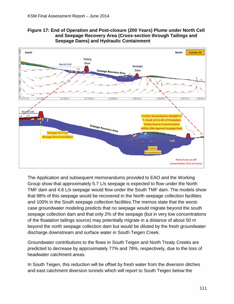
KSM Final Assessment Report – June 2014
111
Figure 17: End of Operation and Post-closure (200 Years) Plume under North Cell and Seepage Recovery Area (Cross-section through Tailings and Seepage Dams) and Hydraulic Containment
The Application and subsequent memorandums provided to EAO and the Working
Group show that approximately 5.7 L/s seepage is expected to flow under the North
TMF dam and 4.6 L/s seepage would flow under the South TMF dam. The models show
that 98% of this seepage would be recovered in the North seepage collection facilities
and 100% in the South seepage collection facilities.The memos state that the worst-
case groundwater modeling predicts that no seepage would migrate beyond the south
seepage collection dam and that only 2% of the seepage (but in very low concentrations
of the floatation tailings source) may potentially migrate in a distance of about 50 m
beyond the north seepage collection dam but would be diluted by the fresh groundwater
discharge downstream and surface water in South Teigen Creek.
Groundwater contributions to the flows in South Teigen and North Treaty Creeks are
predicted to decrease by approximately 77% and 78%, respectively, due to the loss of
headwater catchment areas.
In South Teigen, this reduction will be offset by fresh water from the diversion ditches
and east catchment diversion tunnels which will report to South Teigen below the
KSM Final Assessment Report – June 2014
112
seepage collection facilities, as well as by the discharge of water from the tailings pond
and seepage recovery area if the water quality meets the requirement. The Proponent
proposed to stage the TMF discharge to mimic the stream flows to reduce water
quantity effects.
Flow reduction for North Treaty are more pronounced since most water diversions do
not report into the creek below the seepage collection ponds, but rather the discharge
from the TMF is directed into the main stem of Treaty Creek. Maximum baseflow
reductions in North Treaty are closer to 78%, but the Application reports that
considering the high precipitation and surface water runoff from slopes, the actual
reduction of stream flow in the creek downstream the south seepage collection dam
may be not noticeable.
Groundwater Quality
Groundwater quality would also be impacted by the proposed Project. The Application
states that seepage of contact water from mine infrastructure into the groundwater
environment would alter the current groundwater quality within the immediate
catchments of the proposed mine components. Accidental release of industrial or other
controlled substances could also affect groundwater quality in local spots.
Mine Site Groundwater Quality Effects
Proposed Project activities that could generate contact water include the exposure of
rock at the Mine Site and blasting for construction or mining purposes. Contact water
release may occur from the open pits and block caves, the RSFs, along the access
roads during construction, inside tunnels and from the WSF.
PTMA Groundwater Quality Effects
Proposed Project activities that could generate contact water include the exposure of
rock at the PTMA, blasting for construction and discharge of tailings water from the
Treaty Process Plant. Contact water release may occur along the access roads during
construction, inside tunnels and from the TMF.
As discussed above, the main predicted groundwater effect is seepage. The seepage
collection facilities are predicted to be 98% and 100% effective for the North and South
respectively and any groundwater quality effects would be due to seepage potentially
escaping the seepage collection facilities. The Proponent’s worst-case groundwater
modeling predicts that no seepage would migrate beyond the south seepage collection
dam and that only 2% of the seepage (but in very low concentrations of the floatation
tailings source) may potentially migrate in a distance of about 50 m beyond the north
seepage collection dam but would be diluted by the fresh groundwater discharge
KSM Final Assessment Report – June 2014
113
downstream and surface water in the South Teigen Creek. The effects of this on surface
water quality are discussed in that section.
Summary of Mitigation Proposed in the Application
Groundwater Quantity
The Application reports that reclamation activities are expected to change how
proposed Project components interact with the groundwater environment and as a
result, baseline groundwater flows would be permanently changed.
The Application reports that the following activities within closure plans would provide
for recovery towards natural drainage conditions and minimize effects.
Mine Site
The development of a lake in Mitchell Pit following completion of extraction would
allow for recovery of water levels surrounding the pit towards pre-existing conditions.
The decommissioning of certain tunnels by capping of all portals would reduce the
quantity of seepage through tunnel walls.
PTMA
The TMF Management and Monitoring Plan would provide for post-operation
discharge of water from the TMF cells once effluent quality meets Metal Mining
Effluent Regulations (MMER), which would result in a trend towards baseline
groundwater flow conditions.
The decommissioning of tunnels by capping of all portals would reduce the quantity
of seepage through tunnel walls.
Groundwater Quality
Mine Site
The Proponent proposed the following mitigation measures in the Application:
stop dewatering the pits and block caves after excavation;
management of water levels in the Mitchell Pit and Block Cave Mine post-closure
below the natural local groundwater level to sustain a groundwater sink in the mine
post-closure;
sustained drainage of the Sulphurets Pit and the backfilled waste rock indefinitely,
and collect and divert the contact water into the WSF for treatment;
sustained drainage of the Kerr Pits indefinitely via drill holes or a tunnel to a pipeline,
and convey the contact water collected from the pits into the WSF for treatment; and
KSM Final Assessment Report – June 2014
114
design of the WSF includes measures to reduce seepage below and through the
dam, and into the down-gradient groundwater environment. These measures include
a grout curtain and asphalt core and a system of seepage interception tunnels in the
subsurface between the WSD and the seepage collection dam grout curtains.
PTMA
The Proponent proposed the following mitigation measures in the Application:
all TMF dams (including tailings cell dams and seepage collection dams) are
designed with a low-permeability compacted till core to reduce seepage rates
through the dams;
seepage cut-off walls built with low-permeability native fine-grained soils amended
with bentonite are planned below the North, Splitter, and Southeast tailings dams.
No cut-off wall is planned below the Saddle dam because drainage materials are
required in this area to relieve artesian pressure below the Centre Cell liner;
three seepage collection dams downstream of the TMF along the North Treaty and
South Teigen valleys to minimize seepage into the down-gradient environment
without unduly increasing the overall TMF footprint. These dams are designed to
capture seepage water emanating from the TMF and to pump it back up to the cells;
and
the Proponent has committed to a number of Environmental Management Plans
(EMP), which EAO had added as conditions, that would be further developed during
Mines Act permitting that include measures to avoid, reduce, control and monitor
proposed Project effects on groundwater quality including:
o Water Storage Facility Management and Monitoring Plan and the Tailings
Management Facility Management and Monitoring Plan to reduce seepage;
o WMP to minimize seepage of contact water;
o ML/ARD Management Plan to avoid or reduce the potential for ML/ARD; and
o Groundwater quality long-term monitoring as per the Groundwater Monitoring and Mitigation Plan.
5.4.3 Project Issues and Effects and Proposed Mitigation Identified During
Application Review
During the review of the Application, additional issues were raised by the agencies,
NLG, First Nations and the public. These issues, the Proponent responses and EAO’s
assessment of the adequacy of responses are detailed in Appendix 1. The CPD and
TOC (Appendix 2) contain specific mitigation measures, which would be legally
KSM Final Assessment Report – June 2014
115
enforceable if an EA Certificate is issued. Examples of some of the key issues and
additional commitments are set out below.
General Groundwater
MOE required the Proponent to conduct monitoring programs to develop an
understanding of the performance of the seepage mitigation measures that could not
be derived from studies and analysis prior to construction. MOE also recommended
the Proponent conduct a performance monitoring program to evaluate the
effectiveness of the seepage cutoffs and seepage collection works.
o In response, the Proponent submitted additional information on seepage
rates and pathways and stated these requirements would be discussed
during permitting.
o The Proponent’s commitment to a Groundwater Monitoring and Mitigation
Plan would also address MOE’s concerns.
EC questioned whether the groundwater modeling shows potential changes in
where groundwater discharges that in turn may impact surface waters. EC was
concerned that the proposed Project has the potential to change where
groundwater discharges to surface water and hence, the potential exists for
changes in fish and aquatic habitat as these discharge areas could potentially be
into valuable habitat (such as areas of fish spawning or over-wintering).
o In response, the Proponent stated that the groundwater modeling results
show that the potential reduction of groundwater discharge into the surface
waters will be limited to the Mitchell/McTagg Creeks above the Mitchell/
Sulphurets confluence at the Mine Site and in the Teigen South and Treaty
North tributaries in the PTMA.
o The potential reduction of groundwater discharge is predicted to be small
(0.28 m3/s in Mitchell/McTagg Creeks, 0.12 m3/s in South Teigen tributary
and less than 0.01 m3/s in North Treaty tributary), in comparison to the
contribution of the surface water flows in these creeks.
o The reduction of groundwater discharge will be compensated by the diverted
surface runoffs, glacial melt-water and the treated mine water in both areas.
No effect is predicted on groundwater discharge in the downstream Unuk
River at the Mine Site and in Teigen and Treaty Creeks at the PTMA.
Mine Site
MOE and MEM raised concerns with the Proponent’s assessment of infiltration rates
and seepage at the backfilled Sulphurets Pit. MEM questioned the assumptions the
Proponent used for infiltration and flows throughout the operations and closure
KSM Final Assessment Report – June 2014
116
period. MEM requested further information to support the seepage estimates, water
balance, design capacities (ditches, pipeline, WSF, SeTP, WTP) and to assess the
reasonableness of inputs into the water quality modelling.
o The Proponent prepared a memorandum which stated that the amount of
infiltration into the Sulphurets backfill was determined based on the monthly
annual precipitation that falls onto the Sulphurets backfill with defined waste
rock infiltration coefficients for the operation, closure, and post-closure
phases.
o The Proponent stated that the water quality model did not consider water
storage in the materials in the Sulphurets backfill. All infiltration through the
uncovered materials was assumed to report to the basal drain.
After reviewing the information provided by the Proponent, MEM required a
sensitivity analysis of the effects to water quality, the high-density sludge
treatment plant discharge and downstream water quality of the potential bypass
of up to 100 L/s of seepage from the backfilled waste rock to the WSF without
selenium treatment under maximum conditions over Years 26 to 28.
o In response, the Proponent stated that the expected case water quality
model already includes seepage bypass to the WSF.
o Later in the EA as discussed in section 5.2.3, the Proponent committed to
construct and commission a SeTP at the WSF with a capacity of 500 L/s to
treat water from both the McTagg/Mitchell RSF and from Sulphurets and
Kerr pits as a contingency to manage selenium levels that might be higher
than expected.
Reviewers raised concerns with the assumptions used by the Proponent for
seepage modeling at the WSF and seepage pond stating that it was not
conservative and has the potential to be higher than predicted and assessed by
the Proponent.
MOE raised concerns that a higher seepage rate could lead to an
underestimation of selenium concentrations and loadings. MOE requested
additional information on what mitigation can or would be implemented to avoid
downstream environmental effects if WSF selenium concentrations are greater
than predicted.
MOE stated that seepage has the potential to impact water quality and quantity in
Sulphurets/ Unuk drainages, primarily during winter low flows. Impacts have the
potential to be of a high magnitude as downstream water quality already has
elevated levels of selenium and the seepage would not be treated.
KSM Final Assessment Report – June 2014
117
o The Proponent responded that according to the modeling results presented
in the Application, the WSF is physically and hydraulically contained by the
steep Mitchell Canyon walls together with the glacial till sediments at the
valley bottom.
o Seepage emanating from the WSF would be diluted by the fresh
groundwater discharge from the canyon slopes and would be captured by
the seepage mitigation/recovery systems (including asphalt dam core, grout
curtains under the dam foundations and in the abutments, seepage
collection tunnels, seepage drain galleries, and seepage recovery dam and
pond).
o To be conservative for the EA purpose, contact groundwater with 5% of the
WSF reservoir concentrations was assumed to daylight beyond the seepage
collection dam (despite not predicted even in the worst case of groundwater
modeling) and was applied in the surface water quality modeling inputs, in
order to account for the potential uncertainties in the groundwater seepage
predictions.
o The Proponent prepared an additional memo regarding the WSF seepage
mitigation plan noting that the WSF system includes a seepage interception
system and seepage collection dam to intercept seepage that bypasses the
dam to allow it to be collected and treated. Modelling results of capture
efficiencies with seepage mitigation systems in place shows that no seepage
would daylight in the receiving surface water beyond the seepage collection
dam and that seepage of contact water bypassing the seepage collection
dam would be limited to the deep groundwater environment and have low
concentrations and would meet water quality objectives in the receiving
environment.
o The memo provides a complete list of available seepage mitigation
measures.
MEM required additional sensitivity analysis on the seepage rate from the WSF
bypassing the downstream seepage collection dam and water quality predictions
in Sulphurets Creek at SC3 and downstream in the Unuk River.
o The Proponent’s additional sensitivity analysis showed that increased
concentrations in the low flow periods for elements that are controlled by the
WTP (arsenic, copper and iron). Concentrations of parameters not controlled
by the WTP (selenium, nitrogen and phosphorus) are not sensitive to
seepage bypass rates.
KSM Final Assessment Report – June 2014
118
PTMA
MOE raised concerns about the potential for seepage from the TMF, past the
collection dams and the resulting water quality, sediment quality and fish and fish
habitat effects. MOE observed discrepancies in the Proponent’s modeled
concentration of seepage plume for the North Dam. MOE recommended the
Proponent conduct a comprehensive monitoring program and updates of
groundwater modelling to address these concerns which could include potential
design refinements.
o In response, the Proponent completed additional sensitivity analysis varying
the configurations for the cut-off trenches including width and permeability in
the cut off fill material. The results were nearly identical to the base case,
and indicate that seepage from the TMF would flow to the seepage recovery
pond.
o The Proponent stated that their modelling shows that all flow paths from the
impoundment report to the seepage collection ponds; thus the contact water
component of flow under the North and Southeast seepage dam is
negligible.
NLG raised concerns about the long-term management and risk of the proposed
Project including closure activities such as long-term seepage pump back. NLG
suggested the following alternatives to long-term pump back: seepage could be
stored in a pond and released to South Teigen Creek during periods of higher
stream flow; or controlled release of the North Tailings Pond water (post-closure) to
combine with the seepage water during low flow months such that water quality
exceedances would not occur in South Teigen Creek.
o In response, the Proponent stated that the WMP indicates that the seepage
collection pond pumping system will operate in the closure phase until
seepage collection pond water quality meets regulatory permit requirements.
At closure, the water quality in the North seepage pond is predicted to
improve indicating that at some point long-term pump back is likely to cease.
5.4.4 Residual Effects and Significance Analysis
Groundwater Quantity
Mine Site Groundwater Quantity Residual Effects
There would be residual effects to baseline groundwater levels and flow conditions near
the pits, the block caves and the WSF.
Reductions in water levels and the creation of groundwater sinks are predicted to result
KSM Final Assessment Report – June 2014
119
from mine dewatering. Other residual effects include higher groundwater levels
beneath, and reduced seepage downstream of the WSF (due to water storage and
seepage controls), water level “mounding” beneath the Mitchell and McTagg RSF (as
ground elevation increases with the accumulation of waste rock), and low groundwater
levels in the Sulphurets Pit backfill (due to the installed basal drainage system acting as
a sink).
Groundwater flows around the WSF would exhibit complex changes in flow patterns and
groundwater levels linked to storage of substantial water volumes, grouting and
seepage collection. Groundwater discharge rate downstream of the WSF in the Mitchell
valley would be reduced.
PTMA Groundwater Quantity Residual Effects
There would be residual effects to baseline groundwater levels and flow patterns as the
result of the development of the TMF, TMF dams and seepage collection dams.
Groundwater flows around the TMF would exhibit complex changes in flow patterns and
groundwater levels linked to storage of substantial water volumes, grouting and
seepage collection downstream of the TMF in South Teigen and North Treaty Creeks.
There would be higher groundwater levels beneath the TMF and groundwater discharge
rates into North Treaty and South Teigen would be reduced.
Groundwater Quality
Mine Site Groundwater Quality Residual Effects
There would be residual effects on groundwater quality in the form of plumes of
degraded water which will emanate from the Iron Cap Block Cave mine, the Mitchell
and McTagg RSFs and the WSF. Seepage of water from mine waste storage and
conveyance facilities may affect groundwater quality downstream in the Mitchell and
Sulphurets Creeks.
PTMA Groundwater Quality Residual Effects
There would be residual effects on groundwater in the form of plumes of degraded
water emanating from the TMF and which may affect groundwater quality downstream
in North Treaty and South Teigen Creeks.
Significance Analysis
EAO has undertaken the following significance analysis on the residual adverse effects
on groundwater.
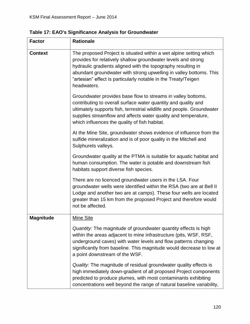
KSM Final Assessment Report – June 2014
120
Table 17: EAO's Significance Analysis for Groundwater
Factor Rationale
Context The proposed Project is situated within a wet alpine setting which
provides for relatively shallow groundwater levels and strong
hydraulic gradients aligned with the topography resulting in
abundant groundwater with strong upwelling in valley bottoms. This
“artesian” effect is particularly notable in the Treaty/Teigen
headwaters.
Groundwater provides base flow to streams in valley bottoms,
contributing to overall surface water quantity and quality and
ultimately supports fish, terrestrial wildlife and people. Groundwater
supplies streamflow and affects water quality and temperature,
which influences the quality of fish habitat.
At the Mine Site, groundwater shows evidence of influence from the
sulfide mineralization and is of poor quality in the Mitchell and
Sulphurets valleys.
Groundwater quality at the PTMA is suitable for aquatic habitat and
human consumption. The water is potable and downstream fish
habitats support diverse fish species.
There are no licenced groundwater users in the LSA. Four
groundwater wells were identified within the RSA (two are at Bell II
Lodge and another two are at camps). These four wells are located
greater than 15 km from the proposed Project and therefore would
not be affected.
Magnitude Mine Site
Quantity: The magnitude of groundwater quantity effects is high
within the areas adjacent to mine infrastructure (pits, WSF, RSF,
underground caves) with water levels and flow patterns changing
significantly from baseline. This magnitude would decrease to low at
a point downstream of the WSF.
Quality: The magnitude of residual groundwater quality effects is
high immediately down-gradient of all proposed Project components
predicted to produce plumes, with most contaminants exhibiting
concentrations well beyond the range of natural baseline variability,
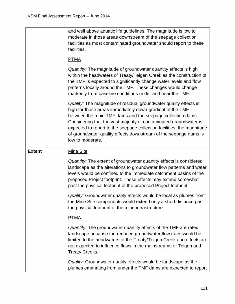
KSM Final Assessment Report – June 2014
121
and well above aquatic life guidelines. The magnitude is low to
moderate in those areas downstream of the seepage collection
facilities as most contaminated groundwater should report to these
facilities.
PTMA
Quantity: The magnitude of groundwater quantity effects is high
within the headwaters of Treaty/Teigen Creek as the construction of
the TMF is expected to significantly change water levels and flow
patterns locally around the TMF. These changes would change
markedly from baseline conditions under and near the TMF.
Quality: The magnitude of residual groundwater quality effects is
high for those areas immediately down-gradient of the TMF
between the main TMF dams and the seepage collection dams.
Considering that the vast majority of contaminated groundwater is
expected to report to the seepage collection facilities, the magnitude
of groundwater quality effects downstream of the seepage dams is
low to moderate.
Extent Mine Site
Quantity: The extent of groundwater quantity effects is considered
landscape as the alterations to groundwater flow patterns and water
levels would be confined to the immediate catchment basins of the
proposed Project footprint. These effects may extend somewhat
past the physical footprint of the proposed Project footprint.
Quality: Groundwater quality effects would be local as plumes from
the Mine Site components would extend only a short distance past
the physical footprint of the mine infrastructure.
PTMA
Quantity: The groundwater quantity effects of the TMF are rated
landscape because the reduced groundwater flow rates would be
limited to the headwaters of the Treaty/Teigen Creek and effects are
not expected to influence flows in the mainstreams of Teigen and
Treaty Creeks.
Quality: Groundwater quality effects would be landscape as the
plumes emanating from under the TMF dams are expected to report
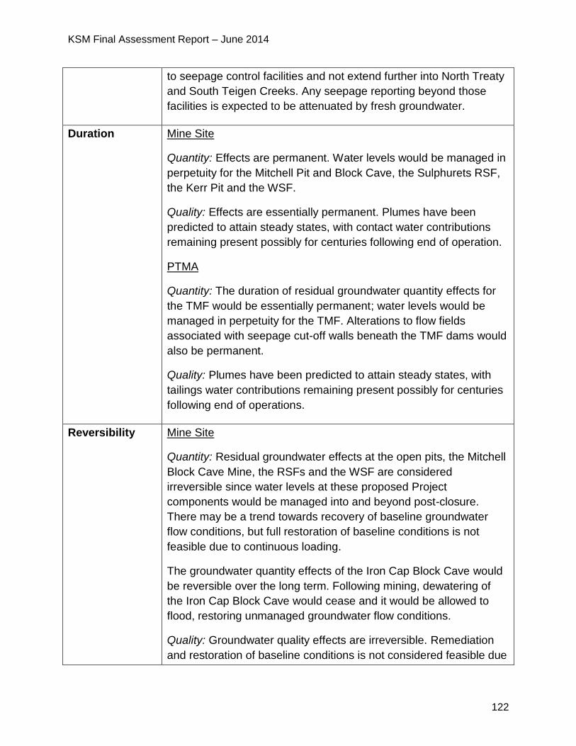
KSM Final Assessment Report – June 2014
122
to seepage control facilities and not extend further into North Treaty
and South Teigen Creeks. Any seepage reporting beyond those
facilities is expected to be attenuated by fresh groundwater.
Duration Mine Site
Quantity: Effects are permanent. Water levels would be managed in
perpetuity for the Mitchell Pit and Block Cave, the Sulphurets RSF,
the Kerr Pit and the WSF.
Quality: Effects are essentially permanent. Plumes have been
predicted to attain steady states, with contact water contributions
remaining present possibly for centuries following end of operation.
PTMA
Quantity: The duration of residual groundwater quantity effects for
the TMF would be essentially permanent; water levels would be
managed in perpetuity for the TMF. Alterations to flow fields
associated with seepage cut-off walls beneath the TMF dams would
also be permanent.
Quality: Plumes have been predicted to attain steady states, with
tailings water contributions remaining present possibly for centuries
following end of operations.
Reversibility Mine Site
Quantity: Residual groundwater effects at the open pits, the Mitchell
Block Cave Mine, the RSFs and the WSF are considered
irreversible since water levels at these proposed Project
components would be managed into and beyond post-closure.
There may be a trend towards recovery of baseline groundwater
flow conditions, but full restoration of baseline conditions is not
feasible due to continuous loading.
The groundwater quantity effects of the Iron Cap Block Cave would
be reversible over the long term. Following mining, dewatering of
the Iron Cap Block Cave would cease and it would be allowed to
flood, restoring unmanaged groundwater flow conditions.
Quality: Groundwater quality effects are irreversible. Remediation
and restoration of baseline conditions is not considered feasible due
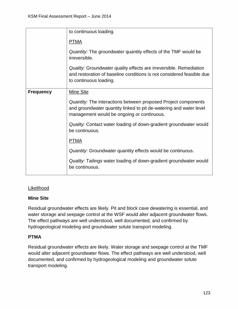
KSM Final Assessment Report – June 2014
123
to continuous loading.
PTMA
Quantity: The groundwater quantity effects of the TMF would be
irreversible.
Quality: Groundwater quality effects are irreversible. Remediation
and restoration of baseline conditions is not considered feasible due
to continuous loading.
Frequency Mine Site
Quantity: The interactions between proposed Project components
and groundwater quantity linked to pit de-watering and water level
management would be ongoing or continuous.
Quality: Contact water loading of down-gradient groundwater would
be continuous.
PTMA
Quantity: Groundwater quantity effects would be continuous.
Quality: Tailings water loading of down-gradient groundwater would
be continuous.
Likelihood
Mine Site
Residual groundwater effects are likely. Pit and block cave dewatering is essential, and
water storage and seepage control at the WSF would alter adjacent groundwater flows.
The effect pathways are well understood, well documented, and confirmed by
hydrogeological modeling and groundwater solute transport modeling.
PTMA
Residual groundwater effects are likely. Water storage and seepage control at the TMF
would alter adjacent groundwater flows. The effect pathways are well understood, well
documented, and confirmed by hydrogeological modeling and groundwater solute
transport modeling.
KSM Final Assessment Report – June 2014
124
5.4.5 Significance Determination
Mine Site
Groundwater Quantity and Quality:
EAO has considered the fact that groundwater effects would be confined to the
immediate catchment basins of the proposed Project footprint. EAO notes that the
magnitude of effects is high in areas adjacent to the mine infrastructure but is low
overall. EAO considered the permanence of these effects. EAO considered the lack of
licenced groundwater users in the proposed Project area but notes the value
groundwater provides to surface water quality and fish and aquatic habitat and notes
that the mine infrastructure is located in an area that ultimately flows into the Unuk River
which has high fisheries values both in BC and Alaska.
These conclusions have been informed by water management and treatment
commitments developed by the Proponent, that EAO has added as conditions, which
will ensure that effects will not be greater than predicted. In particular, EAO notes that
the Proponent has committed to implementing the following plans: WSF Seepage
Management and Monitoring Plan; WMP; ML/ARD Management Plan; and
Groundwater Monitoring and Mitigation Plan. EAO recognizes the details of these
programs will be considered in greater depth during the Mines Act permitting process.
Considering the above analysis and having regard to the conditions for mitigation of
groundwater quantity and quality impacts including mine water management identified
in the TOC and the CPD (which would become legally binding as a condition of an EA
Certificate), EAO is satisfied that the proposed Project is not likely to have significant
adverse effects on groundwater quantity and quality at and downstream of the Mine
Site.
PTMA
Groundwater Quantity and Quality:
EAO notes that the magnitude of effects is high in areas adjacent to the TMF
infrastructure but is low overall and that that any effects that do occur are likely to be
permanent. EAO has considered the lack of licenced groundwater users in the
proposed Project area but notes the value groundwater provides to surface water
quality and fish and aquatic habitat, particularly as the TMF is located in an area that
ultimately flows into the Nass River, a river system with high fisheries values.
These conclusions have been informed by water management and treatment
commitments developed by the Proponent, and added as conditions by EAO, which will
ensure that effects will not be greater than predicted. In particular, EAO notes that the
KSM Final Assessment Report – June 2014
125
Proponent has committed to implementing the following plans: TMF Management and
Monitoring Plan; WMP; ML/ARD Management Plan; and Groundwater Monitoring and
Mitigation Plan. EAO recognizes the details of these programs will be considered in
greater depth during the Mines Act permitting process.
Considering the above analysis and having regard to the conditions for mitigation of
groundwater quantity and quality impacts including water management identified in the
TOC and the CPD (which would become legally binding as a condition of an EA
Certificate), EAO is satisfied that the proposed Project is not likely to have significant
adverse effects on groundwater quantity and quality at and downstream of the PTMA.
5.4.6 Cumulative Effects
EAO considered cumulative effects on groundwater from past, current and proposed
projects. The proposed Snowfield Mine pit is the only project located close enough for
an interaction with the proposed Project. Plumes could emanate from the Snowfield
Mine pit and waste rock dumps and interact with plumes emanating from the proposed
Project components in the Mitchell Creek Valley. Mixing of plumes may increase
contaminant loads (e.g. dissolved metals concentrations) in groundwater within the
Mitchell Creek catchment basin. Due to the lack of information regarding any plans for
the Snowfield Mine, this cumulative effect is not considered further in the cumulative
effects assessment.
5.4.7 Certainty
Groundwater Quantity
Mine Site and PTMA
EAO considers the certainty related to predicted groundwater quantity effects as being
moderate to high. Effects were predicted by a model calibrated by water level
measurements taken in large numbers of installed wells and piezometers over a four
year period, and by detailed measurements of low flows in streams. Sensitivity analysis
was conducted in “worst-case” simulations to account for uncertainty in the permeability
of geological materials and groundwater recharge rates. Results from modeling the
“worst-case” scenarios were consistent with base case results and showed that
predicted results were robust. EAO does recognize that there is an inherent uncertainty
in all models, specifically those which predict the future effects on groundwater. EAO
notes the Proponent has made reasonable efforts to address these inherent
uncertainties in their responses to reviewer questions and through the development of
the Groundwater Monitoring and Mitigation Plan.
KSM Final Assessment Report – June 2014
126
Groundwater Quality
Mine Site
The certainty in groundwater quality effects ranges from moderate to high depending on
the proposed Project component. For all components except the WSF the certainty is
high as the cause-effect relationship between the proposed Project and its interaction
with current conditions is supported by good data, modeling and scientific analyses. The
analyses included worst-case scenario simulations to account for uncertainty in the
permeability of geological materials and groundwater recharge rates. Plume extents
predicted by the “worst-case” scenarios are consistent with base case predictions, and
calibration correlated closely with field measurements.
EAO notes that the level of certainty related to groundwater effects associated with the
WSF is moderate or moderately low. The Proponent observed some fractures in the
WSF foundation, indicating that areas of high-conductivity groundwater flow paths could
be present and could have effects that cannot be fully characterized by field
observations or captured in a quantitative model. This uncertainty is also discussed in
the water quality section of this report.
PTMA
EAO considers the certainty related to groundwater effects for all PTMA components to
be high. The Proponent’s models have demonstrated a good understanding of the
cause-effect relationship between the proposed Project and its interaction with current
conditions and these models are supported by very good baseline datasets and
scientific analyses. The analyses included worst-case scenario simulations to account
for uncertainty in the permeability of geological materials and groundwater recharge
rates. Plume extents predicted by the “worst-case” scenarios are consistent with base
case predictions, and calibration correlated closely with field measurements. EAO is
also aware that a range of additional engineering mitigations can be undertaken to
control groundwater effects. These include grouting, additional seepage control facilities
and water collection wells.
5.4.8 Conclusion
Considering the above analysis and having regard to the conditions identified in the
TOC and the CPD (which would become legally binding as a condition of an EA
Certificate), EAO is satisfied that the proposed Project is not likely to have significant
adverse effects on groundwater quality and/or quantity.
KSM Final Assessment Report – June 2014
127
5.5 Fish and Aquatic Habitat
5.5.1 Background Information
For the fish and aquatic habitat assessment, the following VCs were selected:
Dolly Varden;
bull trout;
rainbow trout/steelhead;
Pacific salmon (coho, sockeye, chinook); and
aquatic habitat.
In addition to desktop studies, the Proponent conducted five years of baseline studies.
The LSA covers 34,198 ha, encompassing watersheds in the immediate area of the
proposed Project with a potential for direct effects within, and immediately downstream
of the proposed Project footprint, including the following sub-watersheds: the mainstem
Unuk River and Coulter, Gingras, Kaypros, McTagg, Mitchell, Sulphurets and Ted
Morris Creeks, and the mainstem Bell-Irving River and North Treaty, Snowbank, South
Teigen, Teigen, Treaty and Tumbling Creeks.
The RSA covers an area of 70,876.4 ha, and includes portions of watersheds both
downstream and upstream of the proposed Project footprint with a potential for direct
effects. The downstream RSA boundaries are placed immediately downstream of the
Treaty/Bell-Irving confluence, and on the Unuk River at the Canada/US Border. The
RSA includes, in addition to the LSA sub-watersheds West Teigen Creek.
Dolly Varden is the only species present in those reaches of North Treaty and South
Teigen Creeks, which lie within the footprint of the proposed TMF. On the Mine Site
there are no fish species present upstream of the Sulphurets Creek cascade.
Table 18 identified the VCs, the watersheds they are present in and the types of habitat
within the watersheds.
Table 18: Fish and Aquatic Habitat VCs, Watersheds and Habitat Types
VC Watersheds/
sub-
watersheds
Habitat
Dolly Varden North Treaty Rearing, spawning and overwintering habitat.
South Teigen Rearing and overwintering habitat; and
Spawning, fry-rearing and parr-rearing habitat
in tributaries.
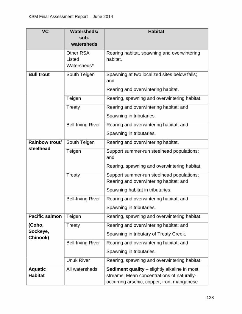
KSM Final Assessment Report – June 2014
128
VC Watersheds/
sub-
watersheds
Habitat
Other RSA
Listed
Watersheds*
Rearing habitat, spawning and overwintering
habitat.
Bull trout South Teigen Spawning at two localized sites below falls;
and
Rearing and overwintering habitat.
Teigen Rearing, spawning and overwintering habitat.
Treaty Rearing and overwintering habitat; and
Spawning in tributaries.
Bell-Irving River Rearing and overwintering habitat; and
Spawning in tributaries.
Rainbow trout/
steelhead
South Teigen Rearing and overwintering habitat.
Teigen Support summer-run steelhead populations;
and
Rearing, spawning and overwintering habitat.
Treaty Support summer-run steelhead populations;
Rearing and overwintering habitat; and
Spawning habitat in tributaries.
Bell-Irving River Rearing and overwintering habitat; and
Spawning in tributaries.
Pacific salmon
(Coho,
Sockeye,
Chinook)
Teigen Rearing, spawning and overwintering habitat.
Treaty Rearing and overwintering habitat; and
Spawning in tributary of Treaty Creek.
Bell-Irving River Rearing and overwintering habitat; and
Spawning in tributaries.
Unuk River Rearing, spawning and overwintering habitat.
Aquatic
Habitat
All watersheds Sediment quality – slightly alkaline in most
streams; Mean concentrations of naturally-
occurring arsenic, copper, iron, manganese
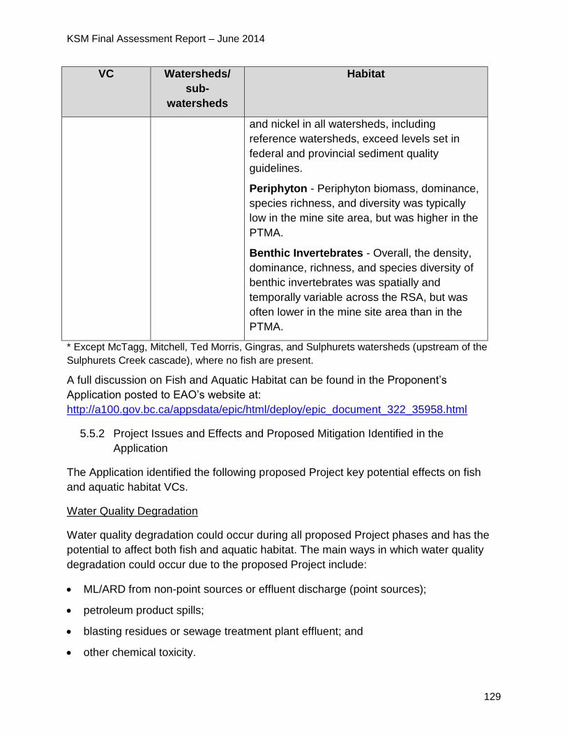
KSM Final Assessment Report – June 2014
129
VC Watersheds/
sub-
watersheds
Habitat
and nickel in all watersheds, including
reference watersheds, exceed levels set in
federal and provincial sediment quality
guidelines.
Periphyton - Periphyton biomass, dominance,
species richness, and diversity was typically
low in the mine site area, but was higher in the
PTMA.
Benthic Invertebrates - Overall, the density,
dominance, richness, and species diversity of
benthic invertebrates was spatially and
temporally variable across the RSA, but was
often lower in the mine site area than in the
PTMA.
* Except McTagg, Mitchell, Ted Morris, Gingras, and Sulphurets watersheds (upstream of the
Sulphurets Creek cascade), where no fish are present.
A full discussion on Fish and Aquatic Habitat can be found in the Proponent’s
Application posted to EAO’s website at:
http://a100.gov.bc.ca/appsdata/epic/html/deploy/epic_document_322_35958.html
5.5.2 Project Issues and Effects and Proposed Mitigation Identified in the
Application
The Application identified the following proposed Project key potential effects on fish
and aquatic habitat VCs.
Water Quality Degradation
Water quality degradation could occur during all proposed Project phases and has the
potential to affect both fish and aquatic habitat. The main ways in which water quality
degradation could occur due to the proposed Project include:
ML/ARD from non-point sources or effluent discharge (point sources);
petroleum product spills;
blasting residues or sewage treatment plant effluent; and
other chemical toxicity.
KSM Final Assessment Report – June 2014
130
The Application reports that point sources of metals are expected to occur as a result of
discharges from the TMF or the Mine Site WTP. Metals that may be present in effluent
discharge were identified as the most important pathways through which water quality
degradation effects could affect fish and aquatic habitat and were the focus of the
effects assessment. Without mitigation, exposure to metals (or other contaminants)
could result in a range of potential effects on fish and aquatic resources, from lethal to
sublethal effects.
The Application reports that chemicals used in ore processing or water treatment may
be released in effluent discharged from the TMF or the Mine Site WTP, or through
accidental spills. These chemicals have the potential to cause toxicity in fish and aquatic
invertebrates, provided that they are present in high enough concentrations for enough
time to affect fish or aquatic organisms.
Spills of diesel fuel or lubricant associated with proposed Project traffic, use of
mechanized equipment and fuel storage areas could enter aquatic habitat directly or in
runoff. Contact with petroleum products may cause physiological or behavioral changes
in fish and aquatic invertebrates, as well as loss of productive habitat capacity.
The use of explosives and disposal of effluent from sewage treatment plants at camps
could introduce nitrogenous compounds and phosphorus into the aquatic environment
which has the potential to cause toxicity or alteration in the productivity of the aquatic
environment.
Habitat Loss and Alteration
Fish habitat loss may entail complete removal or alteration of riparian and instream
habitat, loss of productive capacity, fish passage restrictions and altered water quantity.
The construction, operation, maintenance, and closure of access roads, transmission
lines, TMF, dams, mine pits, RSFs and hydroelectric power (HEP) facilities have the
potential to cause aquatic habitat loss and alteration. For example, TMF water
management may affect productivity of non-fish aquatic life by altering discharge rates,
modifying the wetted width available for aquatic life colonization, as well as nutrient
loading rates. The development of the access roads and transmission line could cause
sedimentation, riparian zone disturbance, and changes in channel morphology. The
installation of dams may alter both the amount of sediment available for transport and
the ability of the channel to transport sediment potentially affecting recruitment for fish
spawning or reducing usable spawning habitat.
The development of the TMF would remove riparian habitat from streams in the North
Treaty and South Teigen watersheds. Riparian vegetation performs numerous
functions, including shading, stabilizing stream banks, controlling sediments,
contributing large woody debris and organic litter, and regulating the composition of
KSM Final Assessment Report – June 2014
131
nutrients.
TMF water management could affect downstream stream temperatures. Increases in
surface water temperature beyond diurnal or seasonal averages could accelerate
embryo development, alter the timing of emergence, growth and downstream migration
of juveniles, reduce metabolic efficiencies of food conversion into growth, alter adult
spawning migration and spawning timing, increase susceptibility to disease and
undermine the competitive advantage of salmonids over non-salmonid species.
Mine Site water management could have several potential effects on downstream non-
fish bearing aquatic habitats. Instream and riparian habitat would be lost within the non-
fish bearing McTagg, Mitchell, and Gingras Creeks due to water diversions.
The WSF would alter downstream aquatic habitat in Sulphurets Creek by potentially
decreasing the supply of organic matter, benthic invertebrates and sediments from its
catchment. The WSF would act as a sedimentation pond, and by settling of suspended
solids, would decrease the movement of sediments from the Mitchell watershed and the
McTagg RSF into Sulphurets Creek.
Other Potential Effects on Fish and Aquatic Habitat
Three other potential effects on fish and aquatic resources were discussed in the
Application, including:
Direct mortality: could be linked to increased fishing pressures, interactions with
construction machinery and other events that cause immediate or near-immediate death
in fish (e.g. sedimentation that smothers embryos). Proposed Project activities that may
be associated with direct mortality effects include construction of the access roads,
transmission line and the TMF.
Noise: loud noise associated with blasting near watercourses can potentially cause
physical damage to fish eggs, larvae, juveniles and adults and tissue damage affecting
the swim bladders of fish. Noise pollution caused by construction machinery and
blasting may affect fish behaviour. The Application states that construction of the
access roads, transmission line and TMF would be associated with blasting activities
and sustained construction noise affecting fish and aquatic habitat.
Erosion and Sedimentation: could increase turbidity causing the smothering of primary
and secondary producers at various life stages, reduced visibility, diminished feeding
efficiency, increased exposure to elevated metal concentrations, and lead to habitat
avoidance by aquatic organisms. Potential proposed Project-specific sources of erosion
and sedimentation include construction of access roads, transmission line, TMF,
tunnels, RSFs, pits, WSD, camps and diversion ditches.
KSM Final Assessment Report – June 2014
132
Summary of Mitigation Proposed in the Application
The Application outlined the Proponent’s mitigations to address effects to fish and
aquatic habitat including a range of mitigation measures incorporated into proposed
Project design elements as well as specific operational policies. The Proponent has
proposed effects monitoring in the AEMP to detect alterations to the receiving
environment including changes to sediment quality or effects on aquatic life and fish,
and implementing adaptive management strategies, where warranted.
Proposed mitigation measures to address effects include:
prohibiting employees and contractors from engaging in fishing while present at the
proposed Project site;
deactivating non-essential roads at closure;
developing and implementing site-specific riparian management prescriptions and
riparian vegetation maintenance plan/prescriptions to guide transmission line
construction and maintenance activities;
implementing sediment control measures (e.g. silt fences surrounding waterbodies),
and repairing areas that are potential sediment sources in a timely manner;
installing settling ponds to intercept runoff from areas outside the WSF catchment during construction;
installing aeration systems within the temporary construction-phase WTPs to increase ammonia volatilization, thereby decreasing loadings in downstream receiving environments generated by explosives use;
installing a high-density sludge lime WTP at the Mine Site to treat contact water
stored in the WSF to reduce concentrations of some metals, total suspended solids
and some ions, as well as adjusting the pH from acidic to a more neutral pH;
reducing selenium concentrations in contact water at the Mine Site, backfilling the
Sulphurets Pit with Kerr Pit waste rock, and covering the material with liners to
reduce infiltration rates;
directing drainage from the backfilled Sulphurets Pit to an ion exchange SeTP for
treatment, prior to pumping to the Mine Site WTP for further treatment;
routing TMF discharge into Treaty from North Treaty Creeks during TMF operations;
planting riparian vegetation around diversion tunnels, channels, and ditches on both
the northeast and southwest sides of the TMF, to protect against temperature
increases in these water conduits, and offer some new aquatic habitat for
colonization during construction and operations;
decommissioning diversion structures on the northeast side of the TMF during

KSM Final Assessment Report – June 2014
133
closure and post-closure, allowing natural drainage into the reclaimed TMF;
converting the TMF from a wetland and stream habitat to a lake-type habitat during
closure and post-closure; and
developing the two seepage recovery ponds located downstream of the TMF dam,
as far as possible, into small lakes suitable for aquatic invertebrates during closure
and post-closure.
KSM Final Assessment Report – June 2014
134
Fish Habitat Compensation Plans
The Proponent developed two Fish Habitat Compensation Plans as required under
Section 35(2) of the Fisheries Act Regulations and the MMER: the first is to offset loss
of the productive capacity of fish habitat linked to construction and operation of the TMF
dams, road crossing structures, transmission line crossings and water quantity
reductions in South Teigen and North Treaty Creeks downstream of the TMF dams; and
the second is to offset loss of the productive capacity of fish habitat linked to the deposit
of deleterious substances within fish-bearing watercourses beneath the footprint of the
proposed TMF and related seepage collection ponds. Both plans were developed with
input from the Working Group and target Dolly Varden habitat with benefits to other
salmonid species, such as coho salmon.
5.5.3 Project Issues and Effects and Proposed Mitigation Identified During
Application Review
During the review of the Application, additional issues were raised by the agencies,
NLG, First Nations and the public. These issues, the Proponent responses and EAO’s
assessment of the adequacy of responses are detailed in Appendix 1. The CPD and
TOC (Appendix 2) contain specific mitigation measures, which would be legally
enforceable if an EA Certificate is issued. Examples of some of the key issues and
additional commitments include:
MOE, Gitanyow Nation and Tahltan Nation raised concerns regarding the
Proponent’s bioaccumulation model in relation to the selenium thresholds as
some sampling stations and fish tissue levels were above provincial guidelines at
baseline.
MOE required the Proponent to describe the potential effects of long-term
exposure to elevated selenium on invertebrates, fish and birds. MOE was
particularly concerned with the potential for selenium concentrations and
loadings to be underestimated in the Proponent’s ground and surface water
quality model predictions and the potential for the residual effects to water quality
and fish to be greater than predicted.
Gitanyow Nation stated the Proponent should develop additional mitigation
measures now to be included in the AEMP as adaptive management, should
elevated selenium levels be detected in the future during operations.
o The Proponent responded that the AEMP includes sampling of water,
sediment, primary producers, and secondary producers (including tissue
metals), with fish sampling to occur as per MMER requirements. The
Proponent asserted the monitoring program was designed to ensure the
collection of data that may be required in the future if bioaccumulation
KSM Final Assessment Report – June 2014
135
modeling is needed and adaptive management strategies would be
implemented, depending on the results of monitoring.
o The Proponent stated that additionally, guidelines for the receiving
environment are established to protect the most sensitive species and
lifestage in the most sensitive environments. However, there is no shared,
consistent toxicity threshold that is common to all species when exposed to
selenium. Species-specific dose‐response thresholds make it difficult to put
in place a single, universal guideline that is protective of aquatic life. Based
on the available information, the Proponent stated that toxicity is not likely to
occur in cold water fish species with the body burden that was measured in
Dolly Varden.
o The Proponent responded that bioaccumulation of selenium in fish is not
predicted to reach levels harmful to fish, fish-eating wildlife or to the health of
humans consuming fish originating from rivers downstream of the proposed
Project.
o The Proponent provided additional details in the SeMP, developed during
the Application review in response to review comments, including a plan to
address uncertainty associated with the potential bioaccumulation of
selenium. A long-term objective of the plan is to establish the relationship
between fish tissue metal (selenium) concentrations and benthic tissue
metal (selenium) concentrations. If a relationship can be established
between fish and benthic tissue metal concentrations, then annual
monitoring of benthic tissue metals would provide an 'early-warning' or
trigger that concentrations of metals in the aquatic environment are
changing.
o Adaptive management measures described in the SeMP include
implementation of additional/ new engineering controls or measures,
alteration in water management, water treatment, risk assessment, and
additional, more targeted monitoring.
MOE provided comments on the draft SeMP noting that the plan does not address
the risk to salmon species posed by high baseline tissue concentrations of selenium
and potential effects on the lower Unuk River. MOE and Gitanyow were concerned
about the effects of selenium loadings that would be discharged into the Unuk, Bell-
Irving and Nass watersheds over the life of the proposed Project and the potential
for selenium to bioaccumulate. MOE specifically noted the Unuk River estuary and
Gitanyow noted the Nass estuary, both of which are fish rearing areas and potential
deposition zones.
KSM Final Assessment Report – June 2014
136
o The Proponent responded indicating that salmon species (coho) in the Unuk
River do not have elevated baseline tissue concentrations of selenium. The
mean concentration of selenium in coho salmon collected from four sites in
the Unuk River in 2013 was between 1.79 and 3.04 mg/kg dry weight, which
is below the tissue residue guideline of 4 mg/kg dry weight.
o The Proponent responded that the SeMP outlines a monitoring framework
that includes sampling of water, sediment and tissue residues that would
apply to both the Unuk River and to waterways downstream of the proposed
TMF.
o The Proponent committed to implement the SeMP prior to construction of
the proposed Project.
MOE was concerned that there could also be an enhanced uptake of selenium
and perhaps mercury by aquatic insects and into fish and wildlife that eat insects
or fish that was not assessed by the Proponent.
o In response, the Proponent stated that it is possible that increased
productivity in streams may allow for increased uptake of selenium into the
food chain, although it is not certain that increased productivity will occur
since other factors may also control biomass (e.g. water temperature, water
flow, availability of other micronutrients, etc.). The proposed monitoring in
the AEMP includes the measurement of periphyton biomass and community
structure, and benthic invertebrate community structure and tissue metal
analysis. These monitoring programs would identify changes in productivity,
as well as any changes in selenium uptake into the food chain via the
aquatic environment.
o The AEMP is a condition of the EA Certificate.
MOE was concerned with the baseline mercury exceedances in Dolly Varden fish
tissue in the Unuk River, North Treaty Creek and South Teigen Creek (maximum
fish tissue residues measured during baseline studies). MOE required additional
information from the Proponent to determine potential effects including
bioaccumulation of mercury. MOE required the Proponent to provide effects
assessments of all COPC that are predicted to exceed BCWQG including the
predicted elevated copper concentrations in the Unuk River and Sulphurets
Creek.
Gitanyow Nation was also concerned about potential impacts of copper in Treaty
Creek salmon and questioned why copper wasn’t considered by the Proponent
as a COPC in their assessment.
KSM Final Assessment Report – June 2014
137
o In response the Proponent submitted additional information regarding all
COPC including mercury and copper. The Proponent stated mercury water
concentrations in the PTMA and in the Unuk River downstream of the Mine
Site are not expected to change significantly relative to baseline, and
changes in mercury bioaccumulation is not expected in the receiving
environment downstream of the TMF or the Mine Site. Therefore, the
Proponent concluded that the baseline mercury tissue residue guideline
exceedance is not a proposed Project-related effect and mercury was
scoped out from further assessment in the EA.
o Similarly, the Proponent prepared additional information for copper and
aluminum indicating that the predicted concentrations exceed guideline
concentrations, but was similar to or lower than baseline concentrations.
Therefore, neither dissolved aluminum nor total copper were selected as
COPCs and were not assessed further because there are no predicted
proposed Project-related effects on concentrations of these metals at either
the PTMA or Mine Site.
MOE, FLNR, Fisheries and Oceans Canada (DFO) and NLG noted a number of
uncertainties with the Proponent’s fish salvage program which includes salvage
of the Dolly Varden from the TMF area and relocating them into Treaty Creek.
DFO was concerned that there may not be a sufficient amount of existing habitat
in Treaty Creek to support both the existing population of Dolly Varden and the
relocated fish from the TMF and suggested the Proponent construct the fish
compensation habitats in Treaty and Teigen Creeks in advance of fish salvage.
NLG suggested the Proponent consider relocation to underutilized, clear water
habitat within the Upper Bell-Irving watershed. MOE and NLG required the
Proponent to implement a post transfer monitoring program to evaluate the
success of the re-location strategy.
o Based upon KSM Fisheries Working Group recommendations on
November 15, 2013, the Proponent conducted further assessment of the
relocation strategy for Dolly Varden to ensure that all potential relocation
options are considered and evaluated. This assessment included a risk
assessment to assess the specific risks associated with relocating Dolly
Varden from the TMF in North Treaty and South Teigen Creeks to other
waterbodies within Teigen and Treaty watersheds.
o The results of the environmental risk analysis indicate the waterbody options
of least risk for Teigen and Treaty watersheds; Hodkin Lake was identified
as the preferred option in the Teigen Watershed; and Treaty Creek is the
preferred option in the Treaty Watershed.
KSM Final Assessment Report – June 2014
138
o The Proponent committed to monitoring Dolly Varden relocation following a
Before-After-Control-Impact experimental design.
NLG raised additional questions regarding the Proponent’s fish salvage program
which the Proponent responded to in an additional memo.
FLNR stated that generally, it does not see a significant advantage to the fish
salvage operation. It is unlikely that salvaging fish would result in the preservation
of any unique genetic diversity, nor will it permanently increase the productivity of
Hodkin Lake or Treaty Creek.
o EAO added a condition that the Proponent must implement a Fish Salvage
Plan that will describe how the effectiveness of the Fish Salvage Plan will be
evaluated.
DFO recommended that the Proponent’s proposed water temperature monitoring
program within the TMF and in the receiving watercourses be implemented
during those times when the TMF would have the highest likelihood of affecting
the water temperature in the receiving environment (e.g. during those times when
it is discharging the greatest amount of water into South Teigen (years greater
than 45), North Treaty Creek (Years 30 to 45 and greater than 56), and Treaty
Creek (during TMF development and Years 45 to 50).
NLG also wanted the Proponent to continue water temperature monitoring in
North Treaty, Treaty, South Teigen and Teigen Creeks for the life of the mine,
including closure and post closure as part of the AEMP.
o In response, the Proponent committed to monitor water temperatures in
North Treaty, Treaty, South Teigen and Teigen Creeks for the life of the
mine, including closure and five years post closure as part of the AEMP.
NLG, Gitanyow Nation and Tahltan Nation were concerned about potential
impacts to salmon including impacts from reduced water quantity in Teigen
Creek (and potential impacts to spawning Chinook). Tahltan Nation was
particularly concerned about potential impacts to the high value fisheries in the
Teigen Creek and North Treaty Creek areas and the adequacy of the AEMP to
protect the fish species in these areas.
Tahltan Nation requested the Proponent commit to a salmon management plan
to protect the salmon species within the Bell Irving River system.
o The Proponent responded that they have committed to monitoring fish and
aquatic habitat in the AEMP, which includes the Bell-Irving and Unuk River
watersheds. In addition to this program, the Proponent has committed to
monitoring Teigen Creek salmon through the implementation of a program
to verify the predictions of the effects assessment. This program will
KSM Final Assessment Report – June 2014
139
include monitoring of adult returns, juvenile abundance in relation to flow,
gravel/bedload transport and supply, hydrology, and water temperatures.
Gitanyow Nation submitted a number of reports regarding sublethal effects of metals
and non-metals on salmon. The reports stated that the Application lacked scientific
information regarding metal toxicity effects on salmonids including sub-lethal effects
to fish. Gitanyow Nation stated that without adequate information, it is impossible to
accurately assess harm of the proposed Project on salmon and biota within the
salmon food-web.
Gitanyow Nation stated that Teigen and Treaty Creeks, and the Bell Irving River,
all in close proximity to the TMF, are vulnerable to ML/ARD effects. These
streams support important populations of Nass River salmonids. Gitanyow Nation
was very concerned that these potential impacts from the TMF would diminish
salmonid availability not only in and around Teigen and Treaty Creeks but in the
Bell Irving and Nass Rivers. Gitanyow Nation stated these fish form part of their
constitutionally protected aboriginal fishing rights.
Gitanyow Nation recommended the Proponent develop and conduct an effective
biotic response monitoring program to determine post proposed Project adverse
effects to fish abundance and biomass.
o In response to Gitanyow Nation’s report, the Proponent submitted a review
of the potential for metals from the TMF to affect salmonids in Treaty and
Teigen Creeks. This report concludes that the COPC screening conducted
by the Proponent followed standard risk assessment approaches as
recommended by MOE and EC and used a reasonable approach to evaluate
if predicted concentrations exceed baseline concentrations.
o The Proponent noted that sublethal effects of metals were considered in the
Application for fish and aquatic habitat. The Proponent’s assessment of not
significant (minor) effects due to water quality degradation considered the
potential for sublethal toxicity and concluded that the potential for chronic
sublethal effects that are proposed Project-related is unlikely since
concentrations are predicted to be below toxicity thresholds. In addition,
predicted metal concentrations are similar to baseline metal concentrations
downstream of the TMF, so the proposed Project is not likely to lead to
residual effects that are different than what is currently occurring under
natural conditions.
MOE reviewed the reports submitted by the Proponent and Gitanyow Nation with
respect to potential metal toxicity from the PTMA and presented their conclusions
in a letter to EAO. MOE agreed with the Gitanyow Nation report in that the
Application does not assess predicted changes in dissolved metal concentrations
KSM Final Assessment Report – June 2014
140
to levels above water quality guidelines, even if total metals show little change.
MOE stated that this creates uncertainty in the assessment results and
conclusions for aquatic effects.
MOE stated that sediment contaminant loadings and downstream effects to
Treaty Creek, Bell-Irving River and Nass River should be addressed through the
Proponent’s proposed AEMP, required through Environmental Management Act
permitting. MOE recommended monitoring to assess potential changes to fish
behavior such as the avoidance of spawning areas due to chemical stresses
relating to tailings seepage and effluent.
After considering the Application and the Proponent’s subsequent Hazard
Quotient memo, MOE concluded that uncertainty remains as to the potential
effects of contaminants predicted to be discharged from the PTMA because
assessments are lacking for metals that were inappropriately screened out.
EC commented that the methods used to assess sub-lethal toxicity to salmonids,
along with the results presented in the Application are acceptable and consistent
with expectations set out in the AIR.
o As discussed in section 5.2.3, EAO re-reviewed the information presented in
the Application, the subsequent December 19, 2013 memo from the
Proponent on hazard quotient methods, additional information from the
Proponent on the baseline and predicted concentrations of COPCs which
were screened out using the alternative screening method, and Working
Group comments. As a result of this re-review, EAO concluded that the
Proponent’s decision to not carry these COPCs into the effects assessment
was appropriate at the EA level. EAO recognizes that additional information
may be required by MOE at the Environmental Management Act permitting
stage with respect to this issue should an EA Certificate be issued for the
proposed Project.
DFO submitted a letter on April 9, 2014, providing a summary of DFO’s
understanding of the relative importance or value of Teigen, Treaty or Bell-Irving
salmon to the Nass River fishery, as follows:
o Sockeye: In general, Teigen and Treaty Creeks have low productive
capacity for sockeye and currently produce very few sockeye. The
importance of these systems as sockeye production areas would be
considered low.
o Chinook: The Bell-Irving River is an important chinook producer, with Teigen
Creek being an important contributor to the Bell-Irving. Treaty Creek appears
to be much less important than Teigen Creek, with low chinook production.
KSM Final Assessment Report – June 2014
141
o Coho: The Bell-Irving River is an important coho producer. Coho information
specific to Teigen and Treaty Creeks is very limited. However, it is
recognized that these tributaries provide important rearing habitat for Nass
coho.
Gitanyow Nation continued to express concerns with the information presented
by reviewers and the Proponent stating that they underrepresent the fisheries
values of Teigen and Treaty Creeks.
NLG was concerned about the potential for effects on aquatic communities due
to changes in nutrient loadings to Teigen and Treaty Creek.
o In response the Proponent noted that the AEMP outlines the following
monitoring for aquatic resources: monitor primary and secondary producers
annually during the operation phase for biomass and community structure,
and analyze benthic invertebrate tissue metals; similar monitoring will be
conducted during the first 10 years after the operation phase (i.e.
closure/post-closure phases) for benthic invertebrates at sites not subject to
MMER or Environmental Management Act discharge permits.
o The Proponent stated that further discussion of the AEMP will be done
during the permitting phase, in consultation with regulatory agencies and
NLG in order to ensure that ongoing monitoring proposed under the AEMP is
conducted in a manner that ensures regulatory compliance.
United States Department of the Interior asserted that the Proponent should have
conducted an analysis of potential proposed Project-related impacts on oolichan and
each salmon species found in the Unuk River and the subsistence fisheries
associated with those species and proposed mitigation measures for effects.
The State of Alaska was concerned about the potential elimination of fish habitat
in BC watersheds that drain to Alaska, and the impact downstream to Alaskan
fishery resources and water quality.
o In response the Proponent noted that the AIR did not require study of Chum
Salmon, Pink Salmon, and oolichan as they are not found in the RSA.
Further, during the review of the draft AIR, EAO and DFO determined that
other species such as Dolly Varden, Bull trout, rainbow trout/steelhead, and
Pacific salmon were sufficient to determine if there is any potential for
adverse effects on downstream oolichan populations.
o Further the Proponent stated that significant residual effects were not
predicted for fish and aquatic habitat due to water quality degradation
downstream of the PTMA (i.e. Nass watershed) or the Unuk River
downstream of the Mine Site.
KSM Final Assessment Report – June 2014
142
NLG stated the increased fishing pressure from simply enabling more people to
be aware of the resource and access it off duty is not fully mitigated. NLG
requested the Proponent to commit to assist in enhanced fishery monitoring of
anglers in the Bell-Irving watershed.
o The Proponent responded that mitigation measures to control access to
fisheries resources by mine employees/contractors on the proposed Project
site are proposed. However, monitoring of anglers in the Bell-Irving
watershed falls under provincial and federal jurisdiction.
NLG responded that BC and Canada have diminishing resources to enforce
fishing in the Bell-Irving watershed and there is currently no monitoring program.
NLG noted that through the NFA Joint Fisheries Committee NLG strives to
protect fish resources in the watershed and funding is a bottleneck to a proper
monitoring program.
MOE, NLG and Gitanyow Nation stated that sediment toxicity monitoring should
have been included in baseline studies and should be included in the Proponent’s
AEMP.
o In response, the Proponent stated that sediment toxicity testing was not
conducted as part of baseline studies as it was not a requirement of the AIR
and is not recommended by the “BC Water and Air Baseline Monitoring
Guidance Document for Mine Proponents and Operators (2012)”.
o The AEMP will be discussed and confirmed by MOE, EC and the Proponent
during the permitting process for the scope of activities required to construct
and operate the mine.
o The SeMP will include lentic14 and lotic15 habitat mapping. This mapping will
contribute to an understanding of potential sediment depositional areas
downstream of the TMF and WSF.
o In response to a recommendation by NLG, the Proponent added additional
sediment sampling sites and benthic invertebrate sampling on the Bell-Irving
River up and downstream of Treaty Creek in the SeMP.
14 Lentic refers to of, relating to, or living in still water.
15 Lotic refers to of, relating to, or living in moving water.
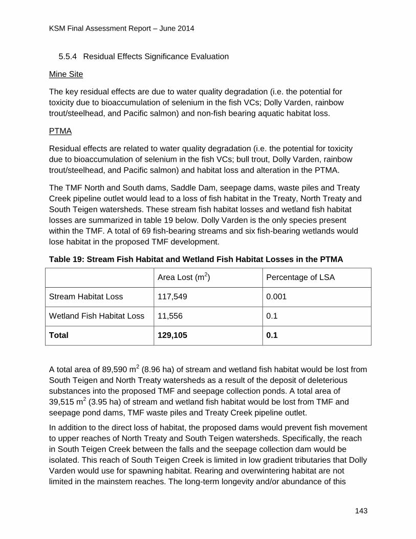
KSM Final Assessment Report – June 2014
143
5.5.4 Residual Effects Significance Evaluation
Mine Site
The key residual effects are due to water quality degradation (i.e. the potential for
toxicity due to bioaccumulation of selenium in the fish VCs; Dolly Varden, rainbow
trout/steelhead, and Pacific salmon) and non-fish bearing aquatic habitat loss.
PTMA
Residual effects are related to water quality degradation (i.e. the potential for toxicity
due to bioaccumulation of selenium in the fish VCs; bull trout, Dolly Varden, rainbow
trout/steelhead, and Pacific salmon) and habitat loss and alteration in the PTMA.
The TMF North and South dams, Saddle Dam, seepage dams, waste piles and Treaty
Creek pipeline outlet would lead to a loss of fish habitat in the Treaty, North Treaty and
South Teigen watersheds. These stream fish habitat losses and wetland fish habitat
losses are summarized in table 19 below. Dolly Varden is the only species present
within the TMF. A total of 69 fish-bearing streams and six fish-bearing wetlands would
lose habitat in the proposed TMF development.
Table 19: Stream Fish Habitat and Wetland Fish Habitat Losses in the PTMA
Area Lost (m2) Percentage of LSA
Stream Habitat Loss 117,549 0.001
Wetland Fish Habitat Loss 11,556 0.1
Total 129,105 0.1
A total area of 89,590 m2 (8.96 ha) of stream and wetland fish habitat would be lost from
South Teigen and North Treaty watersheds as a result of the deposit of deleterious
substances into the proposed TMF and seepage collection ponds. A total area of
39,515 m2 (3.95 ha) of stream and wetland fish habitat would be lost from TMF and
seepage pond dams, TMF waste piles and Treaty Creek pipeline outlet.
In addition to the direct loss of habitat, the proposed dams would prevent fish movement
to upper reaches of North Treaty and South Teigen watersheds. Specifically, the reach
in South Teigen Creek between the falls and the seepage collection dam would be
isolated. This reach of South Teigen Creek is limited in low gradient tributaries that Dolly
Varden would use for spawning habitat. Rearing and overwintering habitat are not
limited in the mainstem reaches. The long-term longevity and/or abundance of this
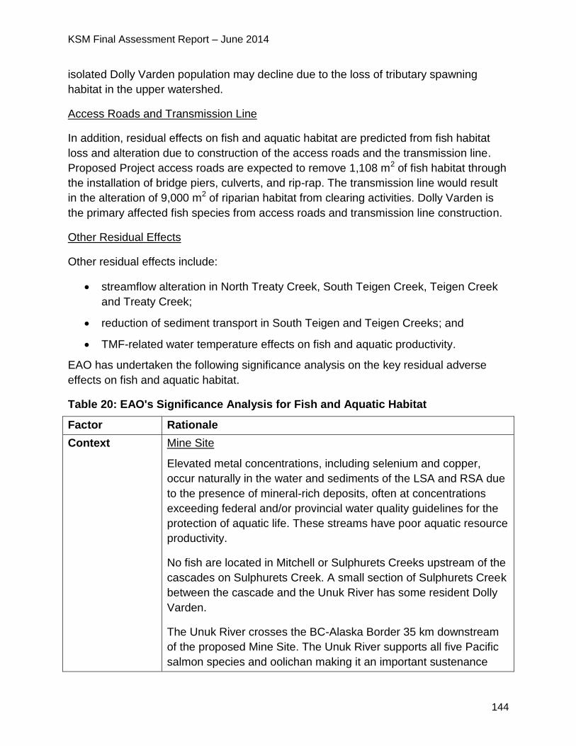
KSM Final Assessment Report – June 2014
144
isolated Dolly Varden population may decline due to the loss of tributary spawning
habitat in the upper watershed.
Access Roads and Transmission Line
In addition, residual effects on fish and aquatic habitat are predicted from fish habitat
loss and alteration due to construction of the access roads and the transmission line.
Proposed Project access roads are expected to remove 1,108 m2 of fish habitat through
the installation of bridge piers, culverts, and rip-rap. The transmission line would result
in the alteration of 9,000 m2 of riparian habitat from clearing activities. Dolly Varden is
the primary affected fish species from access roads and transmission line construction.
Other Residual Effects
Other residual effects include:
streamflow alteration in North Treaty Creek, South Teigen Creek, Teigen Creek
and Treaty Creek;
reduction of sediment transport in South Teigen and Teigen Creeks; and
TMF-related water temperature effects on fish and aquatic productivity.
EAO has undertaken the following significance analysis on the key residual adverse
effects on fish and aquatic habitat.
Table 20: EAO's Significance Analysis for Fish and Aquatic Habitat
Factor Rationale
Context Mine Site
Elevated metal concentrations, including selenium and copper,
occur naturally in the water and sediments of the LSA and RSA due
to the presence of mineral-rich deposits, often at concentrations
exceeding federal and/or provincial water quality guidelines for the
protection of aquatic life. These streams have poor aquatic resource
productivity.
No fish are located in Mitchell or Sulphurets Creeks upstream of the
cascades on Sulphurets Creek. A small section of Sulphurets Creek
between the cascade and the Unuk River has some resident Dolly
Varden.
The Unuk River crosses the BC-Alaska Border 35 km downstream
of the proposed Mine Site. The Unuk River supports all five Pacific
salmon species and oolichan making it an important sustenance
KSM Final Assessment Report – June 2014
145
and commercial fishery river to BC First Nations and federally
registered tribes in Alaska.
PTMA
Some baseline metal concentrations exceed BCWQG in all PTMA
watersheds, except Teigen Creek, due to upstream mineralization
and glaciation processes.
Dolly Varden is the only species present in the reaches of North
Treaty and South Teigen Creeks which lie within the footprint of the
proposed TMF. Dolly Varden, bull trout, mountain whitefish and
rainbow trout are present in South Teigen Creek, downstream of a
2.5 m high falls and outside of the proposed TMF footprint.
Teigen and Treaty Creeks have valuable salmon habitat. Teigen
and Treaty Creeks support steelhead and Pacific salmon species
including coho, sockeye and chinook. Teigen Creek supports
important chinook populations. Snowbank Creek, a sub-watershed
of Teigen Creek, supports important coho populations. Todedada
Creek, a sub-watershed of Treaty Creek, supports important coho
populations. Teigen Creek and Todedada Creek support riverine
sockeye populations. These creeks in turn drain into the Bell-Irving
River, which in turn drains into the Nass River. The Bell-Irving River
is an important chinook and coho producer, with Teigen Creek
being an important chinook contributor to the Bell-Irving (Teigen
Creek comprises approximately 42% of the Bell-Irving River chinook
salmon stocks, and approximately 8% of the total Nass River
chinook salmon stocks). Coho information specific to Teigen and
Treaty Creeks is very limited. However, it is recognized that these
tributaries provide important rearing habitat for Nass coho.
Steelhead are known to inhabit Teigen and Treaty Creeks in
densities high enough to support annual recreational and angler
guided fisheries.
The Nass River support important populations of oolichan, all five
species of Pacific salmon and other salmonids, such as steelhead
and trout. The Bell-Irving River supports Pacific salmon. Access to
healthy populations of these fish are a treaty right of the Nisga’a
Nation and support aboriginal rights fisheries for other First Nations
such as the Tahltan, Gitxsan and Gitanyow Nations. These fish also
KSM Final Assessment Report – June 2014
146
contribute to valuable commercial fisheries.
Magnitude Mine Site
Water Quality Degradation: The magnitude for water quality
degradation effects on the fish and aquatic habitat VCs is moderate,
linked to predicted elevated selenium concentrations downstream of
the Mine Site WTP in all proposed Project phases except
construction. Concentrations of selenium in water and sediment are
predicted to increase relative to baseline concentrations in lower
Sulphurets Creek, but would meet BCWQG at UR1 and UR2 on the
Unuk River. Fish tissue selenium residues of Dolly Varden in
Sulphurets Creek already exceed the BC tissue residue guideline,
and increases in water selenium concentrations will likely lead to
increases in selenium in fish tissue and aquatic life.
Other metals, such as copper, lead, cadmium and zinc are
predicted to improve in Sulphurets Creek and the Unuk River due to
proposed water treatment and the elevated baseline metal levels.
Fish and Aquatic Habitat Loss and Alteration:
Streamflow in Sulphurets Creek or the Unuk River is not predicted
to be substantially altered based on hydrological modelling. Habitat
loss is limited to non-fish bearing areas of the Mitchell, McTagg,
Gingras, and Sulphurets Creeks; these areas had low aquatic
resource productivity in baseline studies. The magnitude for effects
due to aquatic habitat loss and alteration is low.
PTMA
Water Quality Degradation:
With the condition that water quality must meet either BCWQG or
SSWQO at a point 100 m downstream of the effluent discharge
point on Treaty Creek and 100 m downstream of the last point of
control on South Teigen Creek, the magnitude of the water quality
degradation effects on fish and aquatic habitat in these creeks is
considered low. This rating is in reference to the fact that while there
are some minor changes in water quality relative to baseline, the
predicted water quality is below BCWQG which would, by definition,
be protective of the aquatic environment. Although there may be
slight changes in selenium concentrations relative to baseline
conditions which may translate into slight increases in selenium
KSM Final Assessment Report – June 2014
147
tissue residues, it is unlikely that the concentrations would exceed
toxicity thresholds.
Effects on Pacific salmon VCs downstream of the TMF, in the Bell
Irving and Nass Rivers are predicted to be negligible as water
quality will not change relative to baseline.
The magnitude is low for all other water quality degradation effects
on the fish or aquatic habitat VCs, since water quality is predicted to
be similar to baseline conditions.
Fish and Aquatic Habitat Loss and Alteration:
Streamflow (mean annual discharge) in North Treaty and South
Teigen Creek is predicted to change measurably over the duration
of TMF development, resulting in a total of 4211 m2 of residual fish
habitat loss and alteration, through an alteration of the suitability or
area of Dolly Varden habitat. The magnitude is moderate for fish
and aquatic habitat loss and alteration, reflecting the offsetting
effects of proposed fish habitat compensation programs with
respect to fish habitat losses.
Extent Mine Site
Water Quality Degradation: Water quality degradation effects on fish
and aquatic habitat downstream of the Mine Site WTP are
considered landscape since selenium concentrations would exceed
both BCWQG and baseline levels in Sulphurets Creek. With the
Proponent’s commitment to construct and operate a SeTP with a
capacity of 500 L/s at the WSF by year five of operations, selenium
concentrations would meet BCWQG in the Unuk River at both UR1
and UR2. Concentrations of nitrogen would also be elevated relative
to baseline during the construction and operation phases.
Fish and Aquatic Habitat Loss and Alteration: Habitat loss and
alteration effects are considered landscape in extent since fish
depend on habitat downstream of the proposed Project footprint to
carry out life processes (e.g. spawning, rearing and migration).
PTMA
Water Quality Degradation: Water quality degradation effects on fish
and aquatic habitat downstream of the TMF are considered
landscape in extent, as the Proponent has committed to meet
KSM Final Assessment Report – June 2014
148
BCWQG and/or SSWQO at a point 400 m downstream of the
discharge point of any temporary water treatment plants operating
in Upper Treaty Creek or South Teigen Creek, while these plants
are in operation; and 100 m downstream of the effluent discharge
point of the TMF pipeline into Treaty Creek and 100 m downstream
of the North seepage dam in South Teigen Creek during the
operations, closure and post closure phases of the proposed
Project. The potential for residual selenium effects would decrease
with distance from the TMF discharge point due to dilution, and
residual effects are not predicted in Treaty or Teigen Creeks.
Fish and Aquatic Habitat Loss and Alteration: Habitat loss and
alteration effects are considered landscape in extent since fish
depend on habitat downstream of the proposed Project footprint to
carry out life processes (e.g. spawning, rearing and migration).
Duration Mine Site
Water Quality Degradation: Water quality degradation effects on fish
and aquatic habitat VCs downstream of the Mine Site WTP are
rated far future as effluent discharge from the Mine Site is proposed
from the construction phase into the post-closure phase. The effects
are due to release of metal and non-metal water quality parameters
and with the longer term onset of ML/ARD. All these effects would
require long term water treatment as a key mitigation.
Fish and Aquatic Habitat Loss and Alteration: Aquatic habitat loss
and alteration effects are considered permanent as no
compensation is proposed.
PTMA
Water Quality Degradation: Water quality degradation effects on fish
and aquatic habitat VCs downstream of the TMF are rated long-
term, slowly improving after mining operations cease until such time
that water from the TMF meets water quality discharge
requirements and can be discharged.
Fish and Aquatic Habitat Loss and Alteration: Fish habitat loss and
alteration effects are considered short term: a short time would
elapse between habitat destruction and the creation of habitat under
the fish habitat compensation plans.
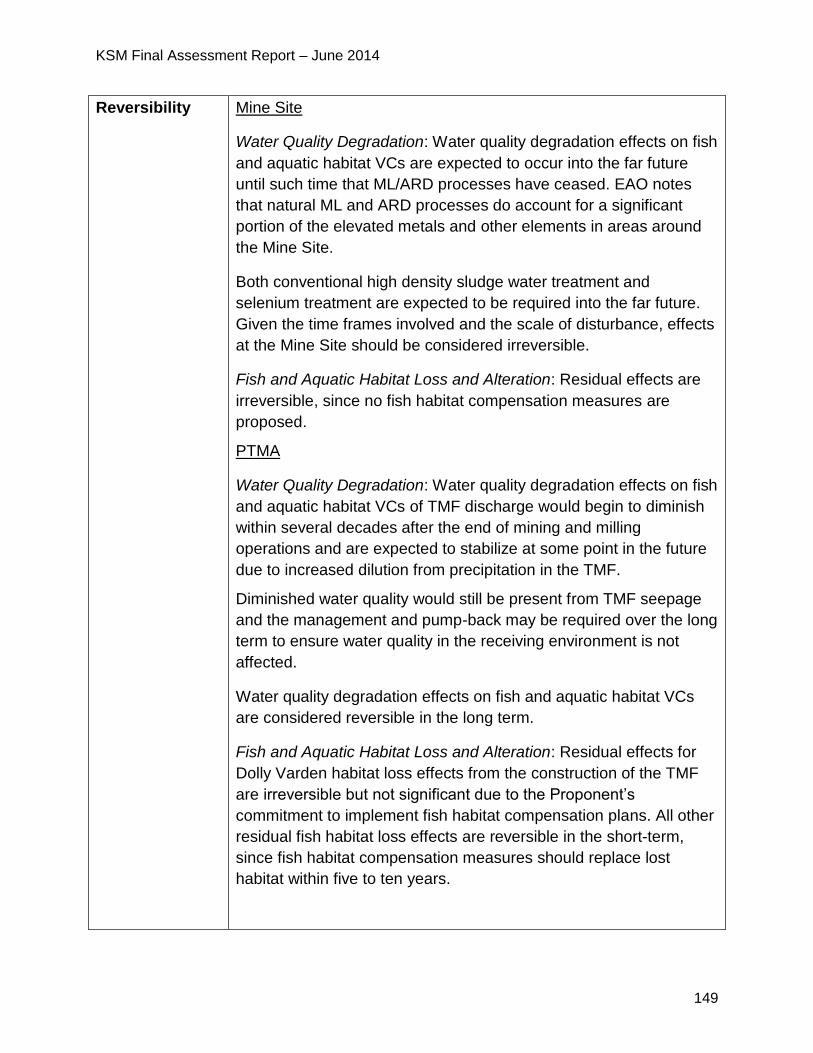
KSM Final Assessment Report – June 2014
149
Reversibility Mine Site
Water Quality Degradation: Water quality degradation effects on fish
and aquatic habitat VCs are expected to occur into the far future
until such time that ML/ARD processes have ceased. EAO notes
that natural ML and ARD processes do account for a significant
portion of the elevated metals and other elements in areas around
the Mine Site.
Both conventional high density sludge water treatment and
selenium treatment are expected to be required into the far future.
Given the time frames involved and the scale of disturbance, effects
at the Mine Site should be considered irreversible.
Fish and Aquatic Habitat Loss and Alteration: Residual effects are
irreversible, since no fish habitat compensation measures are
proposed.
PTMA
Water Quality Degradation: Water quality degradation effects on fish
and aquatic habitat VCs of TMF discharge would begin to diminish
within several decades after the end of mining and milling
operations and are expected to stabilize at some point in the future
due to increased dilution from precipitation in the TMF.
Diminished water quality would still be present from TMF seepage
and the management and pump-back may be required over the long
term to ensure water quality in the receiving environment is not
affected.
Water quality degradation effects on fish and aquatic habitat VCs
are considered reversible in the long term.
Fish and Aquatic Habitat Loss and Alteration: Residual effects for
Dolly Varden habitat loss effects from the construction of the TMF
are irreversible but not significant due to the Proponent’s
commitment to implement fish habitat compensation plans. All other
residual fish habitat loss effects are reversible in the short-term,
since fish habitat compensation measures should replace lost
habitat within five to ten years.
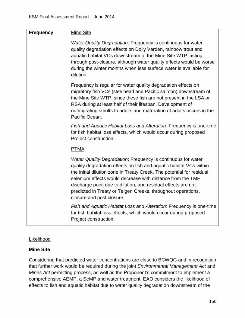
KSM Final Assessment Report – June 2014
150
Frequency Mine Site
Water Quality Degradation: Frequency is continuous for water
quality degradation effects on Dolly Varden, rainbow trout and
aquatic habitat VCs downstream of the Mine Site WTP lasting
through post-closure, although water quality effects would be worse
during the winter months when less surface water is available for
dilution.
Frequency is regular for water quality degradation effects on
migratory fish VCs (steelhead and Pacific salmon) downstream of
the Mine Site WTP, since these fish are not present in the LSA or
RSA during at least half of their lifespan. Development of
outmigrating smolts to adults and maturation of adults occurs in the
Pacific Ocean.
Fish and Aquatic Habitat Loss and Alteration: Frequency is one-time
for fish habitat loss effects, which would occur during proposed
Project construction.
PTMA
Water Quality Degradation: Frequency is continuous for water
quality degradation effects on fish and aquatic habitat VCs within
the initial dilution zone in Treaty Creek. The potential for residual
selenium effects would decrease with distance from the TMF
discharge point due to dilution, and residual effects are not
predicted in Treaty or Teigen Creeks, throughout operations,
closure and post closure.
Fish and Aquatic Habitat Loss and Alteration: Frequency is one-time
for fish habitat loss effects, which would occur during proposed
Project construction.
Likelihood
Mine Site
Considering that predicted water concentrations are close to BCWQG and in recognition
that further work would be required during the joint Environmental Management Act and
Mines Act permitting process, as well as the Proponent’s commitment to implement a
comprehensive AEMP, a SeMP and water treatment, EAO considers the likelihood of
effects to fish and aquatic habitat due to water quality degradation downstream of the
KSM Final Assessment Report – June 2014
151
Mine Site WTP to be low to moderate for all proposed Project phases.
The only exception is the high likelihood of effects to fish and aquatic habitat due to
water quality degradation within lower Sulphurets Creek, as modeled selenium
concentrations would exceed BCWQG for the protection of freshwater aquatic life.
Likelihood is rated high for habitat loss effects as fish habitat loss would occur during
the construction of proposed Project infrastructure.
Water quality degradation effects on fish and aquatic habitat VCs related to catastrophic
failure of the WSF dam are considered very unlikely (as further described in section
5.2.7).
PTMA
Likelihood is rated low for water quality degradation effects on fish and aquatic habitat
VCs downstream of the TMF during all phases, since metal and non-metal
concentrations in effluent must meet BCWQG or SSWQO and are predicted to be very
similar to baseline concentrations.
Likelihood is rated high for habitat loss effects as fish habitat loss would occur during
the construction of proposed Project infrastructure.
Water quality degradation effects on fish and aquatic habitat VCs related to catastrophic
failure of the tailings and seepage dams are considered very unlikely (as further
described in section 5.2.7).
5.5.5 Significance Determination
Mine Site
Water Quality Degradation: EAO has considered the high fisheries values downstream
in the Unuk River which eventually flows into the US. The effects are limited to
Sulphurets Creek (i.e. landscape extent), where aquatic habitat values are low and fish
presence is limited to the lower reach of Sulphurets Creek below the cascade; selenium
concentrations are predicted to be below BCWQG at UR1 and UR2 on the Unuk River
where fish and aquatic habitat values are higher. EAO notes that water and sediments
of the LSA and RSA currently contain elevated levels of numerous metals and other
elements due to naturally occurring processes and the significant mineralization of the
area. EAO has also considered the moderate magnitude of the predicted effects as well
as the far future duration and continual nature of residual effects.
EAO notes the Proponent’s commitment, which EAO has added as conditions, to
implement the AEMP and WMP. EAO recognizes the details of these programs will be
considered in greater depth during the joint Mines Act and Environmental Management
KSM Final Assessment Report – June 2014
152
Act permitting process. EAO also considered the Proponent’s commitment and
subsequent condition to have a fully operational SeTP with a 500 L/s capacity
constructed by year five of operation.
Fish and Aquatic Habitat Loss and Alteration: EAO has considered the moderate
magnitude, landscape extent and permanent duration of effects. EAO notes the existing
high metal concentrations in Mine Site LSA streams and recognizes the importance of
downstream fisheries values.
Considering the above analysis and having regard to the conditions for mitigation of
water quality impacts including water treatment and aquatic effects monitoring identified
in the TOC and the CPD (which would become legally binding as a condition of an EA
Certificate), EAO is satisfied that the proposed Project is not likely to have significant
adverse effects on fish and aquatic habitat at and downstream of the Mine Site.
PTMA
Water Quality Degradation: EAO has considered the fisheries and aquatic habitat
values in the receiving environment in Treaty and Teigen Creeks, and the Bell-Irving
and Nass Rivers where water from the proposed TMF drains into. In additional to the
landscape level of effects, EAO notes current water quality in both Treaty and Teigen
Creeks frequently has elevated levels of metals and other elements due to natural
mineralization in the area. EAO has also considered the low magnitude of the predicted
water quality effects as well as the long term and continual nature of effects. EAO notes
that any water quality effects of TMF discharge would stabilize and diminish in the future
due to increased dilution from precipitation.
The Proponent’s mitigation commitment and the proposed EA Certificate condition to
meet BCWQG and/or SSWQO during the operations, closure and post- closure phases
of the proposed Project is important to ensuring the proposed Project will not cause
significant adverse residual effects and are central to EAO’s conclusions. EAO also
notes that modeled information presented during the EA indicates these objectives can
be met.
EAO also notes the Proponent’s commitment to implement the AEMP and WMP as well
as a SeMP. EAO recognizes the details of these programs will be considered in greater
depth during the joint Mines Act and Environmental Management Act permitting
process. EAO also notes the Proponent’s commitment to a Salmon Monitoring Plan on
Teigen Creek as part of the AEMP.
Fish and Aquatic Habitat Loss and Alteration: EAO has considered the moderate
magnitude, landscape extent and short term duration of effects.
EAO notes that DFO is satisfied that the Proponent’s fish habitat compensation projects
KSM Final Assessment Report – June 2014
153
describe technically feasible compensation options and would compensate for the
anticipated habitat loss associated with the proposed Project. Final offsetting amounts
and measures would be stipulated by DFO in the regulatory phase of the proposed
Project.
Considering the above analysis and having regard to the conditions for mitigation of
water quality impacts including meeting BCWQG and/or SSWQO during the operations,
closure and post- closure phases of the proposed Project, aquatic effects monitoring
and fish habitat compensation identified in the TOC and the CPD (which would become
legally binding as a condition of an EA Certificate), EAO is satisfied that the proposed
Project is not likely to have significant adverse effects on fish and aquatic habitat at and
downstream of the PTMA.
5.5.6 Cumulative Effects
The only project with the potential for cumulative water quality effects linkages with the
proposed Project is the Brucejack Mine Project, which has the potential for local, low
magnitude effects on fish and aquatic habitat via water quality changes. Because the
effects of the Brucejack Mine Project are expected to be localized and are therefore
unlikely to extend into Sulphurets Lake or Creek, a spatial overlap between potential
effects from the Brucejack Mine Project and the proposed Project are not expected.
Fish habitat loss and alteration effects associated with future infrastructure development
(e.g. access roads) are anticipated in the cumulative effects assessment study area.
Lost and altered fish habitat will be offset in accordance with DFO policies with the goal
of maintaining or improving the productivity of the commercial, recreational or Aboriginal
fishery. On this basis, cumulative effects associated with past, present and future
projects should be minimal.
5.5.7 Certainty
Mine Site
Water Quality Degradation Effects
There is low to moderate certainty in the effects to fish and aquatic habitat from water
quality. The uncertainty relates to a number of factors. These factors are described in
more detail in section 5.2.7:
The unproven nature of the large scale selenium treatment facility, although EAO
notes that, if an EA Certificate is issued, a fully operational facility would be required
by year five of operations;
Assumptions and input related to the source terms and other factors used to model
KSM Final Assessment Report – June 2014
154
water quality effects;
The reliance on a very efficient WSF as a primary mitigation for downstream water
quality. EAO notes however, that the Proponent has described a range of potential
engineering solutions which can increase the efficiency of the WSF should seepage
exceed the levels included in the Application;
Assumptions made relating to current water quality under the Mitchell Glacier. EAO
notes, however, that if an EA Certificate is issued, it would be a legal requirement for
the Proponent to have a full understanding of this water quality prior to the
commencement of construction.
Uncertainty about baseline tissue metal residues in fish, the magnitude of potential
increases in fish tissue metal residues, and the body burden at which toxic effects
may occur in fish species downstream of the WTP and the potential for toxic effects
in (non-fish) aquatic life at lower trophic levels. EAO notes that the SeMP, which
would be a legal requirement if an EA Certificate is issued, would address the
monitoring of these effects.
Fish and Aquatic Habitat Loss Effects
There is a moderate to high degree of certainty that the compensation program
proposed by the Proponent will be effective in offsetting habitat losses associated with
the CCAR. These programs are administered by DFO under the Fisheries Act and DFO
has provided their preliminary support for the Proponent’s proposed plan. The losses
will occur primarily during proposed Project construction.
Sublethal Effects
BCWQG are developed to address the most sensitive species within the aquatic
receiving environment. However EAO recognizes there is not perfect knowledge of all
species and the type of effects that could occur from long term exposure to an increase
in metals (such as selenium in the case of the Sulphurets/Unuk drainages) or other
elements over baseline levels or to exposure to multiple metals and other elements in
combination. Notwithstanding this uncertainty, EAO accepts these guidelines as the
best technical information on effects which is currently available to decision makers.
While this uncertainty may exist at the EA stage of the review, EAO believes these
uncertainties can addressed through the Mines Act and Environmental Management Act
permitting processes and ongoing monitoring.
Dam Failures Effects
Considering the mitigations and design processes developed for the WSD, there is a
very low likelihood of a catastrophic failure including a dam breach and the associated
significant environmental impacts to water quality. The certainty is high that the rigorous
KSM Final Assessment Report – June 2014
155
design standards and oversight associated with dam construction, operation, monitoring
and surveillance will result in a very low likelihood of catastrophic dam failure.
PTMA
Water Quality Degradation Effects
There is moderate to high degree of certainty linked to the effects on fish and aquatic
habitat from downstream water quality degradation. The certainty is primarily due to a
number of factors:
predicted water quality in Teigen and Treaty Creeks is expected to be substantially
similar to existing baseline water quality;
conditions which, if an EA Certificate is issued become legally enforceable, require
the Proponent to meet BCWQO or SSWQO in Treaty and Teigen Creeks as well as
implementing an AEMP which will provide mechanisms for early detection of
potential effects; and
the ability of the Proponent to control water quality in the TMF through mill outputs
as well as having a range of dam seepage mitigation options.
Fish and Aquatic Habitat Loss Effects
There is high certainty that the compensation programs proposed by the Proponent will
be effective in offsetting habitat losses associated with construction and operation of the
TMF dams and related seepage collection ponds, road crossing structures,
transmission line crossings and water quantity reductions in South Teigen and North
Treaty Creeks downstream of the TMF dams. These programs are administered by
DFO under the Fisheries Act and DFO has provided their preliminary support for the
Proponent’s proposed plans. The losses would occur primarily during proposed Project
construction and over the duration of TMF development from changes to streamflow in
North Treaty and South Teigen Creek causing the alteration of the suitability or area of
Dolly Varden habitat. DFO noted that a sequential approach to constructing the fish
habitat compensation projects and applying lessons learned from the first project to the
others would reduce the level of uncertainty associated with the successful construction
and implementation of the fish habitat compensation projects.
Salmon Populations in Teigen and Treaty Creeks
EAO recognizes that the absolute abundance of salmon in many watersheds throughout
the province is uncertain. The Proponent and reviewers have presented information on
salmon abundance in Teigen and Treaty Creeks based upon the Proponent’s baseline
data, DFO data, Nisga’a data, and existing peer-reviewed literature. Given this
information, EAO recognizes there is uncertainty regarding the absolute abundance of
KSM Final Assessment Report – June 2014
156
salmon in these watersheds. Notwithstanding this uncertainty, EAO accepts the
information used to assess potential effects on fish and fish habitat. While this
uncertainty may exist at the EA stage, EAO believes these uncertainties can be
addressed through the Proponent’s commitments for monitoring salmon through the
implementation of the Teigen Creek Chinook Salmon Monitoring Program (which would
become legally binding as a condition of an EA Certificate).
Sublethal Effects
BCWQG are developed to address the most sensitive species within the aquatic
receiving environment. However, EAO recognizes there is not perfect knowledge of all
species and the type of effects that could occur from long term exposure to an increase
in metals or other elements over baseline levels or to exposure to multiple metals and
other elements in combination. Notwithstanding this uncertainty, EAO accepts these
guidelines as the best technical information on effects which is currently available to
decision makers. While this uncertainty may exist at the EA stage of the review, EAO
believes these uncertainties can addressed through the Mines Act and Environmental
Management Act permitting processes and ongoing monitoring.
Dam Failures Effects
Considering the mitigations and design processes developed for the TMF, there is a
very low likelihood of a catastrophic failure including a dam breach and the associated
significant environmental impacts to water quality. The certainty is high that the rigorous
design standards and oversight associated with dam construction, operation, monitoring
and surveillance will result in a very low likelihood of catastrophic dam failure.
5.5.8 Conclusion
Considering the above analysis and having regard to the conditions identified in the
TOC and the CPD (which would become legally binding as a condition of an EA
Certificate), EAO is satisfied that the proposed Project is not likely to have significant
adverse effects on fish and aquatic habitat.
5.6 Wetlands
5.6.1 Background Information
The Proponent selected wetland extent and wetland function as VCs for the effects
assessment.
The assessment LSA covers 10,021 ha including the proposed Project footprint plus a
100-m buffer zone. The Application reports that the width of the buffer zone is intended
to ensure that adjacent wetlands that would most likely be affected by effects such as
KSM Final Assessment Report – June 2014
157
dust/metal deposition or the hydrologic effects of surface development, ditching and
runoff are included in the assessment.
The RSA covers 729,784 ha including the Unuk, Bell-Irving and Bowser watersheds and
also serves as the cumulative effects study area.
The Proponent conducted 111 wetland surveys in addition to desktop studies to classify
wetland ecosystems and determine wetland extent and function. The Proponent
conducted a footprint analysis of proposed Project components to determine effects on
wetland extent and function.
A full discussion on wetlands can be found in the Proponent’s Application posted on
EAO’s website at:
http://a100.gov.bc.ca/appsdata/epic/html/deploy/epic_document_322_35958.html
5.6.2 Project Issues and Effects and Proposed Mitigation Identified in the
Application
Wetlands would be affected by development of the CCAR and TCAR, construction
camps #3 and #7, the Kerr Pit, the Sulphurets Laydown Area, the TMF, and the Treaty
OPC as shown in figure 17.
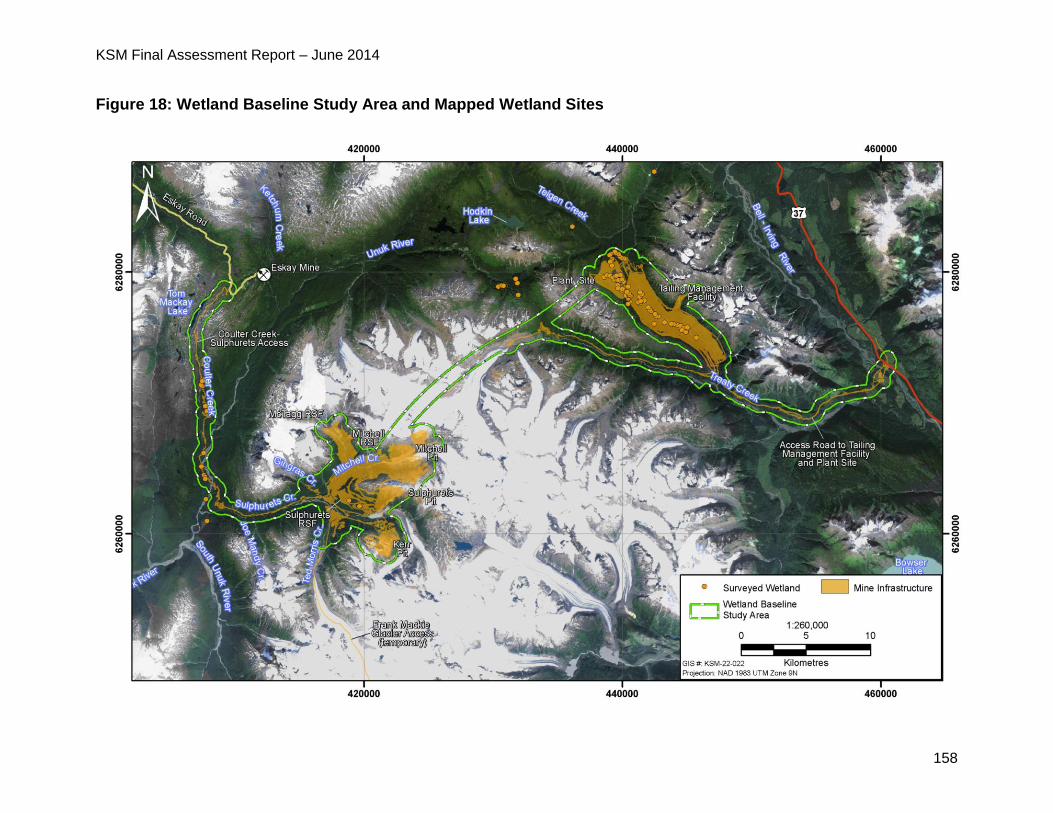
KSM Final Assessment Report – June 2014
158
Figure 18: Wetland Baseline Study Area and Mapped Wetland Sites
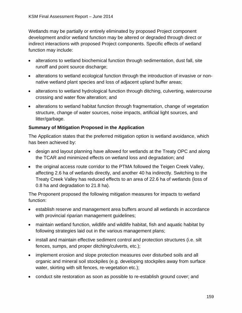
KSM Final Assessment Report – June 2014
159
Wetlands may be partially or entirely eliminated by proposed Project component
development and/or wetland function may be altered or degraded through direct or
indirect interactions with proposed Project components. Specific effects of wetland
function may include:
alterations to wetland biochemical function through sedimentation, dust fall, site
runoff and point source discharge;
alterations to wetland ecological function through the introduction of invasive or non-
native wetland plant species and loss of adjacent upland buffer areas;
alterations to wetland hydrological function through ditching, culverting, watercourse
crossing and water flow alteration; and
alterations to wetland habitat function through fragmentation, change of vegetation
structure, change of water sources, noise impacts, artificial light sources, and
litter/garbage.
Summary of Mitigation Proposed in the Application
The Application states that the preferred mitigation option is wetland avoidance, which
has been achieved by:
design and layout planning have allowed for wetlands at the Treaty OPC and along
the TCAR and minimized effects on wetland loss and degradation; and
the original access route corridor to the PTMA followed the Teigen Creek Valley,
affecting 2.6 ha of wetlands directly, and another 40 ha indirectly. Switching to the
Treaty Creek Valley has reduced effects to an area of 22.6 ha of wetlands (loss of
0.8 ha and degradation to 21.8 ha).
The Proponent proposed the following mitigation measures for impacts to wetland
function:
establish reserve and management area buffers around all wetlands in accordance
with provincial riparian management guidelines;
maintain wetland function, wildlife and wildlife habitat, fish and aquatic habitat by
following strategies laid out in the various management plans;
install and maintain effective sediment control and protection structures (i.e. silt
fences, sumps, and proper ditching/culverts, etc.);
implement erosion and slope protection measures over disturbed soils and all
organic and mineral soil stockpiles (e.g. developing stockpiles away from surface
water, skirting with silt fences, re-vegetation etc.);
conduct site restoration as soon as possible to re-establish ground cover; and
KSM Final Assessment Report – June 2014
160
implement spill response, reporting and notification procedures.
The Proponent proposed a Wetland Compensation Plan. Once the proposed Project is
closed more than 2.5 times as much area of wetlands would have been created,
restored, or compensated than affected.
5.6.3 Project Issues and Effects and Proposed Mitigation Identified During
Application Review
During the review of the Application, additional issues were raised by the agencies,
NLG and First Nations. These issues, the Proponent responses and EAO’s assessment
of the adequacy of responses are detailed in Appendix 1. The CPD and TOC (Appendix
2) contain specific mitigation measures, which would be legally enforceable if an EA
Certificate is issued.
EC questioned the Proponent’s plan to compensate for lost fen wetland habitat,
noting that fen wetland habitat is very difficult to restore, and perhaps only
achievable over the long term (in the order of fifty to hundreds of years).
o In response, the Proponent stated the wetland compensation plan was
developed to compensate for wetlands lost due to the development of the
TMF.
o The wetlands in this area are low gradient wetlands associated with a small
meandering stream. The primary functions of wetlands in this area are water
storage and filtration, wetland complexing and fish habitat. The wetland
compensation projects will be associated with fish habitat and will provide
similar functions. These compensation projects will regulate storm flow
through the fish compensation areas, will reduce erosion by providing
aquatic vegetation to disburse wave action, and will provide benthic
invertebrate habitat which will support fish habitat.
o Creating marsh wetlands similar in vegetation structure to fens associated
with swamps and open water features will provide compensation for the
hydrological, biochemical, ecological, and habitat functions lost due to
development of the TMF.
Following a meeting with the Proponent in October 2013, EC concluded that the
Federal Policy on Wetland Conservation does not apply to the proposed Project
and EC agreed with the Proponent’s conclusion there are no significant residual
effects on wetland birds. However, EC is prepared to review any wetland
compensation plan that the Proponent will prepare in support of its environmental
management efforts.
NLG disagreed with the Proponent’s conclusion that impacts to wetlands would
be not significant (minor), as the wetland creation post-closure, some 50-60
KSM Final Assessment Report – June 2014
161
years hence should not be used to fully discount the impacts from the loss of
wetland habitat in the intervening years.
o The Proponent maintained that the wetland compensation plan was
developed as a best practice to offset the immediate effects to wetland
resources by the proposed Project. Once the proposed Project is closed
more than 2.5 times as much area of wetlands would have been created,
restored, or compensated than affected.
Gitanyow Nation expressed concerns with the Proponent’s different linkage maps for
different VC cumulative effects assessment. Gitanyow stated that as surface water
and wetlands are hydrologically intrinsically linked, the same biophysical maps
should be used to evaluate cumulative impacts.
Gitanyow Nation also expressed concerns that EC no longer requires a wetland
compensation plan from the Proponent. Gitanyow Nation was not satisfied with
the Proponent’s plan to no longer construct any off-site wetland compensation
and instead consider the fisheries compensation plan to double as wetland
compensation.
Gitanyow Nation was concerned about impacts to wetland ecosystems because
if headwater wetlands are destroyed then there would be negative cumulative
effects that would affect the Nass watershed within Gitanyow Territory, thereby
potentially affecting Gitanyow Nation rights and title.
o The Proponent responded that while various components can be potentially
or ecologically linked (e.g. wetlands can be linked to wildlife, surface water
quantity, and surface water quality), residual effects are not necessarily
linked. When describing the cumulative effects for wetlands, the residual
effects considered were loss of wetland extent and loss of wetland function.
Residual effects to water quality were not determined to result in either a
loss of wetland function or extent.
o The Proponent has committed to wetland compensation as per the
compensation projects proposed in the Application which includes a
monitoring protocol. EAO has added this as a proposed condition to the EA
Certificate.
5.6.4 Residual Effects and Significance Analysis
Proposed Project-related wetland losses are briefly summarized in the table below.
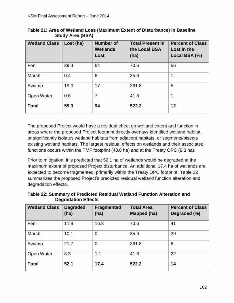
KSM Final Assessment Report – June 2014
162
Table 21: Area of Wetland Loss (Maximum Extent of Disturbance) in Baseline Study Area (BSA)
Wetland Class Lost (ha) Number of
Wetlands
Lost
Total Present in
the Local BSA
(ha)
Percent of Class
Lost in the
Local BSA (%)
Fen 39.4 64 70.6 56
Marsh 0.4 6 35.6 1
Swamp 19.0 17 361.8 5
Open Water 0.6 7 41.8 1
Total 59.3 94 522.2 12
The proposed Project would have a residual effect on wetland extent and function in
areas where the proposed Project footprint directly overlays identified wetland habitat,
or significantly isolates wetland habitats from adjacent habitats, or segments/bisects
existing wetland habitats. The largest residual effects on wetlands and their associated
functions occurs within the TMF footprint (48.8 ha) and at the Treaty OPC (8.3 ha).
Prior to mitigation, it is predicted that 52.1 ha of wetlands would be degraded at the
maximum extent of proposed Project disturbance. An additional 17.4 ha of wetlands are
expected to become fragmented, primarily within the Treaty OPC footprint. Table 22
summarizes the proposed Project’s predicted residual wetland function alteration and
degradation effects.
Table 22: Summary of Predicted Residual Wetland Function Alteration and Degradation Effects
Wetland Class Degraded
(ha)
Fragmented
(ha)
Total Area
Mapped (ha)
Percent of Class
Degraded (%)
Fen 11.9 16.8 70.6 41
Marsh 10.1 0 35.6 29
Swamp 21.7 0 361.8 6
Open Water 8.3 1.1 41.8 22
Total 52.1 17.4 522.2 14
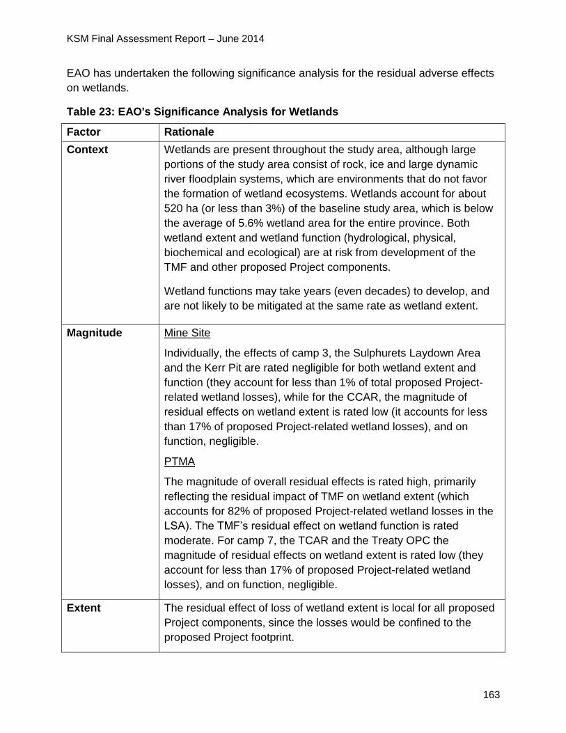
KSM Final Assessment Report – June 2014
163
EAO has undertaken the following significance analysis for the residual adverse effects
on wetlands.
Table 23: EAO's Significance Analysis for Wetlands
Factor Rationale
Context Wetlands are present throughout the study area, although large
portions of the study area consist of rock, ice and large dynamic
river floodplain systems, which are environments that do not favor
the formation of wetland ecosystems. Wetlands account for about
520 ha (or less than 3%) of the baseline study area, which is below
the average of 5.6% wetland area for the entire province. Both
wetland extent and wetland function (hydrological, physical,
biochemical and ecological) are at risk from development of the
TMF and other proposed Project components.
Wetland functions may take years (even decades) to develop, and
are not likely to be mitigated at the same rate as wetland extent.
Magnitude Mine Site
Individually, the effects of camp 3, the Sulphurets Laydown Area
and the Kerr Pit are rated negligible for both wetland extent and
function (they account for less than 1% of total proposed Project-
related wetland losses), while for the CCAR, the magnitude of
residual effects on wetland extent is rated low (it accounts for less
than 17% of proposed Project-related wetland losses), and on
function, negligible.
PTMA
The magnitude of overall residual effects is rated high, primarily
reflecting the residual impact of TMF on wetland extent (which
accounts for 82% of proposed Project-related wetland losses in the
LSA). The TMF’s residual effect on wetland function is rated
moderate. For camp 7, the TCAR and the Treaty OPC the
magnitude of residual effects on wetland extent is rated low (they
account for less than 17% of proposed Project-related wetland
losses), and on function, negligible.
Extent The residual effect of loss of wetland extent is local for all proposed
Project components, since the losses would be confined to the
proposed Project footprint.
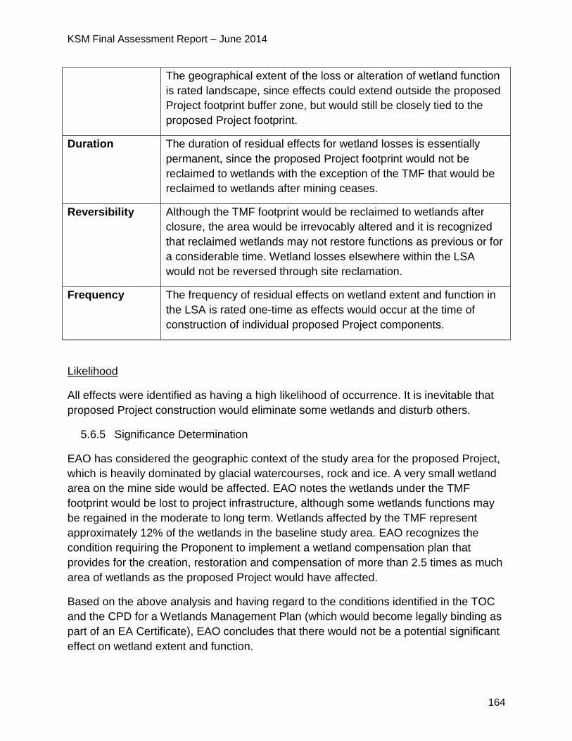
KSM Final Assessment Report – June 2014
164
The geographical extent of the loss or alteration of wetland function
is rated landscape, since effects could extend outside the proposed
Project footprint buffer zone, but would still be closely tied to the
proposed Project footprint.
Duration The duration of residual effects for wetland losses is essentially
permanent, since the proposed Project footprint would not be
reclaimed to wetlands with the exception of the TMF that would be
reclaimed to wetlands after mining ceases.
Reversibility Although the TMF footprint would be reclaimed to wetlands after
closure, the area would be irrevocably altered and it is recognized
that reclaimed wetlands may not restore functions as previous or for
a considerable time. Wetland losses elsewhere within the LSA
would not be reversed through site reclamation.
Frequency The frequency of residual effects on wetland extent and function in
the LSA is rated one-time as effects would occur at the time of
construction of individual proposed Project components.
Likelihood
All effects were identified as having a high likelihood of occurrence. It is inevitable that
proposed Project construction would eliminate some wetlands and disturb others.
5.6.5 Significance Determination
EAO has considered the geographic context of the study area for the proposed Project,
which is heavily dominated by glacial watercourses, rock and ice. A very small wetland
area on the mine side would be affected. EAO notes the wetlands under the TMF
footprint would be lost to project infrastructure, although some wetlands functions may
be regained in the moderate to long term. Wetlands affected by the TMF represent
approximately 12% of the wetlands in the baseline study area. EAO recognizes the
condition requiring the Proponent to implement a wetland compensation plan that
provides for the creation, restoration and compensation of more than 2.5 times as much
area of wetlands as the proposed Project would have affected.
Based on the above analysis and having regard to the conditions identified in the TOC
and the CPD for a Wetlands Management Plan (which would become legally binding as
part of an EA Certificate), EAO concludes that there would not be a potential significant
effect on wetland extent and function.
KSM Final Assessment Report – June 2014
165
5.6.6 Cumulative Effects
The Northwest Transmission Line (NTL), the past Eskay Creek Mine, the proposed
Brucejack, Kitsault and Schaft Creek mines, as well as mineral and energy resource
exploration and timber harvesting, have the potential to generate effects on wetlands
that overlap with those of the proposed Project. Cumulative effects on wetland extent
should be limited to projects in proximity to the proposed Project, since effects on the
geographical extent of individual wetlands are typically local. The proposed Project and
other projects could affect wetland function over a broader area. However, by the post-
closure phase of the proposed Project more than 2.5 times as much area of wetlands
would have been created as would have been adversely affected, including 48 ha
created through compensation projects, and approximately 275 ha restored through
reclamation efforts. Even though the proposed Project would be responsible for a net
increase in wetland extent in northwest BC the temporal context of the effect, i.e. the lag
between the effect and reclamation, would still result in an overall effect to wetland
extent and function.
There are also a number of elements of uncertainty that make quantifying the direct
benefit of the reclamation at 55+ years on proposed Project effects tenuous.
While a residual cumulative effect on the loss of wetland extent is predicted, its
significance is ranked not significant in view of the wetland compensation and
reclamation activities proposed for the proposed Project and anticipated for other
projects.
5.6.7 Certainty
The certainty associated with all effects is high, especially for loss of wetland extent,
which is predetermined by the proposed Project layout. Effects on wetland function are
less certain, but are assumed to be proportional to the area of wetlands eliminated or
disturbed. The uncertainty relates to the recovery of wetland functions and the time it
would take for wetland compensation projects to become functional as wetland habitat.
5.6.8 Conclusion
Considering the above analysis and having regard to the conditions identified in the
TOC and the CPD (which would become legally binding as a condition of an EA
Certificate), EAO is satisfied that the proposed Project is not likely to have significant
adverse effects on wetlands.
KSM Final Assessment Report – June 2014
166
5.7 Terrestrial Ecosystems
5.7.1 Background Information
The following terrestrial ecosystem VCs were selected:
potential pine mushroom habitat;
avalanche track ecosystems;
listed ecosystems;
riparian and floodplain ecosystems;
alpine and parkland ecosystems;
old forests; and
other terrestrial ecosystems.
The LSA covers 66,500 ha and the boundaries coincide with the height-of-land
surrounding both the Mine Site and PTMA. Along the proposed TCAR and CCAR, the
boundary is represented by a 1.5 km buffer. The LSA incorporates the same
watersheds assessed for the surface water quantity VC.
The RSA covers 308,080 ha, and corresponds to the wildlife RSA, which was
delineated on the basis of the expected extent of use by potentially affected wildlife
species, and provides a suitable regional context for ecosystem distribution.
The Proponent used Terrestrial Ecosystem Mapping (TEM) and Predictive Ecosystem
Mapping (PEM) to map terrestrial ecosystems within the LSA and RSA, respectively.
The Proponent conducted field surveys and used BC Conservation Data Centre and
Committee on the Status of Endangered Wildlife in Canada (COSEWIC) data to
document known occurrences of listed (red and blue) ecosystems and plants. The
Proponent also conducted an assessment of plants of cultural importance, a review of
invasive plants and analyzed 100 plant tissue samples to establish baseline metal
concentrations in local vegetation.
The provincial biogeoclimatic ecosystem classification (BEC) zones present within the
RSA include:
Boreal Altai Fescue Alpine (BAFA);
Coastal Mountain-Heather Alpine (CMA);
Coastal Western Hemlock (CWH);
Engelmann Spruce–Subalpine Fir (ESSF);
Interior Cedar Hemlock (ICH); and
Mountain Hemlock (MH).

KSM Final Assessment Report – June 2014
167
Potential Pine Mushroom Habitat
The Application reports that the pine mushroom is the most economically important wild
mushroom harvested in BC and local Aboriginal groups identify mushroom harvesting
as an important cultural activity and economic generator. The Proponent identified pine
mushrooms in the field within the ICH very wet cold BEC subzone, on dry slopes above
the proposed TCAR. Potential mushroom habitat was also mapped within the CWH wet
maritime BEC subzone, primarily along the CCAR and along the Unuk River and lower
Sulphurets Creek.
Avalanche Track Ecosystems
The Application states that in the LSA, avalanche tracks support a variety of deciduous
shrub and herb species including Sitka alder, willows, salmonberry, Sitka valerian,
arrow-leaved groundsel, Indian hellebore and cow-parsnip. Several of these have
cultural importance to local Aboriginal groups.
Listed Ecosystems
The Proponent identified twelve ecosystems (six terrestrial and six wetland) that are
blue-or red-listed within the RSA and LSA.
Riparian and Floodplain Ecosystems
The Application reports that forested ecosystems on aggraded fluvial deposits, often
dominated by large mature cottonwoods with an understory of either subalpine fir or
hybrid white spruce, are very common in the RSA and the LSA, particularly along Treaty
Creek and the Unuk River.
Alpine and Parkland Ecosystems
The Application characterized parkland ecosystems as discontinuous tree islands
growing on elevated sites, occupying a narrow elevation band above dense coniferous
forests and below treeless alpine ecosystems. These sites experience earlier snowmelt,
and permit drainage of excessive moisture that prohibits forest establishment at other
higher-elevation locations.
Forested Ecosystems Including Old Forests
The Application states that below approximately 1,100 m above sea level, forested
ecosystems dominate the landscape. Forrested ecosystems are generally fairly
continuous, but can be interrupted by natural disturbances such as avalanches and
KSM Final Assessment Report – June 2014
168
mass wasting, as well as fluvial disturbances such as flooding, channel aggradation16
and degradation, and debris flows.
The Application reports that many forested ecosystems in the lower slopes and valley
bottoms, except immediately adjacent to Hwy 37, are very old, due largely to the rarity
of stand disturbance or replacement events such as wildfire and forest harvesting.
A full discussion on terrestrial ecosystems can be found in the Proponent’s Application
posted on EAO’s website at:
http://a100.gov.bc.ca/appsdata/epic/html/deploy/epic_document_322_35958.html
5.7.2 Project Issues and Effects and Proposed Mitigation Identified in the
Application
Potential proposed Project effects could include:
loss of terrestrial ecosystems and plants of interest from land clearing;
alteration of natural patterns of diversity (seral stage diversity, ecosystem diversity)
from land clearing, construction and operational activities;
introduction of invasive plant species through ground disturbance associated with
construction activities and through plant dispersal mechanisms associated with the
movement of people and equipment along linear facilities;
deposition of fugitive dust from blasting and ore processing activities, use of gravel
roads and TMF dam and beach construction activities;
windthrow associated with site clearing; and
changes to ecosystem composition, structure and/or function linked to changes in
hydrology from construction activities.
Summary of Mitigation Proposed in the Application
Proposed measures to mitigate potential loss and degradation of the terrestrial
ecosystem include:
adherence to the general impact management considerations within the Terrestrial
Ecosystems Management and Monitoring Plan;
reclamation of disturbed sites that accord with end land use objectives;
avoiding and/or reducing windthrow hazard by using best management practices,
retaining wind-firm trees, feathering edges, topping/pruning of individual trees, and
16 Aggradation involves the raising of the streambed elevation due to a deposition of sediment.
KSM Final Assessment Report – June 2014
169
monitoring for windthrow;
avoiding the introduction and spread of invasive plants through development of on-
site training and education programs, minimizing the creation of suitable habitat for
invasive species, minimizing potential for transport of such species into the proposed
Project area, and detecting/eradicating identified plants;
reducing effects on terrain and soil by adhering to the Terrain, Surficial Geology and
Soil Management and Monitoring Plan; and
reducing fugitive dust accumulation by adhering to the provisions of the Air Quality
Management Plan.
5.7.3 Project Issues and Effects and Proposed Mitigation Identified During
Application Review
During the review of the Application, additional issues were raised by the agencies,
NLG, First Nations and the public. These issues, the Proponent responses and EAO’s
assessment of the adequacy of responses are detailed in Appendix 1. The CPD and
TOC (Appendix 2) contain specific mitigation measures, which would be legally
enforceable if an EA Certificate is issued. Examples of some of the key issues and
additional commitments raised during the Application review stage include:
EC and NLG raised concerns over the management of rare plants at the TMF and
the adequacy of rare plant surveys.
o In response, the Proponent undertook additional rare plant surveys in July
and August 2013 and submitted a draft assessment on potential impacts to
rare plants and lichens in December 2013.
o The Proponent identified 65 individual species of rare plants and lichens.
Seven of the species have not previously been identified, and are
considered previously unknown species. Eight of the species are either
newly discovered in BC or have been identified in very few populations.
o During construction, six rare plant and lichen individuals representing five
species have the potential to be lost, mostly due to the construction of the
mine pits. During operations, 51 rare plant and lichen individuals
representing 29 species have the potential to be lost. Within the Kerr Pit, 25
rare plant and lichen species will be lost due to pit development. During
construction, degradation will affect 18 rare plant and lichens species.
During operations ten species have the potential to be affected by the
proposed Project.
NLG recommended that the Proponent take further measures to reduce the
uncertainties associated with potential risks to rare plants caused by proposed
KSM Final Assessment Report – June 2014
170
Project development including providing more details on proposed mitigation.
o The Proponent responded that pre-construction surveys will support micro-
siting of infrastructure to avoid direct impacts to rare plants by making minor
adjustments to infrastructure locations wherever feasible. Due to a low
success rate associated with transplanting rare plants and lichens the
primary mitigation measures will be focussed on dust and suppression
activities to minimize degradation of species habitats.
NLG recommended the Proponent predict the percentage of the documented
local population that would be lost and the approximate proportion of what is
understood to be the supporting habitats for rare plants that would be lost.
o The Proponent responded that there is a lack of regional survey data and
information related to rare plants and lichens in the area surrounding the
proposed Project to quantify the proposed Project’s potential adverse effects
on regional rare plant populations.
EC raised concerns with respect to potential impacts to rare plants and required the
Proponent to provide a description of how the identification of potential impacts to
rare plants late in the proposed Project planning stage would be mitigated. EC
concerns relate to the high potential for occurrence of rare plants in the southern
portion of the proposed Project study area.
o In response, the Proponent stated that measures to mitigate direct loss to
rare plants located under proposed Project infrastructure would include
avoidance, where possible, or translocation. Measures to mitigate
degradation/alteration impacts will include relevant measures identified in
the Vegetation Clearing Management Plan, and Invasive Plant Management
Plan, sub plans of the Terrestrial Ecosystems Management and Monitoring
Plan.
MEM raised concerns with the potential metals in plant tissues during closure and
post-closure and asked what additional mitigation measures could be implemented.
o The Proponent responded that the mitigation options include selecting plants
that do not take up metal, remediating the soil so that metals are no longer
present, and changing the land use to one that does not include plants.
o The Proponent committed to a Terrestrial Plant Monitoring Plan to monitor
metal levels in plant tissues during all proposed Project phases.

KSM Final Assessment Report – June 2014
171
5.7.4 Residual Effects Significance Analysis
Development of the proposed Project would necessitate land clearing and result in
vegetation loss. Proposed Project activities would result in degradation effects, including
the spread of invasive plant species, deposition of fugitive dust, and increased
windthrow along new forest edges. Residual vegetation loss and degradation effects are
predicted during construction, operation and closure (table 24 below).
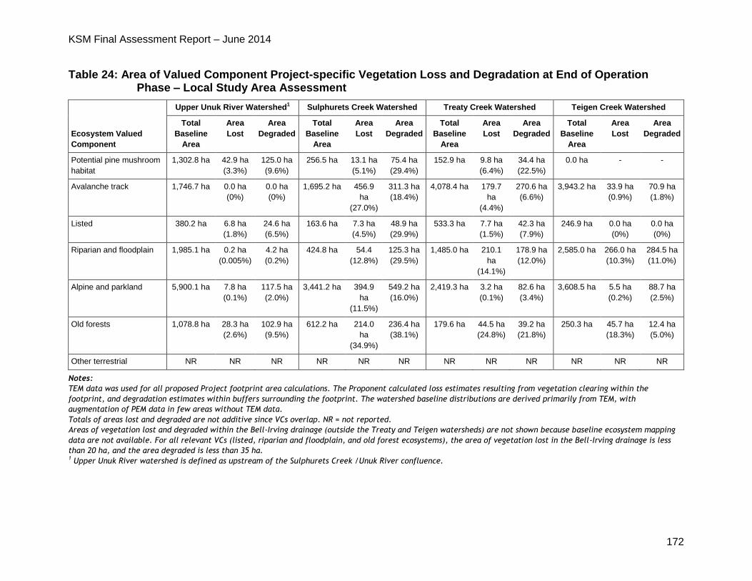
KSM Final Assessment Report – June 2014
172
Table 24: Area of Valued Component Project-specific Vegetation Loss and Degradation at End of Operation Phase – Local Study Area Assessment
Ecosystem Valued
Component
Upper Unuk River Watershed1 Sulphurets Creek Watershed Treaty Creek Watershed Teigen Creek Watershed
Total
Baseline
Area
Area
Lost
Area
Degraded
Total
Baseline
Area
Area
Lost
Area
Degraded
Total
Baseline
Area
Area
Lost
Area
Degraded
Total
Baseline
Area
Area
Lost
Area
Degraded
Potential pine mushroom
habitat
1,302.8 ha 42.9 ha
(3.3%)
125.0 ha
(9.6%)
256.5 ha 13.1 ha
(5.1%)
75.4 ha
(29.4%)
152.9 ha 9.8 ha
(6.4%)
34.4 ha
(22.5%)
0.0 ha - -
Avalanche track 1,746.7 ha 0.0 ha
(0%)
0.0 ha
(0%)
1,695.2 ha 456.9
ha
(27.0%)
311.3 ha
(18.4%)
4,078.4 ha 179.7
ha
(4.4%)
270.6 ha
(6.6%)
3,943.2 ha 33.9 ha
(0.9%)
70.9 ha
(1.8%)
Listed 380.2 ha 6.8 ha
(1.8%)
24.6 ha
(6.5%)
163.6 ha 7.3 ha
(4.5%)
48.9 ha
(29.9%)
533.3 ha 7.7 ha
(1.5%)
42.3 ha
(7.9%)
246.9 ha 0.0 ha
(0%)
0.0 ha
(0%)
Riparian and floodplain 1,985.1 ha 0.2 ha
(0.005%)
4.2 ha
(0.2%)
424.8 ha 54.4
(12.8%)
125.3 ha
(29.5%)
1,485.0 ha 210.1
ha
(14.1%)
178.9 ha
(12.0%)
2,585.0 ha 266.0 ha
(10.3%)
284.5 ha
(11.0%)
Alpine and parkland 5,900.1 ha 7.8 ha
(0.1%)
117.5 ha
(2.0%)
3,441.2 ha 394.9
ha
(11.5%)
549.2 ha
(16.0%)
2,419.3 ha 3.2 ha
(0.1%)
82.6 ha
(3.4%)
3,608.5 ha 5.5 ha
(0.2%)
88.7 ha
(2.5%)
Old forests 1,078.8 ha 28.3 ha
(2.6%)
102.9 ha
(9.5%)
612.2 ha 214.0
ha
(34.9%)
236.4 ha
(38.1%)
179.6 ha 44.5 ha
(24.8%)
39.2 ha
(21.8%)
250.3 ha 45.7 ha
(18.3%)
12.4 ha
(5.0%)
Other terrestrial NR NR NR NR NR NR NR NR NR NR NR NR
Notes:
TEM data was used for all proposed Project footprint area calculations. The Proponent calculated loss estimates resulting from vegetation clearing within the
footprint, and degradation estimates within buffers surrounding the footprint. The watershed baseline distributions are derived primarily from TEM, with
augmentation of PEM data in few areas without TEM data.
Totals of areas lost and degraded are not additive since VCs overlap. NR = not reported.
Areas of vegetation lost and degraded within the Bell-Irving drainage (outside the Treaty and Teigen watersheds) are not shown because baseline ecosystem mapping
data are not available. For all relevant VCs (listed, riparian and floodplain, and old forest ecosystems), the area of vegetation lost in the Bell-Irving drainage is less
than 20 ha, and the area degraded is less than 35 ha. 1 Upper Unuk River watershed is defined as upstream of the Sulphurets Creek /Unuk River confluence.
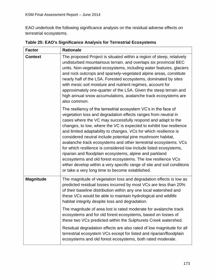
KSM Final Assessment Report – June 2014
173
EAO undertook the following significance analysis on the residual adverse effects on
terrestrial ecosystems.
Table 25: EAO's Significance Analysis for Terrestrial Ecosystems
Factor Rationale
Context The proposed Project is situated within a region of steep, relatively
undisturbed mountainous terrain, and overlaps six provincial BEC
units. Non-vegetated ecosystems, including water features, glaciers
and rock outcrops and sparsely-vegetated alpine areas, constitute
nearly half of the LSA. Forested ecosystems, dominated by sites
with mesic soil moisture and nutrient regimes, account for
approximately one-quarter of the LSA. Given the steep terrain and
high annual snow accumulations, avalanche track ecosystems are
also common.
The resiliency of the terrestrial ecosystem VC’s in the face of
vegetation loss and degradation effects ranges from neutral in
cases where the VC may successfully respond and adapt to the
changes, to low, where the VC is expected to exhibit low resilience
and limited adaptability to changes. VCs for which resilience is
considered neutral include potential pine mushroom habitat,
avalanche track ecosystems and other terrestrial ecosystems. VCs
for which resilience is considered low include listed ecosystems,
riparian and floodplain ecosystems, alpine and parkland
ecosystems and old forest ecosystems. The low resilience VCs
either develop within a very specific range of site and soil conditions
or take a very long time to become established.
Magnitude The magnitude of vegetation loss and degradation effects is low as
predicted residual losses incurred by most VCs are less than 20%
of their baseline distribution within any one local watershed and
these VCs would be able to maintain hydrological and wildlife
habitat integrity despite loss and degradation.
The magnitude of area lost is rated moderate for avalanche track
ecosystems and for old forest ecosystems, based on losses of
these two VCs predicted within the Sulphurets Creek watershed.
Residual degradation effects are also rated of low magnitude for all
terrestrial ecosystem VCs except for listed and riparian/floodplain
ecosystems and old forest ecosystems, both rated moderate.
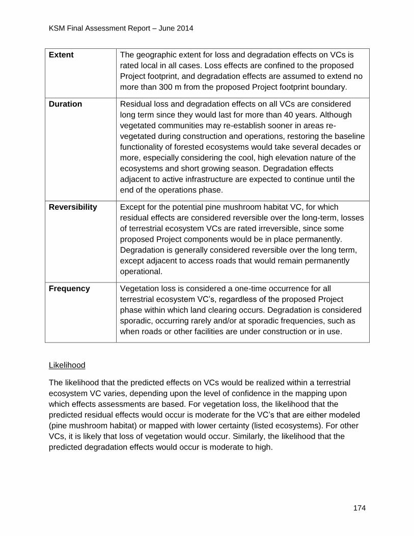
KSM Final Assessment Report – June 2014
174
Extent The geographic extent for loss and degradation effects on VCs is
rated local in all cases. Loss effects are confined to the proposed
Project footprint, and degradation effects are assumed to extend no
more than 300 m from the proposed Project footprint boundary.
Duration Residual loss and degradation effects on all VCs are considered
long term since they would last for more than 40 years. Although
vegetated communities may re-establish sooner in areas re-
vegetated during construction and operations, restoring the baseline
functionality of forested ecosystems would take several decades or
more, especially considering the cool, high elevation nature of the
ecosystems and short growing season. Degradation effects
adjacent to active infrastructure are expected to continue until the
end of the operations phase.
Reversibility Except for the potential pine mushroom habitat VC, for which
residual effects are considered reversible over the long-term, losses
of terrestrial ecosystem VCs are rated irreversible, since some
proposed Project components would be in place permanently.
Degradation is generally considered reversible over the long term,
except adjacent to access roads that would remain permanently
operational.
Frequency Vegetation loss is considered a one-time occurrence for all
terrestrial ecosystem VC’s, regardless of the proposed Project
phase within which land clearing occurs. Degradation is considered
sporadic, occurring rarely and/or at sporadic frequencies, such as
when roads or other facilities are under construction or in use.
Likelihood
The likelihood that the predicted effects on VCs would be realized within a terrestrial
ecosystem VC varies, depending upon the level of confidence in the mapping upon
which effects assessments are based. For vegetation loss, the likelihood that the
predicted residual effects would occur is moderate for the VC’s that are either modeled
(pine mushroom habitat) or mapped with lower certainty (listed ecosystems). For other
VCs, it is likely that loss of vegetation would occur. Similarly, the likelihood that the
predicted degradation effects would occur is moderate to high.
KSM Final Assessment Report – June 2014
175
5.7.5 Significance Determination
EAO has considered the moderate magnitude of the effects on avalanche tracks and
old forest ecosystems in the Sulphurets Creek watershed but notes these VCs are
common throughout the wider LSA and the RSA. EAO considers that vegetation effects
are expected to be of local extent, long term in duration and be irreversible, given the
time to re-establish old forests. Established old growth management areas (OGMA) in
the southern portion of the RSA are not affected and no connectivity between OGMAs is
lost.
EAO notes that other terrestrial ecosystem effects are predicted to be of low magnitude
and local extent. No VC is expected to experience residual effects that would threaten
the viability or sustainability of its local or regional distribution.
EAO notes the conditions to implement the Terrestrial Ecosystems Management and
Monitoring Plan and Terrestrial Plant Monitoring Plan. EAO also notes the Proponent is
required to implement the Terrain, Surficial Geology and Soil Management and
Monitoring Plan as part of the Mines Act permit. These mitigation measures are
expected to be successful in mitigating potential terrestrial ecosystem effects during all
phases of the proposed Project.
Considering the above analysis and having regard to the conditions identified in the
TOC and the CPD (which would become legally binding as a condition of an EA
Certificate), EAO is satisfied that the proposed Project is not likely to have significant
adverse effects on terrestrial ecosystems.
5.7.6 Cumulative Effects
Fifteen other projects, and several land use activities including timber harvesting, and
mineral/energy resource extraction, were assessed for potential overlapping loss and
degradation. However, ecological mapping information required to effectively quantify
an assessment of cumulative effects is unavailable for most of the past and future
projects. The other projects and activities with the highest potential to interact
cumulatively with the proposed Project’s residual vegetation effects are those resulting
in additive vegetation loss or degradation within local watersheds such as Treaty Creek
and Sulphurets Creek. These include the proposed Snowfield and Brucejack mines and
Treaty Creek HEP, none of which would result in additional loss of avalanche track or
old forest ecosystems within the Sulphurets Creek watershed.
Where similar terrestrial ecosystem VC assessments are documented for other projects
(NTL, Forrest-Kerr HEP and McLymont Creek HEP projects), low to moderate
magnitude effects are typically predicted, with no significant effects predicted. The
potential losses of avalanche track and old forest ecosystems, the most important
KSM Final Assessment Report – June 2014
176
potential effects from the proposed Project, are considered of low to moderate
magnitude within the cumulative effects study area, with low-magnitude cumulative
losses expected from other projects and activities. EAO concludes that all cumulative
residual effects on terrestrial ecosystem VCs would be not significant.
5.7.7 Certainty
The certainty in the prediction of residual vegetation loss and degradation effects is
medium for all VCs, except the avalanche track VC, since cause-effect relationships
may not be fully understood or unknown external variables may be influential. Certainty
is high in the effects assessment for the avalanche track VC.
5.7.8 Conclusion
Considering the above analysis and having regard to the conditions identified in the
TOC and the CPD (which would become legally binding as a condition of an EA
Certificate), EAO is satisfied that the proposed Project is not likely to have significant
adverse effects on terrestrial ecosystems.
5.8 Geohazards
5.8.1 Background Information
Geohazard concerns include the risk posed to proposed Project facilities, activities and
personnel by mass movements (such as landslide, debris flows and rock falls) and
avalanches. The focus of the Proponent’s geohazard assessment was on the potential
of the proposed Project to increase the magnitude or frequency of geohazard events,
specifically landslides and snow avalanches.
The geohazards LSA is 38,852 ha, and encompasses all sites where proposed Project
infrastructure may interact with existing geohazards. No RSA was defined for
geohazard assessment purposes.
The Proponent’s assessment of terrain, surficial geology and soils provided key
information for the geohazards assessment. The Proponent also conducted additional
baseline studies including assignment of terrain stability classes to terrain polygons, the
identification of landslide areas and snow avalanche track mapping.
Much of the terrain in the proposed Project area is either unstable or potentially
unstable, since all of the main valleys have been subject to glacial advance and retreat,
and to associated erosion and deposition processes. Post-glacial processes have also
contributed to terrain instability.
KSM Final Assessment Report – June 2014
177
A full discussion on geohazards can be found in the Proponent’s Application posted on
EAO’s website at:
http://a100.gov.bc.ca/appsdata/epic/html/deploy/epic_document_322_35959.html
5.8.2 Project Issues and Effects and Proposed Mitigation Identified in the
Application
The Application reports that the alteration of natural terrain conditions could exacerbate
baseline terrain instability, resulting in higher risks of adverse effects on terrain and
proposed Project infrastructure in cases where feasible and effective design options
and/or mitigation measures are not available.
The Proponent’s baseline studies identified a total of 268 geohazard scenarios that
present various degrees of risk to proposed Project infrastructure and human safety,
assuming no mitigation. The proposed Project components that could be affected
include the PTMA, transmission line, access roads and the Mine Site.
The Application identified the following geohazard scenarios and associated risk:
170 geohazard scenarios at the proposed Mine Site (within the Mitchell, McTagg,
Sulphurets and Ted Morris valleys), 69 of which are considered to pose a high or
very high risk;
29 geohazard scenarios at the PTMA, 12 of which pose a high risk;
Nine geohazard scenarios along the CCAR, three of which pose a high or very high risk; and
60 geohazard scenarios along the TCAR, 32 of which pose a high or very high risk.
The Application reports that snow avalanches pose the greatest overall geohazard risk
to the proposed Project, because their frequency of occurrence is several orders of
magnitude higher than that of landslides. Proposed Project related activities could
create additional snow avalanche terrain. Logging of slopes directly below snow
avalanche terrain could result in longer avalanche run-out paths. Incremental avalanche
terrain could also be created through removal of trees in avalanche initiation and run-out
zones, and through re-contouring of ground that has the effect of increasing slope
gradient, although the Proponent does not anticipate such effects.
Summary of Mitigation Proposed in the Application
The Proponent has developed mitigation strategies that are contained in the Soil
Salvage and Handling Plan, Erosion Control Plan and Vegetation Clearing Management
Plan (as required under the Mines Act permit and Special Use Permit for the access
roads) to deal with the risk of erosion and sedimentation. The Proponent proposes to
temporarily close roads during periods of high risk. To mitigate for snow avalanche
activity the Proponent proposes the following strategies:
KSM Final Assessment Report – June 2014
178
ongoing monitoring and management of the hazard;
avalanche protection measures such as seasonal closure of certain work areas,
temporary road closures, installation of avalanche detection systems, and avalanche
control; and
in high-risk areas that cannot be avoided, avalanche prevention or deflection using
permanent engineered structures or earthworks would be considered.
5.8.3 Project Issues and Effects and Proposed Mitigation Identified During
Application Review
During the review of the Application, additional issues were raised by MEM. These
issues, the Proponent responses and EAO’s assessment of the adequacy of responses
are detailed in Appendix 1. The CPD and TOC (Appendix 2) contain specific mitigation
measures, which would be legally enforceable if an EA Certificate is issued. Examples
of some of the key issues and additional commitments are set out below.
Following a third-party review of the proposed snow avalanche program, MEM
requested a more detailed summary of snow climate data since avalanche
magnitude and frequency is greatly influenced by snowfall, in addition to terrain.
MEM suggested the Proponent conduct an analysis to estimate snowpack height
with a frequency of 1:1, 1:10, 1:30, and 1:100 years. This work would be relevant to
the Proponent’s Active Avalanche Management Plan, which in part identifies the
scope of avalanche risk mitigation measures based on anticipated avalanche
activity.
o The Proponent has committed to ensuring the safety of its workers while
working at the site, with the implementation of an extensive and proactive
Avalanche Management Plan. The Proponent has also committed to
conduct further snow climate analysis as the proposed Project development
advances.
MEM accepted the Proponent’s commitments to conduct further snow climate
analyses as part of the Mines Act permitting requirement. EAO added the
requirement for an Avalanche Management Plan as a condition.
MEM required additional assessment information from the Proponent for avalanche
hazards and glacial travel feasibility up the Frank Mackie glacier temporary access
road.
o In response, the Proponent submitted additional information on the
assessment of the avalanche risks associated with the proposed Frank
Mackie Glacier road. The Proponent’s preliminary analysis indicates that
over 15 km of the alignment is estimated to be affected by avalanches; with
KSM Final Assessment Report – June 2014
179
careful routing of the road, the length of potential exposure could be reduced
to approximately 12 km. A large proportion of the exposed segments along
the route are estimated to be within low frequency avalanche terrain, with a
return period of greater than ten years. The potential consequences of
avalanches reaching the temporary road include vehicle impact, possible
fatalities, and lost productivity due to road closures associated with periods
of elevated avalanche risk, and avalanche deposit clearing.
o As with all other exposed areas within the proposed Project, avalanche
hazard along the route will be mitigated by temporary closure and control of
hazard areas during periods of elevated avalanche hazard.
MEM requested additional information surrounding the possible effects that
mining in the Mitchell Open Pit may have on the Snowfield Landslide, and the
potential for a catastrophic failure of the landslide into the pit.
o In response, the Proponent provided a report that better defined the slide
mass, as well as a Preliminary Snowfield Landslide Management Plan. The
Proponent also hired an expert third party reviewer to comment on the
suitability of the Landslide Management Plan, who endorsed the plan.
MEM concluded that the issues surrounding the Snowfield Landslide have been
adequately addressed at the EA level. It would be a Mines Act permitting
requirement to keep the Landslide Management Plan up to date, and to adhere
to the plan.
MEM requested additional information surrounding the nature and extent of
lacustrine clays that were identified in the Mitchell Valley, particularly with respect
to the effect that this material could have on the stability of the Mitchell RSF. The
Proponent was also asked to provide assurances that the development plan for
the Mitchell RSF would adequately consider the safety of personnel located at
the Mitchell OPC.
o In response, the Proponent provided RSF staging plans, instrumentation
and monitoring plans, and run-out analyses for the RSF. An expert third
party reviewer endorsed the development plan. The Proponent also
committed to conduct additional strength and consolidation testing of the
lacustrine clays before any rock placement in the affected area.
MEM considers that the issues surrounding the lacustrine clays in the Mitchell
Valley have been adequately addressed at the EA level. It would be a Mines Act
permitting requirement to conduct additional testing on the lacustrine clays before
rock placement, and to develop the Mitchell RSF in a manner that adequately
protects personnel at the Mitchell OPC.
KSM Final Assessment Report – June 2014
180
MEM raised concerns about the potential effects of overtopping the tailings dam and
wave damage to other infrastructure such as perimeter diversions.
o In response, the Proponent conducted modelling to assess the potential by
estimating the potential size of avalanche waves and predicting run-up
distances on the tailings beaches and tailings dams. The modelling results
indicated that with the proposed mitigation measures the TMF freeboard and
setback of infrastructure from the high pond level is adequately designed to
resist overtopping from avalanche waves during both normal and Probable
Maximum Flood events. The Proponent expects damage to other
infrastructure due to avalanches or avalanche waves to be minor and
repairable.
5.8.4 Residual Effects and Cumulative Effects
In consideration of EAO’s assessment of the Application, and the Working Group’s
consideration of this information, EAO finds that geohazard risks to the proposed
Project would be mitigated as a result of the condition for an Avalanche Management
Plan.
5.8.5 Conclusion
Based on the above analysis and having regard to the conditions identified in the TOC
and the CPD (which would become legally binding as a condition of an EA Certificate),
EAO is satisfied that there would not be adverse residual effects on geohazard stability
as a result of the proposed Project.
5.9 Wildlife and Wildlife Habitat
5.9.1 Background Information
The Proponent characterized wildlife and wildlife habitat baseline conditions by means
of literature reviews, field surveys from 2008-2011 and habitat suitability modelling. The
Proponent also conducted a grizzly bear population study using deoxyribonucleic acid
(DNA) techniques.
To assess the potential effects on wildlife and wildlife habitat the Proponent selected the
following prominent wildlife species and species groups in the proposed Project area as
VCs:
Moose;
Mountain goats;
Grizzly bears;
Black bears;
KSM Final Assessment Report – June 2014
181
American marten;
Hoary marmot;
Bats;
Raptors;
Wetland birds;
Forest and alpine birds; and
Western toads.
The wildlife LSA covers an area of 44,983 ha, including the proposed Project footprint
and a 1.5 km buffer zone around the footprint (see figure 18).
The wildlife RSA covers an area of approximately 338,000 ha, extending approximately
24 km north and 24.5 km south of the proposed Project footprint (see figure 18). The
RSA reflects the area anticipated to provide habitat for wildlife species that may come in
contact with proposed Project infrastructure during the course of a season or lifetime,
and to include sufficient area beyond the influence of the proposed Project for future
monitoring.
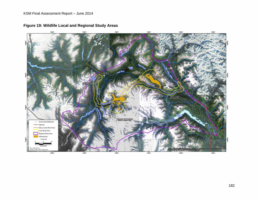
KSM Final Assessment Report – June 2014
182
Figure 19: Wildlife Local and Regional Study Areas
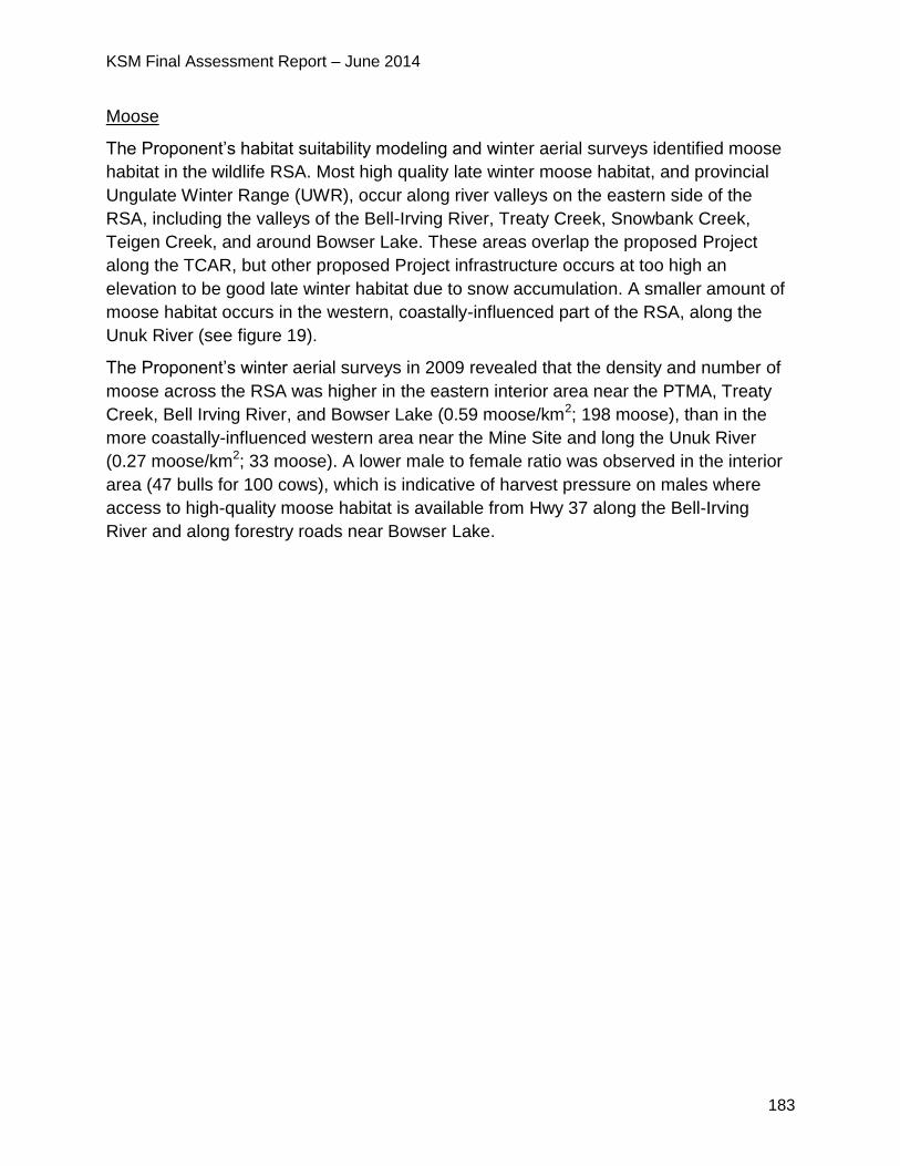
KSM Final Assessment Report – June 2014
183
Moose
The Proponent’s habitat suitability modeling and winter aerial surveys identified moose
habitat in the wildlife RSA. Most high quality late winter moose habitat, and provincial
Ungulate Winter Range (UWR), occur along river valleys on the eastern side of the
RSA, including the valleys of the Bell-Irving River, Treaty Creek, Snowbank Creek,
Teigen Creek, and around Bowser Lake. These areas overlap the proposed Project
along the TCAR, but other proposed Project infrastructure occurs at too high an
elevation to be good late winter habitat due to snow accumulation. A smaller amount of
moose habitat occurs in the western, coastally-influenced part of the RSA, along the
Unuk River (see figure 19).
The Proponent’s winter aerial surveys in 2009 revealed that the density and number of
moose across the RSA was higher in the eastern interior area near the PTMA, Treaty
Creek, Bell Irving River, and Bowser Lake (0.59 moose/km2; 198 moose), than in the
more coastally-influenced western area near the Mine Site and long the Unuk River
(0.27 moose/km2; 33 moose). A lower male to female ratio was observed in the interior
area (47 bulls for 100 cows), which is indicative of harvest pressure on males where
access to high-quality moose habitat is available from Hwy 37 along the Bell-Irving
River and along forestry roads near Bowser Lake.
KSM Final Assessment Report – June 2014
184
Figure 20: Moose Observed during Baseline Surveys and High Quality Winter Habitat
KSM Final Assessment Report – June 2014
185
Mountain Goats
The Proponent’s habitat suitability models indicated that the most suitable year-round
goat habitat in the RSA occurs in the eastern interior area along the Snowslide Range
and in western areas around John Peaks to the west of the Mine Site. Within the LSA,
suitable habitat was identified at the Mine Site and southeast of the TMF. The LSA and
RSA overlap with provincially designated mountain goat UWR U-6-002.
The Proponent conducted mountain goat population surveys in the RSA during the
summer of 2008 and the winter of 2009. During the summer surveys in 2008, the
Proponent observed 230 goats in 62 groups in the RSA. During the winter 2009 survey,
178 goats were observed in 69 groups in the RSA. The average density during both
winter and summer was 0.2 goats/km2 of capable habitat. Goats were observed near
the Mine Site during both winter and summer surveys. Around the PTMA, goats were
observed on the Snowslide Range (located between the PTMA and the Bell-Irving
River). In addition, two potential mineral licks were identified, one in the valley between
the Sulphurets and Kerr pits (confirmed in 2013) and one on the Snowslide Range
(unconfirmed).
Grizzly Bears
Grizzly bears are considered a species of special concern by COSEWIC and are blue-
listed in BC. The Proponent’s habitat suitability modeling revealed that overall, between
8% and 38% of habitat within the RSA is moderately high and high quality habitat for
spring (27%), summer (38%), and fall (8%). In addition, 5% of the LSA was identified as
suitable denning habitat for grizzly bears, particularly in the PTMA. The area near the
proposed TMF and the TCAR has also been identified by the province as a candidate
grizzly bear Wildlife Habitat Area (WHA). The Proponent estimated the
superpopulation17 of grizzly bears that used the RSA during the DNA studies at 31
females and 27 males, for a total of 58 bears. Two thirds of these bears were located in
the coastal zone along the Unuk River.
Black Bears
Black bears are common and widespread in BC. The Proponent detected black bears
throughout the RSA and LSA along all river drainages, particularly along the Unuk, Bell-
Irving, and Bowser rivers, as well as near Bowser Lake, and in the Treaty and Teigen
creek valleys. The Application reports that a large amount (approximately 59,740 ha) of
suitable denning habitat was identified in the RSA, particularly along the Unuk and Bell-
Irving rivers wherever large diameter old-growth trees are available.
17 The observed population is from a finite population and is treated as a sample from a larger
'superpopulation'
KSM Final Assessment Report – June 2014
186
American Marten
The American marten was selected by the Proponent as a VC to represent furbearers in
the proposed Project area. The Proponent conducted habitat suitability modeling for
American marten winter habitat. The majority of the forested habitat within the RSA was
modeled as highly suitable winter habitat for marten. Within the RSA, continuous blocks
of highly suitable habitat were distributed across lower elevations within all major
watersheds, particularly in mature forests along the Unuk River watershed. Over a
quarter of the LSA was identified as highly suitable winter habitat for marten, including
most of the forest habitat within the TMF and the low-elevation older forests along the
Coulter Creek and Treaty Creek corridors.
Hoary Marmot
The Proponent conducted field surveys and habitat suitability modeling for hoary
marmot. During field surveys in 2008 and 2009, marmot colonies were found throughout
the alpine in all of the areas surveyed at both the Mine Site and the PTMA, with the
highest densities being observed in alpine areas near the PTMA (e.g. the Snowslide
Range) surrounding the proposed TMF (average 0.62 colonies/km2). High quality
habitat was mainly distributed across the alpine near the Mine Site and PTMA.
Bats
The Proponent observed two species of myotis (little brown myotis and western long-
eared myotis) within the LSA, mainly within riparian habitat. The Proponent identified
mature and old-growth conifer forests near moist areas and at lower elevations along
waterways as sensitive bat habitat. The Application states the most important habitat
features for bats such as the little brown myotis are cave-based hibernacula, typically
associated with karst (limestone) topography. The only area with exposed limestone in
the LSA is located in the McTagg Creek Valley, extending south to Sulphurets Creek.
Raptors
The Proponent detected eight raptor species during baseline studies including hawks,
falcons, owls and other birds of prey. Listed species observed in the LSA include the
rough-legged hawk (blue-listed) and the Swainson’s hawk (red-listed). In addition, the
northern goshawk laingi subspecies is red-listed in BC and designated as threatened on
Schedule 1 under the Species at Risk Act (SARA); however, the Proponent was unable
to confirm if the northern goshawks observed during baseline surveys are of the laingi
subspecies. The Proponent identified two raptor nests (one bald eagle nest and one
osprey nest) in riparian areas outside of the LSA.
KSM Final Assessment Report – June 2014
187
Wetland Birds
The Proponent detected 25 wetland bird species during 2008 and 2009 baseline studies
including ducks, geese, shorebirds and other bird families associated with water bodies.
Three species identified in the RSA are of regional or provincial conservation concern:
harlequin duck (provincially ranked as vulnerable during the non-breeding season); surf
scoter, which is blue listed and provincially ranked as vulnerable during the breeding
season; and trumpeter swan, which is blue-listed and provincially ranked as vulnerable
during the non-breeding season.
The Proponent identified areas with high species diversity during the breeding period in
wetland complexes associated with the Teigen/Bell-Irving confluence, and along Treaty
and Todedada Creeks. Areas that were occupied during the fall staging survey, while
birds are migrating south, included the habitat around Unuk Lake, Treaty Creek, and
near the Teigen Creek/Bell-Irving River confluence. During the spring staging surveys,
the majority of birds were observed near the Teigen Creek/Bell-Irving confluence and at
Border Lake along the Unuk River near the BC-Alaska border.
Forest and Alpine Birds
The Proponent detected 60 forest and alpine birds during 2008 and 2009 baseline
studies including songbirds, hummingbirds, woodpeckers and game birds in terrestrial
areas. The greatest species richness, highest numbers of individual birds, and highest
diversity of birds were recorded within the proposed TMF footprint, along the CCAR
corridor adjacent to the Unuk River, and near Bowser Lake. The olive-sided flycatcher,
which is federally listed as threatened (SARA Schedule 1), was observed within the
RSA adjacent to Unuk Lake.
Western Toads
Western Toad is listed as a Species of Concern by COSEWIC, listed under SARA, and
is a provincially blue listed species. The Proponent selected Western Toad as a VC to
represent amphibians in the proposed Project area. During ground surveys in 2008 and
2009, three western toad breeding sites were observed, all of which were located
outside of the LSA in low elevation ponds with shallow open water, an open canopy,
and warm water temperatures. Two toad breeding sites were found on West Teigen
Lake, and a third at low elevation along the lower reaches of Teigen Creek near its
confluence with the Bell-Irving River. Other breeding sites likely occur in the RSA. No
high-quality potential sites were identified within the proposed Project footprint or LSA,
although moderately suitable habitat is present.
A full discussion on Wildlife and Wildlife Habitat can be found in the Proponent’s
Application posted on EAO’s website at:
http://a100.gov.bc.ca/appsdata/epic/html/deploy/epic_document_322_35957.html
KSM Final Assessment Report – June 2014
188
5.9.2 Project Issues and Effects and Proposed Mitigation Identified in the
Application
The proposed Project has the potential to adversely affect wildlife VCs to some degree
in the following ways:
habitat loss and alteration (construction and operations phases);
disruption of movement (construction and operations phases);
sensory disturbance (construction and operations phases);
direct mortality (construction and operations phases);
indirect mortality (primarily linked to increased access and increased hunting
pressure; construction, operations, closure, and post-closure phases);
attractants (construction and operations phases); and
chemical hazards (resulting in health effects in wildlife; construction, operations,
closure, and post-closure phases).
Risks to wildlife along the transportation corridors are discussed in Section 10 –
Assessment of Potential Road Use Effects.
Habitat Loss
Moose: Moose habitat loss and alteration due to the proposed Project is summarized in
table 26 below. Winter habitat, in particular late winter habitat, is a critical limiting
feature for moose due to deep snow during the later winter that restricts their movement
(provincial UWRs are based on the area of late winter habitat). The Application reports
the proposed Project would interact with early winter habitat in the PTMA, Treaty
Processing Plant site and TCAR, but the critical late winter habitat overlaps only the
TCAR, with the Treaty Processing Plant site being at too high elevation to be good late
winter habitat.
The Application reports that 648 ha of late winter habitat (1.8%) would be removed at
low elevation by the TCAR and transmission line. A larger area (2,554 ha, 6.3%) of
early winter habitat would be removed in the TMF and Treaty Processing Plant site.
In addition, 443 ha (0.9%) of the proposed moose UWR 6-018 would be altered due to
the TCAR. Due to the range in size of moose home range the loss associated with the
proposed Project could be equivalent to 16% or as little as 3.5% of a home range. The
Proponent estimates that reclamation activities could restore 62 ha of high quality early
winter habitat upon closure within the TMF footprint if the water and vegetation are
deemed safe for wildlife consumption.
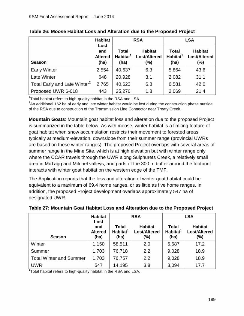
KSM Final Assessment Report – June 2014
189
Table 26: Moose Habitat Loss and Alteration due to the Proposed Project
Season
Habitat
Lost
and
Altered
(ha)
RSA LSA
Total
Habitat1
(ha)
Habitat
Lost/Altered
(%)
Total
Habitat1
(ha)
Habitat
Lost/Altered
(%)
Early Winter 2,554 40,637 6.3 5,864 43.6
Late Winter 648 20,928 3.1 2,082 31.1
Total Early and Late Winter2 2,765 40,623 6.8 6,581 42.0
Proposed UWR 6-018 443 25,270 1.8 2,069 21.4 1Total habitat refers to high-quality habitat in the RSA and LSA.
2An additional 162 ha of early and late winter habitat would be lost during the construction phase outside
of the RSA due to construction of the Transmission Line Connector near Treaty Creek.
Mountain Goats: Mountain goat habitat loss and alteration due to the proposed Project
is summarized in the table below. As with moose, winter habitat is a limiting feature of
goat habitat when snow accumulation restricts their movement to forested areas,
typically at medium-elevation, downslope from their summer range (provincial UWRs
are based on these winter ranges). The proposed Project overlaps with several areas of
summer range in the Mine Site, which is at high elevation but with winter range only
where the CCAR travels through the UWR along Sulphurets Creek, a relatively small
area in McTagg and Mitchel valleys, and parts of the 300 m buffer around the footprint
interacts with winter goat habitat on the western edge of the TMF.
The Application reports that the loss and alteration of winter goat habitat could be
equivalent to a maximum of 69.4 home ranges, or as little as five home ranges. In
addition, the proposed Project development overlaps approximately 547 ha of
designated UWR.
Table 27: Mountain Goat Habitat Loss and Alteration due to the Proposed Project
Season
Habitat Lost and
Altered (ha)
RSA LSA
Total Habitat1
(ha)
Habitat Lost/Altered
(%)
Total Habitat1
(ha)
Habitat Lost/Altered
(%)
Winter 1,150 58,511 2.0 6,687 17.2
Summer 1,703 76,718 2.2 9,028 18.9
Total Winter and Summer 1,703 76,757 2.2 9,028 18.9
UWR 547 14,195 3.8 3,094 17.7 1Total habitat refers to high-quality habitat in the RSA and LSA.
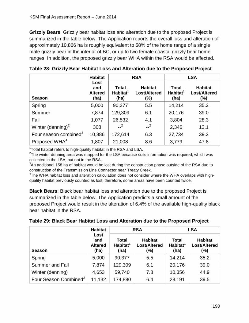
KSM Final Assessment Report – June 2014
190
Grizzly Bears: Grizzly bear habitat loss and alteration due to the proposed Project is
summarized in the table below. The Application reports the overall loss and alteration of
approximately 10,866 ha is roughly equivalent to 58% of the home range of a single
male grizzly bear in the interior of BC, or up to two female coastal grizzly bear home
ranges. In addition, the proposed grizzly bear WHA within the RSA would be affected.
Table 28: Grizzly Bear Habitat Loss and Alteration due to the Proposed Project
Season
Habitat Lost and
Altered (ha)
RSA LSA
Total Habitat1
(ha)
Habitat Lost/Altered
(%)
Total Habitat1
(ha)
Habitat Lost/Altered
(%)
Spring 5,000 90,377 5.5 14,214 35.2
Summer 7,874 129,309 6.1 20,176 39.0
Fall 1,077 26,532 4.1 3,804 28.3
Winter (denning)2 308 --2 --2 2,346 13.1
Four season combined3 10,886 172,614 6.3 27,734 39.3
Proposed WHA4 1,807 21,008 8.6 3,779 47.8 1Total habitat refers to high-quality habitat in the RSA and LSA.
2The winter denning area was mapped for the LSA because soils information was required, which was
collected in the LSA, but not in the RSA. 3An additional 158 ha of habitat would be lost during the construction phase outside of the RSA due to
construction of the Transmission Line Connector near Treaty Creek. 4The WHA habitat loss and alteration calculation does not consider where the WHA overlaps with high-
quality habitat previously counted as lost; therefore, some areas have been counted twice.
Black Bears: Black bear habitat loss and alteration due to the proposed Project is
summarized in the table below. The Application predicts a small amount of the
proposed Project would result in the alteration of 6.4% of the available high-quality black
bear habitat in the RSA.
Table 29: Black Bear Habitat Loss and Alteration due to the Proposed Project
Season
Habitat Lost and
Altered (ha)
RSA LSA
Total Habitat1
(ha)
Habitat Lost/Altered
(%)
Total Habitat1
(ha)
Habitat Lost/Altered
(%)
Spring 5,000 90,377 5.5 14,214 35.2
Summer and Fall 7,874 129,309 6.1 20,176 39.0
Winter (denning) 4,653 59,740 7.8 10,356 44.9
Four Season Combined2 11,132 174,880 6.4 28,191 39.5
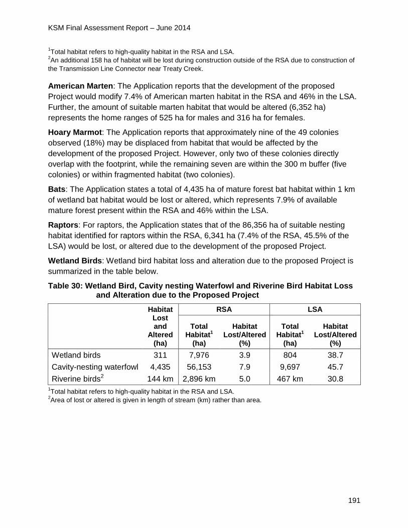
KSM Final Assessment Report – June 2014
191
1Total habitat refers to high-quality habitat in the RSA and LSA.
2An additional 158 ha of habitat will be lost during construction outside of the RSA due to construction of
the Transmission Line Connector near Treaty Creek.
American Marten: The Application reports that the development of the proposed
Project would modify 7.4% of American marten habitat in the RSA and 46% in the LSA.
Further, the amount of suitable marten habitat that would be altered (6,352 ha)
represents the home ranges of 525 ha for males and 316 ha for females.
Hoary Marmot: The Application reports that approximately nine of the 49 colonies
observed (18%) may be displaced from habitat that would be affected by the
development of the proposed Project. However, only two of these colonies directly
overlap with the footprint, while the remaining seven are within the 300 m buffer (five
colonies) or within fragmented habitat (two colonies).
Bats: The Application states a total of 4,435 ha of mature forest bat habitat within 1 km
of wetland bat habitat would be lost or altered, which represents 7.9% of available
mature forest present within the RSA and 46% within the LSA.
Raptors: For raptors, the Application states that of the 86,356 ha of suitable nesting
habitat identified for raptors within the RSA, 6,341 ha (7.4% of the RSA, 45.5% of the
LSA) would be lost, or altered due to the development of the proposed Project.
Wetland Birds: Wetland bird habitat loss and alteration due to the proposed Project is
summarized in the table below.
Table 30: Wetland Bird, Cavity nesting Waterfowl and Riverine Bird Habitat Loss and Alteration due to the Proposed Project
Habitat Lost and
Altered (ha)
RSA LSA
Total Habitat1
(ha)
Habitat Lost/Altered
(%)
Total Habitat1
(ha)
Habitat Lost/Altered
(%)
Wetland birds 311 7,976 3.9 804 38.7
Cavity-nesting waterfowl 4,435 56,153 7.9 9,697 45.7
Riverine birds2 144 km 2,896 km 5.0 467 km 30.8 1Total habitat refers to high-quality habitat in the RSA and LSA.
2Area of lost or altered is given in length of stream (km) rather than area.
KSM Final Assessment Report – June 2014
192
Forest and Alpine Birds: The Application states that overall, at the end of the
operations phase, 4,046 ha of forest and alpine bird habitat would be removed or
altered, including habitat for the SARA-listed rusty blackbird, olive-sided flycatcher and
common nighthawk.
Western Toads: The Application reports that of the 38 wetlands suitable for breeding
identified for western toads in the RSA, three wetlands would be lost or altered within
the 300 m buffer during the construction phase of the proposed Project. Overall, the
proposed Project would result in the loss or alteration of 7.9% of the potentially suitable
wetlands in the RSA and 18.8% of the suitable wetlands in the LSA.
The Application notes that for each of these wildlife VCs, the area described as “lost” is
made up of the proposed Project footprint (34%) and a 300 m buffer (66% of the total
area). Hence, where 46% of the habitat is rated as “lost” within the LSA, 15% of the LSA
would be in the footprint, and 31% of the LSA would be in the 300 m buffer. When
comparing these values to the LSA and RSA the Proponent states it is important to note
that the LSA is an arbitrary boundary set at 1.5 km or 500 m (for roads) from proposed
Project infrastructure, whereas the RSA uses ecological boundaries of rivers and
mountain ridges and roughly approximates the area used by a moose or grizzly bear
during its lifetime and is therefore a better ecological comparison of effects due to the
proposed Project.
Disruption of Movement
The Proponent identified disruption of wildlife movement as a potential effect for six VCs
(moose; mountain goats; grizzly bears; black bears; American marten; and Western
toad) as described in the table below.
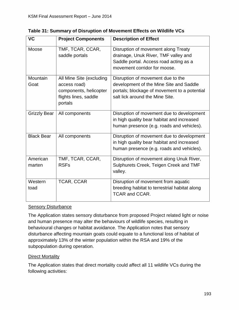
KSM Final Assessment Report – June 2014
193
Table 31: Summary of Disruption of Movement Effects on Wildlife VCs
VC Project Components Description of Effect
Moose TMF, TCAR, CCAR,
saddle portals
Disruption of movement along Treaty
drainage, Unuk River, TMF valley and
Saddle portal. Access road acting as a
movement corridor for moose.
Mountain
Goat
All Mine Site (excluding
access road)
components, helicopter
flights lines, saddle
portals
Disruption of movement due to the
development of the Mine Site and Saddle
portals; blockage of movement to a potential
salt lick around the Mine Site.
Grizzly Bear All components Disruption of movement due to development
in high quality bear habitat and increased
human presence (e.g. roads and vehicles).
Black Bear All components Disruption of movement due to development
in high quality bear habitat and increased
human presence (e.g. roads and vehicles).
American
marten
TMF, TCAR, CCAR,
RSFs
Disruption of movement along Unuk River,
Sulphurets Creek, Teigen Creek and TMF
valley.
Western
toad
TCAR, CCAR Disruption of movement from aquatic
breeding habitat to terrestrial habitat along
TCAR and CCAR.
Sensory Disturbance
The Application states sensory disturbance from proposed Project related light or noise
and human presence may alter the behaviours of wildlife species, resulting in
behavioural changes or habitat avoidance. The Application notes that sensory
disturbance affecting mountain goats could equate to a functional loss of habitat of
approximately 13% of the winter population within the RSA and 19% of the
subpopulation during operation.
Direct Mortality
The Application states that direct mortality could affect all 11 wildlife VCs during the
following activities:
KSM Final Assessment Report – June 2014
194
vehicle-wildlife collision;
vegetation clearing/ pit construction;
avalanche control; and
wildlife interactions with the transmission line.
Indirect Mortality
The Application described indirect mortality as mortality due to increased access and
hunting and range shifts due to disturbance. The Proponent identified potential indirect
mortality effects on the following VCs: moose, mountain goats, grizzly bears and black
bears. The Application states that the primary source of indirect mortality identified for
wildlife VCs in association with the proposed Project development is increased hunting
pressure on ungulates and bears, both legal and illegal, as a result of greater human
access to the RSA.
Attractants
The Proponent identified nine VCs that may be affected by attractants associated with
the proposed Project: moose, mountain goats, grizzly bears, black bears, American
martens, bats, raptors, wetland birds and western toads. The Application identified the
following proposed Project features and materials that have the potential to attract
wildlife:
odours and food sources associated with cooking, incinerators, garbage or sewage;
refuge, shelter, nesting, perching or roosting habitat provided by proposed Project
structures;
regenerating vegetation on road verges or other disturbed areas that creates
desirable forage;
travel corridors such as roads or cleared areas under transmission lines that
facilitate movement through otherwise difficult terrain or vegetation;
de-icing salts used on roads in winter; and
ponds or ditches created by development that provide water and aquatic habitat.
Chemical Hazards
The Application defines a chemical hazard as a chemical that has the potential to cause
an adverse health effect on wildlife VCs due to the proposed Project during any phase.
All 11 VCs have the potential to be affected by chemical hazards. Sources of proposed
Project related COPCs include:
available in water (within the Mine Site, in the WSF; water discharged from the Mine

KSM Final Assessment Report – June 2014
195
Site; within the ponds of the TMF; and water discharged from the TMF);
associated with mine development and operation;
available in ML/ARD generated from exposed waste rock; and
deposited in fugitive dust.
Summary of Mitigation Proposed in the Application
The Application outlines a broad range of mitigation measures to reduce potential
effects on wildlife, many of which are contained and further described in the Wildlife
Effects Monitoring Plan. Examples of some of the measures include:
avoiding construction activities that may disturb wildlife VCs during wildlife sensitive
periods. If avoidance is not possible, conduct preferable non-intrusive pre-
construction clearing surveys to identify evidence of breeding or dens that must be
avoided;
having an Environmental Monitor on site during construction to identify sensitive
wildlife features and implement appropriate procedures to minimize potential
adverse effects to these areas;
managing roadside vegetation (e.g. by clearing along the edges and planting
vegetation that is unattractive to wildlife) to minimize attractiveness to wildlife and
provide good line of sight to avoid vehicle-wildlife collisions;
minimizing the risk of trapping wildlife (particularly moose) along the major access
roads and the on-site roads by managing snow bank height and creating escape
pathways in snow banks;
incorporating and monitoring of wildlife passages into road and bridge design at river
and creek crossings, to allow wildlife to move beneath these structures and
adaptation of wildlife crossings if monitoring indicates that crossings are ineffective;
educating employees to assess and adapt their driving activities during dawn and
dusk, which are periods of high wildlife activity;
yielding to wildlife observed along proposed Project roads and Hwys;
controlling vehicle speeds and vehicles per hour on proposed project roads to
reduce direct mortality (wildlife vehicle collisions) and disruption of movement to
wildlife;
incorporating appropriate design provisions along proposed Project roads to
minimize wildlife/traffic collision risk, thereby facilitating wildlife movement (e.g.
western toads);
providing signage along proposed Project roads in high-value wildlife areas or
KSM Final Assessment Report – June 2014
196
known wildlife travel corridors to warn vehicle operators of the potential to encounter
wildlife;
the proposed Project’s access roads (the CCAR and the TCAR) would be gated and
staffed to prohibit the entry by non-authorized vehicles thereby limiting new hunting
opportunities and associated indirect mortality;
deactivating all non-essential roads, including the CCAR, at closure, when traffic
volumes will be greatly reduced; and,
monitoring and adaptively managing the use of proposed Project structures by wildlife for security habitat (refuge, shelter), daily activities (roosting, perching) or nesting purposes.
5.9.3 Project Issues and Effects and Proposed Mitigation Identified During
Application Review
Note: wildlife issues relating to the transportation corridors (Hwys 37 and 37A) are
addressed in Section 10 Transportation.
During the review of the Application, additional issues were raised by the agencies,
NLG, First Nations and the public. These issues, the Proponent responses and EAO’s
assessment of the adequacy of responses are detailed in Appendix 1. The CPD and
TOC (Appendix 2) contain specific mitigation measures, which would be legally
enforceable if an EA Certificate is issued. Examples of some of the key issues and
additional commitments include:
FLNR stated that there is a high likelihood that the Proponent’s sightings of northern
goshawk in the coastal-influenced Unuk River drainage were laingi subspecies,
which is red listed in BC and threatened under SARA. FLNR required the Proponent
to conduct additional surveys in order to identify and potentially mitigate impacts
during construction of the CCAR and portions of the proposed Project footprint within
potentially suitable habitat.
o The Proponent responded that pre-clearing surveys for raptor nests are
planned during construction of the CCAR and other areas where there is
suitable habitat. This commitment will be expanded upon in the detailed
Wildlife Mitigation and Monitoring Plan to be developed during the permitting
stage.
FLNR commented that breeding sites of western toad can be hard to find and
western toads may not breed every year. Given this, FLNR considers it highly
possible that breeding locations were missed within the Proponent’s surveys of the
TMF and Mine Site footprint. Further, FLNR stated that the Proponent’s finding of an
adult western toad within the planned TMF and at the Mine Site locations should be
considered as potential indicators of breeding habitat nearby. FLNR required the
KSM Final Assessment Report – June 2014
197
Proponent to incorporate this finding into the effects assessment and commit to
additional surveys within the TMF for breeding ponds before the TMF is developed.
o The Proponent responded that the possibility that toad surveys did not find
toads due to the timing of the surveys was included in the Application.
o The Wildlife Effects Monitoring Plan states that if construction occurs
between May and August in wetland and pond habitat, construction monitors
will survey the wetlands and ponds prior to construction activity, and, if toad
breeding is confirmed, a buffer zone of at least 30 m will be established
between construction activities and identified breeding habitat or a
salvage/relocation program will be implemented.
FLNR and wilp Skii km Lax Ha raised concerns with respect to the mitigation
proposed for effects to American marten. FLNR requested additional information
from the Proponent with respect to the feasibility of leaving abundant coarse woody
debris on the ground of the transmission line right of way to provide cover and
subniven18 spaces to facilitate martin movement to mitigate the barrier from the
transmission line right of way. FLNR also requested additional information regarding
the placement of drainage culverts on the access roads to mitigate road impacts on
martin movement.
o The Proponent responded that clearing would leave shrubs and low lying
vegetation in place and the potential to leave fallen timber in place in the
right of way would be investigated. The Proponent noted that fire restrictions
and other permitting requirements may limit the potential for the proposed
Project to use fallen timber to mitigate furbearer movement.
FLNR required additional information from the Proponent with respect to clearing
within natal areas for moose from April to July. Tahltan Nation was also concerned
about potential impacts to moose natal areas and moose habitat. The question of
the location of moose calving areas was also raised at Wildlife Working Group
meetings.
o The Proponent stated that: 1) late winter habitat is the most important
habitat for moose as evaluated in the application (i.e. late winter habitat
defines the locations of provincial moose UWR); 2) moose typically do not
have a “calving area” that they return to every year; and 3) determining the
locations of calving areas would require collaring of female moose, which is
18 refers to a zone that is in or under the snow layer
KSM Final Assessment Report – June 2014
198
not supported by FLNR. Thus moose calving habitat would not be identified
prior to construction.
o The Proponent’s preferred mitigation is to avoid clearing during early spring
when moose cows are calving. If a cow moose is observed incidentally to be
calving during clearing and construction, then mitigation to reduce
disturbance would be triggered.
o The Proponent is preparing a detailed Wildlife Effects Monitoring Plan to
support permit applications. The plan will describe mitigation measures
including stopping machinery until the animals move away.
FLNR and wilp Skii km Lax Ha questioned the Proponent’s proposed mitigation
measure of setting out artificial salt licks for goats to enhance habitat quality outside
of the Mine Site. FLNR stated this is strongly discouraged by the provincial Wildlife
Branch as salt blocks are thought to be a significant vector for disease transmission.
Wilp Skii km Lax Ha stated that concentrations of mountain goats in the wrong areas
could increase predation risk, be an attraction for mine staff, and possibly be an
attraction for hunters.
o In response, the Proponent noted two potential salt licks were identified for
mountain goats within the RSA during baseline surveys. Remote cameras
during 2013 confirmed the use of one of these salt licks - located
approximately 575 m south of the Kerr Pit Haul Road and 1,060 m northwest
of the Sulphurets Pit.
o The Application includes several commitments related to the salt lick,
including 1) minimizing noise and disturbance in the area of the salt lick, 2)
monitoring the salt lick to evaluate if goats continue to use the salt lick, and
3) if use of the lick reduces over time, installing additional artificial salt licks
in appropriate goat habitat to offset disturbance at the existing lick in
consultation with FLNR. The creation of multiple licks would allow goats to
choose which one is safe from predators. The pros and cons of using
commercial salt licks for mountain goats will be evaluated in the Wildlife
Effects Monitoring Plan, to de developed during the permitting stage.
EC required the Proponent to provide information to support the significance
determination for Little Brown Myotis as 46% of mature forest within the local study
area would be lost or altered as a result of the proposed Project.
o The Proponent responded that the effect of habitat loss and alteration on
bats was not considered to be a residual effect in the Application, and
therefore was not assessed for significance. Of the area assessed, 34% was
“lost” in the footprint, and 66% was in the 300 m buffer - hence, 15% of the
KSM Final Assessment Report – June 2014
199
LSA would actually be lost. The Application included an assessment of the
possible location of bat hibernacula that may be used for overwintering.
o The Proponent conducted further study in the spring of 2013 which
confirmed the presence of bats during the summer, although no hibernacula
were confirmed. The Proponent hypothesized that bats observed in May in
the study area may have emerged from hibernacula in these areas along the
Stikine and Iskut rivers to the north and possibly similar to the west in
Alaska, and flown a relatively short distance to the study area where they
were detected. These results support the conclusion reached in the
Application that habitat loss and alteration would not result in a residual
effect on bats.
Gitanyow Nation questioned the Proponent’s significance determination based solely
on a comparison of the area of habitat lost by the proposed Project to a much larger
area (the RSA) in order to show a low percentage of habitat area lost. Gitanyow
Nation disagreed with using this as the only method of assessing severity of impact
to moose and other wildlife species.
o The Proponent responded that in the wildlife effects assessment in the
Application the amount of habitat loss is compared to the amount of
available habitat in the RSA and the LSA. The approach is consistent with
other EAs in BC. The severity of the impact was also assessed by
measuring the amount lost or altered habitat in terms of number moose
home ranges and number of moose given the density found during baseline
surveys.
MEM raised concerns about the Proponent’s proposed reclamation strategies. MEM
required clarification as to how the predevelopment and post-closure land capability
compare. Specifically, MEM requested additional information on: 1) how much area
will not be reclaimed, 2) how much habitat of each relevant species will be
reclaimed, and 3) will the reduction in habitat area potentially impact particular
wildlife species on a population level.
o In response, the Proponent stated that areas were evaluated as lost (4,369
ha) in the footprint and altered (8,967 ha) in a 300 m buffer surrounding the
footprint. The footprint would be cleared, while the buffer may experience
edge effects, noise, dust, disturbance, etc. At closure, 1,887 ha (43%) of the
footprint would be reclaimed while the area in the 300 m buffer (8,967 ha),
would recover naturally when sources of dust and disturbance are removed.
o The Proponent’s detailed responses to question #2 are presented in the
memo addressing MEM’s reclamation comments.
KSM Final Assessment Report – June 2014
200
o The reclamation of wildlife habitat as identified in the Closure and
Reclamation Plan was not a mitigation strategy used to evaluate the impact
of the proposed Project on wildlife. Mountain goat was the only species
identified with the potential for a distinguishable effect on the local
population due to habitat loss from the proposed Project.
5.9.4 Residual Effects Significance Analysis
After considering all relevant mitigation measures proposed, EAO concludes that the
proposed Project would result in residual adverse effects on wildlife and their habitat
primarily due to:
habitat alteration and loss (primarily through land clearing for construction, and
degradation of habitat near to proposed Project components through dusting, noise,
etc.); and
sensory disturbance for some species, such as mountain goats and grizzly bears, which are more sensitive to disturbance.
The other effects listed below have proven and well understood mitigation measures
such as standard best practices and would have lesser residual effects on wildlife
populations:
disruption of wildlife movement (primarily linked to traffic and large infrastructure
components such as the TMF that block migration corridors and to a lesser extent
semi-permeable barriers);
sensory disturbance (linked to noise, visual and lighting intrusion);
direct mortality of wildlife due to construction-related incidents and vehicle-wildlife
collisions;
indirect mortality (mainly due to increased access and hunting pressures), risks
posed by mine-related attractants (such as garbage or attractive vegetation along
roadways); and
health risks due to chemical hazards.
EAO has undertaken the following significance analysis on the residual adverse effects
on wildlife and their habitat.
Table 32: EAO's Significance Analysis for Wildlife and Wildlife Habitat
Factor Rationale
Context Mature forests, wetlands, alpine areas and riparian forests provide
high-value habitat to diverse wildlife communities in the proposed
Project area. Common species or groups that occur in the RSA
include ungulates (e.g. moose and mountain goat),

KSM Final Assessment Report – June 2014
201
omnivores/carnivores (e.g. grizzly bear, black bear and wolves),
furbearers (e.g. fisher, marten and wolverine), hoary marmots, bats,
birds (forest birds, raptors and waterfowl), and amphibians (e.g.
Columbia spotted frog and western toad).
Forest harvesting within the RSA is minimal compared to many
other areas in BC, due to the remoteness of the area and the
relatively poor productivity of forests in this northerly location, so
that wildlife habitats in most of the RSA are essentially undisturbed.
Local and regional populations of most species are healthy in this
area of BC, although regional moose populations have declined
over the last decade.
The ecological implications of residual wildlife effects vary,
depending on the VC. Implications are more severe for moose,
western toad and bats (particularly little brown myotis) as they are
less able to adapt to changes in the environment, have a declining
population or are a listed species. Mountain goats, grizzly bears,
and American marten are expected to have capacity to adapt to
changes in the environment or have a stable population status
making them more resilient. However, mountain goats are more
sensitive to disturbance than most other ungulates and grizzly bears
are more vulnerable to mortality-related issues due to attraction to
camps. Some populations of birds are increasing (i.e., high
resilience) while others (e.g. Schedule 1 species) are or may be
declining (i.e. low resilience). Black bears and hoary marmots are
expected to be the most resilient since their populations are large
and healthy.
Magnitude Moose: The magnitude of habitat loss effects to moose is moderate.
Areas of summer and early winter habitat would be lost in the TMF
and Treaty Processing Plant site, but the important, and limiting
habitat of late winter overlaps with the proposed Project only at low
elevations along the TCAR.
Goats: The magnitude of habitat loss effects for goats is moderate.
Areas of winter habitat would be lost due to the CCAR, small areas
in the Mine Site and at the TMF, where areas of the 300 m buffer
overlap winter habitat.
The magnitude of disturbance effects is also moderate. Goats are
susceptible to noise and disturbance and the Proponent’s noise
modeling indicated that areas of winter and summer habitat would
KSM Final Assessment Report – June 2014
202
effectively be lost at the Mine Site.
Grizzly bears: The magnitude of habitat loss effects for grizzly bears
is moderate. The TMF contains areas of high quality spring and
summer range.
The magnitude of disturbance effects is also moderate, since grizzly
bears are known to avoid human activities to a greater degree than
other large mammals.
Other VCs: The magnitude of habitat loss effects is moderate or low
for all VCs when compared to the RSA (+/- 5%) but are moderate to
high when compared to the LSA (+/- 40%).
Extent The extent of residual wildlife effects is localized to the LSA for most
effects categories, although for some wildlife VCs with larger ranges
(grizzly bears, black bears, moose, and mountain goats), residual
effects will extend to the landscape level, while remaining tied to the
proposed Project footprint or to individual animals within the RSA
(e.g. effects linked to disruption of movement, direct and indirect
mortality, or sensory disturbance). The abundance of individuals of
particular species may decline during construction and operation in
the immediate area of the proposed Project footprint; however, most
wildlife VCs are mobile, and will likely seek alternative habitat if
displaced by mining-related disturbances, if alternative habitat is
available.
Duration Duration of residual wildlife effects is predicted to be long-term or far
future, depending on the extent of habitat removal and animal
displaced from the LSA. As the level of on-site activity declines, or
where site reclamation begins to reverse earlier habitat effects, the
duration of residual effects may be shortened.
Reversibility All residual wildlife effects are considered reversible, except where
habitat is permanently removed during construction and cannot be
reclaimed. Direct mortality effects on hoary marmot colonies are
rated irreversible if entire colonies are removed by open pit mining
and the RSFs.
Frequency For most effects, frequency will be sporadic rather than regular or
continuous. Sporadic effects will include wildlife mortality, disruption
of movement and the effects of attractants. Frequency is rated
regular for sensory disturbance effects such as noise, and regular or
continuous for chemical hazard effects on some VCs (mountain
KSM Final Assessment Report – June 2014
203
goats, bats, wetland birds), since exposure risk will be continuous
during construction and operation.
Likelihood
The likelihood that predicted residual wildlife effects would be experienced varies with
the VC and effect. The likelihood that habitat loss and alteration effects will occur is
considered high, and that bears will be attracted to proposed Project infrastructure and
personnel camps. Indirect mortality effects are difficult to predict for moose and
mountain goats, and the likelihood of effects is rated low due to the standard mitigation
proposed by the Proponent. The likelihood of direct mortality effects is moderate for
moose, bears, American martens, hoary marmots, and western toads, but low for
mountain goats because they will not interact with proposed Project roads at high
elevations. Likelihood is medium for predicted disruptions of animal movements and
sensory disturbance of mountain goats. The likelihood of chemical hazard effects is
medium.
5.9.5 Significance Determination
EAO considered the low to moderate magnitude effect, the reversibility of wildlife
effects, and the sporadic nature of most effects other than sensory disturbance and
chemical hazard effects and the long-term duration of effects.
EAO notes the Proponents commitments to specific mitigation measures contained in
the Wildlife Effects Monitoring Plan identified in the TOC are expected to be successful
in mitigating potential wildlife effects during all phases of the proposed Project.
Considering the above analysis and having regard to the conditions identified in the
TOC and the CPD (which would become legally binding as a condition of an EA
Certificate), EAO is satisfied that the proposed Project is not likely to have significant
adverse effects on wildlife.
5.9.6 Cumulative Effects
Depending on the wildlife VC, numerous other projects and activities have the potential
for residual effects that overlap with the proposed Project’s potential residual wildlife
effects. Projects include the past Eskay Creek, Kitsault, Granduc and Snip mines, the
current Wolverine Mine, Forrest Kerr and Long Lake HEPs and the NTL, the proposed
Bronson Slope, Brucejack, Galore Creek, Arctos Anthracite, Granduc Copper, Schaft
Creek, Red Chris, Swamp Point, Bear River Gravel and Snowfield mines, the McLymont
Creek and Treaty Creek HEPs, and past and potential mineral and energy resource
exploration, residential and Aboriginal resource harvesting, fishing, guide-outfitting,
recreation and tourism, timber harvesting and road traffic. However, considering the
KSM Final Assessment Report – June 2014
204
suite of standard mitigation that would be applied for these projects, the cumulative
effects on wildlife is considered not significant.
5.9.7 Certainty
Confidence in habitat loss effects is medium as habitat suitability modeling by the
Proponent identified high-quality habitat. Areas of lost and degraded habitat were
evaluated through a conservative approach, which included a 300-m buffer surrounding
all footprint areas.
Confidence in the assessment of some wildlife effects, such as disruption of movement,
direct mortality (vehicle collisions), indirect mortality (new access leading to new
hunting), attractants, and chemical hazards is moderate. Mitigation is available for each
of these effects that have been shown to be effective at similar industrial operations and
resource roads.
Confidence in wildlife displacement due to disturbance is low. The Application included
noise modeling which used low threshold values (suburban nighttime noise limits), but
the actual degree that wildlife may avoid active proposed Project facilities is difficult to
predict. Some wildlife may be attracted (e.g. bats and food-rewarded bears) while other
species or individuals may avoid the proposed Project (e.g., moose and bears).
5.9.8 Conclusion
Considering the above analysis and having regard to the conditions identified in the
TOC and the CPD (which would become legally binding as a condition of an EA
Certificate), EAO is satisfied that the proposed Project is not likely to have significant
adverse effects on wildlife.
6 Assessment of Potential Economic Effects
6.1 Economic Effects
6.1.1 Background Information
VCs selected for the assessment include employment and income, and business
opportunities and economic development.
The employment and income VC encompasses potential Project effects on direct and
spin-off (indirect and induced) employment, personal and household income, Gross
Domestic Product (GDP) and government tax revenues, as well as opportunities for,
and benefits to, Aboriginal communities. The business opportunities and economic
development VC includes potential proposed Project benefits on local businesses,

KSM Final Assessment Report – June 2014
205
including Aboriginally-owned businesses, and the overall growth and development of
the local and regional economy.
LSA communities are depicted in figure 20 and include the four Nisga’a villages,
Terrace, Smithers, Stewart, Hazelton, New Hazelton, Dease Lake, Bell II, Meziadin
Junction, Bob Quinn Lake, Gitanyow 1 (Gitanyow Nation), Telegraph Creek 6 and 6A,
Guhthe Tah 12, Dease Lake 9 and Iskut 6 (Tahltan Nation).
The RSA covers 9,559,100 ha, and is comprised of two administrative regions - the
Regional District of Kitimat-Stikine, and Electoral Area A of the Regional District of
Bulkley-Nechako. The Province of BC is also defined as a study area, since some
economic impacts would be realized at the provincial scale.
The Application describes past and current economic conditions observed in the
province, and regional and local communities.
The Proponent’s assessment of the economic effects is based on the results of an
economic impact model, DYNATEC, based on Statistics Canada’s Input/ Output Model
for BC and Canada, but incorporating dynamic and non-linear simulations of the likely
effects. Based on information provided by the Proponent, the model produced estimates
of the proposed Project effects on provincial GDP, income, government revenue and
total employment.
Potential impacts on Nisga’a Nation economic well-being are discussed in Part D of this
Report.
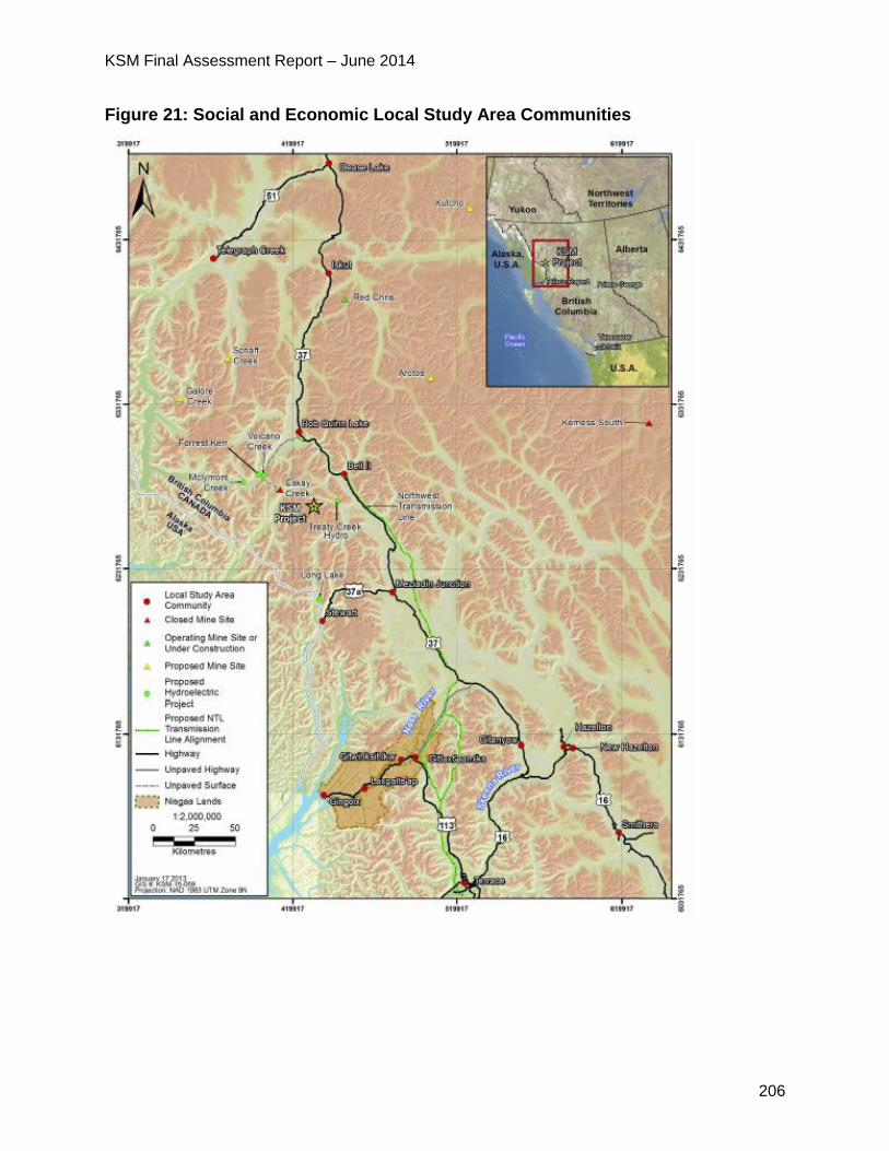
KSM Final Assessment Report – June 2014
206
Figure 21: Social and Economic Local Study Area Communities

KSM Final Assessment Report – June 2014
207
6.1.2 Project Issues and Effects and Proposed Mitigation Identified in the
Application
Overall Effects
The Application states that direct employment and procurement of goods and services
are the only proposed Project components that have the potential to interact with the
two economic VCs (employment and income, and business opportunities and economic
development). They would do so throughout the proposed Project life cycle, but these
impacts would be most evident during construction and operations.
The Application reports that based on modeling the proposed Project is expected to
generate substantial employment opportunities, as well as spending on supplies and
services, resulting in direct and spin-off (indirect and induced) economic impacts that
would include increases in employment, personal income and overall GDP. The
proposed Project would also contribute to government revenues mainly through
personal income tax, corporate profit tax and sales tax, and would also pay rural
property tax and revenues (BC mineral tax). Key economic impacts are summarized in
the table below.
Table 33: Summary of Economic Impacts of the Proposed Project for Construction and Operation
Year
Employment
(Person-
years)
GDP
(Million Constant
Dollars)
Tax Revenue1
(Million Constant Dollars)
Federal Provincial Total
Construction Phase
BC 31,094 $3,445.6 $408.4 $182.8 $591.3
Canada 55,248 $6,020.8 $731.6 $344.5 $1,076.0
Operation Phase
BC 194,313 $20,846.8 $2,808.0 $1,265.2 $4,073.2
Canada 395,868 $41,673.7 $5,368.4 $2,641.1 $8,009.6
Source: 2012 Economic Model Report (Appendix 20-B of the Proponent’s Application).
Note: Proposed Project-related employment includes the sum of direct, indirect, and induced
employment. Operation employment includes construction for underground mining (pit caving). 1 The estimation of government tax revenues is limited to personal income tax, indirect corporate profit
tax, and sales tax. It does not include direct taxes on the profit of the proposed Project, property taxes, or
any royalties paid by the proposed Project.

KSM Final Assessment Report – June 2014
208
The Application reports that businesses that are direct and indirect suppliers to the
proposed Project are expected to benefit from the development of the proposed Project.
During construction and operations, the spending of personal income from direct and
indirect proposed Project-related employment is predicted to result in additional
opportunities for businesses as workers spend their incomes, inducing further income
and GDP impacts. Businesses may also invest and/or expand operations to take
advantage of new opportunities. The Proponent predicts that proposed Project related
changes in income and GDP would result in a beneficial residual effect on business
opportunities and economic development.
Construction Phase Effects
The Application says for the construction phase, total direct capital investment for the
proposed Project would be approximately $5.26 billion, of which about $4.61 billion is
expected to be direct expenditures in Canada. Most capital expenditures would be
sourced within BC, followed by Alberta, Ontario, and to a lesser extent, Quebec.
The remaining expenditures would be sourced internationally.
The Application estimates direct on-site proposed Project employment to be an average
of approximately 314 person years (PY) for the first year of construction increasing to a
peak of 2,260 PY. The Proponent estimates the total direct proposed Project
employment over the five-year period to be approximately 7,450 PY in BC and 9,314 PY
for all of Canada.
Operations Phase Effects
The Proponent predicts the proposed Project would be in operations for 51.5 years and
estimates operating expenditures to be initially $852 million, thereafter varying from as
low as approximately $570 million/year to a high of $780 million/year. Total direct
operation-phase spending by the proposed Project is estimated to be approximately
$34.3 billion over the life of the mine, with most expenditures being made in BC.
Direct employment is predicted to be approximately 1,066 PY during Year 1 of operation
(2020), remaining at that approximate level for four years, then decreasing moderately
to 865 PY by 2029 and remaining near that level for approximately 10 years.
Employment is expected to increase again beginning in Year 21 (2040), reaching a
peak total of approximately 1,709 PY in Years 32 and 33 (2051 and 2052), mainly
reflecting the switch to underground mining. Total employment is projected to then
decrease moderately until the estimated end of operation in Year 52 (2071).
The Application predicts direct employment over the 51.5-year mine life, excluding
construction employment necessitated by the switch to underground mining, to total
approximately 35,205 PY in BC and 52,537 PY for all of Canada. These figures exclude

KSM Final Assessment Report – June 2014
209
the relatively small foreign worker component. For the underground mining construction
component, direct employment is estimated to total approximately 4,621 PY in BC and
5,811 PY for all of Canada.
The Application predicts substantial economic benefits during operation through
employment and through businesses directly and indirectly supplying the proposed
Project. The Application reports that the long duration of the operation phase would
substantially enhance the work experience, education, and skill levels of the regional
workforce, including both Aboriginal and non-Aboriginal workers, and would provide the
necessary confidence for local and regional businesses to commit funds, time and
resources to help meet the proposed Project’s supply and service needs.
Closure and Post-Closure Phases
During closure and post-closure, activities would include the decommissioning and
reclamation of various facilities at the Mine Site and the PTMA, and the ongoing
operation and maintenance of permanent proposed Project components. These
activities would provide employment and business opportunities; however the
Application reports estimates are not available because closure would take place far in
the future.
The Application describes the adverse effects from closure on LSA communities that
have become economically dependent on the proposed Project during operation. Since
direct proposed Project expenditures and employment would be much lower than during
operation, an overall loss of employment, income, GDP and government tax revenues
are predicted at closure, likely triggering indirect and induced employment and income
losses.
Summary of Mitigation Proposed in the Application
Mitigation measures for the potential effects on employment and business are contained
within the Proponent’s Labour Recruitment and Retention Strategy, Procurement
Strategy, Workforce Training Strategy and Workforce Transition Program.
Labour Recruitment and Retention Strategy
The objective of the Labour Recruitment and Retention Strategy is to maximize
employment benefits within the LSA communities, the RSA and the province.
Examples of recruitment measures include the following:
communication activities within LSA communities to provide advance notification of
employment opportunities and expectations, hiring schedules and skill/certification
requirements;
development of employment policies and programs that consider the needs of
workers from regional and Aboriginal communities; and

KSM Final Assessment Report – June 2014
210
development of co-operative working relationships with regional post-secondary
educational institutions to facilitate worker preparedness for proposed Project
positions.
Examples of labour retention measures include the following:
flexibility to accommodate cultural and familial commitments and responsibilities of
workers;
provision of financial management and life skills training opportunities for workers;
and
implementation of zero-tolerance policies for drug and alcohol use, including clear
communication and commitment to the policies by workers.
Procurement Strategy
The overall objective of the Procurement Strategy is to encourage the involvement of
local and regional businesses in the proposed Project, so as to maximize proposed
Project-related benefits within the RSA. Examples of measures provided for in the
strategy include:
development of a Procurement Information System that would be accessible to local
and regional businesses, with information on such topics as qualification
requirements, health and safety requirements, current and future supply
opportunities, quality and business conduct expectations, and required technical
standards;
cooperation with local economic development agencies and educational institutions
to assist them to encourage local business development (e.g., by sponsoring
courses or workshops on business development and contract tendering); and
development of an inventory of suppliers (including information on the types of
goods and services provided, capacities and capabilities) that would be accessible
by proposed Project procurement personnel, as well as the Engineering,
Procurement and Construction Management contractor and other contractors.
Workforce Training Strategy
The objective of the Workforce Training Strategy is to develop qualified locally and
regionally based workers for the proposed Project through measures intended to
maximize the work experience, education and skill levels of the regional workforce. The
Workforce Training Strategy is intended to:
support the development of worker training programs delivered through external
education and training facilities by communicating proposed Project workforce hiring
schedules and skill/certification requirements, and by developing strategic
KSM Final Assessment Report – June 2014
211
partnerships with post-secondary education institutions to deliver appropriate
training within the RSA;
provide in-house training and career development opportunities, including worker
training programs as part of worker recruitment and on-the-job training programs to
enhance worker job expertise and to promote internal worker advancement; and
make education, training, and employment opportunities available to Aboriginal
peoples within the LSA.
Workforce Transition Program
The Workforce Transition Program would be developed and implemented prior to
closure. Its objective would be to help workers secure suitable employment elsewhere
and, thus, minimize the adverse effects of employment loss. Anticipated elements of the
Workforce Transition Program would include:
development of materials that would assist workers to describe the skills acquired
through proposed Project-related employment, to match their skills to alternative
industries and positions, and to articulate their skills and experience effectively in
personal resumes and other job search materials;
creation of an inventory of available workers and their skills/experience, to be made
available to external Human Resources officials; and
coordination with post-secondary training institutions to promote the development of
specific retraining initiatives in response to both industry demand at closure and the
level of interest expressed by proposed Project workers.
6.1.3 Project Issues and Effects and Proposed Mitigation Identified During
Application Review
During the review of the Application, additional issues were raised by the agencies,
NLG19 and the public. These issues, the Proponent responses and EAO’s assessment
of the adequacy of responses are detailed in Appendix 1.
The CPD and TOC (Appendix 2) contain specific mitigation measures, which would be
legally enforceable if an EA Certificate is issued. Examples of some of the key issues
and additional commitments include:
19 A full discussion and analysis of how the proposed Project would affect Nisga’a Nation economic “well-
being” as outlined in the NFA is included in Part D including those issues specific to the Nisga’a Nation.
KSM Final Assessment Report – June 2014
212
The Regional District of Kitimat Stikine was concerned that the refuse from the
proposed Project could overwhelm the small landfill facilities in the region. The
Regional District expects ongoing communication with the Proponent to ensure
solid waste, septic waste and recyclables from the proposed Project is managed
efficiently and not becoming a financial or logistical burden on the Regional
District.
o In response the Proponent committed to consult the Regional District of
Kitimat-Stikine to ensure solid waste, septic waste and recyclables from the
mine or construction camps are managed efficiently and do not become a
financial or logistical burden on the Regional District.
6.1.4 Residual Effects
In consideration of EAO’s assessment of the Application, and comments from the
public, EAO finds that net beneficial effects on the economy from the proposed Project
are anticipated.
6.1.5 Conclusion
Based on the above analysis and having regard to the conditions identified in the TOC
and the CPD (which would become legally binding as a condition of an EA Certificate),
EAO is satisfied that the proposed Project would not have residual adverse economic
effects with the implementation of mitigation measures.
7 Assessment of Potential Social Effects
7.1 Social Effects
7.1.1 Background Information
The Application provided background information on communities in the region that
could potentially be affected by the proposed Project. The Proponent selected the
following VCs for the social assessment: community demographics, infrastructure, and
services; education, skills development and training; and community well-being.
The Proponent accessed information from Statistics Canada Census data, BC Stats,
Aboriginal Affairs and Northern Development Canada and various provincial and
municipal government agencies in addition to conducting interviews.
The social LSA and RSA were the same as the ones used for the economic
assessment.
As part of the social assessment, the Proponent also assessed land use effects and
KSM Final Assessment Report – June 2014
213
selected the following VCs for the assessment:
commercial recreation;
guide-outfitting and trapping;
recreational hunting and fishing;
subsistence;
traditional or heritage value of land;
water licenses;
navigable waters; and
mining and mineral exploration.
The Proponent conducted desktop studies and fieldwork to identify land users and their
frequency and type of use of the land within the LSA and RSA.
The proposed Project falls under two provincial land and resource management plans:
the Nass South Sustainable Resource Management Plan and the Cassiar-Iskut-Stikine
Land and Resource Management Plan. The proposed Project activities are allowable
activities under these plans.
The Proponent also assessed visual and aesthetic effects of the proposed Project using
the following VCs:
visual quality for river rafting tours;
visual quality for heli-skiing tours;
visual quality for guided backcountry expeditions;
visual quality for guided angling trips;
visual quality for visitors to the Treaty Creek Site (a protected heritage site); and
visual quality for Hwy 37 users.
The Proponent identified potentially visually sensitive areas and conducted a viewshed
analysis of the proposed Project area to determine how much of the proposed Project
infrastructure would be visible from the selected viewpoints (see figure 21).
Land use effects relating to Nisga’a Nation and First Nations are described in part D of
this Report.
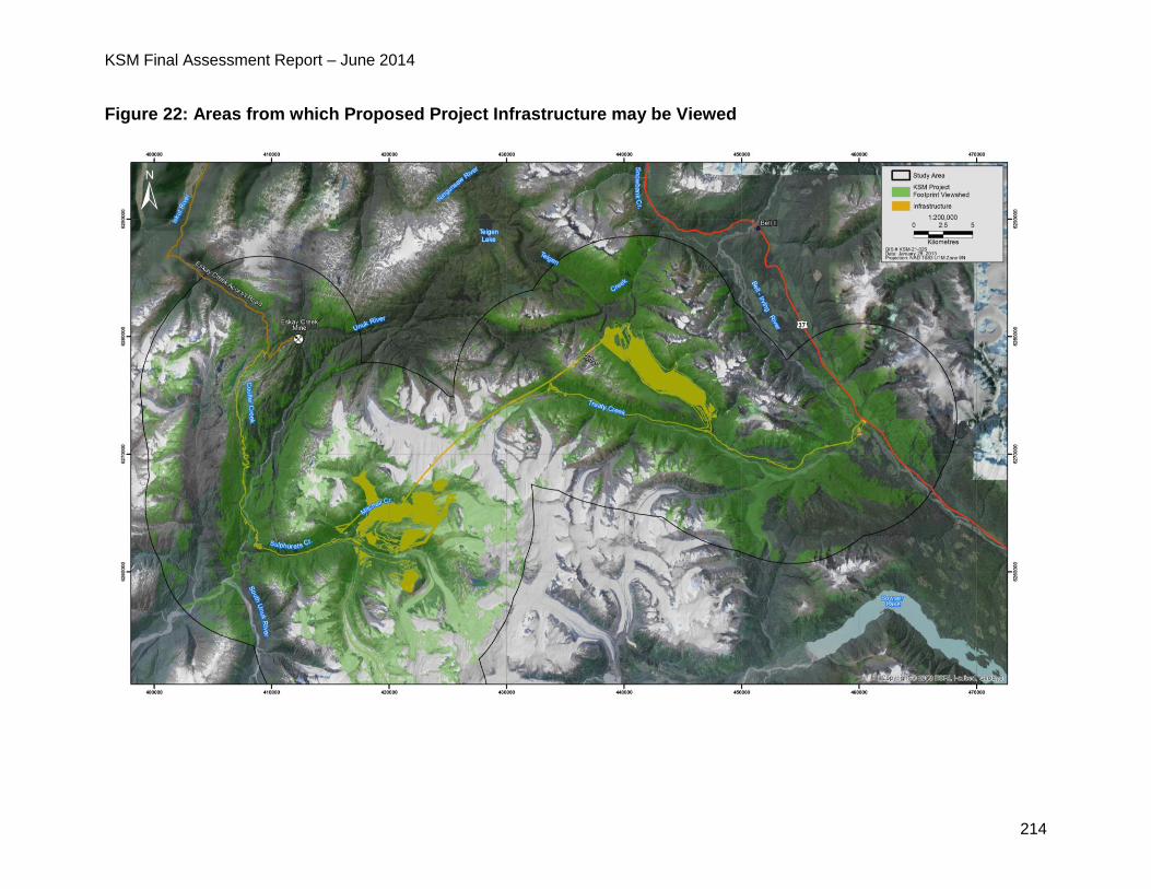
KSM Final Assessment Report – June 2014
214
Figure 22: Areas from which Proposed Project Infrastructure may be Viewed

KSM Final Assessment Report – June 2014
215
7.1.2 Project Issues and Effects and Proposed Mitigation Identified in the
Application
The Application states that direct employment and the procurement of goods and
services are the only proposed Project components that have the potential to impact the
social VCs. Impacts would be most evident during construction and operations. The
Application says the proposed Project’s primary potential social effects would be linked
to changes in employment, income, population, tax base and traffic.
Based on economic modeling, the Proponent predicted the proposed Project related
employment generation (direct, indirect and induced) for the RSA, BC and Canada for
the duration of construction and operation (more than 55 years). This job creation is
summarized, as it relates to the current size of the labour force, in the table below.
Table 34: Proposed Project-Specific Employment Effects
Experienced
Labour Force
(persons, 2006)
Total Project-
related
Employment
(PYs)
Annual Average Project-related
Employment
Total (FTEs)
Proportion of
2006 Labour
Force (%)
Construction Phase
RSA 22,530 1,497 272 1.21%
BC 2,193,115 31,094 5,653 0.26%
Canada 16,861,180 55,248 10,045 0.06%
Operation Phase
RSA 22,530 21,810 423 1.88%
BC 2,193,115 194,313 3,773 0.17%
Canada 16,861,180 345,868 6,716 0.04%
Notes: Active labour force statistics from Statistics Canada (2007). Other data are derived from estimates
of the 2012 Economic Model Report (Appendix 20-B of the Proponent’s Application, Chapter 20).
Proposed Project-related employment includes the sum of direct, indirect, and induced employment.
Operation employment includes construction for underground mining.
The Application states the proposed Project is expected to increase income in the RSA
through the creation of direct, indirect, and induced employment. The table below

KSM Final Assessment Report – June 2014
216
provides a summary of the predicted proposed Project-specific personal incomes,
compared to median RSA, BC and Canada-wide salaries in 2005.
Table 35: Project-specific Effects on Income
Median Full-time
Earnings (2005)
Project-related Income
Average Worker Income
Proportion of 2005
Median
Full-time Earnings
Construction Phase
RSA $46,775 $99,132 212%
BC $42,230 $79,115 187%
Canada $41,404 $72,839 176%
Operation Phase
RSA $46,775 $93,838 201%
BC $42,230 $66,716 158%
Canada $41,404 $63,661 154%
Notes: Median full-time earning (2005) statistics from Statistics Canada (2007). Other data are derived
from estimates of the economic impact modeling (Appendix 20-B of the Proponent’s Application, Chapter
20). Average proposed Project-related worker income estimated as total personal income divided by total
employment (direct, indirect and induced).
The Application provides details on both the positive and negative effects of increased
employment in the region. Some effects described in the Application include:
new employment opportunities associated with the operation of the proposed Project
could increase individual and community income profiles, allowing for improved
financial independence and greater access to goods and services. However, the
rotation schedules for staff residing in camps may adversely affect family and
community dynamics and contribute to stress. Access to additional income may also
contribute to substance misuse or other negative social behaviours;
changes to community demographics from immigration for employment that could
affect a community’s social fabric, sense of identity, stability and education profile;
increases in populations and incomes could lead to increased demand for housing,
water, sewage, waste management and road infrastructure;
KSM Final Assessment Report – June 2014
217
change in demand on local and regional education facilities, programs and
resources;
positive impacts on the municipal and regional tax base within the RSA and some
LSA municipalities as some of the goods and services for the proposed Project are
expected to be procured from the RSA;
increase in traffic associated with transporting materials, staff and concentrate,
raising the possibility of adverse effects including noise levels, air quality and public
safety; and
loss of employment and a reduction in expenditures on supplies and services during
closure and post-closure could trigger indirect and induced employment and income
losses. If residents out-migrate from the RSA, a potential population decline is
possible, and this could affect community demographics, education profiles and
decline in community well-being.
The Application identified the following effects on land use:
Restrictions on access to land and resources - Public access to the proposed
Project area would be restricted for safety and jurisdictional reasons which may
impact tenure holders, subsistence hunters and recreational hunters and fishers.
Specifically, Last Frontier Heliskiing would lose access to approximately 61,450 ha
(6.8%) of its total licence area (904,355 ha), Guide-outfitting licence holder #601066
would have restricted access to 8% of its licence area, including areas that overlap
with the PTMA and access roads, and Explorer’s League river expeditions would be
unable to navigate the Unuk River bridge crossing during construction and
decommissioning activities.
Change in sensory disturbances - Proposed Project-related noise, vibration,
visual/aesthetic changes and light may disturb wildlife and fish resources, and also
land and resource users accustomed to a remote wilderness experience in the LSA.
Aboriginal groups, guide outfitters, resident hunters, commercial recreation
stakeholders and trapline holders may be affected.
Change in the amount of resources - The placement of the proposed Project, and
the presence of proposed Project staff and contractors, in a formerly remote area
may open up wildlife, fish and vegetation resources to increased pressures that
could result in a change in the amount of these harvestable resources. Increased
pressure may result from the loss of vegetation and habitat associated with land
clearing for infrastructure development, wildlife mortality due to increased traffic, and
barriers to wildlife movement. The Application reports an estimated 4,050 ha area of
lost vegetated ecosystems, and degradation and fragmentation of additional habitats
as a result of infrastructure barriers. The proposed Project’s presence may facilitate

KSM Final Assessment Report – June 2014
218
unregulated hunting, trapping and fishing pursuits by opening up access to the area.
Species of potential harvest interest for land users include moose, black bear, grizzly
bear, mountain goat, American marten, salmon and steelhead. Four commercial
stakeholders could be adversely affected by a change in the amount of resources.
With respect to visual and aesthetic effects, the Application identified an alteration of
visual quality for all six of the VCs due to the proposed development of the access
roads, TMF, open pits and RSFs.
Summary of Mitigation Proposed in the Application
The Proponent proposed the following mitigation for social effects:
Labour Recruitment and Retention Strategy, Procurement Strategy and Workforce
Training Strategy (further described in section 6 – Economic Effects) contains
measures designed to: maximize employment benefits within the RSA and LSA;
encourage the involvement of local and regional businesses in the proposed Project;
and maximize work experience, education and skills and education;
Employee Assistance Program would provide support to employees to deal with
personal or family issues including stress or breakdowns in family relationships
linked to work schedules;
provide financial management and general life skills development training programs
to employees to enhance income benefits;
zero tolerance drug and alcohol policy for employees and suppliers;
at proposed Project closure, the Workforce Transition Program would provide
mitigation for any potential decrease in financial independence by helping workers to
secure new employment; and
facilitate resource planning and capacity-building focused on proposed Project-
specific educational and skills development to help manage demand on education
facilities.
The Proponent proposed the following mitigation for land use effects:
installing gates and signs at entrances of the access roads and transmission line
right-of-way to indicate the restricted use of the proposed Project areas;
implement measures contained in the Noise Management Plan and Traffic and
Access Management Plan to reduce sensory disturbance to wildlife and land users;
and
implementing and enforcing a “no hunting” and “no fishing” policy for employees
and contractors while on-site.
KSM Final Assessment Report – June 2014
219
The Proponent proposed the following mitigation measures for the alteration of visual
quality:
maintain tree buffers on access roads to reduce the degree of visual effect; and
decommission and revegetate non-essential roads and infrastructure at proposed
Project closure to diminish the effect on visual quality.
7.1.3 Project Issues and Effects and Proposed Mitigation Identified During
Application Review
During the review of the Application, additional issues were raised by the agencies,
NLG20, First Nations and the public. These issues, the Proponent responses and EAO’s
assessment of the adequacy of responses are detailed in Appendix 1. The CPD and
TOC (Appendix 2) contain specific mitigation measures, which would be legally
enforceable if an EA Certificate is issued. Examples of some of the key issues and
additional commitments include:
The District of Stewart raised concerns with respect to the socioeconomic impacts
on Stewart including the impact on health and social services, noting that improved
economic situations (including local job creation) tend to lead to increases in social
problems like drugs and alcohol.
Tahltan Nation questioned the Proponent’s responsibilities in supporting
enhanced community services, especially, victim services, the Native Alcohol
Drug Abuse Problem and counseling services for both the employee and their
families on and off the job. Tahltan Nation recommended the Proponent consider
different shift rotations to mitigate potential impacts related to community well-
being and sought further details related to training, employing and retaining
Aboriginal people.
o The Proponent responded that with respect to proposed Project employees
and their families, the Proponent has committed to implement programs
such as an Employee Assistance Program and a plan to communicate
proposed Project information to local governments, stakeholders and
residents in the region. These communications help facilitate planning by
local governments and service providers with respect to investments in
community infrastructure and services.
20 A full discussion and analysis of how the proposed Project would affect Nisga’a Nation economic “well-
being” as outlined in the NFA is included in Part D including those issues specific to the Nisga’a Nation.
KSM Final Assessment Report – June 2014
220
o The Proponent confirmed its commitment to training and employment
opportunities for Aboriginal people, referring to the Labour Recruitment and
Retention Strategy, and Procurement Strategy and Workforce Training
Strategy.
o The Proponent stated that over the life of the proposed Project, the
proposed Project would make significant contributions to tax revenues, thus
providing the provincial government with additional revenues to invest in
infrastructure and contribute to services.
During the public comment period in the Application review phase, Last Frontier
Heliskiing and Rivers West Enterprises, doing business as Bell 2 Lodge submitted a
comment in support of the proposed Project. The comment indicated that while Last
Frontier Heliskiing will be losing some nice ski runs in some of the areas due to the
proposed Project, the Proponent has mitigated many of their concerns.
Concerns raised by First Nations are included in the First Nations consultation reports in
Part C of this Report.
7.1.4 Residual Effects Significance Analysis
EAO has undertaken the following significance analysis on the residual adverse effects
on regional demographics, services and infrastructure and land use.
Table 36: EAO’s Significance Analysis for Potential Social Effects
Factor Rationale
Context Social - LSA communities have experienced population and
demographic changes in the past, related to the RSA’s resource-
based economy, and have demonstrated that they have the
capacity to accommodate demographic change. The resilience of
community infrastructure and services in response to increased
demands is expected to be high, since LSA communities should be
able to adapt their infrastructure and services to changing demand
patterns over time.
LSA communities possess a moderate degree of resilience to
potential community well-being effects, and LSA workers and their
families have some familiarity with the challenges and benefits of
mine-related employment. Social and mental health services have
some capacity to adapt to increased demand.
Land use - Six commercial recreation licence holders operate in the
LSA and RSA, including guide outfitters, trappers, heli-skiing,
KSM Final Assessment Report – June 2014
221
guided mountaineering, guided freshwater rafting and anglers.
Members of several Aboriginal groups, notably the Skii km Lax Ha,
currently use the RSA and LSA for subsistence harvesting activities.
No other Aboriginal practices, customs or traditions were identified
within the RSA or LSA. The RSA landscape is currently accessed
seasonally, and only infrequently, by helicopter, boat or the Eskay
Creek Mine road, or by trekking across difficult terrain. Subsistence
harvesters and trappers cite the undisturbed wilderness
environment as a key element of their enjoyment of activities
conducted in the area. For commercial recreationists and guide-
outfitters, being able to offer a wilderness experience is a key factor
in gaining clients for outdoor recreation activities in the RSA’s
relatively undeveloped natural landscape.
Levels of land use activity are currently low, and none of the
residual land use effects are critical to, and therefore affect the
ability to engage in recreational and subsistence land uses in the
extensive surrounding areas of wilderness backcountry.
Magnitude Social – The magnitude is low for all social effects because of the
likelihood that many local workers and their families are familiar with
rotational employment and, thus, have a degree of resilience to the
effect. In addition, it is predicted that a relatively small percentage of
local community residents will be employed by the proposed
Project, limiting the number of workers and families affected. It is
also assumed that most new residents will likely settle in the larger
communities, which have greater infrastructure and service
capacity. Similarly, only a relatively small proportion of community,
regional and BC residents receive training, education and skills
upgrading and the magnitude of any enhanced capacity of
educational institutions is expected to be low in the context of
overall demand on their education and training programs.
Land use – The magnitude is moderate for land use effects as
commercial recreation licenses cover large areas, providing license
holders with the ability to pursue their commercial interests in other
parts of their tenures, if necessary. This rating also reflects adverse
proposed Project effects predicted for species of harvesting
importance, notably moose, grizzly and black bears.
Extent Social – Effects range from local communities to regional in extent.
KSM Final Assessment Report – June 2014
222
The effect of population change on community demographics is
limited to LSA communities and the effects on community well-being
would occur at the community level, whereas effects on education,
skills and training and effects on social and mental health well-being
and services would be regional as these facilities serve regional
populations.
Land use - Residual effects on commercial recreation tenure
holders and subsistence harvesters linked to access restrictions are
predicted to be of local geographic extent at all proposed Project
phases, given that they are largely tied to the proposed Project
footprint while the land uses that are affected take place over much
larger areas. Residual effects on commercial recreation tenure
holders and subsistence harvesters linked to sensory disturbance
(noise and visual intrusion) and wildlife resource reductions are
considered regional in geographic extent during construction and
operation, since they may extend to the RSA. They are predicted to
decline to landscape extent during closure, and local extent during
post-closure.
Duration Social - The duration of social effects ranges from medium duration
to long term. The effects of population change on community
demographics and on community well-being would be long term as
effects would persist through operations. Effects on social and
mental health and related services and community infrastructure
would be medium duration as services are expected to adapt and
improve to accommodate increased demand over the medium term.
Land use - The duration of residual land use effects is rated far
future as some access restrictions would be permanent, and some
wildlife effects may not be reversible until post-closure.
Reversibility Social – Many of the effects would be reversible at closure as
employees leave LSA communities in search of employment
elsewhere and associated demand for services diminishes.
Land use - The residual effects of access restrictions are
irreversible because some proposed Project infrastructure would be
permanent. Sensory disturbance effects linked to noise are
reversible as the effects cease when the noise source is terminated,
although it takes a long time for landscapes to recover from visual
disturbance. Wildlife residual effects with implications for the
KSM Final Assessment Report – June 2014
223
amount of resources available are reversible in the long-term, since
long-term ecological processes are involved in the restoration of
wildlife habitat and species.
Frequency Social - The frequency of effects is rated continuous as the
increased demand on services associated with an increased
population would be continuous. Community well-being effects
would be related to continuous factors such as employment,
financial independence, population change and demands placed on
social and mental health services.
Land use - The frequency of effects on land use would be
continuous overall, as access restriction would be continuous and
sensory disturbance and wildlife effects on land use would be
continuous during construction and operation, although declining to
regular during closure (due to the decrease in activities associated
with closure) and sporadic during post-closure.
Likelihood
Social - The likelihood of social effects is rated high as predictions and evidence from
other mining projects in the area suggest that community demographics, demand for
community infrastructure and services, and community well-being are typically affected.
Land use - The likelihood of effects on land use is rated high overall: changes in access
would occur, sensory disturbances would increase during construction and operation,
and changes in the amount of wildlife resources would affect guide-outfitters,
recreational hunters and subsistence harvesters; however there is uncertainty in
predicting wildlife effects as species would respond to proposed Project infrastructure
and activities in a variety of ways (habituation or avoidance, habitat abandonment, etc.).
7.1.5 Significance Determination
Social - EAO considered the low magnitude effects, the reversibility of effects in the
long term, the medium to long term effects and the local to regional effects. EAO notes
the Proponent has committed to a Labour Recruitment and Retention Strategy,
Procurement Strategy and Workforce Training Strategy, Employee Assistance Program
and Workforce Transition Program to mitigate social effects from the proposed Project.
Considering the above analysis and having regard to the conditions identified in the
TOC and the CPD (which would become legally binding as a condition of an EA
KSM Final Assessment Report – June 2014
224
Certificate), EAO is satisfied that the proposed Project is not likely to have significant
adverse social effects.
Land use - EAO considered the moderate magnitude continuous effects, from local to
regional in extent, far future in duration and irreversible. EAO notes that a large land
base unaffected by the proposed Project is available to land users within which to
conduct commercial recreation, recreational hunting and subsistence harvesting
activities.
Considering the above analysis and having regard to the conditions identified in the
TOC and the CPD (which would become legally binding as a condition of an EA
Certificate), EAO is satisfied that the proposed Project is not likely to have significant
adverse effects on land use.
7.1.6 Cumulative Effects
Social - Many past, present, and reasonably foreseeable future projects (mainly mines)
in the RSA individually have created, do create, or will create changes in employment,
income and value-added, population, demand, tax base, noise, air quality and
transportation patterns. These effects may interact spatially with direct proposed Project
effects on social VCs. The significance of the overall residual cumulative effects on the
three social VCs is predicted to be not significant.
Land use - Almost all past, present and reasonably foreseeable projects and activities
have the potential to contribute to residual cumulative land use effects within the LSA
and the RSA. Collectively, they could result in incremental increases in access use
restrictions, sensory disturbance and resource harvesting, and in wildlife mortality and
habitat losses. They could also result in an incremental reduction in the amount of
resources available to land and resource users. However, the significance of residual
cumulative effects on commercial recreation tenure holders, recreational hunters and
subsistence harvesters is considered not significant.
7.1.7 Certainty
Social - Certainty ranges from medium to high recognizing that it is difficult to predict
the number of new residents in migrating to the RSA, especially at the community level,
however past mining projects provide relevant experience and impacts. Certainty in
community well-being effects is medium including effects on individual esteem, stress,
substance misuse, social and mental health, and vehicle accidents, because causal
relationships are difficult to measure and evaluate.
Land use – There is a high degree of certainty in the assessment that changes in
access will affect certain land users, since available information on patterns of access
KSM Final Assessment Report – June 2014
225
and land use by commercial recreation tenure holders is high. There is medium
certainty in the assessed residual sensory disturbances effects, since land users will
display a variety of reactions to sensory disturbances. There is a high degree of
certainty in the prediction of effects on wildlife harvesters, based on available
information on use patterns and the reliability of the Proponent’s wildlife effects
assessments.
7.1.8 Conclusion
Considering the above analysis and having regard to the conditions identified in the
TOC and the CPD (which would become legally binding as a condition of an EA
Certificate), EAO is satisfied that the proposed Project is not likely to have significant
adverse social effects or effects on land use.
8 Assessment of Potential Heritage Effects
8.1 Archaeological and Heritage Resources
8.1.1 Background Information
The Proponent selected archaeological sites protected under the BC Heritage
Conservation Act as the VC for the assessment. The Proponent reviewed available
archaeological data and conducted field assessments to identify heritage sites.
The Proponent’s Archaeological Impact Assessment (AIA) identified 37 heritage sites
within the RSA. Most of them (28) are prehistoric subsurface lithic scatters21 or single
artifact finds. Three sites are historic telegraph and trapline cabins (located 1.6 km,
11.9 km and 9.6 km outside the LSA respectively). Two sites are historic burials
(located 18 km and 2.4 km outside the LSA respectively). One petroform is located
1.9 km outside the LSA. A possible village site was located 2.7 km outside the LSA, and
a culturally modified tree, 9.2 km outside the LSA. The Treaty Creek Site, the site of a
late 19th Century treaty between the Nisga’a and Tahltan people, is located 4.4 km
outside the LSA (the site was designated under the Heritage Conservation Act pursuant
to provisions of the NFA).
The proposed Project facilities with the greatest number of nearby sites are the Saddle
Car Wash (11 sites), the CCAR (7 sites) and the Treaty Creek transmission line (3
21A surface scatter of cultural artifacts and debris that consists entirely of lithic (i.e. stone) tools and
chipped stone debris
KSM Final Assessment Report – June 2014
226
sites). Of the 37 sites found in the RSA, only seven sites are located within the LSA,
and all of those sites are small lithic scatter sites.
8.1.2 Project Issues and Effects and Proposed Mitigation Identified in the
Application
The Application states that the construction of the CCAR, Mitchell Pit, WTP, Energy
Recovery Area, and TCAR could potentially directly affect known heritage sites and
indirect effects could occur during operations due to increased human presence.
Specific proposed Project-related construction activities with the potential to affect
archaeological sites include clearing and grading for roads and power line rights-of-way,
clearing, grading and excavation for foundations and building footings, earth moving
and blasting for mine construction, and tailings deposition in the TMF.
The Application reports that five of the 37 archaeological sites identified during the AIAs
are in direct conflict with proposed Project-related activity (four lithic scatters and one
artifact find), while two sites may be indirectly affected (both are lithic scatters).
Summary of Mitigation Proposed in the Application
The Proponent has proposed the following mitigation measures for heritage sites:
avoidance of the two sites potentially subject to indirect effects;
determine specific mitigation measures with the Archaeology Branch to minimize
any loss of scientific data resulting from site disturbance or destruction. Possible
measures could include systematic data recovery, construction monitoring, fencing
and/or site capping; and,
Heritage Management and Monitoring Plan includes a Chance Find Procedure,
under which any new archaeological sites found within the proposed Project
footprint, but not identified during previous AIAs, would be avoided and/or effects
mitigated.
8.1.3 Project Issues and Effects and Proposed Mitigation Identified During
Application Review
During the review of the Application no additional issues were raised by the
Working Group and the public with respect to potential impacts to archaeological and
heritage resources.
Issues raised by Nisga’a Nation and First Nations are discussed in part C and D of this
Report.
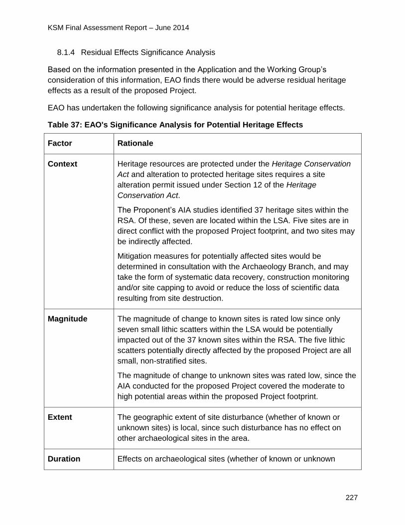
KSM Final Assessment Report – June 2014
227
8.1.4 Residual Effects Significance Analysis
Based on the information presented in the Application and the Working Group’s
consideration of this information, EAO finds there would be adverse residual heritage
effects as a result of the proposed Project.
EAO has undertaken the following significance analysis for potential heritage effects.
Table 37: EAO's Significance Analysis for Potential Heritage Effects
Factor Rationale
Context Heritage resources are protected under the Heritage Conservation
Act and alteration to protected heritage sites requires a site
alteration permit issued under Section 12 of the Heritage
Conservation Act.
The Proponent’s AIA studies identified 37 heritage sites within the
RSA. Of these, seven are located within the LSA. Five sites are in
direct conflict with the proposed Project footprint, and two sites may
be indirectly affected.
Mitigation measures for potentially affected sites would be
determined in consultation with the Archaeology Branch, and may
take the form of systematic data recovery, construction monitoring
and/or site capping to avoid or reduce the loss of scientific data
resulting from site destruction.
Magnitude The magnitude of change to known sites is rated low since only
seven small lithic scatters within the LSA would be potentially
impacted out of the 37 known sites within the RSA. The five lithic
scatters potentially directly affected by the proposed Project are all
small, non-stratified sites.
The magnitude of change to unknown sites was rated low, since the
AIA conducted for the proposed Project covered the moderate to
high potential areas within the proposed Project footprint.
Extent The geographic extent of site disturbance (whether of known or
unknown sites) is local, since such disturbance has no effect on
other archaeological sites in the area.
Duration Effects on archaeological sites (whether of known or unknown
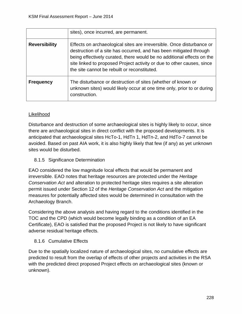
KSM Final Assessment Report – June 2014
228
sites), once incurred, are permanent.
Reversibility Effects on archaeological sites are irreversible. Once disturbance or
destruction of a site has occurred, and has been mitigated through
being effectively curated, there would be no additional effects on the
site linked to proposed Project activity or due to other causes, since
the site cannot be rebuilt or reconstituted.
Frequency The disturbance or destruction of sites (whether of known or
unknown sites) would likely occur at one time only, prior to or during
construction.
Likelihood
Disturbance and destruction of some archaeological sites is highly likely to occur, since
there are archaeological sites in direct conflict with the proposed developments. It is
anticipated that archaeological sites HcTo-1, HdTn 1, HdTn-2, and HdTo-7 cannot be
avoided. Based on past AIA work, it is also highly likely that few (if any) as yet unknown
sites would be disturbed.
8.1.5 Significance Determination
EAO considered the low magnitude local effects that would be permanent and
irreversible. EAO notes that heritage resources are protected under the Heritage
Conservation Act and alteration to protected heritage sites requires a site alteration
permit issued under Section 12 of the Heritage Conservation Act and the mitigation
measures for potentially affected sites would be determined in consultation with the
Archaeology Branch.
Considering the above analysis and having regard to the conditions identified in the
TOC and the CPD (which would become legally binding as a condition of an EA
Certificate), EAO is satisfied that the proposed Project is not likely to have significant
adverse residual heritage effects.
8.1.6 Cumulative Effects
Due to the spatially localized nature of archaeological sites, no cumulative effects are
predicted to result from the overlap of effects of other projects and activities in the RSA
with the predicted direct proposed Project effects on archaeological sites (known or
unknown).
KSM Final Assessment Report – June 2014
229
8.1.7 Certainty
The confidence level in the assessment is high, since the requirements of the Heritage
Conservation Act to conduct site investigations and implement acceptable level of
mitigation for site disturbance provides a rigorous framework for understanding
proposed Project effects on archaeological sites.
8.1.8 Conclusion
Considering the above analysis and having regard to the conditions identified in the
TOC and the CPD (which would become legally binding as a condition of an EA
Certificate), EAO is satisfied that the proposed Project is not likely to have significant
adverse residual heritage effects.
9 Assessment of Potential Health Effects
9.1 Human Health
9.1.1 Background Information
The Proponent selected the following VCs for the assessment of health effects: drinking
and recreational water; air quality; country foods; and noise. For this assessment, the
Proponent relied on the assessments of the various VCs identified for air quality, water
quality, fish, wetlands and vegetation, wildlife and noise.
Section 25.4.1 of the Application describes the LSAs and RSAs for the human health
effects assessment.
9.1.2 Project Issues and Effects and Proposed Mitigation Identified in the
Application
The following proposed Project activities could affect human health:
high noise levels from blasting, the use of helicopters, large construction
machinery, mining activities and road traffic could potentially lead to sleep
disturbance or loss of speech comprehension;
air emissions may lead to deposition of airborne material into water, and onto
soils and plants potentially affecting water quality and the quality of country
foods.
excavation, removal and storage of large quantities of rock and soil and disposal
of tailings and groundwater seepage would create a potential for ML/ARD and
associated effects on drinking and recreational water quality and country foods;
KSM Final Assessment Report – June 2014
230
surface runoff and waste rock storage activities may cause siltation and
associated water chemistry effects, which could affect the quality of drinking
water and country foods; and
sewage treatment plant effluent, garbage, seepage, and accidental spills could
affect human health.
Spills during transport and storage of fuel, chemicals and explosives could contaminate
drinking and recreational water and country foods. Routine proposed Project-related
traffic and in-water works could introduce oils and diesel fuels into the aquatic
environment via spills and leaks, affecting fish and water quality.
The Application reports that predicted concentrations of metals, nutrients and cyanide
do not exceed BC and Canadian drinking water guidelines at stations on Teigen (TEC2)
and Treaty Creek (TRC2) during operation, closure or post-closure. Thus, no related
human health effects from the consumption of surface water from Teigen and Treaty
Creeks downstream of the TMF were identified. Nor would people hunting, trapping or
recreating in the Unuk River Valley be exposed to concentrations of metals or nutrients
that exceed drinking water criteria.
Potential effects to human health would decrease during the closure phase as
decreased activity at the site and reclamation and closure of the site would decrease
the potential for effects to air quality, surface water quality, and country foods quality.
However, the potential for ML/ARD to affect drinking and recreational water quality and
the quality of country foods would continue thorough to the post-closure phase.
Summary of Mitigation Proposed in the Application
The Application lists the mitigation measures set out below to address effects.
Drinking and Recreational Water
Mitigation measures proposed to reduce effects on water quality would reduce
effects on human health linked to the ingestion of drinking water;
Posting signs around the TMF to indicate that the water is not potable, and that
no public access is permitted while the mine is operating. Upon closure, TMF
water quality would be monitored for wildlife mitigation purposes. If water quality
deteriorates in the TMF after mine operation, additional mitigation may be
implemented, including the possibility of a risk assessment to determine if human
use of water from downstream creeks is safe.
Water quality monitoring in accordance with the AEMP and Closure and
Reclamation Plan to ensure that WTP effluent meets discharge permit limits.
KSM Final Assessment Report – June 2014
231
Air Quality
The Air Quality Management Plan includes both an Emissions Management Plan
and a Fugitive Dust Emissions Management Plan that would be implemented to
meet BC MOE ambient air quality objectives.
Monitoring of air quality and fugitive dust emissions during construction and
operation under the Air Quality Management Plan including vehicle and equipment
emissions and fugitive dust monitoring.
Country Foods
Access management measures in the Proponent’s Traffic and Access Management
Plan would mitigate some of the risk of effects on human health by inhibiting direct
public access to the proposed Project footprint.
Monitoring of soils, water quality and levels of metals and other COPCs in mine-
disturbed soils.
Monitoring of terrestrial plant tissue metal concentrations.
Noise
Maximizing distances between major noise sources and sleeping quarters.
Calculating the appropriate level of building insulation required to meet predicted
equivalent sound levels of 30 decibal A-scale or less.
9.1.3 Project Issues and Effects and Proposed Mitigation Identified During
Application Review
During the review of the Application, additional issues were raised by the agencies,
NLG22, First Nations and the public. These issues, the Proponent responses and EAO’s
assessment of the adequacy of responses are detailed in Appendix 1. The CPD and
TOC (Appendix 2) contain specific mitigation measures, which would be legally
enforceable if an EA Certificate is issued. Examples of some of the key issues and
additional commitments are set out below.
NLG was concerned with the Proponent’s assessment associated with the inhalation
of diesel particulate matter less than 2.5 microns in diameter (PM2.5) as it exceeded
the accepted risk level of 1 in 100,000 (i.e., 1 × 10⁻⁵) at the sensitive receptor
22 A full discussion and analysis of how the proposed Project would affect Nisga’a Nation economic “well-
being” as outlined in the NFA is included in Part D including those issues specific to the Nisga’a Nation.
KSM Final Assessment Report – June 2014
232
locations. The Proponent interpreted these risks, in part, by suggesting that the BC
air quality objective for PM2.5 would also be associated with an incremental lifetime
cancer risk that exceeds the 1 × 10⁻⁵ risk level.
o In response, the Proponent provided a detailed discussion on how
comparisons between the BC air quality objective for PM2.5 and the derived
incremental lifetime cancer risk for diesel PM2.5 were made. The Proponent
concluded that it is justified to make this comparison to provide perspective
on a highly conservative assessment of potential incremental human health
risks from the inhalation of PM2.5. This comparison assumes that diesel
exhaust PM2.5, for which the California Environmental Protection Agency has
provided a slope factor, is the predominant constituent of PM2.5, which is a
reasonable assumption in the context of a mining operation.
NLG was not satisfied with the proposed country foods sampling program. These
discussions with the Proponent will continue.
Health Canada (HC) and NLG raised concerns with potential effects to human
health due to arsenic in country foods from baseline and proposed Project
conditions that exceeded the incremental lifetime cancer risk benchmark of
1 x 10⁻⁵.
o In response the Proponent prepared a technical memorandum to clarify why
predicted exposures for operations and closure are different between the
Mine Site and the PTMA and to clarify the toxicity reference values used for
the assessment of arsenic.
o The Proponent’s memo explains that the country foods screening level risk
assessment conservatively assumed that all of the arsenic in tissues would
occur as the most toxic form of arsenic, which is inorganic arsenic. However,
organic arsenic species are the predominant form of arsenic found in
seafood and other meats. Therefore, the wildlife model over-estimated tissue
concentrations of toxic inorganic arsenic and the screening level risk
assessment over-estimated health risks.
o The Proponent revised the ingestion rates for various environmental media
which resulted in total arsenic concentrations in grouse that are lower than
what was assessed in the Application. Modelled moose arsenic
concentrations are comparable to domestic beef arsenic concentrations.
Modelled grouse arsenic concentrations are higher than arsenic
concentrations in poultry due to the high level of arsenic ingestion with soil,
but do not pose a human health risk.
o The Proponent revised the estimation of cancer risks based on updated
model inputs for the country food arsenic concentrations and prepared a
KSM Final Assessment Report – June 2014
233
multi-media health risk assessment. The incremental lifetime cancer risk
from all country foods combined does not exceed the accepted incremental
lifetime cancer risk of 1 in 100,000 (1 x 10⁻⁵).
o The Proponent committed to collect empirical data for arsenic in grouse and
moose in the monitoring phase of the proposed Project should monitoring
data indicate that arsenic concentrations increase in environmental media
(soil, water, plants) above background due to proposed Project activities.
NLG responded that the continued uncertainty with respect to actual arsenic
concentrations in grouse tissue reinforces the option to compare the modelled
concentrations with the measured data. NLG continued to advocate for the
completion of a study which incorporates measured tissue concentrations into an
appropriate risk assessment framework.
o The Proponent responded that their comparison of inorganic to total arsenic
was based on the most recent and defensible analytical (measured) data
available.
HC advised including the collection of empirical data for arsenic in grouse and
moose in the monitoring phase of the proposed Project to confirm modelled
predictions of contaminant levels in country foods, to reduce uncertainties in the
assumptions used in the risk assessment, and to increase confidence in the
assessment results and conclusions.
HC and NLG raised concerns with aluminium levels in grouse.
o The Proponent responded that aluminum is very poorly absorbed by the
body and will be excreted in the feces and urine and not bioaccumulate. The
Proponent reiterated a statement made by HC that exposure to aluminum
from the consumption of country foods is not expected to pose unacceptable
health risks.
o The Proponent committed to consider collecting empirical aluminum grouse
tissue concentrations in the future should aluminum concentrations be found
to increase in environmental media during monitoring.
NLG raised concerns with the Proponent’s use of ecological endpoints rather than
human endpoints for the screening of COPCs for humans. NLG questioned if the
guidelines are not applicable for wildlife health are they applicable to protecting
human health?
o The Proponent responded that the approach used is consistent with the
screening approach provided in the Federal Contaminated Site Risk
Assessment in Canada, Part I: Guidance on Human Health Preliminary
Quantitative Risk Assessment, Version 2.0 for soils and drinking water.
KSM Final Assessment Report – June 2014
234
Guidelines for protection of aquatic life were used because these guidelines
are intended to be protective of fish health and fish, which may be used for
human consumption.
NLG stated that according to Health Canada’s Preliminary Quantitative Risk
Assessment guidance, “COPCs are identified as … those chemicals for which
the maximum on-site concentration exceeds appropriate human health-based
soil quality guidelines”. Similarly, the identification of COPC in water should rely
on comparison to health-based guidelines according to HC. NLG asked the
Proponent to comment on whether the list of COPC changes when HC’s
Preliminary Quantitative Risk Assessment guidance is followed.
o The Proponent responded that the Canadian Council of Ministers of the
Environment (CCME) and BCWQG for the Protection of Aquatic Life were
used as COPC screening benchmarks for water metal concentrations in the
country foods screening level risk assessment. These guidelines were used
rather than health-based Health Canada Guidelines for Canadian Drinking
Water Quality, because the country foods screening level risk assessment
does not assess drinking water, but assesses potential food chain effects of
surface waters to receptors, such as fish or wildlife for human consumption.
HC recommended that in order to adequately characterize the risks associated
with exposure to COPCs in country foods, measured tissue levels should be
compared to modelled levels in order to validate model assumptions. HC also
recommended using the additional guidance document for country foods: Health
Canada. 2010. Supplemental Guidance on Human Health Risk Assessment for
Country Foods(HHRAFoods). Federal Contaminated Site Risk Assessment in
Country Foods.
NLG questioned why a quantitative risk assessment for chemicals associated with
the waste incinerator and other sources of combustion emission including
polynuclear aromatic compounds in diesel exhaust, was not completed.
o The Proponent responded that emissions of criteria air contaminants from
incinerators and combustion sources were included in the human health
assessment.
o Chemicals in addition to criteria air pollutants were not included because
generators for the Project will be in compliance with the US Environmental
Protection Agency Tier 4 standards. Incinerators will have to comply with
Canada-wide standards for dioxins and furans (CCME 2009) and Canada-
wide standards for mercury emissions.
NLG replied that the evaluation of only criteria air contaminants is less than what
is currently required in many Canadian jurisdictions. Potential risks related to
KSM Final Assessment Report – June 2014
235
dioxins and furans should have been assessed for the waste incinerator for
transparency and risk communication purposes.
o The Proponent responded that in BC, emissions of dioxins and furans (in
total equivalent toxicity) are regulated by CCME Canada-Wide Standards,
but an ambient air concentration criterion does not exist. The incinerators will
operate in batches and therefore are not continuous sources of emissions.
o In addition, the locations of the incinerators were chosen so that the plume
will not affect sensitive receptors. The Proponent is committed to
implementing a waste segregation program and plastics will not be burned at
the site.
HC questioned why mercury and lead were not included in the country foods
baseline risk assessment or in the screening level risk assessments used to support
the effects assessment.
o The Proponent responded that mercury and lead were included in the
assessments but provided additional clarification, information and calculations
to show that no risks to human health were identified due to these metals in
country foods.
NLG stated that in light of recent changes in the treatment of lead in risk
assessments it may be valuable to re-evaluate the assessment of lead.
o The Proponent responded that a published tolerable daily intake (TDI) of
3.6 μg/kg body weight (HC 2010b) was available when the submission was
prepared. Subsequently, this TDI was removed and is currently under review
by HC. It is expected that the TDI for lead will be lowered. However, it is not
possible to confirm what the final accepted TDI will be at this time.
Therefore, a re-evaluation is not considered useful at this time.
NLG recommended a commitment to re-evaluate the lead exposures at the time
of the release of new guidance or when measured data become available from
the periodic ongoing monitoring will remove any uncertainty regarding health
risks associated with lead exposures.
o The Proponent responded that a commitment for ongoing monitoring of
environmental media was made in the Application's environmental
monitoring plans. Lead exposures will be re-evaluated if lead concentrations
increase above background in environmental media and new guidance
becomes available.
NLG raised concern with the Proponent’s assessment of cadmium in moose, stating
that in order to adequately characterize the risks associated with exposure to
cadmium measured tissue levels should be compared to modelled levels in order to
KSM Final Assessment Report – June 2014
236
validate model assumptions.
o The Proponent responded that although model assumptions and inputs may
have under-estimated cadmium concentrations in moose, the conclusion of
the Screening Level Risk Assessments will not change.
NLG noted that in a published study, cadmium concentrations in organ meat
were orders of magnitude higher than in muscle. NLG recommended the
Proponent conduct a revision of the Screening Level Risk Assessments including
measured concentrations in order to more reasonably represent risk to
consumers.
o The Proponent responded that risks from the consumption of cadmium with
moose organ meat may exist, but are not proposed Project-related.
o The Proponent will consider the collection of wildlife tissue samples and a
re-evaluation of human health risks should ongoing monitoring show an
increase in the cadmium concentrations in environmental media (water, soil,
plants) during ongoing monitoring for the proposed Project.
9.1.4 Residual Effects Significance Analysis
The Application reports that residual human health effects may result from the ingestion
of metals in surface water or country foods downstream of the proposed Project. The
inhalation of metals in dust and inhalation of criteria air contaminants (NO2, SO2, CO,
TSP, PM2.5, PM10) may result in minor increases over baseline conditions in metal
hazard quotients, incremental lifetime cancer risk and excess mortality at sensitive
receptor locations, including on-site personnel camps, Bell 2 Lodge and Bob Quinn
Lake, and trapline and hunting cabins.
Residual noise effects are predicted to be restricted to potential sleep disturbance for
off-shift workers residing in the Treaty Plant Camp (camp 5) and Treaty Saddle Camp
(camp 6) construction camps and the Treaty operating camp if mitigation does not
satisfy the noise attenuation requirements.
EAO has undertaken the following significance analysis for potential health effects.
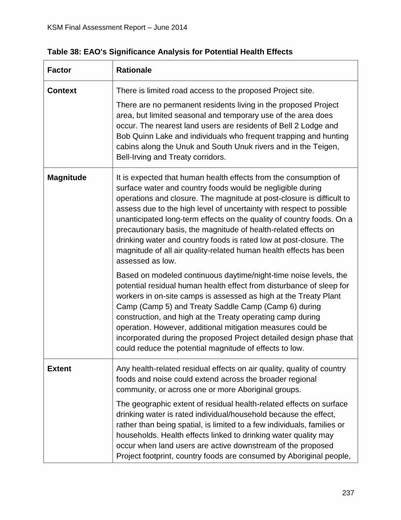
KSM Final Assessment Report – June 2014
237
Table 38: EAO's Significance Analysis for Potential Health Effects
Factor Rationale
Context There is limited road access to the proposed Project site.
There are no permanent residents living in the proposed Project
area, but limited seasonal and temporary use of the area does
occur. The nearest land users are residents of Bell 2 Lodge and
Bob Quinn Lake and individuals who frequent trapping and hunting
cabins along the Unuk and South Unuk rivers and in the Teigen,
Bell-Irving and Treaty corridors.
Magnitude It is expected that human health effects from the consumption of
surface water and country foods would be negligible during
operations and closure. The magnitude at post-closure is difficult to
assess due to the high level of uncertainty with respect to possible
unanticipated long-term effects on the quality of country foods. On a
precautionary basis, the magnitude of health-related effects on
drinking water and country foods is rated low at post-closure. The
magnitude of all air quality-related human health effects has been
assessed as low.
Based on modeled continuous daytime/night-time noise levels, the
potential residual human health effect from disturbance of sleep for
workers in on-site camps is assessed as high at the Treaty Plant
Camp (Camp 5) and Treaty Saddle Camp (Camp 6) during
construction, and high at the Treaty operating camp during
operation. However, additional mitigation measures could be
incorporated during the proposed Project detailed design phase that
could reduce the potential magnitude of effects to low.
Extent Any health-related residual effects on air quality, quality of country
foods and noise could extend across the broader regional
community, or across one or more Aboriginal groups.
The geographic extent of residual health-related effects on surface
drinking water is rated individual/household because the effect,
rather than being spatial, is limited to a few individuals, families or
households. Health effects linked to drinking water quality may
occur when land users are active downstream of the proposed
Project footprint, country foods are consumed by Aboriginal people,
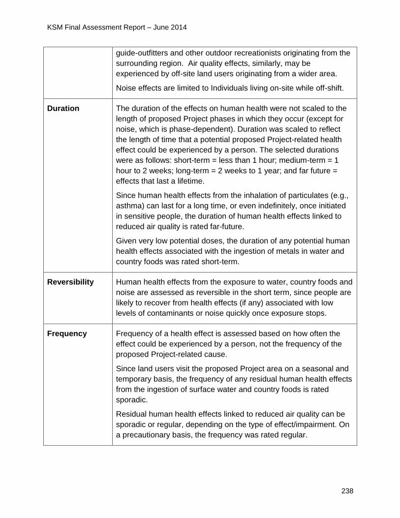
KSM Final Assessment Report – June 2014
238
guide-outfitters and other outdoor recreationists originating from the
surrounding region. Air quality effects, similarly, may be
experienced by off-site land users originating from a wider area.
Noise effects are limited to Individuals living on-site while off-shift.
Duration The duration of the effects on human health were not scaled to the
length of proposed Project phases in which they occur (except for
noise, which is phase-dependent). Duration was scaled to reflect
the length of time that a potential proposed Project-related health
effect could be experienced by a person. The selected durations
were as follows: short-term = less than 1 hour; medium-term = 1
hour to 2 weeks; long-term = 2 weeks to 1 year; and far future =
effects that last a lifetime.
Since human health effects from the inhalation of particulates (e.g.,
asthma) can last for a long time, or even indefinitely, once initiated
in sensitive people, the duration of human health effects linked to
reduced air quality is rated far-future.
Given very low potential doses, the duration of any potential human
health effects associated with the ingestion of metals in water and
country foods was rated short-term.
Reversibility Human health effects from the exposure to water, country foods and
noise are assessed as reversible in the short term, since people are
likely to recover from health effects (if any) associated with low
levels of contaminants or noise quickly once exposure stops.
Frequency Frequency of a health effect is assessed based on how often the
effect could be experienced by a person, not the frequency of the
proposed Project-related cause.
Since land users visit the proposed Project area on a seasonal and
temporary basis, the frequency of any residual human health effects
from the ingestion of surface water and country foods is rated
sporadic.
Residual human health effects linked to reduced air quality can be
sporadic or regular, depending on the type of effect/impairment. On
a precautionary basis, the frequency was rated regular.
KSM Final Assessment Report – June 2014
239
Likelihood
The likelihood that human health effects would occur is considered low. This is because
non-worker human receptors are only present in the LSA or RSA transiently and for
relatively short periods of time, therefore, exposure durations are short. Workers or
contractors for the proposed Project would be provided with potable drinking water and
prohibited from hunting or fishing while onsite, minimizing the potential for exposure to
contaminants through drinking water or country foods.
9.1.5 Significance Determination
Considering the above analysis, comments from the Working Group, and having regard
to the conditions identified in the TOC and the CPD, including the implementation of a
Human Health Monitoring Plan (which would become legally binding as a condition of
an EA Certificate), EAO is satisfied that the proposed Project is not likely to have
significant adverse health effects.
9.1.6 Cumulative Effects
Future and reasonably foreseeable mining, exploration, small hydro, and other
activities, specifically the Brucejack Mine and Treaty Creek HEP, could adversely affect
the regional landscape for air quality. The magnitude of any increased residual effects
on human health is expected to be low.
9.1.7 Certainty
The confidence is high that adverse changes to human health from the consumption of
country foods during construction and operation is unlikely, based on the conservative
nature of the screening level risk assessment.
The confidence in the health effects assessment for surface drinking water is medium,
given uncertainties related to water quality modeling assumptions. The confidence level
for health effects linked to reduced air quality and increased noise is medium, given
inherent challenges in predicting health effects.
EAO also notes that a condition has been added which, if the proposed Project receives
an EA Certificate would become legally enforceable, would require the Proponent to
develop a comprehensive Human Health Monitoring Plan that would address many of
the issues listed in this section and raised by members of the Working Group. This
condition provides increased confidence regarding long term and post closure health
effects (e.g. from the consumption of country foods, potable water and air quality).
9.1.8 Conclusion
Considering the above analysis, comments from the Working Group, and having regard
KSM Final Assessment Report – June 2014
240
to the conditions identified in the TOC and the CPD (which would become legally
binding as a condition of an EA Certificate), EAO is satisfied that the proposed Project is
not likely to have significant adverse health effects.
10 Assessment of Potential Road Use Effects
10.1 Transportation
10.1.1 Background Information
This section of the Assessment Report is intended to be a stand-alone document which
reports on the assessment of potential impacts on those VCs located along the
transportation route to the proposed Mine Site. EAO directed the Proponent to conduct
a traffic assessment to assess the potential effects of project-related traffic along Hwys
37 and 37A. The effects assessment stopped at Hwy 16 because EAO concluded that
the additional incremental traffic added only a negligible amount of new traffic to that
route.
The Proponent’s full assessment can be found in Appendix 22-C of their Application.
The traffic assessment study area encompasses approximately 300 km of Hwy 37 from
the Eskay Creek Mine access road junction, southeast to its junction with Hwy 16 in
Kitwanga; and approximately 65 km of Hwy 37A from Meziadin Junction to the District
of Stewart. The study are includes 500 m on either side of the Hwys.
The proposed Project is accessed from Hwy 37. See figure 22 and the descriptions
below of the transportation access route.
On September 29, 2011, EAO varied the procedural order (section 11 Order) for the
proposed Project to include the use of Hwy 37 between the proposed Project site and
its junction with Hwy 16 at Kitwanga, including those potential effects arising from the
transport of people, goods and materials, including, but not limited to, fuel, hazardous
chemicals and explosives. At this time, EAO also committed to forming a technical
working group to discuss road use and potential effects including effects on Nisga’a
Nation and First Nations, from the use of Hwy 37 by proposed Project related traffic.
EAO initially established a Transportation Working Group specific to KSM. However, in
response to concerns expressed by First Nations and others, EAO established a Hwy
37 Advisory Group to examine the effects of multiple projects as opposed to effects of
each project in isolation. The new Hwy 37 Advisory Group was initially co-chaired by
EAO and MOTI. As of the writing of this report, EAO is in discussions with MOTI and
FLNR regarding the co-chair responsibilities and name of the Advisory Group. The
intent was for the Advisory Group to review and comment on the traffic effects
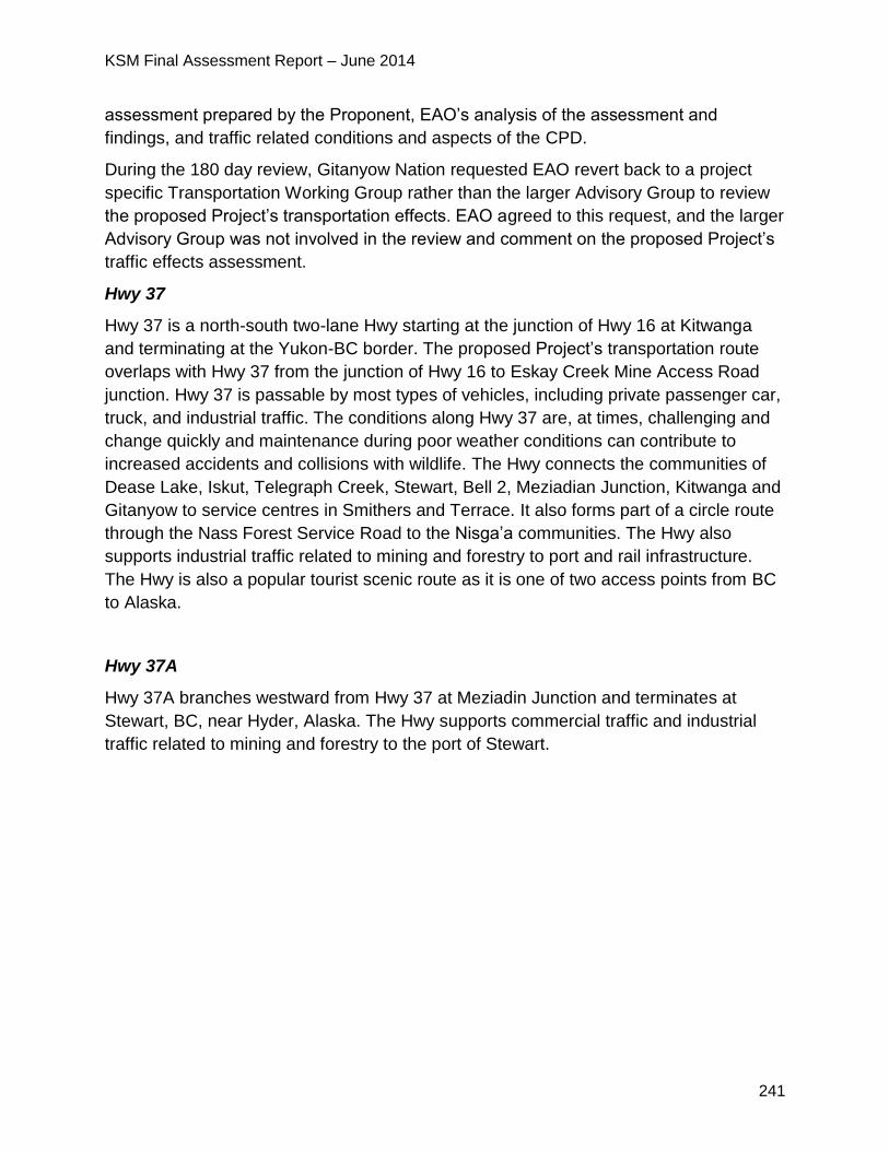
KSM Final Assessment Report – June 2014
241
assessment prepared by the Proponent, EAO’s analysis of the assessment and
findings, and traffic related conditions and aspects of the CPD.
During the 180 day review, Gitanyow Nation requested EAO revert back to a project
specific Transportation Working Group rather than the larger Advisory Group to review
the proposed Project’s transportation effects. EAO agreed to this request, and the larger
Advisory Group was not involved in the review and comment on the proposed Project’s
traffic effects assessment.
Hwy 37
Hwy 37 is a north-south two-lane Hwy starting at the junction of Hwy 16 at Kitwanga
and terminating at the Yukon-BC border. The proposed Project’s transportation route
overlaps with Hwy 37 from the junction of Hwy 16 to Eskay Creek Mine Access Road
junction. Hwy 37 is passable by most types of vehicles, including private passenger car,
truck, and industrial traffic. The conditions along Hwy 37 are, at times, challenging and
change quickly and maintenance during poor weather conditions can contribute to
increased accidents and collisions with wildlife. The Hwy connects the communities of
Dease Lake, Iskut, Telegraph Creek, Stewart, Bell 2, Meziadian Junction, Kitwanga and
Gitanyow to service centres in Smithers and Terrace. It also forms part of a circle route
through the Nass Forest Service Road to the Nisga’a communities. The Hwy also
supports industrial traffic related to mining and forestry to port and rail infrastructure.
The Hwy is also a popular tourist scenic route as it is one of two access points from BC
to Alaska.
Hwy 37A
Hwy 37A branches westward from Hwy 37 at Meziadin Junction and terminates at
Stewart, BC, near Hyder, Alaska. The Hwy supports commercial traffic and industrial
traffic related to mining and forestry to the port of Stewart.
KSM Final Assessment Report – June 2014
242
Figure 23: Transportation Routes
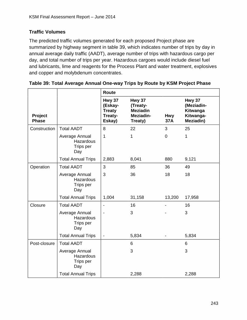
KSM Final Assessment Report – June 2014
243
Traffic Volumes
The predicted traffic volumes generated for each proposed Project phase are
summarized by highway segment in table 39, which indicates number of trips by day in
annual average daily traffic (AADT), average number of trips with hazardous cargo per
day, and total number of trips per year. Hazardous cargoes would include diesel fuel
and lubricants, lime and reagents for the Process Plant and water treatment, explosives
and copper and molybdenum concentrates.
Table 39: Total Average Annual One-way Trips by Route by KSM Project Phase
Project Phase
Route
Hwy 37 (Eskay-Treaty Treaty-Eskay)
Hwy 37 (Treaty-Meziadin Meziadin-Treaty)
Hwy 37A
Hwy 37 (Meziadin-Kitwanga Kitwanga-Meziadin)
Construction Total AADT 8 22 3 25
Average Annual Hazardous Trips per Day
1 1 0 1
Total Annual Trips 2,883 8,041 880 9,121
Operation Total AADT 3 85 36 49
Average Annual Hazardous Trips per Day
3 36 18 18
Total Annual Trips 1,004 31,158 13,200 17,958
Closure Total AADT - 16 - 16
Average Annual Hazardous Trips per Day
- 3 - 3
Total Annual Trips - 5,834 - 5,834
Post-closure Total AADT 6 6
Average Annual Hazardous Trips per Day
3 3
Total Annual Trips 2,288 2,288
KSM Final Assessment Report – June 2014
244
VCs
Transportation of materials, supplies, and personnel to and from the proposed Project
Mine Site has the potential for effects on environmental, economic, social, cultural, and
health components. The Proponent used a risk assessment methodology, including
cumulative risks, to estimate the likelihood or probability of potentially adverse
environmental effects resulting from increased proposed Project traffic. Estimates of the
frequency of collisions along Hwys 37 and 37A with the proposed Project in place were
key inputs to the risk analysis. The Proponent selected the following VCs to be
assessed based on their direct and indirect interactions with the proposed Project
transportation route:
socio-economic;
fish and aquatic habitat;
wildlife and wildlife habitat;
terrestrial ecosystems;
wetlands;
noise;
climate and air quality;
human health; and
heritage.
The Proponent identified and assessed potential effects, mitigation measures, and
residual effects for each VC. Effects were determined using existing and mine-related
traffic and accident data, scientific research and knowledge, available information from
the Nisga’a Nation and First Nations, risk assessment results and feedback from the
Transportation Working Group.
10.1.2 Project Issues and Effects and Proposed Mitigation Identified in the
Application
The Proponent’s Application identified a number of effects, which are listed below.
These effects primarily come from the transportation of equipment, supplies, materials,
and labour and would occur throughout the proposed Project’s construction, operations
and closure phases. This traffic could adversely affect road infrastructure, its users, the
adjacent environment, and the cultural and resource use activities of the Nisga’a Nation
and First Nations.
The Proponent used estimated traffic increases from the proposed Project to assess the
potential environmental and social effects of the proposed Project traffic along Hwys 37
and 37A. The Proponent estimates that the highest percentage increase in traffic as a
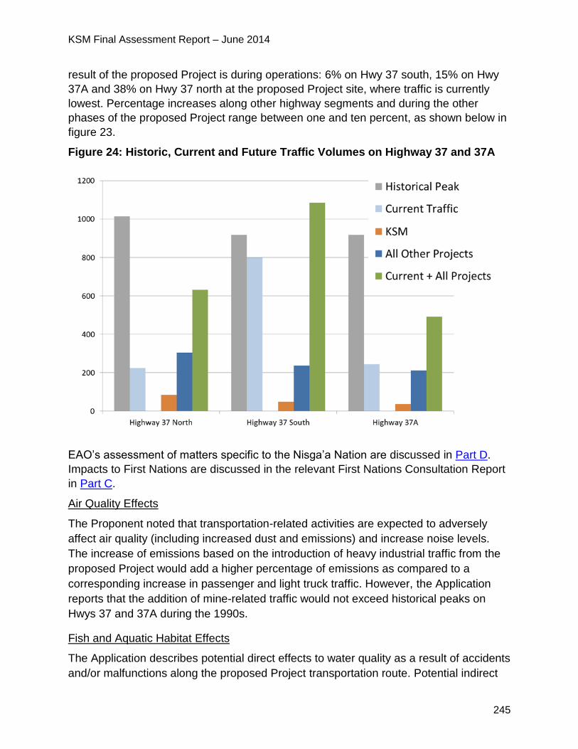
KSM Final Assessment Report – June 2014
245
result of the proposed Project is during operations: 6% on Hwy 37 south, 15% on Hwy
37A and 38% on Hwy 37 north at the proposed Project site, where traffic is currently
lowest. Percentage increases along other highway segments and during the other
phases of the proposed Project range between one and ten percent, as shown below in
figure 23.
Figure 24: Historic, Current and Future Traffic Volumes on Highway 37 and 37A
EAO’s assessment of matters specific to the Nisga’a Nation are discussed in Part D.
Impacts to First Nations are discussed in the relevant First Nations Consultation Report
in Part C.
Air Quality Effects
The Proponent noted that transportation-related activities are expected to adversely
affect air quality (including increased dust and emissions) and increase noise levels.
The increase of emissions based on the introduction of heavy industrial traffic from the
proposed Project would add a higher percentage of emissions as compared to a
corresponding increase in passenger and light truck traffic. However, the Application
reports that the addition of mine-related traffic would not exceed historical peaks on
Hwys 37 and 37A during the 1990s.
Fish and Aquatic Habitat Effects
The Application describes potential direct effects to water quality as a result of accidents
and/or malfunctions along the proposed Project transportation route. Potential indirect
KSM Final Assessment Report – June 2014
246
transportation related effects on environmental health (including humans, mammals,
birds, fish, amphibians, and invertebrates) could occur where accidents and spills
happen near or into major waterbodies and tributaries along the transportation route.
The potential interactions with the fish and aquatic habitat VC and the type of materials
transported are listed below:
spill of fuel or lubricants causing degradation of water quality, fish mortality at
high concentrations and reduced health or altered behaviours at sublethal levels
and effects to aquatic habitat;
spill of lime and reagents causing degradation of water quality which may result
in mortality or decreased fish health;
spill of copper or molybdenum concentrates causing fish mortality and water
quality degradation; and
spill of explosives causing fish mortality, death or serious sublethal effects to
invertebrate food sources for fish and to incubating or rearing juvenile fish.
The Proponent undertook a risk assessment based on the probability and
consequences of accidents or malfunctions along the transportation route. The
assessment concluded that spills of chemicals and/or fuel from transport trucks along
the transportation route at waterbody crossing or near waterbodies could affect aquatic
organisms (see section 5.2 of Appendix 22-C of the Application). The Application
reports that the likelihood of such events is predominantly characterized as unlikely or
rare and the severity of potential, unintended consequences is predominantly
characterized as minor to moderate, depending on the location and time lapse between
occurrences and clean-up.
Wildlife Effects
The Application states that increased traffic levels from mine-related transportation
activities has the potential to cause adverse effects on wildlife populations (including
moose, bears, western toad, and birds) along the proposed transportation route during
all phases of the proposed Project. In particular, potential effects may include injury or
direct mortality of wildlife due to vehicle collisions, disruption of wildlife movement, and
potential habitat degradation from spills and malfunctions. The Application notes that
risks to mortality increase near or adjacent to preferred habitat, occupied habitat, and
where current traffic volumes are low.
Moose
Much of Hwys 37 and 37A bisect or parallel moose winter range habitats. Moose
collisions along Hwy 37 and 37A are reported more frequently during winter months as
moose move into lower elevation winter ranges (timbered wetland complexes) where
snow depths are limited. The Application reports that vegetation regrowth on roadsides
KSM Final Assessment Report – June 2014
247
from brushing will also attract moose and increase the collision risk during the summer.
Based on existing conditions, the Application states that the species of most concern
and at relatively greater risk of colliding with vehicular traffic along the KSM
transportation route are moose. The Application reports that the moose population in
the NWA near Hwy 37 has been declining since 2001. The population was estimated to
be approximately 1600 in 2001, and declined to 640 in 2007 and to 520 in 2011.
Despite conservation measures taken in 2007 including limited entry or closure of
moose hunts in some areas, the population has continued to decline.
Given the current status of moose populations along the KSM transportation route and
the adverse effect of industrial accidents with wildlife and unregulated hunting, the
additional proposed Project traffic may exacerbate the existing conditions.
The Proponent used a population dynamics model received from MOE to perform a
historical reconstruction of the Nass moose population under known harvests and
demographic rates and to conduct a quantitative population viability analysis for moose
along Hwy 37 and 37A road corridors to estimate the cumulative effects of traffic on
moose. The Proponent estimates that the addition of traffic from the proposed Project is
projected to cause less than a 1% increase in mortality to moose populations at their
current population size, equating to just less than 5 moose deaths per year.
The population viability analysis predicted that the increased traffic from the proposed
Project would not cause a decline in the NWA moose population. However, results
suggested that an additional increase in mortality, above what is expected due to
proposed Project traffic, could cause the population to decline. Hence, assuming
conditions remain constant (much-reduced moose population, current hunting rates,
etc.), if all projects in the Study Area were to operate simultaneously, the population
viability analysis predicted that moose-vehicle collisions from these projects may be
sufficient to have an effect on the moose population in the NWA.
The Application reports the following sources of moose mortality per year as shown in
table 40.
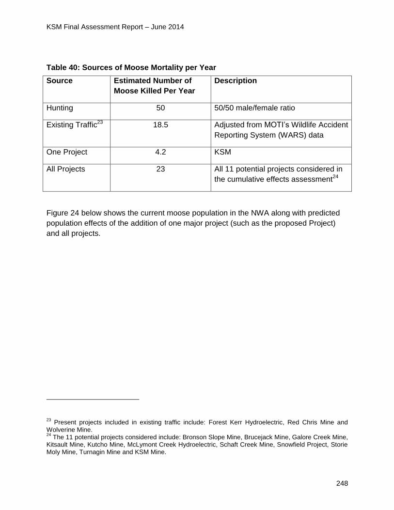
KSM Final Assessment Report – June 2014
248
Table 40: Sources of Moose Mortality per Year
Source Estimated Number of
Moose Killed Per Year
Description
Hunting 50 50/50 male/female ratio
Existing Traffic23 18.5 Adjusted from MOTI’s Wildlife Accident
Reporting System (WARS) data
One Project 4.2 KSM
All Projects 23 All 11 potential projects considered in
the cumulative effects assessment24
Figure 24 below shows the current moose population in the NWA along with predicted
population effects of the addition of one major project (such as the proposed Project)
and all projects.
23 Present projects included in existing traffic include: Forest Kerr Hydroelectric, Red Chris Mine and
Wolverine Mine. 24
The 11 potential projects considered include: Bronson Slope Mine, Brucejack Mine, Galore Creek Mine, Kitsault Mine, Kutcho Mine, McLymont Creek Hydroelectric, Schaft Creek Mine, Snowfield Project, Storie Moly Mine, Turnagin Mine and KSM Mine.
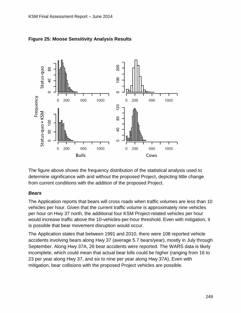
KSM Final Assessment Report – June 2014
249
Figure 25: Moose Sensitivity Analysis Results
The figure above shows the frequency distribution of the statistical analysis used to
determine significance with and without the proposed Project, depicting little change
from current conditions with the addition of the proposed Project.
Bears
The Application reports that bears will cross roads when traffic volumes are less than 10
vehicles per hour. Given that the current traffic volume is approximately nine vehicles
per hour on Hwy 37 north, the additional four KSM Project-related vehicles per hour
would increase traffic above the 10-vehicles-per-hour threshold. Even with mitigation, it
is possible that bear movement disruption would occur.
The Application states that between 1991 and 2010, there were 108 reported vehicle
accidents involving bears along Hwy 37 (average 5.7 bears/year), mostly in July through
September. Along Hwy 37A, 26 bear accidents were reported. The WARS data is likely
incomplete, which could mean that actual bear kills could be higher (ranging from 16 to
23 per year along Hwy 37, and six to nine per year along Hwy 37A). Even with
mitigation, bear collisions with the proposed Project vehicles are possible.
KSM Final Assessment Report – June 2014
250
Other Animals
Toad mortality is also described in the Application, which notes possible mortalities
resulting from since toads and toadlets crossing roads when moving from breeding sites
to upland areas during migration in the spring and late summer.
The Application reports that direct mortality of birds, particularly flocking species such
as pine siskins and crossbills could occur as a result of increased traffic due to the
proposed Project.
Beyond risks of collisions with wildlife and increased access, spills along the proposed
Project transportation route may occur with mine-related traffic during all phases of the
proposed Project. The four primary environmental receptors of a spill are: surface fresh
water; groundwater; air; and soil. Secondary effects on terrestrial and aquatic animals
and plants may occur following exposure to the spilled substance. Accidental spills or
releases of chemical contaminants may degrade wildlife habitat, alter wildlife presence
and change use patterns in the area of the spill.
Terrestrial Ecosystems Effects
The Application states that an increase in proposed Project traffic may result in the
potential for introduction and spread of invasive plants and increased incidence of
wildfire from improper disposal of smoking material. In addition traffic accidents may
result in increased incidence of wildfire and chemical contamination.
Socio-economic Effects
Transportation of equipment, personnel, and materials to and from the proposed Mine
Site is described in the Application to have the following possible effects on land use,
quality of the natural environment and community well-being:
increased industrial traffic related to the proposed Project may be perceived to have
a negative effect on the quality of the natural environment;
increased traffic related to the proposed Project may indirectly affect the harvest of
wildlife resources through disruption of movement and direct mortality effects on
wildlife;
increased vehicle traffic may result in reduced public safety due to the probability of
vehicle accidents particularly involving dangerous cargo; and
increased noise may interrupt and degrade enjoyment of roadside land uses and
residential properties.
KSM Final Assessment Report – June 2014
251
Human Health Effects
The Application states the main human health issues related to the proposed Project
would be from traffic accidents, including their potential risks to country foods, drinking
water, air quality and human safety.
The Proponent notes that any increase in vehicle traffic may result in reduced public
safety, for both vehicles and pedestrians, due to the increased probability of vehicle
accidents. The Proponent predicts a maximum incremental increase of 0.191 collisions
per year due to an increase in traffic from the proposed Project. The Proponent reports
that based on MOTI's safety design thresholds, Hwys 37 and 37A are safely designed
to support higher traffic volumes, including traffic from the proposed Project and other
projects.
Summary of Mitigation Proposed in the Application
Full details on mitigation proposed by the Proponent can be found in the Application.
Many of the following mitigation measures are also contained in the Proponent’s EMP
such as the Traffic and Access Management Plan, Dangerous Goods and Hazardous
Materials Management Plan, Emergency Response Plan (for emergencies other than
spills) and Spill Prevention and Emergency Response Plan, which are all a requirement
of the Proponent’s Mines Act permit for the proposed Project. A summary of the
mitigation initially proposed includes:
a zero-tolerance policy on alcohol and drugs while transporting goods and materials
to and from the site;
making information on weather and highway conditions available to all drivers before
departure and requiring drivers to adjust driving styles to conditions;
providing appropriate training to drivers and personnel; and
advising local communities of driving routes, peak transportation periods and
potential road shutdowns, if required, when transporting heavy/wide loads, and
communicating proposed Project traffic plans to provincial and local governments to
ensure that adequate signage is posted beside public roads.
Wildlife
Measures to minimize interactions between wildlife and vehicles and reduce disruption
to wildlife movement include:
ensuring that proposed Project personnel (including drivers) communicate locations
of observed wildlife to drivers; and
documenting locations of collisions between wildlife and vehicles to inform mitigation
KSM Final Assessment Report – June 2014
252
measures and adaptive management.
Terrestrial Ecosystems
Measures to mitigate potential effects to terrestrial ecosystems include:
establishing on-site vehicle inspection stations for vehicles entering and exiting
proposed Project access roads, and taking appropriate action where risk of invasive
plant introduction is identified; and
ensure vehicles are washed during appropriate time of the year prior to leaving
areas with known invasive species.
The Dangerous Goods and Hazardous Materials Management Plan provides for the
following mitigation measures:
transporting explosives or concentrate in enclosed or covered trailers/closed
containers;
conducting regular vehicle inspections;
dewatering concentrate to a low moisture content before transport; and
adhering to measures specified in procedures when transporting materials over or
near any aquatic systems.
Fish and Aquatic Habitat
In the event of an emergency (other than a spill), the Emergency Response Plan is
intended to ensure that all available resources will be used appropriately to minimize the
extent and severity of the effect on the safety of personnel, the public and the
environment. Examples of actions include:
ensuring that emergency contacts will be readily accessible to drivers;
including a description of communication and warning systems in the plan; and
arranging for required training for workers and contractors;
The Spill Prevention and Emergency Response Plan is intended to prevent spills of
hazardous and non-hazardous cargo as a result of traffic accidents, and to mitigate the
effects of any spills that do occur, in accordance with standards and best management
practices. Measures provided for in the Spill Prevention and Emergency Response Plan
include the following:
outlining procedures to minimize response time and ensure prompt clean-up;
performing spill simulation drills;
excluding wildlife (e.g. bears, moose) from spill sites until effective clean-up of the
KSM Final Assessment Report – June 2014
253
area;
monitoring soil, water and vegetation within the spill area; and
developing a procedure to respond to an unplanned release of process concentrate.
10.1.3 Project Issues and Effects and Proposed Mitigation Identified During
Application Review
During the review of the Application, additional issues were raised by the agencies,
NLG, First Nations and the public. These issues, the Proponent responses and EAO’s
assessment of the adequacy of responses are detailed in Appendix 1. The CPD and
TOC (Appendix 2) contain specific mitigation measures, which would be legally
enforceable if an EA Certificate is issued.
The Regional District of Kitimat Stikine raised concerns with the cumulative impacts
on Hwy 37 and was interested in mitigation to minimize collisions with wildlife and
improve safety.
o The Proponent responded that they look forward to working with the
Regional District to further develop mitigation measures to minimize
collisions with wildlife and improve safety.
o EAO notes that MOTI formed a Hwy 37 sub-group to the Hwy 37 Advisory
Group to facilitate regular ongoing meetings regarding Hwy 37 and Hwy to
address issues and ideas specific to the Hwy. All members of the Hwy 37
Advisory Group were invited to participate in the Hwy 37 sub-group.
Gitanyow Nation was concerned about the potential for a significant cumulative
effect on the local moose population from traffic on Hwy 37, primarily from vehicle
collisions. Gitanyow Nation was especially concerned about the impact this would
have on their asserted right to hunt and associated food security impacts. Gitanyow
Nation thought that hunting of moose should be an activity considered in the
Proponent’s cumulative effects assessment due to the published literature stating
that the moose population is declining from overhunting.
Gitanyow Nation provided traffic data collected from 2012 to 2013 that showed a
differing traffic volume than recorded by the Proponent.
Gitanyow Nation recommended that in order to better understand and rebuild the
Nass moose population, baseline data on wolf, black and grizzly bear populations
are required (to understand moose mortality due to predation).
FLNR also raised concerns with the Proponent’s estimate of vehicle-moose
collisions, stating that it is oversimplified. FLNR stated that vehicle-moose
collisions along a road are influenced by multiple factors which should be
considered including speed, vehicles per day, moose abundance, roadside
KSM Final Assessment Report – June 2014
254
vegetation, etc.
o In response the Proponent stated that cumulative effects on wildlife were
initially assessed for the worst case scenario (i.e. fourteen mine and hydro
projects proceed at the same time). The overall cumulative effects on moose
were assessed as significant using this worst case scenario and were further
assessed.
o The Proponent’s moose report in Appendix 22-C of their Application also
states that the model used for the analysis was overly-sensitive to changes
in mortality, and so the level of additional mortality required to cause a
population declined is likely considerably higher than stated.
o The Proponent reanalyzed potential effects on moose in the Population
Viability Analysis conducted as part of the Traffic Effects Assessment using
only the data reported by the Gitanyow Nation study and concluded that the
use of these traffic data instead of the MOTI data did not alter the outcome
of the analysis.
o EAO established the Hwy 37 Advisory Group to look at cumulative effects
and to provide an ongoing venue to discuss the collection and sharing of
information and to discuss solutions and improved management actions.
Gitanyow Nation continued to assert that there would be a cumulative impact on
the Nass moose population and an impact on their aboriginal right to hunt.
EAO asked FLNR to comment on the criticism raised by Gitanyow Nation and
evaluate the assumptions used by the Proponent in their assessment. FLNR
submitted a memo to EAO on March 17, 2014, stating that the model has made
the following valid predictions:
o Estimated traffic mortalities from the proposed Project, and the “likely
development scenario” of KSM plus two other projects, are not likely to result
in a population level decline.
o The proposed Project traffic will result in increased moose mortality and
pressure on the Nass moose population. This pressure will be present for
the life of the proposed Project, and may result in greater or lesser impacts
on the moose population as its health changes.
FLNR raised concerns regarding the Proponent’s use of the model to make long
term predictions and conduct an effects assessment of the proposed Project over
its 52 year life. This is because the prediction requires that a large number of
assumptions remain valid, which is unrealistic. Unforeseen developments,
changes in habitat productivity, predation, and the regulated and unregulated
hunt are all likely to be significantly different 25 years from now. Climate change
KSM Final Assessment Report – June 2014
255
would also have to be considered. The degree of uncertainty in any of these
factors renders efforts to make long term predictions ineffective. FLNR concluded
that the uncertainty of the model`s prediction over the life of proposed Project,
the current context of the moose population, and the demonstrated downward
pressure resulting from the vehicle collisions, all highlight the need for
mitigation/offsetting.
Gitanyow Nation requested a commitment by the Proponent to a plan to monitor
numbers and types of all proposed Project related traffic along Hwy 37 and 37A,
including staff, contractors and support personnel. Gitanyow Nation also
requested involvement in any monitoring.
o The Proponent responded that they have made the following commitments
in regards to Hwys 37 and 37A including: a Geographic Response Plan; a
plan to gather and share proposed Project information with respect to its
traffic schedules and volumes and wildlife collisions and mortalities; and
funds for the purposes of supporting Nass moose recovery or coordinated
management of aquatic and wildlife populations.
o EAO also added a condition requiring a Wildlife Collisions Protocol for
annual monitoring and reporting of collisions between proposed Project
vehicles and moose, black bear, grizzly bear and deer and the mortality of
such wildlife along provincial Hwys 37 and 37A.
On April 30, 2014, MOTI released a report, Hwy 37 and 37A Traffic Effects
Assessment. In this report, MOTI states that the capacity of Hwy 37 and 37A is
described by the level of service, which characterizes the operating conditions of
the Hwy: speed and travel time, freedom to maneuver, traffic interruptions, and
comfort. MOTI data shows that the Hwy has ample capacity to accommodate
additional traffic volume. MOTI concludes that although moose mortality due to
vehicle collisions is a concern because of the sensitivity of the current population,
it is likely that other factors have and will continue to play a more significant role
in the sustainability of the moose population.
NLG raised concerns with the Proponent’s cumulative effects assessment for
impacts to moose, noting that moose roadkill is of great concern to NLG. NLG was
concerned that the moose mortality was over-estimated in the Proponent’s model as
the NWA moose survey area does not go all the way south to Hwy 16.
o In response the Proponent stated that their traffic-related mortality input to
the model is inflated by approximately 14%, resulting in a more conservative
model (e.g. more sensitive to increased mortality from vehicles). Hence, the
results of the cumulative effects assessment on moose and traffic mortality
KSM Final Assessment Report – June 2014
256
stands and the effect of the proposed Project will not result in a significant
adverse effect on moose.
Gitanyow Nation questioned the Proponent’s comparison that traffic volumes would
not exceed historical levels as a result of the proposed Project as no data is
available on the environmental impacts that occurred at the time of those historical
traffic volumes.
o The Proponent responded that the data reported by Gitanyow Nation falls
within the historic range of values reported by MOTI. The Proponent stated
that the projected results of the traffic effects assessment continue to be
valid and the proposed Project traffic is anticipated to remain below historical
truck traffic along Hwys 37/37A as well as the safety design threshold for the
Hwys.
Gitanyow Nation was concerned that the Proponent’s traffic assessment did not
accurately predict the potential increase in traffic volume that is indirectly related to
the proposed Project. Indirect effects include workers who move to the area
recreating and accessing service centres. Gitanyow Nation noted that other mine
related traffic is important to consider as light duty pickups tend to speed on the
Hwy.
o The Proponent responded that the traffic effects assessment included all
types of vehicles expected to be used for the proposed Project, including flat
deck trucks, vans, tankers and passenger vehicles.
In addition to moose impacts, Gitanyow Nation was especially concerned about the
potential effects to fish and wildlife from an accident or spill and disagreed with the
Proponent’s assessment of effects and questioned the adequacy of the Proponent’s
proposed mitigation measures. In particular, Gitanyow Nation was concerned about
the streams that support fisheries that Gitanyow Nation rely upon for food security
and wildlife species that support food security such as moose.
Gitanyow Nation suggested the Proponent commit to the following additional
mitigation measures:
o increased road maintenance including financial contribution by the Proponent;
o construction of more roadside pull-outs or increasing the shoulder width of the
Hwy;
o guard rails along certain watercourses including, at a minimum, Bell Irving
River, Nass River, Hanna and Tintina Creeks, Cranberry River, Brown Bear
Creek and the Kitwanga River;
o improve on speed limit enforcement by financially contributing to the creation
of new RCMP positions dedicated to patrolling Hwy 37;
KSM Final Assessment Report – June 2014
257
o actions taken towards increasing the regional capacity for spill response;
o brushing to widths that are shown by the best available research to be
effective at reducing collisions;
o chipping of woody debris along the right-of-way to suppress vegetation
growth;
o planting of plant species that are not palatable to moose;
o time brush cutting to reduce the palatability of the re-growing brush for
moose;
o conduct wildlife hotspot research along the Hwy and place effective signage
along key parts of the Hwy to alert drivers;
o during winters of extreme snowfall, create diversionary trails parallel to the
Hwy, and additional trails that lead away from the Hwy into areas where there
is moose forage;
o work with Gitanyow Nation and DFO to develop vegetation management
solutions along the many riparian areas alongside the Hwy; and
o the province, the Proponent and other proponents that use Hwy 37 work
together to establish a Food Security Trust Fund to support a budget for
wildlife monitors, moose salvage program and processing facility for road kill.
In response the Proponent noted that the mitigation proposed is along an existing
provincial public hwy. The provincial government is responsible for the Hwy,
including maintenance and design (installation of guard rails). The Proponent is
committed to participate on the Hwy 37 Advisory Group, along with other
industrial users. In addition, the Proponent is committed to installing emergency
response kits at strategic points along Hwys 37 and 37A, in consultation with the
provincial government.
EAO added a condition requiring the Proponent to prepare a Geographic
Response Plan to coordinate training and spill response along Hwys 37 and 37A
with other industrial users.
EAO notes that MOTI formed a Hwy 37 sub-group to the Hwy 37 Advisory Group
to facilitate regular ongoing meetings regarding Hwy 37 and 37A to address
issues and ideas specific to the Hwy. All members of the Hwy 37 Advisory Group
were invited to participate in the Hwy 37 sub-group.
EAO also notes the condition for the Proponent to develop standard operating
procedures for company and subcontractor vehicles as part of the Wildlife Effects
Monitoring Plan.
KSM Final Assessment Report – June 2014
258
Wilp Skii km Lax Ha expressed concerns with the proposed Project specific and
cumulative effects of traffic on Hwy 37 and requested regional-level guidance on
this issue. Wilp Skii km Lax Ha also raised concerns about moose-vehicle
collisions, moose mortality and the reporting of incidences.
o In response, the Proponent stated their commitment to participate on the
Hwy 37 Advisory Group, along with other industrial users to address
cumulative traffic effects along Hwy 37 on moose and traffic mortality.
Tahltan Nation was concerned with the Proponent’s assessment of potential social
and environmental risks from traffic accidents to be rare and unlikely occurrences
over the life of the proposed Project.
o In response the Proponent explained that the potential increase in traffic
accidents was determined using a collision prediction model. The model is
based on an accepted formula used in other published traffic studies. The
model predicts traffic accidents are expected to be rare occurrences. The
report notes that both Hwys experienced higher traffic volumes during the
1990s. A large proportion of traffic during the 1990s was forestry trucks.
Anticipated proposed Project-related traffic on the Hwys will be below the
volumes experienced on these Hwys in the past. Based on MOTI's safety
design thresholds for Hwys, Hwys 37 and 37A are safely designed to
support higher traffic volumes, including traffic from the proposed Project
and other projects.
FLNR stated the development of the proposed Project would result in an incremental
cumulative effect to wildlife (and aquatic) resources along the Hwy 37 corridor. While
some mitigation is possible through traffic management, the risk will remain elevated
for decades. The magnitude and significance are difficult to assess given potential
shifts in regional population levels, and changes in “context” that will likely occur
over the full 50-year life of the proposed Project.
Given these unknowns and the values at risk, FLNR recommended the
Proponent be directed to participate in and contribute to the Northwest
Assessment and Monitoring Trust, a FLNR initiative to provide a coordinated
approach to managing and mitigating the potential cumulative effects to aquatic
and wildlife populations along Hwy 37.
o The Proponent responded it does not currently support contributing to a trust
unless all industrial users of Hwy 37 contribute to the trust and the fund is
legally and politically supported by the province. The Proponent noted that if
the proposed Project is approved and developed, the Proponent will pay
provincial and federal taxes and it is the provincial government's
responsibility to manage and fund initiatives that it deems are a priority.
KSM Final Assessment Report – June 2014
259
o Later in the review, the Proponent proposed a commitment to contribute
$30,000 per year, commencing with construction, to a habitat trust fund
(where the money would be spent on supporting recovery of the Nass
moose population and mitigating potential cumulative effects along Hwys 37
and 37A). The Proponent would start the fund with an initial $75,000
contribution. Details are provided in the Table of Conditions.
On April 10, 2014 the Assistant Deputy Ministers of MOE and FLNR wrote to
EAO providing support for the proposed condition requiring the Proponent to
participate in and contribute to the Northwest Assessment and Monitoring Trust
to mitigate potential cumulative effects to wildlife populations along Hwy 37.
On April 23, 2014, the Assistant Deputy Minister of FLNR wrote to EAO providing
additional details on the framework of the trust to administer funds dedicated to
assessing, monitoring and mitigating the adverse environmental effects of
resource development in northwest BC. The initial priority of the trust would focus
on strategies to support Nass moose population recovery efforts.
10.1.4 Residual Effects Significance Analysis
Based on the information presented in the Application and the Working Group’s
consideration of this information, EAO finds there would be adverse residual
transportation effects as a result of the proposed Project from accidents and
malfunctions on the following VCs:
air quality;
terrestrial ecosystems and fish and aquatic habitat;
wildlife;
socio-economic; and
human health and safety.
EAO has undertaken the following significance analysis of potential residual road use
effects.
Table 41: EAO's Significance Analysis for Potential Road Use Effects
Factor Rationale
Context Hwys 37 and 37A are well–used and maintained Provincial Hwys
which EAO understands have been designed and engineered to
accommodate significant levels of commercial, residential and
industrial traffic. MOTI confirmed that these Hwys are considered to
be an adequate standard for road access to the proposed Project
KSM Final Assessment Report – June 2014
260
without significant upgrades and the Hwy has ample capacity to
accommodate additional traffic volume.
Excessive speed, substance abuse, fatigue and poor road
conditions are the major causes of collisions between vehicles and
wildlife. Many of these issues can be addressed through careful
management of mine-related traffic. EAO notes that winter road
conditions can be challenging on these Hwys.
Portions of the Proponent’s proposed travel routes pass along
provincial Hwys though areas of sensitive wildlife and aquatic
habitat. In particular, EAO understands that moose populations in
the Nass are at risk and have been declining for a number of years.
Other sensitive aquatic habitats include, but are not limited to the
Cranberry, Nass, Bell-Irving and Kitwanga Rivers as well as
numerous wetland complexes such as the Hanna Tintina
Conservancy. The Nass River is one of the most important fish-
bearing rivers in the Province, which makes its health critical to the
treaty rights of the Nisga’a Nation and the asserted aboriginal rights
of other First Nations in BC’s Northwest.
The Provincial Government has restricted resident and non-resident
(i.e. guiding) of moose in the Nass, and therefore the only regulated
moose hunting is undertaken by the Nisga’a Nation, who have rights
to harvest wildlife (including moose) under the NFA. The Nisga’a
Nation have recently limited their harvest of moose to a very short,
bull-only season with numbers which are much lower than their
treaty entitlement.
The area in question also overlaps with the asserted traditional
territory of the Gitanyow Nation, with asserted aboriginal rights to
hunt in this area. While there are no Provincially regulated
restrictions on Gitanyow Nation hunting of moose, Gitanyow Nation
has informed EAO that under the Gitanyow Ayookxw there are laws
relating to requiring Chief’s permission to hunt, utilizing all edible
portions of animals and practicing conservation. They have stated
that, for the 2012/2013 hunting season the Gitanyow a number of
restrictions in place including a quota of 25 bulls and season which
will end on January 15. This harvest strategy is being co-
implemented with the province and Conservation Officers who are
enforcing the initiative. The Gitanyow Nation have also informed
EAO that the Gitxsan Nation asserted a right to hunt within the
KSM Final Assessment Report – June 2014
261
Nass. EAO is not aware of any other First Nations who would be
hunting pursuant to an aboriginal right to hunt in this area.
The Gitanyow Nation also note that any negative effects on moose
populations would likely also have social, cultural and health effects
on members of the Gitanyow Nation, as moose is readily available
source of healthy, low-fat protein.
EAO understands that proposed Project related traffic would
contribute, at peak levels, additional incremental traffic volumes of
38% during operations on Hwy 37 between the Treaty Creek access
road and Meziadin Junction and 15% along Hwy 37A.
Magnitude Air Quality:
While impacts to air quality from dust and vehicle emissions are
expected to occur throughout the life the proposed Project,
given the limited geographic extent of the impacts, and the
reversibility of any impacts, it is unlikely that air quality will be
degraded over baseline conditions.
There is a low magnitude of effects on air quality.
Terrestrial Ecosystems and Fish and Aquatic Habitat:
The magnitude of an accident and malfunction (e.g. spills)
which occurs along the transportation varies. Accidents or spills
are likely to be very low in magnitude if the spill is small and
does not occur in a sensitive area, where the magnitude can be
larger where the spill or accident occurs in a waterway (e.g.
river or creek) or a sensitive wetland adjacent to a travel
corridor, as water quality impacts may be transferred away from
these linear corridors.
Wildlife:
Mortalities to individual animals are expected along the
transportation corridors. For those populations which are not
currently red or blue listed (such as black bears) these
individual mortalities are likely to be of low magnitude and are
not expected to cause impacts to larger regional populations.
The proposed Project is expected to kill approximately 5 moose
per year, which equates to less than a 1% increase in mortality
to moose populations at their current population size. The Nass
KSM Final Assessment Report – June 2014
262
moose population is currently considered at some risk by the
Provincial Fish and Wildlife Branch due to declining populations.
The transportation route passes through valuable winter moose
range. Recognizing the decrease in the Nass Valley moose
population, the magnitude of effects from mine-related traffic
during critical moose wintering is considered, at five mortalities
a year, moderate.
Economic:
The magnitude of any positive economic impacts from
transportation is considered low and would likely accumulate in
regional centers such as Terrace and Smithers.
Social:
Considering the fact that the transportation corridors are already
used by industrial traffic, the relatively low number of vehicles,
and the site specific nature of any impacts, the magnitude of
any social effects from dust, noise or displacement due to
additional vehicle traffic is considered low.
Human Health and Safety:
Should a specific accident or collision result in a fatality or
serious injury, the individual event itself could be considered
extremely high in magnitude.
Considering the very low probability of accidents and collisions,
the overall magnitude of negative effects is very low.
Extent Air Quality:
Air quality impacts will be limited to linear areas within and
adjacent to the transportation corridors.
Terrestrial Ecosystems and Fish and Aquatic Habitat:
Geographic extent of the impacts or effects from any accidents
and malfunctions (e.g. spills) are difficult to quantify as it
depends on the parameters of the event. Effects from small
spills in terrestrial areas are likely to be very local and limited to
those areas directly adjacent to the transportation corridors.
However, if a spill occurs in a waterway or a sensitive wetland
adjacent to a travel corridor (e.g. Nass River), water quality
impacts may be transferred away from these linear corridors
KSM Final Assessment Report – June 2014
263
and potentially greater distances.
Wildlife:
There is uncertainty regarding the geographic extent of an
effect. If individual mortalities are low, the geographic extent of
the effect may only be limited to those areas of adjacent to the
transportation corridors. Should mortalities increase, or should
certain more sensitive individuals (e.g. cow moose) be impacted
to a greater degree, regional populations of wildlife (e.g. Nass
moose) may be impacted.
Economic:
Any positive economic impacts from transportation will be sub
regional in nature, and would likely be primarily reflected in
regional centers such as Terrace and Smithers.
Social:
Any social impacts caused from increased dust, noise or
displacement due to additional vehicle traffic will occur in the
transportation corridors themselves or areas directly adjacent to
these corridors.
Certain areas, such as formal/informal recreation sites along the
routes may also be impacted on a seasonal basis.
Human Health and Safety:
Any human health and safety impacts from accidents will occur
within the road corridors.
Duration Air Quality:
Air quality impacts will be intermittent during construction and
operations and intermittent during closure and post-closure.
Terrestrial Ecosystems and Fish and Aquatic Habitat:
The duration of any effect would be dependent upon the type
spill or accident. The strategic placement of spill kits as well as
having an approved spill response plan in place should ensure
spills are addressed quickly and that lasting effects are
minimized or eliminated.
Wildlife:
Direct mortality to wildlife is expected to be unpredictable and
KSM Final Assessment Report – June 2014
264
accidental during all phases of the proposed Project.
Economic:
Any positive economic impacts from transportation will be
continuous during construction and operations and intermittent
during closure and post-closure.
Social:
Any social impacts caused from increased dust, noise or
displacement due to additional vehicle traffic will be intermittent
during all phases of the proposed Project.
Human Health and Safety:
Any human health and safety effects from accidents would only
occur during the life of the proposed Project.
Reversibility Air Quality:
Any air quality impacts which do occur are expected to recover
to baseline levels at the end of closure.
Terrestrial Ecosystems and Fish and Aquatic Habitat:
Impacts or effects from any accidents and malfunctions (e.g.
spills) which do occur will likely be reversible if they are
relatively small and have localized effects. However, larger
spills with cascading events which would result in a catastrophic
impact (e.g. a very large spill which occurs in a very sensitive
area at a critical time of year, which impacts a small, sensitive
and important population of fish e.g. salmon and steelhead)
could have effects which will take longer to recover to baseline
levels. A catastrophic spill could cause irreversible effects to a
population.
Wildlife:
Mortality to individual animals is not reversible.
Mortality of individual animals whose regional populations are
not currently at risk (e.g. black bear) is unlikely to result in an
irreversible impact to regional populations.
Over the life of the proposed Project, the Proponent predicts
that individual moose mortality would not result in impacts to
regional moose populations. Therefore, mortality of individual
KSM Final Assessment Report – June 2014
265
animals is unlikely to result in an irreversible impact to regional
populations.
Economic:
Any positive economic impacts from transportation are
expected to decline over the life of the proposed Project, with a
peak occurring during operations and gradually declining
through closure and post-closure.
Social:
Any social impacts caused from increased dust, noise or
displacement due to additional vehicle traffic are expected to
decline over the life of the proposed Project, with a peak
occurring during operations and gradually declining through
closure and post-closure.
Human Health and Safety:
Any human health and safety impacts from accidents would
cease with the end of the proposed Project.
Frequency Air Quality:
Air quality impacts will be frequent during construction and
operations and infrequent during closure and post-closure.
Terrestrial Ecosystems and Fish and Aquatic Habitat:
Any water quality impacts are expected to be extremely
infrequent.
Wildlife:
Direct mortality to wildlife is expected to occur rarely or
infrequently, with individual events unpredictable and
accidental. For moose, the Proponent predicts five mortalities
per year from vehicle collisions.
Collision risks are highest during the operation period with
larger volumes of vehicle traffic as well as in the winter, when
snow banks are highest and wildlife, moose in particular spend
more time in lower areas adjacent to road corridors.
Frequency of collisions should increase through construction
and operations and will likely become rare into the closure and
post-closure phases.
KSM Final Assessment Report – June 2014
266
Economic:
Any positive economic impacts from transportation will be
frequent during construction and operations and infrequent
during closure and post-closure.
Social:
Any social impacts caused from increased dust, noise or
displacement due to additional vehicle traffic will be frequent
during construction and operations and infrequent during
closure and post-closure.
Human Health and Safety:
Any human health and safety effects from accidents would only
occur during the life of the proposed Project.
Likelihood
Air Quality:
Air quality effects are very likely.
Terrestrial Ecosystems and Fish and Aquatic Habitat:
As spills are, by their nature, accidental or related to malfunctions, their likelihood is
difficult to predict. With the conditions related to the placement of spill containment
kits and spill prevention planning, all reasonable efforts have been made to ensure
the lowest likelihood possible.
Wildlife:
While it is very likely that there will be increased mortality of individual animals as a
result of the proposed Project, there is a low likelihood of population level effects to
wildlife. The moose population would likely face increased population level pressure
as the result of project-related effects, but in the current context, this is unlikely to
result in a significant population impact in the short term.
Economic:
There will likely be positive economic effects along the transportation routes.
Social:
There is a low likelihood that increased dust, noise or displacement due to additional
KSM Final Assessment Report – June 2014
267
incremental traffic will have negative effects on users in the transportation corridors.
Any impacts which do occur would likely be only on a seasonable basis and be
concentrated in specific areas (e.g. formal recreation sites and informal areas used
for recreation (e.g. roadside parking near popular fishing areas)).
Human Health and Safety:
There is a low probability of accidents and collisions occurring along the
transportation route. The Proponent predicted the greatest increase in collisions per
year during the operations phase along the northern segment of Hwy 37 (a total
increase of 0.19 collisions).
10.1.5 Significance Determination
Considering the above analysis and having regard to the conditions identified in the
TOC and the CPD (which would become legally binding as a condition of an EA
Certificate) including: a Geographic Response Plan and sharing of information
regarding cumulative effects, EAO determines that the proposed Project is not likely to
have significant adverse effects on social, economic, human health and safety, air
quality and terrestrial ecosystems and fish and aquatic habitat VC associated with
transportation.
EAO notes a number of factors which should be considered prior to a finding of adverse
effects on wildlife:
EAO is aware that many of the issues relating to the decline and recovery of the
Nass moose population, and the potential contribution of road use on Hwy 37 and
37A are very complex and related to a number of issues including legal, illegal and
unregulated hunting, land use decisions, habitat loss and alteration and access.
EAO notes that the proposed Project’s use of Hwy 37 and 37A is but one of these
issues and a solution to declining moose populations is outside the scope of one
road user to address; and
EAO along with MOTI formed a Hwy 37 Advisory Group to address the cumulative
incremental impacts of additional project related traffic along Hwy 37 and 37A. This
Advisory Group includes representation from Nisga’a Nation, Tahltan First Nation,
Ski Km Lax Ha and Gitanyow Nation, FLNR, MOE, MOTI, MEM, Ministry of
Aboriginal Relations and Reconciliation (ARR), EC, local governments and a number
of other industrial road users. EAO expects this Advisory Group to provide a venue
for industrial users and First Nations, Nisga’a Nation, local government and agencies
to continue sharing information and pursuing ideas and initiatives that will further
reduce potential transportation-related effects.
EAO has also included a condition in the draft TOC which would require the
KSM Final Assessment Report – June 2014
268
Proponent to make significant financial contributions to a trust which is being
established by FLNR to support moose recovery initiatives in the Northwest. At least
one other mining project has been asked to make financial contributions to this trust
as a condition of its EA Certificate.
With the addition of the condition to contribute financially to moose recovery efforts as
well as conditions related to coordinated spill response, participation the Hwy 37
Advisory Group, monitoring and reporting wildlife collisions and standard operating
procedures for company and subcontractor vehicles, all which would become legally
enforceable should an EA Certificate be issued, EAO is satisfied that the proposed
Project would not likely result in significant adverse effects to wildlife.
10.1.6 Cumulative Effects
The Application describes cumulative effects related to increased vehicular traffic of the
proposed Project, which would interact in combination with potential transportation
effects from past, present, and reasonably foreseeable projects.
The Proponent conducted a traffic cumulative risk assessment considering current and
reasonably foreseeable future traffic along Hwys 37 and 37A as shown in figures 23 and
25.
Cumulative effects on wildlife were initially assessed for the worst case scenario (i.e.
fourteen mine and hydro projects proceed at the same time). In the cumulative effects
assessment, the Proponent identified two effects as significant using this worst case
scenario: 1) the overall cumulative effects on moose; and 2) the cumulative effect of
traffic near Stewart BC (i.e. community well-being). Both of these effects were further
assessed using two traffic scenarios: 1) a likely development scenario (KSM Project +
2-3 projects) was considered and rated as Not Significant Moderate, and 2) an unlikely
development scenario (fourteen projects concurrently operating) was considered as
rated as Significant. EAO notes that the Proponent identified the following projects as
present projects: Forest Kerr Hydroelectric, Red Chris Mine and Wolverine Mine.
The Application states that the model used for the moose analysis was overly-sensitive
to changes in mortality, the level of additional mortality required to cause a population
decline is likely considerably higher than stated.
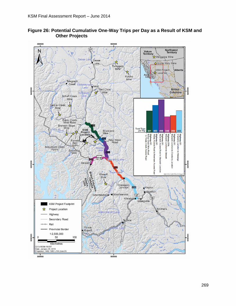
KSM Final Assessment Report – June 2014
269
Figure 26: Potential Cumulative One-Way Trips per Day as a Result of KSM and Other Projects
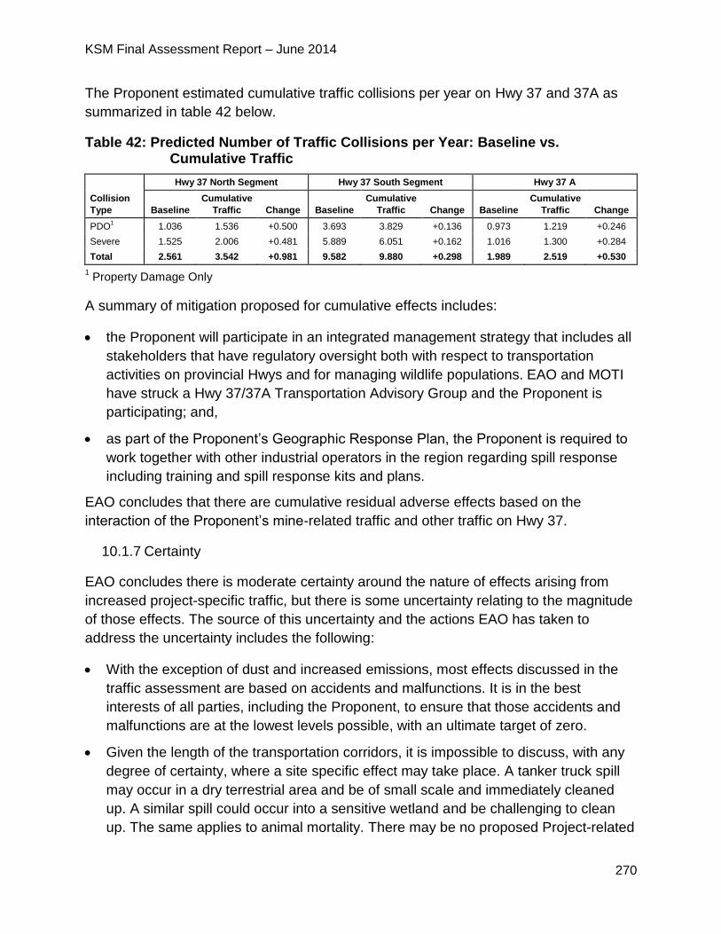
KSM Final Assessment Report – June 2014
270
The Proponent estimated cumulative traffic collisions per year on Hwy 37 and 37A as
summarized in table 42 below.
Table 42: Predicted Number of Traffic Collisions per Year: Baseline vs. Cumulative Traffic
Collision
Type
Hwy 37 North Segment Hwy 37 South Segment Hwy 37 A
Baseline
Cumulative
Traffic Change Baseline
Cumulative
Traffic Change Baseline
Cumulative
Traffic Change
PDO1 1.036 1.536 +0.500 3.693 3.829 +0.136 0.973 1.219 +0.246
Severe 1.525 2.006 +0.481 5.889 6.051 +0.162 1.016 1.300 +0.284
Total 2.561 3.542 +0.981 9.582 9.880 +0.298 1.989 2.519 +0.530
1 Property Damage Only
A summary of mitigation proposed for cumulative effects includes:
the Proponent will participate in an integrated management strategy that includes all
stakeholders that have regulatory oversight both with respect to transportation
activities on provincial Hwys and for managing wildlife populations. EAO and MOTI
have struck a Hwy 37/37A Transportation Advisory Group and the Proponent is
participating; and,
as part of the Proponent’s Geographic Response Plan, the Proponent is required to
work together with other industrial operators in the region regarding spill response
including training and spill response kits and plans.
EAO concludes that there are cumulative residual adverse effects based on the
interaction of the Proponent’s mine-related traffic and other traffic on Hwy 37.
10.1.7 Certainty
EAO concludes there is moderate certainty around the nature of effects arising from
increased project-specific traffic, but there is some uncertainty relating to the magnitude
of those effects. The source of this uncertainty and the actions EAO has taken to
address the uncertainty includes the following:
With the exception of dust and increased emissions, most effects discussed in the
traffic assessment are based on accidents and malfunctions. It is in the best
interests of all parties, including the Proponent, to ensure that those accidents and
malfunctions are at the lowest levels possible, with an ultimate target of zero.
Given the length of the transportation corridors, it is impossible to discuss, with any
degree of certainty, where a site specific effect may take place. A tanker truck spill
may occur in a dry terrestrial area and be of small scale and immediately cleaned
up. A similar spill could occur into a sensitive wetland and be challenging to clean
up. The same applies to animal mortality. There may be no proposed Project-related
KSM Final Assessment Report – June 2014
271
moose mortality in one year, but due to snow levels, storms or other unpredictable
events it could be ten the next year. As such, the actual magnitude of effects can
only be determined over time and with appropriate and accurate monitoring.
EAO notes that conditions related to transportation, which will become legally
enforceable should an EA Certificate be issued, are all focused on decreasing the
chance of effects (e.g. standard operating procedures for company and
subcontractor vehicles), ensuring effects can be addressed in a timely way (e.g.
coordinated spill response), increasing understanding regarding the magnitude of
effects (e.g. monitoring and reporting) and offsetting effects that occur that occur but
cannot be prevented through design or other mitigation (e.g. contributions to a trust).
Another factor related to certainty relates to modelling long term wildlife populations.
There are many factors related to the health of a wildlife population, especially one
such as Nass Moose, which have continued to experience a downward trend in
recent years, despite the elimination of resident and non-resident hunting and
significant voluntary harvest reductions by First Nations and the Nisga’a Nation.
These models have some use over the short term (one to five) years but are of
limited value for the long term.
EAO also notes that the governance of Hwy corridors is a factor that increases
uncertainty related to project-specific effects. Active management of the Hwy
corridor is the responsibility of government, not individual proponents. Many
mitigation suggestions made by members of the Working Group through the EA for
this proposed Project and others (e.g. Kitsault Mine Project) actually relate to the
actions of government and not the Proponent. Since EA Certificate conditions apply
only to proponents and not government, the consideration and implementation of
those suggestions cannot be factored into conclusions on this proposed Project.
However, in recognition of these larger issues, EAO has initiated, along with MOTI
and FLNR, the key agencies with responsibility for managing resources and
transportation in the corridor, the Hwy 37 Advisory Group. This group has met
several times and has already begun working with a multi-agency, multi-stakeholder,
Nisga’a and First Nation group to identify these issues and begin to develop
collaborative solutions.
10.1.8 Conclusion
Considering the above analysis and having regard to the conditions identified in the
TOC and the CPD (which would become legally binding as a condition of an EA
Certificate), EAO is satisfied that the proposed Project is not likely to have significant
traffic effects.
KSM Final Assessment Report – June 2014
272
11 Environmental Management Plans
A number of the Proponent’s Commitments discussed above related to the
establishment of various EMPs. As these would be an important part of the Proponent’s
strategy for avoiding or mitigating adverse environmental, social, economic, health and
heritage effects from the construction, operation and closure of the proposed Project.
The Proponent must develop and implement EMPs prior to construction to provide
guidance for both construction and operations on actions and activities to be
implemented as required to mitigate potential adverse impacts.
Details on each of the EMPs can be found in the Application and include the following
plans and sub-plans:
Construction Management;
Rock Storage Facilities Management and Monitoring;
Tailings Management Facility Management and Monitoring;
Water Storage Facility Management and Monitoring;
Dangerous Goods and Hazardous Materials Management;
Explosives Management;
Spill Prevention and Emergency Response;
Air Quality Management:
o Emissions Management;
o Fugitive Dust Emissions Management; and
o Meteorology Monitoring;
Greenhouse Gas Management;
Terrain, Surficial Geology and Soil Management and Monitoring:
o Soil Salvage and Handling;
o Erosion Control; and
o Soil Contamination Prevention;
Water Management;
Mine Site Water Management;
Metal Leaching and Acid Rock Drainage Management;
Groundwater Monitoring and Mitigation;
Glacier Monitoring;
KSM Final Assessment Report – June 2014
273
Water Management;
Selenium Management Plan;
Fish and Aquatic Habitat Management:
o Fish and Aquatic Habitat Effects Protection and Mitigation;
o Aquatic Effects Monitoring;
o Fish Salvage; and
o Salmon Monitoring;
Wetlands Management;
Terrestrial Ecosystems Management and Monitoring:
o Vegetation Clearing Management Plan;
o Invasive Plant Management Plan;
o Transmission Line Management Plan; and
o Terrestrial Plant Tissue Metal Concentrations Monitoring Plan;
Wildlife Effects Monitoring:
o Wildlife and Wildlife Habitat Management; and
o Ungulate Winter Range Management;
Human Health Monitoring;
Noise Management;
Heritage Management and Monitoring;
Visual Quality Management;
Traffic and Access Management;
Accidents and Malfunctions; and
Reclamation and Closure.
The Proponent must submit the EMPs to the appropriate agencies for review and input
before work commences. The EMPs are considered preliminary at this time and would
be completed in greater detail by the Proponent during the detailed design stage of the
proposed Project. Key components of several of the EMPs are included in the CPD
(Appendix 2).
KSM Final Assessment Report – June 2014
274
12 PART C – FIRST NATIONS CONSULTATION
12.1 Gitanyow Nation
12.1.1 Gitanyow Nation Occupation and Use of Proposed Project Area
Gitanyow Nation is a Gitxsan group of Tsimshian and Athapaskan heritage who speak a
dialect of the Nass-Gitxsan division of the Tsimshian language family. Historically,
Gitanyow Nation was one of seven Gitxsan village groups located in the middle Skeena
Valley, but much of their territory was in the Nass watershed. Hunting, fishing and
harvesting plants were important traditional activities undertaken by Gitanyow Nation.
The Kitwanga valley and the Cranberry River valley were important resource areas
used by Gitanyow Nation for fishing, hunting, trapping and harvesting plants. Gitanyow
Nation lived in, and utilized various parts of, their territory at different times of the year,
moving between the shared tribal winter village at Kitwancool and separate Wilp hunting
and fishing territories in the valleys of Kitwanga, Cranberry, Kiteen, Nass, Kinskuch,
Meziadin, Kispiox and elsewhere. At the time of European contact, and throughout the
19th century, Kitwancool (located at the confluence of the Kitwanga and Kitwancool
rivers) was Gitanyow Nation’s winter village.
Gitanyow Nation is comprised of the following eight Huwilp, each of which belongs to
one of two clans and asserts its own individual traditional territory:
Lax Gibuu (Wolf Clan)
Gwass Hlaam
Malii
Haizimsque
Wii Litsxw
Lax Ganeda (Frog/Raven Clan)
Gamlakyeltxw
Gwinuu
Watahayetsxw
Luuxhon
The Gitanyow Hereditary Chief’s Office (GHCO) advised EAO that it represents the
Gitanyow Huwilp, and described them as the social, political, and governing units of the
Gitanyow Nation. In correspondence from the GHCO to EAO dated July 31, 2008, the
Gitanyow Wilp Lax’yip (traditional territories) are described as follows:
KSM Final Assessment Report – June 2014
275
“The Lax Yip covers the area from Kitwancool Lake, or Gitanyow Lake in the south, north to the Bell One Bridge on the Bell-Irving River and from Kitsault Lake in the west to Bonny Lakes in the east, for a total of approximately 6,200 square kilometres. Gitanyow’s main village is situated on Hwy 37, approximately 20 kilometres north of Kitwanga Junction.”
In March 2012, Gitanyow Nation and the Province of British Columbia signed the Gitanyow Huwilp Recognition and Reconciliation Agreement (Agreement). The purpose of the Agreement is to build upon the relationship between the Gitanyow Nation and the Province with the intention of guiding land and resource management on the Gitanyow Lax’yip. The Agreement addresses the asserted or determined aboriginal rights, including title, as recognized and affirmed under section 35 of the Constitution Act, 1982 (Aboriginal Interests). Specifically, section 2.2 of the Agreement states that the intent of the Agreement is to:
“provide a foundation for a respectful Government-to-Government relationship within which the Parties can collaborate in the implementation and monitoring of this Reconciliation Agreement;
create increased certainty in regard to land and resource management and economic benefits for both Parties;
establish a clear, reliable and efficient framework for Shared Decision-Making, Land and Resource Decisions; and
achieve meaningful engagement, a common understanding of each Party’s respective interests, including Wilp sustainability, and the Parties’ shared interests, and promote well-informed decision-making.”
Part 2 of the Agreement comprises the Gitanyow Lax’yip Land Use Plan, which section
8.2 of the Agreement states will enable the Gitanyow Nation and the Province to work
together on:
“implementing the results of Government to Government land use discussions in a spirit of collaboration; and
addressing strategic and operational land use issues as they arise in the future.”
See Table 43 (section 12.2.5) of this report for EAO’s analysis of the potential impacts
from the proposed Project on the March 2012 Gitanyow Land Use Plan.
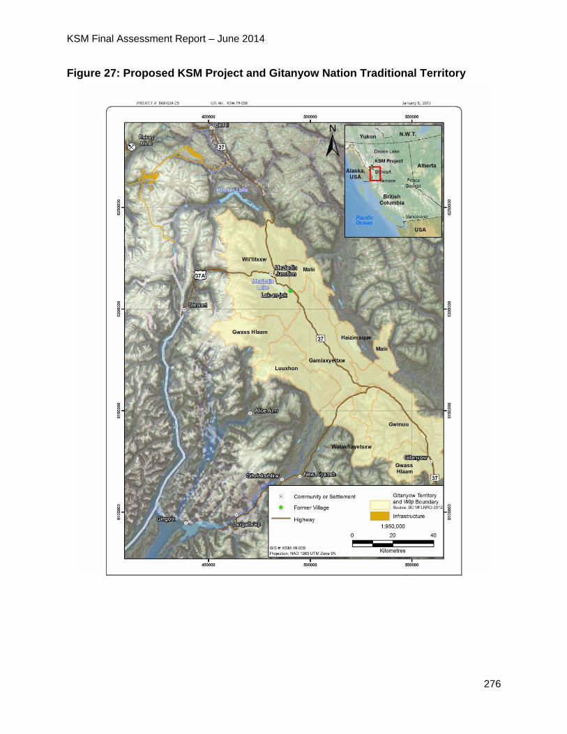
KSM Final Assessment Report – June 2014
276
Figure 27: Proposed KSM Project and Gitanyow Nation Traditional Territory
KSM Final Assessment Report – June 2014
277
12.1.2 Gitanyow Nation Traditional Use of the Proposed Project Area
Although there are no proposed Project components located within the Gitanyow
Nation’s traditional territory, Wilp Wii Litsxw and other Huwilp territories are located
approximately 58 km downstream of the TMF and are bisected by Hwys 37 and 37A,
which comprise the primary transportation corridor for the proposed Project.
Of the eight Gitanyow Huwilp, the traditional territory associated with Wilp Wii Litsxw is
located in closest proximity to the proposed Project area and is also traversed by the
proposed transportation corridor for the Project along Hwy 37. The Proponent’s
Application for an EA certificate states that Wilp Wii Litsxw’s traditional territory, which
extends from south of Bowser Lake to south of Meziadin Lake, includes culturally and
ecologically important hunting and fishing areas. Huwilp activities within the traditional
territories include gathering country foods such as fish, moose meat, and berries.
Areas of particular significance to the Gitanyow Nation for the exercise of traditional use
activities include the Hanna and Tintina Creek watersheds and the confluence of the
Meziadin basin with the Nass River, where salmon spawning and harvesting are
common. According to the Proponent’s Application, the Hanna and Tintina drainages
represent high-value grizzly bear habitat, along with areas to the north along the Bell-
Irving River towards Surveyors Creek. The Hanna-Tintina watersheds also represent an
area of high cultural value to the Gitanyow Nation and, according to the Proponent’s
Application, contain numerous traditional knowledge/traditional use sites.
Correspondence from the GHCO to EAO on February 11, 2014, provided information
regarding the fishing activities undertaken by the Gitanyow Nation within the Skeena
and Nass Rivers. Specifically, the GHCO advised that, as part of an agreement with the
DFO, they harvest sockeye, chinook, coho, chum, and pink salmon for food, social, and
ceremonial purposes in the following areas:
in the waters of the main stem of the Nass River from a point 800 m downstream of the confluence with the Kinskuch River to the confluence with the Bell-Irving River;
in the waters of the Meziadin River from a point 12 m downstream of the Meziadin Fishway to the confluence of the Nass and Meziadin Rivers;
the Cranberry River; and
the Kitwanga River.
The Gitanyow Nation’s preferred salmon is sockeye, followed by chinook and coho.
Steelhead and bull trout are also harvested by the Gitanyow Nation, the steelhead
mostly as bi-catch in the Nass River and bull trout as a target species within tributaries
of the Nass, Kitwanga and Upper Kispiox Rivers.
KSM Final Assessment Report – June 2014
278
Hunting (and in particular the hunting of moose) and trapping are also important
activities undertaken throughout the territories, and wildlife species regularly used by
Gitanyow Nation include the following:
grizzly bear;
mountain goat;
moose;
deer;
marmot;
beaver;
marten;
wolverine; and
rabbit.
Vegetation species gathered for traditional purposes by Gitanyow Nation include:
blueberries;
cranberries;
devil’s club;
hellebore;
Labrador tea;
water lily roots;
nettles;
soapberries;
balsam bark;
red alder bark; and
wild mint.
According to the Proponent’s Application, the harvesting of pine mushrooms is also an
increasingly important economic activity for Gitanyow Nation.
12.1.3 Consultation with Gitanyow Nation
12.1.3.1 Gitanyow Nation involvement with EAO
Pre-Application Stage
Gitanyow Hereditary Chiefs Office
EAO notified the GHCO of the initiation of the EA for the proposed Project via letter on
April 30, 2008; in that letter, EAO advised that the EA process had been initiated and
that it would contact the GHCO again shortly in order to discuss opportunities for the
Gitanyow Nation to participate.
KSM Final Assessment Report – June 2014
279
EAO followed up with a second letter to the GHCO on May 22, 2008, to suggest a
meeting to discuss Gitanyow Nation’s interests in the proposed Project area and to
determine whether Gitanyow Nation wanted to participate in the EA.
On June 2, 2008, EAO sent another letter to the GHCO to provide additional information
regarding the proposed Project, extend an invitation to participate in an upcoming
Working Group meeting, and request a government-to-government meeting to discuss
the Gitanyow Nation’s Aboriginal Interests downstream of the proposed Project. EAO
and the GHCO communicated via e-mail and telephone throughout June 2008 in an
attempt to schedule a meeting.
The GHCO sent EAO a letter on July 31, 2008, confirming their interest in participating
in the EA and requesting capacity funding. The GHCO also provided EAO with
information regarding the Gitanyow Huwilp and advised that the proposed Project could
result in effects on Gitanyow Nation’s asserted rights and interests as they relate to
water quality, wildlife, and snow impacts in their asserted traditional territory. EAO
responded to the GHCO by letter on August 11, 2008 and advised that information
regarding capacity funding from EAO would be provided shortly, and that the GHCO
should also consider requesting capacity funding from the Proponent. EAO conveyed
capacity funding to the GHCO via letter on August 18, 2008 to assist the GHCO’s
participation in the EA of the proposed Project, including travelling to EAO-sponsored
meetings, document review, and other EA-related work. EAO provided the GHCO with
additional capacity funding in the name of the Gitanyow Huwilp Society on
October 28, 2008.
In May 2009, EAO wrote to the GHCO to provide a copy of the Proponent’s 2008
Baseline Studies Report and asked for feedback regarding whether there were any
gaps that should be incorporated into the 2009 Baseline Studies Workplan, which was
attached for review and comment. EAO’s letter also included information about
upcoming meetings of the full Working Group and technical sub-working groups, as well
as an invitation to meet on a government-to-government basis to discuss the EA
process and the nature and scope of Gitanyow Nation’s Aboriginal Interests in the
proposed Project area.
On June 3, 2009, EAO met with representatives of the GHCO and the Canadian
Environmental Assessment Agency (CEA Agency) to discuss the EA of the proposed
Project and opportunities for the Gitanyow Nation to be involved. The following topics
were also discussed at the meeting:
employment opportunities for Gitanyow Nation members;
downstream effects from the proposed Project;
increased traffic on Hwy 37 from the proposed Project and impacts on public
safety, ecotourism, and Gitanyow Nation’s future economic opportunities;
KSM Final Assessment Report – June 2014
280
the opportunity for the Gitanyow Nation to submit comments on the draft AIR and
the timeline for doing so;
the draft order under section 11 (Section 11 Order) of the Act, which First Nations
will be consulted during the EA, and timing for finalization of the Section 11
Order;
upcoming technical meetings that the GHCO were invited to attend; and
capacity funding, which the GHCO advised was insufficient.
On June 16, 2009, EAO sent the GHCO a letter conveying a copy of the Chapter 7
Geochemistry Baseline Study Report and invited them to participate in a meeting to
discuss issues related to metal leaching/acid rock drainage in Vancouver on June 22,
2009. No representatives from the GHCO participated in the June 22 meeting.
EAO sent another letter to the GHCO on July 10, 2009 to advise that EAO’s initial
understanding had been that the GHCO represented the Gitanyow Huwilp, but that Wilp
Wii Litsxw had communicated the desire to be consulted directly. EAO encouraged the
GHCO to continue to participate in the EA and to remain on the Working Group, but
informed them that EAO would also be contacting Wilp Gamlakyeltxw and Wilp
Watahayetsxw directly to inquire about their interest in participating in the EA for the
proposed Project. EAO also provided the GHCO with a copy of the draft Section 11
Order for review and comment.
On June 18, 2010, EAO sent a copy of the draft AIR for review and comment, but the
GHCO wrote to EAO on June 29, 2010, to advise that, without adequate funding, the
GHCO was unable to review the draft Application Information, as requested. The GHCO
did, however, submit comments on the draft Section 11 Order, and advised that the
proposed Project has the potential to affect the resource values within Gitanyow
Nation’s traditional territory, potentially affecting Gitanyow Aboriginal Interests. The
GHCO further advised that even though the proposed Project is outside the territory, it
could adversely affect water quality downstream (downstream effects) and fish and
wildlife values within Gitanyow lands. The GHCO indicated that there was potential for
socio-economic impacts from the proposed Project on Gitanyow Aboriginal Interests as
well, and requested additional capacity funding to facilitate participation in the EA. EAO
responded to the GHCO’s request for additional capacity funding on
September 7, 2010, and indicated that capacity funding had already been provided to
the GHCO to facilitate participation in the pre-Application stage of the EA for the
proposed Project, and advised that this was the maximum amount that could be
allocated to the GHCO for the time being due to budget constraints. EAO also offered
additional time for the GHCO to submit comments on the draft AIR, as well as a face-to-
face meeting with GHCO representatives to discuss the draft AIR and the EA of the
proposed Project in general.
KSM Final Assessment Report – June 2014
281
In September 2010, the GHCO wrote to EAO to submit comments on the draft AIR.
The GHCO requested that EAO recognize that the Gitanyow Nation has Aboriginal
Interests that could be impacted by the proposed Project and that EAO consult directly
with the GHCO and Wilp Wii Litsxw. EAO responded to GHCO’s letter on
November 25, 2010 (copied to Wilp Malii) and provided a copy of the Proponent’s
responses to their comments on the draft AIR. EAO indicated that a number of changes
were made to the draft AIR to reflect some of GHCO’s comments, but noted that many
of the comments were related more to the design, construction, and operation of the
proposed Project; EAO advised that they had directed the Proponent to contact the
GHCO and Wilp Malii directly to discuss the issues raised and then report back to EAO
with the results of that discussion. EAO also extended an invitation to meet with Wilp
Wii Litsxw to meet with EAO to discuss the EA for the proposed Project and any
concerns they may have.
In March 2011, EAO received a letter from the GHCO requesting an amendment to the
Section 11 Order that would expand the scope to include all eight of the Gitanyow
Huwilp, as well as the GHCO, as opposed to just Wilp Wii Litsqxw. The GHCO pointed
out the potential for impacts on air and water quality and fish production from metal
leaching/acid rock drainage as a result of the proposed Project, and therefore on the
Gitanyow Huwilp’s rights to harvest fish and wildlife and gather vegetation. The GHCO
also advised that there could be direct impacts on wildlife in and around Gitanyow
territory due to increased traffic from the proposed Project.
EAO responded to the GHCO’s concerns via letter on April 28, 2011, stating that EAO
wrote to Wilp Gamlakyeltxw, Wilp Watakhayestxw, and Wilp Wii Litsxw on July 10, 2009
to inform them that the proposed Project may potentially result in impacts on Gitanyow
Nation Aboriginal Interests due to downstream impacts and impacts from trucking. The
July 10, 2009 letter went on to say that EAO intended to consult with Wilp Wii Litsxw
because it is the Wilp closest to proposed Project and because Wii Litsxw territory
includes part of the Nass River, as well as the trucking route to Stewart. EAO did not
consider it necessary to consult the remaining Gitanyow Huwilp because EAO did not
believe there would be impacts on those Huwilp’s territories due to the distance from the
proposed Project (at least 80 kilometres to the south). The July 9, 2009 letter concluded
by asking if the Huwilp wished to be engaged in the EA for the proposed Project, but no
response was received. In addition to summarizing past consultation efforts previously
outlined in July 2009, EAO’s April 28, 2011 letter to the GHCO also communicated
EAO’s intention to amend the Section 11 Order to address the following:
1. broaden the scope of the assessment to include transport of construction and
operational materials to the site of the proposed Project;
2. include those Gitanyow Huwilp located adjacent to the Hwy 37 corridor, as well as
the GHCO in the Section 11 Order;
KSM Final Assessment Report – June 2014
282
3. clarify in the Section 11 Order that the scope of the consultation with the newly
added Huwilp is to encompass only on the potential impacts arising from the
transportation corridor and that any Proponent engagement will only be on those
impacts; and
4. clarify that the GHCO is to be added to the definition of First Nations and thereby
order the Proponent to consult with that office (this addition was in recognition of
the role of the GHCO in supplying technical expertise to the Gitanyow Huwilp).
EAO’s April 28, 2011 letter also outlined EAO’s preliminary assessment as to the
potential impacts from the proposed Project on Gitanyow Aboriginal Interests, stating
that EAO considers the scope of its duty to consult with Gitanyow as being between in
the middle of the Haida spectrum. EAO offered the following reasons for its preliminary
assessment:
1. transportation of materials is along existing roads which are already maintained
and regulated by provincial agencies through existing policy;
2. the rights potentially being impacted are in those traditional use and gathering
areas in close proximity to the existing Hwy corridor. Impacts would be limited to
dust, accidents and malfunctions from mine traffic such as spills, and such impacts
would be localized and limited to individual animals or relatively small areas;
3. the roads being used for transportation have been in place for years and any
impact from designation or construction of these roads occurred in the past and is
not part of the scope of the duty to consult about the proposed Project; and
4. with respect to wilp Wii’litsxw territory, the footprint of the proposed Project itself is
well upstream from the edge of their territorial boundary. It is only potential
downstream effects of the proposed Project that are being addressed.
On June 13, 2011, EAO wrote to the GHCO to convey a draft order under section 13 of
the Act (Section 13 Order) for review and comment. The purpose of the Section 13
Order was to change several aspects of the scope and process for the EA of the
proposed Project, specifically the inclusion of Hwy 37 from the proposed Project site to
the junction of Hwy 16 at Kitwanga, and consultation with Gitanyow Huwilp regarding
potential impacts arising from the use of Hwy 37.
On September 12, 2011, EAO sent another letter to the GHCO advising that, based on
a technical report from the Proponent regarding potential effects (a copy of which was
provided in the letter), EAO had determined that there would not be measurable effects
on water quality downstream of the proposed Project in the Bell Irving or Nass Rivers.
EAO stated that it would consider widening the scope of consultation beyond Wilp Wii
Litsxw on potential downstream effects if new information is presented that could
change EAO's conclusion. EAO also confirmed the provision of capacity funding to the
GHCO to support participation in the pre-Application stage for the EAs for the proposed
Kitsault and KSM Projects for Gitanyow Huwilp, with additional capacity funding sent to
KSM Final Assessment Report – June 2014
283
Wilp Luuxhon. EAO’s letter confirmed that GHCO representatives had advised at the
July 21, 2011 meeting that all funding should flow to the GHCO (except for Wilp
Luuxhon) to coordinate on behalf of potentially affected Huwilp, and requested
correction if that understanding was incorrect.
When no comments were received from the GHCO or Gitanyow Huwilp on the draft
Section 13 Order, EAO followed up by letter on October 4, 2011 to the GHCO and Wilp
Gamlaxyelxw, Wilp Gwass Hlaam, Wilp Gwinuu, and Wilp Wii Litsxw to advise that the
Section 13 Order had been finalized, and to invite them to participate in a technical
working group for First Nations potentially affected by proposed projects that would
increase the usage of Hwy 37.
EAO heard concerns from the GHCO and Wilp Wii Litsxw in an April 2012 letter
regarding the potential for chronic and catastrophic effects on downstream waters in the
Nass watershed and the associated effects of fish. EAO responded via a joint letter with
the CEA Agency on July 19, 2012, reiterating EAO’s previous statements regarding the
lack of information indicating the potential for downstream effects in the Bell Irving or
Nass Rivers. EAO and the CEA Agency also expressed satisfaction with the
Proponent’s “February 2012 Assessment of Alternatives for the KSM Project TMF” and
advised that it was still in draft form and available for review and comment by Gitanyow.
On August 14, 2012, EAO wrote to the GHCO and the Gitanyow Fisheries Authority to
convey capacity funding to assist with costs associated with Gitanyow Nation’s
participation in a traffic study designed to inform EAs for projects proposed along Hwy
37, including the proposed Project.
On September 14, 2012, the GHCO submitted comments on the Proponent’s “KSM
Project Hwy 37 and 37A Traffic Effects Assessment”. The comments were submitted in
the context of the March 28, 2012, Gitanyow Huwilp Recognition and Reconciliation
Agreement (Agreement) signed by the eight Gitanyow chiefs and the Province. The
GHCO’s comments referenced the Gitanyow Lax’yip Land Use Plan, stating that the
March 2012 Agreement and provides detailed management objectives and land use
zones for the Gitanyow Nation’s asserted traditional territory, and that the GHCO
expects the proposed Project to adhere to those management objectives. The GHCO
expressed significant concern over the potential effects of the proposed Project on
wildlife (primarily moose) from vehicle collisions, as well as the potential adverse effects
on aquatic ecosystems and human safety in the event that one of the proposed Project
vehicles is involved in an accident that results in the release of deleterious substances
into the surrounding environment.
In December 2012, EAO contacted the GHCO to provide information regarding the
timing for the Proponent to submit their Application and invited the GHCO to participate
in the evaluation process. On January 23, 2013 the GHCO advised EAO via a letter that
the Skeena Fisheries Commission would be providing technical support to the GHCO
KSM Final Assessment Report – June 2014
284
during the Application review stage of the EA for the proposed Project, and EAO
responded to confirm that funding would still be sent to the GHCO. A week later on
January 30, 2013, EAO sent a copy of the Proponent’s “KSM Project – Gitanyow First
Nation Section 11 Order Consultation Summary Report” to the GHCO for review and
comment. On February 13, 2013, the GHCO thanked EAO for the opportunity to and
provided a copy of their comments submitted to the Proponent in December 2012.
On February 26, 2013, EAO sent a letter to the GHCO to provide capacity funding to the
GHCO and the Gitanyow Huwilp Society on behalf of Wilp Wii Litsxw, Wilp Malii, Wilp
Gamlakyeltxw, Wilp Gwass Hlaam and Wilp Gwinuu to assist with participation in the
Application review stage of the proposed Project. On March 1, 2013, the GHCO
confirmed receipt of their requested copies of the Application from the Proponent, and
on May 1, 2013, requested a one-day extension to submit their screening comments,
which EAO granted. On June 4, 2013, EAO wrote to the GHCO to advise that the
Application was found to include all of the information set out in the AIR; the letter also
provided additional information regarding the Application review stage and indicated
that the 180-day Application review would be initiated once all Working Group members
and First Nations had received their requested copies of the Application.
Wilp Luuxhon, Wilp Gwass Hlaam, Wilp Gamlakyeltxw, Wilp Wii Litsxw, and Wilp
Watakhayetsxw
On June 25, 2009, EAO met with representatives from Wilp Luuxhon and Wilp Gwass
Hlaam to discuss Gitanyow traditional laws and customs, the role of the GHCO versus
individual Gitanyow House Groups, and the provincial EA process. During the meeting,
Wilp Luuxhon representatives advised that EAO and the Proponent should be
consulting directly with the hereditary chiefs regarding the EA of the proposed Project,
and not the GHCO; EAO requested that the direction to EAO to consult directly with the
hereditary chiefs of the Huwilp be formally communicated in a letter. At the request of
the Huwilp representatives at the meeting, EAO later followed up by providing additional
information about the proposed Project, as well as a map of all projects currently in the
EA process located within the Gitanyow Huwilp territories.
On July 7, 2009, EAO called Head Chief Morris Derrick of Wilp Wii Litsxw to determine
if the house wished to be consulted directly regarding the EA of the proposed Project or
through the GHCO. On the advice of Chief Derrick, EAO contacted Wing Chief Tim
Martin, who indicated that he was aware of the proposed Project since his sister had
met with the Proponent; he also advised that he had requested that the Proponent meet
with the village to discuss the proposed Project. EAO explained the EA process, the
current status of the EA of the proposed Project, as well as the purpose of the section
11 Order and the Working Group. EAO invited Wing Chief Martin to contact EAO with
any questions and committed to sending him a follow-up letter with additional
information about the proposed Project and the section 11 Order.
KSM Final Assessment Report – June 2014
285
On July 10, 2009, EAO wrote to Wilp Gamlakyeltxw and Wilp Watakhayetsxw to notify
them of the initiation of the EA for the proposed Project. EAO extended an invitation to
the Huwilp to participate in the EA because of the understanding that there was the
potential for downstream impacts on the Huwilp territories from the proposed Project.
EAO wrote to Wilp Wii Litsxwe at the same time to provide information regarding the EA
process and a map of the proposed Project location in relation to the Gitanyow Huwilp
territories. EAO also provided a copy of the draft Section 11 Order to Wilp Wii Litsxw
and Wilp Gamlakyeltxw for review and comment and advised that EAO would add Wilp
Wii Litsxw to the Working Group. On September 28, 2009, EAO followed up with a letter
to Wilp Wii Litsxw requesting confirmation of the authorization of two individuals to
represent the Wilp on the Working Group. EAO received a letter from Wilp Wii Litsxw on
April 6, 2010, confirming that the hereditary chiefs should be consulted directly
regarding the EA of the proposed Project.
On September 7, 2010, EAO wrote a letter to Wilp Wii Litsxw explaining the purpose of
the AIR and inviting comments on the draft AIR for the proposed Project. EAO also
offered to schedule a meeting in September to discuss the draft AIR and the EA
process in general, if desired by Wilp Wii Litsxw.
Between September 2010 and August 2012, EAO communicated via e-mail with Wilp
Wii Litsxw regarding the EA of the proposed Project as members of the Working Group.
EAO also copied Gitanyow Huwilp on correspondence to the GHCO in June and
October 2011 regarding opportunities to review and comment on the draft section 13
Order (see section above for details).
Application Review Stage
Initiation of the 180-Day Review
The 180-day Application review stage of the EA for the proposed Project was initiated
on August 12, 2013. EAO communicated with the Gitanyow Nation between August and
September regarding the initiation of the review, including:
August 15, 2013 – e-mail advising that the 180-day review has been initiated;
and;
August 29-September 12, 2013 – e-mails regarding a conference call to discuss
the initiation of the 180-day Application review stage; EAO canvassed for
preferences regarding potential dates for the call and provided copies of the a
proposed agenda and a revised EA review schedule.
On September 13, 2013, EAO held the conference call with the Proponent and
representatives from the CEA Agency and the Working Group (including the Gitanyow
Nation) to discuss the initiation of the 180-day Application review stage. EAO and the
CEA Agency presented the provincial and federal EA processes and timelines, including
the following milestones and key steps in the EA:

KSM Final Assessment Report – June 2014
286
initiation of the 180-day review on August 12, 2013;
a 45-day public comment period from September 6-October 9, 2013 with open
houses in Iskut, Telegraph Creek, Smithers, Terrace and Stewart;
a series of Working Group and sub-Working meetings to be held throughout the
review;
an opportunity to review and submit comments on the Proponent’s Application;
an opportunity to review and submit comments on the Proponent’s responses to
comments on the Application;
an opportunity to review and submit comments on EAO’s draft Assessment
Report, CPD, and TOC; and
an opportunity for First Nations (including the Gitanyow Nation) to review and
submit comments on EAO’s draft First Nations Consultation Report.
During the call, Working Group members were also given an opportunity to engage in
discussion with, and ask preliminary questions of, the Proponent regarding the
Application. EAO asked Working Group members for their feedback regarding the
format and intent of future Working Group meetings, including the utility of forming
technical sub-Working Groups. EAO provided information regarding upcoming open
houses and advised that the deadline for the first round of Working Group comments on
the Application was October 11, 2013.
Working Group and Technical Sub-Working Group Meetings
Between October 2013 and May 2014, EAO and the CEA Agency scheduled the
following Working Group and technical sub-Working Group meetings for the EA of the
proposed Project:
October 2-3, 2013 – the Proponent presented their significance determination
framework and key areas of the Application, followed by a discussion, and an
opportunity to ask questions (Gitanyow Nation representatives participated in the
meeting on October 2, 2013)
November 6-8, 2013 – an opportunity to engage in technical level discussions
on issues related to wildlife and water quality on both the mine side and tailings
side of the proposed Project (no Gitanyow representatives participated in these
meetings)
November 26-28, 2013 – an opportunity to engage in a technical level
discussion, review the Proponent’s proposed mitigation measures and
conditions, and identify outstanding geotechnical issues for resolution (Gitanyow
representatives participated in all three days of meetings)
May 13-15, 2014 – a three-day Working Group meeting to discuss EAO’s draft
Assessment Report, TOC, CPD, and issues tracking table. The meetings
provided Working Group members with an opportunity to discuss and ask
KSM Final Assessment Report – June 2014
287
questions about EAO’s key findings with respect to potential effects from the
proposed Project on water quality, wildlife, fish, and transportation (Gitanyow
participated in all three days of meetings)
Correspondence and Meetings Between EAO and the Gitanyow Nation
Correspondence
Between September 2013 and March 2014, EAO communicated with the Gitanyow
Nation regarding the status of the EA, including the following:
September 20, 2013 – EAO e-mail conveying the proposed agenda for the
October 2-3, 2013 Working Group meeting and requesting feedback regarding
attendance;
September 24, 2013 – GHCO e-mail requesting a copy of the Lorax
Environmental groundwater comments referenced in comments submitted by
MEM (EAO provided a link to the comments on October 15, 2013);
October 1, 2013 – EAO e-mail to the Working Group conveying the finalized
agenda and PowerPoint presentations for the October 2-3, 2013 Working Group
meeting;
October 11, 2013 – GHCO e-mail conveying comments on the Application and
raising concerns with the short timelines associated with the EA, the need for a
third-party independent review, EAO’s approval of the Proponent’s request to
have some permits and authorizations reviewed concurrently with the
Application, inadequate response to GHCO’s screening comments, the
Proponent’s lack of consultation with the GHCO on the finalization of the
Gitanyow Traditional Use/Traditional Knowledge Study, the belief that the
Proponent is unaware of the that the Hanna Tintina was legally established as a
Conservancy on March 14, 2013, and concern that the Proponent does not
appear to recognize the Gitanyow Lax’yip Land Use Plan;
October 21/26, 2013 – EAO e-mails inviting the Working Group members
(including the Gitanyow Nation) to participate in technical sub-Working Group
meetings for wildlife and water quality, conveying the proposed agendas, and
requesting feedback regarding participation;
October 21, 2013 – GHCO e-mail commenting on budget constraints and the
challenge for Gitanyow Nation Working Group members to attend meetings in
Vancouver, as well as requesting confirmation that the GHCO’s first round of
comments on the Application had been received; EAO confirmed on
November 15, 2013 that the GHCO’s comments had in fact been received;
October 21, 2013 – GHCO e-mail requesting clarification regarding whether the
technical wildlife sub-Working Group meeting will include transportation-related
effects, or if there would be a separate Working Group established for
transportation; EAO clarified that transportation-related effects would be dealt

KSM Final Assessment Report – June 2014
288
with in the Hwy 37 Working Group that is currently under development;
November 1, 2013 – EAO e-mail conveying the draft summaries of the
October 6-9, 2013 technical sub-Working Group meetings for review and
comment;
November 5, 2013 – EAO e-mail to the Working Group (including the Gitanyow
Nation) conveying agendas for the upcoming technical sub-Working group
meetings, graphs depicting water quality predictions from the Proponent, as well
as a draft CPD and an explanation regarding the purpose of that document;
November 6, 2013 – EAO e-mail to Kevin Koch to determine whether additional
follow-up was required after he experienced technical difficulties in participating
in the November 6, 2013 technical wildlife sub-Working Group meeting by
telephone; EAO also directed the Proponent to follow up with Kevin Koch
directly, which was done by November 11, 2013;
November 18, 2013 – EAO e-mail inviting Working Group members (including
the Gitanyow Nation) to participate in geotechnical and selenium sub-Working
Group meetings on November 26-28, 2013, reminding that comments on the
Application were due on October 11, 2013 and requesting notice if additional
time was required;
November 18, 2013 – GHCO e-mail advising that the notice given for the
November 26-28, 2013 meetings was too short and that the Gitanyow Nation
would be submitting additional comments on the Application;
November 19, 2013 – EAO e-mail providing the agendas for the November 26-
28, 2013 meetings, as well as copies of the Proponent’s responses to
geotechnical comments from MEM (or “Batch 1 Responses”);
November 20, 2013 – GHCO e-mail requesting copies of the section 11 Order
for the proposed Project showing the section 13 Order amendments; EAO
responded on the same day to advise that there is only one section 11 Order and
that the section 13 Orders serve to vary the section 11 Order;
November 20-December 4, 2013 – e-mails back and forth between EAO and
the GHCO regarding:
o comments submitted by the GHCO during the evaluation of the proposed
Application and clarifying that they were considered at a high level at that
stage of the review and would now be considered in detail,
o clarification of statements made by EAO at Working Group meetings
regarding the shift in focus from the Proponent’s Application to EAO’s
Draft Assessment Report, CPD, and TOC;
o clarification of statements made by EAO at Working Group meetings
regarding the number of conditions that will likely be attached to the Draft
EA Certificate, if issued; and
o the fact that while EAO will consider all comments submitted by the
KSM Final Assessment Report – June 2014
289
Gitanyow Nation, the focus will be on those comments providing
information related to potential effects from the proposed Project on
Gitanyow Nation’s Aboriginal Interests, according to the scope of
consultation set out in the section 11 and 13 Orders (transportation and
downstream effects on Wilp Wii Litsxw and transportation effects on the
four other Huwilp).
November 21, 2013 – GHCO letter to the provincial and federal environment
Ministers requesting a meeting and expressing concerns with the proposed
Project, including:
o metal leaching and acid rock drainage that will require indefinite water
treatment;
o location of the TMF in the headwaters of the Nass River, the third largest
salmon-producing river in BC;
o dissatisfaction with the EA process for the proposed Project, including
inadequate timelines for meaningful consultation and ensuring proper
mitigation is identified;
o a reminder that the Province must consider and abide by case law and
existing agreements, such as the Gitanyow Recognition and
Reconciliation Agreement;
o the potential for impacts from the proposed Project on an already declining
moose population and moose habitat (particularly from increased traffic
along Hwy 37), water quality, fish and fish habitat, grizzly bears, and
Aboriginal Interests, and comparing the proposed Project to the New
Prosperity Project;
o a request to suspend the EA in order to allow adequate time for all parties
to consider the proposed Project; and
o the desire to establish a Project-specific Traffic Effects Working Group
instead of the newly established Hwy 37/37A Advisory Group.
November 26, 2013 – EAO e-mail conveying copies of the Proponent’s
PowerPoint presentations for the November 26-28, 2013 technical sub-Working
Group meetings;
December 4, 2013 – GHCO e-mail requesting copies of the Proponent’s
PowerPoint presentations from the November 6-8, 2013 technical sub-Working
Group meetings; EAO provided the copies on December 9, 2013;
December 11, 2013 – EAO e-mail conveying “Batch 2” of the Proponent’s
responses to the Working Group’s comments on the Application for review and
comment by January 10, 2014;
December 16, 2013 – EAO e-mail providing a copy of the Proponent’s
assessment of far-field downstream hydrologic effects;
KSM Final Assessment Report – June 2014
290
December 17, 2013 – letter from the Honourable Mary Polak, Minister of
Environment, responding to the GHCO’s November 21, 2013 letter regarding the
EA of the proposed Project, and advising the following:
o that she has toured the proposed Project site and is aware of its scale and
potential for effects;
o that she believes the EA process to be robust and effective in assessing
and addressing the potential for adverse effects, as well as fulfilling the
Crown’s duty to consult with First Nations;
o her confidence in EAO as her delegated authority;
o assurance that EAO remains committed to meeting the Crown’s duty to
consult and accommodate with respect to the proposed Project;
o encouragement for the Gitanyow Nation to identify in a timely manner any
potential impacts on Gitanyow Aboriginal Interests and interests, as well
as any measures that could avoid or mitigate such impacts;
o while there is no limit on conditions, EAO’s improved and more rigorous
approach with the introduction of CPDs has reduced the number of
conditions as compared to previous EAs;
o agreement that BC must honour its contractual commitments, including
the commitments made in the Recognition and Reconciliation Agreement,
and support and encouragement to finalize the Letter of Understanding
being developed by EAO and the Gitanyow Nation to clarify EAO’s role in
the Recognition and Reconciliation Agreement; and
o confirmation that the work of the Hwy 37/37A Advisory Group will
contribute to consultation, but will not replace other venues for
government-to-government consultation; this is consistent with BC’s
approach to consultation and ensures that the commitments made to
consult the Gitanyow Nation as a government regarding potential impacts
to asserted Aboriginal Interests are maintained, while enabling the
technical working group to inform the issues.
December 20, 2013 – EAO e-mail conveying the Proponent’s responses to
Working Group comments on the Application and providing an opportunity to
comment on those responses by January 24, 2014;
December 20, 2013 – EAO e-mail advising that the Proponent requested a 30-
day extension to the 180-day review;
January 7, 2014 – GHCO letter responding to EAO’s December 4, 2013 e-mail
regarding correspondence with Mark Cleveland for the consultation record for the
EA of the proposed Project, including the following:
o the Proponent’s response to comments submitted by the GHCO during
the Application evaluation stage of the EA;
KSM Final Assessment Report – June 2014
291
o EAO comments from the November 8, 2013 Working Group meeting; and,
o GHCO’s issues with the EA process for the proposed Project.
January 8, 2014 – e-mail providing an update on next steps, timelines, and
upcoming opportunities for input into the EA, including an extension from the
January 10, 2014 deadline for submitting comments on all Proponent responses
to January 24, 2014;
January 9, 2014 – GHCO e-mail requesting a copy of the Proponent’s “Batch 1”
responses to comments and an update regarding the Proponent’s request for a
30-day extension to the 180-day review timeline; EAO responded the same day
to provide the responses, advise that EAO’s Executive Director was still in the
process of considering the Proponent’s extension request, and offer any
additional information or assistance that GHCO may require;
January 17, 2014 – e-mail to the Working Group (including the Gitanyow Nation)
acknowledging the complexity and volume of materials for review as part of this
EA, and requesting feedback regarding what EAO could do to facilitate the
Working Group’s review of those documents;
January 17, 2013 - EAO e-mail acknowledging that the GHCO will be meeting
with the CEA Agency in Vancouver on January 21, 2014 and offering to set up a
separate meeting for EAO and the GHCO (as EAO understands it is the GHCO’s
preference to hold separate meetings with the federal and provincial agencies)
that same week;
January 20, 2013 – e-mail conveying the finalized summary of the October 2-3,
2013 Working Group meeting;
January 21, 2014 – GHCO letter responding to EAO’s January 17, 2014 e-mail
regarding the workload associated with the EA of the proposed Project and
requesting that the EA be suspended in order to design and come to agreement
on a consultation process;
January 27, 2014 – EAO e-mail conveying the draft summaries of the
November 15, 2013 technical fisheries conference call and November 26-28,
2013 technical sub-Working Group meetings to participants for review and
comment within two weeks;
January 28, 2014 – GHCO e-mail requesting an update on the Proponent’s
timeline extension request; EAO responded the same day to advise that the
extension would likely be granted shortly to extend the deadline to March 20,
2014, but that additional time beyond March 20 may be required;
January 29, 2014 – EAO e-mail thanking those Working Group members who
have submitted their comments on the Proponent’s responses and requesting an
update from those who haven’t;
January 29, 2014 – GHCO e-mail conveying comments on the Proponent’s
responses to Working Group comments on the Application;
KSM Final Assessment Report – June 2014
292
January 30, 2014 – e-mail conveying an order under section 24(4) of the Act
extending the 180-day review timeline by 30 days, as requested by the
Proponent;
February 4-7, 2014 – e-mails back and forth between EAO and the GHCO
regarding documents posted on EAO’s website, clarification of numbers provided
in GHCO comments regarding Hwy 37 impacts, and a request from EAO for
input from the GHCO with respect to potential mitigation measures/conditions
that could alleviate their concerns;
February 11, 2014 – GHCO letter regarding potential impacts from the proposed
Project on the Gitanyow Nation’s Aboriginal Interests;
February 11-20, 2014 – e-mails back and forth between EAO and the Gitanyow
Nation regarding scheduling a meeting on February 25 or 26, 2014;
February 17, 2014 – GHCO letter regarding the scope of consultation for the EA
of the proposed Project and the draft section 13 Order, and providing information
regarding the Gitanyow Huwilp;
February 21, 2014 – GHCO e-mail conveying the GHCO’s additional comments
on the Application;
February 24, 2014 – EAO letter regarding the following:
o the scope of consultation with the Gitanyow Nation for the EA of the
proposed Project;
o EAO’s agreement to amend the section 11 Order for the proposed Project
in order to include all of the Gitanyow Huwilp, as requested by the GHCO,
and supported by information submitted by the GHCO regarding potential
effects of the proposed Project on Bell-Irving salmon, which swim up the
Nass River and into Gitanyow Nation’s traditional territory where Gitanyow
Nation has an Aboriginal Interest related to fishing;
o a request for confirmation of EAO’s understanding that the GHCO
represents all of the Gitanyow Huwilp, with the exception of Wilp Luuxhon;
o an explanation of EAO methodology for assessing Gitanyow Nation’s
Aboriginal interests;
o EAO’s decision not to suspend the timeline for the EA of the proposed
Project, as requested by the GHCO, because of the existence of sufficient
opportunities for meaningful engagement;
o providing a list of government agency reviewers working on the EA of the
proposed Project, as well as contractors, as requested by the GHCO;
o reiteration of EAO’s commitment to respectful dialogue and a safe
environment for all participants, and assurance that ground rules will be
followed by all participants;
o acknowledgement of the GHCO’s comments on the Application and a
commitment to ensure that the GHCO will have an opportunity to review
KSM Final Assessment Report – June 2014
293
responses;
o GHCO’s concerns regarding transportation effects along Hwy 37 and the
wish to have mitigation measures previously proposed for the EA of the
proposed Kitsault Mine Project applied to the EA for the proposed KSM
Project;
o providing a table listing all of the transportation-related issues and
suggested mitigation/accommodation measures raised by the GHCO for
the EAs of both the proposed Kitsault and KSM Projects;
o EAO’s agreement to discuss transportation-related effects from the
proposed Project at a KSM-specific transportation working group as
opposed to the Hwy 37/37A Advisory Group, as requested by the GHCO;
o an explanation of the format and purpose of the Certified Project
Description and TOC and a proposal to discuss the documents in more
detail at a future meeting;
o EAO’s commitment to provide additional capacity funding to assist the
GHCO’s continued participation in the Application review stage of the EA
of the proposed Project;
o an explanation of how EAO considers and assesses information;
o EAO’s continued commitment to discussing and finalizing the Letter of
Understanding between EAO and the GHCO to clarify the role of the
Gitanyow Huwilp Recognition and Reconciliation Agreement to EA
projects; and
o EAO’s continued commitment to uphold the honour of the Crown and
meet the duty to consult, consistent with applicable case law.
February 24, 2014 – GHCO e-mail conveying proposed discussion topics for the
February 26, 2014 meeting between EAO and the GHCO;
February 26-27, 2014 – e-mails and telephone calls between EAO and the
GHCO to advise that EAO’s February 24, 2014 letter came back as undeliverable
to some of the Gitanyow Huwilp and requesting alternate contact information as
well as confirmation of receipt; the GHCO confirmed receipt on February 27,
2014;
February 27, 2014 – e-mails back and forth between EAO and the GHCO
regarding documents posted on EAO’s website;
February 28, 2014 – EAO e-mail conveying British Columbia’s Bonding Policy
for Mines (an action item from the February 26, 2014 meeting) and advising that
EAO will send additional bonding information from other provincial agencies
shortly;
March 4, 2014 – EAO e-mail conveying the Proponent’s responses to the
GHCO’s comments on potential traffic impacts and moose;
March 5, 2014 – EAO e-mail providing a copy of the draft CPD and TOC for the
KSM Final Assessment Report – June 2014
294
Kitsault Mine Project for the GHCO’s information (an action item from the
February 26, 2014 meeting);
March 5, 2014 – EAO e-mail conveying the Proponent’s responses to comments
submitted by the US Department of the Interior, HC and FLNR, as well as a copy
of the signed section 24(4) Order, extending the 180-day review by an additional
45 days, as requested by the Proponent;
March 10, 2014 – EAO letter to the GHCO and Huwilp wing chiefs regarding
action items from the February 26, 2014 meeting. EAO confirmed the
consultation approach it would take, including analysis of the potential effects of
the proposed Project on the land use objectives set out in the Gitanyow Land
Use Plan, and outlined a list of potential effects from the proposed Project on
Gitanyow Aboriginal interests that had been identified to date, with the proposal
that they be discussed at the next meeting. (Delivery failed on March 10 and was
re-sent on March 11).
March 11-12, 2014 – EAO e-mail to the GHCO advising that e-mails to various
Gitanyow representatives have been coming back as undeliverable and asking
for suggestions regarding a potential solution. On March 12, 2014, the GHCO
provided an alternate e-mail address to which EAO could send documents and
confirmed that those documents would be provided to the appropriate
representatives.
March 11, 2014 – GHCO letter to EAO regarding:
o the consultation approach and scope of the EA;
o the draft section 13 Order;
o an update on the proposed Project, including the Price and Kennedy
Reports and the review timeline;
o bonding and liability;
o traffic and moose;
o fish;
o permitting; and
o conditions.
March 12, 2014 – EAO e-mail to Wilp Luuxhon following up on a telephone
conversation regarding Wilp Luuxhon’s awareness of, and interest in, the EA of
the proposed Project. EAO provided info regarding the proposed Project and
copies of key documents from the EA, including the draft section 13 order for
review and comment. EAO advised that funding is available for Wilp Luuxhon
and confirmed availability to participate in a meeting on March 22, 2014 in
Terrace.
March 13, 2014 – GHCO letter to EAO conveying the GHCO’s comments on the
draft section 13 Order.
March 13, 2014 – EAO e-mail to the GHCO conveying a memo from MOE
KSM Final Assessment Report – June 2014
295
regarding their PTMA Aquatic Impact Assessment Review as follow-up to the
February 26, 2014 meeting.
March 13, 2014 – GHCO e-mail to EAO proposing a meeting on March 25, 2014
in Vancouver. EAO responded on March 17 re: their availability to meet with the
GHCO, as requested, and the GHCO confirmed the date and location.
March 14, 2014 – EAO e-mails to the Working Group (including the GHCO and
Huwilp wing chiefs) conveying the Proponent’s responses to comments
submitted by the NLG, GHCO, MOE, MEM, and EC, as well as a memo
submitted by MOE regarding potential toxicity from the PTMA.
March 16, 2014 – GHCO e-mail to EAO conveying the GHCO’s comments on
the February 12, 2014 report by Dr. Chris Kennedy’s for the Proponent regarding
metal toxicity effects from the TMF (Kennedy Report).
March 17/18, 2014 – EAO e-mails to the Working Group (including the GHCO
and Huwilp wing chiefs) conveying the following:
o memo from FLNR re: the Nass Moose Population Viability Assessment
conducted by the Proponent in the Application (EAO clarified that the
purpose of the memo was to provide guidance as to the appropriate use of
the Population Viability Assessment for effects assessment, thereby
addressing some of the comments regarding the modeling, and identifying
a path forward for a reasonable assessment of the effects of KSM traffic
on Nass Moose);
o GHCO’s assessment of the Kennedy Report and a letter from the
Proponent regarding additional selenium conditions; and
o an update regarding technical memos submitted by the Proponent, the
upcoming opportunity to review of key documents and submit comments,
upcoming Working Group meetings, timelines, and next steps;
March 21, 2014 – GHCO e-mail to EAO cancelling the March 25, 2014 meeting
because GHCO needed additional time to prepare, and advised that they would
propose an alternate meeting date.
March 21, 2014 – EAO e-mail to the GHCO providing information regarding
permits for the proposed Project, as follow-up to the February 26, 2014 meeting.
March 25, 2014 – GHCO letter to EAO conveying Michael Price’s response to
the Kennedy Report.
March 24/26, 2014 – EAO e-mails to the Working Group (including the GHCO
and Huwilp wing chiefs) conveying the following:
o the Proponent’s response to comments from DFO on the Dam Failure
Effects Assessment;
o a memo from EC regarding the potential for sub-lethal effects toxicity from
the TMF; and
o a letter from the GHCO conveying Michael Price’s response to the
KSM Final Assessment Report – June 2014
296
Kennedy Report.
April 1, 2014 – EAO letter to the GHCO outlining EAO’s consideration of
GHCO’s comments on the draft section 13 Order, and conveying a memo
summarizing EAO’s perspective on the information presented in the Price and
Kennedy reports, with an invitation for the GHCO to submit comments on both
documents.
April 2, 2014 – GHCO letter to EAO conveying a revised version of the draft
Letter of Understanding regarding consultation between EAO and the GHCO.
April 4, 2014 – GHCO e-mail to EAO forwarding information regarding a “Unified
Transboundary Workgroup Teleconference Call”.
April 7, 2014 – EAO e-mails to the Working Group (including the GHCO and
Huwilp wing chiefs) providing an update on the EA of the proposed Project
(including upcoming opportunities to review the draft Assessment Report, TOC,
and CPD, and advising of a probable Working Group meeting on May 13-15,
2014 in Smithers). EAO also conveyed the following memos from the Proponent:
o “KSM Project - Response to Comments submitted by Intrinsik
Environmental Sciences Inc. Review on behalf of the NLG - Human Health
Assessment in the KSM Project Dam Failure Effects Assessment Report”;
and
o “KSM Project – Response to Comments from Michael Price submitted on
behalf of the GHCO on March 25 2014”.
April 7, 2014 – GHCO letter to EAO advising that the GHCO does not support
the wording of the draft section13 order and opposes its finalization. The GHCO
letter criticizes the amount of time given to provide additional comments, but
confirms that additional comments on the draft section13 order will be submitted
by April 14, and additional comments on the Price report(s) will be provided by
April 11. EAO responded the same day to advise that the timing for receiving
additional comments is acceptable.
April 11, 2014 – GHCO e-mail to EAO aadvising that the GHCO needs an
additional week to submit follow-up comments on the March 14, 2014 response
from Patrick Williston and the March 20, 2014 response from Harp Gill to the
GHCO’s concerns with potential sub-lethal toxicity effects from the proposed
TMF.
April 14, 2014 – EAO e-mails to the Working Group (including the GHCO and
Huwilp wing chiefs) conveying the following:
o a memo from FLNR and MOE providing clarification regarding the use of
the Environmental Mitigation Policy to support decisions under the Act and
the proposed Project; and
o a memo from DFO providing their opinion on fish values downstream of
the proposed TMF (which represents a follow-up from the submission of
KSM Final Assessment Report – June 2014
297
the Cleveland report on February 11, 2014).
April 15, 2014 – GHCO letter conveying the following:
o additional comments on the revised draft section 13 order;
o a report entitled “KSM baseline data inadequacies in the Bell‐Irving
Sub‐basin: Risk Assessment Uncertainties” in response to EAO’s memo
regarding the Price reports; and
o confirmation that additional comments will be submitted prior to the
Working Group meeting scheduled for May 2014.
April 16, 2014 - GHCO letter conveying a response to Rescan's two memos of
February 28, 2014 and FLNR’s memo of March 27, 2014.
April 16-17, 2014 – EAO e-mails to the Working Group conveying the following:
o two memos prepared by Michael Price entitled: “Price_2014_KSM baseline
WQ data critique” and “Response to Hamilton Memo[5].pdf”; and
o a memo submitted by the Proponent responding to the March 25, 2014 Price
response; and
o the GHCO’s letter response to Rescan's two memos of February 28, 2014
and FLNR’s memo of March 27, 2014.
April 22, 2014 – EAO e-mail to the Working Group (including the GHCO and Huwilp wing chiefs) regarding upcoming Working Group meetings and opportunities/timing for reviewing and commenting on key documents.
April 28, 2014 – EAO e-mail conveying a memo from FLNR regarding the creation of a trust-like arrangement for environmental mitigation in northwest BC.
April 28, 2014 – EAO e-mail to the GHCO conveying a letter responding to GHCO’s comments on the draft section 13 order; including additional information outlining how EAO made its determination regarding the scope of consultation with Gitanyow and what changes were made to the order based on comments received from the GHCO;
April 29, 2014 – EAO e-mail conveying copies of the recently issued section 13 and 24(4) orders for the EA of the proposed Project, as well as outlining the topics for discussion at the May 13-15, 2014 Working Group meetings;
April 29, 2014 – EAO e-mail to the GHCO requesting meeting as a follow-up to the February 26 meeting, where it was agreed that discussion would continue on March 25. The March 25 meeting was cancelled at the GHCO’s request, so EAO proposed meeting the week of May 19 or 26, 2014 and offered to travel to Gitanyow for the meeting;
April 29, 2014 – EAO letter responding to the April 14, 2014 letter from Michael Price regarding EAO’s March 16, 2014 memo to the Working Group regarding hazard quotients;
May 1, 2014 – EAO e-mail conveying MOTI’s Hwy 37 report for information;
May 1, 2014 – EAO e-mail conveying two Proponent memos: “Response to Comments from GHC regarding Gitanyow Traffic Surveys and KSM Moose Modeling submitted on April 15, 2014” and “Response to Comments from Michael Price submitted on behalf of the Gitanyow Hereditary Chiefs on April 7
KSM Final Assessment Report – June 2014
298
2014” for information;
May 1, 2014 – EAO e-mail conveying two Proponent memos: “Response to Comments from Gitanyow Hereditary Chiefs regarding Gitanyow Traffic Surveys and KSM Moose Modeling submitted on April 15, 2014” and “Response to Comments from Michael Price submitted on behalf of the Gitanyow Hereditary Chiefs on April 7th 2014” for information. EAO also outlined next steps, including the fact that the contents of the memos have been incorporated into EAO’s draft Assessment Report, which will be circulated for review and comment for a three-week review.
May 2, 2014 – EAO letter conveying the draft Assessment Report, First Nation Consultation Report, CPD, TOC, and issues tracking table for GHCO’s review and comment. EAO also reiterated the opportunity for the GHCO to prepare a separate submission for Ministers by June 12, 2014, if desired.
May 5, 2014 – GHCO letter conveying two responses: 1) Response to Price Baseline Critique, prepared by Kelsey Norlund on April 29, 2014, and 2) EAO’s April 29, 2014 letter responding to Mr. Price’s April 14, 2014 letter.
May 7, 2014 – EAO e-mail to the Working Group (including the GHCO) conveying the finalized section 13 or 24(4) orders for information, as well as providing notice of the discussion topics at the upcoming May 13-15, 2014 Working Group meetings.
May 7-8, 2014 – e-mails back and forth between EAO and the GHCO regarding the May 13-15, 2014 Working Group meeting.
May 9, 2014 – GHCO letter to EAO expressing continued concern with EAO’s scope of consultation with the GHCO on the EA of the proposed Project, including the fact that EAO did not incorporate many of the GHCO’s comments and did not specifically reference the Gitanyow Huwilp Recognition and Reconciliation Agreement in the section 13 order.
May 12, 2014 – GHCO letter to EAO requesting a government-to-government meeting with Ministers Polak and Bennett prior to referral, and proposing the week of June 2 or 9, 2014; EAO confirmed via e-mail on May 13, 2014 that the request had been forwarded to Ministers, and asked for confirmation regarding whether the GHCO did not wish to submit comments on the draft Assessment Report, CPD, First Nation Consultation Report, TOC, and issues tracking table.
May 12, 2014 – EAO e-mail to the Working Group (including the GHCO) conveying copies of the PowerPoint presentations in advance of the upcoming May 13-15, 2014 Working Group meeting.
May 13-15, 2014 – EAO had discussions with GHCO representatives regarding considering what key issues for resolution and offering to meet to discuss options for new conditions or revisions to existing conditions. EAO Also advised that a request was put in for a meeting with deputy ministers from the MOE, MEM, ARR, and EAO. The GHCO representatives advised that they were looking for an accommodation package, stating that it was dishonourable of the Crown to ask the Proponent to undertake all of the accommodation, and that government needs to provide accommodation as well. There was also a request from GHCO representatives for funding associated with travel for the government-to-government meeting requested by the GHCO.
KSM Final Assessment Report – June 2014
299
May 21, 2014 – GHCO letter to EAO requesting an update on the government-to-government meeting, advising that while their preference is for a meeting the with Ministers, they would be willing to meet with Deputy Ministers. The GHCO also requested a two-week extension to the deadline for submitting comments on the draft referral documents.
May 21, 2014 – EAO letter responding to a GHCO request for a document comparing monthly baseline values to monthly predicted values, and concerns raised by the GHCO regarding baseline ground and surface water information. EAO provided the monthly baseline values as requested and advised that the MOE considered the Proponent’s baseline work to be adequate, and pointed out a number of draft conditions related to protecting water quality and fish.
May 21, 2014 – EAO e-mail conveying the draft summaries from the May 13-15, 2014 Working Group meeting for review and comment, as well as circulating recent submissions from the FLNR in response to the GHCO’s April 15, 2014 memo regarding the moose population viability analysis model, and the Proponent’s response to the GHCO regarding baseline data.
May 23, 2014 – GHCO e-mail requesting a telephone call. Chris Hamilton responded and left a voicemail message, as well as following up with an e-mail the same day to confirm that the Executive Director agreed to grant the GHCO a one-week extension on the deadline for submitting comments on the draft referral package. EAO also advised that anything arriving after that date would be provided to Ministers directly as a separate submission and not reflected in the Assessment Report. EAO confirmed availability for a meeting with Deputy Ministers from EAO, FLNR, ARR, and MEM in Smithers on June 6, 2014, and requested that the GHCO confirm their availability. Glen Williams responded via e-mail the same day that their preference was now to meet in Vancouver on June 6, 2014. Chris Hamilton again responded via e-mail on the same day that it would be helpful to have a proposed agenda to ensure the right people are in attendance before confirming a Vancouver date.
May 27, 2014 – GHCO letter requesting an additional week’s extension until after the June 6, 2014 government-to-government meeting to submit comments on the draft referral documents, and stating that they did not receive EAO’s Gitanyow Land Use Plan analysis, as promised. Chris Hamilton responded to Sandra Littlewood via e-mail the same day to clarify and confirm receipt of an e-mail from Nicole Vinette on May 2, 2014, conveying the draft Gitanyow Land Use Plan analysis for review and comment, and that EAO’s Executive Director would be making a decision shortly regarding the GHCO’s request for an additional extension.
May 28, 2014 – EAO letter to the GHCO following up on the May 2, 2014 letter confirming EAO’s continued commitment to developing a Letter of Understanding with the GHCO in order to clarify consultation between EAO and the Gitanyow Huwilp. EAO also provided its rationale for comments on the GHCO’s suggested edits to the draft Letter of Understanding and requested feedback.
May 29, 2014 – EAO letter advising that EAO’s Executive Director decided to extend the timeline for referral to Ministers from June 12 to June 20, 2014, but that any materials submitted by Gitanyow after May 30 would be sent to Ministers
KSM Final Assessment Report – June 2014
300
as a separate submission and not reflected in EAO’s referral documents. The letter also outlined capacity funding provided by EAO and the Proponent, attempts by EAO to meet with the GHCO to discuss potential effects from the proposed Project on Aboriginal rights and interests, and confirming that EAO did in fact send the Gitanyow Land Use Plan analysis via e-mail from two different staff members on May 2, 2014, as promised.
May 29, 2014 – EAO e-mail confirming the government-to-government meeting scheduled for June 6, 2014 in Vancouver, and advising that the meeting location would soon be confirmed as well. EAO provided a list of provincial government attendees and requested a list of GHCO attendees and a proposed agenda of the topics that the GHCO wished to discuss.
May 30, 2014 – GHCO letter to EAO expressing the GHCO’s disappointment in EAO’s decision to extend the deadline for comments on the draft referral documents by one week instead of two, and confirming that the GHCO will be making a separate submission to Ministers.
June 2, 2014 – GHCO e-mail confirming GHCO attendees at the June 6, 2014 government-to-government meeting in Vancouver, and advising that the GHCO will provide discussion topics shortly.
Meetings Between EAO and the Gitanyow Nation
On February 25, 2014, EAO met with representatives from the GHCO in Vancouver to
discuss the following:
the status of the EA of the proposed Project, including timelines, key documents,
upcoming opportunities for the Gitanyow Nation to continue to provide input into
the EA, and next steps;
key issues raised to date by the Gitanyow Nation;
EAO’s consultation to date with the Gitanyow Nation regarding the EA of the
proposed Project and the draft section 13 Order;
fisheries values (Cleveland Report);
adequacy of the water quality assessment undertaken by the Proponent and the
“Sub-lethal Toxicity Concerns for Salmonids from the KSM Tailings
Impoundment” report compiled by Michael Price on behalf of the GHCO;
scope of the study area chosen by the Proponent;
wetland compensation;
moose impacts from increased traffic;
proposed monitoring; and
the alternatives assessment undertaken by the Proponent.
As requested by the GHCO, EAO arranged for a government-to-government meeting
between the GHCO and EAO, MOE, MEM, FLNR, and ARR. The meeting was

KSM Final Assessment Report – June 2014
301
scheduled for June 6, 2014 in Vancouver, at the request of the GHCO, in order to
discuss the GHCO’s concerns with the proposed Project.
Meetings and Key Correspondence with Wilp Luuxhon
In a letter to Wilp Luuxhon on March 12, 2014, EAO provided information regarding the
EA of the proposed Project and suggested scheduling a meeting to answer any
questions or discuss any concerns that Wilp Luuxhon may have. EAO also provided a
copy of the section 11 order, as well as the draft section 13 order for review and
comment. EAO advised that the GHCO had requested that all of the Gitanyow Huwilp
be added to the section 13 order, and since it was EAO’s understanding that the GHCO
does not represent Wilp Luuxhon, EAO requested that Wilp Luuxhon confirm whether
they were interested in being added to the section 13 order and participating in the EA.
EAO met with representatives from Wilp Luuxhon on March 22, 2014 to discuss the EA
of the proposed Project, capacity funding, and opportunities for Wilp Luuxhon to
participate. EAO followed up with a letter on April 22, 2014, offering capacity funding
and confirming that Wilp Luuxhon had all of the information they required to participate
in the EA. On April 29, 2014, Wilp Luuxhon confirmed interest in participating in the EA
and receiving the capacity funding offered by EAO, which EAO then provided in June
2014.
On May 30, 2014, EAO wrote to Wilp Luuxhon to confirm whether they would be
submitting any comments or a separate submission for ministers, and Wilp Luuxhon
confirmed that they would be providing a separate submission. EAO reiterated the
deadline of June 19, 2014 for providing a separate submission, and indicated that the
contents would be provided directly to Ministers, but not reflected in EAO’s Assessment
Report.
Comments on the Application and Proponent Responses
On October 11, 2013, the GHCO submitted its first round of comments on the
Application, presented as follows:
Appendix A
TMF;
hydrology and long-term monitoring;
mine plan;
geochemistry;
water quality
reclamation and closure;
cumulative effects assessment;
wildlife and wildlife habitat impacts; and
fisheries and aquatic impacts.
KSM Final Assessment Report – June 2014
302
Appendix B
GHCO’s September 14, 2012 “Specific Comments on the Draft Traffic Effects
Assessment for the KSM Project: and
Appendix 22C of the Application.
The first round of comments submitted by the Gitanyow Nation expressed concerns
regarding the following:
economics and bonding;
surface and groundwater quality, modeling, and monitoring;
selenium treatment and potential effects to aquatic biota, fish, wildlife, and
humans;
potential impacts on fish and aquatic habitat;
consequences and risks associated with natural geo-hazards (i.e. avalanches,
landslides, etc.);
cumulative impacts; and
potential impacts on wildlife and wildlife habitat.
EAO provided all of the comments submitted by the Gitanyow Nation to the Proponent
for inclusion in an issue tracking table and response. On November 27, December 11,
and December 20, 2013, EAO circulated the Proponent’s responses to comments on
the Application and requested feedback. Although EAO initially requested feedback on
the Proponent’s responses by December 11, January 10, and January 24 respectively,
the volume and complexity of the documents submitted by the Proponent led to EAO
extending the deadline for all feedback on the Proponent’s responses to comments to
January 24, 2013.
On January 27, 2014, the GHCO submitted additional comments which served to
provide commentary on the Proponent’s responses, as well as following up on the
comments originally submitted on October 11, 2013. The January 9 comments were
focused on the following topics:
water quality;
fish and aquatic habitat;
wetlands;
wildlife and wildlife habitat; and
the traffic effects assessment.
The GHCO expressed particular concern about the Proponent’s decision to locate the
TMF in the headwaters of the Bell-Irving River and the potential impacts on Gitanyow
Nation’s Aboriginal Interests related to fishing and hunting, as well as maintain food
security and manage resources within their traditional territory. The GHCO reiterated its
KSM Final Assessment Report – June 2014
303
concerns regarding the potential for downstream impacts on Gitanyow lands and
resources from the proposed Project and submitted a report to EAO entitled “Sub-lethal
Toxicity Concerns for Salmonids from the KSM Tailings Impoundment”. The report,
which was commissioned by the GHCO and completed by ecologist, Michael Price,
concluded that the Proponent’s Application lacked adequate information to adequately
assess the potential impacts on water quality and fish health, and led to the GHCO’s
determination that the proposed Project poses a significant, long-term adverse effect on
the Gitanyow Nation’s Aboriginal Interests.
On February 21, 2014, the GHCO submitted a third round of comments that focused on
the following topics presented in the Proponent’s Application:
environmental management and monitoring plans;
Aboriginal Interests; and
the “Gitanyow First Nation Traditional Knowledge and Use Desk-Based
Research Report”.
Environmental Management and Monitoring Plans
The GHCO’s comments included the following key concerns regarding the information
provided in the Proponent’s Application:
consultation with the Gitanyow Nation regarding permitting, sampling, monitoring,
and reporting, including GHCO’s desire for the Proponent to submit monitoring
reports to the Gitanyow Nation, including ML/ARD, water effluent quality, and
water quality monitoring;
the timing and frequency of water quality and quantity monitoring;
the Environmental Effects Monitoring Plan and AEMP should be developed in
consultation with Gitanyow Nation;
sampling locations and frequency for monitoring required under the MMER; and
timing and locations for fish sampling and mark/recapture.
Aboriginal Interests
The GHCO’s comments included the following key concerns regarding the information
provided in the Proponent’s Application:
why the Proponent was assessing potential impacts from the proposed Project
on Aboriginal Interests when it is the Crown’s duty to undertake that analysis;
Proponent’s focus on assessing potential impacts only from residual effects of
the proposed Project on Aboriginal Interests;
characterization that the proposed Project is located outside the Gitanyow
Nation’s traditional territory;
assessment methods;
inadequate information to adequately assess potential impacts on fish in the Bell-
Irving and Nass watersheds;
KSM Final Assessment Report – June 2014
304
Proponent’s characterization of the potential impacts on Gitanyow Nation’s right
to hunt, particularly with respect to traffic impacts on moose;
inadequacy of the analysis regarding potential impacts on the right to gather; and
inadequacy of the Proponent’s proposed mitigation measures to address socio-
economic impacts on Gitanyow communities.
“Gitanyow First Nation Traditional Knowledge and Use Desk-Based Research Report”
The GHCO disagreed with some of the content in the “Gitanyow First Nation Traditional
Knowledge and Use Desk-Based Research Report”, including the Proponent’s
characterization of the Gitanyow Nation’s:
traditional territory, including its location relative to the proposed Project;
governance system and social organization;
interests as they relate to Hwy 37;
cultural significance of the ancestral village area of Lax Anjok and landscape
features such as the Nass River system and the Hanna Tintina watershed;
the Fisheries Agreement, Gitanyow Fisheries Authority, and the importance of
these entities for managing, protecting and enhancing fish and fish habitat;
traditional use and traditional economy;
historic and current use;
lack of consideration of the Gitanyow Lax’yip land Use Plans, including water
quality and quantity;
use of fish, plant, and wildlife resources; and
travel within the traditional territory.
A complete list of all comments submitted by the Gitanyow Nation regarding the
proposed Project and the associated responses from the Proponent is presented in the
Tracking Tables, which are an appendix to the Assessment Report.
12.1.3.2 Gitanyow Nation involvement with Proponent
Pre-Application Stage
On November 6, 2009, EAO issued an order under section 11 of the Act, which required
that the Proponent consult with the Gitanyow Wilp Wii Litsxw regarding the EA of the
proposed Project. The Proponent initiated consultations with the Gitanyow Nation prior
to the start of the EA, and met with their representatives on March 6, 2008 to introduce
the proposed Project and discuss the environmental and socio-economic baseline
studies.
Starting in June 2008, the Proponent participated in Working Group meetings led by
EAO and the CEA Agency and organized tours of an operating and a closed mine in
June 2011. Representatives of the Gitanyow Nation participated in almost all of the
KSM Final Assessment Report – June 2014
305
Working Group meetings and also attended both site tours. The Proponent also
provided opportunities for representatives of the Gitanyow Nation to tour the proposed
KSM Project site, which took place in August 2009/10 (Wilp Wii Litsxw) and September
2008/10 (Gitanyow Nation).
As set out in the section 11 Order, the Proponent provided the Gitanyow Nation with
electronic and paper copies of the draft AIR in June 2010, as well as notifications
regarding upcoming open houses.
On September 29, 2011, EAO amended the section 11 Order to include consultation
with the Gitanyow Wilp Malii, Wilp Gamlakyeltxw, Wilp Gwass Hlaam, and Wilp Gwinnu,
either directly or, if requested, through the GHCO.
Although not specifically required by EAO, the Proponent provided GHCO with capacity
funding to facilitate their participation in the EA, including the review of the KSM
Preliminary Economic Assessment and a desk-based Traditional Knowledge/
Traditional Use Study. The Proponent provided the GHCO and Wilp Wii Litsxw with a
copy of the draft desk-based Traditional Knowledge/Traditional Use Study report for
review and comment in February 2011, and followed up by meeting with Wilp Wii Litsxw
representatives in March 2011 to discuss the report. The Proponent also provided the
GHCO with additional funding in 2012 to be used for traffic or socio-economic studies,
or for community infrastructure needs, as determined by the GHCO.
In addition to giving a presentation on the proposed Project at the Gitanyow Career Fair
in April 2012, the Proponent also facilitated the delivery of a “Mining 101: Mining for
Non-Miners” workshop in Gitanyow with participation from the Northwest Community
College School of Exploration and Mining. The Proponent offered to organize an
Occupational First Aid Level 1 course, however, the GHCO opted not to pursue that
opportunity. Employment opportunities connected with baseline field studies were also
offered to the Gitanyow Nation by the Proponent between 2008 and 2011/2012.
After the Proponent provided the Gitanyow Nation with the draft report on December 12,
2012 and received comments back on December 20, 2012, changes were made to the
report to reflect the GHCO’s feedback.
Application Review Stage
As required by the section 11 Order issued by EAO, the Proponent undertook the
following consultation activities with the Gitanyow Nation during the Application review
stage of the EA of the proposed Project:
distributed copies of the Application to the Gitanyow Nation for information and
consultation purposes;
wrote to the Gitanyow Nation to identify the dates of the public comment period
on the Application, and the dates, times and locations of open houses;
KSM Final Assessment Report – June 2014
306
provided a written report to the Gitanyow Nation, EAO, and the CEA Agency on
the results of consultation activities with the Gitanyow Nation;
considered and responded to issues identified in comments submitted by the
Gitanyow Nation during the review of the Application;
where requested by, and within any time limits set by EAO, provided specific
additional information in relation to, or to supplement, the information provided in
the Application;
attended Working Group meetings organized by EAO to provide information
related to the Application and responded to questions on the Application;
prepared a tracking table of issues raised by First Nations (including the
Gitanyow Nation) on the Application and responses to those issues;
considered and prepared written responses to key issues raised by the Gitanyow
Nation regarding the Application; and
by mutual agreement, arranged consultation meetings with the Gitanyow Nation
to identify any specific Aboriginal interests that may be potentially affected by the
proposed Project, as identified in Aboriginal interest and use studies, traditional
use studies, or other sources of information; to identify measures to avoid or
mitigate potential adverse effects; and/or to otherwise address or mitigate the
Gitanyow Nation’s concerns.
Following acceptance of the Application and the initiation of the 180-day review by EAO,
the Proponent provided the Gitanyow Nation with copies of the Application.
Meetings and Key Correspondence Between the Proponent and Gitanyow Nation
In addition to participating in open houses and Working Group meetings organized by
EAO, the Proponent also held the following meeting with representatives of the
Gitanyow Nation:
October 17, 2013 – meeting in Smithers BC, with Chief Glen Williams and Joel
Starlund with the GHCO to provide updates on the proposed Project, concurrent
permitting, and upcoming meetings.
According to the Proponent’s February 2014 Gitanyow First Nation Consultation Report,
the Proponent communicated regularly with the Gitanyow Nation during the Application
review stage of the EA of the proposed Project. In addition to communications regarding
logistics for meetings and requests for information, the Proponent exchanged 60 letters,
emails, and news releases with the Gitanyow Nation.
The Proponent also provided capacity funding to assist the Gitanyow Nation’s
participation on the EA of the proposed Project.
KSM Final Assessment Report – June 2014
307
12.1.4 Analysis of Potential Impacts from the Proposed Project on the March 2012
Gitanyow Lax’yip Land Use Plan
See the appended table presenting EAO’s analysis of the potential impacts from the
proposed Project on the goals and objectives set out in the Gitanyow Lax’yip Land Use
Plan, presented as Schedules A and B in the March 12, 2012 Gitanyow Huwilp
Recognition and Reconciliation Agreement.
12.1.5 Potential Impacts to Gitanyow Nation Aboriginal Interests and Measures to
Mitigate or Accommodate Impacts
A consideration of Gitanyow Nation’s Aboriginal Interests that may be impacted by the
proposed Project, and the transportation route in particular, was approached on the
basis of information currently available to the province, including information provided
during consultation, guidance from the courts regarding Aboriginal Interests, and
consideration of the Agreement.
Some of the information EAO considered with respect to understanding Gitanyow
Aboriginal Interests that may be impacted by the proposed Project include the following:
Gitanyow Ayookxw (Constitution) – provided by the GHCO to EAO on March 7,
2011;
Preliminary Assessment of the Gitanyow Strength of Claim - provided by GHCO
to EAO on March 7, 2011;
letter from Bob Friesen to Skii Km Lax Ha - provided by GHCO to EAO on
March 7, 2011;
Wii’litsxw v British Columbia Ministry of Forests - provided by GHCO to EAO on
March 7, 2011;
Extensive correspondence between EAO, the GHCO, and other Gitanyow
Huwilp;
It is EAO’s assessment, based on current information available, and having regard to
the applicable legal test, that the area of the proposed transportation route is an area
Gitanyow Nation traditionally used for hunting, fishing and gathering and as such, would
support a strong claim to an aboriginal right to hunt, gather, and fish in this area. The
information reviewed to date indicates that historically, this area was used seasonally
for hunting, gathering and fishing, which supports a strong claim to aboriginal rights to
hunt and trap. The information also indicates that portions of the transportation corridor
route are in close to moderate proximity to the village sites, including at Kitwancool and
some sites along Cranberry River, which would support moderate to strong claims of
aboriginal title to those particular portions of the route. In approaching the assessment
KSM Final Assessment Report – June 2014
308
of potential impacts to Gitanyow Nation’s Aboriginal Interests, EAO has focused on the
potential for adverse effects to flow from the proposed Project.
With respect to the transportation component that may impact Gitanyow Aboriginal
Interests, EAO did not seek to resolve any outstanding issues in relation to previous
decisions related to the road. Given the previous existence of the road, EAO has
considered that the transportation component of the proposed Project would have
negligible impacts to Gitanyow Nation’s claim to aboriginal title. EAO has considered
that there is a potential for the transportation component of the proposed Project to
impact on hunting and fishing, and have assessed the degree of that impact on
Gitanyow Nation’s strong claim to aboriginal rights to hunt and fish in the area, to be
moderate. With respect to the potential downstream impacts of the proposed Project on
Gitanyow fishing within its territory, on the basis of the information related to water
quality and potential downstream impacts discussed in section 5 of the Assessment
Report, EAO considered the potential impact to be low. On this basis, EAO determined
that the scope of the duty to consult with Gitanyow Nation was in the middle portion of
the Haida spectrum. In EAO’s view, the consultation process with Gitanyow Nation,
through engagement by the Proponent as well as directly by EAO, adequately fulfills the
Crown’s duty to consult in these circumstances.
At the beginning of the EA in 2008 and 2009, EAO’s original understanding was that the
potential impacts from the proposed Project were due to downstream impacts and
impacts from trucking, and that those impacts would likely only affect Wilp Wii Litsxw.
EAO’s understanding was based on the fact that Wilp Wii Litsxw’s traditional territory is
located closest to the proposed Project, and their territory includes part of the Nass
River and the trucking route. Based on its preliminary understanding in 2009, EAO
proposed to consult only with Wilp Wii Litsxw on the EA of the proposed Project as
opposed to all of the Gitanyow Huwilp.
Additional information was provided by the GHCO to EAO in March 2011 advising that
the proposed Project has the potential to impact all of the Gitanyow Huwilp and,
therefore, all of the Gitanyow Huwilp should be consulted on the EA. EAO reviewed the
additional information and agreed that in connection with the TMF, which is located in
the headwaters of the Nass/Bell Irving system, there is potential for impacts to water
quality from ML/ARD, to wildlife, to the harvesting of plants, and to fish productivity and
quality, and that those issues are within the scope of the Province’s duty to consult.
However, EAO was of the view that those potential impacts, to the extent that they may
arise, related only to Wilp Wii Litsxw’s traditional territory. EAO also recognized that the
approximately 100 trucks per day traveling from the site of the proposed Project to
Stewart via Hwy 37 and Hwy 37A have the potential to impact Wilp Wii Litsxw. EAO
proposed to revise its consultation to include the potentially impacted Gitanyow Huwilp
in relation to the transportation corridor, and to consult with Wilp Wii Litsxw in relation to
KSM Final Assessment Report – June 2014
309
potential downstream impacts associated with the TMF. On September 29, 2011, EAO
revised the scope of the EA to:
broaden the scope of the assessment to include transport of construction and
operational materials to the site of the proposed Project;
include those Gitanyow Huwilp located adjacent to the Hwy 37 corridor, as well
as the GHCO in the section 11 Order;
clarify in the section 11 order that the scope of the consultation with the newly
added Huwilp is to encompass only the potential impacts arising from the
transportation corridor and that any proponent engagement will only be on those
impacts; and
clarify that the GHCO is to be added to the definition of First Nations and thereby
to order the Proponent (Seabridge Gold) to consult with their office (this addition
was in recognition of the role of the GHCO in supplying technical expertise to the
Gitanyow Huwilp).
On February 9, 2014, EAO received a letter from Gitanyow which referenced spawning
and rearing habitat in Teigen and Treaty Creeks and discussed the important
contributions those streams made to salmon populations the Nass and Bell-Irving
Rivers. EAO understood this to be a different issue than previously identified by
Gitanyow, which had been framed as downstream water quality effects; that is, poor
water passing through Gitanyow territory. On the basis of this new information, EAO
agreed to expand the scope of the consultation to include all eight Huwilp. EAO and
Gitanyow exchanged views on how the order should be drafted. EAO, having
considered Gitanyow’s views, issued a section 13 Order on April 28, 2014 which
expanded the scope of consultation to all eight Huwilp for the remainder of the
assessment. EAO notes that, notwithstanding the expansion of the order to include all
eight Huwilp, EAO has been considering all comments made by the Gitanyow
Hereditary Chiefs’ Office, which EAO understands to speak for the Gitanyow Huwilp.
EAO has also engaged separately in discussions with Wilp Luuxhon.
Potential Project Effects on Aboriginal Interests and Proposed Measures to
Mitigate and Accommodate Impacts
On March 10, 2014, EAO wrote to Gitanyow to indicate its understanding of the range of
potential effects the proposed Project could have on Gitanyow Aboriginal Interests,
including impacts to Gitanyow hunting, fishing and gathering within Gitanyow traditional
territory. This list included the following:
with respect to impacts along the transportation corridor, we see the potential for
effects coming from potential spills of chemicals, fuel and other materials into
KSM Final Assessment Report – June 2014
310
riparian areas, wetlands, creeks and rivers and into soils and vegetation in the
right of way. Where these spills occur in creeks or rivers, effects could travel
away from the area of the spills;
additional effects along the transportation corridor may occur as the result of
individual mortalities of a variety of animals, including moose, deer, bear and
furbearers;
increased traffic along Hwy 37 may result in greater risks to human safety,
especially during poor weather and in populated areas;
increased traffic has the potential to create effects as the result of dust and
diminished air quality in the corridor;
the physical footprint of the project may also have impacts on regional wildlife
populations, including moose and other ungulates and bear, which have large
home ranges;
water quality effects from the TMF may result in increased mortality or reduced
health of fish in Treaty and Teigen Creeks, the Bell Irving River and the
Nass River. The potential for diminished water quality also has the potential to
affect human health;
sedimentation and habitat loss due to construction of the TMF may have effects
on fish populations; and
catastrophic failure of the TMF may have significant effects on downstream water
quality and physical fish habitat, with a resulting effect on fish health and fish
populations.
The letter noted that this potential list of effects could result in the potential to impact
Gitanyow Aboriginal Interests associated with fishing in the Nass and Bell Irving Rivers,
the Kitwanga River, the Cranberry River, the Hanna Tintina Conservancy and a range of
other water bodies. As well, the effects listed above could affect Gitanyow Aboriginal
Interests associated with hunting a range of animals, with a particular emphasis on
moose, a staple and important animal for Gitanyow. Additionally, these effects may
impact Gitanyow Aboriginal Interests associated with gathering and utilizing a range of
plants and vegetation in the transportation corridor.
In order to accommodate these potential effects on Gitanyow Aboriginal Interests, EAO
worked with Gitanyow through the course of the EA, listening to suggestions and
working with the Proponent to address potential concerns. As a result of those
conversations, EAO has developed a list of measures that could be incorporated as
conditions in any environmental assessment certificate that may be issued.
Section 12.1.4.1 above describes EAO’s understanding of the issues that have been
identified by Gitanyow Nation during the EA for the proposed Project. Responses to the
full set of concerns are described in the Issues Tracking Table, an appendix to the
Assessment Report. Additional information on how concerns have been addressed,
KSM Final Assessment Report – June 2014
311
including mitigation and Proponent commitments, is provided in the relevant sections of
the Assessment Report.
The following is intended only to be a summary of the major issues raised, the potential
effects on Gitanyow Aboriginal Interests and accommodations of those issues offered
by EAO and the Proponent, as well as EAO’s conclusions on the appropriateness of
accommodations.
Transportation and Increased Traffic
Among the key concerns expressed by the Gitanyow Nation during the EA of the
proposed Project are the potential effects on moose from collisions with proposed
Project vehicles on Hwy 37/37A. These concerns relate to impacts on Gitanyow
Aboriginal Interests associated with hunting animals and trapping furbearers along the
Hwy corridor, with a particular emphasis on moose, which EAO understands is a key
component of Gitanyow hunting. As well, potential spills into important waterbodies like
the Nass, Kitwanga, Cranberry, Hanna Tintina and others could impact the key fisheries
which play a very important role in Gitanyow Aboriginal Interests. Cultural activities such
as pine mushroom harvesting, berry picking and harvesting medicinal and other
important vegetation also have the potential to be affected by Project-related
transportation.
The following discussion provides a summary list of the issues raised by Gitanyow
during the review. EAO responses to these issues, including measures for
accommodations, are listed below each issue.
Gitanyow Nation expressed serious concerns about increased truck traffic along
Hwy 37/37A as a result of the proposed Project and potential adverse effects on
human safety, cultural activities, and community well-being; the Gitanyow Nation
proposed a number of mitigations including increased road maintenance,
including potential financial contributions by the Proponent to support more
maintenance, construction of more roadside pullouts or increasing the shoulder
width of the Hwy, improved guardrails, signage and funding for additional Royal
Canadian Mounted Police officers.
The Proponent has committed to ensuring the safe travel of staff and contractors
along Hwy 37/37A, as set out in the Traffic and Access Management Plan. The
Proponent expects drivers/contractors to comply with this plan, including speed
limits and detailed journey management procedures designed to ensure safe
travel.
The Proponent’s Hwy 37/37A Traffic Effects Assessment indicates that proposed
Project traffic is anticipated to remain below historical truck traffic along Hwy
KSM Final Assessment Report – June 2014
312
37/37A, as well as the safety design threshold for the Hwys. Decisions with
respect to Hwy maintenance and design (including pullouts) and staffing of Royal
Canadian Mounted Police positions are under the provincial/federal government's
jurisdiction.
The Proponent is committed to participating in the Hwy 37/37A Advisory Group,
along with other industrial users. In addition, the Proponent has committed to
installing emergency response kits at strategic points along Hwys 37/37A, in
consultation with the provincial government.
EAO views many of the Gitanyow suggestions for improved management of Hwy
37 to be more appropriately managed by the Province as opposed to an
individual Proponent. A key initiative EAO has developed to address these larger
issues relating to Hwy maintenance, improved infrastructure (e.g. guardrails),
changes to management (e.g. changes to brushing schedules) is the Hwy 37
Advisory Group. The Hwy 37 Advisory Group was formed primarily in response to
Gitanyow concerns regarding the cumulative effects of increased industrial use
on Hwy 37. The Hwy 37 Advisory Group has met a number of times, and a sub-
group has been formed specifically to develop solutions and advise MOTI of
ways to address Hwy safety issues.
Part B of the Assessment Report also provides an analysis that there is a very
low probability of accidents and collisions, and that the overall magnitude of
negative effects is very low as it relates to Project-specific traffic. The
assessment showed an increase in collisions per year during the operations
phase along the northern segment of Hwy 37 as being 0.19 collisions.
Gitanyow Nation also expressed concerns regarding traffic-related spills and
asked that the Proponent explain how a spill of diesel or ore concentrate along
the transportation route was determined to be only a moderate impact when the
nearby Hanna and Tintina Creeks hold the majority of sockeye that spawn in the
Nass watershed.
The Proponent explained that the risk assessment severity scale descriptors
were assigned after mitigation for the entire alignment, not on a stream by stream
basis. It was identified that prompt containment and clean-up of spills is essential
to mitigating risks to aquatic habitat and organisms, and the Spill Prevention and
Emergency Response Plan will minimize response time and maximize clean-up
efficiency, preventing long-term or geographically extensive effects.
The Proponent has also committed to developing and implementing a
Geographic Response Plan, which would ensure that trained spill responders are
notified immediately in the event of a spill. Minimized response times and
maximized clean-up efficiencies would ensure that the duration and extent of spill
KSM Final Assessment Report – June 2014
313
effects are minimized.
Part B of EAO’s Assessment Report concludes that spills are, by their nature,
accidental or related to malfunctions, and as such their likelihood is difficult to
predict. With the conditions related to the placement of spill containment kits and
spill prevention planning, all reasonable efforts have been made to ensure the
lowest likelihood possible and should a spill occur, that appropriate tools are in
place to address that event.
Gitanyow Nation expressed serious concerns about the potential for adverse
impacts on an already declining moose population due to vehicle collisions from
increased truck traffic as a result of the proposed Project. They made a number
of suggestions around mitigation, many of which focused on management of the
Hwy and adjacent areas (e.g. changes to maintenance and brushing regimes):
Significant work was undertaken during the review to address the issue of
potential impacts on moose. EAO expanded the scope of the review to
address the issue of transportation effects, which was the first study of its
kind for an environmental assessment. EAO directed the Proponent to
undertake a Traffic Effects study to examine the potential effects of
project-related traffic. The study contained both quantitative and
qualitative assessments and modeled the long term effects of the
proposed Project on moose populations.
Part B of the Assessment Report concludes that the proposed Project is
expected to kill approximately five moose per year, which equates to less
than a 1% increase in mortality to moose populations at their current
population size. The Nass moose population is currently considered at
some risk by the Provincial Fish and Wildlife Branch due to declining
populations. The transportation route passes through valuable winter
moose range. Recognizing the decrease in the Nass Valley moose
population, the magnitude of effects from mine-related traffic during critical
moose wintering is considered, at five mortalities a year, moderate. EAO
concluded, with support from FLNR wildlife biologists, that this mortality
would not result in a population level effect.
In order to further address potential effect on moose, EAO added a
number of conditions. They include:
o contributing $30,000 per year, commencing with construction, to a
habitat trust fund (where the money would be spent on supporting
recovery of the Nass moose population and mitigating potential
cumulative effects along Hwys 37 and 37A), starting with an initial
$75,000 contribution;
KSM Final Assessment Report – June 2014
314
o developing a wildlife mortality tracking protocol to accurately
understand and communicate wildlife mortality;
o requirement to share all wildlife mortality data;
o mandatory participation in any future planning exercises around
cumulative effects of wildlife;
o mandatory participation in the Hwy 37 Advisory Group; and
o developing a wildlife effects monitoring plan.
Taking into account the above, EAO’s assessment of the potential impact of the
transportation component of the proposed Project on Gitanyow Aboriginal Interests,
including in relation to hunting and gathering, that may be impacted by the
transportation of materials, is that it is low to moderate for the following reasons:
the transportation route is along existing roads, which have been in place
for years, are already maintained and regulated by provincial agencies
through existing policy;
potentially impacts arising from dust, accidents and malfunctions from
mine traffic such as spills, and such impacts would be localized and limited
to individual animals or relatively small areas;
many of the issues relating to the decline and recovery of the Nass moose
population, and the potential contribution of road use on Hwy 37 and 37A
are very complex and related to a number of issues including legal, illegal
and unregulated hunting, land use decisions, habitat loss and alteration
and access. EAO notes that the proposed Project use of Hwy 37 and 37A
is but one of these issues and a solution to declining moose populations is
outside the scope of one road user to address;
EAO along with MOTI formed a Hwy 37 Advisory Group to address the
cumulative incremental impacts of additional project related traffic along
Hwys 37/37A. The Hwy 37 Advisory Group includes representation from
Nisga’a Nation, Tahltan First Nation, Ski Km Lax Ha and Gitanyow Nation,
FLNR, MOE, MOTI, MEM, ARR, EC, local governments and a number of
other industrial road users. EAO expects the Hwy 37 Advisory Group to
provide a venue for industrial users and First Nations, Nisga’a Nation, local
government and agencies to continue sharing information and pursuing
ideas and initiatives that will further reduce potential transportation-related
effects; and,
EAO has also included a condition in the draft TOC which would require
the Proponent to make significant financial contributions to a trust which is
KSM Final Assessment Report – June 2014
315
being established by FLNR to support moose recovery initiatives in the
Northwest. At least one other mining project has been asked to make
financial contributions to this trust as a condition of its EA Certificate.
With the addition of the condition to contribute financially to moose recovery efforts as
well as conditions related to coordinated spill response, participation the Hwy 37
Advisory Group, monitoring and reporting wildlife collisions and standard operating
procedures for company and subcontractor vehicles, all which would become legally
enforceable should an EA Certificate be issued, EAO is satisfied that the potential
impacts to aboriginal rights to hunt moose and other wildlife in the Hwy 37/37A corridor
have been appropriately accommodated.
Reclamation, Closure and Bonding
Gitanyow Nation expressed concerns about the size of the bond that would likely be
required in order to protect Canadian taxpayers from extreme financial liability
associated with the closure and post-closure requirements for the proposed Project,
which they felt would represent an unprecedented amount for a mine security in BC.
While the link to a potential effect on an aboriginal right is less clear than with other
effects (e.g. moose mortality from trucks), EAO understands that this concern primarily
relates to long term water quality and downstream fish habitat it there are not sufficient
resources in place to ensure any effects are regulated and mitigated. Another key
interest relates to potential failure of the tailings dams, which could result in losses of
fish habitat and decreased water quality.
In response to these concerns, EAO has communicated to Gitanyow Nation that
bonding requirements are statutory decisions made under the Mines Act 25 during
subsequent permitting processes are outside the scope of the environmental
assessment. EAO also noted that Gitanyow Nation would be consulted through these
future mine development processes. Notwithstanding this, EAO took a number of steps
during the review to address the concerns raised. Some of these included:
The Proponent recognized that the cost of closure and reclamation are
associated with the proposed Project and that this has been incorporated
25 Subsection 10(4) of the Mines Act (1996) requires mine proponents to "give a security in the amount
and form specified by the Chief Inspector of Mines for mine reclamation, and to provide protection of, and mitigation of damage to, watercourses and cultural heritage resources affected by the mine." Subsection 10(5) of the Mines Act requires mine proponents to "deposit a security in an amount and form satisfactory to the Chief Inspector of Mines so that, together with the deposit under subsection 10(4) and calculated over the estimated mine life, there will be money to perform and carry out properly: a) all conditions of the permit relating to the matters referred to in subsection (4) at the proper time; and b) all the orders and directions of the Chief Inspector or an inspector respecting the fulfillment of the conditions relating to the matter referred to in subsection 4."
KSM Final Assessment Report – June 2014
316
into the planning. The Proponent also noted that if the proposed Project
receives an EA certificate and all other necessary regulatory approvals
and authorizations, the amount of security would be determined by the
MEM as part of a Mines Act permit application.
The Proponent advised that costs of closure (including long- term water
treatment) were outlined in the Application and in the pre-feasibility study
economics evaluation; all the costing was done in 2012 dollars. The
Proponent will develop a closure water treatment trust fund based on
production revenue from Year 1 to end of mine life in Year 52 that will
provide the necessary funding to maintain the long-term water treatment
requirements at the mine site.
The Proponent advised that the Northwest Mine Development Review
Committee would be involved in reviewing the Mines Act permit application
and, as such, would have the opportunity to comment on the scope of the
activities considered by the Chief Inspector of Mines when determining the
security for the proposed Project.
The Proponent included, at the request of EAO, a comprehensive dam
break assessment in their Application. This assessment looked at a
number of possible events and modelled downstream water quality and
potential losses to fish habitat.
As bonding is a statutory requirement, EAO did not add any conditions that
would fetter future decision makers. However, a number of conditions
were added to address the concerns regarding long-term closure and
accidents associated with infrastructure:
o requiring the development of a Closure and Reclamation Plan to be
approved by MEM prior to the commencement of construction on the
TMF dams.
o requiring the development of an Accidents and Malfunctions Plan to be
approved by MEM and MOE prior to the commencement of
construction on the TMF dams.
Part B of the Assessment Report also notes, as it relates to dam failure,
there is extremely low likelihood of a catastrophic failure including a dam
breach or failure and the significant environmental impacts to water
quality. The certainty is very high that the rigorous design standards and
oversight associated with dam construction will mean that the likelihood of
catastrophic dam failure is very low.
KSM Final Assessment Report – June 2014
317
Taking into account the above, EAO’s assessment of the potential impact of bonding
and reclamation decisions on Gitanyow Aboriginal Interests, including in relation to
fishing and other uses related to downstream water quality is that those effects have
been appropriately accommodated.
Fish, Aquatic Habitat and Water Quality
Another of the key concerns expressed by the Gitanyow Nation during the EA of the
proposed Project was potential effects on fish due to diminished water quality, habitat
loss and mortality. EAO understands that these concerns relate specifically to water
quality effects from the TMF and construction of the TMF and associated infrastructure.
Gitanyow Nation has told EAO that the chinook, steelhead, coho and other salmon
which they catch in the Bell-Irving and Nass Rivers (those rivers run through Gitanyow
territory farther downstream) spawn in Teigen and Treaty Creeks. A February 9, 2014
memo to EAO from Gitanyow Nation said that “Gitanyow FSC annual allocation makes
up approximately 5% of the Nass sockeye Annual Escapement Target (AET), 4% of the
Nass chinook AET and 1% of the Nass coho AET”. It also states that “the Gitanyow
steelhead annual harvest is thought to make up between 5%and 12.5% of the total
Nass steelhead AET”. Impacts to water quality in these streams would potentially harm
these populations, resulting in a direct impact on the aboriginal right to fish these
populations further downstream. This memo provided EAO with an excellent
understanding of the scope and scale of the aboriginal rights to be considered.
The following discussion provides a summary list of the issues raised by Gitanyow
Nation during the review related to fish and water quality. EAO responses to these
issues, including measures for accommodations, are listed below for each issue:
Gitanyow Nation expressed concerns with the groundwater modelling undertaken
by the Proponent and potential adverse effects from seepage through/beneath
the dam, and requested that the modelling of seepage rates from the dam be
confirmed by an independent consultant:
o The Proponent advised that the work on the waste storage facility was
completed by qualified professional engineers and the results of the
hydrogeological model generated for engineering design was reviewed by
an independent professional.
o EAO provided a list of the federal and provincial reviewers working on the
review of the Proponent’s work, as well as their professional designations.
o The Proponent clarified that groundwater models built for the purpose of
the environmental effects assessment in the mine area, including the
waste storage facility and the PTMA area were reviewed by Professor
Dr. Leslie Smith at the University of BC, the recognized expert of
groundwater modeling and hydrogeology in BC, Canada, and the world.
KSM Final Assessment Report – June 2014
318
The models were also reviewed by other independent consultant
reviewers contracted by the regulators. The modeling was implemented by
following the MOE Groundwater Modelling Guidelines for Assessing
Impacts of Proposed Natural Resources Development Activities, and the
work was done by a qualified senior hydrogeological modeling specialist
with hydrogeological and modeling experience. The models can be
updated in the future when new information is collected and is substantial.
In addition, to account for the uncertainties in the model predictions,
follow-up groundwater monitoring plans have been developed in the mine
area and the PTMA area to monitor the potential effects in groundwater,
and adaptive management plans can be developed, if necessary.
o EAO added a condition which requires the Proponent to prepare and
submit to the MOE and MEM for approval Groundwater Monitoring and
Mitigation Plan prior to construction of the TMF dams. There is a
requirement for the Proponent to consult with Gitanyow on this plan.
Gitanyow Nation expressed significant concerns regarding the potential impacts
to downstream fisheries from the proposed Project, including what they
considered to be an inadequate assessment by the Proponent of sub-lethal
effects to fish downstream of the TMF; potential impacts to the Nass estuary from
multiple decades of selenium loading; effects on lenthic habitats in the Bell-Irving
and Nass Rivers from selenium loading; and, devastation of the Nass fishery
from chemical contamination if a catastrophic failure of the TMF occurred:
The Proponent clarified that sublethal effects were considered in the Application
for fish and aquatic habitat (Chapter 15), and the information provided in Chapter
30 is based on the Project assessment provided in Chapter 15. In Chapter 15
(Sections 15.7.4, 15.8.2.4, and 15.8.3.2), 'chronic' toxicity (which was intended to
mean chronic sublethal toxicity) was assessed in consideration of endpoints such
as reproductive toxicity, effects to growth, etc. All of the potential effects of
selenium, described in the Application and in the Selenium Management, are
forms of chronic, sublethal toxicity. The Proponent’s assessment of not
significant (minor) due to water quality degradation considered the potential for
sublethal toxicity and concluded that the potential for chronic sublethal effects
that are Project-related is unlikely in the PTMA since concentrations are
predicted to be below toxicity thresholds.
The Proponent advised that the potential for effects due to selenium was
assessed in the Application (Chapter 15) in terms of the predicted concentration
of selenium, which is more relevant when considering existing literature and
guidelines which are based on selenium concentration. In the PTMA,
concentrations of selenium are predicted to remain within 20% of baseline
KSM Final Assessment Report – June 2014
319
conditions. According to the Proponent, the incremental change in selenium
concentration (or loading) due to the proposed Project is small. No significant
flow effects to Treaty Creek were assessed; therefore, if predicted concentrations
and flows are similar to background, then predicted loadings are similar to
background loadings. The contribution of the proposed Project to the
concentrations (or loadings) of selenium already present in the natural aquatic
environment is small, including in areas closest to the TMF. With distance, the
contribution of selenium (either in terms of concentration or loading) due to the
proposed Project relative to natural sources of selenium is diminished due to
dilution and would be expected by the Proponent to become negligible. Any
potential residual effects to water quality, fish, or aquatic resources (due to
metals, including selenium) may be expected to occur only within the local study
area, so no effects are predicted by the Proponent to the Bell-Irving or Nass
Rivers.
The Proponent has committed to the mapping of lentic and lotic habitats, as set
out in the SeMP. Although no differentiation between lentic and lotic habitat was
made in the Application, the potential for effects to fish and aquatic habitat due to
selenium were assessed, and concluded that the potential for effects to fish and
aquatic habitat due to water quality degradation (specifically due to selenium) in
the PTMA is not significant (minor).
The Proponent noted that dam failure has a very low probability of occurrence
and that mitigation measures (e.g. proper construction, inspection, maintenance,
etc.) are proposed to ensure that the probability of failure remains very low.
Additional mitigation measures are proposed in the Dam Failure Effects
Assessment and include avoidance or prevention of a dam failure, minimizing
environmental effects, remediation, and monitoring.
EAO has responded by adding a condition which requires the Proponent to meet
BCWQG or SSWQO within 100 m of the point of discharge. This very
conservative condition has the effect of ensuring that water in Treaty and Teigen
Creeks will always be protective of the most sensitive aquatic species.
EAO is aware Gitanyow Nation has concerns regarding the BCWQG and that
they believe that sub-lethal effects can occur even when BCWQG are met. EAO
responded to this concern with an April 29 letter, saying “BCWQGs provide a
consistent basis for assessing water quality conditions throughout much of the
Province. These guidelines are set through a rigorous scientific process which
includes peer review, and are set to be safe concentrations for the protection of
aquatic life, drinking water, and other water users. BCWQGs are used by EAO
during EAs as a benchmark against which to assess the potential for effects to a
range of aquatic valued components. It is EAO’s view that they represent an
KSM Final Assessment Report – June 2014
320
appropriate tool for environmental assessments. We also recognize that
examining the potential aquatic effects does not cease at the end of an
environmental assessment and will continue throughout the permitting process,
should the project receive an EA certificate. I note that Gitanyow has been invited
to participate in the Mine Review Committees, which is the main group which
oversees the joint Mines Act and Environmental Management Act permitting.”
In addition to condition 8, which requires that water quality 100 meters
downstream of the point of seepage meet BCWQG or SSWQO, EAO has also
added a number of additional conditions to address potential water quality effects
to fish; they include:
o the requirement for a WMP which provides for the detailed design of the
TMF and associated water management facilities and demonstrates how
condition 8 will be satisfied during all phases of the proposed Project. This
must be completed prior to construction of the TMF dams.
o the requirement for an Accidents and Malfunctions Plan that shows how
the Proponent will address any accidental water quality effects. This must
be completed prior to construction of the TMF dams.
o the requirement that the proposed Project must be constructed to enable
the addition of infrastructure and facilities that could collect any seepage
and treat any discharges from the TMF to ensure that condition 8 is met
during all phases of the proposed Project.
o the requirement for an AEMP that continuously examines water quality in
Teigen and Treaty Creeks. This must be completed prior to construction of
the TMF dams.
o the requirement for a Groundwater Monitoring and Mitigation Plan which
shows how the Proponent will prevent groundwater effects to Treaty and
Teigen Creeks. This must be completed prior to construction of the TMF
dams.
o the requirement that, during the operations, closure and post-closure
phases of the Project, the EA Certificate Holder must ensure that the rate
of water discharge from the TMF to Treaty Creek will be staged to mimic
stream flows.
o the requirement for a Salmon Monitoring Plan in Teigen Creek.
Gitanyow Nation raised concerns about the potential adverse effects from
selenium on aquatic biota, fish, wildlife, and humans.
The Proponent advised that a SeMP has been prepared for the proposed
Project, although the potential for effects due to water quality degradation
KSM Final Assessment Report – June 2014
321
(including selenium) in the PTMA was assessed as not significant (minor) and
downstream of the mine site it was assessed as not significant (moderate).
The Proponent further advised that baseline fish whole body metal concentration
data was collected in 2008, 2009, 2011, and 2013. The data is summarized in
the SeMP and provides a solid foundation for comparison of future fish tissue
metal concentration data.
As part of the AEMP, the Proponent has committed to collecting benthic tissue
metal data on an annual basis at stream sites downstream of the Mine Site WTP
and TMF in the PTMA. Fish sampling is recommended at the frequency required
by the MMER in order to avoid population level impacts from sampling (e.g.
some areas have relatively few fish). Establishing the relationship between fish
tissue metal (selenium) concentrations and benthic tissue metal (selenium)
concentrations is a long-term objective (set out in the SeMP), and is not intended
to replace fish monitoring. If a relationship can be established between fish and
benthic tissue metal concentrations, then annual monitoring of benthic tissue
metals will provide an 'early-warning' or trigger that concentrations of metals in
the aquatic environment are changing.
EAO added a number of conditions related to water quality which are listed in the
section above. They include a selenium monitoring plan as well as an AEMP,
which includes monitoring fish tissues.
Gitanyow Nation pointed out the amount of scientific research that is occurring on
selenium speciation, environmental, human health effects, and treatment, and
the widely acknowledged fact that selenium treatment is very problematic and
expensive, with few proven methods:
o The Proponent advised that measures set out in the SeMP will provide an
early warning of potential environmental and human health risks. By the
time the SeTP is required in Year 5 of the mine life, it will have been well
proven.
o The Proponent agreed with Gitanyow Nation’s comment as it related to
temperature and biomass volume and explained that that is why the focus
has been on applying a physiochemical selenium removal process. The
ion exchange process works very well to remove selenate and selenite to
very low levels. The reduction step for reducing selenate to selenite is an
electrochemical process. Once the selenate is reduced it is co-precipitated
with ferric iron. The chemical sludge formed is orders of magnitude less
than the biomass from a biological treatment process. The Proponent’s
plan would be to move the selenium sludge offsite to a treatment facility or
to a level one secure landfill.
KSM Final Assessment Report – June 2014
322
o The Proponent stated that the initial research work completed by Bioteq and
Rescan was picked up by Teck Corp and a full-scale pilot plant was built and
is being operated by Bioteq on the Elk River Coal Project. The ion exchange
is proven technology and works very well. The focus of the pilot plant is on
the selenate reduction step and the chemical sludge produced. The results
are very encouraging, with the plan to expand the process to 15,000 m3/d
plant. As for the independent verification of the treatment system, the Teck
Selenium Evaluation is made up of a number of independent experts as well
as the Southeast Coal Selenium Working Group.
o EAO added a condition which required the Proponent to develop a pilot
selenium treatment plant near the proposed WTP in the Mitchell Drainage.
o The Proponent also notes they have committed to a five-year funding
program for the University of British Columbia to increase knowledge around
selenium treatment method.
o Part B of this Report discusses the certainty around selenium treatment
methods. This Report says that, while there are a number of successful pilot
projects underway and full scale selenium treatment plants are currently
being planned, the type of selenium treatment systems proposed by the
Proponent are not currently proven. EAO notes that this discussion in the
Assessment Report is focused on the mine side and not the PTMA, which
drains into the Nass. Selenium was considered to be a larger uncertainty on
the mine side due the long-term storage and oxidization of waste rock in the
Mitchell and McTagg RSFs. Modelled selenium levels in Treaty and Teigen
Creek were not determined to be significantly different from current baseline
levels of selenium, which are often currently elevated.
Gitanyow Nation raised concerns about potential adverse impacts from the
proposed Project on fish and aquatic habitat, and submitted comments regarding
the frequency, locations, timing, and consultation/reporting of aquatic monitoring
presented in the Proponent’s Application.
o The Proponent has committed to developing a Salmon Monitoring Plan and
providing it to relevant First Nations (including the Gitanyow Nation), DFO and
FLNR. The purpose of the plan would be to build upon existing baseline
hydrology, water temperature, and juvenile fish abundance, adult Chinook
surveys, and Chinook salmon red distribution data collected for the proposed
Project since 2008. The plan will include monitoring objectives related to
hydrology and fluvial, instream flow, and fisheries, and will include recapture
of Chinook salmon tags to support Nass River mark recapture programs.
KSM Final Assessment Report – June 2014
323
o The Proponent has committed to providing monitoring reports and/or records
and related applications (including the AEMP, Effluent Waste Discharge
permit application, Water Management Plan, and Groundwater Monitoring
and Mitigation Plan) to relevant First Nations, including the Gitanyow Nation,
as well as notifying them when there are any proposed changes to monitoring
frequencies.
o The Proponent has committed to salvaging Dolly Varden with the TMF
footprint of the proposed Project and developed the November 28, 2013 Fish
Salvage Plan, which provided information on the identification of water bodies
within Teigen and Treaty watersheds that could potentially receive relocated
Dolly Varden, a literature review of stocking rates for Dolly Varden and/or
similar species, the number of Dolly Varden that could be relocated to
identified water bodies, the ecological risks associating with relocating Dolly
Varden, as well as the risk for each identified water body
o The Proponent advised that the MMER specifies sampling requirements
(including frequency) for water quality, toxicity, sediment, benthic
invertebrates, and fish in areas downstream of discharge points. The
Proponent will be required to follow these standards and guidelines to monitor
for potential aquatic effects.
o The Proponent has committed to monitoring stream water temperatures
annually (and prior to development of the TMF) in North Treaty, Treaty, South
Teigen, and Teigen Creeks during the operations, closure and post-closure
(five years) phases of the proposed Project.
o EAO added a number of conditions relating to fish and fish habitat, including
the following:
the requirement for an AEMP that continuously examines water quality
in Teigen and Treaty Creeks. This must be completed prior to
construction of the TMF dams;
the requirement for a Teigen Creek Salmon Monitoring Plan; and
the requirement for a Fish Salvage Plan, to be developed prior to the
commencement of construction of the TMF dams, which would explain
how Dolly Varden which are currently located within the footprint of the
TMF can be salvaged and relocated.
EAO notes that primary responsibility for managing potential loss to
fish habitat resides with Canada. Notwithstanding this, Part B of the
Assessment Report says that there is high certainty that the
compensation programs proposed by the Proponent will be effective in
KSM Final Assessment Report – June 2014
324
offsetting habitat losses associated with construction and operation of
the TMF dams and related seepage collection ponds, road crossing
structures, transmission line crossings and water quantity reductions in
South Teigen and North Treaty creeks downstream of the TMF dams.
These programs are administered by DFO under the Fisheries Act and
DFO has provided their preliminary support for the Proponent’s
proposed plans. The losses would occur primarily during proposed
Project construction and over the duration of TMF development from
changes to streamflow in North Treaty and South Teigen Creek
causing the alteration of the suitability or area of Dolly Varden habitat.
Taking account the above discussion, and in particular the conclusions that water
quality in Teigen and Treaty Creeks will, as a condition of an EA Certificate, be
protective of the most sensitive aquatic species; salmon populations and water quality
will be monitored and managed through an AEMP and a SeMP, and finally that DFO
has provided its preliminary support for the Proponent’s proposed compensation
programs, EAO’s assessment is that potential impacts of the proposed Project on
Gitanyow Aboriginal Interests, including fishing and other uses related to downstream
water quality, including aboriginal rights to fish in the Nass and Bell-Irving Rivers, has
been appropriately accommodated.
Wildlife and Wildlife Habitat
Gitanyow Nation expressed significant concerns regarding the potential impacts to
wildlife from the proposed Project, with a focus on moose, and stated that the Gitanyow
Nation would consider any further decline in the moose population from the proposed
Project to be a significant impact to moose, as opposed to the Proponent’s finding of
“not significant – moderate” and to the Gitanyow Nation’s Aboriginal Interests related to
hunting.
EAO notes that proposed Project infrastructure is located well outside Gitanyow
territory. Potential effects to wildlife and moose are discussed in the
Transportation Effects assessment in Part B of this Report and in the
transportation section.
EAO acknowledges the fact that wildlife move through and around various
administrative boundaries and that mortality and habitat loss within the footprint
of the proposed Project notes that the magnitude of habitat loss effects is
moderate or low for all VC. Approximately (+/- 5%) of the RSA and +/- 40% of the
LSA would be affected by the proposed Project.
This Report says the magnitude of habitat loss effects to moose is moderate,
with areas of summer and early winter habitat being lost in the TMF and
processing plant site, but the most important habitat of late winter overlaps with
KSM Final Assessment Report – June 2014
325
the proposed Project only at low elevations along the Treaty Creek Access Road.
The extent of residual wildlife effects is localized to the LSA for most effects
categories, although for some wildlife VC with larger ranges (grizzly bears, black
bears, moose, and mountain goats), residual effects will extend to the landscape
level, while remaining tied to the proposed Project footprint or to individual
animals within the RSA (e.g. effects linked to disruption of movement, direct and
indirect mortality, or sensory disturbance). The abundance of individuals of
particular species may decline during construction and operation in the
immediate area of the proposed Project footprint; however, most wildlife VC are
mobile, and will likely seek alternative habitat if displaced by mining-related
disturbances, if alternative habitat is available.
EAO also added a number of conditions relating to the management of wildlife on
the proposed Project site in order to mitigate potential regional effects on wildlife,
including the following:
o prior to the commencement of construction of the Treaty Creek and
the Coulter Creek access roads, the EA Certificate Holder must
develop a standard operating procedure that will form a component of
the Wildlife Effects Monitoring Plan and that will address potential
impacts to wildlife along the Treaty Creek and Coulter Creek roads
resulting from transportation use related to the proposed Project;
o the EA Certificate Holder will develop and submit to the FLNR for
approval a standard operating procedure (the “Bear SOP”) that details
efforts to be taken by the EA Certificate Holder to avoid and reduce
risks of potential bear-human conflicts that could arise during
proposed Project operations;
o the EA Certicate Holder will develop and submit for approval to the
FLNR a Wildlife Effects Monitoring Plan completed prior to the
commencement of construction on the Treaty Creek and Coulter
Creek Access Roads;
o the EA Certicate Holder will develop and submit to the FLNR a
Terrestrial Ecosystems Management and Monitoring Plan prior to the
commencement of construction on Treaty Creek and Coulter Creek
Access Roads;
o the EA Certicate Holder must develop and submit for approval to the
FLNR, the MEM and EAO a Traffic and Access Management Plan for
the Treaty Creek and Coulter Creek access prior to the
commencement of construction on Treaty Creek and Coulter Creek
Access Roads; and
KSM Final Assessment Report – June 2014
326
o the EA Certicate Holder must construct and operate a gate or barrier
on the Treaty Creek Access Road that will restrict access across the
bridge to the West side of the Bell Irving River. Any such gate or
barrier must be in place at any time that the Treaty Creek Access
Road is usable by a passenger vehicle or all-terrain vehicle.
Gitanyow Nation raised concerns about cumulative effects from the proposed
Project on western toad; moose; grizzly and black bear; terrestrial ecosystems;
surface:
o the Proponent provided clarification and/ or pointed to information in
the Application related to the methodology and/or rationale employed
for the cumulative effects assessments related to each of the concerns
raised by Gitanyow Nation, including VC, temporal and spatial
boundaries, residual effects, determination of the significance of
potential adverse effects and the associated criteria, consideration of
other projects in the vicinity of proposed Project area, etc.
o part B of this Report has described, where appropriate, where there
are potential cumulative effects. With respect to the VC raised by
Gitanyow, EAO found a number of cumulative effects related to
transportation effects, which are reported and discussed in that
chapter. There were no cumulative effects identified for the PTMA.
Taking account the above discussion, and in particular noting that the footprint of the
proposed Project is outside Gitanyow Nation’s territory, and with the conditions
discussed above, EAO’s assessment of the potential impacts of the proposed Project
on Gitanyow Aboriginal Interests, including hunting of wildlife, with an emphasis on
moose, is that those effects are low. EAO is satisfied that the potential impacts to
aboriginal rights to hunt within Gitanyow Nation’s territory have been appropriately
accommodated
12.1.6 Conclusions Regarding Gitanyow Nation
In view of the consultation that has taken place with Gitanyow Nation, EAO’s conclusion
is that:
The process of consultation has been carried out in good faith, with the intention
of substantially addressing specific concerns expressed by Gitanyow Nation;
The process of consultation was appropriate and reasonable in the
circumstances;
EAO, on behalf of the Crown, has made reasonable efforts to inform itself of the
impacts the proposed Project may have on Gitanyow Nation Aboriginal Interests
KSM Final Assessment Report – June 2014
327
(and by way of both draft and final copies of this Report, it is communicating its
findings to Gitanyow Nation); and
Measures that would effectively avoid and mitigate impacts to the potential
impacts to Gitanyow Nation’s Aboriginal Interests related to hunting and fishing
have been meaningfully discussed with Gitanyow Nation.
Based on the EA of the proposed Project, and on a careful consideration of the record
of consultation with Gitanyow Nation, it is EAO’s conclusion that the Crown’s duty to
consult and appropriately accommodate the potential impacts of the proposed Project
on Gitanyow Nation’s Aboriginal Interests has been adequately fulfilled.

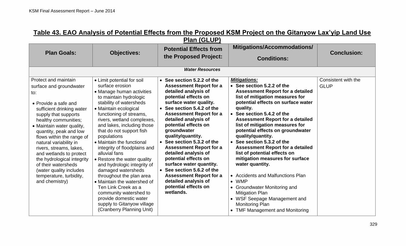
KSM Final Assessment Report – June 2014
329
Table 43. EAO Analysis of Potential Effects from the Proposed KSM Project on the Gitanyow Lax’yip Land Use Plan (GLUP)
Plan Goals: Objectives: Potential Effects from
the Proposed Project:
Mitigations/Accommodations/
Conditions: Conclusion:
Water Resources
Protect and maintain
surface and groundwater
to:
Provide a safe and sufficient drinking water supply that supports healthy communities;
Maintain water quality, quantity, peak and low flows within the range of natural variability in rivers, streams, lakes, and wetlands to protect the hydrological integrity of their watersheds (water quality includes temperature, turbidity, and chemistry)
Limit potential for soil surface erosion
Manage human activities to maintain hydrologic stability of watersheds
Maintain ecological functioning of streams, rivers, wetland complexes, and lakes, including those that do not support fish populations
Maintain the functional integrity of floodplains and alluvial fans
Restore the water quality and hydrologic integrity of damaged watersheds throughout the plan area
Maintain the watershed of Ten Link Creek as a community watershed to provide domestic water supply to Gitanyow village (Cranberry Planning Unit)
See section 5.2.2 of the Assessment Report for a detailed analysis of potential effects on surface water quality.
See section 5.4.2 of the Assessment Report for a detailed analysis of potential effects on groundwater quality/quantity.
See section 5.3.2 of the Assessment Report for a detailed analysis of potential effects on surface water quantity.
See section 5.6.2 of the Assessment Report for a detailed analysis of potential effects on wetlands.
Mitigations:
See section 5.2.2 of the Assessment Report for a detailed list of mitigation measures for potential effects on surface water quality.
See section 5.4.2 of the Assessment Report for a detailed list of mitigation measures for potential effects on groundwater quality/quantity.
See section 5.3.2 of the Assessment Report for a detailed list of potential effects on mitigation measures for surface water quantity.
Accidents and Malfunctions Plan
WMP
Groundwater Monitoring and Mitigation Plan
WSF Seepage Management and Monitoring Plan
TMF Management and Monitoring
Consistent with the
GLUP

KSM Final Assessment Report – June 2014
330
Wetlands
Wetlands would be affected by development of the CCAR and TCAR, construction camps #3 and #7, the Kerr Pit, the Sulphurets Laydown Area, the TMF, and the Treaty OPC.
Wetlands may be partially or entirely eliminated by proposed Project component development and/or wetland function may be altered or degraded through direct or indirect interactions with proposed Project components.
Groundwater
Application states that groundwater quantity effects would occur throughout construction, operations, closure and post-closure. Potential effects include changes in the surface water environment in the proposed Project area including changes in hydraulic gradients, flow
Plan
ML/ARD Management Plan
AEMP
SeMP
Terrain, Surficial Geology and Soil Management and Monitoring Plan
Closure and Reclamation Plan
Conditions:
In addition to the plans listed above,
there are 12 conditions related to water
management and five conditions
related to selenium management in the
TOC, including:
Requirements to meet BC Water Quality Guidelines or Site Specific Water Quality Objectives approved by the MOE during all phases of the proposed Project
Requirements to consult with First Nations, including the Gitanyow Nation
Requirements for agency and First Nation notification, and compliance with MOE direction regarding mitigation, in the event of contaminant level exceedances
Requirements to develop and
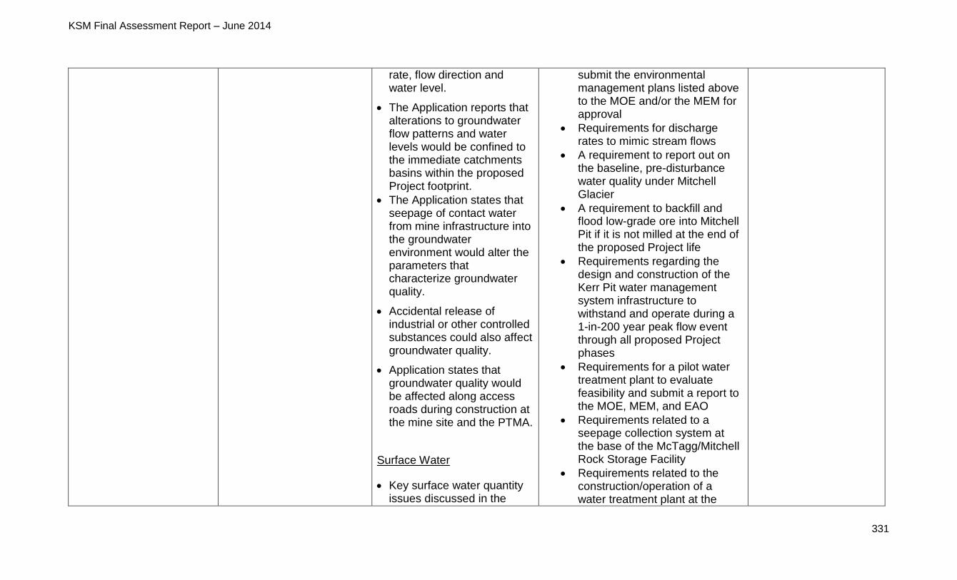
KSM Final Assessment Report – June 2014
331
rate, flow direction and water level.
The Application reports that alterations to groundwater flow patterns and water levels would be confined to the immediate catchments basins within the proposed Project footprint.
The Application states that seepage of contact water from mine infrastructure into the groundwater environment would alter the parameters that characterize groundwater quality.
Accidental release of industrial or other controlled substances could also affect groundwater quality.
Application states that groundwater quality would be affected along access roads during construction at the mine site and the PTMA.
Surface Water
Key surface water quantity issues discussed in the
submit the environmental management plans listed above to the MOE and/or the MEM for approval
Requirements for discharge rates to mimic stream flows
A requirement to report out on the baseline, pre-disturbance water quality under Mitchell Glacier
A requirement to backfill and flood low-grade ore into Mitchell Pit if it is not milled at the end of the proposed Project life
Requirements regarding the design and construction of the Kerr Pit water management system infrastructure to withstand and operate during a 1-in-200 year peak flow event through all proposed Project phases
Requirements for a pilot water treatment plant to evaluate feasibility and submit a report to the MOE, MEM, and EAO
Requirements related to a seepage collection system at the base of the McTagg/Mitchell Rock Storage Facility
Requirements related to the construction/operation of a water treatment plant at the
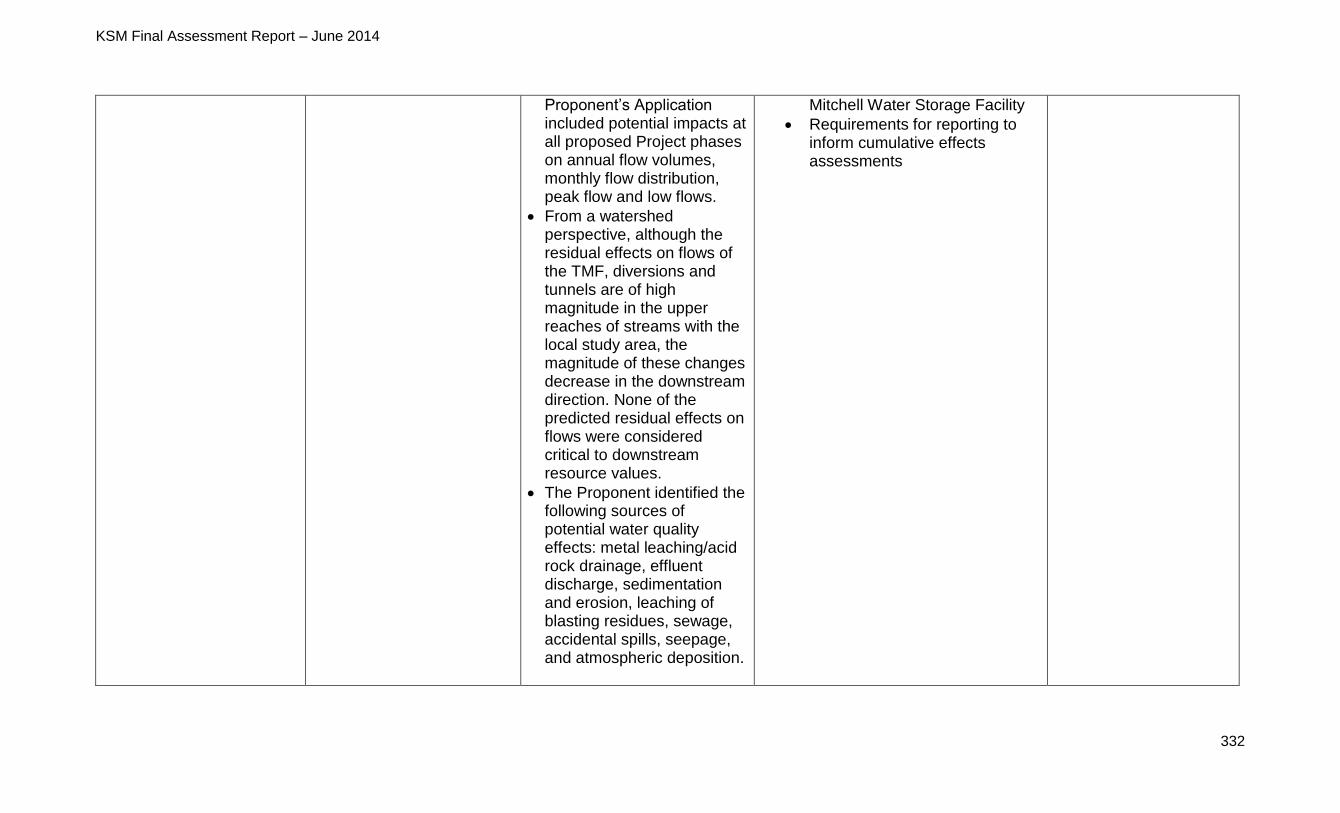
KSM Final Assessment Report – June 2014
332
Proponent’s Application included potential impacts at all proposed Project phases on annual flow volumes, monthly flow distribution, peak flow and low flows.
From a watershed perspective, although the residual effects on flows of the TMF, diversions and tunnels are of high magnitude in the upper reaches of streams with the local study area, the magnitude of these changes decrease in the downstream direction. None of the predicted residual effects on flows were considered critical to downstream resource values.
The Proponent identified the following sources of potential water quality effects: metal leaching/acid rock drainage, effluent discharge, sedimentation and erosion, leaching of blasting residues, sewage, accidental spills, seepage, and atmospheric deposition.
Mitchell Water Storage Facility
Requirements for reporting to inform cumulative effects assessments
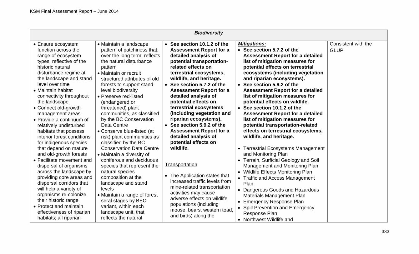
KSM Final Assessment Report – June 2014
333
Biodiversity
Ensure ecosystem function across the range of ecosystem types, reflective of the historic natural disturbance regime at the landscape and stand level over time
Maintain habitat connectivity throughout the landscape
Connect old-growth management areas
Provide a continuum of relatively undisturbed habitats that possess interior forest conditions for indigenous species that depend on mature and old-growth forests
Facilitate movement and dispersal of organisms across the landscape by providing core areas and dispersal corridors that will help a variety of organisms re-colonize their historic range
Protect and maintain effectiveness of riparian habitats; all riparian
Maintain a landscape pattern of patchiness that, over the long term, reflects the natural disturbance pattern
Maintain or recruit structured attributes of old forests to support stand-level biodiversity
Preserve red-listed (endangered or threatened) plant communities, as classified by the BC Conservation Data Centre
Conserve blue-listed (at risk) plant communities as classified by the BC Conservation Data Centre
Maintain a diversity of coniferous and deciduous species that represent the natural species composition at the landscape and stand levels
Maintain a range of forest seral stages by BEC variant, within each landscape unit, that reflects the natural
See section 10.1.2 of the Assessment Report for a detailed analysis of potential transportation-related effects on terrestrial ecosystems, wildlife, and heritage.
See section 5.7.2 of the Assessment Report for a detailed analysis of potential effects on terrestrial ecosystems (including vegetation and riparian ecosystems).
See section 5.9.2 of the Assessment Report for a detailed analysis of potential effects on wildlife.
Transportation
The Application states that increased traffic levels from mine-related transportation activities may cause adverse effects on wildlife populations (including moose, bears, western toad, and birds) along the
Mitigations:
See section 5.7.2 of the Assessment Report for a detailed list of mitigation measures for potential effects on terrestrial ecosystems (including vegetation and riparian ecosystems).
See section 5.9.2 of the Assessment Report for a detailed list of mitigation measures for potential effects on wildlife.
See section 10.1.2 of the Assessment Report for a detailed list of mitigation measures for potential transportation-related effects on terrestrial ecosystems, wildlife, and heritage.
Terrestrial Ecosystems Management and Monitoring Plan
Terrain, Surficial Geology and Soil Management and Monitoring Plan
Wildlife Effects Monitoring Plan
Traffic and Access Management Plan
Dangerous Goods and Hazardous Materials Management Plan
Emergency Response Plan
Spill Prevention and Emergency Response Plan
Northwest Wildlife and
Consistent with the
GLUP
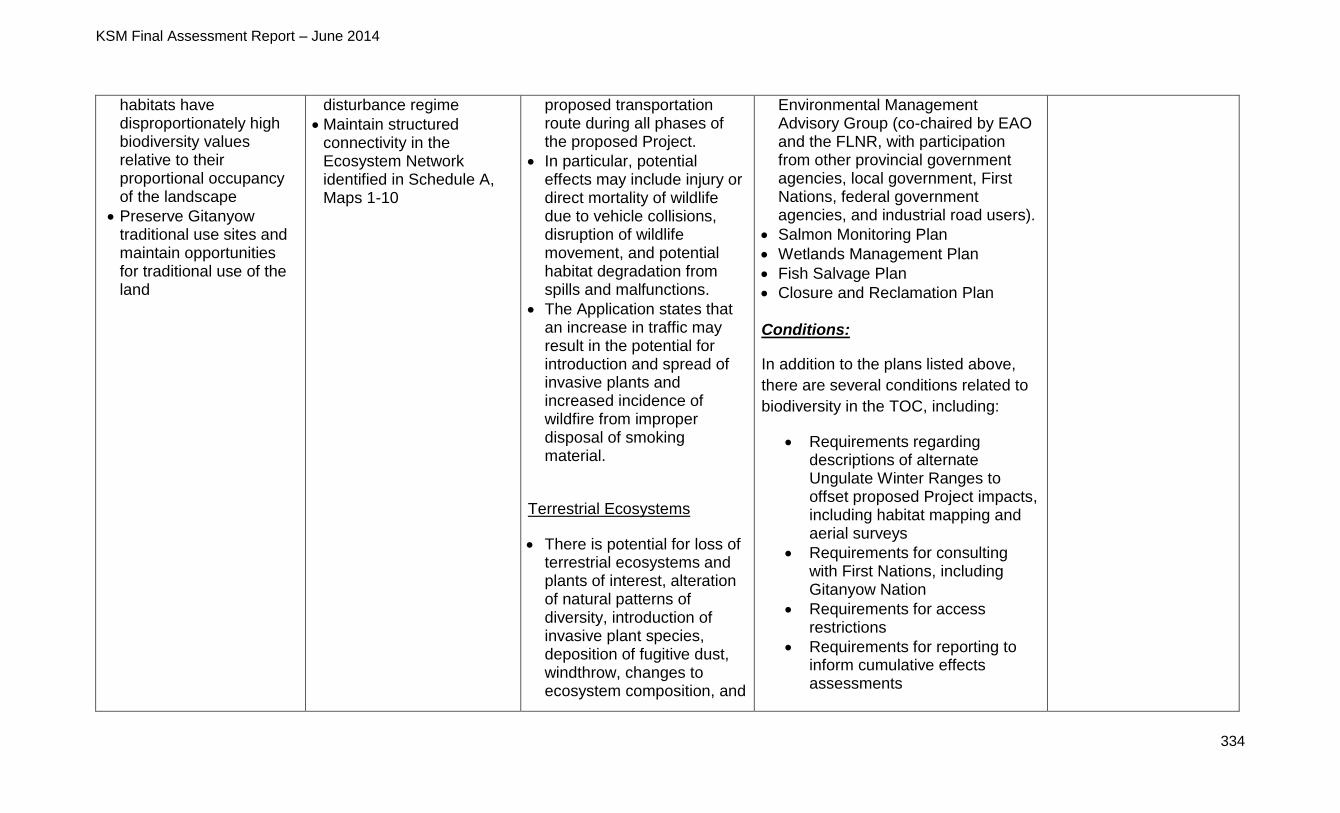
KSM Final Assessment Report – June 2014
334
habitats have disproportionately high biodiversity values relative to their proportional occupancy of the landscape
Preserve Gitanyow traditional use sites and maintain opportunities for traditional use of the land
disturbance regime
Maintain structured connectivity in the Ecosystem Network identified in Schedule A, Maps 1-10
proposed transportation route during all phases of the proposed Project.
In particular, potential effects may include injury or direct mortality of wildlife due to vehicle collisions, disruption of wildlife movement, and potential habitat degradation from spills and malfunctions.
The Application states that an increase in traffic may result in the potential for introduction and spread of invasive plants and increased incidence of wildfire from improper disposal of smoking material.
Terrestrial Ecosystems
There is potential for loss of terrestrial ecosystems and plants of interest, alteration of natural patterns of diversity, introduction of invasive plant species, deposition of fugitive dust, windthrow, changes to ecosystem composition, and
Environmental Management Advisory Group (co-chaired by EAO and the FLNR, with participation from other provincial government agencies, local government, First Nations, federal government agencies, and industrial road users).
Salmon Monitoring Plan
Wetlands Management Plan
Fish Salvage Plan
Closure and Reclamation Plan Conditions:
In addition to the plans listed above,
there are several conditions related to
biodiversity in the TOC, including:
Requirements regarding descriptions of alternate Ungulate Winter Ranges to offset proposed Project impacts, including habitat mapping and aerial surveys
Requirements for consulting with First Nations, including Gitanyow Nation
Requirements for access restrictions
Requirements for reporting to inform cumulative effects assessments
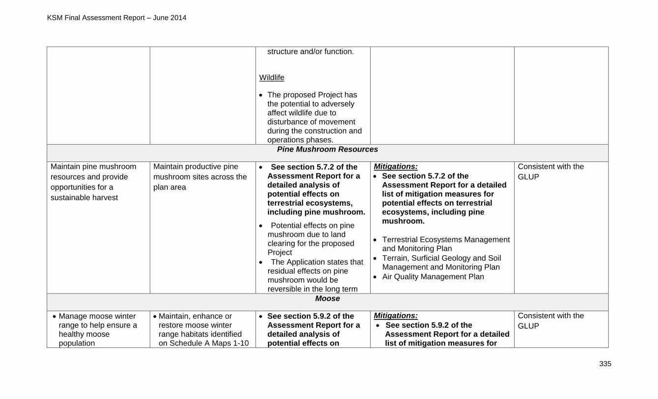
KSM Final Assessment Report – June 2014
335
structure and/or function.
Wildlife
The proposed Project has the potential to adversely affect wildlife due to disturbance of movement during the construction and operations phases.
Pine Mushroom Resources
Maintain pine mushroom
resources and provide
opportunities for a
sustainable harvest
Maintain productive pine
mushroom sites across the
plan area
See section 5.7.2 of the Assessment Report for a detailed analysis of potential effects on terrestrial ecosystems, including pine mushroom.
Potential effects on pine mushroom due to land clearing for the proposed Project
The Application states that residual effects on pine mushroom would be reversible in the long term
Mitigations:
See section 5.7.2 of the Assessment Report for a detailed list of mitigation measures for potential effects on terrestrial ecosystems, including pine mushroom.
Terrestrial Ecosystems Management and Monitoring Plan
Terrain, Surficial Geology and Soil Management and Monitoring Plan
Air Quality Management Plan
Consistent with the
GLUP
Moose
Manage moose winter range to help ensure a healthy moose population
Maintain, enhance or restore moose winter range habitats identified on Schedule A Maps 1-10
See section 5.9.2 of the Assessment Report for a detailed analysis of potential effects on
Mitigations:
See section 5.9.2 of the Assessment Report for a detailed list of mitigation measures for
Consistent with the
GLUP
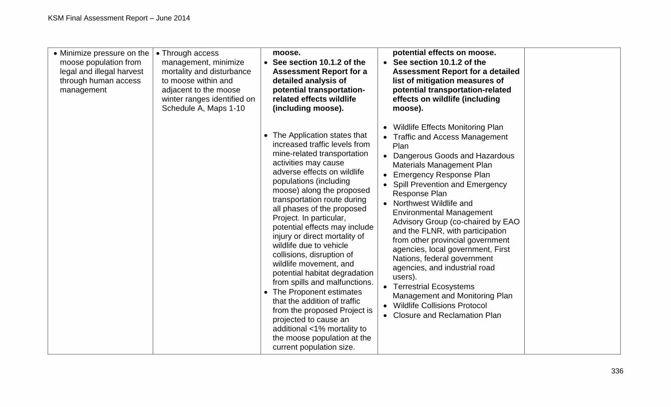
KSM Final Assessment Report – June 2014
336
Minimize pressure on the moose population from legal and illegal harvest through human access management
Through access management, minimize mortality and disturbance to moose within and adjacent to the moose winter ranges identified on Schedule A, Maps 1-10
moose.
See section 10.1.2 of the Assessment Report for a detailed analysis of potential transportation-related effects wildlife (including moose).
The Application states that increased traffic levels from mine-related transportation activities may cause adverse effects on wildlife populations (including moose) along the proposed transportation route during all phases of the proposed Project. In particular, potential effects may include injury or direct mortality of wildlife due to vehicle collisions, disruption of wildlife movement, and potential habitat degradation from spills and malfunctions.
The Proponent estimates that the addition of traffic from the proposed Project is projected to cause an additional <1% mortality to the moose population at the current population size.
potential effects on moose.
See section 10.1.2 of the Assessment Report for a detailed list of mitigation measures of potential transportation-related effects on wildlife (including moose).
Wildlife Effects Monitoring Plan
Traffic and Access Management Plan
Dangerous Goods and Hazardous Materials Management Plan
Emergency Response Plan
Spill Prevention and Emergency Response Plan
Northwest Wildlife and Environmental Management Advisory Group (co-chaired by EAO and the FLNR, with participation from other provincial government agencies, local government, First Nations, federal government agencies, and industrial road users).
Terrestrial Ecosystems Management and Monitoring Plan
Wildlife Collisions Protocol
Closure and Reclamation Plan
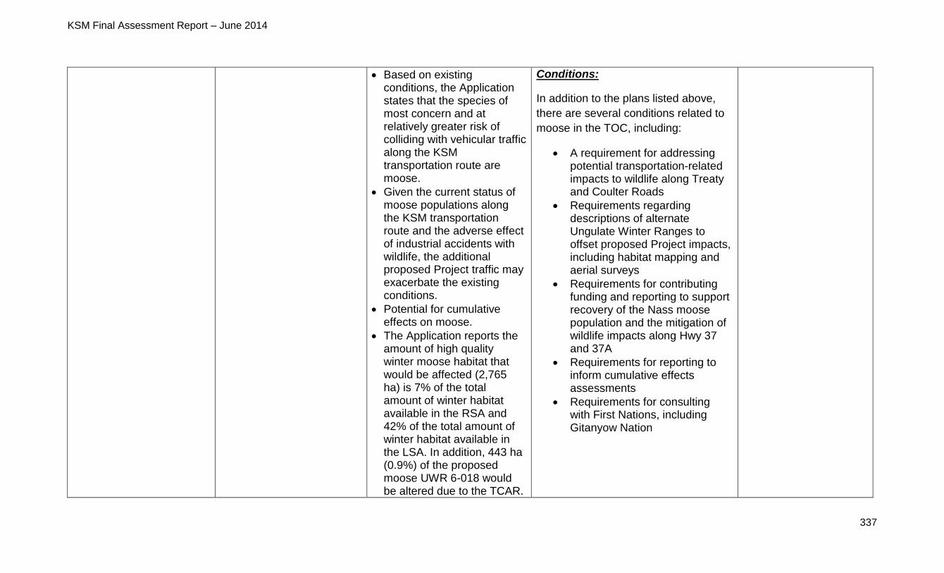
KSM Final Assessment Report – June 2014
337
Based on existing conditions, the Application states that the species of most concern and at relatively greater risk of colliding with vehicular traffic along the KSM transportation route are moose.
Given the current status of moose populations along the KSM transportation route and the adverse effect of industrial accidents with wildlife, the additional proposed Project traffic may exacerbate the existing conditions.
Potential for cumulative effects on moose.
The Application reports the amount of high quality winter moose habitat that would be affected (2,765 ha) is 7% of the total amount of winter habitat available in the RSA and 42% of the total amount of winter habitat available in the LSA. In addition, 443 ha (0.9%) of the proposed moose UWR 6-018 would be altered due to the TCAR.
Conditions:
In addition to the plans listed above,
there are several conditions related to
moose in the TOC, including:
A requirement for addressing potential transportation-related impacts to wildlife along Treaty and Coulter Roads
Requirements regarding descriptions of alternate Ungulate Winter Ranges to offset proposed Project impacts, including habitat mapping and aerial surveys
Requirements for contributing funding and reporting to support recovery of the Nass moose population and the mitigation of wildlife impacts along Hwy 37 and 37A
Requirements for reporting to inform cumulative effects assessments
Requirements for consulting with First Nations, including Gitanyow Nation
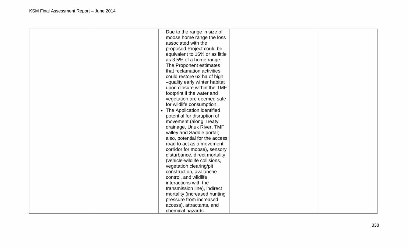
KSM Final Assessment Report – June 2014
338
Due to the range in size of moose home range the loss associated with the proposed Project could be equivalent to 16% or as little as 3.5% of a home range. The Proponent estimates that reclamation activities could restore 62 ha of high –quality early winter habitat upon closure within the TMF footprint if the water and vegetation are deemed safe for wildlife consumption.
The Application identified potential for disruption of movement (along Treaty drainage, Unuk River, TMF valley and Saddle portal; also, potential for the access road to act as a movement corridor for moose), sensory disturbance, direct mortality (vehicle-wildlife collisions, vegetation clearing/pit construction, avalanche control, and wildlife interactions with the transmission line), indirect mortality (increased hunting pressure from increased access), attractants, and chemical hazards.
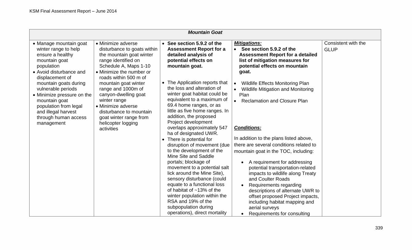
KSM Final Assessment Report – June 2014
339
Mountain Goat
Manage mountain goat winter range to help ensure a healthy mountain goat population
Avoid disturbance and displacement of mountain goats during vulnerable periods
Minimize pressure on the mountain goat population from legal and illegal harvest through human access management
Minimize adverse disturbance to goats within the mountain goat winter range identified on Schedule A, Maps 1-10
Minimize the number or roads within 500 m of mountain goat winter range and 1000m of canyon-dwelling goat winter range
Minimize adverse disturbance to mountain goat winter range from helicopter logging activities
See section 5.9.2 of the Assessment Report for a detailed analysis of potential effects on mountain goat.
The Application reports that the loss and alteration of winter goat habitat could be equivalent to a maximum of 69.4 home ranges, or as little as five home ranges. In addition, the proposed Project development overlaps approximately 547 ha of designated UWR.
There is potential for disruption of movement (due to the development of the Mine Site and Saddle portals; blockage of movement to a potential salt lick around the Mine Site), sensory disturbance (could equate to a functional loss of habitat of ~13% of the winter population within the RSA and 19% of the subpopulation during operations), direct mortality
Mitigations:
See section 5.9.2 of the Assessment Report for a detailed list of mitigation measures for potential effects on mountain goat.
Wildlife Effects Monitoring Plan
Wildlife Mitigation and Monitoring Plan
Reclamation and Closure Plan
Conditions:
In addition to the plans listed above,
there are several conditions related to
mountain goat in the TOC, including:
A requirement for addressing potential transportation-related impacts to wildlife along Treaty and Coulter Roads
Requirements regarding descriptions of alternate UWR to offset proposed Project impacts, including habitat mapping and aerial surveys
Requirements for consulting
Consistent with the
GLUP
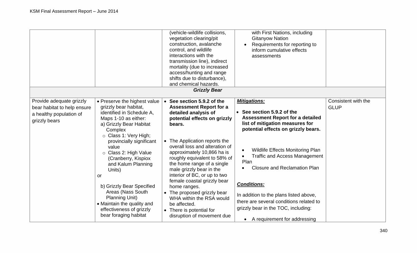
KSM Final Assessment Report – June 2014
340
(vehicle-wildlife collisions, vegetation clearing/pit construction, avalanche control, and wildlife interactions with the transmission line), indirect mortality (due to increased access/hunting and range shifts due to disturbance), and chemical hazards.
with First Nations, including Gitanyow Nation
Requirements for reporting to inform cumulative effects assessments
Grizzly Bear
Provide adequate grizzly
bear habitat to help ensure
a healthy population of
grizzly bears
Preserve the highest value grizzly bear habitat, identified in Schedule A, Maps 1-10 as either: a) Grizzly Bear Habitat
Complex o Class 1: Very High;
provincially significant value
o Class 2: High Value (Cranberry, Kispiox and Kalum Planning Units)
or
b) Grizzly Bear Specified Areas (Nass South Planning Unit)
Maintain the quality and effectiveness of grizzly bear foraging habitat
See section 5.9.2 of the Assessment Report for a detailed analysis of potential effects on grizzly bears.
The Application reports the overall loss and alteration of approximately 10,866 ha is roughly equivalent to 58% of the home range of a single male grizzly bear in the interior of BC, or up to two female coastal grizzly bear home ranges.
The proposed grizzly bear WHA within the RSA would be affected.
There is potential for disruption of movement due
Mitigations:
See section 5.9.2 of the Assessment Report for a detailed list of mitigation measures for potential effects on grizzly bears.
Wildlife Effects Monitoring Plan
Traffic and Access Management Plan
Closure and Reclamation Plan
Conditions:
In addition to the plans listed above,
there are several conditions related to
grizzly bear in the TOC, including:
A requirement for addressing
Consistent with the
GLUP
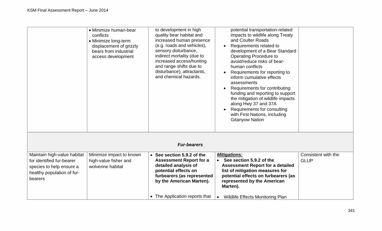
KSM Final Assessment Report – June 2014
341
Minimize human-bear conflicts
Minimize long-term displacement of grizzly bears from industrial access development
to development in high quality bear habitat and increased human presence (e.g. roads and vehicles), sensory disturbance, indirect mortality (due to increased access/hunting and range shifts due to disturbance), attractants, and chemical hazards.
potential transportation-related impacts to wildlife along Treaty and Coulter Roads
Requirements related to development of a Bear Standard Operating Procedure to avoid/reduce risks of bear-human conflicts
Requirements for reporting to inform cumulative effects assessments
Requirements for contributing funding and reporting to support the mitigation of wildlife impacts along Hwy 37 and 37A
Requirements for consulting with First Nations, including Gitanyow Nation
Fur-bearers
Maintain high-value habitat
for identified fur-bearer
species to help ensure a
healthy population of fur-
bearers
Minimize impact to known
high-value fisher and
wolverine habitat
See section 5.9.2 of the Assessment Report for a detailed analysis of potential effects on furbearers (as represented by the American Marten).
The Application reports that
Mitigations:
See section 5.9.2 of the Assessment Report for a detailed list of mitigation measures for potential effects on furbearers (as represented by the American Marten).
Wildlife Effects Monitoring Plan
Consistent with the
GLUP
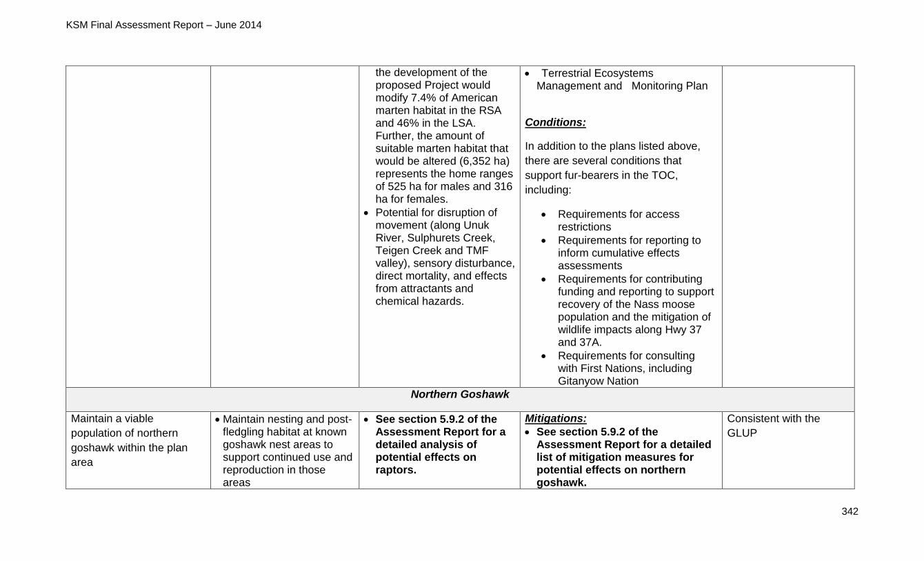
KSM Final Assessment Report – June 2014
342
the development of the proposed Project would modify 7.4% of American marten habitat in the RSA and 46% in the LSA. Further, the amount of suitable marten habitat that would be altered (6,352 ha) represents the home ranges of 525 ha for males and 316 ha for females.
Potential for disruption of movement (along Unuk River, Sulphurets Creek, Teigen Creek and TMF valley), sensory disturbance, direct mortality, and effects from attractants and chemical hazards.
Terrestrial Ecosystems Management and Monitoring Plan
Conditions:
In addition to the plans listed above,
there are several conditions that
support fur-bearers in the TOC,
including:
Requirements for access restrictions
Requirements for reporting to inform cumulative effects assessments
Requirements for contributing funding and reporting to support recovery of the Nass moose population and the mitigation of wildlife impacts along Hwy 37 and 37A.
Requirements for consulting with First Nations, including Gitanyow Nation
Northern Goshawk
Maintain a viable
population of northern
goshawk within the plan
area
Maintain nesting and post-fledgling habitat at known goshawk nest areas to support continued use and reproduction in those areas
See section 5.9.2 of the Assessment Report for a detailed analysis of potential effects on raptors.
Mitigations:
See section 5.9.2 of the Assessment Report for a detailed list of mitigation measures for potential effects on northern goshawk.
Consistent with the
GLUP
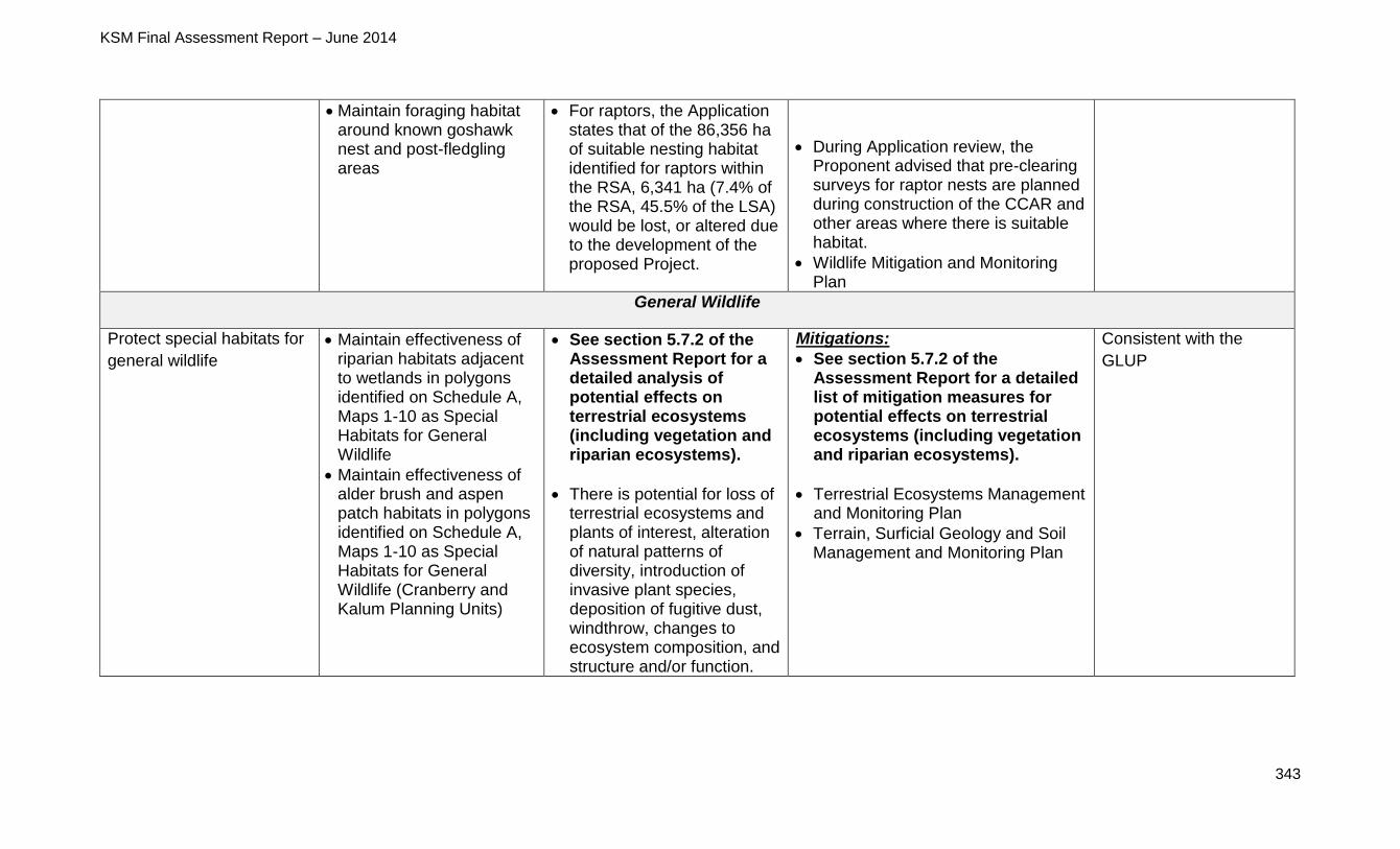
KSM Final Assessment Report – June 2014
343
Maintain foraging habitat around known goshawk nest and post-fledgling areas
For raptors, the Application states that of the 86,356 ha of suitable nesting habitat identified for raptors within the RSA, 6,341 ha (7.4% of the RSA, 45.5% of the LSA) would be lost, or altered due to the development of the proposed Project.
During Application review, the Proponent advised that pre-clearing surveys for raptor nests are planned during construction of the CCAR and other areas where there is suitable habitat.
Wildlife Mitigation and Monitoring Plan
General Wildlife
Protect special habitats for
general wildlife
Maintain effectiveness of riparian habitats adjacent to wetlands in polygons identified on Schedule A, Maps 1-10 as Special Habitats for General Wildlife
Maintain effectiveness of alder brush and aspen patch habitats in polygons identified on Schedule A, Maps 1-10 as Special Habitats for General Wildlife (Cranberry and Kalum Planning Units)
See section 5.7.2 of the Assessment Report for a detailed analysis of potential effects on terrestrial ecosystems (including vegetation and riparian ecosystems).
There is potential for loss of terrestrial ecosystems and plants of interest, alteration of natural patterns of diversity, introduction of invasive plant species, deposition of fugitive dust, windthrow, changes to ecosystem composition, and structure and/or function.
Mitigations:
See section 5.7.2 of the Assessment Report for a detailed list of mitigation measures for potential effects on terrestrial ecosystems (including vegetation and riparian ecosystems).
Terrestrial Ecosystems Management and Monitoring Plan
Terrain, Surficial Geology and Soil Management and Monitoring Plan
Consistent with the
GLUP
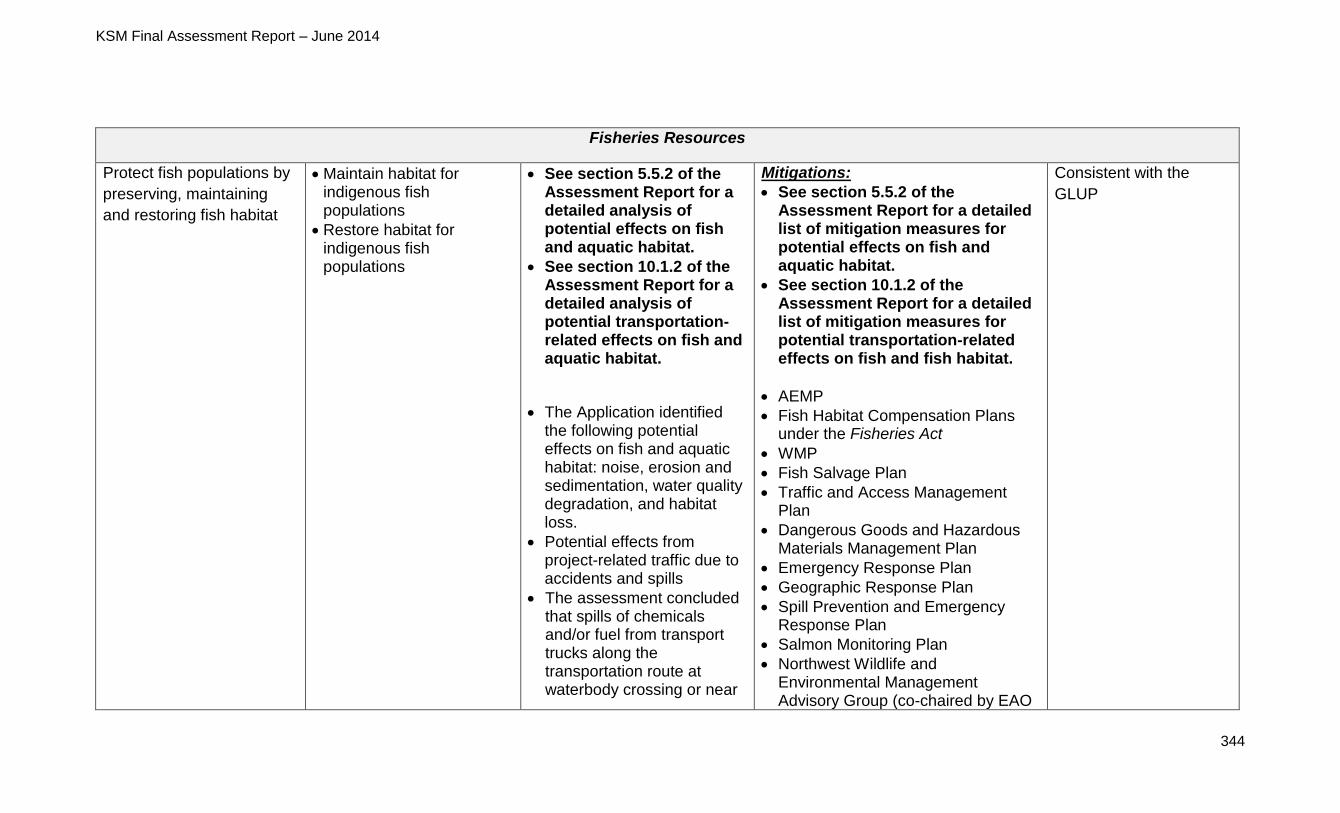
KSM Final Assessment Report – June 2014
344
Fisheries Resources
Protect fish populations by
preserving, maintaining
and restoring fish habitat
Maintain habitat for indigenous fish populations
Restore habitat for indigenous fish populations
See section 5.5.2 of the Assessment Report for a detailed analysis of potential effects on fish and aquatic habitat.
See section 10.1.2 of the Assessment Report for a detailed analysis of potential transportation-related effects on fish and aquatic habitat.
The Application identified the following potential effects on fish and aquatic habitat: noise, erosion and sedimentation, water quality degradation, and habitat loss.
Potential effects from project-related traffic due to accidents and spills
The assessment concluded that spills of chemicals and/or fuel from transport trucks along the transportation route at waterbody crossing or near
Mitigations:
See section 5.5.2 of the Assessment Report for a detailed list of mitigation measures for potential effects on fish and aquatic habitat.
See section 10.1.2 of the Assessment Report for a detailed list of mitigation measures for potential transportation-related effects on fish and fish habitat.
AEMP
Fish Habitat Compensation Plans under the Fisheries Act
WMP
Fish Salvage Plan
Traffic and Access Management Plan
Dangerous Goods and Hazardous Materials Management Plan
Emergency Response Plan
Geographic Response Plan
Spill Prevention and Emergency Response Plan
Salmon Monitoring Plan
Northwest Wildlife and Environmental Management Advisory Group (co-chaired by EAO
Consistent with the
GLUP
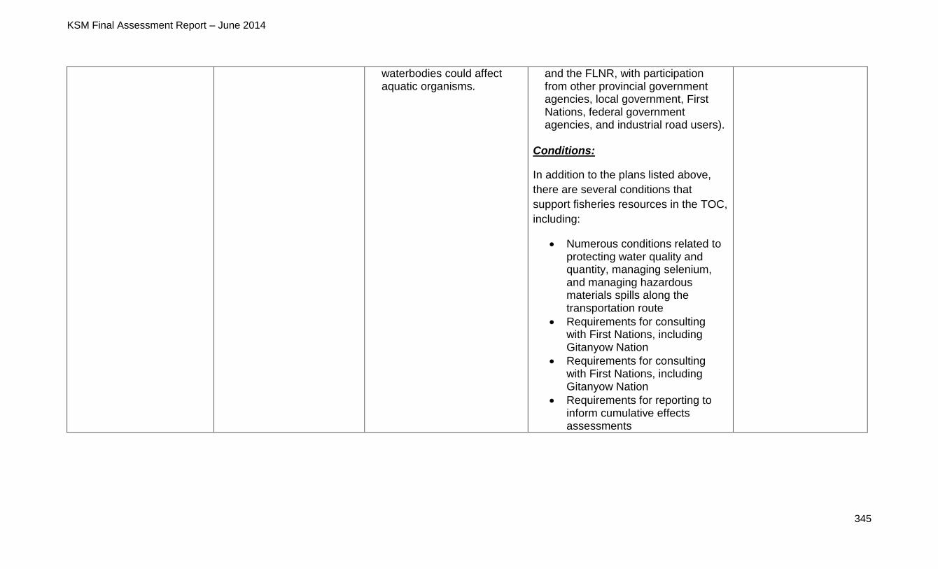
KSM Final Assessment Report – June 2014
345
waterbodies could affect aquatic organisms.
and the FLNR, with participation from other provincial government agencies, local government, First Nations, federal government agencies, and industrial road users).
Conditions:
In addition to the plans listed above,
there are several conditions that
support fisheries resources in the TOC,
including:
Numerous conditions related to protecting water quality and quantity, managing selenium, and managing hazardous materials spills along the transportation route
Requirements for consulting with First Nations, including Gitanyow Nation
Requirements for consulting with First Nations, including Gitanyow Nation
Requirements for reporting to inform cumulative effects assessments
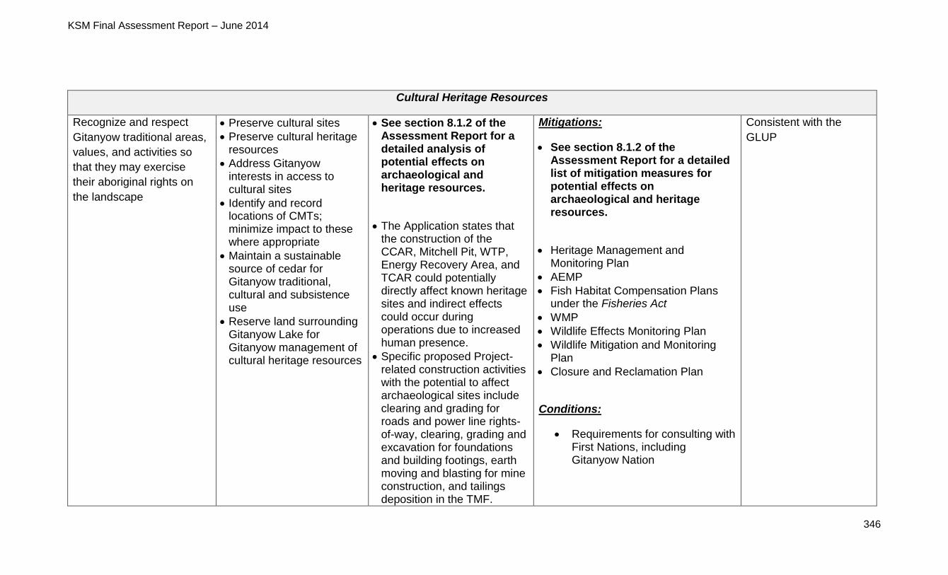
KSM Final Assessment Report – June 2014
346
Cultural Heritage Resources
Recognize and respect
Gitanyow traditional areas,
values, and activities so
that they may exercise
their aboriginal rights on
the landscape
Preserve cultural sites
Preserve cultural heritage resources
Address Gitanyow interests in access to cultural sites
Identify and record locations of CMTs; minimize impact to these where appropriate
Maintain a sustainable source of cedar for Gitanyow traditional, cultural and subsistence use
Reserve land surrounding Gitanyow Lake for Gitanyow management of cultural heritage resources
See section 8.1.2 of the Assessment Report for a detailed analysis of potential effects on archaeological and heritage resources.
The Application states that the construction of the CCAR, Mitchell Pit, WTP, Energy Recovery Area, and TCAR could potentially directly affect known heritage sites and indirect effects could occur during operations due to increased human presence.
Specific proposed Project-related construction activities with the potential to affect archaeological sites include clearing and grading for roads and power line rights-of-way, clearing, grading and excavation for foundations and building footings, earth moving and blasting for mine construction, and tailings deposition in the TMF.
Mitigations:
See section 8.1.2 of the Assessment Report for a detailed list of mitigation measures for potential effects on archaeological and heritage resources.
Heritage Management and Monitoring Plan
AEMP
Fish Habitat Compensation Plans under the Fisheries Act
WMP
Wildlife Effects Monitoring Plan
Wildlife Mitigation and Monitoring Plan
Closure and Reclamation Plan
Conditions:
Requirements for consulting with First Nations, including Gitanyow Nation
Consistent with the
GLUP

KSM Final Assessment Report – June 2014
347
The Application reports that five of the 37 archaeological sites identified during the AIAs are in direct conflict with proposed Project-related activity (four lithic scatters and one artifact find), while two sites may be indirectly affected (both are lithic scatters).
Timber Resources
Promote full utilization of productive sites while providing stable or increased harvest levels
Develop a sustainable and economically viable forest industry that contributes to the local community over the short and long terms, while respecting Gitanyow interests
Dedicate and maintain a productive timber harvesting land base, that promotes an economically sustainable forest industry
Avoid timber harvesting within proposed treaty settlement lands shown on Schedule A, Maps 1-10 (from Gitanyow Treaty Settlement Lands Offer – 2002)
Manage the forest harvest to represent the timber quality and terrain profile
Maintain the long-term health and site productivity of the timber harvesting land base
Limit conversion of the available productive forest
N/A N/A N/A
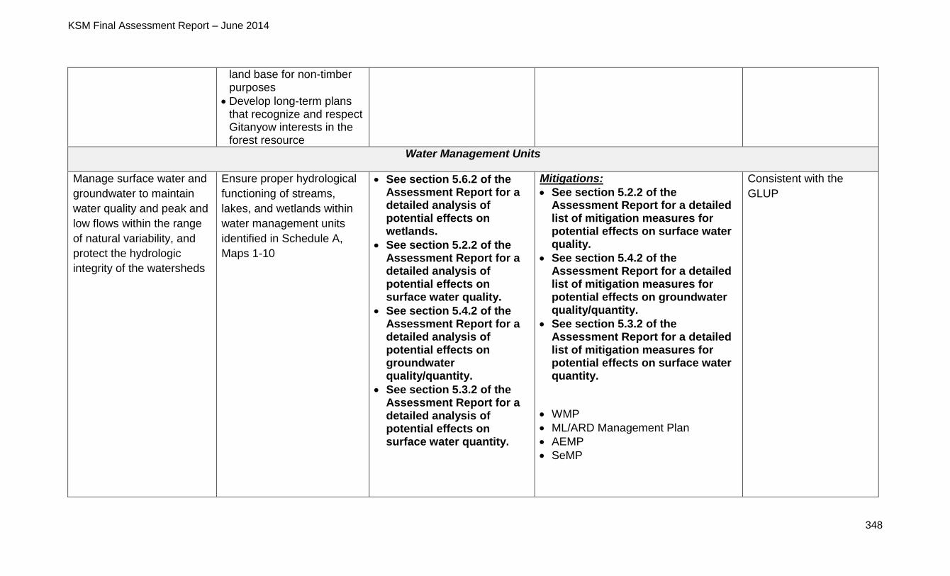
KSM Final Assessment Report – June 2014
348
land base for non-timber purposes
Develop long-term plans that recognize and respect Gitanyow interests in the forest resource
Water Management Units
Manage surface water and
groundwater to maintain
water quality and peak and
low flows within the range
of natural variability, and
protect the hydrologic
integrity of the watersheds
Ensure proper hydrological
functioning of streams,
lakes, and wetlands within
water management units
identified in Schedule A,
Maps 1-10
See section 5.6.2 of the Assessment Report for a detailed analysis of potential effects on wetlands.
See section 5.2.2 of the Assessment Report for a detailed analysis of potential effects on surface water quality.
See section 5.4.2 of the Assessment Report for a detailed analysis of potential effects on groundwater quality/quantity.
See section 5.3.2 of the Assessment Report for a detailed analysis of potential effects on surface water quantity.
Mitigations:
See section 5.2.2 of the Assessment Report for a detailed list of mitigation measures for potential effects on surface water quality.
See section 5.4.2 of the Assessment Report for a detailed list of mitigation measures for potential effects on groundwater quality/quantity.
See section 5.3.2 of the Assessment Report for a detailed list of mitigation measures for potential effects on surface water quantity.
WMP
ML/ARD Management Plan
AEMP
SeMP
Consistent with the
GLUP
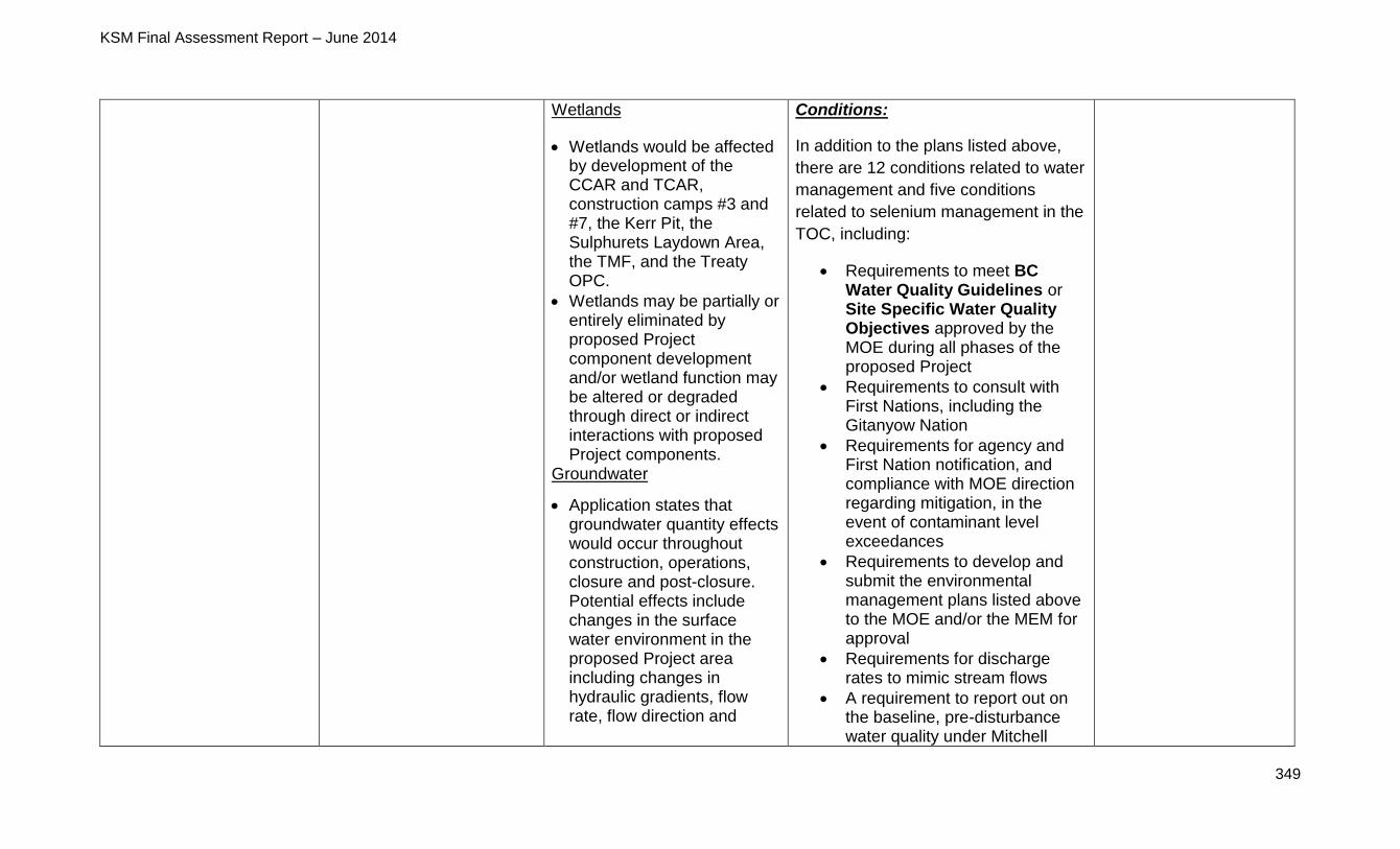
KSM Final Assessment Report – June 2014
349
Wetlands
Wetlands would be affected by development of the CCAR and TCAR, construction camps #3 and #7, the Kerr Pit, the Sulphurets Laydown Area, the TMF, and the Treaty OPC.
Wetlands may be partially or entirely eliminated by proposed Project component development and/or wetland function may be altered or degraded through direct or indirect interactions with proposed Project components.
Groundwater
Application states that groundwater quantity effects would occur throughout construction, operations, closure and post-closure. Potential effects include changes in the surface water environment in the proposed Project area including changes in hydraulic gradients, flow rate, flow direction and
Conditions:
In addition to the plans listed above,
there are 12 conditions related to water
management and five conditions
related to selenium management in the
TOC, including:
Requirements to meet BC Water Quality Guidelines or Site Specific Water Quality Objectives approved by the MOE during all phases of the proposed Project
Requirements to consult with First Nations, including the Gitanyow Nation
Requirements for agency and First Nation notification, and compliance with MOE direction regarding mitigation, in the event of contaminant level exceedances
Requirements to develop and submit the environmental management plans listed above to the MOE and/or the MEM for approval
Requirements for discharge rates to mimic stream flows
A requirement to report out on the baseline, pre-disturbance water quality under Mitchell
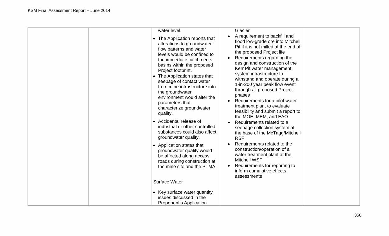
KSM Final Assessment Report – June 2014
350
water level.
The Application reports that alterations to groundwater flow patterns and water levels would be confined to the immediate catchments basins within the proposed Project footprint.
The Application states that seepage of contact water from mine infrastructure into the groundwater environment would alter the parameters that characterize groundwater quality.
Accidental release of industrial or other controlled substances could also affect groundwater quality.
Application states that groundwater quality would be affected along access roads during construction at the mine site and the PTMA.
Surface Water
Key surface water quantity issues discussed in the Proponent’s Application
Glacier
A requirement to backfill and flood low-grade ore into Mitchell Pit if it is not milled at the end of the proposed Project life
Requirements regarding the design and construction of the Kerr Pit water management system infrastructure to withstand and operate during a 1-in-200 year peak flow event through all proposed Project phases
Requirements for a pilot water treatment plant to evaluate feasibility and submit a report to the MOE, MEM, and EAO
Requirements related to a seepage collection system at the base of the McTagg/Mitchell RSF
Requirements related to the construction/operation of a water treatment plant at the Mitchell WSF
Requirements for reporting to inform cumulative effects assessments

KSM Final Assessment Report – June 2014
351
included potential impacts at all proposed Project phases on annual flow volumes, monthly flow distribution, peak flow and low flows.
From a watershed perspective, although the residual effects on flows of the TMF, diversions and tunnels are of high magnitude in the upper reaches of streams with the local study area, the magnitude of these changes decrease in the downstream direction. None of the predicted residual effects on flows were considered critical to downstream resource values.
The Proponent identified the following sources of potential water quality effects: metal leaching/acid rock drainage, effluent discharge, sedimentation and erosion, leaching of blasting residues, sewage, accidental spills, seepage, and atmospheric deposition.
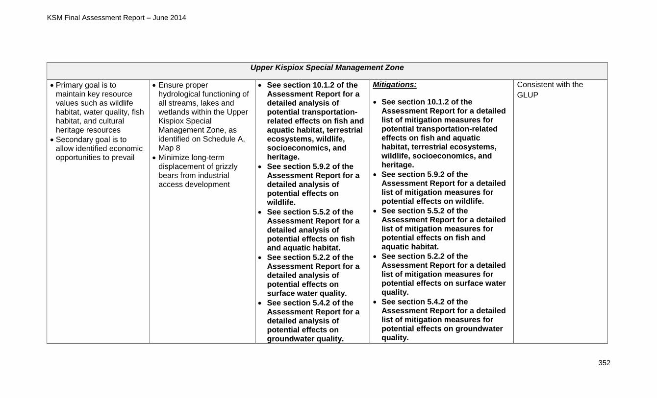
KSM Final Assessment Report – June 2014
352
Upper Kispiox Special Management Zone
Primary goal is to maintain key resource values such as wildlife habitat, water quality, fish habitat, and cultural heritage resources
Secondary goal is to allow identified economic opportunities to prevail
Ensure proper hydrological functioning of all streams, lakes and wetlands within the Upper Kispiox Special Management Zone, as identified on Schedule A, Map 8
Minimize long-term displacement of grizzly bears from industrial access development
See section 10.1.2 of the Assessment Report for a detailed analysis of potential transportation-related effects on fish and aquatic habitat, terrestrial ecosystems, wildlife, socioeconomics, and heritage.
See section 5.9.2 of the Assessment Report for a detailed analysis of potential effects on wildlife.
See section 5.5.2 of the Assessment Report for a detailed analysis of potential effects on fish and aquatic habitat.
See section 5.2.2 of the Assessment Report for a detailed analysis of potential effects on surface water quality.
See section 5.4.2 of the Assessment Report for a detailed analysis of potential effects on groundwater quality.
Mitigations:
See section 10.1.2 of the Assessment Report for a detailed list of mitigation measures for potential transportation-related effects on fish and aquatic habitat, terrestrial ecosystems, wildlife, socioeconomics, and heritage.
See section 5.9.2 of the Assessment Report for a detailed list of mitigation measures for potential effects on wildlife.
See section 5.5.2 of the Assessment Report for a detailed list of mitigation measures for potential effects on fish and aquatic habitat.
See section 5.2.2 of the Assessment Report for a detailed list of mitigation measures for potential effects on surface water quality.
See section 5.4.2 of the Assessment Report for a detailed list of mitigation measures for potential effects on groundwater quality.
Consistent with the
GLUP
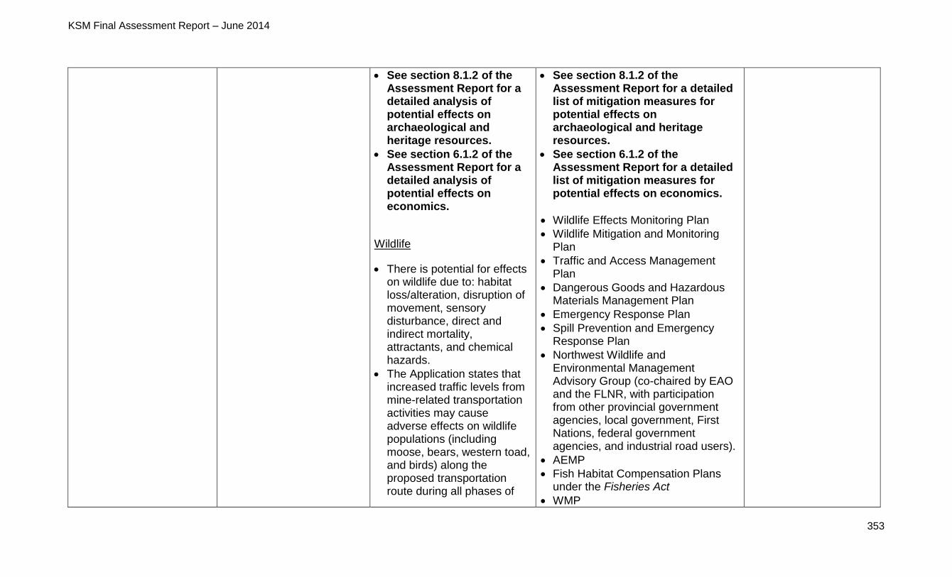
KSM Final Assessment Report – June 2014
353
See section 8.1.2 of the Assessment Report for a detailed analysis of potential effects on archaeological and heritage resources.
See section 6.1.2 of the Assessment Report for a detailed analysis of potential effects on economics.
Wildlife
There is potential for effects on wildlife due to: habitat loss/alteration, disruption of movement, sensory disturbance, direct and indirect mortality, attractants, and chemical hazards.
The Application states that increased traffic levels from mine-related transportation activities may cause adverse effects on wildlife populations (including moose, bears, western toad, and birds) along the proposed transportation route during all phases of
See section 8.1.2 of the Assessment Report for a detailed list of mitigation measures for potential effects on archaeological and heritage resources.
See section 6.1.2 of the Assessment Report for a detailed list of mitigation measures for potential effects on economics.
Wildlife Effects Monitoring Plan
Wildlife Mitigation and Monitoring Plan
Traffic and Access Management Plan
Dangerous Goods and Hazardous Materials Management Plan
Emergency Response Plan
Spill Prevention and Emergency Response Plan
Northwest Wildlife and Environmental Management Advisory Group (co-chaired by EAO and the FLNR, with participation from other provincial government agencies, local government, First Nations, federal government agencies, and industrial road users).
AEMP
Fish Habitat Compensation Plans under the Fisheries Act
WMP
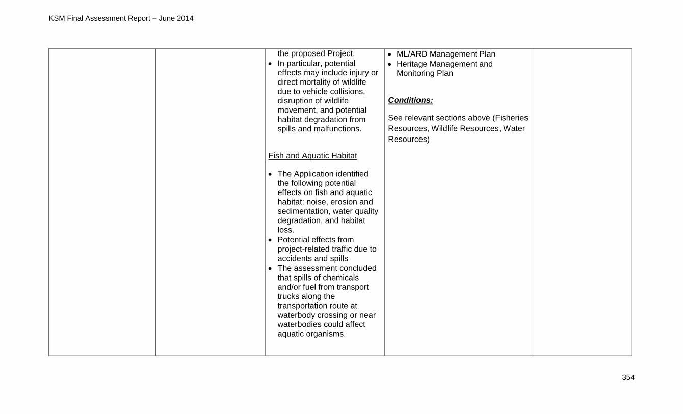
KSM Final Assessment Report – June 2014
354
the proposed Project.
In particular, potential effects may include injury or direct mortality of wildlife due to vehicle collisions, disruption of wildlife movement, and potential habitat degradation from spills and malfunctions.
Fish and Aquatic Habitat
The Application identified the following potential effects on fish and aquatic habitat: noise, erosion and sedimentation, water quality degradation, and habitat loss.
Potential effects from project-related traffic due to accidents and spills
The assessment concluded that spills of chemicals and/or fuel from transport trucks along the transportation route at waterbody crossing or near waterbodies could affect aquatic organisms.
ML/ARD Management Plan
Heritage Management and Monitoring Plan
Conditions:
See relevant sections above (Fisheries
Resources, Wildlife Resources, Water
Resources)
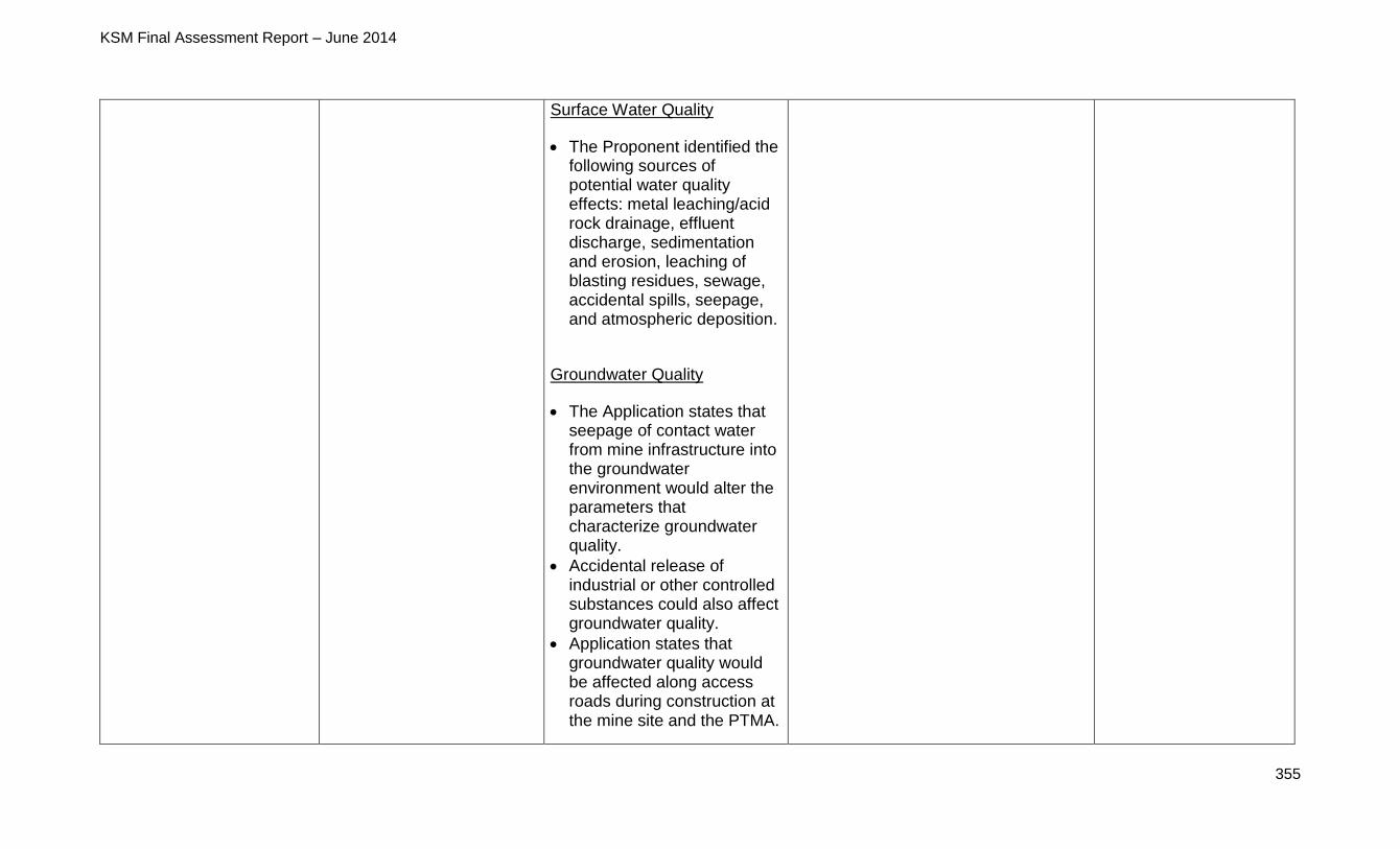
KSM Final Assessment Report – June 2014
355
Surface Water Quality
The Proponent identified the following sources of potential water quality effects: metal leaching/acid rock drainage, effluent discharge, sedimentation and erosion, leaching of blasting residues, sewage, accidental spills, seepage, and atmospheric deposition.
Groundwater Quality
The Application states that seepage of contact water from mine infrastructure into the groundwater environment would alter the parameters that characterize groundwater quality.
Accidental release of industrial or other controlled substances could also affect groundwater quality.
Application states that groundwater quality would be affected along access roads during construction at the mine site and the PTMA.
KSM Final Assessment Report – June 2014
356
Heritage Resources
The Application states that the construction of the CCAR, Mitchell Pit, WTP, Energy Recovery Area, and TCAR could potentially directly affect known heritage sites and indirect effects could occur during operations due to increased human presence.
Specific proposed Project-related construction activities with the potential to affect archaeological sites include clearing and grading for roads and power line rights-of-way, clearing, grading and excavation for foundations and building footings, earth moving and blasting for mine construction, and tailings deposition in the TMF.
The Application reports that five of the 37 archaeological sites identified during the AIAs are in direct conflict with proposed Project-related activity (four lithic scatters and one artifact find), while two sites may be
KSM Final Assessment Report – June 2014
357
indirectly affected (both are lithic scatters).
Socioeconomics
The Application reports that the proposed Project is expected to generate substantial employment opportunities, as well as spending on supplies and services, resulting in direct and spin-off (indirect and induced) economic impacts that would include increases in employment, personal income and overall economic value-added (GDP).
The proposed Project would also contribute to government revenues through personal income tax, corporate profit tax and sales tax, and would also pay rural property tax and revenues (BC mineral tax).
The Application predicts that Project-related changes in income and GDP would result in a beneficial residual effect on business
KSM Final Assessment Report – June 2014
358
opportunities and economic development.
Transportation of equipment, personnel, and materials to and from the proposed Mine Site is described in the Application to have possible effects on land use, quality of the natural environment, and community well-being.
Area To Be Protected
Protect key resource
values such as fisheries,
wildlife, recreation and
cultural heritage resources
while allowing for
continued traditional use
activity and identified
economic opportunities to
prevail
Maintain conservation, recreation, and cultural heritage values and features and features within the area to be protected identified as the Hanna-Tintina Area to be protected in Schedule A, map 1
Recognize the rights and interests of existing eligible tenures within the area to be protected
Maintain ecosystem representation, abundance and integrity, and protect key resource values and natural features
Protect cultural heritage values
See section 10.1.2 of the Assessment Report for a detailed analysis of potential transportation-related effects on fish and aquatic habitat, wildlife, socioeconomics, and heritage.
See section 8.1.2 of the Assessment Report for a detailed analysis of potential effects on archaeological and heritage resources.
See section 5.5.2 of the Assessment Report for a detailed analysis of potential effects on fish and aquatic habitat.
See section 5.9.2 of the
Mitigations:
See section 8.1.2 of the Assessment Report for a detailed list of mitigation measures for potential effects on archaeological and heritage resources.
See section 6.1.2 of the Assessment Report for a detailed list of mitigation measures for potential effects on economics.
See section 5.5.2 of the Assessment Report for a detailed list of mitigation measures for potential effects on fish and aquatic habitat.
See section 5.9.2 of the Assessment Report for a detailed list of mitigation measures for
Consistent with the
GLUP
KSM Final Assessment Report – June 2014
359
Recognize hunting and angling as an acceptable use within Protected Areas
Assessment Report for a detailed analysis of potential effects on wildlife.
See section 7.1.2 of the Assessment Report for a detailed analysis of potential social effects, including recreation.
See section 6.1.2 of the Assessment Report for a detailed analysis of potential effects on economics.
Heritage Resources
The Application states that the construction of the CCAR, Mitchell Pit, WTP, Energy Recovery Area, and TCAR could potentially directly affect known heritage sites and indirect effects could occur during operations due to increased human presence.
Specific proposed Project-related construction activities with the potential to affect archaeological sites include clearing and grading
potential effects on wildlife.
See section 7.1.2 of the Assessment Report for a detailed list of mitigation measures for potential effects on social effects, including recreation.
See section 10.1.2 of the Assessment Report for a detailed list of mitigation measures for potential transportation-related effects on fish and aquatic habitat, socioeconomics, and heritage.
Heritage Management and Monitoring Plan
AEMP
Fish Habitat Compensation Plans under the Fisheries Act
WMP
Wildlife Effects Monitoring Plan
Wildlife Mitigation and Monitoring Plan
Closure and Reclamation Plan
Procurement Strategy
Traffic and Access Management Plan
Dangerous Goods and Hazardous Materials Management Plan
Emergency Response Plan
Spill Prevention and Emergency Response Plan
KSM Final Assessment Report – June 2014
360
for roads and power line rights-of-way, clearing, grading and excavation for foundations and building footings, earth moving and blasting for mine construction, and tailings deposition in the TMF.
The Application reports that five of the 37 archaeological sites identified during the AIAs are in direct conflict with proposed Project-related activity (four lithic scatters and one artifact find), while two sites may be indirectly affected (both are lithic scatters).
Fisheries Resources
The Application identified the following potential effects on fish and aquatic habitat: noise, erosion and sedimentation, water quality degradation, and habitat loss.
Potential effects from project-related traffic due to accidents and spills
The assessment concluded
Northwest Wildlife and Environmental Management Advisory Group (co-chaired by EAO and the FLNR, with participation from other provincial government agencies, local government, First Nations, federal government agencies, and industrial road users).
Conditions:
See relevant sections above (Fisheries
Resources, Wildlife Resources)
KSM Final Assessment Report – June 2014
361
that spills of chemicals and/or fuel from transport trucks along the transportation route at waterbody crossing or near waterbodies could affect aquatic organisms.
Wildlife Resources
There is potential for effects on wildlife due to: habitat loss/alteration, disruption of movement, sensory disturbance, direct and indirect mortality, attractants, and chemical hazards.
The Application states that increased traffic levels from mine-related transportation activities may cause adverse effects on wildlife populations (including moose, bears, western toad, and birds) along the proposed transportation route during all phases of the proposed Project.
In particular, potential effects may include injury or direct mortality of wildlife

KSM Final Assessment Report – June 2014
362
due to vehicle collisions, disruption of wildlife movement, and potential habitat degradation from spills and malfunctions.
Recreation
There is potential for effects on recreational hunters and fishers (due to access restrictions to the land and resources) and commercial recreation stakeholders (as a result of sensory disturbances).
Socioeconomics
The Application reports that the proposed Project is expected to generate substantial employment opportunities, as well as spending on supplies and services, resulting in direct and spin-off (indirect and induced) economic impacts that would include increases in employment, personal income and overall economic value-added
KSM Final Assessment Report – June 2014
363
(GDP).
The proposed Project would also contribute to government revenues through personal income tax, corporate profit tax and sales tax, and would also pay rural property tax and revenues (BC mineral tax).
The Application predicts that Project-related changes in income and GDP would result in a beneficial residual effect on business opportunities and economic development.
Transportation of equipment, personnel, and materials to and from the proposed Mine Site is described in the Application to have possible effects on land use, quality of the natural environment, and community well-being.

KSM Final Assessment Report – June 2014
365
12.2 Gitxsan Nation (including wilp Skii km Lax Ha)
12.2.1 Gitxsan Nation Overview
The term Gitxsan means “people of the Skeena River”. Gitxsan Nation’s asserted
traditional territory is situated on the Skeena River above the Kitselas Canyon, and in
the watershed of the upper Skeena, Nass and Babine Rivers and their tributaries,
totalling 33,000 sq km (Figure 23).
The social unit of Gitxsan society is the wilp (house). Each Wilp has a head chief and is
associated with one of the four pdek (clans): Lax Gibuu (Wolf), Lax Se’el (Frog) Lax
Ganeda (Raven), Gisk’aast (Fireweed/Killer Whale/Grizzly). Gitxsan Nation considers
the wilp to be the sole land and resource managing authority within their specific
territory (lax yip). In Gitxsan Nation, there are 62 huwilp (house groups) recognized by
ayookw (law), and each wilp has a membership list of 50 to 250 persons. Today, the
total membership of Gitxsan Nation is estimated by the Gitxsan Nation to be more than
13,000.
Currently there is no single political organization that represents all Gitxsan Huwilp
regarding asserted claims to aboriginal rights and title (Aboriginal Interests). For the
proposed Project, the Province consulted the wilp that is geographically closest to the
proposed Crown action or decision on behalf of the broader Gitxsan Nation. Wilp Skii
km Lax Ha asserts a traditional territory separate from the rest of the Gitxsan Nation
and was consulted directly.
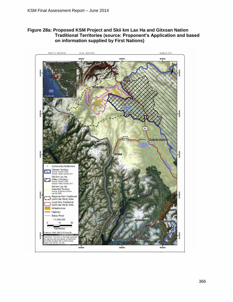
KSM Final Assessment Report – June 2014
366
Figure 28a: Proposed KSM Project and Skii km Lax Ha and Gitxsan Nation Traditional Territories (source: Proponent’s Application and based on information supplied by First Nations)
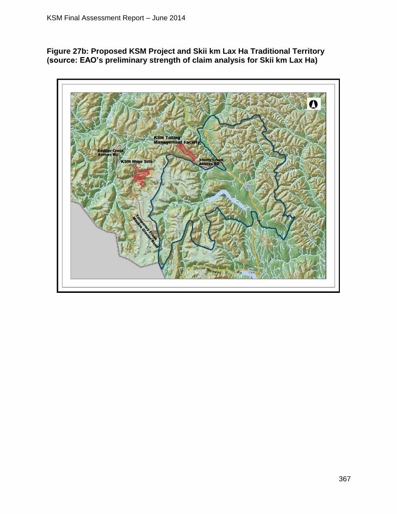
KSM Final Assessment Report – June 2014
367
Figure 27b: Proposed KSM Project and Skii km Lax Ha Traditional Territory (source: EAO’s preliminary strength of claim analysis for Skii km Lax Ha)
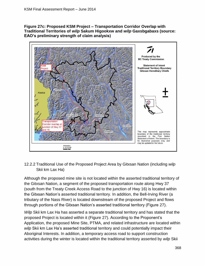
KSM Final Assessment Report – June 2014
368
Figure 27c: Proposed KSM Project – Transportation Corridor Overlap with Traditional Territories of wilp Sakum Higookxw and wilp Gaxsbgabaxs (source: EAO’s preliminary strength of claim analysis)
12.2.2 Traditional Use of the Proposed Project Area by Gitxsan Nation (including wilp
Skii km Lax Ha)
Although the proposed mine site is not located within the asserted traditional territory of
the Gitxsan Nation, a segment of the proposed transportation route along Hwy 37
(south from the Treaty Creek Access Road to the junction of Hwy 16) is located within
the Gitxsan Nation’s asserted traditional territory. In addition, the Bell-Irving River (a
tributary of the Nass River) is located downstream of the proposed Project and flows
through portions of the Gitxsan Nation’s asserted traditional territory (Figure 27).
Wilp Skii km Lax Ha has asserted a separate traditional territory and has stated that the
proposed Project is located within it (Figure 27). According to the Proponent’s
Application, the proposed Mine Site, PTMA, and related infrastructure are located within
wilp Skii km Lax Ha’s asserted traditional territory and could potentially impact their
Aboriginal Interests. In addition, a temporary access road to support construction
activities during the winter is located within the traditional territory asserted by wilp Skii
KSM Final Assessment Report – June 2014
369
km Lax Ha, although the Proponent found that there would not be any significant
residual effects associated with this temporary road.
According to the Proponent’s Application, the Gitxsan hunt, fish, trap and harvest
berries and other plants for food and medicinal purposes throughout their traditional
territory. The Gitxsan Nation harvest the following wildlife for subsistence purposes:
deer;
moose;
mountain goat;
black bear; and
grizzly bear.
Mountain goat used to be hunted by the Gitxsan Nation along the Skeena River, near
Stewart, and in the upper Nass and Kisgaga’as areas, while the following species were
trapped (and continue to be, although at lower levels than in the past):
beaver;
mink;
marten;
fisher;
fox;
wolf;
coyote;
weasel; and
otter.
According to the Proponent’s Application, the Gitxsan Nation also harvest the following
fish species within their traditional territory:
sockeye;
coho;
steelhead;
char;
Dolly Varden;
lake trout; and
cutthroat trout.
The Proponent’s Application also indicates that berries are harvested by the Gitxsan
Nation in different areas within the traditional territory, including:
KSM Final Assessment Report – June 2014
370
Clear-cut Areas
saskatoon berries;
hazelnuts;
chokecherries;
rosehips;
gooseberries;
squash berries;
raspberries;
thimbleberries; and
soapberries.
Valleys
wild crab-apples;
swamp cranberries;
Saskatoon berries;
Thornberry;
rosehips; and
soapberries.
Lower Elevation Wet Areas
devil’s club;
yellow pond lily root; and
edible mushrooms, including pine mushrooms.
No specific information has been received from the Gitxsan Nation regarding their
current use of land and resources within or near the proposed Project area.
In addition to the information about traditional uses undertaken by the Gitxsan Nation as
a whole, the Proponent’s Application also provided information about traditional uses
undertaken by wilp Skii km Lax Ha within the traditional territory they assert as separate
from the Gitsan Nation’s asserted traditional territory. Similarly to the Gitxsan Nation,
wilp Skii km Lax Ha asserts rights to hunt, fish, trap and gather berries and other plants
for food and medicinal purposes throughout their asserted traditional territory.
According to the Proponent’s Application, wilp Skii km Lax Ha harvest the following
wildlife:
moose;
black bear; and
grizzly bear.
The Proponent’s Application also states that prior to 2009, beaver, marten, and
wolverine were trapped along Hwy 37 from the Cranberry River to the wilp Skii km Lax
KSM Final Assessment Report – June 2014
371
Ha cabin located on Skowill Creek. There are two wilp Skii km Lax Ha traplines located
near the PTMA and the Treaty Creek Access Road of the proposed Project. While, wilp
Skii km Lax Ha has indicated to the Proponent that the amount of time members have
spent on the traplines has reduced in the past years because of the operation of their
mineral exploration/mining sector contracting business, Tsesaut Ventures Ltd., wilp Skii
km Lax Ha views this as temporary and plans on expanding its trapline infrastructure, as
noted below.
According to the Proponent’s Application, wilp Skii km Lax Ha have (and have had) a
number of cabins in the following locations:
Historically
Gilbert Lake (along the Treaty Creek Access Road);
Todedada Lake;
at the confluence of Treaty Creek and North Treaty Creek (south of the TMF);
along the Bell-Irving River near Wildfire Ridge;
Teigen Lake (above the PTMA); and
Taft Creek.
Currently
Skowill Creek (near Hwy 37);
Bell Creek (also known as Spruce Creek); and
the outlet of Bowser Lake.
Reportedly, wilp Skii km Lax Ha is also planning to replace a cabin along Teigen Creek,
halfway between the mouth of the creek and Teigen Lake.
According to the Proponent’s Application, wilp Skii km Lax Ha’s primary fishing areas
are located mostly downstream of the TMF along the Bell-Irving River from the
confluence of Snowbank and Teigen Creeks to Bowser Lake and the Bowser/Bell-Irving
confluence. Specifically, wilp Skii km Lax Ha harvests the following fish species at the
following locations within their asserted traditional territory:
Spring Salmon
Cranberry River;
Snowbank Creek/Bell-Irving River confluence near Bell II; and
Treaty Creek/Bell-Irving River confluence.
KSM Final Assessment Report – June 2014
372
Steelhead
west side of the Bell-Irving River; and
along the Bell-Irving River between Treaty Creek and Wildfire Creek (wilp Skii km
Lax Ha also fishes for steelhead trout here).
In addition to information regarding hunting, fishing, and trapping activities undertaken
by wilp Skii km Lax Ha, the Proponent’s Application also provides the following list of
berries and plants collected by wilp Skii km Lax Ha in the Bell-Irving and Ningunsaw
valleys and around Bowser Lake (located well south of the PTMA):
huckleberries;
blueberries;
cranberries;
soapberries;
devil’s club;
mushrooms; and
medicinal plants.
12.2.3 Gitxsan Nation Aboriginal Rights and Title (including wilp Skii km Lax Ha)
A consideration of Gitxsan Nation’s Aboriginal Interests that may be impacted by the
proposed Project was approached on the basis of information currently available to the
Province, including information provided during consultation, and guidance from the
courts regarding aboriginal rights.
The strength of the claim to aboriginal rights is assessed on the basis of information
indicating where that First Nation engaged in an activity, practice, tradition or custom, in
the area of the proposed government decision, which was integral to its distinctive
culture prior to contact with Europeans. The strength of a First Nation’s claim to
Aboriginal title is assessed on the basis of information regarding regular and exclusive
use or occupation of land at 1846.
As set out in a letter from EAO to Gitxsan wilp Gaxsbgabaxs and Sakum Higookxw (and
copied to the GHCO) dated December 23, 2013, the information that was reviewed and
considered by EAO in its initial assessment of Gitxsan Aboriginal Interests is as follows:
Gitxsan Nation: A Preliminary Review of Ethnographic, Historical and
Archaeological Resources” (April 6, 2010);
Gitxsan First Nation v. British Columbia (Minister of Forests), 2002 BCSC 1701;
and
Delgamuukw v. British Columbia, [1997] 3 S.C.R. 1010.
KSM Final Assessment Report – June 2014
373
The requirements of the section 13 Order issued by EAO on September 29, 2011,
which amended the section 11 Order issued on November 6, 2009, required the
Proponent to assess the potential effects that could arise from the transport of people,
goods and materials, including, but not limited to fuel, hazardous cargo and explosives
along access roads and Hwy 37 between the proposed Project site and its junction with
Hwy 16 at Kitwanga.
Approximately 14 km of the transportation route along Hwy 37 (near the junction of Hwy
16) overlaps Gitxsan Nation’s asserted traditional territory. Potential impacts from the
proposed Project on Gitxsan Nation Aboriginal Interests likely include the following:
increased traffic;
risk of accidents and malfunctions;
collisions with wildlife; and
spills of hazardous materials that could impact wildlife, wildlife habitat, fish and
fish habitat, vegetation, and water quality.
Considering the proximity of a portion of the transportation route for the proposed
Project to the Skeena and Kitwanga Rivers, the Gitxsan Nation would have likely
utilized this area for hunting, fishing and gathering, which supports a strong prima facie
claim of aboriginal rights to hunt, fish and gather in this area.
There is no information reviewed to date indicating physical occupation or regular and
intensive use of any specific sites along the proposed transportation route to support a
claim to aboriginal title. It is acknowledged that in Gitxsan First Nation v. British
Columbia (Minister of Forests), 2002 BCSC 1701, Justice Tysoe stated the following:
On the basis of the direct evidence and oral histories, I am satisfied that each
of the petitioning First Nations has a good prima facie claim of aboriginal title
and a strong prima facie claim of aboriginal rights with respect to at least part
of the areas claimed by them and that these parts are included within the
lands covered by Skeena's tree farm and forest licences (para. 72).
EAO has considered that there is a potential for the proposed Project to impact Gitxsan
Nation’s Aboriginal Interests in the area, to be low. This view is supported by the
understanding that the transportation route would utilize an established provincial Hwy,
and therefore no new works would be required and the potential impacts would be
limited to increased traffic. On this basis, EAO determined that the scope of the duty to
consult with Gitxsan Nation was at the low end of the Haida spectrum. In EAO’s view,
the consultation process with Gitxsan Nation, through engagement by the Proponent as
well as directly by EAO, adequately fulfills the Crown’s duty to consult in these
circumstances.
KSM Final Assessment Report – June 2014
374
12.3 Consultation with Gitxsan Nation
12.3.1 Gitxsan Nation involvement with EAO
Pre-Application Stage
EAO notified the Gitxsan Nation via the GHCO of the initiation of the EA for the
proposed Project via letter on April 30, 2008; in that letter, EAO advised that the EA
process had been initiated and that it would contact the Gitxsan Nation again shortly in
order to discuss opportunities for the Gitxsan Nation to participate. One month later, on
May 26, 2008, EAO followed up with a second letter providing more detailed information
about the proposed Project and requesting a government-to-government meeting to
discuss the Gitxsan Nation’s interests in the proposed Project area and determine
whether the Gitxsan Nation would be interested in participating in the EA. EAO noted
that, based on the Province’s current understanding, the proposed Project appeared to
be located outside the Gitxsan Nation’s asserted traditional territory, but that there could
potentially be downstream effects as a result of the proposed Project. EAO requested a
meeting with the Gitxsan Nation to discuss the nature and scope of the Gitxsan Nation’s
Aboriginal Interests in the proposed Project area.
Throughout May 2008, EAO contacted the Gitxsan Nation via telephone and e-mail to
schedule a meeting, which then took place on June 10, 2008. EAO and the CEA
Agency met with representatives from the Gitxsan Treaty Society in Hazelton, where
Gitxsan representatives provided an overview of the traditional territory and governance
structure. EAO presented a map identifying the location of the ore deposit and the
proposed plant site and TMF for the proposed Project, and requested confirmation that
the proposed Project lies outside the Gitxsan Nation’s asserted traditional territory. The
Gitxsan Nation expressed an interest in participating in the EA of the proposed Project,
including Working Group meetings, and requested capacity funding. In July 2009, EAO
wrote to the GHCO to provide a copy of the Proponent’s 2008 Baseline Studies Report
and asked for feedback regarding whether there were any gaps that should be
incorporated into the 2009 Baseline Studies Workplan, which was attached for review
and comment. EAO also invited the Gitxsan Nation to participate in the following
meetings:
a Working Group meeting on May 27, 2009 in Terrace to discuss the baseline
studies and draft AIR;
a sub-Working Group meeting in Terrace to discuss ML/ARD;
a sub-Working Group meeting in Vancouver to discuss fisheries; and
a government-to-government meeting with EAO and the CEA Agency to discuss
the provincial and federal EA processes and the nature and scope of Gitxsan
Nation rights in the proposed Project area.
KSM Final Assessment Report – June 2014
375
On May 28, 2009, EAO and the CEA Agency met with representatives from the GHCO
in Hazelton, where the GHCO expressed concerns about water, impacts on Hwy 37,
and the economic viability of the proposed Project. EAO explained the provincial EA
process and provided an outline of the opportunities for the Gitxsan Nation to be
involved in the EA of the proposed Project, including timelines. EAO once again
requested information about the Gitxsan Nation’s interests in the proposed Project area
(including a map of the Gitxsan house groups) in order to determine whether there
would be any potential for impacts on asserted Aboriginal rights and interests. The
GHCO representatives advised that the proposed Project is located mostly in the Nass
watershed and in the upper Skeena watershed, and that the Gitxsan Nation was in the
process of developing water, fish, and wildlife policies for those areas. The GHCO noted
that wilp Skii km Lax Ha is involved and has other arrangements with the Proponent.
The GHCO advised that every Gitxsan wilp is independent and it is not unusual to have
interactions with individual wilp, but that they work together in the watersheds. They
also advised that Gordon Sebastian is the primary contact for most wilp, but that wilp
Skii km Lax Ha prefers to be consulted directly. The GHCO represents individual wilp,
but does not have control over the wilp or their individual territories. EAO advised that
the draft order under section 11 of the Act would identify the Gitxsan First Nation (as
identified by the Gitxsan Hereditary Chiefs), and explained that this approach would
enable all the Gitxsan wilp to participate in the EA. The GHCO requested that wilp Skii
km Lax Ha be included in the section 11 order.
Between June 2009 and June 2011, EAO wrote the following letters to the GHCO:
June 16, 2009 - provided a copy of the Chapter 7 Geochemistry Baseline Study
Report for the proposed Project and invited the Gitxsan Nation to participate in
an ML/ARD meeting in Vancouver on July 22, 2009;
July 10, 2009 – conveying the draft section 11 order for review and comment,
providing information regarding the EA process, and requesting contact
information for those Gitxsan huwilp that may be interested in being consulted
directly regarding the EA of the proposed Project;
June 18, 2010 – conveying the draft AIR for review and comment;
September 7, 2010 – conveying the draft AIR for review and comment a second
time; and
June 13, 2011 – conveying a draft order under section 13 of the Act for review
and comment, offering to meet during the week of September 20, and requesting
confirmation of the primary contact for the GHCO.
EAO met with representatives of the GHCO on August 15, 2011 in Hazelton to discuss
the cooperative federal-provincial EAs for the proposed KSM, Morrison, Kitsault, and
Schaft Creek projects.
KSM Final Assessment Report – June 2014
376
On October 4, 2011, EAO wrote to the GHCO to advise that since no comments had
been received from the GHCO, EAO had finalized the section 13 order and changes to
the AIR.
Between December 2012 and June 2013, EAO wrote the following letters to Huwilp
Sakum Higooxw (territories Lax Behlit and Xsu Gwin Yookhl) and Gaxsbgabaxs
(territory Gasa Lax Loobit):
December 17, 2012 – advised that EAO has been consulting with the GHCO to
date regarding the EA of the proposed Project, but that ARR had suggested that
the Gitxsan Huwilp may prefer to be consulted directly. EAO requested
confirmation of whether the Huwilp were interested in participating in the EA;
January 30, 2013 – conveyed a copy of the Proponent’s summary of
consultations already carried out in relation to the proposed Project and a
proposal for a consultation process during Application review, and requested
comments;
February 6, 2013 – requested contact information for specific representatives if
the Huwilp wished to be consulted directly regarding the EA of the proposed
Project, and offered capacity funding for each wilp in order to facilitate their
participation;
June 13, 2013 – advised that EAO had determined that the Proponent’s
Application included all of the information set out in the AIR and that the 180-day
review would begin once copies of the Application had been received by the
Working Group and First Nations. EAO also provided information regarding
opportunities for the Huwilp to participate in the EA and provide input.
On September 5, 2013, EAO received confirmation from wilp Sakum Higookxw
(territories Lax Behlit and Xsu Gwin Yookhl) that they were interested in receiving
capacity funding to participate in the EA of the proposed Project, which EAO then sent
on October 9, 2013.
KSM Final Assessment Report – June 2014
377
Application Review Stage
Initiation of the 180-Day Review
The 180-day Application review stage of the EA for the proposed Project was initiated
on August 12, 2013. EAO communicated with the Gitxsan Nation between August and
September regarding the initiation of the review, including:
August 15, 2013 – e-mail from EAO to the Working Group (including the Gitxsan
Nation) advising that the 180-day review had started; and
August 29-September 12, 2013 – e-mails regarding a conference call to discuss
the initiation of the 180-day Application review stage; EAO canvassed for
preferences regarding potential dates for the call and provided copies of the a
proposed agenda and a revised EA review schedule.
On September 13, 2013, EAO held a conference call with the Proponent and
representatives from the CEA Agency and the Working Group to discuss the initiation of
the 180-day Application review stage; no representatives from the GHCO participated in
the call. EAO and the CEA Agency presented the provincial and federal EA processes
and timelines, including the following milestones and key steps in the EA:
initiation of the 180-day review on August 12, 2013;
a 45-day public comment period from September 6-October 9, 2013 with open
houses in Iskut, Telegraph Creek, Smithers, Terrace, and Stewart;
a series of Working Group and sub-Working meetings to be held throughout the
review;
an opportunity to review and submit comments on the Proponent’s Application;
an opportunity to review and submit comments on the Proponent’s responses to
comments on the Application;
an opportunity to review and submit comments on EAO’s draft Assessment
Report, CPD, and TOC; and
an opportunity for First Nations (including the Gitxsan Nation) to review and
submit comments on EAO’s draft First Nations Consultation Report.
During the call, Working Group members were also given an opportunity to engage in
discussion with, and ask preliminary questions of, the Proponent regarding the
Application. EAO asked Working Group members for their feedback regarding the
format and intent of future Working Group meetings, including the utility of forming
technical sub-Working Groups. EAO provided information regarding upcoming open
houses and advised that the deadline for the first round of Working Group comments on
the Application was October 11, 2013.
KSM Final Assessment Report – June 2014
378
Meetings and Key Correspondence with the Gitxsan Nation
On September 4, 2013, the Gitxsan Treaty Society sent a letter to EAO expressing
support for the proposed Project. The letter provides a description of the Gitxsan
Nation’s asserted traditional territory and the assertion that the Gitxsan people wish to
benefit more effectively from the natural resources contained within it. In the letter, the
Gitxsan Treaty Society states that the Gitxsan people are in support of the proposed
Project, which they believe will bring jobs and other economic benefits to their people
and communities. The letter also expressed the Gitxsan Treaty Society’s belief that the
Proponent is committed to the community, First Nations, and the Gitxsan people.
On December 20 and 23, 2013, respectively, EAO wrote letters to wilp Gaxsbgabaxs
and wilp Sakum Higookw (and copied the Gitxsan Treaty Society) to provide EAO’s
initial views of the potential impacts from the proposed Project on the Aboriginal
Interests of the Gitxsan Nation. The letter outlined the following:
EAO’s initial assessment of the Gixtsan Nation’s Aboriginal Interests in the
proposed Project area;
potential impacts of the proposed Project on Gitxsan Aboriginal interests; and
the scope of EAO’s consultation with the Gitxsan Nation regarding the EA of the
proposed Project.
EAO requested feedback from the Gitxsan Nation regarding its initial assessment and
the scope of consultation by January 24, 2014 and offered to meet with the Gitxsan
Nation to answer any questions or discuss the EA of the proposed Project. EAO also
advised that the Gitxsan Nation would have an opportunity to review and comment on
EAO’s draft Assessment Report, as well as the option to submit a separate report of
their own to Ministers for their consideration along with EAO’s Assessment Report.
Between November 2013 and January 2014, EAO communicated regularly with the
Gitxsan Nation (including via e-mail as members of the Working Group. EAO provided
the following information and opportunities for input into the EA of the proposed Project:
November 5, 2013 – EAO provided a copy of the draft CPD, explaining the
purpose of the document and future opportunities to provide comments;
November 5, 2013 – EAO provided copies of water quality prediction graphs
submitted by the Proponent;
November 18, 2013 – EAO advised that the deadline for the Working Group to
submit comments on the Proponent’s Application had passed and requested
notification if any organizations that had not yet submitted comments were still
planning to do so;
KSM Final Assessment Report – June 2014
379
November 19, 2013 – EAO provided copies of the MEM’s geotechnical
comments and the Proponent’s responses for information and consideration;
November 27, 2013 – EAO requested feedback on the Proponent’s responses
to the geotechnical comments and supporting information by December 11,
2013;
December 11, 2013 – EAO circulated the Proponent’s responses to Working
Group comments related to the following for review and comment by January 10,
2014:
o wildlife;
o closure and reclamation;
o fisheries;
o cumulative effects;
o First Nations interests;
o human health;
o social and transportation issues;
o rare plants; and
o the dam failure effects assessment.
December 20, 2013 - EAO circulated the Proponent’s responses to all remaining
Working Group comments for review and comment by January 24, 2014 and
advised that the Proponent had requested a 30-day extension to the 180-day
review timeline.
January 8, 2014 – EAO advised that due to the large volume and complexity of
the materials submitted by the Proponent in response to comments from the
Working Group, the deadline for all comments on the responses was being
extended until January 24, 2014.
January 17, 2014 – EAO acknowledged the challenge faced by Working Group
members to review all of the materials submitted by the Proponent in response to
Working Group comments, and requested feedback or input regarding how EAO
could potentially facilitate that review;
January 20, 2014 – EAO circulated the finalized summary for the October 2-3,
2013 Working Group meeting in Smithers.
January 30, 2014 – EAO advised that the Proponent’s request to extend the
180-day review timeline by 30 days had been approved and provided a copy of
the cover letter to the Proponent and the signed order under section 24(4) of the
Act.
On January 13, 2014, EAO participated in a conference call with representatives from
the Gitsxan Treaty Society and the CEA Agency. The purpose of the call was for EAO
and the CEA Agency to provide updates on the status of the federal and provincial EAs
KSM Final Assessment Report – June 2014
380
for the proposed Project, including the opportunities and timelines for the Gitxsan Nation
to review and provide input into the draft Assessment Report, First Nations Consultation
Report, CPD, and Table of Commitments. The Gitxsan representatives reiterated their
support for the proposed Project and provided the following reasons:
the proposed Project seems very sustainable;
no families will be displaced by the TMF;
there are more pros than cons;
they are pleased with the water treatment plan; and
Gitxsan plans to be involved in the reclamation.
Although the Gitxsan representatives confirmed their support for the proposed Project, a
number of concerns was also raised during the discussion, including:
the Fish Habitat Compensation Plan;
the effectiveness of habitat compensation for protecting Dolly Varden; and
the potential inability of government to provide effective oversight with respect to
monitoring and compliance.
The CEA Agency committed to providing the Gitxsan Nation with the specific sections of
the Proponent’s Application that set out the Fish Habitat Compensation Plans in more
detail. EAO explained that if an EA Certificate is issued for the proposed Project,
monitoring would be undertaken by responsible line agencies with oversight by EAO’s
Compliance and Enforcement Branch, and would be set out as conditions of the EA
Certificate. Monitoring and compliance would also be undertaken according to the
process set out in EAO’s October 2012 follow-up report to the Auditor General’s 2011
Audit of EAO’s Oversight of Certified Projects Report, both of which are posted on
EAO’s website.
In response to an issue regarding existing culverts along Hwy 37 raised by the Gitxsan
Nation representatives, EAO advised that a Hwy 37 Advisory Group had been
established. One of the purposes of the Advisory Working Group is to provide a forum
for representatives from First Nations, industry, and government agencies to discuss
wildlife and resource issues related to the operation and maintenance of Hwy 37. EAO
also committed to providing the Gitxsan Nation with the contact information for a MOTI
representative from the Advisory Working Group.
Throughout the remainder of the EA, EAO continued to communicate regularly with the
Gitxsan Nation and provided information and opportunities for input into the EA of the
proposed Project. Via e-mails to the Working Group, EAO provided the Gitxsan Nation
with the following:

KSM Final Assessment Report – June 2014
381
copies of memos and comments submitted by other members of the Working
Group, as well as the Proponent’s responses;
invitations to participate in Working Group meetings;
updates on the timelines and next steps in the EA of the proposed Project; and
opportunities to provide input.
Open Houses
EAO advised the members of the Working Group (including the Gitxsan Nation) via e-mail of the date, time, and location for each of the following five open houses held during the 45-day public comment period for the EA of the proposed Project:
Iskut September 25, 2013
Telegraph Creek September 26, 2013
Terrace October 1, 2013
Smithers October 2, 2013
Stewart October 9, 2013 Comments on the Application and Proponent Responses
EAO provided several opportunities for the Gitxsan Nation to provide input on the
Proponent’s Application for an EA Certificate and the Proponent’s responses to Working
Group comments. No comments were received from the Gitxsan Nation.
Working Group & Technical Sub-Working Group Meetings
Between October 2013 and May 2014, EAO and the CEA Agency scheduled the
following Working Group and technical sub-Working Group meetings:
October 2-3, 2013 – the Proponent presented their significance determination
framework and key areas of the Application, followed by a discussion, and an
opportunity to ask questions (no GHCO representatives participated in the
meeting, although a Gitxsan Treaty Society representative advised via e-mail on
October 7, 2013 that they would still like to receive information regarding future
meetings)
November 6-8, 2013 – an opportunity to engage in technical level discussions
on issues related to wildlife and water quality on both the mine side and tailings
side of the proposed Project (no GHCO representatives participated in these
meetings)
November 26-28, 2013 – an opportunity to engage in a technical level
discussion, review the Proponent’s proposed mitigation measures and
conditions, and identify outstanding geotechnical issues for resolution (no GHCO
representatives participated in these meetings)
KSM Final Assessment Report – June 2014
382
May 13-15, 2014 – a three-day Working Group meeting to discuss EAO’s draft
Assessment Report, TOC, CPD, and issues tracking table. The meetings
provided Working Group members with an opportunity to discuss and ask
questions about EAO’s key findings with respect to potential effects from the
proposed Project on water quality, wildlife, fish, and transportation
12.3.2 Wilp Skii km Lax Ha involvement with EAO
Pre-Application Stage
On April 30, 2008, EAO wrote a letter to notify wilp Skii km Lax Ha that the EA for the
proposed Project had been initiated and outlined the opportunities for wilp Skii km Lax
Ha to participate.
On May 8, 2008, EAO sent wilp Skii km Lax Ha another letter that contained the
following:
information regarding the proposed Project;
an invitation to participate in the Working Group;
an invitation to schedule a government-to-government meeting to discuss
consultation opportunities and the nature and scope of wilp Skii km Lax Ha’s
asserted Aboriginal rights and interests in the proposed Project area; and
an offer of capacity funding to facilitate wilp Skii km Lax Ha’s participation in the
EA.
On June 9, 2008, EAO and the CEA Agency met with wilp Skii km Lax Ha
representatives in Smithers to discuss wilp Skii km Lax Ha’s interests in the proposed
Project area. In June 2008, wilp Skii km Lax Ha contacted EAO to indicate an interest in
participating in the EA, but advised that capacity funding would be required.
On October 8, 2008, EAO responded to a letter from wilp Skii km Lax Ha expressing
concerns with EAO’s proposed consultation approach for the EA of the proposed
Project, and requested additional information regarding the nature of the rights being
asserted by wilp Skii km Lax Ha. On December 5, 2008, EAO followed up with another
letter requesting clarification to support wilp Skii km Lax Ha’s claim that they are a
distinct rights-holding group, inviting them to participate in the Working Group, and
inviting them to participate in a one-on-one meeting with EAO. EAO requested
information and traditional knowledge that could support wilp Skii km Lax Ha’s claim to
lands in the proposed Project area, and outlined future opportunities for the
wilp Skii km Lax Ha to be involved in the EA.
On December 15, 2008, wilp Skii km Lax Ha wrote to EAO requesting a meeting to
discuss issues not adequately addressed through the Working Group and the current
consultation process for the EA of the proposed Project. Wilp Skii km Lax Ha also
KSM Final Assessment Report – June 2014
383
requested EAO’s presence at a wilp Skii km Lax Ha open house being hosted by the
Proponent and outlined the following concerns with the proposed Project:
carbon footprint;
transportation of concentrate from the proposed Project; and
downstream effects.
On February 16, 2009, EAO wrote to wilp Skii km Lax Ha acknowledging receipt of
information regarding their traditional territory, and encouraging wilp Skii km Lax Ha to
participate in the Working Group. EAO also requested a meeting with the
wilp Skii km Lax Ha to discuss consultation, wilp Skii km Lax Ha’s customs and
practices in the proposed Project area, concerns and issues, as well as the EA process.
Wilp Skii km Lax Ha wrote back to EAO on February 23, 2009 to advise that reports
being produced by the Proponent do not accurately reflect facts regarding wilp Skii km
Lax Ha’s occupation of the proposed Project area and characterizing their occupation
as belonging to someone else.
On May 12, 2009, EAO wrote a letter to wilp Skii km Lax Ha to advise that it had
instructed ARR to review and revise its existing ethnohistoric research in order to
improve EAO’s understanding of wilp Skii km Lax Ha’s interests with respect to the
proposed Project area. EAO also provided specific information and rationale for the
revisions that were made to the report, and confirmed that EAO would continue to
consult with wilp Skii km Lax Ha at the low end of the Haida spectrum, which includes
giving notice, disclosing information, and discussing any issues raised in response to
the notice. EAO advised that wilp Skii km Lax Ha would not be specifically included in
the section 11 order and, as such, the Proponent would not be required to consult
directly with them; however, EAO would continue to consult directly with wilp Skii km
Lax Ha, including participation in the Working Group.
On May 25, 2009, EAO, the CEA Agency, and wilp Skii km Lax Ha held a conference
call in order to discuss the updated ethnohistoric report, wilp Skii km Lax Ha’s territorial
boundary, and the disagreement between EAO and wilp Skii km Lax Ha regarding the
extent of wilp Skii km Lax Ha’s traditional territory. EAO, the CEA Agency and wilp Skii
km Lax Ha met the following day to continue the discussion regarding consultation, the
ethnohistoric report, wilp Skii km Lax Ha’s concerns about the proposed Project and the
Proponent, as well as another request from EAO and the CEA Agency for wilp Skii km
Lax Ha to clearly outline their uses of the proposed Project area.
Between June 2009 and June 2011, EAO sent the following letters to the
wilp Skii km Lax Ha:
June 16, 2009 – provided a copy of the Chapter 7 Geochemistry Baseline Study
Report for the proposed Project and invited wilp Skii km Lax Ha to participate in
an ML/ARD meeting in Vancouver on July 22, 2009;
KSM Final Assessment Report – June 2014
384
July 7, 2009 – provided EAO’s assessment of the appropriate scope of the
Crown’s duty to consult with wilp Skii km Lax Ha on the EA of the proposed
Project, which was based on potential downstream and trucking impacts, and
resulting in EAO’s determination to identify wilp Skii km Lax Ha in the section 11
order as a wilp of the Gitxsan to be consulted by the Proponent at the direction of
EAO;
July 10, 2009 – conveyed the draft section 11 order for review and comment and
provided information regarding the EA process;
June 18, 2010 – conveyed the draft AIR for review and comment;
September 7, 2010 – conveyed the draft AIR for review and comment a second
time;
June 13, 2011 – conveyed a draft order under section 13 of the Act for review
and comment;
October 4, 2011 – conveyed the finalized section 13 order and advising that
changes would be made to the AIR;
January 30, 2013 – conveyed a copy of the Proponent’s summary of
consultations already carried out in relation to the proposed Project and a
proposal for a consultation process during Application review, and requested
comments;
February 6, 2013 – proposed a consultation process for the Application review
stage of the EA of the proposed Project and offering capacity funding to facilitate
wilp Skii km Lax Ha’s participation; and
June 3, 2013 – advised that EAO had determined that the Proponent’s
Application included all of the information set out in the AIR and that the 180-day
review would begin once copies of the Application had been received by the
Working Group and First Nations. EAO also provided information regarding
opportunities for wilp Skii km Lax Ha to participate in the EA and provide input.
KSM Final Assessment Report – June 2014
385
Application Review Stage
Initiation of the 180-Day Review
The 180-day Application reviews stage of the EA for the proposed Project was initiated on August 12, 2013. EAO communicated with wilp Skii km Lax Ha between August and September regarding the initiation of the review, including:
August 15, 2013 – e-mail from EAO to the Working Group (including wilp Skii km Lax Ha) advising that the 180-day review had started; and
August 29-September 12, 2013 – e-mails regarding a conference call to discuss the initiation of the 180-day Application review stage; EAO canvassed for preferences regarding potential dates for the call and provided copies of the a proposed agenda and a revised EA review schedule.
On September 13, 2013, EAO held a conference call with the Proponent and
representatives from the CEA Agency and the Working Group to discuss the initiation of
the 180-day Application review stage; a representative from wilp Skii km Lax Ha
participated in the call. EAO and the CEA Agency presented the provincial and federal
EA processes and timelines, including the following milestones and key steps in the EA:
initiation of the 180-day review on August 12, 2013;
a 45-day public comment period from September 6-October 9, 2013 with open
houses in Iskut, Telegraph Creek, Smithers, Terrace, and Stewart;
a series of Working Group and sub-Working meetings to be held throughout the
review;
an opportunity to review and submit comments on the Proponent’s Application;
an opportunity to review and submit comments on the Proponent’s responses to
comments on the Application;
an opportunity to review and submit comments on EAO’s draft Assessment
Report, CPD, and TOC; and
an opportunity for First Nations (including wilp Skii km Lax Ha) to review and
submit comments on EAO’s draft First Nations Consultation Report.
During the call, Working Group members were also given an opportunity to engage in
discussion with, and ask preliminary questions of, the Proponent regarding the
Application. EAO asked Working Group members for their feedback regarding the
format and intent of future Working Group meetings, including the utility of forming
technical sub-Working Groups. EAO provided information regarding upcoming open
houses and advised that the deadline for the first round of Working Group comments on
the Application was October 11, 2013.
KSM Final Assessment Report – June 2014
386
Meetings and Key Correspondence with wilp Skii km Lax Ha
On December 20, 2013, EAO wrote a letter to wilp Skii km Lax Ha to provide EAO’s initial views of the potential impacts from the proposed Project on the Aboriginal Interests of the Gitxsan Nation. The letter outlined the following:
EAO’s initial assessment of the Gitxsan Nation’s Aboriginal Interests in the proposed Project area;
potential impacts of the proposed Project on Gitxsan Nation’s Aboriginal interests; and
the scope of EAO’s consultation with the Gitxsan Nation regarding the EA of the proposed Project.
EAO requested feedback from wilp Skii km Lax Ha regarding its initial assessment and the scope of consultation by January 24, 2014 and offered to meet with the wilp Skii km Lax Ha to answer any questions or discuss the EA of the proposed Project. EAO also advised that wilp Skii km Lax Ha would have an opportunity to review and comment on EAO’s draft Assessment Report, as well as the option to submit a separate report of their own to Ministers for their consideration along with EAO’s Assessment Report. Between September 2013 and June 2014, EAO communicated regularly with wilp Skii km Lax Ha via e-mail, as members of the Working Group. Key correspondence between EAO and wilp Skii km Lax Ha included the following:
November 1, 2013 – EAO circulated a draft summary from the October 2-3,
2013 Working Group meeting for review and comment prior to finalization;
November 5, 2013 – EAO provided a copy of the draft CPD, explaining the
purpose of the document and future opportunities to provide comments;
November 5, 2013 – EAO provided copies of water quality prediction graphs
submitted by the Proponent;
November 18, 2013 – EAO advised that the deadline for the Working Group to submit comments on the Proponent’s Application had passed and requested notification if any organizations that had not yet submitted comments were still planning to do so;
November 19, 2013 – EAO provided copies of MEM’s geotechnical comments and the Proponent’s responses for information and consideration;
November 27, 2013 – EAO requested feedback on the Proponent’s responses to the geotechnical comments and supporting information by December 11, 2013;
KSM Final Assessment Report – June 2014
387
December 11, 2013 – EAO circulated the Proponent’s responses to Working
Group comments related to the following for review and comment by January 10,
2014:
o wildlife; o closure and reclamation; o fisheries; o cumulative effects; o First Nations interests; o human health; o social and transportation issues; o rare plants; and o the dam failure effects assessment.
December 20, 2013 - EAO circulated the Proponent’s responses to all remaining
Working Group comments for review and comment by January 24, 2014 and
advised that the Proponent had requested a 30-day extension to the 180-day
review timeline.
January 8, 2014 – EAO advised that due to the large volume and complexity of
the materials submitted by the Proponent in response to comments from the
Working Group, the deadline for all comments on the responses was being
extended until January 24, 2014.
January 17, 2014 – EAO acknowledged the challenge faced by Working Group
members to review all of the materials submitted by the Proponent in response to
Working Group comments, and requested feedback or input regarding how EAO
could potentially facilitate that review;
January 20, 2014 – EAO circulated the finalized summary for the October 2-3,
2013 Working Group meeting in Smithers;
January 24, 2014 - EAO circulated a draft summary from the November 6, 2013
technical wildlife sub-Working Group meeting for review and comment prior to
finalization;
January 30, 2014 – EAO advised that the Proponent’s request to extend the
180-day review timeline by 30 days had been approved and provided a copy of
the cover letter to the Proponent and the signed order under section 24(4) of the
Act.
February 11/12, 2014 – e-mails back and forth between EAO and wilp Skii km
Lax Ha to schedule a meeting, which was ultimately confirmed for February 25,
2014.
February 25, 2014 – meeting between EAO, the CEA Agency and
representatives from wilp Skii km Lax Ha to discuss the current status of the EA
and upcoming opportunities for wilp Skii km Lax Ha to provide input into the EA.
KSM Final Assessment Report – June 2014
388
March 5, 2014 – EAO e-mail providing a copy of the draft CPD and TOC for the
Kitsault Mine Project for the GHCO’s information;
March 5, 2014 – EAO e-mail conveying the Proponent’s responses to comments
submitted by the US Department of the Interior, HC, and FLNR, as well as a copy
of the signed section 24(4) Order, extending the 180-day review by an additional
45 days, as requested by the Proponent;
March 5, 2014 – wilp Skii km Lax Ha e-mail to EAO requesting the reason for the
45-day extension. EAO responded the same day that the extension had been
requested by the Proponent, and provided wilp Skii km Lax Ha with a copy of the
Proponent’s incoming letter requesting the extension;
April 15, 2014 – wilp Skii km Lax Ha e-mail requesting clarification regarding the
referral date for the proposed Project to Ministers for a decision on whether to
issue an EA certificate. EAO responded the same day to advise that the new
referral date would likely be in mid-June because of an extension requested by
EAO, and that draft documents would be circulated shortly for review and
comment over a three-week period on or around May 1, 2014. There would also
be an opportunity for First Nations to submit separate reports to Ministers, if
desired;
April 18/23, 2014 – wilp Skii km Lax Ha e-mail requesting additional capacity
funding; EAO responded that wilp Skii km Lax Ha’s request was under
consideration and suggested scheduling a meeting to discuss the EA of the
proposed Project in May 2014;
April 22, 2014 – EAO e-mail to the Working Group (including wilp Skii km Lax
Ha) advising of an upcoming Working Group meeting and outlining opportunities
to review and provide input on key documents;
April 29, 2014 – EAO e-mail conveying copies of the recently issued section 13
and 24(4) orders for the EA of the proposed Project, as well as outlining the
topics for discussion at the May 13-15, 2014 Working Group meetings;
May 2, 2014 – EAO letter conveying the draft Assessment Report, CPD, TOC,
First Nation Consultation Report, and issue tracking table for review and
comment. EAO also advised that if wilp Skii km Lax Ha wishes to submit a
separate report to ministers, it must be submitted to EAO by June 12, 2014, but
that it would not be reflected in EAO’s Assessment Report;
May 20, 2014 – EAO provided additional capacity funding to wilp Skii km Lax Ha,
as requested;
May 27, 2014 – wilp Skii km Lax Ha submitted comments on the draft
Assessment Report, First Nation Consultation Report, and TOC. Wilp Skii km
Lax Ha expressed frustration with the fact that EAO continues to characterize
Skii km Lax Ha as a wilp of the Gitxsan. In addition to a request that EAO clarify
a statement regarding use of traplines (a change that EAO incorporated), wilp
KSM Final Assessment Report – June 2014
389
Skii km Lax Ha submitted comments regarding the following:
o disagreement regarding the methodology used for the assessment of
proposed Project effects on wilp Skii km Lax Ha’s past, present, and future
land use (e.g. drawing conclusions based on availability of resources
instead of considering other factors, such as noise, that may affect
personal choices about whether to engage in traditional land use
activities); and
o wildlife population consequences as a result of sensory disturbance.
Throughout the remainder of the EA, EAO continued to communicate regularly with wilp
Skii km Lax Ha and provided information and opportunities for input into the EA of the
proposed Project. Via e-mails to the Working Group, EAO provided wilp Skii km Lax Ha
with the following:
copies of memos and comments submitted by other members of the Working
Group, as well as the Proponent’s responses;
invitations to participate in Working Group meetings;
updates on the timelines and next steps in the EA of the proposed Project; and
opportunities to provide input.
Open Houses
EAO advised the members of the Working Group (including wilp Skii km Lax Ha) via e-mail of the date, time, and location for each of the following five open houses held during the 45-day public comment period for the EA of the proposed Project:
Iskut September 25, 2013
Telegraph Creek September 26, 2013
Terrace October 1, 2013
Smithers October 2, 2013
Stewart October 9, 2013 Comments on the Application and Proponent Responses On October 14, 2013, wilp Skii km Lax Ha submitted comments on the Application, expressing concerns regarding potential effects related to the following key topic areas:
habitat alteration/loss;
social;
economic;
wildlife (including grizzly bear, wolverine, moose, marten, mountain goat);
dust;
trapping, fishing, and hunting;
increased traffic along Hwy 37;

KSM Final Assessment Report – June 2014
390
First Nations interests; and
access to areas of importance to the wilp Skii km Lax Ha. EAO provided all of the comments submitted by wilp Skii km Lax Ha to the Proponent
for inclusion in an issue tracking table and response. On November 27, December 11,
and December 20, 2013, EAO circulated the Proponent’s responses to comments on
the Application and requested feedback. Although EAO initially requested feedback on
the Proponent’s responses by December 11, January 10, and January 24 respectively,
the volume and complexity of the documents submitted by the Proponent led to EAO
extending the deadline for all feedback on the Proponent’s responses to comments to
January 24, 2013.
A complete list of all comments submitted by wilp Skii km Lax Ha regarding the
proposed Project and the associated responses from the Proponent is presented in
Appendix 1.
Working Group & Technical Sub-Working Group Meetings
Between October 2013 and May 2014, EAO and the CEA Agency scheduled the
following Working Group and technical sub-Working Group meetings:
October 2-3, 2013 – the Proponent presented their significance determination
framework and key areas of the Application, followed by a discussion, and an
opportunity to ask questions (representatives from wilp Skii km Lax Ha
participated in the meeting in person and by telephone)
November 6-8, 2013 – an opportunity to engage in technical level discussions
on issues related to wildlife and water quality on both the mine side and tailings
side of the proposed Project (wilp Skii km Lax Ha participated in the
November 6 technical wildlife sub-Working Group meeting)
November 26-28, 2013 – an opportunity to engage in a technical level
discussion, review the Proponent’s proposed mitigation measures and
conditions, and identify outstanding geotechnical issues for resolution (no wilp
Skii km Lax Ha representatives participated in these meetings)
May 13-15, 2014 – a three-day Working Group meeting to discuss EAO’s draft
Assessment Report, TOC, CPD, and issues tracking table. The meetings
provided Working Group members with an opportunity to discuss and ask
questions about EAO’s key findings with respect to potential effects from the
proposed Project on water quality, wildlife, fish, and transportation
KSM Final Assessment Report – June 2014
391
12.3.3 Gitxsan Nation involvement with Proponent
Pre-Application Stage
On November 6, 2009, EAO issued an order under section 11 of the Act, which required
that the Proponent consult with the wilp of the Gitxsan Nation (as identified by the
GHCO) regarding the EA of the proposed Project. The Proponent initiated consultations
with the Gitxsan Nation prior to the start of the EA, and met with their representatives on
February 27, 2008, to introduce the proposed Project and receive a presentation on
Gitxsan culture, society and sustainability policies.
Starting in June 2008, the Proponent participated in Working Group meetings led by
EAO and the CEA Agency and organized tours of an operating and a closed mine in
June 2011. Representatives of the Gitxsan Nation participated in most of the Working
Group meetings and also attended both site tours. The Proponent also provided
opportunities for representatives of the Gitxsan Nation to tour the proposed KSM Project
site, which took place in September 2008 and August 2010.
As set out in the section 11 Order, the Proponent provided the Gitxsan Nation with
electronic and paper copies of the draft AIR in June 2010, as well as notifications
regarding upcoming open houses.
Although not specifically required by EAO, the Proponent provided the Gitxsan
Hereditary Chiefs Office with capacity funding to facilitate their participation in the EA,
including the review of the KSM Preliminary Economic Assessment and a desk-based
Traditional Knowledge/ Traditional Use Study. The Proponent provided the GHCO with
a copy of the draft desk-based Traditional Knowledge/ Traditional Use Study report for
review and comment in February 2011, and followed up by meeting with GHCO
representatives in April 2011 to discuss the report. The Gitxsan advised that they had
no specific comments on the report, but did provide feedback on some maps portraying
watersheds and Gitxsan boundaries, which the Proponent then incorporated in to the
report.
The Proponent also facilitated the delivery of a “Mining 101: Mining for Non-Miners”
workshop in Hazelton in June 2010. Employment opportunities connected with baseline
field studies were also offered to the Gitxsan Nation by the Proponent between 2008
and 2011/2012.
As set out in the section 11 Order, the Proponent prepared a draft report summarizing
the consultation activities undertaken with the Gitxsan Nation during the pre-Application
stage of the EA, as well as outlining their plan for consulting with the Gitxsan Nation
during the Application review. Although the Proponent provided the Gitxsan Nation with
the draft report on December 12, 2012 for review and comment, no feedback was
received.
KSM Final Assessment Report – June 2014
392
Application Review Stage
As required by the section 11 Order issued by EAO, the Proponent undertook the
following consultation activities with the Gitxsan Nation during the Application review
stage of the EA of the proposed Project:
distributed copies of the Application to the Gitxsan Nation for information and consultation purposes;
wrote to the Gitxsan Nation to identify the dates of the public comment period on the Application, and the dates, times and locations of open houses;
provided a written report to the Gitxsan Nation, EAO, and the CEA Agency on the results of consultation activities with the Gitxsan Nation;
considered and responded to issues identified in comments submitted by the Gitxsan Nation during the review of the Application;
where requested by, and within any time limits set by EAO, provided specific additional information in relation to, or to supplement, the information provided in the Application;
attended Working Group meetings organized by EAO to provide information related to the Application and responded to questions on the Application;
prepared a tracking table of issues raised by First Nations (including the Gitxsan
Nation) on the Application and responses to those issues;
considered and prepared written responses to key issues raised by the Gitxsan
Nation regarding the Application; and
by mutual agreement, arranged consultation meetings with the Gitxsan Nation to identify any specific Aboriginal interests that may be potentially affected by the proposed Project, as identified in Aboriginal interest and use studies, traditional use studies, or other sources of information; to identify measures to avoid or mitigate potential adverse effects; and/or to otherwise address or mitigate the Gitxsan Nation’s concerns.
Following acceptance of the Application and the initiation of the 180-day review by EAO, the Proponent provided the Gitxsan Nation with copies of the Application.
Meetings and Key Correspondence Between the Proponent and Gitxsan Nation
In addition to participating in open houses and Working Group meetings organized by
EAO, the Proponent also held a meeting on September 10, 2013 in Hazelton, BC, with
Cliff Sampare of the GHCO to provide an update on the proposed Project and discuss
letters of support.
Although the GHCO did not submit any comments on the Application, they did submit a
letter of support for the proposed Project on September 4, 2013. In the letter, the GHCO
advised that they were satisfied with the consultation undertaken by the Proponent,
including their explanations of the details of the proposed Project and the potential

KSM Final Assessment Report – June 2014
393
impacts. The GHCO further stated that they believe the proposed Project would result in
jobs and economic benefits for the Gitxsan people and communities for the life of the
proposed Project and beyond.
The Proponent also provided capacity funding to assist the Gitxsan Nation’s
participation on the EA of the proposed Project.
12.3.4 Wilp Skii km Lax Ha involvement with Proponent
Pre-Application Stage
The November 6, 2009, Order issued by EAO under section 11 of the Act also required
the Proponent to consult with wilp Skii km Lax Ha regarding the EA of the proposed
Project. While the Proponent was initiating consultations with the Gitxsan Nation prior to
the start of the EA, they also met with wilp Skii km Lax Ha on February 22, 2008 to
introduce the proposed Project and discuss overlapping asserted traditional territories.
Unlike the Gitxsan Nation, wilp Skii km Lax Ha representatives only participated in some
of the pre-Application Working Group meetings. While wilp Skii km Lax Ha opted not to
attend either of the June 2011 site tours of an operating and closed mine organized by
the Proponent, they did participate in a July 2008 tour of the proposed KSM Project site.
As set out in the section 11 Order, the Proponent provided wilp Skii km Lax Ha with
electronic and paper copies of the draft AIR in June 2010, as well as notifications
regarding upcoming open houses.
Although attempts by the Proponent to conclude a funding agreement with wilp Skii km
Lax Ha were unsuccessful, they did provide wilp Skii km Lax Ha with capacity funding to
review a draft workplan, the KSM Preliminary Economic Assessment, and a desk-based
Traditional Knowledge/ Traditional Use Study. The Proponent provided wilp Skii km Lax
Ha with a copy of the draft desk-based Traditional Knowledge/ Traditional Use Study
report for review and comment in July 2012, although no comments were received
despite several attempts by the Proponent to request them. The Proponent also
provided additional funding to wilp Skii km Lax Ha to cover the cost of core cutting
training in lieu of employment opportunities that did not occur in 2009. The wilp Skii km
Lax Ha provided the Proponent with core boxes in 2010, 2011 and 2012.
As set out in the section 11 Order, the Proponent prepared a draft report summarizing
the consultation activities undertaken with wilp Skii km Lax Ha during the pre-
Application stage of the EA, as well as outlining their plan for consulting with wilp Skii
km Lax Ha during the Application review. Although the Proponent provided wilp Skii km
Lax Ha with the draft report on December 12, 2012 for review and comment, no
feedback was received.
KSM Final Assessment Report – June 2014
394
Application Review Stage
As required by the section 11 Order issued by EAO, the Proponent undertook the
following consultation activities with wilp Skii km Lax Ha during the Application review
stage of the EA of the proposed Project:
distributed copies of the Application to wilp Skii km Lax Ha for information and consultation purposes;
wrote to wilp Skii km Lax Ha to identify the dates of the public comment period on the Application, and the dates, times and locations of open houses;
provided a written report to wilp Skii km Lax Ha, EAO, and the CEA Agency on the results of consultation activities with wilp Skii km Lax Ha;
considered and responded to issues identified in comments submitted by wilp Skii km Lax Ha during the review of the Application;
where requested by, and within any time limits set by EAO, provided specific additional information in relation to, or to supplement, the information provided in the Application;
attended Working Group meetings organized by EAO to provide information related to the Application and responded to questions on the Application;
prepared a tracking table of issues raised by First Nations (including wilp Skii km Lax Ha) on the Application and responses to those issues;
considered and prepared written responses to key issues raised by wilp Skii km Lax Ha regarding the Application; and
by mutual agreement, arranged consultation meetings with wilp Skii km Lax Ha to identify any specific Aboriginal interests that may be potentially affected by the proposed Project, as identified in Aboriginal interest and use studies, traditional use studies, or other sources of information; to identify measures to avoid or mitigate potential adverse effects; and/or to otherwise address or mitigate wilp Skii km Lax Ha’s concerns.
Following acceptance of the Application and the initiation of the 180-day review by EAO, the Proponent provided wilp Skii km Lax Ha with copies of the Application.
Meetings & Key Correspondence Between the Proponent and wilp Skii km Lax Ha
In addition to participating in open houses and Working Group meetings organized by
EAO, the Proponent also held the following four meetings with representatives of
wilp Skii km Lax Ha:
August 21, 2013 – meeting in Vancouver, BC, with Darlene Simpson to provide
an update on the proposed Project and to discuss permitting, exploration, and
engage in internal discussions;
August 30, 2013 – meeting with Rick Connolly, from Foremost Solutions
Consulting Group to provide an update on the proposed Project and engage in
internal discussions;
KSM Final Assessment Report – June 2014
395
September 5, 2013 – meeting with Pascale Mera of Big Sky Consulting and
Peter Evans with EverNorth Consulting to discuss the Proponent’s responses to
the screening comments submitted by wilp Skii km Lax Ha; and
November 6, 2013 – meeting in Vancouver with Darlene Simpson to provide an
update on the status of the proposed Project and engage in internal discussions.
According to the Proponent’s February 2014 Skii km Lax Ha Consultation Report, the
Proponent communicated regularly with wilp Skii km Lax Ha during the Application
review stage of the EA of the proposed Project. In addition to communications
regarding logistics for meetings and requests for information, the Proponent exchanged
51 letters, emails, and news releases with wilp Skii km Lax Ha.
The Proponent also provided capacity funding to assist wilp Skii km Lax Ha’s
participation on the EA of the proposed Project.
12.3.5 Potential Impacts to Gitxsan Nation Interests (including wilp Skii km Lax Ha) and
Measures to Mitigate or Accommodate Impacts
See below for a description of EAO’s understanding of the issues that have been
identified by Gitxsan Nation (including wilp Skii km Lax Ha) during the EA for the
proposed Project.
Responses to the full set of concerns are described in the Issues Tracking Table.
Further information on how concerns have been addressed, including mitigation and
Proponent commitments, is provided in the relevant sections of the Assessment Report.
Many of the issues raised during the review by Skii km Lax ha related to what EAO
would characterize as larger conservation and wildlife management issues. The issues
were largely related to ecosystem linkages, habitat fragmentation and health of fish and
wildlife populations. These issues would all support concerns for a range of potential
effects on aboriginal rights such as trapping, fishing, hunting and harvesting plants.
Another significant subject raised during the course of the review related to wilp
boundaries and the relationship between Skii km Lax Ha and the Gitxsan Nation. EAO
understands these issues to be more related to title and consultation than specific
project related effects.
The following is intended only to be a summary of the major issues raised and
accommodations of those issues.
KSM Final Assessment Report – June 2014
396
Wildlife and Wildlife Habitat
As noted above, many of the Skii km Lax Ha concerns were broadly related to wildlife
habitat and populations and thus to potential effects on aboriginal rights to hunt and
trap.
wilp Skii km Lax Ha expressed concerns about potential effects on wolverine.
o The Proponent advised that the primary effects on wolverine are mortality and disturbance, which are addressed in the mitigation and management plans for marten and bears (e.g. employee education, waste management, infrastructure management, and monitoring incidents and mortalities). In addition, the Proponent has reviewed data on wolverine problems at existing mine and exploration sites in BC and determined that wolverine are not as much of a concern in BC as they are in the Arctic where resources are much less abundant. However, wolverine will be considered in the detailed wildlife management plan that will be completed at the permitting stage.
wilp Skii km Lax Ha pointed out problems with marten experienced at the Brucejack Mine Project and asked whether the Proponent should consider potential residual effects due to attractants for marten. o The Proponent advised that the effect of attractants on marten can be
effectively mitigated with implementation of proper waste and infrastructure management, employee education, and monitoring. The Proponent is committed to implement plans to limit the effects on American marten.
wilp Skii km Lax Ha asked how the Proponent will know if a moose natal area or calving site is present in order to avoid vegetation clearing within two km of those areas. o The Proponent advised that moose winter habitat (particularly late winter
habitat) is the most limiting factor for moose survival, more so than calving or natal areas. Therefore, the surveys, mitigation measures, and evaluation of effects on moose was focused on moose winter habitat instead.
wilp Skii km Lax Ha requested clarification of how the setting out of artificial salt licks to minimize the loss of high-quality habitat and disruption to movement for mountain goat will be conducted. o The Proponent advised that the following commitments have been made with
respect to salt licks: minimizing noise and disturbance in the area of the salt lick; monitoring the salt lick to evaluate if goats continue to use the salt lick;
and
KSM Final Assessment Report – June 2014
397
if use of the lick reduces over time, installing additional artificial salt licks in appropriate goat habitat to offset disturbance at the existing lick.
o The Proponent also advised that remote cameras have been set up at the lick to record goat occurrence (numbers and frequency of use). The cameras will continue to be used to monitor this lick and if a lower use is observed, then artificial licks may be created in consultation with the FLNR and other knowledgeable resources for guidance on proper implementation.
wilp Skii km Lax Ha questioned the effectiveness of the five-year intervals for monitoring activities for moose, mountain goat, and bear proposed by the Proponent. o The Proponent advised that five-year intervals are consistent with guidance
produced by FLNR.
EAO’s review examined a number of the types of effects raised by wilp Skii km Lax Ha.
These potential effects are described in Part B of the Assessment Report. EAO’s
findings show that the magnitude of habitat loss effects is rated moderate or low for all
VCs, including those raised above, which would mostly fall into the furbearers category.
Approximately (+/- 5%) of the RSA and +/- 40% of the LSA would be affected by the
proposed Project.
This Report says the magnitude of habitat loss effects to moose is moderate, with areas
of summer and early winter habitat being lost in the TMF and processing plant site, but
the most important habitat of late winter overlaps with the proposed Project only at low
elevations along the Treaty Creek Access Road. The extent of residual wildlife effects is
localized to the LSA for most effects categories, although for some wildlife VC with
larger ranges (grizzly bears, black bears, moose, and mountain goats), residual effects
will extend to the landscape level, while remaining tied to the proposed Project footprint
or to individual animals within the RSA (e.g. effects linked to disruption of movement,
direct and indirect mortality, or sensory disturbance). The abundance of individuals of
particular species may decline during construction and operation in the immediate area
of the proposed Project footprint; however, most wildlife VC are mobile, and will likely
seek alternative habitat if displaced by mining-related disturbances, if alternative habitat
is available.
EAO also added a number of conditions relating to the management of wildlife on the
project site in order to mitigate potential regional effects on wildlife that were raised by
wilp Skii km Lax Ha. However, EAO notes that many of these issues relate to ongoing
site management practices which would be most effectively captured in documents
such as the Wildlife Effects Monitoring Plan. Some of the conditions added by EAO
include:
KSM Final Assessment Report – June 2014
398
prior to the commencement of construction of the Treaty Creek and the
Coulter Creek access roads, the EA Certificate Holder must develop a
standard operating procedure that will form a component of the Wildlife
Effects Monitoring Plan and that will address potential impacts to wildlife
along the Treaty Creek and Coulter Creek roads resulting from transportation
use related to the proposed Project;
the EA Certificate Holder will develop and submit to the FLNR for approval a
standard operating procedure (the “Bear SOP”) that details efforts to be taken
by the EAC Holder to avoid and reduce risks of potential bear-human conflicts
that could arise during proposed Project operations;
the EA Certificate Holder will develop and submit for approval to the FLNR a
Wildlife Effects Monitoring Plan completed prior to the commencement of
construction on the Treaty Creek and Coulter Creek Access Roads;
the EA Certificate Holder will develop and submit to the FLNR a Terrestrial
Ecosystems Management and Monitoring Plan prior to the commencement of
construction on Treaty Creek and Coulter Creek Access Roads;
the EA Certificate Holder must develop and submit for approval to the FLNR,
the MEM and EAO an Traffic and Access Management Plan for the Treaty
Creek and Coulter Creek access prior to the commencement of construction
on Treaty Creek and Coulter Creek Access Roads; and
the EA Certificate Holder must construct and operate a gate or barrier on the
Treaty Creek access road that will restrict access across the bridge to the
West side of the Bell Irving River. Any such gate or barrier must be in place at
any time that the Treaty Creek road is usable by a passenger vehicle or all-
terrain vehicle.
Taking account the above discussion, and with the conditions discussed above, EAO’s
assessment of the potential impacts of the proposed Project on wilp Skii km Lax Ha
Aboriginal Interests, including hunting of wildlife, with an emphasis on moose, is that
those effects are low. EAO is satisfied that the potential impacts to aboriginal rights to
hunt and fish within wilp Skii km Lax Ha Territory have been appropriately
accommodated
Increased Traffic Along Highway 37
wilp Skii km Lax Ha expressed concerns about Project-specific and cumulative effects
from increased traffic on Hwy 37, specifically related to wildlife effects. They also
requested regional-level consideration of this issue.
The Province has established the Hwy 37/37A Advisory Group, with
membership consisting of provincial, federal, and local government agencies,
NLG, First Nations, and industry stakeholders.
The purpose of the new Hwy 37/37A Advisory Group includes the following:
KSM Final Assessment Report – June 2014
399
o to provide a forum to discuss potential cumulative impacts to wildlife
and fish populations and habitat, as well as invasive plant species, due
to increased resource development and industrial traffic on Hwy
37/37A;
o to provide advice to decision-makers on potential mitigations to reduce
impacts that could be implemented through mechanisms such as EA
certificates and ongoing management actions of government agencies;
and
o to identify information and monitoring needs for wildlife populations and
fish habitats, as well as information-sharing mechanisms.
EAO undertook significant work during the review to address the issue of potential
impacts on moose and wildlife along Hwy 37. EAO expanded the scope of the review to
address the issue of transportation effects, which was the first study of its kind for an
environmental assessment. EAO directed the Proponent to undertake a Traffic Effects
study to examine the potential effects of project-related traffic. The study contained both
quantitative and qualitative assessments and modeled the long term effects of the
project on moose populations.
Part B of this Report concludes that the proposed Project is expected to kill
approximately five moose per year, which equates to less than a 1% increase in
mortality to moose populations at their current population size. The Nass moose
population is currently considered at some risk by the Provincial Fish and Wildlife
Branch due to declining populations. The transportation route passes through valuable
winter moose range. Recognizing the decrease in the Nass Valley moose population,
the magnitude of effects from mine-related traffic during critical moose wintering is
considered, at five mortalities a year, moderate. EAO concluded, with support from
FLNR wildlife biologists, that this mortality would not result in a population level effect.
In order to further address potential effect on moose, EAO added a number of
conditions. They include:
contributing $30,000 per year, commencing with construction, to a habitat trust
fund (where the money would be spent on supporting recovery of the Nass
moose population and mitigating potential cumulative effects along Hwys 37 and
37A), starting with an initial $75,000 contribution;
developing a wildlife mortality tracking protocol to accurately understand and
communicate wildlife mortality;
requirement to share all wildlife mortality data;
mandatory participation in any future planning exercises around cumulative
effects of wildlife;
KSM Final Assessment Report – June 2014
400
mandatory participation in the Hwy 37 Advisory Group; and
developing a Wildlife Effects Monitoring Plan.
Taking account the above, EAO’s assessment of the potential impact of the
transportation component of the proposed Project on wilp Skii km Lax Ha Aboriginal
Interests, including in relation to hunting, trapping and gathering, that may be impacted
by the transportation of materials, is that it is low to moderate for the following reasons:
the transportation route is along existing roads, which have been in place for
years, are already maintained and regulated by provincial agencies through
existing policy;
potentially impacts arising from dust, accidents and malfunctions from mine
traffic such as spills, and such impacts would be localized and limited to
individual animals or relatively small areas;
many of the issues relating to the decline and recovery of the Nass moose
population, and the potential contribution of road use on Hwy 37 and 37A are
very complex and related to a number of issues including legal, illegal and
unregulated hunting, land use decisions, habitat loss and alteration and access.
EAO notes that the proposed Project use of Hwy 37 and 37A is but one of
these issues and a solution to declining moose populations is outside the scope
of one road user to address;
EAO along with MOTI formed a Hwy 37 Advisory Group to address the
cumulative incremental impacts of additional project related traffic along Hwy
37 and 37A. This Advisory Group includes representation from Nisga’a Nation,
Tahltan First Nation, Ski Km Lax Ha and Gitanyow Nation, FLNR, MOE, MOTI,
MEM, ARR, EC, local governments and a number of other industrial road
users. EAO expects this Advisory Group to provide a venue for industrial users
and First Nations, Nisga’a Nation, local government and agencies to continue
sharing information and pursuing ideas and initiatives that will further reduce
potential transportation-related effects; and
EAO has also included a condition in the draft TOC which would require the
Proponent to make significant financial contributions to a trust which is being
established by FLNR to support moose recovery initiatives in the Northwest. At
least one other mining project has been asked to make financial contributions
to this trust as a condition of its EA Certificate.
With the addition of the condition to contribute financially to moose recovery efforts as
well as conditions related to coordinated spill response, participation the Hwy 37
Advisory Group, monitoring and reporting wildlife collisions and standard operating
procedures for company and subcontractor vehicles, all which would become legally
KSM Final Assessment Report – June 2014
401
enforceable should an EA Certificate be issued, EAO is satisfied that the potential
impacts to aboriginal rights to hunt moose and other wildlife in the Hwy 37 corridor have
been appropriately accommodated.
Social Effects
Wilp Skii km Lax Ha expressed concerns about the vagueness of the potential social
effects presented in the Application, and requested that the Proponent more clearly
define the proposed mitigation measures as they relate to potential effects on Aboriginal
groups.
The Proponent advised that due to the distance of the proposed Project from
the communities in which wilp Skii km Lax Ha communities reside and the
nominal population effects of the proposed Project, pressure on social
services and infrastructure is expected to be minimal. Plans to manage
potential social effects related to mine employment are outlined in the
Workforce Training Strategy, Labour Recruitment and Retention Strategy,
Employee Assistance Program, Procurement Strategy, and Workforce
Transition Program (presented in Chapter 20 of the Application).
The Proponent advised that the Labour Recruitment and Workforce Training
Strategy will be designed to maximize the work experience, education, and
skill levels of workers, as well as to develop the workforce to meet the needs
of the proposed Project. Training opportunities will be made available to help
wilp Skii km Lax Ha members take advantage of longer-term employment.
The Labour Recruitment and Retention Strategy includes a focus on the
engagement of Aboriginal workers, and identifies an approach that is to take
into account their needs and the current barriers to employment (e.g. cultural
and socio-economic). The Procurement Strategy is designed to assist local
suppliers in being able to take advantage of opportunities to supply the
proposed Project, including specific activities and processes to enhance local
benefits, particularly with respect to Aboriginal-owned businesses.
The Workforce Training Strategy is designed to maximize the experience,
education and skills levels of the regional workforce. The Proponent has
committed to engaging the Nisga'a Nation and First Nations, including wilp
Skii Km Lax Ha, in the development of these strategies to address the
specific needs and concerns of the communities.
The Proponent will engage Nisga'a Nation and other First Nations to
participate in the development of programs specifically targeted to their
members. In addition, the Proponent is currently working with mine training
organizations in northwest BC to provide sector-related skills and training to
Aboriginal peoples.
KSM Final Assessment Report – June 2014
402
12.3.6 Conclusions Regarding Gitxsan Nation (including wilp Skii km Lax Ha)
In view of the consultation that has taken place with Gitxsan Nation (including wilp Skii
km Lax Ha), it is EAO’s conclusion that:
the process of consultation has been carried out in good faith, with the intention of substantially addressing specific concerns expressed by Gitxsan Nation (including wilp Skii km Lax Ha);
the process of consultation was appropriate and reasonable in the circumstances;
EAO, on behalf of the Crown, has made reasonable efforts to inform itself of the impacts the proposed Project may have on Gitxsan Nation (including wilp Skii km Lax Ha) Aboriginal Interests (and by way of both draft and final copies of this Report, it is communicating its findings to Gitxsan Nation and wilp Skii km Lax Ha); and
measures that would effectively avoid and mitigate impacts to the potential impacts to the Gitxsan Nation’s (including wilp Skii km Lax Ha) Aboriginal rights to hunt and fish, have been meaningfully discussed with Gitxsan Nation and wilp Skii km Lax Ha.
Based on the EA of the proposed Project, and on a careful consideration of the record
of consultation with Gitxsan Nation (including wilp Skii km Lax Ha), it is EAO’s
conclusion that the Crown’s duty to consult and appropriately accommodate the
potential impacts of the proposed Project on Gitxsan Nation’s (including wilp Skii km
Lax Ha) Aboriginal Interests has been adequately fulfilled.
12.4 Tahltan Nation
12.4.1 Tahltan Nation Overview
The area claimed by the Tahltan Nation as traditional territory is located in north
western BC, an area defined by the Alaska border in the west and Caribou Hide in the
east. In the north, Tahltan Nation territory crosses the Yukon border, and it
encompasses the Bell Irving and a portion of the Nass River in the south.
The Tahltan Central Council (TCC) is the elected governing structure for the Tahltan
Nation and has responsibility to represent the Tahltan Nation on matters of importance
to Tahltan, including all issues regarding: title, rights and interests, and lands and
resources in the traditional territory. Iskut First Nation (based in Iskut) and the Tahltan
Indian Band (based in Telegraph Creek) are recognized as Indian bands by Aboriginal
Affairs and Northern Development Canada and are responsible for matters as directed
by Aboriginal Affairs and Northern Development Canada on behalf of their band
memberships. For the purposes of this report, the two bands and their members will be
referred to as the Tahltan Nation.
KSM Final Assessment Report – June 2014
403
During the KSM EA process, the Tahltan Nation was represented by elected
representatives of the TCC and by members of the Tahltan Heritage Resources
Environmental Assessment Team (THREAT). THREAT is comprised of technical
specialists appointed by the TCC to represent the Tahltan Nation’s interests in EA
processes, including associated consultation activities.
The Tahltan Nation is not currently engaged in the British Columbia Treaty Commission
process. As noted on ARR’s website, government representatives are working to build
relationships with the TCC, the Tahltan Indian Band and Iskut First Nation through the
reconciliation process. In March 2013, BC and the TCC signed the “Tahltan Nation
Shared Decision Making Agreement”, which establishes a collaborative framework for
ongoing land and resource decision-making in Tahltan’s asserted traditional territory.
The present day Tahltan population is estimated by the TCC to be approximately 2,577
individuals, and ARR data from 2012 indicates there are 2,413 registered Tahltan
members. The majority of people living within the Tahltan Nation’s asserted traditional
territory are Tahltan members.
There are three main communities within Tahltan Nation’s traditional territory, each with
basic community infrastructure and services. Iskut and Telegraph Creek are
approximately the same distance from the proposed Project, located approximately
140 km to the south, while Dease Lake is approximately 264 km from the proposed
Project area.
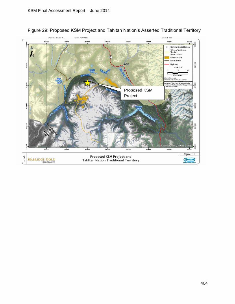
KSM Final Assessment Report – June 2014
404
Figure 29: Proposed KSM Project and Tahltan Nation’s Asserted Traditional Territory
Proposed KSM
Project
KSM Final Assessment Report – June 2014
405
12.4.2 Tahltan Nation’s Traditional Use of the Proposed Project Area
The following components of the proposed Project fall within the Tahltan Nation’s
asserted traditional territory:
Coulter Creek access road;
the eastern portion of the Mitchell-Treaty twinned tunnels;
the processing plant;
the PTMA;
Treaty Creek access road; and
the transmission line.
While the proposed mine site is not located within the Tahltan Nation’s asserted
traditional territory, both Mitchell and Sulphurets Creeks drain into the Unuk River at the
southern boundary of the territory.
According to the Proponent’s Application, the focus of activities undertaken by the
Tahltan Nation is north of the proposed Project near the confluence of the Tahltan and
Stikine Rivers, and some activities associated with the proposed Project have the
potential to impact Tahltan Nation Aboriginal Interests.
No information has been received from the Tahltan Nation regarding their current use of
land and resources within or near the proposed Project area. According to the
Proponent’s Application, the majority of the fishing, hunting, trapping and gathering
activities undertaken by Tahltan members appears to take place further north, such as
the area near Telegraph Creek.
As set out in a letter from EAO to the Tahltan Nation dated December 20, 2013, EAO
reviewed and considered information relating to the activities, practices, traditions, or
customs considered to be integral to the distinctive culture of the Tahltan Nation prior to
contact with Europeans. Specifically, EAO considered currently available information
regarding definite tracts of land that were regularly and exclusively used or occupied in
1846. The information that was reviewed and considered by EAO in its initial
assessment of Tahltan Nation’s asserted Aboriginal rights and title (Aboriginal Interests)
is as follows:
KSM Mine Project: Review of Ethnographic and Historical Sources (dated March 6, 2013; and
Tahltan Nation: Review of Ethnographic, Historic and Archaeological Resources (revised April 7, 2009).
The Province completed the KSM Mine Project: Review of Ethnographic and Historical
Sources, (dated March 6, 2013) and EAO shared it with the Tahltan Nation on
December 20, 2013. The report draws from publicly available published historical,
archival, and anthropological information, including transcribed oral histories. The report
KSM Final Assessment Report – June 2014
406
focuses on land use practices and aspects of social organization that were in place from
the time of European contact to the mid-19th century. EAO advised the Tahltan Nation
that the report was not exhaustive and would be subject to change as more information
became available. To help ensure an accurate and more complete understanding of
Tahltan’s historical interests, EAO invited the Tahltan Nation to review the report and
provide comments or additional information that may be missing.
12.4.3 Tahltan Nation’s Aboriginal Interests
A consideration of the Tahltan Nation’s Aboriginal Interests that may be impacted by the
proposed Project was approached on the basis of information currently available to the
Province, including information provided during consultation, and guidance from the
courts regarding aboriginal rights.
The strength of the claim to aboriginal rights is assessed on the basis of information
indicating where that First Nation engaged in an activity, practice, tradition or custom, in
the area of the proposed government decision, which was integral to its distinctive
culture prior to contact with Europeans. The strength of a First Nation’s claim to
Aboriginal title is assessed on the basis of information regarding regular and exclusive
use or occupation of land at 1846.
It is understood that at the time of contact in1838, the Tahltan Nation was comprised of
a loose affiliation of six smaller “proto-Tahltan” tribes. One of the “proto-Tahltan” tribes
was known as the Nassgotin, but was also referred to as “Laxwiiyip”’ or the “Eastern
Tsetsaut” in ethnohistoric sources. In the early 19th century, the Nassgotin reportedly
occupied an extensive territory that included the headwaters of the Nass, Skeena and
Stikine Rivers. Available ethnohistoric information indicates that, at the time of contact,
the Nassgotin dominated the area encompassing the proposed Project Area. The
Nassgotin are known to have followed a semi-nomadic seasonal round often travelling
over great distances to hunt, trap, fish and gather resources. There may be some
question regarding whether there was any use of areas at higher elevations where the
majority of the proposed Project components are located, given that the geography is
dominated by glaciers and mountains; this supports a moderate to strong prima facie
claim of aboriginal rights to hunt, trap, fish and gather.
There was no information indicating that the area of the proposed Project, or its vicinity,
overlapped with any village sites occupied in 1846, or that there were any sites regularly
or intensively used in 1846, which would to support a claim to Aboriginal title.
EAO has also considered information contained in the Proponent’s Application. In the
Unuk River watershed, specific Project components include the following:
KSM Final Assessment Report – June 2014
407
the Kerr, Sulphurets, Mitchell pits, and underground block cave Iron Cap deposit;
a waste rock storage area;
power plant;
water treatment facility;
camp;
the Coulter Creek Access Road; and
the Ted Morris Creek Winter Access Road.
In the upper Bell-Irving watershed, main project components include the following:
an ore preparation plant;
TMF;
various camps; and
the Treaty Creek Access Road.
The ore preparation plant, TMF, various camps, and the Coulter Creek and Treaty
Creek Access Roads appear to overlap with the Tahltan Nation’s asserted traditional
territory.
The proposed Project, including the Mine Site, TMF, access roads and other Project
components, have the potential to impact fish and fish habitat, wildlife and wildlife
habitat, and vegetation, resulting from the effects of ML/ARD on water quality, loss of
habitat from clearing within the proposed Project footprint, soil erosion, as well as the
risk of accidents, malfunctions, and increased access. Potential downstream effects
from the mine construction and activities could affect the headwaters of the Unuk River,
as well as the Treaty Creek and Teigen Creek drainages of the upper Bell-Irving River.
The above high-level list of potential impacts is not meant to be exhaustive; they simply
represent the major themes of potential impacts identified during the EA. As indicated in
EAO’s November 9, 2009 letter to the Tahltan Nation, the proposed Project area is
located at the southern periphery of the area claimed by the Tahltan Nation (with Treaty
Creek being the southern boundary, as EAO understands it, and the area to the south
having been ceded to a Gitxsan group in or around 1900). As the proposed Project’s
TMF appears to overlap with the Tahltan’s asserted traditional territory minimally (within
the Treaty Creek area), and because the rivers associated with the proposed Project
flow to the south, it does not appear that Tahltan Nation’s Aboriginal Interests would be
significantly impacted by the proposed Project.
Given EAO’s initial assessment of the nature of the potential impacts of the proposed
Project on the asserted Aboriginal Interests of the Tahltan Nation, EAO’s view is that the
duty to consult Tahltan Nation is at the middle range of the Haida consultation
spectrum. However, throughout the EA of the proposed Project, EAO engaged with the
Tahltan Nation pursuant to the process set out in the November 6, 2009 order issued

KSM Final Assessment Report – June 2014
408
under section 11 of the Act which in EAO’s view is more consistent with consultation at
the deeper end of the Haida consultation spectrum.
In EAO’s view, the consultation process with the Tahltan Nation, through engagement
by the Proponent as well as directly by EAO, adequately fulfills the Crown’s duty to
consult in these circumstances.
12.5 Consultation with the Tahltan Nation
12.5.1 EAO’s involvement with the Tahltan Nation
Pre-Application Stage
Initial Engagement
EAO notified the TCC of the initiation of the EA for the proposed Project via letter on
April 30, 2008; in that letter, EAO advised that the EA process had been initiated and
that it would contact the TCC again shortly in order to discuss opportunities for the TCC
to participate. Two weeks later, on May 8, 2008, EAO sent a follow-up letter to the TCC
to provide background information regarding the proposed Project and to extend an
invitation to participate in the first meeting of the EA Working Group. EAO also
requested a government-to-government meeting with the TCC in order to discuss the
following:
consultation opportunities during the federal and provincial EAs;
the nature and scope of the Tahltan Nation’s asserted Aboriginal Interests in the
proposed Project area; and
funding to assist the TCC’s participation in the EA for the proposed Project.
The TCC accepted EAO’s invitation to meet, which then took place on May 29, 2008 in
Vancouver. In addition to the topics listed above, the following topics were also
discussed during the meeting:
TCC’s interest in participating in the EA, including baseline study work;
timing for open houses in the Tahltan communities;
water management in the proposed Project area; and
scheduling a follow-up meeting with EAO and the CEA Agency after the TCC has
provided additional information regarding the Tahltan Nation’s interests in the
proposed Project area.
In May 2009, EAO wrote to the TCC to provide a copy of the Proponent’s 2008 Baseline
Studies Report and asked for feedback regarding whether there were any gaps that
should be incorporated into the 2009 Baseline Studies Workplan, which was attached
for review and comment. EAO’s letter also included information about upcoming
meetings of the full Working Group and technical sub-working groups, as well as an
KSM Final Assessment Report – June 2014
409
invitation to meet on a government-to-government basis to discuss the EA process and
the nature and scope of Tahltan Nation’s Aboriginal Interests in the proposed Project
area.
Capacity Funding
In August 2008, EAO sent a letter to THREAT conveying capacity funding to assist
THREAT’s participation in the EA of the proposed Project on behalf of Iskut First Nation
and Tahltan First Nation. In October 2008, EAO provided additional capacity funding to
assist with the TCC’s participation in the EA.
Section 11 Order and Application Information Requirements
In June 2009, EAO provided the TCC with a copy of the Proponent’s 2008 baseline
geochemistry report and invited the TCC to participate in a Working Group meeting to
discuss ML/ARD, which a THREAT representative attended.
A month later in July, EAO sent a letter to the TCC outlining EAO’s preliminary views for
consulting with the TCC for the EA of the proposed Project, and invited the TCC to
review and provide comments on a draft order under section 11 (Section 11 Order) of
the Act. The draft Section 11 Order acknowledged that the Tahltan Nation had indicated
that the proposed Project is located within its asserted traditional territory, and outlined
EAO’s proposal for how consultation with the Tahltan Nation would be undertaken by
both EAO and the Proponent for the EA for the proposed Project.
The TCC submitted comments on the draft Section 11 Order in August 2009, followed
by comments on the draft AIR. EAO made a number of revisions to the draft in
response to the TCC’s comments prior to finalizing the Section 11 Order on
November 6, 2009. In conveying the finalized Section 11 Order on November 9, 2009,
EAO provided its rationale in a letter for incorporating some but not all of the TCC’s
requested revisions to the Section 11 Order. EAO explained that EAO’s assessment of
the Tahltan Nation’s Aboriginal Interests was preliminary, and was based on the
understanding that the TMF appeared to only slightly overlap with the Tahltan Nation’s
asserted traditional territory. Also, because the rivers that may be potentially impacted
by the proposed Project flow south, EAO did not believe that Tahltan Aboriginal
Interests were likely to be significantly impacted. Despite EAO’s preliminary assessment
that the potential for the proposed Project to impact Tahltan Nation’s Aboriginal
Interests was relatively low, EAO committed to continuing to consult with the Tahltan
Nation at the high end of the Haida spectrum. Finally, EAO requested clarification from
the Tahltan Nation regarding whether activities such as hunting, fishing for food, social,
and ceremonial purposes, and timber harvesting for domestic purposes were, and
continue to be, exercised in the proposed Project area.

KSM Final Assessment Report – June 2014
410
The TCC sent EAO a letter in December 2009 stating that EAO had assessed the
Tahltan Nation’s rights unilaterally and that the EA process was insufficient to discharge
the Crown’s duty to consult and accommodate the Tahltan Nation with the respect to
potential impacts from the proposed Project. EAO responded via a letter to the TCC two
days later, and reiterated the rationale behind its preliminary assessment of the Tahltan
Nation’s Aboriginal Interests that was originally communicated in its November 9, 2009
letter. EAO also clarified the numerous opportunities for the Tahltan Nation to
participate in the EA of the proposed Project, including:
consultation regarding draft legal orders outlining the scope of the review, the EA
process, and consultation requirements;
receipt of capacity funding to assist with engagement in the EA process;
opportunities for Tahltan Nation input and participation in studies;
invitations to participate as a member of the advisory working group on technical
issues;
incorporating traditional ecological knowledge and traditional use information in
the Proponent’s Application for an EA certificate;
engaging in government-to-government consultation, including specific
discussions about potential adverse impacts to the Tahltan Nation’s Aboriginal
Interests form the proposed Project;
pursuing accommodation options through proposed Project design modifications
to address the Tahltan Nation’s Aboriginal Interests and to minimize or eliminate
potential adverse impacts on those interests;
soliciting the Tahltan Nation’s input regarding legal commitments/conditions of an
EA certificate, if one is issued for the proposed Project;
reviewing and providing comments on EAO’s draft Assessment Report to
Ministers; and
the ability for the Tahltan Nation to submit a separate report to Ministers along
with EAO’s Assessment Report, if desired.
Section 13 Orders
In June 2011, EAO sent a letter to THREAT conveying a draft Order under section 13 of
the Act (Section 13 Order), as well as a copy of the revised draft AIR, for review and
comment. The purpose of the Section 13 Order was to change several aspects of the
scope and process for the EA of the proposed Project, specifically the inclusion of
Hwy 37 from the proposed Project site to the junction of Hwy 16 at Kitwanga, and
consultation with Gitanyow regarding potential impacts arising from the use of Hwy 37.
Although no written comments were received from the Tahltan Nation, a verbal
telephone conversation between EAO’s Executive Project Director, Chris Hamilton, and
THREAT’s Nalaine Morin took place on July 22, 2011; during that call Ms. Morin relayed
concerns with the draft Section 13 Order, which Mr. Hamilton understood to be related
KSM Final Assessment Report – June 2014
411
to the rationale for scoping transportation only as far as the junction with Hwy 16 and
not further, as well as the nature and scope of consultation with the Tahltan Nation.
Following up on the July 22, 2011 telephone conversation, EAO wrote to THREAT on
October 4, 2011 to clarify that the draft Section 13 Order would not change EAO’s
current instruction to the Proponent as it relates to consultation with the Tahltan Nation.
In December 2012, EAO notified the TCC of a second Section 13 Order, the purpose of
which was simply to change the timing for the Proponent to submit its request for the
concurrent review of permit applications with its Application for an EA certificate.
Proponent’s Consultation Reports
On January 30, 2013, EAO sent a letter to THREAT conveying a copy of the
Proponent’s “KSM Project Tahltan Nation Section 11 Order Consultation Summary
Report” for review and comment; no comments were received from THREAT.
Application Evaluation
On October 31, 2012, EAO canvassed the Working Group members (including
representatives from the Tahltan Nation) regarding their interest in participating in the
evaluation of the Proponent’s Application. The purpose of the evaluation is to determine
whether the Application contains all of the information set out in the Application
Information Requirements. The TCC accepted EAO’s invitation to participate in the
Application evaluation and submitted their comments on May 3, 2013, after being
granted a one-day extension to the comments deadline, as requested. The Tahltan
Nation also submitted additional screening comments on May 6, 2013.
On June 3, 2013, EAO wrote to THREAT advising that the Proponent’s Application for
an EA certificate had been found to include all of the information set out in the AIR, and
the 180-day review stage would begin once all members of the Working Group had
received their requested copies of the Application. EAO also provided information
regarding EAO’s Assessment Report and outlined opportunities for the Tahltan Nation
to participate in the remainder of the EA and provide input.
In preparation for the initiation of the 180-day review stage for the EA of the proposed
Project, EAO kept the Tahltan Nation apprised of the following between June and
August 2013 by EAO:
June 25, 2013 – e-mail providing an update on concurrent permitting and
requesting feedback regarding the number and format of the copies of the
Application preferred by each Working Group member;
August 1, 2013 – e-mail providing an update on the timing of the revised
Application, as well as instructions for disposing of screening copies;
August 7, 2013 – EAO followed up with the Tahltan by e-mail to confirm that
THREAT had received the revised Table of Concordance from the Proponent, as
KSM Final Assessment Report – June 2014
412
requested, in order to identify specific sections of the Application to receive in
hard copy; and
August 15, 2013 – advised via e-mail that the 180-day review had started and
provided a link to the acceptance letter and the Application on EAO’s website.
EAO also provided an update re: the timing for hard copies, next steps and key
dates in the review (presented in a draft workplan for the Application review
stage).
Application Review Stage
Initiation of the 180-Day Review
The 180-day Application reviews stage of the EA for the proposed Project was initiated on August 12, 2013. EAO communicated with the Tahltan Nation between August and September regarding the initiation of the review, including:
August 16-21, 2013 – e-mails back and forth between EAO and the Tahltan
Nation regarding dates and locations for open houses with the Tahltan
communities; and
August 29-September 12, 2013 – e-mails regarding a conference call to discuss
the initiation of the 180-day Application review stage; EAO canvassed for
preferences regarding potential dates for the call and provided copies of the a
proposed agenda and a revised EA review schedule.
On September 13, 2013, EAO held the conference call with the Proponent and representatives from the CEA Agency and the Working Group (including THREAT) to discuss the initiation of the 180-day Application review stage. EAO and the CEA Agency presented the provincial and federal EA processes and timelines, including the following milestones and key steps in the EA:
initiation of the 180-day review on August 12, 2013;
a 45-day public comment period from September 6-October 9, 2013 with open
houses in Iskut, Telegraph Creek, Smithers, Terrace, and Stewart;
a series of Working Group and sub-Working meetings to be held throughout the
review;
an opportunity to review and submit comments on the Proponent’s Application;
an opportunity to review and submit comments on the Proponent’s responses to
comments on the Application;
an opportunity to review and submit comments on EAO’s draft Assessment
Report, CPD, and TOC; and
an opportunity for First Nations (including the Tahltan Nation) to review and
submit comments on EAO’s draft First Nations Consultation Report.
KSM Final Assessment Report – June 2014
413
During the call, Working Group members were also given an opportunity to engage in discussion with, and ask preliminary questions of, the Proponent regarding the Application. EAO asked Working Group members for their feedback regarding the format and intent of future Working Group meetings, including the utility of forming technical sub-Working Groups. EAO provided information regarding upcoming open houses and advised that the deadline for the first round of Working Group comments on the Application was October 11, 2013.
Meetings and Key Correspondence with the Tahltan Nation
On September 16, 2013, a meeting took place between THREAT, EAO and the CEA Agency in Victoria; the purpose of the meeting was to discuss the EA of the proposed KSM Project, as well as a draft Letter of Understanding outlining consultation objectives with the Tahltan Nation on EA projects in general. The timing and purpose of a Hwy 37 Working Group meeting in early October 2013 to address transportation-related impacts from a number of EA projects in the northwest was also discussed. On December 20, 2013, EAO wrote a letter to the TCC to provide EAO’s initial views of the potential impacts from the proposed Project on the Aboriginal Interests of the Tahltan Nation. The letter outlined the following:
EAO’s initial assessment of the Tahltan Nation’s Aboriginal Interests in the
proposed Project area;
potential impacts of the proposed Project on Tahltan Aboriginal Interests; and,
the scope of EAO’s consultation with the Tahltan Nation regarding the EA of the
proposed Project.
EAO requested feedback from the Tahltan Nation regarding its initial assessment and the scope of consultation by January 24, 2014 and offered to meet with the Tahltan Nation to answer any questions or discuss the EA of the proposed Project. EAO also advised that the Tahltan Nation would have an opportunity to review and comment on EAO’s draft Assessment Report, as well as the option to submit a separate report of their own to Ministers for their consideration along with EAO’s Assessment Report.
Between December 2013 and May 2014, EAO communicated with the Tahltan Nation regarding the status of the EA, including the following key correspondence:
December 20, 2013 – e-mail conveying the Proponent’s responses to Working
Group comments on the Application and providing an opportunity to comment on
those responses by January 24, 2014;
December 20, 2013 – e-mail advising that the Proponent requested a 30-day
extension to the 180-day review;
January 8, 2014 – e-mail providing an update on next steps, timelines, and
upcoming opportunities for input into the EA;
January 15, 2014 – e-mail and letter conveying a copy of the ethnographic report
KSM Final Assessment Report – June 2014
414
entitled “KSM Mine Project: Review of Ethnographic and Historical Sources”
dated March 6, 2013 referenced in EAO’s December 20, 2013 letter;
January 17, 2014 – e-mail to the Working Group (including the Tahltan Nation)
acknowledging the complexity and volume of materials for review as part of this
EA, and requesting feedback regarding what EAO could do to facilitate the
Working Group’s review of those documents;
January 20/24, 2013 – e-mail conveying draft summaries to participants from the
October 2-3, 2013 Working Group meeting and the November 6-8, 2013
technical water quality, wildlife, and selenium sub-Working Group meetings; for
review and comment prior to finalization;
January 30, 2014 – e-mail conveying an order under section 24(4) of the Act
extending the 180-day review timeline by 30 days, as requested by the
Proponent;
February 12, 2014 – e-mails back and forth between EAO and the Tahltan
Nation regarding scheduling a meeting on February 21, 2014 to discuss the EA
of the proposed Project and the draft Letter of Understanding (LOU) between BC
and the Tahltan Nation;
February 20, 2014 - e-mail from EAO to the Tahltan Nation proposing topics for
discussion at the February 21, 2014 meeting and requesting feedback regarding
additional items of interest to the Tahltan Nation;
March 5, 2014 – EAO e-mail providing a copy of the draft CPD and TOC for the
Kitsault Mine Project for the GHCO’s information (an action item from the
February 21, 2014 meeting);
March 5, 2014 – EAO e-mail conveying the Proponent’s responses to comments
submitted by the US Department of the Interior, HC, and FLNR, as well as a copy
of the signed section 24(4) Order, extending the 180-day review by an additional
45 days, as requested by the Proponent;
April 3, 2014 – EAO e-mail to the Tahltan Nation conveying a copy of the revised
draft LOU between EAO and the Tahltan Nation, and proposing scheduling a
meeting to discuss and finalize the LOU;
April 11, 2014 – Tahltan Nation e-mail conveying the draft LOU with the Tahltan
Nation’s suggested revisions;
April 22, 2014 – EAO e-mail to the Working Group (including the Tahltan Nation)
advising of an upcoming Working Group meeting and outlining opportunities to
review and provide input on key documents;
April 24, 2014 – Tahltan Nation letter conveying comments on the Proponent’s
responses to issues raised by the Tahltan Nation, and outlining the Tahltan
Nation’s concerns with the proposed Project;
April 25, 2014 – EAO e-mail conveying EAO’s suggested revisions to the draft
LOU and requesting a meeting to discuss;
KSM Final Assessment Report – June 2014
415
April 29, 2014 – EAO e-mail conveying copies of the recently issued section 13
and 24(4) orders for the EA of the proposed Project, as well as outlining the
topics for discussion at the May 13-15, 2014 Working Group meetings; and
April 29, 2014 – EAO e-mail requesting to schedule a call to discuss the draft
LOU and a meeting the week of May 19 or 26 to discuss the EA of the proposed
Project;
May 2, 2014 - EAO provided the Tahltan Nation with the draft Assessment Report, TOC, CPD, First Nation Consultation Report, and issue tracking tables for review and comment. EAO also advised that the Tahltan Nation may choose to submit a separate report to Ministers for consideration, which would need to be submitted to EAO by June 12, 2014.
May 22, 2014 – the Tahltan Nation requested a two-week extension for submitting comments on the draft Assessment Report, TOC, CPD, First Nation Consultation Report, and issue tracking tables. EAO responded to advise that the Executive Director had agreed to grant a one-week extension, and that anything submitted after May 30, 2014 would be provide to Ministers as a separate submission, but not reflected in EAO’s Assessment Report.
May 30, 2014 – the Tahltan Nation submitted comments on the draft TOC, with a focus on the following:
o adding a condition that the Proponent would not be allowed to start construction of the proposed Project until bonding and financing have been finalized;
EAO considered this and noted that bonding is a statutory decision made through Mine Act permitting
o revised wording in numerous conditions to strengthen the requirement for the Proponent to properly consult and consider Tahltan input on permit applications prior to permits being issued;
o a recommendation to add a condition requiring the Proponent to begin ice patch archaeology, which would include having a plan and program in place prior to the start of construction in order to ensure that significant archaeological values are understood and can be protected prior to any disturbance from development of the proposed Project;
During the EA process the Tahltan identified the importance of snow and ice patches, which is also outlined in the Tahitian Archaeological Standards. While the KSM Project’s Regional Study Area (RSA) has extensive high elevation terrain with snow and ice patches, the Project’s actual footprint is mainly at lower elevations where there are no snow patches or glaciated areas. However, the proponent’s AIA included assessments of 43 snow and ice patches, located in the RSA. The snow and ice patch assessment was conducted by pedestrian survey in August 2012 during the period when there was near maximum annual snow melt. Survey areas were selected based on proximity to the Project footprint and the assessed archaeological potential of the areas. No prehistoric cultural material, paleobotanical or paleontological materials were identified
KSM Final Assessment Report – June 2014
416
during the ice patch survey o a request for a new condition to require an update of the hydrogeological
model that was undertaken for the proposed Project and a proven contingency plan, including triggers for implementation;
an updated hydrogeological model will be completed as a requirement of permitting. EAO has also added conditions requiring groundwater and water management plans.
o a recommendation that wildlife population surveys be undertaken more frequently than every five years;
EAO notes that this condition is not supported by FLNR, who is concerned about the disturbance resulting from surveys
o a recommendation for additional identification and monitoring of effects on sensitive moose habitats;
EAO notes that this is addressed in the condition for a Wildlife Effects Monitoring Plan
o a request for additional monitoring and mitigations for little brown bats; EAO notes that this is addressed in the condition for a Wildlife
Effects Monitoring Plan o an expression of concern that the proposed mitigation for mountain goat
are too focused on habitat loss and not on population effects; EAO will continue a discussion with Tahltan to better understand
this request and how it may be addressed. o a request for conditions that require proven thresholds or contingencies to
deal with risk and uncertainty related to potential wildlife effects. EAO will continue a discussion with Tahltan to better understand
this request and how it may be addressed.
EAO met with representatives from the Tahltan Nation on February 21, 2014 in Vancouver to discuss the following:
EAO’s draft First Nations Consultation Report and the opportunity for the Tahltan
Nation to review and provide comments on that document;
EAO’s December 20, 2013 letter regarding its initial assessment of the Tahltan
Nation’s asserted Aboriginal Interests in the proposed Project area;
Tahltan Nation’s intent to submit a separate report to provincial Ministers along
with EAO’s Assessment Report at the end of the EA for the proposed Project;
EAO’s methodology for assessing potential impacts on the Tahltan Nation’s
Aboriginal Interests in the proposed Project area;
the need for site-specific information regarding the Tahltan Nation’s use of the
proposed Project area; and
the status of the draft LOU between BC and the Tahltan Nation and next steps.
KSM Final Assessment Report – June 2014
417
Another meeting between EAO and Tahltan Nation representatives was scheduled for
June 11, 2014 in order to discuss the draft Letter of Understanding and the EA of the
proposed Project.
Throughout the remainder of the EA, EAO continued to communicate regularly with the
Tahltan Nation and provided information and opportunities for input into the EA of the
proposed Project. Via e-mails to the Working Group, EAO provided the Tahltan Nation
with the following:
copies of memos and comments submitted by other members of the Working
Group, as well as the Proponent’s responses;
invitations to participate in Working Group meetings;
updates on the timelines and next steps in the EA of the proposed Project; and
opportunities to provide input.
Open Houses
EAO worked with the Tahltan Nation to identify appropriate dates and communities to hold open houses, the purpose of which was to provide information regarding the Proponent’s Application and explain opportunities to provide input. Two open houses were held in Tahltan communities: one on September 25, 2013 in Iskut, and one on September 26, 2013 in Telegraph Creek. Five people attended the open house in Iskut and ten people attended the open house in Telegraph Creek. Comments on the Application and Proponent Responses On October 11, 2013, THREAT contacted EAO to request a two-week extension to the deadline for the first round of comments on the Application, but offered to provide a high-level summary of the Tahltan Nation’s issues and concerns by October 15, 2013. EAO granted the extension request and suggested scheduling a meeting between EAO and the TCC in November 2013 and perhaps again in January 2014. On October 21, 2013, the Tahltan Central Council submitted its first round of comments
on the Application, expressing concerns regarding potential effects on the following:
economics;
water quality and fish;
visual and aesthetics;
social conditions;
access; and
wildlife.
The TCC also expressed concerns regarding the alternative means of undertaking the
Project, accidents and malfunctions, and the Proponent’s presentation of Aboriginal
KSM Final Assessment Report – June 2014
418
Interests in the Application. Additional comments were submitted by THREAT to EAO
on November 14, 2013, which expanded on their October 11, 2013 comments related
to:
economics;
water quality and fish;
visual and aesthetics;
accidents and malfunctions;
cumulative effects; and
alternative means of undertaking the Project.
EAO provided all of the comments submitted by the Tahltan Nation to the Proponent for inclusion in an issue tracking table and response. Between January and April 2014, EAO circulated responses from the Proponent to issues raised by members of the Working Group (including the Tahltan Nation) for review and comment. On April 24, 2014, the Tahltan Nation submitted comments on the Proponent’s responses to the issues they had originally raised, and outlined the following overarching concerns with the proposed Project:
effects on high fisheries values in Teigen and North Treaty Creeks;
inadequate detail in the Proponent’s fisheries and aquatic management and
monitoring plans;
impacts from the TMF to water quality/quantity in Teigen and Treaty Creeks;
impacts on fish (especially salmon, including one of the most valuable salon
habitats in the Bell-Irving River system) due to inadequate mitigation and water
treatment;
impacts on fisheries habitat in the event of a catastrophic dam failure event;
unproven technology associated with the SeMP; and
removal of moose habitat, including a vital corridor for moose movement in a
population that is already in decline.
A complete list of all comments submitted by the Tahltan Nation regarding the proposed Project and the associated responses from the Proponent is presented in Appendix 1.
Working Group & Technical Sub-Working Group Meetings
Between October 2013 and May 2014, EAO and the CEA Agency scheduled the
following Working Group and technical sub-Working Group meetings:
October 2-3, 2013 – the Proponent presented their significance determination
framework and key areas of the Application, followed by a discussion, and an

KSM Final Assessment Report – June 2014
419
opportunity to ask questions (Tahltan representatives participated in person and
by telephone)
November 6-8, 2013 – an opportunity to engage in technical level discussions on
issues related to wildlife and water quality on both the mine side and tailings side
of the proposed Project (Tahltan representatives participated in all three days of
meetings)
November 26-28, 2013 – an opportunity to engage in a technical level
discussion, review the Proponent’s proposed mitigation measures and
conditions, and identify outstanding geotechnical issues for resolution (Tahltan
representatives participated in the November 28 meeting)
May 13-15, 2014 – a three-day Working Group meeting to discuss EAO’s draft
Assessment Report, TOC, CPD, and issues tracking table. The meetings
provided Working Group members with an opportunity to discuss and ask
questions about EAO’s key findings with respect to potential effects from the
proposed Project on water quality, wildlife, fish, and transportation.
12.5.2 Proponent’s Involvement with the Tahltan Nation
Pre-Application Stage
On November 6, 2009, EAO issued an order under section 11 of the Act, which required
that the Proponent consult with the TCC on behalf of the Tahltan Nation regarding the
EA of the proposed Project. The Proponent initiated consultations with the Tahltan
Nation prior to the start of the EA, and met with THREAT representatives on February 1,
2008 to introduce the proposed Project.
Starting in June 2008, the Proponent participated in Working Group meetings led by
EAO and the CEA Agency and organized tours of an operating and a closed mine in
June 2011. Representatives of the Tahltan Nation participated in all of the Working
Group meetings and also attended both site tours. The Proponent also provided
opportunities for representatives of the Tahltan Nation to tour the proposed Project site,
which took place in July 2008, June/July/October 2009, and September 2011.
As set out in the section 11 Order, the Proponent provided the Tahltan Nation with
electronic and paper copies of the draft AIR in June 2010, as well as notifications
regarding upcoming open houses.
Although not specifically required by EAO, the Proponent provided the Tahltan Nation
with capacity funding to facilitate their participation in the EA, including the review of the
KSM Preliminary Economic Assessment and a desk-based Traditional Knowledge/
Traditional Use Study. The Proponent provided the Tahltan Nation with a copy of the
draft desk-based report for review and comment in June 2012, and followed up by
meeting with the Tahltan to discuss the report and other issues. Based on a
KSM Final Assessment Report – June 2014
420
recommendation from THREAT, the Proponent held a Traditional Knowledge/Traditional
Use workshop in August 2012 in order to discuss the integration of Tahltan knowledge
into the EA.
In addition to the Traditional Knowledge/Traditional Use workshop, the Proponent also
facilitated the delivery of a “Mining 101: Mining for Non-Miners” workshop at the Tahltan
Youth Conference in April 2010, and attended the Tahltan Resources Forum in June
2008 and the Tahltan Career Fair in May 2012.
In October 2012, the Proponent hosted community meetings in Dease Lake, Iskut, and
Telegraph Creek in order to provide Tahltan members with information regarding the
fisheries, water quality, and wildlife studies that had been undertaken to date for the EA
of the proposed Project. Employment opportunities connected with baseline field studies
were also offered to the Tahltan Nation by the Proponent between 2008 and 2011/2012.
As set out in the section 11 Order, the Proponent prepared a draft report summarizing
the consultation activities undertaken with the Tahltan Nation during the pre-Application
stage of the EA, as well as outlining their plan for consulting with the Tahltan Nation
during the Application review. Although the Proponent provided the Tahltan Nation with
the draft report on December 12, 2012 for review and comment, no feedback was
received.
Application Review Stage
As required by the section 11 Order issued by EAO, the Proponent undertook the
following consultation activities with the Tahltan Nation during the Application review
stage of the EA of the proposed Project:
distributed copies of the Application to the Tahltan Nation for information and
consultation purposes;
wrote to the Tahltan Nation to identify the dates of the public comment period on
the Application, and the dates, times and locations of open houses;
provided a written report to the Tahltan Nation, EAO, and the CEA Agency on the
results of consultation activities with the Tahltan Nation;
considered and responded to issues identified in comments submitted by the
Tahltan Nation during the review of the Application;
where requested and within any time limits set by EAO, provided specific
additional information in relation to, or to supplement, the information provided in
the Application;
attended Working Group meetings organized by EAO to provide information
related to the Application and responded to questions on the Application;
prepared a tracking table of issues raised by First Nations (including the Tahltan
Nation) on the Application and responses to those issues;
KSM Final Assessment Report – June 2014
421
considered and prepared written responses to key issues raised by the Tahltan
Nation regarding the Application; and
by mutual agreement, arranged consultation meetings with the Tahltan Nation to
identify any specific Aboriginal Interests that may be potentially affected by the
proposed Project, as identified in Aboriginal interest and use studies, traditional
use studies, or other sources of information; to identify measures to avoid or
mitigate potential adverse effects; and/or to otherwise address or mitigate the
Tahltan Nation’s concerns.
Following acceptance of the Application and the initiation of the 180-day review by EAO, the Proponent provided the Tahltan Nation with copies of the Application. The Proponent also placed advertisements in local newspapers and participated in the two open houses hosted by EAO in Iskut (September 25, 2013) and Telegraph Creek (September 26, 2013) in order to present the proposed Project to Tahltan community members.
Meetings and Key Correspondence Between the Proponent and Tahltan Nation
In addition to participating in open houses and Working Group meetings organized by
EAO, the Proponent also held the following meetings with representatives of the Tahltan
Nation:
September 10, 2013 – meeting in Smithers BC, with Nalaine Morin of THREAT
to provide an update on the proposed Project and discuss the TMF alternatives
assessment and road assessment;
October 11, 2013 – meeting in Vancouver BC, with representatives from the
TCC to discuss the TCC Communication Agreement; and
January 30, 2014 – meeting in Vancouver BC, with representatives from the
TCC and THREAT to provide an update on the proposed Project and discuss
communications protocols, etc.
According to the Proponent’s February 2014 Tahltan Nation Consultation Report, the Proponent communicated regularly with the Tahltan Nation during the Application review stage of the EA of the proposed Project. In addition to communications regarding logistics for meetings and requests for information, the Proponent exchanged 50 letters, emails, and news releases with the Tahltan Nation, as well as distributing a newsletter to all mailboxes in Dease Lake, Iskut and Telegraph Creek to provide Tahltan Nation members with an update on the proposed Project.
The Proponent also provided capacity funding to assist the Tahltan Nation’s
participation on the EA of the proposed Project.

KSM Final Assessment Report – June 2014
422
12.5.3 Potential Impacts to Tahltan Nation Interests and Measures to Mitigate or
Accommodate Impacts
The sections below describe EAO’s understanding of the issues that have been
identified by Tahltan Nation during the EA for the proposed Project and responses to
the full set of concerns are described in the Issues Tracking Table. Further information
on how concerns have been addressed, including mitigation and Proponent
commitments, is provided in the relevant sections of the Assessment Report. The
majority of Tahltan Nation issues relate to water quality and fish, access, economics,
and alternative means of undertaking the proposed Project. In terms of matching
specific concerns with corresponding mitigation measures, the reader is directed to
those documents. The following is intended only to be a summary of the major issues
raised and accommodations of those issues.
With respect to the issues raised by the Tahltan Nation, many relate to aboriginal rights
to hunt, with a particular emphasis on moose, although goats and other wildlife have
also been discussed. Access has been a theme raised commonly by Tahltan, both
physical access (e.g. new road access providing more pressure) and regulatory access,
meaning hunting rules established under the Wildlife Act. In particular, the Tahltan
Nation view General Open Season rules as placing too much pressure on wildlife and
thereby making Tahltan Nation hunting activities more difficult. They have expressed a
preference for Limited Entry Hunting where fewer non-aboriginal hunters provided with
a limit on the number of animals to be harvested.
Tahltan Nation also expressed concerns about water quality, with a particular emphasis
on Teigen Creek, given the high fisheries values in the area. This concern, as well as a
concern for other rivers and creeks, is directly related to the aboriginal right to fish.
Another consistent message from Tahltan Nation is about culture. While the link
between proposed Project effects and culture is somewhat more difficult to assess, it is
an important value to Tahltan Nation and is connected to a range of issues and
activities, including the ability to access areas and continue to harvest resources, to
increased road traffic and safety concerns, being fully involved in decision-making,
community well-being and cohesion and the importance of language.
Water Quality and Fish
The Tahltan Nation expressed concerns about potential impacts to fish, and the
resulting potential impacts on the aboriginal right to fish, in the Unuk River, Bell-
Irving River, Treaty Creek, and Teigen Creek from impacts to water quality from
the proposed Project, and recommended the development of a Salmon
Management Plan for the area.
The Proponent has committed to monitoring fish and aquatic habitat as set out in
the AEMP (Chapter 26.18.2 in the Application) and to monitor Teigen Creek
KSM Final Assessment Report – June 2014
423
Chinook salmon through the implementation of a Salmon Monitoring Plan to
verify the predictions of the effects assessment. The program will include
monitoring of adult returns, juvenile abundance in relation to flow, gravel
recruitment, hydrology, and water temperatures.
The Proponent’s proposed mitigation measures for ensuring that residual effects
of water quality on fish populations in South Teigen, Teigen, North Treaty and
Treaty Creeks include: designing diversion ditches to minimize water loss,
altering diversion ditch flow patterns to coincide with various phases of Project
development to minimize changes in water quantity, and rotating the TMF to
discharge into Treaty Creek during its operation. The Salmon Monitoring Plan
proposed for Teigen Creek will be designed to detect any changes due to habitat
alteration.
The Proponent has committed to ongoing monitoring in aquatic environments
downstream of discharge points (such as the TMF) in order to ensure that any
changes in the aquatic environment area detected and adequately managed.
In addition to condition 8, which requires that water quality 100 m downstream of
the point of seepage meet BCWQG or SSWQO, EAO has also added a number
of additional conditions to address potential water quality effects to fish. EAO also
notes that Tahltan Nation will be consulted on all these conditions. They include:
o the requirement for a WMP which provides for the detailed design of the TMF
and associated water management facilities and demonstrates how condition
8 will be satisfied during all phases of the proposed Project. This must be
completed prior to construction of the TMF dams;
o the requirement for an Accidents and Malfunctions Plan that shows how the
Proponent will address any accidental water quality effects. This must be
completed prior to construction of the TMF dams;
o the requirement that the proposed Project must be constructed to enable the
addition of infrastructure and facilities that could collect any seepage and treat
any discharges from the TMF to ensure that condition 8 is met during all
phases of the proposed Project;
o the requirement for an AEMP that continuously examines water quality in
Teigen and Treaty Creeks. This must be completed prior to construction of
the TMF dams.
o the requirement for a Groundwater Monitoring and Mitigation Plan which
shows how the Proponent will prevent groundwater effects to Treaty and
Teigen Creeks. This must be completed prior to construction of the TMF
dams;
o the requirement that, during the operations, closure and post-closure phases
of the proposed Project, the EA Certificate Holder must ensure that the rate of
KSM Final Assessment Report – June 2014
424
water discharge from the TMF to Treaty Creek will be staged to mimic stream
flows; and
o the requirement for a Salmon Monitoring Plan in Teigen Creek.
With respect to fish habitat, EAO added a number of conditions relating to fish
and fish habitat, including the following:
o the requirement for an AEMP that continuously examines water quality in
Teigen and Treaty Creeks. This must be completed prior to construction of
the TMF dams;
o the requirement for a Salmon Monitoring Plan; and,
o the requirement for a Fish Salvage Plan, to be developed prior to the
commencement of construction of the TMF dams, which would explain how
Dolly Varden which are currently located within the footprint of the TMF can
be salvaged and relocated.
EAO notes that primary responsibility for managing potential loss to fish habitat
resides with Canada. Notwithstanding this, Part B of this Report says that there is
high certainty that the compensation programs proposed by the Proponent will be
effective in offsetting habitat losses associated with construction and operation of
the TMF dams and related seepage collection ponds, road crossing structures,
transmission line crossings and water quantity reductions in South Teigen and
North Treaty creeks downstream of the TMF dams. These programs are
administered by DFO under the Fisheries Act and DFO has provided their
preliminary support for the Proponent’s proposed plans. The losses would occur
primarily during proposed Project construction and over the duration of TMF
development from changes to streamflow in North Treaty and South Teigen
Creek causing the alteration of the suitability or area of Dolly Varden habitat.
In addition to direct habitat loss, Part B of EAO’s Assessment Report also
discusses the potential effects of water quality degradation on fish. EAO
considered the fisheries and aquatic habitat values in the receiving environment
in Treaty and Teigen Creeks, and in particular the fact that water from the
proposed TMF drains into the Bell-Irving and Nass Rivers. In additional to the
landscape level of effects, EAO noted current water quality in both Treaty and
Teigen Creeks frequently has elevated levels of metals and other elements due
to natural mineralization in the area. We also considered the low magnitude of
the predicted water quality effects as well as the long term and continual nature
of effects. EAO notes that any water quality effects of TMF discharge would
stabilize and diminish in the future due to increased dilution from precipitation.
The Proponent’s mitigation commitment to meet BCWQG and/or SSWQO during
the operations, closure and post- closure phases of the proposed Project is
important to ensuring the proposed Project will not cause significant adverse
residual effects and are central to EAO’s conclusions. EAO also notes that
KSM Final Assessment Report – June 2014
425
modeled information presented during the EA indicates these objectives can be
met.
With respect to Tahltan Nation concerns on the Unuk River, Part B of this Report
concludes that water quality at UR1 will either meet BCWQG or not change
significantly over current baselines.
Access
Tahltan Nation echoed concerns raised by the FLNR regarding the Treaty Creek
Access Road, including geotechnical concerns with the old Bell-Irving bridge
crossing site where the new bridge is proposed, the potential for stream channel
avulsion across alluvial fans, and safety/environmental concerns associated with
the proposed road design across the alluvial fan at km 4.6.
In response to concerns regarding stream channel avulsion, the Proponent has
indicated they will developing and implementing an operational and maintenance
program that would set out regular monitoring and maintenance activities, such
as debris removal, channel dredging/training, culvert maintenance, etc., in order
to minimize the potential for undesirable consequences.
In response to concerns regarding the proposed road design at km 4.7, the
Proponent has amended the design to incorporate changes requested by FLNR,
including adding additional culverts and re-examining the location of the road.
The Proponent has also applied for a wider corridor in the Special Use Permit
near km 4.7 in the event that further design changes are required.
The Proponent’s engineers determined that the west bank of the proposed bridge
location is geotechnically sensitive, and has committed to retain a geotechnical
engineer with appropriate qualifications to provide appropriate field review during
construction.
Tahltan Nation also expressed concerns regarding increased access into the
area via the Treaty Creek Access Road and impacts of the proposed Project on
wildlife. In response, EAO has offered the following conditions:
o prior to the commencement of construction of the Treaty Creek and the
Coulter Creek access roads, the EA Certificate Holder must develop a
standard operating procedure that will form a component of the Wildlife
Effects Monitoring Plan and that will address potential impacts to wildlife
along the Treaty Creek and Coulter Creek roads resulting from transportation
use related to the proposed Project;
o the EA Certificate Holder will develop and submit to the FLNR for approval a
standard operating procedure (the “Bear SOP”) that details efforts to be taken
by the EA Certificate Holder to avoid and reduce risks of potential bear-
human conflicts that could arise during proposed Project operations;
KSM Final Assessment Report – June 2014
426
o the EA Certificate Holder will develop and submit for approval to the FLNR a
Wildlife Effects Monitoring Plan completed prior to the commencement of
construction on the Treaty Creek and Coulter Creek Access Roads;
o the EA Certificate Holder will develop and submit to the FLNR a Terrestrial
Ecosystems Management and Monitoring Plan prior to the commencement of
construction on Treaty Creek and Coulter Creek Access Roads;
o the EA Certificate Holder must develop and submit for approval to the FLNR,
the MEM and EAO a Traffic and Access Management Plan for the Treaty
Creek and Coulter Creek access prior to the commencement of construction
on Treaty Creek and Coulter Creek Access Roads; and
o the EA Certificate Holder must construct and operate a gate or barrier on the
Treaty Creek access road that will restrict access across the bridge to the
West side of the Bell Irving River. Any such gate or barrier must be in place at
any time that the Treaty Creek road is usable by a passenger vehicle or all-
terrain vehicle.
Economics
Tahltan Nation expressed concern about the lack of information in the
Proponent’s economic analysis regarding potential impacts from proposed liquid
natural gas projects, bitumen pipelines, and other associated facilities in the
region. Tahltan Nation is also concerned that commitments may not be honoured
if the proposed Project is sold to another company, including commitments
related to Aboriginal employment and working with local suppliers and
contractors for materials and services.
The Proponent advised that the AIR did not include proposed liquid natural gas
projects, bitumen pipelines, and other associated facilities, and so they were not
included in the analysis.
o EAO notes that, when the AIR was approved in January 2011.
The Proponent has committed to engaging with Tahltan Nation to develop
training programs specifically targeted towards Tahltan members and is currently
working with mine training organizations in the northwest aimed at providing
sector-related skills and training to Aboriginal people.
The Proponent has developed a Procurement Strategy designed to assist local
suppliers (including First Nations) in being able to take advantage of
opportunities to supply the proposed Project.
EAO confirms that an EA Certificate (if issued) would be legally binding, and any
new Project owners would be responsible for complying with the conditions
attached to the EA Certificate.
KSM Final Assessment Report – June 2014
427
Alternative Means of Undertaking the Project
Tahltan Nation raised a number of questions and concerns regarding the
methodology and results of the alternatives assessment, specifically as they
related to the TMF and selenium treatment.
o The Proponent incorporated comments received from THREAT in March
2012 into the final TMF Alternatives Assessment Report, including adding the
following sub-accounts to its analysis: downstream fisheries values,
groundwater quality and quantity, and surface water hydrology. The
Proponent also performed an additional sensitivity analysis on downstream
fisheries values.
o The Proponent followed the Guidelines for the Assessment of Alternatives for
Mine Waste Disposal (2011) in its application for a Schedule 2 Amendment to
the MMER administered by EC. In addition, the sub-accounts and indicators
used were guided by input from technical experts and the Working Group.
o The TMF alternatives assessment was presented to the Working Group
(including representatives from Tahltan Nation) by the Proponent in
September 2011 and March 2012, and Working Group feedback was
incorporated into the final report.
o The Proponent has committed to developing and implementing the following
EMPs that would monitor the effects of metal uptake: Soil Contamination
Prevention Plan, AEMP, and Terrestrial Plant Tissue Metal Concentrations
Monitoring Plan. If contaminants/chemicals of potential concern in plant tissue
change from baseline levels, the Proponent has committed to undertaking a
screening level risk assessment to determine whether changes to country
foods and human health are likely to occur.
Taking account the above discussion, and in particular the following conclusions:
that water quality in Teigen and Treaty Creeks will, as a condition of an EA
Certificate, be protective of the most sensitive aquatic species;
salmon populations and water quality will be monitored and managed through an
AEMP and a SeMP;
DFO has provided its preliminary support for the Proponent’s proposed
compensation programs;
EAO has developed robust conditions around access management;
Tahltan Nation will continue to be consulted through the development of all plans
required to be developed as Conditions; and
Tahltan Nation will be involved throughout the Mine Development Committee,
should an EA Certificate be issued.
EAO’s assessment is that potential impacts of the proposed Project on Tahltan
Aboriginal Interests, including fishing and other uses related to water quality, including
KSM Final Assessment Report – June 2014
428
aboriginal rights to fish in Teigen, Unuk, Treaty and the Bell-Irving Rivers, hunting
throughout the area and the preservation of Tahltan culture, have been appropriately
accommodated.
12.5.4 Conclusions Regarding Tahltan Nation
In view of the consultation that has taken place with Tahltan Nation, it is EAO’s
conclusion that:
the process of consultation has been carried out in good faith, with the intention
of substantially addressing specific concerns expressed by Tahltan Nation;
the process of consultation was appropriate and reasonable in the
circumstances;
EAO, on behalf of the Crown, has made reasonable efforts to inform itself of the
impacts the proposed Project may have on Tahltan Nation Aboriginal Interests
(and by way of both draft and final copies of this Report, it is communicating its
findings to Tahltan Nation); and
measures that would effectively avoid and mitigate impacts to the potential
impacts to the Tahltan Nation’s asserted Aboriginal rights to hunt and fish have
been meaningfully discussed with Tahltan Nation.
Based on the EA of the proposed Project, and on a careful consideration of the record
of consultation with Tahltan Nation, it is EAO’s conclusion that the Crown’s duty to
consult and appropriately accommodate the potential impacts of the proposed Project
on Tahltan Nation’s Aboriginal Interests has been adequately fulfilled.
KSM Final Assessment Report – June 2014
429
13 PART D – NISGA’A NATION CONSULTATION
Chapter 10, paragraph 8(e) of the NFA requires that all EA processes, as defined in the
NFA will, in addition to the requirements of applicable EA legislation, “assess whether
the project can reasonably be expected to have adverse environmental effects on
residents of Nisga’a Lands, Nisga’a Lands, or Nisga’a interests set out in this
Agreement and, where appropriate, make recommendations to prevent or mitigate
those effects.”
Chapter 10, paragraph 8(f) of the NFA requires that all EA processes, as defined in the
NFA, will, in addition to the requirements of applicable EA legislation “assess the effects
of the project on the existing and future economic, social, and cultural well-being of
Nisga’a citizens who may be affected by the project.”
Based on a review of the Proponent’s Application, supplemental information provided by
the Proponent, plus the Proponent’s Environmental, Social and Cultural Impact
Assessment (ESCIA) and related documents as well as issues raised in tripartite
government meetings with the Proponent and NLG during review of the proposed
Project’s Application, EAO has conducted an 8(e) and 8(f) assessment.
Part D provides an assessment of the potential effects of the proposed Project,
mitigation measures and EAO’s conclusions, with respect to paragraph 8(e) and 8(f) of
Chapter 10 of the NFA, based on review of the Proponent’s Application and
supplemental information provided by the Proponent and input from NLG during the EA.
A more detailed assessment of a range of VCs used to inform the assessments can be
found in Part B of this report.
13.1 Introduction and Purpose
Chapter 10 of the NFA applies to the EA of the proposed Project as it falls within the
Nass Area26, as defined in the NFA. The purpose of Part D is to comply with Chapter
10, paragraph 8(e) and 8 (f) of the NFA.
The basis of this assessment was informed by the Proponent’s Application, including
supplemental materials, plus the Proponent’s ESCIA and related documents as well as
issues raised in tripartite government meetings with the Proponent and NLG during
review of the proposed Project’s Application.
26 For the purposed of clarity, the term “Nass Area” will be used throughout, unless the circumstances
require that reference be made to the “Nass Wildlife Area” or “Nisga’a Lands” as both those areas are included in the Nass Area.

KSM Final Assessment Report – June 2014
430
Section 13.2 assesses whether the proposed Project can reasonably be expected to
have adverse environmental effects on residents of Nisga’a Lands, Nisga’a Lands, or
Nisga’a interests and, where appropriate, make recommendation to prevent or mitigate
those effects, pursuant to Chapter 10, paragraph 8(e) of the NFA. This section also
provides EAO’s analysis and conclusions of the Proponent’s proposed mitigation
measures to address concerns raised by the NLG during the EA.
Section 13.3 identifies and evaluates the impacts of the proposed Project on the social,
cultural and economic well-being of the Nisga’a pursuant to Chapter 10, paragraphs 8(f)
of the NFA. This analysis was completed using materials produced by the Proponent
which were identified in the July 2011 Project Work Plan for Assessment of Nisga’a
Economic, Social, and Cultural Impacts and updates provided in December 2013. That
workplan was developed jointly by the NLG, EAO and CEA Agency in order to provide
the Proponent guidance on the type of information the Proponent would be required to
collect in order to assess the effect of the proposed Project on the existing and future
economic, social and cultural well-being of Nisga’a citizens who may be affected by the
proposed Project.
Part D is not intended to duplicate or reproduce the analysis of the Application prepared
pursuant to the provincial or federal EA processes, other parts of this report or CEA
Agency Comprehensive Study Report. Part D provides additional, supplemental
analysis that is focused on issues, impacts, and interests that pertain directly and
specifically to Nisga’a people, Nisga’a lands and Nisga’a Treaty interests.
As described in other parts of this Report, the analysis and conclusion of potential
effects of the proposed Project includes consideration of the Proponent’s mitigation
commitments which, as defined in the CPD and TOC, would become legally binding
conditions of an EA Certificate should one be issued.
13.2 Nisga’a 8e Assessment
13.2.1 Lands
The NFA comprehensively deals with Nisga’a section 35 rights, including land based
rights and authority to make laws in various areas, sets out various interests of the
Nisga’a Nation and addresses many other topics.
The NFA defines the extent of Nisga’a Lands (1992 square kilometres) and sets out the
nature of Nisga’a Nation’s ownership of Nisga’a Lands and Nisga’a Fee Simple Lands
(Category A Lands and Category B Lands) which are situated outside of Nisga’a Lands,
as well as other interests of the Nisga’a Nation including a commercial recreation
tenure, heritage sites and key geographic features.
KSM Final Assessment Report – June 2014
431
Nisga’a Lands form part of the Nass Wildlife Area (the area in which Nisga’a citizens
have the right to harvest wildlife as set out in the NFA), and the NWA is in turn part of
the Nass Area.
The proposed Project, including the PTMA, roads and infrastructure in the Mitchell-
Treaty Saddle Area, Process Plant, TMF, TCAR and transmission line is situated within
the Nass Area. Only the eastern portion of the MTT falls within the Nass Area. At its
closest point the straight line distance from the NWA to the PTMA is 31 km. The PTMA
is located approximately 200 km upstream of the lower Nass River and Nisga’a Lands.
A good portion of the transportation corridors that would be utilized in connection with
the proposed Project are within both the Nass Area and NWA including the TCAR and a
portion of Hwy 37. A portion of the temporary Frank Mackie Glacier access route
proposed to be used during the initial stages of construction in the winter months is also
within the Nass Area.
Potential Effects of the Proposed Project
For the purposes of public safety the Proponent will maintain a 500 m buffer around the
PTMA, which will prohibit various activities, including any use of this portion of the Nass
Area to harvest fish or migratory birds. With the PTMA and buffer covering a total area
of 12,465 ha and the Nass Area spanning 2,700,000 ha, this area is a very small portion
0.005% of the Nass Area.
Mitigation Measures
For this analysis, EAO assumes that there are no mitigations which could avoid or
reduce the potential effect of the loss of access to the PTMA during active mining for
safety purposes.
EAO’s Conclusions on Lands Interests
EAO concludes that the very small area (0.005% of the Nass Area) that will be
unavailable for access by Nisga’a citizens from the proposed Project would not
reasonably be expected to result in any adverse environmental effects on residents of
Nisga’a Lands, Nisga’a Lands, or Nisga’a interests as set out in the NFA.
13.2.2 Access
NFA Chapter 6, Access, in general, defines the rights, obligations, and limitations
regarding public and Crown access to Nisga’a Lands, as well as Nisga’a access to
Crown lands.
KSM Final Assessment Report – June 2014
432
Potential Effects of the Proposed Project
The Proponent predicts that year-round use of the proposed transportation corridors
has the potential to cause adverse environmental effects to terrestrial ecosystems, fish
and aquatic habitat and wildlife. Those effects are discussed in those respective
sections of this report. Other effects associated with the use of the proposed
transportation corridors could be linked to restrictions on access due to safety related
access restrictions, and over-use or over-harvesting of fish, migratory birds or wildlife
and other cultural resources as the backcountry is opened up by proposed Project
roads and rights-of-way. Noise and traffic disturbances associated with the use of the
proposed transportation corridors have the potential to adversely affect use of
subsistence resources and harvesting practices. Indirect effects on culturally important
resources could also derive from direct environmental effects, such as contamination of
country foods.
Nisga’a access to different land use sites along Hwys 37 and 37A could be impeded in
the short term as a result of vehicular accidents over the life of the proposed Project.
KSM Final Assessment Report – June 2014
433
Mitigation Measures
A number of conditions have been added to address access issues. They include the
development of an access management plan for the TCAR, as well as the requirement
that a gate be constructed to prevent unauthorized access onto the TCAR. NLG will be
consulted on the development of the access management plan and EAO will require
appropriate access for Nisga’a Citizens as a component of the plan.
EAO’s Conclusions on Access Interests
EAO concludes that the Proponent’s proposed construction of two new access roads to
the mine site as well as the use of existing Provincial Hwys is not reasonably expected
to have any adverse environmental effects on the Nisga’a Access interests outlined in
the NFA.
13.2.3 Water
Chapter 3 of the NFA provides the Nisga’a Nation with a water reservation of 300,000
decameters per year from the Nass River and other streams for domestic, industrial,
and agricultural uses. There are provisions relating to the Nisga’a water licenses, which
would be applied against the Nisga’a water reservations.
There are no direct interactions or effects expected on the Nass River or any other
watersheds within Nisga’a Lands. However, EAO notes that Chapter 10 of this Report
discusses risk associated with spills along the transportation route and that the
transportation route does cross the Bell-Irving and Nass Rivers.
Watersheds affected within the proposed Project footprint and downstream receiving
environment include the Teigen, Treaty, Mitchell and Gingras Creeks and Unuk and
Bell-Irving Rivers. Teigen and Treaty Creeks and Unuk and Bell-Irving Rivers discharge
into the Nass River and are situated within the Nass Area, but are outside of Nisga’a
Lands.
Maintaining stream flow and water quality in waterbodies within the Nass Area is
important to the protection of freshwater and marine ecosystem values as well as
terrestrial vegetation and wildlife values, all of which are important to the Nisga’a Nation.
Changes to stream flow and water quality can have potential adverse effects on
ecosystem health which, in turn, could have implications on human health from
consumption of fish and wildlife harvested by Nisga’a citizens. These are discussed
more in Part B of this Report.
KSM Final Assessment Report – June 2014
434
Potential Effects of the Proposed Project
Nass River and Other Waterbodies defined in Chapter 3 of the NFA
There are no potential significant adverse environmental effects expected from the
proposed Project to stream flows, water quality or aquatic resources in the
Nass River, its tributaries, or any other watersheds identified in Chapter 3 of the NFA.
The proposed Project’s mining activities do not have any interactions or effects with any
other watersheds beyond the LSA and RSA, (Teigen and Treaty Creeks (PTMA)
Mitchell and Gingras Creeks (Mine Site) and Unuk River and Bell-Irving River
Watersheds) as identified in the Application for potential effects to groundwater quantity
and quality, surface water quantity and quality and fish and aquatic habitat VCs. EAO
notes that Section 10 of this report discusses the possibility of effects to waterways from
accidents and/or spills along the transportation route.
Mine-related activities are not expected to extend to the Bell Irving or Nass River and as
such, no changes are expected in the Nass River.
Mitigation Measures
No direct effects on water interests as defined in the NFA were identified and therefore
no mitigation was proposed. However, as section 10 notes, there is a possibility of an
effect to water caused by accidents or spills along the transportation route. Accordingly
the Proponent developed a number of mitigations related to the transportation corridors.
Details on these are mitigations, as well as EAO’s conclusions on adverse effects, are
provided in section 10.
The key condition EAO developed to address effects from potential spills is the
requirement for a Geographic Response Plan, which sets out a plan for how the
Proponent would address project-related spills and work with other industrial Hwy users
to coordinate effective responses. The Proponent’s EMPs, requirements of the Mines
Act permitting process and conditions identified in the TOC, include various measures
to mitigate traffic effects, including the Traffic and Access Management Plan,
Dangerous Goods and Hazardous Materials Management Plan, Emergency Response
Plan (for emergencies other than spills) and Spill Prevention and Emergency Response
Plan.
Some of the key mitigations the Proponent will include in these plans are:
enforcing posted speed limits;
a zero-tolerance policy on alcohol and drugs while transporting goods and
materials to and from the site;
KSM Final Assessment Report – June 2014
435
requiring drivers transporting to have appropriate safety training and
certification;
transporting explosives or concentrate in enclosed or covered trailers/closed
containers;
adhering to measures specified in procedures when transporting materials
over or near any aquatic systems; and
using best management practices to minimize spill entry into waterbodies or
into the terrestrial environment.
EAO’s Conclusions on Water Interests
EAO concludes that the proposed Project does not affect any of the designated streams
outlined in the NFA. However, EAO notes that the EA discussed the potential for effects
to water related to accidents and malfunctions. EAO concludes that, having considered
the Proponent’s commitments, which are proposed conditions of the EA Certificate, the
proposed Project is not reasonably expected to have any adverse environmental effects
on water interests described in the NFA. However, EAO understands water is also
critical to a number of other interests in the NFA, including fisheries and wildlife
interests. Potential effects to those Nisga’a treaty interests are described in the relevant
sections below.
13.2.4 Fisheries
Chapter 8 of the NFA comprehensively deals with the Nisga’a right to fish as well as fish
harvest allocation entitlements held by the Nisga’a Nation. Nisga’a citizens have the
right to harvest fish and aquatic plants in accordance with the NFA, subject to measures
necessary for conservation and legislation enacted for public health or public safety.
Chapter 1 of the NFA defines fish as:
a) fish, including anadromous fish;
b) shellfish, crustaceans, and marine animals;
c) the parts of fish, shellfish, crustaceans, and marine animals; and
d) the eggs, sperm, spawn, larvae, spat, juvenile stages and adult stages of fish,
shellfish, crustaceans and marine animals but not “wildlife fish.”
The Nisga’a are entitled to harvest wildlife fish pursuant to their right to harvest wildlife
as specified in Chapter 9 of the NFA. Chapter 1 defines wildlife fish as:
a) lampreys, crustaceans, mollusks, and non-anadromous fish, from or in non-tidal
waters;
KSM Final Assessment Report – June 2014
436
b) the part of lampreys, crustaceans, mollusks, and non-anadromous fish, from or in
non-tidal waters; and
c) the eggs, sperm spawn, larvae, spat, juvenile stages and adult stages of lampreys,
crustaceans, mollusks and non anadromous fish, from or in non-tidal waters.
Dolly Varden is the only species present in the reaches of North Treaty and South
Teigen Creeks which lie within the footprint of the proposed TMF. Dolly Varden, bull
trout, mountain whitefish and rainbow trout are present in South Teigen Creek, outside
of the TMF footprint. While Dolly Varden is not an economically valuable sport or
commercial fish species, it is an ecologically important species to the Nisga’a Nation as
a wildlife fish. Teigen and Treaty Creek contain populations of salmon, including
chinook, coho, sockeye and steelhead.
Potential Effects of the Proposed Project
EAO’s Assessment Report includes an evaluation of a number of VCs for fish and
aquatic habitat which was used to analyse potential effects to fish and to “wildlife fish”.
EAO’s complete and detailed analysis of effects to surface water quality and quantity
and fish and aquatic resources is provided in sections 5.2, 5.3, 5.5, and 10 of this
Report. For the purposes of this report, potential effects to both wildlife fish and fish are
assumed to have a direct correlation to the effects discussed in those chapters,
primarily surface water quality and quantity, physical habitat loss and monitoring as well
as potential effects arising from accidents and malfunctions occurring along the
transportation routes.
Effects from the Proposed Project - Water Quality Degradation
PTMA facilities are located in the Treaty and Teigen Creek drainages which drain into
the Bell-Irving River and subsequently the Nass River. PTMA facilities include the
Treaty Ore Preparation Complex, Process Plant, Concentrate Storage and Loadout
Area and TMF.
At the PTMA, surface water quantity will be most affected by the TMF and the system of
diversions and tunnels that route non-contact water around its three cells. Flow
pathways will be changed and catchment areas in the LSA may be altered. The
Proponent’s modeling predicts effects on flow volumes in North Treaty and South
Teigen Creeks with effects diminishing downstream.
During the first 25 years of operation, non-contact water will be routed to South Teigen
and North Treaty Creeks. For the remainder of operation excess water from the TMF
will be routed to Treaty Creek. During post closure, once water quality satisfies
receiving environment guidelines, excess flows from the TMF cells will be routed north
to South Teigen Creek.
KSM Final Assessment Report – June 2014
437
Key water quality concerns associated with the proposed discharge of mine effluent
from the TMF to South Teigen and North Treaty Creeks include elevated levels of a
number of metals as well as ML/ARD from the construction of the TCAR, leaching of
blasting residues during construction of the TCAR and sedimentation effects due to
erosion along the TCAR. Other concerns relate to the potential for contaminated
seepage into groundwater, which would eventually report to Teigen and Treaty Creeks.
Potential Effects of the Proposed Project – Fish and Aquatic Habitat
Habitat Loss and Alteration
Habitat loss and alteration effects could be linked to the construction and operation of
the proposed Project’s TMF and dams, and also the access roads and transmission
lines, where they cross waterbodies. The development and operation of the TMF could
result in streamflow, sediment load and surface water temperature changes in North
Treaty and South Teigen creeks. TMF water management may affect productivity of
non-fish aquatic life by altering discharge rates, modifying the wetted width available for
aquatic life colonization, as well as nutrient loading rates.
In addition to the direct loss of habitat from the TMF, the proposed dams will prevent
fish movement to upper reaches of North Treaty and South Teigen watersheds.
Specifically, the reach in South Teigen Creek between the falls and the seepage
collection dam will be isolated. The Application states that the long-term longevity
and/or abundance of this isolated Dolly Varden population may decline due to the loss
of tributary spawning habitat in the upper watershed.
Direct Mortality
Direct fish mortality may be linked to interactions with construction machinery and other
events that cause immediate or near-immediate death in fish (e.g. sedimentation that
smothers embryos), particularly during construction of the TMF. Direct mortality could
affect bull trout, Dolly Varden, Steelhead and Pacific salmon.
Noise
Construction noise associated with the TCAR, transmission line and the TMF could
affect bulltrout, Dolly Varden, Steelhead and Pacific salmon. Sound waves created by
blasting near watercourses can potentially cause physical damage to fish eggs, larvae,
juveniles, and adults.
Erosion and Sedimentation
Potential Project-specific sources of erosion and sedimentation include access roads,
the transmission line, the TMF, diversion ditches and camps. Erosion and sedimentation
KSM Final Assessment Report – June 2014
438
could result in temporary increases in turbidity in localized areas causing smothering of
primary and secondary producers at various life stages, reduced visibility, diminished
feeding efficiency, increased exposure to elevated metal concentrations, and habitat
avoidance by aquatic organisms. Erosion and sedimentation could affect all fish and
aquatic habitat VCs.
Potential Effects of the Proposed Project – Transportation Route
The Proponent’s Application describes potential direct effects to water quality as
potentially occurring during accidents or malfunctions along the KSM transportation
route. Other indirect transportation-related effects on environmental health (including
humans, mammals, birds, fish, amphibians, and invertebrates) may occur during
accidents and spills near or into major waterbodies and tributaries along the access
roads and Hwy 37/37A. The four major types of accidents and malfunctions from
transportation noted are:
motor vehicle accidents - injury or loss of life, spills of hazardous or non-hazardous
substances to land or water, fires;
hazardous substance spills - health hazard, injury, contaminated soil, contaminated
water, impacts to aquatic organisms;
chronic dust - dust generation, inhalable and respirable suspended particulate; and
chronic vehicle emissions - exhaust gases (e.g. carbon monoxide and carbon
dioxide, nitrogen oxides, sulphur oxides).
The Proponent undertook a risk assessment based on the probability and
consequences of accidents or malfunctions along the transportation route, which
provided information on predicted effects of spills of chemicals and/or fuel from
transport trucks along the transportation route near waterbodies on aquatic organisms
and fish.
Potential Effects of the Proposed Project – Increased Fishing Pressure
Increased fishing pressures may be associated with the development of access roads
and the rights-of-way. Direct mortality could affect bull trout, Dolly Varden, Steelhead
and Pacific salmon.
Mitigation Measures for Fish and Wildlife Fish
In the Application, the Proponent proposed a number of mitigation measures to address
potential adverse environmental effects to fish and aquatic habitat. These mitigations
can generally be seen to fall within three categories: water quality/quantity, habitat
compensation and monitoring.
KSM Final Assessment Report – June 2014
439
Water Quality/Quantity
A complete discussion of the Proponent’s water quality/quantity commitments and
mitigations is discussed in sections 5.2 and 5.3 of this Report and set out in the TOC
and CPD. Some of the main design factors which would conditions of an EA Certificate
(if one is issued by Ministers) include:
installing non-contact diversion ditches on both valley walls, to direct flow north into
the Teigen Creek via South Teigen Creek. Diversion ditches would supplement flows
that could potentially be altered by the TMF footprint;
restricting discharge to the receiving environment from the TMF to surplus water
from the flotation tailings ponds. Store effluent during the winter low-flow periods and
schedule discharge release during the high flow period (May 15 to October 15) of
each year;
all TMF dams (including cell dams and seepage collection dams) are designed with
a low-permeability compacted till core to reduce seepage rates through the dams;
and,
three seepage collection dams downstream of the TMF along the North Treaty and
South Teigen valleys to minimize seepage into the down-gradient environment
without unduly increasing the overall TMF footprint. These dams are designed to
capture shallow seepage water emanating from the TMF and to pump it back up to
the cells.
In addition, EAO has added a number of conditions, which, should an EA Certificate be
issued for the proposed Project, would become legally enforceable. These conditions
relate to water treatment and water management and are important to ensuring the
proposed Project will not cause significant adverse residual effects to fish and aquatic
habitat from effects to water quantity/quality. Some of these conditions include:
water quality must meet either BCWQG or SSWQO at a point 100 m downstream of
the effluent discharge point on Treaty Creek and 100 m downstream of the last point
of control on South Teigen Creek. The Proponent’s water quality models for both
Teigen and Treaty Creeks show this condition can be met. EAO notes that predicted
water quality at those points meets BCWQG and, for most parameters, is within the
natural range of variability (i.e. less than the 95th percentile of baseline conditions).
Considering both of these points are more than 10 km upstream of their confluence
with the Bell-Irving River, and there is significant dilution in both Treaty and Teigen
Creeks, there would be no residual effect on surface water quality in the Bell-Irving
River;
development of a WMP prior to construction on TMF dams;
KSM Final Assessment Report – June 2014
440
development of an Spill Prevention and Emergency Response Plan prior to the
construction of the TMF dams; and
staging TMF discharges to mimic stream flows in Treaty Creek.
Habitat Compensation
The Proponent developed two Fish Habitat Compensation Plans as required under
Section 35(2) of the Fisheries Act Regulations and the MMER. Both plans were
developed with input from the DFO, MOE, NLG and First Nations members of the KSM
Fisheries Technical Working Group.
The first plan is to offset loss of the productive capacity of fish habitat linked to
construction and operation of the TMF dams, road crossing structures, transmission line
crossings and water quantity reductions in South Teigen and North Treaty Creeks
downstream of the TMF dams. The second plan is to offset loss of the productive
capacity of fish habitat linked to the deposit of deleterious substances within fish-
bearing watercourses beneath the footprint of the proposed TMF and related seepage
collection ponds.
EAO is aware that decisions related to habitat compensation fall within the jurisdiction of
Canada. EAO notes that DFO is satisfied that the Proponent’s fish habitat
compensation projects describe technically feasible compensation options and would
compensate for the anticipated habitat loss associated with the proposed Project.
Monitoring
The Proponent has developed an AEMP and a SeMP which will detect alterations to the
receiving environment including changes to sediment quality or effects on aquatic life
and fish, and implementing adaptive management strategies, where warranted. EAO
has added the following conditions to address monitoring of potential effects on fish:
Development of a Groundwater Monitoring and Mitigation Plan prior to the
construction of the TMF dams;
Development of an AEMP, including a SeMP; and
Development of Salmon Monitoring Plan for Teigen Creek.
Part B concludes there will be no significant adverse effects on fish (including wildlife
fish).
EAO’s Conclusions on Fisheries Interests
Part B of this report concluded that project-related surface water quality and quantity,
and groundwater quality and quantity changes were unlikely to result in significant
KSM Final Assessment Report – June 2014
441
adverse effects to Treaty Creek or Teigen Creek or the Bell-Irving and Nass Rivers.
This conclusion was made after considering the project design described in the CPD as
well as conditions described in the TOC.
Further, EAO has concluded that the Proponent’s AEMP, SeMP and Salmon Monitoring
Plan are sufficiently described in the CPD and TOC, and that the monitoring programs
will be further developed during permitting in consultation with the Nisga’a Nation.
With respect to potential impacts on fisheries interests from potential transportation
related effects, EAO notes that the transportation corridor passes through numerous
areas of sensitive fish habitat and along important riparian areas. The transportation
route also traverses the Nass and Bell Irving Rivers, two of the most important fish-
bearing rivers in the Province, which makes its health critical to the treaty right of the
Nisga’a Nation to harvest fish. EAO concluded that the proposed Project is not likely to
have significant adverse effects on water quality from transportation related effects,
although EAO does note that a very rare spill with cascading events could result in a
catastrophic effect (e.g. a very large spill which occurs in a very sensitive area at a
critical time of year, which impacts a small, sensitive and important population of fish
e.g. salmon and steelhead) that could have effects which will take a long period of time
to recover to baseline levels.
EAO concludes that the proposed Project could reasonably be expected to have
adverse environmental effects on particularly Nisga’a right to harvest fish and wildlife
fish, however, through consultation with Nisga’a Nation and other members of the
Working Group, mitigation measures have been recommended that would appropriately
prevent and mitigate those effects, which will be a component of the CPD and TOC
should an EA Certificate be issued.
13.2.5 Wildlife and Migratory Birds
Chapter 9 of the NFA comprehensively deals with the Nisga’a right to harvest wildlife in
the NWA and migratory birds within the Nass Area. Nisga’a wildlife entitlements are
held by the Nisga’a Nation. Nisga’a citizens have the right to harvest wildlife in
accordance with the NFA, subject to measures necessary for conservation and
legislation enacted for public health or public safety. Nisga’a citizens have the right to
trade or barter wildlife and wildlife parts and migratory birds amongst themselves or with
other Aboriginal groups. Subject to certain provisions, Nisga’a wildlife entitlements are
for domestic purposes.
The harvesting of wildlife must be consistent with the communal nature of the Nisga’a
harvest for domestic purposes and traditional harvest seasons, and must not interfere
with other authorized uses of Crown land. The Crown may authorize uses or dispose of
Crown land that may affect Nisga’a harvesting rights, provided that the Crown ensures
KSM Final Assessment Report – June 2014
442
that those uses or dispositions do not deny Nisga’a citizens a reasonable opportunity to
harvest Nisga’a wildlife entitlements or reduce Nisga’a wildlife allocations.
Chapter 9 establishes Nisga’a wildlife allocations for initial designated species, being
moose, grizzly bear, and mountain goat. There is also a process for the designation of
other wildlife species. A Nisga’a wildlife allocation that is set out as a percentage of the
total allowable harvest has the same priority as the recreational and commercial harvest
of the total allowable harvest of that species.
Chapter 9 sets out provisions concerning the management of wildlife in the NWA,
Nisga’a’ law making authority in respect of Nisga’a harvesting of wildlife pursuant to the
NFA, and establishes a “Wildlife Committee”. There are also provisions dealing with
traplines and guiding; and the issuance to the Nisga’a Nation of certain angling guide
licences for watercourses outside of Nisga’a Lands.
The NFA also establishes Nisga’a Nation traplines outside of Nisga’a Lands. Four trap
lines fall within the area studies by the Proponent, but do not overlap with any proposed
infrastructure. Nisga’a citizens have identified Nisga’a Nation hunting and fishing cabins
close to the proposed Project. The issuance of hunting licenses by the NLG in the NWA
varies each year.
EAO notes that the proposed Project falls into both the Nass Area and, within the Nass
Area, the Nass Wildlife Area. As such the treaty entitlements with respect to wildlife
differ within the two areas. EAO’s NFA 8e assessment reflects this difference and is
discussed below.
Potential Effects of the Proposed Project on Migratory Birds27
With respect to the NFA, Nisga’a Citizens have the right to harvest migratory birds
within the Nass Area. Potential impacts on migratory birds from Project infrastructure
include the following.
Habitat Loss
The Proponent detected 25 wetland bird species during 2008 and 2009 baseline studies
including ducks, geese, shorebirds and other bird families associated with water bodies.
Three species identified in the RSA are of regional or provincial conservation concern:
harlequin duck (provincially ranked as vulnerable during the non-breeding season); surf
scoter, which is blue listed and provincially ranked as vulnerable during the breeding
27 EAO notes the NFA provides harvesting rights to species beyond initially designated species. A full
assessment of a range of wildlife VCs is included in EAO’s Assessment Report.
KSM Final Assessment Report – June 2014
443
season; and trumpeter swan, which is blue-listed and provincially ranked as vulnerable
during the non-breeding season.
The Proponent identified areas with high species diversity during the breeding period in
wetland complexes associated with the Teigen/Bell-Irving confluence, and along Treaty
and Todedada Creeks. Areas that were occupied during the fall staging survey, while
birds are migrating south, included the habitat around Unuk Lake, Treaty Creek, and
near the Teigen Creek/Bell-Irving River confluence. During the spring staging surveys,
the majority of birds were observed near the Teigen Creek/Bell-Irving confluence and at
Border Lake along the Unuk River near the BC-Alaska border.
The Application identifies habitat loss for wetland birds, riverine birds and cavity-nesting
waterfowl as ranging from up to 45.7% of the LSA to a maximum of 7.9% of the RSA.
The majority of this wetland habitat loss comes from the development of the TMF.
The Proponent also notes that wetlands may be partially or entirely eliminated by
proposed Project component development and/or wetland function may be altered or
degraded through direct or indirect interactions with proposed Project components.
Specific effects of wetland function may include:
alterations to wetland biochemical function through sedimentation, dust fall, site
runoff and point source discharge;
alterations to wetland ecological function through the introduction of invasive or non-
native wetland plant species and loss of adjacent upland buffer areas;
alterations to wetland hydrological function through ditching, culverting, watercourse
crossing and water flow alteration; and
alterations to wetland habitat function through fragmentation, change of vegetation
structure, change of water sources, noise impacts, artificial light sources, and
litter/garbage.
Mitigation Measures for Migratory Birds
The Proponent’s Application states that the preferred mitigation option is wetland
avoidance, which was addressed through a design and layout plan which allowed for
wetlands at the Treaty OPC and along the TCAR and minimized effects on wetland loss
and degradation. The Proponent also notes that the original planned access route
corridor to the PTMA followed the Teigen Creek Valley, affecting 2.6 ha of wetlands
directly, and another 40 ha indirectly. Switching to the Treaty Creek Valley reduced
effects to an area of 22.6 ha of wetlands (loss of 0.8 ha and degradation to 21.8 ha).
The Proponent proposed the following mitigation measures for impacts to wetland
function:
KSM Final Assessment Report – June 2014
444
establish reserve and management area buffers around all wetlands in accordance
with provincial riparian management guidelines;
install and maintain effective sediment control and protection structures (i.e. silt
fences, sumps, and proper ditching/culverts, etc.);
implement erosion and slope protection measures over disturbed soils and all
organic and mineral soil stockpiles (e.g. developing stockpiles away from surface
water, skirting with silt fences, re-vegetation etc.);
avoid construction activities that may disturb wildlife VCs during wildlife sensitive
periods. If avoidance is not possible, conduct pre-construction clearing surveys to
identify nests or dens that must be avoided;
have an Environmental Monitor on site during construction to identify sensitive
wildlife features and implement appropriate procedures to minimize potential
adverse effects to these areas;
conduct site restoration as soon as possible to re-establish ground cover; and
implement spill response, reporting and notification procedures.
EAO also added a condition requiring the Proponent to develop a Wetlands
Management Plan prior to construction of the TMF dams. The plan would allow for, on
closure, the creation, restoration and compensation of more than 2.5 times as much
wetland area as the proposed Project affected.
Potential Effects of the Proposed Project on Wildlife
With respect to the NFA, Nisga’a Citizens have broader rights to harvest wildlife in the
NWA than in the Nass Area. Potential impacts on wildlife within the NWA arise primarily
from impacts associated with increased traffic on Hwys 37 and 37A. Section 10
discusses these effects in greater detail.
Moose
EAO’s transportation effects assessment, included as section 10, contain a detailed
analysis of potential effects to moose from the proposed Project.
Much of Hwys 37/37A bisect or parallel moose winter range habitats. Moose collisions
along Hwys 37/37A are reported more frequently during winter months as moose move
into lower elevation winter ranges (timbered wetland complexes) where snow depths
are limited. The Application reports that vegetation regrowth on roadsides from brushing
will also attract moose and increase the collision risk during the summer.
Based on existing conditions, the Application states that the species of most concern
and at relatively greater risk of colliding with vehicular traffic along the proposed

KSM Final Assessment Report – June 2014
445
Project’s transportation route are moose. The Application reports that the moose
population in the NWA near Hwy 37 has been declining since 2001. The population was
estimated to be approximately 1600 in 2001, and declined to 640 in 2007 and to 520 in
2011. Despite conservation measures taken in 2007 including limited entry or closure of
moose hunts in some areas, including the Nisga’a Nation voluntarily reducing harvests
below treaty allowances, the population has continued to decline.
Given the current status of moose populations along the proposed Project’s
transportation route and the adverse effect of industrial accidents with wildlife and
unregulated hunting, the additional proposed Project traffic may exacerbate the existing
conditions.
The Proponent used a population dynamics model received from MOE to perform a
historical reconstruction of the Nass moose population under known harvests and
demographic rates and to conduct a quantitative population viability analysis for moose
along Hwys 37/37A road corridors to estimate the cumulative effects of traffic on moose.
The Proponent estimates that the addition of traffic from the proposed Project is
projected to cause less than a 1% increase in mortality to moose populations at their
current population size, equating to just less than five moose deaths per year.
Another potential effect to wildlife, moose in particular, is the potential for increased
impacts due to the cumulative effects of numerous new industrial projects in the
Northwest. The Proponent’s population viability analysis predicted that the increased
traffic from the proposed Project would not cause a decline in the NWA moose
population. However, results suggested that an additional increase in mortality, above
what is expected due to proposed Project traffic, could cause the population to decline.
Hence, assuming conditions remain constant (much-reduced moose population, current
hunting rates, etc.), if all projects in the study area were to operate simultaneously, the
population viability analysis predicted that moose-vehicle collisions from these projects
may be sufficient to have an effect on the moose population in the NWA.
Section 10 provides additional analysis on the potential impacts of increased traffic on
Hwy 37 and access roads being proposed for the proposed Project.
Grizzly Bears
The potential effects of the proposed Project on grizzly bear in the NWA are focused on
mortality through interactions with vehicles. The Proponent’s data suggests bear
accidents tend to occur more frequently from August to September, when bears are
found at low elevation along roadsides seeking out berries and near salmon spawning
streams. The Proponent notes that bear accidents with mine traffic along the access
roads and Hwys 37/37A is likely to be concentrated in the active bear season between
the months of April to October. Grizzly bear mortality risk will be a function of the habitat
KSM Final Assessment Report – June 2014
446
suitability adjacent to the road, the speed limit on the road (e.g. higher for Hwys), and
adequate visibility (e.g. blind turns, whiteout conditions). Overall, the expected
increased mortality associated with collisions with project-related vehicles is negligible.
Mountain Goat
The Application states that the likelihood of vehicle-mountain goat collisions along
proposed Project roads or Hwy 37 is relatively low, since the majority of routes are
located at elevations that are below suitable goat habitat.
Mitigation Measures
The Proponent proposed a number of commitments intended to address transportation
related effects to wildlife, many of which are contained and further described in the
Wildlife Effects Monitoring Plan, a condition of the EA Certificate, should one be issued.
Details on the Wildlife Effects Monitoring Plan are provided in section 5.9 of and in the
CPD. Examples of some of the measures include:
avoid construction activities that may disturb wildlife during sensitive periods. If
avoidance is not possible, conduct pre-construction clearing surveys to identify nests
or dens that must be avoided;
install gates and monitoring access on access roads and rights of ways to restrict
access;
prohibit hunting by proposed Project staff and contractors;
ensure that proposed Project drivers yield to wildlife observed along the Hwys and
adhere to signage in areas of wildlife crossing;
control vehicle speeds and vehicles per hour on proposed project roads to reduce
direct mortality (wildlife vehicle collisions) and disruption of movement to wildlife;
ensure that proposed Project personnel (including drivers) communicate locations of
observed wildlife to drivers; and
document locations of collisions between wildlife and vehicles.
EAO has also added conditions to address potential effects to wildlife, moose in
particular, from project-related traffic. They include:
develop standard operating procedures for company and subcontractor vehicles for
annual monitoring and reporting of collisions between proposed Project vehicles and
moose, black bear, grizzly bear and deer and the mortality of such wildlife along
provincial Hwys 37/37A;
develop and implement a Geographic Response Plan to coordinate training and spill
KSM Final Assessment Report – June 2014
447
response along Hwys 37 and 37A with other industrial users;
participate in any cross-industry or government initiatives around the use of the
Hwy 37 corridor including cumulative effects assessments; and
contribute $30,000 per year, commencing with construction, to a habitat trust fund
(where the money would be spent on supporting recovery of the Nass moose
population and mitigating potential cumulative effects along Hwys 37 and 37A),
starting with an initial $75,000 contribution.
EAO’s Conclusions on Wildlife and Migratory Bird Interests
Migratory Birds
EAO’s Assessment Report concluded that wetlands, which are the primary habitat for
migratory birds, are present throughout the study area, although large portions of the
study area consist of rock, ice and large dynamic river floodplain systems, environments
that do not favor the formation of wetland ecosystems. Wetlands account for about 520
ha (or less than 3%) of the baseline study area, which is below the average of 5.6%
wetland area for the entire province. However, both wetland extent and wetland function
(hydrological, physical, biochemical and ecological) are at risk from development of the
TMF and other proposed Project components. EAO notes the wetlands under the TMF
footprint would be lost to project infrastructure, although some wetlands functions may
be regained in the moderate to long term. The wetlands under the TMF represent
approximately 12% of the wetlands in the baseline study area. EAO notes the condition
to implement a wetland compensation plan that provides for the creation, restoration
and compensation of more than 2.5 times as many wetlands as the proposed Project
would have affected.
Wildlife and Moose
With respect to the issue of moose impact from vehicles, EAO notes that, should the
proposed Project receive an EA Certificate, there would likely be moose mortality, which
is estimated at five animals per year. EAO also concluded this number is unlikely to
have a long term population level effect. However, EAO is aware that many of the
issues relating to the regional decline in moose population are complicated and stem
from a number of issues, including illegal and unregulated hunting. As such, the long
term recovery of Nass moose populations is more appropriately addressed through
planning partnerships involving government, First Nations, the Nisga’a Nation and a
range of industry partners and are beyond the scope of a single industrial road user to
address.
EAO concluded that the proposed Project is not likely to result in significant adverse
effects to wildlife, including migratory birds.
KSM Final Assessment Report – June 2014
448
EAO concludes that the proposed Project, constructed in accordance with the CPD and
TOC, will not deny Nisga’a citizens a reasonable opportunity to harvest Nisga’a wildlife
entitlements or reduce Nisga’a wildlife allocations, or reasonable opportunity to harvest
migratory birds. Through consultation with Nisga’a Nation and other members of the
Working Group, mitigation measures have been recommended that would appropriately
prevent and mitigate any adverse environmental effects. These mitigation measures will
be a component of the CPD and TOC should an EA Certificate be issued.
13.2.6 Vegetation Resources
Chapter 5 of the NFA deals with forest resources. All forest resources (both timber
resources and non-timber forest resources) on Nisga’a Lands are owned by the Nisga’a
Nation. The Nisga’a are required to make laws in respect of timber resources. There are
provisions which deal with harvesting activities and the management of forestry
activities on Nisga’a Lands, including forest health and fire suppression. Provisions in
Chapter 5 also establish timber harvesting rates on Nisga’a Lands and a process for the
Nisga’a Nation to acquire forest tenures having an aggregate annual allowable cut of up
to 150,000 m3.
The Department of Forest Resources of the NLG manages and regulates harvest of
botanical forest products, including pine mushrooms and 10 other mushroom species
and fiddleheads, within Nisga’a Lands. All Nisga’a Nation and non-Nisga’a Nation
harvesters and buyers must apply for a permit for an area-based harvest of pine
mushroom. Cultural plants identified by Nisga’a Nation as having economic and cultural
importance to the Nisga’a Nation include large cedar trees, pine mushroom, medicinal
plants, and edible berry-producing plants.
Potential Effects of the Proposed Project
A summary of the potential adverse environmental effects of the proposed Project to
cultural plants is described below. EAO’s full analysis of impacts to terrestrial
ecosystems and wetlands is provided in section 5.7 and 5.6.
Habitat Loss
The Application predicted that 4,361 ha of vegetation in the Nass Area would be lost or
degraded from the development of the proposed Project. This value translates to less
than one-fifth of 1% of the Nass Area that would be unavailable for harvesting activities
due to the development of the proposed Project.
The Application states there are no known pine mushroom collection sites within the
LSA, however pine mushroom habitat is present in the Interior Cedar Hemlock unit, on
dry slopes above the proposed TCAR and within the Coastal Western Hemlock unit,
primarily along the CCAR (which is outside of the Nass Area.) The Application
KSM Final Assessment Report – June 2014
449
estimates a loss of 9.8 ha of pine mushroom habitat and a further degradation of 34.4%,
representing 6.4% and 22.5% respectively of the 153 ha of pine mushroom habitat in
the LSA.
Health Effects
Cultural plants include plant species used for medicine, dietary and spiritual religious
purposes, and utensils and dyes. The Proponent completed a cultural plant assessment
which focussed on effects from the following metals: aluminum, arsenic, cadmium,
copper, lead, selenium and zinc.
Mitigation Measures
The Proponent’s approach to mitigating potential effects to vegetation resources was to
minimize the overall effects on vegetation resources and ecosystem composition.
Specific key measures incorporated into the proposed Project include:
minimise clearing dimensions through careful design and layout planning;
mitigating potential loss and degradation of the terrestrial ecosystem by adhering to
the Terrestrial Ecosystems Management and Monitoring Plan;
reducing effects on terrain and soil by adhering to the Proponent’s Terrain, Surficial
Geology and Soil Management and Monitoring Plan;
reducing fugitive dust accumulation by adhering to the provisions of the Proponent’s
Air Quality Management Plan;
avoiding the introduction and spread of invasive plants through development of on-
site training and education programs, minimizing the creation of suitable habitat for
invasive species, minimizing potential for transport of such species into the proposed
Project area, and detecting/eradicating identified plants;
monitoring terrestrial effects by adhering to the Terrestrial Plant Tissue Metal
Concentration Monitoring Plan; and
reclamation of disturbed sites that accord with end land use objectives.
EAO also added a condition which would require the Proponent to develop a Wetlands
Management Plan which would describe in greater detail the staging of their plans to
compensate for the loss of TMF wetlands and associated habitat and to address
residual effects of the loss of wetland extent and function at the PTMA, primarily
associated with the TMF. Additional conditions were added requiring the Proponent to
develop a Terrestrial Ecosystems Management and Monitoring Plan.
EAO also worked with NLG to develop the framework for a condition requiring the
Proponent to develop a comprehensive Human Health Monitoring Plan. The plan has
KSM Final Assessment Report – June 2014
450
the following objectives and is intended to ensure that, should any human health effects
be detected which are related to consumption of vegetation or country foods, an
appropriate management action will be identified and implemented:
ensure there is an understanding of metals in soils, plants and animals which have
the potential to affect human health;
establish measures to monitor effects on key valued components during construction
and operation of the proposed Project;
detect potential soil contaminant accumulations and metal deposition/mobility
patterns during construction and operation of the Project; and
assess potential changes in terrestrial plant tissue metal concentrations as a result
of Project activities during construction, operations, closure and post-closure
phases.
EAO’s Conclusions on Vegetation Resources Interests
This Report concluded that the primary effect on cultural plants would be from the loss
of vegetation under the TMF as well as impacts to a small amount of pine mushroom
habitat associated with the construction of the TCAR. Adverse vegetation effects would
be largely localised to the LSA.
EAO concluded that the proposed Project is not likely to result in significant adverse
effects to vegetation resources.
EAO concludes that the proposed Project, constructed in accordance with the CPD and
TOC, is reasonably expected to have minimal adverse environmental effects on the
residents of Nisga’a Lands, Nisga’a Lands, or Nisga’a interests. Through consultation
with Nisga’a Nation and other members of the Working Group, mitigation measures
have been recommended that would appropriately prevent and mitigate any such
adverse effects. These mitigation measures will be a component of the CPD and TOC,
should an EA Certificate be issued.
13.2.7 Archaeological and Cultural Heritage
Chapter 17 of the NFA acknowledges the important role of Nisga’a artifacts in Nisga’a
culture. There are provisions which deal with collections of Nisga’a’ artifacts held by
Canada and BC, and the transfer of some of those artifacts to the Nisga’a Nation; and
there are provisions that deal with other Nisga’a artifacts that are discovered on or off
Nisga’a Lands.
There are provisions in Chapter 17 that deal with the protection of heritage sites on
Nisga’a Lands. There are provisions in Chapter 3 of the NFA which require BC to
designate sites of cultural and historic significance to the Nisga’a Nation outside of
KSM Final Assessment Report – June 2014
451
Nisga’a Lands (those set out in Appendix F-1 of the NFA) as provincial heritage sites.
The Treaty Creek provincial heritage site, the site of a late 19th Century treaty between
the Nisga’a and Tahltan people, is located 4.4 km to the south of the proposed TCAR
on the southern side of the confluence of the Bell-Irving River and Treaty Creek, and
would not be affected by the proposed Project.
The NFA Appendix F-1 identifies five sites of cultural and historic significance to the
Nisga’a Nation, none of which have been identified in the LSA. Other sites that could be
of interest to the Nisga’a, including old village sites, trails, grave sites, house sites, oral
history landmarks and culturally-modified trees, have not been identified in the LSA.
Potential Effects of the Proposed Project
During archaeological surveys, the Proponent identified 37 heritage sites within the
RSA. Most of them (28) are prehistoric subsurface lithic scatters or single artifact finds.
Five of the 37 archaeological sites identified during the AIA are in direct conflict with
proposed Project-related activity (four lithic scatters and one artifact find), while two
sites may be indirectly affected (both are lithic scatters).
Land clearing and grading for roads and power line rights-of-way, clearing, grading and
excavation for foundations and building footings, earth moving and blasting for mine
construction, and tailings deposition in the TMF could have the potential to impact
heritage sites.
The Proponent’s Application indicates that effects to archaeological and heritage sites
are not anticipated beyond the LSA; however, there is a potential that unidentified sites
could be discovered as the proposed Project is constructed.
Mitigation Measures
The Proponent’s mitigation measures focused on site avoidance through the following
proposed Project design and layout planning:
changing the access to the PTMA from Hwy 37 to follow the Treaty Creek Valley
instead of the Teigen Creek Valley avoided effects on 11 archaeological sites (sites
HdTm-1 to HdTm-11);
relocation of Construction Camp 3 resulted in the avoidance of archaeological site
HdTo-6, changing the effect on the site from direct to indirect; and
switching the transmission line route from Treaty Creek to Teigen Creek avoided
impacts to archaeological site HeTl-2.
Mitigation measures for the five sites that would likely be disturbed or destroyed, and
the two that could be disturbed focus on potential direct and indirect construction phase
KSM Final Assessment Report – June 2014
452
effects and indirect operations-phase effects. The Application reports that these
measures are expected to ensure that there are no direct effects during the operations,
closure or post-closure phases. Specific mitigation measures include:
avoidance of the two sites potentially subject to indirect effects;
determine specific mitigation measures with the Archaeology Branch to minimize
any loss of scientific data resulting from site disturbance or destruction. Possible
measures could include systematic data recovery, construction monitoring, fencing
and/or site capping; and
Heritage Management and Monitoring Plan includes a Chance Find Procedure,
under which any new archaeological sites found within the proposed Project
footprint, but not identified during previous AIA, would be avoided and/or effects
mitigated.
EAO’s Conclusions on Archaeology and Cultural Heritage Interests
EAO concluded that the proposed Project would have no residual adverse effects on
archaeological and heritage resources. As such, EAO concludes that the proposed
Project will not reasonably be expected to have adverse environmental effects on the
residents of Nisga’a Lands, Nisga’a Lands, or Nisga’a interests associated with
archeological and cultural heritage interests. EAO notes that, should archaeology
resources be uncovered during construction, the management of such resources will be
guided by relevant Provincial legislation, which would adequately mitigate any potential
adverse effects in such circumstances.
13.2.8 EAO’s Conclusions on NFA 8e Assessment
Based on the information in this section and the Assessment Report, EAO concludes
that the EA for the proposed Project has adequately met the requirements under
Chapter 10, paragraph 8 (e) of the NFA to “assess whether the project can reasonably
be expected to have adverse environmental effects on residents of Nisga’a Lands,
Nisga’a Lands, or Nisga’a interests set out in this Agreement and, where appropriate,
make recommendations to prevent or mitigate those effects.”
The mitigation commitments, as defined in the CPD and TOC, including specific
mitigation measures to address the Nisga’a Nation concerns, are considered
appropriate to prevent or mitigate potential effects and will be recommended by EAO
and included in the referral to the Minister’s to decide if an EA Certificate is issued for
the proposed Project. With successful implementation of the mitigation commitments,
EAO has determined the proposed Project is not likely to result in significant adverse
environmental effects.

KSM Final Assessment Report – June 2014
453
EAO therefore concludes the proposed Project is not reasonably expected to have
adverse environmental effects on residents of Nisga’a Lands, Nisga’a Lands or Nisga’a
interests set out in the NFA.
13.3 Nisga’a 8f Assessment
Chapter 10, paragraph 8(f) of the NFA requires that all EA processes, as defined in the
NFA, “assess the effects of the project on the existing and future economic, social, and
cultural well-being of Nisga’a citizens who may be affected by the project.”
In November of 2010, NLG circulated its Nisga’a Economic, Social, and Cultural Impact
Assessment Guidelines (“ESCIA Guidelines”) to the CEA Agency and EAO to provide
NLG’s perspective on how the 8(f) requirement under the NFA should be addressed for
both the proposed Project and Kitsault Mine Project EAs. The ESCIA Guidelines
established the NLG’s perspective on a comprehensive approach to evaluating specific
economic, social, and cultural effects of a project on the well-being of Nisga’a citizens,
including those residing in the Nisga’a Villages (i.e. Gingolx, Laxgalts'ap, Gitwinksihlkw,
and Gitlaxt'aamiks) as well as Terrace, Prince Rupert, and other parts of BC. EAO notes
that the ESCIA Guidelines were received by BC but have no formal status as guiding
documents.
The potential economic, social, and cultural effects identified in the ESCIA Guidelines
included:
Economic Effects
Nisga’a employment and income; and
Nisga’a business activity, earnings, and investment activity; Nisga’a natural resource
activity and related earnings or values;
Nisga’a Government revenues and expenditures; and
Future Nisga’a Nation economic opportunities and economic development.
Social Effects
Migration and population effects;
Impacts on infrastructure and services;
Occupational and non-occupational health risks;
Occupational and non-occupational accident risks; and
Family and community well-being
KSM Final Assessment Report – June 2014
454
Cultural Effects
Effects on cultural activities and practices including the effect of changing work
patterns and incomes practices; and
Effects on Nisga’a language.
The ESCIA Guidelines also included consideration of cumulative and incremental
impacts of a project in the context of projects that have already taken place or are
expected to take place over the same timeframe as the proposed Project.
The AIR for the proposed Project included direction which required the Proponent to
develop and submit a workplan that outlined how it would collect and analyze the
necessary information to address the ESCIA Guidelines. With guidance from the NLG,
CEA Agency, and EAO, the Proponent developed a study methodology for data
collection and analysis that included a combination of surveys, formal interviews, focus
groups, and informal discussions with Nisga’a citizens and representatives, Nisga’a
literature research and review, and information from relevant sections of the
Proponent’s Application. The study focused on Nisga’a citizens residing in the four
Nisga’a Villages, the Nass Area, and in other areas outside Nisga’a Lands including
Terrace, Prince Rupert, and other communities in BC.
Results of the data analyses, which were based on an estimated mine life of
51.5 years, were incorporated in the Proponent’s ESCIA report.
Based on the information contained in the Proponent’s ESCIA report, this section
provides an overview of the effects of the proposed Project on the economic, social, and
cultural well-being on Nisga’a citizens as defined in the NFA. This information has been
used to inform this 8(f) assessment required under the NFA. Where the Proponent
proposed any measures that mitigate any potential effects on economic, social, and
cultural well-being on Nisga’a citizens, these were also considered.
13.3.1 Economic Well-being
The Proponent’s workplan noted that the other projects, developments and activities
unrelated to the proposed Project being assessed may take place in the region that will
affect economic issues such as employment, migration, and business opportunities. The
proposed Project-related effects were therefore evaluated by the Proponent within the
broader context of regional change and development.
The Proponent, with advice from the NLG, CEA Agency and federal departments, and
EAO, created low, medium and high scenarios to estimate potential employment and
business activities relative to the level of development (i.e. number and types of

KSM Final Assessment Report – June 2014
455
projects) predicted to occur in the region. The Proponent used data from other proposed
or planned projects in the region as a basis to derive the different scenarios.
The scenarios which were evaluated were the following:
a. Low Regional Development Scenario without the proposed Project – this
scenario included the NTL, Forrest Kerr Hydro (FKH), and McLymont Creek
Hydro (MCH). NTL and FKH received EA Certificates and are currently being
constructed. MCH received an EA Certificate in 2012 and has not yet
commenced construction.
b. Low Regional Development Scenario with the proposed Project – this scenario
included the proposed Project, NTL, FKH, and MCH.
c. Moderate Regional Development Scenario without the proposed Project –
includes all the projects in the Low Regional Development Scenario, plus the
Kitsault Mine. Kitsault Mine received an EA Certificate in 2013 and has not yet
commenced construction.
d. Moderate Regional Development Scenario with the proposed Project – includes
the proposed Project, all the projects in the Low Regional Development Scenario,
plus the Kitsault Mine.
e. High Regional Development Scenario without the proposed Project – includes all
the projects in the Medium Regional Development Scenario, plus the Galore
Creek, Shaft Creek and Red Chris Mine Projects
f. High Regional Development Scenario with the proposed Project – includes the
proposed Project, all the projects in the Medium Regional Development
Scenario, plus the Galore Creek, Shaft Creek and Red Chris Mine Projects.
Economic Well-Being Background
Nisga’a Employment and Income
To examine the potential positive and negative effects of the proposed Project on
Nisga’a employment and income, the Proponent analyzed the potential demand for
workers in the region and compared that demand against the Nisga’a employable
labour supply to meet this potential demand.
Based on estimations of labour demand projections, the total number of jobs in the
region is expected to grow within the next decade as projects, both existing and
planned, are constructed and operated.

KSM Final Assessment Report – June 2014
456
The Proponent provided estimates of labour demand based on the scenarios described
above. Under the lowest scenario without the proposed Project, available jobs for all
projects peaked at 425 person years in 2013 (during construction of the NTL, FKH and
MCH) and declined to 65 in 2015 when the construction phase is expected to be
completed for these projects. During operations, the projects are anticipated to have a
limited demand on labour since ongoing annual maintenance is expected to be carried
out using a small number of existing staff and/or external contractors. Under the lowest
scenario with the proposed Project, the proposed Project represents approximately 50%
of the total labour demand in 2014, 97% in 2015 and 100% thereafter.
Under the highest development scenario without the proposed Project, available jobs
would peak at 2,175 person years in 2016 and would continue at those very high
numbers through to 2030. Under the highest development scenario with the proposed
Project, available jobs would peak at 4,185 person years in 2017. Under this scenario,
the proposed Project represents approximately 14% of the total labour demand in 2014,
24% in 2015 and between 33 and 35% from 2016 to 2018. From the year 2020 to 2035
the share of the labour demand from the proposed Project is between 16 and 22%,
thereafter increasing to constitute the vast majority of the labour demand for the
remaining life of the proposed Project.
The proposed Project would add to this regional labour demand with up to 1800 jobs
during construction, 1040 jobs during operations, and 24 positions during
decommissioning and closure. Estimates of employment during post-closure are not
available as it will take place far in the future. Assuming all existing and planned
projects are constructed and operating, the total regional labour demand is forecasted
to peak at 4,185 jobs in 2017.
In order to compare these labour opportunities with potential labour supply, the
Proponent estimated the current employable Nisga’a labour supply as consisting of
Nisga’a citizens who:
are employed (part time or full time) or unemployed looking for work, 15 years or
older;
have expressed an interest in working at the mine or are willing to work under mine
conditions; and
have the minimum skills required to work at the mine.

KSM Final Assessment Report – June 2014
457
Based on its survey work, the Proponent determined that the current employable
Nisga’a labour supply is 1,140 Nisga’a citizens28. Of those, 370 reside on Nisga’a Lands
and 775 live off Nisga’a Lands. By 2051, this labour force is predicted to reach
approximately 1,480 Nisga’a members.
The ESCIA report noted that median incomes earned by Nisga’a’ citizens currently
range between $17,200 for all workers and $43,700 for those working full time. For
some Nisga’a citizens, some or all of their income is derived from government
assistance.
Nisga’a Nation Business, Earnings, and Investment Activity
As part of their ESCIA report, the Proponent conducted a survey of existing Nisga’a
businesses to understand the sectors that they serve, the goods and services they
provide, and the potential business opportunities and effects associated with the
proposed Project. The ESCIA report noted that Nisga’a businesses provide goods and
services to a wide range of sectors such as tourism and food services, retail and
wholesale sales, culture and recreation, and business and other support services. The
majority of these businesses are small, having five employees or less, while only one
business comprises more than 100 employees. Key clients for most Nisga’a businesses
include the NLG or Nisga’a Village governments, social or education agencies, and
provincial and federal governments.
The business survey indicated that about 20% of businesses have worked in the mining
sector, with about the same amount working in construction and forestry, relevant
sectors for considering potential work at the proposed Project.
Nisga’a Natural Resource Activity
Nisga’a citizens depend on the natural resources within the Nass Area to practice and
pursue their traditional, cultural, and commercial activities. Nisga’a citizens use the
landscape for hunting, trapping, gathering, fishing, country foods, medicines, materials,
and other culturally-important resources. There are also Nisga’a commercial harvesting
activities including fishing and forestry operations.
NLG Revenues Expenditure
The ESCIA report indicated the NLG collects approximately $73 million in revenue
annually with $6 million excess revenue (i.e. adjusted for expenses) in 2011. Most of the
28 This number was derived from survey results which excluded those respondents who were not actively
seeking work due to disabilities, family responsibilities or other obligations.
KSM Final Assessment Report – June 2014
458
NLG finances are channeled towards supporting the operations and administration of
NLG including transfers to the Nisga’a Village Governments, Nisga’a Valley Health
Authority, and the Nisga’a School Board. Operating surpluses from commercial entities
such as Nisga’a Fisheries, Lisims Forest Resources, enTel Communications also
contribute to the NLG revenue stream.
Types of Potential Effects of the Proposed Project
Nisga’a Employment and Income
The Proponent’s Application provided an estimate of a maximum of 120 jobs for Nisga’a
citizens during construction and 70 jobs annually during the 51.5 years of operations.
The Proponent did not estimate the proportion of Nisga’a workers of the 24 jobs during
decommissioning and closure. These numbers were based on an analysis of labour
supply and demand specific to Nisga’a communities – informed by labour pool
estimates derived from SERC survey data – and estimates of demand from other
development projects taking place in the region.
With respect to incremental income, the ESCIA report references the average annual
earning for wage employees in equipment operator and labourer job categories for the
operations phase are about $66,60029 per year, inclusive of wages and benefits. They
note that the median wage for aboriginal workers is $17,200 for all workers and $43,700
for full time workers. Considering this base wage as the existing income, the
incremental net income for Nisga’a workers that may be employed at the mine was
calculated to be $40,000 per year30.
Using the $40,000 figure, the Proponent calculated in the ESCIA report that the overall
Nisga’a income effect from the proposed Project would peak at $4.8 million in 2018,
decreasing to $2.8 million by 2020.
29 The Proponent notes the figure provided is conservative because of the amount of overtime that is
typical for the work, adding an additional 25% or more to earnings. 30
NLG comments noted the opportunity cost of Nisga’a citizens losing access to country foods. Statistics Canada reports that approximately 10% of family income in Canada is spent on food. Being very conservative, one could subtract 10% of this incremental income, recognizing that Nisga’a citizens employed at the mine would need to purchase more foodstuffs at stores. Incremental income could be reduced from $40,000 to $36,000.

KSM Final Assessment Report – June 2014
459
Nisga’a Nation Business, Earnings, and Investment Activity
The Proponent’s ESCIA report estimated the potential revenue to Nisga’a businesses
during construction and operation. The Proponent used an average of 10% of regional
business expenditures directed to Nisga’a business based on the assumption that 30%
of the expected regional expenditures of the proposed Project would go to Aboriginal
businesses and that Nisga’a business should be able to secure about a third of this
total. Under the high development scenario, Nisga’a businesses could expect a revenue
of $7.9 million in 2013, and dropping to $4.9 million in 2019 and increasing to $12
million in 2021.
The Proponent estimated the proposed Project to contribute to investment in, and
growth of, Nisga’a businesses during construction and operation. For all scenarios, the
incremental net income from the proposed Project during the construction phase is
forecasted to reach $5.2 million and remain strong during the operation phase (e.g.
$10.5 million in 2021).
The ESCIA report noted that most Nisga’a businesses expect their operations to grow
over the next ten years (irrespective of the proposed Project) and have some interest in
becoming suppliers to the proposed Project regardless of their experience in the mining
sector. The two main factors that were identified as limiting business growth were
capital and finances and existing plant/equipment capacity.
Opportunities during operations are expected to be of most benefit for Nisga’a
businesses as local suppliers may find it difficult to competitively respond to
procurement requests for specialized supply requirements that are needed for
construction within a short period of time. In contrast, local businesses have more time
during operations to better understand the supply needs and requirements of the
proposed Project and foster meaningful working relationships with the Proponent. Some
of the potential goods and services that are needed for operations include expediting
services, bus services, trucking, camp catering, security, and road and building
maintenance.
The largest barriers to benefits to local Nisga’a businesses, as reported in the ESCIA
report, include access to capital and financing and the costs of running and maintaining
infrastructure and equipment. As well, business policies such as the requirement for
health and safety plans could be a challenge, as many Nisga’a businesses did not have
these measures in place.
The most recommended measure to improve business opportunities identified during
the surveys was direct negotiations as opposed to competitive bids, as well as early
payment options and smaller contracts, which would enable businesses to benefit
without additional capital investments.

KSM Final Assessment Report – June 2014
460
The ESCIA report indicated that, based on secondary research on other mines in
Canada, share of project expenditures for aboriginal businesses ranged from 14% to
50%, although many factors influenced those success rates.
Finally, the ESCIA report found that over 90% of Nisga’a business respondents
expressed an interest in becoming suppliers to the proposed Project.
Nisga’a Activities Related to Natural Resources
The ESCIA reports that the proposed Project has the potential to affect the Nisga’a
Nation’s traditional, cultural, and commercial natural resource activities. These activities
are an important part of the Nisga’a culture, but also make an economic contribution to
households. Changes to these activities could come from socio-economic changes both
from environmental impacts of the mine as well as changes in employment patterns.
Full details on the potential impacts to environmental VCs can be found in section 5,
and a discussion of adverse environmental effects on residents of Nisga’a Lands,
Nisga’a Lands and Nisga’a interests set out in the NFA (assessment required under
Chapter 10, paragraph 8(e)) can be found earlier in Part D.
With respect to impacts on Nisga’a harvesting pursuant to Nisga’a section 35 rights as
defined in the NFA from the proposed Project, the ESCIA report did not identify any
clear trends or findings. However, EAO notes that the lack of clarity may actually mean
there is an effect. Almost 40% of those living off Nisga’a Lands indicated there would be
an effect on harvesting activities, while 60% of those living off Nisga’a Lands indicated
there would be no effect. For those living on Nisga’a Lands, the trend is reversed, with
56% saying there would be an effect and 44% saying there would not be an effect on
harvesting.
EAO is also aware that in Nisga’a communities, as with most aboriginal communities,
there is some specialization of labour, with some individuals hunting or fishing for other
community members. As a result, it is not possible, given these numbers and the follow-
up questions asked how much harvesting is done by those who indicated that
harvesting would be affected. As a result, it would appear that a significant number of
Nisga’a citizens indicate changes to harvesting activities. With respect to the economic
component of this and how it would affect well-being, this is addressed in footnote 30,
although EAO is aware that there are both social and cultural components to harvesting
as well.

KSM Final Assessment Report – June 2014
461
Those who thought effects would occur mostly noted they were related to having less
time due to employment and that those effects would likely be seasonal.
The ESCIA report also notes that, with increased wage pressure from new mining and
industrial activities in the Northwest, there may be increased pressure on Nisga’a
businesses to explore increased productivity and competitiveness in the labour market if
existing employees are to be retained. A detailed analysis is not possible given the
information collected.
KSM Final Assessment Report – June 2014
462
NLG Revenues Expenditure
The Proponent’s ESCIA report looked at a number of components of revenue to the
NLG, and noted that based on the results of the assessment of the potential effects of
the KSM on Nisga’a business and natural resource activity it is not possible to
reasonably estimate the effects, either positive or adverse, on revenues to the NLG.
The ESCIA reports NLG annual revenues of about $73 million, with an excess of
revenue over expenses of $6 million in 2011 and an accumulated surplus of $186
million.
The ESCIA report focused on the following components of NLG revenue:
Review and monitoring costs associated with the proposed Project:
o there will be costs associated with the review of the Application, participation in
ongoing environmental and socio-economic monitoring for construction,
operations, closure and post closure phases of the proposed Project.
o the Proponent notes that estimates of these costs are not provided because they
are likely to be the subject of subsequent discussions between the Proponent
and NLG.
Cost implications to community infrastructure and services:
o there will be no direct costs for community infrastructure and services as the
proposed Project’s activities occur well outside of the Nisga’a villages and use on
site facilities;
o incremental migration to Nisga’a communities may have a cost to the NLG with
the provision of additional services associated with housing, education,
recreation and water and sewer. The Proponent notes that community
infrastructure can likely absorb relatively high levels of in-migration, with the
exception of housing. The exact magnitude of this cost to NLG is uncertain; and
o the Proponent assumed that, in each of the three development scenarios, in-
migration would result in additional housing needs. In the low development
scenario, 3 houses a year for a total cost of $700,000 was estimated. For the
high development scenario, 6-8 houses per year at a cost of $1.5-$1.8 million a
year was estimated. The ESCIA report notes these are conservative estimates,
and another likely scenario is that Nisga’a citizens may choose to live in Terrace
and not require additional housing in the four Nisga’a communities.
Resource revenue sharing:
o at the time of writing, negotiations between the Province and NLG have not been
initiated regarding revenue sharing for the proposed Project.
KSM Final Assessment Report – June 2014
463
Mitigation Measures
The Nisga’a Nation and the Proponent have confirmed to the EAO that the Nisga’a
Nation and the Proponent have concluded a legally binding Benefits Agreement in
respect of the proposed Project. Under the Benefits Agreement, the Proponent is
required to implement a number of measures to address the economic, social and
cultural effects of the Project on Nisga’a Citizens, including the following:
funding as a contribution towards the predicted costs to be incurred by the Nisga’a
Nation in respect of responding to adverse social and cultural effects in Nisga’a
Villages;
workplace policies to mitigate cultural effects associated with working at the
proposed Project;
initiatives and commitments to promote employment of Nisga’a Citizens and
contracting with Nisga’a businesses; and
initiatives and commitments in respect of training and education.
EAO’s Conclusions on Economic Well-being
EAO has concluded that the proposed Project is not reasonably expected to adversely
affect the economic well-being of Nisga’a Citizens and is likely to have beneficial
effects.
13.3.2 Social Well-being
Social Well-Being Background
Migration and Population
In their ESCIA report, the Proponent provided an analysis of the potential for migration
to the Nisga’a communities as well as growth in the communities. The analysis, which
was based on a BC Stats model, was used to inform a population growth scenario. The
information shows that, in the first year of construction (2015), the population is
predicted to grow in the order of about 26 people, although it is uncertain where people
would settle. The ESCIA report estimates that the net annual in-migration would decline
gradually with approximately one less person per year migrating to the Nass Area each
year. This suggests a steady increase in the Nass Area population to about 1,847
inhabitants in 2025. By 2030, the local Nisga’a population would have increased by
almost 30% to approximately 1,988 inhabitants, and 2,500 in 2051, a 63% increase over
the population in 2015 and an average annual growth rate of 1.75%.

KSM Final Assessment Report – June 2014
464
Community Infrastructure and Services
Based on census information, the ESCIA report noted that in 2011, there were
605 occupied private homes in the Nisga’a Villages of which 25.3% were rented and
74.7% were owned. Many of the dwellings were constructed prior to 1986 and about
40% were identified as needing major repair. Each household had an average of three
people.
Recent information in the ESCIA report estimated approximately 473 homes in three
Nisga’a Villages with nearly 70 people on waitlists for new homes. Depending on the
community, different approaches have been used to manage the housing demand
including building new houses on available lots, redeveloping existing housing lots,
and/or acquiring funding for home renovations. Temporary accommodations in New
Aiyansh and Gitwinksihlkw (e.g. hotels, motels, bed and breakfast, and RV
campground) have a capacity of 272 units.
Community utilities within Nisga’a Lands such as water, sewer, garbage collection, and
landfill services are operated by NLG and the Nisga’a Village governments. The
community landfill, which is funded by the Regional District of Kitimat-Stikine, is located
near Gitlaxt’aamiks and services the Nisga’a communities and surrounding area. The
ESCIA report noted that all of the water systems in Nisga’a Villages have been or are in
the process of being upgraded. The majority of the community sewer systems are in
good working order with only one system needing a recent upgrade (2011). High-speed
internet services are provided to all Nisga’a Villages by enTel, a company that is part of
the Nisga’a Commercial Group.
Each Nisga’a Village operates a recreation centre that houses community-based
recreation programs funded by Nisga’a Child and Family Services. In addition, the
Nisga’a Memorial Lava Bed Provincial Park provides the setting and facilities for a
variety of recreational activities.
The Nisga’a Nation School District No. 92 administers education services to the Nisga’a
Villages and employs a staff of 32 teachers as of 2011/2012. New proposals are being
considered by the district that focuses on re-organization of the school system in the
Nass Valley and the development of a trades program. The Wilp Wilxo’oskwhl Nisga’a
Institute also provides post-secondary education opportunities in different academic and
vocational sectors.
The Gitlaxt’aamiks Volunteer Fire department and RCMP Lisims/Nass Valley police
detachment provide emergency services in Nisga’a communities with ambulance
services provided by the BC Ambulance Service for the northern region. Healthcare
services (e.g. physician services, public health, and dental/mental health) in the Nisga’a
Villages is delivered through and managed by the Nisga’a Valley Health Authority. Each

KSM Final Assessment Report – June 2014
465
Nisga’a Village government provides social services in their respective communities
while the Nisga’a Child and Family Services coordinates services to ensure the
protection and well-being of Nisga’a children and youth.
Social Risks to Family and Community Well-being
In their ESCIA report, the Proponent collected provincial information on different socio-
economic indicators that were used to examine the current well-being in Nisga’a
communities. For most indicators, including children at risk, youth at risk, human
economic hardship, crime, health, and education, the rates in Nisga’a communities were
found to be double or triple above the relevant provincial average.
The ESCIA report says “It may appear the community well-being in the Nisga’a Villages
is, in a statistical sense, below that of other communities or is lower than the provincial
average but the numbers are likely to hide important context or details of local
perceptions and understandings of well-being.”
Types of Potential Effects of the Proposed Project
Migration and Population
The ESCIA provided two different scenarios of possible changes to migration over the
projected status quo of limited in-migration.
In what is called the “High Net Migration” scenario the ESCIA says that net in-migration
to the Nass Area is predicted to be 52 people (based on a number of 65 people+family
= 88 people – those who choose to live in Terrace or Prince Rupert and commute)
within the first several years of the proposed Project being constructed. The model also
suggests that 26 people will leave the Nass Area due to the proposed Project, leaving a
net increase of 26 people, although it is uncertain exactly where people would settle.
The model then suggests annual in-migration would decline by one person per year,
leaving a steady in-migration in the Nass Area population to about 1,847 people by
2025. By 2051, populations would have increased by one-third to 2,500, an average
growth rate of 1.75% and well ahead of natural population growth rates.
In what is called the “Low Net Migration Scenario” the ESCIA suggests in-migration is
the same, but out-migration rates would be higher than the 26 predicted. In this model,
a more modest population increase of 1,709 people by 2025 would occur, which is an
11.5% increase. By 2035, after 15 years of operation of the proposed Project,
population could be 1,863 people, representing an annual increase of 1.07%, about
double the natural annual population growth rate.
The population change scenarios modelled in the ESCIA have the potential to both
positively and adversely affect Nisga’a communities. The report notes that, despite the

KSM Final Assessment Report – June 2014
466
models which show linear growth rates, both in and out-migration will likely fluctuate
depending on the stage of the proposed Project and the influence of other development
expected to occur in the region, along with other broader social and economic factors
(e.g. a recession, global changes in commodity prices, etc.).
The reasons why individuals might decide to move away, move to or move back to the
Nass Area were also explored in the ESCIA report. Mining experiences in BC have
shown that people moving into the northwest region are more likely to move to larger
centres such as Terrace or Smithers because of the diversity of services that are not
found in smaller communities like the Nisga’a Villages. Those who do decide to move to
the Nisga’a Villages from outside the region or from the large regional centres are likely
to have social connections in those villages and/or actively seek available employment
opportunities.
Other Nisga’a citizens; however, have expressed the intention to move away from the
Nass Area if the proposed Project was to proceed. The ESCIA revealed that some
citizens were likely to leave because of environmental concerns associated with
proposed Project’s mining activity while others return to take advantage of economic
opportunities and enhances social and community networks.
The ESCIA noted that the difference in the level of interest among Nisga’a citizens in
the construction phase employment versus operation phase employment is not
statistically significant. The ESCIA concludes that the occurrence of short term versus
long term migration will depend on numerous social, cultural and economic variables
and interactions that are likely to far outweigh the influence of a single project.
Community Infrastructure and Services
The net impact of potential mine related migration to housing and infrastructure within
the Nisga’a Villages is a function of the quality and quantity of existing housing, current
occupancy, and degree to which expected migration might exceed the combined stock
of housing and infrastructure, including consideration of any upgrades or additions that
may be proposed.
The ESCIA indicated that overcrowded residences continue to be an issue in Nisga’a
communities as housing is close to or at capacity. For Nisga’a citizens living outside of
the Nisga’a Villages, the lack of adequate housing represents a key deterrent to moving
back to the Nass Area. The ESCIA notes that, should the High Net Migration scenario
occur (i.e. 26 people per year), the following effects could occur:
if more people come to the Nisga’a Villages, there is likely to be a short-term
increase in over-crowded households;
additional overcrowded housing will deter those deciding whether to move to (back

KSM Final Assessment Report – June 2014
467
to) the Nass Area for jobs, especially those living in relatively close communities
such as Terrace; and
employment, businesses, and revenues generated by the proposed Project may
prompt investment to upgrade and augment local housing in some or all of the
Nisga’a Villages.
It is predicted that until additional housing become available in the medium to long term,
Nisga’a Villages are likely to face negative social impacts due to overcrowded and
shortage of housing.
The potential influx of people in the Nisga’a Villages is also expected to increase usage
and demand on community infrastructure. For most necessities such as electricity and
communications, the existing community infrastructure would be able to absorb the
additional demand. Similarly, water and sewer facilities in each Nisga’a Village either
have ample capacity to service a larger population or are in the process of being
upgraded.
Recreation facilities, however, have been identified by Nisga’a citizens as an element of
community infrastructure that would require upgrades in order to accommodate more
people. Improving these facilities is considered necessary to not only attract people to
(back to) the Nisga’a Villages, but also provide incentive to keep those considering a
move, in the community. Local schools have the classroom space to take in more
students, but would likely need to hire additional teachers.
The ESCIA highlights the fact that an increase of people to the Nisga’a Villages and to a
lesser extent, individual behaviour and choices (e.g. higher income leading to substance
abuse, domestic disturbance, etc.) have the potential to affect the delivery of services
(e.g. education, emergency and transportation). An increase in students is not likely to
strain education services as schools are facing the challenges of managing declining
school enrolment. During the SERC survey, Nisga’a citizens note a review of the
education system and services in Nisga’a communities is ongoing to address issues
such as the teacher staffing levels and facility conditions.
In the event of mine related accidents along Hwy 37/37A, Nisga’a emergency resources
– Nisga’a Lisims RCMP and/or Nisga’a volunteer fire department - may be called upon if
it is determined that emergency services located in Gitlakdamix were the closest to an
accident. The ESCIA notes that such additional demand is expected to be very short
term and extremely unlikely to create a noticeable burden on Nisga’a emergency
service capacity. However, road blockage caused in the event of an accident could
prevent or delay Nisga’a citizens from reaching their destination, leading to some level
of inconvenience for travellers.

KSM Final Assessment Report – June 2014
468
Nisga’a emergency services may also have to contend with the potential increase in
public and domestic disturbances that are associated with higher disposable incomes in
communities. It has been noted that to some extent, mine related employment and
incomes could lead to increased incidents of alcohol and drug abuse and necessitate
the need for more community policing, placing a strain on existing
police/medical/ambulance services. The Application notes that additional income could
also reinforce a growing trend among Nisga’a citizens who choose to travel to Terrace
for health care and other services. The ESCIA notes that some survey respondents
suggested a direct link between mine-related employment and the need for more police
in the communities.
Potential effects to transportation services and infrastructure include issues of pollution
and other environmental impacts resulting from road related accidents and spills, as
well as risks to wildlife and humans from higher levels of industrial traffic.
Health Risks
The potential risks of environmental exposures from the proposed Project are expected
to be localized to the proposed Project site. The ESCIA states that any health effects to
Nisga’a citizens would affect Nisga’a citizens who use the back country in and around
the mine area, find employment with the proposed Project and/or who may travel along
those sections of Hwy 37/37A being used by mine traffic.
More information regarding the proposed Project-related effects on human health,
including proposed mitigation measures, can be found in section 9 of this Report.
Social Risks to Family and Community Well-being
The Proponent’s Application says that the inflow of transient workers in the Nisga’a
communities not only has the potential to change people’s behaviours, social
conditions, and community dynamics, but can also increase demand on existing
community services, infrastructure, housing, and traditional culture. Workers that
engage in disruptive and/or illegal activities could also cause adverse effects in the
community including crime, alcohol abuse, and family dysfunction.
Increased income associated with proposed Project employment can have both positive
and negative effects on communities. It can improve the standard of living in which
individual and family decisions can be made to improve housing, seek higher education,
practice cultural activities, or invest and save for the future. The ESCIA indicated that
Nisga’a citizens, although working away from their families for periods of time, would
feel better knowing that they could provide a better life for their children with increased
income. Higher incomes have also been noted to improve people’s health, self-esteem,
and choices, particularly for young children.
KSM Final Assessment Report – June 2014
469
Conversely, increased incomes can also exacerbate negative behaviours such as
alcohol and substance abuse, in communities that are already fraught with social
issues. These behaviours can, in turn, lead to other family-related problems including
child neglect and domestic violence. Substance and alcohol abuse, which are the most
common issues raised with respect to increased income associated with the
development of mines and higher incomes, itself can contribute to suicides, overdoses,
and death. Poor spending decisions can dually reduce the well-being of the individual
and the well-being of the wider community that is affected by the negative behaviour.
As mentioned in previous sections, Nisga’a Villages are already experiencing
overcrowded residences and a shortage in housing such that trying to accommodate
new families in the short term would be difficult. To partially address these issues, two
of the Nisga’a communities have developed land for new housing. During the proposed
Project decommissioning and closure phases, there will be loss of jobs and income,
which could lead to an outward migration and negative effects to the community. The
Application notes that enhanced skills and training acquired by Nisga’a over the course
of the proposed Project life would help offset the negative effects of mine closure, as
many of these skills would be transferable.
Schedules related to shift work can strain family and community dynamics as workers
are separated from their families for periods of time. The potential effects on the worker
include feelings of loneliness and separation and the temptation to engage in substance
and alcohol abuse. For the spouse at home, an absent partner can mean managing a
busier household workload, making more independent decisions, and feeling more
anxiety for the partner. The ESCIA noted that the stress caused by a rotational schedule
can increase family fragmentation, family break-ups and violence, and altered behaviour
in children. In addition, time away from the community can reduce a worker’s
community involvement and ability to fully participate in subsistence and traditional
activities. Removal of workers from the community has the potential to remove the most
skilled and employable workers from the community (i.e. brain drain) and redirect
spending away from local businesses to larger centres such as Terrace.
The ESCIA reported that resource harvesting and activities are strongly internalized for
most Nisga’a citizens. Workers living away from the community might have less time for
or lose the opportunity to participate in resource harvesting, whether for subsistence or
community cultural purposes. Instead of harvesting country foods, workers on shift work
may rely more on store bought foods, which have been linked to health problems in
northern communities. At the same time, with higher incomes, workers are able to
purchase the necessary equipment to efficiently partake in resource harvesting
activities.

KSM Final Assessment Report – June 2014
470
Mitigation Measures
The Nisga’a Nation and the Proponent have confirmed to EAO that the Nisga’a Nation
and the Proponent have concluded a legally binding Benefits Agreement in respect of
the proposed Project. Under the Benefits Agreement, the Proponent is required to
implement a number of measures to address the economic, social and cultural effects of
the Project on Nisga’a Citizens, including the following:
funding as a contribution towards the predicted costs to be incurred by the Nisga’a
Nation in respect of responding to adverse social and cultural effects in Nisga’a
Villages;
workplace policies to mitigate cultural effects associated with working at the
proposed Project;
initiatives and commitments to promote employment of Nisga’a Citizens and
contracting with Nisga’a businesses; and
initiatives and commitments in respect of training and education.
EAO’s Conclusions on Social Well-being
EAO has concluded that the proposed Project is not reasonably expected to adversely
affect the social well-being of Nisga’a Citizens.
13.3.3 Cultural Well-being
Cultural Well-Being Background
Culture Practices and Activities
Chapter 2 of the NFA states that “Nisga’a citizens have the right to practice the Nisga’a
culture and to use the Nisga’a language, in a manner consistent with this Agreement”.
The ESCIA report notes that, through the surveys with Nisga’a Citizens, an important
message was that knowledge of the treaty right and ability to use the land is equally
important as the actual pursuit of cultural practices and activities. Nisga’a Nation cultural
practices and activities are connected to the land and aquatic resources in the
environment. Cultural practices described in the ESCIA include hunting, trapping and
fishing, mushroom picking, and the harvest of country food and medicinal plants. Survey
participants talked about Nisga’a as stewards of the land with the responsibility for
protection that land for future generations.
The ESCIA report indicated that survey respondents felt that cultural practices and
activities went beyond the boundaries of traditional resource harvesting practices in a
way where the integrity of the environment is essential to the Nisga’a culture and

KSM Final Assessment Report – June 2014
471
Nisga’a economy. The ESCIA report notes the examples of Nisga’a businesses offering
eco-tourism and wilderness activities showing the relationship between the Nass Area
environment and Nisga’a cultural values.
In terms of cultural activities, the ESCIA report revealed that most Nisga’a citizens, both
on and off Nisga’a Lands, consume wild fish on a weekly basis while some Nisga’a
citizens consume wild meat and wild berries/plants on a weekly basis. It was noted that
wild food consumption among Nisga’a citizens who live on Nisga’a Lands is consistently
higher for all types of foods compared to those citizens who live off Nisga’a Lands.
Work Patterns and Incomes
The ESCIA noted that Nisga’a citizens have had some previous experience with shift
work and the potential interruptions to their land use activities. While there is an
understanding that mine employment can affect resource harvesting and community
activities, there is also a recognition among Nisga’a citizens that people are already
moving away from Nisga’a Villages for seasonal work or other employment, which is not
any different from the work patterns for a mine.
KSM Final Assessment Report – June 2014
472
Nisga’a Language
Census data from 2006 showed that Nisga’a citizens use and are more fluent in the
Nisga’a language compared to the provincial average among other Aboriginal groups.
More recent information in the ESCIA report; however, showed that the comprehension
of and the ability to read and write the Nisga’a language is limited to a small portion of
Nisga’a citizens. In a survey of 405 Nisga’a citizens living in the Nisga’a Villages,
Terrace, Prince Rupert, and Vancouver, 72 (17.8%) understood the Nisga’a language
completely while 42 (10.4%) could speak the language, and 28 (6.9%) could read and
write the language.
The survey’s results coincide with the general recognition among Nisga’a citizens that
most people in Nisga’a communities no longer speak the Nisga’a language regularly.
Teaching the Nisga’a language is often challenging because youth are uninterested to
learn and because of the limited opportunities for citizens to learn the Nisga’a language
in urban centres.
There are current efforts to revitalize the Nisga’a language through immersion classes
in schools and through increased awareness of significance of the language to the
Nisga’a Nation culture. Part of the revitalization includes using new ways to connect
with youth (e.g. mobile app) about the Nisga’a language.
Types of Potential Effects of the Proposed Project
Direct Project-related Environmental Impacts on Culture
The proposed Project has the potential, without mitigation, to adversely affect resource
harvesting activities such as fishing, hunting, trapping, and gathering that are at the core
of Nisga’a Nation culture and cultural practices.
The assessment undertaken by EAO pursuant to Chapter 10, paragraph 8(e) concluded
that the proposed Project is not reasonably expected to have adverse environmental
effects on residents of Nisga’a Lands, Nisga’a Lands or Nisga’a interests set out in the
NFA.
Impacts of Changing Work Patterns and Income
Mine employment schedules can affect the cultural pursuits of Nisga’a citizens by
making it difficult to maintain cultural lifestyle, alter family dynamics, and change the
traditional diet at the mine site.
The ESCIA report described the concerns with respect to the limited time that those
employed at the mine will have to participate in cultural activities, including resource
harvesting. For young, working-aged men, less time on the land practicing culturally-

KSM Final Assessment Report – June 2014
473
related activities may diminish their opportunities to learn traditional skills and
knowledge from their family and elders, which is considered essential to facilitate the
transfer of cultural knowledge between generations. Missing the opportunity to process
fish, hunt and gather plants/berries was identified as another consequence of shift work
associated with the proposed Project. Well over half of all survey respondents noted
that they assumed that people who worked at the proposed Project would affect their
participation in cultural activities.
Mine-related work schedules may also hinder Nisga’a workers from attending cultural
(i.e. cultural, family, community) events such as weddings, ceremonies, funerals, feasts
and other events. For the Nisga’a Nation, being able to participate in these events is
important because of the value and significance of certain ceremonies and the specific
roles of key community members. The ESCIA report noted that Nisga’a citizens
expressed the need to allow employees to return to the community for cultural and
family events, especially for Nisga’a funeral ceremonies and in particular for the role of
the undertaker at Nisga’a funeral ceremonies.
The ESCIA report speaks about the shift from the more traditional “collective” nature of
Nisga’a society to a more individualist culture associated with corporate organizations.
“High context” communication and group decision-making can be replaced with
hierarchical thinking and performance based wage labour.
Shift work can also strain family dynamics if one or both parents work at the mine. It
was also noted that family and community cohesion can be strengthened when workers
have extended time to bond with family and friends, and can participate in cultural and
community events that foster community cultural well-being. Uncles, aunts and
extended family can take care of kids when parents are doing shift work, enhancing the
extended family relationship.
While working at the mine site, Nisga’a workers will have less opportunity to consume
traditional foods such as wild meat, fish and plants/berries because of the Western diet
accommodated in camp. The difference between the diet in camp and Nisga’a
consumption of culturally-relevant food is likely to affect the cultural values and lifestyle
of Nisga’a workers at the mine site. Survey respondents wanted to know if the mining
camp would be sensitive to these needs.
Higher disposable incomes that benefit certain individuals over others have the potential
to weaken cultural cohesion and resilience in communities. The disparity in income can
lead to an increase in spending on oneself, a greater interest in generating wealth, and
a diminished interest in partaking in cultural activities together with family and friends.
Based on experiences from other northern mines, these effects tend to be more
prominent for certain groups in the community. For example, young, single males

KSM Final Assessment Report – June 2014
474
lacking money management skills and responsibilities to support a family are more likely
to spend their income on alcohol and/or substances for themselves and others.
However, it is also recognized that generating more wealth can have positive results
such as improving self-worth through increased responsibility, creating more
opportunities to participate in resource harvesting activities, and contributing to
community well-being. The prospect of having Nisga’a women work at the mine and
earn a good income would have also have an overall positive impact at the family and
community levels.
Effects on Nisga’a Language
The ESCIA report provided information from the survey respondents who, for the most
part felt mine employment would not change Nisga’a language, although they noted it
would be nice if the mine offered Nisga’a language training. Other respondents noted
the possibility of causing overall cultural assimilation and discrimination. The report
does note the following potential pathway for effects on language:
working environment is predominantly English;
Nisga’a workers do not use Nisga’a language during their shift at site (i.e. weeks);
Enforcement of “English-only” policies to ensure clarity and consistency among
employees;
influx non-Nisga’a workers to the Nass Valley necessitates the use of English at the
mine site and in communities; and
continued use of English at home and in the community.
It is recognized that the use of English at the mine could hamper the Nisga’a Nation’s
ongoing efforts to revive the traditional language. However, providing Nisga’a workers
with the ability to spend more time participating in cultural activities with family members
during off shifts may help reverse language loss and the effects to Nisga’a culture.
Teaching non-Nisga’a people the Nisga’a language has also been identified as another
measure to strengthen the culture and increase language use.
Mitigation Measures
The Nisga’a Nation and the Proponent have confirmed to EAO that the Nisga’a Nation
and the Proponent have concluded a legally binding Benefits Agreement in respect of
the proposed Project. Under the Benefits Agreement, the Proponent is required to
implement a number of measures to address the economic, social and cultural effects of
the proposed Project on Nisga’a Citizens, including the following:
funding as a contribution towards the predicted costs to be incurred by the Nisga’a
KSM Final Assessment Report – June 2014
475
Nation in respect of responding to adverse social and cultural effects in Nisga’a
Villages;
workplace policies to mitigate cultural effects associated with working at the
proposed Project;
initiatives and commitments to promote employment of Nisga’a Citizens and
contracting with Nisga’a businesses; and
initiatives and commitments in respect of training and education.
EAO’s Conclusions on Cultural Well-being
EAO has concluded that the proposed Project is not reasonably expected to adversely
affect the cultural well-being of Nisga’a Citizens.
13.3.4 EAO’s Conclusions on NFA 8(f) Assessment
The Nisga’a Nation has confirmed to EAO that a Benefits Agreement between the
Proponent and the Nisga’a Nation is in place which sufficiently addresses the potential
effects to be assessed under paragraph 8(f) of Chapter 10 of the NFA. Additionally,
under paragraph 8(i) of Chapter 10, BC is required to take into account any agreements
between the Nisga’a Nation and the Proponent concerning the effects of the proposed
Project. Given the presence of a Benefits Agreement and the measures generally
described above along with the Nisga’a Nation’s confirmation that the economic, social
and cultural effects of the proposed Project have been sufficiently addressed, EAO is
also of the view that there will be no adverse effects of the proposed Project on the
existing and future economic, social and cultural well-being of Nisga'a citizens, and is
satisfied that the assessment required under paragraph 8(f) of chapter 10 of the NFA
has been adequately conducted and completed.
KSM Final Assessment Report – June 2014
476
14 PART E – CONCLUSIONS
Based on:
information contained in the Application;
the Proponent’s and EAO’s efforts at consultation with First Nations (Tahltan Nation, wilp Skii km Lax Ha of the Gitxsan Nation, Gitxsan Nation and Gitanyow Nation), government agencies, including local governments, and the public, and its commitment to ongoing consultation;
the Proponent’s efforts at engagement with Nisga’a Nation, and its commitment to ongoing engagement;
EAO’s efforts to meet its obligations under the NFA, and its commitment to continue to do so;
comments on the proposed Project made by First Nations, and government agencies, including local governments, as members of EAO’s Working Group, and the Proponent’s and EAO’s responses to these comments;
comments on the proposed Project made by Nisga’a Nation, and the Proponent’s and EAO’s responses to these comments;
comments on the proposed Project received during the public comment period, and the Proponent’s responses to these comments;
issues raised by First Nations regarding potential impacts of the proposed Project and the Proponent’s responses and best efforts to address these issues;
issues raised by Nisga’a Nation, regarding potential impacts of the proposed Project and the Proponent’s responses and best efforts to address these issues;
the design of the proposed Project as specified in Schedule A of the EA Certificate to be implemented by the Proponent during the construction, operations, and decommissioning of the proposed Project; and,
mitigation measures identified as Conditions in Schedule B of the EA Certificate to be undertaken by the Proponent during the construction, operations, and decommissioning of the proposed Project.
EAO is satisfied that:
the EA process has adequately identified and assessed the potential significant adverse environmental, economic, social, heritage and health effects of the proposed Project;
consultation with First Nations, government agencies, and the public, and the distribution of information about the proposed Project have been adequately carried out by the Proponent and that efforts to consult with First Nations will continue on an ongoing basis;

KSM Final Assessment Report – June 2014
477
engagement with the Nisga’a Nation and the provision of information or studies, as appropriate, about the proposed Project and its potential environmental effects and the measures that can be taken to prevent or mitigate those effects have been adequately carried out by the Proponent, and that efforts to engage the Nisga’a Nation will continue on an ongoing basis;
issues identified by First Nations, government agencies and the public, which were within the scope of the EA, were adequately and reasonably addressed by the Proponent during the review of the Application;
issues identified by Nisga’a Nation which were within the scope of the EA, were adequately and reasonably addressed by the Proponent during the review of the Application;
practical means have been identified to prevent or reduce any potential negative environmental, social, economic, heritage or health impacts of the proposed Project such that no direct or indirect significant adverse effect is predicted or expected;
the potential for adverse effects on the aboriginal rights of First Nations has been avoided, minimized or otherwise accommodated to an acceptable level;
the provincial Crown has met its obligations under Chapter 10 of the NFA, including adequately assessing whether the proposed Project can be reasonably expected to have adverse environmental effects on residents of Nisga’a Lands, Nisga’a Lands, or Nisga’a interests set out in the NFA and as appropriate, making recommendations to prevent or mitigate those effects, as well as adequately assessing the effects of the proposed Project on the existing and future economic, social and cultural well-being of Nisga’a citizens who may be affected by the proposed Project; and
the provincial Crown has fulfilled its obligations for consultation and accommodation to First Nations relating to the issuance of an EA Certificate for the proposed Project.
The provincial Minister of Environment and the Minister of Energy and Mines will consider this Assessment Report and other accompanying materials in making their decision on the issuance of an EA Certificate to the Proponent under the Act.


