Embed Size (px)
Citation preview
Land acquisition perspectives of vital elephant corridors in the Coimbatore and Sathyamangalam Forest Divisions,
Tamil Nadu, South India
Principal Investigators
B. Ramakrishnan K. Ramkumar
New Delhi
Wildlife Trust
of India
ENVIRONMENTAL ORGANISATION COIMBATORE, TAMILNADU
June, 2007
Citation: Ramakrishnan, B. and Ramkumar, K. (2007). Land acquisition
perspectives of vital elephant corridors in the Coimbatore and Sathyamangalam Forest Divisions, Tamil Nadu, South India. Final Report. Wildlife Trust of India, New Delhi.
ABOUT THE PRINCIPAL INVESTIGATORS
B. Ramakrishnan: He has obtained his Master’s degree in Wildlife Biology. He has worked on various elephant conservation research projects for more than a decade in South India. He has recently submitted his Ph.D thesis entitled “Significance of corridors to Asian elephants (Elephas maximus) and strategies for conservation and management in the Nilgiri Biosphere Reserve, Tamil Nadu, South India” in the Division of Wildlife Biology, A.V.C. College (Autonomous), Bharathidasan University, Trichirapalli, Tamil Nadu.
e-mail : [email protected] K. Ramkumar: He has obtained his Master’s degree in Wildlife Biology in the
A.V.C. College, (Autonomous) Mayiladuthurai, Tamil Nadu. He is working on elephant conservation in South India since 1999. Presently, he is working as a Wildlife Biologist in Tamilnadu Forest Department, Coimbatore Division and doing Ph.D. entitled “Studies on land use changing pattern and its impact on Human– Elephant conflicts using Remote Sensing and Geographical Information System (GIS) in the Coimbatore Forest Division, Tamil Nadu, South India.
e-mail: [email protected]
Photographs:
Front cover and inside photos : B. Ramakrishnan; Mr. T. Muruganandam &
Mr. G. Sathishkumar
Back cover : Mr. T.R.A. Arunthavaselvan
Typesetting & printing by
ABM Computers 1399 E, Thadagam Road, Coimbatore - 641 002. Phone : 0422 - 2440289
ACKNOWLEDGEMENT
We gratefully acknowledge the Wildlife Trust of India, New Delhi for
sanctioning and timely sending the grant for this project. We are particularly grateful to Mr. Vivek Menon, Executive Director & Ex-Officio Trustee and Dr. Sandeep Kumar Tiwari, Director-Conservation, Wildlife Trust of India, for overseeing the project.
We express our gratitude to Mr. C.K. Sridharan, IFS, the Principal Chief Conservator of Forests & Chief Wildlife Warden, Tamil Nadu Forest Department for issuing permission to carryout the study. This study would not have been possible but for the wholehearted support of all the forest officials of the Coimbatore and Sathyamangalam Forest Divisions. Our special thanks to the Conservator of Forests Mr. P.C. Tyagi, IFS, Coimbatore Circle and Mr. P. Durairasu, IFS, Erode Circle, Mr. I. Anwardeen, IFS, DFO, Coimbatore Forest Division and Mr. S. Ramasubramanian, IFS, DFO, Sathyamangalam Forest Division for rendering all logistic supports for the successful completion of the study.
Our special thanks are also due to the Foresters Mr. Saravanan, Mettupalayam, and Mr. Karuppasetty, Bhavanisagar and Mr. Sathishkumar, Forest Guard, Bhavanisagar, Mr. R.V.S. Nataraj, Counselor, Veerapandi and Mr. Santhosh, Reporter, SUN TV, Mettupalayam for helping in various ways for collecting secondary information. At the organization, we are thankful to Mr. K. Kalidasan, President, Mr. M. Ganesh, Vice-President, Mr. Baskaran, Mr. Senthilkumar, Doordharshan, Mrs. G. Ulagammal and Miss. S. Anitha for assisting in various ways. Finally, our special thanks to Mr. C. K. Anandan, Mr. G. Murali, and Mrs. S. Jayanthi, A. Hema and M. Nithya at the ABM Computers for designing, typesetting and printing this manuscript.
CONTENTS
S.No. Particulars Page No.
1 Introduction ………………………………....................... 1
2 Objectives …………………………………....................... 2
3 Study Area ………………………………………………. 3
4 Methodology ………………………………..................... 6
5 Results & Discussion ………………………………...…. 8
6 Annexure …………………………………………...…… 32
7 References …………………………………...................... 34
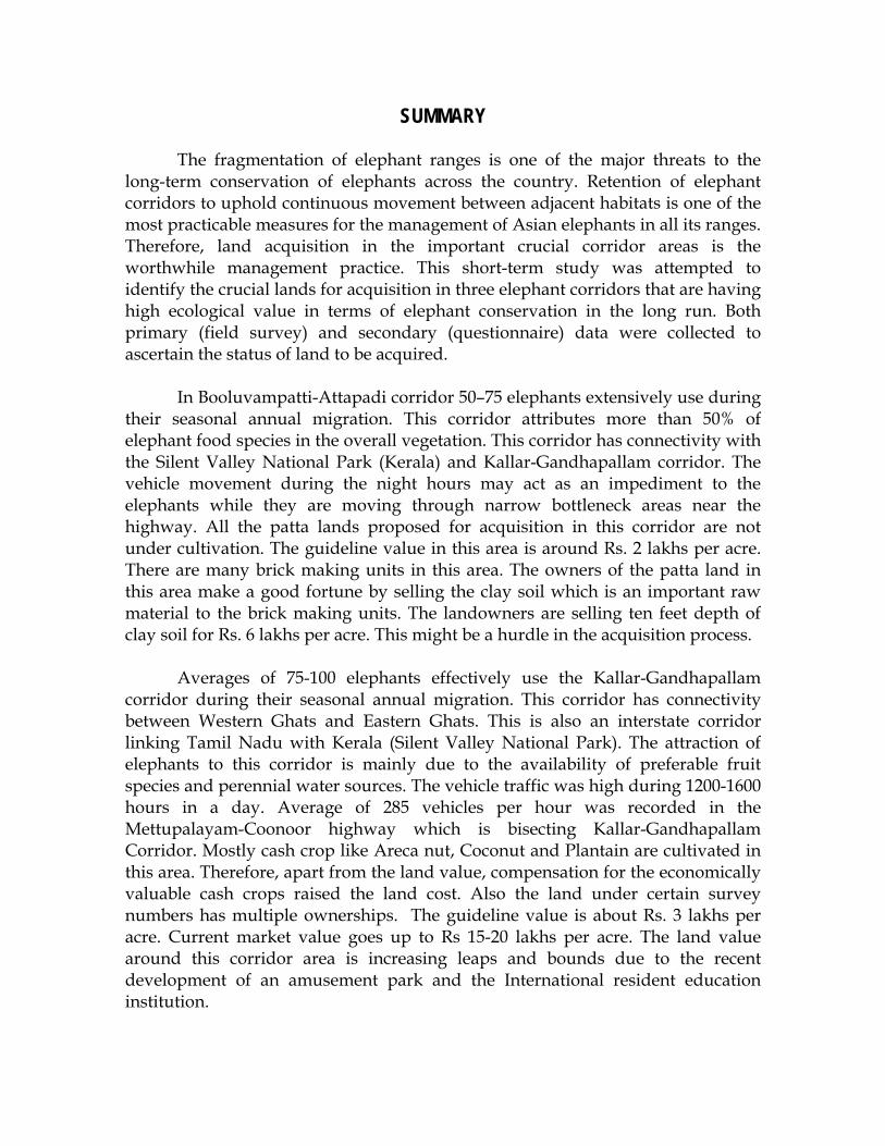
SUMMARY
The fragmentation of elephant ranges is one of the major threats to the long-term conservation of elephants across the country. Retention of elephant corridors to uphold continuous movement between adjacent habitats is one of the most practicable measures for the management of Asian elephants in all its ranges. Therefore, land acquisition in the important crucial corridor areas is the worthwhile management practice. This short-term study was attempted to identify the crucial lands for acquisition in three elephant corridors that are having high ecological value in terms of elephant conservation in the long run. Both primary (field survey) and secondary (questionnaire) data were collected to ascertain the status of land to be acquired.
In Booluvampatti-Attapadi corridor 50–75 elephants extensively use during their seasonal annual migration. This corridor attributes more than 50% of elephant food species in the overall vegetation. This corridor has connectivity with the Silent Valley National Park (Kerala) and Kallar-Gandhapallam corridor. The vehicle movement during the night hours may act as an impediment to the elephants while they are moving through narrow bottleneck areas near the highway. All the patta lands proposed for acquisition in this corridor are not under cultivation. The guideline value in this area is around Rs. 2 lakhs per acre. There are many brick making units in this area. The owners of the patta land in this area make a good fortune by selling the clay soil which is an important raw material to the brick making units. The landowners are selling ten feet depth of clay soil for Rs. 6 lakhs per acre. This might be a hurdle in the acquisition process.
Averages of 75-100 elephants effectively use the Kallar-Gandhapallam corridor during their seasonal annual migration. This corridor has connectivity between Western Ghats and Eastern Ghats. This is also an interstate corridor linking Tamil Nadu with Kerala (Silent Valley National Park). The attraction of elephants to this corridor is mainly due to the availability of preferable fruit species and perennial water sources. The vehicle traffic was high during 1200-1600 hours in a day. Average of 285 vehicles per hour was recorded in the Mettupalayam-Coonoor highway which is bisecting Kallar-Gandhapallam Corridor. Mostly cash crop like Areca nut, Coconut and Plantain are cultivated in this area. Therefore, apart from the land value, compensation for the economically valuable cash crops raised the land cost. Also the land under certain survey numbers has multiple ownerships. The guideline value is about Rs. 3 lakhs per acre. Current market value goes up to Rs 15-20 lakhs per acre. The land value around this corridor area is increasing leaps and bounds due to the recent development of an amusement park and the International resident education institution.
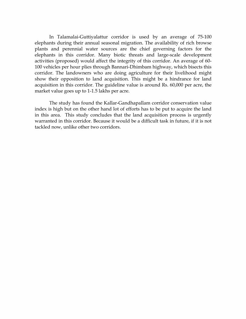
In Talamalai-Guttiyalattur corridor is used by an average of 75-100 elephants during their annual seasonal migration. The availability of rich browse plants and perennial water sources are the chief governing factors for the elephants in this corridor. Many biotic threats and large-scale development activities (proposed) would affect the integrity of this corridor. An average of 60-100 vehicles per hour plies through Bannari-Dhimbam highway, which bisects this corridor. The landowners who are doing agriculture for their livelihood might show their opposition to land acquisition. This might be a hindrance for land acquisition in this corridor. The guideline value is around Rs. 60,000 per acre, the market value goes up to 1-1.5 lakhs per acre. The study has found the Kallar-Gandhapallam corridor conservation value index is high but on the other hand lot of efforts has to be put to acquire the land in this area. This study concludes that the land acquisition process is urgently warranted in this corridor. Because it would be a difficult task in future, if it is not tackled now, unlike other two corridors.
Wildlife Trust of India
1
INTRODUCTION
Over a few decades the vast elephant ranges have been either fragmented or connected by narrow corridors due to expansion of human habitations and agriculture, indiscriminate growth of various development activities, severe biotic pressures, etc. Elephant corridors have received lot of conservation attention in recent years, with the reduction of contiguous habitat into islands. Although elephant corridors comprises only a small fraction of the total elephant range, they are crucial for the elephants, in terms of maintaining seasonal movement between habitats and exchange of genes between isolated populations (Sole and Simberloff, 1986; Noss, 1987; Simberloff and Cox, 1987; Rodgers and Panwar, 1988; Menon et al., 2005). Choudhury (1995) pointed out that the integrity of an elephant range often depends on the protection and re-establishment of corridors between different parts of the home range of an entire population. Ramkumar and Arumugam (2005) pointed out that the delay in the acquisition of vital elephant corridors in and around Mudumalai Wildlife Sanctuary will lead to severe human–elephant conflict in the Nilgiris. Desai (1992), Baskaran et al., (1995) and Ramakrishnan and Durairasu (2004) reported the importance of the present study corridors for the long-term conservation of elephants in the Nilgiri Biosphere Reserve (NBR).
The NBR (5540 sq km) is one of the most widely studied forest ecosystem in the Western Ghats (Daniels, 1993). The various protected areas in the NBR namely; Bandipur Tiger Reserve and National Park (880 sq km) and Nagarhole National Park (645 sq km) in the state of Karnataka, Wayanad Wildlife Sanctuary (344 sq km) and Silent Valley National Park (80 sq km) in Kerala and Mudumalai Wildlife Sanctuary (321 sq km) and Mukurthi National Park (78 sq km) in Tamil Nadu have connectivity with the reserve forests, revenue lands, private forests and plantations. The provision of habitat corridors to link various protected areas has been one of the important management measures for the conservation of many long ranging wild animals especially elephants. Nevertheless, the human dominated land areas adjacent to the biosphere reserve have brought about a substantial change in forest corridors, which has resulted in increasing trend of human-elephant conflict issues in the corridor fringe areas (Ramakrishnan and Durairasu, 2005). Although various strategies have been formulated to reduce adverse effect of habitat fragmentation, one important method that would reduce the negative effects of the habitat fragmentation is the preservation and restoration of biological corridors or the linear landscape between any two habitats.
Therefore land acquisition in the critical corridor areas seems to be a
practical conservation effort to reduce further loss and fragmentation of habitats. This would increase corridor integrity for the betterment of long ranging animals
Wildlife Trust of India
2
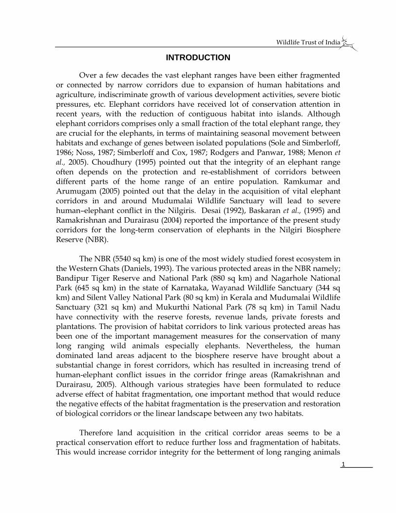
especially elephants. The present studied corridors falls under the centrally sponsored scheme of the Project Elephant, the Government of India (Map 1), this enables the process of land acquisition in a better fashion. This short-term study was carried out with the following objectives in three important elephant corridors, which has high ecological value to the elephant population in this region.
OBJECTIVES
1. To identify the lands in the bottleneck areas of the corridors
2. To find out the legal status, extent of area and ownership status of lands
3. To estimate the approximate cost requirement and
4. To suggest feasibilities for land acquisition
Wildlife Trust of India
3
STUDY AREA
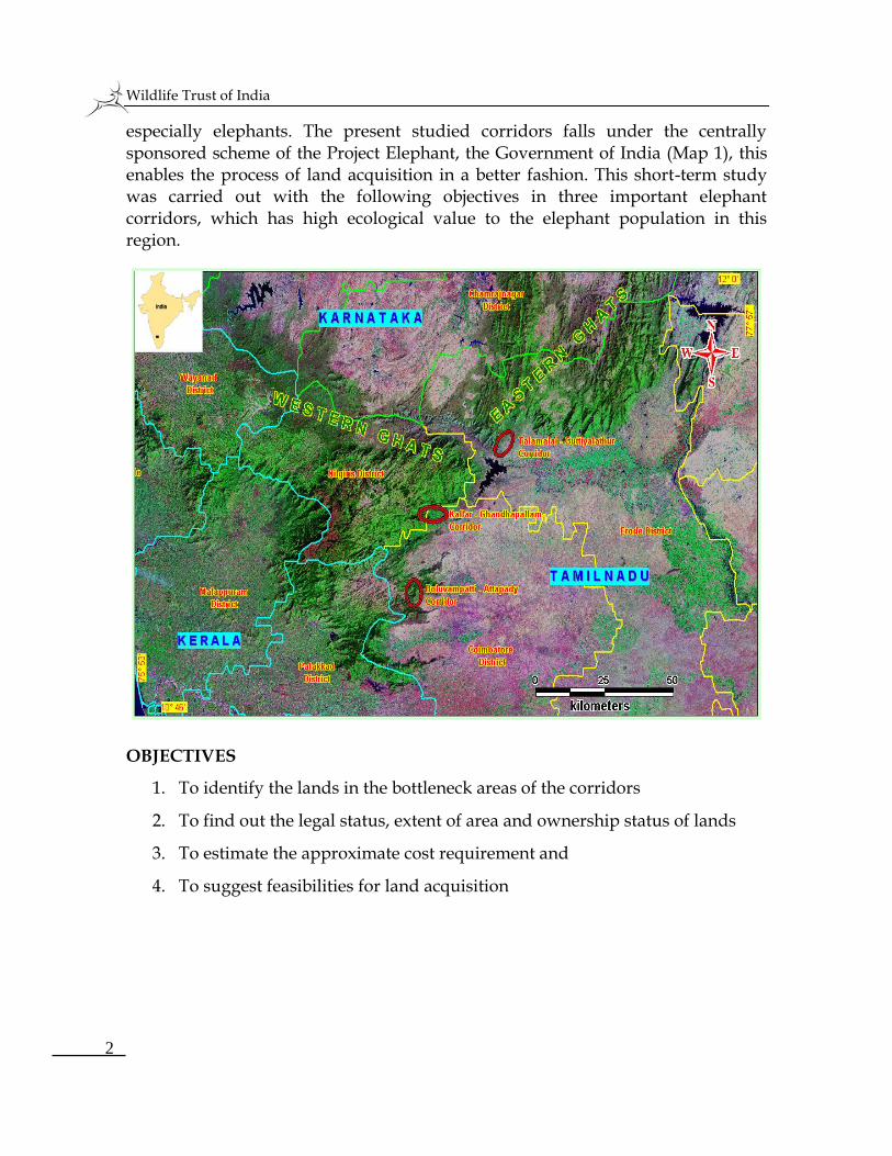
1. BOOLUVAMPATTI-ATTAPADI CORRIDOR
Alternate name: Anaikatti Corridor
Location: This corridor lies between 110 05’ – 110 07’ N and 760 46’ – 760 48’ E in the Western part of the Coimbatore District and is bounded in the north by Gobanari RF, in the south by Thadagam RF, east by human habitations belonging to Veerapandi Village and west by Anakatti group of villages (Map 2). This corridor begins at Gopanari RF linking Periyanaicken Palayam Range in the eastern portion and Bolampatti Range in the South. The terrain consists of undulating plains and hillocks. Kodungarai pallam is the perennial water source to elephants in this region. Seasonal water sources such as Anaikuzhi Pallam and Moongil Pallam are also part of this corridor. Apart from perennial and seasonal water sources, the Forest Department has constructed water tanks near Swamy Dhayanandha Saraswathy Hospital, Horticultural Garden and Mangarai Forest Rest house to elephants. Vegetation ranges from Sub tropical thorn forest to deciduous and semi-evergreen (Champion and Seth, 1968). The tree cover is dominated by Albizzia amara.
Connectivity: Booluvampatti Reserve Forest with Gopanari Reserve Forest
Average length and width: The length of the corridor is 24 km and the effective width ranges from 150 meters to 1000 meters.
Wildlife Trust of India
4
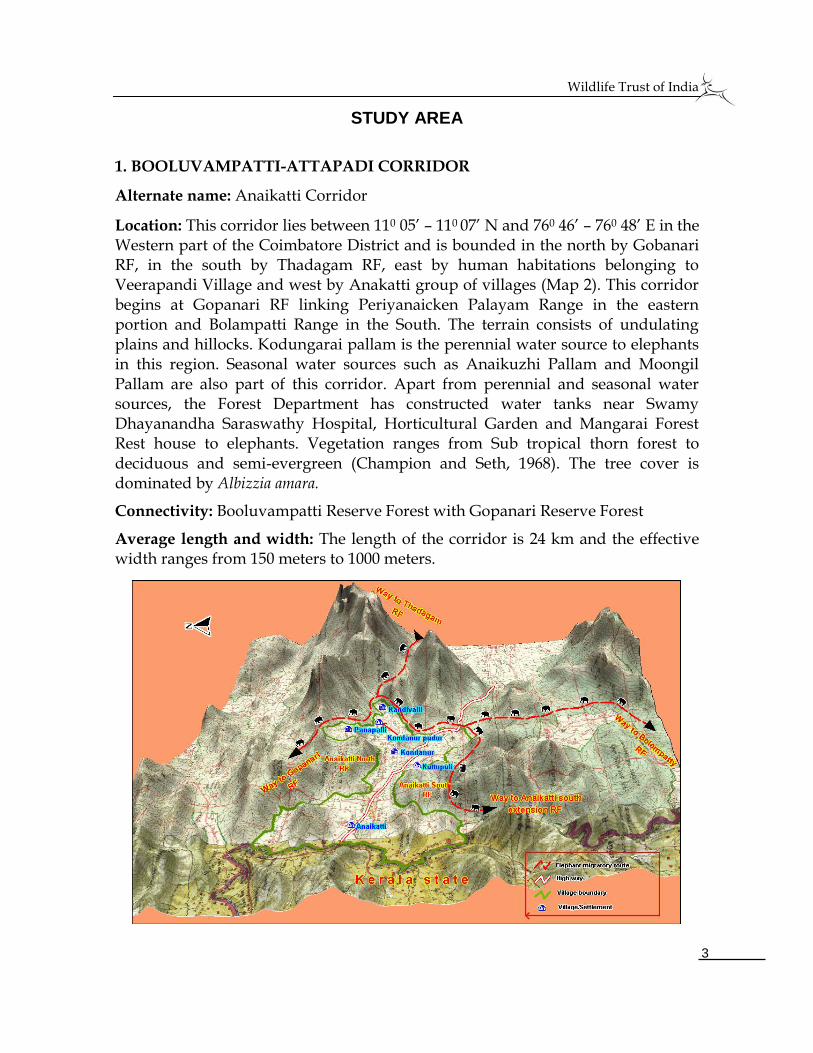
2. KALLAR–GANDHAPALLAM CORRIDOR
Alternate name: Kallar Corridor
Location: The Kallar corridor lies (76052’5”-76056’5” N and 11021’23”-11019’15” E) in the Coimbatore Forest Division and is surrounded on the north by steep escarpment of the Jaccanare Mountains and on the east by agriculture fields and other developmental activities (Map 3). A long strip of corridor beginning at Gandhapallam goes up to Kallar reserve forests along the foothills of Odanthurai RF and Jaccanare slope RF bisected by the Mettupalayam-Coonoor and Mettupalayam-Kotagiri highways. The corridor between second hairpin bend of the Mettupalayam-Coonoor highway and Kallar is narrow due to plantations and various development activities. The terrain is undulating. The elephant’s strong fidelity to this corridor during dry season migration shows the importance for its conservation (Baskaran et al., 1995). The newly established private educational institution (Swami Sachidhananda Jothi Niketan) on the periphery of this forest has considerably reduced the width of the corridor (Sivaganesan and Ramakrishnan, 1997). Due to which elephants passes through undulating terrain of the Jaccanare hills on the north. There were few evidences recorded that the elephant herds have occasionally crossed the highway between first hairpin bend and Kallar Forest Check post as mentioned by Davidar (1972). Mostly loaners (tusker & makhna) are crossing the highway above the first hairpin bend during late night hours. Family herds are trying to cross in the foothill areas of the highway just below the first hairpin bend. Various obstacles do not allow the elephant herds to cross the highway freely. Major threats to this corridor are recent developmental activities, agricultural expansions in the corridor fringes and collection of fuel wood and bamboo for commercial purposes.
Wildlife Trust of India
5
On the contrary, the elephants comprising groups and loaners frequently visits very close to the amusement park due to the availability of perennial water source near the park. A separate study is warranted to investigate the impact of the park on the movement of elephants. Mixed deciduous forests in hill slopes and mixed secondary growth woody forest in lowland areas dominates the vegetation cover of this corridor.
Connectivity: Western Ghats and Eastern Ghats and vice-versa
Average length and width: The length of the corridor is 22 km and width ranges from 75 to 300 meters.
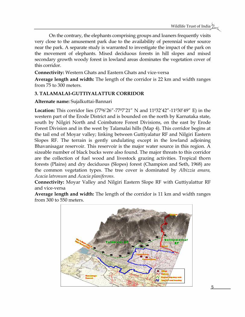
3. TALAMALAI-GUTTIYALATTUR CORRIDOR
Alternate name: Sujalkuttai-Bannari
Location: This corridor lies (7706’26”-7707’21” N and 11032’42”-11030’49” E) in the western part of the Erode District and is bounded on the north by Karnataka state, south by Nilgiri North and Coimbatore Forest Divisions, on the east by Erode Forest Division and in the west by Talamalai hills (Map 4). This corridor begins at the tail end of Moyar valley; linking between Guttiyalatur RF and Nilgiri Eastern Slopes RF. The terrain is gently undulating except in the lowland adjoining Bhavanisagar reservoir. This reservoir is the major water source in this region. A sizeable number of black bucks were also found. The major threats to this corridor are the collection of fuel wood and livestock grazing activities. Tropical thorn forests (Plains) and dry deciduous (Slopes) forest (Champion and Seth, 1968) are the common vegetation types. The tree cover is dominated by Albizzia amara, Acacia latronum and Acacia planiferons. Connectivity: Moyar Valley and Nilgiri Eastern Slope RF with Guttiyalattur RF and vice-versa Average length and width: The length of the corridor is 11 km and width ranges from 300 to 550 meters.
Wildlife Trust of India
6
METHODOLOGY Both primary and secondary data were collected for this present study.
Primary data were collected for the variables such as extent of corridor usage by
elephants of the corridors, traffic intensities on the roads that are bisecting the
corridors, corridor connectivity between habitats, corridor dependent villages and
willingness of the landowners to sell the lands. Secondary data are collected for
the variables such as landholder’s name, extent of area, legal status of the land,
guideline and market value of the land from the Village Administration Officer
(VAO). Elephant census reports were collected from the forest department to
estimate the elephant population in and around these studied corridors. This
would enable the land acquisition to increase the corridor width for the free
movement of elephants between the habitats in the long run.
1. Habitat use by elephants Belt transects (1000 X 20 meters) method was used to find out the dung
density of elephants in all the three corridors. Variables such as number and status
of dung groups were recorded. The number of belt transects ranging between 8
and 15 were laid depending on the size and vegetation heterogeneity of the
corridor. Elephant dung density was estimated using the simple following
arithmetic calculation,
Elephant dung density = Total number of dung piles Total No. of transects X Length X Width
To strengthen the extent of corridors usage by elephants, census reports were
obtained from the forest ranges, which are very close to the present studied
corridors.
2. Availability of ecological resources
Detailed survey was made in the forest trails and footpaths of all three
corridors. Ecological variables such as fruit bearing trees, shade trees and natural
saltlicks were recorded while walking on the trails to calculate encounter rate. The
information on the availability of seasonal and perennial water sources was
collected using questionnaire from the local forest field staff and tribes.
3. Vehicular traffic intensity
The highways bisecting the corridors were monitored for one full day in a
month for a period of three months to quantify the vehicle traffic intensity round
Wildlife Trust of India
7
the clock. Vehicles were divided in to three categories based on their size i.e.
heavy, medium and low weight vehicles. Thus the data collected was used to
know the peak hour vehicle intensity in a day.
4. Land identification
The lands, which are located very close or blocking the corridors, were
identified by thorough field survey. The variables such as presence of dung piles,
feeding sign, traditionally used footpaths and crop depredation intensities by
elephants were collected and marked using Global Positioning System (GPS) to
identify the lands. This GPS coordinates were superimposed on the survey map
obtained from the local village administration and topo sheet of Survey of India in
order to identify the exact lands with survey number, which are to be acquired.
The guideline and market value of the lands were collected from the registrar
office and local people to estimate approximate cost requirement for land
acquisition.
5. Mapping
Survey map for the concerned villages was obtained from the local Village
Administrative Officer (VAO). The identified lands were digitized using MapInfo
professional 7.8 computer software. Contours map was prepared with an interval
of 10m using Global Mapper 5.0 software to know the terrain of the corridor.
Digital elevation models were created using USGS/NASA SRTM data.
Wildlife Trust of India
8
RESULTS & DISCUSSION 1. BOOLAVAMPATTI-ATTAPADI CORRIDOR
1.1. JUSTIFICATION FOR LAND ACQUISITION
1.1.a. Number of elephants utilizing the corridor Table 1. Elephant population recorded in and around the forest ranges of the
Booluvampatti–Attapadi corridor (Booluvampatti, Periyanaicken palayam and Coimbatore ranges)
Year Block Count Waterhole count Dung density/sq.km
2002 29 5 --
2005 40 24 --
2007 100 Not attempted 3126.7 (Source: Synchronized elephant census report for the year 2002 and 2005; Annual Wildlife census report for the year 2007; Dung density was calculated for this present study)
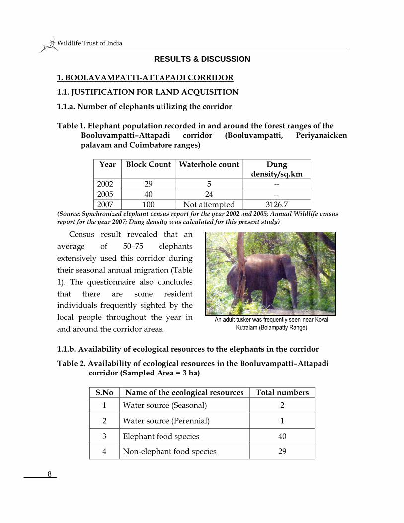
Census result revealed that an
average of 50–75 elephants
extensively used this corridor during
their seasonal annual migration (Table
1). The questionnaire also concludes
that there are some resident
individuals frequently sighted by the
local people throughout the year in
and around the corridor areas.
1.1.b. Availability of ecological resources to the elephants in the corridor
Table 2. Availability of ecological resources in the Booluvampatti–Attapadi corridor (Sampled Area = 3 ha)
S.No Name of the ecological resources Total numbers
1 Water source (Seasonal) 2
2 Water source (Perennial) 1
3 Elephant food species 40
4 Non-elephant food species 29
An adult tusker was frequently seen near Kovai
Kutralam (Bolampatty Range)
Wildlife Trust of India
9
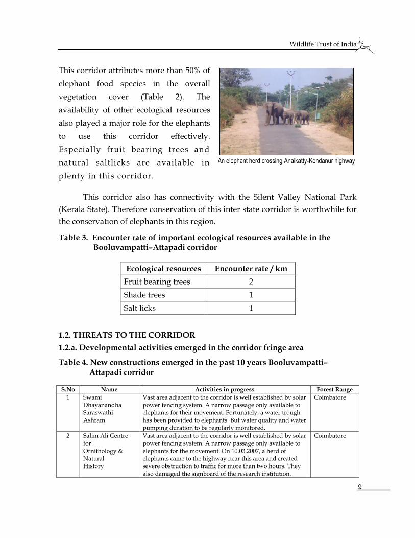
This corridor attributes more than 50% of
elephant food species in the overall
vegetation cover (Table 2). The
availability of other ecological resources
also played a major role for the elephants
to use this corridor effectively.
Especially fruit bearing trees and
natural saltlicks are available in
plenty in this corridor.
This corridor also has connectivity with the Silent Valley National Park
(Kerala State). Therefore conservation of this inter state corridor is worthwhile for
the conservation of elephants in this region.
Table 3. Encounter rate of important ecological resources available in the Booluvampatti–Attapadi corridor
Ecological resources Encounter rate / km
Fruit bearing trees 2
Shade trees 1
Salt licks 1
1.2. THREATS TO THE CORRIDOR
1.2.a. Developmental activities emerged in the corridor fringe area
Table 4. New constructions emerged in the past 10 years Booluvampatti– Attapadi corridor
S.No Name Activities in progress Forest Range
1 Swami Dhayanandha Saraswathi Ashram
Vast area adjacent to the corridor is well established by solar power fencing system. A narrow passage only available to elephants for their movement. Fortunately, a water trough has been provided to elephants. But water quality and water pumping duration to be regularly monitored.
Coimbatore
2 Salim Ali Centre for Ornithology & Natural History
Vast area adjacent to the corridor is well established by solar power fencing system. A narrow passage only available to elephants for the movement. On 10.03.2007, a herd of elephants came to the highway near this area and created severe obstruction to traffic for more than two hours. They also damaged the signboard of the research institution.
Coimbatore
An elephant herd crossing Anaikatty-Kondanur highway
Wildlife Trust of India
10
S.No Name Activities in progress Forest Range
3 RVS Ayurvedha College
Vast area adjacent to the corridor is well established by solar power fencing system. A narrow passage only available to elephants for the movement. Even though the college is not functioning there, huge constructions glittering along the passage.
Coimbatore
4 Karl Kubel Institute
Vast area adjacent to the corridor is well established by solar power fencing system. Literally a narrow passage only available to elephants for their movement. Staff quarters, powerful lighting and non eco-friendly painting on the construction acts as a psychological barrier to elephants during their movement.
Coimbatore
5 Avila Teacher Training Institute (Proposed)
Vast area adjacent to the corridor is well established by solar power fencing system. A narrow passage only available to elephants for the movement. Presently constructions are not permitted by the District administration as per the Hill Area Conservation Authority (HACA). But in future there could be a chance for development. Therefore, land acquisition needs to be considered for this location.
Coimbatore
6 PSG institution started a new construction.
The area is completely protected by powerful electric fencing system. Although mass construction is not initiated now, in future there may be a possibility for it.
Periyanaicken palayam
7 Coimbatore Zoological Park (Proposed)
There is a proposal pending for a long time to establish zoological park on the southwest side of this corridor. The private authorities have already purchased vast area. Currently nothing has materialized, but can happen in future.
Coimbatore
1.2.b. Corridor dependent villages/forest settlements
1. Sembukarai 6. Kandivazhi 2. Dhoomanur 7. Panapalli 3. Jambukundi 8. Veerapandi pudur 4. Kondanur 9. Mel Paavi 5. Pudur 10. Kil Paavi
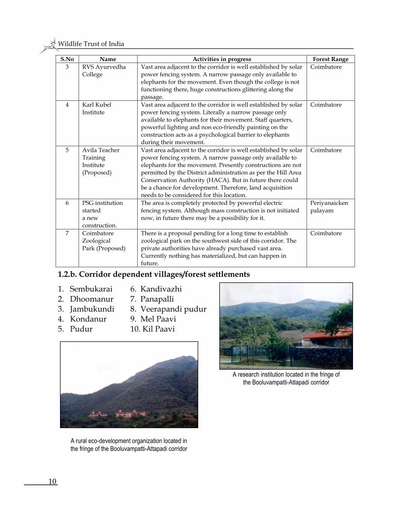
A research institution located in the fringe of
the Booluvampatti-Attapadi corridor
A rural eco-development organization located in
the fringe of the Booluvampatti-Attapadi corridor
Wildlife Trust of India
11
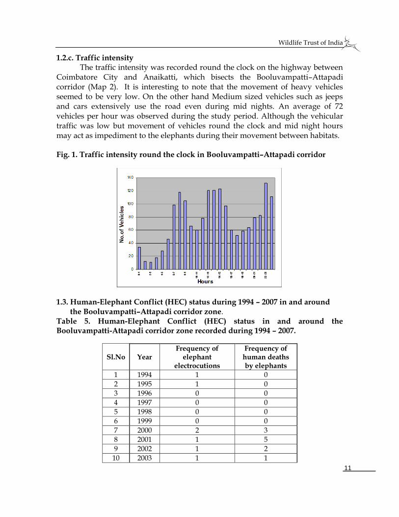
1.2.c. Traffic intensity The traffic intensity was recorded round the clock on the highway between
Coimbatore City and Anaikatti, which bisects the Booluvampatti–Attapadi corridor (Map 2). It is interesting to note that the movement of heavy vehicles seemed to be very low. On the other hand Medium sized vehicles such as jeeps and cars extensively use the road even during mid nights. An average of 72 vehicles per hour was observed during the study period. Although the vehicular traffic was low but movement of vehicles round the clock and mid night hours may act as impediment to the elephants during their movement between habitats. Fig. 1. Traffic intensity round the clock in Booluvampatti–Attapadi corridor
1.3. Human-Elephant Conflict (HEC) status during 1994 – 2007 in and around the Booluvampatti–Attapadi corridor zone. Table 5. Human-Elephant Conflict (HEC) status in and around the Booluvampatti-Attapadi corridor zone recorded during 1994 – 2007.
Sl.No Year Frequency of
elephant electrocutions
Frequency of human deaths by elephants
1 1994 1 0
2 1995 1 0
3 1996 0 0
4 1997 0 0
5 1998 0 0
6 1999 0 0
7 2000 2 3
8 2001 1 5
9 2002 1 2
10 2003 1 1
Wildlife Trust of India
12
11 2004 1 1
12 2005 2 0
13 2006 0 1
14 2007 0 2 Total 10 15
(Source: Forest department official data collected from the Coimbatore Forest Division)
The Human-Elephant Conflict (HEC) status, especially the frequency of elephant deaths due to electrocution and the human deaths by elephants during 1994–2007 revealed an increasing trend from the year 2000. Although two electrocution incidences were recorded during 1994–1995, no further loss was reported till 1999. Only since 2000, the mortality of elephants due to electrocution as well as human deaths by elephants was reported every year (Table 5).
The land use has changed drastically along the corridor and in fringe areas
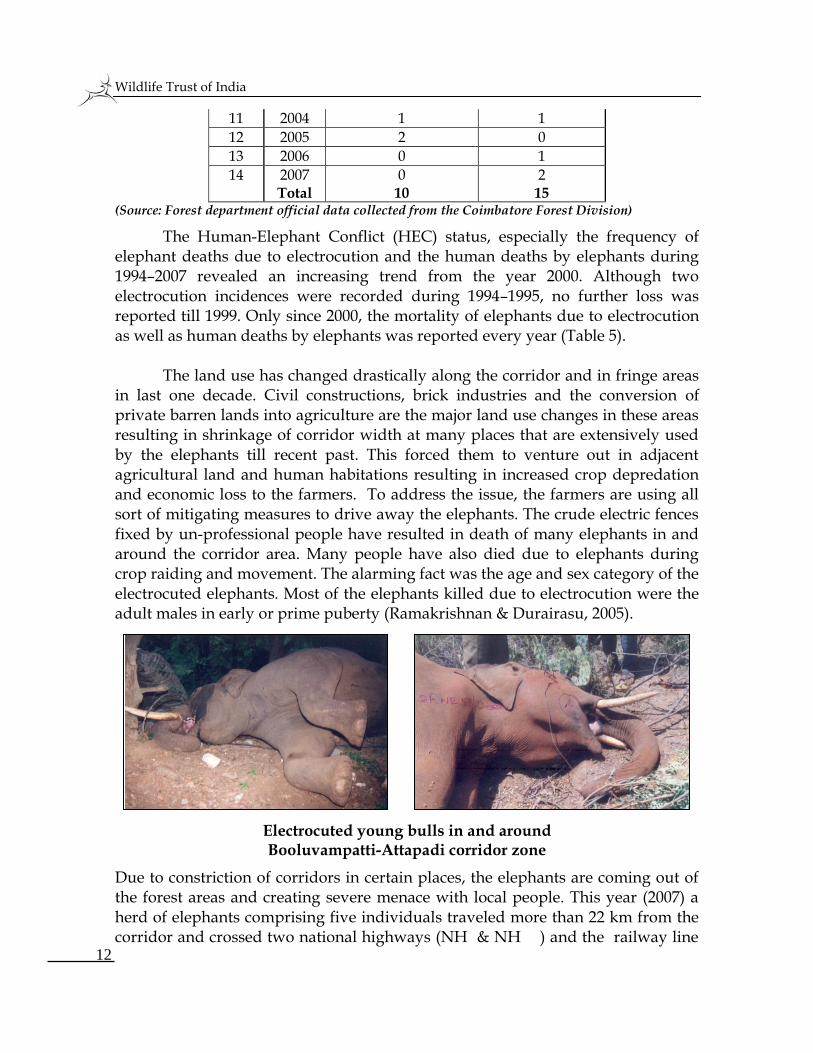
in last one decade. Civil constructions, brick industries and the conversion of private barren lands into agriculture are the major land use changes in these areas resulting in shrinkage of corridor width at many places that are extensively used by the elephants till recent past. This forced them to venture out in adjacent agricultural land and human habitations resulting in increased crop depredation and economic loss to the farmers. To address the issue, the farmers are using all sort of mitigating measures to drive away the elephants. The crude electric fences fixed by un-professional people have resulted in death of many elephants in and around the corridor area. Many people have also died due to elephants during crop raiding and movement. The alarming fact was the age and sex category of the electrocuted elephants. Most of the elephants killed due to electrocution were the adult males in early or prime puberty (Ramakrishnan & Durairasu, 2005).
Electrocuted young bulls in and around Booluvampatti-Attapadi corridor zone
Due to constriction of corridors in certain places, the elephants are coming out of the forest areas and creating severe menace with local people. This year (2007) a herd of elephants comprising five individuals traveled more than 22 km from the corridor and crossed two national highways (NH & NH ) and the railway line
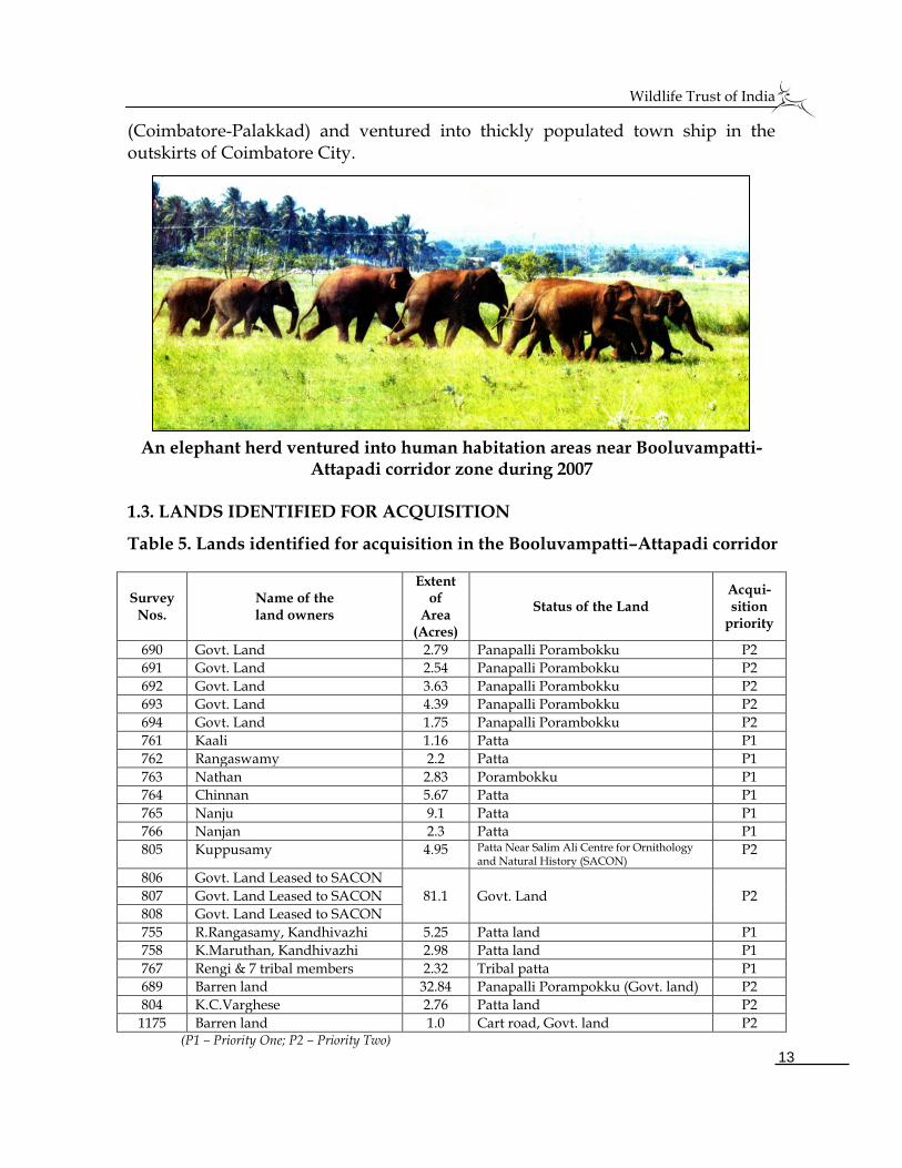
Wildlife Trust of India
13
(Coimbatore-Palakkad) and ventured into thickly populated town ship in the outskirts of Coimbatore City.
An elephant herd ventured into human habitation areas near Booluvampatti-Attapadi corridor zone during 2007
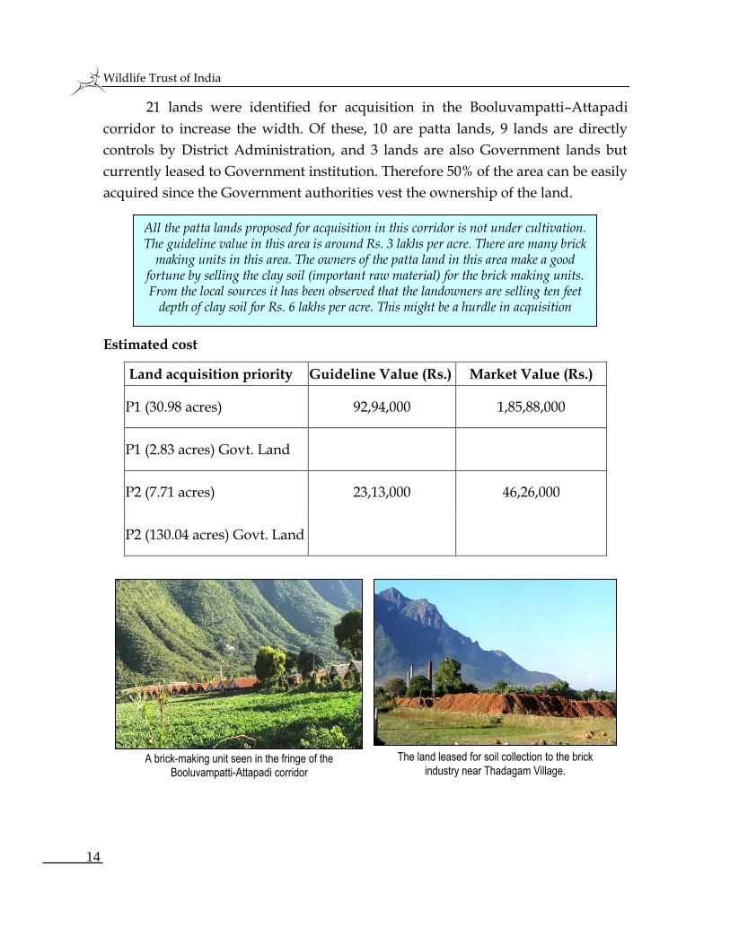
1.3. LANDS IDENTIFIED FOR ACQUISITION
Table 5. Lands identified for acquisition in the Booluvampatti–Attapadi corridor
Survey Nos.
Name of the land owners
Extent of
Area (Acres)
Status of the Land Acqui- sition
priority
690 Govt. Land 2.79 Panapalli Porambokku P2
691 Govt. Land 2.54 Panapalli Porambokku P2
692 Govt. Land 3.63 Panapalli Porambokku P2
693 Govt. Land 4.39 Panapalli Porambokku P2
694 Govt. Land 1.75 Panapalli Porambokku P2
761 Kaali 1.16 Patta P1
762 Rangaswamy 2.2 Patta P1
763 Nathan 2.83 Porambokku P1
764 Chinnan 5.67 Patta P1
765 Nanju 9.1 Patta P1
766 Nanjan 2.3 Patta P1
805 Kuppusamy 4.95 Patta Near Salim Ali Centre for Ornithology and Natural History (SACON)
P2
806 Govt. Land Leased to SACON
81.1 Govt. Land
P2
807 Govt. Land Leased to SACON
808 Govt. Land Leased to SACON
755 R.Rangasamy, Kandhivazhi 5.25 Patta land P1
758 K.Maruthan, Kandhivazhi 2.98 Patta land P1
767 Rengi & 7 tribal members 2.32 Tribal patta P1
689 Barren land 32.84 Panapalli Porampokku (Govt. land) P2
804 K.C.Varghese 2.76 Patta land P2
1175 Barren land 1.0 Cart road, Govt. land P2 (P1 – Priority One; P2 – Priority Two)
Wildlife Trust of India
14
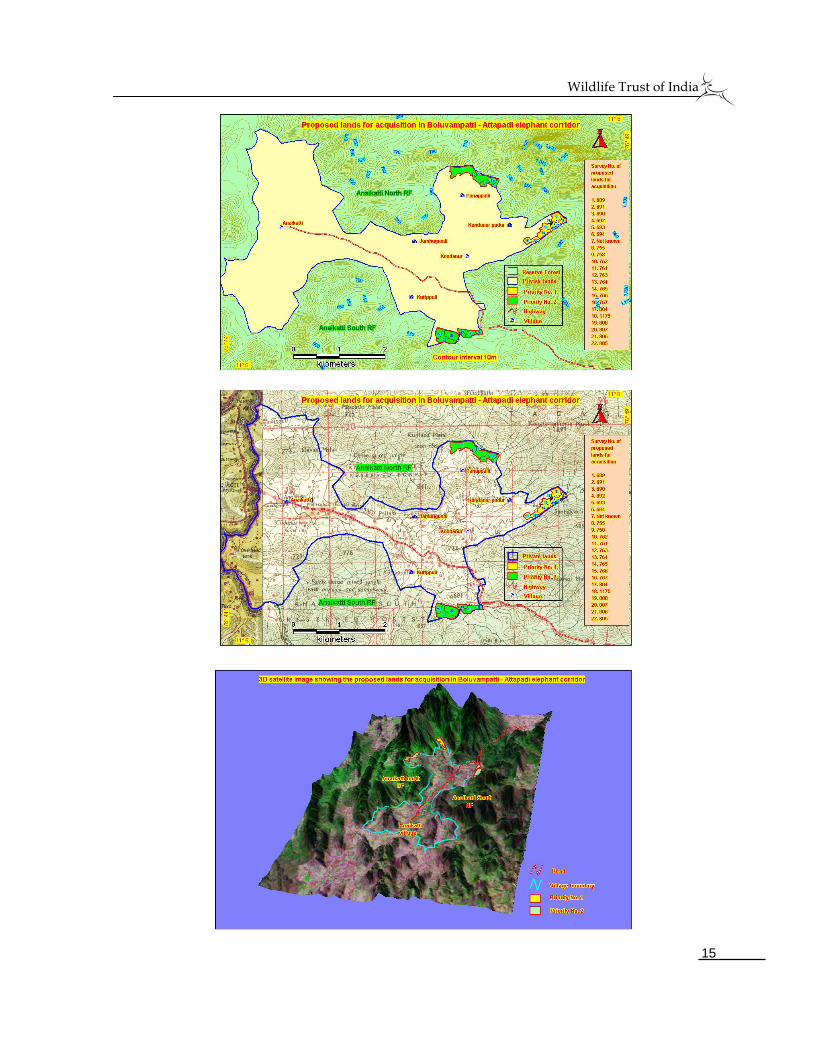
All the patta lands proposed for acquisition in this corridor is not under cultivation. The guideline value in this area is around Rs. 3 lakhs per acre. There are many brick
making units in this area. The owners of the patta land in this area make a good fortune by selling the clay soil (important raw material) for the brick making units. From the local sources it has been observed that the landowners are selling ten feet
depth of clay soil for Rs. 6 lakhs per acre. This might be a hurdle in acquisition
21 lands were identified for acquisition in the Booluvampatti–Attapadi
corridor to increase the width. Of these, 10 are patta lands, 9 lands are directly
controls by District Administration, and 3 lands are also Government lands but
currently leased to Government institution. Therefore 50% of the area can be easily
acquired since the Government authorities vest the ownership of the land.
Estimated cost
Land acquisition priority Guideline Value (Rs.) Market Value (Rs.)
P1 (30.98 acres) 92,94,000 1,85,88,000
P1 (2.83 acres) Govt. Land
P2 (7.71 acres) 23,13,000 46,26,000
P2 (130.04 acres) Govt. Land
A brick-making unit seen in the fringe of the Booluvampatti-Attapadi corridor
The land leased for soil collection to the brick
industry near Thadagam Village.
Wildlife Trust of India
15
Wildlife Trust of India
16
2. KALLAR–GANDHAPALLAM CORRIDOR
2.1. JUSTIFICATION FOR LAND ACQUISITION
2.1.a. Number of elephants utilizing the corridor Table 6. Elephant population recorded in and near the forest ranges of the
(Mettupalayam and Sirumugai ranges) Kallar-Gandhapallam Corridor
Year Block Count Waterhole count Dung density/sq.km
2005 48 43
2007 92 - 618.8 (Source: Synchronized elephant census report for the year 2005 & 2007; Dung density was calculated for this present study)
The census report showed that an
average of 75-100 elephants
effectively use this corridor during
their seasonal annual migration.
This corridor has connectivity
between Western Ghats and
Eastern Ghats. Due to blockage of
this corridor, the near by human
habitation areas were severely
affected by elephants’ depredation
(Ramakrishnan & Durairasu,
2005). This is also an interstate
corridor linking Tamil Nadu with
Kerala (Silent Valley National
Park). Therefore conservation
value seemed to be higher than
other corridors in terms of
elephant conservation in this
region.
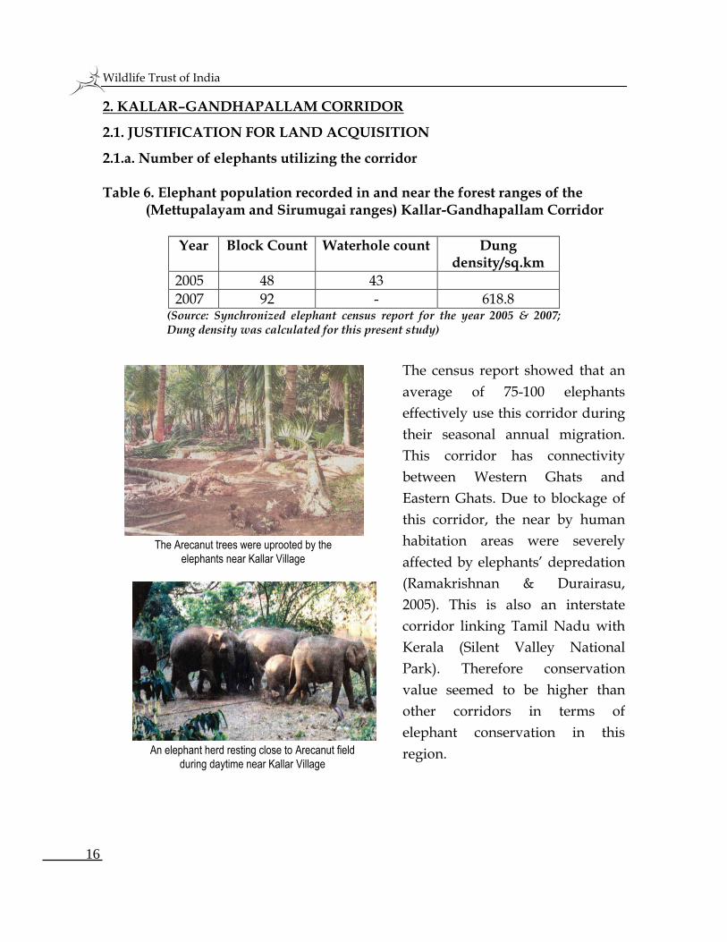
The Arecanut trees were uprooted by the
elephants near Kallar Village
An elephant herd resting close to Arecanut field
during daytime near Kallar Village
Wildlife Trust of India
17
2.1.b. Availability of ecological resources to the elephants in the corridor Table 7. Ecological resources available in the Kallar-Gandhapallam Corridor (Sampled Area 0.4ha)
SI.No Name of the ecological
resources Total numbers
1 Water streams (Seasonal) 6
2 Water streams & ponds (Perennial)
5
3 Elephant food species 16
4 Non-elephant food species 10
Kallar corridor seemed to be most important for the elephants during their migration between Western Ghats and Eastern Ghats. The dry season movement of elephants in this corridor is mainly because of the attraction of elephants to preferable fruit species (eg. Jack, Mango, Tamarind etc.). The availability of ecological resources in the corridor clearly showed their values as habitat corridor. Apart from two perennial rivers two artificial water troughs and one artificial pond are also available to the elephants.
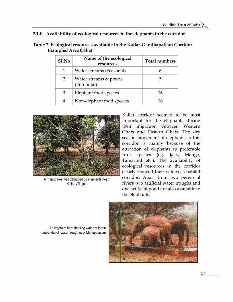
A mango tree was damaged by elephants near Kallar Village.
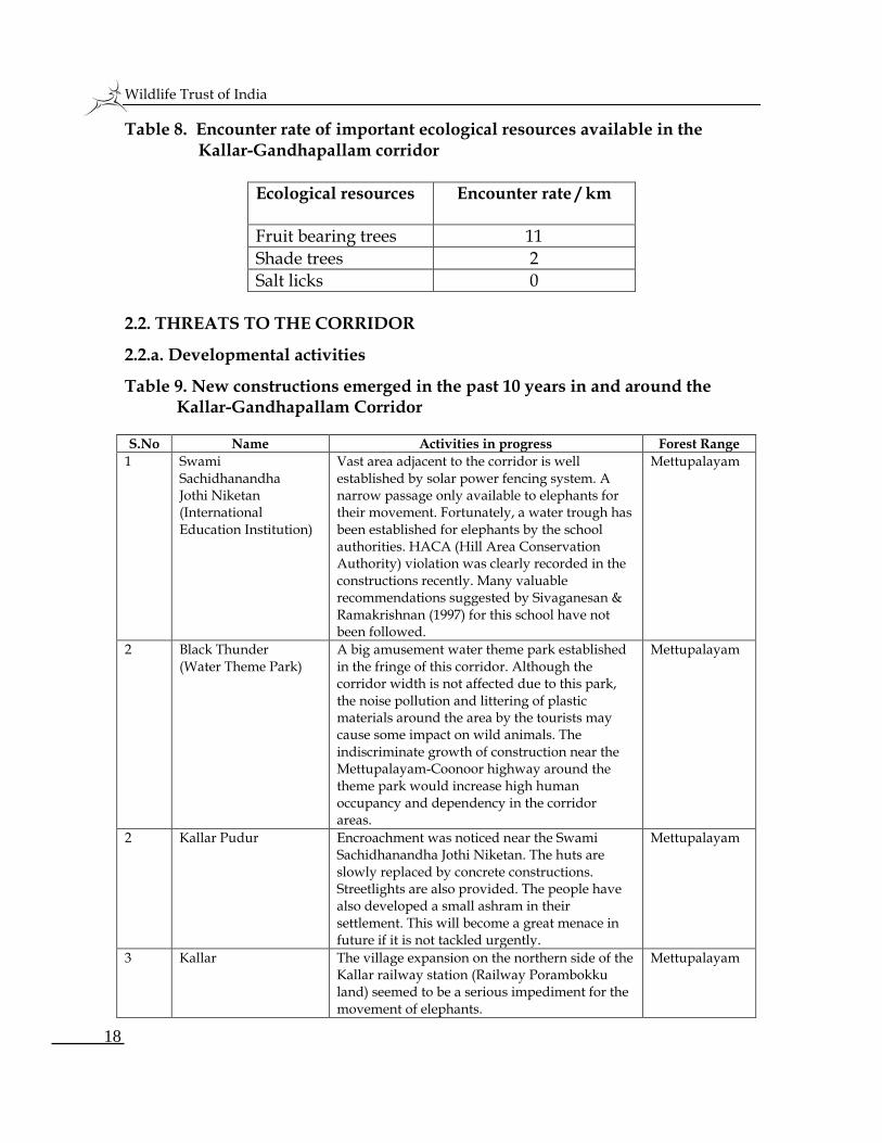
An elephant herd drinking water at forest
timber depot water trough near Mettupalayam
Wildlife Trust of India
18
Table 8. Encounter rate of important ecological resources available in the Kallar-Gandhapallam corridor
Ecological resources Encounter rate / km
Fruit bearing trees 11
Shade trees 2
Salt licks 0
2.2. THREATS TO THE CORRIDOR
2.2.a. Developmental activities
Table 9. New constructions emerged in the past 10 years in and around the Kallar-Gandhapallam Corridor
S.No Name Activities in progress Forest Range
1 Swami Sachidhanandha Jothi Niketan (International Education Institution)
Vast area adjacent to the corridor is well established by solar power fencing system. A narrow passage only available to elephants for their movement. Fortunately, a water trough has been established for elephants by the school authorities. HACA (Hill Area Conservation Authority) violation was clearly recorded in the constructions recently. Many valuable recommendations suggested by Sivaganesan & Ramakrishnan (1997) for this school have not been followed.
Mettupalayam
2 Black Thunder (Water Theme Park)
A big amusement water theme park established in the fringe of this corridor. Although the corridor width is not affected due to this park, the noise pollution and littering of plastic materials around the area by the tourists may cause some impact on wild animals. The indiscriminate growth of construction near the Mettupalayam-Coonoor highway around the theme park would increase high human occupancy and dependency in the corridor areas.
Mettupalayam
2 Kallar Pudur Encroachment was noticed near the Swami Sachidhanandha Jothi Niketan. The huts are slowly replaced by concrete constructions. Streetlights are also provided. The people have also developed a small ashram in their settlement. This will become a great menace in future if it is not tackled urgently.
Mettupalayam
3 Kallar The village expansion on the northern side of the Kallar railway station (Railway Porambokku land) seemed to be a serious impediment for the movement of elephants.
Mettupalayam
Wildlife Trust of India
19
S.No Name Activities in progress Forest Range
4 Plantation Plantation of Areca nut, Plantain and Coconut in the fringes of the crucial areas of the corridor would increase human-elephant conflict in future. The recent human deaths by elephants are the indicators for the high degree of conflict (3 human deaths caused by elephants in the past five months)
Mettupalayam
5 Mitigating measures used against Human-Elephant Conflicts
During the past few decades it was clearly noticed that the mitigating measures are badly designed except by some companies. When the elephants are passing through narrow passages there could be possibilities of elephants coming in contact with the fences. This was evidenced in the Sirumugai and Booluvampatti forest ranges of the Coimbatore Forest Division (Ramakrishnan & Durairasu, 2005).
Mettupalayam
6 Traffic During the past few decades the traffic intensity has increased in the highways of Mettupalayam-Coonoor and Mettupalayam-Kotagiri especially during dry season. Elephants also extensively using this corridor during the dry season. The road dividers and protection wall on both sides at the first hairpin bend of the Mettupalayam-Coonoor highway also affects the elephants’ movement.
Mettupalayam
7 Govt. Horticultural Garden.
The location of Govt. Horticultural Garden in the bottleneck of the corridor itself is a serious impediment to the elephants. Most of the fruits available in the garden are also highly preferred fruits to the elephants.
Mettupalayam
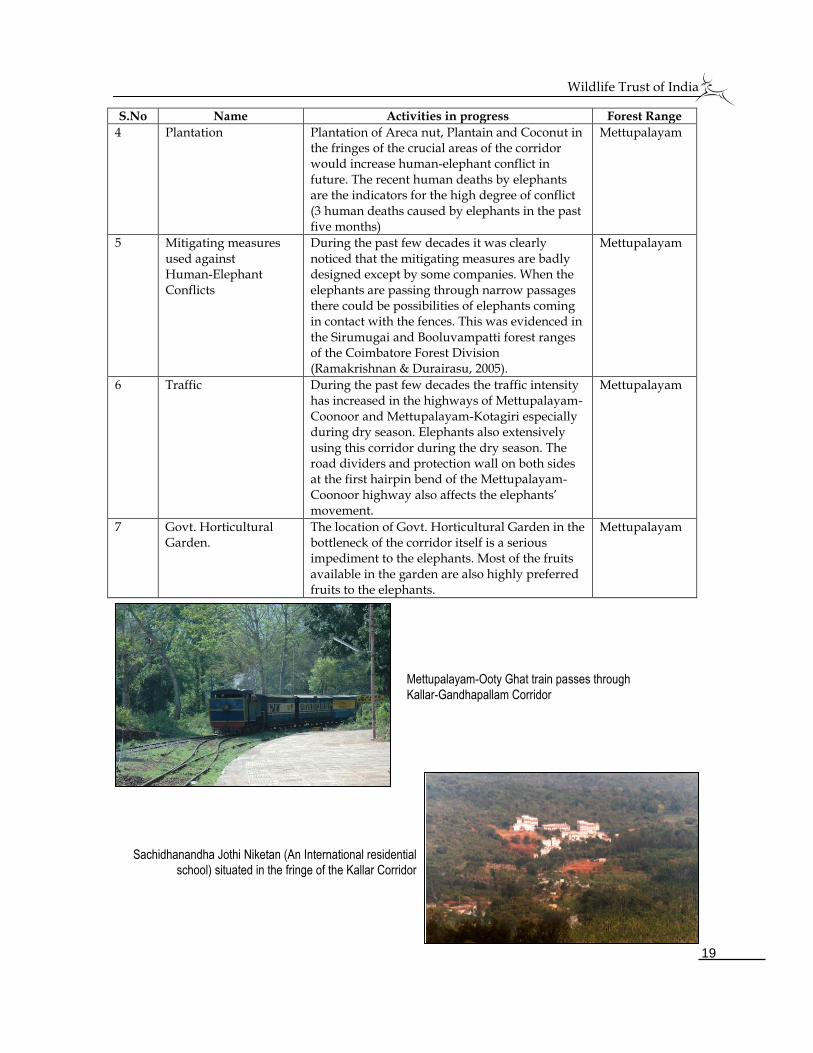
Mettupalayam-Ooty Ghat train passes through
Kallar-Gandhapallam Corridor
Sachidhanandha Jothi Niketan (An International residential school) situated in the fringe of the Kallar Corridor
Wildlife Trust of India
20
2.2.b. Corridor dependent villages / forest settlements
1. Nellithurai
2. Nandhavanapudur
3. Kallar
4. Kallar Pudur
5. Mettupalayam 6. Umapalayam 7. Palapatti
2.2.c. Traffic intensity
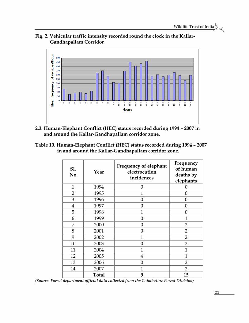
Vehicle traffic was high during 12-16 hours. An average of 285 vehicles per hour was recorded in the Mettupalayam - Coonoor highway (Fig. 2). The vehicle movement was low during mid night hours to early morning hours (1-5 hours). Mid day hours and late night (20-24 hours) are the peak hours of the vehicle movement. This heavy traffic especially during dry season acts as a serious impediment for the movement of elephants.
If an opportunity avails freely, the elephants will go up to Silent Valley National Park (Sivaganesan & Ramakrishnan, 1999). The Ghat railway line also runs parallel to the highway. The high frequency of train movement especially during summer season also affects the elephant movement.
Non-stop vehicle movement is a serious impediment to the elephants in the Mettupalayam-Ooty highway
An adult tusker blocked the Ghat train recently. The passengers & the railway officials are seen driving
away the elephant.
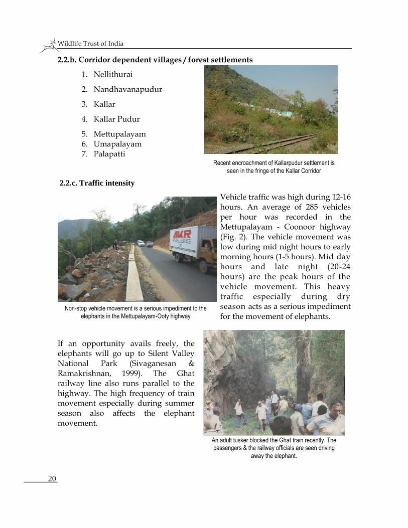
Recent encroachment of Kallarpudur settlement is
seen in the fringe of the Kallar Corridor
Wildlife Trust of India
21
Fig. 2. Vehicular traffic intensity recorded round the clock in the Kallar- Gandhapallam Corridor
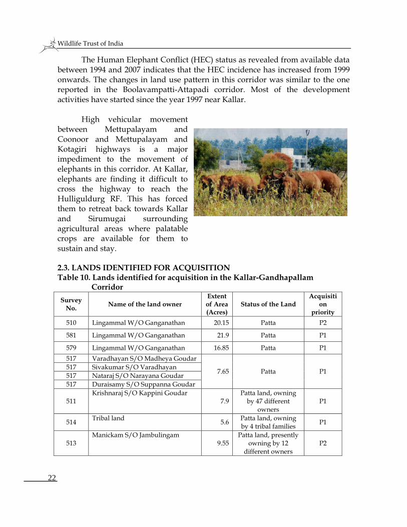
2.3. Human-Elephant Conflict (HEC) status recorded during 1994 – 2007 in and around the Kallar-Gandhapallam corridor zone.
Table 10. Human-Elephant Conflict (HEC) status recorded during 1994 – 2007 in and around the Kallar-Gandhapallam corridor zone.
Sl. No
Year Frequency of elephant
electrocution incidences
Frequency of human deaths by elephants
1 1994 0 0
2 1995 1 0
3 1996 0 0
4 1997 0 0
5 1998 1 0
6 1999 0 1
7 2000 0 2
8 2001 0 2
9 2002 1 2
10 2003 0 2
11 2004 1 1
12 2005 4 1
13 2006 0 2
14 2007 1 2 Total 9 15
(Source: Forest department official data collected from the Coimbatore Forest Division)
Wildlife Trust of India
22
The Human Elephant Conflict (HEC) status as revealed from available data between 1994 and 2007 indicates that the HEC incidence has increased from 1999 onwards. The changes in land use pattern in this corridor was similar to the one reported in the Boolavampatti-Attapadi corridor. Most of the development activities have started since the year 1997 near Kallar.
High vehicular movement between Mettupalayam and Coonoor and Mettupalayam and Kotagiri highways is a major impediment to the movement of elephants in this corridor. At Kallar, elephants are finding it difficult to cross the highway to reach the Hulliguldurg RF. This has forced them to retreat back towards Kallar and Sirumugai surrounding agricultural areas where palatable crops are available for them to sustain and stay. 2.3. LANDS IDENTIFIED FOR ACQUISITION Table 10. Lands identified for acquisition in the Kallar-Gandhapallam
Corridor
Survey No.
Name of the land owner Extent of Area (Acres)
Status of the Land Acquisiti
on priority
510 Lingammal W/O Ganganathan 20.15 Patta P2
581 Lingammal W/O Ganganathan 21.9 Patta P1
579 Lingammal W/O Ganganathan 16.85 Patta P1
517 Varadhayan S/O Madheya Goudar
7.65
Patta
P1 517 Sivakumar S/O Varadhayan
517 Nataraj S/O Narayana Goudar
517 Duraisamy S/O Suppanna Goudar
511 Krishnaraj S/O Kappini Goudar
7.9 Patta land, owning
by 47 different owners
P1
514 Tribal land
5.6 Patta land, owning by 4 tribal families
P1
513 Manickam S/O Jambulingam
9.55 Patta land, presently
owning by 12 different owners
P2
Wildlife Trust of India
23
Survey No.
Name of the land owner Extent of Area (Acres)
Status of the Land Acquisiti
on priority
413 Sachidhanandha Foundation (International education institution)
1.45 Patta, they have vast area apart from this Survey number.
P2
Government Horticulture Department land 12
Leased to Horticulture department
P2
Total Acres 103.05 (P1 – Priority One (59.9 Acres); P2 – Priority Two (43.15 Acres)
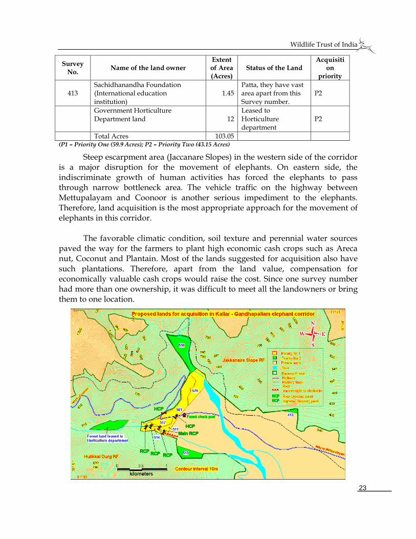
Steep escarpment area (Jaccanare Slopes) in the western side of the corridor is a major disruption for the movement of elephants. On eastern side, the indiscriminate growth of human activities has forced the elephants to pass through narrow bottleneck area. The vehicle traffic on the highway between Mettupalayam and Coonoor is another serious impediment to the elephants. Therefore, land acquisition is the most appropriate approach for the movement of elephants in this corridor. The favorable climatic condition, soil texture and perennial water sources paved the way for the farmers to plant high economic cash crops such as Areca nut, Coconut and Plantain. Most of the lands suggested for acquisition also have such plantations. Therefore, apart from the land value, compensation for economically valuable cash crops would raise the cost. Since one survey number had more than one ownership, it was difficult to meet all the landowners or bring them to one location.
Wildlife Trust of India
24
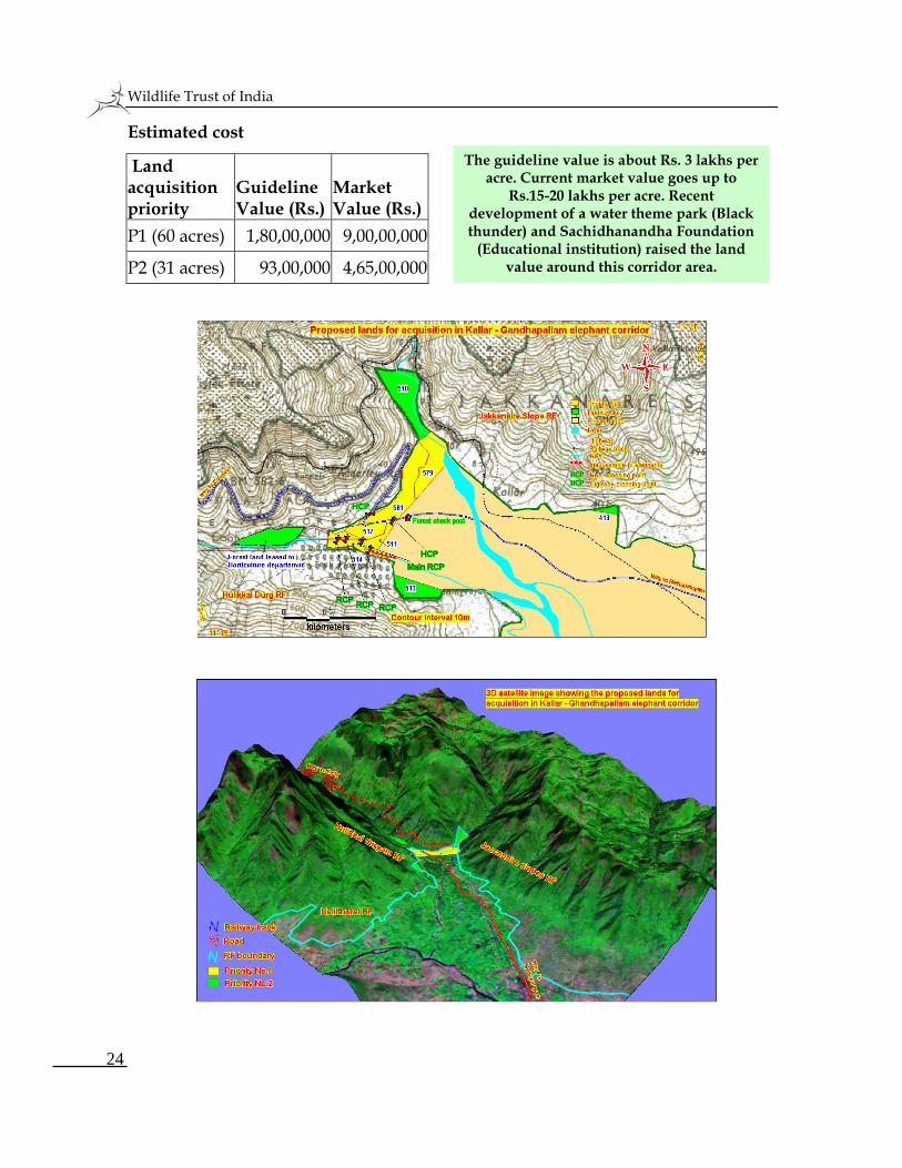
Estimated cost
Land acquisition priority
Guideline Value (Rs.)
Market Value (Rs.)
P1 (60 acres) 1,80,00,000 9,00,00,000
P2 (31 acres) 93,00,000 4,65,00,000
The guideline value is about Rs. 3 lakhs per acre. Current market value goes up to
Rs.15-20 lakhs per acre. Recent development of a water theme park (Black thunder) and Sachidhanandha Foundation
(Educational institution) raised the land value around this corridor area.
Wildlife Trust of India
25
3. TALAMALAI - GUTTIYALATTUR CORRIDOR
3.1. JUSTIFICATION FOR LAND ACQUISITION
3.1.a. Number of elephants utilizing the corridor
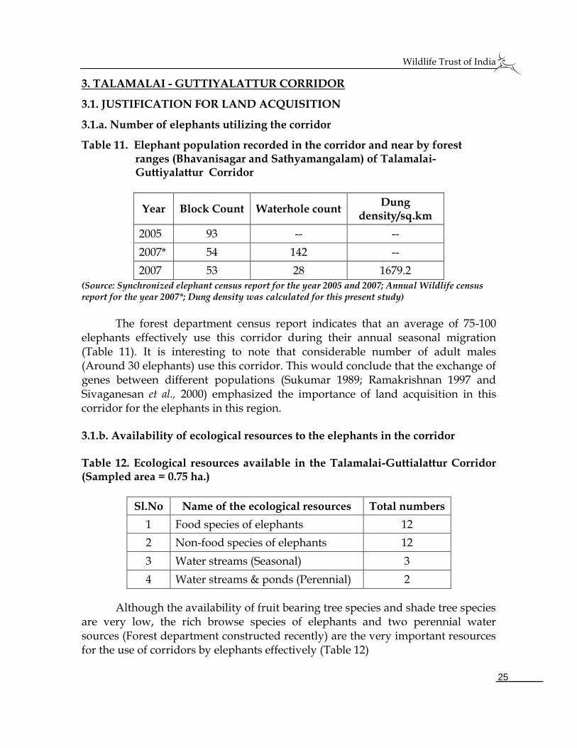
Table 11. Elephant population recorded in the corridor and near by forest ranges (Bhavanisagar and Sathyamangalam) of Talamalai- Guttiyalattur Corridor
Year Block Count Waterhole count Dung
density/sq.km
2005 93 -- --
2007* 54 142 --
2007 53 28 1679.2
(Source: Synchronized elephant census report for the year 2005 and 2007; Annual Wildlife census report for the year 2007*; Dung density was calculated for this present study)
The forest department census report indicates that an average of 75-100
elephants effectively use this corridor during their annual seasonal migration (Table 11). It is interesting to note that considerable number of adult males (Around 30 elephants) use this corridor. This would conclude that the exchange of genes between different populations (Sukumar 1989; Ramakrishnan 1997 and Sivaganesan et al., 2000) emphasized the importance of land acquisition in this corridor for the elephants in this region. 3.1.b. Availability of ecological resources to the elephants in the corridor Table 12. Ecological resources available in the Talamalai-Guttialattur Corridor (Sampled area = 0.75 ha.)
Sl.No Name of the ecological resources Total numbers
1 Food species of elephants 12
2 Non-food species of elephants 12
3 Water streams (Seasonal) 3
4 Water streams & ponds (Perennial) 2
Although the availability of fruit bearing tree species and shade tree species are very low, the rich browse species of elephants and two perennial water sources (Forest department constructed recently) are the very important resources for the use of corridors by elephants effectively (Table 12)
Wildlife Trust of India
26
Table 13. Encounter rate of important ecological resources available in the Talamalai-Guttiyalattur Corridor
Ecological resources Encounter rate / km
Fruit bearing trees 2
Shade trees 1
Salt licks 1
3.2. THREATS TO THE CORRIDOR
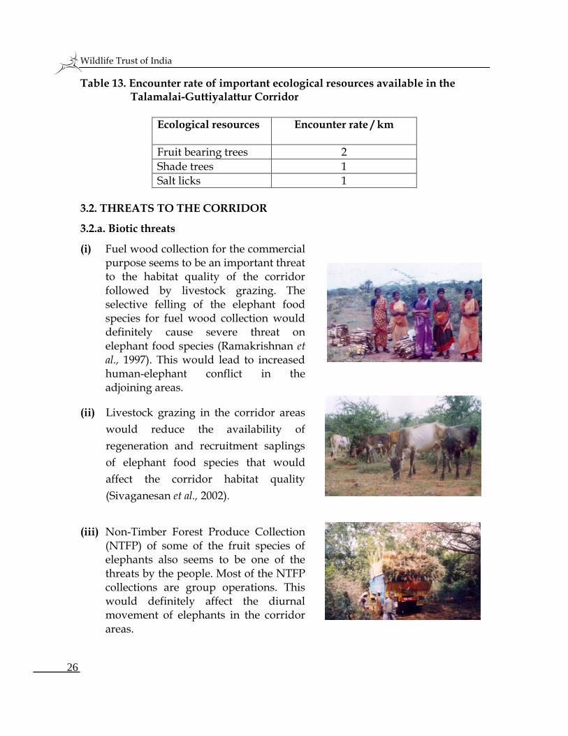
3.2.a. Biotic threats
(i) Fuel wood collection for the commercial purpose seems to be an important threat to the habitat quality of the corridor followed by livestock grazing. The selective felling of the elephant food species for fuel wood collection would definitely cause severe threat on elephant food species (Ramakrishnan et al., 1997). This would lead to increased human-elephant conflict in the adjoining areas.
(ii) Livestock grazing in the corridor areas
would reduce the availability of
regeneration and recruitment saplings
of elephant food species that would
affect the corridor habitat quality
(Sivaganesan et al., 2002).
(iii) Non-Timber Forest Produce Collection
(NTFP) of some of the fruit species of elephants also seems to be one of the threats by the people. Most of the NTFP collections are group operations. This would definitely affect the diurnal movement of elephants in the corridor areas.
Wildlife Trust of India
27
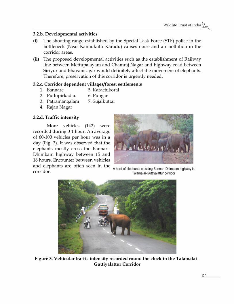
3.2.b. Developmental activities
(i) The shooting range established by the Special Task Force (STF) police in the bottleneck (Near Kannukutti Karadu) causes noise and air pollution in the corridor areas.
(ii) The proposed developmental activities such as the establishment of Railway line between Mettupalayam and Chamraj Nagar and highway road between Siriyur and Bhavanisagar would definitely affect the movement of elephants. Therefore, preservation of this corridor is urgently needed.
3.2.c. Corridor dependent villages/forest settlements 1. Bannare 5. Karachikorai 2. Pudupirkadau 6. Pungar 3. Patramangalam 7. Sujalkuttai 4. Rajan Nagar
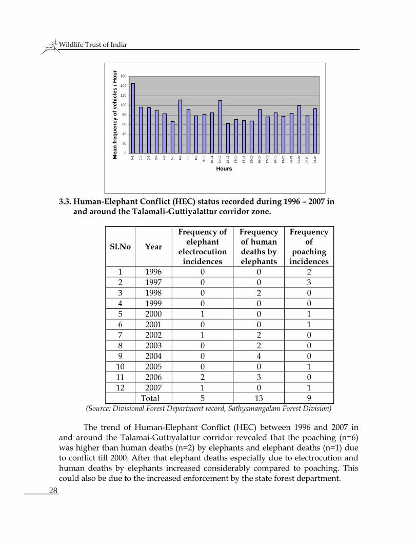
3.2.d. Traffic intensity
More vehicles (142) were recorded during 0-1 hour. An average of 60-100 vehicles per hour was in a day (Fig. 3). It was observed that the elephants mostly cross the Bannari-Dhimbam highway between 15 and 18 hours. Encounter between vehicles and elephants are often seen in the corridor.
Figure 3. Vehicular traffic intensity recorded round the clock in the Talamalai - Guttiyalattur Corridor
A herd of elephants crossing Bannari-Dhimbam highway in Talamalai-Guttiyalattur corridor
Wildlife Trust of India
28
3.3. Human-Elephant Conflict (HEC) status recorded during 1996 – 2007 in and around the Talamali-Guttiyalattur corridor zone.
Sl.No Year
Frequency of elephant
electrocution incidences
Frequency of human deaths by elephants
Frequency of
poaching incidences
1 1996 0 0 2
2 1997 0 0 3
3 1998 0 2 0
4 1999 0 0 0
5 2000 1 0 1
6 2001 0 0 1
7 2002 1 2 0
8 2003 0 2 0
9 2004 0 4 0
10 2005 0 0 1
11 2006 2 3 0
12 2007 1 0 1
Total 5 13 9 (Source: Divisional Forest Department record, Sathyamangalam Forest Division)
The trend of Human-Elephant Conflict (HEC) between 1996 and 2007 in and around the Talamai-Guttiyalattur corridor revealed that the poaching (n=6) was higher than human deaths (n=2) by elephants and elephant deaths (n=1) due to conflict till 2000. After that elephant deaths especially due to electrocution and human deaths by elephants increased considerably compared to poaching. This could also be due to the increased enforcement by the state forest department.
0
20
40
60
80
100
120
140
160
0-1
1-2
2-3
3-4
4-5
5-6
6-7
7-8
8-9
9-1
0
10-1
1
11-1
2
12-1
3
13-1
4
14-1
5
15-1
6
16-1
7
17-1
8
18-1
9
19-2
0
20-2
1
21-2
2
22-2
3
23-2
4
Hours
Mean
fre
qu
en
cy o
f veh
icle
s /
Ho
ur
Wildlife Trust of India
29
The result clearly indicates that HEC has increased during the past few
years, mainly because of increased biotic pressure due to human population growth, vehicle traffic, changed cropping pattern, etc. The bottleneck area in this corridor has thus been identified for acquisition to reduce elephants’ invasion into human habitations and also for their free movement between Western Ghats and Eastern Ghats.
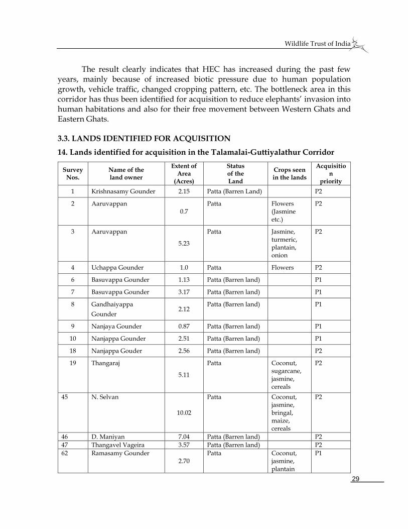
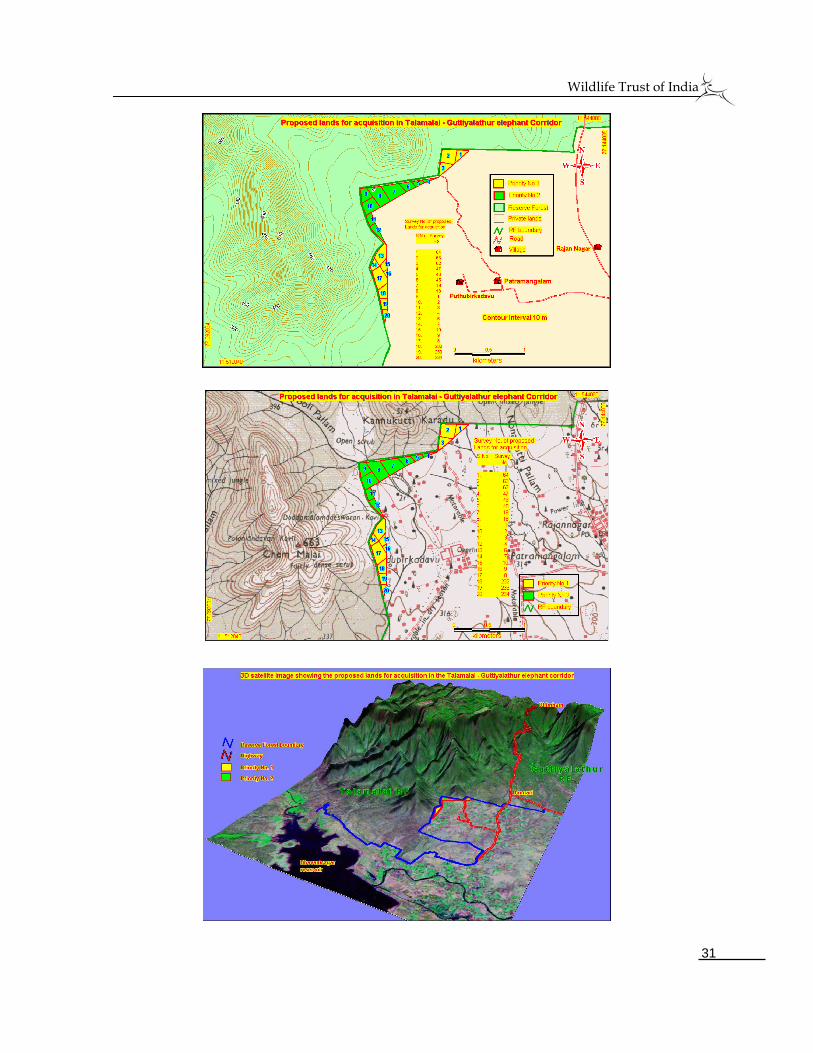
3.3. LANDS IDENTIFIED FOR ACQUISITION
14. Lands identified for acquisition in the Talamalai-Guttiyalathur Corridor
Survey Nos.
Name of the land owner
Extent of Area
(Acres)
Status of the Land
Crops seen in the lands
Acquisition
priority
1 Krishnasamy Gounder 2.15 Patta (Barren Land) P2
2 Aaruvappan 0.7
Patta Flowers (Jasmine etc.)
P2
3 Aaruvappan
5.23
Patta Jasmine, turmeric, plantain, onion
P2
4 Uchappa Gounder 1.0 Patta Flowers P2
6 Basuvappa Gounder 1.13 Patta (Barren land) P1
7 Basuvappa Gounder 3.17 Patta (Barren land) P1
8 Gandhaiyappa
Gounder 2.12
Patta (Barren land) P1
9 Nanjaya Gounder 0.87 Patta (Barren land) P1
10 Nanjappa Gounder 2.51 Patta (Barren land) P1
18 Nanjappa Gouder 2.56 Patta (Barren land) P2
19 Thangaraj
5.11
Patta Coconut, sugarcane, jasmine, cereals
P2
45 N. Selvan
10.02
Patta Coconut, jasmine, bringal, maize, cereals
P2
46 D. Maniyan 7.04 Patta (Barren land) P2
47 Thangavel Vageira 3.57 Patta (Barren land) P2
62 Ramasamy Gounder 2.70
Patta Coconut, jasmine, plantain
P1
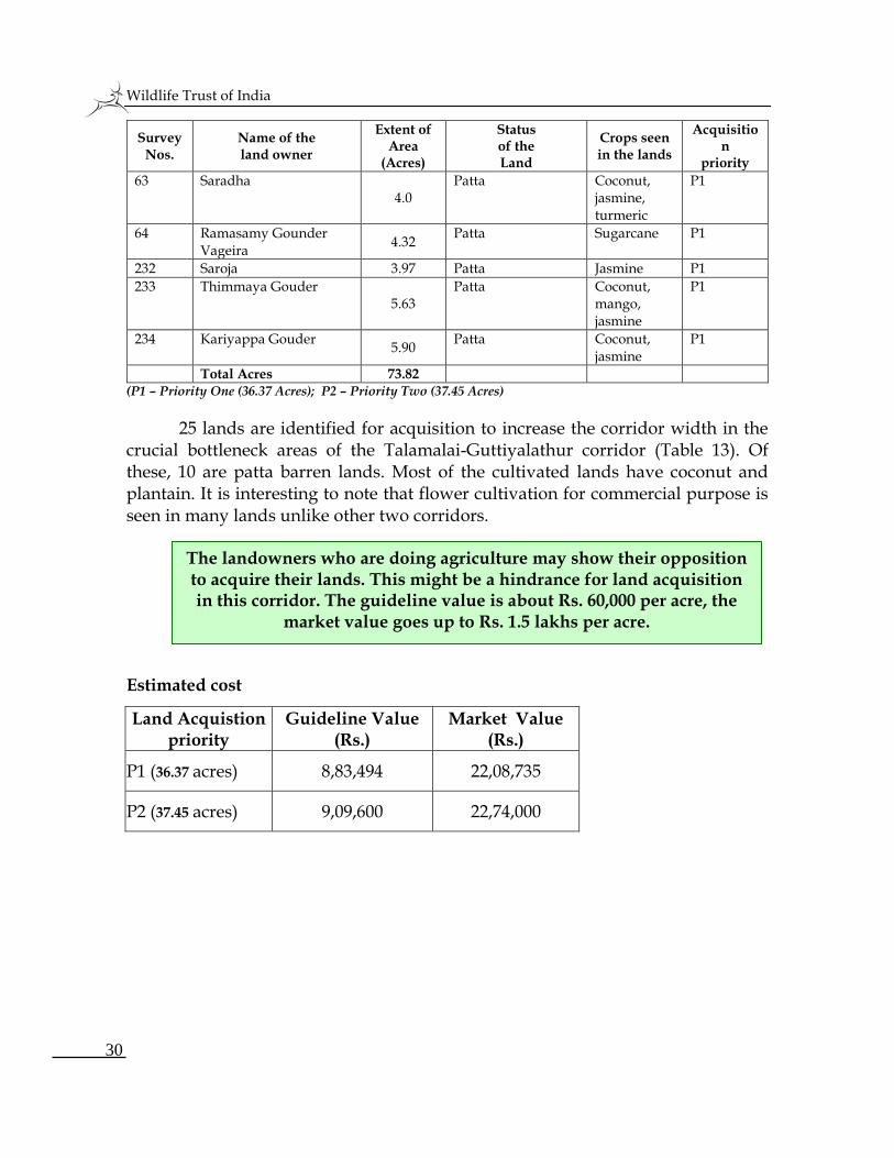
Wildlife Trust of India
30
Survey Nos.
Name of the land owner
Extent of Area
(Acres)
Status of the Land
Crops seen in the lands
Acquisition
priority
63 Saradha 4.0
Patta Coconut, jasmine, turmeric
P1
64 Ramasamy Gounder Vageira
4.32 Patta Sugarcane P1
232 Saroja 3.97 Patta Jasmine P1
233 Thimmaya Gouder 5.63
Patta Coconut, mango, jasmine
P1
234 Kariyappa Gouder 5.90
Patta Coconut, jasmine
P1
Total Acres 73.82 (P1 – Priority One (36.37 Acres); P2 – Priority Two (37.45 Acres)
25 lands are identified for acquisition to increase the corridor width in the crucial bottleneck areas of the Talamalai-Guttiyalathur corridor (Table 13). Of these, 10 are patta barren lands. Most of the cultivated lands have coconut and plantain. It is interesting to note that flower cultivation for commercial purpose is seen in many lands unlike other two corridors. Estimated cost
Land Acquistion priority
Guideline Value (Rs.)
Market Value (Rs.)
P1 (36.37 acres) 8,83,494 22,08,735
P2 (37.45 acres) 9,09,600 22,74,000
The landowners who are doing agriculture may show their opposition to acquire their lands. This might be a hindrance for land acquisition in this corridor. The guideline value is about Rs. 60,000 per acre, the
market value goes up to Rs. 1.5 lakhs per acre.
Wildlife Trust of India
31
Wildlife Trust of India
32
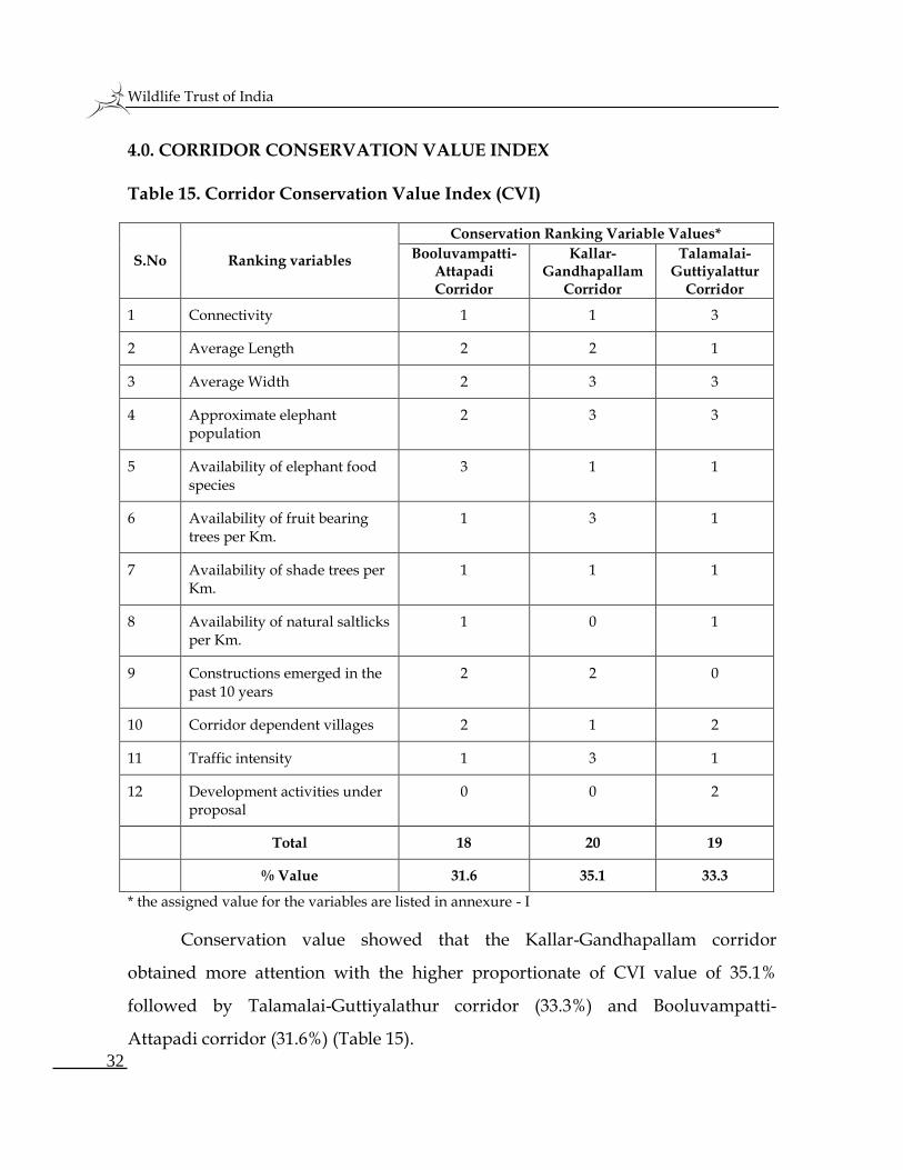
4.0. CORRIDOR CONSERVATION VALUE INDEX Table 15. Corridor Conservation Value Index (CVI)
S.No Ranking variables
Conservation Ranking Variable Values*
Booluvampatti-Attapadi Corridor
Kallar- Gandhapallam
Corridor
Talamalai- Guttiyalattur
Corridor
1 Connectivity 1 1 3
2 Average Length 2 2 1
3 Average Width 2 3 3
4 Approximate elephant population
2 3 3
5 Availability of elephant food species
3 1 1
6 Availability of fruit bearing trees per Km.
1 3 1
7 Availability of shade trees per Km.
1 1 1
8 Availability of natural saltlicks per Km.
1 0 1
9 Constructions emerged in the past 10 years
2 2 0
10 Corridor dependent villages 2 1 2
11 Traffic intensity 1 3 1
12 Development activities under proposal
0 0 2
Total 18 20 19
% Value 31.6 35.1 33.3
* the assigned value for the variables are listed in annexure - I
Conservation value showed that the Kallar-Gandhapallam corridor
obtained more attention with the higher proportionate of CVI value of 35.1%
followed by Talamalai-Guttiyalathur corridor (33.3%) and Booluvampatti-
Attapadi corridor (31.6%) (Table 15).
Wildlife Trust of India
33
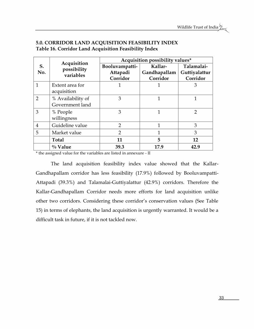
5.0. CORRIDOR LAND ACQUISITION FEASIBILITY INDEX Table 16. Corridor Land Acquisition Feasibility Index
S. No.
Acquisition possibility variables
Acquisition possibility values*
Booluvampatti-Attapadi Corridor
Kallar- Gandhapallam
Corridor
Talamalai- Guttiyalattur
Corridor
1 Extent area for acquisition
1 1 3
2 % Availability of Government land
3 1 1
3 % People willingness
3 1 2
4 Guideline value 2 1 3
5 Market value 2 1 3
Total 11 5 12
% Value 39.3 17.9 42.9 * the assigned value for the variables are listed in annexure - II
The land acquisition feasibility index value showed that the Kallar-
Gandhapallam corridor has less feasibility (17.9%) followed by Booluvampatti-
Attapadi (39.3%) and Talamalai-Guttiyalattur (42.9%) corridors. Therefore the
Kallar-Gandhapallam Corridor needs more efforts for land acquisition unlike
other two corridors. Considering these corridor’s conservation values (See Table
15) in terms of elephants, the land acquisition is urgently warranted. It would be a
difficult task in future, if it is not tackled now.
Wildlife Trust of India
34
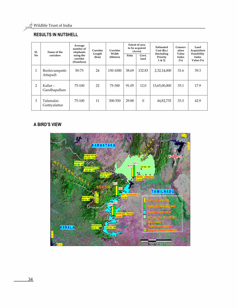
RESULTS IN NUTSHELL
Sl.No
Name of the corridors
Average number of elephants using the corridor
(Numbers)
Corridor Length (Km)
Corridor Width
(Meters)
Extent of area to be acquired
(Acres)
Estimated Cost (Rs.) (Including
Priority 1 & 2)
Conservation Value Index
(%)
Land Acquisition Feasibility
Index Value (%)
Patta Govt. land
1 Booluvampatti-Attapadi
50-75 24 150-1000 38.69 132.83 2,32,14,000 31.6 39.3
2 Kallar -Gandhapallam
75-100 22 75-300 91.05 12.0 13,65,00,000 35.1 17.9
3 Talamalai-Guttiyalattur
75-100 11 300-550 29.88 0 44,82,735 33.3 42.9
A BIRD’S VIEW
Wildlife Trust of India
35
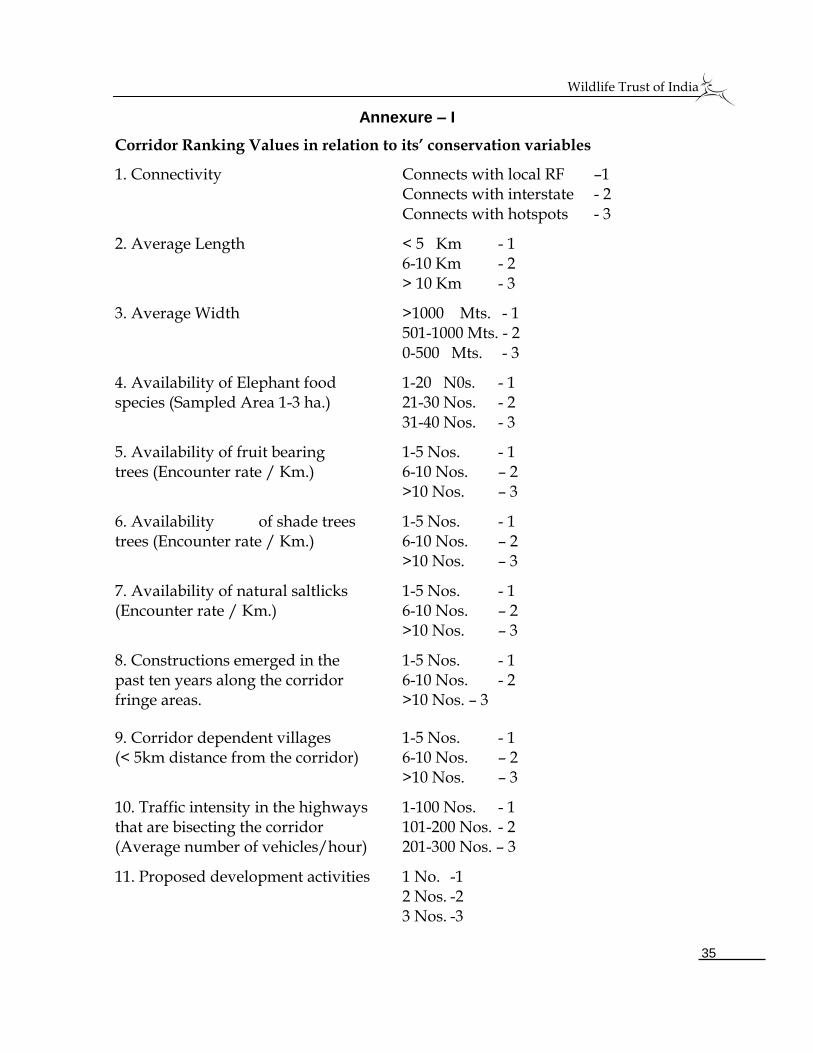
Annexure – I
Corridor Ranking Values in relation to its’ conservation variables
1. Connectivity Connects with local RF –1 Connects with interstate - 2 Connects with hotspots - 3
2. Average Length < 5 Km - 1 6-10 Km - 2 > 10 Km - 3
3. Average Width >1000 Mts. - 1 501-1000 Mts. - 2
0-500 Mts. - 3
4. Availability of Elephant food 1-20 N0s. - 1 species (Sampled Area 1-3 ha.) 21-30 Nos. - 2 31-40 Nos. - 3
5. Availability of fruit bearing 1-5 Nos. - 1 trees (Encounter rate / Km.) 6-10 Nos. – 2 >10 Nos. – 3
6. Availability of shade trees 1-5 Nos. - 1 trees (Encounter rate / Km.) 6-10 Nos. – 2 >10 Nos. – 3
7. Availability of natural saltlicks 1-5 Nos. - 1 (Encounter rate / Km.) 6-10 Nos. – 2 >10 Nos. – 3
8. Constructions emerged in the 1-5 Nos. - 1 past ten years along the corridor 6-10 Nos. - 2 fringe areas. >10 Nos. – 3
9. Corridor dependent villages 1-5 Nos. - 1 (< 5km distance from the corridor) 6-10 Nos. – 2 >10 Nos. – 3
10. Traffic intensity in the highways 1-100 Nos. - 1 that are bisecting the corridor 101-200 Nos. - 2 (Average number of vehicles/hour) 201-300 Nos. – 3
11. Proposed development activities 1 No. -1 2 Nos. -2 3 Nos. -3
Wildlife Trust of India
36
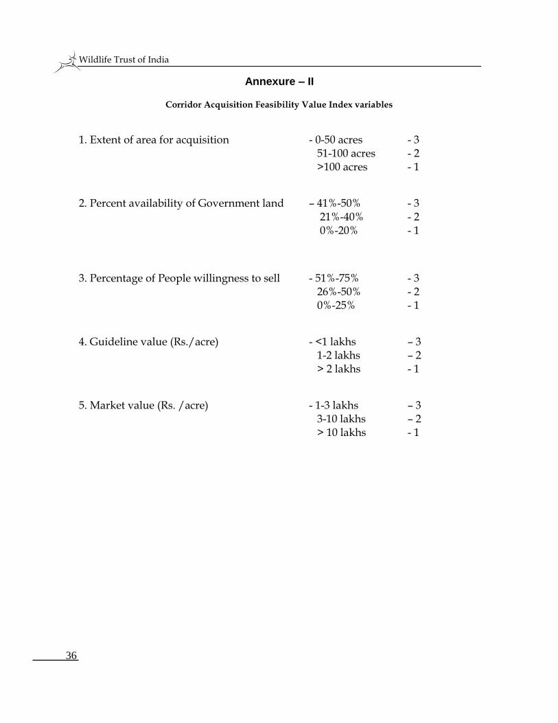
Annexure – II
Corridor Acquisition Feasibility Value Index variables
1. Extent of area for acquisition - 0-50 acres - 3 51-100 acres - 2 >100 acres - 1
2. Percent availability of Government land – 41%-50% - 3 21%-40% - 2 0%-20% - 1
3. Percentage of People willingness to sell - 51%-75% - 3 26%-50% - 2 0%-25% - 1
4. Guideline value (Rs./acre) - <1 lakhs – 3 1-2 lakhs – 2 > 2 lakhs - 1
5. Market value (Rs. /acre) - 1-3 lakhs – 3 3-10 lakhs – 2 > 10 lakhs - 1
Wildlife Trust of India
37
REFERENCES Baskaran, N., M. Balasubramanian, S. Swaminathan and A. A. Desai (1995).
Home range of elephants in the Nilgiri Biosphere Reserve, South India. In: Proceedings of the International Seminar on the Conservation of Asian Elephants,(eds., J.C. Daniel and H.S. Datye), Bombay Natural History Society, Mumbai.
Champion, H. G. and S. K. Seth (1968). A revised survey of the forest types of India. Government of India.
Choudhury, A. (1995). Status of wild elephants in Dibang Valley of Arunachal Pradesh, J. Bombay Nat. Hist. Soc. 92(3): 417.
Daniels, R.J.R. (1993). The Nilgiri Biosphere Reserve and its role in conserving India’s biodiversity. Current Science, 64(10): 706-708.
Davidar, E. R. C. (1972). Investigation of elephant migration paths in the Nilgiri Hills and inquiry into impediments to the free movement of elephants there and recommendations for the provision of corridors for their movement. Mimeo.
Desai, A. A. (1991). The home range of elephants and its implications for management of the Mudumalai Wildlife Sanctuary, Tamil Nadu. J. J.Bombay. Nat. Hist. Soc, 88, Pp 145-156.
Menon, V., Tiwari, S.k., Easa, P.S and Sukumar, R (2005). Right of passage: Elephant Corridors of India. Conservation Reference Series 3. Wildlife Trust of India, New Delhi, Pp 287.
Noss, R. F. (1987). Protecting Natural Areas in Fragmented Landscape, Nat. Areas. Tr., 7, Pp 2-18.
Ramakrishnan, B., N. Sivaganesan and R. K. Srivastava (1997). Human interference and its impact on the elephant corridors in Sathyamangalam and Coimbatore Forest Divisions, Tamil Nadu, Southern India. Indian Journal of Forestry, 20 (1), Pp 8 – 19.
Ramakrishnan, B. and P. Durairasu (2004). Human-Elephant Conflict issues in Crucial Elephant Corridors in Coimbatore Forest Division, Tamil Nadu, India. OSAI Technical Report No.2, Coimbatore.
Ramakrishnan, B. and P. Durairasu (2005). Human-elephant conflict mitigating measures in the Coimbatore Forest Division, Tamil Nadu, India. OSAI Technical Report No.3, Coimbatore.
Ramkumar, K. and A. Arumugam (2005). Evaluation of the status, land use
Wildlife Trust of India
38
pattern and habitat utilization of elephants in corridors of Mudumalai Wildlife Sanctuary and Nilgiris North Forest Division, Nilgiris, Tamil Nadu. Project Report submitted to Nilgiri Wildlife & Environment Association, Udhagamandalam.
Rodgers, W. A. and H. S. Panwar (1988). Planning wildlife protected area in India. Volume I and II. Report to Department of Environment, Forest and Wildlife, Government of India, Wildlife Institute of India. Dehradun.
Simberloff, D. and Cox, J. (1987). Corridors for conservation. New Scientist, 1642, 63-68.
Sivaganesan, N. and B. Ramakrishnan (1997). An ecological assessment on the development of Sachidhanandha Jothi Niketan School adjoining the Kallar-Jacanare Corridor in Coimbatore forest division, Nilgiris. Wildlife Corridor Project Technical Report: Submitted to the Salim Ali Centre for Ornithology and Natural History, Coimbatore.
Sivaganesan, N. and B. Ramakrishnan (1999). A status report of elephant corridor between Nilgiri Eastern Slope Reserve Forests and Coimbatore Forest Division linking Silent valley National Park in the Nilgiri Biosphere Reserve, Salim Ali Centre for Ornithology and Natural History, Coimbatore, Tamil Nadu.
Sivaganesan, N., Ajithkumar and B. Ramakrishnan (2000). Status of the corridors and their use by mammals with special reference to selected endangered mammals in the Nilgiri Biosphere Reserve, Southern India. Technical Report. Submitted to the Salim Ali Centre for Ornithology and Natural History, Coimbatore.
Sivaganesan, N., G.Sivasubramanian and N.Ramesh (2002). Management of Elephant corridors through community participatory approach in the Greater Moyar Valley Corridor, Tamil Nadu. South India. Final Report submitted to the U.S. Fish and Wildlife Service, USA.
Soule, M.E. and D.Simberloff, (1986). What do genetics and ecology tell us about the design of nature reserve?. Biol. Conserv., 35, 19-40.
Sukumar, R. (1989). THE ASIAN ELEPHANT: ECOLOGY AND MANAGEMENT. Cambridge University Press, UK, England.
Wildlife Trust of India
39