Embed Size (px)
Citation preview

Quaternary International 106–107 (2003) 141–158
Late Quaternary climatic changes in Northern Cilento(Southern Italy): an integrated geomorphological and
paleopedological study
F. Scarcigliaa,*, F. Terribileb, C. Colomboc, A. Cinquea
aDipartimento di Scienze della Terra, Universit "a di Napoli ‘‘Federico II’’, Largo S.Marcellino 10, 80138 Napoli, ItalybDipartimento di Scienza del Suolo, della Pianta e dell’Ambiente (DISSPA), Universit "a di Napoli ‘‘Federico II’’, Via Universit "a 100,
80055 Portici (NA), ItalycDipartimento di Scienze Animali, Vegetali e dell’Ambiente (SAVA), Universit "a del Molise, Via De Sanctis, 86100 Campobasso, Italy
Received 25 September 2002; accepted 25 September 2002
Abstract
This paper reports a contribution to the knowledge of the local morphodynamic and pedogenetic response to Late Quaternary
climatic changes in Northern Cilento (Southern Italy). Three representative geomorphological units and associated paleosols have
been characterised in detail by field work, chemical and mineralogical analyses, and micromorphological observations of thin
sections. The data confirm an intense degree of weathering and a complex history of soil formation, often representing different
environments in contrast with the present pedoclimatic regime. Two of the three profiles reveal a polygenetic character, recording
typical interglacial conditions characterised by high temperatures and humidity with important soil development, followed by the
occurrence of periglacial conditions possibly occurring during cold glacial stages (namely the Last Glacial) at mid-latitude coastal
regions of Southern Italy. The third paleosol appears essentially monogenetic and developed under interglacial-like conditions.
r 2003 Elsevier Science Ltd and INQUA. All rights reserved.
1. Introduction
The specific geographical position of Southern Italymakes it an area of particular interest for studying theeffects of the Quaternary climatic change in theMediterranean area. Despite such favourable condi-tions, most of this potential is still scarcely investigated.In this field, the existing literature focuses mostly on
the reconstruction of paleoclimatic curves based onpollen content analysis of lacustrine (Watts et al., 1996a,b; Allen et al., 1999) and marine (Rossignol-Strick andPlanchais, 1989; Amore et al., 1999; Russo Ermolli anddi Pasquale, 2002) successions. While a satisfactoryreconstruction of past climates (particularly for the LateQuaternary) is shown in those papers, very little isknown about the consequences of those climatic changesin terms of physical environment dynamics. It seems
that the only well documented phenomena during theglacial events are the important cryoclastism experi-enced by the free face elements of the Apenniniclandscape, with consequent cliff recession and screeaccumulation even at very low elevations (Brancaccio,1968; Boenzi, 1980; Coltorti and Dramis, 1988; Scarci-glia, 2000); the development of typical glacial landforms(Cinque et al., 1990; Giraudi, 1997); and the markedlowering of the snow limit (Federici, 1979; Palmentolaand Acquafredda, 1983).This work is part of a larger project aiming to
characterise in detail the recent evolution of severalselected areas of Southern Apennines, which account fordifferent lithological and geomorphological scenarios, inorder to contribute to the knowledge of the localmorphodynamic and pedogenetic response to LateQuaternary climatic changes (Aucelli et al., 1998;Scarciglia, 2000). In this framework, this paper dealswith the preliminary results from an area chosen asrepresentative of a typical hilly landscape carved onarenaceous flysch deposits. It is located in the Cilentopromontory, at the south-eastern end of the SalernoGulf (Tyrrhenian Sea), approximately at a latitude of
*Corresponding author. Present address: Dipartimento di Scienze
della Terra, Universit"a della Calabria, 87036 Arcavacata di Rende
(CS), Italy. Tel.: +39-984-493600-78; fax: +39-984-493601.
E-mail addresses: [email protected] (F. Scarciglia), terribil@
unina.it (F. Terribile), [email protected] (C. Colombo), cinque@
unina.it (A. Cinque).
1040-6182/03/$ - see front matter r 2003 Elsevier Science Ltd and INQUA. All rights reserved.
PII: S 1 0 4 0 - 6 1 8 2 ( 0 2 ) 0 0 1 6 9 - 6

401150N and a longitude of 141560E (Fig. 1). This areawas selected mainly because of the occurrence of wellexposed (dissected) foothill sequences testifying fluctua-tions in the production and wasting of debris andweathering materials, and the existence of dated marineterraces useful to fix chronological constrains to theproposed interpretation of paleopedological data.
2. Geological setting
The study area is located along the Tyrrhenian flankof the Southern Apennines. It corresponds to a hillypromontory reaching up to 326 m a.s.l. (Mt. Licosa) andcomposed mainly of northeast-dipping, stratified sand-stones, rich in quartz, feldspars and subordinate micas(Critelli and Le Pera, 1990) with silty and clayeyinterlayers. These rocks belong to Tertiary flyschformations (‘‘Cilento Group’’, Amore et al., 1988),which form one of the numerous thrust sheets composingthe Apennine chain. They were folded and overthrustedtowards the northeast during Neogenic times. However,the bulk of the present relief was determined by LatePliocene toMiddle Pleistocene extensional block-faulting.Since the beginning of the Late Pleistocene, the areaentered a period of substantial tectonic stability, as theconstant and normal elevation of Last Interglacial sealevel features demonstrates (Brancaccio et al., 1990, 1991;Cinque et al., 1994; Iannace et al., 2001).
3. Climate and vegetation
The study area has a humid temperate climate typicalof Mediterranean coastal zones (suboceanic mediterra-
nean climate, sensu Finke et al., 1998). It is characterisedby high evapotranspiration rates (Lippmann-Provansal,1987). According to the data of the Servizio IdrograficoItaliano, mean monthly temperatures vary from aminimum of 51C (in the month of January or February)to a maximum of 25–301C (recorded in August); meanannual rainfall ranges from 750 to 1000 mm accordingto elevation and aspect. The present pedoclimate ischaracterised by a thermic soil temperature regimeassociated with a xeric soil moisture regime (sensuUSDA, 1998).The present vegetation cover is the typical open
Mediterranean Maquis which appears to be verydegraded, above all because of repeated phases of forestclearance experienced until the first half of the 20thcentury to allow agricultural practice. More recently,grazing and finally land set aside have occurred.Several areas have been left to a slow, spontaneousre-naturalization; some other scattered zones are culti-vated, mainly with olive trees. Landscape degradationinduced by man probably also increased the geomorphicinstability of some slopes and foothill areas.
4. Materials and methods
The preliminary phase of this study was a detailedgeomorphological survey, to identify and understandthe major landscape units representing the Late Qua-ternary evolution of the area. Particular interest wasgiven to depositional landforms, which represent moreconservative environments, and to their relations withthe dated marine formations and terraces of the coastalstrip. The sediments associated with foothill taluses andfans were analysed in order to gain some informationabout the history of hillslope dynamics. As well, a lowintensity soil survey was conducted on the majorgeomorphological units to select some paleosols and/or old weathering profiles representing differentphases within or above Late Quaternary sedimentarysequences (and therefore different ages), to be analyti-cally characterised. The aim was to reconstruct paleocli-matic and paleoenvironmental conditions active indifferent stages of Late Quaternary times. Soil informa-tion was also used to support and refine the chronologyof pedogenetic and geomorphic events where theavailable time constraints were not so rigorous oraccurate.Within the different geomorphological units, three
soil profiles were finally chosen as more relevant for adetailed soil analysis. One (SP1) came from the lowerslope talus exposing the upper 2 m under the erodedtopographic surface (Buonanotte site). A second (SP2)from the lower alluvial cone showed the upper part ofthe stratigraphic succession in a gully (near to OgliastroMarina village), and a third one (SP3) was from the top
VesuviusVesuvius
Salerno GulfSalerno Gulf
CilentoCilento
Southern Apennines
Southern Apennines
Tyrrhenian Sea
Tyrrhenian Sea 40˚ N40˚ N
15˚ E15˚ E
Fig. 1. Location map of the study area.
F. Scarciglia et al. / Quaternary International 106–107 (2003) 141–158142

of an ancient dune ridge of S. Marco di Castellabatearea (Fig. 2).The three soil profiles were characterised by morpho-
logical description, bulk and undisturbed sampling, androutine physical and chemical analyses according to theMinistero delle Politiche Agricole e Forestali methods(MiPAF, 2000). Soil samples were air dried and sievedðo2 mmÞ: Particle size distribution analysis was carriedout by the pipette method. pH was measured in a 1:2.5soil:water suspension and electrical conductivity in a 1:5soil:water suspension. Organic matter was determinedby dichromate oxidation. Cation exchange capacity andexchangeable bases were determined by BaCl2 metho-dology and Inductively Coupled Plasma-Mass Spectro-scopy (ICP-MS), respectively. Thin sections wereprepared and observed using Optical Microscopy(OM) (FitzPatrick, 1984). The different forms of Feand total amounts of Mn, Ti, Al and Si were determinedby selective extraction techniques (ammonium-oxalate,dithionite-citrate and nitric–hydrofluoric–hydrochloricacids, MiPAF, 2000) and measured by ICP-MS.Mineralogical analyses were conducted by X-ray
diffraction techniques (XRD) both on fine clayðo0:2 mÞ (parallel oriented specimens) and coarse sandfractions (2–0:2 mm) (randomly oriented powders),separated by sieving and centrifugation, using a RigakuGeigerflex D/Max IIIC X-ray diffractometer equippedwith iron-filtered Co–K radiation generated at 40 kW;30 mA: Different treatments were performed to inves-tigate fine clays, including Mg-saturation, natural,ethylene-glycol and formamide solvated, K-saturation,natural and after heating at 1051C and 5501C (Whittingand Allardice, 1986; Wilson, 1987). X-ray patterns wereinterpreted according to Berry (1974) and Brindley andBrown (1980). Differential X-ray diffraction analysis(DXRD) was applied for the identification of ironoxides on fine clay randomly-oriented powders (Schulze,1994).
5. Geomorphological results
The geomorphology of the area is schematicallygiven in Fig. 2 and is characterised by hillslopes with
Fig. 2. Geomorphological sketch showing the main geomorphological units, their chronological and stratigraphic relations and the studied soil
profiles.
F. Scarciglia et al. / Quaternary International 106–107 (2003) 141–158 143

smooth convex–concave cross profiles, generally wellgraded to the main valley floors by means of thick,polycyclical, detritic-colluvial taluses. These talusesmostly consist of angular sandstone clasts supportedby a yellow to yellowish brown and reddish brownmatrix, ranging from sandy loam to sandy clayey loamin texture, and in places largely prevailing on the rockfragments.The scree taluses are dissected by minor incisions,
generally V-shaped, hosting dissected alluvial cones, andshowing triangular facets in the interfluves. Along thenorth and south-western flanks of Mt. Licosa, the basalconcavities of the relief appear graded to marine terraces(different abrasion platforms hanging at differentheights over the present sea level) of Middle and UpperPleistocene age (Fig. 2). They are cut on the bedrock orother sedimentary bodies, sometimes associated withtypical marine deposits, and are related to the main sealevel highstands, namely OIS (oxygen isotopic stage) 7and sub-stages 5e, 5c and 5a. This chronologicalreconstruction is based on (i) isoleucine epimerisationand U/Th dating methods on biogenic samples(Brancaccio et al., 1990; Iannace et al., 2001); (ii) theoccurrence of pre-Mousterian Palaeolithic industries(Cinque et al., 1994); (iii) the presence of a pyroclasticmarker layer, widespread all along the south Tyrrheniancoastal areas and dated to the transition OIS 3-2 (Lireret al., 1967; Antonioli et al., 1994; Cinque et al., 1994;Gambassini et al., 1996); and (iv) regional-scale strati-graphic correlations (Brancaccio et al., 1991; Scarcigliaet al., 2003).The eastern flanks of Mt. Licosa appear graded to
valley floors that are related to the present-day base level(or slightly hanging over them), even though thepresence of ancient basal flats, buried under the recentcolluvial and alluvial bodies, cannot be excluded. Thelongitudinal profile of the Rivo dell’Arena stream valley(south-east of Mt. Licosa) is well graded to the presentflat alluvial plain. The Holocene (OIS 1) infillingdeposits seem to overlap those forming its valley-sides.The mutual morpho-stratigraphical relationshipsbetween the dated marine terraces and the taluses(together with some sedimentological evidence, the mainpedological features and/or degree of weathering) enableto distinguish at least two generations of both scree andalluvial cone deposits and ascribe them mainly to OIS7-6 and OIS 5 to 4-2 (the penultimate and the lastinterglacial/glacial cycles, respectively). The olderlandforms show paleo-sea level marks (wave-cutmorphologies and/or sediments) representing theEuthyrrenian (Last Interglacial, OIS 5e) sea level stand,or locally the previous one (more elevated a.s.l. fortectonic uplift). The Last Glacial alluvial cones overliethe 5e platform hanging at about 10 m a.s.l. (innermargin), and were emplaced in the valleys dissectingthe ancient talus/cones. They also appear in course of
dissection. Their thickness reaches 8–10 m; althoughthe lower boundaries cannot be always detected.The deposits consist of composite sequences in whichdebris flow, mud flow and/or debris avalanchefacies with different sedimentary structures and texturesalternate, thus recording different influences ofwater and gravity processes in their accretion (Fig. 3a).Both the Last Glacial cones and taluses show inthe uppermost portion of their sequences thetephra marker bed (Fig. 3b), rich in white pumicefragments and various phenocrystals and often intenselyreworked.Various marine, transitional and continental Qua-
ternary sediments fill the depressed zones and valleysof Mt. Licosa (Lippmann-Provansal, 1987; Cinque et al.,1994). They are generally related to the repeatedtransgression/regression cycles (submergence/emer-gence), experienced by the Licosa promontory and dueto the Late Quaternary tectonics and climatic fluctua-tions. Among these the ‘‘S. Marco sandstones’’ (Cinqueet al., 1994), outcrop in the small bay located along thenorthern side of Mt. Licosa (where the village of S.Marco lies) and are interpreted as beach ridge facies.They form a marine terrace of the Penultimate Inter-glacial sea level highstand (OIS 7) at a maximumelevation of 14 m a.s.l. (tectonically uplifted to aboutþ60 m in some sites), and overlie continental dunedeposits intensely pedogenised (reddened eolian sands),tentatively ascribed to the same age or to the previouscolder stage (OIS 8).As for the geomorphic phenomena active in the
area, in the present-day morphoclimatic conditionsbio-chemical weathering, pedogenesis and colluvialprocesses prevail, and coexist on the middle and lowerportions of slopes. The scree taluses experience soilcreep and intense surface erosion (sheet and rill wash)with severe surface fine depletion and the formation of aresidual stony surface where the shrubby and grassycover is more open. In addition, they show evidence ofstrong dissection sometimes reaching the buried ‘‘fresh’’bedrock. Concentrated overland flows run through theseincisions during the strongest rainstorms, often with thedeposition of thin fans. Also, block fragmentation of theoutcropping bedrock acts in the area, especially on thesteepest slope elements (X45–501) such as coastal seacliffs or gully trenches where a headward-migratingerosion is active, while cryoclastic phenomena areabsolutely absent.Three main landscape units, such as the slope
taluses, the recent alluvial cones and the ancientdune ridges were finally chosen as representative in thearea on the basis of the whole geomorphologicalobservations. They characterise more conservative en-vironments, well correlate with the dated marineterraces, and represent different ages during the LateQuaternary.
F. Scarciglia et al. / Quaternary International 106–107 (2003) 141–158144

6. Pedological results
The soils can be considered on the whole as paleosols,as defined in the Paleopedology Glossary by theINQUA Working Group ‘‘Definitions used in Paleope-dology’’ (1995), as they show pedogenetic features thatcan be essentially related to soil processes not inequilibrium with present-day climatic conditions, anddate to the Pleistocene.
6.1. Soil profile SP1
Profile SP1 (Fig. 2) was sampled at the top of adepositional glacis (about 30 m a.s.l.), gently slopingtowards the present alluvial plain (Rivo dell’Arenastream) at the NE footslope of Mt. Licosa (Buonanottesite). The glacis appears clearly polycyclical, with asharp erosional discontinuity displayed in some inci-sions, at about 30 cm depth, and truncating the oldestdeposits. It mainly consists of fine colluvial materials(including occasional coarse, angular rock fragments)reworked from the upper (and steeper) scree talus,ranging in age mainly from the oxygen isotopic stage 7to 2 (see Section 5). Typical solifluction lobes can beobserved at its surface.The main morphological, physical and chemical data
of SP1 are reported in Tables 1 and 2. The profile ischaracterised by a sharp erosional discontinuity separ-ating two different environments: the lower and thickerburied paleosol with clear gley features (horizons2Btgb1–2Btgb2) marked by a yellowish hue of thematrix (2.5 Y) and a high frequency of mottles, andthe thinner top paleosol (made of three distinct Bthorizons under a thin A horizon), yellowish brown incolours (10 YR), very rich in Fe–Mn concretions and
partially cemented. The profile is essentially sandy loamto sandy clayey loam in texture and alternates angularand subangular blocky structures, with the occurrenceof a prismatic structure in the buried soil. Worthy tonote are the very low values both of CEC and organicmatter content, and the pH which varies from neutral tosub-acid.More results of the analysis of thin sections are widely
described in Scarciglia et al. (2003). Among the majorsoil features (Table 3), the presence of differentgenerations of clay coatings is of most importance.They often appear laminated, both in surface and inburied horizons. They are usually abundant and thickand show various signs of degeneration (fragmentation,progressive assimilation into the soil matrix, change inthe internal fabric leading to broken extinction bands orgrainy interference pattern between crossed polars,presence of isolated papules), as described by Bronger(1969/70), FitzPatrick (1984), Catt (1989), Tarnocai andValentine (1989) and Kemp (1998). In contrast, ayounger but less represented generation of clay coatingsis present, showing ‘‘fresh’’ unbroken surfaces and sharpextinction bands between crossed polars (XPL). More-over, abundant silt or fine sand coatings are oftenalternated with the clay coatings. Some other relevantfeatures were observed, including iron–manganese con-cretions, mainly subspherical and concentric; develop-ment of angular/subangular (and rarely prismatic andsubcuboidal) blocky structures; intensely bleached andMn-infilled inter-aggregate cracks and the abundance ofvesicular pores (bubbles) in the surface paleosol; and thepresence of pyroxenes and amphiboles among thedetrital grains in the upper horizons, indicating somepossible pyroclastic supply (reworked from upslope)tentatively correlated to the tephra marker.
(b)(a)
Fig. 3. (a) A typical outcrop of the Last Glacial alluvial cones, showing a composite sedimentary sequence with different facies; (b) a detail of Fig. 3a:
the white arrow indicates the tephra marker layer in the upper portion of the sequence.
F. Scarciglia et al. / Quaternary International 106–107 (2003) 141–158 145

6.2. Soil profile SP2
Profile SP2 (Fig. 2) is located at about 25 m a.s.l. in agully dissecting an alluvial cone of the last generation
(Last Glacial), emplaced in the dissected talus justbehind the village of Ogliastro Marina (200 m fromthe southern coast). It shows an alternation ofdifferent sedimentary phases (pyroclastic included) and
Table 1
The main morphological features
Profile Horizon Depth (cm) Colour RR Structure Mottles Fe–Mn Clay CaCO3concretions coatings
SP1 surface A 0–10 10YR 4/6 0 c AB þ ðþÞ ðþÞ —
Bt 10–20 10YR 4/4 0 f SB þ þ þ —
Btc1 20–30 10YR 4/6 0 vc AB þ þ þþ —
Btc2 30–40 10YR 4/4 0 f AB þðþÞ þ þþþ þþ ðþÞ —
SP1 buried 2Btgb1 40–90 2.5Y 6/2 — c P, SB þþþ — þðþÞ —
2Btgb2 90–130þ 2.5Y 6/3 — m AB þþ — þþþ —
SP2 Bt1 0–1.5 2.5Y 5/4 — m AB ðþÞ — þþ —
2Bt2 1.5–15 10YR 3/4 0 c AB ðþÞ — þþþ —
2Bt3 15–50 10YR 4/4 0 f AB ðþÞ — þ —
3Bt4 50–70 10YR 4/4 0 f AB ðþÞ — þðþÞ —
3Bt5 70–95 10YR 4/4 0 f AB ðþÞ — þþ —
4Bt6 95–120 10YR 4/4 0 f AB þ þ þþ —
4Bt7 120–180þ 10YR 5/4 0 f AB þþ þ þþþþ —
SP3 R 10YR 5/6 0 — ðþÞ — — þþABtb 0–25 7.5YR 3/3 2.5 f SB ðþÞ þþ ðþÞ þBtb1 25–50 7.5YR 3/3 2.5 f AB þ — þ ðþÞBtb2 50–75 7.5YR 3/4 3.3 f SB þ þþþ þþ ðþÞBEtb 75–140þ 7.5YR 3/4 3.3 m AB ðþÞ — þþþ —
RR: redness rate (sensu Torrent et al., 1980); Structure: AB: angular blocky; P: prismatic; SB: subangular blocky; f: fine; m: medium; c: coarse; vc:
very coarse. —, ðþÞ; þ; þþ; þþþ; þþþþ indicate increasing abundance of some soil features: absent, rare, occasional, common, frequent,
abundant, very abundant.
Table 2
The main physical and chemical features
Profile Horizon Particle size distribution pH EC Org. mat. CEC Mg Na Ca K
C. Sand F. Sand C. Silt F. Silt Clay ðH2OÞ ðmS cm�1Þ (%) ððþÞ cmol kg�1Þ (%) (%) (%) (%)
(%) (%) (%) (%) (%)
SP1 surface A 14.3 32.4 5.9 17.3 30.2 6.0 476 0.21 11.4 26.5 13.0 58.1 2.4
Bt 18.0 39.8 2.3 14.5 25.5 6.6 170 0.19 9.1 72.0 22.5 4.3 1.2
Btc1 22.8 44.1 2.4 11.9 18.8 7.2 290 0.02 6.7 — — — —
Btc2 20.2 36.6 6.7 11.9 24.6 7.2 453 0.07 10.0 27.0 28.1 42.5 2.4
SP1 buried 2Btgb1 28.1 36.0 1.9 8.2 25.8 6.9 522 0.02 10.3 30.4 33.8 34.5 1.3
2Btgb2 24.5 33.9 3.5 12.0 26.1 7.0 652 0.02 11 28.6 35.8 34.1 1.4
SP2 Bt1 6.9 29.2 5.3 18.1 40.5 7.6 960 0.26 18.4 26.6 44.8 27.5 1.1
2Bt2 9.1 40.5 8.0 23.2 19.2 7.0 2690 0.31 19.2 27.5 53.7 18.2 0.6
2Bt3 8.7 36.1 12.4 26.4 16.4 6.6 3700 0.31 17.5 28.9 47.8 22.8 0.5
3Bt4 8.8 36.5 9.8 26.3 18.6 6.4 6455 0.38 15.9 29.6 46.3 23.7 0.5
3Bt5 9.1 40.1 4.3 17.6 29.0 6.5 3390 0.46 10.7 30.1 46.5 22.8 0.6
4Bt6 10.2 39.5 3.9 18.1 28.3 6.9 2645 0.26 9.5 — — — —
4Bt7 7.7 34.4 6.3 15.6 36.0 6.7 3140 0.19 11.4 30.4 50.7 17.9 0.9
SP3 R 57.0 24.5 1.6 6.4 10.6 8.9 101 0.33 2.9 — — — —
ABtb 19.7 31.8 1.0 16.1 31.3 8.4 122 0.38 12.2 3.7 2.0 93.4 0.8
Btb1 33.0 32.9 1.7 10.2 22.3 8.2 178 0.07 12.0 — — — —
Btb2 21.4 27.8 1.1 16.5 33.2 8.3 157 0.14 12.9 2.7 4.1 91.7 1.5
BEtb 43.0 33.2 0.4 4.5 19.0 7.9 180 0.02 10.0 4.1 6.1 88.4 1.4
C: coarse; F: fine; EC: electrical conductivity; Org. Mat: organic matter; CEC: cation exchange capacity.
F. Scarciglia et al. / Quaternary International 106–107 (2003) 141–158146

pedogenetical cycles (at least four). Part of thealluvial cone surface shows a polygonal network ofcracks, some decimetres wide in diameter, with bleachededges and manganese segregation inside. Tables 1 and 2show the main morphological, physical and chemicalresults for SP2. Colours are mainly yellowish brown,and texture ranges from clay and loam in the uppermostfour horizons to sandy clayey loam and clayeyloam in the lowest three horizons. Angular blockyaggregates are also present. The high values of electricalconductivity and the high percentage of Naþ ionsin the exchange complex can be related to thenearness of the sea. The pH ranges between neutraland sub-acid. CEC varies from about 10 to 20 cmol=kgand the organic matter from about 0.2% to 0.5%. Claycoatings are present in the whole profile (Bt argillichorizons).Using optical microscopy (Table 3), it was possible to
distinguish various generations of laminated clay coat-ings or infillings superimposed by silty–clay coatings.The coatings show remarkable differences in colour,texture, interference colour, extinction pattern, degree ofdegeneration or assimilation into the matrix. There arealso rare silt cappings, with particles tangentiallyorientated on the top of some sandstone fragments.The last formed and less frequent generation of claycoatings is easily recognisable, because they are notbroken and assimilated in the soil matrix, and show anarrow band of extinction in XPL.
Some other relevant features observed in thin sectionsare the following: the development of a subangularblocky structure rarely grading towards subcuboidal inthe upper horizons; the presence of reworked volcanicglass fragments (weathered subspherical pumices andashy pisolithes) and phenocrystals of feldspars, pyrox-ene, biotite, amphibole and opaques in some horizonsð2Bt2; 2Bt3; 3Bt4Þ: The much lower relative content ofquartz and feldspar grains in these horizons rich inpyroclastic materials than in the other horizons is alsopointed out by the X-ray diffraction analysis of thecoarse sand fraction (powder samples). Many peaks ofquartz (the main reflections at 4.27, 3.34, 2.46, 1:82 (A)and feldspars/plagioclases (3.76, 3.26, 3.22, 3.19, 2:54 (A)resulted very intense in the Bt1; 3Bt4; 3Bt5; 4Bt6 and4Bt7 horizons, while they strongly decreased until about1/5 in intensity in the 2Bt2; 2Bt3 and 3Bt4 horizons (datanot shown).
6.3. Soil profile SP3
Profile SP3 (Fig. 2) involves a paleosol developedon eolian sands overlain by 4–6 m of marine bio-clastic calcarenites of the above quoted ‘‘S. Marcosandstones’’ formation (Penultimate Interglacial), nearthe homonymous village, where they reach an elevationof about 35 m a.s.l.. The soil description and themain results of routine analyses are summarised inTables 1 and 2, respectively. Four argillic horizons
Table 3
The main micromorphological features of the profiles
Profile Horizon Clay Degree of Silt Silt Vesicular Subcuboidal Fe–Mn Fe–Mn Volcanic
coatings degeneration coatings cappings pores structure segregations concretions glass
and infill. of clay c. (%) (%) fragments
(%) (%)
SP1 A 15 —, þðþÞðþÞ þ þ ðþÞ — þþ — 5–10. o2 0
surface A-Bt 10–12 —, þþ þ — þþþþ þ 4–5. 7–8. 0
Btc1 15 —, þþ ðþÞ þ þ ðþÞ — þþ ðþÞ — 10 5 0
Btc2 10–15. ðþÞ; þþðþÞ ðþÞ — þþ — 5–10. 20–25 0
SP1 2Btgb1 20–25 ðþÞ; þþþ þþ — þ — 5 o2 0
buried 2Btgb2 15–20 ðþÞ; þþþ þðþÞ — þ — 15 5 0
SP2 2Bt2 35–40 þþ ðþÞ þ þ ðþÞ — þþ ðþÞ þ 5 0 10–15.
2Bt3 10–15. þ; þþðþÞ þ þ þþþþ — 3–5 0 > 303Bt4 10–15. —, þþ þðþÞ þ þþþþ — 5 0 20
3Bt5 10–15. þ; þþðþÞ þ þþ þþ þþþðþÞ — 5 o2 0
4Bt6 15 —, þþ þþ þ þþ ðþÞ — 5 2–5. 0
4Bt7 25 þ; þþðþÞ þðþÞ — — — 10 o2 0
SP3 R 0 — — — — — 2ð* Þ 0 0
ABtb o2 — ðþÞ — — — 2–5. 15 0
Btb2 5 —, ðþÞ — — — — o2 5 0
BEtb 20 —, þ — — — — 5 o1 0
infill: infillings; —, ðþÞ; þ; þþ; þþþ; þþþþ indicate increasing frequency (or intensity) of pedogenetic features: absent, rare, common,
frequent, abundant, very abundant (or low to very intense); (n) on the weathered surfaces of bioclasts. R indicates the calcarenite overlying the
paleosol of profile SP3.
F. Scarciglia et al. / Quaternary International 106–107 (2003) 141–158 147
(ABtb, Btb1; Btb2 and BEtb) have been distinguishedunder the overlying biocalcarenites (R). They arecharacterised by angular or subangular blocky struc-tures, sandy loam to sandy clayey loam texturesand dark brown colours; in the lowest (eluvial) horizonthere are some whitish leached tongues. This is the onlyprofile in which the redness rate (sensu Torrent et al.,1980) always differed from zero (2.5 to 3.3). The pH issub-alkaline and can be related to the influence ofsecondary carbonate coatings and concretions (possiblyderived from the dissolution of calcite shells of theoverlying marine biocalcarenites) present in somepores. This profile is also characterised by low CECvalues and organic matter percentages. Clay coatingsare less abundant and less thick than in the other twoprofiles, increasing towards the lower horizons of thepaleosol.Optical microscopy (Table 3) permitted observation
of the ‘‘freshness’’ of clay coatings, with sharp extinctionbands (XPL) and no evidence of breaking or degenera-tion. Some other interesting features were recognised inthin sections, such as the occurrence in some horizons ofpyroxene, biotite and amphibole primary minerals inaddition to dominant quartz, feldspars and plagioclases;some evidence of carbonate dissolution affectingthe rounded shells of the overlying calcarenites; andthe presence of calcite coatings in some pores of theunderlying soil.
6.4. Clay minerals
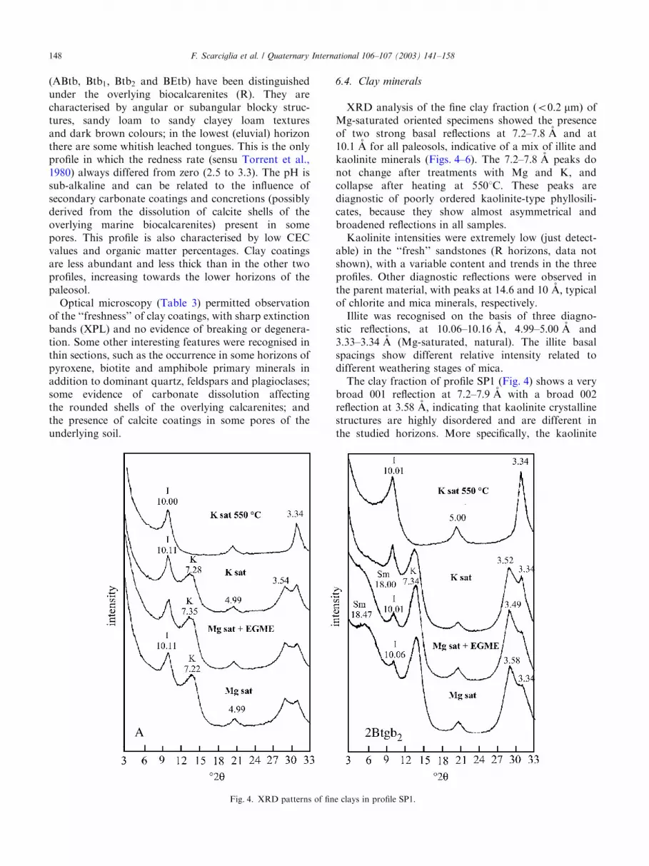
XRD analysis of the fine clay fraction ðo0:2 mmÞ ofMg-saturated oriented specimens showed the presenceof two strong basal reflections at 7.2–7:8 (A and at10:1 (A for all paleosols, indicative of a mix of illite andkaolinite minerals (Figs. 4–6). The 7.2–7:8 (A peaks donot change after treatments with Mg and K, andcollapse after heating at 5501C: These peaks arediagnostic of poorly ordered kaolinite-type phyllosili-cates, because they show almost asymmetrical andbroadened reflections in all samples.Kaolinite intensities were extremely low (just detect-
able) in the ‘‘fresh’’ sandstones (R horizons, data notshown), with a variable content and trends in the threeprofiles. Other diagnostic reflections were observed inthe parent material, with peaks at 14.6 and 10 (A; typicalof chlorite and mica minerals, respectively.Illite was recognised on the basis of three diagno-
stic reflections, at 10.06–10:16 (A; 4.99–5:00 (A and3.33–3:34 (A (Mg-saturated, natural). The illite basalspacings show different relative intensity related todifferent weathering stages of mica.The clay fraction of profile SP1 (Fig. 4) shows a very
broad 001 reflection at 7.2–7:9 (A with a broad 002reflection at 3:58 (A; indicating that kaolinite crystallinestructures are highly disordered and are different inthe studied horizons. More specifically, the kaolinite
Fig. 4. XRD patterns of fine clays in profile SP1.
F. Scarciglia et al. / Quaternary International 106–107 (2003) 141–158148

reflection appears strong and asymmetric at about 7:2 (Awith a low expansion to 7.35 in presence of EGME. Thisbehaviour is more accentuated in the 2Btgb2 horizon,where the kaolinite reflections are more intense com-pared with those of illite.The nature of the kaolinite phyllosilicate was also
investigated under formamide treatment in order todifferentiate from the possible presence of halloysite.The results of this treatment did not show any expansionof the peak to 7.35 (A (data not shown), confirming theabsence of halloysite and the hypothesis that the lowcrystallinity degree of kaolinite could be related to thepedogenetic environment.The illite peaks are substantially unchanged in their
position after treatments with EGME, K and heating at5501C; but large differences can be observed in theirrelative intensity. The basal reflections intensity of 5.0and 3:33 (A peaks result particularly stronger in theburied horizons of this profile compared with the surfacehorizons, indicating a significant presence of dioctahe-dral mica.X-ray diffraction patterns of profile SP1 also show the
presence of distinct peaks ranging from 15.8 to 18:5 (Atogether with 10:1 (A in the lower horizons (the buriedpaleosol, with gley features) on Mg-saturated naturalsamples. These peaks expanded to 18.0–18:8 (A in Mgethylene-glycol samples, whereas natural K-saturatedones collapsed. These reflections are consistent with the
Fig. 5. XRD patterns of fine clays in profile SP2.
Fig. 6. XRD patterns of fine clays in profile SP3.
F. Scarciglia et al. / Quaternary International 106–107 (2003) 141–158 149

presence of some kaolinite–smectite mixed layers,because they show a basal intermediate peak rangingfrom 10 to 18 (A that collapses after K-saturation to themica spacing (for discussion see Section 7).X-ray diffraction patterns of profile SP2 (Fig. 5) show
the lowest intensity reflections for kaolinite. In parti-cular these peaks appear very broad and asymmetrical,completely overlapped by the illite reflections that showa stronger 10 (A reflection but quite similar in allhorizons. A treatment to discriminate between kaoliniteand halloysite was performed on K-saturated samplesby heating at about 1051C; but no peak collapsesupported the occurrence of halloysite. The clay fractionwas also treated with formamide but did not show anyexpansion of the peak to 7:35 (A; confirming the absenceof halloysite minerals.X-ray patterns of fine clays in soil profile SP3 (Fig. 6)
show the presence of kaolinite and illite phyllosilicates.More specifically, the illite basal reflection results areparticularly intense and increase slightly in presenceof K, decreasing under Mg treatment (ABtb horizon).On the contrary, the 7:72 (A peak of kaolinite in theABtb and BEtb horizons increases and shows a moreregular and symmetrical reflection in the BEtb horizon,which does not expand in presence of EGME. Kaolinitepeaks did not expand after formamide treatment (datanot shown), excluding the presence of halloysite.
6.5. Iron forms in the paleosols
The mineralogy of Fe oxides (hematite and goethitecontent) was investigated in the fine earth and in the
sand and clay fractions, in order to get some furtherunderstanding of the pedoenvironmental conditions inwhich the paleosols were formed, and also to evaluatesome relationships between Fe oxides and the pastpedoenvironments (Cornell and Schwertmann, 1996).Table 4 shows some geochemical data as well as somepedogenetic indices (Fed � Feo=Fet and Feo=Fed) de-termined in order to obtain important information onthe degree of weathering of the paleosols.In the fine earth fraction the total iron content ðFetÞ is
moderate and rather homogeneous in all the horizons ofthe three profiles (mean value: 23:5 g kg�1). This resultis probably related to the parent material, which is poorin Fe minerals, very rich in quartz and feldspars, butlower in aluminous-silicate minerals (chlorite and mica)characterised by high Fe content. The mean differenceFet � Fed; which indicates the Fe content in primaryminerals, is about 10:5 g kg�1 for profile SP1 and SP3,while it is higher ð17:0 g kg�1Þ for profile SP2. Thisindicates that in the latter paleosol there was a highercontent of Fe2þ; and therefore this soil underwent a lessintense or limited weathering process compared withprofiles SP1 and SP3. The lower content of Fe in theparental material produced mean Fed values (estimatingthe iron crystalline oxide forms), which are very low inprofile SP2 ð6:7 g kg�1Þ and higher in profile SP1ð11:3 g kg�1Þ and profile SP3 ð14:5 g kg�1Þ: TheFeo=Fed ratio, which gives an indication of the amountof amorphous against crystalline iron forms, showsmean values of about 0.21 for profile SP1 (0.23 for thesurface paleosol and 0.11 for the buried one) and SP2,and higher for SP3 (0.29). According to these data, the
Table 4
Some selected geochemical data and weathering indices of the profiles
Profile Horizon Fet (g/kg) Mnt (g/kg) Tit (g/kg) Fed (g/kg) Feo (g/kg) Feo=Fed ðFed � FeoÞ=Fet Sio (g/kg) Alo (g/kg)
SP1 surface A 20.92 1.90 3.80 13.79 3.17 0.23 0.51 0.73 1.27
Bt 21.82 2.27 3.68 11.73 2.14 0.18 0.44 0.58 1.03
Btc1 15.83 1.16 2.66 9.15 1.64 0.18 0.47 0.52 0.82
Btc2 26.78 5.44 3.24 15.58 5.21 0.33 0.39 1.02 1.57
SP1 buried 2Btgb1 18.76 0.12 2.75 7.13 0.75 0.11 0.34 0.44 0.71
2Btgb2 27.66 0.13 3.53 12.97 1.26 0.10 0.42 0.55 0.92
SP2 Bt1 27.72 0.23 3.29 7.71 0.96 0.12 0.24 0.74 1.45
2Bt2 28.24 0.87 3.30 7.29 1.64 0.23 0.20 1.17 2.66
2Bt3 23.02 0.35 2.65 5.93 1.13 0.19 0.21 0.86 2.18
3Bt4 21.58 0.41 2.81 6.86 1.05 0.15 0.27 0.66 1.80
3Bt5 22.12 0.35 4.11 6.57 1.44 0.22 0.23 0.62 1.15
4Bt6 20.26 0.42 3.82 6.70 1.58 0.24 0.25 0.56 0.91
4Bt7 22.98 0.39 3.91 5.75 1.74 0.30 0.17 0.85 1.29
SP3 R 3.68 0.33 0.84 3.92 0.75 0.19 0.86 0.32 0.49
ABtb 26.28 1.30 3.74 16.40 5.50 0.34 0.41 1.43 2.40
Btb1 29.16 1.35 3.52 17.62 4.88 0.28 0.44 1.33 2.23
Btb2 22.54 0.55 2.94 12.88 3.79 0.29 0.40 1.20 1.88
BEtb 23.46 0.33 2.53 10.90 2.60 0.24 0.35 0.92 1.53
F. Scarciglia et al. / Quaternary International 106–107 (2003) 141–158150

presence of some amorphous component, possiblyderiving from fine volcanic ashes strongly homogenisedinto the soil matrix (and therefore macroscopically notvisible) could be considered in the latter profile. On thewhole, these values appear very close to 0.1, as typical ofsoils of Mediterranean environments characterised bylow water activity (xeric regime) and relatively hightemperature (thermic regime) in the dry period. Thesepedoenvironmental conditions are widespread in coastalzones of Southern Italy and induce that the largest partof Fe oxides are well crystallised in the form of hematite(rubification processes). Fig. 7 represents the Fed; Feoand Alo content in the coarse sand and in the fine clayfractions. From these data it is possible to observe thatthe highest values of Fed in the clay fraction (Fig. 7b) ofprofile SP2 correlate to the lowest values in the sandy
fraction (Fig. 7a). Such results point out that in profileSP2 the sand fraction has a larger content in weath-erable Fe phases (possibly pyroclastic material) ascompared to those of the other two profiles; this canbe related to the conspicuous volcanic glass supply(pumices and ashes) in some horizons ð2Bt2; 2Bt3; 3Bt4Þof SP2. This feature is also well correlated with the highvalues of Alo and Sio (Table 4), which indicate thepresence of easily alterable aluminous-silicates ofvolcanic origin accumulated in this soil. Anotherpossible factor influencing the observed Fed; Feo andAlo values could be related to a partly inherited degreeof weathering of profile SP2: the particularly elevatedcrystalline iron content in fine clays, apparently non-fitting with the relatively young age of the soil, could berelated to reworking of soil sediments (sensu Brongerand Catt, 1989) from upslope areas (Scarciglia et al.,2003).The forms of iron present in the paleosols were also
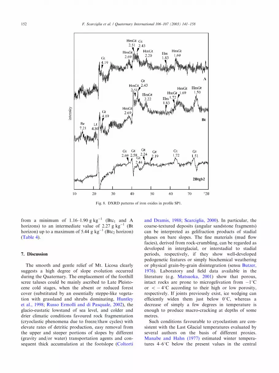
investigated in the fine clay fraction by mineralogicalanalysis through DXRD techniques. DXRD patternsshow the dominance of goethite in all the profiles, assuggested (at least for the paleosols of SP1 and SP2) bythe prevailing yellowish-brown colours (10YR to 2.5Yhue) (Torrent et al., 1983). Some data for profile SP1 arereported in Fig. 8. Goethite was identified by diagnosticpeaks at 2.43, 2.25, 1.72 and 1:51 (A; the first reflectionð4:19 (AÞ being sharp and intense only in profile SP2.Evident peaks of goethite also were identified (2.69,2.19–2.20, 1:69 (A), but they coincide with hematitereflections, therefore resulting in difficulty discriminat-ing between the two iron oxides. On such bases, it wasimportant to test the absence of the reflection at 1:83 (Aand the occurrence of that at 2:51 (A (both pertaining tohematite only) to recognise the possible presence ofhematite coexisting with goethite. As a result of thisanalysis, hematite was recognised in the SP1 surfacepaleosol (and not in the buried one) (Fig. 8), presumablyalso in SP2 and with major certainty in SP3, which alsohad relatively higher values of the redness rate than inthe other profiles (Table 1), confirming this hypothesis.Similarly to the pedogenetic indices, the mineralogy ofiron oxides, estimated through the DXRD analysis,reveals marked differences in the paleosols. The goethiteand hematite data (Table 5) exhibit an essentiallygoethitic environment in all horizons, while hematite ispresent in SP1 surface horizons and in profile SP3 only.In the uppermost horizons of profile SP1, the possible
occurrence of Mn oxides also was observed. Fig. 8shows also two very irregular and characteristicbroadened peaks of the manganese minerals with lowcrystalline order as lithioforite and birnessite, withprimary reflections at 4.71 and 7:21 (A; respectively, thatare quite common in hydromorphic soils (Liu et al.,2002). This result is confirmed by the relatively hightotal Mn content in the SP1 surface paleosol, ranging
0
5
10
15
20
25
30
1 3 5 7 9 11 13 15 17 19
g/K
g
Alo
Feo
Fed
A Bt
Btc
1B
tc2
2Btb
g12B
tbg2
AB
tbB
tb1
Btb
2B
Etb
Bt1
2Bt2
2Bt3
3Bt4
3Bt5
4Bt6
4Bt7
SP1
SP2
SP3
0
5
10
15
20
25
30
12345678 91 01 11 21 31 41 51 61 71 81 9
g/kg
Alo
Feo
Fed
A Bt
Btc
1B
tc2
2Btb
g12B
tbg2 B
t12B
t22B
t33B
t43B
t54B
t64B
t7
AB
tb
Btb
1B
tb2
BE
tb
SP1
SP2
SP3
(a)
(b)
Fig. 7. Diagrams reporting the Fed; Feo and Alo content in the coarsesand fraction (a) and in the clay fraction (b) of the three profiles.
F. Scarciglia et al. / Quaternary International 106–107 (2003) 141–158 151
from a minimum of 1.16–1:90 g kg�1 (Btc1 and Ahorizons) to an intermediate value of 2:27 g kg�1 (Bthorizon) up to a maximum of 5:44 g kg�1 (Btc2 horizon)(Table 4).
7. Discussion
The smooth and gentle relief of Mt. Licosa clearlysuggests a high degree of slope evolution occurredduring the Quaternary. The emplacement of the foothillscree taluses could be mainly ascribed to Late Pleisto-cene cold stages, when the absent or reduced forestcover (substituted by an essentially steppe-like vegeta-tion with grassland and shrubs dominating, Huntleyet al., 1998; Russo Ermolli and di Pasquale, 2002), theglacio-eustatic lowstand of sea level, and colder anddrier climatic conditions favoured rock fragmentation(cryoclastic phenomena due to freeze/thaw cycles) withelevate rates of detritic production, easy removal fromthe upper and steeper portions of slopes by different(gravity and/or water) transportation agents and con-sequent thick accumulation at the footslope (Coltorti
and Dramis, 1988; Scarciglia, 2000). In particular, thecoarse-textured deposits (angular sandstone fragments)can be interpreted as gelifraction products of stadialphases on bare slopes. The fine materials (mud flowfacies), derived from rock-crumbling, can be regarded asdeveloped in interglacial, or interstadial to stadialperiods, respectively, if they show well-developedpedogenetic features or simply biochemical weatheringor physical grain-by-grain disintegration (sensu Butzer,1976). Laboratory and field data available in theliterature (e.g. Matsuoka, 2001) show that porous,intact rocks are prone to microgelivation from �11Cor o� 41C according to their high or low porosity,respectively. If joints previously exist, ice wedging canefficiently widen them just below 01C; whereas adecrease of simply a few degrees in temperature isenough to produce macro-cracking at depths of somemetres.Such conditions favourable to cryoclastism are con-
sistent with the Last Glacial temperatures evaluated byseveral authors on the basis of different proxies.Manabe and Hahn (1977) estimated winter tempera-tures 4–61C below the present values in the central
Fig. 8. DXRD patterns of iron oxides in profile SP1.
F. Scarciglia et al. / Quaternary International 106–107 (2003) 141–158152

Table5
Someselectedsoilfeaturesusefulforpaleoclimaticandenvironmentalinterpretation(seethetextfordetails)
Profile
Typicalclimatic
features
Micromorphology
Clayminerals
Ironoxides
Weatheringindices
IWPE
Clay
coat.
Degreeof
degenerationof
clayc.
Siltcoat.Silt
capp.
Vesicular
pores
Fe–Mn
concr.
Fe–Mn
segreg.
Sub-
cuboidal
structure
IK
Sm
Hm
Gt
RR
(Fe d–Fe o)=Fe t(F.E.)
SP1
þþ
—,þ
þðþ
Þþ
þðþ
Þ—
þþ
ðþÞ
þþ
ðþÞ
þþ
ðþÞ
ðþÞ
þþ
þðþ
Þ—
þþðþ
Þ0
þþ
þ22
surface
Presentday
Y(Y)
Y2.5P
Interglacial
YY
YY
YY
6I
Glacial
YY
Y(Y)
YY
5.5G
SP1
þþðþ
Þðþ
Þ;þ
þþ
þðþ
Þ—
þþ
þþ
þþ
þþ
þþ
þþ
—þþ
—þþ
14.5
buried
Presentday
(Y)
(Y)
(Y)
1.5P
Interglacial
YY
YY
Y5I
Glacial
YY
YY
(Y)
Y5.5G
SP2
þþðþ
Þ—,þ
þðþ
Þþþ
þðþ
Þþ
þþ
ðþÞ
þðþ
Þþ
þþ
þðþ
Þðþ
Þþ
þðþ
Þ0,—
þ19
Presentday
Y(Y)
Y2.5P
Interglacial
YY
Y(Y)
Y4.5I
Glacial
YY
YY
Y(Y)
YY
7.5G
SP3
þðþ
Þ—,ðþ
Þ—
——
þþþ
þðþ
Þþþ
—þ
þðþ
Þþþ
þþ
ðþÞ
12.5
Presentday
(Y)
(Y)
1P
Interglacial
YY
YY
YY
Y7I
Glacial
0G
coat:coatings;capp:cappings;concr.:concretions;segreg.:segregations;RR:rednessrate(sensuTorrentetal.,1980);I:illite;K:kaolinite;Sm:smectite;Hm:hematite;Gt:goethite.F.E.:fineearth;
—,ðþ
Þ;þ;
þþ;
þþþindicateincreasingfrequencyofsomepedogeneticfeatures:absent,rare,common,frequent,abundant;IW:cumulateempiricalindexofweathering.Thesmectiteclays
havebeencomputedasnegativesincetheydecreaseaccordingtoincreasingleaching(increasingweathering).PE:comparativeempiricalindexofpedogeneticenvironment;P:presentday;I:
interglacial;G:glacial.
F. Scarciglia et al. / Quaternary International 106–107 (2003) 141–158 153

Mediterranean area, which well accord with the modernmulti-proxy bio-climatic simulation models applied byvan Andel (2002), showing isotherms comprised be-tween 01C and �41C for winter months during the LastGlacial Maximum in Southern Italy. These results alsoappear compatible with the lowest values calculated byWatts et al. (1996b) in other continental sites in theSouthern Apennines (located at about 401560N and151360E) and reaching �51C to �101C; to �201C duringthe coldest months.Further information about past climatic and environ-
mental changes can be inferred from the results of soilanalyses. The complete set of data regarding the threesoil profiles shows an extreme pedological complexity inthe study area. All the paleosols consist of variousargillic horizons, so that they can be regarded as Alfisols(sensu USDA, 1998). The profiles SP1 and SP2 show thepresence of a natric horizon and can be classified asTypic Natrixeralfs. Although the classification of buriedsoils is often disputable, the buried paleosol of profileSP3 can be tentatively classified as a Typic Haploxeralf.Some selected soil features useful for paleoclimatic/
paleoenvironmental reconstruction and for estimatingthe weathering degree (soil evolution) of the studiedpaleosols have been summarised in Table 5. Theyinclude micromorphological data, clay and iron oxidemineralogy and some weathering indices (on a relativescale). This information is interpreted in terms ofpresent-day (mediterranean), interglacial and (peri)gla-cial climate.Profile SP1 and SP2 show abundant thick and
laminated clay coatings, mostly characterised by differ-ent forms and degree of degeneration. This supportstheir relict significance, as a consequence of persisting(polycyclical) more humid conditions than today, andpossibly characterised by seasonal contrast, typical ofQuaternary interglacial and sometimes interstadialperiods (Catt, 1989). Most of the clay coatings couldhave formed during the Last Interglacial in both of theprofiles.Both soil profiles SP1 and SP2 show an important
change in pedogenesis, indicated by the superimpositionof silt or silty-clay coatings on the clay coatings (andrare silt cappings observed in SP2 only). These featuressuggest disaggregation and illuviation of coarse particlesin response of freeze/thaw cycles and percolation ofseasonal melt-water, typical of periglacial environments.This hypothesis is well supported by the contemporaryoccurrence of (i) the variously degenerated and brokenclay coatings; (ii) the high frequency of vesicular pores,indicating possible air trapping during soil freezing;(iii) the rare occurrence of subcuboidal structure,possibly cryogenic, in the upper horizons; and (iv) thelocal presence of a polygonal pattern of cracks over thefan surface. Surface polygons and cubic peds, separatedby bleached vertical cracks with Mn segregations,
suggest soil contraction for progressive cooling andsubsequent ice segregation between the peds (upwardloss of heat), followed by seasonal ice thawing and waterpercolation. The assemblage seems to indicate thepresence of ice, seasonal at least, in these paleosols(Catt, 1989; Tarnocai and Valentine, 1989; FitzPatrick,1997; Kemp, 1998; Van Vliet-Lano.e, 1998) duringtypical cold glacial phases.The rarer and thinner clay coatings with no sign of
degeneration, clearly superimposed over both the siltyand the older clay coatings, represent the latestgeneration of illuvial clays, which are quite unlikely torepresent relict features. Their weaker expression isprobably related to a younger and less intense phenom-enon, although under restored wet conditions, whichcharacterised (along with increased temperatures) theLateglacial and the Post-Glacial epoch. This climaticamelioration was also accompanied by a progressivesubstitution of a treeless environment by a ratherwidespread forest cover (mixed oak woodland) even inmid-latitude and coastal regions (Watts et al., 1996b;Amore et al., 1999; Russo Ermolli and di Pasquale,2002).On the contrary, profile SP3 shows the presence of
only ‘‘fresh’’ clay coatings (unbroken and non-degener-ated) requiring humid conditions and seasonal contrast,and the absence of silt coatings or silt cappings. Thesefeatures may suggest an essentially monogenetic soilformation under interglacial-like conditions, in goodagreement with the age of the paleosol. Actually, theoverlying ‘‘S. Marco sandstones’’, deposited duringthe sea level rise and highstand of OIS 7, represent theclosing event of the transgressive cycle occurred duringthe Penultimate Interglacial, so that the paleosol couldhave mainly developed during this period before beingsubmerged.The different extent of clay translocation suggests a
marked difference in the climate between the Holoceneand the last two interglacials, the latter clearly showingmore humid paleoenvironmental conditions. This hy-pothesis is confirmed by comparing present botanicalevidence and Middle Pleistocene paleopalynologicaldata. Abies, sharply prevailing during the pastinterglacials, was almost completely replaced by Fagus
in the highest vegetation belt (mountainous forest) ofSouth Italy during the Post-Glacial (Juvign!e et al.,1999), presumably as a result of a slightly reducedhumidity.Soil profiles SP1, SP2 and SP3 are characterised by
the dominance of kaolinite and illite clay minerals,which may well be the weathering products of primaryfeldspars, chlorite and micas. More specifically, theyare characterised by a very broad 001 reflection at7.2–7:90 (A and a broad 002 reflection at 3:58 (A with acomplete absence of non-basal reflections. This beha-viour indicates that kaolinite crystalline structures are
F. Scarciglia et al. / Quaternary International 106–107 (2003) 141–158154

highly disordered and differ in the various paleosols.Illite was recognised on the basis of three specific 001,002 and 003 reflections at 10.1, 5.0 and 3:33 (A; whichremain unchanged after EGME solvation and Ksaturation and heating at 5501C: Kaolinite peakintensity ranges with larger variability than illite in eachof the three profiles. On the basis of the relative intensityof the illite d-reflections compared with those ofkaolinite, illite dominates in the horizons of profileSP2, whereas kaolinite is higher in the buried horizonsof profile SP1 and in profile SP3. More specifically, thepaleosol of SP3 shows a higher amount of kaolinite inthe lower horizons (BEtb), decreasing in the upper ABtbhorizon (Fig. 6). The extremely low content in kaolinitein the R horizons (unweathered sandstones), as well asits different amounts and trends in each profile showingan increasing content with soil age, support itspedogenetic origin, conversely excluding an inheritancefrom parent materials.The pedogenetic environment of these paleosols is
revealed as very complex, and the clay mineralogy hasshown an intense degree of weathering. The highkaolinite variability in the studied profiles can be relatedto the different climatic conditions in which these soilsdeveloped (Dixon, 1989). The low crystallinity of thekaolinite minerals mainly forms under temperate humidclimatic conditions, where the weathering of primaryminerals is very intense and more specifically under asignificant alternation of rainy and dry seasons (typicalof interglacial periods), i.e. where elevated mean annualtemperatures and rainfall (cf. Summerfield, 1991;Thomas, 1994) allow intense leaching of cations in gooddrainage conditions. This suggests that temperaturesand precipitation significantly higher than today couldhave occurred in the study area during the LateQuaternary interglacials. In particular, since the paleo-climatic record of polar ice-cores indicates for the LastInterglacial a mean global temperature about 21C higherthan the present values, and not less than 71C higherthan the Last Glacial (Orombelli, 1997), much warmerconditions should be supposed for that period inNorthern Cilento, as located in middle latitudes. Otherfactors that can have influenced the mineralogicalcomposition of clays can be related to the time ofpedogenesis, directly influencing the degree of pedoge-netic development.Kaolinite minerals have shown low crystallinity,
typical of very intense weathering conditions, as in theburied paleosol of profile SP1 and in the SP3 paleosol,while the increasing amount of illite in profile SP2 seemsto be related to a lower stage of weathering of thisprofile, according to its younger age. The SP1 and SP3paleosols appear more weathered, with a high amountof kaolinite, likely formed in temperate and more humidpedogenetic conditions than the present-day climate.These conditions are also in agreement with some
chemical properties of these paleosols, such as the lowcontent in organic carbon and the low values of CEC,possibly pointing out a long history of weathering.Chlorite, as well as mica, inherited from the bedrock
sandstones and from other sediments somewhat rework-ing or deriving from that parent material, appear tohave weathered to 2:1 phyllosilicates (Barnhisel andBertsch, 1989). As weathering progresses in temperateand more humid conditions, kaolinite, illite and ironoxides are formed. The amount of illite does not changewith soil depth in contrast with the kaolinite, but seemsto be related to the soil age and consequent degree ofsoil weathering, becoming more abundant in the young-er profile SP2. The presence of expandable phyllosili-cates in the 2Btgb1 and 2Btgb2 horizons of profile SP1accords with the hydromorphic environment that theyrepresent (see below). This fully matches the geomorphiccontext of foothill, with sediment, water and cationsupply, as well as with interglacial climatic conditionscharacterised by a remarkably alternation of dry andwet season. Expandable 2:1 clay minerals may representa transitional weathering product of chlorite with theformation of an intermediary of smectite–kaolinitemixed layer mineral. Mica is generally stable at higherpH and Kþ activity, whereas its weathering increaseswith acidic conditions and intense leaching, leading toan increasing kaolinite formation, that is in agreementwith warm-temperate and humid climates well-recordedin the studied profiles, especially SP1 and SP3.The absence/presence of hematite, associated with
dominant goethite in the studied soil profiles, may belinked with marked differences between the pedoenvir-onment of these paleosols. Hematite needs gooddrainage conditions, high temperature and high waterdeficit in dry periods. In contrast, goethite formationneeds a more humid weathering environment thatpromotes its pedogenetic formation over hematite(Schwertmann and Taylor, 1989; Huang and Wang,1997).In general terms the studied paleosols developed in
different pedoenvironmental conditions. The presentMediterranean climate, characterised by a moderatexeric moisture regime, leads to a moderate iron releaseeven from Fe-rich parent materials and the formation ofboth hematite and goethite. Profile SP3 clearly devel-oped under rather high temperature and water deficitthat promoted hematite formation in addition togoethite. This is consistent with the redness rates ofthe paleosols (Tables 1 and 5) indicating a moderaterubification in this paleosol against the absence of thisprocess in the buried soil of profile SP1 and in profileSP2. Accordingly for this pedoenvironmental condition,Fe-rich minerals present in the parent material, such aschlorite and mica, appear to have weathered to kaolinitein a warm-temperate humid environment, where the pHof the soil solution was weakly acidic (6.0–6.5) and
F. Scarciglia et al. / Quaternary International 106–107 (2003) 141–158 155

extensive leaching occurred. During the weathering ofchlorite and mica the ejection of Fe2þ and its subsequentre-crystallisation presumably occurred, in form ofgoethite or hematite (according to the specific moistureregime), and further alteration was retarded. Thepresence of Mn oxides in the SP1 surface soil andspecifically the concentric-layered Fe–Mn concretionsindicate that in this profile frequent changes in redoxpotential happened, possibly also in relation to simpledifferences in permeability between the surface andburied soil, or oscillations of the water table determinedby the higher paleo-sea level during the interglacialphases. These are further important evidence of morehumid conditions than today, indicated by the dom-inance of a goethitic iron oxide mineralogy, alsoassociated with hematite in SP1 surface soil (and inSP3) and by other hydromorphic features in the sameprofile: the abundant Fe–Mn concretions and/or segre-gations, the intensely leached cracks, the yellowish hueof the matrix, and the presence of smectites (in theburied paleosol). In contrast, since goethite requiresmuch wetter conditions than hematite, with poorerdrainage and possibly weaker seasonal contrast(Schwertmann and Taylor, 1989; Huang and Wang,1997), the periglacial environment recorded in thisprofile, showing prolonged humidity (induced by thepersistence of water from slow seasonal ice-melting)alternating with drier conditions (related to the lowtemperatures of cold stages), could have played animportant role in the soil formation during glacialfluctuations.On the bases of all the discussed data reported in
Table 5, many differences in the degree of weatheringand the complexity of soil-forming processes recorded inthe studied profiles did not allow definition of a uniqueindex of pedogenetic evolution. Therefore, for thepurpose of this case study, an empirical index ofweathering has been formulated, combining the relativeintensity/abundance of the selected soil features, toallow a comparison among the paleosols. The highestvalues have been calculated for those paleosols whichexperienced polygenetic soil evolution under interglacialand periglacial conditions, mainly SP1 surface and SP2.The specific climatic information has been empiricallyevaluated by another comparative (but not quantitative)index, to appreciate and compare the prevailingpedogenetic environment/s.
8. Conclusions
The results of soil analysis in combination with thegeomorphological reconstruction and the chrono-strati-graphical constraints, indicate that the slope talus andits basal depositional glacis in which SP1 is cut werepolycyclically emplaced at least from the Penultimate
Interglacial up to the Last Glacial, so that the profileshould better preserve those features developed at leastduring the last interglacial/glacial cycle. There is goodevidence of warmer and more humid conditions thantoday, possibly occurring during the Last Interglacial.The profile SP1 as a whole, and especially the upperpaleosol, should have experienced some further pedo-genetic development under typical periglacial conditionsduring the last glacial period, at least. In such conditionsan important role was certainly played by cyclical soilfreezing and thawing in steppe-vegetated environments,where cryoclastic processes dominated on barer slopes.For the soil representing the recent alluvial cone units
(SP2), a great part of the pedogenesis should haveoccurred under the periglacial conditions characterisingthe Last Glacial, with the development of some featuresclearly related to milder phases (interstadials or morelikely the previous interglacial itself). Both profiles SP1and SP2 show weak evidence of a Holocene youngerpedogenesis under increased humidity and tempera-tures, and progressive forest restoration. Whereasprofiles SP1 and SP2 revealed important polygeneticfeatures related to different stages of pedogenesisoccurred under different climatic and environmentalconditions (interglacial to periglacial), profile SP3,‘‘sealed’’ by the overlying ‘‘S. Marco sandstones’’,experienced a long time of ‘‘stable’’ and ‘‘constant’’direction of pedogenesis, recording an older interglacialpaleoenvironment (the Penultimate), closed by themarine transgression over the paleosol itself.According to these results, the clay minerals and the
iron oxides recognised in the studied paleosols also canbe interpreted as the weathering products of the primaryminerals present in the sandstone parent material. Ingeneral terms, both illite and kaolinite could derive fromchlorite and mica, and progressively warmer, morehumid and acidic environments could have allowedincreasing leaching, thus promoting kaolinite formation.The same Fe-rich primary minerals (chlorite and mica)could have been the source of goethite and hematite insimilar climatic conditions, with higher temperaturesand better drainage conditions favouring water deficit inthe dry season and promoting hematite formation.In synthesis, this work has confirmed that an
integrated study (morphology, micromorphology,chemical analysis, clay and Fe oxides mineralogy) ofpaleosols in combination with the classical geomorpho-logical disciplines can give a relevant contribution tothe paleoclimatic reconstruction such as in NorthernCilento. It helped to differentiate and describe severalpaleoenvironments (often in contrast with the presentpedoclimatic regime) and to better understandthe interactions between morphodynamic (also man-induced) phenomena and the main pedogeneticprocesses. In particular it allowed description andinterpretation of the extreme pedological complexity
F. Scarciglia et al. / Quaternary International 106–107 (2003) 141–158156

and the intense degree of weathering which characterisesthe study area in terms of response to the LateQuaternary climatic fluctuations.The most relevant results are: (i) the polycyclic and
polygenetic imprint of some important pedogeneticprocesses (i.e. clay translocation and silt translocation);(ii) the repeated occurrence of typical interglacialconditions characterised by high temperatures andhumidity with important soil development; (iii) theoccurrence of typical periglacial conditions during coldQuaternary stages (namely the Last Glacial) also in mid-latitude and coastal regions of Southern Italy; and(iv) some details in the chronological reconstruction ofclimatic phases and related sequences of geomorphicevents.
Acknowledgements
We thank Prof. P. Tedeschi from ISPAIM-CNR(Ercolano, NA) and Prof. P. Violante from DISSPA(Portici, NA) for the use of laboratory facilities. We arealso grateful to Prof. E.A. FitzPatrick for interestingand helpful discussion on thin sections. This work wasfinancially supported by CNR Grant CTB 9900646CTOS (Chief Scientist: Prof. A. Cinque, Co-ordinator:Prof. E. Cupia Palmieri).
References
Allen, J.R.M., Brandt, U., Brauer, A., Hubbertens, H.-W., Huntley,
B., Keller, J., Kraml, M., Mackensen, A., Mingram, J., Negen-
dank, J.F.W., Nowaczyk, N.R., Oberh.ansli, H., Watts, W.A.,
Wulf, S., Zolitschka, B., 1999. Rapid environmental changes in
southern Europe during the last glacial period. Nature 400,
740–743.
Amore, F.O., Bonari, G., Ciampo, G., de Capoa, P., Perrone, V.,
Sgrosso, I., 1988. Relazioni tra ‘‘flysch interni’’ e domini
appenninici: reinterpretazione delle formazioni di Pollica, S. Mauro
e Albidona e il problema dell’evoluzione inframiocenica delle zone
esterne appenniniche. Memorie Societ"a Geologica Italiana 41,
285–297.
Amore, F.O., Ciampo, G., Di Donato, V., Esposito, P., Russo
Ermolli, E., Staiti, D., 1999. An integrated micropalaeontological
approach applied to Late Pleistocene–Holocene palaeoclimatic and
palaeoenvironmental changes (Gaeta Bay, Tyrrhenian Sea). In:
Hart, M.B. (Ed.), Climates: Past and Present. Geological Society of
London, Special Publication 181, London, pp. 95–111.
Antonioli, F., Cinque, A., Ferranti, L., Romano, P., 1994. Emerged
and submerged marine terraces of Palinuro Cape (Southern Italy).
Memorie Descrittive della Carta Geologica d’Italia 52, 237–260.
Aucelli, P.P.C., Cinque, A., Scarciglia, F., 1998. Alcune tipologie di
versante ricorrenti in Appennino meridionale: forme, depositi e
processi morfodinamici. Atti 791 Congresso Soc. Geol. It.: ‘‘La
Sicilia, un laboratorio naturale nel Mediterraneo. Strutture, mari,
risorse e rischi’’, Palermo, 21–23 September 1998, pp. 103–106.
Barnhisel, R.I., Bertsch, P.M., 1989. Chlorite and hydroxy-inter-
layered vermiculite and smectite. In: Dixon, G.B., Weed, S.B.
(Eds.), Minerals in Soil Environments, 2nd Edition. Soil Science
Society of America, Book Series No.1, Madison, WI, pp. 729–788.
Berry, L. (Ed.), 1974. Selected powder diffraction data for minerals,
1st Edition. JCPDS—Joint Committee on Powder Diffraction
Standards, Publication DBM-1-23, Philadelphia, USA.
Boenzi, F., 1980. Some evidence of Quaternary cold periods in
Southern Italy: data and reflections. Geografia Fisica Dinamica
Quaternaria 3, 16–20.
Brancaccio, L., 1968. Genesi e caratteri delle forme costiere nella
Penisola Sorrentina. Bollettino Societ"a Naturalisti in Napoli 77,
247–274.
Brancaccio, L., Cinque, A., Russo, F., Belluomini, G., Branca, M.,
Delitala, L., 1990. Segnalazione e datazione di depositi tirreniani
sulla costa campana. Bollettino Societ"a Geologica Italiana 109,
259–265.
Brancaccio, L., Cinque, A., Romano, P., Rosskopf, C., Russo, F.,
Santangelo, N., Santo, A., 1991. Geomorphology and neotectonic
evolution of a sector of the Tyrrhenian flank of the southern
Apennines (Region of Naples, Italy). Zeitschrift f .ur Geomorpho-
logie, Suppl.-Bd 82, 45–78.
Brindley, G.W., Brown, G., 1980. Crystal structures of clay minerals
and their X-ray identification. Mineralogical Society, Monograph
5, London, UK.
Bronger, A., 1969/70. Zur Mikromorphogenese und zum Tonminer-
albestand quart.arer L .ossb .oden in S .udbaden. Geoderma 3,
281–320.
Bronger, A., Catt, J.A., 1989. Paleosols: problems of definition,
recognition and interpretation. Catena Supplement 16, 1–7.
Butzer, K.W., 1976. Geomorphology from the Earth. Harper and Row
Publishers, New York.
Catt, J.A., 1989. Relict properties in soils of the central and north-
west European temperate region. Catena Supplement 16,
41–58.
Cinque, A., Liccardo, C., Palma, B., Pappalardo, L., Rosskopf, C.,
Sepe, C., 1990. Le tracce glaciali nel Parco Nazionale d’Abruzzo
(Appennino centrale): nota preliminare. Geografia Fisica Dinamica
Quaternaria 13 (2), 121–133.
Cinque, A., Romano, P., Rosskopf, C., Santangelo, N., Santo, A.,
1994. Morfologie costiere e depositi quaternari tra Agropoli e
Ogliastro Marina (Cilento, Italia meridionale). Il Quaternario-
Italian Journal of Quaternary Sciences 7 (1/a), 3–16.
Coltorti, M., Dramis, F., 1988. The significance of stratified slope-
waste deposits in the Quaternary of Umbria-Marche Apennines,
Central Italy. Zeitschrift f .ur Geomorphologie 71, 59–70.
Cornell, R.M., Schwertmann, U., 1996. The Iron Oxides, Wiley, New
York, 604pp.
Critelli, S., Le Pera, E., 1990. Litostratigrafia e composizione
della Formazione di Pollica (Gruppo del Cilento, Appennino
Meridionale). Bollettino Societ"a Geologica Italiana 109, 511–536.
Dixon, J.B., 1989. Kaolin and Serpentine Group Minerals. In: Dixon,
G.B., Weed, S.B. (Eds.), Minerals in Soil Environments, 2nd
Edition. Soil Science Society of America, Book Series No. 1.
Madison, WI, pp. 467–525.
Federici, P.R., 1979. Una ipotesi di cronologia glaciale w .urmiana,
tardo e post w .urmiana nell’Appennino centrale. Geografia Fisica
Dinamica Quaternaria 2, 196–202.
Finke, P., Hartwich, R., Dudal, R., Iba *nez, J., Jamagne, M., King, D.,
Montanarella, L., Yassoglu, N., 1998. Georeferenced Soil Data-
base for Europe. Manual of Procedures, Version 1.0. European
Soil Bureau Scientific Committee, Rome, Italy, 171pp.
FitzPatrick, E.A., 1984. Micromorphology of Soils. Chapman & Hall,
London, 433pp.
FitzPatrick, E.A., 1997. Arctic soils and permafrost. In: Woodin, S.J.,
Marquiss, M. (Eds.), Ecology of Arctic Environments. British
Ecological Society, Special Publication No. 13. Blackwell Science,
Oxford.
Gambassini, P., Martini, F., Palma di Cesnola, A., Peretto, C.,
Piperno, M., Ronchitelli, A.M., Sarti, L., 1996. Il Paleolitico
F. Scarciglia et al. / Quaternary International 106–107 (2003) 141–158 157

dell’Italia centro-meridionale. Guide Archeologiche di Preistoria e
Protostoria 1, ABACO Edizioni Forl"ı, Italy.
Giraudi, C., 1997. Prima segnalazione dell’apparato glaciale di M.
Breccioso (Val Roveto-Abruzzo): un contributo all’inquadramento
cronologico delle fasi glaciali tardo-pleistoceniche. Il Quaternario-
Italian Journal of Quaternary Sciences 10 (2), 201–206.
Huang, P.M., Wang, M.K., 1997. Formation chemistry and selected
surface properties of iron oxides. Advances in GeoEcology 30,
241–270.
Huntley, B., Allen, J.R.M., Watts, W.A., 1998. Weichselian palaeoen-
vironment of Southern Italy: the record from Lago Grande di
Monticchio. Terra Nostra 98/6, 56–61.
Iannace, A., Romano, P., Santangelo, N., Santo, A., Tuccimei, P.,
2001. The OIS 5c along Licosa cape promontory (Campania
region, Southern Italy): morphostratigraphy and U/Th dating.
Zeitschrift f .ur Geomorphologie 45 (3), 307–319.
INQUA Working Group, 1995. Definitions used in Paleopedology,
Paleopedology Glossary. INQUA/ISSS Paleopedology Commis-
sion. Newsletter 11(2) 35–37.
Juvign!e, E., Munno, R., Petrosino, P., Romano, P., Russo Ermolli, E.,
1999. A Late Middle Pleistocene Climatic Cycle in Southern Italy
Inferred from Pollen Analysis and Tephrostratigraphy of the
Acerno Lacustrine Succession. De Frede, Napoli.
Kemp, R.A., 1998. Role of micromorphology in paleopedological
research. Quaternary International 51/52, 133–141.
Lippmann-Provansal, M., 1987. L’Apennin Campanien Meridional
(Italie). Etude Geomorphologique. These de Doctorat, Universite
d’Aix - Marseille II, Aix en Provence, France.
Lirer, L., Pescatore, T., Scandone, P., 1967. Livello di piroclastiti nei
depositi continentali post-tirreniani del litorale sud-tirrenico. Atti
Accademia Gioenia di Scienze Naturali Catania 6 (18), 85–115.
Liu, F., Colombo, C., Adamo, P., He, J.Z., Violante, A., 2002. Trace
elements in iron–manganese nodules from a Chinese Alfisol. Soil
Science Society of America Journal 66, 661–670.
Manabe, S., Hahn, D.G., 1977. Simulation of the tropical climate of
an ice age. Journal of Geophysical Research 82, 3889–3991.
Matsuoka, N., 2001. Microgelivation versus macrogelivation: towards
bridging the gaps between laboratory and field frost weathering.
Permafrost and Periglacial Processes 12, 299–313.
MiPAF (Ministero delle Politiche Agricole e Forestali), 2000.
Osservatorio Nazionale Pedologico e per la Qualit"a del Suolo,
International Society of Soil Science, Societ"a Italiana della Scienza
del Suolo. Metodi di analisi chimica del suolo. Franco Angeli
Editore, Milano.
Orombelli, G., 1997. Recenti progressi nella valutazione del paleocli-
ma. Le variazioni climatiche negli ultimi 150.000 anni. La Terra nel
Sistema Solare, Ciclo di lezioni 1995/96, Istituto Lombardo,
Accademia di Scienze e Lettere, Milano, pp. 73–97.
Palmentola, G., Acquafredda, P., 1983. Gli effetti dei ghiacciai
quaternari sulla montagna del Matese, al confine molisano-
campano. Geografia Fisica Dinamica Quaternaria 6, 117–130.
Rossignol-Strick, M., Planchais, N., 1989. Climate patterns revealed
by pollen and oxygen isotope records of a Tyrrhenian Sea core.
Nature 342, 413–416.
Russo Ermolli, E., di Pasquale, G., 2002. Vegetation dynamics of
southweastern Italy in the last 28000 yr inferred from pollen
analysis of a Tyrrhenian Sea core. Vegetation History and
Archaeobotany 11 (3), 211–220.
Scarciglia, F., 2000. Variazioni tardo-quaternarie delle morfodina-
miche di versante in Appennino meridionale: il contributo della
paleopedologia. Ph.D. Thesis, Universit"a ‘‘Federico II’’, Napoli,
Italy, 252pp.
Scarciglia, F., Terribile, F., Colombo, C., 2003. Micromorphological
evidence of paleoenvironmental changes in Northern Cilento
(South Italy) during the Late Quaternary. Catena.
Schulze, D.G., 1994. Differential X-ray diffraction analysis of soil
minerals. In: Luxmoore, R.J., Amonette, J.E., Zelazny, L.W.,
Bartels, J.M. (Eds.), Quantitative Methods in Soil Mineralogy.
Miscellaneous Publication, Soil Science Society of America,
Madison, WI, USA, pp. 412–429.
Schwertmann, U., Taylor, R.M., 1989. Iron oxides. In: Dixon, J.B.,
Weed, S.B. (Eds.), Minerals in Soil Environments, 2nd Edition.
Soil Science Society of America, Madison, WI, USA, 379–438.
Summerfield, M.A., 1991. Global Geomorphology. Longman Scien-
tific and Technical, New York 537pp.
Tarnocai, C., Valentine, K.W.G., 1989. Relict soil properties of the
Arctic and Subarctic regions of Canada. Catena Supplement 16,
9–39.
Thomas, M.F., 1994. Geomorphology in the Tropics. Wiley, New
York, 460pp.
Torrent, J., Schwertmann, U., Schulze, D.J., 1980. Iron oxide
mineralogy of some soils of two river terrace sequences in Spain.
Geoderma 23, 191–208.
Torrent, J., Schwertmann, U., Fechter, H., Alfarez, F., 1983.
Quantitative relationships between soil color and hematite content.
Soil Science 136 (6), 354–358.
USDA, 1998. Keys to Soil Taxonomy, 8th Edition. US Department of
Agriculture, Soil Survey Staff, Natural Resources Conservation
Service, Washington DC, 326pp.
van Andel, T.H., 2002. The climate and the landscape of the middle
part of the Weichselian Glaciation in Europe: the Stage 3 Project.
Quaternary Research 57, 2–8.
Van Vliet-Lano.e, B., 1998. Frost and soils: implications for paleosols,
paleoclimates and stratigraphy. Catena 34, 157–183.
Watts, W.A., Allen, J.R.M., Huntley, B., 1996a. Vegetation history
and paleoclimate of the Last Glacial period at Lago Grande di
Monticchio, Southern Italy. Quaternary Science Reviews 15,
133–153.
Watts, W.A., Allen, J.R.M., Huntley, B, Fritz, S.C., 1996b. Vegetation
history and climate of the last 15000 years at Laghi di Monticchio,
Southern Italy. Quaternary Science Reviews 15, 113–132.
Whitting, L.D., Allardice, W.R., 1986. X-ray diffraction techniques.
In: Klute, A. (Ed.), Methods of Soil Analysis, Physical and
Mineralogical Methods, 2nd Edition. Agronomy, 9(1), American
Society of Agronomy, Soil Science Society of America, WI, USA,
pp. 331–362.
Wilson, M.J. (Ed.), 1987. A Handbook of Determinative Methods in
Clay Mineralogy. Blackie and Sons, Glasgow, UK.
F. Scarciglia et al. / Quaternary International 106–107 (2003) 141–158158


