Embed Size (px)
Citation preview
ESTABLISHMENT laiCORDS
5s-/ LIST"
OF
LIGHTS AND FOG-SIGNALS
ON THE
COASTS, RIVERS AND LAKES
OF THE
DOMINION OF CA.NA.DA_
COHRECI'ED TO THE
1st _A_pril, 1899
DEPARTMENT OF MARINE AND FISHERIES
OTTAWA GOVERNMENT PRINTING BUREA U
1899
r
M
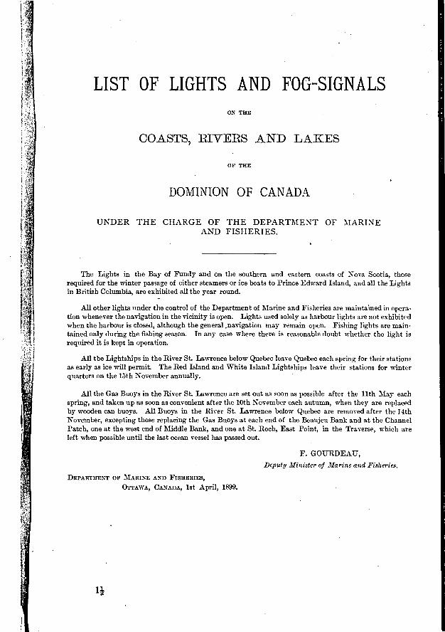
LIST OF LIGHTS AND FOG-SIGNALS ON THE
COASTS, RIVERS AND LAKES
0F THE
DOMINION OF CANADA
UNDER THE CHARGE OF THE DEPARTMENT OF MARINE AND FISHERIES.
The Lights in the Bay of Fundy and on the southern and eastern coasts of Nova Scotia, those required for the winter passage of either steamers or ice boats to Prince Edward Island, and all the Lights in British Columbia, are exhibited all the year round.
All other lights under the control of the Department of Marine and Fisheries are maintained in opera-tion whenever the navigation in the vicinity is open. Lights used solely as harbour lights are not exhibited when the harbour is closed, although the general ,navigation may remain open. Fishing lights are main-tained only during the fishing season. In any case where there is reasonable doubt whether the light is required it is kept in operation.
All the Lightships in the River St. Lawrence below Quebec leave Quebec each spring for their stations as early as ice will permit. The Red Island and White Island Lightships leave their stations for winter quarters on the 15th November annually.
Ail the Gas Buoys in the River St. Lawrence are set out as soon as possible after the llth May each spring, and taken up as soon as convenient after the 10th November each autumn, when they are replaced by wooden can buoys. All Buoys in the River St. Lawrence below Quebec are removed after the 14th November, excepting those replacing the Gas Buoys at each end of the Beaujeu Bank and at the Channel Patch, one at the west end of Middle Bank, and one at St. Roch, East Point, in the Traverse, which are left when possible until the last ocean vessel has passed out.
F. GOURDEATJ,
Deputy Minister of Marine and Fisheries.
DEPARTMENT OF MARINE AND FISHERIES,
OTTAWA, CANADA, 1st April, 1899.
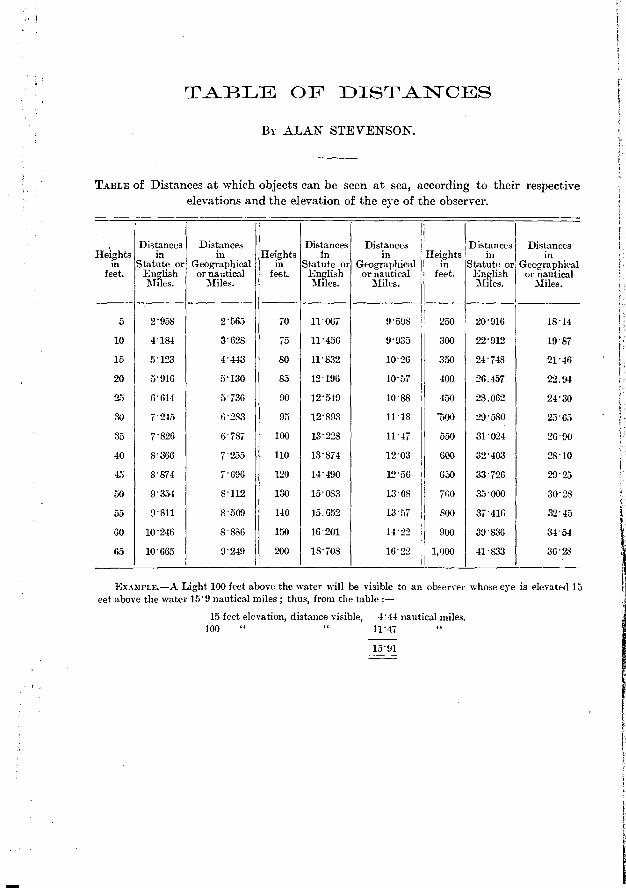
TABLE OF DISTANCES
BY ALAN STEVENSON.
TABLE of Distances at which objects can be seen at sea, according to their respective elevations and the elevation of the eye of the observer.
• Heights
in feet.
Distances in
Statute or English
Distances in
Geographical or nautical
Miles.
Distances Distances Fleights in in Heights
in Statute or Geographical in feet. English or nautical feet.
Miles. Miles.
Distances in
Statute or English
Distances in
Geographical or nautical
31iles.
5 2958 2565 70 11067 9598 250 20916 1814
10 4184 3'628 75 11456 9'935 300 22'912 1987
15 5123 4443 80 11832 1026 350 24748 2146
20 5916 5130 85 12196 1057 400 26.457 22.94
25 6614 5736 90 12549 1088 450 28.062 2430
30 7'245 6283 95 12893 1118 -500 29580 2565
35 7826 6787 100 13'228 1147 550 31024 2690
40 8366 7255 110 13'874 1203 1 600 32403 28 . 10
45 8'874 7'696 120 14'490 1256 650 33726 2925
50 9354 8112 130 15'083 1308 700 35000 30'28
55 9811 8509 140 15.652 1357 800 37416 32'45
60 10'246 8886 150 16201 1422 I 900 39836 34'54
65 10665 9249 200 18708 1622 1,000 41833 3628
EXAMPLE.-A Light 100 feet above the water will be visible to an observer whose eye is elevated 15 eet above the water 15'9 nautical miles ; thus, from the table :—
15 feet elevation, distance visible, 444 nautical miles. 100 " 11'47
15'91
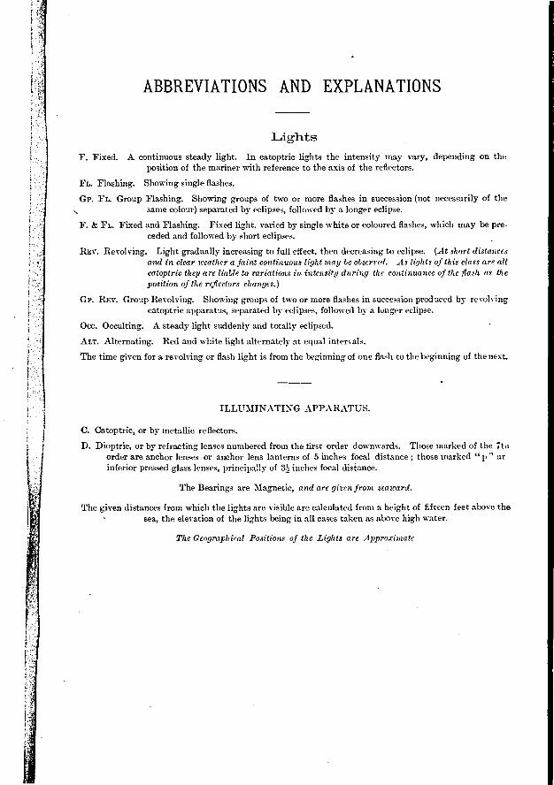
ABBREVIATIONS AND EXPLANATIONS
Lights
F. Fixed. A continuous steady light. In catoptric lights the intensity may vary, depending on the position of the mariner with reference to the axis of the reflectors.
FL. Flashing. Showing single flashes.
Gr. FL. Group Flashing. Showing groups of two or more flashes in succession (not necessarily of the same colour) separated by eclipses, followed by a longer eclipse.
F. & FL. Fixed and Flashing. Fixed light, varied by single white or coloured flashes, which may be pre-
ceded and followed by short eclipses. •
REV. Revolving. Light gradually increasing to full effect, then decreasing to eclipse. (At short distances and in clear weather a faint continuous light may be observed. As lights of this class are all catoptric they are liable to variations in intensit y during the continuance of the flash as the position of the reflectors changes.)
GP. REV. Group Revolving. Showin,g groups of two or more flashes in succession produced by revolving catoptric apparatus, separated by eclipses, followed by a longer eclipse.
• Occ. Occulting. A steady light suddenly and totally eclipsed.
ALT. Alternating. Red and white light alternately at equal intervals.
The time given for a revolving or flash light is from the beginning of one flash to the beginning of the next.
ILLUMINATING APPARATUS.
C. Catoptric, or by metallic reflectors.
D. Dioptrie, or by refracting lenses numbered from the first order downwards. Those marked of the 7to order are anchor lenses or anchor lens lanterns of 5 inches focal distance ; those marked " p " ar inferior pressed glass lenses, principally of 34 inches focal distance.
The Beatings are Mag-,netie, and are given from seaward.
The given distances from which the lights are visible are calculated from a height of fifteen feet above the
sea, the elevation of the lights being in all cases taken as above high water.
The Geographical Positions of the Lights are Approximate
...-
I•
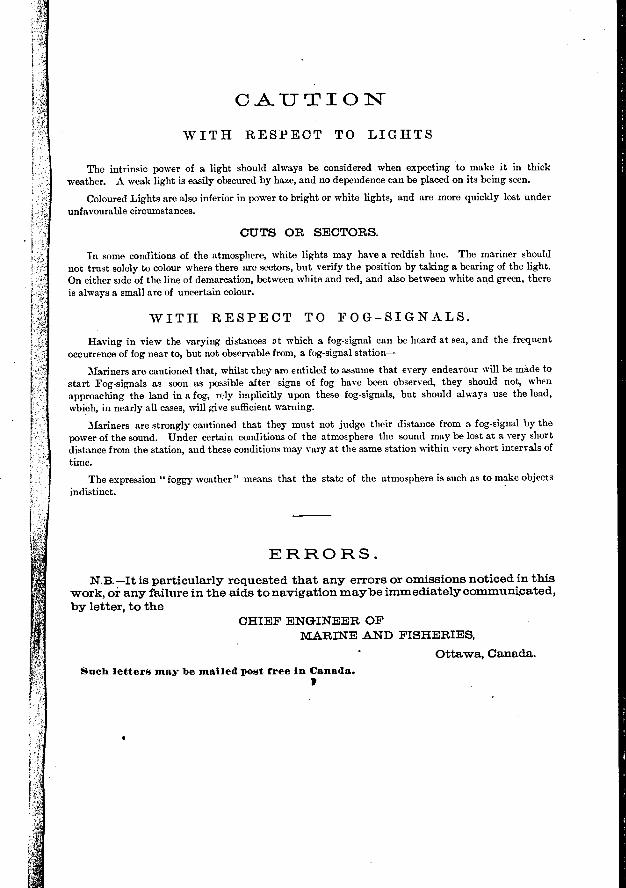
CAUTION-
WITH RESPECT TO LIGHTS
The intrinsic power of a light should always be considered when expecting to make it in thick
weather. A weak light is easily obscured by haze, and no dependence can be placed on its being seen.
Coloured Lights are also inferior in power to bright or white lights, and are more quickly lost under
unfavourable circumstances.
GIJTS OR SECTORS.
In some conditions of the atmosphere, white lights may have a reddish hue. The mariner should
not trust solely to colour where there are sectors, but verify the position by taking a bearing of the light.
On either side of the line of demarcation, between white and red, and also between white and green, there
is always a small arc of uncertain colour.
WITFI RESPECT TO FOG-SIGNALS.
Having in view the varying distances at which a fog-signal can be heard at sea, and the frequent
occurrence of fog near to, but not observable from, a fog-signal station-
Mariners are cautioned that, whilst they are entitled to assume that every endeavour will be made to
start Fog-signals as soon as possible after signs of fog have been observed, they should not, when
approaching the land in a fog, rely iraplicitly upon these fog-signals, but should always use the lead,
which, in nearly all cases, will give sufficient warning.
Mariners are strongly cautioned that they must not judge their distance from a fog-signal by the
power of the sound. TJnder certain conditions of the atmosphere the sound may be lost at a very short
distance from the station, and these conditions may vary at the same station within very short intervals of
time.
The expression " foggy weather " means that the state of the atmosphere is such as to make objects
indistinct.
ERRORS.
N.B.—It is particularly requested that any errors or omissions noticed in this veork, or any failure in the aids to navigation maybe immediately communi,cated,
by letter, to the CHIEF ENGINEER OF
MARINE AND FISHERIES, • Ottawa, Canada.
Such letters may be mailed post free in Canada.
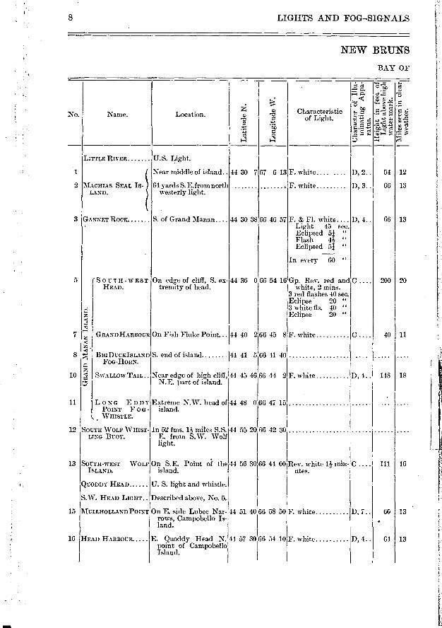
8 LIGFITS AND FOG-SIGNALS
NEW BRUNS
BAY OF
4"; ...-
z
Characteristic No. Name. Location. cp "?.? of Light. .e•'-r> • .;' '.. a, ..c
-,z •Z 'MF-e.."•'-'-'-' '1
:.f>. ' 5 ...:•-: -.> -C.b.5'..4 e 2 c.,
.,.> ,...1 = e - ■ › -. >
e .C.
LITTLE RIVER U. S. Light.
1 Near middle of island .. 44 30 7 67 6 13 F. white D, 2.. 54 12
2 MACHIAS SEAL IS- 64 yards S. E.from north , F. white D, 3.. 66 13 LAND, westerly light.
3 GANNET ROCK S. of Grand Manan.... 44 30 38 66 46 57F. & FI. white.... D, 4.. 66 13
Light 45 sec.
Eclipsed 51 "
Flash 4.?s "
Eclipsed 51 " —
In every 60 "
5 (SOUTH-WEST On edge of cliff, S. ex- 44 36 0 66 54 16 Gp. Rev, red and C.... 200 20 I HEAD. tremity of head. white, 2 inins.
3 red flashes 40 sec.
Eclipse 20 " ,-; 3 white fis. 40 "
Eclipse 20 " ‹
7 GRAND HARBouR On Fish Fluke Point... 44 40 2 66 45 8 F. white c 40 11 <
8 '-I BIGDUCKISL-9ND S. end of island 44 41 5 66 41 40 4 FOG-HORN. C..
10 ,‹ SWALLOW TAIL.. Near edge of high cliff, 44 45 46136 44 2F. white D, 4.. 148 18 C N.E. part of island.
11 LONG EDDY EXtrerne N.W. head of 44 48 066 47 15 . .... POINT F on- island.
L, WHISTLE.
12 SOUTH WOLF WHIST- In 52 fms. n miles S.S. 44 55 20 66 42 30 LINO BUOY. E. from S.W. Wolf
light.
13 SOUTH-WEST WOLF On S.E. Point of the 44 56 30 66 44 00 Rev. white 1 ,- min- C .... 111 16 ISLAND. island. utes.
QUODDY HEAD U. S. light and whistle.
S.W. HEAD LIGHT Described above, No. 5.
15 MULLHOLLAND POINT On E. side Lubec Nar- 44 51 40 66 58 50 F. white D, 7.. 60 13 rows, Campobello Is- . land.
16 HEAD HARBOUR E. 9uoddy Head N. 44 57 30 66 54 10 F. white D, 4.. 64 13 point of Campobello Island.
Visible from all points of approach .
Visible from N.N.W. through E. to S.S.W.
16
13
15
1891
35 I 1871
44
34
1885
1829 Fog
horn 1880
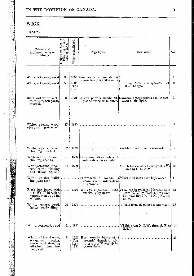
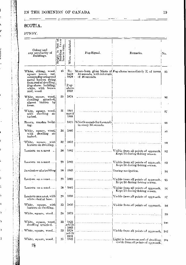
IN THE DOMINION OF CANADA. 9
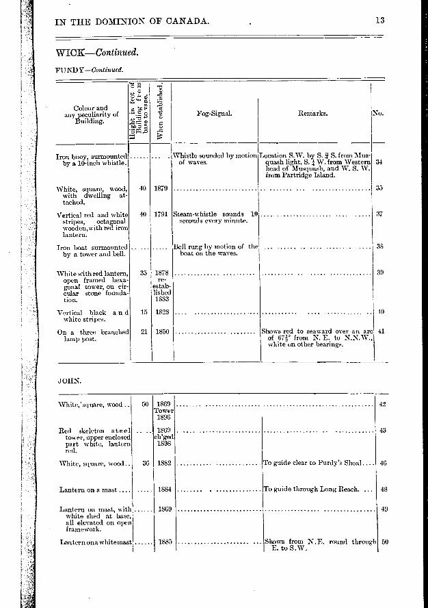
WICK.
FUNDY.
Colour and any peculiazity of
Buildings. No. Fog-Signal. Remarks.
0 P.
Z) C) C) V-1 e
•
"-g1V g * al
When
est
abl
ishe
d.
36 1832
53 1832 reblt 1875
41 I 1831
White, octagonal, wood
White, octagonal, wood
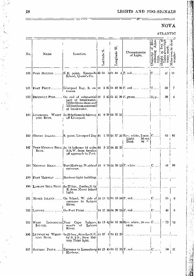
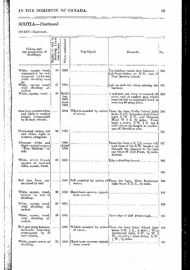
Black and white verti-cal stripes, octagonal, wooden.
Steam-whistle sounds 5 seconds in every 30 seconds
Cotton powder bombs ex-ploded every 20 minutes.
1
In range N.W. lead 4Ï miles S. of Murr Ledges.
Dangerous rocks extend 4 miles east-ward of the light.
2
3
43 I 1880 5 White, square, wood, with dwelling attached.
'White, square, wood, 32 1879 dwelling attached.
White, with brown roof, 1886 dwelling near by.
White,octagonal,wood, 50 1860 with white dwelling and outbuildings near
White wooden build-ing, dark roof.
Visible from all points seaward
Visible between the bearings of S.W. round by S. to N.W.
Steam-whistle sounds 4 Whistle SO feet above high water... seconds with intervals of 16 seconds.
7
10
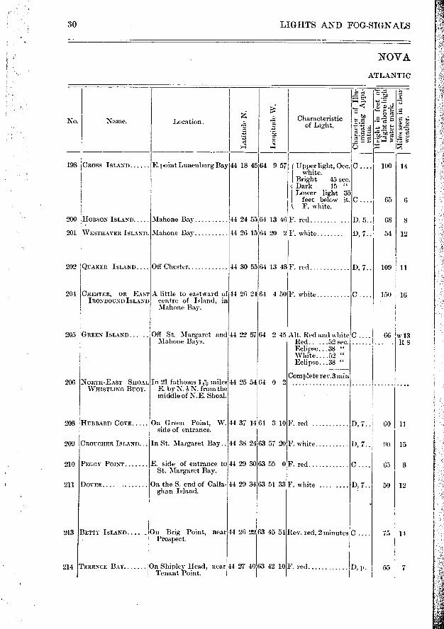
11
Horn sounds 6 seconds with intervals of 35 seconds.
Black iron buoy-, with "S. Wolf" in white, surmounted by 10 in. whistle.
Whistle sounded auto-matically by waves.
From the buoy, Head Harbour light 12 bears N.W. by W.81 miles ; and Lepreau light E. by N. e. N., 13i miles.
White, square, wood, lantern on dwelling.
White, octagonal, wood
White, with red cross, octagonal, wooden, tower with dwelling attached. Iron lan-tern, red.
Horn sounds blasts of 8 seconds' duration, with intervals of 35 seconds be-tween them.
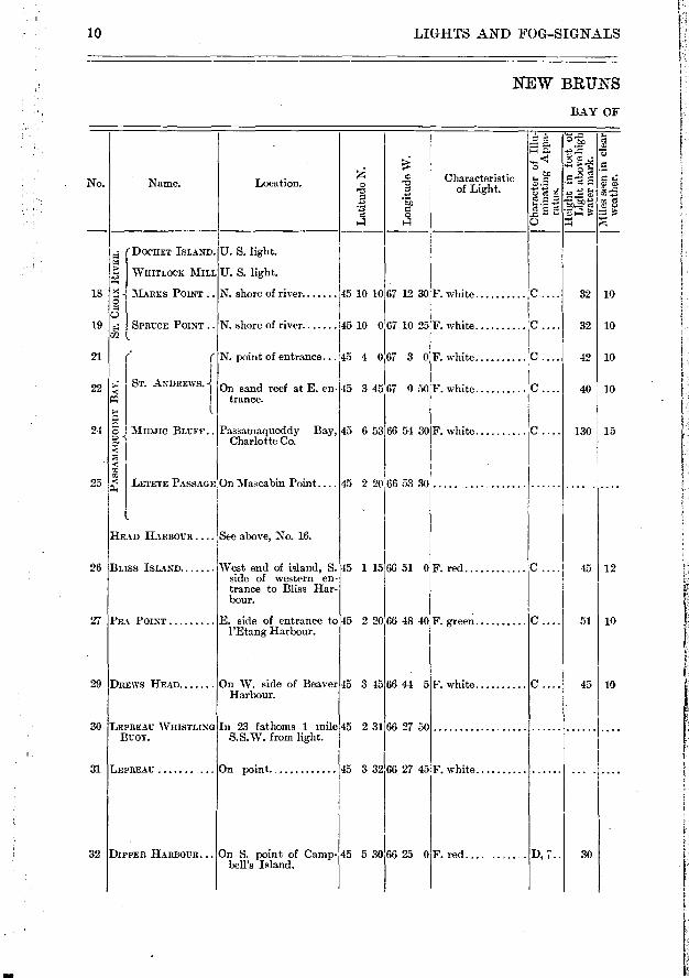
LIGHTS AND FOG—SIGNALS
NEW BRUNS
BAY OF
re et a -•,-.,, ̀,1
4 ..- ...,z-.. T.,
...-
No. Name. Location. e -cc Characteristic e — .„ sa e ... :.3.• --icf..à =A ... I e -e. a' 2 *E). 4 3 7.■ e 0 a a 5
( DOCHET ISLAND. U. S. light.
l' WHITLOCK MILL U. S. light.
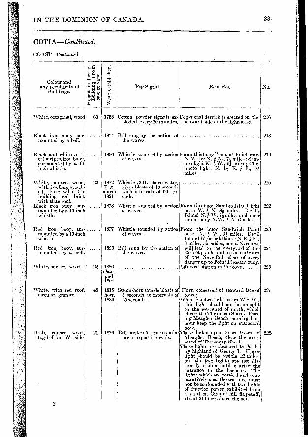
18 >.1 MARKS POINT .. N. shore of river 45 10 10 67 12 30 F. white C 32 10 R CD
19 E.; SPRUCE POINT.. N. shore of river 145 10 0 67 10 25 F. white C 32 10 rn (_
21 ( f N. point of entrance... 45 4 067 3 0 F. white C 42 10
1 ST. ANDREWS. I On sand reef at E. en- 45 3 45 67 0 50 F. white C 40 10
4 1 trance.
24 :E2" i Minn° BLUFF.. Passama,quoddy Bay, 45 6 53 66 54 30F. white C . 130 15 e ' Charlotte Co. c c m m
25 ‹ L 11.1E PASSAGE On Mascabin Point . ... 45 45 2 20 66 53 30 . .
l
HEAD HARBOUR .... See above, No. 16.
26 BLISS ISLAND West end of island, S. 45 1 15 66 51 0F. red c 45 12 side of western en-trance t,o Bliss Har-bour.
27 PEA POINT E. side of entrance to 45 2 20 66 48 40 F. green C . 51 10 l'Etang Harbour.
29 DREWS HEAD On W. side of Beaver 45 3 45 66 44 5 F. white C 45 10 FIarbour.
30 LEPREAU WHISTLING In 23 fathoms 1 mile 45 2 31 66 27 50 ... BUOY. S.S.W. from light.
31 LEPREAU On point 45 3 32 66 27 45F. white .
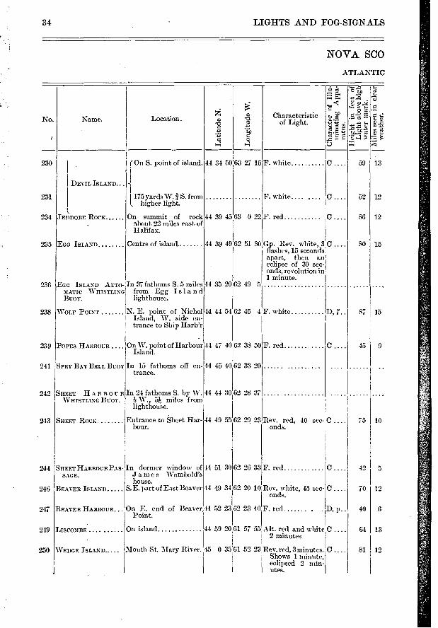
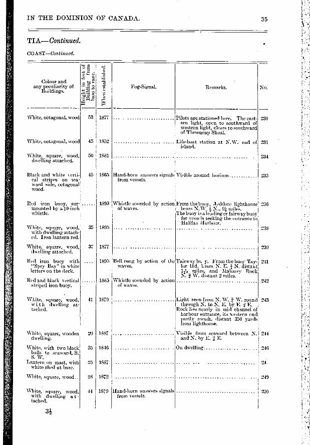
32 DIPPER HARBOUR... On S. point of Camp- 45 5 30 66 25 0F. red.... ..... D, 7 30 bell's Island.
10
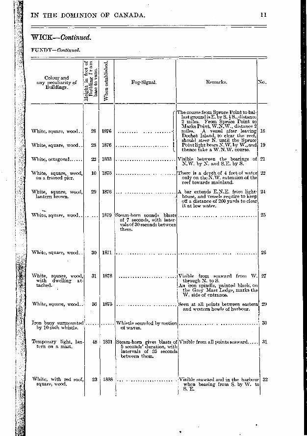
IN THE DOMINION OF CANADA.
WICK—Continued.
F UNDY—Continued.
11
, o ,5
Colour and te > d e any peculiarity of -...5. o le> Fog-Signal. Remarks. No.
Buildings.
to a â rà
• ri g..a ..o › ..--
I The course from Spruce Point to bal-last eround is E. by S. i S., distance 2 miles. From Spruce Point to Marks Point, W.N.W., distance 2
White, square, wood.. 28 1876 ....... i miles. A vessel alter leaving 18 Dochet Island, to clear the reef, should steer N. until the Spruce
White, square, wood.. 28 1876 Point light bears N.W. by W., and 19 thence take a W.N.W. course.
White, octagonal. 22 1833 Visible between the bearings of 21 N.W. by N. and S.E. by S.
White, square, wood, 10 1875 There is a depth of 4 feet of water 22 on a framed pier. only on the N.W. extension of the
reef towards mainland.
White, square, wood, 29 1876 . A bar extends E.N.E. from light 24 lantern brown. . house, and vessels require to keep
off a distance of 260 yards to clear it at low water.
--.-
White, square, wood.. .. ... 1879 Steam-hom sounds blasts 25 of 7 seconds, with inter- vals of 30 seconds between them.
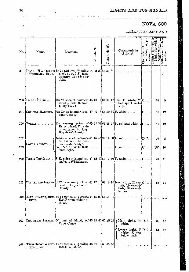
White, square, wood.. 30 1871 . 26
White, square, wood, 31 1878 .. I Visible from seaward from W. 27 with dwelling at through N. to S. tached. An iron spindle, painted black, on
' the Grey Mare Ledge, marks the W. side of entrance.
White, square, wood. 36 1875 .. Seen at all points between eastern 29 and western heads of harbour.
Iron buoy surmounted Whistle sounded by motion 30 by 10-inch whistle, of waves.
Temporary light, lan- 48 1831 Steam-horn gives blasts of Visible from all points seaward 31 tern on a mast. 5 seconds' duration, with
intervals of 25 seconds between them.
White, with red roof, 23 1888 Visible seaward and in the harbour 32 square, wood , when bearing from S. by W. to
S. E.

39
40
41
SPLIT ROCK WHIST-LINO BUOY.
MUSQUASH
( PARTRIDGE IS-LAND.
PARTRIDGE 'S-e,' LAND BELL
BOAT.
NEGRO POINT.. .
c...
D, 3..
D, 6..
D, 4..
Elec-
In 30 fathoms off Split 45 7 10 Rock.
E. side of entrance .
Highest point of Island, St. John Harbour.
45 8 35
45 14 3
Near E. side of Part-ridge Island.
45 14 7
On end of Government breakwater, W. en-trance to port.
45 14 13
On pier on point of bar, W. side of channel.
45 14 58
On Prince William Street, foot of St. James Street, St. John City.
45 15 41
8 40
35 10
5 42
ST. JOHN HAR-BOUR.
REEDS POINT....
66 2 43
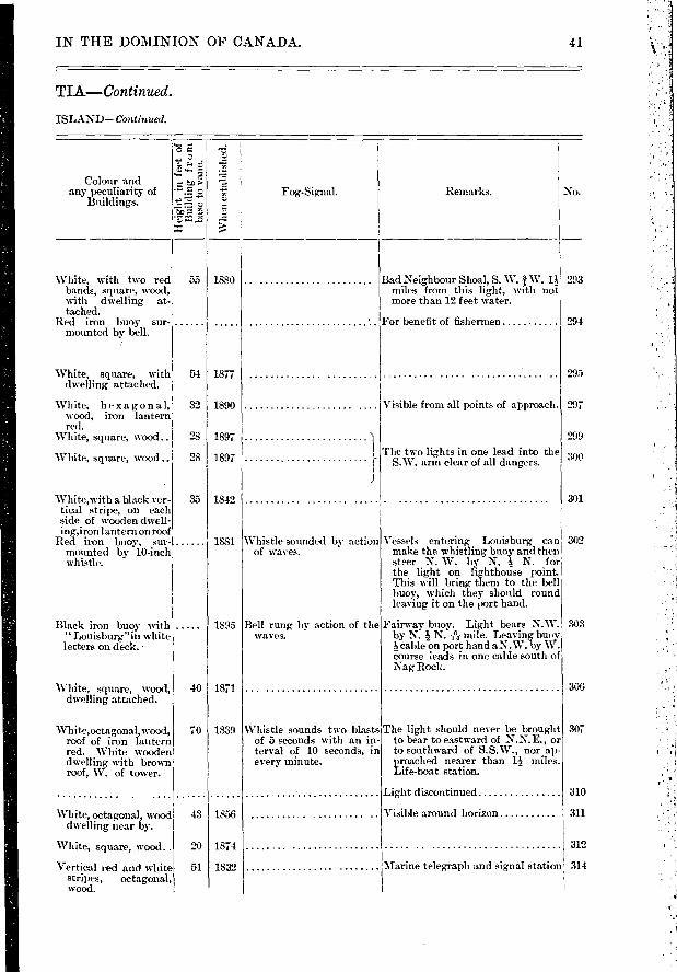
66 3 19 F. white
66 3 12 F. red .....
66 3 28 F. red and white. 64 c. p. incandes-cent lamps.
No.
43
35
37
50
GREEN HEAD
SAND POINT ...... Low shore, E. side of river, about 150 feet back from high water mark.
BELYEAS POINT
WILLIAMS LANDING..
On Nathaniel Belyea's Point, W. side of River.
Near outer end of public wharf.
42
43
46
48
49 IOAK POINT T. land, W. side of river.
FLEWELLINGS LAND- West sicle of river, Par-ING. ish of Greenwich.
45 16 50:66 9 15 F. white... ......
45 20 50 66 13 0 F. white
45 23 5,66 14 30F. white
45 30 50 66 7 45 F. white
45 32 10 66 8 01'. white
45 33 0:66 9 8 F. red
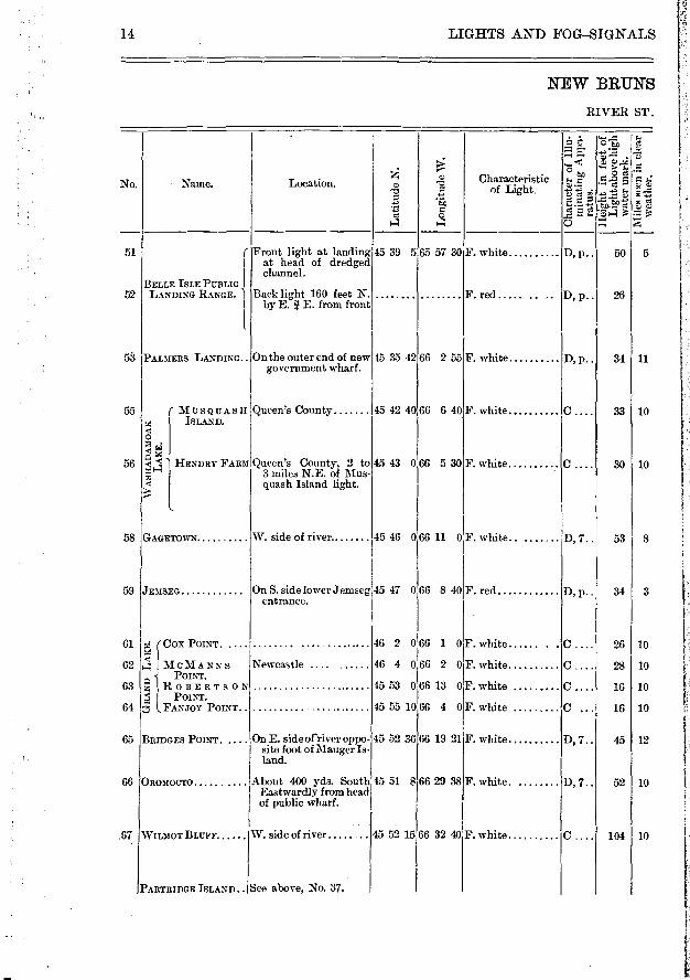
RIVER ST.
D..... 150 10
D, 7.. 60 13
D, 7.. 40 11
D, p.. 30 10
C.... 50 10
5 D, p.. 25
12 LIGHTS AND FOG—SIGNALS
NEW BRUNS
BAY OF
.Na me. Location.
Lo
ng
itu
de
W.
o
E5
'S
R e
". ..0 te..D •-• C.2
*E3i-1 e
Cs
+.>
re;
8 8 " •
Characteristic of Light.
Lati
tud
e N
.
66 14 0
66 14 30
66 3 5
F. green seaward F. white to bar-
!
F. white.
112
119 17
tricity
10
Colour and any peculiarity of
Building.
Iron buoy, surmounted by a 10-inch whistle.
White, square, wood, with dwelling at-tached.
Vertical red and white stripes, octagonal wooden,with red iron lantern.
Iron boat surmounted by a tower and bell.
White with red lantern, open framed hexa-gonal tower, on cir-cular stone founda-tion.
Vertical black a n white stripes.
On a three branche lamp post.
from Mus- n Western . W. S. W.
No.
34
37
39
40
ver an arc ) N.N.W.,
35
38
41
To guide clear to Purdy's Shoal....
To guide through Long Reach. ...
Shows from N.E. round through E. to S.W.
50
1869 Tower
1896
1869 ch'ged 1898
1882
1884
1869
1885
43
46
48
49
50
36
Red skeleton st eel tower, upper enclosed part white, lantern red.
White, square, wood..
Lantern on a mast .
Lantern on mast, with white shed at base, all elevated on open framework.
Lantern on a white mast
IN THE DOMINION OF CANADA. 13
WICK—Continued.
FUNDY—Continued.
'C) ,-. ce -I
g 5"
e tc > a
•--..= a t>, Fog-Signal. Remarks.
c.,
,... P.--
Whistle sounded by motion Location S.W. by S. e S. of waves , quash light, S. i- W. froi
head of Musquash, and from Partridge Island.
40 1879
40 1791 Steam-whistle sounds 10 seconds every minute.
Bell rung by motion of the ... ...... .. .... .... boat on the waves.
35 1878 re-
estab- lished 1883
15 1828
L 21 1850 Shows red to seaward c of 67V from N. E. t white on other bearinî
JOHN.
White,'square, wood ..
LIGHTS AND FOG-SIGNALS
NEW BRUNS
RIVER ST.
No. Name. Location. Q) n0 Characteristic $.. e
"C -E of Light. -.à .i:;= -..
.. co 4 • '-• -. t.o...° e 1 e
1:4' sc4' o
ngineâ 15 39 565 57 30F. white D, p.. 50 5 51 r Fre a theligcror àaeg
channel. BELLE ISLE Pullim
52 LANDING RANGE. Back light 160 feet N F. red ..... .. .. D, p.. 26 by E. ï E. from front
1
53 PALMERS LANDING.. On the outer end of new 45 35 42 66 2 55 F. white D, p.. 34 11 government wharf.
55 ( Musouasn Queen's County 45 42 40 66 6 40 F. white C 33 10 X ISLAND. C 0 › m C I 0
56 ‹ 1 HENDRY FARM Queen's County, 2 to 45 43 0 66 5 30 F. white C 30 10 z•r-1 3 miles N.E. of Mus- m I
,g I quash Island light.
l
58 GAGETOWN W. side of river 45 46 066 11 0 F. white D, 7.. 53
59 JEMSEG
On S. side lower Jemseg 45 47 066 8 40F. red D, p.. 34 3 entrance.
61 ra (Cox POINT . .... ................ ..... 46 2 066 1 0 F. white ...... . . C .... 26 10
62 4' I M oM A NN s Newcastle 46 4 0 66 2 0 F. white C 28 10 POINT ,r, M -,-,
oo zliA0BERTSON 45 53 0 66 13 0F. white C 16 10 I, POINT.
64 7c FANJOY POINT. 15 55 10 66 4 0F. white C ... 16 10
65 BRIDGES POINT . .... On E. sideofriver oppo- 45 52 3666 19 21F. white D, 7.. 45 12 site foot of Mauger Is- land.
66 OROMOCTO About 400 yds. South 45 51 866 29 38 F. white. D, 7.. 52 10 Eastwardly from head of public wharf.
67 WILMOT BLUFF W. side of river 45 52 1566 32 40F. white C 104 10
PARTRIDGE ISLAND.. See above, No. 37.
14

IN THE DOMINION OF CANADA. 15
WICK—Continued.
JOHN—Concluded.
-.
P. , ..É.
• 1- . , 2:.3 .7::
Colour and •
-5. g ' 3 any peculiarity of - r., 2 1 Fog-Signal. Remarks. No Buildings.
7,1 -g
--- 'e:-
-.. ,..- —
Lantern on a mast .... 45 1890 ( 51 I Lights visible between the bear- ' ings of N.E. through N. t,o S.W.
J In range show centre of dredg,ed
Lantern hung on end of 17 1890 1 channel N. by E. î E. At outer 52
Israel Noble's dwel- I end of channel, a black can buoy
ling which is white, I is moored and sides are balized. square, wood. l
White, square, wood.. 28 1884 53 mov'd
1896
White, square, wood, 27 1875 r In coming.down, the two lights to 55 on piles. Re- be kept in range until opposite
built N. W. end of Hog Island whence 1893 a southerly course to be kept to
foot of Musquash Island. In White, square, wood, 27 1875 going up, the two lights to be 56
on piles. Re- brought in range opposite N.W. built end of Hog Island, and kept in 1893 range until within mile of the
t_ light on Hendry Farm.
White, square, wood. 47 1895 To guide vessels between Jemseg 58 Lantern red. On and Musquash Island, and to show cribwork pier, turn in river at Buzzas.
Mast, with white shed 21 1884 Light shows from S.W. round by 59
with brown roof at W. to N. E. base, on white timber pier.
White, square, wood.. 36 1869 61 ,
White, square, wood.. 26 1876 62
White, square, wood.. 16 1873 63
White, square, wood.. 16 1873 64
White, square, wood 30 1891 To guide vessels through the channel 65
with lantern roof red. on E. side of Gilbert or Manger Island.
White, square, wood, 47 1869 66 on cribwork pier. mov'd Lantern red. 1895
Lantern on mast, with 40 1869 67 white shed at base elevated on open framework.
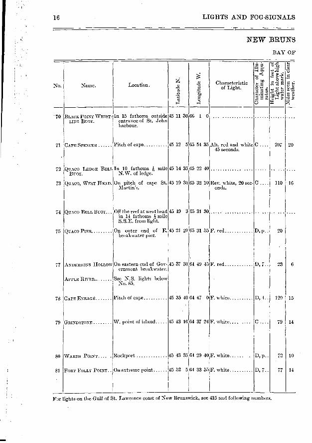
LIMITS AND FOG-SIGNALS
NEW BRUNS
BAY OF
...-
.. tx,
Characteristic s... e .-. No. Naine. Location.
-ô> ,-0 z.›.- •-• e C) Z)
..?> ..
to 7.' :*=.'S -,5. f■D ) :` t's
‘., o
1-1 4 o
70 BLACK POINT WHIST- In 15 fathoms outside 45 11 30 66 1 0
LINO BUOY, entrance of St. John harbour.
71 CAPE SPENCER Pitch of cape 45 12 5 65 54 35 Alt. red and white C .... 207 20 45 seconds.
72 QUACO LEDGE BELL In 10 fathoms h mile 45 14 35 65 22 40 ..... .. . BUOY. N. W. of ledge.
73 QUACO, WEST HEAD. On pitch of cape St. 45 19 30 65 32 10 Rev. white, 20 sec- C .... 110 16 Martin's. onds.
74 QUACO BELL BUOY... Off the reef at west head 45 19 3 65 31 30 .... in 14 fathoms I mile S.S.E. from het.
75 QUACO PIER On outer end of E. 45 21 20 65 31 55 F. red D, p.. 20 breakwater pier.
77 ANDERSONS HOLLOW On eastern end of Goy- 45 37 30 64 49 45 F. red D, 7.. 23 6 ernment breakwater.
APPLE RIVER. See N.S. lights below No. 85.
78 CAPE ENRAGE Pitch of cape 45 35 40 64 47 0F. white D, 4.. 120 15
79 GRINDSTONE W. point of island.... 45 43 16 61 37 24F. white.... .... C .... 79 14
80 YARDS POINT.... ROCkpOrt 45 43 35 64 29 40F. white D, p.. 72 10
81 FORT FOLLY POINT.. On extreme point 45 52 5i64 33 55F. white D, 7.. 77 14
For lights on the Gulf of St. Lawrence coast of New Brunswick, see 415 and following numbers.
16

72
General coast light to guide to St. 73 Martin Harbour.
74
Visible between W. by N. W. and i 75 N.W. ; and between N. E. and I N.E. bv E. Obscured irom N. W. to N. E. The deepest waterI in entering the inner harbour is close to the light.
Vessels inay run for harbour one , 77 hour before high water, giving the
light 50 ft. of a berth on port hand. i
IN THE DOMINION OF CANADA. 17
WICK— Conc luded.
FUNDY.
..15
1-■
co e No
Colour and any peculiarity of
Buildings.
Whe
n e
stab
lish
ed.
Fog-Signal. Remarks.
1890
35 1873
49 1835 re-
built 1883
Black iron buoy, sui mounted by a 10-inch! whistle.
White, square, build-ing with tower.
Red iron buoy, sur- mounted by a bell.
White, square, -wood, dwelling attached. Fog building white, with brown roof, wood.
Whistle sounds by the ac- From the buoy Partridge Island 70 tion of the waves, light bears N. W., 31 miles ;
Mispeck Point, E. N., le miles ; south-west end of Meogenes Island,! N.W. by W., 3 miles.
Visible between the bearings E.S.E.. 71 round by S. to W. N.W. Partridge Island light bearing N.W. by W. '7. W., distant n
Bell rung by motion of buoy on the waves.
Steam-horn 70 feet from lighthouse, gives blasts of 9 seconds with intervals of 30 seconds.
Black iron buoy, sur- mounted by a bell.
Bell rings by action of waves.
21 1887 White, square, wood..
24 Re-built 1898
23 I 1840 White, square, fog-alarm building of gray stone with slate roof.
Steam-horn sounds blasts of 8 seconds, with intervals of 20 seconds.
Fog-alarm is 130 feet S.W. from the 78 lighthouse, at an elevation of 100 feet.
White, square, woixl
Steam-horn sounds blasts of 15 seconds, with intervals of 30 seconds.
White,octagonal, wood, white dwelling near by. Fog,-hont build-ing white,with brown roof.
White, square, wood.. 22 1890
Visible over 315 from S.W. by W. 70 through N. to W. by- N.
Fog-alarm building stands in front of tower. If horn disabled, old trumpet 150 feet behind will sound short blasts every 15 seconds.
Visible from E.N.E. through N. to 80 S.W. "2 W.
40 I 1854
SI At junction of Petitcodiac and Mein-ramcook rivers.
35 I 1890 White, with iron Ian-teni red, square, wood, with dwelling attached.
o
85
86
12
20
45 19 30
45 17 25
64 47 30 F. red
64 46 40:.
64 23 20Y. red D, 7.. 60 10
64 19 5F. white C 37 9
63 55 00T. red
C
p• • ; 15 5
D, p..
C .
30 6
35
C . 75 13
C 60 10
C 109 15
D, 7.. 27 10
11
O
5
05 D, p..
31)
D,
D, p..
60
C . 12
63 29 0 F. red
89
90
92
93
94
95
96
97
98
99
100
1 .02
104
45 20 10 63 32 10F. red
45 18 40,63 48 30F. white
45 14 0'64 0 43F. red
45 63064 13 20 F. white
45 9 3564 21 . 30F. white
45 10 15 1 64 45 50Y. white
On shore of Basin of Mines.
Basin of Mines, N.W. extremity of head, S. shore.
E. sicle of mouth of La Tite River.
On Bluff, W. side of Avon River, near its mouth.
On Oak Point pier
S. shore
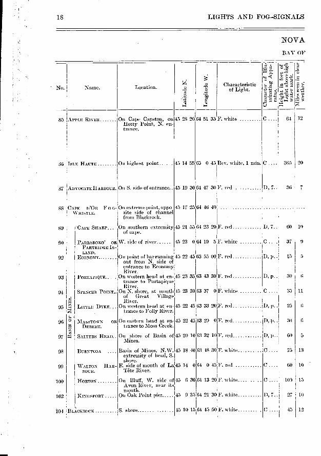
IS , LIGHTS AND FOG-SIGNALS
NOVA
BAY OF
No. Name. Location.
. L
ong
itu
de
W.
Characteristic of Light.
ce
APPLE RIVER On Cape Capston, on 45 28 20 Hetty- Point, N. en- trance.
64 51 35 F. white 0 64
ISLE HAUTE On highest point 45 14 55 65 0 45 Rev. white, 1 min. C.. 365
On S. side of entrance.. ADVOCATE HARBOUR. D, 7.. 36 7 87
88 CAl'E n'Oit F o c- On extreme point, oppo WHLSTLE, site side of channel
from Blackrock.
3 ..NIASSTOWN Olt
DEBERT.
C gr, SALTERS HEAD..
BURNTCOA
WALTON HAR-BOUR.
HORTON ...
KING SPORT
BLACEROCE
(CAPE SHARP. On southern extremity 45 21 55 of cape.
PARRSBORO' OR W. side of river 45 23 0 PARTRIDGE IS- LAND.
ECONOMY On point of bar running 45 22 45 out from N. side of entrance to Economy River.
PORTAPIQUE... . On western head at en- 45 23 35 trance to Portapique River.
SPENCER POINT On N. shore, at mouth of Great Village Ris er.
LITTLE DYKE On western head at en- trance to Folly River.
On eastern head at en-trance to Moss Creek.
45 23 30:63 37 0
45 22 45 63 33 201E. red
45 22 45
63 43 301'. red
F. white
e to> e c Remarks. Fog-Signal. No.
Colour and any peculiarity of
Buildings.
IN THE DOMINION OF CANADA
SCOTIA.
19
F UNI_YV".
WI'
34
30
White, oblong, wood, square tower, sur-mounted by octagonal metal lantern rising from roof of dwelling. Foe-alarm building, white, with brown roof, wood.
White, square, wood, dwelling attached, almost hidden by trees.
White, square, wood. with dwelling at-tached.
Brown, wooden build-ing.
White, square, wood, with dwelling at-tached.
'White, square, with lantern on dwelling.
Lantern on a mast ...
45 Re- Steam-horn gives blasts of Fog-alarm immediately E. of tower built 14 seconds, with intervals 1870 I of 46 seconds.
Fog,: alarm 1889
53 I 1878
27
Whistle sounds for 6 seconds in every 30 seconds.
1886
32
1882 . Visible from all points of approach. 92 Kept lit during fishing- season.
85
1884 mov'd 1888
1875
1852
86
87
88
89
White, square, wood, dwelling attached.
. White, square, woo(I..
Lantern on a ma-st
In window of a building
Lantern on a mast....
Lantern on a mast....
Lantern on a mast, with white shed at base.
White, square, with lantern on dwelling.
White, square, wood ..
'White, square, ‘vocKl.
20
20
20
33
20
20
20
35
23
35
1851
1883 1878
reb'ilt 1891 1848
1882
1863
1882
1882
1888
1859
'Visible froni all points of approach. Kept lit during fishing season.
During: navigation.
93
94
Visible trom all points of approach. 95 Kept lit during fishing- season.
Visible from all points of approach. 96 Kept lit dining fishing season.
Visible from all points of approach. 97
Visible from all points of approach. 98
99
100
Visible from all points of approach. 102
Light in lantern on roof of dwelling, 104 visible from all points of a pproach.!
1873 I
F
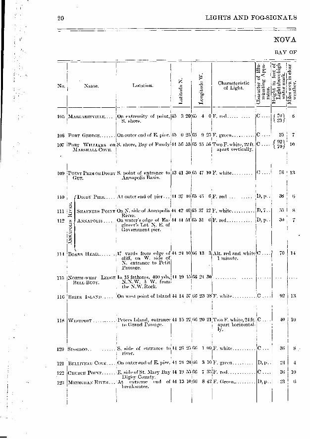
D, p.. 38
D, 7.. 55 s
D, p.. 30 7
70 I 14
C 92
40
0... 36
10
8
D, l'•
I), p..1
24
36 10
23
4
O
20 LIGHTS AND FOG-SIGNALS
o o
• e
7:4
„.„ e 7...m
No. Naine. Location.
— e ; L
atit
ude
N.
Characteristic of Light.
NOVA
BAY OF
106
107
105 MARGARETVILLE.... ,On extremity of point, 45 S. shore.
PORT GEORGE On outer end of E. pier.
PORT WILLIAMS on,S. shore, Bay of Fundy MARSHALL COVE.
3 20 65 4 0F. red .....
45 0 25 65 9 25F. green
44 56 53 65 15 56 Two F. white, 22 ft
apart vertically
C f701 8 1 23f
25 1 7
c f 921! 10 1 70)1
43 41 30 100 POINT PRIM ORDIGBY ' S. point of entrance to GUT. Annapolis Basin.
65 47 10F. white 0.1 76 13
110
112
NN
AP
OLIS
RIV
ER
.
65 45 6,F. red ........ DIGBY PIER At outer end of pier...
SHAFNERS POINT On N. side of Annapolis 44 42 40 65 37 12 F. white River.
ANNAPOLIS On water's edge of En- 1 44 44 51 65 31 6 F. red.. gineer's Lot N. E. of. Govermnent pier.
44 37 40
115
118
114
116
BOARS HEAD. •17 yards from edge of 44 24 10 66 13 3 Alt. red and white cliff, on W. side of 1 minute. N. entrance to Petit
' Passage.
NORTH-WEST LEDGE In 15 fathoms, 400 yds, 44 19 15 66 24 30 • BELL-BuoY. N.N.W. I W. from
the N.W. Rock.
BRIER ISLAND (1:In west point of Island 44 14 57 66 23 38 F. white
WESTPORT Peters Island, entrance 44 15 27,66 20 21,'Two F. white, 24 ft. to Grand Passage. j apart horizontal-
ly.
1 00,F. white.
44 24 201 66 3 10 F. green.
44 19 55 66 7 34F. red
-14 13 10.66 8 42 F. Green.
120 , SISSIBOO. S. side of entrance to 11 44 26 2566 river.
On miter end of E. pier 121 .BELLIVEAU COVF
122 Cnuiteit POINT
123 METEGILAN RIVER
E. side of St. Mary Bay D igby County.
At extreme end of breakwater.
";* o
22
21
22
22
29
43 1885
23 ' 1889
116
Visible from the northward between the bearings of S. by W. and S.S. W., and from the ;outhward be-tween the bearings of X.E. by E. and N.N.W. j W.
113
120
55
15 each
33
1809 Fog,- alarm 1873
1830
1870
8
0
3
1 1.4
10
8
4
10
1;
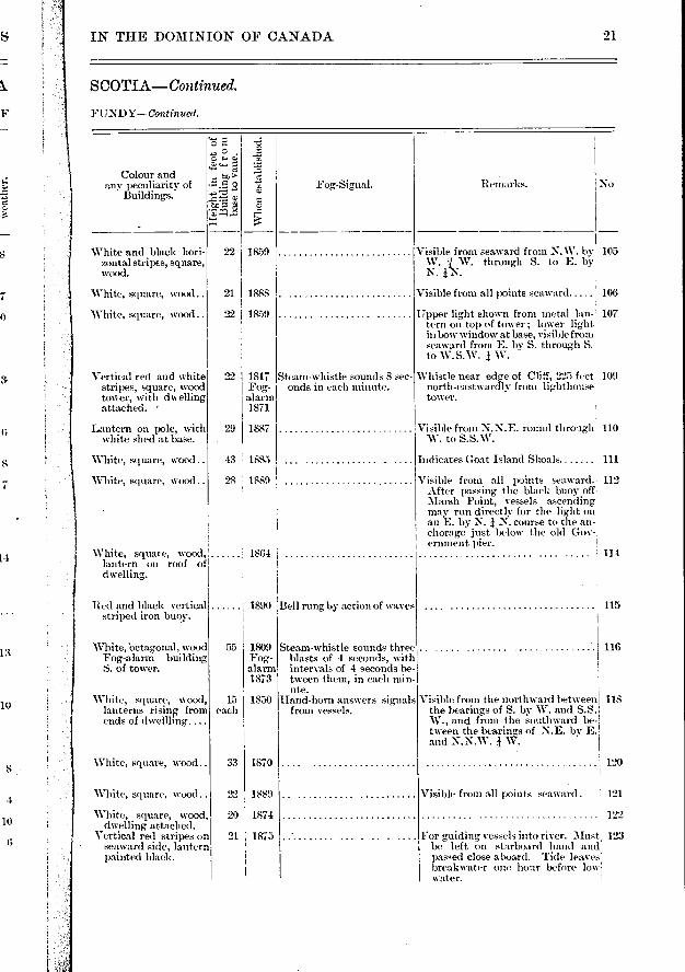
IN THE DOMINION OF CANADA 9 1
SCOTIA—Continued.
FUNDY—Continued.
No Remarks. Fog-Signal. Colour and
any peculiarity of Buildings.
f-■
o
Tap. ‘,53 • 1. -o
White and black hori-zontal stripes, square, wood.
White, square, wood..
White, square, wood..
Vertical red and white stripes, square, wood tower, with dwelling attached.
1859
1888
1859
1817 Steam-whistle sounds S sec-Fog- onds in each minute. alarm 1871
Visible from seaward from N. W. by 105 W. j W. through S. to E. by N. I N.
Visible from all points seaward 106
Upper light shown from metal lan- 107 tern on top of tower ; lower light in bow window at base, visible from seaward from E. by S. through S. to W.S.W. j W.
Whistle near edge of Cliff, 225 feet 109 north-eastwardly from lighthouse tower.
Visible from N.N.E. round through 110 W. to S. S.W.
1887
White, square, wood..
White, square, wood..
White, square, wood, lantern on roof of dwelling.
Red and black vertical striped iron buoy.
1864
1890 Bell rung by action of waves
Indicates Goat Island Shoals 111
Visible from all points seaward. 112 After passing the black buoy off. Marsh Point, vessels a.scending may run directly for the light on an 'E. by N. j N. course to the an-chorage just below the old Gov-, ernment pier. ! 114
115
Lantern on pole, with white shed at base.
White,'octagonal, wood Fog-alarm building S. of tower.
White, square, wood, lanterns rising from ends of dwellling....
White, square, wood..
Steam-whistle sounds three blasts of 4 seconds, with intervals of 4 seconds be-tween them, in each min-ute.
Hand-horn answers signals fnmi vessels.
White, square, wood..
White, square, wood, dwelling attached.
Vertical red stripes on seaward side, lantern painted black.
22 1889
20 1874
21 1875
Visible from all points seaward.
For guiding vessels into river. Must! be left on starboanl hand and
passed close aboard. Tide leaves breakwater one hour 1)efore low! water.
.. • ........ • • • • • • • • • • •
121
122
123
Location
a
44 5 10
43 59 5
43 50 2
CAT ROCK BELL BUOY.
YARMOUTH Olt CAPE FOURCHU.
BUNKER ISLAND
130
131
133
134
103 16
26 6
18 117
31 ! 10
43 44 0 66 10 47
43 40 16 66 18 55' ...
PRAMES ISLAND 139 66 1 40 37 35 56 12
4
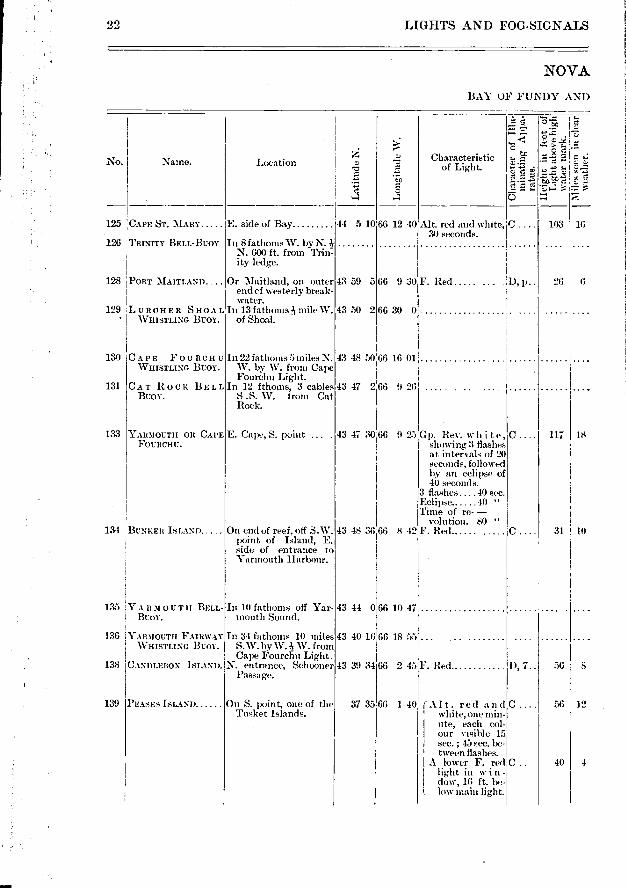
22 LIGHTS AND FOG-SIGNALS
NOVA
BAY OF FUNDY AND
Lon
git
ude
W.
.-.. 2'; A
„ c
ai e> t
— e. :•• s4
o
No. Naine. Characteristic of Light.
125 CAPE ST. MARY....
126 TRINITY BELL-BUOY
PORT MAITLAND.
129
E. side of Bay
In 8 fathoms W. by N. N. 600 ft. from Trin: ity ledge.
Or -Maitland, on outer end cf westerly break-water.
In 13 fathoms mile W. of Shoal.
128
LURCHER SHOAL WHISTLING BUOY.
66 12 40
66 9 30F. Red ..... . • • 1), P • •
66 30 0
Alt. red and white, C 30 seconds.
CAPE FOURCHU WHISTLING BUOY.
In 22 fathoms 5 miles N. W. by W. from Cape Fourchu Light.
In 12 fthoms, 3 cables S .S. W. from Cat Rock.
43 48 5006 16 01
4341 266 926
43 47 30 66 925
43 39 3460 2 45F. Red D, 7..
135 YA 11M OU TH BELL-BUOY.
136 YARMOUTH FAIRWAY WHISTLING BUOY.
138 CANDLEBOX ISLAND.
E. Cape, S. point ... .
On end of reef, off S.W. point of Island, E. side of entrance to Yarmouth Harbour.
In 10 fathoms off Yar-mouth Sound.
In 34 fathoms 10 miles S.W. by W. -?s W. from Cape Fourchu Light.
N. entrance, Schooner Passage.
Gp. Rev. w h it e, showing :3 flashes at intervals of 20 seconds, followed by an eclipse of 40 seconds.
3 flashes....40 sec. Eclipse. 40 " Time of re- —
volution. 80 " 8 42Y. Recl
568
On S. point, one of the Tusket Islands.
(Alt. red and C ' white, one min-
lite, each col- our visible 15 sec. ; 45 sec. be- tween flashes.
A lower F. red C light in w in - dow, 16 ft. be-
. low main light.
43 48 3603
Bell rung- by action of the waves.
Whistle sounded by action of the waves.
,No. Remarks.
131
133
White, square, wood, on brown, circular, steel and concrete.
pier.
Red iron buoy, sur- 1890 mounted by a bell.
Black and white striped .... 1894 buoy, with 10-inch whistle.
White, square, wood, 37 1893 with dwelling at-tached. lion lantern, red.
White, square, wood, 42 1879 with dwelling, at-tached.
1874 Bell gives one stroke every 15 seconds.
Bell rings by the motion of the buoy on the waves.
Whistle sounded by action of the waves.
Hand-horn answers signals from vessels.
Hand-horn answers signals from vessels.
Visible from southward, betweem 134 N.E., by N. and N. 2 E. Also over Stanwood's Beach when bear- ing from S. 4 E., to S.E. 1 E., but cannot be run for on those bear-ings, only entrance to harbour being through Yarmouth Sound and round Cape East.
From the buoy the " Roaring Bull" 135 bears E.N.E., 14 miles ; and Cape,' Fourchu light N.E. by N., n miles! 136
Visible from all points seaward ....
Sea light, visible from all points, 139 of approach from southward also through Schooner and Ellen wood Passages.
Lower light marks channel be-tween Old Man and Old Woman Rocks. Visible only between bearings W. by N. 4 N. N. and W. by W.
138
IN THE DOMINION OF CANADA.
SCOTIA—Continued.
ATL ANTIC COASTS.
23
Colour and any peculiarity of
Buildings.
>
.5 ,d
Whe
n e
stab
lish
ed.
Fog-Signals.
Whistle sounded by action of the waves.
Bell rung by action of the wa yes.
White, octagonal 43 1868
Iron buoy, surmounted ...... . by a bell.
White, square, wood.. 27 1884 Tower
1897 Red and black horizon- .... . 1882
tal bands with " Lur- cher Shoal "in white. Iron buoy, with 10- inch whistle.
Red iron buoy, with 10- 1894 inch whistle.
Black iron buoy- sur- .... 1897 mounted by a bell, " Cat Rock "in white letters on deck.
125
From the buoy Cape St. Mary bears 126 N.E. by E. 7 miles ; Cape Four- chu S. by E. 134 miles ; Lurcher
*Shoal S.W. by W. 124 miles. Kept up only from 15ih A.pril to 128
15th November, each year.
Shoal lies 15 milesis.i.W. by W.1 W. 129 from Cape Fourchu light. -
130
From the buoy Yarmouth Light bears N.N.E. and the outer tan-gent of West Cape N.N.W.
Vertical red and white 59 1839 stripes, octagonal, chan- wooden tower ; white, ged. wooden dwelling near 1892 by. Fog-
alarm 1869
Whistle on W. side of cape sounds 10 seconds in every minute.
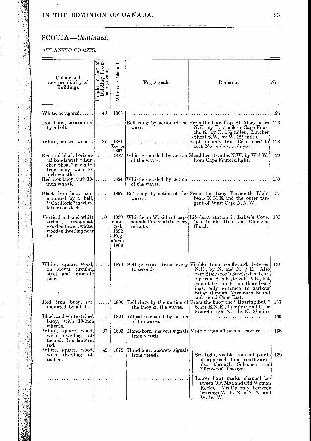
Life-boat station in Baker's Cove, just inside Hen and Chickens Shoal.
43 37 2 65 59 0
66 0 52 43 23 3 t
o
t. jË. C
• • e e
OS D. 2.. 18 SEAL ISLAND S. point -k mile inland. 142
TUSKET RIVER
ARGYLE
PUBNICO HARBOUR..
ST. JOHNS LEDGE BELL-BUOY.
BON PORTAGE IS-LAND.
STODDART
CAPE SABLE On Cape
WEST HEAD, CAPE SABLE ISLAND.
On the Head ....
BARRINGTON EAST BAY LIGHTSHIP.
43 23 19
43 27 17
65 52 4
65 49 36
65 46 54
F. white
F. white
115 12
40 8
Beach Point, E. side of entrance, 120 yards from low water mark.
43 35 45
147
148
150
151
152
155
156
157
145
146
43 27 14 65 44 44 Rev. red, one min- ute.
43 28 26 65 43 IF. red
24 LIGHTS AND FOG-SIGNALS
NOVA
ATLANTIC
Location. No. Name. Characteristic
of Lig,ht.
Lat
itude
N.
Lon
gitu
de W
.
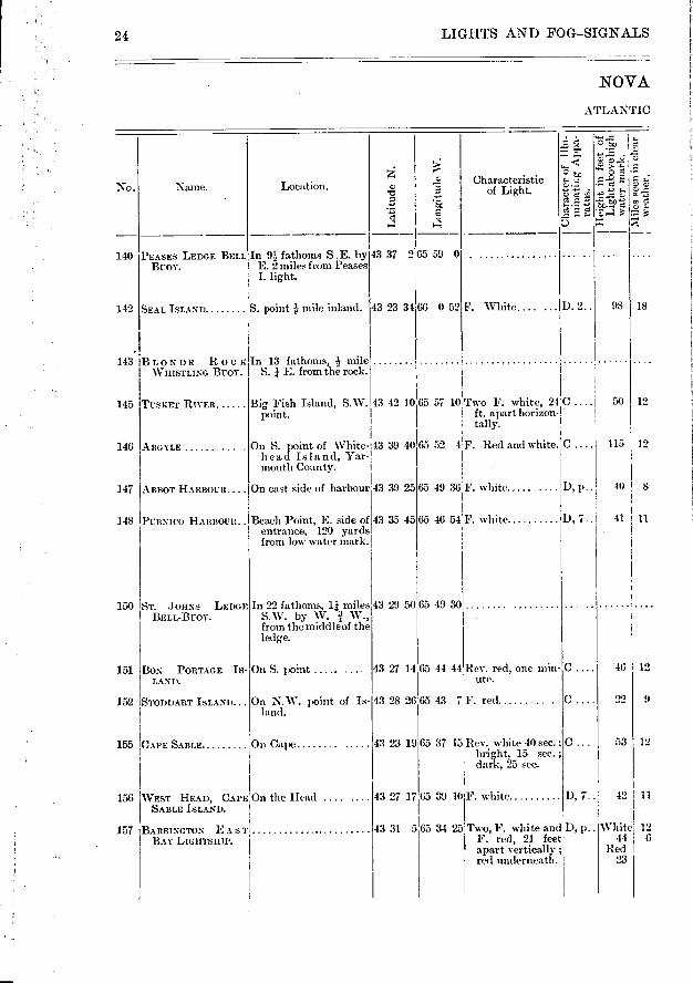
140 PEASES LEDGE BELL In 9 fathoms S. E. by BUOY. E. 2 miles from Peases
I. light.
143 BLONDE Roc K In 13 fathoms, mile WHISTLING BUOY. S. E. from the rock.
F. White.... ...
65 57 10 Two F. white, 24 C .... 50 12 ft. apart horizon- tally.
On S. point of White- 13 39 40 head Island, Yar- mouth County.
D, p. .
D, 7.. 41 11
On S. point .....
On N.W. point of Is-land.
65 37 15 Rev. white 40 sec.; bright, 15 sec. ; dark, 25 sec.
Big Fish Island, S.W..43 42 10 point.
ABBOT HAnnourt.... On east side of harbour 43 39 25
In 22 fathoms, 11 miles 43 29 50'65 49 30 S.W. by W. ï W., from the middle of the ledge.
43 31 565 34 25
65 39 10 F. white
F. Red and white. C
Two, F. white and D, p.. F. red, 21 feet apart vertically ;• red underneath. !
C 46 12
22 9
C.... 53 12
D, 7.. 42 11
White 12 44 6
Red 231
IN THE DOMINION OF CANADA. 25
SCOTIA—Continued.
143
145
146
147
150
151
153
155
156
e
\Vit
en e
stab
l
Remarks. No. Fog-Signals. Colour and
any peculiarity of Buildings.
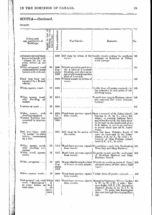
1898 Bell rung by action of the Guides vessels seeking the southern waves, entrance to Schooner or Ellen-
wood passage.
60
23
28
28
lternate red and black horizontal bands with " Peases Id. Fy." in white letters on the deck.
White, octagonal, wood surmounted by metal lantern with red roof.
Black iron buoy sur-mounted by a 10-inch whistle.
White, square, wood ..
White, square, wood, with dwelling at-tached.
Lantern on mast
1830 Whistle sounds in each min- Fog- ute a blast of 5 seconds alarm duration, and after an in. 1810 terval of 5 seconds another
bla.st of 5 seconds. 1882 Whistle sounds by action of
waves.
1864
1874 I
1884
Visible from all points seaward ; in bav windows in each gable of the dtt:elling house.
To guide into Argyle Harbour, shows red seaward, and white towards harbour.
140
142
White, square, with dwelling, attached.
Wooden building sur-mounted by iron lan-tern.
Red iron buoy, with "J. Ledge " in white letters, surmounted by a bell.
White, square, wood, with dwelling a t - tached.
White, small, square, tower.
White, octagonal. ....
White, square, wood..
Hull painted red, with word " Barrington " in white letters on both sides.
White; 1875 41
Red
above deck.
- 28 1874
21 1877
50 1861 Fog-alarm 1876
36 1888
40 1854 Hand-horn answers signals Im- from vessels.
prov'd 1889 ,
1891 Bell rung by the action of the waves.
Hand-horn answers signals from vessels.
Steam-whistle sounds a blast of 10 secs. in each minute.
Hand-!-..orn answers signals from vessels.
Hand-horn answers signals Visible from all points seaward from vessels.
Hand-horn answers signals from vessels.
'Moored in 6 fathoms, Wesses Ledge, 157 S. W. lty W. :} W., 2 mile ; Bac- caro Light, S.S.E. E., 6/", miles; Bantam Rocks, S. by E. ;i, E. (P.t miles. To guide into Barrington Bay and through Barrington Pass-age.
Open tvestward of St. Johns Island, beating N. E. by N., clears the ledge ; in making harbour froin any other direction, the light must be brought to the northward of E. N.E. before it can be steered for, to avoid shoal spot off St. .Ann's Point .
From the buoy Pubnico Light is open to westward of St. Johns Island, N.E. by N., 61 miles ; S. tangent of Bon Portage Island beats S.E. S., 41 miles.
For guiding vessels into Barrington West Bay and Shag Harbour.
T. guide vessels into the anchorage of Stoddart Harbour and Shag Harbour Sound.
Whistle on southern point of Cape, elevated about 40 feet above high water.
148
Lon
gitu
de W
.
Lat
itude
N.
s "co
• >-É
"jé • Itz.- a
•
i -17. .=
Characteristic of Light.
176
178
mile S. W. of rocks, which lie 1i miles S. W. W. from Bac-caro light.
In 22 fathoms mile S. by W. from the rock.
On N. side
Range lights building.
Near S.E. point of Mac-Nutt Island, S h e 1 - burne Harbour.
80 yards froiti extremity at E. side of entrance t o Shelburne H a r - bour.
Gull Rock
Ragged Island Harbour 43 42 15
Off the approach to 43 37 28 Ragged Island Har- bour.
In In fathoms l i:16 43 39 30 miles- W. ?, N. from Gull Rock -light, and 3 miles N. î W. from Carter's I. light.
On Shingle Point, E. 43 48 40 side of harbour.
Nearly on centre of is- 43 48 30 land.
65 6 °Oil'. red
65 1 44
6540
64 55 231e. red
64 47 15.Gp. Rev. white, 3 ' flashes with in-
tervals of 10 I seconds followed
y eclipse of 30 I seconds. Revo- ' lution 50 seconds.
C . I 49l0
• •
46 12
60 13
f120 111 1 65. 13
47 I 10
C.... 56 10
66 I 8 D, 7..
13 10 C.
12 43
43 39 12,65 5 50in white
On E. side of entrance 43 26 54 65 28 12 F. red to Barrington Bay.
65 19 28 F. red
43 30 54
43 37 15
43 41 25
65 29 8 43 25 38
F. white.... .. D, 7..
Alt. red and white one minute.
Two F. white, 55 feet apart verti-cally.
C ..
C ...
On E. end of Island, 43 29 27 65 27 entrance to harbour of Port Latour.
4
65 20 58
65 15 45
No.
159
160
162
163
165
166 167
168
170
172
173
174
175
26 LIGHTS AND FOG—SIGNALS
NOVA
ATLANTIC
Name. Location.
BACCARO
BANTAM ROCKS WHISTLING Bum-.
BRAZIL ROCK BELL-BUOY.
PAGE ISLAND. .
NEGRO ISLAND... .
NORTHEAST H A R-BOUR.
CAPE ROSEWAY
SAND SPIT
RAGGED ISLAND HARBOUR.
CARTER ISLAND
LOCKEPORT WHIST LINO BUOY.
LOCKPORT FAIRWAY BELL Buoy.
PORT HEBERT
LITTLE HOPE
Remarks. Fog-Signals.
1
'1 No.
159
160
35
34
44
1890
1872 re-
built 1887
168
170
172
173 White, square, \vood..
Red iron buoy with letter L in white, surmounted by 10- inch whistle.
Red and black hori-zontal bands, with "Lockport Fy." in white letters on the deck.
Hand-horn answers signals from vessels.
Whistle sounded by the motion of the wave:s.
Bell rung by action of the waves.
176
17g
31
29
29
30
1853
1872
1888
1898
1872
1865 chan-ged 1889
IN THE DOMINION OF CANADA. 27
SCOTIA—Continued.
COAST—Continned.
e z
t "5- • 'EPP
Co our and any peculiarity of
Buildings.
Whe
n es
tabl
ishe
d.
White, with black ball seaward, square.
Red iron buoy with 10-inch whistle.
1850 new lan- tern 1882 1888 Whistle sounded by the
motion of the waves.
Black and red horizon-tal bands. Iron buoy surmounted by bell.
White, with red iron lantern, square, wood, with kitchen attached
Bell rung by the motion of the waves.
Hand-horn answers signals from vessels.
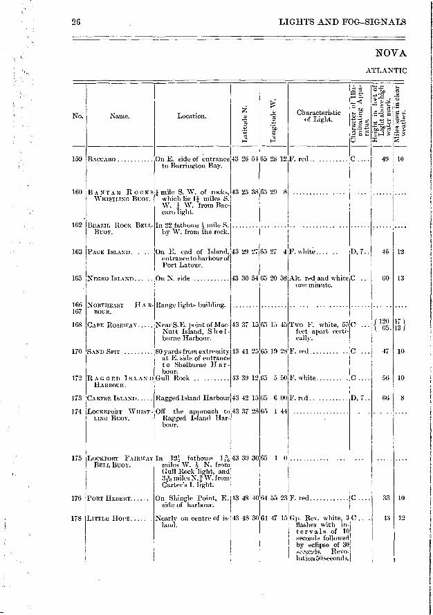
From the buoy Baccaro Light bears 162 N. E. 6 miles ; C. Sable Light N.W. by W., 8 miles.
Visible from all points of approach . 163
165 White,octagonal,wood, with dwelling at-tached.
166 167
Life-boat station at Blanche, between Negro Island and Baccaro Point.
Black and white ver-tical stripes, octag-onal.
White, square, wood, on pier.
77 1788 re-
paired 1858
44 Re-built 1880
Trumpet, established 1884, sounds a blast of 10 sec-onds' duration every two minutes.
White, square, wood..
From the buoy Carter's Island light 174 bears N. bv W. W. miles, Gull Rock : Light N.W. N. miles, and a N.N.W. course lead's about midway between the 4?, fathom patch and the Blow breakei-up to S. end of Cranberry Island.
A N. N. W. course from the buoy 175 leads clear of all dangers up to the southern end of Cranberry
21 miles distant.
White, square, wood, with dwelling at-tached.
White, square, wood, metal lantern, red, on roof of dwelling.
Hand-horn answers signals Visible around horizon from vessels.
1-1
No. Naine.
7-■
ta c. •
5 o ; â g
PORT MOUTON
FORT POINT
BROOKLYN PIER
LIVERPOOL WHIST—LINO BUOY.
184
180
181
182
11
4
N.E. point, Spectacle Island, Queen's Co.
Liverpool Bay, S. en-trance.
On end of substantial part of breakwater, 115feet from shore and 555 feet from outer end of breakwater.
In 20 fathoms in fairway off Liverpool.
S. point, Liverpool Bay COFFIN ISLAND
PORT MEDWAY BELL-BUOY.
MEDWAY HP Al>
PORT MEDWAY
LAHAVE BELL-BUOY.
MOSER ISLAND 191
185
187
183
189
190
Port Med way, W. si de of entrance.
44 6 10
Harbour light building.
WEST IRONBOUND Near Cape Lahave, ISLAND. mouth of Lahave
River.
195
F. red O .
F. red
Rev. white, 30 sc,c-C onds.
64 32 15
64 18 50
64 20 55
64 16 20
64 11 25
64 17 35
28 LIGHTS AND FOG-SIGNALS
NOVA
ATLANTIC
Location.
Lo
ngit
ude
W.
Characteristic of Light.
43 55 5 64 48 5 F: red
44 2 35 64 42 20 F. red
44 2 45 64 41 20 F. green ....
C ....I 30
D• P- 30
44 0 20 64 36 55
44 1 55
193 ILAILIVE
In 22 fins., 3 miles,S. by E. from Moser Island light.
On Island, W. side of 44 14 15 entrance to Lahave River.
44 17 16
44 13 42
44 17 0
64 37 32 Rev. white, 2 min .:C C. Light 30 sec. 1 Dark 90 "
F. white C .
65 16
44 10
55 8
48 8
• 72 13
On Fort Point
196 LUNENBURG WHIST— In 23 fins., 6milesS.E. LINO BUOY. 1 by S. S., from Bat-
: tery Point light.
In 14 fathoms 1/ miles 44 3 15 64 31 25 S.S.W. from breaker off approach to Port.
197 BATTERY POINT Entrance to Lunenburg 44 21 45 Harbour.
F. red C . 1, 50 1
11
IN THE DOMINION OF CANADA.
SCOTIA—Continued.
CO.A.ST—Continued.
99
Fog-Signal. Remarks • No Colour and
any peculiarity of Buildings.
°
4-■ p.
Z) gi
751.4
\VIl
eil
est
ablis
hed.
20 1873
17 1855
25 Build-ing 1878 mast 1889
.. 1883
50
23
1812
1888 ch'ged
1898
1851
White, square, wood, surmounted by red, octag,onal lant um, white dwelling- near by.
White, square, wood, with dwelling at-tached.
White, square, wood..
Iron buoy painted white and black in vertical stripes, surmounted by 10-inch whistle.
Horizontal stripes, red! and white, eight in number, octagonal.
Alternate white and' black vertical stripes, "Port Medway on side.
White, with black squares on seaward sides, square, wood.
,For guiding vessels into harbour. .. Life-boat station on N.W. end of
Port Mouton Esland.
Left on port side when entering the harbour.
A red iron can buoy is moored off outer end of sunken pier, which must be left on starboard hand in entering Herring Cove.
Whistle sounded by actioffiFroin the buoy Coffin Island lig,ht of waves. bears N. E. 11-i; miles, Fort Point
light N. W. N., and Western Head W S. 2 miles. From buoy- a course N. W. N. for 4 miles clears all danger to anchor-age off Brooklyn pier.
From the buov a N. E. course will lead clear of the S. \V. breaker up through the channel to the iron can buoy off Neil Point, Vs miles distant.
188
180
181
182
184
185
187
Like a dwelling house
26
35
29
1886
1868
1876
1855
1891
189
190
24 1864
Red iron buoy sur- mounted by bell.
White, square, wood, lantern on roof of dwelling.
White, square, wood, with dwelling at-tached.
White, square, wood, with dwelling at-tached.
Red and black horizon-tal bands. Iron buoy surmounted by 10 inch whistle.
White, square tower on dwelling.
From the buoy, West Iroffixamd light bears N.N.E., 2À
Eland-horn answers signals from vessels.
193
Near edge of cliff 40 feet high 1 193
Whistle sounded by action From the buoy Cross Island light, 196 of waves. bears N.E. E., 2 miles ; W est
Ironbound light, S.W. by W. W., 4 74 miles ; Rose Point, N.W. .1 W., 11 miles.
Hand horn answers signals 197 from vessels.
Bell sounded by action of waves.
191
LIGHTS AND FOG-SIGNALS
NOVA
ATLANTIC
30
iLl - ...,'..... .,. 5.: ,,_, '... 1> ID ....2 ..- c,
„.. ..... ;..• à E...
No. Name. Location. ..â ..,.., Characteristic If :41 -2
..,Ei :.)....
.f. Ti g ce 'P. e.: — -, › , .,.. 5 I c
4 4 5 li
198 CROSS ISLAND E.point Lunenburg Bay 44 18 45 64 9 57 f Uper light, Occ. C.... 100 14
I BrVitte. 45 sec.
Dark- 15 ” I L of' te ev etr bleohut
35 ,
it. C .... 65 6 I. F. white.
200 HOBSON ISLAND Mahone Bay 44 24 55 64 13 46 F. red D. 5.. 68 8
201 WESTHAVER ISLAND. MallOtle Bay 44 26 15164 20 2 F. white D, 7... 54 12
202 QUAKER ISLAND.... Off Chester 44 30 55 64 13 48 F. red D, 7.. 109 11
204 CHESTER, OR EAST A little to eastward of 44 26 24 64 4 50 F. white C 150 16 IRONBOUND ISLAND centre of Island, in
Mahone Bay.
205 GREEN ISLAND... .. Off St. Margaret and 44 22 57 A 2 45 Alt. Red and white C .... 66 v 13
Mahone Bays. Red.. ...52 sec. ...... ... . R 8 Eclipse...38 " White....52 " Eclipse...38 "
Complete rev.3 min 206 NORTH-EAST SHOAL In 21 fathoms lei,- miles 44 25 54 64 0 2 •
WHISTLING BUOY. E. by N. N. from the middle of N.E. Shoal.
08 HUBBARD COVE On Green Point, W. 44 37 1464 3 10F. red D, 7.. 60 11 side of entrance.
09 CROUCHER ISLAND... In St. Margaret Bay .. 44 38 2463 57 20F. white D, 7.. 90 15
10 PEGGY POINT E. side of entrance to 44 29 30 63 55 0F. red C 65 8 St. Margaret Bay.
11 DOVER. . On the S. end of Calla- 44 29 34 63 51 33F. white .... D, 7.. 50 12 ghan Island.
1
13 BETTY ISLAND.... _ On Brig Point, near 44 26 22 63 45 54 Rev. red, 2 minutes C .... 75 14 Prospect.
I I
14 TERENCE BAY I On Shipley Head, near 44 27 4063 42 10 F. red ID, p. 55 7 I Tenant Point. I i
2
2
2

200
201
202
204
IN THE DOMINION OF CANADA. 31
SCOTIA—Continued.
COAST—Continued.
c T-•
z e 2
Whe
n e
stab
lish
ed.
Colour and any peculiarity of
Buildings.
Red, octagonal base...
Fog-Signal. Remarks. No.
58 1832 Steam-horn sounds 20 sec-,I ) Pilots resort here, and vessels may 198 onds every 1:-Ç minutes. take refuge in case of necessity.
1872 White, square, wood.. 29
White, square, wood. 27 Iron lantern, red, with dwelling attached.
White, square, wood, 35 with dwelling at-tached.
White, oblong, wood, square wooden tower, surmounted by iron lantern rising from roof of dwelling.
White, square, wood, with dwelling at-tached.
Black iron buoy with "N. E. Shoal " in white letters.
White, sqtiare, wood, dwelling attached.
White, square, wood. dwelling attached.
White, square, wood..
White, square, wood, surmounted by . r e d iron lantern. Keep-er's residence at-tached.
White, with two hori-zontal red bands, square, wood, dwel-ling attached.
Mast with white shed at base.
28
46
1882 chan-ged 1895
1883 Hand horn answers signals To guide into Chester Basin from vessels.
1871 Seen from all points of approach ; the lantern alone is visible, build-ing hidden by trees.
1874 205
1895 Whistle sounded by action Fairway buoy to indicate shoal. of the waves. From the buov a N.W. N. course
leads into Mahone Bay and a N.E. by N. N. course leaxls into St. Margaret Bay clear of Horseshoe Ledge.
Lantern on dwelling
Visible from all points seaward. To 211 guide into Dover Harbour. Ves- sels running for it on a N.N.W. course will pass clear to W. of Shag Bay breakers and enter to E. of Fleming Island.
Coast light 213
206
208
209
210
214
42 1886
40 1882
26 1868
31 1892
54 ; 1875
25 1885

1 I .1)
o
z Location. Name. No.
63 30 15
63 30 50
In 20 fathoms N.E. 1-196 miles from Chebucto Head lighthouse.
1431 40 63 30 2
218
219
220
222
3 1 5°1 130 J
32 LIGHTS AND FOG-SIGNALS
NOVA
ATLANTIC
t.•
,_< 47: •-
72: t> .̂ e. • c7;
LI • E :74 et o -
Characteristic of Light.
216 'SA3IB1IO
SISTERS B E L L-BUOY
Middle of Island 144 26 10
In 22 fathoms S.E. by E. mile frotn the Blind Sisters.
63 33 281E. white D, 2. . I 115 16
SAMBRO A r T 0- MATIC WHIST-LINO BUOY.
In 25 fathoms near S. end of Sambro outer bank.
44 21 30
304 CHEBUCTO HEAD Light on summit of head 44 whistle in front of and below light.
Rev, white, o n e minute.
OUTER AUTOM.- In 36 faIIIOLGS TIC WHISTLING entrance. BUOY.
outside;44 28 25 63 22 10
223 15 1 INNER AUTO-tt MATIC WHIST- ,: I LING BUOY. d
224 THRum C A P BELL-BUOY.
225 1 HERRING COVE..
o
227 MEAGHER BEACH
44 33 5763 29 51
Western Head 44 33 57,63 32 58
Sherbrooke tower, E 44 36 0 63 32 5 side of entrance to Halifax Harbour.
F. red ID, p.. 45 8
F. white C . 58 12
132 1 18
GEORGE ISLAND. On W. Sicle of Island in Halifax Harbour.
44 38 30 6.3 33 25 Two F. white, 2010 .... feet apart verti-, Cally. Both show; seaward on S. ;1 into Harbour on N. side. On W. side upper light, only visible.
CHEBUCTO HEAD See No. 220 above.
228
IN THE DOMINION OF CANADA.
COTIA—Continued.
COAST— Continucd.
33 •
-6. 8 le F.
Colour and any peculiarity of --• F. 0 +.> Fog-Signal. Remarks. No.
Buildings. ...>:-c a>
'5 .0 --. s6.1 ,...:.
White, octagonal, wood 60 1758 Cotton powder signals ex- Fog-signal derrick is erected on the 216 ploded every 20 minutes. seaward side of the lighthouse.
Black iron buoy sur- 1874 Bell rung by the action of 218 mounted by a bell, the waves.
Black and white verti- 1890 Whistle sounded by action From this buoy Pennant Pointbears 219
cal stripes, iron buoy, of waves. N.W. by N. i N., 71 miles ; Sam-
surmounted by a 10- bro light N. :; W., ''.4 miles ; Che- inch whistle. bucto light, N. by E. i E., 88
miles.
White, square, wood, 22 1872 Whistle 73 ft. above water, 220
with dwelling attach- Fog- gives blasts of 10 seconds ed. Fog-whistle alarm with intervals of 50 sec- building red brick 1891 onds. with slate roof.
Black iron buoy, sur- 1878 Whistle sounded by action From this buoy Sambro Island light 222
mounted by a 10-inch of waves. bears W. / N. 81 mile.. Devil's f whistle. Island N. W. 7, miles, and inner
signal buoy N. W. N. 6 miles. •
Red iron buoy, sur- 1877 Whistle sounded by action From the buoy Sandwich Point 223
mounted by a 10-inch of waves. bears N. i- W., 31- miles. Devil whistle. Island West lighthouse N.E. ï E.,
3 miles, 51 cables, and a N. course Red iron buoy, sur- 1893 Bell rung by the action of will lead to the westward of the 224
mounted by a bell, the waves. 32-foot patch, and to the eastward of the Neverfail, clear of every danger up to Point Pleasant buoy.
White, square, wood.. 22 1886 Lifeboat station in the cove 223 chan- ged 1891
White, with red roof, 48 1815 Steam-horn sounds blasts of Horn conies out of seaward face of 227 circular, granite. horn 5 seconds at intervals of tower.
1889 25 seconds. When Sambro light bears W.S.W., this light should not be brought to the westward of north, which clears the Thrumcap Shoal. Pass-ing Meagher Beach entering har-bour keep the light on starboard bow.
Drab, square wood, 21 1876 Bell strikes 7 times a mm- These lights open to \vestward of 22E
fog-bell on W. side. ute at equal intervals. Meagher Beach, clear the west- ward of Thrumcap Shoal.
These lights are obscured to the E. by highland of George I. Upper light should be visible 12 miles, but the two lights are not dis-tinctly visible until nearing the entrance to the harbour. The lights which are vertical and com-paratively near the sea level must not be confounded with two lights of inferior power exhibited from a yard on Citadel hill flag-staff, about 240 feet above the sea.
3
230
231
234
235
Name.
DEVIL ISLAND...
JEDDORE ROCK
EGG ISLAND
Location.
r On S. point of island.
I 175 yards W. î S. from higher light.
On summit of rock about 22 miles east of Halifax.
Centre of island.
In 24 fathoms S. by W. 1 W 54- miles from lighthouse.
Entrance to Sheet Har-bour.
In dormer window of James Wambold's house.
S. E. part of East Beaver
POPES HARBOUR ....
SPRY BAY BELL Buoy
SHEET HARBOUR WHISTLING BT:OY.
239
241
242
243 SHEET ROCK
SHEET HARBOUR PAS-SAGE.
246 BEAVER ISLAND
BEAVER HARBOUR...
LISCO31BE '
WEDGE ISLAND... ..
244
247
249
250
44 35 2062, 49
44 44 54 62 45 4 F. white
On W. point of Harbour 44 47 40 62 38 50 Island.
F. red
62 33 20 45 40
44 51 30 62 26 33 F. red
20 10 Rev. white, 45 sec-onds.
44 49 3-1162
On E. end of Beaver 44 Point.
52 23,62 23 40 F. red
57 55 Alt. red and white 2 minutes
Mouth St. Mary River. 45 0 35161 52 23 Rev. red, 3minutes. Shows 1 minute, eclipsed 2 min-utes.
44 59 2061, On island
15 87
9 45
10 75
42 ' 5
70 12
40 6
64 13
81 12
52
86
SO
12
12
15
D, 7..
o
D, p..
34 LIGHTS AND FOG-SIGNALS
NOVA SCO
ATLANTIC
No.
›... ..-- a
a
...5 .-. to ...Pe e 4 ; r—I
44 31 50,63 27 15
c: C
4
o e-e e 4 a
1,, 8 F.,
59 I 13
236 EGG ISLAND AUTO- In 37 fathoms S. 5 miles MATIC WHISTLING from Egg Island Bcov. lig,hthouse.
238 WOLF POINT N. E. point of 'Nichol Island, W. side en- trance to Ship Harb'r
In 15 fathoms off en- 44 trance.
Characteristic of Light.
F. white
F. white.... ....
44 39 4563 0 22 F. red
44 39 49 62 51 30 Gp. Rev. white, 30 flashes, 15 seconds, apart, then an eclipse of 30 sec-onds, revolution in 1 minute.
44 44 30 62 28 37
44 49 55 62 29 23 Rev. red, 40 sec- C onds.
C
No.
53
45
50
1877
1852
1881
230
231
234
235
Bell rung by action of the waves.
Whistle sounded by action of waves.
White, square, wood, with dwelling attach-ed. Iron lantern red.
White, square, wood, dwelling attached.
Red iron buoy with "Spry Bay" in white letters on the deck.
Red and black vertical striped iron buoy.
White, square, wood, with dwelling at-tached.
238
239
241
242
243
!
244
246
24
219
250
45 ! 1865
1893
1895
1877
1893
1885
1879
1837
1846
1887
1872
1879
35
37
41
20
35
25
28
44
IN THE DOMINION OF CANADA.
TIA—Continued.
COAST—Continued.
35
•-•`: e tG e 0
fo- 5 •E'.4 -a
Remarks. Colour and
any peculiarity of Buildings.
White, oetagonal, wood
White, octagonal, wood
White, square, wood, dwelling attached.
Pilots are stationed here. The east-ern light, open to southward of western light, clears to southward of Thrumcap Shoal.
Life-boat station at N.W. end of
Wh
en e
sta
blis
hed.
Fog-Signal.
Black and white verti-cal stripes on sea-ward side, octagonal wood.
Red iron buoy, sur-mounted by a 10-inch whistle.
Hand-horn answers signals frein vessels.
Visible around horizon
Whistle sounded by action.From the buoy, Jeddore lighthouse 236 of waves. • bears N.W. N., 9.i tulles.
The buoy is a leading or fairway buoy, for vess( Is seeking the entrance to Halifax Harbour.
Fairway bu y. Frcm the buoy Tay-lor Hd. Lsars N. E. N. distant lee miles, and Maloney Rock
ï W. distant 2 miles.
Light seen from N. W. W. round through N. to N. E. by E. E.
Rock lies nearly in mid channel of harbour entrance, its western end partly awash, distant 350 yards from lighthouse.
White, square, wooden d welling.
White, with two black balls to seaward, S. S. W.
Limtern on mast, with white shed at base.
White, square, wood..
White, square, wood, with dwelling a t - tached.
Hand-horn answers signals from vessels.
Visible fmm seaward between N. and N. by E. E.
On dwelling
3i
LIGHTS AND FOG-SIGNALS 36
NOVA SCO
ATLANTIC COAST AND
•.'":.' e.. ... '_E 1.3.
..-- , ..... > ,.. - tr, Characteristic 4 e d .t. = 4 No. Name. Location. -?. c).... - of Light. .e, -.à d, ,
5 ,.',..c - c.)
.- -5-.1. LI. . ....i fc.-..i.; . d ...› ct a 4":, 5
251 ISAAC HARBOUR 1n25 fathoms n miles 45 2 20 61 32 37 WHISTLING BUOY. S.W. by S. î S. from
Country Harbour light.
253 ISAAC HARBOUR..... On W. side of harbour, 45 10 061 39 12 Two F. white, 20 C 80 9 about mile S. from feet apart verti- Holly l'oint. cally.
254 COUNTRY HARBOUR.. On Green Island, Guys- 45 6 861 32 30 F. white C 51 12 bore' County.
256 TORBAY On eastern point of 45 11 37 61 18 35 F. red and white.. C ... 51 10 Berry Head, W. side of entranee to Bay, Guysboro' County.
257 North side of entrance 45 15 45 61 17 0 F. red D, 7.. 40 8 to harbour, 65 feet
COLE HARBOUR.... - from water's edge.
258 t 650 feet N. 33' E. from F. red C 107 10
front light.
260 THREE TOP ISLAND.. S.E. point of island, en- 45 12 40 61 9 40 F. white 0.... 48 11 trance to Whitehaven.
261 WHITERF.AD ISLAND. S.W. extremity of is- 45 12 0 61 8 15 Rev. white, 20 sec- C .... 5.5 11 land, Guysboro' onds, 10 seconds County. flash, 10 seconds
eclipse.
262 CAPEBREAKER, BELL In 14 fathoms, 4 cables 45 18 20 60 54 0 .... BUOY. E.S.E from middle of
shoal.
263 CRANBERRY ISLAND.. N. part of island, off 45 19 45 60 55 25 (Main light, F. D. 3.. 89 15 Cape Canso. I white.
-1 Lower light, F D. 7.. 54 12 I white, 35 feet 1 below main. (..
264 GRIMESHOALWHIST - In 20 fathoms, 1i miles, 45 21 13 60 50 45 .... LING Buor. E.S.E. of shoal.
• . . ....
Coast light and to guide vessels fre-quenting Country and Fisher-man's Harbours.
Shows red to seaward white to north-ward into bay and towards Molasses Harbour.
251
253
254
256
White, square, wood, with dwelling, a t - tached.
White, square, wood, dwelling attachd.
White, with vertical red stripes, wood. Top of lantern black.
White, square, wood ..
White, square, wood..
White, square, wood, with dwelling a t - tached.
White, pyrain d al, wood, octagonal lan-tern.
Black iron buoy, with "C. Breaker" in white letters on the deck. Surmounted by a bell.
After passing Berry Head, the 257 lights in one lead into Cole Har-bour to the westward and clear of Topsham ledge and Seal Rocks. I 258
To guide vessels into Whitehaven. To point out dangers on N. side of W. passage ; light is obstructed when bearing to eastward of N.E. by E., visible from all other points, except when intercepted by high land of Whitehead Island.
Life-boat station on Deming Point, western entrance to *Whitehead.
To act as a fairway buoy for ves-sels making Canso Harbour from southward.
Front the buoy a N. W. by N. N. course will lead up to, and about •?5 a cable to eastward of, Man of War Rock, distant g
"Upper light visible all round, lower one does not show to vessels pass-ing between it and coast.
264
260
261
262
263 Steam-horn sounds a bla.st of 8 secs, in each minute.
78
20 1874
28 1873
36 1876
33 1898
33 1898
32 1879
35 I 18,54
1894
1815 re-
built 1883 Fog
alarm 1864
1880
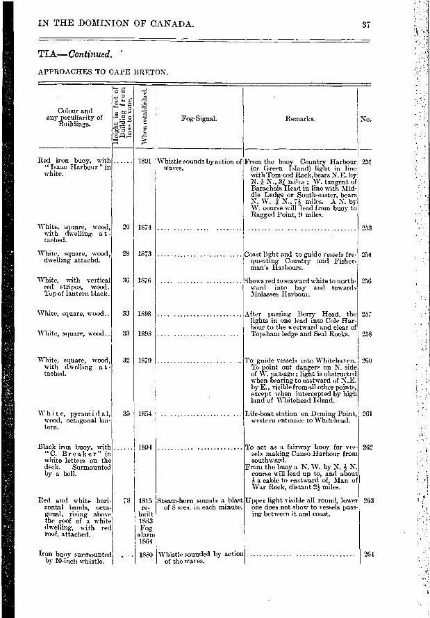
IN THE DOMINION OF CANADA.
TLA—Continued.
APPROACHES TO CAPE BRETON.
37
e.;
o
"E7
Colour and any peculiarity of
Buildings.
e. •1: Fog-Signal. Remarks.
Red iron buoy, with "Isaac Harbour " in white.
1891 Whistle sounds by action of waves.
From the buoy Country Harbour (or Green Island) light in line with Tom-cod Rock,bears N.E. by N. î N., 31 miles ; W. tangent of Barachois Head in line with Mid-dle Ledge or South-easter, bears N. W. e N.. 7:} miles. A N. 133,- W. course will -lead from buoy to Ragged Point, 9 miles.
Iron buoy surmounted by 10-inch whistle.
Whistle sounded by action of the waves.
Red and white hori-zontal bands, octa-gonal, rising above the roof• of a white dwelling, with red roof, attached.
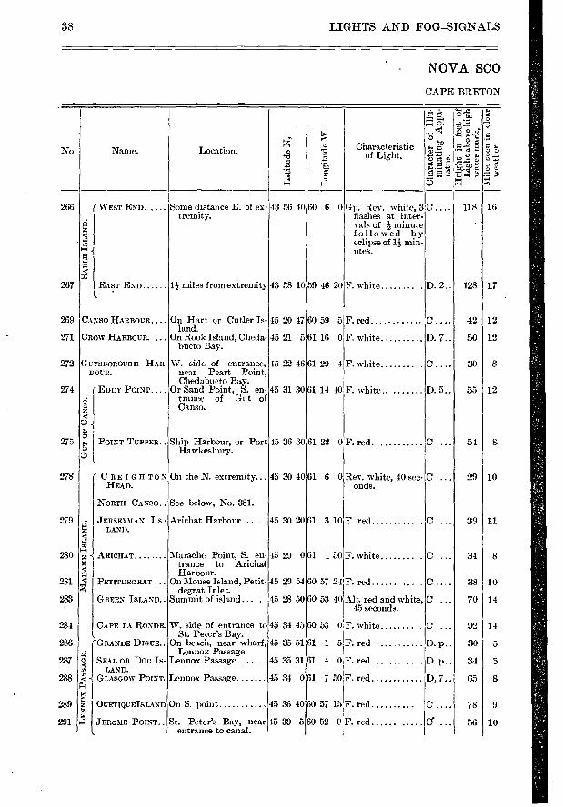
LIGHTS AND FOG—SIGNALS
NOVA SCO
CAPE BRETON
—
-
-Z
No. Name. Location. v m Characteristic
e ..'-' of Light. -.;;*-.-- ,01: -.-, g-• e, ....È
...> EI e .g e'f,"'Éce el —
a a c...)
266 (WEST END. .... SoMe distance E. of ex- 43 56 40 60 6 0 Gp. Rev. white, 3 C .... 118 la tremity. flashes at inter-
vals of i- minute z c followed by a eclipse of 14 min- e.
1-4 .1 utes. N ' a c
267 EAST END II- miles from extremity 43 58 10 59 46 20F. white D. 2.. 128 17 l '
269 CANSO HARBOUR.... On Hart or Cutler Is- 45 20 47 60 59 5 F. red C.... 42 12 land.
271 CI:tow Ilimourc. ... On Rook Island, Cheda- 45 21 5 61 16 0 F. white D. 7.. 50 12 bucto Bay.
272 GUYSBOROUGH HAR- W. side of entrance, 45 22 46 61 29 4 F. white c . 30 8 BOUR. near Peart Point,
Chedabucto Bay. 274 (EDDY POINT.... Or Sand Point, S. en-45 31 30 61 14 40 F. white.. D. 5.. 55 12
É 1 trance of Gut of
z Canso.
..à. ■
275 5' I POINT TUPPER.. Ship Harbour, or Port 45 36 30 61 22 0 F. red c . 54 S F Hawkesbury. r.. t.
278 ( ORE 1 D it TON On the N. extremity... 45 30 40 61 6 0 Rev. white, 40 sec- C .... 29 10 HEAD. onds.
NORTH CANSO.. See below, No. 381.
279 ...; JERSEYMAN I S - ,Irichat Flarbour 45 30 20 61 3 10 F. red C.... 39 11 r.Z LAND. rC a u2 s-r
280 .-• j ARICHAT . . Marache Point, S. en-45 29 061 1 50 F. white c . 34 8
-1 trance to Arichat a Harbour.
281 ‹ PETITDEG RAT . . . On Mouse Island, Petit- 45 29 54 60 57 24 F. red c . 38 10 degrat Inlet.
283 GREEN ISLAND.. Simi-Mt of island... . 45 28 50 60 53 40 Alt. red and white, C .... 70 14 45 seconds.
, 284 CAPE LA RONDE. W. side of entrance to 45 34 45 60 53 0F. white c . 92 14
I. St. Peter's Bay. 286 'GRANDE DIGUE.. On beach, near wharf, 45 35 51 61 1 5F. red .... D. p.. 30 5
„. Lennox Passage. 287 5 bEAL OR DOG IS- Lennox Passage 45 35 31 61 4 0F. red .. ... .... D. p.. 34 5
ri3 LAND. r 288 !'‹ j GLASGOW POINT. Lennox Passage 45 34 061 7 50 F. red D, 7.. 65 8
g4 x
., a „ 2811 VUETIQUEISLAND On S. point 45 36 40 60 57 15 F. red C .... 78 9
i4 1 4 JEROME POINT.. St. Peter's Bay, near 45 39 560 52 0 ' F. red C. . 56 10
entrance to canal.
38
is
9
1
1
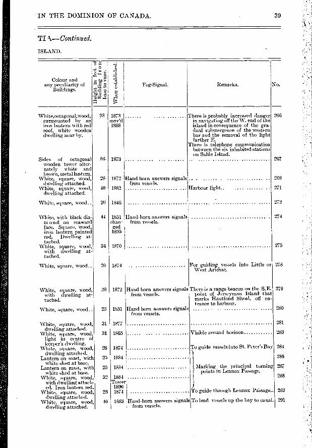
IN THE DOMINION OF CANADA.
TI k—Continued.
ISLAND.
G> Z; ... °
c., ..... .r.■
... %...3 ..,
Colour and -... to > e any peculiarity of -•.e.. Fog-Signal. Remarks. No.
Buildings.,.«., ...., .
-' -
74 7---
White,octagonal,wood, 98 1873 There is probably increased danger 266 surmounted by an mov'd in navigating off the W. end of the
iron lantern with red 1888 island in consequence of the gr-
roof, white wooden dual submergence of the western dwelling near by. bar and the removal of the light
farther E. There is telephone communication
between the six inhabited stations on Sable Island.
Sides of octagonal 86 1873 267 wooden tower alter nately white and brown, metal lantern.
White, square, wood, 28 1872 Hand horn answers signals 269 dwelling attached , from vessels.
White, square, wood, 40 1882 Harbour light.. .... .. ..... .. 271 dwelling attached.
White, square, wood .. 20 1846 272.
White, with black dia- 44 1851 Hand-horn answers signals 274 mon d on seaward chan- from vessels. face. Square, wood, ged
iron lantern painted 1895 red. Dwelling at- tached.
White'
square, wood, 34 1870 271 with dwelling at- tached.
White, square, wood.. 20 1874 For guiding vessels into Little or 271 West Arichat.
White, square, wood, 28 1872 Hand horn answers signals There is a range beacon on the S.E. 271 with cfwelling - at- from vessels , point of Jerseyman Island that
tached. marks IIautfond Shoal, off en trance to harbour.
White, square, wood.. 25 1851 Hand horn answers signals 28 from vessels.
White, square, wood 31 1877 28 dwelling attached.
White, square, wood 31 1865 Visible around horizon 28 light in centre o keeper's dwelling.
White, square, wood, 28 1874 To guide vessels into St. Peter's Bay 5 dwelling attached. -1
Lantern on mast, with 25 1884 28 white shed at base. I
Lantern on mut, with 25 1884 L Marking the principal turning 5 white shed at base. 1 points in Lennox Passage.
White, square, wood, 32 1884
J
'28
with dwelling attach- Tower•
ed. Iron lantern red. 1896
White, square, wood, 28 1874 To guide through Lennox Pdssage.. 2 1 dwelling attached.
White, square, wood, 40 1883 Hand-horn answers signals To lead vessels up the h-%y to canal. ̀,M dwelling attached , from vessels.
39
4
LIGHTS A... - .e'OG-SIG NALS
NOVA SCO
CAPE BRETON
c., Characteristic : .tc, :-... 2 `e: 7:: • No. Name. Location. m 'P.,
Z
.. = e -._ , • , • e ..e 0
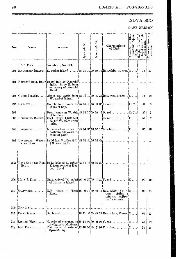
EDDY POINT See above, No. 274.
293 Sr. ESPRIT ISLAND E. end of Island 45 36 30 60 29 10 Rev.white, 30 secs. C . .. 78 14
294 FOURCHE BELL Buoy In 101-- fms. off Fourché Inlet. S. by E. from extremity of Fourche Head.
295 GUION ISLAND About 230 yards from 45 46 10 60 6 30 Rev. red, 30 secs.. C .... 74 19 W. end of Island.
297 GABARUS On Harbour Point, S. 45 50 40 60 8 30 F. red D. 7.. 47 8 shore of bay.
299 r Front range on W. side 45 54 15 59 59 6 F. red D. 7.. 26 7 I of harbour•
300 LOUISBURG RANGE -{ Back range 1,330 feet F. red c 54 7 I N. 67° W. frOm front L light.
301 LOUISBURG. ...... .. N. side of entrance to 45 54 35 59 57 15!F. white.... C .. 85 16 harbour, 120 yaids in. shore of point.
302 LOUISBURG WHIST- In 36 fms. 3 miles S.E. 45 52 43 59 53 44 LING BUOY. S. from light.
303 LOUISBURG BELL In 13 fathoms li cables 45 54 13 59 56 30 BUOY. E. from centre of Har-
bour Shoal.
306 MAIN-À-Diru. . ... On S. side of W. point 46 0 30 59 47 30 F. red C.... 90 10 of Scattarie Island.
307 SCATTARIE ...... ... N.E. point of Trap 46 2 15 59 40 15 Rev. white 1?-2 rnM- C .... 90 15 Rock. lites; visible a
minute, eclipse half a minute.
310 Cow BAY ... .
311 FLINT HEAD On Island 46 11 059 45 55 Rev. white, 15 secs. C .... 65 12
312 LINGAN ÙEAD N. side of entrance to 46 14 10 60 2 10 F. red c 50 10 Bridgeport Harbour.
314 LOW «POINT Flat point E. side of 46 16 2060 7 16 F. white.... .... C .... 70 14 Spanish Bay.
40
Fog-Signal.
Whe
n es
tabl
islie
d.
294
295
297
299
300
301
Whistle sounded by action of waves.
Bell rung by action of the waves.
302
303
306
307
1
310
311
Vessels entering Louisburg can make the whistling buoy and then steer N. W. by N. 4 N. for the light on lighthouse point. This will bring them to the bell buov, which they should round lem:ing it on the port hand.
Fairway buoy. Light bears N.W. by N. N. 5 mile. Leaving buoy
cable on port hand a N.W. by W. Course leads in one cable south of .Nag Rock.
The light should never be brought to bear t,o eastward of N.N.E., or to southward of S. S. W., nor ap-proached nearer than 1 miles. Life-boat station.
Light discontinued
White,with a black ver-tical stripe, on each side of wooden dwell-ng, iron lantern on roof
Red iron buoy, sur- mounted by 10-inch whistle.
Black iron buoy with " Louisburg" in white letters on deck. •
White, square, wood, dwelling attached.
White,octagonal, wood, roof of iron lantern red. White wooden dwelling with brown I roof, W. of tower.
28 1897
28 1897
35 1842
1881
1895
40 1871
70 1839
IN THE DOMINION OF CANADA.
TIA—Continued.
ISLAND—Continued.
41
- .
>
el)*
Remarks. No. Colour and
any peculiarity of Buildings.
White, with two ree bands, square, wood,I with d welling at-' tached.
Red iron buoy- sur- mounted by bell.
White, square, with' 54 1877 d welling attached.
White, hexagonal, 32 1890 wood, iron lantern red.
White, square, wood..
White, square, wood ..
Bad l'.■reighbour Shoal, S. W. î W. 14 293 miles from this light, with noi more than 12 feet water.
For benefit of fishermen
Visible from all points of approach.
The two lights in one lead into the S.W. arm clear of all dangers.
55 1880
White, octagonal, wood dwelling near by.
White, square, wood..
Vertical red and white stripes, octagonal, wood.
43 I 1856
20 1874
51 I 1832
Visible around horizon
312
Marine telegraph and signal station 314
Whistle sounds two blasts of 5 seconds with an in-terval of 10 seconds, in every minute.
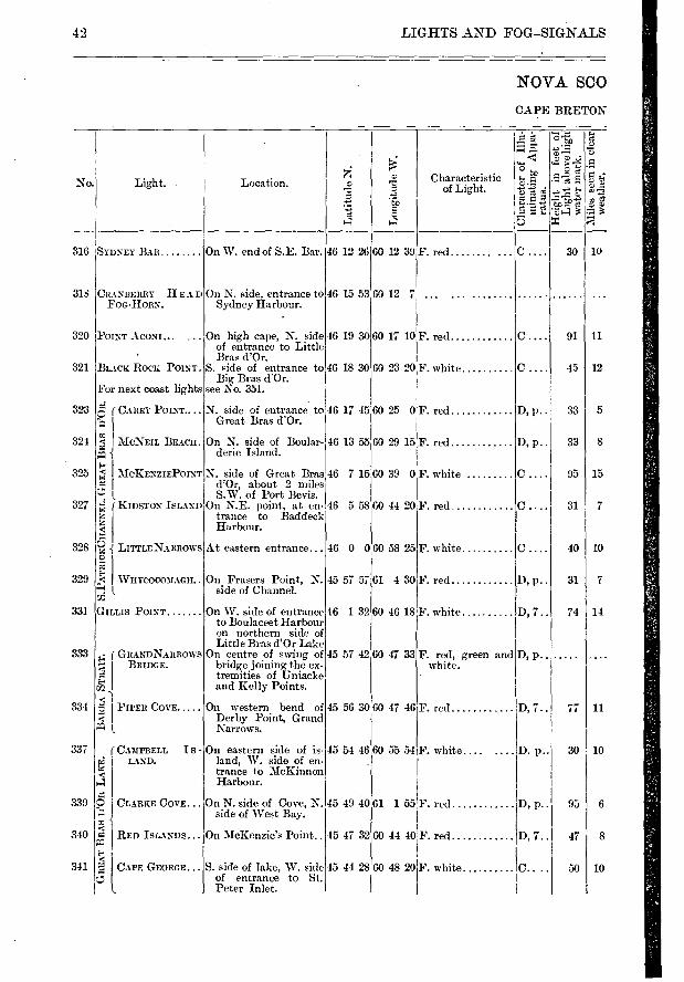
60 12 39 F. red
60 12 7
60 17 10F. red..
60 23 20 F. white
60 25 0F. red..
60 29 15F. red..
60 39 0 F. white
60 44 20 F. red
60 58 25 F. white
61 4 30iF. red
F. white . .....
F. red, green and white.
F. red
F. ....
46 12 26
46 15 53
46 19 30
46 18 30
46 0 0
45 57 57
46 1 32i60 46 18
45 57 42 60 47 33
45 56 30 60 47 46
45 51 46 60 55 54
o o
G .
'1),A e
A
10 30
• e
o
t
- B.
-2 ....
'al 4 3
SYDNEY BAR
CRANBERRY HEAD FOG-HORN.
POINT ACONI...
BLACK ROCK POINT.
For next coast lights
É (CAREY POINT....
„ „
AMIN EIL BEACH.
MCKENZIEPOINT
L
KIDSTON ISLAND
6 r JAITTLENARROWS
• WHYCOCO3IAGH..
Goums POINT
• ( GILANDNARROWS !:.1. BRIDGE.
rJ C I
PIPER COVE
(CAMPBELL • i LAND.
C • I • I
I s -
316
318
320
321
323
324
325
327
328
329
331
333
334
337
C CAPE GEORGE...
I.
42 LIGHTS AND FOG-SIGNALS
NOVA SCO
CAPE BRETON
Characteristic of Light. No. Light. Location.
Lat
itu
de N
.
Lon
git
ude
W.
339
340
341
On W. end of S.E. Bar.
On N. side, entrance to Sydney Harbour.
On high cape, N. side of entrance to Little Bras d'Or.
S. side of entrance to Big Bras d'Or.
see No. 351.
On N. side of Boular-derie Island.
At eastern entrance...
On Frasers Point, N. side of Channel.
On W. side of entrance to Boulaceet Harbour on northern side of Little Bras d'Or Lake
On centre of swing of bridge joining the ex-tremities of Uniacke and Kelly Points.
On western bend of Derby Point, Grand Narrows.
On eastern side of is-land, W. side of en-trance to McKinnon FIarbour.
S. side of lake, W. side of entrance to St. Peter Inlet.
45 49 40 61 1 55 F. red
45 47 32 60 44 40F. red
45 44 2860 48 20
C.... 91 11
0.... 45 12
D, p.. 33 5
D, p.. 33 8
C.... 95 15
C.... 31 7
40 10
D, p.. 31 7
D, 7.. 74 14
D, p.
D, 7.. 77 11
D. p.. 30 10
D, p.. 95 6
D, 7.. 47 8
C.... 50 10 F. white
CLARKE COVE... On N. side of Cove, N. side of West Bay.
I RED ISLANDS... On McKenzie's Point..
N. side of entrance to 46 17 45 Great Bras d'Or.
N. side of Great Bras 46 7 15 d'Or, about 2 miles S.W. of Port Bevis.
On N.E. point, at en- 46 5 58 trance to Baddeck Harbour.
16 13 55
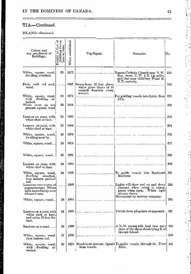
IN THE DOMINION OF CANADA.
TLA—Continued.
ISLAND—Continued.
43
.., -t> ° c.; .-;::
Colour and any peculiarity of • .- 2 ?. Fog-Signal. Remarks. No. Buildings. ...,
.... ›
White, square, wood, 20 1872 Roman Catholic Church near N.W. 316 dwelling attached. Bar, bears N. W. 1 N. 1/.1- miles,
and that near Gillivray Peint E. N.E. easterly.
Drab, with red roof, 1887 Steam-horn 52 feet above 318 wood , water gives blasts of 10
seconds duration every minute. .
White, square, wood, 20 1874 For guiding vessels into Little Bras 320 with dwelling at- d'Or. tached.
White cross on red 23 1868 321 ground, square, wood
Lantern on mast, with 25 1886 323 white shed at base.
Lantern on mast, with 25 1884 324 white shed at base.
White, square, wood, 30 1874 322 dwelling near by.
White, square, wood... 33 1875 327
.
White, square, wood.. 35 1881 32:. _
Lantern on mast, with 25 1884 32'... white shed at base.
White, square, wood 38 1895 To guide vessels into Boulaceet 331 d welling attached, Harbour. iron lantern painted red. '
Lanterns over centre of 1889 Lights will show red up and down 33:
superstructure. White channel when swing is closed,
light immediately over green when open. I.Vhitè light coloured ones , always shows.
Maintained by railway company. White, square, wood. 38 1884 33.
Lantern on a mast with 24 1889 Visible from all points of approach. 33' white shed at base and cabin 30 feet dis -
tant.
Lantern on a mast .... 20 1890 .1 N.W. course will lead into cove 33 dear of the three shoals lying S. of George Island.
'White, square, wood. 37 1895 34 Iron lantern red.
White, square, wood, 20 1875 Hand-horn answers signals To guide vessels through St. Peter 34 with dwelling at- from vessels. Inlet. tached.
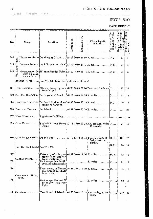
44 LIGHTS AND FOG—SIGNALS
NOVA SCO
CAPE BRETON
.-Ei r c
0 ,.. ̀•-• › ,... .- No. Name. Location. a) -0 Characteristic
' tn.' of Light. -■-, -. „e „ ,.. 0 5
= c ., -. 1 AQ■Dc .:_ti q - - ,-, .,', 4
4 5-
344 (FREESTONEISLET On Gregory Island.... 45 42 5060 47 50 F. red E-1 D, 7.. 30 7 pzi 1
345 —4 BEAVER ISLAND. On S.E. point of island 45 40 40 60 49 47F. red D, p.. 30 5 _
I 346 z-i I GOOSEBER1ILLS: W. from Sandys Point. 45 40 7 60 51 1F. red D, p.. 31 5
l. JOB- IES ISLE.
JERO3fE POIkT See No. 291 above for lights south of canal.
351 BIRD ISLAND Ciboux Island, l.1 mile 46 23 1060 22 30 Rev. red, 1 minute C ... 77 14 from N. end.
352 ST. ANN HARBOUR. On S. point of beach .. 46 17 45 60 32 25F. white C.... 41 8
354 INcomsn HARBOUR. On beach S. side of en-46 38 10 60 23 13 F. red D, 7.. 45 8 trance to harbour.
355 INcoNisn ISLAND... On island 46 41 2060 20 10F. white c. 237 20
357 NEIL HARBOUR Lighthouse building. . '
359 CAPE NORTH i mile S.E. from Money 47 1 45 60 23 15 Alt. red and white C.... 74 15 Point. 45 seconds.
360 CAPE ST. LewilEmE. On the Cape... ...... 47 2 55 60 35 10 Two F. white, 42 ( D, 3.. 137 17 feet apart ver- f tically.
1 D, 7 .. 95 15 For St. Paul Island See No. 652.
362 r Extremity of point, en- 46 39 20 60 59 50 F. white D, p.. 52 8 I trance to Eastern har-
CAVEAU POINT... . i bour, Cheticamp. 363 Is BaeokEraiirgoen,i ir40 0nfteleigt. : F. w hite C . 97 8
364 ( Front range, in Eastern 46 38 15 61 0 25 F. red c 45 8 ' Harbour, 60 feet back I from water.
FIETICA3IP 11A11- . ROUE.
365 1 Back range, 990 feet S. F. white. C . 62 13 . by W. W.f rom front 1. light.
366 FIETICAMP Near S. end of Island.. 46 36 20 61 3 10 Rev. white, 45 sec- C .... 149 18 onds.
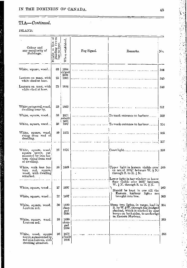
Colour and any peculiarity of
Buildings.
White, square, wood ..
Lantern on mast, with white shed at base.
Lantern on mast, with white shed at base.
White,octagonal,wood, dwelling near by.
White, square, wood..
White, square, wood..
White, square, wood, rising from roof of dwelling.
White, square, wood, square tower, sur-mounted by iron lan-tern rising from roof of dwelling.
White, with iron lan-tern red, square, wood, with dwelling attached.
White, square, wood ..
White, square, wood ..
White, square, wood. Lantern red.
White, square, wood . Lantern red.
White, wood, squar tower, surmounted b red iron lantern, wit dwelling attached.
Remarl,s. No.
t in lantern visible over 1911' between W. N.
3. to E. N.
; in bay window on lower ble over 185e,' between through S. t,o E. N.
362
363
364
365
366
344
345
346
351
rance to harbour
rance to harbour
352
354
3.55
357
359
360
)e kept in one till the harbour lights are
t into line.
lights, in range, lead in î W. through the dredged which is marked by spar both sides, to anchorage
ir Harbour.
IN THE DOMINION OF CANADA. 45
TIA—Continued.
ISLAND.
.. c.' 9.
,§ • .... 3
• - .E 2 e Fog-Signal. ..--• -
F,
..,
33 1884 ch'ged
1898 25 1884
2511884
33 1863 .
38 1871 To mark en rebuil
14,381 38 1887 .. . ........... ... „ To mark en
40 1871
26 1876 Coast light.
56 1889 .. Upper ligh an arc of
- through 5.
Lower lighl floor visi W. i N.
27 1897 Should 1
Easter] 27 1897 brough
30 1890 These two chan- S. by W. ged channel, 1894 buoys on
in Easter 38 1890
chan- ged 1894
36 1872 .. ... r'built 1896
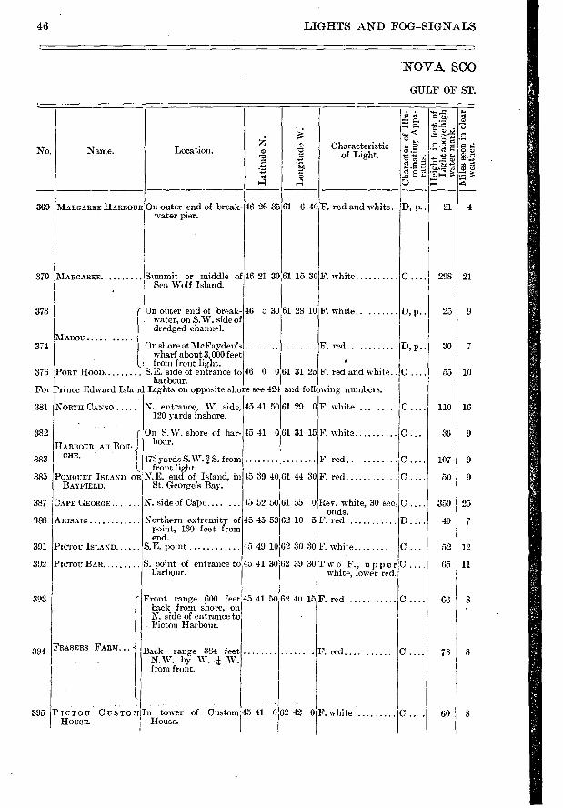
369
370
373
374
46 5 30 61 28 10
0.
D, p..
D,p..
D.
c c
298 21
25 9
30 1 7
55 1 10
110 1 16
36 1 9
107 9
50 1 9
350 25
40 I 7
52 I 12
65 1 11
66 8
8 78
8 60
NORTH CANSO
HARBOUR AU Bou-CHE. I
POMQUET ISLAND OR HAYFIELD.
APE GEORGE
ARISAIG
PICTOU ISLAND
PICTOU BAR. .
FRASERS FARM...
381
382
383
385
387
388
391
392
393
391
N. entrance, W. side, 120 yards inshore.
On S.W. shore of har-bour.
PICTOU CusTom In tower of Custom HOUSE. House.
395
F. white
F. red
F. red
Rev. white, 30 sec onds.
F. red
F. white
Two F., upper white, lower red.
473 yards S. W.1 S. from front light.
N.E. end of Island, in St. George's Bay.
45 39 40
Northern extremity of 45 45 53 point, 130 feet from end.
S.E. point 45 49 10
S. point of entrance to 45 41 30 harbour.
61 44 30
61 55 0
62 10 5
62 30 30
62 39 30
45 52 50 N. side of Cape
Front range 600 feet 45 41 50 62 40 15 F. red back from shore, on N. side of entrance to Pictou Harbour.
Back range 384 feet N.W. by W. • W. from front.
F. red ..........
46 LIGHTS AND FOG—SIGNALS
NOVA SCO
GULF OF ST.
No. Name. Location.
Lat
itude
N.
■=1 0. e-É e
e
ci
. ■ •
"E r4
Characteristic of Light.
MARGAREE HARBOUR On outer end of break- water pier.
Summit or middle of 46 21 30 61 15 30 Sea Wolf Island.
46 26 35 61 6 40 F. red and white.. D, p.. 21 4
On outer end of break-water, on S. W. side of dredged channel.
MABOU On shore at Mc Fayden's
I wharf about 3,000 feet from front light.
376 PORT HOOD S.E. side of entrance to harbour.
For Prince Edward Island Lights on opposite sho
MARGAREE F. white
F. white
F. red
46 0 0 61 31 25 F. red and white..
e see 424 and following numbers.
45 41 50 61 29 0 F. white.... ....
45 41 0:61 31 15
. . 45 41 0 62 42 0 F. white
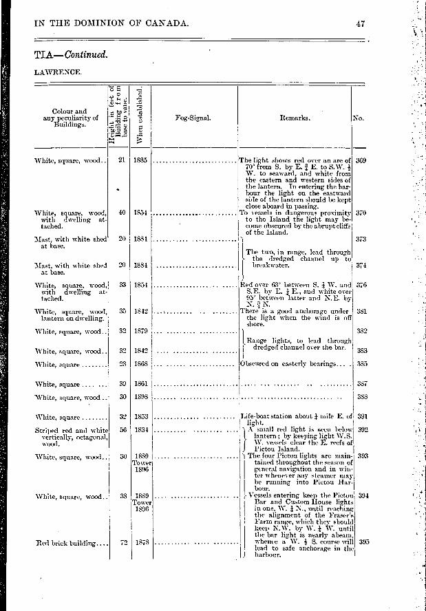
369
370
373
1835
1854
1884
1881
White, square, wood..
White, square, wood, with dwelling at-tached.
Mast, with white shed at base.
Mast, with white shed at base.
376
381
382
383
385
387
388
White, square
Striped red and white vertically, octagonal, wood.
White, square, wood..
'White, square, wood..
Red brick building....
21
40
20
20
33
35
30
32
32
23
39
30
32
56
38
72
1868
1861
1898
1853
1834
1889 ............... Tower 1896
1889 Tower 1896
18,78
IN THE DOMINION OF CANADA. 47
TIA—Con tinued.
LAWRENCE.
Remarks. No. Colour and
any peculiarity of Buildings.
Fog-Signal.
■•• 13
1.1 t.0
0
:1
.■>'" Wh
en e
sta
blis
hed
.
The light shows red over an arc of 70° from S. by E. î E. to S.W. W. to seaward, and white from the eastern and western sides of the lantern. In entering the har-bour the light on the eastward side of the lantern should be kept close aboard in passing.
To vessels in dangerous proximity to the Island the light may be-come obscured by the abrupt cliffs of the Island.
The two, in range, lead through the dredged channel up to breakwater. 374
White, square, wood, with dwelling at-tached.
White, square, wood, lantern on dwelling.
White, square, wood..
White, square, wood..
White, square
White, square ....
White, square, wood ..
1854
1842
1879
1842
Red over 63° between S. W. and S.E. by E. E., and white over 95' between latter and N.E. by N. N.
There is a good anchorage under the light when the wind is off shore.
1 Range lights, to lead through
dredged channel over the bar.
Obscured on easterly bearings... .
Life-boat station about mile E. of 391 light. I
} A small red light is seen below 392 lantern ; by keeping ligh W t .S. W. vessels clear the E. reefs of Pictou Island.
") The four Pictou lights are main- 393 tained throughout the season of general navigation and in win- ter whenever any steamer may be running into Pictou Har-bour.
r Vessels entering keep the Pictou 394 Bar and Custom House lights in one, W. i N., until reaching the alignment of the Fraser's Farm range, which they should keep N.W. by W. i W. until the bar light is nearly abeam, whence a W. -.! S. course will 395 lead to safe anchorage in the
J harbour.
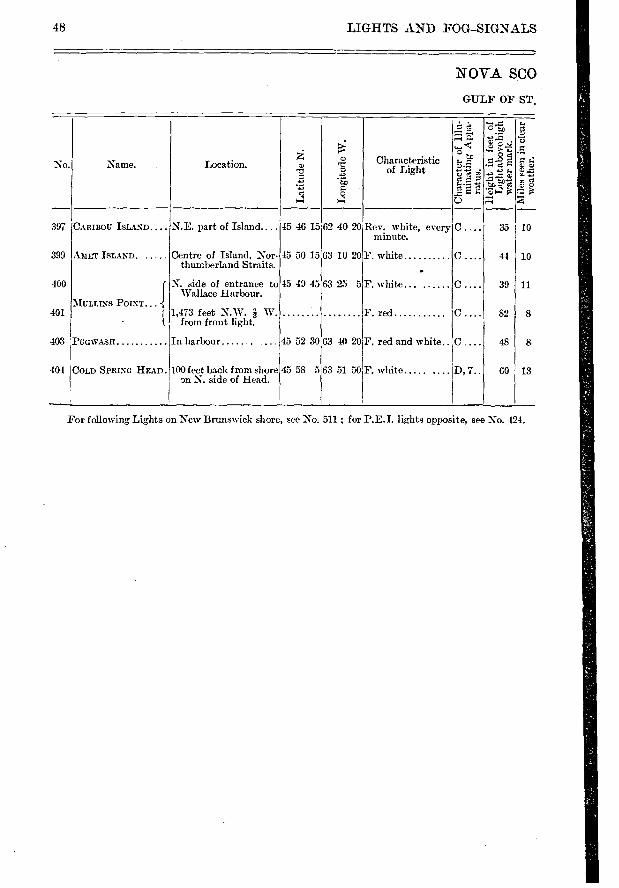
Location.
CARIBOU ISLAND.... N.E. part of Island....
Centre of Island, Nor-thumberland Straits.
N. side of entrance to Wallace Harbour.
1,473 feet N.W. à W. from front light.
In harbour
100 feet back from shore on N. side of Head.
Characteristic of Light
Rev, white, every minute.
F. white
1.■
63 25 5F. white... ......
F. red
63 40 20F. red and white..
No.
Lati
tude
N.
ce
ei
e.) • C)
e Bi.
35 10
44 10
39 11
82 8
48 8
60 13
Natne.
45 46 15 62 40 20
63 10 20 C.
45 58 563 51 50F. white ..... D, 7..
45 50 15
15 49 45
45 52 30
397
399
400
401
403
40-1
AMET ISLAND
MULLINS POINT...
•
PPGIVASH
COLD SPRING HEAD.
48 LIGFITS AND FOG-SIGNALS
NOVA SCO
GTJLF OF ST.
For following Lights on New Brunswick shore, see No. 511 ; for P.E.I. lights opposite, see No. 424.
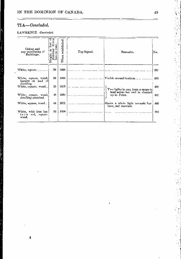
No.
1Vhe
n es
tabl
ishe
d.
Fog-Signal.
1868
1886
1873
1891
1871
1890
Remarks.
rc5 1„, o lu la— g
Colour and I e any pecoliatity of H o
Buildings. t-ÉÉ e
Visible around horizon.... .......
-1( Two lights in one, form a range to lead across bar and in channel
I up to Point. J
Shows a white light towards har-bour, red seaward.
397
399
400
401
403
404
White, square.... ....
White, square, wood, lantern on roof of dwelling.
White, square, wood..
White, square, wood, dwelling attached.
White, square, Wood.
White, with iron lan-tern red, square wood.
26
26
25
18
44
36
TI A— Conc luded.
LAWRENCE—Ccm,cluded.
IN THE DOMINION OF CANADA. 49
4

50 LIGHTS AND FOG—SIGNALS
IC o
EAST POINT. .1200 feet from extremity and 250 feet from S. shore of point.
SOURIS EAST Knights Point 300 feet S.E. of breakwater.
SOURIS EAST BREAK-WATER.
On block at outer end of breakwater.
408-
409
410
412
413
414
415
416
417
418
CARDIGAN RIVER.
PANMURE HEAD
GEORGETOWN .
1.
Between Ferry Wharf and Morrison's Beach W. shore of river.
S.E. extremity- of Car-digan Bay.
On St. Andrews Point, S.W. side of entrance
On Westaway's farm ,12• mile N. W. by W.
W. from front light.
46 27 10161 58 10
16 20 50
46 20 50
62 14 30
62 15 0
46 15 55 62 25 0
46 12 50162 31 45
46 9 0
46 957
62 27 35 F. white
F. red seawaixl, white across hat.- bour, between N.E. and N.W.
F. white ;C
62 31 30
F. white with red sector to indicate anchorage.
F. red .......
F. white
F. white
F. red
F. green to sea-ward, white across river to NE'ward.
D, 4..
D. p
C ...
D, 4..
100
85 15
40 I 2
78 10
14 72
1 11
8 43
96 16
501 8
62 12
15
PRINCE ED
STRAIT OF NORTH
No. Name. Location.
Lat
itu
de N
.
2 >
a. •-• •-• t
e
74.
Characteristic of Light.
( In village 220 feet north from shore of river and 312 feet N. 70' E. from head of public wharf.
ANNANDALE .
Back light on Juniper Pt. N.W. by N. 4,340 feet from front one.
ANNANDALE WHARF.IN. W. corner of wharf.
1.
Rev. white, 3 min-, C , utes.
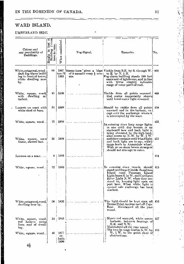
Remarks. Fog-Signal.
408 .
409
410
45 1880
34 I 1889
13 ! 1898
White, square, wood .. 32 1883
White,octagonal, wood, dwelling near by.
White, square, wood, red lantetn rising frein roof of dwell-ing.
White, square, wood..
50 1853
34 I 1868
46 1877 re-
built 1890
415
416
417
418
56 1898
8 1 1898
IN THE DOMINION OF CANADA. 51
WARD ISLAND.
UMBERL AND SIDE.
o tw> •
•
:=1 to à "c3
■•••■
No.
Whe
n es
tabl
ishe
d.
Colour and any peculiarity of
Buildings.
60 1867 mov'd 1885
White,octagonal,wood drab fog-alarm build-ing in front of tower, white dwelling near by.
White, square, wood, with d-welling at-tached.
I Lantern on mast with white shed at base.
White, square, wood..
White. square, open frame, slatted face.
Lantern on a mast ....
Steam-horn 'gives a blast Visible from S.E. by S. through W. of 8 seconds every I min- to E. by N. I N. ute. Fog-alarm building stands 100 feet
eastward of lighthouse, and in line with tower roughly indicates
• range of outer point of reef.
Visible from all points seaward. Red sector teinporarily shown until breakwater light resumed.
Should be visible from all points seaward and in the harbour, ex-cept over the anchorage where it is intercepted by the mast.
) I 412 In entering river keep range lights
in one until day beacon is on starboard bow and back light is being obscured by the high land, alter course t,o N.W. by W. W.
- and then continue until wharf light 413 and back light are in one, which range leads to Annandale wharf. With an on-shore breeze strangers should not attempt to enter.
414
In entering rivervessels should stand northveard inside Boughton Island until Panmure Island Light bears S. by W. and Cardigan River Light N. W. when they can stand in, keeping light open on port bow. When white light is opened safe anchorage has been reached.
This light should be kept open off Terras Point, to clear reef off Cape Bear. Maintained all the year round .
Shows red seaward, white across harbour, between bearings of N.E. and N.W.
Maintained all the year round. }- The two in range lead in N. W. by I W. W. to the point clear of I obstructions.
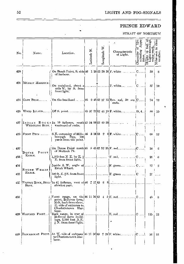
No.
420
421
424
426
427
429
432
433
434
435
437
438
439
440
( On Beach Point, S. side I of harbour.
46 128
MURRAY HARBOUR -{ On mainland, about a
mile W. by S. from front light.
La
titu
de N
.
Location.
F. white .
F. white... ....
°.5.f
e «e F. g
'E e
e
Sc
e..F.
33
74
8
10
12
45 57 22
45 5-1 50
F. red
F. red
F. white
28 ' 6
12
45 8
125 : 12
12 56
62 44 10F. white
62 49 20
52 LIGFITS AND FOG—SIGNALS
PRINCE EDWARD «Ole
STRAIT OF NORTHUM
62 28 30
Characteristic of Light.
CAPE BE.AR On the headland ..
WOOD ISLAND... Off S. point
INDIAN ROCKSIR 10 fathoms, south WHISTLING Buoy, westward of rocks.
S.E. extremity of Hills-borough Bay, 100 yards from the point.
InÉrdirshSja. rfangle of
B RUSH WHAIIFi RANGE. 500 ft. E. / S. from front
light.
FITZROY ROCK, BELL- In fathoms, west of 46 7 17 63 6 8 BUOY. shoalest part.
Name.
16 0 4562 27 15
POINT PRIM .
DoHS E RANGE.
On Douse Point north146 of 1.■ tuttock Pt. POINT
1,315 feet N. E. E. from front 1
1,315 feet N. E. by E. 3 E. from front light.
Rev. red, 30 sec- C onds.
D, 4..1 80 15
...... .
68 12
16 6
46 3 1063 2 0 F. white..
8 4562 52 55F. red..
F. red.
. ...... . F. green
F. green
( Front range, on the 46 11 50 63 4 5 point, Bellevue farm, 35ft. back from shore, E. side of entrance to Charlottetown Har-bour.
HASZARD POINT.. -{ Back range, in rear of Bellevue farm build- ings, 2,244 feet N.E.
I 4 N. from front light.
BLOCKHOUSE POINT. At W. side of entrance to Charlottetown Har-bour.
46 11 36 63 728
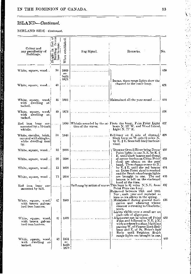
Remarks. Fog Signal. Colour and
any peculiarity of Buildings.
' c
e e
z I •>c, Ta-ra3=-d'
Whe
n es
tab
li
420
421
424
16 1898
22 1898
15 1893
15 1898
1889 47
47 1889
42 1851 re-
built 1879
IN THE DOMINION OF CANADA. 53
ISLAND—Continued.
BERLAND SIDE—Contznued.
No.
White, square, wood_ 30
White, square, wood.. 40
1869 re-
built 1879 In one, these range lights show the
channel to the outer buoy.
46 1881
40 1876
.. 1890
55 1846
White, square, wood, with dwelling at-tached.
White, square, wood, with dwelling at-ta,ched.
Red iron buoy sur-mounted by a 10-inch whistle.
White, circular, brick, covered with shing,les, white dwelling near by.
White, square, Wood..
White, square, wood ..
White, square, wood..
White, square, wood .
Red iron buoy sur- mounted by bill.
'White, square, wood, with brown galvan-ize_d iron lantern.
White, square, wood, with brown galvan-ized iron lantern.
White, square, wood, with dwelling at-tached.
5Iaintained all the year round
426
Whistle sounded by the ac. Front the buoy, Prim Point Light 427 tion of the waves. bears N. 23 W. and Wood Island
! Light N. 77' E.
Bell-buoy on E. side of channel, 429 black buoy on W. side 21 miles N. by E. E. from bell-buoy harbourH
• ward.
To enter Orwell River bring Douse 432 Point lights in one N.E. by E. E. until black beacon and clump . of spruce bushes on China Point 433 shoal are abeam on the port hand. Then change course to N. by E. E. until the red beacon; 434 on Douse Point shoal is reached and the Brush wharf range lights are brought in one. The red, 435 beacon is left on the starboard.
1 hand at the turn. _ Bell rung by action of waves This buoy is 41,, miles N.N.E. frœd 437
Point Prim can buoy. Removed between 10th and 18th
Nov , each year and replaced as soon as ice allows in the spring.
Maintained during general navi- 438 gation and whenever winter steamer is running to Charlotte-town.
Lights visible over a small arc on each side of alignment.
Alignment can be taken off l'oint 439 Prim and followed in N.E. N. with nowhere less than 5 fathoms passing W. of Fitzroy Rock Bell - buoy and E. of St. Peter's Spit Buoy until Brighton Beach
1 range lights are brought in one. 440
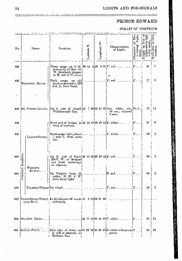
Location. Characteristic
of Light.
Lo
ngit
ude
W.
Lati
tude
N.
Front range on N.W. extremity of Hon. G. W. Howlan's proper-ty E. side of N. river.
Back range, on old Asylum grounds,1,275 feet N. from front.
BRIGHTON BEACH. j
46 12 28
63 31 48
No.. Name.
On S. side of island, Hillsborough Bay.
West end of bridge, at,16 13 15 head of ',arbour.
Inner range light, abouti mile N. from outer:
one.
Occ, white, vis., 30 sec., eclipsed 6 sec.
F. white.... . .
F. white
D, 6..
On S. side of Muds Bluff, W. of dredged cut from anchorage to wharves.
On Wrights farm, 3:4 cables N. W. N: from front light.
63 29 42 F. red
F. red
F. red 2
SEA-COIV HEAD
INDIAN POINT.
46 19 10 63 48 25
East (dge of shoal, on 46 22 50 63 48 45 S. side of channel, in Bedeque Bay.
F. white IC
F. white with green C . ,sector.
454
455
88 15
48 I 13
F. red
F. red
▪ 07.re
„
▪
c 4.
to te . e e
t.>
F. 2 'Esq e 77: E.)-«
C.... 41 7
C.... 77 9
O
o
rr,
441
442
46 14 5
46 7 20
63 820
63 11 35
63 29 10
70
41
60
14
G
G
3
3
441 1ST. PETERS ISLAND..
446
447 LEARDSRANGEj
o
r-1 .‘ RIGHTS
▪ RANGE.. A.
▪
:
o
PALIIERS WHARF On wharf .
TRYONSHOAL WHIST- In 542 fathoms off south 46 8 55 LING BUOY. extremity.
448
449
450
452
54 LIGHTS AND FOG-SIGNALS
PRINCE EDWARD
STRAIT OF NORTHUM
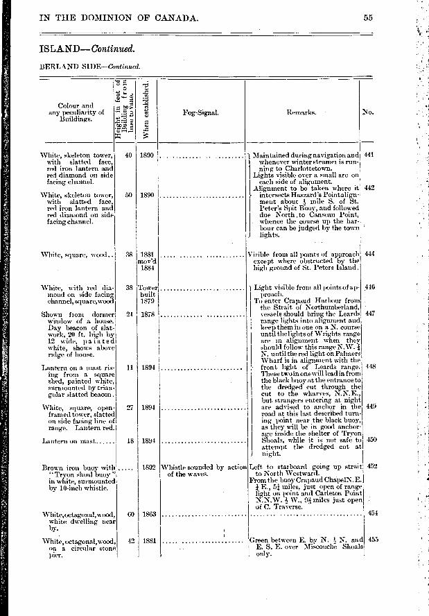
Visible from all points of approach except where obstructed by the high ground of St. Peters Island.
444
Colour and any peculiarity of
Buildings.
White, skeleton tower, with slatted face, red iron lantern and red diamond on side facing channel.
White, skeleton tower, with slatted face, red iron lantern and red diamond on side facing channel.
05.1 o
4. S.
o •
4e "0 :70 ii
CJ •Z
I 40
50
White, square, wood..
White, with red dia-mond on side facing channel, square,wood
Shown front dormer window of a house. Day beacon of slat-work, 20 ft. high by 12 wide, painted white, shows above ndge of house.
Lantern on a nia.st ris-ing from a square shed, painted white, surmounted by trian-gular slatted beacon .
White, square, open-framed tower, slatted on side facing line of range. Lantern red.
38
24
11
27
38
116
447
448
449
450
452
1881 mov'd
1884
Tower built 1879
1878
1894
1894
1894
1892
1863
1881
Lantern on mast
Brown iron buoy with " Tryon shoal buoy " in white, surmounted by 10-inch whistle.
White,octagonal,wood, white dwelling near by.
• White, octagonal, wood,
on a circular stone pier.
18
60
.42 Green between E. by N. Is N. and E. S. E. over Miscouche Shoals only. -
455
454
IN THE DOMINION OF CANADA.
IS LAND— Continue,c1.
BERLAND SIDE—Continued.
55
Whe
n es
tabl
ishe
d.
Fog-Signal.
1890
1890 I
-Remarks.
) Maintained during navigation and 441
I whenever winter steamei is run-ning to Charlottetown.
Lights visible over a small arc on I each side of alignment. I Alignment to be taken where it 442 }- intersects Haszard's Point align- ' ment about -& mile S. of St. I Peter's Spit ifuov, and followed
due North .to anseau Point, whence the course up the har- bour can be judged by the town '
1 lights.
No.
Light visible from all points of a p-I proach. ' To enter Crapaud Harbour from
the Strait of Northumberland, vessels should bring the Leards range lights into alignment and keep them in one on a N. course until the lights of Wrights range are in alignment when they should follow this range N.W. N. until the ned light on Palmer: Wharf is in aligninent with the front light of Leards range. These two in one will lead in from the black buoy at the entrance to the dredged cut through the cut to the wharves, .N.N.E., but strangers entering at night are advised to anchor in the road at this last described turn-ing point near the black buoy, as they will be in good anchor-age inside the shelter of Tryon Shoals, while it is not safe to attempt the dredged cut at night.
L,eft t,o starboard going up strait to North Westward.
From the buoy Crapaud ChapelN.E. k E., 5t miles, just open of range light on point and Carleton Point N.N.W. W., 9',24 miles just open of C. Traverse.
Whistle sounded by action of the waves.
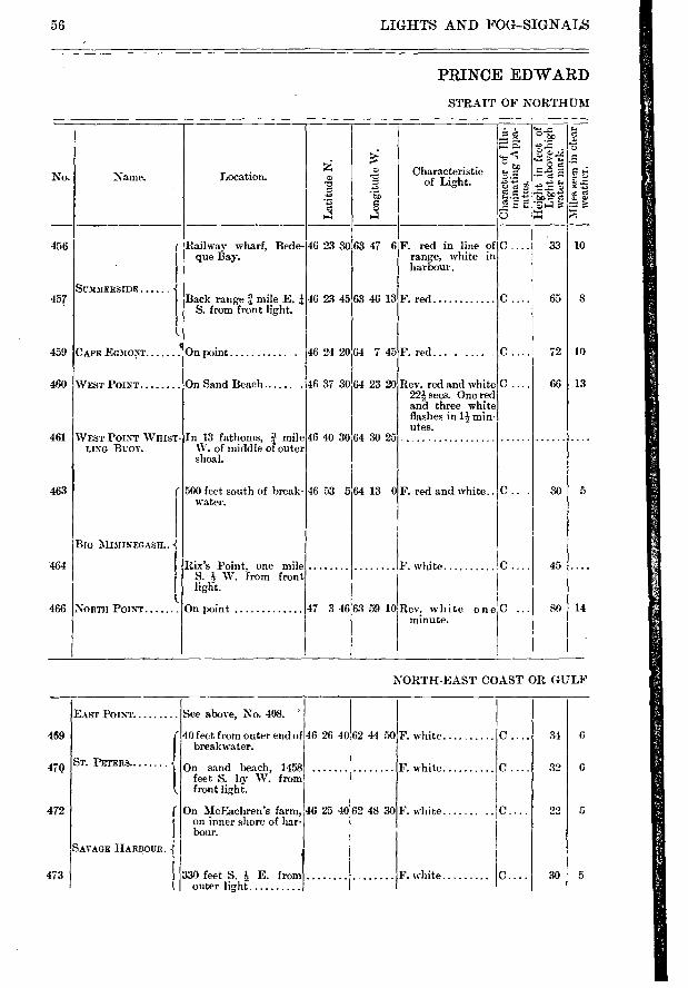
ST. PETERS
469
47Q
472
473
62 44 50 46 26 40 34 F. white
6 F. white 32
5 9 ,) F. white 46 25 40 62 48 30 C.
30 5 F. white
40 feet from outer end of breakwater.
On sand beach, 1458 feet S. by W. from front light.
On MeEachren's farin, on muer shore of har-bour.
330 feet S. E. from outer light
56 LIGHTS AND FOG-SIGNALS
PRINCE EDWARD
STRAIT OF NORTHUM
• . .''. ''5 "'il) i.
■74 ^ -.-› ...E. 't;
›... .:•-■-• '-' o ,J.2 ■••
:4 CD Characteristic No. Name. Location. a) -o
•E
...>
cs o 14 14 -0
456 I Railway wharf, Bede- 46 23 30 63 47 6 F. red in line of C ... 33 10 1 que Bay. range, white in
harbour.
SUMMERSIDE -{ 457 Bu fkrni
front mile E. i 46 23 45 63 46 13 F. red C 65 8
l
459 CAPE EG3IONT On point 46 24 20 64 7 45F. red ... . .... . C .... 72 10
460 WEST POINT On Sand Beach 46 37 30 64 23 20 Rev, red and white C .... 66 13 224 secs. One red and three white flashes in li min-utes.
161 WEST POINT WHIST- In 13 fathoms, mile 46 40 30 64 30 25 .
LINO Buoy. W. of middle of outer shoal.
463 1 500 feet south of break-4G 53 564 13 0F. red and white C.. . 30 5 water.
Bi MIMINEGASIL.
464 Rix's Point, one mile F. white C 45 .... S. W. from front light.
(.. 466 NORTH POINT On point 47 3 4663 59 10 Rev. white one C ... SO 14
minute.
NORTH-EAST COAST OR GULF
EAST POINT See above, No. 408.
SAVAGE HARBOUR.
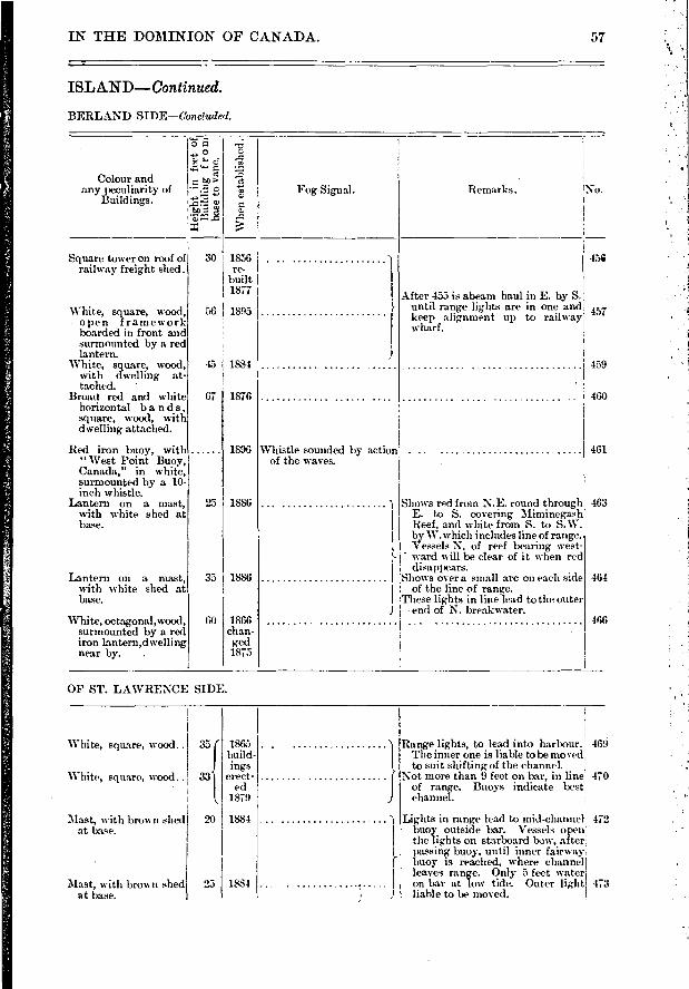
Remarks. No. Fog-Signal.
Square tower on roof of railway freight shed.
White, square, wood, open framework boarded in front and surmounted by a red lantern.
White, square, wood, with dwelling at-tached. •
Broad red and white horizontal ban ds, square, wood, with dwelling attached.
Red iron buoy, with "West Point Buoy, Canada," in white, surmounted by a 10- inch whistle.
Lantern on a mast, with white shed at base.
Lantern on a mast, with white shed at base.
White, octagonal, wood, surmounted by a red iron lantermdwelling near by. .
AI ter 453 is abeam haul in E. by S. until range lig,hts are in one and keep alignment up to railway wharf.
Whistle sounded by action of the waves.
Shows red from N.E. round through I E. to S. covering Miminegash I Reef, and white from S. to S. W. I by W.which includes line of range. I Vessels N. of reef bearing west- ;- • ward will be clear of it when red I disappears. I Shows over a small arc on each side I of the line of range. I These lights in line lead to the outer
end of N. breakwater. 466
30 1856 re.
built 1877 1
460
I 461
Colour and any peculiarity of
Buildings.
45e
457
459
56 I 1895
45 1884
67
25
35
60
1876
1896
1886
1886
1866 chan- ged 1875
463
464
"5
• e
• a ▪tea acF3
1.1.
▪
1
1865 build-ings
erect-ed
1879
1884
3331
20
1884 05 ;
Range lights, to lead into harbour. 469 The inner one is liable to be moved, to suit shifting of the channel.
Not more than 9 feet on bar, in line 4i 0 - of range. Buoys indicate best' channel.
Lights in range lead to mid-channel 472 buoy outside bar. Vessels open the lights on starboard lxwv, after passing buoy, until inner fairway ,
buoy is reached, where channel leaves range. Only 5 feet water on bar at low tide. Outer light 473 liable to be moved.
White, square, wood..
White, square, wood..
Mast, with brown shed at base.
Mast, with brown shed at base.
IN THE DOMINION OF CANADA. 57
ISL AND—Con tinued.
BERLAND SIDE—Concluded.
OF ST. LAWRENCE SIDE.

478
479
481
475
476
NEW LONDON
DARNLEY POINT...
FISH ISLAND
TRACADIE.... .....
OVE HEAD I
NORTH OR GRAND RUSTIC°.
46 25 35 63 230
63 8 45 46 26 10
46 27 42,63 17 15
Back light on beach 1500ft. S. W. of main light.
Front range, near shore-line, 6 cables south-ea.stwardly from C. Aylesbury.
1,341 feet S. \V. by S. from front light.
Entrance to Malpeque or Richmond Bay on inside of island.
Front range, 1,200 feet S.E. by E. E. from main light. -
46 31 0163 39 0
F. red
F. red
F. white
F. white
F. white
F. red
F. white
F. red
19
24
18
25
40
22
45
3
3
8
5
LIGHTS AND FOG-SIGNALS
PRINCE EDWARD
GULF OF ST.
No. Name. Location.
> .--- >4. a 1,
"c ... ...5>o -.;.1 = ci 4 1.
c.) - o
Characteristic 2g of Light.
e.g 1:74 ■-■
482
484
490
488
489
487
485
On beach, W. side of entrance, 1,800 feet back from shore line.
Back tower 1,200 feet S.S.W. froui front.
Front light close to edge of sand beach at en-trance to harbour.
Back light, 600 feet from front.
W. side of entrance to harbour.
Front range light, 225 feet from main light.
Outer end of breakwater 46 31 10 63 28 52 on N. W. side of en- trance to Grenville Harbour.
F. red
F. red C. . 1351 7
C 50 12
C.... 18 6
40!
46 34 50 63 42 29 F. white.. ......
46 34 52 63 42 17 F. white
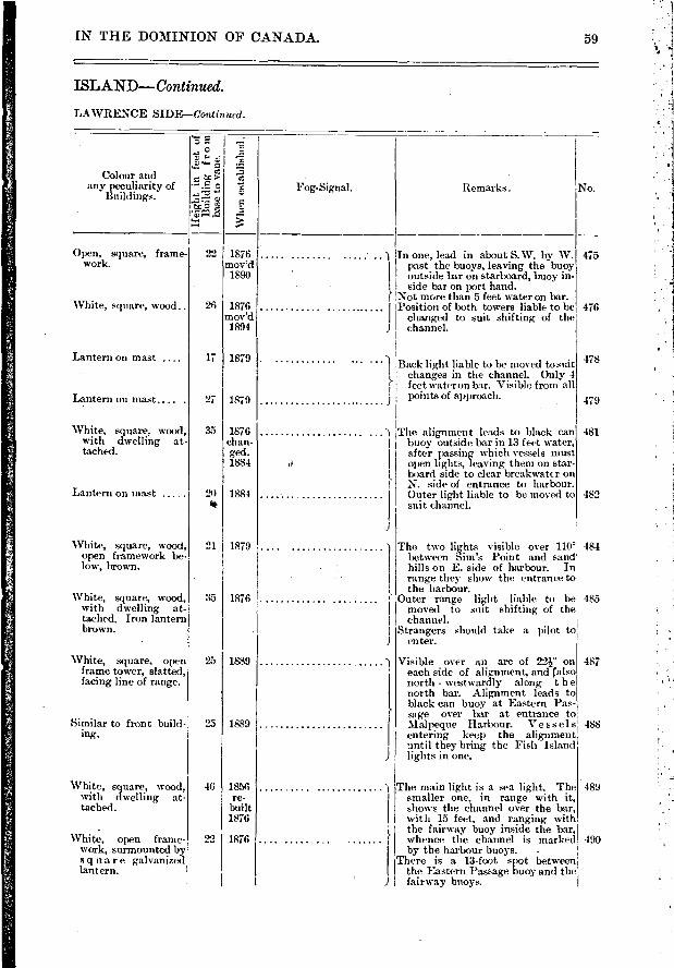
Open, square, frame-work.
White, square, wood..
475
476
478
479
481
482
1
The two lights visible over 1101 484 between Sim's Point and sand' hills on E. side of harbour. In range they show the entrance to the harbour.
Outer range lieht liable to be 485 moved to suit shifting of the
channel. Strangers should take a pilot to
enter.
Visible over an arc of 22W on each sicle of alignment, and (also north - westwardly along t h e north bar. Alignment leads to black can buoy at Eastern Pas-sage over bar at entrance to Malpeque Harbour. Vessels entering- keep the alignment until they bring the Fish Island lights in one.
The main light is a sea light. The smaller one, in range with it, shows the channel over the bar, with 15 feet, and ranging with the fairway buoy inside the bar, vehence the channel is marked by the harbour buoys. .
There is a 13-foot spot between the Eastern Passage buoy and the fairway buoys.
487
488
489
490
" " 1 Back light liable t,o be moved to suit
, changes in the channel. Only 4 c feet water on bar. Visible from all
points of approach.
1 The alignment leads to black can I buoy outside bar in 13 feet water, I after passing which vessels must I open lights, leaving them on star-', board side to clear breakwater on I N. side of entrance to harbour. I Outer light liable to be moved to I suit channel.
22 1876 mov'd
1890
26 1876 mov'd 1894
17 1879
27 1879
35 1876 chan-ged. 1884
'90 1884 gut
21 1879
35 1876
25 1889
25 1889
46 1856 re-
built 1876
22 1876
IN THE DOMINION OF CANADA.
ISLAND—Continued.
LAWRENCE SIDE—Continued.
59
Colour and any peculiarity of
Buildings.
e.
e o
fc- S:s>,
Whe
n es
tabl
ished
.
Fog-Signal. Remarks.
) In one, lead in about S.W. by W. past the buoys, leaving the buoy
I outside bar on starboard, buoy in-,' side bar on port hand. ( Not more than 5 feet water on bar. I Position of both towers liable to be I changed to suit shifting of the ) channel.
No.
Lantern on mast ....
Lantern on mast. ... .
White, square, wood, with dwelling at-tached.
Lantern on mast
White, square, wood, open framework be-low, brown.
White, square, wood, with dwelling at-tached. Iron lantern brown.
White, square, open frame tower, slatted, facing line of range.
Similar to front build-ing.
White, square, wood, with dwelling at-tached.
White, open frame-work, surmounted by s q tiar e galvanized lantern.
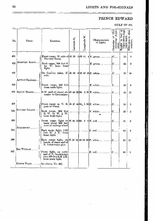
GO LIGHTS AND FOG—SIGNALS
PRINCE EDWARD
GULF OF ST.
• 14 ez. -.....-zi
i7..;
›....- ""c'
No. Name. Location.
•-•-• ,,,,>' ;. . er. Characteristic
— ......: •.-. e = c. c)
e * E. • ze .5 foSre' 1. g .Z e e r. e • e: 4 i:• re"..• : es o
4 4 É = ''
491 Front range, W. side of 46 33 5 63 41 8 F. green C 55 3 Darnley Basin.
492 DARNLEY BASIN... Back range, 380 feet S. F. green C 64 3
by W. from front light.
195 On CoAay Inlet, N. 46 40 063 52 40 F. white C 26 10 side.
LITTLE CHAkNEL..
196 Front range, 200 feét F. white C 16 8 from main light.
198 SANDY ISLAND S W. pan of island, en- 46 48 2264 2 20 F. white C 45 12 trance to Cascumpec.
199 Front range on N. E. 46 47 45 64, 1 50F. white O. .. 35 5 part of island.
SAvAGE ISLAND... Back range, 900 feet F. white C .... 45 I 5
S. W. by W. i W. c. from front light.
03 Front range light on 46 48 16 64 3 6F. red 0.... 31 3 I bank about 500 feet I west of railway wharf
NORTHPORT 04 I Back range light, 1125 F. red C . 42 3
I feet W. I N. from l front light.
06 ( Back range light, on 46 57 35 63 59 20F. white. C.... 35 11 ' beach, at inner end of
I N. breakwater pier.
BIG TIGNISH i 07 Front light, on outer F. red C .... 18 5
! end of N. breakl,vater I. pier, 620 feet S.E. E.
from main light.
NORTH POINT ,See above, No. 466. I
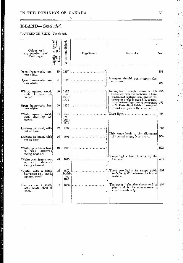
IN THE DOMINION OF CANADA.
ISLAND—Concluded.
LAWRENCE SIDE—Conch dol.
Colour and e ...›. e . any peculiarity of . ^.E. c ,", Fog-Signal. Remarks. No.
Buildings. 5
. ..... -,..r. 5-:
Open framework, Ian- 15 1897 1 491 tern white. I
:-
Open framework. Ian- 21 1897 Strangers should not attempt the
teni white. ' entrance. I 492 J
White' square, wood, 30 1872 ) In one, lead through channel with 5 495
with kitchen at- re- I feet at entrance to harbour. There tached. built I is a ballast heap in the alignment at
1876 }, the point of the S. sand bill, to pass I
tins the front light must be opened 49€
Open framework, Ian- 20 1876 I to.N. Outerlight liabletobemoved tern white. 1 to suit changes in the ch.annel.
White, square, wood, 41 1856 Coast light 49i. with dwelling, at- re- filched. built
1876
Lantern on mast, with 22 1897 1 49'.. hut at base. I
' This range leads to the alignment
Lantern on mast, with 26 1897 of the red range, Northport. 501- hut at base. I
1
White, open frame tow- 29 1885 er, with slatwork facing channel. I
- Range lights lead directly up the
White, open frame tow- 41 1885 1 harbour. 50- er, with slatwork
facing channeL 1
White, with a black 33 1877 ) These, two lights, in range, guide 501
horizontal band, build- I in N.W. W. between the break- square, wood. ing I waters.
1881
Lantern on a mast, 14 1883 I The outer light also shows end of WY with white shed at I pier, and is for convenience of base. J small vessels only.
61
7
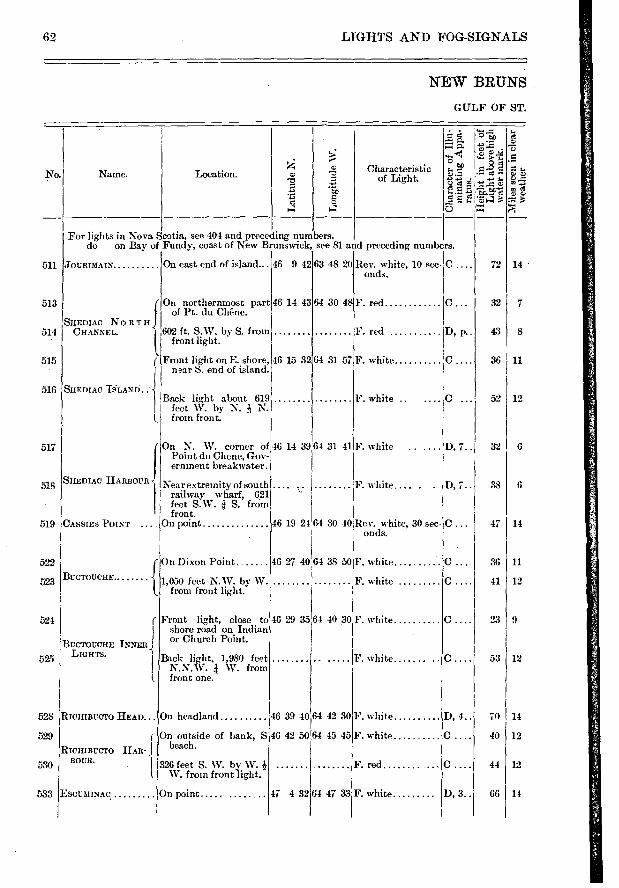
No. Name.
72
32
43
36
52
32
38
47
36
41
23
53
64 30 4
64 31 57
On northernmost part of Pt. du Chêne.
602 ft. S.W. by- S. from front light.
Front light on E. shore, near S. end of island.
Back light about 619 feet W. by N. h N. from front.
46 14 43
46 15 32
F. red..
F. red .
white !C
F. white ..
F. white.... . . D, 7..
Rev. white, 30 sec- C onds.
0.
D, p..
!D, 7.. F. white
SHEDIAC HARBOUR
CASSIES POINT
BuoroucHE
{ SHEDIAC NORTH CFIANNEL.
f
iSHEDIAC ULAND. ; ,
46 29 35 64 40 30 F. white
F. white
46 39 40 64 42 30
46 42 50 64 45 45
F. white
F. white
F. red
47 4 3264 47 33 F. white
70
40
66
14
7
8
11
12
6
6
14
11
12
9
12
14
12
12
14
62 LIGHTS AND FOG-SIGNALS
NEW BRUNS
GULF OF ST.
Lat
itu
de N
.
- 50 o
1.
.—
;11> 2e-e
à ; t>
••-•
.9. -té
o *E3a
Location. Characteristic of Light.
511
For lights in Nova Scotia, see 404 and preceding numbers. do on Bay of Fundy, coast of New Brunswick, see 81 and preceding numbers.
JOURIMAIN On east end of island... 46 9 42 63 48 20 Rev. white, 10 sec- C onds.
39 64 31 41
513
514
515
516
517
518
519
522
523
524
BUCTOUCHE
525 LIGHTS.
RICHIBUCTO HEAD...
529
RICHIBUCTO HAR -BOUR.
EsetatiNac.
On N. W. corner of 46 14 Point du Chene, Gov-ernment breakwater.
icirear extremity of south railway wharf, 621 feet S.W. g S. from front.
jOn point
On Dixon Point
1,050 feet N.W. by W. from front light.
Front light, close to shore road on Indian or Church Point.
Back light, 1,980 feet N.N.W. 4 W. from front one.
On headland
On outside of bank, S beach.
326 feet S. W. by W. W. from front light.
On point
F. white
F. white
C .
D, 4..
0.
0.
I), 3. ,
46 19 24 64 30 40
46 27 40 64 38 50
INNER .)
528
530
533
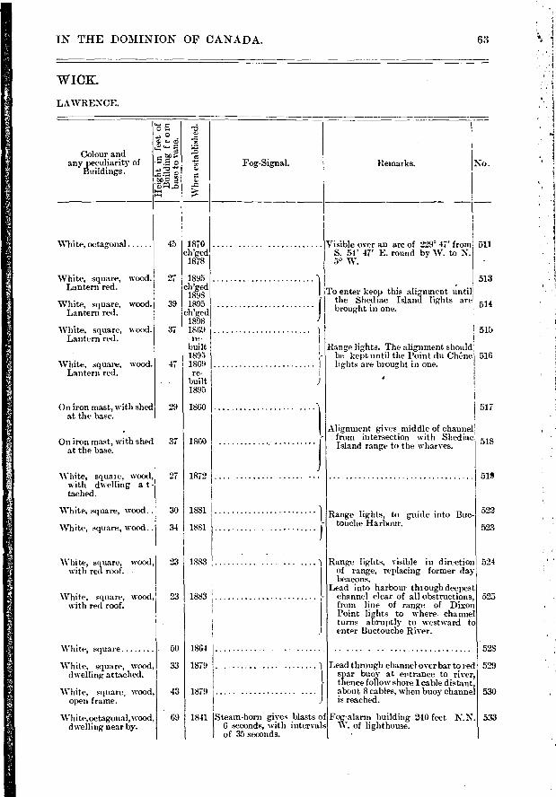
Colour and any peculiarity of
Buildings.
"5
a g. e
î *FJP:1-a
No.
511 White, octagonal
White, square, wood. Lantern red.
White, square, wood. Lantern red.
White, square, wood. Lantern red.
White, square, wood. Lantern red.
1
517
518
519
522
523
On iron mast, with shed at the base.
On iron mast, with shed at the base.
White, square, wood, with dwelling a t - tached.
White, square, woo.d..
White, square, wood..
White, square, wood, with red roof. .
'White, square, wood, with red roof.
45 1870 ch'ged I 1878
27 1895 ch'ged
1898 39 1895
ch'ged 1898
37 1869 re-
built 1895
47 1869 re-
. built 1895
29 1860
37 I 1860
27 I 1872
30 1881
34 1881
23 I 1883
23 I 1883
50 186-1
33 1879
43 1879
524
525
528
529
530
533
IN THE DOMINION OF CANADA.
WICK.
LAWRENCE.
63
Fog-Signal.
Whe
n es
tabl
ishe
d.
Remarks.
Visible over an arc of 229' 47' from S. 54' 47' E. round by W. to N. 5° W.
513
To enter keep this alignment until ' the Shed iac Island lights are 514
J
brought in one.
515
I Range lights. The alignment should - be kept until the Point du Chêne 516
lights are brought in one.
Alignment g-ives middle of channel from intersection with Shediac Island range to the wharves.
Range lights, to guide into Buc-touche Harbour.
Range lights, visible in direction of range, replacing former day beacons.
Lead into harbour through deepest channel clear of all obstructions, from line of range of Dixon Point lights to where channel turns abruptly to westward to enter Buctouche River.
White, square
White, square, wood, dwelling attached.
White, square, wood, open fraie.
White,octagonal,wood, dwelling near by.
1841 Steam-horn gives blasts of 6 seconds, with intervals of 35 seconds.
Lead through channel over bar to red spar buoy at entrance to river, thence follow shore 1 cable distant, about 8 cables, when buoy channel is reached.
Fog-alarm building 240 feet N.N. W. of lighthouse.
69
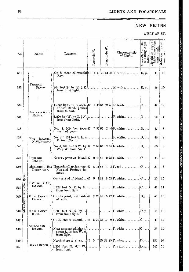
Characteristic of Light.
La t
itu
de N
.
Lon
git
ude
W.
Fox ISLAND,' N.W.POINT.
PORTAGE ISLAND.
No. 1, 100 feet from north of coast.
No. 2, 1,0.51 feet S. E..% E. from No. 1. -
No. 3, 954 feet S.W. by W. j W. from No. 1.
Near S. point of Island
Horseshoe Bar, between Fox and Portage Is-lands.
On west end of Island..
1,222 feet N. E. by E. from front light.
On the point, north side of river.
No.
534
535
536
537
538 1
1.D
' p..
D, p..
D, p..
D, p..
'D, I> •
D, p..
D, p..
D, p..
D, p..
47 7 52
47 9 45
47 8 14
47 5 7
47 7 22
47 530
41
58
47 12
72 14
47 I 8
46
361 8
12
33
10
11
10
45
8
10
10
10
12
10
10
10
48
45
35
120
140
30
42
43
65 2 15
65 238
65 4 3:F. red
F. white .....
F: white
F. white
65 19 0
65 23 45
F. white
F. white
F. white
65 653
65 15 42
F. white
F. white
F. white
F. white.... ...
F. white
539
540
541
542
543
544
545
546
547
548
549
550
64 LIGHTS AND FOG-SIGNALS
NEW BRUNS
GULF OF ST.
Location. Name. e i
H.= H H $.
g e
7:24
0 t 1—
e.
g g à - rd
5«
On S. shore Miramichi Bay.
Flont light on E. shore of Fox Island,n miles
I SwAsnwAY froin S. end. - ; RANGE. ' 1,220 feet W. by N. N.
from front light.
47 4 47I64 54 58F. white
F. white
47 6 46 64 59 50F. white
F. white
47 7 55i65 2 6IF. white ....
804 feet S. by E. à E. from front light
MIRAMICHI BAY LIGHT- SITU'.
7N1 JAAY Du VIN
ISLAND.
1J A IC POINT ( "":" FRONT.
• PRESTON
BRACH
0 A K POINT 1 1,800 feet N. E. by E. BACK. 1. from front light.
On E. end of Island... f
North shore of river... 47 5 7
GRANT BEACH " 1 I
I 1,300 feet N. from front.
SHRLDRAKE ISLAND. Near west end of Island,
about 1,165 feet W. of front light.
A
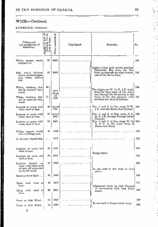
No. Remarks.
White, square, wood, lantern red.
. Red, steel skeleton tower, enclosed upper part white, lantern red.
White, skeleton, slat-ted on seaward face, wood.
White, skeleton, slat-ted un seaward face, wood.
Lantern on mast, with white shed at base.
Lantern on mast, with white shed at base.
Lantern on mast, with white shed at base.
29 1869
59 1869
46)
71
1872 chang
ed 1891
40 moved le81
38 moved 1881
28 1881
The alignment W. by N. N. leads from the deep water of the outer bay through the Swashway to the buoys in the ship channel, with nowhere less than 2/ fathoms.
Nos. 1 and 2, in line, range N.W. 4 N. into the Horse-shoe Channel.
Nos. 1 and 3, in line, range N.E. by E.-"," E. through Portage Island Channel.
Nos. 2 and 3, in line, range W. by N. 4 N. to the upper buoy of Horse-shoe Shoal.
}- Range lights.
L
Lantern on mast, red shed at base:
Lantern on mast, red shed at base.
1869
1869
1869
1869
28
38
46
39
34
31
534
535
536
537
538
539
540
541
542
543
544
545
546
547
548
IN THE DOMINION OF CANADA.. 65
WICK— Con tinued.
LAWRENCE—Continued.
tn..> 0 Fog-Signal. Colour and
any peculiarity of Buildings.
Whe
n es
tab
1869
1873
25 1882
30 1882
?
Lights in line lead vessels entering Miramichi Bay from the Bar buoy up through the ship channel east of the Lump buoy.
White, . square, wood,: 42 with dwelling near.
A schooner rigged ship.
Lantern hoisted on mast, with white shed at base, all supported on trestle-work.
Sanie as front light....
Mast, with shed at base.
Mast, with shed at base.
Same as Oak l'oint .
Sanie as Oak Point..
5
1869 ............ )
In one lead to above.
1869 1 IL
red buoy in river
Alignment leads up Oak Channel to intersection with Oak Point range.
549
In one lead to Napan black buoy. 550
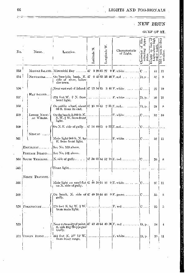
D, p..
D,
C LOWER NEG17- AC WHARF.
NEC CAC
EscumINAC
PORTAGE ISLAND
SOL-TH TRAC> ADIE
. On the beach,1,080 ft.N. j N. W. W. from front ! light.
On N.E. side of gully..
Main light 900 ft. N. by E. from front light.
See No. 533 above.
See No. 541 above.
N. side of gully... . .
.5 0 22 47 14 40
47 30 0364 52 10
F. red 'C
F. white
0. F. red
No.
553
554
556
557
558
559
560
561
564
565
566
569
0.
D, p..
D, p..
32 10
32 11
8 26
37 i 11
44 I 11
87 I 9
10 23
11 30
35 8
5
28
11
Near extremityof point, S. side Big Shippegan
INDIAN POINT... . -{ 444 feet N. 31° 15' W. from front range.
573
574
47 43 40 64 40 :en red
F. white
66 LIGHTS AND FOG-SIGNALS
NEW BRUN
GULF OF ST.
Lo
ng
itu
de
W.
af,
Pe.
Characteristic of Light.
"."tc -.E 5
.*3
Z.;ame. . Location.
c. D, p..
MIDDLE ISLAND. Miramichi Bay ,47 3 2865 27 0:F. white..
NEWCASTLE On lime-kiln bank, N. 47 0 45,65 33 4011'. red ... side of river, below the town.
r 'Near east end of Island. 47 13 54,65 3 46 F. white..
HAY ISLAND.. 224 feet W. N. from
I front light.
On public wharf, about 47 15 40 65 2 35 F. red. GO ft. from its end.
F. white
... F. white
( Front light
NORTH TRACADIE.
Main lig,ht on sand flat 47 40 10 64 46 0 F. white... '1 on N. side of gully. .
, . .
jOn beach, N. side of 47 40 10 64 46 0 1 F. green
gully.
570 POKEMOCCHE 270 feet S. by W. W. F. red from main light.
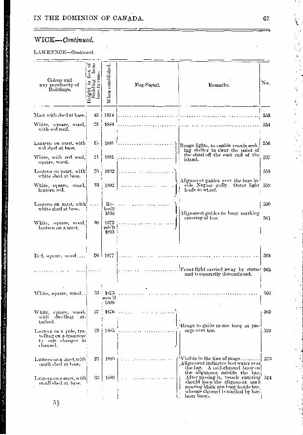
j 1 J 30
1881
95 1892
33 1892
1873 rebit 1893
1877 I
Front light carried an ay by storm and temporarily discontinued.
Red. square, wood....
White, square, wood ..
White, square, wood, with dwelling, at-taclied.
553
554
556
557
55S
559
560
561
564
565
566
569
570
57:3
574
25 18.89
1889
IN THE DOMINION OF CAN.A_DA. 67
WICK—Continued.
LAWRENCE—Continued.
2 s«-
Colour and any peculiarity of
Buildings.
No.
\Vhe
n es
tabl
ishe
d.
Mast with shed at base. 45 1874
White, square, wood, 23 1884 witls red roof.
Lantern on mast, with 15 1881 red shed at base.
White, with red roof, square, wood.
Lantern on mast, with white shed at base.
White, square, wood, lantern red.
Lantern on mast, with white shed at base.
White, square, wood, lantern on a mat.
Range lig,hts, to enable vessels seek-ing shelter to clear the point of the shoal off the east end of the island.
Alignment waffles over the bars in-side Neguac gully. Outer light leads to wharf.
Alig,nment guides to buoy 'narking crossing of bar.
Re- built 1896
Fog-Signal. Remarks.
Lantern on a pole, tra-velling on a tramway to suit changes in channel.
33 I 1875 :
I 1896
37 1876
23 1885 I !Range to guide to can buoy at pas-. ■
sage over bar.
Lantern on a mast,with small shed at lase.
Lantern on a mast, witli small shed at base.
. Visible in the line of range......... Alignment indicates best water over
the bar. A mid-channel .buoy on the alignment outside the bar.
... After passing it, vessels entering should keep the aligmnent until nearing black can buoy inside bar, whence channel is mar. ked by bar-
I. hour buoys. 51

BIG SHIPPEGAN
Miscou GULLY
IIISCOU ISLAND
4154 0164 35 0
47 49 10 64 44 40
47 49 30 64 54 10
F. white... ...... I), 7..
F. red
575
578
579
581
582
584
583
586
587
589
590
592
593
594
596
597
598
601
603
604
On Alexander Point, 47 43 30 64 39 10 N.E. of entrance to gully.
On N. side of E. en- 47 55 trance to Little Ship-pegan.
Birch Point 48 1
564 29 30
fe4 29 25
C .
D,
D,
p
41 11
49 , 14
88 15
31) 1171
SI 10
43 14
36 12
38 ii
66 15
30 6
49 13
309
34 9
24 9
24
68 LIGHTS AND FOG—SIGNALS
NEW BRUNS
GULF OF ST.
No.
GOOSE LAKE... W. side of Miscou Is- land.
HARPER POINT At western entrance to Little Shippegan.
POKESITDIE N.E. point of island..
CARAQUET On island, Bay of Cha-
STONEHAVEN
BELLONI POINT
Naine. Location.
47 55 40
c:! ""r..."' • et-'c' •—
•-t-2.""1 r.• I - Z . Characteristic
of Light.
t-) 7
F. white C . 32 11
F. white 'D, . 45 7
Gp. rev. white 40 .. 79 14 flashes at inter- vals of 15 see-i onds, followed by eclipse if 30 sec-onds. Complete ,
revolution in 11 minutes.
64 35 40jtev. white, every C 10 minute.
F. white .. D, p 3
F. white. .. 7..
F. white ..... 'D, I.
F. red D, 7..
F. white ......
Long
itude
W.
leur. At head of . 47 45 30 65 20 50
On E. side entramce to 47 40 21 65 33 18 Bathurst Harbour.
BATHURST
PETIT ROCHER 2D >2 .<4 LITTLE BELL E-
DUNE. 6 HERON ISLAND..
DOUGLAS ISLAND OR DALHOUSIE ISLAND.
DALHOUSIE HAR-BOUR.
DALHOUSIERA I L- WAY WHARF.
47 39 20 65 36 40
360 feet N. 51' E . from ........ !.... front light.
f On Elm Tree Point.... 47 48 39'. 65 13 13
On the point 47 55 10 65 53
Chaleur Bay 48 0 0.66 8
On E. end of island.... 48 4 25 . 66 21
S. side of entrance to harbour.
29 feet from outer end 48 4 25 66 22 Zen white .... and 33 feet from front edge of wharf.
On Caron Point. ,
25 F. white
0 F. white
30 F. white
48 3 4566 20 50 F. white
F. white
CA MPBE LLTON RANGE LIGHTS
1.
MONTGOMERY IS-LAND.
On summit, 296 feet S. E. 4 " E. from wharf light. I
Pier beside railway 48 0 50,66 39 55 w It a r f, Restigouchel River. I •
iOn Moffat's Wharf ..
F. white
F. red ...
F. red
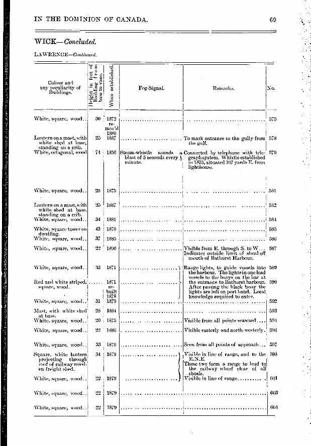
'73
Wh
en e
sta
blim
White, square, wood..
Lantern on a mast, with white shed at base, standing on a crib.
White, octagonal, wood
'White, square, wood..
Lantern on a mast,with white shed at base, standing on a crib.
White, square, wood..
White, square tower on dwelling.
'White, square, wood..
White, sepiare, wood..
White, square, wood ..
30 1872 re-
mov'd 1880
25 1887
74 I 1856
28 1 1875
25 ! 1887
34 1881
43 1870
37 1885
22 1890
33 1871
Steam-whistle sounds a blast of 5 seconds every minute.
575
To mark entrance to the g-ully from 578 the gulf.
Connected by telephone with tele- 579 graph system. Whistle established in 1875, situated 107 yards E. from lighthouse.
581.
582
584
585
:586
Visible from E. through S. to W... 587 Indicates outside limit of shoal off,
mouth of Bathurst Harbour.
Range lights, t,o guide vessels int,o 589 the harbour. The lights in one lead vessels to the buoys on the bar at the entrance t,o Bathurst harbour.! 590 After passing the black buoy the lights are left on port hand. Local knowledge required to enter.
593
Visible from all points seaward ...
Visible easterly and north-westerly. 596
594
592
597
598
601
603
604
IN THE DOMINION OF CANADA. 69
WICK—Concluded.
LAWRENCE—Continued.
c I
'
Colour and any peculiarity of
Buildings. Fog-Signal. Remarks. No.
Red and white striped, 1871 square, wood. re-
built 1878
White, square, wood.. 31 '1879
Mast, with white shed' 28 1884 at base.
White, square, wood.. 20 1875
White, square, wood .. 22 1886
White, square, wood. .1 33 1870
Square, white lantern 34 1879 projecting thmugh roof of railway wood-en freight shed.
White, square, wood..
White, square, wood..
White, square, woc>d
Seen from all points of approach...
Visible in line of range, and to the E.N.E.
These two fonn a range to lead to the railway wharf clear of all shoals.
Visible in line of range 22 1879
22 1879
22 1879
•
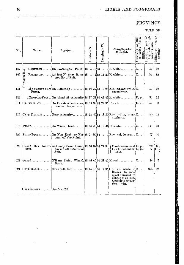
I
3'1
50 12
42
35
64 18 30 48 25 40 Near extremity
48 30 30 64 12 40 On White Head..
On Flat Rock, or Pla- teau, off the Point.
48 37 50 fi4 9 0
607
609
611
612
614
616
618
620
622
623
624
O'Hara Point Wharf, Basin.
lose to S. face
7
56 12
36 12
52
90
149 13
77 TO
29 6 } 37 11
38
355 26
48 49 45 64 28 45
48 45 15 64 935
70 • LIGHTS AND FOG-SIGNALS
PROVINCE
GULF OF
Lc cation .
CARLETON On Tracadigash Point.
PAspEmAc. , 1 330 feet N. from S. ex- tremity of Spit.
a
o
5
48 5 15 66 7 0
48 1 2 65 14 20
-- 5
n sa•
e •-■
> •
E 5.
o
No, Name. Characteristic of Light.
Lon
gitu
de W
.
F. white
F. white..
48 12 30:64 46 25
GRAND RIVER
CAPE DESPAIR
PERCÉ
POINT PETER.
Alt. red and white, C.. . one minute.
F. white D, p • •
F. red.
Rev, white, every.C.... minute.
F. white
Rev. red, 30 secs.. C....
{ F. red on f oremast D, p . . F, white on main- D, p..
mast.
F. red
Gp. rev. white, 3p.... flashes 15 secs. apart followed by eclipse of 30 secs. Çomplete revolu-tion 1 min.
MACQUEREAU On extremity POINT.
NEWPORTPOINT. On island off extremity 48 17 23 64 42
On E. side of entrance, 48 24 33 64 28 coast of Gaspé
LIGHT- At Sandy Beach Point, 48 50 35 64 24 30 moored off extreme of
j Spit.
GASPÉ BAY SHIP.
GASPÉ
CAPE GASPÉ
CAPE ROSIER... See No. 673.
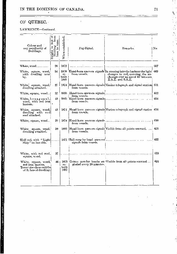
Visible from all points seaward. ... 620
622
37
46
IN THE DOMINION OF CANADA. 71
OF QUEBEC.
LAWRENCE—Continucd.
J.D = •••
LC,
•C :1> 'C.' Pe • 5
.
Colour and any peculiarity of
Buildings. Fog-Signal. Remarks. I No
28
54
607
609
White, wood
White, square, wood, with dwelling near by.
1872
Hand-horn answers signals from vessels.
In running into the harbour the light changes to red, covering the an-chorage over an arc of 45 betwn E.S.E. and S.S.E.
1870 re-
built 1881
27 1874
27 1895
43 1885
43 I 1874
29 1874
White: square, wood, dwelling attached.
White, square, wood..
White, hexag on al, wood, with red iron lantern.
White, square, wood, dwelling with r e roof attached.
White, square, wcxxl..
Hand-horn answers signals from vessels.
Hand-horn answers signals. from vessels.
Hand-horn answers signals from vessels.
Hand-horn answers signals from vessels.
Hand-horn answers signals from vessels.
611
612
614
Marine telegraph and signal station 616
618
Marine telegraph and signal station
1883 White square, wood, 50 dwelling attached.
Hand-horn answers sig-nals from vessels.
'Hull red, with " Light Ship " on her skie.
White, with red roof, square, wood.
White, square, wood, red iron lantern.
Tower rises from middle of S. face of dwelling.
Bell rung by hand answers signals from vessels.
1873 i Cotton powder bombe ex-Visible from all points seaward ... re- ploded every 20 minutes.
built 1892
1871
623
624
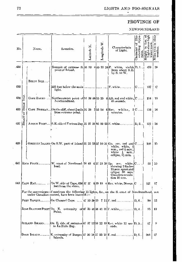
90 D, 6..
47 37 52
47 36 10
12
13
9
17
67 D, 5..
208 D, 6..
631
632
634
635
637
639
641
643
72 LIGHTS AND FOG—SIGNALS
PROVINCE OF
NEWFOUNDLAND
.± É. 18̀.g. p.,': p - 1, -2 —
›: —-* ' --
,, Characteristic Name. Location. rà ca--
-c ::.:' of Light. -., -.-' ,3 , -.....' t•-• % -,---
‘-: o
4 4 0
Summit of extreme S. 51 53 055 22 10F. white, visible D. 1.. 470 28 point of Island. from about 5. E.
by S. to W.
BELLE ISLE . .. -{ 333 feet below the main ... . F. white C .... 137 17
light.
- 1 l ; CAPE BAULD ... Northernmost point of 51 38 5055 25 0 Alt. red and white, C .... 154 18
1\ ewfoundland. 45 seconds. 2 1.2 .2 2 4-1 CAPE NORMAN.. On the cliff, about ï mile 51 38 7 55 54 6 Rev. white, 2C .... 116 16 r... from extreme point. minutes. c l.1 ‹ 4
43 AMOUR POINT... S. E. side of Forteau Bay 51 27 35 56 50 53F. white D, 2.. 152 18
è-- '
GREENLY ISLAND On S.W. part of Island 51 22 33 57 10 51 Gp. rev. red and C .... 108 15 white, white, min., red -à min., white Is min., eclipse, ps- min.
l
RICH POINT W. coast of Newfound- 54) 42 057 24 30 Gp. rev. white, C ... 93 15 land. showing 2 flashes
15 secs. apart and eclipse 30 secs. Complete revolu-tion 45 secs.
CAPE RAY On W. side of Cape, 650 47 37 059 18 0 Rev. white. 20 secs. C .. 127 17 feet from the shore.
For the convenience of mariners the following 11 lights, &c., on the S. coa,t of Newfoundland not under Canadian control, have been inserted :—
PORT BASQUE On Channel Cape. .... 47 33 50 59 7 11 F. red
ROSE BLANCHE POINT On E. extremity of Point.
47 35 48 58 41 31 F. white D, 4.. 95
58 22 13 IRELAND ISLAND On E. side of entrance to La Poile Bay.
Rev. white 12 sec-onds.
BOAR ISLAND E. extremity of Burge° Islands.
57 35 10 F. red
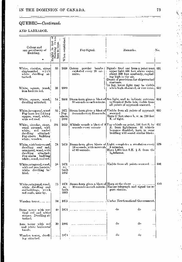
\Vhen
est
abli
shed
.
Remarks. 'No. Fog-Signal.
631
632
Sea light, and to indicate entrance 634 to Strait of Belle Isle, visible from all points of approach seaward.
Visible from all points of approach 635 seaward.
Horn 67 feet above h. w. m. 210 feet E. of light.
Foo.-whistle on point, 166 feet S. by 637 E. from lighthouse. If whistle becomes disabled, horn in saine
building will sound similar blasts.
Light completes a revolution every 3 minutes.
Horn 1,064 feet S.E. S. from the
639
Visible from all points seaward ... 641
Steam-horn 'ives a blast of 10 seconds in each minute.
Steam-horn gives a blast of 5 seconds every 35 seconds.
Whistle sounds a blast of 8 seconds every minute
1878 :Steam-horn gives blasts of I 10 seconds, with intervals I. of SO seconds.
1871 re-
built 1892
do do
do do
do do
1874
1886 :
1874
78
58
75
31
40
39
Stone tower with ver-tical red and white stripes. Dwelling at-taclied.
Iron tower with red and white horizontal bands.
Wooden tower, dwell-ing attached.
IN THE DOMINION OF CANADA. 73
Q1JEBEC--Continued.
AND LABRADOR.
Colour and te any peculiarity of
7.1 CD r..
773 „d
Building.
59 1858 Cotton powder bombs ( , Signals tired out from a point near exploded every 20 mi- I upper light 400 feet above water, nutes. I about 500 feet southerly, explod-
ing, high in the air. -1 Depot of provisions for shipwrecked
mariners. In fog, lower light may be visible
1. I when high obscured, or vice versa.
White, circular, stone clapboarded with white dwelling at-tached.
White, square, wood, iron lantern red.
White, square, wood, dwelling attached.
White, hexagonal, wo•od Fog-horn bu ildin g square, wood, white, with red roof.
White, circular, stone, wood covered, with white, red roofed dwelling attached. Fog-alarm building white, wooden.
White, withlantern and dwelling roof red, octagonal, wood, with dwelling attached. Fog-alarin building white, wood, roof red.
White,octagonal, wood, with red iron lantern, white dwelling be-hind.
31 1880
54 1884
53 1871 Fog-
alarm, 1890
104 1855
White,octag,onal, wood, white dwelling and
outbuildings, with red roofs, near by.
1871 'Steam-horn gives a blast of re- 10 seconds in each minute.
built 1885
Horn at the shore Marine telegraph and signal ice re-
port station.
Wooden tower.... ... 1875 Under Newfoundland Government.
643
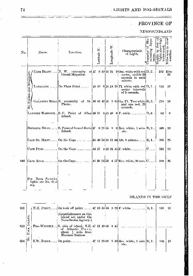
N. W. extremity Grand Miquelon.
of 47 610
18
8
24
26
24
30
315
180 CAPE RACE i On the Cape.
For Nova Sco ti a lights see No. 85 et 3(Y).
648
652
653
654
140
140 D, 1..
IS
18
74 LIGHTS AND FOG-SIGNALS
PROVINCE OF
NEWFOUNDLAND
ID, 1.. 390
No.
ce
Characteristic of Light.
'en C a
_ ,_ z •r:
c.= - • •- •
5 4 -
5 'e • ô 7-1 e *"
Naine. Location.
CAPE BLANC
LANGLADE
GAI,ANTRY HEAD
On Plate Point 46 49 8
of St. 146 45 42.56
56 24 9.0cc, white with red D, 2.. 103 15 to sector, visible 10 16 seconds in each minute.
56 24 19 Fl. white with red D, 1.. sector intervals of 5 seconds.
154 18
-JD
LASIALIN HARBOUR..
DoDinsE HEAD S. Point of Grand Burin Island.
CAPE ST. MARY On the Cape
CAPE PINE- On the Cape
9 44
46 51 0 55 48 0
47 0 26 55 9 0 Rev. white, 1 min- . ute.
46 49 34 54 11 34 Alt. I minute
46 37 453 31 45 F. white
46 39 24 53 4 17
S. extremity Pierre.
S.E. Point of Allan Island.
Gp. FI. Two white D, 2.. 210 and one red, 20 seconds.
F. white D, 8.. 64
D, 2.. 430
Rev. white, 30 sees.1C . ....
ISLANDS IN THE GULF
47 13 55 60 8 20 F. white
.e. :."•-7. , island are under the. < ! Nova Scotia Agency. ) 4
- FOG-WH •
ISTLE . ,'S. side of island, S.E. 47 11 48 60 8 45 of Atlantic C ove, • ,-z
< ! about 11,-. mile from ;•4 ,
1 Humane Station. •
'12 S.W.. POINT On point 47 11 20 60 9 40
N.E. POINT lOn rock off point
(Establishments on this
Rev. white, 1 min-
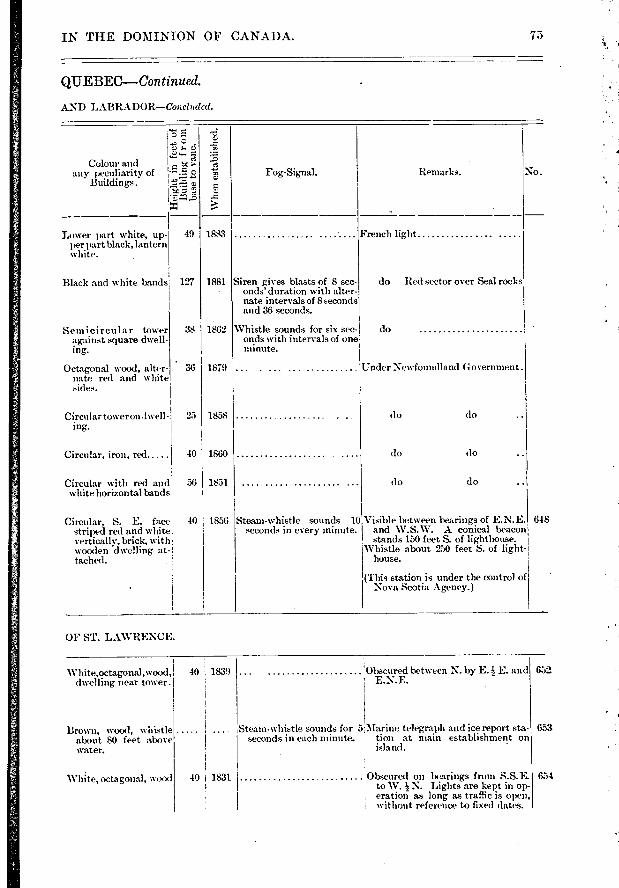
Whe
n e
stab
lish
ed.
Fog-Signal. Remarks.
Lower part white, up-)er part black, lantern
white.
49
Black and white bands 127
Semicircular tower against square dwell-ing.
Octagonal wood, alter-nate red and white sides.
Circular tower on .1well-ing.
Circular, iron, red 40
Circular with red and 56 white horizontal bands
Circular, S. E. face; 40 striped red and white vertically, brick, with: wooden dwelling at-tached.
French light
do Red sector over Seal rocks
do
1879 I_
do do
do do
do do
Steam-whistle sounds 10 Visible between bearings of E.N.E. seconds in every minute. and W.S.W. A conical beacon
stands 150 feet S. of lighthouse. Whistle about 250 feet S. of light-
house.
(This station is under the control of Nova Scotia Agency.)
:Under Newfoundland Government .
648
Colour and any peculiarity of
Buildings.
o
1883
1881
1862 38
• 36
25 1858
1860
1851
1856
Siren gives blasts of 8 sec-onds' duration with alter-nate intervals of 8 seconds and 36 seconds.
Whistle sounds for six sec-onds with intervals of one minute.
White,octagonal,wood, 40 dwelling near tower.
1839
Brown, wood, whistle about 80 feet above water.
White, octagonal, wood 40 I 1831
652
653
654
IN THE DOMINION OF CANADA.
QUEBEC--Con tinued.
AND LABRADOR—Conciuded.
OF ST. LAWRENCE.
Obscured between N. by E. 11E. and E.N.E.
Steam-whistle sounds for 5.Marine telegraph and ice report sta-seconds in each minute. tion at main establishment on
island. -
Obscured on bearings from S.S.E. to W. N. Lights are kept in op-eration as long as traffic is open, without reference to fixed dates.
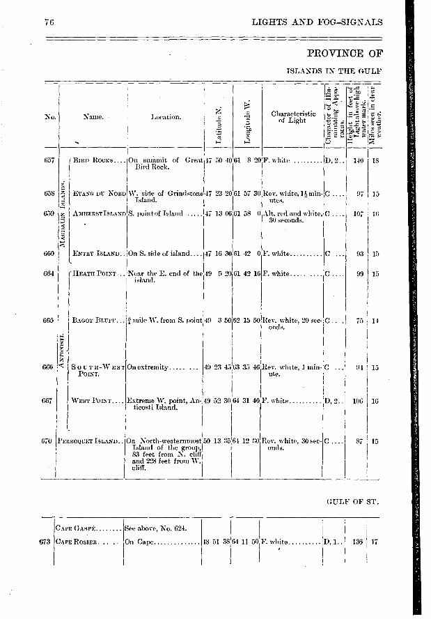
140 IS
97 15
10:
93 ; 15
99 I 15
75 14
49 23 45.63 35 46,Rev. white, 1 min- 'C ... 91 , 15 ute.
49 52 3064 31 40 F. white I), 2.. 106 I 16
1 12 20 Rev. white, 30 sec- onds.
87 15 50 13 35
'BIRD ROCKS.... On summit of Great , Bird Rock.
:2 ETANG DU NORD
z.
AMHERSTISLAND ;e
W. side of Grindstone Island.
S. point of Island
g-■
SOUTH-WEST POINT.
On extremity .....
WEST POINT....
PERROQUET ISLAND..
Extreme W. point, An-ticosti Island.
On North-westerinnost Island of the group, 83 feet from N. cliff and 228 feet from W. cliff.
666
667
670
ENTRY ISLAND.. On S. side of island.... I47 16 30161 42 0
(HEATH POINT... Near the E. end of the 49 5 20 61 42 16
F. white
F. white .....
CAPE GASPÉ
CAPE ROSIER. ..
See above, No. 624.
On Cape I), 1.. 673 F. white 136 I 17 48 51 38 64 11 50
No.
657
658
659
660
664
76 LIGHTS AND FOG-SIGNALS
PROVINCE OF
ISLANDS IN THE GULF
La
titi
ub N
.
IC
- •
5
Characteristic of Light
tc . li +v> .
442.
e
Name. I Location.
47 50 40 61 8 20F. wh;te D, 2..
47 23 2061 57 30 Rev. white, 11, min- C utes.
665 BAGOT BLUFF... mile W. from S. point 49 3 50
47 13 06 61 58 0,Alt. red and white, I 30 seconds.
62 15 50 Rev. white, 20 sec- C . owls.
GULF OF ST.
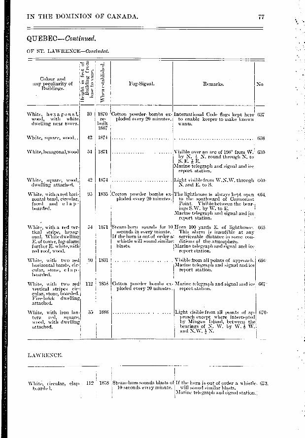
Colour and any peculiarity of
Buildings.
;"5'
;
;
Remarks. No
1870 re-
built 1887
1874
1871
39
42
51
42
95
667
670-
Whité, circular, clap-boardel.
112 1858
IN THE DOMINION OF CANADA.
QUEBEC—Continued.
OF ST. LAWRENCE—Concluded.
I I
Fog-Signal.
■V
Iten
est
abl
White, hexagona 1, wood, with white dwelling near tower.
Cotton powder• bombs ex-ploded every 20 minutes.
International Code flags kept here 657 to enable keeper to make known wants.
White, square, wood..
White, liexagonal,wood
White, square, wood, dwelling attached.
White, with a rcid hori-zontal band, circular, faced and c la p-boarded.
White, with a red ver-tical stripe, hexag-onal. White dwelling E. of tower, fog-alarm farther E. white,with red roof, wood.
White, with two red horizontal bands, éir-cular, stone, c lap-boarded.
658
Visible over an arc of 198° froni W. 659- bv N. N. round through N. to S.E.E.
Marine telegraph and signal and ice . report station.
Light visible from W.N.W. through 660 , N. and E. to S.
1835 ;Cotton powder bombs ex- The li ghthouse is always kept open 66-1 ploded every 20 minutes. to the southward of Cormorant
Point. Visible between the bear- , ings S.W. by W. to E. 1
Marine telegraph and signal and ice report station.
Steam-horn sounds for 10 Horn 100 yards E. of lighthouse.. 665. seconds in every minute. This alarm is inaudible at any
If the horn is out of order a serviceable distance in some con-whistle will sound similar ditions of the atmosphere. blasts. Marine telegraph and signal and ice
report station.
1831 ! .......... . Visible from all points of approach. 666T Marine telegraph and signal and ice
report station.
1874
54 1871
90
112 1858 White, with two red veitical strilws cir-cular, stone, boarded. Fire-brick dwelling attached.
Cotton powder bombs ex-ploded every 20 minutes.
Marine telegra.ph and signal and ice report station.
White. with iron Ian- 55 1888 tern red, square, wood, with dwelling' attached.
Light visible from all points of ap-proach except where intercepted by Mingan Island, between the liearings of N. W. by W. W. and N.W. N.
LAWRENCE.
Steam-horn sounds blasts of If the horn is out of order a whistle. 673. 10 seconds every minute. ! will sound similar blasts.
'Marine telegraph aud signal station.:
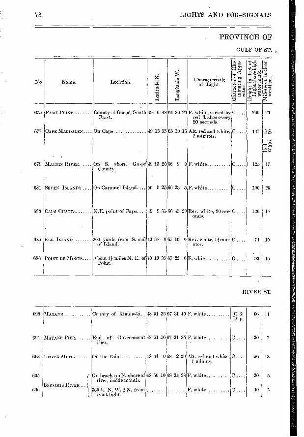
681
683
685
686
677 CAPE MAG DALES.. . On Cape
679 MARTIN RIVER. .... On S. shore, Gaspé County.
On Carousel Island....
N.E. point of Cape....
49 13 20
50 5 25
49 5 55 66 45 29
4988 0 67 10 0
66 9 0 F. white
66 23 5 F. white
Rev. white, 30 sec- C .... 120 18 onds.
Rev. white, 1:4 min-utes.
F. white ..... .
74
. 93
15
15
(390 MATANE
691 iMATANE PIER.
LITTLE METIS...
BERSTMIS RIVER...
t.
693
695
696
C p.
30 7
56 13
30 5
40 5
66 14
78 LIGHTS AND FOG-SIGNALS
PROVINCE OF
GULF OF ST. ,
No. Name.
Lati
tude
N.
Lo
ngit
ude
W.
Location. Characteristic of Light.
, 2 p.
CI
-
e« i'&7)
z,• 5
675 County of Gaspé, South Coast.
i200 yards from S. end I of Island.
FAME POINT ...
SEVEN ISLANDS ....
CAPE CHATTE
EGG ISLAND
POINT DE MONTS
49. 6 48 64 36 20 F. white, varied by ‘ C .... 200 20 red flashes every, 20 seconds.
49 15 35 65 19 15 Alt. red and white,.0 .... 147 2 minutes.
125 117
About 11 miles N. E. Of 49 19 35 67 22 0 Point.
C.
190 I 20
RIVER ST.
' County of Rimouski..
End of Pier.
48 51 3567 31 40 . F. .....
Government 48 51 50 67 31 35 F. white.. . . .
On the Point.... .... 48 41 068 2 21:1A1t. red and white, 1 minute.
On beach on N. shore of 48 56 1068 38 23 river, inside mouth. I
360 ft. N. W. a N. from front light.
F. white.... ..
F. white iC
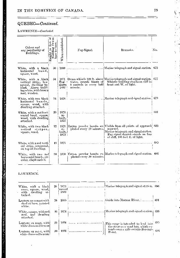
Remarks. Fog-Signal.
Wh
en e
stab
lish
ed.
White, with a black horizontal band, square, wood.
White, with a black vertical stripe, hex-agonal, dwelling be-hind. Alarm build-ing white, withbrown roof, wooden.
White, with two black horizontal bands, square, wood, with dwelling attached.
White, with a red hori-zontal band, square, wocxl, with dwelling attached.
39 1870 re-
built, 1875
50
54
54
White, with two black vertical stripes, square, wood.
Cotton powder bombs ex-ploded every 20 minutes.
Visible frun all points of approach 633 sea.ward.
Marine telegraph and signal station.' Fog-signal derrick stands on face of cliff, 106 feet E. of light.
32 1871 re-
built, 1875
White, with a red verti-cal stripe, octagonal, on top of dwelling.
White, with two red horizontal bands, cir-cular, clapboarded.
48 1871
90 ; 1830 Cotton powder bombs ex-! ploded every 20 minutes.
1 685
Marine telegraph and signal station. 686
Colour and any peculiarity of
Buildings.
e. •
•711 -4.z
Marine telegraph and signal station. 1 675
Marine telegraph and signal station. Whistle building stands on cliff in front and W. of light.
Marine telegraph and signal station. 679
677
681
1880
1871 Steam-whistle 128 ft. above Fog- water, sounds blasts of alarm 8 seconds in every half 1892 minute.
1876
1885 20
20
30
693
695
IN THE DOMINION OF CANADA. 79
QUEBEC—. Continued.
LAWRENCE—Concluded.
LAWRENCF"....
White, with a black cross, square, wood, with dwelling at-tached.
Lantern on a mast with shed at base, painted white.
White., square, with red roof, and dwelling attached.
Lantern on mat, \ With Wil ite diamond beacon
Lantern on mast, with white diamond beacon.
39 1873 'moved
1883
40 1874
1891 1
1891
Marine teleg,raph and signal station.! 690
Guide into Matane River ' 691
Marine telegraph and signal station.
This range is intended to Pad into the river over s.uid bar, which ex-tends over a mile outside Bersimis ' 690 Point.
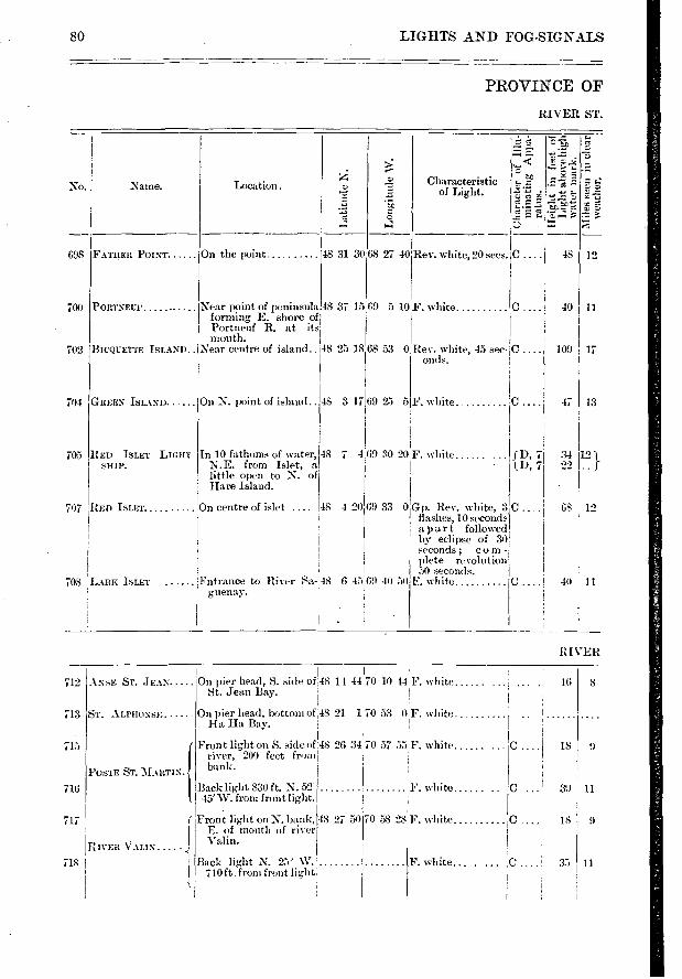
698
700
702
PORTNEUP
BICQUETTE ISLAND..
Location . o
a
o
i>
e
12
707
708
GREEN ISLAND.. .... On N. point of island..
RED ISLET LIGHT- In 10 fathoms of water, SHIP. N.E. from Islet, a
little open to N. of Hare Island.
RED ISLET On centre of islet ....
40 11
109 17
47 I 13
34 121 f
GS I 12
40 I 11
;9 30 20F. white ...... (D, 7 1,1), 7
ANSE ST. JEAN 712
713
715
ST. ALPFIONSE .....
POSTE ST. MARTIN.
716
717
RIVER VAUX .... ' .
718
14 44 70 10 44 F. white
21 1 70 53 0F. white
26 34 70 57 55 F. white
80 LIGHTS AND FOG-SIGNALS
PROVINCE OF
RIVER ST.
No. j Name.
FATHER POINT On the point.
Near point of peninsula forming E. shore of Portneuf R. at its mouth.
Near centre of island .. 48
Lo
ng
itu
de
W.
Characteristic of Light.
`E
3.22
• - F
-
C....; 48
C
25 18.68 53 0 Rev. white, 45 sec- C oncls.
48 31 30 68 27 40 Rev. white, 20 secs.
48 37 15 69 5 10F. white
704
705
...ARK ISLET
48 7 4
48
Entrance to River Sa- 48 guenay.
F. white :C .
0 Gp. Rev. white, 3 C flashes, 10 seconds apart followed by eclipse of 30 seconds ; corn - plete revolution 50 seconds.
F. white C .
48 3 17 69 25 5
4 20 69 33
G 45:69 40 50
RIVER
On pier head, S. side of ,48 St. Jean Bay.
On pier head, bottom of 48 Ha Ha Bay.
Front light on S. side of 48 river, 200 feet froni bank.
Back light 830 ft. N. 52' F. white 45' W. from front light.
Front light on N. bank, 48 27 50 70 58 28F. white E. of mouth of river Valin.
Back light N. 25 W. 710 ft . from front light
F. white... .....
C I 18 9
39 11
18 9
0H 35 11
16
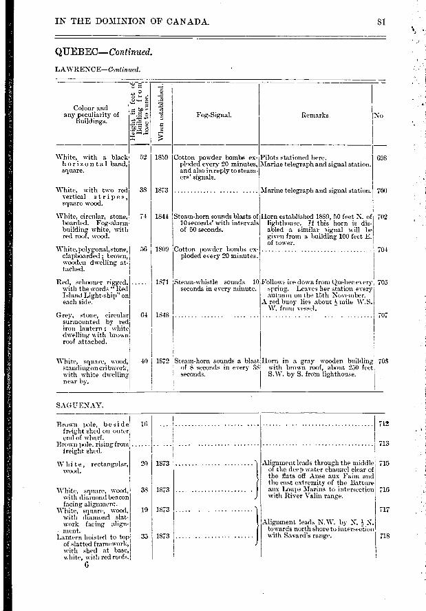
Wh
en e
sta
blis
hed.
Remarks. No Colour and
any peculiarity of Buildings.
o
> e
‘,ct
•Z‘'
Fog-Signal.
Red, schooner rigged, with the words "Red
Island Light-ship" on each side.
Follows ice down from Quebec every 705 spring. Leaves her station every autumn on the lûth November.
A red buoy lies about 13 mile W.S. W. from vessel.
Cotton powder bombs ex- Pilots stationed here. ploded every 20 minutes, I Marine telegraph and signal station. and also in reply to steam- ers' signals.
1859 White, with a black 52 horizon tal band, square.
White, with two red vertical s tripes, square wood.
White, circular, stone, boarded. Fog,-alarm building white, with red roof, wood.
White, polygonahstone, clapboarded ; brown, wooden dwelling at-tached.
38 I 1873
74 1841
56 I 1809
Steam-horn sounds blasts of 10 seconds' with intervals of 50 seconds.
Cotton powder bombs ex-ploded every 20 minutes.
Marine telegraph and signal station.
Horn established 1889, 50 feet N. of lighthouse. If this horn is dis-abled a similar signal will be given from a building 100 feet E. of tower.
Grey, stone, circular stirtnounted by red iron lantern ; white dwelling, with brown roof attached.
White, square, wood, stand ing on cribwork, with white dwelling near by.
Steam-horn sounds a blast Horn in a gray wooden building of 8 seconds in every 58 with brown roof, about 250 feet seconds. S.W. by S. frotn lighthouse.
Steam-whistle sounds 10' seconds in every minute.
1871
64 1848
40 1872
698
700
702
704
I 707
703
16 712
713
20 I 1873
38 I 1873
19 11873
718 35 I 1873
Brown pole, beside freight shed on outer end of wharf.
Brown pole, rising from freight shed.
W hi te, rectangular, wo(xl.
White. square, wood, with diamond beacon facing aligmnent.
White, square, wood, with diamond slat-work facing align-
. ment. Lantern hoisted to top
of slatted framework, with shed at base, white, with red roofs.
Alignment leads through the middle 715 of the deep water channel clear of the flats off Anse aux Faim and the east extremity of the Batture aux Loups Marins to intersection 716 with River Valin range.
111
Alignment leads N.W. by N. 1, N. towards north shore to intersection with Savard's range.
IN THE DOMINION OF CANADA. 81
QUEBEC—Continued.
LAWRENCE—Continued.
SAGUENAY.
6
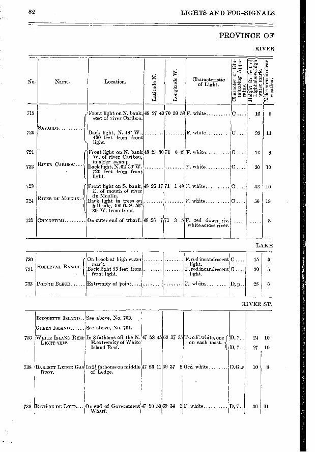
24 10 D, 7..
ll, 7. .
10 D.Gas
27 10
8
11 D, 7.. 36
82 LIGHTS AND FOG—SIGNALS
PROVINCE OF
RIVER
• › :
o Characteristic No. Name. Location. .7e. "cc"
'Z. î.'. - E..' 4 3 •—, ,* 4 1-4 5
719 Front light on N. bank, 48 27 49 70 59 58 F. white c 16 east of river Caribou.
SAVARDS 720 Back light, N. 48° W., F. white c 39 11
490 feet from front light.
721 Front light on N. bank 48 27 3071 0 49 F. white c 14 8 W. of river Caribou,
RIVER CARIBOU... in alder swamp. 722 Back light, N.6230
,w. F. white c 30 10
. 720 feet from front light.
723 Front light on S. bank, 48 26 17 71 1 48 F. white c 32 10 E. of mouth of river du Moulin. 724 R I V E R DU MOULIN. Back light in trees on F. white C 56 13 hill side, 400 ft. S. 55° 30' W. from front.
75 CHICOUTIMI On outer end of wharf. 48 26 7 71 3 5F. red down riv s white across river.
LAKE
733
731
730
{
ROBERVAL RANGE.
POINTE BLEUE
On beach at high water mark.
Back light 95 feet from front light.
Extremity of point ...
F. red incandescent !C light.
F. red incandescent C light.
F. white.... ....
15 5
30 5
28 5 D, p..
RIVER ST.
BICQUETTE ISLAND
GREEN ISLAND
WHITE ISLAND REEF LIGHT-SHIP.
738 BARRETT LEDGE GrAS BUOY.
See above, No. 702.
See above, No. 704.
In 8 fathoms off the N. E.extremity of White Island Reef.
In 21 fathoms on middle of Ledge.
47 58 45
47 53 11
Two F. white, one on each mast.
69 37 5Oce. white
736 69 37 35
739 RIVIÉRE DU LOUP.... On end of Government 1 Wharf.
47 50 59 9 34 1 F. white .....
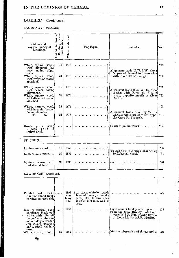
o
ti) 5 c Fog-Signal. Remarks. No.
Colour and any peculiarity of
Buildings.
Wh
en e
sta
bli
shed
. White, square, wood,
with diamond day mark facing align-ment.
White, square, wood, with irregular beacon attached.
17 I 1873 719 1I
Alignment leads N.W. -h W. along }- N. part of channel to intersection
I with River Caribou range. 720 31 1873
721 Alignment leads W.N.W. to inter-
section with River du Moulin range, opposite mouth of River 722 Canbou.
17 I 1873
32 I 1873
White, square, wood, with beacon facing alignment.
White, square, wood, with diamond beacon attached.
723 18 I 1873
21 I 1873
White, square, wood, with irregular beacon facing alignment.
do do .. 724 Alignment leads S.W. by W. to-
wards south shore of river, oppo-site Cape St. François.
Brown pole rising through roof of freight shed.
725 Leads to public wharf
Lantern on a mast ....
Lantern on a mast ...
Lantern on mast, with red shed at base.
16 I 1839
25 I 1889
25 I 1893
To lead vessèls through channel up to Roberval wharf.
730
731
733
736
Lii,,ht cannot be depended upon From the buoy Brandy Pots Light
bears W..1. 2.ï miles, and Rivière du Loup Lights S.S.E. 2Ï miles.
Marine telegraph and signal station
738
;39
1893 Gas
buoy 1886
1886
35 1882
IN THE DOMINION OF CANADA. 83
QUEBEC--Continued.
SAGUENAY—Concluded.
ST. JOHN.
LAWRENCE—Cont inued.
Painted r ed, with "White Island Reef" in white on each side
8-in , steam-whistle, sounds blast of 8 secs., interval 8 secs., blast 8 secs. then inters al of 2 min. and 20 secs.
Iron cylindrical buoy checlzered black and
• white, with "Barrett Ledge" in white, sur. mounted by a wooden can shaped slatwork and a small red lan-tern.
White, square, wood..
6Ls
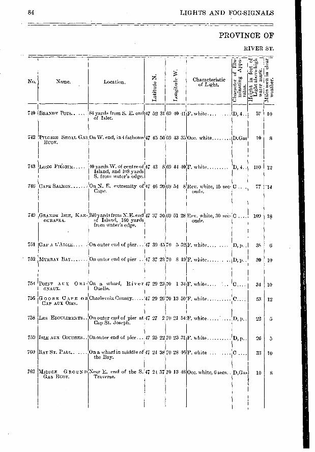
No.
740
742
743
746
749
751
- 752
754
756
758 ILES EBOULEMENTS.
ISLE AUX COUDRES.
BAY ST. PAUL.
BRANDY POTS.....
PILGRI3I SHOAL GrAS BUOY.
LONG PIL.GRIM
CAPE SALMON
CAP A L'AIGLE
MURRAY 13AY
POINT AUX RI - GNAUX.
GOOSE CAPE OR CAP AUX OIES.
Location.
84 yards from S. E. end of Islet.
On W. end, in 4 fathoms
40 yards W. of centre of Island, and 108 yards S. from water's edge.
On N. E. extremity of Cape.
On outer end of pier...
On outer end of pier ..
On a wharf, River Ouelle.
Charlevoix County
On outer end of pier at Cap St. Joseph.
On outer end of pier. ...
69 40 41 47 52 31
47 45 50 69 4333
69 44 40 4713 8
47 46 20 69 54 8
47 37 30 69 51 28
47 39 45 70 532
47 37 23 70 8 19
47 29 23 70 1 34
47 29 2670 13 50
47 27 2
47 25 22
70 21 54
70 23 31
70 28 46
D, 4..
D.Gas
D, 4..
D, 1)..
D, P. •
C....
D, p..
D, p.. 759
760
762
. —.I
g "Z e: 4.■
57 10
10 8
180 12
77 - 14
109 18
381 G
.30 i 10
34 10
53 12
221 5
26 5
33 10
10 8
84 LIGHTS AND FOG-SIGNALS
PROVINCE OF
RIVER ST.
Name. Characteristic of Light.
e r--.
< t.n
'FiA> à-511
Lo n
git
ude
W.
On a wharf in middle of 47 24 38 the Bay.
F. white .... „ .
Occ. white
F. white
Rev. white, 15 sec-onds.
Rev. white, 30 sec-onde.
F. white....
F. white ..... .
F. white
F. white .....
F. white
F. white
GRANDE ISLE, KA3I- 240 yards from N.E. end OCRASKA. of Island, 160 yards
from water's edge.
Lat
itu
de N
.
MIDDLE GROUND Near E. end of the S.47 24 37 GAS BUOY. Traverse.
70 13 48 Occ. white, 6 secs.. D,Gas
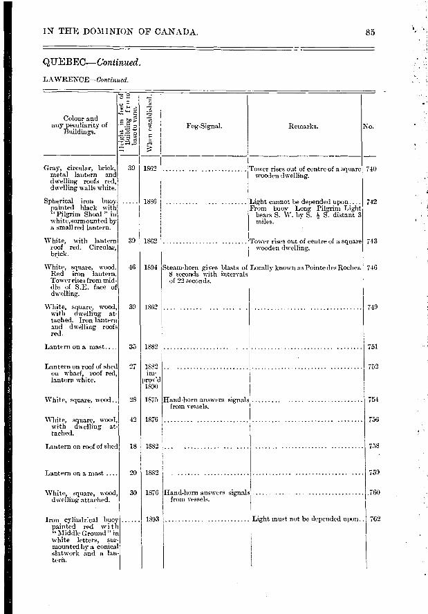
Colour and any peculiarity of
Buildings.
c
e >
-arg. Fog-Signal.
Whe
n es
tabl
i
No. Re/narks.
39
39
46
39
27 1882 im-
prov'd 1890
28 1875
42 1876
18 I 1882
20 1882
30 1876
1893 Light must not be depended upon.. 762
740
742
743
746
749
751
752
754
756
758
759
760
IN THE DOMINION OF CANADA. 85
QITEBEG—Continued.
LAWRENCE—Continued.
Gray, circula r, brick, metal lantern and dwelling roofs red, dwelling walls white.
Spherical iron buoy painted black with " Pilgrim Shoal " in white,surmounted by a small red lantern.
1862 ,
1886
Tower rises cmt of centre of a square wooden dwelling.
Light cannot be depended upon.... From buoy Long Pilgrim Light
bears S. W. by S. Is S. distant 3
White, with lantern roof red. Circular, brick.
White, square, wood. Red iron lantern. Tower rises from mid-dle of S.E. face of dwelling.
White, square, wood, with dwelling at-tached. Iron lantern and dwelling roofs red.
Lantern on a mast... ,
1862 Tower rises out of centre of a square wooden dwelling.
1894 Steam-horn gives blasts of Locally known as Pointe des Roches 8 seconds with intervals of 22 seconds.
1862
35 1882
Lantern on roof of shed on wharf, roof red, lantern white.
White, square, wood ..
White, square, wood, with dwelling at-tached.
Lantern on roof of shed
Lantern on a mast ....
White, square, wood, dwelling attached.
Hand-horn answers signals from vessels.
Hand-horn answers signals from vessels.
Iron cylindr:cal buoy painted red with "Middle Ground "in
white letters, sur-mounted by a conical slatwork and a Ian-terh.

70 14 51 of St. Rochl47 21 53 31
25
TWO F. white and one F. red. One F. white at each mast head and red on stay be-tween the masts.
Two F. white, one on each mast head.
D, 7..
D, p..
D, p..
D, p..
49
25 and 31
14
9
6
8
764 UPPER TRAVERSE LIGHT-SHIP.
In 4 fms. N. W. edge of St. Roch Shoal.
HANNEL PATCH GAS'On the Patch in 3 BUOY. I fathoms.
767
47 19 58 70 16 16
47 14 33 70 19 35
100 yards from S. point 47 12 25 of Islet.
70 21 36 768 STONE PILLAR. .. , .
ALGERNON ROCK.
BEAUJEU BANK E. END GAS BUOY.
769
772
773 BEAUJEU BANK W. END GAS AND BELL- BUOY.
70 21 15
70 27 56
70 30 37
70 32 50
0 33 15
Occ. white
Rev. white 30 sec-onds.
F. white
F. pink
Occ. white 6 sec-onds.
Occ.white obscured 4 seconds in every 30 seconds.
F. white and red..
In channel, S. E. of 47 12 11 Stone Pillar.
In 3 fathoms on Shoal. 47 6 13
In 14 fathoms on Shoal. 47 4 11
Near extremity of pier, 1,11 miles from W. point of Island.
47 2 47
At outer end of Govern- 46 59 26 men Wharf
ST. THOMAS DE 1 MONTMAGNY. Back range, 1,971 feet
S. i W. from front light.
G A S On W. end of Margaret 47 025 Island Bank in 3h fathoms.
GROSSE ISLE BUOY.
36 I 6
10
8 14
48 12
26 I 3
41 I 3
10 I 8
D.Gas
D, 6..
D.Gas
D. Gas
D, 7..
D, Ps •
D,p..
D. Gas
F. white
70 39 9 F. pink.
776
778
779
781
LIGHTS AND FOG—SIGNALS
PROVINCE OF
RIVER ST.
86
No. Nanae.
Lat
itu
de N
.
Lon
g itu
de W
.
A à, —‹ o
e e '751-1 C.)
Location. Characteristic of Light.
0
Z o
e o.
5 5 e-
763 LOWER TRAVERSE N.E. part LIGFIT-SHIP. Shoals.
83H4 14
RANE ISLAND
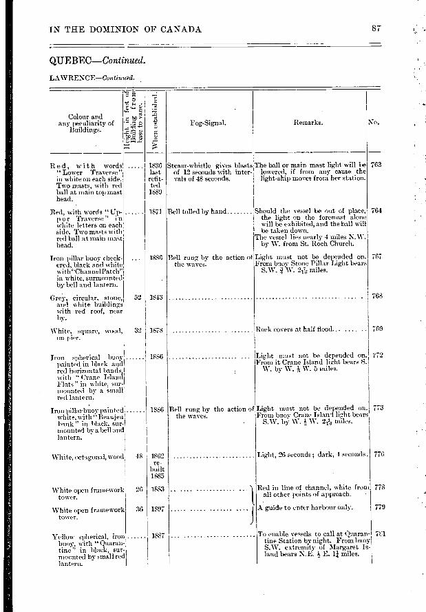
1836 last refit-ted 1889
1871
No.
763
764
767
768
769
52 1 1843
32 1878
773
776
778
779
IN THE DOMINION OF CANADA 87
QUEBEC—Continued.
LAWRENCE—Contintad.
Remarks. Fog-Signal.
Whe
n es
tabli
shed.
Colour and any peculiarity of
Buildings.
Steatn-whistle gives blasts The ball or main mast light will be of 12 seconds with inter- lowered, if from any cause the vals of 48 seconds, light-ship moves from her station.
Red, with words " Lower Traverse" in white on each side. Two masts, with red ball at main top mast head.
- Red, with words " Up-
p e r Traverse" i n white letters on each side. Two masts with red ball at main niait
head.
Iron pillar buoy check-ered, black and white with"ChannelPatch" in white, surmounted by bell and lantern.
Grey, circular, stone, and white buildings with red roof, near by.
White, square, wood, on
Iron spherical buoy painted in black and red horizontal bands, with " Crane Island li Flats" in white sur- , . mounted by a smalr red lantern.
Iron pillarbuoy painted white, with "Beaujeu bank " in black, sur-I mounted by a bell and lantern.
1886 Bell rung by the action of the waves.
Rock covers at half flood... ....
1886 Light must not be depended on» i'72 From it Crane Island light bears S.
W. by W. ?; W. 5 miles.
1886 Bell rung by the action of Light must not be depended on. the waves. From buoy Crane Island lig,ht bears
• S.W. bY W. W. 2116 miles.
Bell tolled by hand Should the vessel be out of place, the light on the foremast alone will be exhibited, and the ball will be taken down.
The vessel lies nearly 4 miles N.W. by W. from St. Roch Church.
Light must not be depended on. From buov Stone Pillar Light bears
S.W. .W. 2/76- miles.
g
F:
White, octagonal, %rood
White open framework tower.
White open framework tower.
48 1862 re-
built 1885
26 1883
36 1897
Light, 26 seconds; dark, 4 seconds .
Red in line of channel, white from all other points of approach.
A guide to enter harbour only.
To enable vessels to call at Quaran- 761 tine Station by night. From buoy ,
S.W. extremity of Margaret Is-land bears N.E. E. 1 miles.
1887 Yellow spherical, iron buoy, with " Quaran-tine.'" in black, sur. mounted by .sinall red lantern.
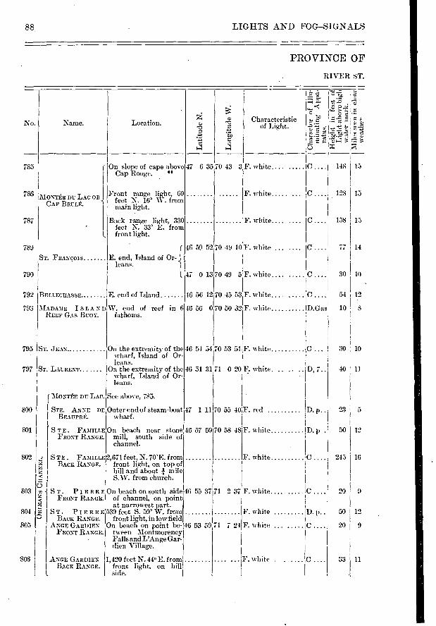
ST. LAURENT
( MO;7TÉE DU LAC.
STE. ANNE DE,
STE. FAMILLE FRONT RANGE.
BEAUPRÉ. BEAUPRÉ.
785
MONTÉE DU LAC OR , CAP BRULÉ.
786
787
789
ST. FRANÇOIS
BELLECRASSE
790
792
793 MADAME ISLAND REEF GAS BUOY.
795 1ST. JEAN.
D, 7..
D. p..
D. p .
F. white .....
F. white.... ....
46 59 52 70 49 10F. white ...
47 0 13 70 49 5 F. white
46 56 12,70 45 53 I F. white.... .....
46 56 070 50 32 F. white
46 54 54
46 51 31
47 1 11
C 128
C 138
C 77
30
C .... ! 54
D.Gas 10 8
15
15
14
10
12
70 53 MIE. white
71 0 20 F. white.
70 55 40F. red .
70 58 48 F. white
797
800
801
802
803
804
805
2,671 feet, N. 70'E. f rom front light, on top of hill and about mile S.W. from church.
On beach on south side 46 55 37 of channel, on point at narrowest part.
539 feet S. 59' W. from front light, in low field
On beach on point be- 46 53 59 tween Montmorency Falls and L'Ange Gar-dien Village.
1,420 feet N. 44° E. from front light, on hill side.
30 ' 10
40 ! 11
23
12
16 243
209
50 . 12
20 9
33 11 806
88 LIGHTS AND FOG-SIGNALS
PROVINCE OF
RIVER ST.
No. Naine. Location.
Lat i
tude
N.
Lo
ngit
ude
W.
" `1
<7'.7
—
— c, - E
.? 3
Characteristic of Light.
7 6 35 70 43 3F. white.... ..... C . . . .1 148 13 On slope of cape above Cap Rouge. 44
Front range light, 60 feet N. 16' W. from main light.
Back range li,ght, 330 feet N. 33' E. frona front light.
E. end, Island of Or-leans.
E. end of Island
W. end of reef in 6 fathoms.
On the extremity of the wharf, Island of Or-leans.
On the extremity of the wharf, Island of Or-leans.
See above, 785.
Outer end of steam-boat wharf.
On beach near stone 46 57 mill, south side of channe].
50
STE. FAMILLE BACK RANGE.
o -{ ST. PIERRE
FRONT RANGE.
PIERRE BACK RANGE.
ANGE GARDIEN FRONT RANGE.
ANGE GARDIEN BACK RANGE.
F. white IC
I C
F. white D. P..
F. white
F. white
71 2 37,F. white
71 721
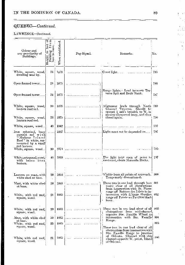
IN THE DOMINION OF CANADA. 89
Q1JEBEC-- Continued.
LAWRENCE—Continued.
"5 E..
5.0
'Whe
n es
tabl
i
Colour and any peculiarity of
Buildings. Fog-Signal. Remarks. No.
White, square, wood, dwelling near by.
34 1870 785 Coast light. .
Open framed tower.... 24 1875 786
Open framed tuwer.... 34 1875
White, square, wood, lantern roof red.
White, square, wood, lantern roof red.
30
28
1875
1875
1
)
White, square, wood..
Iron . spherical, buoy
ElIZIame dred Island Reef " in white, sur-mounted by a small red lantern.
White, square, wood.. 30
1862
1887
1874
White,octagonal,wood, with brown iron lantern.
40 1869
Lantern on mast,. with white shed at base.
Mast, with white shed at base.
50
20 188S
1885
White, with red roof, square, wood.
1885
Range lights. • Lead between Tra-verse Spit and Brulé Bank.
Alignment leads throm,,h North! 789 Channel Traverse. Should be l opened sail's breadth to W. in
passing- chequered buoy, and theM closed ageain. 790
792
Light must not be depended on...
795
The light kept open of point to westward, clears Iaranda Rocks.
Visible from all points of approach. Temporarily discontinued.
These two in one lead through best water clear of all obstructions [ from intersection with St. Pierre t range off Batture des Islets to in • ; tersection with L'Ange Gardien! range off Pointe au Pavillon black buoy.
787
„
797
800
801
802
803 23 1885
804 50 i 1885
These two in one le.ad clear of all obstructions from mid-channel opposite Ste. Famine Wharf to intersection with Ste. Famille Range.
805 1885 23
White, with red roof, square, wood.
Mast, with white shed at base.
White, with rt-d roof, square, wood. These two in one lead clear of all
1 obstructions from intersectionwith Ste. Fa.nille Range to junction of Orleans. Channel with ship channel opposite W. point, Island of Orleans.
800 White, with red roof,. 21 square, wood.
1885
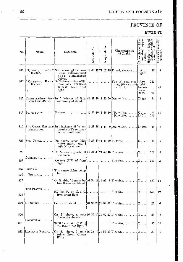
s'e
7=;
No.
811
812
ST. ANTOINE 816
819 STE. CROIX GAS AND BELL-BUOY.
Om white
f F. white ..... . 1,F. white
Om white
F. white
F. white
F. white .....
F. white
F. white
820
823
821
825
826
827
828
829
830
831
71 36 10
71 44 0
71 44 10
71 52 10
71 53 8
71 54 51
71 56 21
71 59 35
14 I 8
96 10 106
14 8
41 6
5 120
5 200
12 130
12 152
6 27
10
5 35
D. gas
D, 7 .
D. gas
C.
C.
C
C.
90 LIGHTS AND FOG-SIGNALS
PROVINCE OF
RIVER ST.
Name.
Lat
itu
de N
.
Lon
git
ude
W.
Location.
1? :0 ;) > 0 c2
• d a) 0
ri 55
Characteristic of Light.
QUEBEC, FRONT N.E. corner of Princess 46 49 RANGE. Louise Eilabankmene
near Immigration Offices.
QUEBEC, BACK On Battery at foot of St. ... RANGE. Famine St., 2,900 feet
W.S. W. from front light.
F. red, electric....
Two F. red, elec. Arc trio, 16 feet apart light. vertically. Incan-
des- cent.
43
112
rs
96 J
17 71 12 15 Arc light.
8
815 ITREMBLESSHOALGASIn 7 fathoms off S.E. 46 41 10 71 33 20 { AND BELL-BUOY, extremity of shoal.
S. shore.
In 4 fathoms off W. ex- 46 38 36 tremity of Paget Bank or Ecureuil Shoal.
On shore, near high 46 37 45 water mark, and mile N. of church.
( On X. shore, mile off 1 46 41 48 I the river.
POTITNEUF .... I 540 feet X.E. of front
light.
BABRE X " • • " • f Two range lights being 1 built. BOULARD.. •
On S. side, l miles be- 46 39 13 low Richelieu Island.
THE PLATON I 507 feet E. by N. N. I from front light.
STE. CROIX .....
833
RICHELIEU. ... .... Centre of Island ,46 38 25
( On S. shore, a mile 46 37 10 above the church.
LOTBINIÉRE 1 2,850 feet S.W. by W.
I., W. from front light.
LANGLAIS POINT.... On S. shore, mile 46 35 5 below Great Chêne River.
F. white
F. white .... . .
F. white .....
F. white
46 39 40
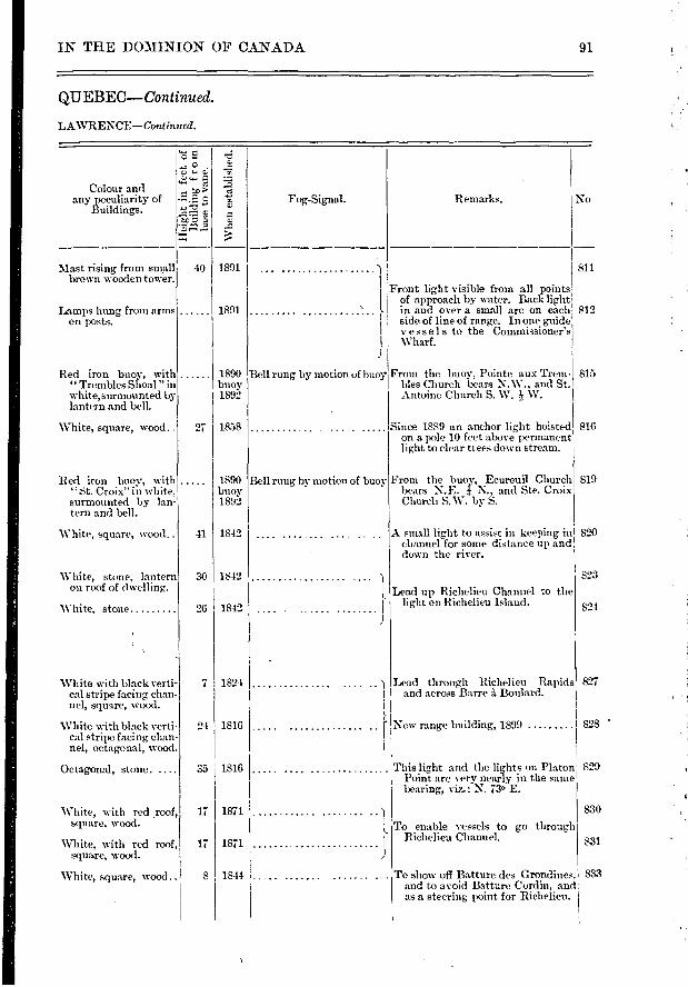
Colour and any peculiarity of
Buildings. terâ
Whe
n em
tabl
hihe
d.
1891
1891
40
27 1858
1890 buoy 1892
Mast rising from small brown wooden tower.
Lamps hung from arms on posts.
Red iron buoy, with "Trembles Shoal "in white, surmounted by lantern and bell.
White, square, wood.
811
812
815
816
819
820
823
824
827
828 •
This lig,ht and the lights on Platon Point are very nearly in the same bearing, viz.: N. 73. E.
830
To enable vessels to go through Richelieu Channel,
To show off Batture des Orondines, 833 and to avoid Batture Cordin, and as a steering point for Richelieu.
831
829
White with black verti-cal stripe facing chan-nel, square, wood.
White with black verti-cal stripe facing chan-nel, octagonal, wood.
Octagonal, stone. ....
White, with red roof, square, wood.
White, with red roof, square, wood.
White, square, wood ..
7 1824
24 1816
35 1816
17 1871
17 1871
8 1844
IN THE DOMINION OF CANADA
QIIEBEC--Continued.
91
LAWRENCE—Continued.
No
Front light visible from all points of approach by water. Back light
}- in and over a small arc on each side of line of range. In one guide
I vessels to the Commissioner's Wharf.
1890 Bell rung by motion uf buoy' From the buoy, Pointe aux Trem- buoy bles Church bears N.W., and St. 1892 Antoine Church S. W. Is W.
Since 1889 an anchor light hoisted on a pole 10 feet above permanent light to clear bees down stream.
Fog-Signal. Remarks.
Red iron buoy, with "St. Croix" in white, surmounted by lan-tern and bell.
Bell rung by motion of buoy From the buoy, Ecureuil Church bears N. E. .1 N., and Ste. Croix Church S.W. by S.
A small light to assist in keeping in channel for some distance up and down the river.
White, square, wood..
White, stone, lantern on roof of dwelling.
White, stone
30 1842
26 1842
Lead up Richelieu Channel to the light on Richelieu Island.
41 1842
Lead through Richelieu Rapids and across Barre à Boulard.
1
}- 1. New range building, 1899
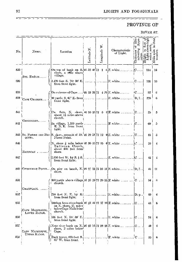
No.
835
836
838
839
841
842
845
846
847
Name.
STE. EMÉLIE
72 1 0
72 430
72 5 0
72 12 0
72 15 0
72 16 10
F. white
F. white
F. white
F. white
F. white
F. white
F. white
F. white
F. white
F. white .....
114
131
16
16
6
5
5
5
4
4
11
fi
CHAMPLAIN.
851
852
855
856
857
858
On flats, N. shore, about 1 miles above church. -
In village, 1,350 yards E. N. E. from front light.
S. shore, summit of St. Pierre Point.
N. shore î mile below Batisca n Church, about 600 feet from shore.
2,050 feet W. by S. à S. from front light.
On pier on beach, N. shore.
300 yards above village church.
750 feet N. E. by E. from front light.
F. white
F. white
F. white .....
F. white... ......
F. white
D, 7..
C. ..
D. p..
C.
25
60
85
20
42
40
34
60 1 6
41 6
54
6 55
46 33 39
46 35 25
46 29 58
46 30 35
46 27 12
46 26 26
92 LIGFITS AND FOG-SIGNALS
PROVINCE OF
RIVER ST.
On top of bank on S. 46 33 40 shore, a niftle above village.
Location
Lon
gitu
de W
Characteristic of Light.
to
o ft.
ta ‘:
9 ‘'s Té. •• 5
ei
3
3,420 feet S. 700 30' E. from front light.
On extreme of Cape ....
CAPE CHARLES... SO yards S. 67' E. from front light.
GRONDINES
ST. PIERRE DES BEC-QUETS.
BATISCAN .
1.
849 1CITROUILLE POINT...
230 feet from river bank 46 23 on N. shore, 21- miles
CAPE MADELEINE, belowCape Madeleine
LOWER RANGE. church.
APE MADELEINE, UPPER RANGE.
536 feet N. 60. 30' E. from front light.
Year river bank on N. 46 23 shore, 2 miles below Cape.
Back tower, 855 feet S. .... 85 W. from front.
C.... 92
D, 7.. 120
46 72 27 18
16 72 28 28
. - .....
72 20 55 F. white .....
Remarks. No. Fog-Signal. Colour and
any peculiarity of Buildings.
z
1856
1856 chan- ged 1890
White, square, wood, with red vertical stripe on side facing alignment.
do do ..
White, polygonal, wood
Lanternon a mat.
Lead through channel dredged in Batture Ste. Anne.
30
30
12
40
25
40
852
855
856
857
858
23
26
36
16
IN THE DOMINION OF CANADA.
QUEBEC--Continued.
LAWRENCE— COTIe
93
Wli
en e
stab
lish
ed.
built 1880 lit
1898
1
Lights, in one N. 70' 30' W. lead 835 midway- between the red and black buoys from the curve at Cap' Charles to the curve at Cap à la . Roche. The channel marked by. 836 this range is 300 feet wide.
833 Lead between Cap à la Roche and
Cape Charles. Front light also 839 answers as a steering point through Horseback Bar.
White, with red ver-tical stripe, square, wood.
White, with red %-er-tical stripe,octagonal, wood.
White, octagonal, wood' 30
White, octag,onal, wood ; 18)
White, octagonal, wood
White, square, wood, red iron lantern on middle of roof.
White, square, wood..
1857 .......... • • . • • • - I
1857
1844
1844 moved
1879
1844 moved
1879
36
41
841
842
845
846
847
849
851
Lead to upper entrance of Cap a 1 la Roche Channel.
1878 Temporarily on a pole.
'White, square, wood, polygonal, wooden lantern.
White, square, wood..
White, octagonal, wood
White, octagonal, wood
. .
The alignment leads into the -up- ] ' per entrance to the channel north
of Provencher Shoal. .............. .... ....
}- To clear Provencher Shoal, leading I through N. channel.
1843
1813 moved
1891
1843 moved
1891 1843
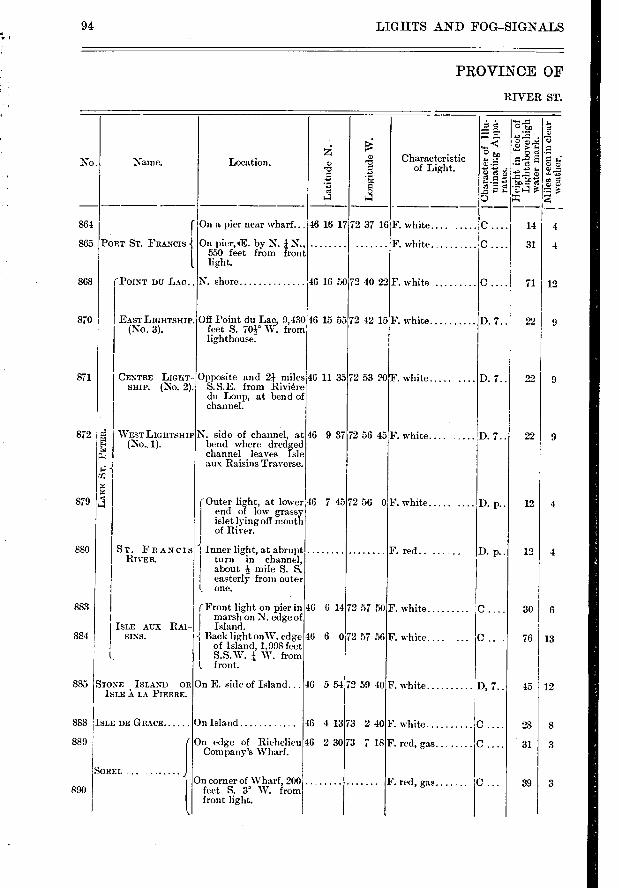
LIGHTS AND FOG—SIGNALS
PROVINCE OF
RIVER ST.
94
›.: ..- ID
No. Name. Location. o Chara "o
e e o a a
864 f On a pier near wharf... 46 16 17 72 37 16 F. white
865 PORT ST. FRANCIS On pier,IE. by N. 1 N., F. white
I 550 feet from front
t light.
368 (Form' DU LAC.. N. shore 46 16 50 72 40 22 F. white
370 EAST LIGHTSHIP. Off Point du Lac, 9,430 16 15 55 72 42 15F. white (No. 3). feet S. 70à. W. from
lighthouse.
371 CENTRE LIGHT- Opposite and 21 miles 46 11 35 72 53 ?OF. white SHIP. (No. 2). S.S.E. from Rivière
du Loup, at bend of channel.
172 -2 WEsx LIGHTSHIP N. side of channel, at 46 9 37 72 56 45F. white ;.4 E, (No.. 1). bend where dredged g ;:-■ , channel leaves Isle
aux Raisins Traverse. Ez 1
H H
79 1 (Outer light, at lower 46 7 45 72 56 0F. white end of low grassy islet lying off mont h of River.
80 Sr. FRANCIS Inner light, at abrupt F. red. RIVER. turn in channel,
about } mile S. S. easterly from outer
I, one.
83 (Front light on pier in 46 6 14 72 57 50F. white, marsh on N. edge of
ISLE AUX RAI- Island. 84 SINS. -- Back light onW. edge 46 6 072 57 56 F. white.
I of Island, 1,998 feet I S.S.W. 1 W. from L. front.
35 STONE ISLAND OR On E. side of Island ... 46 5 54 72 59 40F. white.
ISLE À LA PIERRE
38 ISLE DE GRACE On Island 46 4 13 73 2 40 F. white.
39
On edge of Richelieu 46 2 30 73 7 18 F. red, ga Company's Wharf.
SOREL ... ... .....
On corner of Wharf, 200 F. red, gii 10 feet S. 3° W. from
front light.
8
8
8
8
8
8
7425' ,
• ,111
C ....
C ....
"-dfc
8 e
"ecaTees 3
ss
14
31
2 2 e
4
4
C 71
D. 7..
D. 7..
D. 7..
D. p..
D. p..
C .
D, 7..
C.... 39 3
teristic ight.
12
9
9
4
4
13
12
8
3
22
22
12
12
30
76
45
28
31
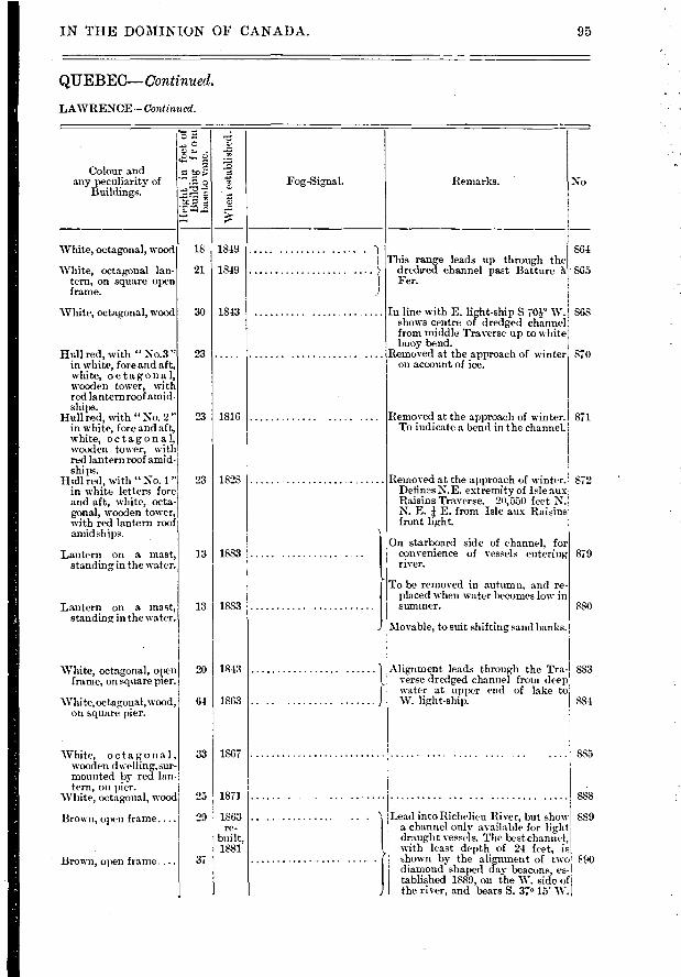
Colour and any peculiarity of
Buildings. o
P-1.=
1
1
1.
White, octagonal, wood
White, octagonal lan-tern, on square open frame.
White, octagonal, wood
Hull red, with " No.3 " in white, fore and aft, white, octagonal, wooden tower, with red lantern roof amid-ships.
Hull red, with "No. 2" in white, fore and aft, white, octagonal, wooden tower, with red lantern roof amid-ships.
Hull red, with "No. 1" in white letters fore and aft, white, octa-gonal, wooden tower, with red lantern roof amid ships.
Lantern on a mast, standing in the water.
Lantern on a mast, standing in the water.
1849 18
21
30
1849
1843
23
23 1816
23 1828
13 I 1883
13 I 1883
864
865
868
870
871
872
879
880
883
884
White, octagonal, wooden dwel ling, sur-mounted by red lan-tern, on pier.
White, octagonal, wood
Brown, open frame....
Brown, open frame....
33 I 1867
25 1871
29 1863 re-
built, 1881
37
IN THE DOMINION OF CANADA. 95
QUEBEC— Continued.
LAWRENCE—Continued.
No Remarks.
Wh
en e
stab
lish
ed.
Fog-Signal.
This range leads up through the dredged channel past Batture à Fer.
In line with E. light-ship s vor W. shows centre of dredged channel from middle Traverse up to white buoy bend.
Removed at the approach of winter on account of ice.
Removed at the approach of winter. To indicate a bend in the channel.
Removed at the approach of winter. Detinss.N.E. extremity of Isle aux Raisins Traverse. 20,550 feet N. N. E. E. from Isle aux Raisins front light.
On starboard side of channel, for convenience of vessels entering river.
1 To be removed in autumn, and Te-
placed when water becomes low in sunnner.
1Movable, to suit shifting and banks. Movable, to suit shifting and banks.
White, octagonal, open frame, on square pier.
White,octagonal,wood, on square pier.
20 I 1843
64 I 1863
Alignment leads through the Tra-verse dredged channel from deep water at upper end of lake to W. light-ship.
885
888
Lead into Richelieu River, but show 889 a channel only ayailable for light draught vessels. The best channel, with least depth of 24 feet, is shown by the alignment of two i90 diamond shaped day beacons, es - I tablished 1889, on the W. side of the river, and bears S. 37. 15' W.
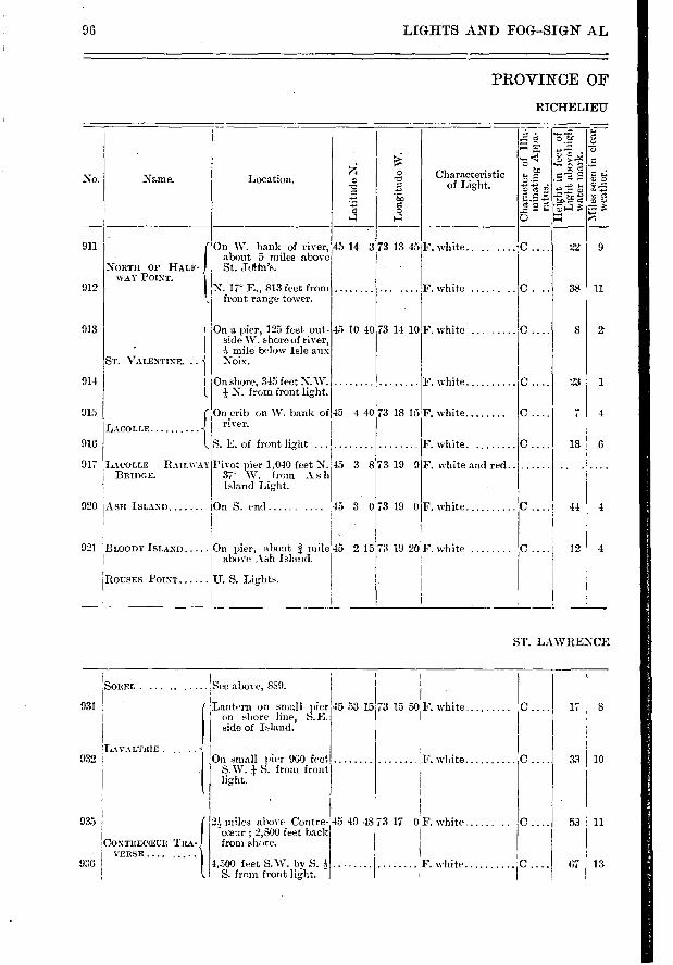
17 1 8
33 1 10
53 1 11
67 13
96 LIGHTS AND FOG-SIGN AL
PROVINCE OF
RICHELIEU'
No. Name.
Long
itu
de W
.
, osf
's
si
o
• —• e r.)
Location. Characteristic of Light. 1'7.1
920
921 1131.00DY ISLAND
914
915
916
917
911
912
913
ASH ISLAND
On a pier, 125 feet out-side W. shore of river,
1 -4 mile below Isle aux
ST. VALENTINE. .. Noix.
BACOLLE BRIDGE.
LACOLLE
{ NORTH OF HALF-WAY POINT.
RAILWAY
1 1 On shore, 345 feet N. W. I. N. from front light.
(On crib on W. bank of river.
S. E. of front light ... S. E. of front light
Pivot pier 1,010 feet N. 37 W. from A s h Island Light.
On S. end
On pier, about / mile above Ash Island.
On W. bank of river, 45 14 3 about 5 miles above St. Jothfs.
N. 17- E., 813 feet from front range tower.
15 3 8
45 3 0
45 2 15
45 10 40
73 13 45
73 19 9
73 19 0
73 19 20
F. white.. ..
F. white ......
F. white
F. white.
F. white and red.
F. white
F. white
22 9
C. 38 11
O.... 8 2
C.... 23 1
C 7 4
C.... 18 6
C...j 44 4
C.... 12 4
73 14 10 F. white .
45 4 40173 18 15 F. white
ROUSES POINT U. S. Lights.
ST. LAWRENCE
I 'See above, 889.
931 1Lantern on small pier
1 on shore line, S.E. 1 side of Island.
, LAVALTRIE . .. .. -1
!
SOREL
932 On small pier 960 feet S.W. S. from front light.
45 53 15 73 15 501'. white
F. white
935
' CONTRECITUII TRA-
936 1 1
VERSE .... ..... 21 miles above Contre- 45 49 48 73 17 0 F. white... coeur ; 2,800 feet back 1 from shore.
1,500 feet S.W. by S. A F. white... S. from front light. 1
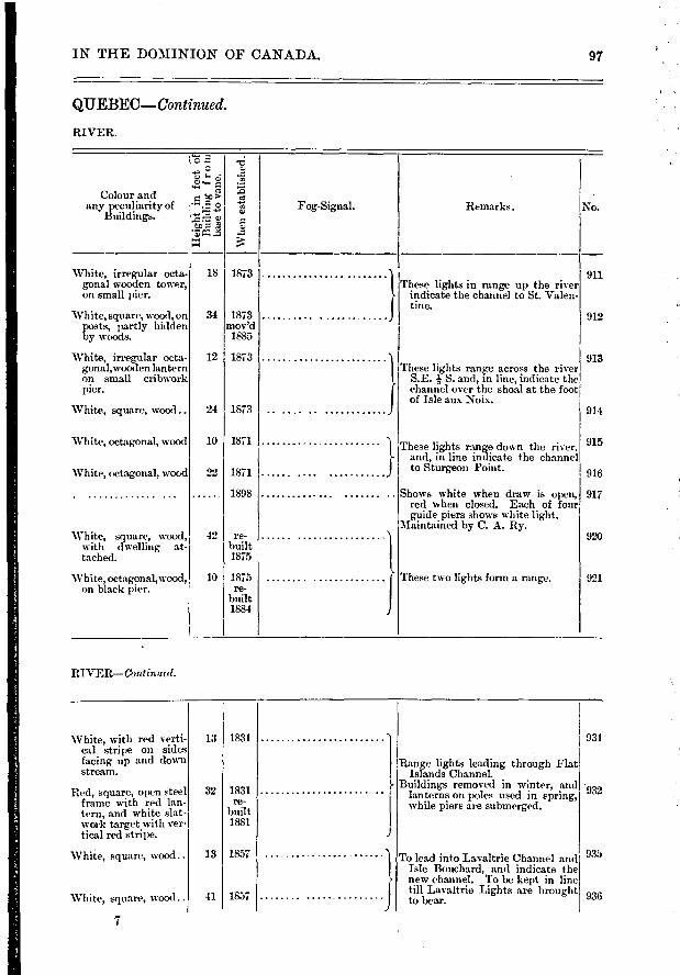
Wh
en e
sta
blis
hed.
Remarks. No. Fog-Signal.
These lights in range up the river indicate the channel to St. Valen-tine.
White, irregular octa- 18 gonal wooden tower, on small pier.
White, square, wood, on 34 posts, partly hidden by woods.
White, irregular octa- 12 gonalo,vooden lantern on small cribwork pier.
White, square, wood.. 24
'White, octagonal, wood
White, octagonal, wood
White, square, wood, with dwelling at-tached.
White, oc tagonal, wood , on black pier.
10
22
42
10
} These lights range across the river S.E. i S. and, in line, indicate the channel over the shoal at the foot of Isle aux Noix.
Colour and any peculiarity of
Buildings.
I z
z *U5r4 ■–■
911
912
913
914
1873
1873 mov'd 1885
1873
1873
1871
1871
1898
re- built 1875
1875 re-
built 1884
These lights range down the river. and, in line indicate the channel to Sturgeon Point.
Shows white when draw is open, red when closed. Each of four guide piers shows white light.
Maintained by C. A. Ry.
915
916
917
920
These two lights form a range. 921
931
932
935
936
IN THE DOMINION OF CANADA. 97
QUEBEC—Continued.
RIVER.
RIVER—Continual.
White, with red verti-cal stripe on sides facing up and down stream.
Red, square, open steel frame with red lan-tern, and white slat-work target with ver-tical red stripe.
White, square, wocxl..
White, square, wood..
7
13 I 1831
32 1831 re-
built 1881
13 1857
41 1857
Range lights leading through Flat Islands Channel.
Buildings removed in winter, and lanterns on poles used in spring, while piers are submerged.
To lead into Lavaltrie Channel and Isle Bouchard, and indicate the new channel. To be kept in line till Lavaltrie Lights are brought to bear.

98 LIGHTS AND FOO-SIGNALS
PROVINCE OF
ST. LAWRENCE
..c.2 - --- . — > ;.,.., .:.....,
No. Name. Location. Characteristic OJ •-P. ''' e ■•• c.> Q
....?. of Light. -;":'•"-r-; • g-. c-...r.
' _.e. -t.- a ç'. a 5' ,'-':
939 ISLE AUX PRUNES... On S. shoreaf Island,145 47 48 73 20 25 F. white C.. 40 10 opposite -N, erchères.
942 ( 1 mile below Répen- F. white c . 14 4 I tigny village.
RÉPENTIGNY 943 I 510 feet N. 22°E. from 45 45 2 73 26 17 F. white C . 30 4
t front one. I
944 ISLE :i. LA PAGUE.... On a pier on the Islet.. 45 44 14 73 26 15 F. white.... C .... 24 4
947 ( Front light, near shore 45 41 22 73 27 43 F. white C . 22 10 on N.E. side of Is- land. • >
ISLE STE. THU- itksE, LOIVER-{
948 RANGE. Back range, 600 feet S. F. white .. . ... C .. . .1 48 12 500 W. from front.
l.
949 f On cribwork block, be- 45 40 37 73 27 40 F. white c . 57 6 low river bank, on S. shore of island.
ISLE STE. THÉ- RÉSE, UPPER 1
950 RANGE. About 5,000 feet S. W. F. white C .... 29 6 î S. from back light, on Ile aux Vaches.
t-
953 ( Front range tower in 45 38 24 73 29 23 F. white.... . C .... 25 4 1 village, close to shore.
POINTE AUX TRESS- I 954 BLES. Back range tower 1,800
feet S. 4e W. from I
front.
F. white C .... 53 4
Head of ocean navigation.
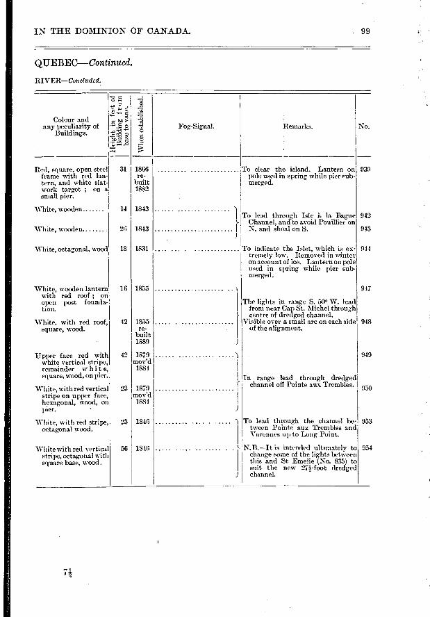
Red, square, open steel frame with red lan-tern, and white slat-work target ; on a small pier.
White, wooden
White, wooden
White, octagonal, wood
White, wooden lantern with red roof ; on open post founda-tion.
White, with red roof, square, wood.
Upper face red with white vertical stripe, remainder whit e, square, wood, on pier.
White, with red vertical stripe on upper face, hexagonal, wood, on pier.
White, with red stripe, octagonal wood.
White with red vertical stripe, octagonal with square base, wood.
311 1866 re-
built 1882
14 1843
26 1843
18 1831
16 1855
42 1855 re-
built 1889
42 1879 mov'd 1884
23 1879 mov'd
1884
23 I 1816
56 I 1816
Colour and any peculiarity of
Buildings.
ô -
r.) z g a
sea
;.» n 0
L.
IJ
939
942
943
944
917
948
949
950
953
954
IN THE DOMINION OF CANADA.
QUEBEC—Continued.
RIVER—Concluded.
99
Whe
n e
sta
blis
hed.
Fog-Signal. No. Remarks.
To clear the island. Lantern on pole used in spring while pier sub-merged.
To lead through Isle à la Bague }- Channel, and to avoid Pouillier on
N. and shoal on S.
To indicate the Islet, which is ex-tremely low. Removed in winter on account of ice. Lantern on pole used in spring while pier sub-merged.
The lights in range S. 500 W. lead from near Cap St. Michel through centre of dredged channel.
Visible over a small arc on each side of the alignment.
In range lead through dredged channel off Pointe aux Trembles.
To lead through the channel be-tween Pointe aux Trembles and Varennes up to Long Point.
N.B.—It is intended ultimately to change some of the lights between this and St Emelie (No. 835) to suit the new 21-foot dredged channel.
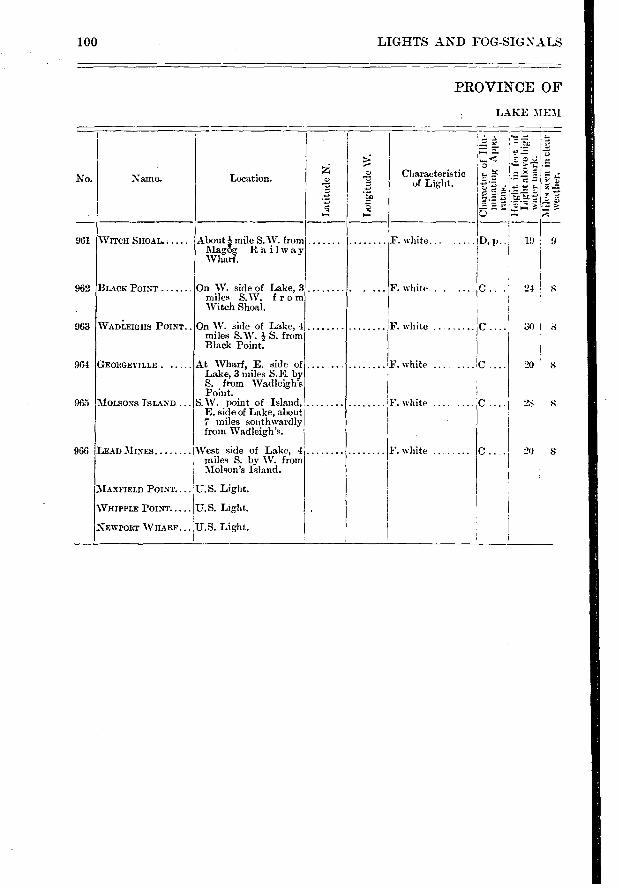
LIGHTS AND FOG-SIG NALS
PROVINCE OF
LAKE IIEM
100
Z Characteristic %., ',,c ..r. . .‘', ...-.. - No. Name. Location.
#.1) 7.1 ..::,, .7.: • - 1: :.-... :.,
s , ' 71
tr, - - e, • 7, ..: .1: •-• r_.) ce *. , r— z, i•— ■ . :77,..; 7. a 4
961 WITCH SHOAL- About . mile S.W. from F. white. D, p.. 19 9 Magôg R à i 1 w a y Wharf.
962 BLACK POINT On W. side of Lake, 3 F. white . . .... C .. . 24 8 miles S.W. f r o m Witch Shoal.
963 WADLEIGHS POINT.. On W. side of Lake, 4 F. white C 341 miles S.W. } S. from Black Point.
964 GEORGEVILLE . At Wharf, E. side of F. white ... ... C .... 241 8 Lake, 3 miles S.E. by S. from Wadleigh's Point.
165 MOLSONS ISLAND ... S.W. point of Island, F. white ........C .... 28 8 E. side of Lake, about 7 miles southwardly from Wadleigh's.
)66 LEAD MINES West side of Lake, 4 F. white C . 20 8 miles S. by W. from Molson's Island.
MAXFIELD POINT U.S. Light.
VHIPPLE POINT !U.S. Light. .
NEWPORT WHARF ,U.S. Light.
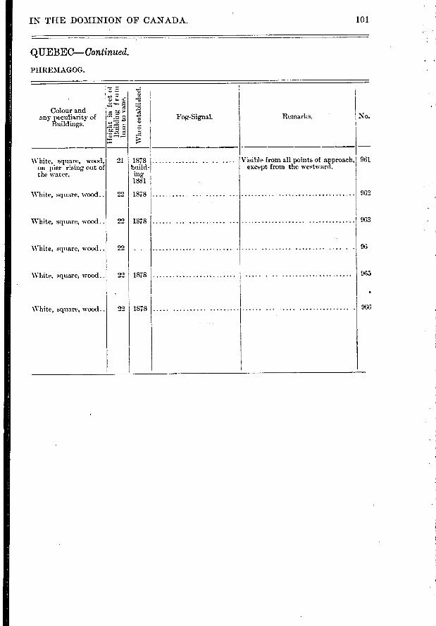
101 IN THE DOMINION OF CANADA.
QUEBEC—Continued.
PHREMAGOG.
' Z.; :-.- • - -
Colour and li2risty of . .„•--1 k.".. ,c, f Fog-Signal. Remarks. No. a ny lrufpdig
-
• E ir-^, ..g - ..-'«e' r-
White, square, wood, 21 1878 ............. .. .. .... Visible from all points of approach, 961
on pier r:sing out of build- except from the westward. the rater. ing
1881
White, square, wood.. 22 1878 062
White, square, wood.. 22 1878 . . . . 96.3
White, square, wood.. 22 96
'White, square, wood.. 22 1878 96.i
White, square, wood.. 22 1878 061
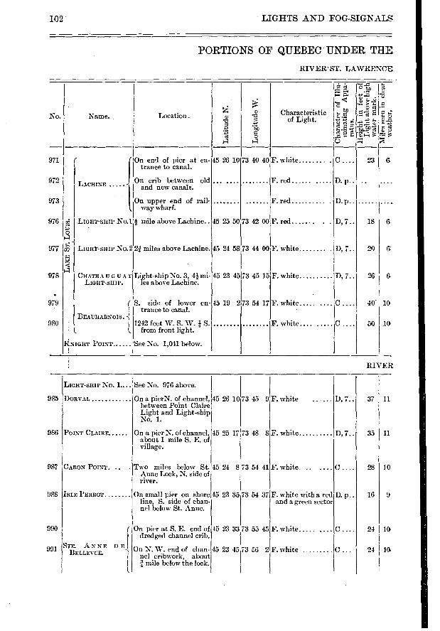
No.
971
972
973
976
977
978
979
980
F. white .....
F. white
985
986
987
988
990
991
37 11 D, 7..
11 35 D,7..
10 28
9 16 D. p..
24 I 10
24 10,
102 LIGHTS AND FOG-SIGNALS
PORTIONS OF QUEBEC UNDER THE
RIVER ST. LAWRENCE
'4 ... .....z.
..-- c •••• ,?.. t.., .:-... Name. Location. Characteiistic
i• a.,..9.. -- cz, a; o
e o a a 5
I On end of pier at en- 45 26 10 73 40 40F. white C . 23 G trance to canal.
On crib between old ... .... ........ F. red LACHINE and new canals.
On upper end of rail- F. red D. p.. ..... .... way wharf.
a;2 LIGHT-SHIP No.1 -.! mile above Lachine.. 45 25 50 73 42 00F. red D, 7.. 18 G 'e • o 4
7/2 LIGHT-SHIP NO.2 2 .1 miles above Lachine. 45 24 58 73 44 00 F. white D, 7.. 20 6: e. x < a
CHATEAUGUAY Light-ship No. 3, 4i mi- 45 23 45 73 45 15 F. white D, 7.. 26 G LIGHT-SHIP, les above Lachine.
( S. side of lower en- 45 19 273 54 17 F. white ..... C .... 40 10 ( trance to canal.
BEAUHARNOIS. -{ I 1242 feet W. S. W. I S. F. white.... ..... C .... 50 10
. l I. frorn front light.
liNIGHT POINT See No. 1,011 below. I
RIVER
LIGHT-SHIP No. 1.... See No. 976 above.
DOR VAL
POINT CLAIRE
CARON POINT. ..
On a pierN. of channel, between Point Claire Light and Light-ship No. 1.
On a pier N. of channel, about 1 mile S. E. of village.
Two miles below St. Anne Lock, N. side of river.
45 26 10
45 25 17
45 24 8
73 45 9
73 48 8
73 54 41
F. white ......
F. white
F. white. ..
ISLE PERROT On small pier on shore line, S. side of chan-nel below St. Anne.
45 23 35 73 54 37 F. white with a red and a green sector
STE. ANNE DE' BELLE VUE.
On pier at S. E. end of dredged channel crib.
On N. W. end of chan-nel cribwork, about
mile below the lock.
45 23 33173 55 45
73 6 2 45 23 45
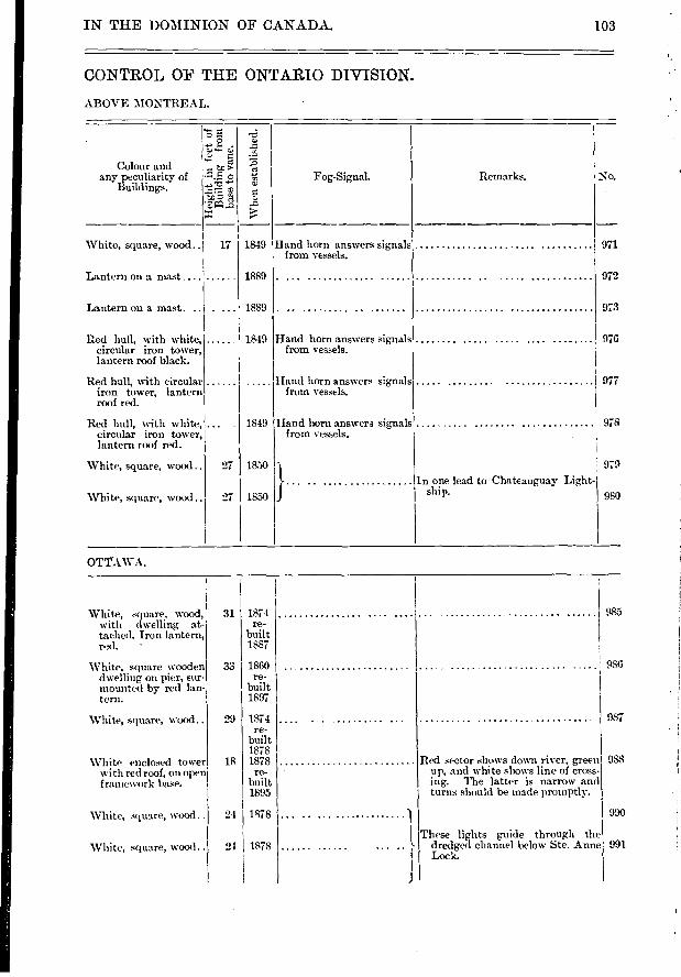
IN THE DOMINION OF CANADA.
CONTROL OF THE ONTARIO DIVISION.
ABOVE MONTREAL.
"5 ....4'd
...› s- .
----,.. c... o Colour and e
any peculiarity of --...e $ tt, Fog-Sig-nal. Remarks. No. Buildings. c.,
■-■ ,...
White, square, wood.. 17 1849 Hand horn answers signals 971 from vessels.
Lantern on a mast ... . ...... 1889 . 972
Lantern on a mast... . ... 1889 973
Red hull, with white, 1849 Hand horn answers signals 97E circular iron tower, from vessels. lantern roof black.
Red hull, uith circular Hand horn answers signals 977 iron tower, lantern from vessels. roof red.
Red hull, with white, ... 1849 Hand horn answers signals 97t
circular iron tower, from vessels. lantern roof red.
White, square, wood.. 27 1850 97:
In one lead to Chateauguay Light-
White, square, wood.. 27 1850 J ship. 984
103
1
OTTAWA.
White, square, wood, 31 1874 985 with dwelling at- re-
tached. Iron lantern, built ',xi. • 1887
White, square wooden 33 1860 (18(
dwelling on pier, sur- re-
mounted by red lan built tern. 1897
White, square, wood.. 29 1874 98; re-
built 1878
White enclosed tower 18 1878 Red sector shows down river, green 98:
with red roof, on open re- up, and white shows line of cross- f raniework base, built mg. The latter is narrow and
1895 turns should be made promptly.
White, square, wood.. 24 1878 .. ) 99,
I These lights guide through the .
White, square, wood.. 24 1878 ... .. , dredged channel below Ste. Anne 99
1 Lock.
J
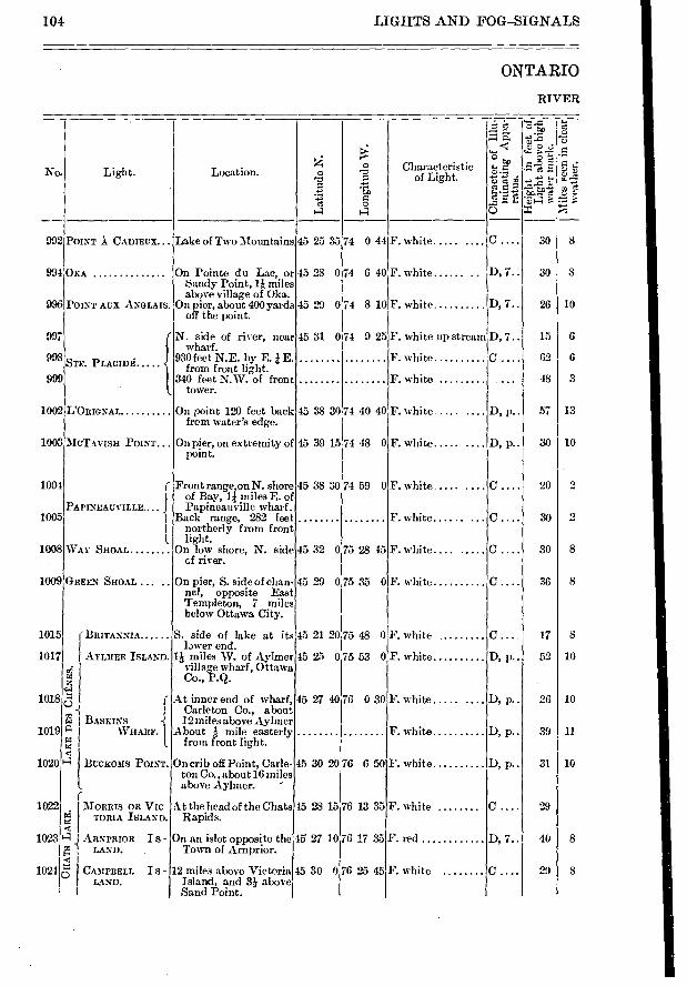
LIGHTS AND FOG-SIGNALS
ONTARIO
RIVER
104
....:0 ro. Light. Location. 0 ,E, Characteristic
of Light.
..... o
1-1 14
92 POINT ..1 CADIEUX... Lake of Two Mountains 45 25 35 74 0 44 F. white ..... ....
94 OKA On Pointe du Lac, or 45 28 074 6 40 F. white ...... .. Sandy Point, 1* miles above village of Oka.
96 POINT AUX ANGLAIS. On pier, about 400 yards 45 29 074 8 10F. white off the point.
97 N. side of river, near 45 31 074 9 25F. white up stream wharf.
98e -e. 930feet N.E. by E. i E. F. white oTE. L-- LACIDÉ from front light.
99 340 feet N.W. of front F. white tower.
02 L'ORIGNAL On point 120 feet back 45 38 30 74 40 40 F. white .... .... from water's edge.
03 MCTAVISH POINT On pier, on extiemity of 45 39 15 74 48 0F. white ..... .... point.
04 r Front range,on N. shore 45 38 30 74 59 0F. white .... .... of Bay, li miles E. of
PAPINEAUVILLE.... 1 Papineauville wharf. 05 1 Back range
' 282 feet F. white
I northerly from front I. light.
08 WAY SHOAL On low shore, N. side 45 32 0 75 28 45 F. white.... ..... cf river.
D9 GREEN SHOAL ... On pier, S. side of chan- 45 29 075 35 0 F. white ne!, opposite East Templeton, 7 miles below Ottawa City.
1.5 - BRITANNIA S. side of lake at its 45 21 20 75 48 0 F. white lawer end.
1.7 AYLMER ISLAND. 1* miles W. of Aylmer 45 25 075 53 0F. white village wharf, Ottawa
c,4 Co., P.Q. z e,:..1 Q r At inner end of wharf, 45 27 40 76 0 30 F. white .....
-1 I Carleton Co., about 0 , L.1 I .DASKINS i 12 miles above Aylmer
L9 "2. WHAnr. I About :1. mile easterly F. white r4 (, from front light. c.e c
0' BucKoms Porn.. On crib off Point, Carie-45 30 20 76 6 50 F. white ton Co.. about 16 miles
l above Aylmer. - (
I2 MORRIS OR VIC- At the head of the Chats 15 28 15 76 13 35F. white a TORIA ISLAND. Rapids. x .1 I3?4 J ARNPRIOR I S - On an islet opposite the 45. 27 1076 17 33 F. red
I /2 LAND. Town of Arnprior. E. Ze.
4 C..) >-> CAMPBELL I S - 12 miles above Victoria 45 30 0 76 25 45 F. white LAND. Island, and 3* above
1 Sand Point.
9
10
1
10
1
1
1
10
10
10
10
10
1
1
10
43' e÷-.;
z ..J'EL
_-
301 8
o e
g .Er! o
D, 7..
D, 7..
D, 7..
D, p..
D, p..
C.
D, p..
D, p..
D, p..
D, p..
D, 7..
30
26
15
62
48
57
20
30
30
36
17
52
2G
39
31
29
40
29
8
10
6
6
3
13
2
2
8
8
10
10
11
10
8
30 I 10
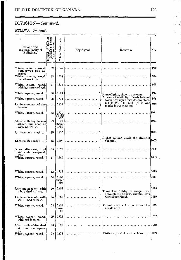
32 1875
23 1898
27 1873
20 1874
38 1874
... 1898
43 1871 r'built
1897 29 1871
ch'ged 1886
15 1897
15 11897
25 I 1870
17 I 1860
13 1872
34 1883 ch'ged
1898
20 1883
25 I 1883
992
994
996
997
998
999
100
1003
1004
1005
1008
1009 .
1015
1017
1018
Range lights, show up stream A beam of white light leads to front
tower through down stream chan-nel N.W. (1) and (3) in one marks lower channel.
Lights in one mark the dredged channel.
These two lights, in range, lead through the deepest channel over Constance Shoal.
To indicate the low point, and the 102t shoals off it.
1019
IN THE DOMINION OF CANADA. 105
DIVISION—Con!inued.
OTTAWA—Continued.
C.) e
'E '4 a
No. Colour and
any peculiarity of Buildings.
Whe
n es
tabl
shed
.
Fog-Signal. Remarks.
25 1883 moved
1889
29
30 1885
29
1873 .
White, square, wood, with dwelling at-tached.
'White, square, wood, on cribwork pier.
White, square, wood, with lantern roof red.
White, square, wood..
White, square,. wood..
Lantern on mast of day beacon.
White, square, wood..
Mast, with day beacon affixed, and shed at base, all white.
Lantern on a mast....
Lantern on a mast.—
Sides alternately red and white,hexagonal, wood.
White, square, wood..
White, square, wood..
White, square, wood..
Lantern on mast, with white shed at base.
Lantern on mast, with white shed at base.
White, square, wood ..
White, square, wood, with red lantern.
Mast, with white shed at base, on square pier.
White, square, wood..
....... .. . 1
[....... • • • • •
J
1022
1023
1021 1873 I . ......... Visible up and down the lake
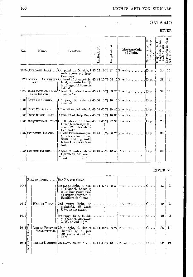
1025
1028
1029
1031
1032
1033
1035
1037
DOULONGE LAKE
LOWER ALLUME= LAKE.
MORRISONS OR RAW-LEI'S ISLAND. .
LOWER NARROWS....
FORT WILLIAM..
DEEP RIVER ISLET..
MCQUESTIONS POINT
SCHOONER ISLAND...
SOUCIER ISLAND
76 47 0
76 54 0
45 50 0177 10 0
45 54 4577 15 45 -
45 59 077 16 30
46 1 45 77 22 30
46 44 e9 6 25
On pier, N. side of channel.
On outei end of wharf.
At mouth of Deep River
On S. shore of Deep River,Renfrew,N.R., about 22 miles above Pembroke.
InLakeTerniscamingue, 5 miles above Long Sault and 2 miles below Opemican Nar-TOWS.
About 2 miles above Opernican Narrows.
F. white
F. white
D, P- • 30
24 D, p
D, p..
D, p..
10
9
10
8
26 I 9
30
19 3-
12 3
38 , 11
29 10
3 13 1041
1042
1043
1044
1042
See No. 979 above. BEAUHARNOIS
C '4
ICNIGIIT POINT -{
GROSSE POINT OR VALLEYFIELD.
COTEAULANDING
106 LIGHTS AND FOG-SIGNALS
ONTARIO
RIVER
No. Name.
•
r•- ■4«
■-■
z
t -5
F-5
•-•
•- -37 Location. Chara,cteristic of Light.
1038
43 0177 3 25
On point on N. side, 45 52 10 mIle abose old Fort Coulonge.
On hea,d of Spence's Is- 45 48 15 land, oprxIsite Lot 18, E.Rangeof Allumette
About 3 miles below 45 Pembroke.
F. white 'D, p.. 32
F. white D,
F. white :D, p..
F. white c F. white D, p..
F. white
46 46 55 79 10 50 F. white
RIVER ST.
( 1st range light, S. side I of channel, about
miles from guard lock, at upper entrance to Beauharnois Canal.
2nd range light, on .. mainland, 93 yards S.W. of 1st range.
3rd range light, S. side . of channel. 396 yards N.W. of 2nd light.
Main light, N. side of 45 channel, on a pier 304 yards W. of 3rd light.
F. white
F. white
F. white .
9 22 1 F. white..
iI
13 15 , F. red ...
14 48:74
On Government Pier... 45 14 40174
74 8 50 45 14 47
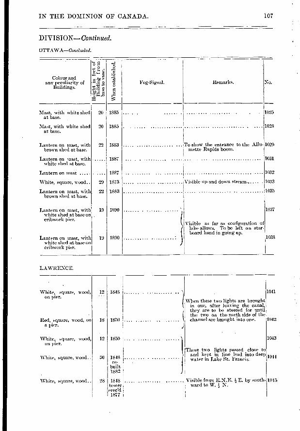
1041 12 I 1848 White, square, wood, on pier.
When these two lights are brought in one, after leaving the canal, they are to be steered for until the two on the north side of the channel are brmight into one. 1042 Red, square, wood, on
a pier. 1850 18
1043 White, square, wood, on pier.
12 1850 1 These two lights passed close to >- and kept in line lead into deep
i water in Lake St. Francis. 1044 White, square, wood .. 1848 re-
built 1882
1045 1 Visible from E.N.E. E. by south ward to W. N. -
White, square, wood.. 28 1848 tower eree'd
1877
107 IN THE DOMINION OF CANADA.
DIVISION—Continued.
OTTAWA—Concluded.
,t. ••■-■ a ,7,
Colour and ,.. any peculiarity of : F. o -'5. Fog-Signal. Remarks. No.
Buildings. ...:=
11 ..= ;i• c,
,...1 ...?:
3Iast, with white shed 20 1885 ... . . . . 1025 at base.
3Iast, with white shed 20 1885 . 1028 at base.
Lantern on mast, with 22 1883 To show the entrance to the Allu- 1029 brown shed at base. mette Rapids boom.
Lantern on mast, with 1887 1031 white shed at base.
Lantern on mast 1887 1032
White, square, wood.. 29 1873 Visible up and doi.vn stream 1033 F
Lanteni on mast, with 22 1883 103 . brown shed at base.
Lantern on mast, with 19 1890 103; white shed at base on cribwork pier.
Visible as far as configuration of lake allows. To be left on star- board hand in going up.
Lantern on mast, with 19 1890 103 white shed at base on cribwork pier.
LAWRENCE.
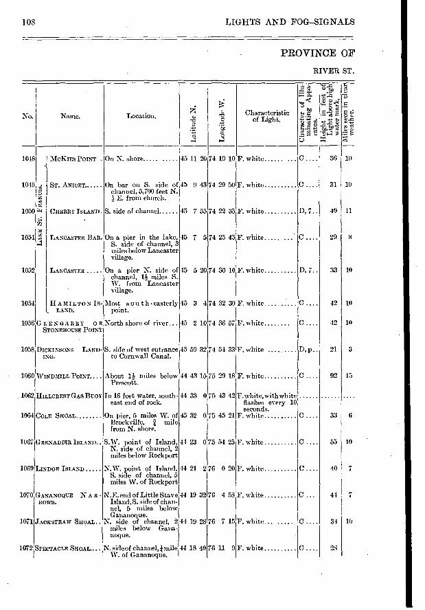
MCKIES POINT . .
Sr. ANICET
CHERRY ISLAND
L12
LANCASTER BAR
LANCASTER
HAMILTONIS-L LAND.
GrLENGARRY OR STONEFIOUSE POINT
DICKINSONS LAND-ING.
1060 WINDMILL POINT....
HILLCREST GAS BUOY
COLE SHOAL
GRENADIER ISLAND
LINDOE ISLAND
GANANOQUE N A R - ROWS.
JACKSTRAW SHOAL
1072 SPECTACLE SHOAL....
1048
1049
1050
1051
1052
1054
1056
1058
_ 1062
1064
1067
1069
1070
1071
36 10
31 10
40 11
29 I 8
33 I 10
42 I 10
42 I 10
21 3
15 92
6 33
55 10
40 7
44 7
34 10
28
45 11 20
45 9 43
45 7 55
45 7 5
45 5 20
45 3 4
74 19 10
74 20 50
74 22 35
74 25 45
74 30 10
74 32 30
F. white ......
F. white
F. white
F. white .....
F. white
F. white
D, 7..
D, 7..
C . .
45 2 10
45 59 32
44 43 15
44 33 0
45 32 0
44 23 0
44 21 2
44 19 32
44 19 28
44 18 40
108 LIGHTS AND FOG--SIGNALS
PROVINCE OF
RIVER ST.
Lo
ngit
ude
W.
5?,
8
..•-•-z • - M. 2 °•F: 5 E
C.)
No. I Name. Location. Characteristic of Light.
o
Xe
On N. shore .....
On bar on S. side of channel, 5,700 feet N. ,b E. from church.
S. side of channel
On a pier in the lake, S. side of channel, 3 miles below Lancaster village.
On a pier N. side of channel, 1 miles S. W. from Lancaster village.
Most sou t h - easterly point.
North shore of river...
S. side of west entrance to Cornwall Canal.
About 1,1- miles below Prescott.
In 16 feet water, south-east end of rock.
On pier, 5 miles W. of Brockville, I mile from N. shore.
S.W. point of Island, N. side of channel, 2 miles below Rockport
N.W. point of Island, S. side of channel, 5 miles W. of Rockport
N.E. end of Little Stave Island, S. side of chan-nel, 5 miles below Gananoque.
N. side of channel, 2 miles below Gana-noque.
N. side of channel, mile W. of Gananoque.
74 36 57 1 F. white c .
74 54 33 F. white D, p
75 29 18F. white c
75 43 42 F. white,with white flashes every 10 seconds.
75 45 21 F. white c .
75 54 25 F. white c .
76 0 20.F. white c .
76 4 58F. white
76 7 15F. white C
76 11 9 F. white c .
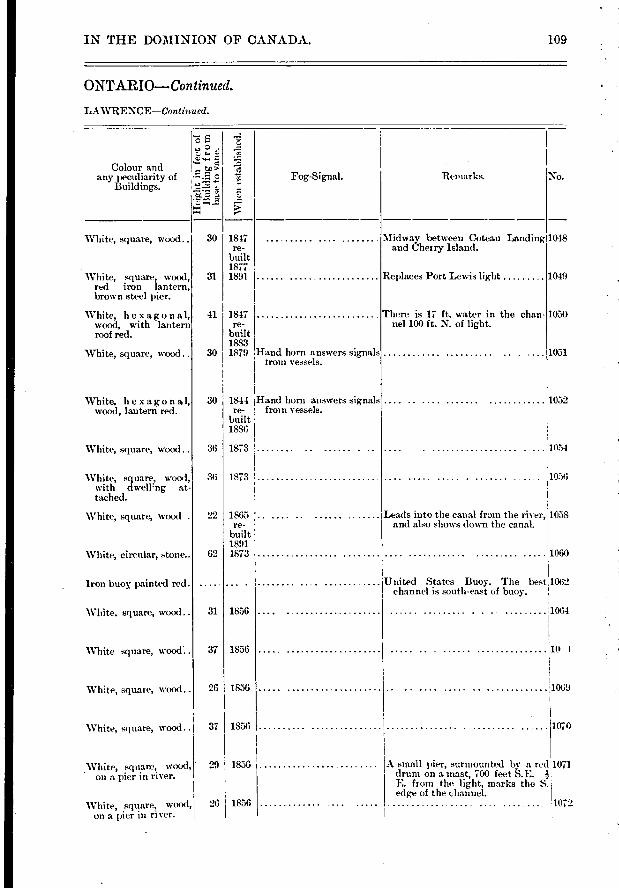
IN THE DOMINION OF CANADA. 109
ONTARIO—Continued.
LAWRENCE—Continued.
E
e c
el'
No. Remarks. Colour and
any peculiarity of Buildings.
esta
blis
hed.
Fog-Signal.
30 1847 re-
built 1877 1891
Midway between Coteau Landing 1048 and Cherry Island.
White, square, wood..
White, square, wood, red iron lantern, brown steel pier.
White, hexagonal, wood, with lantern roof red.
White, square, wood..
White, hexagonal, wood, lantern red.
White, square, wood..
White, square, wood, with dwell'ng at-tached.
31
30
41 1847 re-
built 1883 1879 Hand horn answers sigmals
from vessels.
Replaces Pott Lewis light
There is 17 ft. water in the chan-nel 100 ft. N. of light.
1049
1050
1051
30 1844 Hand horn answers signals re- from vessels.
built 1886
1052
36
36
1873
1873
1054
1056
1058 Leads into the canal from the river, and also shows down the canal.
White, square, wood . 92
62
1865 re-
built 1891 1873 1060
31 1856
White, circular, stone..
Iron buoy painted red.
White. square, wood..
United States Buoy. The best 1062 channel is south-east of buoy.
1856 37
1064
10 I,
1069
1070
26 1856
White square, wood..
White, squal e, wood..
White, square, wood.. 37
29 1856 White, square, wood, on a pier in river.
1856
A small pier, surmounted by a red 1071 drum on a mast, 700 feet S.E. E. from the light, marks the S. edge of the channel.
White, square, wood, on a pier in river.
26 1856 1072
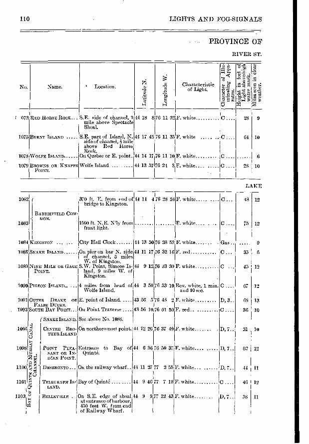
LIGHTS AND FOG-SIGNALS
PROVINCE OF
RIVER ST.
6 36;76 50 37 F. white.... .....
9 12
›: ,.,..,1 a.' co A ,
...- 0 ...... > .,.. , m 1... e ...-A .9.. No. Name. ' Location. Characteristic o ̂c
•-• of Light. •::!,) %1 ,; , ...› e
-..> •c .-
e B
4 a 5 = ',
073 RED HORSE Rocs... S.E. side of channel, 1 44 18 8 76 11 32 1'. white c 28 9 mile above Spectacle Shoal.
1075 BURNT ISLAND S.E. part of Island, N. 44 17 45 76 11 35 F. white ..... .. C ... 64 10 side of channel, -I,- mile above Red florse Rock.
1078 WOLFE ISLAND On Quebec or E. point. 44 14 17 76 11 10F. white c 6
1079 BROWNS OR KNAPPS Wolfe Island .... ..... 44 13 57 76 24 3 F. white.... ..... C .... 28 10 POINT.
LAKE
I BARRIEFIELD COM--{ MON.
1084 KINGSTON
1086 SNAKE ISLAND
NINE MILE OR GAGE POINT.
1089
1090 PIGEON ISLAND.....
1091 OUTER DRAKE OR FALSE DUCKS.
1093 SOUTH BAY POINT...
I a
o
POINT PLEA- SANT OR IN-
4,1 DIAN POINT.
Z Z Z
r SNAKE ISLAND.
CENTRE BRO-THER ISLAND
DESERONTO
1082
1083
1096
1098
1100
City Hall Clock
On pier on bar N. side of channel, 5 miles W. of Kingston.
S.W. Point, Simcoe Is- 44 land, 9 miles W. of Kingston.
'4 miles from head of , Wolfe Island.
E. point of Island.
On Point Traverse
See above No. 1086.
On northernmost point.
Entrance to Bay of 44 Quinté.
On the railway wharf..
44 13 50 76 28 53
44 11 17 76 32 16
76 33 30,F. white
1500 ft. N.E. N'ly from front light.
e 1101 TELEGRAPH IS- Bay of Quinte
1" LAND.
11031 3 BELLEVILT.E On S.E. edge of shoal;44 ts' at entrance of harbour,
450 feet W. from end of Railway Wharf.
12 67
13 68
10 36
31 10
12
11 44
12 46
11 38
C I 48 12
12 75
9 Gas .
c 35 6
C 45 12
F. white.... .
F. white
F. red..
44 11 27 77 2 55 I'. white... ...... D, 7..
44 9 46 77 7 18'F. white
370 ft. E. from end of 44 14 4 76 28 24 bridge to Kingston.
F. white
44 3 50 76 33 10 Rev. white, 1 min. and 10 sec.
43 56 5 76 48 2F. white
43 56 10 76 51 50 1 F. red
44 12 26 76 37 49 F. white.... , .
9 977 22 43 F. white ..... D, 7..
D, 3..
D, 7..
D, 7..
110
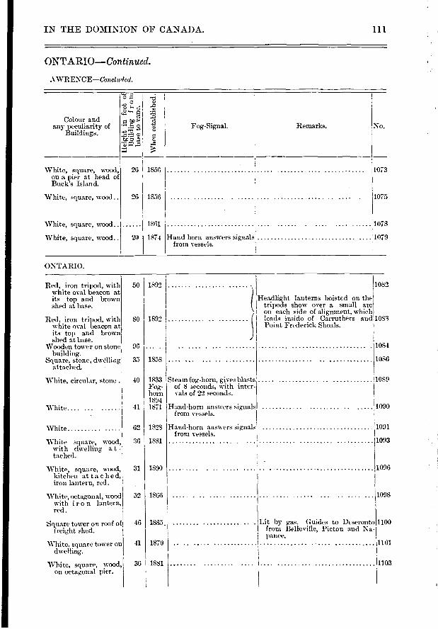
Whe
n e
sta
blis
hed.
Remarks. No. Colour and
any peculiarity of Buildings.
Fog-Signal.
c‘, e •-■ CO e 0
e
White, square, wood, on a pier at head of Buck.'s Island.
White, square, wood..
26 I 1856
26 I 1856
1073
1075
White, square, wood..
White, square. wood..
1861
20 I 1874 Hand horn answers signals from vessels.
. ..... 1078
...... 1079
Red, iron tripod, mith white oval beacon at its top and brown shed at base.
Red, iron tripod, with white oval beacon at its top and brown shed at base.
Wooden tower on stone building.
Square, stone, dwelling attached.
White, circular, stone .1
White.... ...
White
White square, wood, with dwelling a t - tached.
White, square, wood, kitchen at toe he d, iron lantern, red.
White, octagonal, wood with iron lantern, red.
Square tower on roof of freiglit shed.
White, square tower on dwelling.
White, square, wood, on octagonal pier.
31
52
46
41
36
1890
1866
1084
1086
1089
1090
1001
1093
1096
..11098
Lit by gas. Guides to DE seronto11100 from Belleville, Picton and Na-panee. 1101
'11103
IN THE DOMINION OF CANADA. 111
ONTARIO—Continued.
AWRENCE—Concluded.
ONTARIO.
50
1892
96
35 I 1358
40 1833 Fog-horn 1894
41 1871
62 1828
SO
1892 1082
Head light lanterns hoistrd on the tripods show over a small arc on each side of alignment. which
,S leads inside of Carruthers and 1083 Point Frederick Shoals.
Steam fog,-honi, gives blasts of 8 seconds, with inter-vals of 22 seconds.
Hand-horn answers signals from vessels.
Hand-lioni answers signals from vessels.
1885.
1870 ..
1881 ...
36 I 1881
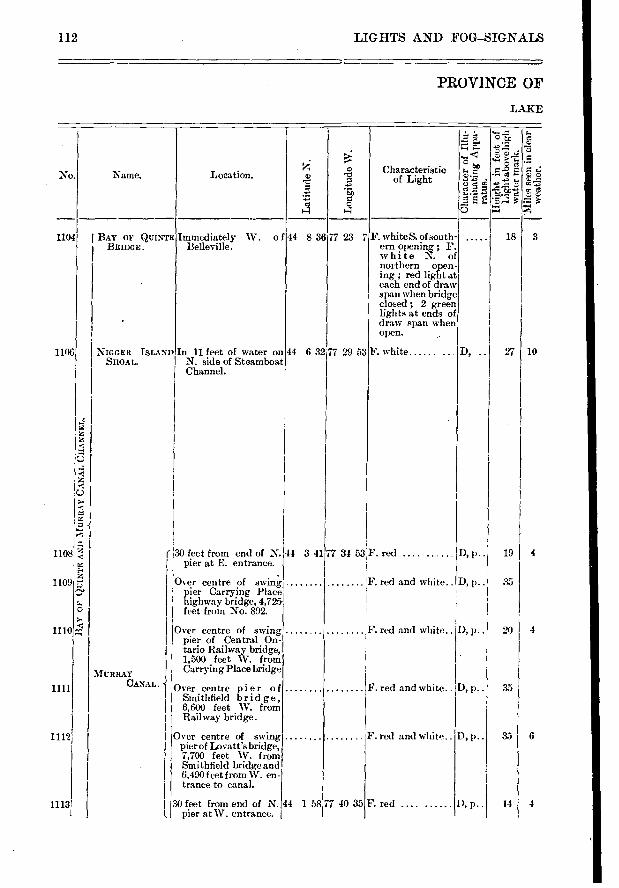
44 8 36 77 23 7 3
10
18
27
F. red and white..
F. red and white..
1104
1106
1108
1109
o
1110 4
1111
1112
1113
D, p..
D,p..
1), p..
19 I 4
35
4 20
35
6 35
4 14
LIGHTS AND FOG—SIGNALS
PROVINCE OF
LAKE
112
Name. Location.
Lati
tude
N.
te o
"5'.F;
>
a> • -u C.> •-• . 4-,
-à> 8 'S e
Characteristic of Light
BAY OF QUINTE BRIDGE.
Immediately W. of Belleville.
F. white S. of south-ern opening ; F. white N. of northern open-ing red light at each end of draw span when bridge closed ; 2 green lights at ends of draw span when open.
No.
N IGGER IsLANDlIn 11 feet of water on SHOAL. N. side of Steamboat
Channel.
44 6 32,77 29 53 F. white. ....
( '30 feet from end of N. pier at E. entrance.
Over centre of swing pier Carrying Place highway bridge, 4,725 feet from No. 892.
Over centre of swing Pier of Central On-tario Railway bridge, 1,500 feet W. from
MURRAY Carrying Place bridge
CANAL. -1 Over centre pier of Smithfield bridge,
6,600 feet W. from Railway bridge.
Over centre of swing pier of Lovatt's bridge, 7,700 feet W. from gmithfield bridge and 6,490 feet from W. en-trance to canal.
7 34 53F. red .....
F. red and white.. D, p..
F. red and white.. D, p..
D, p..
30 feet from end of N. pier at W. entrance.
44 1 58 7 40 35 F. red ......
44 341
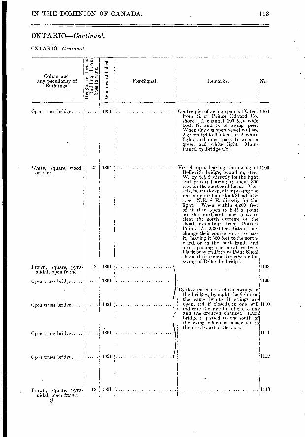
Centre pier of swing span is 195 feet)1104 frein S. or Prince Edward Co. shore. A channel 100 feet wide both N. and S. of swing pier. When draw is open vessel will see 2 green lights flanked by 2 white lights and must pass between a green and white light. Main-tained by Bridge Co.
Vessels upon leaving the swing of 1106 Belleville bridge, hound up, steer W. by S. e S. directly for the light and pass it leaving it about 300 feet on the starboard hand. Ves-sels
' bound down, after passing the
red buoy off Onderdonk Shoal, also steer N.E. e E. directly for the light. When within 4,000 feet of it the y open it half a point on the starboard bow so as to clear the north extreme of the shoal extending from Potters Point. At 2,000 feet (listant they change their course so as to pa-ss it, leaving it 300 feet to the north-ward, or on the port hand, and after passing the inost easterly black buoy on Potters- Point Shoal shape their course directly for the , swing of Belleville bridge.
1108
Fog-Signal. [Zen-larks. No.
I 1891
1891
1891
[N THE DOMINION OF CANADA. 113
ONTARIO—Continued.
ONTARIO—Continued.
o •
o ‘,.t
o )-•-
• '" es' 0
Colour and any peculiarity of
Buildings.
Open truss bridge I 1891
White, square, wood, on p er.
Brown, square, pyra- midal, open frame.
Open truss bridg‘.
Whe
n es
ta
27 1894
12 1891
1891 1109
Open truss bridge.
Open truss bridge
Open truss bridge..
By day the centr s of the swings of the bridges, by night the lights ou' the san,e (white ifswings are open, red if closed), in one will 1110 indicate the middle of the canal' and the dredged channel. Each, bridge is passed to the south of the swing, which is somewhat to the northward of the axis.
1111
1112
12 1891 1113 Brent n, square, pyra- midal, open frame.
8
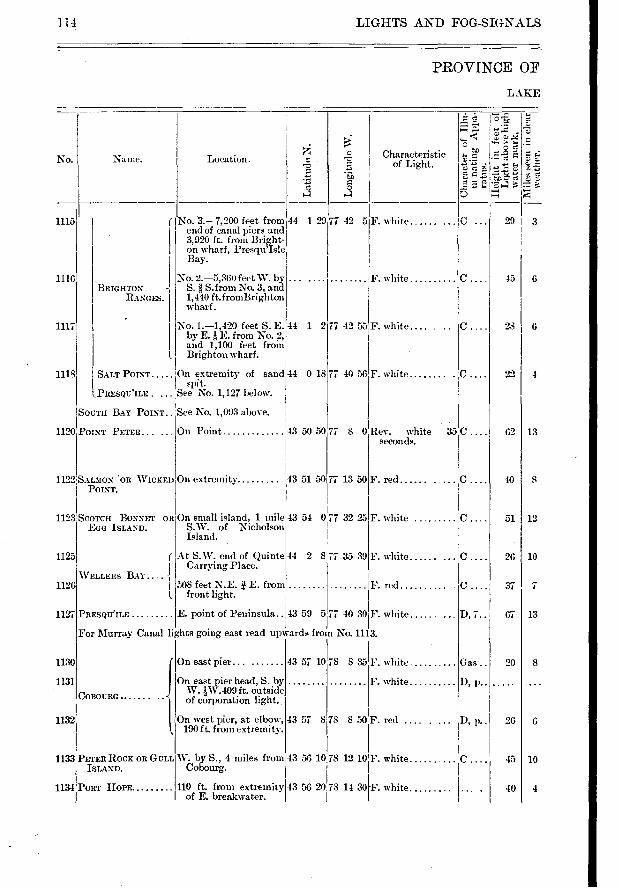
1115
1116
1117
1118
BRIGHTON RANGES.
SALT POINT
1.13nEseu'ime
F. white
F. white
On small island, 1 mile 43 51 S.W. of Nicholson Island.
0 77 32 25
77 35 39
Rev. white 35 seconds.
F. red
F. white
F. white ......
F. red
43 59 PRESQU'ILE E. point of Peninsula..
1125
1126
1127
1130
1131
1132
W. by S., 4 miles from 43 56 1018 12 10 F. white Cobourg.
F 110 ft. from extremity 43 56 20 78 14 30 F. white of E. breakwater.
43 57 10 78 835
4351 8 1 78 850
On east pier... .......
On east pier head, S. by W. iW.409 ft. outside of corporation light.
On west pier, at elbow, 190 ft. from extremity.
F. white
F. white
F. red .... .
0.
0.
0.
0.
D, 1. .
Gas ..
D, p..
D, p..
0.
29 I 3
45 I 6
28 1 6
22 4
62 I 13
10 1 8
51 12
26 10
377
67 13
20 I 8
26 6
10 45
4 40
LIGHTS AND FOG-SIGNALS
PROVINCE OF
LAKE
114
Lon
git
ude
W.
c ;:••■' t>
«e:■
No. Name. Location.
.73
- • •
•
•.21
0;
2 = E- C.)
Characteristic of Light.
No. 1.-1,420 feet S. E. 44 by E. F. from No. g, and 1,100 feet from Brighton wharf.
On extremity of sand;44 spit.
See No. 1,127 below.
1122 SALMON OR WICKED On extremity POINT.
1123 SCOTCH BONNET OR EGG ISLAND.
r At S.W. end of Quinte 44 I Carrying Place.
• I 508 feet N.E. E. from .. 1. front light.
77 42 5
1 277 42 55 F. white.... .
0 18 77 40 56F. white
SOUTH BAY POINT.. See No. 1,093 above
1120 POINT PETER .. . , On Point
WELLERS BAY .. .
No. 3.-7,200 feet from 44 1 29 end of canal piers and 3,920 ft. from Bright-on wharf, Presqu'Isle Bay.
No. 2.-5,360 feet W. by S. g S. from No. 3, and 1,440 ft.fromBrighton wharf.
43 50 50 77 8 0
43 51 50 77 13 50
28
5 77 40 30 F. white
For Murray Canal lights going east read upwards from No. 1113.
1(
1133 PETER ROCK OR GULL ISLAND.
1134 PORT HOPE
COBOURG
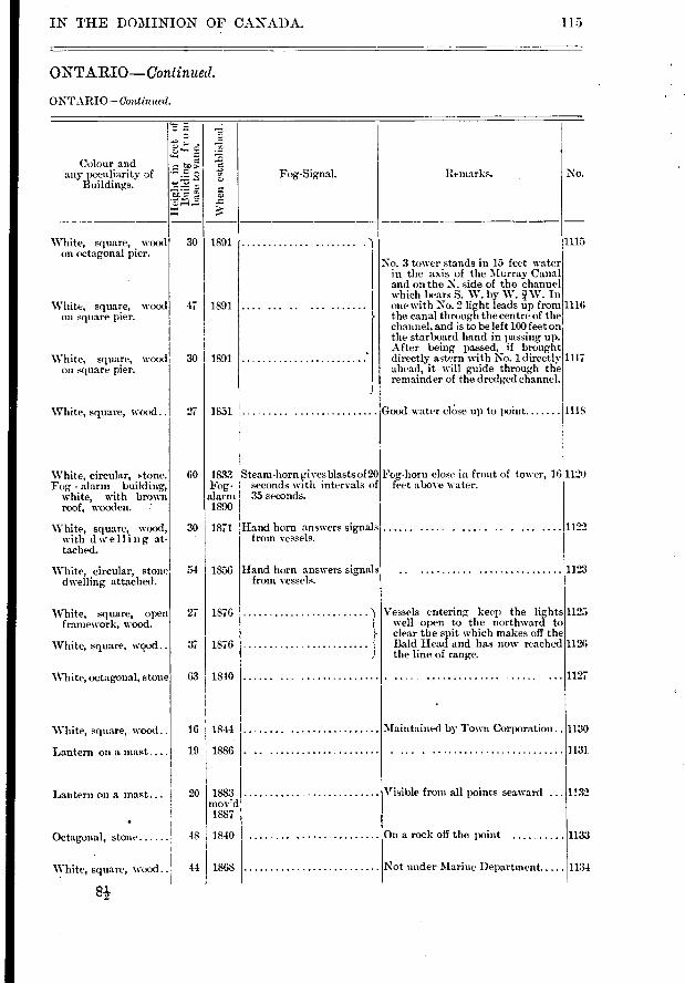
30 1891
47 11891
30 I 1891
27 I 1851
White, square, wood on octagonal pier.
White, square, wood on square pier.
White, square, wood on square pier.
White, square, wood..
No.
1115
1116
1117
1118
Vessels entering keep the lights well open to the northward to clear the spit which makes off the Bald Head and has now reached the line of range.
60
30
54
27
37
63
1122
1123
1125
1126
1127
1130
1131
1132
1133
Hand horn answers signals from vessels.
IN THE DOMINION OF CANADA.
ONTARIO—Continued.
ONTARIO—Continued.
115
.'"E•
Colour and any peculiarity of
Buildings. Fog-Signal. Iternarks.
Whe
n e
sta
bli
shed.
No. 3 tower stands in 15 feet water in the axis of the Murray Canal and on the N. side of the channel which beais S. W. by W. W. In one with No. 2 light leads up from the canal through the centre of the channel, and is to be left 100 feet on the starboard hand in passing up. After being passed, if brought directly astern with No. 1 directly ahead, it will guide through the remainder of the dredged channel.
Good water clOse up to point
White, circular, stone. Fog, - alarm building,
white, with brown roof, wooden.
White, square, wood, with dwelling at-tached.
White, circular, stone dwelling attached.
'White, square, open framework, wood.
White, square, wood..
"White, octagonal, stone
1833 Steam-horn eives blasts of 20 Fog- seconds with intervals of alarm 35 seconds. 1890
1871 'Hand horn answers sig-nals from vessels.
1856
1876
1876
1840
Fog-horn close in front of tower, 16 1120 feet above water.
White, square, wood..
Lantern on a mast ...
Octagonal, stone
'White, square, Nvood
16 I 1844
19 1886
48 I 1840
44 I 1868
Maintained by Town Corporation..
Visible from all points seaward ...
On a rock off the point
Not under Marine Department
Lantern on a mast... 20 1883 mov'd 1887
1134
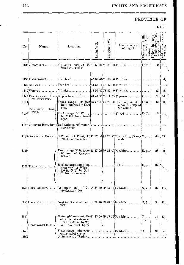
c
13 52 4078 38 0
43 52 0 78 47 0
43 50 45 78 56 0
43 48 55 79 155
43 37 4819 20 20
F. white .....
F. white
F. white
F. green ....
Occ. red, visible 6 seconds, eclipsed 6 seconds.
F. red
D. 6.
D, 7..
1149'
1150 TORONTO
1152 PORT CREDIT
1153 OAKVILLE
1155
, 7..
D, 7. .
10\
12
51
43
18
66 1, 18
23 9
37
11'. 37
75
30
116 LIGHTS AND FOG-SIGN.ALS
PROVINCE OF
LAKE
Location. Characteristic of Light.
'le = ,
.>) Lo.
o^ z •
No. Name.
1137 NEWCASTLE iOn outer end of E. breakwater pier.
43 53 35 78 34 0 F. white D7.. 29141
1138 DARLINGroN.. .... Pier head.. .......
1139 OSHAWA Pier head
1140 WHITBY W. pier
1142 IcRE.NRHMANS B A TIE. pier head OR PICKERING. I
1144 Front range 100 feet from outer end of East pier.
Back range N. W. by N. 2,400 from front light.
In 5 fathoms off water-works crib.
TORONTO EAST
1145' PIER.
11471TORONTO BELL BUOY
43 37 0 1148 ' GIBRALTAR POINT... S.W. side of Point, 1:7, 1 mile S. of Toronto.
19 22 55'Rev. white, 45 sec- C onds.
Front range 37 ft. from W. end of Queen's Wharf.
43 37 55 79 24 45 F. white D, p..
Back range on extension shoreward of Wharf, 200 ft. N.E. by N. ?, N. from front one. -
F. red !D, p..
At outer end of N. bieak water pier.
43 33 4079 35 0F. white .
Near inner end of main 43 26 4079 40 12F. white pier.
BURLINGTON BAY.
1156
1151 . 1 f
Main light near middle 43 18 20 79 48 25 of S. pier at entrance, 1.570 feet S.W. by W-.Ç '
., W. from front light-.
Front range light near ... .... ........ i outer end of S. pier
,On inner end of S. pier . .
F. white
F. white.... ..... .
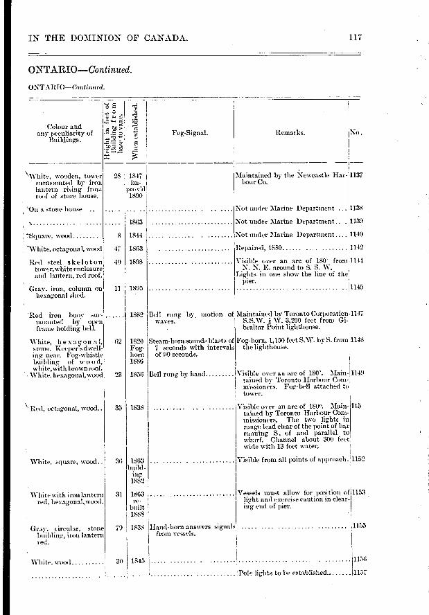
62
23
35
36
31
79
Bell rung by motion of waves.
Steam-horn sounds blasts of 7 seconds with intervals of 90 seconds.
1153
1155
1151;
1863
1841
1863
1898
1895
1882
1820 Fog-horn 1886
1858
1838
1863 build-
ing 1882
1863 re-
built 1888
1838
1845
117 IN THE DOMINION OF CANADA.
ONTARIO—Continued.
ONTARIO—Continued.
-
r.,?..11.
.r. Z's
Colour and any peculiarity of
Buildings. Fog-Signal. Remarks. No.
\'‘Vhite, wooden, tower surmounted by iron lantern rising from ro...f of store house.
28 1847 im-
proy'd 1890
Maintained by the Newcastle Har-bour Co.
1137
00n a stone house
,
-Square, woo(I 8
-White, octagonal, wood 47
Red steel skeletonl tower, white enclosure and lantern, red roof.
Gray, iron, column on hexagonal shed.
- Red iron buoy sur-mounted by open frame holding bell.
White, hexagon a I, stone. Keeper s dwell-ing- near. Fog-whistle building of w 00 d, white,%vith brown roof.
White, hexagonal,wood
"Red. octagonal, wood..
White. square, waxl..
White with ironlantern red, Lexagonal,wood.
Gray. circular, stone building„ iron lantern red.
Not under Marine Department ... 1138
Not under Marine Department .. 1139
Not under Marine Department 1140
Repaired, 1880 1142
Visible over an arc of 180' from 1144 N. N. E. around to S. S. W.
Lights in one show the line of the pier. 1145
,Maintained by Toronto Corporation 1147 S.S.W. W. 3,200 feet from Gi-braltar Point lighthouse.
Fog-horn, 1,150 feet S.W. by S. from 1148 the lighthouse.
Bell rung by hand 'Visible over an arc of 180°. Main- 1149 tabled by Toronto Harbour Com-missioners. Fog-bell attached to tower.
Visible over an arc of 180'. Main-tained by Toronto Harbour Com-missioners. The two lights in range lead clear of the point of bar running S. cf and parallel to wharf. Channel about 300 feet wide with 13 feet water.
Visible from all points of approach . !1152
Vessels must allow for position of light and exercise caution in clear-ing end of pier.
Hand-horn answers signals from vessels.
115
White. wood 30
Pole lights to be established. 1157
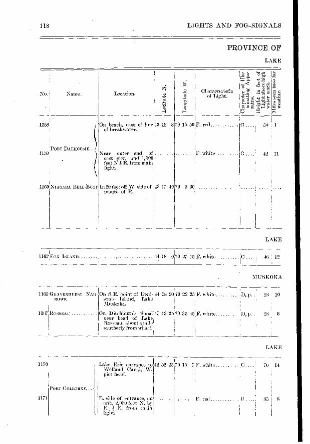
e
No. Name. Location. Characteristic of Light.
Lon
git
ude
W.
• r."
ct
çPORT DALHOUSIE.. .
On beach, east of line of break-water.
1158 79 15 50 . F. red C 50 1 43 12 8
Near outer end of .... east pier, and 1,500 feet N E. from main light.
F. white ........ 0 42 11 1159
NIAGARA DELL-13 uoT In 20 feet off W. side of mouth of R.
43 17 40179 5 30 1160
1165 GRAVENHURST NAR- On S.E. point of Deni-Rows. son's island, Lake
Muskoka.
On Ditchburn'. Shoal near head of Lake Rosseau, about a mile southerly from wharf.
RossEAu 1167
44 58 20 79 22 25
45 13 35 79 35 45
F. white ..... !D, p.. 28 10
F. white p..
118 LIGHTS AND FOG-SIGNALS
PROVINCE OF
LAKE
LAKE
1162 FOX ISLAND 'i44 18 079 27 15F. white iC , 46 ;
:\115SKOKA
LAKE
Lake Erie entrance to 42 02 2579 15 7 . white ,C 70 14 Welland Canal, W. pier head.
1170
1171 .... F. red ..... . 35 8
PORT COLBORNE... -
E. side of entrance, on ; crib, 2,030 feet N. by ; E. E. from main
light.
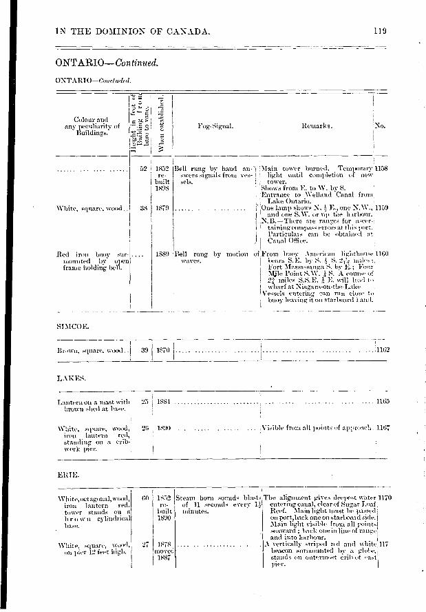
Remarks.
White, square, wood..
Red iron buoy sur-mounted by open frame holding bell.
Brown, square, wood.. 1810 1
39 .11162
Steam horn sounds blasts of 11 seconds every minutes.
IN THE DOMINION OF CANADA. 119
ONTARIO—Continued.
ONTARIO—Conciwicd.
Colour and any peculiarity of
Buildings.
, .
•
• > •r.": • i
,
Fog-Signal.
...... 52 , 1852 re-
I built 1898
38 1879
Bell rung by hand an-' Main tower burned. Temporary 1158 swers signals from yes- I light until completion of new sels. I tower.
Shows from E. to W. by S. • 'Entrance to Welland Canal from
Lake Ontario. • ,One lain') shows N. j, E., one N.W., 1159 ' and one S.W. or up tile harbour. N.B.—There are ranges for a‘cer-
taining compa.ss errors at this port. • I Partic'ulars can be obtained at
Canal Office.
by motion of ,From buoy American lightlu wise 1160 bears S. E. by S. !, S. 2?„, miles
, Fort Massassauga S. by E.; Four Mjle Point S.W. ± S. A course of '4" miles S.S.E. k E. will lead to
I \-vharf at Niagara-on-the-Lake 1Vessels entering can run close to ; buoy leaving it on starboard l.air I.
1889 'Bell rung waves.
SIM COE.
LAKES.
Lantern on a mast with 25 1881 . 1165 brown shed at base.
White, square, woo(l, 26 181H) . . in n lantern red, standing on a crib-, work pier.
Visible from all i ■oints of approacli. 1167
ERIE.
W h ite, octagonal, wood, 60 1852 irmi lantern red, re-
tower stands on a built
b r o se n cylindrical 1890 base.
White, square, wood, 27 1878
on pier 12 feet high. moved 1887
The alignment g,ives deepest water4170 entering canal, clear of Stig,ar Loaf' Reef. Main light must be passed on port,back one on starboard side. Main light visible from all points' seaward ; back one in line of range and into harbour.
A vertically striped red and white 117 beacon eZurmounted lw a globe, stands on outerm ■ pst cri h u t fast pier.
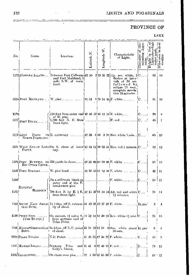
>A
Lon
git
ude
W.
1174
1176
1177
1179
c
10 64
51 10
8 20
7 45
65 13
52 12
96 15
42 11
34 11
70 11
76 15
8 4
45 9
70 12
48 ' 12
51 28!82 34 0 Occ, white about D, gas 10 secs.
49 5582 38 22 F. white C . . 11
and 41 82 40 49 F. red..
12 1 5082 35 38Y. white
0 41
LIGHTS AND FOG-SIGNALS
PROVINCE OF
LAKE
120
Location.
I 'a LZ e. • "
if e'È
Ei -7à• • " .5ï
'e 1".2-e tc 7114—
No. Naine. Characteristic of Light.
1172 MonAwK ISLAND.... Between Port Colborne and Port Maitland, 1 mile S.W. of main-
. land.
42 50 279 31 23 GIL rev. white, 3C flashes at inter-vals of 30 sec. followed by eclipse 75 secs.,
complete revolu-tion 21 minutes.
PORT MAITLAND . . W. pier 42 51 8 79 34 48 F. white
PORT DOVER
110 feet from outer end 42 46 5280 12 101'F. white....
1 of W. pier. 1,700 feet N. E. from F. red.
1 front light. 1
BONG POINT OR1E. extremity NonTx FORELAND.
42 33 080 3 20,Rev. white 1 min..
11181 WEST END OF LoNc;On S. shore of inner 42 3-1 52 80 23 50.1 ev. red 1 minute. POINT. bay.
1182 PORT BURWELL OR'333 vards in shore. BIG OTTER CREEK .1
W. pier head
On a cribwork block on 1 outer end of the E. I
RONDEAU breakwater pier. •
1189 SOUTH EAST SHOAL Ill 5 fms. off S. extrem-GAS BUOY. ity of shoal.
42 39 00 SO 50 00 F. white
42 39 55 81 12 40F. white ...
F. white ......
32 81 54 18 .Alt. red and white minutes.
41 49 35 82 27 28 F. white
52 18 82 30 26 Rev. white 1110111
1183 PORT STANLEY
1186
On caisson, 1.ï miles S. 41 from extreme end of Pelee Point.
HARBOUR 1 1187 780 feet N. by E. I E. 1 42 15 from front light.
D, gas 9 I 4
1191 MIDDLEGliousriGAs In 5 fins. off N.E. point BUOY. of shoal.
1192 PELEE ISLAND N.B. Point.
1195 r. MIDDLE ISLAND Between Pelee Kelly's Island.
1197)LEA1ItNoToN„ ■ On shore near pier
1190 PELER SPIT r (THE Dunn%)
1).
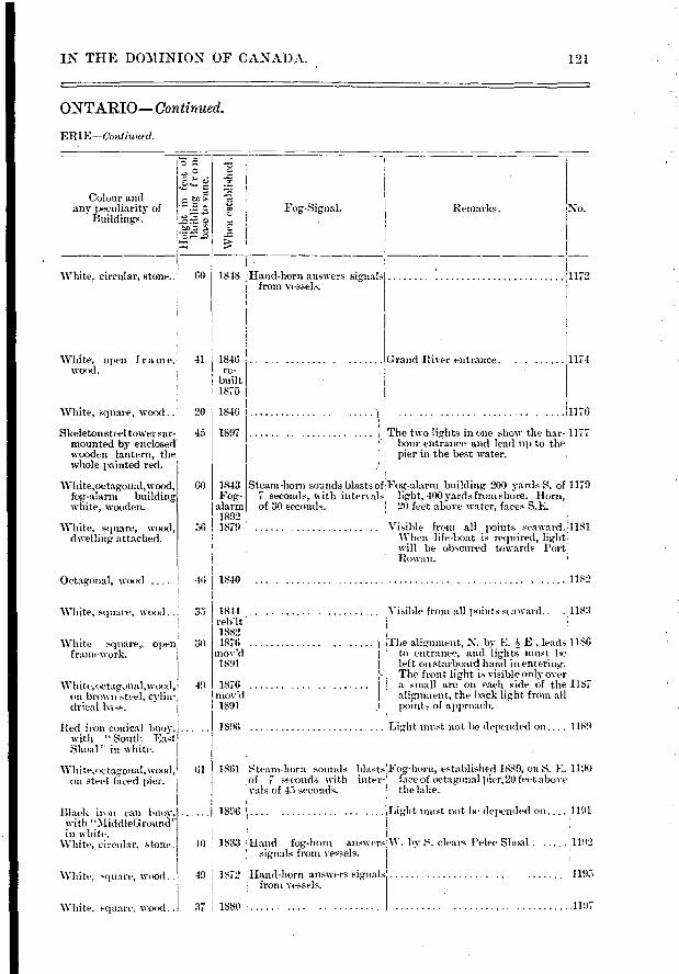
Remarks.
Grand River entrance.
No.
1172
1171
... ................
White, open f r a m e,• 41 1846 wood. re- ; . built
: 1875
White, square, wood... 20 1846
1897
60 1843 Fog-
alarm 1892
56 1879
White, square, wood 35
White square, open framework.
White,uctagonal,wood, 49 on brown steel, cylin- drical base.
Red iron conical buoy, ...... with " South East Shoal " in white.
White,octagonal,wood, 61 on steel faced pier.
30
W. by S. clears Pelee Shoal . 1192
1195
1197
Black iron can buoy, in tu "MiddleGrouner in white.
circular, stone.
White, square, wood..
White, square. wood..
IN THE DOMINION OF CANADA. 121
ONTARIO— Continued.
ERIE—Continiied.
.e Colour and Ie. any peculiarity of Fog,-Signal.
Buildings. ".fi-E15.2
White, circular, stone.. • 60 1848 !Hand-horn answers signals from vessels.
Skeleton steel tower stir-mounted by enclosed wooden lantern, the whole painted red.
White,octagonal,wood, fog-alarm building white, wooden.
White, square, wood, dwelling attached.
... '1,, The two lights in one show the bar- 1177 bour entrance and lead np to the pier in the best water.
'
Steam-horn sounds blasts of :' Fog-alarni building 200 yards S. oi1179 7 seconds, with intervals light, 100 yards from shore. Horn, , of 30 seconds. 20 feet above water, faces S.E. ,
:Visible from all points seaward. 1181 When life-boat is required, light will be obscured towards Port
I Rowan.
Octagonal, \i-ood 46 I 1840 • 1182
I Visible from all points seaward.. .. 1183 1844
1882 1876 The aliemment, N. by E. E , leads 1186
mov'd I ' to entrance, and lights must be 1891 I left on starboaid hand in entering.
;- The front light is visible only over 1876 a small arc on each side of the 1187
mov'd alignment, the back light from all 1891 • ) 1 points of approach.
1896 1Light most not be depended on.... 1189
• 1861 Steam-horn sounds blasts17o,-horn, established 1889, on S. E. 1190
l of 7 seconds with inter- (ace of octagonal pier,20 feet above vals of 45 seconds, the lake.
1896 1 .... Light must not lie dei ■ended on ,•1191
40 1813 j Hand fog-horn answers signals from vessels.
49 1872 Hand-horn answers signals from vessels.
37 1880 .
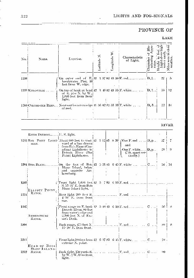
119S
Location. Naine.
One F. red ..
and
One F. white.... (7 ft. apart ver-
D, p.. 1 27 7
D, p.. 20 , 9
83 8 30
56
so II
.122 LIGHTS AND FOG—SIGNALS
PROVINCE OF
LAKE
No.
i1199 KIN“svILLE ..... '
COLCHESTER REEF... Near south-eastern edgeill 56 02 82 53 33iF. white
of reef.
On outer end of E. 42 1 37 breakwater Pier, 10 feet from \V. ecige.
On top of bank at head 42 of I:. pier N. by W., 1,060 feet from front light.
1200
' :..-:
.-- ! c . •—• '.-t. -,... . lr: .;-;-Ic ....D Characteristic
-..•., -7-- of Light. ■ Q 12 M . , - '.:-.Y l''. -F,
t7.
tO ,•,:j • z. -.:«., ' r.- .-
!
82 43 50 F. red D, 7..: 27 5 !
1 4S 82 43 55F. white.... 'I), 7.. 55 12
72 I 14-
RIVER
'RIVER DETROIT. U. S. light. ! I I „
I.„ ,. I ,0,-,!-,-, 1.‘co,”All POINT LIGHT- .ADODt 600 ceet to west-,42
I SHIP. , ward of a line drawn: from Bois Blanc (Can-adian) Lighthouse to Detroit River (Bar Point) Lighthouse.
1 17
1204IBOIS BLANC. On the foot of Bois 42 5 11 ! Blanc Island, below : and opposite Am-I herstburg.
83 6 43F. white ... C 56 14
5 783 6 2:4F. red
,
IRear light 309 feet S. , F. red ,
I l" 10 I:. from front, , , i one. I '
1207 'Front range on E. bank 42 5 40133 6 101'. red
Detroit River, 80 feet I
' from ivater's edge and, !
A3IHERsTBI:RG , , 2,300 feet N. of Fra-' RANGE. sers Dock. ! I I
. , I I •
1208 Back range, 475 feet N. F. red .... . .
! 16. 30' E. from front. I j
I , I
i . I
1211 i Front light :100feet from 42 G 17.83 6 451F. white. .. .... C ....! 70 ,
extreme N. point. I ! I HEAD OF Bois BLANC 1 s 1. A N 1)- ! .
1212 RANGE. Back light, 150 yards S. 'F. red. .0 . lIO '
, by IlV. \ W. from iront , I '
,
1 4. light.
1205 :Front light 1,696 feet'4') S. 533V E. from Bois
I Blanc Island E IOTT POINT ;
12C6 RANGE .
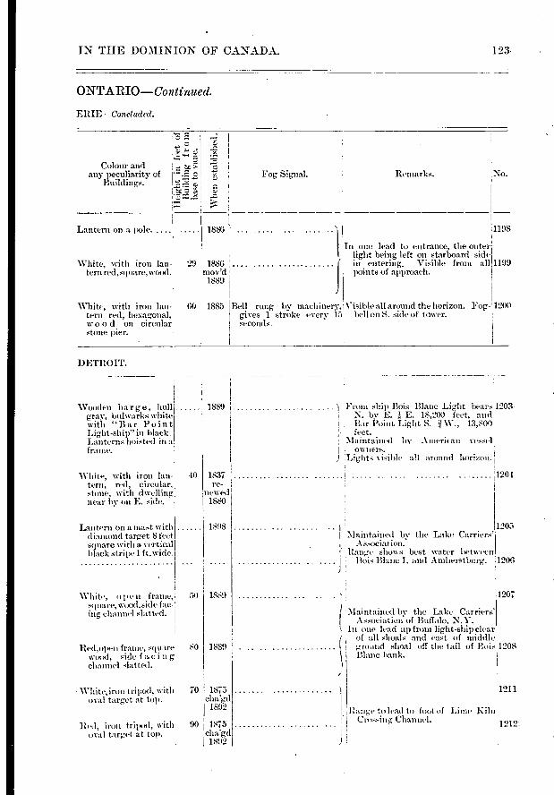
Colour and any peculiarity of
Buildings.
Lantern on a pole. ....
White, with iron lan- 29 1886
ternred,square,wood.. mov'd 1 1889
Remarks.
1 .In one lead to entrance, the outer light being left on starboard side
i' . in entering. Visible front all
Points of ai proach.
White, with iron ion-fera red, hexagonal, woo d on ci rcular stone. lier.
Bell rung by machiner , Visible all around the horizon. Fog,- 1200 gives 1 stroke every 17e bell on S. side of tower. seconds.
60 1885
No.
1198.
1199
Whe
n e
sta
blis
hed.
d■-•
••••-
Fog Signal.
1886'
Wooden barge, hull gray, bithvarks white with "Bar Point Light-ship" in black. Lanterns hoisted in a frame.
White, with iron imi-tera, red, circular, stone, with dwelling near by on E. side.
Lantern on a mast with d iamond target 8 feet square with a vertical black stripe 1 ft.wide.
1889
1837 re-
wwed 1880
1898
50 i 1889
IN THE DOMINION OF CANADA. 123-
ONTARIO—Continu ed.
EIZIE —Concl uded.
1)ETHOIT.
White, open frame, square, wood,side fac-ing channe] slatted.
Red, optai f rame, square 80 1889 wood, sicle f acing channe] slatted.
White,iron tripod, with 70 1875 oval target at top.
1892
Red, iron tripod, with 90 1875 ()val target at top. cha'gcl
1592
Front ship Bois Blanc Light bears 1203- N. by E. E. 18,200 feet, and Bar l'oint Light S. W., 13,800
- feet. .Maintained 'oy .A merican vessel . owners.
isi ble all around horizon.
1204
• 1 :Maintained by the Lake Carriers'
, Association. 1 . Range show s best water between
. ' Bois Blanc I. and Amherstburg. 1206
1207
( Maintained by the Lake Carriers' Association of Buffalo, N.Y.
In one lead up from light-ship clear i' of all shoals and east of middle L ground shoal off the tail of Bois 1208 \ Blanc bank.
1211
Ilange to lcad to foot of Lime Kiln Ci:ossing, Channel. 1212:
1205
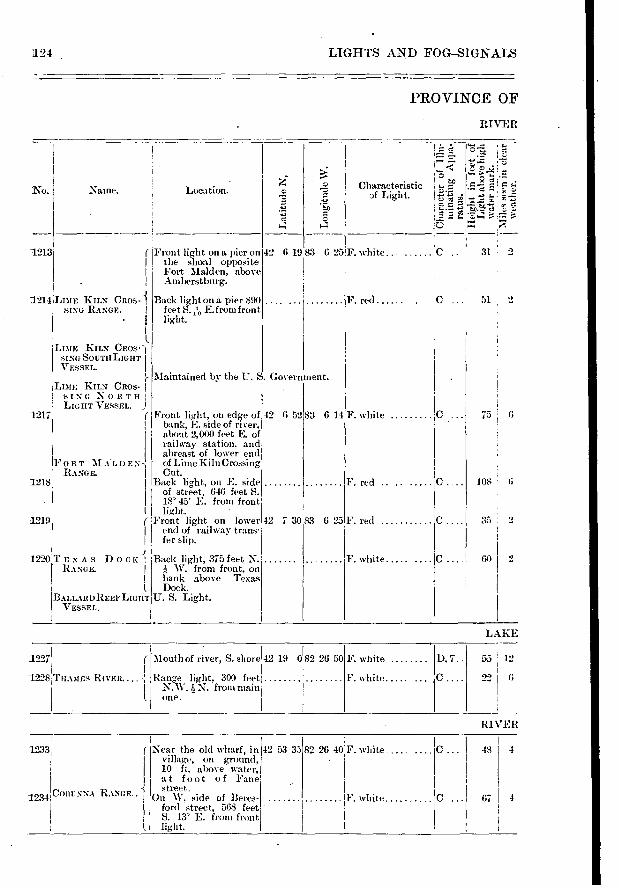
1233
CORUNNA RANGE.. 1234
I.
67 I 4
124 LIGHTS AND FOG-SIGNALS
PROVINCE OF
RIVER
1213
Naine. Characteristic pf Light.
.‘à.
1'5 " ' ...,•••• •
,=
C 31 2
Location.
( Front light on a pier on I the shoal opposite I Fort Malden, above
...-linherst burg.
Q
ci
7- . 5)
42 6 19 83 625 F. white.
1214 LIME KILN CROS-1 SING RANGE. I
•
LIME KILN CROS-) SING SOUTHLIGHT VESSEL.
LIME KILN CROS- I SING NORTH I LIGHT VESSEL.
Back light on a pier 890 feet S. T.1-, E. f rom front
Maintained by the U. S. Government.
F. red C ... 51 2
F. white
C.
C. F. red
F. white ..... te
1 FORT -N.IALDEN RANGE. I
1218
1219
1220
Front light, on edge of bank, E. side of river, about 2,000 feet E. of railway station , and abreast of lower end of Lime Kiln Crossing Cut.
Back light, on E. side of street, 646 feet S. 18 45' E. from front light.
Front light on lower end of railway trans-fer slip.
Back light, 375 feet N. W. from front, on
bank above Texas Dock.
U. S. Light.
42 6 52
42 7 30
83 6 14
F. red
83 6 23
75 6
108
33 2
60 2
1217
TEXAS DOCK I RANGE. 1
BALLARDREEPLIGHT VESSEL.
LAKE
.1227
1228 THAMES RIVER....
Mouth of river, S. shore 42 19 082 26 50
Range light, 300 feet N.W. 1, N. from main one.
F. white
F. white .....
D. 7.. 55 12
226
Near the old wharf, in village, on ground, 10 ft. above water, at foot of Fane street.
On W. side of Beres-ford street, 568 feet S. 13' E. from front light.
RIVER
82 26 40!F. white .........C I 48 4
IF white
42 53 35
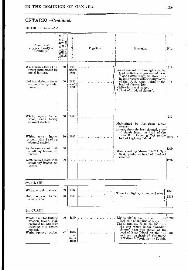
Remarks. Fog--Signal.
1217
1218. •
White iron skeleton tower surmounted by metal lantern.
Red it•on skeleton tower surmounted by metal lantern. .
White, open frame, wood, side facing channel slatted.
White, open frame, rwood, side facing channel slatted.
Lantern on a mast with small day beacon at-tached.
Ludern on a ma.st with small da3; beacon at-tached.
30 1886 mov'd 1891
:0 1886 mov'd 1891
1889 50
80
28
40
1889
59 1837
1845 23
White, circular, stone.
Red, open frame, square wood.
1227 These two lights, in one, lead over
bar. '1 1228
L
White, skeleton framed wooden tower, with enclosed top and side fronting the range, slatted.
White, square, wooden.
40 I 1890
42 1890 Re-
built 1892
;Lights visible over a small arc on 1233. I each side of the line of range. 1 The alignment, S. 13° E., indicates
the best water in the Canadian '- channel past the sho3.1s at the
head of Stag Island on the W., 1231 and past the shoals off the mouth
I of Talford's Creek on the E. side.
IN THE DOMINION OF CANADA. 125.
ONTARIO—Continued.
DETROIT—Concluded.
.5.
è
-d ••
No. Colour and
any peculiarity of Buildings.
Wli
en e
sta
bli
slie
d.
1213. The alignment of these lights can be ' kept with the alignment of Bois , Blanc Island range, northward to , its intersection with the alignment , of the U. S. range lights at the,1214 , head of Grosse Isle. ,Visible in line of range. At foot of dredged channel.
'
Maintained by American vessel owners.
In one, show the best channel, clear of shoals from the head of the Lime Kiln Crossing Cut to the foot of Fighting Island.
• 1 1219 ' Maintained by Messrs. Duff & Gat-,
;- field, pilots, at head of dredged channel.
11220 ,
ST. CLAIR.
ST. CLAIR.
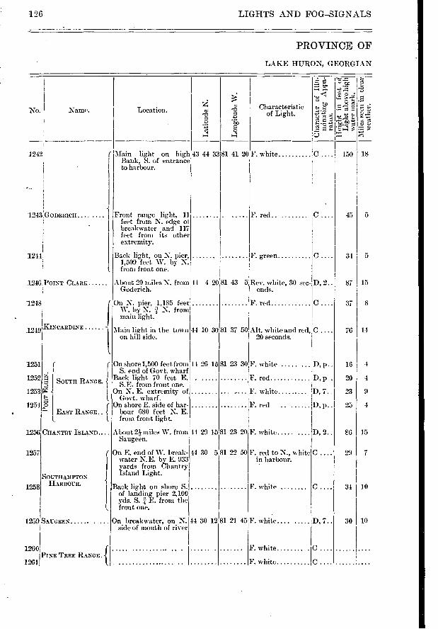
Narne. No.
1243,GODERICH....
1244
1246 POINT CLARE
1248
1249 1KINCARDINE
-5 SOUTH RANGE.
o
1
EAST RANGE.. -f CHANTRY
SOUTHAMPTON HARBOUR.
f I.
1251
1252
1253
1254
1256
1257
1258
44 4 20
Front range light, 11 feet from N. edge ol breakwater and 117 feet front its other extremity.
Back light, on N. pier, 1,509 feet W. by N. front front one.
About 20 miles N. from Goderich.
On N. pier, 1,185 feet W. by N. i N. from main light.
1259,SAUGEEN On breakwater, on N. side of mouth of river
-f PINE TREE RANGE. 1260
1261
81 23 30F. white ...... D, p..
F. red
F. white
F . red
D, p..
D, 7.
D, p..
81 23 20
81 22 50
F. white .....
F. red to N., white in harbour.
D, 2..
F. white .....
81 21 45 F. white.. D, 7..
F. white
F. white
C.
C.
F. green
F. red
F. red
Rev. white, 30 sec-onds.
D, 2..
Alt. white and red, C 20 seconds.
31 5
87 15
37 8
76 14
16 4
20 4
23 9
25 i 4
6 I 15
297
311 10
30 I 10
5 45
126 LIGHTS AND FOG—SIGNALS
PROVINCE OF
LAKE HURON, GEORGIAN
r„ .-. • •
Characteristic .t9 • of Light.
- t•-■
‘ri ;1•7;;*,'
F ;
F. white :C . 150 1 18
Location. o
1242 r Main light on high 43 44 33 Bank, S. of entrance to harbour.
On shore 1,500 feet from 44 26 S. end of Govt. wharf
Back light 70 feet E. S.E. from front one.
On N. E. extremity- of Govt. wharf.
On shore E. side of har-bour 680 feet N. E. from front light.
About 21 miles W. from 41 29 15 Saugeen.
On E. end of W. break- 44 30 5 water N.E. by E. 933 yards from Chantry Island Light.
Back light on shore S. of landing pier 2,100 yds. S. E. from the front one.
14 30 12
Main light in the town 44 10 on bill side.
o Sc
81 41 20
81 43 5
30181 37 50
15
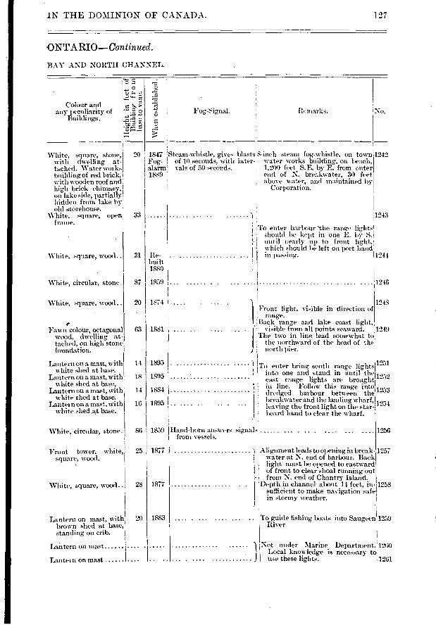
Wh
en e
sta
bli
shed.
marks.
31 Re-built 1880
87 1859 ; ........
1244
1246
'IN THE DOMINION OF CANADA. 127
ONTARIO—Con tinued.
BAY AND NORTH CHANNEL.
H„ 0
b- Colour and any peculiarity of
Buildings. No.
White, square, stone, 20 with dwelling at-tached. Water works building of red brick, with wooden roof and high brick chimney, on lake side, partially hidden from lake hy-oid storehouse.
White, square, open 33 frame.
'White, square, wood..
White, circular, stone.
1847 Steam-whistle, gives blasts 8-inch steam fog-whistle, on town Fog- 1 of 10 seconds, with inter-. water works building
' on beach,
alarm' vals of 50 seconds. , 1,200 feet S.E. by E. from outer 1889 ' I, end of N. brer.kwater, 30 feet
! above water, and maintained by ! , Corporation.
1243 L
,To enter harbour 'the range lights should lie kept in one É. by S. until r early up to front light,
• which should he left on port hand I 1 in passing.
1242
20 1874
63 I 1881
14 1895
18 1895
14 1884
16 1895
86 1859
20 I 1883
Front tower, white, 25 1877 square, wood.
White, square, wood.. 28 1877
White, square, wood..
Fawn colour, octagonal wood, dwelling at-tached, on high stone foundation.
Lantern on a mast, with white shed at base.
Lantern on a mast, with white shed at base,
Lantern on a mast, with white shed at base.
Lantern on a mast, with white shed ,at base.
White, circular, stone.
Lantern on mast, with brown shed at base, standing on crib.
Latitern on mast ......
Lantein on mast
1 1248
Front light, visible in direction of range.
. : Back range and lake coast light,
J'. visible from all points seaward. 1249
The two in line lead somewhat to the northward of the he.ad of the north pier.
To enter bring south range lights 1251 into one and stand in until the ,,,9
east range lights are brought- '''''' u in line. Follow this range into .,,,,
dredged harbour between the ''''''' breakwater and the land ing wharf, i ,- , leaving the front light on the star- '`')'
, board hand to clear the wharf.
Hand-horn answers signals from vessels.
Alig-nment leads to opening in break- 1257 water at N. end of harbour. Back light must be opened to eastward of front to clear shoal running out
- from N. end of Chantry Island. Depth in channel about 14 feet, in- 1258
sufficient to make navigation safe in stormy weather.
To guide fishing boats into Saugeen'1259 River.
Not under Marine Department. 1260 Local knowledge is necessary to
J use these lights. 1261
1256
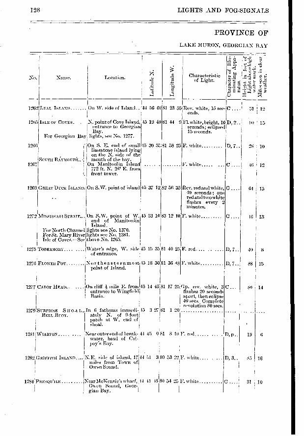
82 56 35 45 37 12
10 45 53 1083 12
45 15 3581 40 25
C ....
D, 7..
D, 7..
46 I 13
40 8
88 15
; 14
19 I 6
85 16
LIGHTS AND FOG-SIGNALS
PROVINCE OF
LAKE HURON, GEORGIAN BAY
128
No.
5:
re.
r--; -
cc°
. -z. o ;-4
=-•= c:
Name. Location. Characteristic of Light.
51 1 12 1262 LYAL ISLAND On W. side of Island.. 44
1265 IstE OF COVES. . N. point of Cove Island, 45 entrance to Georgian Bay.
For Georgian Bay lights, see No. 1277.
1266 f On S. E. end of small 45 30 3:7-, limestone island lying
I on the N. side of the .SOUTII BA:YMOUTH.. mouth of the bay.
1267 On Manitoulin Island . I 772 ft. N. 28' E. from (, front tower.
56 40
19 40
81 23 55 Rev. white, 15 sec- C ....! onds.
81 44 9 Fl.white, bright, 10 D, 2.. 90 15 seconds; eclipsed 15 seconds.
81 58 25
F. white
F. white D, 7.. 28
46 12
1269 GREAT DUCK ISLAND. On S.W. point of island Rev. red and white, 40 seconds ; one red and two white flashes every 2 minutes.
C .... 6-1 15
1272. MISSISSAGI F. white On S.W. point of W. end of Manitoulin Island.
For North Channel lights see No. 1370. For St. Mary River lights see No. 1381. Isle of Coves.—See above No. 1265.
1275 TORERMORY
1276 FLOWER POT
'Water's edge, W. side of entrance.
Northeasternmost 15 point of Island.
18 30 81 36 48 F. white
1277 CABOT HEAD... cliff mile E. from 45 14 45 81 entrance to Wingfield Basin.
17 25;Gp. rev. white, 3 flashes 20 seconds apart, then eclipse 40 secs. Complete revolution 80 secs.
1279 SURPRISE SHOA L ■ BELL BUOY.
1281 WIARTON .....
3 2181
1 82 GRIFFITH ISLAND....
1284 , PRESQU'II
, In 6 fathoms itnmedi- 45 ately N. of 9-foot' Patch at W. end of shoal.
Near outer end of break-' 44 45 water, head of Col- poy's Bay.
NearMcKenzie's wharf, 1.44 41 48 Owen Sound, Geor-T giali Bay.
1 20
8 10 F. red
D, 3..
I I
I . 80 54 25F. white
I
0 81
N.E. side of island, 17 14 51 3 . 80 53 22F. white.... miles from Town of Owen Sound.
31 10
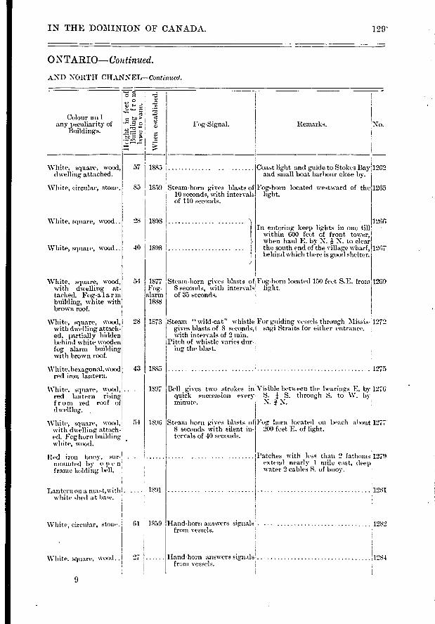
No. Remarlzs.
White, square, wood..
White, squal e, wood ..
1859 Steam-horn gives blasts of 10 seconds, with intervals of 110 seconds.
1898
1898
85
28
40
54
28
43
54
1885
1897
1596
IN THE DOMINION OF CANADA. 129'
ONTARIO- COntinued.
AND NORTH CHANNEL—Continued.
7:d !
!
!
>1 0 Fog-Signal.
Colour an 1 any peculiarity of
Buildings.
White, square, wood, 57 1885 dwelling attached.
White, circular, stone.
Coast light and guide to Stokes Bay 1262 and small boat harbour close by.
Fog-horn located westward of the 1265
1266 In entering keep lights in one till
within 600 feet of front tower, when haul E. by N. N. to clear the south end of the village wharf, 1267 behind which there is good shelter.
White, square, wood, with dwelling at-tached. Fog-a larm building, white with brown roof.
1877 Steam-horn gives blasts of Fog- 8 seconds, with intervals
alarm of 35 seconds. 1888
Fog-horn located 150 feet S.E. from 1269
White, square, wood, with dwelling attach-ed, partially hidden behind white wooden fog alarm building with brown roof.
1873 Steam " wild-cat" whistle gives blasts of 8 seconds, with intervals of 2 min.
;Pitch of whistle varies dur-ing the blast.
For guiding vessels through Missis- 1272 sagi Straits for either entrance.
White, hexagonal,wood red iron lantern.
White, square, wood, . red lantern rising from red roof of
White, square, wood,! with dwelling attach.' ed. Foghorn building white, wood.
Red iton buoy, su1'- 1 mounted by o
frame holding bell.
Lantern on a mast,with . ....1 1891 white shed at base.
White, circular, stone.
1275
Bell gives two strokes in Visible between the bearings E. by 1276' quick succession every S. 1 S. through S. to W. by minute. N. N.
Steam horn gives blasts of 8 seconds with silent in-tervals of 40 seconds.
Patches with less than 2 fathoms l 1.279 extend nearly 1 mile east, deep,1 water 2 cables S. of buoy.
1281
Fog horn located on beach about 1277 200 feet E. of light.
61 1859 Hand-horn answers signals 1259 from vessels.
White, square, wood.. Hand-horn answers signals 11254 97
from vessels.
9
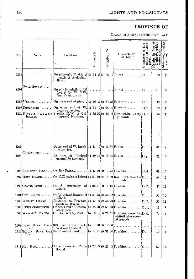
Naine.
OWEN SOUND..
MEAFORD
THORNBURY
NOTTAWASAGA ISLAND.
COLLINGWOOD •
Characteristic of Light
F. red .....
F. red
- • -c-3 - >
z
"É.o."Ect: " C.3
39 7
A cl!
•
0.
D, 7..
D, 2..
46
42
32
86
8
13
17
41 ! 8
27 6
D, 4.. 61
54
15
12
D, 7.. 40 11
CHRISTIAN ISLAND.. On Bar Point
HOPE ISLAND On N. E. point of Island
GIANTS TOMB On S. extremity of Island.
44 31 0 80 13 50
44 30 40,80 13 45
F. red
F. red.... . .....
44 47 2080 9 25F. white
44 54 50 80 10 O'Rev. white—One minute.
44 52 47 80 0 28 F. white.... .
1285
1286
1288
1289
1291
1292
1293
1296
1297
1298
1301
1308
1310
1311
1302 WHISKY ISLAND....
1303 PENETANGUISHENE
1306 WESTERN ISLANDS..
On W. side of Beausoleil 44 51 25 Island.
Entrance to Penetan- 41 49 0 guishene Harbour.
On outer end of Reform- 44 48 30 atory pier.
On Double Top Rock .. 45 2 4
79 53 22
79 53 20
79 53 50
80 21 31
D, 7..
45 9 30 80 12 0
45 19 21 80 31 30
45 22 5 80 23 5
F. white D.
F. white, varied by D, 4. white flashes every 30 seconds.
F. white.... .....
10 54
11 33
8
14
17
74
10 4
63 13
130 LIGHTS AND FOG-SIGNALS
PROVINCE OF
LAKE HURON, GEORGIAN BAY
No. g Location.
On pilework-, E. side of inouth of Sydenham River.
On pile foundation,1053' feet S. by W. / W. from front tower.
On outer end of pier...
On outer end of W. breakwater pier.
2 miles N.W. of Col- lingwood Harbour.
Outer end of W. break-water pier.
At turn a dredged channel in harbour.
• g a
44 34 43 80 56 19
44 36 4080 34 30 F. white
44 34 080 26 5F. white
44 32 22 80 15 6 Rev. white, every- ?, minute.
GIN ISLAND F. white
F. white
F. white....
LONE ROCK BELL- 300 feet from rock, BUOY. Wabuno Channel.
SEGUIN BANK GAS South end of bank.... Bcor.
At entrance to Parry Sound.
RED ROCK
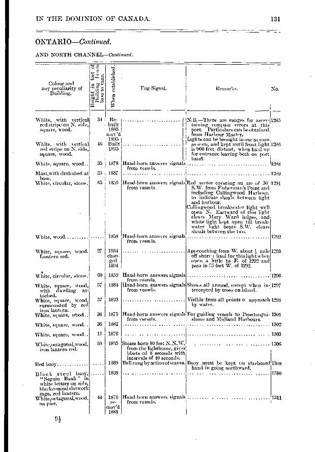
Remarks. Fog-Signal.
1292
Approaching from W. about ?, mile off shore ; haul for this light- when open a little to E. of 1292 and pass in 75 feet W. of 1292.
1296
Shows all around, except when in-:1297 tercepted by trees on island.
Visible from all points o approach 1298 by water.
For guiding vessels to Fenetan,gui- 1301 shene and Midland Harbours. 1302
1303
1306
Buoy must be kept on starboard hand in going northward.
1310
1293
1308
1311
1285
1286
1288
1289
34
46
35
2.5
85
1887
1859
1858
37 I 1893
36 1875
36 1882
18 1876
59 1895
1889
1898
44 I 1870 I re-imov'd I 1881
IN THE DOMINION OF CANADA.
ONTARIO—Continued.
AND NORTH CHANNEL—Continued.
131
Colour and any peculiarity of
Building.
c *".
Whe
n es
tabl
is
Re- r N.B.—There are ranges for ascer- built I taining compass errors at this 1883
1port. Particulars can be obtained
m ov 'd from Harbour Master. 1895 j Lights can be brought in one as soon Built ... ............. I as sen, and kept until front light 1895 1 is 900 feet distant, when haul up
I for entrance leaving both on port l. hand.
1878 Hand-horn answers signals from vessels.
1884 chan-ged 1894
60 1859
57 1884
White, square, wood. 27 Lantern red.
White, with vertical red stripe on N. side, square, wood.
White, with vertical red stripe on N. side, square, wood.
White, square, wood..
Mast,with drab shed at base.
White, circular, stone.
White, wood
• White, circular, stone.
White, square, wood, with dwelling at-tached.
White, square, wood, surmounted by red iron lantern.
White, square, wbod
White, square, woocl..
White, square, wood..
White,octagonal,wood , iron lantern red.
Red buoy
Black steel buoy, "Seguin Bank" in white letters on side, black conical slat work cage, red lantern.
White,octagonal,wood, on pier.
Hand-horn answers sihmals from vessels.
Hand-horn answers signals from vess.els.
Hand-horn answers signals froin vessels.
Hand-horn answers signals from vessels.
Steam horn 80 feet N.N.W. from the lighthouse, gives blasts of 8 seconds with intervals of 10 seconds.
Bell rung by action of waves.
Hand-horn answers signals from vessels.
Hand-horn answers signals Red sector covering an arc of 30 1291 from vessels. S.W. front Fisherman's Point and
including Colling-wood Harbour, to indicate shoals between light and harbour.
Collingwc)od breakwater light well open N. Eastward of this light" clears Mary Ward ledges, and white light kept open till break-water light bears S.W. clears shoals between the two.
• 9i
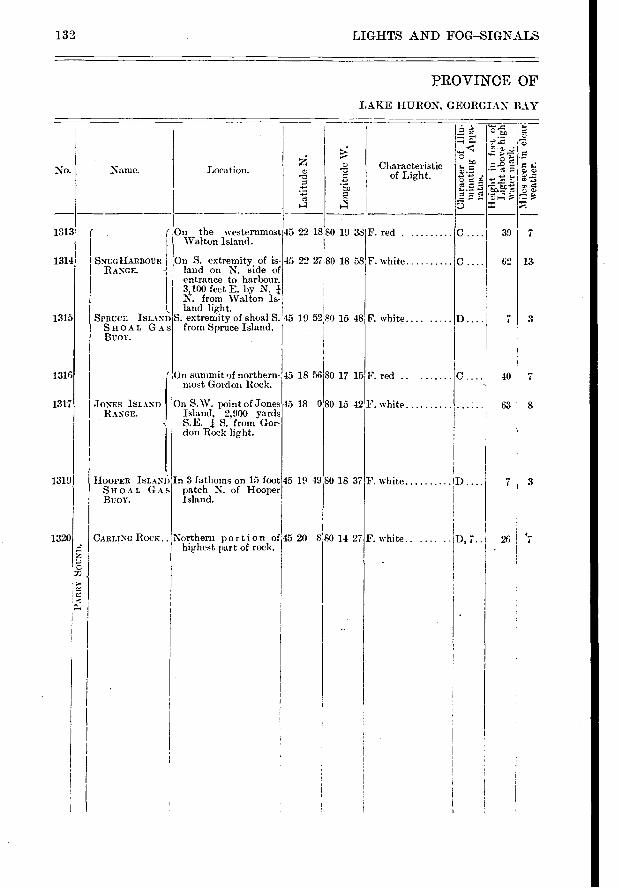
1 L
ong
itu
de W
.
39
62 SNUGHARBOUR I RANGE.
C.... 40
63
13
3
8
1 45 19 49
45 18 0
45 18 56
80 15 42
80 17 15
0 18 37
8 0 14 27 26 .7 D, 7..
1313
1314
1315
1316
1317
1319
1320
F.e" o
132 LIGHTS AND FOG—SIGNALS
PROVINCE OF
LAKE HURON, GEORGIAN BAY
No. Name. Location. a> • r. t>)
Characteristic of Light.
" tip it'
-›* 7. 7.; B
- •-
Tz.toà f, 72. e
SPRUCE ISLAND SHOAL GAS BUOY.
On the westernmost 45 22 18 80 19 38 Walton Island.
On S. extremity of is- 45 22 27 80 18 58 land on N. side of entrance to harbour. 3,100 feet E. by N. N. from Walton Is-land light.
S. extrennty of shoal S. 45 19 5280 15 48 from Spruce Island.
ln summit of northern-most Gordon Rock.
F. red
F. white
F. white....
F. red
JONES ISLAND RANGE.
On S.W. point of Jones Island, 2,900 yards S. E. S. from Gor-don Rock light.
F. white
HOOPER ISLAND SHOAL GAS BUOY.
In 3 fathoms on 15 foot patch N. of Hooper Island.
F. white
CARLING_ ROCK.. Northern portion of 45 20 highest part of rock.
F. white.. ....
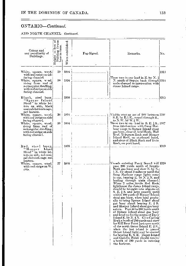
-d
White, square, wood,j with red stripe onsiddH facing channel.
White, square, w rising from roof of rectangular dwelling, with red stripe on side facing, channel.
Blac k, steel buoy, "Spruce Island Shoal " in white let-ters on side, black c-onical slatwork cage, red lantern.
White, square, wood, 38 with red stripe on side facing channel.
White, square, wood, 50 rising from roof of rectangular dwelling, with red stripe on side facing channel.
29 1894 I
Red, steel buoy-, " Ho° p e r Island Shoal " in white let-ters on side, red coni-cal slatwork cage. red lantern.
White, square, wood, with red stripe on W. side.
1894
1898
1894
1894
1898
1898
IN THE DOMINION OF CANADA_ 133
O-NTARIO—Continued.
AND NORTH CHANNEL—Continued.
Wh
en e
sta
bl
Colour and any peculiarity- of
Buildings. Fog-Signal. Remarks.
-
.1 ▪ 0 .
;•;.:
• "'
•
0 77-
No.
1313
These two in one lead in E. by N. N. south of Seguin bank through main channel to intersection with Jones Island range.
1315
Visible over an are of 180 between 131): S.E. by E.?,- E., round tliroug,h S., to N.W. by W. W.
These two in on- lead in S. E. S., 1317 from intersection with Snug Har-bour range to Spruce Island shoal gas buoy, clear of Ariel Rock, Hall Reef, Teleg,rain Rock and Hooper: Island Reef, on starboard hand, and clear of Black Rock and Twin Rock, on port hand. 11319
Vessels entering Parry Sound will 1320 pass 200 yards south of Sequin Bank gas buoy and steer E. by N.
N. for about 2 miles or until thel Snug Harbour range lights come in one, bearing E. by N. N. and
leading through main channel.! When 2 miles inside Red Rock lighthouse the Jones Island range should be brought into alignment S. E. J S. and kept exactly mite within 400 yards of Hooper Island shoal gas buoy, when haul graciu-ally to bring Spruce Island slime gas buoy ahead bearing E. S. ' and Hooper Island shoal gas buov astern. Pass 50 to 100 yards south of Spruce Island shoal gas buoy and head up for the centre of Davy. Island E. by N. 4 N. Give Carling' Rock a berili of 2.00 yards and steer for Kill Bear Point just open north! of the north Sister Island E. :1_ %vhen the last island is passecf Depot Island light may be steered for bearing E. S. E. Depot Island and Cadotte Point should receive; a berth of 100 yards in entering the harbour.
1314
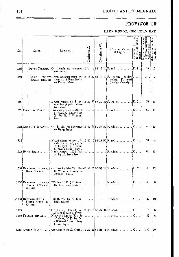
134 LIGHTS AND FOG-SIGNALS
PROVINCE OF
LAKE HURON, GEORGIAN BAY
No. Naine. Location.
Lati
tude
N.
I L
ong -
itu
de_W
.
1
51;
e • 1.1
C.)
Characteristic of Light.
1323: I DEPOT ISLAND..
1324
F. red ;D, 7.. 25 On beach at western 45 19 680 7 10 extremity-.
ROSE POINT From western-most ex- 45 18 57 80 2 49 F. green (bridge SWING BRIDGE tremity of Rose Point I open), F. r e d
to Parry Island. j (bridge closed).
10
1327 Front.range, on S. ex- E 45 33 33 tremity of point, close!
, to water. 1328 POINT AU BARIL Back range, on summit
of island, 4,800 feet E. by S. S. from front.
80 30 34F. white
F. red C.
I), 7.. 38
60 10
10
1331 GEREAUX ISLAND... On S. sicle of entrance 45 44 31 80 39 52 to Byng Inlet.
F. white C ' 49 12
C.... 34
1
1332
1333 .BYNG INLET
1336
1337 BUSTARD ROCKS, FRONT INNE It RANGE.
Front range, close to S. 45 45 580 38 56 sideof channel, j mile N.E. by E. 1 E. from Gereaux Islard light.
Back range, 1,520 feet E. by N. from front.
On a rocky islet,2) miles S. W. of entrance to French River.
229 feet N.E. E. from the last described.
BUSTARD ROCKS, ( BACK RANGE.
45 53 25 80 57 18
F. red
F. white
F. white
F. white. ..
, .. 48 12
61) I 13
30 I 6
F. white .......C 27 193 ft. W. by S. from back tower.
1.
,On Lefroy Island, W. 45 56 8 1 side of mouth of river.
RIVER . I Near the Creek, E. side -1 of river, N. E. by- N.
4,300 feet from Lefroy Island light.
1343 LONELY ISLAND 1:11it summit of N. bluff.. 45 34 27
1338IBusTARD ROCKS, FRONT OUTER
I RANGE.
1339'
13401FRENGH
10
80 54 40Y. white .......C ....I 15 6
..F. red C 37 6
81 28 11 F. white. C.... 195 I 20
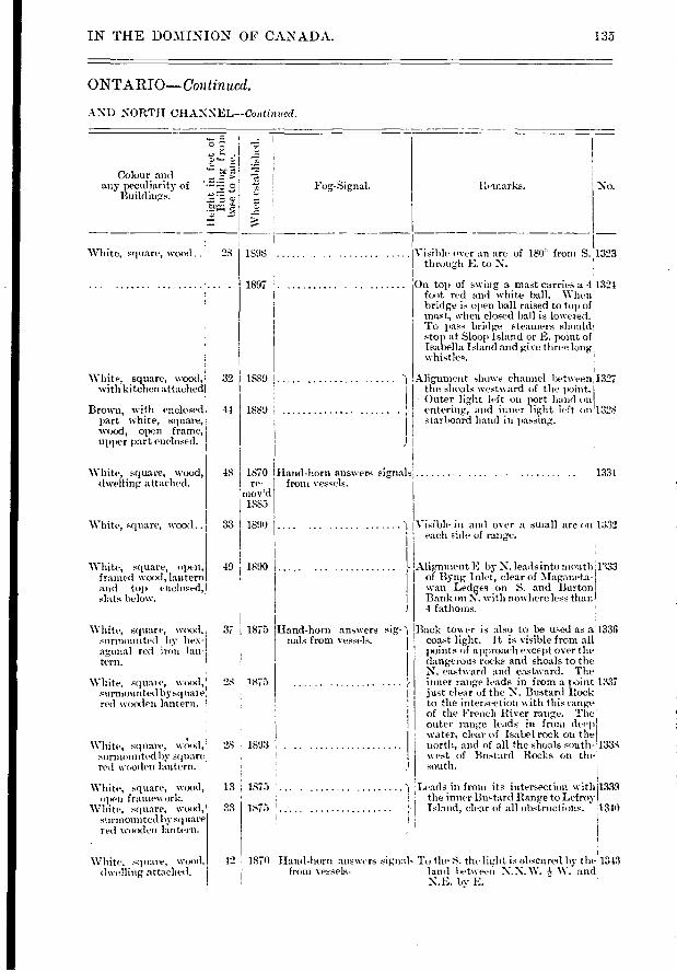
.r.• I
> S.;
White, square, wood. j 28
Colour and any peculiarity of
Buildings.
W 1
1(11
es
t al )
1 is
lie
d
Fog-Signal.
1898
32
44
48
Visible over an arc of 180 from S. 1323 through E. to N.
On top of swing a mast carries a 41324 foot red and white ball. When bridge is open ball raised to top of mast, when closed ball is lowered. To pass bridge steamers should! stop at Sloop Island or E. point of Isabella Island and gi ce three long' whistles.
Alignment shows channel between.1327 the shoals westward of the point.; Outer light left on port hand onl entering, and inner light left on '1328 starboard band in passing,.
1331
Visible in and over a small arc on 1332 each side of range.
Alignment H by N. leads into mouth FM of Byng Inlet, clear of Maganeta- wan Ledges on S. and Burton Bank on N. with nowhere less than 4 fathoms.
Back tower is also to be used as a1336 coast light. It is visible from all points of approach except over the dangerous rocks and shoals to the N. eastward and emtward. The inner range lads in from a point 1337 just clear of the N. Bustard Rock to the intersection with this range of the French River range. The
outer range leads in fnmi deep' water, clear of Isabel rock on the north, and of all the shoals south- 1338 west of Bustard Rocks on the south.
Remarks. No.
1897
1889
1889
White, square, open, framed wood, lantern :old top enclosed, slats below.
White, square, wood, surmoutited by hex-agonal red iron lan-tern.
Whit e, squat e, ‘vood, surniounted by sq u al e red wooden lantern.
White, square, wciod, surmounted by square red wooden lantern.
White, square, wood, 111)(11 framework.
White, square, wood, surmounted liv square red wiroden lantern.
White, square, Nvood, dwelling attached.
49 i 1890
37 j 1875
08 1875
28 1893
13 , 1875
33 1875
Hand-horn answers sig- nais from vessels.
IN THE DOMINION OF CANADA. 135
ONTARIO—Con tin ued.
AND NORTH CHANNEL--Continned.
White, square, wood, with kitchen attached
Brown, with enclosed part white, square, wood, open frame, upper part enelosed.
White, square, wood, dwelling attached.
1870 Hand-horn answers signal re- front vessels.
mov'd 1885
Leads in from its intersection witlà'1339 the inner Bu-tard Range to Lefro;\ -
- Island, clear of all obstructions. 1340
• • ....... • • ..... • • • •
1890 White, square, wood .. 33
42 1870 Hand-horn answers signal- Ti the S. the light is obscured bv the .1343 from vessels- land between N.N. W. and,'
N.H. by E.
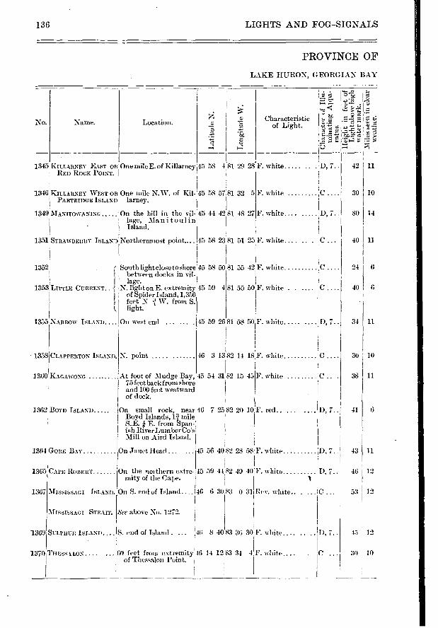
45 58 4 81 29 28 F. white
5 45 58 57.81 32
45 44 42 81 48 27 F. white 7"
IsLAYiNortherntnost point....
r
45 58 23 81 51 25IF. white....
}'.white C.
!D, 7.. F. red.
50 81 55 42
4 1 81 55 50F. white . .
F. white
30 10
80 14
40 I 11
24 6
40 6
34 11
30 10
38 11
41 6
CAPE ROBERT On the northern extre. mity of the Cape.
MISSISSAGI ISLAND. On S. end of Island..
MISsISSAGI See above No. 1272.
45 12
30 IO
SULPHUR ISLAND.... S. end of Island . 146 8 4083 36 30F. white....
1365
1367
1369
1370 THESSA LOS ...00 feet from extremity,46 14 12 83 34 of Thessalon l'oint.
4'F. %%bite . C
LIGHTS AND FOG-SIGNALS 136
PROVINCE OF
LAKE HURON, GEORGIAN BAY
L4... ".77.c 'r=4" 17.■
• I .7: - .
•
. 5. "7.,
D, 7.. 42f11
O.
No.
1345KILLARNEY EAST OR RED ROCK POINT.
1346 KILLARNEY WEST 01U PARTRIDGE ISLAND'
1349 :NIANtrowAND.:o
Location.
One mile E. of Killarneyi
One mile N.W. of Kil-larney.
On the hill in the vil-lage, Manitoulin
Naine.
o
F. white
Characteristic of Light.
1351 STRAWBERRY
1352
1353 LITTLE CURRENT..
1355 NARROW ISLAND .
South light close toshore 45 58 between docks in vil- lage.
N. light on E. extremity 45 59 of Spider Island, 1,350 feet N W. from S. light.
On west end ...
N. point - 1358 CLAPPERTON ISLAND.
45 59 2681 58 50
46 3 1382 14 18,F. white 'C
1362 BOYD ISLAND
1360 KAGAWONG At foot of Mudge Bay, 45 54 31 82 15 -15 75 feet back from shore and 100 feet westward of dock.
On small rock, near 46 7 25 82 20 10 Boyd Islands, n mile S.E. E. from Span-ish RiverLumberCo's Mill on Aird Island.
F. white D, 7..
45 56 4082 28 58 F. white
15 59 4482 49 40 1F. white
1 46 6 3085 0 3bRev. white.. .
On Janet Head ... 1364 GOBE BAY D,7..I 43 11
D, 7.. 46 12
C 53 12
I), 7..
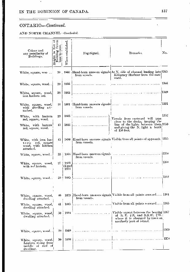
1351
1352 Vessels from eastward will pass
close to the docks, keeping the line of the lights between them 1353 and giving the N. light 'a berth of 154) feet.
Visible from all points of approach.!1355
1358
1360
1302
IN THE DOMINION OF CANADA. 137
ONTARIO—Continued.
AND NORTH CHANNEL—Coariuded.
No. Colour and
anv peculiarity of Buildings.
White, square, woo
White, square, wood..
White, square, wood, it-on lantern red.
e Si
„
" .-
20 1866
20 1866
38 1885
Fog-Signal.
Hand-horn answers signals from vessels.
Remarks.
At N. side of channel leading into 1345 Killarney Harbour from the east-ward.
1346
1349
White, square, wood, 44 1881 with dwelling a t - tached.
Hand-horn answers signals from vessels.
White, with lantern 23 1866 red, square, waxl.
White, with lantern 13 1866 red, square, wood.
White, with iron lan-tern red, square wood, with kitchen attached.
Hand-horn answers signals from vessels.
White, square, wood.
White, square, wood with red lantern.
White, square, wood..
33 ! 1866
27 1888 ch'ged
1894
39 1885
Hand-horn answers signals from vessels.
45 I 1890
White, square, wood, dwelling attached.
White, square, wood, dwelling attached.
White, square, wood, dwelling, attached.
40 ! 1879
41
50
1885 1.....
1884
Visible from all points seaward.... 1361
Visible from all points seaward .... 1365
Visible except Letween the bearing 1367 of S. E. 1, S. and S.S.W. where it is obscured by trees on northerly part of island.
Hand-horn answers signals from vessels.
1369 White, square, wood .. 20 I 1869
1370 30 1898 White, square, wood. Lantern rising from middle of roof of dwelling:.

F. red D . p
F. red.. ...... D.p..
1:3S LIGHTS AND FOG--SIGNALS
PROVINCE OF
RIVER ST.
No. No me.
La
titu
de N
.
Lon
git
ude
W.
Location.
• e
_ 11
• cr c3 c:
e
Characteristic of Light.
d
tc
1372 BRUCE MINES On outer end of wharf. :46 17 51
1373 Mums— 60 feet from outer end 46 15 35 of public wharf.
1375 NORTH SISTER ROCK. E. side of channel
1376 BA3IFORD ISLAND On E. extremity of Is- 46 19 land, I mile S. W. of, Wilson's channel.
1378 SHOAL IstANP On N. extremity S. side 46 18 51 of channel.
POINT DEToun IT. S. I.ight
FRYING PAN ISLAND. IX. S. Light.
PIPE ISLAND ..... . U . S. Light.
SWEETS POINT II. S. Light.
ROUND IstAND. S. Light.
WINTER POINTU. S. Lights. RANGE.
84 4 30 F. white D, 7.. 32 11
83 47 16 F
83 53 20F. white C 05 3
46 18 16 83 54 44 I F. white D, 7.. 35 11
6 83 59 35 F. white D, 7.. 32 1 10
19 1 2 1381 ( On west shore of St. 1 Joseph Island, Jt tnile I below Ross Wharf.
SAILORS ENCAMP- 1 1382 mENT LOWER 64 feet east from shore
RANGE. line. 246 feet S. W. from front light.
46 14 18 84 5 40
IENCAMPMENT Cum...U. S. Light .
1384 On shore north of wharf
1385 436 feet S.E. I E. from front light.
RAINS W II A It F RANGE.
46 15
84 5 201'. red .p.. 21
F. red D. p .. 26 .2
1396 ( 640 feet from shore...
1387 SAILORS ENCAMP- II
I M ENT UPPER 260 feet N. E. from the RANGE. front light.
46 15 21.84 5 21]F. red .. . ..... 65 2
F. red D.p.. 73 2
DARK HOLE, EAsr U. S. Lights. RANGE.
DARK HOLE, WEsT U. S. Lights. RANGE.
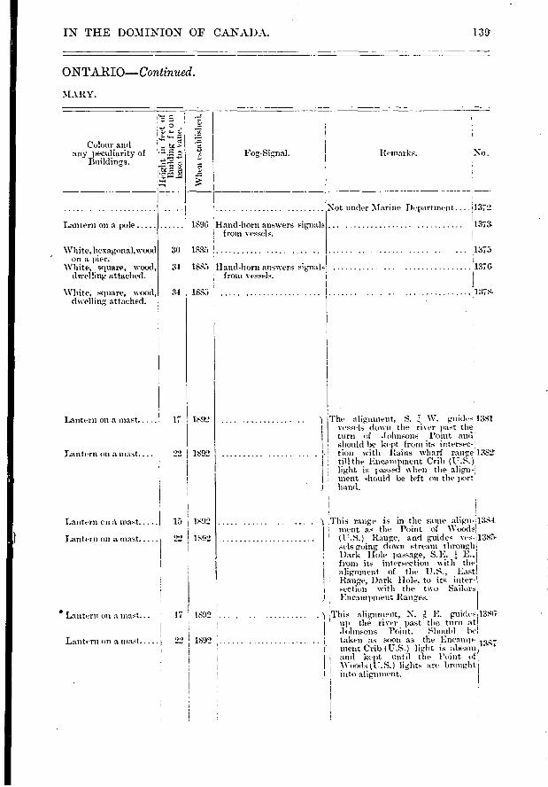
Remarks. No. Fog-Signal. Colour and
any peculiarity of Buildings.
tc>
Lantern on a mast .....
Lantern on a mast. ...
Lantern en à mast
Lantern on a mast .....
1892 17
1892
15 1892
. i This alig-nnient, N. E. guides 1386 • up the river past the turn at
Johnsons Point. Should be taken as soon as the EncaniP-
r • ment Crib (U.S.) light is abeam
I and kept until the Point of Woods (U.S.) lights are brought
I into alignment.
1892 .
1892 1387
IN THE DOMINION OF CANADA. 139
ONTARIO—Continued.
MARY.
■V
hea,
esta
blis
hed.
Lantern on a pole
White, hexagonal, wood on a pier.
White, square, wood, dwelling attached.
White, square, wood, dwelling attached.
1896 Hand- boni answers signals ! from vessels.
30 1885
34 • 1885 Hand-horn answers signal s from vessels.
34 1685
Not under Marine Department .... 1_372
:1373
1375
1376.
.1178-
The alignment, S. W. guides 1381 vessels down the river ilast the
turn of Johns-ons Point and should be kept from its intersec-i
tion with Bains wharf range 1382 till the Encampment Crib (U.S. ): light is passd when the align-ment should be left on the port: hand.
22 1892
• Lantern on a mast... 17
Lantern on a mast
This range is in the same align-:1384 : ment as the Point of Woods I: (U.S.) Range, and guides ves- 1385- ; sels going down stream through
Dark Hole passage, S.E. E., from its intersection with the alig,nment of the U.S., -
Range, Dark Hole, to its nter-section with the two Sailors Encampment Ranges.
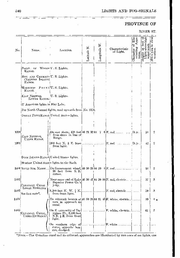
Characteristic of Light.
e-a;
5 o
••■•• 0 .71
> o
- • = e
3 rz! •-!!
84 19 0 46 30 21
46 30 47 84 20 00
46 30 39;84 21 43
F. red
F. red, electric.
F. red, electric.... .
F. white, electric.. ..
F. white, electric.. ..
1390
1391
1401;
‘-) 34
2 42
2 14
3 37
3
4 39
0 61
140 LIGHTS AND FOG—SIGNALS
PROVINCE OF
RIVER ST.
A •—■ C. I-0 0.
o -‹
•A'
r.)
Naine. Location. "i4
'47>
POINT OP 'WOODS U. S. Lights. RANGE.
HEN AND CHICKENS U. S. Lights. (NEEBISH ISLAND) RANGE.
HARWOOD POINT RANGE.
U. S. Lights-.
EAsT NEEBISH, LOWER RANGE.
U. S. Lights.
27 American lights in Hay Lake.
For North Channel lights, read upwards from No. 1378.
INDIAN POINTRANGE United States lights.
EAST NEERISH, UPPER RANGE.
On east shore, 159 feet 46 21 3284 7 0 froin shore in line of Range.
F. red D. p
f
302 feet N. E. from front light. -
F. red ..... D. P.
DECK ISLAND RANGE United States lights.
20 other United States lights to the Sault.
SAULT STE. MARIE .. On Government wharf, 25 feet from S. E. corner.
1402 Near outer end of Lake Superior Power Co.'s
CANADIAN CANAL jetty-. LowEn ENTaaNcEl,
1403 1,300 feet N. W. .1i N. See foot note". from front light.
1404
On cribwork. beacon at [ turn in approach to
canal.
On E. extremity of Da-vignon Pt., 2,100 feet N.E. E. from front light..
l On southern edge of curve, opposite hea-
1 con, (hredged.
..... .1E. white
1405' !CANADIAN CANAL,
UPPER ENTRANcE
*NOTE. —The Canadian canal and its cribwork approaches are illu ninated by two rous of arc lights, one
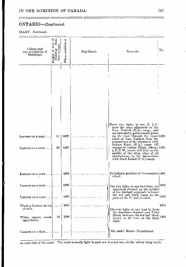
Colour and any peculiarity of
Buildings.
- , 1-tenlark.s.
To indicate position of Government wharf.
The two lights in one lead from the 1402 American channel up the middle
of the dredged approach between the red and black buoys to the 1 v.,)3 piers at the E. end of canal.
1404
The two lights in one lead in from , the American channel past Vidal.
Shoal, between the red and black. im, buoys, to the turn at the front
. ,'''
light.
Not under Marine Department.
1401
1892 17
22 1892
1894
1896
1896
1896
65 1896
Lantern on a mast ....
Lantern on a mast
Lantern on a mast ....
Lantern on a mast ....
Lantern on a mast .
Wooden lantern on top of crib.
White, square, wood, open frame.
Lantern on a float
IN THE DOMINION OF CANADA. 141
ONTARIO—Continued.
31ARY— Continue l.
Fog-Signal.
Wh
en e
stab
lislie
d.
These two lights in one, N. show the sanie alignment as the: East Neebish (U.S.) range, and are intended to guide vessels going, up the river through the u1per1390• reach of East Neebish from the intersection of the alig-nment witlt Indian Point (U.S.) range till! abreast of Indian Point, whence 1391
N.N.W. course will lead up the middle of the river, clear of all
obstructions, to the in tersec tion : with Duck Island (U.S.) range. ,
on each side of the canal. The most westerly light in each row is a red one, all the others being white.
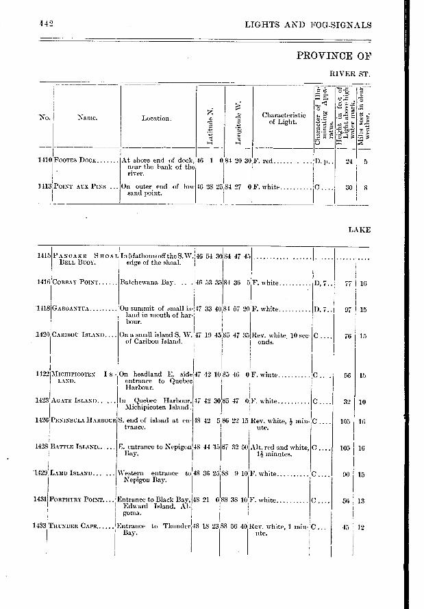
Batchewana Bay. 146 53 35 84 36 5
48 42 5 86 22 15
In Quebec Harbour, Michipicoten
S. end of island at en-trance.
1415
1416
1418
1420
Alt. red and white, minutes.
F. white
77 16
97 ! 15
15 76
56 15
10 32
16 105
105 1 16
15
56 I 13
1428
1429
1431
C.
C.
I). 7..
D, 7..
C ....
C ....
.142 LIGFITS AND FOG-SIGNALS
PROVINCE OF
RIVER ST.
.;
-‹
;-.
...
No Characteristic . Name. Location. ,D
T0
4 4 ..)- ..., •̀-::
L410 FOOTE'S DOCK At shore end of dock, 46 1 084 20 30F. red ...... . ... I). p.. 24 5 . near the bank of the
river.
1113 POINT AUX PINS On outer end of low 46 28 25 84 27 0F. white C . 30 8 sand point.
i
LAKE
PANCAKE S non 1. In 5 fathomsoff theS.W.46 54 30 BELL BUOY, edge of the shoal. ;
84 47 45
CORBAY POINT
GARGANTUA
CARIBOU ISLAND
F. white
On summit of small is-,47 33 40 84 57 20 land in mouth of hah bour.
On a small island S. W. '47 19 4585 47 35 Kev. white, 10 sec-of Caribou Island. onds.
F. white
1422 MICHIPICOTEN I S - LAND.
1423 AGATE ISLAND.....
1426 PENINSULA HARBOUR
On headland E. side 47 42 10 85 46 entrance to Quebec Harbour.
47 42 30:85 47
0 F. white
0,F. white
Rev, white, min-ute.
87 32 50 BATTLE ISLAND......
LAMB ISLAND......
PORPHYRY POINT....
E. entrance to Nepigon 48 44 115 Bay.
Western entrance to 48 36 25 88 9 10 .Nepigon Bay.
Entrance to Black Bay, 48 21 088 38 10 F. white Edward Island, Al- goma.
H1433T UNDER CAPE. Entrance to Thunder Bay.
48 18 2388 56 40 Rev. white, 1 min- ute.
45 12
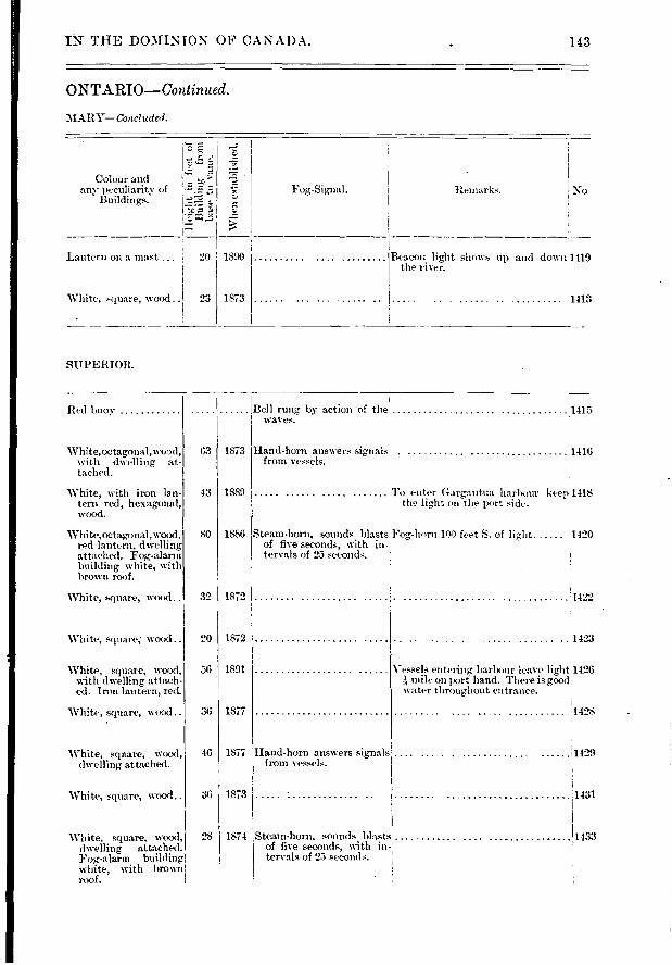
Remarks. No Fog,-Signal.
1890
1873
Colour and any peculiarity of
Buildings.
Lantern on a mast ... I
White, square, wood
Beacon light shows up and down 1419 the river.
1413
-5
esta
bli
slie
d.
23
IN THE DOMINION OF CANADA. 143
ONTARIO—Continued.
MARY—Conciudcd.
SUPERIOR.
32 1872
63 . 1873
43 1889
80 1886
20 1872
56 I 1891
36 I 1877
46 1877
36 1873
28 1874
Red buoy
White,octagonal,wood, with dwelling at-tached.
White, with iron lan-tern red, hexagonal, wood.
White,octagonal,wood, red lantern, dwelling attached. Fog-alarm building white, with brown roof.
White, square, wood..
White, square; wood..
White, square, wood, with dwelling attach-ed. Iron lantern, red.
White, square, wood..
White, square, wood dwelling- attached.
White, square, wood..
White, square, wood, dwelling attached. Fog-alarm building white, with 1/rown roof.
Bell rung by action of the 1415 waves.
Hand-horn answers signals 1416 from vessels.
'ro enter Gargantua harbour keep 1418 the light on the port side. •
Steam-horn, sounds blasts Fog,-horn 100 feet S. of light 1420 of five seconds, with in- tervals of 25 seconds. I
1422
1423
Vessels entering harbour leave lightH1426 k tulle on port hand. There is good .
water throughout entrance.
.1428
Hand-horn answers signals from vessels.
,1431
Steam-honi, sounds blasts of five seconds, with in- tervals of 25 seconds.
1429
1 1433

Lat
itudu
N.
z 0 a
1436
1438'P0RT ARTHUR...
1440 PIE ISLAND
1441 VICTORIA ISLAND.... Near the western end of 48 the island.
50
F. white
F. white.... ..
F. white
F. white ..... D,
C .1 40 11
30 1
43 11
29 , 10
F. white D, 7.. • S9 15
1414,S0uTn EAer BAY.... On S. side of entrance. F. white.... .......D. p..
F. white ID. p..
10 30
28 10
46 7 35 19 22 40
46 340 79 32 30 14451SOUTH RIVER On point near tannery, on W. side of month .
1448
BISHOPS BAY .
1449
1450 FERRIS ISLAND .. „
'
RAINY RIVER... -. I 1451
1452
36
26, 5
17 I 5
11
32 10
144 LIGHTS AND FOG-S1GNALS
PROVINCE OF
LAKE
7«,* t
0 tc .
C.;
z
No, ! Name. Lccation. Characteristic of Light.
On N. shore of river, 48 23 30 near Fort Williani.
KAMINISTIQUIA....
1437 879 feet E.N.E. from above.
On cribwork block, 31 feet from W. end of
, breakwater.
400 ft. S.W. from wharf, W. extremity of is-land, W. entrance of Thunder Bay.
89 13 25
48 25 40 89 12 30
48 13 33 89 10 30
89 20 10
LAKE
LAKE OF
Front range on sma11 1 49 27 53 94 45 35 F. white D, 7.. island about 200 feet i N. of N.E. extremity of Royal Island.
Back range on N. shore F white ,C . of Royal Island.
Off extreme West point 49 3 694 39 25 F. white ..... D, 7.. of Bigsby Island. 1
Off S. extreme of Sable 48 52 42,91 44 24 F. white D, 7..
î mile S. E. by S. S. from main light.
F. red D, 7.. 28
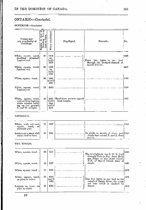
1444 1887
1445 25 1887
White, with red roof, square, wood, on cribwork pier.
Lantern on a mast, with white shed at base.
i To guide to mouth of river, past shoals that extend N. and E. from
' mooth.
I The two lights in one S. 30 E. lead through Bishops Bay from Bish-ops Point to the small islands N.E. of Royal Island clear of shoals.
I
1 The two lights in one lead to the mouth of Rainy River, the clan-
i nel into which is marked by buoys,
20
28 1897
28
1897
1897
30
25
1886 mov'd 1895
1895
1448
1419
1450
1451
1452
IN THE DOMINION OF CANADA.
ONTARIO— Concluded.
SUPERIOR—Concluded.
.e. e ...: „ . e.> •
Colour and
any peculiarity of S. a f. Fog-Signal. Remarks. :No. Buildings. 1
Té:-....; . . ....,..., a .'r.
a) 1-, .-Z ̂ i
,.,., > t
■-■-i ■••• i
1 White, square, wood, 40 1873 ) 1436
dwelling attached. re- Lantern red. built I These two lights in one lead
1876 }- through the dredged channel at I mouth of river.
White, square, wood. 30 1873 1437 Lentern red. re- J
built 1895
-
White, square, wood.. 36 1882 1438 m ov'd
• 1887
White, square, wood. 23 1895 11440 Lantern rect.
White, square, wood, 30 1881 Hand-horn answers signals 1441 with red iron lantern, build- from vessels. white wooden build- ings ing on low ground, eree'd S. and W. of light. 1887
NIPISSING.
THE WOODS.
145
White, square, wood .
White, square, wood ..
White, square, wood ..
'White, square, wood, on piles in water.
Lantern on mast, on piles in water.
10
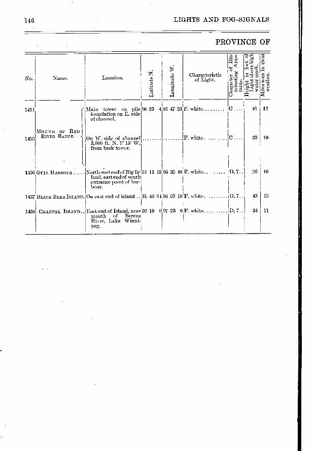
F. white
F. white. 10 23
.26 10
No.
1454
1455
1456
1457
1458 11 34
PROVINCE OF
La
titu
de N
.
Lo
ngitu
de W
.
Characteristic of Light.
4 o
e -Fe
:74
46 12
Name.
MO U T H OF RED I RIVER RANGE. -{
Location.
Main tower on pile 50 23 496 47 23 foundation on E. side of channel.
On W. side of channel 3,600 ft. N. r 15' W. from back tower.
C.
C.
F. white. GULL IIARBOUR North-east end of Big Is- 51 11 18 land, east end of south entrance point of har-bour.
D, 7..
BLACK BEAR ISLAND. On east end of island .. 51 46 54 96 53 10 F. white. D, 7.. 43 I 15
96 35 48
52 18 0 CHANNEL ISLAND . . East end of Island, near mouth of Berens River, Lake Winni-peg.
97 23 0[F. white 7..
146 LIGHTS AND FOG—SIGNALS
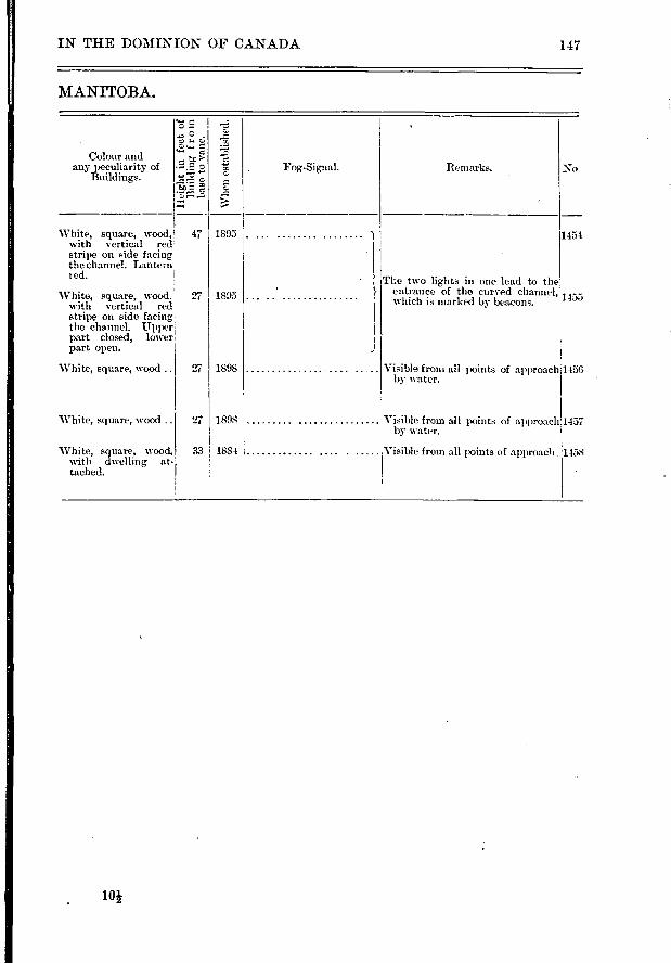
47
27
27 1457
1458
IN THE DOMINION OF CANADA 147
MANITOBA.
"5 .5
tr
-ze A
Remarks. No Colour and
any peculiarity of Buildings.
Whe
n e
stab
lish
ed.
Fog-Signal.
1805
1895
1898
1898
33 1884
White, square, wood, with vertical red stripe on side facing the channel. Lantern t ed.
White, square, wood. with vertical red stripe on side facing the channel. Upper part closed, lower part open.
White, square, ‘voocl
White, square, wood ..
White, square, wood, with dwelling at-tached.
1454
The two lights in one lead to the entrance of the curved channel, 1455
which is marked by beacons.
Visible front all points of approach 1456 by water.
Visible from all points of approach by water.
. Visible from all points of approach.
10i
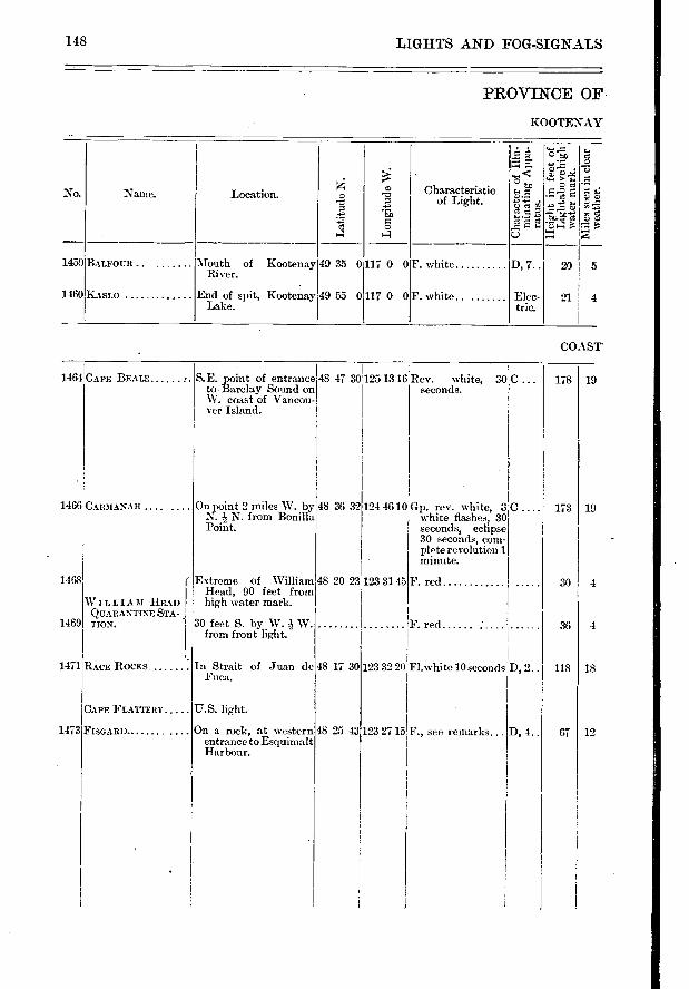
1468
1469
1471
1473
178 I 19
173 I 19
30 4
36 4
118 18
67 12
148 LIGHTS AND FOG-SIGNALS
PROVINCE OF
KOOTENAY
f0 a a • .1›.
" C 4'1
Characteristic of Light.
No.
›: r-e)
z
Location. Name.
,•••,
•
g J.
E3 La t
itu
de N
.
1459 RurouR Mouth of River.
Kootenay 49 35 0117 0 0 F. white D, 7.. 201 5
1160 KASLO End of spit, Kootenay Lake.
49 55 0 117 0 0 F. white Elec- tric.
21 I 4
COAST
1461 CAPE BEALE S. E. point of entrance 48 47 30 125 13 16 Rev. white, SOC to Barclay Sound on seconds. W. coast of Vancou- ver Island.
48 36 32 1466 CARMANAII On point 2 miles W. by N. N. from Bonilla Point.
124 46 10 Gp. rev. white, 3 white flashes, 30 seconds, eclipse 30 seconds, com-plete revolution 1 minute.
WILLIAM HEAD QUARANTINE STA-TION.
RACE ROCKS
Extreme of William Head, 90 feet from high water mark.
30 feet S. by W. W. from front light.
In Strait of Juan de Fuca.
48 20 23 123 31 45
48 17 30
F. red
F. red
Fl.white 10 seconds 123 32 20 D, 2..
CAPE FLATTERY
FISGARD
U.S. light.
On a rock, at western entrance to Esquimalt Harbour.
48 25 43 123 27 15 F., see remarks... D, 4..
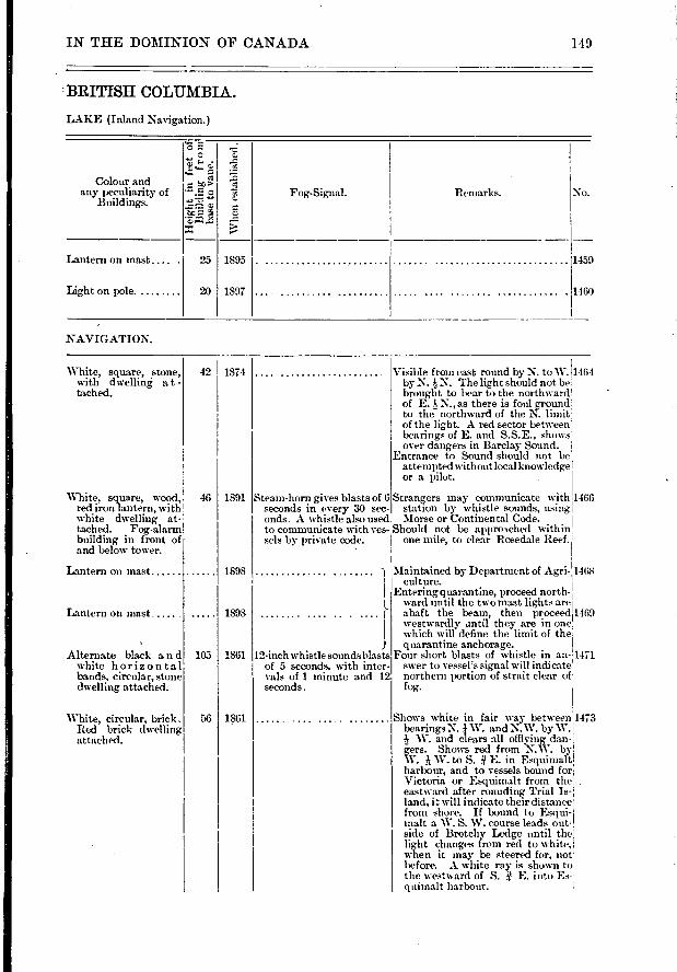
Wh
en e
stab
lish
ed.
c
z Colour and
any peculiarity of Buildings.
No. Remarks. Fog-Signal.
Lantern on mast ....
Light on pole.
1459
1460
25
20
1895
1897
White, square, stone, with dwelling a t - tached.
White, square, wood, red iron lantern, with white dwelling at-tached. Foi„,-alarm building in front of and below tower.
Visible from east round by N. to W.1464 by N. N. The light should not ber
brought to bear to the northwarcV of E. 4 N., as there is foul ground: to the northward of the 1\ . limit' of the light. A red sector between' bearings of E. and S.S.E., shows over dangers in Barclay Sound. 1
Entrance to Sound should not be attempted without local knowledge r or a pilot.
Strangers may communicate with1466 station by whistle sounds, using; Morse or Continental Code.
Should not be approsched within 1 one mile, to clear Rosedale Reef.
Steam-horn gives blasts of 6 seconds in every 30 sec-onds. A whistle also used to communicate with ves-sels by private code.
42 , 1874
46
105
56
1891
1898
1898
1861
1861
IN THE DOMINION OF CANADA 149
BRITISH COLUMBIA.
LAKE (Inland Navigation.)
NAVIGATION.
Lantern on mast
Lantern on mast
Alternate black and white horizontal bands, circular, stone dwelling attached.
12-inch whistle sounds blasts of 5 seconds, with inter-vals of 1 minute and 12 seconds.
Maintained by Department of Agri- 1468 culture.
Entering quarantine, proceed north-ward until the two ma.st lights are abaft the beam, then proceed 1469 westwardly antil they are in one which will define the limit of the quarantine anchorage.
Four short blasts of whistle in an- 1471 swer to vessel's signal will indicate northern portion of strait clear of fog-.
White, circular, brick. Red brick dwelling attached.
Shows white in fair way between bearings N. W. and N.W. by W. 4 W. and clears all offiving dan-gers. Shows red from N.W. by W. it W. to S. E. in Esquimalt harb.our, and t,o vessels bound for Victoria or Esquintalt from the eastward after rounding Trial Is-land, it will indicate their distance from shore. If bound to Esqui-malt a W. S. W. course leads out-side of Brotchy Ledge until the light changes from red to white, when it may be steered for, not before. A white ray is shown to the westward of S. E. into Es-quimalt harbour.
1473
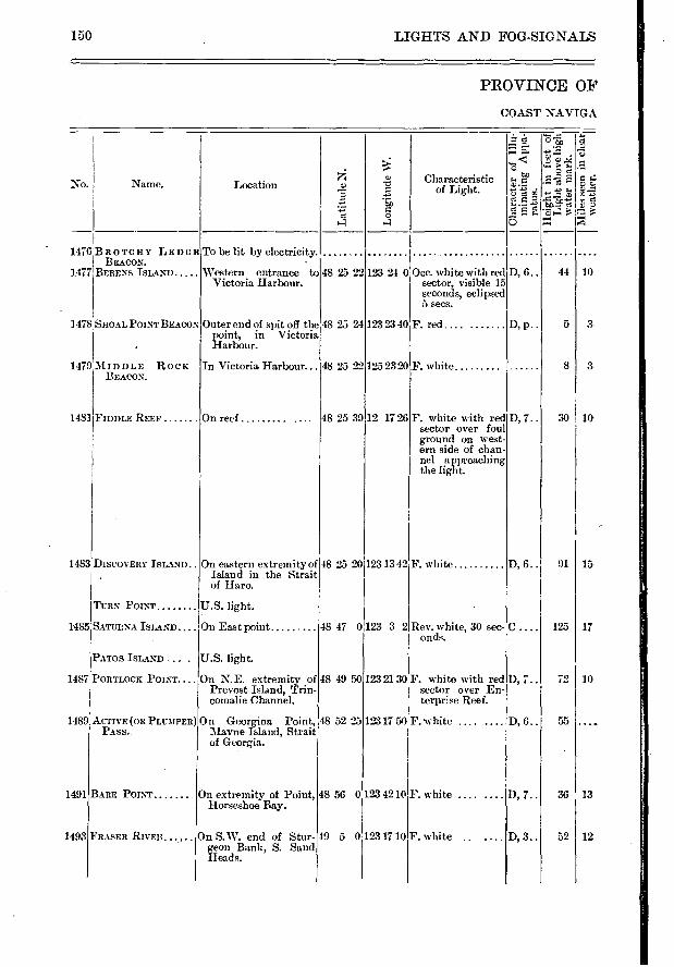
150 LIGHTS AND FOG-SIGNALS
PROVINCE OF
COAST NAVIGA.
- .... .._ .,«, -
...a. ...... > t. .5, ■••••
tp , 2 5 . Characteristi
" c g. a a ..ii a No. Name. Location .,:.› P..a' of Light. 22 —
-;.É z
a ô
4 4 C)
1476 BROTCHY LEDGHTO be lit by electricity. ..... .. BEAcoN.
1477 BERENS ISLAND Western entrance to 48 25 22 123 24 0 Occ, white with red D, 6.. 44 10 Victoria Harbour. sector, visible 15
seconds, eclipsed 5 secs.
1478 SHOAL POINTBEACON Outer end of spit off the 48 25 24 123 23 40 F. red .... ....... D, p.. 5 3- point, in Victoria
. Harbour.
1479 MIDDLE ROCK In Victoria Harbour... 48 25 22 125 23 20 F. white 8 3 BEACON.
1481 FIDDLE REEF On reef 48 25 39 12 17 26 F. white with red D, 7.. 30 10 sector over foul ground on west-ern side of chan-nel approaching the light.
[483 DISCOVERY ISLAND.. On eastern extremity of 48 25 20 123 13 42 F. white D, 6.. 91 15 Island in the Strait of Haro.
TURN POINT U.S. light.
485 SATURNA ISLAND On East point 48 47 0 123 3 2 Rev. white, 30 sec- C.... 125 17 onds.
PATOS ISLAND .. . U.S. light.
487 PORTLOCK POINT.... On N.E. extremity of 48 49 50 123 21 30 F. white with red D, 7.. 72 10 Prevost Island, Trin- sector over En- comalie Channel. terprise Reef.
489 AcTivr (OR PLUMPER) On Georgina Point, 48 52 2512317 50 F. uhite .... .... D, 6.. 55 .... PASS. Mayne Island, Strait
of Georgia.
491 BARE POINT On extremity of Point, 48 56 0h23 42 10 F. white .... .... D, 7.. 36 13 Horseshoe Bay.
193 FRASER RIVER... , On S.W. end of Stur- 49 5 0 123 17 10 F. white .. ... D, 3.. 52 12 geon Bank, S. Sand Head s.
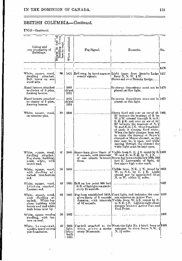
Fog-Signal.
Whe
n e
sta
bli
1478
1479
1483
1485
1487
1489
1491
47 I 1886
58
48
42
30
1888
1895
1885
1897
1866 light-house built 1884
IN THE DOMINION OF CANADA. 151
BRITISH COLUMBIA—Continued.
TION—Continual.
J-• • Q
z c Remarks. No. Colour and
any peculiarity of Buildings.
1476
1477 White, square, wood, 30 dwelling attached. Bell tower on sea-ward side.
1876 I Bell rung by hand answers vessels' signals.
Light bears from Brotchy Ledge buoy N. N. W. W.
Shows red ov,.r Brotehy Ledge
Hand lantern attached 1889 to cluster of 3 piles, ch'ged forming beacon. 1894
Hand lantern attached 1891 to cluster of 3 piles, ch'ged forming beacon. 1894
In storms dependence must not be placed on this light.
In storms dependence must not be placed on this light.
White, square, wood, 30 1898 on concrete pier.
White, square, wood, dwelling attached . Fog-alarm building, wood, white, with brown roof.
White, square, wood, with dwelling at - tached. Iron lantern red.
White, square, wood, k it ch en attached. Lantern red.
Shows fixed red over an arc of 45' 30' between the bearings of S. by W. / W. around through S. to S. S. L. E. and over an arc of 48' 30' between the bearings of N. W. and N.E. N. Over remainder of circle it remains fixed white. When the light changes from red
• to white the fairway of Bayne's channel or Mayor channel, as the case may be, is open, and while passing through the channel the white light must be kept open.
Steam-horn gives blasts of Visible from S. E. / S. round by S. 8 seconds, with intervals W. and N. to N.E. by N. / of one minute between Steam fog-horn established 1890, 300 them. feet S. Eastwardly of light, 45
feet above high water mark.
Visible from N.E. N. round by W. to S.E. by E. / E. Light should not be approached frcm N. or W. within li miles.
Bell on low point 900 feet S. E. of light gives a stroke every 15 seconds.
1481
White, square, wood, with dwelling at-tached. White fog-alarm building with brown roof and white tank house near by.
White, square wooden dwelling, with lan-tern on roof.
Fog-horn established 1893, gives blasts of 8 seconds duration, with intervals of 52 seconds.
Coast light, and indicates the ea.st-ern entrance to Active Pass.
Visible from W. S. round by N. to N.E. N. Light in sight clears dangers between Active Pass and East Point.
1493 White, hexagonal, wooden tower on iron pile foundation.
Fog-bell attached to the tower, gives a stroke every 20 seconds.
From the light No. 1 black buoy at entrance to river bears N.W. N. 1Ï miles.
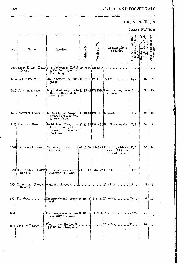
• e
e e
7) >
1501
1503
1504
1507
MIDDLE GROUNI BEACON.
THE SISTERS
SAND HEADS BELL Buor.
GARRY POINT
Back tower near eastern 49 28 16 extremity of island.
Front tower 290 feet S. 74' W. from back one.
49 10 12
Nanaimo, Strait of 49 12 30 Georgia.
S. side of entrance to Nanaimo Harbour.
Na.naimo Harbour
On easterly and largest 49 29 3 rock.
Under bluff at Prospect Point, First Narrows, Burrard Inlet.
Inside First Narrows of Burrard Inlet, at en-trance to Vancouver Harbour.
49 19 42
49 .18 34
49 17 52 123 650
123 48 45
12318 18 ........
123 11 12 F. red .
123 1554 Rev , white, one minute.
123 8 0 F. white...
226
96 I 15
28 ItO
52 8
65 14
10 I 2
SI 2
46 12
71 I 13
48
1494
1495
1497
1498
1499
D, 7..
D, 7..
D, 5..
O, l'•
F. white .....
F. white .....
152 LIGHTS AND FOG-SIGNALS
PROVINCE OF
COAST NAVIGA
Characteristic of Light.
IC
No. Name. Location.
1509'
1510 YELLOW ISLAND.. -{
BROCKTO.N POINT....
ENTRANCE ISLAND...
LLOWS POINT BEACON.
PROSPECT POINT....
POINT ATKINSON. . N. point of entrance to English Bay and Bur-. rani Inlet.
In 17 fathoms N.E. 1. N.149 655 1,350 feet from first
black buoy.
On platform of tide 49 718 gauge.
120 42 10
123 55 27
D, 7..
F. See remarks..
F. white, with red seCtor of n° over Gabriola ieef.
F. red
F. white ..... D, p..
F. white.. . D, 7..
D, 7..
124 27 34
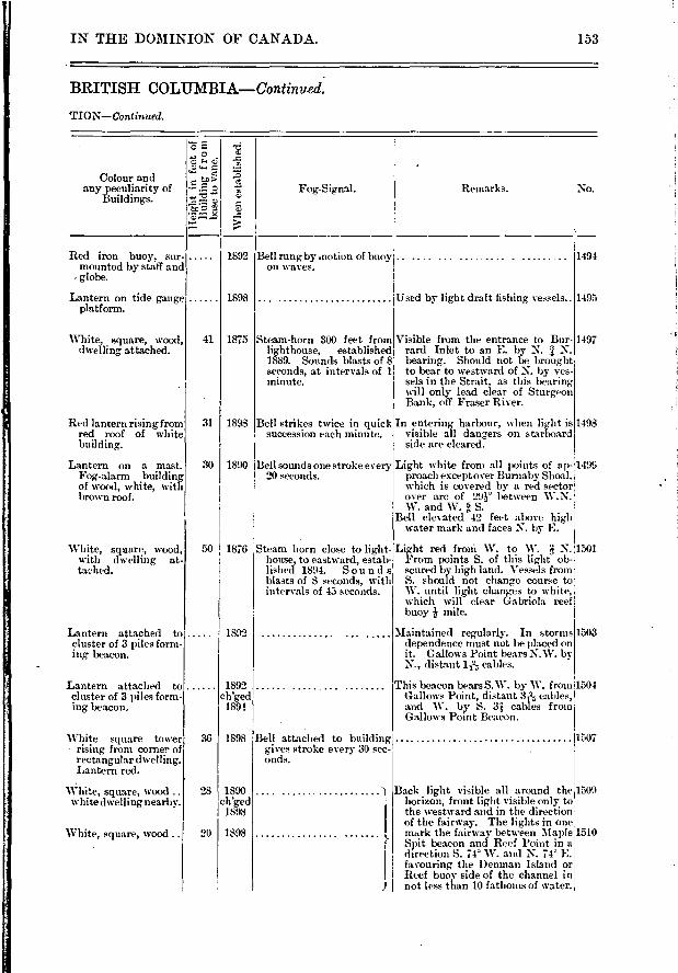
50 ! 1876
18:12
1892 ch'ged
1891
1898 36
28
20
1890 ch'ged
1898
1898
IN THE DOMINION OF CANADA.
BRITISH COLUMBIA—Continued..
TION—Continued.
153
e
.0 .00
Jiff
Fog-Signal. Remarks. No.
1.1.1
Colour and any peculiarity of
Buildings.
Whe
n es
tabli
shed
.
41
1892
1898
1875 Steana-horn 300 feet from lighthouse, established 1889. Sounds blasts of 8 seconds, at intervals of 1 minute.
31 1898 Bell strikes twice in quick succession each minute.
30 1890
Bell attached to building' gives stroke every 30 sec-onds.
Steam horn close to light-house, to eastward, estab-lished 1894. Sou n d s blasts of 8 seconds, with intervals of 43 seconds.
Bell sounds one stroke every 20 seconds.
Red iron buoy. sur-mounted by staff and globe.
Lantern on tide gauge platform.
White, square, wood, dwelling attached.
Red lantern rising from red roof of white
Lantern on a mast. Fog-alarm building of wood, white, with brown roof.
White, square, wood, with dwelling at-tached.
Lantern attached to cluster of 3 piles form-ing beacon.
Lantern attached to cluster of 3 piles form-ing beacon.
White square tower rising from corner of rectangular dwelling. Lantern red.
White, square, wood .. white dwelling nearby.
White, square, wood ..
1491
1495
Visible from the entrance to Bur-rard Inlet to an E. by N. N. bearing. Should not be brought to bear to westward of N. by ves-sels in the Strait, as this bearing will only lead clear of Sturgeon Bank, off Fraser River.
In entering harbour, when light is visible all dangers on starboard side are cleared.
Light white from all points of ap- 1499 proach except over Burnaby- Shoal, which is opvered by a red sector over arc of 29e between W. N. W. and W. a S.-
Bell elevated 42 feet above high water mark and faces N. by- E.
Light red froni W. to W. N. 1501 Fmm points S. of this light ob-scured by high land. Vessels from S. should not change course to W. until light changes to white, which will clear Gabriola reef buoy mile.
1■Iaintained reg-ularly. In storms 1503 dependence must not be pla,ced on it. Gallows Point bears N.W. by N., distant 1 12, cables.
This beacon bears S.W. by W. fromi1504 Gallows Point, distant ae,j' cables, and W. by S. 3 .; cables from Gallows Point Beacon.
1307
1509
1510
Bell rung by motion of buoy; ....... . on waves.
ilf.jsed by light draft fishing vessels..
1497
1498
Back light visible all around the horizon, front light visible only to the westward and in the direction of the fairway. The lights in one m.rk the fairway- between Maple
f Spit beacon and Reef Point in a direction S. 7 4° W. and N. 74 E. favouring the Denman Island or Reef buoy side of the channel in not less than 10 fathoms of water.
' F
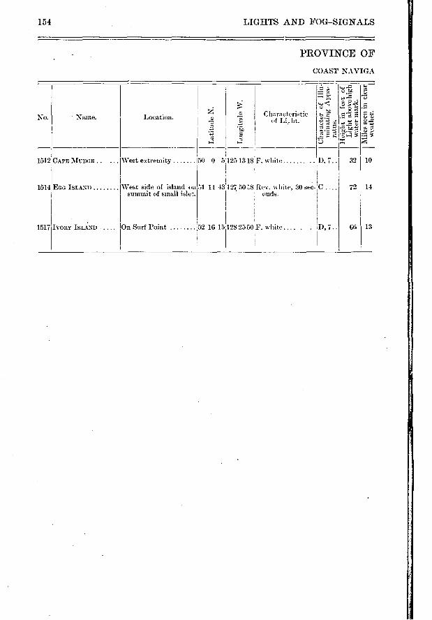
154 LIGHTS AND FOG—SIGNALS
PROVINCE OF
COAST NAVIGA
No.
1512 CAPE MUDGE ..
- Name.
West extremity
Location. 7
50 0 5
Characteristic of Li_ lit.
125 13 18 F. white
cf. j
.?)
5
.t• g e
D, 7.. 32 10
1514 EGG ISLAND West side of island on summit of small 51 14 43 127 50 .7,8 Rev. white, 20 sec- C
ends. 72 14
1517 D,7.. IVORY ISLAND On Surf Point 52 10 15 28 2550 F. white.... 66 13

IN THE DOMINION OF CANADA.
BRITISH COLUMBIA—Concluded.
TION—Concludcd.
-.-.. e-- • ,.. .... -
..> 0 g 8...t.' 3 .
Colour and ''' ..." › re any peculiarity of *:".:-.• 2 L, Fog-Signal. Remarks, No.
Buildings. -r--.. r.) z
,.,., ..= ..-1 ...-
Red lantern rising from 30 1898 Visible over an are of 205 between 1512 red roof of white the bearings of S. 48' E. around 1 dwelling. through N. to N. 73° W. ,
White, square, wood, 50 1898 Visible between the bearings N. 45° 1514 dwelling attached. W. round through E. to S. 6° W.,1 Lanteni red, over remainder of horizon light'
obscured by high land of Egg, Island. 1
- L
Red lantern rising from 30 1898 Visible over an arc of 233' betweeu 1517 red roof of white the bearings S. 75' W. round building. through N. to S. 52'E.
155
•
•
No.
Bayfield 385 Bay, Forteau 637 Baymouth, South 1266, 1267 Baynes Sound 1509, 1510 Bay of Quinte 1096-1106 Bay St. Paul 760 Bau Verte 478 Beach Point, Murray Harbour 420 Beach Point Pubnico. 148 Beale, Cape 1464 Bear, Cape 421 Beauharnois 979, 980 Beaujeu Bank Gas Buoys 772, 773 Beausoleil Island 1301 Beaver Harbour, N.B 29 Beaver Harbour, .N.S 247 Beaver Island, S. E. Coast of N.S 246 Beaver Island, St. Peter's Inlet... 345 Bearer Point 247 Becquets, St. Pierre des 845 Bedegue Bay 455, 456 Bellechasse 792 Belledune Point, Little 593 Belle-Isle 631-639 Belle-Isle Public Landing 51, 52 Belleville 1103 Belkrue Farm 438, 439 Bellevue, Ste. Anne de. 990, 991 Belliveau Cove 121 Belloni Point 587 Belvea Point 46 Beiens Island, B.0 1477 Berens River, Lake Winnipeg 1458 Berry Head 256 Bersimis River 695, 696 Betty Island 213 Bevis, Port 325 Bicquette Island 702 Big Bras d'Or 321-325 Big Duck Island, N.B. 8 Big Fish Island 145 Big Island 1456 Big Miminegash 463, 464 Big Otter Creek 1182 Bigsby Island 1450 Big Shippegan 573-575 Big Tignish 506, 507 Birch Point 579 Bird Island 351 I3ird Rocks 657 Bishop's Bay 1448, 1449 Black Bay 1-131 Black Bear Island 1457 Black Point, P.Q, 962 Black Point Whistling Buoy. 70 Black Rock 104 Black Rock Point 321 Blanche 165 Bleue, Point 733 Blind Sisters 218 Bliss Island 26 Blockhous.e Point 440 Blonde Rock Whistling-Buoy 113
INDE X
N.B.—The names by which the lights are most generally known are printed in common or lower case letters, and the names of the places near which the lights are situated, in it•dics.
A
Abbot Harbour Aconi Point Active Pa.ss _Advocate Harbour Agate Island Alberton Alexander Point Algernon Rock Allumette Lake, Lower Amet Island Amherstburg Amherst Island Amour Point Anderson's Hollow Ange Gardien Anglais, Point aux.. Annandale Annapolis ... Annapolis Basin Annapolis River Anse St. Jean Anticosti Apple River Aryle. Arichat Arisaig Arnprior Island Arthur, Port Ash Island Atkinson, Point Avon River Aylesbury, Cape Aylmer Island
Baccaro Baddcck Harbour Bagot Bluff. Bague, Isle à la Balfour Bamford Island Bantam Rocks Whistling-Buoy Barclau Sound Bare Point Baril, Point au Bar Point Bar Point Light-ship Barra Strait. Barre à Boulard Barrett Ledge Gas Buoy. Barriefield Common Barrington East Bay Light-ship Barrington West Bay Basin Of Mines Baskins Wharf Batchewana Bay Bathurst Batiscan Battery Point Battle Island Bauld, Cape Bag des Chaleiirs Bay du Vin Island
No.
147 320
1489 87
1423 498-504
575 769
1028 399
1207, 1208 659 637
77 805, 806
996 412, 414
112 109
110-112 712
C64- 667 85
146 279, 280
388 1023 1438 920
1497 100
487, 488 1017
159, 160 327 665 944
1451) 1376 160
1464 1491
1327, 1328 1296 1203
333, 334 825, 826
738 1082, 1083
157 151
89-102 1018, 1019
1416 587-590 846, 847
197 1428
634 581-612 543, 541
158 INDEX.
No.
Bloody Island 921 Boar's Head 114 Bois Blanc 1204, 1211, 1212 Bonilla Point 1466 Bon Portage Island 151 Bouche, Harbour au 382, 383 Boulaceet Harbour 331 Boularderie Island 324 Boyd Island 1362 Brandy Pots 740 Brazil Rock Bell-Buoy 162 Breaker, Cape 262 . Bridgeport Harbour 312 Bridges Point 65 Brier Island 116 Brighton Beach., .. ... , 441, 442 Brighton, Ont 1115-1117 Brui Point 213 Britannia, 1015 Brockton Point 1499 Brooklyn Pier 182 Brotchy Ledge Beacon 1476 Brothers, The 1096 Browns Point 1079 Bruce Mines - 1372 Brûlé, Cap 785-787 Brush Wharf 434, 435 Buckoms Point 1020 Buctouche 522-525 Bunker Island 134 Burlington Bay 1155-1157 Burntcoat 98 Burnt Island 1075 Burrard Inlet 1497-1499 Burwell, Port 1182 Bustard Rocks 1336-1338 Byng Inlet . 1331-1333
Cabot Head Cadieux, Pointe à Callaghan's island Campbell Island, Ottawa River Campbell Island, C.B Campbell's Island, Dipper Harbour Campbellton Canipobello Island Candlebox Island Canso, Cape Canso, Gut of Canso Harbour Canso, North Cap à l'Aigle Cap à la Roche Cap aux Oies Cap Bridé Cape Aylesbur y
Cape Bauld. Cape Beale Cape Bear Cape Breaker Cape Capiton Cape Charles Cape Chatte Cape Despair Cape d'Or Fog-Whistle Cape Egmont Cape Enrage ............. , Cape Fourchu Cape Gaspé Cape George, Bras d'Or Lake Cape George, Strait of Northumberland Cape Lahave Cape la Ronde
No.
Cape Madeleine, River St. Lawrence. 855-858 Cape Magdalen, Gulf 677 Cape Mudge . 1512 Cape Norman 635 Cape North 359 Cape Race 648 Cape Ray 643 Cape Robert 1365 Cape Roseway 168 Cape Rosier 673 Cape Sable 155, 156 Cap St. Joseph 758 Cape St. Lawrence 360 Cape St. Mary 125 Cape Salmon 746 Cape Sharp 89 Cape Spencer 71 Cap Rouge 785-787 Capiton, Cape 85 Caraquet. 585 Cardigan Bay 416 Cardigan River. 415 Carey Point 323 Caribou Island, Lake Superior 1420 Caribou Island, Strait of Northld, N. S 397 Caribou River, Saguenay 721, 722 Carleton 607 Carling Rock 1320 Carmanah.... ..... . 1166 Caron Point, .NB. 589, 590 Carons Point, Ottawa River 987 Carousel Island. 681 Carter Island. 173 Cascumpec 498-504 Cassies Point 519 Cat Rock Bell Buoy 131 Caveau Point 362, 363 Centre Brother Island 1096 Centre Light-ship, Lake St. Peter.... 871 Chaleur Bay 581-612 Champlain 851, 852 Channel Island 1458 Channel Patch Gas Buoy 767 Chantry Island 1256 Charles, Cape 838, 839 Charlottetown 438-440 Chateauguay- 978 Chats Lake 1022-1021 Chatte, Cape 683 Chebucto Head 220 Chedabucto Bay 271, 272 Chemainus 1491 Chêne, Point du 513, 514, 517, 518 Chênes, Lake des 1015-1020 Cherry Island 1050 Chester ..... ... ... 202 204 Cheticamp 361i-366 Chicoutimi 725 Christian Island 1296 Ch.urch Point, Buctouche 524, 525 Church Point, St. Mary's Bay, N.S 122 Ciboux Island 351 Citrouille Point 849 Claire, Point 986 Clapperton Island 13.58 Clarke Cove 339 Clark, Point 1216 Cobeguid Bay 93-98 Cobourg 1130-1132 Coffin Island 185 Colborne, Port 1170, 1171 Colchester Reef 1200 Cold Spring Head 404 Cole Harbour ...... .. ...... .. 257 258 Cole Shoal '1064 Collingwood 1292, 1203
1277 992 211
1024 337
32 603, 604
15, 16 138 263
274, 275 269 381 751
838-842 756
785-787 487, 488
634 1464 424 262 85
838, 839 683 616
88 459
78 130, 133
624 341 387 195 284
INDEX. 159
No.
Colpoy's Bay 1281 Contrecoeur Traverse 935, 936 Conway nlet 495, 496 CorbaN',. Point 1416 Cornwall Canal . 1058 Corunna.. 1233, 1234 Coteau Landing 1045 Coudres, Isle aux 759 Coulonge, Lake 1025 Country Harbour 254 Cove Head . 478, 479 Cove Island 1265 Cow Bay 310 Cox Point 61 Cranberry Head, C.B 318 Cranberry Island, Canso 263 Crane Island 776 Craratid 446-450 Credit, Port 1152 Creighton Head 278 Cross Island 198 Croucher's Island 209 Crow Harbour 271 Current, Little 1352, 1353 Cutler Island 269
Dalhousie, N.B 596-598 Dalhousie, Port, Ont.. 1158, 1159 Darlington ........ .. .. .... 1138 Darnley Basin 491, 492 Darnley Point 487, 488 Davignon Point 1405 Debert 96 Deep River Islet 1033 De Fuca, Strait of Juan . 1471 Deming Point 261 De Monts, Point 686 Denison's Island. 1165 Denman Island 1509, 1510 Departure Bay . . . . ............ 1501 Depot Island 1323 Derby Point. 334 Des Chats, Lake 1022-1024 Des Chênes, Lake 1015-1020 Deseronto 1100 Despair, Cape 616 Detroit River 1203- 1220 Devil Island. 230, Ml. Dickinsons Landing 1058 Digby Gut 109 Digby Pier 110 Dipper Harbour 32 Discovery Island... .. .. ...... 1483 Ditchburn's Shoal 1167 Dixon Point 522, 523 Dog Island 287 Dorval 985 Double Top Rock. 1306 Douglas Island 596 Douse Point 432, 433 Dover 211 Dover, Port. 1176, 1177 Drake, Outer 1091 Drews Head • 29 Du,Chéne Wharf 515, 516 Duck Island, Big, N.B 8 Duck Island, Great, Ont 1269 Duff and Gatfield's Range. 1219, 1220 Dummy, The 1190 Dyke, Little.. — ........ ..., ..... 95
No.
East Beaver Island 246 East End, Anticosti 664 East End, Long Point 1179 East End, Sable Island 267 Eastern Harbour, Cheticamp 364, 365 East Ironbound Island 204 East Light-ship, Lake St. Peter 870 East Neebish, Upper Range 1390, 1391 East Pier, Toronto .... ........ 1144, 1145 East Point, P.E.I. 408 East Point, Saturna Island 1485 East Quoddy Head 16 East Souris 409 East Templeton.... . .... .... ... . 1009 Eboulements, Les 758 Economy 92 Ecureuil shoal 819 Eddy Point 274 Edward Island 1431 Egg Island, B.0 1514 Egg Island, N.S 235, 236 Egg Island, Ont 1123 Egg Island, Que .......... ... . .... 683 Egmont, Cape 459 Elgin, Port 1251-1254 Ellenwood Passage 139 Elliott Point 1205, 1206 Elm Tree Point 392 Encampment, Sailors 1381, 1382, 1386, 1387 English. Bay 1497 Enrage, Cape 78 Entrance Island, B.0 1501 Entry Island, Magdalens 660 Escuminac 533 Esprit Island, St 293 Esguimalt Harbour 1473 Etang du Nord 638 Etany Harbour 27
False Ducks 1091 Fame Point. 675 Fanjoy Point 64 Father Point 698 Ferris Island 1450 Fiddle Reef 1481 First Narrows 1498, 1499 Fisgard 1473 Fish Fluke Point 7 Fish Island. 489, 490 Fishernum's Harbour.... ... , ... 254 Fitzroy Rock 437 Flat Point, C.B 314 Flat Bock, Gaspé 620 Flewelling's Landing 50 Flint Head 311 Flower Pot . 1276 Folly Point. 81 Folly Rircr 95 Foote's Dock
. 1410
Foreland, North 1179 Fort Coulonge 1025 Fort eau Bay 637 Fort Folly Point 81 Fort Malden 1217, 1218 Fort Point, La Hare River ...... 193 Fort Point, Liverpool Bay 181 Fort William, Algoma 1436, 1437 Fort William, Ottawa River. 1032 Fourché Bell-Boy 291 Fourchu, Cape 130, 133 Fox Island, Lake Simeoe . .. 1162
160 INDEX.
536-540 1493
393, 394 329 344
1142 1336-1340
297 1089
58 1503 1070
3 1418 1495
622-624 341
387 228 106
417, 418 964
1489, 1501 1489 1331 1298 1148
65 331
1301 288
1056 1301
1242-1244 346 756 581 ,
1316 1364 888 286 833 749
7 61-64
3, 5-11 333, 334
118 481, 482
614 549, 550
1165 657
321- 325 337- 341
833 1269
94 42
254 205 704 283 208 639
1009 344
1067 484, 485
27
Fox Island, Miramichi River Fraser River Frasers Farm, Pictou Frasers Point, C.B Freestone Islet Frenchman's Bay French River
G
Gabarus Gage Point Gagetown Gallows Point Beacon Gananoque Narrows Gannet Rock Gargantua . Garry, Point Gaspé George, Cape, Bras d'Or Lake George, Cape, Strait of Northumber-
land George Island George, Port Georgetown Georgeville Georgia Strait Georgina Point Gereaux Island Giant's Tomb Gibraltar Point Gilbert Island Gillis Point ............... . Gin Island Glasgow Point Glengarry Point Gloucester Bay Goderieh Gooseberry Island Goose Cape, Que
_Goose Lake, N.B.. Gordon Rock Gore Bay. Grace, Isle de Grande Digne Grand Rivière du Chéne Grande Isle, Kampuraska Grand Harbour Grand Lake, N.B..... ...... . . Grand Manan Grand Narrows Grand Passage Grand Rustico Grand River Grant Beach Gravenhurst Narrows. Great Bird Rock Great Bras d'Or Great Bras d'Or Lake Great Chine River .
Great Duck Island Great Village River Green Head, River St. John. Green Island, Guysboro' County, NS Green Island, Lunenburg, N.S. Green Island. Que Green Island, Richmond County, N.S Green Point Greenly Island Green Shoal, Ottawa River.. Gregory Island Grenadier Island Grenville Harbour Grey Mare Ledge.
Griffith's Island 1282 Grime Shoal . 264 Grindstone Island, N.B 79 Grindstone Island, Magdalens 658 Grondines 841, 842 Grosse Isle Gas Buoy 781 Grosse Point 1044 Guion Island 295 Gull Harbour 1456 Gull Island, Ont 1133 Gull Rock, N.5 172 Gut of Canso 214, 275 Guysborough Harbour 272
H
Ha Ha Bay. 713 Halfway Point, North of 911, 912 Halifax. 216-231 Hamilton Island 1054 Harbour an Bouche 382, 383 Harbour Island 239 Harbour Point 297 Haro Strait 1483 Harper's Point 582 Hart Island 269 Hazard Point. 438, 439 Haute, Isle 86 Hawkesbury Port 275 Hawley-s Island . 1029 Hay Island 556, 557 Head Harbour 16 Head of Bois Blanc Island 1211, 1212 Heath Point 664 Hebert, Port 176 Hendry Farm 56 Herring Cove 225 Heron Island 594 Hetty Point 85 Hillcrest Gas Buoy 1062 Hillsborough Bay 444 Hilton 1373 Hobson Island 200 Holly Point. 253 Hood, Port 376 Hooper Island Shoal Gas Buoy 1319 Hope Island 1297 Hope, Port 1134 Horse-shoe Bar Light-ship 542 Horseshoe Bay 1491 Horton 100 Hubbart1 Cove 208
Indian Point, Bay of Quinté 1098 Indian Point, Bedeque Bay, P.E.I 455 Indian Point, Big Shippegan, N.B. 573, 574 Indian Point, Buctouche, N.B 524, 525 Indian Rocks, Whistling-Buoy 427 Ingonish 354, 355 Inner Automatic Whistling-Buoy,Hal-
ifax . 223 Ironbound Island, West 195 Ironbound Island, East 204 Isaac Harbour 251, 253 Island of Orleans 789, 790, 795, 797 Isle à la Bague 944 Isle à la Pierre S85 Isle àux Coudres 759 Isle aux Grues. 776 Isle aux Noix 913, 914 Isle aux Prunes 939 Isle aux Raisins 883, 884 Isle aux Vaches 950 Isle de Grace 888
No. No.
INDEX. 161
No.
Isle Haute 86 Isle of Coves 1265 Isle Perrot 988 Isle Ste. Thérèse 947-950 Ivory Island 1517
Jackstraw Shoal 1071 Janet Head 1364 Jeddore Rock 231 Jemseg 59 Jerome Point 291 Jerseyman Island 279 Johns Ledge, St 150 Jones Island 1316, 1317 Jourimain 511 Juan de Fuca, Strait of 1471 Juniper Point 413
Kagawong 1360 Kaministiquia 1436, 1437 Kamouraska 749 Kaslo 1460 Kelly Point 333 Kidston Island. 327 Killarney 1345, 1346 Kincardine 1248, 1249 Kingsport 102 Kingston 1082-1084 Kingsville 1198, 1199 Knapps Point 1079 Knight Point, Que 1041-1043 Knights Point, P.E I 409 Kootenay Lake 1459, 1460
L
Lachine. 971-973 Lacolle 915, 916 Lacolle Railway Bridge 917 Lahave 193 Lahave Bell-Buoy 190 Lahave River 191, 195 Lake des Chats 1022-1024 Lake Coulonge 1025 Lake des Chenes 1015-1020 Lake Memphremagog 961-966 Lake Muskoka • 1165-1167 Lake Nipissing 1444, 1445 Lake of the Woods 1448-1452 Lake of Two Mountains 992-999 Lake Ros.seau 1167 Lake St. Clair 1227, 1228 Lake St. Francis 1041-1054 Lake St. John 730-733 Lake St. Louis 971-980 Lake St. Peter 868-884 Lake Simcoe 1162 Lake Temiscamingue 1037, 1038 Lake Winnipeg 1454-1458 Lamb Island 1429 Lancaster 1051, 1052 L'Ange Gardien 805, 806 Langlais Point 833 Lark Islet. 708 La Ronde, Cape ..... .... .... .... 284 La Tête River .. . .. . .. . .. .... 99 Latour, Port 163 Lavaltrie 931, 932 Lead Mines 966
No.
Leamington 1197 Leards 446, 447 Lefroy Island 1339 Lennox Passage 286-291 Lepreau 30, 31 Les Eboulements ......... ....... 758 L'Etang Harbour 27 Letete Passage 25 Lime Kiln Crossing 1213, 1214 Lindoe Island 1069 Lingan Head 312 Liscombe 249 Little Belledune 593 Little Bras d'Or . 320 Little Channel 495, 496 Little Current 1352, 1353 Little Dyke 95 Little Hope 178 Little Métis 693 Little Narrows 328 Little Shippegan 578-582 Little Stave Island 1070 Liverpool Bay 181, 185 Liverpool Whistling-Buoy 184 Lockeport 174, 175 London, New 484, 485 Lonely Island 1343 Lone Rock Bell-Buoy 1308 Long Eddy. Point.... ........... 11 Long Pilgrim 743 Long Point ...... .... 1179, 1181 Long Reach 48 L'Orignal 1002 Lotbiniere ............ .... .... ... 830, 831 Louisburg 299-303 Lower Allumette Lake 1028 Lower Narrows 1031 Lower Neguac Wharf 558, 559 Lower Traverse Light-ship 763 Low Point 314 Lubec Narrows 15 Lunenburg 196-198 Lui-cher Shoal 129 Lyal Island 1262
Mabou. 373, 374 Machias Seal Island 1, 2 MCEachren's Farm 472, 473 McKenzie Point, C.B.... . .. 325, 340 McKenzie Wharf, Ont 1284 31c1Cies Point . 1048 McKinnon Harbour . 337 McMann's Point 62
' McNeil Beach 324 MacNutt Island 168 Macquereau Point 611 McQuestion's Point. 1035 3IcTavish Point 1003 Madame Island . 278- 284 31adain Island, St. Lawren ce,G as Buoy 793 Magdalen Cape 677 Madeleine, Cape 855-858 Magdalen Islands 657- 660 Magog 961 Mahone Bay. 200, 201, 204, 205 Main-à-Dieu 306 Maitland, Port, N.S 128 Maitland, Port, Ont..... .... 1174 Malden 1217, 1218 Malpcque Bay 489, 490 Manitoba 1454-1456 Manitoulin Island 1268-1272, 1349-1365 Manitowaning 1349
11
No.
162 INDEX.
Marache Point Margaree Margaret's Bay . Margaret Island Bank Margaretville. Marjories Isle Marks Point Marshall Cove Martin River . Mascabin Point Masstown Matane Matane Pier Mauyer Island Mayne Island Meaford Meagher Beach. Medway Head Medway, Port Meraphremagog, Lake Memramcook River . Meteghan River Metis Point, Little Michipieoten Island Middle Ground Beacon, Nanaimo Middle Ground Gas Buoy, Que Middle Ground, Lake Erie. Middle Island, Lake Erie Middle Island, Miramichi River. Middle Rock Beacon .. . Mid jic Bluff Miminegash, Big Mines Basin. Mink Island Miramichi Bay or River. Miramichi Bay Light-ship Miscou Gully Miscou Island Mississaigi Strait Mississaig,i Island Moffatt's Wharf Mohawk Island Molasses Harbour Molsons Island Money Point Montée du Lac Montgomery Island........ Montmagny, St. Thomas de. Montmorency Falls Morris Island Morrisons Beach Morrisons Island Moser Island Moss Creek Moulin River, Mouse Island...—. ........... Mouton, Port ..... Mudge Bay Mudge, Cape Mulholland Point Mullins Point Murray Bay Murray Canal Murray Harbour Muskoka Lakes Musquash Harbour Musquash Island
Na 71« into Harbour Narrow Island Neebish, East, Upper Range..... Negro Island, N.S Negro Point, N.B
280 369, 370 209, 210
781 105 346
18 107 679
25 96
690 691
65 1489 1288 227 188
187-189 961- 966
81 123 693
1422, 1423 1504
762 1191 1195
553 1479
24 463, 464
89-102 1311
534-561 542 578
579, 581 1272 1367 604
1172 256 965 359
785-787 601
778, 779 805, 806
1022 415
1029 190, 191
96 723, 724
281 180
1360 1512
15 400, 401
752 1108-1113
420, 421 1165-1167
35 55
1501-1504 1355
1390, 1391 165
39
Neguac Ned Harbour. Nepigon Bay. Newcastle, Grand Lake Newcastle, Miramichi. Newcastle, Ont New London Newport Point Niagara Nichol Island. Nicholson's Island.... Nigger Island Shoal Nine Mile Point Nipissing, Lake.... Noix, Isle aux Nord, Etang du. Norman, Cape North Canso. North, Cape, N.S /North East Harbour VV
North East Point, St. Paul Island.... North East Shoal Whistling Buoy.... North Foreland. North of Halfway Point ....... North Point, P.E I
Northport North Rustico North Sister Rock North Tracadie Northumberland Straits North-west Ledge Nottawasaga Island
0
Oak Point, Miramichi Bay, N.B Oak Point, St. John River, N.B. Oak Point, BIS Oakville O'Hara Point Oka Opemican Narrows Or, Cape d' .....
Orignaux, Pointeaux Orleans Channel Oromocto. Orwell Harbour . Oshawa Ottawa River Otter Creek, Big Ouelle, River Ouetique Island . Outer Automatic Whistling-Buoy,
Halifax Outer Drake Owen Sound
Paget Bank Page Island Palmers Landing Palmers Wharf, P.E I Pancake Shoal Bell Buoy Panmure Head Papineauville Parrsboro' Parry Sound Partridge Island, Lake Huron Partridge Island, N.S Partridge Island, St. John Harbour Paspebiac Passamaquoddy Bay Pauls Bluff Pea Point Peart Point
No.
558-561 357
1428, 1429 62
554 1137
484, 485 612
1160 238
1123 1106 1089
1444, 1445 913, 914
658 635 381 359
166, 167 652 206
1179 911, 912
466 503, 504 481, 482
1375 565, 566
399 115
1291
545, 546 49
102 1153 623 994
1037, 1038 88
754 800-806
66 432-435
1139 985-1038
1182 751 289
• 222
1091 1285, 1286
819 163 53
450 1415 416
1001, 1005 90
1311-1324 1346
90 37,38
609 21-25
448 27
272
Port Credit. Port Dalhousie Port Dover Port Elgin Port George Port Hawkesbury Port Hebert Port Hood Port Hope Port Latour Portlock Point Port Maitland, .N.S Port Maitland, Ont Port Medway .... . Port Mouton Portneuf, above Quebec Portneuf, Saguenay County Port St. Andrews Port St. Francis Port Stanley. Port Williams Poste St. Martin Prescott Presqu'ile, Lake Ontario Presgu'ile, Owen Sound Preston Beach Prevost Island Prim Point, N.S Prim Point, P.E.I.. Prince Edward Island Prospect Prospect l'oint Prunes, Isle aux Public Landing., Belle-Isle Pubnico Harbour Pugwash Purdy's Shoal
Quaco. Quaker Island. Quarantine Gas Buoy Quebec Quebec Harbour, Lake Superior Quebec Point, River St. Lawrence.. Queen's Wharf, Toronto Quinte, Bay of Quinte, Carrying Place Quoddy Hcad, East
Race, Cape Race Rocks Ragged Island Harbour. . Rams Wharf Rainy River Raisins, Isle aux Ray, Cape Red Horse Rock Red Islands, C.B Red Islet Light-ship Red Islet Red River Red Rock, Parry Sound.. Red Rock Point, Killa rney Reeds Point Répentigny ...... . Restigouche River Richelieu .... • . ........ . ....... Richelieu River. ............ . Richibucto Harbour
Richibucto Head Richmond Bay.
INDEX, 163
No.
Peases Island 139 Peases Ledge Bell Buoy 140 Peggy Point 210 Pelee 1190, 1192 Penetang-uishene 1302, 1303 Peninsula Harbour 1426 Percé 618 Perroquet Island 670 Perrot Isle .. 988 Peter Point, Ont 1120 Peter Point, Gaspé, Que 620 Peter Rock 1133 Peter's Bay 284, 291 Peter's Island 118 Pcticodiac River ... . . . .. ..... .... 81 Petitdegrat. 281 Petit Passage 114 Petit Rocher 592 Pickering 1142 Pictou - 392-395 Pictou Island 391 Pie Island 1440 Pierre, Isle à la 885 Pigeon Island 1090 Pilgrim Shoal Gas Buoy 742 PiWrim, Long 743 Pillar, Stone 768 Pine Tree 1260, 1261 Pins, Point aux 1413 Piper's Cove 334 Plateau 620 Platon 827
' 828
Pleasant Point 1098 Plumper Pass 1489 Point à Cadieux 992 Point Aconi . 320 Point Amour 637 Point Atkinson 1497 Point au Baril 1327, 1328 Point aux Anglais 996 Point aux Pins 1413 Point aux Orignaux 754 Point aux Trembles 953, 951 Point Bleue 733 Point Caveau 362, 363 Point Citrouille . 849 Point Claire. 986 Point Clark 1246 Point de Monts 686 Point du Chêne 513, 514, 517, 518 Point du Lac 994 Point du Lac; Lake St. Peter 868 Point Langlais 833 Point Lepreau 30, 31 Point O'Hara 623 Point Pelee 1190 Point Peter, Gaspé, Que 620 Point Peter, Ont. 1120 Point Pleasant . 1098 Point Prim, Digby Gut, N.S.... . .. 1W.1 Point Prim, Hillsborough Bay, P.E. .... 429 Point Rich 641 Point Traverse 1093 Point Tupper 975 Pokemouche 569, 570 Pokesudie . .. 584 Pomquet Island 385 Popes Harbour 239 Porphyry Point 1431 Port Arthur 1438 Portage Island 541 Portage Island, Bon .... .. . 151 Portapique 03 Port Bevis 325 Port Burwell 1182 Port Colborne 1170, 1111
nl
1152 1158, 1159 1176,1177 1251-1254
106 275 176 376
1134 163
1487 128
1174 187-189
180 823,824
700 21,22
864,865 1183
107 715,716
1060 1127 1284
534,535 1487 109 429
480-507 213
1498 939
51,52 148 403 . 46
72-75 202 781
811, 812 1422, 1423
1078 1149, 1150 1096 -1106 1125, 1126
16
648 1471
172-174 1381, 1385 1451, 1452
883, 884 643
1073 340 705 707
1451, 1455 1311 1345
41 942, 943 603, 604
829 911-921 529, 530
528 489, 490
164 INDEX.
No.
Rich Point Bintouski River Caribou River du Moulin River Ottawa River Ouelle River St. Clair River St. Francis River St. Mary River Thames River Valin Rivière du Chêne Rivière du Loup Rix's Point Robert, Cape. Robertson Point Roberval Rockport Rondeau Harbour Ronde, Cape la Rook Island Rose Point Swing Bridge Roseway, Cape Rosier, Cape • Rosseau Rouge, Cap Royal Island Rustic°
Sable, Cape 155 Sable Island Cape 156 Sable Island 266, 267 Sable Island, Lake of the Woods. ... 1451, 1452 Saguenay River 708-725 Sailors' Encampment 1381, 1382, 1386, 1387 St. Alphonse 713 St. Andrew Point 417, 418 St. Andrews 2,-7 22 St. Anicet 1049 Ste. Anne de Bellevue 990, 991 Ste. Anne de Beaupré 800 St. Aun Harbour, C.B 352 St. Antoine 816 St. Clair, Lake 1227, 1228 St. Clair. River 1233, 1234 Ste. Croix, Que 819, 820 St. Croix River, N.B 18, 19 Ste. Emélie 835, 836 St. Esprit Island 293 Ste. Famille 801, 802 St. Francis Lake 1041-1054 St. Francis, Port 864, 865 St. Francis River 879, 880 St. François 789, 790 St. Ueorge's Bay.. 385 St. Jean 795 St. Jean, Anse 712 St. John Harbour, N.B 37-41, 70 St. John Lake 730-733 St. Johns Ledge Bell-Buoy 150 St. Joseph Island. 1381, 1387 St. Laurent 797 St. Lawrence, Cape 360 St. Louis Lake 971-980 St. Martin, Poste. ... .... 715, 716 St. Martins 73 St. Margaret Bay 205, 209, 210 St. Mary Bay, N.S 122 St. Mary Cape, N.S 125 St. Mary River, Nova Scotia 250 St. Mar!? River, Ont 1381-1413 St. Patrick Channel 327-329 St. Paul Bay .. • • ........... - - • • 760 St. Paul Island 652-e54
No.
St. Peters 469, 470 St. Peters Bay, C.B 284, 291 St. Peter Inlet 341-346 St. Peters Island, Hillsborough Bay 444 St. Peter Lake 868-884 St. Pierre des Becquets 845 St. Pierre, Orleans Channel 803, 804 Ste. Marie, Sault 1401-1405 Ste. Placide 997-999 St. Roch Light-ship. 763, 764 St. Thérèse, Iele 947-950 St. Thomas de Montmagny 778, 779 St. Valentine 913, 914 Salmon, Cape, Que 746 Salmon Point, Ont 1122 Salters Head 97 Salt Point 1118 Sambro 216, 219 Sand Heads, Fraser River 1493, 1494 Sand Point, Guysboro County 274 Sand Point, St. John River 43 Sand Spit, Shelburne Harbour 170 Sandy Beach Point Lightship.. 622 Sandy Island, P.E I 498 Sandy Point 994 Sandy's Point, St. Peter Inlet 346 Saturna Island 1485 Saugeen 1259 Sault Ste. Marie 1401-1405 Savage Harbour 472, 473 Savage Island 499, 500 Savards. 719, 720 Scattarie 306, 307 Schooner Island 1037 Schooner Passage 138 Scotch Bonnet 1123 Sea Cow Head 454 Seal Island, S.E. coast of N.S.. ... 142 Seal Island, Lennox Passage 287 Seal Island, Machins 1, 2 Sea Wolf Island 370 Seguin Bank Gas Buoy 1310 Seven Islands 681 Shafners Point 111 Shag Harbour Saund 151, 152 Sharp, Cape 89 Shediac 513-518 Sheet Harbour 242 244 Sheet Rock 243 Shelburne Harbour 170 Sheldrake Island 547, 548 Sherbrooke Tower . 227 Shingle Point 176 Ship Harbour 275 Shipley Head 214 Shippegan 573-575 Shoal Point Beacon, B. C 1478 Shoal Island 1378 Simcoe Island 1089 Simcoe, Lake 1162 Sissiboo 120 Sister Rock, North 1375 Sisters, The 1507 Sisters Bell-Buoy 218 Snake Island, Lake Ontario 1086 Snug Harbour 1313, 1314 Soo 1401-1405 Sorel 889, 890 Soucier Island 1038 Souris East 409 Souris East Breakwater... - . _ ... 410 Southampton Harbour 1257, 1258 South Baymouth 1266, 1267 South Bay Point 1093 S. Point Anticosti 665 South River 1445
641 698
721,722 723,724
985-1038 754
1233, 1231 879,880
1381-1413 1227, 1228
717,718 833 739 464
1365 63
730, 731 80
1186,1187 284 271
1324 168 673
1167 785-787
1448,1449 481,482
South Tracadie South-East Bay South East Shoal South-West Head, Grand Manan S.W. Point Anticosti S.W. Point, St. Paul Island South Traverse S.W. Wolf Island South Wolf Whistling-Buoy Spanish Bay Spanish River Mills Spectacle Island, N.S Spectacle Shoal, Ont Spencer Cape Spencer Point Spences Island Spider Island. Split Rock Whistling-Buoy Spruce Island Shoal Gas Buoy Spruce Point. Spry Bay Bell-Buoy Stag Island Stanley, Port Stave Island, Little Stoddart Island Stonehaven Stonehouse Point Stone Island Stone Pillar Strait of Juan De Fuca Strait of Ocorgia &rait of Haro Strawberry Island . . ...... Sturgeon Bank Sulphur Island Surnmerside Surf Point Surprise Shoal Bell-Buoy Swallow Tail Swampy Swashway Range Sydney
Telegraph Island Temiscamingue, Lake Tenant Point ..... . Terence Bay Texas Dock Thames River Thessalon Thornbury Three Top Island Thrumcap Thunder Cape Thunder Bay Tignish, Big Tobermory Torbay Toronto Tracadie, N.B Tracadie, P.E.I Tracadigash Point. ... Trap Rock ..... Traverse, Contrecœur Traverse Trembles Shoal.. . Trembles, Point aux Trinity Bell-Buoy.... Tryein Shoal Whistling-Buoy Tupper, Point Tusket Islands. Tusket, River. . ....... . Two Mountains, Lake ..ef
• • • • • • • •
INDEX. 165
No.
564 1444 1189
5 666 654 762
13 12
314 1362
180 1072
71 94
10"J3 1353
31 1315
19 241
1233, 1234 1183 1070
152 586
1056 885 768
1471 1489, 1501
1483 1351 1493 1369
456, 457 1517 1279
10 1458
536, 537 316, 318
1101 1037, 1038
214 214
1219, 1220 1227, 1228
1370 1289 260 224
1433 1433
506, 507 1275
256 1144-1150
564-566 475, 476
607 307
935, 936 762-764
815 953, 954
126 452 275 139 145
992-999
No.
Uniacke Point 333 Upper Traverse Light-ship. 764
Vaches, Isle aux 950 Valentine, St 913, 914 Valin River 717, 718 Valleyfield 1044 Vancouver 1499 Verchères .................... 939 Victoria Harbour, B.0 1477-1479 Victoria Island, Ottawa River 1022 Victoria Island, Lake Superior. 1441 Victoria, P.E.I 446, 447 Vin Island. Bay du 543, 544
Wadleighs Point 963 Wallace Harbour 400 Walton Harbour 99 Walton Island 1313 Wambolds 244 Ward's Point 80 Washadanioak Lake 55, 56 Watt/noie Channel 1308 Way Shoal 1008 Wedge Island 250 Welland Canal 1170, 1171 Weller's Bay 1125, 1126 Westawaus 418 West End, Long Point 1181 West End, Sable Island. 266 Western Head 225 Western Islands 1306 Westhaver Island 201 West Head, Cape Sable Island 156 West Head, Quaco 73 West Ironbound Island. 195 West Light-ship, Lake St. Peter . 872 West Point, Anticosti 667 'West Point, P.E I 460, 461 Westport 118 Whisky Island 1302 Whitby 1140
itchaven . 260 Whitehead Island, Guysboro' County. 261 Whitehead Islam', Yarmouth County 146 White Head, Percé 618 White Island Reef Light-ship 736 Whycocomagh 329 Wiarton 1281 Wicked Point 1122 William Head Quarantine Station.... 1468, 1469 • illiam's Landing 48 Williams Port 107 Wilmot Bluff 67 Wilson's Channel 1376 Windmill Point Ion° Wingfield Basin 1277 Winnipeg Lake 1454-1458 Witch Shoal.. 961 Wolfe Island, River St. Lawrence 1078, 1079 Wolf Island, S.W., Bay of Fundy 13 Wolf Point 238 Wood Island 426 Woods, Lake of the 1448-1452 Wrights 448, 449
Yarmouth 130-136 Yellow Island 1509, 1510
"" ti"'"%1#.4i
.;
•


