Embed Size (px)
Citation preview
Appendix 9A (v)
Initial Environmental Examination (DRAFT)
April 2015
IND: Orissa Integrated Irrigated Agriculture and Water Management Investment Program: Tranche 2
Machhagaon Subproject (Tranche-2 Preparation) IEE & Public Consultation Report (compliant with ADB Safeguard Policy Statement 2009)
Prepared by Department of Water Resources (DoWR), Project Management Unit (PMU) for the Asian Development Bank. This initial environmental examination is a document of the borrower. The views expressed herein do not necessarily represent those of ADB's Board of Directors, Management, or staff, and may be preliminary in nature. Your attention is directed to the “terms of use” section of this website. In preparing any country program or strategy, financing any project, or by making any designation of or reference to a particular territory or geographic area in this document, the Asian Development Bank does not intend to make any judgments as to the legal or other status of any territory or area.
Orissa Integrated Irrigated Agriculture & Water Management Investment Program (OIIAWMIP)
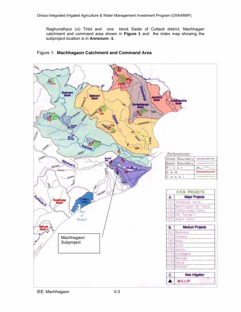
Department of Water Resources (DoWR)
Project Management Unit (PMU)
Orissa Integrated Irrigated Agriculture and
Water Management Investment Programme (OIIAWMIP)
( ADB Loan No. 2444 and OFID Loan No. 1251-P)
Machhagaon Subproject
(Tranche-2 Preparation)
Initial Environmental Examination (IEE) & Public Consultation Report
(compliant with ADB Safeguard Policy Statement 2009)
August 2014
assisted by Institutional Strengthening and Project Management Consultants (ISPMC)
Hydrosult, Division of SNC- Lavalin Inc. in association with
Sutra Consulting Pvt. Ltd., SBH Consultants Pvt. Ltd and N.K. Buildcon Pvt. Ltd
Orissa Integrated Irrigated Agriculture & Water Management Investment Program (OIIAWMIP)
PREFACE
This “IEE & Public Consultation Report” for the proposed Machhagaon Subproject is
intended to comply with the prerequisites for Preparation of Tranche-2 subproject of the
OIIAWIMP.
This document, initially drafted during OIIAWIMP (Project 1, Tranche-1) preparations, is
updated and revised to comply with ADB’s Safeguard Policy Statement 2009. This Report
supersedes the Report on IEE & Public Consultation prepared for the proposed Subproject
under ADB TA - 4814-INDIA during May 2008 by STUP Consultants and as well as draft
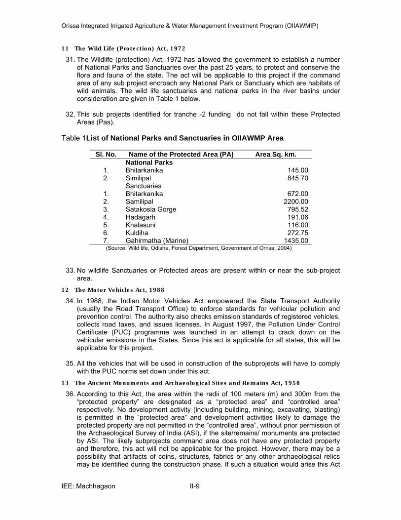
report prepared during June 2012 and subsequent comments made during April 2014. The
necessary comments and suggestions given by ADB were incorporated.
A tabular guidance on the responses and compliance with the above mentioned ADB
comments/requirements is presented on the following pages.
This Report supersedes the Report on IEE & Public Consultation prepared for the proposed
Subproject under ADB TA - 4814-INDIA during May 2008 by STUP Consultants.
August 2014 ISPMC
(‘’Compliance to ADB Comments Dated 11th April 2014’’ ’table to follow this page)
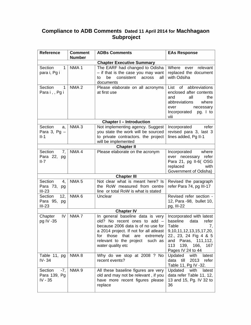
Compliance to ADB Comments Dated 11 April 2014 for Machhagaon Subproject
Reference Comment Number
ADBs Comments EAs Response
Chapter Executive Summary Section 1 para i, Pg i
NMA 1 The EARF had changed to Odisha – if that is the case you may want to be consistent across all documents
Where ever relevant replaced the document with Odsiha
Section 1 Para i , , Pg i
NMA 2 Please elaborate on all acronyms at first use
List of abbreviations enclosed after contents and all the abbreviations where ever necessary Incorporated pg. I to viii
Chapter I – Introduction Section a, Para 3, Pg – II-1
NMA 3 Not implementing agency. Suggest you state the work will be sourced to private contractors. the project will be implemented
Incorporated refer revised para 3, last 3 lines added, Pg II-1
Chapter II Section 7, Para 22, pg II-7
NMA 4 Please elaborate on the acronym Incorporated where ever necessary refer Para 21, pg II-6( OSG replaced with Government of Odisha)
Chapter III Section 4, Para 73, pg III-23
NMA 5 Not clear what is meant here? Is the RoW measured from centre line or total RoW is what is stated
Revised the paragraph refer Para 74, pg III-17
Section 12, Para 95, pg III-23
NMA 6 Unclear Revised refer section -12, Para -98, bullet 10, pg, III-22
Chapter IV Chapter IV pg IV -35
NMA 7 In general baseline data is very old? No recent ones to add – because 2006 data is of no use for a 2014 project. If not for all atleast for those that are extremely relevant to the project such as water quality etc
Incorporated with latest baseline data refer Table 7, 9,10,11,12,13,15,17,20, 22., 23, 24 Fig 4 & 5 and Paras, 111,112, 113 139, 166, 167 Pages IV 24 to 44
Table 11, pg IV- 34
NMA 8 Why do we stop at 2008 ? No recent events?
Updated with latest data till 2013 refer Table 11, Pg IV -32.
Section -7, Para 139, Pg IV - 35
NMA 9 All these baseline figures are very old and may not be relevant , if you have more recent figures please replace
Updated with latest data refer Table 11, 12, 13 and 15, Pg. IV 32 to 36

Reference Comment Number
ADBs Comments EAs Response
Chapter - V Section 1, Para 170, Pg V- 48
NMA 10 Next para states that you may need to resettle encroachers so this is not correct
Revised and cross reference to RP plan made refer para 180, 181 Pg. V – 47 & 48
Section 3, Para 176
NMA 11 What – head load Revised refer Para 186 Pg. V 50
Section 3, Para 176
NMA 12 Where Revised refer Para 186 Pg. V 50
Section 3, Para 181
NMA 13 Sentence is grambled Revised refer Para 191, bullet 4 Pg. V 52
Section 3,Para 182
NMA 14 In complete sentence Revised refer Para 192, Pg. V 53
Section C, Para 184 pg. V- 56
NMA 15 ? Revised refer Para 198, bullet 3, Pg. V -54
Section d, Para 184 pg. V- 56
NMA 16 What is the scientific arrangement Revised refer Para 200, bullet 2 Pg. V 55
Section 3, Para 184 pg. V- 56
NMA 17 Are we expecting that for this small scale work that the contractor will have a fuel storage site? If not relevant to this project please remove
Revised refer Para 200, bullet 3, Pg. V 55
Para 194, V- 57
NMA 18 Are there any such sensitive areas with in the project site
No sensitive areas as the canals are in the outskirts of the villages. Refer revised Para 205, bullet 5 Pg V -56
Para 189 V- 57
NMA 19 What about that canal which passes through the forests?
Incorporated refer Para 205, , Pg. V 56
Para 193 page V- 58
NMA 20 Do we have a number ? Can we cross reference to the Resettlement Plan
Incorporated refer Para 207, bullet 3 Pg. V 56
Para 193 page V- 58
NMA 21 What will the social mobilizers focus on
The sentence deleted refer Para 207, bullet 5, pg. 56
Para 193 page V- 58
NMA 22 What do you mean ? I think the sentence needs to be rewritten
Revised refer Para 207, bullet 7, Pg. V 57
Para 193 page V- 58
NMA 23 Is there a suitable disposal site where it can be disposed of or where do we instruct the contractors to dispose of waste
Incorporated refer Para 207, bullet 8, pg V-57
Para – 196 page V- 59
NMA 24 Do we need to shift these? What is the approval process – please state how it should be done
Incorporated refer Para 210, last 3 lines added pg V-57
Para 198 page V - 59
NMA 25 Is it testing of water quality, it should be if water quality not of suitable quality it will result in negative impacts . Even if you test water quality unless something is done about it, it could still result in
Revised refer Para 211, Pg V-58

Reference Comment Number
ADBs Comments EAs Response
negative impacts so please remove this sentence
Para 199 Page V- 59
NMA 26 ?? Incorporated ( PP stands for Pani Panchayat) Para 212, Pg. V- 58
Para 199 Page V- 59
NMA 27 Unless they are supported nobody will be encouraged to do something ? How do we encourage them what is the mechanism
Incorporated refer section 4, sub section b, Para 213, pg V-58
Para 204 Page V- 60
NMA 28 But baseline says not much diversity ? Is this relevant for this sub project
Incorporated refer section 4, sub section g, Para 218, pg V-59
Chapter VI Para 206 Page VI -61
NMA 29 What is individual or focus group discussion
Revised refer Section A, Para 220, Pg IV -60
Para 222 Page VI -66
NMA 30 What do you mean by conclusion Revised to Consultation refer Para 229, Pg VI -64
Para 223 Page VI -66
NMA 31 We would also need to disclose the key findings of the IEE at least a one or two page document in the SIO Office
Incorporated refer Para 230, 231 Pg VI -65
Chapter VIII Para 225 Page VIII -70
NMA 32 And who among these divisions will be responsible for env. management
Incorporated refer Section B, Para 241 Pg VIII -68
Para 233 Page VIII -70
NMA 33 Since this has been revised in the new EARF you can omit the bit of env. Cell and base your staffing requirements on the new EARF
Revised refer section D Para 242 , Pg VIII 68
Para 235 Page VIII -71
NMA 34 We should designate a particular staff in SIO or else nobody will take responsibility
Incorporated kindly refer Para 243, Pg VIII 69
Need to be worded more clearly the way it is stated it is unclear who reports to whom
Revised refer Para 250, Pg. VIII -70
Para 236 Page VIII -71
NMA 35 Is this env Specialist different to the one on the ISPMC team
Yes he is different from ISPMC National Environment Specialist. Refer Para 245, Pg. VIII -69
Para 240 Page VIII -71
NMA 36 Who will provide all these trainings and what specific training is being done is being planned? On the job training or any other specific training
The details are cross referenced in Para 249, Pg VIII -70
Para 240 Page VIII -72
NMA 38 For Cat. B an annual env. Monitoring report is sufficient
Revised to annual report refer Para 254, Pg VIII -70
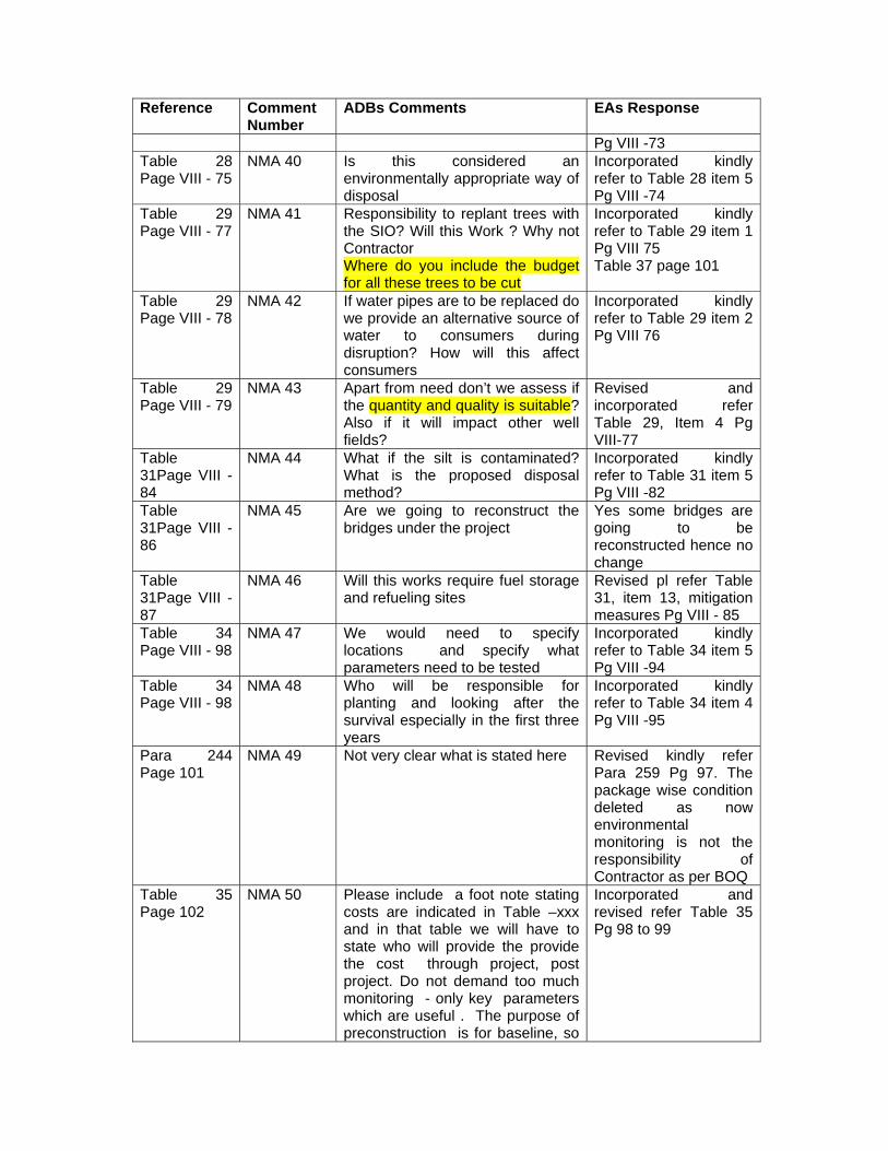
Table 28 Page VIII - 75
NMA 39 Shouldn’t the contractor also be responsible
Incorporated kindly refer to Table 28 item 3
Reference Comment Number
ADBs Comments EAs Response
Pg VIII -73 Table 28 Page VIII - 75
NMA 40 Is this considered an environmentally appropriate way of disposal
Incorporated kindly refer to Table 28 item 5 Pg VIII -74
Table 29 Page VIII - 77
NMA 41 Responsibility to replant trees with the SIO? Will this Work ? Why not Contractor Where do you include the budget for all these trees to be cut
Incorporated kindly refer to Table 29 item 1 Pg VIII 75 Table 37 page 101
Table 29 Page VIII - 78
NMA 42 If water pipes are to be replaced do we provide an alternative source of water to consumers during disruption? How will this affect consumers
Incorporated kindly refer to Table 29 item 2 Pg VIII 76
Table 29 Page VIII - 79
NMA 43 Apart from need don’t we assess if the quantity and quality is suitable? Also if it will impact other well fields?
Revised and incorporated refer Table 29, Item 4 Pg VIII-77
Table 31Page VIII - 84
NMA 44 What if the silt is contaminated? What is the proposed disposal method?
Incorporated kindly refer to Table 31 item 5 Pg VIII -82
Table 31Page VIII - 86
NMA 45 Are we going to reconstruct the bridges under the project
Yes some bridges are going to be reconstructed hence no change
Table 31Page VIII - 87
NMA 46 Will this works require fuel storage and refueling sites
Revised pl refer Table 31, item 13, mitigation measures Pg VIII - 85
Table 34 Page VIII - 98
NMA 47 We would need to specify locations and specify what parameters need to be tested
Incorporated kindly refer to Table 34 item 5 Pg VIII -94
Table 34 Page VIII - 98
NMA 48 Who will be responsible for planting and looking after the survival especially in the first three years
Incorporated kindly refer to Table 34 item 4 Pg VIII -95
Para 244 Page 101
NMA 49 Not very clear what is stated here Revised kindly refer Para 259 Pg 97. The package wise condition deleted as now environmental monitoring is not the responsibility of Contractor as per BOQ
Table 35 Page 102
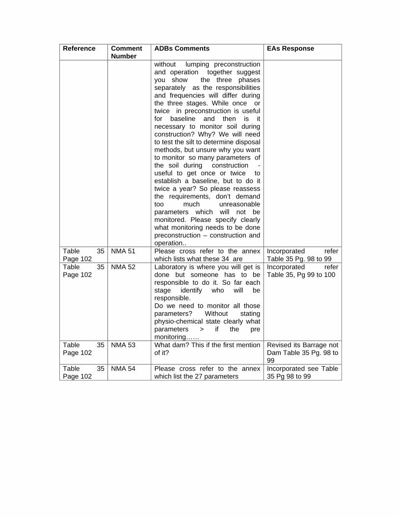
NMA 50 Please include a foot note stating costs are indicated in Table –xxx and in that table we will have to state who will provide the provide the cost through project, post project. Do not demand too much monitoring - only key parameters which are useful . The purpose of preconstruction is for baseline, so
Incorporated and revised refer Table 35 Pg 98 to 99
Reference Comment Number
ADBs Comments EAs Response
without lumping preconstruction and operation together suggest you show the three phases separately as the responsibilities and frequencies will differ during the three stages. While once or twice in preconstruction is useful for baseline and then is it necessary to monitor soil during construction? Why? We will need to test the silt to determine disposal methods, but unsure why you want to monitor so many parameters of the soil during construction - useful to get once or twice to establish a baseline, but to do it twice a year? So please reassess the requirements, don’t demand too much unreasonable parameters which will not be monitored. Please specify clearly what monitoring needs to be done preconstruction – construction and operation..
Table 35 Page 102
NMA 51 Please cross refer to the annex which lists what these 34 are
Incorporated refer Table 35 Pg. 98 to 99
Table 35 Page 102
NMA 52 Laboratory is where you will get is done but someone has to be responsible to do it. So far each stage identify who will be responsible. Do we need to monitor all those parameters? Without stating physio-chemical state clearly what parameters > if the pre monitoring……
Incorporated refer Table 35, Pg 99 to 100
Table 35 Page 102
NMA 53 What dam? This if the first mention of it?
Revised its Barrage not Dam Table 35 Pg. 98 to 99
Table 35 Page 102
NMA 54 Please cross refer to the annex which list the 27 parameters
Incorporated see Table 35 Pg 98 to 99
Orissa Integrated Irrigated Agriculture & Water Management Investment Program (OIIAWMIP)
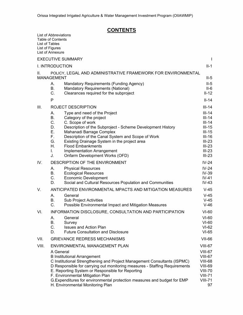
CONTENTS List of Abbreviations Table of Contents List of Tables List of Figures List of Annexure
EXECUTIVE SUMMARY I
I. INTRODUCTION II-1
II. POLICY, LEGAL AND ADMINISTRATIVE FRAMEWORK FOR ENVIRONMENTAL MANAGEMENT II-5
A. Mandatory Requirements (Funding Agency) II-5 B. Mandatory Requirements (National) II-6 C. Clearances required for the subproject II-12
P II-14
III. ROJECT DESCRIPTION III-14 A. Type and need of the Project III-14 B. Category of the project III-14 C. C. Scope of work III-14 D. Description of the Subproject - Scheme Development History III-15 E. Mahanadi Barrage Complex III-15 F. Description of the Canal System and Scope of Work III-16 G. Existing Drainage System in the project area III-23 H. Flood Embankments III-23 I. Implementation Arrangement III-23 J. Onfarm Development Works (OFD) III-23
IV. DESCRIPTION OF THE ENVIRONMENT IV-24 A. Physical Resources IV-24 B. Ecological Resources IV-39 C. Economic Development IV-41 D. Social and Cultural Resources Population and Communities IV-43
V. ANTICIPATED ENVIRONMENTAL MPACTS AND MITIGATION MEASURES V-45 A. General V-45 B. Sub Project Activities V-45 C. Possible Environmental Impact and Mitigation Measures V-46
VI. INFORMATION DISCLOSURE, CONSULTATION AND PARTICIPATION VI-60 A. General VI-60 B. Survey VI-60 C. Issues and Action Plan VI-62 D. Future Consultation and Disclosure VI-65
VII. GRIEVANCE REDRESS MECHANISMS VII-66
VIII. ENVIRONMENTAL MANAGEMENT PLAN VIII-67 A General VIII-67 B Institutional Arrangement VIII-67 C Institutional Strengthening and Project Management Consultants (ISPMC) VIII-68 D Responsible for carrying out monitoring measures - Staffing Requirements VIII-69 E. Reporting System or Responsible for Reporting VIII-70 F. Environmental Mitigation Plan VIII-71 G.Expenditures for environmental protection measures and budget for EMP VIII-71 H. Environmental Monitoring Plan 97
Orissa Integrated Irrigated Agriculture & Water Management Investment Program (OIIAWMIP)
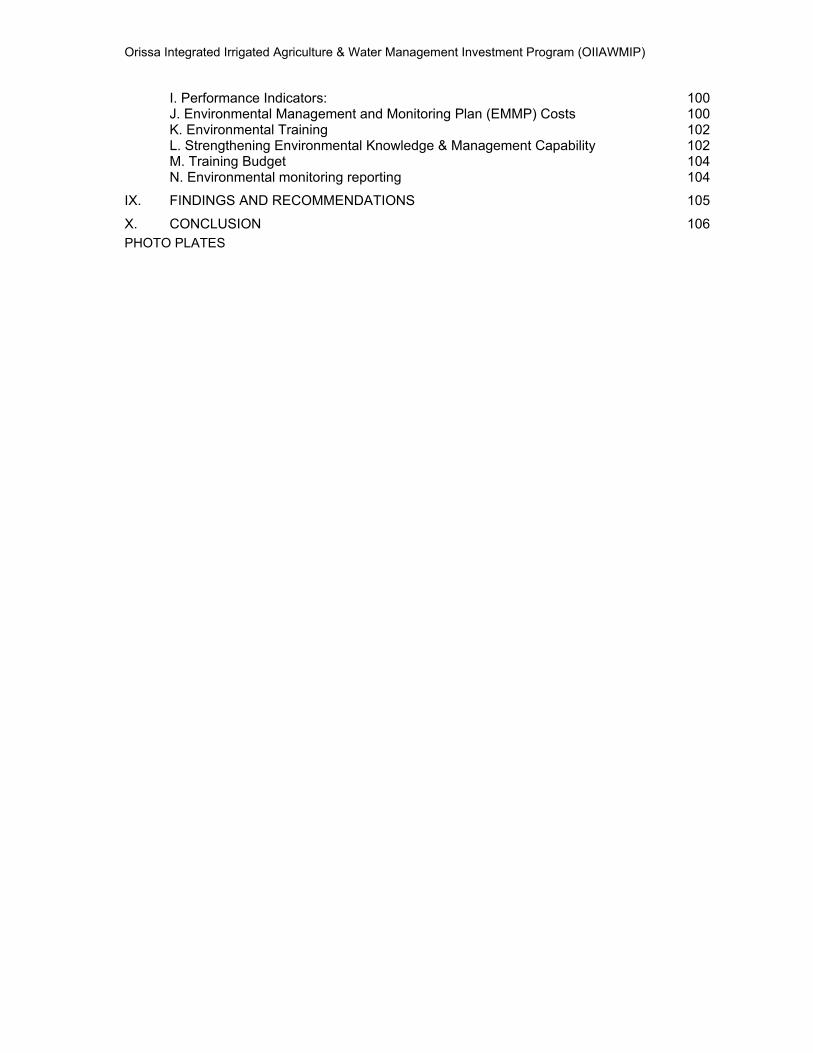
I. Performance Indicators: 100 J. Environmental Management and Monitoring Plan (EMMP) Costs 100 K. Environmental Training 102 L. Strengthening Environmental Knowledge & Management Capability 102 M. Training Budget 104 N. Environmental monitoring reporting 104
IX. FINDINGS AND RECOMMENDATIONS 105
X. CONCLUSION 106 PHOTO PLATES
Orissa Integrated Irrigated Agriculture & Water Management Investment Program (OIIAWMIP)
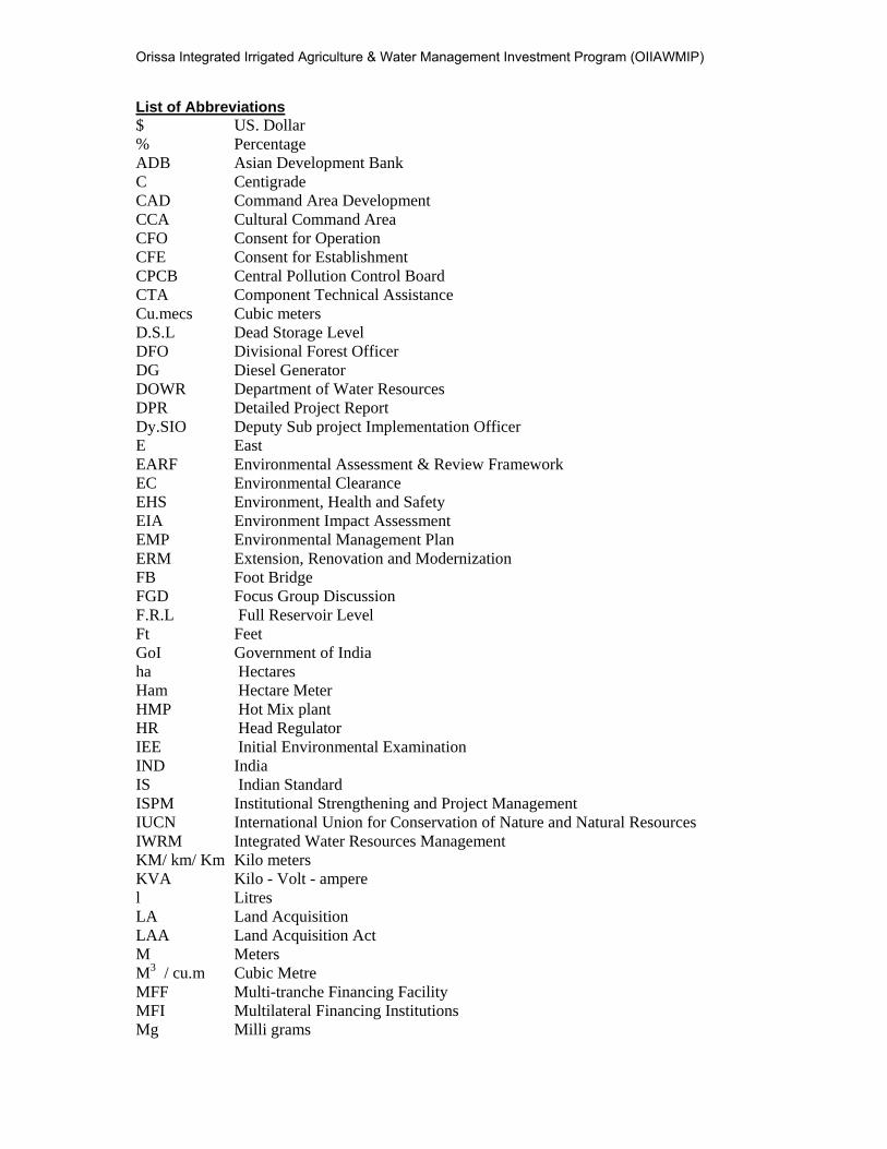
List of Abbreviations
$ US. Dollar % Percentage ADB Asian Development Bank C Centigrade CAD Command Area Development CCA Cultural Command Area CFO Consent for Operation CFE Consent for Establishment CPCB Central Pollution Control Board CTA Component Technical Assistance Cu.mecs Cubic meters D.S.L Dead Storage Level DFO Divisional Forest Officer DG Diesel Generator DOWR Department of Water Resources DPR Detailed Project Report Dy.SIO Deputy Sub project Implementation Officer E East EARF Environmental Assessment & Review Framework EC Environmental Clearance EHS Environment, Health and Safety EIA Environment Impact Assessment EMP Environmental Management Plan ERM Extension, Renovation and Modernization FB Foot Bridge FGD Focus Group Discussion F.R.L Full Reservoir Level Ft Feet GoI Government of India ha Hectares Ham Hectare Meter HMP Hot Mix plant HR Head Regulator IEE Initial Environmental Examination IND India IS Indian Standard ISPM Institutional Strengthening and Project Management IUCN International Union for Conservation of Nature and Natural Resources IWRM Integrated Water Resources Management KM/ km/ Km Kilo meters KVA Kilo - Volt - ampere l Litres LA Land Acquisition LAA Land Acquisition Act M Meters M3 / cu.m Cubic Metre MFF Multi-tranche Financing Facility MFI Multilateral Financing Institutions Mg Milli grams

Orissa Integrated Irrigated Agriculture & Water Management Investment Program (OIIAWMIP)
mm Millimetres MoEF Ministry of Environment & Forests N North NAAQS National Ambient Air Quality Standards NABET National Accreditation Board for Education and Training NABL National Accreditation Board for Testing and Calibration Laboratory NBSS National Bureau of Soil Survey NBSS&LUP National Bureau of Soil Survey and Landuse Planning NGO Non Governmental Organisation NIC National Informatics Centre NRRP National Rehabilitation and Resettlement Policy NWP National Water Policy O&M Operation and Maintenance OIIAWMIP Orissa Integrated Irrigated Agriculture and Water Management Investment
Program OM Operation Manaul O&M Operation and Maintenance OP Operational Policies OSPCB Odisha State Pollution Control Board PA Protected Areas PF Protected Forest PIM Participatory Irrigation Management PMU Project Management Unit PP Pani Panchayat PPE / PPG Personnel Protective Equipments / Personnel Protective Gears PPME Project Performance Monitoring and Evaluation PPTA Project Planning and Technical Assistance PRR Powered Road Roller PUC Pollution under Control Certificate RD Reduced Distance REA Rapid Environmental Assessment RF Reserved Forest RoW Right of Way RPM Respirable Particulate Matter R & R Resettlement & Rehabilitation SC Schedule Caste Sec Seconds SIO’s Sub- Project Implementation Officers SOI Survey of India SPCB State Pollution Control Board SPS Safeguard Policy Statement ST Schedule Tribes SRC Special Relief Commisioner WMM Wet Mix Macadam WUAs Water Users Association
Orissa Integrated Irrigated Agriculture & Water Management Investment Program (OIIAWMIP)
LIST OF TABLES Table 1: List of National Parks and Sanctuaries in OIIAWMP Area ................................................. II-9
Table 2: Salient Features of Mahanadi Barrage ........................................................................... III-16
Table 3: Machhagan Canal Scheme ............................................................................................ III-16
Table 4: Showing Canal Categorization ....................................................................................... III-17
Table 5: Main Canal Structures .................................................................................................... III-18
Table 6: Showing Structures to be repaired and new construction ............................................... III-20
Table 7: Rainfall Data, Machhagaon subproject covered blocks -2004 to 2013 .......................... IV-24
Table 8: Mean Monthly Temperatures and Relative Humidity, Cuttack District ........................... IV-25
Table 9: Land Use pattern in Cuttack and Jagatsingpur District .................................................. IV-26
Table 10: Block wise land use Cuttack and Jagatsinghpur District (Area in ha) ............................ IV-28
Table 11: List of Past flood and area damaged by Flood in Mahanadi basin ................................. IV-30
Table 12: Water quality Mahanadi River basin .............................................................................. IV-34
Table 13: Biomonitoring of River Mahanadi ................................................................................... IV-34
Table 14: Indian Standard for the Surface Water (CPCB Standard) .............................................. IV-35
Table 15: Water Quality of Mahandi & Taladanda Canal in Cuttack .............................................. IV-36
Table 16: Groundwater Utilization in Blocks covering Machhagan, March 2004 ............................ IV-37
Table 17: Ground Water Characteristics of different locations near Cuttack ................................. IV-38
Table 18: Common fresh water fishes of Mahanadi basin ............................................................. IV-40
Table 19: Showing the Fauna of the Area as per IUCN status ...................................................... IV-40
Table 20: Forest cover in Cuttack and Jagatsinghpur District ........................................................ IV-41
Table 21: Small Scale Industries in Cuttack District ....................................................................... IV-41
Table 22: Length of highways in Cuttack & Jagatsinghpur district ................................................ IV-42
Table 23: Demographic Pattern of Cuttack District ........................................................................ IV-43
Table 24: Demographic Pattern of Jagatsinghpur District .............................................................. IV-43
Table 25: Population details of the blocks covered under the project ............................................ IV-44
Table 26: Structure Rehabilitation Works for Main Canal Distributaries, Minors & Sub-minors ...... V-46
Table 27: Issues of the Public Consultation ................................................................................... VI-62
Table 28: Environmental Parameters Checklist for Anticipated Impacts and Mitigation Measures for
Machhagoan Sub-project - Pre Construction Activity (Impacts due to Location)-Environmental
Mitigation Plan ..............................................................................................................................VIII-72
Table 29: Environmental Parameters Checklist for anticipated impacts and Mitigation Measures for
Machhagaon Sub-project - Pre Construction Activity (Impacts During Design and Survey) -
Environmental Mitigation Plan ......................................................................................................VIII-75
Table 30: Environmental Parameters Checklist for anticipated impacts and Mitigation Measures for
Machhagaon Sub-project (Main canal, Distributaries and Minors executed by Contractors) - Pre
Construction Activity (Construction Contractor) - Environmental Mitigation Plan ..........................VIII-78
Table 31: Environmental Parameters Checklist for anticipated impacts and Mitigation Measures for
Machhagoan Sub-project (Main canal, Distributaries and Minors executed by Contractors) -
Construction Phase - Environmental Mitigation Plan ....................................................................VIII-81
Orissa Integrated Irrigated Agriculture & Water Management Investment Program (OIIAWMIP)
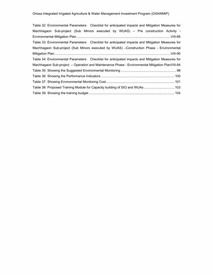
Table 32: Environmental Parameters Checklist for anticipated impacts and Mitigation Measures for
Machhagaon Sub-project (Sub Minors executed by WUAS) – Pre construction Activity -
Environmental Mitigation Plan ......................................................................................................VIII-89
Table 33: Environmental Parameters Checklist for anticipated impacts and Mitigation Measures for
Machhagaon Sub-project (Sub Minors executed by WUAS) –Construction Phase - Environmental
Mitigation Plan ..............................................................................................................................VIII-90
Table 34: Environmental Parameters Checklist for anticipated impacts and Mitigation Measures for
Machhagaon Sub-project – Operation and Maintenance Phase - Environmental Mitigation Plan VIII-94
Table 35: Showing the Suggested Environmental Monitoring ............................................................ 98
Table 36: Showing the Performance Indicators ................................................................................ 100
Table 37: Showing Environmental Monitoring Cost .......................................................................... 101
Table 38: Proposed Training Module for Capacity building of SIO and WUAs ................................. 103
Table 39: Showing the training budget ............................................................................................. 104
Orissa Integrated Irrigated Agriculture & Water Management Investment Program (OIIAWMIP)
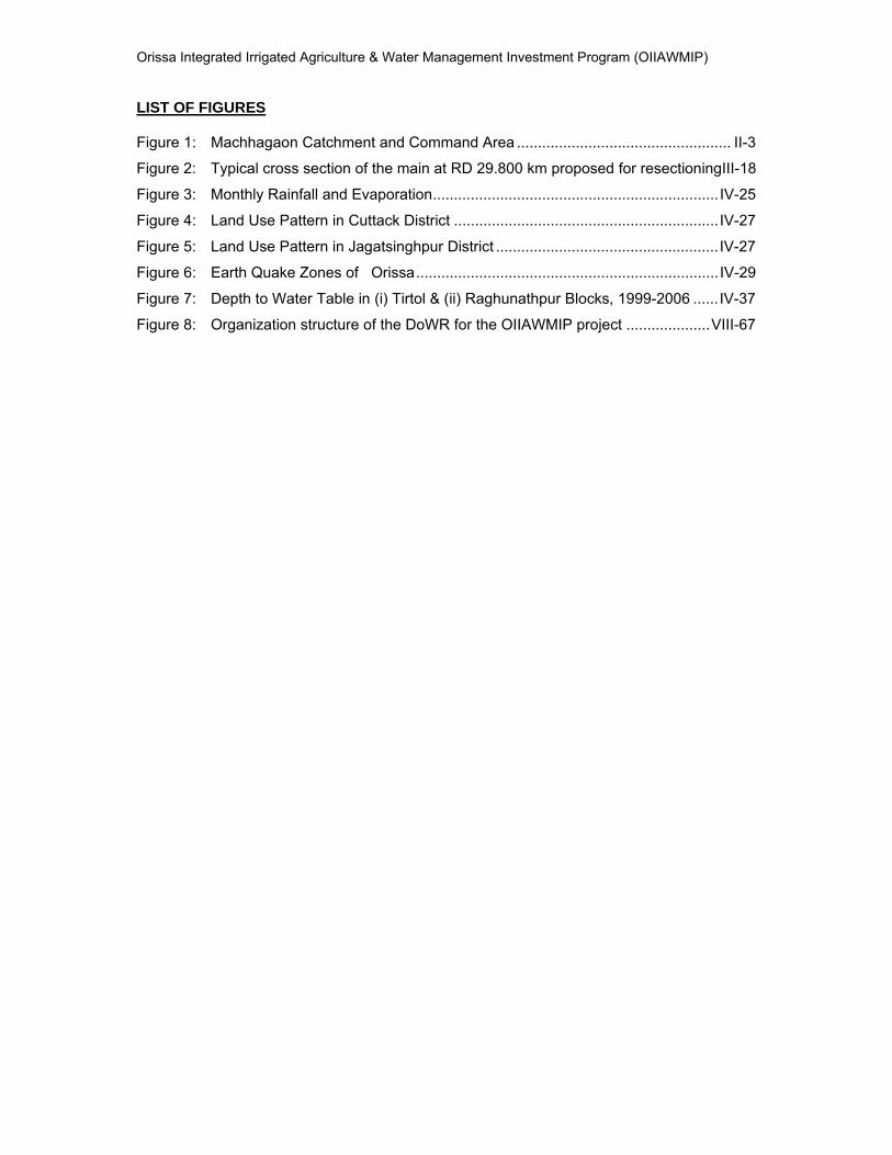
LIST OF FIGURES Figure 1: Machhagaon Catchment and Command Area ................................................... II-3
Figure 2: Typical cross section of the main at RD 29.800 km proposed for resectioningIII-18
Figure 3: Monthly Rainfall and Evaporation .................................................................... IV-25
Figure 4: Land Use Pattern in Cuttack District ............................................................... IV-27
Figure 5: Land Use Pattern in Jagatsinghpur District ..................................................... IV-27
Figure 6: Earth Quake Zones of Orissa ........................................................................ IV-29
Figure 7: Depth to Water Table in (i) Tirtol & (ii) Raghunathpur Blocks, 1999-2006 ...... IV-37
Figure 8: Organization structure of the DoWR for the OIIAWMIP project .................... VIII-67
Orissa Integrated Irrigated Agriculture & Water Management Investment Program (OIIAWMIP)
LIST OF ANNEXURE ANNEXURE 1: Map Showing ayacut area of the Machhagaon sub project & Location
ANNEXURE 2: List of Odisha State Pollution Control Board approved Crushers
ANNEXURE 3: Schematic line diagram showing distribution system
ANNEXURE 4: Villagers present during public consultation- Jajpur subproject
ANNEXURE 5 Findings of Focus Group Discussion
ANNEXURE 6: List of Participants present during latest Public Consultation-December 2011
ANNEXURE 7 Summary of Public Consultation- December 2011
ANNEXURE 8 Key persons met and Data Sources
ANNEXURE 9: Environmental Monitoring – Check list - Contractors
ANNEXURE 9a: Environmental Monitoring – Check list - WUAs
ANNEXURE 10: Parameters for Ground water analysis as per IS : 10500:1991
ANNEXURE 10a: Parameters for Surface water analysis as per IS : 2296 : 1992
ANNEXURE 10b: Parameters for Soil / Silt analysis

Orissa Integrated Irrigated Agriculture & Water Management Investment Program (OIIAWMIP)
IEE: Machhagaon i
EXECUTIVE SUMMARY
1. PROJECT BACKGROUND
i. The “Orissa Integrated Irrigated Agriculture and Water Management Investment Program” (OIIAWMIP) is an initiative by the Department of Water Resources (DoWR) of the Government of Odisha. It is intended to undertake the improvement of irrigation service delivery with Pani Panchayat (PP) empowerment and to enhance the productivity and sustainability of irrigated agriculture, thereby contributing to rural poverty reduction by increasing rural economic growth in the four northern river basins (Brahmani, Baitarani, Burhabalanga, and Subrenerekha river basins) and a part of Mahanadi Delta areas. The Government of Odisha had obtained a multi-tranche financing facility loan from the Asian Development Bank (ADB), titled Multi Financing Facility (MFF) N0. 0022 and Loan No. 2444 India(IND). The loan includes funds for upgrading or undertaking extension renovation and modernization (ERM) work in 6 major, 9 medium and 4 creek irrigation projects.
ii. The “Orissa Integrated Irrigated Agriculture and Water Management Investment Program” (OIIAWMIP) is classified as Category B according to the Environment Policy (2002) of the Asian Development Bank (ADB). Initial environmental examinations (IEEs) were undertaken for two major and three medium irrigation schemes, and two sample community-based minor lift irrigation schemes during the Project Planning and Technical Assistance (PPTA) stage; IEEs for four major and 2 medium were prepared during the Component Technical Assistance (CTA) stage. An environmental assessment and review framework (EARF) was also prepared during the PPTA stage, to guide the environmental assessment of further subprojects. Machhagaon is one of the subprojects included in the CTA for preparation of IEEs. The present report deals with the Initial Environmental Examination Report for the Machhagaon subproject, as per the new ADB Safeguard Statement, June, 2009.
2. EXTENT OF THE IEE STUDY
iii. The IEE is normally part of the Appraisal Report. However, for the Machhagaon sub- project, an IEE was prepared during CTA period. This report has been prepared on the basis of site visits and the completion of ADB’s Rapid Environmental Assessment (REA) Checklist and updated to meet the requirements of ADBs Safeguard Policy Statement (SPS) 2009.
3. METHODOLOGY
iv. The general methodology adopted to accomplish the Initial Environmental Examination includes:
• Review of legal and statutory requirements;
• Review of feasibility study;
• Preliminary reconnaissance to identity environmentally sensitive issues relating to the subproject and base line conditions;
• Collection of Primary and secondary data;
• Stakeholders Consultations;
• Identify and assess the potential impacts of the subproject on the base line conditions and recommend mitigation measures to offset the identified adverse impacts;
Orissa Integrated Irrigated Agriculture & Water Management Investment Program (OIIAWMIP)
IEE: Machhagaon ii
• Formulate Environmental Management Plan including review of Institutional set up and
• Capacity Building.
4. DESCRIPTION OF THE PROJECT
v. Machhagan irrigation sub-project is in the lower Mahanadi river basin. The Main canal (Taladanda) off takes from the Mahanadi Barrage at Cuttack, (latitude 20o28’46’’ N, longitude 85o54’76’’ E) and bifurcates at reducing distance (RD) 11.75km. The left canal remains the Taladanda supplying a command area of 32,684ha. The right canal is the Machagaon (latitude 20o25’774’’ N, longitude 85o58’272’’ E supplying a command area of 34,870 ha (670 Ha Cuutack District and 34,200 Ha Jagatsingpur District) spread over six blocks of Jagatsingpur District i.e. (i) Biridi (ii) Balikuda (iii) Jagatsinghpur (iv) Nuagaon (v) Raghunathpur (vi) Tirtol and one block Sadar of Cuttack district.
vi. Machhagoan Main Canal offtakes from Taladanda Canal at RD 11.75 km, 20o 25’ 45”N, 85o 58’ 17”E to irrigate an area of 34870 Ha of land, a part command of delta stage I lying in mostly in Jagatsingpur district. Canal system is more than 125 years old and is in a dilapidated condition mostly due to inadequate maintenance for paucity funds. Lack of maintenance and renovation causes uneven and ill distribution of water, thus affecting the efficiency of the irrigation. The deficiencies on carrying capacity of main canal are due to siltation, waterway obstruction, weed growth, weak canal embankments. Distributary canals, minor canals and sub-minor canals off taking from the Machhagan main canal feed the command area. Access is poor along many of these distributary canals.
vii. The total area covered by the scheme is about 60,500ha, and the original Culturable Command Area (CCA) was 51,460ha. With growth of villages and commercial development the current command area is estimated at 34,870 ha The 52.4km long Machhagaon main canal system consists of 9 distributaries1, 12 minors and 12 sub-minor canals. The sub-project has four weirs namely Kaijanga, Nauda, Chatara and Padampur. The cisterns of the weir cum falls are built with laterite stone masonry covered with cement concrete and the canals are mostly unlined
viii. The Machhagaon scheme located in Cuttack and Jagatsingpur district, benefits 498 villages (within 75 PP) with total beneficiaries of 58,338 including vulnerable groups. Poverty is rampant in the project area.
ix. Due to lack of operations and maintenance, coupled with no major rehabilitation or
upgrading since original construction, the command area receives limited irrigation water. So, rehabilitation of Machhagaon canal system is absolutely necessary for economic up-liftment of villagers of Cuttack, and Jagatsingpur districts district of Odisha.
5. SCOPE OF WORK
x. The Initial Environment Examination(IEE) has been prepared for Machhagaon subproject which covers:
• Renovation and modernization of the canal system by regulators, without increasing the command area. This entails the restoration back to the designed command area, without extending and widening the canal systems, and minimizing the losses by
1 Based on DoWR guide lines for classification of canals
Orissa Integrated Irrigated Agriculture & Water Management Investment Program (OIIAWMIP)
IEE: Machhagaon iii
repairing the existing structures, and if necessary, the construction of additional structures as per the field requirement
• Bringing the canals to the original design section and providing necessary lining or guard walls in the vulnerable reaches of the main canal and upstream and downstream of structures.
• Remodeling of existing Hydraulic control structures for improved flow control and flow measurement in the main canal and distributaries.
• Repair of existing drainage siphon to avoid water logging and properly designing drainage inlets to minimize entry of sediment into the canals.
• Providing additional new bridges and repairing the existing ones for improved access across canals.
• Renovating the outlets of the main canal, distributaries, minor and sub-minors.
• Providing some tube wells along the entire length main canal and its distribution system was kept to provide water during canal closure period.
6. ENVIRONMENTAL CATEGORY OF THE PROJECT
xi. This sub- project is also classified as “Category B” as per Asian Development Bank’s Safeguard Policy Statement, 2009. This project is one of the sub-projects of the CTA, which were prepared earlier. This sub-project does not have any major environmentally sensitive issues within the existing project area. There are no wild life sanctuaries or national parks, eco-sensitive zones, protected monuments, endangered or exotic species of plants are present in the region. Although expansion and modernization of existing sub-projects (Irrigation / River valley) may involve Ministry of Environment and Forest (MoEF) clearance, the present sub-project does not extend to an additional command areas; hence, no clearance is required. Since the project components include mainly renovation works, with no extension and widening of the canal system, the impact on natural resources is negligible, temporary and can be mitigated.
7. PROJECT ALTERNATIVES
xii. The project has little or no scope for alternatives in terms of locations, as it is an existing project and the scope of the present project is to improve the performance of an existing system without increasing the command and to cater to the needs of the people. The originally designed areas will be improved, through the rehabilitation of sections of the canals and by modernizing the system with regulators, minimizing the losses by repairing structures and constructing additional structures as per requirements. The investment costs are largely for the rehabilitation and upgrading of the existing systems. As the original design appears to be adequate, alternative solutions for rehabilitation are not foreseen at this time.
8. CLEARANCES REQUIRED FOR THE SUBPROJECT
xiii. After reviewing the various applicable environmental acts and statutes, as applicable to Government of India, Govt. of Odisha and ADB some of the clearances that are to be obtained by Sub-project Implementation Officer (SIO) / Contractor are:
• Permission from State Forest Department- Permission for undertaking the renovation / repair of the Distributary No -7 which passes through the Dhalthangad reserved forest area. There are some trees that exist on the canal embankments to
Orissa Integrated Irrigated Agriculture & Water Management Investment Program (OIIAWMIP)
IEE: Machhagaon iv
the possible extent trees would be saved if tree cutting is necessary, they require permission from State Divisional Forest Officer (DFO) for cutting before commencement of the civil work.
• Consent from Odisha State Pollution Control Board - All the construction contractors should obtain consent under the water and air act from Odisha State pollution control board before commencement of construction work for the plant and machinery (Hot Mix, Wet Mix Macadam (WMM), Batching, Crusher, Diesel Generator greater than 15 Kilo-volt-amperes (KVA) they establish for the projector if they are procuring from the vendor, the contractor should ensure that the vendors has the requisite consents from the State Pollution Control Board of Odisha(OSPCB). The list of crushers falling under Regional Office Cuttack (Cuttack, Jagatsingpur, Kendrapara) whose consents has been issued by OSPCB, Cuttack as on November 2011 ( information shared ) is enclosed as Annexure-2
• Permissions from Department of Mines and Geology :
i. Contractor would obtain permission for transporting the soil from the Department of Mines and Geology or local bodies as applicable, along with the mutual agreement with the land owner in case of private lands.
ii. Contractor would obtain permission for extracting boulders before quarrying; if the extraction of the boulder is being procured from the existing quarry/supplier, it shall be ensured that, the requisite license/ lease has been obtained from the concerned Authority.
iii. Contractor would obtain permission for extracting sand before quarrying ; if the extraction of boulder is being procured from the existing quarry/supplier, it shall be ensured that the requisite license/ lease has been obtained from the concerned Authority.
• Permission from Commissioner of Explosives - If the Contractor stores diesel or stores blasting materials he has to obtain permission or if procuring or executing through vendors he must ensure that the vendor has obtained permission.
• Permission from District Health Officer - Contractor would obtain permission for establishing labour camps.
• Pollution under Control Certificates - Vehicles and machineries engaged in the construction of the project will comply with the Motors Vehicle act and will be required to obtain pollution under control certificate.
• Clearance of Encroachments - There are some encroachments which need to be addressed as per R & R policy of the government, SIO, DoWR should ensure there won’t be any issues pertaining to the resettlement before handing over the site to the contractor.
9. BASELINE ENVIRONMENTAL STATUS
xiv. The baseline environmental overview is as follows :
a. Topography- The slope of the area varies from 0 – 10 meters (m) and the elevation is also around 10m in the area.
b. Climate. The mean annual rainfall of the area is 1,577 mm(milli meters), rainfall occurs from south –west monsoon between June to October, for 10 years from 2004 to 2013 show an average annual distribution is as follows: (i) 1,304mm (87%) during the monsoon (ii) 150mm (10%) during the pre-monsoon months of February to May; and (iii) 44mm (3%) during the post monsoon period from November to January. Temperature varies with minimums ranging from 120C (centigrade) to 160 C and maximums from 340C to 440C.
Orissa Integrated Irrigated Agriculture & Water Management Investment Program (OIIAWMIP)
IEE: Machhagaon v
. c. Geology & Soils - The oldest rocks found in the study area are Khondalites,
Charnockites and Granite Gneiss. Khondalites is mainly found in Jagatsingpur while the Granite Gneiss are found in the north of Mahanadi basin from Narsinghpur to Tigira block of Cuttack District. The main soil found in the study area are alluvial and laterite soil. The alluvial soil is generally found in Cuttack district. The texture of this soil is sandy loam, silty loam; clay loam and heavy loam and it is very fertile in nature while the laterite soil is generally hard, infertile and acidic in nature.The subproject falls under earthquake risk zone III i.e. moderate damage risk zone.
.
d. Landuse - Machhagaon canal mainly passes through the agricultural lands, at places it crosses small nallas, State highways, roads, railway line and passes adjacent to the settlements in certain sections of the canals. Only one canal Distributary No. 7 passes through the Dhalthangad Reserved Forest at RD 14.000 to 16.000km. The available existing acquired land for the canal i.e. Right Of Way (ROW) for the main canal ranges from 28 m to 30 m including both sides of the canal centre. For distributaries the available right of way (ROW) is ranging from 20 to 25 m covering both sides of the canal; for minors the available ROW is approx. 6 to 10 m covering both the sides of the canal and for sub-minors the available ROW is around 6 to 10 m (both sides of the canal). No additional land acquisition is required.
e. Agro-climatic condition - The Machhagaon subproject falls in the , within the “East & South Eastern Coastal Plain” agro-climatic zone The district is primarily an agricultural district but even large scale industrial units are present in Cuttack, Chowduar and Jagatpur and Paradeep has become a new industrial centre.
f. Water Resources - The water quality of the Machhagaon subproject is not monitored but the water quality of Taladanda is monitored. The water quality for Taladanda and Mahandi river shows that the water quality of Class C or even deteriorates further by not meeting Class C also near the vicinities of the Jagatpur habitations and also due to the release of untreated effluents from the Cuttack town ship.
g. Biodiversity – The forest cover of the Machhagaon project districts i.e. Cuttack and Jagatsingpur is very less, only 787 sq.km( square kilometers) and 132 sq.km out of which demarcated protected forest is around 101 sq.km in Cuttack district and 4.77 sq.km Jagatsingpur district. Only one Distributary No -7 which passes through a small patch of the Dhalthangad reserved forest area.. There are no endangered plants in the subproject area the dominant tree species are Anogeissus latifolia, Azadiracta indica, Albizia lebbeck, Buchanania lanjan, Butea monosperma etc., There are no endangered fauna in the subproject area, the fauna found in the area are pea foul, red jungle fowl, red spur fowl, black partridge, grey horn bill, green pigeon and ducks all under least concern category of red data book. There are no government notified core habitations like elephant reserves or sanctuaries with in the area of influence of the project area.
h. Demography – The command area is spread over 6 blocks of Jagatsinghpur district and one block of 498 villages with a total number of beneficiaries 58,338 covering an area of 34,870 Ha(hectares). The sub-project covered blocks have around 790044 total populations of which schedules caste (SC) population is around 24.5 % and schedules tribes (ST) population is around 0.94%( percentage) as per 2001 census.
10. ANTICIPATED ENVIRONMENTAL IMPACTS AND MITIGATION MEASURES:
xv. The potential positive and negative impacts were identified in relation to design, construction and operation for the proposed renovation works. The negative environmental impacts, both direct and indirect, associated with the project location
Orissa Integrated Irrigated Agriculture & Water Management Investment Program (OIIAWMIP)
IEE: Machhagaon vi
and mitigation measures, and the impacts arising due to the construction phase of the project will be temporary and short term in nature.
xvi. The direct and short term impacts concern the implementation stage of the ERM works which can be mitigated with environmental management plan (EMP) implementation. Mitigation measures have been developed to reduce all negative impacts to acceptable levels. Special measures like dust suppression measures, traffic management and safety measures for workers have been addressed in the EMP
11. INFORMATION DISCLOSURE, CONSULTATION AND PARTICIPATION
xvii. In the most recent notification of the Ministry of Environment and Forests of 14 September 2006, (referred to in section III E of this IEE) modernization of irrigation projects does not require Public Consultation. However, public consultation and information disclosure is an essential element of the ADB Safeguard Policy Statement 2009, and included in the internal project procedures. The process of stakeholder, public consultation as well as outcome of consultations is documented and information disclosure adopted for the subproject have been developed.
xviii. The subproject stake holders of the project include:
• Project benefitted communities or stakeholders or Pani Panchayat members,
• Institutional stake holders such as, government institutions like Water Resource Department, State Pollution Control Board, etc.,
xix. House hold survey for 249 households in Madhyasashan, Nuagaon, Pari Sankharasahi, Chasikhanda, Narasinghpur, Banamalipur, Nimapur, Ugalpur, Uchinda, Sukida, Jagannathpur, Katikata covering head, middle and tail end villages . The Focus Group Discussions (FGDs) were held at Madhyasashan, Narasinghpur, Banamalipur and Sukida villages. The consultation and discussions were held with groups of beneficiaries during initial field visits and the preparation of feasibility studies for the core sub-projects. During these discussions, the scheme was discussed with groups of beneficiaries, typically 10 to 20 persons in size, and their views sought on key issues including (i) anticipated effects of the proposed scheme improvement, (ii) the extent and nature of changes in land use that may occur with improved supplies of irrigation water (iii) presence of any sites of archaeological or cultural importance (iv) land stability in the around the existing scheme and (v) potential land use conflicts. No serious concerns were raised by villagers during these discussions. Focus group discussion for individual village and household surveys were conducted in selected villages to understand the present problem of irrigation system.
xx. The Institutional stake holders that were consulted were: State Pollution Control Board, Regional Office, and Cuttack. The feedback and suggestions obtained from the departments were used in screening the subproject and planning the activities.
xxi. Summary findings of Consultation sessions with benefited communities are:
• Villagers will cooperate in all aspects for implementation of the prestigious project
• They will accommodate the short term impacts during construction phase
• They need real help from government side for regular testing of agricultural soil and irrigation water
• Environmental awareness program will be required for non use of banned pesticide as well as personal safety during application of pesticide
• Non availability of the canal water during construction work- villagers requested planning of construction work during lean period when irrigation water not much required
Orissa Integrated Irrigated Agriculture & Water Management Investment Program (OIIAWMIP)
IEE: Machhagaon vii
• Introduction of organic manure, bio-fertilizer and vermicompost will be required. Farmers have no knowledge on beneficial effect of utilization of bio-fertilizer
• Minimization of conflict among water users through PP intervention
• Solving of drainage problem at water logging area
• Treatment of soil to reduce salinity
12. GRIEVANCE REDRESS MECHANISM
xxii. The grievance mechanism for the subproject has been developed and discussed in the IEE report.
13. ENVIRONMENTAL MANAGEMENT PLAN (EMP)
xxiii. The EMP presents the following features : (i) Institutional Arrangement required for the subproject; (ii) staffing requirement for EMP implementation; (iii) Reporting System and the responsibilities of different institutions involved in EMP implementation (iv) Environmental Monitoring plan with the check list of anticipated impacts and suggested mitigation measures and the responsibility of different institutions and also stages of implementation (v) Suggesting Environmental monitoring plan with showing locations of monitoring, frequency and stage of monitoring; (vi) performance indicators for the subproject (vii) Environmental Monitoring and Management Costs and (viii) Capacity building requirements.
14. RECOMMENDATION
xxiv. Recommends the subproject to be rated Category B for the following reasons: (i)There are no significant adverse impacts associated with this project in the local environmental condition due to construction and operation of the project. Instead the project is expected to improve irrigation facilities and enhance economic growth of the area; (ii) Increased irrigation will also help in planting of more trees thereby increasing the environmental conditions of the area adding to the greenery and general aesthetics of the area; (iii) The indirect benefits of the project will be lowered levels of out migration as the communities will have more opportunity of securing income from within the village; (iv) There will be growth in living standard of people, which will encourage proper education, social awareness, health facility and prosperity amongst the people; (v) The IEE clearly states in its findings that there will be no significant impact in the local environmental condition due to construction and operation of the project and preference shall be given to the local labour for carrying out the work.
xxv. Any impact associated with the project activities will be minor in nature and will be restricted. Adequate safety, dust suppression measures and traffic management need to be taken up by the contractor while executing the construction works as main canal close to Kathjori and Devi rivers and habitations are close to many canals. Any Issues related to encroachments need to be addressed as per the resettlement and rehabilitation (R & R) policy. Clearing of weeds and grasses involving community and awareness raising about the impacts of weeds during operation phase will enhance system efficiency. Scope for increased levels in ground water increase in soil salinity, increased levels of insecticides and pesticides might be some of the impacts need to be monitored during project operation. Increased ground water level is a beneficial impact and hence no mitigation measures are recommended. It is suggested that local villagers should be educated through pani panchayat about rational use of water, chemical fertilizers and pesticides to reduce soil salinity and protect surface and ground water quality.
Orissa Integrated Irrigated Agriculture & Water Management Investment Program (OIIAWMIP)
IEE: Machhagaon viii
15. CONCLUSION
xxvi. The IEE has assessed potential environmental impacts associated with the subproject. There are no adverse impacts that are significant and complex in nature expected from implementation of this subproject.
xxvii. The subproject is expected to improve the existing degraded irrigation infrastructure and will be put to beneficial use to the society. This will boost agriculture growth in the area and will bring prosperity to the region.
xxviii. The potential adverse impacts are minimal as no additional land is required, and the impacts that may arise with construction can be mitigated through following standard working procedures with adequate safety and dust suppression measures and monitoring for the works carried out by the Contractor and WUAs and implementing the suggested EMP measures
xxix. By improving the irrigation infrastructure economic disparity between head end and tail end users will be reduced.
xxx. .IEE assessment confirmed the subproject Category B classification and will not require detailed Environmental Impact Assessment(EIA) to be undertaken except obtaining required permits and certification as suggested in the IEE report.
Orissa Integrated Irrigated Agriculture & Water Management Investment Program (OIIAWMIP)
IEE: Machhagaon II-1
I. INTRODUCTION
a. Overview
1. The Asian Development Bank (ADB) has agreed with national and state governments to fund the project in Odisha, which will include support for irrigated agriculture development and integrated water resources management with a a loan of $189 million in the form of a sector loan to utilize multi-tranche financing facility (MFF). The Government of India is promoting state-level sector reforms through its National Water Policy (NWP) 1987 and 2002, which advocates PIM and IWRM to promote and sustain more efficient water use.
2. To support the process, in the late 1990s, the Government of Odisha gradually
developed the policy, planning and institutional basis for the irrigation and water resources. Specific steps taken include (i) promulgation of the State Water Policy and State Water Plan adopting Participatory Irrigation Management (PIM) and Integrated Water Resources Management (IWRM) principles, (ii) establishment of a legal framework for water usera associations (WUAs), (iii) substantial increase in the water tariff and operation & maintenance (O&M) financing, and (iv) capacity strengthening of the Department of Water Resources (DoWR).
3. As an effort towards attaining these objectives ADB will support the state through a
MFF “Orissa Integrated Irrigated Agriculture and Water Management Investment Program (OIIAWMIP) to be implemented under several tranches. The project has a wider objective to improve the irrigation service delivery with Pani Panchayat (PP) empowerment to enhance the productivity and sustainability of irrigated agriculture, thereby contributing to rural poverty reduction by increasing rural economic growth and reducing poverty in the four northern river basins (Brahmani, Baitarani, Burhabalanga, and Subrenerekha river basins) and a part of Mahanadi Delta areas. The executing agency is the Department of Water Resources (DoWR). The DoWR, Odihsa will be the implementing agency and the projects are operated through a Project Management Unit (PMU), and the works will be outsourced to private contractors selected under National Competitive Bidding.
4. The project will assist in preparation of operation plans and procedures and an
improved canal operation performance monitoring and evaluation (PME) system to provide canal managers with (minimal) data. Assistance for O&M, and regular training, will continue during and after system ERM to facilitate adoption of improved procedures by both the DoWR managers and Pani Panchayts (PPs).
5. The major components of the OIIAWMP include:
the rehabilitation of irrigation systems within five major river basins, namely the Subernarekha, Burhabalang, Mahanadi, Baitarani and Brahmani covering a total area of 300,407 ha;
supporting implementation of integrated water resources management using a river basin approach;
strengthening the capacity of irrigation water delivery agencies;
promoting participatory irrigation management through water user association;
Supporting improvements in the quality of and access to agricultural support services.
Orissa Integrated Irrigated Agriculture & Water Management Investment Program (OIIAWMIP)
IEE: Machhagaon II-2
6. The Machhagaon scheme located in Cuttack and Jagatsingpur District, benefits 498 villages (within 75 PP) with total beneficiaries of 58,338 including vulnerable groups. Poverty is rampant in the project area. There are a number of government welfare schemes operating in the project villages. Some are run by Non-Government Organizations for the benefit of the vulnerable groups. The schemes are Antodaya Annapurna Yojna,, Indira Avas Yojana (IAY), Old Age Pension and Widow Allowance etc. General awareness about these welfare schemes is high.
b. Purpose of the Report
7. Machhagaon canal irrigation system is one of the sub-projects to be funded under Tranche -2. The rehabilitation and resectioning of an existing major canal irrigation scheme: Machhagaon located in Cuttack and Jagatsingpur districts are being considered. The Initial Environmental Examination (IEE) report investigates the environmental impacts based on the preliminary design and estimates. It is mandatory that the sub-project considered for implementation complies with all relevant environmental requirements of the Government of India, the State Government of Odisha, and ADB’s safeguard Policy Statement (SPS) 2009. The Environment Impact Assessment (EIA) Notification of 2006, Govt. of India is the basis for environmental assessment. The expansion and modernization of existing projects or activities listed in the Schedule to this notification with addition of capacity beyond the limits specified for the concerned sector, project or activities which cross the threshold limits given in the Schedule, after expansion or modernization require environmental clearance. As this sub-project involves renovation of the existing canals to its original designed capacity, repair of existing structures and construction of some new additional structures (Village Road Bridges, Bathing ghats etc) are involved in the project without increase in the command areas or no new canal are proposed, so doesn’t require any environmental clearances.
c. The Study Methodology
8. The IEE was prepared based on the detailed screening and analysis of all environmental parameters, field visits to the project site to assess the present condition of the system and level of intervention required. The data to establish baseline environmental status of the project was collected from various secondary sources like published literature, reports, official web sites and meeting with the key personnel. The list of villagers met during focus group discussion is given in Annexure 4 &6 and sources of data are given in bibliography that is given in Annexure 8. Public consultation was undertaken at four villages in the project area. The villages were selected in such a way that they were chosen to be representative of the head, middle and tail end of the project to get views of the project affected community. An environmental management plan was suggested to mitigate the adverse impacts of the project.
d. Project Location
9. Machhagan irrigation sub-project is in the lower Mahanadi river basin. The Main canal (Taladanda) off takes from the Mahanadi Barrage at Cuttack, (latitude 20o28’46’’ N, longitude 85o54’76’’ E) and bifurcates at RD 11.75km. The left canal remains the Taladanda supplying a command area of 32,684ha. The right canal is the Machagaon (latitude 20o25’774’’ N, longitude 85o58’272’’ E supplying a command area of 34,870 ha (670 Ha Cuutack District and 34,200 Ha Jagatsingpur District) spread over six blocks of Jagatsingpur District i.e. (i) Biridi (ii) Balikuda (iii) Jagatsinghpur (iv) Nuagaon (v)
Orissa Integrated Irrigated Agriculture & Water Management Investment Program (OIIAWMIP)
IEE: Machhagaon II-3
Raghunathpur (vi) Tirtol and one block Sadar of Cuttack district. Machhagan catchment and command area shown in Figure 1 and the index map showing the subproject location is in Annexure -1.
Figure 1: Machhagaon Catchment and Command Area
Machhagaon Subproject
Orissa Integrated Irrigated Agriculture & Water Management Investment Program (OIIAWMIP)
IEE: Machhagaon II-4
e. Structure of IEE Report
10. In line with the ADB’s SPS 2009, the IEE report has 10 chapters. The details are as:
1. Executive Summary: The section deals briefly with the critical facts, significant findings and recommendations.
2. Chapter 1: Introduction This chapter describes with overview of the project, purpose of the report, study methodology and project location
3. Chapter 2: Policy, Legal and Administrative Frame work for Environment Management chapter provides environmental management and protection policies, regulations as per the Ministry of Environment, Govt. of India, Govt. of Odisha and ADB environmental policies and the required clearance for the subproject.
4. Chapter -3: Description This chapter briefly describes the present condition of the various structures under the Machhagaon Canal System irrigation project and a description of the proposed engineering recommendations.
5. Chapter 4: Description of the Environment. The section includes baseline conditions for the physical and natural environment, socio economic and demographic profile of the project area. The data presented in the report is gathered from secondary sources.
6. Chapter 5: Anticipated Environmental Impacts and Mitigation Measures Chapter describes the extent of the impacts of the project activity on the existing environment. The focus of section is on the adverse impacts however the beneficial impacts are also reported in this chapter.
7. Chapter 6: The Information Disclosure, Consultation and Participation chapter gives information on consultation, stages and levels of consultation process and findings of the public consultation conducted in six villages as part of the project.
8. Chapter 7 Grievance Redress Mechanism Chapter provides the proposed mechanism for grievances.
9. Chapter 8: Environmental Management Plan Chapter describes the measures recommended for mitigating the adverse impacts arising out of the project. This chapter also emphasizes on the roles and responsibilities, regular monitoring activities, supervision and reporting of monitoring of various environmental components during different phases of the project.
10. Chapter 9 Gives findings and recommendations of the IEE study.
11. Chapter 10 includes the conclusion of the IEE study.
Orissa Integrated Irrigated Agriculture & Water Management Investment Program (OIIAWMIP)
IEE: Machhagaon II-5
II. POLICY, LEGAL AND ADMINISTRATIVE FRAMEWORK FOR ENVIRONMENTAL
MANAGEMENT
11. The environmental management and protection policies, regulations and administrative
framework governing the project are reviewed in this section. The review includes sector-specific environmental policies and regulations of the Government of India, State Govt of Odisha, ADB’s Safeguard Policy Statement, June, 2009, and the administrative framework of various agencies, such as the Ministry of Environment and Forest (MoEF), the Pollution Control Boards and other bodies associated with the implementation of the proposed subproject.
A. Mandatory Requirements (Funding Agency)
1 Asian Development Bank’s Safeguard Policy Statement (June 2009)
12. The following are the requirements under Asian Development Bank’s safeguard policy.
2 Environment Categorization
13. Under ADB’s Safeguard Policy Statement (2009), (SPS) ADB uses a classification system to reflect the significance of a project’s potential environmental impacts. A project’s category is determined by the category of its most environmentally sensitive component, including direct, indirect, cumulative, and induced impacts in the project’s area of influence. Each proposed project is scrutinized as to its type, location, scale, and sensitivity and the magnitude of its potential environmental impacts. Projects are assigned to one of the following four categories based on the Operations Manual Section F1 and Operational Procedures (OP) March 2010:
Category A: Projects with potential for significant adverse environmental impacts which
are irreversible, diverse, or unprecedented. An environmental impact assessment (EIA) is required to address significant impacts.
Category B: Projects judged to have some adverse environmental impacts, but of a lesser degree and or significance than those of category A projects. An initial environmental examination (IEE) is required to determine whether or not significant environmental impacts warranting an EIA are likely. If an EIA is not needed, the IEE is regarded as the final environmental assessment report.
Category C: Projects unlikely to have adverse environmental impacts. No EIA or “IEE is required, although environmental implications are still reviewed.
Category F1: Projects are classified as category F1, if they involve a credit line though a financial intermediary. The financial intermediary must apply on environmental management system; otherwise all subprojects will result in insignificant impacts.
3 Environmental Management Plan
14. It addresses the potential impacts and risks identified through the process of
environmental assessment and the level of details and complexity of the EMP. It identifies impacts and risks and the priority measures and actions that will commensurate with the project.
4 Public Disclosure
15. The IEE summary will be translated in to local language and disclosed to Water Users Association (WUA) level. The copy of the full IEE will be available with subproject
Orissa Integrated Irrigated Agriculture & Water Management Investment Program (OIIAWMIP)
IEE: Machhagaon II-6
Implementation Office (SIO) and Project Management Unit (PMU) and will be made available for the stakeholders as and when asked for. A copy of the IEE Summary will be disclosed through the DOWR website and in ADB website as well.
B. Mandatory Requirements (National)
5 Environmental Regulatory and Policy Framework for Subproject Selection
16. The environmental regulations of the Government of India have laid out various policy guidelines, acts and regulations pertaining to the sustenance of environment. The acts that are applicable to this project are summarized in the sections below.
6 Constitutional Provisions
17. The Constitution of India, in Article 48, of Directive Principles of the State, states that “the state shall endeavor to protect and improve the environment and to safeguard forests and wildlife of the country”. Further Article 51-A (g), of fundamental duties, emphasizes that, “It shall be the duty of every citizen of India to protect and improve the natural environment including forests, lakes, rivers and wildlife and to have compassion for living creatures”. These two provisions of the constitution are the guiding principles for the environmental legislation in India.
18. The Government of India has laid down various policy guidelines, regulations, acts and
legislations pertaining to the sustainability and protection of the environment and its various components. The statutory requirements for the proposed subproject are discussed briefly in the following paragraphs.
7 The Environment (Protection) Act, 1986 and the Environmental I mpact Assessment
Notification, 14th September 2006
19. The Environmental (Protection) Act, 1986 is the umbrella legislation providing for the protection of the environment in the country. This act provides the Environment (Protection) Rules, which were formulated in 1986. The Environmental Impact Assessment Notification, 1994 and the various amendments thereto have been notified under this act. The Ministry of Environment and Forests (MoEF) has enacted a new notification under the Environmental Protection Act, 1986 related to environmental clearance (EC) of the developmental projects with effect from September 14, 2006.
20. According to this notification, developmental projects are classified as category A and
Category B based on their size, nature, location and possible environmental impacts. All the projects included in Category A require environmental clearance from the MoEF, Government of India. The list of projects or activities requiring environmental clearance and their categorization is given in the schedule of this notification. According to this notification, expansion and modernization of existing projects or activities listed in the schedule to this notification with addition of capacity beyond the limits specified for the concerned sector, project or activities which cross the threshold limits given in the Schedule after expansion or modernization requires environmental clearance.
21. During discussions held with officials of the department of environment and forests
Government of Odisha (GoO). The state department of environment (DOEn) is of the view that new irrigation projects encompassing a command area less than 500 ha need not require EC. In view of this all the new major, medium and minor projects that are likely to increase the command area more than 500 ha and will need an EC from the State Environment Impact Assessment Authority (SEIAA) and projects whose command area increases equal to or more than 10,000 ha will need an EC from the central government.
Orissa Integrated Irrigated Agriculture & Water Management Investment Program (OIIAWMIP)
IEE: Machhagaon II-7
22. This Machhagaon sub-project is an existing major project where renovation of existing canals to its original designed capacity, repair of existing structures and construction of new additional structures like village bridges, bathing ghats etc are involved in the project activities. Since no new canals and no additional command area is being increased under this sub-project so doesn’t require environmental clearance as per the provisions of EIA notification 2006.
8 The Water and Air (Prevention and Control of Pollution) Acts
23. The Water (Prevention and Control of Pollution) Act, 1974 resulted in the establishment of the Central and State level Pollution Control Boards, (central pollution control board(CPCB) and state pollution control board (SPCB)) whose responsibilities include managing water quality and effluent standards, as well as monitoring water quality, prosecuting offenders and issuing licenses for the construction and operation of developmental projects requiring water as a resource. The Air (Prevention and Control of Pollution) Act, 1981, empowers the SPCBs to enforce air quality standards set by the CPCB.
24. During the construction phase of the project, if plants like concrete mixing plants, hot
mix plants, crushers, diesel generators etc are installed., will require consent {consent for establishment (CFE) and consent for Operation (CFO)} from the Odisha State Pollution Control Board(OSPCB) pursuant to the Water (Prevention and Control of pollution) Act of 1974, The Water Cess Act of 1977 and the Air (Prevention and Control of Pollution) Act of 1981.
25. This consent will be taken by the construction contractor. If the contractor is procuring
the material from the vendors, he must ensure that the vendor’s have consent from the OSPCB. This would be applicable to all the major, medium and minor sub projects of this loan programme.
9 The Hazardous Waste (Management and Handling) Rules, 1989
26. The Central Government formulated these rules under the Environment (Protection) Act, 1986. Under Section 7 of these rules it is required that the operator or occupier of a facility dealing with hazardous waste ensures that hazardous waste is packaged in a suitable manner for storage and transport and that the labeling and packaging shall be easily visible and be able to withstand physical conditions and climatic factors.
27. Bituminous and other materials used in construction are considered as hazardous in
nature. Section 9 of these Rules also requires that in case of an accident during transportation of hazardous wastes, the operator or occupier of a facility shall immediately report to the SPCB in the prescribed form. This statute applies to the contractor’s if they are involved, in handling (including storing) and transshipment of hazardous bituminous materials during construction or black topping of the project canal embankment roads.
10 The Forest (Conservation) Act, 1980
28. The Forest (Conservation) Act, 1980 pertains to the cases of diversion of forest area for non-forestry use. The forest management rules, 2003 provide the guidelines for conversion of forest land for non-forest purposes. According to these rules the process of obtaining forest clearance under the new amendment varies with the legal status of the forestland to be diverted. There are two types of forests namely, reserved and protected, whose forest land can be diverted for non forest purposes. Reserved Forest (RF) is an area notified under the provisions of the Indian Forest Act or the State Forest Acts, with a full degree of protection. In Reserved Forest, all activities are prohibited unless permitted. Protected Forest (PF) is an area notified under the provisions of Indian Forest Act or the State Forest Acts with a limited degree of protection. In
Orissa Integrated Irrigated Agriculture & Water Management Investment Program (OIIAWMIP)
IEE: Machhagaon II-8
Protected Forests all activities are permitted unless prohibited by a government notification. It also restricts felling of trees and regulates diversion of forestland for non-forest use.
a In the case of Reserved Forest
(i) If the area of forests to be cleared or diverted exceeds 40 ha then prior permission will be granted by MoEF, Government of India (GOI), New Delhi.
(ii) If the area of forest to be cleared or diverted is between ‘5 to 40’ ha, then the case would be put to the state advisory committee for consideration. The committee after studying the case will make its recommendation to the MoEF, GOI for formal approval.
(iii) If the area of forest to be cleared or diverted is below or equal to 5 ha, then the MoEF regional office is empowered to give the approval.
(iv) If the area to be clear-felled has a forest density of more than 40%, permission to undertake any work is needed from the Central Government, irrespective of the area to be cleared.
b. In the case of Protected Forest
29. The MoEF regional office is empowered to accord Forest clearance for an area up to 5 hectares, which is to be cleared.
The procedure for getting the forest clearance is as follows:
(i) The user agency will submit an application to the District Forests Officer (DFO) seeking conversion of forest land for non forests purpose.
(ii) The DFO will scrutinise the application and forward it to the state conservator of forests (CFO) with his recommendations.
(iii) The state forest department will estimate the cost of compensatory afforestation as twice the cost of area likely to be submerged/ acquired and suggest the user agency to deposit this amount to the state forests department.
(iv) The state forests department will also identify the land for compensatory afforestation and submit the application along with a compensatory afforestation plan to the Secretary MoEF, Government of India.
(v) The expert committee scrutinizes the application and state government’s proposal for compensatory afforestation. If required, the committee will also under take site visits.
(vi) The committee accords approval provided the application and compensatory afforestation proposals are satisfactory
(vii) The state government submits the compliance report stating the status of implementation of compensatory afforestation plan and conditions given in MoEF’s first stage clearance.
(viii) After review of the compliance report MoEF accords formal forest clearance.
30. This sub-project is an existing project without any forest areas except Distributary No. 7 passes through the Dhartangad R.F at RD 14.000 to 16.000 km, so permission is required from the State Forest Department for rehabilitation work. However, there are some trees on the canal embankments i.e. within ROW if any tree need to cut under unavoidable situation, then SIO should obtain permission for tree cutting from State Forest Department.
Orissa Integrated Irrigated Agriculture & Water Management Investment Program (OIIAWMIP)
IEE: Machhagaon II-9
11 The Wild Life (Protection) Act, 1972
31. The Wildlife (protection) Act, 1972 has allowed the government to establish a number of National Parks and Sanctuaries over the past 25 years, to protect and conserve the flora and fauna of the state. The act will be applicable to this project if the command area of any sub project encroach any National Park or Sanctuary which are habitats of wild animals. The wild life sanctuaries and national parks in the river basins under consideration are given in Table 1 below.
32. This sub projects identified for tranche -2 funding do not fall within these Protected
Areas (Pas). Table 1List of National Parks and Sanctuaries in OIIAWMP Area
Sl. No. Name of the Protected Area (PA) Area Sq. km.
National Parks 1. Bhitarkanika 145.00 2. Similipal 845.70 Sanctuaries
1. Bhitarkanika 672.00 2. Samilipal 2200.00 3. Satakosia Gorge 795.52 4. Hadagarh 191.06 5. Khalasuni 116.00 6. Kuldiha 272.75 7. Gahirmatha (Marine) 1435.00
(Source: Wild life, Odisha, Forest Department, Government of Orrisa, 2004)
33. No wildlife Sanctuaries or Protected areas are present within or near the sub-project area.
12 The Motor Vehicles Act, 1988
34. In 1988, the Indian Motor Vehicles Act empowered the State Transport Authority (usually the Road Transport Office) to enforce standards for vehicular pollution and prevention control. The authority also checks emission standards of registered vehicles, collects road taxes, and issues licenses. In August 1997, the Pollution Under Control Certificate (PUC) programme was launched in an attempt to crack down on the vehicular emissions in the States. Since this act is applicable for all states, this will be applicable for this project.
35. All the vehicles that will be used in construction of the subprojects will have to comply
with the PUC norms set down under this act.
13 The Ancient Monuments and Archaeological Sites and Remains Act, 1958
36. According to this Act, the area within the radii of 100 meters (m) and 300m from the “protected property” are designated as a “protected area” and “controlled area” respectively. No development activity (including building, mining, excavating, blasting) is permitted in the “protected area” and development activities likely to damage the protected property are not permitted in the “controlled area”, without prior permission of the Archaeological Survey of India (ASI), if the site/remains/ monuments are protected by ASI. The likely subprojects command area does not have any protected property and therefore, this act will not be applicable for the project. However, there may be a possibility that artifacts of coins, structures, fabrics or any other archaeological relics may be identified during the construction phase. If such a situation would arise this Act

Orissa Integrated Irrigated Agriculture & Water Management Investment Program (OIIAWMIP)
IEE: Machhagaon II-10
would then apply. However, in case of chance finds, the contractors will be required to follow a protocol; as defined in the Environmental Management Plan.
14 Land Acquisition and Resettlement & Rehabilitation:
37. The following acts and policies would be applicable to the sub-projects under OIIAWMIP.
a) Land Acquisition Act, 1894 (LAA-1894) and subsequent amendments
38. In India, compensation for land acquisition (LA) and resettlement assistance for project-affected people is governed by the Land Acquisition Act (LAA), 1894 which has been amended from time to time. Under the Land Acquisition Act of 1894, compensation is paid only to the legal titleholders and does not provide any compensation package to the non-titleholders like encroachers, squatters etc. LAA, as amended in 1984 provides the legal framework for land acquisition for a public purpose in India. It enables the State Government to acquire private lands for a public purpose, and seeks to ensure that no person is deprived of land except under the Act
b) National Rehabilitation and Resettlement Policy, 2007 (NRRP-2007)
39. The National Rehabilitation and Resettlement Policy, 2007 (NRRP-2007) was adopted by the Government of India in 31st October, 2007 to address development-induced resettlement issues. The policy provides for the basic minimum requirements, and all projects leading to involuntary displacement of people must address the rehabilitation and resettlement issues comprehensively. The State Governments, Public Sector Undertakings or agencies, and other requiring bodies shall be at liberty to put in place greater benefit levels than those prescribed in the NRRP-2007. The principles of this policy may also apply to the rehabilitation and resettlement of persons involuntarily displaced permanently due to any other reason.
c).The Orissa Resettlement and Rehabilitation Policy, 2006
40. The State Government of Odisha in 2006 have framed and adopted a comprehensive resettlement and rehabilitation policy named “The Orissa Resettlement and Rehabilitation Policy, 2006” in order to ensure sustained development through a participatory and transparent process. It shall apply to all those projects, for which acquisition of private land under Land Acquisition Act, 1894 or under any other law's for the timebeing in force or proclamation inviting objections in case of Government land is notified. This shall also be applicable to all projects for which land is acquired through negotiation under the provisions of this Policy
d). Involuntary Resettlement Policy of Asian Development Bank
41. The Safeguard Policy Statement (2009) of Asian Development Bank’s (ADB) is being followed to prepare the resettlement plan. The main objectives of the ADB policy include:
• to avoid involuntary resettlement wherever possible; • to minimize involuntary resettlement by exploring project and design
alternatives;
• to enhance, or at least restore, the livelihoods of all affected persons in real terms relative to pre-project levels; and to improve the standards of living of the affected poor and other vulnerable groups
Orissa Integrated Irrigated Agriculture & Water Management Investment Program (OIIAWMIP)
IEE: Machhagaon II-11
42. This sub-project Machhagaon doesn’t require any land acquisition but there are some encroachments which would be surveyed and addressed separately in the Resettlement Report.
15 Public Liability I nsurance Act, 1991
43. This Act provides for public liability insurance for the purpose of providing immediate relief to the persons affected by an accident occurring while handling any hazardous substance and for matters connected therewith or incidental thereto. The transportation of hazardous substances by vehicle use is also included. This statute would apply on the implementers of the Project.
16 Central Pollution Control Board (CPCB)
44. It is a statutory authority attached to the MoEF located at New Delhi. The main responsibilities of CPCB include the planning and implementation of water and air pollution programmes; advising the Central Government on water and air pollution programmes; setting air and water standards and co-ordinating with the SPCBs.
17 Odisha State Pollution Control Board (OSPCB)
45. The OSPCB is the government agency responsible for ensuring the compliance to relevant standards related to discharges in the environment. The activities of the OSPCB include, planning and executing state level air and water quality initiatives; advising the state government on air, water and industry issues; establishing standards based on National Minimum standards and enforcing and monitoring of all activities within the state under the Air Act, the Water Act and the Cess Act.
18 Applicability of I nternational Environmental Agreements
46. In addition, international conventions such as the International Union for Conservation of Nature and Natural Resources2 (IUCN), Convention on Migratory Species of Wild Animals(CMS)3 and Ramsar Convention on Wetlands of International Importance4 are applicable for selection and screening of sub-projects under restricted / sensitive areas. India is a party to these conventions
19 Odisha State Legislations and Acts and Other relevant Guidelines/ Standards
47. Over and above, the project also gives due importance to the Indian standards, norms, guidelines and management procedures related to canal or irrigation projects such as IS 4701 reaffirmed 1995 i.e. Code of Practice for Earth work on canals and IS 4839 (part -1)1992, etc.
48. The Government of India in the Ministry of Labour & Employment have enacted the
Building and Other Construction Workers (Regulation of Employment and Conditions of Service of the Buildings and other Construction Workers and to provide their safety, health and welfare measures. To enforce the same the Government of Odisha has formulated rules namely the Orissa Building and other Construction Workers (Regulation of Employment and conditions of Service) Rules, 2002. As per the act
2 The IUCN provides Red List of Threatened Species which provides comprehensive information on the global
conservation status of plants and animal species. The IUCN Red List is applicable for assessing global risk of extinction for species world over. The objective of the list is to highlight and convey the need for species conservation issues to public, policy makers and researchers
3 CMS also known as Bonn Convention, recognized that states must be the protectors of migratory species that
live within or pass through their national jurisdictions, and aim to conserve terrestrial, marine and avian migratory species through out their ranges. Migratory species threatened with extinction are listed on the Appendix I of the Convention. The signatories have to strive towards protecting these species.
4 The convention on Wetlands of International importance ( Ramsar Convention) provides the framework for
national action and international cooperation for the conservation and wise use of wetlands and their resources, As per this there are 25 designated wetlands in India, Chilka in Orissa is one among them
Orissa Integrated Irrigated Agriculture & Water Management Investment Program (OIIAWMIP)
IEE: Machhagaon II-12
Government has to deposit 1 % cess of the cost approved as per the tendered notification. The amount needs to be deducted from the bill at the time of making payment to the contractor.
49. According to the Child Labour Act, children at the age of 14 to 18 years, if employed
shall not be engages in hazardous working conditions.
50. The constitution of India has provisions for ensuring the health and wellbeing of all employees need to be protected and the state has the duty to ensure protection. For this sub-project, the mitigation measures were based on the World Bank Environmental, Health and Safety (EHS) Guidelines.
20 Orissa minor mineral concession Rules 1990 amended 2004
51. As per the act, no person shall undertake any quarrying operations for the purpose of extraction, collection and /or removal of minor minerals except under and in accordance with terms and conditions of the quarry lease, permit and / or auction sale, various rules which are important and relevant to the project activities are stated below:
Extraction, collection, and / or removal of minor minerals by a person from his own land for normal agricultural operations or other bonafide domestic consumptions shall not be construed as quarrying operations.
The government may have restrictions in granting a quarry lease; for an area upto 5 Ha, the permit and lease should be obtained from Tahasildhar, Revenue Department, Govt. of Orissa and above 5 Ha, from the Sub-Collector, and in the case of Forest Lands, it should be from Divisional Forest Officer and for the Minor minerals other than those specified in item I(1) of Schedule III, regardless of location, from the Mining Officer and Deputy Director of Mines, Department of Steel & Mines.
Chapter II section 14 sub. Section 8 states the conditions of quarry lease; it states that the lease shall not carry on or be allowed to be carried out on , any quarrying operations at any point with in a distance of: (a). One hundred meters from any railway line, national highway, state highway or any reservoir; or (b) with in a distance of 50 meters from any tank, canal, road (other than National or State highways) except under and under in accordance with the permission of the Collector.
Section 21 and 23 states lessee shall ensure major erosion and observe all such environmental safeguards as provided in the act and in case of granite quarry, proper reclamation should be done with plantation.
It also states if the land leased out is a private land, the lessee shall pay a reasonable compensation, as agreed upon between the lessee and the owner of the land.
It also states that the depth of quarry below the surface shall not exceed six meters.
C. Clearances required for the subproject
52. After reviewing the various applicable environmental acts and statutes, as applicable to Government of India, Govt. of Odisha and ADB some of the clearances that are to be obtained by SIO / Contractor are:
• Permission from State Forest Department- Permission for undertaking the renovation / repair of the Distribuatry No -7 which passes through the Dhalthangad reserved forest area. There are some trees that exist on the canal embankments to the possible extent trees would be saved if tree cutting is necessary, they require permission from State DFO for cutting before commencement of the civil work.
Orissa Integrated Irrigated Agriculture & Water Management Investment Program (OIIAWMIP)
IEE: Machhagaon II-13
• Consent from Odisha State Pollution Control Board - All the construction contractors should obtain consent under the water and air act from Odisha State pollution control board before commencement of construction work for the plant and machinery (Hot Mix, WMM, Batching, Crusher, Diesel Generator greater than 15 KVA) they establish for the projector if they are procuring from the vendor, the contractor should ensure that the vendors has the requisite consents from the State Pollution Control Board of Odisha. The list of crushers falling under Regional Office Cuttack (Cuttack, Jagatsingpur, Kendrapara and Jajpur) whose consents has been issued by OSPCB, Cuttack as on November 2011 ( information shared ) is enclosed as Annexure-2
• Permissions from Department of Mines and Geology :
iv. Contractor would obtain permission for transporting the soil from the Department of Mines and Geology or local bodies as applicable, along with the mutual agreement with the land owner in case of private lands.
v. Contractor would obtain permission for extracting boulders before quarrying; if the extraction of the boulder is being procured from the existing quarry/supplier, it shall be ensured that, the requisite license/ lease has been obtained from the concerned Authority.
vi. Contractor would obtain permission for extracting sand before quarrying ; if the extraction of boulder is being procured from the existing quarry/supplier, it shall be ensured that the requisite license/ lease has been obtained from the concerned Authority.
• Permission from Commissioner of Explosives - If the Contractor stores diesel or stores blasting materials he has to obtain permission or if procuring or executing through vendors he must ensure that the vendor has obtained permission.
• Permission from District Health Officer - Contractor would obtain permission for establishing labour camps.
• Pollution under Control Certificates - Vehicles and machineries engaged in the construction of the project will comply with the Motors Vehicle act and will be required to obtain pollution under control certificate.
• Clearance of Encroachments - There are some encroachments which need to be addressed as per R & R policy of the government, SIO, DoWR should ensure there won’t be any issues pertaining to the resettlement before handing over the site to the contractor. However an RP plan has been prepared separately to address the issues.
Orissa Integrated Irrigated Agriculture & Water Management Investment Program (OIIAWMIP)
IEE: Machhagaon III-14
III. PROJECT DESCRIPTION
A. Type and need of the Project
53. Machhagoan Main Canal offtakes from Taladanda Canal at RD 11.75 km, 20o 25’ 45”N, 85o 58’ 17”E to irrigate an area of 34870 Ha of land, a part command of delta stage I lying in mostly in Jagatsingpur district. The canal was constructed during 19th Century under delta stage I scheme.
54. The canal system is more than 125 years old and is in a dilapidated condition mostly
due to inadequate maintenance for paucity funds. Lack of maintenance and renovation causes uneven and ill distribution of water, thus affecting the efficiency of the irrigation. The deficiencies on carrying capacity of main canal are due to siltation, waterway obstruction, weed growth, weak canal embankments. The canal embankments in high fill area cause seepage. Most of the regulating structures of the canal system are also in a bad shape and require immediate extension, renovation, and modernization. Some of the hydraulic structures which are in a dilapidated condition will be demolished and replaced with new structures. Repairing to the other hydraulic structures including bridges will be required. New construction of one cross-regulator including some hydraulic structures and bridges as per requirement will be taken up. The seepage loss in the canal is to be controlled by lining the canal at selected places. Therefore there is a need to renovate this old canal or resection the canal to improve its carrying capacity and to ensure equitable distribution of water from head to tail end villagers and improve the service roads where ever necessary..
55. Machhagan irrigation sub-project is in the lower Mahanadi river basin. The Main canal
(Taladanda) off takes from the Mahanadi Barrage at Cuttack, (latitude 20o28’46’’ N, longitude 85o54’76’’ E) and bifurcates at RD 11.75km. The left canal remains the Taladanda supplying a command area of 32,684ha. The right canal is the Machagaon (latitude 20o25’774’’ N, longitude 85o58’272’’ E supplying a command area of 34,870 ha( 670 Ha Cuutack District and 34,200 Ha Jagatsingpur District) spread over six blocks of Jagatsingpur District i.e. (i) Biridi (ii) Balikuda (iii) Jagatsinghpur (iv) Nuagaon (v) Raghunathpur (vi) Tirtol and one block Sadarof Cuttack district.
56. Distributary canals, minor canals and sub-minor canals off taking from the Machhagan
main canal feed the command area. Access is poor along many of these distributary canals.
B. Category of the project
57. This project does not have any major environmentally sensitive issues. There are no reserved forest, wild life sanctuaries, eco-sensitive zones, protected monuments, endangered or exotic species of plants or animals in the region. There is no rehabilitation and resettlement of people. Hence this project is classified as category B as per ADB’s Safeguard Policy Statement 2009.
C. C. Scope of work
58. The difficulties inherent in operating and maintaining the existing system, coupled with no major rehabilitation or upgrading since original construction, has resulted in most of the command area getting little irrigation water. At present (i) the areas receiving irrigation water are exclusively in the head of the canal system, and total 21,583ha
Orissa Integrated Irrigated Agriculture & Water Management Investment Program (OIIAWMIP)
IEE: Machhagaon III-15
(61.89%); (ii) the partially deprived5 area is 10,700ha (30.69%); and (iii) the totally deprived6 area is 2587 ha (7.41%) (Ref. DPR Machhagaon sub-project, prepared for CWC Oct. 2011).
D. Description of the Subproject - Scheme Development History
59. Machhagan was designed and built foremost as a navigation canal in the mid-19th Century, extending from Cuttak city to an estuary of the Kathjori river and serving the Balikuda Jagatsinghpur area. It was an East India Company commercial project. The Company started construction but sold the project to the British Government in 1871. The British Government expanded the scope and completed the scheme.
60. Machhagaon and other early irrigation developments to safeguard against famine are
collectively known as the Mahanadi Delta Stage-I project. With construction in the Mahanadi middle basin of Hirakud reservoir in 1946-1957, additional perennial water came available. Irrigation scheme coverage was extended into Puri district in developments collectively known as the Mahanadi Delta Stage-II Project.
61. Navigation use declined leaving a main canal system conveying silt-laden water for
irrigation. Maintenance of lock gates ceased and they fell into disrepair. However the irrigation infrastructure has been maintained with modest improvements over the year. The lock diversion weirs were gated and adapted to regulate water for irrigation, but remain ill suited to this purpose.
62. The total area covered by the scheme is about 60,500ha, and the original CCA was
51,460ha. With growth of villages and commercial development the current command area is estimated at 34,870ha.
63. Irrigation canal water supplements rainfall. In kharif most (>90%) of the command area
receives canal water and paddy is the dominant crop. Follow on Rabi crops, dominated by gram, rely heavily of soil moisture available following harvest of the paddy crop.
E. Mahanadi Barrage Complex
64. The river bifurcates into two just upstream of Naraj barrage: (i) Mahanadi; and (ii) Kathjori. The Mahanadi further divides into the Mahanadi and the Birupa rivers. These three principal branches of the Mahanadi sub-divide into numerous branches forming an extensive fertile delta of about 9,000 km2.
65. Three barrages across these main river branches form a common pond for offtaking
canals. The barrage just upstream of Cuttack city is Naraj; the Mahanadi barrage and Birupa barrages are near the downstream end of Cuttack, across the Mahandi and Birupa rivers respectively. The Mahanadi is by far the largest of the three barrages with 95 bays, compared with 46 bays for Naraj and just 15 for Birupa.
66. Three canals offtake from the Mahanadi-Birupa pond: (i) HLC-1 on the left bank of the
Birupa; (ii) Kendrapara on the left bank of the Mahanadi; and (iii) Taladanda on the right bank of the Mahanadi. Salient features of the Mahanadi barrage are tabulated in Table 2 below.
5 Partially deprived means that some irrigation water is received, but flows are unreliable, non-timely, and
inadequate. 6 The totally deprived area has not received canal water in living memory (30 years plus). Some parts of the
canal system in the tail end totally deprived areas have been ploughed over.
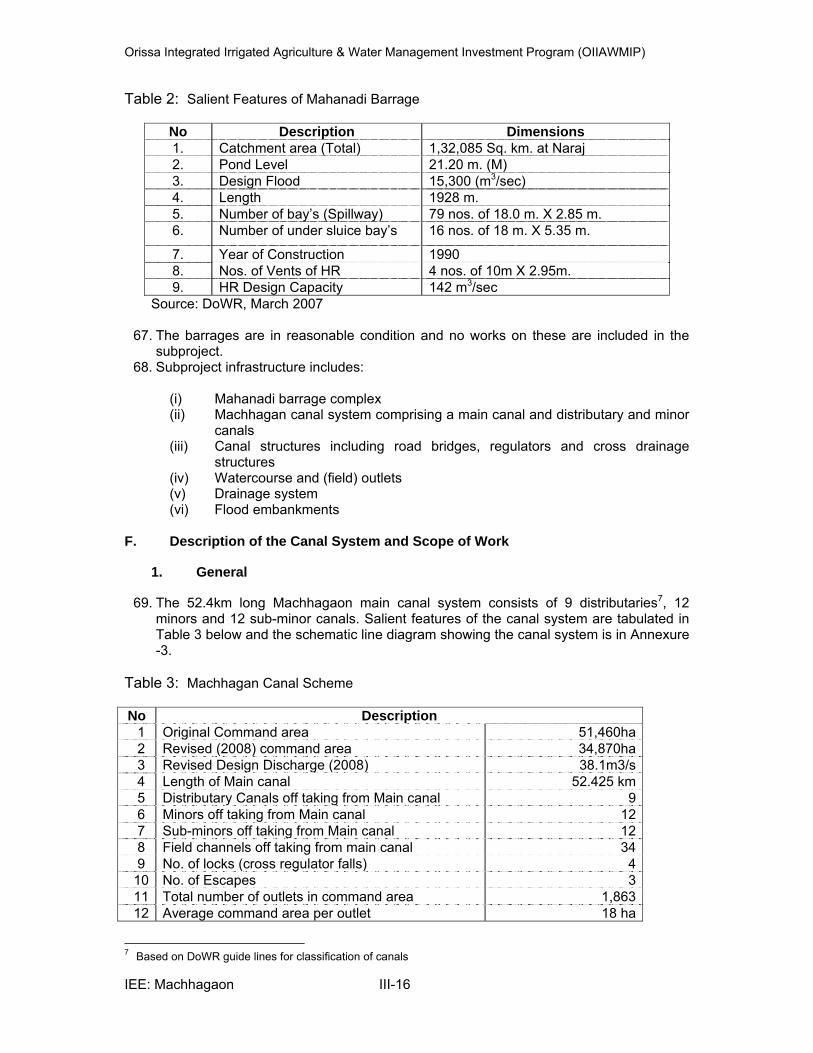
Orissa Integrated Irrigated Agriculture & Water Management Investment Program (OIIAWMIP)
IEE: Machhagaon III-16
Table 2: Salient Features of Mahanadi Barrage
No Description Dimensions 1. Catchment area (Total) 1,32,085 Sq. km. at Naraj 2. Pond Level 21.20 m. (M) 3. Design Flood 15,300 (m3/sec) 4. Length 1928 m. 5. Number of bay’s (Spillway) 79 nos. of 18.0 m. X 2.85 m. 6. Number of under sluice bay’s 16 nos. of 18 m. X 5.35 m.
7. Year of Construction 1990 8. Nos. of Vents of HR 4 nos. of 10m X 2.95m. 9. HR Design Capacity 142 m3/sec
Source: DoWR, March 2007
67. The barrages are in reasonable condition and no works on these are included in the subproject.
68. Subproject infrastructure includes: (i) Mahanadi barrage complex (ii) Machhagan canal system comprising a main canal and distributary and minor
canals (iii) Canal structures including road bridges, regulators and cross drainage
structures (iv) Watercourse and (field) outlets (v) Drainage system (vi) Flood embankments
F. Description of the Canal System and Scope of Work
1. General
69. The 52.4km long Machhagaon main canal system consists of 9 distributaries7, 12 minors and 12 sub-minor canals. Salient features of the canal system are tabulated in Table 3 below and the schematic line diagram showing the canal system is in Annexure -3.
Table 3: Machhagan Canal Scheme No Description
1 Original Command area 51,460ha 2 Revised (2008) command area 34,870ha 3 Revised Design Discharge (2008) 38.1m3/s 4 Length of Main canal 52.425 km 5 Distributary Canals off taking from Main canal 9 6 Minors off taking from Main canal 12 7 Sub-minors off taking from Main canal 12 8 Field channels off taking from main canal 34 9 No. of locks (cross regulator falls) 4
10 No. of Escapes 3 11 Total number of outlets in command area 1,863 12 Average command area per outlet 18 ha
7 Based on DoWR guide lines for classification of canals
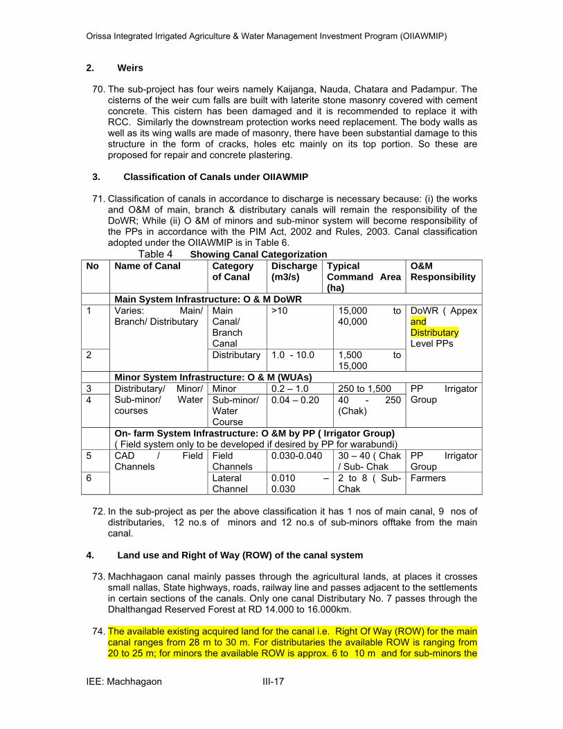
Orissa Integrated Irrigated Agriculture & Water Management Investment Program (OIIAWMIP)
IEE: Machhagaon III-17
2. Weirs
70. The sub-project has four weirs namely Kaijanga, Nauda, Chatara and Padampur. The cisterns of the weir cum falls are built with laterite stone masonry covered with cement concrete. This cistern has been damaged and it is recommended to replace it with RCC. Similarly the downstream protection works need replacement. The body walls as well as its wing walls are made of masonry, there have been substantial damage to this structure in the form of cracks, holes etc mainly on its top portion. So these are proposed for repair and concrete plastering.
3. Classification of Canals under OIIAWMIP
71. Classification of canals in accordance to discharge is necessary because: (i) the works
and O&M of main, branch & distributary canals will remain the responsibility of the DoWR; While (ii) O &M of minors and sub-minor system will become responsibility of the PPs in accordance with the PIM Act, 2002 and Rules, 2003. Canal classification adopted under the OIIAWMIP is in Table 6.
Table 4 Showing Canal Categorization
No Name of Canal Category of Canal
Discharge (m3/s)
Typical Command Area (ha)
O&M Responsibility
Main System Infrastructure: O & M DoWR 1 Varies: Main/
Branch/ Distributary Main Canal/ Branch Canal
>10 15,000 to 40,000
DoWR ( Appex and Distributary Level PPs
2 Distributary 1.0 - 10.0 1,500 to 15,000
Minor System Infrastructure: O & M (WUAs) 3 Distributary/ Minor/
Sub-minor/ Water courses
Minor 0.2 – 1.0 250 to 1,500 PP Irrigator Group 4 Sub-minor/
Water Course
0.04 – 0.20 40 - 250 (Chak)
On- farm System Infrastructure: O &M by PP ( Irrigator Group) ( Field system only to be developed if desired by PP for warabundi)
5 CAD / Field Channels
Field Channels
0.030-0.040 30 – 40 ( Chak / Sub- Chak
PP Irrigator Group
6 Lateral Channel
0.010 – 0.030
2 to 8 ( Sub- Chak
Farmers
72. In the sub-project as per the above classification it has 1 nos of main canal, 9 nos of
distributaries, 12 no.s of minors and 12 no.s of sub-minors offtake from the main canal.
4. Land use and Right of Way (ROW) of the canal system
73. Machhagaon canal mainly passes through the agricultural lands, at places it crosses small nallas, State highways, roads, railway line and passes adjacent to the settlements in certain sections of the canals. Only one canal Distributary No. 7 passes through the Dhalthangad Reserved Forest at RD 14.000 to 16.000km.
74. The available existing acquired land for the canal i.e. Right Of Way (ROW) for the main
canal ranges from 28 m to 30 m. For distributaries the available ROW is ranging from 20 to 25 m; for minors the available ROW is approx. 6 to 10 m and for sub-minors the

Orissa Integrated Irrigated Agriculture & Water Management Investment Program (OIIAWMIP)
IEE: Machhagaon III-18
available ROW is around 6 to 10 m. No additional land acquisition is required for the subproject. Resectioning of the main canal has been proposed under this sub-project, the longitudinal section (L.S) and design section( D.S) has been approved by the Chief Engineer Design, Research and Quality Control, Bhubaneswar on 31.03.2011 for main canal. The typical cross section of the main at RD 29.800 km proposed for resectioning is shown in Figure 2.
15
16
17
18
19
20
21
22
-25-24-23-22-21-20-19-18-17-16-15-14-13-12-11-10 -9 -8 -7 -6 -5 -4 -3 -2 -1 0 1 2 3 4 5 6 7 8 9 10 11 12 13 14 15 16 17 18 19 20 21 22 23 24 25
Figure 2 : Typical cross section of the main at RD 29.800 km proposed for resectioning
5. Machhagan Main Canal
75. The head regulator for Machhagaon at the Biribati bifurcation has a (design) capacity of 45 m3/s through three gated sluiceways. Each sluiceway has 3 gates.
76. The 52.425 km long main canal is aligned along or quite close to the left bank of
Kathjori and Devi rivers, following high ground, and its right bank forms the left bank embankment of the Kathjori river in its middle reaches. It is largely unlined. Some reaches pass through coarse sandy material and seepage and canal bank stability is threatened.
77. The canal appears to have been designed according to regime principals and its long
section slope is close to the Lacey slope. The original design widths are also close to the Lacey regime width in the upper reaches, but downstream of Chatra weir at RD 32.99km a minimum width for navigation of 40ft (12.2m) was adopted leaving the lower reaches over wide.
6. Main Canal Structures
78. Existing and proposed main canal structures are presented in Table 5 and described below.
Table 5: : Main Canal Structures
No Type of structure No. of Structures
as per Inventory
No of structures to be repaired
or renovated
New structures proposed
1 Cross Regulators 3 0 42 Escapes 3 3 03 Head regulators 32 32 04 Village Road Bridges 34 20 125 Drainage syphon 4 3 06 VRB cum fall cum Weir 4 4 07 Field Outlets 52 51 0

Orissa Integrated Irrigated Agriculture & Water Management Investment Program (OIIAWMIP)
IEE: Machhagaon III-19
i. Main Canal Head and Cross Regulators
79. The Biribati head regulator at RD 0 km comprises a 3-span bridge / 1.6m drop with adjacent disused lock. Upstream of the structure three small gates have been fitted to each span, giving a total of 9 gates (1.82 x 2.74 m). These gates are manually operated. Upstream and downstream are abrupt right angle return walls, and eddies circulate downstream catching trash.
80. The main canal head regulator and the four cross regulators are similar in design. The
piers, abutment and wing walls were all constructed from laterite blocks. Over the years gates have been provided, the steel joist supported timber deck bridges replaced / strengthened with RCC, and the downstream cistern (apron) floor of stone masonry covered with concrete. In all cases the laterite blocks are in admirable condition except some minor damage. The damage of the structures in the form of cracks, holes etc., needs repair and and requires plastering with a skin of reinforced concrete but not included under ADB funding, this shall be under taken by Mahanadi South –Division separately.
81. There are 32 head regulators supplying distributary and minor canals. Most were
constructed of brick with manually operated vertical lift steel gates or stop logs to close off orifice flow through the structure. None have gauges in working order and off take flows are not measured. The largest head regulator is for distributary No. 19 (original design flow 9.9 m3/s). This is a two span-gated orifice structure. While the brickwork for these structures remains sound, the overall condition is poor, particularly with respect to gates, gauges and flow measurement ability and these are going to be are going to be renovated under the sub-project.
82. The existing four cross regulators are: (i) Kaijanga (RD 14.520km); (ii) Nuwada (RD
24.380km), (iii) Chatara (RD 32.775km); and (iv) Padmapur (RD 41.721km). There are defunct lock chambers adjacent to the Kaijanga, Nawada and Padmapur weirs. There is also a check structure below the Biluakhai Syphon offtake with open bays. These CRs are in bad shape requiring renovation.
83. From the main canal different distributaries, minors and sub-minors are originating from
the main canal, to regulate the flow head regulators were provided. The 32 number of existing head regulators are damaged and having leakages.
ii. Escapes
84. Existing main canal have escapes at locations: (i) Dhanipur at RD 24.200 km (1 nr gate: 1.25x2.0m), left to the Alaka river; (ii) Chatara at RD 31.834 km, also to Alaka river; and (iii) at RD 50.633 km left to a drainage nullah. These requires repair and are proposed under the sub-project.
iii. Cross Drainage Structure / Drainage Syphon
85. There are four existing drainage siphons out of which three cross drainage syphon at 2.00 km, 4.60 km and 18.607 km are proposed for renovation . These are old concrete hume pipe constructions and need replacement. The upstream and downstream wing, cistern and return wall are damaged over a period of time needs renovation to improve the drainage in the command area.
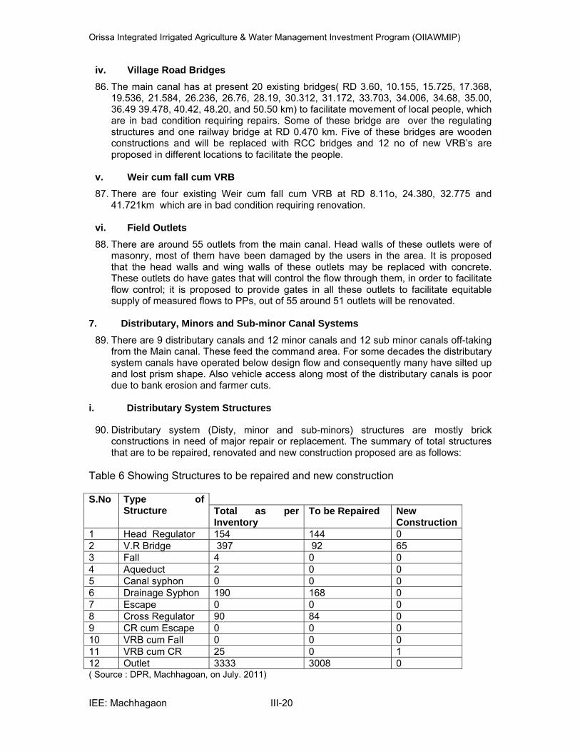
Orissa Integrated Irrigated Agriculture & Water Management Investment Program (OIIAWMIP)
IEE: Machhagaon III-20
iv. Village Road Bridges
86. The main canal has at present 20 existing bridges( RD 3.60, 10.155, 15.725, 17.368, 19.536, 21.584, 26.236, 26.76, 28.19, 30.312, 31.172, 33.703, 34.006, 34.68, 35.00, 36.49 39.478, 40.42, 48.20, and 50.50 km) to facilitate movement of local people, which are in bad condition requiring repairs. Some of these bridge are over the regulating structures and one railway bridge at RD 0.470 km. Five of these bridges are wooden constructions and will be replaced with RCC bridges and 12 no of new VRB’s are proposed in different locations to facilitate the people.
v. Weir cum fall cum VRB
87. There are four existing Weir cum fall cum VRB at RD 8.11o, 24.380, 32.775 and 41.721km which are in bad condition requiring renovation.
vi. Field Outlets
88. There are around 55 outlets from the main canal. Head walls of these outlets were of masonry, most of them have been damaged by the users in the area. It is proposed that the head walls and wing walls of these outlets may be replaced with concrete. These outlets do have gates that will control the flow through them, in order to facilitate flow control; it is proposed to provide gates in all these outlets to facilitate equitable supply of measured flows to PPs, out of 55 around 51 outlets will be renovated.
7. Distributary, Minors and Sub-minor Canal Systems
89. There are 9 distributary canals and 12 minor canals and 12 sub minor canals off-taking from the Main canal. These feed the command area. For some decades the distributary system canals have operated below design flow and consequently many have silted up and lost prism shape. Also vehicle access along most of the distributary canals is poor due to bank erosion and farmer cuts.
i. Distributary System Structures
90. Distributary system (Disty, minor and sub-minors) structures are mostly brick constructions in need of major repair or replacement. The summary of total structures that are to be repaired, renovated and new construction proposed are as follows:
Table 6 Showing Structures to be repaired and new construction S.No Type of
Structure Total as per Inventory
To be Repaired New Construction
1 Head Regulator 154 144 0 2 V.R Bridge 397 92 65 3 Fall 4 0 0 4 Aqueduct 2 0 0 5 Canal syphon 0 0 0 6 Drainage Syphon 190 168 0 7 Escape 0 0 0 8 Cross Regulator 90 84 0 9 CR cum Escape 0 0 0 10 VRB cum Fall 0 0 0 11 VRB cum CR 25 0 1 12 Outlet 3333 3008 0 ( Source : DPR, Machhagoan, on July. 2011)
Orissa Integrated Irrigated Agriculture & Water Management Investment Program (OIIAWMIP)
IEE: Machhagaon III-21
8. Earth work and Turfing
91. Earth work in the main canal, distributaries, minors and sub-minors would be carried out for resection of the canals. Most of the canal sections have eroded over period resulting in under section due to rain cuts and failure of slopes in many places, and breaches occur at peak supply condition hence it is necessary to restore the canal banks to its design section. This involves filling of the earth material, the approx. quantities required in the main canal 6.07 lakh cum and for distributaries, minors and sub-minors it requires approx 0.83 lakh cum.
92. The canal system offtake from the barrage in the deltaic region and the river carries a
lot of silt in the rainy season and erosion of the canals banks is taking place both depositing in the canal bed over the years resulting in increased bed level and reducing the flow. So in order to bring back the canal to its design bed level requires desilting and cutting of canal bed. The approximate quantity of cutting would be around 2.81 lakh cum in the main canal & for distributary, minor and sub-, minor’s approx. 0.77 lakhs cum. Approximately 40 % of cutting quantity from the main canal and some quantity of the distributaries, minors and sub-minors shall be reused in the filling material in the main canal and distributary system.
93. Provision for compaction of the main canals has been built under the project by
Powered Road Roller (PRR)/ Vibratory Roller and the ordinary compaction (HRR) to be done in distributaries, minor and sub-minors.
94. In the sections of the canal where earth work has been completed a provision for turfing
has been made.
9. Lining and retaining walls
95. In some stretches, the canal runs in sandy and silty types of soils resulting in seepage and growth of grasses and weeds in the silted zones causing reduction in flow. In order to reduce these losses it is recommended to have lining in these reaches and upstream and downstream of structure locations a provision for lining and retaining wall is built within the sub-project.
10. Service roads
96. The canal service roads which are primarily meant for movement of inspection vehicles are now only the means for transporting agricultural products and materials like seeds, fertilizer, pesticides and agricultural implements. Most of the existing service roads are in good condition so no improvement proposed under the sub-project.
11. Drilling of bore wells
97. A provision for drilling approximately 60 number of tube wells along the entire of length
of main canal and its distribution system was kept to provide water during canal closure period.
12. Construction Materials
98. The below are the list of provisional construction materials that the Contractor may need to procure for the sub-project. The preliminary estimate provides a provision to approximate carriage and conveyance of materials i.e. lead distance involved are given below:
Orissa Integrated Irrigated Agriculture & Water Management Investment Program (OIIAWMIP)
IEE: Machhagaon III-22
Cement may be procured from a approx. distance of 20 km i..e Jagatsinghpur.
Steel may be procured from a approx. distance of 43 km i..e Cuttack. Wood (shuttering and centering) may be procured from a approx. distance of
78 km i.e. Bhubaneswar Granite products may be procured from the quarry Haridaspur the lead
provided is 90 kms. In addition the tentative list of approved crushers ( State Pollution Control Board )available within the lead distance are as:
Tapti Tie-up Pvt. Ltd.,At : Barada & Dankari,PO – Mahisara,Dist:
Jajpur RSS Infrastructure Projects Ltd.,At Dankari., P.O. Mahisara, Dist:
Jajpur Chitra Builders (P) Ltd., Plot . No- D-7, At: Ranasinghabati Tahasil-
Dharmasala, Dist: Jajpur Anand Exports ( Crusher unit), Nimpalli, Golagaon, Jajpur Rout Stone Crushers, At. Godisahi, Cuttack
Morum / Gravel mayl be procured from Neulpur, 72 km away. Sand may be procured from a distance of 20 km from local river Kathojodi,
Devi and Biluakhia etc. Bricks mayl be procured from a distance of 26 km from nearby places Hume pipe may be procured from a distance of 78 km from Bhubaneswar Laterite stone may be procured from a distance of 72 km from Chhatia.
Earth generated from cutting shall be utilized in filling. The remaining earth
quantity shall be procured by the contractor from private lands; the estimate has a provision for hiring earth from private lands. The contractor before commencement of works shall identify the borrow areas and take approval from the SIO. The EMP for the subproject stipulates the criteria of selection for borrow areas to avoid any damage to the environment. Contractor would try to procure earth within lead of 5 km of the canal system in small quantities.
13. Disposal of Debris & Spoil
99. The material generated from dismantling old structures would be reused to the possible extent. Any materials like wood or iron would be taken in to the surplus stock of Water Resources Department and auctioned by the competent authority.
100. The generated cutting material suitable for the filling would be utilized to the possible extent. The remaining material generated will be tested for suitability and necessary material testing shall be carried out and it shall be utilized in the spoil banks of the existing canal and in the low lying sections of the canal bank with in the available ROW after toe line. However, if any additional material is generated it would be disposed by identifying a suitable places like old borrow areas, quarry sites and low lying govt. land by taking appropriate permission from the SIO and competent authority. The silt shall be tested for heavy metals and pesticide residues also before disposal and some quantities can be distributed to the adjacent farmers by involving PP.
14. Access roads
101. The sub-project is well connected with the road net work. The State Highway -43
runs through the sub-project in different locations from head to tail. The other roads like Cuttack – Paradeep also connect the sub-project These roads can be utilized for transporting the material to the project site. However, the access service roads shall be maintained if necessary by the contractor while transporting the material.

Orissa Integrated Irrigated Agriculture & Water Management Investment Program (OIIAWMIP)
IEE: Machhagaon III-23
15. Plantation 102. To increase the aesthetic value of the area and also to compensate any tree loss that
may arise due to unavoidable tree cutting, the subproject is built with a provision for 8000 trees plantation in the area i.e. along the canal system.
G. Existing Drainage System in the project area
103. The existing surface drainage system comprises: (i) natural nullah channels, many of which have been improved and make more effective with secondary drains and cross drainage structures; and (ii) new drainage channels or cuts. Excess rainfall falling on the right bank of the Machhagaon main canal drains south-west to the Kathjori – Bilukhai – Devi river system. Water falling on the left bank drains east to the Hansua nullah, which forms the northern boundary of the command area, and east and south to the Barunai and Saulian nullahs, feeding into the Hansua main drain. Water falling in the tail of the command area drains either into the Devi river via the Gobari drainage system, or to the Alakan drainage system.
104. These rivers / channels / nullahs lead drainage flows around the perimeter of the command area collecting near the south-east corner of the scheme, from where drainage flows in either the (i) Hansua main drain; (ii) the Devi river or (iii) the Alakan nullah to the Bay of Bengal.
105. Bridges have been built over the drainage cuts. To prevent back up of water in the nullahs and drains during high tides and storm surges, some bunds and sluices have been constructed towards the coast, or are planned.
H. Flood Embankments
106. The Machhagan command is protected by a flood embankment on the left bank of the Kathjori and Devi rivers, which also forms the right embankment of the Machhagan main canal in its middle reaches and also passes adjacent to the Distributary No-19.
I. Implementation Arrangement
107. Procurement of civil works for the sub-project related to main canal, distributaries and minors shall be divided into different contract packages and tendered. Water Resources Department through PMU in consultation with the concerned C.E’s/ S.E/E.Es as per the provisions of OPWD code and in line with ADBs procurement guidelines shall call for tenders through national competitive bidding. Contractors shall be selected and they will execute the civil works under the supervision of respective Subproject Implementing Officers (SIOs).
108. For sub-minors execution of civil work shall be carried out by different Water Users
Associations (PPs) of the respective subproject through an agreement between SIO and SIO / Executive Engineer of the respective sub-project.
J. Onfarm Development Works (OFD)
109. The onfarm development works include watercourses, field channels and field drains. In the traditional system of irrigation the responsibility of distribution system ends at outlet. So distribution of water beyond the outlets remains the responsibility of the farmers. OFD works under Machhagaon sub-project command area had been contemplated to be taken up separately insteps by Command Area Development (CAD) wing of Water Resources Department separately in consultation with the farmers of the concerned WUAs. The CAD water management activities will be funded by the OSG through the centrally sponsored program (CSP) for CAD works without availing OIIAWMIP funds.
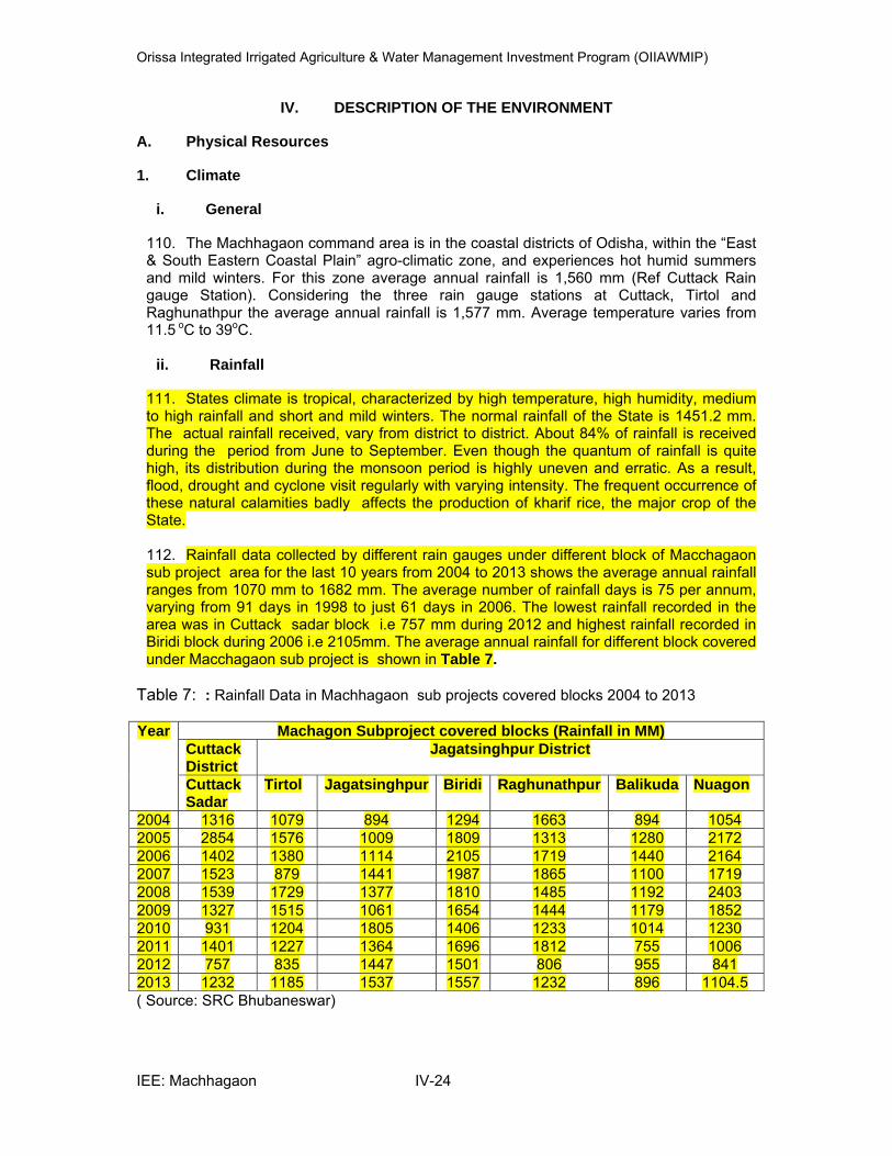
Orissa Integrated Irrigated Agriculture & Water Management Investment Program (OIIAWMIP)
IEE: Machhagaon IV-24
IV. DESCRIPTION OF THE ENVIRONMENT
A. Physical Resources
1. Climate
i. General
110. The Machhagaon command area is in the coastal districts of Odisha, within the “East & South Eastern Coastal Plain” agro-climatic zone, and experiences hot humid summers and mild winters. For this zone average annual rainfall is 1,560 mm (Ref Cuttack Rain gauge Station). Considering the three rain gauge stations at Cuttack, Tirtol and Raghunathpur the average annual rainfall is 1,577 mm. Average temperature varies from 11.5 oC to 39oC.
ii. Rainfall
111. States climate is tropical, characterized by high temperature, high humidity, medium to high rainfall and short and mild winters. The normal rainfall of the State is 1451.2 mm. The actual rainfall received, vary from district to district. About 84% of rainfall is received during the period from June to September. Even though the quantum of rainfall is quite high, its distribution during the monsoon period is highly uneven and erratic. As a result, flood, drought and cyclone visit regularly with varying intensity. The frequent occurrence of these natural calamities badly affects the production of kharif rice, the major crop of the State. 112. Rainfall data collected by different rain gauges under different block of Macchagaon sub project area for the last 10 years from 2004 to 2013 shows the average annual rainfall ranges from 1070 mm to 1682 mm. The average number of rainfall days is 75 per annum, varying from 91 days in 1998 to just 61 days in 2006. The lowest rainfall recorded in the area was in Cuttack sadar block i.e 757 mm during 2012 and highest rainfall recorded in Biridi block during 2006 i.e 2105mm. The average annual rainfall for different block covered under Macchagaon sub project is shown in Table 7.
Table 7: : Rainfall Data in Machhagaon sub projects covered blocks 2004 to 2013 Year Machagon Subproject covered blocks (Rainfall in MM)
Cuttack District
Jagatsinghpur District
Cuttack Sadar
Tirtol Jagatsinghpur Biridi Raghunathpur Balikuda Nuagon
2004 1316 1079 894 1294 1663 894 1054 2005 2854 1576 1009 1809 1313 1280 2172 2006 1402 1380 1114 2105 1719 1440 2164 2007 1523 879 1441 1987 1865 1100 1719 2008 1539 1729 1377 1810 1485 1192 2403 2009 1327 1515 1061 1654 1444 1179 18522010 931 1204 1805 1406 1233 1014 1230 2011 1401 1227 1364 1696 1812 755 1006 2012 757 835 1447 1501 806 955 841 2013 1232 1185 1537 1557 1232 896 1104.5 ( Source: SRC Bhubaneswar)

Orissa Integrated Irrigated Agriculture & Water Management Investment Program (OIIAWMIP)
IEE: Machhagaon IV-25
113. From1965 – 2012 Odisha experienced nearly 17 droughts. This is in part due to low rainfall in these years, but also due to the erratic nature of rainfall within a year. For example in the 2000 drought year monsoon rainfall was 755mm (58% of the average of 1304 mm) but monthly deviations were June 260 mm (126%), July 172mm (55%), August 180 mm (48%), September 64 mm (28%), October 79 mm (43%). The rainfall pattern caused crop loss and depressed yields. Out of 52 years only 13 years have been normal years, this almost puts the state with a 75% probability of being visited by natural calamity of any kind as per status of agriculture in Odisha, Directorate of Agriculture, Odisha.
iii. Temperature and Humidity
114. Temperature varies with monthly average minimums ranging from 12oC to 16oC and maximum from 34oC to 44oC. Relative humidity varies from 67% in summer to 90% during the monsoon. Table 8 shows the mean monthly temperatures and relative humidity.
Table 8: Mean Monthly Temperatures and Relative Humidity, Cuttack District
Month Average Temperatures Relative Humidity
Max oC
Min o C
% at 08.30 hrs
% at 17.30 hrs
January 34 16 81 61 February 38 19 85 79 March 41 23 83 67 April 43 26 84 67 May 44 27 79 89 June 43 26 87 79 July 38 26 90 88 August 39 37 89 84 September 41 26 87 83
October 37 24 85 82 November 36 20 85 82 December 34 17 80 79
(Source: DoWR , PPTA calculations)
iv. Evaporation
115. Class A pan evaporation data is available at Cuttack meteorological station and has been used to estimate crop water requirements. Rainfall and evaporation in Jagatsingpur district is shown in the Figure 3. Evaporation is well above rainfall during Rabi, and the reverse in Kharif.
Figure 3: Monthly Rainfall and Evaporation
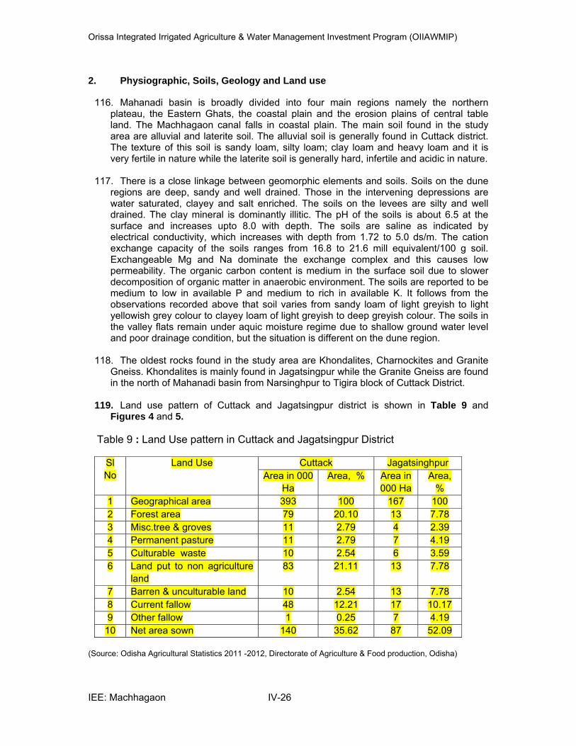
Orissa Integrated Irrigated Agriculture & Water Management Investment Program (OIIAWMIP)
IEE: Machhagaon IV-26
2. Physiographic, Soils, Geology and Land use
116. Mahanadi basin is broadly divided into four main regions namely the northern plateau, the Eastern Ghats, the coastal plain and the erosion plains of central table land. The Machhagaon canal falls in coastal plain. The main soil found in the study area are alluvial and laterite soil. The alluvial soil is generally found in Cuttack district. The texture of this soil is sandy loam, silty loam; clay loam and heavy loam and it is very fertile in nature while the laterite soil is generally hard, infertile and acidic in nature.
117. There is a close linkage between geomorphic elements and soils. Soils on the dune
regions are deep, sandy and well drained. Those in the intervening depressions are water saturated, clayey and salt enriched. The soils on the levees are silty and well drained. The clay mineral is dominantly illitic. The pH of the soils is about 6.5 at the surface and increases upto 8.0 with depth. The soils are saline as indicated by electrical conductivity, which increases with depth from 1.72 to 5.0 ds/m. The cation exchange capacity of the soils ranges from 16.8 to 21.6 mill equivalent/100 g soil. Exchangeable Mg and Na dominate the exchange complex and this causes low permeability. The organic carbon content is medium in the surface soil due to slower decomposition of organic matter in anaerobic environment. The soils are reported to be medium to low in available P and medium to rich in available K. It follows from the observations recorded above that soil varies from sandy loam of light greyish to light yellowish grey colour to clayey loam of light greyish to deep greyish colour. The soils in the valley flats remain under aquic moisture regime due to shallow ground water level and poor drainage condition, but the situation is different on the dune region.
118. The oldest rocks found in the study area are Khondalites, Charnockites and Granite
Gneiss. Khondalites is mainly found in Jagatsingpur while the Granite Gneiss are found in the north of Mahanadi basin from Narsinghpur to Tigira block of Cuttack District.
119. Land use pattern of Cuttack and Jagatsingpur district is shown in Table 9 and
Figures 4 and 5. Table 9 : Land Use pattern in Cuttack and Jagatsingpur District
Sl
No
Land Use Cuttack Jagatsinghpur
Area in 000
Ha
Area, % Area in
000 Ha
Area,
%
1 Geographical area 393 100 167 100
2 Forest area 79 20.10 13 7.78
3 Misc.tree & groves 11 2.79 4 2.39
4 Permanent pasture 11 2.79 7 4.19
5 Culturable waste 10 2.54 6 3.59
6 Land put to non agriculture
land
83 21.11 13 7.78
7 Barren & unculturable land 10 2.54 13 7.78
8 Current fallow 48 12.21 17 10.17
9 Other fallow 1 0.25 7 4.19
10 Net area sown 140 35.62 87 52.09
(Source: Odisha Agricultural Statistics 2011 -2012, Directorate of Agriculture & Food production, Odisha)
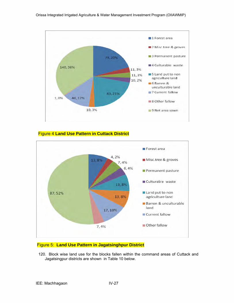
Orissa Integrated Irrigated Agriculture & Water Management Investment Program (OIIAWMIP)
IEE: Machhagaon IV-27
Figure 4 Land Use Pattern in Cuttack District
Figure 5: Land Use Pattern in Jagatsinghpur District
120. Block wise land use for the blocks fallen within the command areas of Cuttack and Jagatsingpur districts are shown in Table 10 below.
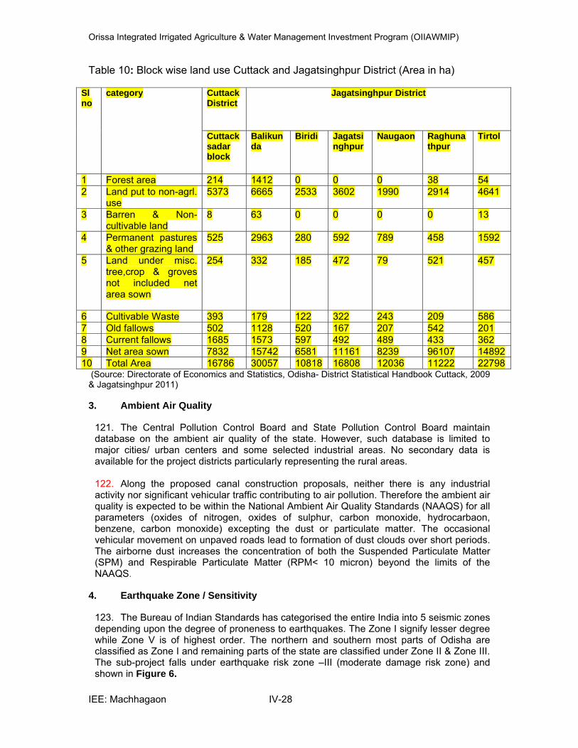
Orissa Integrated Irrigated Agriculture & Water Management Investment Program (OIIAWMIP)
IEE: Machhagaon IV-28
Table 10: Block wise land use Cuttack and Jagatsinghpur District (Area in ha)
Sl no
category Cuttack District
Jagatsinghpur District
Cuttack sadar block
Balikunda
Biridi Jagatsinghpur
Naugaon Raghunathpur
Tirtol
1 Forest area 214 1412 0 0 0 38 54 2 Land put to non-agrl.
use 5373 6665 2533 3602 1990 2914 4641
3 Barren & Non-cultivable land
8 63 0 0 0 0 13
4 Permanent pastures & other grazing land
525 2963 280 592 789
458 1592
5 Land under misc. tree,crop & groves not included net area sown
254 332 185 472 79 521 457
6 Cultivable Waste 393 179 122 322 243 209 586 7 Old fallows 502 1128 520 167 207 542 201 8 Current fallows 1685 1573 597 492 489 433 362 9 Net area sown 7832 15742 6581 11161 8239 96107 14892 10 Total Area 16786 30057 10818 16808 12036 11222 22798
(Source: Directorate of Economics and Statistics, Odisha- District Statistical Handbook Cuttack, 2009 & Jagatsinghpur 2011)
3. Ambient Air Quality
121. The Central Pollution Control Board and State Pollution Control Board maintain database on the ambient air quality of the state. However, such database is limited to major cities/ urban centers and some selected industrial areas. No secondary data is available for the project districts particularly representing the rural areas. 122. Along the proposed canal construction proposals, neither there is any industrial activity nor significant vehicular traffic contributing to air pollution. Therefore the ambient air quality is expected to be within the National Ambient Air Quality Standards (NAAQS) for all parameters (oxides of nitrogen, oxides of sulphur, carbon monoxide, hydrocarbaon, benzene, carbon monoxide) excepting the dust or particulate matter. The occasional vehicular movement on unpaved roads lead to formation of dust clouds over short periods. The airborne dust increases the concentration of both the Suspended Particulate Matter (SPM) and Respirable Particulate Matter (RPM< 10 micron) beyond the limits of the NAAQS.
4. Earthquake Zone / Sensitivity
123. The Bureau of Indian Standards has categorised the entire India into 5 seismic zones depending upon the degree of proneness to earthquakes. The Zone I signify lesser degree while Zone V is of highest order. The northern and southern most parts of Odisha are classified as Zone I and remaining parts of the state are classified under Zone II & Zone III. The sub-project falls under earthquake risk zone –III (moderate damage risk zone) and shown in Figure 6.

Orissa Integrated Irrigated Agriculture & Water Management Investment Program (OIIAWMIP)
IEE: Machhagaon IV-29
Figure 6: Earth Quake Zones of Odisha
5. Drainage
i. Regional Drainage
124. The project area falls in Mahanadi – Kathajori- Devi (Jagatsinghpur) Doab – I drainage system. This doab is bounded by river Mahanadi on the left and Kathjori- Devi on the right. The GCA of the doab is 1.0 lakh ha and the proposed CCA is 0.61 lakh ha and the drainage congested area is about 0.215 lakh ha. Within this doab, there are several drainage sub-systems among which there are 3 major systems which are discussed below.
125. Hansua – Baranala – Saulia system: This system has a total drainage area of about 65920 ha. The system originates from Kandarpur siphon and outfall in to the sea through Jatadhari Muhana. There are about 53 nos. secondary drains in this system, the total length of which comes to about 260 km. A tidal structure is proposed to be constructed at the outfall of the system to prevent ingress of saline water and to provide better drainage condition. 126. Alaka system: This is a dead branch of river Kathjori cut off from the main river long ago. This system now drains a narrow strip of land of about 860 ha. along its length of 54km. It has no secondary drains. A gated sluice is proposed to be constructed at its outfall. 127. Madhusudanpur – Gobari system: This system has a total drainage area of about 9290 ha. It has 13 nos. of secondary drains. This system originates from Madhusudanpur and outfalls into the Devi river. A gated sluice outfall structure is proposed on the main drain to control the back flow into the command area. 128. Smaller natural drainage nullahs drain water from within the command area, and form natural boundaries to distributary canal commands. Man-made drainage cuts have been excavated to link the natural nullahs, including the Majhikora and the Singapur drainage cuts. The highest level of ground water is 1.60 m. below ground level in some

Orissa Integrated Irrigated Agriculture & Water Management Investment Program (OIIAWMIP)
IEE: Machhagaon IV-30
stretches of the command area. But paddy being the predominant crop in the Kharif, the rise in water table does not cause any harm to crop.
ii. Drainage of Machhagaon Command Area
129. The existing surface drainage system comprises: (i) natural nullah channels, many of which have been improved and make more effective with secondary drains and cross drainage structures; and (ii) new drainage channels or cuts. Excess rainfall falling on the right bank of the Machhagaon main canal drains south-west to the Kathjori – Bilukhai – Devi river system. Water falling on the left bank drains east to the Hansua nullah, which forms the northern boundary of the command area, and east and south to the Barunai and Saulian nullahs, feeding into the Hansua main drain. Water falling in the tail of the command area drains either into the Devi river via the Gobari drainage system, or to the Alakan drainage system. 130. These rivers / channels / nullahs lead drainage flows around the perimeter of the command area collecting near the south-east corner of the scheme, from where drainage flows in either the (i) Hansua main drain; (ii) the Devi river or (iii) the Alakan nullah to the Bay of Bengal. 131. Bridges have been built over the drainage cuts. To prevent back up of water in the nullahs and drains during high tides and storm surges, some bunds and sluices have been constructed towards the coast, or are planned.
6. Flood condition of Mahanadi, Brahmani and Baitarani Basin
132. The Mahanadi delta experiences frequent major floods, particularly when flood levels are exacerbated by storm surges increasing sea levels. The construction of Hirakud reservoir in 1957 moderates peak flows in the delta and also allows flows to be accurately gauged and flood warnings issued. 133. The Machhagan command is protected by a flood embankment on the left bank of the Kathjori and Devi rivers, which also forms the right embankment of the Machhagan main canal in its middle reaches. 134. More or less in alternate years flood condition is recorded by concerned department. Table 11 below indicates flood status of the project area of Odisha.
Table 11: List of Past flood and area damaged by Flood in Mahanadi basin Sr. No.
Year and month
Rivers Affected Dist./ Area under project area
Loss/Damage Reported
Average Human
Average Livestock
Public Utility
1 1960 (August)
Mahanadi, Brahmani and
Baitarani
Cuttack, Not available
Not available
Average 6 lakh acre of cropped area damaged
2 1961 (Sept)
Mahanadi, Brahmani and
Baitarani
Cuttack, Not available
Not available
Average 0.48 lakh acre of
cropped area damaged
3 1964 (July- Aug)
Mahanadi, Brahmani and
Baitarani
Cuttack, Dhenkanal, Sambalpur Not available
Not available
Average 1.35 lakh acre of
cropped area damaged
4 1971 (July- Oct.)
Mahanadi, Brahmani and
Baitarani
Cuttack, Sundergarh 8 75 Average 3.34 lakh acre of
cropped area damaged
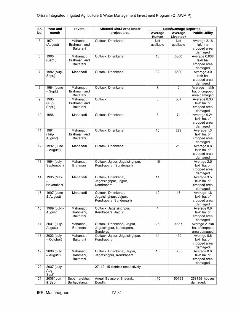
Orissa Integrated Irrigated Agriculture & Water Management Investment Program (OIIAWMIP)
IEE: Machhagaon IV-31
Sr. No.
Year and month
Rivers Affected Dist./ Area under project area
Loss/Damage Reported
Average Human
Average Livestock
Public Utility
5 1974 (August)
Mahanadi, Brahmani and
Baitarani
Cuttack, Dhenkanal Not available
Not available
Average 2.16 lakh ha
cropped area damaged
6 1980 (Sept.)
Mahanadi, Brahmani and
Baitarani
Cuttack, Dhenkanal 16 3300 Average 0.638 lakh ha.
cropped area damaged
7 1982 (Aug- Sept.)
Mahanadi Cuttack, Dhenkanal 32 6500 Average 3.0 lakh ha.
cropped area damaged
8 1984 (June – Sept.)
Mahanadi, Brahmani and
Baitarani
Cuttack, Dhenkanal 7 0 Average 1 lakh ha. of cropped area damaged
9 1985 (Aug- Sept.)
Mahanadi, Brahmani and
Baitarani
Cuttack 3 587 Average 0.33 lakh ha. of
cropped area damaged
10 1986 Mahanadi Cuttack, Dhenkanal 3 74 Average 0.24 lakh ha. of
cropped area damaged
11 1991 (July- August)
Mahanadi, Brahmani and
Baitarani
Cuttack, Dhenkanal 10 229 Average 1.3 lakh ha. of
cropped area damaged
12 1992 (June – August)
Mahanadi Cuttack, Dhenkanal 8 250 Average 0.8 lakh ha. of
cropped area damaged
13 1994 (July- September)
Mahanadi, Brahmani
Cuttack, Jajpur, Jagatsinghpur, Kendrapara, Sundergarh
10 Average 2.5 lakh ha. of
cropped area damaged
14 1995 (May – November)
Mahanadi Cuttack, Dhenkanal, Jagatsinghpur, Jajpur, Kendrapara
11 Average 3.5 lakh ha. of
cropped area damaged
15 1997 (June & August)
Mahanadi Cuttack, Dhenkanal, Jagatsinghpur, Jajpur, Kendrapara, Sundergarh
10 17 Average 1.8 lakh ha. of
cropped area damaged
16 1999 (July - August
Mahanadi, Brahmani, Baitarani
Cuttack, Jagatsinghpur, Kendrapara, Jajpur
4 Average 0.8 lakh ha. of
cropped area damaged
17 2001 (July- August)
Mahanadi, Brahmani
Cuttack, Dhenkanal, Jajpur, Jagatsingpur, kendrapara, Sundergarh
25 4537 Average 2 lakh ha. of cropped area damaged
18 2003 (July – October)
Mahanadi, Baitarani
Cuttack, Jajpur, Jagatsinghpur, Kendrapara
14 450 Average 0.8 lakh ha. of
cropped area damaged
19 2006 (July – August)
Mahanadi, Brahmani, Baitarani
Cuttack, Dhenkanal, Jajpur, Jagatsingpur, Kendrapara
15 300 Average 0.6 lakh ha. of
cropped area damaged
20 2007 (July- Aug – Sept)
27, 12, 15 districts respectively
21 2008( Jun & Sept)
Subarnarekha, Burhabalang,
Angul, Balasore, Bhadrak, Boudh,
110 50163 258155 houses damaged,
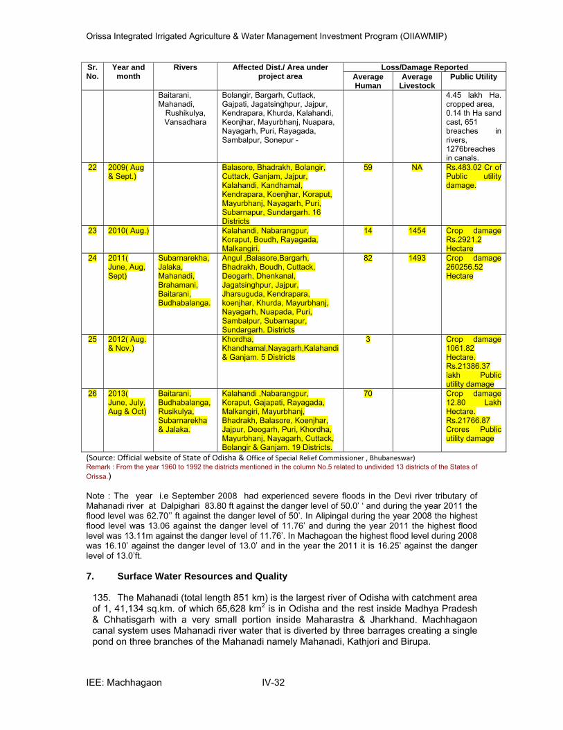
Orissa Integrated Irrigated Agriculture & Water Management Investment Program (OIIAWMIP)
IEE: Machhagaon IV-32
Sr. No.
Year and month
Rivers Affected Dist./ Area under project area
Loss/Damage Reported
Average Human
Average Livestock
Public Utility
Baitarani, Mahanadi,
Rushikulya, Vansadhara
Bolangir, Bargarh, Cuttack, Gajpati, Jagatsinghpur, Jajpur, Kendrapara, Khurda, Kalahandi, Keonjhar, Mayurbhanj, Nuapara, Nayagarh, Puri, Rayagada, Sambalpur, Sonepur -
4.45 lakh Ha. cropped area, 0.14 th Ha sand cast, 651 breaches in rivers, 1276breaches in canals.
22 2009( Aug & Sept.)
Balasore, Bhadrakh, Bolangir, Cuttack, Ganjam, Jajpur, Kalahandi, Kandhamal, Kendrapara, Koenjhar, Koraput, Mayurbhanj, Nayagarh, Puri, Subarnapur, Sundargarh. 16 Districts
59 NA Rs.483.02 Cr of Public utility damage.
23 2010( Aug.) Kalahandi, Nabarangpur, Koraput, Boudh, Rayagada, Malkangiri.
14 1454 Crop damage Rs.2921.2 Hectare
24 2011( June, Aug, Sept)
Subarnarekha, Jalaka, Mahanadi, Brahamani, Baitarani, Budhabalanga.
Angul ,Balasore,Bargarh, Bhadrakh, Boudh, Cuttack, Deogarh, Dhenkanal, Jagatsinghpur, Jajpur, Jharsuguda, Kendrapara, koenjhar, Khurda, Mayurbhanj, Nayagarh, Nuapada, Puri, Sambalpur, Subarnapur, Sundargarh. Districts
82 1493 Crop damage 260256.52 Hectare
25 2012( Aug. & Nov.)
Khordha, Khandhamal,Nayagarh,Kalahandi & Ganjam. 5 Districts
3 Crop damage 1061.82 Hectare. Rs.21386.37 lakh Public utility damage
26 2013( June, July, Aug & Oct)
Baitarani, Budhabalanga, Rusikulya, Subarnarekha & Jalaka.
Kalahandi ,Nabarangpur, Koraput, Gajapati, Rayagada, Malkangiri, Mayurbhanj, Bhadrakh, Balasore, Koenjhar, Jajpur, Deogarh, Puri, Khordha, Mayurbhanj, Nayagarh, Cuttack, Bolangir & Ganjam. 19 Districts.
70 Crop damage 12.80 Lakh Hectare. Rs.21766.87 Crores Public utility damage
(Source: Official website of State of Odisha & Office of Special Relief Commissioner , Bhubaneswar) Remark : From the year 1960 to 1992 the districts mentioned in the column No.5 related to undivided 13 districts of the States of
Orissa.) Note : The year i.e September 2008 had experienced severe floods in the Devi river tributary of Mahanadi river at Dalpighari 83.80 ft against the danger level of 50.0’ ‘ and during the year 2011 the flood level was 62.70’’ ft against the danger level of 50’. In Alipingal during the year 2008 the highest flood level was 13.06 against the danger level of 11.76’ and during the year 2011 the highest flood level was 13.11m against the danger level of 11.76’. In Machagoan the highest flood level during 2008 was 16.10’ against the danger level of 13.0’ and in the year the 2011 it is 16.25’ against the danger level of 13.0’ft.
7. Surface Water Resources and Quality
135. The Mahanadi (total length 851 km) is the largest river of Odisha with catchment area of 1, 41,134 sq.km. of which 65,628 km2 is in Odisha and the rest inside Madhya Pradesh & Chhatisgarh with a very small portion inside Maharastra & Jharkhand. Machhagaon canal system uses Mahanadi river water that is diverted by three barrages creating a single pond on three branches of the Mahanadi namely Mahanadi, Kathjori and Birupa.
Orissa Integrated Irrigated Agriculture & Water Management Investment Program (OIIAWMIP)
IEE: Machhagaon IV-33
136. The Hirakud dam reservoir in Sambalpur district, north-west Odisha provides the only major storage of Mahanadi river flow. The dam was constructed in 1948-1957. The dam intercepts 83,400 km2 of the Mahanadi catchment and has 4,823 MCM of storage. Water is released to irrigate over 260,000ha in 4 districts and 251,000 ha in the Mahanadi delta8, and for power generation, local water supply and flood protection of 9,500 ha. 137. The Mahanadi deposits silt as it loses energy within the delta. Evidence of siltation is visible in the low-lying island formations and the braiding river channels within the flood embankments. Sediment accretion in the Mahanadi impedes drainage north from the command area. 138. Rainfall from the south-west monsoon results in high runoff in August and September. 139. Due to low elevation, flat slopes and storm surges about a third of the Mahanadi Basin area suffers flooding and drainage congestion. Storm surges9 in the 1999 super cyclone were estimated in excess of 6-7m. Flood levels and protection embankments along rivers and nullahs are closely monitored during the monsoon. To reduce risk of damage to command areas the DoWR will shortly implement the Flood Master Plan (Raising and Strengthening Embankments). 140. In recent years there have been several large flood events, in particular: 1994-95, 2001-02 and 2003-04 with 10-day flood volumes of 1,450,360ham (16,790m3/s), 1,222,220ham (14,150m3/s) and 1,011,460ham (11,710m3/s), respectively. The annual average flood for this period was 510,020ham (5,900m3/s). The design flood for the Mahanadi barrage is 15,300m3/s. 141. Water quality of the Mahanadi within the Machhagaon project area is shown in Tables 12 and 13 below. It is noted that water quality deteriorate at the d/s of Cuttack city and that is due to discharge of untreated effluent from Cuttack city. Yearly variation (from 2007 to 2010) of BOD level of river Mahanadi is also shown in the Table 12. Upstream of Cuttack, the river water confirms to Class C quality and is potable with conventional treatment following by disinfection. Downstream, in the Mahanadi doesnt confirms to Class C. 142. In India, the Central Pollution Control Board (CPCB) has developed a concept of designated best use and classified water based on the surface water quality (IS: 2296- 1992) into five classes i.e. A – E see Table 14. The different classes are: A- Drinking Water Source without conventional treatment but after disinfection; B- Outdoor bathing (Organised); C- Drinking water source after conventional treatment and disinfection; D- Propagation of Wild life and Fisheries and E -Irrigation, Industrial Cooling and Controlled Waste disposal.
8 Data are sourced from the “3
rd Spiral Study Report of Mahanadi Basin Plan (Volume-I)”, Department of Water
Resources, Government of Orissa, 2001 9 Information provided in “Orissa State Water Plan (Annexures)”, Orissa Water Planning Organization,
Department of Water Resources, 2004
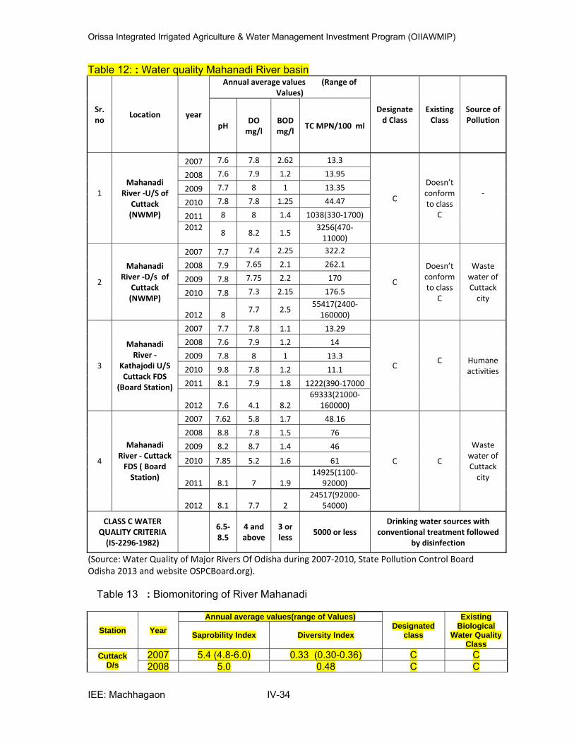
Orissa Integrated Irrigated Agriculture & Water Management Investment Program (OIIAWMIP)
IEE: Machhagaon IV-34
Table 12: : Water quality Mahanadi River basin
Sr. no
Location year
Annual average values (Range of Values)
Designate
d Class Existing Class
Source of Pollution
pH DO mg/l
BOD mg/l
TC MPN/100 ml
1
Mahanadi River ‐U/S of
Cuttack (NWMP)
2007 7.6 7.8 2.62 13.3
C
Doesn’t conform to class
C
‐
2008 7.6 7.9 1.2 13.95
2009 7.7 8 1 13.35
2010 7.8 7.8 1.25 44.47
2011 8 8 1.4 1038(330‐1700) 2012
8 8.2 1.5
3256(470‐11000)
2
Mahanadi River ‐D/s of
Cuttack (NWMP)
2007 7.7 7.4 2.25 322.2
C
Doesn’t conform to class
C
Waste water of Cuttack city
2008 7.9 7.65 2.1 262.1
2009 7.8 7.75 2.2 170
2010 7.8 7.3 2.15 176.5
2012 8 7.7 2.5
55417(2400‐160000)
3
Mahanadi River ‐
Kathajodi U/S Cuttack FDS
(Board Station)
2007 7.7 7.8 1.1 13.29
C C
Humane activities
2008 7.6 7.9 1.2 14
2009 7.8 8 1 13.3
2010 9.8 7.8 1.2 11.1
2011 8.1 7.9 1.8 1222(390‐17000
2012 7.6 4.1 8.2 69333(21000‐
160000)
4
Mahanadi River ‐ Cuttack FDS ( Board Station)
2007 7.62 5.8 1.7 48.16
C C
Waste water of Cuttack city
2008 8.8 7.8 1.5 76
2009 8.2 8.7 1.4 46
2010 7.85 5.2 1.6 61
2011 8.1 7 1.9 14925(1100‐
92000)
2012 8.1 7.7 2 24517(92000‐
54000)
CLASS C WATER QUALITY CRITERIA (IS‐2296‐1982)
6.5‐8.5
4 and above
3 or less
5000 or less Drinking water sources with
conventional treatment followed by disinfection
(Source: Water Quality of Major Rivers Of Odisha during 2007‐2010, State Pollution Control Board Odisha 2013 and website OSPCBoard.org). Table 13 : Biomonitoring of River Mahanadi
Station Year
Annual average values(range of Values) Designated
class
Existing Biological
Water Quality Class
Saprobility Index Diversity Index
Cuttack D/s
2007 5.4 (4.8-6.0) 0.33 (0.30-0.36) C C 2008 5.0 0.48 C C
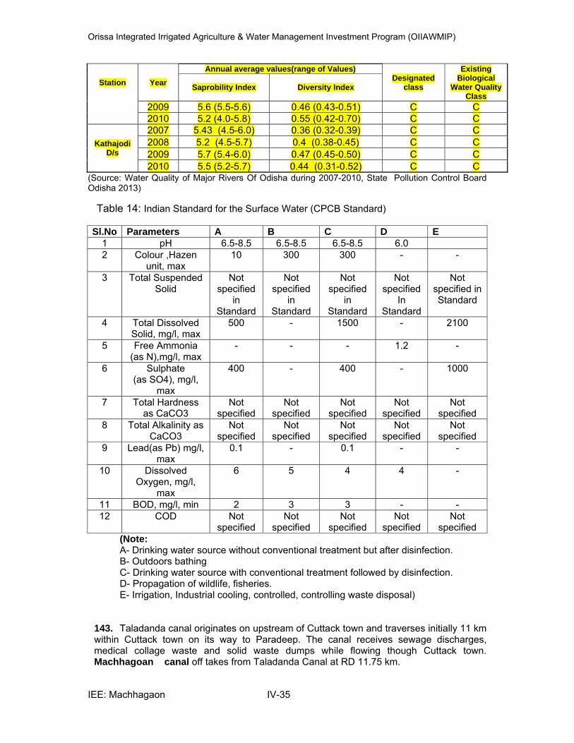
Orissa Integrated Irrigated Agriculture & Water Management Investment Program (OIIAWMIP)
IEE: Machhagaon IV-35
Station Year
Annual average values(range of Values) Designated
class
Existing Biological
Water Quality Class
Saprobility Index Diversity Index
2009 5.6 (5.5-5.6) 0.46 (0.43-0.51) C C 2010 5.2 (4.0-5.8) 0.55 (0.42-0.70) C C
Kathajodi D/s
2007 5.43 (4.5-6.0) 0.36 (0.32-0.39) C C
2008 5.2 (4.5-5.7) 0.4 (0.38-0.45) C C
2009 5.7 (5.4-6.0) 0.47 (0.45-0.50) C C
2010 5.5 (5.2-5.7) 0.44 (0.31-0.52) C C (Source: Water Quality of Major Rivers Of Odisha during 2007-2010, State Pollution Control Board Odisha 2013)
Table 14: Indian Standard for the Surface Water (CPCB Standard) Sl.No Parameters A B C D E
1 pH 6.5-8.5 6.5-8.5 6.5-8.5 6.0 2 Colour ,Hazen
unit, max 10 300 300 - -
3 Total Suspended Solid
Not specified
in Standard
Not specified
in Standard
Not specified
in Standard
Not specified
In Standard
Not specified in Standard
4 Total Dissolved Solid, mg/l, max
500 - 1500 - 2100
5 Free Ammonia (as N),mg/l, max
- - - 1.2 -
6 Sulphate (as SO4), mg/l,
max
400 - 400 - 1000
7 Total Hardness as CaCO3
Not specified
Not specified
Not specified
Not specified
Not specified
8 Total Alkalinity as CaCO3
Not specified
Not specified
Not specified
Not specified
Not specified
9 Lead(as Pb) mg/l, max
0.1 - 0.1 - -
10 Dissolved Oxygen, mg/l,
max
6 5 4 4 -
11 BOD, mg/l, min 2 3 3 - - 12 COD Not
specified Not
specified Not
specified Not
specified Not
specified (Note: A- Drinking water source without conventional treatment but after disinfection. B- Outdoors bathing C- Drinking water source with conventional treatment followed by disinfection. D- Propagation of wildlife, fisheries. E- Irrigation, Industrial cooling, controlled, controlling waste disposal)
143. Taladanda canal originates on upstream of Cuttack town and traverses initially 11 km within Cuttack town on its way to Paradeep. The canal receives sewage discharges, medical collage waste and solid waste dumps while flowing though Cuttack town. Machhagoan canal off takes from Taladanda Canal at RD 11.75 km.
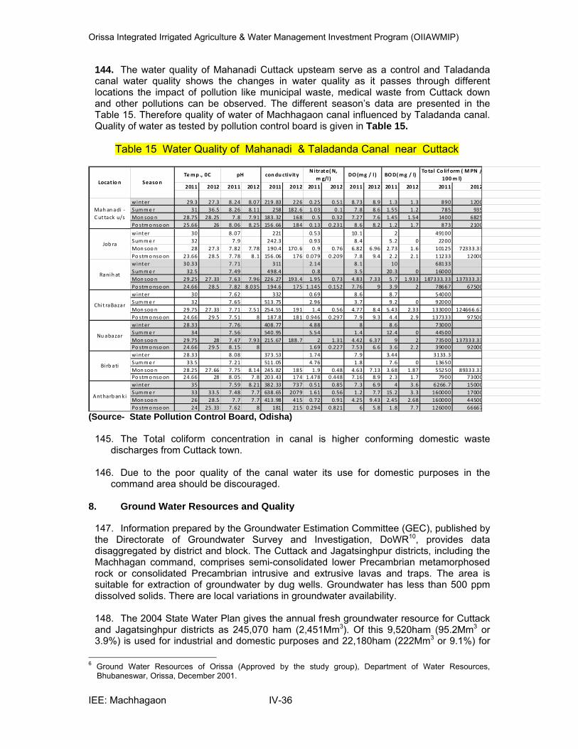
Orissa Integrated Irrigated Agriculture & Water Management Investment Program (OIIAWMIP)
IEE: Machhagaon IV-36
144. The water quality of Mahanadi Cuttack upsteam serve as a control and Taladanda canal water quality shows the changes in water quality as it passes through different locations the impact of pollution like municipal waste, medical waste from Cuttack down and other pollutions can be observed. The different season’s data are presented in the Table 15. Therefore quality of water of Machhagaon canal influenced by Taladanda canal. Quality of water as tested by pollution control board is given in Table 15.
Table 15 Water Quality of Mahanadi & Taladanda Canal near Cuttack
2011 2012 2011 2012 2011 2012 2011 2012 2011 2012 2011 2012 2011 2012
winter 29.3 27.3 8.24 8.07 219.83 226 0.25 0.51 8.73 8.9 1.3 1.3 890 1200
Summe r 31 36.5 8.26 8.11 258 182.6 1.03 0.1 7.8 8.6 1.55 1.2 785 935
Mon soo n 28.75 28.25 7.8 7.91 183.32 168 0.5 0.32 7.27 7.6 1.45 1.54 1400 6825
Po stmonso on 25.66 26 8.06 8.25 156.66 184 0.13 0.231 8.6 8.2 1.2 1.7 873 2100
winter 30 8.07 221 0.53 10.1 2 49100
Summe r 32 7.9 242.3 0.93 8.4 5.2 0 2200
Mon soo n 28 27.3 7.82 7.78 190.4 170.6 0.9 0.76 6.82 6.96 2.73 1.6 10125 72333.33
Po stmonso on 23.66 28.5 7.78 8.1 156.06 176 0.079 0.209 7.8 9.4 2.2 2.1 11233 12000
winter 30.33 7.71 311 2.14 8.1 10 68133
Summe r 32.5 7.49 498.4 0.8 3.5 20.3 0 16000
Mon soo n 29.25 27.33 7.63 7.96 226.27 193.4 1.95 0.73 4.83 7.33 5.7 1.933 187333.33 137333.33
Po stmonso on 24.66 28.5 7.82 8.035 194.6 175 1.145 0.152 7.76 9 3.9 2 78667 67500
winter 30 7.62 332 0.69 8.6 8.7 54000
Summe r 32 7.65 513.75 2.96 3.7 9.2 0 92000
Mon soo n 29.75 27.33 7.71 7.51 254.55 191 1.4 0.56 4.77 8.4 5.43 2.33 133000 124666.67
Po stmonso on 24.66 29.5 7.51 8 187.8 181 0.946 0.297 7.9 9.3 4.4 2.9 137333 97500
winter 28.33 7.76 408.77 4.88 8 8.6 73000
Summe r 34 7.56 540.95 5.54 1.4 12.4 0 44500
Mon soo n 29.75 28 7.47 7.93 215.67 188.7 2 1.31 4.42 6.37 9 2 73500 137333.33
Po stmonso on 24.66 29.5 8.15 8 1.69 0.227 7.53 6.6 3.6 2.2 39000 92000
winter 28.33 8.08 373.53 1.74 7.9 3.44 3133.3
Summe r 33.5 7.21 511.05 4.76 1.8 7.6 0 13650
Mon soo n 28.25 27.66 7.75 8.14 245.82 185 1.9 0.48 4.63 7.13 3.68 1.87 55250 89333.33
Po stmonso on 24.66 28 8.05 7.8 203.43 174 1.478 0.448 7.16 8.9 2.3 1.7 7900 73000
winter 35 7.59 8.21 382.33 737 0.51 0.85 7.3 6.9 4 3.6 6266.7 15000
Summe r 33 33.5 7.48 7.7 638.65 2079 1.61 0.56 1.2 7.7 15.2 3.3 160000 17000
Mon soo n 26 28.5 7.7 7.7 413.98 415 0.72 0.91 4.25 9.43 2.45 2.68 160000 44500
Po stmonso on 24 25.33 7.62 8 181 215 0.294 0.821 6 5.8 1.8 7.7 126000 66667
Mah an adi ‐ C ut tack u/s
Job ra
Ranih at
Chi t raBazar
Temp ., 0C pH condu ctiv ityN itrate(N,
m g/l)DO (mg / l )
Nu abazar
Bi rb ati
Antharb an k i
Locat io n Seaso n
To tal Co li f orm ( MPN /100 m l)
BOD(mg / l)
(Source- State Pollution Control Board, Odisha)
145. The Total coliform concentration in canal is higher conforming domestic waste
discharges from Cuttack town.
146. Due to the poor quality of the canal water its use for domestic purposes in the command area should be discouraged.
8. Ground Water Resources and Quality
147. Information prepared by the Groundwater Estimation Committee (GEC), published by the Directorate of Groundwater Survey and Investigation, DoWR10, provides data disaggregated by district and block. The Cuttack and Jagatsinghpur districts, including the Machhagan command, comprises semi-consolidated lower Precambrian metamorphosed rock or consolidated Precambrian intrusive and extrusive lavas and traps. The area is suitable for extraction of groundwater by dug wells. Groundwater has less than 500 ppm dissolved solids. There are local variations in groundwater availability. 148. The 2004 State Water Plan gives the annual fresh groundwater resource for Cuttack and Jagatsinghpur districts as 245,070 ham (2,451Mm3). Of this 9,520ham (95.2Mm3 or 3.9%) is used for industrial and domestic purposes and 22,180ham (222Mm3 or 9.1%) for
6 Ground Water Resources of Orissa (Approved by the study group), Department of Water Resources,
Bhubaneswar, Orissa, December 2001.
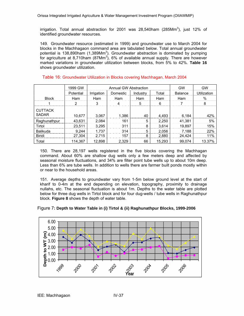
Orissa Integrated Irrigated Agriculture & Water Management Investment Program (OIIAWMIP)
IEE: Machhagaon IV-37
irrigation. Total annual abstraction for 2001 was 28,540ham (285Mm3), just 12% of identified groundwater resources. 149. Groundwater resource (estimated in 1999) and groundwater use to March 2004 for blocks in the Machhagaon command area are tabulated below. Total annual groundwater potential is 138,890ham (1,389Mm3). Groundwater abstraction is dominated by pumping for agriculture at 8,710ham (87Mm3), 6% of available annual supply. There are however marked variations in groundwater utilization between blocks, from 5% to 42%. Table 16 shows groundwater utilization.
Table 16: Groundwater Utilization in Blocks covering Machhagan, March 2004
Block
1999 GW Annual GW Abstraction GW GW
Potential Irrigation Domestic Industry Total Balance Utilization
Ham Ham Ham Ham Ham Ham %
1 2 3 4 5 6 7 8
CUTTACK SADAR 10,677 3,067 1,386 40 4,493 6,184 42%
Raghunathpur 43,631 2,084 161 5 2,250 41,381 5%
Tirtol 23,511 3,295 311 8 3,614 19,897 15%
Balikuda 9,244 1,737 314 5 2,056 7,188 22%Biridi 27,304 2,715 157 8 2,880 24,424 11%
Total 114,367 12,898 2,329 66 15,293 99,074 13.37%
150. There are 28,197 wells registered in the five blocks covering the Machhagan command. About 60% are shallow dug wells only a few meters deep and affected by seasonal moisture fluctuations, and 34% are filter point tube wells up to about 10m deep. Less than 6% are tube wells. In addition to wells there are farmer built ponds mostly within or near to the household areas. 151. Average depths to groundwater vary from 1-5m below ground level at the start of kharif to 0-4m at the end depending on elevation, topography, proximity to drainage nullahs, etc. The seasonal fluctuation is about 1m. Depths to the water table are plotted below for three dug wells in Tirtol block and for four dug-wells / tube wells in Raghunathpur block. Figure 8 shows the depth of water table.
Figure 7: Depth to Water Table in (i) Tirtol & (ii) Raghunathpur Blocks, 1999-2006
0.00
1.00
2.00
3.00
4.00
5.00
6.00
Dep
th to
WT
(m
)
Year
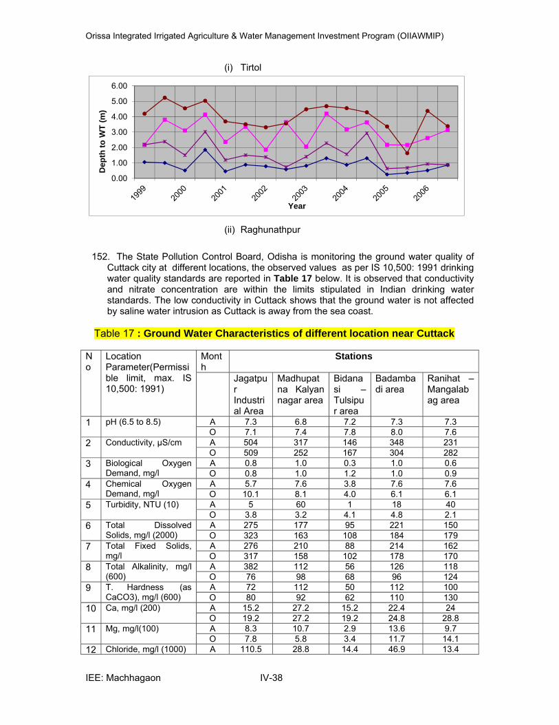
Orissa Integrated Irrigated Agriculture & Water Management Investment Program (OIIAWMIP)
IEE: Machhagaon IV-38
(i) Tirtol
0.00
1.00
2.00
3.00
4.00
5.00
6.00
Dep
th t
o W
T (
m)
Year
(ii) Raghunathpur
152. The State Pollution Control Board, Odisha is monitoring the ground water quality of
Cuttack city at different locations, the observed values as per IS 10,500: 1991 drinking water quality standards are reported in Table 17 below. It is observed that conductivity and nitrate concentration are within the limits stipulated in Indian drinking water standards. The low conductivity in Cuttack shows that the ground water is not affected by saline water intrusion as Cuttack is away from the sea coast.
Table 17 : Ground Water Characteristics of different location near Cuttack No
Location Parameter(Permissible limit, max. IS 10,500: 1991)
Month
Stations
Jagatpur Industrial Area
Madhupatna Kalyan nagar area
Bidanasi – Tulsipur area
Badambadi area
Ranihat –Mangalabag area
1 pH (6.5 to 8.5) A 7.3 6.8 7.2 7.3 7.3O 7.1 7.4 7.8 8.0 7.6
2 Conductivity, µS/cm A 504 317 146 348 231 O 509 252 167 304 282
3 Biological Oxygen Demand, mg/l
A 0.8 1.0 0.3 1.0 0.6 O 0.8 1.0 1.2 1.0 0.9
4 Chemical Oxygen Demand, mg/l
A 5.7 7.6 3.8 7.6 7.6 O 10.1 8.1 4.0 6.1 6.1
5 Turbidity, NTU (10) A 5 60 1 18 40 O 3.8 3.2 4.1 4.8 2.1
6 Total Dissolved Solids, mg/l (2000)
A 275 177 95 221 150 O 323 163 108 184 179
7 Total Fixed Solids, mg/l
A 276 210 88 214 162 O 317 158 102 178 170
8 Total Alkalinity, mg/l (600)
A 382 112 56 126 118 O 76 98 68 96 124
9 T. Hardness (as CaCO3), mg/l (600)
A 72 112 50 112 100 O 80 92 62 110 130
10 Ca, mg/l (200) A 15.2 27.2 15.2 22.4 24 O 19.2 27.2 19.2 24.8 28.8
11 Mg, mg/l(100) A 8.3 10.7 2.9 13.6 9.7 O 7.8 5.8 3.4 11.7 14.1
12 Chloride, mg/l (1000) A 110.5 28.8 14.4 46.9 13.4
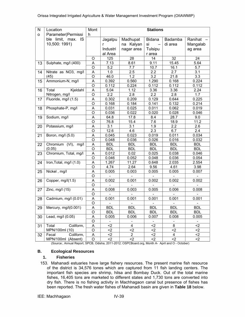
Orissa Integrated Irrigated Agriculture & Water Management Investment Program (OIIAWMIP)
IEE: Machhagaon IV-39
No
Location Parameter(Permissible limit, max. IS 10,500: 1991)
Month
Stations
Jagatpur Industrial Area
Madhupatna Kalyan nagar area
Bidanasi – Tulsipur area
Badambadi area
Ranihat –Mangalabag area
O 125 28 14 32 24
13 Sulphate, mg/l (400) A 7.13 8.61 9.11 15.45 5.64 O 5.2 7.7 10.7 16.1 5.7
14 Nitrate as NO3, mg/l (45)
A 1.0 2.5 2.2 2.7 3.1 O 46.0 1.2 3.2 21.8 3.3
15 Ammonium-N, mg/l A 0.392 0.560 1.290 0.168 0.224 O 0.112 0.224 0.112 0.112 0.112
16 Total Kjeldahl Nitrogen, mg/l
A 5.04 1.12 3.36 3.36 2.24 O 2.2 2.8 2.2 2.8 1.7
17 Fluoride, mg/l (1.5) A 0.302 0.209 0.129 0.644 0.225 O 0.168 0.184 0.141 0.132 0.214
18 Phosphate-P, mg/l A 0.031 0.025 0.011 0.062 0.019 O 0.036 0.022 0.020 0.028 0.046
19 Sodium, mg/l A 64.8 17.8 8.4 28.7 9.0 O 76.8 15.4 7.6 18.9 11.2
20 Potassium, mg/l A 3.1 3.1 1.9 2.2 2.6 O 12.6 4.6 2.3 6.7 2.4
21 Boron, mg/l (5.0) A 0.045 0.023 0.019 0.011 0.034 O 0.048 0.036 0.026 0.016 0.032
22 Chromium (VI), mg/l (0.05)
A BDL BDL BDL BDL BDL O BDL BDL BDL BDL BDL
23 Chromium, Total, mg/l A 0.012 0.02 0.025 0.038 0.046 O 0.046 0.052 0.048 0.036 0.054
24 Iron,Total, mg/l (1.0) A 1.267 11.27 0.648 2.035 2.554 O 4.74 2.64 9.56 4.61 3.98
25 Nickel , mg/l A 0.005 0.003 0.005 0.005 0.007 O - - - - -
26 Copper, mg/l(1.5) A 0.002 0.001 0.002 0.002 0.002 O - - - - -
27 Zinc, mg/l (15) A 0.008 0.003 0.005 0.006 0.008 O - - - - -
28 Cadmium, mg/l (0.01) A 0.001 0.001 0.001 0.001 0.001 O - - - - -
29 Mercury, mg/l(0.001) A BDL BDL BDL BDL BDL O BDL BDL BDL BDL BDL
30 Lead, mg/l (0.05) A 0.005 0.006 0.007 0.008 0.005 O - - - - -
31 Total Coliform, MPN/100ml (10)
A <2 4 <2 8 <2 O <2 <2 <2 <2 <2
32 Fecal Coliform, MPN/100ml (Absent)
A <2 2 <2 4 <2 O <2 <2 <2 <2 <2
(Source:, Annual Report, SPCB, Odisha, 2011-2012; OSPCBoard.org, Month A- April and O - October)
B. Ecological Resources
1. Fisheries
153. Mahanadi estuaries have large fishery resources. The present marine fish resource of the district is 34,576 tones which are captured from 11 fish landing centers. The important fish species are shrimp, hilsa and Bombay Duck. Out of the total marine fishes, 16,405 tons are marketed to different states and 1,730 tons are converted into dry fish. There is no fishing activity in Machhagaon canal but presence of fishes has been reported. The fresh water fishes of Mahanadi basin are given in Table 18 below.
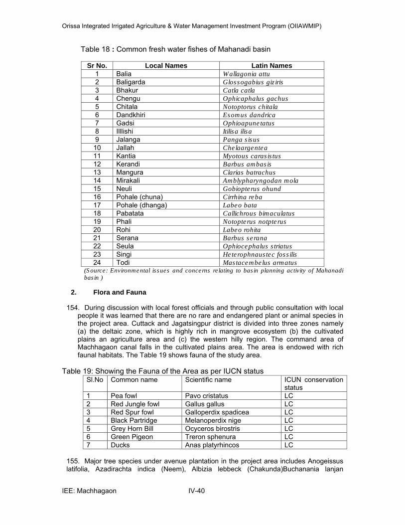
Orissa Integrated Irrigated Agriculture & Water Management Investment Program (OIIAWMIP)
IEE: Machhagaon IV-40
Table 18 : Common fresh water fishes of Mahanadi basin
Sr No. Local Names Latin Names 1 Balia Wallagonia attu 2 Baligarda Glossogabius giziris
3 Bhakur Catla catla 4 Chengu Ophicaphalus gachus
5 Chitala Notoptorus chitala 6 Dandkhiri Esomus dandrica 7 Gadsi Ophioapunetatus 8 Illlishi Itilisa ilisa 9 Jalanga Panga sisus
10 Jallah Chelaargentea11 Kantia Myotous carasistus 12 Kerandi Barbus ambasis 13 Mangura Clarias batrachus 14 Mirakali Amblypharyngodan mola 15 Neuli Gobiopterus ohund
16 Pohale (chuna) Cirrhina reba 17 Pohale (dhanga) Labeo bata 18 Pabatata Callichrous bimaculatus 19 Phali Notopterus notpterus 20 Rohi Labeo rohita 21 Serana Barbus serana 22 Seula Ophiocephalus striatus
23 Singi Heterophnaustec fossilis 24 Todi Mastacembelus armatus
(Source: Environmental issues and concerns relating to basin planning activity of Mahanadi basin )
2. Flora and Fauna
154. During discussion with local forest officials and through public consultation with local people it was learned that there are no rare and endangered plant or animal species in the project area. Cuttack and Jagatsingpur district is divided into three zones namely (a) the deltaic zone, which is highly rich in mangrove ecosystem (b) the cultivated plains an agriculture area and (c) the western hilly region. The command area of Machhagaon canal falls in the cultivated plains area. The area is endowed with rich faunal habitats. The Table 19 shows fauna of the study area.
Table 19: Showing the Fauna of the Area as per IUCN status
Sl.No Common name Scientific name ICUN conservation status
1 Pea fowl Pavo cristatus LC 2 Red Jungle fowl Gallus gallus LC 3 Red Spur fowl Galloperdix spadicea LC 4 Black Partridge Melanoperdix nige LC 5 Grey Horn Bill Ocyceros birostris LC 6 Green Pigeon Treron sphenura LC 7 Ducks Anas platyrhincos LC
155. Major tree species under avenue plantation in the project area includes Anogeissus latifolia, Azadirachta indica (Neem), Albizia lebbeck (Chakunda)Buchanania lanjan
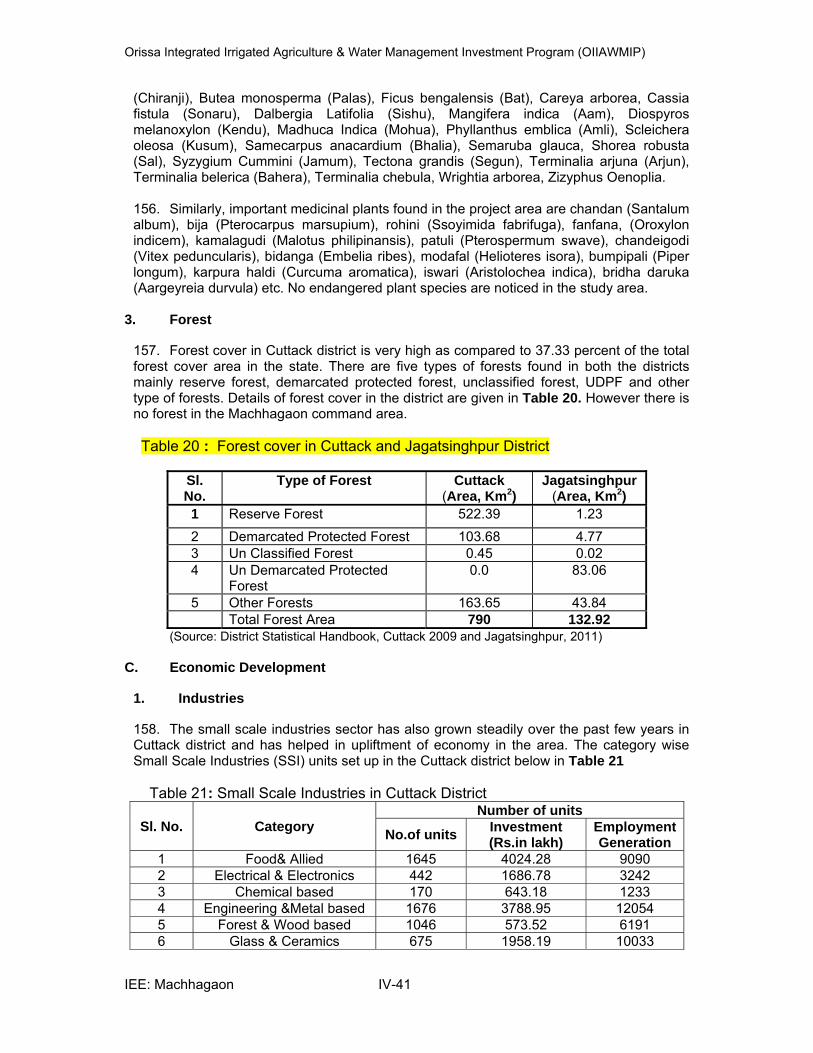
Orissa Integrated Irrigated Agriculture & Water Management Investment Program (OIIAWMIP)
IEE: Machhagaon IV-41
(Chiranji), Butea monosperma (Palas), Ficus bengalensis (Bat), Careya arborea, Cassia fistula (Sonaru), Dalbergia Latifolia (Sishu), Mangifera indica (Aam), Diospyros melanoxylon (Kendu), Madhuca Indica (Mohua), Phyllanthus emblica (Amli), Scleichera oleosa (Kusum), Samecarpus anacardium (Bhalia), Semaruba glauca, Shorea robusta (Sal), Syzygium Cummini (Jamum), Tectona grandis (Segun), Terminalia arjuna (Arjun), Terminalia belerica (Bahera), Terminalia chebula, Wrightia arborea, Zizyphus Oenoplia.
156. Similarly, important medicinal plants found in the project area are chandan (Santalum album), bija (Pterocarpus marsupium), rohini (Ssoyimida fabrifuga), fanfana, (Oroxylon indicem), kamalagudi (Malotus philipinansis), patuli (Pterospermum swave), chandeigodi (Vitex peduncularis), bidanga (Embelia ribes), modafal (Helioteres isora), bumpipali (Piper longum), karpura haldi (Curcuma aromatica), iswari (Aristolochea indica), bridha daruka (Aargeyreia durvula) etc. No endangered plant species are noticed in the study area.
3. Forest
157. Forest cover in Cuttack district is very high as compared to 37.33 percent of the total forest cover area in the state. There are five types of forests found in both the districts mainly reserve forest, demarcated protected forest, unclassified forest, UDPF and other type of forests. Details of forest cover in the district are given in Table 20. However there is no forest in the Machhagaon command area.
Table 20 : Forest cover in Cuttack and Jagatsinghpur District
Sl. No.
Type of Forest Cuttack (Area, Km2)
Jagatsinghpur (Area, Km2)
1 Reserve Forest 522.39 1.23
2 Demarcated Protected Forest 103.68 4.77 3 Un Classified Forest 0.45 0.02 4 Un Demarcated Protected
Forest 0.0 83.06
5 Other Forests 163.65 43.84 Total Forest Area 790 132.92
(Source: District Statistical Handbook, Cuttack 2009 and Jagatsinghpur, 2011)
C. Economic Development
1. Industries
158. The small scale industries sector has also grown steadily over the past few years in Cuttack district and has helped in upliftment of economy in the area. The category wise Small Scale Industries (SSI) units set up in the Cuttack district below in Table 21
Table 21: Small Scale Industries in Cuttack District
Sl. No. Category Number of units
No.of units Investment (Rs.in lakh)
EmploymentGeneration
1 Food& Allied 1645 4024.28 9090 2 Electrical & Electronics 442 1686.78 3242 3 Chemical based 170 643.18 1233 4 Engineering &Metal based 1676 3788.95 12054 5 Forest & Wood based 1046 573.52 6191 6 Glass & Ceramics 675 1958.19 10033
Orissa Integrated Irrigated Agriculture & Water Management Investment Program (OIIAWMIP)
IEE: Machhagaon IV-42
7 Textile based 111 213.64 629 8 Leather units 551 879.28 3437 9 Paper 219 956.59 1133
10 Rubber & Plastic 1084 836.88 7091 11 Repairing & Servicing 1356 2425.93 5901 12 Miscellaneous 1888 2269.65 7154
TOTAL 10863 19380.44 67268 Source: official Website of Cuttack (www.cuttack.nic.in)
159. In addition to this there are many large and medium industries in Cuttack district. 160. Paradeep Port a glory of the Odisha state representing industrial growth & economic prosperity belongs to the Jagatsinghpur district. .Paradeep and Tirtol are the two Industrial areas of the District. In Jagatsingpur district the famous POSCO integrated steel plant is under construction. There are number of handloom and cottage industrial units are located in Jagatsingpur district.
2. Transportation
161. Cuttack is connected by National Highway NH-5 and runs through the district for 85.75 km and connects Cuttack to important cities like Baripada and Baleshwar. This district is also well connected with the National Highway no. 5A, comprising a running length within the district of 77 kms. Apart from the national and state highway, major district road runs for 461.50 km within the state, reaching all corner of the district. The Machhagaon canal is approachable from Cuttack- Paradeep road. 162. Jagatsinghpur district is well connected by road & rail. The existing length of highways and roads are given in Table 22 below.
Table 22: Length of highways in Cuttack & Jagatsinghpur districts
Sl no
Types Cuttack District Jagatsinghpur District
1 National Highway 64 10 2 State Highway 118 133 3 Major Hoghway 316 41 4 OtharDistrict Road 443 203 5 Rural Road 1257 807 6 Gram Panchayat Road ------- 1570 7 Forest Road 204 ------- 8 Railway Lines 114 68.12 9 Railway Stations 20 9
( Source: District Statistical Handbook Cuttack 2009 & Jagatsinghpur 2011)
3. Agricultural and Mineral Development
163. Cuttack is divided into three agro-climatic zone viz. a) marshy strip of Bay of Bengal. This low land impregnated with salt and unsuitable for cultivation, b) Alluvial plains forming the delta of Mahanadi River, c) Hilly regions which are sterile land covered with bamboos and scrub jungles. Agriculture constitutes the main source of rural livelihood and incomes. Rice and Paddy is the main food crop grown in this area. 164. The Major food crop grown in Jagatsinghpur is paddy, Sugarcane, turmeric and cotton are the major commercial crops. The district enjoys rich fertile soil of the Mahanadi,
Orissa Integrated Irrigated Agriculture & Water Management Investment Program (OIIAWMIP)
IEE: Machhagaon IV-43
enough water resources and receives substantial rainfall which is conducive for raising good crops. 165. At Jagatsingpur district no mineral resources are available but at Cuttack district few fireclay mines (7 nos.) are in operation.
D. Social and Cultural Resources Population and Communities
1. Demographic Status
166. Total population of Cuttack district is 2,624,470 out of which 1,888,423 is the rural population and 736,047 is the urban population, which constitutes about 28.05% of urban population. The population of schedule cast 498,633 or 19% to the total population and schedule tribe is 93,745 04 3.6% of total population . A detail of demographic structure of the Cuttack district is given in Table 23.
Table 23: Demographic Pattern of Cuttack District
(Source: census 2011)
167. Total population of Jagatsinghpur district is 1,136, 971 out of which 1,020,991 is the rural population and 115,980 is the urban population, which constitutes about 10.2% of urban population. The population of schedule cast is 248,152 or 21.83 % of total population and schedule tribe is 7,862 or 0.7% of total population. A detail of demographic structure of the Jagatsinghpur district is given in Table 24.
Table 24: Demographic Pattern of Jagatsinghpur District
(Source: census 2011)
168. Jagatsinghpur District ranks first in the State by achieving 88.96 % male literacy rate according to the latest census of 2001 and second in female literacy rate at 69.94% after
Total Population 2,624,470
Rural Population 1,888,423
Urban Population 736,047
SC Population 498,633
ST Population 93,745
Percentage of Urban Population to Total Population 28.0 % Number of females per Thousand Male 940
Population density per Sq.Km 667 Decennial growth rate percentage 1991-2001(P) 12.1
Total Population 1,136,971
Rural Population 1,020,991
Urban Population 115,980
SC Population 248,152
ST Population 7862
Percentage of Urban Population to Total Population 10.2% Number of females per Thousand Male 967
Population density per Sq.Km 683 Decennial growth rate percentage 1991-2001(P) 7.5

Orissa Integrated Irrigated Agriculture & Water Management Investment Program (OIIAWMIP)
IEE: Machhagaon IV-44
Khurda District. While the provisional census 2011 states, among the males the highest literacy rates is recorded in the district of Jagatsinhpur ( 93.20%). The District is predominantly agrarian. It has been experiencing natural calamities like floods and cyclones which are major hindrance in the economic development. (Source: District website). 169. The command area is spread over 6 blocks of Jagatsinghpur district and one block of 498 villages with a total number of beneficiaries 58,338 covering an area of 34,870 Ha. The population details of the blocks covered under the project is given in Table 25.
Table 25: Population details of the blocks covered under the project
S.no Name of the Block and district
Total Population SC Population ST Population
1 Sadar, Cuttack district 130385 37578 4420
2 Biridi Jagatsinghpur district 75352 24067 341
3 Balikuda 151279 29646 257
4 Jagatsinghpur, 132539 32276 540
5 Nuagaon 73316 13396 247
6 Raghunathpur 77583 18584 934
7 Tirtol 149590 29782 741
Total 790044 185329 7480
( Source: 2001 census, District Statistical Handbook, Cuttack and Jagatsinghpur districts)
170. The block level information for 2011 census is under finalization, so 2001 census is used. The sub-project covered blocks have around 790044 total populations of which SC population is around 24.5 % and ST population is around 0.94% as per 2001 census.
2. Places of Historical, Archeological and Religious Significance
171. Cuttack city houses the Barabati Fort, a nine storey palace of the Ganga dynasty lies on the bank of Mahanadi River. Qadam-I-Rasool, a sacred shrine for Muslims is situated in the centre of Cuttack city and Netaji Seva Sadan, a birth place of Netaji Subhash Chandra Bose is located in Oriya bazaar of town.
172. In Jagatsinghpur district Garh Kujanga (Kunjabehari Matha) and Jhankada are the religious centre. Paradepgarh (Sandhakuda) is the historical site of the district.
Orissa Integrated Irrigated Agriculture & Water Management Investment Program (OIIAWMIP)
IEE: Machhagaon V-45
V. ANTICIPATED ENVIRONMENTAL MPACTS AND MITIGATION MEASURES
A. General
173. The positive and negative impacts associated with this project are described in this chapter. The impacts associated during the construction phase of the project will be temporary and short term in nature. During the operation phase, impacts associated may have longer term effects. For purposes of this IEE report the environmental impacts in the study area have been discussed during the construction and operation phase of the project. Identification of these impacts is followed by recommendations of appropriate cost effective mitigation measures. These impacts along with the mitigation measures are given in the following sections.
B. Sub Project Activities
174. In Machhagaon priority for infrastructure works is as follows:
(i) Works to ensure safety / integrity of irrigation system, for example canal lining / left bank stability measures near RD 10.115 Km where high seepage from the canal which is in high fill may otherwise lead to earthworks failure.
(ii) Improved hydraulic performance of first main and then distribution canals, checking for prism/ trapezoidal shape and stability and remodeling using regime principles.
(iii) Desiltation, weed removal and by bringing back canal section to design sections
(iv) Hydraulic control structures for improved flow control and flow measurement along first the main and then distributary canals to the heads of minor canals.
(v) Repair and reconstruction and existing structures that are defunct and construction of new structures
(vi) Reconstruction of existing bridges and construction of new bridges for improved access across canals.
(vii) Resectioning of Minor and sub minor canal systems. (viii) Provision of drilling for new tube wells along the canal system
175. Activities related to Machhagaon Subproject, however, are listed below::
1. Subproject Activities during construction phase
176. The following are the activities to be carried out during construction phase The cistern of weir cum falls built with laterite stone masonry covered with cement
concrete are damaged and needs replacement with RCC structures, replacement of damaged downstream protection works and repair of wing walls etc
The main canal will be remodeled as per design section along with lining and strengthening and widening of the embankment as per requirement.
Distributaries, minors, sub-minors will also be remodeled as per design section. Provision of lining and guard walls where ever necessary Extension, renovation and modernization of the existing head and cross regulators
which involves provision of new gates, separate gate operating platform and bridge decks, improved and more gradual transitions, gauges and flow measurement structures.
Construction of new hydraulic structures in place of old ones which are in a dilapidated condition.
Repairing of existing bridges and construction of new bridges / culverts as per requirement.

Orissa Integrated Irrigated Agriculture & Water Management Investment Program (OIIAWMIP)
IEE: Machhagaon V-46
Repairing of the balance hydraulic structures Construction of new hydraulic structures as per requirement. Protection of embankments by way of turfing and plantation Improvement of
inspection / patrol road. Repair of existing outlets and construction of new out lets as per the demand and
technical feasibility Drilling of tube wells along the canal system
177. Rehabilitation works for the structures are summarized below in Table 26
Table 26 Structure Rehabilitation Works for Main Canal Distributaries, Minors & Sub-minors
S.No Type of
Structure Total as per Inventory
To be Repaired/ Renovated
New Construction
1 Head Regulator 186 176 0 2 V.R Bridge 431 112 77 3 Fall 4 0 0 4 Aqueduct 2 0 0 5 Canal syphon 0 0 0 6 Drainage Syphon 194 171 0 7 Escape 3 3 0 8 Cross Regulator 93 84 4 9 CR cum Escape 0 0 010 VRB cum Fall 4 4 0 11 VRB cum CR 25 0 0 12 Outlet 3385 3059 0
(Source: DPR July 2011)
2. Sub Project Activities during operation phase
178. The following are the activities that are to be undertaken during operation phase Maintenance of water availability Maintenance of canal through desilting operation and removal of weeds and grasses Awareness raising of the farmers / PP members for not letting drainage into the
canals and washing of animals in the canal. Maintain drainage system of agricultural field
C. Possible Environmental Impact and Mitigation Measures
179. The proposed project will have impacts on the environmental in different phases:
• Due to Project Location • During site selection, Planning and design phase • During the construction phase • During operation phase
1. Impacts due to Project Location
180. The environmental issues that may arise due to the present project location are minimal:
As per the resettlement plan(RP) the sub project would not entail land acquisition as existing right of way (ROW) is sufficient. However the project would entail loss
Orissa Integrated Irrigated Agriculture & Water Management Investment Program (OIIAWMIP)
IEE: Machhagaon V-47
of assets and livelihood of people settled (non title holders) on either side of the existing embankment. As per the RP prepared during January 2013 shows encroachments totals to 900 units (out of which 338 are residential, 473 commercial and 89 common property resources) for more details kindly refer RP plan for Macchagaon.
However some details of encroachments which were noticed during preliminary environmental survey are also detailed here (Main canal – RD 0 to 1.00; 2.0; 2.3; 4.5; 5.6; 6.7;7 to 8; 8.900; 9.100; 10.00 to 11.00; 11.300; 12.13; 13.14; 14.600; 14.700 to 15.300; 18.000 to 19.300; 22.800 to 24.400; 26.200; 27.500, 28.200,29.700; 30.500;30.538; 31.0 to 32.0(Canal bank constructed houses – Bengali refugies) ; 39.400; 36.500; 34.00; 45.000 to 45.200; 48.000 to 49.000 km; Disty No -1 RD – 0 to 1.000; 1.4 to 1.8; 2.0 to 3.0; 3.6 to 3.9 km; Disty No -2 RD 1.900 to 2.205; 3.500 to 4.200; 5.200 to 6.000; 6.200 to 6.400; 7.00 to 7.400; 7.430 to 7.606 km; Disty – No. 2C RD 0.900 to 1.562 km; Disty No –2D – RD 0.00 to 0.85 km; Disty No-2E – RD 0.000 to 0.400; 1,05 to 1.500; 2.3 to 2.500; 3.05 to 3.9; 4.7 km; Disty .No -3 RD 0.100 to 0.500; 1.80 to 1.90 km; Disty. No -3A – RD 0.250 to 0.450 km; Disty No -4 –RD 0.00 to 0.09; 0.210 to 0.800;1.4 to 2.300; 3.8 to 6.300; 8.400 to 8.800 km; Disty . No – 4A – RD 1.3 to 1.5; 1.7 to 1.9 km; Disty No -5 – 0.600 to 0.800; 1.2 to 1.600; 2.200 to 3.000 km; Disty. No- 5A – RD 0.200 to 0.600 km; Disty No. 5B – RD 1.8 to 3.1km; Disty .No 5C – RD km 0.5 to 0.8; 1.1 to 1.4; 1,9 to tail; Disty No – 6 – RD 0.03 to 0.250; 0.900 to 1.20; 1.5 to 2.1; 2.800 to 3.200; 4.8 to 5.8 km; Disty No – 6C – RD 0.20 to 0.40; 3.20 to 3.500;3.6 to 3.8km; Disty No – 6D- RD 0. 800 to 1.1 km; Disty No – 6E – RD 0.20 to 0.90; 1.80 to 2.1km; Birampur sub-minor – RD 0.00 to 0.40 km; Disty No -7 RD – 5.95; 8.44; 8.5; 17.0; 17.50; 18.50 km; Disty No – 7 B – RD 0.550; 0.900; 1.200; 1.41; 1.62 km; Disty no. 7 B-1 – RD 0.110 km; Disty No- 8 RD – 6.202; 8.860,11.117; 11.404, 11.050;12.000; 12.100; 13.200;14.500; 14.610 km; Disty No- 9 RD – 0.500; 1.000; 1.100; 2.500; 2.900; 3.100 km; Disty No 10 main RD – 0.3 to 0.650; 1.3 to 1.4; 1.850 to 1.950; 2.010 to 2.050; 2.3 to 2.45; 2.65 to 2.67; 2.9 to 2.95; 3.5 to 3.6 km; Disty No. 10C RD – 0.2 to 1.000( refugies); Disty no- 13 RD – 2.900; 4.600; 6.400; 10.80 km; Disty no – 13C – RD 0.70; 0.90; 1.00; 2.05 km; Disty No – 13F – RD 0.300 km; Disty. No -14 – 1.100 to 1.300 km; Disty. No 15A – 4.000 to 4.500 km; Disty no – 19A – 0.847;3.012 to 3.112; 9.540 km; Sub-minor -9F – RD 0.100; 0.350; 0.450; 0.600; 1.100; 1.500km; Sub-minor 9D – RD 0.000 to 1.000 km; Olando minor RD – 0 to 0.500; 0.75 to 1.35 km; Hazipur minor RD – 0.1; 0.221; 1.75; 2.3 km; Hazipur minor – A RD 0 to 1.35 km; Hazipur minor B branch – RD 0. 17 km; Bagula minor RD – 0 to 1.0; 1.2 to 1.540 km ; Paramahans minor RD – 0.7 to 1.03 km; Bagalpur Disty – RD 2.3 ; 5.7; 7.7; 7.75; 7.90 to 12.16 km; Kamalpur minor – RD 0. 022; 0.50 km; Chasikthanda minor – RD 0.2 to 0.5 km; Gayichara left minor – 0.8 to 1.5 km; Gayichara right minor – RD 0.018, 0.01; 0.9;1.3; 1.52; 2.01 to 4.45 km; Bambilo Disty – RD 6 to 10.00 km etc.,) Within the ROW.
No forest land except in Distributary No-7 from RD 14 to 16 Km as it is an existing canal system no additional impact is anticipated except some trees that are also found on the existing canal embankments may get affected
No archaeological, monumental, and cultural sites are present along the ROW except few temples with in ROW
Utilities like electric poles / line, transformers were noticed on the canal embankment either passing adjacent or at places crossing the canals in different sections of the main canal, distributaries, minors and sub-minors (Main canal RD km 6.07; 8.09; 9.1; 9.1 26 to 31 km; Disty no-1; Disty No -2; Disty No-2E ; Disty .No -2D; Disty. No 8, Disty. No -9, Disty No. 14, Disty No. 15A; 15C; 15B Sub-Minor -9F; Sub-minor 9E; Sub-Minor 9C. Bagalpur disty; Kamalpur
Orissa Integrated Irrigated Agriculture & Water Management Investment Program (OIIAWMIP)
IEE: Machhagaon V-48
minor; Chasikanda minor; Gayichara left minor; Gayichara right minor; Bambilo Disty; Disty No - 8 B; Radhanga minor; Alla minor; Murunia minor; Khuja sub-minor; Damodharpur minor; Disty No 8 C; Icchapur minor; Chandagarh minor; Disty No – 10 main; Disty No – 10B; Disty 10B A-1; Disty 10B A; Disty 10C; Disty 10 D; Disty 10 E; Disty No 10E-1; Arilo sub minor; Disty No – 10 F; Disty no – 10 G; Disty 10 H; Disty 10 I; Disty 10M; Disty . No 10 – N; Disty No 10 J; Disty . No – 10k; Disty . No 10L; Disty No – 10 O; Disty No 10 P etc., and other minors and sub-minors) in these canals some poles / lines shall be obstructing needs shifting. Even at places the water pipe lines ( Water pipeline Disty 8 – RD 7.688 to 9.480 km; Disty no- 7 – 4.6 to 6.42; 8.22 to 8.55; 9.5 to 10.0 km; Disty . No – 7B-1 RD 0 to 0.800 km; passes on the canal embankments.
181. The mitigation measures proposed are:
Proper planning and precautions would be taken by the contractor while executing the works in consultation with the PP members and local people
DoWR with the help of ISPMC Resettlement Specialist conducted a survey and a detailed RP plan has been prepared, RP implementation cost will be borne by the executing agency (EA) and the livelihood assistance cost will be borne out of the OIIAWMIP loan fund for RP implementation. The proposed RP budget works out to Rs. 80,53, 547 ($ 1,46,237) for more details refer Resettlement Plan for Machhagaon prepared and submitted to ADB during January 2013
During the survey SIO along with the survey team and Design Engineers shall identify the number of trees likely to get affected and to the possible should avoid tree cutting.
During survey and design the SIO staff shall identity the electric poles / lines / transformers and water pipelines in consultation with the design team that need to be shifted.
No additional impact is anticipated as it is an existing canal system where distributary No-7 passes through Dhartangad R.F at 14 to 16 km and some trees present on the canal system my get affected so SIO has to obtained permission for undertaking repair in the Dhartangad R.F and if any trees that need to be cut shall obtained permission from State Forest Department.
2. Impacts during Planning and Design Phase
182. The planning phase will include further detailed topographic and geotechnical surveys and hydrological assessments which will provide information for the detailed design of the scheme. As such impacts during this planning phase may be limited to erroneous or inadequate field assessments and data interpretation. These impacts could manifest themselves in the following manner:
Incorrect survey in order to align / resection of canal. This may result in loss of
cultivated land or encroachment of community owned land; Incorrect hydrological assessment of flood magnitude, drainage problem resulting in
under-design of conveyance system, leading to hydraulic/structural failure; Incorrect and insufficient geotechnical survey which does not adequately taken into
account the geology of the area. Designing of canals to suit the additional command area that are converted to
agricultural lands from forest and grazing lands etc., Designing and repair / renovation of CD work’s to improve drainage conditions in the
command area. Some large girth trees present on the embankment may may require cutting Utilities like electric poles / electric lines were found within the ROW on the canal
embankment
Orissa Integrated Irrigated Agriculture & Water Management Investment Program (OIIAWMIP)
IEE: Machhagaon V-49
No Archaeological sites are within the project area but while excavation work chance find protocol would be used.
Identification of potential sites or locations for drilling tube wells
Adequate provision for weed removal especially water hyacinth
183. The mitigation measures proposed would include:
Thorough hydrological assessment using all available background data and making use of flood simulation software to better estimate optimum design flows. This is to be conducted as the starting point to the design process and will be checked and verified in accordance with project quality assurance procedures;
A geotechnical survey, topo survey and a soil survey particularly along the axis of the canal side should be conducted at the beginning of the design process to reduce the risk of costly design revisions during construction, or worse the failure of a scheme due to a design based on erroneous parameters;
The design should be checked in accordance with project quality assurance and quality control procedures.
Proper designing of the minor and sub-minors would be carried out keeping in view of the additional carrying capacity to support the increased command areas without affecting the tail end users.
During project planning proper drainage arrangements shall be planned in consultation with the drainage division. As part of the improvement to the drainage problem within the command, There are total 194 drainage siphons in the command area out of which 171 are proposed for repair and renovation. These are old concrete hume pipe constructions and need replacement. The upsteam and downstream wing, cistern and return wall are damaged over a period of time needs renovation to overcome the drainage problem in the command area.
Some large girth trees present on the canal embankment may require removal or tree cutting. During survey and design SIO staff along with survey team and in consultation with design engineers shall identify the number of trees that may get affected. To the possible extent tree cutting shall be avoided, if any tree shall be removed from the ROW before commencement of actual work it shall be done in consultation and with the permission of State Forest Department. Stacking, transport and storage of wood shall be done as per the relevant norms. All efforts shall be made to preserve the trees to the possible extent.
Utilities like electric poles / lines /transformers/ water pipelines existing within ROW may be damaged while widening or strengthening the canal embankment or may cause hindrance to the movement of construction equipment, the SIO in consultation with design team should identify the need for shifting such poles, if they need to be relocated proper planning and contingency for shifting need to be planned by the SIO in consultation with the PMU
Disposal sites locations, refuse piles, storage facilities, fuel storage areas, seepage pits, pit toilets, septic tanks, surface water bodies, drains, field fertilized with dung., shall be away from tube well locations.
3. Impacts during Construction Phase
184. During the construction phase the following activities may be considered to be important towards the development of impacts:
• Pre-construction activities like selection of Camps, Borrow areas, Quarry etc
• Construction Method
• Source of materials and process of procurement of material like earth from borrow areas, Quarry areas, mining of sand
Orissa Integrated Irrigated Agriculture & Water Management Investment Program (OIIAWMIP)
IEE: Machhagaon V-50
• Transportation of construction materials used in the construction
• Storage of materials and
• Work site maintenance and
• Labour related issues like their shelter, facilities etc
185. Most of the impacts during construction phase are temporary or short term in nature and can be mitigated by using appropriate methods.
Construction Method
186. Rehabilitation and resection of the existing canal system will involve earth moving equipment like excavators, rollers, tippers, tractors, concrete mixers, vibrators, dozers, etc and stripping and leveling of borrow areas etc. Materials will be brought through trucks and offloaded and lifted through manually (head load) where the approach roads in the minors and sub minors are narrow. Excavation and manual digging and cutting would be involved. The excess material would be disposed off within the low lying areas of right of way.
i. Pre construction activities by the contractor
After finalizing the contractor before the contractor commence his work Contractor shall identify potential sites for work camps , stockpiles, storage areas and disposal sites with the help of SIO staff and takes the approval of the SIO manager.
Contractor shall identify the potential locations for sources of borrow areas, quarry and other materials if any required and take the prior approval of the SIO Manager and apply for any approvals from appropriate agencies if required
187. The mitigation measures proposed are:
The responsibility of establishing camps, stock piles, storage areas and disposal sites mainly lies with the Contractor. The contractor shall identify potential sites with the help of SIO. If the sites selected should not cause any damage to property, vegetation, irrigation, drainage and drinking water supply. Residential areas will not be considered and sensitive locations like schools and sanctuaries need to be avoided. All locations identified for disposal need to be included in the design specifications and on plan drawings.
a) Camp
• Contractor shall avoid establishment of camp / plant in forest areas. • Contractor shall prioritize areas within or nearest possible vacant space within the
subproject without affecting property, forest, vegetation, drinking water sources and away from the water bodies and the canal system.
• All construction plants shall be sited sufficiently away from the settlements and agricultural operations or any commercial establishments. Such plants shall be located at least 100m away from the nearest dwelling preferably in the downwind direction.
• The Contractor shall submit a detailed layout plan for all such plant sites established and approved by the SIO manager.
• If any contractor has to establish crushers, hot mix plants and batching plants shall comply with the requirements of the relevant emission control legislations. Consent for Establishment and Operation from state pollution control board Odisha shall be obtained before establishment and operation and a copy to be submitted to the SIO Manager.

Orissa Integrated Irrigated Agriculture & Water Management Investment Program (OIIAWMIP)
IEE: Machhagaon V-51
• Arrangements to control dust pollution through provision of wind screen, water sprinklers and dust extraction systems shall have to be provided at all such sites (plants).
b) Borrow areas
• If earth material is required or need to procure from borrow pits. • Finalisation of borrow areas for earth and all logistic arrangements as well as
compliance to environmental requirements, as applicable shall be the sole responsibility of the Contractor.
• Contractor shall identify the potential borrow areas and take permission from SIO manager before operating any borrow areas.
• Contractor shall identify the potential borrow areas and take permission from SIO manager before operating any borrow areas. Earth material should be taken from barren land or selected borrow area during lean period as per IS Code 1498 after taking approval from SIO Manager. The criteria of selection is as follows:
Selection Criteria of Borrow areas is as follows: IS 4701: 1982
• No borrow pits shall be dug within 5m of the toe of the embankment, if the depth of the borrow pit is less than 0.5m it shall be after 5m of the toe of the embankment and if the pit depth shall be more than 0.5m it shall be 10m of the toe of the embankment or within such a distance from the toe of the bank where a 4:1 hydraulic gradient line cuts the ground surface, which ever more.
• Borrow pits shall not be more than 1m in depth and 25 m in length. • A clear distance of 1m shall be left between the pits • The bed of borrow pits shall be left reasonably smooth and even. • The contractor shall not be permitted to lift any material from the forest areas. • The contractor shall not start borrowing earth from selected borrow area until the
mutual agreement is signed between landowner and Contractor. Copy of the document shall be submitted to SIO manager.
• The Contractor in addition to the established practices, rules and regulation will also consider following criteria before finalizing the locations. 1) The borrow area should not be located in agriculture field unless unavoidable i.e.
barren land is not available. 2) The borrow pits should not be located along the roads. 3) The loss of productive and agricultural land should be minimum. 4) The loss of vegetation is almost nil or minimum. 5) Sufficient quality of soil is available. 6) The Contractor will ensure the availability of suitable earth. The Contractor shall
obtain representative samples from each of the identified borrow areas and have these tested at the site laboratory following a testing programme as approved by the concerned Engineer.The Contractor after award of the contract may identify the potential private lands for borrow areas and he will take the approval for the borrow areas after testing the suitability and enter into mutual agreement with the land owners. As per the contractual conditions Contractor will arrange sites for borrow areas by making an agreement with the land owner, and he will also ensure to take the necessary permission for operating these borrow areas. The necessary royalty would be deducted by the SIO staff from the Contractor. Contractor would try to procure earth within a lead of 5 Km of the canal system in small quantities. Planning of haul roads for accessing borrow areas shall be undertaken during this stage. The haul roads shall be routed to avoid agricultural areas as well as forest areas as far as possible and shall use the existing village roads wherever possible.
Orissa Integrated Irrigated Agriculture & Water Management Investment Program (OIIAWMIP)
IEE: Machhagaon V-52
c) Quarry areas
• The Contractor shall finalize the quarry for procurement of construction materials after assessment of the availability of sufficient materials, quality and other logistic arrangements.
• A preliminary survey has been carried out by the SIO and identified the quarry as mentioned in Chapter 3, section 12,
• If extraction shall be done, prioritize sites already permitted by the Mining or concerned department,
• Contractor shall purchase materials and finalize vendors who have valid permissions. The list of potential crusher who has valid license from State Pollution Control board, Odisha is enclosed for reference as Annexure 2.
• If other sites are necessary and the contractor want to use, let the contractor obtain necessary permission from the concerned regulatory authority and inform SIO Manager.
• The contractor shall avoid all forest areas for quarrying
d) Sand
• The sand shall be procured from identified (by SIO) sand mines as far as possible. If Contractor wishes to procure from other sources he shall obtain the lease agreement of the supplier
188. Most of the impacts during construction phase are temporary or short term in nature
and can be mitigated by using appropriate methods a. Impact on Land Use:
189. Land acquisition will be not required for the said major irrigation project. No major adverse impact is expected on the living conditions of the inhabitants. Storage of construction materials and silt at construction sites may temporarily change local land use status. The disposal of debris and silt shall be done properly
190. The mitigation measures proposed are: 191. The Contractor while working in main canal, distributaries and minors and WUAs
while working in sub-minors shall ensure the following:
Construction materials / silt should be stored properly and proper appropriate measures shall be taken while disposing the debris and silt.
To the possible extent the materials like stone and other reusable materials shall be utilized in the construction.
The iron and wood if any generated shall be taken into the surplus stock and the scrap shall be auctioned as per the procedures of Odisha Water Resources Department.
The suitable material generated from cutting shall be used in the filling after material testing and obtaining necessary approval from the SIO. The remaining unsuitable material shall be disposed on the left side of the main canal after the toe line within the ROW and also in the adjacent suitable available land along the canal after obtaining necessary permission from the competent authority.
b. Impact of soil – soil erosion and siltation:
192. Degraded embankments, damage to soil and general land value. Increased sedimentation build-up and clogging of surrounding waterways. Soil erosion will take
Orissa Integrated Irrigated Agriculture & Water Management Investment Program (OIIAWMIP)
IEE: Machhagaon V-53
place during earthworks, such as filling and cutting for re-sectioning of the canals. The impact will be localized, short-term and minor. These activities will be conducted in the dry season. Measures to mitigate generation of excessive dust will be taken up by the contractor. Further safeguards associated with on-site activity and clean-up will be incorporated into the procurement documents. Improper excavation of borrow area might lead to water logging.
193. The mitigation measures proposed are: 194. The Contractor while working in main canal, distributaries and minors and WUAs
while working in sub-minors shall ensure the following:
carry out excavations operations and slope stabilization work during the dry season only
use silt traps Careful construction planning for surface protection particularly before monsoon season
Earth material and selection of Borrow area as per IS code 1498 1970 reaffirmed 1970.
Earthworks operations shall be strictly limited to the areas to be occupied by the permanent works and approved borrow areas and quarries, unless otherwise permitted by the Project Manager. Due provision shall be made for temporary drainage. Erosion and/or instability and/or sediment deposition arising from earthwork operations not in accordance with the Specifications shall be made good immediately.
The Contractor shall obtain the permission of the Project Manager before opening up any borrows or quarries. Such borrow pits and quarries may be prohibited or restricted in dimensions and depth by the Project Manager where:
(i) they might affect the stability or safety of the Works or adjacent property; (ii) they might interfere with natural or artificial drainage or irrigation; (iii) they may be environmentally unsuitable. (iv) the contractor should enter into an equitable agreement with landowner for
borrow area redevelopment if any landowner requires and after completion of the borrow area the contractor obtains a “Satisfaction Letter “ or “No – objection Letter” from the land owner on a stamp paper preferably.
At least 14 days before he intends to commence opening up any approved borrow pit or quarry, the Contractor shall submit to the Project Manager his intended method of working and restoration. These shall include but not be limited to:
(i) the location, design and method of construction of any access track;
(ii) the volume and nature of materials to be removed; (iii) the sequence and method of excavation of materials; (iv) measures for controlling runoff and sediment from the site during operations;
and
Proposals for site restoration including approximate finished levels, drainage, erosion and sediment control, slope stabilisation and re-vegetation, including reinstatement of any access track.
The operation of borrow pits or borrow areas shall not be permitted until the method of working for that particular pit or area has been approved by the Project Manager in writing. Restoration shall be to the satisfaction of the Project Manager
Soil erosion will take place during earthworks, such as filling and cutting for re-sectioning of the canals. The impact will be localized, short-term and minor. These activities will be conducted in the dry season. Mitigating and safeguarding measures
Orissa Integrated Irrigated Agriculture & Water Management Investment Program (OIIAWMIP)
IEE: Machhagaon V-54
to prevent excessive dust will be taken up by the contractor like sprinkling of water. Further safeguards associated with on-site activity and clean-up will be incorporated into the procurement documents.
The rehabilitation of the borrow areas shall be done by the contractor as per the land owners requirements.
c. Impact on Access Roads and Haulage Roads
195. Deterioration in quality of roads and damage to some of the existing bridges on the canal anticipated while transporting the materials
196. The mitigation measures proposed are:
197. The Contractor while working in main canal, distributaries and minors and WUAs
while working in sub-minors shall ensure the following
Limited construction period, careful planning on the movement of vehicles and restrictions on construction workers movement and adequate monitoring shall be carried out by the contractor
The main canal has at present 20 existing bridges( RD 3.60, 10.155, 15.725, 17.368, 19.536, 21.584, 26.236, 26.76, 28.19, 30.312, 31.172, 33.703, 34.006, 34.68, 35.00, 36.49 39.478, 40.42, 48.20, and 50.50 km) to facilitate movement of local people, which are in bad condition requiring repairs. Some of these bridge are over the regulating structures and one railway bridge at RD 0.470 km. Five of these bridges are wooden constructions and will be replaced with RCC bridges, so these bridges should be avoided to the possible extent.
All existing roads used by vehicles of the contractor or any of his suppliers of material, if damaged due to contractors vehicles, shall be maintained during construction period. Clear any materials dropped by the vehicles on the access roads.
d. Impact on Water Quality:
198. Water requirement for construction purposes is not large . Thus impact on water quantity is negligible. However there would be other minor impacts that may arise are:
Inadequate drainage in the temporary camp site resulting poor sanitation condition and surface and ground water pollution and promote breeding of mosquitoes.
Contamination of ground and surface water due to inappropriate disposal of spoil materials, debris and waste
Contamination of water due to fuels and lubricants and construction waste waters Erosion of embankments due to improper compaction
199. The mitigation measures proposed are:
200. The Contractor while working in main canal, distributaries and minors and WUAs
while working in sub-minors shall follow the below:
Proper disposal/reuse of construction spoils and silt generated from desilting operation considering environmental safeguard
Arrangement to drain out wastewater from construction site should be planned as per the site conditions i.e. along the natural gradients. The Contractors are hiring buildings for Camp as these are scattered works. If Contractor establishes any Camp he shall ensure adequate drainage and sanitation at the site.
Orissa Integrated Irrigated Agriculture & Water Management Investment Program (OIIAWMIP)
IEE: Machhagaon V-55
The contractor shall procure the fuel from the nearest authorized outlets, if any minor storage if he has to make he shall ensure he doesn’t contaminate the area.
Contractor shall avoid oil spillages etc., Contractor shall not wash his vehicles in the canals Contractor shall ensure or install equipments in such a way that the waste water
doesn’t enter the canal during monsoon season. Contractor shall ensure proper compaction after completion of the earthwork. for
the main canal compaction has to be done by Powered Road Roller or Vibratory Roller and in the distributaries, minors and sub-minors by hand roller.
To protect the canal from erosion in the completed earth work of the sections of the canals a provision for turfing has been made
e. Impact on Air Quality:
201. Deterioration of air quality would be mainly due to fugitive dust emission from construction activities, and gaseous emissions from construction equipments and vehicular movements. These impacts would be short term in nature and limited to the project site and construction phase only.
202. The mitigation measures to be adopted by contractors working in main canal, distributaries and minors and WUAs working in sub-minors are:
Contractor shall ensure trucks carrying soil, sand and stone will be duly
covered to avoid spilling. Contractor shall ensure adequate dust suppression measures such as regular
sprinkling of water. Contractor shall ensure that all construction equipments and vehicles are in good working condition, properly tuned and maintained to keep emissions within permissible limits.
f. Impact on Noise Level:
203. The construction phase will see the operation of only light construction machinery, which is known to emit sounds with moderate decibel (dB). Temporary impacts in the immediate vicinity of project site may occur due to noise generated from construction activities superimposed with existing vehicular noise. The magnitude of impact will depend upon specific types of equipment to be used, the construction methods employed and scheduling of the work. The construction noise will be intermittent and of short duration and mostly during day time.
204. The mitigation measures proposed are: all construction equipment and vehicles used in construction shall strictly
conform to the MoEF / CPCB standards. All vehicles exceeding the limits shall be fitted with exhaust silencers. Regular servicing of all construction vehicles and machinery shall be done
and during servicing the effectiveness of exhaust silencers shall be checked. All the construction sites within 150m of the nearest habitation, noisy
construction work such as crushing, operation of DG sets and any high noise construction equipments shall be stopped during night time between 10.00pm and 6.00 am.
g. Impact on Biological Environment:
205. The project site does not include any rare or endangered species of plant and animals. Thus, no impacts on rare / endangered species are envisaged due to site
Orissa Integrated Irrigated Agriculture & Water Management Investment Program (OIIAWMIP)
IEE: Machhagaon V-56
operations. The increased irrigation facilities in the area will actually enhance the environmental conditions resulting in more greenery. There is also a possibility of planting more trees by farmers due to the easy availability of water. Only few canal side trees will be felled during construction phase if unavoidable. There are no forest patches except in the Distributary No 7 from RD 14 to 16 km where the ROW is restricted to existing right of way only.
206. The mitigation measures proposed are: The Contractor while working in main canal, distributaries and minors and WUAs
while working in sub-minors shall follow the below: The sub-project has provision for planting around 3000 trees along the canal banks
against the tree loss if any Plantation of indigenous tree species along the irrigation canal compensates loss of
flora. The survival of trees needs to be monitored by the WUAs and SIO staff.
h. Impact on Social Environment
207. Most of the social impacts related to development of irrigation project are negative as well as positive. Some of the impacts and mitigation measures are as follows:
The sub project is to be implemented on a community participative basis, with full
consultation during the planning and design process. Most impacts pertaining to the establishment of the proposed scheme are
positive in nature, the soils in the area will become more stable and the area will have a source of irrigation and farm use water, which has a positive impact on the agriculture of the area, thereby enhancing farm incomes.
The subproject doesn’t entail any land acquisition as existing RoW is sufficient, however, in the sub project would entail loss of assets and livelihood of people settled (non –title holders) on either side of the existing canal embankments . The assets loss or encroachments are 900 (residential, commercial and common property resources)units as per the Resettlement Plan of Machhagaon prepared during January 2013. The proposed RP budget is Rs. 80,53,547($1,46,237), the RP implementation cost will be borne by the executing agency and the Livelihood Assistance cost will be borne out of OIIAWMIP loan fund. .
During the construction phase, there may be an influx of migrant skilled and unskilled workers in the project area. This will be restricted to the construction phase of the project. Efforts will be made to recruit local workers from the area as a priority to create employment opportunities and provide a sense of well being among local people as well as social compatibility among the people.
Labour/construction camps will be sited based on consultation with local communities with the priority of causing the least disruption to the residents and the surrounding environment. Transport routes for materials to the site, given the proximity of the residents houses etc. will also be selected with community consultation such that minimal disturbance will be made to residents. Given the proximity of the houses to the entry road to the site, the final selection of the entry route to the site for construction purposes will need to be carefully monitored for impacts during the construction period.
The location of key infrastructure under the main contract is located at a distance from the communities, therefore the camp sites are unlikely to cause disturbance to the communities.
For construction activities undertaken close to communities, movement of construction equipment, vehicles and personnel will be regulated to avoid traffic jams and noise.
Orissa Integrated Irrigated Agriculture & Water Management Investment Program (OIIAWMIP)
IEE: Machhagaon V-57
After completion of all construction activities, excess construction material and debris, is should be removed from the site and disposed of in the low lying areas within ROW.
No civil works are to be carried out in the vicinity of villages or settlements during evening hours, times of rest or when any cultural procession or activity is underway
i. Occupational Health and Safety
208. The Construction contractor will be required to
Develop and implement site specific health and safety plan which include measures like: (a) proper safety measures while working at VRB’s (b) ensuring all workers are provided with and use of Personal Protective Equipments (PPE); (c) ensuring all workers follow the documented procedures and providing health and safety training to the workers
Providing first aid kits at the work sites at all times Providing insurance including medical coverage for workers Providing basic amenities like drinking water, clean eating areas, sanitation etc Safety and security of the work sites etc Providing proper lighting arrangement while working in the nights Moving equipment and vehicles equipped with back alarms or flag men Maintaining equipment properly and ensuring the workers are not exposed to high
noise level and use of hearing protection etc if required should be enforced Providing appropriate sign boards while excavation / construction work and providing
proper barricades for preventing people and animals.
j. Community Health and Safety
209. Most sections of the canals are passing through crop lands except few locations canal passes adjacent to the residential localities and canal bank serve as an access road in the areas. So construction contractor should ensure the materials he dumps or equipments he installs will not obstruct the movement of local people. If necessary he will ensure proper safety measures in the areas and take dust suppression measures adequately to prevent dust pollution etc.
210. Some sections of the canal pass have electric poles along the canal or some times
electric lines cross across the canal. The Contractors and WUAs while working shall ensure all precautions and prevent any danger from electrical line or equipments and ensures that they doesn’t cause any inconvenience to the people. The SIO shall identify the electric poles / lines that may hinder the movement people and machines during construction and SIO shall request the local electricity department for shifting such poles/ lines by depositing the required shifting charges from the department contingency funds.
211. The contractor Camp can cause some temporary disturbance to the surrounding areas if established near the residential areas, so care should be taken while identifying the areas and ensure the place is not polluted due to the storage of oils/ fuels used for construction. While storing fuel the contractor shall adopt approved practices of storing fuels and train the staff in handling and recovering the materials. proper lighting, sanitation and drinking water facilities for the workers and staff shall also be provided. If the contractor constructs any temporary structures he will follow the approved practices and clear the site and handover to the concerned and take a no –objection or satisfaction letter.

Orissa Integrated Irrigated Agriculture & Water Management Investment Program (OIIAWMIP)
IEE: Machhagaon V-58
4. Operation Phase Impact
a. Impact on Irrigation Water Quality and Quantity
212. Periodic testing of water for chemical and biological properties will help in establishing a database on water quality. This will help in taking planning decision and remedial measures for any adverse impacts on the water quality. The result of the testing if disseminated to the pani panchayats would help in bringing awareness to the local people. Weed removal should be done regularly and community should be made aware of the causes of weed growth and washing of domestic animals and letting domestic sewage into the canal should be checked with help of pani panchayats. If proper water planning not done with PP there could lead to conflicts within the WUAs. Hence WUA, Apex committee and Distibutary committees shall be involved in the water planning and distribution.
b. Impact on canal system due to weeds
213. Fast multiplying weeds like water hyacinth reduces or impairs flow of water and reduces water availability and damages structures and increases mosquitoes if unchecked. So regular deweeding and checking of weeds by mechanical means or by usage of herbicides if necessary. Pani Panchayat members including community members shall be made aware and encouraged to prepare compost / vermi compost etc. The State Agriculture Policy 2013 emphasizes on the provision of assistance for organic farming i.e. provision of subsidy for establishing vermi compost units, so linkages shall be established with the local agriculture department.
c. Impact on the aesthetics
214. After completion of works, replanting of economically and aesthetically important plants can be ensured along the canal. Greening of the area may offset the ecological effects of the clearing and felling of any trees during construction phase. So monitoring of trees and their survival planted along the canal shall be ensured.
d. Impact due to non -maintenance
215. The responsibility of maintaining main canal, distributaries likes with the SIO staff and minor and sub-minors with WUAs. The responsibilities of PP are as:
Removal of silt and proper up keep of minor/ sub-minor/ water courses / field channels and field drains
Repair and maintenance of inspection path and service roads Removal of grass, shrubs and bushes from the canal embankment and canal
beds Repair and maintenance of all structures in the distribution system handed
over for operation and maintenance. Restoration of banks – earthwork Repairs to lining, painting, plastering and replacing damage portions to
structures etc.
e. Soil modification
216. Agriculture practiced by beneficiary farmers may intensify as a result of infrastructure improvements. The nature and extent of improvements will be influenced by agriculture extension. The changes in agriculture practices may result in soil modifications, including increased susceptibility to slumping, reduced nutrient status and impaired structure if the organic matter content is not maintained. These can be mitigated by

Orissa Integrated Irrigated Agriculture & Water Management Investment Program (OIIAWMIP)
IEE: Machhagaon V-59
including sustainable land use practices in the agriculture extension component. These include (i) continued use of traditional terrace construction and management of water flows, (ii) the use of deep rooting grasses and shrubs to further strengthen bunds and terrace walls, and (iii) promotion of continued use of organic based practices like use of bio-fertilizers.
f. Soil and water contamination due to agrochemicals
217. The intensification of agriculture may also result in increased use of agrochemicals including mineral fertilizers and pesticides, which may result in soil and water contamination. Although the use of agrochemical is currently far less than the level applied in productive agriculture systems, these need to be carefully monitored, and mitigated through agriculture extension that promotes (i) optimum, informed use of mineral fertilizers in combination with organic manure, (ii) promotion of the concept of integrated pest management, focusing on cost effective and environmentally friendly or benign pest management techniques; and (iii) emphatic discouragement of the use of persistent and banned pesticides.
g. Biodiversity
218. Introduction of high yielding varieties (HYV) if any in the sub project area at the expense of traditional low yielding varieties might affect the agricultural biodiversity of the area. These can be mitigated by establishing linkages with local agriculture department on (i) awareness raising through the agriculture extension component and through training and support to WUAs of the importance of maintaining diversity of farming practices and local landscape, (ii) promoting under the agriculture extension component the maintenance of variety of production of both cash and subsistence crops and (iii) promoting under the agriculture extension component the use of indigenous multi-purpose trees for soil protection, watershed management and cash crop production.
219. The renovation and modernization of this project will have beneficial impacts in terms
of improved irrigation and road facilities in the area that increase overall agriculture production and improved economic conditions of the area.
Orissa Integrated Irrigated Agriculture & Water Management Investment Program (OIIAWMIP)
IEE: Machhagaon VI-60
VI. INFORMATION DISCLOSURE, CONSULTATION AND PARTICIPATION
A. General
220. Consultation, participation and disclosure was an integral part of environmental assessment process. Stakeholders were consulted about the proposed project. It helped in identification of needs of the local population that is likely to be benefited. Aiming at promotion of public understanding and fruitful solutions of developmental problems such as local needs of farmers and problem and prospect associated with irrigation facilities, various sections of community people and other stakeholders were consulted during household survey as well as through focus group discussions. It was attended by local farmers, gram panchyat members and engineers from DOWR.
221. Discussions were held with groups of beneficiaries during initial field visits and the
preparation of feasibility studies for the core sub-projects. During these discussions, the scheme was discussed with groups of beneficiaries, typically 10 to 20 persons in size, and their views sought on key issues including (i) anticipated effects of the proposed scheme improvement, (ii) the extent and nature of changes in land use that may occur with improved supplies of irrigation water (iii) presence of any sites of archaeological or cultural importance (iv) land stability in the around the existing scheme and (v) potential land use conflicts. No serious concerns were raised by villagers during these discussions. Villagers anticipated higher yields of existing crops as well as the ability to produce a greater range of crops, including cash crops, as well marketable surpluses that would increase cash incomes.
222. The consultations were carried during initial IEE report preparation and also during
revised IEE updation. The list of villagers met during focus discussion is given in Annexure 4 & 6. The findings of focus group discussion for individual village are given in Annexure 5 & 7. The sources of data are given in bibliography that is given in Annexure 8. Household surveys were also conducted in selected villages to understand the present problem of irrigation system.
B. Survey
1. Household Surveys
223. In order to access the existing environment and likely impacts on irrigation, a house hold survey for 249 households in Madhyasashan, Nuagaon, Pari Sankharasahi, Chasikhanda, Narasinghpur, Banamalipur, Nimapur, Ugalpur, Uchinda, Sukida, Jagannathpur, Katikata covering head, middle and tail part of village was carried out with the help of local NGO. A common approach is to interview a representative sample of affected people and ask a predefined set of questions, with a response recoded in a standard form. Survey was conducted for sample population that consisted equal representation of gender, age and economic status. Survey also ensured equal distribution of higher and backward cast groups.
224. Points as emerged from household survey is given below,
1. Most of the villagers have not heard anything about the proposed project
2. Majority of the people consulted during house hold survey feel that the proposed project will be beneficial for their economic upliftment
3. A main source of the drinking water is tube well. In 98% cases as per villager perception quality of drinking water is good for consumption. Only in

Orissa Integrated Irrigated Agriculture & Water Management Investment Program (OIIAWMIP)
IEE: Machhagaon VI-61
Banamalipur area few villagers express that salinity problem of the drinking water.
4. There is no dust and gaseous emission problem in villages as there is no industry nearby.
5. Local people are very much interested to involve in the project as labour. Only few villagers from Madhyasashan and Katikata are not interested to participate in the project as labour. The villagers have no objection on migration of labour during construction.
6. Most of the villagers feel that during construction related dust and noise may not be a problem
7. Villagers mentioned that there is no big tree along the canal. No forest area exist nearby
8. 25 % of the villagers indicate that they catch fishes from nearby pond and watercourse mainly. They expressed that fish population is very less in canal water.
9. Farmers generally used Gromour, DAP, urea, potash as fertilizer without testing the soil
10. 77% of the farmers disclosed that they utilise pesticide for control of pest. In 45% cases farmers have not taken any precaution during application of pesticide.
11. There is field drainage problem (40% cases) during heavy rainfall. As such no salinity problem of the land.
2. Focused Group Discussions
225. Focus group discussions (FGDs) were used as an effective tool in the public participation process. The FGDs were held at Madhyasashan, Narasinghpur, Banamalipur and Sukida covering head, middle and tail part of village with the help of local NGO active in environmental field to understand the implication of the project impacts on various groups, especially those with a distinct degree of vulnerability.
226. Issues discussed with the village community are regarding environmental aspects
are given below.
Awareness and extent of the project and development components
Benefits of Project for the economic and social Upliftment of Community
Labour availability in the Project area or requirement of outside labour involvement
Sources of water for the villager and quality of available water
Overall dependency on canal system
Local disturbances due to Project Construction Work
Necessity of tree felling, requirement and responsibility for the maintenance of canal bund plantation
Views on disposal of debris and desilted soil from canal
Water logging and drainage problem if any
Forest and sensitive area nearby the project site
Movement of wild animal if any within the village

Orissa Integrated Irrigated Agriculture & Water Management Investment Program (OIIAWMIP)
IEE: Machhagaon VI-62
Use of fertilizer, manure, pesticide and bio-fertilizer
Precaution during application of pesticide
Soil salinity problem
Necessity of testing of water and soil.
C. Issues and Action Plan
227. On the basis of FGD some action plan is being recommended for fulfillment of villager demands and issues and mitigation of short term impacts and depicted in Table 27.
Table 27: Issues of the Public Consultation
Sr. No.
Key Issues/Demands
Perception of village community Action to be Taken
1 Awareness of the project – including coverage area
People were not much aware of this project and felt that Machhagaon Major irrigation project will bring prosperity to the village.
Project should be consider for detail design program and to be finalized for funding
2 Presence of any forest, wild life or any sensitive / unique environmental components nearby the project area
As per the villagers there are no special environmental components nearby. No forest and sensitive locations in and around Machhagaon command area
Points are noted
3 Presence of historical/ cultural sites
As per the villagers there are no special historical/ cultural site
Points are noted
4 Occurrence of flood Occurrence of flood during heavy rainfall
Proper designing of drainage outlet will be absolutely required during detail designing
5 Drainage problem –canal water seepage
Water logging and drainage problem exist at few places of middle and tail end
Water logging not only from seepage but also occur during flooding. Proper drainage arrangement needed
6 Salinity problem As per villagers there is no salinity problem of the area. In Tail part villagers reported salinity problem of land
At coastal district salinity problem is common
7 Testing of soil and water
Generally soil and water not tested Routine testing of agricultural soil and irrigation water will be essential as per EMP. Provision of soil testing at block level is absolutely necessary. Responsibility can be given to pani panchyat
8 Cultivation practices during Kharif and Rabi seasons
At present people are cultivating paddy as Kharif crop People like to cultivate economically rewarding crops like ground nut, spices,
Ensure sufficient available water in entire command area during Rabi season by said
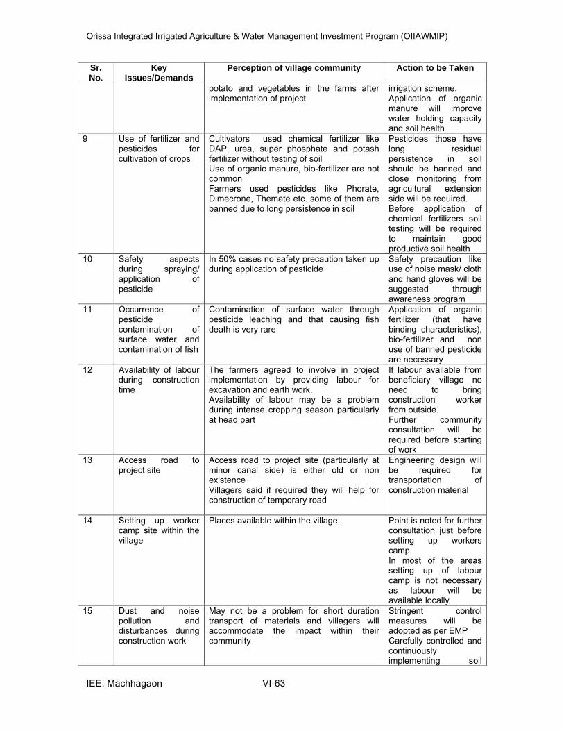
Orissa Integrated Irrigated Agriculture & Water Management Investment Program (OIIAWMIP)
IEE: Machhagaon VI-63
Sr. No.
Key Issues/Demands
Perception of village community Action to be Taken
potato and vegetables in the farms after implementation of project
irrigation scheme. Application of organic manure will improve water holding capacity and soil health
9 Use of fertilizer and pesticides for cultivation of crops
Cultivators used chemical fertilizer like DAP, urea, super phosphate and potash fertilizer without testing of soil Use of organic manure, bio-fertilizer are not common Farmers used pesticides like Phorate, Dimecrone, Themate etc. some of them are banned due to long persistence in soil
Pesticides those have long residual persistence in soil should be banned and close monitoring from agricultural extension side will be required. Before application of chemical fertilizers soil testing will be required to maintain good productive soil health
10 Safety aspects during spraying/ application of pesticide
In 50% cases no safety precaution taken up during application of pesticide
Safety precaution like use of noise mask/ cloth and hand gloves will be suggested through awareness program
11 Occurrence of pesticide contamination of surface water and contamination of fish
Contamination of surface water through pesticide leaching and that causing fish death is very rare
Application of organic fertilizer (that have binding characteristics), bio-fertilizer and non use of banned pesticide are necessary
12 Availability of labour during construction time
The farmers agreed to involve in project implementation by providing labour for excavation and earth work. Availability of labour may be a problem during intense cropping season particularly at head part
If labour available from beneficiary village no need to bring construction worker from outside. Further community consultation will be required before starting of work
13 Access road to project site
Access road to project site (particularly at minor canal side) is either old or non existence Villagers said if required they will help for construction of temporary road
Engineering design will be required for transportation of construction material
14 Setting up worker camp site within the village
Places available within the village.
Point is noted for further consultation just before setting up workers camp In most of the areas setting up of labour camp is not necessary as labour will be available locally
15 Dust and noise pollution and disturbances during construction work
May not be a problem for short duration transport of materials and villagers will accommodate the impact within their community
Stringent control measures will be adopted as per EMP Carefully controlled and continuously implementing soil
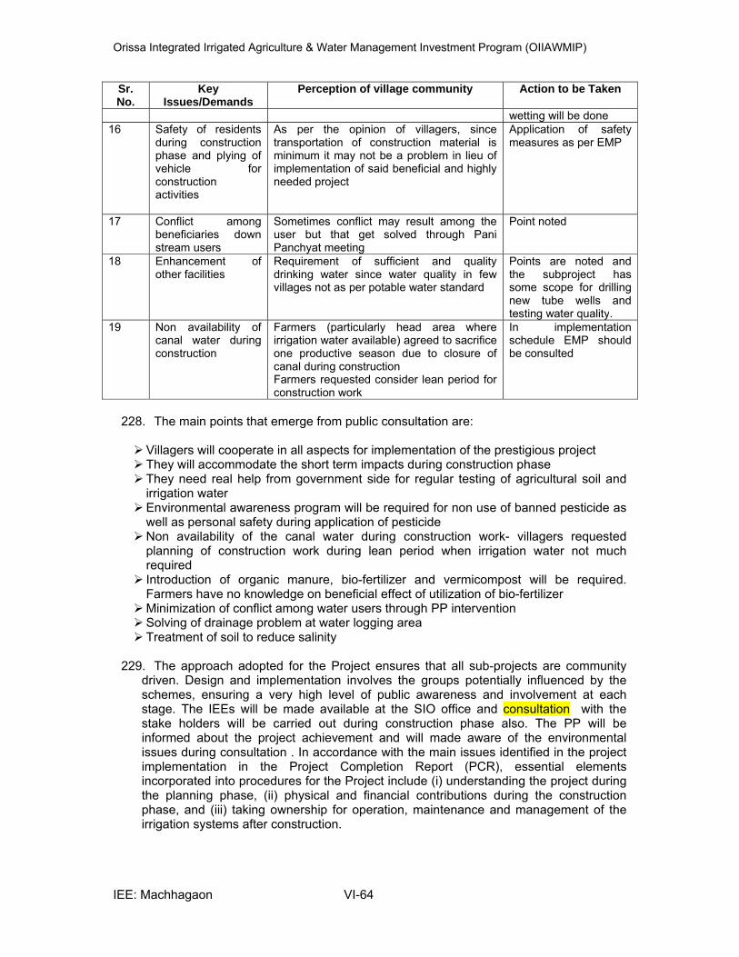
Orissa Integrated Irrigated Agriculture & Water Management Investment Program (OIIAWMIP)
IEE: Machhagaon VI-64
Sr. No.
Key Issues/Demands
Perception of village community Action to be Taken
wetting will be done 16 Safety of residents
during construction phase and plying of vehicle for construction activities
As per the opinion of villagers, since transportation of construction material is minimum it may not be a problem in lieu of implementation of said beneficial and highly needed project
Application of safety measures as per EMP
17 Conflict among beneficiaries down stream users
Sometimes conflict may result among the user but that get solved through Pani Panchyat meeting
Point noted
18 Enhancement of other facilities
Requirement of sufficient and quality drinking water since water quality in few villages not as per potable water standard
Points are noted and the subproject has some scope for drilling new tube wells and testing water quality.
19 Non availability of canal water during construction
Farmers (particularly head area where irrigation water available) agreed to sacrifice one productive season due to closure of canal during construction Farmers requested consider lean period for construction work
In implementation schedule EMP should be consulted
228. The main points that emerge from public consultation are:
Villagers will cooperate in all aspects for implementation of the prestigious project They will accommodate the short term impacts during construction phase They need real help from government side for regular testing of agricultural soil and irrigation water Environmental awareness program will be required for non use of banned pesticide as well as personal safety during application of pesticide Non availability of the canal water during construction work- villagers requested planning of construction work during lean period when irrigation water not much required Introduction of organic manure, bio-fertilizer and vermicompost will be required. Farmers have no knowledge on beneficial effect of utilization of bio-fertilizer Minimization of conflict among water users through PP intervention Solving of drainage problem at water logging area Treatment of soil to reduce salinity
229. The approach adopted for the Project ensures that all sub-projects are community
driven. Design and implementation involves the groups potentially influenced by the schemes, ensuring a very high level of public awareness and involvement at each stage. The IEEs will be made available at the SIO office and consultation with the stake holders will be carried out during construction phase also. The PP will be informed about the project achievement and will made aware of the environmental issues during consultation . In accordance with the main issues identified in the project implementation in the Project Completion Report (PCR), essential elements incorporated into procedures for the Project include (i) understanding the project during the planning phase, (ii) physical and financial contributions during the construction phase, and (iii) taking ownership for operation, maintenance and management of the irrigation systems after construction.

Orissa Integrated Irrigated Agriculture & Water Management Investment Program (OIIAWMIP)
IEE: Machhagaon VI-65
D. Future Consultation and Disclosure
230. During construction period also consultations will be carried out with affected persons, and stakeholders Pani Panchayat members and farmers and other vulnerable communities including women will be consulted to address any issues related to the proposed construction. The findings would be presented in the monitoring reports that would be submitted to ADB. The brief executive summary of the IEE would be translated into local language and it would be made available to local people at SIO office.
231. As per the ADB SPS 2009, for Environment Category “B” subproject, the following
documents will be submitted to ADB for disclosure on ADB’s website. Draft IEE Final IEE A new or updated IEE and corrective action plan prepared during project
implementation, if any, and Environmental Monitoring reports
Orissa Integrated Irrigated Agriculture & Water Management Investment Program (OIIAWMIP)
IEE: Machhagaon VII-66
VII. GRIEVANCE REDRESS MECHANISMS
232. A joint social and environmental redress mechanism will be implemented under the Project. The Grievance Redressal Committee will be constituted at PMU level comprising of the Project Director, Resettlement Officer, Environmental Officer representatives from local Non–Government Organizations(NGOs), elected representatives from Municipality / Panchayat, representatives of affected persons including vulnerable groups and women in the committee. The GRC will meet regularly (at least once a month) on a prefixed date. All the grievances of the people will be reviewed and resolved within 6 weeks of the date of submission. Through public consultations and disclosure, the APs will be informed that they have a right to grievance redressed. Field offices will display a board providing details of person to contact should they have any complaint regarding environment or social issues. The APs can call upon the support of the NGO to assist them in presenting their grievances or queries to GRC.
233. Grievances and suggestions from local and affected people may come-up related to
inappropriate implementation of the project and components of EMP. Grievance re-dress mechanism shall be translated in Odia language and posted to the respective village/Panchayat office by Contractor on behalf of the OIIAWMIP at least 6 weeks prior to commencement of construction works.
234. The expected range of grievances to be handled through this mechanism will
encompass but not limited to the following: i) nuisance from noise, dust, borrow earth, disposal of spoil and temporary blocking of access; ii) contamination of receiving water from runoff iii) emissions from increase vehicular traffic and stationary sources like hot mix plant, WMM etc., iv) conflict between local residents and migrant workers;v) ownership of vegetation for clearing; and vi) damage compensation. These issues will be addressed through acknowledgement, evaluation and corrective action and response approach. Grievances from public or stakeholders concerning the project and EMP implementation will be received by the concerned Executive Engineer (SIO Manager) of the sub-project. The Executive Engineer shall refer the application to PD, PMU who with the help of Construction Management Specialist, Quality Control and Assurance Specialist and Environment specialist of ISPMC then assess the grievances/suggestions and if they are found to be genuine and acceptable shall be moved to GRC and they will be resolved within 6 weeks from the date of receipt. In site the Contractor shall provide a sign board notifying the contact details of the GRC.
235. This mechanism is non-judicial in nature and does not preclude the affected people
coursing their grievances to the courts. The corrective action will be started as per the action plan indicated to the stakeholder. The action taken and the outcome shall form a part of half yearly report to ADB.
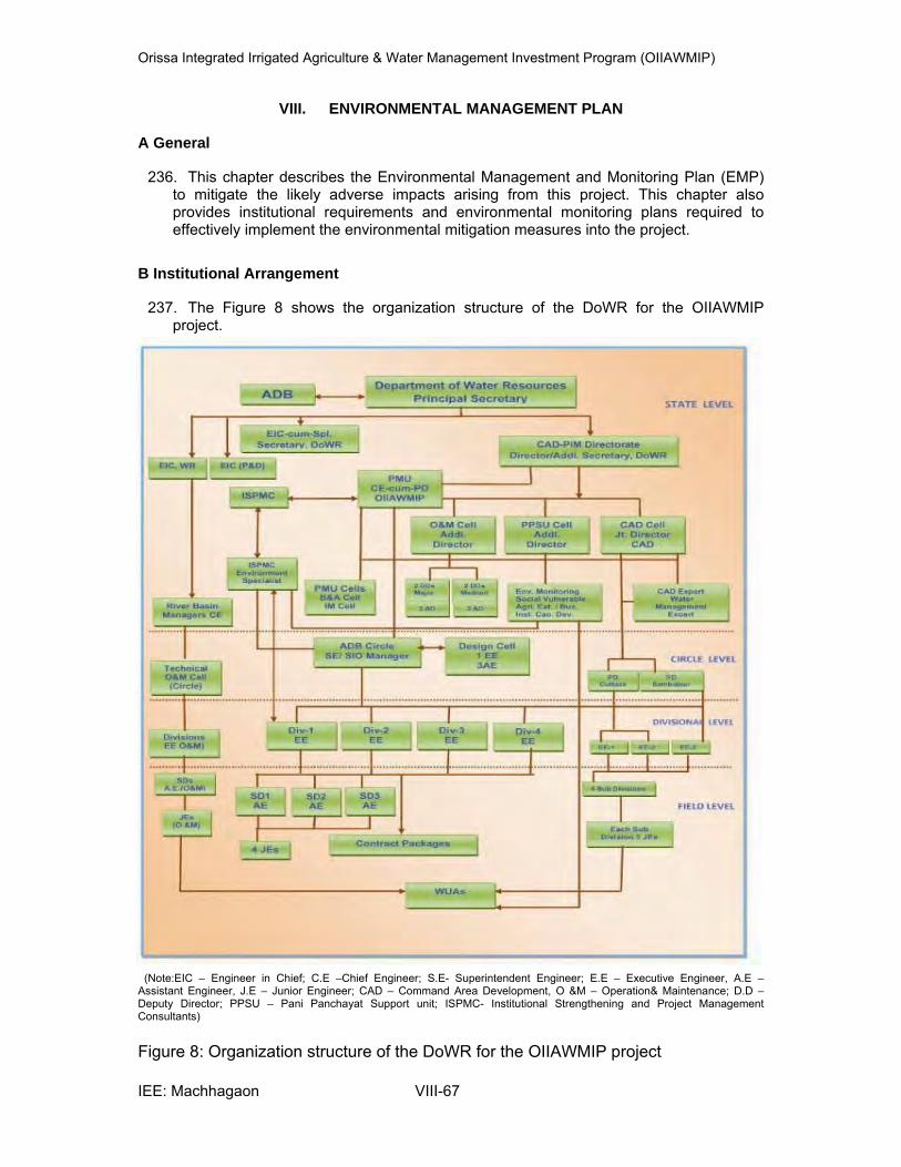
Orissa Integrated Irrigated Agriculture & Water Management Investment Program (OIIAWMIP)
IEE: Machhagaon VIII-67
VIII. ENVIRONMENTAL MANAGEMENT PLAN
A General
236. This chapter describes the Environmental Management and Monitoring Plan (EMP) to mitigate the likely adverse impacts arising from this project. This chapter also provides institutional requirements and environmental monitoring plans required to effectively implement the environmental mitigation measures into the project.
B Institutional Arrangement
237. The Figure 8 shows the organization structure of the DoWR for the OIIAWMIP project.
(Note:EIC – Engineer in Chief; C.E –Chief Engineer; S.E- Superintendent Engineer; E.E – Executive Engineer, A.E – Assistant Engineer, J.E – Junior Engineer; CAD – Command Area Development, O &M – Operation& Maintenance; D.D – Deputy Director; PPSU – Pani Panchayat Support unit; ISPMC- Institutional Strengthening and Project Management Consultants)
Figure 8: Organization structure of the DoWR for the OIIAWMIP project

Orissa Integrated Irrigated Agriculture & Water Management Investment Program (OIIAWMIP)
IEE: Machhagaon VIII-68
The key agencies involved in implementation of EMP are:
238. DoWR is the Executing Agency for OIIAWMIP. The DoWR has been reorganized to constitute a Command Area Development and Participatory Irrigation Management Directorate (CAD&PIM Directorate) for more effectively integrating irrigation system management and on-farm development through participation of the Pani Panchayats. The Project is being implemented through the existing setup technically headed by EIC. Special Secretary, DoWR has been designated as the Engineer-in-Chief for OIIAWMIP. Special Secretary, DoWR will advise and guide on overall implementation matters including PIM-CAD.
239. A Project Management Unit (PMU) has been established within the CAD&PIM
Directorate with a Project Director of the rank of Chief Engineer operating under the overall guidance of Additional Secretary cum Director CAD - PIM with the overall responsibility of program implementation. Chief Engineer cum Project Director, PMU will exercise the powers vested by the OPWD code for execution of all civil works. At the field level Sub-project Implementation Offices (SIO) have been formed to implement the program. For Major irrigation sub-projects the concerned Superintending Engineer is the Sub-project manager and the concerned Executive Engineer is the Sub-project manager for Medium irrigation Sub-projects. The Sub-Project Manager, who is a Superintending Engineer (SE) for major irrigation systems and an EE for medium schemes, will manage the Technical Cell as well as monitor and guide the CAD and PP Support Cells for effective integration and coordination of the sub-project activities, under the support and guidance of PMU, EIC (P&D), and ISPM Consultants provided through regular PMU-SIO meetings.
240. DoWR for effective implementation of Tranche-2 sub-projects under OIIAWMIP
proposes to create one Circle, four Divisions, 12 Sub-Divisions under the Chief Engineer – cum – Project Director, PMU.
Circle: One Superintending Engineer S.E will be in charge of circle office. He will be responsible for the managing the Technical Cell as well as monitor and guide the CAD and PP Support Cells for effective integration and coordination of the sub-project activities. Division: Under each division one Executive Engineer (E.E) will be in charge of the division for, processing tender and bid documents executing the works, check measurement etc. He will ensure the quality of the ongoing works etc. Sub-Division: Under each sub-division Assistant Engineer / Asst. Executive Engineer shall be in charge of the sub-division office. He will be supported by field functionaries like Junior Engineer and other field for execution, check measurement, monitoring the works and ensuring the quality of the work.
241. The Junior Engineer at the field level will be responsible for day to day environmental monitoring and the overall supervision and responsibility of EMP implementation will be with the concerned SIO ( S.E for Major sub project and E.E for medium sub project).
C Institutional Strengthening and Project Management Consultants (ISPMC)
242. The ISPMC will have an Environment Specialist, Resettlement Specialist and Indigenous group Specialist who will support the PMU in advising and monitoring the EMP measures with help of SIO Staff and WUAs. The ISPMC will assist in reviewing all the contractors monthly environmental reports submitted by Contractors through SIO in consultation with PMU. They will assist the PMU in preparing environmental
Orissa Integrated Irrigated Agriculture & Water Management Investment Program (OIIAWMIP)
IEE: Machhagaon VIII-69
monitoring reports and other reports like preparation of IEEs, RP and social assessment reports.
D Responsible for carrying out monitoring measures - Staffing Requirements
243. As per the “ revised Environmental Assessment and Review Frame work (EARF) prepared for the project it states that “PMU will be responsible to undertake (i) environmental screening at subproject identification stage; (ii) preparation of IEEs/EIAs at subproject appraisal stage; and (iii) environmental management and mitigation during subproject implementation and operational stage. At appraisal, IEEs /EIAs will be done with the engagement of consulting firms who would be guided by the project environmental specialist. Environmental management and mitigation will be undertaken by the construction contractors during construction phase under the supervision of the designated staff in the subproject management offices (SIOs) and monitored by PMU environmental cell. The consultants mobilized for institutional strengthening and project management will also be entrusted to provide necessary capacity development of the DOWR engineers and SIO (S.E for major sub project and E.E for medium subproject) in terms of environmental planning and management”.
244. The PMU with the help of SIO of DoWR( assisted by the WUAs), and the Institutional
Strengthening and Project Management Consultants (ISPMC) will be guiding the implementation of the EMP. During project works the responsibility to implement environmental mitigation and safeguards shall be primarily on the Contractor for main canal, distributaries and minors and monitored by the SIO (S.E for major sub project and E.E for medium subproject). The field level Junior Engineer shall be made responsible for monitoring the EMP activities of the Contractors on a day to day basis. The SIO staff and WUAs with the help of ISPMC, Environment Specialist will monitor the EMP implementation of the Contractor.
245. While the implementation of sub-minors shall be on WUAs and monitored by SIO.
Pani Panchayat Support Unit (PPSU) is the state level apex agency who is responsible for strengthening the PP activities. Under PPSU one Environmental Monitoring Specialist was recruited to provide capacity building of the PPs. He may be made responsible for the monitoring of WUAs along with SIO staff and these will work under the overall guidance of ISPMC. The WUAs will end up leading O&M responsibilities with the help of Environmental Monitoring Specialist of PPSU, CAD unit.
246. The current structure of DoWR indicates that they have no environmental
management system. The WUAs will end up leading O&M responsibilities. Neither DOWR nor the WUAs are currently in a position to assume EMP responsibility. Their institutional capabilities and capacities will have to be developed and strengthened under the Project.
247. So for effective monitoring there is a need to designate or make in charge one Junior
Engineer (Technical / Works) from each sub-project to look into the environmental aspects, he may be named as “ Environmental Co-coordinator” who would be working under the guidance of National Environment Specialist- ISPMC in addition to his regular duties. The Environmental Co-coordinators would be trained time to time; this will ensure proper and systematic environmental monitoring and ensuring timely compliances from the contractors. In addition Junior Engineer (O&M) would also be trained along with the Junior Engineer (Technical / Works) who will monitor after the completion of works i.e. during “Operation and Maintenance Period”.

Orissa Integrated Irrigated Agriculture & Water Management Investment Program (OIIAWMIP)
IEE: Machhagaon VIII-70
248. To make environmental monitoring integral in to the system and since the projects are of larger scale there is a need for systematic and continuous monitoring. To ensure systematic monitoring the ISPMC had developed formats presented in Annexure-.9 & 9a. The format has to be filled up and submitted by the Contractor / WUAs to SIO staff on a monthly basis. The Contractors / WUAs and SIO shall be trained for filling up the format during the project period.
249. As per the Technical Specification for construction of civil works of ADB assisted schemes, DoWR, Odisha Section – 6 Clause – 1.23 – Sub – Clause 1.23.2, Contractors shall be designate as “Safety Officers” and he shall also be made responsible for environmental issues and he shall be named as an “Environmental Co-ordinator” from the Contractors side and he shall also be trained on the environmental issues.
E. Reporting System or Responsible for Reporting
250. Reporting system suggested under this project is three tier systems:
• Reporting of the Contractor and WUAs to the SIO staff.(For the civil works implemented by Contractors monitoring shall be done SIO with the help of ISPMC and for the civil works carried out by WUAs monitoring shall be done by SIO with the help of PPSU Environmental Monitoring Specialist).
• Reporting of ISPMC, Environment Specialist after evaluating the contractor reports and evaluating the indicators at PMU level (The reports submitted by Contractors shall be evaluated by ISPMC Environment Specialist and feedback provided to SIO and PMU); In addition, ISPMC, Resettlement Specialist for resettlement issues and Vulnerable Group Specialist responsible for preparing Indigenous People Development Plan (IPDP) and for any social related issues.
• PMU reporting to ADB and PMU shall submit annual environmental monitoring report to ADB
251. Environmental monitoring suggested involves regular checking of the parameters
suggested in the environmental management plan to ascertain the mitigation measures are achieved as the work progress. It provides the necessary feedback and midcourse corrections for project management to keep the program to achieve the expected outputs.
252. The reporting system starts with the construction Contractor who is the main
executor of the implementation activities. The Contractor will report on a monthly basis to SIO staff as per the check list provided in the Annexure 9 to the Junior Engineer. Junior Engineer at the field will be responsible for ensuring EMP implementation in consultation with SIO, he on the basis of daily visits to the site and observations evaluates and submit to the SIO manager. This will form the basis for evaluating the Contractor on the implementation process.
253. For the works executed by Pani Panchayat or WUAs similar simplified reporting
system is proposed, the PPs have to complete a check list Annexure 9a and submit to the SIO staff, the Environment Monitoring Specialist recruited under PPSU, CAD unit will evaluate on a monthly basis and submit to the PMU and ISPMC.
254. The Environment Specialist, ISPMC during periodic visits spot checks the sites and
evaluates the monthly reports submitted by the Junior Engineer and PPSU Environmental Monitoring Specialist and on this basis brief quarterly reports would be prepared and submitted to the PMU and on a yearly basis a detailed report with corrective action plans would be prepared.

Orissa Integrated Irrigated Agriculture & Water Management Investment Program (OIIAWMIP)
IEE: Machhagaon VIII-71
255. The PMU will submit the annual environmental monitoring reports during the construction phase to the ADB. The PMU in the monthly meetings should discuss the implementation of EMP with the SIO staff and ISPMC and suggest remedial measures to the contractor.
F. Environmental Mitigation Plan
256. An Environmental Management and Monitoring Plan (EMP) is key to ensure a safe and clean environment. The desired results from the environmental mitigation measures proposed in the project can only be obtained with a management plan to assure its proper implementation & function. The EMP outlines the plans for the proper implementation of mitigation measures to reduce the adverse impacts arising out of the project activities. The EMP has been prepared addressing issues such as: • Mitigation measures for abatement of adverse impacts caused during the
construction and operation stage; • Details of management plans; • Institutional set up identified/recommended for implementation of the EMP; • Post project environmental monitoring programme to be undertaken;
G.Expenditures for environmental protection measures and budget for EMP
257. The major impacts due to different project activities and their mitigation measures
have been identified in Chapter 5. The environmental parameters checklist for the anticipated impacts and suggested mitigation measures with implementation and supervision responsibility during Pre construction Table 28 and 29; Pre construction activity for the works executed by contractor Table 30, Construction phase for the works executed by contractor Table 31; Preconstruction activities for the works executed by WUAs Table 32 and Construction phase for the works executed by WUAs Table 33 and Operation & maintenance phases Table 34 for the Machhagaon subproject is shown below:
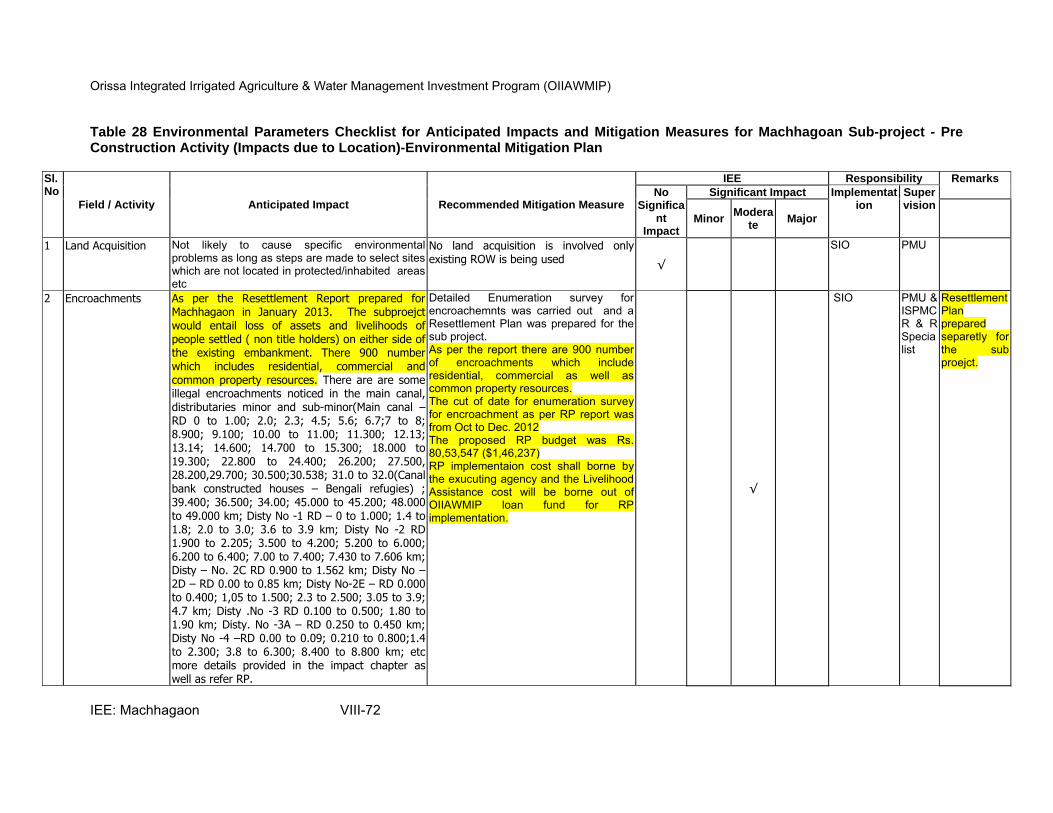
Orissa Integrated Irrigated Agriculture & Water Management Investment Program (OIIAWMIP)
IEE: Machhagaon VIII-72
Table 28 Environmental Parameters Checklist for Anticipated Impacts and Mitigation Measures for Machhagoan Sub-project - Pre Construction Activity (Impacts due to Location)-Environmental Mitigation Plan
Sl.No
Field / Activity Anticipated Impact Recommended Mitigation Measure
IEE Responsibility Remarks
No Significa
nt Impact
Significant Impact Implementation
Supervision
Minor Modera
te Major
1 Land Acquisition Not likely to cause specific environmental problems as long as steps are made to select sites which are not located in protected/inhabited areas etc
No land acquisition is involved only existing ROW is being used √
SIO PMU
2 Encroachments As per the Resettlement Report prepared for Machhagaon in January 2013. The subproejct would entail loss of assets and livelihoods of people settled ( non title holders) on either side of the existing embankment. There 900 number which includes residential, commercial and common property resources. There are are some illegal encroachments noticed in the main canal, distributaries minor and sub-minor(Main canal –RD 0 to 1.00; 2.0; 2.3; 4.5; 5.6; 6.7;7 to 8; 8.900; 9.100; 10.00 to 11.00; 11.300; 12.13; 13.14; 14.600; 14.700 to 15.300; 18.000 to 19.300; 22.800 to 24.400; 26.200; 27.500, 28.200,29.700; 30.500;30.538; 31.0 to 32.0(Canal bank constructed houses – Bengali refugies) ; 39.400; 36.500; 34.00; 45.000 to 45.200; 48.000to 49.000 km; Disty No -1 RD – 0 to 1.000; 1.4 to 1.8; 2.0 to 3.0; 3.6 to 3.9 km; Disty No -2 RD 1.900 to 2.205; 3.500 to 4.200; 5.200 to 6.000; 6.200 to 6.400; 7.00 to 7.400; 7.430 to 7.606 km; Disty – No. 2C RD 0.900 to 1.562 km; Disty No –2D – RD 0.00 to 0.85 km; Disty No-2E – RD 0.000 to 0.400; 1,05 to 1.500; 2.3 to 2.500; 3.05 to 3.9; 4.7 km; Disty .No -3 RD 0.100 to 0.500; 1.80 to 1.90 km; Disty. No -3A – RD 0.250 to 0.450 km; Disty No -4 –RD 0.00 to 0.09; 0.210 to 0.800;1.4 to 2.300; 3.8 to 6.300; 8.400 to 8.800 km; etc more details provided in the impact chapter as well as refer RP.
Detailed Enumeration survey for encroachemnts was carried out and a Resettlement Plan was prepared for the sub project. As per the report there are 900 number of encroachments which include residential, commercial as well as common property resources. The cut of date for enumeration survey for encroachment as per RP report was from Oct to Dec. 2012 The proposed RP budget was Rs. 80,53,547 ($1,46,237) RP implementaion cost shall borne by the exucuting agency and the Livelihood Assistance cost will be borne out of OIIAWMIP loan fund for RP implementation.
√
SIO PMU & ISPMC R & R Specialist
Resettlement Plan prepared separetly for the sub proejct.
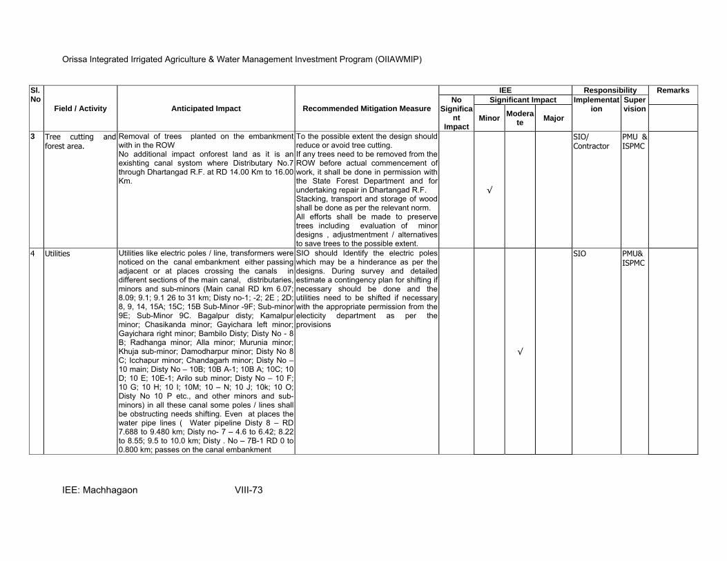
Orissa Integrated Irrigated Agriculture & Water Management Investment Program (OIIAWMIP)
IEE: Machhagaon VIII-73
Sl.No
Field / Activity Anticipated Impact Recommended Mitigation Measure
IEE Responsibility Remarks
No Significa
nt Impact
Significant Impact Implementation
Supervision
Minor Modera
te Major
3 Tree cutting and forest area.
Removal of trees planted on the embankment with in the ROW No additional impact onforest land as it is an exishting canal systom where Distributary No.7 through Dhartangad R.F. at RD 14.00 Km to 16.00 Km.
To the possible extent the design should reduce or avoid tree cutting. If any trees need to be removed from the ROW before actual commencement of work, it shall be done in permission with the State Forest Department and for undertaking repair in Dhartangad R.F. Stacking, transport and storage of wood shall be done as per the relevant norm. All efforts shall be made to preserve trees including evaluation of minor designs , adjustmentment / alternatives to save trees to the possible extent.
√
SIO/ Contractor
PMU & ISPMC
4 Utilities Utilities like electric poles / line, transformers were noticed on the canal embankment either passing adjacent or at places crossing the canals in different sections of the main canal, distributaries, minors and sub-minors (Main canal RD km 6.07; 8.09; 9.1; 9.1 26 to 31 km; Disty no-1; -2; 2E ; 2D; 8, 9, 14, 15A; 15C; 15B Sub-Minor -9F; Sub-minor 9E; Sub-Minor 9C. Bagalpur disty; Kamalpur minor; Chasikanda minor; Gayichara left minor; Gayichara right minor; Bambilo Disty; Disty No - 8 B; Radhanga minor; Alla minor; Murunia minor; Khuja sub-minor; Damodharpur minor; Disty No 8 C; Icchapur minor; Chandagarh minor; Disty No –10 main; Disty No – 10B; 10B A-1; 10B A; 10C; 10 D; 10 E; 10E-1; Arilo sub minor; Disty No – 10 F; 10 G; 10 H; 10 I; 10M; 10 – N; 10 J; 10k; 10 O; Disty No 10 P etc., and other minors and sub-minors) in all these canal some poles / lines shall be obstructing needs shifting. Even at places the water pipe lines ( Water pipeline Disty 8 – RD 7.688 to 9.480 km; Disty no- 7 – 4.6 to 6.42; 8.22 to 8.55; 9.5 to 10.0 km; Disty . No – 7B-1 RD 0 to 0.800 km; passes on the canal embankment
SIO should Identify the electric poles which may be a hinderance as per the designs. During survey and detailed estimate a contingency plan for shifting if necessary should be done and the utilities need to be shifted if necessary with the appropriate permission from the electicity department as per the provisions
√
SIO PMU& ISPMC

Orissa Integrated Irrigated Agriculture & Water Management Investment Program (OIIAWMIP)
IEE: Machhagaon VIII-74
Sl.No
Field / Activity Anticipated Impact Recommended Mitigation Measure
IEE Responsibility Remarks
No Significa
nt Impact
Significant Impact Implementation
Supervision
Minor Modera
te Major
5 Canal weeds noticed in the silted protions of the canal
Reduced water flow and delayed water supply Provision for removal of weeds during resectioning and PP members may be encouraged to prepare vermi compost with the weeds. SIO shall establish linkage with the agriculture department for establishment of vermic-compost units or encouraged to prepared ornaments with weed like water hyacinth
√
SIO PMU& ISPMC
6 Religious and community structures
Few temples present at Main canal RD- 3.4, 7.08; 8.900; 9.100; 14.600km ;Disty No -2 21.200km ; Disty – No. 2C RD 0.900; 1.562 km ; Disty no- 13 – 4.60 ; 6.400; 9.50; 11.00 km; Disty no- 19 A –RD 0.495; 0.847; 10.470 km; Disty no 19A-1 RD 0.714 km; Disty no -19B – 4.269km ; Disty No- 2E -.0.300; 2.97km; Hazipur minor RD – 0.1km etc.,were found with in the ROW may get affected
The religious structures shall not be affected to the possible extent , the designs shall accommodate, if necessary if the temples need to be relocated this shall be done in consultation with the local people.
√
SIO PMU& ISPMC
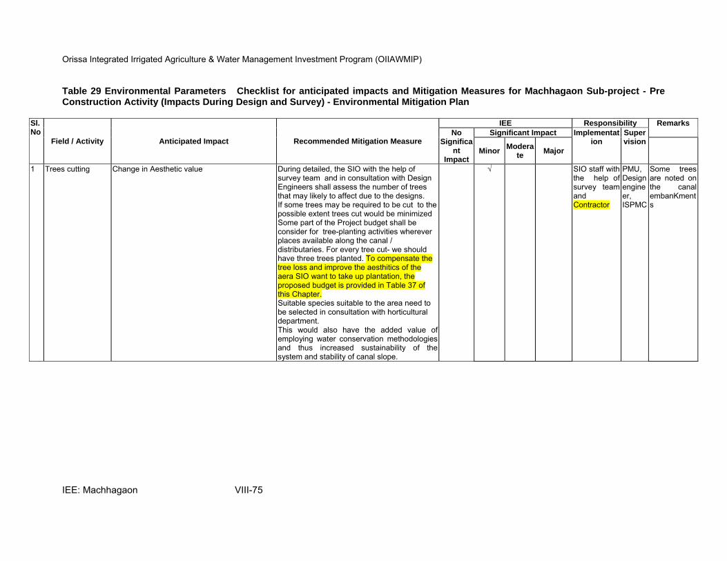
Orissa Integrated Irrigated Agriculture & Water Management Investment Program (OIIAWMIP)
IEE: Machhagaon VIII-75
Table 29 Environmental Parameters Checklist for anticipated impacts and Mitigation Measures for Machhagaon Sub-project - Pre Construction Activity (Impacts During Design and Survey) - Environmental Mitigation Plan
Sl.No
Field / Activity Anticipated Impact Recommended Mitigation Measure
IEE Responsibility Remarks
No Significa
nt Impact
Significant Impact Implementation
Supervision
Minor Modera
te Major
1 Trees cutting Change in Aesthetic value During detailed, the SIO with the help of survey team and in consultation with Design Engineers shall assess the number of trees that may likely to affect due to the designs. If some trees may be required to be cut to the possible extent trees cut would be minimized Some part of the Project budget shall be consider for tree-planting activities wherever places available along the canal / distributaries. For every tree cut- we should have three trees planted. To compensate the tree loss and improve the aesthitics of the aera SIO want to take up plantation, the proposed budget is provided in Table 37 of this Chapter. Suitable species suitable to the area need to be selected in consultation with horticultural department. This would also have the added value of employing water conservation methodologies and thus increased sustainability of the system and stability of canal slope.
√ SIO staff with the help of survey teamand Contractor
PMU, Design engineer, ISPMC
Some trees are noted on the canal embanKments
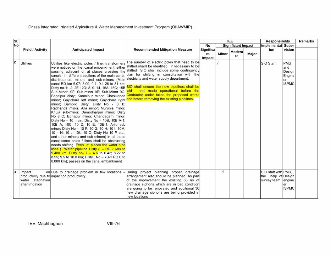
Orissa Integrated Irrigated Agriculture & Water Management Investment Program (OIIAWMIP)
IEE: Machhagaon VIII-76
Sl.No
Field / Activity Anticipated Impact Recommended Mitigation Measure
IEE Responsibility Remarks
No Significa
nt Impact
Significant Impact Implementation
Supervision
Minor Modera
te Major
2 Utilities Utilities like electric poles / line, transformers were noticed on the canal embankment either passing adjacent or at places crossing the canals in different sections of the main canal, distributaries, minors and sub-minors (Main canal RD km 6.07; 8.09; 9.1; 9.1 26 to 31 km; Disty no-1; -2; 2E ; 2D; 8, 9, 14, 15A; 15C; 15B Sub-Minor -9F; Sub-minor 9E; Sub-Minor 9C. Bagalpur disty; Kamalpur minor; Chasikanda minor; Gayichara left minor; Gayichara right minor; Bambilo Disty; Disty No - 8 B; Radhanga minor; Alla minor; Murunia minor; Khuja sub-minor; Damodharpur minor; Disty No 8 C; Icchapur minor; Chandagarh minor; Disty No – 10 main; Disty No – 10B; 10B A-1; 10B A; 10C; 10 D; 10 E; 10E-1; Arilo sub minor; Disty No – 10 F; 10 G; 10 H; 10 I; 10M; 10 – N; 10 J; 10k; 10 O; Disty No 10 P etc., and other minors and sub-minors) in all these canal some poles / lines shall be obstructing needs shifting. Even at places the water pipe lines ( Water pipeline Disty 8 – RD 7.688 to 9.480 km; Disty no- 7 – 4.6 to 6.42; 8.22 to 8.55; 9.5 to 10.0 km; Disty . No – 7B-1 RD 0 to 0.800 km); passes on the canal embankment
The number of electric poles that need to be shifted shallll be identified, if necessary to be shifted SIO shall include some contingency plan for shifting in consultation with the electricity and water supply department. SIO shall ensure the new pipelines shall be laid and made operational before the Contractor under takes the proposed works and before removing the existing pipelines.
√ SIO Staff PMU and Design Engineer, ISPMC
3 Impact on productivity due to water stagnation after irrigation
Due to drainage problem in few locations –impact on productivity.
During project planning proper drainage arrangement also should be planned. As part of the improvement the existing 63 no of drainage siphons which are in bad condition are going to be renovated and additional 30 new drainage siphons are being provided in new locations
√ SIO staff with the help of survey team
PMU, Design engineer, ISPMC
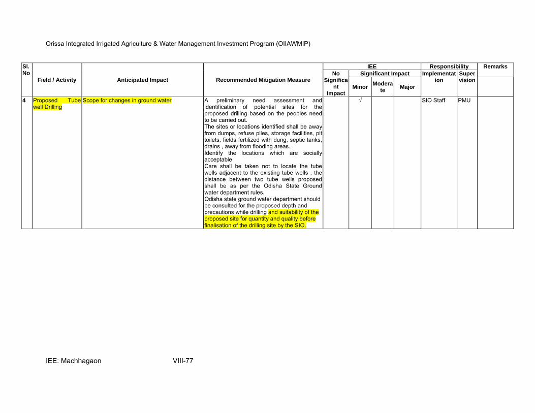
Orissa Integrated Irrigated Agriculture & Water Management Investment Program (OIIAWMIP)
IEE: Machhagaon VIII-77
Sl.No
Field / Activity Anticipated Impact Recommended Mitigation Measure
IEE Responsibility Remarks
No Significa
nt Impact
Significant Impact Implementation
Supervision
Minor Modera
te Major
4 Proposed Tube well Drilling
Scope for changes in ground water A preliminary need assessment and identification of potential sites for the proposed drilling based on the peoples need to be carried out. The sites or locations identified shall be away from dumps, refuse piles, storage facilities, pit toilets, fields fertilized with dung, septic tanks, drains , away from flooding areas. Identify the locations which are socially acceptable Care shall be taken not to locate the tube wells adjacent to the existing tube wells , the distance between two tube wells proposed shall be as per the Odisha State Ground water department rules. Odisha state ground water department should be consulted for the proposed depth and precautions while drilling and suitability of the proposed site for quantity and quality before finalisation of the drilling site by the SIO.
√ SIO Staff PMU
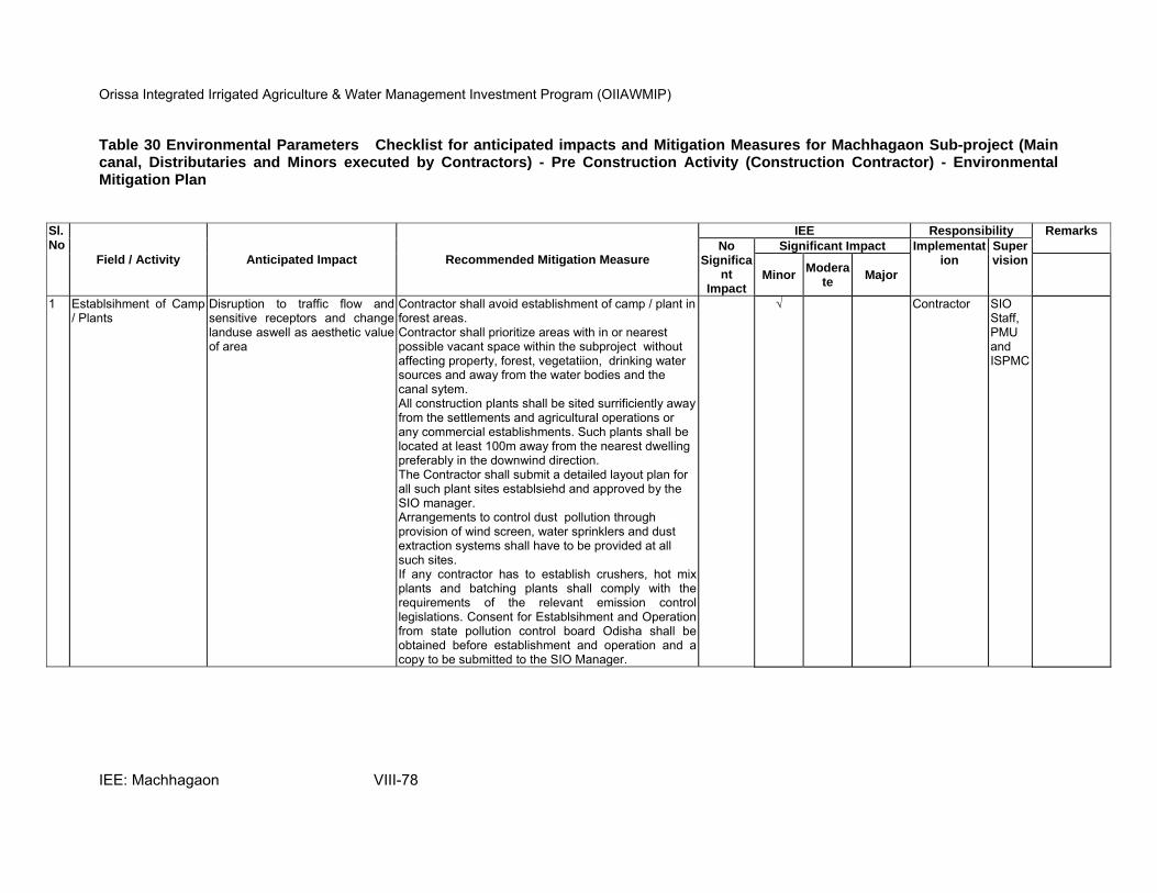
Orissa Integrated Irrigated Agriculture & Water Management Investment Program (OIIAWMIP)
IEE: Machhagaon VIII-78
Table 30 Environmental Parameters Checklist for anticipated impacts and Mitigation Measures for Machhagaon Sub-project (Main canal, Distributaries and Minors executed by Contractors) - Pre Construction Activity (Construction Contractor) - Environmental Mitigation Plan
Sl.No
Field / Activity Anticipated Impact Recommended Mitigation Measure
IEE Responsibility Remarks
No Significa
nt Impact
Significant Impact Implementation
Supervision
Minor Modera
te Major
1 Establsihment of Camp / Plants
Disruption to traffic flow and sensitive receptors and change landuse aswell as aesthetic value of area
Contractor shall avoid establishment of camp / plant in forest areas. Contractor shall prioritize areas with in or nearest possible vacant space within the subproject without affecting property, forest, vegetatiion, drinking water sources and away from the water bodies and the canal sytem. All construction plants shall be sited surrificiently away from the settlements and agricultural operations or any commercial establishments. Such plants shall be located at least 100m away from the nearest dwelling preferably in the downwind direction. The Contractor shall submit a detailed layout plan for all such plant sites establsiehd and approved by the SIO manager. Arrangements to control dust pollution through provision of wind screen, water sprinklers and dust extraction systems shall have to be provided at all such sites. If any contractor has to establish crushers, hot mix plants and batching plants shall comply with the requirements of the relevant emission control legislations. Consent for Establsihment and Operation from state pollution control board Odisha shall be obtained before establishment and operation and a copy to be submitted to the SIO Manager.
√ Contractor SIO Staff, PMU and ISPMC

Orissa Integrated Irrigated Agriculture & Water Management Investment Program (OIIAWMIP)
IEE: Machhagaon VIII-79
Sl.No
Field / Activity Anticipated Impact Recommended Mitigation Measure
IEE Responsibility Remarks
No Significa
nt Impact
Significant Impact Implementation
Supervision
Minor Modera
te Major
2 Sources of Materials Borrow areas- extraction of materials like earth etc., can disrupt natural drainage, vegetation and resulting in accelerated erosion and leading to water stagnation, ponding and pollution
Finalisation of borrow areas for earth and all logistic arrangementsas well as compliance to environmental requirements, as applicable shall be the sole respsonsibility of the Contractor. Selection Criteria of Borrow areas is as follows: Contractor shall identify the potential borrow areas and take permission from SIO manager before operating any borrow areas. The Contractor shall not start borrowing earth from selected borrow area untill the mutual agreement is signed between landowner and Contractor. Copy of the document shall be submitted to SIO manager. The Contractor in addition to the established practices, rules and regulation will also consider following criteria before finalizing the locations. 1) The borrow area should not be located in agriculture field unless unavoidable i.e. barren land is not available. 2) The borrow pits should not be located along the roads. 3) The loss of productive and agricultural land should be minimum. 4) The loss of vegetation is almost nil or minimum. 5) Sufficient quality of soil is available. 6) The Contractor will ensure the availability of suitable earth.The Contractor shall obtain representative samples form each of the identified borrow areas and have these tested at the site laboratory following a testing programme as approved by the concerned Engineer. It shall be ensured that the fill material compacted to the required density. Planning of haul roads for accessing borrow areas shall be undertaken during this stage. The haul roads shall be routed to avoid a gricultural areas as well as forest areas as far as possible and shall use the existing village roads wherever possible.
√ Contractor SIO Staff and PMU ISPMC
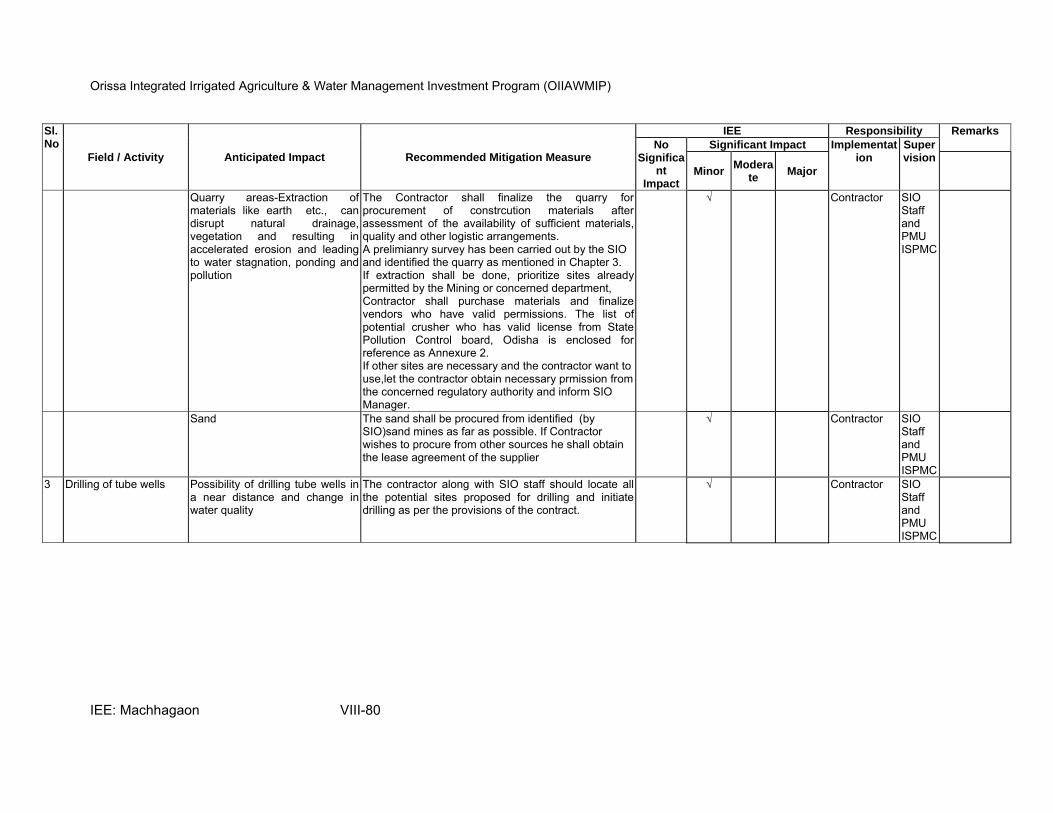
Orissa Integrated Irrigated Agriculture & Water Management Investment Program (OIIAWMIP)
IEE: Machhagaon VIII-80
Sl.No
Field / Activity Anticipated Impact Recommended Mitigation Measure
IEE Responsibility Remarks
No Significa
nt Impact
Significant Impact Implementation
Supervision
Minor Modera
te Major
Quarry areas-Extraction of materials like earth etc., can disrupt natural drainage, vegetation and resulting in accelerated erosion and leading to water stagnation, ponding and pollution
The Contractor shall finalize the quarry for procurement of constrcution materials after assessment of the availability of sufficient materials, quality and other logistic arrangements. A prelimianry survey has been carried out by the SIO and identified the quarry as mentioned in Chapter 3. If extraction shall be done, prioritize sites already permitted by the Mining or concerned department, Contractor shall purchase materials and finalize vendors who have valid permissions. The list of potential crusher who has valid license from State Pollution Control board, Odisha is enclosed for reference as Annexure 2. If other sites are necessary and the contractor want to use,let the contractor obtain necessary prmission from the concerned regulatory authority and inform SIO Manager.
√ Contractor SIO Staff and PMU ISPMC
Sand The sand shall be procured from identified (by SIO)sand mines as far as possible. If Contractor wishes to procure from other sources he shall obtain the lease agreement of the supplier
√ Contractor SIO Staff and PMU ISPMC
3 Drilling of tube wells Possibility of drilling tube wells in a near distance and change in water quality
The contractor along with SIO staff should locate all the potential sites proposed for drilling and initiate drilling as per the provisions of the contract.
√ Contractor SIO Staff and PMU ISPMC

Orissa Integrated Irrigated Agriculture & Water Management Investment Program (OIIAWMIP)
IEE: Machhagaon VIII-81
Table 31 Environmental Parameters Checklist for anticipated impacts and Mitigation Measures for Machhagoan Sub-project (Main canal, Distributaries and Minors executed by Contractors) - Construction Phase - Environmental Mitigation Plan
Sl.No
Field / Activity Anticipated Impact Recommended Mitigation Measure
IEE Responsibility Remarks
No Significant Impa
ct
Significant Impact Implementation
Supervision
MinorModera
te Major
1 Inadequate monitoring during construction stages
Potential damages to system likely to be maximised as a result of neglect on part of contractor.
Contractor to execute works in accordance with standard Contract Specification. Provision of site supervisory staff to ensure quality control and adherence to contract requirements. Monthly progress reporting and recording of community complaints/ objections. Issues to be resolved jointly with Project (SIO), PMU and ISPMC.
√ Contractor SIO Staff, PMU and ISPMC
2 Tube well drilling Scope for contamination of water
The Contractor after tube well drilling shall purge and decontaminate before it is put to use
Tube well shallbe sealed and its pedal shall be sealed properly to avoid mixing of impurties mixing witih ground water
A concrete pad around the tube well may be constructed
√ Contractor SIO Staff, PMU and ISPMC
3 Site clearance –Clearing and grubbing
Damage to existing vegetation
If any vegetation shall be removed from construction site / zone before commencement of construction shalll be carried out such that damage to the surrouding vegetation other than identifieid vegetation proposed for clearing is minimal. Only ground cover/ shrubs that impinge directly at the work site shall be removed prior approval from SIO staff and in consultation with Environment Specialist
√ Contractor SIO Staff, PMU and ISPMC
4 Disposal of debris from dismantling structures and spoil
Scope for contamination of soil and blockage of natural drains and pollution of ground water by dumping of construction spoils
To the possible extent the materials like stone and other reusable materials shall be utlized in the construction. The iron and wood generated if any would be disposed off as a surplus stock and scrap shall be autioned as per the procedures of Odisha Water Resoruces Department.
√ Contractor SIO Staff, PMU , ISPMC
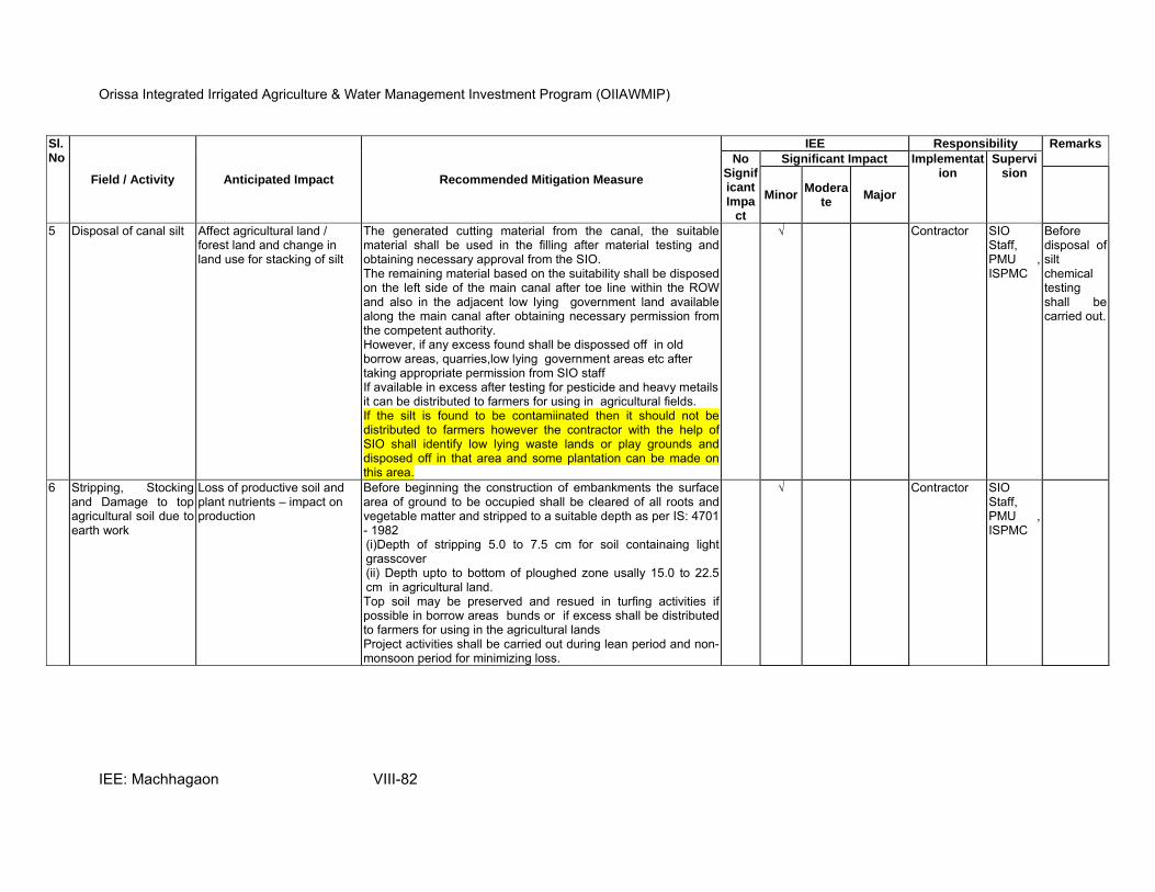
Orissa Integrated Irrigated Agriculture & Water Management Investment Program (OIIAWMIP)
IEE: Machhagaon VIII-82
Sl.No
Field / Activity Anticipated Impact Recommended Mitigation Measure
IEE Responsibility Remarks
No Significant Impa
ct
Significant Impact Implementation
Supervision
MinorModera
te Major
5 Disposal of canal silt Affect agricultural land / forest land and change in land use for stacking of silt
The generated cutting material from the canal, the suitable material shall be used in the filling after material testing and obtaining necessary approval from the SIO. The remaining material based on the suitability shall be disposed on the left side of the main canal after toe line within the ROW and also in the adjacent low lying government land available along the main canal after obtaining necessary permission from the competent authority. However, if any excess found shall be dispossed off in old borrow areas, quarries,low lying government areas etc after taking appropriate permission from SIO staff If available in excess after testing for pesticide and heavy metails it can be distributed to farmers for using in agricultural fields. If the silt is found to be contamiinated then it should not be distributed to farmers however the contractor with the help of SIO shall identify low lying waste lands or play grounds and disposed off in that area and some plantation can be made on this area.
√ Contractor SIO Staff, PMU , ISPMC
Before disposal of silt chemical testing shall be carried out.
6 Stripping, Stocking and Damage to top agricultural soil due to earth work
Loss of productive soil and plant nutrients – impact on production
Before beginning the construction of embankments the surface area of ground to be occupied shall be cleared of all roots and vegetable matter and stripped to a suitable depth as per IS: 4701 - 1982 (i)Depth of stripping 5.0 to 7.5 cm for soil containaing light grasscover (ii) Depth upto to bottom of ploughed zone usally 15.0 to 22.5 cm in agricultural land. Top soil may be preserved and resued in turfing activities if possible in borrow areas bunds or if excess shall be distributed to farmers for using in the agricultural lands Project activities shall be carried out during lean period and non-monsoon period for minimizing loss.
√ Contractor SIO Staff, PMU , ISPMC
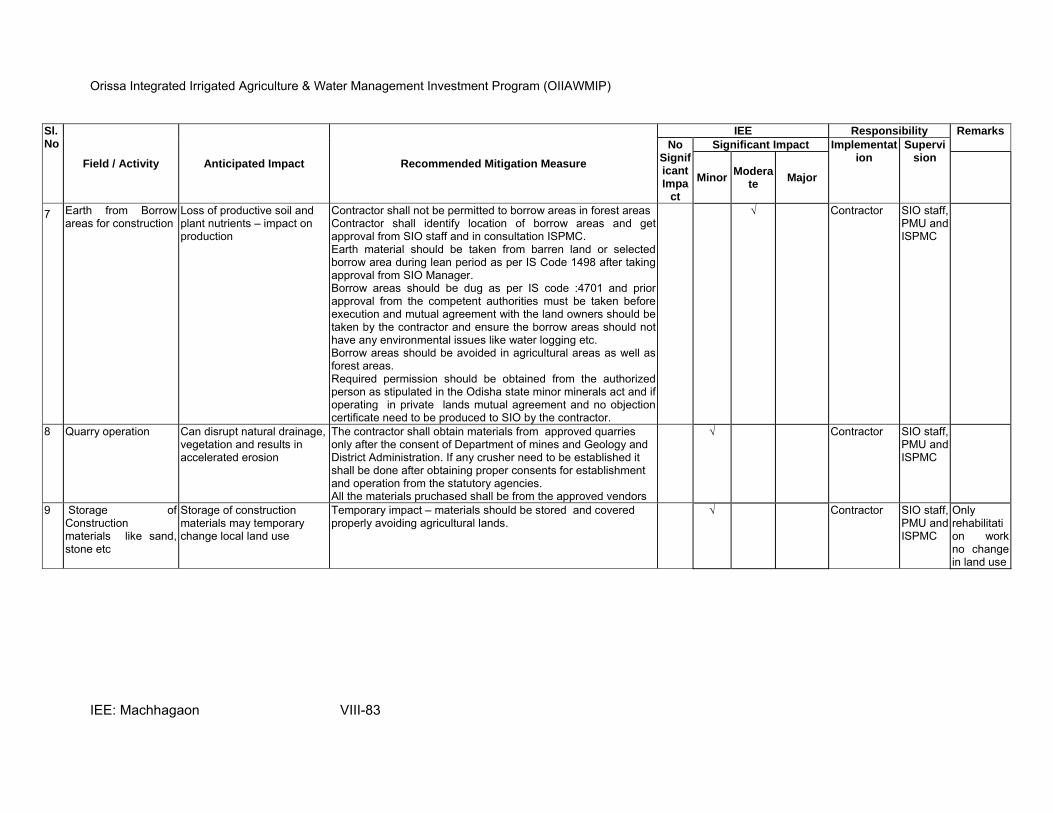
Orissa Integrated Irrigated Agriculture & Water Management Investment Program (OIIAWMIP)
IEE: Machhagaon VIII-83
Sl.No
Field / Activity Anticipated Impact Recommended Mitigation Measure
IEE Responsibility Remarks
No Significant Impa
ct
Significant Impact Implementation
Supervision
MinorModera
te Major
7 Earth from Borrow areas for construction
Loss of productive soil and plant nutrients – impact on production
Contractor shall not be permitted to borrow areas in forest areas Contractor shall identify location of borrow areas and get approval from SIO staff and in consultation ISPMC. Earth material should be taken from barren land or selected borrow area during lean period as per IS Code 1498 after taking approval from SIO Manager. Borrow areas should be dug as per IS code :4701 and prior approval from the competent authorities must be taken before execution and mutual agreement with the land owners should be taken by the contractor and ensure the borrow areas should not have any environmental issues like water logging etc. Borrow areas should be avoided in agricultural areas as well as forest areas. Required permission should be obtained from the authorized person as stipulated in the Odisha state minor minerals act and if operating in private lands mutual agreement and no objection certificate need to be produced to SIO by the contractor.
√ Contractor SIO staff, PMU and ISPMC
8 Quarry operation Can disrupt natural drainage, vegetation and results in accelerated erosion
The contractor shall obtain materials from approved quarries only after the consent of Department of mines and Geology and District Administration. If any crusher need to be established it shall be done after obtaining proper consents for establishment and operation from the statutory agencies. All the materials pruchased shall be from the approved vendors
√ Contractor SIO staff, PMU and ISPMC
9 Storage of Construction materials like sand, stone etc
Storage of construction materials may temporary change local land use
Temporary impact – materials should be stored and covered properly avoiding agricultural lands.
√ Contractor SIO staff, PMU and ISPMC
Only rehabilitation work no change in land use
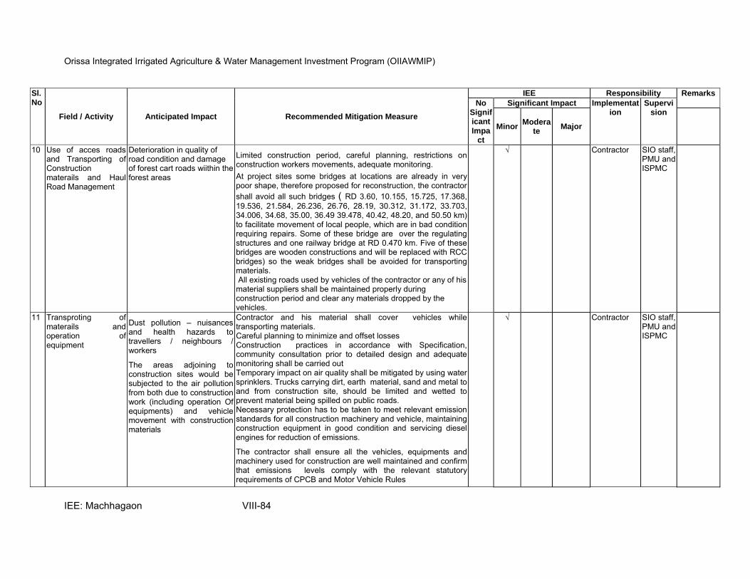
Orissa Integrated Irrigated Agriculture & Water Management Investment Program (OIIAWMIP)
IEE: Machhagaon VIII-84
Sl.No
Field / Activity Anticipated Impact Recommended Mitigation Measure
IEE Responsibility Remarks
No Significant Impa
ct
Significant Impact Implementation
Supervision
MinorModera
te Major
10 Use of acces roads and Transporting of Construction materails and Haul Road Management
Deterioration in quality of road condition and damage of forest cart roads wiithin the forest areas
Limited construction period, careful planning, restrictions on construction workers movements, adequate monitoring.
At project sites some bridges at locations are already in very poor shape, therefore proposed for reconstruction, the contractor
shall avoid all such bridges ( RD 3.60, 10.155, 15.725, 17.368, 19.536, 21.584, 26.236, 26.76, 28.19, 30.312, 31.172, 33.703, 34.006, 34.68, 35.00, 36.49 39.478, 40.42, 48.20, and 50.50 km) to facilitate movement of local people, which are in bad condition requiring repairs. Some of these bridge are over the regulating structures and one railway bridge at RD 0.470 km. Five of these bridges are wooden constructions and will be replaced with RCC bridges) so the weak bridges shall be avoided for transporting materials. All existing roads used by vehicles of the contractor or any of his material suppliers shall be maintained properly during construction period and clear any materials dropped by the vehicles.
√ Contractor SIO staff, PMU and ISPMC
11 Transproting of materails and operation of equipment
Dust pollution – nuisances and health hazards to travellers / neighbours / workers
The areas adjoining to construction sites would be subjected to the air pollution from both due to construction work (including operation Of equipments) and vehicle movement with construction materials
Contractor and his material shall cover vehicles while transporting materials. Careful planning to minimize and offset losses Construction practices in accordance with Specification, community consultation prior to detailed design and adequate monitoring shall be carried out Temporary impact on air quality shall be mitigated by using water sprinklers. Trucks carrying dirt, earth material, sand and metal to and from construction site, should be limited and wetted to prevent material being spilled on public roads. Necessary protection has to be taken to meet relevant emission standards for all construction machinery and vehicle, maintaining construction equipment in good condition and servicing diesel engines for reduction of emissions.
The contractor shall ensure all the vehicles, equipments and machinery used for construction are well maintained and confirm that emissions levels comply with the relevant statutory requirements of CPCB and Motor Vehicle Rules
√ Contractor SIO staff, PMU and ISPMC
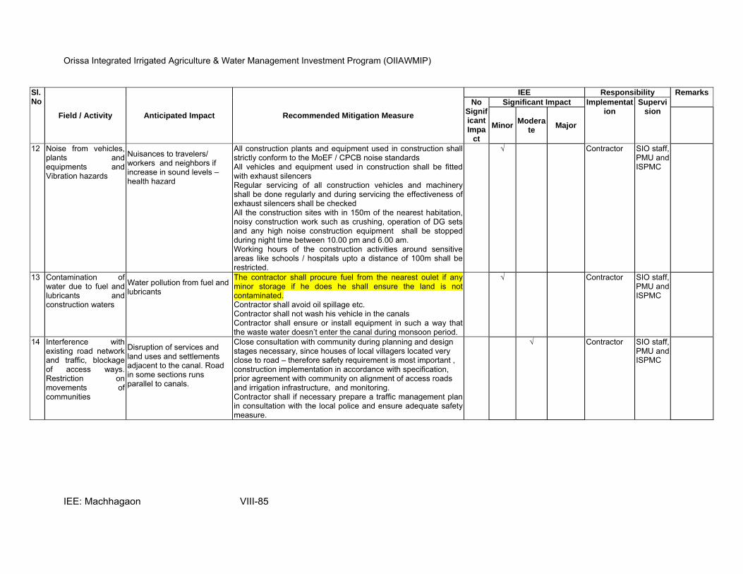
Orissa Integrated Irrigated Agriculture & Water Management Investment Program (OIIAWMIP)
IEE: Machhagaon VIII-85
Sl.No
Field / Activity Anticipated Impact Recommended Mitigation Measure
IEE Responsibility Remarks
No Significant Impa
ct
Significant Impact Implementation
Supervision
MinorModera
te Major
12 Noise from vehicles, plants and equipments and Vibration hazards
Nuisances to travelers/ workers and neighbors if increase in sound levels – health hazard
All construction plants and equipment used in construction shall strictly conform to the MoEF / CPCB noise standards All vehicles and equipment used in construction shall be fitted with exhaust silencers Regular servicing of all construction vehicles and machinery shall be done regularly and during servicing the effectiveness of exhaust silencers shall be checked All the construction sites with in 150m of the nearest habitation, noisy construction work such as crushing, operation of DG sets and any high noise construction equipment shall be stopped during night time between 10.00 pm and 6.00 am. Working hours of the construction activities around sensitive areas like schools / hospitals upto a distance of 100m shall be restricted.
√ Contractor SIO staff, PMU and ISPMC
13 Contamination of water due to fuel and lubricants and construction waters
Water pollution from fuel and lubricants
The contractor shall procure fuel from the nearest oulet if any minor storage if he does he shall ensure the land is not contaminated. Contractor shall avoid oil spillage etc. Contractor shall not wash his vehicle in the canals Contractor shall ensure or install equipment in such a way that the waste water doesn’t enter the canal during monsoon period.
√ Contractor SIO staff, PMU and ISPMC
14 Interference with existing road network and traffic, blockage of access ways. Restriction on movements of communities
Disruption of services and land uses and settlements adjacent to the canal. Road in some sections runs parallel to canals.
Close consultation with community during planning and design stages necessary, since houses of local villagers located very close to road – therefore safety requirement is most important , construction implementation in accordance with specification, prior agreement with community on alignment of access roads and irrigation infrastructure, and monitoring. Contractor shall if necessary prepare a traffic management plan in consultation with the local police and ensure adequate safety measure.
√ Contractor SIO staff, PMU and ISPMC

Orissa Integrated Irrigated Agriculture & Water Management Investment Program (OIIAWMIP)
IEE: Machhagaon VIII-86
Sl.No
Field / Activity Anticipated Impact Recommended Mitigation Measure
IEE Responsibility Remarks
No Significant Impa
ct
Significant Impact Implementation
Supervision
MinorModera
te Major
15 Soil Erosion and Siltation Degraded embankments,
damage to soil and general land value. Increased sedimentation build-up and clogging of surrounding waterways.
Employment of stringent construction practices and monitoring Confirming excavations opearions and slope stabilisation work( such as avoiding deep cutting of borrow areas, borrow areas shall be connected to natural drain)and arranging sprinkling of water during the dry season only and compaction in main canal by powered road roller and vibtratory roller and in the distributaries, minors and sub-minors by ordinary compaction Careful construction planning for surface protection particularly before monsoon season and provision of turfing and plantation. Plantation can be taken up on the canal embakments with the available funds under plantation and also with the other ongoing shcemes of Govt. Odisha like social forestry programmes etc
√ Contractor SIO staff, PMU and ISPMC
16 Stocking materials or Blockage of natural drainage with materails
Damage to natural drainage patterns
Presently natural Drains are dominant with weeds
Assessment of existing drainage channels during construction stages. Contractor to maintain natural drainage, stipulate in Contract Specification. Provision of site supervision during construction implementation.
√ Contractor SIO Staff, PMU and ISPMC
17 Personnel Safety Measures for Labour
Workers health would get affected
Contractor shall provide the necessary personnel Protective Equipment (PPE) like foot wear, gloves, protective goggles and eye –shields etc for workers emplyed in concrete, crusehrs, welders and bitumen work Ear plugs to workers exposed to loud noise and workers working in crushers etc if the contractor establishes. The contractor shall comply with all the regulations regarding safe scaffoldiing, ladders, working platforms, excavations and safe emans of entry and engress The contractor shall not employ any person below age of 14 years for any work and no pregnant women. The contractor shall comply with all the relevant provisions of the Orissa Buidlings and other Construction Workers ( Regulations of Employment and conditions of service) Rules 2002 and shall also comply with the precautions as required for ensurig the safety of thw worKmen as per International Labour Organisation (ILO) Convention No 62 as far as thise are applicable to this contract.
√ Contractor SIO Staff, PMU and ISPMC

Orissa Integrated Irrigated Agriculture & Water Management Investment Program (OIIAWMIP)
IEE: Machhagaon VIII-87
Sl.No
Field / Activity Anticipated Impact Recommended Mitigation Measure
IEE Responsibility Remarks
No Significant Impa
ct
Significant Impact Implementation
Supervision
MinorModera
te Major
18 Traffic and Safety Disruption of services and may lead to accidents
The contractor shall take all necessary measures for maintining the traffic during construction and errect safety barricades, safety ribbons and safety boards including sign boards, flags and other measures as per the requirement
√ Contractor SIO Staff, PMU and ISPMC
19 Protection of public and workers health and safety
Loss of public / workers health status
Project staff to provide basic health and safety trainings to all construction workers and providing periodic health check ups and AIDS awareness camps
√ Contractor SIO Staff, PMU and ISPMC
20 Risk from Electric Poles / lines and electrical equipments
Scope for electric shocks andelectrocution hazard
While giving level or marking workers should ensure they take preventive measures while working with electric lines. The contractor shall take all required precautions to prevent danger from electrical equipments and ensures that he doesn’t place or stack any material that may cause danger or inconvenince to any person or public All machines and equipments and lighting used will be as per the IS standards and shall mainatian properly withoout any defects.
√ Contractor SIO Staff, PMU and ISPMC
21 Damage to different flora / fauna habitats
Along the canal side few trees are presnt- during renovation work those trees might be felled
Close consultation with community prior to detailed design to identify important flora/fauna habitats. Careful planning of infrastructure alignment prior to construction/ implementation. Stipulate in Conditions of Contract and provision of site supervision. Plantation of trees along the irrigation canal compensate loss of flora Contractor shall take reasonable precaution to prevent his workers from damaging any flora or fauna of the area including fishing or hunting of any animals in the area. If by chance if the contractor sights any animal (wild) the contractor shall inform the SIO staff and Environment Specialist and need to be reported to the State Forest Department immeidately and shall take appropriate steps / measures in consultation with Forest Department Officials Replanting of saplings of 3:1 for each tree cut (but you will have to identify suitable places to replant- any areas identified?
√ Contractor SIO Staff, PMU and ISPMC
No forest land exist along the canal

Orissa Integrated Irrigated Agriculture & Water Management Investment Program (OIIAWMIP)
IEE: Machhagaon VIII-88
Sl.No
Field / Activity Anticipated Impact Recommended Mitigation Measure
IEE Responsibility Remarks
No Significant Impa
ct
Significant Impact Implementation
Supervision
MinorModera
te Major
22 Temporary closure of irrigation system
Non availability of irrigation water and impact on production and livelihood of farmers
Consultation with local Water Users Associations members or Panu Panchayt members befor closing the canal
The construction activities will be scheduled after Kharif crop period only
Proper information shall be given to the farmers
√ Contractor SIO Staff, PMU and ISPMC
23 Digging activity – Chance found Archaeological property
By Chance if any Archaeological property is found while digging
While excavating or dismantling any structure if any fossils, coins, articles of value / antiquity and remians of archaelogical interest discovered on the site shall be the property of the Government and shall be dealt with as the provisions of the relevant legislation
The Contractor shall take reasonable precautions to prevent his workmen or any other persons from damaging or removing any such articles, if any articles found shall be brought to the notice of SIO and Environment Specialist and shall seek the direction of Archaelogical Survey of India (ASI) before contractor recommencing the work
√ Contractor SIO Staff, PMU and ISPMC
24 Provision of Basic Ameneties and proper accomodation
Scope for providing improper accomodation and basic amenities to workers
The Contractor shall provide the basic accomodations as per the provisions of the Orissa Building and Construction Workers Rules The location and layout of the labour camps shall be provided to the SIO staff and take his approval The Contractor will ensure all the basic amenities like provision of drinking water at work site and camps and proper sanitation facilities and arrangement for eating the food. The drinking water he provides shall be as per the IS 10,500.
√ Contractor SIO Staff, PMU and ISPMC
25 Clearing of site before monsoon and Demobilization of contractor
Scope for not clearing materials from the site especially cutting materils from the canal bed and materiasl used for construction
The Contractor shall ensure that he clears all the unwanted materials and debris from the canal bed which may effect or obstruct after releasing the water into canal.
√ Contractor SIO Staff, PMU and ISPMC
26 Tree plantation Scope for wrong species selection and not able to survive
SIO shall consult horticultural department before selecting the tree species that would be planted along the canal Approriate distance shall be maintained and Regular maintenance shall be carried out.
√ SIO staff PMU and ISPMC
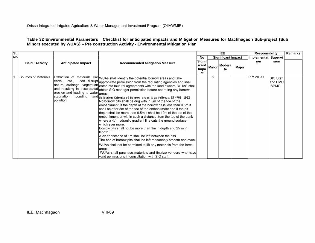
Orissa Integrated Irrigated Agriculture & Water Management Investment Program (OIIAWMIP)
IEE: Machhagaon VIII-89
Table 32 Environmental Parameters Checklist for anticipated impacts and Mitigation Measures for Machhagaon Sub-project (Sub Minors executed by WUAS) – Pre construction Activity - Environmental Mitigation Plan
Sl.No
Field / Activity Anticipated Impact Recommended Mitigation Measure
IEE Responsibility Remarks
No Significant Impa
ct
Significant Impact Implementation
Supervision
MinorModera
te Major
1 Sources of Materials Extraction of materials like earth etc., can disrupt natural drainage, vegetation and resulting in accelerated erosion and leading to water stagnation, ponding and pollution
WUAs shall identify the potential borrow areas and take appropirate permission from the regulating agencies and shall enter into mututal agreements with the land owners. WUAS shall obtain SIO manager permission before operating any borrow areas. Selection Criteria of Borrow areas is as follows: IS 4701: 1982
No borrow pits shall be dug with in 5m of the toe of the embankment, if the depth of the borrow pit is less than 0.5m it shall be after 5m of the toe of the embankment and if the pit depth shall be more than 0.5m it shall be 10m of the toe of the embankment or within such a distance from the toe of the bank where a 4:1 hydraulic gradient line cuts the ground surface, which ever more. Borrow pits shall not be more than 1m in depth and 25 m in length. A clear distance of 1m shall be left between the pits The bed of borrow pits shall be left reasonably smooth and even.
WUAs shall not be permitted to lift any materials from the forest areas. WUAs shall purchase materials and finalize vendors who have valid permissions in consultation with SIO staff.
√ PP/ WUAs SIO Staff and PMUISPMC
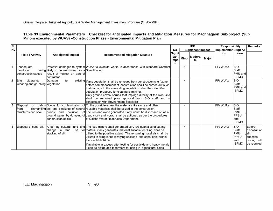
Orissa Integrated Irrigated Agriculture & Water Management Investment Program (OIIAWMIP)
IEE: Machhagaon VIII-90
Table 33 Environmental Parameters Checklist for anticipated impacts and Mitigation Measures for Machhagaon Sub-project (Sub Minors executed by WUAS) –Construction Phase - Environmental Mitigation Plan
Sl.No
Field / Activity Anticipated Impact Recommended Mitigation Measure
IEE Responsibility Remarks
No Significant Impa
ct
Significant Impact Implementation
Supervision
MinorModera
te Major
1 Inadequate monitoring during construction stages
Potential damages to system likely to be maximised as a result of neglect on part of contractor.
WUAs to execute works in accordance with standard Contract Specification.
√ PP/ WUAs SIO Staff, PMU and ISPMC
2 Site clearance –Clearing and grubbing
Damage to existing vegetation
If any vegetation shall be removed from construction site / zone before commencement of construction shalll be carried out such that damage to the surrouding vegetation other than identifieid vegetation proposed for clearing is minimal. Only ground cover/ shrubs that impinge directly at the work site shall be removed prior approval from SIO staff and in consultation with Environment Specialist
√ PP/ WUAs SIO Staff, PMU and ISPMC
3 Disposal of debris from dismantling structures and spoil
Scope for contamination of soil and blockage of natural drains and pollution of ground water by dumping of construction spoils
To the possible extent the materials like stone and other reusable materials shall be utlized in the construction. The iron and wood generated if any would be dispossed off as a dead stock and scrap shall be autioned as per the procedures of Odisha Water Resoruces Department.
√ PP/ WUAs SIO Staff, PMU , PPSU and ISPMC
4 Disposal of canal silt Affect agricultural land and change in land use for stacking of silt
The sub-minors shall generated very low quantities of cutting material if any generates material suitable for filling shall be utlized to the possible extent. The remaining mateirals shall be utilized in filling in the low lying sections the canal bank within the available ROW
If available in excess after testing for pesticide and heavy metals it can be distributed to farmers for using in agricultural fields
√ PP/ WUAs SIO Staff, PMU , PPSU and ISPMC
Before disposal of silt chemical testing will be required
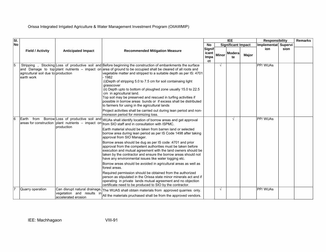
Orissa Integrated Irrigated Agriculture & Water Management Investment Program (OIIAWMIP)
IEE: Machhagaon VIII-91
Sl.No
Field / Activity Anticipated Impact Recommended Mitigation Measure
IEE Responsibility Remarks
No Significant Impa
ct
Significant Impact Implementation
Supervision
MinorModera
te Major
5 Stripping , Stocking and Damage to top agricultural soil due to earth work
Loss of productive soil and plant nutrients – impact on production
Before beginning the construction of embankments the surface area of ground to be occupied shall be cleared of all roots and vegetable matter and stripped to a suitable depth as per IS: 4701 - 1982 (i)Depth of stripping 5.0 to 7.5 cm for soil containaing light grasscover (ii) Depth upto to bottom of ploughed zone usually 15.0 to 22.5 cm in agricultural land. Top soil may be preserved and rescued in turfing activities if possible in borrow areas bunds or if excess shall be distributed to farmers for using in the agricultural lands
Project activities shall be carried out during lean period and non- monsoon period for minimizing loss.
√ PP/ WUAs
6 Earth from Borrow areas for construction
Loss of productive soil and plant nutrients – impact on production
WUAs shall identify location of borrow areas and get approval from SIO staff and in consultation with ISPMC.
Earth material should be taken from barren land or selected borrow area during lean period as per IS Code 1498 after taking approval from SIO Manager.
Borrow areas should be dug as per IS code :4701 and prior approval from the competent authorities must be taken before execution and mutual agreement with the land owners should be taken by the contractor and ensure the borrow areas should not have any environmental issues like water logging etc.
Borrow areas should be avoided in agricultural areas as well as forest areas.
Required permission should be obtained from the authorized person as stipulated in the Orissa state minor minerals act and if operating in private lands mutual agreement and no objection certificate need to be produced to SIO by the contractor.
√ PP/ WUAs
7 Quarry operation Can disrupt natural drainage, vegetation and results in accelerated erosion
The WUAS shall obtain materials from approved quarries only.
All the materials pruchased shall be from the approved vendors.
√ PP/ WUAs
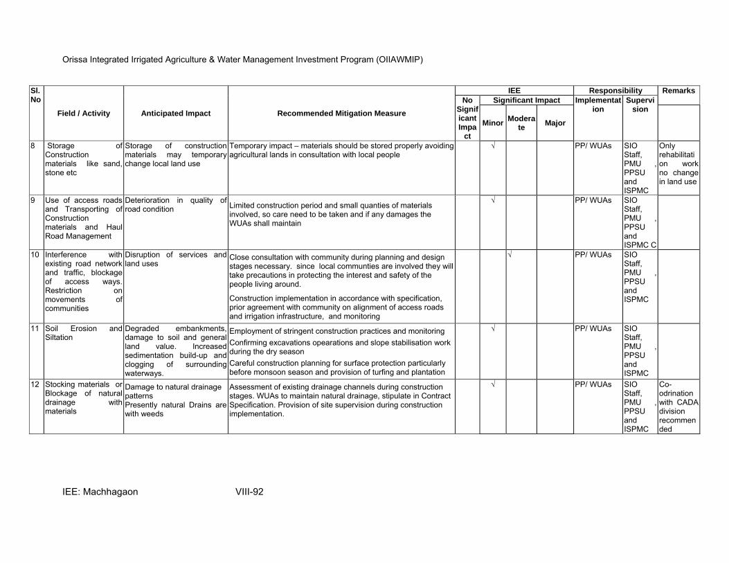
Orissa Integrated Irrigated Agriculture & Water Management Investment Program (OIIAWMIP)
IEE: Machhagaon VIII-92
Sl.No
Field / Activity Anticipated Impact Recommended Mitigation Measure
IEE Responsibility Remarks
No Significant Impa
ct
Significant Impact Implementation
Supervision
MinorModera
te Major
8 Storage of Construction materials like sand, stone etc
Storage of construction materials may temporary change local land use
Temporary impact – materials should be stored properly avoiding agricultural lands in consultation with local people
√ PP/ WUAs SIO Staff, PMU , PPSU and ISPMC
Only rehabilitation work no change in land use
9 Use of access roads and Transporting of Construction materials and Haul Road Management
Deterioration in quality of road condition Limited construction period and small quanties of materials
involved, so care need to be taken and if any damages the WUAs shall maintain
√ PP/ WUAs SIO Staff, PMU , PPSU and ISPMC C
10 Interference with existing road network and traffic, blockage of access ways. Restriction on movements of communities
Disruption of services and land uses
Close consultation with community during planning and design stages necessary. since local communties are involved they will take precautions in protecting the interest and safety of the people living around.
Construction implementation in accordance with specification, prior agreement with community on alignment of access roads and irrigation infrastructure, and monitoring
√ PP/ WUAs SIO Staff, PMU , PPSU and ISPMC
11 Soil Erosion and Siltation
Degraded embankments, damage to soil and general land value. Increased sedimentation build-up and clogging of surrounding waterways.
Employment of stringent construction practices and monitoring
Confirming excavations opearations and slope stabilisation work during the dry season
Careful construction planning for surface protection particularly before monsoon season and provision of turfing and plantation
√ PP/ WUAs SIO Staff, PMU , PPSU and ISPMC
12 Stocking materials or Blockage of natural drainage with materials
Damage to natural drainage patterns Presently natural Drains are with weeds
Assessment of existing drainage channels during construction stages. WUAs to maintain natural drainage, stipulate in Contract Specification. Provision of site supervision during construction implementation.
√ PP/ WUAs SIO Staff, PMU , PPSU and ISPMC
Co-odrination with CADA division recommended
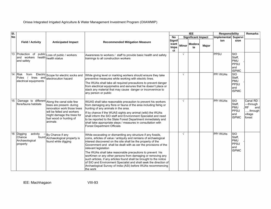
Orissa Integrated Irrigated Agriculture & Water Management Investment Program (OIIAWMIP)
IEE: Machhagaon VIII-93
Sl.No
Field / Activity Anticipated Impact Recommended Mitigation Measure
IEE Responsibility Remarks
No Significant Impa
ct
Significant Impact Implementation
Supervision
MinorModera
te Major
13 Protection of public and workers health and safety
Loss of public / workers health status
Awareness to workers / staff to provide basic health and safety trainings to all construction workers
√ PPSU SIO Staff, PMU , PPSU and ISPMC
14 Risk from Electric Poles / lines and electrical equipments
Scope for electric socks and electrocution hazard
While giving level or marking workers should ensure they take preventive measures while working with electric lines.
The WUAs shall take all required precautions to prevent danger from electrical equipmetns and esnures that he doesn’t place or stack any material that may cause danger or inconvenince to any person or public
√ PP/ WUAs SIO Staff, PMU , PPSU and ISPMC
15 Damage to different flora/fauna habitats
Along the canal side few trees are present- during renovation work those trees will be felled and workers might damage the trees for fuel wood or hunting of animals
WUAS shall take reasonable precaution to prevent his workers from damaging any flora or fauna of the area including fishig or hunting of any animals in the area.
If by chance if the WUAS sights any animal (wild) the WUAs shall inform the SIO staff and Environment Specialist and need to be reported to the State Forest Department immediately and shall take appropriate steps / measures in consultation with Forest Department Officials
√ PP/ WUAs SIO Staff, PMU , PPSU and ISPMC
Canal RD ----through RF and …..through village forest
16 Digging activity – Chance found Archaeological property
By Chance if any Archaeological property is found while digging
While excavating or dismantling any structure if any fossils, coins, articles of value / antiquity and remians of archaelogical interest discovered on the site shall be the property of the Government and shall be dealt with as oer the provisions of the relevant legislation
The WUAs shall take reasonable precautions to prevent his worKmen or any other persons from damaging or removing any such articles, if any articles found shall be brought to the notice of SIO and Environment Specialist and shall seek the direction of Archaelogical Survey of India (ASI) before WUAs recommencing the work
√ PP/ WUAs SIO Staff, PMU , PPSU and ISPMC
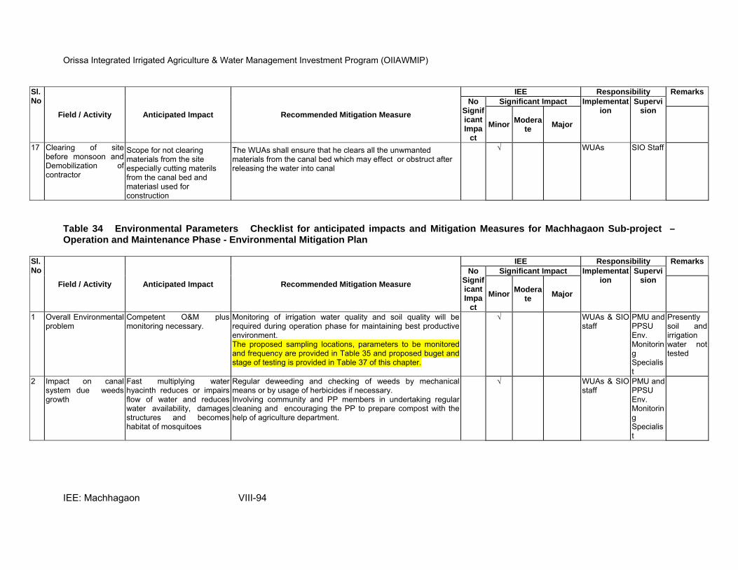
Orissa Integrated Irrigated Agriculture & Water Management Investment Program (OIIAWMIP)
IEE: Machhagaon VIII-94
Sl.No
Field / Activity Anticipated Impact Recommended Mitigation Measure
IEE Responsibility Remarks
No Significant Impa
ct
Significant Impact Implementation
Supervision
MinorModera
te Major
17 Clearing of site before monsoon and Demobilization of contractor
Scope for not clearing materials from the site especially cutting materils from the canal bed and materiasl used for construction
The WUAs shall ensure that he clears all the unwmanted materials from the canal bed which may effect or obstruct after releasing the water into canal
√ WUAs SIO Staff
Table 34 Environmental Parameters Checklist for anticipated impacts and Mitigation Measures for Machhagaon Sub-project – Operation and Maintenance Phase - Environmental Mitigation Plan
Sl.No
Field / Activity Anticipated Impact Recommended Mitigation Measure
IEE Responsibility Remarks
No Significant Impa
ct
Significant Impact Implementation
Supervision
MinorModera
te Major
1 Overall Environmental problem
Competent O&M plus monitoring necessary.
Monitoring of irrigation water quality and soil quality will be required during operation phase for maintaining best productive environment. The proposed sampling locations, parameters to be monitored and frequency are provided in Table 35 and proposed buget and stage of testing is provided in Table 37 of this chapter.
√ WUAs & SIO staff
PMU and PPSU Env. Monitoring Specialist
Presently soil and irrigation water not tested
2 Impact on canal system due weeds growth
Fast multiplying water hyacinth reduces or impairs flow of water and reduces water availability, damages structures and becomes habitat of mosquitoes
Regular deweeding and checking of weeds by mechanical means or by usage of herbicides if necessary. Involving community and PP members in undertaking regular cleaning and encouraging the PP to prepare compost with the help of agriculture department.
√ WUAs & SIO staff
PMU and PPSU Env. Monitoring Specialist
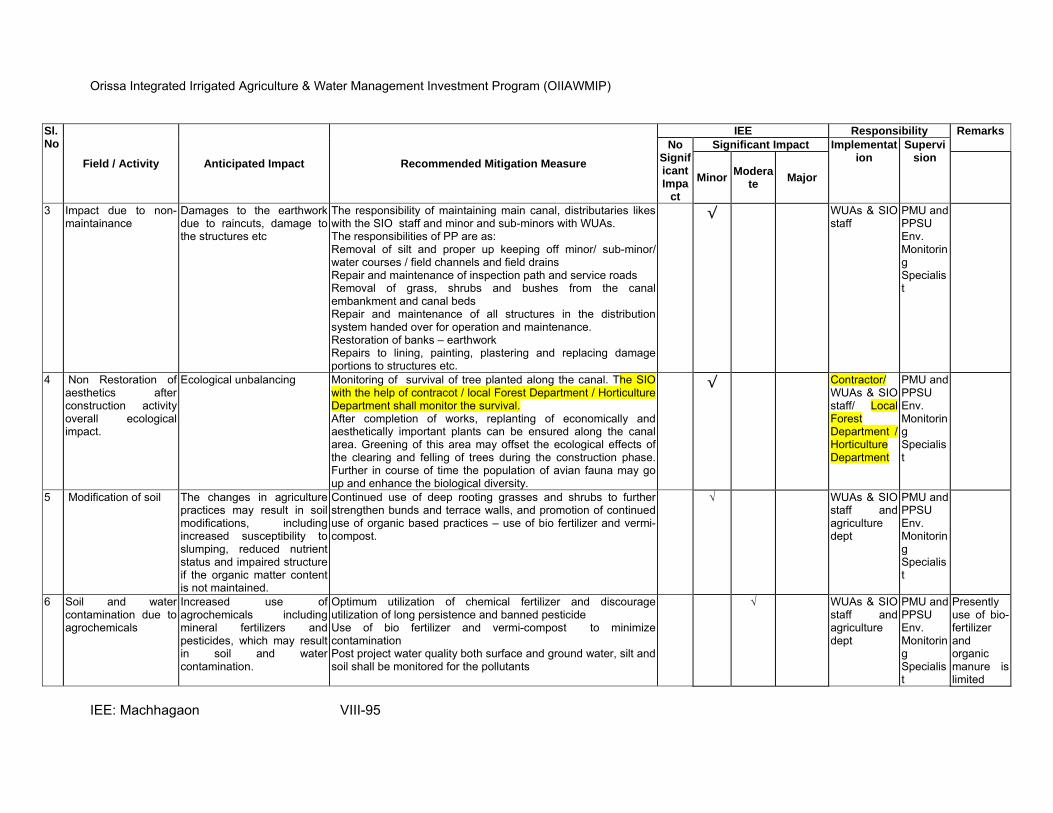
Orissa Integrated Irrigated Agriculture & Water Management Investment Program (OIIAWMIP)
IEE: Machhagaon VIII-95
Sl.No
Field / Activity Anticipated Impact Recommended Mitigation Measure
IEE Responsibility Remarks
No Significant Impa
ct
Significant Impact Implementation
Supervision
MinorModera
te Major
3 Impact due to non-maintainance
Damages to the earthwork due to raincuts, damage to the structures etc
The responsibility of maintaining main canal, distributaries likes with the SIO staff and minor and sub-minors with WUAs. The responsibilities of PP are as: Removal of silt and proper up keeping off minor/ sub-minor/ water courses / field channels and field drains Repair and maintenance of inspection path and service roads Removal of grass, shrubs and bushes from the canal embankment and canal beds Repair and maintenance of all structures in the distribution system handed over for operation and maintenance. Restoration of banks – earthwork Repairs to lining, painting, plastering and replacing damage portions to structures etc.
√ WUAs & SIO staff
PMU and PPSU Env. Monitoring Specialist
4 Non Restoration of aesthetics after construction activity overall ecological impact.
Ecological unbalancing Monitoring of survival of tree planted along the canal. The SIO with the help of contracot / local Forest Department / Horticulture Department shall monitor the survival. After completion of works, replanting of economically and aesthetically important plants can be ensured along the canal area. Greening of this area may offset the ecological effects of the clearing and felling of trees during the construction phase. Further in course of time the population of avian fauna may go up and enhance the biological diversity.
√ Contractor/ WUAs & SIO staff/ Local Forest Department / Horticulture Department
PMU and PPSU Env. Monitoring Specialist
5 Modification of soil The changes in agriculture practices may result in soil modifications, including increased susceptibility to slumping, reduced nutrient status and impaired structure if the organic matter content is not maintained.
Continued use of deep rooting grasses and shrubs to further strengthen bunds and terrace walls, and promotion of continued use of organic based practices – use of bio fertilizer and vermi-compost.
√ WUAs & SIO staff and agriculture dept
PMU and PPSU Env. Monitoring Specialist
6 Soil and water contamination due to agrochemicals
Increased use of agrochemicals including mineral fertilizers and pesticides, which may result in soil and water contamination.
Optimum utilization of chemical fertilizer and discourage utilization of long persistence and banned pesticide Use of bio fertilizer and vermi-compost to minimize contamination Post project water quality both surface and ground water, silt and soil shall be monitored for the pollutants
√ WUAs & SIO staff and agriculture dept
PMU and PPSU Env. Monitoring Specialist
Presently use of bio-fertilizer and organic manure is limited
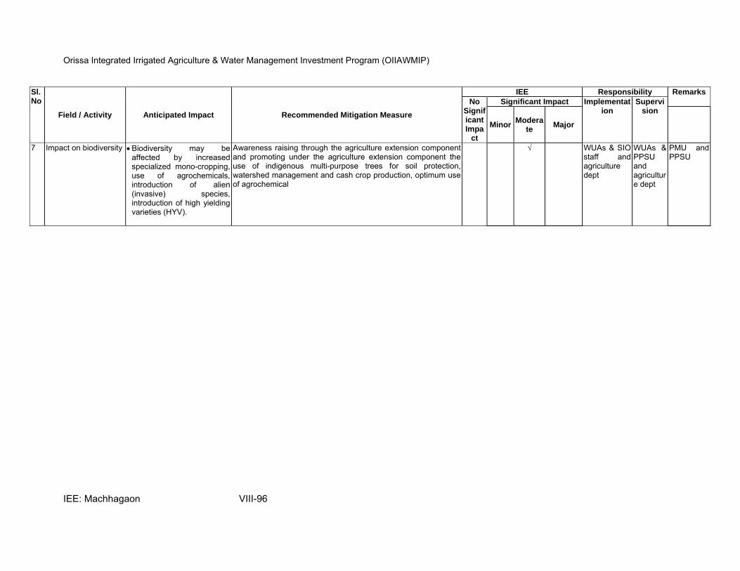
Orissa Integrated Irrigated Agriculture & Water Management Investment Program (OIIAWMIP)
IEE: Machhagaon VIII-96
Sl.No
Field / Activity Anticipated Impact Recommended Mitigation Measure
IEE Responsibility Remarks
No Significant Impa
ct
Significant Impact Implementation
Supervision
MinorModera
te Major
7 Impact on biodiversity • Biodiversity may be affected by increased specialized mono-cropping, use of agrochemicals, introduction of alien (invasive) species, introduction of high yielding varieties (HYV).
Awareness raising through the agriculture extension component and promoting under the agriculture extension component the use of indigenous multi-purpose trees for soil protection, watershed management and cash crop production, optimum use of agrochemical
√ WUAs & SIO staff and agriculture dept
WUAs & PPSU and agriculture dept
PMU and PPSU
Orissa Integrated Irrigated Agriculture & Water Management Investment Program (OIIAWMIP)
IEE: Machhagaon 97
H. Environmental Monitoring Plan
258. Environmental Monitoring is an essential component of any developmental project, it is an integral; part of any environmental assessment process. Any intervention in the form of development shall have complex-inter relationships between people, natural resources, biotic and other forces resulting in a new environment. So it is essential to monitor critical environmental parameters in the pre-post project scenario, during and post project scenario. The monitoring program includes environmental parameters, description of sampling stations, frequency of monitoring, applicable standards, responsible parties is shown in Table 35 and the parameters suggested for monitoring ground water, surface water, silt and soil is presented in Annexure 10, 10a &b.
259. The monitoring can be carried out by (i) PMU outsourcing to a Laboratory for all the
subprojects , or (ii) SIO outsourcing to a laboratory directly. The suggested parameters, description of sampling locations and different stages of monitoring required along with suggested frequency is shown in Table 35.
260. The environmental monitoring during the different phases of the subproject implementation can be carried out by a recognized laboratory (i.e approved by State Pollution Control Board, Odisha or National Accreditation Board for Testing and Calibration Laboratory (NABL) or National Accreditation Board for Education and Training (NABET) or any Ministry of Environment and Forests (MoEF) recognized laboratory,
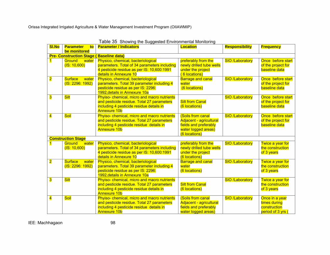
Orissa Integrated Irrigated Agriculture & Water Management Investment Program (OIIAWMIP)
IEE: Machhagaon 98
Table 35 Showing the Suggested Environmental Monitoring Sl.No Parameter to
be monitored Parameter / Indicators Location Responsibility Frequency
Pre- Construction Stage ( Baseline data)
1 Ground water (IS: 10,600)
Physico, chemical, bacteriological parameters. Total of 34 parameters including 4 pesticide residue as per IS: 10,600:1991 details in Annexure 10
preferably from the newly drilled tube wells under the project ( 6 locations)
SIO /Laboratory Once before start of the project for baseline data
2 Surface water (IS: 2296: 1992)
Physico, chemical, bacteriological parameters. Total 39 parameter including 4 pesticide residue as per IS: 2296: 1992,details in Annexure 10a
Barrage and canal water (6 locations)
SIO /Laboratory Once before start of the project for baseline data
3 Silt Phyiso- chemical, micro and macro nutrients and pesticide residue. Total 27 parameters including 4 pesticide residue details in Annexure 10b
Silt from Canal (6 locations)
SIO /Laboratory Once before start of the project for baseline data
4 Soil Phyiso- chemical, micro and macro nutrients
and pesticide residue. Total 27 parameters including 4 pesticide residue details in Annexure 10b
(Soils from canal Adjacent - agricultural fields and preferably water logged areas) (6 locations)
SIO /Laboratory Once before start of the project for baseline data
Construction Stage
1 Ground water (IS: 10,600)
Physico, chemical, bacteriological parameters. Total of 34 parameters including 4 pesticide residue as per IS: 10,600:1991 details in Annexure 10
preferably from the newly drilled tube wells under the project (6 locations)
SIO /Laboratory Twice a year for the construction of 3 years
2 Surface water (IS: 2296: 1992)
Physico, chemical, bacteriological parameters. Total 39 parameter including 4 pesticide residue as per IS: 2296: 1992,details in Annexure 10a
Barrage and canal water (6 locations)
SIO /Laboratory Twice a year for the construction of 3 years
3 Silt Phyiso- chemical, micro and macro nutrients and pesticide residue. Total 27 parameters including 4 pesticide residue details in Annexure 10b
Silt from Canal (6 locations)
SIO /Laboratory Twice a year for the construction of 3 years
4 Soil Phyiso- chemical, micro and macro nutrients and pesticide residue. Total 27 parameters including 4 pesticide residue details in Annexure 10b
(Soils from canal Adjacent - agricultural fields and preferably water logged areas)
SIO /Laboratory Once in a year times during construction period of 3 yrs (
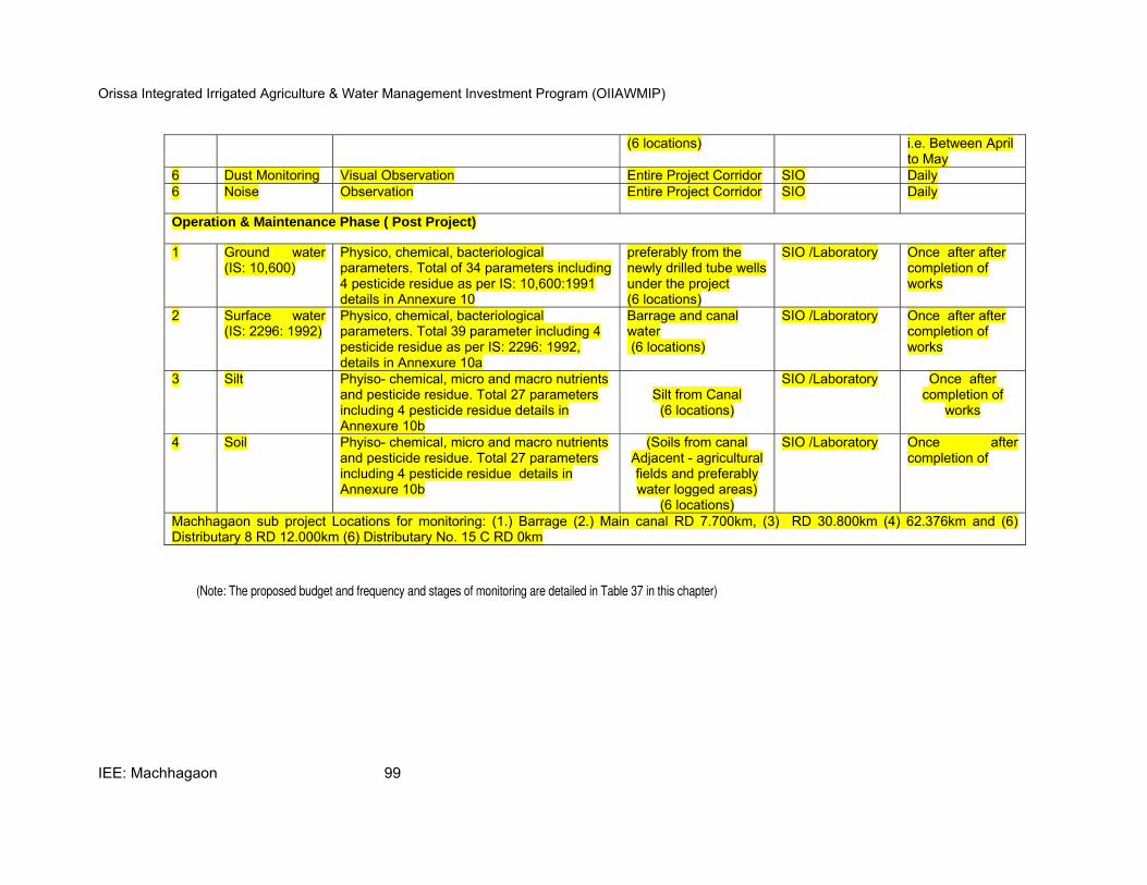
Orissa Integrated Irrigated Agriculture & Water Management Investment Program (OIIAWMIP)
IEE: Machhagaon 99
(6 locations) i.e. Between April to May
6 Dust Monitoring Visual Observation Entire Project Corridor SIO Daily 6 Noise Observation Entire Project Corridor SIO Daily
Operation & Maintenance Phase ( Post Project)
1 Ground water (IS: 10,600)
Physico, chemical, bacteriological parameters. Total of 34 parameters including 4 pesticide residue as per IS: 10,600:1991 details in Annexure 10
preferably from the newly drilled tube wells under the project (6 locations)
SIO /Laboratory Once after after completion of works
2 Surface water (IS: 2296: 1992)
Physico, chemical, bacteriological parameters. Total 39 parameter including 4 pesticide residue as per IS: 2296: 1992, details in Annexure 10a
Barrage and canal water (6 locations)
SIO /Laboratory Once after after completion of works
3 Silt Phyiso- chemical, micro and macro nutrients and pesticide residue. Total 27 parameters including 4 pesticide residue details in Annexure 10b
Silt from Canal
(6 locations)
SIO /Laboratory Once after completion of
works
4 Soil Phyiso- chemical, micro and macro nutrients and pesticide residue. Total 27 parameters including 4 pesticide residue details in Annexure 10b
(Soils from canal Adjacent - agricultural fields and preferably water logged areas)
(6 locations)
SIO /Laboratory Once after completion of
Machhagaon sub project Locations for monitoring: (1.) Barrage (2.) Main canal RD 7.700km, (3) RD 30.800km (4) 62.376km and (6) Distributary 8 RD 12.000km (6) Distributary No. 15 C RD 0km
(Note: The proposed budget and frequency and stages of monitoring are detailed in Table 37 in this chapter)
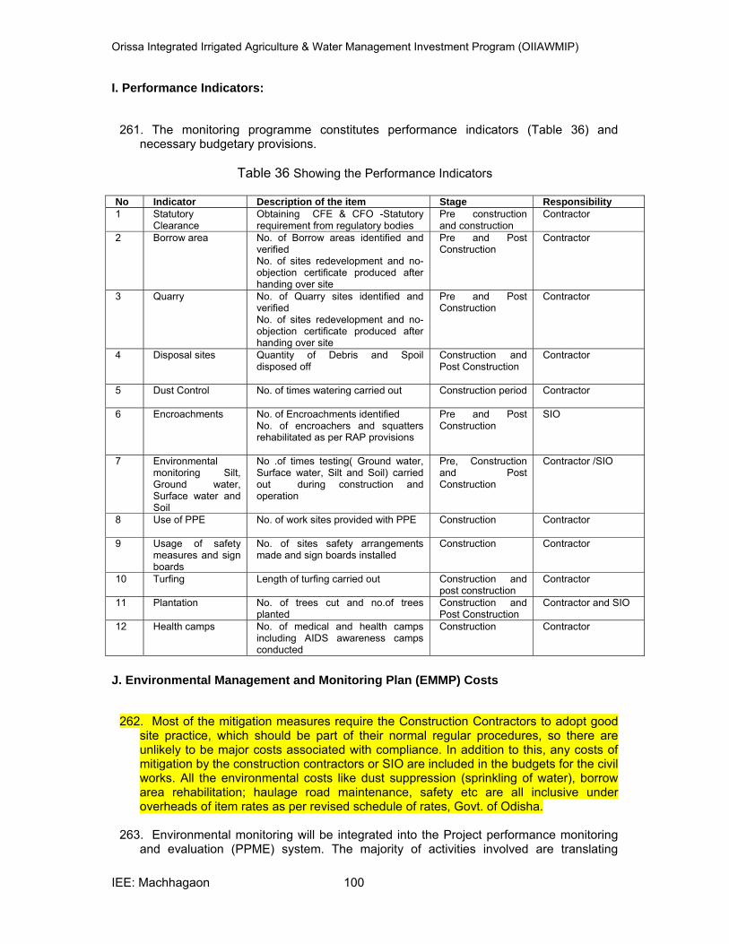
Orissa Integrated Irrigated Agriculture & Water Management Investment Program (OIIAWMIP)
IEE: Machhagaon 100
I. Performance Indicators:
261. The monitoring programme constitutes performance indicators (Table 36) and
necessary budgetary provisions.
Table 36 Showing the Performance Indicators
No Indicator Description of the item Stage Responsibility
1 Statutory Clearance
Obtaining CFE & CFO -Statutory requirement from regulatory bodies
Pre construction and construction
Contractor
2 Borrow area No. of Borrow areas identified and verified No. of sites redevelopment and no-objection certificate produced after handing over site
Pre and Post Construction
Contractor
3 Quarry No. of Quarry sites identified and verified No. of sites redevelopment and no-objection certificate produced after handing over site
Pre and Post Construction
Contractor
4 Disposal sites Quantity of Debris and Spoil disposed off
Construction and Post Construction
Contractor
5 Dust Control No. of times watering carried out Construction period Contractor
6 Encroachments No. of Encroachments identified No. of encroachers and squatters rehabilitated as per RAP provisions
Pre and Post Construction
SIO
7 Environmental monitoring Silt, Ground water, Surface water and Soil
No .of times testing( Ground water, Surface water, Silt and Soil) carried out during construction and operation
Pre, Construction and Post Construction
Contractor /SIO
8 Use of PPE No. of work sites provided with PPE Construction Contractor
9 Usage of safety measures and sign boards
No. of sites safety arrangements made and sign boards installed
Construction Contractor
10 Turfing Length of turfing carried out Construction and post construction
Contractor
11 Plantation No. of trees cut and no.of trees planted
Construction and Post Construction
Contractor and SIO
12 Health camps No. of medical and health camps including AIDS awareness camps conducted
Construction Contractor
J. Environmental Management and Monitoring Plan (EMMP) Costs
262. Most of the mitigation measures require the Construction Contractors to adopt good site practice, which should be part of their normal regular procedures, so there are unlikely to be major costs associated with compliance. In addition to this, any costs of mitigation by the construction contractors or SIO are included in the budgets for the civil works. All the environmental costs like dust suppression (sprinkling of water), borrow area rehabilitation; haulage road maintenance, safety etc are all inclusive under overheads of item rates as per revised schedule of rates, Govt. of Odisha.
263. Environmental monitoring will be integrated into the Project performance monitoring
and evaluation (PPME) system. The majority of activities involved are translating
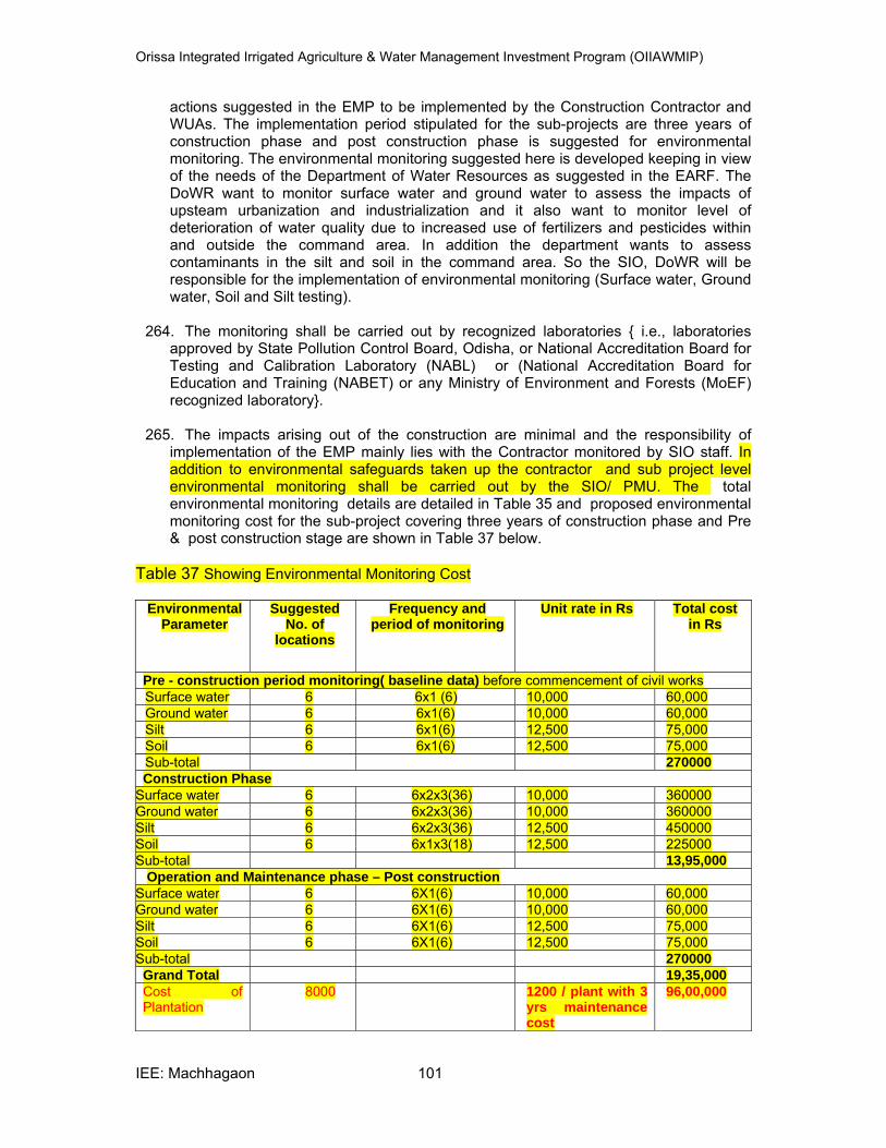
Orissa Integrated Irrigated Agriculture & Water Management Investment Program (OIIAWMIP)
IEE: Machhagaon 101
actions suggested in the EMP to be implemented by the Construction Contractor and WUAs. The implementation period stipulated for the sub-projects are three years of construction phase and post construction phase is suggested for environmental monitoring. The environmental monitoring suggested here is developed keeping in view of the needs of the Department of Water Resources as suggested in the EARF. The DoWR want to monitor surface water and ground water to assess the impacts of upsteam urbanization and industrialization and it also want to monitor level of deterioration of water quality due to increased use of fertilizers and pesticides within and outside the command area. In addition the department wants to assess contaminants in the silt and soil in the command area. So the SIO, DoWR will be responsible for the implementation of environmental monitoring (Surface water, Ground water, Soil and Silt testing).
264. The monitoring shall be carried out by recognized laboratories { i.e., laboratories
approved by State Pollution Control Board, Odisha, or National Accreditation Board for Testing and Calibration Laboratory (NABL) or (National Accreditation Board for Education and Training (NABET) or any Ministry of Environment and Forests (MoEF) recognized laboratory}.
265. The impacts arising out of the construction are minimal and the responsibility of
implementation of the EMP mainly lies with the Contractor monitored by SIO staff. In addition to environmental safeguards taken up the contractor and sub project level environmental monitoring shall be carried out by the SIO/ PMU. The total environmental monitoring details are detailed in Table 35 and proposed environmental monitoring cost for the sub-project covering three years of construction phase and Pre & post construction stage are shown in Table 37 below.
Table 37 Showing Environmental Monitoring Cost
Environmental Parameter
Suggested No. of
locations
Frequency and period of monitoring
Unit rate in Rs Total cost in Rs
Pre - construction period monitoring( baseline data) before commencement of civil works
Surface water 6 6x1 (6) 10,000 60,000 Ground water 6 6x1(6) 10,000 60,000 Silt 6 6x1(6) 12,500 75,000 Soil 6 6x1(6) 12,500 75,000 Sub-total 270000
Construction Phase
Surface water 6 6x2x3(36) 10,000 360000 Ground water 6 6x2x3(36) 10,000 360000 Silt 6 6x2x3(36) 12,500 450000 Soil 6 6x1x3(18) 12,500 225000 Sub-total 13,95,000
Operation and Maintenance phase – Post construction
Surface water 6 6X1(6) 10,000 60,000 Ground water 6 6X1(6) 10,000 60,000 Silt 6 6X1(6) 12,500 75,000 Soil 6 6X1(6) 12,500 75,000 Sub-total 270000
Grand Total 19,35,000
Cost of Plantation
8000 1200 / plant with 3 yrs maintenance cost
96,00,000
Orissa Integrated Irrigated Agriculture & Water Management Investment Program (OIIAWMIP)
IEE: Machhagaon 102
K. Environmental Training
266. The basic requirement of the environmental training is to strengthen the knowledge of PMU/ SIO, DoWR and WUAs on environmental aspects.
L. Strengthening Environmental Knowledge & Management Capability
267. The capacity and skills of the DoWR to carry out environmental management of irrigated agriculture schemes will need to be developed to be responsive and proactive to the needs and perceptions of environmental management in their jurisdictions during and following Project completion. The institutional strengthening of environmental management will be blended within the activities. The focus will be on building the capacity and capability of the SIO, DoWR to assume their responsibilities in carrying out REAs, IEEs and implementing EMPs. The organizational framework in the DoWR for this to occur will be establishment of new environmental division as per EARF.
268. Awareness raising will initially introduce the environmental assessment and EMP
procedures among the project stakeholders. In addition meetings, seminars and some short courses will be organized to raise awareness within the DoWR. ISPM Environmental consultant during the field visits will also give on-field training on the implementation of EMP to the Contractor staff and SIO staff by the ISPMC and WUAs with the help of PPSU – Environmental Monitoring Specialist. In addition training programs would be conducted to the Contractor staff and SIO staff, DoWR by the ISPMC and for WUAs by the PPSU – Environmental Monitoring Specialist with the available funds of the PMU under training. The list of appropriate training module and tentative time frame is given in Table 38 and the required budget is suggested in Table 39.
269. Participatory Mechanisms are the building blocks for the success of the Project. Besides the DoWR and WUAs, the community needs to get involved in developing the foundation of future environmental management of irrigated agriculture in the State. Results of Environmental monitoring carried out during construction would be disseminated to WUA / PP members for raising awareness through PPSU Environmental Monitoring specialist and these would be built into the PPME System Participatory Environmental Monitoring guidelines shall be developed with the assistance of the environmental monitoring specialists of PPSU through the PIM Component for use by DoWR and WUA staff during construction and O&M. Lessons learned from past environmental management initiatives will be used to reinforce public participation as an essential aspect to instill a sense of ownership and stewardship among all stakeholders that will be involved in environmental management and the use of resources. Measures to involve active participation of the community will be included to help ensure more effective and appropriate management, since the stakeholders (those using the resources) can become involved in a voluntary way in some of the basic monitoring (e.g., soil erosion point sources) and regulating various activities under the EMP.
270. An environmental monitoring programme is important as it provides useful
information and helps to i) assist in detecting the development of any unwanted environmental situation, and thus, provides opportunities for adopting appropriate control measures, and ii) evaluate the performance and effectiveness of mitigation measures proposed in the EMP and suggest improvements in management plan, if required.
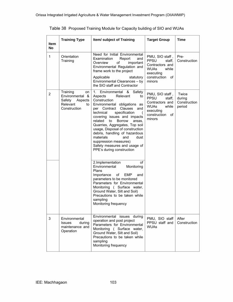
Orissa Integrated Irrigated Agriculture & Water Management Investment Program (OIIAWMIP)
IEE: Machhagaon 103
Table 38 Proposed Training Module for Capacity building of SIO and WUAs
Item No
Training Type Item/ subject of Training Target Group Time
1 Orientation Training
Need for Initial Environmental Examination Report and Overview of important Environmental Regulation and frame work to the project
Applicable statutory Environmental Clearances – by the SIO staff and Contractor
PMU, SIO staff , PPSU staff, Contractors and WUAs while executing construction of minors
Pre-Construction
2 Training on Environmental & Safety Aspects Relevant to Construction
1. Environmental & Safety Aspects Relevant to Construction Environmental obligations as per Contract Clauses and technical specification ( covering issues and impacts related to Borrow areas, Quarries, Aggregates, Top soil usage, Disposal of construction debris, handling of hazardous materials and dust suppression measures) Safety measures and usage of PPE’s during construction
PMU, SIO staff , PPSU staff, Contractors and WUAs while executing construction of minors
Twice during Construction period
2.Implementation of Environmental Monitoring Plans Importance of EMP and parameters to be monitored Parameters for Environmental Monitoring ( Surface water, Ground Water, Silt and Soil) Precautions to be taken while sampling Monitoring frequency
3 Environmental Issues during maintenance and Operation
Environmental issues during operation and post project Parameters for Environmental Monitoring ( Surface water, Ground Water, Silt and Soil) Precautions to be taken while sampling Monitoring frequency
PMU, SIO staff PPSU staff and WUAs
After Construction
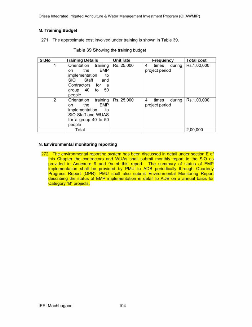
Orissa Integrated Irrigated Agriculture & Water Management Investment Program (OIIAWMIP)
IEE: Machhagaon 104
M. Training Budget
271. The approximate cost involved under training is shown in Table 39.
Table 39 Showing the training budget Sl.No Training Details Unit rate Frequency Total cost
1 Orientation training on the EMP implementation to SIO Staff and Contractors for a group 40 to 50 people
Rs. 25,000 4 times during project period
Rs.1,00,000
2 Orientation training on the EMP implementation to SIO Staff and WUAS for a group 40 to 50 people
Rs. 25,000 4 times during project period
Rs.1,00,000
Total 2,00,000
N. Environmental monitoring reporting
272. The environmental reporting system has been discussed in detail under section E of this Chapter the contractors and WUAs shall submit monthly report to the SIO as provided in Annexure 9 and 9a of this report. The summary of status of EMP implementation shall be provided by PMU to ADB periodically through Quarterly Progress Report (QPR). PMU shall also submit Environmental Monitoring Report describing the status of EMP implementation in detail to ADB on a annual basis for Category “B” projects.
Orissa Integrated Irrigated Agriculture & Water Management Investment Program (OIIAWMIP)
IEE: Machhagaon 105
IX. FINDINGS AND RECOMMENDATIONS
273. There are no significant adverse impacts associated with this project. Instead the project is expected to improve irrigation facilities and enhance economic growth of the area. Increased irrigation will also help in planting of more trees thereby increasing the environmental conditions of the area adding to the greenery and general aesthetics of the area. The indirect benefits of the project will be lowered levels of out migration as the communities will have more opportunity of securing income from within the village. There will be growth in living standard of people, which will encourage proper education, social awareness, health facility and prosperity amongst the people.
274. The IEE clearly states in its findings that there will be no significant impact in the local
environmental condition due to construction and operation of the project. Main canal close to Kathjori and Devi rivers and the right bank canal form the left river embankment. Habitations are close to the canal at many places and canal bank serves as a service road / approach road, so adequate safety, dust suppression measures and traffic management need to be taken up by the contractor while executing the construction works. Any Issues related to encroachments need to be addressed as per the R & R policy. Any impact associated with the project activities will be minor in nature and will be restricted only during the construction phase of the project. Increased levels in ground water increase in soil salinity, increased levels of insecticides and pesticides are some of the major impacts during project operation. Increased ground water level is a beneficial impact and hence no mitigation measures are recommended. It is suggested that local villagers should be educated through pani panchayat about rational use of water, chemical fertilizers and pesticides to reduce soil salinity and protect surface and ground water quality.
Orissa Integrated Irrigated Agriculture & Water Management Investment Program (OIIAWMIP)
IEE: Machhagaon 106
X. CONCLUSION
275. There are no adverse impacts expected from this project. The project is expected to improve the existing derelict irrigation infrastructure and will be put to beneficial use to the society. This will boost agriculture growth in the area and will bring prosperity to the region. By improving the irrigation infrastructure issues like water logging, economic disparity between head end and tail end users will be reduced. The project has already been assessed as category “B” project and will not require environmental clearance from state government as no additional land is covered for irrigation under this project.
Orissa Integrated Irrigated Agriculture & Water Management Investment Program (OIIAWMIP)
IEE: Machhagaon 107
ANNEXURE
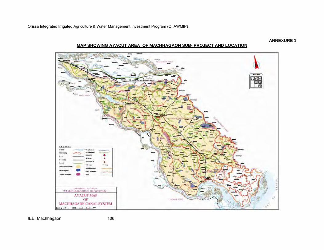
Orissa Integrated Irrigated Agriculture & Water Management Investment Program (OIIAWMIP)
IEE: Machhagaon 108
ANNEXURE 1 MAP SHOWING AYACUT AREA OF MACHHAGAON SUB- PROJECT AND LOCATION
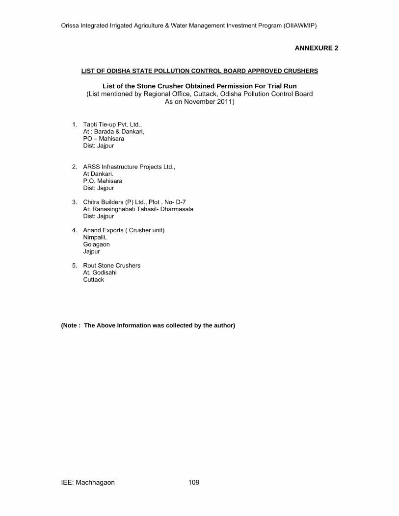
Orissa Integrated Irrigated Agriculture & Water Management Investment Program (OIIAWMIP)
IEE: Machhagaon 109
ANNEXURE 2
LIST OF ODISHA STATE POLLUTION CONTROL BOARD APPROVED CRUSHERS
List of the Stone Crusher Obtained Permission For Trial Run
(List mentioned by Regional Office, Cuttack, Odisha Pollution Control Board As on November 2011)
1. Tapti Tie-up Pvt. Ltd., At : Barada & Dankari, PO – Mahisara Dist: Jajpur
2. ARSS Infrastructure Projects Ltd., At Dankari. P.O. Mahisara Dist: Jajpur
3. Chitra Builders (P) Ltd., Plot . No- D-7 At: Ranasinghabati Tahasil- Dharmasala Dist: Jajpur
4. Anand Exports ( Crusher unit) Nimpalli, Golagaon Jajpur
5. Rout Stone Crushers At. Godisahi Cuttack
(Note : The Above Information was collected by the author)

Orissa Integrated Irrigated Agriculture & Water Management Investment Program (OIIAWMIP)
IEE: Machhagaon 110
ANNEXURE 3
SCHEMATIC LINE DIAGRAM SHOWING DISTRIBUTION SYSTEM
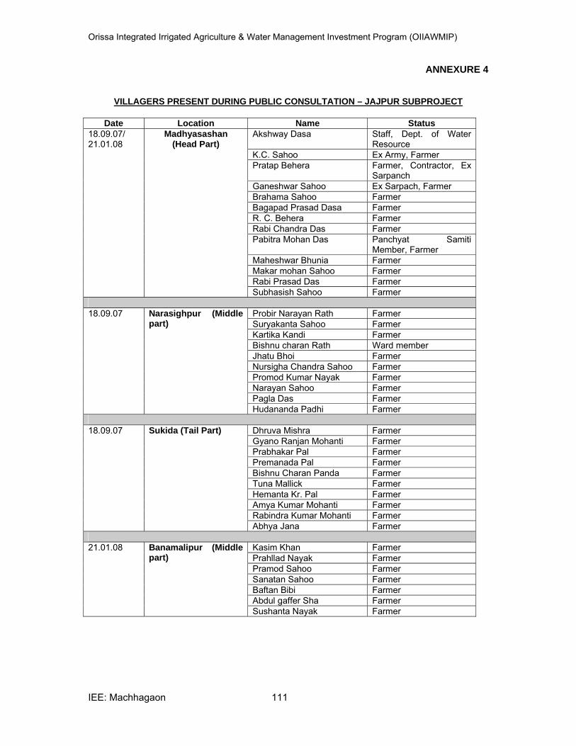
Orissa Integrated Irrigated Agriculture & Water Management Investment Program (OIIAWMIP)
IEE: Machhagaon 111
ANNEXURE 4
VILLAGERS PRESENT DURING PUBLIC CONSULTATION – JAJPUR SUBPROJECT
Date Location Name Status
18.09.07/ 21.01.08
Madhyasashan (Head Part)
Akshway Dasa Staff, Dept. of Water Resource
K.C. Sahoo Ex Army, Farmer Pratap Behera Farmer, Contractor, Ex
Sarpanch Ganeshwar Sahoo Ex Sarpach, Farmer Brahama Sahoo Farmer Bagapad Prasad Dasa Farmer R. C. Behera Farmer Rabi Chandra Das Farmer Pabitra Mohan Das Panchyat Samiti
Member, Farmer Maheshwar Bhunia Farmer Makar mohan Sahoo Farmer Rabi Prasad Das Farmer Subhasish Sahoo Farmer
18.09.07 Narasighpur (Middle
part) Probir Narayan Rath Farmer Suryakanta Sahoo Farmer Kartika Kandi Farmer Bishnu charan Rath Ward member Jhatu Bhoi Farmer Nursigha Chandra Sahoo FarmerPromod Kumar Nayak Farmer Narayan Sahoo Farmer Pagla Das Farmer Hudananda Padhi Farmer
18.09.07 Sukida (Tail Part) Dhruva Mishra Farmer
Gyano Ranjan Mohanti Farmer Prabhakar Pal Farmer Premanada Pal Farmer Bishnu Charan Panda Farmer Tuna Mallick Farmer Hemanta Kr. Pal FarmerAmya Kumar Mohanti Farmer Rabindra Kumar Mohanti Farmer Abhya Jana Farmer
21.01.08 Banamalipur (Middle
part) Kasim Khan Farmer Prahllad Nayak Farmer Pramod Sahoo Farmer Sanatan Sahoo Farmer Baftan Bibi Farmer Abdul gaffer Sha Farmer Sushanta Nayak Farmer
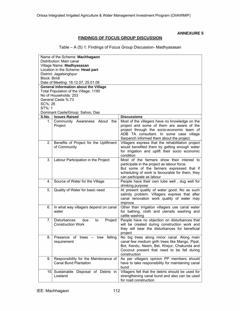
Orissa Integrated Irrigated Agriculture & Water Management Investment Program (OIIAWMIP)
IEE: Machhagaon 112
ANNEXURE 5 FINDINGS OF FOCUS GROUP DISCUSSION
Table – A (5) 1: Findings of Focus Group Discussion- Madhyasasan
Name of the Scheme: MachhagaonDistribution: Main canal Village Name: Madhyasasan Location in the Scheme: Head part District: Jagatsinghpur Block: Biridi Date of Meeting: 18.12.07, 25.01.08 General Information about the VillageTotal Population of the Village: 1190 No of Households: 253 General Caste %:73 SC%: 26 ST%: 1 Dominant Caste/Group: Sahoo, Das S.No. Issues Raised Discussions
1. Community Awareness About the Project
Most of the villagers have no knowledge on the project and some of them are aware of the project through the socio-economic team of ADB TA consultant. In some case village Sarpanch informed them about the project.
2. Benefits of Project for the Upliftment of Community
Villagers express that the rehabilitation project would benefited them by getting enough water for irrigation and uplift their socio economic condition
3. Labour Participation in the Project Most of the farmers show their interest to participate in the project as labour force. But some of the farmers expressed that if scheduling of work is favourable for them, they can participate as labour
4. Source of Water for the Village People have their own tube well , dug well for drinking purpose
5. Quality of Water for basic need At present quality of water good. No as such salinity problem. Villagers express that after canal renovation work quality of water may improve.
6. In what way villagers depend on canal water
Other than irrigation villagers use canal water for bathing, cloth and utensils washing and cattle washing
7. Disturbances due to Project Construction Work
People have no objection on disturbances that will be created during construction work and they will bear the disturbances for beneficial project
8. Presence of trees – tree felling requirement
No big trees along minor canal. Along main canal few medium girth trees like Mango, Pipal, Bot, Kendu, Neem, Bel, Khejur, Chakunda and Coconut present that need to be fell during construction
9. Responsibility for the Maintenance of Canal Bund Plantation
As per villagers opinion PP members should have to take responsibility for maintaining canal bund
10. Sustainable Disposal of Debris in Lowland
Villagers felt that the debris should be used for strengthening canal bund and also can be used for road construction
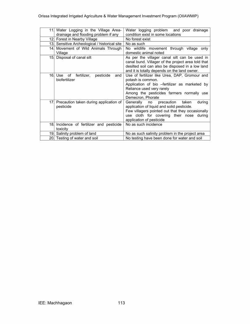
Orissa Integrated Irrigated Agriculture & Water Management Investment Program (OIIAWMIP)
IEE: Machhagaon 113
11. Water Logging in the Village Area- drainage and flooding problem if any
Water logging problem and poor drainage condition exist in some locations
12. Forest in Nearby Village No forest exist 13. Sensitive Archeological / historical site No as such 14. Movement of Wild Animals Through
Village No wildlife movement through village only domestic animal noted
15. Disposal of canal silt As per the villager canal silt can be used in canal bund. Villager of the project area told that desilted soil can also be disposed in a low land and it is totally depends on the land owner.
16. Use of fertilizer, pesticide and biofertilizer
Use of fertilizer like Urea, DAP, Gromour and potash is common. Application of bio –fertilizer as marketed by Reliance used very rarely Among the pesticides farmers normally use Demecron, Phorate
17. Precaution taken during application of pesticide
Generally no precaution taken during application of liquid and solid pesticide. Few villagers pointed out that they occasionally use cloth for covering their nose during application of pesticide
18. Incidence of fertilizer and pesticide toxicity
No as such incidence
19. Salinity problem of land No as such salinity problem in the project area 20. Testing of water and soil No testing have been done for water and soil
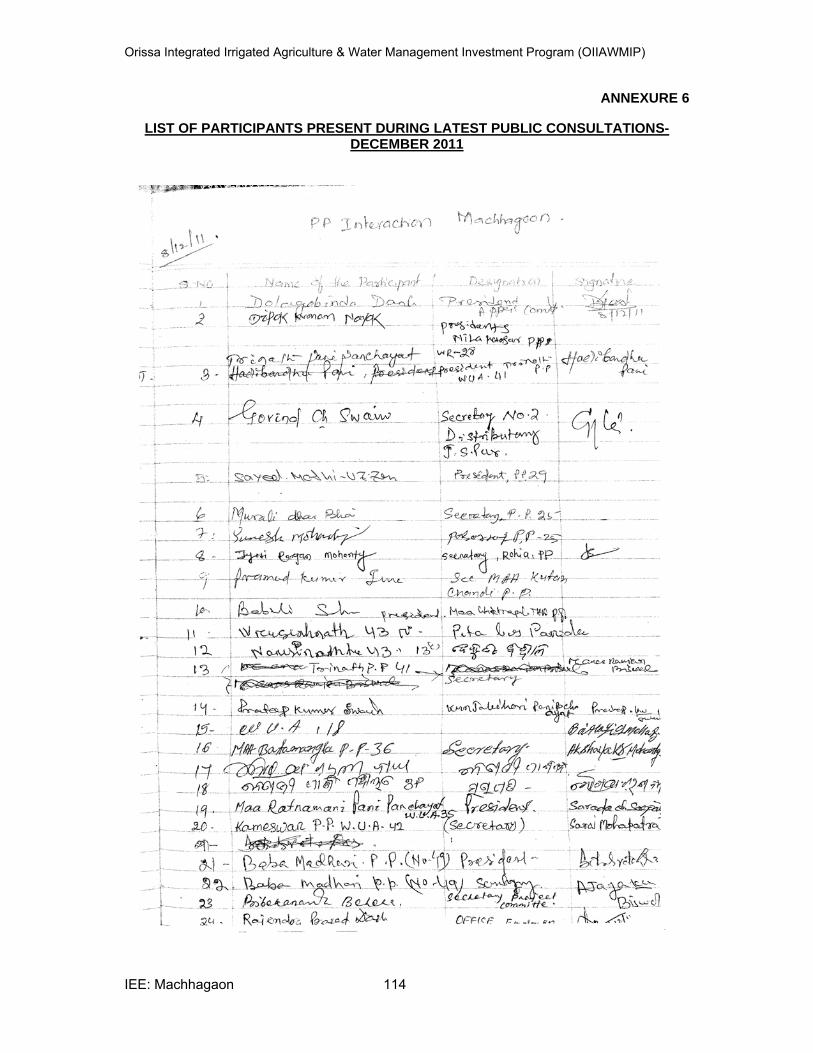
Orissa Integrated Irrigated Agriculture & Water Management Investment Program (OIIAWMIP)
IEE: Machhagaon 114
ANNEXURE 6
LIST OF PARTICIPANTS PRESENT DURING LATEST PUBLIC CONSULTATIONS-DECEMBER 2011
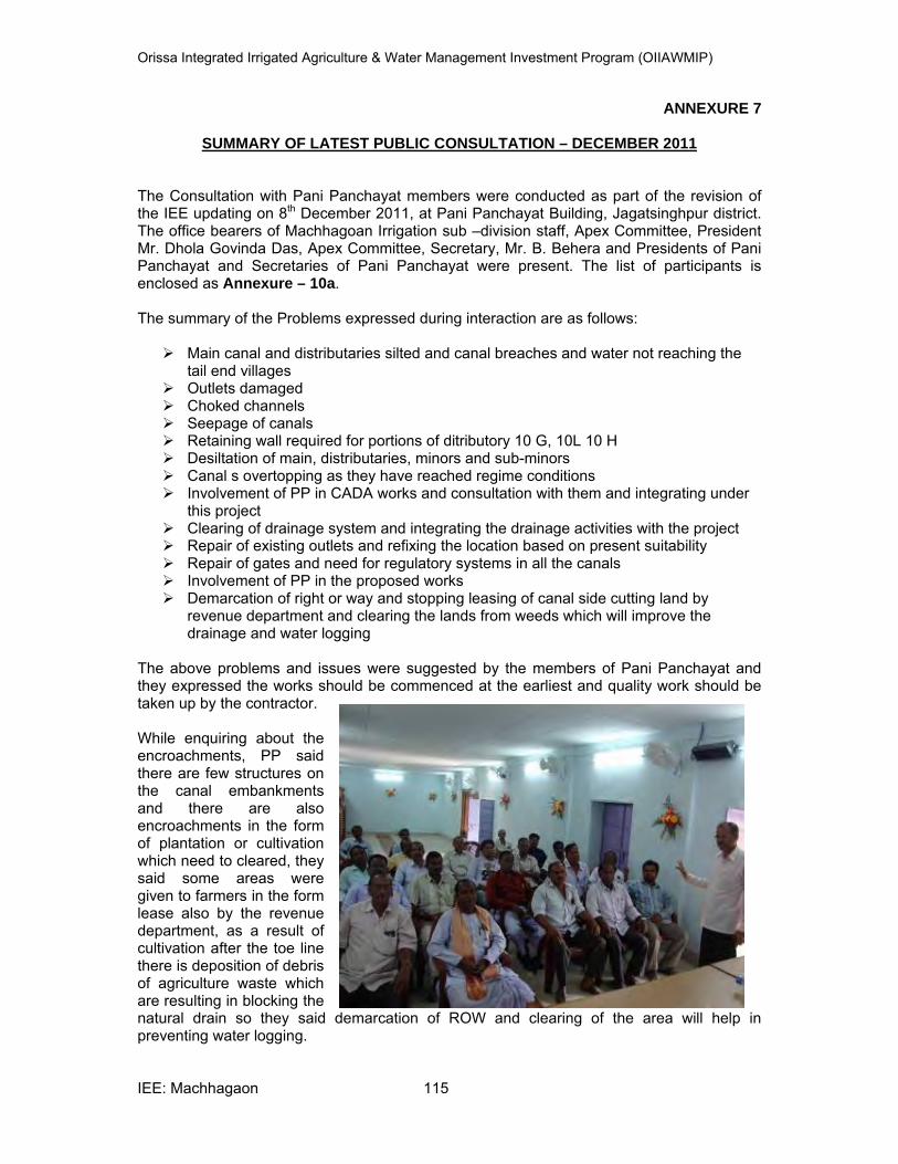
Orissa Integrated Irrigated Agriculture & Water Management Investment Program (OIIAWMIP)
IEE: Machhagaon 115
ANNEXURE 7
SUMMARY OF LATEST PUBLIC CONSULTATION – DECEMBER 2011
The Consultation with Pani Panchayat members were conducted as part of the revision of the IEE updating on 8th December 2011, at Pani Panchayat Building, Jagatsinghpur district. The office bearers of Machhagoan Irrigation sub –division staff, Apex Committee, President Mr. Dhola Govinda Das, Apex Committee, Secretary, Mr. B. Behera and Presidents of Pani Panchayat and Secretaries of Pani Panchayat were present. The list of participants is enclosed as Annexure – 10a. The summary of the Problems expressed during interaction are as follows:
Main canal and distributaries silted and canal breaches and water not reaching the tail end villages
Outlets damaged Choked channels Seepage of canals Retaining wall required for portions of ditributory 10 G, 10L 10 H Desiltation of main, distributaries, minors and sub-minors Canal s overtopping as they have reached regime conditions Involvement of PP in CADA works and consultation with them and integrating under
this project Clearing of drainage system and integrating the drainage activities with the project Repair of existing outlets and refixing the location based on present suitability Repair of gates and need for regulatory systems in all the canals Involvement of PP in the proposed works Demarcation of right or way and stopping leasing of canal side cutting land by
revenue department and clearing the lands from weeds which will improve the drainage and water logging
The above problems and issues were suggested by the members of Pani Panchayat and they expressed the works should be commenced at the earliest and quality work should be taken up by the contractor. While enquiring about the encroachments, PP said there are few structures on the canal embankments and there are also encroachments in the form of plantation or cultivation which need to cleared, they said some areas were given to farmers in the form lease also by the revenue department, as a result of cultivation after the toe line there is deposition of debris of agriculture waste which are resulting in blocking the natural drain so they said demarcation of ROW and clearing of the area will help in preventing water logging.
Orissa Integrated Irrigated Agriculture & Water Management Investment Program (OIIAWMIP)
IEE: Machhagaon 116
The PP expressed willingness to support the proposed activities and they even said they do not have any objection if the canal closed after December or after Kharif crop if the contractor’s establish the camps and bring outside labour also if necessary. The PP members expressed they are facing severe water contamination problem, they expressed agriculture labour not willing to work in the agricultural fields as they are experiencing different skin problems due to the canal contaminated water. They are experiencing municipal wastes and other wastes are mixing the canal water. When enquired about the health issues the PP expressed Jatsinghpur district is experiencing increased number of cancer cases year to year, they expressed this may be due to contamination of water in the area. Apart from these the farmers are facing severe skin problems due to the use of canal water. The common seasonal diseases in the area are Typhoid, Malaria, Dysentery and Diahorea They said the soil might have contaminated due to the polluted waters of the canal and even food grain might have affected but they are not in a position to assess the impact, they expressed agriculture department should undertake some studies to identify the impacts of pollution in the area. The common sources of drinking water are tube wells and protected piped water supply. The ground water depth in the area ranges from 120‘to 225’ and water quality is good. The usage of fertilizers in the area is mostly inorganic except usage of cow dung, in general the farmers are using urea – 25 kgs / acre; DAP – 25 kgs/ acre and Potash – 12.5 kgs / acre, even the farmers are using inorganic pesticides only. They said there is no forest area except in one canal system and no migratory birds visit their area.
Orissa Integrated Irrigated Agriculture & Water Management Investment Program (OIIAWMIP)
IEE: Machhagaon 117
ANNEXURE 8
KEY PERSONS MET AND DATA SOURCES
A. List of persons consulted
1. Mr. N. Mahapatra, Director, Water Resources Dept., Govt. of Odisha
2. Mr. Loknath Mohanti, SDO, Water Resources Dept., Govt. of Odisha
3. Mr. M. Bera, Engineer, Water Resources Dept., Govt. of Odisha
4. Mr. B. K. Misra , Member Secretary, Odisha State Pollution Control Board
5. Mr. B. N. Bhol, Environmental Engineer, Odisha State Pollution Control Board
B. List of data sources
1. District Statistical Hand Book of Cuttack and Jagatsingpur (2005) Directorate of Economics and Statistics, Govt. of Odisha
2. Economic Survey 2005-06 (2006), Directorate of Economics and Statistics, Planning and Co-ordination Department, Govt. of Odisha
3. District Census data book of Odisha
4. Brief Notes on Machhagaon Irrigation Project for the visit of Asian Development Bank Mission (2007), Department of Water Resources, Govt of Odisha
5. Statistical Abstract of Odisha (2005) Directorate of Economics and Statistics, Govt. of Odisha
6. Statistical Outline of Odisha (2007), Directorate of Economics and Statistics, Govt. of Odisha
7. Official website of State of Odisha (www.orissa.gov.in)
8. Official website for Cuttack District (www.cuttack.nic.in)
9. Official Website of Ministry of Environment and Forest (www.envfor.nic.in)
10. National Engineering Handbook, Hydrology (1972) Section 4 U.S.SCS
11. Annual Report 2005-06 State Pollution Control Board, Odisha
12. Champion and Seth (1968) Classification of forest type of India
13. Mitra, G.N., Misra, U.K. and Sahu, S. K (2002) Macro and Micro Nutrient Status of the soils of Odisha, Dept. of Agriculture Govt. of Odisha
14. State of the Environment Report Odisha (2006) State Pollution Control Board, Odisha
15. Goel, R. S. (2000) Environmental Impacts Assessment of water Resources Projects- concerns, policy issues, perception and scientific analysis, Oxford & IBH Publishing Co. Pvt. Ltd
16. Preliminary Project Report on Odisha Integrated Irrigated Agriculture and Water Management, Department of Water Resources, Government of Odisha, December, 2005.
17. Odisha WRCP Environmental Assessment, Department of Water Resources, Government of Odisha, March, 1995.
Orissa Integrated Irrigated Agriculture & Water Management Investment Program (OIIAWMIP)
IEE: Machhagaon 118
18. Ground Water Resources of Odisha, Director of Ground Water Survey & Investigation, Odisha,2001
19. Census of India 2011, Provisional Population Totals, Directorate of Census Operations, Odisha.
20. Hand Book of Statistics, Cuttack and Jagatsinghpur, Directorate of Economics and Statistics 2007, Govt. of Odisha
21. Detailed Project Report for Improvement of Macchagaon canal & its Distribution system October 2011 Department of Water Resources, Govt. of Odisha
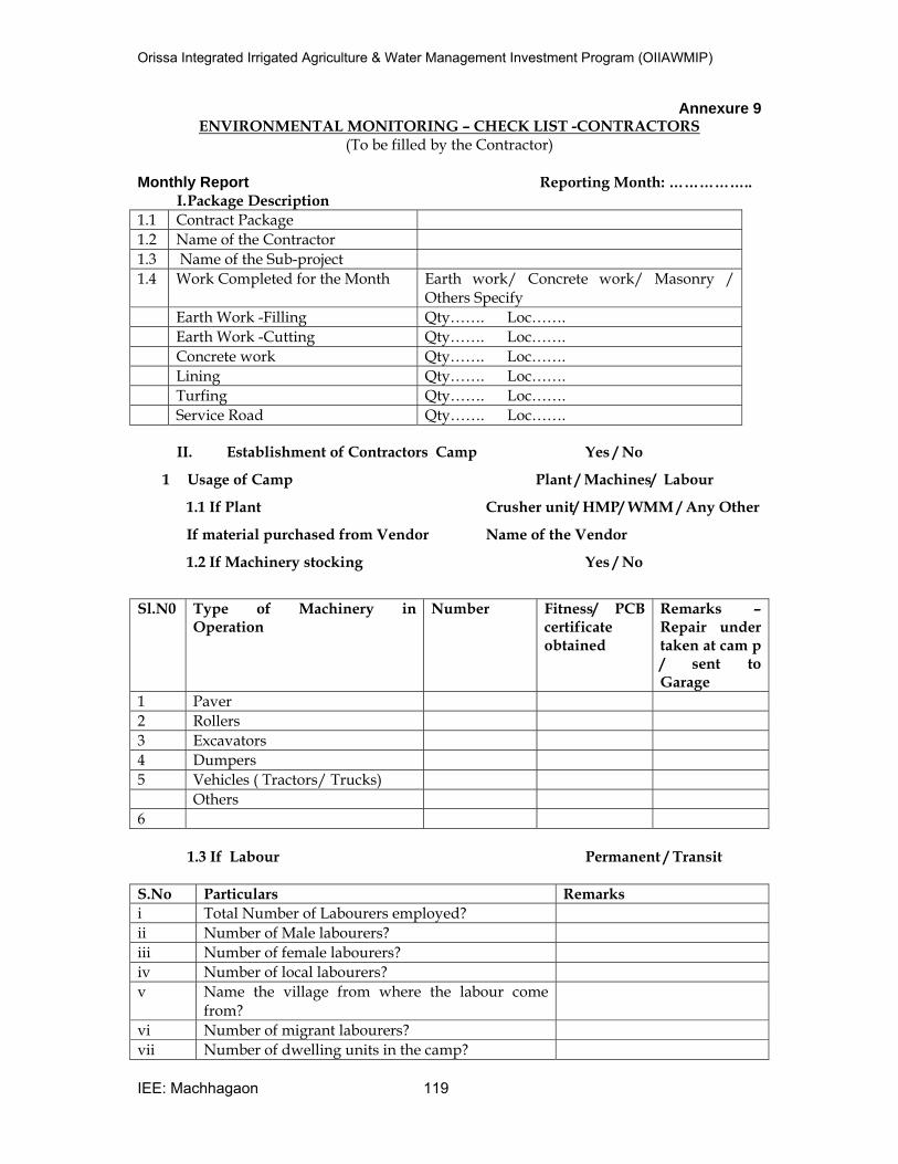
Orissa Integrated Irrigated Agriculture & Water Management Investment Program (OIIAWMIP)
IEE: Machhagaon 119
Annexure 9 ENVIRONMENTAL MONITORING – CHECK LIST -CONTRACTORS
(To be filled by the Contractor)
Monthly Report Reporting Month: …………….. I. Package Description
1.1 Contract Package
1.2 Name of the Contractor
1.3 Name of the Sub-project
1.4 Work Completed for the Month Earth work/ Concrete work/ Masonry / Others Specify
Earth Work -Filling Qty……. Loc…….
Earth Work -Cutting Qty……. Loc…….
Concrete work Qty……. Loc…….
Lining Qty……. Loc…….
Turfing Qty……. Loc…….
Service Road Qty……. Loc…….
II. Establishment of Contractors Camp Yes / No
1 Usage of Camp Plant / Machines/ Labour
1.1 If Plant Crusher unit/ HMP/ WMM / Any Other
If material purchased from Vendor Name of the Vendor
1.2 If Machinery stocking Yes / No
Sl.N0 Type of Machinery in Operation
Number Fitness/ PCB certificate obtained
Remarks – Repair under taken at cam p / sent to Garage
1 Paver
2 Rollers
3 Excavators
4 Dumpers
5 Vehicles ( Tractors/ Trucks)
Others
6
1.3 If Labour Permanent / Transit
S.No Particulars Remarks
i Total Number of Labourers employed?
ii Number of Male labourers?
iii Number of female labourers?
iv Number of local labourers?
v Name the village from where the labour come from?
vi Number of migrant labourers?
vii Number of dwelling units in the camp?
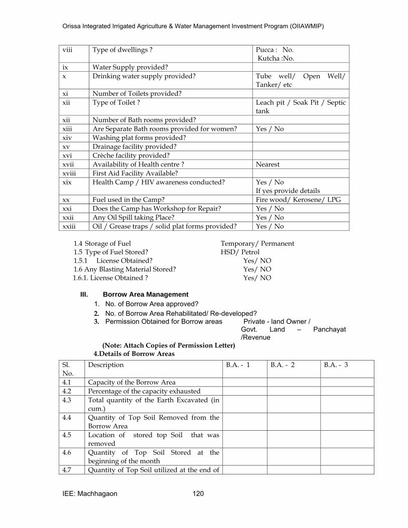
Orissa Integrated Irrigated Agriculture & Water Management Investment Program (OIIAWMIP)
IEE: Machhagaon 120
viii Type of dwellings ? Pucca : No. Kutcha :No.
ix Water Supply provided?
x Drinking water supply provided? Tube well/ Open Well/ Tanker/ etc
xi Number of Toilets provided?
xii Type of Toilet ? Leach pit / Soak Pit / Septic tank
xii Number of Bath rooms provided?
xiii Are Separate Bath rooms provided for women? Yes / No
xiv Washing plat forms provided?
xv Drainage facility provided?
xvi Crèche facility provided?
xvii Availability of Health centre ? Nearest
xviii First Aid Facility Available?
xix Health Camp / HIV awareness conducted? Yes / No If yes provide details
xx Fuel used in the Camp? Fire wood/ Kerosene/ LPG
xxi Does the Camp has Workshop for Repair? Yes / No
xxii Any Oil Spill taking Place? Yes / No
xxiii Oil / Grease traps / solid plat forms provided? Yes / No
1.4 Storage of Fuel Temporary/ Permanent 1.5 Type of Fuel Stored? HSD/ Petrol 1.5.1 License Obtained? Yes/ NO 1.6 Any Blasting Material Stored? Yes/ NO
1.6.1. License Obtained ? Yes/ NO
III. Borrow Area Management
1. No. of Borrow Area approved?
2. No. of Borrow Area Rehabilitated/ Re-developed? 3. Permission Obtained for Borrow areas Private - land Owner /
Govt. Land – Panchayat /Revenue
(Note: Attach Copies of Permission Letter) 4.Details of Borrow Areas
Sl. No.
Description B.A. - 1 B.A. - 2 B.A. - 3
4.1 Capacity of the Borrow Area
4.2 Percentage of the capacity exhausted
4.3 Total quantity of the Earth Excavated (in cum.)
4.4 Quantity of Top Soil Removed from the Borrow Area
4.5 Location of stored top Soil that was removed
4.6 Quantity of Top Soil Stored at the beginning of the month
4.7 Quantity of Top Soil utilized at the end of
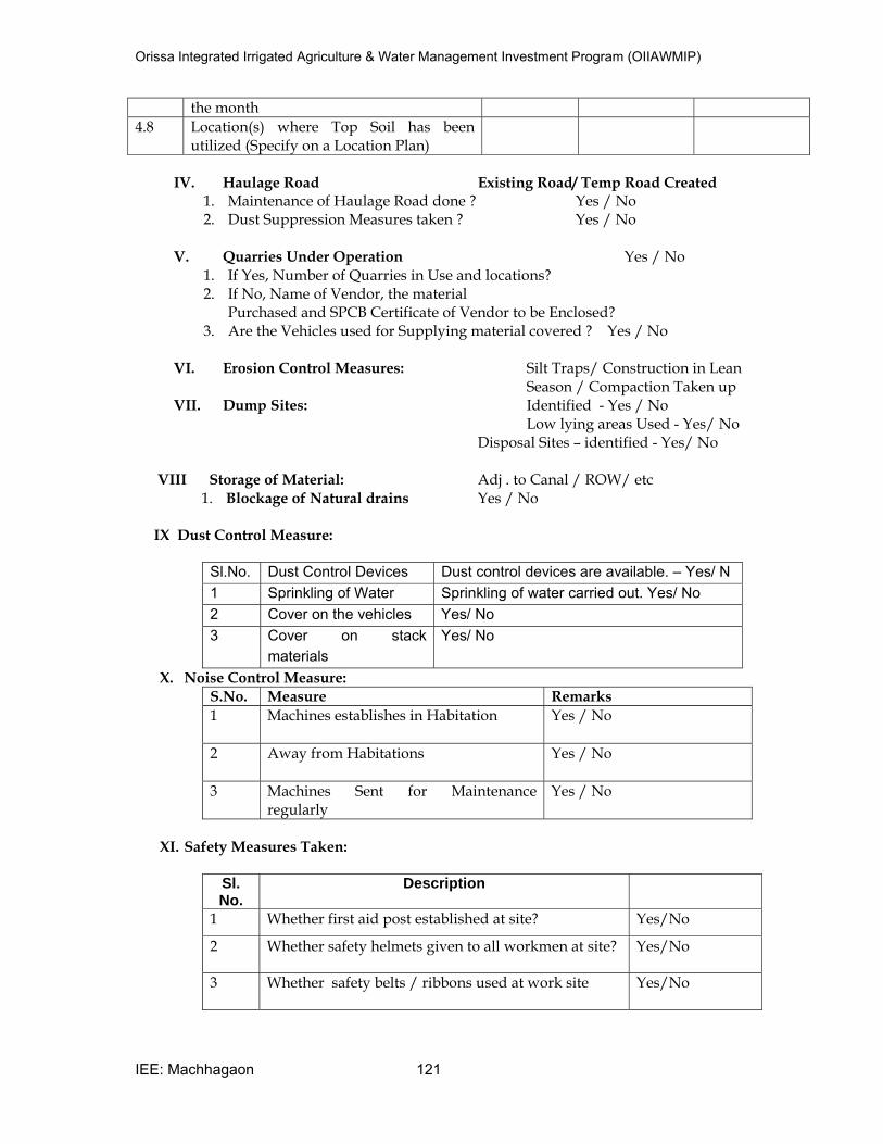
Orissa Integrated Irrigated Agriculture & Water Management Investment Program (OIIAWMIP)
IEE: Machhagaon 121
the month
4.8 Location(s) where Top Soil has been utilized (Specify on a Location Plan)
IV. Haulage Road Existing Road/ Temp Road Created
1. Maintenance of Haulage Road done ? Yes / No 2. Dust Suppression Measures taken ? Yes / No
V. Quarries Under Operation Yes / No
1. If Yes, Number of Quarries in Use and locations? 2. If No, Name of Vendor, the material
Purchased and SPCB Certificate of Vendor to be Enclosed? 3. Are the Vehicles used for Supplying material covered ? Yes / No
VI. Erosion Control Measures: Silt Traps/ Construction in Lean
Season / Compaction Taken up VII. Dump Sites: Identified - Yes / No
Low lying areas Used - Yes/ No Disposal Sites – identified - Yes/ No VIII Storage of Material: Adj . to Canal / ROW/ etc
1. Blockage of Natural drains Yes / No
IX Dust Control Measure:
Sl.No. Dust Control Devices Dust control devices are available. – Yes/ N
1 Sprinkling of Water Sprinkling of water carried out. Yes/ No
2 Cover on the vehicles Yes/ No
3 Cover on stack
materials
Yes/ No
X. Noise Control Measure:
S.No. Measure Remarks
1 Machines establishes in Habitation
Yes / No
2 Away from Habitations
Yes / No
3 Machines Sent for Maintenance regularly
Yes / No
XI. Safety Measures Taken:
Sl. No.
Description
1 Whether first aid post established at site? Yes/No
2 Whether safety helmets given to all workmen at site? Yes/No
3 Whether safety belts / ribbons used at work site Yes/No
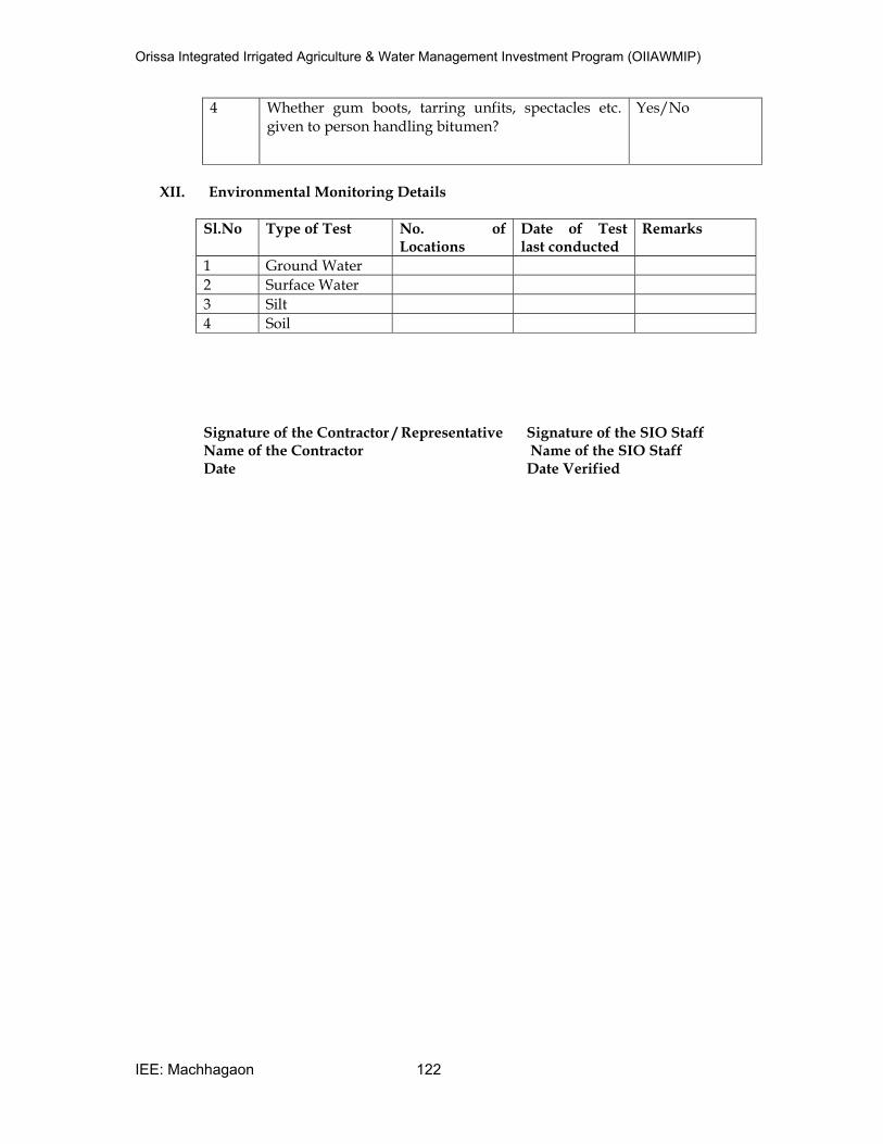
Orissa Integrated Irrigated Agriculture & Water Management Investment Program (OIIAWMIP)
IEE: Machhagaon 122
4 Whether gum boots, tarring unfits, spectacles etc. given to person handling bitumen?
Yes/No
XII. Environmental Monitoring Details
Sl.No Type of Test No. of Locations
Date of Test last conducted
Remarks
1 Ground Water
2 Surface Water
3 Silt
4 Soil
Signature of the Contractor / Representative Signature of the SIO Staff Name of the Contractor Name of the SIO Staff Date Date Verified
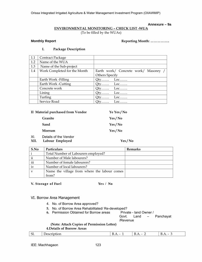
Orissa Integrated Irrigated Agriculture & Water Management Investment Program (OIIAWMIP)
IEE: Machhagaon 123
Annexure – 9a ENVIRONMENTAL MONITORING – CHECK LIST -WUA
(To be filled by the WUAs)
Monthly Report Reporting Month: ……………..
I. Package Description
1.1 Contract Package
1.2 Name of the WUA
1.3 Name of the Sub-project
1.4 Work Completed for the Month Earth work/ Concrete work/ Masonry / Others Specify
Earth Work -Filling Qty……. Loc…….
Earth Work -Cutting Qty……. Loc…….
Concrete work Qty……. Loc…….
Lining Qty……. Loc…….
Turfing Qty……. Loc…….
Service Road Qty……. Loc…….
II Material purchased from Vendor Ye Yes / No
Granite Yes / No
Sand Yes / No
Morrum Yes / No
XI. Details of the Vendor XII. Labour Employed Yes / No
S.No Particulars Remarks
i Total Number of Labourers employed?
ii Number of Male labourers?
iii Number of female labourers?
iv Number of local labourers?
v Name the village from where the labour comes from?
V. Storage of Fuel Yes / No
VI. Borrow Area Management
4. No. of Borrow Area approved?
5. No. of Borrow Area Rehabilitated/ Re-developed? 6. Permission Obtained for Borrow areas Private - land Owner /
Govt. Land – Panchayat /Revenue
(Note: Attach Copies of Permission Letter) 4.Details of Borrow Areas
Sl. Description B.A. - 1 B.A. - 2 B.A. - 3
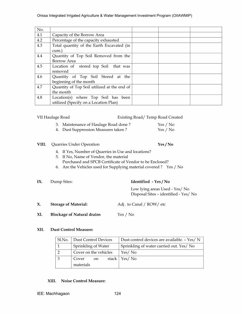
Orissa Integrated Irrigated Agriculture & Water Management Investment Program (OIIAWMIP)
IEE: Machhagaon 124
No.
4.1 Capacity of the Borrow Area
4.2 Percentage of the capacity exhausted
4.3 Total quantity of the Earth Excavated (in cum.)
4.4 Quantity of Top Soil Removed from the Borrow Area
4.5 Location of stored top Soil that was removed
4.6 Quantity of Top Soil Stored at the beginning of the month
4.7 Quantity of Top Soil utilized at the end of the month
4.8 Location(s) where Top Soil has been utilized (Specify on a Location Plan)
VII Haulage Road Existing Road/ Temp Road Created
3. Maintenance of Haulage Road done ? Yes / No 4. Dust Suppression Measures taken ? Yes / No
VIII. Quarries Under Operation Yes / No
4. If Yes, Number of Quarries in Use and locations? 5. If No, Name of Vendor, the material
Purchased and SPCB Certificate of Vendor to be Enclosed? 6. Are the Vehicles used for Supplying material covered ? Yes / No
IX. Dump Sites: Identified - Yes / No
Low lying areas Used - Yes/ No Disposal Sites – identified - Yes/ No X. Storage of Material: Adj . to Canal / ROW/ etc
XI. Blockage of Natural drains Yes / No
XII. Dust Control Measure:
Sl.No. Dust Control Devices Dust control devices are available. – Yes/ N
1 Sprinkling of Water Sprinkling of water carried out. Yes/ No
2 Cover on the vehicles Yes/ No
3 Cover on stack
materials
Yes/ No
XIII. Noise Control Measure:
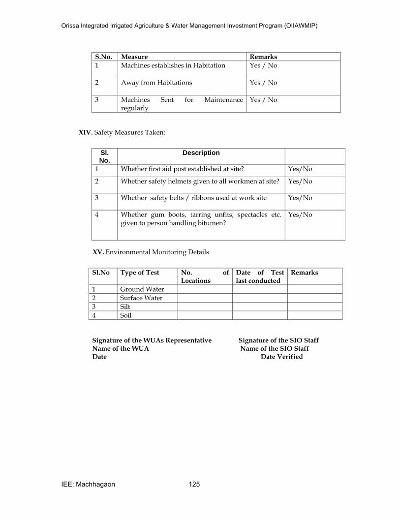
Orissa Integrated Irrigated Agriculture & Water Management Investment Program (OIIAWMIP)
IEE: Machhagaon 125
S.No. Measure Remarks
1 Machines establishes in Habitation
Yes / No
2 Away from Habitations
Yes / No
3 Machines Sent for Maintenance regularly
Yes / No
XIV. Safety Measures Taken:
Sl. No.
Description
1 Whether first aid post established at site? Yes/No
2 Whether safety helmets given to all workmen at site? Yes/No
3 Whether safety belts / ribbons used at work site Yes/No
4 Whether gum boots, tarring unfits, spectacles etc. given to person handling bitumen?
Yes/No
XV. Environmental Monitoring Details
Sl.No Type of Test No. of Locations
Date of Test last conducted
Remarks
1 Ground Water
2 Surface Water
3 Silt
4 Soil
Signature of the WUAs Representative Signature of the SIO Staff Name of the WUA Name of the SIO Staff Date Date Verified
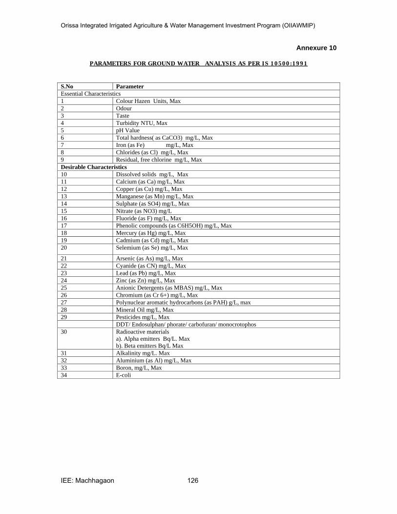
Orissa Integrated Irrigated Agriculture & Water Management Investment Program (OIIAWMIP)
IEE: Machhagaon 126
Annexure 10
PARAMETERS FOR GROUND WATER ANALYSI S AS PER I S 10500:1991
S.No Parameter
Essential Characteristics
1 Colour Hazen Units, Max
2 Odour
3 Taste
4 Turbidity NTU, Max
5 pH Value
6 Total hardness( as CaCO3) mg/L, Max
7 Iron (as Fe) mg/L, Max
8 Chlorides (as Cl) mg/L, Max
9 Residual, free chlorine mg/L, Max
Desirable Characteristics
10 Dissolved solids mg/L, Max
11 Calcium (as Ca) mg/L, Max
12 Copper (as Cu) mg/L, Max
13 Manganese (as Mn) mg/L, Max
14 Sulphate (as SO4) mg/L, Max
15 Nitrate (as NO3) mg/L
16 Fluoride (as F) mg/L, Max
17 Phenolic compounds (as C6H5OH) mg/L, Max
18 Mercury (as Hg) mg/L, Max
19 Cadmium (as Cd) mg/L, Max
20 Selemium (as Se) mg/L, Max
21 Arsenic (as As) mg/L, Max
22 Cyanide (as CN) mg/L, Max
23 Lead (as Pb) mg/L, Max
24 Zinc (as Zn) mg/L, Max
25 Anionic Detergents (as MBAS) mg/L, Max
26 Chromium (as Cr 6+) mg/L, Max
27 Polynuclear aromatic hydrocarbons (as PAH) g/L, max
28 Mineral Oil mg/L, Max
29 Pesticides mg/L, Max
DDT/ Endosulphan/ phorate/ carbofuran/ monocrotophos
30 Radioactive materials a). Alpha emitters Bq/L. Max b). Beta emitters Bq/L Max
31 Alkalinity mg/L. Max
32 Aluminium (as Al) mg/L, Max
33 Boron, mg/L, Max
34 E-coli
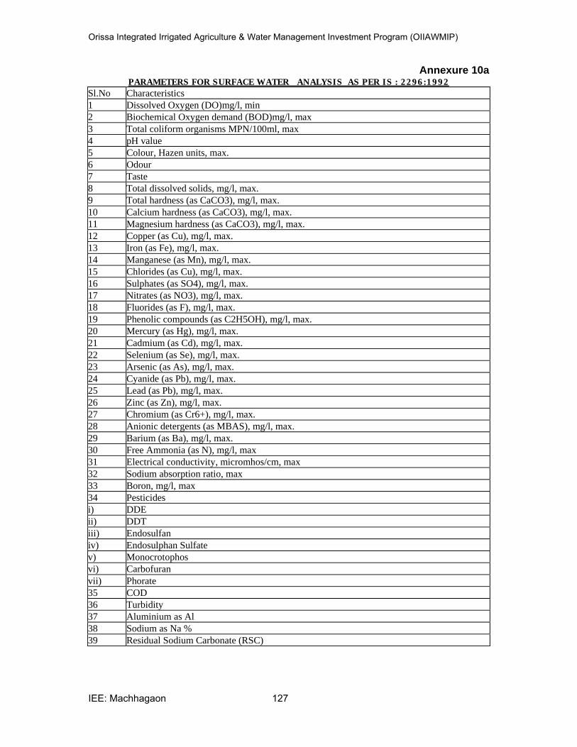
Orissa Integrated Irrigated Agriculture & Water Management Investment Program (OIIAWMIP)
IEE: Machhagaon 127
Annexure 10a PARAMETERS FOR SURFACE WATER ANALYSI S AS PER I S : 2296:1992
Sl.No Characteristics
1 Dissolved Oxygen (DO)mg/l, min
2 Biochemical Oxygen demand (BOD)mg/l, max
3 Total coliform organisms MPN/100ml, max
4 pH value
5 Colour, Hazen units, max.
6 Odour
7 Taste
8 Total dissolved solids, mg/l, max.
9 Total hardness (as CaCO3), mg/l, max.
10 Calcium hardness (as CaCO3), mg/l, max.
11 Magnesium hardness (as CaCO3), mg/l, max.
12 Copper (as Cu), mg/l, max.
13 Iron (as Fe), mg/l, max.
14 Manganese (as Mn), mg/l, max.
15 Chlorides (as Cu), mg/l, max.
16 Sulphates (as SO4), mg/l, max.
17 Nitrates (as NO3), mg/l, max.
18 Fluorides (as F), mg/l, max.
19 Phenolic compounds (as C2H5OH), mg/l, max.
20 Mercury (as Hg), mg/l, max.
21 Cadmium (as Cd), mg/l, max.
22 Selenium (as Se), mg/l, max.
23 Arsenic (as As), mg/l, max.
24 Cyanide (as Pb), mg/l, max.
25 Lead (as Pb), mg/l, max.
26 Zinc (as Zn), mg/l, max.
27 Chromium (as Cr6+), mg/l, max.
28 Anionic detergents (as MBAS), mg/l, max.
29 Barium (as Ba), mg/l, max.
30 Free Ammonia (as N), mg/l, max
31 Electrical conductivity, micromhos/cm, max
32 Sodium absorption ratio, max
33 Boron, mg/l, max
34 Pesticides
i) DDE
ii) DDT
iii) Endosulfan
iv) Endosulphan Sulfate
v) Monocrotophos
vi) Carbofuran
vii) Phorate
35 COD
36 Turbidity
37 Aluminium as Al
38 Sodium as Na %
39 Residual Sodium Carbonate (RSC)
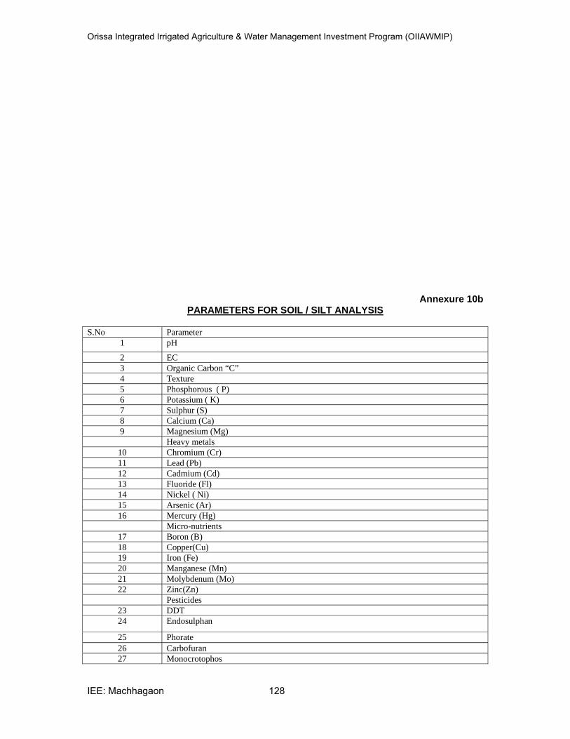
Orissa Integrated Irrigated Agriculture & Water Management Investment Program (OIIAWMIP)
IEE: Machhagaon 128
Annexure 10b PARAMETERS FOR SOIL / SILT ANALYSIS
S.No Parameter
1 pH
2 EC
3 Organic Carbon “C”
4 Texture
5 Phosphorous ( P)
6 Potassium ( K)
7 Sulphur (S)
8 Calcium (Ca)
9 Magnesium (Mg)
Heavy metals
10 Chromium (Cr)
11 Lead (Pb)
12 Cadmium (Cd)
13 Fluoride (Fl)
14 Nickel ( Ni)
15 Arsenic (Ar)
16 Mercury (Hg)
Micro-nutrients
17 Boron (B)
18 Copper(Cu)
19 Iron (Fe)
20 Manganese (Mn)
21 Molybdenum (Mo)
22 Zinc(Zn)
Pesticides
23 DDT
24 Endosulphan
25 Phorate
26 Carbofuran
27 Monocrotophos

Orissa Integrated Irrigated Agriculture & Water Management Investment Program (OIIAWMIP)
IEE: Machhagaon 129
PHOTO PLATES
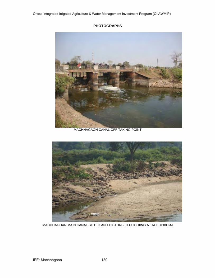
Orissa Integrated Irrigated Agriculture & Water Management Investment Program (OIIAWMIP)
IEE: Machhagaon 130
PHOTOGRAPHS
MACHHAGAON CANAL OFF TAKING POINT
MACHHAGOAN MAIN CANAL SILTED AND DISTURBED PITCHIING AT RD 0+000 KM
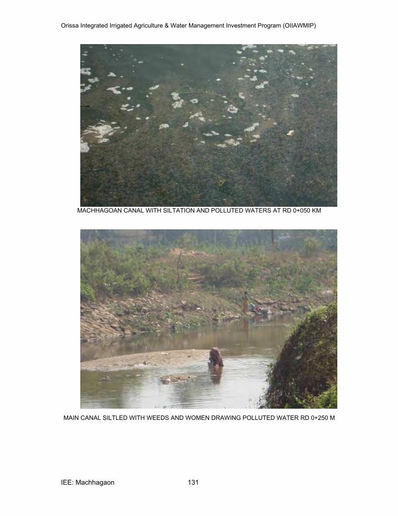
Orissa Integrated Irrigated Agriculture & Water Management Investment Program (OIIAWMIP)
IEE: Machhagaon 131
MACHHAGOAN CANAL WITH SILTATION AND POLLUTED WATERS AT RD 0+050 KM
MAIN CANAL SILTLED WITH WEEDS AND WOMEN DRAWING POLLUTED WATER RD 0+250 M
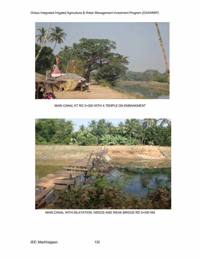
Orissa Integrated Irrigated Agriculture & Water Management Investment Program (OIIAWMIP)
IEE: Machhagaon 132
MAIN CANAL AT RD 3+300 WITH A TEMPLE ON EMBANKMENT
MAIN CANAL WITH SILATATION, WEEDS AND WEAK BRIDGE RD 3+400 KM
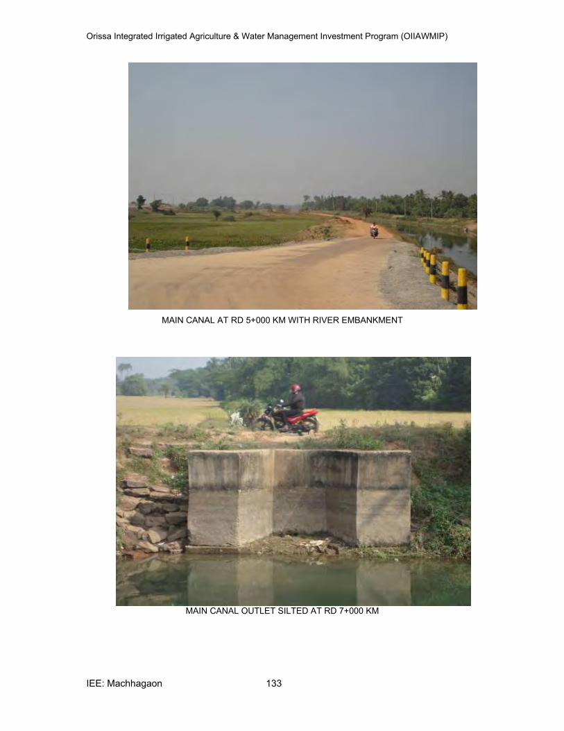
Orissa Integrated Irrigated Agriculture & Water Management Investment Program (OIIAWMIP)
IEE: Machhagaon 133
MAIN CANAL AT RD 5+000 KM WITH RIVER EMBANKMENT
MAIN CANAL OUTLET SILTED AT RD 7+000 KM
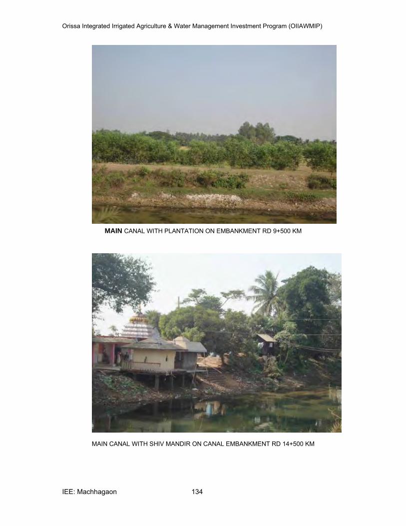
Orissa Integrated Irrigated Agriculture & Water Management Investment Program (OIIAWMIP)
IEE: Machhagaon 134
MAIN CANAL WITH PLANTATION ON EMBANKMENT RD 9+500 KM
MAIN CANAL WITH SHIV MANDIR ON CANAL EMBANKMENT RD 14+500 KM

Orissa Integrated Irrigated Agriculture & Water Management Investment Program (OIIAWMIP)
IEE: Machhagaon 135
DISTRIBUTORY NO.10 RD 0+650 KM WITH ENCROACHMENTS
MAIN CANAL WITH RIVER EMABNKMENT AT RD 15+200 KM
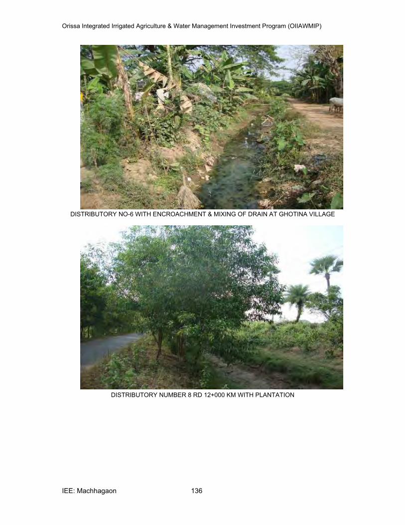
Orissa Integrated Irrigated Agriculture & Water Management Investment Program (OIIAWMIP)
IEE: Machhagaon 136
DISTRIBUTORY NO-6 WITH ENCROACHMENT & MIXING OF DRAIN AT GHOTINA VILLAGE
DISTRIBUTORY NUMBER 8 RD 12+000 KM WITH PLANTATION
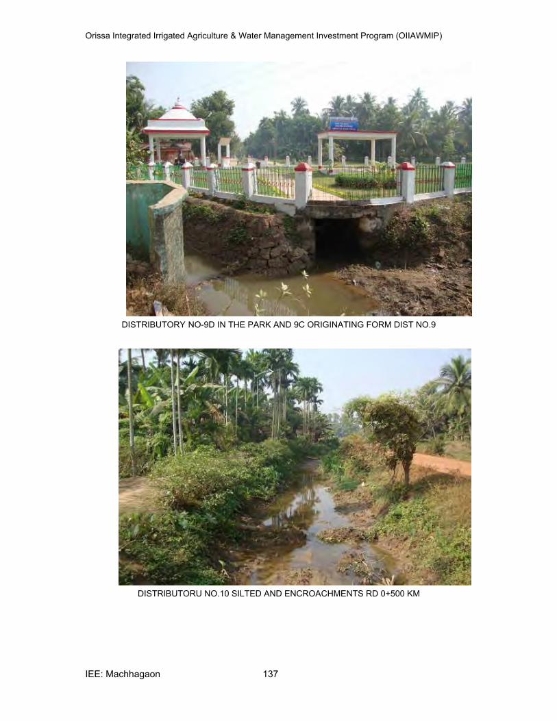
Orissa Integrated Irrigated Agriculture & Water Management Investment Program (OIIAWMIP)
IEE: Machhagaon 137
DISTRIBUTORY NO-9D IN THE PARK AND 9C ORIGINATING FORM DIST NO.9
DISTRIBUTORU NO.10 SILTED AND ENCROACHMENTS RD 0+500 KM
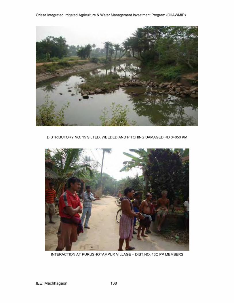
Orissa Integrated Irrigated Agriculture & Water Management Investment Program (OIIAWMIP)
IEE: Machhagaon 138
DISTRIBUTORY NO. 15 SILTED, WEEDED AND PITCHING DAMAGED RD 0+050 KM
INTERACTION AT PURUSHOTAMPUR VILLAGE – DIST.NO. 13C PP MEMBERS
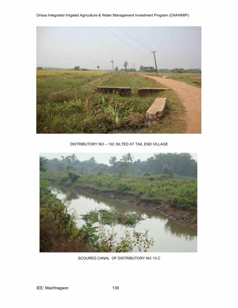
Orissa Integrated Irrigated Agriculture & Water Management Investment Program (OIIAWMIP)
IEE: Machhagaon 139
DISTRIBUTORY NO – 13C SILTED AT TAIL END VILLAGE
SCOURED CANAL OF DISTRIBUTORY NO 13 C
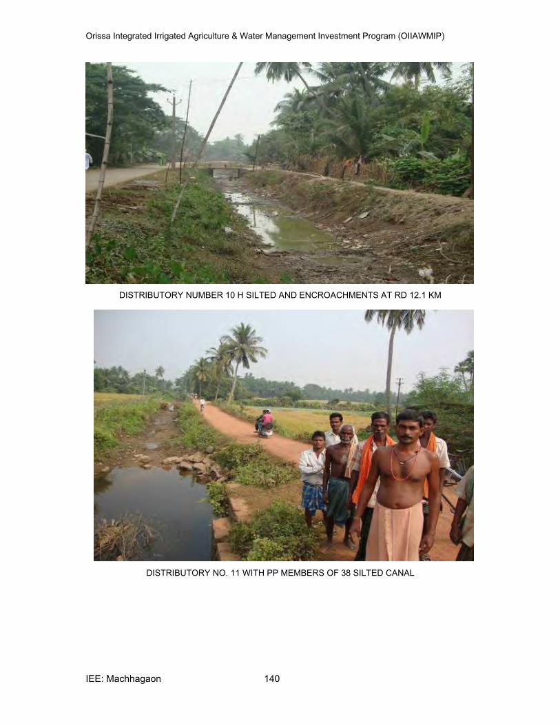
Orissa Integrated Irrigated Agriculture & Water Management Investment Program (OIIAWMIP)
IEE: Machhagaon 140
DISTRIBUTORY NUMBER 10 H SILTED AND ENCROACHMENTS AT RD 12.1 KM
DISTRIBUTORY NO. 11 WITH PP MEMBERS OF 38 SILTED CANAL
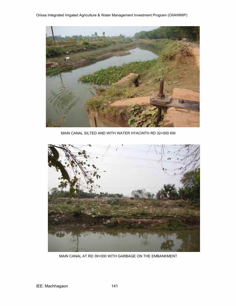
Orissa Integrated Irrigated Agriculture & Water Management Investment Program (OIIAWMIP)
IEE: Machhagaon 141
MAIN CANAL SILTED AND WITH WATER HYACINTH RD 32+000 KM
MAIN CANAL AT RD 39+000 WITH GARBAGE ON THE EMBANKMENT
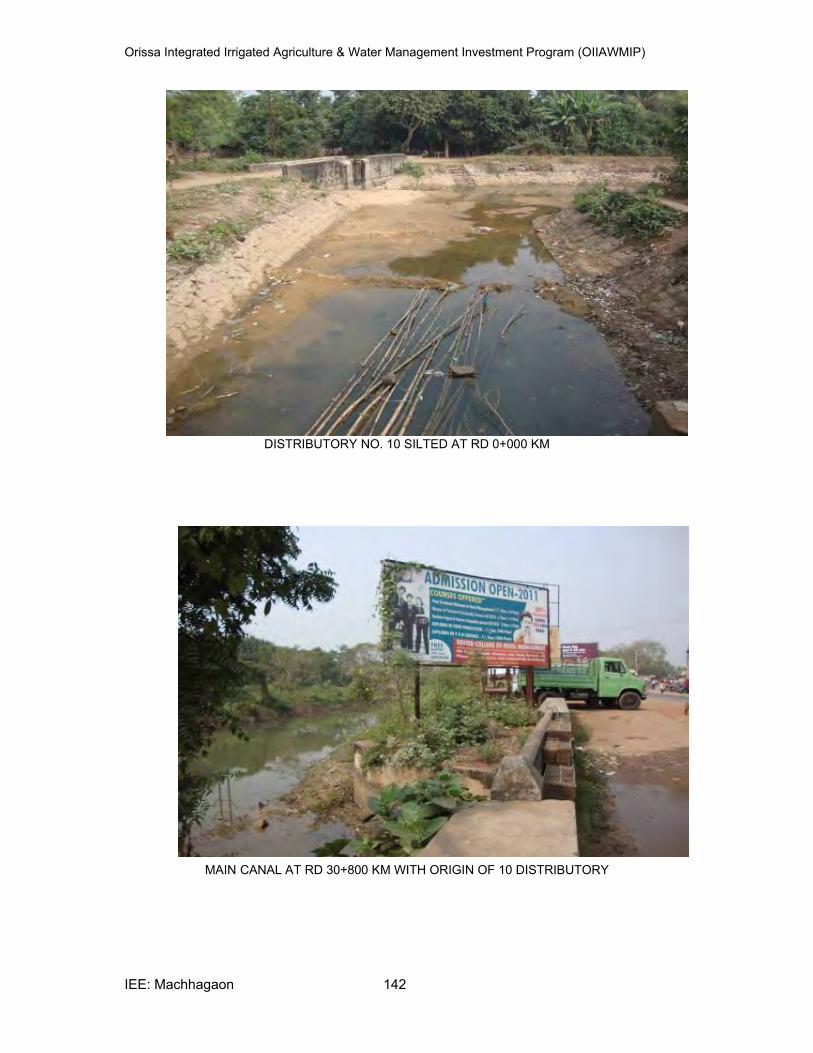
Orissa Integrated Irrigated Agriculture & Water Management Investment Program (OIIAWMIP)
IEE: Machhagaon 142
DISTRIBUTORY NO. 10 SILTED AT RD 0+000 KM
MAIN CANAL AT RD 30+800 KM WITH ORIGIN OF 10 DISTRIBUTORY


