Embed Size (px)
Citation preview
Journal of Environment and Earth Science www.iiste.org
ISSN 2224-3216 (Paper) ISSN 2225-0948 (Online)
Vol. 3, No.9, 2013
143
Major Human and Natural Disruptions that Facilitated Vegetation Cover Removal in the Ethiopia Highlands
Maereg Tafere1, Jana Olivier2, and Maarten Jordaan2
1 World Vision International ([email protected]; [email protected]; [email protected]) 2 University of South Africa – UNISA ([email protected]; [email protected])
* E-mail of the corresponding author: [email protected]; or [email protected] Abstract The Ethiopian highlands, occupying 44% of the total surface area of the country, are home to over 80% of the people, 75% of livestock, and are where up to about 95% of the crops are grown. However, they are among the most degraded in Africa due to a long tradition of settled agriculture that dates back to more than 3000 years. This has been aggravated by climatic strains and civil unrest. As the frequency of such extreme weather conditions increase, subsistence farmers become even more desperate, resulting in actions that cause significant damages to the environment. In addition, civil unrest aggravates the threat to the environment. Even though, much of Ethiopia’s history has been dominated by war between internal rivals for domestic supremacy and against external invaders, the environmental implications of such recurrent destructive wars have not been studied. A survey was carried out in the northern and southern parts of the Ethiopian highlands in order to understand deforestation patterns. The result of a focused group discussion indicated that the removal of forest covers in the highlands followed a non-linear trajectory over the past five decades. Catastrophic climatic conditions and civil unrest posed turning points in deforestation and mismanagement of natural resources. During times of severe droughts, instability, and civil conflict, only forests around religious institutions, homesteads, and those found among communities with local bylaws (written or otherwise) have survived compared to those exposed to free human and animal access. In a country whose history is characterized by prolonged civil war and instability, the impacts of protracted and prolonged wars should come to the Centre of the environmental degradation discourses. The conventional thesis of blaming only the poor farmers, who struggle to make ends meet, for destroying their environment due to their “ignorance” and to completely neglect the destructive acts of powers, does not seem fair, to say the least. Keywords: Drought, civil unrest, environmental degradation, Ethiopian highlands
1. Introduction Ethiopia has a long history of land use and agriculture, especially in the highland areas. Land cultivation and population expansion has been practiced in the areas currently under the Ethiopian territory for over 5000 years (Patterson, 2007). The Ox-plough system, one of the most productive but arguably the most destructive methods, was introduced in the highland areas of Ethiopia some 2000 years ago (Webb & Braun, 1994). While the majority of these highland areas, which cover 45% of land mass, and are home for 80% of people are degraded (Patterson, 2007), the northern highlands, where cultivation started earlier, are severely degraded compared to those in the southern and western part of the country (Hurni, 1994). The fact that these highlands are among the most degraded environments in Africa may not be contested, the rate at which the environmental degradation occurred is debated. Some believe that the environment has deteriorated tremendously in the past few decades, attributed to recent deforestation, recurrent droughts and famine (EFAP, 1994, Hagos et al, 2002; Dessie & Kleman, 2007), while others suggest that the changes have instead occurred over hundreds of years and recent changes are limited, at least in the northern highlands (Bewket, 2002; Boerma, 2006; Munro et al, 2008; and Nysse et al, 2008). In fact, the latter challenges the presumption that natural resources are rapidly dwindling in the highlands by suggesting that stabilization and even recovery is occurring. The improvements are attributed to environmental education (Bekalo & Bangay, 2002) and physical and biological conservation measures carried out in the past few decades. However, qualitative deterioration of vegetation where indigenous and more productive trees are replaced by fast-maturing exotic types such as eucalyptus or acacia cannot be overruled (Jagger & Pender, 2003; Tafere, 2011). The reasons for land degradation in the rugged mountainous highlands form a complex interaction of various factors, including farming on steep slopes and marginal lands, erratic and torrential rainfall patterns, inadequate investment in soil protection, poor and/or absence of natural vegetation protection policies, lack of fallow periods, poor recycling of crop residuals to the soil, overgrazing, and limited external plant nutrients (EFAP, 1994; Hurni, 1994; Hagos et al, 2002). However, the importance given to the various factors is at times diametrically opposing. Some argue that climate has been the main driving force for the long-term
Journal of Environment and Earth Science www.iiste.org
ISSN 2224-3216 (Paper) ISSN 2225-0948 (Online)
Vol. 3, No.9, 2013
144
environmental degradation (Machado et al, 1998); others emphasize on the anthropogenic impacts caused due to intensive human action due to major shifts in farming techniques (the introduction of the plough set, for example), and/or settlement patterns (Bard et al, 2000); still others suggest that there should be other factors apart from temporal rain patterns that contributed to the current degradation in the driest parts of the country (Nyssen et al, 2005). As can be noticed, the physical degradation throughout the highlands is mainly associated with biological degradation and water erosion and the socio-political factors often get forgotten in the discussions, though they may have significant impacts. This is not, however, to mean that no resource management techniques were applied. Studies suggest a long history of indigenous resource conservation techniques, which imply longstanding resource constraints in these areas. According to Munro et al (2008), evidences from historical records indicate that conservation activities have been practiced in this part of Ethiopia long before the recently known drought crisis occurred (Beshah, 2003). However, it was not until after the 1972-74 famine in Wollo and neighbouring areas, that environmental and resource degradation became of serious concern to the authorities. On a country level, the Ethiopian government, with the support of external aid, launched major conservation and afforestation activities since the mid-1970s (Hurni, 1988), followed by environmental education in 1985 (Bekalo & Bangay, 2002). Since then, many regional states have adopted environmental protection strategies as part of their economic development strategies. From 1991 onwards, the policy of the state has focused on conservation-based agriculture development. Research was also introduced later by the ministry of agriculture (FDRE, 1997b), gradually leading to the development of soil conservation guidelines. Despite these efforts, however, continued environmental degradation in formerly better-off areas coupled with the recurrent drought led to a presumption that the degradation may be irreversible (Hagos et al, 2002). In addition to natural resources management or the lack of it, armed conflicts have disastrous consequences on the environment: destruction of crops and forests, pollution of water supplies, collapse of environmental governance and data vacuum, and over-exploitation of natural resources are but a few examples (O’connell, 2000). Armed forces may destroy their own environment, or the opposition’s, as a strategy to win the war. Forest goods and services can fund civil wars such as the Al-Shabaab group in stateless Somalia (http://world.time.com/2012/11/27/why-charcoal-may-endanger-somalias-best-hope-for-peace/#ixzz2a2jpZXD6). Damages may also be indirect: troop movement may degrade arable land and vegetation; fighting and arms production may increase pollution and waste; provisions for troops may intensify pressures on resources; norms in favour of environmental protection may deteriorate; and war refugees may dump waste and damage ecosystems in pursuit of food, land, and firewood (Dasgupta, 1995; McNeill, 2001). In addition to the direct destructions caused by war, inhabitants of war zones can cause damages out of desperation. A strong dependence on natural resources persists among conflict affected communities in periods of profound chaos (as other services cease to function properly). The Ethiopian highlands have experienced such direct and indirect consequences of civil and international conflicts. Much of Ethiopia’s history has been dominated by war between internal rivals for domestic supremacy and against external invaders (Bonger, 1994; Zewde, 2002). Northern Ethiopia (including present day Eritrea) witnessed most of Ethiopia’s local and international wars. During the post-Axumite period (after the ninth century), power transfer was dominantly based on fighting powers (Bonger, 1994). The nobility, kings, and would-be kings mobilized up to 150,000 peasant soldiers who kept on moving around highland Ethiopia almost throughout the year except during the rainy seasons. These soldiers fed themselves on food either voluntarily given to them or looted from peasants. The armies moved from one province to another, allowing each one to recover its reserves of grain. These wars were reasons for the frequent changes of leadership which culminated with loss of land titles of the authorities related to the old regime. Marsden (2007) describes the situation as “the people of the highlands, the Christian farmers whose land and stores were forever being plundered by shifting hordes of rebels and regional armies, sought solace in the traditions of their faith.” This happened both during peace times and during war between rivals. This definitely discouraged farming (and investment on the farmlands) to the extent that farmers preferred to join one of the rivals as soldiers to avoid the looting and abuse by these armies (Bonger, 1994). In later years since the 1960s, Ethiopia had a history of one of the longest civil wars in Africa, claiming hundreds of thousands of people (Webb and Braun 1994). Movements of such a huge army must have contributed to forest destruction due to demand for firewood and the clearing of routes and camp sites. In addition to internal conflicts, the Ethiopian highlands also witnessed major international wars. The period known as the scramble for Africa in the late 20th century may have been the peak of Ethiopia’s struggle to remain independent. During this period the Ethiopian army (which was more or less a peasant army without modern training) fought with the Egyptians in 1875 and 1876, the Dervishes (Islamist expansionists from Sudan) in 1886, the Italians on several occasions in 1887 (one in February and another in November), and again in 1896
Journal of Environment and Earth Science www.iiste.org
ISSN 2224-3216 (Paper) ISSN 2225-0948 (Online)
Vol. 3, No.9, 2013
145
which ended with the defeat of the Italian army (Abebe, 1998). Almost all of these wars took place in the northernmost part of the country, also the most degraded environment in the country. The need for strict laws and legal instruments to protect the natural environment became apparent when people depending heavily on natural resources were faced with scarcity. In essence, traditional management systems sufficed when nature was generous and population pressure was not an issue. In the Ethiopian context, there is evidence that indicates elements of ‘environmental’ policies existed as far back as the sixteenth century. The Fetha Nagast5 (the oldest narrative of the law of the kings) contained articles of punishment against unlawful burning of entire or parts of lands and forests (Strauss, 1968). However, natural resources management in post-modern Ethiopia relied largely on traditional management systems and community level arrangements. It is, therefore, safe to say that the lack of uniform natural resources management codes might have also contributed to localized use which depended on local perceptions and needs. Even after the country’s modern-day policies and procedures were designed during the imperial rule of King Haile Selassie (early 1930 to 1975), no proper system was put in place to monitor the implementation as per the legal provisions. In some communities, local by-laws and social norms filled the gap. The laws that can be termed as modern came in the 1990s. Three environmental policy instruments have been enacted within a short period of time namely the 1994 Forestry Law, the 1997 Environmental protection Policy, and the 2007 Forest Resources use policy. The 1997 policy on environment is comprehensive covering key aspects of natural resources, but lacked essential elements. To fill the gaps, a new forest development, conservation and utilization proclamation was issued in 2007 (FDRE, Proclamation # 542/2007).
2. Research objectives Often than not, local communities are accused of destroying their environment due to ignorance. However, historical evidences show that though without sophisticated conservation technologies, many communities have long history of conservation and resource management practices. Wherever natural resources mismanagement and blunder took place, the actors must have been under tremendous pressure for survival (arguably, no one benefits from these resources more than the locals themselves). In this case social norms and traditional conservation mechanisms cannot hold. Thus, simplistic assumptions (such as population pressure and lack of conservation knowledge, for example) which are taken for granted need to be challenged with authentic studies. The findings discussed in this paper are taken from a body of a much wider study carried out to understand rainfall and environmental degradation patterns in Ethiopia (Tafere, 2011). This paper does not intend to deal with the whole issue of conflict and the environment in general. Rather, the part that deals with civil conflicts in Ethiopia and the relationship with the destruction of natural forests (thereby exposing the environment to degradation) is discussed in this paper. Neither does it attempt to cover all aspects of the drought-environment relationship, but it tries to explore if indeed severe droughts had the potential of forcing communities to over-exploit the environment especially where environmental laws are not strong, and where strong social norms don’t exist. The objectives of this specific paper can therefore be summarised as:
• to understand, from the communities and other actors, if the deforestation and associated environmental degradation followed a linear trend with slow increments over a long period of time or followed a non-linear pattern,
• to learn if and why communities destroy their much valued natural resources, and • to find out what are the most effective forest protection mechanisms that worked in these contexts
3. Research Methodology
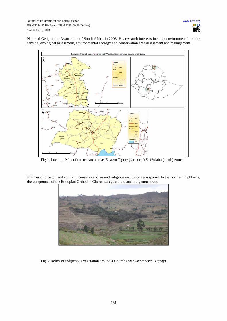
3.1 Location of the research area The research was conducted in Eastern Tigray and Wolaita zones of Ethiopia. Eastern Tigray zone is located in Tigray regional state, the northern most part of the country. The centre of the zone is about 890 Km north of Addis Ababa, Capital of Ethiopia, and 120 Km from Mekelle, capital of Tigray regional state (Fig. 1). This part of the country is characterized by sparse and irregular rainfall, and is highly drought-prone. Average annual rainfall and temperature of the area is 500-600mm and 18oC respectively. The pattern of rainfall in any given year is inconsistent. Eastern Tigray is found between 13o 48’ – 14o 02’ N and 390 34’ – 39o48’ E with a topography characterized by steep and rugged terrain and altitudes ranging between 1800 to 3100 m.a.s.l. The eastern margin of the study area borders the western margin of the Great East African Rift system. The second study area (Wolaita zone) is situated in the Southern Nations, Nationalities, and People’s Region (SNNPR), its centre (Sodo) being at about 420 km south of Addis Ababa. While Wolaita zone is wider, the study
5 The Fetha-Nagast served as the foundation of legal and spiritual standard until the new constitution was crafted by King Haile Selassie sometime after the Second World War.
Journal of Environment and Earth Science www.iiste.org
ISSN 2224-3216 (Paper) ISSN 2225-0948 (Online)
Vol. 3, No.9, 2013
146
area covers a portion located between 60 42’ – 6o 58’ North and 37o 40’ – 37o 54’ East. Annual average rainfall in the highland and mid-highland areas of Wolaita zone is about 1300 mm while the lowland areas is up to 600 mm or even less. Rainfall is bimodal with the main rains falling in the June-September and the short rains in February – March. The short rains (Belg) are more variable and unreliable. Failure of one or both rains often leads to food insecurity in the area. Average daily temperature is somewhere between 15-30o C. Like the eastern part of Tigray, Wolaita zone is also highly affected by drought. In both research areas, agriculture is the main stay of the people, though cereals predominate in Eastern Tigary while root crops (enset – false banana, sweet potatoes, etc.) make up the main staple food in Wolaita. Due to continued fragmentation of farmland as a result of population increase and frequent land redistribution during the communist regime (1974 – 1991), and the lack of other livelihood opportunities for such families, land size has continued to diminish and at present is on average about 0.5 ha. 3.2 Data collection and analysis A focused group discussion method was employed in eastern Tigray and Wolita zones between July and October 2010. The groups were made up of farmers, traders, local administrators, and experts in natural resources management. A questionnaire (made up of 36 questions) was administered to understand community’s perception on drought frequency and environmental degradation patterns. This paper does not cover all the questions, but focuses only on three important ones (whether the forest removal process was situational or linear).
1. How was the forest removed i.e. slowly and linearly or depended on incidents/unique occasions?
2. If the depletion was not linear, what were the circumstances/situations that resulted in significant removal of trees?
3. What are the conditions that protected forests in these contexts (if any)? Eastern Tigray and Wolaita zones were selected for the research due to their relevance. The people of the two study areas experienced years of declining environmental quality (forestry, soil, water resources). Besides, these zones are among those drought prone areas (Hurni, 1994) and as a result have been in the books of the Disaster Prevention and Preparedness Agency of Ethiopia (DPPA) for food assistance programs (DPPA, 2003). A total of 264 persons (136 in Easter Tigray and 128 in Wolaita Zone) participated in 14 group discussions, of which 30% and 22% were women from Eastern Tigray and Woliata zones respectively. In Eastern Tigray, three districts that border a natural forest (Dess’a forest), namely Atsbi-Womberta, S.Tsaeda-Emba, and Enderta districts, were included in the study. In Wolaita zone, the groups came from two districts, Humbo and Sodo-Zuria districts. Before the actual discussion started, the groups were guided to have a common understanding on what constitutes a forest and on the definitions of forest protection, environmental law, and civil conflict. Further to the group discussions, follow up conversations were made with prominent resource experts and elders in these areas for verification purposes.
4. Major Findings and Recommendations The key outcomes of the group discussions (in response to the three research questions), which were endorsed by a clear majority, are described below. Ideas/opinions that were not consented by the majority of each group, and/or not endorsed by the experts and resident elders, are not included in the discussions below.
4.1 Tigray Region The groups in Eastern Tigray indicated that, in the past four decades and as far as they can remember, natural forests were located in pocket areas inaccessible for farming purposes, and around church compounds. There were very few trees around homesteads a few decades ago. However, they identified the Dess’a forest (about 120,000 ha) as the only major natural forest in the area, which is located in a moisture stressed environment just at the mountain slopes leading to the East Africa Rift valley. This forest, though still serving as a source of important agricultural implements and construction materials, has reduced in size and quality. In response to the questionnaire, respondents identified three forces in action that contributed to the diminishing trend of natural forests:
i) To start with, farmlands are normally devoid of trees due to the farming techniques employed which are almost exclusively dependent on ox-plough. The land clearing occurred over many years, mainly due to increased demand for farmland but also for firewood, farm implements, and construction activities. With increasing population, more and more marginal lands have been distributed to the landless youth which still continues to be the practice in some districts (woredas) and sub-districts (Tabias). As a result, not only has the boundaries of the Dess’a forest area been encroached, but also patches of cleared land appear in various locations due to seasonal cattle camping by pastoralist communities resident in the lowland areas. Land clearing for farming, respondents unanimously agreed, was a slow process that took place over many generations.
Journal of Environment and Earth Science www.iiste.org
ISSN 2224-3216 (Paper) ISSN 2225-0948 (Online)
Vol. 3, No.9, 2013
147
ii) In addition to the continued steady decline of forests, communities identified landmark events as points of departures for major natural resources degradation.
o Top on the list is the 1975 nationalization of land and the redistribution that followed during the Communist government (endorsed by all group interviewees). The community did not despise the nationalization of land, but rather the uncertainty and lack of ownership it had created due to the frequency of redistributions.
o The other major event that resulted in substantial deforestation was the 1984/85 famine (strong consensus among respondents). All groups attested that since 1984/85, vegetation cover has continued to decline in quantity and quality. The situation was so severe that people started to make a living from sales of firewood and charcoal. According to respondents, prior to this period, tree cutting was mainly for their own firewood use and farm implements. In one community, the respondents reported that charcoal making was unknown to them until that time. This is, however, in contrast to Gebreegziabher (1999), who rather stated that there were two charcoal making enterprises in the 1950s run by the Italians, after the liberation by a concession obtained from the local governor of the region.
o Some also mentioned the period of the Italian occupation (1936-41) as a widespread intrusion that undermined local resource management systems (elder groups). This is in line with the findings by Gebreegziabher (1999) who mentioned widespread tree cutting, against local norms, by the Italians and their Eritrean aides. The Italians were the first to introduce prohibitive rules which “distanced” the inhabitants from the forest resources they safeguarded for many years.
o According to discussants, even droughts as recent as 2009 led to a destruction of a whole natural forest in Enderta district.
iii) Respondent groups (from Atsbi-Wombert and Enderta) also mentioned forest fires contributing to damages on the nearby Dess’a natural forest. In 1970, a major fire broke out and inflicted huge damage to hundreds of hectares for over ten days. The most recent one occurred in 1998 and destroyed large portions of the forest. The causes of these fires are believed to have been the mishandling of fire by residents and intruders, traditional methods of honey extraction (using smoke), land preparation by burning grass and bushes, and traditional ceremonies that require fireworks. Other parts of the country also suffer from wild fires. The most recent incident destroyed a big portion of the Bale forest in 2007 (BBC, March 12, 2007). Forest fire action is worse during dry seasons or long-drought years.
iv) The 1975–1991 civil war was the other significant factor mentioned by respondents. Movements of large mechanised army groups almost transformed an area within a short period of time. Trees were cleared to facilitate visibility, to provide fire wood for food preparation and temporary camp constructions, and for logistical routes. One of the writers is an eye witness to the amount of forest removal that took place in western Tigray. At the end of the war in 1992, he found an area that was known for its dense forest devoid of its original biomass except for scanty trees in farmlands.
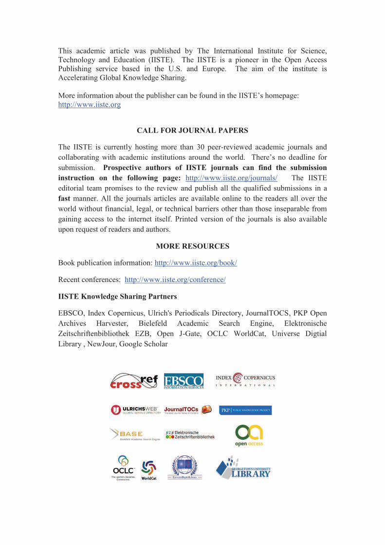
v) In terms of forest protection mechanisms, the discussant groups in the different districts implied differential legal and traditional forest management mechanisms in various districts bordering the Dess’a forest. During difficult times such as those indicated above, no other entity except the Ethiopian Orthodox Church clergy provided protection against tree cutting. As the majority of the inhabitants of the Ethiopian highlands are adherents of the Ethiopian Orthodox Church, the Church compounds are considered sacred, and are to be revered (fig. 2). The church compounds survived all the severe droughts and seasons of other pestilences, civil unrest, and power vacancies of many centuries. The groups also identified agreed-upon bylaws as better tools in protecting communal forests in times of civil unrest. In the absence of formal governance, local norms and peer pressures have the potential to serve as resources protection mechanisms. 4.2 Wolaita Zone
The groups interviewed for this research agreed on the prevalence of forests consistent to their definition of forests prior to the land reform proclamation of 1975. The natural forest covered mountains, valleys and the remote areas of the lowland which was predominantly uncultivated. For as long as they remember, there was limited forest cover in areas suitable for farming, especially in the mid-highland and highland areas. Like the groups in Eastern Tigray, the Wolaita groups identified the old natural forest locations, and described why these natural forests were destroyed and how. The results are similar.
i) The land reform was, according to them, the most important turning point to the continued indiscriminate felling of trees then located in mountain ranges. Not that the aim of the reform was negative, but lack of a smooth transition process led to the destruction. Unlike in Eastern Tigray, landlords controlled large mechanised farms prior to 1975. When the land was nationalized and became
Journal of Environment and Earth Science www.iiste.org
ISSN 2224-3216 (Paper) ISSN 2225-0948 (Online)
Vol. 3, No.9, 2013
148
communal without any form of management system, communities residing nearby started to cut trees as they thought appropriate. Some forest areas had also been allocated to landless farmers for farming. Farmers then had limited knowledge on environmental protection, apparently no local institutions or bylaws existed to define resource use terms, and the local administration was practically paralyzed by the changes. However, forest cover had been steadily deteriorating even before 1975 due to growing needs from increasing population (WADU, 1976).
ii) The 1984/85 famine was also identified by respondent groups as the other major factor in facilitating removal of forest covers in the zone. In fact, the impact of the famine was so severe that it contributed to changes in many social norms. Sales of forest goods and services became one of the coping mechanisms during dry years.
iii) Like in Eastern Tigray and elsewhere in Ethiopia, during years of instability such as civil conflict, where local administration is weaker, only forests around religious institutions and those found among communities with local bylaws (written or otherwise) are left unaffected. Respondents in this zone identified the change of government in 1991 as one of the events contributing to deforestation. The lawlessness and insecurity led to lack of ownership and responsibility. State owned farms and natural forests were looted and trees indiscriminately cut. Such destruction of natural resources was not limited to the research areas alone. Even elsewhere in the country, communal properties were looted, national parks and public commercial farms encroached, and forests exploited especially in formerly protected assets (Dereume, J. et al, 2008).
iv) Unlike those in Eastern Tigray, respondent groups did not identify the 1975–1991 civil war as a factor for deforestation. This is obvious since this area was not the fighting ground during this period. However, some experts mentioned it might have had an indirect effect due to diversion of human and financial capitals for the war agenda.
In recent years, forest protection mechanisms have been put in place in some regenerating mountain areas. The Humbo farmer-managed natural regeneration program is one such example. It is managed by cooperatives with local bylaws. The bylaws provide the mechanism for use and care. Members of the cooperatives benefit by cutting grass for their livestock and firewood from the thinning and pruning processes. When the forests mature, the benefits will not be limited to such but will grow to a level where families may use fully grown timber for construction and firewood. It also stipulates fines against transgressors including legal action by the district court (the bylaws are endorsed by the local court). So far, the groups proudly testify, the system works.
5. Discussion and Recommendations Focused group discussion in the two areas, located more than 1000 km apart, unanimously agreed that the 1975 land reform, and the 1984/85 famine were the most important turning points to significant natural forest removal, followed by the 1975-91 civil war (mainly in Eastern Tigray), subsequent droughts as late as 2009, and the temporary instability of 1991 during the change of government. During times of instability, firearms become readily available and wildlife and communal properties become objects of resentment. Uncertainties breed anxiety about the future and provide opportunity for exploitation before the new authorities have the time to enact policies. Therefore, it is safe to conclude that the countless wars that characterised the history of the Ethiopian highlands had significant contribution to the destruction of the natural environment in these areas. In the Ethiopian context, the impact of years of negligence and irresponsibility that were forced upon the poor farmers by those in power should be included in the web of reasons of environmental degradation and it is time that prolonged and destructive wars come to the centre of the environmental management discourses. The environmental implications of the long-term military engagements such as the times of the Zemene Mesafint (early 1700 to 1850s), and the civil war between the communist regime and the rebel forces (from the 1970s to 1991), deserve serious attention by researchers. In sub-Saharan Africa, the impacts of climate-related disasters are significant to the extent that they tend to be almost paralyzing. Recurrent and severe droughts, apart from their direct effect on the natural environment, have the capacity to push the inhabitants to the limits in such a way that they take desperate measures to save their lives. As the frequency of such extreme weather conditions increase (due to climate change), peoples’ actions become even more desperate, resulting in significant damages to the environment. This fact compounded by legal vacuums, and inadequacies in social norms, have the potential to destroy much needed forest resources. Therefore, in poor and disaster prone communities, safeguarding forest resources does not depend only on enforcing strict laws, but also in adequately investing in alternative sources of income. In terms of systems and opportunities that facilitate natural resources protection, educations, and the establishment of bylaws, are very important. After land was nationalized in 1975, trees were being cut for firewood, construction, and commercial purposes. Later when awareness creation changed attitudes of the highlanders, they started planting exotic trees and conserving existing ones first to save themselves time and
Journal of Environment and Earth Science www.iiste.org
ISSN 2224-3216 (Paper) ISSN 2225-0948 (Online)
Vol. 3, No.9, 2013
149
energy spent in fetching the same from the distant lowlands and then to protect their farmlands. However, this led to “migration” of forest destruction from the highlands to the nearby lowlands. Still today, what is alarming, and needs decisive action, is the state of vegetation destruction in lowland areas. According to respondent groups, the lowland areas of Wolaita and the Dessa’s forest in eastern Tigray, used to be dense forests and savannah grasslands (Abella area). The lowlands, being sparsely populated and a vast part belonging to no one, they lacked the care and management they dearly required to flourish. Besides, unlike the humid mid-highlands and highlands, lack of sufficient moisture and harsh environment makes recovery very difficult. So, in essence, the highlanders “externalized” the deforestation to the lowlands by safeguarding vegetation in their localities and cutting those far off (“leakage effect”). This is indicative of the lack of uniformity in education and the implementation of the Federal forest policies between the highland areas and the lowlands. This calls for proper management of marginal areas such as the lowlands (even those forest areas currently less affected by deforestation), as restoration or recovery can be difficult in these water stressed lowland environments if existing ones are lost. From the above evidences, it can safely be concluded that the complex dynamics of intensive land use driven by population pressure, inadequate investment in new technology, and gaps in appropriate policies affected the highland environment. However, major disruptions such as recurrence of severe and prolonged droughts, and civil unrest, accelerated the deforestation processes. During severe drought times in subsistence farming and poor communities, utmost attention must be granted to natural resources management, and maintaining of law and order, and creating a sense of ownership of natural resources to avoid further deterioration in forest goods and services.
Acknowledgement We would like to thank World Vision Ethiopia and the staff in Mekelle and Hawassa who facilitated the group meetings, and meetings with the local government authorities. Our special thanks also goes to the group members and experts who devoted their time during the discussion days. References Abebe, Berhanou. 1998. “Histoire de L’Éthiopie: d’Axoum a la Révolution. Maisonneuve et Larose – Centre Français Des Étude Éthiopiennes.” Paris. Pp 7. Bard, K. A, Coltori. M, DiBlasi M. C, Dramis F, and Fattovich R. 2000. The Environmental History of Tigray (Northern Ethiopia) in the Middle and Late Holocene: a Preliminary outline. African Archaeological Review, Vol. 17, No. 2, Pp. 69-81. Bekalo S, Bangay, C: 2002. “Towards effective environmental education in Ethiopia: problems and prospects in responding to the environment—poverty challenge,” International Journal of Educational Development Pp. 35–46. Beshah, T. 2003. “Understand Farmers: Explaining Soil & Water Conservation In Konso, Wollaita, and Wollo, Ethiopia.” PhD thesis, Wageningen University and Research Centre, Wageningen, The Netherlands. Bewket, W. 2002. “Land Cover Dynamics Since 1950 in Chemoga Water shade, Blue Nile Basin, Ethiopia.” Mountain Research and Development Vol 22, No. 3. Pp 263-269. Boema P. 2006. “Assessing Forest Cover Change in Eritrea – A historical Perspective.” Mountain Research and Development Vol. 26, No. 1. Pp. 41- 47. Bonger, Tenkir. 1994. “Growth and Development of Contemporary Ethiopia: From where to where? How?” (Translated from Amharic). Chamber Printing Press, Addis Ababa. Pp. 50 - 58. Dasgupta, 1995. “Population, Poverty, and Local Environment.” Scientific American272 (2). Pp. 1879 – 1902. Dereume, J., Kashipzha.A., and Fuller J. 2008. “A GIS application for trail sustainability with Bale Mountain National Park (BMNP), Ethiopia.” NR505 group projects. Pp. 2 Dessie, G and Kleman J. 2007. “Pattern and Magnitude of Deforestation in the Southern Central Rift Valley Region of Ethiopia.” Mountain Research and Development, Vol 27, No.2. Pp.162-168. Disaster Prevention and Preparedness Agency (DPPA). 2003. “Food Supply Prospect in 2003: Early Warning System Report.” DPPA, Addis Ababa, Ethiopia. Pp. 1-6. EFAP. 1994. “Ethiopian forest action program: the Challenge for Development.” Ministry of Natural Resources Development and Environmental Protection. vol. II. EFAP Secretariat, Addis Abeba, Ethiopia. Pp2. Federal Democratic Republic of Ethiopia (FDRE). 2007. “Forest Development, Conservation and Utilization Proclamation,” Federal Negarit Gazeta proclamation # 542/2007. Federal Democratic Republic of Ethiopia (FDRE). 1997b. “Ethiopian Agricultural Research Organization Proclamation.” Federal Negarit Gazeta, No. 42, Addis Ababa. Ethiopia. Hagos, F. and Haile, M. 1997. “Land Degradation and Rehabilitation in Tigray: Achievements and Constraints.” Mekelle University College. Mekelle, Ethiopia.
Journal of Environment and Earth Science www.iiste.org
ISSN 2224-3216 (Paper) ISSN 2225-0948 (Online)
Vol. 3, No.9, 2013
150
Hurni, H. 1994. “Methodological Evaluation of Soil Conservation Research in Ethiopia.” IDRC currents, Vol. 9, Swedish University of Agricultural Sciences, Uppsala. Hurni, H. 1988. “Degradation and Conservation of the Resources in the Ethiopian Highlands.” Mountain Research abd Development, Vol. 8, Nos2.3. Pp 123-130. Jagger, P and Pender J. 2003. “The Role of Trees for Sustainable Management of Less Favoured Lands: The case of Eucalyptus in Ethiopia.” Forest Policy & Economics, Vol. 5, Pp 83-95. Machado M. J., Perez-Gonzalez A., and Benito G. 1998. Paleoenvironmental Changes during the Last 4000 years in Tigray, Northern Ethiopia. Quaternary Research 49, Article No. QR981965. The University of Washington. Pp. 312-321. Marsden, Philip. 2007. “The Barefoot Emperor: An Ethiopian Tragedy.” Harper Collins Publishers. Pp. 13-40. McNeill, J. R. 2001. “An Environmental History of the 21st – century World.” Norton XXVI. New York, Pp. 5-15. Munro R. N, Deckers J, Haile M, Grove A. T, Poesen J, and Nyssen J. 2008. “Soil Landscapes, Land Cover Change and Erosion Features of the Central Plateau Region of Tigray, Ethiopia:” Photo-monitoring with an Interval of 30 Years. Catena (75) Elsevier B.V. Pp. 55-64. Nyssen J, Haile M, Naudts J, Munro N, Poesen J, Moeyersons J, Frankl A, Deckers J, and Punkhurst R. 2008. “Desertification? Northern Ethiopia Re-Photographed after 140 years.” Elsevier B.V. Pp. 2749-55. Nyssen J, Vandenreyken H, Poesen J, Moeyersons J, Deckers J, Haile M, Salles C, and Govers G. 2005. Rainfall erosivity and Variability in the Northern Ethiopian Highlands. Journal of Hydrology 311. Elseviers B. V. Pp. 172-187. O'Connell, M. E., 2000. “Conflict and the Environment,” Human Rights Quarterly, Volume 22, Number 4, pp. 1099-1103 (Review), The Johns Hopkins University Press: DOI: 10.1353/hrq.2000.0047. Patterson, K. P. 2007. “Integrating Population, Health, and Environment in Ethiopia.” Bridge – Making the Link. Population Reference Bureau (PRB). Washington DC. Pp. 1-12. Strauss L. Peter (editor). 1968. “The Fetha Nagast:” The Laws of the Kings (translated from Ge’ez -ancient language of Ethiopia, Faculty of Law, Haile Selassie I University (now Addis Ababa University). Addis Ababa. Pp. 305. Tafere, M. 2011. “The Environmental and Socio-economic Impacts of Drought Disasters, Perceptions and Adaptation in Ethiopia” (PhD thesis). The University of South Africa (UNISA). South Africa. Wolaita Agricultural Development Unit (WADU). 1976. “Agricultural Survey of Abella.” WADU Publication # 47. Sodo. Webb P. and Braun J. 1994. “Famine and Food Security in Ethiopia: lessons for Africa.” John Willy and Sons. New York. Pp. 10-56. Zewde, B. 2002. “A History of Modern Ethiopia:” 1855 – 1991. Addis Ababa University Press. Second edition. Pp. 1-2, 14, 215-216. Maereg Tafere received his B.Sc. degree in physics (geology minor) from Addis Ababa University in 1986. He then obtained his M.Sc. from Indian Institute of Technology (IIT), Kharagpur in 1991 exploration geophysics. After having worked with the Ethiopian Institute of Geological Survey, and World Vision International, he then completed his PhD in 2011 in environmental management, more specifically in the effects of disasters on the natural environment. He continues to work for World Vision International at a capacity of an associate director of disaster management for the East Africa region. His research interest is mainly in the impacts of disasters on humans and the natural environmental. Prof Jana Olivier was awarded her BSc in Zoology and Botany from the University of the Witwatersrand in 1967. She subsequently obtained her B.Sc honours (Geography) from the University of South Africa (UNISA) and her M.Sc. and PhD from Rand Afrikaans University (now University of Johannesburg) with specialization in Climatology. She has lectured at Vista University, the University of Stellenbosch, University of the North and UNISA and is currently Emeritus Professor in the Department of Environmental Sciences at UNISA and Professor Extra-ordinarius in the Department of Geography, Geo-informatics and Meteorology at the University of Pretoria. During her academic career she has written and assisted the publication of more than 60 papers in accredited scientific journals. Her research interests vary widely, with emphasis on environmental problems. Maarten Jordaan obtained his B.Sc. degree in geography, geology and Botany from the university of Johannesburg in 1981 followed by B.Sc. honours in 1982 (Geography). He then received his M.Sc. in GIS and remote sensing from the same university in 1996. He is currently in his final year working on his PhD in environmental sciences. He became a Member of International Association of Impact Assessors in 2007, and
Journal of Environment and Earth Science www.iiste.org
ISSN 2224-3216 (Paper) ISSN 2225-0948 (Online)
Vol. 3, No.9, 2013
151
National Geographic Association of South Africa in 2003. His research interests include: environmental remote sensing, ecological assessment, environmental ecology and conservation area assessment and management.
Fig 1: Location Map of the research areas Eastern Tigray (far north) & Wolaita (south) zones
In times of drought and conflict, forests in and around religious institutions are spared. In the northern highlands, the compounds of the Ethiopian Orthodox Church safeguard old and indigenous trees.
Fig. 2 Relics of indigenous vegetation around a Church (Atsbi-Womberta, Tigray)
This academic article was published by The International Institute for Science,
Technology and Education (IISTE). The IISTE is a pioneer in the Open Access
Publishing service based in the U.S. and Europe. The aim of the institute is
Accelerating Global Knowledge Sharing.
More information about the publisher can be found in the IISTE’s homepage:
http://www.iiste.org
CALL FOR JOURNAL PAPERS
The IISTE is currently hosting more than 30 peer-reviewed academic journals and
collaborating with academic institutions around the world. There’s no deadline for
submission. Prospective authors of IISTE journals can find the submission
instruction on the following page: http://www.iiste.org/journals/ The IISTE
editorial team promises to the review and publish all the qualified submissions in a
fast manner. All the journals articles are available online to the readers all over the
world without financial, legal, or technical barriers other than those inseparable from
gaining access to the internet itself. Printed version of the journals is also available
upon request of readers and authors.
MORE RESOURCES
Book publication information: http://www.iiste.org/book/
Recent conferences: http://www.iiste.org/conference/
IISTE Knowledge Sharing Partners
EBSCO, Index Copernicus, Ulrich's Periodicals Directory, JournalTOCS, PKP Open
Archives Harvester, Bielefeld Academic Search Engine, Elektronische
Zeitschriftenbibliothek EZB, Open J-Gate, OCLC WorldCat, Universe Digtial
Library , NewJour, Google Scholar


