Embed Size (px)
Citation preview
Estuaries Vol. 21, No. 48, p. 818-828 December 1998
Marsh Vegetation Types of the Mississippi River Deltaic Plain
JENNEKE M. VISSER!
CHARLES E. SASSER
Coastal Ecology InstituteLouisiana State UniversityBaton Rouge, Louisiana 70803
ROBERT H. CHABRECK
School ofForestry, Wildlife, and FisheriesLouisiana State University Agricultural CenterBaton Rouge, Louisiana 70803
R. G. LINSCOMBE
Louisiana Department of Wildlife and FisheriesRoute 4, Box 78New Iberia, Louisiana 70560
ABSTRACT: Marshes of the Mississippi River Deltaic Plain represent 17% of the coastal marshes in the continentalUnited States. However, only a few detailed descriptions of the diverse plant communities that occur in this large expanseof wetlands exist and none are based on detailed vegetation analysis. The objective of this study was to quantitativelyanalyze the vegetation data collected in the wetlands of the Barataria and Terrebonne estuary to determine naturallyoccurring vegetation associations. Two-way indicator species analyses (TWINSPAN) revealed nine vegetation types: polyhaline mangrove, polyhaline oystergrass, mesohaline mix, mesohaline wiregrass, oligohaline wiregrass, oligohaline mix,fresh bulltongue, fresh maidencane, and fresh cutgrass. These nine types form a logical expansion on the four salinityzones described for the region by previous studies and form a basis to compare the vegetation types of the MississippiRiver Delta region with other regions of the Atlantic and Gulf coasts.
Introduction
The Mississippi River Deltaic Region (MRDR) estuary complex contains the largest salt marsh areaand the second largest fresh marsh area in the continental United States, representing 17% of thecoastal marshes in the continental United States(557,000 ha of fresh and salt marsh in the MRDRcompared to 3,216,000 ha of fresh and salt marshin the continental United States; Field et al. 1991).However, detailed descriptions of the diverse plantcommunities that occur in this large expanse ofwetlands have been few. Penfound and Hathaway(1938) provided the earliest descriptions of thecommunity types found in the MRDR. Their effortswere followed by O'Neil (1949), who published thefirst map of major vegetation associations for coastal Louisiana, including the MRDR, as part of aninventory of muskrat habitat.
The most recent description of the major habitats within coastal Louisiana was by Chabreck et al.(1968) based on a vegetation survey of more than5000 stations. Chabreck (1970, 1972) delineated
I Corresponding author; tele: 225/388-6515; fax: 225/3886376; e-mail: [email protected].
© 1998 Estuarine Research Federation 818
and mapped four vegetation zones (fresh, intermediate, brackish, and saline) mainly on the basisof Penfound and Hathaway'S (1938) descriptionsof the major vegetation types of the MRDR. Withinthese salinity zones several vegetation associationscan be distinguished (O'Neil 1949; Shiftlet 1963;White 1983; Visser et al. 1994; Sasser et al. 1995).However, the 1968 survey remains the only coastwide vegetation study in Louisiana. In this paper,we revisit the 1968 data using quantitative techniques to describe in more detail the major vegetation types occurring in one of the world's largestdeltas. Data analysis focused on Barataria andTerrebonne estuaries, which contain 77% (429,000ha) of the marshes of the MRDR (based on Fieldet al. 1991).
Methods
DATA COLLECTION
The 1968 Louisiana coastwide survey of vegetation was funded by the Louisiana Wildlife and Fisheries Commission and the United States ArmyCorps of Engineers. Sampling stations were locatedalong north-south transects spaced at 13-km (7.5'longitude) intervals (Fig. 1). Along these transects,

Marsh Vegetation Types 819
Ifa-________/ --------
22
I 25km I
23
24 25
LakePontchartrain
29
GulfofMexico 36
o
'" "
Fig. 1. Location of the vegetation transects in Barataria and Terrebonne basins. Transect numbers are those used by Chabreck(1972). Terrebonne Basin is the area between the Atchafalaya River and Bayou Lafourche. Barataria Basin is the area between BayouLafourche and the Mississippi River.
stations were located at O.4-km intervals (0.25mile) starting from the Gulf of Mexico.
Vegetation was surveyed by one observer from ahelicopter hovering above the station. Each speciesoccurring in a 30-m (100-ft) radius from the station was recorded and assigned an abundance value (3 = abundant, 2 = common, and 1 = rare).Species identification was improved by landing atevery eighth station and collecting unknown specimens. Specimens were returned to the laboratoryand identified. In addition, the station was classified as natural marsh, forested (shrubs or trees),dewatered marsh, open water, beach, natural leveeor ridge, spoil bank, or developed. Plant speciesnomenclature follows Godfrey and Wooten (1981),
except for ferns which follows Correll and Correll(1975).
ANALYSES
For the analyses in this study, only those stationsclassified as natural marsh were used. Before thestart of the analyses all submerged, free-floating,and tree species were removed from the dataset,so that only emergent marsh vegetation was included in the analysis. Some species that were difficult to identify correctly using helicopter surveys,such as some grasses and sedges, were grouped bygenus. Mter this, species occurring in less than fivestations (approximately 1% of the stations) wereremoved to reduce the influence of these rare spe-

820 J. M. Visser et al.
cies in the analyses, and reduce instability in theanalysis (Tausch et al. 1995).
Separate datasets were compiled for Baratariaand Terrebonne basins. These datasets were classified using two-way indicator-species analysis(TWINSPAN) with the default setting of the program (Hill 1979). TWINSPAN was chosen over other classification strategies because this techniquebest reflects the intuitive phytosociologic classification of vegetation types (Dale 1995).
Results
COMPARISON AMONG BASINS
TWINSPAN revealed nine vegetation types forthe deltaic plain (Fig. 2). For both basins the firstsplit seems to differentiate between high and lowsalinity stations. Indicator species identified for thehigh salinity plots were Spartina alterniflora and Distichlis spicata (in both basins), Spartina patens (Barataria) , and funGus roemenanus (Terrebonne). Incontrast, indicator species for low salinity plotswere Panicum hemitomon and Eleocharis spp. (inboth basins), Sagittaria lancifolia (Barataria), andTypha spp. (Terrebonne). The second level separates the high salinity plots into polyhaline and mesohaline, with Spartina alterniflora as the indicatorspecies for polyhaline marsh and Spartina patens formesohaline marsh. At the same level, low salinityplots are divided into oligohaline and fresh, withthe combination of Spartina patens and Bacopa monnieri as indicators for oligohaline and Panicum hemitomon as an indicator for fresh. The naming of thevegetation types uses the salinity zones of coastalmarshes as described by Odum et al. (1984) combined with common names for the dominant plantspecies. Subsequent splits are different for each basin. However, resulting vegetation types are verysimilar for both basins (Fig. 2).
The percentage occurrence of vegetation typesin each basin shows several differences (Fig. 3).Barataria Basin has larger percentages of mesohaline marshes, while Terrebonne Basin has largerpercentages of fresh and polyhaline marshes.
VEGETATION 'TYPES
Polyhaline mangrove is characterized by thepresence of Avicenia germinans. However, it isequally dominated by Spartina alterniflora and Batismaritima (a complete list of species observed ineach vegetation type is provided in Appendices 1and 2). Polyhaline mangrove has relatively low species richness (Table 1), is uncommon in BaratariaBasin, and is slightly more common in TerrebonneBasin (Fig. 3). Avicennia germinans reaches itsnorthernmost range in Louisiana as a dwarf shrubgrowth form. It occurs mostly flanking the largebays (Fig. 4) on the protected side of barrier is-
lands, as well as on a few islands on the northernedge of the bays.
Polyhaline oystergrass is the common "saltmarsh" association abundant in both basins (Fig.3). Polyhaline oystergrass is always dominated bySpartina alterniflora, sometimes with funGUs roemerianus as a co-dominant. It occurs mostly flankingthe large bays (Fig. 4). Number of species per station is the lowest of all described vegetation types(Table 1).
Mesohaline mix is without a clear dominant andcan be described as a mixture of Spartina alterniflora, Spartina patens, and Distichlis spicata. Speciesrichness of mesohaline mix is higher than in thepolyhaline oystergrass. This vegetation type isabundant in Barataria Basin and common in Terrebonne Basin (Fig. 3). It occurs just inland from thepolyhaline vegetation types (Fig. 4).
Mesohaline wiregrass is always dominated bySpartina patens, sometimes with Distichlis spicata asa co-dominant. It occurs generally just inland fromthe mesohaline mix (Fig. 4). Mesohaline wiregrassis similar in species richness to the mesohaline mix(Table 1). Mesohaline wiregrass is abundant inBarataria Basin and common in Terrebonne Basin(Fig. 3).
Oligohaline wiregrass generally occurs just inland from the mesohaline wiregrass (Fig. 4). Likemesohaline wiregrass, oligohaline wiregrass is always dominated by Spartina patens. However, Distichlis spicata is occasionally present with a lowabundance. Scirpus americanus is a frequent codominant in this type. In addition, oligohalinewiregrass has a higher species richness than themesohaline wiregrass (Table 1). This vegetationtype is common in both basins (Fig. 3).
Oligohaline mix generally occurs interspersedwith the oligohaline wiregrass (Fig. 4). Oligohalinemix is clearly dominated by Sagittaria lancifolia inthe spring, but this might be less clear in the fall.In the fall, oligohaline mix is characterized by theco-occurrence of Sagittaria lancifolia with Cyperusspp. and Bacopa monnieri. Oligohaline mix has thehighest number of species per station (Table 1).Oligohaline mix is common in both basins (Fig.3).
Fresh bulltongue is always dominated by Sagittaria lancifolia and is frequently co-dominated byPanicum hemitomon and Eleocharis spp. This vegetation type can be distinguished from the oligohaline mix based on the absence of Bacopa monnieriand the presence of ferns (Thelypteris palustris andOsmunda regalis) , Myrica cerifera, and Hydrocotylespp. Fresh bulltongue has relatively high speciesrichness. It occurs generally inland from the oligohaline vegetation types and is often found interspersed with the fresh maidencane type (Fig. 4).

Marsh Vegetation Types 821
Barataria Basin
Saline Fresh
Spartina alterniflora Spartina patens
84860
Spartina patens /Bacopa monnieri
44329072683
PolyhalineMangrove
MesohalineMix
OligohalineWiregrass
FreshBulltongue
FreshCutgrass
PolyhalineOystergrass
MesohalineWiregrass
OligohalineMix
FreshMaidencane
Terrebonne BasinSaline Fresh
Spartina patens /Bacopa monnieri
30 115 41 48 70 27 58 108 15
PolyhalineMangrove
MesohalineMix
OligohalineWiregrass
FreshBulltongue
FreshCutgrass
PolyhalineOystergrass
MesohalineWiregrass
OligohalineMix
FreshMaidencane
Fig. 2. Summary of the results from the TWINSPAN analyses for vegetation data from Barataria and Terrebonne basins. Speciesat each fork are important indicator species for the division; however, not all indicator species used in the division are listed. Numbersindicate the number of stations within each vegetation type.
This vegetation type is common in both basins(Fig. 3).
Fresh maidencane is dominated by Panicum hemitomon. The species richness (5.8 species per stationwith a total of 55 species observed) of the freshmaidencane marsh is slightly lower than the freshbulltongue marsh. It occurs in large expanses inthe interior of the estuaries, sometimes interspersed with the fresh bulltongue (Fig. 4). Thisvegetation type is abundant in Terrebonne Basinand common in Barataria Basin (Fig. 3).
Fresh cutgrass is dominated by Zizaniopsis mili-
acea, with Panicum hemitomon as a frequent co-dominant. Within the fresh marsh this vegetation typehas the lowest species richness (4.3 species per station with a total of 23 species observed). It occursmostly along the natural levee of Bayou Lafourche(Fig. 4). This vegetation type is uncommon in bothbasins (Fig. 3).
Discussion
The nine vegetation types described in this paper are a logical expansion from the four vegetation-salinity zones previously described by Pen-

822 J. M. Visser et al.
Barataria
2% 1%
lO%~_TII14%
8% 21%
Terrebonne
3% 6%
17%
22%
8%
II Polyhaline Mangrove
Polyhaline Oystergrass
§ Mesohaline mix
[[]ill Mesohaline Wiregrass
mOligohaline Wiregrass
mOligohaline mix
IT] Fresh Maidencane-Bulltongue
~ Fresh Maidencane
D Fresh Cutgrass
14%Fig. 3. Percent occurrence of each vegetation type in Barataria and Terrebonne basins.
TABLE 1. Number of species in each vegetation type.
found and Hathaway (1938) and Chabreck (1970)for coastal Louisiana. These previously describedvegetation-salinity zones are as follows:
Saline Marsh: This vegetation zone is a combination of Spartina alterniflora, Juncus roemerianus,Batis maritima, Avicennia germinans, and Distichlisspicata. Salinity 18%0 (range 8-29%0).
Brackish Marsh: This vegetation zone is a combination of Spartina patens, Scirpus americanus, Scirpus robustus, and Eleocharis parvula. Salinity 10%0(range 4-18%0).
Intermediate Marsh: This vegetation zone is acombination of Spartina patens, Vigna luteola, Scirpus califomicus, Echinochloa walteri, Sagittaria sp.,Cladium jamaicense, and Phragmites australis. Salinity4%0 (range 2-8%0).
Vegetation Type
Polyhaline mangrovePolyhaline oystergrassMesohaline mixMesohaline wiregrassOligohaline wiregrassOligohaline mixFresh bulltongueFresh maidencaneFresh cutgrass
AverageSpecies per Station
4.32.74.04.67.68.07.05.84.3
TotalSpecies
142630375549525523
Fresh Marsh: This vegetation zone is a combination of Panicum hemitomon, Hydrocotyle sp., Pontederia cordata, Sagittaria sp., and Althernantera philoxeroides. Salinity 0%0 (range 0-3%0).
Polyhaline mangrove and polyhaline oystergrasscompose the saline marsh of previous authors. Thepolyhaline mangrove vegetation type is relativelyrare in Barataria Basin (the area used by Penfoundand Hathaway to define their marsh types) andtherefore was probably not recognized as a different type in the qualitative analysis. This vegetationtype reflects the northern range of Avicenia germinans and can also be found in Florida and Texas(Chapman 1977; Montague and Wiegert 1990).
The polyhaline oystergrass vegetation type occurs throughout the eastern coast of North America (Chapman 1960; Teal 1986; Montague andWiegert 1990; Wiegert and Freeman 1990). In NewEngland, this vegetation type is commonly referredto as low marsh (Niering and Warren 1980; Bertness and Ellison 1987). Along the Gulf of Mexicocoast to the east of the MRDR, salt marshes aresometimes characterized by monocultures of Juncus roemerianus (Eleuterius 1976; Montague andWiegert 1990). Our results show that this speciesoccurs as a frequent co-dominant in the polyhalineoystergrass marsh.
The mesohaline mix vegetation type seems to be

LakePontchartrain
Interspersed Vegetation Types
/HI Fresh MaidencanelFresh Bulltongue
IT] Fresh Bulltongue/Oligohaline Mix
Gl OligohalinelMesohaline Wiregrass
~ Mesohaline MixlMesohaline Wiregrass
~ Polyhaline OystergrasslMesohaline Mix
21 22
I 25 kill I
23 .' j., • • : gO"';'~oii~ 27~'-=='24 25 26 28 29
Marsh Vegetation Types 823
Vegetation Types
Fresh Cutgrass
Fresh Maidencane
Fresh Bulltongue
Oligohaline Mix
Oligohaline Wiregrass
Mesohaline Wiregrass
Mesohaline Mix
~ Polyhaline Oystergrass
~~ Polyhaline Mangrove
d'~..~ I''lt~~~l?*.Pl l> 0 0l;; d
~
GulfofMexico 36
Fig. 4. Distribution of vegetation types along transects. Breaks indicate areas not occupied by marsh. Areas of the coast where twovegetation types were found interspersed are indicated. However, individual stations within these areas possessed one of the twovegetation types.
a transition zone from the saline to the brackishmarsh. Palmisano (1970) considered this vegetation type, without Spartina alterniflora as the cleardominant, a brackish marsh. The occurrence ofDistichlis spicata in the mesohaline mix generallyindicates a slightly higher elevation than the elevation in the polyhaline oystergrass vegetation type(Shiflet 1963; Sasser 1977; Bertness and Ellison1987; Wiegert and Freeman 1990). The mesohaline wiregrass vegetation type is similar in speciescomposition to the brackish marsh in the qualitative analysis (Chabreck 1970; see above). White(1983) classified what we call mesohaline wiregrass(marsh dominated by Spartina patens with low species diversity) as saline marsh for the Pearl Riverestuary in Louisiana. The mesohaline wiregrassvegetation type seems very similar in species composition to the high marsh as it has been describedfor the New England coast of the United States(Niering and Warren 1980; Bertness and Ellison1987). Along the southeastern Atlantic, mesohaline wiregrass is relatively uncommon and usuallyconfined to small patches or to a narrow fringeshoreward of the polyhaline oystergrass marsh(Wiegert and Freeman 1990). In Louisiana, themesohaline marsh can be several kilometers wide.This might be due to the gentle slope of the coastand the small tidal amplitude (30 cm) along theGulf Coast.
The intermediate marsh is divided into the oligohaline wiregrass and the oligohaline mix. Otherstudies. (Sasser et al. 1994; Visser et al. 1994; Sasseret al. 1996) have mentioned these different vegetation types in the intermediate salinity zone of theLouisiana coast. Visser et al. (1994) calls the oligohaline mix a Bacopa marsh, characterized by Bacopa monnieri, Sagittaria lancijolia, Eleocharis spp.,Pluchea camphorata, and Leptochloa jascicularis, whileSasser et al. (1994) calls this marsh type Sagittarialancifolia intermediate marsh. The oligohalinewiregrass marsh seems very similar in species composition to the floating-brackish marshes describedby O'Neil (1949). No descriptions of similar oligohaline vegetation types outside of Louisianawere found in the literature. Along the southeastAtlantic Coast oligohaline marshes are dominatedby Spartina eynosuroides (Wiegert and Freeman1990).
The fresh maidencane and the fresh bulltonguevegetation type have been previously described byWhite (1983) and Sasser et al. (1995). Both thesevegetation types can occur on floating mats. Everset al. (1996) mapped 95% of the maidencanemarsh and 51 % of the fresh bulltongue as floatingmarshes in Barataria and Terrebonne basins. Panicum hemitomon-dominated marshes occur in central Florida under two different environmental regimes (Kushlan 1990): flag marshes (moderate hy-

824 J. M. Visser et al.
droperiod and fire frequency) and wet prames(short hydroperiod and high fire frequency). Nodescriptions of vegetation associations similar tothe fresh bulltongue were found in the literature.Therefore, the fresh bulltongue type seems to beunique to the Louisiana coast. In Florida, the Cladium jamaicense-dominated Everglades are the mostcommon freshwater marsh (Kushlan 1990). Alongthe mid-Atlantic Coast fresh tidal marshes are often mixtures which include Peltandra virginica, Pontederia cordata, Zizania aquatica, and Typha spp.(Odum et al. 1984). Similar mixtures are alsofound in some of the fresh marshes of central Florida (Kushlan 1990), while along the north Atlantic,fresh marsh is composed of perennial grasses (e.g.,Calamagrostis canadensis) and sedges (Odum et a1.1984).
The fresh cutgrass is a vegetation type previouslydescribed by Shiflet (19163) as occurring on firmmineral soils in the Chenier Plain of Louisiana.Fresh cutgrass also occurs along the Atlantic coastsouth of Virginia and Maryland in tidal freshwatermarshes (Odum et al. 1984).
ConclusionThe nine vegetation types classified using TWIN
SPAN form a logical extension of the four vegetation zones identified for the MRDR by previousauthors. This new classifilcation provides a basis toachieve consistency for comparisons within vegetation types rather than within the very broad salinity zones that have been extensively used by Louisiana ecologists for the last 30 yr. This is especiallyimportant in light of the serious land loss and associated changes in the region (Craig et a1. 1979;Gagliano et a1. 1981; Scaiife et a1. 1983; Sasser et a1.1986; Walker et a1. 1987; Evers et a1. 1992; Boeschet al. 1994). As new vegetation datasets are assembled our classification utilizing the 1968 databasewill provide a substantial baseline for quantitativeanalyses relating vegetation change to forcing factors such as subsidence, sea-level rise, hydrologicmodification, hurricanes, and development. Mostof the vegetation types described in this paper aresimilar to vegetation types described for the Atlantic and Gulf coasts of the United States. Only thetwo oligohaline vegetation types and the fresh bulltongue vegetation type appear to be restricted toLouisiana.
ACKNOWLEDGMENTS
This study was funded by the Barataria-Terrebonne NationalEstuary Program. The comments of three anonymous reviewersgreatly improved this paper.
LITERATURE CITED
BERTNESS, D. M. AND A. M. ELLISON. 1987. Determinants of pattern in a New England salt marsh plant community. EcologicalMonographs 57:129-147.
BOESCH, D. F., M. N. JOSSELYN, A. J. MEHTA, J. T. MORRIS, W. KNUTTLE, C. A. SIMMENSTAD, AND D.J. P. SWiFf. 1994. Scientificassessment of coastal wetland loss, restoration and management in Louisiana. Journal of Coastal Research Special Issue 20.
CHABRECK, R. H. 1970. Marsh zones and vegetative types in theLouisiana coastal marshes. Ph.D. Dissertation, Louisiana StateUniversity, Baton Rouge, Louisiana.
CHABRECK, R. H. 1972. Vegetation, water, and soil characteristicsof the Louisiana coastal region. Louisiana State University Agricultural Experiment Station Bulletin No. 664. Louisiana StateUniversity, Baton Rouge, Louisiana.
CHABRECK, R. H.,J. T.JOANEN, AND A. W. PALMISANO. 1968. Vegetative type map of the Louisiana coastal marshes. LouisianaWildlife and Fisheries Commission, New Orleans, Louisiana.
CHAPMAN, V. J. 1960. Salt Marshes and Salt Desserts of theWorld. Interscience, New York.
CHAPMAN, V. J. 1977. Wet Coastal Ecosystems. Elsevier, Amsterdam, The Netherlands.
CORRELL, D. S. AND H. B. CORRELL. 1975. Aquatic and WetlandPlants of Southwestern United States. Stanford UniversityPress, Stanford, California.
CRAIG, N. J., R. E. TURNER, AND J. W. DAY, JR. 1979. Land lossin coastal Louisiana (USA). Environmental Management 3:133144.
DALE, M. B. 1995. Evaluating classification strategies. Journal ofVegetation Science 6:437-440.
ELEUTERIUS, J. N. 1976. The distribution ofJuncus roemerianus inthe salt marshes of North America. Chesapeake Science 17:289292.
EVERS, D. E.,J. G. GOSSELINK, C. E. SASSER, ANDJ. M. HILL. 1992.Wetland loss dynamics in southwestern Barataria basin, Louisiana (USA), 1945-1985. Wetlands Ecology and Management 2:103-118.
EVERS, D. E., G. O. HOLM, AND C. E. SASSER. 1996. Digitizationof the floating marsh maps if the Barataria and Terrebonnebasins, Louisiana. Barataria-Terrebonne National EstuarineProgram, BTNEP Publication Number 28. Thibodaux, Louisiana.
FIELD, D. W., A. J. REYER, P. A. GENOVESE, AND B. D. SHEARER.1991. Coastal Wetlands of the United States: An accountingof a valuable national resource. Special NOAA 20th Anniversary Report, National Oceanic and Atmospheric Administration and United States Fish and Wildlife Service, Washington,D.C.
GAGLIANO, S. M., KJ. MEYER-ARENDT, AND K M. WICKER. 1981.Land loss in the Mississippi,River deltaic plain. Transactions ofthe Gulf Coast Association of Geological Societies 31:295-300.
GoDFREY, R. K AND J. W. WOOTEN. 1981. Aquatic and WetlandPlants of Southeastern United States. University of GeorgiaPress, Athens, Georgia.
HILL, M. O. 1979. Twinspan-A FORTRAN Program for Arranging Multivariate Data in an Ordered Two-way Table byClassification of the Individuals and Attributes. Cornell University Press, Ithaca, New York.
KUSHLAN J. A. 1990. Freshwater marshes, p. 324-363. In R. L.Meyers andJ.J. Ewel (eds.), Ecosystems of Florida, Universityof Central Florida Press, Orlando, Florida.
MONTAGUE, C. L. AND R. G. WIEGERT. 1990. Salt marshes, p. 481516. In R. L. Meyers and J. J. Ewel (eds.), Ecosystems of Florida, University of Central Florida Press, Orlando, Florida.
NIERING, W. A. AND R. S. WARREN. 1980. Vegetation patterns andprocesses in New England salt marshes. BiQscience30:301-307.
ODUM, W. E., T. J. SMITH, III, J. K HOOVER, AND C. C. McIVOR.1984. The ecology of tidal freshwater marshes of the UnitedStates east coast: A community profile. U.S. Fish and WildlifeService. FWSjOB8-83jI7.
O'NEIL, T. 1949. The muskrat in the Louisiana coastal marshes.Louisiana Wildlife & Fisheries Commission, New Orleans,Louisiana.

PALMISANO, A. W. 1970. Plant community-soil relationships inLouisiana coastal marshes. Ph.D. Dissertation, Louisiana StateUniversity, Baton Rouge, Louisiana.
PENFOUND, W. T. AND E. S. HATHAWAY. 1938. Plant communitiesin the marshland of southeastern Louisiana. Ecological Monographs 8:1-56.
SASSER, C. E. 1977. Distribution ofvegetation in Louisiana coastal marshes as a response to tidal flood. M.S. Thesis, LouisianaState University, Baton Rouge, Louisiana.
SASSER, C. E., M. D. DOZIER,]. G. GoSSELINK, AND]. M. HILL.1986. Spatial and temporal changes in Louisiana's Baratariabasin marshes, 1945-1980. Environmental Management 10:671680.
SASSER, C. E.,]. G. GOSSELINK, E. M. SWENSON, AND D. E. EVERS.1995. Hydrologic, vegetation, and substrate of floating marshes in sediment-rich wetlands of the Mississippi River deltaplain, Louisiana, USA. Wetlands Ecology 3:171-187.
SASSER, C. E.,]. G. GoSSELINK, E. M. SWENSON, C. M. SWARZENSKI,AND N. C. LEIBOWITZ. 1996. Vegetation, substrate and hydrology in floating marshes in the Mississippi River delta plainwetlands, USA. Vegetatio 122:129-142.
SASSER, C. E., E. M. SWENSON, D. E. EVERS,]. M. VISSER, G. O.HOLM, AND]. G. GOSSELINK. 1994. Floating Marshes in theBarataria and Terrebonne Basins, Louisiana. Coastal EcologyInstitute, Louisiana State University, Baton Rouge. LSU-CEl94-02.
SCAIFE, W. W., R. E. TURNER, AND R. COSTANZA. 1983. Recent
Marsh Vegetation Types 825
land loss and canal impacts on coastal Louisiana. Environmental Management 7:433-442.
SHIFLET, T. N. 1963. Major ecological factors controlling plantcommunities in Louisiana marshes. Journal of Range Management 16:231-235.
TAUSCH, R.]., D. A. CHARLET, D. A. WEIXELMAN, AND D. C. ZAMUNDIO. 1995. Patterns of ordination and classification instability resulting from changes in input data order. Journal ofVegetation Science 6:897-902.
TEAL,]. M. 1986. The ecology of regularly flooded salt marshesof New England: A community profile. United States Fish andWildlife Service Biological Report 85(7.4).
VISSER,]. M., D. E. EVERS, G. O. HOLM, JR., C. E. SASSER, G. P.PETERSON, AND]. G. GOSSELINK. 1994. 1993 Annual report,LOOP, Inc., Environmental monitoring program. LouisianaOffshore Oil port Pipeline. Report to LOOP, Inc. New Orleans, Louisiana.
WALKER, H.].,]. M. COLEMAN, H. H. ROBERTS, AND R. S. TYE.1987. Wetland loss in Louisiana. Geografiska Annaler 69A: 189200.
WHITE, D. A. 1983. Plant communities of the lower Pearl Riverbasin, Louisiana. American Midland Naturalist 110:381-396.
WIEGERT, R. G. AND B.]. FREEMAN. 1990. Tidal salt marshes ofthe southeast Atlantic Coast: A community profile. UnitedStates Fish and Wildlife Service Biological Report 85(7.29).
Received for consideration, April 15, 1997Accepted for publication, March 31, 1998
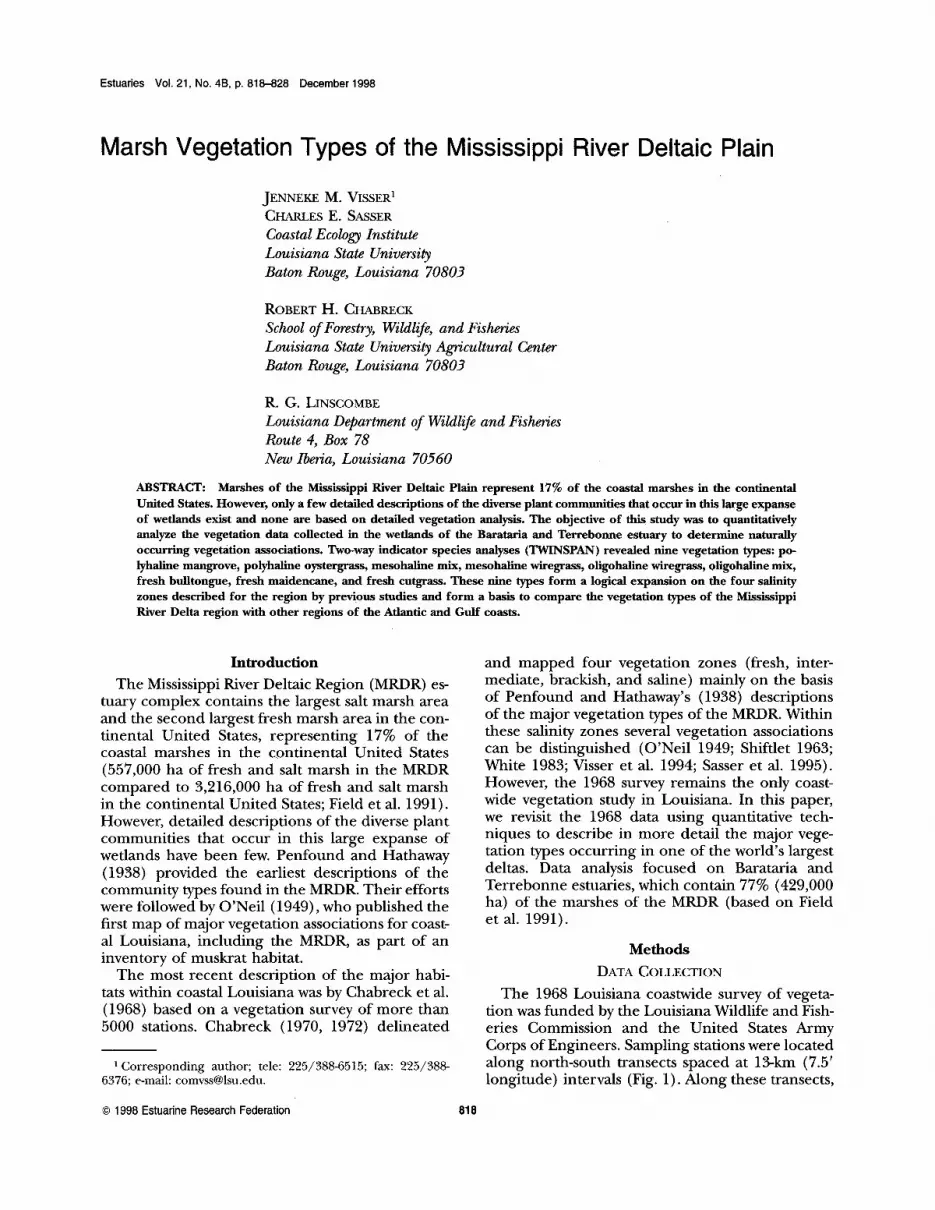
Appendix 1. Condensed TWINSPAN output for Barataria Basin. Consistency classes are as follows: + = <5% of the stations, I = 5-20%, II = 21-40%, III = 41-60%, IV = 61-80%, and V = 81-100%.
Vegetation Type I
Species PM PO MM MW OW OM FB FM FC
Spartina alterniflora II V V IISalicornia virginica IV + +Avicennia germinans V IJuncus roemerianus IV III II +Borrichia frutescens II + + +Batis maritima IV I I +Iva frutescens IV I I II + + +Spartina eynosuroides + + IScirpus robustus I IDistichlis spicata II II V IV ISpartina patens + V V IV IIpomoea sagittata + I I IBaccharis halimifolia I I I I +Aster subulatusl tenuifolius + I I IAmaranthus australis + I I I +Scirpus americanus + + I II IIEleocharis parvula I II I ISetaria magna I I I + +Lythrum lineare I I IKosteletzkya virginica + I I +Pluchea camphoratalfoetida + + I IV II ISolidago sempervirens + I + +Setaria geniculata + I + +Phyla lanceolatal nodiflora IEchinochloa walteril crusgalli + II IV IBacopa monnieri + IV III +Leptochloa fascicularis I +Cyperus spp. + + IV IV I IIVigna luteola + + II II ISesbania drummondiil macrocarpa + + + I I IPolygonum punctatum + + II IHibiscus lasiocarpus + I I + +Eleocharis spp. + I V III III IIITypha latifolial domingensis + I III III +
826 J. M. Visser et al.
Appendix l. Continued.
Vegetation Type l
Species PM PO MM MW OW OM FB FM Fe
Sagittaria lancifolia + + V V V IIEupatorium capillifolium + + + + +Scirpus californicus/validus I I I I IIAlternanthera philoxeroides I ISagittaria latifolia I +Phragmites australis + I IMyrica cerifera + I III IHydrocotyle spp. I II II IIILudwigia leptocarpa/peploides + + + I IIThelypteris palustris/ Osmunda regalis I IZizaniopsis miliacea + II II VPanicum hemitomon II IV V IVLimnomum spongia IDecodon verticillatus + + I IV ICephalanthus occidentalis .r II V
Species omitted from the analysis
Aeschynomene indica +Agalinis maritima +Ammania coccinea + +Andropogon virginicus +Bidens laevis + +Chenopodium allntm +Cladium jamaicenseCuscuta indecora +Dichromena colorata + +Erianthus giganteus +Euphorma spp. + + + +Panicum spp. + +Paspalum distichum +Philoxerus vermicularisPhytolacca americana + +Pontederia cordata +Rhynchospora spp. +Saururus ceruuus + +Triadenum virginicum + +Verbena spp. + +1 PM = Polyhaline Mangrove.PO = Polyhaline OystergrassMM = Mesohaline Mix.MW = Mesohaline Wiregrass.OW = Oligohaline Wiregrass.OM = Oligohaline Mix.FB = Fresh Bulltongue.FM = Fresh Maidencane.FC = Fresh Cutgrass.

Marsh Vegetation Types 827
Appendix 2. Condensed TWINSPAN output for Terrebonne Basin. Consistency classes are as follows: + = <5% of the stations, I =5-20%, II = 21-40%, III = 41-60%, IV = 61-80%, and V = 81-100%.
Vegetation Type
Species PM PO MM MW OW OM FB FM Fe
Borrichia frutescens II + + +Batis maritima IV + IAvicennia germinans V +Salicornia virginica II I I +Spartina alterniflora V V V IIfunGUs roemerianus + IV II II + +Iva frutescens III I + II +Scirpus rolmstus I IFimlJristylis castanea + I I + +Distichlis spicata II III V IV I I +Spartina patens I II V V V II I +Spartina cynosuroides I I I + +Baccharis halimifolia + + II I I I +Lythrum lineare + I I II +Agalinis maritima + I + + IAmaranthus australis + + I I II + +Vigna luteola + + III I IScirpus americanus II III I + +Sesbania drummondii! macrocarpa + + I III I + +Pluchea camphorata!foetida + I II V I ISetaria magna + + I II I +Setaria geniculata + I I I + +Aster sulmlatus! tenuifolius + + I I IKosteletzkya virginica I I IIIpomoea sagittata II I I +Cyperus spp. + III IV II IILeptochloa fascicularis III +Bacopa monnieri II IV I +Phyla lanceolata! nodiflora I IEchinochloa walteri! crusgalli I IV II I IAlternanthera philoxeroides + I + IIPanicum spp. I +Paspalum distichum I I +Hibiscus lasiocarpus + I + I IEleocharis parvula + + I I +Cladium jamaicense I I ISagittaria lancifolia II III V IIPolygonum punctatum + I I +Phragmites australis II II IScirpus californicus! validus I + + IEupatorium capillifolium + + I I I IEleocharis spp. I II III III IVThelypteris palustris! Osmunda regalis I III + ITypha latifolia!domingensis + II IV III IIMyrica cerifera I IV I IILudwigia leptocarpa!peploides + I II IHydrocotyle spp. I + IL IV IISolidago sempervirens + + IPanicum hemitomon + I IV V IITriadenum virginicum + IDichromena colorata + + IDecodon verticillatus I ICephalanthus occidentalis + III IBidens laevis +Zizaniopsis miliacea + I VSagittaria latifolia + III
Species omitted from the analysisAeschynomene indica +Andropogon virginicus +Boehmeria cylindrica +Centella asiatica +Chenopodium allmmColocasia esculenta + +

828 J. M. Visser et al.
Appendix 2. Continued.
Species
Cuscuta indewraConoclinium coelestinum/Eupatorium perfoliatumEuphorlJia spp.Habenaria repensHeliotrapium curassavicumIris spp.Lobelia cardinalisPhiloxerus vermicularisPhytolacca americanaPontederia cordataRanunculus spp.Rhynchospora spp.Saururus cernuus&suvium portulacastrumSonchus spp.Suaeda maritimaTriglochin striataXyris iridifolia
1 PM = Polyhaline Mangrove.PO = Polyhaline OystergrassMM = Mesohaline Mix.MW = Mesohaline Wiregrass.OW = Oligohaline Wiregrass..OM = Oligohaline Mix.FB = Fresh Bulltongue.FM = Fresh Maidencane.FC = Fresh Cutgrass.
Vegetation Type
PM PO MM MW OW OM FB FM Fe
+ ++ + +
+ + I ++
++
++
++++
+ ++
++ +
++