Embed Size (px)
Citation preview

125 FEB 05
© JEPPESEN SANDERSON, INC., 1999, 2005. ALL RIGHTS RESERVED.
METEOROLOGICAL SERVICE FOR INTERNATIONAL AIR NAVIGATION - ANNEX 3
METEOROLOGY
In this part of the METEOROLOGY section, selected Chapters and paragraphs have been extractedfrom ICAO Annex 3 – Meteorological Service for International Air Navigation. Chapter and paragraphnumbers reflect those contained in the Annex.
CHAPTER 1 – DEFINITIONS
1.1 DEFINITIONS
When the following terms are used in the Standardsand Recommended Practices for MeteorologicalService for International Air Navigation, they havethe following meanings:
AERODROME CLIMATOLOGICAL SUMMA-RY — Concise summary of specified meteorologi-cal elements at an aerodrome, based on statisticaldata.
AERODROME CLIMATOLOGICAL TABLE — Ta-ble providing statistical data on the observed occur-rence of one or more meteorological elements at anaerodrome.
AERODROME METEOROLOGICAL OFFICE —An office, located at an aerodrome, designated toprovide meteorological service for international airnavigation.
AERONAUTICAL FIXED TELECOMMUNICATIONNETWORK (AFTN) — A world-wide system ofaeronautical fixed circuits provided, as part of theaeronautical fixed service, for the exchange of mes-sages and/or digital data between aeronautical fixedstations having the same or compatible communica-tions characteristics.
AERONAUTICAL METEOROLOGICAL STA-TION — A station designated to make observa-tions and meteorological reports for use in interna-tional air navigation.
AIRCRAFT OBSERVATION — The evaluation ofone or more meteorological elements made from anaircraft in flight.
AIRMET INFORMATION — Information issued bya meteorological watch office concerning the occur-rence or expected occurrence of specified en routeweather phenomena which may affect the safety oflow-level aircraft operations and which was not al-ready included in the forecast issued for low-levelflights in the flight information region concerned orsub-area thereof.
AIR-REPORT — A report from an aircraft in flightprepared in conformity with requirements for posi-tion, and operational and/or meteorological informa-tion.
NOTE: Details of the AIREP form are given inPANS-ATM (Doc 4444) (Air Traffic Control pages,Series 400).
AUTOMATIC DEPENDENT SURVEILLANCE(ADS) — A surveillance technique in which aircraftautomatically provide, via a data link, data derivedfrom on-board navigation and position-fixing sys-tems, including aircraft identification, four-dimen-sional position and additional data as appropriate.
BRIEFING — Oral commentary on existing and/orexpected meteorological conditions.
CONSULTATION — Discussion with a meteorolo-gist or another qualified person of existing and/or ex-pected meteorological conditions relating to flightoperations; a discussion includes answers to ques-tions.
EXTENDED RANGE OPERATION — Any flightby an aeroplane with two turbine power-units wherethe flight time at the one power-unit inoperativecruise speed (in ISA and still air conditions), from apoint on the route to an adequate alternate aero-drome, is greater than the threshold time approvedby the State of the Operator.
FLIGHT DOCUMENTATION — Written or printeddocuments, including charts or forms, containingmeteorological information for a flight.
FORECAST — A statement of expected meteoro-logical conditions for a specified time or period, andfor a specified area or portion of airspace.
GAMET AREA FORECAST — An area forecastin abbreviated plain language for low-level flights fora flight information region or sub-area thereof, pre-pared by the meteorological office designated by themeteorological authority concerned and exchangedwith meteorological offices in adjacent flight informa-tion regions, as agreed between the meteorologicalauthorities concerned.
GRID POINT DATA IN DIGITAL FORM — Com-puter processed meteorological data for a set of reg-ularly spaced points on a chart, for transmissionfrom a meteorological computer to another comput-er in a code form suitable for automated use.
NOTE: In most cases such data are transmitted onmedium or high speed telecommunications chan-nels.
HUMAN FACTORS PRINCIPLES — Principleswhich apply to aeronautical design, certification,training, operations and maintenance and whichseek safe interface between the human and othersystem components by proper consideration to hu-man performance.
INTERNATIONAL AIRWAYS VOLCANO WATCH(IAVW) — International arrangements for monitor-ing and providing warnings to aircraft of volcanic ashin the atmosphere.

TABLE OF CONTENTS
METEOROLOGY PB-V
Hawaii . . . . . . . . . . . . . . . . . . . . . . . . . . . . . . . . . . . . . . . . . . . . . . . . . . . . . . . . . . . . . . . . . . . . . . . . . . PB-2Hong Kong . . . . . . . . . . . . . . . . . . . . . . . . . . . . . . . . . . . . . . . . . . . . . . . . . . . . . . . . . . . . . . . . . . . . . . PB-2Indonesia . . . . . . . . . . . . . . . . . . . . . . . . . . . . . . . . . . . . . . . . . . . . . . . . . . . . . . . . . . . . . . . . . . . . . . . PB-2Japan . . . . . . . . . . . . . . . . . . . . . . . . . . . . . . . . . . . . . . . . . . . . . . . . . . . . . . . . . . . . . . . . . . . . . . . . . . PB-3Kiribati. . . . . . . . . . . . . . . . . . . . . . . . . . . . . . . . . . . . . . . . . . . . . . . . . . . . . . . . . . . . . . . . . . . . . . . . . . PB-4Korea . . . . . . . . . . . . . . . . . . . . . . . . . . . . . . . . . . . . . . . . . . . . . . . . . . . . . . . . . . . . . . . . . . . . . . . . . . PB-4Marshall Is . . . . . . . . . . . . . . . . . . . . . . . . . . . . . . . . . . . . . . . . . . . . . . . . . . . . . . . . . . . . . . . . . . . . . . PB-5Malaysia . . . . . . . . . . . . . . . . . . . . . . . . . . . . . . . . . . . . . . . . . . . . . . . . . . . . . . . . . . . . . . . . . . . . . . . . PB-5Micronesia, Federated States of . . . . . . . . . . . . . . . . . . . . . . . . . . . . . . . . . . . . . . . . . . . . . . . . . . . . . . PB-5Myanmar. . . . . . . . . . . . . . . . . . . . . . . . . . . . . . . . . . . . . . . . . . . . . . . . . . . . . . . . . . . . . . . . . . . . . . . . PB-5New Zealand. . . . . . . . . . . . . . . . . . . . . . . . . . . . . . . . . . . . . . . . . . . . . . . . . . . . . . . . . . . . . . . . . . . . . PB-5Northern Mariana Is . . . . . . . . . . . . . . . . . . . . . . . . . . . . . . . . . . . . . . . . . . . . . . . . . . . . . . . . . . . . . . . PB-5Palau. . . . . . . . . . . . . . . . . . . . . . . . . . . . . . . . . . . . . . . . . . . . . . . . . . . . . . . . . . . . . . . . . . . . . . . . . . . PB-5Papua New Guinea. . . . . . . . . . . . . . . . . . . . . . . . . . . . . . . . . . . . . . . . . . . . . . . . . . . . . . . . . . . . . . . . PB-6Philippines . . . . . . . . . . . . . . . . . . . . . . . . . . . . . . . . . . . . . . . . . . . . . . . . . . . . . . . . . . . . . . . . . . . . . . PB-6Singapore . . . . . . . . . . . . . . . . . . . . . . . . . . . . . . . . . . . . . . . . . . . . . . . . . . . . . . . . . . . . . . . . . . . . . . . PB-6Solomon Is . . . . . . . . . . . . . . . . . . . . . . . . . . . . . . . . . . . . . . . . . . . . . . . . . . . . . . . . . . . . . . . . . . . . . . PB-6Taiwan. . . . . . . . . . . . . . . . . . . . . . . . . . . . . . . . . . . . . . . . . . . . . . . . . . . . . . . . . . . . . . . . . . . . . . . . . . PB-6Thailand . . . . . . . . . . . . . . . . . . . . . . . . . . . . . . . . . . . . . . . . . . . . . . . . . . . . . . . . . . . . . . . . . . . . . . . . PB-6Tonga . . . . . . . . . . . . . . . . . . . . . . . . . . . . . . . . . . . . . . . . . . . . . . . . . . . . . . . . . . . . . . . . . . . . . . . . . . PB-6Vanuatu. . . . . . . . . . . . . . . . . . . . . . . . . . . . . . . . . . . . . . . . . . . . . . . . . . . . . . . . . . . . . . . . . . . . . . . . . PB-6Vietnam. . . . . . . . . . . . . . . . . . . . . . . . . . . . . . . . . . . . . . . . . . . . . . . . . . . . . . . . . . . . . . . . . . . . . . . . . PB-6Wake I. . . . . . . . . . . . . . . . . . . . . . . . . . . . . . . . . . . . . . . . . . . . . . . . . . . . . . . . . . . . . . . . . . . . . . . . . . PB-6Western Samoa . . . . . . . . . . . . . . . . . . . . . . . . . . . . . . . . . . . . . . . . . . . . . . . . . . . . . . . . . . . . . . . . . . PB-6
AVAILABILITY OF VOLMET BROADCASTS - PACIFIC BASIN . . . . . . . . . . . . . . . . . . . . . . . . . . . . . . . . . PB-7
VOLMET BROADCASTS IN PLAIN LANGUAGE - PACIFIC BASIN . . . . . . . . . . . . . . . . . . . . . . . . . . . . . . PB-8
LOCATIONS OF MET BROADCAST STATIONS - PACIFIC . . . . . . . . . . . . . . . . . . . . . . . . . . . . . . . . . . . PB-13
AERONAUTICAL ENROUTE INFORMATION SERVICE. . . . . . . . . . . . . . . . . . . . . . . . . . . . . . . . . . . . JAPAN-1
17 JUN 05
© JEPPESEN SANDERSON, INC., 1995, 2005. ALL RIGHTS RESERVED.

TABLE OF CONTENTS
METEOROLOGYPB-IV
APPENDIX 6 – TECHNICAL SPECIFICATIONS RELATED TO SIGMET AND AIRMET INFORMATION,AERODROME WARNINGS AND WIND SHEAR WARNINGS . . . . . . . . . . . . . . . . . . . . . . . . . . . . . . . . . . . 79
1. SPECIFICATIONS RELATED TO SIGMET INFORMATION . . . . . . . . . . . . . . . . . . . . . . . . . . 791.1 Format of SIGMET messages . . . . . . . . . . . . . . . . . . . . . . . . . . . . . . . . . . . . . . . . . . . . . . . . . 791.2 Dissemination of SIGMET messages . . . . . . . . . . . . . . . . . . . . . . . . . . . . . . . . . . . . . . . . . . . 802. SPECIFICATIONS RELATED TO AIRMET INFORMATION . . . . . . . . . . . . . . . . . . . . . . . . . . 812.1 Format of AIRMET messages . . . . . . . . . . . . . . . . . . . . . . . . . . . . . . . . . . . . . . . . . . . . . . . . . 812.2 Dissemination of AIRMET messages . . . . . . . . . . . . . . . . . . . . . . . . . . . . . . . . . . . . . . . . . . . 823. SPECIFICATIONS RELATED TO SPECIAL AIR-REPORTS. . . . . . . . . . . . . . . . . . . . . . . . . . 824. DETAILED CRITERIA RELATED TO SIGMET AND AIRMET MESSAGES
AND SPECIAL AIR-REPORTS (UPLINK) . . . . . . . . . . . . . . . . . . . . . . . . . . . . . . . . . . . . . . . . 824.1 Identification of the flight information region . . . . . . . . . . . . . . . . . . . . . . . . . . . . . . . . . . . . . . 824.2 Criteria related to phenomena included in SIGMET and AIRMET
messages and special air-reports (uplink) . . . . . . . . . . . . . . . . . . . . . . . . . . . . . . . . . . . . . . . . 825. SPECIFICATIONS RELATED TO AERODROME WARNINGS . . . . . . . . . . . . . . . . . . . . . . . . 835.1 Forms and dissemination of aerodrome warnings . . . . . . . . . . . . . . . . . . . . . . . . . . . . . . . . . . 835.2 Quantitative criteria for aerodrome warnings . . . . . . . . . . . . . . . . . . . . . . . . . . . . . . . . . . . . . . 846. SPECIFICATIONS RELATED TO WIND SHEAR WARNINGS . . . . . . . . . . . . . . . . . . . . . . . . 846.1 Detection of wind shear . . . . . . . . . . . . . . . . . . . . . . . . . . . . . . . . . . . . . . . . . . . . . . . . . . . . . . 846.2 Format and dissemination of wind shear warnings . . . . . . . . . . . . . . . . . . . . . . . . . . . . . . . . . 84
Table A6-1 - Template for SIGMET and AIRMET messages and special air-reports (uplink) . . . . . . . . . 85Table A6-2 - Template for aerodrome warnings . . . . . . . . . . . . . . . . . . . . . . . . . . . . . . . . . . . . . . . . . . . . 91Table A6-3 - Template for wind shear warnings . . . . . . . . . . . . . . . . . . . . . . . . . . . . . . . . . . . . . . . . . . . . 92Table A6-4 - Ranges and resolutions for numerical elements included in
volcanic ash and tropical cyclone advisory messages, SIGMET/AIRMETmessages and aerodrome and wind shear warnings . . . . . . . . . . . . . . . . . . . . . . . . . . . . . . . . . . . . . . 93
Example A6-1 - SIGMET and AIRMET messages and the corresponding cancellations. . . . . . . . . . . . . 93Example A6-2 - SIGMET messages for tropical cyclone . . . . . . . . . . . . . . . . . . . . . . . . . . . . . . . . . . . . . 94Example A6-3 - SIGMET messages for volcanic ash. . . . . . . . . . . . . . . . . . . . . . . . . . . . . . . . . . . . . . . . 94Example A6-4 - SIGMET messages for severe turbulence . . . . . . . . . . . . . . . . . . . . . . . . . . . . . . . . . . . 94Example A6-5 - AIRMET messages for moderate mountain wave. . . . . . . . . . . . . . . . . . . . . . . . . . . . . . 95
DECODE OF EIGHT FIGURE GROUP APPENDED TO MOTNE/OPMET BROADCASTS . . . . . . . . . . . . . . 97Runway Designator (First and Second Digits) . . . . . . . . . . . . . . . . . . . . . . . . . . . . . . . . . . . . . . . . . . . 97Runway Deposits (Third Digit) . . . . . . . . . . . . . . . . . . . . . . . . . . . . . . . . . . . . . . . . . . . . . . . . . . . . . . . 97Extent of Runway Contamination (Fourth Digit) . . . . . . . . . . . . . . . . . . . . . . . . . . . . . . . . . . . . . . . . . . 97Depth of Deposit (Fifth and Sixth Digits). . . . . . . . . . . . . . . . . . . . . . . . . . . . . . . . . . . . . . . . . . . . . . . . 97Friction Co-Efficient or Braking Action (Seventh and Eighth Digits) . . . . . . . . . . . . . . . . . . . . . . . . . . . 98Examples . . . . . . . . . . . . . . . . . . . . . . . . . . . . . . . . . . . . . . . . . . . . . . . . . . . . . . . . . . . . . . . . . . . . . . . 98
REPORTS ON AERODROME PAVEMENT CONDITIONS VIA MOTNEMETEOROLOGICAL OPERATIONAL TELECOMMUNICATIONS NETWORK - EUROPE(MOTNE) BROADCAST . . . . . . . . . . . . . . . . . . . . . . . . . . . . . . . . . . . . . . . . . . . . . . . . . . . . . . . . . . . . . . . . 101
SERVICES AND TELEPHONE NUMBERS - PACIFIC BASIN
SERVICES . . . . . . . . . . . . . . . . . . . . . . . . . . . . . . . . . . . . . . . . . . . . . . . . . . . . . . . . . . . . . . . . . . . . . . . . . . PB-1Prior to Departure . . . . . . . . . . . . . . . . . . . . . . . . . . . . . . . . . . . . . . . . . . . . . . . . . . . . . . . . . . . . . . . . . PB-1During Flight . . . . . . . . . . . . . . . . . . . . . . . . . . . . . . . . . . . . . . . . . . . . . . . . . . . . . . . . . . . . . . . . . . . . . PB-1Facility Abbreviations . . . . . . . . . . . . . . . . . . . . . . . . . . . . . . . . . . . . . . . . . . . . . . . . . . . . . . . . . . . . . . PB-1
TELEPHONE NUMBERS . . . . . . . . . . . . . . . . . . . . . . . . . . . . . . . . . . . . . . . . . . . . . . . . . . . . . . . . . . . . . . PB-1American Samoa . . . . . . . . . . . . . . . . . . . . . . . . . . . . . . . . . . . . . . . . . . . . . . . . . . . . . . . . . . . . . . . . . PB-1Australia . . . . . . . . . . . . . . . . . . . . . . . . . . . . . . . . . . . . . . . . . . . . . . . . . . . . . . . . . . . . . . . . . . . . . . . . PB-1Brunei . . . . . . . . . . . . . . . . . . . . . . . . . . . . . . . . . . . . . . . . . . . . . . . . . . . . . . . . . . . . . . . . . . . . . . . . . . PB-1Cambodia . . . . . . . . . . . . . . . . . . . . . . . . . . . . . . . . . . . . . . . . . . . . . . . . . . . . . . . . . . . . . . . . . . . . . . . PB-2Cook Is . . . . . . . . . . . . . . . . . . . . . . . . . . . . . . . . . . . . . . . . . . . . . . . . . . . . . . . . . . . . . . . . . . . . . . . . . PB-2Fiji Is . . . . . . . . . . . . . . . . . . . . . . . . . . . . . . . . . . . . . . . . . . . . . . . . . . . . . . . . . . . . . . . . . . . . . . . . . . . PB-2French Pacific Territories . . . . . . . . . . . . . . . . . . . . . . . . . . . . . . . . . . . . . . . . . . . . . . . . . . . . . . . . . . . PB-2Guam . . . . . . . . . . . . . . . . . . . . . . . . . . . . . . . . . . . . . . . . . . . . . . . . . . . . . . . . . . . . . . . . . . . . . . . . . . PB-2
17 JUN 05
© JEPPESEN SANDERSON, INC., 1995, 2005. ALL RIGHTS RESERVED.

TABLE OF CONTENTS
METEOROLOGY PB-III
APPENDIX 3 – TECHNICAL SPECIFICATIONS RELATED TO METEOROLOGICALOBSERVATIONS AND REPORTS. . . . . . . . . . . . . . . . . . . . . . . . . . . . . . . . . . . . . . . . . . . . . . . . . . . . . . . . . 47
Table A3-1 - Template for local routine (MET REPORT) and local (SPECI) reports. . . . . . . . . . . . . . . . . 47Table A3-2 - Template for METAR and SPECI . . . . . . . . . . . . . . . . . . . . . . . . . . . . . . . . . . . . . . . . . . . . . 51Table A3-3 - Use of change indicators in trend forecast . . . . . . . . . . . . . . . . . . . . . . . . . . . . . . . . . . . . . . 54Table A3-4 - Ranges and resolutions for the numerical element included in local forecasts . . . . . . . . . . 54Table A3-5 - Ranges and resolutions for the numerical elements included in METAR and SPECI . . . . . 55Example A3-1 - Routine report . . . . . . . . . . . . . . . . . . . . . . . . . . . . . . . . . . . . . . . . . . . . . . . . . . . . . . . . . 56Example A3-2 - Special report . . . . . . . . . . . . . . . . . . . . . . . . . . . . . . . . . . . . . . . . . . . . . . . . . . . . . . . . . 56Example A3-3 - Volcanic activity report . . . . . . . . . . . . . . . . . . . . . . . . . . . . . . . . . . . . . . . . . . . . . . . . . . 56
APPENDIX 4 – TECHNICAL SPECIFICATIONS RELATED TO AIRCRAFTOBSERVATIONS AND REPORTS. . . . . . . . . . . . . . . . . . . . . . . . . . . . . . . . . . . . . . . . . . . . . . . . . . . . . . . . . 57
1. CONTENTS OF AIR-REPORTS . . . . . . . . . . . . . . . . . . . . . . . . . . . . . . . . . . . . . . . . . . . . . . . 571.1 Routine air-reports by air-ground data link. . . . . . . . . . . . . . . . . . . . . . . . . . . . . . . . . . . . . . . . 571.2 Special air-reports by air-ground data link . . . . . . . . . . . . . . . . . . . . . . . . . . . . . . . . . . . . . . . . 571.3 Routine air-reports by voice communications . . . . . . . . . . . . . . . . . . . . . . . . . . . . . . . . . . . . . 581.4 Special air-reports by voice communications. . . . . . . . . . . . . . . . . . . . . . . . . . . . . . . . . . . . . . 592. CRITERIA FOR REPORTING . . . . . . . . . . . . . . . . . . . . . . . . . . . . . . . . . . . . . . . . . . . . . . . . . 592.2 Wind direction . . . . . . . . . . . . . . . . . . . . . . . . . . . . . . . . . . . . . . . . . . . . . . . . . . . . . . . . . . . . . 592.3 Wind speed . . . . . . . . . . . . . . . . . . . . . . . . . . . . . . . . . . . . . . . . . . . . . . . . . . . . . . . . . . . . . . . 592.4 Wind quality flag. . . . . . . . . . . . . . . . . . . . . . . . . . . . . . . . . . . . . . . . . . . . . . . . . . . . . . . . . . . . 592.5 Temperature . . . . . . . . . . . . . . . . . . . . . . . . . . . . . . . . . . . . . . . . . . . . . . . . . . . . . . . . . . . . . . . 592.6 Turbulence . . . . . . . . . . . . . . . . . . . . . . . . . . . . . . . . . . . . . . . . . . . . . . . . . . . . . . . . . . . . . . . . 59
Table A4-1 - Turbulence index to be reported. . . . . . . . . . . . . . . . . . . . . . . . . . . . . . . . . . . . . . . . . . . . . . 60Table A4-2 - Time of occurrence of the peak value to be reported. . . . . . . . . . . . . . . . . . . . . . . . . . . . . . 60Table A4-3 - Template for special air-report (downlink). . . . . . . . . . . . . . . . . . . . . . . . . . . . . . . . . . . . . . . 61Table A4-4 - Ranges and resolutions for the meteorological elements included in air-reports . . . . . . . . . 62
APPENDIX 5 – TECHNICAL SPECIFICATIONS RELATED TO FORCASTS . . . . . . . . . . . . . . . . . . . . . . . . . 631. CRITERIA RELATED TO TAF . . . . . . . . . . . . . . . . . . . . . . . . . . . . . . . . . . . . . . . . . . . . . . . . . 631.1 TAF format . . . . . . . . . . . . . . . . . . . . . . . . . . . . . . . . . . . . . . . . . . . . . . . . . . . . . . . . . . . . . . . . 631.2 Inclusion of meteorological elements in TAF . . . . . . . . . . . . . . . . . . . . . . . . . . . . . . . . . . . . . . 631.3 Use of change groups . . . . . . . . . . . . . . . . . . . . . . . . . . . . . . . . . . . . . . . . . . . . . . . . . . . . . . . 641.4 Use of probability groups . . . . . . . . . . . . . . . . . . . . . . . . . . . . . . . . . . . . . . . . . . . . . . . . . . . . . 651.5 Numbers of change and probability groups . . . . . . . . . . . . . . . . . . . . . . . . . . . . . . . . . . . . . . . 662. CRITERIA RELATED TO TREND FORECASTS. . . . . . . . . . . . . . . . . . . . . . . . . . . . . . . . . . . 662.1 Format of trends forecasts . . . . . . . . . . . . . . . . . . . . . . . . . . . . . . . . . . . . . . . . . . . . . . . . . . . . 662.2 Inclusion of meteorological elements in trend forecasts . . . . . . . . . . . . . . . . . . . . . . . . . . . . . 662.3 Use of change indicators . . . . . . . . . . . . . . . . . . . . . . . . . . . . . . . . . . . . . . . . . . . . . . . . . . . . . 672.4 Use of probability indicators. . . . . . . . . . . . . . . . . . . . . . . . . . . . . . . . . . . . . . . . . . . . . . . . . . . 683. CRITERIA RELATED TO FORECASTS FOR TAKE-OFF . . . . . . . . . . . . . . . . . . . . . . . . . . . . 683.1 Format of forecast for take-off . . . . . . . . . . . . . . . . . . . . . . . . . . . . . . . . . . . . . . . . . . . . . . . . . 683.2 Amendments to forecasts for take-off . . . . . . . . . . . . . . . . . . . . . . . . . . . . . . . . . . . . . . . . . . . 684. CRITERIA RELATED TO AREA AND ROUTE FORECASTS, OTHER THAN
FORECASTS ISSUED WITHIN THE FRAMEWORK OF THE WORLDAREA FORECAST SYSTEM. . . . . . . . . . . . . . . . . . . . . . . . . . . . . . . . . . . . . . . . . . . . . . . . . . 68
4.1 Format of area and route forecasts . . . . . . . . . . . . . . . . . . . . . . . . . . . . . . . . . . . . . . . . . . . . . 684.2 Amendments to area and route forecasts . . . . . . . . . . . . . . . . . . . . . . . . . . . . . . . . . . . . . . . . 685. CRITERIA RELATED TO AREA FORECASTS FOR LOW-LEVEL FLIGHTS . . . . . . . . . . . . . 695.1 Format and content of GAMET area forecasts . . . . . . . . . . . . . . . . . . . . . . . . . . . . . . . . . . . . 695.2 Amendments to GAMET area forecasts . . . . . . . . . . . . . . . . . . . . . . . . . . . . . . . . . . . . . . . . . 705.3 Exchange of area forecasts for low-level flights . . . . . . . . . . . . . . . . . . . . . . . . . . . . . . . . . . . . 70
Table A5-1 - Template for TAF . . . . . . . . . . . . . . . . . . . . . . . . . . . . . . . . . . . . . . . . . . . . . . . . . . . . . . . . . 71Table A5-2 - Use of change and time indicators in TAF . . . . . . . . . . . . . . . . . . . . . . . . . . . . . . . . . . . . . . 75Table A5-3 - Ranges and resolutions for the numerical elements included in TAF. . . . . . . . . . . . . . . . . . 75Example A5-1 - TAF . . . . . . . . . . . . . . . . . . . . . . . . . . . . . . . . . . . . . . . . . . . . . . . . . . . . . . . . . . . . . . . . . 76Example A5-2 - Cancellation of TAF. . . . . . . . . . . . . . . . . . . . . . . . . . . . . . . . . . . . . . . . . . . . . . . . . . . . . 76Example A5-3 - GAMET area forecasts . . . . . . . . . . . . . . . . . . . . . . . . . . . . . . . . . . . . . . . . . . . . . . . . . . 77
© JEPPESEN SANDERSON, INC., 1995, 2005. ALL RIGHTS RESERVED.
17 JUN 05

TABLE OF CONTENTS
METEOROLOGYPB-II
CHAPTER 7 – SIGMET AND AIRMET INFORMATION, AERODROMEWARNINGS AND WIND SHEAR WARNINGS . . . . . . . . . . . . . . . . . . . . . . . . . . . . . . . . . . . . . . . . . . . . . . . 13
7.1 SIGMET Information . . . . . . . . . . . . . . . . . . . . . . . . . . . . . . . . . . . . . . . . . . . . . . . . . . . . . . . . 137.2 AIRMET Information . . . . . . . . . . . . . . . . . . . . . . . . . . . . . . . . . . . . . . . . . . . . . . . . . . . . . . . . 137.3 Aerodrome Warnings . . . . . . . . . . . . . . . . . . . . . . . . . . . . . . . . . . . . . . . . . . . . . . . . . . . . . . . . 14
CHAPTER 8 – AERONAUTICAL CLIMATOLOGICAL INFORMATION . . . . . . . . . . . . . . . . . . . . . . . . . . . . . . 148.1 General Provisions. . . . . . . . . . . . . . . . . . . . . . . . . . . . . . . . . . . . . . . . . . . . . . . . . . . . . . . . . . 14
CHAPTER 9 – SERVICE FOR OPERATORS AND FLIGHT CREW MEMBERS . . . . . . . . . . . . . . . . . . . . . . 149.1 General Provisions. . . . . . . . . . . . . . . . . . . . . . . . . . . . . . . . . . . . . . . . . . . . . . . . . . . . . . . . . . 149.2 Information for Operators for Pre-Flight Planning and for
In-Flight Re-Planning Under Centralized Operational Control . . . . . . . . . . . . . . . . . . . . . . . . . 159.3 Briefing, Consultation and Display . . . . . . . . . . . . . . . . . . . . . . . . . . . . . . . . . . . . . . . . . . . . . . 159.4 Flight Documentation - General . . . . . . . . . . . . . . . . . . . . . . . . . . . . . . . . . . . . . . . . . . . . . . . . 169.5 Automated Pre-flight Information Systems for Briefing, Consultation,
Flight Planning and Flight Documentation . . . . . . . . . . . . . . . . . . . . . . . . . . . . . . . . . . . . . . . . 169.6 Information for Aircraft in Flight . . . . . . . . . . . . . . . . . . . . . . . . . . . . . . . . . . . . . . . . . . . . . . . . 17
CHAPTER 10 – INFORMATION FOR AIR TRAFFIC SERVICES, SEARCH AND RESCUESERVICES AND AERONAUTICAL INFORMATION SERVICES . . . . . . . . . . . . . . . . . . . . . . . . . . . . . . . . . . 17
10.1 Information for Air Traffic Service Units . . . . . . . . . . . . . . . . . . . . . . . . . . . . . . . . . . . . . . . . . . 1710.2 Information for Search and Rescue Services Units . . . . . . . . . . . . . . . . . . . . . . . . . . . . . . . . . 1710.3 Information for Aeronautical Information Services Units . . . . . . . . . . . . . . . . . . . . . . . . . . . . . 17
CHAPTER 11 – REQUIREMENTS FOR AND USE OF COMMUNICATIONS . . . . . . . . . . . . . . . . . . . . . . . . 1711.1 Requirements for Communications . . . . . . . . . . . . . . . . . . . . . . . . . . . . . . . . . . . . . . . . . . . . . 1711.2 Use of Aeronautical Fixed Service Communications -
Meteorological Bulletins in Alphanumeric Format . . . . . . . . . . . . . . . . . . . . . . . . . . . . . . . . . . 1811.3 Use of Aeronautical Fixed Service Communications -
World Area Forecast System Products . . . . . . . . . . . . . . . . . . . . . . . . . . . . . . . . . . . . . . . . . . 1811.4 Use of Aeronautical Mobile Service Communication . . . . . . . . . . . . . . . . . . . . . . . . . . . . . . . . 1811.5 Use of Aeronautical Data Link Service - Contents of D-VOLMET . . . . . . . . . . . . . . . . . . . . . . 1811.6 Use of Aeronautical Broadcast Service -
Contents of VOLMET Broadcasts . . . . . . . . . . . . . . . . . . . . . . . . . . . . . . . . . . . . . . . . . . . . . . 18
APPENDIX 1 – FLIGHT DOCUMENTATION - MODEL CHARTS AND FORMS . . . . . . . . . . . . . . . . . . . . . . . 19MODEL A - Aerodrome Forecasts - Example 1 - Tabular Form . . . . . . . . . . . . . . . . . . . . . . . . . . . . . . . . 20MODEL A - Aerodrome Forecasts - Example 2 - TAF . . . . . . . . . . . . . . . . . . . . . . . . . . . . . . . . . . . . . . . 21MODEL TA - Tabular Forecasts of enroute conditions - Example 1 - Low Level . . . . . . . . . . . . . . . . . . . 22MODEL TA - Tabular Forecasts of enroute conditions - Example 2 - Medium Level . . . . . . . . . . . . . . . . 23MODEL TB - Tabular Forecasts of upper winds and upper air temperatures . . . . . . . . . . . . . . . . . . . . . . 25MODEL IS - Upper wind and temperature chart for isobaric surface . . . . . . . . . . . . . . . . . . . . . . . . . . . . 26MODEL IS - Upper wind and temperature chart for standard isobaric surface . . . . . . . . . . . . . . . . . . . . 27MODEL SWH - Significant Weather Chart (High Level) . . . . . . . . . . . . . . . . . . . . . . . . . . . . . . . . . . . . . . 28MODEL SWM - Significant Weather Chart (Medium Level) . . . . . . . . . . . . . . . . . . . . . . . . . . . . . . . . . . . 31MODEL SWL - Significant Weather Chart (Low Level). . . . . . . . . . . . . . . . . . . . . . . . . . . . . . . . . . . . . . . 32MODEL VAG - Volcanic Ash Advisory Information In Graphic Format . . . . . . . . . . . . . . . . . . . . . . . . . . . 34MODEL SN - Notations Used In Flight Documentation . . . . . . . . . . . . . . . . . . . . . . . . . . . . . . . . . . . . . . 35
1. Symbols for Significant Weather . . . . . . . . . . . . . . . . . . . . . . . . . . . . . . . . . . . . . . . . . . . . . . . 352. Fronts and Convergence Zones and Other Symbols Used . . . . . . . . . . . . . . . . . . . . . . . . . . . 363. Abbreviations Used to Describe Clouds. . . . . . . . . . . . . . . . . . . . . . . . . . . . . . . . . . . . . . . . . . 374. Depicting of Lines and Systems on Specific Charts . . . . . . . . . . . . . . . . . . . . . . . . . . . . . . . . 37
APPENDIX 2 – TECHNICAL SPECIFICATIONS RELATED TO WORLD AREA FORECASTSYSTEMS AND METEOROLOGICAL OFFICES . . . . . . . . . . . . . . . . . . . . . . . . . . . . . . . . . . . . . . . . . . . . . 39
Table A2-1 - Template for advisory message for volcanic ash . . . . . . . . . . . . . . . . . . . . . . . . . . . . . . . . . 39Example A2-1 - Advisory message for volcanic ash. . . . . . . . . . . . . . . . . . . . . . . . . . . . . . . . . . . . . . . . . 43Table A2-2 - Template for advisory message for tropical cyclones . . . . . . . . . . . . . . . . . . . . . . . . . . . . . . 44Example A2-2 - Advisory message for tropical cyclones . . . . . . . . . . . . . . . . . . . . . . . . . . . . . . . . . . . . . 46
17 JUN 05
© JEPPESEN SANDERSON, INC., 1995, 2005. ALL RIGHTS RESERVED.
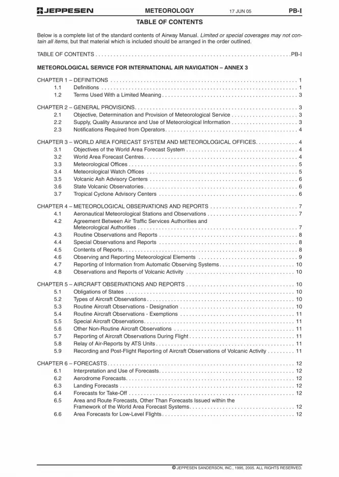
TABLE OF CONTENTS
METEOROLOGY PB-I
Below is a complete list of the standard contents of Airway Manual. Limited or special coverages may not con-tain all items, but that material which is included should be arranged in the order outlined.
TABLE OF CONTENTS . . . . . . . . . . . . . . . . . . . . . . . . . . . . . . . . . . . . . . . . . . . . . . . . . . . . . . . . . . . . . . . . .PB-I
METEOROLOGICAL SERVICE FOR INTERNATIONAL AIR NAVIGATION – ANNEX 3
CHAPTER 1 – DEFINITIONS . . . . . . . . . . . . . . . . . . . . . . . . . . . . . . . . . . . . . . . . . . . . . . . . . . . . . . . . . . . . . . 11.1 Definitions . . . . . . . . . . . . . . . . . . . . . . . . . . . . . . . . . . . . . . . . . . . . . . . . . . . . . . . . . . . . . . . . . 11.2 Terms Used With a Limited Meaning . . . . . . . . . . . . . . . . . . . . . . . . . . . . . . . . . . . . . . . . . . . . . 3
CHAPTER 2 – GENERAL PROVISIONS. . . . . . . . . . . . . . . . . . . . . . . . . . . . . . . . . . . . . . . . . . . . . . . . . . . . . . 32.1 Objective, Determination and Provision of Meteorological Service . . . . . . . . . . . . . . . . . . . . . . 32.2 Supply, Quality Assurance and Use of Meteorological Information . . . . . . . . . . . . . . . . . . . . . . 32.3 Notifications Required from Operators. . . . . . . . . . . . . . . . . . . . . . . . . . . . . . . . . . . . . . . . . . . . 4
CHAPTER 3 – WORLD AREA FORECAST SYSTEM AND METEOROLOGICAL OFFICES. . . . . . . . . . . . . . 43.1 Objectives of the World Area Forecast System . . . . . . . . . . . . . . . . . . . . . . . . . . . . . . . . . . . . . 43.2 World Area Forecast Centres. . . . . . . . . . . . . . . . . . . . . . . . . . . . . . . . . . . . . . . . . . . . . . . . . . . 43.3 Meteorological Offices . . . . . . . . . . . . . . . . . . . . . . . . . . . . . . . . . . . . . . . . . . . . . . . . . . . . . . . . 53.4 Meteorological Watch Offices . . . . . . . . . . . . . . . . . . . . . . . . . . . . . . . . . . . . . . . . . . . . . . . . . . 53.5 Volcanic Ash Advisory Centers . . . . . . . . . . . . . . . . . . . . . . . . . . . . . . . . . . . . . . . . . . . . . . . . . 63.6 State Volcanic Observatories . . . . . . . . . . . . . . . . . . . . . . . . . . . . . . . . . . . . . . . . . . . . . . . . . . . 63.7 Tropical Cyclone Advisory Centers . . . . . . . . . . . . . . . . . . . . . . . . . . . . . . . . . . . . . . . . . . . . . . 6
CHAPTER 4 – METEOROLOGICAL OBSERVATIONS AND REPORTS . . . . . . . . . . . . . . . . . . . . . . . . . . . . . 74.1 Aeronautical Meteorological Stations and Observations . . . . . . . . . . . . . . . . . . . . . . . . . . . . . . 74.2 Agreement Between Air Traffic Services Authorities and
Meteorological Authorities . . . . . . . . . . . . . . . . . . . . . . . . . . . . . . . . . . . . . . . . . . . . . . . . . . . . . 74.3 Routine Observations and Reports . . . . . . . . . . . . . . . . . . . . . . . . . . . . . . . . . . . . . . . . . . . . . . 84.4 Special Observations and Reports . . . . . . . . . . . . . . . . . . . . . . . . . . . . . . . . . . . . . . . . . . . . . . 84.5 Contents of Reports . . . . . . . . . . . . . . . . . . . . . . . . . . . . . . . . . . . . . . . . . . . . . . . . . . . . . . . . . . 84.6 Observing and Reporting Meteorological Elements . . . . . . . . . . . . . . . . . . . . . . . . . . . . . . . . . 94.7 Reporting of Information from Automatic Observing Systems . . . . . . . . . . . . . . . . . . . . . . . . . 104.8 Observations and Reports of Volcanic Activity . . . . . . . . . . . . . . . . . . . . . . . . . . . . . . . . . . . . 10
CHAPTER 5 – AIRCRAFT OBSERVATIONS AND REPORTS . . . . . . . . . . . . . . . . . . . . . . . . . . . . . . . . . . . . 105.1 Obligations of States . . . . . . . . . . . . . . . . . . . . . . . . . . . . . . . . . . . . . . . . . . . . . . . . . . . . . . . . 105.2 Types of Aircraft Observations . . . . . . . . . . . . . . . . . . . . . . . . . . . . . . . . . . . . . . . . . . . . . . . . . 105.3 Routine Aircraft Observations - Designation . . . . . . . . . . . . . . . . . . . . . . . . . . . . . . . . . . . . . . 105.4 Routine Aircraft Observations - Exemptions . . . . . . . . . . . . . . . . . . . . . . . . . . . . . . . . . . . . . . 115.5 Special Aircraft Observations. . . . . . . . . . . . . . . . . . . . . . . . . . . . . . . . . . . . . . . . . . . . . . . . . . 115.6 Other Non-Routine Aircraft Observations . . . . . . . . . . . . . . . . . . . . . . . . . . . . . . . . . . . . . . . . 115.7 Reporting of Aircraft Observations During Flight . . . . . . . . . . . . . . . . . . . . . . . . . . . . . . . . . . . 115.8 Relay of Air-Reports by ATS Units . . . . . . . . . . . . . . . . . . . . . . . . . . . . . . . . . . . . . . . . . . . . . . 115.9 Recording and Post-Flight Reporting of Aircraft Observations of Volcanic Activity . . . . . . . . . 11
CHAPTER 6 – FORECASTS . . . . . . . . . . . . . . . . . . . . . . . . . . . . . . . . . . . . . . . . . . . . . . . . . . . . . . . . . . . . . . 126.1 Interpretation and Use of Forecasts. . . . . . . . . . . . . . . . . . . . . . . . . . . . . . . . . . . . . . . . . . . . . 126.2 Aerodrome Forecasts. . . . . . . . . . . . . . . . . . . . . . . . . . . . . . . . . . . . . . . . . . . . . . . . . . . . . . . . 126.3 Landing Forecasts . . . . . . . . . . . . . . . . . . . . . . . . . . . . . . . . . . . . . . . . . . . . . . . . . . . . . . . . . . 126.4 Forecasts for Take-Off . . . . . . . . . . . . . . . . . . . . . . . . . . . . . . . . . . . . . . . . . . . . . . . . . . . . . . . 126.5 Area and Route Forecasts, Other Than Forecasts Issued within the
Framework of the World Area Forecast Systems. . . . . . . . . . . . . . . . . . . . . . . . . . . . . . . . . . . 126.6 Area Forecasts for Low-Level Flights . . . . . . . . . . . . . . . . . . . . . . . . . . . . . . . . . . . . . . . . . . . . 12
17 JUN 05
© JEPPESEN SANDERSON, INC., 1995, 2005. ALL RIGHTS RESERVED.

PB-918 NOV 05
Eff 24 Nov
© JEPPESEN SANDERSON, INC. 1993, 2005. ALL RIGHTS RESERVED.
AVAILABILITY OF VOLMET BROADCASTS - PACIFIC BASIN
METEOROLOGY
Bangkok BangkokRadio
11387 SSB
6676 SSB
2965 SSB
2310-1145
H24
1210-2245
10-15 SIGMET3
METReport/Special1
Bangkok Intl
MET Report2, 3 Yangon (Intl), Hanoi(Noibai), Chiang Mai,Rayong (U-Taphao),Phuket, Songkhla (HatYai), Ho Chi Minh,Phnom Penh,Vientiane
AerodromeForecast4
Bangkok Intl
40-45 SIGMET3
METReport/Special5
Bangkok Intl
MET Report3, 6 Yangon (Intl), Hanoi(Noibai), Chiang Mai,Rayong (U-Taphao),Phuket, Songkhla (HatYai), Ho Chi Minh,Phnom Penh,Vientiane
AerodromeForecast4
Bangkok Intl
NOTE:– 1 Latest routine or special report between H+00 and H+10, including trend statement, repeat at end of
broadcast if time permits.
– 2 H+00 (or the previous H+30 report when the H+00 report is not available), including trend statementwhen appended.
– 3 As available.
– 4 Valid for 9 hours.
– 5 Latest routine or special report between H+30 and H+35, including trend statement, repeated at end ofbroadcast if time permits.
– 6 H+30 (or the H+00 report when the H+30 report is not available), including trend statement whenappended.
Brisbane Australian 6676 SSB
11387 SSB
H24 00-05&
30-35
TRENDForecasts
Melbourne, Sydney,Brisbane, Perth,Darwin
TRENDForecast/Aerodrome Forecast
Cairns
TREND Forecast Townsville, Adelaide
STATION CALLSIGN
FREQS(kHz)
BROADCASTTIMES FORM BROADCAST
PERIOD H+

18 NOV 05Eff 24 Nov
PB-8
© JEPPESEN SANDERSON, INC. 1993, 2005. ALL RIGHTS RESERVED.
AVAILABILITY OF VOLMET BROADCASTS - PACIFIC BASIN
METEOROLOGY
Tokyo
(Intl)
(New Tokyo Intl)
Tokyo
Townsville Brisbane
Vancouver Honolulu
Vientiane Bangkok
Wellington Auckland
Yangon Bangkok
WEATHER FOR AVAILABLE FROMSTATIONS
STATION CALLSIGN
FREQS(kHz)
BROADCASTTIMES FORM BROADCAST
PERIOD H+
Auckland AucklandVOLMET
6679 SSB
8828 SSB
13282 SSB
H24 20-25 MET Reports(includingTREND-typelandingforecasts)
Auckland,Christchurch,Wellington, Nadi,Faleolo, Noumea,Pago Pago, Tahiti
Aerodromeforecasts
Nadi, Noumea
50-55 MET Reports(includingTREND-typelandingforecasts)
Auckland,Christchurch,Wellington, Nadi,Faleolo, Noumea,Pago Pago, Tahiti
AerodromeForecasts
Auckland,Christchurch

PB-718 NOV 05
Eff 24 Nov
© JEPPESEN SANDERSON, INC. 1993, 2005. ALL RIGHTS RESERVED.
AVAILABILITY OF VOLMET BROADCASTS - PACIFIC BASIN
METEOROLOGY
RADIOTELEPHONY
Identify location for which weather is desired andfind station(s) disseminating broadcast. Contents ofbroadcast of each Station is shown following the list-ing below.
WEATHER FOR AVAILABLE FROMSTATIONS
Adelaide Brisbane
Anchorage Honolulu
Auckland Auckland
Bangkok Bangkok
Brisbane Brisbane
Brunei Singapore
Cairns Brisbane
Chiang Mai Bangkok
Christchurch Auckland
Cold Bay Honolulu
Darwin Brisbane
Den Pasar Singapore
Elmendorf AFB Honolulu
Fairbanks Honolulu
Faleolo Auckland
Fukuoka Tokyo
Guam Honolulu
Guangzhou/Baiyun Hong Kong
Hanoi Bangkok
Hilo Honolulu
HoChiMinh Hong Kong
Hong Kong Hong Kong
Honolulu Honolulu
Kahului Honolulu
King Salmon Honolulu
Kota Kinabalu Singapore
Kuala Lumpur Singapore
Kuching Singapore
Las Vegas Honolulu
Los Angeles Honolulu
Macau Hong Kong
Mactan Hong Kong
Manila
(Intl)
Hong Kong
Melbourne Brisbane
Nagoya Tokyo
Naha Hong Kong
Nadi Auckland
Noumea Auckland
Ontario Honolulu
Osaka
(Kansai Intl)
Tokyo
Pago Pago Auckland
Penang Singapore
Perth Brisbane
Phnom Penh Bangkok
Phuket Bangkok
Portland Honolulu
Rayong
(U-Taphao)
Bangkok
Sacramento Honolulu
San Francisco Honolulu
Sapporo
(New Chitose)
Tokyo
Seattle Honolulu
Seoul/Incheon(Incheon Intl)
Tokyo
Singapore Singapore
Soekarno-Hatta Singapore
Songkhla/Hat Yai Bangkok
Subang Singapore
Sydney Brisbane
Tahiti Auckland
Taiwan
(Chiang Kai Shek)
(Kaohsiung Intl)
Taipei
WEATHER FOR AVAILABLE FROMSTATIONS

PB-6 11 FEB 05METEOROLOGY
© JEPPESEN SANDERSON, INC., 1993, 2005. ALL RIGHTS RESERVED.
SERVICES AND TELEPHONE NUMBERS - PACIFIC BASIN
PAPAU NEW GUINEA
PORTMORESBY
FIS 325-6787 or
324-4542
NWS 325-5544
325-8877 or
324-4725
MADANG FIS 852-2501
NADZAB FIS 472-2253
WEWAK FIS 856-2360
PHILIPPINES
MANILA MWO (632) 832-2596
877-1109 / Local3523
Fax (632)832-2927/832-3023
SINGAPORE
SINGAPORE
(Changi)
MWO (65) 65425059
Fax (65) 65425026
(Paya Lebar) MWO 63813156
(Seletar) MWO 64815978
SOLOMON IS
HONIARA
(Henderson)
MWO 21757 or 21758
TAIWAN
TAIPEI
(SungshanANWS)
MO-I (886) 2-8770-2167
Fax (886)2-8770-2234
THAILAND
BANGKOK
(Intl)
662-3994-566-75
Fax 662-3991613 /3994011
CHIANG MAI
(Intl)
CHIANG RAI
(Intl)
PHUKET
(Intl)
RAYONG
(U-Taphao Intl)
SONGKHLA
(Hat Yai Intl)
TONGA
FUA’AMOTU(Intl)
MO-III 676-32-001/002/003 (1200-0600) 6 hrsPNR
VANUATU
PORT VILA
(Bauerfield)
(678) 22-932
VIETNAM
DANANG
(Intl)
(84-511)823-391/97
Fax (84-511)823-393
HANOI
(Noibai Intl)
(84-4) 8-8271513ext 334
HOCHIMINH
(Tan Son NhatIntl)
(84-8) 8-443-179ext 2241
(84-8) 443-705
WAKE I
Wake I AAF IFSS Honolulu
1 800 WX BRIEF(992-7433)
WESTERN SAMOA
APIA MO-III (685) 20855
(685) 20856
THAILAND

11 FEB 05 PB-5METEOROLOGY
© JEPPESEN SANDERSON, INC., 1993, 2005. ALL RIGHTS RESERVED.
SERVICES AND TELEPHONE NUMBERS - PACIFIC BASIN
ULSAN MWO 82-52-289-0365
Fax82-52-288-2392
YANGYANG
(Intl)
MWO 82-33-671-0365
Fax82-33-673-0366
YECHEON MWO 82-54-650-5772
MARSHALL IS
From all locations within the Marshall Is, contactHonolulu IFSS 1 800 WX BRIEF (992-7433).
MALAYSIA
ALOR SETAR
(Sultan AbdulHalim)
MWO 04-7144212
BINTULU MWO 086-334148 /332095
Fax 086-314386
BUTTERWORTH
(intl)
MWO 04-3314633
Fax 04-3319897
IPOH
(Sultan AzlanShah)
MWO 05-3125148
JOHOR BAHRU
(Sultan Ismail)
MWO 07-5994739
KOTA BHARU
(Gong Kedak) &(Sultan IsmailPetra)
MWO 09-7737490
Fax 09-7737490
KOTA KINABALU
(Intl)
MWO 088-256054,219186, 219188
Fax 088-211019,210741
KUALATERENGGANU
(Sultan Mahmud)
MWO 09-6664743
KUANTAN MWO 09-5381216,5382917
Fax 09-5381273
KUCHING
(Intl)
MWO 082-452454
Fax 082-453527
LABUAN MWO 087-412109
LANGKAWI
(Intl)
MWO 04-9551277
Fax 04-9554852
KOREA
MALACCA MWO 06-3175455
MIRI MWO 085-421104
PENANG
(Intl)
MWO 04-6438301,6438302
Fax 04-6446804
SANDAKAN MWO 089-667726
SIBU MWO 084-307730
Fax 084-307705
SUBANG
(Sultan AbdulAziz Shah)
MWO 603-78461441
Fax 603-78464982
TAWAU MWO 089-950660
MICRONESIA, FEDERATED STATES OF
From all locations within the Federated States ofMicronesia, contact Honolulu IFSS 1 800 WXBRIEF (922-7433).
MYANMAR
YANGON
(Intl) MWO 951665669
Fax 951665944 or951665704
NEW ZEALAND
Airways (03) 358-1550
Fax (03) 358-6856
MetService (04) 472-9379
Fax (04) 473-5321
NORTHERN MARIANA IS
From all locations within The Northern Mariana Is,contact Honolulu IFSS 1 800 WX BRIEF(992-7433).
PALAU
From all locations within Palau, contact HonoluluIFSS 1 800 WX-BRIEF (992-7433).
MALAYSIA
PB-4 23 SEP 05METEOROLOGY
© JEPPESEN SANDERSON, INC. 1993, 2005. ALL RIGHTS RESERVED.
SERVICES AND TELEPHONE NUMBERS - PACIFIC BASIN
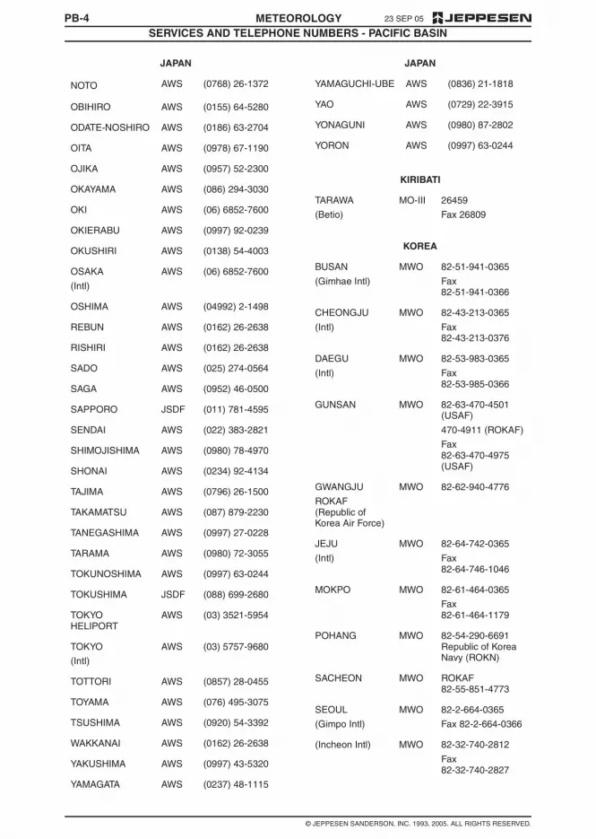
NOTO AWS (0768) 26-1372
OBIHIRO AWS (0155) 64-5280
ODATE-NOSHIRO AWS (0186) 63-2704
OITA AWS (0978) 67-1190
OJIKA AWS (0957) 52-2300
OKAYAMA AWS (086) 294-3030
OKI AWS (06) 6852-7600
OKIERABU AWS (0997) 92-0239
OKUSHIRI AWS (0138) 54-4003
OSAKA
(Intl)
AWS (06) 6852-7600
OSHIMA AWS (04992) 2-1498
REBUN AWS (0162) 26-2638
RISHIRI AWS (0162) 26-2638
SADO AWS (025) 274-0564
SAGA AWS (0952) 46-0500
SAPPORO JSDF (011) 781-4595
SENDAI AWS (022) 383-2821
SHIMOJISHIMA AWS (0980) 78-4970
SHONAI AWS (0234) 92-4134
TAJIMA AWS (0796) 26-1500
TAKAMATSU AWS (087) 879-2230
TANEGASHIMA AWS (0997) 27-0228
TARAMA AWS (0980) 72-3055
TOKUNOSHIMA AWS (0997) 63-0244
TOKUSHIMA JSDF (088) 699-2680
TOKYOHELIPORT
AWS (03) 3521-5954
TOKYO
(Intl)
AWS (03) 5757-9680
TOTTORI AWS (0857) 28-0455
TOYAMA AWS (076) 495-3075
TSUSHIMA AWS (0920) 54-3392
WAKKANAI AWS (0162) 26-2638
YAKUSHIMA AWS (0997) 43-5320
YAMAGATA AWS (0237) 48-1115
JAPAN
YAMAGUCHI-UBE AWS (0836) 21-1818
YAO AWS (0729) 22-3915
YONAGUNI AWS (0980) 87-2802
YORON AWS (0997) 63-0244
KIRIBATI
TARAWA
(Betio)
MO-III 26459
Fax 26809
KOREA
BUSAN
(Gimhae Intl)
MWO 82-51-941-0365
Fax82-51-941-0366
CHEONGJU
(Intl)
MWO 82-43-213-0365
Fax82-43-213-0376
DAEGU
(Intl)
MWO 82-53-983-0365
Fax82-53-985-0366
GUNSAN MWO 82-63-470-4501(USAF)
470-4911 (ROKAF)
Fax82-63-470-4975(USAF)
GWANGJU
ROKAF(Republic ofKorea Air Force)
MWO 82-62-940-4776
JEJU
(Intl)
MWO 82-64-742-0365
Fax82-64-746-1046
MOKPO MWO 82-61-464-0365
Fax82-61-464-1179
POHANG MWO 82-54-290-6691Republic of KoreaNavy (ROKN)
SACHEON MWO ROKAF82-55-851-4773
SEOUL
(Gimpo Intl)
MWO 82-2-664-0365
Fax 82-2-664-0366
(Incheon Intl) MWO 82-32-740-2812
Fax82-32-740-2827
JAPAN

23 SEP 05 PB-3METEOROLOGY
© JEPPESEN SANDERSON, INC. 1993, 2005. ALL RIGHTS RESERVED.
SERVICES AND TELEPHONE NUMBERS - PACIFIC BASIN
MERAUKE FSS 62-971-21764
62-971-23884
Fax 62-971-22633
RENGAT
(Japura)
AFIS 62-769-41020
62-769-41276
SINGKEP
(Dabo)
AFIS 62-776-21273
Fax 62-776-21273
TERNATE
(Baabulah)
AFIS 62-921-21797
62-921-25164
Fax 62-921-23508
UJUNGPANDANG
FIC 62-411-550123ext 122
Fax62-411-553183
WAMENA AFIS 62-969-31281
Fax 62-969-31481
JAPAN
AGUNI AWS (098) 858-8210
AKITA AWS (018) 886-3136
AMAKUSA AWS (0969) 57-6111
AMAMI AWS (0997) 63-0244
AOMORI AWS (017) 739-2241
ASAHIKAWA AWS (0166) 83-2222
CHITOSE JSDF (0123) 23-3101
CHOFU AWS (0422) 31-0812
FUKUE AWS (0959) 72-3287
FUKUI AWS (0776) 51-0300
FUKUOKA AWS (092) 621-3588
FUKUSHIMA AWS (0247) 57-1122
HACHIJOJIMA AWS (04996) 2-0449
HAKODATE AWS (0138) 57-4003
HANAMAKI AWS (0198) 26-2018
HATERUMA AWS (0980) 82-2498
HIROSHIMA AWS (0848) 86-8231
HIROSHIMANISHI AWS (082) 232-5161
IKI AWS (0920) 44-5165
ISHIGAKI AWS (0980) 82-2498
IWAMI AWS (0856) 23-5448
INDONESIA
IZUMO AWS (0853) 72-0508
KAGOSHIMA AWS (0995) 58-2644
KAMIGOTO AWS (0957) 52-2300
KANSAI
(Intl)
AWS (0724) 55-9002
KERAMA AWS (098) 858-8210
KIKAI AWS (0997) 63-0244
KITADAITO AWS (098) 858-9210
KITAKYUSHU AWS (093) 471-7651
KOCHI AWS (088) 863-2768
KOMATSU JSDF (0761) 22-3962
KOZUSHIMA AWS (0422) 31-0812
KUMAMOTO AWS (096) 232-2851
KUMEJIMA AWS (098) 985-3050
KUSHIRO AWS (0154) 57-8053
MATSUMOTO AWS (0263) 58-2520
MATSUYAMA AWS (089) 973-7565
MEMANBETSU AWS (01527) 4-2353
MIHO JSDF (0859) 45-6115
MINAMIDAITO AWS (098) 858-8210
MISAWA JSDF (0176) 53-9426
MIYAKE JIMA AWS (04994) 6-0436
MIYAKO AWS (0980) 72-3055
MIYAZAKI AWS (0985) 51-2985
MONBETSU AWS (01582) 4-1017
NAGASAKI AWS (0957) 52-2300
NAGOYA AWS (0568) 29-1600
NAHA AWS (098) 858-8210
NAKASHIBETSU AWS (01537) 2-2662
NANKI-
SHIRAHAMA
AWS (0739) 42-4326
NARITA
(Intl)
AWS (0476) 32-6612
NEW CHITOSE AWS (0123) 45-7711
NIGATA AWS (025) 274-0564
NIIJIMA AWS (0422) 31-0812
JAPAN

PB-2 11 FEB 05METEOROLOGY
© JEPPESEN SANDERSON, INC., 1993, 2005. ALL RIGHTS RESERVED.
SERVICES AND TELEPHONE NUMBERS - PACIFIC BASIN
CAMBODIA
PHNOM PENH
(Pochentong Intl)
(855) 23-426647
Fax (855) 23-366191
COOK IS
RAROTONGA I
(Intl)
MO-III (682) 20603 or
(682) 25890 ext.211
Fax (682) 21603
FIJI IS
NADI
(Intl)
MO-I/MWO
(679) 724888 ext.4431/4433/4435
Fax (679) 720190
SUVA
(Nausori Intl)
MO-III (679) 478482
FRENCH PACIFIC TERRITORIES
FRENCH POLYNESIA
(Tahiti FIR)
(689) 80 33 00
(689) 80 33 33
Fax (689) 80 33 39
NEW CALEDONIA (687) 27 93 00 - 27 9304
Fax (687) 27 93 27
GUAM
AGANA
(Guam Intl)
HAWAII
800-WX-BRIEF (992-7433) will contact FSS frommany locations in the United States. (Cell phoneusers who are outside their cell phone area codeand want to call a FSS, call toll-free 800-555-1212for a directory listing.)
Dialing 1-800-757-4469 will reach Honolulu FSSfrom all locations. Additional phone numbers andservices, with locations from which they can bereached, are listed below.
HILO WSO (808) 933-6941(1000-0200Z)
HONOLULU FSS
FSS
WSO
(808) 833-8440
1-800-757-4469
(808) 973-5286
LIHUE WSO (808) 245-2420(1000-0200Z)
HONG KONG
HONG KONG
(Intl)
(Office hours) 2910 6300
(Duty Forecaster) 2910 6920
Fax 2910 0080
INDONESIA
BALIKPAPAN FIC/FSS 62-542-766886ext. 2005/2035
Fax62-542-766832
BANJARMASIN FSS 62-511-705277ext. 232
Fax62-511-705251
BIAK FSS 62-981-22555 ext.202
Fax 62-981-22106
Fax 62-981-25580
FIC 62-981-22555 ext.209
Fax 62-981-22106
Fax 62-981-25580
BIMA
(MuhamadSalahudin)
AFIS 62-374-42171
62-374-646260
Fax 62-374-81471
JAKARTA FIC 62-21-5506188
Fax62-21-5506182
JAYAPURA FSS 62-967-593079
Fax62-967-591107
KUPANG FSS 62-380-881395
Fax62-380-881263
MANADO FSS 62-431-814320ext 333/330/235
Fax62-431-811595
MANOKWARI
(Rendani)
AFIS 62-986-211892
Fax62-986-212585
MAUMERE
(Waioti)
AFIS 62-382-21444
62-382-21736
Fax 62-382-21920
MEDAN FSS 62-61-4565777ext 2147
Fax62-61-4561800


18 NOV 05Eff 24 Nov
PB-12
© JEPPESEN SANDERSON, INC. 1993, 2005. ALL RIGHTS RESERVED.
AVAILABILITY OF VOLMET BROADCASTS - PACIFIC BASIN
METEOROLOGY
Tokyo Tokyo 2863 SSB
6679 SSB
8828 SSB
13282 SSB
H24 10-15&
40-45
MET Report &TREND*
Tokyo (New Tokyo Intl),Osaka (Kansai Intl)*Repeated if timepermits.
MET Report Tokyo (Tokyo Intl),Sapporo (NewChitose), Nagoya,Fukuoka,Seoul/Incheon(Incheon Intl)
AerodromeForecast
Tokyo (New Tokyo Intl),Osaka (Kansai Intl)
STATION CALLSIGN
FREQS(kHz)
BROADCASTTIMES FORM BROADCAST
PERIOD H+

PB-1118 NOV 05
Eff 24 Nov
© JEPPESEN SANDERSON, INC. 1993, 2005. ALL RIGHTS RESERVED.
AVAILABILITY OF VOLMET BROADCASTS - PACIFIC BASIN
METEOROLOGY
Singapore(Changi)
SingaporeRadio
6676 SSB
(1230 -2230)
11387 SSB
(2230 -1230)
H24 20-25 SIGMET1 Singapore
METAR / SPECI2 Singapore
METAR4
Kuala Lumpur3,Soekarno-Hatta3,Kuching3, Brunei3,Kota Kinabalu3, DenPasar3, Penang3,Subang
TAF4 Singapore5, KualaLumpur5
50-55 SIGMET1 Singapore
METAR / SPECI Singapore6
METAR4
Kuala Lumpur7,Soekarno-Hatta7,Kuching7, Brunei 7,Kota Kinabalu7, DenPasar7, Penang7,Subang
TAF4 Singapore5,Soekarno-Hatta5
NOTE:– 1 SIGMET message or ‘NIL’ is transmitted.
– 2 Latest routine or special report between H+00 and H+15, including trend statement; repeated at end ofbroadcast, time permitting.
– 3 H+00 (or the previous H+30 report when the H+00 report is not available) including trend statementwhen appended.
– 4 As available.
– 5 Valid for 9 hours.
– 6 Latest routine or special report between H+30 and H+45, including trend statement; repeated at end ofbroadcast, time permitting.
– 7 H+30 (or the H+00 report when the H+30 report is not available) including trend statement whenappended.
Taipei 124.4 MHz Continuous
Repetitive
METAR
SPECI
TAF
Chaing Kai Shek Intl
Kaohsiung Intl
ATC RadioChannels
When traffic permits SIGMET Taipei FIR
TaipeiD-VOLMET
SITA’s
Aircom
network
METAR
SPECI
TAF
Chaing Kai Shek Intl
Kaohsiung Intl
SIGMET
AIRMET
Taipei FIR
STATION CALLSIGN
FREQS(kHz)
BROADCASTTIMES FORM BROADCAST
PERIOD H+

18 NOV 05Eff 24 Nov
PB-10
© JEPPESEN SANDERSON, INC. 1993, 2005. ALL RIGHTS RESERVED.
AVAILABILITY OF VOLMET BROADCASTS - PACIFIC BASIN
METEOROLOGY
Honolulu HonoluluRadio
2863 SSB
6679 SSB
8828 SSB
13282 SSB
H24 00-05
30-35
AerodromeForecasts
Honolulu, Hilo, Guam
SIGMET Oakland FIR
Hourly Reports Honolulu, Hilo,Kahului, Guam
05-10
35-40Hourly Reports
San Francisco, Seattle(-Tacoma Intl), LosAngeles, Portland,Sacramento, Ontario,Las Vegas
SIGMET Oakland FIR
AerodromeForecasts
San Francisco, Seattle(-Tacoma Intl), LosAngeles
25-30
55-60 Hourly Reports
Anchorage, ElmendorfAFB, Fairbanks, ColdBay, King Salmon,Vancouver
SIGMET Oakland FIR
AerodromeForecasts
Anchorage, Fairbanks,Cold Bay, Vancouver
HongKong HongKong
128.875MHz
Continuous H24 METReport/Special3
Shenzhen
METReport/Special &TRENDForecast3
Macau, Taipei (Intl),Gaoxiong
2863 SSB4
6679 SSB
8828 SSB
13282 SSB
H24 15-20&
45-50
METReport/Special &TRENDForecast3
Taipei (Chiang KaiShek Intl), Gaoxiong,Hong Kong (Intl)
METReport/Special3
Manila (Intl), Mactan,Naha
AerodromeForecast2
Hong Kong (Intl)
1 SIGMET information is prepared by the Meteorological Watch Office whenever any of the followingphenomena are occurring or are expected to occur within the Hong Kong FIR: Active thunderstorms, severeline squall, severe turbulence, marked mountain waves, tropical cyclone, heavy hail, severe icing, widespreadsandstorm/duststorm (unlikely to be used). Tropical cyclones will be mentioned whenever they are centeredwithin the area 10N to 30N, 105E to 125E even though this area extends beyond the Hong Kong FIR. Therequirement to issue SIGMET information regarding active thunderstorms refers to the occurrence orexpected occurrence of an area of widespread cumulonimbus clouds (Cb) or Cb along a line with little or nospace between individual clouds, or to Cb embedded in cloud layers or concealed by haze. It does not referto isolated or scattered Cb not embedded in cloud layers or concealed by haze.2 In VHHH MET Reports and Forecasts, wind information refers to the SE anemometer and the visibility refersto that observed from the Meteorological Office on the 4th floor of the Airport Terminal Building.3 All reports are the latest available. However, if the latest available report would be more than two hours oldat broadcast time, it is not transmitted.4 Broadcast on 2863 kHz is to be implemented when operationally required.
STATION CALLSIGN
FREQS(kHz)
BROADCASTTIMES FORM BROADCAST
PERIOD H+

11 FEB 05 PB-1METEOROLOGY
© JEPPESEN SANDERSON, INC., 1993, 2005. ALL RIGHTS RESERVED.
SERVICES AND TELEPHONE NUMBERS - PACIFIC BASIN
SERVICES
PRIOR TO DEPARTURE
Meteorological offices at aerodromes of departurecan supply meteorological information, and providebriefing and documentation to aeronautical person-nel. Such information includes area, enroute andaerodrome forecasts, routine and special reports,and SIGMET information.
DURING FLIGHT
Air Traffic Service units are capable of supplying allthe types of meteorological information mentionedabove on the pilot"s request. Additionally, VOLMETbroadcasts are issued at regular time intervals.
The telephone numbers of the Services (EnglishLanguage) described above are listed below.
FACILITY ABBREVIATIONS
TELEPHONE NUMBERS
ATC – Air Traffic Control
AWS – Aviation Weather Station
FIC – Flight Information Center
FIS – Flight Information Service
FSS – Flight Service Station
IFSS – International Flight Service Station
JSDF – Japan Self Defense Force
MO-I – Class I Meteorological Office
MO-II – Class II Meteorological Office
MO-III – Class III Meteorological Office
MWO – Meteorological Weather Service
NWS – National Weather Service
PATWAS – Pilot’s Automatic TelephoneWeather Answering Service
RFC – Regional Forecast Center
WSO – Weather Forecasting Office
AMERICAN SAMOA
800-WX-BRIEF (992-7433) will contact FSS frommany locations in the United States. (Cell phoneusers who are outside their cell phone area codeand want to call a FSS, call toll-free 800-555-1212for a directory listing.)
TAU I
(Fitiuta)
IFSS Honolulu
1 800 WX BRIEF(992-7433)
TATUILA I
(Pago Pago Intl)
MO-III Nadi
688-9130
IFSS Honolulu
1 800 WX BRIEF(992-7433).
AUSTRALIA
A limited elaborative briefing service is availablefrom Regional Forecasting Centres (RFCs) andMeteorological Offices (MOs) on the followingtelephone numbers:
Adelaide 08 8366 2617
Alice Springs 08 8952 1943(0630-1730)
Canberra 02 6247 0411(0600-1830)
Cairns 07 4035 9777(0000-1830)
Brisbane 07 3229 1854
Darwin 08 8920 3833
Hobart 03 6221 2026
Launceston 03 6391 8377(0600-1630)
Melbourne 03 9669 4850
Perth 08 9263 2253
Port Hedland 08 9140 1480(0530-1430)
Rockhampton 07 4922 3597(0500-1900)
Sydney 02 9296 1527
Townsville 07 4779 5999
NOTE: Conversations on these briefing servicesare recorded
BRUNEI
BRUNEI
(Intl)
MO-I Fax (673)02-332735
(673) 02-330142
(673) 02-330143
AMERICAN SAMOA

JAPAN-2 31 DEC 04METEOROLOGY
© JEPPESEN SANDERSON, INC., 1993, 2004. ALL RIGHTS RESERVED.
AERONAUTICAL ENROUTE INFORMATION SERVICE
a. Echo-area is expressed in relation to the nameof airport, notable location etc.
b. Echo-intensity is usually provided with 3 steps.(5 steps on request)
c. Echo-top is observed on the hour only. And themaximum within about 50 km mesh is provided.
d. Echo does not show obstructions to vision suchas fog, cloud without precipitation.
3 Steps
5 Steps (on request)
Echo-intensity (mm/HR) Rainfallintensity
WEAK 0 — 4
MODERATE 4 — 16
STRONG 16 —
NOTE: Each intensity means a rainfall intensityconverted by per hour.
Echo-intensity (mm/HR) Rainfallintensity
VERY WEAK 0 — 1
WEAK 1 — 4
MODERATE 4 — 16
STRONG 16 — 64
VERY STRONG 64 —
NOTE: Each intensity means a rainfall intensityconverted by per hour.

31 DEC 04 JAPAN-1METEOROLOGY
© JEPPESEN SANDERSON, INC., 1993, 2004. ALL RIGHTS RESERVED.
AERONAUTICAL ENROUTE INFORMATION SERVICEAeronautical Enroute Information Service (hereinaf-ter referred to as AEIS) is a service to support air-craft in-flight (other than those arriving at and de-parting from airports), by providing them with theinformation essential to safety of flights, by handlingreports from aircraft on the meteorological condition,etc., and by conducting other communication neces-sary for safety of flights.
Information to be provided includes:
a. Meteorological Information: SIGMET, ARMAD,METAR, FCST and TREND, SPECI, WeatherRadar Echo, other necessary information.
b. NOTAM: NOTAMs including S/I condition issuedin preceding 10 hours (5 hours for Broadcast)and become effective within 10 hours (5 hoursfor Broadcast) from time of the issuance.
c. PIREP (Pilot Report): The reports on meteoro-logical conditions etc., received from aircraftin-flight in the preceding two (2) hours.
d. Other necessary information.
This service will be available in the Tokyo and Fuku-oka ACC and will operate with the following stationidentifications and frequencies.
Air-Ground NEW CHITOSE INFORMATION Kushiro 135.1 MHz
Obihiro 135.6 MHz
Okadama 134.75 MHz
Yokotsudake 127.1 MHz
Asahikawa 124.15 MHz
Air-Ground SENDAI INFORMATION Akita 134.6 MHz
Jobonzan 135.8 MHz
Niigata 135.3 MHz
Air-Ground TOKYO INFORMATION Nasu 135.65 MHz
Kumagaya 135.75 MHz
Narita 134.8 MHz
Matsumoto 134.85 MHz
Hakone 134.7 MHz
Yamanashi 127.15 MHz
Air-Ground CHUBU INFORMATION Komatsu 135.05 MHz
Mikawa 135.5 MHz
Air-Ground OSAKA INFORMATION Nikunisan 135.6 MHz
Kushimoto 126.75 MHz
Miho 134.75 MHz
Air-Ground FUKUOKA INFORMATION Iwakuni 126.7 MHz
Shimizu 135.1 MHz
Sangunzan 126.95 MHz
Fukue 134.65 MHz
Air-Ground KAGOSHIMA INFORMATION Kaseda 135.8 MHz
Amani 134.8 MHz
Air-Ground NAHA INFORMATION Yaedake 127.1 MHz
Miyako 134.75 MHz
Check NOTAMs for more complete details on this service.

9925 FEB 05
© JEPPESEN SANDERSON, INC., 1999, 2005. ALL RIGHTS RESERVED.
DECODE OF EIGHT FIGURE GROUP APPENDED TO MOTNE/OPMET BROADCASTS
METEOROLOGY
99421594 Dry Snow covering 11% to 25% of the runway: depth 15 mm; braking action medium to good.
14//99// Runway 14 non-operational due to runway clearance in progress.
14////// Runway 14 contaminated but reports are not available or are not updated due to aerodromeclosure or curfew, etc.
88////// All runways are contaminated but reports are not available or are not updated due toaerodrome closure or curfew, etc.
14CLRD// Runway 14 contamination has ceased to exist.
(No further reports will be sent unless recontamination occurs).

25 FEB 05
© JEPPESEN SANDERSON, INC., 1991, 2005. ALL RIGHTS RESERVED.
DECODE OF EIGHT FIGURE GROUP APPENDED TO MOTNE/OPMET BROADCASTS
98 METEOROLOGY
The quoted depth is the mean of a number of readings or, if operationally significant, the greatest depth mea-sured.
FRICTION CO-EFFICIENT OR BRAKING ACTION (Seventh and Eighth Digits)
The friction co-efficient is denoted by two digits or, if the co-efficient is not available, the braking action is denot-ed by two digits.
a. Friction co-efficient
b. Braking action
NOTE:1. Where Braking Action is assessed at a number of points along a runway, the mean value will be trans-
mitted or, if operationally significant, the lowest value.
2. If measuring equipment does not allow measurement of friction with satisfactory reliability, which maybe the case when a runway is contaminated by wet snow, slush, or loose snow, the figures 99 will beused.
EXAMPLES
NOTE: The occasion may arise when a new report or a valid report is not available in time for disseminationwith the appropriate METAR message. In this case, the previous runway state report will be repeated, as indi-cated by the figures 99 in place of the runway designator.
92 = 10 cm
93 = 15 cm
94 = 20 cm
95 = 25 cm
96 = 30 cm
97 = 35 cm
98 = 40 cm or more
99 = runway or runways non-operational due to snow, slush, ice, large drifts or runway clearance, butdepth not reported.
// = Depth of deposit operationally not significant or not measurable.
Example:
28 — friction co-efficient 0.28
35 — friction co-efficient 0.35
etc.
95 = Good
94 = Medium / Good
93 = Medium
92 = Medium / Poor
91 = Poor
99 = Unreliable
// = Braking action not reported; Runway not operational; Aerodrome closed; etc.

9725 FEB 05
© JEPPESEN SANDERSON, INC., 1991, 2005. ALL RIGHTS RESERVED.
DECODE OF EIGHT FIGURE GROUP APPENDED TO MOTNE/OPMET BROADCASTS
METEOROLOGY
The first two digits indicate the Runway Designator.
The third digit indicates the Runway Deposits.
The fourth digit indicates the extent of runway contamination.
The fifth and sixth digits indicate the depth of deposit.
The seventh and eighth digits indicate the friction co-efficient or Braking Action.
RUNWAY DESIGNATOR (First and Second Digits)
The two digits correspond to the runway designator (e.g., 09, 27 etc.). In the case of parallel runways, the ‘Left”runway is indicated by the designator only (e.g., 09L as 09) while the “Right” runway has 50 added so that 09Rbecomes 59 and 27R becomes 77. Whenever all runways are affected the figure group 88 will be used.
NOTE: 99 may sometimes appear as the first two digits. This does not purport to be a runway indicator butmeans that the information is a repetition of the last message because no new message has been received intime for transmission.
RUNWAY DEPOSITS (Third Digit)
The runway deposit expressed as a single figure as follows:
EXTENT OF RUNWAY CONTAMINATION (Fourth Digit)
The extent of runway contamination is expressed as a single digit in accordance with the following scale:
DEPTH OF DEPOSIT (Fifth and Sixth Digits)
The depth of deposit is indicated by two digits in accordance with the following scale:
Thereafter, the depth is indicated by:
0 — Clear and dry 6 — Slush
1 — Damp 7 — Ice
2 — Wet or water patches 8 — Compacted or rolled snow
3 — Rime of frost covered (Depth normally lessthan 1 mm)
9 — Frozen ruts or ridges
4 — Dry snow / — Type of deposit not reported (e.g., due torunway clearance in progress).
5 — Wet snow
1 — Less than 10% of runway contaminated (covered)
2 — 11% to 25% of runway contaminated (covered)
5 — 26% to 50% of runway contaminated (covered)
9 — 51% to 100% of runway contaminated (covered)
/ — not reported (e.g., due to runway clearance in progress).
00 less than 1 mm 15 = 15 mm
01 = 1 mm etc.
02 = 2 mm 20 = 20 mm
etc. etc., up to
10 = 10 mm 90 = 90 mm
etc. NOTE: Code 91 is not used.

9525 FEB 05
© JEPPESEN SANDERSON, INC., 2005. ALL RIGHTS RESERVED.
METEOROLOGICAL SERVICE FOR INTERNATIONAL AIR TRAFFIC - ANNEX 3
METEOROLOGY
Example A6-5. AIRMET message for moderate mountain wave
AMSWELL FIR MOD MTW OBS AT 1205Z AND FCST N48 El0 FLO80 STNR NC
Meaning:
The second AIRMET message issued for the AMSWELL1 flight information region (identified by YUCCAmswell area control centre) by the Donlon/Intemational1 meteorological watch office (YUDO) since 0001UTC; the message is valid from 1215 UTC to 1600 UTC on the 22nd of the month; moderate mountain wavewas observed at 1205 UTC at 48 degrees north and 10 degrees east at flight level 080; the mountain waveis expected to remain stationary and not to undergo any changes in intensity.
1 Fictitious locations

25 FEB 05
© JEPPESEN SANDERSON, INC., 2005. ALL RIGHTS RESERVED.
METEOROLOGICAL SERVICE FOR INTERNATIONAL AIR TRAFFIC - ANNEX 3
94 METEOROLOGY
Example A6-2. SIGMET message for tropical cyclone
Example A6-3. SIGMET message for volcanic ash
Example A6-4. SIGMET message for severe turbulence
YUCC SIGMET 3 VALID 251600/252200 YUDO-
AMSWELL FIR TC GLORIA OBSN2706 W07306 AT 160OZ CB TOP FL500 WI 150NM OF CENTRE MOVNW IOKT NC FCST 220OZ TC CENTRE N2740 W07345 OTLK TC CENTRE 260400 N2830 W07430261000 N2912 W07530
Meaning:
The third SIGMET message issued for the AMSWELL1 flight information region (identified by YUCC Amswellarea control centre) by the Donlon/International1 meteorological watch office (YUDO) since 0001 UTC; themessage is valid from 1600 UTC to 2200 UTC on the 25th of the month; tropical cyclone Gloria was observedat 27 degrees 06 minutes north and 73 degrees 6 minutes west at 1600 UTC with cumulonimbus top at flightlevel 500 within 150 nautical miles of the centre; the tropical cyclone is expected to move northwestwards at10 knots and not to undergo any changes in intensity; the forecast position of the centre of the tropical cycloneat 2200 UTC is expected to be at 27 degrees 40 minutes north and 73 degrees 45 minutes west.
Outlook:
The centre of the tropical cyclone is expected to be on the 26th of the month at 0400 UTC and 1000 UTClocated at 28 degrees 30 minutes north and 74 degrees 30 minutes west, and at 29 degrees 12 minutes northand 75 degrees 30 minutes west, respectively.
1 Fictitious locations
YUDD SIGMET 2 VALID 211100/211700 YUSO
SHANLON FIR/UIR VA ERUPTION MT ASHVAL LOC S1500 E07348 VA CLD OBS AT 1100Z FL310/450APRX 220KM BY 35KM S1500 E07348 - S1530 E07642 MOV ESE 65KMH FCST 1700Z VA CLD APRXS1506 E07500 - S1518 E08112 - 51712 E08330 - S1824 E07836
OTLK 212300Z VA CLD APRX S 1600 E07806 - S 1642 E08412 - S 1824 E08900 - S 1906 E08100 220500ZVA CLD APRX S1700 E08100 - 51812 E08636 - S2000 E09224 - S2130 E08418
Meaning:
The second SIGMET message issued for the SHANLON1 flight information region (identified by YUDDShanlon area control centre) by the Shanlon/International1 meteorological watch office (YUSO) since 0001UTC; the message is valid from 1100 UTC to 1700 UTC on the 21st of the month; volcanic ash eruption ofMount Ashval1 located at 15 degrees south and 73 degrees 48 minutes east; volcanic ash cloud observed at1100 UTC between flight levels 310 and 450 in an approximate area of 220 km by 35 km between 15 degreessouth and 73 degrees 48 minutes east, and 15 degrees 30 minutes south and 76 degrees 42 minutes east;the volcanic ash cloud is expected to move east-southeastwards at 65 kilometres per hour; at 1700 UTC thevolcanic ash cloud is forecast to be located approximately in an area bounded by the following points: 15degrees 6 minutes south and 75 degrees east, 15 degrees 18 minutes south and 81 degrees 12 minutessouth, 17 degrees 12 minutes south and 83 degrees 30 minutes east, and 18 degrees 24 minutes south and78 degrees 36 minutes east.
Outlook:
The volcanic ash cloud at 2300 UTC on the 21st of the month is expected to be located approximately in anarea bounded by the following points: 16 degrees south and 78 degrees 6 minutes east, 16 degrees 42minutes south and 84 degrees 12 minutes east, 18 degrees 24 minutes south and 89 degrees east, and 19degrees 6 minutes south and 81 degrees east; the volcanic ash cloud at 0500 UTC on the 22nd of the monthis expected to be located approximately in an area bounded by the following points: 17 degrees south and 81degrees east, 18 degrees 12 minutes south and 86 degrees 36 minutes east, 20 degrees south and 92degrees 24 minutes east, and 21 degrees 30 minutes south and 84 degrees 18 minutes east.
1 Fictitious locations
YUCC SIGMET 5 VALID 221215/221600 YUDO-
AMSWELL FIR SEV TURB OBS AT 1210Z YUSB FL250 MOV E 40KMH WKN
Meaning:
The fifth SIGMET message issued for the AMSWELL1 flight information region (identified by YUCC Amswellarea control centre) by the Donlon/International1 meteorological watch office (YUDO) since 0001 UTC; themessage is valid from 1215 UTC to 1600 UTC on the 22nd of the month; severe turbulence was observed at1210 UTC over SibyBistock* aerodrome (YUSB) at flight level 250; the turbulence is expected to moveeastwards at 40 kilometres per hour and to weaken in intensity.
1 Fictitious locations

9325 FEB 05
© JEPPESEN SANDERSON, INC., 2005. ALL RIGHTS RESERVED.
METEOROLOGICAL SERVICE FOR INTERNATIONAL AIR TRAFFIC - ANNEX 3
METEOROLOGY
NOTE:
1. Fictitious location.
2. Additional provisions in 6.2.5.
3. End of the message (as the wind shear warning is being cancelled).
Table A6-4. Ranges and resolutions for the numerical elements included in volcanic ash and tropicalcyclone advisory messages, SIGMET/AIRMET messages and aerodrome and wind shear warnings
Example A6-1. SIGMET and AIRMET message and the corresponding cancellations
Element as specified in Appendices 2 and 6 Range Resolution
Summit elevation: M
FT
000 - 8100
000 - 27000
1
1
Advisory number: for VA (index)1
for TC (index)1000 - 2 000
00 - 99
1
1
Maximum surface wind: KMH
KT
00 - 399
00 - 199
1
1
Central pressure: hPa 850 - 1050 1
Surface wind speed: KMH
KT
60 - 199
30 - 99
1
1
Surface visibility: M
M
0000 - 0800
0800 - 5000
50
100
Cloud: height of base: M
FT
000 - 1000
000 - 300
30
100
Cloud: height of top: M
M
FT
FT
000-3000
3 000 - 20 000
000-10000
10 000 - 60 000
30
10 000 - 60 000
100
1 000
Latitudes: °(degrees)
'(minutes)
00 - 90
00 - 60
1
1
Longitudes: ° (degrees)
'(minutes)
000 -180
00 - 60
1
1
Flight levels: 000 - 650 10
Movement: KMH
KT
0 - 300
KT
10
51Non-dimensional
SIGMET
YUDD SIGMET 2 VALID 101200/101600 YUSO-
SHANLON FIR/UIR OBSC TS FCST
S OF N54 TOP FL390 MOV E WKN
Cancellation of SIGMET
YUDD SIGMET 3 VALID 101345/101600 YUSO
SHANLON FIR/MR CNL SIGMET 2 101200/101600
AIRMET
YUDD AIRMET 1 VALID 151520/151800 YUSO-
SHANLON FIR ISOL TS OBS
N OF S50 TOP ABV FL 100 STNR WKN
Cancellation of AIRMET
YUDD AIRMET 2 VALID 151650/151800 YUSO
SHANLON FIR CNL AIRMET 1 151520/151800
YUCC SIGMET 3 VALID 251600/252200 YUDO

25 FEB 05
© JEPPESEN SANDERSON, INC., 2005. ALL RIGHTS RESERVED.
METEOROLOGICAL SERVICE FOR INTERNATIONAL AIR TRAFFIC - ANNEX 3
92 METEOROLOGY
NOTE 1: The ranges and resolutions for the numerical elements included in wind shear warnings are shown inTable A 6-4 of this appendix.
NOTE 2: The explanations for the abbreviations can be found in the Procedures for Air Navigation Services -ICAO Abbreviations and Codes (PANS-ABC, Doe 8400).
Table A6-3. Template for wind shear warnings
OR
Key: M = inclusion mandatory, part of every message
C = inclusion conditional, included whenever applicable
Element Detailed content Template Example
Location indicator ofthe aerodrome (M)
Location indicator ofthe aerodrome
nnnn YUCC1
Identification of thetype of message (M)
Type of message andsequence number
WS WRNG [nn] WS WRNG 01
Time of origin andvalidity period (M)
Day and time of issueand, where applicable,validity period in UTC
nnnnnn [VALID TL nnnnnn] or
[VALID nnnnnn/nnnnnn]
211230 VALID TL211330
221200 VALID221215/221315
IF THE WIND SHEAR WARNING IS TO BE CANCELLED, SEE DETAILS AT THE END OF THE TEMPLATE.
Phenomenon (M) Identification of thephenomenon and itslocation
[MOD] or [SEVI WS IN APCH or
[MOD] or [SEV] WS [APCH]RWYnnn
or
WS APCH RWY12
MOD WS RWY34
[MOD] or [SEV] WS INCLIMB-OUT
or
WS IN CLIMB-OUT
[MOD] or [SEV] WSCLIMB-OUT RWYnnn or
MBST IN APCH or
MBST [APCH] RWYnnn
or
MBST APCH RWY26
MBST IN CLIMB-OUT or
MBST CLIMB-OUT RWYnnn
MBST IN CLIMB-OUT
Observed, reported orforecast phenomenon(M)
Identification whetherthe phenomenon isobserved or reportedand expected tocontinue or forecast
REP AT nnnn nnnnnnnn or
OBS (AT nnnn] or
FCST
REP AT 1510 B747
OBS AT 1205
FCST
Details of thephenomenon (C)2
Description ofphenomenon causingthe issuance of thewind shear warning
SFC WIND: nnn/nnKMH (ornnrdnnKT) nnnM(nnnFT)-WIND: nnn/nnKMH (ornnn/nnKT)
or
nnKMH (or nnKT) ASPEEDL
nnKM (or nnNM)
FNA RWYnn
or
nnKMH (ornnKT) ASPEEDGnnKM (ornnNM) FNA RWYnn
SFC WIND:320/20KMH
60M-WIND:360/50KMH
(SFC WIND: 320/10KT
200FT-WIND:360/25KT)
60KMH ASPEEDL4KM
FNA RWY13 (30KTASPEEDL 2NM FNARWY13)
Cancellation of windshear warning3
Cancellation of windshear warning referringto its identification
CNL WS WRNG nnnnnnn/nnnnnn
CNL WS WRNG1211230/2113303

9125 FEB 05
© JEPPESEN SANDERSON, INC., 2005. ALL RIGHTS RESERVED.
METEOROLOGICAL SERVICE FOR INTERNATIONAL AIR TRAFFIC - ANNEX 3
METEOROLOGY
Table A6-2. Template for aerodrome warnings
OR
NOTE:1. Fictitious location.
2. One phenomenon or a combination thereof, in accordance with 5.1.2.
3. In accordance with 5.1.2.
4. Hoar frost or rime in accordance with 5.1.2.
5. In accordance with 5.1.3.
6. End of the message (as the aerodrome warning is being cancelled).
Element Detailed content Template Example
Location indicator of theaerodrome (M)
Location indicator of theaerodrome
nnnn YUCC1
Identification of the typeof message (M)
Type of message andsequence number
AD WRNG n AD WRNG 2
Validity period (M) Day and time of validityperiod in UTC
VALID nnnnnn/nnnnnn VALID 211230/211530
IF THE AERODROME WARNING IS TO BE CANCELLED, SEE DETAILS AT THE END OF THE TEMPLATE.
Phenomenon (M)2 Description ofphenomenon causingthe issuance of theaerodrome warning
TC3 nnnnnnnnnn or
[HVY] TS or
GR or
[HVY] SN [nnCMj3 or
[HVY] FZRA or
[HVY] FZDZ or
RIME4 or
[HVY] SS or
[HVY] DS or
SA or
DU or
SFC WSPD nn[n]KMH
MAX nn[n]
(SFC WSPD nn[n]KT
MAX nn[n]) or
SO or
FROST or
VA or
free text up to 32characters5
TC ANDREW
HVY SN 25CM
SFC WSPD 8OKMH MAX120
VA
Observed or forecastphenomenon (M)
Indication whether theinformation is observedand expected tocontinue, or forecast
OBS [AT nnnnZ] or
FCST or
OBS [AT nnnnZ] ANDFCST
OBS AT 120OZ
OBS
OBS AT 1220Z AND FCST
Changes in intensity(C)
Expected changes inintensity
INTSF or
WKN or
NC
WKN
Cancellation ofaerodrome warning6
Cancellation of aerodromewarning referring to itsidentification
CNL AD WRNG nnnnnnNnnnnnn
CNL AD WRNG 2211230/2115306

25 FEB 05
© JEPPESEN SANDERSON, INC., 2005. ALL RIGHTS RESERVED.
METEOROLOGICAL SERVICE FOR INTERNATIONAL AIR TRAFFIC - ANNEX 3
90 METEOROLOGY
NOTE:1. In accordance with 1.1.2.
2. No wind and temperature to be uplinked to other aircraft in flight in accordance with 3.2.
3. See 4.1.
4. Fictitious location.
5. In accordance with 1.1.3 and 2.1.2.
6. See 3.1.
7. See 2.1.3.
8. In accordance with 1.1.4 and 2.1.4.
9. In accordance with 4.2.1 a).
10. In accordance with 4.2.4.
11. In accordance with 4.2.5 and 4.2.6.
12. In accordance with 4.2.1 b).
13. In accordance with 4.2.2.
14. In accordance with 4.2.3.
15. In accordance with 4.2.1 c).
16. The use of cumulonimbus, CB, is restricted to AIRMETs and SIGMETs related to SST flight during tran-sonic and supersonic cruise; the use of towering cumulus, TCU, is restricted to AIRMETs in accordancewith 1.1.4 and 2.1.4.
17. In accordance with 2.1.4.
18. In accordance with 4.2.1 d).
19. In accordance with 4.2.7.
20. In accordance with 4.2.7.
21. In accordance with 4.2.8.
22. Only for SIGMET messages for volcanic ash cloud and tropical cyclones.
23. Only for SIGMET messages for tropical cyclones.
24. Only for SIGMET messages for volcanic ash.
25. Up to four layers (or levels) in accordance with 4.2.9.
26. End of the message (as the SIGMET/AIRMET message is being cancelled).
NOTE: In accordance with 1.1.5 and 2.1.5, severe or moderate icing and severe or moderate turbulence (SEVICE, MOD ICE, SEV TURB, MOD TURB) associated with thunderstorms, cumulonimbus clouds or tropical cy-clones should not be included.
NOTE 1: The ranges and resolutions for the numerical elements included in wind shear warnings are shown inTable A 6-4 of this appendix.
NOTE 2: The explanations for the abbreviations can be found in the Procedures for Air Navigation Services -ICAO Abbreviations and Codes (PANS-ABC, Doe 8400).
CancellationofSIGMET/AIRMET26(C)
CancellationofSIGMET/AIRMET referringto itsidentification
CNL SIGMET[nn]nnnnnnnlnnnnnn or CNLSIGMET [nn]nnnnnnn/nnnnnn [VA MOV TOnnnn FIR]24
CNLSIGMETSST [nn]nnnnnnnlnnnnnn
CNL AIRMET(nn)nnnnnnn/nnnnnn
- CNL SIGMET 2101200/10160026
CNL SIGMET 3251030/251430 VAMOV TO YUDOFIR26
CNL SIGMET SST1212330/22013026
CNL AIRMET151520/15180026
Key: M = inclusion mandatory, part of every message
C = inclusion conditional, included whenever applicable

925 FEB 05
© JEPPESEN SANDERSON, INC., 1999, 2005. ALL RIGHTS RESERVED.
METEOROLOGICAL SERVICE FOR INTERNATIONAL AIR NAVIGATION - ANNEX 3
METEOROLOGY
4.6 OBSERVING AND REPORTINGMETEOROLOGICAL ELEMENTS
4.6.1 Surface Wind
4.6.1.1 The mean direction and the meanspeed of the surface wind shall be measured, aswell as significant variations of wind direction andspeed, and reported in degrees true and kilometersper hour (or knots), respectively.
4.6.1.2 Recommendation – When local routineand special reports are used for departing aircraft,the surface wind observations for these reportsshould be representative of conditions along the run-way; when local routine and special reports are usedfor arriving aircraft, the surface wind observations forthese reports should be representative for the touch-down zone.
4.6.1.3 Recommendation – For METAR andSPECI, the surface wind observations should berepresentative of conditions above the whole runwaywhere the is only one run way and the whole runwaycomplex where there is more than one runway.
4.6.2 Visibility
4.6.2.1 The visibility as defined in Chapter 1 shallbe measured or observed, and reported in meters orkilometers,
4.6.2.2 Recommendation – When local routineand special reports are used for departing aircraft,the visibility observations for these reports should berepresentative of conditions along the runway; whenlocal routine and special reports are used for arrivingaircraft, the visibility observations for these reportsshould be representative of the touchdown zone ofthe runway.
4.6.2.3 Recommendation – For METAR andSPECI the visibility observations should be repre-sentative of the aerodrome.
4.6.3 Runway Visual Range
NOTE: Guidance on the subject of runway visualrange is contained in the Manual of Runway VisualRange Observing and reporting Practices (DOC9328).
4.6.3.1 Runway visual range as defined in Chap-ter I shall be assessed on all runways intended forCategory II and III instrument approach and landingoperations.
4.6.3.2 Recommendation – Runway visualrange as defined in Chapter I should be assessedon all runways intended for use during periods of re-duced visibility, including:
a. precision approach runways intended for Cate-gory I instrument approach and landing opera-tions; and
b. runways used for take-off and having high-inten-sity edge lights and/or center line lights.
NOTE: Precision approach runways are definedin Annex 14, Volume I, Chapter I, under ‘Instru-ment runway’.
4.6.3.3 The runway visual range, assessed in ac-cordance with 4.6.3.1 and 4.6.3.2, shall be reportedin meters throughout periods when either the visibili-ty or the runway visual range is less than 1500m.
4.6.3.4 Runway visual range assessments shallbe representative of:
a. the touchdown zone of the runway intended fornon-precision or Category I instrument approachand landings operations;
b. the touchdown zone and the mid-point of therunway intended for Category II instrument ap-proach and landing operations; and
c. the touchdown zone, the mid-point and stop-endof the runway intended for Category III instru-ment approach and landing operations.
4.6.3.5 The units providing air traffic service andaeronautical information service for an aerodromeshall be kept informed without delay of changes inthe serviceability status of the automated equipmentused for assessing runway visual range.
4.6.4 Present Weather
4.6.4.1 The present weather occurring at theaerodrome and/or its vicinity shall be observed andreported as necessary.
4.6.4.2 Recommendation – For local routineand special reports, the present weather informationshould be representative of conditions at the aero-drome.
4.6.4.3 Recommendation – For METAR andSPECI, the present weather information should berepresentative of conditions at the aerodrome and,for certain specified weather phenomena, in its vicin-ity,
4.6.4.4 Recommendation – Where observa-tions are made using automatic observing systems,provisions should be made for manual insertion ofthose present weather elements which cannot bedetermined adequately by that equipment.
4.6.5 Clouds
4.6.5.1 Cloud amount, cloud type and height ofcloud base shall be observed, and reported as nec-essary to describe the clouds of operational signifi-cance. When the sky is obscured, vertical visibilityshall be observed and reported, where measured, inlieu of cloud amount, cloud type and height of cloudbase. The height of cloud base and vertical visibilityshall be reported in meters (or feet).
4.6.5.2 Recommendation – Cloud observationsfor local routine and special reports should be repre-sentative of the approach area.
4.6.5.3 Recommendation – Cloud observationsfor METAR and SPECI should be representative ofthe aerodrome and its vicinity.

8925 FEB 05
© JEPPESEN SANDERSON, INC., 2005. ALL RIGHTS RESERVED.
METEOROLOGICAL SERVICE FOR INTERNATIONAL AIR TRAFFIC - ANNEX 3
METEOROLOGY
OR
Elementas
specifiedin
Chapter5and
Appendix6
Detailedcontent
Template(s) Examples
SIGMET SIGMETSST1
AIRMET SPECIAL
AIR-
REPORT2
Forecastposition(C)22
Forecastposition ofvolcanicash cloudor thecentre ofthe TC atthe end ofthevalidityperiod oftheSIGMETmessage(C)
FCST nnnnZ TC CENTRE
Nnn[nn] or Snn[nn]Wnnn[nn] or Ennn[nn]
or
FCST nnnnZ VA CLD APRX
Nnn[nn] or Snn[nn]Wnnn[nn] or Ennn[nn]
- Nnn[nn] or Snn[nn]Wnnn[nn] orEnnn[nn]
[ - Nnn[nn] or Snn[nn]Wnnn[nn] orEnnn[nn]]
[ - Nnn[nn] or Snn[nn]Wnnn[nn] orEnnn[nn]]
- - FCST 2200ZTC
CENTREN2740W07345
FCST 17002VA CLD
APRX S15E075 -
S15 E081 -
S17 E083 -
S18 E079 -
S15 E075
Outlook22
(C)Outlookprovidinginformation beyondthe periodof validityof thetrajectoryof thevolcanicash cloudandpositionsof thetropicalcyclonecentre (C)
OTLK nnnnnn TC CENTRE
Nnnnn or SnnnnWnnnnn or Ennnnn
nnnnnn TC CENTRE
Nnnnn or SnnnnWnnnnn or Ennnnn
or
OTLK nnnnn VA CLD APRX
[FLnnn/nnn]25 Nnn[nn] or
Snn[nn]Wnnn[nn) or Ennn[nn]
- Nnn[nn] or Snn[nn]Wnnn(nn) orEnnn[nn]
- Nnn[nn] or Snn[nn]Wnnn[nn] orEnnn[nn]
[ - Nnn[nn] or Snn[nn]Wnnn[nn] orEnnn[nn]]
[ - Nnn[nn] or Snn[nn]Wnnn[nn] orEnnn[nnj]
nnnnnn VA CLD APRX
Nnn[nn] or Snn[nn]Wnnn[nn] or Ennn[nn]
- Nnn[nn] or Snnf nn]Wnnn[nn] orEnnn[nn]
- Nnn[nn] or Snn[nn]Wnnn[nn] orEnnn[nn]
( - Nnn[nn] or Snn[nn]Wnnn[nn] orEnnn[nn]]
[ - Nnn(nn) or Snn[nn]Wnnn[nn] orEnnn[nn]j
- OTLK260400TC
CENTREN28030
W07430261000 TC
CENTRE
N3100W07600
OTLK212300VA CLD
APRX
S16 E078 -
S17 E084 -
S18 E089 -
S19 E081 -
S16 E078220300
VA CLDAPRX
S17 E081 -
S18 E086 -
S20 E092 -
S21 E084 -
S17 E081

25 FEB 05
© JEPPESEN SANDERSON, INC., 2005. ALL RIGHTS RESERVED.
METEOROLOGICAL SERVICE FOR INTERNATIONAL AIR TRAFFIC - ANNEX 3
88 METEOROLOGY
Level (C) Flight levelandextent22(C)
FLnnn or FLnnn/nnn orTOP FLnnn or [TOP]ABV FLnnn or [TOP] BLW FLnnn
or BLW nnnnM (or BLW nnnnFT)
or23
FLnnn FL180
FL050/080
TOP FL390
BLW FL200
TOP ABVFL100
FL310/450
CB TOPFL500 WI
270KM OFCENTRE
(CB TOPFL500 WI150NM OFCENTRE)
FL310/350APRX
220KM BY35KM
FL390
CB TOP [ABV] FLnnn WI nnnKM OF CENTRE
(or CB TOP [ABV] FLnnn W1 nnnNM OFCENTRE) or
CB TOP [BLW] FLnnn WI nnnKM OF CENTRE
(or CB TOP [BLW] FLnnn WI nnnNM OFCENTRE)
or24
FLnnn/nnn [APRX nnnKM BY nnnKM]
[Nnn[nn] or Snn[nn]Wnnn[nn] or Ennn[nn]
- Nnn[nn] or Snn[nn]Wnnn[nn] or Ennn[nn]
( - Nnn[nn] or Snn[nn]Wnnn[nn] or Ennn[nn]]
[ - Nnn[nn] or Snn[nn]Wnnn[nn] or Ennn[nn]]]
(or FLnnnlnnn [APRX nnnNM BY nnnNM]
(Nnn[nn] or Snn(nn]Wnnn[nn] or Ennn[nn]
- Nnn[nn] or Snn[nn]Wnnn[nn] or Ennn[nn]
[ - Nnn[nn] o;' Snn[nn]Wnnn[nn] or Ennn[nn]]
[ - Nnn[nn] or Snn[nn]Wnnn(nn] or Ennn[nn]]])
Movementsorexpectedmovement(C)
Movementor expectedmovement(directionand speed)withreferenceto one ofthe eightpoints ofcompass orstationary(C)
MOV N [nnKMH] or MOV NE [nnKMH] or MOVE [nnKMH] or MOV SE [nnKMH] or MOV S[nnKMH] or MOV SW [nnKMH] or MOV W[nnKMH] or MOV NW [nnKMH] or MOV W[nnKMH] or MOV NW [nnKMH] (or MOV N[nnKT] or MOV NE [nnKT] or MOV E [nnKT] orMOV SE [nnKT] or MOV S [nnKT] or MOV SW[nnKT] or MOV W [nnKT] or MOV NW [nnKT] orSTNR
- MOV E40KMH(MOV E20KT)
Changes inintensity(C)
Expectedchanges inintensity(C)
INTSF or WKN or NC - WKN
Elementas
specifiedin Chapter
5 andAppendix
6
Detailedcontent
Template(s) Examples
SIGMET SIGMETSST'
AIRMET SPECIAL
AIR-REPORT2

8725 FEB 05
© JEPPESEN SANDERSON, INC., 2005. ALL RIGHTS RESERVED.
METEOROLOGICAL SERVICE FOR INTERNATIONAL AIR TRAFFIC - ANNEX 3
METEOROLOGY
Elementas
specifiedin Chapter
5 andAppendix
6
Detailedcontent
Template(s) Examples
SIGMET SIGMETSST'
AIRMET SPECIAL
AIR-REPORT2
Location(C)
Location(referring tolatitude andlongitude(in degreesandminutes) orlocations orgeographicfeatureswell knowninternationally)
Nnn[nn] Wnnn[nn] or
Nnn[nn] Ennn[nn] or
Snn[nn] Wnnn[nn] or
Snn[nn] Ennn[nn]
or
N OF Nnn[nn] or
S OF Nnn[nn] or
N OF Snn[nn] or
S OF Snn[nn] or
(AND]
W OF Wnnn[nn] or
E OF Wnnn[nn] or
W OF Ennn[nn] or
E OF Ennn[nn]
or
[N OF, NE OF, E OF, SE OF, S OF, SW OF, WOF, NW OF] nnnnnnnnnnnn
or
WI Nnn[nn] or Snn[nn] Wnnn[nn] or Ennn[nn] -
Nnn[nn] or Snn[nn] Wnnn[nn] or Ennn[nn] -
Nnn[nn] or Snn[nn] Wnnn[nn] or Ennn[nn] -
[Nnn[nn] or Snn[nn] Wnnn[nn] or Ennn[nn] -
Nnn[nn] or Snn[nn] Wnnn[nn] or Ennn[nn]]
NnnnnWnnnnn or
NnnnnWnnnnn or
SnnnnWnnnnnor
SnnnnEnnnnn
S OF N54
N OF N50
N2020W07005
YUSB4
N2706W07306
N48 E010
N OF N1515AND
W OFE13530
W OF E1554
WI N6030E02550 -
N6055E02500 -
N6050E02630

25 FEB 05
© JEPPESEN SANDERSON, INC., 2005. ALL RIGHTS RESERVED.
METEOROLOGICAL SERVICE FOR INTERNATIONAL AIR TRAFFIC - ANNEX 3
86 METEOROLOGY
Element as
specified in
Chapter 5and
Appendix 6
Detailedcontent
Template(s) Examples
SIGMET SIGMETSST'
AIRMET SPECIAL
AIR-REPORT2
Phenomenon(M)8
Description ofphenomenoncausing theissuance ofSIGMET /AIRMET (C)
OBSC9
TS [GR10]EMBD12
FRQ13 TS[GR]SQL14 TS[GR]
MODTURB11
SEVTURB
SFCWSPDnn[n]KMH
(or SFCWSPDnn[n]KT)
TS
TSGR
SEV TURB
FRQ TS
OBSC TSGR
EMBD TSGR
TC GLORIA
TCnnnnnnnnnn
ISOL15
CB16
OCNL18
CB FRQ13
CB
GR
VA[ERUPTION] [MTnnnnnnnnnn] [LOC
Nnn[nn] orSnn[nn]Ennn[nn]orWnnn[nn]]VA CLD
SFC VISnnnnM(nn)17
SEV TURB
SEV ICE
VA ERUPTION
MT ASHVAL
LOC S15
E073 VA CLD
SEVTURB11
SEVICE19
SEV ICE(FZRA)20
SEVMTW21
ISOL15
TS[GR]10
OCNL18
TS[GR]
MT OBSC
BKN CLDnnn/[ABV]nnnnM (orBKN CLDnnn/[ABV]nnnnFT)
SEV MTW
HVY SS
HVY DSHVY SS
VA CLD [FLnnn/nnn]
VA [MTnnnnnnnnnn]
MOD TURB
MOD MTW
ISOL CB
VA[ERUPTION] [MTnnnnnnnnnn] [LOC
Nnn[nn] orSnn[nn]
Ennn[nn]orWnnn[nn]]VA
CLD
OVC CLD
nnn/[ABV]nnnnM (orOVC CLDnnMABV]nnnnFT)
ISOL15
CB16
OCNL18
CB FRQ13
CB
BKN CLD120/900M
(BKN CLD400/3000FT)
MOD TURB11
GR10
CB16
OVCCLD270/ABV3000M (OVC CLD900/ABV10000FT)
ISOL15
TCU16
OCNL18
TCU16
FRQ13
TCU
SEV ICE
MODTURB11
MODICE19
MODMTW21
Observed orforecastphenomenon(M)
Indicationwhether theinformation isobserved andexpected tocontinue, orforecast (M)
OBS [AT nnnnZ]
FCST
OBS [AT nnnnZ] AND FCST
OBS AT nnnnZ OBS AT 1210Z
OBS
OBS AND FCST

8525 FEB 05
© JEPPESEN SANDERSON, INC., 2005. ALL RIGHTS RESERVED.
METEOROLOGICAL SERVICE FOR INTERNATIONAL AIR TRAFFIC - ANNEX 3
METEOROLOGY
NOTE: The ranges and resolutions for the numerical elements included in SIGMET/AIRMET messages and inspecial air-reports are shown in Table A6-4 of this appendix.
Key: M
C
=
=
=
=
inclusion mandatory, part of every message
inclusion conditional, included whenever applicable
a double line indicates that the text following it should be placed on the subsequent line
Table A6-1. Template for SIGMET and AIRMET messages and special air-reports (uplink)
Element asspecified in
Chapter 5 andAppendix 6
Detailedcontent
Template(s) Examples
SIGMET SIGMETSST1
AIRMET SPECIAL
AIR-REPORT2
Locationindicator ofFIR/CTA (M)3
ICAO locationindicator of theATS unitserving theFIR or CTA towhich theSIGMET/AIRMETrefers(M)
nnnn — YUCC4
YUDD4
Identification(M)
Messageidentificationand sequencenumber5 (M)
SIGMET[nn]n
SIGMETSST[nnjn
AIRMET[nn]n
ARS SIGMET 5
SIGMET A3
SIGMET SST 1
AIRMET 2
ARS
Validity period(M)
Date-timegroupsindicating theperiod ofvalidity in UTC(M)
VALID nnnnnn/nnnnnn _6 VALID221215/221600
VALID101520/101800
VALID251600/252200
Locationindicator ofMWO (M)
Locationindicator ofMWOoriginating themessage witha separatinghyphen (M)
nnnn— YUDO—4
YUSO—4
Name of theFIR/ CTA oraircraftidentification(M)
Locationindicator andname of theFIR/CTA7 forwhich theSIGMET/AIRMET isissued oraircraftradiotelephonycall sign (M)
nnnn nnnnnnnnnn
FIR[/UIR] or nnnn
nnnnnnnnnn CTA
nnnnnnnnnnnnnn
FIR[/n]
nnnnnn YUCCAMSWELL
FIR4
YUDDSHANLON
FIR/UIR4
YUCCAMSWELL
FIR/24
YUDDSHANLON
FIR4
VA812
IF THE SIGMET IS TO BE CANCELLED, SEE DETAILS AT THE END OF THE TEMPLATE.

25 FEB 05
© JEPPESEN SANDERSON, INC., 2005. ALL RIGHTS RESERVED.
METEOROLOGICAL SERVICE FOR INTERNATIONAL AIR TRAFFIC - ANNEX 3
84 METEOROLOGY
5.2 Quantitative criteria for aerodrome warnings
Recommendation. - When quantitative criteria are necessary for the issue of aerodrome warnings covering,for example, the expected maximum wind speed or the expected total snowfall, the criteria should be estab-lished by agreement between the meteorological office and the users of the warnings.
6. SPECIFICATIONS RELATED TO WIND SHEAR WARNINGS
6.1 Detection of wind shear
Recommendation - Evidence of the existence of wind shear should be derived from:
a) ground-based wind shear remote-sensing equipment, for example, Doppler radar;
b) ground-based wind shear detection equipment, for example, a system of surface wind and/or pressure sen-sors located in an array monitoring a specific runway or runways and associated approach and departurepaths;
c) aircraft observations during the climb-out or approach phases of flight to be made in accordance withChapter 5; or
d) other meteorological information, for example, from appropriate sensors located on existing masts or tow-ers in the vicinity of the aerodrome or nearby areas of high ground.
NOTE: Wind shear conditions are normally associated with the following phenomena:
– thunderstorms, microbursts, funnel cloud (tornado or waterspout), and gust fronts
– frontal surfaces
– strong surface winds coupled with local topography
– sea breeze fronts
– mountain waves (including low-level rotors in the terminal area)
– low-level temperature inversions.
6.2 Format and dissemination of wind shear warnings
NOTE: Information on wind shear is also to be included as supplementary information in local routine and spe-cial reports and METAR and SPECI in accordance with the templates in Tables A3-1 and A3-2.
6.2.1 The wind shear warnings shall be prepared in abbreviated plain language in accordance with the tem-plate in Table A6-3 and disseminated for aerodromes where wind shear is considered a factor in accordancewith local arrangements with the appropriate ATS authority and operators concerned and by the meteorologicaloffice designated to provide service for the aerodrome or disseminated directly from automated ground-basedwind shear remote-sensing or detection equipment referred to in 6.1 a) and b).
6.2.2 Recommendation. - Where microbursts are observed, reported by pilots or detected by ground-basedwind shear detection or remote-sensing equipment, the wind shear warning should include a specific referenceto microburst.
6.2.3 Recommendation. - Where information from ground-based wind shear detection or remote-sensingequipment is used to prepare a wind shear warning, the warning should, if practicable, relate to specific sec-tions of the runway and distances along the approach path or take-off path as agreed between the meteorolog-ical authority, the appropriate ATS authority and the operators concerned.
6.2.4 Recommendation. - When an aircraft report is used to prepare a wind shear warning, or to confirm awarning previously issued, the corresponding aircraft report, including the aircraft type, should be given un-changed in the warning.
NOTE 1: Following reported encounters by both arriving and departing aircraft two different wind shear warn-ings may exist, one for arriving aircraft and one for departing aircraft.
NOTE 2: Specifications for reporting the intensity of wind shear are still undergoing development. It is recog-nized, however, that pilots, when reporting wind shear, may use the qualifying terms "moderate", "strong" or"severe", based to a large extent on their subjective assessment of the intensity of the wind shear encountered.In accordance with 6.2.4, such reports are to be incorporated unchanged in wind shear warnings.
6.2.5 Recommendation. - The use of text additional to the abbreviations listed in the template in Table A6-3should be kept to a minimum. The additional text should be prepared in abbreviated plain language using ap-proved ICAO abbreviations and numerical values. If no ICAO approved abbreviations are available, Englishplain language text should be used.

8325 FEB 05
© JEPPESEN SANDERSON, INC., 2005. ALL RIGHTS RESERVED.
METEOROLOGICAL SERVICE FOR INTERNATIONAL AIR TRAFFIC - ANNEX 3
METEOROLOGY
4.2.2 Recommendation. - An area of thunderstorms should be considered frequent (FRQ) if within that areathere is little or no separation between adjacent thunderstorms with a maximum spatial coverage greater than75 per cent of the area affected, or forecast to be affected, by the phenomenon (at a fixed time or during the pe-riod of validity).
4.2.3 Recommendation. - Squall line (SQL) should indicate a thunderstorm along a line with little or no spacebetween individual clouds.
4.2.4 Recommendation. - Hail (GR) should be used as a further description of the thunderstorm, as neces-sary.
4.2.5 Recommendation. - Severe and moderate turbulence (TURB) should refer only to: low-level turbulenceassociated with strong surface winds; rotor streaming; or turbulence whether in cloud or not in cloud (CAT). Tur-bulence should not be used in connection with convective clouds.
4.2.6 Turbulence shall be considered:
a) severe whenever the turbulence index is between 15 and 27 (i.e. the peak value of the eddy dissipation rate(EDR) exceeds 0.5); and
b) moderate whenever the turbulence index is between 6 and 14 (i.e. the peak value of the eddy dissipationrate (EDR) exceeds 0.3 while not exceeding 0.5).
4.2.7 Recommendation. - Severe and moderate icing (ICE) should refer to icing in other than convectiveclouds. Freezing rain (FZRA) should refer to severe icing conditions caused by freezing rain.
4.2.8 Recommendation. - A mountain wave (MTW) should be considered:
a) severe whenever an accompanying downdraft of 3.0 m/s (600 ft/min) or more and/or severe turbulence isobserved or forecast; and
b) moderate whenever an accompanying downdraft of 1.75-3.0 m/s (350-600 ft/min) and/or moderate turbu-lence is observed or forecast.
4.2.9 Recommendation. - In the outlook of SIGMET messages for volcanic ash, up to four layers or levelsshould be included.
5. SPECIFICATIONS RELATED TO AERODROME WARNINGS
5.1 Format and dissemination of aerodrome warnings
5.1.1 The aerodrome warnings shall be issued in accordance with the template in Table A6-2 where requiredby operators or aerodrome services, and shall be disseminated in accordance with local arrangements to thoseconcerned.
5.1.2 Recommendation. - In accordance with the template in Table A6-2, aerodrome warnings should relate tothe occurrence or expected occurrence of one or more of the following phenomena:
– tropical cyclone (to be included if the 10-minute mean surface wind speed at the aerodrome is expected tobe 63 km/h (34 kt) or more)
– thunderstorm
– hail
– snow (including the expected or observed snow accumulation)
– freezing precipitation
– hoar frost or rime
– sandstorm
– duststorm
– rising sand or dust
– strong surface wind and gusts
– squall
– frost
– volcanic ash
– other phenomena as agreed locally.
5.1.3 Recommendation. - The use of text additional to the abbreviations listed in the template in Table A6-2should be kept to a minimum. The additional text should be prepared in abbreviated plain language using ap-proved ICAO abbreviations and numerical values. If no ICAO approved abbreviations are available, Englishplain language text should be used.

25 FEB 05
© JEPPESEN SANDERSON, INC., 2005. ALL RIGHTS RESERVED.
METEOROLOGICAL SERVICE FOR INTERNATIONAL AIR TRAFFIC - ANNEX 3
82 METEOROLOGY
2.1.5 AIRMET information shall not contain unnecessary descriptive material. In describing the weather phe-nomena for which the AIRMET is issued, no descriptive material additional to that given in 2.1.4 shall be includ-ed. AIRMET information concerning thunderstorms or cumulonimbus clouds shall not include references to as-sociated turbulence and icing.
NOTE: The specifications for SIGMET information which is also applicable to low-level flights are given in 1.1.4.
2.2 Dissemination of AIRMET messages
2.2.1 Recommendation. - AIRMET messages should be disseminated to meteorological watch offices in adja-cent flight information regions and to other meteorological offices, as agreed by the meteorological authoritiesconcerned.
2.2.2 Recommendation. - AIRMET messages should be transmitted to international operational meteorologi-cal data banks and the centres designated by regional air navigation agreement for the operation of aeronauti-cal fixed service satellite distribution systems, in accordance with regional air navigation agreement.
3. SPECIFICATIONS RELATED TO SPECIAL AIR-REPORTS
NOTE: This appendix deals with the uplink of special airreports. The general specifications related to specialairreports are in Appendix 4.
3.1 Recommendation. - Special air-reports should be uplinked for 60 minutes after their issuance.
3.2 Recommendation. - Information on wind and temperature included in automated special air-reportsshould not be uplinked to other aircraft in flight.
4. DETAILED CRITERIA RELATED TO SIGMET AND AIRMET MESSAGES ANDSPECIAL AIR-REPORTS (UPLINK)
4.1 Identification of the flight information region
Recommendation. - In cases where the airspace is divided into a flight information region (FIR) and an upperflight information region (UIR), the SIGMET should be identified by the location indicator of the air traffic servic-es unit serving the FIR.
NOTE: The SIGMET message applies to the whole airspace within the lateral limits of the FIR, i.e. to the FIRand to the UIR. The particular areas and/or flight levels affected by the meteorological phenomena causing theissuance of the SIGMET are given in the text of the message.
4.2 Criteria related to phenomena included in SIGMET and AIRMET messages andspecial air-reports (uplink)
4.2.1 Recommendation. - An area of thunderstorms and cumulonimbus clouds should be considered:
a) obscured (OBSC) if it is obscured by haze or smoke or cannot be readily seen due to darkness;
b) embedded (EMBD) if it is embedded within cloud layers and cannot be readily recognized;
c) isolated (ISOL) if it consists of individual features which affect, or are forecast to affect, an area with a max-imum spatial coverage less than 50 per cent of the area concerned (at a fixed time or during the period ofvalidity); and
d) occasional (OCNL) if it consists of well-separated features which affect, or are forecast to affect, an areawith a maximum spatial coverage between 50 and 75 per cent of the area concerned (at a fixed time or dur-ing the period of validity).
- frequent FRQ TCU
- Icing
- moderate icing (except for icing in convertiveclouds)
MOD ICE
- turbulence
- moderate turbulence MOD TURB (except forturbulence in convective clouds)
MOD TURB
- mountain wave
- moderate mountain wave MOD MTW

8125 FEB 05
© JEPPESEN SANDERSON, INC., 2005. ALL RIGHTS RESERVED.
METEOROLOGICAL SERVICE FOR INTERNATIONAL AIR TRAFFIC - ANNEX 3
METEOROLOGY
2. SPECIFICATIONS RELATED TO AIRMET INFORMATION
2.1 Format of AIRMET messages
2.1.1 The content and order of elements in an AIRMET message shall be in accordance with the templateshown in Table A6-1.
2.1.2 The sequence number referred to in the template in Table A6-1 shall correspond with the number ofAIRMET messages issued for the flight information region since 0001 UTC on the day concerned. The meteo-rological watch offices whose area of responsibility encompasses more than one FIR and/or CTA shall issueseparate AIRMET messages for each FIR and/or CTA within its area of responsibility.
2.1.3 The flight information region shall be divided in sub-areas, as necessary.
2.1.4 In accordance with the template in Table A6-1, only one of the following phenomena shall be included inan AIRMET message, using the abbreviations as indicated below:
at cruising levels below flight level 100 (or below flight level 150 in mountainous areas, or higher, where neces-sary):
- surface wind speed
- widespread mean surface wind speed above60 km/h (30 kt)
SFC WSPD
(+ wind speed and units)
- surface visibility
- widespread areas affected by reduction ofvisibility to less than 5000 m, including theweather phenomenon causing the reduction ofvisibility
SFC VIS
(+ visibility)
(+ one of the following weather phenomena orcombination thereof: BR, DS, DU, DZ, FC, FG, FU. GR,GS, HZ, IC, PL, PQ, RA, SA, SG, SN, SQ, SS or VA)
- thunderstorms
- isolated thunderstorms without hail ISOL TS
- occasional thunderstorms without hail OCNL TS
- isolated thunderstorms with hail ISOL TSGR
- occasional thunderstormes with hail OCNL TSGR
- mountain obscuration
- mountain obscured MT OBSC
- cloud
- widespread areas of broken or overcast cloudwith height of base less than 300 m (1000 ft)above ground level:
- broken BKN CLD (+ height of the base and top and units)
- overcast OVC CLD (+ height of the base and top and units)
- cumulonimbus clouds
which are:
- isolated ISOL CB
- occasional OCNL CB
- frequent FRQ CB
- towering cumulus clouds
which are:
- isolated ISOL TCU
- occasional OCNL TCU

25 FEB 05
© JEPPESEN SANDERSON, INC., 2005. ALL RIGHTS RESERVED.
METEOROLOGICAL SERVICE FOR INTERNATIONAL AIR TRAFFIC - ANNEX 3
80 METEOROLOGY
b. at transonic levels and supersonic cruising levels:
1.1.5 SIGMET information shall not contain unnecessary descriptive material. In describing the weather phe-nomena for which the SIGMET is issued, no descriptive material additional to that given in 1.1.4 shall be includ-ed. SIGMET information concerning thunderstorms or a tropical cyclone shall not include references to associ-ated turbulence and icing.
1.1.6 Recommendation. - Meteorological watch offices in a position to do so should issue SIGMET informa-tion for volcanic ash cloud and tropical cyclones in graphical format using the WMO BUFR code form, in addi-tion to the issuance of this SIGMET information in abbreviated plain language in accordance with 1.1.1.
NOTE: The BUFR code form is contained in WMO Publication No. 306, Manual on Codes, Volume 1.2, Part B -Binary Codes.
1.2 Dissemination of SIGMET messages
1.2.1 SIGMET messages shall be disseminated to meteorological watch offices, WAFCs and to other meteoro-logical offices in accordance with regional air navigation agreement. SIGMET messages for volcanic ash shallalso be disseminated to VAACs.
1.2.2 SIGMET messages shall be disseminated to international OPMET data banks and the centres designat-ed by regional air navigation agreement for the operation of aeronautical fixed service satellite distribution sys-tems, in accordance with regional air navigation agreement.
mountain wave
- severe mountain wave SEV MTW
duststorm
- heavy duststorm HVY DS
sandstorm
- heavy sandstorm HVY SS
volcanic ash
- volcanic ash (irrespective of altitude) VA (+ volcano name, if known)
turbulence
- moderate turbulence MOD TURB
- severe turbulence SEV TURB
cumulonimbus
- isolated cumulonimbus ISOL CB
- occasional cumulonimbus OCNL CB
- frequent cumulonimbus FRQ CB
hail
- hail GR
volcanic ash
- volcanic ash (irrespective altitude) VA (+ volcano name, if known)

8 25 FEB 05
© JEPPESEN SANDERSON, INC., 1999, 2005. ALL RIGHTS RESERVED.
METEOROLOGICAL SERVICE FOR INTERNATIONAL AIR NAVIGATION - ANNEX 3
METEOROLOGY
4.3 ROUTINE OBSERVATIONS ANDREPORTS
4.3.1 At Aerodromes, routine observationsshall be made throughout the 24 hours each day, ex-cept as otherwise agreed between the meteorologi-cal authority, the appropriate ATS authority and theoperator concerned. Such observations shall bemade at intervals of one hour or, if so determined byregional air navigation agreement, at intervals of onehalf-hour. At other aeronautical meteorological sta-tions, such observations shall be made as deter-mined by the meteorological authority taking into ac-count the requirements of air traffic services unitsand aircraft operations.
4.3.2 Reports of routine observations shall beissued as:
a. local routine reports only for dissemination at theaerodrome of origin (intended for arriving anddeparting aircraft); and
b. METAR for dissemination beyond the aerodromeof origin (mainly intended for flight planning,VOLMET broadcasts and D-VOLMET).
NOTE: Meteorological information used in ATIS(voice-ATIS and D-ATIS) is to be extracted from thelocal routine report, in accordance with Annex 11,4.3.6.1g).
4.3.3 At aerodromes that are not operationalthroughout 24 hours in accordance with 4.3.1,METAR shall be issued prior to the aerodrome re-suming operations in accordance with regional airnavigation agreement.
4.4 SPECIAL OBSERVATIONS ANDREPORTS
4.4.1 A list of criteria for special observationsshall be established by the meteorological authority,in consultation with the appropriate ATS authority,operators and others concerned.
4.4.2 Reports of special observations shall beissued as:
a. local special reports, only for dissemination atthe aerodrome of origin (intended for arrivingand departing aircraft); and
b. SPECI for dissemination beyond the aerodromeof origin (mainly intended for flight planning,VOLMET broadcasts and D-VOLMET).
NOTE: Meteorological information used in ATIS(voice-ATIS and D-ATIS) is to be extracted fromthe local routine report, in accordance with An-nex 11, 4.3.6.1g).
4.4.3 At aerodromes that are operationalthroughout 24 hours in accordance with 4.3.1, fol-lowing the resumption of the issuance of METAR,SPECI shall be issued, as necessary.
4.5 CONTENTS OF REPORTS
4.5.1 Local routine and special reports andMETAR and SPECI shall contain the following ele-ments in order indicated
a. identification of the type of report;
b. location indicator;
c. time of observation;
d. identification of an automated or missing report,when applicable;
e. surface wind direction and speed;
f. visibility;
g. runway visual range, when applicable;
h. present weather;
i. cloud amount, cloud type (only for cumulonim-bus and towering cumulus clouds) and height ofcloud base or, where measured, vertical visibili-ty;
j. air temperature and dew-point temperature; and
k. QNH and, when applicable, QFE (QFE includedonly in local routine and special reports).
NOTE: The location indicators referred to and b. andtheir significations are published in Location Indica-tors DOC 7910).
Recommendation - In addition to elements listedunder 4.5.1 a. to k. local routine and special reportsand METAR and SPECI should contain supplemen-tary information to be placed after element k.
4.5.3 Optional elements included under sup-plementary information shall be included in METARand SPECI in accordance with regional air naviga-tion agreement.

7925 FEB 05
© JEPPESEN SANDERSON, INC., 2005. ALL RIGHTS RESERVED.
METEOROLOGICAL SERVICE FOR INTERNATIONAL AIR TRAFFIC - ANNEX 3
METEOROLOGY
APPENDIX 6. TECHNICAL SPECIFICATIONS RELATED TO SIGMET AND AIRMETINFORMATION, AERODROME WARNINGS AND WIND SHEAR WARNINGS
(See Chapter 7 of this Annex.)
NOTE: Data type designators to be used in abbreviated headings for SIGMET, AIRMET tropical cyclone andvolcanic ash advisory messages are given in WMO Publication No. 386, Manual on the Global Telecommunica-tion System.
1. SPECIFICATIONS RELATED TO SIGMET INFORMATION
1.1 Format of SIGMET messages
1.1.1 The content and order of elements in a SIGMET message shall be in accordance with the templateshown in Table A6-1.
1.1.2 Messages containing SIGMET information for subsonic aircraft shall be identified as "SIGMET", thosecontaining SIGMET information for supersonic aircraft during transonic or supersonic flight shall be identifiedas "SIGMET SST".
1.1.3 The sequence number referred to in the template in Table A6-1 shall correspond with the number of SIG-MET messages issued for the flight information region since 0001 UTC on the day concerned. Separate seriesof sequence numbers shall be used for "SIGMET" and "SIGMET SST" messages. The meteorological watchoffices whose area of responsibility encompasses more than one FIR and/or CTA shall issue separate SIGMETmessages for each FIR and/or CTA within its area of responsibility.
1.1.4 In accordance with the template in Table A6-1, only one of the following phenomena shall be included ina SIGMET message, using the abbreviations as indicated below:
a. at a subsonic cruising levels:
thunderstorm
- obscured OBSC TS
- embedded EMBD TS
- frequent FRQ TS
- squall line SQL TS
- obscured with hail OBSC TSGR
- embedded with hail EMBD TSGR
- frequent, with hail FRQ TSGR
- squall line with hail SQL TSGR
tropical cyclone
- tropical cyclone with 10-minute surface wind speed of 63 km/h(34 kt) or more
TC (+ cyclone name)
turbulence
- severe turbulence SEV TURB
icing
- severe icing SEV ICE
- icing due to freezing rain SEV ICE (FZRA)
25 FEB 05
© JEPPESEN SANDERSON, INC., 2005. ALL RIGHTS RESERVED.
METEOROLOGICAL SERVICE FOR INTERNATIONAL AIR TRAFFIC - ANNEX 3
78 METEOROLOGY
winds and temperatures: at 2 000 feet above ground level wind direction 270 degrees; wind speed 70kilometres per hour, temperature plus 3 degrees Celsius; at 5 000 feet aboveground level wind direction 250 degrees; wind speed 80 kilometres per hour,temperature minus 2 degrees Celsius; at 10 000 feet above ground level winddirection 240 degrees; wind speed 85 kilometres per hour, temperature minus11 degrees Celsius;
clouds: broken stratocumulus, base 2500 feet, top 8 000 feet above ground level;
freezing level: 3000 feet above ground level;
minimum QNH: 1004 hectopascals;
sea: surface temperature 15 degrees Celsius; and state of sea 5 metres;
volcanic ash: nil.
1Fictitious locations

7725 FEB 05
© JEPPESEN SANDERSON, INC., 2005. ALL RIGHTS RESERVED.
METEOROLOGICAL SERVICE FOR INTERNATIONAL AIR TRAFFIC - ANNEX 3
METEOROLOGY
Example A5-3. GAMET area forecast
YUCC GAMET VALID 220600/221200 YUDO
AMSWELL FIR/2 BLW FL100
SECN I
SFC WSPD: 10/12 65 KMH
SFC VIS: 06/08 3000 M BR N OF N51
SIGWX: 11/12 ISOL TS
SIG CLD: 06/09 OVC 800/11 00 FT AGL N OF N51 10/12 ISOL TCU 1200/8000 FT AGL
ICE: MOD FL050/080
TURB: MOD ABV FL090
SIGMETS APPLICABLE: 3, 5
SECN II
PSYS: 06 L 1004 HPA N5130 E01000 MOV NE 25 KT WKN
WIND/T: 2000 FT 270/70 KMH PS03 5000 FT 250/80 KMH MS02 10000 FT 240/85KMH MS11
CLD: BKN SC 2500/8000 FT AGL
FZLVL: 3000 FT AGL
MNM QNH: 1004 HPA
SEA: T15 HGT 5M
VA: NIL
Meaning: An area forecast for low-level flights (GAMET) issued for sub-area two of theAmswell1 flight information region (identified by YUCC Amswell area controlcentre) for below flight level 100 by the Donlon/International1 meteorologicaloffice (YUDO); the message is valid from 0600 UTC to 1200 UTC on the 22ndof the month.
Section I:
surface wind speeds: between 1000 UTC and 1200 UTC 65 kilometres per hour;
surface visibility: between 0600 UTC and 0800 UTC 3000 metres north of 51 degrees north (dueto mist);
significant weatherphenomena:
between 1100 UTC and 1200 UTC isolated thunderstorms without hail;
significant clouds: between 0600 UTC and 0900 UTC overcast base 800, top 1100 feet aboveground level north of 51 degrees north; between 1000 UTC and 1200 UTCisolated towering cumulus base 1200, top 8000 feet above ground level;
icing: moderate between flight level 050 and 080;
turbulence: moderate above flight level 090 (at least up to flight level 100);
SIGMET messages: 3 and 5 applicable to the validity period and sub-area concerned.
Section II:
pressure systems: at 0600 UTC low pressure of 1 004 hectopascals at 51.5 degrees north 10.0degrees east, expected to move north-eastwards at 25 knots and to weaken;

25 FEB 05
© JEPPESEN SANDERSON, INC., 2005. ALL RIGHTS RESERVED.
METEOROLOGICAL SERVICE FOR INTERNATIONAL AIR TRAFFIC - ANNEX 3
76 METEOROLOGY
Example A5-1. TAF
Example A5-2. Cancellation of TAF
TAF for YUDO (Donlon/International)1:
TAF YUDO 160000Z 160624 13018KMH 9000 BKN020 BECMG 0608 SCT015CB BKN020 TEMPO 081217025G45KMH 1000 TSRA SCT0I0CB BKN020 FM1230 15015KMH 9999 BKN020
Meaning of the forecast:
TAF for Donlon/International1 issued on the 16th of the month at 0000 UTC valid from 0600 UTC to 2400 UTCon the 16th of the month; surface wind direction 130 degrees; wind speed 18 kilometres per hour; visibility 9kilometres, broken cloud at 600 metres; becoming between 0600 UTC and 0800 UTC, scatteredcumulonimbus cloud at 450 metres and broken cloud at 600 metres; temporarily between 0800 UTC and 1200UTC surface wind direction 170 degrees; wind speed 25 kilometres per hour gusting to 45 kilometres perhour; visibility 1000 metres in a thunderstorm with moderate rain, scattered cumulonimbus cloud at 300metres and broken cloud at 600 metres; from 1230 UTC surface wind direction 150 degrees; wind speed 15kilometres per hour; visibility 10 kilometres or more; and broken cloud at 600 metres.
1 Fictitious location
NOTE: In this example, the primary units "kilometre per hour" and "metre" were used for wind speed andheight of cloud base, respectively. However, in accordance with Annex 5, the corresponding non-SI alternativeunits "knot" and 'foot" may be used instead.
Cancellation of TAF for YUDO (Donlon/International)1:
TAF AMD YUDO 161500Z 160624 CNL
Meaning of the forecast:
Amended TAF for Donlon/International1 issued on the 16th of the month at 1500 UTC cancelling thepreviously issued TAF valid from 0600 UTC to 2400 UTC on the 16th of the month.
1 Fictitious location

7525 FEB 05
© JEPPESEN SANDERSON, INC., 2005. ALL RIGHTS RESERVED.
METEOROLOGICAL SERVICE FOR INTERNATIONAL AIR TRAFFIC - ANNEX 3
METEOROLOGY
Table A5-2. Use of change and time indicators in TAF
Table A5-3. Ranges and resolutions for the numerical elements included in TAF
Change or timeindicator
Time period Meaning
FM nhnhnmnm used to indicate a significant change in most weather elementsoccurring at nhnh hours and nmnm minutes (UTC); all the elementsgiven before "FM" are to be included following “FM” (i.e. they are allsuperseded by those following the abbreviation)
BECMG n1n1n2n2 the change is forecast to commence at n1n1 hours (UTC) and becompleted by n2n2 hours (UTC); only those elements for which achange is forecast are to be given following “BECMG”; the time periodn1n1n2n2 should normally be less than 2 hours and in any caseshould not exceed 4 hours
TEMPO n1n1n2n2 temporary fluctuations are forecast to commence at n1n1 hours(UTC) and cease by n2n2 hours (UTC); only those elements for whichfluctuations are forecast are to be given following “TEMPO”;temporary fluctuations should not last more than one hour in eachinstance, and in the aggregate, cover less than half of the periodn1n1n2n2
PROBnn - n1n1n2n2 probability of occurrence (in%) ofan alternative value of a forecastelement or elements; nn = 30 ornn = 40 only; to be placed afterthe element(s) concerned
-
TEMPO n1n1n2n2 probability of occurrence oftemporary fluctuations
Element as specified in Chapter 6 Range Resolution
Wind direction: ° true 000 - 360 10
Wind speed: KMH
KT
00 - 3991
00 - 19911
1
Visibility: M
M
M
M
0000 - 0800
0800 - 5000
5 000 - 9000
9 000 - 9 999
50
100
1 000
999
Vertical visibility: 30's M(100's FT)
000 - 020 1
Cloud: height of base: 30's M(100's FT)
000 - 050 1
Air temperature (maximum and minimum): °C -80 - +60 11 There is no aeronautical requirement to report surface wind speeds of 200km/h (100kt) or more; however,provision has been made for reporting wind speeds up to 399km/h (199kt) for non-aeronautical purposes, asnecessary.

25 FEB 05
© JEPPESEN SANDERSON, INC., 1999, 2005. ALL RIGHTS RESERVED.
METEOROLOGICAL SERVICE FOR INTERNATIONAL AIR TRAFFIC - ANNEX 3
74 METEOROLOGY
NOTE:1. Fictitious location.
2. To be used in accordance with 1.2.1.
3. To be included in accordance with 1.2.1.
4. To be included whenever applicable.
5. One or more, up to a maximum of three, groups in accordance with 1.2.3.
6. To be included whenever applicable in accordance with 1.2.3. No qualifier for moderate intensity.
7. Weather phenomena to be included in accordance with 1.2.3. 8. 10.
8. Up to four cloud layers in accordance with 1.2.4. 9.
9. To be included in accordance with 1.2.5.
10. To be included in accordance with 1.3, 1.4 and 1.5.
SS or
FZDZ or
FZRA or
SHGR or
SHGS or
SHPL or
SHRA or
SHSN or
TSGR or
TSGS or
TSPL or
TSRA or
TSSN
FU orVA or
SQ orPO or
FC orTS or
BCFGor
BLDUor
BLSAor
BLSNor
DRDUor
DRSAor
DRSNor
FZFGor
MIFGor
PRFG
Cloud amountand height ofbase or verticalvisibility (C)4
FEWnnn orSCTnnn orBKNnnn orOVCnnn
VVnnnorVV///
SKC orNSC
FM1230 15015KMH 9999BKN020
(FM1230 15008KT 9999BKN020)
BECMG 1820 8000 NSW NSC
BECMG 0608 SCT015CBBKN020
Cloud type (C)4 CB -
Element asspecified inChapter 6
Detailedcontent
Template(s) Examples

7325 FEB 05
© JEPPESEN SANDERSON, INC., 1999, 2005. ALL RIGHTS RESERVED.
METEOROLOGICAL SERVICE FOR INTERNATIONAL AIR TRAFFIC - ANNEX 3
METEOROLOGY
Expectedsignificantchanges toone or moreof the aboveelementsduring theperiod ofvalidity (C)4,10
Change orprobabilityindicator (M)
PROB30 [TEMPO] or PROB40[TEMPO] or BECMG or
TEMPO or FM
Period ofoccurrence orchange (M)
nnnn
Wind (C)4 nnn[P]nn[n][G[P]nn[n]]KMH
or
VRBnnKMH
(or
nnn[P]nn[G[P]nn]KT
or
VRBnnKT)
TEMPO 151825070G100KMH
(TEMPO 1518 25035G50KT)
TEMPO 1214 17025G50KMH1000
TSRA SCT010CB BKN020
(TEMPO 1214 17012G25KT1000
TSRA SCT010CB BKN020)
Prevailingvisibility (C)4
nnnn C
A
V
0
K
BECMG 1011 00000KMH2400 OVCO10
(BECMG 1011 00000KT 2400OVC010)
PROB30 1214 0800 FG
Weatherphenomenon:intensity (C)6
- or + - NSW BECMG 1214 RA
TEMPO 0304 FZRA
TEMPO 1215 BLSN
PROB40 TEMPO 0608 0500FG
Weatherphenomenon:characteristicsand type (C) 4, 7
DZ or RA or
SN or SGor
PL or DS or
IC orFG or
BR orSA or
DU orHZ or
Element asspecified inChapter 6
Detailedcontent
Template(s) Examples

25 FEB 05
© JEPPESEN SANDERSON, INC., 1999, 2005. ALL RIGHTS RESERVED.
METEOROLOGICAL SERVICE FOR INTERNATIONAL AIR TRAFFIC - ANNEX 3
72 METEOROLOGY
Element asspecified inChapter 6
Detailedcontent
Template(s) Examples
Weather(C)4, 5
Intensity ofweatherphenomena (C)6
- or + -
Characteristicsand type ofweatherphenomena (C)7
DZ or RA or
SN or SG or
PL or DS or
SS or
FZDZ or
FZRA or
SHGR or
SHGS or
SHPL or
SHRA or
SHSN or
TSGR or
TSGS or
TSPL or
TSRA or
TSSN
IC or FGor
BR or SAor
DU or HZor
FU or VAor
SO or POor
FC or TSor
BCFG or
BLDU or
BLSA or
BLSN or
DRDU or
DRSA or
DRSN or
FZFG or
MIFG or
PRFG
RA
+TSRA
-FZDZPRFG
HZ
FG
+TSRASN
SNRA FG
Cloud (M)8 Cloud amountand height ofbase or verticalvisibility (M)
FEWnnn orSCTnnn orBKNnnn orOVCnnn
VVnnn
or
VV///
SKC or
NSC
FEW010
OVC020
VV005
VV///
SKC
NSC
SCT005 BKN012
Cloud type (C)4 CB - SCT008 BKN025CB
Temperature(O)9
Name of theelement (M)
TX TX25/13Z TN09/05Z
TX05/12Z TNM02/03ZMaximumtemperature (M)
[M]nn/
Time ofoccurrence of themaximumtemperature (M)
nnZ
Name of theelement (M)
TN
Minimumtemperature (M)
[M]nn/
Time ofoccurrence of theminimumtemperature (M)
nnZ

7125 FEB 05
© JEPPESEN SANDERSON, INC., 1999, 2005. ALL RIGHTS RESERVED.
METEOROLOGICAL SERVICE FOR INTERNATIONAL AIR TRAFFIC - ANNEX 3
METEOROLOGY
Table A5-1. Template for TAF
Element asspecified inChapter 6
Detailed content Template(s) Examples
Identificationof the type offorecast (M)
Type of forecast (M) TAF or TAF AMD or TAF COR TAF
TAF AMD
Locationindicator (M)
ICAO locationindicator (M)
nnnn YUDO1
Time of issueof forecast (M)
Day and time of issueof the forecast in UTC(M)
nnnnnnZ 160000Z
Identificationof a missingforecast (C)
Missing forecastidentifier (C)
NIL NIL
END OF TAF IF THE FORECAST IS MISSING.
Day and periodof validity offorecast (M)
Day and period of thevalidity of the forecastin UTC (M)
nnnnnn 160624
080918
Identificationof a cancelledforecast (C)
Cancelled forecastidentifier (C)
CNL CNL
END OF TAF IF THE FORECAST IS CANCELLED.
Surface wind(M)
Wind direction (M) nnn or VRB2 24015KMH; VRBO4KMH
(24008KT); (VRB02KT)
19022KMH
(19011KT)
Wind speed (M) [Plnn[n] 00000KMH
(00000KT)
140P199KMH
(140P99KT)
Significant speedvariations (C)3
G[P]nn[n] 12012G35KMH
(12006G18KT)
24032G54KMH
(24016G27KT)
Units ofmeasurement (M)
KMH (or KT)
Visibility (M) Prevailing visibility(M)
nnnn C
A
V
0
K
0350
7000
9000
9999
CAVOK

25 FEB 05
© JEPPESEN SANDERSON, INC., 1999, 2005. ALL RIGHTS RESERVED.
METEOROLOGICAL SERVICE FOR INTERNATIONAL AIR TRAFFIC - ANNEX 3
70 METEOROLOGY
Each of the items g) to o) and q) to w) shall, when applicable, be included in the GAMET area forecast begin-ning on a new line and include an indication of the location (referring where possible, to latitude and longitudeand/or locations or geographic features well known internationally) and level, where appropriate. Items g) to o)for which no hazardous phenomenon is expected to occur, or which are already covered by a SIGMET mes-sage, shall be omitted from the area forecast. When no weather phenomena hazardous to low-level flights oc-cur and no SIGMET information is applicable, the term “HAZARDOUS WX NIL” shall replace all items listed un-der g) to o).
5.2 Amendments to GAMET area forecasts
When a weather phenomenon hazardous to low-level flights has been included in the GAMET area forecastand the phenomenon forecast does not occur, or is no longer forecast, a GAMET AMD shall be issued, amend-ing only the weather element concerned.
NOTE: Specifications regarding the issuance of AIRMET information amending the area forecast in respect ofweather phenomena hazardous for low-level flights are given in Appendix 6.
5.3 Exchange of area forecasts for low-level flights
Area forecasts for low-level flights prepared in support of the issuance of AIRMET information shall be ex-changed between meteorological offices responsible for the issuance of flight documentation for low-levelflights in the flight information regions concerned.
NOTE 1: The ranges and resolutions for the numerical elements included in TAF are shown in Table A5-3 ofthis appendix.
NOTE 2: The explanations for the abbreviations used can be found in the Procedures for Air Navigation Servic-es - ICAO Abbreviations and Codes (PANS-ABC, Doe 8400).
Key: M = inclusion mandatory, part of every message
C = inclusion conditional, dependent on meteorological condition or method of Observation
O = inclusion optional

725 FEB 05
© JEPPESEN SANDERSON, INC., 1999, 2005. ALL RIGHTS RESERVED.
METEOROLOGICAL SERVICE FOR INTERNATIONAL AIR NAVIGATION - ANNEX 3
METEOROLOGY
CHAPTER 4 – METEOROLOGICALOBSERVATIONS AND REPORTS
NOTE: Technical specifications and detailed criteriarelated to this chapter are given in Appendix 3.
4.1 AERONAUTICALMETEOROLOGICAL STATIONS ANDOBSERVATIONS
4.1.1 Each Contracting State shall establish ataerodromes and other points of significance to inter-national air navigation, in its territory, such aeronau-tical meteorological stations as it determines to benecessary. An aeronautical meteorological stationmay be a separate station or may be combined witha synoptic station.
4.1.2 Recommendation – Each ContractingState should establish, or arrange for the establish-ment of, aeronautical meteorological stations onoff-shore structures or at other points of significancein support of helicopter operations to off-shore struc-tures, if required by regional air navigation agree-ment.
4.1.3 Aeronautical meteorological stationsshall make routine observations at fixed intervals. Ataerodromes, the routine observations shall be sup-plemented by special observations whenever speci-fied changes occur in respect of surface wind, visibil-ity, runway visual range, present weather and/orcloud.
4.1.4 Recommendation – Each ContractingState should arrange for its aeronautical meteoro-logical stations to be inspected at sufficiently fre-quent intervals to ensure that a high standard of ob-servations is maintained, that instruments and alltheir indicators are functioning correctly, and tocheck whether the exposure of the instruments haschanged significantly.
4.1.5 At aerodromes, with runways intended forCategory II and III instrument approach and landingoperations, automated equipment for measuring orassessing, as appropriate, and for monitoring andremote indicating of surface wind, visibility, runwayvisual range, height of cloud base, air and dew-pointtemperatures and atmospheric pressure shall be in-stalled to support approach and landing and take-offoperations. These devices shall be integrated auto-matic systems for acquisition, processing, dissemi-nation and display in real time of the meteorologicalparameters affecting landing and take-off opera-tions. The design of integrated automatic systemsshall observe Human Factors principles and includeback-up procedures.
4.1.6 Recommendation – At aerodromes,with runways intended for Category I instrument ap-proach and landing operations, automated equip-ment for measuring or assessing, as appropriate,and for monitoring and remote indicating of surfacewind, visibility, runway visual range, height of cloudbase, air and dew-point temperatures and atmo-spheric pressure should be installed to support ap-proach and landing and take-off operations. Thesedevices should be integrated automatic systems foracquisition, processing, dissemination and display in
real time of the meteorological parameters affectinglanding and take-off operations. The design of inte-grated automatic systems should observe HumanFactors principles and include back-up procedures.
4.1.7 Recommendation – Where an integrat-ed automatic system is used for the dissemina-tion/display of meteorological information, it shouldbe capable of accepting the manual insertion of datacovering those meteorological elements which can-not be observed by automatic means.
4.1.8 The observations shall form basis for thepreparation of reports to be disseminated at theaerodrome of origin and for reports to be dissemi-nated beyond the aerodrome of origin.
4.1.9 Owing to the variability of meteorologicalelements in space and time, to limitations of observ-ing techniques and to limitations caused by defini-tions of some of the elements, the specific value ofany of the elements given in a report shall be under-stood by the recipient to be best approximation toactual conditions at the time of observation.
4.2 AGREEMENT BETWEEN AIRTRAFFIC SERVICES AUTHORITIESAND METEOROLOGICALAUTHORITIES
Recommendation - An agreement between themeteorological authority and the appropriate ATSauthority should be established to cover, amongstother things:
a. the provision in air traffic services units of dis-plays related to integrated automatic systems;
b. the calibration and maintenance of these dis-plays/instruments;
c. the use to be made of the displays/instrumentsby air traffic services personnel;
d. as and where necessary, supplementary visualobservations (e.g. of meteorological phenomenaof operational significance in the climb-out andapproach areas) if and when made by air trafficservices personnel to update or supplement theinformation supplied by the meteorological sta-tion;
e. meteorological information obtained from aircrafttaking off or landing (e.g. on wind shear); and
f. if available, meteorological information obtainedfrom ground weather radar.
NOTE: Guidance on the subject of coordination be-tween ATS and meteorological services is containedin the Manual on Coordination between Air Trafficservices, Aeronautical Information Service andAeronautical Meteorological Services (DOC 9377).

6925 FEB 05
© JEPPESEN SANDERSON, INC., 1999, 2005. ALL RIGHTS RESERVED.
METEOROLOGICAL SERVICE FOR INTERNATIONAL AIR TRAFFIC - ANNEX 3
METEOROLOGY
5. CRITERIA RELATED TO AREA FORECASTS FOR LOW-LEVEL FLIGHTS
5.1 Format and content of GAMET area forecasts
When prepared in GAMET format, they shall contain two sections: Section I related to information on en-routeweather phenomena hazardous to low-level flights, prepared in support of the issuance of AIRMET informa-tion, and Section II related to additional information required by low-level flights. The area forecasts shall con-tain the following information as necessary and, when prepared in GAMET format, in the order indicated. Addi-tional elements in Section II shall be included in accordance with regional air navigation agreement:
a) location indicator of the air traffic services unit serving the flight information region(s) to which the area fore-cast for low-level flights refers; for example, “YUCC”;
b) message identification using the abbreviation “GAMET”;
c) date-time groups indicating the period of validity in UTC; for example, “VALID 220600/221200”;
d) location indicator of the meteorological office originating the message, followed by a hyphen to separate thepreamble from the text; for example, “YUDO”;
e) on the next line, name of the flight information region, or a sub-area thereof, for which the area forecast forlow-level flights is issued; for example “AMSWELL FIR72BLWFL120”;
f) on the next line, indication of the beginning of the first section of the area forecast using the abbreviation“SECN I”;
g) widespread mean surface wind speed exceeding 60 km/h (30 kt); for example, “SFC WSPD: 10/12 65KMH”;
h) widespread areas of surface visibility below 5 000 m including the weather phenomena causing the reduc-tion of visibility; for example, “SFC VIS: 06/08 3000 M BR NOFN51”;
i) significant weather conditions encompassing thunder storms and heavy sand- and duststorm (except forphenomena for which a SIGMET message has already been issued); for example, “SIGWX: 11/12 ISOLTS”;
j) mountain obscuration; for example, “MT OBSC: MT PASSES S OF N48”;
k) widespread areas of broken or overcast cloud with height of base less than 300 m (1000 ft) above groundlevel (AGL) or above mean sea level (AMSL) and/or any occurrence of cumulonimbus (CB) or towering cu-mulus (TCU) clouds, giving height indications of their bases and tops; for example, “SIG CLD: 06/09 OVC800/1100 FT AGL N OF N51 10/12 ISOL TCU 1200/8000 FT AGL”;
l) icing (except for that occurring in convective clouds and for severe icing for which a SIGMET message hasalready been issued); for example, “ICE: MOD FL050/080”;
m) turbulence (except for that occurring in convective clouds and for severe turbulence for which a SIGMETmessage has already been issued); for example, “TURB: MOD ABV FL090”;
n) mountain wave (except for severe mountain wave for which a SIGMET message has already been issued);for example, “MTW: MOD ABV FL080 E OF N63”; o) SIGMET messages applicable to the FIR concernedor the sub-area thereof, for which the area forecast is valid; for example, “SIGMET APPLICABLE: 3,5”;
p) on the next line, indication of the beginning of the second section of the area forecast using the abbreviation“SECN II”;
q) pressure centres and fronts and their expected movements and developments; for example, “PSYS: 06 L1004 HPA N5130 E01000 MOV NE 25 KT WKN”;
r) upper winds and upper-air temperatures for at least the following altitudes: 600, 1500 and 3000 m (2000,5000 and 10000 ft); for example, “WIND/T: 2000 FT 270/70 KMH PS03 5000 FT 250/80 KMH MS02 10000FT 240/85 KMH MS II”;
s) cloud information not included under k), giving cloud amount, type and height indications of the bases andtops above ground level (AGL) or above mean sea level (AMSL); for example, “CLD: BKN SC 2500/8000FT AGL”;
t) height indication of 0° C level(s) above ground level (AGL) or above mean sea level (AMSL), if lower thanthe top of the airspace for which the forecast is supplied; for example. “FZLVL: 3000 FT AGL”;
u) forecast lowest QNH during the period of validity; for example, “MNM QNH: 1004 HPA”;
v) sea-surface temperature and state of the sea if required by regional air navigation agreement; for example,“SEA: T15 HGT 5 M”; and
w) location of volcanic eruptions which are producing ash clouds of significance to aircraft operations, name ofvolcano and time of first eruption, if known; for example, “VA: MT. HOKKAIDO KOMAGATAKE PSN N4255El 4040 ERUPTED VA CLD TOP 4900 FT MOV SE”.

25 FEB 05
© JEPPESEN SANDERSON, INC., 1999, 2005. ALL RIGHTS RESERVED.
METEOROLOGICAL SERVICE FOR INTERNATIONAL AIR TRAFFIC - ANNEX 3
68 METEOROLOGY
2.3.3 The change indicator “TEMPO” shall be used to describe forecast temporary fluctuations in the meteoro-logical conditions which reach or pass specified values and last for a period of less than one hour in each in-stance and, in the aggregate, cover less than one-half of the period during which the fluctuations are forecastto occur. The period during which the temporary fluctuations are forecast to occur shall be indicated, using theabbreviations “FM” and/or “TL”, as appropriate, each followed by a time group in hours and minutes. When theperiod of temporary fluctuations in the meteorological conditions is forecast to begin and end wholly within thetrend forecast period, the beginning and end of the period of temporary fluctuations shall be indicated by usingthe abbreviations “FM” and “TL”, respectively, with their associated time groups. When the period of temporaryfluctuations is forecast to commence at the beginning of the trend forecast period but cease before the end ofthat period, the abbreviation “FM” and its associated time group shall be omitted and only “TL” and its associat-ed time group shall be used. When the period of temporary fluctuations is forecast to begin during the trendforecast period and cease by the end of that period, the abbreviation “TL” and its associated time group shall beomitted and only “FM” and its associated time group shall be used. When the period of temporary fluctuationsis forecast to commence at the beginning of the trend forecast period and cease by the end of that period, bothabbreviations “FM” and “TL” and their associated time groups shall be omitted and the change indicator “TEM-PO” shall be used alone.
2.4 Use of the probability indicator
The indicator “PROB” shall not be used in trend forecasts.
3. CRITERIA RELATED TO FORECASTS FOR TAKE-OFF
3.1 Format of forecasts for take-off
Recommendation - The format of the forecast should be as agreed between the meteorological authority andthe operator concerned. The order of the elements and the terminology, units and scales used in forecasts fortake-off should be the same as those used in reports for the same aerodrome.
3.2 Amendments to forecasts for take-off
Recommendation - The criteria for the issuance of amendments for forecasts for take-off for surface wind direc-tion and speed, temperature and pressure and any other elements agreed locally should be agreed betweenthe meteorological authority and the operators concerned. The criteria should be consistent with the corre-sponding criteria for special reports established for the aerodrome in accordance with Appendix 3, 2.3.1.
4. CRITERIA RELATED TO AREA AND ROUTE FORECASTS, OTHER THANFORECASTS ISSUED WITHIN THE FRAMEWORK OF THE WORLD AREAFORECAST SYSTEM
4.1 Format of area and route forecasts
4.1.1 Area and route forecasts and amendments there to, disseminated locally, shall be in one of the forms pre-scribed for the exchange of such information between meteorological offices or in another form as agreed lo-cally.
4.1.2 Route forecasts and amendments thereto which are exchanged between meteorological offices shall bein the ROFOR code form prescribed by the World Meteorological Organization.
NOTE: The ROFOR code form is contained in WMO Publication No. 306, Manual on Codes, Volume 1.1, PartA - Alphanumeric Codes.
4.1.3 Recommendation.- The order of the elements in area and route forecasts (or amendments thereto) in ab-breviated plain language should normally follow that of the corresponding coded form of message. The termi-nology and units employed should be consistent with those used in the related aerodrome reports and fore-casts. The identifier employed should be “AREA FCST” or “ROUTE FCST”, respectively, preceded in the caseof amendments by “AMD”. The CA VOK procedure applied in TAF should not be used in area and route fore-casts.
4.2 Amendments to area and route forecasts
4.2.1 A list of criteria to be used for amendments to area and route forecasts shall be established by the mete-orological authority, in consultation with operators and other users concerned.
4.2.2 Amendments to area and route forecasts shall be issued in accordance with criteria in Appendix 2, 1.4.

6725 FEB 05
© JEPPESEN SANDERSON, INC., 1999, 2005. ALL RIGHTS RESERVED.
METEOROLOGICAL SERVICE FOR INTERNATIONAL AIR TRAFFIC - ANNEX 3
METEOROLOGY
2.2.4 Weather phenomena
2.2.4.2 The trend forecast shall indicate the expected onset or cessation of one or more, up to a maximum ofthree, of the following weather phenomena or combinations thereof:
– ice crystals
– freezing fog
– low drifting dust, sand or snow
– blowing dust, sand or snow
– thunderstorm (with or without precipitation)
– squall
– funnel cloud (tornado or waterspout).
2.2.4.3 The expected end of occurrence of the weather phenomena shall be indicated by the abbreviation“NSW”.
2.2.5 Clouds
When the height of the base of a cloud layer of BKN or OVC extent is expected to lift and change to or passthrough one or more of the following values, or when the height of the base of a cloud layer of BKN or OVC ex-tent is expected to lower and pass through one or more of the following values: 30, 60, 150, 300 and 450 m(100, 200, 500, 1000 and 1500 ft), the trend forecast shall indicate the change. When the height of the base ofa cloud layer is below or is expected to fall below or rise above 450 m (1500 ft), the trend forecast shall also in-dicate changes in cloud amount from SKC, FEW, or SCT increasing to BKN or OVC, or changes from BKN orOVC decreasing to SKC, FEW or SCT. When no cumulonimbus and no cloud below 1500 m (5000 ft) or belowthe highest minimum sector altitude, whichever is greater, are forecast and “CAVOK” and “SKC” are not appro-priate, the abbreviation “NSC” shall be used.
2.2.6 Vertical visibility
When the sky is expected to remain or become obscured and vertical visibility observations are available at theaerodrome, and the vertical visibility is forecast to improve and change to or pass through one or more of thefollowing values, or when the vertical visibility is forecast to deteriorate and pass through one or more of the fol-lowing values: 30, 60, 150 or 300 m (100, 200, 500 or 1000 ft), the trend forecast shall indicate the change.
2.2.7 Additional criteria
Criteria for the indication of changes based on local aerodrome operating minima, additional to those specifiedin 2.2.2 to 2.2.6, shall be used as agreed between the meteorological authority and the operator(s) concerned.
2.3 Use of change indicators
2.3.1 When a change is expected to occur, the trend forecast shall begin with one of the change indicators“BECMG” or “TEMPO”.
2.3.2 The change indicator “BECMG” shall be used to describe forecast changes where the meteorologicalconditions arc expected to reach or pass through specified values at a regular or irregular rate. The period dur-ing which, or the time at which, the change is forecast to occur shall be indicated, using the abbreviations “FM”,“TL”, or “AT”, as appropriate, each followed by a time group in hours and minutes. When the change is forecastto begin and end wholly within the trend forecast period, the beginning and end of the change shall be indicat-ed by using the abbreviations “FM” and “TL”, respectively, with their associated time groups. When the changeis forecast to commence at the beginning of the trend forecast period but be completed before the end of thatperiod, the abbreviation “FM” and its associated time group shall be omitted and only “TL” and its associatedtime group shall be used. When the change is forecast to begin during the trend forecast period and be com-pleted at the end of that period, the abbreviation ”TL” and its associated time group shall be omitted and only“FM” and its associated time group shall be used. When the change is forecast to occur at a specified time dur-ing the trend forecast period, the abbreviation “AT” followed by its associated time group shall be used. Whenthe change is forecast to commence at the beginning of the trend forecast period and be completed by the endof that period or when the change is forecast to occur within the trend forecast period but the time is uncertain,the abbreviations “FM”, “TL” or “AT” and their associated time groups shall be omitted and the change indicator“BECMG” shall be used alone.

25 FEB 05
© JEPPESEN SANDERSON, INC., 1999, 2005. ALL RIGHTS RESERVED.
METEOROLOGICAL SERVICE FOR INTERNATIONAL AIR TRAFFIC - ANNEX 3
66 METEOROLOGY
1.5 Numbers of change and probability groups
Recommendation- The number of change and probability groups should be kept to a minimum and should notnormally exceed five groups.
1.6 Dissemination of TAF
TAF and amendments thereto shall be disseminated to international OPMET data banks and the centres des-ignated by regional air navigation agreement for the operation of aeronautical fixed service satellite distributionsystems, in accordance with regional air navigation agreement.
2. CRITERIA RELATED TO TREND FORECASTS
2.1 Format of trend forecasts
Trend forecasts shall be issued in accordance with the templates shown in Appendix 3, Tables A3-1 and A3-2.The units and scales used in the trend forecast shall be the same as those used in the report to which it is ap-pended.
NOTE: Examples of trend forecasts are given in Appendix 3.
2.2 Inclusion of meteorological elements in trend forecasts
2.2.1 General provisions
The trend forecast shall indicate significant changes in respect of one or more of the elements: surface wind,visibility, weather and clouds. Only those elements shall be included for which a significant change is expected.However, in the case of significant changes in respect of cloud, all cloud groups, including layers or masses notexpected to change, shall be indicated. In the case of a significant change in visibility, the phenomenon causingthe reduction of visibility shall also be indicated. When no change is expected to occur, this shall be indicatedby the term “NOSIG”.
2.2.2 Surface wind
The trend forecast shall indicate changes in the surface wind which involve:
a) a change in the mean wind direction of 60° or more, the mean speed before and/or after the change being20 km/h (10 kt) or more;
b) a change in mean wind speed of 20 km/h (10 kt) or more; and
c) changes in the wind through values of operational significance. The threshold values should be establishedby the meteorological authority in consultation with the appropriate ATS authority and operators concerned,taking into account changes in the wind which would:
1) require a change in runway(s) in use; and
2) indicate that the runway tailwind and crosswind components will change through values representingthe main operating limits for typical aircraft operating at the aerodrome.
2.2.3 Visibility
When the visibility is expected to improve and change to or pass through one or more of the following values, orwhen the visibility is expected to deteriorate and pass through one or more of the following values: 150, 350,600, 800, 1500 or 3000 m, the trend forecast shall indicate the change. When significant numbers of flights areconducted in accordance with the visual flight rules, the forecast shall additionally indicate changes to or pass-ing through 5000 m.
NOTE: In trend forecasts appended to local routine and special reports, visibility refers to the forecast visibilityalong the runway(s); in trend forecasts appended to METAR and SPECI, visibility refers to the forecast prevail-ing visibility.

6525 FEB 05
© JEPPESEN SANDERSON, INC., 1999, 2005. ALL RIGHTS RESERVED.
METEOROLOGICAL SERVICE FOR INTERNATIONAL AIR TRAFFIC - ANNEX 3
METEOROLOGY
e) when the height of base of the lowest layer or mass of cloud of BKN or OVC extent is forecast to lift andchange to or pass through one or more of the following values, or when the height of the lowest layer ormass of cloud of BKN or OVC extent is forecast to lower and pass through one or more of the following val-ues:
1) 30, 60, 150 or 300 m (100, 200, 500 or 1000 ft); or
2) 450 m (1500 ft), in cases where significant numbers of flights are operated in accordance with the visualflight rules;
f) when the amount of a layer or mass of cloud below 450 m (1500 ft) is forecast to change:
1) from SKC, FEW or SCT to BKN or OVC; or
2) from BKN or OVC to SKC, FEW or SCT;
g) when cumulonimbus clouds are forecast to develop or dissipate;
h) when the vertical visibility is forecast to improve and change to or pass through one or more of the followingvalues, or when the vertical visibility is forecast to deteriorate and pass through one or more of the followingvalues: 30, 60, 150 or 300 m (100, 200, 500 or 1000 ft); and
i) any other criteria based on local aerodrome operating minima, as agreed between the meteorological au-thority and the operators.
1.3.2 Recommendation - When a change in any of the elements given in Chapter 6, 6.2.3 is required to be indi-cated in accordance with the criteria given in 1.3.1, the change indicators “BECMG” or “TEMPO” should beused followed by the time period during which the change is expected to occur.
The time period should be indicated as the beginning and of the period in whole hours UTC. Only those ele-ments for which a significant change is expected should be included following a change indicator. However, inthe case of significant changes in respect of cloud groups, including layers or masses not expected to change,should be indicated.
1.3.3 Recommendation - The change indicator “BECMG” and the associated time group should be used to de-scribe changes where the meteorological conditions are expected to reach or pass through specified thresholdvalues at a regular or irregular rate and at an unspecified time during the time period. The time period shouldnormally not exceed 2 hours but in any case should not exceed 4 hours.
1.3.4 Recommendation - The change indicator “TEMPO” and the associated time group should be used to de-scribe expected frequent or infrequent temporary fluctuations in the meteorological conditions which reach orpass specified threshold values and last for a period of less than one hour in each instance and, in the aggre-gate, cover less than one-half of the forecast period during which the fluctuations are expected to occur. If thetemporary fluctuation is expected to last one hour or longer, the change group “BECMG” should be used in ac-cordance with 1.3.3 or the validity period should be subdivided in accordance with 1.3.5.
1.3.5 Recommendation.- Where one set of prevailing weather conditions is expected to change significantlyand more or less completely to a different set of conditions, the period of validity should be subdivided intoself-contained periods using the abbreviation “FM” followed immediately by a four-figure time group in wholehours and minutes UTC indicating the time the change is expected to occur. The subdivided period followingthe abbreviation “FM” should be self-contained and all forecast conditions given before the abbreviation shouldbe superseded by those following the abbreviation.
1.4 Use of probability groups
Recommendation - The probability of occurrence of an alternative value of a forecast element or elementsshould be indicated, as necessary, by use of the abbreviation “PROB” followed by the probability in tens of percent and the time period during which the alternative value(s) is (are) expected to apply. The probability infor-mation should be placed after the element or elements forecast and be followed by the alternative value of theelement or elements. The probability of a forecast of temporary fluctuations in meteorological conditions shouldbe indicated, as necessary, by use of the abbreviation “PROB” followed by the probability in tens of per cent,placed before the change indicator “TEMPO” and associated time group. A probability of an alternative value orchange of less than 30 per cent should not be considered sufficiently significant to be indicated. A probability ofan alternative value or change of 50 per cent or more, for aviation purposes, should not be considered a prob-ability but instead should be indicated, as necessary, by use of the change indicators “BECMG” or “TEMPO” orby subdivision of the validity period using the abbreviation “FM”. The probability group should not be used toqualify the change indicator “BECMG” nor the time indicator “FM”.

25 FEB 05
© JEPPESEN SANDERSON, INC., 1999, 2005. ALL RIGHTS RESERVED.
METEOROLOGICAL SERVICE FOR INTERNATIONAL AIR TRAFFIC - ANNEX 3
64 METEOROLOGY
1.2.4 Cloud
Recommendation - Cloud amount should be forecast using the abbreviations “FEW”, “SCT“, “BKN” or “OVC”as necessary. If no clouds are forecast, and the abbreviation “CAVOK” is not appropriate, the abbreviation“SKC” should be used. When it is expected that the sky will remain or become obscured and clouds cannot beforecast and information on vertical visibility is available at the aerodrome, the vertical visibility should be fore-cast in the form “VV”followed by the forecast value of the vertical visibility. When several layers or masses ofcloud are forecast, their amount and height of base should be included in the following order:
a) the lowest layer or mass regardless of amount, to be forecast as FEW, SCT, BKN or OVC as appropriate;
b) the next layer or mass covering more than 2/8, to be forecast as SCT, BKN or OVC as appropriate;
c) the next higher layer or mass covering more than 4/8, to be forecast as BKN or OVC as appropriate; and
d) cumulonimbus clouds, whenever forecast and not- moderate or heavy precipitation (including showers al-ready included under a) to c).
Cloud information should be limited to cloud of operational significance, i.e. cloud below 1500 m (5000 ft) orthe highest minimum sector altitude whichever is greater, and cumulonimbus whenever forecast. In apply-ing this limitation, when no cumulonimbus and no cloud below 1500 m (5000 ft) or below the highest mini-mum sector altitude whichever is greater are forecast, and “CAVOK” or “SKC” are not appropriate, the ab-breviation “NSC” should be used.
1.2.5 Temperature
Recommendation - When forecast temperatures are included in accordance with regional air navigation agree-ment, the maximum and minimum temperatures expected to occur during the period of validity of the TAFshould be given, together with their corresponding times of occurrence.
1.3 Use of change groups
1.3.1 Recommendation - The criteria used for the inclusion of change groups in TAF or for the amendment ofTAF should be based on the following:
a) when the surface wind is forecast to change through values of operational significance the threshold valuesshould be established by the meteorological authority in consultation with the appropriate ATS authorityand operators concerned, taking into account changes in the wind which would:
1) require a change in runway(s) in use; and
2) indicate that the runway tailwind and crosswind components will change through values representingthe main operating limits for typical aircraft operating at the aerodrome;
b) when the visibility is forecast to improve and change to or pass through one or more of the following values,or when the visibility is forecast to deteriorate and pass through one or more of the following values:
1) 150, 350, 600, 800, 1500 or 3000 m; or
2) 5000 m in cases where significant numbers of flights are operated in accordance with the visual flightrules;
c) when any of the following weather phenomena or combinations thereof are forecast to begin or end orchange in intensity:
– freezing precipitation
– moderate or heavy precipitation (including showers thereof)
– duststorm
– sandstorm
– other weather phenomena given in Appendix 3, 4.4.2.3 only if they are expected to cause a significantchange in visibility;
d) when the onset or cessation of any of the following weather phenomena or combinations thereof are fore-cast to begin or end:
– ice crystals
– freezing fog
– low drifting dust, sand or snow
– blowing dust, sand or snow
– thunderstorm (with or without precipitation)
– squall
– funnel cloud (tornado or waterspout);

6325 FEB 05
© JEPPESEN SANDERSON, INC., 1999, 2005. ALL RIGHTS RESERVED.
METEOROLOGICAL SERVICE FOR INTERNATIONAL AIR TRAFFIC - ANNEX 3
METEOROLOGY
APPENDIX 5. TECHNICAL SPECIFICATIONS RELATED TO FORECASTS
(See Chapter 6 of this Annex.)
1. CRITERIA RELATED TO TAF
1.1 TAF format
TAF shall be issued in accordance with the template shown in Table A5-1 and disseminated in the TAF codeform prescribed by the World Meteorological Organization.
NOTE: The TAF code form is contained in WMO Publication No. 306, Manual on Codes, Volume I.1, Part A -Alphanumeric Codes.
1.2 Inclusion of meteorological elements in TAF
NOTE: Guidance on operationally desirable accuracy of forecasts is given in Attachment B.
1.2.1 Surface wind
Recommendation - In forecasting surface wind, the expected prevailing direction should be given. When it isnot possible to forecast a prevailing surface wind direction due to its expected variability, for example, duringlight wind conditions (less than 6 km/h (3 kt) or thunderstorms, the forecast wind direction should be indicatedas variable using “VRB”. When the wind is forecast to be less than 2 km/h (1 kt) the forecast wind speed shouldbe indicated as calm. When the forecast maximum speed (gust) exceeds the forecast mean wind speed by 20km/h (10kt) or more, the forecast maximum wind speed should be indicated. When a wind speed of 200 km/h(100kt) or more is forecast, it should be indicated to be more than 199 km/h (99kt).
1.2.2 Visibility
Recommendation - When the visibility is forecast to be less than 800 m it should be expressed in steps of 50 m;when it is forecast to be 800 m or more but less than 5 km, in steps of 100 m; 5 km or more but less than 10 kmin kilometre steps and when it is forecast to be 10 km, or more it should be expressed as 10 km, except whenconditions of CAVOK are forecast to apply. The prevailing visibility should be forecast. When visibility is forecastto vary in different directions and the prevailing visibility cannot be forecast, the lowest forecast visibility shouldbe given.
1.2.3 Weather phenomena
Recommendation - One or more, up to a maximum of three, of the following weather phenomena or combina-tions thereof together with their characteristics and, where appropriate, intensity should be forecast if they areexpected to occur at the aerodrome:
– freezing precipitation
– freezing fog
– moderate or heavy precipitation (including showers thereof)
– low drifting dust, sand or snow
– blowing dust, sand or snow
– duststorm
– sandstorm
– thunderstorm (with or without precipitation)
– squall
– funnel cloud (tornado or waterspout)
– other weather phenomena given in Appendix 3, 4.4.2.3 only if they are expected to cause a significantchange in visibility.
The expected end of occurrence of those phenomena should be indicated by the abbreviation “NSW”.

25 FEB 05
© JEPPESEN SANDERSON, INC., 1999, 2005. ALL RIGHTS RESERVED.
METEOROLOGICAL SERVICE FOR INTERNATIONAL AIR NAVIGATION - ANNEX 3
62 METEOROLOGY
Table A4-4. Ranges and resolutions for the meteorological elements included in air-reports
Element as specified in Chapter 5 Range Resolution
Wind direction: °true 000 - 360 1
Wind speed: KMH
KT
00 - 500
00 - 250
2
1
Wind quality flag: (index)1 0 - 1 1
Temperature: °C -80 - +60 0.1
Turbulence: routine air-report: (index)1
(time ofoccurrence)1
0-28
0 - 15
1
1
Turbulence: special air-report: (index)1 15 - 27 1
Humidity: % 0 - 100 11 Non-dimensional

6125 FEB 05
© JEPPESEN SANDERSON, INC., 1999, 2005. ALL RIGHTS RESERVED.
METEOROLOGICAL SERVICE FOR INTERNATIONAL AIR NAVIGATION - ANNEX 3
METEOROLOGY
NOTE: Message to be prompted by the pilot-in-command. Currently only the condition "SEV TURB" can be au-tomated (see 2.6.3).
Table A4-3. Template for the special air-report (downlink)
NOTE:1. The index and the time of occurrence to be reported in accordance with Tables A4-1 and A4-2, respective-
ly.
2. The turbulence index to be reported in accordance with 2.6.3 and Table A4-1.
3. Obscured, embedded or widespread thunderstorms or thunderstorms in squall lines.
4. Duststorm or sandstorm.
5. Pre-eruption volcanic activity or a volcanic eruption.
Key: M = mandatory, part of every message
C = inclusion conditional; included whenever available
Element as specified inChapter 5
Detailed content Template(s) Examples
Message type designator(M)
Type of the air-report (M) ARS ARS
Aircraft identification (M) Aircraft radiotelephony callsign (M)
nnnnnn VA812
DATA BLOCK 1
Latitude (M) Latitude in degrees andminutes (M)
Nnnnn or Snnnn S4506
Longitude (M) Longitude in degrees andminutes (M)
Wnnnnn or Ennnnn E01056
Level (M) Flight level (M) FLnnn FL330
Time (M) Time of occurrence in hoursand minutes (M)
OBS AT nnnnZ OBS AT 1216Z
DATA BLOCK 2
Wind direction (M) Wind direction in degrees (M) nnn/ 262/
Wind speed (M) Wind speed in kilometres perhour (or knots) (M)
nnnKMH (or nnnKT) 158KMH
(079KT)
Wind quality flag (M) Wind quality flag (M) n 1
Temperature (M) Air temperature in tenths ofdegrees C (M)
T[M]nnn T127
TM455
Turbulence (C) Turbulence index and thetime of occurrence of thepeak value (C)1
EDRnn/nn EDR16/08
Humidity (C) Relative humidity in per cent(C)
RHnnn RH054
DATA BLOCK 3
Condition prompting theissuance of a specialair-report (M)
SEV TURB [EDRnn]2
or
SEV ICE or
SEV MTW or
TS GR3 or
TS3 or
HVY SS4 or
VA CLD [FL nnn/nnn]or
VA5 [MTnnnnnnnnnnnnnnnnnnnn]
SEV TURBEDR16;
VA CLD FL050/100

25 FEB 05
© JEPPESEN SANDERSON, INC., 1999, 2005. ALL RIGHTS RESERVED.
METEOROLOGICAL SERVICE FOR INTERNATIONAL AIR NAVIGATION - ANNEX 3
60 METEOROLOGY
2.6.3 Special air-reports
Special air-reports on turbulence shall be made during any phase of the flight whenever the peak value ex-ceeds the EDR value of 0.5. The special air-report on turbulence shall be made with reference to the 1 minutepereiod immediately preceding the observation. Both the average and peak value of turbulence shall be ob-served. The average and peak values shall be reportedin terms of a turbulence index as indicated in tableA4-1, column 0.5-0.8 and >0.8. Special air-reports shall be issued every minute until such time that the peakvalues of turbulence fall below EDR value of 0.5.
Table A4-1. Turbulence index to be reported as a function of the average and peak value of turbulence(Classes corresponding to severe turbulence are shaded)
Table A4-2. Time of occurrence of the peak value to be reported
Peak value of turbulence
Average value ofturbulence
EDR (m2/3s-1) Nil report
EDR(m2/3s-1) <0.1 0.1-0.2 0.2-0.3 0.3-0.4 0.4-0.5 0.5-0.8 > 0.8
< 0.1 0 1 3 6 10 15 21
0.1-0.2 2 4 7 11 16 22
0.2-0.3 5 8 12 17 23
0.3-0.4 9 13 18 24
0.4-0.5 14 19 25
0.5-0.8 20 26
> 0.8 27
Nil report 28
Peak value of turbulence occurring during the one-minute period....... minutes prior to the observation
Value to be reported
0 - 1 0
1 - 2 1
2 - 3 2
... ...
13 - 14 13
14 - 15 14
No timing information available 15

6 25 FEB 05
© JEPPESEN SANDERSON, INC., 1999, 2005. ALL RIGHTS RESERVED.
METEOROLOGICAL SERVICE FOR INTERNATIONAL AIR NAVIGATION - ANNEX 3
METEOROLOGY
NOTE: The information is provided, at the request ofthe delegated authority in a State. by WMO regionalspecialized meteorological centers (RSMC) for theprovision of transport model products for radiologicalenvironment emergency response. The informationis sent by the RSMC to a single contact point of thenational meteorological service in each State. Thiscontact point has the responsibility of redistributingthe RSMC products within the State concerned.
3.4.3 Recommendation – The boundaries ofthe area over which meteorological watch is to bemaintained by a meteorological watch office should,is so far as is practicable, be coincident with theboundaries of a flight information region or a controlarea or a combination of flight information regionsand/or control areas.
3.4.4 Recommendation – Meteorologicalwatch should be maintained continuously; however,in areas with a low density of traffic the watch maybe restricted to the period relevant to expected flightoperations.
3.5 VOLCANIC ASH ADVISORYCENTERS
3.5.1 A Contracting State, having accepted, byregional air navigation agreement, the responsibilityfor providing VAAC within the framework of the inter-national airways volcano watch, shall arrange forthat center to respond to a notification that a volcanohas erupted, or is expected to erupt or volcanic ashis reported in its area of responsibility, by arrangingfor that center to:
a. monitor relevant geostationary and polar-orbitingsatellite data to detect existence and extent ofvolcanic ash in the atmosphere in the are con-cerned;
b. activate the volcanic ash numerical trajecto-ry/dispersion model in order to forecast themovement of any ash ‘cloud’ which has been de-tected or reported;
NOTE: The numerical model may be its own or,by agreement, that of another VAAC.
c. issue advisory information regarding the extentand forecast movement of the volcanic ash‘cloud’ to:
1. meteorological watch offices, area controlcenters and flight information centers servingflight information regions in its area of re-sponsibility which may be affected;
2. other VACCs whose areas of responsibilitymay be affected;
3. world area forecast centers, internationalOPMET data banks, international NOTAM of-fices, and centers designated by regional airnavigation agreement for the operation ofaeronautical fixed service satellite distribu-tion systems; and
4. airlines requiring the advisory informationthrough the AFTN address provided specifi-cally for this purpose; and
NOTE: The AFTN address to be used by theVAACs is given in the Handbook on the Interna-
tional Airways Volcano Watch (IAVW) (Doc 9766)and at: http://www.icao.int/icao/en/anb/met/in-dex.html.
d. issue updated advisory information to the meteo-rological watch offices, area control centers,flight information centers and VACCs referred toin c. as necessary, but at least six hours untilsuch time as the volcanic ash ‘cloud’ is no longeridentifiable from satellite data, no further reportsof volcanic ash are received from the area, andno further eruptions of the volcano are reported.
3.5.2 Volcanic ash advisory centers shall main-tain a 24-hour watch.
3.6 STATE VOLCANO OBSERVATORIES
Contracting States that maintain volcano observato-ries monitoring active volcanoes shall arrange thatselected State volcano observatories, as designatedby regional air navigation agreement, observing sig-nificant pre-eruption volcanic activity, a volcaniceruption and/or volcanic ash in the atmosphere shallsend this information as quickly as practicable to itsassociated ACC, MWO and VAAC.
NOTE: Pre-eruption volcanic activity in this contextmeans unusual and/or increasing volcanic activitywhich could presage a volcanic eruption.
3.7 TROPICAL CYCLONE ADVISORYCENTRES
A contracting State having accepted, by regional airnavigation agreement, the responsibility for provid-ing a TCAC shall arrange for that center to\:
a. monitor the development of tropical cyclones inits area of responsibility, using geostationary andpolar-orbiting satellite data, radar data and othermeteorological information;
b. issue advisory information concerning the posi-tion of the cyclone center, its direction and speedof movement, central pressure and maximumsurface wind near the center, in abbreviatedplain language to:
1. meteorological watch offices in its area of re-sponsibility;
2. other TCACs whose area of responsibilitymay be affected; and
3. world area forecast centers, internationalOPMET data banks, and centers designatedby regional air navigation agreement for theoperation of aeronautical fixed service satel-lite distribution systems; and
c. issue updated advisory information to meteoro-logical watch offices for each tropical cyclone, asnecessary, but at least every six hours.

5925 FEB 05
© JEPPESEN SANDERSON, INC., 1999, 2005. ALL RIGHTS RESERVED.
METEOROLOGICAL SERVICE FOR INTERNATIONAL AIR NAVIGATION - ANNEX 3
METEOROLOGY
1.4 Special air-reports by voice communications
When voice communications are used, the elements contained in special air-reports shall be:
Message type designator
NOTE 1: Air-reports are considered routine by default. The message type designator for special air-reports isspecified in the PANS-ATM (Doc 4444), Appendix 1.
NOTE 2: In the case of a special air-report of pre-eruption volcanic activity, volcanic eruption or volcanic ashcloud, additional requirements are indicated in 4.2.
2. CRITERIA FOR REPORTING
2.1 When air-ground data link is used, the wind direction, wind speed, wind quality flag, temperature, turbu-lence and humidity included in air-reports shall be reported in accordance with the following criteria.
2.2 Wind direction
The wind direction shall be reported in terms of degrees true, rounded to the nearest whole degree.
2.3 Wind speed
The wind speed shall be reported in kilometres per hour or knots, rounded to the nearest 2 km/h (1 knot). Theunits used shall be indicated.
2.4 Wind quality flag
The wind quality flag shall be reported as 0 when the roll angle is less than 5 degrees and as 1 when the rollangle is 5 degrees or more.
2.5 Temperature
The temperature shall be reported to the nearest tenth of a degree Celsius.
2.6 Turbulence
The turbulence shall be observed in terms of the eddy dissipation rate (EDR).
2.6.1 Routine air-reports
The turbulence shall be reported during the en-route phase of the flight and shall refer to the 15-minute periodimmediately preceding the observation. Both the average and peak value of turbulence, together with the timeof occurrence of the peak value to the nearest minute, shall be observed. The average and peak values shallbe reported in terms of a turbulence index comprising seven intensity levels of EDR as indicated in Table A4-1.The time of occurrence of the peak value shall be reported as indicated in Table A4-2.
2.6.2 Interpretation of the turbulence index
Turbulence shall be considered:
a. severe when the turbulence index is between 15 and 27 (i.e. the peak value of the EDR is exceeding 0.5);
b. moderate when the turbulence index is between 6 and 14 (i.e. the peak value of the EDR is exceeding 0.3while not exceeding 0.5);
c. light when the turbulence index is between 1 and 5 (i.e. the peak value of the EDR is between 0.1 and 0.3);and
d. nil when the turbulence index is 0 (i.e. the peak value of the EDR is less than 0.1).
NOTE: The EDR is an aircraft-independent measure of turbulence. However, the relationship between theEDR index and the perception of turbulence is a function of aircraft type, and the mass, altitude, configura-tion and airspeed of the aircraft.
Section 1 (Position information)
Aircraft identification
Position or latitude and longitude
Time
Flight level or altitude
Section 3 (Meteorological information)
Condition prompting the issuance of a special air-report, to be selected from the list presented in TableA4-3.

25 FEB 05
© JEPPESEN SANDERSON, INC., 2005. ALL RIGHTS RESERVED.
METEOROLOGICAL SERVICE FOR INTERNATIONAL AIR NAVIGATION - ANNEX 3
58 METEOROLOGY
1.2 Special air-reports by air-ground data link
When air-ground data link is used, the elements contained in special air-reports shall be:
Message type designator
Aircraft identification
NOTE 1: The requirements of special air-reports may be met by the data link fight information service (D-FIS)application entitled "Special air-report service". The details of this data link application are specified in Doc9694.
NOTE 2: In the case of a special air-report of pre-eruption volcanic activity, volcanic eruption or volcanic ashcloud, additional requirements are indicated in 4.2.
1.3 Routine air-reports by voice communications
When voice communications are used, the elements contained in routine air-reports shall be:
Message type designator
Data block 1
Latitude
Longitude
Level
Time
Data block 2
Wind direction
Wind speed
Wind quality flag
Temperature
Turbulence (if available)
Humidity (if available)
Data block 3
Condition prompting the issuance of a special air-report (one condition to be selected from the listpresented in Table A4-3).
Section 1 (Position information)
Aircraft identification
Position or latitude and longitude
Time
Flight level or altitude
Next position and time over
Ensuing significant point
Section 2 (Operational information)
Estimated time of arrival
Endurance
Section 3 (Meteorological information)
Air temperature
Wind direction
Wind speed
Turbulence
Aircraft icing
Humidity (if available)

5725 FEB 05
© JEPPESEN SANDERSON, INC., 2005. ALL RIGHTS RESERVED.
METEOROLOGICAL SERVICE FOR INTERNATIONAL AIR NAVIGATION - ANNEX 3
METEOROLOGY
APPENDIX 4. TECHNICAL SPECIFICATIONS RELATED TO AIRCRAFTOBSERVATIONS AND REPORTS
(See Chapter 5 of this Annex)
1. CONTENTS OF AIR-REPORTS
1.1 Routine air-reports by air-ground data link
When air-ground data link is used and automatic dependent surveillance (ADS) is being applied, the elementscontained in routine air-reports shall be
Message type designator
Aircraft identification
NOTE: When ADS is being applied, the requirements of routine air-reports may be met by the combination ofthe basic ADS data block (data block 1) and the meteorological information data block (data block 2), availablefrom ADS reports. The ADS message format is specified in the PANS-ATM (Doc 4444), Part II, Section 14.4and in Annex 10, Volume III, Part I - Digital Data Communication Systems.
1.1.2 When air-ground data link is used while ADS is not being applied, the elements contained in routine re-ports shall be in accordance with routine air-reports by voice communication.
NOTE: When air-ground data link is used while ADS is not being applied, the requirements of routine air-re-ports may be met by the controller pilot data link communication (CPDLC) application entitled "Position report".The details of this data link application are specified in the Manual of Air Traffic Services Data Link Applications(Doc 9694) and in Annex 10, Volume III, Part I.
Data block 1
Latitude
Longitude
Level
Time
Data block 2
Wind direction
Wind speed
Wind quality flag
Temperature
Turbulence (if available)
Humidity (if available)

25 FEB 05
© JEPPESEN SANDERSON, INC., 1999, 2005. ALL RIGHTS RESERVED.
METEOROLOGICAL INFORMATION FOR INTERNATIONAL AIR NAVIGATION - ANNEX 3
56 METEOROLOGY
Example A3-1. Routline report
Example A3-2. Special report
Example A3-3. Volcanic activity report
1. Local routine report (same location and weather conditions as METAR):
MET REPORT YUDO 221630Z WIND 240/15KMH VIS 600M RVR RWY 12 TDZ I000M MOD DZ FG CLDSCT 300M OVC 600M T17 DP16 QNH 1018 HPA TREND BECMG TL1700 VIS 800M FG BECMGAT1800 VIS 10KM NSW
2. METAR for YUDO (Donlon/International)1:
METAR YUDO 221630Z 24015KMH 0600 R12/I000U DZ FG SCT010 OVC020 17/16 Q1018 BECMGTL1700 0800 FG BECMG AT 1800 9999 NSW
Meaning: of both reports:
Routine report for Donlon/International1 issued on the 22nd of the month at 1630 UTC; surface winddirection 240 degrees; wind speed 15 kilometres per hour; visibility (along the runway(s) in the localroutine report; prevailing visibility in METAR) 600 metres; runway visual range representative of thetouchdown zone for runway 12 is 1 000 metres and the runway visual range values have shown an upwardtendency during previous 10 minutes (RVR tendency to be included in METAR only); and moderate drizzleand fog; scattered cloud at 300 metres; overcast at 600 metres; air temperature 17 degrees Celsius;dew-point temperature 16 degrees Celsius; QNH 1 018 hectopascals; trend during next 2 hours, visibility(along the runway(s) in the local routine report; prevailing visibility in METAR) becoming 800 metres in fogby 1700 UTC; at 1800 UTC visibility (along the runway(s) in the local routine report; prevailing visibility inMETAR) becoming 10 kilometres or more and nil significant weather.
1 Fictitious location
NOTE: In this example, the primary units "kilometre per hour" and "metre" were used for wind speed andheight of cloud base, respectively. However, in accordance with Annex 5, the corresponding non-SI alternativeunits "knot" and 'foot" may be used instead.
1. Local special report (same location and weather conditions as SPECI):
SPECIAL YUDO 151115Z WIND 050/25KT MAX37 MNM10 VIS 1200M HVY TSRA CLD BKN CB 500FTT25 DP22 QNH 1008 HPA TREND TEMPO TL1200 VIS 600M BECMG AT1200 VIS 8KM NSW NSC'.
2. SPECI for YUDO (Donlon/International)1: SPECI YUDO 151115Z 05025G37KT 3000 1200NE+TSRABKNO05CB 25/22 Q1008 TEMPO TL1200 0600 BECMG AT1200 8000 NSW NSC
Meaning of both reports:
Selected special report for Donlon/International1 issued on the 15th of the month at 1115 UTC; surfacewind direction 050 degrees; wind speed 25 knots gusting between 10 and 37 knots (minimum wind speednot to be included in SPECI) visibility 1 200 metres (along the runway(s) in the local special report);prevailing visibility 3 000 metres (in SPECI) with minimum visibility 1200 metres to north east (directionalvariations to be included in SPECI only); thunderstorm with heavy rain; broken cumulonimbus cloud at500 feet; air temperature 25 degrees Celsius; dew-point temperature 22 degrees Celsius; QNH 1 008hectopascals; trend during next 2 hours, visibility (along the runway(s) in the local special report;prevailing visibility in SPECI) temporarily 600 metres from 1115 to 1200, becoming at 1200 UTC visibility(along the runway(s) in the local special report; prevailing visibility in SPECI) 8 kilometres, thunderstormceases and nil significant weather and nil significant cloud.
1 Fictitious location
NOTE: In this example, the non-SI alternative units "knot" and 'foot" were used for wind speed and height ofcloud base, respectively However, in accordance with Annex 5, the corresponding primary units "kilometreper hour" and "metre" may be used instead.
VOLCANIC ACTIVITY REPORT YUSB1 231500 MT TROJEEN1 VOLCANO N5605 W12652 ERUPTED231445 ,LARGE ASH CLOUD EXTENDING TO APPROX 30000 FEET MOVING SW
Meaning:
Volcanic activity report issued by Siby/Bistock meteorological station at 1500 UTC on the 23rd of the month.Mt. Trojeen volcano 56 degrees 5 minutes north 126 degrees 52 minutes west erupted at 1445 UTC on the23rd; a large ash cloud was observed extending to approximately 30 000 feet and moving in a south-westerlydirection.
1 Fictitious location

5525 FEB 05
© JEPPESEN SANDERSON, INC., 1999, 2005. ALL RIGHTS RESERVED.
METEOROLOGICAL INFORMATION FOR INTERNATIONAL AIR NAVIGATION - ANNEX 3
METEOROLOGY
Table A3-5 - Ranges and resolutions for the numerical elements included in METAR and SPECI
Table A3-5 cont’d

25 FEB 05
© JEPPESEN SANDERSON, INC., 1999, 2005. ALL RIGHTS RESERVED.
METEOROLOGICAL INFORMATION FOR INTERNATIONAL AIR NAVIGATION - ANNEX 3
54 METEOROLOGY
Table A3-3 - Use of change indicators in trend forecast
Table A3-4 - Ranges and resolutions for the numerical elementd included in local forecasts

5325 FEB 05
© JEPPESEN SANDERSON, INC., 1999, 2005. ALL RIGHTS RESERVED.
METEOROLOGICAL INFORMATION FOR INTERNATIONAL AIR NAVIGATION - ANNEX 3
METEOROLOGY

25 FEB 05
© JEPPESEN SANDERSON, INC., 1999, 2005. ALL RIGHTS RESERVED.
METEOROLOGICAL INFORMATION FOR INTERNATIONAL AIR NAVIGATION - ANNEX 3
52 METEOROLOGY
Table A3-2 cont’d

5125 FEB 05
© JEPPESEN SANDERSON, INC., 1999, 2005. ALL RIGHTS RESERVED.
METEOROLOGICAL INFORMATION FOR INTERNATIONAL AIR NAVIGATION - ANNEX 3
METEOROLOGY
Table A3-2 - Template for METAR and SPECI
NOTE 1: The ranges and resolutions for the numerical elements included in METAR and SPECI are shown inTable A3-5 of this appendix.
NOTE 2: The explanations for the abbreviations used can be found in the Procedures for Air Navigation Servic-es - ICAO Abbreviations and Codes (PANS-ABC, Doc 8400).
Key: M = inclusion mandatory, part of every message
C = inclusion conditional, dependent on meteorological conditions or method ofobservation
0 = inclusion optional

25 FEB 05
© JEPPESEN SANDERSON, INC., 1999, 2005. ALL RIGHTS RESERVED.
METEOROLOGICAL INFORMATION FOR INTERNATIONAL AIR NAVIGATION - ANNEX 3
50 METEOROLOGY
Table A3-1 cont’d
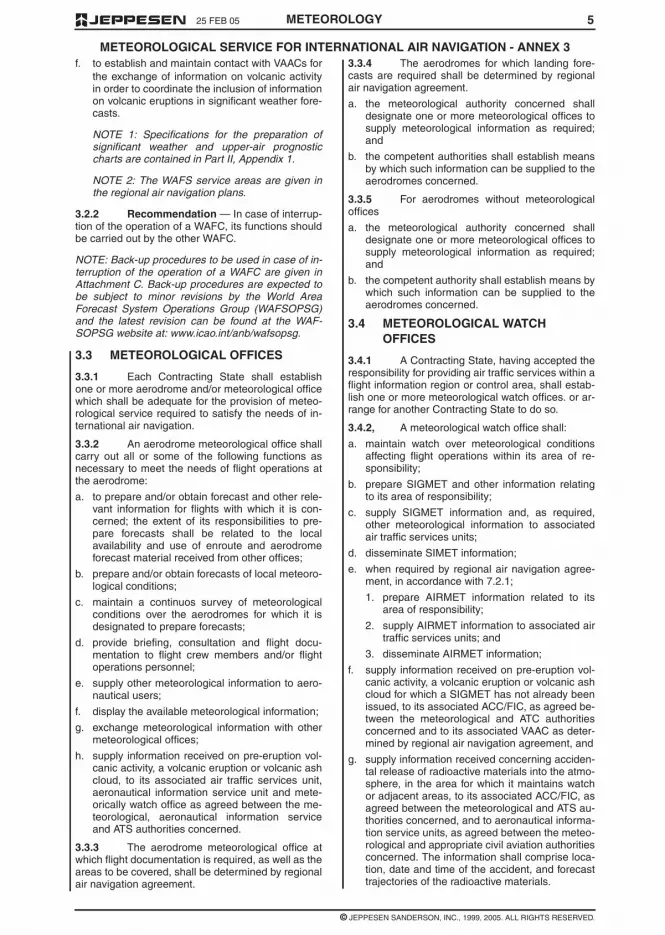
525 FEB 05
© JEPPESEN SANDERSON, INC., 1999, 2005. ALL RIGHTS RESERVED.
METEOROLOGICAL SERVICE FOR INTERNATIONAL AIR NAVIGATION - ANNEX 3
METEOROLOGY
f. to establish and maintain contact with VAACs forthe exchange of information on volcanic activityin order to coordinate the inclusion of informationon volcanic eruptions in significant weather fore-casts.
NOTE 1: Specifications for the preparation ofsignificant weather and upper-air prognosticcharts are contained in Part II, Appendix 1.
NOTE 2: The WAFS service areas are given inthe regional air navigation plans.
3.2.2 Recommendation — In case of interrup-tion of the operation of a WAFC, its functions shouldbe carried out by the other WAFC.
NOTE: Back-up procedures to be used in case of in-terruption of the operation of a WAFC are given inAttachment C. Back-up procedures are expected tobe subject to minor revisions by the World AreaForecast System Operations Group (WAFSOPSG)and the latest revision can be found at the WAF-SOPSG website at: www.icao.int/anb/wafsopsg.
3.3 METEOROLOGICAL OFFICES
3.3.1 Each Contracting State shall establishone or more aerodrome and/or meteorological officewhich shall be adequate for the provision of meteo-rological service required to satisfy the needs of in-ternational air navigation.
3.3.2 An aerodrome meteorological office shallcarry out all or some of the following functions asnecessary to meet the needs of flight operations atthe aerodrome:
a. to prepare and/or obtain forecast and other rele-vant information for flights with which it is con-cerned; the extent of its responsibilities to pre-pare forecasts shall be related to the localavailability and use of enroute and aerodromeforecast material received from other offices;
b. prepare and/or obtain forecasts of local meteoro-logical conditions;
c. maintain a continuos survey of meteorologicalconditions over the aerodromes for which it isdesignated to prepare forecasts;
d. provide briefing, consultation and flight docu-mentation to flight crew members and/or flightoperations personnel;
e. supply other meteorological information to aero-nautical users;
f. display the available meteorological information;
g. exchange meteorological information with othermeteorological offices;
h. supply information received on pre-eruption vol-canic activity, a volcanic eruption or volcanic ashcloud, to its associated air traffic services unit,aeronautical information service unit and mete-orically watch office as agreed between the me-teorological, aeronautical information serviceand ATS authorities concerned.
3.3.3 The aerodrome meteorological office atwhich flight documentation is required, as well as theareas to be covered, shall be determined by regionalair navigation agreement.
3.3.4 The aerodromes for which landing fore-casts are required shall be determined by regionalair navigation agreement.
a. the meteorological authority concerned shalldesignate one or more meteorological offices tosupply meteorological information as required;and
b. the competent authorities shall establish meansby which such information can be supplied to theaerodromes concerned.
3.3.5 For aerodromes without meteorologicaloffices
a. the meteorological authority concerned shalldesignate one or more meteorological offices tosupply meteorological information as required;and
b. the competent authority shall establish means bywhich such information can be supplied to theaerodromes concerned.
3.4 METEOROLOGICAL WATCHOFFICES
3.4.1 A Contracting State, having accepted theresponsibility for providing air traffic services within aflight information region or control area, shall estab-lish one or more meteorological watch offices. or ar-range for another Contracting State to do so.
3.4.2, A meteorological watch office shall:
a. maintain watch over meteorological conditionsaffecting flight operations within its area of re-sponsibility;
b. prepare SIGMET and other information relatingto its area of responsibility;
c. supply SIGMET information and, as required,other meteorological information to associatedair traffic services units;
d. disseminate SIMET information;
e. when required by regional air navigation agree-ment, in accordance with 7.2.1;
1. prepare AIRMET information related to itsarea of responsibility;
2. supply AIRMET information to associated airtraffic services units; and
3. disseminate AIRMET information;
f. supply information received on pre-eruption vol-canic activity, a volcanic eruption or volcanic ashcloud for which a SIGMET has not already beenissued, to its associated ACC/FIC, as agreed be-tween the meteorological and ATC authoritiesconcerned and to its associated VAAC as deter-mined by regional air navigation agreement, and
g. supply information received concerning acciden-tal release of radioactive materials into the atmo-sphere, in the area for which it maintains watchor adjacent areas, to its associated ACC/FIC, asagreed between the meteorological and ATS au-thorities concerned, and to aeronautical informa-tion service units, as agreed between the meteo-rological and appropriate civil aviation authoritiesconcerned. The information shall comprise loca-tion, date and time of the accident, and forecasttrajectories of the radioactive materials.

4925 FEB 05
© JEPPESEN SANDERSON, INC., 1999, 2005. ALL RIGHTS RESERVED.
METEOROLOGICAL INFORMATION FOR INTERNATIONAL AIR NAVIGATION - ANNEX 3
METEOROLOGY
Table A3-1 cont’d

4 MAR 05
© JEPPESEN SANDERSON, INC., 1999, 2005. ALL RIGHTS RESERVED.
METEOROLOGICAL INFORMATION FOR INTERNATIONAL AIR NAVIGATION - ANNEX 3
48 METEOROLOGY
Table A3-1 cont’d

474 MAR 05
© JEPPESEN SANDERSON, INC., 2005. ALL RIGHTS RESERVED.
METEOROLOGICAL INFORMATION FOR INTERNATIONAL AIR NAVIGATION - ANNEX 3
METEOROLOGY
APPENDIX 3 - TECHNICAL SPECIFICATIONS RELATED TO METEOROLOGICALOBSERVATIONS AND REPORTS
Table A3-1 - Template for the local routine (MET REPORT) and local (SPECIAL) reports
NOTE 1: The ranges and resolutions for the numerical elements included in the local routine and special re-ports are shown in Table A3-4 of this appendix.
NOTE 2: The explanations for the abbreviations used can be found in the Procedures for Air Navigation Servic-es - ICAO Abbreviations and Codes (PANS-ABC, Doc 8400).
Key: M = inclusion mandatory, part of every message
C = inclusion conditional, dependent on meteorological condition
0 = inclusion optional

25 FEB 05
© JEPPESEN SANDERSON, INC., 1999, 2005. ALL RIGHTS RESERVED.
METEOROLOGICAL SERVICE FOR INTERNATIONAL AIR NAVIGATION - ANNEX 3
46 METEOROLOGY
Table A2-2 cont’d
Example A2-2. Advisory message for tropical cyclones
TC ADVISORY
DTG: 19970925/160OZ
TCAC: YUFO
TC: GLORIA
NR: 01
PSN: N2706 W07306
MOV: NW 20KMH
C: 965HPA
MAX WIND: 90KMH
FCST PSN + 12 HR: 26/040OZ N2830 W07430
FCST MAX WIND + 12 HR: 90KMH
FCST PSN + 18 HR: 2611000Z N2852 W07500
FCST MAX WIND + 18 HR: 85KMH
FCST PSN + 24 HR: 26/160OZ N2912 W07530
FCST MAX WIND + 24 HR: 80KMH
NXT MSG: 19970925/2000Z

4525 FEB 05
© JEPPESEN SANDERSON, INC., 1999, 2005. ALL RIGHTS RESERVED.
METEOROLOGICAL SERVICE FOR INTERNATIONAL AIR NAVIGATION - ANNEX 3
METEOROLOGY
Table A2-2

25 FEB 05
© JEPPESEN SANDERSON, INC., 1999, 2005. ALL RIGHTS RESERVED.
METEOROLOGICAL SERVICE FOR INTERNATIONAL AIR NAVIGATION - ANNEX 3
44 METEOROLOGY
NOTE 1: The ranges and resolutions for the numerical elements included in advisory messages for tropical cy-clone are shown in Appendix 6, Table A 6-4.
NOTE 2: The explanations for the abbreviations can be found in the Procedures for Air Navigation Services -ICAI Abbreviations and Codes (PANS-ABC, Doc 8400).
NOTE 3: All the elements are mandatory.
NOTE 4: Inclusion of a "colon " after each element heading is mandatory.
NOTE 5: The numbers 1 to 16 are included only for clarity and they are not part of the advisory message, asshown in the example.
Table A2-2. Template for advisory message for tropical cyclones
Key: = = a double line indicates that the textAbbreviations and Codes (PANS-ABC, Doc 8400).following it should be placed on the subsequent line

4325 FEB 05
© JEPPESEN SANDERSON, INC., 1999, 2005. ALL RIGHTS RESERVED.
METEOROLOGICAL SERVICE FOR INTERNATIONAL AIR NAVIGATION - ANNEX 3
METEOROLOGY
Example A2-1. Advisory message for volcanic ash
VOLCANIC ASH ADVISORY
ISSUED: 20000402/0700Z
VAAC: TOKYO
VOLCANO: USUZAN 805-03
LOCATION: N4230 E14048
AREA: JAPAN
SUMMIT ELEVATION: 732M
ADVISORY NUMBER: 2000/432
INFORMATION SOURCE: GMS JMA
AVIATION COLOUR CODE: RED
ERUPTION DETAILS: ERUPTED 20000402/0614Z ERUPTION OBS ASH TO ABV FL300
OBS ASH DATE/TIME: 02/0645Z
OBS ASH CLD: FL150/350 N4230 E14048 - N4300 E14130 - N4246 E14230 - N4232E14150 -N4230 E14048 SFC/FL150 MOV NE 25KT FL150/350 MOVE 30 KT
FCST ASH CLD + 6 HR: 02/1245Z SFC/FL200 N4230 E14048 - N4232 E14150 - N4238E14300 - N4246 E14230 FL200/350 N4230 E14048 - N4232 E14150N4238 E14300 - N4246 E14230 FL350/600 NO ASH EXP
FCST ASH CLD + 12 HR: 02/1845Z SFC/FL300 N4230 E14048 - N4232 E14150 - N4238E14300 - N4246 E14230 FL300/600 NO ASH EXP
FCST ASH CLD + 18 HR: 03/0045Z SFC/FL600 NO ASH EXP
NEXT ADVISORY: 20000402/1300Z
REMARKS: ASH CLD CAN NO LONGER BE DETECTED ON SATELLITE IMAGE

25 FEB 05
© JEPPESEN SANDERSON, INC., 1999, 2005. ALL RIGHTS RESERVED.
METEOROLOGICAL SERVICE FOR INTERNATIONAL AIR NAVIGATION - ANNEX 3
42 METEOROLOGY
Table A2-1 cont’d

4125 FEB 05
© JEPPESEN SANDERSON, INC., 1999, 2005. ALL RIGHTS RESERVED.
METEOROLOGICAL SERVICE FOR INTERNATIONAL AIR NAVIGATION - ANNEX 3
METEOROLOGY
Table A2-1 cont’d
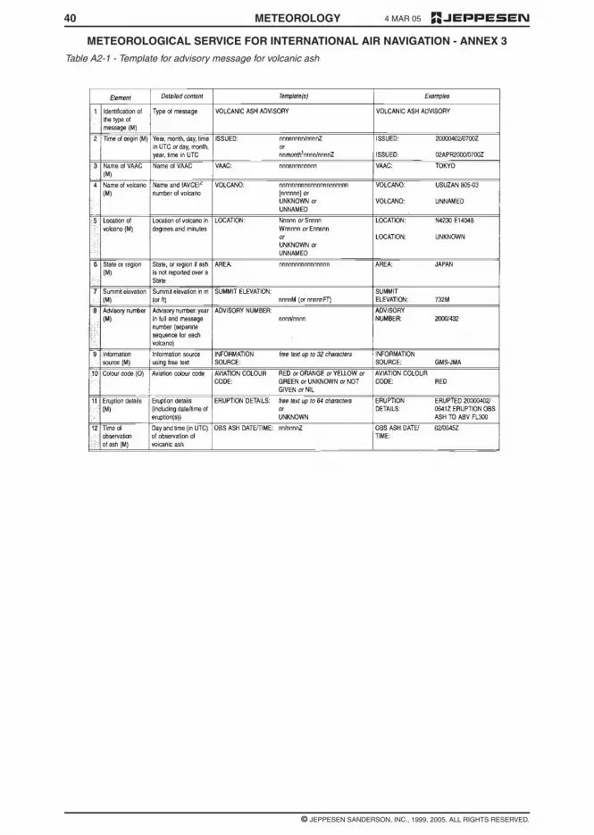
4 MAR 05
© JEPPESEN SANDERSON, INC., 1999, 2005. ALL RIGHTS RESERVED.
METEOROLOGICAL SERVICE FOR INTERNATIONAL AIR NAVIGATION - ANNEX 3
40 METEOROLOGY
Table A2-1 - Template for advisory message for volcanic ash

4 25 FEB 05
© JEPPESEN SANDERSON, INC., 1999, 2005. ALL RIGHTS RESERVED.
METEOROLOGICAL SERVICE FOR INTERNATIONAL AIR NAVIGATION - ANNEX 3
METEOROLOGY
2.2.6 Recommendation — Demonstration ofcompliance of the quality system applied should beby audit. If non-conformity of the system is identified,action should be initiated to determine and correctthe cause. All audit observations should be evi-denced and properly documented.
2.2.7 The meteorological information suppliedto the users listed in 2.1.2 shall be consistent withHuman Factors principles and shall be in formswhich require a minimum of interpretation by users,as specified in the following chapters.
NOTE: Guidance material on the application of Hu-man Factors principles can be found in the HumanFactors Training Manual (DOC 9863).
2.3 NOTIFICATIONS REQUIRED FROMOPERATORS
2.3.1 An operator requiring meteorological ser-vice or changes in existing meteorological serviceshall notify, sufficiently in advance, the meteorologi-cal authority or the meteorological office(s) con-cerned. The minimum amount of advance notice re-quired shall be as agreed between themeteorological authority or meteorological office(s)and the operator.
2.3.2 The meteorological authority shall be no-tified by the operator requiring service when:
a. new routes or new types of operations areplanned;
b. changes of a lasting character are to be made inscheduled operations; and
c. other changes, affecting the provision of meteo-rological service, are planned.
Such information shall contain all details necessaryfor the planning of appropriate arrangements by themeteorological authority.
2.3.3 The aerodrome meteorological office, orthe meteorological office concerned, shall be noti-fied by the operator or a flight crew member:
a. of flight schedules;
b. when non-scheduled flights are to be operated;
c. when flights are delayed, advanced or cancelled.
2.3.4 Recommendation — The notification tothe aerodrome meteorological office, or the meteo-rological office concerned, of individual flightsshould contain the following information except that,in the case of scheduled flights, the requirement forsome or all of this information may be waived byagreement between the meteorological office andthe operator:
a. aerodrome of departure and estimated time ofdeparture;
b. destination and estimated time of arrival;
c. route to be flown and estimated times of arrivalat, and departure from, any intermediate aero-drome(s);
d. alternate aerodromes needed to complete theoperational flight plan and taken from the rele-vant list contained in the regional air navigationplan;
e. cruising level;
f. for supersonic flights, the alternative subsoniccruising level and the locations of the transonicacceleration and deceleration areas and of thesubsonic climb and descent paths;
g. type of flight, whether under the visual or the in-strument flight rules;
h. type of meteorological information requested fora flight crew member, whether flight documenta-tion and/or briefing or consultation;
i. time(s) at which briefing, consultation and/orflight documentation are required.
CHAPTER 3 – WORLD AREAFORECAST SYSTEM ANDMETEOROLOGICAL OFFICES
NOTE: Technical specifications and detailed criteriarelated to this chapter are given in Appendix 2.
3.1 OBJECTIVES OF THE WORLD AREAFORECAST SYSTEM
The objectives of the world area forecast systemshall be to supply meteorological authorities andother users with forecasts of global upper wind, up-per-air temperature and humidity, direction, speedand height of maximum wind, tropopause height andtemperature and forecasts of significant weatherphenomena in digital form. This objective shall beachieved through a comprehensive, integrated,worldwide and, as far as practicable, uniform sys-tem, and in a cost-effective manner, taking full ad-vantage of evolving techniques.
3.2 WORLD AREA FORECASTCENTRES
3.2.1 A Contracting State, having accepted theresponsibility for providing a WAFC within the frame-work of the world area forecast system, shall ar-range for that centre:
a. to prepare global forecasts for grid points in digi-tal form for all required levels and in a standardformat; the forecasts shall comprise upperwinds, upper-air temperatures, tropopauseheights and maximum wind speed, direction andheight;
b. to prepare global forecasts of significant weatherphenomena in digital form;
c. to issue the forecasts referred to in a. and b. indigital to meteorological authorities and other us-ers in its service area, as approved by the Con-tracting State on advice from the meteorologicalauthority;
d. to prepare and issue amendments to the fore-casts;
e. to receive information concerning the accidentalrelease of radioactive materials into the atmo-sphere, from its associated WMO regional spe-cialized meteorological centre for the provision oftransport model products for radiological envi-ronmental emergency response, in order to in-clude the information in significant weather fore-casts; and

394 MAR 05
© JEPPESEN SANDERSON, INC., 1999, 2005. ALL RIGHTS RESERVED.
METEOROLOGICAL SERVICE FOR INTERNATIONAL AIR NAVIGATION - ANNEX 3
METEOROLOGY
APPENDIX 2 - TECHNICAL SPECIFICATIONS RELATED TO WORLD AREAFORECAST SYSTEM AND METEOROLOGICAL OFFICES
Table A2-1. Template for advisory message for volcanic ash
NOTE 1: The ranges and resolutions for the numerical elements included in advisory messages for volcanicash are shown in Appendix 6, Table A6-4.
NOTE 2: The explanations for the abbreviations can be found in the Procedures for Air Navigation Services -ICAO Abbreviations and Codes (PANS-ABC, Doc 8400).
NOTE 3: Inclusion of a "colon " after each element heading is mandatory.
NOTE 4: The numbers 1 to 18 are included only for clarity and they are not part of the advisory message, asshown in the example.
NOTE:1. Use abbreviations for months of the year from the PANS-ABC (Doc 8400), for example, "JAN".
2. International Association of Volcanology and Chemistry of the Earth's Interior (IAVCEI).
3. Up to 4 selected layers.
4. If ash reported (e.g. AIREP) but not identifiable from satellite data.
Key: M = inclusion mandatory, part of every message;
0 = inclusion optional;
= = a double line indicates that the text following it should be placed on the subsequent line
25 FEB 05
© JEPPESEN SANDERSON, INC., 1999, 2005. ALL RIGHTS RESERVED.
METEOROLOGICAL SERVICE FOR INTERNATIONAL AIR NAVIGATION -- ANNEX 3
38 METEOROLOGY
4.2 SWL — SIGNIFICANT WEATHER CHART (LOW LEVEL)
4.3 ARROWS AND FEATHERS
Arrows indicate direction. Number of pennants and/or feathers correspond to speed.
Heavy solid lineinterrupted by windarrow and flight level
= position of jet stream axis with indication of wind direction, speed in kt or km/h andheight in flight levels. The vertical extent of the jet stream is indicated (in flightlevels) below the flight level, e.g. FL270 accompanied by +20/-30 indicates that theheight of the jet extends from FL240 to FL290.
Figures on arrows = speed in kt or km/h of movement of frontal system
Flight levels insidesmall rectangles
= height in flight levels of tropopause at spot locations; e.g., . Low and Highpoints of the tropopause topography are indicated by the letters L or H respectivelyinside a pentagon with the height in flight levels.
X = position of pressure centres given in hectopascals;
L = centre of low pressure;
H = centre of high pressure;
Scalloped lines = demarcation of area of significant weather
Dashed lines = altitude of 0°C isotherm in feet (hectofeet) or metres
NOTE: 0°C level may also be indicated by ; i.e., 0°C level is at analtitude of 6,000 ft.
Figures on arrows = speed in kt or km/h of movement of frontal systems, depressions or anticyclones
Figure inside thestate of the seasymbol
= total wave height in feet or metres
Figure inside the seasurface temperaturesymbol
= sea surface temperature in °C
Figures inside thestrong surface windsymbol
= wind in kt or km/h
EXAMPLE:
270° / 115 kt (equivalent to 213 km/h)
A pennant corresponds to 50 kt or 93 km/h;
A feather corresponds to 10 kt or 18 km/h;
A half-feather corresponds to 5 kt or 9 km/h.

3725 FEB 05
© JEPPESEN SANDERSON, INC., 1999, 2005. ALL RIGHTS RESERVED.
METEOROLOGICAL SERVICE FOR INTERNATIONAL AIR NAVIGATION -- ANNEX 3
METEOROLOGY
3 ABBREVIATIONS USED TO DESCRIBE CLOUDS
3.1 TYPE
3.2 AMOUNT
3.3 HEIGHTS
Heights are indicated on SWH and SWM in flight levels (FL), top over base.
When XXX is used, tops or bases are outside the layer of the atmosphere to which the chart applies.
In SWL (low level) significant weather charts:
a. Heights are indicated as altitudes above mean sea level;
b. The abbreviation SFC is used to indicate ground level.
4 DEPICTING OF LINES AND SYSTEMS ON SPECIFIC CHARTS
4.1 SWH AND SWM — SIGNIFICANT WEATHER CHARTS (HIGH AND MEDIUM)
Wind arrows indicate the maximum wind in jet and the flight level at which it occurs. Significant changes(speed of 20 knots or more, 3,000 ft (less if practicable) in flight level) are marked by the double bar. In theexample, at the double bar the wind speed is 225 km/h - 120 kt.
The heavy line delineating the jet axis begins/ends at the points where a wind speed of 150 km/h - 80 kt isforecast.
* This symbol refers to widespread surface wind speeds exceeding 60 km/h (30 kt).
CI = Cirrus AS = Altostratus ST = Stratus
CC = Cirrocumulus NS = Nimbostratus CU = Cumulus
CS = Cirrostratus SC = Stratocumulus CB = Cumulonimbus
AC = Altocumulus
Clouds except CB:
SKC = sky clear (0/8ths)
FEW = few (1/8th to 2/8ths)
SCT = scattered (3/8th to 4/8ths)
BKN = broken (5/8ths to 7/8ths)
OVC = overcast (8/8ths)
CB only:
ISOL = individual CBs (isolated)
OCNL = well separated CBs (occasional)
FRQ = CBs with little or no separation (frequent)
EMBD = CBs embedded in layers of other clouds or concealed by haze (embedded)
Scalloped line = demarcation of areas of significant weather
Heavy broken line = delineation of area of CAT

25 FEB 05
© JEPPESEN SANDERSON, INC., 1999, 2005. ALL RIGHTS RESERVED.
METEOROLOGICAL SERVICE FOR INTERNATIONAL AIR NAVIGATION -- ANNEX 3
36 METEOROLOGY
2 FRONTS AND CONVERGENCE ZONES AND OTHER SYMBOLS USED
Volcanic eruption *** Freezing precipitation ****
Mountain obscuration Visible ash cloud *****
* In flight documentation for flights operating up to FL 100, this symbol refers to “squall line”.
** The following information should be included at the side of the chart: radioactive materials symbol;Latitude/longitude of accident site; Date and time of accident; check NOTAM for further information.
*** The following information should be included at the side of the chart: Volcanic eruption symbol; Name andinternational number of volcano (if known); Latitude/longitude; Date and time of the first eruption (if known)
Check SIGMETs and NOTAM or ASHTAM for volcanic ash.
**** This symbol does not refer to icing due to precipitation coming into contact with an aircraft which is at avery low temperature.
***** Visible ash cloud symbol applies only to model VAG not to SIGWX charts.
NOTE: Height indications between which phenomena are expected, top above base as per chart legend.
Cold front at the surface Position, speed and level of max.wind
Warm front at the surface Convergence line
Occluded front at the surface Freezing level
Quasi-stationary front at thesurface Intertropical convergence zone
Tropopause high State of the sea
Tropopause low Sea surface temperature
Tropopause level Widespread strong surface wind *

3525 FEB 05
© JEPPESEN SANDERSON, INC., 1999, 2005. ALL RIGHTS RESERVED.
METEOROLOGICAL SERVICE FOR INTERNATIONAL AIR NAVIGATION -- ANNEX 3
METEOROLOGY
APPENDIX 1. MODEL SN – NOTATIONS USED IN FLIGHT DOCUMENTATION
1 SYMBOLS FOR SIGNIFICANT WEATHER
Thunderstorms Drizzle
Tropical cyclone Rain
Severe squall line* Snow
Moderate turbulence Shower Hail
Severe turbulence Widespread blowing snow
Mountain waves Severe sand or dust haze
Moderate aircraft icing Widespread sandstorm or duststorm
Severe aircraft icing Widespread haze
Widespread fog Widespread mist
Radioactive materials in the atmosphere** Widespread smoke

25 FEB 05
© JEPPESEN SANDERSON, INC., 1999, 2005. ALL RIGHTS RESERVED.
METEOROLOGICAL SERVICE FOR INTERNATIONAL AIR NAVIGATION - ANNEX 3
34 METEOROLOGY
MODEL VAG - VOLCANIC ASH ADVISORY INFORMATION IN GRAPHIC FORMAT

3325 FEB 05
© JEPPESEN SANDERSON, INC., 1999, 2005. ALL RIGHTS RESERVED.
METEOROLOGICAL SERVICE FOR INTERNATIONAL AIR NAVIGATION - ANNEX 3
METEOROLOGY
ANNEX 1- MODEL SWL - SIGNIFICANT WEATHER CHART (LOW LEVEL)

25 FEB 05
© JEPPESEN SANDERSON, INC., 1999, 2005. ALL RIGHTS RESERVED.
METEOROLOGICAL SERVICE FOR INTERNATIONAL AIR NAVIGATION - ANNEX 3
32 METEOROLOGY
ANNEX 1 - MODEL SWL - SIGNIFICANT WEATHER CHART (LOW LEVEL)

3125 FEB 05
© JEPPESEN SANDERSON, INC., 1999, 2005. ALL RIGHTS RESERVED.
METEOROLOGICAL SERVICE FOR INTERNATIONAL AIR NAVIGATION - ANNEX 3
METEOROLOGY
APPENDIX 1 - MODEL SWM - SIGNIFICANT WEATHER CHART (MEDIUM LEVEL)

25 FEB 05
© JEPPESEN SANDERSON, INC., 1999, 2005. ALL RIGHTS RESERVED.
METEOROLOGICAL SERVICE FOR INTERNATIONAL AIR NAVIGATION - ANNEX 3
30 METEOROLOGY
APPENDIX 1 - MODEL SWH - SIGNIFICANT WEATHER CHART (HIGH LEVEL)
POLAR STEREOGRAPHIC PROJECTION (SHOWING THE JETSTREAM VERTICAL EXTENT ANDCROSSING JETSTREAM DEPICTIONS).

325 FEB 05
© JEPPESEN SANDERSON, INC., 1999, 2005. ALL RIGHTS RESERVED.
METEOROLOGICAL SERVICE FOR INTERNATIONAL AIR NAVIGATION - ANNEX 3
METEOROLOGY
c. “issue” is used solely in connection with caseswhere the obligation specifically extends tosending out the information to a user;
d. “make available” is used solely in connectionwith cases where the obligation ends with mak-ing the information accessible to a user; and
e. “supply” is used solely in connection with caseswhere either c. or d. applies.
CHAPTER 2 – GENERALPROVISIONS
2.1 OBJECTIVE, DETERMINATION ANDPROVISION OF METEOROLOGICALSERVICE
2.1.1 The objective of meteorological servicefor international air navigation shall be to contributetowards the safety, regularity and efficiency of inter-national air navigation.
2.1.2 This objective shall be achieved by sup-plying the following users: operators, flight crewmembers, air traffic services units, search and res-cue services units, airport managements and othersconcerned with the conduct or development of inter-national air navigation, with the meteorological infor-mation necessary for the performance of their re-spective functions.
2.1.3 Each Contracting State shall determinethe meteorological service which it will provide tomeet the needs of international air navigation. Thisdetermination shall be made in accordance with theprovisions of this Annex and with due regard to re-gional air navigation agreements; it shall include thedetermination of the meteorological service to beprovided for international air navigation over interna-tional waters and other areas which lie outside theterritory of the State concerned.
2.1.4 Each Contracting State shall designatethe authority, hereinafter referred to as the meteoro-logical authority, to provide or to arrange for the pro-vision of meteorological service for international airnavigation on its behalf. Details of the meteorologi-cal authority so designated shall be included in theState aeronautical information publication, in accor-dance with Annex 15, Appendix 1, GEN 1.1 (notpublished herein).
2.1.5 Each Contracting State shall ensure thatthe designated meteorological authority complieswith the requirements of the World MeteorologicalOrganization in respect of qualifications and trainingof meteorological personnel providing services forinternational air navigation.
2.2 SUPPLY, QUALITY ASSURANCEAND USE OF METEOROLOGICALINFORMATION
2.2.1 Close liaison shall be maintained be-tween those concerned with the supply and thoseconcerned with the use of meteorological informa-tion on matters which affect the provision of meteo-rological service for international air navigation.
2.2.2 Recommendation — In order to meetthe objective of meteorological service for interna-tional air navigation, the Contracting State shouldensure that the designated meteorological authorityreferred to in 2.1.4 establishes and implements aproperly organized quality system comprising proce-dures, processes and resources necessary to pro-vide for the quality management of the meteorologi-cal information to be supplied to users listed in 2.1.2.
2.2.3 Recommendation — The quality systemestablished in accordance with 2.2.2 should be inconformity with the International Organization forStandardization (ISO) 9000 series of quality assur-ance standards, and certified by an approved orga-nization.
NOTE: International Organization for Standardiza-tion (ISO) 9000 series of quality assurance stan-dards provide a basic framework for the develop-ment of a quality assurance programme. The detailsof a successful programme are to be formulated byeach State and in most cases are unique to theState organization.
2.2.4 Recommendation — The quality systemshould provide the users with assurance that themeteorological information supplied complies withthe stated requirements in terms of the geographicaland spatial coverage, format and content, time andfrequency of issuance and period of validity, as wellas the accuracy of measurements, observations andforecasts. Where the quality system indicates thatthe meteorological information to be supplied to theusers does not comply with the stated requirements,and automatic error correction procedures are notappropriate, such information should not be suppliedto the users unless it is validated with the originator.
NOTE 1: Requirements concerning the geographicaland spatial coverage, format and content, time andfrequency of issuance and period of validity of mete-orological information to be supplied to aeronauticalusers are given in Chapters 3, 4, 6 to 10 and Appen-dices 2, 3, 5 to 9 of Annex 3 and the relevant region-al air navigation plans. Guidance concerning the ac-curacy of measurement and observation, andaccuracy of forecasts is given in Attachments A andB respectively to Annex 3.
NOTE 2: Notwithstanding the provisions in 2.2.4,provisional TAF may still be issued, as necessary, inaccordance with Appendix 8, 4.4.3.
2.2.5 Recommendation — In regard to the ex-change of meteorological information for operationalpurposes, the quality system should include verifica-tion and validation procedures and resources formonitoring adherence to the prescribed transmis-sion schedules for individual messages and/or bulle-tins required to be exchanged, and at the times oftheir filing for transmission. The quality systemshould be capable of detecting excessive transittimes of messages and bulletins received.
NOTE: Requirements concerning the exchange ofoperational meteorological information are given inChapter 11 and Appendix 10 of Annex 3.

2925 FEB 05
© JEPPESEN SANDERSON, INC., 1999, 2005. ALL RIGHTS RESERVED.
METEOROLOGICAL SERVICE FOR INTERNATIONAL AIR NAVIGATION - ANNEX 3
METEOROLOGY
APPENDIX 1 - MODEL SWH SIGNIFICANT WEATHER CHART (HIGH LEVEL)
POLAR STEREOGRAPHIC PROJECTION

25 FEB 05
© JEPPESEN SANDERSON, INC., 1999, 2005. ALL RIGHTS RESERVED.
METEOROLOGICAL SERVICE FOR INTERNATIONAL AIR NAVIGATION - ANNEX 3
28 METEOROLOGY
APPENDIX 1 - MODEL SWH - SIGNIFICANT WEATHER CHART (HIGH LEVEL)
EXAMPLE - MERCATOR PROJECTION

2725 FEB 05
© JEPPESEN SANDERSON, INC., 1999, 2005. ALL RIGHTS RESERVED.
METEOROLOGICAL SERVICE FOR INTERNATIONAL AIR NAVIGATION - ANNEX 3
METEOROLOGY
APPENDIX 1 - MODEL IS - UPPER WIND AND TEMPERATURE CHART FORSTANDARD ISOBARIC SURFACE
EXAMPLE - ARROWS, FEATHERS AND PENNANTS (POLAR STEREOGRAPHIC PROJECTION)
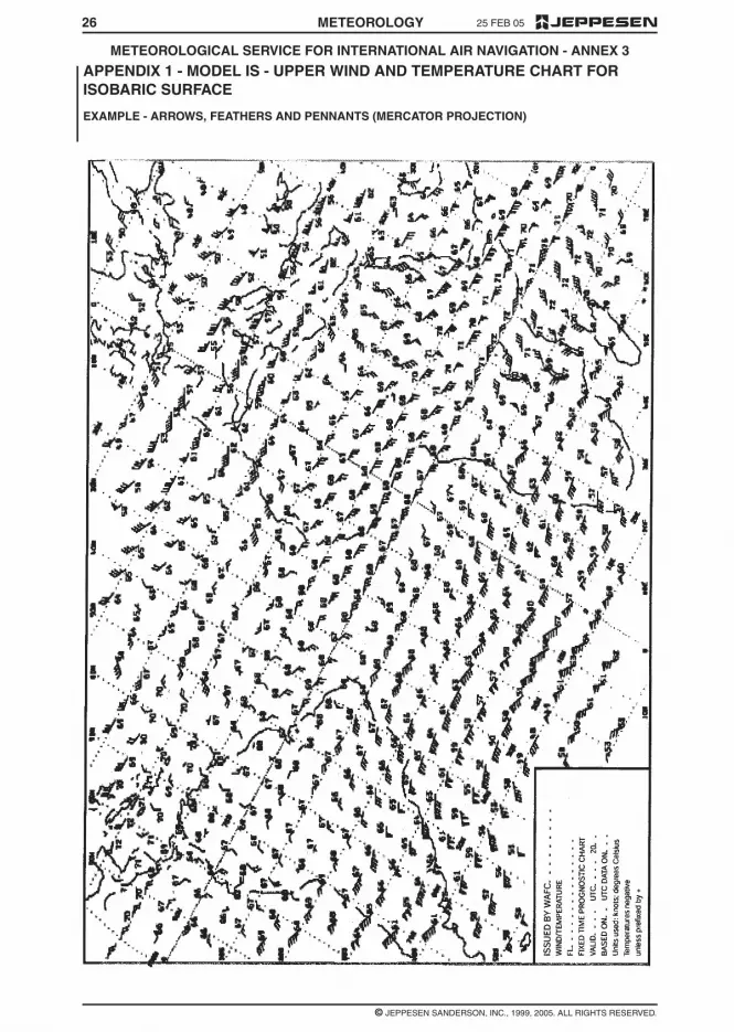
25 FEB 05
© JEPPESEN SANDERSON, INC., 1999, 2005. ALL RIGHTS RESERVED.
METEOROLOGICAL SERVICE FOR INTERNATIONAL AIR NAVIGATION - ANNEX 3
26 METEOROLOGY
APPENDIX 1 - MODEL IS - UPPER WIND AND TEMPERATURE CHART FORISOBARIC SURFACE
EXAMPLE - ARROWS, FEATHERS AND PENNANTS (MERCATOR PROJECTION)

2525 FEB 05
© JEPPESEN SANDERSON, INC., 1999, 2005. ALL RIGHTS RESERVED.
METEOROLOGICAL SERVICE FOR INTERNATIONAL AIR NAVIGATION - ANNEX 3
METEOROLOGY
APPENDIX 1 - MODEL TB - TABULAR FORECAST OF UPPER WINDS ANDUPPER AIR TEMPERATURES
EXAMPLE - SPOT LOCATIONS

2325 FEB 05
© JEPPESEN SANDERSON, INC., 1999, 2005. ALL RIGHTS RESERVED.
METEOROLOGICAL SERVICE FOR INTERNATIONAL AIR NAVIGATION - ANNEX 3
METEOROLOGY
APPENDIX 1, MODEL TA - TABULAR FORECAST OF ENROUTE CONDITIONS -EXAMPLE 2 - MEDIUM LEVEL

25 FEB 05
© JEPPESEN SANDERSON, INC., 1999, 2005. ALL RIGHTS RESERVED.
METEOROLOGICAL SERVICE FOR INTERNATIONAL AIR NAVIGATION - ANNEX 3
22 METEOROLOGY
APPENDIX 1 - MODEL TA , TABULAR FORECAST OF ENROUTE CONDITIONS -EXAMPLE 1 - LOW LEVEL
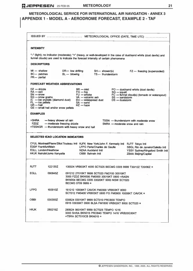
2125 FEB 05
© JEPPESEN SANDERSON, INC., 1999, 2005. ALL RIGHTS RESERVED.
METEOROLOGICAL SERVICE FOR INTERNATIONAL AIR NAVIGATION - ANNEX 3
METEOROLOGY
APPENDIX 1 - MODEL A - AERODROME FORECAST, EXAMPLE 2 - TAF

25 FEB 05
© JEPPESEN SANDERSON, INC., 1999, 2005. ALL RIGHTS RESERVED.
METEOROLOGICAL SERVICE FOR INTERNATIONAL AIR NAVIGATION - ANNEX 3
20 METEOROLOGY
APPENDIX 1 - MODEL A - AERODROME FORECASTS - EXAMPLE 1 - TABULARFORM

2 25 FEB 05
© JEPPESEN SANDERSON, INC., 1999, 2005. ALL RIGHTS RESERVED.
METEOROLOGICAL SERVICE FOR INTERNATIONAL AIR NAVIGATION - ANNEX 3
METEOROLOGY
NOTE: The IAVW is based on the co-operation ofaviation and non-aviation operational units using in-formation derived from observing sources and net-works that are provided by States. The watch isco-ordinated by ICAO with the co-operation of otherconcerned international organizations.
METEOROLOGICAL AUTHORITY — The au-thority providing or arranging for the provision of me-teorological service for international air navigationon behalf of a Contracting State.
METEOROLOGICAL BULLETIN — A text com-prising meteorological information preceded by anappropriate heading.
METEOROLOGICAL INFORMATION — Meteo-rological report, analysis, forecast and any otherstatement relating to existing or expected meteoro-logical conditions.
METEOROLOGICAL OFFICE — An office desig-nated to provide meteorological service for interna-tional air navigation.
METEOROLOGICAL REPORT — A statement ofobserved meteorological conditions related to aspecified time and location.
METEOROLOGICAL SATELLITE — An artificialEarth satellite making meteorological observationsand transmitting these observations to Earth.
OBSERVATION (Meteorological) — The evalua-tion of one or more meteorological elements.
PROGNOSTIC CHART — A forecast of a speci-fied meteorological element(s) for a specified time orperiod and a specified surface or portion of airspace,depicted graphically on a chart.
REGIONAL AIR NAVIGATION AGREEMENT —Agreement approved by the Council of ICAO nor-mally on the advice of a regional air navigationmeeting.
SERVICE AREA (World Area Forecast Sys-tem) — A geographical area within which a re-gional area forecast centre is responsible for supply-ing area forecasts to meteorological authorities andother users.
SIGMET INFORMATION — Information issued bya meteorological watch office concerning the occur-rence or expected occurrence of specified en routeweather phenomena which may affect the safety ofaircraft operations.
STANDARD ISOBARIC SURFACE — An isobar-ic surface used on a world-wide basis for represent-ing and analyzing the conditions in the atmosphere.
TROPICAL CYCLONE — Generic term for anon-frontal synoptic-scale cyclone originating overtropical or sub-tropical waters with organized con-vection and definite cyclonic surface wind circula-tion.
TROPICAL CYCLONE ADVISORY CENTRE(TCAC) — A meteorological centre designated byregional air navigation agreement to provide adviso-ry information to meteorological watch offices re-garding the position, forecast direction and speed of
movement, central pressure and maximum surfacewind of tropical cyclones.
UPPER-AIR CHART — A meteorological chart re-lating to a specified upper-air surface or layer of theatmosphere.
VISIBILITY — Visibility for aeronautical purposesis the greater of:
a. the greatest distance at which a black object ofsuitable dimensions, situated near the ground,can be seen and recognized when observedagainst a bright background;
b. the greatest distance at which lights in the vicini-ty of 1,000 candles can be seen and identifiedagainst an unlit background.
NOTE: The two distances have different values in airof given extinction coefficient, and the latter b. varieswith the background illumination. The former a. isrepresented by the meteorological optical range(MOR).
VOLCANIC ASH ADVISORY CENTRE (VAAC) —A meteorological centre designated by regional airnavigation agreement to provide advisory informa-tion to meteorological watch offices, area controlcentres, flight information centres, world area fore-cast centres, relevant regional area forecast centresand international OPMET data banks regarding thelateral and vertical extent and forecast movement ofvolcanic ash in the atmosphere following volcaniceruptions.
VOLMET BROADCAST — Routine broadcastcontaining, as appropriate, current aerodromeweather reports, aerodrome forecasts and SIGMETmessages for aircraft in flight.
VOLMET DATA LINK SERVICE (D-VOLMET) —Provision of current aerodrome weather reports,aerodrome forecasts and SIGMET messagesthrough data link.
WORLD AREA FORECAST CENTRE (WAFC) —A meteorological centre designated to prepare andsupply significant weather forecasts and upper-airforecasts in digital and/or pictorial form on a globalbasis to regional area forecast centres, and direct toStates by appropriate means as part of the aeronau-tical fixed service.
WORLD AREA FORECAST SYSTEM (WAFS) —A world-wide system by which world and regionalarea forecast centres provide aeronautical meteoro-logical en route forecasts in uniform standardizedformats.
1.2 TERMS USED WITH A LIMITEDMEANING
For the purpose of Annex 3, the following terms areused with a limited meaning as indicated below:
a. to avoid confusion in respect of the term “ser-vice” between the meteorological service consid-ered as an administrative entity and the servicewhich is provided, “meteorological authority” isused for the former and “service” for the latter;
b. “provide” is used solely in connection with theprovision of service;

1925 FEB 05
© JEPPESEN SANDERSON, INC., 1999, 2005. ALL RIGHTS RESERVED.
METEOROLOGICAL SERVICE FOR INTERNATIONAL AIR NAVIGATION - ANNEX 3
METEOROLOGY
APPENDIX 1. FLIGHT DOCUMENTATION - MODEL CHARTS AND FORMS
(See Chapter 9 of this Annex.)
MODEL A - Aerodrome forecasts
Example 1 - Tabular form
Example 2 - TAF
MODEL TA - Tabular forecast of en-route conditions
Example 1 - Low level
Example 2 - Medium level
MODEL TB - Tabular forecast of upper winds and upper-air temperatures
Example - Spot locations
MODEL IS - Upper wind and temperature chart for standard isobaric surface
Example 1 - Arrows, feathers and pennants (Mercartor projection)
Example 2 - Arrows, feathers and pennants (Polar stereographic projection)
MODEL SWH - Significant weather chart (high level)
Example 1 - Mercator projection
Example 2 - Polar stereographic projection
Example 3 - Polar stereographic projection (showing the jet stream vertical extent andcrossing jet stream depictions)
NOTE: In accordance with Appendix 8, 4.3.1.1 m additional information related tovolcanic ash should be placed at the side of the charts.
MODEL SWM - Significant weather chart (medium level)
MODEL SWL - Significant weather chart (low level)
Example 1
Example 2
MODEL VAG - Volcanic ash advisory information in graphical format
MODEL SN - Sheet of notations used in flight documentation

18 25 FEB 05
© JEPPESEN SANDERSON, INC., 1999, 2005. ALL RIGHTS RESERVED.
METEOROLOGICAL SERVICE FOR INTERNATIONAL AIR NAVIGATION - ANNEX 3
METEOROLOGY
11.1.3 Suitable telecommunication facilities shallbe made available to permit world area forecast cen-ters to supply the required world area forecast sys-tem products to meteorological offices, meteorologi-cal authorities and other users.
11.1.4 Telecommunication facilities betweenmeteorological offices and, as necessary, aeronauti-cal meteorological stations and aerodrome controltowers or approach control offices shall permit com-munications by direct speech, the speed with whichthe communications can be established being suchthat required points may normally be contacted with-in approximately 15 seconds.
11.1.5 Recommendation – Telecommunicationfacilities between meteorological offices and flight in-formation centers, area control centers, rescue coor-dination centers and aeronautical telecommunica-tion stations should permit:
a. communications by direct speech, the speedwith which the communications can be estab-lished being such that the required points maynormally be contacted within approximately 15seconds; and
b. printed communications, when a record is re-quired by the recipient; the message transmittime should not exceed 5 minutes.
NOTE: In 11.1.4 and 11.1.5 ‘approximately 15seconds’ refers to telephony communications in-volving switchboard operation and ‘5 minutes’ re-fer to printed communications involving transmis-sion.
11.1.6 Recommendation – The telecommuni-cation facilities required in accordance with 11.1.4and 11.1.5 should be supplemented, as and wherenecessary, by other forms of visual or audio commu-nications, for example, closed-circuit television orseparate information processing systems.
11.1.7 Recommendation – As agreed betweenthe meteorological authority and operators, provi-sion should be made to enable operators to estab-lish suitable telecommunications facilities for obtain-ing meteorological information from aerodromemeteorological offices or other appropriate sources.
11.1.8 Recommendation – Suitable telecom-munications facilities shall be made available to per-mit meteorological offices to exchange operationalmeteorological information with other meteorologicaloffices.
11.1.9 Recommendation – The telecommuni-cations facilities used for the exchange of operation-al meteorological information should be the aero-nautical fixed service.
11.2 USE OF AERONAUTICAL FIXED SERVICECOMMUNICATIONS - METEORLOGICAL BULLE-TINS IN ALPHANUMERIC FORMAT
Meteorological bulletins containing operational me-teorological information to be transmitted via aero-nautical fixed service shall be originated by the ap-propriate meteorological office or aeronauticalmeteorological station.
NOTE: Meteorological bulletins containing opera-tional meteorological information authorized for
transmission via aeronautical fixed service are listedin Annex 10, Volume II, Chapter 4, together with therelevant priorities and priority indicator.
11.3 USE OF AERONAUTICAL FIXED SERVICECOMMUNICATIONS - WORLD AREA FORECASTSYSTEM PRODUCTS
Recommendation – World area forecast systemproducts in digital form should be transmitted usingbinary data communication techniques. The methodand channels used for dissemination of the productsshould be as determined by regional air navigationagreement.
11.4 USE OF AERONAUTICAL MOBILE SER-VICE COMMUNICATION
The content and format of meteorological informa-tion transmitted to aircraft and by aircraft shall beconsistent with the provisions of this Annex.
11.5 USE OF AERONAUTICAL DATA LINKSERVICE - CONTENTS OF D-VOLMET
D-VOLMET shall contain current METAR and SPECItogether with trend forecasts where available, TAFand SIGMET, special air-reports not covered by SIG-MET and, where available, AIRMET.
NOTE: The requirement to provide METAR andSPECI may be met by the data-link information ser-vice (D-FIS) application entitled ‘Data link-aero-drome routine meteorological report (D-METAR) ser-vice’; the requirement to provide TAF may be met bythe D-FIS application entitled ‘Data link-aerodromeforecast (D-TAF) service’; and the requirement toprovide SIGMET and AIRMET messages may bemet by the D-FIS application entitled ‘Data link-SIG-MET (D-SIGMET) service’. The details of these datalink services are specified in the Manual of Air TrafficServices Data Link Applications (Doc 9694).
11.6 USE OF AERONAUTICAL BROADCASTSERVICE - CONTENTS OF VOLMET BROAD-CASTS
11.6.1 Continuous VOLMET broadcasts, nor-mally on very high frequencies (VHF) shall containcurrent METAR and SPECI, together with trend fore-casts where available.
11.6.2 Scheduled VOLMET broadcasts, normal-ly on high frequencies (HF), shall contain currentMETAR and SPECI, together with trend forecastswhere available and, where so determined by re-gional air navigation agreement, TAF and SIGMET.

1725 FEB 05
© JEPPESEN SANDERSON, INC., 1999, 2005. ALL RIGHTS RESERVED.
METEOROLOGICAL SERVICE FOR INTERNATIONAL AIR NAVIGATION - ANNEX 3
METEOROLOGY
NOTE: The responsibilities relating to aeronauticalinformation services information and the quality as-surance of the information is given in Annex 15,Chapter 3.
9.6 INFORMATION FOR AIRCRAFT INFLIGHT
9.6.1 Meteorological information for use by air-craft in flight shall be supplied by a meteorologicaloffice to its associated air traffic services unit andthrough D-VOLMET or VOLMET broadcasts. Meteo-rological information for planning by the operator foraircraft in flight shall be supplied on request, asagreed between the meteorological authority or au-thorities and the operator concerned.
9.6.2 Meteorological information for use by air-craft on flight shall be supplied to air traffic servicesunits in accordance with specifications of Chapter10.
9.6.3 Meteorological information shall be sup-plied through D-VOLMET or VOLMET broadcast asdetermined by regional air navigation agreement,and in accordance with the specifications of Chapter11.
CHAPTER 10 - INFORMATION FORAIR TRAFFIC SERVICES, SEARCHAND RESCUE SERVICES ANDAERONAUTICAL INFORMATIONSERVICES
NOTE: Technical specifications and detailed criteriarelated to this chapter are given in Appendix 9.
10.1 INFORMATION FOR AIR TRAFFIC SER-VICES UNITS
10.1.1 The meteorological authority shall desig-nate a meteorological office to be associated witheach air traffic services unit. The associated meteo-rological office shall, after coordination with air trafficservices unit, supply, or arrange for the supply ofup-t-date meteorological information to the unit nec-essary for the conduct of its function.
10.1.2 Recommendation – The associated me-teorological office for an aerodrome control tower orapproach control office should be an aerodrome me-teorological office.
10.1.3 The associated meteorological office fora flight information center or area control center shallbe a meteorological watch office.
10.1.4 Recommendation – Where, owing to lo-cal circumstances, it is convenient for the duties ofan associated meteorological office to be shared be-tween two or more meteorological offices, the divi-sion of responsibility should be determined by themeteorological authority in consultation with the ap-propriate ATS authority.
10.1.5 Any meteorological information request-ed by an air traffic services unit in connection withan aircraft emergency shall be supplied as rapidly aspossible.
10.2 INFORMATION FOR SEARCH AND RES-CUE SERVICES UNITS
Meteorological offices designated by the meteoro-logical authority in accordance with regional air navi-gation agreement shall supply search and rescueservices units with the meteorological informationthey require in a form established by mutual agree-ment. For that purpose, the designated meteorologi-cal office shall maintain liaison with the search andrescue services unit throughout a search and rescueoperation.
10.3 INFORMATION FOR AERONAUTICAL IN-FORMATION SERVICES UNITS
The meteorological authority, in coordination withthe appropriate civil aviation authority, shall arrangefor the supply of up-to-date meteorological informa-tion to relevant aeronautical information servicesunits, as necessary, for the conduct of their func-tions.
CHAPTER 11- REQUIREMENTS FORAND USE OF COMMUNICATIONS
NOTE 1: Technical specification and detailed criteriarelated to this chapter are given in Appendix10.
NOTE 2: It is recognized that it is for each Contract-ing State to decide upon it own internal organizationand responsibility for implementing the telecommu-nication facilities referred to this chapter.
11.1 REQUIREMENTS FOR COMMUNICA-TIONS
11.1.1 Suitable telecommunications facilitiesshall be made available to permit aerodrome meteo-rological offices and, as necessary, aeronautical me-teorological stations to supply the required meteoro-logical information to air traffic services units on theaerodromes for which those offices and stations areresponsible, and in particular to aerodrome controltowers, approach control offices and the aeronauti-cal telecommunications stations serving these aero-dromes.
NOTE: Circuits of the aeronautical fixed service areused for the collection and regional and inter-region-al exchanges of operational meteorological informa-tion as well as for access to international operationalmeteorological data banks. Three aeronautical fixedservice satellite distribution systems providing forglobal coverage are used to support the regionaland inter-regional exchanges of operational meteo-rological information. Provisions relating to the satel-lite distribution systems are given in Annex 10, Vol-ume III, part 1, 10.1 and 10.2.
11.1.2 Suitable telecommunications facilitiesshall be made available to permit meteorologicalwatch offices to supply the required meteorologicalinformation to air traffic services and search and res-cue services units in respect of the flight informationregions, control areas and search and rescue re-gions for which those offices are responsible, and inparticular to flight information centers, area controlcenters and rescue coordination centers and the as-sociated aeronautical telecommunications stations.

16 25 FEB 05
© JEPPESEN SANDERSON, INC., 1999, 2005. ALL RIGHTS RESERVED.
METEOROLOGICAL SERVICE FOR INTERNATIONAL AIR NAVIGATION - ANNEX 3
METEOROLOGY
9.3.4 The required briefing, consultation, dis-play and/or flight documentation shall normally beprovided by the meteorological office associatedwith the aerodrome of departure. At an aerodromewhere these facilities are not available, arrange-ments to meet the requirements of flight crew mem-bers shall be as agreed upon between the meteoro-logical authority and the operator concerned. Inexceptional circumstances, such as an undue delay,the meteorological office associated with the aero-drome shall provide or, if that is not practicable, ar-range for the provision of a new briefing, consulta-tion and/or flight documentation as necessary.
9.3.5 Recommendation – The flight crewmember or other flight operations personnel forwhom briefing, consultation and/or flight documenta-tion has been requested should visit the meteorolog-ical office at the time agreed upon between the me-teorological office and the operator concerned.Where local circumstances at an aerodrome makepersonal briefing or consultation impracticable, themeteorological office should provide these servicesby telephone or suitable telecommunication facilities.
9.4 FLIGHT DOCUMENTATION –GENERAL
NOTE: The requirements for the use of automatedpreflight information systems in providing flight docu-mentation are given in 9.5.
9.4.1 Recommendation – Flight documenta-tion should cover the whole route to be flown andcomprise information listed under 9.2 a., c., and e. toh. However, in accordance with regional air naviga-tion agreement, or in the absence thereto whenagreed between the meteorological authority andthe operator concerned, flight documentation forflights of two hours duration or less, after a shortstop or turn around should be limited to the informa-tion operationally needed, but in all cases the flightdocumentation should at least comprise the informa-tion on 9.2.1 e., f., g. and if appropriate, h.
9.4.2 Recommendation – Meteorological of-fices should, as far as practicable, provide informa-tion received within the framework of the world areaforecast system for flight documentation. The flightdocumentation should be presented in the form ofcharts, tabular forms, or abbreviated plain-languagetexts. Aerodrome forecasts should be presented inthe TAF code, or in abbreviated plain-language textusing a tabular presentation.
NOTE: Models of charts and forms for use in thepreparation of flight documentation are given in Ap-pendix 1. These models and methods for their com-pletion are developed by the World MeteorologicalOrganization on the basis of relevant operational re-quirements stated by the International Civil AviationOrganization.
9.4.3. Whenever it becomes apparent that themeteorological information to be included in theflight documentation will differ materially from thatmade available for pre-flight planning and in-flightre-planning, the operator shall be advised immedi-ately and, if practicable, be supplied with the revised
information as agreed between the operator and themeteorological office concerned.
9.4.4 Recommendation – Whenever neces-sary and possible, the flight documentation shouldbe brought up to date, in writing or orally, before it issupplied to flight crew members. In cases where aneed for amendment arises after the flight documen-tation has been supplied, and before take-off of theaircraft, the meteorological office should, as greedlocally, issue the necessary amendment or updatedinformation to the operator or to the local air trafficservices unit, for transmission to the aircraft.
9.4.5 Recommendation – The forms andcharts included in flight documentation should beprinted in English, French, Russian or Spanish; theyshould, wherever practicable, be completed in thelanguage requested by the operator, preferably us-ing one of those languages. Where appropriate, ap-proved abbreviations should be used. The units em-ployed for each element should be indicated; theyshould be in accordance with Annex 5.
9.5 AUTOMATED PRE-FLIGHTINFORMATION SYSTEMS FORBRIEFING, CONSULTATION, FLIGHTPLANNING AND FLIGHTDOCUMENTATION
9.5.1 Where the meteorological authority usesautomated pre-flight information systems to supplyand display meteorological information to operatorsand flight crew members for self-briefing, flight plan-ning and flight documentation purposes, the infor-mation supplied and displayed shall comply with therelevant provisions in 9.1 to 9.4 inclusive.
9.5.2 Recommendation – Automatedpre-flight information systems providing for a harmo-nized, common point of access to meteorological in-formation and aeronautical information services in-formation by operators, flight crew members andother aeronautical personnel concerned should beestablished by an agreement between the meteoro-logical authority and the relevant civil aviation au-thority or the agency to which the authority provideservice has been delegated in accordance with An-nex 15, 3.1.1 c.
NOTE: The meteorological and aeronautical infor-mation services information concerned is specifiedin 9.1 to 9.4 and Appendix 8 and in Annex 15, 8.1and 8.2 respectively.
9.5.3 Where automated pre-flight informationsystems are used to provide a harmonized, commonpoint of access to meteorological information andaeronautical information services information by op-erators, flight crew members and other aeronauticalpersonnel concerned, the meteorological authorityconcerned shall remain responsible for the qualitycontrol and quality management if meteorological in-formation by means of such systems in accordancewith Chapter2, 2.2.2

1525 FEB 05
© JEPPESEN SANDERSON, INC., 1999, 2005. ALL RIGHTS RESERVED.
METEOROLOGICAL SERVICE FOR INTERNATIONAL AIR NAVIGATION - ANNEX 3
METEOROLOGY
c. use by flight crew members before departure;and
d. aircraft in flight.
9.1.2 Meteorological information supplied tooperators and flight crew members shall cover theflight in respect of time, altitude and geographical ex-tent. Accordingly, the information shall relate to ap-propriate fixed times, or periods of time, and shallextent to the aerodrome of intended landing, alsocovering the meteorological conditions expected be-tween the aerodrome of intended landing and onealternate aerodrome designated by the operator. Inaddition, if agreed between numerological authorityand the operator, information up to a further aero-drome shall be supplied
9.1.3 Meteorological information supplied tooperators and flight crew members shall include up-per winds and upper-air temperatures, significant enroute weather phenomena, METAR and SPECI (in-cluding trend forecasts), TAF, forecasts for take-off,SIGMET information and those special air-reportsnot covered by a SIGMET, and AIRMET information,which are available at the meteorological office andwhich are relevant to the planned flight operations.
9.1.4 Where necessary, the meteorological au-thority of the State providing service for operatorsand flight crew members shall initiate coordinatingaction with the meteorological authorities of otherStates with a view to obtaining from them reportsand/or forecasts required.
9.1.5 Meteorological information shall be sup-plied to operators and flight crew members at the lo-cation to be determined by the meteorological au-thority, after consultation with the operators and thetime to be agreed upon between the meteorologicaloffice and the operator concerned. The service shallnormally be confined to flights originating within theterritory of the State concerned, unless otherwiseagreed between the meteorological authority andthe operator concerned. At an aerodrome without ameteorological office, arrangements for the supply ofmeteorological information shall be as agreed uponbetween the meteorological authority and the opera-tor concerned.
9.2 INFORMATION FOR OPERATORSFOR PRE-FLIGHT PLANNING ANDFOR IN-FLIGHT RE-PLANNINGUNDER CENTRALIZEDOPERATIONAL CONTROL
9.2.1 Meteorological information for pre-flightplanning and in-flight re-planning by operators shallinclude any or all of the following information, as es-tablished by the meteorological authority in consulta-tion with operators concerned:
a. current and forecast: upper winds, upper-air tem-peratures and humidity;
b. tropopause height and temperature, and direc-tion, speed and height of maximum wind;
c. existing and expected significant en route weath-er phenomena and amendments thereto;
d. forecast for take-off;
e. METAR and, where available, SPECI (includingtrend forecasts) for the aerodrome of departure,take-off and en route alternate aerodromes, theaerodrome of intended landing and destinationalternate aerodromes, as determined by regionalair navigation agreement;
f. TAF and amendments thereto for the aero-dromes of departure and intended landing, andfor take-off, en route and destination alternateaerodromes as determined by regional air navi-gation agreement;
g. SIGMET information and appropriate specialair-reports relevant to the whole of the routesconcerned as determined by regional air naviga-tion agreement, and;
NOTE: Appropriate special air-reports will bethose not already used in preparation of SIG-MET messages.
h. AIRMET information for low-level flights are de-termined by regional air navigation agreement.
9.2.2 When upper-air information is supplied inchart form, it shall consist of charts for standardflight levels.
9.2.3 Recommendation – The upper wind andupper-air temperature information and the significanten route weather information requested for pre-flightplanning and in-flight re-planning by the operatorshould be supplied as soon as it becomes available,but not later than 3 hours before departure. Othermeteorological information requested for pre-flightplanning and in-flight re-planning by the operatorshould be supplied as soon as is practicable.
9.3 BRIEFING, CONSULTATION ANDDISPLAY
NOTE: The requirements for the use of automatedpreflight information systems in providing briefing,consultation and display are given in 9.5...
9.3.1 Briefing and/or consultation shall be pro-vided, on request, to flight crew members and/orother flight operations personnel. Its purpose shallbe to supply the latest available information on exist-ing and expected meteorological conditions alongthe route to be flown, at the aerodrome of intendedlanding, alternate aerodromes and other aero-dromes as relevant, either to explain and amplify theinformation contained in the flight documentation or,if so agreed between the meteorological authorityand the operator, in lieu of flight documentation.
9.3.2 Meteorological information used for brief-ing and consultation shall include any or all of the in-formation listed in 9.2.1.
9.3.3 If the meteorological office expresses anopinion on the development of the meteorologicalconditions at an aerodrome which differs apprecia-bly from the aerodrome forecast included in the flightdocumentation, the attention of flight crew membersshall be drawn to the divergence. The portion of thebriefing dealing with the divergence shall be record-ed at the time of briefing and this record shall bemade available to the operator.

14 25 FEB 05
© JEPPESEN SANDERSON, INC., 1999, 2005. ALL RIGHTS RESERVED.
METEOROLOGICAL SERVICE FOR INTERNATIONAL AIR NAVIGATION - ANNEX 3
METEOROLOGY
7.3 AERODROME WARNINGS
7.3.1 Aerodrome warnings shall be issued bythe meteorological office designated by the meteoro-logical authority concerned and shall give conciseinformation of meteorological conditions which couldaversely affect aircraft on the ground, includingparked aircraft, and the aerodrome facilities and ser-vices.
7.3.2 Recommendation – Aerodrome warn-ings should be cancelled when the conditions are nolonger occurring and/or no longer expected to occurat the aerodrome
7.4 WIND SHEAR WARNINGS
7.4.1 Wind shear warnings shall be preparedby the meteorological office designated by the mete-orological authority concerned and shall give con-cise information of the observed or expected exist-ence of wind shear which could adversely affectaircraft on the approach between runway level and500m (1600ft) above that level and aircraft on therunway during the landing roll or take-off run. Wherelocal topography has been shown to produce signifi-cant wind shears at heights in excess of 500m(1600ft) above runway level, then 500m (1600ft)shall not be considered restrictive.
NOTE: Guidance on the subject of wind shear iscontained in the Manual on Wind Shear (DOC 9817,in preparation).
7.4.2 Recommendation – Wind shear warn-ings for arriving aircraft and/or departing aircraftshould be cancelled when aircraft reports indicatethat wind shear no longer exists, or alternatively, af-ter an agreed elapsed time. The criteria for the can-cellation of a wind shear warning should be definedlocally for each aerodrome, as agreed between themeteorological authority, the appropriate ATS au-thority and the operators concerned.
CHAPTER 8 - AERONAUTICALCLIMATOLOGICAL INFORMATION
NOTE: Technical specifications and detailed criteriarelated to this chapter are given in Appendix 7
8.1 GENERAL PROVISIONS
NOTE: In cases where it is impracticable to meet therequirements for aeronautical climatological informa-tion on a national basis, the collection, processingand storage of observational data may be affectedthrough computer facilities available for internationaluse, and the responsibility for the preparation of re-quired aeronautical climatological information maybe delegated by agreement between the meteoro-logical authorities concerned.
8.1.1 Aeronautical climatological informationrequired for the planning of flight operations shall beprepared in the form of aerodrome climatological ta-bles and aerodrome climatological summaries. Suchinformation shall be supplied to aeronautical usersagreed between the meteorological authority andthose users.
NOTE: Climatological data required for aerodromeplanning purposes are set out in Annex 14, VolumeI, 3.1.3.
8.1.2 Recommendation – Aeronautical clima-tological information should normally be based onobservations made over a period of at least 5 yearsand the period should be indicated in the informationsupplied.
8.1.3 Recommendation – Climatological datarelated to sites for new aerodromes and to additionalrunways at existing aerodromes should be collectedstarting as early as possible before commissioningof those aerodromes or runways.
8.2 AERODROME CLIMATOLOGICAL TA-BLES
Recommendation – Each Contracting State shouldmade arrangements for collecting and retaining thenecessary observational data and have the capabili-ty:
a. to prepare aerodrome climatological tables foreach regular and alternate international aero-drome within its territory; and
b. to make available such climatological tables toan aeronautical user within a time period asagreed between the meteorological authorityand that user.
8.3 AERODROME CLIMATOLOGICAL SUM-MARIES
Recommendation – Aerodrome climatological sum-maries should follow the procedures prescribed bythe World Meteorological Organization. Where com-puter facilities are available to store, process and re-trieve the information, the summaries should be pub-lished, or otherwise made available to aeronauticalusers on request. Where such computer facilities arenot available, the summaries should be prepared us-ing the models specified by the World Meteorologi-cal Organization, and should be published and keptup to date as necessary.
8.4 COPIES OF METEOROLOGICAL OBSER-VATIONAL DATA
Each meteorological authority, on request and to theextent practicable, shall make available to any othermeteorological authority, to operators and to othersconcerned with the application of meteorology to in-ternational air navigation, meteorological observa-tional data required for research, investigation or op-erational analysis.
CHAPTER 9 - SERVICE FOROPERATORS AND FLIGHT CREWMEMBERS
9.1 GENERAL PROVISIONS
9.1.1 Meteorological information shall be sup-plied to operators and flight crew members for:
a. pre-flight planning by operators;
b. in-flight re-planning by operators using central-ized operational control of flight operations;

1325 FEB 05
© JEPPESEN SANDERSON, INC., 1999, 2005. ALL RIGHTS RESERVED.
METEOROLOGICAL SERVICE FOR INTERNATIONAL AIR NAVIGATION - ANNEX 3
METEOROLOGY
6.5.1 Area and route forecasts shall containupper winds, upper-air temperatures, significant enroute weather phenomena and associated clouds.Other elements may be added as required. This in-formation shall cover the flight operations for whichthey are intended in respect of time, altitude andgeographical extent.
6.5.2 Meteorological offices preparing areaand route forecasts shall keep the forecasts undercontinuous review and issue amendments as neces-sary.
6.6 AREA FORECASTS FORLOW-LEVEL FLIGHTS
6.6.1 Recommendation – When the density oftraffic operating below flight level 100 (or up to flightlevel 150 in mountainous areas, or higher, wherenecessary) warrants the routine issue and dissemi-nation of area forecasts for such operations, the fre-quency of issue, the form and the fixed time or peri-od of validity of those forecasts and the criteria ofamendments thereto should be determined by themeteorological authority in consultation with the us-ers.
6.6.2 When the density of traffic operating be-low flight level 100 warrants the issuance of AIRMETinformation in accordance with 7.2.1, area forecastsfor such operations shall be prepared in a formatagreed upon between the meteorological authoritiesconcerned. When abbreviated plain language isused, the forecast shall be prepared as a GAMETarea forecast, employing approved ICAO abbrevia-tions and numerical values.Thwe area forecastsshall be issued to cover the layer between groundand flight level 100 (or up to flight level 150 in moun-tainous areas, or higher, where necessary) and shallcontain information on en-route weather phenomenahazardous to low-level flights, in support of the issu-ance of AIRMET information, and additional informa-tion required by low-level flights.
6.6.3 Area forecasts for low-level flights pre-pared in support of the issuance of AIRMET infor-mation shall be issued every 6 hours and transmit-ted to meteorological offices concerned not laterthan one hour prior to the beginning of their validityperiod.
CHAPTER 7 – SIGMET AND AIRMETINFORMATION, AERODROMEWARNINGS AND WIND SHEARWARNINGS
NOTE: Technical specifications and detailed criteriarelated to this chapter are given in Appendix 6.
7.1 SIGMET INFORMATION
7.1.1 SIGMET information shall be issued by ameteorological watch office and shall give a concisedescription in abbreviated plain language concern-ing the occurrence and/or expected occurrence ofspecified en route weather phenomena, which mayaffect the safety of aircraft operations, and of the de-velopment of those phenomena in time and space.
7.1.2 SIGMET information shall be cancelledwhen the phenomena are no longer occurring or areno longer expected to occur in the area.
7.1.3 SIGMET information shall be cancelledwhen the phenomena are no longer occurring or areno longer expected to occur in the area.
7.1.4 Recommendation – In the special caseof SIGMET messages for volcanic ash cloud andtropical cyclones, an outlook should be included giv-ing information for up to 12 hours beyond the periodof validity specified in 7.1.3, concerning the trajecto-ry of the volcanic ash cloud and positions of the trop-ical cyclone center.
7.1.5 Recommendation – SIGMET messagesissued in accordance with 7.1.4 concerning volcanicash cloud and tropical cyclones should be based onadvisory information provided by VAACs and TCACsrespectively, designated by regional air navigationagreement.
7.1.6 Close coordination shall be maintainedbetween the meteorological watch office and the as-sociated area control center/flight information centerto ensure that information on volcanic ash cloud in-cluded in SIGMET and NOTAM messages is consis-tent.
7.1.7 A SIGMET message relating to the ex-pected occurrence of weather phenomena listed inAppendix 6, 1.1.4 with the exception of volcanic ashcloud and tropical cyclones, shall be issued notmore than 6 hours, preferably not more than 4 hours,before the expected time of occurrence of that phe-nomenon.
7.1.8 Recommendation – SIGMET messagesconcerning volcanic ash cloud or tropical cyclonesexpected to affect a flight information region shouldbe issued up to 12 hours before the commencementof the period of validity or as soon as practicable ifsuch advance warning of the existence of these phe-nomena is not available. SIGMET messages for vol-canic ash cloud and tropical cyclones should be up-dated at least every 6 hours.
7.2 AIRMET INFORMATION
7.2.1 AIRMET information shall be issued by ameteorological watch office in accordance with re-gional air navigation agreement, taking into accountthe density of the air traffic operating below flight lev-el 100. AIRMET information shall give a concise de-scription in abbreviated plain language concerningthe occurrence and/or expected occurrence of spec-ified en-route weather phenomena, which have notbeen included in Section I of the area forecast forlow-level flights issued in accordance with Chapter6, sction6.6 and which may affect the safety oflow-level flights, and of the development of thosephenomena in time and space.
7.2.2 AIRMET information shall be cancelledwhen the phenomena are no longer occurring or areno longer expected to occur in the area.
7.2.3 The period of validity of an AIRMET mes-sage shall be not more than 6 hours, and preferablynot more than 4 hours.

12 25 FEB 05
© JEPPESEN SANDERSON, INC., 1999, 2005. ALL RIGHTS RESERVED.
METEOROLOGICAL SERVICE FOR INTERNATIONAL AIR NAVIGATION - ANNEX 3
METEOROLOGY
CHAPTER 6 – FORECASTS
NOTE: Technical specifications and detailed criteriarelated to this chapter are given in Appendix 5.
6.1 INTERPRETATION AND USE OFFORECASTS
6.1.1 Owing to the variability of meteorologicalelements in space and time, to limitations of fore-casting techniques and to limitations caused by thedefinitions of some of the elements, the specific val-ue of any of the elements given in a forecast shall beunderstood by the recipient to be the most probablevalue which the element is likely to assume duringthe period of the forecast. Similarly, when the time ofoccurrence or change of an element is given in aforecast, this time shall be understood to be themost probable time.
6.1.2 The issue of a new forecast by a meteo-rological office, such as a routine aerodrome fore-cast, shall be understood to cancel automaticallyany forecast of the same type previously issued forthe same place and for the same period of validity orpart thereof.
6.2 AERODROME FORECASTS
6.2.1 An aerodrome forecast shall be preparedby the meteorological office designated by the mete-orological authority concerned.
6.2.2 An aerodrome forecast shall be issued ata specified time and consist of a concise statementof the expected meteorological conditions at anaerodrome for a specified period.
6.2.3 Aerodrome forecasts and amendmentsthereto shall be issued as TAF and include the fol-lowing information in the order indicated:
a. identification of the type of forecast;
b. location indicator;
c. time and issue of forecast;
d. identification of a missing forecast, when appli-cable;
e. date and period of validity of forecast;
f. identification of a cancelled forecast, when appli-cable;
g. surface wind;
h. visibility;
i. weather;
j. cloud; and
k. expect significant changes to one or more ofthese elements during the period of validity.
Optional elements shall be included in TAF in accor-dance with regional air navigation agreement.
NOTE: The visibility included in TAF refers to theforecast prevailing visibility.
6.2.4 Meteorological offices preparing aero-drome forecasts shall keep the forecasts under con-tinuous review and, when necessary, shall issueamendments promptly. The length of the forecastmessages and the number of changes indicated inthe forecast shall be kept to a minimum.
6.2.5 TAF cannot be kept under continuos re-view shall be cancelled.
6.2.6 Recommendation – The period of validi-ty of routine aerodrome forecasts should be not lessthan 9 hours nor more than 24 hours; this periodshould be determined by regional air navigationagreement. Routine TAF valid for less than 12 hoursshould be issued every 3 hours and those valid for12 to 24 hours should be issued every 6 hours.
6.3 LANDING FORECASTS
6.3.1 A landing forecast shall be prepared bythe meteorological office designated by the meteoro-logical authority concerned; such forecasts are in-tended to meet requirements of local users and ofaircraft within about one hour’s flying time from theaerodrome.
6.3.2 Landing forecasts shall be prepared inthe form of a trend forecast, as determined by re-gional air navigation agreement.
6.3.3 A trend forecast shall consist of a concisestatement of expected significant changes in themeteorological conditions at that aerodrome to beappended to a local routine or local special report, ora METAR or SPECI. The period of validity of a trendforecast shall be 2 hours from the time of the reportwhich forms part of the landing forecast
6.4 FORECASTS FOR TAKE-OFF
6.4.1 A forecast for take-off shall be preparedby the meteorological office designated by the mete-orological authority concerned.
6.4.2 Recommendation – A forecast fortake-off should refer to a specified period of time andshould contain information on expected conditionsover the runway complex in regard to surface winddirection and speed and any variations thereof, tem-perature, pressure (QNH), and any other elementsas agreed locally.
6.4.3 Recommendation – A forecast fortake-off should be supplied to operators and flightcrew members on request within the 3 hours beforethe expected time of departure.
6.4.4 Recommendation – Meteorological of-fices preparing forecasts for take-off should keep theforecasts under continuos review and, when neces-sary, should issue amendments promptly.
6.5 AREA AND ROUTE FORECASTS,OTHER THAN FORECASTS ISSUEDWITHIN THE FRAMEWORK OF THEWORLD AREA FORECAST SYSTEM
NOTE: Provisions concerning forecasts issued with-in the framework of the world area forecast systemare contained in Chapter 3 and those concerningarea forecasts for low-level flights, under Section6.6.
1125 FEB 05
© JEPPESEN SANDERSON, INC., 1999, 2005. ALL RIGHTS RESERVED.
METEOROLOGICAL SERVICE FOR INTERNATIONAL AIR NAVIGATION - ANNEX 3
METEOROLOGY
5.3.5 In the case of the requirement to reportduring the climb-out phase, an aircraft shall be des-ignated, at approximately hourly intervals, at eachaerodrome to make routine observations in accor-dance with 5.3.1.
5.4 ROUTINE AIRCRAFTOBSERVATIONS - EXEMPTIONS
5.4.1 When voice communications are used,an aircraft shall be exempted from making routineobservations specified in 5.3.2 when:
a. the aircraft is not equipped with RNAV equip-ment; or
b. the flight duration is 2 hours or less; or
c. the aircraft is at a distance equivalent to lessthan one hour of flying time from the next intend-ed point of landing; or
d. the altitude of the flight path is below 1500m(5000ft).
5.4.2 Recommendation – When voice com-munications are used, additional exemptions may beprescribed by regional air navigation agreement forflights over routes and areas with high-density airtraffic and/or with adequate synoptic networks. Suchprocedures should take form of exemption or desig-nation procedures and should:
a. make it possible for the minimum requirementsfor aircraft observations of all meteorological of-fices concerned to be met; and
b. be as simple as possible to implement and pref-erably not involving consideration of individualcases.
5.5 SPECIAL AIRCRAFTOBSERVATIONS
Special observations shall be made by all aircraftwhenever the following conditions are encounteredor observed:
a. severe turbulence; or
b. severe icing; or
c. severe mountain wave; or
d. thunderstorms, without hail, that are obscured,embedded, widespread or in squall lines; or
e. thunderstorms, with hail, that are obscured, em-bedded, widespread or in squall lines; or
f. heavy duststorm or heavy sandstorm; or
g. volcanic ash cloud; or
h. pre-eruption volcanic activity or a volcanic erup-tion.
NOTE: Pre-eruption volcanic activity in this con-text means unusual and/or increasing volcanicactivity which could presage a volcanic eruption.
In addition, in case of transonic and supersonicflights:
i. moderate turbulence; or
j. hail; or
k. cumulonimbus clouds.
5.6 OTHER NON-ROUTINE AIRCRAFTOBSERVATIONS
When other meteorological conditions not listed un-der 5.5; e.g., wind shear, are encountered andwhich, in the opinion of the pilot-in-command, mayaffect the safety or markedly affect the efficiency ofother aircraft operations, the pilot-in-command shalladvise the appropriate air traffic services unit assoon as practicable.
NOTE: Icing, turbulence and, to a large extent, windshear, are elements which, for the time being, can-not be satisfactorily observed from the ground andfor which in most cases aircraft observations repre-sent the only available evidence.
5.7 REPORTING OF AIRCRAFTOBSERVATIONS DURING FLIGHT
5.7.1 Aircraft observations shall be reported byair-ground data link. Where air-ground data link isnot available or appropriate, aircraft observationsduring flight shall be reported by voice communica-tions.
5.7.2 Aircraft observations shall be reportedduring flight at the time the observation is made oras soon thereafter as is practicable.
5.7.3 Aircraft observations shall be reported asair-reports.
5.8 RELAY OF AIR-REPORTS BY ATSUNITS
The meteorological authority concerned shall makearrangements with the appropriate ATS authority toensure that, on receipt by the ATS units:
a. routine and special air-reports by voice commu-nications, the ATS units relay them without delayto their associated meteorological watch office.
b. routine air-reports by data link communications,the ATS units relay them without delay toWAFCs; and
c. special air-reports by data link communications,the ATS units relay them without delay to theirassociated meteorological watch office andWAFCs.
5.9 RECORDING AND POST-FLIGHTREPORTING OF AIRCRAFTOBSERVATIONS OF VOLCANICACTIVITY
Special aircraft observations of pre-eruption volcanicactivity, a volcanic eruption or volcanic ash cloudshall be recorded on the special air-report of volca-nic activity form. A copy of the form shall be includedwith the flight documentation provided to flights op-erating on routes which, in the opinion of the meteo-rological authority concerned, could be affected byvolcanic ash clouds.

25 FEB 05
© JEPPESEN SANDERSON, INC., 1993, 2005. ALL RIGHTS RESERVED.
REPORTS ON AERODROME PAVEMENT CONDITIONS VIA MOTNE
102 METEOROLOGY
Stuttgart Torino Visby
Tampere (Pirrkala) Turku Vojens/Skrydstrup
Thisted Varna Warsaw
Timisoara Vasteras Zagreb
Targu Mures Vienna Zurich
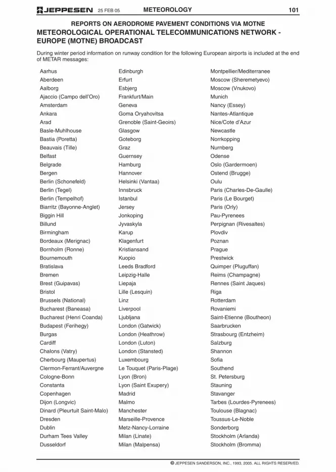
10125 FEB 05
© JEPPESEN SANDERSON, INC., 1993, 2005. ALL RIGHTS RESERVED.
REPORTS ON AERODROME PAVEMENT CONDITIONS VIA MOTNE
METEOROLOGY
METEOROLOGICAL OPERATIONAL TELECOMMUNICATIONS NETWORK -EUROPE (MOTNE) BROADCAST
During winter period information on runway condition for the following European airports is included at the endof METAR messages:
Aarhus Edinburgh Montpellier/Mediterranee
Aberdeen Erfurt Moscow (Sheremetyevo)
Aalborg Esbjerg Moscow (Vnukovo)
Ajaccio (Campo dell’Oro) Frankfurt/Main Munich
Amsterdam Geneva Nancy (Essey)
Ankara Goma Oryahovitsa Nantes-Atlantique
Arad Grenoble (Saint-Geoirs) Nice/Cote d’Azur
Basle-Muhlhouse Glasgow Newcastle
Bastia (Poretta) Goteborg Norrkopping
Beauvais (Tille) Graz Nurnberg
Belfast Guernsey Odense
Belgrade Hamburg Oslo (Gardermoen)
Bergen Hannover Ostend (Brugge)
Berlin (Schonefeld) Helsinki (Vantaa) Oulu
Berlin (Tegel) Innsbruck Paris (Charles-De-Gaulle)
Berlin (Tempelhof) Istanbul Paris (Le Bourget)
Biarritz (Bayonne-Anglet) Jersey Paris (Orly)
Biggin Hill Jonkoping Pau-Pyrenees
Billund Jyvaskyla Perpignan (Rivesaltes)
Birmingham Karup Plovdiv
Bordeaux (Merignac) Klagenfurt Poznan
Bornholm (Ronne) Kristiansand Prague
Bournemouth Kuopio Prestwick
Bratislava Leeds Bradford Quimper (Pluguffan)
Bremen Leipzig-Halle Reims (Champagne)
Brest (Guipavas) Liepaja Rennes (Saint Jaques)
Bristol Lille (Lesquin) Riga
Brussels (National) Linz Rotterdam
Bucharest (Baneasa) Liverpool Rovaniemi
Bucharest (Henri Coanda) Ljubljana Saint-Etienne (Boutheon)
Budapest (Ferihegy) London (Gatwick) Saarbrucken
Burgas London (Heathrow) Strasbourg (Entzheim)
Cardiff London (Luton) Salzburg
Chalons (Vatry) London (Stansted) Shannon
Cherbourg (Maupertus) Luxembourg Sofia
Clermon-Ferrant/Auvergne Le Touquet (Paris-Plage) Southend
Cologne-Bonn Lyon (Bron) St. Petersburg
Constanta Lyon (Saint Exupery) Stauning
Copenhagen Madrid Stavanger
Dijon (Longvic) Malmo Tarbes (Lourdes-Pyrenees)
Dinard (Pleurtuit Saint-Malo) Manchester Toulouse (Blagnac)
Dresden Marseille-Provence Toussus-Le-Noble
Dublin Metz-Nancy-Lorraine Sonderborg
Durham Tees Valley Milan (Linate) Stockholm (Arlanda)
Dusseldorf Milan (Malpensa) Stockholm (Bromma)

10 25 FEB 05
© JEPPESEN SANDERSON, INC., 1999, 2005. ALL RIGHTS RESERVED.
METEOROLOGICAL SERVICE FOR INTERNATIONAL AIR NAVIGATION - ANNEX 3
METEOROLOGY
4.6.5.4 Recommendation – Where observa-tions of cloud amount and/or height of cloud baseare made using automatic observation systems, pro-vision should be made for manual insertion of cloudamounts and, where appropriate, cloud type, togeth-er with the heights of those layers or masses not di-rectly measurable by that equipment.
4.6.6 Air Temperature and dew-pointtemperature
4.6.6.1 The air temperature and the dew-pointtemperature shall be measured and reported in de-grees Celsius.
4.6.6.2 Recommendation – Observation of airtemperature and dew-point temperature for localroutine and special reports and METAR and SPECIshould be representative for the whole runway com-plex.
4.6.7 Atmospheric Pressure
The atmospheric pressure shall be measured, andQNH and QFE values shall be computed and report-ed in hectopascals.
4.6.8 Supplementary information
4.6.8.1 Recommendation – Observations madeat aerodromes should include the available supple-mentary information concerning significant meteoro-logical conditions, particularly those in the approachand climb-out areas. Where practicable, the informa-tion should identify the location of the meteorologicalcondition.
4.6.8.2 Recommendation – Where observa-tions are made using automatic observing systems,provision should be made for manual insertion of in-formation concerning significant meteorological con-ditions which cannot be determined adequately bythat equipment.
4.7 REPORTING OF INFORMATIONFROM AUTOMATIC OBSERVINGSYSTEMS
Recommendation – METAR and SPECI from auto-matic observing systems should only be used duringnon-operational hours of the aerodrome. TheseMETAR and SPECI should be identified with theword ‘AUTO’.
4.8 OBSERVATION AND REPORTS OFVOLCANIC ACTIVITY
Recommendation – The occurrence of pre-eruptionvolcanic activity, volcanic eruptions and volcanic ashcloud should be reported without delay to the asso-ciated air traffic services unit, aeronautical informa-tion services unit and meteorological watch office.The report should be made in the form of a volcanicactivity report comprising the following information:
a. message type, VOLCANIC ACTIVITY REPORT;
b. station identifier, location indicator or name ofstation;
c. date/time of message;
d. location of volcano and name, if known; and
e. concise description of event including, as appro-priate, level of intensity of volcanic activity, occur-
rence of an eruption and its date and time andthe existence of a volcanic ash cloud in the areatogether with direction of ash cloud movementand height.
NOTE: Pre-eruption volcanic activity in this contextmeans unusual and/or increasing volcanic activitywhich could presage a volcanic eruption.
CHAPTER 5 – AIRCRAFTOBSERVATIONS AND REPORTS
NOTE: Technical specifications and detailed criteriarelated to this chapter are given in Annex 4.
5.1 OBLIGATIONS OF STATES
Each Contracting State shall arrange, according tothe provisions of this chapter, for observations to bemade by aircraft of its registry operating on interna-tional air routes and for the recording and reportingof these observations.
5.2 TYPES OF AIRCRAFTOBSERVATIONS
The following aircraft observations shall be made:
a. routine aircraft observations during en route andclimb-out phases of the flight and;
b. special and other non-routine aircraft observa-tions during any phase of the flight.
5.3 ROUTINE AIRCRAFTOBSERVATIONS - DESIGNATION
5.3.1 Recommendation – When air-grounddata link is used and automatic dependent surveil-lance (ADS) is being applied, automated routine ob-servations should be made every 15 minutes duringthe en-route phase and every 30 seconds duringclimb-out for the first 10 minutes of the flight.
5.3.2 When voice communications are used,routine observations shall be made during en-routephase in relation to those air traffic services report-ing points or intervals:
a. at which the applicable air traffic services proce-dures require routine reports; and
b. which are those separated by distances corre-sponding most closely to intervals of one hour offlying time.
5.3.3 Recommendation – For helicopter oper-ations to and from aerodromes on offshore struc-tures, routine observations should be made from he-licopters at points and times as agreed between themeteorological authorities and the helicopter opera-tors concerned.
5.3.4 In the case of air routes with high densitytraffic (e.g. organized tracks), an aircraft from amongthe aircraft operating at each flight level shall be des-ignated, at approximately hourly intervals, to makeroutine observations in accordance with 5.3.1 or5.3.2, as appropriate. The designation proceduresshall be subject to regional air navigation agree-ment.

TABLE OF CONTENTS
METEOROLOGY PB-V
Hawaii . . . . . . . . . . . . . . . . . . . . . . . . . . . . . . . . . . . . . . . . . . . . . . . . . . . . . . . . . . . . . . . . . . . . . . . . . . PB-2Hong Kong . . . . . . . . . . . . . . . . . . . . . . . . . . . . . . . . . . . . . . . . . . . . . . . . . . . . . . . . . . . . . . . . . . . . . . PB-2Indonesia . . . . . . . . . . . . . . . . . . . . . . . . . . . . . . . . . . . . . . . . . . . . . . . . . . . . . . . . . . . . . . . . . . . . . . . PB-2Japan . . . . . . . . . . . . . . . . . . . . . . . . . . . . . . . . . . . . . . . . . . . . . . . . . . . . . . . . . . . . . . . . . . . . . . . . . . PB-3Kiribati. . . . . . . . . . . . . . . . . . . . . . . . . . . . . . . . . . . . . . . . . . . . . . . . . . . . . . . . . . . . . . . . . . . . . . . . . . PB-4Korea . . . . . . . . . . . . . . . . . . . . . . . . . . . . . . . . . . . . . . . . . . . . . . . . . . . . . . . . . . . . . . . . . . . . . . . . . . PB-4Marshall Is . . . . . . . . . . . . . . . . . . . . . . . . . . . . . . . . . . . . . . . . . . . . . . . . . . . . . . . . . . . . . . . . . . . . . . PB-5Malaysia . . . . . . . . . . . . . . . . . . . . . . . . . . . . . . . . . . . . . . . . . . . . . . . . . . . . . . . . . . . . . . . . . . . . . . . . PB-5Micronesia, Federated States of . . . . . . . . . . . . . . . . . . . . . . . . . . . . . . . . . . . . . . . . . . . . . . . . . . . . . . PB-5Myanmar. . . . . . . . . . . . . . . . . . . . . . . . . . . . . . . . . . . . . . . . . . . . . . . . . . . . . . . . . . . . . . . . . . . . . . . . PB-5New Zealand. . . . . . . . . . . . . . . . . . . . . . . . . . . . . . . . . . . . . . . . . . . . . . . . . . . . . . . . . . . . . . . . . . . . . PB-5Northern Mariana Is . . . . . . . . . . . . . . . . . . . . . . . . . . . . . . . . . . . . . . . . . . . . . . . . . . . . . . . . . . . . . . . PB-5Palau. . . . . . . . . . . . . . . . . . . . . . . . . . . . . . . . . . . . . . . . . . . . . . . . . . . . . . . . . . . . . . . . . . . . . . . . . . . PB-5Papua New Guinea. . . . . . . . . . . . . . . . . . . . . . . . . . . . . . . . . . . . . . . . . . . . . . . . . . . . . . . . . . . . . . . . PB-6Philippines . . . . . . . . . . . . . . . . . . . . . . . . . . . . . . . . . . . . . . . . . . . . . . . . . . . . . . . . . . . . . . . . . . . . . . PB-6Singapore . . . . . . . . . . . . . . . . . . . . . . . . . . . . . . . . . . . . . . . . . . . . . . . . . . . . . . . . . . . . . . . . . . . . . . . PB-6Solomon Is . . . . . . . . . . . . . . . . . . . . . . . . . . . . . . . . . . . . . . . . . . . . . . . . . . . . . . . . . . . . . . . . . . . . . . PB-6Taiwan. . . . . . . . . . . . . . . . . . . . . . . . . . . . . . . . . . . . . . . . . . . . . . . . . . . . . . . . . . . . . . . . . . . . . . . . . . PB-6Thailand . . . . . . . . . . . . . . . . . . . . . . . . . . . . . . . . . . . . . . . . . . . . . . . . . . . . . . . . . . . . . . . . . . . . . . . . PB-6Tonga . . . . . . . . . . . . . . . . . . . . . . . . . . . . . . . . . . . . . . . . . . . . . . . . . . . . . . . . . . . . . . . . . . . . . . . . . . PB-6Vanuatu. . . . . . . . . . . . . . . . . . . . . . . . . . . . . . . . . . . . . . . . . . . . . . . . . . . . . . . . . . . . . . . . . . . . . . . . . PB-6Vietnam. . . . . . . . . . . . . . . . . . . . . . . . . . . . . . . . . . . . . . . . . . . . . . . . . . . . . . . . . . . . . . . . . . . . . . . . . PB-6Wake I. . . . . . . . . . . . . . . . . . . . . . . . . . . . . . . . . . . . . . . . . . . . . . . . . . . . . . . . . . . . . . . . . . . . . . . . . . PB-6Western Samoa . . . . . . . . . . . . . . . . . . . . . . . . . . . . . . . . . . . . . . . . . . . . . . . . . . . . . . . . . . . . . . . . . . PB-6
AVAILABILITY OF VOLMET BROADCASTS - PACIFIC BASIN . . . . . . . . . . . . . . . . . . . . . . . . . . . . . . . . . PB-7
VOLMET BROADCASTS IN PLAIN LANGUAGE - PACIFIC BASIN . . . . . . . . . . . . . . . . . . . . . . . . . . . . . . PB-8
LOCATIONS OF MET BROADCAST STATIONS - PACIFIC . . . . . . . . . . . . . . . . . . . . . . . . . . . . . . . . . . . PB-13
AERONAUTICAL ENROUTE INFORMATION SERVICE. . . . . . . . . . . . . . . . . . . . . . . . . . . . . . . . . . . . JAPAN-1
17 JUN 05
© JEPPESEN SANDERSON, INC., 1995, 2005. ALL RIGHTS RESERVED.

TABLE OF CONTENTS
METEOROLOGYPB-IV
APPENDIX 6 – TECHNICAL SPECIFICATIONS RELATED TO SIGMET AND AIRMET INFORMATION,AERODROME WARNINGS AND WIND SHEAR WARNINGS . . . . . . . . . . . . . . . . . . . . . . . . . . . . . . . . . . . 79
1. SPECIFICATIONS RELATED TO SIGMET INFORMATION . . . . . . . . . . . . . . . . . . . . . . . . . . 791.1 Format of SIGMET messages . . . . . . . . . . . . . . . . . . . . . . . . . . . . . . . . . . . . . . . . . . . . . . . . . 791.2 Dissemination of SIGMET messages . . . . . . . . . . . . . . . . . . . . . . . . . . . . . . . . . . . . . . . . . . . 802. SPECIFICATIONS RELATED TO AIRMET INFORMATION . . . . . . . . . . . . . . . . . . . . . . . . . . 812.1 Format of AIRMET messages . . . . . . . . . . . . . . . . . . . . . . . . . . . . . . . . . . . . . . . . . . . . . . . . . 812.2 Dissemination of AIRMET messages . . . . . . . . . . . . . . . . . . . . . . . . . . . . . . . . . . . . . . . . . . . 823. SPECIFICATIONS RELATED TO SPECIAL AIR-REPORTS. . . . . . . . . . . . . . . . . . . . . . . . . . 824. DETAILED CRITERIA RELATED TO SIGMET AND AIRMET MESSAGES
AND SPECIAL AIR-REPORTS (UPLINK) . . . . . . . . . . . . . . . . . . . . . . . . . . . . . . . . . . . . . . . . 824.1 Identification of the flight information region . . . . . . . . . . . . . . . . . . . . . . . . . . . . . . . . . . . . . . 824.2 Criteria related to phenomena included in SIGMET and AIRMET
messages and special air-reports (uplink) . . . . . . . . . . . . . . . . . . . . . . . . . . . . . . . . . . . . . . . . 825. SPECIFICATIONS RELATED TO AERODROME WARNINGS . . . . . . . . . . . . . . . . . . . . . . . . 835.1 Forms and dissemination of aerodrome warnings . . . . . . . . . . . . . . . . . . . . . . . . . . . . . . . . . . 835.2 Quantitative criteria for aerodrome warnings . . . . . . . . . . . . . . . . . . . . . . . . . . . . . . . . . . . . . . 846. SPECIFICATIONS RELATED TO WIND SHEAR WARNINGS . . . . . . . . . . . . . . . . . . . . . . . . 846.1 Detection of wind shear . . . . . . . . . . . . . . . . . . . . . . . . . . . . . . . . . . . . . . . . . . . . . . . . . . . . . . 846.2 Format and dissemination of wind shear warnings . . . . . . . . . . . . . . . . . . . . . . . . . . . . . . . . . 84
Table A6-1 - Template for SIGMET and AIRMET messages and special air-reports (uplink) . . . . . . . . . 85Table A6-2 - Template for aerodrome warnings . . . . . . . . . . . . . . . . . . . . . . . . . . . . . . . . . . . . . . . . . . . . 91Table A6-3 - Template for wind shear warnings . . . . . . . . . . . . . . . . . . . . . . . . . . . . . . . . . . . . . . . . . . . . 92Table A6-4 - Ranges and resolutions for numerical elements included in
volcanic ash and tropical cyclone advisory messages, SIGMET/AIRMETmessages and aerodrome and wind shear warnings . . . . . . . . . . . . . . . . . . . . . . . . . . . . . . . . . . . . . . 93
Example A6-1 - SIGMET and AIRMET messages and the corresponding cancellations. . . . . . . . . . . . . 93Example A6-2 - SIGMET messages for tropical cyclone . . . . . . . . . . . . . . . . . . . . . . . . . . . . . . . . . . . . . 94Example A6-3 - SIGMET messages for volcanic ash. . . . . . . . . . . . . . . . . . . . . . . . . . . . . . . . . . . . . . . . 94Example A6-4 - SIGMET messages for severe turbulence . . . . . . . . . . . . . . . . . . . . . . . . . . . . . . . . . . . 94Example A6-5 - AIRMET messages for moderate mountain wave. . . . . . . . . . . . . . . . . . . . . . . . . . . . . . 95
DECODE OF EIGHT FIGURE GROUP APPENDED TO MOTNE/OPMET BROADCASTS . . . . . . . . . . . . . . 97Runway Designator (First and Second Digits) . . . . . . . . . . . . . . . . . . . . . . . . . . . . . . . . . . . . . . . . . . . 97Runway Deposits (Third Digit) . . . . . . . . . . . . . . . . . . . . . . . . . . . . . . . . . . . . . . . . . . . . . . . . . . . . . . . 97Extent of Runway Contamination (Fourth Digit) . . . . . . . . . . . . . . . . . . . . . . . . . . . . . . . . . . . . . . . . . . 97Depth of Deposit (Fifth and Sixth Digits). . . . . . . . . . . . . . . . . . . . . . . . . . . . . . . . . . . . . . . . . . . . . . . . 97Friction Co-Efficient or Braking Action (Seventh and Eighth Digits) . . . . . . . . . . . . . . . . . . . . . . . . . . . 98Examples . . . . . . . . . . . . . . . . . . . . . . . . . . . . . . . . . . . . . . . . . . . . . . . . . . . . . . . . . . . . . . . . . . . . . . . 98
REPORTS ON AERODROME PAVEMENT CONDITIONS VIA MOTNEMETEOROLOGICAL OPERATIONAL TELECOMMUNICATIONS NETWORK - EUROPE(MOTNE) BROADCAST . . . . . . . . . . . . . . . . . . . . . . . . . . . . . . . . . . . . . . . . . . . . . . . . . . . . . . . . . . . . . . . . 101
SERVICES AND TELEPHONE NUMBERS - PACIFIC BASIN
SERVICES . . . . . . . . . . . . . . . . . . . . . . . . . . . . . . . . . . . . . . . . . . . . . . . . . . . . . . . . . . . . . . . . . . . . . . . . . . PB-1Prior to Departure . . . . . . . . . . . . . . . . . . . . . . . . . . . . . . . . . . . . . . . . . . . . . . . . . . . . . . . . . . . . . . . . . PB-1During Flight . . . . . . . . . . . . . . . . . . . . . . . . . . . . . . . . . . . . . . . . . . . . . . . . . . . . . . . . . . . . . . . . . . . . . PB-1Facility Abbreviations . . . . . . . . . . . . . . . . . . . . . . . . . . . . . . . . . . . . . . . . . . . . . . . . . . . . . . . . . . . . . . PB-1
TELEPHONE NUMBERS . . . . . . . . . . . . . . . . . . . . . . . . . . . . . . . . . . . . . . . . . . . . . . . . . . . . . . . . . . . . . . PB-1American Samoa . . . . . . . . . . . . . . . . . . . . . . . . . . . . . . . . . . . . . . . . . . . . . . . . . . . . . . . . . . . . . . . . . PB-1Australia . . . . . . . . . . . . . . . . . . . . . . . . . . . . . . . . . . . . . . . . . . . . . . . . . . . . . . . . . . . . . . . . . . . . . . . . PB-1Brunei . . . . . . . . . . . . . . . . . . . . . . . . . . . . . . . . . . . . . . . . . . . . . . . . . . . . . . . . . . . . . . . . . . . . . . . . . . PB-1Cambodia . . . . . . . . . . . . . . . . . . . . . . . . . . . . . . . . . . . . . . . . . . . . . . . . . . . . . . . . . . . . . . . . . . . . . . . PB-2Cook Is . . . . . . . . . . . . . . . . . . . . . . . . . . . . . . . . . . . . . . . . . . . . . . . . . . . . . . . . . . . . . . . . . . . . . . . . . PB-2Fiji Is . . . . . . . . . . . . . . . . . . . . . . . . . . . . . . . . . . . . . . . . . . . . . . . . . . . . . . . . . . . . . . . . . . . . . . . . . . . PB-2French Pacific Territories . . . . . . . . . . . . . . . . . . . . . . . . . . . . . . . . . . . . . . . . . . . . . . . . . . . . . . . . . . . PB-2Guam . . . . . . . . . . . . . . . . . . . . . . . . . . . . . . . . . . . . . . . . . . . . . . . . . . . . . . . . . . . . . . . . . . . . . . . . . . PB-2
17 JUN 05
© JEPPESEN SANDERSON, INC., 1995, 2005. ALL RIGHTS RESERVED.

TABLE OF CONTENTS
METEOROLOGY PB-III
APPENDIX 3 – TECHNICAL SPECIFICATIONS RELATED TO METEOROLOGICALOBSERVATIONS AND REPORTS. . . . . . . . . . . . . . . . . . . . . . . . . . . . . . . . . . . . . . . . . . . . . . . . . . . . . . . . . 47
Table A3-1 - Template for local routine (MET REPORT) and local (SPECI) reports. . . . . . . . . . . . . . . . . 47Table A3-2 - Template for METAR and SPECI . . . . . . . . . . . . . . . . . . . . . . . . . . . . . . . . . . . . . . . . . . . . . 51Table A3-3 - Use of change indicators in trend forecast . . . . . . . . . . . . . . . . . . . . . . . . . . . . . . . . . . . . . . 54Table A3-4 - Ranges and resolutions for the numerical element included in local forecasts . . . . . . . . . . 54Table A3-5 - Ranges and resolutions for the numerical elements included in METAR and SPECI . . . . . 55Example A3-1 - Routine report . . . . . . . . . . . . . . . . . . . . . . . . . . . . . . . . . . . . . . . . . . . . . . . . . . . . . . . . . 56Example A3-2 - Special report . . . . . . . . . . . . . . . . . . . . . . . . . . . . . . . . . . . . . . . . . . . . . . . . . . . . . . . . . 56Example A3-3 - Volcanic activity report . . . . . . . . . . . . . . . . . . . . . . . . . . . . . . . . . . . . . . . . . . . . . . . . . . 56
APPENDIX 4 – TECHNICAL SPECIFICATIONS RELATED TO AIRCRAFTOBSERVATIONS AND REPORTS. . . . . . . . . . . . . . . . . . . . . . . . . . . . . . . . . . . . . . . . . . . . . . . . . . . . . . . . . 57
1. CONTENTS OF AIR-REPORTS . . . . . . . . . . . . . . . . . . . . . . . . . . . . . . . . . . . . . . . . . . . . . . . 571.1 Routine air-reports by air-ground data link. . . . . . . . . . . . . . . . . . . . . . . . . . . . . . . . . . . . . . . . 571.2 Special air-reports by air-ground data link . . . . . . . . . . . . . . . . . . . . . . . . . . . . . . . . . . . . . . . . 571.3 Routine air-reports by voice communications . . . . . . . . . . . . . . . . . . . . . . . . . . . . . . . . . . . . . 581.4 Special air-reports by voice communications. . . . . . . . . . . . . . . . . . . . . . . . . . . . . . . . . . . . . . 592. CRITERIA FOR REPORTING . . . . . . . . . . . . . . . . . . . . . . . . . . . . . . . . . . . . . . . . . . . . . . . . . 592.2 Wind direction . . . . . . . . . . . . . . . . . . . . . . . . . . . . . . . . . . . . . . . . . . . . . . . . . . . . . . . . . . . . . 592.3 Wind speed . . . . . . . . . . . . . . . . . . . . . . . . . . . . . . . . . . . . . . . . . . . . . . . . . . . . . . . . . . . . . . . 592.4 Wind quality flag. . . . . . . . . . . . . . . . . . . . . . . . . . . . . . . . . . . . . . . . . . . . . . . . . . . . . . . . . . . . 592.5 Temperature . . . . . . . . . . . . . . . . . . . . . . . . . . . . . . . . . . . . . . . . . . . . . . . . . . . . . . . . . . . . . . . 592.6 Turbulence . . . . . . . . . . . . . . . . . . . . . . . . . . . . . . . . . . . . . . . . . . . . . . . . . . . . . . . . . . . . . . . . 59
Table A4-1 - Turbulence index to be reported. . . . . . . . . . . . . . . . . . . . . . . . . . . . . . . . . . . . . . . . . . . . . . 60Table A4-2 - Time of occurrence of the peak value to be reported. . . . . . . . . . . . . . . . . . . . . . . . . . . . . . 60Table A4-3 - Template for special air-report (downlink). . . . . . . . . . . . . . . . . . . . . . . . . . . . . . . . . . . . . . . 61Table A4-4 - Ranges and resolutions for the meteorological elements included in air-reports . . . . . . . . . 62
APPENDIX 5 – TECHNICAL SPECIFICATIONS RELATED TO FORCASTS . . . . . . . . . . . . . . . . . . . . . . . . . 631. CRITERIA RELATED TO TAF . . . . . . . . . . . . . . . . . . . . . . . . . . . . . . . . . . . . . . . . . . . . . . . . . 631.1 TAF format . . . . . . . . . . . . . . . . . . . . . . . . . . . . . . . . . . . . . . . . . . . . . . . . . . . . . . . . . . . . . . . . 631.2 Inclusion of meteorological elements in TAF . . . . . . . . . . . . . . . . . . . . . . . . . . . . . . . . . . . . . . 631.3 Use of change groups . . . . . . . . . . . . . . . . . . . . . . . . . . . . . . . . . . . . . . . . . . . . . . . . . . . . . . . 641.4 Use of probability groups . . . . . . . . . . . . . . . . . . . . . . . . . . . . . . . . . . . . . . . . . . . . . . . . . . . . . 651.5 Numbers of change and probability groups . . . . . . . . . . . . . . . . . . . . . . . . . . . . . . . . . . . . . . . 662. CRITERIA RELATED TO TREND FORECASTS. . . . . . . . . . . . . . . . . . . . . . . . . . . . . . . . . . . 662.1 Format of trends forecasts . . . . . . . . . . . . . . . . . . . . . . . . . . . . . . . . . . . . . . . . . . . . . . . . . . . . 662.2 Inclusion of meteorological elements in trend forecasts . . . . . . . . . . . . . . . . . . . . . . . . . . . . . 662.3 Use of change indicators . . . . . . . . . . . . . . . . . . . . . . . . . . . . . . . . . . . . . . . . . . . . . . . . . . . . . 672.4 Use of probability indicators. . . . . . . . . . . . . . . . . . . . . . . . . . . . . . . . . . . . . . . . . . . . . . . . . . . 683. CRITERIA RELATED TO FORECASTS FOR TAKE-OFF . . . . . . . . . . . . . . . . . . . . . . . . . . . . 683.1 Format of forecast for take-off . . . . . . . . . . . . . . . . . . . . . . . . . . . . . . . . . . . . . . . . . . . . . . . . . 683.2 Amendments to forecasts for take-off . . . . . . . . . . . . . . . . . . . . . . . . . . . . . . . . . . . . . . . . . . . 684. CRITERIA RELATED TO AREA AND ROUTE FORECASTS, OTHER THAN
FORECASTS ISSUED WITHIN THE FRAMEWORK OF THE WORLDAREA FORECAST SYSTEM. . . . . . . . . . . . . . . . . . . . . . . . . . . . . . . . . . . . . . . . . . . . . . . . . . 68
4.1 Format of area and route forecasts . . . . . . . . . . . . . . . . . . . . . . . . . . . . . . . . . . . . . . . . . . . . . 684.2 Amendments to area and route forecasts . . . . . . . . . . . . . . . . . . . . . . . . . . . . . . . . . . . . . . . . 685. CRITERIA RELATED TO AREA FORECASTS FOR LOW-LEVEL FLIGHTS . . . . . . . . . . . . . 695.1 Format and content of GAMET area forecasts . . . . . . . . . . . . . . . . . . . . . . . . . . . . . . . . . . . . 695.2 Amendments to GAMET area forecasts . . . . . . . . . . . . . . . . . . . . . . . . . . . . . . . . . . . . . . . . . 705.3 Exchange of area forecasts for low-level flights . . . . . . . . . . . . . . . . . . . . . . . . . . . . . . . . . . . . 70
Table A5-1 - Template for TAF . . . . . . . . . . . . . . . . . . . . . . . . . . . . . . . . . . . . . . . . . . . . . . . . . . . . . . . . . 71Table A5-2 - Use of change and time indicators in TAF . . . . . . . . . . . . . . . . . . . . . . . . . . . . . . . . . . . . . . 75Table A5-3 - Ranges and resolutions for the numerical elements included in TAF. . . . . . . . . . . . . . . . . . 75Example A5-1 - TAF . . . . . . . . . . . . . . . . . . . . . . . . . . . . . . . . . . . . . . . . . . . . . . . . . . . . . . . . . . . . . . . . . 76Example A5-2 - Cancellation of TAF. . . . . . . . . . . . . . . . . . . . . . . . . . . . . . . . . . . . . . . . . . . . . . . . . . . . . 76Example A5-3 - GAMET area forecasts . . . . . . . . . . . . . . . . . . . . . . . . . . . . . . . . . . . . . . . . . . . . . . . . . . 77
© JEPPESEN SANDERSON, INC., 1995, 2005. ALL RIGHTS RESERVED.
17 JUN 05

TABLE OF CONTENTS
METEOROLOGYPB-II
CHAPTER 7 – SIGMET AND AIRMET INFORMATION, AERODROMEWARNINGS AND WIND SHEAR WARNINGS . . . . . . . . . . . . . . . . . . . . . . . . . . . . . . . . . . . . . . . . . . . . . . . 13
7.1 SIGMET Information . . . . . . . . . . . . . . . . . . . . . . . . . . . . . . . . . . . . . . . . . . . . . . . . . . . . . . . . 137.2 AIRMET Information . . . . . . . . . . . . . . . . . . . . . . . . . . . . . . . . . . . . . . . . . . . . . . . . . . . . . . . . 137.3 Aerodrome Warnings . . . . . . . . . . . . . . . . . . . . . . . . . . . . . . . . . . . . . . . . . . . . . . . . . . . . . . . . 14
CHAPTER 8 – AERONAUTICAL CLIMATOLOGICAL INFORMATION . . . . . . . . . . . . . . . . . . . . . . . . . . . . . . 148.1 General Provisions. . . . . . . . . . . . . . . . . . . . . . . . . . . . . . . . . . . . . . . . . . . . . . . . . . . . . . . . . . 14
CHAPTER 9 – SERVICE FOR OPERATORS AND FLIGHT CREW MEMBERS . . . . . . . . . . . . . . . . . . . . . . 149.1 General Provisions. . . . . . . . . . . . . . . . . . . . . . . . . . . . . . . . . . . . . . . . . . . . . . . . . . . . . . . . . . 149.2 Information for Operators for Pre-Flight Planning and for
In-Flight Re-Planning Under Centralized Operational Control . . . . . . . . . . . . . . . . . . . . . . . . . 159.3 Briefing, Consultation and Display . . . . . . . . . . . . . . . . . . . . . . . . . . . . . . . . . . . . . . . . . . . . . . 159.4 Flight Documentation - General . . . . . . . . . . . . . . . . . . . . . . . . . . . . . . . . . . . . . . . . . . . . . . . . 169.5 Automated Pre-flight Information Systems for Briefing, Consultation,
Flight Planning and Flight Documentation . . . . . . . . . . . . . . . . . . . . . . . . . . . . . . . . . . . . . . . . 169.6 Information for Aircraft in Flight . . . . . . . . . . . . . . . . . . . . . . . . . . . . . . . . . . . . . . . . . . . . . . . . 17
CHAPTER 10 – INFORMATION FOR AIR TRAFFIC SERVICES, SEARCH AND RESCUESERVICES AND AERONAUTICAL INFORMATION SERVICES . . . . . . . . . . . . . . . . . . . . . . . . . . . . . . . . . . 17
10.1 Information for Air Traffic Service Units . . . . . . . . . . . . . . . . . . . . . . . . . . . . . . . . . . . . . . . . . . 1710.2 Information for Search and Rescue Services Units . . . . . . . . . . . . . . . . . . . . . . . . . . . . . . . . . 1710.3 Information for Aeronautical Information Services Units . . . . . . . . . . . . . . . . . . . . . . . . . . . . . 17
CHAPTER 11 – REQUIREMENTS FOR AND USE OF COMMUNICATIONS . . . . . . . . . . . . . . . . . . . . . . . . 1711.1 Requirements for Communications . . . . . . . . . . . . . . . . . . . . . . . . . . . . . . . . . . . . . . . . . . . . . 1711.2 Use of Aeronautical Fixed Service Communications -
Meteorological Bulletins in Alphanumeric Format . . . . . . . . . . . . . . . . . . . . . . . . . . . . . . . . . . 1811.3 Use of Aeronautical Fixed Service Communications -
World Area Forecast System Products . . . . . . . . . . . . . . . . . . . . . . . . . . . . . . . . . . . . . . . . . . 1811.4 Use of Aeronautical Mobile Service Communication . . . . . . . . . . . . . . . . . . . . . . . . . . . . . . . . 1811.5 Use of Aeronautical Data Link Service - Contents of D-VOLMET . . . . . . . . . . . . . . . . . . . . . . 1811.6 Use of Aeronautical Broadcast Service -
Contents of VOLMET Broadcasts . . . . . . . . . . . . . . . . . . . . . . . . . . . . . . . . . . . . . . . . . . . . . . 18
APPENDIX 1 – FLIGHT DOCUMENTATION - MODEL CHARTS AND FORMS . . . . . . . . . . . . . . . . . . . . . . . 19MODEL A - Aerodrome Forecasts - Example 1 - Tabular Form . . . . . . . . . . . . . . . . . . . . . . . . . . . . . . . . 20MODEL A - Aerodrome Forecasts - Example 2 - TAF . . . . . . . . . . . . . . . . . . . . . . . . . . . . . . . . . . . . . . . 21MODEL TA - Tabular Forecasts of enroute conditions - Example 1 - Low Level . . . . . . . . . . . . . . . . . . . 22MODEL TA - Tabular Forecasts of enroute conditions - Example 2 - Medium Level . . . . . . . . . . . . . . . . 23MODEL TB - Tabular Forecasts of upper winds and upper air temperatures . . . . . . . . . . . . . . . . . . . . . . 25MODEL IS - Upper wind and temperature chart for isobaric surface . . . . . . . . . . . . . . . . . . . . . . . . . . . . 26MODEL IS - Upper wind and temperature chart for standard isobaric surface . . . . . . . . . . . . . . . . . . . . 27MODEL SWH - Significant Weather Chart (High Level) . . . . . . . . . . . . . . . . . . . . . . . . . . . . . . . . . . . . . . 28MODEL SWM - Significant Weather Chart (Medium Level) . . . . . . . . . . . . . . . . . . . . . . . . . . . . . . . . . . . 31MODEL SWL - Significant Weather Chart (Low Level). . . . . . . . . . . . . . . . . . . . . . . . . . . . . . . . . . . . . . . 32MODEL VAG - Volcanic Ash Advisory Information In Graphic Format . . . . . . . . . . . . . . . . . . . . . . . . . . . 34MODEL SN - Notations Used In Flight Documentation . . . . . . . . . . . . . . . . . . . . . . . . . . . . . . . . . . . . . . 35
1. Symbols for Significant Weather . . . . . . . . . . . . . . . . . . . . . . . . . . . . . . . . . . . . . . . . . . . . . . . 352. Fronts and Convergence Zones and Other Symbols Used . . . . . . . . . . . . . . . . . . . . . . . . . . . 363. Abbreviations Used to Describe Clouds. . . . . . . . . . . . . . . . . . . . . . . . . . . . . . . . . . . . . . . . . . 374. Depicting of Lines and Systems on Specific Charts . . . . . . . . . . . . . . . . . . . . . . . . . . . . . . . . 37
APPENDIX 2 – TECHNICAL SPECIFICATIONS RELATED TO WORLD AREA FORECASTSYSTEMS AND METEOROLOGICAL OFFICES . . . . . . . . . . . . . . . . . . . . . . . . . . . . . . . . . . . . . . . . . . . . . 39
Table A2-1 - Template for advisory message for volcanic ash . . . . . . . . . . . . . . . . . . . . . . . . . . . . . . . . . 39Example A2-1 - Advisory message for volcanic ash. . . . . . . . . . . . . . . . . . . . . . . . . . . . . . . . . . . . . . . . . 43Table A2-2 - Template for advisory message for tropical cyclones . . . . . . . . . . . . . . . . . . . . . . . . . . . . . . 44Example A2-2 - Advisory message for tropical cyclones . . . . . . . . . . . . . . . . . . . . . . . . . . . . . . . . . . . . . 46
17 JUN 05
© JEPPESEN SANDERSON, INC., 1995, 2005. ALL RIGHTS RESERVED.

TABLE OF CONTENTS
METEOROLOGY PB-I
Below is a complete list of the standard contents of Airway Manual. Limited or special coverages may not con-tain all items, but that material which is included should be arranged in the order outlined.
TABLE OF CONTENTS . . . . . . . . . . . . . . . . . . . . . . . . . . . . . . . . . . . . . . . . . . . . . . . . . . . . . . . . . . . . . . . . .PB-I
METEOROLOGICAL SERVICE FOR INTERNATIONAL AIR NAVIGATION – ANNEX 3
CHAPTER 1 – DEFINITIONS . . . . . . . . . . . . . . . . . . . . . . . . . . . . . . . . . . . . . . . . . . . . . . . . . . . . . . . . . . . . . . 11.1 Definitions . . . . . . . . . . . . . . . . . . . . . . . . . . . . . . . . . . . . . . . . . . . . . . . . . . . . . . . . . . . . . . . . . 11.2 Terms Used With a Limited Meaning . . . . . . . . . . . . . . . . . . . . . . . . . . . . . . . . . . . . . . . . . . . . . 3
CHAPTER 2 – GENERAL PROVISIONS. . . . . . . . . . . . . . . . . . . . . . . . . . . . . . . . . . . . . . . . . . . . . . . . . . . . . . 32.1 Objective, Determination and Provision of Meteorological Service . . . . . . . . . . . . . . . . . . . . . . 32.2 Supply, Quality Assurance and Use of Meteorological Information . . . . . . . . . . . . . . . . . . . . . . 32.3 Notifications Required from Operators. . . . . . . . . . . . . . . . . . . . . . . . . . . . . . . . . . . . . . . . . . . . 4
CHAPTER 3 – WORLD AREA FORECAST SYSTEM AND METEOROLOGICAL OFFICES. . . . . . . . . . . . . . 43.1 Objectives of the World Area Forecast System . . . . . . . . . . . . . . . . . . . . . . . . . . . . . . . . . . . . . 43.2 World Area Forecast Centres. . . . . . . . . . . . . . . . . . . . . . . . . . . . . . . . . . . . . . . . . . . . . . . . . . . 43.3 Meteorological Offices . . . . . . . . . . . . . . . . . . . . . . . . . . . . . . . . . . . . . . . . . . . . . . . . . . . . . . . . 53.4 Meteorological Watch Offices . . . . . . . . . . . . . . . . . . . . . . . . . . . . . . . . . . . . . . . . . . . . . . . . . . 53.5 Volcanic Ash Advisory Centers . . . . . . . . . . . . . . . . . . . . . . . . . . . . . . . . . . . . . . . . . . . . . . . . . 63.6 State Volcanic Observatories . . . . . . . . . . . . . . . . . . . . . . . . . . . . . . . . . . . . . . . . . . . . . . . . . . . 63.7 Tropical Cyclone Advisory Centers . . . . . . . . . . . . . . . . . . . . . . . . . . . . . . . . . . . . . . . . . . . . . . 6
CHAPTER 4 – METEOROLOGICAL OBSERVATIONS AND REPORTS . . . . . . . . . . . . . . . . . . . . . . . . . . . . . 74.1 Aeronautical Meteorological Stations and Observations . . . . . . . . . . . . . . . . . . . . . . . . . . . . . . 74.2 Agreement Between Air Traffic Services Authorities and
Meteorological Authorities . . . . . . . . . . . . . . . . . . . . . . . . . . . . . . . . . . . . . . . . . . . . . . . . . . . . . 74.3 Routine Observations and Reports . . . . . . . . . . . . . . . . . . . . . . . . . . . . . . . . . . . . . . . . . . . . . . 84.4 Special Observations and Reports . . . . . . . . . . . . . . . . . . . . . . . . . . . . . . . . . . . . . . . . . . . . . . 84.5 Contents of Reports . . . . . . . . . . . . . . . . . . . . . . . . . . . . . . . . . . . . . . . . . . . . . . . . . . . . . . . . . . 84.6 Observing and Reporting Meteorological Elements . . . . . . . . . . . . . . . . . . . . . . . . . . . . . . . . . 94.7 Reporting of Information from Automatic Observing Systems . . . . . . . . . . . . . . . . . . . . . . . . . 104.8 Observations and Reports of Volcanic Activity . . . . . . . . . . . . . . . . . . . . . . . . . . . . . . . . . . . . 10
CHAPTER 5 – AIRCRAFT OBSERVATIONS AND REPORTS . . . . . . . . . . . . . . . . . . . . . . . . . . . . . . . . . . . . 105.1 Obligations of States . . . . . . . . . . . . . . . . . . . . . . . . . . . . . . . . . . . . . . . . . . . . . . . . . . . . . . . . 105.2 Types of Aircraft Observations . . . . . . . . . . . . . . . . . . . . . . . . . . . . . . . . . . . . . . . . . . . . . . . . . 105.3 Routine Aircraft Observations - Designation . . . . . . . . . . . . . . . . . . . . . . . . . . . . . . . . . . . . . . 105.4 Routine Aircraft Observations - Exemptions . . . . . . . . . . . . . . . . . . . . . . . . . . . . . . . . . . . . . . 115.5 Special Aircraft Observations. . . . . . . . . . . . . . . . . . . . . . . . . . . . . . . . . . . . . . . . . . . . . . . . . . 115.6 Other Non-Routine Aircraft Observations . . . . . . . . . . . . . . . . . . . . . . . . . . . . . . . . . . . . . . . . 115.7 Reporting of Aircraft Observations During Flight . . . . . . . . . . . . . . . . . . . . . . . . . . . . . . . . . . . 115.8 Relay of Air-Reports by ATS Units . . . . . . . . . . . . . . . . . . . . . . . . . . . . . . . . . . . . . . . . . . . . . . 115.9 Recording and Post-Flight Reporting of Aircraft Observations of Volcanic Activity . . . . . . . . . 11
CHAPTER 6 – FORECASTS . . . . . . . . . . . . . . . . . . . . . . . . . . . . . . . . . . . . . . . . . . . . . . . . . . . . . . . . . . . . . . 126.1 Interpretation and Use of Forecasts. . . . . . . . . . . . . . . . . . . . . . . . . . . . . . . . . . . . . . . . . . . . . 126.2 Aerodrome Forecasts. . . . . . . . . . . . . . . . . . . . . . . . . . . . . . . . . . . . . . . . . . . . . . . . . . . . . . . . 126.3 Landing Forecasts . . . . . . . . . . . . . . . . . . . . . . . . . . . . . . . . . . . . . . . . . . . . . . . . . . . . . . . . . . 126.4 Forecasts for Take-Off . . . . . . . . . . . . . . . . . . . . . . . . . . . . . . . . . . . . . . . . . . . . . . . . . . . . . . . 126.5 Area and Route Forecasts, Other Than Forecasts Issued within the
Framework of the World Area Forecast Systems. . . . . . . . . . . . . . . . . . . . . . . . . . . . . . . . . . . 126.6 Area Forecasts for Low-Level Flights . . . . . . . . . . . . . . . . . . . . . . . . . . . . . . . . . . . . . . . . . . . . 12
17 JUN 05
© JEPPESEN SANDERSON, INC., 1995, 2005. ALL RIGHTS RESERVED.

PB-918 NOV 05
Eff 24 Nov
© JEPPESEN SANDERSON, INC. 1993, 2005. ALL RIGHTS RESERVED.
AVAILABILITY OF VOLMET BROADCASTS - PACIFIC BASIN
METEOROLOGY
Bangkok BangkokRadio
11387 SSB
6676 SSB
2965 SSB
2310-1145
H24
1210-2245
10-15 SIGMET3
METReport/Special1
Bangkok Intl
MET Report2, 3 Yangon (Intl), Hanoi(Noibai), Chiang Mai,Rayong (U-Taphao),Phuket, Songkhla (HatYai), Ho Chi Minh,Phnom Penh,Vientiane
AerodromeForecast4
Bangkok Intl
40-45 SIGMET3
METReport/Special5
Bangkok Intl
MET Report3, 6 Yangon (Intl), Hanoi(Noibai), Chiang Mai,Rayong (U-Taphao),Phuket, Songkhla (HatYai), Ho Chi Minh,Phnom Penh,Vientiane
AerodromeForecast4
Bangkok Intl
NOTE:– 1 Latest routine or special report between H+00 and H+10, including trend statement, repeat at end of
broadcast if time permits.
– 2 H+00 (or the previous H+30 report when the H+00 report is not available), including trend statementwhen appended.
– 3 As available.
– 4 Valid for 9 hours.
– 5 Latest routine or special report between H+30 and H+35, including trend statement, repeated at end ofbroadcast if time permits.
– 6 H+30 (or the H+00 report when the H+30 report is not available), including trend statement whenappended.
Brisbane Australian 6676 SSB
11387 SSB
H24 00-05&
30-35
TRENDForecasts
Melbourne, Sydney,Brisbane, Perth,Darwin
TRENDForecast/Aerodrome Forecast
Cairns
TREND Forecast Townsville, Adelaide
STATION CALLSIGN
FREQS(kHz)
BROADCASTTIMES FORM BROADCAST
PERIOD H+
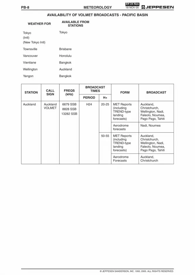
18 NOV 05Eff 24 Nov
PB-8
© JEPPESEN SANDERSON, INC. 1993, 2005. ALL RIGHTS RESERVED.
AVAILABILITY OF VOLMET BROADCASTS - PACIFIC BASIN
METEOROLOGY
Tokyo
(Intl)
(New Tokyo Intl)
Tokyo
Townsville Brisbane
Vancouver Honolulu
Vientiane Bangkok
Wellington Auckland
Yangon Bangkok
WEATHER FOR AVAILABLE FROMSTATIONS
STATION CALLSIGN
FREQS(kHz)
BROADCASTTIMES FORM BROADCAST
PERIOD H+
Auckland AucklandVOLMET
6679 SSB
8828 SSB
13282 SSB
H24 20-25 MET Reports(includingTREND-typelandingforecasts)
Auckland,Christchurch,Wellington, Nadi,Faleolo, Noumea,Pago Pago, Tahiti
Aerodromeforecasts
Nadi, Noumea
50-55 MET Reports(includingTREND-typelandingforecasts)
Auckland,Christchurch,Wellington, Nadi,Faleolo, Noumea,Pago Pago, Tahiti
AerodromeForecasts
Auckland,Christchurch

PB-718 NOV 05
Eff 24 Nov
© JEPPESEN SANDERSON, INC. 1993, 2005. ALL RIGHTS RESERVED.
AVAILABILITY OF VOLMET BROADCASTS - PACIFIC BASIN
METEOROLOGY
RADIOTELEPHONY
Identify location for which weather is desired andfind station(s) disseminating broadcast. Contents ofbroadcast of each Station is shown following the list-ing below.
WEATHER FOR AVAILABLE FROMSTATIONS
Adelaide Brisbane
Anchorage Honolulu
Auckland Auckland
Bangkok Bangkok
Brisbane Brisbane
Brunei Singapore
Cairns Brisbane
Chiang Mai Bangkok
Christchurch Auckland
Cold Bay Honolulu
Darwin Brisbane
Den Pasar Singapore
Elmendorf AFB Honolulu
Fairbanks Honolulu
Faleolo Auckland
Fukuoka Tokyo
Guam Honolulu
Guangzhou/Baiyun Hong Kong
Hanoi Bangkok
Hilo Honolulu
HoChiMinh Hong Kong
Hong Kong Hong Kong
Honolulu Honolulu
Kahului Honolulu
King Salmon Honolulu
Kota Kinabalu Singapore
Kuala Lumpur Singapore
Kuching Singapore
Las Vegas Honolulu
Los Angeles Honolulu
Macau Hong Kong
Mactan Hong Kong
Manila
(Intl)
Hong Kong
Melbourne Brisbane
Nagoya Tokyo
Naha Hong Kong
Nadi Auckland
Noumea Auckland
Ontario Honolulu
Osaka
(Kansai Intl)
Tokyo
Pago Pago Auckland
Penang Singapore
Perth Brisbane
Phnom Penh Bangkok
Phuket Bangkok
Portland Honolulu
Rayong
(U-Taphao)
Bangkok
Sacramento Honolulu
San Francisco Honolulu
Sapporo
(New Chitose)
Tokyo
Seattle Honolulu
Seoul/Incheon(Incheon Intl)
Tokyo
Singapore Singapore
Soekarno-Hatta Singapore
Songkhla/Hat Yai Bangkok
Subang Singapore
Sydney Brisbane
Tahiti Auckland
Taiwan
(Chiang Kai Shek)
(Kaohsiung Intl)
Taipei
WEATHER FOR AVAILABLE FROMSTATIONS

PB-6 11 FEB 05METEOROLOGY
© JEPPESEN SANDERSON, INC., 1993, 2005. ALL RIGHTS RESERVED.
SERVICES AND TELEPHONE NUMBERS - PACIFIC BASIN
PAPAU NEW GUINEA
PORTMORESBY
FIS 325-6787 or
324-4542
NWS 325-5544
325-8877 or
324-4725
MADANG FIS 852-2501
NADZAB FIS 472-2253
WEWAK FIS 856-2360
PHILIPPINES
MANILA MWO (632) 832-2596
877-1109 / Local3523
Fax (632)832-2927/832-3023
SINGAPORE
SINGAPORE
(Changi)
MWO (65) 65425059
Fax (65) 65425026
(Paya Lebar) MWO 63813156
(Seletar) MWO 64815978
SOLOMON IS
HONIARA
(Henderson)
MWO 21757 or 21758
TAIWAN
TAIPEI
(SungshanANWS)
MO-I (886) 2-8770-2167
Fax (886)2-8770-2234
THAILAND
BANGKOK
(Intl)
662-3994-566-75
Fax 662-3991613 /3994011
CHIANG MAI
(Intl)
CHIANG RAI
(Intl)
PHUKET
(Intl)
RAYONG
(U-Taphao Intl)
SONGKHLA
(Hat Yai Intl)
TONGA
FUA’AMOTU(Intl)
MO-III 676-32-001/002/003 (1200-0600) 6 hrsPNR
VANUATU
PORT VILA
(Bauerfield)
(678) 22-932
VIETNAM
DANANG
(Intl)
(84-511)823-391/97
Fax (84-511)823-393
HANOI
(Noibai Intl)
(84-4) 8-8271513ext 334
HOCHIMINH
(Tan Son NhatIntl)
(84-8) 8-443-179ext 2241
(84-8) 443-705
WAKE I
Wake I AAF IFSS Honolulu
1 800 WX BRIEF(992-7433)
WESTERN SAMOA
APIA MO-III (685) 20855
(685) 20856
THAILAND
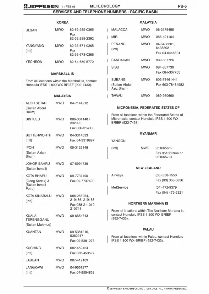
11 FEB 05 PB-5METEOROLOGY
© JEPPESEN SANDERSON, INC., 1993, 2005. ALL RIGHTS RESERVED.
SERVICES AND TELEPHONE NUMBERS - PACIFIC BASIN
ULSAN MWO 82-52-289-0365
Fax82-52-288-2392
YANGYANG
(Intl)
MWO 82-33-671-0365
Fax82-33-673-0366
YECHEON MWO 82-54-650-5772
MARSHALL IS
From all locations within the Marshall Is, contactHonolulu IFSS 1 800 WX BRIEF (992-7433).
MALAYSIA
ALOR SETAR
(Sultan AbdulHalim)
MWO 04-7144212
BINTULU MWO 086-334148 /332095
Fax 086-314386
BUTTERWORTH
(intl)
MWO 04-3314633
Fax 04-3319897
IPOH
(Sultan AzlanShah)
MWO 05-3125148
JOHOR BAHRU
(Sultan Ismail)
MWO 07-5994739
KOTA BHARU
(Gong Kedak) &(Sultan IsmailPetra)
MWO 09-7737490
Fax 09-7737490
KOTA KINABALU
(Intl)
MWO 088-256054,219186, 219188
Fax 088-211019,210741
KUALATERENGGANU
(Sultan Mahmud)
MWO 09-6664743
KUANTAN MWO 09-5381216,5382917
Fax 09-5381273
KUCHING
(Intl)
MWO 082-452454
Fax 082-453527
LABUAN MWO 087-412109
LANGKAWI
(Intl)
MWO 04-9551277
Fax 04-9554852
KOREA
MALACCA MWO 06-3175455
MIRI MWO 085-421104
PENANG
(Intl)
MWO 04-6438301,6438302
Fax 04-6446804
SANDAKAN MWO 089-667726
SIBU MWO 084-307730
Fax 084-307705
SUBANG
(Sultan AbdulAziz Shah)
MWO 603-78461441
Fax 603-78464982
TAWAU MWO 089-950660
MICRONESIA, FEDERATED STATES OF
From all locations within the Federated States ofMicronesia, contact Honolulu IFSS 1 800 WXBRIEF (922-7433).
MYANMAR
YANGON
(Intl) MWO 951665669
Fax 951665944 or951665704
NEW ZEALAND
Airways (03) 358-1550
Fax (03) 358-6856
MetService (04) 472-9379
Fax (04) 473-5321
NORTHERN MARIANA IS
From all locations within The Northern Mariana Is,contact Honolulu IFSS 1 800 WX BRIEF(992-7433).
PALAU
From all locations within Palau, contact HonoluluIFSS 1 800 WX-BRIEF (992-7433).
MALAYSIA

PB-4 23 SEP 05METEOROLOGY
© JEPPESEN SANDERSON, INC. 1993, 2005. ALL RIGHTS RESERVED.
SERVICES AND TELEPHONE NUMBERS - PACIFIC BASIN
NOTO AWS (0768) 26-1372
OBIHIRO AWS (0155) 64-5280
ODATE-NOSHIRO AWS (0186) 63-2704
OITA AWS (0978) 67-1190
OJIKA AWS (0957) 52-2300
OKAYAMA AWS (086) 294-3030
OKI AWS (06) 6852-7600
OKIERABU AWS (0997) 92-0239
OKUSHIRI AWS (0138) 54-4003
OSAKA
(Intl)
AWS (06) 6852-7600
OSHIMA AWS (04992) 2-1498
REBUN AWS (0162) 26-2638
RISHIRI AWS (0162) 26-2638
SADO AWS (025) 274-0564
SAGA AWS (0952) 46-0500
SAPPORO JSDF (011) 781-4595
SENDAI AWS (022) 383-2821
SHIMOJISHIMA AWS (0980) 78-4970
SHONAI AWS (0234) 92-4134
TAJIMA AWS (0796) 26-1500
TAKAMATSU AWS (087) 879-2230
TANEGASHIMA AWS (0997) 27-0228
TARAMA AWS (0980) 72-3055
TOKUNOSHIMA AWS (0997) 63-0244
TOKUSHIMA JSDF (088) 699-2680
TOKYOHELIPORT
AWS (03) 3521-5954
TOKYO
(Intl)
AWS (03) 5757-9680
TOTTORI AWS (0857) 28-0455
TOYAMA AWS (076) 495-3075
TSUSHIMA AWS (0920) 54-3392
WAKKANAI AWS (0162) 26-2638
YAKUSHIMA AWS (0997) 43-5320
YAMAGATA AWS (0237) 48-1115
JAPAN
YAMAGUCHI-UBE AWS (0836) 21-1818
YAO AWS (0729) 22-3915
YONAGUNI AWS (0980) 87-2802
YORON AWS (0997) 63-0244
KIRIBATI
TARAWA
(Betio)
MO-III 26459
Fax 26809
KOREA
BUSAN
(Gimhae Intl)
MWO 82-51-941-0365
Fax82-51-941-0366
CHEONGJU
(Intl)
MWO 82-43-213-0365
Fax82-43-213-0376
DAEGU
(Intl)
MWO 82-53-983-0365
Fax82-53-985-0366
GUNSAN MWO 82-63-470-4501(USAF)
470-4911 (ROKAF)
Fax82-63-470-4975(USAF)
GWANGJU
ROKAF(Republic ofKorea Air Force)
MWO 82-62-940-4776
JEJU
(Intl)
MWO 82-64-742-0365
Fax82-64-746-1046
MOKPO MWO 82-61-464-0365
Fax82-61-464-1179
POHANG MWO 82-54-290-6691Republic of KoreaNavy (ROKN)
SACHEON MWO ROKAF82-55-851-4773
SEOUL
(Gimpo Intl)
MWO 82-2-664-0365
Fax 82-2-664-0366
(Incheon Intl) MWO 82-32-740-2812
Fax82-32-740-2827
JAPAN

23 SEP 05 PB-3METEOROLOGY
© JEPPESEN SANDERSON, INC. 1993, 2005. ALL RIGHTS RESERVED.
SERVICES AND TELEPHONE NUMBERS - PACIFIC BASIN
MERAUKE FSS 62-971-21764
62-971-23884
Fax 62-971-22633
RENGAT
(Japura)
AFIS 62-769-41020
62-769-41276
SINGKEP
(Dabo)
AFIS 62-776-21273
Fax 62-776-21273
TERNATE
(Baabulah)
AFIS 62-921-21797
62-921-25164
Fax 62-921-23508
UJUNGPANDANG
FIC 62-411-550123ext 122
Fax62-411-553183
WAMENA AFIS 62-969-31281
Fax 62-969-31481
JAPAN
AGUNI AWS (098) 858-8210
AKITA AWS (018) 886-3136
AMAKUSA AWS (0969) 57-6111
AMAMI AWS (0997) 63-0244
AOMORI AWS (017) 739-2241
ASAHIKAWA AWS (0166) 83-2222
CHITOSE JSDF (0123) 23-3101
CHOFU AWS (0422) 31-0812
FUKUE AWS (0959) 72-3287
FUKUI AWS (0776) 51-0300
FUKUOKA AWS (092) 621-3588
FUKUSHIMA AWS (0247) 57-1122
HACHIJOJIMA AWS (04996) 2-0449
HAKODATE AWS (0138) 57-4003
HANAMAKI AWS (0198) 26-2018
HATERUMA AWS (0980) 82-2498
HIROSHIMA AWS (0848) 86-8231
HIROSHIMANISHI AWS (082) 232-5161
IKI AWS (0920) 44-5165
ISHIGAKI AWS (0980) 82-2498
IWAMI AWS (0856) 23-5448
INDONESIA
IZUMO AWS (0853) 72-0508
KAGOSHIMA AWS (0995) 58-2644
KAMIGOTO AWS (0957) 52-2300
KANSAI
(Intl)
AWS (0724) 55-9002
KERAMA AWS (098) 858-8210
KIKAI AWS (0997) 63-0244
KITADAITO AWS (098) 858-9210
KITAKYUSHU AWS (093) 471-7651
KOCHI AWS (088) 863-2768
KOMATSU JSDF (0761) 22-3962
KOZUSHIMA AWS (0422) 31-0812
KUMAMOTO AWS (096) 232-2851
KUMEJIMA AWS (098) 985-3050
KUSHIRO AWS (0154) 57-8053
MATSUMOTO AWS (0263) 58-2520
MATSUYAMA AWS (089) 973-7565
MEMANBETSU AWS (01527) 4-2353
MIHO JSDF (0859) 45-6115
MINAMIDAITO AWS (098) 858-8210
MISAWA JSDF (0176) 53-9426
MIYAKE JIMA AWS (04994) 6-0436
MIYAKO AWS (0980) 72-3055
MIYAZAKI AWS (0985) 51-2985
MONBETSU AWS (01582) 4-1017
NAGASAKI AWS (0957) 52-2300
NAGOYA AWS (0568) 29-1600
NAHA AWS (098) 858-8210
NAKASHIBETSU AWS (01537) 2-2662
NANKI-
SHIRAHAMA
AWS (0739) 42-4326
NARITA
(Intl)
AWS (0476) 32-6612
NEW CHITOSE AWS (0123) 45-7711
NIGATA AWS (025) 274-0564
NIIJIMA AWS (0422) 31-0812
JAPAN

PB-2 11 FEB 05METEOROLOGY
© JEPPESEN SANDERSON, INC., 1993, 2005. ALL RIGHTS RESERVED.
SERVICES AND TELEPHONE NUMBERS - PACIFIC BASIN
CAMBODIA
PHNOM PENH
(Pochentong Intl)
(855) 23-426647
Fax (855) 23-366191
COOK IS
RAROTONGA I
(Intl)
MO-III (682) 20603 or
(682) 25890 ext.211
Fax (682) 21603
FIJI IS
NADI
(Intl)
MO-I/MWO
(679) 724888 ext.4431/4433/4435
Fax (679) 720190
SUVA
(Nausori Intl)
MO-III (679) 478482
FRENCH PACIFIC TERRITORIES
FRENCH POLYNESIA
(Tahiti FIR)
(689) 80 33 00
(689) 80 33 33
Fax (689) 80 33 39
NEW CALEDONIA (687) 27 93 00 - 27 9304
Fax (687) 27 93 27
GUAM
AGANA
(Guam Intl)
HAWAII
800-WX-BRIEF (992-7433) will contact FSS frommany locations in the United States. (Cell phoneusers who are outside their cell phone area codeand want to call a FSS, call toll-free 800-555-1212for a directory listing.)
Dialing 1-800-757-4469 will reach Honolulu FSSfrom all locations. Additional phone numbers andservices, with locations from which they can bereached, are listed below.
HILO WSO (808) 933-6941(1000-0200Z)
HONOLULU FSS
FSS
WSO
(808) 833-8440
1-800-757-4469
(808) 973-5286
LIHUE WSO (808) 245-2420(1000-0200Z)
HONG KONG
HONG KONG
(Intl)
(Office hours) 2910 6300
(Duty Forecaster) 2910 6920
Fax 2910 0080
INDONESIA
BALIKPAPAN FIC/FSS 62-542-766886ext. 2005/2035
Fax62-542-766832
BANJARMASIN FSS 62-511-705277ext. 232
Fax62-511-705251
BIAK FSS 62-981-22555 ext.202
Fax 62-981-22106
Fax 62-981-25580
FIC 62-981-22555 ext.209
Fax 62-981-22106
Fax 62-981-25580
BIMA
(MuhamadSalahudin)
AFIS 62-374-42171
62-374-646260
Fax 62-374-81471
JAKARTA FIC 62-21-5506188
Fax62-21-5506182
JAYAPURA FSS 62-967-593079
Fax62-967-591107
KUPANG FSS 62-380-881395
Fax62-380-881263
MANADO FSS 62-431-814320ext 333/330/235
Fax62-431-811595
MANOKWARI
(Rendani)
AFIS 62-986-211892
Fax62-986-212585
MAUMERE
(Waioti)
AFIS 62-382-21444
62-382-21736
Fax 62-382-21920
MEDAN FSS 62-61-4565777ext 2147
Fax62-61-4561800


18 NOV 05Eff 24 Nov
PB-12
© JEPPESEN SANDERSON, INC. 1993, 2005. ALL RIGHTS RESERVED.
AVAILABILITY OF VOLMET BROADCASTS - PACIFIC BASIN
METEOROLOGY
Tokyo Tokyo 2863 SSB
6679 SSB
8828 SSB
13282 SSB
H24 10-15&
40-45
MET Report &TREND*
Tokyo (New Tokyo Intl),Osaka (Kansai Intl)*Repeated if timepermits.
MET Report Tokyo (Tokyo Intl),Sapporo (NewChitose), Nagoya,Fukuoka,Seoul/Incheon(Incheon Intl)
AerodromeForecast
Tokyo (New Tokyo Intl),Osaka (Kansai Intl)
STATION CALLSIGN
FREQS(kHz)
BROADCASTTIMES FORM BROADCAST
PERIOD H+

PB-1118 NOV 05
Eff 24 Nov
© JEPPESEN SANDERSON, INC. 1993, 2005. ALL RIGHTS RESERVED.
AVAILABILITY OF VOLMET BROADCASTS - PACIFIC BASIN
METEOROLOGY
Singapore(Changi)
SingaporeRadio
6676 SSB
(1230 -2230)
11387 SSB
(2230 -1230)
H24 20-25 SIGMET1 Singapore
METAR / SPECI2 Singapore
METAR4
Kuala Lumpur3,Soekarno-Hatta3,Kuching3, Brunei3,Kota Kinabalu3, DenPasar3, Penang3,Subang
TAF4 Singapore5, KualaLumpur5
50-55 SIGMET1 Singapore
METAR / SPECI Singapore6
METAR4
Kuala Lumpur7,Soekarno-Hatta7,Kuching7, Brunei 7,Kota Kinabalu7, DenPasar7, Penang7,Subang
TAF4 Singapore5,Soekarno-Hatta5
NOTE:– 1 SIGMET message or ‘NIL’ is transmitted.
– 2 Latest routine or special report between H+00 and H+15, including trend statement; repeated at end ofbroadcast, time permitting.
– 3 H+00 (or the previous H+30 report when the H+00 report is not available) including trend statementwhen appended.
– 4 As available.
– 5 Valid for 9 hours.
– 6 Latest routine or special report between H+30 and H+45, including trend statement; repeated at end ofbroadcast, time permitting.
– 7 H+30 (or the H+00 report when the H+30 report is not available) including trend statement whenappended.
Taipei 124.4 MHz Continuous
Repetitive
METAR
SPECI
TAF
Chaing Kai Shek Intl
Kaohsiung Intl
ATC RadioChannels
When traffic permits SIGMET Taipei FIR
TaipeiD-VOLMET
SITA’s
Aircom
network
METAR
SPECI
TAF
Chaing Kai Shek Intl
Kaohsiung Intl
SIGMET
AIRMET
Taipei FIR
STATION CALLSIGN
FREQS(kHz)
BROADCASTTIMES FORM BROADCAST
PERIOD H+

18 NOV 05Eff 24 Nov
PB-10
© JEPPESEN SANDERSON, INC. 1993, 2005. ALL RIGHTS RESERVED.
AVAILABILITY OF VOLMET BROADCASTS - PACIFIC BASIN
METEOROLOGY
Honolulu HonoluluRadio
2863 SSB
6679 SSB
8828 SSB
13282 SSB
H24 00-05
30-35
AerodromeForecasts
Honolulu, Hilo, Guam
SIGMET Oakland FIR
Hourly Reports Honolulu, Hilo,Kahului, Guam
05-10
35-40Hourly Reports
San Francisco, Seattle(-Tacoma Intl), LosAngeles, Portland,Sacramento, Ontario,Las Vegas
SIGMET Oakland FIR
AerodromeForecasts
San Francisco, Seattle(-Tacoma Intl), LosAngeles
25-30
55-60 Hourly Reports
Anchorage, ElmendorfAFB, Fairbanks, ColdBay, King Salmon,Vancouver
SIGMET Oakland FIR
AerodromeForecasts
Anchorage, Fairbanks,Cold Bay, Vancouver
HongKong HongKong
128.875MHz
Continuous H24 METReport/Special3
Shenzhen
METReport/Special &TRENDForecast3
Macau, Taipei (Intl),Gaoxiong
2863 SSB4
6679 SSB
8828 SSB
13282 SSB
H24 15-20&
45-50
METReport/Special &TRENDForecast3
Taipei (Chiang KaiShek Intl), Gaoxiong,Hong Kong (Intl)
METReport/Special3
Manila (Intl), Mactan,Naha
AerodromeForecast2
Hong Kong (Intl)
1 SIGMET information is prepared by the Meteorological Watch Office whenever any of the followingphenomena are occurring or are expected to occur within the Hong Kong FIR: Active thunderstorms, severeline squall, severe turbulence, marked mountain waves, tropical cyclone, heavy hail, severe icing, widespreadsandstorm/duststorm (unlikely to be used). Tropical cyclones will be mentioned whenever they are centeredwithin the area 10N to 30N, 105E to 125E even though this area extends beyond the Hong Kong FIR. Therequirement to issue SIGMET information regarding active thunderstorms refers to the occurrence orexpected occurrence of an area of widespread cumulonimbus clouds (Cb) or Cb along a line with little or nospace between individual clouds, or to Cb embedded in cloud layers or concealed by haze. It does not referto isolated or scattered Cb not embedded in cloud layers or concealed by haze.2 In VHHH MET Reports and Forecasts, wind information refers to the SE anemometer and the visibility refersto that observed from the Meteorological Office on the 4th floor of the Airport Terminal Building.3 All reports are the latest available. However, if the latest available report would be more than two hours oldat broadcast time, it is not transmitted.4 Broadcast on 2863 kHz is to be implemented when operationally required.
STATION CALLSIGN
FREQS(kHz)
BROADCASTTIMES FORM BROADCAST
PERIOD H+

11 FEB 05 PB-1METEOROLOGY
© JEPPESEN SANDERSON, INC., 1993, 2005. ALL RIGHTS RESERVED.
SERVICES AND TELEPHONE NUMBERS - PACIFIC BASIN
SERVICES
PRIOR TO DEPARTURE
Meteorological offices at aerodromes of departurecan supply meteorological information, and providebriefing and documentation to aeronautical person-nel. Such information includes area, enroute andaerodrome forecasts, routine and special reports,and SIGMET information.
DURING FLIGHT
Air Traffic Service units are capable of supplying allthe types of meteorological information mentionedabove on the pilot"s request. Additionally, VOLMETbroadcasts are issued at regular time intervals.
The telephone numbers of the Services (EnglishLanguage) described above are listed below.
FACILITY ABBREVIATIONS
TELEPHONE NUMBERS
ATC – Air Traffic Control
AWS – Aviation Weather Station
FIC – Flight Information Center
FIS – Flight Information Service
FSS – Flight Service Station
IFSS – International Flight Service Station
JSDF – Japan Self Defense Force
MO-I – Class I Meteorological Office
MO-II – Class II Meteorological Office
MO-III – Class III Meteorological Office
MWO – Meteorological Weather Service
NWS – National Weather Service
PATWAS – Pilot’s Automatic TelephoneWeather Answering Service
RFC – Regional Forecast Center
WSO – Weather Forecasting Office
AMERICAN SAMOA
800-WX-BRIEF (992-7433) will contact FSS frommany locations in the United States. (Cell phoneusers who are outside their cell phone area codeand want to call a FSS, call toll-free 800-555-1212for a directory listing.)
TAU I
(Fitiuta)
IFSS Honolulu
1 800 WX BRIEF(992-7433)
TATUILA I
(Pago Pago Intl)
MO-III Nadi
688-9130
IFSS Honolulu
1 800 WX BRIEF(992-7433).
AUSTRALIA
A limited elaborative briefing service is availablefrom Regional Forecasting Centres (RFCs) andMeteorological Offices (MOs) on the followingtelephone numbers:
Adelaide 08 8366 2617
Alice Springs 08 8952 1943(0630-1730)
Canberra 02 6247 0411(0600-1830)
Cairns 07 4035 9777(0000-1830)
Brisbane 07 3229 1854
Darwin 08 8920 3833
Hobart 03 6221 2026
Launceston 03 6391 8377(0600-1630)
Melbourne 03 9669 4850
Perth 08 9263 2253
Port Hedland 08 9140 1480(0530-1430)
Rockhampton 07 4922 3597(0500-1900)
Sydney 02 9296 1527
Townsville 07 4779 5999
NOTE: Conversations on these briefing servicesare recorded
BRUNEI
BRUNEI
(Intl)
MO-I Fax (673)02-332735
(673) 02-330142
(673) 02-330143
AMERICAN SAMOA

JAPAN-2 31 DEC 04METEOROLOGY
© JEPPESEN SANDERSON, INC., 1993, 2004. ALL RIGHTS RESERVED.
AERONAUTICAL ENROUTE INFORMATION SERVICE
a. Echo-area is expressed in relation to the nameof airport, notable location etc.
b. Echo-intensity is usually provided with 3 steps.(5 steps on request)
c. Echo-top is observed on the hour only. And themaximum within about 50 km mesh is provided.
d. Echo does not show obstructions to vision suchas fog, cloud without precipitation.
3 Steps
5 Steps (on request)
Echo-intensity (mm/HR) Rainfallintensity
WEAK 0 — 4
MODERATE 4 — 16
STRONG 16 —
NOTE: Each intensity means a rainfall intensityconverted by per hour.
Echo-intensity (mm/HR) Rainfallintensity
VERY WEAK 0 — 1
WEAK 1 — 4
MODERATE 4 — 16
STRONG 16 — 64
VERY STRONG 64 —
NOTE: Each intensity means a rainfall intensityconverted by per hour.

31 DEC 04 JAPAN-1METEOROLOGY
© JEPPESEN SANDERSON, INC., 1993, 2004. ALL RIGHTS RESERVED.
AERONAUTICAL ENROUTE INFORMATION SERVICEAeronautical Enroute Information Service (hereinaf-ter referred to as AEIS) is a service to support air-craft in-flight (other than those arriving at and de-parting from airports), by providing them with theinformation essential to safety of flights, by handlingreports from aircraft on the meteorological condition,etc., and by conducting other communication neces-sary for safety of flights.
Information to be provided includes:
a. Meteorological Information: SIGMET, ARMAD,METAR, FCST and TREND, SPECI, WeatherRadar Echo, other necessary information.
b. NOTAM: NOTAMs including S/I condition issuedin preceding 10 hours (5 hours for Broadcast)and become effective within 10 hours (5 hoursfor Broadcast) from time of the issuance.
c. PIREP (Pilot Report): The reports on meteoro-logical conditions etc., received from aircraftin-flight in the preceding two (2) hours.
d. Other necessary information.
This service will be available in the Tokyo and Fuku-oka ACC and will operate with the following stationidentifications and frequencies.
Air-Ground NEW CHITOSE INFORMATION Kushiro 135.1 MHz
Obihiro 135.6 MHz
Okadama 134.75 MHz
Yokotsudake 127.1 MHz
Asahikawa 124.15 MHz
Air-Ground SENDAI INFORMATION Akita 134.6 MHz
Jobonzan 135.8 MHz
Niigata 135.3 MHz
Air-Ground TOKYO INFORMATION Nasu 135.65 MHz
Kumagaya 135.75 MHz
Narita 134.8 MHz
Matsumoto 134.85 MHz
Hakone 134.7 MHz
Yamanashi 127.15 MHz
Air-Ground CHUBU INFORMATION Komatsu 135.05 MHz
Mikawa 135.5 MHz
Air-Ground OSAKA INFORMATION Nikunisan 135.6 MHz
Kushimoto 126.75 MHz
Miho 134.75 MHz
Air-Ground FUKUOKA INFORMATION Iwakuni 126.7 MHz
Shimizu 135.1 MHz
Sangunzan 126.95 MHz
Fukue 134.65 MHz
Air-Ground KAGOSHIMA INFORMATION Kaseda 135.8 MHz
Amani 134.8 MHz
Air-Ground NAHA INFORMATION Yaedake 127.1 MHz
Miyako 134.75 MHz
Check NOTAMs for more complete details on this service.
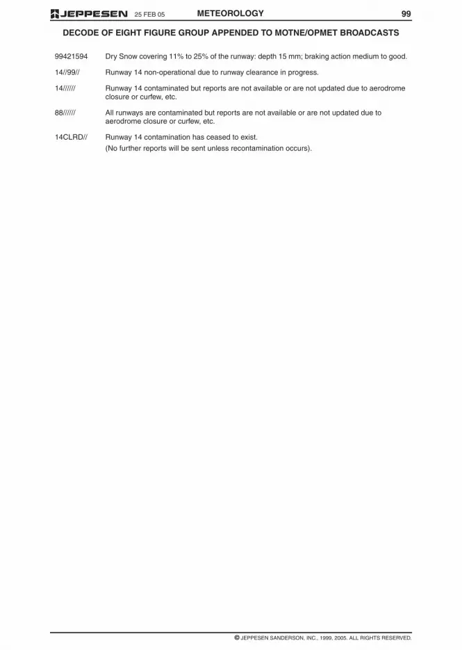
9925 FEB 05
© JEPPESEN SANDERSON, INC., 1999, 2005. ALL RIGHTS RESERVED.
DECODE OF EIGHT FIGURE GROUP APPENDED TO MOTNE/OPMET BROADCASTS
METEOROLOGY
99421594 Dry Snow covering 11% to 25% of the runway: depth 15 mm; braking action medium to good.
14//99// Runway 14 non-operational due to runway clearance in progress.
14////// Runway 14 contaminated but reports are not available or are not updated due to aerodromeclosure or curfew, etc.
88////// All runways are contaminated but reports are not available or are not updated due toaerodrome closure or curfew, etc.
14CLRD// Runway 14 contamination has ceased to exist.
(No further reports will be sent unless recontamination occurs).

25 FEB 05
© JEPPESEN SANDERSON, INC., 1991, 2005. ALL RIGHTS RESERVED.
DECODE OF EIGHT FIGURE GROUP APPENDED TO MOTNE/OPMET BROADCASTS
98 METEOROLOGY
The quoted depth is the mean of a number of readings or, if operationally significant, the greatest depth mea-sured.
FRICTION CO-EFFICIENT OR BRAKING ACTION (Seventh and Eighth Digits)
The friction co-efficient is denoted by two digits or, if the co-efficient is not available, the braking action is denot-ed by two digits.
a. Friction co-efficient
b. Braking action
NOTE:1. Where Braking Action is assessed at a number of points along a runway, the mean value will be trans-
mitted or, if operationally significant, the lowest value.
2. If measuring equipment does not allow measurement of friction with satisfactory reliability, which maybe the case when a runway is contaminated by wet snow, slush, or loose snow, the figures 99 will beused.
EXAMPLES
NOTE: The occasion may arise when a new report or a valid report is not available in time for disseminationwith the appropriate METAR message. In this case, the previous runway state report will be repeated, as indi-cated by the figures 99 in place of the runway designator.
92 = 10 cm
93 = 15 cm
94 = 20 cm
95 = 25 cm
96 = 30 cm
97 = 35 cm
98 = 40 cm or more
99 = runway or runways non-operational due to snow, slush, ice, large drifts or runway clearance, butdepth not reported.
// = Depth of deposit operationally not significant or not measurable.
Example:
28 — friction co-efficient 0.28
35 — friction co-efficient 0.35
etc.
95 = Good
94 = Medium / Good
93 = Medium
92 = Medium / Poor
91 = Poor
99 = Unreliable
// = Braking action not reported; Runway not operational; Aerodrome closed; etc.

9725 FEB 05
© JEPPESEN SANDERSON, INC., 1991, 2005. ALL RIGHTS RESERVED.
DECODE OF EIGHT FIGURE GROUP APPENDED TO MOTNE/OPMET BROADCASTS
METEOROLOGY
The first two digits indicate the Runway Designator.
The third digit indicates the Runway Deposits.
The fourth digit indicates the extent of runway contamination.
The fifth and sixth digits indicate the depth of deposit.
The seventh and eighth digits indicate the friction co-efficient or Braking Action.
RUNWAY DESIGNATOR (First and Second Digits)
The two digits correspond to the runway designator (e.g., 09, 27 etc.). In the case of parallel runways, the ‘Left”runway is indicated by the designator only (e.g., 09L as 09) while the “Right” runway has 50 added so that 09Rbecomes 59 and 27R becomes 77. Whenever all runways are affected the figure group 88 will be used.
NOTE: 99 may sometimes appear as the first two digits. This does not purport to be a runway indicator butmeans that the information is a repetition of the last message because no new message has been received intime for transmission.
RUNWAY DEPOSITS (Third Digit)
The runway deposit expressed as a single figure as follows:
EXTENT OF RUNWAY CONTAMINATION (Fourth Digit)
The extent of runway contamination is expressed as a single digit in accordance with the following scale:
DEPTH OF DEPOSIT (Fifth and Sixth Digits)
The depth of deposit is indicated by two digits in accordance with the following scale:
Thereafter, the depth is indicated by:
0 — Clear and dry 6 — Slush
1 — Damp 7 — Ice
2 — Wet or water patches 8 — Compacted or rolled snow
3 — Rime of frost covered (Depth normally lessthan 1 mm)
9 — Frozen ruts or ridges
4 — Dry snow / — Type of deposit not reported (e.g., due torunway clearance in progress).
5 — Wet snow
1 — Less than 10% of runway contaminated (covered)
2 — 11% to 25% of runway contaminated (covered)
5 — 26% to 50% of runway contaminated (covered)
9 — 51% to 100% of runway contaminated (covered)
/ — not reported (e.g., due to runway clearance in progress).
00 less than 1 mm 15 = 15 mm
01 = 1 mm etc.
02 = 2 mm 20 = 20 mm
etc. etc., up to
10 = 10 mm 90 = 90 mm
etc. NOTE: Code 91 is not used.

9525 FEB 05
© JEPPESEN SANDERSON, INC., 2005. ALL RIGHTS RESERVED.
METEOROLOGICAL SERVICE FOR INTERNATIONAL AIR TRAFFIC - ANNEX 3
METEOROLOGY
Example A6-5. AIRMET message for moderate mountain wave
AMSWELL FIR MOD MTW OBS AT 1205Z AND FCST N48 El0 FLO80 STNR NC
Meaning:
The second AIRMET message issued for the AMSWELL1 flight information region (identified by YUCCAmswell area control centre) by the Donlon/Intemational1 meteorological watch office (YUDO) since 0001UTC; the message is valid from 1215 UTC to 1600 UTC on the 22nd of the month; moderate mountain wavewas observed at 1205 UTC at 48 degrees north and 10 degrees east at flight level 080; the mountain waveis expected to remain stationary and not to undergo any changes in intensity.
1 Fictitious locations

25 FEB 05
© JEPPESEN SANDERSON, INC., 2005. ALL RIGHTS RESERVED.
METEOROLOGICAL SERVICE FOR INTERNATIONAL AIR TRAFFIC - ANNEX 3
94 METEOROLOGY
Example A6-2. SIGMET message for tropical cyclone
Example A6-3. SIGMET message for volcanic ash
Example A6-4. SIGMET message for severe turbulence
YUCC SIGMET 3 VALID 251600/252200 YUDO-
AMSWELL FIR TC GLORIA OBSN2706 W07306 AT 160OZ CB TOP FL500 WI 150NM OF CENTRE MOVNW IOKT NC FCST 220OZ TC CENTRE N2740 W07345 OTLK TC CENTRE 260400 N2830 W07430261000 N2912 W07530
Meaning:
The third SIGMET message issued for the AMSWELL1 flight information region (identified by YUCC Amswellarea control centre) by the Donlon/International1 meteorological watch office (YUDO) since 0001 UTC; themessage is valid from 1600 UTC to 2200 UTC on the 25th of the month; tropical cyclone Gloria was observedat 27 degrees 06 minutes north and 73 degrees 6 minutes west at 1600 UTC with cumulonimbus top at flightlevel 500 within 150 nautical miles of the centre; the tropical cyclone is expected to move northwestwards at10 knots and not to undergo any changes in intensity; the forecast position of the centre of the tropical cycloneat 2200 UTC is expected to be at 27 degrees 40 minutes north and 73 degrees 45 minutes west.
Outlook:
The centre of the tropical cyclone is expected to be on the 26th of the month at 0400 UTC and 1000 UTClocated at 28 degrees 30 minutes north and 74 degrees 30 minutes west, and at 29 degrees 12 minutes northand 75 degrees 30 minutes west, respectively.
1 Fictitious locations
YUDD SIGMET 2 VALID 211100/211700 YUSO
SHANLON FIR/UIR VA ERUPTION MT ASHVAL LOC S1500 E07348 VA CLD OBS AT 1100Z FL310/450APRX 220KM BY 35KM S1500 E07348 - S1530 E07642 MOV ESE 65KMH FCST 1700Z VA CLD APRXS1506 E07500 - S1518 E08112 - 51712 E08330 - S1824 E07836
OTLK 212300Z VA CLD APRX S 1600 E07806 - S 1642 E08412 - S 1824 E08900 - S 1906 E08100 220500ZVA CLD APRX S1700 E08100 - 51812 E08636 - S2000 E09224 - S2130 E08418
Meaning:
The second SIGMET message issued for the SHANLON1 flight information region (identified by YUDDShanlon area control centre) by the Shanlon/International1 meteorological watch office (YUSO) since 0001UTC; the message is valid from 1100 UTC to 1700 UTC on the 21st of the month; volcanic ash eruption ofMount Ashval1 located at 15 degrees south and 73 degrees 48 minutes east; volcanic ash cloud observed at1100 UTC between flight levels 310 and 450 in an approximate area of 220 km by 35 km between 15 degreessouth and 73 degrees 48 minutes east, and 15 degrees 30 minutes south and 76 degrees 42 minutes east;the volcanic ash cloud is expected to move east-southeastwards at 65 kilometres per hour; at 1700 UTC thevolcanic ash cloud is forecast to be located approximately in an area bounded by the following points: 15degrees 6 minutes south and 75 degrees east, 15 degrees 18 minutes south and 81 degrees 12 minutessouth, 17 degrees 12 minutes south and 83 degrees 30 minutes east, and 18 degrees 24 minutes south and78 degrees 36 minutes east.
Outlook:
The volcanic ash cloud at 2300 UTC on the 21st of the month is expected to be located approximately in anarea bounded by the following points: 16 degrees south and 78 degrees 6 minutes east, 16 degrees 42minutes south and 84 degrees 12 minutes east, 18 degrees 24 minutes south and 89 degrees east, and 19degrees 6 minutes south and 81 degrees east; the volcanic ash cloud at 0500 UTC on the 22nd of the monthis expected to be located approximately in an area bounded by the following points: 17 degrees south and 81degrees east, 18 degrees 12 minutes south and 86 degrees 36 minutes east, 20 degrees south and 92degrees 24 minutes east, and 21 degrees 30 minutes south and 84 degrees 18 minutes east.
1 Fictitious locations
YUCC SIGMET 5 VALID 221215/221600 YUDO-
AMSWELL FIR SEV TURB OBS AT 1210Z YUSB FL250 MOV E 40KMH WKN
Meaning:
The fifth SIGMET message issued for the AMSWELL1 flight information region (identified by YUCC Amswellarea control centre) by the Donlon/International1 meteorological watch office (YUDO) since 0001 UTC; themessage is valid from 1215 UTC to 1600 UTC on the 22nd of the month; severe turbulence was observed at1210 UTC over SibyBistock* aerodrome (YUSB) at flight level 250; the turbulence is expected to moveeastwards at 40 kilometres per hour and to weaken in intensity.
1 Fictitious locations

9325 FEB 05
© JEPPESEN SANDERSON, INC., 2005. ALL RIGHTS RESERVED.
METEOROLOGICAL SERVICE FOR INTERNATIONAL AIR TRAFFIC - ANNEX 3
METEOROLOGY
NOTE:
1. Fictitious location.
2. Additional provisions in 6.2.5.
3. End of the message (as the wind shear warning is being cancelled).
Table A6-4. Ranges and resolutions for the numerical elements included in volcanic ash and tropicalcyclone advisory messages, SIGMET/AIRMET messages and aerodrome and wind shear warnings
Example A6-1. SIGMET and AIRMET message and the corresponding cancellations
Element as specified in Appendices 2 and 6 Range Resolution
Summit elevation: M
FT
000 - 8100
000 - 27000
1
1
Advisory number: for VA (index)1
for TC (index)1000 - 2 000
00 - 99
1
1
Maximum surface wind: KMH
KT
00 - 399
00 - 199
1
1
Central pressure: hPa 850 - 1050 1
Surface wind speed: KMH
KT
60 - 199
30 - 99
1
1
Surface visibility: M
M
0000 - 0800
0800 - 5000
50
100
Cloud: height of base: M
FT
000 - 1000
000 - 300
30
100
Cloud: height of top: M
M
FT
FT
000-3000
3 000 - 20 000
000-10000
10 000 - 60 000
30
10 000 - 60 000
100
1 000
Latitudes: °(degrees)
'(minutes)
00 - 90
00 - 60
1
1
Longitudes: ° (degrees)
'(minutes)
000 -180
00 - 60
1
1
Flight levels: 000 - 650 10
Movement: KMH
KT
0 - 300
KT
10
51Non-dimensional
SIGMET
YUDD SIGMET 2 VALID 101200/101600 YUSO-
SHANLON FIR/UIR OBSC TS FCST
S OF N54 TOP FL390 MOV E WKN
Cancellation of SIGMET
YUDD SIGMET 3 VALID 101345/101600 YUSO
SHANLON FIR/MR CNL SIGMET 2 101200/101600
AIRMET
YUDD AIRMET 1 VALID 151520/151800 YUSO-
SHANLON FIR ISOL TS OBS
N OF S50 TOP ABV FL 100 STNR WKN
Cancellation of AIRMET
YUDD AIRMET 2 VALID 151650/151800 YUSO
SHANLON FIR CNL AIRMET 1 151520/151800
YUCC SIGMET 3 VALID 251600/252200 YUDO

25 FEB 05
© JEPPESEN SANDERSON, INC., 2005. ALL RIGHTS RESERVED.
METEOROLOGICAL SERVICE FOR INTERNATIONAL AIR TRAFFIC - ANNEX 3
92 METEOROLOGY
NOTE 1: The ranges and resolutions for the numerical elements included in wind shear warnings are shown inTable A 6-4 of this appendix.
NOTE 2: The explanations for the abbreviations can be found in the Procedures for Air Navigation Services -ICAO Abbreviations and Codes (PANS-ABC, Doe 8400).
Table A6-3. Template for wind shear warnings
OR
Key: M = inclusion mandatory, part of every message
C = inclusion conditional, included whenever applicable
Element Detailed content Template Example
Location indicator ofthe aerodrome (M)
Location indicator ofthe aerodrome
nnnn YUCC1
Identification of thetype of message (M)
Type of message andsequence number
WS WRNG [nn] WS WRNG 01
Time of origin andvalidity period (M)
Day and time of issueand, where applicable,validity period in UTC
nnnnnn [VALID TL nnnnnn] or
[VALID nnnnnn/nnnnnn]
211230 VALID TL211330
221200 VALID221215/221315
IF THE WIND SHEAR WARNING IS TO BE CANCELLED, SEE DETAILS AT THE END OF THE TEMPLATE.
Phenomenon (M) Identification of thephenomenon and itslocation
[MOD] or [SEVI WS IN APCH or
[MOD] or [SEV] WS [APCH]RWYnnn
or
WS APCH RWY12
MOD WS RWY34
[MOD] or [SEV] WS INCLIMB-OUT
or
WS IN CLIMB-OUT
[MOD] or [SEV] WSCLIMB-OUT RWYnnn or
MBST IN APCH or
MBST [APCH] RWYnnn
or
MBST APCH RWY26
MBST IN CLIMB-OUT or
MBST CLIMB-OUT RWYnnn
MBST IN CLIMB-OUT
Observed, reported orforecast phenomenon(M)
Identification whetherthe phenomenon isobserved or reportedand expected tocontinue or forecast
REP AT nnnn nnnnnnnn or
OBS (AT nnnn] or
FCST
REP AT 1510 B747
OBS AT 1205
FCST
Details of thephenomenon (C)2
Description ofphenomenon causingthe issuance of thewind shear warning
SFC WIND: nnn/nnKMH (ornnrdnnKT) nnnM(nnnFT)-WIND: nnn/nnKMH (ornnn/nnKT)
or
nnKMH (or nnKT) ASPEEDL
nnKM (or nnNM)
FNA RWYnn
or
nnKMH (ornnKT) ASPEEDGnnKM (ornnNM) FNA RWYnn
SFC WIND:320/20KMH
60M-WIND:360/50KMH
(SFC WIND: 320/10KT
200FT-WIND:360/25KT)
60KMH ASPEEDL4KM
FNA RWY13 (30KTASPEEDL 2NM FNARWY13)
Cancellation of windshear warning3
Cancellation of windshear warning referringto its identification
CNL WS WRNG nnnnnnn/nnnnnn
CNL WS WRNG1211230/2113303

9125 FEB 05
© JEPPESEN SANDERSON, INC., 2005. ALL RIGHTS RESERVED.
METEOROLOGICAL SERVICE FOR INTERNATIONAL AIR TRAFFIC - ANNEX 3
METEOROLOGY
Table A6-2. Template for aerodrome warnings
OR
NOTE:1. Fictitious location.
2. One phenomenon or a combination thereof, in accordance with 5.1.2.
3. In accordance with 5.1.2.
4. Hoar frost or rime in accordance with 5.1.2.
5. In accordance with 5.1.3.
6. End of the message (as the aerodrome warning is being cancelled).
Element Detailed content Template Example
Location indicator of theaerodrome (M)
Location indicator of theaerodrome
nnnn YUCC1
Identification of the typeof message (M)
Type of message andsequence number
AD WRNG n AD WRNG 2
Validity period (M) Day and time of validityperiod in UTC
VALID nnnnnn/nnnnnn VALID 211230/211530
IF THE AERODROME WARNING IS TO BE CANCELLED, SEE DETAILS AT THE END OF THE TEMPLATE.
Phenomenon (M)2 Description ofphenomenon causingthe issuance of theaerodrome warning
TC3 nnnnnnnnnn or
[HVY] TS or
GR or
[HVY] SN [nnCMj3 or
[HVY] FZRA or
[HVY] FZDZ or
RIME4 or
[HVY] SS or
[HVY] DS or
SA or
DU or
SFC WSPD nn[n]KMH
MAX nn[n]
(SFC WSPD nn[n]KT
MAX nn[n]) or
SO or
FROST or
VA or
free text up to 32characters5
TC ANDREW
HVY SN 25CM
SFC WSPD 8OKMH MAX120
VA
Observed or forecastphenomenon (M)
Indication whether theinformation is observedand expected tocontinue, or forecast
OBS [AT nnnnZ] or
FCST or
OBS [AT nnnnZ] ANDFCST
OBS AT 120OZ
OBS
OBS AT 1220Z AND FCST
Changes in intensity(C)
Expected changes inintensity
INTSF or
WKN or
NC
WKN
Cancellation ofaerodrome warning6
Cancellation of aerodromewarning referring to itsidentification
CNL AD WRNG nnnnnnNnnnnnn
CNL AD WRNG 2211230/2115306

25 FEB 05
© JEPPESEN SANDERSON, INC., 2005. ALL RIGHTS RESERVED.
METEOROLOGICAL SERVICE FOR INTERNATIONAL AIR TRAFFIC - ANNEX 3
90 METEOROLOGY
NOTE:1. In accordance with 1.1.2.
2. No wind and temperature to be uplinked to other aircraft in flight in accordance with 3.2.
3. See 4.1.
4. Fictitious location.
5. In accordance with 1.1.3 and 2.1.2.
6. See 3.1.
7. See 2.1.3.
8. In accordance with 1.1.4 and 2.1.4.
9. In accordance with 4.2.1 a).
10. In accordance with 4.2.4.
11. In accordance with 4.2.5 and 4.2.6.
12. In accordance with 4.2.1 b).
13. In accordance with 4.2.2.
14. In accordance with 4.2.3.
15. In accordance with 4.2.1 c).
16. The use of cumulonimbus, CB, is restricted to AIRMETs and SIGMETs related to SST flight during tran-sonic and supersonic cruise; the use of towering cumulus, TCU, is restricted to AIRMETs in accordancewith 1.1.4 and 2.1.4.
17. In accordance with 2.1.4.
18. In accordance with 4.2.1 d).
19. In accordance with 4.2.7.
20. In accordance with 4.2.7.
21. In accordance with 4.2.8.
22. Only for SIGMET messages for volcanic ash cloud and tropical cyclones.
23. Only for SIGMET messages for tropical cyclones.
24. Only for SIGMET messages for volcanic ash.
25. Up to four layers (or levels) in accordance with 4.2.9.
26. End of the message (as the SIGMET/AIRMET message is being cancelled).
NOTE: In accordance with 1.1.5 and 2.1.5, severe or moderate icing and severe or moderate turbulence (SEVICE, MOD ICE, SEV TURB, MOD TURB) associated with thunderstorms, cumulonimbus clouds or tropical cy-clones should not be included.
NOTE 1: The ranges and resolutions for the numerical elements included in wind shear warnings are shown inTable A 6-4 of this appendix.
NOTE 2: The explanations for the abbreviations can be found in the Procedures for Air Navigation Services -ICAO Abbreviations and Codes (PANS-ABC, Doe 8400).
CancellationofSIGMET/AIRMET26(C)
CancellationofSIGMET/AIRMET referringto itsidentification
CNL SIGMET[nn]nnnnnnnlnnnnnn or CNLSIGMET [nn]nnnnnnn/nnnnnn [VA MOV TOnnnn FIR]24
CNLSIGMETSST [nn]nnnnnnnlnnnnnn
CNL AIRMET(nn)nnnnnnn/nnnnnn
- CNL SIGMET 2101200/10160026
CNL SIGMET 3251030/251430 VAMOV TO YUDOFIR26
CNL SIGMET SST1212330/22013026
CNL AIRMET151520/15180026
Key: M = inclusion mandatory, part of every message
C = inclusion conditional, included whenever applicable

925 FEB 05
© JEPPESEN SANDERSON, INC., 1999, 2005. ALL RIGHTS RESERVED.
METEOROLOGICAL SERVICE FOR INTERNATIONAL AIR NAVIGATION - ANNEX 3
METEOROLOGY
4.6 OBSERVING AND REPORTINGMETEOROLOGICAL ELEMENTS
4.6.1 Surface Wind
4.6.1.1 The mean direction and the meanspeed of the surface wind shall be measured, aswell as significant variations of wind direction andspeed, and reported in degrees true and kilometersper hour (or knots), respectively.
4.6.1.2 Recommendation – When local routineand special reports are used for departing aircraft,the surface wind observations for these reportsshould be representative of conditions along the run-way; when local routine and special reports are usedfor arriving aircraft, the surface wind observations forthese reports should be representative for the touch-down zone.
4.6.1.3 Recommendation – For METAR andSPECI, the surface wind observations should berepresentative of conditions above the whole runwaywhere the is only one run way and the whole runwaycomplex where there is more than one runway.
4.6.2 Visibility
4.6.2.1 The visibility as defined in Chapter 1 shallbe measured or observed, and reported in meters orkilometers,
4.6.2.2 Recommendation – When local routineand special reports are used for departing aircraft,the visibility observations for these reports should berepresentative of conditions along the runway; whenlocal routine and special reports are used for arrivingaircraft, the visibility observations for these reportsshould be representative of the touchdown zone ofthe runway.
4.6.2.3 Recommendation – For METAR andSPECI the visibility observations should be repre-sentative of the aerodrome.
4.6.3 Runway Visual Range
NOTE: Guidance on the subject of runway visualrange is contained in the Manual of Runway VisualRange Observing and reporting Practices (DOC9328).
4.6.3.1 Runway visual range as defined in Chap-ter I shall be assessed on all runways intended forCategory II and III instrument approach and landingoperations.
4.6.3.2 Recommendation – Runway visualrange as defined in Chapter I should be assessedon all runways intended for use during periods of re-duced visibility, including:
a. precision approach runways intended for Cate-gory I instrument approach and landing opera-tions; and
b. runways used for take-off and having high-inten-sity edge lights and/or center line lights.
NOTE: Precision approach runways are definedin Annex 14, Volume I, Chapter I, under ‘Instru-ment runway’.
4.6.3.3 The runway visual range, assessed in ac-cordance with 4.6.3.1 and 4.6.3.2, shall be reportedin meters throughout periods when either the visibili-ty or the runway visual range is less than 1500m.
4.6.3.4 Runway visual range assessments shallbe representative of:
a. the touchdown zone of the runway intended fornon-precision or Category I instrument approachand landings operations;
b. the touchdown zone and the mid-point of therunway intended for Category II instrument ap-proach and landing operations; and
c. the touchdown zone, the mid-point and stop-endof the runway intended for Category III instru-ment approach and landing operations.
4.6.3.5 The units providing air traffic service andaeronautical information service for an aerodromeshall be kept informed without delay of changes inthe serviceability status of the automated equipmentused for assessing runway visual range.
4.6.4 Present Weather
4.6.4.1 The present weather occurring at theaerodrome and/or its vicinity shall be observed andreported as necessary.
4.6.4.2 Recommendation – For local routineand special reports, the present weather informationshould be representative of conditions at the aero-drome.
4.6.4.3 Recommendation – For METAR andSPECI, the present weather information should berepresentative of conditions at the aerodrome and,for certain specified weather phenomena, in its vicin-ity,
4.6.4.4 Recommendation – Where observa-tions are made using automatic observing systems,provisions should be made for manual insertion ofthose present weather elements which cannot bedetermined adequately by that equipment.
4.6.5 Clouds
4.6.5.1 Cloud amount, cloud type and height ofcloud base shall be observed, and reported as nec-essary to describe the clouds of operational signifi-cance. When the sky is obscured, vertical visibilityshall be observed and reported, where measured, inlieu of cloud amount, cloud type and height of cloudbase. The height of cloud base and vertical visibilityshall be reported in meters (or feet).
4.6.5.2 Recommendation – Cloud observationsfor local routine and special reports should be repre-sentative of the approach area.
4.6.5.3 Recommendation – Cloud observationsfor METAR and SPECI should be representative ofthe aerodrome and its vicinity.

8925 FEB 05
© JEPPESEN SANDERSON, INC., 2005. ALL RIGHTS RESERVED.
METEOROLOGICAL SERVICE FOR INTERNATIONAL AIR TRAFFIC - ANNEX 3
METEOROLOGY
OR
Elementas
specifiedin
Chapter5and
Appendix6
Detailedcontent
Template(s) Examples
SIGMET SIGMETSST1
AIRMET SPECIAL
AIR-
REPORT2
Forecastposition(C)22
Forecastposition ofvolcanicash cloudor thecentre ofthe TC atthe end ofthevalidityperiod oftheSIGMETmessage(C)
FCST nnnnZ TC CENTRE
Nnn[nn] or Snn[nn]Wnnn[nn] or Ennn[nn]
or
FCST nnnnZ VA CLD APRX
Nnn[nn] or Snn[nn]Wnnn[nn] or Ennn[nn]
- Nnn[nn] or Snn[nn]Wnnn[nn] orEnnn[nn]
[ - Nnn[nn] or Snn[nn]Wnnn[nn] orEnnn[nn]]
[ - Nnn[nn] or Snn[nn]Wnnn[nn] orEnnn[nn]]
- - FCST 2200ZTC
CENTREN2740W07345
FCST 17002VA CLD
APRX S15E075 -
S15 E081 -
S17 E083 -
S18 E079 -
S15 E075
Outlook22
(C)Outlookprovidinginformation beyondthe periodof validityof thetrajectoryof thevolcanicash cloudandpositionsof thetropicalcyclonecentre (C)
OTLK nnnnnn TC CENTRE
Nnnnn or SnnnnWnnnnn or Ennnnn
nnnnnn TC CENTRE
Nnnnn or SnnnnWnnnnn or Ennnnn
or
OTLK nnnnn VA CLD APRX
[FLnnn/nnn]25 Nnn[nn] or
Snn[nn]Wnnn[nn) or Ennn[nn]
- Nnn[nn] or Snn[nn]Wnnn(nn) orEnnn[nn]
- Nnn[nn] or Snn[nn]Wnnn[nn] orEnnn[nn]
[ - Nnn[nn] or Snn[nn]Wnnn[nn] orEnnn[nn]]
[ - Nnn[nn] or Snn[nn]Wnnn[nn] orEnnn[nnj]
nnnnnn VA CLD APRX
Nnn[nn] or Snn[nn]Wnnn[nn] or Ennn[nn]
- Nnn[nn] or Snnf nn]Wnnn[nn] orEnnn[nn]
- Nnn[nn] or Snn[nn]Wnnn[nn] orEnnn[nn]
( - Nnn[nn] or Snn[nn]Wnnn[nn] orEnnn[nn]]
[ - Nnn(nn) or Snn[nn]Wnnn[nn] orEnnn[nn]j
- OTLK260400TC
CENTREN28030
W07430261000 TC
CENTRE
N3100W07600
OTLK212300VA CLD
APRX
S16 E078 -
S17 E084 -
S18 E089 -
S19 E081 -
S16 E078220300
VA CLDAPRX
S17 E081 -
S18 E086 -
S20 E092 -
S21 E084 -
S17 E081

25 FEB 05
© JEPPESEN SANDERSON, INC., 2005. ALL RIGHTS RESERVED.
METEOROLOGICAL SERVICE FOR INTERNATIONAL AIR TRAFFIC - ANNEX 3
88 METEOROLOGY
Level (C) Flight levelandextent22(C)
FLnnn or FLnnn/nnn orTOP FLnnn or [TOP]ABV FLnnn or [TOP] BLW FLnnn
or BLW nnnnM (or BLW nnnnFT)
or23
FLnnn FL180
FL050/080
TOP FL390
BLW FL200
TOP ABVFL100
FL310/450
CB TOPFL500 WI
270KM OFCENTRE
(CB TOPFL500 WI150NM OFCENTRE)
FL310/350APRX
220KM BY35KM
FL390
CB TOP [ABV] FLnnn WI nnnKM OF CENTRE
(or CB TOP [ABV] FLnnn W1 nnnNM OFCENTRE) or
CB TOP [BLW] FLnnn WI nnnKM OF CENTRE
(or CB TOP [BLW] FLnnn WI nnnNM OFCENTRE)
or24
FLnnn/nnn [APRX nnnKM BY nnnKM]
[Nnn[nn] or Snn[nn]Wnnn[nn] or Ennn[nn]
- Nnn[nn] or Snn[nn]Wnnn[nn] or Ennn[nn]
( - Nnn[nn] or Snn[nn]Wnnn[nn] or Ennn[nn]]
[ - Nnn[nn] or Snn[nn]Wnnn[nn] or Ennn[nn]]]
(or FLnnnlnnn [APRX nnnNM BY nnnNM]
(Nnn[nn] or Snn(nn]Wnnn[nn] or Ennn[nn]
- Nnn[nn] or Snn[nn]Wnnn[nn] or Ennn[nn]
[ - Nnn[nn] o;' Snn[nn]Wnnn[nn] or Ennn[nn]]
[ - Nnn[nn] or Snn[nn]Wnnn(nn] or Ennn[nn]]])
Movementsorexpectedmovement(C)
Movementor expectedmovement(directionand speed)withreferenceto one ofthe eightpoints ofcompass orstationary(C)
MOV N [nnKMH] or MOV NE [nnKMH] or MOVE [nnKMH] or MOV SE [nnKMH] or MOV S[nnKMH] or MOV SW [nnKMH] or MOV W[nnKMH] or MOV NW [nnKMH] or MOV W[nnKMH] or MOV NW [nnKMH] (or MOV N[nnKT] or MOV NE [nnKT] or MOV E [nnKT] orMOV SE [nnKT] or MOV S [nnKT] or MOV SW[nnKT] or MOV W [nnKT] or MOV NW [nnKT] orSTNR
- MOV E40KMH(MOV E20KT)
Changes inintensity(C)
Expectedchanges inintensity(C)
INTSF or WKN or NC - WKN
Elementas
specifiedin Chapter
5 andAppendix
6
Detailedcontent
Template(s) Examples
SIGMET SIGMETSST'
AIRMET SPECIAL
AIR-REPORT2

8725 FEB 05
© JEPPESEN SANDERSON, INC., 2005. ALL RIGHTS RESERVED.
METEOROLOGICAL SERVICE FOR INTERNATIONAL AIR TRAFFIC - ANNEX 3
METEOROLOGY
Elementas
specifiedin Chapter
5 andAppendix
6
Detailedcontent
Template(s) Examples
SIGMET SIGMETSST'
AIRMET SPECIAL
AIR-REPORT2
Location(C)
Location(referring tolatitude andlongitude(in degreesandminutes) orlocations orgeographicfeatureswell knowninternationally)
Nnn[nn] Wnnn[nn] or
Nnn[nn] Ennn[nn] or
Snn[nn] Wnnn[nn] or
Snn[nn] Ennn[nn]
or
N OF Nnn[nn] or
S OF Nnn[nn] or
N OF Snn[nn] or
S OF Snn[nn] or
(AND]
W OF Wnnn[nn] or
E OF Wnnn[nn] or
W OF Ennn[nn] or
E OF Ennn[nn]
or
[N OF, NE OF, E OF, SE OF, S OF, SW OF, WOF, NW OF] nnnnnnnnnnnn
or
WI Nnn[nn] or Snn[nn] Wnnn[nn] or Ennn[nn] -
Nnn[nn] or Snn[nn] Wnnn[nn] or Ennn[nn] -
Nnn[nn] or Snn[nn] Wnnn[nn] or Ennn[nn] -
[Nnn[nn] or Snn[nn] Wnnn[nn] or Ennn[nn] -
Nnn[nn] or Snn[nn] Wnnn[nn] or Ennn[nn]]
NnnnnWnnnnn or
NnnnnWnnnnn or
SnnnnWnnnnnor
SnnnnEnnnnn
S OF N54
N OF N50
N2020W07005
YUSB4
N2706W07306
N48 E010
N OF N1515AND
W OFE13530
W OF E1554
WI N6030E02550 -
N6055E02500 -
N6050E02630

25 FEB 05
© JEPPESEN SANDERSON, INC., 2005. ALL RIGHTS RESERVED.
METEOROLOGICAL SERVICE FOR INTERNATIONAL AIR TRAFFIC - ANNEX 3
86 METEOROLOGY
Element as
specified in
Chapter 5and
Appendix 6
Detailedcontent
Template(s) Examples
SIGMET SIGMETSST'
AIRMET SPECIAL
AIR-REPORT2
Phenomenon(M)8
Description ofphenomenoncausing theissuance ofSIGMET /AIRMET (C)
OBSC9
TS [GR10]EMBD12
FRQ13 TS[GR]SQL14 TS[GR]
MODTURB11
SEVTURB
SFCWSPDnn[n]KMH
(or SFCWSPDnn[n]KT)
TS
TSGR
SEV TURB
FRQ TS
OBSC TSGR
EMBD TSGR
TC GLORIA
TCnnnnnnnnnn
ISOL15
CB16
OCNL18
CB FRQ13
CB
GR
VA[ERUPTION] [MTnnnnnnnnnn] [LOC
Nnn[nn] orSnn[nn]Ennn[nn]orWnnn[nn]]VA CLD
SFC VISnnnnM(nn)17
SEV TURB
SEV ICE
VA ERUPTION
MT ASHVAL
LOC S15
E073 VA CLD
SEVTURB11
SEVICE19
SEV ICE(FZRA)20
SEVMTW21
ISOL15
TS[GR]10
OCNL18
TS[GR]
MT OBSC
BKN CLDnnn/[ABV]nnnnM (orBKN CLDnnn/[ABV]nnnnFT)
SEV MTW
HVY SS
HVY DSHVY SS
VA CLD [FLnnn/nnn]
VA [MTnnnnnnnnnn]
MOD TURB
MOD MTW
ISOL CB
VA[ERUPTION] [MTnnnnnnnnnn] [LOC
Nnn[nn] orSnn[nn]
Ennn[nn]orWnnn[nn]]VA
CLD
OVC CLD
nnn/[ABV]nnnnM (orOVC CLDnnMABV]nnnnFT)
ISOL15
CB16
OCNL18
CB FRQ13
CB
BKN CLD120/900M
(BKN CLD400/3000FT)
MOD TURB11
GR10
CB16
OVCCLD270/ABV3000M (OVC CLD900/ABV10000FT)
ISOL15
TCU16
OCNL18
TCU16
FRQ13
TCU
SEV ICE
MODTURB11
MODICE19
MODMTW21
Observed orforecastphenomenon(M)
Indicationwhether theinformation isobserved andexpected tocontinue, orforecast (M)
OBS [AT nnnnZ]
FCST
OBS [AT nnnnZ] AND FCST
OBS AT nnnnZ OBS AT 1210Z
OBS
OBS AND FCST

8525 FEB 05
© JEPPESEN SANDERSON, INC., 2005. ALL RIGHTS RESERVED.
METEOROLOGICAL SERVICE FOR INTERNATIONAL AIR TRAFFIC - ANNEX 3
METEOROLOGY
NOTE: The ranges and resolutions for the numerical elements included in SIGMET/AIRMET messages and inspecial air-reports are shown in Table A6-4 of this appendix.
Key: M
C
=
=
=
=
inclusion mandatory, part of every message
inclusion conditional, included whenever applicable
a double line indicates that the text following it should be placed on the subsequent line
Table A6-1. Template for SIGMET and AIRMET messages and special air-reports (uplink)
Element asspecified in
Chapter 5 andAppendix 6
Detailedcontent
Template(s) Examples
SIGMET SIGMETSST1
AIRMET SPECIAL
AIR-REPORT2
Locationindicator ofFIR/CTA (M)3
ICAO locationindicator of theATS unitserving theFIR or CTA towhich theSIGMET/AIRMETrefers(M)
nnnn — YUCC4
YUDD4
Identification(M)
Messageidentificationand sequencenumber5 (M)
SIGMET[nn]n
SIGMETSST[nnjn
AIRMET[nn]n
ARS SIGMET 5
SIGMET A3
SIGMET SST 1
AIRMET 2
ARS
Validity period(M)
Date-timegroupsindicating theperiod ofvalidity in UTC(M)
VALID nnnnnn/nnnnnn _6 VALID221215/221600
VALID101520/101800
VALID251600/252200
Locationindicator ofMWO (M)
Locationindicator ofMWOoriginating themessage witha separatinghyphen (M)
nnnn— YUDO—4
YUSO—4
Name of theFIR/ CTA oraircraftidentification(M)
Locationindicator andname of theFIR/CTA7 forwhich theSIGMET/AIRMET isissued oraircraftradiotelephonycall sign (M)
nnnn nnnnnnnnnn
FIR[/UIR] or nnnn
nnnnnnnnnn CTA
nnnnnnnnnnnnnn
FIR[/n]
nnnnnn YUCCAMSWELL
FIR4
YUDDSHANLON
FIR/UIR4
YUCCAMSWELL
FIR/24
YUDDSHANLON
FIR4
VA812
IF THE SIGMET IS TO BE CANCELLED, SEE DETAILS AT THE END OF THE TEMPLATE.

25 FEB 05
© JEPPESEN SANDERSON, INC., 2005. ALL RIGHTS RESERVED.
METEOROLOGICAL SERVICE FOR INTERNATIONAL AIR TRAFFIC - ANNEX 3
84 METEOROLOGY
5.2 Quantitative criteria for aerodrome warnings
Recommendation. - When quantitative criteria are necessary for the issue of aerodrome warnings covering,for example, the expected maximum wind speed or the expected total snowfall, the criteria should be estab-lished by agreement between the meteorological office and the users of the warnings.
6. SPECIFICATIONS RELATED TO WIND SHEAR WARNINGS
6.1 Detection of wind shear
Recommendation - Evidence of the existence of wind shear should be derived from:
a) ground-based wind shear remote-sensing equipment, for example, Doppler radar;
b) ground-based wind shear detection equipment, for example, a system of surface wind and/or pressure sen-sors located in an array monitoring a specific runway or runways and associated approach and departurepaths;
c) aircraft observations during the climb-out or approach phases of flight to be made in accordance withChapter 5; or
d) other meteorological information, for example, from appropriate sensors located on existing masts or tow-ers in the vicinity of the aerodrome or nearby areas of high ground.
NOTE: Wind shear conditions are normally associated with the following phenomena:
– thunderstorms, microbursts, funnel cloud (tornado or waterspout), and gust fronts
– frontal surfaces
– strong surface winds coupled with local topography
– sea breeze fronts
– mountain waves (including low-level rotors in the terminal area)
– low-level temperature inversions.
6.2 Format and dissemination of wind shear warnings
NOTE: Information on wind shear is also to be included as supplementary information in local routine and spe-cial reports and METAR and SPECI in accordance with the templates in Tables A3-1 and A3-2.
6.2.1 The wind shear warnings shall be prepared in abbreviated plain language in accordance with the tem-plate in Table A6-3 and disseminated for aerodromes where wind shear is considered a factor in accordancewith local arrangements with the appropriate ATS authority and operators concerned and by the meteorologicaloffice designated to provide service for the aerodrome or disseminated directly from automated ground-basedwind shear remote-sensing or detection equipment referred to in 6.1 a) and b).
6.2.2 Recommendation. - Where microbursts are observed, reported by pilots or detected by ground-basedwind shear detection or remote-sensing equipment, the wind shear warning should include a specific referenceto microburst.
6.2.3 Recommendation. - Where information from ground-based wind shear detection or remote-sensingequipment is used to prepare a wind shear warning, the warning should, if practicable, relate to specific sec-tions of the runway and distances along the approach path or take-off path as agreed between the meteorolog-ical authority, the appropriate ATS authority and the operators concerned.
6.2.4 Recommendation. - When an aircraft report is used to prepare a wind shear warning, or to confirm awarning previously issued, the corresponding aircraft report, including the aircraft type, should be given un-changed in the warning.
NOTE 1: Following reported encounters by both arriving and departing aircraft two different wind shear warn-ings may exist, one for arriving aircraft and one for departing aircraft.
NOTE 2: Specifications for reporting the intensity of wind shear are still undergoing development. It is recog-nized, however, that pilots, when reporting wind shear, may use the qualifying terms "moderate", "strong" or"severe", based to a large extent on their subjective assessment of the intensity of the wind shear encountered.In accordance with 6.2.4, such reports are to be incorporated unchanged in wind shear warnings.
6.2.5 Recommendation. - The use of text additional to the abbreviations listed in the template in Table A6-3should be kept to a minimum. The additional text should be prepared in abbreviated plain language using ap-proved ICAO abbreviations and numerical values. If no ICAO approved abbreviations are available, Englishplain language text should be used.

8325 FEB 05
© JEPPESEN SANDERSON, INC., 2005. ALL RIGHTS RESERVED.
METEOROLOGICAL SERVICE FOR INTERNATIONAL AIR TRAFFIC - ANNEX 3
METEOROLOGY
4.2.2 Recommendation. - An area of thunderstorms should be considered frequent (FRQ) if within that areathere is little or no separation between adjacent thunderstorms with a maximum spatial coverage greater than75 per cent of the area affected, or forecast to be affected, by the phenomenon (at a fixed time or during the pe-riod of validity).
4.2.3 Recommendation. - Squall line (SQL) should indicate a thunderstorm along a line with little or no spacebetween individual clouds.
4.2.4 Recommendation. - Hail (GR) should be used as a further description of the thunderstorm, as neces-sary.
4.2.5 Recommendation. - Severe and moderate turbulence (TURB) should refer only to: low-level turbulenceassociated with strong surface winds; rotor streaming; or turbulence whether in cloud or not in cloud (CAT). Tur-bulence should not be used in connection with convective clouds.
4.2.6 Turbulence shall be considered:
a) severe whenever the turbulence index is between 15 and 27 (i.e. the peak value of the eddy dissipation rate(EDR) exceeds 0.5); and
b) moderate whenever the turbulence index is between 6 and 14 (i.e. the peak value of the eddy dissipationrate (EDR) exceeds 0.3 while not exceeding 0.5).
4.2.7 Recommendation. - Severe and moderate icing (ICE) should refer to icing in other than convectiveclouds. Freezing rain (FZRA) should refer to severe icing conditions caused by freezing rain.
4.2.8 Recommendation. - A mountain wave (MTW) should be considered:
a) severe whenever an accompanying downdraft of 3.0 m/s (600 ft/min) or more and/or severe turbulence isobserved or forecast; and
b) moderate whenever an accompanying downdraft of 1.75-3.0 m/s (350-600 ft/min) and/or moderate turbu-lence is observed or forecast.
4.2.9 Recommendation. - In the outlook of SIGMET messages for volcanic ash, up to four layers or levelsshould be included.
5. SPECIFICATIONS RELATED TO AERODROME WARNINGS
5.1 Format and dissemination of aerodrome warnings
5.1.1 The aerodrome warnings shall be issued in accordance with the template in Table A6-2 where requiredby operators or aerodrome services, and shall be disseminated in accordance with local arrangements to thoseconcerned.
5.1.2 Recommendation. - In accordance with the template in Table A6-2, aerodrome warnings should relate tothe occurrence or expected occurrence of one or more of the following phenomena:
– tropical cyclone (to be included if the 10-minute mean surface wind speed at the aerodrome is expected tobe 63 km/h (34 kt) or more)
– thunderstorm
– hail
– snow (including the expected or observed snow accumulation)
– freezing precipitation
– hoar frost or rime
– sandstorm
– duststorm
– rising sand or dust
– strong surface wind and gusts
– squall
– frost
– volcanic ash
– other phenomena as agreed locally.
5.1.3 Recommendation. - The use of text additional to the abbreviations listed in the template in Table A6-2should be kept to a minimum. The additional text should be prepared in abbreviated plain language using ap-proved ICAO abbreviations and numerical values. If no ICAO approved abbreviations are available, Englishplain language text should be used.

25 FEB 05
© JEPPESEN SANDERSON, INC., 2005. ALL RIGHTS RESERVED.
METEOROLOGICAL SERVICE FOR INTERNATIONAL AIR TRAFFIC - ANNEX 3
82 METEOROLOGY
2.1.5 AIRMET information shall not contain unnecessary descriptive material. In describing the weather phe-nomena for which the AIRMET is issued, no descriptive material additional to that given in 2.1.4 shall be includ-ed. AIRMET information concerning thunderstorms or cumulonimbus clouds shall not include references to as-sociated turbulence and icing.
NOTE: The specifications for SIGMET information which is also applicable to low-level flights are given in 1.1.4.
2.2 Dissemination of AIRMET messages
2.2.1 Recommendation. - AIRMET messages should be disseminated to meteorological watch offices in adja-cent flight information regions and to other meteorological offices, as agreed by the meteorological authoritiesconcerned.
2.2.2 Recommendation. - AIRMET messages should be transmitted to international operational meteorologi-cal data banks and the centres designated by regional air navigation agreement for the operation of aeronauti-cal fixed service satellite distribution systems, in accordance with regional air navigation agreement.
3. SPECIFICATIONS RELATED TO SPECIAL AIR-REPORTS
NOTE: This appendix deals with the uplink of special airreports. The general specifications related to specialairreports are in Appendix 4.
3.1 Recommendation. - Special air-reports should be uplinked for 60 minutes after their issuance.
3.2 Recommendation. - Information on wind and temperature included in automated special air-reportsshould not be uplinked to other aircraft in flight.
4. DETAILED CRITERIA RELATED TO SIGMET AND AIRMET MESSAGES ANDSPECIAL AIR-REPORTS (UPLINK)
4.1 Identification of the flight information region
Recommendation. - In cases where the airspace is divided into a flight information region (FIR) and an upperflight information region (UIR), the SIGMET should be identified by the location indicator of the air traffic servic-es unit serving the FIR.
NOTE: The SIGMET message applies to the whole airspace within the lateral limits of the FIR, i.e. to the FIRand to the UIR. The particular areas and/or flight levels affected by the meteorological phenomena causing theissuance of the SIGMET are given in the text of the message.
4.2 Criteria related to phenomena included in SIGMET and AIRMET messages andspecial air-reports (uplink)
4.2.1 Recommendation. - An area of thunderstorms and cumulonimbus clouds should be considered:
a) obscured (OBSC) if it is obscured by haze or smoke or cannot be readily seen due to darkness;
b) embedded (EMBD) if it is embedded within cloud layers and cannot be readily recognized;
c) isolated (ISOL) if it consists of individual features which affect, or are forecast to affect, an area with a max-imum spatial coverage less than 50 per cent of the area concerned (at a fixed time or during the period ofvalidity); and
d) occasional (OCNL) if it consists of well-separated features which affect, or are forecast to affect, an areawith a maximum spatial coverage between 50 and 75 per cent of the area concerned (at a fixed time or dur-ing the period of validity).
- frequent FRQ TCU
- Icing
- moderate icing (except for icing in convertiveclouds)
MOD ICE
- turbulence
- moderate turbulence MOD TURB (except forturbulence in convective clouds)
MOD TURB
- mountain wave
- moderate mountain wave MOD MTW

8125 FEB 05
© JEPPESEN SANDERSON, INC., 2005. ALL RIGHTS RESERVED.
METEOROLOGICAL SERVICE FOR INTERNATIONAL AIR TRAFFIC - ANNEX 3
METEOROLOGY
2. SPECIFICATIONS RELATED TO AIRMET INFORMATION
2.1 Format of AIRMET messages
2.1.1 The content and order of elements in an AIRMET message shall be in accordance with the templateshown in Table A6-1.
2.1.2 The sequence number referred to in the template in Table A6-1 shall correspond with the number ofAIRMET messages issued for the flight information region since 0001 UTC on the day concerned. The meteo-rological watch offices whose area of responsibility encompasses more than one FIR and/or CTA shall issueseparate AIRMET messages for each FIR and/or CTA within its area of responsibility.
2.1.3 The flight information region shall be divided in sub-areas, as necessary.
2.1.4 In accordance with the template in Table A6-1, only one of the following phenomena shall be included inan AIRMET message, using the abbreviations as indicated below:
at cruising levels below flight level 100 (or below flight level 150 in mountainous areas, or higher, where neces-sary):
- surface wind speed
- widespread mean surface wind speed above60 km/h (30 kt)
SFC WSPD
(+ wind speed and units)
- surface visibility
- widespread areas affected by reduction ofvisibility to less than 5000 m, including theweather phenomenon causing the reduction ofvisibility
SFC VIS
(+ visibility)
(+ one of the following weather phenomena orcombination thereof: BR, DS, DU, DZ, FC, FG, FU. GR,GS, HZ, IC, PL, PQ, RA, SA, SG, SN, SQ, SS or VA)
- thunderstorms
- isolated thunderstorms without hail ISOL TS
- occasional thunderstorms without hail OCNL TS
- isolated thunderstorms with hail ISOL TSGR
- occasional thunderstormes with hail OCNL TSGR
- mountain obscuration
- mountain obscured MT OBSC
- cloud
- widespread areas of broken or overcast cloudwith height of base less than 300 m (1000 ft)above ground level:
- broken BKN CLD (+ height of the base and top and units)
- overcast OVC CLD (+ height of the base and top and units)
- cumulonimbus clouds
which are:
- isolated ISOL CB
- occasional OCNL CB
- frequent FRQ CB
- towering cumulus clouds
which are:
- isolated ISOL TCU
- occasional OCNL TCU
25 FEB 05
© JEPPESEN SANDERSON, INC., 2005. ALL RIGHTS RESERVED.
METEOROLOGICAL SERVICE FOR INTERNATIONAL AIR TRAFFIC - ANNEX 3
80 METEOROLOGY
b. at transonic levels and supersonic cruising levels:
1.1.5 SIGMET information shall not contain unnecessary descriptive material. In describing the weather phe-nomena for which the SIGMET is issued, no descriptive material additional to that given in 1.1.4 shall be includ-ed. SIGMET information concerning thunderstorms or a tropical cyclone shall not include references to associ-ated turbulence and icing.
1.1.6 Recommendation. - Meteorological watch offices in a position to do so should issue SIGMET informa-tion for volcanic ash cloud and tropical cyclones in graphical format using the WMO BUFR code form, in addi-tion to the issuance of this SIGMET information in abbreviated plain language in accordance with 1.1.1.
NOTE: The BUFR code form is contained in WMO Publication No. 306, Manual on Codes, Volume 1.2, Part B -Binary Codes.
1.2 Dissemination of SIGMET messages
1.2.1 SIGMET messages shall be disseminated to meteorological watch offices, WAFCs and to other meteoro-logical offices in accordance with regional air navigation agreement. SIGMET messages for volcanic ash shallalso be disseminated to VAACs.
1.2.2 SIGMET messages shall be disseminated to international OPMET data banks and the centres designat-ed by regional air navigation agreement for the operation of aeronautical fixed service satellite distribution sys-tems, in accordance with regional air navigation agreement.
mountain wave
- severe mountain wave SEV MTW
duststorm
- heavy duststorm HVY DS
sandstorm
- heavy sandstorm HVY SS
volcanic ash
- volcanic ash (irrespective of altitude) VA (+ volcano name, if known)
turbulence
- moderate turbulence MOD TURB
- severe turbulence SEV TURB
cumulonimbus
- isolated cumulonimbus ISOL CB
- occasional cumulonimbus OCNL CB
- frequent cumulonimbus FRQ CB
hail
- hail GR
volcanic ash
- volcanic ash (irrespective altitude) VA (+ volcano name, if known)

8 25 FEB 05
© JEPPESEN SANDERSON, INC., 1999, 2005. ALL RIGHTS RESERVED.
METEOROLOGICAL SERVICE FOR INTERNATIONAL AIR NAVIGATION - ANNEX 3
METEOROLOGY
4.3 ROUTINE OBSERVATIONS ANDREPORTS
4.3.1 At Aerodromes, routine observationsshall be made throughout the 24 hours each day, ex-cept as otherwise agreed between the meteorologi-cal authority, the appropriate ATS authority and theoperator concerned. Such observations shall bemade at intervals of one hour or, if so determined byregional air navigation agreement, at intervals of onehalf-hour. At other aeronautical meteorological sta-tions, such observations shall be made as deter-mined by the meteorological authority taking into ac-count the requirements of air traffic services unitsand aircraft operations.
4.3.2 Reports of routine observations shall beissued as:
a. local routine reports only for dissemination at theaerodrome of origin (intended for arriving anddeparting aircraft); and
b. METAR for dissemination beyond the aerodromeof origin (mainly intended for flight planning,VOLMET broadcasts and D-VOLMET).
NOTE: Meteorological information used in ATIS(voice-ATIS and D-ATIS) is to be extracted from thelocal routine report, in accordance with Annex 11,4.3.6.1g).
4.3.3 At aerodromes that are not operationalthroughout 24 hours in accordance with 4.3.1,METAR shall be issued prior to the aerodrome re-suming operations in accordance with regional airnavigation agreement.
4.4 SPECIAL OBSERVATIONS ANDREPORTS
4.4.1 A list of criteria for special observationsshall be established by the meteorological authority,in consultation with the appropriate ATS authority,operators and others concerned.
4.4.2 Reports of special observations shall beissued as:
a. local special reports, only for dissemination atthe aerodrome of origin (intended for arrivingand departing aircraft); and
b. SPECI for dissemination beyond the aerodromeof origin (mainly intended for flight planning,VOLMET broadcasts and D-VOLMET).
NOTE: Meteorological information used in ATIS(voice-ATIS and D-ATIS) is to be extracted fromthe local routine report, in accordance with An-nex 11, 4.3.6.1g).
4.4.3 At aerodromes that are operationalthroughout 24 hours in accordance with 4.3.1, fol-lowing the resumption of the issuance of METAR,SPECI shall be issued, as necessary.
4.5 CONTENTS OF REPORTS
4.5.1 Local routine and special reports andMETAR and SPECI shall contain the following ele-ments in order indicated
a. identification of the type of report;
b. location indicator;
c. time of observation;
d. identification of an automated or missing report,when applicable;
e. surface wind direction and speed;
f. visibility;
g. runway visual range, when applicable;
h. present weather;
i. cloud amount, cloud type (only for cumulonim-bus and towering cumulus clouds) and height ofcloud base or, where measured, vertical visibili-ty;
j. air temperature and dew-point temperature; and
k. QNH and, when applicable, QFE (QFE includedonly in local routine and special reports).
NOTE: The location indicators referred to and b. andtheir significations are published in Location Indica-tors DOC 7910).
Recommendation - In addition to elements listedunder 4.5.1 a. to k. local routine and special reportsand METAR and SPECI should contain supplemen-tary information to be placed after element k.
4.5.3 Optional elements included under sup-plementary information shall be included in METARand SPECI in accordance with regional air naviga-tion agreement.

7925 FEB 05
© JEPPESEN SANDERSON, INC., 2005. ALL RIGHTS RESERVED.
METEOROLOGICAL SERVICE FOR INTERNATIONAL AIR TRAFFIC - ANNEX 3
METEOROLOGY
APPENDIX 6. TECHNICAL SPECIFICATIONS RELATED TO SIGMET AND AIRMETINFORMATION, AERODROME WARNINGS AND WIND SHEAR WARNINGS
(See Chapter 7 of this Annex.)
NOTE: Data type designators to be used in abbreviated headings for SIGMET, AIRMET tropical cyclone andvolcanic ash advisory messages are given in WMO Publication No. 386, Manual on the Global Telecommunica-tion System.
1. SPECIFICATIONS RELATED TO SIGMET INFORMATION
1.1 Format of SIGMET messages
1.1.1 The content and order of elements in a SIGMET message shall be in accordance with the templateshown in Table A6-1.
1.1.2 Messages containing SIGMET information for subsonic aircraft shall be identified as "SIGMET", thosecontaining SIGMET information for supersonic aircraft during transonic or supersonic flight shall be identifiedas "SIGMET SST".
1.1.3 The sequence number referred to in the template in Table A6-1 shall correspond with the number of SIG-MET messages issued for the flight information region since 0001 UTC on the day concerned. Separate seriesof sequence numbers shall be used for "SIGMET" and "SIGMET SST" messages. The meteorological watchoffices whose area of responsibility encompasses more than one FIR and/or CTA shall issue separate SIGMETmessages for each FIR and/or CTA within its area of responsibility.
1.1.4 In accordance with the template in Table A6-1, only one of the following phenomena shall be included ina SIGMET message, using the abbreviations as indicated below:
a. at a subsonic cruising levels:
thunderstorm
- obscured OBSC TS
- embedded EMBD TS
- frequent FRQ TS
- squall line SQL TS
- obscured with hail OBSC TSGR
- embedded with hail EMBD TSGR
- frequent, with hail FRQ TSGR
- squall line with hail SQL TSGR
tropical cyclone
- tropical cyclone with 10-minute surface wind speed of 63 km/h(34 kt) or more
TC (+ cyclone name)
turbulence
- severe turbulence SEV TURB
icing
- severe icing SEV ICE
- icing due to freezing rain SEV ICE (FZRA)

25 FEB 05
© JEPPESEN SANDERSON, INC., 2005. ALL RIGHTS RESERVED.
METEOROLOGICAL SERVICE FOR INTERNATIONAL AIR TRAFFIC - ANNEX 3
78 METEOROLOGY
winds and temperatures: at 2 000 feet above ground level wind direction 270 degrees; wind speed 70kilometres per hour, temperature plus 3 degrees Celsius; at 5 000 feet aboveground level wind direction 250 degrees; wind speed 80 kilometres per hour,temperature minus 2 degrees Celsius; at 10 000 feet above ground level winddirection 240 degrees; wind speed 85 kilometres per hour, temperature minus11 degrees Celsius;
clouds: broken stratocumulus, base 2500 feet, top 8 000 feet above ground level;
freezing level: 3000 feet above ground level;
minimum QNH: 1004 hectopascals;
sea: surface temperature 15 degrees Celsius; and state of sea 5 metres;
volcanic ash: nil.
1Fictitious locations

7725 FEB 05
© JEPPESEN SANDERSON, INC., 2005. ALL RIGHTS RESERVED.
METEOROLOGICAL SERVICE FOR INTERNATIONAL AIR TRAFFIC - ANNEX 3
METEOROLOGY
Example A5-3. GAMET area forecast
YUCC GAMET VALID 220600/221200 YUDO
AMSWELL FIR/2 BLW FL100
SECN I
SFC WSPD: 10/12 65 KMH
SFC VIS: 06/08 3000 M BR N OF N51
SIGWX: 11/12 ISOL TS
SIG CLD: 06/09 OVC 800/11 00 FT AGL N OF N51 10/12 ISOL TCU 1200/8000 FT AGL
ICE: MOD FL050/080
TURB: MOD ABV FL090
SIGMETS APPLICABLE: 3, 5
SECN II
PSYS: 06 L 1004 HPA N5130 E01000 MOV NE 25 KT WKN
WIND/T: 2000 FT 270/70 KMH PS03 5000 FT 250/80 KMH MS02 10000 FT 240/85KMH MS11
CLD: BKN SC 2500/8000 FT AGL
FZLVL: 3000 FT AGL
MNM QNH: 1004 HPA
SEA: T15 HGT 5M
VA: NIL
Meaning: An area forecast for low-level flights (GAMET) issued for sub-area two of theAmswell1 flight information region (identified by YUCC Amswell area controlcentre) for below flight level 100 by the Donlon/International1 meteorologicaloffice (YUDO); the message is valid from 0600 UTC to 1200 UTC on the 22ndof the month.
Section I:
surface wind speeds: between 1000 UTC and 1200 UTC 65 kilometres per hour;
surface visibility: between 0600 UTC and 0800 UTC 3000 metres north of 51 degrees north (dueto mist);
significant weatherphenomena:
between 1100 UTC and 1200 UTC isolated thunderstorms without hail;
significant clouds: between 0600 UTC and 0900 UTC overcast base 800, top 1100 feet aboveground level north of 51 degrees north; between 1000 UTC and 1200 UTCisolated towering cumulus base 1200, top 8000 feet above ground level;
icing: moderate between flight level 050 and 080;
turbulence: moderate above flight level 090 (at least up to flight level 100);
SIGMET messages: 3 and 5 applicable to the validity period and sub-area concerned.
Section II:
pressure systems: at 0600 UTC low pressure of 1 004 hectopascals at 51.5 degrees north 10.0degrees east, expected to move north-eastwards at 25 knots and to weaken;

25 FEB 05
© JEPPESEN SANDERSON, INC., 2005. ALL RIGHTS RESERVED.
METEOROLOGICAL SERVICE FOR INTERNATIONAL AIR TRAFFIC - ANNEX 3
76 METEOROLOGY
Example A5-1. TAF
Example A5-2. Cancellation of TAF
TAF for YUDO (Donlon/International)1:
TAF YUDO 160000Z 160624 13018KMH 9000 BKN020 BECMG 0608 SCT015CB BKN020 TEMPO 081217025G45KMH 1000 TSRA SCT0I0CB BKN020 FM1230 15015KMH 9999 BKN020
Meaning of the forecast:
TAF for Donlon/International1 issued on the 16th of the month at 0000 UTC valid from 0600 UTC to 2400 UTCon the 16th of the month; surface wind direction 130 degrees; wind speed 18 kilometres per hour; visibility 9kilometres, broken cloud at 600 metres; becoming between 0600 UTC and 0800 UTC, scatteredcumulonimbus cloud at 450 metres and broken cloud at 600 metres; temporarily between 0800 UTC and 1200UTC surface wind direction 170 degrees; wind speed 25 kilometres per hour gusting to 45 kilometres perhour; visibility 1000 metres in a thunderstorm with moderate rain, scattered cumulonimbus cloud at 300metres and broken cloud at 600 metres; from 1230 UTC surface wind direction 150 degrees; wind speed 15kilometres per hour; visibility 10 kilometres or more; and broken cloud at 600 metres.
1 Fictitious location
NOTE: In this example, the primary units "kilometre per hour" and "metre" were used for wind speed andheight of cloud base, respectively. However, in accordance with Annex 5, the corresponding non-SI alternativeunits "knot" and 'foot" may be used instead.
Cancellation of TAF for YUDO (Donlon/International)1:
TAF AMD YUDO 161500Z 160624 CNL
Meaning of the forecast:
Amended TAF for Donlon/International1 issued on the 16th of the month at 1500 UTC cancelling thepreviously issued TAF valid from 0600 UTC to 2400 UTC on the 16th of the month.
1 Fictitious location

7525 FEB 05
© JEPPESEN SANDERSON, INC., 2005. ALL RIGHTS RESERVED.
METEOROLOGICAL SERVICE FOR INTERNATIONAL AIR TRAFFIC - ANNEX 3
METEOROLOGY
Table A5-2. Use of change and time indicators in TAF
Table A5-3. Ranges and resolutions for the numerical elements included in TAF
Change or timeindicator
Time period Meaning
FM nhnhnmnm used to indicate a significant change in most weather elementsoccurring at nhnh hours and nmnm minutes (UTC); all the elementsgiven before "FM" are to be included following “FM” (i.e. they are allsuperseded by those following the abbreviation)
BECMG n1n1n2n2 the change is forecast to commence at n1n1 hours (UTC) and becompleted by n2n2 hours (UTC); only those elements for which achange is forecast are to be given following “BECMG”; the time periodn1n1n2n2 should normally be less than 2 hours and in any caseshould not exceed 4 hours
TEMPO n1n1n2n2 temporary fluctuations are forecast to commence at n1n1 hours(UTC) and cease by n2n2 hours (UTC); only those elements for whichfluctuations are forecast are to be given following “TEMPO”;temporary fluctuations should not last more than one hour in eachinstance, and in the aggregate, cover less than half of the periodn1n1n2n2
PROBnn - n1n1n2n2 probability of occurrence (in%) ofan alternative value of a forecastelement or elements; nn = 30 ornn = 40 only; to be placed afterthe element(s) concerned
-
TEMPO n1n1n2n2 probability of occurrence oftemporary fluctuations
Element as specified in Chapter 6 Range Resolution
Wind direction: ° true 000 - 360 10
Wind speed: KMH
KT
00 - 3991
00 - 19911
1
Visibility: M
M
M
M
0000 - 0800
0800 - 5000
5 000 - 9000
9 000 - 9 999
50
100
1 000
999
Vertical visibility: 30's M(100's FT)
000 - 020 1
Cloud: height of base: 30's M(100's FT)
000 - 050 1
Air temperature (maximum and minimum): °C -80 - +60 11 There is no aeronautical requirement to report surface wind speeds of 200km/h (100kt) or more; however,provision has been made for reporting wind speeds up to 399km/h (199kt) for non-aeronautical purposes, asnecessary.

25 FEB 05
© JEPPESEN SANDERSON, INC., 1999, 2005. ALL RIGHTS RESERVED.
METEOROLOGICAL SERVICE FOR INTERNATIONAL AIR TRAFFIC - ANNEX 3
74 METEOROLOGY
NOTE:1. Fictitious location.
2. To be used in accordance with 1.2.1.
3. To be included in accordance with 1.2.1.
4. To be included whenever applicable.
5. One or more, up to a maximum of three, groups in accordance with 1.2.3.
6. To be included whenever applicable in accordance with 1.2.3. No qualifier for moderate intensity.
7. Weather phenomena to be included in accordance with 1.2.3. 8. 10.
8. Up to four cloud layers in accordance with 1.2.4. 9.
9. To be included in accordance with 1.2.5.
10. To be included in accordance with 1.3, 1.4 and 1.5.
SS or
FZDZ or
FZRA or
SHGR or
SHGS or
SHPL or
SHRA or
SHSN or
TSGR or
TSGS or
TSPL or
TSRA or
TSSN
FU orVA or
SQ orPO or
FC orTS or
BCFGor
BLDUor
BLSAor
BLSNor
DRDUor
DRSAor
DRSNor
FZFGor
MIFGor
PRFG
Cloud amountand height ofbase or verticalvisibility (C)4
FEWnnn orSCTnnn orBKNnnn orOVCnnn
VVnnnorVV///
SKC orNSC
FM1230 15015KMH 9999BKN020
(FM1230 15008KT 9999BKN020)
BECMG 1820 8000 NSW NSC
BECMG 0608 SCT015CBBKN020
Cloud type (C)4 CB -
Element asspecified inChapter 6
Detailedcontent
Template(s) Examples

7325 FEB 05
© JEPPESEN SANDERSON, INC., 1999, 2005. ALL RIGHTS RESERVED.
METEOROLOGICAL SERVICE FOR INTERNATIONAL AIR TRAFFIC - ANNEX 3
METEOROLOGY
Expectedsignificantchanges toone or moreof the aboveelementsduring theperiod ofvalidity (C)4,10
Change orprobabilityindicator (M)
PROB30 [TEMPO] or PROB40[TEMPO] or BECMG or
TEMPO or FM
Period ofoccurrence orchange (M)
nnnn
Wind (C)4 nnn[P]nn[n][G[P]nn[n]]KMH
or
VRBnnKMH
(or
nnn[P]nn[G[P]nn]KT
or
VRBnnKT)
TEMPO 151825070G100KMH
(TEMPO 1518 25035G50KT)
TEMPO 1214 17025G50KMH1000
TSRA SCT010CB BKN020
(TEMPO 1214 17012G25KT1000
TSRA SCT010CB BKN020)
Prevailingvisibility (C)4
nnnn C
A
V
0
K
BECMG 1011 00000KMH2400 OVCO10
(BECMG 1011 00000KT 2400OVC010)
PROB30 1214 0800 FG
Weatherphenomenon:intensity (C)6
- or + - NSW BECMG 1214 RA
TEMPO 0304 FZRA
TEMPO 1215 BLSN
PROB40 TEMPO 0608 0500FG
Weatherphenomenon:characteristicsand type (C) 4, 7
DZ or RA or
SN or SGor
PL or DS or
IC orFG or
BR orSA or
DU orHZ or
Element asspecified inChapter 6
Detailedcontent
Template(s) Examples

25 FEB 05
© JEPPESEN SANDERSON, INC., 1999, 2005. ALL RIGHTS RESERVED.
METEOROLOGICAL SERVICE FOR INTERNATIONAL AIR TRAFFIC - ANNEX 3
72 METEOROLOGY
Element asspecified inChapter 6
Detailedcontent
Template(s) Examples
Weather(C)4, 5
Intensity ofweatherphenomena (C)6
- or + -
Characteristicsand type ofweatherphenomena (C)7
DZ or RA or
SN or SG or
PL or DS or
SS or
FZDZ or
FZRA or
SHGR or
SHGS or
SHPL or
SHRA or
SHSN or
TSGR or
TSGS or
TSPL or
TSRA or
TSSN
IC or FGor
BR or SAor
DU or HZor
FU or VAor
SO or POor
FC or TSor
BCFG or
BLDU or
BLSA or
BLSN or
DRDU or
DRSA or
DRSN or
FZFG or
MIFG or
PRFG
RA
+TSRA
-FZDZPRFG
HZ
FG
+TSRASN
SNRA FG
Cloud (M)8 Cloud amountand height ofbase or verticalvisibility (M)
FEWnnn orSCTnnn orBKNnnn orOVCnnn
VVnnn
or
VV///
SKC or
NSC
FEW010
OVC020
VV005
VV///
SKC
NSC
SCT005 BKN012
Cloud type (C)4 CB - SCT008 BKN025CB
Temperature(O)9
Name of theelement (M)
TX TX25/13Z TN09/05Z
TX05/12Z TNM02/03ZMaximumtemperature (M)
[M]nn/
Time ofoccurrence of themaximumtemperature (M)
nnZ
Name of theelement (M)
TN
Minimumtemperature (M)
[M]nn/
Time ofoccurrence of theminimumtemperature (M)
nnZ

7125 FEB 05
© JEPPESEN SANDERSON, INC., 1999, 2005. ALL RIGHTS RESERVED.
METEOROLOGICAL SERVICE FOR INTERNATIONAL AIR TRAFFIC - ANNEX 3
METEOROLOGY
Table A5-1. Template for TAF
Element asspecified inChapter 6
Detailed content Template(s) Examples
Identificationof the type offorecast (M)
Type of forecast (M) TAF or TAF AMD or TAF COR TAF
TAF AMD
Locationindicator (M)
ICAO locationindicator (M)
nnnn YUDO1
Time of issueof forecast (M)
Day and time of issueof the forecast in UTC(M)
nnnnnnZ 160000Z
Identificationof a missingforecast (C)
Missing forecastidentifier (C)
NIL NIL
END OF TAF IF THE FORECAST IS MISSING.
Day and periodof validity offorecast (M)
Day and period of thevalidity of the forecastin UTC (M)
nnnnnn 160624
080918
Identificationof a cancelledforecast (C)
Cancelled forecastidentifier (C)
CNL CNL
END OF TAF IF THE FORECAST IS CANCELLED.
Surface wind(M)
Wind direction (M) nnn or VRB2 24015KMH; VRBO4KMH
(24008KT); (VRB02KT)
19022KMH
(19011KT)
Wind speed (M) [Plnn[n] 00000KMH
(00000KT)
140P199KMH
(140P99KT)
Significant speedvariations (C)3
G[P]nn[n] 12012G35KMH
(12006G18KT)
24032G54KMH
(24016G27KT)
Units ofmeasurement (M)
KMH (or KT)
Visibility (M) Prevailing visibility(M)
nnnn C
A
V
0
K
0350
7000
9000
9999
CAVOK

25 FEB 05
© JEPPESEN SANDERSON, INC., 1999, 2005. ALL RIGHTS RESERVED.
METEOROLOGICAL SERVICE FOR INTERNATIONAL AIR TRAFFIC - ANNEX 3
70 METEOROLOGY
Each of the items g) to o) and q) to w) shall, when applicable, be included in the GAMET area forecast begin-ning on a new line and include an indication of the location (referring where possible, to latitude and longitudeand/or locations or geographic features well known internationally) and level, where appropriate. Items g) to o)for which no hazardous phenomenon is expected to occur, or which are already covered by a SIGMET mes-sage, shall be omitted from the area forecast. When no weather phenomena hazardous to low-level flights oc-cur and no SIGMET information is applicable, the term “HAZARDOUS WX NIL” shall replace all items listed un-der g) to o).
5.2 Amendments to GAMET area forecasts
When a weather phenomenon hazardous to low-level flights has been included in the GAMET area forecastand the phenomenon forecast does not occur, or is no longer forecast, a GAMET AMD shall be issued, amend-ing only the weather element concerned.
NOTE: Specifications regarding the issuance of AIRMET information amending the area forecast in respect ofweather phenomena hazardous for low-level flights are given in Appendix 6.
5.3 Exchange of area forecasts for low-level flights
Area forecasts for low-level flights prepared in support of the issuance of AIRMET information shall be ex-changed between meteorological offices responsible for the issuance of flight documentation for low-levelflights in the flight information regions concerned.
NOTE 1: The ranges and resolutions for the numerical elements included in TAF are shown in Table A5-3 ofthis appendix.
NOTE 2: The explanations for the abbreviations used can be found in the Procedures for Air Navigation Servic-es - ICAO Abbreviations and Codes (PANS-ABC, Doe 8400).
Key: M = inclusion mandatory, part of every message
C = inclusion conditional, dependent on meteorological condition or method of Observation
O = inclusion optional

725 FEB 05
© JEPPESEN SANDERSON, INC., 1999, 2005. ALL RIGHTS RESERVED.
METEOROLOGICAL SERVICE FOR INTERNATIONAL AIR NAVIGATION - ANNEX 3
METEOROLOGY
CHAPTER 4 – METEOROLOGICALOBSERVATIONS AND REPORTS
NOTE: Technical specifications and detailed criteriarelated to this chapter are given in Appendix 3.
4.1 AERONAUTICALMETEOROLOGICAL STATIONS ANDOBSERVATIONS
4.1.1 Each Contracting State shall establish ataerodromes and other points of significance to inter-national air navigation, in its territory, such aeronau-tical meteorological stations as it determines to benecessary. An aeronautical meteorological stationmay be a separate station or may be combined witha synoptic station.
4.1.2 Recommendation – Each ContractingState should establish, or arrange for the establish-ment of, aeronautical meteorological stations onoff-shore structures or at other points of significancein support of helicopter operations to off-shore struc-tures, if required by regional air navigation agree-ment.
4.1.3 Aeronautical meteorological stationsshall make routine observations at fixed intervals. Ataerodromes, the routine observations shall be sup-plemented by special observations whenever speci-fied changes occur in respect of surface wind, visibil-ity, runway visual range, present weather and/orcloud.
4.1.4 Recommendation – Each ContractingState should arrange for its aeronautical meteoro-logical stations to be inspected at sufficiently fre-quent intervals to ensure that a high standard of ob-servations is maintained, that instruments and alltheir indicators are functioning correctly, and tocheck whether the exposure of the instruments haschanged significantly.
4.1.5 At aerodromes, with runways intended forCategory II and III instrument approach and landingoperations, automated equipment for measuring orassessing, as appropriate, and for monitoring andremote indicating of surface wind, visibility, runwayvisual range, height of cloud base, air and dew-pointtemperatures and atmospheric pressure shall be in-stalled to support approach and landing and take-offoperations. These devices shall be integrated auto-matic systems for acquisition, processing, dissemi-nation and display in real time of the meteorologicalparameters affecting landing and take-off opera-tions. The design of integrated automatic systemsshall observe Human Factors principles and includeback-up procedures.
4.1.6 Recommendation – At aerodromes,with runways intended for Category I instrument ap-proach and landing operations, automated equip-ment for measuring or assessing, as appropriate,and for monitoring and remote indicating of surfacewind, visibility, runway visual range, height of cloudbase, air and dew-point temperatures and atmo-spheric pressure should be installed to support ap-proach and landing and take-off operations. Thesedevices should be integrated automatic systems foracquisition, processing, dissemination and display in
real time of the meteorological parameters affectinglanding and take-off operations. The design of inte-grated automatic systems should observe HumanFactors principles and include back-up procedures.
4.1.7 Recommendation – Where an integrat-ed automatic system is used for the dissemina-tion/display of meteorological information, it shouldbe capable of accepting the manual insertion of datacovering those meteorological elements which can-not be observed by automatic means.
4.1.8 The observations shall form basis for thepreparation of reports to be disseminated at theaerodrome of origin and for reports to be dissemi-nated beyond the aerodrome of origin.
4.1.9 Owing to the variability of meteorologicalelements in space and time, to limitations of observ-ing techniques and to limitations caused by defini-tions of some of the elements, the specific value ofany of the elements given in a report shall be under-stood by the recipient to be best approximation toactual conditions at the time of observation.
4.2 AGREEMENT BETWEEN AIRTRAFFIC SERVICES AUTHORITIESAND METEOROLOGICALAUTHORITIES
Recommendation - An agreement between themeteorological authority and the appropriate ATSauthority should be established to cover, amongstother things:
a. the provision in air traffic services units of dis-plays related to integrated automatic systems;
b. the calibration and maintenance of these dis-plays/instruments;
c. the use to be made of the displays/instrumentsby air traffic services personnel;
d. as and where necessary, supplementary visualobservations (e.g. of meteorological phenomenaof operational significance in the climb-out andapproach areas) if and when made by air trafficservices personnel to update or supplement theinformation supplied by the meteorological sta-tion;
e. meteorological information obtained from aircrafttaking off or landing (e.g. on wind shear); and
f. if available, meteorological information obtainedfrom ground weather radar.
NOTE: Guidance on the subject of coordination be-tween ATS and meteorological services is containedin the Manual on Coordination between Air Trafficservices, Aeronautical Information Service andAeronautical Meteorological Services (DOC 9377).

6925 FEB 05
© JEPPESEN SANDERSON, INC., 1999, 2005. ALL RIGHTS RESERVED.
METEOROLOGICAL SERVICE FOR INTERNATIONAL AIR TRAFFIC - ANNEX 3
METEOROLOGY
5. CRITERIA RELATED TO AREA FORECASTS FOR LOW-LEVEL FLIGHTS
5.1 Format and content of GAMET area forecasts
When prepared in GAMET format, they shall contain two sections: Section I related to information on en-routeweather phenomena hazardous to low-level flights, prepared in support of the issuance of AIRMET informa-tion, and Section II related to additional information required by low-level flights. The area forecasts shall con-tain the following information as necessary and, when prepared in GAMET format, in the order indicated. Addi-tional elements in Section II shall be included in accordance with regional air navigation agreement:
a) location indicator of the air traffic services unit serving the flight information region(s) to which the area fore-cast for low-level flights refers; for example, “YUCC”;
b) message identification using the abbreviation “GAMET”;
c) date-time groups indicating the period of validity in UTC; for example, “VALID 220600/221200”;
d) location indicator of the meteorological office originating the message, followed by a hyphen to separate thepreamble from the text; for example, “YUDO”;
e) on the next line, name of the flight information region, or a sub-area thereof, for which the area forecast forlow-level flights is issued; for example “AMSWELL FIR72BLWFL120”;
f) on the next line, indication of the beginning of the first section of the area forecast using the abbreviation“SECN I”;
g) widespread mean surface wind speed exceeding 60 km/h (30 kt); for example, “SFC WSPD: 10/12 65KMH”;
h) widespread areas of surface visibility below 5 000 m including the weather phenomena causing the reduc-tion of visibility; for example, “SFC VIS: 06/08 3000 M BR NOFN51”;
i) significant weather conditions encompassing thunder storms and heavy sand- and duststorm (except forphenomena for which a SIGMET message has already been issued); for example, “SIGWX: 11/12 ISOLTS”;
j) mountain obscuration; for example, “MT OBSC: MT PASSES S OF N48”;
k) widespread areas of broken or overcast cloud with height of base less than 300 m (1000 ft) above groundlevel (AGL) or above mean sea level (AMSL) and/or any occurrence of cumulonimbus (CB) or towering cu-mulus (TCU) clouds, giving height indications of their bases and tops; for example, “SIG CLD: 06/09 OVC800/1100 FT AGL N OF N51 10/12 ISOL TCU 1200/8000 FT AGL”;
l) icing (except for that occurring in convective clouds and for severe icing for which a SIGMET message hasalready been issued); for example, “ICE: MOD FL050/080”;
m) turbulence (except for that occurring in convective clouds and for severe turbulence for which a SIGMETmessage has already been issued); for example, “TURB: MOD ABV FL090”;
n) mountain wave (except for severe mountain wave for which a SIGMET message has already been issued);for example, “MTW: MOD ABV FL080 E OF N63”; o) SIGMET messages applicable to the FIR concernedor the sub-area thereof, for which the area forecast is valid; for example, “SIGMET APPLICABLE: 3,5”;
p) on the next line, indication of the beginning of the second section of the area forecast using the abbreviation“SECN II”;
q) pressure centres and fronts and their expected movements and developments; for example, “PSYS: 06 L1004 HPA N5130 E01000 MOV NE 25 KT WKN”;
r) upper winds and upper-air temperatures for at least the following altitudes: 600, 1500 and 3000 m (2000,5000 and 10000 ft); for example, “WIND/T: 2000 FT 270/70 KMH PS03 5000 FT 250/80 KMH MS02 10000FT 240/85 KMH MS II”;
s) cloud information not included under k), giving cloud amount, type and height indications of the bases andtops above ground level (AGL) or above mean sea level (AMSL); for example, “CLD: BKN SC 2500/8000FT AGL”;
t) height indication of 0° C level(s) above ground level (AGL) or above mean sea level (AMSL), if lower thanthe top of the airspace for which the forecast is supplied; for example. “FZLVL: 3000 FT AGL”;
u) forecast lowest QNH during the period of validity; for example, “MNM QNH: 1004 HPA”;
v) sea-surface temperature and state of the sea if required by regional air navigation agreement; for example,“SEA: T15 HGT 5 M”; and
w) location of volcanic eruptions which are producing ash clouds of significance to aircraft operations, name ofvolcano and time of first eruption, if known; for example, “VA: MT. HOKKAIDO KOMAGATAKE PSN N4255El 4040 ERUPTED VA CLD TOP 4900 FT MOV SE”.

25 FEB 05
© JEPPESEN SANDERSON, INC., 1999, 2005. ALL RIGHTS RESERVED.
METEOROLOGICAL SERVICE FOR INTERNATIONAL AIR TRAFFIC - ANNEX 3
68 METEOROLOGY
2.3.3 The change indicator “TEMPO” shall be used to describe forecast temporary fluctuations in the meteoro-logical conditions which reach or pass specified values and last for a period of less than one hour in each in-stance and, in the aggregate, cover less than one-half of the period during which the fluctuations are forecastto occur. The period during which the temporary fluctuations are forecast to occur shall be indicated, using theabbreviations “FM” and/or “TL”, as appropriate, each followed by a time group in hours and minutes. When theperiod of temporary fluctuations in the meteorological conditions is forecast to begin and end wholly within thetrend forecast period, the beginning and end of the period of temporary fluctuations shall be indicated by usingthe abbreviations “FM” and “TL”, respectively, with their associated time groups. When the period of temporaryfluctuations is forecast to commence at the beginning of the trend forecast period but cease before the end ofthat period, the abbreviation “FM” and its associated time group shall be omitted and only “TL” and its associat-ed time group shall be used. When the period of temporary fluctuations is forecast to begin during the trendforecast period and cease by the end of that period, the abbreviation “TL” and its associated time group shall beomitted and only “FM” and its associated time group shall be used. When the period of temporary fluctuationsis forecast to commence at the beginning of the trend forecast period and cease by the end of that period, bothabbreviations “FM” and “TL” and their associated time groups shall be omitted and the change indicator “TEM-PO” shall be used alone.
2.4 Use of the probability indicator
The indicator “PROB” shall not be used in trend forecasts.
3. CRITERIA RELATED TO FORECASTS FOR TAKE-OFF
3.1 Format of forecasts for take-off
Recommendation - The format of the forecast should be as agreed between the meteorological authority andthe operator concerned. The order of the elements and the terminology, units and scales used in forecasts fortake-off should be the same as those used in reports for the same aerodrome.
3.2 Amendments to forecasts for take-off
Recommendation - The criteria for the issuance of amendments for forecasts for take-off for surface wind direc-tion and speed, temperature and pressure and any other elements agreed locally should be agreed betweenthe meteorological authority and the operators concerned. The criteria should be consistent with the corre-sponding criteria for special reports established for the aerodrome in accordance with Appendix 3, 2.3.1.
4. CRITERIA RELATED TO AREA AND ROUTE FORECASTS, OTHER THANFORECASTS ISSUED WITHIN THE FRAMEWORK OF THE WORLD AREAFORECAST SYSTEM
4.1 Format of area and route forecasts
4.1.1 Area and route forecasts and amendments there to, disseminated locally, shall be in one of the forms pre-scribed for the exchange of such information between meteorological offices or in another form as agreed lo-cally.
4.1.2 Route forecasts and amendments thereto which are exchanged between meteorological offices shall bein the ROFOR code form prescribed by the World Meteorological Organization.
NOTE: The ROFOR code form is contained in WMO Publication No. 306, Manual on Codes, Volume 1.1, PartA - Alphanumeric Codes.
4.1.3 Recommendation.- The order of the elements in area and route forecasts (or amendments thereto) in ab-breviated plain language should normally follow that of the corresponding coded form of message. The termi-nology and units employed should be consistent with those used in the related aerodrome reports and fore-casts. The identifier employed should be “AREA FCST” or “ROUTE FCST”, respectively, preceded in the caseof amendments by “AMD”. The CA VOK procedure applied in TAF should not be used in area and route fore-casts.
4.2 Amendments to area and route forecasts
4.2.1 A list of criteria to be used for amendments to area and route forecasts shall be established by the mete-orological authority, in consultation with operators and other users concerned.
4.2.2 Amendments to area and route forecasts shall be issued in accordance with criteria in Appendix 2, 1.4.
6725 FEB 05
© JEPPESEN SANDERSON, INC., 1999, 2005. ALL RIGHTS RESERVED.
METEOROLOGICAL SERVICE FOR INTERNATIONAL AIR TRAFFIC - ANNEX 3
METEOROLOGY
2.2.4 Weather phenomena
2.2.4.2 The trend forecast shall indicate the expected onset or cessation of one or more, up to a maximum ofthree, of the following weather phenomena or combinations thereof:
– ice crystals
– freezing fog
– low drifting dust, sand or snow
– blowing dust, sand or snow
– thunderstorm (with or without precipitation)
– squall
– funnel cloud (tornado or waterspout).
2.2.4.3 The expected end of occurrence of the weather phenomena shall be indicated by the abbreviation“NSW”.
2.2.5 Clouds
When the height of the base of a cloud layer of BKN or OVC extent is expected to lift and change to or passthrough one or more of the following values, or when the height of the base of a cloud layer of BKN or OVC ex-tent is expected to lower and pass through one or more of the following values: 30, 60, 150, 300 and 450 m(100, 200, 500, 1000 and 1500 ft), the trend forecast shall indicate the change. When the height of the base ofa cloud layer is below or is expected to fall below or rise above 450 m (1500 ft), the trend forecast shall also in-dicate changes in cloud amount from SKC, FEW, or SCT increasing to BKN or OVC, or changes from BKN orOVC decreasing to SKC, FEW or SCT. When no cumulonimbus and no cloud below 1500 m (5000 ft) or belowthe highest minimum sector altitude, whichever is greater, are forecast and “CAVOK” and “SKC” are not appro-priate, the abbreviation “NSC” shall be used.
2.2.6 Vertical visibility
When the sky is expected to remain or become obscured and vertical visibility observations are available at theaerodrome, and the vertical visibility is forecast to improve and change to or pass through one or more of thefollowing values, or when the vertical visibility is forecast to deteriorate and pass through one or more of the fol-lowing values: 30, 60, 150 or 300 m (100, 200, 500 or 1000 ft), the trend forecast shall indicate the change.
2.2.7 Additional criteria
Criteria for the indication of changes based on local aerodrome operating minima, additional to those specifiedin 2.2.2 to 2.2.6, shall be used as agreed between the meteorological authority and the operator(s) concerned.
2.3 Use of change indicators
2.3.1 When a change is expected to occur, the trend forecast shall begin with one of the change indicators“BECMG” or “TEMPO”.
2.3.2 The change indicator “BECMG” shall be used to describe forecast changes where the meteorologicalconditions arc expected to reach or pass through specified values at a regular or irregular rate. The period dur-ing which, or the time at which, the change is forecast to occur shall be indicated, using the abbreviations “FM”,“TL”, or “AT”, as appropriate, each followed by a time group in hours and minutes. When the change is forecastto begin and end wholly within the trend forecast period, the beginning and end of the change shall be indicat-ed by using the abbreviations “FM” and “TL”, respectively, with their associated time groups. When the changeis forecast to commence at the beginning of the trend forecast period but be completed before the end of thatperiod, the abbreviation “FM” and its associated time group shall be omitted and only “TL” and its associatedtime group shall be used. When the change is forecast to begin during the trend forecast period and be com-pleted at the end of that period, the abbreviation ”TL” and its associated time group shall be omitted and only“FM” and its associated time group shall be used. When the change is forecast to occur at a specified time dur-ing the trend forecast period, the abbreviation “AT” followed by its associated time group shall be used. Whenthe change is forecast to commence at the beginning of the trend forecast period and be completed by the endof that period or when the change is forecast to occur within the trend forecast period but the time is uncertain,the abbreviations “FM”, “TL” or “AT” and their associated time groups shall be omitted and the change indicator“BECMG” shall be used alone.

25 FEB 05
© JEPPESEN SANDERSON, INC., 1999, 2005. ALL RIGHTS RESERVED.
METEOROLOGICAL SERVICE FOR INTERNATIONAL AIR TRAFFIC - ANNEX 3
66 METEOROLOGY
1.5 Numbers of change and probability groups
Recommendation- The number of change and probability groups should be kept to a minimum and should notnormally exceed five groups.
1.6 Dissemination of TAF
TAF and amendments thereto shall be disseminated to international OPMET data banks and the centres des-ignated by regional air navigation agreement for the operation of aeronautical fixed service satellite distributionsystems, in accordance with regional air navigation agreement.
2. CRITERIA RELATED TO TREND FORECASTS
2.1 Format of trend forecasts
Trend forecasts shall be issued in accordance with the templates shown in Appendix 3, Tables A3-1 and A3-2.The units and scales used in the trend forecast shall be the same as those used in the report to which it is ap-pended.
NOTE: Examples of trend forecasts are given in Appendix 3.
2.2 Inclusion of meteorological elements in trend forecasts
2.2.1 General provisions
The trend forecast shall indicate significant changes in respect of one or more of the elements: surface wind,visibility, weather and clouds. Only those elements shall be included for which a significant change is expected.However, in the case of significant changes in respect of cloud, all cloud groups, including layers or masses notexpected to change, shall be indicated. In the case of a significant change in visibility, the phenomenon causingthe reduction of visibility shall also be indicated. When no change is expected to occur, this shall be indicatedby the term “NOSIG”.
2.2.2 Surface wind
The trend forecast shall indicate changes in the surface wind which involve:
a) a change in the mean wind direction of 60° or more, the mean speed before and/or after the change being20 km/h (10 kt) or more;
b) a change in mean wind speed of 20 km/h (10 kt) or more; and
c) changes in the wind through values of operational significance. The threshold values should be establishedby the meteorological authority in consultation with the appropriate ATS authority and operators concerned,taking into account changes in the wind which would:
1) require a change in runway(s) in use; and
2) indicate that the runway tailwind and crosswind components will change through values representingthe main operating limits for typical aircraft operating at the aerodrome.
2.2.3 Visibility
When the visibility is expected to improve and change to or pass through one or more of the following values, orwhen the visibility is expected to deteriorate and pass through one or more of the following values: 150, 350,600, 800, 1500 or 3000 m, the trend forecast shall indicate the change. When significant numbers of flights areconducted in accordance with the visual flight rules, the forecast shall additionally indicate changes to or pass-ing through 5000 m.
NOTE: In trend forecasts appended to local routine and special reports, visibility refers to the forecast visibilityalong the runway(s); in trend forecasts appended to METAR and SPECI, visibility refers to the forecast prevail-ing visibility.

6525 FEB 05
© JEPPESEN SANDERSON, INC., 1999, 2005. ALL RIGHTS RESERVED.
METEOROLOGICAL SERVICE FOR INTERNATIONAL AIR TRAFFIC - ANNEX 3
METEOROLOGY
e) when the height of base of the lowest layer or mass of cloud of BKN or OVC extent is forecast to lift andchange to or pass through one or more of the following values, or when the height of the lowest layer ormass of cloud of BKN or OVC extent is forecast to lower and pass through one or more of the following val-ues:
1) 30, 60, 150 or 300 m (100, 200, 500 or 1000 ft); or
2) 450 m (1500 ft), in cases where significant numbers of flights are operated in accordance with the visualflight rules;
f) when the amount of a layer or mass of cloud below 450 m (1500 ft) is forecast to change:
1) from SKC, FEW or SCT to BKN or OVC; or
2) from BKN or OVC to SKC, FEW or SCT;
g) when cumulonimbus clouds are forecast to develop or dissipate;
h) when the vertical visibility is forecast to improve and change to or pass through one or more of the followingvalues, or when the vertical visibility is forecast to deteriorate and pass through one or more of the followingvalues: 30, 60, 150 or 300 m (100, 200, 500 or 1000 ft); and
i) any other criteria based on local aerodrome operating minima, as agreed between the meteorological au-thority and the operators.
1.3.2 Recommendation - When a change in any of the elements given in Chapter 6, 6.2.3 is required to be indi-cated in accordance with the criteria given in 1.3.1, the change indicators “BECMG” or “TEMPO” should beused followed by the time period during which the change is expected to occur.
The time period should be indicated as the beginning and of the period in whole hours UTC. Only those ele-ments for which a significant change is expected should be included following a change indicator. However, inthe case of significant changes in respect of cloud groups, including layers or masses not expected to change,should be indicated.
1.3.3 Recommendation - The change indicator “BECMG” and the associated time group should be used to de-scribe changes where the meteorological conditions are expected to reach or pass through specified thresholdvalues at a regular or irregular rate and at an unspecified time during the time period. The time period shouldnormally not exceed 2 hours but in any case should not exceed 4 hours.
1.3.4 Recommendation - The change indicator “TEMPO” and the associated time group should be used to de-scribe expected frequent or infrequent temporary fluctuations in the meteorological conditions which reach orpass specified threshold values and last for a period of less than one hour in each instance and, in the aggre-gate, cover less than one-half of the forecast period during which the fluctuations are expected to occur. If thetemporary fluctuation is expected to last one hour or longer, the change group “BECMG” should be used in ac-cordance with 1.3.3 or the validity period should be subdivided in accordance with 1.3.5.
1.3.5 Recommendation.- Where one set of prevailing weather conditions is expected to change significantlyand more or less completely to a different set of conditions, the period of validity should be subdivided intoself-contained periods using the abbreviation “FM” followed immediately by a four-figure time group in wholehours and minutes UTC indicating the time the change is expected to occur. The subdivided period followingthe abbreviation “FM” should be self-contained and all forecast conditions given before the abbreviation shouldbe superseded by those following the abbreviation.
1.4 Use of probability groups
Recommendation - The probability of occurrence of an alternative value of a forecast element or elementsshould be indicated, as necessary, by use of the abbreviation “PROB” followed by the probability in tens of percent and the time period during which the alternative value(s) is (are) expected to apply. The probability infor-mation should be placed after the element or elements forecast and be followed by the alternative value of theelement or elements. The probability of a forecast of temporary fluctuations in meteorological conditions shouldbe indicated, as necessary, by use of the abbreviation “PROB” followed by the probability in tens of per cent,placed before the change indicator “TEMPO” and associated time group. A probability of an alternative value orchange of less than 30 per cent should not be considered sufficiently significant to be indicated. A probability ofan alternative value or change of 50 per cent or more, for aviation purposes, should not be considered a prob-ability but instead should be indicated, as necessary, by use of the change indicators “BECMG” or “TEMPO” orby subdivision of the validity period using the abbreviation “FM”. The probability group should not be used toqualify the change indicator “BECMG” nor the time indicator “FM”.

25 FEB 05
© JEPPESEN SANDERSON, INC., 1999, 2005. ALL RIGHTS RESERVED.
METEOROLOGICAL SERVICE FOR INTERNATIONAL AIR TRAFFIC - ANNEX 3
64 METEOROLOGY
1.2.4 Cloud
Recommendation - Cloud amount should be forecast using the abbreviations “FEW”, “SCT“, “BKN” or “OVC”as necessary. If no clouds are forecast, and the abbreviation “CAVOK” is not appropriate, the abbreviation“SKC” should be used. When it is expected that the sky will remain or become obscured and clouds cannot beforecast and information on vertical visibility is available at the aerodrome, the vertical visibility should be fore-cast in the form “VV”followed by the forecast value of the vertical visibility. When several layers or masses ofcloud are forecast, their amount and height of base should be included in the following order:
a) the lowest layer or mass regardless of amount, to be forecast as FEW, SCT, BKN or OVC as appropriate;
b) the next layer or mass covering more than 2/8, to be forecast as SCT, BKN or OVC as appropriate;
c) the next higher layer or mass covering more than 4/8, to be forecast as BKN or OVC as appropriate; and
d) cumulonimbus clouds, whenever forecast and not- moderate or heavy precipitation (including showers al-ready included under a) to c).
Cloud information should be limited to cloud of operational significance, i.e. cloud below 1500 m (5000 ft) orthe highest minimum sector altitude whichever is greater, and cumulonimbus whenever forecast. In apply-ing this limitation, when no cumulonimbus and no cloud below 1500 m (5000 ft) or below the highest mini-mum sector altitude whichever is greater are forecast, and “CAVOK” or “SKC” are not appropriate, the ab-breviation “NSC” should be used.
1.2.5 Temperature
Recommendation - When forecast temperatures are included in accordance with regional air navigation agree-ment, the maximum and minimum temperatures expected to occur during the period of validity of the TAFshould be given, together with their corresponding times of occurrence.
1.3 Use of change groups
1.3.1 Recommendation - The criteria used for the inclusion of change groups in TAF or for the amendment ofTAF should be based on the following:
a) when the surface wind is forecast to change through values of operational significance the threshold valuesshould be established by the meteorological authority in consultation with the appropriate ATS authorityand operators concerned, taking into account changes in the wind which would:
1) require a change in runway(s) in use; and
2) indicate that the runway tailwind and crosswind components will change through values representingthe main operating limits for typical aircraft operating at the aerodrome;
b) when the visibility is forecast to improve and change to or pass through one or more of the following values,or when the visibility is forecast to deteriorate and pass through one or more of the following values:
1) 150, 350, 600, 800, 1500 or 3000 m; or
2) 5000 m in cases where significant numbers of flights are operated in accordance with the visual flightrules;
c) when any of the following weather phenomena or combinations thereof are forecast to begin or end orchange in intensity:
– freezing precipitation
– moderate or heavy precipitation (including showers thereof)
– duststorm
– sandstorm
– other weather phenomena given in Appendix 3, 4.4.2.3 only if they are expected to cause a significantchange in visibility;
d) when the onset or cessation of any of the following weather phenomena or combinations thereof are fore-cast to begin or end:
– ice crystals
– freezing fog
– low drifting dust, sand or snow
– blowing dust, sand or snow
– thunderstorm (with or without precipitation)
– squall
– funnel cloud (tornado or waterspout);

6325 FEB 05
© JEPPESEN SANDERSON, INC., 1999, 2005. ALL RIGHTS RESERVED.
METEOROLOGICAL SERVICE FOR INTERNATIONAL AIR TRAFFIC - ANNEX 3
METEOROLOGY
APPENDIX 5. TECHNICAL SPECIFICATIONS RELATED TO FORECASTS
(See Chapter 6 of this Annex.)
1. CRITERIA RELATED TO TAF
1.1 TAF format
TAF shall be issued in accordance with the template shown in Table A5-1 and disseminated in the TAF codeform prescribed by the World Meteorological Organization.
NOTE: The TAF code form is contained in WMO Publication No. 306, Manual on Codes, Volume I.1, Part A -Alphanumeric Codes.
1.2 Inclusion of meteorological elements in TAF
NOTE: Guidance on operationally desirable accuracy of forecasts is given in Attachment B.
1.2.1 Surface wind
Recommendation - In forecasting surface wind, the expected prevailing direction should be given. When it isnot possible to forecast a prevailing surface wind direction due to its expected variability, for example, duringlight wind conditions (less than 6 km/h (3 kt) or thunderstorms, the forecast wind direction should be indicatedas variable using “VRB”. When the wind is forecast to be less than 2 km/h (1 kt) the forecast wind speed shouldbe indicated as calm. When the forecast maximum speed (gust) exceeds the forecast mean wind speed by 20km/h (10kt) or more, the forecast maximum wind speed should be indicated. When a wind speed of 200 km/h(100kt) or more is forecast, it should be indicated to be more than 199 km/h (99kt).
1.2.2 Visibility
Recommendation - When the visibility is forecast to be less than 800 m it should be expressed in steps of 50 m;when it is forecast to be 800 m or more but less than 5 km, in steps of 100 m; 5 km or more but less than 10 kmin kilometre steps and when it is forecast to be 10 km, or more it should be expressed as 10 km, except whenconditions of CAVOK are forecast to apply. The prevailing visibility should be forecast. When visibility is forecastto vary in different directions and the prevailing visibility cannot be forecast, the lowest forecast visibility shouldbe given.
1.2.3 Weather phenomena
Recommendation - One or more, up to a maximum of three, of the following weather phenomena or combina-tions thereof together with their characteristics and, where appropriate, intensity should be forecast if they areexpected to occur at the aerodrome:
– freezing precipitation
– freezing fog
– moderate or heavy precipitation (including showers thereof)
– low drifting dust, sand or snow
– blowing dust, sand or snow
– duststorm
– sandstorm
– thunderstorm (with or without precipitation)
– squall
– funnel cloud (tornado or waterspout)
– other weather phenomena given in Appendix 3, 4.4.2.3 only if they are expected to cause a significantchange in visibility.
The expected end of occurrence of those phenomena should be indicated by the abbreviation “NSW”.

25 FEB 05
© JEPPESEN SANDERSON, INC., 1999, 2005. ALL RIGHTS RESERVED.
METEOROLOGICAL SERVICE FOR INTERNATIONAL AIR NAVIGATION - ANNEX 3
62 METEOROLOGY
Table A4-4. Ranges and resolutions for the meteorological elements included in air-reports
Element as specified in Chapter 5 Range Resolution
Wind direction: °true 000 - 360 1
Wind speed: KMH
KT
00 - 500
00 - 250
2
1
Wind quality flag: (index)1 0 - 1 1
Temperature: °C -80 - +60 0.1
Turbulence: routine air-report: (index)1
(time ofoccurrence)1
0-28
0 - 15
1
1
Turbulence: special air-report: (index)1 15 - 27 1
Humidity: % 0 - 100 11 Non-dimensional

6125 FEB 05
© JEPPESEN SANDERSON, INC., 1999, 2005. ALL RIGHTS RESERVED.
METEOROLOGICAL SERVICE FOR INTERNATIONAL AIR NAVIGATION - ANNEX 3
METEOROLOGY
NOTE: Message to be prompted by the pilot-in-command. Currently only the condition "SEV TURB" can be au-tomated (see 2.6.3).
Table A4-3. Template for the special air-report (downlink)
NOTE:1. The index and the time of occurrence to be reported in accordance with Tables A4-1 and A4-2, respective-
ly.
2. The turbulence index to be reported in accordance with 2.6.3 and Table A4-1.
3. Obscured, embedded or widespread thunderstorms or thunderstorms in squall lines.
4. Duststorm or sandstorm.
5. Pre-eruption volcanic activity or a volcanic eruption.
Key: M = mandatory, part of every message
C = inclusion conditional; included whenever available
Element as specified inChapter 5
Detailed content Template(s) Examples
Message type designator(M)
Type of the air-report (M) ARS ARS
Aircraft identification (M) Aircraft radiotelephony callsign (M)
nnnnnn VA812
DATA BLOCK 1
Latitude (M) Latitude in degrees andminutes (M)
Nnnnn or Snnnn S4506
Longitude (M) Longitude in degrees andminutes (M)
Wnnnnn or Ennnnn E01056
Level (M) Flight level (M) FLnnn FL330
Time (M) Time of occurrence in hoursand minutes (M)
OBS AT nnnnZ OBS AT 1216Z
DATA BLOCK 2
Wind direction (M) Wind direction in degrees (M) nnn/ 262/
Wind speed (M) Wind speed in kilometres perhour (or knots) (M)
nnnKMH (or nnnKT) 158KMH
(079KT)
Wind quality flag (M) Wind quality flag (M) n 1
Temperature (M) Air temperature in tenths ofdegrees C (M)
T[M]nnn T127
TM455
Turbulence (C) Turbulence index and thetime of occurrence of thepeak value (C)1
EDRnn/nn EDR16/08
Humidity (C) Relative humidity in per cent(C)
RHnnn RH054
DATA BLOCK 3
Condition prompting theissuance of a specialair-report (M)
SEV TURB [EDRnn]2
or
SEV ICE or
SEV MTW or
TS GR3 or
TS3 or
HVY SS4 or
VA CLD [FL nnn/nnn]or
VA5 [MTnnnnnnnnnnnnnnnnnnnn]
SEV TURBEDR16;
VA CLD FL050/100

25 FEB 05
© JEPPESEN SANDERSON, INC., 1999, 2005. ALL RIGHTS RESERVED.
METEOROLOGICAL SERVICE FOR INTERNATIONAL AIR NAVIGATION - ANNEX 3
60 METEOROLOGY
2.6.3 Special air-reports
Special air-reports on turbulence shall be made during any phase of the flight whenever the peak value ex-ceeds the EDR value of 0.5. The special air-report on turbulence shall be made with reference to the 1 minutepereiod immediately preceding the observation. Both the average and peak value of turbulence shall be ob-served. The average and peak values shall be reportedin terms of a turbulence index as indicated in tableA4-1, column 0.5-0.8 and >0.8. Special air-reports shall be issued every minute until such time that the peakvalues of turbulence fall below EDR value of 0.5.
Table A4-1. Turbulence index to be reported as a function of the average and peak value of turbulence(Classes corresponding to severe turbulence are shaded)
Table A4-2. Time of occurrence of the peak value to be reported
Peak value of turbulence
Average value ofturbulence
EDR (m2/3s-1) Nil report
EDR(m2/3s-1) <0.1 0.1-0.2 0.2-0.3 0.3-0.4 0.4-0.5 0.5-0.8 > 0.8
< 0.1 0 1 3 6 10 15 21
0.1-0.2 2 4 7 11 16 22
0.2-0.3 5 8 12 17 23
0.3-0.4 9 13 18 24
0.4-0.5 14 19 25
0.5-0.8 20 26
> 0.8 27
Nil report 28
Peak value of turbulence occurring during the one-minute period....... minutes prior to the observation
Value to be reported
0 - 1 0
1 - 2 1
2 - 3 2
... ...
13 - 14 13
14 - 15 14
No timing information available 15

6 25 FEB 05
© JEPPESEN SANDERSON, INC., 1999, 2005. ALL RIGHTS RESERVED.
METEOROLOGICAL SERVICE FOR INTERNATIONAL AIR NAVIGATION - ANNEX 3
METEOROLOGY
NOTE: The information is provided, at the request ofthe delegated authority in a State. by WMO regionalspecialized meteorological centers (RSMC) for theprovision of transport model products for radiologicalenvironment emergency response. The informationis sent by the RSMC to a single contact point of thenational meteorological service in each State. Thiscontact point has the responsibility of redistributingthe RSMC products within the State concerned.
3.4.3 Recommendation – The boundaries ofthe area over which meteorological watch is to bemaintained by a meteorological watch office should,is so far as is practicable, be coincident with theboundaries of a flight information region or a controlarea or a combination of flight information regionsand/or control areas.
3.4.4 Recommendation – Meteorologicalwatch should be maintained continuously; however,in areas with a low density of traffic the watch maybe restricted to the period relevant to expected flightoperations.
3.5 VOLCANIC ASH ADVISORYCENTERS
3.5.1 A Contracting State, having accepted, byregional air navigation agreement, the responsibilityfor providing VAAC within the framework of the inter-national airways volcano watch, shall arrange forthat center to respond to a notification that a volcanohas erupted, or is expected to erupt or volcanic ashis reported in its area of responsibility, by arrangingfor that center to:
a. monitor relevant geostationary and polar-orbitingsatellite data to detect existence and extent ofvolcanic ash in the atmosphere in the are con-cerned;
b. activate the volcanic ash numerical trajecto-ry/dispersion model in order to forecast themovement of any ash ‘cloud’ which has been de-tected or reported;
NOTE: The numerical model may be its own or,by agreement, that of another VAAC.
c. issue advisory information regarding the extentand forecast movement of the volcanic ash‘cloud’ to:
1. meteorological watch offices, area controlcenters and flight information centers servingflight information regions in its area of re-sponsibility which may be affected;
2. other VACCs whose areas of responsibilitymay be affected;
3. world area forecast centers, internationalOPMET data banks, international NOTAM of-fices, and centers designated by regional airnavigation agreement for the operation ofaeronautical fixed service satellite distribu-tion systems; and
4. airlines requiring the advisory informationthrough the AFTN address provided specifi-cally for this purpose; and
NOTE: The AFTN address to be used by theVAACs is given in the Handbook on the Interna-
tional Airways Volcano Watch (IAVW) (Doc 9766)and at: http://www.icao.int/icao/en/anb/met/in-dex.html.
d. issue updated advisory information to the meteo-rological watch offices, area control centers,flight information centers and VACCs referred toin c. as necessary, but at least six hours untilsuch time as the volcanic ash ‘cloud’ is no longeridentifiable from satellite data, no further reportsof volcanic ash are received from the area, andno further eruptions of the volcano are reported.
3.5.2 Volcanic ash advisory centers shall main-tain a 24-hour watch.
3.6 STATE VOLCANO OBSERVATORIES
Contracting States that maintain volcano observato-ries monitoring active volcanoes shall arrange thatselected State volcano observatories, as designatedby regional air navigation agreement, observing sig-nificant pre-eruption volcanic activity, a volcaniceruption and/or volcanic ash in the atmosphere shallsend this information as quickly as practicable to itsassociated ACC, MWO and VAAC.
NOTE: Pre-eruption volcanic activity in this contextmeans unusual and/or increasing volcanic activitywhich could presage a volcanic eruption.
3.7 TROPICAL CYCLONE ADVISORYCENTRES
A contracting State having accepted, by regional airnavigation agreement, the responsibility for provid-ing a TCAC shall arrange for that center to\:
a. monitor the development of tropical cyclones inits area of responsibility, using geostationary andpolar-orbiting satellite data, radar data and othermeteorological information;
b. issue advisory information concerning the posi-tion of the cyclone center, its direction and speedof movement, central pressure and maximumsurface wind near the center, in abbreviatedplain language to:
1. meteorological watch offices in its area of re-sponsibility;
2. other TCACs whose area of responsibilitymay be affected; and
3. world area forecast centers, internationalOPMET data banks, and centers designatedby regional air navigation agreement for theoperation of aeronautical fixed service satel-lite distribution systems; and
c. issue updated advisory information to meteoro-logical watch offices for each tropical cyclone, asnecessary, but at least every six hours.
5925 FEB 05
© JEPPESEN SANDERSON, INC., 1999, 2005. ALL RIGHTS RESERVED.
METEOROLOGICAL SERVICE FOR INTERNATIONAL AIR NAVIGATION - ANNEX 3
METEOROLOGY
1.4 Special air-reports by voice communications
When voice communications are used, the elements contained in special air-reports shall be:
Message type designator
NOTE 1: Air-reports are considered routine by default. The message type designator for special air-reports isspecified in the PANS-ATM (Doc 4444), Appendix 1.
NOTE 2: In the case of a special air-report of pre-eruption volcanic activity, volcanic eruption or volcanic ashcloud, additional requirements are indicated in 4.2.
2. CRITERIA FOR REPORTING
2.1 When air-ground data link is used, the wind direction, wind speed, wind quality flag, temperature, turbu-lence and humidity included in air-reports shall be reported in accordance with the following criteria.
2.2 Wind direction
The wind direction shall be reported in terms of degrees true, rounded to the nearest whole degree.
2.3 Wind speed
The wind speed shall be reported in kilometres per hour or knots, rounded to the nearest 2 km/h (1 knot). Theunits used shall be indicated.
2.4 Wind quality flag
The wind quality flag shall be reported as 0 when the roll angle is less than 5 degrees and as 1 when the rollangle is 5 degrees or more.
2.5 Temperature
The temperature shall be reported to the nearest tenth of a degree Celsius.
2.6 Turbulence
The turbulence shall be observed in terms of the eddy dissipation rate (EDR).
2.6.1 Routine air-reports
The turbulence shall be reported during the en-route phase of the flight and shall refer to the 15-minute periodimmediately preceding the observation. Both the average and peak value of turbulence, together with the timeof occurrence of the peak value to the nearest minute, shall be observed. The average and peak values shallbe reported in terms of a turbulence index comprising seven intensity levels of EDR as indicated in Table A4-1.The time of occurrence of the peak value shall be reported as indicated in Table A4-2.
2.6.2 Interpretation of the turbulence index
Turbulence shall be considered:
a. severe when the turbulence index is between 15 and 27 (i.e. the peak value of the EDR is exceeding 0.5);
b. moderate when the turbulence index is between 6 and 14 (i.e. the peak value of the EDR is exceeding 0.3while not exceeding 0.5);
c. light when the turbulence index is between 1 and 5 (i.e. the peak value of the EDR is between 0.1 and 0.3);and
d. nil when the turbulence index is 0 (i.e. the peak value of the EDR is less than 0.1).
NOTE: The EDR is an aircraft-independent measure of turbulence. However, the relationship between theEDR index and the perception of turbulence is a function of aircraft type, and the mass, altitude, configura-tion and airspeed of the aircraft.
Section 1 (Position information)
Aircraft identification
Position or latitude and longitude
Time
Flight level or altitude
Section 3 (Meteorological information)
Condition prompting the issuance of a special air-report, to be selected from the list presented in TableA4-3.

25 FEB 05
© JEPPESEN SANDERSON, INC., 2005. ALL RIGHTS RESERVED.
METEOROLOGICAL SERVICE FOR INTERNATIONAL AIR NAVIGATION - ANNEX 3
58 METEOROLOGY
1.2 Special air-reports by air-ground data link
When air-ground data link is used, the elements contained in special air-reports shall be:
Message type designator
Aircraft identification
NOTE 1: The requirements of special air-reports may be met by the data link fight information service (D-FIS)application entitled "Special air-report service". The details of this data link application are specified in Doc9694.
NOTE 2: In the case of a special air-report of pre-eruption volcanic activity, volcanic eruption or volcanic ashcloud, additional requirements are indicated in 4.2.
1.3 Routine air-reports by voice communications
When voice communications are used, the elements contained in routine air-reports shall be:
Message type designator
Data block 1
Latitude
Longitude
Level
Time
Data block 2
Wind direction
Wind speed
Wind quality flag
Temperature
Turbulence (if available)
Humidity (if available)
Data block 3
Condition prompting the issuance of a special air-report (one condition to be selected from the listpresented in Table A4-3).
Section 1 (Position information)
Aircraft identification
Position or latitude and longitude
Time
Flight level or altitude
Next position and time over
Ensuing significant point
Section 2 (Operational information)
Estimated time of arrival
Endurance
Section 3 (Meteorological information)
Air temperature
Wind direction
Wind speed
Turbulence
Aircraft icing
Humidity (if available)

5725 FEB 05
© JEPPESEN SANDERSON, INC., 2005. ALL RIGHTS RESERVED.
METEOROLOGICAL SERVICE FOR INTERNATIONAL AIR NAVIGATION - ANNEX 3
METEOROLOGY
APPENDIX 4. TECHNICAL SPECIFICATIONS RELATED TO AIRCRAFTOBSERVATIONS AND REPORTS
(See Chapter 5 of this Annex)
1. CONTENTS OF AIR-REPORTS
1.1 Routine air-reports by air-ground data link
When air-ground data link is used and automatic dependent surveillance (ADS) is being applied, the elementscontained in routine air-reports shall be
Message type designator
Aircraft identification
NOTE: When ADS is being applied, the requirements of routine air-reports may be met by the combination ofthe basic ADS data block (data block 1) and the meteorological information data block (data block 2), availablefrom ADS reports. The ADS message format is specified in the PANS-ATM (Doc 4444), Part II, Section 14.4and in Annex 10, Volume III, Part I - Digital Data Communication Systems.
1.1.2 When air-ground data link is used while ADS is not being applied, the elements contained in routine re-ports shall be in accordance with routine air-reports by voice communication.
NOTE: When air-ground data link is used while ADS is not being applied, the requirements of routine air-re-ports may be met by the controller pilot data link communication (CPDLC) application entitled "Position report".The details of this data link application are specified in the Manual of Air Traffic Services Data Link Applications(Doc 9694) and in Annex 10, Volume III, Part I.
Data block 1
Latitude
Longitude
Level
Time
Data block 2
Wind direction
Wind speed
Wind quality flag
Temperature
Turbulence (if available)
Humidity (if available)

25 FEB 05
© JEPPESEN SANDERSON, INC., 1999, 2005. ALL RIGHTS RESERVED.
METEOROLOGICAL INFORMATION FOR INTERNATIONAL AIR NAVIGATION - ANNEX 3
56 METEOROLOGY
Example A3-1. Routline report
Example A3-2. Special report
Example A3-3. Volcanic activity report
1. Local routine report (same location and weather conditions as METAR):
MET REPORT YUDO 221630Z WIND 240/15KMH VIS 600M RVR RWY 12 TDZ I000M MOD DZ FG CLDSCT 300M OVC 600M T17 DP16 QNH 1018 HPA TREND BECMG TL1700 VIS 800M FG BECMGAT1800 VIS 10KM NSW
2. METAR for YUDO (Donlon/International)1:
METAR YUDO 221630Z 24015KMH 0600 R12/I000U DZ FG SCT010 OVC020 17/16 Q1018 BECMGTL1700 0800 FG BECMG AT 1800 9999 NSW
Meaning: of both reports:
Routine report for Donlon/International1 issued on the 22nd of the month at 1630 UTC; surface winddirection 240 degrees; wind speed 15 kilometres per hour; visibility (along the runway(s) in the localroutine report; prevailing visibility in METAR) 600 metres; runway visual range representative of thetouchdown zone for runway 12 is 1 000 metres and the runway visual range values have shown an upwardtendency during previous 10 minutes (RVR tendency to be included in METAR only); and moderate drizzleand fog; scattered cloud at 300 metres; overcast at 600 metres; air temperature 17 degrees Celsius;dew-point temperature 16 degrees Celsius; QNH 1 018 hectopascals; trend during next 2 hours, visibility(along the runway(s) in the local routine report; prevailing visibility in METAR) becoming 800 metres in fogby 1700 UTC; at 1800 UTC visibility (along the runway(s) in the local routine report; prevailing visibility inMETAR) becoming 10 kilometres or more and nil significant weather.
1 Fictitious location
NOTE: In this example, the primary units "kilometre per hour" and "metre" were used for wind speed andheight of cloud base, respectively. However, in accordance with Annex 5, the corresponding non-SI alternativeunits "knot" and 'foot" may be used instead.
1. Local special report (same location and weather conditions as SPECI):
SPECIAL YUDO 151115Z WIND 050/25KT MAX37 MNM10 VIS 1200M HVY TSRA CLD BKN CB 500FTT25 DP22 QNH 1008 HPA TREND TEMPO TL1200 VIS 600M BECMG AT1200 VIS 8KM NSW NSC'.
2. SPECI for YUDO (Donlon/International)1: SPECI YUDO 151115Z 05025G37KT 3000 1200NE+TSRABKNO05CB 25/22 Q1008 TEMPO TL1200 0600 BECMG AT1200 8000 NSW NSC
Meaning of both reports:
Selected special report for Donlon/International1 issued on the 15th of the month at 1115 UTC; surfacewind direction 050 degrees; wind speed 25 knots gusting between 10 and 37 knots (minimum wind speednot to be included in SPECI) visibility 1 200 metres (along the runway(s) in the local special report);prevailing visibility 3 000 metres (in SPECI) with minimum visibility 1200 metres to north east (directionalvariations to be included in SPECI only); thunderstorm with heavy rain; broken cumulonimbus cloud at500 feet; air temperature 25 degrees Celsius; dew-point temperature 22 degrees Celsius; QNH 1 008hectopascals; trend during next 2 hours, visibility (along the runway(s) in the local special report;prevailing visibility in SPECI) temporarily 600 metres from 1115 to 1200, becoming at 1200 UTC visibility(along the runway(s) in the local special report; prevailing visibility in SPECI) 8 kilometres, thunderstormceases and nil significant weather and nil significant cloud.
1 Fictitious location
NOTE: In this example, the non-SI alternative units "knot" and 'foot" were used for wind speed and height ofcloud base, respectively However, in accordance with Annex 5, the corresponding primary units "kilometreper hour" and "metre" may be used instead.
VOLCANIC ACTIVITY REPORT YUSB1 231500 MT TROJEEN1 VOLCANO N5605 W12652 ERUPTED231445 ,LARGE ASH CLOUD EXTENDING TO APPROX 30000 FEET MOVING SW
Meaning:
Volcanic activity report issued by Siby/Bistock meteorological station at 1500 UTC on the 23rd of the month.Mt. Trojeen volcano 56 degrees 5 minutes north 126 degrees 52 minutes west erupted at 1445 UTC on the23rd; a large ash cloud was observed extending to approximately 30 000 feet and moving in a south-westerlydirection.
1 Fictitious location

5525 FEB 05
© JEPPESEN SANDERSON, INC., 1999, 2005. ALL RIGHTS RESERVED.
METEOROLOGICAL INFORMATION FOR INTERNATIONAL AIR NAVIGATION - ANNEX 3
METEOROLOGY
Table A3-5 - Ranges and resolutions for the numerical elements included in METAR and SPECI
Table A3-5 cont’d
25 FEB 05
© JEPPESEN SANDERSON, INC., 1999, 2005. ALL RIGHTS RESERVED.
METEOROLOGICAL INFORMATION FOR INTERNATIONAL AIR NAVIGATION - ANNEX 3
54 METEOROLOGY
Table A3-3 - Use of change indicators in trend forecast
Table A3-4 - Ranges and resolutions for the numerical elementd included in local forecasts

5325 FEB 05
© JEPPESEN SANDERSON, INC., 1999, 2005. ALL RIGHTS RESERVED.
METEOROLOGICAL INFORMATION FOR INTERNATIONAL AIR NAVIGATION - ANNEX 3
METEOROLOGY

25 FEB 05
© JEPPESEN SANDERSON, INC., 1999, 2005. ALL RIGHTS RESERVED.
METEOROLOGICAL INFORMATION FOR INTERNATIONAL AIR NAVIGATION - ANNEX 3
52 METEOROLOGY
Table A3-2 cont’d

5125 FEB 05
© JEPPESEN SANDERSON, INC., 1999, 2005. ALL RIGHTS RESERVED.
METEOROLOGICAL INFORMATION FOR INTERNATIONAL AIR NAVIGATION - ANNEX 3
METEOROLOGY
Table A3-2 - Template for METAR and SPECI
NOTE 1: The ranges and resolutions for the numerical elements included in METAR and SPECI are shown inTable A3-5 of this appendix.
NOTE 2: The explanations for the abbreviations used can be found in the Procedures for Air Navigation Servic-es - ICAO Abbreviations and Codes (PANS-ABC, Doc 8400).
Key: M = inclusion mandatory, part of every message
C = inclusion conditional, dependent on meteorological conditions or method ofobservation
0 = inclusion optional

25 FEB 05
© JEPPESEN SANDERSON, INC., 1999, 2005. ALL RIGHTS RESERVED.
METEOROLOGICAL INFORMATION FOR INTERNATIONAL AIR NAVIGATION - ANNEX 3
50 METEOROLOGY
Table A3-1 cont’d

525 FEB 05
© JEPPESEN SANDERSON, INC., 1999, 2005. ALL RIGHTS RESERVED.
METEOROLOGICAL SERVICE FOR INTERNATIONAL AIR NAVIGATION - ANNEX 3
METEOROLOGY
f. to establish and maintain contact with VAACs forthe exchange of information on volcanic activityin order to coordinate the inclusion of informationon volcanic eruptions in significant weather fore-casts.
NOTE 1: Specifications for the preparation ofsignificant weather and upper-air prognosticcharts are contained in Part II, Appendix 1.
NOTE 2: The WAFS service areas are given inthe regional air navigation plans.
3.2.2 Recommendation — In case of interrup-tion of the operation of a WAFC, its functions shouldbe carried out by the other WAFC.
NOTE: Back-up procedures to be used in case of in-terruption of the operation of a WAFC are given inAttachment C. Back-up procedures are expected tobe subject to minor revisions by the World AreaForecast System Operations Group (WAFSOPSG)and the latest revision can be found at the WAF-SOPSG website at: www.icao.int/anb/wafsopsg.
3.3 METEOROLOGICAL OFFICES
3.3.1 Each Contracting State shall establishone or more aerodrome and/or meteorological officewhich shall be adequate for the provision of meteo-rological service required to satisfy the needs of in-ternational air navigation.
3.3.2 An aerodrome meteorological office shallcarry out all or some of the following functions asnecessary to meet the needs of flight operations atthe aerodrome:
a. to prepare and/or obtain forecast and other rele-vant information for flights with which it is con-cerned; the extent of its responsibilities to pre-pare forecasts shall be related to the localavailability and use of enroute and aerodromeforecast material received from other offices;
b. prepare and/or obtain forecasts of local meteoro-logical conditions;
c. maintain a continuos survey of meteorologicalconditions over the aerodromes for which it isdesignated to prepare forecasts;
d. provide briefing, consultation and flight docu-mentation to flight crew members and/or flightoperations personnel;
e. supply other meteorological information to aero-nautical users;
f. display the available meteorological information;
g. exchange meteorological information with othermeteorological offices;
h. supply information received on pre-eruption vol-canic activity, a volcanic eruption or volcanic ashcloud, to its associated air traffic services unit,aeronautical information service unit and mete-orically watch office as agreed between the me-teorological, aeronautical information serviceand ATS authorities concerned.
3.3.3 The aerodrome meteorological office atwhich flight documentation is required, as well as theareas to be covered, shall be determined by regionalair navigation agreement.
3.3.4 The aerodromes for which landing fore-casts are required shall be determined by regionalair navigation agreement.
a. the meteorological authority concerned shalldesignate one or more meteorological offices tosupply meteorological information as required;and
b. the competent authorities shall establish meansby which such information can be supplied to theaerodromes concerned.
3.3.5 For aerodromes without meteorologicaloffices
a. the meteorological authority concerned shalldesignate one or more meteorological offices tosupply meteorological information as required;and
b. the competent authority shall establish means bywhich such information can be supplied to theaerodromes concerned.
3.4 METEOROLOGICAL WATCHOFFICES
3.4.1 A Contracting State, having accepted theresponsibility for providing air traffic services within aflight information region or control area, shall estab-lish one or more meteorological watch offices. or ar-range for another Contracting State to do so.
3.4.2, A meteorological watch office shall:
a. maintain watch over meteorological conditionsaffecting flight operations within its area of re-sponsibility;
b. prepare SIGMET and other information relatingto its area of responsibility;
c. supply SIGMET information and, as required,other meteorological information to associatedair traffic services units;
d. disseminate SIMET information;
e. when required by regional air navigation agree-ment, in accordance with 7.2.1;
1. prepare AIRMET information related to itsarea of responsibility;
2. supply AIRMET information to associated airtraffic services units; and
3. disseminate AIRMET information;
f. supply information received on pre-eruption vol-canic activity, a volcanic eruption or volcanic ashcloud for which a SIGMET has not already beenissued, to its associated ACC/FIC, as agreed be-tween the meteorological and ATC authoritiesconcerned and to its associated VAAC as deter-mined by regional air navigation agreement, and
g. supply information received concerning acciden-tal release of radioactive materials into the atmo-sphere, in the area for which it maintains watchor adjacent areas, to its associated ACC/FIC, asagreed between the meteorological and ATS au-thorities concerned, and to aeronautical informa-tion service units, as agreed between the meteo-rological and appropriate civil aviation authoritiesconcerned. The information shall comprise loca-tion, date and time of the accident, and forecasttrajectories of the radioactive materials.

4925 FEB 05
© JEPPESEN SANDERSON, INC., 1999, 2005. ALL RIGHTS RESERVED.
METEOROLOGICAL INFORMATION FOR INTERNATIONAL AIR NAVIGATION - ANNEX 3
METEOROLOGY
Table A3-1 cont’d

4 MAR 05
© JEPPESEN SANDERSON, INC., 1999, 2005. ALL RIGHTS RESERVED.
METEOROLOGICAL INFORMATION FOR INTERNATIONAL AIR NAVIGATION - ANNEX 3
48 METEOROLOGY
Table A3-1 cont’d

474 MAR 05
© JEPPESEN SANDERSON, INC., 2005. ALL RIGHTS RESERVED.
METEOROLOGICAL INFORMATION FOR INTERNATIONAL AIR NAVIGATION - ANNEX 3
METEOROLOGY
APPENDIX 3 - TECHNICAL SPECIFICATIONS RELATED TO METEOROLOGICALOBSERVATIONS AND REPORTS
Table A3-1 - Template for the local routine (MET REPORT) and local (SPECIAL) reports
NOTE 1: The ranges and resolutions for the numerical elements included in the local routine and special re-ports are shown in Table A3-4 of this appendix.
NOTE 2: The explanations for the abbreviations used can be found in the Procedures for Air Navigation Servic-es - ICAO Abbreviations and Codes (PANS-ABC, Doc 8400).
Key: M = inclusion mandatory, part of every message
C = inclusion conditional, dependent on meteorological condition
0 = inclusion optional

25 FEB 05
© JEPPESEN SANDERSON, INC., 1999, 2005. ALL RIGHTS RESERVED.
METEOROLOGICAL SERVICE FOR INTERNATIONAL AIR NAVIGATION - ANNEX 3
46 METEOROLOGY
Table A2-2 cont’d
Example A2-2. Advisory message for tropical cyclones
TC ADVISORY
DTG: 19970925/160OZ
TCAC: YUFO
TC: GLORIA
NR: 01
PSN: N2706 W07306
MOV: NW 20KMH
C: 965HPA
MAX WIND: 90KMH
FCST PSN + 12 HR: 26/040OZ N2830 W07430
FCST MAX WIND + 12 HR: 90KMH
FCST PSN + 18 HR: 2611000Z N2852 W07500
FCST MAX WIND + 18 HR: 85KMH
FCST PSN + 24 HR: 26/160OZ N2912 W07530
FCST MAX WIND + 24 HR: 80KMH
NXT MSG: 19970925/2000Z

4525 FEB 05
© JEPPESEN SANDERSON, INC., 1999, 2005. ALL RIGHTS RESERVED.
METEOROLOGICAL SERVICE FOR INTERNATIONAL AIR NAVIGATION - ANNEX 3
METEOROLOGY
Table A2-2

25 FEB 05
© JEPPESEN SANDERSON, INC., 1999, 2005. ALL RIGHTS RESERVED.
METEOROLOGICAL SERVICE FOR INTERNATIONAL AIR NAVIGATION - ANNEX 3
44 METEOROLOGY
NOTE 1: The ranges and resolutions for the numerical elements included in advisory messages for tropical cy-clone are shown in Appendix 6, Table A 6-4.
NOTE 2: The explanations for the abbreviations can be found in the Procedures for Air Navigation Services -ICAI Abbreviations and Codes (PANS-ABC, Doc 8400).
NOTE 3: All the elements are mandatory.
NOTE 4: Inclusion of a "colon " after each element heading is mandatory.
NOTE 5: The numbers 1 to 16 are included only for clarity and they are not part of the advisory message, asshown in the example.
Table A2-2. Template for advisory message for tropical cyclones
Key: = = a double line indicates that the textAbbreviations and Codes (PANS-ABC, Doc 8400).following it should be placed on the subsequent line
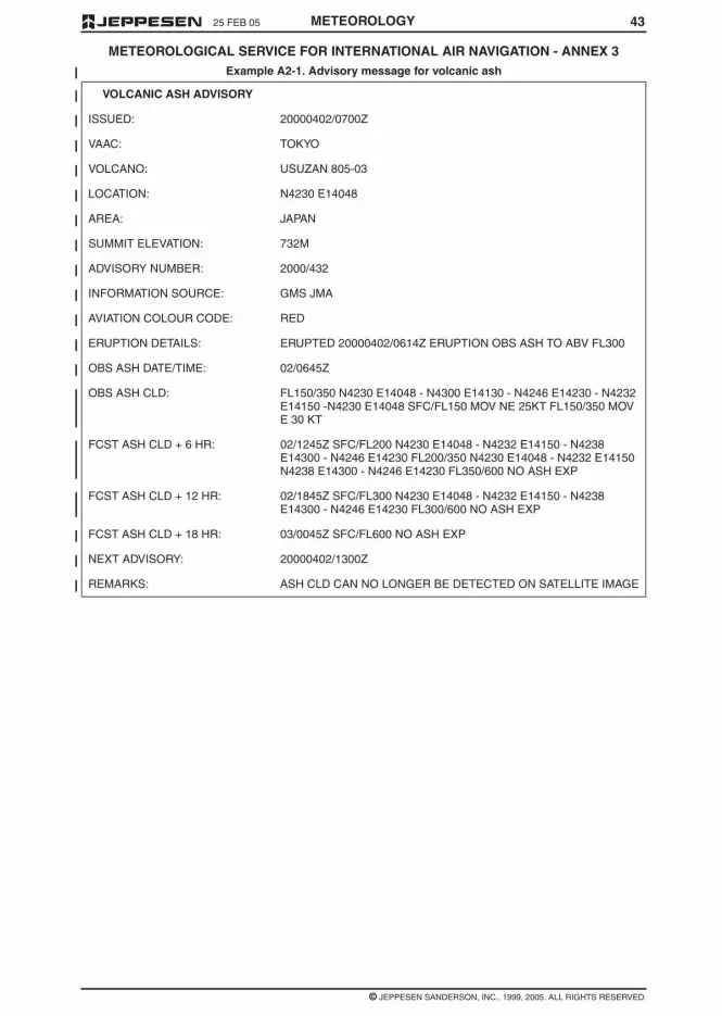
4325 FEB 05
© JEPPESEN SANDERSON, INC., 1999, 2005. ALL RIGHTS RESERVED.
METEOROLOGICAL SERVICE FOR INTERNATIONAL AIR NAVIGATION - ANNEX 3
METEOROLOGY
Example A2-1. Advisory message for volcanic ash
VOLCANIC ASH ADVISORY
ISSUED: 20000402/0700Z
VAAC: TOKYO
VOLCANO: USUZAN 805-03
LOCATION: N4230 E14048
AREA: JAPAN
SUMMIT ELEVATION: 732M
ADVISORY NUMBER: 2000/432
INFORMATION SOURCE: GMS JMA
AVIATION COLOUR CODE: RED
ERUPTION DETAILS: ERUPTED 20000402/0614Z ERUPTION OBS ASH TO ABV FL300
OBS ASH DATE/TIME: 02/0645Z
OBS ASH CLD: FL150/350 N4230 E14048 - N4300 E14130 - N4246 E14230 - N4232E14150 -N4230 E14048 SFC/FL150 MOV NE 25KT FL150/350 MOVE 30 KT
FCST ASH CLD + 6 HR: 02/1245Z SFC/FL200 N4230 E14048 - N4232 E14150 - N4238E14300 - N4246 E14230 FL200/350 N4230 E14048 - N4232 E14150N4238 E14300 - N4246 E14230 FL350/600 NO ASH EXP
FCST ASH CLD + 12 HR: 02/1845Z SFC/FL300 N4230 E14048 - N4232 E14150 - N4238E14300 - N4246 E14230 FL300/600 NO ASH EXP
FCST ASH CLD + 18 HR: 03/0045Z SFC/FL600 NO ASH EXP
NEXT ADVISORY: 20000402/1300Z
REMARKS: ASH CLD CAN NO LONGER BE DETECTED ON SATELLITE IMAGE

25 FEB 05
© JEPPESEN SANDERSON, INC., 1999, 2005. ALL RIGHTS RESERVED.
METEOROLOGICAL SERVICE FOR INTERNATIONAL AIR NAVIGATION - ANNEX 3
42 METEOROLOGY
Table A2-1 cont’d

4125 FEB 05
© JEPPESEN SANDERSON, INC., 1999, 2005. ALL RIGHTS RESERVED.
METEOROLOGICAL SERVICE FOR INTERNATIONAL AIR NAVIGATION - ANNEX 3
METEOROLOGY
Table A2-1 cont’d

4 MAR 05
© JEPPESEN SANDERSON, INC., 1999, 2005. ALL RIGHTS RESERVED.
METEOROLOGICAL SERVICE FOR INTERNATIONAL AIR NAVIGATION - ANNEX 3
40 METEOROLOGY
Table A2-1 - Template for advisory message for volcanic ash

4 25 FEB 05
© JEPPESEN SANDERSON, INC., 1999, 2005. ALL RIGHTS RESERVED.
METEOROLOGICAL SERVICE FOR INTERNATIONAL AIR NAVIGATION - ANNEX 3
METEOROLOGY
2.2.6 Recommendation — Demonstration ofcompliance of the quality system applied should beby audit. If non-conformity of the system is identified,action should be initiated to determine and correctthe cause. All audit observations should be evi-denced and properly documented.
2.2.7 The meteorological information suppliedto the users listed in 2.1.2 shall be consistent withHuman Factors principles and shall be in formswhich require a minimum of interpretation by users,as specified in the following chapters.
NOTE: Guidance material on the application of Hu-man Factors principles can be found in the HumanFactors Training Manual (DOC 9863).
2.3 NOTIFICATIONS REQUIRED FROMOPERATORS
2.3.1 An operator requiring meteorological ser-vice or changes in existing meteorological serviceshall notify, sufficiently in advance, the meteorologi-cal authority or the meteorological office(s) con-cerned. The minimum amount of advance notice re-quired shall be as agreed between themeteorological authority or meteorological office(s)and the operator.
2.3.2 The meteorological authority shall be no-tified by the operator requiring service when:
a. new routes or new types of operations areplanned;
b. changes of a lasting character are to be made inscheduled operations; and
c. other changes, affecting the provision of meteo-rological service, are planned.
Such information shall contain all details necessaryfor the planning of appropriate arrangements by themeteorological authority.
2.3.3 The aerodrome meteorological office, orthe meteorological office concerned, shall be noti-fied by the operator or a flight crew member:
a. of flight schedules;
b. when non-scheduled flights are to be operated;
c. when flights are delayed, advanced or cancelled.
2.3.4 Recommendation — The notification tothe aerodrome meteorological office, or the meteo-rological office concerned, of individual flightsshould contain the following information except that,in the case of scheduled flights, the requirement forsome or all of this information may be waived byagreement between the meteorological office andthe operator:
a. aerodrome of departure and estimated time ofdeparture;
b. destination and estimated time of arrival;
c. route to be flown and estimated times of arrivalat, and departure from, any intermediate aero-drome(s);
d. alternate aerodromes needed to complete theoperational flight plan and taken from the rele-vant list contained in the regional air navigationplan;
e. cruising level;
f. for supersonic flights, the alternative subsoniccruising level and the locations of the transonicacceleration and deceleration areas and of thesubsonic climb and descent paths;
g. type of flight, whether under the visual or the in-strument flight rules;
h. type of meteorological information requested fora flight crew member, whether flight documenta-tion and/or briefing or consultation;
i. time(s) at which briefing, consultation and/orflight documentation are required.
CHAPTER 3 – WORLD AREAFORECAST SYSTEM ANDMETEOROLOGICAL OFFICES
NOTE: Technical specifications and detailed criteriarelated to this chapter are given in Appendix 2.
3.1 OBJECTIVES OF THE WORLD AREAFORECAST SYSTEM
The objectives of the world area forecast systemshall be to supply meteorological authorities andother users with forecasts of global upper wind, up-per-air temperature and humidity, direction, speedand height of maximum wind, tropopause height andtemperature and forecasts of significant weatherphenomena in digital form. This objective shall beachieved through a comprehensive, integrated,worldwide and, as far as practicable, uniform sys-tem, and in a cost-effective manner, taking full ad-vantage of evolving techniques.
3.2 WORLD AREA FORECASTCENTRES
3.2.1 A Contracting State, having accepted theresponsibility for providing a WAFC within the frame-work of the world area forecast system, shall ar-range for that centre:
a. to prepare global forecasts for grid points in digi-tal form for all required levels and in a standardformat; the forecasts shall comprise upperwinds, upper-air temperatures, tropopauseheights and maximum wind speed, direction andheight;
b. to prepare global forecasts of significant weatherphenomena in digital form;
c. to issue the forecasts referred to in a. and b. indigital to meteorological authorities and other us-ers in its service area, as approved by the Con-tracting State on advice from the meteorologicalauthority;
d. to prepare and issue amendments to the fore-casts;
e. to receive information concerning the accidentalrelease of radioactive materials into the atmo-sphere, from its associated WMO regional spe-cialized meteorological centre for the provision oftransport model products for radiological envi-ronmental emergency response, in order to in-clude the information in significant weather fore-casts; and

394 MAR 05
© JEPPESEN SANDERSON, INC., 1999, 2005. ALL RIGHTS RESERVED.
METEOROLOGICAL SERVICE FOR INTERNATIONAL AIR NAVIGATION - ANNEX 3
METEOROLOGY
APPENDIX 2 - TECHNICAL SPECIFICATIONS RELATED TO WORLD AREAFORECAST SYSTEM AND METEOROLOGICAL OFFICES
Table A2-1. Template for advisory message for volcanic ash
NOTE 1: The ranges and resolutions for the numerical elements included in advisory messages for volcanicash are shown in Appendix 6, Table A6-4.
NOTE 2: The explanations for the abbreviations can be found in the Procedures for Air Navigation Services -ICAO Abbreviations and Codes (PANS-ABC, Doc 8400).
NOTE 3: Inclusion of a "colon " after each element heading is mandatory.
NOTE 4: The numbers 1 to 18 are included only for clarity and they are not part of the advisory message, asshown in the example.
NOTE:1. Use abbreviations for months of the year from the PANS-ABC (Doc 8400), for example, "JAN".
2. International Association of Volcanology and Chemistry of the Earth's Interior (IAVCEI).
3. Up to 4 selected layers.
4. If ash reported (e.g. AIREP) but not identifiable from satellite data.
Key: M = inclusion mandatory, part of every message;
0 = inclusion optional;
= = a double line indicates that the text following it should be placed on the subsequent line

25 FEB 05
© JEPPESEN SANDERSON, INC., 1999, 2005. ALL RIGHTS RESERVED.
METEOROLOGICAL SERVICE FOR INTERNATIONAL AIR NAVIGATION -- ANNEX 3
38 METEOROLOGY
4.2 SWL — SIGNIFICANT WEATHER CHART (LOW LEVEL)
4.3 ARROWS AND FEATHERS
Arrows indicate direction. Number of pennants and/or feathers correspond to speed.
Heavy solid lineinterrupted by windarrow and flight level
= position of jet stream axis with indication of wind direction, speed in kt or km/h andheight in flight levels. The vertical extent of the jet stream is indicated (in flightlevels) below the flight level, e.g. FL270 accompanied by +20/-30 indicates that theheight of the jet extends from FL240 to FL290.
Figures on arrows = speed in kt or km/h of movement of frontal system
Flight levels insidesmall rectangles
= height in flight levels of tropopause at spot locations; e.g., . Low and Highpoints of the tropopause topography are indicated by the letters L or H respectivelyinside a pentagon with the height in flight levels.
X = position of pressure centres given in hectopascals;
L = centre of low pressure;
H = centre of high pressure;
Scalloped lines = demarcation of area of significant weather
Dashed lines = altitude of 0°C isotherm in feet (hectofeet) or metres
NOTE: 0°C level may also be indicated by ; i.e., 0°C level is at analtitude of 6,000 ft.
Figures on arrows = speed in kt or km/h of movement of frontal systems, depressions or anticyclones
Figure inside thestate of the seasymbol
= total wave height in feet or metres
Figure inside the seasurface temperaturesymbol
= sea surface temperature in °C
Figures inside thestrong surface windsymbol
= wind in kt or km/h
EXAMPLE:
270° / 115 kt (equivalent to 213 km/h)
A pennant corresponds to 50 kt or 93 km/h;
A feather corresponds to 10 kt or 18 km/h;
A half-feather corresponds to 5 kt or 9 km/h.

3725 FEB 05
© JEPPESEN SANDERSON, INC., 1999, 2005. ALL RIGHTS RESERVED.
METEOROLOGICAL SERVICE FOR INTERNATIONAL AIR NAVIGATION -- ANNEX 3
METEOROLOGY
3 ABBREVIATIONS USED TO DESCRIBE CLOUDS
3.1 TYPE
3.2 AMOUNT
3.3 HEIGHTS
Heights are indicated on SWH and SWM in flight levels (FL), top over base.
When XXX is used, tops or bases are outside the layer of the atmosphere to which the chart applies.
In SWL (low level) significant weather charts:
a. Heights are indicated as altitudes above mean sea level;
b. The abbreviation SFC is used to indicate ground level.
4 DEPICTING OF LINES AND SYSTEMS ON SPECIFIC CHARTS
4.1 SWH AND SWM — SIGNIFICANT WEATHER CHARTS (HIGH AND MEDIUM)
Wind arrows indicate the maximum wind in jet and the flight level at which it occurs. Significant changes(speed of 20 knots or more, 3,000 ft (less if practicable) in flight level) are marked by the double bar. In theexample, at the double bar the wind speed is 225 km/h - 120 kt.
The heavy line delineating the jet axis begins/ends at the points where a wind speed of 150 km/h - 80 kt isforecast.
* This symbol refers to widespread surface wind speeds exceeding 60 km/h (30 kt).
CI = Cirrus AS = Altostratus ST = Stratus
CC = Cirrocumulus NS = Nimbostratus CU = Cumulus
CS = Cirrostratus SC = Stratocumulus CB = Cumulonimbus
AC = Altocumulus
Clouds except CB:
SKC = sky clear (0/8ths)
FEW = few (1/8th to 2/8ths)
SCT = scattered (3/8th to 4/8ths)
BKN = broken (5/8ths to 7/8ths)
OVC = overcast (8/8ths)
CB only:
ISOL = individual CBs (isolated)
OCNL = well separated CBs (occasional)
FRQ = CBs with little or no separation (frequent)
EMBD = CBs embedded in layers of other clouds or concealed by haze (embedded)
Scalloped line = demarcation of areas of significant weather
Heavy broken line = delineation of area of CAT

25 FEB 05
© JEPPESEN SANDERSON, INC., 1999, 2005. ALL RIGHTS RESERVED.
METEOROLOGICAL SERVICE FOR INTERNATIONAL AIR NAVIGATION -- ANNEX 3
36 METEOROLOGY
2 FRONTS AND CONVERGENCE ZONES AND OTHER SYMBOLS USED
Volcanic eruption *** Freezing precipitation ****
Mountain obscuration Visible ash cloud *****
* In flight documentation for flights operating up to FL 100, this symbol refers to “squall line”.
** The following information should be included at the side of the chart: radioactive materials symbol;Latitude/longitude of accident site; Date and time of accident; check NOTAM for further information.
*** The following information should be included at the side of the chart: Volcanic eruption symbol; Name andinternational number of volcano (if known); Latitude/longitude; Date and time of the first eruption (if known)
Check SIGMETs and NOTAM or ASHTAM for volcanic ash.
**** This symbol does not refer to icing due to precipitation coming into contact with an aircraft which is at avery low temperature.
***** Visible ash cloud symbol applies only to model VAG not to SIGWX charts.
NOTE: Height indications between which phenomena are expected, top above base as per chart legend.
Cold front at the surface Position, speed and level of max.wind
Warm front at the surface Convergence line
Occluded front at the surface Freezing level
Quasi-stationary front at thesurface Intertropical convergence zone
Tropopause high State of the sea
Tropopause low Sea surface temperature
Tropopause level Widespread strong surface wind *

3525 FEB 05
© JEPPESEN SANDERSON, INC., 1999, 2005. ALL RIGHTS RESERVED.
METEOROLOGICAL SERVICE FOR INTERNATIONAL AIR NAVIGATION -- ANNEX 3
METEOROLOGY
APPENDIX 1. MODEL SN – NOTATIONS USED IN FLIGHT DOCUMENTATION
1 SYMBOLS FOR SIGNIFICANT WEATHER
Thunderstorms Drizzle
Tropical cyclone Rain
Severe squall line* Snow
Moderate turbulence Shower Hail
Severe turbulence Widespread blowing snow
Mountain waves Severe sand or dust haze
Moderate aircraft icing Widespread sandstorm or duststorm
Severe aircraft icing Widespread haze
Widespread fog Widespread mist
Radioactive materials in the atmosphere** Widespread smoke

25 FEB 05
© JEPPESEN SANDERSON, INC., 1999, 2005. ALL RIGHTS RESERVED.
METEOROLOGICAL SERVICE FOR INTERNATIONAL AIR NAVIGATION - ANNEX 3
34 METEOROLOGY
MODEL VAG - VOLCANIC ASH ADVISORY INFORMATION IN GRAPHIC FORMAT

3325 FEB 05
© JEPPESEN SANDERSON, INC., 1999, 2005. ALL RIGHTS RESERVED.
METEOROLOGICAL SERVICE FOR INTERNATIONAL AIR NAVIGATION - ANNEX 3
METEOROLOGY
ANNEX 1- MODEL SWL - SIGNIFICANT WEATHER CHART (LOW LEVEL)

25 FEB 05
© JEPPESEN SANDERSON, INC., 1999, 2005. ALL RIGHTS RESERVED.
METEOROLOGICAL SERVICE FOR INTERNATIONAL AIR NAVIGATION - ANNEX 3
32 METEOROLOGY
ANNEX 1 - MODEL SWL - SIGNIFICANT WEATHER CHART (LOW LEVEL)

3125 FEB 05
© JEPPESEN SANDERSON, INC., 1999, 2005. ALL RIGHTS RESERVED.
METEOROLOGICAL SERVICE FOR INTERNATIONAL AIR NAVIGATION - ANNEX 3
METEOROLOGY
APPENDIX 1 - MODEL SWM - SIGNIFICANT WEATHER CHART (MEDIUM LEVEL)
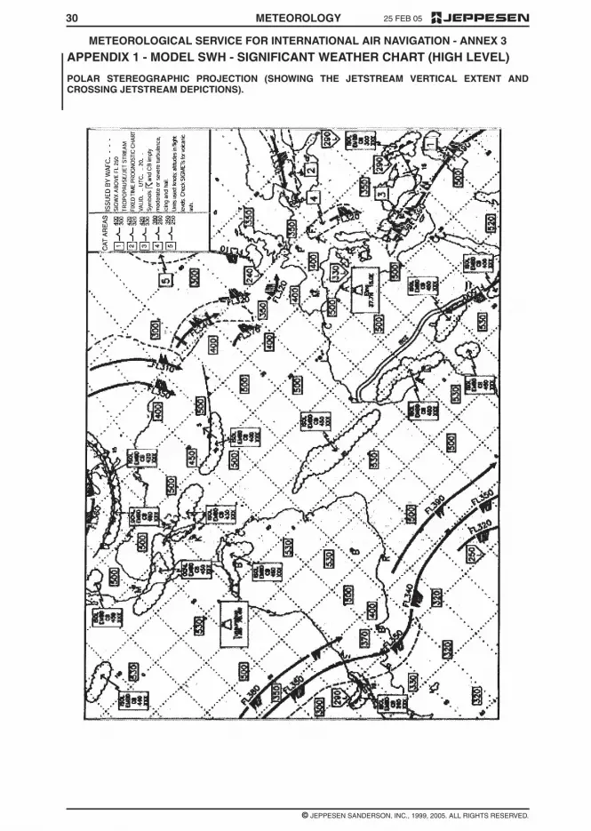
25 FEB 05
© JEPPESEN SANDERSON, INC., 1999, 2005. ALL RIGHTS RESERVED.
METEOROLOGICAL SERVICE FOR INTERNATIONAL AIR NAVIGATION - ANNEX 3
30 METEOROLOGY
APPENDIX 1 - MODEL SWH - SIGNIFICANT WEATHER CHART (HIGH LEVEL)
POLAR STEREOGRAPHIC PROJECTION (SHOWING THE JETSTREAM VERTICAL EXTENT ANDCROSSING JETSTREAM DEPICTIONS).

325 FEB 05
© JEPPESEN SANDERSON, INC., 1999, 2005. ALL RIGHTS RESERVED.
METEOROLOGICAL SERVICE FOR INTERNATIONAL AIR NAVIGATION - ANNEX 3
METEOROLOGY
c. “issue” is used solely in connection with caseswhere the obligation specifically extends tosending out the information to a user;
d. “make available” is used solely in connectionwith cases where the obligation ends with mak-ing the information accessible to a user; and
e. “supply” is used solely in connection with caseswhere either c. or d. applies.
CHAPTER 2 – GENERALPROVISIONS
2.1 OBJECTIVE, DETERMINATION ANDPROVISION OF METEOROLOGICALSERVICE
2.1.1 The objective of meteorological servicefor international air navigation shall be to contributetowards the safety, regularity and efficiency of inter-national air navigation.
2.1.2 This objective shall be achieved by sup-plying the following users: operators, flight crewmembers, air traffic services units, search and res-cue services units, airport managements and othersconcerned with the conduct or development of inter-national air navigation, with the meteorological infor-mation necessary for the performance of their re-spective functions.
2.1.3 Each Contracting State shall determinethe meteorological service which it will provide tomeet the needs of international air navigation. Thisdetermination shall be made in accordance with theprovisions of this Annex and with due regard to re-gional air navigation agreements; it shall include thedetermination of the meteorological service to beprovided for international air navigation over interna-tional waters and other areas which lie outside theterritory of the State concerned.
2.1.4 Each Contracting State shall designatethe authority, hereinafter referred to as the meteoro-logical authority, to provide or to arrange for the pro-vision of meteorological service for international airnavigation on its behalf. Details of the meteorologi-cal authority so designated shall be included in theState aeronautical information publication, in accor-dance with Annex 15, Appendix 1, GEN 1.1 (notpublished herein).
2.1.5 Each Contracting State shall ensure thatthe designated meteorological authority complieswith the requirements of the World MeteorologicalOrganization in respect of qualifications and trainingof meteorological personnel providing services forinternational air navigation.
2.2 SUPPLY, QUALITY ASSURANCEAND USE OF METEOROLOGICALINFORMATION
2.2.1 Close liaison shall be maintained be-tween those concerned with the supply and thoseconcerned with the use of meteorological informa-tion on matters which affect the provision of meteo-rological service for international air navigation.
2.2.2 Recommendation — In order to meetthe objective of meteorological service for interna-tional air navigation, the Contracting State shouldensure that the designated meteorological authorityreferred to in 2.1.4 establishes and implements aproperly organized quality system comprising proce-dures, processes and resources necessary to pro-vide for the quality management of the meteorologi-cal information to be supplied to users listed in 2.1.2.
2.2.3 Recommendation — The quality systemestablished in accordance with 2.2.2 should be inconformity with the International Organization forStandardization (ISO) 9000 series of quality assur-ance standards, and certified by an approved orga-nization.
NOTE: International Organization for Standardiza-tion (ISO) 9000 series of quality assurance stan-dards provide a basic framework for the develop-ment of a quality assurance programme. The detailsof a successful programme are to be formulated byeach State and in most cases are unique to theState organization.
2.2.4 Recommendation — The quality systemshould provide the users with assurance that themeteorological information supplied complies withthe stated requirements in terms of the geographicaland spatial coverage, format and content, time andfrequency of issuance and period of validity, as wellas the accuracy of measurements, observations andforecasts. Where the quality system indicates thatthe meteorological information to be supplied to theusers does not comply with the stated requirements,and automatic error correction procedures are notappropriate, such information should not be suppliedto the users unless it is validated with the originator.
NOTE 1: Requirements concerning the geographicaland spatial coverage, format and content, time andfrequency of issuance and period of validity of mete-orological information to be supplied to aeronauticalusers are given in Chapters 3, 4, 6 to 10 and Appen-dices 2, 3, 5 to 9 of Annex 3 and the relevant region-al air navigation plans. Guidance concerning the ac-curacy of measurement and observation, andaccuracy of forecasts is given in Attachments A andB respectively to Annex 3.
NOTE 2: Notwithstanding the provisions in 2.2.4,provisional TAF may still be issued, as necessary, inaccordance with Appendix 8, 4.4.3.
2.2.5 Recommendation — In regard to the ex-change of meteorological information for operationalpurposes, the quality system should include verifica-tion and validation procedures and resources formonitoring adherence to the prescribed transmis-sion schedules for individual messages and/or bulle-tins required to be exchanged, and at the times oftheir filing for transmission. The quality systemshould be capable of detecting excessive transittimes of messages and bulletins received.
NOTE: Requirements concerning the exchange ofoperational meteorological information are given inChapter 11 and Appendix 10 of Annex 3.

2925 FEB 05
© JEPPESEN SANDERSON, INC., 1999, 2005. ALL RIGHTS RESERVED.
METEOROLOGICAL SERVICE FOR INTERNATIONAL AIR NAVIGATION - ANNEX 3
METEOROLOGY
APPENDIX 1 - MODEL SWH SIGNIFICANT WEATHER CHART (HIGH LEVEL)
POLAR STEREOGRAPHIC PROJECTION

25 FEB 05
© JEPPESEN SANDERSON, INC., 1999, 2005. ALL RIGHTS RESERVED.
METEOROLOGICAL SERVICE FOR INTERNATIONAL AIR NAVIGATION - ANNEX 3
28 METEOROLOGY
APPENDIX 1 - MODEL SWH - SIGNIFICANT WEATHER CHART (HIGH LEVEL)
EXAMPLE - MERCATOR PROJECTION

2725 FEB 05
© JEPPESEN SANDERSON, INC., 1999, 2005. ALL RIGHTS RESERVED.
METEOROLOGICAL SERVICE FOR INTERNATIONAL AIR NAVIGATION - ANNEX 3
METEOROLOGY
APPENDIX 1 - MODEL IS - UPPER WIND AND TEMPERATURE CHART FORSTANDARD ISOBARIC SURFACE
EXAMPLE - ARROWS, FEATHERS AND PENNANTS (POLAR STEREOGRAPHIC PROJECTION)

25 FEB 05
© JEPPESEN SANDERSON, INC., 1999, 2005. ALL RIGHTS RESERVED.
METEOROLOGICAL SERVICE FOR INTERNATIONAL AIR NAVIGATION - ANNEX 3
26 METEOROLOGY
APPENDIX 1 - MODEL IS - UPPER WIND AND TEMPERATURE CHART FORISOBARIC SURFACE
EXAMPLE - ARROWS, FEATHERS AND PENNANTS (MERCATOR PROJECTION)

2525 FEB 05
© JEPPESEN SANDERSON, INC., 1999, 2005. ALL RIGHTS RESERVED.
METEOROLOGICAL SERVICE FOR INTERNATIONAL AIR NAVIGATION - ANNEX 3
METEOROLOGY
APPENDIX 1 - MODEL TB - TABULAR FORECAST OF UPPER WINDS ANDUPPER AIR TEMPERATURES
EXAMPLE - SPOT LOCATIONS

2325 FEB 05
© JEPPESEN SANDERSON, INC., 1999, 2005. ALL RIGHTS RESERVED.
METEOROLOGICAL SERVICE FOR INTERNATIONAL AIR NAVIGATION - ANNEX 3
METEOROLOGY
APPENDIX 1, MODEL TA - TABULAR FORECAST OF ENROUTE CONDITIONS -EXAMPLE 2 - MEDIUM LEVEL
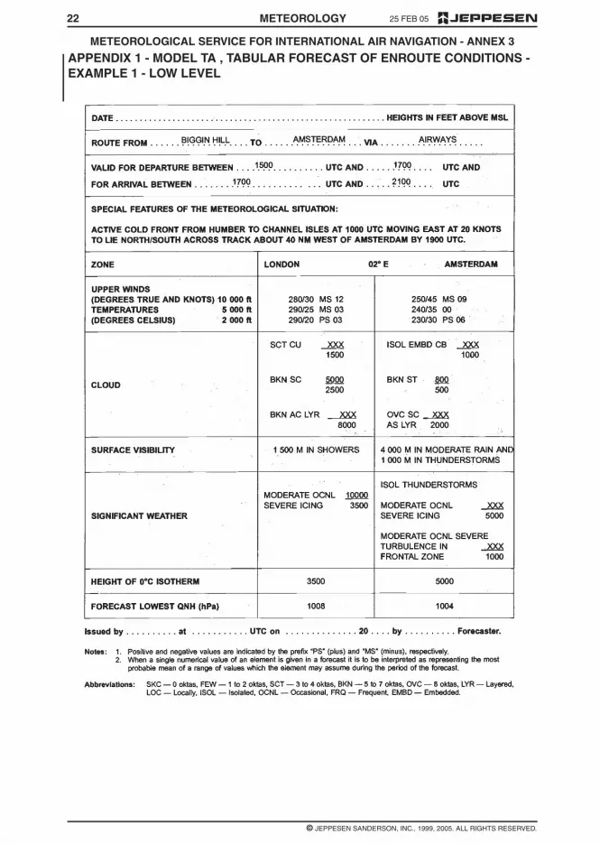
25 FEB 05
© JEPPESEN SANDERSON, INC., 1999, 2005. ALL RIGHTS RESERVED.
METEOROLOGICAL SERVICE FOR INTERNATIONAL AIR NAVIGATION - ANNEX 3
22 METEOROLOGY
APPENDIX 1 - MODEL TA , TABULAR FORECAST OF ENROUTE CONDITIONS -EXAMPLE 1 - LOW LEVEL

2125 FEB 05
© JEPPESEN SANDERSON, INC., 1999, 2005. ALL RIGHTS RESERVED.
METEOROLOGICAL SERVICE FOR INTERNATIONAL AIR NAVIGATION - ANNEX 3
METEOROLOGY
APPENDIX 1 - MODEL A - AERODROME FORECAST, EXAMPLE 2 - TAF

25 FEB 05
© JEPPESEN SANDERSON, INC., 1999, 2005. ALL RIGHTS RESERVED.
METEOROLOGICAL SERVICE FOR INTERNATIONAL AIR NAVIGATION - ANNEX 3
20 METEOROLOGY
APPENDIX 1 - MODEL A - AERODROME FORECASTS - EXAMPLE 1 - TABULARFORM

2 25 FEB 05
© JEPPESEN SANDERSON, INC., 1999, 2005. ALL RIGHTS RESERVED.
METEOROLOGICAL SERVICE FOR INTERNATIONAL AIR NAVIGATION - ANNEX 3
METEOROLOGY
NOTE: The IAVW is based on the co-operation ofaviation and non-aviation operational units using in-formation derived from observing sources and net-works that are provided by States. The watch isco-ordinated by ICAO with the co-operation of otherconcerned international organizations.
METEOROLOGICAL AUTHORITY — The au-thority providing or arranging for the provision of me-teorological service for international air navigationon behalf of a Contracting State.
METEOROLOGICAL BULLETIN — A text com-prising meteorological information preceded by anappropriate heading.
METEOROLOGICAL INFORMATION — Meteo-rological report, analysis, forecast and any otherstatement relating to existing or expected meteoro-logical conditions.
METEOROLOGICAL OFFICE — An office desig-nated to provide meteorological service for interna-tional air navigation.
METEOROLOGICAL REPORT — A statement ofobserved meteorological conditions related to aspecified time and location.
METEOROLOGICAL SATELLITE — An artificialEarth satellite making meteorological observationsand transmitting these observations to Earth.
OBSERVATION (Meteorological) — The evalua-tion of one or more meteorological elements.
PROGNOSTIC CHART — A forecast of a speci-fied meteorological element(s) for a specified time orperiod and a specified surface or portion of airspace,depicted graphically on a chart.
REGIONAL AIR NAVIGATION AGREEMENT —Agreement approved by the Council of ICAO nor-mally on the advice of a regional air navigationmeeting.
SERVICE AREA (World Area Forecast Sys-tem) — A geographical area within which a re-gional area forecast centre is responsible for supply-ing area forecasts to meteorological authorities andother users.
SIGMET INFORMATION — Information issued bya meteorological watch office concerning the occur-rence or expected occurrence of specified en routeweather phenomena which may affect the safety ofaircraft operations.
STANDARD ISOBARIC SURFACE — An isobar-ic surface used on a world-wide basis for represent-ing and analyzing the conditions in the atmosphere.
TROPICAL CYCLONE — Generic term for anon-frontal synoptic-scale cyclone originating overtropical or sub-tropical waters with organized con-vection and definite cyclonic surface wind circula-tion.
TROPICAL CYCLONE ADVISORY CENTRE(TCAC) — A meteorological centre designated byregional air navigation agreement to provide adviso-ry information to meteorological watch offices re-garding the position, forecast direction and speed of
movement, central pressure and maximum surfacewind of tropical cyclones.
UPPER-AIR CHART — A meteorological chart re-lating to a specified upper-air surface or layer of theatmosphere.
VISIBILITY — Visibility for aeronautical purposesis the greater of:
a. the greatest distance at which a black object ofsuitable dimensions, situated near the ground,can be seen and recognized when observedagainst a bright background;
b. the greatest distance at which lights in the vicini-ty of 1,000 candles can be seen and identifiedagainst an unlit background.
NOTE: The two distances have different values in airof given extinction coefficient, and the latter b. varieswith the background illumination. The former a. isrepresented by the meteorological optical range(MOR).
VOLCANIC ASH ADVISORY CENTRE (VAAC) —A meteorological centre designated by regional airnavigation agreement to provide advisory informa-tion to meteorological watch offices, area controlcentres, flight information centres, world area fore-cast centres, relevant regional area forecast centresand international OPMET data banks regarding thelateral and vertical extent and forecast movement ofvolcanic ash in the atmosphere following volcaniceruptions.
VOLMET BROADCAST — Routine broadcastcontaining, as appropriate, current aerodromeweather reports, aerodrome forecasts and SIGMETmessages for aircraft in flight.
VOLMET DATA LINK SERVICE (D-VOLMET) —Provision of current aerodrome weather reports,aerodrome forecasts and SIGMET messagesthrough data link.
WORLD AREA FORECAST CENTRE (WAFC) —A meteorological centre designated to prepare andsupply significant weather forecasts and upper-airforecasts in digital and/or pictorial form on a globalbasis to regional area forecast centres, and direct toStates by appropriate means as part of the aeronau-tical fixed service.
WORLD AREA FORECAST SYSTEM (WAFS) —A world-wide system by which world and regionalarea forecast centres provide aeronautical meteoro-logical en route forecasts in uniform standardizedformats.
1.2 TERMS USED WITH A LIMITEDMEANING
For the purpose of Annex 3, the following terms areused with a limited meaning as indicated below:
a. to avoid confusion in respect of the term “ser-vice” between the meteorological service consid-ered as an administrative entity and the servicewhich is provided, “meteorological authority” isused for the former and “service” for the latter;
b. “provide” is used solely in connection with theprovision of service;
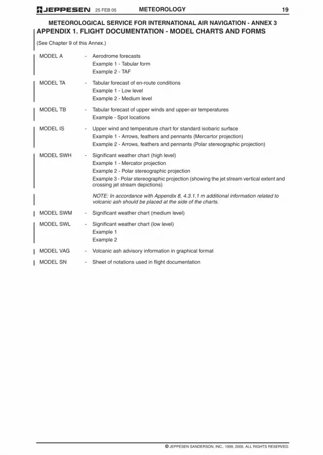
1925 FEB 05
© JEPPESEN SANDERSON, INC., 1999, 2005. ALL RIGHTS RESERVED.
METEOROLOGICAL SERVICE FOR INTERNATIONAL AIR NAVIGATION - ANNEX 3
METEOROLOGY
APPENDIX 1. FLIGHT DOCUMENTATION - MODEL CHARTS AND FORMS
(See Chapter 9 of this Annex.)
MODEL A - Aerodrome forecasts
Example 1 - Tabular form
Example 2 - TAF
MODEL TA - Tabular forecast of en-route conditions
Example 1 - Low level
Example 2 - Medium level
MODEL TB - Tabular forecast of upper winds and upper-air temperatures
Example - Spot locations
MODEL IS - Upper wind and temperature chart for standard isobaric surface
Example 1 - Arrows, feathers and pennants (Mercartor projection)
Example 2 - Arrows, feathers and pennants (Polar stereographic projection)
MODEL SWH - Significant weather chart (high level)
Example 1 - Mercator projection
Example 2 - Polar stereographic projection
Example 3 - Polar stereographic projection (showing the jet stream vertical extent andcrossing jet stream depictions)
NOTE: In accordance with Appendix 8, 4.3.1.1 m additional information related tovolcanic ash should be placed at the side of the charts.
MODEL SWM - Significant weather chart (medium level)
MODEL SWL - Significant weather chart (low level)
Example 1
Example 2
MODEL VAG - Volcanic ash advisory information in graphical format
MODEL SN - Sheet of notations used in flight documentation

18 25 FEB 05
© JEPPESEN SANDERSON, INC., 1999, 2005. ALL RIGHTS RESERVED.
METEOROLOGICAL SERVICE FOR INTERNATIONAL AIR NAVIGATION - ANNEX 3
METEOROLOGY
11.1.3 Suitable telecommunication facilities shallbe made available to permit world area forecast cen-ters to supply the required world area forecast sys-tem products to meteorological offices, meteorologi-cal authorities and other users.
11.1.4 Telecommunication facilities betweenmeteorological offices and, as necessary, aeronauti-cal meteorological stations and aerodrome controltowers or approach control offices shall permit com-munications by direct speech, the speed with whichthe communications can be established being suchthat required points may normally be contacted with-in approximately 15 seconds.
11.1.5 Recommendation – Telecommunicationfacilities between meteorological offices and flight in-formation centers, area control centers, rescue coor-dination centers and aeronautical telecommunica-tion stations should permit:
a. communications by direct speech, the speedwith which the communications can be estab-lished being such that the required points maynormally be contacted within approximately 15seconds; and
b. printed communications, when a record is re-quired by the recipient; the message transmittime should not exceed 5 minutes.
NOTE: In 11.1.4 and 11.1.5 ‘approximately 15seconds’ refers to telephony communications in-volving switchboard operation and ‘5 minutes’ re-fer to printed communications involving transmis-sion.
11.1.6 Recommendation – The telecommuni-cation facilities required in accordance with 11.1.4and 11.1.5 should be supplemented, as and wherenecessary, by other forms of visual or audio commu-nications, for example, closed-circuit television orseparate information processing systems.
11.1.7 Recommendation – As agreed betweenthe meteorological authority and operators, provi-sion should be made to enable operators to estab-lish suitable telecommunications facilities for obtain-ing meteorological information from aerodromemeteorological offices or other appropriate sources.
11.1.8 Recommendation – Suitable telecom-munications facilities shall be made available to per-mit meteorological offices to exchange operationalmeteorological information with other meteorologicaloffices.
11.1.9 Recommendation – The telecommuni-cations facilities used for the exchange of operation-al meteorological information should be the aero-nautical fixed service.
11.2 USE OF AERONAUTICAL FIXED SERVICECOMMUNICATIONS - METEORLOGICAL BULLE-TINS IN ALPHANUMERIC FORMAT
Meteorological bulletins containing operational me-teorological information to be transmitted via aero-nautical fixed service shall be originated by the ap-propriate meteorological office or aeronauticalmeteorological station.
NOTE: Meteorological bulletins containing opera-tional meteorological information authorized for
transmission via aeronautical fixed service are listedin Annex 10, Volume II, Chapter 4, together with therelevant priorities and priority indicator.
11.3 USE OF AERONAUTICAL FIXED SERVICECOMMUNICATIONS - WORLD AREA FORECASTSYSTEM PRODUCTS
Recommendation – World area forecast systemproducts in digital form should be transmitted usingbinary data communication techniques. The methodand channels used for dissemination of the productsshould be as determined by regional air navigationagreement.
11.4 USE OF AERONAUTICAL MOBILE SER-VICE COMMUNICATION
The content and format of meteorological informa-tion transmitted to aircraft and by aircraft shall beconsistent with the provisions of this Annex.
11.5 USE OF AERONAUTICAL DATA LINKSERVICE - CONTENTS OF D-VOLMET
D-VOLMET shall contain current METAR and SPECItogether with trend forecasts where available, TAFand SIGMET, special air-reports not covered by SIG-MET and, where available, AIRMET.
NOTE: The requirement to provide METAR andSPECI may be met by the data-link information ser-vice (D-FIS) application entitled ‘Data link-aero-drome routine meteorological report (D-METAR) ser-vice’; the requirement to provide TAF may be met bythe D-FIS application entitled ‘Data link-aerodromeforecast (D-TAF) service’; and the requirement toprovide SIGMET and AIRMET messages may bemet by the D-FIS application entitled ‘Data link-SIG-MET (D-SIGMET) service’. The details of these datalink services are specified in the Manual of Air TrafficServices Data Link Applications (Doc 9694).
11.6 USE OF AERONAUTICAL BROADCASTSERVICE - CONTENTS OF VOLMET BROAD-CASTS
11.6.1 Continuous VOLMET broadcasts, nor-mally on very high frequencies (VHF) shall containcurrent METAR and SPECI, together with trend fore-casts where available.
11.6.2 Scheduled VOLMET broadcasts, normal-ly on high frequencies (HF), shall contain currentMETAR and SPECI, together with trend forecastswhere available and, where so determined by re-gional air navigation agreement, TAF and SIGMET.

1725 FEB 05
© JEPPESEN SANDERSON, INC., 1999, 2005. ALL RIGHTS RESERVED.
METEOROLOGICAL SERVICE FOR INTERNATIONAL AIR NAVIGATION - ANNEX 3
METEOROLOGY
NOTE: The responsibilities relating to aeronauticalinformation services information and the quality as-surance of the information is given in Annex 15,Chapter 3.
9.6 INFORMATION FOR AIRCRAFT INFLIGHT
9.6.1 Meteorological information for use by air-craft in flight shall be supplied by a meteorologicaloffice to its associated air traffic services unit andthrough D-VOLMET or VOLMET broadcasts. Meteo-rological information for planning by the operator foraircraft in flight shall be supplied on request, asagreed between the meteorological authority or au-thorities and the operator concerned.
9.6.2 Meteorological information for use by air-craft on flight shall be supplied to air traffic servicesunits in accordance with specifications of Chapter10.
9.6.3 Meteorological information shall be sup-plied through D-VOLMET or VOLMET broadcast asdetermined by regional air navigation agreement,and in accordance with the specifications of Chapter11.
CHAPTER 10 - INFORMATION FORAIR TRAFFIC SERVICES, SEARCHAND RESCUE SERVICES ANDAERONAUTICAL INFORMATIONSERVICES
NOTE: Technical specifications and detailed criteriarelated to this chapter are given in Appendix 9.
10.1 INFORMATION FOR AIR TRAFFIC SER-VICES UNITS
10.1.1 The meteorological authority shall desig-nate a meteorological office to be associated witheach air traffic services unit. The associated meteo-rological office shall, after coordination with air trafficservices unit, supply, or arrange for the supply ofup-t-date meteorological information to the unit nec-essary for the conduct of its function.
10.1.2 Recommendation – The associated me-teorological office for an aerodrome control tower orapproach control office should be an aerodrome me-teorological office.
10.1.3 The associated meteorological office fora flight information center or area control center shallbe a meteorological watch office.
10.1.4 Recommendation – Where, owing to lo-cal circumstances, it is convenient for the duties ofan associated meteorological office to be shared be-tween two or more meteorological offices, the divi-sion of responsibility should be determined by themeteorological authority in consultation with the ap-propriate ATS authority.
10.1.5 Any meteorological information request-ed by an air traffic services unit in connection withan aircraft emergency shall be supplied as rapidly aspossible.
10.2 INFORMATION FOR SEARCH AND RES-CUE SERVICES UNITS
Meteorological offices designated by the meteoro-logical authority in accordance with regional air navi-gation agreement shall supply search and rescueservices units with the meteorological informationthey require in a form established by mutual agree-ment. For that purpose, the designated meteorologi-cal office shall maintain liaison with the search andrescue services unit throughout a search and rescueoperation.
10.3 INFORMATION FOR AERONAUTICAL IN-FORMATION SERVICES UNITS
The meteorological authority, in coordination withthe appropriate civil aviation authority, shall arrangefor the supply of up-to-date meteorological informa-tion to relevant aeronautical information servicesunits, as necessary, for the conduct of their func-tions.
CHAPTER 11- REQUIREMENTS FORAND USE OF COMMUNICATIONS
NOTE 1: Technical specification and detailed criteriarelated to this chapter are given in Appendix10.
NOTE 2: It is recognized that it is for each Contract-ing State to decide upon it own internal organizationand responsibility for implementing the telecommu-nication facilities referred to this chapter.
11.1 REQUIREMENTS FOR COMMUNICA-TIONS
11.1.1 Suitable telecommunications facilitiesshall be made available to permit aerodrome meteo-rological offices and, as necessary, aeronautical me-teorological stations to supply the required meteoro-logical information to air traffic services units on theaerodromes for which those offices and stations areresponsible, and in particular to aerodrome controltowers, approach control offices and the aeronauti-cal telecommunications stations serving these aero-dromes.
NOTE: Circuits of the aeronautical fixed service areused for the collection and regional and inter-region-al exchanges of operational meteorological informa-tion as well as for access to international operationalmeteorological data banks. Three aeronautical fixedservice satellite distribution systems providing forglobal coverage are used to support the regionaland inter-regional exchanges of operational meteo-rological information. Provisions relating to the satel-lite distribution systems are given in Annex 10, Vol-ume III, part 1, 10.1 and 10.2.
11.1.2 Suitable telecommunications facilitiesshall be made available to permit meteorologicalwatch offices to supply the required meteorologicalinformation to air traffic services and search and res-cue services units in respect of the flight informationregions, control areas and search and rescue re-gions for which those offices are responsible, and inparticular to flight information centers, area controlcenters and rescue coordination centers and the as-sociated aeronautical telecommunications stations.
16 25 FEB 05
© JEPPESEN SANDERSON, INC., 1999, 2005. ALL RIGHTS RESERVED.
METEOROLOGICAL SERVICE FOR INTERNATIONAL AIR NAVIGATION - ANNEX 3
METEOROLOGY
9.3.4 The required briefing, consultation, dis-play and/or flight documentation shall normally beprovided by the meteorological office associatedwith the aerodrome of departure. At an aerodromewhere these facilities are not available, arrange-ments to meet the requirements of flight crew mem-bers shall be as agreed upon between the meteoro-logical authority and the operator concerned. Inexceptional circumstances, such as an undue delay,the meteorological office associated with the aero-drome shall provide or, if that is not practicable, ar-range for the provision of a new briefing, consulta-tion and/or flight documentation as necessary.
9.3.5 Recommendation – The flight crewmember or other flight operations personnel forwhom briefing, consultation and/or flight documenta-tion has been requested should visit the meteorolog-ical office at the time agreed upon between the me-teorological office and the operator concerned.Where local circumstances at an aerodrome makepersonal briefing or consultation impracticable, themeteorological office should provide these servicesby telephone or suitable telecommunication facilities.
9.4 FLIGHT DOCUMENTATION –GENERAL
NOTE: The requirements for the use of automatedpreflight information systems in providing flight docu-mentation are given in 9.5.
9.4.1 Recommendation – Flight documenta-tion should cover the whole route to be flown andcomprise information listed under 9.2 a., c., and e. toh. However, in accordance with regional air naviga-tion agreement, or in the absence thereto whenagreed between the meteorological authority andthe operator concerned, flight documentation forflights of two hours duration or less, after a shortstop or turn around should be limited to the informa-tion operationally needed, but in all cases the flightdocumentation should at least comprise the informa-tion on 9.2.1 e., f., g. and if appropriate, h.
9.4.2 Recommendation – Meteorological of-fices should, as far as practicable, provide informa-tion received within the framework of the world areaforecast system for flight documentation. The flightdocumentation should be presented in the form ofcharts, tabular forms, or abbreviated plain-languagetexts. Aerodrome forecasts should be presented inthe TAF code, or in abbreviated plain-language textusing a tabular presentation.
NOTE: Models of charts and forms for use in thepreparation of flight documentation are given in Ap-pendix 1. These models and methods for their com-pletion are developed by the World MeteorologicalOrganization on the basis of relevant operational re-quirements stated by the International Civil AviationOrganization.
9.4.3. Whenever it becomes apparent that themeteorological information to be included in theflight documentation will differ materially from thatmade available for pre-flight planning and in-flightre-planning, the operator shall be advised immedi-ately and, if practicable, be supplied with the revised
information as agreed between the operator and themeteorological office concerned.
9.4.4 Recommendation – Whenever neces-sary and possible, the flight documentation shouldbe brought up to date, in writing or orally, before it issupplied to flight crew members. In cases where aneed for amendment arises after the flight documen-tation has been supplied, and before take-off of theaircraft, the meteorological office should, as greedlocally, issue the necessary amendment or updatedinformation to the operator or to the local air trafficservices unit, for transmission to the aircraft.
9.4.5 Recommendation – The forms andcharts included in flight documentation should beprinted in English, French, Russian or Spanish; theyshould, wherever practicable, be completed in thelanguage requested by the operator, preferably us-ing one of those languages. Where appropriate, ap-proved abbreviations should be used. The units em-ployed for each element should be indicated; theyshould be in accordance with Annex 5.
9.5 AUTOMATED PRE-FLIGHTINFORMATION SYSTEMS FORBRIEFING, CONSULTATION, FLIGHTPLANNING AND FLIGHTDOCUMENTATION
9.5.1 Where the meteorological authority usesautomated pre-flight information systems to supplyand display meteorological information to operatorsand flight crew members for self-briefing, flight plan-ning and flight documentation purposes, the infor-mation supplied and displayed shall comply with therelevant provisions in 9.1 to 9.4 inclusive.
9.5.2 Recommendation – Automatedpre-flight information systems providing for a harmo-nized, common point of access to meteorological in-formation and aeronautical information services in-formation by operators, flight crew members andother aeronautical personnel concerned should beestablished by an agreement between the meteoro-logical authority and the relevant civil aviation au-thority or the agency to which the authority provideservice has been delegated in accordance with An-nex 15, 3.1.1 c.
NOTE: The meteorological and aeronautical infor-mation services information concerned is specifiedin 9.1 to 9.4 and Appendix 8 and in Annex 15, 8.1and 8.2 respectively.
9.5.3 Where automated pre-flight informationsystems are used to provide a harmonized, commonpoint of access to meteorological information andaeronautical information services information by op-erators, flight crew members and other aeronauticalpersonnel concerned, the meteorological authorityconcerned shall remain responsible for the qualitycontrol and quality management if meteorological in-formation by means of such systems in accordancewith Chapter2, 2.2.2

1525 FEB 05
© JEPPESEN SANDERSON, INC., 1999, 2005. ALL RIGHTS RESERVED.
METEOROLOGICAL SERVICE FOR INTERNATIONAL AIR NAVIGATION - ANNEX 3
METEOROLOGY
c. use by flight crew members before departure;and
d. aircraft in flight.
9.1.2 Meteorological information supplied tooperators and flight crew members shall cover theflight in respect of time, altitude and geographical ex-tent. Accordingly, the information shall relate to ap-propriate fixed times, or periods of time, and shallextent to the aerodrome of intended landing, alsocovering the meteorological conditions expected be-tween the aerodrome of intended landing and onealternate aerodrome designated by the operator. Inaddition, if agreed between numerological authorityand the operator, information up to a further aero-drome shall be supplied
9.1.3 Meteorological information supplied tooperators and flight crew members shall include up-per winds and upper-air temperatures, significant enroute weather phenomena, METAR and SPECI (in-cluding trend forecasts), TAF, forecasts for take-off,SIGMET information and those special air-reportsnot covered by a SIGMET, and AIRMET information,which are available at the meteorological office andwhich are relevant to the planned flight operations.
9.1.4 Where necessary, the meteorological au-thority of the State providing service for operatorsand flight crew members shall initiate coordinatingaction with the meteorological authorities of otherStates with a view to obtaining from them reportsand/or forecasts required.
9.1.5 Meteorological information shall be sup-plied to operators and flight crew members at the lo-cation to be determined by the meteorological au-thority, after consultation with the operators and thetime to be agreed upon between the meteorologicaloffice and the operator concerned. The service shallnormally be confined to flights originating within theterritory of the State concerned, unless otherwiseagreed between the meteorological authority andthe operator concerned. At an aerodrome without ameteorological office, arrangements for the supply ofmeteorological information shall be as agreed uponbetween the meteorological authority and the opera-tor concerned.
9.2 INFORMATION FOR OPERATORSFOR PRE-FLIGHT PLANNING ANDFOR IN-FLIGHT RE-PLANNINGUNDER CENTRALIZEDOPERATIONAL CONTROL
9.2.1 Meteorological information for pre-flightplanning and in-flight re-planning by operators shallinclude any or all of the following information, as es-tablished by the meteorological authority in consulta-tion with operators concerned:
a. current and forecast: upper winds, upper-air tem-peratures and humidity;
b. tropopause height and temperature, and direc-tion, speed and height of maximum wind;
c. existing and expected significant en route weath-er phenomena and amendments thereto;
d. forecast for take-off;
e. METAR and, where available, SPECI (includingtrend forecasts) for the aerodrome of departure,take-off and en route alternate aerodromes, theaerodrome of intended landing and destinationalternate aerodromes, as determined by regionalair navigation agreement;
f. TAF and amendments thereto for the aero-dromes of departure and intended landing, andfor take-off, en route and destination alternateaerodromes as determined by regional air navi-gation agreement;
g. SIGMET information and appropriate specialair-reports relevant to the whole of the routesconcerned as determined by regional air naviga-tion agreement, and;
NOTE: Appropriate special air-reports will bethose not already used in preparation of SIG-MET messages.
h. AIRMET information for low-level flights are de-termined by regional air navigation agreement.
9.2.2 When upper-air information is supplied inchart form, it shall consist of charts for standardflight levels.
9.2.3 Recommendation – The upper wind andupper-air temperature information and the significanten route weather information requested for pre-flightplanning and in-flight re-planning by the operatorshould be supplied as soon as it becomes available,but not later than 3 hours before departure. Othermeteorological information requested for pre-flightplanning and in-flight re-planning by the operatorshould be supplied as soon as is practicable.
9.3 BRIEFING, CONSULTATION ANDDISPLAY
NOTE: The requirements for the use of automatedpreflight information systems in providing briefing,consultation and display are given in 9.5...
9.3.1 Briefing and/or consultation shall be pro-vided, on request, to flight crew members and/orother flight operations personnel. Its purpose shallbe to supply the latest available information on exist-ing and expected meteorological conditions alongthe route to be flown, at the aerodrome of intendedlanding, alternate aerodromes and other aero-dromes as relevant, either to explain and amplify theinformation contained in the flight documentation or,if so agreed between the meteorological authorityand the operator, in lieu of flight documentation.
9.3.2 Meteorological information used for brief-ing and consultation shall include any or all of the in-formation listed in 9.2.1.
9.3.3 If the meteorological office expresses anopinion on the development of the meteorologicalconditions at an aerodrome which differs apprecia-bly from the aerodrome forecast included in the flightdocumentation, the attention of flight crew membersshall be drawn to the divergence. The portion of thebriefing dealing with the divergence shall be record-ed at the time of briefing and this record shall bemade available to the operator.

14 25 FEB 05
© JEPPESEN SANDERSON, INC., 1999, 2005. ALL RIGHTS RESERVED.
METEOROLOGICAL SERVICE FOR INTERNATIONAL AIR NAVIGATION - ANNEX 3
METEOROLOGY
7.3 AERODROME WARNINGS
7.3.1 Aerodrome warnings shall be issued bythe meteorological office designated by the meteoro-logical authority concerned and shall give conciseinformation of meteorological conditions which couldaversely affect aircraft on the ground, includingparked aircraft, and the aerodrome facilities and ser-vices.
7.3.2 Recommendation – Aerodrome warn-ings should be cancelled when the conditions are nolonger occurring and/or no longer expected to occurat the aerodrome
7.4 WIND SHEAR WARNINGS
7.4.1 Wind shear warnings shall be preparedby the meteorological office designated by the mete-orological authority concerned and shall give con-cise information of the observed or expected exist-ence of wind shear which could adversely affectaircraft on the approach between runway level and500m (1600ft) above that level and aircraft on therunway during the landing roll or take-off run. Wherelocal topography has been shown to produce signifi-cant wind shears at heights in excess of 500m(1600ft) above runway level, then 500m (1600ft)shall not be considered restrictive.
NOTE: Guidance on the subject of wind shear iscontained in the Manual on Wind Shear (DOC 9817,in preparation).
7.4.2 Recommendation – Wind shear warn-ings for arriving aircraft and/or departing aircraftshould be cancelled when aircraft reports indicatethat wind shear no longer exists, or alternatively, af-ter an agreed elapsed time. The criteria for the can-cellation of a wind shear warning should be definedlocally for each aerodrome, as agreed between themeteorological authority, the appropriate ATS au-thority and the operators concerned.
CHAPTER 8 - AERONAUTICALCLIMATOLOGICAL INFORMATION
NOTE: Technical specifications and detailed criteriarelated to this chapter are given in Appendix 7
8.1 GENERAL PROVISIONS
NOTE: In cases where it is impracticable to meet therequirements for aeronautical climatological informa-tion on a national basis, the collection, processingand storage of observational data may be affectedthrough computer facilities available for internationaluse, and the responsibility for the preparation of re-quired aeronautical climatological information maybe delegated by agreement between the meteoro-logical authorities concerned.
8.1.1 Aeronautical climatological informationrequired for the planning of flight operations shall beprepared in the form of aerodrome climatological ta-bles and aerodrome climatological summaries. Suchinformation shall be supplied to aeronautical usersagreed between the meteorological authority andthose users.
NOTE: Climatological data required for aerodromeplanning purposes are set out in Annex 14, VolumeI, 3.1.3.
8.1.2 Recommendation – Aeronautical clima-tological information should normally be based onobservations made over a period of at least 5 yearsand the period should be indicated in the informationsupplied.
8.1.3 Recommendation – Climatological datarelated to sites for new aerodromes and to additionalrunways at existing aerodromes should be collectedstarting as early as possible before commissioningof those aerodromes or runways.
8.2 AERODROME CLIMATOLOGICAL TA-BLES
Recommendation – Each Contracting State shouldmade arrangements for collecting and retaining thenecessary observational data and have the capabili-ty:
a. to prepare aerodrome climatological tables foreach regular and alternate international aero-drome within its territory; and
b. to make available such climatological tables toan aeronautical user within a time period asagreed between the meteorological authorityand that user.
8.3 AERODROME CLIMATOLOGICAL SUM-MARIES
Recommendation – Aerodrome climatological sum-maries should follow the procedures prescribed bythe World Meteorological Organization. Where com-puter facilities are available to store, process and re-trieve the information, the summaries should be pub-lished, or otherwise made available to aeronauticalusers on request. Where such computer facilities arenot available, the summaries should be prepared us-ing the models specified by the World Meteorologi-cal Organization, and should be published and keptup to date as necessary.
8.4 COPIES OF METEOROLOGICAL OBSER-VATIONAL DATA
Each meteorological authority, on request and to theextent practicable, shall make available to any othermeteorological authority, to operators and to othersconcerned with the application of meteorology to in-ternational air navigation, meteorological observa-tional data required for research, investigation or op-erational analysis.
CHAPTER 9 - SERVICE FOROPERATORS AND FLIGHT CREWMEMBERS
9.1 GENERAL PROVISIONS
9.1.1 Meteorological information shall be sup-plied to operators and flight crew members for:
a. pre-flight planning by operators;
b. in-flight re-planning by operators using central-ized operational control of flight operations;

1325 FEB 05
© JEPPESEN SANDERSON, INC., 1999, 2005. ALL RIGHTS RESERVED.
METEOROLOGICAL SERVICE FOR INTERNATIONAL AIR NAVIGATION - ANNEX 3
METEOROLOGY
6.5.1 Area and route forecasts shall containupper winds, upper-air temperatures, significant enroute weather phenomena and associated clouds.Other elements may be added as required. This in-formation shall cover the flight operations for whichthey are intended in respect of time, altitude andgeographical extent.
6.5.2 Meteorological offices preparing areaand route forecasts shall keep the forecasts undercontinuous review and issue amendments as neces-sary.
6.6 AREA FORECASTS FORLOW-LEVEL FLIGHTS
6.6.1 Recommendation – When the density oftraffic operating below flight level 100 (or up to flightlevel 150 in mountainous areas, or higher, wherenecessary) warrants the routine issue and dissemi-nation of area forecasts for such operations, the fre-quency of issue, the form and the fixed time or peri-od of validity of those forecasts and the criteria ofamendments thereto should be determined by themeteorological authority in consultation with the us-ers.
6.6.2 When the density of traffic operating be-low flight level 100 warrants the issuance of AIRMETinformation in accordance with 7.2.1, area forecastsfor such operations shall be prepared in a formatagreed upon between the meteorological authoritiesconcerned. When abbreviated plain language isused, the forecast shall be prepared as a GAMETarea forecast, employing approved ICAO abbrevia-tions and numerical values.Thwe area forecastsshall be issued to cover the layer between groundand flight level 100 (or up to flight level 150 in moun-tainous areas, or higher, where necessary) and shallcontain information on en-route weather phenomenahazardous to low-level flights, in support of the issu-ance of AIRMET information, and additional informa-tion required by low-level flights.
6.6.3 Area forecasts for low-level flights pre-pared in support of the issuance of AIRMET infor-mation shall be issued every 6 hours and transmit-ted to meteorological offices concerned not laterthan one hour prior to the beginning of their validityperiod.
CHAPTER 7 – SIGMET AND AIRMETINFORMATION, AERODROMEWARNINGS AND WIND SHEARWARNINGS
NOTE: Technical specifications and detailed criteriarelated to this chapter are given in Appendix 6.
7.1 SIGMET INFORMATION
7.1.1 SIGMET information shall be issued by ameteorological watch office and shall give a concisedescription in abbreviated plain language concern-ing the occurrence and/or expected occurrence ofspecified en route weather phenomena, which mayaffect the safety of aircraft operations, and of the de-velopment of those phenomena in time and space.
7.1.2 SIGMET information shall be cancelledwhen the phenomena are no longer occurring or areno longer expected to occur in the area.
7.1.3 SIGMET information shall be cancelledwhen the phenomena are no longer occurring or areno longer expected to occur in the area.
7.1.4 Recommendation – In the special caseof SIGMET messages for volcanic ash cloud andtropical cyclones, an outlook should be included giv-ing information for up to 12 hours beyond the periodof validity specified in 7.1.3, concerning the trajecto-ry of the volcanic ash cloud and positions of the trop-ical cyclone center.
7.1.5 Recommendation – SIGMET messagesissued in accordance with 7.1.4 concerning volcanicash cloud and tropical cyclones should be based onadvisory information provided by VAACs and TCACsrespectively, designated by regional air navigationagreement.
7.1.6 Close coordination shall be maintainedbetween the meteorological watch office and the as-sociated area control center/flight information centerto ensure that information on volcanic ash cloud in-cluded in SIGMET and NOTAM messages is consis-tent.
7.1.7 A SIGMET message relating to the ex-pected occurrence of weather phenomena listed inAppendix 6, 1.1.4 with the exception of volcanic ashcloud and tropical cyclones, shall be issued notmore than 6 hours, preferably not more than 4 hours,before the expected time of occurrence of that phe-nomenon.
7.1.8 Recommendation – SIGMET messagesconcerning volcanic ash cloud or tropical cyclonesexpected to affect a flight information region shouldbe issued up to 12 hours before the commencementof the period of validity or as soon as practicable ifsuch advance warning of the existence of these phe-nomena is not available. SIGMET messages for vol-canic ash cloud and tropical cyclones should be up-dated at least every 6 hours.
7.2 AIRMET INFORMATION
7.2.1 AIRMET information shall be issued by ameteorological watch office in accordance with re-gional air navigation agreement, taking into accountthe density of the air traffic operating below flight lev-el 100. AIRMET information shall give a concise de-scription in abbreviated plain language concerningthe occurrence and/or expected occurrence of spec-ified en-route weather phenomena, which have notbeen included in Section I of the area forecast forlow-level flights issued in accordance with Chapter6, sction6.6 and which may affect the safety oflow-level flights, and of the development of thosephenomena in time and space.
7.2.2 AIRMET information shall be cancelledwhen the phenomena are no longer occurring or areno longer expected to occur in the area.
7.2.3 The period of validity of an AIRMET mes-sage shall be not more than 6 hours, and preferablynot more than 4 hours.

12 25 FEB 05
© JEPPESEN SANDERSON, INC., 1999, 2005. ALL RIGHTS RESERVED.
METEOROLOGICAL SERVICE FOR INTERNATIONAL AIR NAVIGATION - ANNEX 3
METEOROLOGY
CHAPTER 6 – FORECASTS
NOTE: Technical specifications and detailed criteriarelated to this chapter are given in Appendix 5.
6.1 INTERPRETATION AND USE OFFORECASTS
6.1.1 Owing to the variability of meteorologicalelements in space and time, to limitations of fore-casting techniques and to limitations caused by thedefinitions of some of the elements, the specific val-ue of any of the elements given in a forecast shall beunderstood by the recipient to be the most probablevalue which the element is likely to assume duringthe period of the forecast. Similarly, when the time ofoccurrence or change of an element is given in aforecast, this time shall be understood to be themost probable time.
6.1.2 The issue of a new forecast by a meteo-rological office, such as a routine aerodrome fore-cast, shall be understood to cancel automaticallyany forecast of the same type previously issued forthe same place and for the same period of validity orpart thereof.
6.2 AERODROME FORECASTS
6.2.1 An aerodrome forecast shall be preparedby the meteorological office designated by the mete-orological authority concerned.
6.2.2 An aerodrome forecast shall be issued ata specified time and consist of a concise statementof the expected meteorological conditions at anaerodrome for a specified period.
6.2.3 Aerodrome forecasts and amendmentsthereto shall be issued as TAF and include the fol-lowing information in the order indicated:
a. identification of the type of forecast;
b. location indicator;
c. time and issue of forecast;
d. identification of a missing forecast, when appli-cable;
e. date and period of validity of forecast;
f. identification of a cancelled forecast, when appli-cable;
g. surface wind;
h. visibility;
i. weather;
j. cloud; and
k. expect significant changes to one or more ofthese elements during the period of validity.
Optional elements shall be included in TAF in accor-dance with regional air navigation agreement.
NOTE: The visibility included in TAF refers to theforecast prevailing visibility.
6.2.4 Meteorological offices preparing aero-drome forecasts shall keep the forecasts under con-tinuous review and, when necessary, shall issueamendments promptly. The length of the forecastmessages and the number of changes indicated inthe forecast shall be kept to a minimum.
6.2.5 TAF cannot be kept under continuos re-view shall be cancelled.
6.2.6 Recommendation – The period of validi-ty of routine aerodrome forecasts should be not lessthan 9 hours nor more than 24 hours; this periodshould be determined by regional air navigationagreement. Routine TAF valid for less than 12 hoursshould be issued every 3 hours and those valid for12 to 24 hours should be issued every 6 hours.
6.3 LANDING FORECASTS
6.3.1 A landing forecast shall be prepared bythe meteorological office designated by the meteoro-logical authority concerned; such forecasts are in-tended to meet requirements of local users and ofaircraft within about one hour’s flying time from theaerodrome.
6.3.2 Landing forecasts shall be prepared inthe form of a trend forecast, as determined by re-gional air navigation agreement.
6.3.3 A trend forecast shall consist of a concisestatement of expected significant changes in themeteorological conditions at that aerodrome to beappended to a local routine or local special report, ora METAR or SPECI. The period of validity of a trendforecast shall be 2 hours from the time of the reportwhich forms part of the landing forecast
6.4 FORECASTS FOR TAKE-OFF
6.4.1 A forecast for take-off shall be preparedby the meteorological office designated by the mete-orological authority concerned.
6.4.2 Recommendation – A forecast fortake-off should refer to a specified period of time andshould contain information on expected conditionsover the runway complex in regard to surface winddirection and speed and any variations thereof, tem-perature, pressure (QNH), and any other elementsas agreed locally.
6.4.3 Recommendation – A forecast fortake-off should be supplied to operators and flightcrew members on request within the 3 hours beforethe expected time of departure.
6.4.4 Recommendation – Meteorological of-fices preparing forecasts for take-off should keep theforecasts under continuos review and, when neces-sary, should issue amendments promptly.
6.5 AREA AND ROUTE FORECASTS,OTHER THAN FORECASTS ISSUEDWITHIN THE FRAMEWORK OF THEWORLD AREA FORECAST SYSTEM
NOTE: Provisions concerning forecasts issued with-in the framework of the world area forecast systemare contained in Chapter 3 and those concerningarea forecasts for low-level flights, under Section6.6.

1125 FEB 05
© JEPPESEN SANDERSON, INC., 1999, 2005. ALL RIGHTS RESERVED.
METEOROLOGICAL SERVICE FOR INTERNATIONAL AIR NAVIGATION - ANNEX 3
METEOROLOGY
5.3.5 In the case of the requirement to reportduring the climb-out phase, an aircraft shall be des-ignated, at approximately hourly intervals, at eachaerodrome to make routine observations in accor-dance with 5.3.1.
5.4 ROUTINE AIRCRAFTOBSERVATIONS - EXEMPTIONS
5.4.1 When voice communications are used,an aircraft shall be exempted from making routineobservations specified in 5.3.2 when:
a. the aircraft is not equipped with RNAV equip-ment; or
b. the flight duration is 2 hours or less; or
c. the aircraft is at a distance equivalent to lessthan one hour of flying time from the next intend-ed point of landing; or
d. the altitude of the flight path is below 1500m(5000ft).
5.4.2 Recommendation – When voice com-munications are used, additional exemptions may beprescribed by regional air navigation agreement forflights over routes and areas with high-density airtraffic and/or with adequate synoptic networks. Suchprocedures should take form of exemption or desig-nation procedures and should:
a. make it possible for the minimum requirementsfor aircraft observations of all meteorological of-fices concerned to be met; and
b. be as simple as possible to implement and pref-erably not involving consideration of individualcases.
5.5 SPECIAL AIRCRAFTOBSERVATIONS
Special observations shall be made by all aircraftwhenever the following conditions are encounteredor observed:
a. severe turbulence; or
b. severe icing; or
c. severe mountain wave; or
d. thunderstorms, without hail, that are obscured,embedded, widespread or in squall lines; or
e. thunderstorms, with hail, that are obscured, em-bedded, widespread or in squall lines; or
f. heavy duststorm or heavy sandstorm; or
g. volcanic ash cloud; or
h. pre-eruption volcanic activity or a volcanic erup-tion.
NOTE: Pre-eruption volcanic activity in this con-text means unusual and/or increasing volcanicactivity which could presage a volcanic eruption.
In addition, in case of transonic and supersonicflights:
i. moderate turbulence; or
j. hail; or
k. cumulonimbus clouds.
5.6 OTHER NON-ROUTINE AIRCRAFTOBSERVATIONS
When other meteorological conditions not listed un-der 5.5; e.g., wind shear, are encountered andwhich, in the opinion of the pilot-in-command, mayaffect the safety or markedly affect the efficiency ofother aircraft operations, the pilot-in-command shalladvise the appropriate air traffic services unit assoon as practicable.
NOTE: Icing, turbulence and, to a large extent, windshear, are elements which, for the time being, can-not be satisfactorily observed from the ground andfor which in most cases aircraft observations repre-sent the only available evidence.
5.7 REPORTING OF AIRCRAFTOBSERVATIONS DURING FLIGHT
5.7.1 Aircraft observations shall be reported byair-ground data link. Where air-ground data link isnot available or appropriate, aircraft observationsduring flight shall be reported by voice communica-tions.
5.7.2 Aircraft observations shall be reportedduring flight at the time the observation is made oras soon thereafter as is practicable.
5.7.3 Aircraft observations shall be reported asair-reports.
5.8 RELAY OF AIR-REPORTS BY ATSUNITS
The meteorological authority concerned shall makearrangements with the appropriate ATS authority toensure that, on receipt by the ATS units:
a. routine and special air-reports by voice commu-nications, the ATS units relay them without delayto their associated meteorological watch office.
b. routine air-reports by data link communications,the ATS units relay them without delay toWAFCs; and
c. special air-reports by data link communications,the ATS units relay them without delay to theirassociated meteorological watch office andWAFCs.
5.9 RECORDING AND POST-FLIGHTREPORTING OF AIRCRAFTOBSERVATIONS OF VOLCANICACTIVITY
Special aircraft observations of pre-eruption volcanicactivity, a volcanic eruption or volcanic ash cloudshall be recorded on the special air-report of volca-nic activity form. A copy of the form shall be includedwith the flight documentation provided to flights op-erating on routes which, in the opinion of the meteo-rological authority concerned, could be affected byvolcanic ash clouds.

25 FEB 05
© JEPPESEN SANDERSON, INC., 1993, 2005. ALL RIGHTS RESERVED.
REPORTS ON AERODROME PAVEMENT CONDITIONS VIA MOTNE
102 METEOROLOGY
Stuttgart Torino Visby
Tampere (Pirrkala) Turku Vojens/Skrydstrup
Thisted Varna Warsaw
Timisoara Vasteras Zagreb
Targu Mures Vienna Zurich

10125 FEB 05
© JEPPESEN SANDERSON, INC., 1993, 2005. ALL RIGHTS RESERVED.
REPORTS ON AERODROME PAVEMENT CONDITIONS VIA MOTNE
METEOROLOGY
METEOROLOGICAL OPERATIONAL TELECOMMUNICATIONS NETWORK -EUROPE (MOTNE) BROADCAST
During winter period information on runway condition for the following European airports is included at the endof METAR messages:
Aarhus Edinburgh Montpellier/Mediterranee
Aberdeen Erfurt Moscow (Sheremetyevo)
Aalborg Esbjerg Moscow (Vnukovo)
Ajaccio (Campo dell’Oro) Frankfurt/Main Munich
Amsterdam Geneva Nancy (Essey)
Ankara Goma Oryahovitsa Nantes-Atlantique
Arad Grenoble (Saint-Geoirs) Nice/Cote d’Azur
Basle-Muhlhouse Glasgow Newcastle
Bastia (Poretta) Goteborg Norrkopping
Beauvais (Tille) Graz Nurnberg
Belfast Guernsey Odense
Belgrade Hamburg Oslo (Gardermoen)
Bergen Hannover Ostend (Brugge)
Berlin (Schonefeld) Helsinki (Vantaa) Oulu
Berlin (Tegel) Innsbruck Paris (Charles-De-Gaulle)
Berlin (Tempelhof) Istanbul Paris (Le Bourget)
Biarritz (Bayonne-Anglet) Jersey Paris (Orly)
Biggin Hill Jonkoping Pau-Pyrenees
Billund Jyvaskyla Perpignan (Rivesaltes)
Birmingham Karup Plovdiv
Bordeaux (Merignac) Klagenfurt Poznan
Bornholm (Ronne) Kristiansand Prague
Bournemouth Kuopio Prestwick
Bratislava Leeds Bradford Quimper (Pluguffan)
Bremen Leipzig-Halle Reims (Champagne)
Brest (Guipavas) Liepaja Rennes (Saint Jaques)
Bristol Lille (Lesquin) Riga
Brussels (National) Linz Rotterdam
Bucharest (Baneasa) Liverpool Rovaniemi
Bucharest (Henri Coanda) Ljubljana Saint-Etienne (Boutheon)
Budapest (Ferihegy) London (Gatwick) Saarbrucken
Burgas London (Heathrow) Strasbourg (Entzheim)
Cardiff London (Luton) Salzburg
Chalons (Vatry) London (Stansted) Shannon
Cherbourg (Maupertus) Luxembourg Sofia
Clermon-Ferrant/Auvergne Le Touquet (Paris-Plage) Southend
Cologne-Bonn Lyon (Bron) St. Petersburg
Constanta Lyon (Saint Exupery) Stauning
Copenhagen Madrid Stavanger
Dijon (Longvic) Malmo Tarbes (Lourdes-Pyrenees)
Dinard (Pleurtuit Saint-Malo) Manchester Toulouse (Blagnac)
Dresden Marseille-Provence Toussus-Le-Noble
Dublin Metz-Nancy-Lorraine Sonderborg
Durham Tees Valley Milan (Linate) Stockholm (Arlanda)
Dusseldorf Milan (Malpensa) Stockholm (Bromma)

10 25 FEB 05
© JEPPESEN SANDERSON, INC., 1999, 2005. ALL RIGHTS RESERVED.
METEOROLOGICAL SERVICE FOR INTERNATIONAL AIR NAVIGATION - ANNEX 3
METEOROLOGY
4.6.5.4 Recommendation – Where observa-tions of cloud amount and/or height of cloud baseare made using automatic observation systems, pro-vision should be made for manual insertion of cloudamounts and, where appropriate, cloud type, togeth-er with the heights of those layers or masses not di-rectly measurable by that equipment.
4.6.6 Air Temperature and dew-pointtemperature
4.6.6.1 The air temperature and the dew-pointtemperature shall be measured and reported in de-grees Celsius.
4.6.6.2 Recommendation – Observation of airtemperature and dew-point temperature for localroutine and special reports and METAR and SPECIshould be representative for the whole runway com-plex.
4.6.7 Atmospheric Pressure
The atmospheric pressure shall be measured, andQNH and QFE values shall be computed and report-ed in hectopascals.
4.6.8 Supplementary information
4.6.8.1 Recommendation – Observations madeat aerodromes should include the available supple-mentary information concerning significant meteoro-logical conditions, particularly those in the approachand climb-out areas. Where practicable, the informa-tion should identify the location of the meteorologicalcondition.
4.6.8.2 Recommendation – Where observa-tions are made using automatic observing systems,provision should be made for manual insertion of in-formation concerning significant meteorological con-ditions which cannot be determined adequately bythat equipment.
4.7 REPORTING OF INFORMATIONFROM AUTOMATIC OBSERVINGSYSTEMS
Recommendation – METAR and SPECI from auto-matic observing systems should only be used duringnon-operational hours of the aerodrome. TheseMETAR and SPECI should be identified with theword ‘AUTO’.
4.8 OBSERVATION AND REPORTS OFVOLCANIC ACTIVITY
Recommendation – The occurrence of pre-eruptionvolcanic activity, volcanic eruptions and volcanic ashcloud should be reported without delay to the asso-ciated air traffic services unit, aeronautical informa-tion services unit and meteorological watch office.The report should be made in the form of a volcanicactivity report comprising the following information:
a. message type, VOLCANIC ACTIVITY REPORT;
b. station identifier, location indicator or name ofstation;
c. date/time of message;
d. location of volcano and name, if known; and
e. concise description of event including, as appro-priate, level of intensity of volcanic activity, occur-
rence of an eruption and its date and time andthe existence of a volcanic ash cloud in the areatogether with direction of ash cloud movementand height.
NOTE: Pre-eruption volcanic activity in this contextmeans unusual and/or increasing volcanic activitywhich could presage a volcanic eruption.
CHAPTER 5 – AIRCRAFTOBSERVATIONS AND REPORTS
NOTE: Technical specifications and detailed criteriarelated to this chapter are given in Annex 4.
5.1 OBLIGATIONS OF STATES
Each Contracting State shall arrange, according tothe provisions of this chapter, for observations to bemade by aircraft of its registry operating on interna-tional air routes and for the recording and reportingof these observations.
5.2 TYPES OF AIRCRAFTOBSERVATIONS
The following aircraft observations shall be made:
a. routine aircraft observations during en route andclimb-out phases of the flight and;
b. special and other non-routine aircraft observa-tions during any phase of the flight.
5.3 ROUTINE AIRCRAFTOBSERVATIONS - DESIGNATION
5.3.1 Recommendation – When air-grounddata link is used and automatic dependent surveil-lance (ADS) is being applied, automated routine ob-servations should be made every 15 minutes duringthe en-route phase and every 30 seconds duringclimb-out for the first 10 minutes of the flight.
5.3.2 When voice communications are used,routine observations shall be made during en-routephase in relation to those air traffic services report-ing points or intervals:
a. at which the applicable air traffic services proce-dures require routine reports; and
b. which are those separated by distances corre-sponding most closely to intervals of one hour offlying time.
5.3.3 Recommendation – For helicopter oper-ations to and from aerodromes on offshore struc-tures, routine observations should be made from he-licopters at points and times as agreed between themeteorological authorities and the helicopter opera-tors concerned.
5.3.4 In the case of air routes with high densitytraffic (e.g. organized tracks), an aircraft from amongthe aircraft operating at each flight level shall be des-ignated, at approximately hourly intervals, to makeroutine observations in accordance with 5.3.1 or5.3.2, as appropriate. The designation proceduresshall be subject to regional air navigation agree-ment.


