Embed Size (px)
Citation preview

Methodological Aspects of Iranian Archaeology
Past and Present
Kamal Aldin Niknami
A thesis submitted to the Faculty of Arts of the University of Sheffield for the degree of Doctor of Philosophy
Department of Archaeology and Prehistory, University of Sheffield
May 1999
Summary This dissertation is the first overview of the history and present state of archaeology in Iran. Its aim is to consider the relevance of recent developments in Western archaeology, and their relevance to a Near Eastern Islamic State. The Palaeolithic of Iran is taken as a case study. The first concern of chapters (1) and (2), in this thesis is to evaluate the distinctively national characteristics of archaeology in Iran. Specifically the chapters consider the development of archaeology in Iran in the 1960s and 1970s in relation to the `New Archaeology' in the USA. It is clear that these external influences had only a minimal impact on archaeology in Iran; the `New Archaeology' which first developed in American circles more than thirty years ago, made a somewhat belated impact on Iranian archaeology in the seventies. Not all of its agenda has been adopted, and because it was pioneered by anthropologists on relatively recent and simple New World sites, it is not totally applicable to the long historical sequence of complex Iranian mounds. I argue that Iranian archaeology was simply left behind, "out of date" and generally atheoretical. I also stress that its traditional authority structure prevented discussion of new ideas. Chapter (3), emphasises that, despite a wide range of archaeological work in Iran, the blanks on the archaeological maps are far greater in extent than the small regions that have to some extent been filled in. On the other hand the unparalleled expansion of archaeology particularly the complexity and costs of fieldwork, will force us to determine priorities much more clearly. Thus in the future we will probably see fewer of the enormous ten-year excavations at Tell- sites such as characterised the 1960s and 1970s. We have to move to smaller projects deliberately designed to answer specific problems (i. e., excavation at one period sites; surface survey, and regional studies). Because the concept of surface surveying as a reliable method of data recovery has not been introduced into the archaeology of Iran, and archaeologists there are still not familiar with its methods and techniques, this chapter aims to emphasis the importance and productivity of this strategy and provides a general model of archaeological survey methodology for the future. The present thesis goes radically beyond the traditional cultural-historical paradigms of Iranian research orientation, and suggests, for instance that the study of Palaeolithic Archaeology (in new perspectives) is a fundamental period of human cultural progress, but one that has long been completely neglected in Iranian archaeology. The current issues of Palaeolithic Archaeology, the importance of environmental data, and the range of our understanding of Iranian Palaeolithic Archaeology are the subjects of Chapters (4) and (5). The political and ideological problems of the archaeology of Iran are discussed in chapter (6) where I argue that the concept of Archaeological Heritage Management is a matter of top priority for Iranian archaeology. This chapter discusses major disasters in Iranian cultural heritage (i. e., looting of sites due to a lack of legal protection, an adequate management system, as well as economic and social problems). I conclude in this thesis that there are major challenges for archaeology in Iran in the future; the older generation is almost gone, the new generation coming to the fore must face many tasks, among them the transition from a monolithic national school to a more subtle, many-sided approach to archaeological problems. It must salvage what it can of sites rapidly being destroyed by various factors. At the same time we will have to challenge the political and ideological constraints affecting archaeology in society. The new generation must envision a master-plan for the future archaeological development in this region, where economic development and prosperity still allows good opportunities and support for systematic archaeological research.

To My Family

Acknowledgements
I would like to express my gratitude to my supervisor professor J. R. Collis
for providing the initial impetus for this investigation and for his invaluable
advice and guidance throughout the project. He provided me with
suggestions and encouragement during the course of the research and made
many comments on the written work as it was produced.
Thanks are also due to Professor K. Branigan, Dr. P. Halstead, Dr. M.
Parker Pearson and Dr. M. Charles for their advice. I further wish to
acknowledge Dr. B. Ottaway as the Head of the Research School for
providing research facilities in the Department of Archaeology and
Prehistory.
Further thanks are reserved for my sponsor, the Ministry of Culture and
Higher Education of the Islamic Republic of Iran, for providing the financial
support for my study.
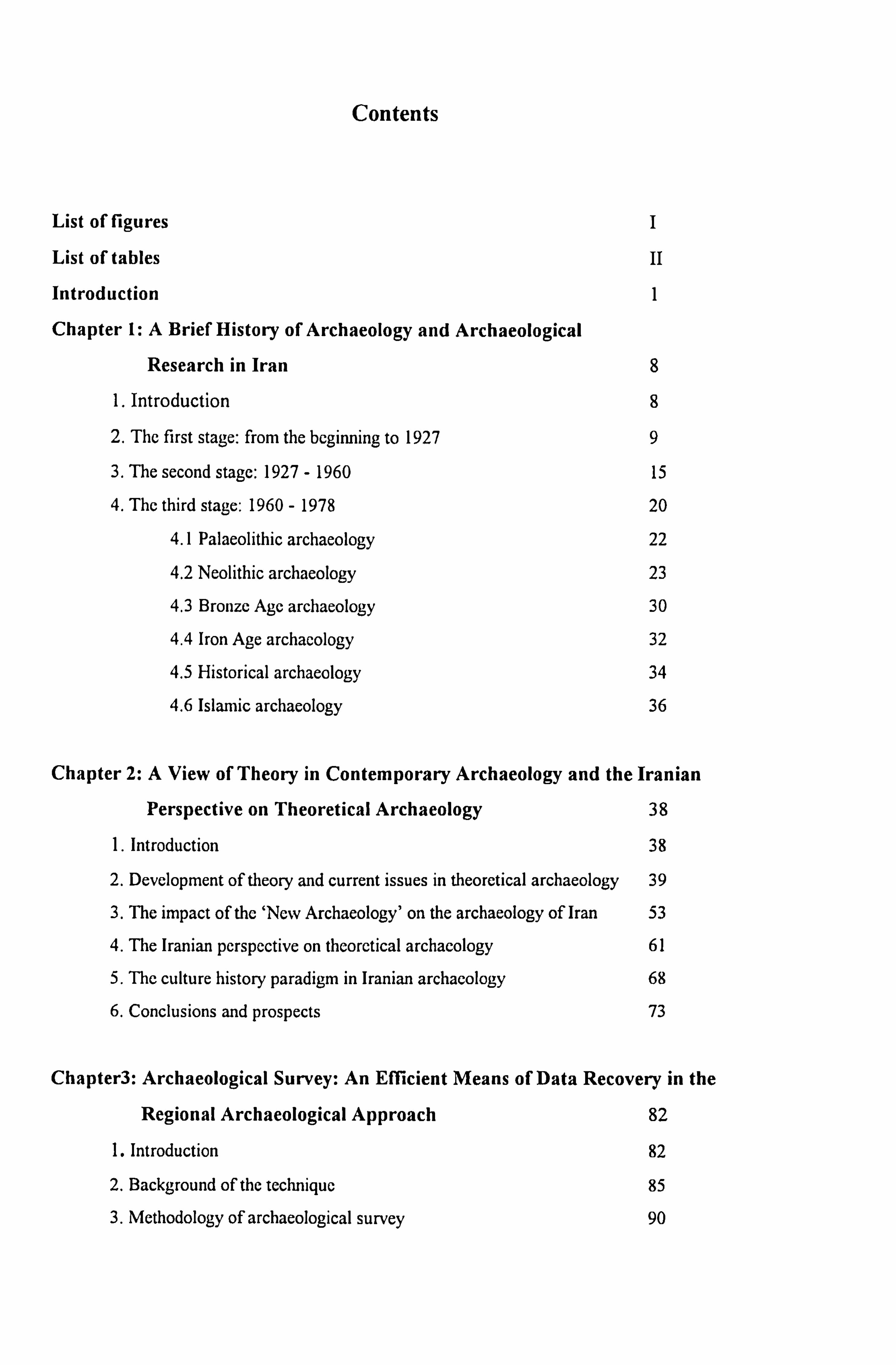
Contents
List of figures I
List of tables II
Introduction 1
Chapter 1: A Brief History of Archaeology and Archaeological
Research in Iran 8
1. Introduction 8
2. The first stage: from the beginning to 1927 9
3. The second stage: 1927 - 1960 15
4. The third stage: 1960 - 1978 20
4.1 Palaeolithic archaeology 22
4.2 Neolithic archaeology 23
4.3 Bronze Age archaeology 30
4.4 Iron Age archaeology 32
4.5 Historical archaeology 34
4.6 Islamic archaeology 36
Chapter 2: A View of Theory in Contemporary Archaeology and the Iranian
Perspective on Theoretical Archaeology 38
1. Introduction 38
2. Development of theory and current issues in theoretical archaeology 39
3. The impact of the `Nerv Archaeology' on the archaeology of Iran 53
4. The Iranian perspective on theoretical archaeology 61
5. The culture history paradigm in Iranian archaeology 68
6. Conclusions and prospects 73
Chapter3: Archaeological Survey: An Efficient Means of Data Recovery in the
Regional Archaeological Approach 82
1. Introduction 82
2. Background of the technique 85
3. Methodology of archaeological survey 90
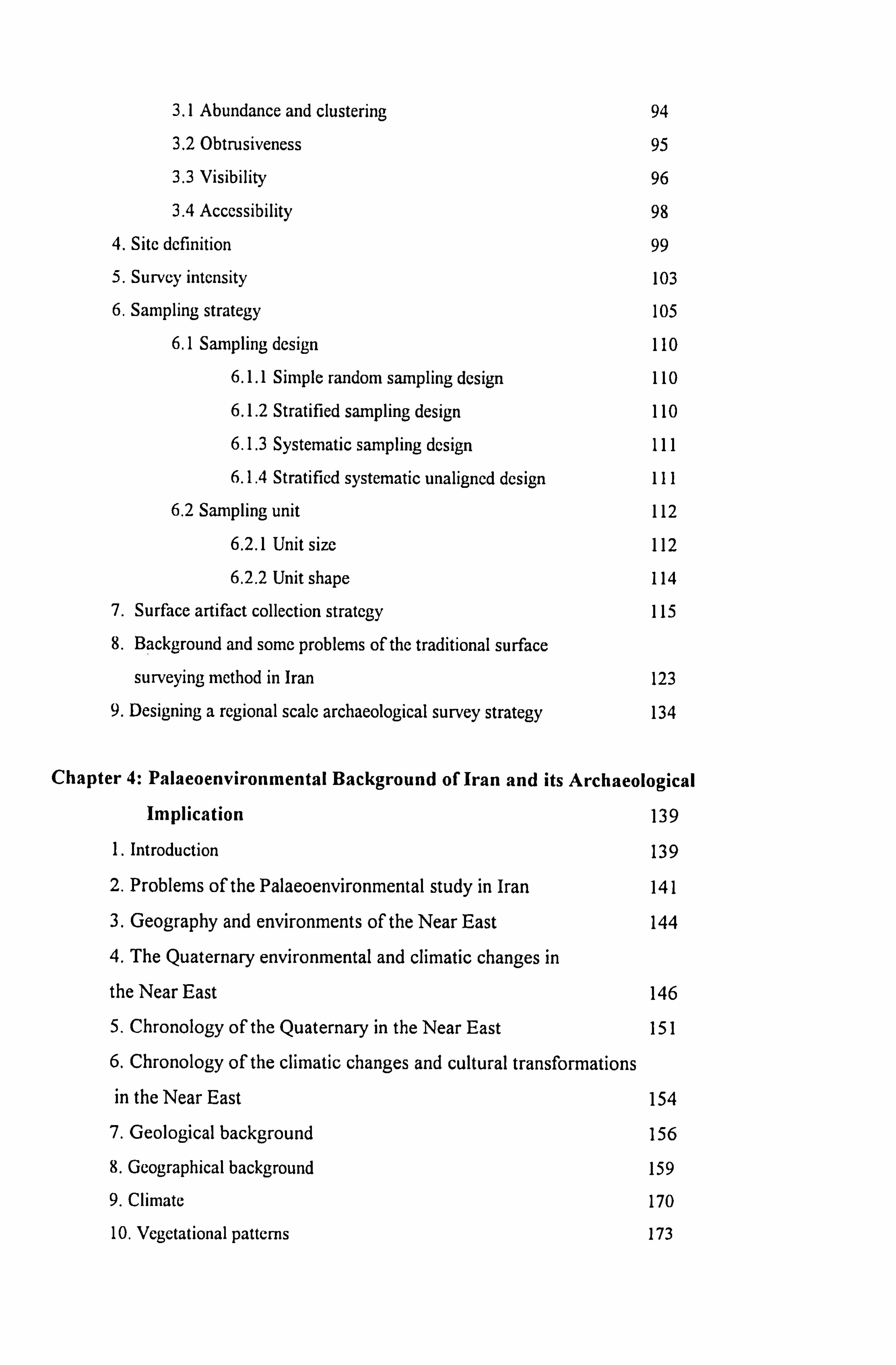
3.1 Abundance and clustering 94
3.2 Obtrusiveness 95
3.3 Visibility 96
3.4 Accessibility 98
4. Site definition 99
5. Survey intensity 103
6. Sampling strategy 105
6.1 Sampling design 110
6.1.1 Simple random sampling design 110
6.1.2 Stratified sampling design 110
6.1.3 Systematic sampling design 111
6.1.4 Stratified systematic unaligned design 1I1
6.2 Sampling unit 112
6.2.1 Unit size 112
6.2.2 Unit shape 114
7. Surface artifact collection strategy 115
8. Background and some problems of the traditional surface
surveying method in Iran 123
9. Designing a regional scale archaeological survey strategy 134
Chapter 4: Palaeoenvironmental Background of Iran and its Archaeological
Implication 139
1. Introduction 139
2. Problems of the Palaeoenvironmental study in Iran 141
3. Geography and environments of the Near East 144
4. The Quaternary environmental and climatic changes in
the Near East 146
5. Chronology of the Quaternary in the Near East 151
6. Chronology of the climatic changes and cultural transformations
in the Near East 154
7. Geological background 156
8. Geographical background 159
9. Climate 170
10. Vegetational patterns 173
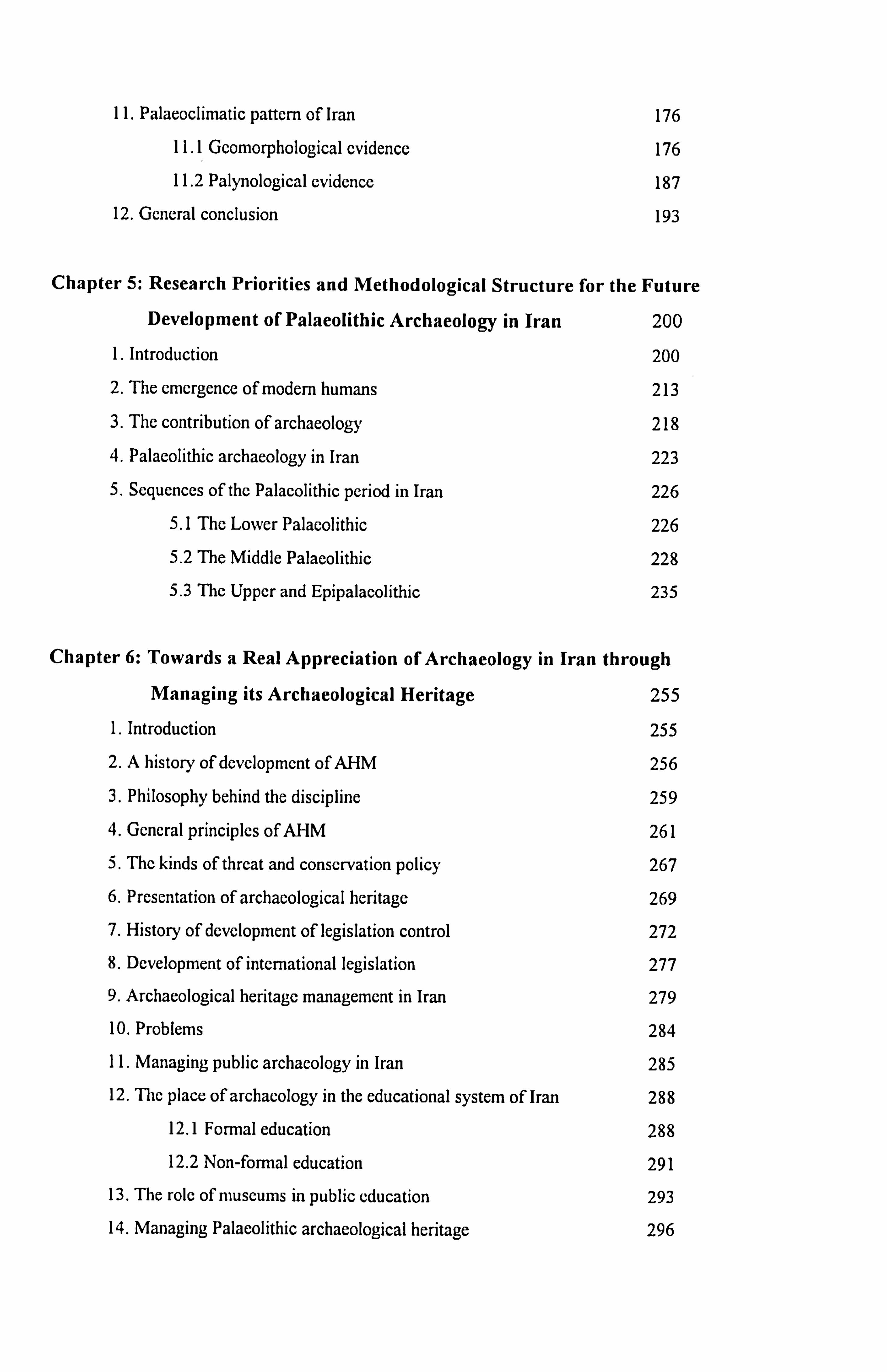
11. Palaeoclimatic pattern of Iran 176
11.1 Geornorphological evidence 176
11.2 Palynological evidence 187
12. General conclusion 193
Chapter 5: Research Priorities and Methodological Structure for the Future
Development of Palaeolithic Archaeology in Iran 200
1. Introduction 200
2. The emergence of modem humans 213
3. The contribution of archaeology 218
4. Palaeolithic archaeology in Iran 223
5. Sequences of the Palaeolithic period in Iran 226
5.1 The Lower Palaeolithic 226
5.2 The Middle Palaeolithic 228 5.3 The Upper and Epipalacolithic 235
Chapter 6: Towards a Real Appreciation of Archaeology in Iran through
Managing its Archaeological Heritage 255
1. Introduction 255
2. A history of development of AHM 256
3. Philosophy behind the discipline 259 4. General principles of AHM 261
5. The kinds of threat and conservation policy 267
6. Presentation of archaeological heritage 269
7. History of development of legislation control 272
8. Development of international legislation 277
9. Archaeological heritage management in Iran 279
10. Problems 284
11. Managing public archaeology in Iran 285
12. The place of archaeology in the educational system of Iran 288
12.1 Formal education 288
12.2 Non-formal education 291
13. The role of museums in public education 293
14. Managing Palaeolithic archaeological heritage 296

15. Prospects for the future
Conclusion
Bibliography
Figures
303
308
319
370
Appendix 388
List of Figures
Fig. 1a Geological map of Iran 371
Fig lb Physiographic map of Iran 372
Fig. 2 Lake Zeribar and Lake Mirabad pollen diagrams 373
Fig. 3 Lake Urmia pollen diagram 374
Fig. 4A map of the Old World indicating the dates of Homo erectus sites 375
Fig. 5 The number of the Palaeolithic excavations in Iran 376
Fig. 6 Lower Palaeolithic finds in Iran 377
Fig. 7 Selected Lower Palaeolithic artifacts from Iran 378
Fig. 8 Middle Palaeolithic finds in Iran 379
Fig. 9 Selected Middle Palaeolithic artifacts from Iran 380
Fig. 10 Upper and Epi-Palaeolithic finds in Iran (except Zarzian) 381
Fig. 11 Upper and Epi-Palaeolithic finds in Iran (Baradostian and Zarzian) 382
Fig. 12 Selected Upper and Epi-Palaeolithic artifacts from Iran 383
Fig. 13 Chronology of the Iranian Palaeolithic 384
Fig. 14 Ratio of the Palaeolithic units to the total number of archaeological units (M A degree), University of Tehran 385
Fig. 15 Ratio of the Palaeolithic units to the total number of archaeological units (B A degree), University of Tehran 386
Fig. 16 The number of the Palaeolithic specialists in the Department of Archaeology- University of Tehran 387
I

List of Tables
Table 1 Major excavation projects in Iran from 1898 to 1978 389
II
Introduction
It has long been recognised that archaeology has developed differently in various
countries or regions of the world. As in other parts of the Near East the
development of archaeology in Iran has been due to (1) in part the nature of the
regional archaeological record and the resources available for archaeological
research; (2) more fundamentally due to national or ethnic loyalties and adherence
to political philosophies and cultural traditions; and (3) the crucial influence of
eminent scholars. The goal of the present thesis is to examine and try to account
for variations in the questions asked and in modes of analysing and explaining data
employed by archaeologists in Iran. This thesis discusses the special factors
affecting the development of archaeology in Iran, to see how far these can account
for the features that distinguish the archaeology currently practised in Iran from that
encountered elsewhere. For this, the first goal is to explain the present state of
archaeology in Iran. To achieve this I also aim to delineate as clearly and
dispassionately as possible the special characteristics, achievements, and the current
problems of Iranian archaeological tradition.
Iranian archaeology today is characterised by an apparent absence of scientific
methods and social science theory in archaeological approaches; the absence of
multi-disciplinary research strategies; a lack of familiarity with the many branches of
archaeology (e. g. environmental, landscape, and ethnoarchaeology); domination of
art historians and traditional archaeologists; a neglect of prehistoric archaeology; an
isolation of archaeology from the public sphere and from social and political
debates; and an emphasis on merely reconstructing cultural history without regard
to cultural process.
These features give the observer an impression of the World Archaeology of the
early 1960s as a parallel for the state of Iranian archaeology at the present time.
This situation is a product of several parallel and often conflicting traditions. These
include a broadly-based antiquarianism and the socio-political climate which has
dominated the evolution of Iranian archaeology since the 1930s. During the pre-
Revolution period, the political ideology of the regime sometimes encouraged, but
more often restricted, the development of archaeological research. As a result of
severe restrictions an increasing number of archaeologists devoted their attention
only to the refinement of typological definitions and chronological changes. As a
result of the loss of contacts with colleagues abroad that began with the Revolution
and continued for sometime thereafter, Iranian archaeologists still pursue their
research in the directions set in the 1950s. During the sixties and seventies new
trends were developed by the `New Archaeologists' such as multi-disciplinary
research, the questioning of diffusionary theories, and growing concern with
problems of social structure, economic process, settlement pattern and urbanisation.
While these developments were certainly welcome, they engaged the attention of
relatively few archaeologists; in part, Iranian archaeologists, because of several
restrictions, did not heed the voice of the `New Archaeologists' such as Braidwood,
for example, who was working in Iran at this time and who urged a change
direction of research toward hypothesis testing, processual analysis, and injection of
anthropological theories into archaeological research. Anthropology in the Anglo-
Saxon tradition which laid strong emphasis on scientific methods and technical
2
analysis, has not affected archaeological approaches in this country. Instead, a
parallel tradition of archaeology as historical research dominated the indigenous
antiquarian tradition. It was affirmed as an academic discipline in the pre-
Revolution period by archaeologists and historians affiliated with the Imperial
regime. The structure of Iranian academic institutions has always tended to
perpetuate the research orientations that are familiar to those in positions of
authority. As a result the dominant research paradigm has always been toward
problems of sequence and chronology rather than concern with broader cultural
issues and a social archaeology. This tradition has carried on scarcely unchanged in
the post-Revolution period as well. Thus, what we see today results from an
archaeological evolution that began with the past repressive regime in Iran.. I
believe that archaeology in Iran will remain isolated from the main stream of World
Archaeology, unless Iranian archaeologists redirect their energies toward updating
archaeology through constructing a new organisation for it, and adopting new
ideas. It is obvious that any new plan for archaeology in Iran should be based on a
knowledge of its background, its development, and the most important factors
affecting these processes. Unfortunately, Iranian archaeologists are not interested
in the study of the history of archaeology (apart from a few descriptive articles), nor
has there been any critical review of archaeology published. Thus researchers who
need access to the archives encounter many difficulties due to deficiencies in the
management system of archaeology, and a heavy bureaucracy dominates the whole
administrative system of the country. However, since the Revolution the situation
has changed; for instance, the appearance of a relatively good political and social
context in Iranian society; the appearance of a younger generation of
3
archaeologists; the availability of adequate financial resources; an increase in new
archaeological departments in universities; and a growing attention of government
to archaeology. Despite these, at present Iranian archaeology is in a virtual state of
crisis (see chapter 2 for detail). The post-Revolution transformation has produced
only a few changes and the most important features of the crisis (mostly inherited
from the previous regime) and their main causes still remain unchanged. In this
thesis I will try to explain the main causes of this crisis in the archaeology of Iran,
and as mentioned at the beginning of this introduction to show why Iranian
archaeology is so impervious to currents of thought in the rest of the world,
especially technical and theoretical ones. I believe that the great gap between the
archaeology of Iran and World Archaeology cannot be simply removed by carrying
out empirical research in various fields, because the present structure of
archaeology and its great deficiencies will prevent the contribution of such work
from allowing further development. Therefore our first priority in doing
archaeological research must be concerned with the way in which archaeology can
be salvaged from its present pitfalls. Without a firm recognition of the
circumstances under which archaeology operates, even the idea of modernising
archaeology will be a meaningless matter.
In this short sketch, I will try throughout this thesis, to achieve two things: first, by
looking backward, to see how we arrived where we are today; second, by looking
ahead (however risky, in a rapidly developing field) in order to describe some goals
mainly in theory and method. Here I might as well be bold and suggest what I think
is an ideal programme for the future.
4
This dissertation is the first overview of the history and present state of archaeology
in Iran. Its aim is to consider recent developments in Western archaeology, and
their relevance to a Near Eastern Islamic State. The Palaeolithic of Iran is taken as
a case study. The first concern of chapters (1) and (2) in this thesis is to evaluate
the distinctively national characteristics of archaeology in Iran. Specifically the
chapters consider the development of archaeology in Iran in the 1960s and 1970s in
relation to the `New Archaeology' in the USA. It is clear that these external
influences had only a minimal impact on archaeology in Iran; the `New
Archaeology', which first developed in American circles more than thirty years ago,
made a somewhat belated impact on Iranian archaeology in the seventies. Not all
its agenda has been adopted, and because it was pioneered by anthropologists on
relatively recent and simple New World sites, it is not totally applicable to the long
historical sequences of complex Iranian mounds. I argue that Iranian archaeology
was simply left behind, `out of date', and generally atheoretical. I also stress that its
traditional authority structure prevented discussion of new ideas. Chapter (3)
demonstrates that, despite a wide range of archaeological work in Iran, the blanks
on the archaeological maps are far greater in extent than the small regions that have
to some extent been filled in. On the other hand the unparalleled expansion of
archaeology, particularly the complexity and costs of fieldwork, will force us to
determine priorities much more clearly. Thus in the future we will probably see
fewer of the enormous ten-year excavations at Tell-sites such as characterised the
1960s and 1970s. We have to move to smaller projects deliberately designed to
answer specific problems (e. g. excavation at one period sites; surface survey; and
regional studies). Because the concept of surface surveying as a reliable method of
5
data recovery has not been introduced into the archaeology of Iran, and
archaeologists there are still not familiar with its methods and techniques, this
chapter aims to emphasise the importance and productivity of this strategy and
provides a general model of archaeological survey methodology for the future. The
present thesis goes radically beyond the traditional cultural-historical paradigms of
Iranian research orientation, and suggests, for instance, that the study of
Palaeolithic Archaeology (in new perspectives) is a fundamental period of human
cultural progress, but one that has long been completely neglected in Iranian
archaeology. The current issues of Palaeolithic Archaeology, the importance of
environmental data, and the range of our understanding of Iranian Palaeolithic
Archaeology are the subjects of Chapters (4) and (5). The political and ideological
problems of the archaeology of Iran are discussed in chapter (6) where I argue that
the concept of Archaeological Heritage Management is a matter of top priority for
Iranian archaeology. This chapter discusses major disasters in Iranian cultural
heritage (e. g. looting of sites due to a lack of legal protection, the lack of an
adequate management system, as well as economic and social problems). I
conclude in this thesis that there are major challenges for archaeology in Iran in the
future; the older generation is almost gone, the new generation coming to the fore
must face many tasks, among them the transition from a monolithic national school
to a more subtle, many-side approach to archaeological problems. It must salvage
what it can of sites rapidly being destroyed by various factors. At the same time we
will have to challenge the political and ideological constraints affecting archaeology
in society. The new generation must envision a master-plan for the future
archaeological development of this region, where economic development and
6

prosperity still allows good opportunities and support for systematic archaeological
research. Only a drastic change in the national policy of archaeology and education
and much more co-operation with the archaeological institutions of the developed
countries can reverse the present situation of archaeology in Iran.
Chapter 1
A Brief History of Archaeology
and Archaeological Research in Iran
1. Introduction
The starting point of the Iranian archaeology was the same as for other Near Eastern
archaeological research which relates to western scholarship interests, firstly to
discovery the lost civilisation of the Bible Lands, then to display interesting objects
in museums.
Up to 1927 the archaeology of Iran was exclusively under French control. All
excavations were directed to the discovery of the visible ancient city of Susa; as a
result much remarkable material found its way to the Louvre Museum.
Soon after 1928, though the termination of French monopoly opened the gates to
all, the previous trend in museum interest collection remained dominant, with some
transformation in ideas and techniques. Development of regional chronologies
prevailed in the archaeological research; nevertheless, we should note that
investigating a number of prehistoric sites formed the basic goal of this period of
archaeological activities.
It was only at the beginning of the 1960s that the American `New Archaeologists'
started problem-oriented and hypothesis testing approaches, mainly in the Neolithic
period. Such approaches initiated a new era in the archaeology of Iran. Advanced
methods of stratigraphy and careful control over the context of material remains was
widely used, and research designs to solve problems concerning the economic
8
relationships of human communities received more attention rather than a more
description of cultural material.
Doubtless the archaeology of Iran with more than 100 important excavation projects
(see Negahban 1997: 482-505) has played a fundamental role and major contribution
in the Near East through the 19th and 20th centuries. The main purpose of this
chapter, through a concise review of its history, is to recognise the major factors
affecting its developmental processes, in order to describe some prospects for its
future development. It can be categorised in three stages, each of them with its own
characteristics. It is necessary to note here that the fourth stage of archaeology in
the post-Revolution period (started in 1979) is not reviewed here, because, firstly,
the revolution brought all foreign excavations to an end, and, secondly, many
changes occurred in the organisation of archaeology which has led to a 10 year
cessation of work. Fortunately it has become active again by the parliament
approving of new laws and a reorganisation of various archaeological centres under
the `Cultural Heritage Organisation' (CHO) in 1989. Though this organisation began
immediately to reform and reorganise archaeological activities, nevertheless, the
unfamiliarity of Iranian archaeologists with the new thoughts of the `World
Archaeology' and many deficiencies associated with the system of archaeology,
means there are few immediate prospects for the development of a programme of
archaeological excavation; for this we may have to wait for a long time.
2. The First Stage: from the beginning to 1927
The Near East has attracted travellers from the 17th century onwards for two main
reasons: firstly, as the lands of the Bible; secondly because of its ancient visible
9
remains. Both resulted in an ever increasingly attention paid by adventurers,
travellers and scholars (Hilprecht 1903, Ceram 1951, Gabriel 1969, Daniel 1975,
Fagan 1985, Trigger 1989, Stiebing 1993).
Iran however did not enjoy the same level of interest as some neighbouring
countries, except Susa which Benjamin of Tudela, a Spanish Jew in the twelfth
century identified as the location of the Biblical story of Daniel (Gabriel 1969: 46-
54).
As early as the seventeenth century travellers such as Pietro Della Valle, an Italian
nobleman, made journeys to Iran and took away a copy of the Persepolis inscription;
it was the first example of cuneiform which reached Europe. It was afier the 1600s
that establishment of the East India Company and the rivalry between England and
France put Iran in a strategic and favourable position to attract travellers, merchants
and politicians. They were generally accompanied by artists which made it possible
to make accurate drawing of outstanding monuments and inscriptions of Persepolis,
for instance, by Herbert in 1626, Tavernier and his draughtsman de Slandes in 1631
and de Bruin in 1701 (Ceram 1970: 167-176). But it was not until 1765 that
Karsten Niebuhr, a Danish scholar, took a great step towards the decipherment of
the cuneiform by making wonderfully accurate and clear copies of them (Rajabi
1965: 110-15). This work formed the basis of the great breakthrough in the
decipherment of the cuneiform inscriptions by Henry Rawlinson who as a military
advisor to the Persian governor of Kurdistan in Iran from 1835. At Kermanshah he
discovered a four hundred lines inscription engraved in 516 B. C. on the orders of
Darius the Great. This trilingual (Old Persian, Elamite, and Babylonian) inscription
is 122 metres above the ground on the face of the great rock of Biston near
10
Kermanshah. By the end of 1837 he had completely copied and translated two
hundred lines of the Old Persian section of the inscription. His translation of the
entire Old Persian text appeared in the Journal of the Royal Asiatic Society in 1846-
47. This decipherment became a key to the unlocking of the early history of western
Asia-see H. Rawlinson (1852), G. Rawlinson (1898), Ceram (1958).
By the middle of the last century the major sites of Egypt and Mesopotamia were
being excavated to obtain valuable antiquities, especially in Mesopotamia under the
joint diplomatic archaeological agreement between France and England (Stiebing
1993: 96); Botta and Layard excavated the most important ancient sites at Nimrud,
Nineveh and Khorsabad during 1842-1852 (Lloyd 1976). At that time the existence
of a state of war between Iran and Russia prevented any similar archaeological work
in Iran. But the study of customs and cultures of Iranian tribes in order to
understand their potential strength to confront Russian threats to India became an
interest of many British political agents in the region. Layard was one of them, and
he made a journey to Iran in 1840-42 to obtain "information to the British
government to prevent the Russia intention to draw Persia away from the influence
of England"(Layard 1887: 9). He observed many archaeological sites and accurately
noted them for the first time in his travel account.
The first conventional excavation, like those of Mesopotamia, did not start in Iran
until the 1850s when Luflos, a geologist in the Turko-Persian Frontier Commission
for determining the border of Iran and the Ottoman Empire, and a politician
interested in acquiring major finds for museum display (Lloyd 1980: 132), visited
Susa, which was identified as the Biblical Shushan. He had already excavated at
Warka, the Biblical Erech, as early as 1850 on his belief that "... from our childhood
11
we have been led to regard this as the cradle of the human-race" (Daniel 1981: 78).
The huge ruins on the Susa acropolis encouraged him to make an excavation on the
central part of the mound. His campaign for the first time brought to light a
columned hall of the Achaemenid period (Moghadam 1973: 3,77).
In spite of the more sophisticated excavations in Mesopotamia during the second
half of the nineteenth century under British directors such as Smith at Kuynjik in
1873, and Rassam at Tell Balavat in 1878-1882, French excavation under de Sarzec
at Tello in 1877, and the American first expedition at Nippur in 1884 (Lloyd 1978),
the archaeology of Iran did not develop as did that of Iraq. At the same time
interest in buried treasure led to the digging of archaeological sites not only by the
order of the Shah but also by regional governors. Etemad-Al-Saltaneh as the special
advisor of King Naser Eddin and Dr. Feuvrier as his medical doctor wrote in their
diary memoires, how the plundering of sites and the tragedy of `Shah Archaeology'
happened (Etemad-Al-saltaneh 1977, Eghbal 1947). An excavation technique that
should be mentioned here was that observed by H. Schindler, a telegraph engineer in
1870, when he saw workmen who were digging for treasures at Tepe Hissar; his
suggestion about obtaining the intact pottery vessels by using water to wash away
the soil surrounding the artifacts led to the diversion of a canal through the site
(Roushani 1968: 206).
The next step in the archaeology of Iran was taken by the French government and
archaeologists on May 12 1895. According to a treaty the Shah, Nasser Eddin, gave
the French exclusive excavation rights to all of Persia (Iran), providing that the
sacred places such as mosques, shrines and the tomb of Daniel should not be
touched; all gold and silver objects found should become the exclusive property of
12
His Majesty; all other objects discovered should be divided between the French
Mission and Persia, and the French government, in return for His Majesty's
generosity, should pay 10000 Toman to him. This contract was renewed and
extended for sixty years with the new Shah, Mozaffar Eddin, three years later, giving
all of the objects found in Susiana to France (Masoumi 1976: 4-6). According to
this convention in 1897 de Morgan the famous Egyptologist, prehistorian, and mine
engineer, was appointed as director of the Delegation Francaise eii Perse. The
delegation has been described as "probably the most important archaeological
expedition that has left Europe" (Carlton 1939: 34).
The modern exploration of Iran began in 1897 when the French monopoly of
archaeological excavation was established. During the succeeding decades a huge
Achaemenid tell was excavated and the mapping and the identification of prehistoric
and historical sites progressed rapidly. At the same time knowledge of
archaeological method was promoted by the establishment of international schools
throughout the Near East, and Petrie's innovation of tell stratigraphy. His technique
appeared on the scene in 1890 at a mound in Palestine. Though the true nature of
tells had formerly been recognised by Schliemann at Troy, Petrie developed the
principal tools of later excavations: stratigraphy or the art of recognition of debris
layers in a mound; and ceramic typology, the study of the change in pottery styles as
a clue to chronology. During this period the French delegation locked the Iranian
gate of archaeology to all. These early decades continued a formative period in
archaeology in our field. The true nature of the tells, and how they were formed,
were the fundamental questions. Archaeologists began to learn how to distinguish
the successive strata and to date each by its contents, particularly the pottery. The
13
task was more complex than first thought, but it yielded a rough outline of the
history and culture of ancient Khuzistan in Iran. In each excavation pottery and
objects were found in abundance but scarcely a single piece was reported in relation
to a context. The result is that de Morgan's reports, like all pre World War I
publications, were vast, but often useless in terms of information. It is clear that the
primitive excavation technique obscured much evidence, some of it destroyed
forever. In this first period archaeologists began to familiarise themselves with the
characteristic materials of the mounds, but no description made on the economic,
social and religious life of past cultures.
During the first season of his work he moved a total of 18000 cubic meters of earth
with 1200 workmen. He began to dig a series of vertical shafts as used in industrial
mining in order to establish a relatively accurate picture of the successive cultural
phases of the historical and prehistoric periods, as well as to find intact structural
remains buried under heaps of rubble. Then he turned his attention to the main
acropolis of Susa, using a masive trench 25 meters wide by 100 meters long (de
Morgan 1905: 50,1906: 4). His special method, namely `the exploration of the
regular strata' needed to remove a wide range of archaeological layers, by using a
large number of workmen, resulted in the destruction of a valuable part of the
Achaemenian main platform and of Elamite architectural material (Steve and Gasch
1941: 45-6, Hole 1987: 41).
Excavations by the French delegation were not restricted just to Susa, but de
Morgan extended them to the Caspian Sea shore when he excavated there on
prehistoric sites in the last decade of the nineteenth century (de Morgan 1896).
With the Gautier and Lamper excavations, under the same expedition, at the
14
prehistoric Moussian in 1902-3, their realm reached to Luristan (Gautier and
Lamper 1905).
Here we should note that the physical removal of debris and the demolition of
supposedly worthless ancient walls to obtain valuable antiquities, were accepted by
the French delegation (Parrot 1953: 39), but de Morgan and his successors brought
to Iran the new idea of archaeology and a basic excavation method that had formerly
been developed in Egypt and Mesopotamia.
A result of the French archaeological monopoly, imposed by royal edict, gave the
French authorities absolute control of archaeology in Iran, so that no one was
allowed to excavate, except with their sanction, until 1927.
3. The Second Stage: 1927 to 1960
A nationalism based on regional culture appeared throughout the Near Eastern
countries when the Ottoman Empire collapsed after the First World War. This idea
encouraged national identities to develop pan Turkism, pan Arabism and pan
Iranism, at least in the eastern part of the Near East. Governments sought
legitimation through the support of archaeology and historical research. A change in
the policy of Reza Shah (who reigned in Iran from 1920 to 1941), following this
new political doctrine, introduced the archaeology of Iran in the new state. In 1927
the French archaeological monopoly was cancelled by the Iranian parliament. It
opened the locked gates of archaeology to all countries. This period in Iran
coincided with advanced post-war archaeology in the Near East, in particular in
Mesopotamia, a growing national feeling among various nations of the Near East,
and events of the First World War resulted in changes in the antiquities laws in the
most parts of the Near East, especially in Iraq. The new rules changed the position
15
of foreign archaeological expeditions, and established national departments of
antiquity and a national museum (David and Joan Oates 1981: 29). On the other
hand new improved archaeological techniques were developed by archaeologists,
who worked here for many years. An expedition organised by the Deutsche Orient-
Gesellschaft to Iraq was more concerned with the recovery of information than the
enrichment of museum collections. They produced new techniques of excavation
that would be a `prototype of all stratigraphical investigation in later time' (Lloyd
1978: 178). Development of pottery sequences devised by Petrie in the early 1900s,
was successfully continued by Woolley (Stiebing 1993: 17) who in the 1930s
undertook the excavation of magnificent tombs at Ur (Woolley 1934) comparable
with Schliemann's discovery at Mycenae and Carter at Tutankhamun's tomb (Daniel
1975: 201). The American expedition at Khafaje in 1930 (Delougaz and Lloyd
1942), the British School of Archaeology's excavation by Mallowan at Tepe
Arpachiya in 1933 (Mallowan and Rose 1935), and the British Museum expedition
directed by Thompson and Mallowan at Kuynjik in 1931 (Thompson and Mallowan
1932), threw new light on aspects of early prehistoric Iraq that hitherto were
unknown.
Two years after the annulling of the French monopoly and due to the encouragement
of government of Iran, an antiquity department was established under A. Godard a
French architect (Masoumi 1976: 9). This event resulted in the opening of
archaeological excavation to all, especially to the American Institution of
Archaeology, established in Iran in 1930. At that time excavation by large foreign
expeditions was encouraged. The excavations carried out under these conditions are
too numerous to list in full, but the monumental American excavations at Takht-e-
16
Jamshid were a landmark as was the French sponsored excavation at Sialk (below).
Though the main interests of archaeologists were to recover evidence of ancient
sites, it was at a series of much smaller mounds that Schmidt and Ghirshman really
transformed archaeology from a large intuitive affair into a systematic (if not
scientific) discipline. By the beginning of 1930 prehistoric archaeology began to
appear on some small mounds and Ghirshman mastered the pottery and the
stratigraphy. His chronological and terminological framework, worked out in the
same year, remained basic for many years for archaeologists.
This phase in Iranian archaeology saw the development of real sophistications; as
methods advanced, the field moved from enlightened treasure hunting to scholarly
competence. According to improved methods in fieldwork and interpretation, a
chronological sequence based on pottery styles was produced (for detailed
explanation of the role of pottery as a key material in the chronology in Iran see:
McCown 1942,1954, Piggott 1943, Gordon 1947, Childe 1952, Young 1958,1969,
Dyson 1967,1987, Henrickson 1985, Voigt 1987), and an outline of the political
history of Iran emerged, complementing the literary accounts in the cuneiform texts
and integrating the country into a large framework of events in the ancient Near
East. Still, however, archaeology was better at answering such questions as `what'
`where' and `how', rather than `why'. The following lists the number and location
of excavations carried out in this period, and the individuals involved:
Wulsin at Turang Tepe in 1931 (Wulsin 1932); Schmidt at Tepe Hissar in 1931
(Schmidt 1937); Langsdorff at Tell Bacon (Langsdorff and McCown 1942);
Ghirshman at Tepe Giyan in 1931 and Sialk 1933 (Contenau and Ghirshman 1935
Ghirshman 1938a, 1939); Arne at Shah Tepe in 1933 (Arne 1945); Schmidt at
17
Cheshme Ali in 1934 (Schmidt 1935); Schmidt at Persepolis 1934 and Istakhr 1935
(Schmidt 1953,1936); and Ghirshman at Bishapour 1936 and at Susa 1946
(Ghirshman 1938b, 1952). Although during this period stratigraphy and control
over the recovery of artifacts was developed, because of the predominance and
emphasis on the enrichment of museum collections, some of the work such as
Ghirshman's excavation at Giyan or the work of Schmidt at Hissar seem ̀ coarse by
modern standards' and needs re-excavation (Dyson 1987: 648-652, Hole 1987: 51).
Nevertheless during this period prehistoric archaeology could produce reliable
enough evidence to establish a chronological framework for the prehistory of the
Iranian Plateau, as McCown in his `Comparative Stratigraphy of Early Iran'
(McCown 1942) has described in detail. The chronology proposed by Schmidt and
Ghirshman for historical and prehistoric Iran remained for a long time the basis for
all comparative work. These were refined by new evidence found at Godin by
Young in 1965 (Young 1965,1969) and at Ali Kosh by Hole in 1977 (Hole 1987:
51,1977a), and continue in use until the present.
The second phase of this period is accompanied by clandestine digging by treasure
hunters, which has been as productive of finds as scientific excavation (Bacon 1960:
176). In 1928 the bronze objects of Luristan began to appear on the art market
(Stark 1932) and twenty years later many hundreds of objects of gold, silver and
bronze could still be purchased from antiquity dealers in Iran, Europe and the United
States. These objects were obtained in an illegal excavation at Ziwiye (Y. Godard
1948; Muscarrella 1977) (for other plundered sites such as Khurvin and Zalu-Ab,
see: Rad and Hakemi 1950; Vanden Berghe 1955; Godard 1933).
18
Each of them caused in turn the definition of archaeological problems, for instance,
that of the Luristan Bronzes, which led the attention of field activity and research to
the Luristan district. First of all Schmidt, on behalf of the Oriental Institute of
Chicago University, conducted the Holm's Expedition to Luristan from 1935 to
1938 (Schmidt 1938). He made an aerial survey of this province (Schmidt 1940)
which helped him to recognise the location of sites to be excavated. His work in the
form of tunnelling defined the numerous sites in this area and yielded splendid and
valuable artifacts .
At the same time Sir Aurel Stein, a British explorer, made his fourth journey to Iran,
in particular to Luristan (for full account of his journeys see: Stein 1934; 1935;
1937; 1940). He visited and plotted the location of many sites and made trial
excavations all along his route on any visible artificial mound (Stein 1940: 171-313).
Though his elaborate description of sites and artifacts formed the basis for the
Bronze Age of Iran, his extensive and primitive excavation technique was even more
of a menace than the Luri treasure hunters (Goff 1980: 17) who were introduced to
the value of antiquities through this sort of excavation.
The distinctive features of the Iranian Archaeology during these early years were:
(1) the concentrated effort to recover a national history, particularly of the
Achaemenid era; (2) archaeological organisation, resources, and technical facilities,
such as only a local school can provide; (3) a preference for large scale exposure of
architecture at virgin sites, rather than more careful soundings at small prehistoric or
re-excavated sites; (4) an emphasis on building up a corpus of whole pottery found
in situ rather than detailed analysis of sherds. These objectives to some extent were
acceptable, but the isolation from developed techniques of analysis and
19
interpretation elsewhere meant that the archaeology of Iran did not take full
advantage of the stratigraphic revolution until late the 1960s. As a consequence,
some of the architectural phasing was imprecise, and interpretations have remained
controversial. Furthermore, as with the Iranian experiment in method, publication
fell so far behind fieldwork that it is so difficult to judge the merits of the various
methods employed and the results obtained
4. The Third Stage: 1960 to 1978
Changing political conditions in the post World War II years, helped maximise the
involvement of foreign archaeologists to their peak and at the same time fostered
the development of a national school of archaeology in Iran. This period also
coincided with the greatest development in archaeological techniques, methodology
and strategies in the Near East. The first development came from Kathleen
Kenyon's introduction of stratigraphic methods, perfected later by Wheeler and
others on Romano-British sites. She applied this method to the complex problems
of Palestinian mounds in her excavation at Jericho in 1952-58 (Kenyon 1972). Here
she dug in small squares within a grid, leaving intervening catwalks or balks, that
were then used to see the deposits in section and to guide careful probing and
stripping of the strata. Digging proceeded not only by architectural strata, rather
than by artificial levels, but also, by following the natural stratification, separating
soil layers by colour, texture and depositional character, etc. This system introduced
both the third dimension and the element of control that made it possible to separate
debris layers and the objects they contained with greater accuracy. Indeed at that
time the system worked so well that various adaptations of the so-called Wheeler-
20
Kenyon field methods were employed on nearly all American and British excavations
in Iran in the 1960s and 1970s.
The second development came from the `New Archaeology', an archaeology which
was revolutionised by natural science, social science, ethnography, and
environmental studies in America in the late 1960s. The teamwork philosophy of
this approach brought into field archaeology specialists who soon demonstrated that
they could contribute much to the study of aspects of the material culture which had
been neglected. By the late 1960s in both the Levant and Mesopotamia interest in
prehistoric research shifted in emphasis from traditional historical and culture-
historical approaches to a more detailed investigation of human life style.
Hypothesis testing, especially questions concerning the origin of sedentary life,
formed a major factor in the change in research direction which first began to appear
with Braidwood's work in the hilly flanks of northern Mesopotamia. This kind of
research required specialised geomorphologists, botanists, zoologists and chemists
rather than archaeologists alone. The excavation techniques were altered from large
scale horizontal to the small vertical ones using careful stratigraphy and control to
recover plant and animal remains. The beginning of the 1960s saw a great change in
archaeology in Iran under the problem oriented researches of Braidwood on the
Neolithic, which led the way to the new generation of archaeologists. It is relevant
to note here that, in view of the large amount of excavation undertaken, a brief
summary of archaeological activities will be discussed period by period in this
section.
21
4.1 Palaeolithic Archaeology
The beginning of Palaeolithic archaeology in the Near East was later than in
Europe. The first Palaeolithic discovery was made by D. Garrod when she started
an excavation at Mount Carmel, Palestine, in 1920, and then in northern Iraq at
Hezar Mard cave in 1928 (Garrod 1930). Thel940s saw new efforts to discover
sites on both the west and east sides of the Zagros mountains located between Iran
and Iraq. At this time R. Solecki excavated at Shanidar cave and distinguished four
major archaeological levels (Mousterian, Baradostian, and Zarzian B2, B1) spanning
the past 100,000 years (Solecki 1961). The second contemporary project was that
of Coon, an American anthropologist. In 1949 he firstly dug in the hunters' cave at
Bistun, at Tamtame cave near the Lake Urmia, and the Mesolithic occupation of the
Belt cave on the Caspian foreshore. Then in 1951 he dug both Belt cave and the
nearby Hotu cave (Coonl951,1957). Iran, by this pioneering investigation, was
shown to have been occupied in at least the middle Palaeolithic and Mesolithic
periods. Other excavations and surveys have been made in Iran by various foreign
prehistorians:
Field made several trenches in Luristan in 1950 (Field 1951); Braidwoods' group
excavated several Palaeolithic sites at Kermanshah in 1959-60 (Braidwood 1960);
and Hole and Flannery dug five sites in Luristan in 1965 (Hole and Flannery 1964).
Smith was excavating at a cave in Bistun in 1965 (Young and Smith 1965), while at
the same time McBurney (1964,1968,1970) excavated the Middle Palaeolithic cave
of Ke-Aram I in Mazandaran in 1963, as well as undertaking Mesolithic
investigations at Ali Tepe near Behshahr on the caspian in 1962 and 1964, and later
(1969) investigated a Middle Palaeolithic cave in Luristan. There have also been a
22
few Palaeolithic surveys and surface collections particularly in Azerbaijan by Solecki
(Solecki 1969 ) and in Luristan by Mortensen (Mortensen 1974).
Palaeolithic archaeology in Iran, in comparison with the Bronze and Iron Ages, has
not been sufficiently developed. The basic reason for this may lie in what Smith and
Negahban have stressed (Smith 1986: 40-42; Negahban 1981,1982: 12).
They concluded that the relative remoteness of Iran for European scholars, the
exclusive monopoly of excavation by the French archaeologists, the political state of
Iran as a non-mandate country limiting easy access, and the lack of local scholarly
interest, could be part of the explanation for the time lag in Palaeolithic research of
Iran (see also chapter 5).
In spite of the sporadic excavations at Kunji cave and Ali Tepe, excavated by Hole,
Flannery and Burney, whose data provides sufficient information to build up a
regional chronological framework, the level of research on the whole still remains in
an underdeveloped state.
Another weak point is the lack of analytical studies of stone artifacts. Though Hole
and Flannery began to provide a typological model of the flint industry based on
their small sample, and though this was continued by Baumler and Speth (Baumler
and Speth 1993), because of the absence of comprehensive studies on previous
work, and the unwillingness of Iranian scholars to involve themselves with the
Palaeolithic period (see chapter 2), no great progress has been made.
4.2 Neolithic Archaeology:
Prior to 1960 there was little knowledge about Neolithic sites which were simply
by-products of other excavations. The main reason for the slow development of
interest in Neolithic Iran, as in Palaeolithic archaeology, lay in the political
23
conditions and the French monopoly. The effect of Childe's hypothesis on the origin
of agriculture that led archaeologists to the lowlands and to `oases' to find traces
relevant to beginning of the Neolithic is an additional factor.
Until the 1960s all our knowledge of Neolithic Iran was derived from the
excavations carried out at Sialk, Tepe Hissar, Cheshme Ali, Giyan, and Khuzistan by
both French and American expeditions during the first third of the present century.
The earliest occupation was at Sialk I dated to 5500 B. C. (Ghirshman 1938,1939).
No other attempt was made until 1949 when Coon started his cave exploration at
two caves on the Caspian foreshore. Unlike traditional approaches, he focused on
the subsistence pattern of the inhabitants of the cave, whose seventeen layers
showed the development from hunter gather to the later Neolithic and historical
periods. His absolute dates using the newly developed Carbonl4 method, pushed
the Neolithic of Iran back to 6100 B. C. (Coon 1951). The archaeology of Iran
received particular attention from 1960 onwards which has considerably altered the
direction of research. The main reason was the genesis of new hypotheses
concerning the transition from a Palaeolithic to an agricultural way of life. Here a
short review will be made only of Childe's and Braidwood's hypotheses.
Childe introduced the term `Neolithic Revolution' to describe the origin of food
production and its consequences (Childe 1952: 23), making archaeologists aware of
the importance of the transformation from hunting and gathering to food production.
This revolution took place in the Near East during the post Pleistocene period from
about 10,000 B. C. Childe formulated the `oasis' or `propinquity' hypothesis for the
invention of agriculture centres. He believed that under the effects of a major
climatic change much of the Near East began to dry up. The hunters, gathers and
24
animals were forced to take refuge near the rivers and oases that had not dried up.
Plants continued to grow only near sources of water. Because of the proximity of
the plants, animals and humans, people had the opportunity to recognise their
behaviour, and subsequently domesticated them (Childe 1952: 25). Mesopotamia
and Palestine were the first places in the Near East where archaeologists began to
excavate Neolithic sites to test the Childe hypothesis.
Two projects were conducted by Braidwood at Jarmo in Iraq and Kenyon at Jericho
in Palestine; both were of special importance during the early post World War II
period. Braidwood organised an archaeological expedition to seek evidence
concerning the early stages of farming, partly in reaction to Childe (Braidwood et al.
1960: 2-3). He gathered around him an interdisciplinary team of both archaeologists
and natural scientists supported by the Oriental Institute of the Chicago University,
establishing an approach that has since became standard. Braidwood was influenced
by Peak and Fleure, who had formerly claimed wheat and barley must have been
domesticated firstly in the `Fertile Crescent' (Redman 1978: 95).
Braidwood's excavations and additional site surveys in Iraq (1945-55) and Iran
(1960) achieved significant results that led him to formulate his thoughts about the
origins of agriculture, an hypothesis that has come to be known as the `Natural
Habitat Zone' or `Nuclear Zone hypothesis'. In contrast to the Childe hypothesis he
first concluded that there has not been significant climatic change in the past 12000
years (Braidwood and Howe 1960: 181; 1962: 142-3). He initially argued for a
`Nuclear Zone', a place where the animals and plants could have existed in the wild
state. So the piedmont hills and lower intermontane valleys of the Zagros-Taurus
arc of mountains was an ideal location for food producing (Braidwood 1958: 1426-
25
1429). For him the development of an agricultural way of life seems to have
occurred as the `culmination of the ever increasing cultural differentiation and
specialisation of human communities'(Braidwood 1960a: 132). Around 8000 B. C.
the inhabitants of the hills around the Fertile Crescent had come to know their
habitat so well that they were beginning to domesticate the plants and animals they
had previously been collecting and hunting. But, starting in 1962, because of the
many excavations on the new sites and increasingly more accurate data supplied by
natural scientists, he began to alter the geographic limits of the `Nuclear Zone' to
include the highland of Anatolia and the hilly region of Lebanon and Judaea (Wright
1971: 457).
The second project testing the Childe hypothesis was undertaken by Kathleen M.
Kenyon when she began to excavate at Jericho in 1952. Her description of `brilliant
green oases in the and land' (Kenyon 1954: 121 ) of the Levant as the primary
location of the agricultural revolution seemed to support Childe's position. During
1960 and later, different Neolithic sites were excavated in both the lowlands of the
Levant and the foot hills of the Zagros; the majority of them fit into Braidwood's
`Nuclear Zone' whereas no one excavated in dry rivers or near oases (Redman
1978: 97). It seems that the hypothesis of Braidwood was victorious over Childe's
in the war of ideas .
During the two decades of the 1960s and 1970s additional excavations on sites of
the Near East provided a major contribution to our knowledge of Neolithic culture:
Mellaart carried out the extensive excavation projects at Hacilar and catal Huyuk in
Turkey (Mellaart 1961; 1967). In Mesopotamia Tell-Essawan (Abu al Soof 1968)
Chogha Mami (Oates 1969) and Yarim Tepe (Merpet and Munchaev 1973) were
26
excavated. At the same time in southern Jordan and Syria the famous site of Beidha
was excavated by Kirkbride (1966), de Cotenson (1971) excavated at Tell Ramad
and Vanloon (1968) at a site near the Euphrates in Syria.
Such excavations on Neolithic sites did not appear in Iran until the 1960s when
Braidwood's expedition under the Iranian Prehistoric Project came to seek for the
world's first farmers in Persian Kurdistan (Braidwood 1960b). The initial aim of this
project was `the reclamation and interpretation of evidence for the earliest
appearance of an effective food producing and village- farming communities way of
life' (Braidwood et al. 1961: 2008). He started his work at two small mounds
(Asiab and Sarab) in the western part of Iran :
Asiab was a small low mound, that was an encampment of intensive food collectors,
whose flint industry was somewhat more developed than that of Karim Shahirian in
Iraqi Kurdistan. The sounding also yielded items in stone and numerous small clay
objects, including a few fragments of figurines. Other artifacts in the Asiab
assemblage include beads and pendants. No evidence bearing on architecture was
found expect one round shallow basin which was interpreted as a floor of some kind
of semi-subterranean structure. Remarkable objects in Asiab were great quantities
of coprolites, regarded as an invaluable clue to the diet of people who were hunter-
gatherers. Braidwood suggested a date for Asiab of between 9000 and 7000 B. C.
(Braidwood 1961: 3-7).
A further phase of the early food collecting culture is seen at Tepe Sarab. There no
mud walled architecture was found, but the site contained the remains of pit
dwellings. The `Sarah Venus' and other forms of figurines were made of baked
clay. Painted pottery, flint and obsidian objects could be compared to those of
27
Jarmo in Iraq. Sarab showed the presence of domesticated goats, but there was a
great concentration on shells of a local land snail gathered for food. Sarab's position
indicated that it may be an early village farming community (Braidwood et al. 1961:
2008-9).
In 1963 a major excavation project took place by F. Hole's team in the Zagros area.
He conducted the most significant excavation at Ali Kosh, a Neolithic site in
Luristan. Remains at Ali Kosh and an adjacent mound have been subdivided into
seven phases; the three initial phases were occupied by Neolithic people: Bus
Mordeh; Ali Kosh; and Mohammad Jafar. Bus Mordeh is the earliest phase and
dates from 7500 to 6750 B. C. The diet was a combination of wild and domesticated
resources both plants and animals. The settlement of the Ali Kosh phase from about
6750 to 6000 B. C. proved to be larger than the earlier phase, and the development
of architecture, domestication of animals and plants, and artifacts suggested that the
community of Ali Kosh was a permanent village. The last phase of occupation dates
from 6000 to 5600 B. C., characterised with the innovation of substantial agricultural
tools, the introduction of pottery, and new building techniques (Hole et al. 1969).
The initial result of the Ali Kosh project took the Neolithic culture of Iran back to
the eighth millennium B. C. and introduced to Iran modern archaeological
techniques. The systematic excavation, using flotation and careful sieving, enabled
excavators to obtain a large quantities of plant and animal remains. This material
formed the basis for the reconstruction of the economy of Ali Kosh. Finally Hole
and Flannery were able, on the basis of the results, to offer a model for the beginning
of agriculture in the Near East.
28
Throughout the 1960s and 1970s several successive excavations brought more
Neolithic sites to light, especially concentrated along the Zagros range:
Dyson and Young conducted an excavation at Hajifiruz in Azerbaijan in 1960
(Dyson and Young 1960), continued by Voigt in 1968 (Voigt 1983). At the same
time when Burney was excavating at Yanik Tepe (Burney 1961), other sites in
Luristan such as Tepe Guran (Mortensen 1963), Gang Dareh (Smith 1968) and
Tepe Abdol Hossain (Pullar 1973) came under excavation.
The most important excavations outside of the Zagros range occurred in the south-
eastern part of Iran directed by Lamberg Karlovsky at Tepe Yahya in 1967
(Lamberg Karlovsky 1969). Another site in a marginal plain of the central desert
was Tepe Zaghe excavated by Tehran University (Malek Shahmirzadi 1977).
Among the various Neolithic sites, Gang Dareh has a important role, because the
oldest settlement (Level E) at this site is so far without parallel. Carbon 14 dates
suggested that the date of this settlement lies in the middle of the eight millennium
B. C. making it the oldest Neolithic site in Iran, with the earliest pottery in the Near
East (Hole 1987a: 49; Redman 1978: 169). Level D dated from 7500 to 7000 B. C.
was characterised by long piano-convex bricks used in rectilinear buildings, that may
have been constructed in two storeys. The evidence of this level showed the
economy of people at this era was based on domesticated goats and plants (Smith
1972). Apart from the excavations mentioned above, this period is characterised
also by substantial surface surveys, concerned with the Neolithic Iran. One was led
by Wright to investigate the relationship between climatic change and the
introduction of agriculture. He initiated research on pollen analysis, sampling Lake
Zaribar in northwest Iran, producing a sequence dated from 21000 to 9000 B. C. He
29
concluded that the climate of this region before 9000 B. C. was cooler and probably
drier than today (Wright 1968, see also chapter 4 for detail). The second was made
by Adams who surveyed the region of Khuzistan where the successive cultures are
more easy to recognise than in other areas. He located about 130 new sites, some of
them dated to the sixth millennium B. C. (Adams 1962).
These sophisticated researches concerning Neolithic Iran have indicated the
significant role of this region, when Neolithic archaeology filled in a major gap of
Near Eastern archaeology concerned with the introduction of agriculture. In
comparison with the Levant and Mesopotamia we are still a long way from resolving
the problems, and there are many gaps to be filled (Smith 1971: 13); however,
archaeologists in Iran have produced large amounts of data that give a wider
perspective of prehistoric life in the Near East, as well as providing the basis for
hypotheses concerning the origins of the agricultural way of life. Perhaps it is
relevant to note here that there are at least three hypotheses that have been
formulated directly on data gathered from Iran:
Population Pressure Hypothesis proposed by Smith and Young (1982); Marginal
Zone Hypothesis, suggested by Binford and refined by Flannery (1969); Neoclimatic
Change Hypothesis formulated by Wright (1968; 1976). This brief study cannot
deal them with detail.
4.3 Bronze Age Archaeology
As mentioned before, the appearance of the so-called `Luristan Bronzes' on the art
markets in the 1920s stimulated archaeologists to search for their origin. In the late
1930s major excavations were carried out for this end. Soon after the end of the
Second World War, two important sites of this period, Tureng Tepe (Wulsine 1932)
30
and Geoy Tepe (Burton-Brown 1951), were excavated and have appreciably
increased our understanding of the third and second millennium B. C. occupation of
Iran.
The most important excavations occurred for the first time in the south-eastern part
of Iran such as those conducted by Caldwell at Tel-i-Iblis (Caldwell 1960); Tosi at
Shahr-i-Sokhta (Tosi 1969); and Lamberg Karlovsky at Tepe Yahya (C. and Marta
Lamberg Karlovsky 1972). At the same time comparable excavations were
conducted in the western part of this country by Delougaz and Kantor at Chogamish
(Delougaz and Kantor 1973); Vanden Berghe at various sites in Luristan (Vanden
Berghe 1973); Negahban at Haft Tepe in Khusistan (Negahban 1969); and Sumner
at Tepe Malyan (Sumner 1974).
The successive excavations in south-eastern Iran brought to light traces of many
unknown cultures from the Neolithic to the Historical period and produced strong
evidence for organised trade patterns, linking areas to the west (Mesopotamia ), the
east (Indus Valley), and the south (the Persian Gulf). It seems that the
internationalism of the Elamite Empire (Lamberg Karlovsky and Kohl 1971: 21),
and the growth of the political and economic power of their kingdom in the mid-
third millennium B. C. onwards, forced Sumerian trade into new channels. These
sites in south-eastern Iran specialised in the provision of specific resources: smelted
copper objects at Iblis; steatite objects at Yahya; and Lapis Lazuli objects at Shahr-i-
Sokhta; and they played a substantial role in regional exchange and controlling long
distance trade routes between Mesopotamia and the Indus Valley. For further
information see: Burney 1977: 147; Herrmann 1968; Lamberg Karlovsky 1972; Kohl
1974.
31
Work on the Bronze Age period in the west part of Iran was complemented by
extensive surveys. Sumner in his excellent excavation and survey in the Marvdasht
plain concentrated his attention on population growth and the development of state
organization (Sumner 1979) as well as the economic and political system of the
Bronze Age community.
4.4 Iron Age Archaeology
Although the Iron Age in Iran is the shortest archaeological period (1250-550
B. C. ), within this short span the amount of excavation carried out has been greater
than for other periods. Over thirty Iron Age sites in Iran have been excavated, most
of them after 1960. Research on the origin of the Iranian culture, its materials and
dating and its appearance on the Iranian Plateau, was initiated by Ghirshman's work
at Tepe Giyan in 1931 and then at Tepe Sialk in 1933. After the Second World War
he also excavated the Persian Achaemenid village in Susa (Ghirshman 1954). The
differences between strata, and the appearance of the new grey ware (grey black
ware) enabled him to compare the various sites, and suggest when the Iranian
culture reached the Plateau. He concluded that the first migration came from the
Caucasus at the end of the second millennium, and the second migration at the
beginning of the Ist millennium B. C. For a full account of his hypothesis see
Ghirshman 1954; 1977. The next step, to solve the Iranian migration problem, was
taken by Dyson in 1957, when he started a major programme, the so-called `Hasanlu
Project' that continued until 1977. The main aim of this project was to establish a
basic chronology and to study the little-known pre-and protohistoric period of
Azerbaijan in northwest Iran. A series of other settlements adjacent the main
Hasanlu Tepe were excavated in order to confirm the sequence and to fill in gaps.
32
The extensive surface surveys undertaken by Young, as a member of the Hasanlu
Project, and the following excavations, revealed Hasanlu as an `anchor' and as the
`Iron Age par exellence' (Levine 1971: 40) in western Iran, a position that it still
retains. For more information about the Hasanlu Project see Dyson 1961; 1964;
1972; Burney 1972. In 1962 Stronach began to excavate at Passargad as the final
point of Iranian migration (Stronach 1978). An important excavation was organised
by Young at Godin Tepe from 1965 to 1973 (Young 1967b). At the same time
Stronach dug at Nushjan Tepe (Stronach and Roaf 1978), and Goff started to
excavate at Babajan (Goff 1969), two important sites of the period of the Medes.
At that time Vanden Berghe was also excavating at cemeteries of Pusht-i-Kuh,
Luristan. While much work continued in the central and northern Zagros, other
areas with Iron Age evidence excited attention and Iranian archaeologists for the
first time conducted several expeditions independently, for instance, the excavation
of Marlik Tepe (Negahban 1965) and the large Iron Age cemetery at Gheytaryeh
(Kambakhshfard 1969).
Summarising: by the beginning of the seventies major archaeological excavation had
started and succeeded in identifying the Iron Age of Iran, in particular in the
northwest and western part of this country. The typology of pottery was the basis
to classification and interpretation, specially the grey black ware, regarded to have
been an indicator of the first Indo-Iranian tribes. Two hypotheses were formulated
by Young and Dyson to establish the date and routes of the Iranian migration into
the Plateau. Young divided the Iron Age period within three horizons, each
characterised by a specific pottery technique: the early western grey ware horizon;
the late western grey ware horizon; and a late buff ware horizon. He concluded that
33
the changes in material culture in the strata prove the arrival of a new population.
Then he proposed an east-west movement rather than a north-south one, as
suggested by Ghirshman (Young 1965; 1967a). Although his conclusion on routes
of migration is not the same as Ghirshman, their dating of the first migration in the
last century of the second millennium (about 1300/1250 B. C. ) was in agreement.
Dyson on the basis of the development of the material culture came to similar
conclusions as Young but he replaced Young's ceramic horizons with the periods of
Iron Age 1,2,3 (Dyson 1965). Though the division of the Iron Age Iran into three
periods has been accepted by most researchers (Iron Age 1 approximately
1300/1250-1000; Iron Age 2 1000-800/750; Iron Age 3 750-550 B. C. ), the debate
about where the Indo-Iranian came from and how they migrated still remains
unresolved.
4.5 Historical Archaeology
Until 1950 our knowledge about the Medes, the first Iranian dynasty (728-550
B. C. ), was completely based on indirect and secondary, sometimes highly biased
sources including the Assyrian and Babylonian texts and the later writings of
Herodotus. In the early 1900s scholars such as Buckingham (1829) attempted to
find the Golden City of the Medes in ancient Ekbatan on the basis of Herodotus'
narrative. Throughout the nineteen century scholars such as Rawlinson (1865) used
all those unreliable sources to synthesise the Median period. But the lack of Median
written sources resulted in contradictory conclusions and major disagreement.
Excavations conducted in the late 1950s and throughout the 1960s and 1970s in
Azerbaijan shed new light on the Median period. The important excavations of the
Hasanlu and Godin Projects, as well as the Nushijan and Babajan projects, yielded
34
significant architectural data as well as pottery and iron objects. These data were
able to contribute to the questions of Media as the origin of the first Iranian tribal
migrations to the Iranian Plateau.
Unlike the Medes, Achaemenid archaeology was always a lively and controversial
field from the early 1900s up to present. Magnificent architectural remains of their
empire (550-331 B. C. ), the fine glazed and unglazed tiles, and large inscribed reliefs
were found at the Achaemenid capitals of Susa, Persepolis, and Passargad. Susa
itself has been excavated continuously for about a century under French excavators.
The Oriental Institute of Chicago University has explored Persepolis, while the
British Institute of Persian Studies has excavated Passargad. These excavations
were followed by Iranian archaeologists providing detailed information about
Achaemenian art and history.
Despite extensive excavations, research and publication which have increased our
understanding of the official and propagandistic art of the Achaemenid rulers, their
empire was built upon the subjection and the suffering of many people (Nylander
1971: 51), but no research has yet been done to reveal the every day life of these
commoners.
In the case of the Partho-Sassanian period (250 B. C. -642 A. D. ) archaeologists were
attracted to a brilliant art and architecture, when the publications of Ghirshman at
Bishapur, Ivane Karkhe, Barde Neshandeh and others brought them to light.
Although these early conventional and to some extent commercial works were
enormously destructive to the archaeological record (Keal 1971: 56) they introduced
this period to new practitioners, who developed new standards of excavation on
Partho-Sassanian sites as early as 1960. Several occupation sites of this period in
35
western and south-western Iran have been systematically excavated, including
Jundishapur (Adams and Hansen 1968), Qasr-i-Abunasr (Fry ed. 1973), Qale
Yazdigird (Keal 1967), Shahr-i-Qumis (Hansman and Stronach 1974).
Much of the archaeological evidence, in fact, came not from excavations, but from
systematic regional surveys. Wenke (1987) used survey data to study the cultural
complexity, and political and economic aspects of this period. In addition, the
availability of extensive documentary sources such as inscriptions and early Islamic
texts, besides archaeological evidence, enabled some archaeologists such as Vanden
Berghe (1993) to reconstruct a outline of Partho-Sassanian culture history.
4.6 Islamic Archaeology
Up to 1960 the field activities concerning the Islamic period have been carried out
by the French expedition at Susa, followed by the American expedition under the
leadership of Schmidt at Estakhr and Ray, looking for pre-Islamic remains; the
wealth of Islamic finds has only been reported in summary. These excavations were
followed by those of another American team at Nishapur, northeastern Iran, from
1935 to 1947. This excavation though initially planned to recover valuable
Sassanian artifacts, produced a large amount of artistic material as well as evidence
of a flourishing urban settlement dating to the eleventh century. Although the
classification of Nishapur pottery produced by Wilkinson (1973) has become a
standard reference, the concentration on aesthetic aspects of art has meant that his
work has not transcended simple description.
The first systematic excavation of an Islamic site did not take place until the late
1960s, when the British Institute of Persian Studies carried out extensive field work
under Whitehouse at Siraf on the Persian Gulf from 1966 to 1974. This excavation
36
exposed a number of interesting buildings, ceramics and small finds (Whitehouse
1970,1971,1972,1975). There were also a few small scale excavations on the
Islamic sites, such as excavation of Williamson at Tepe Dasht-i-deh (Williamson
1971), Bivar and Fehervari at Ghubaya (1972), and Bulliet at Nishapur (Bulliet
1976); none has been published in detail.
To sum up, the study of Islamic art and archaeology in Iran is primitive and
undeveloped and certainly cannot be compared to the achievements of historical
archaeology. A major reason for this is that Islamic archaeology has been never
problem-oriented; it does not seek to resolve questions by excavation, though the
innovative work at Siraf tended to solve certain problems of trade by demonstrating
the distribution of trade objects (Whitehouse 1983) and focused on social
differentiation in an Islamic urban community. But it will not succeed unless a large
number of other sites can be excavated. The second reason lies in its novelty, which
means its practitioners have been, and still are, remarkably few. The final reason
comes from the lack of governmental encouragement in the pre-Revolution period,
which directed research orientation to historical periods; no Islamic site has been
subjected to complete excavation by Iranian archaeologists, but there have been very
short term rescue excavations on many threatened sites. Today, despite the greater
attention being paid to Islamic sciences, because of the overall deficiencies of
archaeology in Iran (see discussions of following chapters), as in other fields of
archaeology, no development can be seen in the archaeology of this period.
37
Chapter 2
A View of Theory in Contemporary Archaeology
and the Iranian Perspective on Theoretical Archaeology
1. Introduction
The abundance of information available about the past, and the growth of
unscientific interpretations by people outside academic archaeology, require careful
thought by archaeologists. The building of theoretical frameworks remains a
prerequisite of serious research. Some archaeologists still consider that they
examine data objectively, and "let the facts speak for themselves". The majority
now develop a conscious theoretical approach and collect data or explore existing
information with an explicit theoretical framework in mind and a clear problem
orientation. Theoretical frameworks are now developing rapidly, according to the
advances of research. Unlike the 1960s and 1970s when the hottest area of debate
was between traditional and "New Archaeology", discussion now centres upon the
applicability of rival theoretical approaches. Many archaeologists (in Iran)
especially those who are working in historical periods, still regard archaeological
theory as a sub-discipline that may be ignored. Their mistake is to overlook the fact
that all investigation of the past involves a theoretical perspective. We are products
of a social environment that has conditioned our view on the world, and our view of
the past is influenced by our perception of the present. In fact, our very choice of
research topics probably reflects our personal options (Trigger 1989: 410).
Awareness of archaeological theory allows us to acknowledge this problem, even if
38
there is very little that we can do about it. It also help us to perceive our own
points of view clearly, and to guard against an unthinking imposition of our own
values and preoccupations on ancient societies. Since most branches of
archaeological theory have their roots in philosophy or other disciplines such as
sociology or anthropology, they offer the possibility of gaining new insights into
familiar aspects of the past. Theory does not provide answers, but it suggests a
wider range of interesting questions that revive existing data and encourage a search
for new and better information. This chapter will not attempt to explain the current
state of archaeological theory in general, but rather it is an analysis of the current
state of theoretical archaeology in Iran, in order, on the one hand, to demonstrate
the important reasons for such non-theoretical archaeology in Iran, and on the other
hand to reflect the maturity of the subject and the principal ideas which Iranian
archaeologists will inevitably need for their future development.
2. Development of theory and current issues in theoretical archaeology
After the Second World War archaeology was still a small field. By the fifties and
the sixties it was expanding rapidly and taking a more scientific approach. At that
time great advances were made in bringing science into archaeology, through new
dating methods, a multi-disciplinary approach, experiments with the use of
statistics, and devoting substantial attention to increasing the precision of artifact
classification. In the United States as the birth place of the `New Archaeology'
there was an increasing emphasis on environment, other cultures, and people-
oriented disciplines. Anthropology and archaeology grew markedly because of
39
these trends, and archaeologists were urged to become concerned with sociological
issues - the people behind the artifacts.
It was during these decades of rapid change that many of the main concepts of the
`New Archaeology' made by scholars such as Walter Taylor (1948), Julian Steward
(1955), Leslie White (1959), and Albert Spaulding (1960) entered the literature.
But the person who quickened the `New Archaeology' movement was Lewis
Binford who incorporated earlier lines of thinking with an explicit concern for
scientific methods and field research design. He wrote a series of powerful
methodological articles setting the guidelines for the `New Archaeology' (1962,
1964,1965,1968). Through the work of Binford himself and his students, much of
the `New Archaeology' programme has survived and has become the mainstream of
archaeology. Perhaps the most important impact of `New Archaeology' is its
demands for a clear archaeological methodology in formulating both research
design for the field and analytical strategies for interpretation of results. There is
now universal agreement that explicit questions have to be formulated and a
research design established before archaeological work is carried out. Other
characteristics of the `New Archaeology' are the recognition of the diversity of
material needed to support an interpretive proposition, the increasing use of
sampling in many aspects of field and laboratory work, and the growing reliance on
statistical procedures. The `New Archaeology' offered a greater change to the
methodology of archaeology by emphasising a systemic view, for example, of
culture, as a series of interrelated subsystems affected by ecological phenomena.
This relationship sought confirmation in examining the various data defined and
sampled through extensive research designs. Emphasis on examining variability
40
among data led scholars to devise special procedures for understanding artifact
typologies and experimentation with artifact classes. The `New Archaeology' has
also had a considerable impact on the professional structure of archaeology. It
caused the establishment of new departments of anthropology and archaeology in
universities throughout the United States and resulted in opening the door for
young scholars to make significant contributions to the field. Many of the people
who trained professionally in the seventies during the `New Archaeology' period,
are now involved in public archaeology. Their methodological and philosophical
focus has been on developing data recovery strategies and management principles.
Its emphasis on research design and hypothesis testing is fundamental in much of
public archaeology today (the following references give a detailed information
about the concept and development of the `New Archaeology', for example;
Binford 1972,1989, Clarke 1978, Renfrew and Bahn 1996, Trigger 1989, Watson
et al. 1971, Willey and Sabloff 1993).
Further developments of the `New Archaeology' have involved ethnoarchaeology,
experimental studies and other ways of giving adequate meaning to the
archaeological record, a series of approaches often called `middle-range theory'
(see Schiffer 1976). The study of the material of the archaeological record,
chemical and physical analysis of material, combined with the objective of
discovering behavioural patterns through various systematic analytical approaches,
allowed for multiple steps of interpretive results. In terms of distribution studies,
models and techniques taken from geographical and ecological science allowed a
richer explanation of observed patterns.
41
Most of the elements of the `New Archaeology' are contained in expressions such
as process, system, explanation, laws, hypothesis, and testing. Systems theory
provides a useful way of studying the interaction between various parts of a society
and its environment. Hypothesis formulation and testing reflects an interest in
scientific theory and the use of statistics. The greatest drawback in the `New
Archaeology' is the question of laws, and the assumption that such laws not only
exist, but can be detected archaeologically, is fundamental to the tenets of the `New
Archaeology'. This grand goal led to a criticism and active debate among the "New
Archaeologists" themselves about how realistic their objectives were (see for
example, Clarke 1973, Flannery 1973, Hodder 1992, ch. 2). As Glyn Daniel has
stressed, the hope of discovering laws of cultural dynamics in archaeology and
anthropology is perhaps a vain one, doomed to failure (1981: 192).
The leading supporter of the `New Archaeology' in Europe has been Colin
Renfrew who has maintained the emphasis on generalisation and explanation
(Renfrew 1982). He gave a clear exposition to systems theory as an explanatory
method in his analysis of the growth of Aegean civilisation. The ideas of American
neo-evolutionists such as Service (1962) with his schematic typology of band, tribe,
chiefdom and state were introduced and applied to European case studies and
opened up to a new model of archaeological research and writing. This model
stressed the process of social and economic change within a systems theory
framework, with a particular interest in exchange, ritual monuments, settlement
patterns, and central places (Renfrew 1982) as the evidence for those processes in
the archaeological record. The methodology used depended greatly on scientific
techniques, on quantification, and on geographical and mathematical models
42
(Renfrew et al. 1982: 287-421). The kind of archaeology advocated by Renfrew
from the late 1960s onwards has dominated the discipline of archaeology in Britain.
This is the so-called `Processual Archaeology' with its emphasis on social and
economic processes, its systemic view of culture, and its acceptance of neo-
evolutionary social typologies, employing a methodology containing all the new
scientific, mathematical and geographical techniques.
Many archaeologists did not adopt completely all aspects of the Processual (New
Archaeology) thought, and there was always certain amount of criticism. The
volume and influence of criticism increased greatly in the 1980s, especially in
Britain. The term `Postprocessual' covers a variety of approaches that are different
in many ways from Processual thought and practice. The most prominent of these
critiques originates in the works of Ian Hodder (1982a, 1982b), who coined the
term Postprocessual Archaeology, and his students at Cambridge. This theory grew
up from larger discussions of poststructuralism and postmodernism in France and
Britain. "Postprocessual Archaeology" argues that `Processual Archaeology' has
paid insufficient attention to the social context of archaeological research and has
focused too much attention on method, ignoring meaning and progress, both in the
past and in the present (Patterson 1990: 191). Three main strands in post-modern,
Postprocessual theory, at least in Anglo-American debates (Patterson 1990,
Champion 1991, Hodder 1991a, 1992, Preucel 1991, Trigger 1991a), are the
radical post-structuralist works of Shanks and Tilley (1987a, 1987b, 1989, Tilley
1991, Shanks 1992), the work in the U. S. A. by Leone and others which draws upon
critical theory (Leone 1986, Leone and Preucel 1992), and Hodder's emphasis on
the social context of theory (Hodder 1986,1988,1989a, 1989b, 1991 a, 1992). All
43
three strands of Postprocessual theory ask archaeology to build a reflexive process
into its practice and into the structure that formulates its interpretations. One of the
major contributions to the debate has been the recognition that archaeological
observations are laden with theory and embedded in society. This is why a
politicised archaeology should recognise the diversity of interests in the past outside
archaeology.
In general Postprocessualists identify four major problems arising from Processual
approaches, including:
(1) bad practice in the use of formal techniques (e. g. computer and statistics), and a
heavy emphasis on the results of statistical approaches;
(2) philosophical models used for theory and practice are now seen to be
problematic;
(3) there was insufficient attention to the problems that arise in trying to connect
archaeological observables with the entities that interesting theory is about;
(4) Processualists tended to adopt unsatisfactory socio-cultural theory (Cowgill
1993: 552-3, Hodder 1992, ch. 1,7, Preucel and Hodder 1996a, ch. 1, Hodder
1982a)
Some of the objections to the basis of Processual Archaeology and the kinds of
explanation of the past which it offers, concern its functionalist account of human
cultural and social organisation, reducing a large amount of human experience to
mere adaptation to environment. Material culture is more than just a tool for
survival or an information system for efficiency of adaptation. The adoption of a
systems theory approach to explanation has also denied the active role of the
individual, who was largely neglected in the discussion of system and subsystem as
44
the key explanatory units. Furthermore, it fails to describe the cause of social
change within society; systems theory relies on factors such as environmental
change and population growth, as external or independent variables not subject to
social factors (Champion 1991: 134, Hodder 1992: 34).
`Postprocessual Archaeology' takes different elements from Structuralism,
Phenomenology, Poststructuralism and Critical Theory as well as Marxist social
thought. In Britain, the birthplace of Postprocessualism, it is Ian Hodder at
Cambridge University who is the pioneer of the Postprocessualist studies just as
Binford led ̀ New Archaeology'. Hodder's early contributions to archaeology were
in quantitative methods and locational analysis (Hodder and Orton 1976). Hodder
has said that he was led to a new way of thinking which differs from that of `New
Archaeology' as defined by Clarke. He was able to devise sophisticated
quantitative methods to describe the distribution of archaeological artifacts or
phenomena. He initially chose East Africa for an archaeological investigation of the
spatial patterning of artifacts in relation to the ethnic boundaries. He then turned
his attention to the study of material objects, symbol systems, and their contribution
to archaeological interpretation. In examining ideas about spatial patterning of
material culture, he found that his observations contradicted these ideas. For
example, rather than more interaction between groups causing greater similarity of
artifacts, he noted that the nature of the interaction and the degree of competition
constitutes ethnic group distinction. He also found that the symbolic patterns and
the cultural meanings of items such as spears carried by young unmarried men and
the calabashes decorated by young married women determine the form and
distribution of these items within and beyond a single society (Hodder 1982: ch. 4,
45
1991b: 101-119). Hodder's ideas are still leading in two directions: first, to
investigate generalities about human existence; second, emphasis on
ethnoarchaeological studies in order to put the objects being investigated into a
richer context. He claims that (1991c) :
(1) the past interpenetrates the present and future;
(2) different parts of societies represent different ideas of the past because of the
existence of the different conceptions of the past within society;
(3) discourses about the past reflect the relation of power and authority that exist
within society;
(4) the archaeological record is an objective structure; it both shapes and constrains
interpretation of its significance;
(5) the middle-range theories encouraged by Processual archaeologists are
inadequate.
A second criticism to the `New Archaeology' comes from the writings of
Poststructuralists such as Shanks and Tilley (1987a, 1987b, Tilley 1991, Shanks
1992). They are arguing about a realistic past which implies that the observable is
generated and partly explained by unobservable relationships or processes. They
claim that:
(1) archaeology is an interpretive practice which takes place in the present and
brings the past to present;
(2) there are various versions of archaeological understandings of the past which
reflect present-day power relations;
(3) archaeology should use dialectical approaches to establish the grounds for
inquiry in general, for communication, for inquiry into other societies and cultures
46
and investigation of objects. The dialectical approach is necessary not only to
establish the relations of meaning, knowledge, and explanation, but also to address
issues of power, ideology, structure and so on;
(4) by rationalising the discipline in terms of methodological procedures this will
produce more objective views of the past than `Processual Archaeology' which
placed the practice of science outside the society in which it occurs;
(5) archaeologists should challenge the established social order and forms of power
and knowledge, and they should also attempt to establish situations in which their
expertise can be used to combat ideas of superiority.
The third `Postprocessual Archaeology' was introduced by Leone and others
(Leone et al. 1987, Leone and Preucel 1992). They argue that:
(1) archaeological practice and archaeology as ideology are part of the present and
reveal the historically specific nature of concepts like rationality, analytical
frameworks and knowledge;
(2) there is a need for critical assessment of both the analytical framework and
knowledge;
(3) there is a need to examine ideology and forms of social categories which shaped
human action in the past. They may not be directly visible from the social relations
and the dialectical link between them and political economy;
(4) in order to understand the relationship between the past and present it is
necessary to examine the history of ideology.
`Postprocessual Archaeology' differs from the Processual `New Archaeology' over
a number of issues:
47
One point concerns methodological objectivity. Some Postprocessualists believe
that there is a little chance of obtaining an objective view of the past with present
approaches, because archaeological excavation is destructive of contextual
relationships. If we do not have an effective method for understanding these
relationships, it could be argued that all excavation should stop (e. g. Miller and
Tilley 1984). On the other hand, as they argue, belief in the lack of objective reality
is often diminished once an archaeologist spends substantial time doing fieldwork,
and that it sometimes can lead to delusions in the other direction. This encourages
the viewpoint that if we expect objective work, precise measurements should be
used during fieldwork and laboratory analysis. Despite this claim, the consistency
of much of the material which has been systematically collected during fieldwork
and reported in recent decades, has led most archaeologists to accept it as a
sufficiently objective set of data to serve as the basis for interpretation and further
research (Renfrew and Bahn 1996: 43).
Second, Postprocessualists say that it is essential to put archaeological objects in
the context of ancient meaning. They have made some interesting new
contributions in this area by seeking contextual relations. Though this was a
primary concern of the `New Archaeology' to see objects, features, and sites within
their systemic and ecological contexts, many examples of their work in this respect
reflected a simple materialist-functional viewpoint. The main contribution of
Postprocessualists is to expand the definition of context to include wider symbolic
and social contexts (Hodder 1992, ch. 7, Preucel and Hodder 1996b: 300-307).
Third, an important drawback of the `New Archaeology' is its over-emphasis on
validation and efforts to be objective (Shanks and Tilley 1989, Hodder 1987). This
48
approach requires that knowledge comes from a dialogue between subject
(investigator) and object (the archaeological record), and accepts the existence of a
set of methods for determining truth, rationality or reality. They seek objectivity by
applying the same methods, observational techniques, standards of evidence and
criteria of validity, as are used in the natural sciences. The Postprocessualists
encourage the more realistic view which asserts the necessity of understanding and
explaining the unobservable relationship and processes that produce what is
observed.
Fourth, the approach to the role of material culture in `Processual Archaeology' has
not been properly recognised. Processualists have regarded evidence consisting of
material culture items as the passive remains of past behaviour, and the main goals
of archaeologists were to find methods of translating these surviving remains into
past behaviour. Despite many studies on the social and physical processes relating
present material to the past (e. g. Schiffer 1976), the basic role of material culture as
the passive remains of the past was not seen as a critical problem. Hodder (1982b)
through his ethnographic study has argued that material culture should be seen as
having symbolic meaning and as active, creating social relationships; clothing, for
example, performs not just a functional need of providing protection against the
environment, but also has a symbolic meaning and is part of an active social
strategy; thus the emphasis should be on the meaning, not the function of material
culture, and that meaning will be specific to the social and historical context of
usage. In this respect the archaeological record is not a passive reflection of past
behaviour, but it creates a meaningful part of past social behaviour. In order to
49
understand it, it is necessary to find ways of interpreting the meaning of past
cultures.
An approach to solve this problem comes also from the contribution of Miller and
Tilley (1984) by their emphasis on the concept of ideology and of symbolic
meaning. They argued that ideology is an important part of social reality and a part
of the principles in terms of which individuals organised their lives and their actions
and therefore it becomes an integral part of the past which archaeologists should be
seeking. In this methodology they tried to link the interpretation of the symbolic
meaning of material culture with explanations of social organisation and change.
Hodder's contextual approach (1986,1992) is another way to address this problem.
He distinguishes a contextual meaning for material culture where it derives at least
part of its meaning from its context and preceding contexts. In this approach
(which seems to be useful in dealing with historical societies rather than the more
remote past), Hodder uses the kind of historical explanation derived from a
historical approach. He regards the archaeological record not as evidence to make
inferences but as a text which has to be read. An archaeological record contains
some sort of objective account of the past, if we have the correct means of
decoding it; we should think of the evidence of the past as a text to which
archaeologists as readers give meaning (Hodder 1988,1989a, Tilley 1990). In the
historical period, because of the availability of non-material forms of evidence as
sources of meaning, reading such material may be possible, but is impossible for
remains from the distant past. Barrett (1988) showed the impossibility of this
approach and has argued that we may understand how types of material culture
were used by past societies and their roles in social relationships, but we cannot
50
gain a real access to the actual meaning which past societies would have attached to
their material objects.
Fifth, there are different views of the Processualists and Postprocessualists on the
concept of culture. As early as the mid twenties Taylor, an American
anthropologist, proposed a radical view of culture. He argued that culture is a
mental phenomenon consisting of the contents of minds, not material objects or
observable behaviour (Taylor 1948: 96, see also Dunnell 1986: 36). In his view
cultural heritage consists of mental constructs, and its physical form is a property of
the world of physics and not of culture. Material culture, according to Taylor, is
not culture and is in fact two removes from the real thing: the locus of culture is
mental, ideas in people's minds. Artifacts and architecture are the results of
behaviour, which itself derives from mental activity. For Taylor culture (the first
order phenomenon) is unobservable and non-material; behaviour (second order
phenomenon) is observable but non-material; and only with third-order phenomena
resulting from behaviour do we come to artifacts, architecture and other materials
making up the archaeological record. This third-order consists only of
objectification of culture and does not constitutes culture itself (Taylor 1948: 100).
In 1962 Binford published an account of culture quite different from that of Taylor.
For Binford, culture is "man's extrasomatic means of adaptation" (Binford 1962) to
support human in a wide range of physical environments in space and time. For
Binford culture documents the interplay of climatic, topographic, floral, faunal,
geological, and other natural factors with hunter-gatherer-forager subsistence and
technology. By this definition he attacked the traditional anthropological culture
concept because it was not appropriate to his goals and practice as an archaeologist.
51
He tended to show little interest in the meanings of archaeological materials, and
mentalist-idealist concept of culture. He viewed artifacts and associated non-
artifactual ecofactual information as the essential means to interpret the dynamics of
palaeoenvironment and human palaeoeconomies.
In contrast to Binford, Hodder began with the mentalist concept of culture. For
him culture is mental (symbolic) material, social behavioural and the recursive
relations among all three. For Hodder artifacts play an important role, and
characterise human social encounters (Hodder 1991b, 1991c). Unlike Binford he is
not interested in the subsistence patterns of prehistoric societies, rather he is
interested in the meanings associated with artifacts and the role which they play in
complex social actions and interactions. He believes that symbol systems are what
distinguishes the human primate from all other species; symbol systems include and
are shaped by material objects and architectural forms (Hodder 1982b).
In recent years there have been attempts by some scholars, particularly from the
North America, to build a bridge between the basic themes of the Processual and
Postprocessual archaeological theory and practice, to improve our understanding of
the past. Redman is one of them, and he believes that though both approaches are
obviously complementary, it is unlikely that there will be significant integration. He
makes the suggestion that an ideal combination of the best of the two approaches is
the best way we can expect, and recommends that (1991: 304) "we encourage
serious scholars to do what they are best at doing and to co-ordinate diverse
thinking to form a loose, but lasting alliance for new knowledge of the past and
present".
52
A similar discussion in this respect was published by Trigger (1991b) who
characterises ̀ Processual Archaeology' as neo-evolutionism and ecological
determinism, and `Postprocessual Archaeology' as dealing the psychological and
mental aspects of human experience. In his view the confrontation between the two
ideas is in fact that between reason and culture. He argues that ecological,
technological, and economic factors are external constraints on human behaviour,
while cultural traditions are internal constraints. Because cultures are historical
phenomena, the innovation of new concepts is strongly affected by earlier concepts
and their history. The best means archaeologists have to get at the cultural meanings
of historically related archaeological evidence is to develop a direct historical
approach. On the other hand, he encourages archaeologists to study cultural
traditions as well as their interactions with ecological or other external constraints
imposed on human behaviour. Therefore he synthesises the ecological determinism
of `Processual Archaeology' with the psychologically oriented `Postprocessual
Archaeology'.
3. The impact of the `New Archaeology' on the archaeology of Iran
The discussion that follows aims to characterise the methodological and
theoretical aspects of the work carried out by American `New Archaeologists' in
Iran during the 1960s and 1970s. The question of why this trend has not led to a
fundamental change in the traditional orientation of Iranian archaeology will be
discussed later in this chapter.
Firstly an important point should be mentioned here, that Iranian archaeology from
its origins in the French tradition up to the present time (about 150 years) has
always been pragmatic, so that nowhere in the literature can one find a general
53
definition of archaeology or a body of archaeological theory. This is in sharp
contrast to American anthropological archaeology which has generated a large
number of theoretical works (for theoretical themes of American archaeology, see
Willey and Sabloff 1974,1980,1993, Binford 1977).
The American `New Archaeologists' introduced the following approaches to Iran:
(a) a multi-disciplinary approach; (b) the consideration of environmental factors; (c)
the consideration of the values of ethnoarchaeology; (d) the employment of general
systems theory (a systemic view of culture) with its quantitative methodology; (e)
the concept of an explicit scientific method with hypothesis testing. These were the
fundamental directions of the `New Archaeology' of the 1960s in America (Willey
and Sabloff 1974: 183-197) and at the same time in the Near East (Redman 1978)
and Iran (for the case of Iran, see the bibliography cited in chapter 1).
In methodology the innovations of the `New Archaeology' in Iran followed from
contemporary theory in American archaeology. However, because of the typical
characteristics of the archaeological approach of Iranian archaeologists (pragmatic
rather than conceptual) emphasis on methodology prevailed over the development
of theory. Before the arrival of the ̀ New Archaeology', traditional explanations of
cultural change in Iran were based usually on (according to the Ghirshman school)
factors such as art, religion, politics, history and typology. The `New Archaeology'
in contrast placed an emphasis on the environment and technology (such as the
work carried out by Braidwood and his colleagues in Iranian Kurdistan, and by
Hole at Ali Kosh). They applied sophisticated methods of recovery and scientific
analysis. Such methods enabled them to recognise important evidence of
environmental adaptations, subsistence systems, trade, and the like. In their
54
interpretation of processes by which human society evolved over time `New
Archaeologists' focused on explanation instead of simply description.
The environmental approach with its concern for ecofacts and artifacts, and its
goals of reconstructing past culture as part of the ecosystem concentrated on
regional surface survey, especially simpler one-period sites, and settlement pattern
studies. In excavation a large multi-disciplinary staff of environmental
archaeologists such as ethnobotanists and zoologists attempted total recovery of
floral and faunal remains through improved methods of sieving and flotation of
excavated areas in order to analyse the food production economy (Hole et al.
1968). Palynologists attempted to determine the degree of climatic change (see
chapter 4 for detailed information and bibliography). Urban geographers sought
through `central place' analysis to estimate population size for the region and to
build models of exchange and distribution of products (e. g. H. T. Wright 1975).
The appreciation of the value of ethnography was relatively new. A general lack of
anthropological training has prevented Iranian archaeologists from equipping
themselves for ethnographic observations. Furthermore, the wealth of historical
texts leads them generally to comparative methods which focus largely on a direct
historical approach (see Flannery 1967 for a similar explanation). The first step of
using ethnography as a tool of archaeology was taken by the `New Archaeologists'.
Their studies compared models of anthropology and prehistory with analogies
drawn from the study of modern societies. Kramer (1982) studied a modern village
in Western Iran to understand socio-economic change of the region in the
prehistoric period.
55
The adoption of general systems theory (a systemic view of culture and focusing
attention on various sub-systems by studying the nature and the extent of
archaeological record as well as archaeological patterning as a reflection of human
behaviour) has not been as widespread in Iran as it has been in contemporary
American archaeology. In method this approach used the techniques of sampling,
retrieval techniques (noted above) and multi-variate statistical analysis (for a general
discussion on systems theory see Flannery 1968,1976; Binford and Binford 1968;
Clarke 1978). Such analysis only becomes feasible as computers are fully applied to
the manipulation of archaeological data. Iranian archaeology has not used
computers even simply as a mechanical tool to record basic information from field
records. The initial computer programming of excavated material including pottery
and other artifacts was employed by Lamberg-Karlovsky at Tepe-Yahya from 1971,
but there has been little testing of results and no published reports of further
developments (Lamberg-Karlovsky and Beale, eds., 1986, ch. 1).
An explicitly scientific method was a basic trend in the current American
orientation. It assumed that the testing of general "covering laws" and the
explanation of cultural patterning in the scientific sense should be the major
objective of archaeology (Watson et al. 1971; Renfrew 1973). This viewpoint has
not been adopted by the archaeology of Iran. An important reason for this failure
may be the historical orientation of Iranian research that is not amenable to scientific
(deductive) methods (see below). However, the general influence of this idea is
seen in the development of research design, in the emphasis of problem solving
strategies, and in the testing of hypotheses that increasingly characterised some
American projects in Iran in the 1970s. These projects used natural sciences in
56
areas such as radiocarbon dating, geological analysis of sediments, and the like, but
other contemporary scientific methods such as the thermoluminescence and
neutron-activation analysis capable of dating and studying the exact source of
ceramics, for instance, have never been introduced into Iranian archaeology.
In summary, it may be said that perhaps the single most important contribution of
the `New Archaeology' to our field in Iran, is that it has raised the right questions.
It has focused on the potential of archaeology for understanding cultural change in
general, rather than emphasising on a direct historical approach. It has also brought
to light mass of new evidence for the elucidation of a spatial-temporal range and
succession of material culture in Iran. Despite this, there are some critical questions
concerning the methodological and theoretical aspects of this approach for one who
at the end of this century (after about 25 years after its application in Iran) reviews
this important enterprise.
The first question concerns the `New Archaeology's' uncritical application of
method derived from New World sites to the stratified Tells of Iran (and in the Near
East in general). It should be stressed here that much of the `New Archaeology' in
America was developed on single period sites in the and Southwest. There the
shallow and relatively simple deposits allowed a representative exposure, and
produced stratified material. Interestingly, many of these sites were simply
abandoned rather than looted and destroyed. They preserved in situ a large
quantity of material even on the living surfaces. Finally, the cultures represented
there were relatively recent, so that ethnographic approaches were capable of
identifying relevant behavioural patterns between past and present. Indeed, few of
these conditions are present at the Iranian Tell sites. It should be mentioned here
57
that the Tell (a basic element of Near Eastern archaeology) is unique and remains
the most determinative factor in shaping archaeological methodologies, and their
application in this branch of archaeology.
Was the `New Archaeology' applicable to large Tell sites with more complex
stratification? And if so, what modifications were necessary? What is the nature of
the archaeological record in the stratified mounds of Iran? What is preserved and
why? What is significant for the cultural process in the formation and long history of
Tells? Furthermore, it must be asked how much usable material can be rescued
from a badly preserved, frequently destroyed and poorly stratified mound. How can
the logical problems of exploring, excavating, and recording material throughout
successive layers be solved? How representative is this material? Does it reflect
cultural patterning? Most importantly, in a Tell excavation, what constitutes a
statistically valid database? Lloyds (1963) and G. E. Wright (1975), addressed these
questions, but they met with little understanding from New World colleagues (see
also Hole and Heizer 1973: 66-77).
The above questions were not adequately addressed in the literature of the `New
Archaeology' in Iran. They also have not been sought by Iranian archaeologists,
which was especially unfortunate because their resultant failure to adapt newer
methods critically, has always prevented them from proper testing and further
experimentation.
Unresolved philosophical issues raise certain questions about the `New
Archaeology', some of which were mentioned earlier at the beginning of this
chapter. Much of the philosophy of the `New Archaeology' is based on the
postulates of positivist philosophers of science like Hempel and others, for whom
58
the objective is scientific explanation. The use of the Hypothetico-deductive
method (method of testing hypotheses) is an attempt to formulate general covering
laws (Watson 1991: 227).
Many American archaeologists (e. g. Redman 1991) would insist that such laws are
the legitimate and the exclusive goal of archaeology. But is there any consensus
among philosophers and scientists on the nature of scientific reasoning? Is it
applicable to archaeology either as history or as a study of the human cultural
process? Is archaeological investigation by nature a deductive or inductive inquiry,
or both? Can archaeology be scientific and should it? If so, where does that leave all
the practitioners of Iranian archaeology from the early beginnings until the present?
And many other questions. Clearly these basic questions must be addressed in
Iranian archaeology if the `New Archaeology' is to have an important impact upon
it.
Another issue is the lack of a significant body of general archaeological theory at
the time concerned. During the 1960s and 1970s ̀ New Archaeologists' attempted
to solve this problem in a variety of ways. One major type of solution has been to
turn to other scientific disciplines. Such borrowing of theory from disciplines such
as ecology has offered a greater success for archaeological theory building (much of
the work of the `New Archaeologists' in Iran at this time indicates its influence).
But as important as this approach is, it does not provide the ultimate answer to the
problem of archaeological theory; as Gumerman and Philips (1978) have pointed
out this approach, if consistently applied, could lead to the loss of archaeology's
disciplinary identity. But even if such identity were to be retained, another serious
problem remains. In this respect Binford (1981: 23) has concluded that "many other
59
sciences may be concerned with the various aspects of human behaviour, history
and socio-cultural change in which the phenomena studied are events, behaviour, or
patterning in communicated thought. The basic phenomena with which we work
are static, material, untranslated into symbols or clues to human thoughts. No other
science addresses such phenomena".
A fundamental question was, and still is, whether the archaeology of Iran should be
historically or anthropologically oriented, or both. Most American `New
Archaeologists' believe the statement of Willey and Philips (1958: 2) that
"archaeology is anthropology or it is nothing". On the contrary the archaeology of
Iran is history or it is nothing. History as an inductive science is generally
concerned with chronology, individual events, and attempts to reconstruct human
history, while archaeology today is generalising and deductive, and concerned with
the timeless change of cultural process and universal human behaviour.
Archaeology attempts to explain such change through an explicitly scientific
approach. Much of the `New Archaeology' in the West went beyond general
anthropological theory to the specific adaptations of the `Processualist' school.
While today we can only applaud the notion that archaeology is not exclusively
antiquarianism; though the ultimate aim of the archaeology is the fuller
understanding of human nature, thought, and action, questions of specific
application remain. Such questions may include: do there exist universal laws
governing cultural change? Can human behaviour past or present, really be
explained? If so, to what extent do the remains brought to light by archaeology
preserve adequate evidence for this task, and will the materialistic-deterministic
60
scheme constitute a satisfactory explanatory framework (see also questions raised
by `Postprocessual Archaeology').
What we need now at the very least is an application of anthropological
archaeology drawn largely from prehistory, which must be examined and applied
both critically and selectively to the archaeology of Iran (which is history based)
both on the artifactual remains and on the abundance of documentary resources
going back 3000 years.
4. The Iranian perspective on theoretical archaeology
Dealing with the historical formation of the body of beliefs and ideas that
constitute Iranian archaeology requires much more extensive treatment and
documentation of the impact of the political history of Iran on the position of
Iranian archaeology. It requires also a survey of the degree to which different
groups of individuals accepted the dominant interpretation of the past and an
evaluation of the reliability of the dominant ideology. Because there has never been
an attempt to provide a critical evaluation of archaeology of Iran, the mechanisms
of the various political, social, and economic factors constituting the formation of
archaeology are completely unknown.
Archaeology in Iran from its beginning has always been used as an ideological link
with national patriotic aspirations. It was a tradition which not only affected Iran
and all the Near Eastern countries to highlight their past in order to add the
necessary colour to the dominant ideology, but also, as the post-Napoleonic period
has witnessed, a marked increase in nationalistic trends backed by romanticism
prevailed throughout Europe at the time (Trigger 1984: 358). Renfrew (1980)
distinguished this great tradition of archaeology in the Mediterranean lands and the
61
Near East as one which regarded the principles of archaeology as simple and self
evident, and archaeology forms one element in the characterisation of a nation's
cultural superiority. Thus, archaeology very quickly entered into the service of the
glorification of the past, and a very definite patriotic content was included. In the
Near East this ideological use of the past had two aspects: one is the
encouragement of nationalistic feelings which focused interest on archaeological
ruins and history and a complete set of cultural phenomena, the other, is an active
international concern for the discovery of biblical monuments reflecting the interest
of European narratives. As a consequence very little attention was paid to any
original approach which might escape this imposed position. Cultural history and
history of art became the main research goals and at the same time there was no
particular encouragement for Iranian archaeology to follow contemporary Western
theoretical orientation. Human history as a central issue in countries like England
with a leading international political role at that time (Trigger 1984: 304) was of no
concern to Iranian history. The archaeological aspects of the debated issues such as
the idea of progress of archaeology and its relation, for example, to social structure
(Trigger 1989), social evolutionism, the environmental determinism of Ratzel (Earle
and Preucel 1987), the historical particularism of Boas (Harris 1968), which were
all of particular interest among scholars at the time, left the archaeology of Iran
completely unaffected.
One of the main effects on archaeological thought in Iran during the pre-Revolution
period has been the country's political situation under the regime headed by the
Pahlavi Dynasty (1921-1978). Certain attitudes were oriented by authorities who
blocked the introduction of theories and the development of models opposed to the
62
official ideology. Related to this political environment, the system of universities
and archaeological centres favoured certain kinds of traditional research rather than
theoretical innovations of rational and methodological archaeology. Archaeology
was classified among the humanities which isolated it from the influences of natural
sciences. Furthermore, at a time when the trend in other parts of the world was for
prehistoric studies to seek inspiration from anthropology and the natural sciences,
the subject of prehistory attracted little attention or was even completely ignored.
Other factors encouraging traditional archaeology have included economic
limitations in the field of education and research on the prehistoric period. A
partiality to some foreign researchers and their fashions prevented the genesis of an
indigenous alternative. As we have seen, the concept of the `New Archaeology'
was introduced to the archaeology of Iran by Braidwood's interdisciplinary
approach which was continued by the work of Hole and Flannery. They applied
their theories, methods, and programmes to the quantitatively and qualitatively rich
archaeological material available in Iran, and so tested them against the theories and
methods of previous traditions, e. g. testing Childe's hypothesis concerning the
beginning of agriculture in the Near East (see chapter 1 for detailed discussion).
Despite the presence of a great number of Iranian archaeologists working with
those teams, and their familiarity with the application of physical, chemical,
biological, and mathematical techniques, such a tradition did not take root in Iran
and anti-theoretical traditions continued to be dominant. The general position of
archaeology in the country through time can be outlined as following:
(a) a lack of suitable organisation and research structure; (b) a lack of any coherent
programme of research; (c) a complete lack of theoretical and methodological
63
orientation; (d) the dominance of traditional and descriptive archaeology; (e)
deficient consideration of environmental factors; (0 the absence of interdisciplinary
and multi-disciplinary studies.
There are a number of possible reasons responsible for the neglect of theoretical
phenomena in the archaeology of Iran, possible explanations include:
(1) the academic system of Iran was until recently isolated and always had
difficulties in renewing itself or accepting innovations of any kind. Archaeological
departments have not been affected by theoretical considerations. Art historians
were, and still are, dominant in all departments. There are no courses emphasising
generalised approaches, or the teaching of the methodology, epistemology and
philosophy of archaeology, as well as environmental archaeology, computing or
quantitative methods. In general, archaeological courses do not reflect the major
advances in archaeological knowledge or methods, and they do not consider
excavation techniques and some basic concepts such as typology and stratigraphy.
It is typical that university textbooks which refer to modern archaeological literature
have not appeared in Iran, and still make no specific mention of the work of the
pioneering archaeologists. The attitudes of the leading archaeologists as well as
their work are completely unknown through academic training courses. The
inadequacy of training programmes along with the limited employment of
professional archaeologists in the archaeological services prevent the infusion of
new ideas into the profession. Furthermore, as I have mentioned earlier (see also
chapters 6 from a different perspective) the ideological and nationalistic character of
the discipline in Iran offers perhaps a much more acceptable explanation for the
underdevelopment of theoretical archaeology in Iran. Selecting between changing
64
paradigms was never a question of academic choice and archaeologists from their
limited social position have a limited potential for affecting this historically formed
ideological structure;
(2) organisational factors; this is a major general drawback of archaeology in Iran.
The division of the archaeological community into two separate branches, CHO and
universities, without any common platform for discussion and exchange of ideas;
(3) the specific concentration of Iranian archaeologists on huge excavation projects
mainly in relation to State aspirations. These enormous projects have always
diverted archaeologists' attention from the theoretical questions (now as before,
there are extensive projects being undertaken but no priority is given to
archaeological field research and theoretical issues);
(4) the theoretical discussions in archaeology have mainly been developed by
scholars concerned with the prehistoric period. In Iran, in the absence of any
conscious tendency by archaeologists to study this period, the theoretical debates
focusing on questions about the nature of explanation and the explanation of the
processes of social change have been completely ignored. On the other hand, the
archaeologists of the historical period are more interested in the historically
documented materials, and do not feel such concerns to be relevant to their field;
(5) it can be argued that the wealth of data and availability of archaeological
material may be responsible for the limitation of theoretical thinking in Iran.
Everywhere a great number of finds appear. Unlike some countries (e. g. America)
where a lack of archaeological finds can result in a major theoretical development,
in Iran archaeologists have been usually more inclined to become antiquarians and
art historians;
65
(6) the isolation of Iranian archaeology from the external influences in the both pre
and post Revolution periods can be a major reason for the lack of theoretical
consideration in archaeology. This problem was increased under the political and
economic crisis of the country after the Revolution which made access to new
literature and archaeological sciences more difficult and sometimes impossible.
Another reason is the difficulty many Iranian students of archaeology have in
reading complicated English theoretical texts with any certainty of understanding
them properly. It should be mentioned here that the important theoretical works
such as those by the ̀ New Archaeologists' in America or by Clarke in Britain have
never been translated into the Iranian language, or seriously and critically presented
and discussed in the archaeological literature. The recent Postprocessual trends in
British theoretical debate are also completely unknown, and Feminist and Gender
perspectives have not yet found their way into archaeological research and
publication in this country;
(7) as it has been suggested, some ideologies such as Marxism have played an
important role in generating theoretical discussions in archaeology (e. g. Hodder
1991). Marxism in Iran has never been an effective alternative to the dominant
ideology especially at a public level (because of deeply held Islamic beliefs),
although its influences on academic approaches may be considerable. After the
Second World War the Communist Party, loyal to Russian political and ideological
strategies, formed a minority group. An awareness of Marxism in society and in
science has been advocated by intellectuals in the realms of sociology, but not in
archaeology. Among a large range of Marxist literature which has been translated
66
into the Iranian language, only one work of Childe (Man Makes Himself) has been
translated and published.
It is for these reasons that archaeology is treated within a historical framework
leading to essentially descriptive research. A survey of Iranian archaeological
journals published since 1965 (Art and Public; Archaeology; Journal of Historical
Studies) and two important journals published since the Revolution (Athar; Journal
of Iranian Archaeology and History) shows that all articles are merely descriptive
(reports of archaeological material recovered from excavations, or studies of
collections or individual objects), with no attempt at widening the analysis beyond a
few typological series. The articles reporting excavation show a total lack of
theoretical consideration. The cultural historical viewpoints (the interpretation of
archaeological data within a historical or culture-history framework) means that
archaeology is traditionally used to illustrate historical research on ancient Iranian
cultures, confining archaeological research to establishing chronologies, or defining
typological and stylistic variations.
Sometimes a small movement towards the new ideas in archaeology has been
started by a minority group which is active and influential wherever the younger
generation has attained posts of responsibility as researchers or lecturers. Their
initial interest has been less towards adaptive and evolutional theories and more
towards scientific methods. Thus, one cannot talk of theoretical debate in Iran, or
of the development of ideas through propositions, critiques, and replies; at least it
does not appear in the published record. The reasons for this situation relate to the
non-theoretical structure of the Iranian archaeology, the political and ideological
conditions of society, and the lack of a general awareness in understanding the
67
potential of theoretical thinking in the development of archaeology. This brief
discussion shows that the lack of theory in Iranian archaeology is not simply the
result of the isolation of Iran from the centres of theoretical innovations; it is also
the result of historical processes that from an early date tied the reconstruction of
the past to a specific political idea. What can be said from this discussion is that the
work archaeologists do in Iran is generally identified with political ideological
purposes, denying archaeology as a discipline, its real explanatory potential and of
its ability to make a contribution to social developments. It will be only within this
social context that one can envisage a reaction against the traditional paradigms and
overcome the lack of influence of the ̀ New Archaeology' in Iran.
5. The culture history paradigm in Iranian archaeology
In Iranian archaeology, the main areas of interest have always been chronology,
typology, and cultural history, for the purpose of establishing the continuity of
Iranian history, and the origins of ethnic groups, and their culture, and the definition
of the influences and contacts between them. While such considerations have a
theoretical basis, the theory is completely tacit. In this paradigm discussion about
methodological questions is generally concerned with traditional problems such as
the nature of typological change, the definition of traditional archaeological entities
(e. g. culture groups), and the reconstruction of relative sequences. Archaeologists
in Iran still continue to work within this paradigm, even to the present day. They
are in fact antiquarians, representatives of an archaeology which emphasises a direct
approach to objects, and analyses of monuments outside their contexts. They were,
and are still, not generally interested in ecofacts and the natural properties of
artifactual entities. Though the radiocarbon dating method was extensively used in
68
Iran by foreign expeditions, it is rarely used by Iranians for such purposes. Yet the
methods of probabilistic sampling and planning of excavation as well as using
scientific prospecting methods (e. g. geochemical and geophysical) have not taken
root in Iranian archaeology. Under such circumstances Iranian archaeology has
missed opportunities for applying new methodologies by which new questions may
arise and help to undermine the culture historical paradigm.
Of the many foreign archaeologists who have worked in Iran between the two
World Wars, Ghirshman, a French archaeologist who carried out a large number of
excavations throughout the country, has had a considerable impact on Iranian
history (Ghirshman 1954). He wished to turn the study of monuments into a
specific means of acquiring knowledge about the past, and to establish stylistic rules
which would permit each object to be attributed to a period and to a place. His
publications concentrate primarily on aesthetic interpretations of antiquities. His
theoretical approach did not simply stop at diffusionist interpretations to explain the
"Indo-Iranian" phenomenon (a prime interest of the Iranian Court) but tried to
demonstrate the superiority of their civilisations in contrast to indigenous cultures
(see discussion in chapter 1, under `historical archaeology in Iran' and relevant
bibliography).
The typological method in the antiquarian school of Ghirshman was based on
several fundamental assumptions:
(a) distinctive artifact types may be used to identify cultures; (b) the distributions of
such artifact types reflect cultural domains; (c) cultural domains reflect the presence
of tribal or ethnic groups. He distinguished many types of distinctive artifacts as
characteristic of cultures throughout Iran and divided them into indigenous and
69
invader categories. His model did not try to equate languages and ethnic groups
with specific archaeological culture groups or even with individual types of
artifacts. What he attempted was to identify, on the basis of a detailed knowledge
of the past cultures, periods of continuous development and periods of
discontinuity. This school and its Iranian followers, however, made many attempts
at solving particular problems within the `Indo-Iranian' question by concentrating
on the origins and later displacements of various tribes. Solutions proposed were
mostly based on the consideration of art styles, religious belief (mainly grave
rituals), and artifact typology. The archaeological interpretation of this school in
terms of diffusion and migration, seems to be derived to some extent from
Kossinna's approach which after the First World War had a profound influence on
German archaeology (Trigger 1989: 163-167).
An important question here is the differences in the archaeological material between
various types of grave goods, and their possible associations with different
population groups (e. g. the identification of social strata and groups). Questions of
this type are based on specific artifact types, and on the definition of symbols, rank,
and power in a given period. Such analyses never questioned whether material
culture is suitable for reconstructing social stratification. Archaeology in Iran has
always attempted to clarify social questions on the basis of the archaeological
material (e. g. interpreting social position in a given period according to data on
inscriptions) rather than a detailed examination of the entire material culture.
Despite a recent reassessment (e. g. Renfrew 1987) of the `Indo-European' question
which suggests that the solution to this question is certainly not to be found in
archaeology alone, but will require collaboration between archaeologists, linguists,
70
ethnologists, and mythologists to develop new theoretical models, the bias in favour
of diff. isionism is still evident in the present day archaeology of Iran.
The culture-history paradigm has continued without any change in all fields of
archaeology until recently. Neolithic archaeology which was oriented by
Braidwood to the new ideas of the early 1960s, has reverted to traditional ways.
Iranian archaeologists of the Neolithic period are often well aware of the work done
by Hole and Flannery, but their own projects are carried out with a minimum of
theory or more often no theory at all. Other fields of archaeology such as the
Bronze Age and Iron Age have continued in the same way as laid down by the
Ghirshman antiquarian school (see bibliography in chapter 1). Some of the results
are the pursuit of typology and chronology as an end in itself, and an overemphasis
on the rich burials. There is no model building or theoretical interpretation in this
field. Protohistoric archaeology has its share of traditional antiquarian approaches,
but on the whole it presents a varied picture. Much of this is due to the influences
of scholars such as Dyson and Young, who started wide ranging projects involving
protohistoric archaeology in Iran during the 1960s and 1970s. They produced a
cultural historical interpretation of chronological and spatial patterns of artifacts
discovered (see chapter 1, for bibliography). From a theoretical point of view,
Dyson's socio-political interpretations of protohistoric patterns in Northern Iran,
were more important because he tried to use historical and anthropological
concepts to overcome the limitations of the traditional definition of an
archaeological culture. Such attempts have never been continued after they left
Iran.
71
Historical and Islamic archaeology have close links with historical, linguistic and
documented subjects. They present a fragmented picture which makes it difficult to
speak of historical or Islamic archaeology. These fields of archaeology were, and
still are, dominated by art-historical approaches, which set them apart from all other
branches of archaeology. A problem of historical studies is the uncritical use of
historical and written sources for the interpretations of evidence. Both fields are
concerned with the material remains of the full historical period. Also there has
been no development of approaches to an analysis or interpretation of evidence, or
theories or methodology to overcome the limitations of the different types of
evidence available. Historical archaeology in Iran seems to be more conservative;
its main focus has always been on the sophisticated palaces and architectural
remains and has neglected the people who lived around such areas.
In general, historical archaeology in Iran is seen as subsidiary to history, and
descriptions are written within a framework of historical context. Some productive
research strategies have been conducted in this field, such as Whitehouse's
excavation at Siraf (see chapter 1), for example. At the time these were something
of a reaction to the architectural and art historical approaches to the surviving
material of the historical period, to the exclusion of other parts of the archaeological
record. Their impact on Iranian archaeological approaches seems to have been
negligible, and there has no been continuation of this area of archaeological interest.
Finally, the statement of Clarke (1972: 18) that the historical periods could offer an
important testing ground for theories of interpretation, since archaeological data
could be set alongside independent sources of information, has never been
considered by Iranian historical archaeologists.
72
6. Conclusions and Prospects
There are many possibilities for developing a radical discourse; economic priorities
still lead most archaeological activities; although Iran has important ecological
problems, environmental studies are still descriptive in approach, and no socio-
economic ecological perspective has been developed; the cultural heritage and the
problem of what to do with it, has not been considered from a alternative position;
neither has a programme of the role of archaeology in education. After the
Revolution there has been an increase in the number of excavations, but the results
and the specific process of research remain under the control of traditional
archaeologists. Most importantly, one should mention the absence of
communication between archaeology and the rest of society; archaeology has no
role in the social, economic, and political debates in society. The archaeological
community generally remains more interested in the maintenance of its isolated
elitist position, rather than offering a critical view of the past in relation to the
present
The remedy for the archaeology of Iran should be considered in two directions;
first, upgrading field methods as already mentioned. It is a fact that Iranian
archaeology has not experienced each of the four competing paradigms or
approaches that Clarke saw in the archaeological scene of 1972 (Clarke 1972: 43).
They have included the morphological, the anthropological, the ecological, and the
geographical paradigms. Some aspects of such paradigms were brought to Iran by
the `New Archaeology' but caused no changes in the thinking of Iranian
archaeologists. For the future, archaeologists should be expanding the application
of scientific techniques, rather than concentrating on the recovery of objects and
73
architectural structures. The new methods mainly concern the analysis of organic
material, metal objects, stone implements, the recording of intrasite distribution
patterns and systematic field surveying. It should be mentioned, however, that
these new archaeological techniques must be used in a critical way and should be
related to specific questions or some theoretical framework for the reconstructing
of past societies. At the same time, specific research programmes should be
prepared with explicit hypotheses on the environment, economy and society, as well
as social theories of historical change and the discussion of specific aspects within
archaeological theories.
Second, turning to theoretical archaeology; archaeology itself at the end of the
present century has become a particularistic, historical, quantitative and artifact-
based discipline (some aspects were predicted by Clarke in 1972). It is also
subjective, and anti-positivist, multi-paradigmatic and pluralistic, more politically,
and ideologically conscious, both as a humanistic and a social science (Hodder
1985, Shanks and Tilley 1987). This trend needs collaboration with other
disciplines such as philosophy, social anthropology, sociology, history, ethnology,
etc. A glance at the bibliography of the archaeological literature in Iran shows the
gap between Iranian social thought in other disciplines and archaeological
researches undertaken. The adoption of such an archaeology (from a theoretical
point of view) requires the following necessary developments:
(1) in an initial stage of development of archaeological theory, one of the central
questions will be to find an adequate definition of the subject and its object of study.
As we have already seen, the main goal of the `New Archaeology' was to define
archaeology as the science studying the material remains which societies in all times
74
and places have created for their existence. In this respect, the objects of study of
archaeology are the material remains themselves. Since all archaeological materials
are not of the same order and therefore cannot be grouped into the same type of
categories, this implies that each material has a special meaning in itself. The
problem that arises is that one object may posses more than one cultural meaning.
Only the contextual relations of the objects can help to replace them in a cultural
structure. The object conceived as a message would consist of a semantic value,
which implies a direct meaning (e. g. flakes, bones, etc), and an associated value
which arises from its contextual relations. Thus the aim of the theoretical discursive
analysis, should be to define the dimensions of structural complexities, in order to
reveal their structural function. The definition of structural categories will allow us
to provide an economic and social meaning. The knowledge of archaeology in Iran
must refer to the meaning and the structural and contextual positions of the material
objects. This can only be achieved through the building of a scientific archaeology,
which means a discipline with a particular theoretical framework. Its aim should be
to formulate the logical representations of past social and cultural facts, and the real
object of study of archaeology should be to propose coherent representations which
by validating theories and with empirical support, explain the historical meaning of
the nature, properties and presence of archaeological materials. In order to achieve
this true scientific knowledge, archaeology will need a specific paradigm. This
paradigm is urgently needed in Iran where the archaeological object is still admired
and inductivist position is still dominant;
(2) Iranian archaeologists should be aware of the recognition of the political and
social context of the practice of archaeology and assess the implications of such a
75
recognition. Shanks and Tilley (1987a, 1987b), through their critical discussion of
contemporary European archaeology, have provided a specific answer to the above
problem. In their view contemporary archaeology with its various characteristics
and claims (i. e. its separation of theory from practice, its divorcing of the past from
the present), is an element in the structure of power and knowledge by which the
capitalist economies of Europe have come to dominance. In contrast, archaeology
should be a means of exposing these ideologies, of reassessing the role of the past in
the discourse of the present, and engaging in a critique of modern society;
archaeology is nothing if it is not critique (Shanks and Tilley 1987b: 213). To
facilitate our attempts to attain our objectives we have to discuss the problem of
having a political ideology-based archaeology, and the political facts should not
distract us from the problems of theoretical archaeology. Archaeological research
should reflect the political aspects of Iranian society, aiming at demonstrating how
the archaeological past influences present-day society, and how present ideologies
form our constructions of the past. On the other hand, archaeologists also must be
more aware of their political and ideological influences in modern society, and must
explicitly analyse and express the fundamentals of their scientific goals and research.
Fortunately, in Iran in recent years, there have been debates (among the younger
generation of archaeologists) leading towards a critical reassessment of current
attitudes of archaeology. Such debates should provide the way for a reappraisal of
the state and aims of traditional Iranian archaeology, and to challenge the political
misuse of archaeology. At the same time the ideological nature of ethnic studies
which have deep roots in Iranian archaeology and are still very much alive, should
be exposed and criticised;
76
(3) this sense of creating a modern archaeology finds expression in the universities,
but this leads to the question of the potential of archaeology in society. The
theoretical and methodological foundations of the discipline should be discussed
with the aim of developing a modern framework in which a more scientific and
socially relevant archaeology can be undertaken. The creation of a number of posts
and departments of archaeology in universities will open the possibility of
institutionalising the concept of theory, and this will give it a firm basis in the
country. Some archaeological courses at universities should incorporate several
areas of the theoretical knowledge needed to devise a new framework, such as the
basics of philosophy, economics, general sociological and anthropological theories,
and a new set of questions produced by these theories. The increase in publications
and conferences on theory will help the development of the concept;
(4) this needs to be seen against the background of the political boundaries of the
Near East which were drawn up after the First World War, and which do not
coincide with archaeological ethnic boundaries. This problem has generally given
rise to the chauvinistic political views which often employ historical and
archaeological data in order to prove their particular propositions. The revival of
this trend today among some Central Asian countries (see, for example, Kohl and
Tsetskhladze 1995 ch. 10) with strong governmental support, may force Iranian
archaeology to take part in a pointless competition, with its political consequences.
To avoid this, as far as the ethnic groups of Iran are concerned, we have to
demonstrate that only after detailed studies can the problem of ethnic attributions be
revised, and only then can the tentative steps be taken from specific archaeological
77
problems towards the important issues of correlation between archaeological
cultures, assemblages, languages, and ethnic groups;
(5) finally, one cannot overlook the fact that from about the 1980s, there have been
a wide range of programmatic announcements drawn up in the Iranian literature
presenting paradigms for the humanities according to Islamic philosophy (it has
deeply affected the circulation of some academic research particularly in sociology).
The influence of this philosophy is more complex, and yet what is stated in Islamic
syllabuses is not in fact incorporated in the research practice of archaeologists.
Nevertheless, the attempts to define the aims of archaeology as an independent
discipline, and evaluations of Islamic ideas and their impact on theoretical questions,
should be a major obligation of archaeologists.
In summary, it has been shown that there is a limited range of archaeological
theories and research directions in Iranian archaeology, and also that theoretical
ideas from the `New Archaeology' and from the international literature have made
no serious impact on the archaeology of Iran. The basic questions which remain to
be answered are why they have not generated theoretical debates and why the work
of Iranian archaeologists does not reflect them. Obviously the interdisciplinary
approach, which played an important role in the `New Archaeology's' research (and
also in modern archaeology) has not found its place in Iranian archaeology. It
should be remembered that the background to the development of archaeology in
Iran is historical research, and archaeology here is considered part of the
humanities. The last and current generation of Iranian archaeologists has been
trained in this tradition (even those who were trained in the U. S. A. in the 1970s),
and in fact many of them devote much of their time to studies in history, historical
78
geography, and art history. The anthropological approach with its quantitative
analysis of metrical attributes, which forms the basis of the ̀ New Archaeology' has
yet never influenced conventional archaeology in Iran. Furthermore, the role of the
Iranian archaeologists in joint archaeological research with western projects has not
been scientific, rather it has been an executive role, or, in some exceptional cases,
their unfamiliarity with the characteristics of contemporary archaeological research,
and also language barrier, have affected the quality of their scientific contributions.
In addition, political and ideological constraints have always played an important
role in this respect. During most of the period considered in this chapter, these
constraints remained fundamental because ideology has always been part of the
institutionalised section of the political system. This circumstance has threatened
archaeology in many ways; the ambiguity of its place (as pure humanistic science or
as experimental science) within the academic system of Iran, is still a major problem
for archaeology, resulting in many limitations for archaeologists either in attracting
funding for research and high quality students to study archaeology (in comparison
to the other subjects, archaeologists are generally dissatisfied from their job).
Needless to say, without a multilateral reformation of archaeology in this country,
the present organisation of archaeology with only a few archaeologists, trained
mainly in the old fashion, cannot offer much change in research directions.
However, we are optimistically now looking forward to social and political change
in Iranian society. At the moment many areas of public and intellectual life are
become more highly politicised than ever before, an atmosphere within which even
school children are more interested in, and running, critical debates. At the same
time, compulsory educational programmes are being encouraged to reach even the
79
remotest parts of the country. The potential of science and technology to explain
the world and improve it are appreciated. There is a growing tendency to recognise
the ability of science to solve the problems of the world. Innovation in technology
attracts major support as the basis of economic development and general public
welfare. These attitudes gradually change the social and intellectual climate of
society and will provide a suitable social context for developing radical theoretical
debates.
The expansion of universities in the post-Revolution period are giving rise to a new
generation of archaeologists, who have been heavily influenced by the democratic
sense of this period, and by contemporary social and political debates.
Unfortunately the Iranian university system from a early date has always been
conservative, authoritarian, and dominated professionally and politically. These
have prevented innovative intellectual climates, academic progress and individual
freedom to choose the particular orientation for a discipline. Despite many reforms
in recent years no great change can yet be seen; it is, however, part of the
responsibility of the new generation to engage in such discussion of university
problems.
In more general terms, the future expansion of archaeology in Iran can be expected
as one aspect of the economic development, causing massive programmes of urban
development, engineering, agricultural, and industrial projects. These lead to
growth of rescue excavations and eventually a public awareness of archaeology.
Finally we hope that the current political and economic development in Iran
awakens the responsible organisations to understand the importance of
Archaeological Heritage Management, which in turn will offer the opportunity to
80
consider theoretical matters such as the presentation of the past and construction of
meaning.
Given the present situation with increasing opportunities for international contacts
(e. g. sending students of archaeology to Western countries) we will undoubtedly
see the growing impact of foreign research which will certainly lead to a
development in methodological and theoretical debates. We hope the ensuing
debates will encourage further research, but only if the most basic issues and
questions can also be subjected to discussion without any kind of restrictions. As
already mentioned, a new generation of archaeologists is coming on to the scene;
they will not accept the traditional phenomenon of archaeology as the increase of
tangible finds; they prefer the refinement of observation that will enrich Iranian
archaeology and its perception of the past.
Now, we have to wait and see if Iranian archaeologists will actually change their
previous positions. We must first deal with the debate which has gone on in
American, British, and Scandinavian archaeology since the 1960s. We can then
move in other directions; making extensive use of our own domestic philosophy to
originate particular hypotheses for our regional problems. Thus the outcome may
be rather different from the American `New Archaeology' and the British
`Postprocessual Archaeology'.
81
Chapter 3
Archaeological Survey: An Efficient Means of Data
Recovery in the Regional Archaeological Approach
1. Introduction
Field survey consists of a range of techniques designed to collect information
concerning the nature, variability, and organisation and distribution of artifacts and
settlements across a landscape. It is a legitimate and productive research tool
responsible for the discovery and documentation of cultural remains on the modern
surface. It has been also regarded as a principal source of delineating a large
amount of information about archaeological sites. Survey also within a
methodological framework is defined as a method to provide a estimation of the
general or specific parameters of the study area in response to the target parameters
which is determined by problem orientation (Ammerman 1981; Cherry 1983;
Dunnell and Dancey 1983; Dancey 1974; Flannery 1976; Johnson 1977; Lewarch
and O'Brien 1981; Plog et al. 1978; Renfrew and Bahn 1991; Renfrew and
Wagstaff 1982; Schiffer et al. 1978; Struever 1971) .
From the 1970s it has been promoted under the conservation archaeology of the
United States with extended large scale survey strategies to study regional
settlement patterns in advance of land modification projects, and to facilitate long-
term management of public resources (Schiffer and Gumerman ed. 1977). This
kind of research particularly in the American Southwest where field conditions are
optimal for survey work, has created much of the standard literature of survey
82
methodology and technique such as probability sampling (e. g. Redman 1974; see
also relevant section).
For many reasons data obtained through survey have been viewed as equally
important as data obtained by excavation, sometimes even of greater utility.
Important reasons are :
(1) obtaining survey data is easier than those from excavation especially, where
logistical and economic factors are concerned (Cherry 1983; Dunnell and
Dancey1983);
(2) survey data represent a wide range perspective of regional patterns (Cherry
1983,1984; Dunnell and Dancey 1983);
and (3) survey does not destroy archaeological sites as excavation, and results can
be replicated (Cherry 1983).
As with other areas of archaeological discipline, the potential of archaeological
survey also in turn has been criticised. Although some problems now have been
dismissed, some are not insignificant. For the problem of the integrity of surface
remains as against buried remains, see Ammerman 1978,1981,1983; Cherry 1984;
Dunnell and Dancey 1983; Hope-Simpson 1983,1984; Shaar 1983. For the
problem of the quality of the survey results a considerable discussion can be found
in Cowgill 1986,1989,1990. Pioneering work by Plog et al. 1978 and Schiffer et
al. 1978 and recent work of Cherry et al. 1991 represent efforts to develop a
methodological basis for surface survey by examining the factors that affect the
accuracy and consistency of survey results. Related studies have demonstrated the
effects of different sampling procedures and survey intensity on survey results
(Cherry et al. 1978; Cowgill 1990; Judge 1981; Mueller 1975; Plog 1976; Plog et
83
al. 1978; Redman 1974). Foley (1981) and Gallant (1986) have addressed some
kind of biases that affected survey results in their experience in two region of Kenya
and the Greek Islands. Finally a large amount of information about survey
methodology can be found through case studies carried out over the last 30 years in
different parts of the world. These experiences have produced a highly
sophisticated methodology for regional archaeological survey. Results of such
experiences today can provide a detailed picture of past human life over the world.
See, for example, Adams 1981; Baker and Lloyd 1991; Dyson 1982; Keller and
Rupp 1983; McIntosh and McIntosh 1980; Macready and Thompson 1985;
Postgate 1982; Renfrew and Wagstaff 1982; Whallon 1979.
The main goal of research in this chapter is on the one hand to explore the
potential of a methodologically well-defined framework of regional archaeological
survey while on the other hand emphasising the productivity of this strategy as an
archaeological approach particularly where problem orientation researches are
planned. Both are intended to be adopted in future Iranian archaeological activities
through producing a general model of archaeological survey methodology. What
should be stressed here is that many archaeological sites in Iran are being
continuously threated by illegal excavations, large scale development projects, and
natural disasters. These factors will affect the techniques of systematic surface
survey as a major archaeological approach to the archaeology of Iran. In fact,
during the last decades this approach has not been developed either by foreign or by
Iranian archaeologists. Furthermore, Iranian archaeologists are not familiar yet with
the methodological and technical aspects of archaeological survey. Most
importantly, in the lack of recognition of the potential of other technical
84
approaches, the notion of excavation as the only means of data recovery is still
advocated. These problems make survey a top priority for scientific archaeology in
Iran.
2. Background of the technique
From the 1960s the theoretical dimensions of archaeology have grown and
changed rapidly, as new theoretical viewpoints of archaeologists have changed their
approach to the character of human culture from a static to a dynamic one. This
has in practice resulted in a shift in attention from the settlement as a unit of analysis
to the region as the analytical unit. Willey's pioneering study of settlement patterns
in the Viru Valley of Peru (1953) turned archaeologists' attention to settlement
archaeology. At the same time Binford (1962) proposed human culture as an
organisational system by which people interact with other cultural and natural
systems in their environment. He argued that cultural systems and processes
operated over the entire region rather than on a single site, and the region must be
considered as the analytical unit. Other attempts were made to clarify this issue by
identifying the nature of archaeological material and sites on the one hand, and
formulating principles of archaeological survey techniques on the other hand. Thus
archaeological sites were assumed to represent the spatially differentiated activity
loci of a cultural system, whereas a single archaeological site cannot reflect all of
the activity patterns of a particular system (Juge et al. 1975: 82; Cherry and
Shennan 1978: 101). Thus, if the explanation of a cultural system and of its
structuring and functioning is sought, the examination of the total range of types of
component sites and distribution of archaeological material over the whole area
85
becomes as essential part of the research strategy. The scope of such research may
encompass thousands of square kilometres. Since examining the nature and
variability of all archaeological material existing in a given area is practically and
economically impossible, probability sampling techniques were developed to
provide representative data (see below).
At the same time problem oriented approaches were conducted in various regions
leading to substantial developments. The large-scale survey projects in the Basin of
Mexico (Sanders et al. 1979), Mesopotamia (Adams 1965,1981), and different
areas of the Southwestern United States approached by SARG (Southwestern
Anthropological Research Group), not only produced much empirical data, but also
led to increased attention to formulating research questions in regional terms. The
difference between such major projects and more traditional ones lie in their
research specific questions, their expectations from survey data, and the approaches
used. In all three cases fieldwork was conducted over a substantial number of
years. The main goal of research in all cases has been the understanding of cultural
processes by focusing on the variability of the spatial distribution of the settlement
patterns, the human locational behaviour characteristics (Plog and Hill 1971), the
processes contributing to cultural evolution, variability in natural environment and
contemporary agricultural systems, changes in population size and cultural
complexity (Adams 1981; Sanders et al. 1979), and the relationship between
population growth and economic growth. These questions necessitated appropriate
methods both in fieldwork and analysis. Most attention was paid to population
estimation on the basis of density of surface material and site function through
obtaining reliable quantitative information. To this end the introduction of new
86
sampling strategies proved most productive. Survey techniques such as a standard
system for recording sites, classifying sites on the basis of site size, and extensive
field walking strategies to locate sites over large areas were developed through
these projects. In fact, the real advance in archaeological survey methodology took
place when SARG proposed a research programme to solve big problems of
cultural processes in 1971. In this group more than 30 archaeologists were co-
operating. Their concept of archaeology as a science and dealing with questions
concerning entire human cultural systems characterised them as a different class of
archaeologist. In their view archaeology was a means to respond to the big
problems of cultural process such as change and stability in societies and cultural
mechanisms by which societies adapt to change in their natural and social
environment. To solve such problems requires programmes of long-term fieldwork
and analysis, and interdisciplinary and multi-stage research. For tackling the general
question of "why are sites located where they are? " besides other ancillary
questions, SARG has formulated a more productive research design covering the
following points (see: Gumerman 1971,1973)
(1) planning an intensive, probabilistic regional survey; (2) planning a multi-stage
approach to refine variables and measurements in the course of field work and
analysis; (3) specifying in detail the various characteristics of archaeological
materials and existing variables; (4) standardising sampling strategy (a stratified
sampling design in terms of natural variability was argued to be the best procedure)
and intensity of field work; and (5) use of a computer data bank to control survey
information and to allow statistical analysis. This model proved to be most
87
advantageous, and some archaeologists (e. g. Cherry 1978) suggested it should be
applied in other countries.
In summary, since 1970 a variety of the key elements led to the rapid
developments in modern archaeological survey:
(1) in terms of methodology it was affected by insights of the `New Archaeology'
especially those initiated by Binford (1964,1965) where the great emphasis was
concentrated on explaining cultural processes, and social and economic change of
past societies. This kind of research required explicitly well-defined research
designs, formulating hypotheses and constructing models.
(2) exploring the entire range of a region rather a single site, since human behaviour
tends to be regionally circumscribed. Settlement and land use in one part of a
region tends to be closely tied with settlement and land use in other parts of the
same region. Such ties are not static but change through time, and the study of the
changing interrelationship between different parts of a region is a crucial guide to
understanding processes of culture. At the same time environmental approaches
started to recognise the interaction between man and his associated environment
and the position of archaeological sites and material to each other. It involved
spatial archaeology which adopted mathematical methods and statistical techniques.
This procedure had been developed by geographers to elucidate modern patterns on
the surface, and mathematical approaches were used to examine many kinds of
information derived from regional studies. One basic element in such studies was to
examine archaeological distribution patterns and interrelationships between
settlements.
88
(3) defining adequate terms and the theoretical basis for archaeological terms was
much debated. The definition of an archaeological `site' for example, is still a
controversial matter for archaeologists. Few archaeologists would find any
difficulty in defining finds on the surface, but what exactly is a site, what are its
limits and how should it be recognised from the artifacts or features surviving on
the surface, have been debated for a long time. As Dunnell (1992: 22) has pointed
out, the term `site' is an artificial concept invented in the present with no meaning in
the past. It is only with the growth of fieldwork in the present century that
functional words like `monument', `camp' and ` village' began to be replaced by the
more objective term `site'. On the other hand some studies of hunter gather
societies suggested that individual `sites' are meaningless if they are not viewed in
terms of the shifting patterns of activities that make up the overall manner of
subsistence (Smith 1992: 11-26), or cannot be related to a past system
(Binford: 1992: 56). Another problem emerged when archaeologists came to
reconstruct the full human use of the landscape. They realised that there were very
faint scatters that might not qualify as sites, but which represent significant human
activity. This phenomenon can be seen in areas especially where mobile societies
have left sparse archaeological remains. For such phenomena archaeologists used
the term `non-site' or `off-site', but these require special methodology to locate and
record such artifactual finds (Dunnell and Dancey 1983; see also relevant section in
text ).
(4) the most important factor in developing archaeological survey particularly in
recent years, relates to the extensive use of new technical approaches and special
instruments, not only for the discovery of sites, but more crucially for recording
89
them, interpreting them, and monitoring change in them through time. Among them
aerial photography has long been used, while some others have been devised
recently. For the incorporation of such technical approaches in archaeological
survey see for example; Aerial Photography (Riley 1984; Wilson 1982), Geological
Surveying (Spoerry 1992), Magnetic Surveying (Clark 1990), Metal Detectors
(Stead 1991), Soil Analysis (Courty et al., ed. 1990), GIS-Geographical
Information Systems (Allen 1990).
There is also an increasing awareness of statistical methods in discovery and
analysis. Thus, probability sampling has been integrated into archaeological survey.
Sophisticated quantitative procedures such as multivariate analyses, for example,
have been used commonly. This procedure can be designed to look for significant
relationships or contrast between elements to define groups, thus bringing greater
order into data. Multivariate statistics notably cluster analysis and factor analysis
can produce significant results where typological classification of artifacts or
seriation of assemblage are sought. For more detail see Fletcher and Lock 1991 .
3. Methodology of archaeological survey
The completeness and consistency of a survey strategy depends directly on :
(1) evaluating characteristics of the surface archaeological material (archaeological
records) and (2) documenting these characteristics accurately.
Archaeologists who document the archaeological record, need to realise the
differences between the surface archaeological record and the document. The
archaeological record is defined as "the empirical reality of the surface
archaeological deposits" (Wandsnider and Camilli 1992: 170). They equated it with
90
well known "physical consequence population" or "potential finds population" as
Cowgill (1970: 162 ) has pointed out, while the archaeological document is
identified according to Cowgill (1970: 163) as the "physical finds population". The
distinction between `record' and `document' is important because what is exposed
for discovery on the surface is not necessarily what is actually discovered, or, in
other words what can be found and what is found; `record' denotes what exists on
the surface and `document' denotes what is found in any single inspection of the
surface (according to Wandsinder and Camilli's usage which can be equated with
Cowgill's terminology); for the nature and degree of these differences see:
Wandsnider and Camilli 1992; also Ebert 1992. These populations in part can be
affected by the method and practice being used. As Cowgill has demonstrated,
some physical traces of an activity may survive, but be undetectable with the
methods and instruments available (1970: 163). This is important to his conclusion
that, "the physical find population" is the only kind of population which we are
ordinarily really able to sample. A surface record can be characterised
archaeologically by properties such as abundance (the number of artifacts on the
surface), composition (the number or relative frequency of specimens in various
classes in the surface record), and distribution (the arrangement of those specimens
across the surface) (Shott 1995: 477). These properties may be generally
correlated; there are empirical examples to show how these properties co-vary,
arguing that abundance of record increases as distribution tends to be more
clustered, and that composition in regard to artifact size classes varies with
abundance (Dunnell 1988: 34; Schofield 1991: 124-126; Wandsnider and Camilli
1992: 174). But the co-variation can be a product of the methods used to measure
91
the surface record, and does not relate to the essence of the record itself. The
archaeological document can be affected by our observations made on the surface
and varies according to the methods we use to characterise archaeological records.
Variation between surface documents, however, can be the result of the various
methods we use. The relationship between the archaeological record and document
varies according to the various factors existing in the study area such as site
obtrusiveness, density, clusteredness and so on. Variability between surface record
and document can be measured by means of accuracy, precision, reliability and
validity. All survey work is assumed to be high level in these respects, but see Plog
(1986). Documenting the surface archaeological record in the light of these
qualities has been an objective of archaeologists (e. g. Nance 1988). He made a
distinction between the direct measurement which can be made of objects, and
indirect measurements which can be made of the past behaviour. He assessed the
validity of the relationship between faunal remains and prehistoric diet. Validity is
a term concerned with the quality of indirect measurement (e. g. past behaviour)
while the objective materials on the surface (e. g. content and configuration of an
archaeological record) do need direct measurement in terms of precision, reliability
and accuracy. These qualities relate to both the measuring instruments and the
direct measurements that can be made by those instruments. Precision refers to the
comprehensiveness of the measurement instruments, for example, choosing the
appropriate level of survey intensity. Reliability refers to the quality of
measurements made between similar variables with a small amount of error. In the
course of site survey, if different frequencies of material obtained under different
procedures from the same area tend to be similar, the procedure and result should
92
be reliable. Accuracy is the level of accurate measuring, the deviation between
actual and measured phenomenon; the smaller the deviation the higher the level of
precision. Survey which has these qualities provides a faithful representation of
archaeological records (Cowgill 1990; Wandsnider and Camilli 1992; for
measurement of these qualities in statistical terms, see also Plog 1976). Specific
characteristics of archaeological records should be accurately and reliably defined
by survey procedures; this will depend upon the desired level of precision that one is
asking from the archaeological record. All levels of precision need accurate
information of frequencies and state of discovered materials. The main purpose of
sampling strategy within the context of archaeological survey is to represent these
two characteristics of materials as accurately as possible.
Another aspect of the archaeological record relates to the spatial relationship
between materials. In such cases all distributional patterns and nature of structures
need to be known beforehand. Some archaeologists suggest a full coverage of the
survey area and recording all materials (e. g. articles contributed to Fish and
Kowalewski 1990). It enables archaeologists to find out a full picture of spatial
relationship between those materials. With such a picture, the spatial distribution of
materials and structural patterns can be revealed.
Documenting the archaeological record to estimate population parameters is the
principal goal of any survey research, but there are factors that affect our
observation and eventually correct estimation. Some factors relating to the
archaeological and environmental characteristics of the study area cannot be directly
controlled by archaeologists such as natural processes of deposition or visibility
(Ebert 1992: 40-43; Redman 1982: 377; Schiffer et al. 1978; Schiffer and Wells
93
1982; Schiffer 1987: 141-262; Shennan 1985: 35-42; Terrenato and Ammerman
1996). There are other controllable factors that influence our results, for instance,
survey techniques and probability sampling strategy (Schiffer et al. 1978: 4). Other
factors such as survey intensity (inspecting the survey area by crew members),
obtrusiveness of materials, abundance, and distribution of the surface record have
considerable effects on results (Barker 1991: 3; Cherry 1983, Cherry et al. 1991:
18-19; Plog et al. 1978, Redman 1982, Schiffer et al. 1978, Schiffer and Wells
1982; Shennan 1985, Wandsnider and Camilli 1992).
3.1 Abundance and clustering
Abundance relates to site or artifact density, and indicates the frequency of site or
artifact type in a study area, while clustering is the spatial aggregation of
archaeological material in the same area (Read 1986; Schiffer et al. 1978: 5). If the
frequency of archaeological material (artifacts or sites) is high and not highly
clustered, the total frequency of this material can be estimated from an accurate and
reliable survey of a relatively small area. Here the spatial relationship between
material cannot be estimated by sample. Thus in such areas even the crudest
method of sampling technique can produce useable data for parameter estimation
but in the areas where abundance (frequency) falls or materials tend to be more
clustered, an accurate and precise parameter estimation or discovery requires a
large sample size to be taken; thus, in this respect probability sampling tends to be
more cost-effective. Again, in the areas where the extreme values of rare types or
clustering are sought, sample survey becomes a less reliable way of documenting
the character of archaeological surface distribution, since survey within the sample
94
units may, or may not, encounter archaeological remains (Schiffer et al. 1978: 4,
Wandsnider and Camilli 1992: 171). Instead, a purposive sampling technique
would be appropriate. In terms of purposive technique, particularly when it
incorporates interview data (obtained from local inhabitants), aerial photos, soil
survey and topographic maps can lead to a complete inventory of sites.
Furthermore, a variety of predictive models can be used as the basis for the
purposive techniques, such as those that demonstrate relationships between
environment variables and the occurrence of site and artifact types. Location of
clustered material such as the hydrological pattern or specialised areas at which
particular activities took place can be revealed through purposive technique
(Schiffer et al. 1978: 5).. Another productive way in a purposive technique to
recognise site location can be to make use of ethnographic data and well
documented historical sources. In some areas local inhabitants are the most useful
source of information, while in other areas remote sensing or disproportionate
sampling of areas where high density of rare material exists can increase the
discovery of clustered materials. However, it is true that the information derived
from purposive techniques are highly biased. An alternative way to increase
precision and reliability of such techniques would be micro-stratification, in which
the study area is divided up into small spaces of micro strata; each unit would
contain a certain number of sites and artifacts, and when searched systematically can
produce acceptable parameter estimation.
3.2 Obtrusiveness
Obtrusiveness relates to various characteristics of the archaeological record (sites
and artifact type) such as size, surface morphology, and their physical and biological
95
pattern. Obtrusiveness is the degree of possibility of detecting archaeological
material using a particular technique. Thus, obtrusiveness depends upon
characteristics of the archaeological record on the one hand, and specific technique
on the other hand (Schiffer et al. 1978: 6, Schiffer and Wells 1982: 347).
Obtrusiveness of the archaeological record affects the rate of material being
discovered, if, for instance, a region contains large surface or architectural remains
and mounds which can be found by even a simple inspection technique, whereas a
hunter-gather activity area will need more specialised techniques of discovery.
Obtrusiveness of the archaeological record can be measured by intensity of survey
effort. Thus, the obtrusiveness of high density artifact scatters with a diameter of
30m is high if the survey transect spacing is 15m or less (Cowgill 1990: 252-256,
Redman 1982: 377), while the obtrusiveness of the same phenomenon will be
reduced as intervals of transect spacing increase. Correlation between
obtrusiveness and survey intensity affect discovery probability, as Schiffer and Wells
pointed out (1982: 347); discovery probability is 1.0 only when obtrusiveness is
equal to or greater than crew spacing interval.
3.3 Visibility
Visibility is the measure of detecting the archaeological record within the
environmental variabilities of a study area (Schiffer et al. 1978: 8, Schiffer and
Wells 1982: 348). One of the key issues in survey methodology is the relationship
between surface visibility and the discovery of archaeological sites in the landscape.
It is clear from experience that all archaeological material on the landscape does not
have an equal chance of being discovered, due to the differences in environmental
characteristics existing in the various parts of a region. A growing crop, for
96
example, will affect the visibility of sites or scatters of artifacts. In such an area the
difficulty of observation of the ground surface offers a low expectation of site
discovery. Some recent studies in the Aegean Island of Keos and at Cecina in Italy,
for example, measured in quantitative terms the scale of impact of visibility on site
discovery. The authors found evidence that could document a clear pattern of
association between surface visibility and site discovery and a strong relationship
between them (Cherry et al. 1991, Terrenato and Ammerman 1996).
The most important factors that have a significant effect on material discovery are:
(1) the intensity of past and present land use (e. g. ploughing, for assessing degree of
effect by ploughing see: Ammerman 1985); (2) surface soil formation processes
(Schiffer 1987); (3) the characteristics of the archaeological record; and (4) the
environmental characteristics and geomorphological pattern of the study area
(Ammerman and Schaffer 1981).
Environmental characteristics of an area such as recent alluvial deposition,
precipitation and seasonal changes in vegetation affect visibility of site locations,
that is, an and area offers visibility of sites more than forested and waterlogged
areas. Techniques to be used in such areas are dependent on the nature of visibility.
Because a study area may consist of various environmental characteristics, dividing
up the area into zones according to their different visibility helps to emphasise the
differences and to justify the specific technique to be used in each zone. Thus a
wide range of techniques is available to apply in each area to increase the chance of
discovery. In areas with an extended and visible surface such as cultivated fields, or
with sparse vegetation, field walking can be productive, if factors that obscure or
reduce visibility of sites or isolated material can be controlled (Schiffer et al. 1978:
97
8, Cherry 1983). A way out of the problem of visibility particularly in the area
where isolated materials are abundant, is the intensification of field coverage, since
the landscape is covered more intensively and more attention is paid to lighter
scatters of material on its surface (Cherry 1983). Aerial remote sensing is a useful
technique in identifying large sites and revealing hydrolic activity, architectural and
vegetational patterns. In areas where exposure of the ground surface is obscured by
low vegetation or geological deposition, systematic use of shovel pits can be useful,
while sites buried at a greater depth can be detected by auguring or coring tools
(e. g. McManamon 1984, Shott 1985). But such approaches are applicable to small
areas not to a region (Terrenato and Ammerman 1996: 92).
It is obvious that a correct estimation of parameters depends heavily on
consideration of all the archaeological records in the study area. Failure to do this
can introduce a large amount of bias into estimation of parameters and eventually
affects our reconstruction of the human past. To overcome such biases, and before
designing any survey, there is a need to collect complete information of vegetation,
topography, geological history, hydrology and soils. This information can aid the
stratification on the basis of material visibility; appropriate techniques can then be
applied into each stratum.
3.4 Accessibility
Accessibility is the possibility of making observations at a particular place (Schiffer
et al. 1978, Schiffer and Gumerman 1977a: 186-187, Schiffer and Wells 1982: 349).
This factor also affects the discovery rate when adverse factors are encountered
which can reduce the efficiency of the crew, for instance, when heavy rain makes
surfaces wet and slippery and muddy, affecting team morale. Besides climatic
98
factors there is a variety of adverse factors such as dense forest and jungle marshy
land, and rugged or mountainous terrain that affect crew mobility and
transportation. They may also inhibit survey work by affecting shape and size of
collection units or the direction of field survey (for results of a quantitative
measurement of accessibility, see Schiffer and Wells 1982: 348). There is also a
problem of accessibility that archaeologists are facing with reference to the land
ownership pattern in some countries. Access to private land needs permission but it
may be refused by the land owner. In such a circumstances indirect procedures of
data collecting and site discovery such as remote sensing, predictive models and
interviews can replace direct access (Schiffer et al. 1978: 9).
4. Site definition
The question of what is a site has always been a problem. In the traditional view
of archaeological data a site has consisted of a specific class of archaeological
material or a large amount of visible artifacts, or outstanding architectural
structures, whereas small sites, activity areas and simple artifact scatters were
outside of interest (Hole and Heizer 1973: 111; see also Dunnell and Dancey 1983).
Many archaeological sites were excluded by such an interpretation. This may
originate from (1) a conscious omission on the basis of the research objective or (2)
unconsciously on the basis of how methodologically a site is defined. Plog et al.
(1978: 386) published the result of two surveys carried out in Chaco Canyon
National Monument (52km2) and in the Star Lake area of Mexico (60km).
Although, both surveys were similar in the intensity of investigation, density of
archaeological material and range of topography and vegetation, the former survey
99
had overlooked a large number of pre-ceramic sites: 109 sites found in the latter
survey, against only 15 sites found in the former, due to the difficulty of perceiving
sparse lithic scatters as sites in the first survey. Difficulties in operationalising the
site concept forced archaeologists to provide an explicit definition of archaeological
sites. A further step in response to this problem has been taken by archaeologists
such as Schiffer et al. (1978: 14) by defining a site as: artifacts in the study area
occur in a cluster representing natural observation units called `sites'. Two more
such definitions include: a site is "defined as any location characterised by the
deposition of the remains of human activity" (SARG. 1974: 110) and "any place
where there are traces of human activity is a site" (Schaar 1983: 26). Each of these
is technically correct but of little operational value in the field specially in an area
where spatially continuous or highly dispersed distribution of cultural remains exist
across the region. For example, as Gallant (1986: 408) has shown from his
experience, only 1.6% of the one hectare sample unit was completely devoid of
surface artifacts. An alternative was a formalised approach that established density-
based criteria for site definition such as that produced by SARG: "a site is any locus
of cultural material, artifacts or facilities with a density of material of at least five
artifacts per square meter" (Flog and Hill 1971: 8). Another is that of the Arizona
State Museum Research Group which proposed a three part definition: "a site (1) it
must have spatial limits; (2) it must have multiple activity loci; and (3) in the lack of
(1) and (2) it must have an artifact density greater than five artifacts per square
meter (Doelle 1977: 202). The density-based definitions have potentially greater
utility but have been criticised by field experiments: (1) a standardised density of 5
artifacts per square meter is the exception rather than rule; (2) revealing multiple
100
activity loci and spatial limits in certain type of sites, such as non-sedentary sites
where their population has left low density scatters, can be difficult; and (3) these
criteria would undoubtedly exclude the vast majority of artifacts in many survey
areas (Cherry 1983: 394-396, Gallant 1986: 408, Plog et al. 1978: 386-387).
At the same time there have been other attempts to solve the problem. One made
by Plog et al. is more incisive (1978: 388-389); in this definition a site is "a discrete
and potentially interpretable locus of material". By discrete they meant "spatially
bounded with those boundaries marked by at least relative changes in artifact
densities". They also emphasised the value of the "trailing edge of the
archaeological site spectrum", that is those loci of cultural material where artifact
material distribution is sparse and diffuse. Of great importance in response to the
problem of site definition has been to shift the orientation of research away from the
traditional site. A growing awareness of low density diffuse distribution of cultural
material has led to the suggestion that, in certain areas or for the investigation of
certain classes of material, the site concept has to be replaced with a recording
system where the location of a single cultural item becomes the basic unit of
discovery. This research strategy is called siteless, ̀ non-site' or `off-site' survey. In
such a procedure in regional survey the elementary unit of observation and analysis
is the artifact (Dunnell 1993, Dunnell and Dancey 1983: 272, Ebert 1992: 62,
Foleyl981). This procedure offers several advantages : (1) it provides situations in
which many sites can be detected; (2) it provides a recognition of the variability of
densities of sites by concentrating on fine gradation in the intensity of human
activity and moveable cultural items of such activity; and (3) it is helpful in trying to
101
explain quantitatively variation in the surface densities of cultural materials (Cherry
1983: 396).
This procedure is very labour intensive and requires rigorous models of sampling
strategy that may be regarded as a disadvantage of this system. However besides
more attempts to operationalise the `non-site' concept, Doelle (1977) has made a
critical argument in which `sites' and `non-sites' cannot both be recorded during a
single survey of an area. He recommended a combined procedure termed "wide-
spaced, rapid-paced" to provide a reliable inventory of visible large-site as well as
non-site manifestations.
A further step toward a operational definition of a site has been taken by Gallant
(1986: 409); he argued that a site would be a combination of the concept of the
spatial distribution of the artifact as a continuum on a regional scale and of a high
density scatter or site as only one end of that continuum. On the basis of the
definition of Plog et al. he concluded a site can only be defined in relation to overall
regional artifact density which in turn will be affected by visibility.
In the end, it seems more reasonable here to use Cherry's computerised model of
site concept. This concept is basically based on several assumptions: (1) the
archaeological record consists of a virtually continuous spatial distribution of
material over the landscape; (2) distribution is extremely variable in density; and (3)
a distribution may consists of two variable components, of domestic or structural
remains, and of background noise (very low density of material scattered across the
field). The discrimination between the two kinds of scatters should be well defined
(Cherry 1982, Cherry and Shennan 1978, see also Dunnell and Dancey 1883: 272-
273). Cherry developed his model when he was working on Melos. In his
102

computer-drawn topographic relief model the peaks do not indicate natural
topography but rather indicate areas where the density of material can be expected
to be high. This area is usually termed a `site'. The great importance of this model
is its application to deal with every stage of density level (e. g. slicing through the
model at any density level makes it possible to retain at one extreme only the tops
of the highest peaks, at the other the entire configuration of the density of the
landscape); thus it is a process in which data/material can be retained or discarded.
If the selection is the case, the question of site definition proves to be tied with
sampling process. As Cherry pointed out, the concept of a site within the
population of archaeological material in a regional scale would depend upon: (1)
specific characteristics of the distribution; (2) the resource available; and (3) the
importance of certain classes of archaeological data.
A point to be stressed here is that, despite development in the ontological and
theoretical concept of the archaeological `site' over last 30 years, some
archaeologists are now thinking of the development of a new and accurate
terminology. This assumption is based on the fact that, as Shott notes (1995: 470),
since the archaeological record is continuous in distribution and not discrete as
assumed by the `site' approach, a continuous term would be necessary to describe
better the "high density modes in continuous archaeological record".
5. Survey intensity
This affects fundamentally the probability of material discovery and parameter
estimation; the degree of the intensity of the survey is one of the most basic
103
decisions in conducting any survey project (Cherry et al. 1991, Cowgill 1990,
Schiffer et al. 1978).
Intensity can be measured by the amount of distance separating members of a
survey team or by the number of person-days spent in surveying a particular area
(Plog et al. 1978: 390, Schiffer and Wells 1982). The level of intensity depends
directly on a variety of conditions and factors existing in the area such as time and
resources available as well as local conditions such as ease of access and
transportation. It has been suggested that only with a high level of intensity will
many sites be found. The hypothesis that "The higher the intensity, the larger will
be the number of sites found" was examined by Plog et al. (1978) on 12 previously
surveyed areas of the American Southwest. The result illustrated a positive
correlation between person-day per square unit and site discovery (a survey
intensity of 20 person-days per square mile could produce a density of slightly more
than 10 sites, whereas with 80 person-days approximately 65 sites were
discovered). The pattern is that spending more days per unit area produces more
sites per unit area. Their experiment also indicated that only a greater level of
intensity would detect more archaeological sites while Schiffer et al. (1978: 9,13)
and Schiffer and Wells (1982: 370) have concluded that the greater level of intensity
may still overlook material with low obtrusiveness. They proposed three kinds of
intensity levels: the large spaced intervals (at 100m) for areas with more obtrusive
materials, close spaced intervals (at a few metres) for isolated materials, and
intermediate spaced intervals (at 10-75m). Similar experiments by Redman (1982:
378) show that the large spaced intervals (e. g. transects at 1 km intervals) can
locate all large obtrusive sites(e. g. 200m in diameter) but that only 15% of the
104
surface scatters (e. g. 50m in diameter) while transects at 200m intervals would
increase the probability of discovering low obtrusive sites (e. g. 100m in diameter) to
100% and surface scatters to 75%. The conclusion from both Schiffer et al. and
Redman (see also Cherry 1983, Cherry et al. 1991) is that increasing survey
intensity and expending more time per unit area will provide more sites of low
obtrusiveness and isolated artifacts.
A point to be emphasised here concerns the appropriateness of intensive and
extensive survey methods. What sort of techniques should be chosen and which
level of intensity can be productive will depend on a number of factors, including
project goal, the state of existing knowledge, the environmental characteristics of
the study area and the resource available. If the research is aimed at estimation
rather than overall regional patterns, a selective, intensive survey based on
probability principles is the most productive approach (Cherry 1983: 391-2). But
where a multi-stage research cycle is in progress specific questions will be posed at
each stage of research as the survey project progresses, and there is a need to
complement intensive and extensive survey methods.
6. Sampling Strategy
Archaeologists have long recognised that inferences about past human behaviour
are in fact based upon small samples. The concept of representativeness of samples
and using sampling method to collect artifacts was an important issue in New World
archaeology in the first quarter of the present century (e. g. works carried out by
Spier in 1917 and Gladvin in 1928, see Chenhall 1975: 3). Somewhat later, on the
basis of both the Viru Valley and the Lower Mississippi Alluvial Valley survey
105
projects (Philips et al. 1951, Ford and Willey 1949), Ford discussed sampling
procedure in more detail. Although these early works concerned the validity of
their samples, there was not a firm understanding of the principles of statistical
random sampling.
During the 1950s sampling strategy attracted more attention from archaeologists
and adopted the developed mathematically based framework of sampling technique
known as random sampling. But it was not until the 1960s that Binford (1964)
proposed a research design in which probability sampling (random sampling) was
assumed as an integral part of a comprehensive research design and the best means
of obtaining representative and reliable data. In his view sampling is one of the
most important exercises in development of research design through which one can
examine statistically the project's research goals, the data requirement, and the best
method for collecting the required data.
From 1960 a growing number of American archaeologists was interested in the
potential of sampling techniques in archaeology. As Mueller has pointed out
(Mueller 1975: x) this was due to: (1) the increasing costs of performing field
work; (2) the decreasing availability of research funds; (3) the huge amount of
artifactual and non artifactual data; and (4) the abundance of regions, sites and
assemblages to be searched. These factors led archaeologists to explicit application
of sampling theory in the survey of a region, excavation of a site and analysis of an
assemblage.
A clear portrait of sampling concept, can be found in the Flannery's introduction to
an article written by Plog (Flannery 1976: 131-135). In this introduction through a
dialogue he tried to demonstrate a brief account of sampling procedure and its great
106
importance in the regional level survey. As he has pointed out, the greatest
Mesoamericanists such as Sander and MacNeish have surveyed entire regions field
by field and metre by metre with expenditure of more money and time. He has
argued that the "real Mesoamerican archaeologists" have not applied probability
sampling; their reasons were (1) sampling is a waste of energy; (2) is too time
consuming; (3) is not reliable; and (4) is not applicable to complex societies. They
also added: "a 20% sampling design has missed Teotihuacan the largest pre-
Columbian city in the new world". Here Flannery, to defend sampling validity, has
referred to the excellent work of Binford and replied : "probability sampling is not a
discovery technique to find lots of cities, but it is just the best way to get
representative sample of sites if you cannot go for the whole universe... " He has
concluded that the full coverage of an entire region to find a rare type of site may
waste more time than preparing a 20% sample, since there may be more time spent
"pushing the jeep out of the mud". Flannery in his argument has tried to provide a
good understanding between the two contradictory opinions: one group defending
traditional survey techniques claimed that probability sampling would not find lost
cities or " The Pyramid of the Sun", others relied heavily on probability sampling as
the best archaeological approach. In the end, his two suggestions seem to clarify
simply the purpose of sampling: "first, if you can survey entire region meter by
meter, do so in preference to sampling. Second, otherwise.. . do a 20% sample.. .
by
using some kind of probability sampling..., believe it does not take more time than
you were already planning to spend... Although this sampling may fail to find the
8 sq km city of Monte Alban, but it is unique".
107
From the 1960s onwards probability sampling has always held a central position in
the archaeological research and literature. A wide range of information concerning
sampling theory and method can be found through the following references :
Binford 1964, Cherry 1983, Cherry and Shenan 1978, various papers in Cherry et
al. eds., 1978, Cowgill 1964,1970,1990, Flannery 1976, Hole 1980, Juge 1981,
various papers in Mueller ed., 1975, Nance 1981,1983,1988, Plog 1978, Read
1986, Redman 1974,1987.
The concept of utilising a probability sampling strategy in modern survey now has
a central position in the discipline. As has commonly been stressed in the
archaeological literature, decision making on probability sampling is based on
fundamental assumptions:
(1) archaeologists are not able to investigate completely all existing materials;
(2) a limited amount of material selected through a valid procedure reflects
accurately the parameters of the total population;
(3) investigating all of the materials may be impossible or need a huge amount of
money and time. These limited resources impose only the investigation of a small
portion of total materials;
(4) the pattern of cultural remains reflects the nature of patterns of past behaviour.
Sampling only a portion of the surface remains through a systematic procedure
allows us to make inferences from that sample of the entire pattern of the past.
The objective of probabilistic sampling is to obtain a representative sample from
which estimates can be made of total population parameters or as a tool to aid
archaeologists in selecting a unit of investigation. In planning a sampling design
there are four major steps for consideration : (1) statement of objective (research
108
question); (2) definition of the population to be sampled; (3) choice of sample size
and sampling unit; and (4) selection of sampling technique (Peacock 1978: 183).
The objective of sampling strategy in archaeological survey varies from the
relatively simple task of estimating the average density of cultural remains in a
region to sampling an area to estimate the meaningful parameters of those remains.
The expectation from the sampling strategy may not be satisfied unless decisions are
made on utilising an effective sampling method of discovery and an efficient
sampling method of estimation (Nance 1983: 291).
Sampling methods are concerned with the attempt to infer the quantitative
relationship between a large entity (population) and a sample of that population. In
this procedure basic attention needs to be paid to the representativeness of samples,
sample estimates and statistical theory. In contrast to the sampling method of
discovery which relates to the process of location of cultural phenomena, sampling
methods of estimation concern the best estimation of general characteristics of
phenomena. However, for the purpose of the proper implementation of sampling
procedures in archaeological survey work in terms of sampling strategy, there are
several variables that have to be identified and the relationship between them must
be understood beforehand. Population: is a larger entity about which some kinds
of information is required. Elements: are the individual members of a population.
Population parameter: is the property of interest in a population, which is derived
from values of all members of the population. Sample estimate: is the information
of population parameter obtained from observation of sample elements. Sample
size: is the number of elements appearing in the sample. Sample fraction: is the
proportion of population that is selected for examination.
109
6.1 Sampling design
Sampling design is the procedure by which sampling units are selected. There are
four type of sampling design useable in archaeology that have been defined by
geographers (Haggett et al. 1977).
6.1.1 Simple random sampling design : the study area in this method is gridded
into squares. The two axes of the area are numbered and a location is chosen
according to a random numbers table or by a pair of random co-ordinates. The
advantages of this method are: (1) different sampling units have a equal chance of
being chosen; (2) this method reduces observation biases. But there are some
disadvantages: (1) it needs site boundaries before randomisation and these are not
always known with certainty; (2) the great draw back of this method is that, in the
area where high density of materials tend to be clustered, randomly selection of
sampling units may miss more clustered units to be tested (Redman 1974, Redman
and Watson 1970, Plog 1976, Plog et al. 1978 ). The best example of using this
method can be seen from work of Marcus Winter at the small formative period
study of Tierras Largas in the Oaxaca-Mexico.
6.1.2 stratified sampling design : the study area is divided into natural segments,
and samples are drawn independently from each segment. Within each segment the
location of the point is determined by the same randomisation procedure as in
simple random sampling. In areas where the archaeological materials are evenly
distributed, subdividing the area into homogeneous strata of equal size will be most
effective. But the sizes of stratified units are not always equal. Because in some
cases when the distribution of variables is not equal over the study area, the strata
with more variables actually need more observation than strata with less variables
110
(Plog et al. 1978: 403). Effective stratification would reduce sampling standard
deviation. Reducing this factor increases sampling precision and produces better
estimation within each strata (Nance 1983: 308).
6.1.3 systematic sampling design : is based on the selection of the first sampling
unit to be sampled by some random method. After the first unit has been selected
then, all subsequent sample units are selected at a specified interval. Systematic
sampling reduces the risk of missing any unique portion of the site which could
happen in random sampling. For a valuable example of application systematic
sampling, see regional survey on Melos (Cherry 1982).
6.1.4 stratified systematic unaligned design : it is a more satisfactory method to
use which combines the main elements of all three random, stratified and systematic
designs. In this method the study area is divided systematically into a regular
checkerboard of the sub-areas. A point I is determined by random numbers in the
corner of the sub-area. The X-axis and Y-axis of the sub-area are numbered
between zero and nine. A random number between zero and ninety-nine gives a co-
ordinate position with respect to both axes. The X co-ordinate is kept constant all
along the row but the Y co-ordinate is varied by using a random numbers table. As
these numbers are drawn the points move up and down with respect to the Y-axis,
but remains in the same position with respect to the X-axis. When both the first
row and column are completed a new corner point must be generated point II...
This process continues until all rows and columns are full. This method provides a
unbiased set of samples over the whole area. Redman and Watson (1970) used this
method for collecting surface material at a large mound of Girik-i-Haciyan in
Turkey.
III
The efficiency and preference of each sampling design described above has been
tested by Plog (1976) on some samples taken from major surveys in the Valley of
Mexico. In a comparative study he tried to assess the efficiency of each design at
predicting the total number of sites from a 10% sample. He concluded that
systematic and stratified systematic sampling were slightly more efficient than the
simple stratified random sampling design. But there are no significant differences
between the more complex and simplest designs. Therefore, in most circumstances
such as surveying unknown areas, the simplest sampling design would be the most
practical
6.2 Sampling unit
Statistical sampling in archaeological survey entails the construction of a grid over
the area to be sampled. These are generally quadrats, transects or other arbitrary
units. An investigator must select unit of particular size and shape from which to
draw a sample. A number of studies illustrated the effect of size and shape of
sampling units; on discovery probability. See: Cherry 1983, Plog et al. 1978,
Redman 1974, Schiffer et al. 1978.
6.2.1 Unit size
The choice is typically between large and small sampling units. Basically large units
have several advantages: (1) the edge effect that causes overestimating the total
number of sites in a sampling area is reduced for large areas (Plog et al. 1978: 399,
Schiffer et al. 1978, Schiffer and Wells 1982: 350). The hypothetical or effective
coverage of a real sampling unit is greater than their actual surface area. For
instance four square sampling units that are 0.25km2 each and cover a total area of
112
1.00km2 will hypothetically cover a area of 1.44km2, whereas two squares sampling
units that are 0.50km2 each and cover a total area of 1.00km2 will hypothetically
cover an area of only 1.30km2; (2) large units generally tend to reveal spatial
clustering, patterns of association and intersite relationship; (3) costs are lower and
moving crews between large units are easy; and (4) site count in such units will be
greater. Also the use of smaller units increases problems associated with skewness
of the population distribution (Nance 1983: 308, Redman 1974: 19); using large
units reduces these problems. In contrast: (1) as Plog's experiences have
demonstrated, owing to the greater area of hypothetical coverage of smaller
sampling units, smaller units would offer the likelihood of finding more sites than
larger units. For example in the Valley of Oaxaca for discovering the Noriega site
quadrates each 0.5km x 0.5km or 25km2 were selected randomly. In order to
discover part of Noriega, 13.5km2 or 25% of the total quadrates had to be
surveyed. When the side of quadrates were doubled to 1 km2 the total area to be
surveyed became 18km2 or 33% of survey quadrates. But conversely experience
showed that when the size of each quadrate decreases to only 0.25km2 the total
area expected to be surveyed decreases to only 6.0km2 or 11.1% of the survey
quadrates (see other examples in Plog et al. 1978: 395-398); (2) one way to reduce
the effect of aggregation is to use smaller sampling units. As Plog (1976: 157) has
demonstrated, reduction in the sample unit size increases precision. However, there
will be a problem of increasing costs of examining large numbers of small sampling
units; (3) because of the large number of the smaller units in the study area they
would yield improved parameter estimate (Plog et al. 1978: 40, Schiffer et al. 1978:
11).
113
Sampling unit size is affected by many factors such as logistics, funding, target
parameters and distribution of relevant archaeological material. If money is
available and the intention is to look at intersite relationships, stratigraphic
correlation and spatial analysis, large units can be employed. On the other hand
when funds are low and the research goal is the estimation of overall site density, or
a total inventory of common objects (Redman 1987: 260), intermediate and small
size units may be chosen. The decision on the unit size should be relevant to the
problem orientation (project specific); if the aim of research is to deal with multiple
target parameters, choosing various size of units would be appropriate.
6.2.2 Unit shape
As with unit size, choosing the shape of sampling units (transect, quadrat) also
needs some consideration. Although the results of several studies on the unit shape
are not conclusive, there are considerable indications that transects (a large
rectangle) are effective from a statistical perspective (e. g. Cherry 1983, Plog 1976,
Plog et al. 1978, Schiffer et al. 1978 ) since: (1) transects hypothetically cover a
larger area than quadrats, and thus can be expected to discover a greater percentage
of sites (examples can be found in Plog et al. (1978: 401) based on their experience
in the Valley of Oaxaca showing that in six cases transect samples have found a
greater number of sites than other choices); (2) transects are easier to handle and to
cover long distances; (3) transects can be designed to record artifact densities
across the landscape and would meet a variety of topographic and environmental
elements; thus transects are ideal to estimate site variability and general population
parameters (Judge et al. 1975: 88, Schiffer et al. 1978: 12); (4) transects have long
114
edges so intersect more sites resulting in more information where a regional or
intrasite survey is intended (Schiffer and Wells 1982: 376). In contrast: (1) a
number of regularly placed quadrats would produce twice as much edge exposure
as transects. Thus they would have a larger sample area than transects. For finding
individual things or particular sites, a large accumulation of activity loci and
distributional patterns, they are supposed to be equally as effective as transects
(Cherry and Shennan 1978: 30, Redman 197: 20); (2) quadrats have less edge effect
(hypothetical coverage) than transects. For example a square that is 300m on a side
covering an area of 0.09km2, will hypothetically cover an area of 0.16km2, whereas
a rectangle that is 900 by 100m, also covering an area of 0.09km2 will
hypothetically cover an area of 0.20km2 (Plog et al. 1978: 399). Thus potentially
transects find more sites but it is more likely that the estimation will be biased with
over-representation of the total number of site in a sampling area; (3) sampling error
in quadrat units may be lower than transect units (Cherry and Shennan 1978: 30).
Although applying transect sampling units seems to be advantageous, the unit size,
and shape of units chosen will also depend on research orientation and specific
problems.
7. Surface artifact collection strategy
The common goal of all investigators in material collection is to obtain a sample of
surface material that can be representative of the whole material from a site or
region. Traditionally, surface artifacts have long been used to locate sites, establish
regional culture history, and to determine where to excavate within a site (Hole and
Heizer 1973). In recent years increasing application of surface collection in cultural
115
resource management (CRM) and basic research projects have expanded the
traditional role of surface collection to a research problem (Dunnell and Dancey
1983, Plog et al. 1978, Redman and Watson 1970, Schiffer et al. 1978) and to a
recognition of the effects of formation processes on surface phenomena (Schiffer
1976, Schiffer 1987). Today the systematic collection of material from a site
surface forms a considerable part of archaeological survey design. A method of
controlled surface collecting yields data that makes a regional survey more efficient
and productive. Basically, the concept of surface collection is based on two
assumptions :
(1) in any archaeological site, there is a meaningful relationship between material
distributed on the surface and underground distribution. From surface data, the
condition of the subsurface can be predicted (Binford et al. 1970) regarding a 1: 1
correspondence between surface and subsurface (see Redman and Watson 1970);
(2) the superficial distribution of artifacts constitutes an appropriate source of
archaeological data independent of surface remains (Dunnell and Dancey1983: 270,
Lewarch and O'Brien 1981: 300). The question of the validity of surface
collection is critical both concerning the composition of surface deposits and the
relationship between surface and sub-surface material. The questions that may be
asked here are: (1) what is the role of formation processes (cultural and natural)
that create contemporary surface materials; (2) how is the contemporary surface
different from the past surface, sub-surface deposit or other modern surfaces. This
question is derived from the fact that in many cases different artifact class
frequencies can be observed either between surface and sub-surface or on the
surface at various time of collection (Terrenato and Ammerman 1996). Thus,
116
modern surfaces are not the same as past surfaces and they differ from one another.
As has been demonstrated in the archaeological literature these differences can be
due to modern land modification processes or to geomorphological processes
(Lewarch and O'Brien 1981: 300). Cultural and natural transformational processes
are disturbing the sites and causing surface material to be moved farther away from
its original contexts or old and new material to be mixed together. Identifying the
relationship between surface and sub-surface in such areas (e. g. ploughed zone or
cultivated area) is more complex, since artifacts in such an area are undergoing a
high rate of damage and disturbance by ploughing. It can cause varied densities of
artifacts on the surface; the problem is that, since ploughing permanently breaks up
body sherds, the densities of diagnostic sherds does not have a meaningful
relationship with cultural and behavioural processes. In such cases the results may
be biased because low density materials may be overlooked. Another problem
arises from a widespread scatter of sherds visible on the site caused by manuring
practices on the cultivated area or mixed with refuse from the daily life of habitation
areas. Rupp (1983: 67) has witnessed this problem by representing an example of
the early North American occupants that they threw their refuse out of their living
areas so that there was little material found within the foundation of structures.
Thus in such areas we can quantify artifact densities, but it is confusing if one is
interested in identifying the patterns of activity areas in relation to high density of
artifacts, since artifact densities cannot necessarily define activity areas other than in
the case of refuse deposits.
In the archaeological literature there have been a variety of studies specifically to
evaluate the degree to which formation processes create surface materials. Various
117
attempts have been made to understand the impact of depositional, erosional and
cultural processes through examining the surface class frequencies in a site or
region (e. g. Hanson and Schiffer 1975, Hesse 1971). Effects of alluvial deposition
on surface sherd frequencies have been examined by Kirkby and Kirkby (1976).
They developed a series of probability equations for recovering surface materials
based on original population size, average accumulation rates and time since
deposition. They determined that after 100 years 37% of the original sherds in the
deposit will be detected on the surface. But recovery probabilities drop sharply
with time so that, after 1000 years only, 0.004% of the original sherd population
will be exposed as surface materials. The hypothesis that distribution of surface
materials reflect underground conditions was tested by Redman and Watson (1970)
at the two prehistoric sites of Cayonu and Girik-i-Hacian in Turkey. They obtained
a significant correlation between surface and sub surface by measuring the ratio of
artifact categories obtained from the surface and the sub-surface. They also
concluded that, with increasing depth, correlation of surface to sub-surface artifact
class frequencies will decrease. In general, correlation dropped significantly below
a 50cm depth from the surface, although, some test squares showed high correlation
below lm. depth (Redman and Watson 1970, see also Redman 1973). The effect of
cultural transformational processes such as ploughing, has been an area of interest
in the archaeological literature (e. g. Ammerman 1985, Clark and Schofield 1991).
Ploughing can be viewed as a large scale formation process that is unique to the
modern surface. This factor causes lateral and vertical displacement of artifacts and
changes artifact class frequencies over the surface, eventually resulting in serious
disturbance to the archaeological patterns. The nature of the plough zone and the
118
effect of ploughing on the archaeological record have been an important research
area in which attempts on the one hand have been made to define its character in
terms of formation processes (e. g. Schiffer 1975,1987), and on the other hand to
quantify changes in artifact size and weight class ratios in order to estimate reliable
population parameters. The plough zone surface contains an amount (sample) of the
underlying plough zone artifact population, which is affected by artifact size,
cultivation method and other factors. Discovery rate on such a surface depends
heavily on the density of exposed artifacts, visibility conditions and survey intensity
(Ammerman 1985). One most important problem in the plough zone concerns the
density of artifacts appearing on the surface. A number of studies have showed that
on average between a minimum of 0.3% and a maximum of 16.6% of plough zone
artifacts can appear on the surface (references can be found in Shott 1995: 478).
Terrenato and Ammerman (1996: 93-95) have tried experimentally to illustrate the
exposure rate and stochastic variation of artifacts by simulating the circulation of
material in the plough zone. Their experiment was carried out by trials using
samples of 10,30,100,300 and 500 fragments. Results showed that, in the case of
10 fragments, only in two out of 10 trials did one piece make its appearance on the
surface, while at the level of 300 pieces a fair number of pieces made their
appearance on the surface (9 pieces in any one trial). This means that when the
number of pieces in the plough zone is comparatively small (less than 10 pieces) this
stochasticity expressed itself in the presence or absence of material on the surface.
Because of varying density values from one trial to the next (from one year to the
next year), this issue in turn can cause problems such as: (1) we can have little
confidence in interpretations made on the basis of spatial distribution of such light
119
scatters; (2) defining sites and off-sites will be more problematic since a site defined
in one trial (year) may be off-site in the next year; (3) single inspection of such a site
overlooks lighter scatters, producing biased and unrepresentative samples of the
artifact population. To overcome this Ammerman and Feldman (1978) have
proposed successive and replicated collection of surface material.
Despite many sophisticated quantitative studies that have shown an independent
behaviour to spatial patterning of surface materials even under plough disturbance
(Binford et al. 1970, Dunnell and Lewarch 1974, Redman and Watson 1970), there
have been other attempts trying to show that superficial patterning can only be the
reflection of sub surface ones (Ammerman 1983, Voorrips et al. 1978, Shaar 1983,
for more discussion see also Lewarch and O'Brien 1981, Cherry 1983). It means
that the only legitimate way to obtain archaeological data will be by excavation
rather than by surface collection. It is a critical area in archaeological research that
can be solved with a good understanding of formation processes. Nevertheless,
Lewarch and O'Brien in their comparative study (1981) have tried to provide a
general state of knowledge about how formation processes form surface
phenomena. Such a study enabled them to conclude with several generalisations.
Most importantly a confirmation was made on isomorphism of surface to sub-
surface, conditioned by various factors such as depth, erosional regimes and cultural
features. This is analogous to Redman and Watson's observation, and might be
systematically stated as a general principle: the probability of surface/sub-surface
artifact class isomorphism decreases with depth from surface.
The important reason for doing surface collecting is that excavation can yield less
information with the expenditure of more money and time. Modern researches do
120
need comparative information from more than one site. If regional study is the
research aim, only a systematic surface collection can provide comparative data for
the various sites in a region. However uncontrolled surface collection may cause
loss of information on provenience and destroys the correlation between surface and
subsurface materials. An obvious disadvantage of surface collection particularly in
the non-cultivated areas concerns the frequencies of diagnostic material; in an area
where sites are undergoing recycling of material by natural geomorphological
process, concentration of material or density of diagnostic artifacts may be
considerably lower than in those areas where recycling factors are more active. In
these circumstances continuous collecting may cause many sites to disappear.
Thus, analysing artifacts in the field without collecting has been advocated (Schiffer
and Gumerman 1977a: 189-190), if time and specialists are available. But there are
several reasons which make collecting strategy essential (1) specific researches
require more detailed analysis, which is not possible in the field only; (2) the lack of
collection prohibits re-analysis, re-studies and re-tests of data which may be
required in the next stages (Plog et al. 1978: 406).
A systematic surface collection involves complete collection of selected portions of
the site surface in order to understand distribution patterns of artifact types across
the region. Selecting a portion of the surface and range of artifacts to be collected
requires a proper probability sampling strategy to be carried out. If the sample is
drawn properly it can: (1) minimise selection biases resulting from the over-
representation of large artifacts. As stated above large artifacts on the surface have
a better chance of being collected. Large sized artifacts are over-represented on the
surface and have a high recovery rate, so that under an arbitrary collecting
121
procedure biases will appear. An alternative way to reduce large sized artifact
biases has been proposed by Ammerman and Feldman (1978). This procedure is
the repeated collection of sets of grid squares of an area at different times, as a
means of checking the kinds of variation in the surface pattern; (2) provide the level
of confidence in the estimation of population parameters; (3) allow quantitative
comparison of artifact frequencies in order to extrapolate the patterns of artifact
distribution.
There are many different types of sampling designs available. Each sampling design
to be applied to surface collecting should primarily consider two points: (1)
collection should be made from different parts of the study area to provide
information about all occupational periods, their spatial extent, and functional
similarities between artifact and chronology; (2) time restraints are an important
point in sampling design. Some sampling procedures require more time to collect
samples and locate sample units. Although simple random sampling has the
advantage of equally choosing sample units, it is more time consuming (Plog et al.
1978: 407) and it may leave more productive areas unsampled (Redman and
Watson 1970: 281). The alternative way to delineate such problems can be the use
of systematic sampling design such as stratified systematic unaligned sampling
(Redman 1987: 252). In addition, there are other factors such as sampling unit
shape and size (see sampling section) that can affect the accuracy of the collecting
strategy. It must be considered that in the more elongated units the provenience of
artifacts may be lost. Experiments have demonstrated that square units can provide
precise information about provenience of artifacts rather than rectangular units and
there is a less chance of mixing artifacts from different activity areas or from
122
different occupational periods (Plog et al. 1978: 408). Size of sampling units and
the size of samples are relevant to the site size in square metres, and the artifact
density. These factors have to be balanced in relation to the research problem.
Units of adequate size would provide sufficient number of artifacts from different
areas. The size of sample (sampling fraction) for each site varies with the size of
the site. Through a large amount of sampling fraction a sufficient number of
artifacts as a whole can be collected from the study area.
8. Background and some problems of traditional surface surveying methods in
Iran
For decades most archaeological investigation in the Near East (Iran) focused on
excavation of relatively large Tell sites. Nevertheless, regional investigations were
common in the beginning of present century, where site identification was a major
problem, and again in the 1930s and 1940s when new ceramic sequences made it
possible to date more of the sites found by regional surveys. Traditionally, site
survey in Iran has entailed the collection of surface artifacts, their dating with
reference to comparable materials excavated at other sites, and the selection of one
or more of the surveyed sites for excavation. Several recent survey projects
represent a radical departure from this traditional approach to the notion that
excavations at a single site contribute to the definition of spatio-temporal
characteristics of artifact assemblages and to the development of regional
chronologies, but they cannot in themselves clarify changes occurring on a regional
scale, which are reflected in part by variations among sites. The most influential
surveys, and the first systematically aimed at the study of ancient patterns of rural
123
land use and the definition and explanation of long-term transformation in economic
and political organisation in Iran and Iraq, were those of Adams and Johnson
conducted from the 1950s to 1975 (Adams and Hansen 1968, Adams and Nissen
1972, Adams 1981, Johnson 1973). These highly productive surveys encouraged
others to undertake archaeological surveys in many parts of the Near East. During
the 1970s many researchers adopted the methods of archaeologists working in the
southeastern United States to surveying for archaeological evidence in southern
Iran. Survey techniques that are highly productive on the irrigated alluvial plains of
Iranian Khuzistan and Mesopotamia (and in the southwestern American desert) may
not be appropriate in the highlands of Iran. The goal that guides many regional
surveys in Iran is to document change in land use, in settlement systems, and in the
size and distribution of human populations. It should be stressed here that a large
flat alluvium that supports agriculture only under irrigation offers different
possibilities and presents different difficulties to the archaeologists than surveys in
the wetter highlands. Nevertheless, some archaeologists have used these lowland
surveys as inspiration for surveys in regions whose physical and cultural landscapes
differ radically. For instance, Adams' surveys of lowland Mesopotamia and the
floodplain of Iranian Khuzistan were developed mainly on the possibility of
recognising ancient networks of canals and natural watercourses on the floodplains.
In examining aerial photographs often "a pattern of linear discolorations emerged,
generally consisting of the faint traces of ancient levees". He also suggested that in
semiarid areas settlement would have been possible only where water was available
along rivers and canals. Where settlements of a period showed linear patterns, it
could be assumed that the lines reflected the watercourses upon which the
124
settlements depended (Adams 1981: 27-28). Some problems arise from this type of
survey; one of the problems Adams encountered was that modern agricultural fields
affected visibility; crops covered the study area and in some cases the slightly raised
contours of canal levees and low Tell sites were subject to obliteration by
ploughing. These circumstances are common where fieldwalking has been the only
method for site location. Adams' extensive type survey was more dependent on
ground checks of highly visible sites and levees by vehicle. The modern canals,
furthermore, are a considerable impediment both to fieldwalking and to vehicular
surveys. Adams attempted to avoid both problems by restricting most of his survey
to territory outside modern cultivated lands (Adams 1981: 35). Another serious
source of problem is geomorphological. In the floodplains of Mesopotamia and
Iran there is regular inundation of rivers such as the Euphrates and Karun which are
associated with aggradation. Deposits of sediment around many ancient Tell sites
are now more than 5m higher than the lower occupation floors of the sites (Adams
1981: 10). The implication is that many sites could be completely buried by the
river's sediments (Brookes et al. 1982: 295-299, Kirkby and Kirkby 1976). If thick
alluvium can hide even a Tell some 4m high, how many more of the small, low sites
may be hidden? Perhaps wherever alluviation has contributed significant deposits of
sediment there will be under-representation not only of small or low sites, but also
of sites whose most recent occupation is very ancient. In other words, there will be
an inverse relationship between the probability of discovering a site in the alluvium
and the age of its most recent occupation. Furthermore, Adams' and Johnson's
surprising discoveries of dense settlements in both regions lacking any demonstrable
associations with canals indicate a research problem that purposive sampling along
125
canal routes can never address, and the lack of controlled sampling prevents us
from assessing the accuracy and precision of estimates of the parameters of the
population of all sites. Indeed, the fact that they found so many of sites in spite of a
survey strategy that avoided territory not associated with canal traces suggests that
such sites may be even more common that their evidence indicates. To conclude,
except under cultivation the flat alluvium affords easy visibility for the more
obtrusive sites, such as high Tells and better preserved levees. The flat area also
permits easy and rapid survey by air and wheeled vehicle. Unfortunately, these
benefits are accompanied by the systematic loss of data from sites buried by deep
sediments. Alluvial plains in Iran also are unique in representing clusters of sites
along canals. Economic surveys take advantage of this clustering by restricting
fieldwalking to areas adjacent to canal levees. These areas may be treated as one
stratum of a stratified sample that undergoes much more intensive investigation than
other strata (Schiffer et al. 1978: 5-6). If we are to reconstruct the agricultural
history of such plains, and our assumption that agriculture and settlement depend on
irrigation is valid, these are certainly the most economic field strategies (apart from
sample biases); and they permit a small crew to cover a large area in few seasons of
fieldwork as was the case in Adams' surveys. It is important to recognise that if the
irrigation assumption cannot be substantiated, or if we are to discover the full range
of sites in the survey area, other field strategies are necessary.
In the highlands, geomorphological and cultural phenomena present a different
position. Systematic burial of low or more ancient sites by alluvium is more rare,
sites are not obscured by overlying deposits, but by colluvial or cultural and plant
covers. In the highlands wheeled transportation is generally difficult or impossible.
126
In some such areas soil may be accumulating or site visibility may be low; in others
the soil may be deflated or washed away, making sites more visible. In the
mountainous areas, furthermore, there is usually little visible contrast between sites
and natural features; from a distance of 100m a Tell may be indistinguishable from a
natural hill. In general, the problem of archaeological survey in the highlands is that
the visibility and obtrusiveness of sherd scatters are extremely low. Vegetation
cover and leaf-fall are a common impediment to sherd visibility, particularly in the
wooded parts of the Zagros and Elburz highlands. Colluvial deposition in valley
bottoms buries sites there, and causes our estimates of site distribution to be biased
in favour of eroded hilltops. In addition, the stony surface cover on many soils
contrasts very poorly with scatters of sherds or lithics. Furthermore, in the
highlands of Iran there are no regional canal networks along which we can expect
sites to cluster, and in the highlands the sites (especially the Neolithic sites) are
often small and dispersed throughout the landscape. They occur in diverse habitats
that often obscure site visibility. As a result, in such areas the techniques used by
Adams will tend to produce biased samples, and eventually poor estimates of site
locational parameters. Thus, it is useful to consider all types of archaeological
survey. This permits some generalisation about the factors that contribute to the
probability that the survey will discover particular kinds of sites in various
environments.
In summary, survey data constitute a basic source of archaeological information for
tracing shifting regional patterns of human past life styles. Survey data also permit
interpretive reconstructions of the changing patterns of settlement, social,
127
economic, and political organisation structure of regionally defined communities.
Considerable caution is needed when obtaining and analysing regional survey data.
The landscape must be viewed as an evolving artifact subject to many of the same
processes of distortion as other archaeological records. How regional data are
collected and what processes contributed to the formation of the record that is
sampled are questions that affect directly the accuracy and reliability of the data
themselves. Much has been made of survey methodology over the past three
decades, particularly the issue of sampling strategy (see references in the beginning
of this chapter). Central to this discussion has been a concern for the construction
of explicit survey research design (e. g. Schiffer et al. 1978). Every survey is guided
by a research design, whether it has been made explicit or not. Cultural and natural
formation processes represent a second set of issues that must be addressed when
assessing the accuracy of survey data. The impact that natural formation processes
such as erosion and alluviation can have on the archaeological record is profound.
In most parts of Iran, with their long history of settlement, the survey universe is
particularly complex. In southern Iran, for example, erosion and alluviation have
had a powerful effect, altering the topography and influencing the distribution and
visibility of archaeological sites; for instance, under the sediment deposits many
sites that would have formed part of the settlement landscape in a given period now
lie buried beneath alluvium (see the above discussion, and discussion in chapter 4).
Although in such cases a variety of useful survey approaches focusing specially on
the off-site components of settlement systems will be of great importance, without
subsurface testing even these innovative methods will fail to detect this buried
portion of the archaeological record. The impact of cultural activity also plays an
128
important role in the formation of the archaeological record. In case of Iran, the
Neolithic and Early Bronze Age sites are frequently buried beneath the
accumulation of millennia of subsequent human activity, obscuring large portions of
these records. Many of Tell sites, however, clearly contain extensive accumulation
of different occupation levels, in which each of them is enveloped and concealed
beneath metres of debris.
In the Palaeolithic period the above problem is very obvious and the identification
of the Palaeolithic sites is very difficult. In this period the periodic fluctuations of
climate during the vast span of time covered by the Palaeolithic period have led to
its archaeological evidence being contained with a variety of types of geological
deposits. These are often deeply buried and only accessible in the present-day
where they have been exposed, but not yet destroyed by either natural or human
activities. Thus, a understanding of the geological correlations to make climatic and
environmental framework for Palaeolithic seems to be more necessary. In Iran, so
far the Pleistocene environmental framework has not been established from the
investigation of numerous Pleistocene deposits, many of which may not contain
direct evidence of human activity (such as lithic artifact) , and hence they are not
recognised as Palaeolithic archaeological sites. Also undisturbed landsurfaces
containing lithic artifacts associated with environmental evidence have not been
recognised by archaeology of Iran. However, other type of site also contribute
significantly to our understanding of the Palaeolithic. Sites containing artifacts and
or faunal remains , even when disturbed, help to complete our understanding of the
regions of Iran occupied, or otherwise, at different stage of the Pleistocene and the
climatic conditions tolerated by early hominid populations. Site without artifactual
129
remains also p[lay a major role in the Palaeolithic research, helping to provide the
chronological, climatic, and environmental framework within which the artifactual
evidence can be studied. Sites rich in mammalian remains but without artifacts or
hominid skeletal remains are so important in the study of the human physical
evolution. The Palaeolithic archaeological resources with its special nature needs a
distinctive set of academic priorities and research strategies. At present, the Iranian
archaeological exercises focus mainly upon the more visible, accessible, and better
documented archaeological sites and do not adequately address the needs of the
Palaeolithic part of the Iranian archaeological resources. The biggest problem of
Palaeolithic Iran is the fact that the potential archaeological significance of non-
artifactual sites is not widely accepted, this means that such sites are excluded from
the any research priorities and eventually throughout the heritage management
policies (see also chapter 6). There are also problems for the sites containing
artifacts, which are at least generally accepted as an archaeological site. The deeply
buried and non-structural nature of Palaeolithic sites makes them much more likely
to be inadequately preserved. In Iran open air Palaeolithic sites are by the
traditional definitions of `archaeological site' (above) are excluded from statutory
protection on archaeological ground. With respect to above discussion, it appears
that the identification and delimitation of the Palaeolithic sites is a key task. At first
step a comprehensive survey strategy throughout Iran (both in theoretical and in
practical sides as outlined above) is needed. It will provide a complete inventory of
all Palaeolithic sites scattered throughout Iran (particularly traces of the Lower and
Middle Palaeolithic Iran, see chapter 5) and the identification of all Pleistocene
deposits, their characterisation in terms of relevant attributes, and their subsequent
130
discriminations. The important attributes are included for example, kinds of
Pleistocene deposits, period, disturbance, stratigraphic and geological evidence,
botanical evidence, mammalian evidence, molluscan evidence, and artifactual
evidence. This inventory associated with such attributes will provide the basic
information which can be used as a data base for the research priorities and
archaeological heritage management policies. What remains to be noted here is that
in the areas where the Palaeolithic sites are buried beneath the depositions, the
gathering of information in the absence of technical equipment may be impossible
and surveying the surface alone may fail to provide the necessary data. In such
cases surveying strategy should be oriented towards a full investigation (such as
geological and environmental processes, see chapter 4) of the present landscape of
the study area. Such investigations enable us to assess the key variables that might
have influenced the operation of cultural systems in the areas. For the
reconstruction of the ancient human environments, what we can locate by survey is
as much geological and environmental accident as cultural artifacts left on the
surface.
Related to this problem is the question of how representative surface distributions
are of the subsurface distributions. Although experiments have shown that cultural
debris in ploughed soil tends to displace laterally and vertically, with surface
material composing only a small fraction of the total distributed below ground, a
broad isomorphism between surface and subsurface assemblages generally persists
(Redman and Watson 1970). However, the relationships between surface and
subsurface material distributions depend on a variety of factors, including the depth
of deposition, erosional regimes and cultural features (Dunnell and Simek 1995).
131
Modern development and in most cases in Iran the frequent resurveying of a site or
region add further distortion to the visible archaeological record. For survey results
to provide reliable data, therefore, the temporal and spatial limitations of these data
must be clear and must condition any attempt to reconstruct human past activities.
The main goal of this chapter is concerned with the development of the
methodology which I believe is seriously required by archaeology in Iran. The main
thrust of the chapter is to introduce a framework to explain the principles of survey
strategy, as well as to suggest the fact that in Iran, there is a great deal which could
be done to improve the situation. It will be argued from the present state of
archaeological survey methods in Iran that what is lacking, in effect, is a
methodology tailored to the very specific problems of survey data and its
interpretation. Only by doing this can the deficiencies inherent in Iranian survey
work can be recognised (whether they relate to archaeological method, the nature
of archaeological and environmental factors, or to the present system of Iranian
archaeology), and the means of compensating for them be devised. This chapter
emphasises that regionally based, ecologically stratified, multi-stage data collection
programmes (Cherry and Shennan 1978) are the best means of obtaining adequate
samples of the full range of Iranian archaeological heritage to serve for planning,
educational and research purposes. Such data collection programmes involve an
explicit survey research design and an integrated range of surface survey techniques.
Unfortunately, no projects that are conducting survey in Iran are making an effort
to describe their survey design. To achieve this, a model describing the processes
of conducting a regional survey is provided. In this model among the various
techniques of survey strategy the main emphasis is basically on fieldwalking
132
technique, because under present financial circumstances and the absence of
specialists working in various technical fields conducting surveys which need
technical equipment such as geophysics may be impossible. Some of the main
requirements of a competent survey team according to this model may be
summarised as follows:
1-an understanding of current knowledge concerning natural and human landscapes,
their history and their formation processes. This is essential for an understanding of
the problems involved and for the design, implementation and interpretation of
survey programmes;
2-a knowledge of artifacts of different periods; a knowledge of cultural processes
leading to their occurrence in the archaeological record; an understanding of how
such artifacts and their distributional patterns may be affected by natural and
cultural processes;
3-a knowledge of the range, limitations, and applications of the different
fieldwalking techniques available and of sampling theory. There is also a need to
understand the factors affecting artifact recovery in the field, team management and
experience.
133
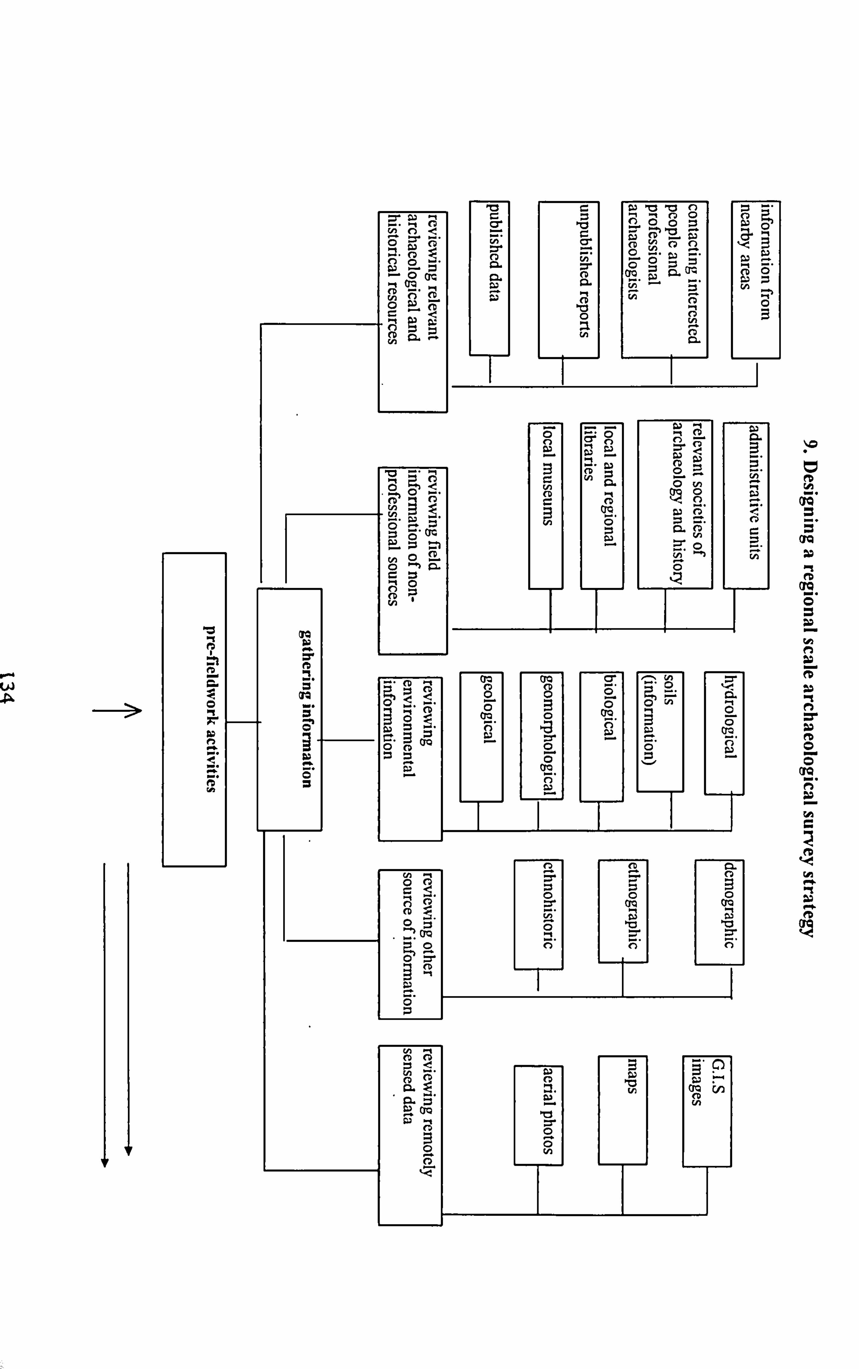
< 'C -00O WO n C Q cp yö
ýt 3 0
m M. 0 27 Z -t -
cý -a ac (p ö
ä ö y 3
. O-.
f 1 y G - . "
\ýQ
d _y ýQ"
IQ
CM
f9 3U
f9 O O
UQ
C9
P'P
fe eD
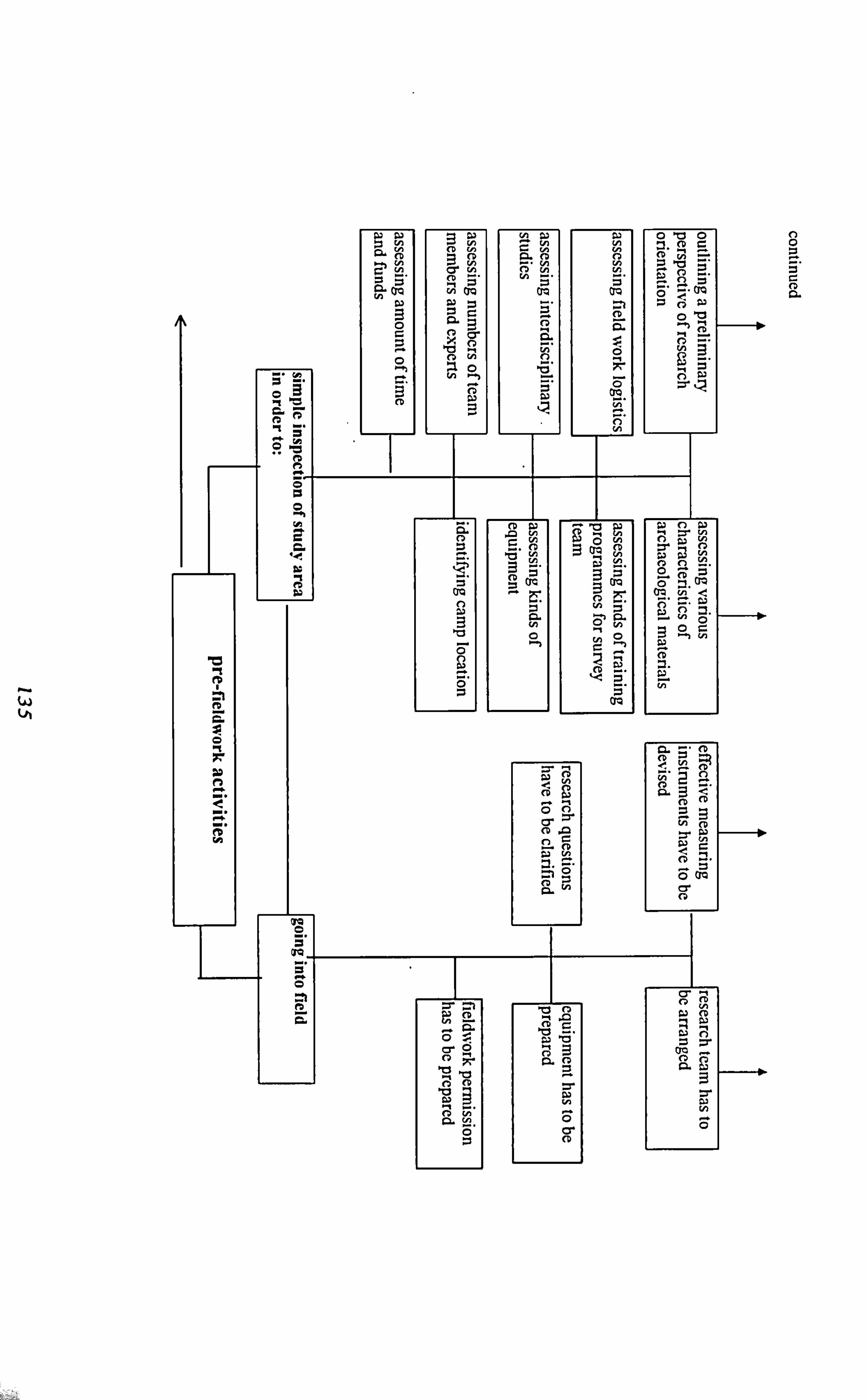
0 0
Q.
w
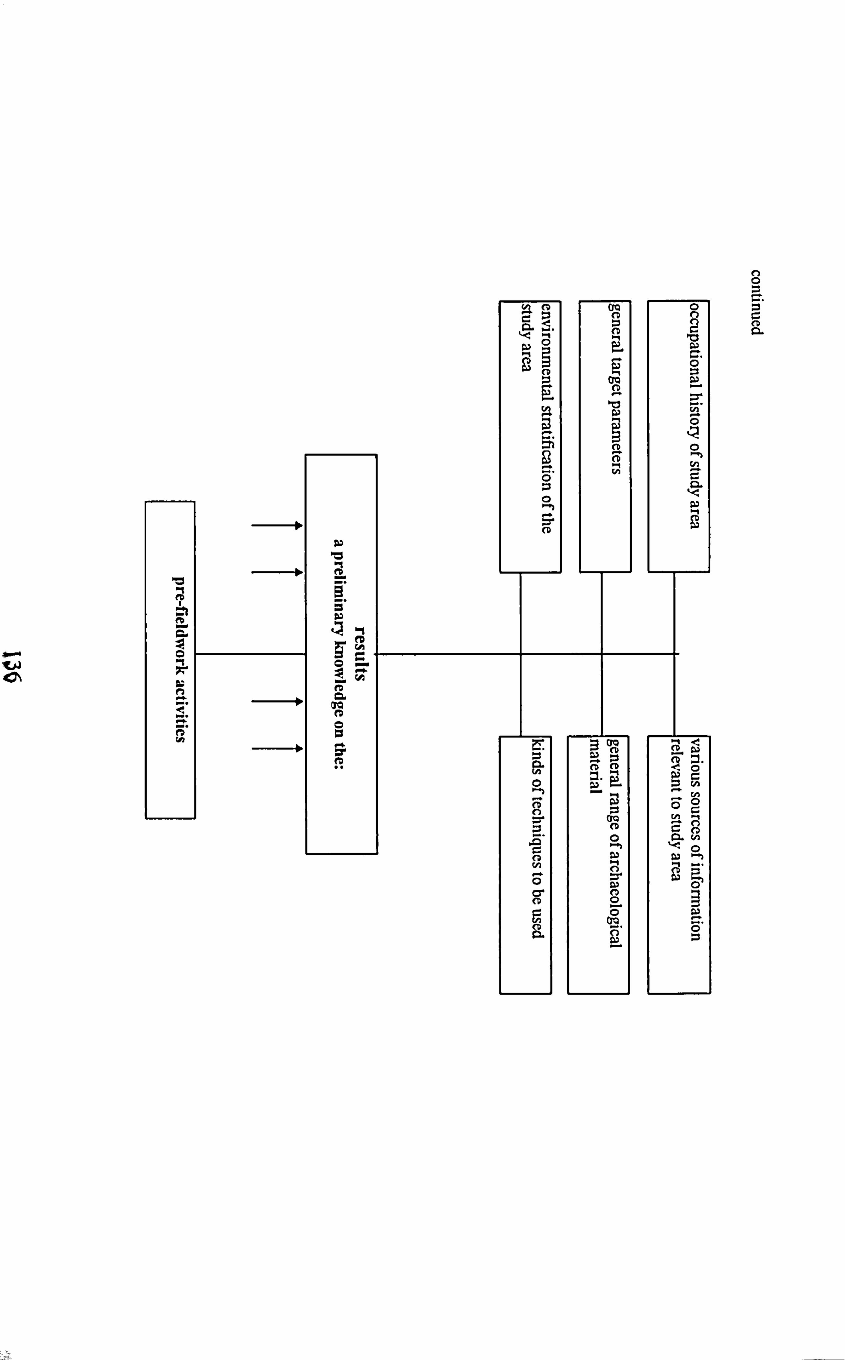
C, 0 C. C
a
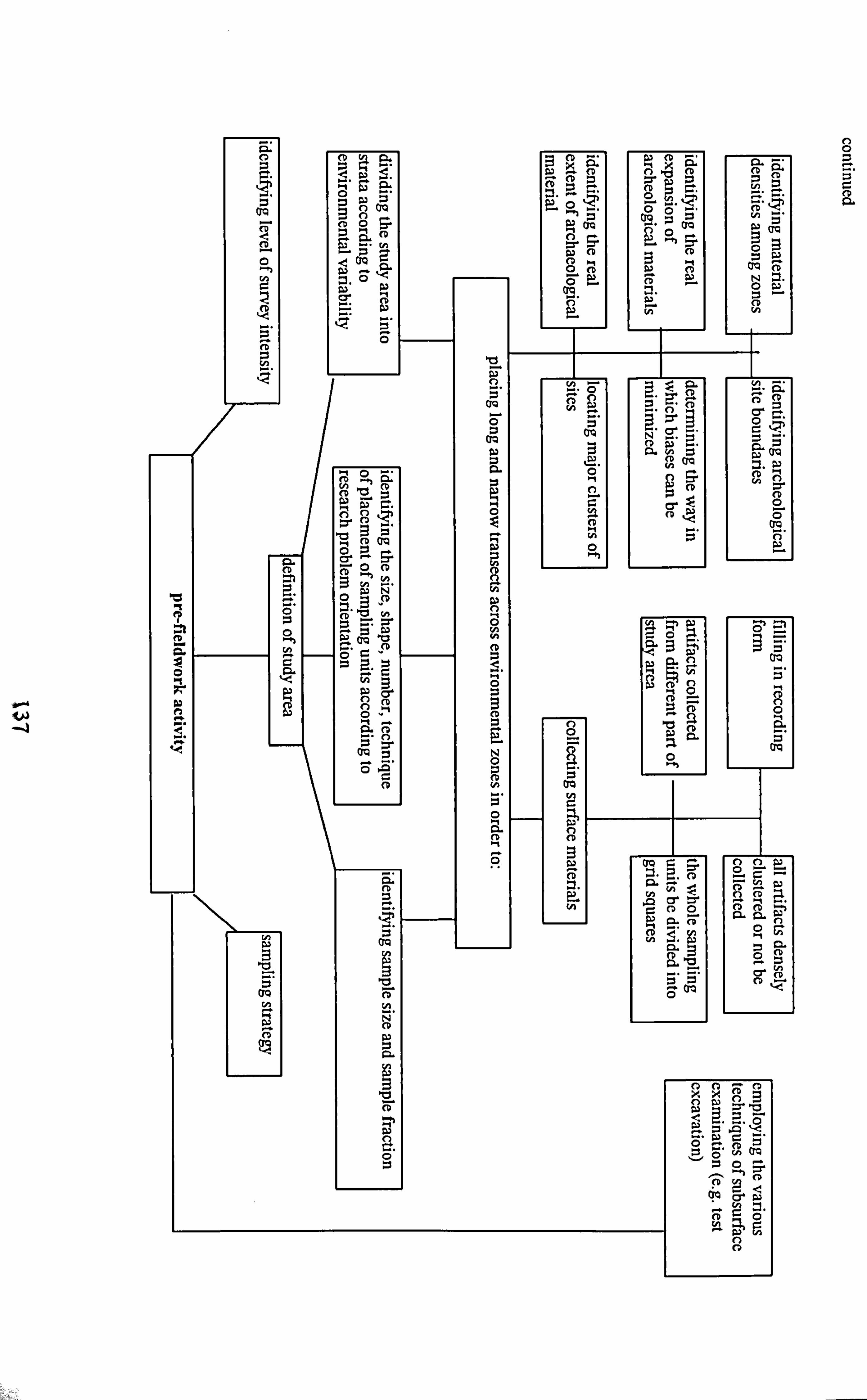
K
0
w
, -.. i
0
C N rr
a
y w
I
Ä
(D LI.
n
ö (D Q
0
o5P `° b. '
= Co
O ý' C
nO O~ ti .. 1" A
OQ ý
Ö ý"
f9
I b N CD
a
b
0
rjQ f"
M w C w o ö c o i
»"ö ý. ý coo ~"ä
I Q C. U
( TQ
¢ a' O_
H r. ý.
A
'L7 , Za
0
CD
(o
.N G
ä'b
0
ä ., 0 0 0 a
av
ö=- .rC vý y
fD l"2 92. CD. ,
00
X0
GOi C;
r. ýp 0y QO
yGO
0 0
a
ý;
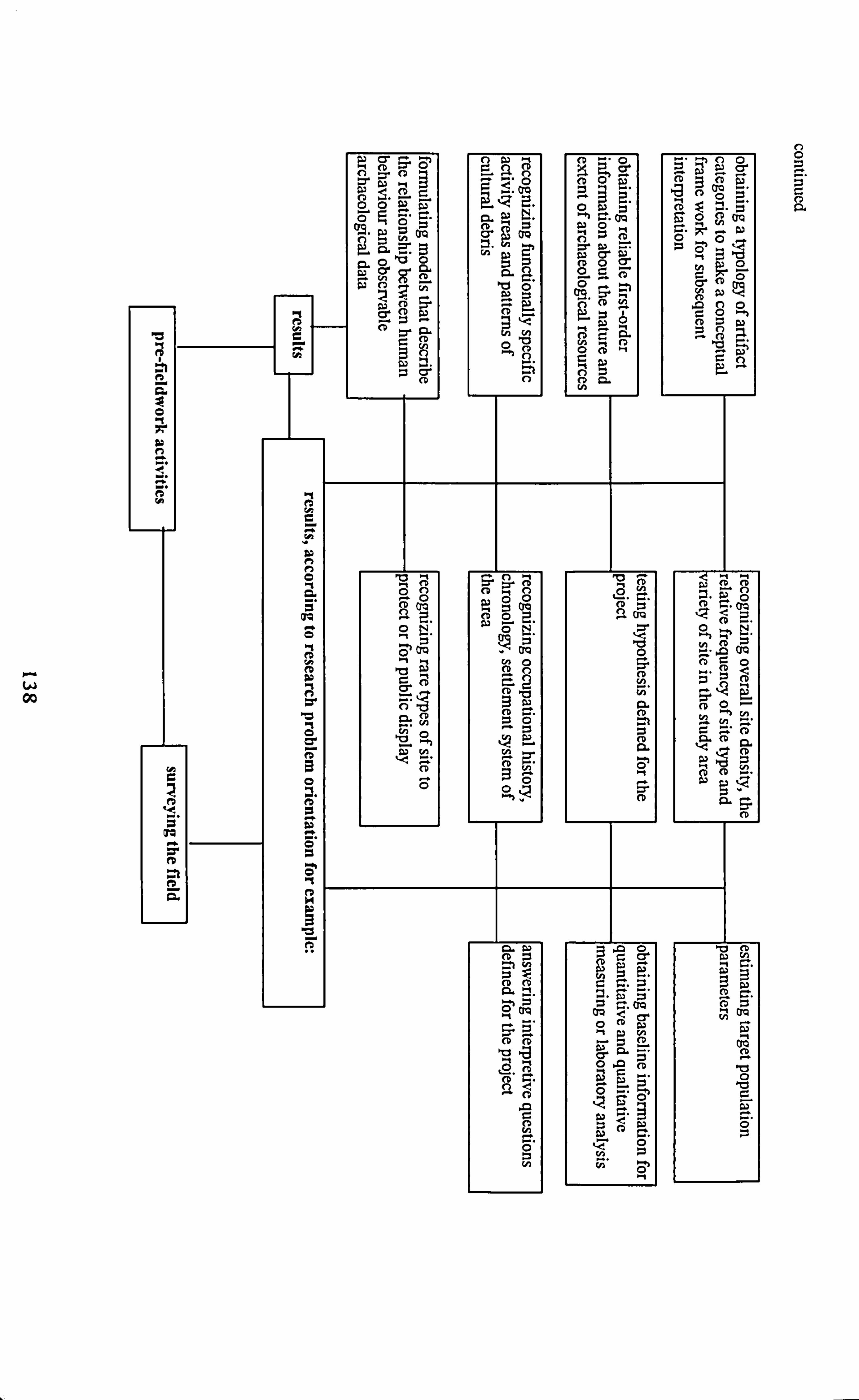
0- w 00
0
ä
0 ti
m
CM G
QO
S t9
a
y C I y
a- 56 EP
w ., nw "+
fD ö c co o
a coo
O , "", no
wwa, CD : ýy
"" 9 " N" rq -A " O2
v -i QO C
D y P
N cry QG
to
O " p
K' 0w
- 0 'a w c_
W G vi p( E; 0 o" 10
pC CJ CO
wC cm g, - aoO
CD co , 17 (D = R 10 ti ° öD w
CD CD N
V ýp
Oh i1
ap d0 0 On
10 CD 0 to 7 & F- P 14 =' (D
w ß r,
° . CD
ýn 42 C ä ca
, ca 14. Ln a c
0 CD a'
CD
CD coo 9
C. = EI w
c
ýu 3 - 9: 92. CD
_O n
C C
EL li: i
42
O
U, yÖ ti
0 0
Chapter 4
Palaeoenvironmental Background of Iran
and its Archaeological Implication
1. Introduction
The idea of climatic change as a determinant factor in major cultural change in the
Near East has always been promoted from Huntington (1905) in the early twentieth
to Childe in the middle of the century, and more recently by the majority of
archaeologists. Bar-Yosef (1994,1995) and Turner (1992) have stressed that the
early Palaeolithic human movements from Africa to Eurasia coincided with climatic
fluctuation of the various glacial cycles as well as by change in the carnivore
communities. For the Neolithic Revolution the climatic determinism concept
emphasises a climatic change from a cooler and drier condition to a warmer climate
in the terminal Pleistocene. This change was assumed to have had a profound effect
on the environment of the Near East that contributed significantly to the adjustments
in human adaptation that resulted in the development of plant and animal
domestication and the beginning of agriculture (Bar Yosef and Belfer-Cohen 1989,
1991,1992, Braidwood 1972, Cauvin 1978, Henry 1989, Redman 1978, Mathews
et al. 1990, McCorriston and Hole 1991, Miller 1991a, Moore 1985, Moore and
Hillman 1992, Watson 1991, Wright 1968,1976). In the period of urbanisation it is
argued that environmental forces played a major role in shaping social development.
Hole (1994) and Sumner (1988) (see also Adams 1981, Postgate 1992, Weiss et al.
1993) have addressed climatic change as a basic factor in the reorientation of
139
Mesopotamian and Iranian societies since the fifth and fourth millennia B. C. that
caused a change in the organisation of irrigation systems and mobilisation of labour.
The reconstruction of the environment first requires an answer to questions of
chronology and climate. It is essential to understand that when the human activities
under study took place in terms of the broad world climatic succession. This then is
a matter of chronology. A reliable data allow us, for instance, to determine whether
the context belongs to a glacial or an interglacial phase, and what the temperature is
likely to have been in that part of the globe. Other questions such as sea-level will
be related to this one. An important step in the reconstruction of Palaeoenvironment
especially for all postglacial context is the study of the vegetation (pollen or other
plant remains)at that time. Other important step is to turn to the fauna and
microfauna including insects, snails, and rodents, all of which are very sensitive
indicators of climatic change.
No single method will give an adequate picture, and so as many methods as data will
allow need to be applied to build up a comprehensive image. There are a series of
advanced methods are used by environmental archaeologists in reconstructing
Palaeoenvironmental patterns of the globe, including for instance, extracting data
from the sea bed and ice cores (the most coherent record of climatic changes on a
worldwide scale is now provided by deep-sea cores, drilled from the ocean bed.
These cores contain shells of microscopic marine organisms known as foraminifera,
laid down on the ocean floor through the slow continuous progress of
sedimentation. Variation in the ratio of two oxygen isotopes in the calcium
carbonate of these shells give a sensitive indicator of sea temperature at the time the
organisms were alive. We now have an accurate temperature sequence stretching
140
back 2.3 million years which reflects climate change on a global scale. Thus the cold
periods in the deep-sea cores relate to glacial periods of ice advance, and the warm
periods to interglacial or interstadial periods of ice retreat. The deep-sea core
oxygen is a framework for a relative chronology for the Pleistocene. Fluctuations in
Pleistocene and Holocene climate as recorded in deep-sea cores, ice cores, and
sediments containing pollen are of considerable value for dating purposes. This
method records the fluctuations in climate during the Ice Age. From the beginning
of the Pleistocene, about 1.7 million years ago, down to about 730,000 years ago
(Lower Pleistocene) there were perhaps ten cold periods separated by warmer
interludes. Another eight or nine distinct periods of cold climate may have
characterised the Middle and Upper Pleistocene (oxygen isotope stages 19-1 from
730,000 to about 10,000 years ago). The period of warmer climate known as the
Holocene covers the last 10,000 years)(see Aitken 1990).
The modern archaeology today for the Palaeoenvironmental reconstruction applies
the following techniques as well. Studying ancient winds (Parkin and Shackleton
1973); ancient coastlines (van Andel 1989); submerged land surfaces (Shackleton
and van Andel 1986); rocks and soils (Holliday 1992); the composition of the
sediments and soils of cave sites (Courty et al. 1990); and dendroclimatalogy
(Schweingruber 1988); as well as studying micro and macrobotanical remains and
micro and macro fauna remains (Moore et al. 1991, Rackham 1994).
2. Problems of the Palaeoenvironmental study in Iran
The researchers who deal with Iranian Archaeology to document climatic patterns
and their influences on the human cultural processes are initially facing the following
problems:
141

(1) knowledge of past environmental events and processes in Iran is relatively poor,
although from the nineteenth century there have been a large number of studies for
this purpose;
(2) the correlation of geological events and archaeological processes has not been
sufficiently well established; for example, the glacial and pluvial environmental
fluctuations of the Pleistocene period have been poorly documented so the
contextual framework of Palaeolithic cultural processes is relatively unknown;
(3) dating methods to document palaeoenvironmental processes have not been
developed; apart from the radiocarbon dating control that is still used for
archaeological purposes, with a few exceptions there has been no application of
dating methods such as thermoluminescence, potassium-argon, uranium-thorium and
many others that are successfully used in other parts of the world and;
(4) and although some field studies in Iran, particularly in the palynological field,
were excellent, they are very limited in scope, amount and area (e. g. the pollen sites
in Iran come from the forest and steppe-forest association; there is no pollen
evidence from either desert or steppe zones). These limitations demonstrate the
difficulty of reconstructing the environmental background of human activities in less
well known parts of the country.
In theory, at least, climatic change in terms of variation in temperature, precipitation
and other climatic variables, would have affected the physical pattern of the land and
the nature and distribution of faunal and botanical communities. There is evidence
for a significant climatic changes during the late Pleistocene and early Holocene in
Iran which would have affected the land morphology. Erosion and deposition are
both geomorphological processes that affected the preservation of sites as well as
142
the lives of people who lived in them. The severe environmental changes that have
occurred could help account for some cultural responses manifested in such events
as shifts in settlement pattern or change in technology. Apart from the other
principal geological processes such as tectonics and earthquakes that deeply affected
the land patterns there is also another problem, that is extrapolating the past
environmental patterns from the present ones. It is land use practice that prevents
direct comparison between past and present situations and disturbed the landscape
through time (Miller 1991b: 155). Such practices include the removal of trees and
woody shrubs, overgrazing by domesticated animals, compaction of topsoil, and
increasing degradation of the root network; all these contribute to increased surface
runoff and wind erosion. The cultivation of domesticated plants has increased
domesticated seeds and replaced wild species. The increased cultivation may have
gradually decreased organic materials in the soil while increased irrigation with
associated salinisation has profoundly affected the landscape in Iran during the last
few thousand of years. All these adversely affect our knowledge of former climates
in Iran. The reconstruction of earlier human cultural processes in the Palaeolithic,
for example, relies heavily on the quality and availability of the Palaeoenvironmental
data, and if not, the lack of such data affects the quality of research and results, so it
is necessary to explain why Palaeolithic archaeology in Iran stands now in a
undeveloped state.
In terms of archaeological techniques, particularly systematic surface survey (see
chapter 3), the geomorphology of the land has a considerable effect on survey
results. It has been argued by most archaeologists that regional archaeological
studies require a knowledge of the geological history of the region, since the
143
archaeological data need to be interpreted in the light of natural and cultural
processes that have affected them (Brookes et al. 1982; see also Schiffer et al. 1978,
Schiffer 1987). In the areas where some archaeological sites have been buried under
alluvial deposits the archaeological samples taken from the surface cannot be
representative of the former population and the conclusion eventually tends to be
distorted. Thus one can assume that fluctuating climatic conditions of the late
Pleistocene and early Holocene in Iran (as we will see in this chapter) may have
caused a large number of archaeological sites to become buried, affecting the
reliability of reconstructions of cultural processes. For the future, a matter of high
priority must be a careful assessment of the geological processes that have affected
each of the settlement areas. In the areas where deposition has been excessive, sub-
surface sampling to identify buried material by means such as coring or penetrating
radar can produce results if funding permits.
Since this thesis is dealing primarily with the Palaeolithic Iran within the wider
context of the Near Eastern Palaeolithic, so assessing the potential and limitations of
the Pleistocene record for Iran in particular and the Near East in general appears to
be necessary here. For this a general outline of geography, environment and
chronology of the Near East is provided in the following section. Noting that in the
absence of more reliable Palaeolithic data from the most parts of the Near East, the
chronology discussed in this section is based mainly on the Levantine chronology.
3. Geography and environments of the Near East
The main geographic features of this region include the topographic combination of
mountains, plateaux, and alluvial plains. The coastal plains are narrow in
comparison with those found on other continents. The Anatolian plateau is bounded
144
by the Pontain mountains to the north and the Taurus mountains to the south, with
each range spanning about 1500 km in length. Both join the northwestern end of the
1800 km long Zagros chain which, together with the Caucasus mountains, comprises
the deeply dissected landmass. The Iranian plateau is bounded by the Zagros
mountains to the west and south, the Elburz and Kopet Dagh mountains to the
north, and the Khurasan and Baluchistan mountains to the east. The Mesopotamian
plain stretches and descends from the foothills of the Zagros and Taurus into the
Persian Gulf. It is bounded to the west by the Syro-Arabian Desert, which stretches
into the Arabian peninsula. The Mediterranean Levant is a special zone within
western Asia, covering an area about 1100 km long and 250-350 km wide.
Topographically, it include the coastal mountain range, the Dead Sea System or the
Rift of the Orentes-Jordan valleys, inland mountain ranges such as the Anti-Lebanon
mountains, and an eastward sloping plateau, dissected by many wadis flowing into
the Syro-Arabian Desert and spotted by oases. Today, the climate of the Near East
is dominated by two distinct seasons: cool, rainy winters and hot, dry summers.
Winter temperatures are milder in the coastal ranges and more severe inland or at
higher elevations. Precipitation is affected by distance from the sea and by altitude,
with the central Anatolian and Iranian plateaux the Syro-Arabian Desert and
Mesopotamia being the driest zones. In the Mediterranean Levant, rainfall decrease
in a north-south direction from the Taurus mountains to the Sinai peninsula. Today,
Eu-Mediterranean vegetation, consisting of woodlands or open parklands, prevails
along the coastal ranges. Dwarf shrubland and steppic vegetation dominant the
eastern Anatolian plateau, forming a wide arching belt from northern Mesopotamia
into Sinai. In the semi-arid and and region, xeromorphic dwarf shrubland and desert
145
plant associations cover most areas. The current complex climatic system of the
Near East makes it difficult to reconstruct the pattern of the past. Several lines of
evidence (e. g. Palynological sequences and lake levels) suggest that the present
climate in Iran (and generally in Southwest Asia and the Near East) differs in some
respects from climates of the late Pleistocene and early Holocene (Butzer 1975,
COHMAP Members 1988, Flohn 1981, Kutzbach 1981,1983, Kuzbatch and
Guetter 1986, Kuzbatch et al. 1993, Roberts and Wright 1993, van Zeist and
Bottema 1982, Wright 1993), while Upper Pleistocene rainfall distributions were
somewhat similar to those of today. Decadal and centennial fluctuations in the
amount of precipitation, rather than temperature changes, were responsible for the
expansion and contraction of vegetational belts (e. g. Roberts and Wright 1993).
The distribution of past mammalian fauna, as well as birds is poorly known, and
most of the information is gathered from animal bone collections retrieved from
excavations across the region.
4. The Quaternary environmental and climatic changes in the Near East
Our knowledge of environmental and climatic changes in the Near East during the
Quaternary is still fragmentary. This makes it difficult to correlate events there with
those taking place in northwest Europe at the same period. In this latter region, an
accumulation of evidence from many sources has shown that the last glacial period,
known as the Wiirm occurred between about 70 ka and 10 ka, and was followed by
the Holocene period. During the latter part of the Würm between 25 ka and 15 ka a
major ice advance occurred, which at its maximum, covered a large proportion of
the northern hemisphere. The nature of the changes which occurred beyond the ice
front, in places such as the Near East, still remain largely unknown (with some
146
exception in the Levant), owing to the paucity of research work which has been
carried out here. Early works postulated climatic changes on a large scale, which
they claimed had a fundamental effect on the geomorphic processes operating in the
region. Pluvial periods, that is times with higher precipitation than at present, were
considered to have occurred in the Near East contemporaneously with glacial
activity in northwest Europe. Recent work, however, has shown that the pattern is
much more complex than this, and that perhaps different conditions prevailed in
different areas at the same period. The lack of evidence from large parts of the
region makes it difficult to be precise in drawing detailed conclusions. Information
on the Nile Valley has been greatly enhanced over the last few years as the result of
work on the Aswan High Dam as well as by continued archaeological investigations
(Beaumont et al. 1988). Studies of alluvial deposits in Egypt have been used for two
main purposes. Small wadi deposits provide an indication of local climatological
conditions, while flood plain sediments of the Nile record environmental events,
particularly summer monsoonal rainfall, in Ethiopia. Evidence of pluvial conditions
in southern Egypt, possibly about 60 ka is provided by the Wadi Floor
Conglomerate, which overlies bedrock along many wadi floors. At the time of the
accumulation of this deposit there is no evidence for higher Nile flood levels, which
would be indicative of pluvial conditions in Ethiopia. The Korosko Formation,
consisting of Nile silts, was deposited between 50 ka and 25 ka. During the first
part of this cycle, pluvial conditions still continued in southern Egypt, while at the
same time increased precipitation in Ethiopia produced grater floods along the Nile.
Later, pluvial activity in Egypt declined, although even higher flood levels were
recorded down the Nile river system. This lack of complete agreement between
147
environmental conditions in south Egypt and the source of the Blue Nile in Ethiopia
seems characteristic of the latter part of the Pleistocene period. During the time of
LGM in northwest Europe the climate in southern Egypt appears to have been arid,
as it is today, while at the same time wet conditions prevailed in Ethiopia. In the 10
ka following 15 ka the discharge of the Nile increased, as too did wadi incision in
southern Egypt. This latter fact is taken to indicate the return of pluvial conditions
in that region. Nile flood levels began to decrease in the third millennium B. C., and
local wadi activity also declined in intensity. Since this period the climate of
southern Egypt has remained arid. The lowest Nile floods appear to have been
recorded between 2350 and 800 B. C., with slightly less and conditions prevailing
since that time. (see also Paulissen and Vermeersch 1987).
Although similar sequences of alluvial deposits exist throughout the Tigris-
Euphrates basin, their chronological significance has not yet been studied in any
detail. So far the most detailed work on the Euphrates comes from Syria, where late
Pleistocene and Holocene terraces have been described (Peaumont et al. 1988).
Pleistocene stratigraphy has been well studied in the basin of the River Jordan.
Here, the main sequence of sediments, known as the Lisan Marls, are considered to
be late Pleistocene in age and to have been deposited in a huge lake over 300 km in
length, which possessed a water level about 200 m above that of the present Dead
Sea. Following the Maximum development of the lake, more and conditions
occurred, and the lake decreased in size. With a lowering of water surface
elevation, a sequence of shorelines were cut in the Lisan Marls at many different
heights down to the present level of the Dead Sea (Klein and Flohn 1987).
148
Glacial activity at the present day is confined to a few small come glaciers and
permanent snow patches in the Pontus and Taurus ranges and the Armenian Plateau
of Turkey, as well as on Savalan, Suleiman, and Damavand in the Elburz mountains
of Iran. In Turkey the contemporary snowline reaches a minimum height of about
3200 mI the northern part of the Pontus Range, rising inland to more than 4000 m,
while in Iran it appears to be slightly higher at between 4000 m and 4300 m
(Messerli 1967). During the Pleistocene it seems that glacier grew large and that
new ones come into being in other upland regions. The actual amount by which the
snowline was depressed during this period is still the subject of considerable
controversy. Values of 800 to 1200 m have been reported for Turkey, while in parts
of the Zagros it is claimed to have been at least 1200 m (Wright 1980).
A considerable body of research has been carried out in the Near East on alluvial
deposits of Tertiary and Quaternary age fringing the major upland regions. The
deposits are often of very great thicknesses, upwards of 300 m, and would seem to
indicate continued continental sedimentation over very long periods of time. In a
series of papers (see next for discussion and bibliography) dealing with alluvial
deposits along the southern slopes of the Elburz mountains three major alluvial
formations of post-Upper Miocene age have been identified. The oldest
(Hezardarreh Formation) between 100 and 120 m in thickness. It age is estimated
to be Mio-Pliocene. Overlying this is the Kahrizak Formation. This is much thinner,
really more than 60 m in thickness, but it has been subjected to folding and faulting.
It age is estimated to be mid-Quaternary. Finally, the youngest formation, the
Tehran Alluvium, is generally less than 35 m in thickness and has been unaffected by
orogenic activity.
149
The dating of recent alluvial material, and the land forms to which they give rise, still
poses problems. Two phases of alluvial deposition are widely recognised in the
Near East. In Iran, the earlier phase began no more than 50 ka and had probably
ended by the fourth millennium B. C. This was followed by a period of erosion, after
which a second phase of deposition occurred during the Middle Ages. In the Konya
basin of central Turkey, research suggests that present environmental conditions are
not responsible for the major geomorphological features. Such features, including
abandoned shorelines, wave-cut cliffs, sandpits and deltas, all testify to lacustrinal
conditions during the recent geological past. Studies of the fauna of the lacustrinal
sediments suggest that the water was fresh, even though it had no outlet.
Archaeological evidence shows that the basin was largely dry by 8500 years ago (De
Rider 1965). At present depositional processes appear to be confined to alluvial fan
formation along the margins of the basin. The total thickness of sediments within
the basin is unknown, but boreholes have revealed that in some places it is at least
400 m.
Sea level changes also occurred during the Pleistocene period leaving behind well
marked raised beaches in the Mediterranean Sea, Red Sea, and the Persian Gulf. As
yet attempts have been made to correlate the differing levels which have been
described in studies of local significance. In the Black Sea region eight distinct
Quaternary shorelines have been recognised, ranging in height from 105 m to the
present sea level (Schrader 1979). A much more complex situation exist in the
Mediterranean with no general agreement about correlation between the different
areas, owing to the absence of diagnostic faunal assemblages. Shorelines have been
described ranging from 200 m to 2m above the present sea level, with many of these
150
being recognised in the eastern Mediterranean region. In Lebanon, high-level
shorelines have been identified at 180-190 m, 110-120 m, and at 60 m, together with
a series of lower ones (Beeaumont et al. 1988)).
5. Chronology of the Quaternary in the Near East
Review of the Palaeolithic record and Palaeoenvironmental data from the Near
East mostly from the Levant reveal that a significant amount of chronometric
research has been carried out in this region. Although application of radiometric
techniques is not as plentiful in the Near East as in Europe and Africa, Quaternary
biostratigraphic and climatic records of the Pleistocene are correlated to deep see
oxygen isotopic records, which aid the reconstruction of Palaeolithic chronology and
environment (e. g. Farrand 1994). Unfortunately, similar investigations in the other
countries of the Near East are generally lacking to this day; once these are
conducted further clues to understand the Palaeoclimatic patterns and the
Palaeolithic colonisations of the Near East will emerge.
The geochronology of the Near Eastern Quaternary is based on the correlation of
coastal, marine and inland fluvial-lacustrine sequences. Calculations of the relative
ages of the different formations are often based on their biostratigraphic positions,
interpretations of their Palaeoclimates and possible correlations with the curve of the
oxygen isotope stages (noting that there is no established palaeoclimatic sequence
for the most parts of the Near East into which one can fit evidence found in the
prehistoric sites, nor are the climatic implications of deep-sea isotope curves clear
for this region).. In the past, Quaternary terminology was adopted from the Alpine
sequence generally correlated with the central European loess cycles (e. g. Sanlaville
1988). Obtaining secure dates for this region is problematic due to the rare presence
151
of tuffs and lava flows, which are necessary for radiopotassium dating techniques. A
sufficient number of palaeomagnetic readings is not yet available for large areas of
the Near East. Therefore, the Quaternary subdivisions are based on local sequences
of marine shorelines and inland fluvial sequences in river valleys. Their chronologies
are derived from either correlation with known Palaeoclimatic chronologies, such as
the oxygen isotope stages, or the European terrestrial faunal sequences (Sanlaville
1988, Besancon et al. 1988). Given the variability of the Near Eastern landscape,
Quaternary cycles were identified in marine and coastal sequences, on the one hand,
and terrestrial sequences, on the other. Inland sequences are often based on the
study of wadi and river terraces such as Nahr el-Kebir, the Orontes, the Middle
Euphrates (e. g. Sanlaville et al. 1993); a few riverine and wadi localities in Turkey
(e. g. Albrecht and Müller-Beck 1994); and the Kura Valley in Georgia (Lubin and
Bosinski 1995). Inland basins outside the Rift Valley accommodated lakes, but their
Pleistocene history is still poorly known (Copeland and Hours 1989). The existing
lakes in the Near East are often located in tectonic basins. Major tectonic
movements took place during the Plio-Pleistocene, but later, minor once had
additional effects on the landscape. In particular, the role of tectonic movements
can be observed in the formation and subsequent changes along the Syro-African
Rift Valley. These movements caused older lakes to disappear and new ones to
form (Sanlaville 1988). Thus, the efforts to correlate marine coastal cycles with
inland fluvial-lacustrine cycles are often tenuous. Palaeoclimatic correlations of
these formations with the oxygen isotope stages may not always be feasible until
new or improved techniques make possible the dating of stratified sequences where
volcanic tuffs and lava flows are absent. Without a chronological control, the
152
subdivision of the Lower and Middle Pleistocene is still a puzzle composed of
stratigraphy, relative chronology based on general subdivisions of fauna and pollen
assemblages. It should be noted that marine transgressions played different roles
along the Mountainous and flat coastlines. For example, while the change in sea
level affected the width of the flat coastal plains, shorelines along the mountainous
coastal line are often expressed in series of terraces. However, the main sediments,
whether the Kurkar (sandstone) dunes, the sandy beaches or the hamra (red loam
deposits), are present everywhere along the Mediterranean shores (Bar-Yosef 1998).
The chrono-stratigraphy of the Levant was based on the assumption that the
Mousterian is solely of the last Wurm glaciation. Currently, (ESR) and (TL) dates
indicate that this industry is at least as old as oxygen isotope stage 7 age, or even
oxygen isotope stage 8 (Schwarcz 1994). Therefore, the Lower Palaeolithic in the
Near East began with the first colonisation of Homo erectus, 1.8-1.4 myr, and lasted
until the end of the Acheulo-Yabrudian, around 300-250 kyr (see (Bar-Yosef 1994
and discussion in chapter 5). The different topography and climate of the Near East
is demonstrated by its floral (e. g. van Zeist and Bottema 1991, see also relevant
section in this chapter), and faunal history (e. g. Tchernov (1988). Given its location
on the crossroads of the palaeoarctic, oriental, and African zoogeographic zones, the
region has preserved a mixture of mammals, reptiles, birds, and molluscs,
demonstrating the coexistence of various species. A number of species characterise
the Mediterranean Basin, where local climatic conditions facilitated the emergence
of endemic species, especially during the heights of the glacial periods when the
desertic belts reached their maximum expansion. Today, the results of fieldwork
153
allow the subdivision of the Quaternary into biozones based on two areas alone: the
Caucasus (e. g. Vekua 1987), and the central Levant (e. g. Tchernov 1992).
6. Chronology of the climatic changes and cultural transformations in the Near
East
The Near East provides a unique opportunity to consider several crucial events in
human evolution that may have been affected by climatic changes. The oldest
movements of hominids resulted from major shifts in the distribution of food
resources of the African landscape that occurred during the Olduvai subchron (1.95-
ca. 1.84 myr). The Olduvai subchron seems to have resulted in palaeoecological
changes. A series of migrations out of Africa by Homo erectus is recognisable in the
archaeological records of Eurasia, even when the fossils themselves are not found.
The dispersals of modern humans who evolved in Africa sometimes between 500
and 50 ka (Stoneking 1993) also resulted from environmental changes in their
homeland (Barham 1999). Without identifying the timing of these events, it is
difficult to understand their relationship to known climatic fluctuations during the
Middle and Upper Pleistocene. In the desertic Saharo-Arabian belts, evidence
indicates that humans did not survive in and zones when glacial conditions prevailed
in northern latitudes. Movements out of Africa are therefore expected to have taken
place in the more humid intervals, either at the onset of glacial cycles (such as
isotope stage 5d, ca. 115 ka and 5b, ca. 90 ka) or perhaps later, during early stage 3,
ca. 60 or 50 ka. Movements southward from northern latitudes was driven by the
expansion of glaciated areas and the periglacial belt. Because there is no evidence
that prehistoric technologies before the Upper Palaeolithic enabled humans to
survive in close proximity to the glaciers, they must have had to seek foraging
154
territories in the Mediterranean Basin or in the lowlands around the Black and
Caspian Seas. The Levant offered a special area, with different vegetation
associations that provided various species of edible seeds, fruits, as well as a number
of mammals, and birds that could have been hunted. Although during less stressful
climatic conditions, the Levant would have been an important two-way corridor for
movement of humans between Africa and Eurasia, the number of African elements in
the Near Eastern faunas decreased through the Pleistocene (Tchernove 1992). The
region always enjoyed higher temperatures than did adjacent areas, as well as plant
and animal food resources that were more stable and reliable than those of most
European environments (Bar-Yosef 1995). The Levant would therefore have been
attractive to human groups living under conditions of diminishing resources and
increasing social stress, for example, in such places as the Balkan, the Anatolian
Plateau, and the Taurus-Zagros ranges. Those who occupied the Caucasus area had
their own refugium in the lowlands near the Black Sea and the Caspian Sea.
Evidence for the Presence of Neanderthal morphological features in Middle
Palaeolithic human fossils (ca. 80-55 ka) in the Levant is therefore not surprising
(see further discussion in chapter 5). The possible role of environmental changes in
affecting the Middle-Upper Palaeolithic transition must be noted here. This
transition, ca. 47-45 ka represents a time of rapid technological and social change, as
expressed in the European and Near Eastern archaeological record by the
incremental exploitation of the northern latitudes in Eurasia. The establishment of
farming communities ca. 10 ka in the Near East is interpreted to be the result of
socio-economic decisions made by sedentary hunter-gatherers facing the vagaries of
the Younger Dryas (Wright 1993). Newly emerging lifeways are seen as the result
155
of the ̀ Neolithic Revolution' that in due course led to the establishment civilisations
in the Near East.
A brief overview of the present day physical geography, climate and vegetational
patterns of Iran will help us draw inferences for earlier conditions. It is important
because, according to Krinsley (1970), Zohary (1973) and Ganji (1978), the basic
climatic gradient of increasing aridity from west to east and from northwest to
southeast in the Pleistocene can be compared with that of the present day and that
modern vegetation can be compared with that in prehistory.
Fortunately, there is a range of studies available that facilitate the work of
researchers seeking information on Iranian geography (e. g. Ahmadi 1988, Alijani
1990, Fisher (ed. ) 1968, Ganji 1968, Jafarpoor 1988, K-Tehrani and Darvish Zadeh
1984, Kasmaiee 1993, Kelt and Shahrabi 1986, Mahdavi 1987, Mahmoudi 1974,
1988, Sarvati 1993). More detailed information on the Iranian natural flora can be
found in Flora Orienialis (Biissier 1867-1888), Flor de l'Iran (Parsa 1943-1959),
and Flora Iranica (Rechinger, ed., 1963-1997), while Zohary's research (1973)
provides a unique aid to the knowledge of the vegetation of Iran.
7. Geological background (fig. 1a)
In recent decades our knowledge of the evolution of the continental masses has
increased owing to geological and geophysical investigations in many parts of the
world. As a result of this work new theories of sea floor spreading and plate
tectonics have been put forward. The basic idea of these theories is that the
continental masses are embedded in huge plates which move over the denser
material beneath the earth's crust. These plates, and the continents on top of them,
156
travel across the surface of the earth probably as the result of currents acting deep
within the earth. This movement can lead to the plates coming into contact with one
another, so producing crush zones, or mountain ranges. In contrast, where to plates
are moving away from one another, upwelling of magma occurs usually beneath the
ocean floors, to produce see floor spreading. In the Mediterranean and Near
Eastern region three major plates can be identified. These are the African, Eurasian,
and Arabian plates, and the boundaries between them are the Azores-Gibraltar ridge
and its extension across North Africa, the Red Sea and the Alpide zone of Iran. In
Iran it would appear that the northward motion of Arabia toward Eurasia has been
accomplished by widespread overthrusting in a belt from southern Iran to the central
Caspian. The result has been to thicken the continental crust over large areas. Iran
can be divided into two regions: the Zagros folded belt, and the rest of the country.
In the Zagros region continuous sedimentation under tranquil conditions has
occurred from Cambrian to late Tertiary times, when the sediments were folded into
a series of parallel anticlines and synclines. In contrast, the rest of Iran has suffered
more severe epeirogenic movements, as well as considerable igneous and
metaphormic activity. Three provinces can be identified in this latter region. The
first, Rezaiyeh-Esfandegheh orogenic belt runs parallel with the Zagros mountains
and unites with the Taurus orogenic belt of Turkey. It is separated from the Zagros
mountains by the Zagros crush zone, which is an area of thrusting and faulting.
Central and eastern Iran, a fault bounded, roughly triangular shaped region with its
apex in the south, forms the second province. The Elburz mountains of northern
Iran and the Parallel region to the south of them make up the final division of the
country. The northward movement of Africa and Arabia during the Mesozoic
157
caused a reduction in width of the Tethyan Sea. This was achieved by a subduction
zone which consumed oceanic crust. Eventually at some time during the late
Cretaceous all the oceanic crust disappeared into the mantle and the leading edges of
the African and Arabian plates reached the subduction zone. When this occurred
ophiolites were emplaced along the Zagros crush zone at the leading margin of the
Arabian plate. The Zagros sedimentary basin, the present Zagros mountains,
continued as the shelf of the old Afro-Arabian continent, with continuing
sedimentation, mostly of a carbonate nature.
Yet another period of compression occurred in the late Tertiary period, associated
with the formation of the Red Sea and Gulf of Aden, and also the south-eastwards
movement of Eurasia. These movements, which are continuing at the present day,
led to the underthrusting of Iran by the Arabian plate and resulted in the complex
folding of the Zagros mountains, together with folding and faulting in other parts of
the country. Based on the above outline the distribution of rocks of different ages is
relatively possible to explain. The oldest rocks, of pre-Camberian and Palaeozoic
age, are found on the stable masses with occasional smaller outcrops occurring
throughout the country. Marine sediments, in particular limestones and marls of
Mesozoic age, make up a much larger proportion of the outcrop. These sediments,
it is believed, where deposited in the Tethyan Sea, between the respective remnants
of Gondwanaland and Laurasia. Calcareous sediments, such as these have
importance in the economic life of the region, for it is in these rocks that the oil
reserves are concentrated. For example, in Iran, the Asmari limestone is the most
important reservor rock for oil accumulation. Rocks of Tertiary age, mostly marine
sands, clays, marls and limestones are also found in Iran. Thick Quaternary
158
sediments, almost all of which are unconsolidated, are confined to the upland basins
of the highland zone, and the majority valley systems of rivers. A characteristic
feature of the region is the widespread occurrence of eruptive rocks, mainly basalts.
They are found associated with zones of weakness especially in the highland zones
of Iran. The formed volcanic peaks, from which lava flows radiate, are seen in
Damavand mountain and Taftan mountain. Although the lava fields of Iran have not
been investigated in detail, most of them appear to be geologically young, dating
from the Tertiary to the historical period. Owing to the tectonic instability of much
of the region of Iran, earthquake, with epicenttres along the major plate boundaries,
are of common occurrence. Throughout history these natural hazards have had
considerable impact on human activity in the region affected by them.
8. Geographical background (fig. lb)
The heartland of Iran can be defined geographically as a plateau bounded in the
north by the Elburz system and to the southwest and south by the Zagros
Mountains. This vast triangular plateau is far from homogeneous and includes not
only the extensive desert lands of the Dasht-i-Kavir and Lut, but also large areas of
well watered and fertile soils lying between the enclosing mountains and the desert
basins which are the centres of the seasonal drainage systems. The two principal
mountain chains form natural barriers causing regional diversity. In geographical
terms they provide an effective barrier into the interior plateau for atmospheric
moisture and rain bearing clouds coming especially from the Mediterranean Sea in
the west, and also to the other atmospheric system from the north. In historical
terms they have played a major role in preventing easy access for invaders into the
interior of Iran. The Elburz Mountains with a general level of 3000m dominate the
159
topography of Northern Iran where higher precipitation and the local climate permit
specialised agricultural activities. The Zagros Chain running from northwest to
southeast imposes its own regional influences throughout its length; it rises generally
to a height of 2000-3000m, specially in the west where sufficient altitude and rainfall
have always encouraged forest cover and a rich agriculture.
With its considerable regional diversity, Iran can be divided geographically into the
following areas:
The Plateau. The interior desert basins cover about one half of the area of the
country or some 780,000 km2. These basins fall naturally into two groupings
separated by mountain ranges. The northern sections known as Dasht-i-Kavir (the
Great Desert) and the southern as Dasht-i-Lut. Both areas are characterised by
clayey, salty soil and extremely brackish ground water and temporary salt lakes.
Both the nature of the soil and climatic conditions turn these areas into one of the
driest lands in the world. The Great Desert contains few but well known
settlements; many of the richest agricultural areas lie in the lands bordering the
Desert, including among others the Dasht-i-Ghazvin, Dasht-i-Varamin and Mashhad.
Many of the country's famous ancient cities were located on higher ground about
1000m in altitude and represent for the most part staging posts on the ancient
caravan routes linking northern Khurasan and the Caspian areas with the south.
Agricultural life is primarily based on oasis cultivation in which dates, palms, other
fruits, grain and fodder play a major role.
The Plains of the Zagros Slope. A series of fertile plains and basins surround the
Central Deserts lying along the northeastern edge of the Zagros Mountains. The
most extensive areas are those surrounding Isfahan, Kirman and Marvdasht, though
160
many other smaller centres exist with a prosperous agricultural base. Throughout
the zone the principal water supply is river water and the Kanat (a subterranean
canal). Drainage within the basin is largely internal and a number of salt-lake basins
similar to those in the Central Deserts stretch from the southeast through the
Gavkhuni Bog to Isfahan. Outside the area of saline soil and toward the Zagros
slopes, soils are generally deep and fertile supporting a varied agriculture, mainly
irrigated, but with a significant area suitable to dryland grains and a rich livestock
economy. This is an important zone in archaeology because the agricultural way of
life started in this zone, and readily accessible mineral deposits permitted the early
growth of sophisticated urban centres in this area of Iran. It is an interesting fact
that many of the modern mining enterprises in the area represent new working of
ancient sites. Copper mining has also ancient origins in this zone, the deposits to the
south of Kirman (e. g. Tell-i-Ibllis) having been exploited at an early date.
Northwest Iran. This zone includes East and West Azerbaijan, Kurdistan and
Hamadan with its geographical continuation to the south. Despite the geological
similarities throughout this zone, the northwest remains geographically distinct from
the areas further east. Topographically, the zone contains a series of irregular
mountainous areas where altitudes can reach over 4800m with the highest peak of
the Sabalan. This zone is drained by plenty of permanent rivers water fed by rainfall
and snow melt across the area. Much of the area in the north is drained by Aras-
Rud River and in the southwest by Zanjan-Rud River whose tributaries eventually
join the Kizil-Uzon River and the Sefid-Rud system. The other drainage system of
this zone, including those streams around Mahabad together with Zab-e-Bozorg
River, cross the frontier of Iraq and link with the Zab-e-Kochak River. Lake Urmia
161
in Western Azerbaijan constitutes an internal drainage basin fed by local rivers: the
Zarrineh-Rud River and Simineh-Rud River from the south, and others from the
east. Azerbaijan is among the better watered areas of Iran and irrigated cultivation
systems can be found throughout the region, with the most productive areas located
in the major river valleys around the cities of Tabriz, Urmia, Ardebil and Zanjan
where soils are rich and deep and water supplies are easily available, though dryland
cultivation is also possible over large areas where cereals are cultivated
conventionally by rainfall. The southern rim of this zone toward the north of Isfahan
in the Central Zagros is geographically similar to Azerbaijan as noted above; this rim
takes the form of a broken mountain system beginning in the northwest with the
Kuh-i-Chehel Cheshmeh Mountain with a height of more than 3000m and continuing
in the Kuh-i-Alvand Mountain with a height of 3500m. All parts of this zone are
agriculturally well developed with deep soils in the valleys and reliable rainfall. Both
the Kanat and the river water irrigation supplies are utilised for sedentary
agriculture. Livestock is generally important with a strong transhumant tradition
affecting mainly the Kurdistan area.
Baluchistan. The mountains of Baluchistan are recognised as the southeastern part
of the Central Iranian zone. To the north the area is clearly defined by the Kuh-i-
Basman Mountain which reaches its greatest elevation at about 3500m. This narrow
chain runs east-west to link with the Zagros. To the east another mountain chain,
the Kuh-i-Sultan serves as a link with the mountains of Baluchistan-Pakistan.
Topography throughout the region is irregular and mainly above an altitude of 1000
m. In addition to the mountain ridges traversing the area two plateaux can be seen,
one toward the north located around Zahidan and the other centred on Khash with
162
the mass of the Kuh-i-Taftan Mountain lying between. Unlike the northern part
which is covered by sand and silt and dune deposits with insufficient soil or water
resources to offer a base for a strong sedentary agriculture, the Khash Plateau in the
south represents a strong contrast with settled cultivation developed over large areas
dependant upon adequate if not abundant underground water resources and rich
deep soils.
South of this region and its immediate neighbour to the south, is the Iranian Makran.
The zone itself consists of two distinctive topographical areas. First, the northern
Makran is characterised by the roughly west-east alignment of Bashagird Mountain
that rises to over 1500 m separating the Makran from the Djazmorian-Hamon lake
basin to the north. Second, there is Central Makran beginning from Ras-Al-Shir in
the west and continuing into Pakistan in the east. This zone consists of a series of
relatively regular folds of an anticline structure which gives coastal Makran a
character very different from the other major depressions and internal basins in the
country. The Iranian Makran offers far less inducement to human settlement
because of the greater proportion of rocky outcrops; springs are fewer, and the
sporadic rainfall quickly disperses to the sea, and frequent floods have covered the
valley floors with sand and debris. With monsoon rainfall some areas of flat ground
which are covered by fertile alluvial soils can be cultivated with a wide range of
crops but there are two major hazards: frequent extreme drought, and flood; in one
year extreme drought may prevail followed a short period later by extensive and
equally disastrous flooding. Thus, despite the occurrence of monsoon rainfall, and
plenty of water available, in the lack of construction dams for water conservation,
sedentary agriculture has not been developed.
163
The East Iranian Highlands. This system runs from the Kuh-i-Surkh Mountain
south of Mashhad and links up with the Kuh-i-Taftan Mountain in northern
Baluchistan. Kuh-i-Surkh with an altitude of 3000 m is separated from the hill areas
to the south by the Great Kavir. A large area including foothills is located in the
southern part of this zone and acts as an intermediate zone where areas of good soils
and rich underground water resources permit cultivation of cereals, vegetables and
other crops. South of the foothills soils are poor and salty where marshes are also
found. Drainage from the northern highlands flows to the marshes.
The other highland area in this zone is the moderately large-scale mountain chain
which runs from east to west covering an area about 90 km width and about 120 km
length from north to south. This is the Birjand-Kayinat Highland region which
achieves its greatest height in the Kuh-i-Ahangaran Mountain at about 300 m.
Agriculture in the Birjand-Kayinat region is based on the Kanat and earth dam
systems replenished by the irregular rainfall and heavy snowfall on the mountain
ranges. Some villages are universally famous for saffron cultivation which is
exported to the other parts of the country. Because of tectonic instability this zone
and many settlements suffer periodic earthquakes of which the greatest occurred in
1978 particularly affecting Tabas.
The Sistan Depression. Centred on Zabul is a large depression which links in the
east with the foothills of the Hindu Kush in Afghanistan. The principal features of
this zone within Iranian territory are the two permanent lakes of the Hamon-i-
Hirmand and Hamon-i-Sabari which link the Hamon-i-Pusak in Afghanistan to form
a single sweet water lake. The lake is fed by the Hirmand River which originates in
Afghanistan. Despite the abundance of water supplies available for irrigation, settled
164
agriculture is poorly developed. A most important factor to inhibit rich cultivation is
the Wind of 120 Days which is specially vigorous in Sistan. It blows during all of
the days from May to October starting in the morning as a hot blast from the
northwest. The wind contains heavy dust and so the air is thick and hazy, and
usually the wind is strong enough to carry sand particles that act as a highly efficient
abrasive. Vegetation can be stripped off, bushes and trees distorted, small plants
crushed and the growing layer of plants eroded away; lighter soils are eroded away
and the wind causes an intense evaporation of surface moisture.
The mountain Ranges:
The Elburz Mountains. These form one of the world's greatest mountain systems.
It comprises an almost continuous wall dividing the two climatic zones of the
Caspian shoreline in the north and Central Iran in the south. It extends in a shallow
arc from the Caucasus Mountains on the frontier with Azerbaijan at Astara, over a
length of some 1100 km, as far as Jajarm in the east. This system has an average
height estimated at 3100m while its peak in the Damavand reaches its highest point
at 5600m. The range carries a heavy snow cover throughout the winter and the
northern slopes receive heavy rainfall varying with altitude. Abundant water
maintains a dense forest cover on the northern slopes of the Elburz above the
Caspian plain. The Elburz system is made up of two unequal portions (1) the Talish
Hills in the west and northwest and (2) the main Elburz in the centre and east. The
Tallish Hills consist of a long narrow ridge running northwest-southeast and rising to
a maximum height of over 3000m. Near the Caspian Sea the Tallish Hills experience
a heavy rainfall without a dry season, and this gives rise to a thick vegetation cover.
165
Drainage patterns in the Elburz are aligned to the Caspian or to the central basins
with streams flowing down the steep slopes. In the west the Sefid-Rud system
captures the Kizil-Uzon and the Shahrud rivers and flows toward the Caspian Sea.
In the east the main lines of the drainage run to the east along the Khurasan
Mountains as Hezarmasjid and Binalud Mountains. From a watershed in the Kuchan
the region is drained westwards by the Atrak River and its tributaries towards the
Turkman Sahra region while the Kashaf River drains to the southeast joining the
Hari River in Garmab. In the eastern part of the Elburz livestock herding is
important, especially in the hill areas of northern Khurasan. The major areas of
settled agriculture occur both in the lower Atrak region and the broad plain around
Mashhad and the extended oases of Nishabur and Sabzvar, while the western parts
of the Elburz with their higher precipitation have commonly developed the
cultivation of cereals and fruits.
The Zagros Mountains. These bound the Iranian Plateau on the northwest to
southeast running from the Irano-Iraqi border at Kasr-i-Shirin to the Hurmuz Strait
in the Oman Sea. It occupies the entire western part of the country, about one half
of the total area. Considerable areas lie above 3000 m with Zard Kuh Mountain
reaching 4500 m. The land of the main Zagros is drained by major perennial rivers
which flow to the Persian Gulf, including the Karkheh, Karun, Hendijan, Mond and
Mehran systems, though several small streams make a direct but seasonal route to
the Persian Gulf. The extensive oak forests on the higher ridges is the vegetational
characteristic of the zone and a relatively heavy and reliable rainfall in the areas of
the western Zagros allows sedentary agriculture particularly around the Marvdasht
plain, though most of the areas have been exploted by tribal groups with an
166
economy based on herding. The main tribal groups occupying this vast area include
Kurds, Lurs, Bakhtiyari and Kashkay all of whom are still engaged in transhumant
herding. In recent years the establishment of agricultural extension services and
road construction programmes are leading to increased sedentary cultivation. The
eastern Zagros is an area of poorer rainfall than the west. Sedentary agriculture has
been developed in the major river valleys and plains particularly around Istahban,
Fasa and Niriz. Livestock, often under a nomadic regime, remains the basis of the
economy of the area, exploiting seasonal grasslands, by moving between the cool
and warm places.
The Iranian Lowlands:
The Khuzistan Lowland. Is the largest single expanse of true lowland in Iran and
the area does represent a sharp contrast to the rest of the country where mountains
are rarely out of view. The plain is regarded as part of the Arabian Platform with a
deep cover of recent layers of alluvial deposition making up a continuation of the
Mesopotamian region to the foothills of the Zagros. A high rate of deposition of
alluvium still occurs in the headwaters of the Persian Gulf brought down by the
Tigris-Euphrates and Karun systems. The plain is virtually an integrated plain with a
slow rise in altitude from the Persian Gulf to the slopes of the Zagros. The
Khuzistan plain is in fact the gift of the Karkhe and Karun Rivers. The Karkhe drains
northwestern Khuzistan while the north and northeast is served by the Karun and its
tributaries and the east is drained by the Jarahi system. Although much of the waters
feed into the Persian Gulf through the Arvand River, a number of creeks known as
167
Khur also distribute the river waters of both systems. The largest of these creeks is
the Khur-Musa which serves as a sea-way to the ports of Imam and Mahshahr. The
former has developed as a major port and the latter acts as a terminal for oil product
exports from the Abadan refinery. The flat plain of Khuzistan because of the
availability of irrigation waters has offered favourable conditions for sedentary
agriculture and urbanisation throughout the Iranian history. The land has been
continuously settled from the early Neolithic to the Achaemenid, Sasanian and
Islamic periods.
The Caspian and Turkaman Sahra Lowlands. Extending east-west between the
Caspian Sea and the Elburz Mountains in a strip of land varying width from 2 km to
50 km. Much of the Caspian lowland represents the areas left by the recession of
the Caspian Sea and is characterised by non saline alluvial soils. To the east in the
Gurgan plain, the Caspian piedmont soils and heavy rainfall produce an especial
agricultural condition over much of the plain. Administratively, this zone is divided
up into three provinces: Gilan in west; Mazandaran in centre; and Gurgan in east,
and these territorial divisions reflect real geographical differences.
Gilan consists of a delta formed by the Sefid-Rud River which extends 40km north-
eastward into the Caspian. The river itself is divided into several distributary
channels entering to a number of lagoons lying on the western flank of the delta.
Gilan has a extremely rainy and a hot steamy climate allowing the cultivation of
crops which are usually restricted to monsoon regimes of the world. Rice growing
has its greatest development on the marshy lowland at or sea level. Other products
are grown on an increasing scale and there are extensive mulberry groves which
support silk worms.
168
Mazandaran consists of a number of narrowing enclaves; the largest are the
Tunikabon lowland and the Chalus valley, both woodland areas covered by fairly
thick scrub. Many small streams descend as seasonal torrents from the central
Elburz and here the greater elevation results in higher rainfall which is to some
extent reflected in the number and size of these local streams. Farther east there is a
greater width of plain due to the presence of several larger rivers formed by the
division of the Haraz River. Most of the lowland is given over to rice and fruit
growing. Since annual precipitation declines quite sharply to the east, the majority
of the lowland is cultivated by irrigation systems. To the east also where the rivers
flow below the surrounding plains, direct irrigation is no longer possible and rice
growing which demands much water tends to be replaced by the cultivation of other
cereals, cotton and flax.
Gurgan is a transition zone towards Central Asia . Its climate is distinctly semi-arid
but on the hills there is greater soil fertility and slightly heavier rainfall, so that most
of the towns and villages are to be found on the hill slopes. From the southeastern
corner of the Caspian Sea there is a rapid transition into semi-arid and the fully and
steppe conditions. The Gurgan River crosses this region but its course has changed
so frequently that a number of ancient irrigation channels can be seen crossing the
area. As in eastern Mazandaran the principal streams flow a few metres below the
general level of surrounding plains so here the landscape differs markedly from those
of the central and western Caspian plains. The main feature of the Gurgan plain are
steppes broken only by artificial mounds (Tepe) representing older settlement sites.
169
9. Climate
Because of the position of Iran in the Asian land mass, its distance from the oceans
and the encircling mountains that block oceanic influences from most of Iran, most
of the country has a continental type climate characterised by dryness and extreme
change in temperature. In general four large-scale atmospheric features control the
climate of Iran, (1) the subtropical jet stream which steers the course of the
Mediterranean airflow over Iran; (2) the Asiatic high pressure zone which affects
westerly winter airflow over central and eastern Iran; (3) the low-pressure centre on
Northwest India and Pakistan which affects airflow from the north over Iran; and (4)
the arid-warm air from the Arabian Desert in the south which spreads northwards
throughout the summer and steers the humid airflow rising from the Persian Gulf.
The variations in Iranian climate can be classified as follow:
The Caspian Lowland may be regarded as a region of mild winters. It comprises
the southern coastal plain of the Caspian Sea and the adjacent lower zones of the
northern part of the Elburz Mountains. The mean annual temperature varies here
from about 15° to 18°C and the mean monthly temperature for January between 4°
and 9°C. In upper parts of the Elburz from 500 m upwards there is a sharp drop in
the winter temperatures similar to those of cool temperature zones. The January
extreme minimum at Polour at about 2100m for instance, is -24°C. Some of the
Elburz peaks are snow-covered all the year around.
Northwest Iran along the Zagros Chains is to a large extent subjected to particular
climatic influences. The thermal climate closely resembles those of higher zones in
the east Mediterranean Mountains. A considerably lower winter temperature in this
zone and the long distance from the sea increases continental characteristics so they
170
do not support a Mediterranean vegetation. The temperature varies both with
altitude and latitude. The climatic conditions in the northern part of this zone is to
some extent similar to the humid Caspian mountains. It differs however from the
southern Zagros in its hot and dry summer.
The Central Plateau has a typical continental desert climate resembling that of the
Central Asian Deserts in moisture deficiency and to some extent in its extreme
winter temperature. In the Kirman area the mean annual temperatures is about
18°C, with extreme maximum temperatures reaching 44°C and extreme minimum
temperatures of 14°C.
The Coastal Plains of the Persian Gulf and Oman Sea is a narrow region
extending from Khuzistan in the west to the Pakistan border in the east, with a high
winter and summer temperatures. The amount of rain is very scant and displays a
climatic regime similar to that of tropical Northeast Africa. The extreme maximum
temperatures in some places such as Bushehr Port (in the Persian Gulf) reaches 46°C
while its extreme minimum is 0°C and Jask (in the Oman Sea) has 6°C as its extreme
minimum and 45°C as its extreme maximum. This climatic variation dominates a
wide continuous belt extending further northwards and eastwards to Iranian
Baluchistan, Pakistan and the southern Afghanistan border.
Annual precipitation ranges in Iran from over 2000mm (e. g. Sabalan Mountain in
the northern Zagros Chains and Damavand Mountain in the Elburz Chains) to 50mm
or less (e. g. Dasht-i-Lut). The amount of rainfall decreases in general from north to
south and from west to east, but the driest part of Iran is not located in the extreme
south but in the Central Plateau where higher mountain chains prevent oceanic
171
climate influences. As the rainfall distribution map indicates, very high amounts of
precipitation fall only in a few localities in the Caspian region where the majority of
the summer heavy rain coupled with extreme temperatures of 30°C in summer
results in a subtropical environment and a vegetation of thick forests on the northern
slopes of the Elburz Chains, while the adjacent areas such as the Kurdistan
Mountains with heavy rain but very dry summers display only thinly scattered
forests. Topographical patterns of the areas lying on either side of the Elburz and
Zagros Chains affect the amounts of rainfall, which varies with altitude, local
exposure, longitude, and latitude. Ramsar, for example, is an area in the Caspian
plain which enjoys an annual amount of 1200mm while Tehran on the southern
slopes of the Elburz receives only 230mm. Ravansar, an area in the northern Zagros
about 1450m in altitude receives about 620mm precipitation, while farther south
Hamadan with a height of 1900m receives only 370mm. Proceeding towards the
Central Plateau rainfall decreases eastwards considerably. The areas such as
Kirman, Yazd, Qom, and Isfahan which are all located in the marginal lands of the
central desert receive only 100-120mm precipitation. To the south, towards the
Persian Gulf, the amount of rainfall increases slightly although it does not normally
exceed 150-200mm.
To sum up, in terms of the climatic diversity Iran can be divided into following:
(1) humid-subtropical zone including the coastal plain of the Caspian Sea and the
lower zones of the adjacent mountains slopes;
(2) humid-temperate zone including the higher zone of the Elburz northern slopes;
(3) subhumid-temperate zone including the northwestern highland of Iran;
(4) semi-arid-temperate zone including the highland of the Zagros;
172
(5) arid-temperate mountain zone including all the mountains of Northeastern Iran;
(6) desert-temperate zone including the Central Plateau and adjacent mountains
slopes;
(7) arid-hot desert conditions including Dasht-i-Kavir and Lut;
(8) arid-subtropical zone of southern Iran; and (9) tropical Savanna zone of the
coastal belt of the Persian Gulf and Oman Sea.
10. Vegetational Patterns
In the western part of Iran there is only one area of truly humid forests. It covers
the lowlands along the southern coast of the Caspian Sea and northern slopes of the
adjoining Elburz Chains. It is termed `Hyrcanian Forests' from the vigorous growth
of its tall trees. The lowland type of forest growth can be divided into several
classes according to variations in the characteristics of deep ground soils, swampy
areas and coastal dunes. The characteristics species of the Hyrcanian Forest include:
trees such as lime, ash, elm, walnut, and maple which form the main cover of the
zone, with some species of evergreen flora such as Busces sempervivens, Buscus
hyrcanicus, Prunus laurocerasus, Quercus castaneaefolia and others. The
characteristics of the lower Hyrcanian Forest is the presence of evergreen trees and
shrubs such as Ilex spinigera, Buscus hyrcanicus, Hedera pastuchovii and trees
such as Plerocarya fraxinifolia, Parrolia persica and Albizia julibrissin. The
Hyrcanian Forest in the foothills and in the areas more than 500m above sea level
falls into two groups. At an elevation of between 700 and 1000m it is dominated by
the species of the Hyrcanian mountain forest such as Fagus orientalis, and Carpinus
orientalis. At elevations of between 200-2400m the closed forest changes into cold-
173
deciduous broad-leaved mountain woodland mostly covered by oak (Quercus
macranthera) which is accompanied by elms, ash, wild pear and many shrubs
including juniper.
The western slopes of the Zagros Chains extending from Kurdistan in the
northwest to the Fars in the south is covered with a semi-humid forest namely the
`Zagrosian Forest' .
It differs from the Hyrcanian Forest in its low trees which
permit enough light to encourage growth of grass and steppe cover on the ground.
Its more characteristic members are: Quercus brantii, Quercus libanii, and Quercus
boissieri along with elm, maple, walnut, pistachio (Pistachio khinjuk and Pistachio
atlantica) and several almond trees.
On the southern slopes of the Elburz Chains and both sides of the main ranges of
Khurasan located between Iran and Turkmanistan, the main vegetational pattern is a
cold resistant-type known as `Juniper Forest'; it is made up of low trees of
Juniperus polycarpos along with shrubs or trees such as Pistachio atlantica and
Pistachio khinjuk, almond berberis, maple, and various others. The ground cover is
also made up of a complete steppe complex.
A special kind of dry forest known as the "Pistachio-Almond-Maple Forest" covers
the interior slopes of the Zagros Chains to the Central Plateau. It once extended
from the west of Tehran to Kirman and Baluchistan but in many part it has been
completely removed; today its remnant can only be seen in the Fars Province around
Lake Nayriz and on the elevated parts of the interior plateau as on Jabal Bariz
Mountain in Kirman. This forest consists mainly of Pistachio trees or shrubs and
several species of almond, maple, juniper, and others. Characteristically, this kind of
forest is considerably less dense than those of the Juniper Forest. The lower
174
elevations of the inland plateau has a similar pattern but much less dense with no
maple or juniper, and they are covered by pistachio trees along with several shrubs
and species of berberis, lonicera, lycium and others. The vegetational pattern of the
ground cover on the interior plateau and the majority of the country is of steppe
formations (dwarf-shrubland). The steppe cover of the Central Plateau in Iran under
semi-arid to and conditions comprises Artemisietea herbae-albae iranica. The flora
is dominated by Arlemisia herba-alba along with Alanibolimo and Astragalus
together with the other brush wood and many grasses. This kind of association
generally occupies more elevated mountain zones above 2000m. Other associations
cover areas of medium elevation containing mostly Artemisia with other species
such as dwarf bushes, grasses and herbs. In the depression of the central desert
where the altitude is less than 1000m above sea level the conditions of lower
precipitation but higher evaporation and salinity do not allow vegetation growth, so
the ground seems completely bare. Outside the deserts, to the south and along the
Persian Gulf and Oman Sea, the predominant vegetation is of scattered trees and
shrubs with a steppe-like ground cover. This pattern toward the southwest
(Khuzistan and upper reaches of the Fars region) is mixed with those of the
Pistachio-almond formation. There the Kunar tree (Ziziphus spina christi) has a
wide distribution with several species of Acacia which are accompanied by shrubs
like Salvadora persica, Colotropis procera, Prosopis spicigera, the dwarf palm
(Nannornhops ritchiana Wendland) and many other components.
The vegetation of the large depression of Sistan in the southeast about 500m above
sea level is the same as the desert flora pattern, while to the north and in the eastern
hill ranges the pattern changes into steppe of Artemisia type. From the foothills
175
upwards the Pistachio-almond type becomes dominant and is accompanied with
several almond species as Amygdalus bucharica, maple trees, Cercis griffithii, trees
of Celtis Caucasica and several shrubs. At altitudes above 2000m this pattern is
replaced with dry Juniper Forest. The latter is a pattern which dominantly covers
the uplands of Afghanistan and Central Asia where the altitude reaches to 3000 m
above sea level.
11. Palaeoclimatic Pattern of Iran
Selected evidence to understand past climatic conditions in Iran is presented here,
noting that the faunal evidence which is generally used for this purpose will not be
discussed here because this line of evidence has not been properly developed in Iran
and publications analysing faunal remains from Iranian archaeological sites are still
very limited.
11.1 Geomorphological evidence
Glaciation and Snowline. The end of the terminal Pleistocene is usually placed at
approximately 9000 B. P. when, in Europe at least, climatic conditions had returned
essentially to those of today. Clearly retreat and disappearance of the ice had been a
gradual process that took place parallel with the warming of the climate. In this
respect the characteristics of the ice fields and glacial gradients such as moraines
have been considered as clues to understanding climatic changes. The small extent
and inaccessibility of late Pleistocene and modern glacial features in this country
restrict definitive palaeoclimatic inferences and due to the lack of radiometric dates
for this period, the dating of palaeoclimatic phases has relied entirely upon relative
176
topographic and geomorphic relationships and comparisons with the Alpine Würm
glacial sequence (Brookes 1982: 195).
Few glacial studies in Iran have tried to define the limits of Wiirm III maximum
glaciers in order to determine the surface gradient of present and past snowlines to
indicate whether past snowfall was greater or less than at present. Bobek (1940)
who was the first in this field argued that the late Pleistocene snowline was only
650-800m lower than today; he calculated a temperature lapse rate of 0.6°C/loam
elevation for the Iranian Kurdistan mountains and suggested a temperature
depression of 3-5°C. In 1960 Wright (Wright 1961) visited the Zagros Mountains
and found the Iraqi side glacier moraines attributable to the last glaciation extending
to a much lower elevation than Bobek had mapped. He calculated a temperature
lapse rate of 0.67°C/loom elevation to arrive at 12°C of temperature lowering at a
height of 1800m. Wright concluded that the snowline depression was due in part to
increased snowfall. He argued that the apparent increased precipitation on the
western flank of the Zagros could have occurred contemporaneously with the colder
but not more humid climate on the Iranian Plateau. Since the two areas would have
been separated climatically as they are today, Wright argued that the climatic
contrast may have been due to increased frequency and intensity of the cyclonic
disturbances in the Pleistocene period that entered Mesopotamia during the
Pleistocene, and that this could account for increased snowfall on the western flank
of the Zagros, but the intensified Siberian anticyclone in winter could block the
penetration of these storms into the Iranian Plateau (Wright 1961: 160). In his later
study (Wright 1980), on the basis of pollen evidence indicating a drier rather than
wetter climate during the last glaciation period for the Zagros area, he suggested
177
that the snowline depression must have resulted from temperature drop rather than
increased snowfall (see also Wright 1976, Roberts and Wright 1993). Wright's
suggestion can be supported to some extent by findings by Messerli (1967) from the
Mediterranean areas and by Brookes (1982) from Iran. Messerly estimated a
highest lapse rate of 6°C to 7°C/loom temperature drop for the eastern and southern
Mediterranean areas during the last glaciation. In the same way Brookes, by
comparing the various modern and Ice-Age snowlines in Iran, proposed a lapse rate
of between 4.7 to 6.7C/loom temperature drop for this country during the last
glaciation. However, palaeoclimatic studies of the last glacial-age in Iran have
problems in establishing regional Ice-Age snowlines: first, snowlines studies have
often been concentrated on the isolated areas where the glacial remnants are too
small to yield palaeoclimatic inferences; second, as Messerli (1967) has concluded,
the most isolated glacier patches in the Mediterranean Mountains have been the
results of snow-slides and avalanches and are independent of the climatic condition
of the snowline. On the other hand van Zeist and Bottema (1977) have proposed
levels of global warming up to 1-2°C above present in the early Mid-Holocene
c. 7000-4000 B. P. which would have resulted in the complete disappearance of the
small Iranian glaciers at that time. Archaeological evidence to support this idea lies
in the developed irrigation system among societies from the Neolithic onwards in the
various areas of the Zagros where, after the disappearance of the glaciers, the people
relied heavily on stream flows from winter rainfall for water supply (Adams 1981,
Hole 1987, Kirkby 1977).
Stratigraphic alluvial deposits are the other line of evidence to understand
palaeoclimatic variation in Iran. Vita-Finzi in his studies (1969,1973,1975) in the
178
three areas of Iran identified two alluvial units from the late Pleistocene and
Holocene. The earliest sedimentary unit (Tehran Alluvium), on the basis of
associated artifacts, has been provisionally dated from c. 50,000 B. C. to about
c. 4000 B. C. under a semi-arid condition (Vita-Finzi 1969: 951-973). The later unit,
so-called Khorramabad Alluvium, tentatively dated to the Little Ice-Age beginning
in about 1500 A. D. formed under the conditions of finer sediment deposition and
more continuous discharges. He tentatively correlated these two depositional
phases with the Wurm glacial period and speculated that the deposition of coarse
material indicated a semi-arid condition and flood discharges of short duration rather
than a pluvial condition in the Pleistocene period. Similar approaches to characterise
alluvial fan formation was made by Beaumont (1972) in the southern foothills of
Elburz. In his view fan formation occurred under cold climate conditions
particularly during the Würm glaciation.
Kirkby (1977) in his study in southwestern Iran identified archaeological sites buried
by alluvium. He referred the alluvial sediments of the lower Karkheh River across
the Khuzistan plain to the period of 6500 to 2000 B. C.
A study in this field with palaeoclimatic and archaeological implications was
conducted by the Royal Ontario Museum in the Kermanshah region in 1975
(Brookes et al. 1982). The study area along the course of the Ab-i-Marik, Qara Su
and Ab-i-Razawar exposed five alluvial sediments. These units were designated I-V
in order of increasing age. Unit V with a depth of three metres consisted of a
reddish brown silty clay and CaCo3 concentration was believed to represent the
original fan deposits caused by stream and mud flows during the Late Würm. Unit
V also was seen to overlie unit VI (the lowest unit) which comprised fan gravels.
179

These gravels were assigned to the end-Pleistocene phase of cool, semi-arid climate,
recorded in the Lake Zeribar pollen zone sequence (see next) which dates to
c. 33500-14000 B. P. The top of unit V represents fluvially re-deposited sediments
with entirely fine-grained structure, which it was tentatively concluded had had a
more complete vegetation cover (Brookes et al. 1982: 291). This situation
according to the pollen evidence of Lake Zeribar, which shows a gradual increase of
tree pollen indicates climatic warming through an interval dated between 10500-
6200 B. P. (van Zeist 1967, van Zeist and Bottema 1977) unit V is therefore
tentatively dated at about 10500 to 6000 B. P. Unit IVa was assumed to be
deposited by more than one major flood which caused erosion in the basin and
incision in the channels; this unit marked a major change in watershed conditions.
The three silty clay and sand alluvial units with a 10 metres depth above unit IVa
were referred to a more regulated fluvial sedimentation. Several lines of evidence
such as animal bone fragments, a potsherd in unit IVa, written historical documents,
and a TL date on a sherd, tentatively dated the flood of unit IVa to a maximum age
of between c. 200 A. D. to c. 1000 A. D.
Data obtained from the Kermanshah area have been used to establish the
geomorphic sequence for the area which has helped in the interpretation of most
palaeoclimatic and archaeological events. Data revealed that in the late Pleistocene
and early Holocene the mountainous areas of Western Iran were drained by streams
from snow and glacier meltwater which were responsible for deposition of a poorly
sorted gravel and sand over the flood plain and fans. With the early Holocene a
warming climate reached the Zagros Mountains and streams moved slowly and
carried finer sediments to built alluvial flood plain. This study suggested a period of
180
environmental stability at least for the Zagros area, perhaps not too different in some
respects from those of the present, and which characterised at least part of the
period from the early Holocene until the Parthian. It is not clear what date should
be assigned to the beginning of the early Holocene, although the radio carbon-dated
pollen record has been used for this purpose; so the dating of the terminal
Pleistocene alluviation in this area is therefore uncertain. But as Vita-Finzi (1969:
966) has pointed out in the Iraqi-Zagros there were two parallel alluvial deposits cut
by erosional processes. Most of this dissection may have been completed by the
early seventh millennium. Also in the Mediterranean areas two alluvial fills were
dated to some 8000 years ago and, as in Iran, a later alluvium dated to the medieval
period. Thus, it is acceptable that the long period of stability represented by the
deposits separating the Tehran and Khorramabad alluviums had begun by about
4000 B. C. when, according to the interpretation of the Lake Zeribar pollen core,
climate had achieved modern characteristics.
Such studies should have a top priority in archaeology since subsequent erosion
and deposition have had the direct affect of burying a large number of prehistoric
and even historical sites in Iran making many sites essentially invisible. A reason for
this is that nowadays one can find along the river bank sections, sherds of various
dates at various depths below the modern surface. This has been especially
confirmed by archaeological excavations in Western Iran where the study cited
above revealed the active alluvial periods. For example at Ganj Dareh, a seventh
millennium site, there was at least Im between virgin soil and the current plain level
(Smith 1972: 183), and Hole reported early deposits of a depth of about 3.5 m for
181
Tepe Sabz (Hole et al. 1969: 50); likewise the deepest occupation at Haji Firuz and
other sites in Azerbaijan were also well below modern plain level (Voigt 1983).
Lacustrine and marine features have been studied in Iran since the late nineteenth
century and well developed. Most research in this field was carried out in semi-arid
and and interior basins and produced significant results for the geomorphological
pattern during the periods concerned. The detailed work of scholars such as
Blanford in 1893 and Huntington in 1903 shed light on the understanding of
sedimentation processes in the and interior basins of Iran. Huntington recognised
traces of a progressive desiccation in Eastern Iran (Sistan) since the end of the
Tertiary period and also since the 14th century A. D. (Huntington 1905). He also
proposed a fluvial period in Sistan from the latest Pleistocene to about the 10th
century A. D. which Huntington assumed supported a rich agriculture in Sistan.
The excellent state of preservation of the geomorphological sequence of the Caspian
shorelines has received special attention from scholars from various countries,
particularly from the former Soviet Union. The highest Caspian shorelines are 80 to
90m above the present lake level. These were considered by Granmann and Bobek
in 1937 to have been formed during the Mindel glaciation. Terraces at 73 to 75m
were attributed to early and late Würm, while the early Holocene terraces were
mapped at 16 to 10m relative to the present Caspian level (for a summary of
previous investigations on the subject of explaining changes in the level of the
Caspian Sea, see Ehlers 1971). Ehlers, in his work along the southern shores of the
Caspian Sea, traced thirteen terraces from -20 m to 240m and attributed them to
transgressions of the Caspian during the cold-climate phase of the Würm glaciation.
He also concluded that the lower level terraces had been formed during the Mid-
182
Holocene when the warm conditions caused evaporation and eventually sea
regressions. This interval has been confirmed by palaeoclimatic material from the
well-watered settlements in the Elburz foothills which today are semi-arid steppes
(McBurney 1968).
A comprehensive study in this field appeared in Krinsley's work in the 1970s,
which drew attention to the sequence in the Iranian Central Desert and surrounding
areas. From this area he found sediments with various components that had been
deposited by expanded and reduced lakes during cooling and warming climatic
conditions. In the area around the Neyriz Lake in Fars Province, for example, he
found six earlier lake terraces the highest of which dated to c. 20,000 years B. P. or
the Würm III glacial maximum. A steep profile between the fourth and fifth
shorelines represented a rapid desiccation which he assumed was contemporary with
a post-Pleistocene warming climate (according to the Lake Zeribar pollen analysis,
c. 11500 years B. P. ). Krinsley (1970) on the basis of the various abandoned
shorelines concluded that there were alternatively a rise and regressions in lake level
recognisable in the sediments deposited on the shorelines. The first regression was
tentatively dated to 6000B. C. and the final most likely marks the present-day lake
level
Studies of lake level change to establish the geological sequence of the hydrological
system and their palaeoclimatic significance were also carried in the Sistan basin by
Meder, the geologist member in the Italian Archaeological Expedition to the Sistan,
in 1970. Like Krinsley, Meder examined deposition around the Sistan lakes and the
Hilmand River to produce evidence with the following interpretation. He found
largely expanded gravel terraces around the Hilmand River which he interpreted as
183
deposited during the Würm glacial period. On the lake-floor he also found
sediments which he considered were deposited during a cold climatic condition
contemporary with the Holocene Atlantic Phase c. 8500-5200 years B. P. Similar
research was carried out by Schweizer (1975) around Lake Urmia in West
Azerbaijan. He compared earlier and present lake-levels by calculating the amounts
of water feeding the lake and its evaporation. He concluded that the vertical
sequence of terrace deposits visible in the present shoreline can be referred to a cold
climate period when increasing glacier meltwater caused fluctuations in the lake
level, which reached a height of 30 to 115 m above present lake level during the WU
rm III, Würm I, Riss, and Mindel glacial periods. No interpretation of lake levels
was made in this research and no precise dating was proposed for the glacial
sequences. Recently research in Lake Urmia has distinguished various lake levels
and interpreted the lake as a playa type with a shallow depth until around 9000 B. P.
(Kelts and Shahrabi 1986). The result of this study is similar to that of Lake Zeribar
sedimentological and limnological study conducted in 1960 (see Hutchinson and
Cowgill 1963, Megard 1967). The data obtained from Lake Zeribar have been
incorporated into the Oxford lake level data bank that categorises individual lake
histories according to water level status (see Street-Perott and Roberts 1983). The
results indicate that from before 22000 years B. P. Lake Zeribar was at least 8-10 m
deep and slightly cooler than it is present. Aquatic flowering plants and diatoms
dating to the period after about c. 11000 B. P. to c. 9000 B. P. suggested that there
was intermittently lower lake levels and a warmer or drier climate than previously.
Warm temperate cladoceran species became more common between 9000 to 6000
B. P. indicating a condition of maximum summer warmth. In this period the cool-
184
temperature species characteristic of earlier deposits disappeared (Wright 1968:
338). By about 5500 B. P. the lake was again deep and the fluctuations of the period
c. 22000 B. P. to 6000 B. P. had ceased (Vita-Finzi 1969: 967). This fluctuation in
the Lake Zeribar water level which was low during the period of terminal
Pleistocene and intermediate in the Early Holocene has been confirmed by pollen
analysis from the lake indicating a delayed rise in tree cover in the Zagros mountains
during the early Holocene (van Zeist and Bottema 1991).
The water level fluctuation as a result of the climatic change can be also seen in the
sedimentation pattern at the head of the Persian Gulf. These sediments represent
deposits washed down from the Zagros Mountains to the Persian Gulf, and indicated
different water levels of the Gulf during its intermittent regressions and
transgressions (Diester-Hass 1973, Sarnthein 1972; see also Kay and Johnson 1981).
Evidence shows that the beginning of the rise in sea level occurred about 21000
years B. P. from a low some 120m below present sea level and attaining
approximately present levels around 6000 B. P. (Al-Asfour 1982: fig. 7.1;
Dalongeville and Sanlaville 1987: fig. 9). Sarnthein suggested that before that time
(6000 B. P. ) in the Zagros area rivers were less active than they are today, and that
the climate in the Zagros was considerably drier than it is now. It is important to
note that on the basis of the earliest transgressions which dated to 12000-11000
years B. P. Sarnthein concluded that the decreasing aridity and beginning of a
warmer conditions may have continued until about 9000 B. P. This period of warm
but relatively and climate was followed by a period of fluctuating precipitation and
less aridity until about 6000 B. P. when modern precipitation and temperature levels
were established. This conclusion, with a slight difference in dating, can be
185
correlated with those results demonstrated by Vita-Finzi (1969), Butzer (1975,
1978) and Brice (1978). They believed that the Zagros Mountains experienced
colder and drier conditions during the later portion of Wurm glaciation (Wärm III),
and an amelioration of temperature in the early Holocene.
Desert formation. The evolution of desert conditions as a consequence of climatic
fluctuation has always been a favoured research area for scholars working in the
Iranian Central Desert. This is a completely and or semi-arid belt extending almost
continuously from the Western Sahara, across Syria and Arabia in the west, into the
Iranian Plateau and to the east towards Turkistan and Mongolia. This great and
zone is assumed to have been formed in the Pleistocene glacial period (Ganji 1978:
154). Gabriel (1957) in his excellent book "Geographical Study in Iran" has listed a
considerable amount of work carried out in this inaccessible desert area beginning
from the eighteenth century. Gabriel himself succeeded in crossing the Great Kavir
and recognised the two pluvial periods in the Lut Desert corresponding with the Riss
and Würm glaciations. On the basis of the previous work Gabriel interpreted the
Great Kavir as the dry basin of a previous body of water which had evaporated
during the latest period of desiccation. Bobek in his study (1969: 190) attributed the
basin fill of the Lut Desert to a shallow, closed lake from the upper Pliocene to
Pleistocene. According to Bobek there was an increase in aridity in the early
Pleistocene that was accompanied by wind erosion. Thus, the glacial periods in Iran
were characterised by greater aridity due to increased continentality of the Iranian
Plateau during the Pleistocene cold phase. He concluded that after the aridity of the
Pleistocene there occurred a warm period with increased run-off which he equated
with a "wet interglacial". Research conducted by Krinsley during 1965-1967
186
produced valuable results. He managed to visit more than 200 playa from north to
south within the Central Desert. He analysed chemically sediment and mineral
deposits, and from the alternating deposits of salts and brown and green clays,
proposed a significant change in depositional environment and suggested a condition
of intermittent moist, cool and and climate (Krinsley 1970). The Qom playa for
instance whose present surface is covered by salt crusts, he interpreted as a shallow
lake which accumulated during the Pleistocene onwards. The clay layers between
the salt crusts were considered to represent a cooler period while the salt layers,
particularly those on the surface, he assumed must have been deposited during post-
Würm and conditions. In general Krinsley believed that the cooler condition of the
terminal Pleistocene in the interior of Iran caused a lower rate of evaporation,
especially in the shorter and cooler summers, which eventually resulted in the
increase of run-off from the glacial mountains which reached the playas and caused
the lake to form. Finally the water evaporation during the and climate and intense
wind from the northern quadrants eroded the dry superficial lake sediments and
transported them to the sites of the present dune fields.
11.2 Palynological evidence
Palaeoenvironmental investigation in Iran started with Braidwood's interdisciplinary
team, with geological and palaoecological studies aimed at evaluating the
environmental setting at the time of early plant and animal domestication and the
development of village life. These investigations for the first time in the Near East,
led to palynological research, initiated by Wright at Lake Zeribar in the Zagros
Mountains. Pollen studies in Iran were continued by van Zeist, Bottema and Wright
in some localities in the central Iranian Zagros. Two of these, Lalabad some 40 km
187
northwest of Kermanshah, and Nilofar some 15 km northwest of Kermanshah, are
still essentially unpublished (Wright 1968), but detailed accounts on the Lake
Zeribar, Lake Mirabad and Lake Urmia pollen records are already available.
Lake Zeribar is a small lake in the Zagros Mountains near the Marivan, situated at
an elevation of 1300 m. The lake is surrounded by the oak-woodland vegetation
typical of the Zagros which can be found here between 700 and 230m. The lower
part of the Zeribar zone 1b diagram covering the last 22000 years indicated a period
in which arboreal pollen was completely absent, while the record was dominated by
Artemisia, Chenopodiaceae, Umbelliferae and Graminea characteristic of cold and
dry conditions (van Zeist and Bottema 1977, El-Moslimani 1982, Wright et al.
1967). Zeribar zone 3b diagram dating from c. 22000 to c. 14000 B. P. indicated that
during this period steppe and desert steppe vegetation must have prevailed in the
area, and a cool and dry climate condition is assumed to have limited tree growth.
The pollen assemblage from zone 4, dating from 14000 to 10500 B. P. and
contemporaneous with the Late Wiirm glaciation saw an increase in temperature to
about 2-3°C below the present levels, but very dry. Increase in tree pollen values of
Pistacia and decrease in the Artemisia values suggest a temperature rise, while high
concentrations of Chenopodiaceae pollen values indicate dry conditions (van Zeist
and Bottema 1977,1982, Roberts and Wright 1993). Climatic conditions in the
Zeribar area in the early Holocene from 10500 to 6000 B. P. can be seen in the zone
5 assemblage. This zone sees the development of true woodland throughout the
area, as indicated by an increase in pollen values for trees such as Quercars and
Pistacia. During this period oak woodland and grasses became rather more dense,
and abruptly replaced the dominant herbs Artemisia and Chenopods. Although in
188
the early Holocene, temperatures rose quite considerably, the dry climatic conditions
prevented a more rapid expansion of trees. By 9000 years B. P. the vegetation could
be described as a grass steppe with some trees. This pattern is similar to the oak-
pistachio forest steppe found today on south facing slopes in the Zagros foothills
which receive an annual rainfall of about 500mm. By 6000 years B. P. the total value
for oak, pistachio and ash pollen was about 20%, but subsequently the percentage of
oak pollen rose rapidly to levels of 40-55%, suggesting that, by then, vegetational
pattern and therefore precipitation and temperature conditions may have been similar
to those of the present day (van Zeist and Bottema 1977: 83). The importance of
the Zeribar pollen diagram was enhanced by examining a sediment core from Lake
Mirabad 300 km to the southeast. This lake is situated at an elevation of 800m, or
500m lower than Zeribar. A radiocarbon date of 10370 ± 120 B. P. was obtained for
the lowest core (Wright 1968: 337; van Zeist and Bottema 1977: 60) and suggested
a Holocene age for the pollen record. There was a similarity between components
of Zeribar zone 5 and the lower part of the Mirabad diagram. The Mirabad diagram
showed that oak-pollen percentage gradually increases from the bottom upwards. In
this section of the core pistachio and oak combined to comprise nearly 20% of the
total pollen while, in contrast, non arboreal species such as Chenopodiaceae
dominated the higher area at Lake Zeribar, which reflects the dryer climate of the
Mirabad area. The Mirabad diagram in zone 6 and 7 (5500 B. P. onwards) marked
an increase in oak pollen values (rising to 80%) and a decrease in Chenopodiaceae;
thus, during this period the Mirabad area was covered by typical Zagros oak
woodland (fig. 2).
189
A third pollen core comes from Lake Urmia, a saline lake some 140 km long and 15-
50 km wide located at an elevation of 1280 m in the northern part of the Zagros
Chains. Bottema (1986,1987) suggests a radio-carbon date of 13200 to 9500 BY
for the lower pollen zone Y, which more or less correlates with pollen zone 4 at
Zeribar. The pollen diagram of this zone is characterised by very low arboreal
pollen values (less than 5%). The dominant species were Chenopodiaceae,
Gramineae and Artemi. sia that are indication of dry climatic conditions. Some
fluctuation in the moisture regime was suggested by the pollen record obtained from
the subzone ZI with the decrease of Artemisia value and its replacement by open
forest-steppe and grass vegetation between 9000-8000 B. P. indicating slightly more
moist conditions (Wright 1993: 201, van Zeist and Bottema 1991: fig. 16, Bottema
1986). The subsequent periods in sub zone Z2-Z4 dated c. 7000 B. P. onwards were
characterised mainly by higher values of oak (Quercus). Artemisia reappears again
and the various trees and shrub such as Juniperus sabina and Acer colonised the
area. In spite of the increased Artemisia, the climatic conditions cannot have been
drier than during the time of subzone Z1 (fig. 3).
In summary, the pollen records found in the areas of the northwestern Zagros
document the vegetational and climatic pattern in the area during a time span of
c. 22000 to 5000 B. P. According to pollen diagrams, the Zagros area during the
period of c. 22000-14000 B. P. was virtually treeless, with steppe and desert steppe
dominated by Artemisia and Chenopodiaceae for the greater part of the area. This
pattern was conditioned by a cool and dry climate (van Zeist and Bottema 1982:
278) which at the time prevailed throughout the greater part of the Near East (a
temperature of 6.8°C has been suggested by Messerly for the Near Eastern
190
mountainous areas on the basis of the maximum snowline depression to 1000-
1200m). Thus, the Wurm glacial temperature drop did not allow tree growth at
elevations above 1100-1500m, and also climatic dryness would have prevented tree
growth below 1000-1500m; so elevations between 800 and 1500m were covered by
Artemisia, Chenopodiaceae and others. Such a pattern adapted to cool, dry climatic
conditions is comparable to the present day vegetation of north Afghanistan (van
Zeist and Bottema 1977). For heights below 800m a pattern of desert steppe similar
to that of present day Mesopotamian lowland steppe was also suggested. Although
there is no palynological information for the Caspian shoreline van Zeist and
Bottema (1991) suggested a very humid climatic condition and forest pattern.
Slightly later, in the late Pleistocene (c. 13000-10000 B. P. ), the pattern tended to be
divided into two distinguishable patterns; the northern slopes of the elevated part of
the Elburz were covered by closed forest and woodland more dense in the west than
toward the east (similar to the present day pattern), while the majority, particularly
below 500m was covered by open vegetation such as grass and scrub (Uerpmann
and Frey 1981). In this period the greatest part of Lake Urmia remained as dry land.
At around 12000 B. P. a slight change appeared in the climatic condition of the area
and an increase occurred in temperature rising to 2-3°C lower than at present, but
considerably drier than nowadays. This condition permitted the growth of a very
open forest steppe of Quercus and Pistacia between 1500-1600 and 2200 m (van
Zeist and Bottema 1982). The Mesopotamian lowland type steppes survived from
the previous period and remained the dominant pattern of areas below 800m
elevation, while the basin of Lake Urmia remained unchanged as dryland as before
(van Zeist and Bottema 1991: 70, Wright et al. 1967: 442).
191
Information on vegetational sequence and climatic conditions in western Iran in the
early Holocene comes out from the pollen evidence from the above mentioned lakes.
For the period between 10500 and 6000 B. P. the pollen diagrams suggested a
maximum for tree growth in the Urmia area. Although the temperature reached
present day levels, the Zeribar evidence indicates that the early Holocene climate of
Western Iran must have been relatively warm and dry (El-Moslimani 1986, Wright
1976, Wright et al. 1967). Oak-pistachio forest-steppes developed a wide
distribution at an elevation between 800m and 2500m and suggests an increase in
precipitation. This pattern can be compared with that of the present day Zagros oak
woodland. Because of the aridity of this period most parts of the forest-steppe areas
must have been taken over by steppe containing Artemisia. Two kinds of Artemisia
steppe family were distinguished: the elevated interior plateau was covered by
Artemisietea herha-alba iranica, and the Zagros foothills below 800m by
Mesopotamian lowland type steppe (both are comparable to the present day steppe
pattern). The climatic condition and vegetational pattern of the southern shoreline
of the Caspian Sea and the north facing slopes of the Elburz Mountains during this
period seemed to be similar to those of the present day Hyrcanian Forest as
described by Zohary (1973). This similarity in vegetational cover can be attributed
to an approximately similar level of precipitation with humid conditions (van Zeist
and Bottema 1991: 118; see also Frey and Kurschner (1989), Frey et al. (1985) for
the relevant maps).
192
12. General conclusion
This review of the literature on late Quaternary geomorphology and palynology in
Iran suggests that, despite the interpretative problems, these independent sets of
palaeoclimatic data reflect a uniform if broad pattern. In very general terms, on the
basis of the pollen records, the Zagros Mountains experienced a cold and dry
climatic condition from 2-3°C (Wright 1980) to 5-8°C (Krinsley 1970, van Zeist and
Bottema 1977) below the present time temperature during the last glacial maximum.
The vegetational pattern of the area under these condition was dominated by
Artemesia and Chenopodiaceae. This pattern today can be seen only in the most
and mountain regions such as at the very eastern end of the Zagros near the Shiraz
and cold steppe of the Armenian (Wright 1993, Wright et al. 1967) as well as the
cool and dry mountainous areas of north Afghanistan (van Zeist and Bottema 1977,
1991). Subsequent pollen studies in other parts of the north and east Mediterranean
areas and the Near East support the inferences that the late Pleistocene climate of
this entire area was cold and dry rather than moist. It is assumed that these
conditions throughout the Eurasian continent relate to the Siberian winter
anticyclonic circulation (Freitage 1977), and suggests an annual precipitation of 50-
200 mm or about a third of present day precipitation. At the same time lower
evaporation increased an accumulation of ice and caused a general lowering of the
snowline of 1800m on the outward slopes of the Zagros and Elburz Mountains, and
between 3000-4000m on the mountains of interior Iran (Brookes 1982). This
indicates that the changes leading to glacial conditions in Iran were mainly caused by
temperature depression, affected by the general pattern of atmospheric conditions,
differences in exposure, and differences in the distribution of precipitation. During
193
the cooler phase in the mountains, at least, summers were probably mild but the
winters would have been extremely cold with heavy snowfall (Wright 1976), and
lake levels at least seasonally higher because of decreased evaporation and higher
meltwater, while in warm phases many of them may have dried up. Thus, the cooler
phase of Iran, particularly in the mountainous areas, with a poor vegetation cover
and animal life, probably did not allow hunter gatherer groups to occupy the areas.
Unfortunately, for the other parts of Iran outside the Zagros a primitive state of
knowledge exists today for reconstructing the past climatic conditions, but
according to geomorphological evidence the interior basins of Iran during the last
glacial period contained lakes of various sizes and depths. Since the end of the
Pleistocene most of them have dried up or have been reduced in size, though some
lakes such as those around Shiraz in Fars, persist at least perennially (Krinsley
1970). The Hilmand Lake in southeast Iran was much larger and deeper in
Pleistocene times (Costantini and Tosi 1978: 171). Thus, during the cooler phase, at
least, there was much more surface water than today in the interior basins of Iran.
Although there has been limited Palaeolithic research, Smith (1986), on the basis of
sporadic finds of Palaeolithic surface material and the similarity of past conditions of
these areas to the present day interior desert of Australia, has suggested that there
were rather more favourable living conditions for hunters, gatherers and perhaps
fishermen. Attempts to evaluate the southern coastal regions of Iran meet with
similar difficulties because very little palaeoclimatological and archaeological
research has been attempted in these areas. Some research has concluded that
during the last glacial period the Persian Gulf was much smaller than it is today, and
its expansion occurred in the warmer phase when the world's oceans rose because of
194
the melting of the great ice sheet in the northern and southern hemispheres (see Al-
Asfour 1982, Dalongeville and Sanlaville 1987, Fairbanks 1989). The same may be
true for the Oman Sea shorelines toward Pakistan. The problem that Palaeolithic
archaeologists are facing here is whether or not these now-submerged coastal belts
were inhabited by Palaeolithic groups.
The Pleistocene conditions in the northern highlands are also not known in detail,
but Krinsley (1970) suggested increased snowfall in the Caspian basin in glacial
times because of the decreased temperature. Van Zeist and Bottema (1977,1991)
attributed this zone to a continuous forest vegetation within warmer and more
humid climatic conditions. This pattern shows a distinct contrast to the treeless
regions of most of Iran where a cold and dry climate prevailed. Geomorphological
evidence has demonstrated several fluctuations of sea water level in the Caspian Sea
and a number of beaches considerably higher than the modern one (up to 90m).
Although in the late Pleistocene the Caspian shorelines seems to have been very
promising hunter-gather territory, so far no sites have been found here. It is likely
that successive fluctuations of sea level have destroyed the sites or buried them deep
beneath the modern plain.
About around 11000 B. P., because of the reduction in the winter cyclonic activity
over the Near East, surface air temperature became 5-10°C warmer than during the
last glacial maximum (Brookes 1982: 194). This increased evaporation and,
eventually, aridity and higher temperatures caused a transitional pattern in the
vegetation, from the steppe to open woodland, a pattern which at the time
dominated more or less the higher regions of the Near East. Warm dry conditions
were the dominant characteristics of the early Holocene in most parts of Iran. With
195
the higher temperature the sea level dropped and coastal plains were expanded.
Warm summers and ameliorated winters of the terminal Pleistocene allowed
Palaeolithic human occupation inside caves or year round open sites in the both the
Zagros and the Elburz foothills. These conditions permitted humans, plants and
animals to move out of restricted areas, and then man was able to enlarge his
geographic range and to adopt new economic strategies, new technologies and
eventually a new way of life with the beginning of agriculture.
Climatic variation in Iran is shown to reach a maximum aridity around 6000 B. P.
By 5500 B. P. precipitation again increased and caused lake levels to rise and
changed the open woodland cover of the Zagros to a truly forest vegetation (van
Zeist and Wright 1963: 67). Both the pollen and sediment profiles as well as
archaeological evidence reveal a series of fluctuation reversals particularly during the
period of 9000 and 6000 B P. There is general agreement on the basis of
vegetational history that implies the modern temperature and precipitation ranges
had been established by about 4000 B P. (van Zeist and Bottema 1982: 289), while
Ganji (1978: 162) and Siahpoush (1973: 27) have argued for less rainfall, higher
temperature and more aridity covering most parts of Iran between 4400 and 2850
B. P. In their view the climatic stabilisation in Iran must occurred after 1300 B. P.
In addition to these traditional attempts to reconstruct the past climatic conditions
in Iran a new line of evidence has recently been developed. It is a climate model in
which it is assumed that the climate is governed by atmospheric circulation patterns,
which are in turn affected by surface boundary conditions, distribution of land,
ground cover, ice sheets, sea ice and sea temperatures and by the earth's orbital
parameters (COHMAP Members 1988; Kutzbach 1981,1983; Kutzbach et al.
196
1993). For the present discussion the essential points are that at 18000 B. P. ice
sheets were at their maximum and sea surface temperature and sea levels were lower
than at present. This model demonstrates for the Near East a January temperature
of at least 10°C lower than at present and a July temperature of 1-2°C lower than
today. For the early Holocene climate models confirm palaeoenvironmental data in
showing climatic conditions significantly different from those of the late Pleistocene
and the present; simulated experiments showed a gradual warming of the northern
hemisphere caused by increasing solar insolation (radiation received by the earth)
due to the changing tilt of the earth's axis, together with a shifting balance in the
influence of the southwest monsoon and the location of the westerlies in the Near
East and North Africa (COHMAP Members 1988, Kutzbach 1981). At the same
time (around 9000 B. P. ) the earth was closest to the sun on 30 July, resulting in an
increase in summer temperature and correspondingly colder winter temperatures. It
is estimated that July temperatures in the northern hemisphere averaged 2-4°C and
over Southwest Asia at 9000 B. P. 2-3C0 higher than today. The result was greater
seasonality in the northern hemisphere and in this period the Near East experienced
the most extreme seasonality in its history. In addition to greater contrast between
summer and winter temperatures, summer aridity was longer, and winter
temperatures are assumed to be 1.5°C lower than modern values. The enhanced
thermal contrast between seasons and greater summer heating of the Asia landmass
resulted in an increase in the intensity of both the westerlies and the monsoon
systems. At the same time the intertropical convergence zone is thought to have
shifted northward to south of the Mediterranean areas, across North Africa and
perhaps north of the Persian Gulf (Roberts 1982: 209, Sirocko et al. 1993) resulting
197
in powerful moist maritime air from the Indian Ocean causing summer rain on the
area from the southern edge of the Atlas Mountains in Pakistan to the western parts
of Southern Iran and Mesopotamia (El-Moslimani 1986: 62). Thus, increased
rainfall in the early Holocene in some parts of the Near East, as in North Africa, can
be attributed to the joint contributions of the westerlies and the monsoon system
(Kutzbach 1983). The results of this model can be confirmed for the most parts of
the Near East by the palaeoclimatic data in the form of higher lake levels, (Roberts
and Wright 1993: 196) for example, but it does not, however, explain why parts of
the eastern Mediterranean regions such as Iran in the early Holocene were drier than
at present, as suggested by palynological data. The climate model suggests, that it
may have been a stronger winter outflow of cold air from the Eurasian land mass
that blocked the easterward movement of airflow from the Mediterranean Sea into
interior areas such as Anatolia and Iran (Wright 1993: 218, c. f the palynological
data represented by van Zeist and Bottema 1977,1982,1991).
From the maximum effect of this increased solar insolation at 9000 B. P., the model
then suggests that there was a decline to values of temperature and precipitation
approaching those of today by around 6000 B. P. As mentioned above, the
southern-eastern sector of the Near East (Iran lies in this sector) received moisture
from both the monsoonal system from the southwest and the Mediterranean system
driven by westerlies (COHMAP Members 1988, Sirocko 1993, Kutzbach et al.
1993). As solar insolation declined the monsoon became progressively weaker and
shifted to the south, and so total precipitation declined and became more seasonal
occurring only in winters. This event around 6000 B. P. has been well documented
by Kay and Johnson (1981: 259) at least for the southern part of Iran. They
198
concluded that the humid episode in the southern Zagros ended around 5900 B. P.
and that the ensuing drier period lasted until about 3000 B. P. after which modern
wetter conditions appeared. In the central Zagros they noted a wetter period from
about 6400-5200 B. P., followed by aridity to about 3400 B. P. However the rapid
decline from favourable climatic conditions affected substantially the Neolithic
system of the central and southern Zagros. This climatic event can be seen clearly in
archaeological data in the form of a wide range dislocation of population, and
abandonment of some regions throughout the Zagros (Hole 1994). Interestingly,
archaeological data obtained from Neolithic sites (during the sixth-fifth millennium)
throughout the Zagros regions confirm this climatic event and eventually the same
demographic trend and settlement patterns. Sumner (1988: 29-38) remarks that
"sedentary population decreased at an accelerating rate between 4900-4350 B. C. " a
reduction of 69% in 500 years which, he attributes to "a severe crisis in subsistence
production". This pattern similarly can be seen in Marvdasht (Sumner 1988: 4),
Bakhtiary (Zagarell 1982: 65), Fasa and Darab (Miroschedji 1973), Deh Luran
(Hole 1987a: 85), Behbahan (Nissen and Redman: 1971) and Ramhormuz (Caldwell
1968), in all of which there was a marked decline in sites, and at some sites the
climatic change forced people to shift away from agriculture toward animal
husbandry, as occurred in Luristan (Henrikson 1985: 40).
199
Chapter 5
Research Priorities and Methodological Structure
for the Future Development of Palaeolithic Archaeology in Iran
1. Introduction
My thoughts on Palaeolithic archaeology in Iran are based on the one hand on my
personal observations and on the other hand on the results of previously conducted
and on-going Palaeolithic research in various parts of Iran. First of all, however, it
is necessary to mention certain important problems. Our knowledge of the
Palaeolithic in Iran is quite fragmentary. Most of the research and studies are far
from giving us precise information either on the location of sites or on the
chronostratigraphy of Palaeolithic materials. In addition Iran has been only partially
explored and a huge area still needs to be surveyed. In the light of this my
suggestions are provisional and of course open to change or at the very least to
further modification. Despite insufficient studies the Palaeolithic of Iran is very rich
and allows us nevertheless to attempt a few summary thoughts on the problems of
Iranian Palaeolithic archaeology. It must be pointed out that this essay is not a
theoretical or methodological work. It is unfortunate that the information we have
about the Palaeolithic in Iran today does not allow that kind of presentation.
Instead this is basically a descriptive account that tries to identify the main
problem areas.
200
The first section of this chapter attempts to explain the current state of academic
knowledge of Palaeolithic archaeology as a basis for a discussion of the future of
Iranian archaeology; the second section will try to illustrate the present day state of
the Palaeolithic in Iran and in the third section some suggestions will be made about
what we need to know to make further progress.
The Palaeolithic period is the oldest period of human prehistory and in Iran spans
the time from the assumed appearance of Homo erectus ca. 0.8 million years ago
(ca. 0.8 Ma) to the beginning of the `Neolithic Revolution' ca. 10,000 thousand
years ago (ca. 10 Ka). Current priority in Palaeolithic research includes the
understanding of the physical evolution, the cultural development and the global
colonisation of our early ancestors. Although there is a diversity of thinking of how
to study the Palaeolithic and what parts of are interesting and important (e. g.
Gamble 1987, Wynn 1991), there is a common agreement within this diversity to
study
(1) the absolute age of our earliest ancestors and information on the palaeoclimate
in which they survived;
(2) to understand the role of environmental and chronostratigraphical information in
association with geographical processes which is a key aspect of palaeolithic
research. The periodic fluctuation of climate during the vast span of time includes
archaeological evidence from a variety of types of geological deposits including
river, lake, marine, colluvial and solifluction deposits. These are often deeply buried
and access to them can only be possible where they are exposed by natural
processes such as river erosion or human activities such as quarrying;
201
(3) the main direct evidence of humans in the Palaeolithic is their lithic artifacts.
Typological and technological analysis of lithic artifacts becomes more significant
where their changes through time can be identified and interpreted;
(4) studying hominid skeletal material has a great importance where the processes
of human physical evolution are sought;
(5) studying the past ways of thought from material remains (cognitive
archaeology). Such approach attempts to provide answers to some fundamental
questions of the ability of archaic humans in the Palaeolithic to plan ahead
intelligently and organise themselves logistically (e. g. Gamble 1987).
Of great importance are also studying the remains of animals used for food and the
remains of non-food mammals, molluscs, pollen and insects. Such evidence
provides knowledge of the prevailing climatic conditions and environmental
contexts of the Palaeolithic and economic patterns of Palaeolithic life.
The main interest of Palaeolithic research is the interpretation and reconstruction of
the life of past extinct humans from their preserved skeletal remains, their assumed
behaviour and the processes that shaped them, by using a multidisciplinary approach
and within a methodological context. Thus, the questions of `why' `where' and
`how' did some later species of hominids such as Homo erectus and Homo sapiens
emerge or disperse to other parts of the world appears to some archaeologists and
anthropologists to be the single most important point of contention.
As has been stressed in the archaeological and anthropological literatures, the Near
East, as the geographic crossroad between Africa, Asia, and Europe, was certainly a
main route for the dispersal of Homo erectus into Eurasia. The archaeological
record of some parts of the Near East (western Asia) can contribute to explain the
202
Middle to Upper Palaeolithic revolution undertaken by anatomically modern
humans. This region was also the core area where the `Neolithic Revolution' took
place. The successful adaptation of hominids in western Asia facilitated their
movement farther into eastern parts of the Near East; therefore locating the earliest
sites in the Near East that mark the possible routes of hominids at various periods is
of great importance. Such sites may provide clues to when these movements took
place and to gain insights into the various phases of human evolution and their
behavioural capacities while colonising each region. Unfortunately, among the Near
Eastern countries, only the extensive research in the Levant contributes to these
problems of Palaeolithic research in contrast to Turkey, Iraq, Iran and Afghanistan
where such research is lacking.
It is worth mentioning that the chronology of the first appearance of the hominids
and the evolutionary phases in Asia has been in recent years a subject of major
controversy. Although almost the whole of Asia is still blank on archaeological
maps, the recent discoveries of early hominids in China, Pakistan and Central Asia
seem to change the date and traditional views on the issue and most importantly
they indicate the potential of Asia to provide dates and the possibility that the
relevant data may be available elsewhere in Asia. Unfortunately, at the moment the
undeveloped state of Palaeolithic research in some countries of the Near East
prevents researchers linking archaeological records between the Levant and eastern
Asia, and therby reconstructing the possible routes of early hominid dispersal into
Asia. As has been pointed out by some scholars (e. g. Wolpoff and Nkini 1985:
204) Homo erectus is far better represented outside of Africa than it is within
Africa, particularly in Asia. As we will see, this is also true for the emergence of
203
anatomically modern humans. Therefore Asia (particularly western Asia) can be
viewed as an ideal region for testing a number of conflicting evolutionary
hypotheses. If this is the case, the Palaeolithic should have a top priority in
archaeological research in western Asia.
The earliest human fossil comes from Africa dated to between 4.0 and 5.0 Ma but
complete fossil remains are only known from between 3.0 and 4.0 Ma (Johanson et
al. 1982). These are generally attributed to Australopithecus. The earliest species
attributed to the genus Homo is Homo habilis (the first tool maker) which may have
first appeared at about 2.3 Ma but the earliest good fossil evidence is a little less
than 2.0 Ma old. Members of H. habilis are well documented in East Africa in
deposits at Olduvai and Koobi Fora (Leakey and Walker 1976). They produced the
so-called Oldowan technology by which a stone pebble (the core), usually of lava,
was struck using a second (the hammer) to produce a crude chopper or scraper and
sharp flake. Both the pebble tools and the flakes were probably used in various
ways, but their technology is seen as a more opportunistic stone shaping or tool
making rather than a systematic technology (Isaac 1984,1986). By 1.6 Ma or more,
Homo habilis was followed by species characterised by tall stature named Homo
erectus (for more detail see Rightmire 1990). The transition from habilis to erectus
involved a slight enlargement of the brain and a change in facial features including
the development of prominent ridge above the eyes, the brow ridge (Turner and
Chamberlain 1989). By 1.4 Ma the Oldowan tradition had been supplemented by a
new tradition; Acheulian technology is characterised by large bifaces in the form of
hand axes and cleavers. The number of identifiable tool types in Acheulian
assemblages is small, not all of which occur at every site; in some cases the dominant
204
tool is the biface. However, the great majority of typical Acheulian assemblages in
Africa, the Near East and India combine varying percentages of both Acheulian and
Oldowan components but none occur in East Asia (Gowlett 1988). Instead, a
chopping tool assemblage like the Oldowan appears in this part of the world. This
different pattern is argued to indicate the existence of two different types of people
in the west and the east, but Clark (1992: 210) concludes that in the Far East the
raw materials used by H. erectus were mostly not hard and resistant. So, it is likely
that the technology was based on the use of bamboo, wood and their by-products.
This issue can best explain the unspecialised nature of the stone industries in this
region, the use of which have been restricted to the basic needs of chopping, sawing
and scraping these raw materials. In Africa about 0.5 Ma there began to appear
hominids that replaced H. erectus. This group shows more advanced morphological
characteristics combining H. erectus features with certain modern ones. The new
form of hominids, specimens of which have been found in Africa, Europe and Asia,
are generally known as archaic Homo sapiens. It is argued that during the Lower
Pleistocene and even the early part of the Middle Pleistocene some H. erectus
became extinct and during the later Middle Pleistocene or earlier later Pleistocene
(ca. 0.5-0.2 Ma) specimens of archaic Homo sapiens occupied Europe, the Levant,
India and eastern Asia. The earliest hominid fossils in Europe are generally assigned
to this specimen and are associated with both Acheulian and Oldowan type
technology (Roberts et al. 1994, Roebroeks 1994, Stringer 1989). In the Levant at
Zuttiyeh, the stone industry is an evolved Acheulian (Vandermeersch 1989); at
Hathnora in India it is also a typical later Acheulian (de Lumley and Sonakia 1985).
In China and southeast Asia associated stone artifacts are in the core/chopper
205
tradition (Rightmire 1990: 34-52). The Acheulian type bifaces which are
characteristic of specialised Acheulian core techniques in Africa, Europe and
western Asia have not been found in east Asia as yet.
The date and circumstances in which the early H. erectus dispersed from their
African homeland, where several species evolved from ca 4.0 to 2.0 Ma is a major
issue debated by scholars for several decades. The new dates for the Javanese
human fossils would indicate that Homo erectus arrived in southeast Asia at about
1.8 Ma (Swisher et al. 1994) but this needs to be confirmed by further field work.
The new data also suggests that Homo erectus as a species with innovative abilities
and general adaptive skill could have emerged either during or immediately after the
Olduvai subchron which is currently dated to 2.1/1.98-1.75 Ma (Cande and Kent
1992). Thus, the early dispersal of Homo erectus may have occurred after 1.8 Ma,
probably from the south towards the north of Africa, and to Eurasia under a severe
climatic constraint (Turner 1992). Therefore the early part of the Lower
Pleistocene about ca 1.8-1.4 Ma was the crucial formative period for Homo erectus
populations. In the lack of convincing evidence to demonstrate an alternative route
of human migration into Europe and Asia, the Near East will remain the only
potential corridor for Homo erectus migration out of Africa (Bar-Yosef 1994: 214-
217). The evidence from Lower Palaeolithic sites in western Asia indicates that
both Ubeidiya and Dmanisi were among the first stations of Homo erectus in the
Near East and Eurasia (fig. 4).
Dmanisi, an open site in south Georgia, is situated on a basaltic block between the
two tributaries of the Kura River. Stratified faunal assemblages of this site are
associated with a lithic industry containing core-choppers but no bifaces. Data
206
gathered from the site suggest a lower Pleistocene age for the site, when a wet
environment with well-watered forests was dominant (Dzaparidze et al. 1989). The
hominid mandible discovered from the site is considered to be more primitive than
that of Ubeidiya; therefore the site is thought to have been occupied contemporarily
with the Olduvai subchron and is dated within a time range of 1.8±0.1 Ma.
Palaeomagnetic analysis of the lava flow (the sites occurs over a lava flow) revealed
normal polarity and accordingly was ascribed to the Olduvai event. Since the layer
occurs stratigraphically above the lava flow, the K-Ar age provided the upper limit
of the Homo erectus find. Since the find layer is also normally polarised, although it
was argued that it belonged to the Olduvai event, however, it is in principle possible
to ascribe it to the Brunches epoch ca. Less than 800/000 kyr (see Singhavi et al.
1998).
Excavation at Ubeidiya in the Jordan Valley produced a fairly large lithic and faunal
assemblage (Opdyke et al. 1985). Deposits at this site accumulated in or near an
ancient lake and most of the archaeological horizons are associated with a single
period of regression of the lake water. The faunal remains include a number of
large mammals as well as rodent species and these indicate a climate more humid
and cooler than at present. The dating of Ubeidiya is based on the faunal studies by
Tchernov (1992) that he suggests the age as 1.4-1.0 Ma. The raw material used for
the manufacture of artifacts was basalt, flint and limestone. The early hominids
used each type for different tool types: core-chopper and light tools were made of
flint, while the hand axe group were made of basalt. The earliest layers of Ubeidiya
contain an abundance of core-choppers but lacks bifaces. These assemblages are
similar to those of developed Oldowan tradition and can be used as an indication for
207
the presence of an early group of Homo erectus in this area. The upper layers
contain a lithic industry which includes bifaces, termed as early Acheulian industry
by Bar-Yosef and Goren-Inbar (1993). The presence or absence of bifaces in the
different layers of this site is taken to designate different groups of people who lived
in this area. In terms of overall pattern of mammalian movements, hominid remains
and lithic items from Dmanisi and Ubeidiya seem to mark a stage in human dispersal
from Africa into Eurasia. Evidence from Dmanisi and Ubeidiya would enforce the
possible hypothesis that in the late Pleistocene several mammalian species moved
from Africa across Arabia, probably via the Levant, or perhaps through the Bab-el-
mandab Straits (Wood and Turner 1995: 240). As has long been debated by
western archaeologists and palaeontologists, the spread of Homo erectus from
Africa through the Levantine corridor to the east, eventually reaching into tropical
Asia, may have occurred around 1.0-1.2 Ma. Their conclusion is mostly based on
similarities between the morphological patterns of the hominid fossils from the
temperate regions of the Far East (Java and Peking men) and African hominids on
the one hand, and the resemblance of associated stone artifacts of Peking man to the
developed Oldowan tradition in Africa on the other (Wei Qi 1988). During the last
decades there have been sporadic attempts particularly by Chinese scholars to
demonstrate a separate origin for the hominid lineage in Asia, suggesting that the
hominid remains from East Asia are from more than one species. They refer the
hominid remains of East Asia to an early form of Australopithecus and suggest an
earlier more primitive phase of hominid evolution in East Asia. Recently the
excavation of Longgupo Cave in China by a joint Chinese, American and Canadian
team provided important evidence, including very archaic hominid dental fragments
208
and primitive stone tools. This evidence enabled the excavators to claim that the
hominid remains from Longgupo Cave are comparable in age and morphology with
the earliest examples of the genus Homo (H. habills and H. ergaster) and the
Oldowan technology in East Africa. The age of the Longgupo hominid is
tentatively estimated as 1.96-1.78 Ma; it means that this hominid may be older than
any reported Homo erectus from China (Huang et al. 1995). If the date of 1.8 Ma
suggested for the Indonesian Homo erectus (Swisher et al. 1994) is correct the new
evidence of the Longgupo Cave suggests a date for the hominid occupation of East
Asia at around 2.0 Ma. These evidence from Pakistan (see below) and China opens
up the possibility that the first hominid to leave Africa was at least as primitive as
Homo ergaster and indicates that Homo erectus may have evolved within Asia and
then spread back into Europe and Africa, (see also Wood and Turner 1995, Dennell
1995).
Homo erectus is consistently present throughout the Lower Pleistocene and most
of the Middle Pleistocene, at least in East Asia (Howell 1994: 267) and in the
Levant (Bar-Yosef 1994: 214). Admittedly, in most of the Near East there has
been nothing like such detailed multidisciplinary surveys for fossil hominids and
associated cultural and faunal remains as there have been in the Levant. The
researches carried out in a diversity of situations and in a succession of geological
contexts at sites such as Latamne (Orontes River), Evron-Quarry (coastal plain),
Gesher Benot Ya'aqov (Jordan Valley) and Joub Jannine II (southern Bekaa)
provided information about the Acheulian industry complex and clues to the early
colonisation of western Asia by Homo erectus. The systematic excavation at
Evron-Quarry conducted by Ronen (1991) revealed an archaeological horizon of
209
the Lower Palaeolithic containing small pebbles of quartz, limestone and flint. The
lithic assemblage reported from this site consisted of bifaces, flint artifacts and
various flakes including retouched pieces. Bifaces are generally large and similar to
those found at Ubeidiya, while flint artifacts are relatively small. The faunal remains
have also a close similarity to those of Ubeidiya and indicate a mixed woodland
environment at this site around 700-500Ka. Latame is a unique site on the terraces
of the Orontes River. This site has been re-excavated by Sanlaville and his
colleagues (Sanlaville et al. 1993). Study of flora, fauna and the in situ lithic
assemblage of the Latamne occupation floor, using TL dating, supports a date in the
middle Lower Palaeolithic (the Middle Acheulian in the Levantine chronology ca.
700-500 Ka) for the site. The mammal bone assemblage is composed mainly of
equids and elephant types, although the presence of two additional species, deer and
a type of gazelle, is suggested. The worked tool categories include bifaces made
from limestone and basalt, as well as core choppers which typologically are similar
to the Ubeiddiya technology. Among the known Lower Palaeolithic sites in the
Levant, the site of Gesher Benot Ya'aqov in the upper Jordan Valley is unique,
since the deposits on the site produced the remains of hominids: two broken femora
which are attributed to Homo erectus. The archaeological horizon of this site was
embedded in a depositional sequence that accumulated above a lava flow. This
formation, together with the fauna assemblage retrieved from the site, were dated to
around 900-700 Ka (Goren-Inbar et al. 1992). The lithic assemblage consists of an
African type assemblage containing abundant bifaces including both hand axes and
cleavers and a diversity of flake tools with extensive evidence of Levallois types
(this tool making technique originated in the Acheulian; the core is shaped and
210
flakes of the required size and shape can be removed; it is characterictic of
Mousterian technologies) (Goren-Inbar 1992).
It is very unfortunate that outside of the Levant toward the east the Lower
Palaeolithic sequences and the record of early humans in much of Asia (particularly
in the Near East) is not at all clear. For example, until only a few years ago the
region extending from east of the Euphrates across the plateau of Iran and on
through Central Asia was almost without an example of a site of early Palaeolithic
people that could be reliably dated on the basis of its geological context. Therefore
little is known about early man and his ways of life in this large, and zone of interior
Asia. Fortunately in recent years in some parts of this zone there have been
excavations and field researches, with the use of TL and ESR dating methods.
They provide convincing evidence and suggest a longer chronology for the sites
than previously was accepted.
Field research and excavation in the Arabian Peninsula indicate numerous repeated
occupation levels containing the Acheulian biface tradition. Bifaces have been
mainly found from the western part of this region where they were made from a
variety of raw materials such as flint, basalt and rocks. Find spots along the Red
Sea and site of Saffaqah provided evidence for the Acheulian lithic tradition with
bifaces, cleavers and flakes (Whalen et al. 1983,1984).
In the Transcaucasus the Lower Palaeolithic sequence is known from the cave of
Azykh in southern Azerbaidzhan. There are 14 metres (10 layers) of infilling with
continuous human occupation in the lower 6 units. The artifacts of the earliest
occupation is termed the Kuruchai industry (Guseinov 1981,1985) and comprise
cobbles including chopping tools, cores and irregular retouched flakes. The
211
assemblages resemble the so-called developed Oldowan tradition and are dated as
early as 1.2 My. The Acheulian industry is documented in unit 6 and 5 which
contain mainly cobbles, bifaces, chopper tools and retouched flakes. Assemblages
of faunal remains in this site comprise micromammals such as rodent species,
carnivores, bison and caprines together with a hominid right mandible fragment.
The pollen analysis at the site for the Early Acheulian (unit 6) indicates warm
climatic conditions with a winter temperature of 9-14 C° and a precipitation of 500-
1000 mm, and a subsequent reduction of both during the Middle Acheulian (unit 5)
(Guseinov 1985).
The Lower Palaeolithic sequence is also known from two other caves in Georgia;
Koudaro and Tsona, both in western Georgia. The Koudaro site comprises
Acheulian occupation horizons, the lowest of which (5B) contains mammalian
remains similar to that of Azykh unit 6 (Lubin and Barychinkov 1984).
Recently the most reliable evidence of early human presence in the adjacent regions
of the Near East was obtained from Central Asia. Fieldwork along with
stratigraphic, pedological and palynological studies at Kuldara, a site in southern
Tajikistan, revealed a Lower Palaeolithic site within a very long stratigraphic series
of loess in which 28 palaeosoils were deposited over 105 Myrs. The site occurs in
the 11`h and 12`h of these palaeosoils. Analysing the archaeological assemblages,
including lithic artifacts and a small quantity of broken bone remains, enabled
excavators to suggest a date of 0.85 Ma for this site (Ranov et al. 1995). Among
the Lower Palaeolithic sites now known from Central Asia are Khonako and Kuhi-
Pioz in Tajikistan, respectively dated to ca. 0.5 Ma and the early Middle Pleistocene
(ca. 0.6 Ma) on the basis of geological evidence (Gabori 1987). Bos-Barmak in
212
Kyrgyzstan, where a large amount of objects was found on the ancient terraces of
Lake Issy-Kul is assigned to the late Middle Pleistocene. Karatau I and Lahuti I
both in Tajikistan have been dated to 0.195-0.21 and 0.13-0.15 Ma respectively.
The lithic industry in Karatau I is characterised by pebble tools similar to the
Acheulian tradition but without bifaces (Davis et al. 1980). Selungur Cave in
Kyrgyzstan containing skeletal remains attributable to Homo erectus (Islamov
1990). Uranium-series dating on the basis of geological evidence suggested an age
of ca. 0.126 Ma for the site. The lithic industry in this site is similar to that of
Karatau I in the absence of cores and the presence of pebble tools but displays a
more developed feature (Ranov et al. 1995). In Iraq and Iran (see below) little is
known about the Lower Palaeolithic sequence and the number of sites is still rather
small. A similar situation still prevails in Turkey where most of the finds are surface
occurrences and often of isolated bifaces or core-choppers (Yal(; inkaya 1981).
Mention should be made here of a claim for stone artifacts in conglomerates of the
upper Siwalik Group, northern Pakistan. Dennell and his associates suggest a date
of 2.0 Ma for the lithic assemblage at Riwat on the basis of palaeomagnetic and
geological criteria. The Riwat finds are striking in their antiquity and were
interpreted as made by Homo habilis (Dennell and Rendell 1988, Dennell et al.
1988). The Riwat finds have generated controversy (for detail see Hemingway
1989, Stapert 1989, Dennell 1995).
2. The emergence of modern humans
The issue of the origin of modern human populations has been a central theme of
debate throughout the greater part of this century. The issue of the biological and
213
demographic origin of modern human populations has been seen generally as a
conflicting issue between two schools of thought. One view (the `Garden of Eden'
or `Noah's Ark' or `Out of Africa' Hypothesis); asserts that biologically and
genetically modern human populations evolved initially in Africa at sometime within
the last 200-300 Ka and subsequently dispersed to all other regions, replacing
Homo erectus without any genetic admixture with the pre-existing population
within the same regions (Howells 1976, Stringer 1990,1992,1994, Wilson and
Cann 1992a, Mellars et al. 1993). In contrast, the `Multiregional' Hypothesis
asserts that an essentially gradual, continuous process of evolutionary change took
place over a long period time in each of the different regions to which Homo
erectus spread, resulting in the appearance the regional varieties of modern man in
each of these regions. Gene flow between populations in the different regions is
assumed to maintain a broadly similar pattern of evolutionary development within
the different regions throughout the whole of this time range (Wolpoff 1989,1992,
Wolpoff et al. 1994, Thorne and Wolpoff 1992, Frayer et al. 1993).
The recent development in the field of molecular genetics is potentially critical to
this long running debate. Support for the recent emergence of modern man from
Africa is provided by genetic studies especially of mitochondrial DNA (mtDNA).
This is based on the detailed work carried out on the variability in mtDNA from
about 140 individuals of different modern geographic or racial origin, undertaken by
Wilson and his colleagues and reported in 1987 (Wilson and Cann 1992b). It has
been claimed that the important aspect of this genetic research is in the various
estimates of the rate of genetic mutation of mtDNA, which can be used to date the
emergence of the initial humans in Africa. As mtDNA is inherited from the mother
214
alone the mtDNA in all members of a small population may derive from any one
ancestral female, as other female lineages randomly fail to produce female
reproduction in a given generation and disappear. If such a population then divides
up into separated groups, the accumulation of neutral mutations in the mtDNA can
be used as a clock to indicate the length of time that has passed since the groups
separated. Wilson and Cann postulated that a common female ancestor had
probably lived in the region between ca. 50 and 350 Ka, and that the descendants of
this initial population had probably expanded to most other regions of the world by
around 30-100 Ka. One feature that emerged from these studies is that the present
day population in Africa shows a wider range of genetic variation than the
combined populations in all other regions of the world suggesting a longer period of
evolution of modern humans in this region than elsewhere (Vigilant et al. 1991).
This indicates that modern man has existed in southern Africa for longer than
elsewhere allowing local populations more time to diverge (Stringer and Andrews
1988, Cann et al. 1994 see also Cann et al. 1987, Stoneking and Cann 1989).
Similar conclusions have been derived from the analysis of genetic polymorphisms
and the development of language. A reconstruction of the human phylogenetic tree
based on blood-group and enzyme polymorphysms shows that the first split
separates Africans from non-Africans. Linguistic families largely relate to the
population groupings defined by the tree (Cavalli-Sforza 1991).
These two theories of the evolution of modern man are currently in conflict. One
of the most critical and controversial conclusions of the mtDNA studies is that the
total replacement of one human population (e. g. Eurasian) by another (e. g.
African), without any traces of genetic admixture, resulted in a high degree of
215
isolation of the Eurasian archaic populations and therefore they became extinct
without making any significant contribution to the biological make up of any of the
subsequent populations. The other controversial issue that is challenged by
supporters of the "Multiregional Evolution" school is the problem of estimating
mutation-rate (the rate of genetic divergence of mtDNA). They argue that by using
a different set of estimates one can push the suggested date of the inferred
colonisation of Eurasia to as early as 850 Ka, a date that has been generally
accepted for the appearance of Homo erectus in northern latitudes in the Early
Pleistocene (see Wolpoff 1989).
A further problem relates to the phylogenetic trees derived from mtDNA data.
Templeton (1992,1993) argues that the co-workers of the phylogenetic trees
misapplied the "parsimony analysis" and the data sets used were too large to allow
the computer program employed to provide a unique solution. He also points out
that the joining time of these trees was very uncertain and likely to be much more
than 200 Ka. So, the detailed mtDNA results that were seen to support the `Out of
Africa' hypothesis seem to have been discounted (below) (see also Klein 1994: 6).
Finally, biologists speak of a `bottleneck' when the number of individuals in a
population is reduced after which it may once more expand. The principle of
population bottleneck is that a large population displays wide genetic diversity
among its members. If the population falls to very low numbers, only a fraction of
the existing genetic variation will survive and be passed on to future generations
(Wilson et al. 1985). In other words the new population represents only a small
sample of the genetic variation that originally existed. This theory asserts that a
bottleneck may be associated with the origin of new species and can be used to
216
interpret the origin of Homo sapiens. Such an analysis was carried out by Rogers
and Harpending (1992) suggesting that a major population expansion occurred
around 45 Ka. They argue for a dramatic reduction in human numbers in Africa
about 60 Ka, followed shortly afterwards by the appearance of fully modern humans
in both Africa and Eurasia and the disappearance of the Neanderthals.
To summarise, the two models are very different in their requirements for gene
flow. The `Out of Africa' model assumes a special event in a geographically
restricted population, from which descendants move into other regions of the Old
World. Gene flow or interbreeding occurs within an original population and then
between neighbouring groups of descendants. There is no requirement for
extensive gene flow over distant geographical regions in the process of the
evolution of modern humans. In contrast, the `Multiregional Evolution' model
requires extensive gene flow not only over large geographical regions but also
through long tracts of time. It is fair to say, therefore, that genetic evidence
supports the `Out of Africa' hypothesis. The `Multiregional Evolution' hypothesis
finds little or no support from the genetic data at least as interpreted by some
scholars. For instance, Cavalli-Sforza (1991: 104-106) states that "supporters of
the `Multiregional' model do not understand population genetics; they use a model
that requires continuous change of genes, but it requires an enormous amount of
time to reach equilibrium. There has been insufficient time in human history to
reach that equilibrium". Indeed genetic data pushed the `Out of Africa' hypothesis
even further than its anthropological supporters initially thought by indicating
complete replacement of established archaic populations by incoming modern
humans (a relatively recent origin for Homo sapiens between 200 ka and 100 ka
217
based on assumed rates of mutation). The identification in 1997 of mtDNA in the
type specimen of Neanderthals appeared to prove the case. The DNA could not be
matched with any living population. Also the identification of the large number of
mutations between the ancient Neanderthal DNA and our own, indicated that about
400 ka had passed since we last shared an ancestor. (see Barham 1999). Thus,
based on mentioned experiment the genetic evidece therefore suggests that
Neanderthals evolved into a distinctive species well adapted to the rigorus of glacial
periods in Eurasia, when modern humans were absent (see next).
In recent years an alternative hypothesis which incorporates elements of the `Out of
Africa' and `Multiregional' hypotheses has been advocated (e. g. Smith 1994,
Treisman 1995). According to this hypothesis the modern human evolved in
isolation in Africa and then spread by migration and by hybridisation, or gene
exchange, or both, throughout the archaic populations.
However, debates on the origin of modern humans continue and no doubt the
problem can only be solved in the light of fresh evidence and further research.
3. The contribution of archaeology
One role of archaeology is to reconstruct change in behaviour associated with the
evolution of modern humans, and to distinguish behavioural differences between
non-modern and modern humans to help explain why non-modern humans failed to
survive.
In archaeological terms the transition from Middle to Upper Palaeolithic in Europe
coincided with an abrupt change in the behavioural, organisational and
technological pattern of ancient human societies, and the appearance of
anatomically modern humans that is thought to be contemporary with this event.
218
The main behavioural differences between the Middle and Upper Palaeolithic are
the production of bone and antler objects; use of worked marine shells;
development of rock art and the presence of a few art objects; frequent use of red
ochre; and the extensive use of grinding tools. The Middle to Upper Palaeolithic
transition is also marked by innovations and inventions including new or improved
techniques of food acquisition and preparation which would have led to better
nourishment and population increase. The transportation of materials over long
distances indicates higher mobility, larger than the preceding period (Mellars 1989a,
1989b, 1992). The Middle to Upper Palaeolithic transition can be explained as
resulting from changes in technological and social organisation that took place
within one region and then spread throughout other areas (Soffer 1994, Bar-Yosef
1994). By contrast some scholars refer this behavioural transformation to the
biologically based advances in human mental capacity and development of modern
language (Klein 1989,1994, Clark 1992). Davidson and Noble (1992) have
proposed that the ability of modern humans at about 55 Ka years to cross the 100
km waterway to Australia was accomplished with boats whose construction
required the use of modern language.
The archaeological evidence for the transition is best known in western Europe and
is employed by many scholars as a model for other regions. In Europe the
Chatelperronian culture seems to represent a transitional phase between the
Mousterian and the Upper Palaeolithic. Archaeological evidence indicates that an
abrupt change in behavioural patterns occurred about 40 Ka, and Mousterian
Neanderthals of the Chatelperronian were replaced by modern humans of the
Aurignacian (Cro Magon) moving in from elsewhere (Harrold 1989). In the Near
219
East and Africa the cultural periods that correspond to the European Mousterian or
Middle Palaeolithic (before 40,000 years ago) are commonly also called Mousterian
and are characterised by the same tradition of artifact types as characterise the
European Mousterian. The succeeding cultural unit (after about 40,000 years ago)
is called the Upper Palaeolithic and is marked by some kinds of artifacts that
characterise the Upper Palaeolithic in Europe. The Near East (particularly the
Levant) is one of the most interesting areas for the study of modem human origins,
since it has produced a relatively large sample of skeletal remains belonging to this
period and the remains show a range of morphological diversity which has given
rise to a variety of competing interpretations. Advocates of the `Out of Africa'
hypothesis find the remains from Skhul and Qafzeh caves, dated by TL and ESR
methods to the time range of 120-85 Ka, compelling evidence for early modern
humans in the Near East. Proponents of the "Multiregional Evolution" hypothesis
regard the human relics from Tabun Cave as transitional fossils between archaic
Homo and forms closer to modern humans. Both hypotheses agree that such forms
as Qafzeh or Skhul are not fully modern; these forms occur only during the Upper
Palaeolithic (Bar-Yosef 1995: 514). This means that additional morphological
changes within this lineage took place in the following period and probably
continued into the early part of the Upper Palaeolithic. The skeleton uncovered
from the Mousterian deposit of the Kebara Cave in 1987 is seen as a Neanderthal
(Valladas et al. 1988). A TL examination dated the skeleton and its associated flint
artifacts to an age of ca. 60 Ka. The big surprise came in the following year, when
the same laboratory produced an age for the Homo sapiens fossils of Qafzeh ca. 92
Ka. These dates indicate that some Homo sapiens preceded Neanderthals in the
220
area, and thus the Neanderthals could not be ancestors of modern humans. In 1989
more dates were determined, this time for Skhul (early modern) and Tabun
(Neanderthals) of 100 Ka and 120 Ka respectively (Vandermeersch 1992). These
dates indicate an early presence of Neanderthals in the region, probably immigrated
from Europe, even though the first Homo sapiens appears some 20 Ka later. The
appearance of Neanderthals at Kebara Cave from 60 Ka would complicate the
interpretation of modern humans originating from the Neanderthals in this region.
If Neanderthals had evolved into modern humans in the region as the
"Multiregionalists" postulate, then no Neanderthals would be expected after the
appearance of Modern humans. The Kebara Cave Neanderthal postdates Skhul by
40 Ka. The `Out of Africa' interpretation of these fossils and their dates suggests
that Neanderthals moved into the Near East from Europe by 120 Ka, and modern
humans migrated into the region by 100 Ka from Africa, and the two populations
coexisted for some 40 Ka. Because the anatomical characteristics of the
Neanderthal and Homo sapiens in the Levant indicate no similarity to each other,
Stringer (1989) concludes that Neanderthals and modern humans evolved
separately, the former in Europe and the latter probably in Africa. If the Skhul and
Qafzeh fossils are truly close in date to 100 Ka old, this puts them close to the
earliest modern human fossils in east or northern Africa. It also means that the
Near East must be considered as a possible centre of origin.
However, more recently, new type of evidence discovered from the sites of Zambia
and Kenya in Africa shed new light on the origins of modern human. The earliest
use of pigment dating to between 200 and 350 ka and new ways of making and
using stone tools dating to about 200 ka found from those sites suggests for the
221
makers a symbolic awareness and new behaviours. These lines of evidence enabled
excavators to suggest a date of 200 ka or earlier for the emergence of modern
humans in Africa (see Barham 1999).
The major cultural change in the Levant from the Middle to Upper Palaeolithic
took place around 45 Ka. The sequence of the Upper Palaeolithic here begins with
the transitional industry of the Emiran culture (early Upper Palaeolithic) that is best
known from the Ksar Akil rockshelter in Lebanon, and from Boker Tachtit, an open
air site in the Negev highlands (Ohnuma and Bergman 1990). This culture is
characterised by the continued use of the unipolar Levallois core reduction
technology with increasing frequencies of prismatic cores. Similar unipolar,
convergent blanks within the late Mousterian times shaped into points were
modified during this period into end scrapers, chamfered pieces and burins. The
early Upper Palaeolithic which follows the initial transitional phase in the Levant is
the Ahmaria tradition that is characterised by a series of blade and bladelet
industries and is dated to about 38-35 through to 22-20 Ka. The Ahmaria sequence
was succeeded by the Levantine Aurignacian sequence which occurs in the central
Levant. The Aurignacian phase A is characterised by a series of blade and bladelets
with carinated nosed scrapers and retouched bladelets. The characteristics of the
Aurignacian phase B stone industry are the flake, nosed and carinated scrapers
which are followed by the Aurignacian phase C flake, scraper and burin industries
(Marks and Ferrig 1988, Bar-Yosef and Belfer-Cohen 1988). In summary, the
Middle to Upper Palaeolithic transition is well documented in the Levant giving rise
to different interpretations. Whether or not the change is an indigenous one or the
result of acculturation is still debated. The case for in situ change finds support
222
from many scholars (e. g. Bar-Yosef 1992, Gileada 1991). Nevertheless, the
southwest Asia Middle/Upper Palaeolithic transition represents cultural changes at a
similar rate to that in parts of Africa. The Ahmarian, the earliest Upper Palaeolithic
(ca. 37 Ka) in the Levant, is comparable to, and contemporary with, the Dabban in
Cyrenica, and the Nazlet Khater culture along the upper Nile (Vermeersch et al.
1990, Van Peer 1991). Therefore, the evidence may suggest that northern Africa
and the Levant could be considered as a single culture area with regional variants,
the material products of which were made by anatomically modern humans.
4. Palaeolithic archaeology in Iran
The researchers who deal with the Palaeolithic period in Iran are initially facing the
following problems.
First, during a hundred years of Iranian archaeology the importance of the
Palaeolithic has not been properly recognised. Although there was a handful of
Palaeolithic excavations particularly during the 60s and 70s, the fact is that no
Iranian prehistorian has ever specialised in the Palaeolithic or has ever produced a
published report. Also Palaeolithic research has not been always a priority in official
circles. After the Iranian Revolution in 1979, despite the many excavations now in
progress in Iran, no research is concerned with the Palaeolithic. This official
ignorance of the Palaeolithic seems to be due to a contrast between Islamic thought
and the materialistic view of the Palaeolithic; contrary to western preconception of
Islamic beliefs there is no direct evidence of cultural pressure at least at an academic
level. Instead, the traditional views of Iranian archaeologists and archaeological
services lead them to concentrate strongly on the historical period. A lack of
223
interest within the educational system in the universities also explains the lag of
Palaeolithic archaeology in Iran.
Second, the very obvious factor is the relatively limited amount of fieldwork that has
been done, and the small number of sites that have been properly excavated (fig. 5).
For the most part the work has been sporadic in nature with few extensive
excavations lasting more than one or two seasons and no effort has been made to
promote problem-oriented multi-stage investigation or serious multi-disciplinary
research.
Third, there is a serious sampling bias resulting from the heavy emphasis on
fieldwork in the Zagros area at the expense of other regions. Even there, however,
the quality of excavation has not always been high, nor has the analysis of the
excavated materials produced landmarks in archaeological methods. It is significant
that, many sites that have been tested or excavated, have in fact received only a few
lines in print. Until now there is only one report fully published and the results of
some of the researches carried out in the past several decades are still not fully
available for discussion.
Fourth, there is also a great deficiency of palaeoenvironmental and palaeoecological
data which has limited our knowledge of the past environmental events and
processes in Iran, and, although some of the field studies particularly in palynology
have been excellent considering their restricted scope, their number has been small.
Thus we still cannot properly evaluate the environmental background of human
activities in any single region of Iran even in the comparatively well-studied Zagros
Mountains, let alone in the country as a whole.
224
Fifth, the other handicap is our understanding of the absolute and relative
chronology of the Palaeolithic sequence. This is a weakness in our understanding of
many other parts of the Near East, but in Iran it is even more apparent. Thus, of the
nineteen Iranian radiocarbon dates known, only a few can be accepted at face value
and in any case they refer only to the past 50 Ka or less. There are no methods yet
applied to arrange in even approximate chronological order the many thousands of
years of the earlier Palaeolithic cultures although such methods such as potassium
argon, thermoluminescence or uranium thorium have been successfully used in other
parts of the world to date Palaeolithic sites.
Sixth, the Pleistocene period during which the development of the Palaeolithic
cultures occurred is not well understood in Iran. Thus, the so-called glacial and
pluvial environmental fluctuations of the Pleistocene period are poorly documented.
Consequently it is not possible to say with any precision how long any of the
Palaeolithic cultures or traditions in Iran lasted, to what degree they overlapped with
each other, and how they might be chronologically subdivided to document their
internal changes.
Seventh, the anatomical features of the humans are not well documented and there is
a very limited information about human skeletal materials available. Thus, who the
people were in the various cultural periods, how they evolved physically, and to
what degree we can speak of biological continuity from the Palaeolithic occupants of
Iran to the more recent inhabitants are problems that await solution.
Eighth, no effort has been made to relate Palaeolithic Iran with neighbouring
regions, even though some authors assume Iran is a crossroad and must be seen as a
meeting point of cultural influences from all the adjoining areas; indeed some
225
researchers have assumed that the Upper Palaeolithic cultures of Eurasia were born
on the Iranian Plateau (e. g. Garrod 1938, McBurney 1964). At the moment with the
lack of any comparative studies of the material culture to define similarities or
parallels, this is no more than an attractive assertion.
5. Sequences of the Palaeolithic period in Iran
5.1 The lower Palaeolithic; this period in Iran is the most ambiguous period in the
archaeological sequence of this country. The paucity of evidence in this period may
be due to the amount and the quality of the site explorations on the one hand, or, as
in other parts of the Near East, destruction or covering of relevant sites under
sedimentation or submersion caused by frequent environmental fluctuations on the
other. Examples can be found in Bar-Yosef (1994), see also chapter 4 for detail.
The limited evidence from the Lower Palaeolithic in Iran comes from open-air sites;
no caves or rockshelter sites are known in this period. This situation is similar to
Africa and the Levant where caves were little utilised until the end of the Lower
Palaeolithic. Until now the earliest known Lower Palaeolithic site in Iran is a small
site in Kashafrud Basin (Khorasan) investigated in 1974 and 1975 by Ariai and
Thibault (1977). They found a relatively large amount of stone artifacts including
choppers and chopping tools made from quartzite, and smaller tools of flakes such
as scrapers, notched pieces and a kind of knife. A simple review of the stone
industry discovered at the site shows an apparent resemblance to Asian
chopper/chopping tool tradition from Central Asia, India and the Levant which
enabled investigators to suggest a date of 800 Ka for the site, contemporary with the
Acheulian tradition in Africa. No developed dating methods were used, nor was
associated evidence such as fauna and flora remains and relationships between
226
materials and their geological contexts studied; thus, the suggested date at the
moment remains unconvincing unless additional in situ materials are discovered from
this region.
Similar artifacts in the form of surface scatters were obtained from an open air site in
Baluchistan by Hume in 1966-67 (Hume 1976), so-called Ladizian culture. The
stone industry of this culture was referred to the Asian chopper/chopping tool
complex. The industry is mainly composed of scrapers, knives, notched and pointed
pieces, but no hand axes or cleavers. No study has been made of the fauna and flora
remains, or the climatic and environmental background of the region. Although the
geological and geomorphological features of the region are still completely
unknown, Hume, on the basis of the geological processes observable on the ancient
river terraces, has dated the Ladizian to a period beginning in the Riss and ending
during the Wurm glaciation period. At the moment the claim that many of stone
tools found in Ladizian are the product of natural processes rather than by humans,
or that they were made in post Palaeolithic periods (e. g. Smith 1986: 15) makes an
evaluation of Ladizian impossible.
Very little is known about the Lower Palaeolithic in western Iran except some
occurrences mainly in the form of surface finds in Barda Balka of Iraqi Kurdistan,
the closest region to Iranian Kurdistan (Braidwood and Howe 1960) or Pal Barik in
Luristan (Mortensen 1974) and Azerbaijan (Sadek-kooros 1976). The Barda Balka
and Pal Barik finds represent stone industries which include pebble flake tools
associated with a small number of Acheulian-like hand axes, while Azerbaijan yields
artifacts of the general chopper flake tools without hand axes, similar to those found
in Khorasan and Baluchistan described above. In the absence of any clear date
227
suggested for the above finds we are not able to make inferences about differences
between two groups of people who may have lived in the west, with the hand axe
tradition, and in the east without it. Whether or not the traditions of pebble tools
and hand axes belong to a single entity, or are separate, needs further research. As
mentioned earlier in this chapter, if the claim for the combination of both traditions
as a single entity from the Levantine and African sites is correct (see Bar-Yosef
1994 and Gowlett 1988), we can assume that this culture was first established in
western Iran by people who probably migrated in from outside. They lived only in
this area and rarely penetrated into the eastern parts of the country and left few
traces. Unfortunately, in the lack of reliable evidence such as skeletal materials or
adequate typological studies of the stone artifacts we cannot make any firm
statement about the time of arrival of the earliest inhabitants, the actual directions
from which they came or the biological types of hominids involved. The manner in
which they exploited the physical environment and the nature of their settlement
patterns and subsistence systems are largely unknown. The rate and nature of the
regional and functional variations in lithic industries is another problem awaiting
solution (fig. 6,7).
5.2 The Middle Palaeolithic; the situation in the Middle Palaeolithic period is
somewhat better than for the Lower Palaeolithic. Some twenty Middle Palaeolithic
sites in the form of caves, rockshelters and surface scatters have been reported for
Iran. Most of them occur in the Zagros Mountains, but some are known in other
zones as well. The most important Middle Palaeolithic site, Shanidar in Iraqi
Kurdistan adjacent to the Iranian border, is the richest one so far found. This site
produced a wealth of data including human skeletal remains which can be used for
228
the examination of the Iranian sites in this period. Within the cluster of sites located
in Luristan near Khorramabad, three sites, Kunji Cave, Gar Arjaneh and Chamari
Cave were investigated by Hole and Flannery in 1963 and 1965 (Hole and Flannery
1967). The Mousterian occupation here were dated with radiocarbon to between 50
Ka and 38 Ka B. C. The stone industry reported from the sites is composed of flake
tools featuring side scrapers, unifacial triangular points, burins and borers but no
Levallois method. The very poorly preserved faunal remains in these sites were
examined and the authors concluded that these sites were seasonal camps and
onagers were hunted by the inhabitants of Kunji Cave at least. The other rockshelter
site in this zone called Humian was investigated by McBurney in 1969 (McBurney
1970, Bewley 1984). It was likely a summer camp site to hunt ibex or goat and
sheep that migrated up from the plains. In the Hulailan Valley on the Saimarreh
River Mortensen (1974,1993) located at least seven Mousterian sites, two of which
(Charvilla and Ghar Huchi) are rockshelters while the other five are surface
occurrences. The Hulailan sites were claimed to be seasonal hunting sites
(Mortensen 1975), and stone tool industries resemble those represented from
Khorramabad sites but with Levallois method.
Toward the north on the Zagros Mountains the best known are Warwasi rockshelter
excavated in 1959-60 by Howe (Braidwood and Howe 1960) and Bistun cave
excavated by Coon in 1949 (Coon 1951). On both sites the lithic industry is
composed of a high frequency of Mousterian type scrapers and points with some
Levallois elements. The faunal remains obtained from the Warwasi site suggested
that it served more as a camp site for hunting onager, red deer and other types of
229
animals than as a living site (for detail and characteristics of the stone industry in
Warwasi see also Dibble and Holdaway 1993).
Less is understood from the preliminary reports about the other Mousterian sites in
this region. For instance, Char-i-Khar (Young and Smith 1966), sites no. 16 and 17
near Harsin (Smith and Mortensen 1980) and the earliest level of Gang Dareh
(Smith 1975). It is also true for the region extending from the central Zagros
toward the Persian Gulf. From this zone some kinds of Mousterian type tools have
been reported as surface scatters but all lack further information on the typology of
lithic industries found, or an adequate study of subsistence and settlement patterns.
Sites include Fars (Field 1939), Kur river basin (Sumner 1977), Tell-i-Iblis in
Kerman (Caldwell 1967) and Izeh plain in Khuzistan (Wright 1979). The same
limitation exists in the greater part of northern Iran, Baluchistan in the east and the
shorelines of the Persian and Oman Sea in the south. The only extensive work in the
Elburz Mountains, northern Iran, is McBurney's excavation (1964) carried out in a
large cave called Ke-Aram I. His excavation here produced a large amount of small
stone tools categorised as Mousterian type similar to that of the Zagros. The
animals hunted here such as cattle, red deer and rhinoceros, reflect forest conditions
and so a modern type of climate, perhaps dating to the last interglacial period or to a
warm phase of the last glaciation, according to the excavator. However, this claim
should be regarded with some reserve until it can be confirmed by means other than
faunal remains alone.
All the above indicate the level of our understanding about the Middle Palaeolithic
in Iran; therefore it is hard to speak with any confidence about the beginning or end
of the Mousterian period in Iran. A reason for this weak point is that there has been
230
no dating other than the sporadic use of radiocarbon dating for which obviously the
earliest phase of the Mousterian is far beyond its range. Also there has no been
attempt to date the glacial deposits of the Early or Middle Pleistocene to be used as
an indication to date artifacts obtained within such deposits. However, by
considering an age of 100 Ka for layer D at Shanidar suggested by Solecki (1963)
and evidence that implies the Mousterian lasted in the Zagros to about 40 Ka (Hole
and Flannery 1967), accepting a duration of 50 or 60 Ka for the Mousterian period
of the Zagros would be reasonable, but whether it spread elsewhere in Iran is at
present completely unknown.
For the Mousterian in Iran no important skeletal materials have been found to help
us to understand much about the biological side of the inhabitants. Thus, the only
evidence for the biological characteristics of the human population in this period, at
least in the Zagros region, is the available evidence from the Shanidar Cave. The
level of earliest occupation in this cave is a thick Mousterian deposit which is
characterised by points, flakes, scrapers and several human skeletons (Solecki 1963,
1971). The Shanidar skeletons suggested that the population was Neanderthal in
type with large cranial capacities, and massive faces with fairly large brow ridge
(Trinkaus 1983). From an examination of the fossilised pollen contained in the earth
surrounding these skeletons, it seems that at least one of the bodies was purposely
buried with flowers strewn across it (Solecki 1971, but see Gargett 1989 for a
different interpretation). This type of attention to burial at least 50 Ka years ago is
interesting evidence for human behaviour. If the Shanidar evidence is correct, then
we can assume a similar physical and behavioural pattern for the Zagros; however
the origin of the Neanderthals in this region in relation to the two evolutionary
231
hypotheses raises problems. It is hard to say at the moment whether these
Neanderthals evolved locally from preceding populations or migrated to the region,
whether they remained unchanged to the end of the Middle Palaeolithic or had
already been replaced by or developed into modern Homo sapiens. There is a gap in
human skeletal materials from the latest skeleton of Shanidar dated to ca. 44 Ka
B. C. to the Holocene time about 9 Ka B. C. The problem cannot be solved without
further fieldwork.
The technological side of the Mousterian occupation in Iran also remains
problematic. As we have seen, the artifact assemblages are from caves and open
sites. There is a strong emphasis on points, side-scrapers, denticulates and borers,
but the Levallois method is rarely used. There may be significant differences
between assemblages found in caves and those from open-air sites. The Mousterian
industry in the Levant consists of scrapers, notched pieces, borers and some burins,
and the Levallois method as well as the Acheulian tradition was frequently used. As
for the Taurus Mountains there are both similarities and differences with the Zagros
sites. The settlements in this zone such as Kizilin and Okuzini (Kayan et al. 1987)
are found in caves and open-air sites. The raw material is generally flint and the
cores are reduced to their last limits. The characteristics of the assemblages found
are disc cores and a great number of thick flakes; common tools are denticulates,
notches and scrapers. Some Levallois flakes are present. This indicates that the
Levallois method was known but as in the Zagros its use was very limited. Despite
the local and internal differences, the similarities of the Zagros and Taurus regions
become more obvious when it is compared to the Mediterranean coast. Aspects that
seem to differ between the mountains and the coasts are the length to width and
232
width to thickness ratio for the flakes and blades. These ratios show longer and
thinner flakes on the Mediterranean coast than in the mountain assemblages
(Minzoni-Deroche 1993: 150). A similar Mousterian technological pattern seems to
have existed contemporarily elsewhere adjacent to the Iranian Plateau.
The transition from the Lower Palaeolithic to the Middle Palaeolithic in India took
place not less than 100 Ka years ago. The assemblages from the two Middle
Palaeolithic sites of Patpara and Nakjharkhurd, northern India, indicate that the
stone industry appears to follow the pattern observed in Africa (Clark and Williams
1990) and the Levant where the Acheulian bifaces disappear and the flake tool
components become abundant. But the typology and technology of the Middle
Palaeolithic assemblages from both sites suggest their direct derivation from the
preceding Acheulian industry of the region which are characterised by bifaces and
core choppers without the Levallois method. The characteristics of the Indian
Mousterian technology dated to 40-50 Ka is a flake-based technology (flakes with
an inverse retouch) with modified form of the Levallois method (Clark and Williams
1987: 30, Clark 1992: 208).
The Middle Palaeolithic in Central Asia can be seen as a derivative of the Lower
Palaeolithic, which is characterised by core choppers and scrapers (for detailed
information on the site locations and stone artifacts, see Islamov 1990, Davis et al.
1980). The same pattern is also seen from the cave sites of the Transcaucasian
region, where palynological and faunal data indicate a climatic condition drier and
more severe than at present after the beginning of the Würm. In this region the first
use of cave sites took place in the Mousterian period when the caves became dry
and suitable for occupation (Beliaeva 1997: 151). The Mousterian cultural horizon
233
here is recorded in the three caves of Monasheskaya, Barakaevskaya, Autlevskaya
and in the Gubskiy rockshelter. The Mousterian layers of these sites were dated as
belonging to the Middle Würm and have yielded remains of the open grassland
species such as bison, wild horse and Caucasian sheep or goat as well as human
remains belonging to a Neanderthal male (Beliaeva 1997: 151-153). The stone
assemblage is typically Mousterian, resembling those of adjoining western Asia (the
Levant) with its distinctive industries (Lubin 1997: 146) including scrapers of
various types and a high frequency of points, denticulated and notched tools, borers
and burins.
However, the Middle Palaeolithic assemblages recovered from Iran particularly from
the Zagros indicate many aspects of the stone industry in this period. Included are
similarities in raw materials, core reduction technology, retouched tool morphology,
and other aspects of assemblages (Dibble and Holdaway 1993). The notion of a
Zagros Mousterian as a recognisable entity within this region and distinct from other
Near Eastern assemblage (particularly those of the Levant) has been widely used for
many years (e. g. Hole and Flannery 1967: 155, Smith 1986), and is not discussed
here. But of course it should be the subject of continuing discussion and refinement,
most particularly with respect to the low frequency of Levallois products in Zagros
sites in contrast to their supposedly much higher incidence in Levantine sites (Dibble
1984). The degree of typological homogeneity within and among the Zagros
Mousterian assemblages is striking, and appear to exist despite the large region
encompassed by this tradition, the differences between sites in elevation and in
various environmental setting, and the long period of time that may be involved
(Baumler and Speth 1993). Explaining these similarities is not simple matter, and
234
one that is far beyond the descriptive goal of this chapter. For at the heart of this
issue lies the complex debate concerning the nature of variability in the Palaeolithic
stone tool assemblages, and in particular the degree to which the observed variability
is a reflection of style, function, technology. Dibble (1985) has presented data that
demonstrate another kind of patterning within the Mousterian of southern France
that appears to be related to differences in raw material (see also Roland and Dibble
1990)
In Iran as in adjacent regions it is unclear whether the variability in Middle
Palaeolithic stone tool assemblages such as infrequency of the Levallois tradition
implies a regional technological tradition and a degree of continuity independent
from the west (the Levant) as has been argued (above) or alternatively the
Mousterian of Iran has developed as the result of the diffusion of techniques (on the
basis of the apparent homogeneity in Mousterian stone tool assemblages particularly
in Zagros Mousterian assemblages discussed above) and even people from outside
of Iran, possibly from the Levant, Central Asia or India. These are questions which,
with such a scanty evidence now available, cannot be answered and require further
fieldwork (fig. 8,9).
5.3 The Upper and Epipalaeolithic; as mentioned earlier in this chapter,
archaeologists argue that the transition from the Middle to the Upper Palaeolithic
was accompanied by a major change in human life ways including a shift in
behavioural patterns, subsistence strategies and stone tool inventories. As far as the
Iranian Upper Palaeolithic is concerned, despite the availability of relatively well
documented information from Upper Palaeolithic sites in the Zagros as well as
information on the palaeoenvironmental conditions of the region (at about 40 Ka)
235
there is no remarkable improvement in our archaeological knowledge to understand
this transition in Iran.
The Upper Palaeolithic stages in Iran as Iraq (mainly in the Zagros) is divided into
two periods. The first is called Baradostian (the name used by Solecki for layer C at
Shanidar), and the second the Zarzian (layer B at Shanidar). The Baradostian
industry in the Zagros is based mainly on blades including some microblades.
Typologically, it is dominated by burins, scrapers and notched blades, but with no
use of the Levallois method. There also heavier implements such as picks, choppers
and grinding stones. The radiocarbon dating suggests a date of 33-38 Ka for layer C
at Shanidar (Solecki 1963). The Baradostian culture in Iran is seen in the so-called
Khorramabad Valley in the three well documented archaeological sites of the Yafteh
Cave, Pasangar and Gar-Arjaneh. The Baradostian deposits at these sites contain a
greater variety of tool types and evidence, and there was much greater emphasis on
the technique of making blades. Characteristics of the Baradostian in these sites, as
in Shanidar layer C, are small slender points, backed blades, retouched bladelets,
scrapers, and simple and polyhedric burins. Several coarse stones used for grinding
ochre were found at Yafteh Cave; they are the first evidence of a ground stone
technology that was a pre-requisite for early agriculture. Wild goat seems to have
been the main game animal. Ochre was used perhaps for body decoration. Some
fragments of human bone covered with ochre were found at one of the sites (Gar-
Arjaneh) and some pebbles which may have been polished for ornamentation. On the
basis of the Khorramabad evidence Hole and Flannery (1967) saw two phases: an
early Baradostian (38 ka-30 ka) and a late Baradostian (30 ka-20 ka), with a
progressive reduction in size of the implements and an increase in the microlithic
236
element. This requires confirmation at other sites. However, the dating of the
Baradistian sites in the Khorramabad Valley appears to be more critical; if we are
reasonably sure of the beginning of the Baradostian, we are far less so about its end.
There are at least twenty-two radiocarbon determinations available, all from
Shanidar and yafteh Caves, which range from ca. 38 ka or older to ca. 20 ka
(although no dates after ca. 25 ka are considered reliable). Thus, we cannot realy
say how late the Baradostian survived in the Zagros or whether it lasted later in
some areas. It is possible that some sites such as Shanidar Cave were abondoned
between ca. 26 ka and 12 ka, ( Solecki 1963) when, it will be recalled, the climate in
the Zagros was at its coldest and driest (van Zeist and Bottema 1991), but of course
occupations may have persisted in other Zagros sites; much depended on local
conditions. In the Zagros Mountains the other Baradostian sites are Ghar-i-Khar
and Bistiun near Kermanshah (Young and Smith 1966) and Warwasi rockshelter.
There may be some Baradostian in the Hulailan Valley of Luristan among the fifteen
Upper Palaeolithic sites surveyed but this is not certain (Mortensen 1974). Further
south in Fars and Khuzistan some Baradostian sites such as Barmi Shur Cave on
Lake Tashk near Shiraz (Piperno 1974), Gavi Cave near the Kur river (Sumner
1977) and sites on the Izeh Plain (Wright 1979) were reported on the basis of only
surface collections, while it is by no means unlikely that these occurrences are
Baradostian. There are no finds of Baradostian sites in Iran east of the Zagros
towards the Caspian shore or the interior plateau. Unlike the Mousterian that is
fairly widespread in iran (as already mentioned), it is found from the central Zagros
to the Caspian shore and the Afghan border. The early Upper Palaeolithic
(Baradostian) that immediately follows it seems to have a much more restricted
237
distribution in Iran, having been found so far only in the western part of the country.
Yet the Upper Palaeolithc, as a cultural stage, is traditionally seen as the product of
people with grater adaptive powers, who were more expansive geographically with a
tendency to fill all zones suitable for hunters and gatherers and to exploit the
available resources more intensively than did those of the Middle Palaeolithic (e. g.
Mellars 1992). The possible explanations for the restriction of the Baradostian sites
can be perhaps due to the prevailing climatic conditions which were more cold and
dry out side the Zagros and its slopes that may now have hindered settlement. It can
be argued that outside of the Zagros where available cave sites were much rarer the
exploitation of available resources would have been affected by environmental
factors, and the Baradostian may have been less adaptable to life on the Iranian
plateau than were the Middle Palaeolithic groups, particularly if the climatic
conditions were more severe. This explanation for the Caspian shore seems to be
critical, because the palynological and geomorphological data (see chapter 4)
indicate this zone as a very promising territory for hunter and gatherer, but so far no
the Baradostian sites have been found here. It is likely that successive fluctuations
of sea level have destroyed the sites or buried them deep beneath the modern plain.
Or (and this is probably the best answer) the Baradostian beyond the Zagros are still
to be found and identified as such. It seems likely that in the non-mountainous
regions such as the interior plateau of Iran the Upper Palaeolithic settlements
probably consisted of open sites with tents or huts, at least in the colder months.
Nothing of this kind is yet known, so whether the absence of Upper Palaeolithic sites
in most parts of Iran is due to the paucity of field research or reflects the interior of
Iran as a less favourable situation for human occupation remains to be seen.
238
The other archaeological problem in this respect concerns the transition from the
Middle to Upper Palaeolithic in terms of continuity or discontinuity of the local
cultural traditions. There is no reliable evidence to indicate a direct transition from
Mousterian to Baradostian and no stratigraphic hiatuses are seen between the
Middle and Upper Palaeolithic occupations. This situation here is similar to that of
ambiguity represented in the Lower to Middle Palaeolithic transition. It is a fact that
in Iran there are no traces of an older lithic tradition identifiable as the origin for the
Upper Palaeolithic tradition. As mentioned earlier the transition from the Middle to
Upper Palaeolithic in the Near East is well seen in the Levantine Palaeolithic
sequences at the site of Boker Tachtit. Here there is a transitional industry which
differs from the Mousterian industries by diminishing use of the flat unipolar and
bipolar Levallois core reduction and appearance of a modern industry including
modified blanks for scrapers, burins and the frequent use of prismatic cores (Marks
1983). Some prehistorians (e. g. Marks 1983) explain this transition as functional or
technological variations of the local industries with a purely indigenous origin, while
others (e. g. Bar-Yosef 1995) prefer to see it as a result of the rapid acculturation,
that is its origin may be somewhere outside the region. Whichever explanation is
preferred, because this transitional phase seems to be absent in Iran, we have no
evidence for such a phenomenon. Furthermore, apart from ambiguity in the lithic
industries, other characteristics of the Upper Palaeolithic period such as socio-
economic and behavioural patterns are not clear in the Baradostian period of Iran.
Ritual or religious behaviour are absent and there is no example of art in the Zagros
such as painting, engraving, or sculptures on cave walls or in stone, bone or antler.
Beads, pendants and other objects for personal use are very rare. Most importantly,
239
so far, no skeletal remains of the humans who produced the Baradostian artifacts in
Iran and Iraq (e. g. the fragments of human bone found at Gar-Arjaneh) have been
studied. Thus, as with the Middle Palaeolithic people, whether they evolved from a
local ancestor or immigrated to Iran from outside will remain as a basic problem for
future research.
The term Epipalaeolithic is used to identify the archaeological periods characterised
by microlithic industries. This period in the Levant postdates the Levantine
Aurignacian C and predates the pre-pottery Neolithic. In the Zagros this period
(from ca. 15 Ka to 8 Ka) falls into two specific phases; one is assigned to the very
end of the Upper Palaeolithic and other to the very beginning of the Neolithic. The
former is termed Epipalaeolithic or the Zarzian culture (Shanidar layer B2) and the
latter is termed proto Neolithic or the Zawi Chemi/Karim Shahir culture (Shanidar
layer B1) (R. S. Solecki 1963, Solecki and Solecki 1970,1982, Hole 1987b). The
Zarzian was first excavated in Iraqi Kurdistan at the type site of Zarzi by Garrod in
1928 (Garrod 1930) and since then at Shanidar Cave and Palegawra ( Braidwood
and Howe 1960).
The Zarzian sites in Iran occupy roughly the same geographical areas as the
Baradostian ones. The known sites in the northern Zagros are Gar-i-Khar and
Warwasi. In the Khorramabad Valley the uppermost layers of Pasangar produced
Zarzian materials (Hole and Flannery 1967). Abundant Zarzian sites have been
reported from the Huleilan Valley of Luristan, such as Mar Ruz, Mar Gurgalan
Sarab and Ghar-i-Gogel and other additional open-air sites (Mortensen 1974,1975,
1993). No radio carbon dates were obtained from these sites but the emphasis on
geometric microliths suggests the later phase of the Zarzian (Mortensen 1993). A
240
relatively large number of Epipalaeolithic sites have been reported from Fars and
Khuzistan. The most important are two rockshelter sites on the shore of the Lake
Maharlu near Shiraz (Field 1939); and an open-air site on the shore of the Lake
Neyriz (Krinsley 1970). Sumner (1977), on the basis of his surface collections
around Marvdasht, has reported some nineteen Epipalaeolithic sites of various
forms. The same number of sites of various kinds were also reported by Wright
(1979) from the mountainous zone of northeastern Khuzistan. Unfortunately, we
know little more about these sites than their stone tools; they are all from surface
finds, not excavations, and in the absence of any dating method their absolute date is
unknown and their relative age also is uncertain.
The evidence for the Epipalaeolithic occupation of the rest of Iran is more sparse.
From the vast region of Baluchistan and Makran coast only one is known (Vita-Finzi
and Copeland 1980). The best evidence for the Epipalaeolithic culture outside of
the Zagros comes from the three excavated cave sites of the Caspian region. Here,
the caves of Belt and Hoto excavated by Coon (1957), and Ali Tepe, excavated by
McBurney (1968), all date to 10.05 Ka -9 Ka and illustrate a different variety of the
Epipalaeolithic hunter-gatherer life. The ecosystem here offered abundant food
resources of wild plants and wild animals such as cattle, gazelle, equids, Caspian
seal, fish and snails. The stone industry at the Belt and Ali Tepe sites is microlithic
in type and has a general similarity to the Zarzian of the Zagros with a somewhat
local facies (McBurney 1968). How intensively the Epipalaeolithic inhabitants of
this part of Iran exploited certain animals and plants which later were domesticated,
is an interesting question concerning the problem of origin of agriculture.
McBurney (1968) has suggested that there may have been an incipient domestication
241
of goats or sheep and perhaps of wheat or other local grains. Unfortunately, this
view point has not been pursued by researchers in favour of the abundant
Epipalaeolithic sites found in the Zagros. If the suggested pattern existed here,
whether it was a purely indigenous development or was influenced by contemporary
developments in the Zagros region is a question which requires further field
research. The other problem concerning the Epipalaeolithic of Iran is that at the
moment we do not know actually where the Zarzian began and what its origin was.
Hole and Flannery (1967: Fig. 2) have suggested a time range of ca. 20 Ka to 10 Ka
for the Zarzian but the radio carbon dates obtained from Shanidar and Palegawra are
limited to the later part of this time range. The Shanidar layer B2 is dated at 10.05±
0.4 Ka and Palegawra has five dates range from ca. 12.05 Ka to 11.01 Ka. Whether
it goes back further than the suggested dates is uncertain. It may have even
coexisted to some extent with the later Baradostian or, as Hole and Flannery have
argued (1967 see also Hole, 1970) on the basis of their work in Luristan, the Zarzian
may have developed directly out of the Baradostian ca. 20 Ka. This claim is based
on the typological and technological continuities between the late Baradostian and
the Zarzian represented at Pasangar. Unfortunately, the absence of any radiocarbon
dating for most sites in the Zagros between 25 Ka and 13 Ka prevents further
exploration of the issue. Indirect evidence comes from the palaeoenvironmental
pattern of the Zagros during this period. There was possibly a very cold and very
and climate with a treeless landscape which would have inhibited the human
occupation of the Zagros highlands and adjoining regions (van Zeist and Bottema
1977,1991). There is a real gap of about ten thousand years in the human
occupation that is well seen in Shanidar between the late Baradostian and the earliest
242
Zarzian. Such a hiatus seems to occur in northern Afghanistan and central Asia
under the climatic conditions around 30 Ka to 12 Ka (Davis et al. 1980, Lubin
1992). If it is the case, perhaps the missing earlier Zarzian sites are to be found in
the warmer lowland zones of Iran (possibly in the southern parts of the interior
plateau) and Iraq (Smith 1986: 29). Evidence for the direct development of the
Zarzian cannot be seen from Shanidar, since there is a time gap of 15 Ka between
the Baradostian and the Zarzian. But Solecki (1982: 126) believes that in the final
stage of the Zarzian sequence in Shanidar there is evidence which encourages the
interpretation of a direct development of the Zawi Chemi culture out of the Zarzian.
If the above explanation of the Pasangar and Shanidar sites is correct, they suggest a
local Zagros sequence from the Baradostian to the Zarzian to Zawi Chemi (from the
earlier Upper Palaeolithic to the proto Neolithic). This is an issue which needs much
more data before it can be resolved.
In general, to reconstruct the Zarzian we are in a better situation than for previous
periods with a fair amount of information. As the environmental data indicate, at
about 14 Ka a climatic pattern was established in the Zagros with higher temperature
and greater precipitation (see chapter 4). It caused tree growth and diminishing cool
steppe type grasses and eventually increasing populations of game animals. The
settlement pattern in the Zarzian varies from quite small shelters to large cave sites
such as Shanidar. Sites are characteristically located in the valleys of the Zagros
Mountains at different altitudes ranging from Shanidar Cave at an elevation of about
750 m to Warwasi at over 1300 m, though possible open-air sites have also been
located. All of the sites were chosen for their easy access to available resources.
Most of them face south and southeast for good light and warmth (Solecki and
243
Solecki 1982: 124). The settlement patterns in the Zarzian functionally fall into
three hypothetical categories proposed by Hole and Flannery (1967: 163-164). The
largest of the three types is a seasonal base camp functioning as living place and
activity area. In the Zagros the base camps in the lower mountain valleys were
probably occupied during the winter months, and open camps or shelters at higher
elevations were used during the summer. The second type are butchering sites.
They are generally smaller than the base camps, and their assemblages include
butchering and killing tools but they lack the base camp implements. At the
Khorramabad sites Hole and Flannery (1967) have found remains of complete sets
of bones of wild goats and sheep at the base camp, but not for wild cattle and red
deer, which leads to the conclusion that the primary preparation of the large animals
took place at the butchering stations and only selected parts were carried to base
camps. The same is true for Warwasi where the great representation of teeth with
few leg and foot bones in the Zarzian samples suggests that the carrying of carcasses
(or at the very least the heads) did occur after the initial preparation at the Warwasi
butchering station (Olszewski 1993: 215). The third type are transitory stations
acting as a point to look out and search for game. They may also have been used for
preparing new tools, hunting small animals or gathering plant foods. In the
Khorramabad Valley the Kunji, Yafteh and Garman caves probably functioned as
base camps and Gar Arjaneh and Pasangar as butchering stations.
The Zarzian stone industry is characterised by regular-sized chipped stone artifacts
generally smaller than the Baradostian tradition. Blades are frequent and there are
also microliths of both non-geometric and geometric forms (especially scalene
triangles), microburins, thumbnail scrapers, perforators, backed blades and
244
shouldered points (fig. 12). Obsidian in small quantities is represented from
Shanidar, Palegawra and Zarzi (see for further information Garrod 1930, Braidwood
1960, Hole and Flannery 1967, Wahida 1981, Solecki and Solecki 1982).
The subsistence pattern of the Zarzian is based mainly on hunting and gathering.
Animal bones excavated from the various sites indicated that animals such as goat,
sheep, onager, as well as land snails, fresh water crabs and turtles were hunted
frequently. Also various birds including duck, stork and eagle occur (Turnbull and
Reed 1974, Turnbull 1975). There is no good evidence for the wide scale use of
plant food or cereal utilisation (e. g. from food processing tools such as querns,
mullers and so on), although some grinding stones, possible storage pits, and a flint
blade with "sickle sheen" on one edge (probably for cutting plants) are present at
Shanidar and Ghar-i-Khar (Young and Smith 1966). Pistachio nuts may have been
eaten but the consumption of the buckthorn seeds found at the site of Zarzi is not so
certain (Wahida 1981).
In the later part of the Epipalaeolithic in the Zagros important changes took place
such as semi-permanent and permanent villages, extensive processing of plant food
and probably some use of domesticated cereals, some domesticated animals,
elaborate burials with grave goods, worked bones, ground stone industry, and so on.
Many of these traits indicate more complex socio-economic and technological
patterns that lead to the "Neolithic Revolution" in this region. Comparatively few
Zagros settlements of the early post-Pleistocene have been described in detail, and
the chronology, distribution and internal organisation of the Zagros sites of 9-7 B. C.
remain to be fully documented. In general the evidence for this period throughout
the Zagros and its adjacent areas is sparse and the settlements are generally quite
245
small. This pattern may reflect sample bias resulting from the considerable
alluviation and the recent disturbance and scattering of archaeological remains that
were never very large (Hole 1987a: 32-33)(fig. 10-13).
In the Zagros, somewhat later than the Zarzian, several open-air sites have been
found on the Iraqi side such as Zawi Chemi Shanidar (Solecki 1981), Karimshahir
and M'lefaat (Braidwood and Howe 1960) and one site on the Iranian side, Asiab
(Braidwood et al. 1961). These sites have yielded little botanical material and few
remains of a variety of wild animals, but a large amount of artifacts including small
chipped stone tools as well as heavier chipped and ground stones. Some of these
may have been used in clearing woodland and processing plant foods (e. g. querns,
pestles, mullers and mortars). In addition to their zoological and artifactual remains,
these sites (e. g. Zawi Chemi) have produced evidence of structures in the form of
pits and perhaps pit houses (Solecki 1981, Solecki and Solecki 1982). Although the
botanical and faunal remains have not yet been analysed, some authors (e. g. Perkins
and Daly 1974: 80) suggest that by ca. 8500 B. C. sheep had been brought under the
control of inhabitants of Zawi Chemi Shanidar and at the same time Bökönyi (1977)
reported for Asiab an early occurrence of domesticated goat.
To summarise, from a review of the Upper Palaeolithic cultural processes in the
Zagros region the pattern of a gradual change in stone tools, technology, subsistence
and behaviour becomes more clear. It is also clear from this review that during the
Palaeolithic there was a slow development of a stone tool technology from the large,
multipurpose tools to smaller ones, a development that became more rapid toward
the end of the Palaeolithic; also the use of a ground stone technology and of storage
pits. Increasing frequency and use of such technologies document the foundation
246
for early agriculture. The use of smaller chipped stone tools or worked microliths in
combination with bone and antler hafts was a major innovation at the end of the
Upper Palaeolithic. One chipped stone tool that sometimes is found hafted in a bone
or antler is a series of flint blades with "sickle sheen". It has been suggested that
these implements were used in reaping grains or used to cut some sort of vegetables.
Their presence in the late Upper Palaeolithic deposits suggests increasing attention
was paid to plant resources and development of technology leading to the
subsequent agricultural way of life. The evidence for the Zagros suggests that
toward the end of Palaeolithic the tradition of hunting was changed and new
methods of obtaining food were developed. The hunting strategy was changed from
large mammals to the smaller animals, birds, fish and land snails. Additional sources
(particularly plant foods) were more available than game animals, and provided food
where the game was not available. In this situation it is probable that some kinds of
animals such as sheep and goats were exploited in a manner that conserved their
numbers. It could be possible by selective hunting of animals (Flannery 1969: 77-
80). Unfortunately, there is no reliable evidence for animal exploitation practised by
the Epipalaeolithic inhabitants of the Zagros region, but Bökönyi (1977: 9) has
argued for a morphological change between wild and domesticated sheep and goats,
some of which were recovered from Asiab. It is reasonable to suppose that goats
and sheep were controlled by the inhabitants of Asiab for a long time before such
change occurred. Thus, the appearance of the morphological change at the end of
the Epipalaeolithic can support the view that man exploited these species
systematically during this period.
247
There are also no archaeobotanical analyses of the Epipalaeolithic sites to indicate
the circumstances under which the early cultivation of plants among the foraging
groups of the Epipalaeolithic populations developed into the agriculture of the
farming groups of the Neolithic. Evidence from the Levant shows that by the end of
the Epipalaeolithic (termed Natufian) plants including einkorn and perhaps other
cereals and legumes were deliberately cultivated, at least by 9000 B. C. at Mureibit
(Moore 1985, van Zeist 1988: 53-55). The Bos Mordeh evidence from Ali Kosh at
about 7500 B. C. (Hole 1977b: 24, Hole 1987b: 34) indicates the cultivation of both
cereals and pulses. If the view is correct that the inhabitants of the earlier
settlements in the Zagros collected the small-seeded legumes not for human
consumption, but as a fodder for goats and sheep (Helbaek 1969: 398), so it seems
reasonable to argue that, as Hole (1977b) has concluded, such a many sided
agricultural and herding system must have had a long history of development,
starting with the early Epipalaeolithic populations of the region. As mentioned
above, the formative stages of the agricultural development have not been properly
documented in Iran even in the relatively well studied areas of the Zagros. In the
future those who wish to explain how and why agriculture developed in Iran and its
possible relationships to the other regions, will need to turn their attention to
identifying more late Pleistocene sites. At the same time an understanding of
prevailing environmental conditions during the late Pleistocene as well as recording
and analysing of economic and social evidence will better explain the changes in the
relationships between man and his environment and changes in social organisation
that marked the earliest stages of agricultural development.
248
The final point in this presentation deals with the future prospects for Palaeolithic
archaeology in Iran. Obviously in the face of such scanty primary evidence and such
ambiguity in the data now available, we are still a long way from being able to speak
with any confidence about processes, patterns and regularities. We are still very
much in the pioneering stage of enquiry but unfortunately it is one that has been too
long drawn out and even in the future we face stagnation.
We need more information about the spread of Homo erectus into Asia, the spread
of modern man and evolution of Epipalaeolithic into agricultural societies. We also
need a more accurate chronology for Palaeolithic Iran, since we do not know how
early humans occupied the land or how long the various cultural periods lasted, or
how much continuity there was between. It is not possible to say whether a short or
long chronological framework is appropriate. We also need more regional
stratigraphic lithic and climatic information throughout Iran and efforts to place the
archaeological materials within these contexts. Similarly, more intensive surveys are
required throughout the country to fill in the many gaps in our knowledge of the
distribution and density of occupation in the various geographical zones and cultural
periods, even in the areas which have been well explored. It should be mentioned
here that there are many unrecognised blank spots. A study of great importance
from the viewpoint of human adaptation would be the analysis of archaeological
faunal materials (with several helpful techniques of investigation such as taphonomy)
within a single region through the various prehistoric periods. This would establish
several factors (1) whether or not there were significant changes in the type and
frequency of major game species exploited through time, (2) what age and sex
classes were preferred within a species, and (3) how they butchered and how the
249
skeletal residues were disposed of These investigations would be particularly
valuable for understanding the Middle to Upper Palaeolithic change when innovation
in technology and social organisation led to greater hunting efficiency and an
emphasis on certain game animals. But it is important also for the evaluation of any
possible change in hunting strategy and consumption of the Upper Palaeolithic
cultures. Although such strategies have been conducted several times in Iran it
seems that their primary concern was directed to the morphology of the different
species, and what they could tell them about environment, chronology and
domestication. But on the question of the interactions between people and animals,
no further step has been taken than labelling animals as either wild or domestic, and
the people as hunters or herders. At best, a quantified list of the species
encountered in a site was provided (below). For instance, the Warwasi (late
Baradostian) game animal sample as examined by Trunbull (1975) is consisted of
some parts of animals such as Equus hemonionus, Capra aegagrus, Ovis orientalis,
Bos primigenius, and Canis lupus as well as smaller rodent species such as
Meriones cf. Persicus, Allactaga sp. Jerboa, Ellobius cf fiuscocapilhrs, Ocholana
cf. rz fescens, and Lepus cf. Capensis. This sample is composed almost entirely of
teeth, with one horn core (Ovis) and a few scattered foot bones. The fact that most
of the faunal sample here consisting mainly of teeth, with a few leg and foot bones.
Since teeth are part of the skull component, the greater representation of these in the
Baradostian sample suggest either that transport of carcasses to the rockshelter did
in fact occur, with perhaps further transport of meat to other localities after initial
butchering at Warwasi. A limited use of the rockshelter might also explain the lack
of features in the late Baradostian. In this regard, Hole and Flannery (1967: 163-
250
164) who define butchering stations as those sites which lack hearths and clearly
defined living floors, and which yield few identifiable animal bones, note that, in the
Khorramabad Valley of Iran, animal heads and hind were brought to prehistoric
butchering stations for further dismemberment and then transport to base camps.
Thus, the late Baradostian occupation at Warwasi probably saw the use of the
rockshelter as a game outlook and butchering station. Hunters may have passed the
time waiting for game by manufacturing hunting implements. The fact that so much
of the lithic assemblage reflects heavy reduction suggests that these late Baradostian
hunters brought few new sources of raw materials with them each time they
reoccupied the rockshelter, relying instead on picking up previously discarded lithic
items and reutilising these to manufacture new tools or to resharpen these older
tools for new use (intensive reduction of stone raw materials is a pattern found in the
Mousterian assemblage from Kunji cave and may indicate that heavy utilisation of
existing pieces is a long-term tradition for the Zagros region, see Baumler and Speth
1993). Another example comes from the study of Hesse (1984) on the animal bones
to measure the sex and age ratio of the domesticated animals at the site of Gang
Dareh Tepe the oldest Neolithic site in Iran. His study showed a controlled cull of
goats at this site, in which most males were killed when still juvenile while females
lived well into adult life. This sex and age related difference in survival, was
assumed a persuasive case for a managed herd under early domestication.
Another study area concerns the analyses of the stone artifacts. Relatively little
effort has been invested in detailed stylistic, typological and technological analysis
that might enable us to build up local archaeological sequences. The identification
of zonal styles which might reflect regional specialisation has similarly been
251
neglected. The problem of the extent to which the local raw materials influence the
typology, and particularly technology, in the earlier periods of the Palaeolithic, has
been little discussed in Iran. However it seems more reasonable to make use of
some technical analyses such as use-wear on stone tools for the purpose of
understanding their function as a guide or target in future work. Finally we must
note the threat posed by the problem of site destruction in Iran. Since there are no
comprehensive maps of the distribution of Palaeolithic sites, the quantity of
destruction, and the severity and extent of loss are still completely unknown, but it
seems to be a fact that a large number of Palaeolithic sites have been drowned by
increasing hydrological projects or destroyed by agricultural or other operations.
Economic projects in general, and treasure hunting in particular, are threating the
sites. Although Palaeolithic sites receive much less attention from treasure hunters
than sites of later periods, the loss is no less serious.
In summary, Palaeolithic research to study fossilised remains of our human
ancestors and their associated materials is being done in all the inhabited continents.
Clearly, the pursuit of knowledge concerning the processes of human evolution and
the longest period of the human cultural development needs to be a co-operative
venture shared among scientists of all nations. However, in the Near East there are
some important imbalances among the countries such as Iran in contributing to this
issue. Several lines of possible action to overcome imbalances occurred in
Palaeolithic research in Iran will be: (1) recruitment and training of young scientists;
(2) museum and research facilities; (3) educating the public and informing
government. It is clear that these lines of action are closely interlinked; for example,
training cannot be successful unless the public, the related organisations, and the
252
government become aware of and interested in Palaeolithic materials and the
achievements of research. Similarly, training and educating the public cannot be
possible if no encouragement by government and suitable facilities are available. It
is quite important that there should be developed a sense of partnership linking
scientists and the well-established traditions of research from the developed
countries with those in Iran, where local involvement is just beginning. It is also a
fact that during the past decades the co-operation of Iranians within the joint
expeditions has often been very low, or restricted to unscientific roles. What is
important to insist on for the future development, is a systematical plan to help guest
scientists in this country to give classes, lectures, and providing information for
newspapers, exhibitions and possibly field schools. At the same time the scientific
exchange between the foreign scholars and Iranians should be encouraged. It would
be beneficial if scholars from developed countries and Iran could visit each other's
institutions and participate in one another's field research projects. This would
provide an opportunity to Iranian organisations to supplement facilities and also help
in broadening the level of knowledge.
In Iran doubtless there are now very good political, cultural and economic
conditions for archaeological research, and within these contexts promoting
Palaeolithic archaeology is the responsibility of Iranian scholar themselves. The
development of an indigenous professionalism in Iran must be made by a greater
popular appreciation of prehistory in general and of Palaeolithic archaeology in
particular; to do so, several contributions from organisations such as archaeological
services and academic centres can facilitate this. Offering some general information
on the Palaeolithic period for the pre-university levels and creating an independent
253
personality for Palaeolithic archaeology in the universities, where at the moment the
Palaeolithic is not taught and studied (fig. 14,15), can be an effective policy for
future development. At the same time a great emphasis should be placed on training
the needed professional staff as well as to plan more comprehensive approaches to
the solution of certain specific problems. In terms of public interest, more organised
publicity would also increase public awareness about the Palaeolithic as well as
giving rise to specific questions about human cultural and physical evolution within
society.
For a better understanding of what Iran's role and special character was in the
Palaeolithic, when it formed one piece in the mosaic of widely varying Palaeolithic
cultures throughout Asia, there can be no substitute for development programmes of
multi-disciplinary fieldwork in the country.
254
Chapter 6
Towards a Real Appreciation of Archaeology in Iran
through Managing its Archaeological Heritage
Theory, Methodology, Implementation
1. Introduction
From a review of the archaeological literature we can agree that the archaeological
heritage is:
(1) a finite non-renewable resource (Darvill 1987: 11, McGimsey 1972: 24, Cleere
1984: 127);
(2) a matter of public concern (McGimsey 1972: 5, Fowler 1982: 1);
(3) governed by legislation (McGimsey and Davis 1977: 9, Fowler 1982: 4, Schiffer
and Gumerman 1977: 3, Darvill 1987: 32);
(4) subject to assessment for its archaeological significance (Cleere 1984: 127,
Dunnell 1984, Schaafsma 1989).
Thus, from the above description AHM can be conceived as a process or a set of
practice aimed at the management of cultural heritage. In this process ARM relies
on (a) its formulised practice; (b) on legislative and governmental policy and (c) on
particular issues such as "who own the past", reburial issues, tourism, issues on
right of access to archaeological sites, etc.
255
In the 1990s some authors have considered that the previous definitions of AHM to
have been descriptive and to have tended to avoid placing AHM in either a
disciplinary or theoretical context, resulting in a separation of AHM from
archaeology and archaeological research (e. g. Carman 1991, Smith 1993). In the
new definition AHM is regarded to be much more than the previous definition, and
fulfills other roles and functions. AHtVI is conceived as fulfilling a cultural and
socio-political role in societies; in cultural terms AHM is used to establish and
maintain cultural and other identities. In socio-political terms, with the
institutionalisation of archaeology, archaeological knowledge plays a role in State
discourses to arbitrate on debates over cultural identities. Thus AHM archaeology
as a discipline has become directly engaged with cultural and political debate and
conflict (Smith 1993,1994).
2. A history of development of AHM
Archaeological heritage management may be assumed to have begun with the
Swedish Royal Proclamation of 1666, declaring all objects from antiquity to be the
property of the Crown which for the first time acknowledged the importance of the
remains of the past within a national concept (Kristiansen 1989). Juridical control
of ancient remains was a matter which was encouraged by the some States of
Europe during the 18th century and Denmark developed this concept in the first
decade of the 19th century (Kristiansen 1984). By the end of the century the
ancient monuments of most of the western countries were covered by protective
legislation; for example the UK passed its first Ancient Monuments Protection Act
in 1882 (Cleere 1984) and the U. S. A enacted its first antiquities law in 1906
(McGimsey and Davis 1984).
256
The end of World War II saw the beginning of archaeological heritage
management as an integral component of social and economic planning, and the
concept of `rescue' or `salvage' archaeology in advance of development or re-
development became an important subject in archaeology. Post-war reconstruction
and the world-wide economic development of the later 1950s and 1960s was
accompanied by the coming to nationhood of many colonial regions particularly in
Asia and Africa. Since then economic development has become the dominant issue
in both the developed and developing countries, affecting natural environment,
ancient landscapes, and archaeological sites by extending highways, resource
exploitation, and other landscape practices. At the same time while the growth of
tourism became a major industry, many coastlines were submerged under
construction development, and visitor pressure caused some detrimental effects
such as physical attrition in archaeological sites like Stonehenge (see Chippindale
1983, Golding 1989).
In the developing countries where the shortcomings of protection legislation were
apparent the threats were more severe than in the developed countries. In these
countries large-scale programmes of industrialisation were put into effect without
any regard for their impact on the natural and historical environment. In Brazil for
instance much of the Amazon jungle has been destroyed in recent years, and heavy
mining has disturbed large areas of natural and historical landscapes (Costa et al.
1988). At the same time there was a population growth throughout the Third
World countries, and a serious problem of treasure hunting and illicit trade, with
international financial support, created a further source of threat to the
archaeological heritage. Nevertheless, the development pressure of the 1960s
257
resulted in an awareness of the environment which instigated relevant reactions,
most of them by the developed countries or official organisations. Since the 1970s,
therefore, the impact of economic development on the natural and cultural
environment became a major issue to be debated in such countries. The UN
Environmental Programme (UNPE) was established and funds became available to
protect the impact of development; even so in some countries such as the United
States the environmental protection programmes were expanded to protect
archaeological heritage as well. However, in most countries (e. g. West African
countries) the importance of archaeological conservation was largely overlooked
and the antiquities services stood apart from other governmental environmental
protection agencies (Okpoko 1988). By this time most European countries had
enacted new protective legislation to replace outdated laws; this led to an increase
in personnel to carry out the necessary work of recording, designation and
excavation, as well as causing an awareness of the need for establishing
philosophical and methodological frameworks by which the academic and social
relationship and obligation can be identified.
The concept of Cultural Resource Management (CRM), public archaeology and
conservation archaeology were developed in the United States over the past
decades. Since the appearance of the Archaeological and Historical Conservation
Act in 1974 there has been a large amount of investigation, recording, and
conservation of both prehistoric and historic sites. The term CRM is thus used for
official involvement for archaeological purposes. Schiffer and Gumerman (1977b:
2) have defined the business of CRM as the total preservation of scarce non-
renewable resources. The management of cultural resources involves determining
258
the least loss of information concerning past lifeways; the emphasis is upon planning
research and conservation policies (see also Fowler 1982). Under this system the
public interest and values of cultural heritage are thought to override matters of
private concern.
3. Philosophy behind the discipline
In archaeological terms the past as a major symbolic resource can be used as a
means by certain authorities to legitimise their nationalistic, ideological, or
chauvinistic purposes. In such cases identification is restricted to the elements that
have a direct significance to such purposes. Thus the identity of the past and
present is often closely associated through special sites and the tangible remains of
past human activities such as archaeological materials or intangible relics of human
thought symbolised, for instance, by ritual sites (Fowler 1987; see also Kristiansen
1989,1993). A great part of the development of museums is concerned not simply
with financial gain but is motivated by a search for the roots of living civilisations.
This use of the archaeological heritage, to establish cultural or national identity, is
best seen from the nations established after the end of colonialism in the post-war
period. An example is that of the former British colonial territory of Southern
Rhodesia which took its name from its greatest archaeological monument,
Zimbabwe. Another example is Mexico which, since the time of achieving its
independence, has made extensive use of its pre-colonial antiquities to consolidate
the sense of cultural and political identity (Trigger 1989: 130-134,180). For other
examples over the world see Gathercole and Lowenthal (1990), Kohl and Fawcett
(1995).
259

The educational value of the archaeological heritage is an important issue in
heritage management policy. The obvious way of encouraging popular support is
through public education. It is generally argued in teaching history or related
subjects. The use of archaeological elements can stimulate the imagination of the
child more effectively than any amount of formal teaching or reading. There are
many ways of implementing public education programmes in archaeology ranging
from a simple display of archaeological material, to encouraging visits to sites which
have been restored, or are still under excavation.. Nowadays, managing the
archaeological heritage for the purpose of public education is regarded as being an
incomparable strategy for increasing public awareness, and it is widely used in all
parts of the world (see also Stone 1994).
The role of archaeological heritage in tourism is of growing importance in heritage
management. Mass tourism is a feature of modern economic life, and it is a big
business both nationally and internationally. In Britain, for instance, by 1994 it is
predicted that 167 million visits (by residents and overseas visitors) to designated
heritage sites will generate £24 billion of expenditure. Wales in 1989 attracted
about 7 million visitors of which 4.3 million visits are recorded by paying visitors to
archaeological sites, galleries, and museums (Carr 1994: 55-56).
Another important feature of heritage management is the protection of the
database for the academic discipline of archaeology. A database contains a vast
amount of archaeological information collected through field survey and
documentary research. This sort of information can be used in heritage
management policy for the following purposes; (1) conservationists and planning
archaeologists are concerned with protecting the archaeological heritage from being
260
destroyed; (2) researchers are concerned with constructing images of the past and
interpreting the remains of past human activities in a way that is understandable and
interesting for people; (3) educationalists are responsible for translating and
transmitting these constructed images to the public from the nursery school to
further education, integrating it into informal education (Fraser 1993).
4. General principles of AHM
Given the differing constraints under which archaeological management
organisations have to work, it is not an easy task to outline general principles;
however there is agreement on the following areas:
The first step in the identification and management of archaeological heritage is to
produce an integrative management process to structure the inventory, evaluation
and protection. This process can be started with the formulation of an
archaeological heritage overview in the area concerned. The process continues by
undertaking further inventory through assessing previously recorded sites as well as
surveying for new sites. In the areas where land-altering factors may impact an
archaeological heritage, this process can outline additional research required to
evaluate the importance of heritage and propose preservation and protection
programmes (see also Cleere 1989).
Another task of AHM is the assessment of the values of the archaeological
heritage. AHM involves many judgements and decisions. Many decisions in AHM
concern specific archaeological questions such as: is a site of sufficient importance
to qualify for legal excavation? Should a development project be allowed to
continue and destroy archaeological remains? Which sites have a priority to gain
allocation of funds for excavation, preservation and protection? Do we know
261
enough about the remains to make the required decision or is further field
evaluation necessary? etc.
A central problem for several years in AHM has been how the significance of
archaeological heritage is to be established, and which parts of the archaeological
heritage are of significance and need to be selected for the management processes
such as recording and protecting (Schaafsma 1989, Startin 1993,1995). In some
countries the procedures for determining significance are not so clear; for instance,
the 1966 Historic Preservation Act of America considered only the historic
monuments to be significant (Fowler 1982). Sometimes they are affected by
economic and political considerations or by non-scientific standards. From this
perspective it means that some things will have to be discarded. Under these
circumstances the process is to identify those few resources and then ignore the
rest. The rest are regarded as presumably insignificant. Numerous attempts,
especially on the theoretical side, beginning in the 1970s, resulted in recognition
that all archaeological materials are important for their potential contribution to
scientific research. Dunnell and Dancey (1978: 2-3) identified two types of
significance, humanistic and scientific, for all of the archaeological heritage
(resources). The humanistic significance is a matter of cultural heritage and can be
evaluated in terms of the specific legislation criteria of significance. The scientific
significance relates to information in the archaeological records, and the significance
of a specific archaeological heritage is its potential for providing answers to relevant
research questions. Thus significance is not an absolute concept but a mechanism
for structuring inquiry about cultural heritage.
262
At the same time, the concept of valuing the archaeological heritage is central to
much of the literature concerning the management of archaeology. This is generally
studied for assessment of the significance of the individual components of
archaeological heritage. Green (1980: 2) makes a useful distinction between value
and significance. The value of a cultural resource can be assessed in two ways: (1)
whether its character is such that in situ preservation or adaptive reuse are merited,
and (2) whether it has demonstrable scientific value. In this view value becomes a
function of significance; the value of a resource is its potential of yielding data to
confirm reputed significance versus in situ preservation. For the other specific
meaning of value and significance in the American CRM see Davis (1989: 97),
Schiffer and Gumerman (1977b: 31).
Concern with the concept of value, particularly in Britain, is now turning to the
consideration of how that value is ascribed to archaeological remains, accepting that
value is not inherent in archaeological material, but is ascribed to it through social
processes. The question becomes, then, not `what value does this have? ', but "what
kind of social value does it represent and where does this come from? " In spite of a
common agreement on valuation, there exists a wide range of different
methodologies and terminology to understand valuation. Carman, for instance, uses
the term `value gradients' (1995,1996) and considers value as a dynamic process
which is composed of two elements: the type of value, and its quality. For Carman
the process of valuation is a real social fact and comes at the end of a social process
of selection. Darvill (1995a) considers value to be real and to derive from a
combination of the expert knowledge of the archaeologists and private interest.
There is also a debate concerning the measurement of the significance of
263
archaeological remains. Darvill emphasises the role of the concept of importance in
assessing archaeological remains. Startin looks at the method for identifying
material of national importance in relation to legal and other forms of protection
(Darvill et al. 1987, Startin 1993).
The word `assessment' is generally used to give value where the importance of
archaeological remains is concerned. The basic reason why archaeological remains
are important is for the information they contain about the past. They are fragile
and non-renewable; each site contains unique information that can be lost forever
unless recorded. In the AHM literature this can be termed `academic value',
because the value itself entails examination and interpretation of, for instance,
totally buried sites. There are also other values; visible sites or landscapes form an
important visual component, and contribute to the aesthetic values of remains.
They also provide a direct educational resource and contribute to the recreational
activities of modern society. Many archaeological sites also have a symbolic value
for the past, or because they were intentionally created as monuments.
Principally, in recent years there have been attempts to standardise and develop a
series of value criteria for archaeological remains, of which three main value
systems can be identified: they are characterised as use value, option value and
existence value. Their definition is based on differences in attitudinal and interest
based orientation (Darvill 1995a).
The attitudinal orientation of use value is based on a number of standards and
expectations of academic and scientific requirements such as archaeological and
scientific research, education, recreation and tourism, symbolic representation,
legitimate of activities, economic gain, and so on.
264
Option value concerns the idea that we have to maintain some of the resource in a
virginal and unexploited state because they are not important at present but they
may be in the future. It is recognised that there will always be new questions about
the past to be addressed, and there will be new techniques and methodologies to
investigate the past. The attitudinal orientation of this value set is based on
humanistic behaviour assuming that the future will be better than present.
The existence value concerns the psychological behaviour of people interested in an
impressive past. They represent their feeling of belonging to the past by having
periodic festivals, celebrations, and special occasions (Fowler 1992: 44-52).
At present the main preferred option of protectionists and archaeological heritage
managers concerns option value and existence value. Use value needs appropriate
considerations since academic knowledge of the past always needs fresh data.
There can be more important uses of space than the preservation of buried remains,
and there are always new philosophies in archaeology and Al-iM practices to be
developed through further research. However there remains an assumption that
something can be measured in value terms by appropriate methods. The precise
relationship between ancient material which undoubtedly exists in a physical form
and the remains which can only be identified as "archaeological" as a result of social
process will become the great area of debate in the future.
A challengeable area in evaluating the archaeological resource concerns the site
based characteristic of the archaeological resource where the legislation mechanism
of recording values such a resource as having national or archaeological
importance. This means that the typical definition of archaeological sites sees them
as a series of spatially bounded entities, and therefore the space between
265
archaeological sites is assumed to be no archaeological value. Recently a number of
developments within archaeological thinking has highlighted this issue. The growth
of non-site archaeology (e. g. Foley 1981, Dunnell and Dancey 1983, Shennan 1985)
has criticised the site based notion in regional analyses. Non-site based archaeology
recognises the archaeological site as a artificial construction, and places the
emphasis on archaeological remains revealed from survey and on the issues such as
sampling which arise from the use of this evidence (see also chapter 3). There has
also been an increasing interest in the concept of landscape (e. g. Wagstaff 1987)
that incorporates the spatial manifestation of the relation between humans and their
environments (Crumley and Marquardt 1990: 73). In this regard landscape
archaeology aims to study the formation and transformation processes of the
environment caused by either natural or human agencies, and to explore the
relationship between the two. Thus, the notion of site based archaeological value in
areas where a set of discrete components exists can be seen to be in conflict both
with the non-site based methodology for regional analysis, and with the continuity
which is embodied in the idea of landscape. This is possible only through
considering the archaeological resource as a spatially continuous variable (Kent
1990: 1, Kroll and Price 1991: 1-3, Startin 1995, Wheatley 1995: 171).
Another significant management task is to determine the impact of land-use
planning on the archaeological heritage (Macinnes 1993). In some developed
countries there is legislation that all planning decisions should be reviewed in
advance to determine their impact on the heritage. For most land-use planning, this
means that archaeological heritage managers must attempt to devise possible ways
for a project to avoid, or minimally damage the archaeological heritage within the
266
planning area. It is clear that any landscape planning disturbs the human imprints,
balances of biological species, and aesthetic qualities of the landscapes through
altering their physical forms. There is generally a trend to conserve specific sites
and monuments because of their historical and aesthetic importance. What is
generally forgotten by archaeologists is the preservation of ecofactual evidence of
an ancient landscape. In many countries the old fashioned notion of the single site
constitutes the only legal system of protection; the alternative is the currently
established notion of the conservation area practiced in some countries (e. g.
Planning Policy Guidance Note 16, in Britain) through which the monuments are
considered in relation to each other and to the landscape of which they form a part.
In this respect, the AHM policies should be integrated into a conservation policy
that covers every aspect of environmental heritage protection including wildlife
landscape, coastal protection, and much more (Kristiansen 1984).
5. The kinds of threat and conservation policy
As mentioned above, what must be preserved depends on the values and research
aims of the present. It is more obvious that not all archaeological sites and
archaeological heritage can be preserved for the immediate future because of the
unavoidable threats from natural and human agencies. In such cases the application
of rescue or salvage archaeology to record archaeological remains in advance of the
destruction is a common response to the endangered sites. There are two major
categories of destruction: those of a natural origin; and those associated with human
activities on the landscape. Natural agents include the activities of various plants,
animals and erosive actions (winds, water and temperature) which affect all
archaeological heritage in archaeological contexts. For discussion and description
267
of these processes as they relate to archaeological sites see Schiffer (1987).
Human-caused destruction include:
(1) destruction by large scale development projects by which the earth's surface is
now being exploited for the commercial and industrial purposes more extensively
than ever before;
(2) destruction by mechanised agriculture; the most extensive damage to
archaeological sites is agricultural intensification. Though it is slow it is just as
destructive. Mechanical ploughing penetrates below the surface and causes
considerable damage to buried remains. In other areas forest plantation and tree
roots are destroying sites and monuments. Elsewhere the extensive clearance of
woodlands is transforming the nature of the environment so that land is being
eroded and ecofacts are being lost. In such cases effective management depends
not only on legislation but also on the designation of methods to reduce damage,
and to the effective protection of the remains (see also Nickens 1991);
(3) destruction by vandalism and looting; the deliberate destruction of
archaeological sites caused by looting and the site vandalism constitutes one of the
most serious threats to the archaeological heritage. The problem is world-wide
including all archaeological heritage; nevertheless the problem of vandalism is not
new. Various Roman Emperors issued edicts to protect monuments; similar edicts
or laws were issued by various European countries from the 16th century. The
problem of protecting the archaeological heritage was exacerbated in the last
century by the development of the great museums in the West. To fill these great
centres the archaeological heritage of many nations were often illegally exported. It
was only from the 1970s that UNESCO passed a convention to prohibit and prevent
268
the illicit import and export of the cultural heritage. At the same time another
international development was the decision of the International Council of Museums
(ICOM) to avoid acquiring artifacts without a reliable provenance (Björnstad
1989). The scale of the problem varies from one country to another according to
the protective legislation, public control, level of living conditions, and the quality
of land ownership. In some countries, the United States for instance, the problem is
complicated by the existence of sites on private land, so that the commercial
exploitation of sites is often completely legal and sometimes the exploitation by
treasure hunting is carried out with the assistance of consulting archaeologists and
CRM staffs (Elia 1992). In some large countries (e. g. Iran) where the exploitation
of archaeological heritage even on private land is illegal, it is impossible to ensure
the protection of the heritage scattered over thousands of square kilometres.
Fortunately, nowadays, all nations over the world are making anti-looting efforts a
priority and are taking steps to overcome this problem, through more rigorous law
enforcement, public information, and various relevant actions provided by national
and international acts (see, for example, O'Keefe and Prott 1984, McManamon
1991, Hutt et al. 1992, Cleere 1993).
6. Presentation of archaeological heritage
The presentation of archaeological heritage to the general public is an essential
method of promoting and understanding of the origin and development of modern
societies. At the same time it is the most important means of promoting an
understanding of its protection. The presentation strategy can include various
techniques. These include permanent and temporary exhibitions, audio-visual
presentation, demonstration, display panels, guided walk, and talks and leaflets.
269
The decision about which technique to use should be determined by considerations
such as what is being presented for whom and for what purposes. Archaeological
heritage can be presented in many way.
Many historical sites provide a demonstration of skills, crafts and activities from
the period concerned. The most positive aspect of demonstration is the opportunity
for visitors to become familiar with aspects of the past lifeways. The demonstration
also helps to perpetuate knowledge which otherwise would be lost.
On-site presentation is an effective means of popularisation. The main objectives
of on-site presentation can be: (1) improving access to the archaeological site whilst
protecting the most sensitive and fragile areas of the site; (2) increasing public
awareness of the historical and cultural dimension of the area; (3) involving a wide
range of organisations, groups, and individuals in the protection of archaeological
heritage; (4) promoting environmental and archaeological education by using
technical means; and (5) providing publicity and public relation support (see also
Stanley Price 1990).
Archaeological museums have an important role in the management of
archaeological heritage and in the presentation of these materials in a wide range of
display and interpretive projects aimed to entertain, educate and enlighten. In
recent years the attitudes of museums have changed from the traditional enormous
accumulation of luxury finds, to the exhibition of finds for interpretive purposes,
imaginative displays of finds in context, and a reconstruction of archaeological
heritage. It is argued that different techniques of exhibition in museums stimulate
different kinds of understanding. The arrangement of finds within a strong axial
structure, with little space between display units and a predetermined route for
270
moving visitors, helps the relationship to be understood better than the structures
with multiple circulation routes, with each display unit forming an independent
aspect of knowledge (Pearce 1993).
Local museums play an important role in children's cultural education and in public
awareness, by making use of artifacts and ethnographic materials. By using audio-
visual instruments aspects of people's past can be demonstrated, and children
encouraged to acquire knowledge.
In recent years in situ presentation of archaeological materials to enlighten the
public through various excavation programmes and reconstructed archaeological
sites has seen considerable efforts in various countries, for example, the Imperial
Tomb at Xian in China or the Jorvik Viking Centre at York in Britain. The latter is
playing an important role not only in presenting a particular excavation and
explaining the sequence of archaeological discovery in an imaginative way to the
public but the messages are represented within an enjoyable and dynamic
atmosphere (Addyman 1990).
Popularising archaeology through media and archaeological publications has found
an important place in heritage management. Though in most countries there are
large numbers of archaeological reports, archaeologists often make little effort to
translate dry and technical reports into popular accounts, or making their works
comprehensible to the people who are ultimately paying the programme's expenses.
On the other hand information is made available through publication of the results.
This may not take place until long after the excavation has been completed, since
there are often many specialists whose work has to be co-ordinated and whose
combined findings have to be analysed. Nevertheless, it has been claimed that in
271
Britain, for instance, up to 60 percent of modern excavations remain unpublished
after 10 years (Renfrew and Bahn 1991: 481). There are some indications that this
situation is improving and archaeological information is now becoming available at
least in the developed countries through publishing books and magazines as well as
brochures and booklets on the more general topics of archaeology (see Canouts
1992 for detail).
The role of other media such as television and radio in this way by providing news,
film and archaeological programmes is more important and more effective.
7. History of development of legislation control
Throughout the world the protection and preservation of archaeological remains by
legislative control has long been recognised. The earliest laws to protect ancient
monuments date back to ancient times, and were concerned with tomb-robbing,
linked with religious sanctions, such as that against the grave robbers of the
Pharaonic Tombs or the Royal Tombs of Ur (Woolley 1953: 91-93, Daniel 1975).
However, the limited legislative acts from ancient times did not establish any
important tradition in Europe. The first stage to protect archaeological heritage in
the earliest European legislation was concerned with the preventing vandalism,
intentional destruction and the importing of finds. In 1462 Pope Pius II ordered the
protection of the ancient monuments of Rome, and a Royal Proclamation of 1666
forbade the destruction of ancient monuments in Sweden (O'Keefe and Prott 1984:
34). Considering the remains of the past as a tangible manifestation of human
achievements and national cultural identity as expressed in ARM terms is a recent
phenomenon. Most European countries took their first steps in this direction in the
late 19th century largely as a result of the development of the modern scientific
272
approach to archaeology and an appreciation of value of indigenous cultures (not
simply classical civilisation). Outside Europe the establishment of legislation and
organisational institutions for protection or preservation purposes was generally
later and varied even more in content. Particularly in Africa and Asia, for instance,
with the expiring of the colonial Empires in the years following World War II and
the creation of the new nation states, a new generation of antiquities protection
legislation was born. The role of cultural heritage in the establishment of cultural
identity is a fundamental one, since it provides a base by which the proof of a
distinct nationhood can be possible. As a reflection of this national feeling, many of
the new states enacted legislation to control all the heritage of the past within their
countries, especially a substantial control over the export of cultural material,
vandalism, and destruction of national antiquities. It would be impossible in this
chapter to provide a comprehensive overview of the developmental process of the
issue over the world. There has been a growing literature concerning this field both
regionally and internationally; more references can be found in O'Keefe and Prott
(1984), Prott and O'Keefe (1989), O'Keeffe (1993), Cleere (1993).
Since the second section of this chapter deals with current situation of AHIvI in Iran,
here, only a brief review is made on the development of the field in the Near East to
see how the legislation system of Iran was developed within this context.
The greater part of the Near East was controlled by the Ottoman Empire until the
First World War. The usual practice was to obtain a permit from the Sultan
allowing the collection and removal of antiquities. Under this system Lord Elgin
removed marbles from the Acropolis in Athens in 1799, Layard and Botta removed
the Assyrian sculptures from the Tells of Mesopotamia between 1843 and 1851
273
(Lloyd 1980: 98-100), and numerous items were removed by Schliemann from his
excavation at Troy from 1870 to 1890. In Turkey in 1874 the Antiquity Regulation
brought all archaeological excavation in the Empire under control so that foreign
researchers could not longer ravage and remove from the Empire what they found,
but instead had to leave one-third of their discoveries to the State. At the same
time the National Museum and a school to train Ottoman archaeologists and
museum specialists were established. The Director of Museums permitted the
British Museum's excavation at Kuyunjik and obliged them only to present to the
museum copies of their archaeological publications and casts of Assyrian reliefs
(Lloyd 1980: 170). After the First World War new legislation replaced the previous
Ottoman law through which excavations and antiquity exports were allowed only
with the approval of the government, and objects resulting from excavations were
to be divided between the excavator and the government in a fixed proportion.
The situation in Iraq until 1917 was to some extent the same as Turkey. In this year
Britain occupied Iraq and a British woman, Gertrude Bell, became the first Director
of Antiquities and she established the first museum in Iraq. In 1924 a law was
passed to control the conduct of excavations. This law reflected standards of
contemporary archaeology and forced expeditions to use the most improved and
up-to-date methods. According to this law, although all finds were in the first place
the property of the State, at the end of work, the expeditions were given the right to
select a number of objects in recompense for their pain and expense. The Antiquity
Law of 1936 limited the right of foreign excavators to a share of the removable
finds. The amendments of 1974 and 1975 have broadened the previous law and
provided a total prohibition of export. Iraq has always had a large number of
274
foreign excavation teams. In recent years there has also been increased co-
operation between the Iraqi antiquities authorities and foreign expeditions for
rescue operations such as the Hamrin and Haditha projects (see also Lloyd 1980,
Masry 1981: 233).
Lebanon and Syria, as French mandates, applied the first antiquities legislation
created by the French administration. The regulation was renewed in 1947; this was
a complete piece of legislation on the French pattern, and provided for the
classification of cultural property of special significance. It also provided a crucial
control on excavation and the trading of antiquities. The current legislation in both
countries is based on the older legislation; they have strengthened the provision
regarding state ownership, licensing excavations and trading antiquities.
In Palestine (modern Israel and Jordan) the situation was similar to that of Lebanon
and Syria. Britain was responsible for the mandate of Palestine after the First
World War, and introduced an administrative regulation known as Antiquity
Ordinance. Current legislation in Israel passed in 1978 has some excellent provision
on site protection and underwater cultural heritage. Jordanian legislation, passed in
1975, has made provision such as the requirement of the logistic information for
issuing excavation licences and provisions on the safety of the missions (O'Keefe
and Prott 1984: 50).
Egypt, because of its visible monuments, has long attracted European travellers,
from the 16th century. Many excavations were carried out during the 18th century
and, as in Mesopotamia, a large number of excavated finds found their routes to
western museums. The first regulation to protect the Egyptian archaeological
heritage was created by French excavator "Mariette" who established an Egyptian
275
Service of Antiquities and Egyptian National Museum in 1858. In 1884 Maspero,
head of the French Institute in Cairo, encouraged the Egyptian Government to
allow the export of some part of the finds by excavators, and this resulted in an
enthusiasm for funding of excavations in Egypt by various European institutions
(Drower 1982: 14,33). In 1889 the British Egypt Exploration Society carried out
archaeological surveys in Egypt and recorded a great number of archaeological
monuments. The current legislation in Egypt, enacted in 1951, uses a system of
legislation similar to that of the French system. According to this act no registered
antiquities can be exported, finds must be reported and all excavation must be
licensed.
Archaeology in the countries of the Arabian Peninsula started very much later than
in other Near Eastern countries. Antiquities legislation in these countries was
adopted from other adjacent regions, particularly from Syria, in 1970.
In Iran prior to 1927 archaeology was exclusively under the control of France (see
chapter 1 for details). The first Iranian antiquities law passed in 1930 provided
protection over archaeological monuments. In this legislation two kinds of
excavation were defined: scientific excavation for the purpose of archaeological
research required special licence, and excavation for commercial exploitation
purposes was permitted only on unregistered sites. According to this law all finds
from scientific and commercial excavations (except 10 selected items) were the
property of the excavators. The amendments of 1968 and 1973 have broadened the
previous law and provided a restriction on commercial excavations, illegal
excavations and antiquities exports, as well as protecting national heritage on
private property (Cultural Heritage Organisation 1989: 37,50,55; Negahban 1997:
276
39-41). For a short time after the beginning of the Islamic Revolution in Iran in
1979, until the establishment of new organisations in 1985, archaeological heritage
remained in an uncontrolled position in which damage to sites reached its maximum.
In this year the Parliament passed a law providing the protection of the State on
both national and private property, all clandestine excavation became illegal, as well
as the export of relics. Only scientific institutions are authorised to do fieldwork.
According to this law a new organisation known as the `Cultural Heritage
Organisation' was established as a centre to manage all archaeological activities
throughout the country.
8. Development of international legislation
At the international level UNESCO (1985) has responsibility for a series of
important recommendations and conventions such as the Convention for the
Protection of Cultural Property in the event of Armed Conflicts (The Hague
Convention 1954), the Convention for the Prohibiting and Preventing the Illicit
Import, Export and Transfer of Cultural Property (1970), and the Convention for
the Protection of the World Cultural and Natural Heritage (1972). UNESCO has
run a number of major international campaigns largely financed by contributions
from Member States; these include: the campaign in Nubia in advance of the
completion of the Asad Dam; the restoration of temples at Borobodur (Indonesia)
and in Katmandhu (Nepal); the excavation at Carthage (Tunisia) as well as
protecting or repairing major archaeological sites over the world such as the
Egyptian Pyramids (Cleere 1993). UNESCO has also been active in providing
substantial material support for large national projects and in supplying experts to
help in various ways with smaller projects. There has also been a series of
277
recommendations concerning AHM issued by UNESCO including: Principles
Applicable to Archaeological Excavation (1959); Preservation of Endangered
Cultural Heritage (1968); Exchange of Cultural Property (1976); Protection of
Moveable Cultural Heritage (1978).
In 1985 ICOMOS (International Council on Monuments and Sites) created an
International Committee on Archaeological Heritage Management (ICAHM).
ICAHM (1990) identified the need for an international Charter to provide the
philosophical basis for protection and heritage management. This Charter was
ratified by ICOMOS in Lausanne in 1990 (ICOMOS 1990). The Charter defines
the professional standards and goals for AHM in fields such as protection policies,
legislation and economy, fieldwork, maintenance and conservation, professional
qualification, etc.
Another international body which has been active in creating rules of international
law is the Council of Europe. The European Cultural Convention of 1954
established the concept of a European cultural heritage, and the Convention of 1969
covered clandestine excavations. In 1992,20 European States signed the European
Convention on the Protection of the Archaeological Heritage to replace the original
Convention of 1969. The Revised Convention, through making a comprehensive
definition of archaeological heritage, stresses the value of the archaeological
heritage as a source of European culture and as an instrument for scientific study.
The most important fields to be covered by this Convention are: protection and
conservation, scientific publication and education, protection of underwater
heritage, scientific exchange of experiences and experts between States, legal
acquisition of finds by state museums, etc (O'Keefe 1993).
278
9. Archaeological heritage management in Iran
The current weakness of Iranian archaeology in theoretical and methodological
terms is the broad predominance of cultural historical method, the incomplete
acceptance of new techniques in fieldwork, in data analysis (palaeobotany, statistical
analysis, etc), and a broad ignorance of trends in international archaeology.
Archaeology in Iran from its beginning has been structured to find and display
artifacts. At no time there have been any attempts to study relationships between
finds and theoretical considerations. Thus, in empirical studies such as excavation
the immediate impact of finds on theory is generally neglected.
There has not yet been sufficient re-examination of the state of archaeology and
archaeological research and its relation to Iranian social and political contexts (pre-
and post-Revolution) in Iran. Apart from the recent work of Negahban (1997)
which in his autobiography deals only very simply with the beginning of
archaeology in Iran, there remains only the account of Malek Shahmirzadi (1987)
who describes some aspects of Iranian archaeology without making an assessment
of the political connection of archaeology or trying to analyse the theoretical base
for the subject. Therefore, in the lack of the published information and difficulty in
access to unpublished databanks in Iran, statements in this thesis cannot be
documented in all details, but they arise from the personal knowledge and
experience of author as a teaching member of archaeology in the main department
of archaeology in Tehran.
From the very beginning archaeology in Iran was largely viewed as a device to
support the doctrine of official nationalism in the pre-Revolution regime. The study
279
of material remains was regarded as an instrument for promoting Pan-Iranism by
emphasising the glories of the Iranian nation before the Sasanid civilisation was
abolished by the invasion of the Arabic Moslems in the seventh century A. D.
During the entire period of the Pahlavi Dynasty, they legitimised their
authoritarianism by reference to the theoretical concept of "kingship is a divine
blessing", the only philosophy declared acceptable by the Government. This led
most archaeologists (because of official encouragement) to do their best to justify
the Iranian Imperial past by dealing with only historical archaeology. During this
period, archaeology adapted itself to the regime. It was characterised by a
centralisation directed and strongly controlled from the capital by archaeologists
who were to some extent loyal to the regime and interested in an interpretation of
history which matched the contemporary political situation.
Although most work have been oriented around this issue, nevertheless from the
1960s there has been important discoveries of prehistoric sites, mainly by foreign
expeditions. Despite the wealth of data collected from excavations which have
filled archaeological stores across the country, little has been published and few
scientific analytical studies have been carried out by Iranian archaeologists. As a
consequence, archaeological aims (to take care of new finds, protect them, and the
inspection of the work of professional archaeologists) were not defined and patchily
implemented. The system relied entirely on personal ability without official support;
the system also encouraged unqualified people to be appointed to archaeological
posts. This sad fact is a reflection of the absence of a dynamic research strategy
supported by the Government, and of the low professional ability of many Iranian
280
archaeologists. All are problems which are being addressed at the present time (see
below).
Major changes took place in the Iranian academic world at the end of the Second
World War. These were reflected in the presence of a large number of intellectuals
and specialists who, according to a development policy, had been educated in
western countries. The availability of posts for them in governmental circles
allowed the organisations formed at this time to continue with only minor changes
until the Revolution. In archaeology this feature is marked by the establishment of
various institutional organisations formed mainly under the influence of the
European and American schools.
The Islamic Revolution in Iran in 1979 led to a re-organisation of all scientific
research including archaeology, through which the various institutes of archaeology,
museums, and archaeological centres were united into a single body and re-named
`Cultural Heritage Organisation' (CHO), at first under the Ministry of Culture and
Higher Education, and then under the Ministry of the Culture and Islamic
Guidance, while the departments and research institutes of archaeology at the
universities remained in the former Ministry as before. The expansion of
universities in Iran from 1984 gave a new generation of intellectuals access to
academic posts, together with a greater democratic sense resulting from the
Revolution, and brought an opportunity for young archaeologists to think about the
social and political connections of archaeology and ultimately about its theoretical
and methodological development. An optimistic view suggests that the adoption of
Islamic thought in Iranian politics does not prevent genuine discussion of the basic
premises on which scientific interpretation of archaeological material rests.
281
Fortunately, Islam itself has a positive view towards archaeology and the Holy
Koran contains many Verses recommending Moslems to travel around the earth to
see the relics of past generations. After about 20 years since the establishment of an
Islamic regime in Iran, there can be seen no opposition to archaeology by religious
scholars at an academic or public level. It is also important to stress here that there
has been no conflict on highly controversial issues such as human evolution as there
has been in Europe and America, rather there are signs of its general acceptance
(e. g. accepting aspects of transformation idea in human evolution). Despite this, at
the moment no great progress has been made, since firstly, shifts in ideological and
political emphasis have not impacted on archaeology because most Iranian
archaeologists deal purely with non-theoretical archaeology and have not ever had
any serious ideological or political involvement. It is also true for the present time
that despite the presence of a relatively large number of Islamic archaeologists
working at the universities or other research institutions, there is no discussion of
fundamental issues such as the impact of Islamic thought and politics on
archaeology. Secondly, due to the centralised and hierarchical system of
management in archaeology access and promotion of young archaeologists to posts
is very limited because of the domination of the older generation. Thirdly, confining
research exclusively to the archaeology of Iran produces a lack of interest in
international archaeology. Finally, since the Revolution, both external and internal
circumstances such as economic conditions have resulted in the effective isolation
of Iranian science. This restricts the possibilities for communication with other
countries and receiving new thoughts on archaeology, which leaves archaeology at
its pre-Revolution level, even sometimes with a progressive drop in standards.
282
The organisation described above has a number of disadvantages. On the one
hand, CHO is given extensive power as manager and co-ordinator for
archaeological activities in Iran. This centre is responsible for undertaking various
large rescue excavation projects as well as managing archaeological heritage
through administrative authorities throughout the country. Other institutes such as
universities have to obtain the necessary permission for their fieldwork. It means
that all archaeologists are required to report their fieldwork results to the CHO and
this is then filed in the centre's archive. At present the archive contains a full
documentary record of fieldwork carried out during the last decades; most of this is
still unpublished and inaccessible. On the other hand some archaeological institutes
lost their financial independence which until then had provided adequate resources
to fund their own research activities. In practice, however, this role is obstructed by
the State bureaucracies, which wish to control funds for archaeological work. As a
consequence many difficulties have arisen in managing archaeological fieldwork,
heritage systems, and publications and so on, an intricate problem within a complex
bureaucratic system. The most important disadvantage of this system is a deliberate
neglect of university staffs' research potential in archaeological work, even though
some teaching staff have good experience and training. This system restricts staff
to do only library work or, if permission is available, to do less important trial
excavations for training students. Thus, there are sometimes insufficient specialists
available to carry out the work planned by CHO and the quality of work is severely
affected by this problem. The inadequate co-operation between universities and
CHO is one of the shortcomings of archaeology inherited by the present regime.
Needless to say that for the future development of archaeology in Iran this problem
283
should be solved by a close co-operation between universities and CHO in terms of
joint fieldwork and research proposals.
10. Problems
The problems faced by archaeology in general and archaeological heritage
management (described in the first section) in particular are generally akin to the
difficulties encountered by Iranian society as a whole. The most important
problems include:
(a) the deep economic crisis of the post-war situation and its continuation which
affects the amount of funding allocated to basic science and research. In
archaeology it causes a considerable restriction in field activities and the necessary
heritage management strategies. Only a few research excavations with central
budgeting have been carried out in the last few years;
(b) a major problem arises from the uncertainty in decision making by various
authorities who are appointed generally for non-scientific considerations. The lack
of a specified policy and the frequent change in the position of managers make any
long-term planning for archaeology impossible. Under such circumstances even the
current short-term activities are also questionable. In this respect another problem
stems from the disintegration of archaeological institutes. A major controversy
surrounds the capability of the CHO in managing archaeology. In fact, two rival
archaeological centres (CHO and universities) each claiming the right to represent
archaeology;
(c) almost all archaeological teaching and training has been centred in Tehran. The
long and short specialist courses have been so few in number that is impossible to
speak of there being a national programme or policy. Foreign scientific literature in
284
related courses coming into Iranian libraries is sporadic and limited due to the
absence of links with the experienced institutions in the rest of the world.
Professional training for students is inadequate and deeply affects the level of their
capabilities (see below);
(d) Iranian archaeological law on the protection of archaeological sites lacks a basic
ability to protect sites from threats resulting from either treasure hunting or
developmental projects. Theoretically, a small number of scheduled monuments are
properly preserved because special permits for any alteration at such sites is needed.
It. Managing public archaeology in Iran
Within academic archaeology the interest in more extensive dissemination of
archaeology to a wider audience can be seen as part of the much wider debate that
has discussed the role and value of the past as an element of public heritage (e. g.
Cleere 1989, Layton 1989,1990). The main emphasis of this chapter is to introduce
to the archaeology of Iran the belief that an extension of the way in which the
archaeology is studied and understood by students and the general public would be
ideal and if this can be achieved will enhance the awareness of Iranian society as a
whole (for a similar conclusion see, MacKenzie and Stone 1990; Stone 1994).
What can be gained from the appreciation of archaeology by the general public will
be at least a greater level of protection for archaeological sites and in general help
the promotion of AHM (e. g. Stone 1994).
How the past is represented and communicated is the significant aspect here, as
ideological and political processes at work in Iran affect such knowledge resources.
In Iran today, as during the last regime, some versions of the past are highly visible
and are highlighted; others may be hidden, overlooked or intentionally excluded. As
285
mentioned earlier the most fundamental reason for the lack of support for education
for prehistory may originate from the ideology of the previous and present States.
In the pre-Revolution period the syllabus was broadly aimed at giving children the
stages of human cultural processes, starting from the appearance of the Medes
Dynasty at about 700 B. C. It was done only from a nationalist perspective to
support the philosophy of the contemporary regime; this at its best is biased and to
some extent racist. In the post-Revolution situation the tradition of dividing human
history is continued by focusing only on Islamic events.
The primary concern of this chapter is to use archaeological knowledge and
techniques to remove some of the dead traditions in the presentation of the past.
To accomplish this, I will consider the various alternative ways used by people in
modern societies, first considering how the past is confronted, illustrated and
taught. In this view archaeologists and educationalists attempt to bring together
the ideologies of education with the material evidence and knowledge of the past
provided by archaeology. An important idea around this experience is that the
conception and use of the past is necessarily accomplished by a simple change in
curricula. In Iran it is obvious that, though preparing a specific curriculum may
produce short-term benefits, in the long-term the concept of the past cannot be
improved by simply adding more information, as museums cannot be improved by
merely adding or changing displays. To achieve this, the very nature of the objects
and information representing the past, as well as the forms and structure of
communication and authorities' viewpoints need to be reconsidered. Most
importantly, there must be change in the institutions both in the viewpoints and
structures, to create a past sensitive to the new ways of society. In Iran the
286
authorities have attempted to impose specialisation on institutions that reflect the
priorities and practices of nationalism and ideology, rather than taking into account
individual experiences and the practical interaction of people in specific
communities and specific situations. Iran is termed a multilingual and multicultural
country. What is ignored here is, however, the contribution of the various
indigenous cultures manifested in many ethnic groups each with its own character
and tradition. Therefore, we need to take the past back to the Iranian community to
provide the real features of the past for the people for whom it is partly at least out
of sight and reach. In practical terms, it will be possible only by teaching and
presenting the real past with reference to the people and histories within their
societies. In Iran there is an obligation for the State and all educational institutions
to educate the public about what archaeologists do and why it is important. In
addition to the potential benefits in informing society, further steps will need to be
taken
(1) inclusion of archaeology in formal and informal education programmes, to
appreciate the vitality of the AHM and its role in modern achievements; and
expansion and modernising archaeological departments in the large universities. At
the moment three state universities with chairs of archaeology are not enough for a
country as large as Iran with a population of 70 million and an immense
archaeological heritage;
(2) emphasis on the general public's interest in archaeology through programmes
provided by academic institutions;
(3) balancing the past and the present by enlightening the general public on the
norms and values of Iranian archaeological heritage;
287

(4) a comprehensive policy for museum collection, and training appropriate
personnel, as well as establishing an education office in museums to link with public
interests and the educational system of the country must be one of the priorities of
the State. In such a way adequate budgets and necessary equipment should be
prepared;
(5) at the same time active encouragement should be given to the establishment of
local authority or community museums, since the objects collected by museums in
local and community levels have great popularity and archaeological significance.
12. The place of archaeology in the educational system of Iran
12.1 Formal education; all formal education in Iran is State controlled and
although the State gives permission to individuals to run schools (under special
conditions to run universities), the curricula, syllabuses, timetables, examination and
certification as well as the general supervision of instructional programmes are the
rights of the State. History is one of the subjects in the curriculum of Iranian
schools. It is intended to inform students about the human past, including that of
Iranian society. In Iran History for a long time was taught from a perspective which
is now totally outdated for the present generation. Students in Iran commonly
consider history boring, uninteresting and irrelevant in their present world. The
reason for this is that most history teachers stress the record of dynasties, of kings
and their wars, dates and names. Archaeology as a discipline in not taught at any
level in the school educational system. In primary and secondary schools
archaeology appears only incidentally as part of history; in such a case it is normally
taught as part of the Iranian pre-Islamic civilisation by teachers who in most cases
288
have not received instruction in archaeology. In addition, even the texts have been
written by people who know nothing about the discipline. School texts used in Iran
do not give enough importance to prehistoric culture, instead they focus their
attention on historical, especially Islamic, events. Students are not made to
understand that the history of Iran is a process that has gone on for thousands of
years during which humans adapted in different ways to various environments. At
university level archaeology is now taught in three state universities and in the two
newly established archaeological departments in the Open University (Islamic Azad
University) as well as in an archaeological department organised by CHO. Three of
these offer a course leading to a Master's degree in archaeology. This is a three
year programme and the first two years are devoted to taught courses and
examination, while the third year candidates carry out research and present the
result in the form of a thesis. Courses to be taken by candidates mainly include; art
history, archaeology of Iran, Islamic art and architecture. The Palaeolithic is not
taught in any level in universities, and prehistory generally begins with the Neolithic,
see also (chapter Sand fig. 14-15). Unfortunately, the change in universities have
been inadequate. It is a fact that there are more posts in universities which are
occupied on political grounds. In all universities the facilities for teaching
archaeology generally remain rudimentary. Basic texts are hard to come by and
laboratory equipment mostly non-existent. Students are taught mainly traditional
subjects. Analytical archaeology and technical skills such as computing, are poorly
developed. Students are no longer guaranteed jobs based on their skills (except
those are trained at CHO). Moreover, fieldwork is not sufficiently provided for in
the curriculum or it is generally limited by financial problems. Thus students
289
wishing to participate in fieldwork have to do so by joining projects run by CHO
outside the university, but it is not generally possible.
Perhaps the introduction of archaeology, even as a first step, as an adjunct to
history will be useful because it may help to create interest in local and regional
origins and so engage the general public in an appreciation of their own past. If it is
the case, we wish to see a change in the current system of education. A first step
should be making a non-political, non-sectarian, and non-racial curriculum to
portray the past with a modern approach to archaeology which may provide
children with a more balanced outlook on the world around them. The study of
prehistory should be given an appropriate place in the curriculum. In studying
prehistory, students should be introduced to the techniques and methodology of
archaeology which would help train the young in the scientific analysis of events
and the interpretation of material culture rather than simply filling them with
historical facts, as well as visiting examples of prehistoric sites in order to see the
evidence of the past directly. Interest in prehistoric sites could then be easily
transferred to historical monuments to see the continuation of cultural processes.
Through the experiences gained in visits to archaeological sites, the student can be
taught to read and interpret the social and economic contexts of the events which in
historical writings are obscured and overlaid by more political and personal details.
An archaeology syllabus in Iran should start with local material and move outwards
to the wider world. Students should first be acquainted with their environments and
then gradually introduced to archaeological sites from the earliest period in their
region and then in the country as a whole. Students would then study the Near
East and finally world archaeology. For a useful plan of archaeology to teach
290
students both in classroom and on site, see Howkins (1991), Smardz (1990). To
realise such a syllabus, teachers must be trained not only in archaeology but in skills
to teach the subject to students. The training courses should cover simple ways of
interpreting artifacts and particularly the basic concepts of AHM in the areas of
informing students about the values of archaeological sites and protecting them, and
include visits to museums and archaeological sites, seminars with archaeologists and
museum professionals. To make this training possible the government must make
money available. A department of archaeology to run programmes must be created
at one of the universities with the necessary staff both teaching and supporting.
Apart from university academic training, provision must be made at the `Teacher
Training Centres' for the training of archaeological teachers. Furthermore, it is also
necessary for the CHO and museums to begin their archaeological programme, for
archaeology education will not be possible without the influence on the general
public provided by museums.
12.2 Non-formal education: non-formal education has improved since The
Revolution with increased government support. This system serves the rural
population (they are about half of the total population) through adult literacy
programmes and other services. Most of its curricula cover subjects of particular
interest to rural people such as health, farming and environmental conservation.
Many people in Iran (particularly the rural population) find it difficult to appreciate
the value of archaeology as understood in the culture of many people in the western
countries. In such countries people devote their leisure time to visiting museums or
archaeological sites. In the countries where the standard conditions of living are
lower and national policies are oriented toward resolving the basic economic
291
problems, it thus becomes more complex to co-ordinate strategies for improving the
appreciation of archaeology in the same ways as occur in developed countries. If
the study of archaeology is to survive and flourish in Iran, it must be popularised
and made relevant to local and regional culture and educational curricula.
Unfortunately, museums in Iran have not successfully carried out the responsibility
of informing public. One obvious factor in this is that museums in Iran are elitist
and urban institutions. Their policy is not well-defined and there is a uncertainty
and disagreement about the role of museums in Iran (see below). Mass media,
especially radio and television and information technology, are commonly seen as
the best solution to the problem of bringing the vast amount of public in greater
contact with archaeological heritage (Bender and Wilkinson 1992). Programmes
about archaeology appears sporadically on radio and television, but few are
systematic, well planned, researched and useable for the non-urban populations,
indicating that research centres do not have a link with the media. At present in
Iran, there is a hot debate on using the international network systems produced by
various satellites as well as the so-called Global Computer Network. Some
encourage the idea of connecting the systems, while some are claiming that the
contents of these systems will conflict with the principles of Islamic morality and the
beliefs of people. Needless to say, the overall implication of the arrival of such
systems in Iran will have profound effects on Iranian people as they become more
familiar with the world around them (apart from possible contrasts). In relation to
this subject, the question arises as to what extent the new technologies of
information processing can fit within the society and solve the problem of
communicating Iranian cultural origins. The programmes on these new networks
292
tend to be urban in focus, while in most of the country television programmes are
not yet available. In addition, the level of programming required for the rural areas
because of the differences in languages and local traditions poses further problems.
Under these circumstances, information technology cannot easily accomplish its full
potential for improving access to archaeological heritage in Iranian society at least
in the rural areas. The possible way at the moment to improve the access of such
people to information on archaeology will remain only in the help of educational
institutions such as schools and museums and other related activities. If these
institutions are going to succeed they must not only use modern techniques but
must also become more sensitive to the realities of local situations and
understanding of the concerns of a diverse public.
13. The role of museums in public education: museums play an important social
and cultural role in helping to educate the public about history, and the nature of
other cultures. Museums, through presenting items from the past, provide the basis
from which we constitute notions of self and cultural identity. The contribution of
museums to cultural life can be seen in a variety of ways. Museums are generally
described as public institutions established for public education. They are
responsible for managing strategies for collecting, conserving, researching,
entertaining, stimulating national interests, protecting the archaeological heritage for
the reconstruction of the nation's past, and providing the cultural link between
peoples (ICOMOS 1986, Pearce 1990, Merriman 1991, Hooper-Greenhill 1992,
Ucko 1994). In view of these varying roles museums may be regarded as a public
affair. Museums in Iran have been in serious crisis in recent years. The problems
have emerged from the ideological and political trends, management system, and
293
particularly from the economic troubles. The situation of the archaeological
museums in Iran is more complicated; all museums come directly under the general
supervision of the CHO. The largest and oldest one is the National Museum
founded in 1941, very rich in prehistoric, historical and Islamic collections. The
other main museum in Tehran is Reza Abbasi, very rich in Islamic art and
archaeology, but it lacks a suitable space for display and storage. In addition to the
two large museums in Tehran, there is a considerable number of provincial
museums, which have been grown at an increasing rate as a result of large scale
excavation projects. Such museums are generally badly staffed and structured, and
restoration and cataloguing facilities are insufficient. The changes that are now
gradually tacking place in Iran present both a challenge and opportunity for
museums as they need to attract a new audience to survive. Because the public
needs to be informed, museums should be changing from their long standing
position. Traditional museum practices are now being questioned both from within
the museum field and from without. What is a museum for and how does it relate
to other institutions in society? As mentioned earlier, Iranian archaeological
museums function as a treasure store rather than doing research. They have been,
and are, poorly designed, outdated on the one hand, and limited by a lack of funds
on the other. Their structure is not properly suited for modern functions (except
the National Museum). They are generally lacking the specialised personnel due to
the inefficiency of courses offered in the training centres. Because the educational
curricula have numerous gaps in covering of the past, the museums should be
encouraged to develop educational links with related institutions. Also there have
no been systematic attempts to encourage school-teachers and other educationalists
294
to use the museums for teaching related subjects such as history. Traditionally, the
aim of displaying material in museums is to present their aesthetic aspects, and the
objects do not generally tell a more comprehensive story of human kind. A central
philosophy behind museum exhibition which conveys a clear understanding of
human societies must be developed in Iran. In order to develop a museum culture it
is necessary to understand the place of the museum in today's society, to determine
how the message about their importance to society can be disseminated, and to
demonstrate how the public can realise the full benefits of museums. An important
task in the new approach to developing exhibitions in Iran should be regarding the
demands of the public and what they might want to see. Theoretically, Iranian
culture is a living culture and there are themes and myth, religion and philosophy
behind most the objects in a museum. There is no tradition of consulting ethnic or
local groups prior to setting up displays for them. Thus it is more essential to have
researched background information and thoughtful displays. Technically each
display should follow a more functional and practical exhibition in which stories are
told through the exhibits, their arrangement and their explanatory notes.
Moreover museums in Iran should actively reach out to all levels of community in
exhibit planning. An effective utilisation of museum services must be a bridge
between the museums and the rural populations. All museums in Iran are located in
urban centres and so the rural populations rarely benefit from them. In addition,
most of the cultural information is designed to inform the urban public; very little is
intended to inform the others. Thus most of the AI-IM practices, especially
concerning protection seem to have failed. Because the majority of archaeological
295

sites are located in the realms of the rural populations where there is a lack of public
interest, the protection of sites is severely hampered.
The idea of mobile exhibitions as an alternative to the more highly centralised
museums in Iran should be considered. In this way the educational and cultural
programmes through exhibiting planning for rural or local communities must not
only be based on the collections, but closely related to the living culture,
archaeology, history and art of the region concerned. Local legends, rites, and
traditional festivals can provide themes for the education of the local public. With
such common ground they can associate themselves directly with the museum
programmes.
Suggestion for extension services to establish contacts with schools has already
been made. One successful step in this respect is museum workshop activities.
Museum workshops offer heritage education to engage school children through
physical and intellectual activity that bring ideas and values from the past into the
life of the present. If museums in Iran adopt the methodology of workshops in their
education policies they will find that their educational impact improves greatly.
Certainly, the handling of cultural material, prehistoric artifacts for example, in the
workshop makes children aware of the fragility of the collections and the best ways
to handle and keep them. When children are allowed to take part in a dynamic
relationship with the past through such workshops; therefore they become aware of
their own cultural roots and in the long-term it creates in them a sensitivity about
the archaeological past in their region as well as an idea about how to appreciate the
past and protect it.
14. Managing Palaeolithic archaeological heritage
296
The characteristics of Palaeolithic archaeology as well as the main factors
responsible for the deficiencies of Palaeolithic archaeology in Iran have been
discussed in chapter (5) and there is no need to stress them again here. It was
shown that, despite substantial funding for archaeology in Iran, the field continues
to be neglected; Palaeolithic sites continue to be threatened or suffer from
substandard work and questionable results. In AHM terms these indicate the lack
of a concrete policy (a) to inform public of the potential and value of Palaeolithic
sites; (b) to enforce consistent enforcement of standards; and (c) to the critical
shortage of specialised professional training. The AHlvi practices in Iran are
generally to schedule the nationally important monuments and to focus upon the
more visible, accessible and better documented archaeological sites and monuments
of the prehistoric and historic periods; they do not address the needs of the
Palaeolithic part of the Iranian archaeological heritage particularly those aspects
which are not visible (see below). The basis for an effective management of the
archaeological heritage is having clear criteria to assess the value of its different
parts (Wainwright 1989, English Heritage 1991). In Iran in the absence of the
contribution of current knowledge in the assessment processes, such criteria have
not been established, resulting in a complete exclusion of Palaeolithic sites from
legal protection on archaeological grounds, and producing the following specific
problems:
The record-based inventory process to recognise and identify Palaeolithic
archaeological heritage focuses upon the visible traces of humans left on the surface
of the present day landscape. In this view sites and monuments are considered as
the basic tools for knowing where Palaeolithic archaeological resources survive.
297
The main point which has to be considered is that the investigation and
understanding of the Palaeolithic period depends on the analysis of evidence not
caused by human activity. Geological deposits without artifacts can be investigated
to provide the chronostratigraphic, climatic and environmental framework of the
Palaeolithic within which the artifactual evidence can be situated. The
environmental evidence plays a significant role by contributing directly to the
investigation of Palaeolithic life. Sites containing faunal and floral remains help to
complete our understanding of the climatic conditions of the region occupied by the
early hominid populations (Wenban-Smith 1995a). It is very important that to
understand the cultural development through the Palaeolithic the artifactual
evidence also should be placed and analysed, along with non-artifactual evidence,
within this framework (English Heritage 1991: 34-35). There are also problems
associated with carrying out an inventory of sites containing artifacts which are
generally accepted as an archaeological heritage. The deeply buried and non-
structural nature of Palaeolithic heritage makes it inaccessible and impossible to be
characterised by superficial observations. On the other hand Palaeolithic sites
consisting mainly of lithic scatter (Schofield 1994) are not covered by the traditional
definition of sites and monuments, since the vast majority of archaeological remains,
and hence behavioural information derivable from them, are located `of site'
(Blumenschine and Masao 1991: 456). The study of Isaac and Harris (1980: 21)
confirmed that, in the Palaeolithic, artifacts are scattered between sites, and much
less than 10% of all artifacts occur within excavated concentrations which could be
called sites, so they are excluded from the formal legal protection policy. In other
words, as mentioned above, an important part of Palaeolithic archaeological
298
heritage is composed of the natural geological deposits associated with biological
remains which cannot be scheduled as an ancient monument and protected. Many
sites of Palaeolithic significance in Iran are still not recognised by old fashioned
criteria, and for sites which do not achieve the status of national or international
significance, there is no formal safety policy in the local or national planning
processes. In Iran conservation of the natural environment is the responsibility of
the `Environmental Conservation Organisation' a centre consisting of various
specialists but no archaeologist. Its legal functions relate to nature conservation
such as conservation of the natural environment, flora and fauna and geological
features, but with no obligation to inventory and protect geological deposits with
respect to their Palaeolithic heritage.
A subsequent area for debate is the problem of mitigation, where threats are
affecting the Palaeolithic heritage. In such cases where identifying and recording of
a threated Palaeolithic sites have already been completed, then the next step should
be to decide how to reduce the threat, to preserve or to excavate it. In this respect,
academic knowledge is needed on how to mitigate the effects, the selection of areas
for excavation, methods of recording, the application of scientific techniques for
recovering and analysing material such as small mammals and botanical remains,
and adopting an appropriate research strategy in advance of destruction. These
skills are not present in the relevant archaeological organisations of Iran and result
in considerable damage to the Palaeolithic heritage. What is important to stress
here is the key role played by geological contexts (deposits) in Palaeolithic study; if
such deposits can be considered as an integral part of the Palaeolithic resources, the
299
threats to them can be controlled and mitigated in the same ways as for other parts
of the archaeological heritage (see also Wenban-Smith 1995b).
The solution to the problems in the basic areas of the management of Palaeolithic
heritage will depend upon greatly improved AHM programmes, but given the
general deficiencies of the archaeological system and the principal weakness of
Palaeolithic archaeology within this system which both affect the processes of
AHM, achieving the goals will not be easy. If no such efforts are made in this
respect, it is likely that the Palaeolithic heritage of Iran will be lost in the immediate
future.
In summary, since the concepts of AHM have not been introduced into the
archaeology of Iran, and Iranian archaeological organisations are still not familiar
with the processes of AHM, so in the lack of any local experience relating to the
issue, putting forward any recommendation inevitably will be based on the
knowledge and experiences of foreign countries contributing to the field. A set of
ideals and principles to inform any future Iranian Palaeolithic management system is
adopted here from the experiences such as those created for example by the
ICOMOS and ICAHM Charters, European Conventions, practices carried out by
English Heritage in Britain (e. g. English Heritage 1991,1992), and CRM in the
USA (e. g. Smith and Ehrenhard 1991, McManamon 1994).
The necessary important strategies to manage the Palaeolithic heritage in Iran (they
also can be used for heritage of other periods) are as follow:
(1) it should be widely recognised that a knowledge and understanding of the origin
and development of human societies is of fundamental importance to humanity in
identifying its cultural and social roots. The Palaeolithic archaeological heritage
300
consists of the basic record of past human activities. Its protection and proper
management is essential to enable archaeologists and other scholars to study and
interpret such records;
(2) defining and identifying Palaeolithic archaeological heritage as discussed above.
It is important to stress here that an accurate definition and identification of what is
to be protected helps to improve protection of the Palaeolithic heritage. Elements
of Palaeolithic heritage are not just objects that are important; any evidence of
whatever nature that can throw light on this period is important;
(3) the Palaeolithic heritage is a fragile and non-renewable cultural resource like
other archaeological heritage. Because of the non-structural nature of Palaeolithic
sites and the greater fragility of their objects, human and natural agencies, land use
practices, for instance, would damage them more severely than the heritage of other
periods. Such effects must therefore be controlled and developed in order to
minimise the destruction of such heritage. Providing the necessary protective
legislation and provisions is an effective way to reduce human effects and provides
support for heritage management. Legislation should forbid the destruction,
degradation, alteration through change of any Palaeolithic sites and their associated
natural environments. Legislation should offer protection not only to identified
Palaeolithic heritage such as cave sites for example, but to the areas where the
recovery of Palaeolithic sites can potentially be expected;
(4) managing Palaeolithic heritage for protection and for other management
purposes needs a wide range of information about the extent and nature of such
heritage. It is possible only by the application of successful surface survey
strategies in the whole country. At the same time a computerised resource database
301
consisting of knowledge of any Palaeolithic heritage for protection purpose and for
scientific study and research should be compiled;
(5) the overall objective of Palaeolithic heritage management should be the
preservation of Palaeolithic sites in situ, except under some circumstances when
preservation by record should be implemented. In such cases a sample of sites is
excavated before total excavation. Excavation priorities should be focused on
threatened sites while the excavation of non-threatened sites for research goals must
be preceded by many scientific considerations. However, excavation for non-rescue
purposes should leave a portion of the site undisturbed for future research;
(6) in terms of long-term conservation and curation policy of archaeological
heritage, Iran has relatively little experience. Unlike the outstanding buildings
which are well preserved, prehistoric heritage, particularly heritage from the
Palaeolithic period, has not attracted official support; it is facing serious losses (e. g.
by major hydrological and mining projects near Palaeolithic sites). Archaeologists
traditionally learn some aspects of excavation and collection techniques, but training
in the areas of site conservation, including post-excavation conservation techniques,
is not usually part of an archaeologist's education. The lack of professional training
causes generally a substandard performance of work in the field such as research,
data acquisition, analysis, interpretation, and reporting. Thus, the training of an
adequate number of qualified professionals in the various fields of Palaeolithic
archaeology and in the relevant specialised fields should be an important objective
for the educational policy in Iran. At the same time effective quality control should
be made on the work being done by any responsible organisations. An important
task for such organisations is to guide archaeologists through a number of published
302
standards in the performance of their work. A number of special skills needed in
this field include, in addition to strictly Palaeolithic knowledge: an understanding of
the relevant law, regulation, and policies; awareness of fundamentals of
administration, management and business; and an understanding of the ethics and
principals applicable to the general public. For a number of other useful academic
training programmes in this field see Alexander (1989), Stanley Price (1989),
English Heritage (1991), Darvill (1995b);
(7) the presentation of the Palaeolithic heritage to the general public by various
means as outlined before, is an essential component of promoting an understanding
of the value of Palaeolithic archaeology. At the same time its effective presentation
promotes understanding of the need for its protection.
Finally, there is a need for international assistance and a co-operative programme
for Palaeolithic heritage management. It requires the assistance of professionals
dealing with this issue from the developed institutions of various countries. At the
same time the notion of organising international seminars and conferences, as well
as international exchange of professional staff, should be developed as a means of
raising standards of Palaeolithic management strategies.
15. Prospects for the future
Iran, as a signatory to the UNESCO World Heritage Convention, has already
declared some places as possessing world heritage status. One of these is the
central part of the city of Isfahan, and another is Takht Jamshid in Shiraz; both
possess immense archaeological significance. During the past few years there has
been professional activity concerning the preservation and restoration of historical
303
monuments. Such activity is designed to integrate the architectural, engineering
conservation, and archaeological aspects of preservation. While higher professional
standards of management are based on a firm understanding of AI-IM policies, the
values of conservation philosophy and much greater participation of archaeologists
are needed. It will prove disadvantageous if disparate approaches are adopted for
prehistoric sites. There is a need on a national basis for policies to co-ordinate
management strategies between various institutions, to involve greater participation
of archaeologists, and to encourage a positive dialogue between specialists on the
strategies concerned, and to relate professional works to public education issues.
It is worth mentioning here that while major art galleries spend more money on
building and acquisitions, many prehistoric and historical sites of potential
importance are permitted to disappear unrecorded and unprotected. It is urgent
that archaeological concerns, both prehistoric and historical, should be assigned
legitimate and higher priority than that accorded at present by government. It is
also a fact that the general international conservation issues in the field of the
environment such as the protection of wildlife or plant life, have reached in Iran
only recently. Consequently, it has received less attention in environmental
procedures. Indeed, while magnificent historical sites have attracted political
considerations, those small prehistoric remains which did not seem to possess
contemporary relevance were bulldozed unknown and unrecorded. This situation is
also seen more or less at present. At the moment archaeological sites commonly
are the last resources surveyed, and only after decisions have been taken by
government or industries, which ensures that discoveries cannot alter the planning
processes. Under such circumstances, discovery or rescue excavation occurs so
304
inconveniently late, because of the lack of advance warning that neither personnel
or suitable funding are made available. It is more likely that if major archaeological
surveys had preceded the planning for the industrial or economic projects (e. g. the
construction of a new airport near Tehran in recent years), because of the potential
archaeological resources in the area, site location may have been different without
any adverse effect on the project concerned. Such long-term considerations of
archaeological potential should be provided for areas subjected to future
developments. Such is the situation with the important issue of land use practices,
particularly mining. It cannot be denied that in some places vegetational
regeneration and eventually environmental balances are affected by various factors
of economic development. The forested shoreline of the Caspian Sea is an
outstanding example. Its landforms and geomorphological structures are of major
interest in Iran, while its forest covers many archaeological sites. The relationship
between prehistoric occupation and the rapid formation of the soils after deliberate
obliteration of about one third of forests requires systematic investigation. The
environmental data which this area contains may be crucial, particularly where a
meaningful and complete pattern of prehistoric landscape is concerned. The same
principles apply to the built environment, when significant historical and prehistoric
sites, demolished in the name of development (or by looting), or when they are
restored without essential considerations for their archaeological integrity.
Evidently Iranian archaeological managers are less familiar with the concept that
prehistory and history are valuable economic resources. For a country so intent on
the development of tourism, this failure is sadly apparent. It can be accepted that
managing archaeological heritage in a country such as Iran where economic
305
underdevelopment and its consequences exist, affects society's economy by
increasing money spent by tourism on the one hand, and reduces unemployment and
crime rates on the other. Because of the frequent shocks to the international prices
of crude oil which is the basic source of Iranian foreign exchange, there has been in
recent years a trend to substitute it by developing the tourism industry.
Archaeology still has little place in this strategy, but for the future Iran's abundant
archaeological heritage can make for a rapid and intensive development in this field,
if the detailed strategic planning takes archaeology into account more seriously than
it is at present.
Such consideration does not imply that archaeologists wish to preserve all
archaeological sites; it is impossible, but their destruction should be based on
systematic prior research and essential evaluation. The prerequisites are a proper
research design, funds, qualified staff, adequate time to record, investigate and to
decide conservation priorities. Archaeologists in Iran, however, are likely to be
constrained by more than these pressures. They must accept obligations. In the
first place those working in academic positions should accept the fact that their
discipline does not consist of a small association of scholars doing their own things.
They have an important educational role to play, involving some form of public
archaeology. They should face the challenge of public archaeology, for instance, in
developing the received preconceptions of authorities and institutions.
Fortunately, the Iranian government in recent years has encouraged the idea of
decentralisation. Free economy is sometimes encouraged and sponsorship is
assumed to have a greater importance. It would be best for the archaeological
system to shape itself within a regional framework under a centralised body. In
306
such a way the dominant role of the State in controlling archaeology will be
weakened if funds for archaeological fieldwork and heritage protection can be
provided by the appropriate private centres. In such cases archaeological
organisations such as CHO will maintain their role as a national co-ordinator and
organiser of archaeological work throughout the country. Unfortunately, at present
the Iranian archaeological heritage is suffering greatly from looting of sites and the
illicit export of archaeological materials. This is due to a lack of judicial protection,
the opening up of the country's borders, economic and social problems, and in
general by the lack of a progressive management system. It is a major catastrophe
for Iranian cultural heritage. It is the responsibility of the State's archaeological
centres to provide a new conceptual approach in terms of ARM strategies in order
to overcome the problem, not just by warning, but also by creating respect for
cultural heritage values. Modern techniques of protection must be introduced and
at the same time an effort must be made to update protective legislation and
increasing public awareness.
Finally, discussion on Islamic philosophy and its relationship to archaeology needs a
special background in this field, which is beyond of the aims of this present thesis.
However, it seems clear that the question of the future of archaeology in Iran
cannot be solved by a single-sided approach to its ideological problems, but must be
considered within the framework of the total development of society.
307
Conclusions
A review of the archaeology of Iran showed that archaeology in Iran has been
viewed as it is elsewhere in the Near East as a branch of history rather than
anthropology. One consequence of this position is that attention to the remote past
has been focussed largely on Iranian nations. Questions of ethnic origins have thus
been paramount in terms of approaches to the national history in Iran, and in the
past answers have been found with reference to mythology and by appeal to ancient
texts.
Generally archaeology has been asked to supply some answers to ethnic questions
or in more cases archaeology has been used to validate the established mythological
or legendary constructs regarding the original ancestors. At this intersection of
mythology, history, and archaeology lie many problems for the interpretation of the
past. Political and nationalistic motivation for preferring one interpretation over
another are at the heart of these problems.
This research also revealed that the political position of archaeology in Iran, has
tended in the past to give a false impression of uniformity to what has been termed
as Pan Iranism. This conveniently ignores the very different histories and cultural
and economic traditions of the peoples who have participated in the construction of
Iranian civilisation. Most governmental and scientific structures in Iran were
compelled to conform with this model and to pay lip-service to Iranian nationalism.
Archaeology was no exception to this process; indeed, it was cynically used by
nationalist politicians to reinforce their ideological message (and in so doing often
benefited from resources to encourage this role). The sudden collapse of the
308
Iranian Royal regime in 1979 and its aftermath have therefore been a difficult
experience for archaeology in this country. Over fifty years of domination by such
rulers forced Iranian archaeology into this ideological and political direction. A
study of the Iranian archaeological literature shows that this idealisation and
politicisation hindered the application of basic concepts. Archaeology students have
been exposed at universities to a single philosophical system and actual steps have
been taken to prevent them from exposure to other doctrine and theories.
University teaching has been the Cinderella of archaeology and because of the many
limitations of resources in terms of specialised staff, funding and an advanced
training policy, they have been involved only marginally in research. However,
during the second half of the present century Iranian archaeology underwent
considerable development mainly by foreign scholars. It was also institutionalised
as a science and many excavations were carried out. Central governmental funding
was the exclusive source for excavations and publications in order to increase its
own glorification.
During this period the culture-history paradigm dominated all archaeological
approaches and archaeological work has been concentrated on two subjects: first,
the material aspects of the pure Iranian culture; and secondly, the transition from
the Indo-Iranians to the early historical Iranians. Although most work has been
oriented round these poles, there have been quite unprecedented prehistoric
discoveries, notably from the Neolithic, Bronze and Iron Age, because large scale
excavation projects provided the opportunities for discoveries. Although discovery
is an important component of archaeology, archaeological practice does not end
there. In order to evaluate the total archaeological achievement of Iran the
309
following three fields should be considered: the scientific nature of the guiding
theory; the creativity of the study; and the advancement of research facilities and
methodology. I maintain that during the whole of the pre-Revolution period
deficiencies in these three areas undermined some of the importance attached to the
material discoveries. Problems affected development in all three areas. In the area
of theoretical concepts, along with the many reasons discussed, the central one must
be the negative influence of the dominant culture-history approach supported by
ideological and political pressures. In order to demonstrate Iranian cultural
superiority, most work carried out by archaeologists was restricted to the materials
themselves with a heavy concentration on historical data. Such approaches made
archaeology remain anti-theoretical, and ignored the importance of the prehistoric
period; for example, the study of social, economic and cultural patterns through
archaeological data in order to discover the laws of the development of human
society has not been a real interest. Thus even now many Iranian archaeologists still
avoid discussing theoretical problems, let alone developing new theories. In fact, in
a country such as Iran with its vast land, various ethnic groups, and diversity of
social types, researchers, if they managed to liberate their thinking and free
themselves from the above constraints, could use the abundant finds to obtain more
reliable conclusions about the ancient societies of the different peoples inhabiting
the disparate ecological regions. Regarding fieldwork, the lack of a concrete
guiding theory and valid testable scientific hypotheses meant that the excavation
programmes, the selection of materials, and the type of record keeping, all followed
an undeveloped pattern. Many valuable phenomena were ignored. Some research
data were totally discarded, especially material concerning the natural environment
310
such as floral and faunal remains, as well as other materials not considered to be
cultural relics. The above problems seem also to have resulted from the absence of
a serviceable guiding theory rather than to technical problems. There has also been
little improvement in terms of research facilities, tools and methodology.
Techniques and implements used in fieldwork virtually stagnated at the level of the
early 1950s. Consequently, all the archaeological teams remained very backward in
terms of excavation techniques, digging tools, laboratory equipment, and
restoration and storage methods, as well as explanatory methods. Even relatively
low-cost procedures, such as flotation or computer data processing and analysis,
could not be popularised owing to the ignorance of the administrators. A necessary
role of research should be to report newly explored archaeological material,
completely and expeditiously. But for several reasons Iranian archaeologists
frequently could not do that; thus archaeological materials were discovered so
rapidly and in such quantity that the work of processing and analysing could not
keep pace. These circumstances produced critical consequences; the vast amount
of data was not quickly processed; or only a brief description was provided, lacking
precise detail; excavated material was packed away in store rooms year after year.
As time passed, labels became mixed and original records were lost. From the
scientific perspective much important data was eventually reduced to indecipherable
rubbish. Such problems were becoming more prevalent during the Revolution and
after, since successive political campaigns occupied most of the working times of
archaeologists who were already short-handed.
The Islamic Revolution brought a deep change in the structure of Iranian society in
1979. The transition from dictatorship to democracy in Iran is more than a simple
311
mechanical change from one system to another. The process is a more complex
one, and it is difficult to make a definitive statement about it. It is still too early to
assess to what extent democratic changes in different areas of life have been
adopted. It is clear that the Iranian situation has certain peculiarities that need not
be detailed here. One clear thing is that Iranian society in regaining its democratic
and human identity, and this should create the conditions needed for integration
with dignity into the human cultures. There can be no doubt that today in the field
of human sciences many concepts which resulted in stagnation and a lack of validity
attributable to the pre-Revolution system are being rejected. Some characteristics
of the system are reflected in scientific knowledge. We must now carry out genuine
analysis, so that we may free our science once and for all from non-scientific
totalitarian concepts. This is especially important in the historical sciences which
are more heavily influenced by such concepts. In the post Revolution period,
despite many changes in the humanities, archaeology saw no great change. The
reasons, which I have discussed in the relevant chapters are:
archaeology has generally been used as a support for the ideology of the previous
regime; a uncertainty in its real place among the humanities; an uncertainty in its
ideological and political relations to the dominant Islamic thought; public
unawareness of its potential; the domination of the traditional archaeologists; the
lack of involvement of archaeologists in the serious ideological and political debate;
a lack of interest in international archaeology; the isolation of Iranian science
(archaeology) from World Archaeology because of the economic and political
conditions; the absence of any development in its highly centralised and hierarchical
management system.
312
The general structure of archaeology still remains as before; now Iranian politics
exercise tremendous power over archaeology through the auspices of the Iranian
government, though I do not believe this socio-political context of archaeology
completely controls the organisation of the discipline, or the research of
archaeologists. Nevertheless, in the case of Iran, the government has always shaped
the kinds of research archaeologists do, the way they structure and organise their
work, and the use of archaeological results in the public realm, particularly the use
of archaeology to define Iranian national identity. As mentioned earlier, in the pre -
Revolution period this control was obvious. It was manifested through the
encouragement of an official version of history, based on the myth of Imperial
sanctity. In the post-revolution period, it is clear that archaeology under the control
of the Iranian authorities has begun again to feed into a new ideology, an ideology
that is not focussed on the Imperial one, but which has as its central theme, the
notion of the Muslims as a cohesive and homogeneous ethnic group. We see in this
period a reformatting of the ideological system, the creation of a sense of cohesion
and homogeneity among Muslims to deny internal social conflicts. The new
ideology has been transformed from a system of belief based on the notion of a
national body in which the Iranian people were seen as a family linked to the Royal
family in a paternalistic bond, to a vision of the Iranian people as a member of the
great Islamic family. Paralleling this general ideological transformation, we
unfortunately see a transformation within the field of archaeology from neutral
work that did not threaten the Imperial myth to work that feeds into the myth of
homogeneity. At the present time control on archaeology manifests itself on two
levels; on the first level, the themes that archaeologists explore and the way
313
archaeology is used in the public realm of the mass media and the tourist industry is
actively controlled by the Iranian authorities. This control is manifested through the
funding for research, focussing on Islamic art and architecture, and the preservation
of specific sites linked to this theme. The second and more subtle level at which the
Iranian government controls archaeology is through its policy of funding empirical
research. This is seen in the rescue orientation of the archaeological administration
instead of research, which favours total site excavation and detailed description of
data. The overall result of this emphasis on detailed empirical work rather than
theory is that Iranian archaeology is losing its critical edge; archaeologists,
particularly those who are working in the administrative system of CHO, are
becoming technicians, unable or not interested to look at their data with a synthetic
or critical eye.
However, at the present time, Iran is in a transition period, when democracy is still
a tender plant, and democratic institutions are still in the process of being created. I
believe that these developments leading to economic and social stability will bring
about a reformation, a re-organisation for archaeology and a spiritual and material
renaissance for it.
This present thesis is aimed at providing a critical review of the archaeology of Iran
on the one hand (as the first attempt in this respect), to understand the potential and
the important weak points of Iranian archaeology with reference to World
Archaeology. On the other hand it provides a series of practical suggestions for the
archaeology of Iran to release it from its pitfalls. In this regard my suggestions as
the conclusions of this thesis concern in brief the following areas of archaeology.
314
1-(a) archaeology should be free of political and ideological constraints; (b)
archaeologists should attempt to provide a critical evaluation of archaeology in the
past, for a better understanding of the mechanisms of the various political, social,
economic, and ideological factors affecting the formation of archaeology in the
present; (c) archaeologists should be aware of the misuse of archaeological evidence
and interpretation; (d) they must challenge the domination by traditional
archaeologists; (e) they must equip themselves with the new thoughts on
archaeology both in theory and in field methods.
2-Iranian archaeology to be released from its present situation, needs to adopt the
new ideas on archaeology from World Archaeology. It can be done by translating
the relevant issues into the Iranian language and sending students of archaeology to
the West. At the same time archaeological training programmes in the country itself
should be revised to reflect such interests.
3-Archaeologists should attempt to bring archaeology into the public realm. This
kind of consideration will have some advantages: (a) archaeology has a role in the
social, economic, and political debates in society; (b) archaeological researches
relate to public needs; (c) public awareness of archaeology will preserve
archaeological material and will salvage it from the present dangerous threats of
destruction; (d) publicly funded archaeology will free archaeology from the above
mentioned controls; (e) it will promote the role of archaeology in education. Thus
the concept of Archaeological Heritage Management must be given a top priority;
for this the following are needed: (a) inclusion of archaeology in formal and
informal education programmes; (b) expansion and modernising archaeological
departments in the large universities; (c) emphasis on the general public's interest in
315
archaeology, through programmes provided by 'academic institutions; (d) balancing
the past and present by enlightening the general public on the norms and values of
archaeological heritage; (e) providing a comprehensive policy for museum
collections and establishing an education office in museums to link with public
interest and the formal educational system; (f) providing link between mass media
and archaeology to popularise archaeology.
4-Archaeology in Iran lacks technical aspects of archaeology in its fieldwork
strategies; for example, archaeologists of this country are not familiar with the
concept, aims, potential, and the utility of contemporary surface survey. Through
this thesis I tried to introduce a methodology and application of such a method to
the archaeology of Iran, according to the propositions that: (a) a majority of Iranian
territory is still archaeologically unknown; (b) survey data can represent a wide
range of perspective of regional patterns, (c) large scale excavation may destroy the
sites especially in the areas where the excavation teams are unprofessional, but
survey does not; (d) survey data is equally important and reliable as excavation
data; (e) collecting survey data is more economical than excavation data.
5-The case study chosen to evaluate the potential of Iranian was the Palaeolithic,
the present state of this period in Iran shows that, in comparison to the other
periods of archaeology, Palaeolithic archaeology has attracted less attention, in
terms of excavation, research, training programmes, and publication. Regarding the
Palaeolithic period, there are exist several important problems: (a) except a small
portion of the country located in the Zagros area (Western Iran), in terms of
Palaeolithic data, the other parts of the country are still completely unknown; (b)
the study of environmental and palaeoenvironmental data has not found its way into
316
any archaeological research circulation; (c) uncertainty in the chronological
sequences of Palaeolithic data; (d) the absence of any advanced dating methods; (e)
destruction of Palaeolithic sites and the lack of a meaningful definition of
Palaeolithic sites; (f) the failure to teach the Palaeolithic as an independent unit at
universities; (h) a complete isolation of Iranian Palaeolithic archaeology from the
advanced methodological and theoretical issues of World Archaeology.
In fact, any development of Palaeolithic studies need to be seen in connection with
the general development of archaeology in this country which will remove some of
those problems. Top priority in Palaeolithic research should be given to the study
of human origins in Iran and of early Homo, to solve problems of human evolution.
Such interest has long been developed in the areas neighbouring Iran such as the
Levant, Central Asian countries, Pakistan and India, pointing to the Near East as
the geographical crossroads between Africa, Asia, and Europe as certainly a main
route for the dispersal of the earliest hominids. A major problem in human
evolution is whether the earliest hominids evolved in Africa and spread eastward, or
evolved independently in Southeast Asia and perhaps spread westward, or both.
Answers can only be speculative until reliably dated materials are found in Late
Pliocene or Early Pleistocene deposits in Southeast Asia, but the suggestion of
human migration and contact between Africa and India is a strong one (particularly
in the Acheulian period). If it is the case, Lower Palaeolithic sites must exist in the
area. The country of Iran presents a obvious corridor; a connecting link between
the Far East, and the Near East and beyond. The similarity between mammals and
primates (including hominids), of Africa, Europe and Asia from, at least Miocene
times onward, is strongly suggestive of international migrations. From Plio-
317
Pleistocene time the likely land-link is Iran. In the historical period migratory
movements and warrior's campaigns have frequently swept across its border.
6-Another problem that strikes at the heart of the matter, is the need for contact and
interaction with fellow archaeologists and those working in related disciplines.
Regular interaction and discussions are essential if knowledge of current research is
to be maintained. The Iranian government should encourage joint research
programmes between Iranian institutions and research teams from Western
countries. These researchers often provide the funding and equipment for the
programmes which will lead to further training of Iranian archaeologists. This, I
feel, is the most practical way to help Iranian national institutions and professionals.
7-Another matter deserving attention is the need for regular and prompt publication
of research results, in particular, in international journals. There has not been much
of this outside of Iran. Clearly there are some difficulties in the provision of funds
for printing and publication of journals, which is frustrating. Publication is
however, the best way to let others know of work being done and it is essential
when seeking funds for further work. Obviously, today, publication record in an
European or American university is, perhaps, the most important part of a regular
promotion and funding of research proposals; this should be the case in Iran as well.
318
Bibliography
Abual Soof, Behnam 1968 Tell es-Sawan: Excavation of the Fourth Season (Springl967). Sumer 24: 3-15.
Adams, Robert McC. 1962 Agriculture and Urban Life in Early Southwestern Iran. Science 136: 109-122. 1965 Land Behind Baghdad. Chicago: University of Chicago Press. 1981 Heartland of Cities: Survey of Ancient Settlement and Land Use on the Central Flood Plain of the Euphrates. Chicago: University of Chicago Press.
Adams, Robert McC., and D. P. Hansen 1968 Archaeological Reconnaissance and Sounding in Jundishapur. Ars Orientalis7: 53-73.
Adams, Robert McC., and Hans Nissen 1972 The Uruk Countryside. Chicago: University of Chicago Press.
Addyman, Peter V. 1990 Reconstruction as Interpretation: The Example of the Jorvik Viking Centre, York. In: P. Gathercole and D. Lowenthal, eds., The Politics of the Past. (One World Archaeology 12). London: Unwin Hyman, 257-264.
Ahmadi, H. 1988 Applied Geomorphology (in Persian). Tehran: University of Tehran Press.
Aitken M. J. 1990 Science Based Dating in Archaeology. London: Longman.
Al-Asfour, T. A. 1982 Changing Sea Level along the North Coast of Kuwait. London: Kegan Paul.
Albrecht, G., and H. Müller-Beck (eds) 1994 Das Palaolithikum von Sehremuz bei Samsat am Euphrat. Tubingen: Verlag Archaeologica Ventoria.
Alexander, John 1989 A Suggested Training Scheme for Archaeological Resource Managers in Tropical Countries. In: H. F. Cleere, ed., Archaeological Heritage Management in the Modern World. (One World Archaeology 9). London: Unwin Hyman 280-284.
319
Alijani, B. 1990 Formation of Siberian High and its Effect on the Climate of Eastern Iran. Quarterly Journal of Geographical Research (in Persian), 17: 41-51.
Allen, K. ed. 1990 Interpreting Space: GIS and Archaeology. London: Taylor and Francis.
Ammerman, Albert J. 1981 Survey and Archaeological Research. Annual Review of Anthropology 10: 63-88. 1983 Discussion. In: D. R. Keller and D. W. Rupp, eds., Archaeological Survey in the Mediterranean Area. Oxford: BAR International Series 155 1985 Plow-Zone Experiments in Calabria, Italy. Journal of Field Archaeology 12: 33-40.
Ammerman, Albert J., and M. W. Fieldman 1978 Replicated Collection of Site Surface. American Antiquity 43: 734- 740.
Ammerman, Albert J., and G. D. Schaffer 1981 Neolithic Settlement Pattern in Calabria, Italy. Current Anthropology 22: 430-432.
van Andel, T. H. 1989 Late Quaternary Sea Level and Archaeology. Antiquity 63: 733-745.
Ariai, A., and C. Thibault 1977 Nouvelles Precisions ä Propos de L'outillage Paleolithique Ancient Sur Galets du Khorassan (Iran). Paleorient 3: 101-108.
Arne, A. J. 1945 Excavation at Shah Tepe, Iran. Reports from the Scientific Expedition to the Northwestern Provinces of China. Stockholm: Statens Ethnografiska Museum.
Bacon, Edward 1960 Digging for History (a Survey of Recent World Archaeological Discoveries 1945-1959). London: Adam and Charles Black.
Barham, L. 1999 From Art and Tools Came Human Origins. British Archaeology 24: 8- 9.
Barker, Graeme 1991 Introduction: Method and Problem. In: G. Barker and J. A. Lloyd, eds., Roman Landscapes: Archaeological Survey in the Mediterranean Region. Monograph of the British School at Rome, No. 2. London: British School at Rome, 1-9.
320
Barker, Graeme, and John A. Lloyd, eds., 1991 Roman Landscapes: Archaeological Survey in the Mediterranean Region. Monographs of the British School at Rome No. 2. London: British School
at Rome.
Barrett, John C. 1988 Fields of Discourse: Reconstructing a Social Archaeology. Critique of Anthropology 7 (3): 5-16.
Bar-Yosef, O. 1992 The Role of Western Asia in Modern Human Origins. Philosophical Transactions of the Royal Society 337: 193-200. 1994 The Lower Palaeolithic of the Near East. Journal of World Prehistory 8 (3): 211-265. 1995 The Role of Climate in the Interpretation of Human Movements and Cultural Transformations in Western Asia. In: E. S. Vrba, G. H. Denton, T. C. Partridge and L. H. Burckle, eds., Palaeoclimate and Evolution, with Emphasis on Human Origins. New Haven: Yale University Press, 507-523. 1998 Early Colonisation and Cultural Continuities in the Lower Palaeolithic of Western Asia. In: M. D. Petraglia and R. Korisettar, eds., Early Human Behaviour in Global Context, the Rise and Diversity of the Lower Palaeolithic Record. London: Routledge (One World Archaeology 28) 221279.
Bar-Yosef, 0., and A. Belfer-Cohn 1988 The Early Upper Palaeolithic in Levantine Caves. In: J. H. Hoffecker and C. A. Wolf, eds., The Early Upper Palaeolithic. Oxford: BAR International Series 437: 23-41. 1989 The Origin of Sedentism and Farming Communities in the Levant. Journal of World Prehistory 3: 447-498. 1991 From Sedentary Hunter-Gatherer to Territorial Farmers in the Levant. In: S. A. Gregg, ed., Betu-een Bands and States. Carbondale: Centre for Archaeological Investigations, 181-202. 1992 From Foraging to Farming in the Mediterranean Levant. In A. B. Gebauer and T. D. Price, eds., Transitions to Agriculture in Prehistory. Prehistory Press, Madison, Wis, 21-48.
Bar-Yosef, 0., and N. Goren-Inbar 1993 The Lithic A. ssemblages of Ubeidiya: A Lower Palaeolithic Site in the Jordan Valley. Jerusalem: The Hebrew University of Jerusalem.
Baumler, Mark F., and J. D. Speth 1993 A Middle Palaeolithic Assemblage From Kunji Cave, Iran. In: D. I. Olszewski, H. L. Dibble, eds., The Palaeolithic Prehistory of the Zagros-Taurus. Philadelphia: The University Museum, University of Pennsilvania Monograph 83: 1- 77.
Beaumont, Peter 1972 Alluvial Fans along the Foothills of the Elburz Mountains, Iran. Palaeogeography, Palaeoclimatology, Palaeoecology 12: 251-273.
321
Beaumont, Peter, Gerald H. Blake, and J. Malkolm Wagstaff 1988 The Middle East, a Geographical Study (second edition). London: David Fulton Publishers.
Betiaeva, Elen 1997 Palaeolithic Cave Sites in Gubs Canyon, Northern Caucasus. In: C. Bonsall, and C. Tolan-Smith, eds., The Human Use of Caves. Oxford: BAR International Series 667: 150-154.
Bender, S., and R. Wilkinson 1992 Public Education and the Academy. Archaeology and Public Education 3: 1-3.
Berberian, M. 1976 Seismotectonic Map of Iran. Tehran: Geological Survey of Iran..
Besancon, J., L. Copeland and P. Sanlaville 1988 Reflexicons sur les Prospections Geoprehistoriques au Proche Orient. Pal eorient 14 (2): 3 1-39.
Bewley, R. H. 1984 The Cambridge University Archaeological Expedition to Iran, 1969. Excavation in the Zagros Mountains: Houmian, Mir Malas, Barde Spid. Iran 22: 1- 38.
Biörnstad, i%Iargareta I989 The ICOMOS, International Committee on Archaeological Heritage Management. In: H. F. Cleere ed. Archaeological Heritage Management in the Modern World. (One World Archaeology 9). London: Umyin Hyman, 70-75.
Binford, Lewis R. 1962 Archaeology as Anthropology. American Antiquity 28: 217-225. 1964 A Consideration of Archaeological Research Design. American Antiquity 29: 425-441. 1965 Archaeological Systematics and the Study of Cultural Process. American Antiquity 31: 203-210. 1968 Archaeological Perspectives. In: S. R. Binford and L. R. Binford, eds., New Perspectives ißt Archaeology. Chicago: Aldine, 5-23. 1972 All Archaeological Perspective. New York: Seminar Press. 1977 General Introduction. In L. R. Binford, ed., For Theory Building in Archaeology: Essays on Faunal Remains, Aquatic Resources, Spatial Analysis, and Systematic Modelling. New York: Academic Press, 1-10. 1981 Bones: Ancient Merl and Modern Myths. New York: Academic Press. 1989 Debating Archaeology. New York: Academic Press. 1992 Seeing the Present and Interpreting the Past and Keeping Things Straight. In: J. Rossignol and L. Wandsnider, eds., Space, Time, and Archaeological Landscapes. New York: Plenum, 43-59.
322
Binford, S. R., and Binford, L. R., eds. 1968 New Perspectives in Archaeology. Chicago: Aldine.
Binford, Lewis R., S. R. Binford, R. Whallon, and M. A. Hardin 1970 Archaeology at Hatchery West. Society for American Archaeology, Memoirs 24.
Bivar, A. D., and G. Fehervari 1972 Ghubaya. Iran 14: 168-9.
Blumenschine, R. J., and F. T. Masao 1991 Living Sites at Olduvai Gorge, Tanzania? Preliminary Landscape Archaeology Results in the Basal Bed II Lake Margin Zone. Journal of Human Evolution 21: 451-462.
Bobek, H. 1940 Die Gegenwartige und Eiszeitliche Vergletscherung im Zentralkurdischen Hochgebirge. Zeitschr. F. Gletscherk 27: 50-88. 1969 Zur Kenntnis der Sudlichen Lut. Osterr. Geogr. Gesell. Mittei 13: 155- 192.
Boissier, P. E. 1867-1888 Flora Orientalis (5 Vols. ). Basel-Geneva-Lyon.
Bökönyi, S. 1977 Animal Remains from the Kermanshah Valley, Iran. Oxford: BAR International Supplementary Series 34.
Bottema, S. 1986 A Late Quaternary Pollen Diagram from Lake Urmia (Northwest Iran). Review of Palaeobotany and Palynology 47: 244-26 1. 1987 Chronology and Climatic Phases in the Near East from 16000 to 10000 B. P. In: O. Aurenche, J. Evin and F. Hours, eds., Chronologies in the Near East, Relative Chronology and Absolute Chronology (16000 - 4000 B. P. ). Oxford: BAR International Series 379 (i): 293-310.
Braidwood, Robert J. 1958 Near Eastern Prehistory. Science 127: 1419-30. 1960a The Agricultural Revolution. Scientific American 203 (3): 130-52. 1960b Seeking the World's First Farmers in Persian Kurdistan. Illustrated London News 237: 695-97. 1961 The Iranian Prehistoric Projects (1959-1960). Iranica Antiqua 1: 3-7. 1972 Prehistoric Investigation in Southwestern Asia. Proceedings of the American Philosophical Society 116: 310-320.
Braidwood, Robert J., and Bruce, Howe 1960 Prehistoric Investigation in Iraqi Kurdistan. Studies in Ancient Oriental Civilization No. 31. Chicago: University of Chocago Press.
323
1962 Southwestern Asia Beyond the Lands of the Mediterranean Littoral. In: R. J. Braidwood, and G. Willey, eds., Courses Toward Urban Life. Chicago: Aldine Publishing Company, 132-146.
Braidwood Robet J., Bruce Howe, and Charles Reed 1961 The Iranian Prehistoric Project. Science 133: 2008-10.
Brookes, Ian A. 1982 Geomorphological Evidence for Climatic Change in Iran during the Last 20,000 Years. In: J. L. Bintliff and W. van Zeist, eds., Palaeoclimates, Palaeoenvironments and Human Communities in the Eastern Mediterranean Region in Later Prehistory. Oxford: BAR International Series 133: 191-228.
Brookes, Ian A., L. D. Levine and R. W. Dennell 1982 Alluvial Sequence in Central West Iran and Implications for Archaeological Survey. Journal of Field Archaeology 9: 285-299.
Buckingham, J. S. 1829 Travels in Assyria, Media and Persia (2 Vols. ). London: Colburn and Bentley.
Bulliey, Richard 1976 Medieval Nishapur: A Topographic and Demographic Reconstruction. Studia Iranica 5: 68-89.
Burney, Charles 1961 Excavation at Yanik Tepe, Norh Western Iran. Iraq 23: 138-153. 1972 Excavation at Haftvan Tepe. Iran 10: 127-142 1977 From Village To Empire: A Introduction to Near Eastern Archaeology. Oxford: Phaidon Press.
Burton-Brown, T. 1952 Excavation In Azerbaijan
, 1948. London: Murray.
Butzer, Karl W. 1975 Pattern of Environmental Change in the Near East during the Late Pleistocene and Early Holocene. In: F. Wendorf and A. E. Marks, eds., Problems in Prehistory: North Africa and the Levant. Dallas: Southern Methodist University Press, 389-410. 1978 The Late Prehistoric Environmental History of the Near East. In: W. C. Brice, ed., The Environmental History of the Near East and Middle East since the Late Ice Age. New York: Academic Press, 5-12.
Caldwell, J. R. 1968 Tell-i-Ghazir. Reallexikon der Assyriologie und Vorderasiatischen Archaeologie 3: 349-355.
Caldwell, J. R., ed.
324
1967 Investigations at Tal-i-Iblis. Illinois State Museum, Preliminary Reports No. 9. Springfield: Illinois State Museum.
Caldwell, J. R., and S. M. Shahmirzadi 1960 Tal-i Ihlis: The Kerman Range and the Beginning of Smelting. Springfield: Illinois State Museum.
Cande, S. C., and D. V. Kent 1992 A New Geomagnetic Polarity Time Scale for the Late Cretaceous and Cenozoic. Journal of Geophysical Research 97: 13,917-13,951.
Cann, R. L., M. Stoneking, and A. C. Wilson 1987 Mitochondrial DNA and Human Evolution. Nature 325: 31-36.
Cann, R. L., O. Rickards, and J. K. Lum 1994 Mitochondrial DNA and Human Evolution: Our One Lucky Mother. In: M. H. Nitecki and D. V. Nitecki, eds., Origins of Anatomically Modern Humans. New York: Plenum Press, 135-148.
Canouts, V. 1992 NADB-The National Archaeological Database. Federal Archaeology Report 5 (3): 1f
Carman, John Richard 1991 Beating the Bounds: Archaeological Heritage Management as Archaeology, Archaeology as Social Science. Archaeological Review from Cambridge 10 (2): 175-184. 1995 The Importance of Things. In: M. A. Cooper, A. Firth, J. Carman, and D. Wheatley, eds., Managing Archaeology. London: Routledge, 19-32. 1996 Valuing Ancient Things: Archaeology and Law. Leicester: University Press.
Carr, E. A. J. 1994 Tourism and Heritage, The Pressure and Challenges of the 1990s. In: G. J. Ashworth, and P. J. Larkham, eds., Building a New Heritage, Tourism, Culture, and Identity in the New Europe. London: Routledge, 50-68.
Cauvin, J. S. 1978 Les Premiers Villages de Syrie-Palestine dti Neuvi eme au Huiti eme Millennaires av. Maison de L'Orient, Lyons.
Cavalli-Sforza, L. L. 1991 Genes, People and Language. Scientific American 265: 104-110.
Ceram, C. W. 1951 Gods, Graves and Scholars: The Study of Archaeology. Harmondsworth: Pelican Books. 1958 A Picture History ofArchaeology. London: Thames and Huson. 1970 The March of Archaeology. New York: Knopf.
325
Champion, Timothy 1991 Theoretical Archaeology in Britain. In: I. Hodder, ed., Archaeological Theory in Europe: The Last Three Decades. London: Routledge, 129-159.
Chenhal, Robert. G. 1975 A Rationale for Archaeological Sampling. In: J. W. Mueller, ed., Sampling in Archaeology. Tucson: University of Arizona Press, 3-24.
Cherry, John F. 1982 A Preliminary Definition of Site Distribution. In: C. Renfrew and M. Wagstaff, eds., An Island Polity, the Archaeology of Exploitation in Melos. Cambridge: Cambridge University Press, 10-23. 1983 Frogs Round the Pound: Perspectives on Current Archaeological Survey Projects in the Mediterranean Region. In: D. R. Keller and D. W. Rupp, eds,. Archaeological Survey in the Mediterranean Area. Oxford: BAR International Series 155: 375-416. 1984 Common Sense in Mediterranean survey? (Reply to R. Hope-Simpson). Journal of Field Archaeology 11: 117-120.
Cherry, John F., Clive Gamble, and Stephen Shennan, eds. 1978 Sampling in Contemporary British Archaeology. Oxford: BAR British Series 50.
Cherry, John F., J. L. Davis, E. Mantzourani and T. M. Whitelaw 1991 The Survey Methods. In: J. F. Cherry, L. Davis and E. Mantzourani, eds., Landscape Archaeology as Long-Term History. Northern Keos in the Cycladic Island from Earliest Settlement Until Modern Times. Los Angeles: Monumenta Archaeologica, Institute of Archaeology, University of California, 13-35.
Cherry, John F., and S. Shennan 1978 Sampling Techniques and Regional Survey Strategies. In: T. C. Darvill, M. Parker Pearson, R. W. Smith, and R. M. Thomas, eds., New Approaches to Our Past: An Archaeological Forum. Conference Proceedings, University of Southampton, 101-125.
Childe, V. Gordon 1952 New Light on the Most Ancient East (4th ed. ) London: Routledge and Kegan Paul.
Clark, A. J. 1990 Seeing Beneath the Soil. London: Batsford.
Clark, J. Desmond 1992 African and Asian Perspectives on the Origins of Modern Humans. Philosophical Transactions of the Royal Society 337: 201-215.
Clark, J. Desmond, and Martin A. J. William
326
1987 Palaeoenvironments and Prehistory in North Central India: A Preliminary Report. In: J. Jacobson, ed., Studies in the Archaeology of India and Pakistan. Warminister: Aris and Phillips Ltd., 19-41. 1990 Prehistoric Ecology, Resource Strategies and Culture Changes in Son Valley, Northern Madhya Pradash, Central India. Man and Environment 15: 13-24.
Clark, R. H., and A. J. Schofield 1991 By Experiment and Calibration: A Integrated Approach to Archaeology of Ploughsoil. In: A. J. Schofield, ed., Interpreting Artifact Scatters: Contributions to Ploughsoil Archaeology. Oxford: Oxbow Monographs No. 4: 93-105.
Clarke, David L. 1972 Models and Paradigms in Contemporary Archaeology. In: D. L. Clarke, ed., Models in Archaeology. London: Methuen. 1973 Archaeology: The Loss of Innocence. Antiquity 47: 6-18. 1978 Analytical Archaeology (Revised R. Chapman), 2nd ed. London: Methuen.
Cleere, Henry F. 1984 World Cultural Resource Management: Problems and Perspective. In: H. F. Cleere, ed., Approaches to the Archaeological Heritage. Cambridge: Cambridge University Press, 125-131. 1989 Introduction: The Rationale of Archaeological Heritage Management. In: H. F. Cleere, ed., Archaeological Heritage Management in the Modern World. (One World Archaeology 9) London: Unwin Hyman, 1-19. 1993 British Archaeology in a Wider Context. In: J. Hunter, and I. Ralston, eds., Archaeological Resource Management in the UK: An Introduction. Stroud: Alan Sutton Publishing Ltd., 115-124.
COHMAP Members 1988 Climate Change of the Last 18000 Years: Observation and Model Simulation. Science 241: 1043-1052.
Contenau, J., and R. Ghirshman 1935 Fouilles de Tepe Giyan. Paris: Paul Geuthner.
Coon, Carlton S. 1951 Cave Exploration in Iran, 1949. Philadelphia: University Museum, University of Pennsylvania. 1957 The Seven Caves. Archaeological Exploration in the Near East. New York: Alfred A. Knopf.
Copeland, L. and F. Hours (eds) 1989 The Hammer on the Rock: Studies in the Early Palaeolithic of Azraq, Jordan. Oxford: BAR International Series 540.
Costa, Fernanda A., Walter A. Neves and Solange B. Galdarelli
327
1988 Rescue Archaeology in Brazilian Amazon: Retrospect and Perspectives. In: Archaeology and Society, Proceedings of the ICAHAM Symposium in Stockholm. ICAHAMReport No 1: 277-285.
Costantini, Lorenzo, and Maurizio Tosi 1978 The Environment of Southern Sistan in the Third Millennium B. C., and its Exploitation by the Proto-Urban Hilmand Civilisation. In: W. C. Brice, ed., The Environmental History of the Near East and Middle East since the Last Ice Age. New York: Academic Press, 165-183.
Courty, M. A., P. Goldberg and R Masphail, ed. 1990 Soils and Micromorphology in Archaeology. Cambridge: Cambridge University Press.
Cowgill, George L. 1964 The Selection of Samples from Large Sherd Collection. American Antiquity 29: 467-473. 1970 Some Sampling and Reliability Problems in Archaeology. In: J. C. Gardin. ed., Archeologie et Calculateurs: Problems Semiologiques et Mathematiques. Paris: Centre National de la Recherche Scientifique, 161-175. 1986 Archaeological Applications of Mathematical and Formal Methods. In: D. J. Meltzer, D. Fowler and J. A. Sabloff, eds., American Archaeology Past and Future. Washington: Smithsonian Institution Press, 369-394. 1989 Formal Approach in Archaeology. In: C. C. Lamberg-Karlovsky, ed., Archaeological Thought in America. Cambridge: Cambridge University Press, 74- 88. 1990 Towards Refining Concepts of Full Coverage Survey. In: S. K. Fish and S. A. Kowalewski, eds., The Archaeology of Regions. Washington: Smithsonian Institution Press, 249-260. 1993 Distinguished Lecture in Archaeology: Beyond Criticising New Archaeology. American Anthropologist 95: 551-573.
Crumley, C. L., and W. H. Marquardt 1990 Landscape: A Unifying Concept in Regional Analysis. In: K. M. S. Allen, S. W. Green, and E. W. Zubrow, eds., Interpreting Space : GIS and Archaeology. London: Taylor and Francis, 73-79.
Cultural Heritage Organisation 1989 The Collection of Legislation, Conventions, and Regulations of the Iranian Cultural Heritage Organisation (in Persian). Tehran: Cultural Heritage Organisation.
Dalongeville, R and P. Sanlaville 1987 Confrontations des Datations Isotopiques aux Donnees Geomorphologiques et Archeologiques a propos des Variations Relatives du Niveau Marine sur la Rive Arabe du Gulf Persian. In: O. Aurenche, J. Evin and F. Hours, eds., Chronologies in the Near East, Relative Chronology and Absohite Chronology (16000-4000 B. P. ). Oxford: BAR International Series 379 (i): 567- 583.
328
Dancey, William S. 1974 The Archaeological Survey :A Reorientation. Man in the Northeast 8: 98-112.
Daniel, Glyn E. 1975 A Hundred and Fifty Years of Archaeology. London: Duckworth. 1981 A Short History of Archaeology. London: Thames and Hudson.
Darvill, Timothy C. 1987 Ancient Monuments in the Countryside: An Archaeological Management Review. London: English Heritage. 1995a Value Systems in Archaeology. In: M. A. Cooper, A. Firth, J. Carman, and D. Wheatley, eds., Managing Archaeology. London: Routledge, 40-50. 1995b Preparing Archaeologists for Management. In: M. A. Cooper, A. Firth, J. Carman, and D. Wheatley, eds., Managing Archaeology. London: Routledge, 175-188.
Darvill, T., A. Saunder, and W. Startin 1987 A Question of National Importance: Approach to the Evaluation of Ancient Monuments for the Monuments Protection Programme in England. Antiquity 61: 393-408.
Davidson, I., and W. Noble 1992 Why the First Colonisation of the Australian Region is the Earliest Evidence of Modern Human Behaviour. Archaeology of Oceania 27: 113-119.
Davis, H. A. 1989 Is an archaeological Site Important to Science or to the Public, and is There Difference? In: D. L. Uzzell, ed., Heritage Interpretation (Vol. 1. ) The natural and Built Environment. London: Bellhaven Press, 96-99.
Davis, R. S., V. A. Ranov and A. E. Dodonov 1980 Early Man in Soviet Central Asia. Scientific American 6: 130-137.
de Contensen, H. 1971 Tell Ramad, A Village of Syria of the 7th And 6th Millennium B. C. Archaeology 24: 278-285.
de Lumley, H. and A. Sonakia 1985 Contexte Stratigraphique et Archeologique de 1'Homme de la Namada, Hatnora, Madhya Pradesh, Inde. Anthropologie 89: 3-12.
Delougaz, P., and Helen J. Kantor 1973 Chogha Mish. Iran 11: 189 -91.
Delougaz, P., and S. Lloyd 1942 Pre Sargonid Temple in the Diyala Region. Chicago: Oriental Istitute Publication No. 58.
329
de Morgan, Jacques H. 1896 Recherches Archeologiques. Mission Scientifiques en Perse 4. Paris. 1905 Histoire et Travaux de la Delegation Publique (1897-1905). Paris. 1906 Les Recherches Arch eologique s. Paris: Ernest Leroux.
Dennell, R. W. 1995 Do Human Origins lie only in Africa? New Evidence from Northern Pakistan. Cranium 12: 21-24.
Dennell, R. W. and H. M. Rendell 1988 Late Pliocene Artifacts from Northern Pakistan. Current Anthropology 29: 495-498.
Dennell, R. W., H. Rendell and E. Hailwood 1988 Early Tool Making in Asia: Two-Million-Year Old Artifacts in Pakistan. Antiquity 62: 89-107.
Department of the Environment 1990 Planning Policy Guidance: Archaeology and Planning, PPG16, London: HMSO.
De Ridder, N. A. 1965 Sediments of the Konya Basin, Central Anatolia, Turkey. Palaeography, Palaeoclimatology, Palaeoecology 1: 225-154.
Dibble, Harold L. 1984 The Mousterian Industry from Bisitun Cave. Paleorient 10 (2): 23-34. 1985 Raw-Material Variation in Levallois Flake Manufacture. Current Anthropology 26: 391-393.
Dibble, Harold L., and Simon J. Holdway 1993 The Middle Palaeolithic Industries of Warwasi. In: D. I. Olszewiski and H. L. Dibble, eds., The Palaeolithic Prehistory of the Zagros-Taurus. Philadelphia: The University Museum, University of Pennsylvania, 75-99.
Diester-Hass, L. 1973 Holocene Climate in the Persian Gulf as Deduced from Grain-Size and Pteropod Distribution. Marine Geology 14: 207-223.
Doelle, W. H. 1977 A multiple Survey Strategy for Cultural Resource Management Studies. In: M. B. Schiffer and G. J. Gumerman, eds., Conservation Archaeology. New York: Academic Press, 201-209.
Drower, M. S. 1982 The Early Years. In: T. G. H. James, ed., Excavation in Egypt. The Egypt Exploration Society (1882-1982): 1-38.
330
Dunnell, Robert C. 1984 The Ethics of Archaeological Significance Decisions. In: E. L. Green, ed., Ethics and Value in Archaeology. New York: Free Press, 62-74. 1986 Five Decades of American Archaeology. In: D. J. Meltzer, D. D. Fowler, and J. A. Sabloff, eds., American Archaeology Past and Future. Washington: Smithsonian Institution Press, 23-49. 1988 Low Density Archaeological Record from Plowed Surface: Some Preliminary Considerations. American Archaeology 7: 29-38. 1992 The Notion Site. In: J. Rossignol, and L. Wandsnider, eds., Space, Time and Archaeological Landscapes. New York: Plenum, 21-41.
Dunnell, Robert C., and William S. Dancey 1978 Assessment of Significance and Cultural Resource Management Plans. American Societyfor Conservation Archaeology, Newsletter 5: 2-7. 1983 The Siteless Survey: A Regional Data Collection Strategy. In: Michael B. Schiffer, ed., Advances in Archaeological Method and Theory 6: 267-287.
Dunnell, Robert C., and J. E. Simek 1995 Artifact Size and Plowzone Processes. Journal of Field Archaeology 22: 305-319.
Dyson, Robert H., Jr 1961 Excavation of the Mannaean Citadel at Hasanlu. Illustrated London News (6374): 534-537. 1964 New Excavation at Hasanlu, in Persian Azerbaijan. Illustrated London News (6528): 372-79. 1965 Problems of Protohistoric Iran as Seen from Hasanlu. Journal of Near Eastern Studies 24(3): 193-217. 1967 Problems in the Relative Chronology of Iran, 6000-2000 B. C. In: R. W. Ehrich, ed., Chronologies in Old World Archaeology (2nd ed. ). Chicago: University of Chicago Press, 215-256. 1972 The Hasanlu Project. In: The Memorial Volume of the Fifth International Congress of Iranian Art and Archaeology (Vol. 1): 39-58. Tehran. 1987 The Relative and Absolute Chronology of Hissar 2 and the Proto- Elamite Horizon of Northern Iran. In: O. Aurenche, J. Evin and F. Hours, eds., Chronology in the Near East. BAR International Series 379(2): 647-680.
Dyson, Robert H., Jr, and T. Cuyler Young 1960 The Solduz Valley, Iran.: Pesdeli Tepe. Antiquity 34: 19-24.
Dyson, S. L. 1982 Archaeological Survey in the Mediterranean Basin: A Review of Recent Researches. American Antiquity 47: 87-98.
Dzaparidze, V., G. Bosinski, T. Bugianisvili, L. Gabunia, A. Justus, N. Klopotovskaja, E. Kvavadze, D. Lordkipanidze, G. Majsuradze, N. Mgeladze, M. Nioradze, E. Pavlenisvili, H. U. Schminke, and D. Sologasvili 1989 Der Altpaläolithische Fundplatz Dmanisi in Georgian (Kaukasus). Jahrbuch des Römisch-germanischen Zentralmuseums Mainz 36: 67-116.
331
Earle, Timothy K., and Robert W. Preucel 1987 Processual Archaeology and the Radical Critique. Current Anthropology 28 (4): 501-538.
Ebert, James I. 1992 Distributional Archaeology. Albuquerque: University of New Mexico Press.
Ehlers, E. 1971 Sudkaspisches Tiefland (Nordiran) und Kaspisches Meer. Beitrag zu Ihrer Entwicklungsgeschichte in Jung-und Post-Pleistozän. Tübinger Geographisch Studien 44, Sonderband. 5: 1-184.
Elia, R. J. 1992 The Ethics of Collaboration: Archaeologists and the Whydah Project. Historical Archaeology 26: 105-117.
EI-Moslimani, A. P. 1982 The Late Quaternary Vegetational History of the Zagros and Taurus Mountains in the Region of Lake Mirabad, Lake Zeribar and Lake Van, a reappraisal. In: J. L. Bintliff and W. van Zeist, eds., Palaeoclimates, Palaeoenvironments and Human Communities in the Eastern Mediterranean Region in Later Prehistory. Oxford: BAR International Series 133: 343-349. 1986 Ecology and Late Quaternary History of the Kurdo-Zagrosian Oak Forest Near Lake Zeribar, Western Iran. Vegetation 68: 55-63.
Eghbal, A., J. 1947 The Three Years Memoires of Dr. Feuvrier in the Iranian Court (1889- 1892). (in Persian). Tehran: Elmi.
English Heritage 1991 Exploring Our Past: Strategies for the Archaeology of England. London: Historic Buildings and Monuments Commission for England (HBMC). 1992 Managing England's Heritage: Setting Our Priorities for the 1990s. London: Historic Buildings and Monuments Commission for England (HBMC).
Etemad-Al Saltaneh, M. H. 1977 The Diary Memoires of Etemad-A1 Saltaneh 3rd ed. (I n Persian) Tehran: Asatir.
Fagan, Brian M. 1985 The Adventure of Archaeology. Washington: National Geographic Society.
Fairbanks, R. G. 1989 A 17000 Year Glacio-Eustatic Sea Level Record: Influence of Glacial Melting Rates on the Younger Dryas Event and Deep Ocean Circulation. Nature 342: 637-642.
332
Farrand, William R. 1994 Confrontation of eological Stratigraphy and Radiometric Dates from Upper Pleistocene Sites in the Levant. In: 0 Bar-Yosef and R. S. Kra, eds., Late Quaternary Chronology And Palaeoclimates of the Eastern Mediterranean. Tucson: Radiocarbon and Peabody Meuseum 33-53.
Field, H. 1939 Contribution to the Anthropology of Iran. Anthropological Series, Vol. 29. No. 2. Chicago: Field Museum of Natural History. 1951 Reconnaissance in South Western Asia. South Western Journal of Anthropology 7: 86-102
Fish, Susanne K., and Steven A. Kowalewski, eds. 1990 The Archaeology of Region, A Case for Full Coverage Survey. Washington: Smithsonian Institution Press.
Fisher, W. B., ed. 1968 The Cambridge History of Iran, Vol. 1, The Land of Iran. Cambridge: Cambridge University Press.
Flannery, Kent V. 1967 Culture History vs. Culture Process: A Debate in American Archaeology. Scientific American 217: 119-122. 1968 Archaeological System Theory and Early Mesoamerica. In: B. J. Meggers, ed., Anthropological Archaeology in the Americas. Washington: Anthropological Society of Washington, 67-68. 1969 Origin and Ecological Effects of Early Domestication in Iran and the Near East. In: P. J. Uko and G. W
. Dimbleby, eds., The Domestication and
Exploitation of Plant and Animal. Chicago: University of Chicago Press, 73-100. 1973 Archaeology with a Capital S. In: C. L. Redman, ed., Research and Theory in Current Archaeology. New York: Wiley, 83-93. 1976 Sampling on the Regional Level. In: K. V. Flannery, ed., The Early Mesoamerican Village. New York: Academic Press, 131-135. 1976 (ed. ) The Early Mesoamerican Village. New York: Academic Press.
Fletcher, M., and G. Lock 1991 Digging Numbers: Elementary Statistics for Archaeologists. Oxford: Oxford University committee, Archaeological Monograph, 33.
Flohn, H. 1981 Tropical Climate Variation during the Late Pleistocene and Early Holocene. In: A. Berger, ed., Climatic Variation and variability: Fact and Theories. Boston: D. Reidel Publishing Co., 233-258.
Foley, Robert 1981 Off-Site Archaeology and Human Adaptation in Eastern Africa: Analysis of Regional Artifact Density in the Amboseli, Southern Kenya. Cambridge Monograph in African Archaeology 3. Oxford: BAR International Series 97.
333
Ford, James A., and Gordon R. Willey 1949 Surface Survey of the Viru Valley, Peru. Anthropological Papers of the American Museum of natural History 43.
Fowler, Don D. 1982 Cultural Resource Management. In: M. B. Schiffer, ed., Advances in Archaeological Method and Theory 5: 1-49. 1987 Uses of the Past: Archaeology in the Service of the Past. American Antiquity 52 (2): 229-248.
Fowler, P. J. 1992 Then, Now: The Past In Contemporary Society. London: Routledge.
Fraser, David 1993 The British Archaeological Database. In: J. Hunter, and I. Ralston, eds., Archaeological Resource Management in the UK: An Introduction. Stroud: Alan Sutton Publishing Ltd., 19-29.
Frayer, D. W., M. H. Wolpoff, A. G. Thorne, F. H. Smith, and G. G. Pope 1993 Theories of Modern Human Origins: The Paleontological Test. American Anthropology 95: 14-50.
Freitag, H. 1977 The Pleniglacial, Late Glacial and Early Post Glacial Vegetations of Zeribar and Their Present day Counterparts. Palaeohistoria 19: 87-95.
Frey, W., and H. Kurschner 1989 Vorderer Orient. Vegetation 1: 8000,000, Karte AVI 1. Wiesbaden: TU binger Atlas des Vorderen Orients.
Frey, W., H. Kurschner, and W. Probst 1985 Sudkaspi. sches Tiefland und Elburzgebirge (Iran). Vegetation 1: 500,000 Karte A VI 5. Wiesbaden: Tübinger Atlas des Vorderen Orients.
Frye, Richard, ed. 1973 Sassanian Remains from Qusr-i-Abunasr: Seal, Sealing and Coin. Massachusetts : Harvard University Press
Gabori, M. 1987 Nouvelles Decouvertes dans le Palaeolithique d'Asie Centrale Sovie tique. In: H. L. Dibble and A. Montet-White, eds., Upper Pleistocene Prehistory of Western Eurasia. Philadelphia: University Museum, University of Pennsylvania, 287-295.
Gabriel, Alfons 1957 Die Erforschung Persiens. Trans. by F. Khajenouri 1969 (in Persian). Tehran: Ibn-e-Sina.
334
Gallant, T. W. 1986 Background Noise and Site Definition: A Contribution to Survey Methodology. Journal of Field Archaeology 13: 403-418.
Gamble, C. 1987 Man the Shoveler: Alternative Models for Middle Pleistocene Colonisation and Occupation in Northern Latitudes. In: O. Soffer, ed., The Pleistocene Old World: Regional Perspective. New York: Plenum Press, 81-98.
Gangi, M. H. 1968 Climate of Iran. In: W. B. Fisher, ed., The Cambridge History of Iran, vol. 1. The Land of Iran. Cambridge: Cambridge University Press, 212-249. 1978 Post-Glacial Climatic Change on the Iranian Plateau. In: W. C. Brice, ed., The Environmental History of the Near East and Middle East since the Last Ice Age. New York: Academic Press, 149-163.
Gargett, Robberth H. 1989 Reply. Current Anthropology 30: 157-190.
Garrod, Dorothy A. E. 1930 The Palaeolithic of Southern Kurdistan: Excavation in the Caves of Zarzi and Hazar Merd. Bulletin of the American School of Prehistoric Research 6: 8-43. 1938 The Upper Palaeolithic in the Light of Recent Discovery. Proceedings of the Prehistoric Society 4-1: 1-26.
Gautier, J. E., and G. Lamper 1905 Fouilles de Moussian. Memoires de la Delegation en Perse 8: 59-149. Paris: Ernest Leroux.
Ghirshman, Roman 1938a Fouilles de Sialk pres de Kashan, 1933 1934,1937, Vol. 1. Paris: Geuthner. 1938b Les Fouilles de Shapur, Iran. Revue des Art Asiatiques 12: 12-19. 1939 Fouilles de Sialk pres de Kashan
, Vol. 2. Paris: Geuthner.
1952 Cinq Campagnes de Fouilles a Suse, 1946-195 1. Revue d' Assyriologie 46: 1-18. 1954 Iran from the Earliest Times to the Islamic Conquest. Baltimore: Penguin Books. 1977 L' Iran et la Migration des Indo Aryens et des Iraniens. Leiden: E. J. Brill.
Gileada, I. 1991 The Upper Palaeolithic Period in the Levant. Journal of World Prehistory 5: 105-154.
Godard, Andre 1933 Nouveaux Bronzes de Luristan, les Fouilles du Zalu-Ab. Gazette des Beaux-Arts 10: 129-136.
335
Godard, Yedda 1950 The Arabian Nights Story of Gold Treasure of Ziwiye. Illustrated London News May 8; 714-715.
Goff, Claret L. 1969 Excavation at Babajan, 1967. Iran 7: 115-30. 1980 An Archaeologist in the Making Six Seasons in Iran. London: Constable
Golding, F. N. 1989 Stonehenge, Past and Future. In: H. F. Cleere, ed., Archaeological Heritage Management in the Modern World. (One World Archaeology 9). London: Unwin Hyman, 256-264.
Gordon, D. H. 1947 Sialk, Giyan, Hissar and the Indo Iranian Connection. Man in India 24: 196-241.
Goren-Inbar, N. 1992 The Acheulian Site of Gesher Benot Ya'aqov: An African or Asian Entity? In: T. Akazawa, K. Aoki, and T. Kimura, eds., The Evolution and Dispersal of Modern Human in Asia. Tokyo: Hokusen-Sha, 67-82.
Goren-Inbar, N., S. Blitzky, K. Verosub, E. Werker, M. Kislev, A. Heimann, I. Carmi, and A. Rosenfield 1992 New Discoveries at the Middle Pleistocene: Acheulian Site of Gesher Benot Ya'aqov, Israel. Quaternary Research 38: 117-128.
Gowlett, J. A. J. 1988 A Case of Developed Oldowan in the Acheulian. World Archaeology 20: 13-26.
Green, D. F. 1980 Brief Analysis and Advice on the Central Arizona Project to Water and Power Resources Service. Central Arizona Project.. Phoenix, Arizona.
Gumerman, G. J. 1971 (ed. ) The Distribution of Prehistoric Population Aggregate. Prescott College: Anthropological Report No. I., Prescott College Press. 1973 Proceedings of the Second Annual Meeting of the South-western Anthropological Research Group. Prescott College: Anthropological Report No. 3., Prescott College Press.
Gumerman, G. J., and Phillips, D. A., Jr. 1978 Archaeology beyond Anthropology. American Antiquity 43: 184-192.
Guseinov, M. M.
336
1981 The Azykh Cave. (in Russian and English). Baku: Institute of History, Academy of Science of Azerbaijan SSR. 1985 Ancient Palaeolithic of Azerbaidzhan. (in Russian; English Summary). Baku: 'Elm.
Haggett, Peter, A. Cliff, and A. Frey 1977 Locational Analysis in Human Geography. London: Edward Arnold.
Hansman, John , and David, Stronach 1974 Excavation at Shahr-i-Qumis 1971. Journal of The Asiatic Society of Great Britain and Ireland 1: 8-22.
Hanson, J. A., and Michael B. Schiffer 1975 The Joint Site-A Preliminary Report. Anthropology 65: 47-91.
Harris M. 1968 The Rise of Anthropological Theory. New York: Cromwell.
Harrold, F. B. 1989 Mousterian, Chatelperronian and Early Aurignacian in western Europe: Continuity or Discontinuity? In: P. Mellars and C. B. Stringer, eds., The Human Revolution: Behavioural and Biological Perspectives on the Origins of Modern Humans. Edinburgh: Edinburgh University Press, 677-713.
Haung, Wanpo, R. Ciochon, G. Yumin, R. Larick, F. Qiren, H. Schwarz, C. Yonge, J. deVos, and W. Rink 1995 Early Homo and Associated Artifacts from Asia. Nature 378: 275-278.
Hawkins, Nancy W. 1991 Classroom Archaeology: Including Archaeology in Existing Curricula; an Example from Louisiana. In: G. S. Smith and J. E. Ehrenhard, eds., Protecting the Past. Ann Arbor: CRC Press, 149-156.
Helbaek, H. 1969 Plant Collecting, Dry-Farming, and Irrigation Agriculture in Prehistoric Deh-Luran. In: F. Hole, K. V. Flannery and J. A. Neely, eds., Prehistory and Ecology of the Deh Luran Plain. Memoir No. 1. Ann Arbor: University of Michigan, Museum of Anthropology, 383-426.
Hemingway, M. F. 1989 Early Artifacts from Pakistan? Some Questions for the Excavators. Current Anthropology 30: 317-318.
Henrikson, Elizabeth F. 1985 An Updated Chronology of the Early and Middle Chalcolithic of the Central Zagros High Land, Western Iran. Iran 23: 63-108.
Henry, D. O.
337
1989 From Foraging to Agriculture: The Levant at the End of the Ice Age. Philadelphia: University of Pennsylvania Press.
Herrmann, Georgina 1968 Lapis Lazuli: The Early Phase of its Trade. Iraq 30: 21-56.
Herzfeld, E. 1929 Bericht über die Ausgrabungen von Pasargadae. Archaeologische Mitteilklugen aus Iran 1: 4-16.
Hesse, A. 1971 Tentative Interpretation of the Surface Distribution of Remains on the Upper Fort of Mirgissa. In: F. R. Hodson, D. G. Kendal, and P. Tautu, eds., Mathematics in the Archaeological and the Historical Sciences. Chicago: Aldine, 436-444.
Hesse, Brian 1984 These are our Goats: The Origins of Herding in West Central Iran. In: J. Clutton-Brock and C. Grigson, eds., Animals and Archaeology, vol 3: Early Herders and their Flocks. Oxford: BAR International Series 202: 243-264.
Hodder, Ian 1982a Theoretical Archaeology: A Reactionary View. In: I. Hodder, ed., Symbolic and Structural Archaeology. Cambridge: Cambridge University Press. 1982b Symbols in Action: Ethnoarchaeological Studies of Material Culture. Cambridge: Cambridge University Press. 1986 Reading the Past. Cambridge: Cambridge University Press. 1987 (ed. ) Archaeology as Long-Term History. Cambridge: Cambridge University Press. 1988 Material Culture, Texts, and Social Changes: A Contextual Discussion and some Archaeological Examples. Proceedings of the Prehistoric Society 44: 67- 75. 1989a Post-Modernism, Post-Structuralism, and Post-Processual Archaeology. In: I. Hodder, ed., The Meaning of Things. London: Unwin Hyman, 64-78. 1989b This is not an Article about Material Culture as a Text. Journal of Anthropological Archaeology 8: 250-269. 1991a Archaeological Theory in Contemporary European Societies: The Emergence of Competing Traditions. In: I. Hodder, ed., Archaeological Theory in Europe: The Last Three Decades. London: Routledge, 1-24. 1991b Reading the Past: Current Approaches to Interpretation in Archaeology (2nd. ed. ) Cambridge: Cambridge University Press. 1991 c Postprocessual Archaeology: The Current Debate. In: R. Preucel, ed., Processual and Postprocessual Archaeologies: Multiple Ways of Knowing the Past. Centre of Archaeological Investigation, Carbondale: Southern Illinois University, Occasional Paper, 10: 3 0-41. 1992 Theory and Practice in Archaeology. London: Routledge
Hodder, Ian, and Clive Orton
338
1976 Spatial Analysis in Archaeology. Cambridge: Cambridge University Press.
Hole, B. 1980 Sampling in Archaeology, a Critique. Annual Review of Anthropology 9: 217-234.
Hole, Frank 1970 The Palaeolithic Culture Sequence in Iran. Proceedings of VIIth International Congress on Prehistoric and Protohistoric Sciences, Prague 1966. Prague: Institut d'Archelogie de 1'Academie Tchechoslovaque des Sciences ä Prague 286-292. 1977a The Comparative Stratigraphy of the Early Prehistoric Periods in Khuzistan. Paleorient 4: 229-232. 1977b Studies in the Archaeological History of the Deh Luran Plain. Memoir No. 9. Ann Arbor: University of Michigan, Museum of Anthropology. 1987a Archaeology of the Village Period. In: F. Hole, ed., The Archaeology of Western Iran. Washington: Smithsonian Institution Press, 29-79. 1987b Chronologies in the Iranian Neolithic. In: O. Aurenche, J. Evin, and F. Hours, eds., Chronologies in the Near East, Relative Chronologies and Absolute Chronology 16,000-4,000 B. P. Oxford: BAR International Series 379 (i): 353- 379. 1987 (ed. ) The Archaeology of Western Iran. Washington: Smithsonian Institution Press. 1994 Environmental Instabilities and Urban Origins. In: Gil Stein and M. Rothman, eds., Chiefdoms and Early States in the Near East. Prehistory Press: Monographs in World Archaeology 18: 121-151.
Hole, Frank, and Kent V. Flannery 1967 The Prehistory of Southwestern Iran: A Preliminary Report. Proceedings of the Prehistoric Society 33: 147-206.
Hole, Frank, K. V. Flannery, and J. A. Neely 1969 Prehistory and Human Ecology of the Deh Luran Plain, Memoir No. I Ann Arbor: University of Michigan, Museum of Anthropology.
Hole, F., and R. F. Heizer 1973 An Introduction to Prehistoric Archaeology. (3rd ed. ). New York: Holt.
Holliday, V. T., ed. 1992 Soil in Archaeology: Landscape Evolution and Human Occupation. Washington: Smithsonian Institute Press.
Hooper-Greenhill, E. 1992 Museums and the Shaping of Knowledge. London: Routledge.
Hope-Simpson, Richard 1989 The Analysis of Data from Surface Survey. Journal of Field Archaeology 11: 115-117.
339
1983 The Limitation of Surface Survey. In: D. R. Keller, and D. W. Rupp, eds., Archaeological Survey in the Mediterranean Area. Oxford: BAR International Series 155 45-48.
Howell, F. C. 1994 A Chronostratigraphic and Taxonomic Framework of the Origins of Modern Humans. In: M. H. Nitecki and D. V. Nitecki, eds., Origins of Anatomically Modern Humans. New York: Plenum Press, -253-319.
Howells, W. W. 1976 Explaining Modern Man: Evolutionists Versus Migrationists. Journal of Human Evolution 5: 477-496.
Hume, G. W. 1976 The Ladizian: An Industry of the Asian Chopper-Chopping Tool Complex in Iranian Baluchistan. Philadelphia: Dorrance and Co.
Huntington, E. 1905 The Basin of Eastern Persia and Sistan. In: R. W. Pumpelly, ed., Exploration in Turkistan. Washington: Carnegie Institute, Publication No. 26: 219- 317.
Hutchinson, G. E, and U. M. Cowgill 1963 Chemical Examination of a Core from Lake Zeribar. Science 140: 67- 69.
Hutt, S., E. W. Jones, and M. E. McAllister 1992 Archaeological Resource Protection. Washington: Preservation Press.
ICAHM 1990 Charter for the Protection and Management of the Archaeological Heritage. Paris: ICOMOS.
ICOMOS 1990 Directory of Archaeological Heritage Management. Oslo: ICOMOS.
Isaac, G. L. 1984 The Archaeology of Human Origins: Studies of the Lower Pleistocene in East Africa 1971-1981. In: F. Wendorf, and A. Close, eds., Advances in World Archaeology. New York: Academic Press, 1-87. 1986 Foundation Stones: Early Artifacts as Indicators of Activities and Abilities. In: G. N. Bailey and P. Callow, eds., Stone Age Prehistory: Studies in Memory of Charles McBurney. Cambridge: Cambridge University Press, 221-241.
Isaac, G. L., and J. W. K. Harris 1980 A Method for Determining the Characteristics of Artifacts Between Sites in the Upper Member of Koobi Fora Formation, East Lake Turkana. In: R. E. Leakey and B. A. Ogot, eds., Proceedings of the 8th Pan African Congress of
340
Prehistoric Quantitative Studies. Nairobi: The International Louis Leakey Memorial Institute for African Prehistory, 19-22.
Islamov, Y. I. 1990 Sel'oungour, un Nouveau Site du Paleolithique Inferieur en Asie Central. Anthropologie 94: 675-688.
Jafarpoor, E. 1988 The Rate of Continentality in Iran (in Persian). Research in Geography 23: 48-81.
Johanson, D. C., M. Taieb, and Y. Coppens 1982 Pliocene Hominids from the Hadar Formation, Ethiopia. American Journal of Physical Anthropology 57: 373-384.
Johnson, G. A. 1973 Local exchange and Early State Development in Southwestern Iran. Museum of Anthropology, Anthropological Papers, No. 51. Ann Arbor: University of Michigan. 1977 Aspect of Regional Analysis in Archaeology. Annual Review of Anthropology 6: 479-508.
Judge, James W., James I. Ebert and Robert K. Hitchcock 1975 Sampling in Regional Archaeological Survey. In J. W. Mueller, ed., Sampling in Archaeology. Tucson: The University of Arizona Press, 82-123.
Kambakhsh Fard, S. 1969 Excavation at Ancient Cemeteries of Gheytaryeh (in Persian). Bastan Shenasi va Honar-i-Iran 2: 58-68.
Kasmaiee, M. 1993 Climatic Classification of Iran For Housing and Residential Environments (in Persian). Tehran: Building and Housing Research Centre, Ministry of Housing and Urban Development, Report No. 151.
Kay, P. A., and D. L. Johnson 1981 Estimation of Tigris-Euphrates Streamflow from Regional Palaeoenvironmental Proxy data. Climatic Change 3: 252-263.
Kayan, I., Minzoni-Deroche, A. and Yalcinkaya, I. 1987 Prospection Prehistorique dans la Region d'Antalya. Eski Anadolu 1: 9-13.
Keal, Edward 1967 Qaleh-i-Yazdgird: A Sassanian Palace Stronghold in Persian Kurdistan. Iran 5: 99-122. 1971 Partho-Sassanian Archaeology: A New Phase. Expedition 13: 55-61.
Keller, Donald, and David W. Rupp, eds.
341
1983 Archaeological Survey in Mediterranean Area. Oxford: BAR International Series 155.
Kelts, K., and M. Shahrabi 1986 Holocene Sedimentology of Hypersaline Lake Urmia, Northwestern Iran. Palaeogegraphy, Palaeoclimatology, Palaeoecology 54: 105-130.
Kent, S. 1990 Activity Areas and Architecture: An Interdisciplinary View of the Relationship between Use of Space and Domestic Built Environment. In: S. Kent, ed., Domestic Architecture and Space: An Interdisciplinary Cross-Cultural Study, New Directions in Archaeology. Cambridge: Cambridge University Press, 1-8.
Kenyon, Kathlen M. 1954 Ancient Jericho. Readings From Scientific American 1979. Old World Archaeology: Hunter, Farmer, and Civilisation 117-122. 1972 Beginning in Archaeology (3rd. ed. ). New York: Praeger.
Khosrow-Tehrani, K., and A. Darvishzadeh 1984 Geology of Iran (in Persian). Tehran: Teacher Training Centre.
Kirkbride, D. V. W. 1966 Five Season at the Pre Pottery Neolithic Village of Beidha in Jordan. Palestine Exploration Quarterly 98: 8-72.
Kirkby, Michael J. 1977 Land and Water Resource of the Deh Luran and Khuzistan Plains. In: F. Hole, ed., Studies in the Archaeological History of the Deh Luran Plain. Memoir No. 9. Ann Arbor: University of Michigan, Museum of Anthropology.
Kirkby, A., and M. J. Kirkby 1976 Geomorphic Processes and the Surface Survey of Archaeological Sites in Semi-Arid Areas. In: D. A. Davidson, and M. L. Shackley, eds., Geography. Boulder, Lolo: Westview Press, 229-253.
Klein, C., and H. Flohn 1987 Contributions to the Knowlede of the Fluctuations of the Dead Sea Level. Theoretical and Applied Climatology 38: 151-156.
Klein, Richard G. 1989 Biological and Behavioural Perspectives on Modern Human Origins in Southern Africa. In: P. Mellars and C. B. Stringer, eds., The Human Revolution: Behavioural and Biological Perspectives on the Origins of Modern Humans. Edinburgh: Edinburgh University Press, 529-546. 1994 The Problem of Modern Human Origins. In: M. H. Nitecki and D. V. Nitecki, eds., Origins of Anatomically Modern Humans. New York: Plenum Press, 3-17.
Kohl, Philip L.
342
1974 The Balance of Trade in South Eastern Asia in the Mid Third Millennium B. C. Current Anthropology 19: 463-492.
Kohl, Philip L., and Clare Fawcett, eds. 1995 Nationalism, Politics, and the Practice of Archaeology. Cambridge: Cambridge University Press.
Kohl, Philip L., and Gocha R. Tsetskhladze 1995 Nationalism, Politics, and the Practice of Archaeology in the Caucasus. In: P. L. Kohl, and C. Fawcett, eds., Nationalism, Politics, and the Practice of Archaeology. Cambridge: Cambridge University Press, 140-174.
Kramer, Carol 1982 Village Ethnoarchaeology: Rural Iran in Archaeological Perspective, New York: Academic Press.
Krinsley, D. B. 1970 A Geomorphological and Palaeoclimatological Study of the Playas of Iran. Part 1 and 2. U. S. Geological Survey, Interagency Report IR-Military-1. Final Scientific Report Prepared for Air Force Cambridge Research Laboratories, Washington.
Kristiansen, Kristian 1984 Denmark. In: H. F. Cleere, ed., Approaches to the Archaeological Heritage. Cambridge: Cambridge University Press, 21-36. 1989 Perspectives on the Archaeological Heritage: History and Future. In: H. F. Cleere, ed., Archaeological Heritage Management in the Modern World. (One World Archaeology 9) London: Unwin Hyman, 23-29. 1992 The Strength of the Past and its Great Might; an Essay on the Use of the Past. Journal of European Archaeology 1: 3-32.
Kroll, E. M., and T. D. Price 1991 Introduction. In: E. M. Kroll, and T. D. Price, eds., The Interpretation of Archaeological Spatial Patterning. New York: Plenum Press, 1-3.
Kutzbach, John E. 1981 Monsoon Climate of the Early Holocene: Climate Experiment with the Earth's Orbital Parameters for 9000 Years Ago. Science 214: 59-61. 1983 Monsoon Rains of the Late Pleistocene and Early Holocene: Pattern, Intensity, and Possible Causes of Changes. In: A. Street-Perrott, M. Beran and R. Ratcliffe, eds., Variation in the Global Water Budget. Dordrecht: Reidel Publishing Co., 371-389.
Kutzbach, John E., and P. J. Guetter 1986 The Influence of Changing Orbital Parameters and Surface Boundary Conditions on Climate Simulation for the Past 18000 Years. Journal of the Atmospheric Sciences 43: 1726-1759.
Kutzbach, John E., P. J. Guetter, P. J. Behling, and R. Selin
343
1993 Simulated Climatic Changes: Results of the COHMAP Climate-Model Experiments. In: H. E. Wright, Jr., J. E. Kutzbach, T. Webb III, W. F. Ruddiman, F. A. Street-Perrott, and P. J. Bartlein, eds., Global Climates since the Last Glacial Maximum. Minneapolis: University of Minnesota Press, 24-93.
Lamberg- Karlovsky, C. C. 1969 Excavation at Tepe Yahya. Iran 7: 163-168. 1972 Trade Mechanisms in Indus-Mesopotamia Interrelation. Journal of The American Oriental Society 92 (2): 222-230.
Lamberg-Karlovsky C. C., and Marta Lamberg-Karlovsky 1971 An Early City in Iran. Readings from the Scientific American 1972. Old World Archaeology: Foundation of Civilisation 174-183.
Lamberg- Karlovsky C. C., and Philip, Kohl 1971 The Early Bronze Age of Iran as Seen from Tepe Yahya. Expedition 13: 39-43.
Lamberg-Karlovsky, C. C., and Thomas Wight Beale, ed. 1986 Excavation at Tepe Yahya, Iran 1967-1975. Peabody Museum of Archaeology and Ethnology, Harvard University: Harvard University Press.
LangsdoriT, Alexander, and D. E McCown 1942 Tall-i-Bakun A: Season of 1932. Oriental Institute Publication No. 54. Chicago: University of Chicago Press.
Layard, A. H. 1887 Early Adventure in Persia, Susiana and Babylonia. London: Murray.
Layton, R., ed. 1989 Who Needs the Past? London: Unwin Hyman. 1990 Conflict in the Archaeology of Living Traditions. London: Unwin Hyman.
Leakey, R. E., and A. C. Walker 1976 Australopithecus, Homo erectus and the Single Species Hypothesis. Nature 261: 572-576.
Leone, Mark P. 1986 Symbolic Structural and Critical Archaeology. In: D. J. Meltzer, D. D. Fowler, and J. A. Sabloff, eds., American Archaeology Past and Future. Washington: Smithsonian Institution Press, 415-438.
Leone, Mark P., P. B. Potter, Jr, and P. A. Shackel 1987 Toward a Critical Archaeology. Current Anthropology 28 (3): 283- 302.
Leone, Mark P., and Robert Preucel
344
1992 Archaeology in a Democratic Society: A Critical Theory Perspective. In: L. Wandsinder, ed., Quandaries and Quests: Vision of Archaeology's Future. Carbondale: Southern Illinois University, 115-135.
Levin, Louis D. 1971 The Iron Age Revealed. Expedition 13: 39-43.
Lewarch, Denis E., and Michael J. O'Brien 1981 The Expanding Role of Surface Assemblage in Archaeological Research. In: M. B. Schiffer, ed., Advances in Archaeological Method and Theory 4: 297-342.
Lloyd, Seton 1978 The Archaeology of Mesopotamia from the Old Stone Age to the Persian Conquest. London: Thames and Hudson. 1980 Foundation in the Dust. London: Thames and Hudson.
Lubin, Vassily P. 1997 Human Use of Caves in the Caucasus. In: C. Bonsall, and C. Tolan- Smith, eds., The Human Use of Caves. Oxford: BAR International Series 667: 144- 149. 1992 Human Adaptation in the Mountain Environment of the Caucasus during the Upper Palaeolithic and Mesolithic. Preistoria Alpina 28 (2): 207-217.
Lubin, Vassily P., and G. F. Barychinkov 1984 L'activite de Chasse des Plus Anciens Habitants du Caucase (Acheule en, Mousterien). Anthropologie 88: 221-229.
Lubin, Vassily P., and G. Bosinski 1995 The Earliest Occupation of the Caucasus Region. In: W. Roebroeks and T. van Kolfschoton, eds., The Earliest Occupation of Europe. Leiden: University of Leiden, 207-253.
Macinnes, Lesley 1993 Archaeology as Land Use. In: J. Hunter, and I. Ralston, eds., Archaeological Resource Management in the UK: An Introduction. Stroud: Alan Sutton Publishing Ltd., 243-255.
Macready, Sarah and F. H. Thompson, eds. 1985 Archaeological Field Survey in Britain and Abroad. Occasional Paper 6. London: Society of Antiquaries.
Mahdavi, M. 1987 Study of the Desert Climate of Iran: Case Study of Kashan (in Persian). Tehran: University of Tehran Press.
Mahmoudi, F. 1974 Geomorphology of Iran (in Persian). Tehran: University of Tehran Press.
345
1988 Evolution of the Iranian Landforms in Quaternary (in Persian) Geographical Research 23: 5-43.
Malek Shahmirzadi, S. 1987 A Brief Outline of the Archaeological Studies in Iran (in Persian). Iranian Journal of Archaeology and History. 1 (2): 57-73. 1977 Tepe Zaghe :A Six Millennium B. C. Village in the Gazvin Plain of the Central Iran Plateau. Unpublished Ph. D, Diss., University of Pennsylvania.
Mallowan, M. E. L., and J. C. Rose 1935 The Excavation of Tell Arpachiya, 1933. Iraq 2: 1-179.
Marks, A. E., and C. R. Ferring 1988 The Early Upper Palaeolithic of the Levant. In: J. F. Hoffecker and C. A. Wolf, eds., The Early Upper Palaeolithic: Evidence from Europe and Near East. Oxford: BAR International Series 437: 43-72.
Masoumi, G. 1976 Archaeology of Iran from 1847 to 1976 (in Persian). Tehran: The Royal Army Publication.
Masry, Abdullah H. 1981 Traditions of Archaeological Research in the Near East. World Archaeology 13 (2): 222-239.
Masuda, Seichi 1977 Excavation at Tepe Sang-i-Chaxmaq. Iran 17: 222-223.
Mathews, R., D. Anderson, R. S. Chen and T. Webb 1990 Global Climate and the Origin of Agriculture. In: L. F. Newman, ed., Hunger in History. Cambridge: Basil Blackwell, 27-55.
McBurney, C. B. M. 1964 Preliminary Report on Stone Age Reconnaissance in North-Eastern Iran. Proceedings of the Prehistoric Society 30: 382-399. 1968 The Cave of Ali Tappeh and the Epi-Palaeolithic in N. E. Iran. Proceedings of the Prehistoric Society 34: 358-413. 1970 Palaeolithic Excavation in the Zagros Area. Iran 8: 185-186.
McCorriston, J., and Frank Hole 1991 The Ecology of Seasonal Stress and the Origin of Agriculture in the Near East. American Anthropologist 93: 46-69.
McCown, D. E. 1942 The Comparative Stratigraphy of Early Iran. Studies in Ancient Oriental Civilisation No. 23. Chicago: University of Chicago Press. 1954 The Relative Stratigraphy and Chronology of Iran. In: R. W Erich, ed., Relative Chronology in Old World Archaeology, Chicago: University of Chicago Press, 56-68.
346
McGimsey, C. R. 1972 Public Archaeology. New York: Seminar Press.
McGimsey, C. R. and H. A. Davis, eds. 1977 The Management of Archaeological Resource: The Airlie House Report. Washington: Society for American Archaeology.
McIntosh, Susan Keech, and Roderich J. McIntosh 1980 Prehistoric Investigation in the Region of Jenne, Mali. A Study in the Development of Urbanism in the Sahel, Part ii: The Regional Survey and Conclusions. Cambridge Monographs in African Archaeology 2. Oxford: BAR International Series 89 (ii).
McManamon, Francis P. 1984 Discoveries Sites Unseen. In: M. B. Schiffer, ed., Advances in Archaeological Method and Theory 7: 223-292. 1991 The Federal Government's Recent Response to Archaeological Looting. In: G. S. Smith and J. E. Ehrenhard, eds., Protecting the Past. Ann Arbor: CRC Press. 261-270. 1994 Presenting Archaeology to the Public in the USA. In: P. G. Stone and B. L. Molyneaux, eds., The Presented Past. (One World Archaeology 25) London: Routledge, 61-81.
Megard, R. P. 1967 Late Quaternary Cladocera of Lake Zeribar. Ecology 46: 179-189.
Mellaart, James 1961 Excavation at Hacilar. Anatolia Studies 11: 70-75. 1967 C: atal Huyuk :A Neolithic Town in Anatolia. New York McGraw-Hill..
Mellars, P. A. 1989a Major Issues in the Emergence of Modern Humans. Current Anthropology 30: 349-385. 1989b Technological Changes at the Middle-Upper Palaeolithic Transition: Economic, Social and Cognitive Perspectives. In: P. Mellars and C. B. Stringer, eds., The Human Revolution: Behavioural and Biological Perspectives on the Origins of Modern Humans. Edinburgh: Edinburgh University Press, 338-365. 1992 Archaeology and the Population-Dispersal Hypothesis of Modern Human Origin in Europe. Philosophical Transactions of the Royal Society 337: 225-234.
Mellars, P. A., M. J. Aitken and C. B. Stringer 1993 Outlining the Problem. In: M. J. Aitken, C. B. Stringer and P. A. Mellars, eds., The Origin of Modern Humans and the Impact of Chronometric Dating. New Jersey: Princeton University Press, 3-11.
Merriman, N.
347
1991 Beyond the Glass Case: The Past, the Heritage and the Public in Britain. Leicester Museum Studies. Leicester: Leicester University Press.
Messerli, B. 1967 Die Eiszeitliche und Gegenwartige Vergletscherung im Mittelmeerraum. Geographica Helvetica 22: 105-228.
Miller, Daniel, and Christopher Tilley, eds. 1984 Ideology, Power, and Prehistory. Cambridge: Cambridge University Press.
Miller, Naomi F. 1991a The Origin of Plant Cultivation in the Near East. In: C. W. Cowan and P. J. Watson, eds., The Origins of Agriculture in International Perspective. Washington: Smithsonian Institution Press, 29-58. 1991b Archaeobotanical Research in the Near East. In: W. van Zeist, K. Wasylikowa and K. E. Behre, eds., Progress in Old World Palaeoethnobotany, A Retrospective View on the Occasion of 20 years of the International Work Group for Palaeoethnobotany. Rotterdam: Balkema, 133-160.
Minzoni-Deroche, A. 1993 Middle and Upper Palaeolithic in the Taurus-Zagros Region. In D. I. Olszewiski and H. L. Dibble, eds., The Palaeolithic Prehistory of the Zagros- Taurus. Philadelphia: The University Museum, University of Pennsylvania, 147- 158.
Miroschedji, P. 1973 Prospections Archeologique daps les Vallees de Fasa et Darab. Proceedings of the Ist Annual Symposium on Archaeological Research in Iran, 1972,1: 1-7.
Moghadam, Salma 1973 Suse : Site et Musee. Tehran: Ministry of Culture and Art
Moore, A. M. T. 1985 The Development of Neolithic Societies in the Near East. Advances in World Archaeology 4: 1-69.
Moore, A. M. T. and Hillman, G. C. 1992 The Pleistocene to Holocene Transition and Human Economy in Southwest Asia: The Impact of the Younger Dryas. America,, Antiquity 57: 482- 494.
Moore, P. D., A. J. Webb, and M. E. Collinson 1991 Pollen Analysis. Oxford: Blackwell Scientific.
Mortensen, Peder 1963 Early Village Occupation: Excavation at Tepe Guran Luristan. Acta Archaeologica 34: 110-121.
348
1974 A Survey of Prehistoric Settlements in Northern Luristan. Acta Archaeologica 45: 1-47. 1975 Survey and Soundings in the Holailan Valley 1974. In: F. Bagherzadeh, ed., Proceedings of the IIIrd Annual Symposium on Archaeological Research in Iran 1975. Tehran: Iranian Centre for Archaeological Research 1-12. 1993 Palaeolithic and Epipalaeolithic Sites in the Hulailan Valley, Northern Luristan. In: D. I. Olszewiski and H. L. Dibble, eds., The Palaeolithic Prehistory of the Zagros-Taurus. Philadelphia: The University Museum, University of Pennsylvania, 159-186.
Mueller, James W. ed. 1975 Sampling in Archaeology. Tucson: The University of Arizona Press.
Muscarella, Oscar White 1977 `Ziwiye' and Ziwiye : The Forgery of a Provenience. Journal of Field Archaeology 4: 197-219.
Nance, Jack D. 1981 Statistical Fact and Archaeological Faith: Two Models in Small Sites Sampling. Journal of Field Archaeology 8: 151-165. 1983 Regional Sampling in Archaeological Survey: The Statistical Perspective. In: M. B. Schiffer, ed., Advances in Archaeological Method and Theory 6: 289-356. 1988 Reliability, Validity and Quantitative Methods in Archaeology. In: M. S. Aldenderfer, ed., Quantitative Research in Archaeology. Newbury Park: Sage Publication, 244-293.
Negahban Ezat 0. 1965 Notes on Some Objects from Marlik. Journal of Near Eastern Studies, 24(4): 309-324. 1969 Haft Tepe. Iran 7: 173-77. 1981-82 Problems of Archaeology of Iran. In Iranian Studies Seminar, University of Pennsylvania, Annual Proceedings, 17-21. 1997 The Survey of Fifty Years of Archaeology of Iran (in Persian). Tehran: Cultural Heritage Organisation.
Nickens, Paul R. 1991 The Destruction of Archaeological Sites and Data. In: G. S. Smith and J. E. Ehrenhard, eds., Protecting the Past. Ann Arbor: CRC Press, 73-81.
Nissen, H. J., and C. R. Redman 1971 Preliminary Notes on Archaeological Surface Survey in the Plain of Behbahan and the Lower Zureh Valley. Bastan Shenasi 6: 48-50.
Nylander, Carl 1971 The achaemenid Empire. Expedition 13: 50-54.
O'Keefe, P. J. and L. V. Prott
349
1984 Law and the Cultural Heritage. Vol. 1. Discovery and Excavation. Abingdon: Professional Books. 1993 The European Convention on the Protection of the Archaeological Heritage. Antiquity 67: 406-413.
Oates, David, and Joan Oates 1981 The Near East: A Personal View. In J. D. Evans, B. Cunliffe and C. Renfrew, eds., Essays in Honour of Glyn Daniel. London: Thames and Hudson, 28-34.
Oates, J. 1969 Choga Mami, 1967-68: A Preliminary Report. Iraq 31: 115-152.
Ohnuma, K., and C. A. Bergman 1990 A Technological Analysis of the Upper Palaeolithic Levels (XXV-VI) of Ksar Akil, Lebanon. In: P. Mellars, ed., The Emergence of Modern Humans: An Archaeological Perspective. Edinburgh: Edinburgh University Press, 91-138.
Okpoko, Ikechukwu A. 1988 How to Create an Understanding of the Need for Rescue Operations in West Africa. In: Archaeology and Society. Proceedings of the ICAHAM Symposium in Stockholm. ICAHAM Report No 1: 41-54.
Olszewski, Deborah I. 1993 The Zarzian Occupation at Warwasi Rockshelter, Iran. In: D. I. Olszewiski and H. L. Dibble, eds., The Palaeolithic Prehistory of the Zagros- Taurus. Philadelphia: The University Museum, University of Pennsylvania, 207- 217.
Opdyke, N. D., E. Lindsay, and G. Kukla 1985 Evidence for Earlier Date of Ubeidiya, Israel Hominid Site. Nature 304: 375-378.
Parkin, D. W., and N. J. Shackelton 1973 Trade Winds and Temperature Correlations Down a Deep-Sea Core off the Saharan Coast. Nature 245: 455-457.
Parrot, Andre 1953 ArcheologieMesopotamienne (Vol. 2). Paris.
Patterson, Thomas C. 1990 Some Theoretical Tensions with and between the Processual and Postprocessual Archaeologies. Journal of Anthropological Archaeology 9: 189- 200.
Paulissen, E., and P. M. Vermeersch 1987 Earth, Man, and Climate in Egyptian Nile Valley during the Pleistocene. In: A. E. Close, ed., Prehistory of North Africa: Essay in Honor of Fred Wendorf. Dallas: Southern Methodist University Press, 29-67.
350
Peacock, William R. B. 1978 Probablistic Sampling in Shell Middens: A Case Study from Oronsay, Inner Hebrides. In: J. F. Cherry, C. Gamble, and S. Shennan, eds., Sampling in Contemporary British Archaeology. Oxford: BAR British Series 50: 177-190.
Pearce, Susan 1990 Archaeological Curatorship. Leicester: Leicester University Press. 1993 Museum Archaeology. In J. Hunter, and I. Ralston, eds., Archaeological Resource Management in the UK: An Introduction. Stroud: Alan Sutton Publishing Ltd,. 232-242.
Perkins, D., Jr., and P. Daly 1974 The Beginning of Food Production in the Near East. In: R. Stigler, ed., The Old World. New York: St. Martin's Press, 71-97.
Philip's Encyclopedic World Atlas 1992 London: George Philip Limited, 103.
Philips, Philip, James A. Ford, and James B. Griffin 1951 Archaeological Survey in the Lower Mississippi Valley, 1940-1947. Paper of the Peabody Museum, Harvard University 25.
Piggot, Stuart 1943 Dating the Hissar Sequence-The India Evidence. Antiquity 17: 169-82.
Piperno, M. 1974 Upper Palaeolithic Caves in Southern Iran. Preliminary Report. East and West 24: 9-13.
Plog, F. T., and J. N. Hill 1971 Explaning Variability in the Distribution of Sites. In: G. J. Gumerman, ed., The Distribution of Prehistoric Population Aggregates. Prescott: Prescott College, Anthropological Reports 1: 45-54.
Plag, Stephen 1976 Relative Efficiencies of Sampling Techniques for Archaeological Survey. In: K. V. Flannery, ed., The Early Mesoamerican Village. New York: Academic Press, 136-158. 1978 Sampling in Archaeological Survey: a Critique. American Antiquity 43: 280-285. 1986 The Survey Strategy. In: S. Plog, ed., Spatial Organisation and Exchange Archaeological Survey on Northern Blackmesa. Carbondale: Southern Illinois University Press, 33-49.
Plog, S, F. Plog, and W. Wait 1978 Decision Making in Modern Survey. In: M. B. Schiffer, ed., Advances in Archaeological Method and Theory 1: 3 83-421.
351
Postgate, J. N. 1982 Abu Salbikh. In: J. Curtis, ed., Fifty Years of Mesopotamian Discovery. The Work of the British School of Archaeology in Iraq, 1932-1982. The British School of Archaeology in Iraq, 48-6 1. 1992 Early Mesopotamia, Society and Economy at the Down of History. London: Routledge.
Preucel, Robert 1991 Introduction. In: R. Preucel, ed., Processual and Postprocessual Archaeologies: Multiple Ways of Knowing the Past. Centre of Archaeological Investigation, Carbondale: Southern Illinois University, Occasional Paper, 10: 1-14.
Preucel, Robert, and Ian Hodder 1996a Communicating Present Pasts. In: R. Preucel and I. Hodder, eds., Contemporary Archaeology in Theory. London: Blackwell 1-20. 1996b Material Symbols. In: R. Preucel and I. Hodder, eds., Contemporary Archaeology in Theory, London: Blackwell, 299-314.
Prott, L. V., and P. J. O'Keefe 1989 Law and the Cultural Heritage. Vol. 3. Movement. London: Butterworths.
Pullar, Judith 1979 Tepe Abdul Hossein. Iran 17: 152-55.
Rackham, J. 1994 Interpreting the Past: Animal Bones. London: British Museum Publication.
Rad, M., and A. Hakemi 1950 Fouilles Scientifiques ä Gadi-Tepe et Sur d' autres Tepes de Khurvin. Gozareshha yi-Basian Shenasi 1: 82 -122.
Rajabi, P. 1965 Travel Account of Karsten Niebuhr. (in Persian). Tehran: Elmi.
Ranov, Vadim A., E. Carbonell, and, X. P. Rodriguez 1995 Kuldara: Earliest Human Occupation in Central Asia in its Afro-Asian Context. Current Anthropology 36: 337-346.
Rawlinson, G. 1865 The Five Great Monarchies of the Ancient Eastern World. London. 1898 A Memoir ofMajor-General Sir H. C. Rawlinson. London .
Rawlinson, Henry C. 1852 Notes on Some Paper Casts of Cuneiform Inscriptions upon the Sculptured Rock at Behiston. Archaeologia 34: 73-82.
Read, Dwight W.
352
1986 Sampling Procedures for Regional Surveys: A Problem of Representativeness of Effectiveness. Journal of Field Archaeology 13: 477-491.
Rechinger, Karl Heinz, ed. 1963-1997 Flora Iranica, Flora des Iranischen Hochlandes und der Umrahmenden Gebirge Persian, Afghanistan, Teile von West Pakistan, Nord-Iraq, Azerbaidjan, Turkmenistan. Akademische Druck-u. Verlagsanstalt Graz-Austria.
Redman, Charles L. 1973 Multi-Stage Fieldwork and Analytical Techniques. American Antiquity 38: 61-79. 1974 Archaeological Sampling Strategies. Addison-Wesley Module in Anthropology 55. 1978 The Rise of Civilisation. San Francisco: Freeman. 1982 Archaeological Survey and the Study of Mesopotamian Urban System, a Review Article. Journal of Field Archaeology 9: 375-382. 1987 Surface Collection, Sampling, and Research Design, a Retrospective. American Antiquity 52 : 249-265. 1991 Distinguished Lecture in Archaeology: In Defense of the Seventies: The Adolescence of New Archaeology. American Anthropologist 93: 295-307.
Redman, Charles L., and P. J. Watson 1970 Systematic Intensive Surface Collection. American Antiquity 35: 279- 291.
Renfrew, Colin 1973 (ed. ) The Explanation of Culture Change: Models in Prehistory. London: Duckworth. 1980 The Great Tradition Versus the Great Divide: Archaeology as Anthropology? American Journal of Archaeology 84: 287-298. 1982a Explanation Revisited. In: C. Renfrew, M. J. Rowlands and B. A. Segraves, eds., Theory and Explanation in Archaeology. The Southampton Conference, London: Academic Press, 5-24. 1982b Socio-economic Change in Ranked Societies. In: C. Renfrew, and S. J. Shennan, eds., Ranking, Resource and Exchange: Aspects of the Archaeology of Early European Society. Cambridge: Cambridge University Press, 1-8. 1987 Archaeology and Language. The Puzzle of Indo-European Origins. London: Jonathan Cape Ltd.
Renfrew, Colin and Paul Bahn 1991 Archaeology: Theory, Methods and Practice. London: Thames and Hudson. 1996 Archaeology: Theory, Methods and Practice. (Revised ed. ). London: Thames and Hudson.
Renfrew, Colin, and Malcolm Wagstaff, eds. 1982 An Island Polity, the Archaeology of Exploitation in Melos. Cambridge: Cambridge University Press.
353
Rightmire, G. P. 1990 The Evolution of Homo erectus. Cambridge: Cambridge University Press.
Riley, D. N. 1987 Air Photography and Archaeology. London: Duckworth.
Roebroeks, W. 1994 Updating the Earliest Occupation of Europe. Current Anthropology 35: 301-305.
Roberts, M. B., C. B. Stringer, and S. A. Parfitt 1994 A Hominid Tibia from Middle Pleistocene Sediments at Boxgrove, UK. Nature 369: 311-312.
Roberts, Neil 1982 Lake Levels as an Indication of Near Eastern Palaeoclimates: A Preliminary Appraisal. In: J. L. Bintliff and W. van Zeist, eds., Palaeoclimates, Palaeoenvironments and Human Communities in the Eastern Mediterranian Region in Later Prehistory. BAR International Series 133: 235-267.
Roberts, Neil, and H. E. Wright, Jr. 1993 Vegetational, Lake-Levels, and Climatic History of the Near East and South West Asia. In: H. E. Wright, Jr., J. E. Kutzbach, T. Webb III, W. F. Ruddiman, F. A. Street-Perrott, and P. J. Bartlein, eds., Global Climates since the Last Glacial Maximum. Minneapolis: University of Minnesota Press, 194-220.
Rogers, A. R., and H. C. Harpending 1992 Population Growth Makes Waves in the Distribution of Pairwise Differences. Molecular Biology and Evolution 9: 552-569.
Rolland, N., and H. L. Dibble 1990 a New Synthesis of Middle Palaeolith Variability. American Antiquity 55 (3): 480-499.
Ronen, A. 1991 The Lower Palaeolithic Site Evron-Quarry in Western Galilee, Israel. In: Festschrift Karl Brunnacker. Köln: Geologisches Institut der Universität zu Kö In, 187-212.
Roushani, G. 1968 The Three Travel Account of Houtums Schindler: Harat, Marv, and Mashhad. (in Persian). Tehran: Elmi.
Rupp, D. W. 1983 Discussion. In: D. R. Keller, and D. W. Rupp, eds., Archaeological Survey irr the Mediterranean Area. Oxford: BAR International Series 155.
Sadek-Kooros. H.
354
1976 Early Hominid Traces in East Azerbaijan. In: F. Bagherzadeh, ed., Proceedings of the IVth Annual Symposium on Archaeological Research in Iran 1975. Tehran: Iranian Centre for Archaeological Research 1-10.
Sanders, W. T., J. R. Parsons, and R. S. Santley 1979 The Basin of Mexico. New York : Academic Press.
Sanlaville, P. 1988 Synthese sur le Paleoenvironnement. Paleorient 14 (2) 57-60.
Sanlaville, P., J. Besangon, L. Copeland, and S. Muhesen (eds) 1993 Le Pal eolithique de la Vallee Moyenne de 1 'Orente (Syrie). Oxford: BAR International Series 587.
SARG (Southwestern Anthropological Research Groups) 1974 SARG: A Co-operative Approach towards Understanding the Location of Human Settlement. World Archaeology 6: 107-116.
Sariandi, V. I. 1971 The Lapis-Lazuli Route in the Ancient East. Archaeology 24: 12-15.
Sarnthein, M. 1972 Sediments and History of the Post-Glacial Transgression in the Persian Gulf and Northwest Gulf of Oman. Marine Geology 12: 245-266.
Sarvati, M. R. 1993 Geomorphology in Iran. In: H. J. Walker and W. E. Grabau, eds., The Evolution of Geomorphology. London: John Wiley and Sons Ltd., 217-222.
Schaafsma, Curtis F. 1989 Significant until Proven Otherwise: Problems versus Representative Samples. In: H. F. Cleere, ed., Archaeological Heritage Management in the Modern World. (One World Archaeology 9) London: Unwin Hyman, 38-51.
Schaar, K. W. 1983 Discussion. In: D. R. Keller, and D. W. Rupp, eds., Archaeological Survey in the Mediterranean Area. Oxford: BAR International Series 155.
Schiffer, Michael B. 1976 Behavioural Archaeology. New York: Academic Press. 1987 Formation Processes of Archaeological Record. Albuquerque: University of New Mexico Press.
Schiffer, Michael B., and G. J. Gumerman 1977a Acquisition of Survey Data. In: M. B. Schiffer and G. J. Gumerman, eds., Conservation Archaeology: A Guide for Cultural Resource Management Studies. New York: Academic Press, 183-190.
355
1977b Cultural Resource Management. In: M. B. Schiffer and G. J. Gumerman, eds., Conservation Archaeology: A Guide for Cultural Resource Management Studies. New York: Academic Press, 1-17. 1977 (eds. ) Conservation Archaeology: A Guide for Cultural Resource Management Studies. New York: Academic Press.
Schiffer, Michael B., Alan P. Sullivan, and Timothy Coklinger 1978 The Design of Archaeological Survey. World Archaeology 10: 1-28.
Schiffer, Michael B., and Susan J. Wells 1982 Archaeological Survey: Past and Future. In: R. H. McGuire, and M. B. Schiffer, eds., Hohokam and Patayam: Prehistory of Southwestern Arizona. New York: Academic Press, 345-383.
Schmidt, E. F. 1935 Excavation at Rayy. Philadelphia: University of Pennsylvania. Bulletin of the University Museum 5: 41-49. 1937 Excavation at Tepe Hissar, Damghan, 1931-1933. Philadelphia:. University of Pennsylvania Press 1938 The Second Holmes' Expedition to Luristan. Bulletin of American Institute of Iranian Art And Archaeology 5: 205-218. 1940 Flight Over Ancient Cities of Iran. Chicago: University of Chicago Press. 1953 Persepolis 1, Structure, Relieves and Inscriptions. Chicago: Oriental Institute Publication No. 48.
Schofield, A. J. 1991 Artifact Distributions as Activity Area: Examples from Southeast Hampshire. In: A. J. Schofield, ed., Interpreting Artifact Scatters: Contributions to Plough Zone Archaeology. Oxford: Oxbow Monograph 4: 117-128.
Schofield, A. J. 1994 Looking Back with Regret; Looking Forward with Optimism: Making More of Surface Lithic Scatters. In: N. Ashton and A. David, eds., Stories in Stone. London: Lithic Studies Society Occasional Paper No. 4: 90-98.
Schrader, H. 1979 Quaternary Palaeoclimatology of the Black Sea Basin. Sedimentary Geology 23: 165-180.
Schwarcz, H. P. 1994 Chronology of Modern Humans in the Levant. In: 0. Bar-Yosef and R. S. Kra, eds., Late Quaternary Chronology and Palaeoclimate of the Eastern Mediterranean. Tucson: Radiocarbon and the Peabody Museum, 21-32.
Schweingruber, F. H. 1988 Tree Rings: Basics and Applications of Dendrochronology. Dordrecht: Reidel.
356
Schweizer, G. 1975 Untersuchungen zur Physiographic Ostanatolien und Nordwestiran, Geomorphologische, Klima - und Hydrogeographische Studien im Vansee - und Rezaiyehsee Gebiet. Tübinger Geographische Studien 60: 1-145.
Service, E. R. 1962 Primitive Social Organisation. New York: Academic Press.
Shackleton , J. C., and T. H. van Andel 1986 Prehistoric Shore Environments, Shellfish Availability, and Shellfish Gathering at Franchthi, Greece. Geoarchaeology 1(2): 127-143.
Shanks Michael 1992 Experiencing the Past. London: Routledge.
Shanks, Michael, and Christopher Tilley 1987a Re-constructing Archaeology: Theory and Practice. Cambridge: Cambridge University Press. 1987b Social Theory and Archaeology. Oxford: Polity Press. 1989 Archaeology into the 1990s. Norwegian Archaeological Review 22(1): 1-12.
Shennan, Stephen 1985 Experiments in the Collection and Analysis of Archaeological Data: The East Hampshire Survey. University of Sheffield, Department of Archaeology and Prehistory: Sheffield University Press.
Shott, Michael J. 1985 Shovel-Test Sampling as a Site Discovery Technique: A Case Study from Michigan. Journal of Field Archaeology 12: 457-468. 1995 Reliability of Archaeological Record on Cultivated Surfaces: A Michigan Study. Journal of Field Archaeology 22: 475-490.
Siah-Poosh, M. T. 1973 On the Palaeoclimatology of the Iranian Plateau (in Persian). Tehran: Ibn-e-Sina Publishing Co.
Singhavi, Ashok K., Günther, A. Wagner, and Ravi, Korisettar 1998 Techniques for the Chronometry of the Palaeolithic: Evidence for Global Colonisation. In: M. D. Petralgia and R. Korisettar, eds., Early Human Behaviour in Global Context, the Rise and Diversity of the Lower Palaeolithic Record. London: Routledge (One World Archaeology 28), 23-83.
Sirocko, F., M. Sarnthein, H. Erienkeuser, H. Lange, M. Arnold, and J. C. Duplessy 1993 Century-Scale Events in Monsoonal Climate over the Past 24000 Years. Nature: 364: 322-324.
Smardz, Karolyn
357
1990 Archaeology in the Toronto School System: The Archaeological Resource Centre. In: P. G. Stone, and R. MacKenzie, eds., The Excluded Past: Archaeology in Education. London: Unwin Hyman, 293-306.
Smith, C. 1992 Late Stone Age, Hunters of the British Isles. London: Routledge.
Smith, Fred H. 1994 Samples, Species, and Speculations in the Study of Modern Human Origins. In: M. H. Nitecki and D. V. Nitecki, eds., Origins of Anatomically Modern Humans. New York: Plenum Press, 227-249.
Smith, George S., and John E. Ehrenhard, eds. 1991 Protecting the Past. Ann Arbor: CRC Press.
Smith, Laurajane 1993 Towards a Theoretical Framework for Archaeological Heritage Management. Archaeological Review from Cambridge 12 (1): 5 5-75. 1994 Heritage Management as Postprocessual Archaeology? Antiquity 68: 300-309.
Smith, Philip E. L. 1968 Ganj Dareh Tepe. Iran 6: 158-60. 1971 Iran 9000-4000 B. C: The Neolithic. Expedition 13: 6-13. 1972 Survey of Excavations in Iran During 1970-71. Iran 10: 165-168. 1972 Prehistoric Excavation at Gat y Dareh Tepe in 1967. The Memorial Volume, 5th International Congress of Iranian Art and Archaeology 1968,1: 183- 193. 1975 Ganj Dareh Tepe. Iran 13: 178-180. 1986 Palaeolithic Archaeology in Iran. American Institute of Iran Studies. Philadelphia: The University Museum, University of Pennsylvania.
Smith, Philip E. L., and T. Cuyler Young, Jr 1982 The Force of Numbers: Population Pressure in the Central Western Zagros. In: T. C. Young
, P. E. L. Smith and P. Mortensen, eds., The Hilly Flanks
and Beyond. Studies in Ancient Oriental Civilisation No. 36. Chicago: University of Chicago Press, 141-162.
Smith, Philip E. L., and P. Mortensen 1980 Three New Early Neolithic Sites in Western Iran. Current Anthropology 21: 511-512.
Soffer, Olga 1994 Ancestral Lifeways in Eurasia: The Middle and Upper Palaeolithic Records. In: M. H. Nitecki and D. V. Nitecki, eds., Origins of Anatomically Modern Humans. New York: Plenum Press, 101-120.
Solecki, Ralph S. 1963 Prehistory in Shanidar Valley, Northern Iraq. Science 139: 179-193.
358
1969 Survey in Western Azerbaijan. Iran 7: 189-90. 1971 Shanidar; The First Flower People. New York: Alfred A. Knopf.
Solecki, Rose L. 1981 An Early Village Site at Zawi Chemi Shanidar. Bibliotheca Mesopotamica 13. Malibu: Undena Publications.
Solecki, Rose L., and Solecki Ralph S. 1970 Grooved Stones from Zawi Chemi Shanidar: A Proto Neolithic Site in Northern Iraq. American Anthropologist 72: 831-841. 1982 Late Pleistocene-Early Holocene Cultural Traditions in the Zagros and the Levant. In: T. Cuyler Young, Jr., P. E. L. Smith and P. Mortensen eds., The Hilly Flanks and Beyond. Studies in Ancient Oriental Civilisation No. 36. Chicago: University of Chicago Press, 123-137.
Spaulding, Albert C. 1960 The Dimension of Archaeology. In: G. E. Dole and R. L. Carneiro, eds., Essays in the Science of Culture in Honor of Leslie A. While. New York: Thomas Y. Crowell, 437-456.
Spoerry, P., ed. 1992 Geo Prospection in the Archaeological Landscape. Oxford: Oxbow Monograph 18.
Stanley Price, Nicholas P. 1989 Archaeology and Conservation Training at the International Level. In: H. F. Cleere, ed., Archaeological Heritage Management in the Modern World. (One World Archaeology 9) London: Unwin Hyman, 292-301. 1990 Conservation and Information in the Display of Prehistoric Sites. In: P. Gathercole and D. Lowenthal, eds., The Politics of the Past. (One World Archaeology 12). London: Unwin Hyman, 284-290.
Stapert, D. 1989 Early Artifacts from Pakistan? Some Questions for the Excavators. Current Anthropology 3 0: 318.
Stark, F. 1932 The Bronze of Luristan. Geographical Journal 80: 498-505.
Startin, Bill 1993 Assessment of Field Remains. In: J. Hunter, and I. Ralston, eds., Archaeological Resource Management in the UK: An Introduction. Stroud: Alan Sutton Publishing Ltd,. 184-196.
Stead, I. M. 1991 The Snettisham Treasure: Excavation in 1990. Antiquity 65 : 447-465.
Steibing, William H, Jr.
359
1993 Uncovering the Past: A History of Archaeology. New York: Prometheus Books
Stein, Sir Aurel 1934 Archaeological Reconnaissances in Southern Persia. Geographical Journal 83: 126-154. 1935 An Archaeological Tour in the Ancient Persia. Geographical Journal 86: 490-507. 1937 Archaeological Reconnaissances in North-western India and South- eastern Iran. New York: Macmillan. 1940 Old Routes of Western Iran. New York: Greenwood Press.
Steve, M. J., and H. Gasch 1971 L'Acropol de Suse, Nouvelles Fouilles. Memoires de la Delegation Arch eologique en Iran 46. Paris: Paul Geuthner.
Steward, Julian H. 1955 Theory of Culture Change: The Methodology of Multilinear Evolution. Urbana: University of Illinois Press.
Stone, Peter G. 1994 Introduction: A framework of Discussion. In: P. G. Stone and B. L. Molyneaux, eds., The Presented Past. (One World Archaeology 25) London: Routledge, 15-28.
Stoneking, M., and R. L. Cann 1989 African Origin of Human Mitochondrial DNA. In: P. Mellars and C. B. Stringer, eds., The Human Revolution. Edinburgh: Edinburgh University Press, 17- 30.
Street-Perrott, F. A., and A. T. Grove 1979 Global Maps of Lakes Level Fluctuation since 30,000 years B. P. Quaternary Research 12: 83-118.
Street-Perrott, F. A., and Neil, Roberts 1983 Fluctuation in Closed Basin Lakes as an Indicator of Past Atmospheric Circulation Patterns. In: F. A. Street-Perrott, M. Beran, and R. Ratcliffe, eds., variation in the Global Water Budget. Dordrecht: Reidel, 331-345.
Stringer, C. B. 1989 The Origin of Early Modern Humans: A Comparison of the European and Non-European Evidence. In: P. Mellars and C. B. Stringer, eds., The Human Revolution: Behavioural and Biological Perspectives on the Origins of Modern Humans. Edinburgh: Edinburgh University Press, 232-244. 1990 The Emergence of Modern Humans. Scientific American 263: 98-104. 1992 Replacement, Continuity, and the Origin of Homo sapiens. In: G. Brä uer and F. H. Smith, eds., Continuity or Replacement: Controversies in Homo sapiens Evolution. Rotterdam: A. A. Balkema, 9-24.
360
1994 Out of Africa -A Personal History. In: M. H. Nitecki and D. V. Nitecki, eds., Origins of Anatomically Modern Humans. New York: Plenum Press, 149- 172.
Stringer, C. B., and P. Andrews 1988 Genetic and Fossil Evidence for the Origin of Modern Humans. Science 239: 1263-1268.
Stronach, David 1978 Pasargadae: a Report on the Excavations Conducted by the British Institute. Oxford: Clarendon Press.
Stronach, David, and Michael Roaf 1978 Excavation at Tepe Nushijan, Part 1. Iran 16: 1-11.
Struever, S. 1971 Comments on Archaeological Data Requirements and Research strategy. American Antiquity 36: 9-19.
Sumner, William M. 1974 Excavation at Tell-i- Malyan, 1971-72
. Iran 12: 155-80
1977 Early Settlement in Fars Province, Iran. Mountains and Lowlands Essay in the Archaeology of Greater Mesopotamia. Bibliotheca Mesopotamica 7. Malibu: Undena Publications, 291-306. 1979 Estimating Population by Analogy: An Example. In Carol Carmer, ed., Ethnoarchaeology: Implication of Ethnography For Archaeology. New York: Columbia University Press, 164-174. 1988 Malyan, Tell-e-(Anshan), Reallexikon der A ssyriologie und vorderasiatischen Archaeologie 7: 306-320.
Swisher, C. C., G. H. Curtis, T. Jacob, A. J. Getty, A. Suprijo and Widiasmoro 1994 Age of the Earliest Known Hominids in Java, Indonesia. Science 263: 1118-1121.
Taylor, Walter W. 1948 A Study of Archaeology. Menasha, WI: American Anthropological Association Memoir No. 69.
Tchernov, E. 1988 The Palaeobiogeographical History of the Southern Levant. In: Y. Yom-Tov and E. Tchernov, eds., the Zoogeography of Israel. The Hague: Dr W. Junk, 150-159. 1992 The Afro-Arabian Component in the Levantine Mammalian Fauna -A Short Biogeographical Review. Israel Journal of Zoology 38: 155-192.
Templeton, A. R. 1992 Human Origin and Analysis of Mitochondrial DNA Sequences. Science 255: 737.
361
1993 The `EVE' Hypotheses :A Genetic Critique and Re-analysis. American Anthropologist 95: 51-72.
Terrenato, Nicola, and Albert J. Ammerman 1996 Visibility and Site Recovering the Cecina Valley Survey, Italy. Journal of Field Archaeology 23: 91-109.
Thompson, R. Campbell, and M. E. L. Mallowan 1932 The British Museum Excavation at Nineveh, 1931-1932. Liverpool Annals of Archaeology and Anthropology 20: 71-186.
Thorne, A. G., and M. H. Wolpoff 1992 The Multiregional Evolution of Humans. Scient 'lc American 266: 28- 33.
Tilley, Christopher 1990 (ed. ) Reading Material Culture: Structuralism, Hermeneutics, and Post-Structuralism. Oxford: Basil Blackwell. 1991 Material Culture and Text: The Art of Ambiguity. London: Routledge.
Tosi, M. 1969 Excavation at Shahr-i-Sokhta: Preliminary Report on the Second Compaign. East and West 19: 283-386.
Treisman, Michel 1995 The Multiregional and Single Origin Hypotheses of the Evolution of Modern Man: A Reconciliation. Journal of Theoretical Biology 173: 23-29.
Trigger, Bruce G. 1984 Alternative Archaeologies: Nationalist, Colonialist, Imperialist, Man 19 (3): 355-370. 1989 A History of Archaeological Thought. Cambridge: Cambridge University Press. 1991a Postprocessual Development in Anglo-American Archaeology. Norwegian Archaeological Review 24(2): 65-76. 1991b Distinguished Lecture in Archaeology: Constraint and Freedom- A New Synthesis for Archaeological Explanation. American Anthropologist 93: 551-569.
Trinkaus, E. 1983 The Shanidar Neanderthals. New York: Academic Press.
Turnbull, P. F. 1975 The Mammalian Fauna of Warwasi Rockshelter, West-Central Iran. Fieldiana Geology 33: 141-155.
Turnbull, P. F., and C. A. Reed 1974 The Fauna from the Terminal Pleistocene of Palegwra Cave, a Zarzian Occupation Site in Northeastern Iraq. Fieldiana Anthropology 63: 81-146.
362
Turner, A. 1992 Large Carnivores and Earliest European Hominids: Changing Determinants of Resource Availability during the Lower and Middle Pleistocene. Journal of Human Evolution 22: 109-126.
Turner, A., and A. T. Chamberlain 1989 Speciation, Morphological Change and the Status of African Homo erectus. Journal of Human Evolution 18: 115-130.
Ucko, Peter J. 1994 Museums and Sites: Culture of the Past within Education-Zimbabwe, Some Ten Years on. In: P. G. Stone and B. L. Molyneaux, eds., The Presented Past. (One World Archaeology 25) London: Routledge, 237-282.
Uerpmann, H. P., W. Frey 1981 Die Umgebung Von Gar-e-Kamarband (Belt-Cave) und Gar-e-Ali Teppe (Behshahr, Mazandaran, N-Iran) Heute und im Spätpleistozan. In W. Frey and H. P. Uerpmann, eds., Beiträge zur Umweltgeschichte des Vorderen Orients. Beih. Tübinger Atlas des Vorderen Orients, Reihe A (Naturwiss) 8: 134-190.
Vahida, G. 1981 The Re-excavation of Zarzi, 1971. Proceedings of the Prehistoric Society 47: 19-40.
Valladas, H, J. L. Reyss, J. Joron, G. Valladas. 0. Bar-Yosef, and B. Vandermeersch 1988 Thermoluminescence Dating of Mousterian `Proto-Cro-Magnon' Remains from Israel and the Origin of Modern Man. Nature 331: 614-616.
Van Loon, Maurtis, James H. Skinner, and Willer Van Zeist 1968 The Oriental Excavation at Mureybit, Syria: Preliminary Report on the 1965 Campaign. Journal of Near Eastern Studies 27 (4 ): 265-290.
Van Peer, P. 1991 Interassemblage Variability and Levallois Styles: The Case of the Northern African Middle Palaeolithic. Journal of Anthropological Archaeology 10: 107-151.
van Zeist, Willem 1967 Late Quaternary Vegetation History of Western Iran. Reviews in Palaeobotany and Palynology 2: 301-311. 1988 Some Aspects of Early Neolithic Plant Husbandry in the Near East. Anatolica 15: 49-67
van Zeist, W., and S. Bottema 1977 Palynological Investigation in Western Iran. Palaeohistoria 19: 19-85. 1982 Vegetational History of the Eastern Mediterranean and the Near East during the Last 20,000 Years. In: J. L. Bintliff and W. van Zeist, eds., Palaeoclimates, Palaeoenviroinnents and Human Communities in the Eastern
363
Mediterranean Region in Later Prehistory. BAR International Series 133: 277- 321. 1991 Late Quaternary Vegetation of the Near East. Beihefte zum Tübinger Atlas des Vorderen Orients, Reihe A (Naturwissenschaften) Nr 18. Reichert, Wiesbaden.
Vanden Berghe, L. 1957 La Necropole de Khorvin. Ghozaresh ha-yi-Bastan Shenasi 5: 32-48. 1959 Archeologie de 1'IranAncient. Leiden: E. J. Brill. 1971 Excavation in Posht-i-Kuh, Iran. Archaeology 24 (3): 263-271. 1973 Excavation in Luristan at Kalleh Nissar. Shiraz: Bulletin of the Asia Institute 3: 25-56. 1993 Splendeure des Sassanides. Bruxelles: Musees Royaux d'Art et d' Histoire Communal.
Vandermeersch, B. 1989 The Evolution of Modern Humans: Recent Evidence from South-West Asia. In: P. Mellars and C. B. Stringer, eds., The Human Revolution. Edinburgh: Edinburgh University Press, 155-164. 1992 The Near Eastern Hominids and the Origins of Modern Humans in Eurasia. In: T. Akazawa, K. Aoki, and T. Kimura, eds., The Evolution and Dispersal of Modern Human in Asia. Tokyo: Hokusen-Sha, 29-38.
Vekua, A. K. 1987 Lower Pleistocene Mammalian Fauna of Akhalkalaki (Southern Georgia). Palaeontographica Italica 74: 63-96.
Vermeersch, P. M., E. Paulissen, and P. Van Peer 1990 Le Paleolithique de la Vallee du Nil Egyptien. Anthropologie 94: 435- 458.
Vigilant, L., M. Stoneking, H. Harpending, K. Hawkes, and L. C. Wilson 1991 African Populations and the Evolutions of Human Mitochondrial DNA. Science 256: 628-632.
Vita-Finzi, Claudio 1969 Late Quaternary Alluvial Chronology of Iran. Geologische Rundschau 58: 951-973. 1973 The Late Quaternary Subsidence. Geographical Journal 139: 414-421. 1975 Quaternary Deposits in the Iranian Makran. Geographical Journal 141: 415-420.
Vita-Finzi, C., and L. Copeland 1980 Surface Finds from Iranian Makran. Ira,, 18: 149-155.
Voigt, M. M. 1983 Haji Firuz Teppe, Iran: The Neolithic Settlement. Hasanlu Excavation Report, Vol. I.. University Museum Monograph 50. Philadelphia: The University Museum, University of Pennsylvania.
364
1987 Relative and Absolute Chronologies for Iran between 6500 and 3500 B. C. In 0. Aurenche, J. Evin and F. Hours, eds., Chronologies in the Near East, BAR International Series 379 (2)
.
Voorrips, Albertus, Diane P. Gifford, and Albert J. Ammerman 1978 Toward an Evaluation of Sampling Strategies: Simulated Excavation Using Stratified Sampling Design. In: J. F. Cherry, C. Gamble, and Stephen Shennan, eds., Sampling in Contemporary British Archaeology. Oxford: BAR British Series 50 227-263.
Wagstaff, J. M. 1987 Landscape and Culture: Geographical and Archaeological Perspectives. Oxford: Basil Blackwell.
Wainwright, G. J 1989 The Management of English Landscape. In: H. F. Cleere, ed., Archaeological Heritage Management in the Modern World. (One World Archaeology 9) London: Unwin Hyman, 164-170.
Wandsnider, LuAnn, and Eileen L. Camilli 1992 The Character of Surface Archaeological Deposits and its Influence on Survey Accuracy. Journal of Field Archaeology 19: 169-188.
Watson, Patty Jo 1991 Origins of Food Production in Western Asia and Eastern North America. In: L. C. K. Shane and E. J. Cushing eds., Quaternary Landvcape. Minneapolis: University of Minnesota Press, 1-37.
Watson, Patty Jo, Steven A. LeBlance, and Charles L. Redman 1971 Explanation in Archaeology: An Explicitly Scientific Approach. New York: Columbia University Press.
Watson, Richard A. 1991 What the New Archaeology has Accomplished. Current Anthropology 32: 275-291.
Wei Qi 1988 Le Cadre Stratigraphique, Geochronologique et Biostratigraphiqe des Sites les Plus Ancient Connus en Chine. Anthropologie 92: 931-938.
Weiss, H., M. A. Courty, W. Wetterstorm, F. Guichard, L. Senior, R. Meadow,
and A. Curnow 1993 The Genesis and Collapse of Third Millennium North Mesopotamian Civilisation. Science 261: 995-1004.
Wenban-Smith, Francis 1995a Square Pegs in Round Holes. In: M. A. Cooper, A. Firth, J. Carman,
and D. Wheatley, eds., Managing Archaeology, London: Routledge, 146-162.
365
1995b Managing the Palaeolithic Heritage IV: The End of the Beginning. In: A. J. Schofield, ed., Lithic in Context, Suggestions for the Future Direction of Lithic Studies. London: Lithic Studies Society Occasional Paper No. 5: 115-124.
Wenke, Robert J. 1987 Western Iran in the Partho-Sassanian Period: The Imperial Transformation. In: Frank, Hole, ed., The Archaeology of Western Iran. Washington: Smithsonian Institution Press, 251-281.
Whalen, N., H. Sindi, G. Wahida, and J. S. Siraj-Ali 1983 Excavation of Acheulian Sites Near Saffaqah, in Ad-Dawadmi 1982. A11a17: 9-21.
Whalen, N., S. J. Siraj-Ali and W. Davis 1984 Excavation of Acheulian Sites Near Saffaqah, Saudi Arabia, 1983. At/al 8: 9-24.
Whallon, R. 1979 An Archaeological Survey of the Keban Reservior Area of East-Central Turkey. Ann Arbor: Museum of Archaeology, University of Michigan Memoir 11.
Wheatley, David 1995 The Impact of Information Technology on the Practice of Archaeological Management. In: M. A. Cooper, A. Firth, J. Carman, and D. Wheatley, eds., Managing Archaeology. London: Routledge, 163-174.
White, Leslie A. 1959 The Evolution of Culture: The Development of Civilisation to the Fall of Rome. New York: McGraw Hill.
Whitehouse, D. 1970 Siraf. A Medieval Port on the Persian Gulf. World Archaeology 2 (2): 141-158. 1971 Excavation at Siraf: Fourth Interim Report. Iran 9: 1-18. 1972 Excavation at Siraf : Fifth Interim Report. Iran 10 : 63-88 1975 Siraf. Iran 13: 187. 1983 Maritime Trade in the Gulf: the 11th and 12th Centuries. World Archaeology 14 (3): 328-334.
Wilkinson, Charles K. 1973 Nishapur: Pottery of Early Islamic Period. New York: The Metropolitan Museum of Art.
Willey, Gordon R. 1953 Prehistoric Settlement Pattern in the Vir: i Valley, Peru. Bureau of American Ethnology Bulletin 155.
Willey, Gordon R., and Jeremy A. Sabloff 1974 A History ofAmerican ArchaeoloSy. San Francisco: Freeman.
366
1980 A History of American Archaeology (Revised Edition). San Francisco: Freeman. 1993 A History of American Archaeology (3rd edition). London: Thames and Hudson.
Willey, Gordon R., and Philip Phillips 1958 Method and Theory in American Archaeology. Chicago: University of Chicago Press.
Williamson, Andrew 1971 Tepe Yahya Project: Tepe Dasht-i-Deh. Iran 13: 182-3.
Wilson, A. C., and R. L. Cann 1992a The Mother of Us All. Scientific American 266: 68-73. 1992b The Recent African Genesis of Humans. Scientific American 266: 22- 27.
Wilson, A. C., R. L. Cann, S. M. Carr, M. George, U. B. Gyllensten, K. M. Helm- Bychowski, R. G. Higuchi, S. R. Palumbi, E. M. Prager, R. D. Sage and M. Stoneking 1985 Mitochondrial DNA and Two Perspectives in Evolutionary Genetics. Biological Journal of the Linnean Society 26: 375-400.
Wilson, D. R. 1982 Air Photography Interpretation for Archaeologists. London: Batsford.
Wolpoff, Milford H. 1989 Multiregional Evolution: The Fossil Alternative to Eden. In: P. A. Mellars and C. B. Stringer, eds., The Human Revolution; Behavioural and Biological Perspectives on the Origins of the Modern Humans. Edinburgh: Edinburgh University Press, 62-108. 1992 Theories of Modern Humans Origins. In: G. Bräuer and F. H. Smith, eds., Continuity or Replacement: Controversies in Homo sapiens Evolution. Rotterdam: A. A. Balkema, 25-64.
Wolpoff, Milford H. and Abel Nkini 1985 Early and Early Middle Pleistocene Hominids from Asia and Africa. In: Eric Delson, ed., Ancestors: the Hard Evidence. New York: Alan R. Liss, Inc., 202-205.
Wolpoff, M H., A G. Thorne, F H. Smith, D W. Frayer and G G. Pope 1994 Multiregional Revolution: A World-Wide Source for Modern Human Populations. In: M. H. Nitecki and D. V. Nitecki, eds., Origins of Anatomically Modern Humans. New York: Plenum Press, 175-199.
Wood, Bernard and Alan Turner 1995 Out of Africa and into the Asia. Nature 378: 239-240.
Woolley, C. L.
367
1934 Ur F_xcavation(Vol. 2): The Royal Cemetery. London. 1953 Spadework. London: Lutterworth.
Wright, G. Ernest 1975 The New Archaeology. The Biblical Archaeologist 38: 104-117.
Wright, Gary A. 1971 Origin of Food Production in Southwestern Asia: A Survey of Ideas. Current Anthropology 12 (4-5): 447-477.
Wright, H. E, Jr. 1961 Pleistocene Glaciation in Kurdistan. Eiszeitalter und Gegenwart 12: 131-164. 1968 Natural Environment of early Food Production in the Near East. Science 161: 334-339. 1976 The Environmental Setting for Plant Domestication in the Near East. Science 194: 385-389. 1977 Environmental Change and the Origins of Agriculture in the Old and New Worlds. In: Charles A. Reed, ed., Origin of Agriculture. The Hague: Mouton, 281-318. 1980 Climatic Change and Plant Domestication in the Zagros Mountains. Iran 18: 145-148. 1993 Environmental Determinism in Near Eastern Prehistory. Current Anthropology 34: 458-469.
Wright, H. E, Jr., McAndrews, and W. van Zeist 1967 Modern Pollen Rain in Western Iran and its Relation to Plant Geography and Quaternary Vegetational History. Journal of Ecology 55: 415-443.
Wright, Henry T. 1975 Population, Exchange, and Early State Formation in Southwestern Iran, American Anthropologist 77: 267-289.
Wright, Henry T., ed. 1979 Archaeological Investigations in Northeastern Xuzestan 1976. Research Reports in Archaeology; Contribution 5, Technical Report 10. Ann Arbor: University of Michigan, Museum of Anthropology.
Wulsin, F. R. 1932 Excavation at Tureng Tepe, Near Astar Abad. Supplement to the Bulletin of the American Institute for Persian Art and Archaeology No. 2.
Wynn, T. 1991 Tools, Grammar and the Archaeology of Cognition. Cambridge Archaeological Journal 1,2: 191-206.
Yalginkaya, I. 1981 Le Palaeolithic Inferior de Turquie. In: J. Cauvin and P. Sanlaville, eds., Prehistoire du Levant. Paris: CNRS, 207-218.
368
Young, T. Cuyler, Jr. 1965 A Comparative Ceramic Chronology for Western Iran, 1500-500 B. C. Iran 3: 53-85. 1967a The Iranian Migration into the Zagros. Iran 5: 11-37. 1967b Godin Tepe. Iran 5: 139-40. 1969 The Chronology of the Late Third and Second Millenia in Central Western Iran as Seen from Godin Tepe. American Journal of Archaeology 73 (3): 287-91.
Young, T. Cuyler, Jr., and P. E. L. Smith 1966 Research in the Prehistory of Central Western Iran. Science 153: 386- 391.
Zagarella, A. 1982 The Prehistory of the Northeast Baktiyari Mountains, Iran. Beihefte zum Tübinger Atlas des Vorderen Orients, Reihe B, Nr. 42. Reichert, Wiesbaden.
Zohary, Michael 1973 Geobotanical Foundations of the Middle East Vol. I and 2. Stuttgart: Gustav Fischer Verlag.
369

Figures
370
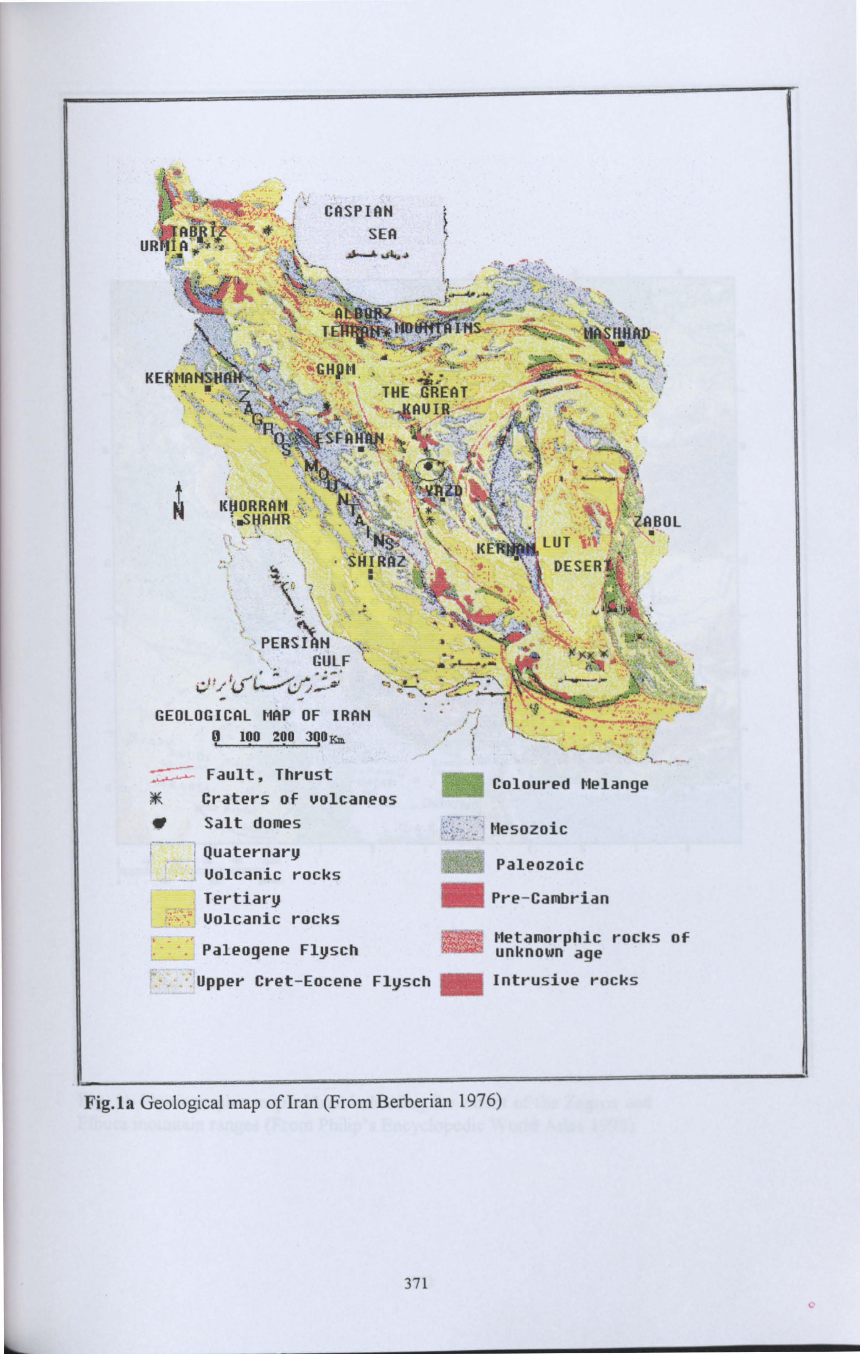
CASPIAN
SEA UR A x"r
AtOW ''ý To",
dP
K
K1ORRAM",: . SHAHR
'I.
. It
PERSIAN GULF ... -"
xX
ý, 7 ýýý. ý ,~'-3, _ ". _- ri=m
=ý -'-""-..... ýy
GEOLOGICAL MAP OF IRAN © 100 200 300
Fault, Thrust Coloured Melange
SIE Craters of volcaneos " Salt domes Mesozoic
Quaternary Uolcanic rocks
Paleozoic
Tertiary Pre-Cambrian Uolcanic rocks
Metamorphic rocks of Paleogene Flysch unknown age
Upper Cret-Eocene Flysch = Intrusiue rocks
Fig. 1a Geological map of Iran (From Berberian 1976)
371
r r
' 41
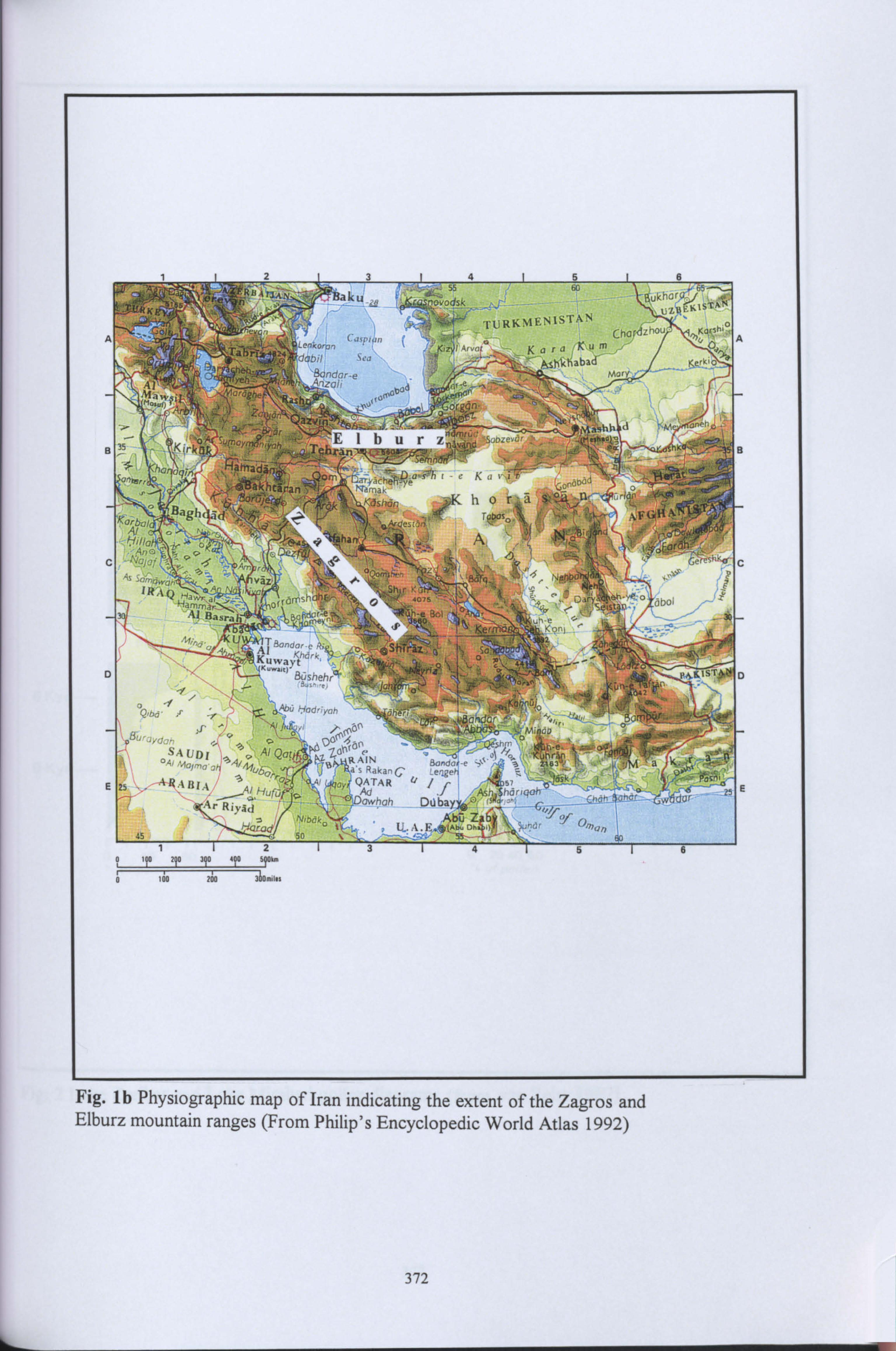
Al
3 35 KirkQk' me m
hTa han ,;,; C onpr.
r'ý ýýý-:
a4 0
55 ku
H ;. ýodsk
.
60
"J-"
f" TURKMENISTAN
A-m Ka ra Kum
Sea kshkhabad -e
bad
orgyn.
(MMO IhurZ nýýaRd 'Sro« ýr q{ýý
Ga.,. icheýL) a-i'h ieK \ri r. inaý.
ücro
hKbshdn h
r
o rI d
1'
tß4
ßäJ B
.,, c ýýi ý_, sý . f: ýýý U a4Al BonvoreR+,
ayth`. Km., D Busehr4 M1 '` aus^.. r.
°f` ýAöO Hadnynr Qlb6" y,
SAUDI Al Qat °y
Z(
E 25 ý$AB1q Hufu
Ar Riy9d o N1Ddk°
j harte 45 50
IN a Rakan C
ATAR 4/ kd
dwhah DO
U.. A. E,
33
)f
Oýnnn
5
'A'al o
xIE
It po 90 90 490 S90k
0 ioo 2J0 360.011
Fig. lb Physiographic map of Iran indicating the extent of the Zagros and Elburz mountain ranges (From Philip's Encyclopedic World Atlas 1992)
372
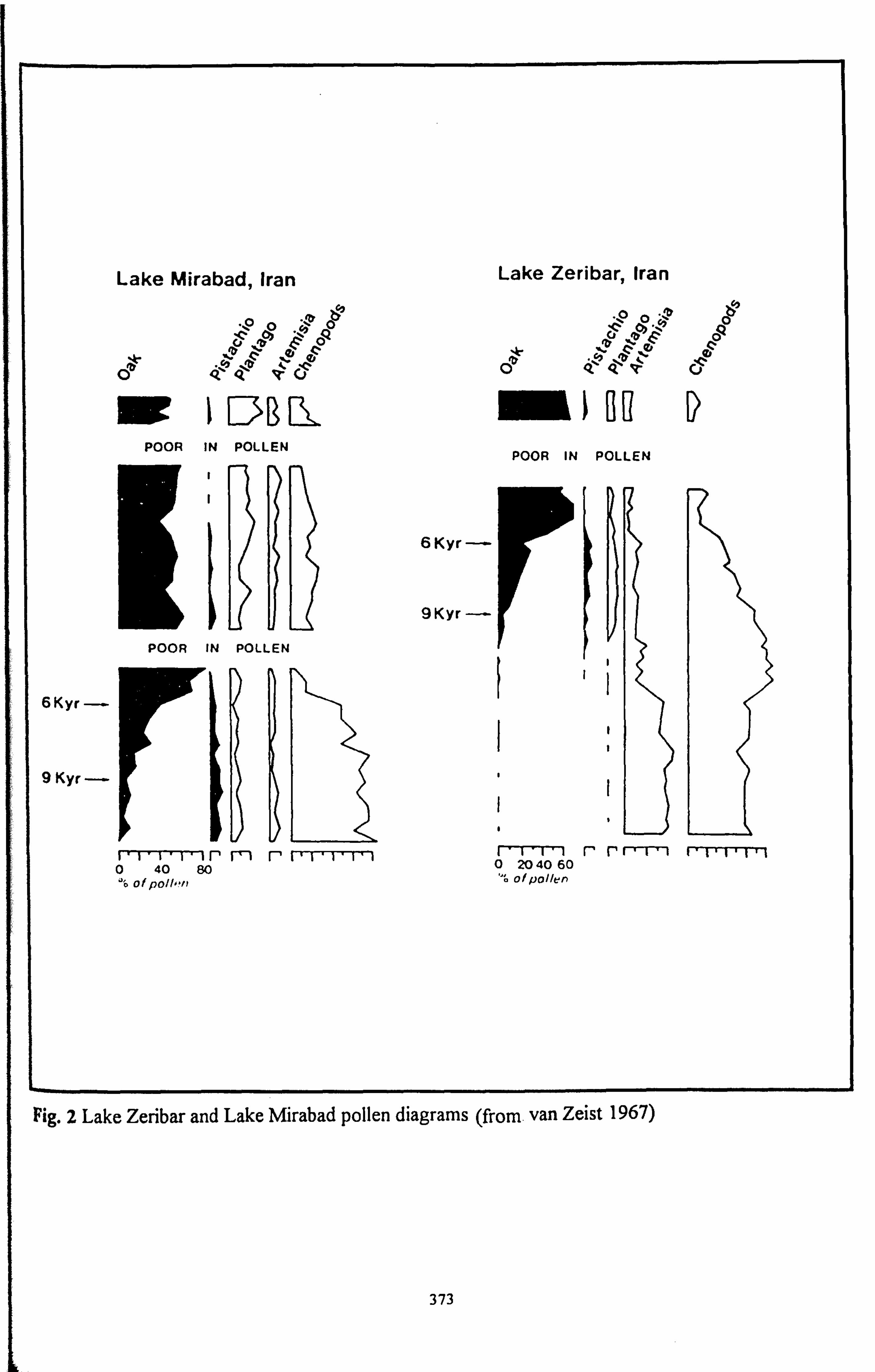
Lake Mirabad, Iran Lake Zeribar, Iran
C oa ý o o Q
"o o ` A
y oa ? ý a ' -o %Z F c
c ° F co
° c c e QI Qý`e Pý V'cý Oý Qýy Qýý Q
t lßR( ei lH POOR IN POLLEN
POOR IN POLLEN
I
6Kyr ---
9KYr--
POOR IN POLLEN
I ý
6 Kyr --
I
I
9 Kyr ---
rlýr--r irmr -ý 11 Iý- 0 2040 60 rriII r-r*-rý 0 40 80 " of P011,111 of pollen
Fig. 2 Lake Zeribar and Lake Mirabad pollen diagrams (from. van Zeist 1967)
373
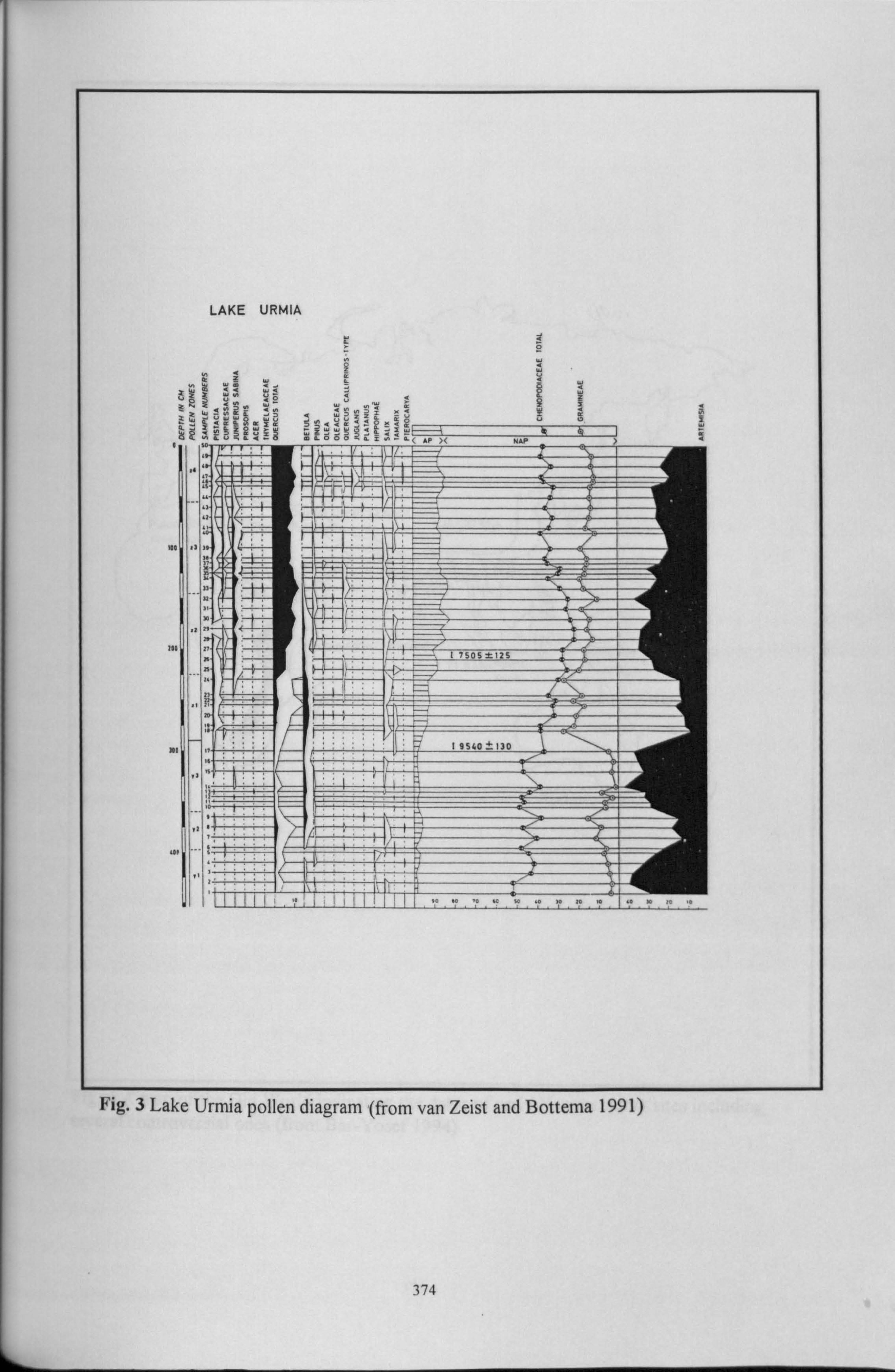
LAKE URMIA
ä `__ W m WN W; ö
W = ti l
IX '
W
z 1ý äNs, äö mSööoX iz =ä l 1s
r C AP )( NAP )
100 r1 if ii
S.
_.
_
Alit
200
1 7SOS X12 5 _
pi
ü
»/
r! n
I 15 <0 ± 17 0 --
_
iö
' NA
s
Fig. 3 Lake Urmia pollen diagram (from van Zeist and Bottema 1991)
s, äöm Sööoiz r= äC AP )< NAP )
t 1ý Yý
n ý"4 17505 ±125
1 9540 170
iö
s
374
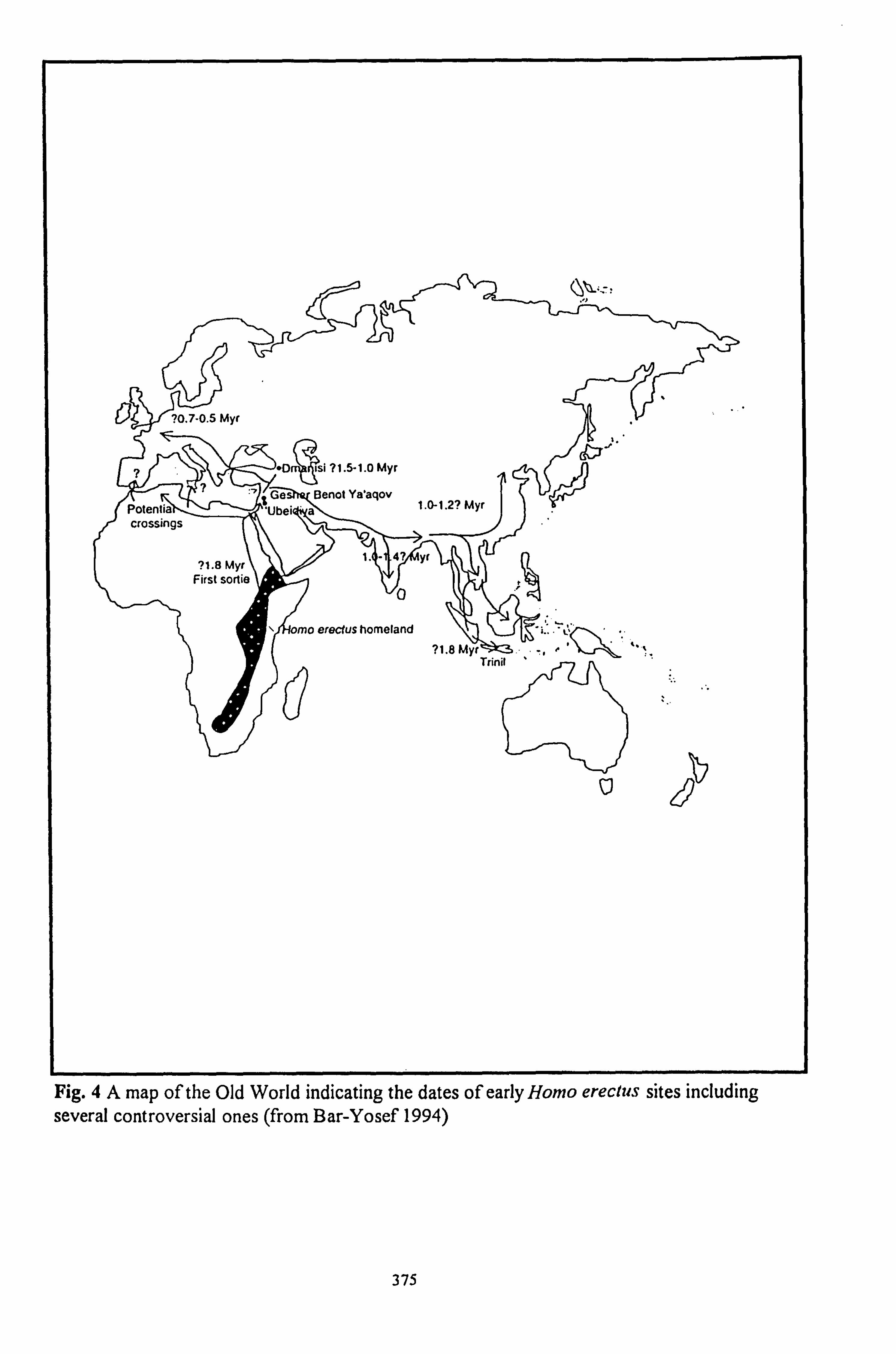
d
Fig. 4A map of the Old World indicating the dates of early Homo ereclus sites including several controversial ones (from Bar-Yosef 1994)
375
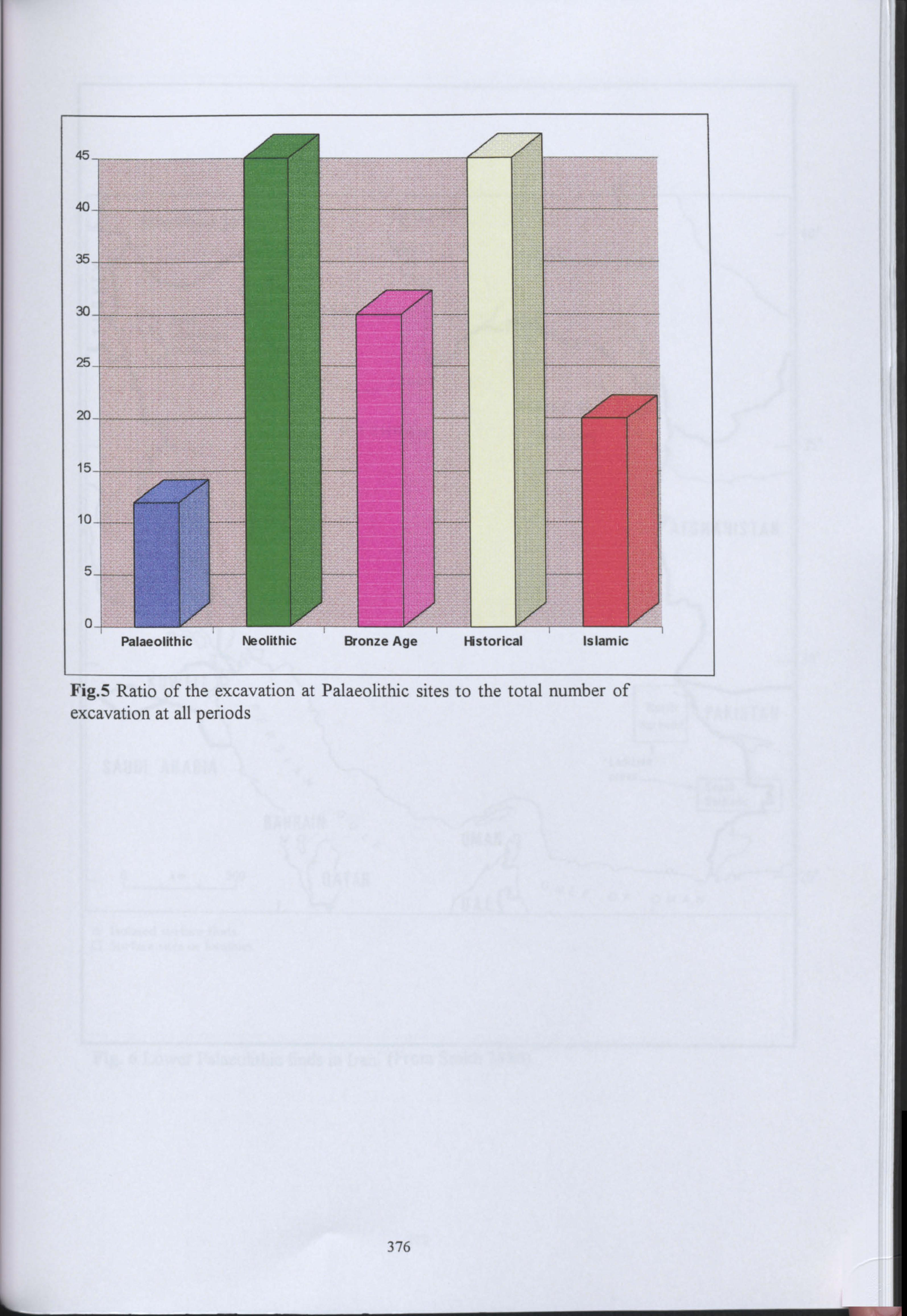
I
376
Fig. 5 Ratio of the excavation at Palaeolithic sites to the total number of excavation at all periods
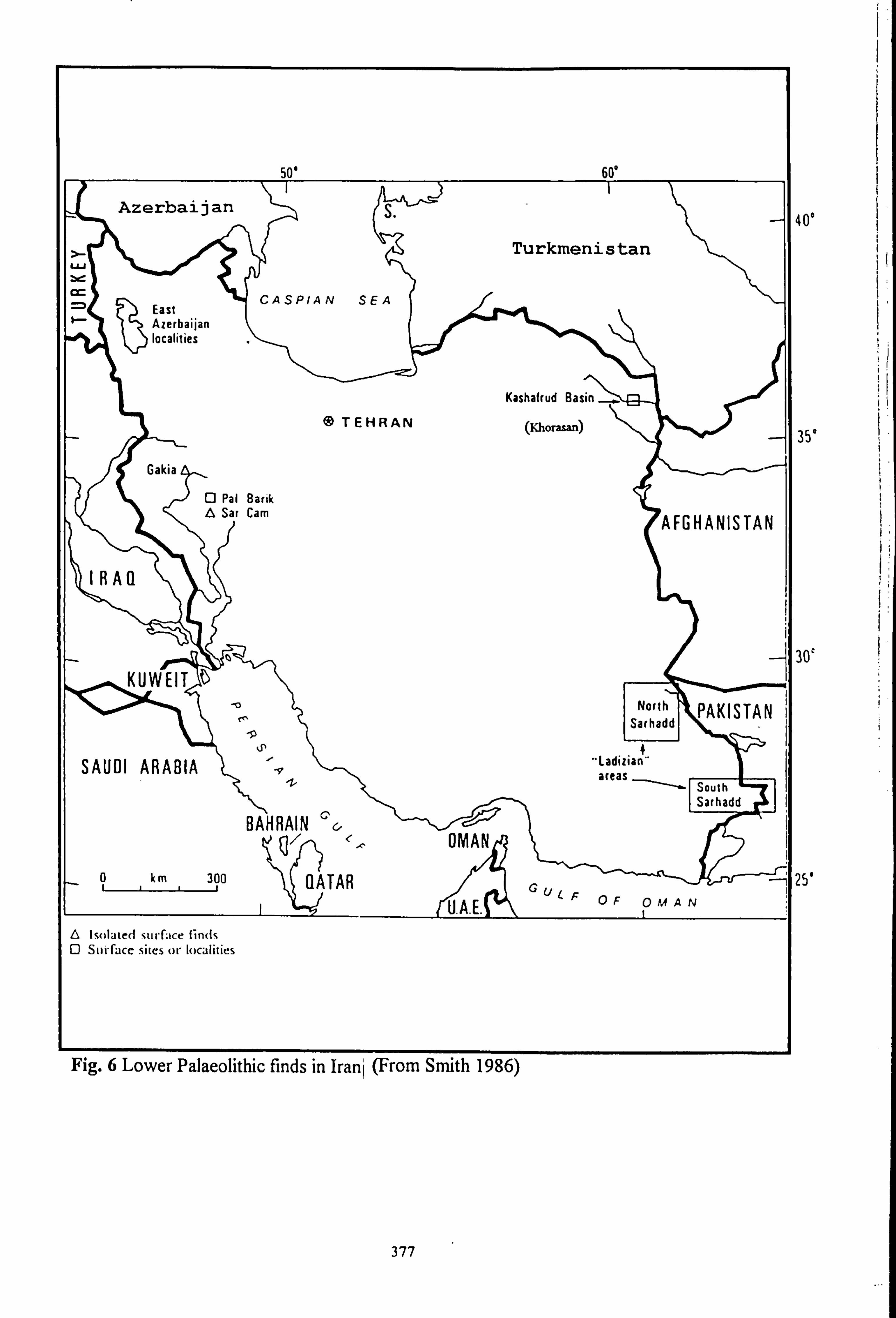
50' 60'
Azerbaijan S
Turkmenistan W
East CASPIAN SEA
Azerbaijan localities
Kashafrud Basin
® TEHRAN (Khorasan)
Gakia
Q Pal Barik A Sat Cam AFGHANISTAN
IRAQ
o H KUWEIT North PAKISTAN ISarhadd
9 kp n
SAUDI ARABIA ýy "Ladizia" areas
South Sarhadd
BAHRAIN OMAN
0 km 300 QATAR U
U. A. E. FOF OMAN
Isolated surface finds Q Surface sites or localities
Fig. 6 Lower Palaeolithic finds in Iran] (From Smith 1986)
40°
35°
30`
25'
377
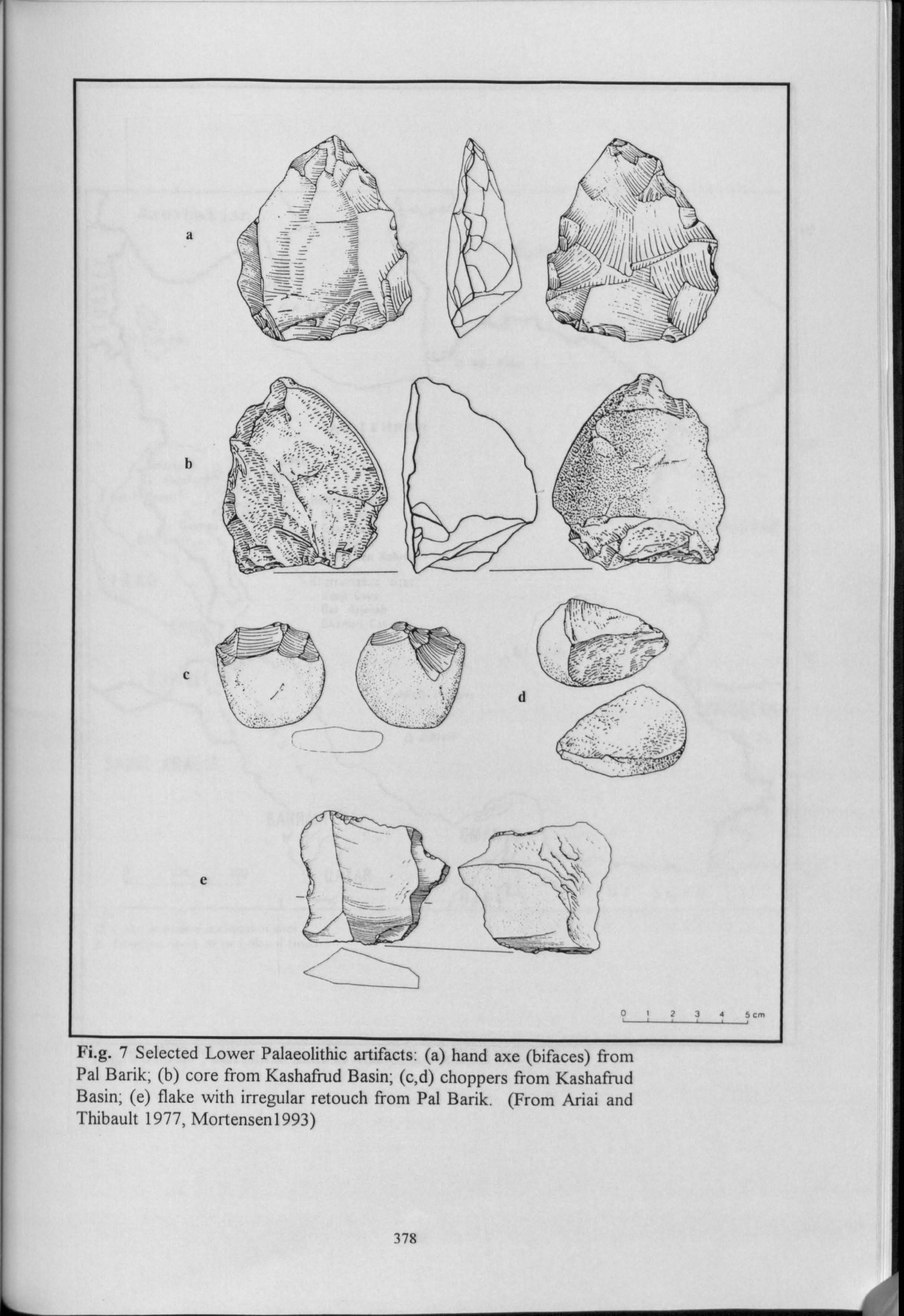
ýr
ý�'ý; 'i ý-,
\A-"^ -_ ':
ýý. Rte.;. .: J-. t"'--T
_
134 5cm
Fi. g. 7 Selected Lower Palaeolithic artifacts: (a) hand axe (bifaces) from Pal Bank; (b) core from Kashafrud Basin; (c, d) choppers from Kashafrud Basin; (e) flake with irregular retouch from Pal Barik. (From Ariai and Thibault 1977, Mortensen1993)
378
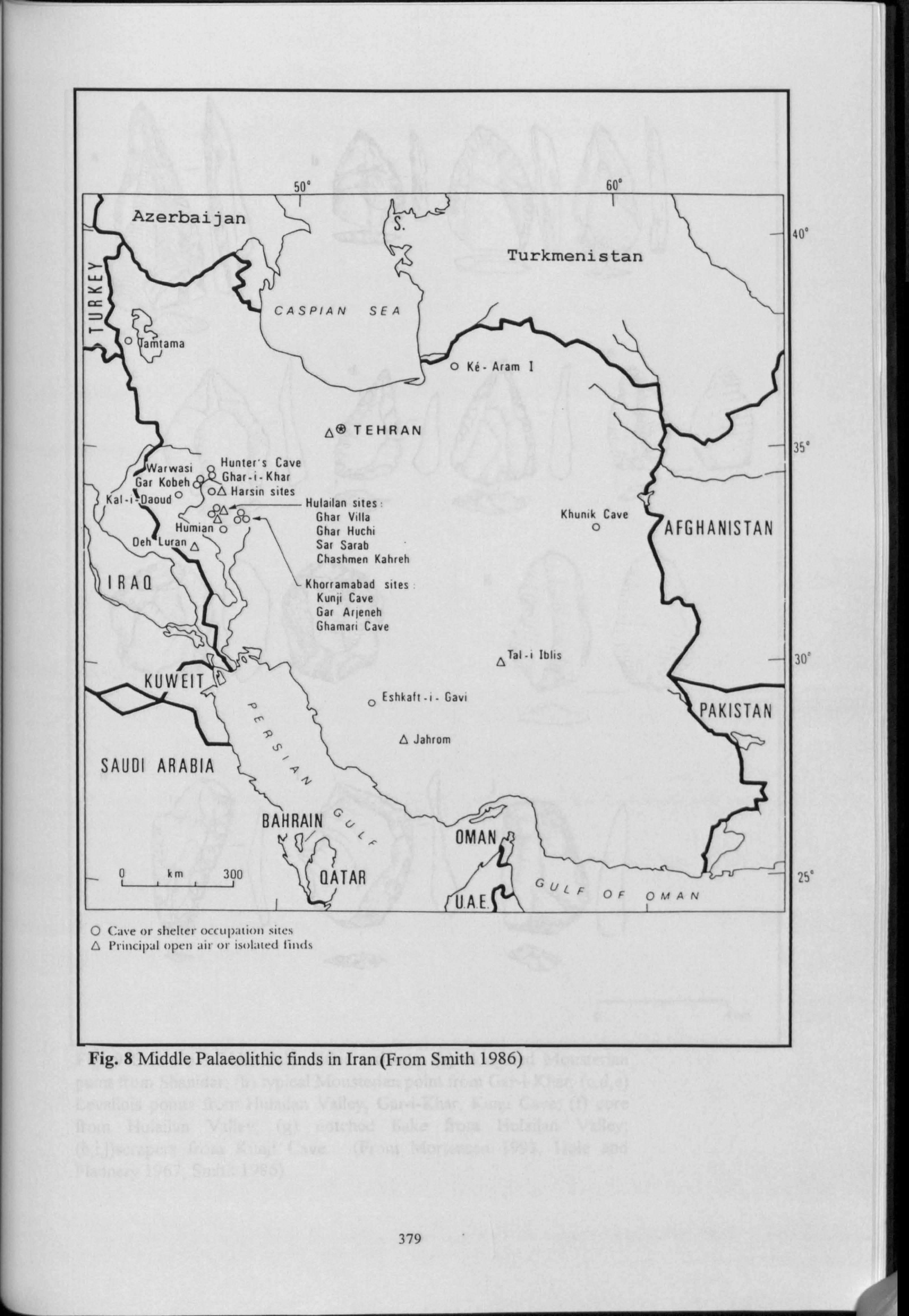
Azerbaijan
0 amtama
0 Ke " Aram I
TEHRAN
Warwasi Hunter's Cave
Gar Kobeh Ghar-i-Khar
Kal-iýDaoud0 ox Harsin sites Ar Hulailan sites
\1 Ghar Villa Humian
o Char Huchi
Oeh luran A Sat Sarab Chashmen Kahreh
IRAQ Khorramabad sites Kund Cave Gar Arleneh Ghamari Cave
C4 ATal-i Iblis
KUWEIT o
Eshkaft-i- Gavi
9A Jahrom
SAUDI ARABIA vZ
BAHRAIN
0 km 300 QATAR
O Cave or shelter occupation sites G Principal o)(l air ur isol. urcl ill )(1%
Khunik Cave 0 AFGHANISTAN
AKISTAN I
OMAN
ý' ULFpFOMAN
UAEý
ig. 8 Middle Palaeolithic finds in Iran (From Smith 1986)
Turkmenistan
CASPIAN SEA
w,
W
Lý
m
m
379
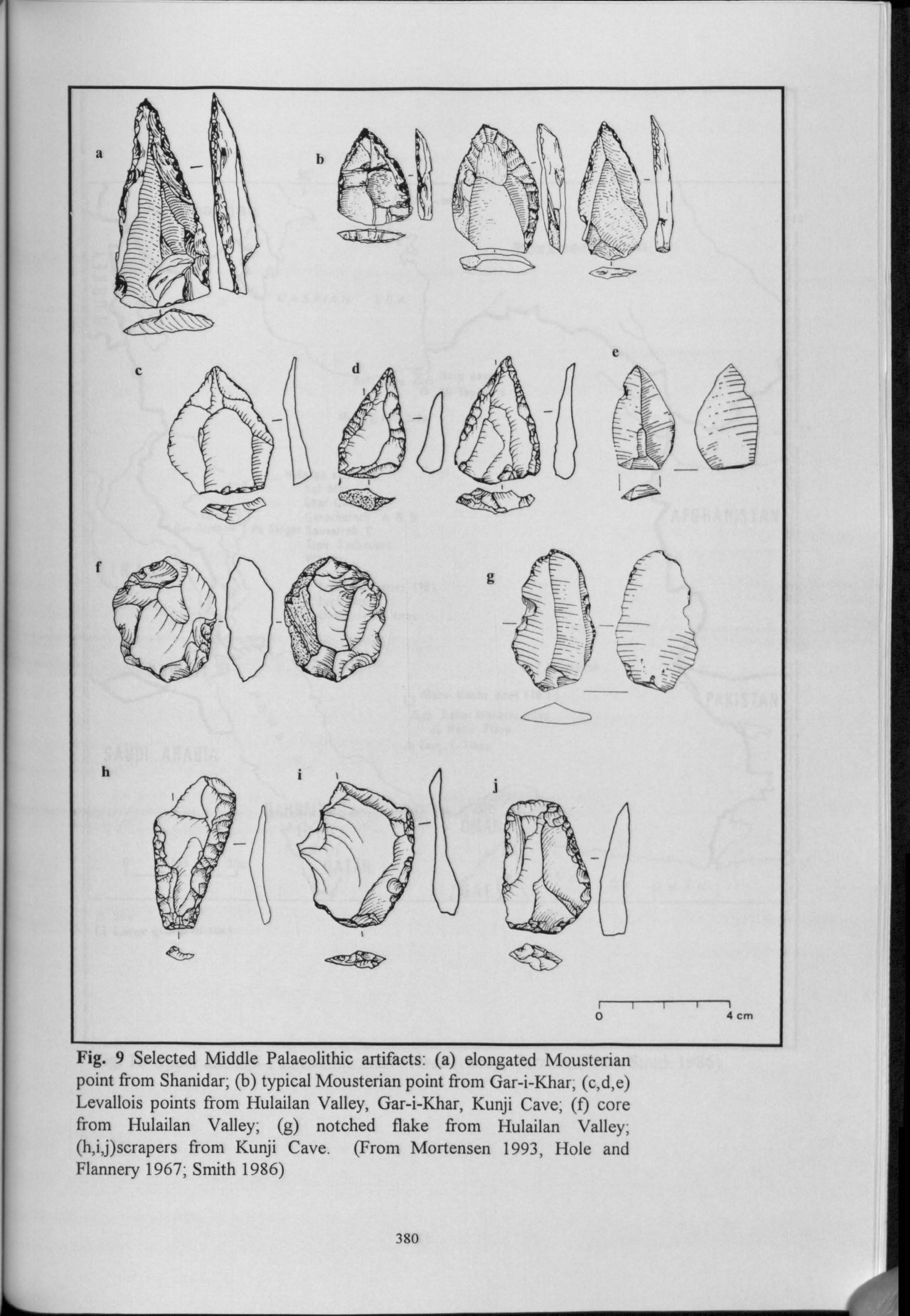
_-jh
O4 cm
Fig. 9 Selected Middle Palaeolithic artifacts: (a) elongated Mousterian point from Shanidar; (b) typical Mousterian point from Gar-i-Khar; (c, d, e) Levallois points from Hulailan Valley, Gar-i-Khar, Kunji Cave; (f) core from Hulailan Valley; (g) notched flake from Hulailan Valley; (h, i, j)scrapers from Kunji Cave. (From Mortensen 1993, Hole and Flannery 1967; Smith 1986)
380
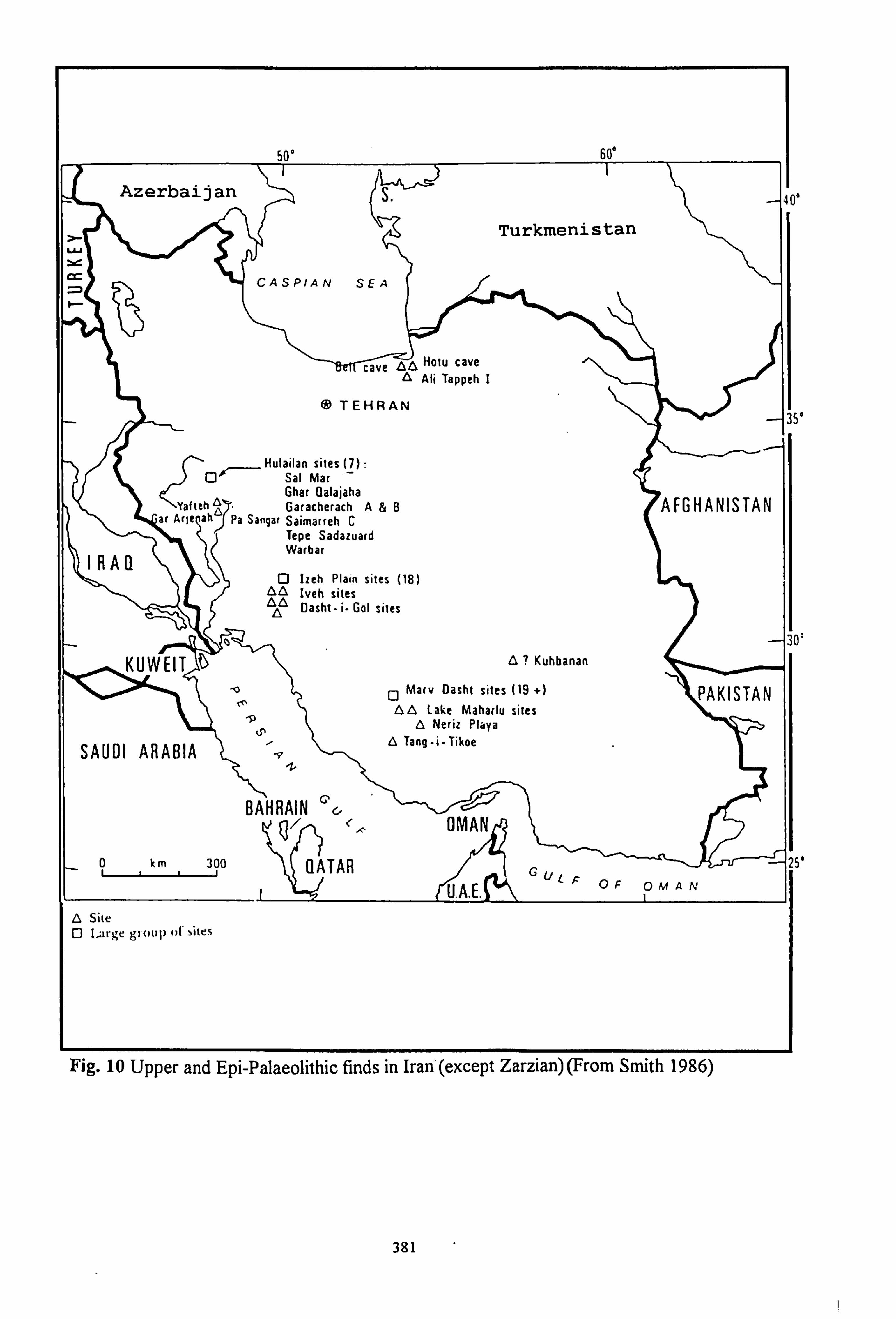
500 60°
I Azerbaijan S.
Turkmenistan
cr- CASPIAN SEA
&A Hotu cave A Ali Tappeh I
@TEHRAN
Hulailan sites (7) Qj- Sal Mar
Ghar Qalajaha YaftehA. Garacherach A&B
ar Ar le ah Pa Sangar Saimarreh C Tepe Sadazuard
IRAQ Warbar
0 Izeh Plain sites (18) 6 Iveh sites
Oasht- i. Go[ sites
KUWEIT )
SAUDI ARABIA
BAHRAIN
0 km 300 QATAR
6 Site 0 Large group of sites
A? Kuhbanan
0 Marv Dasht sites (19 ") A0 Lake Maharlu sites
A Neriz Playa A Tang-i-Tikoe
OMAN
C'UC OF OMAN U. A.
AKISTAN
g. 10 Upper and Epi-Palaeolithic finds in Iran (except Zarzian) (From Smith 1986)
-aso'
-ý:
AFGHANISTAN 11
e
3
0
381
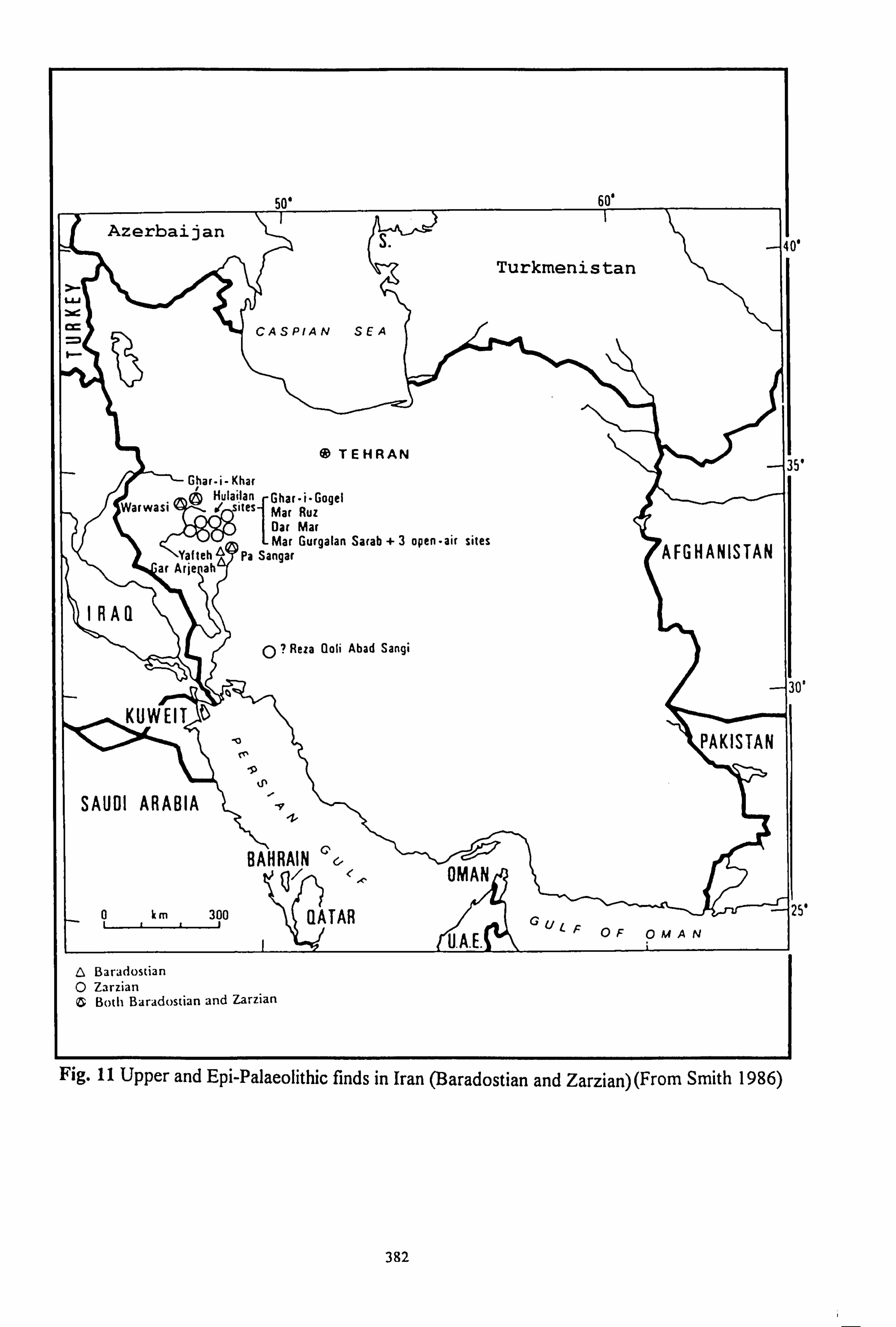
50' 60'
Azerbaijan S
Turkmenistan
W
Y
CASPIAN SEA
*TEHRAN 3
Ghar-i- Khar ® Hulailan Ghar"i"Gogel
Warwasi itesMar Ruz Oar Mar Mar Gurgalan Sarab +3 open-air sites
AFGHANISTAN Y t hA te a Pa Sangar ar Arie ah
IRAQ 0? Reza Goli Abad Sangi
-3 KUWEIT
PAKISTAN
SAUDI ARABIA ti
BAHRAIN OMAN
0, km 300 QATAR GU ̀ F OF OMAN U. A. E. A Baradostian O Zarzian C Both Baradostian and Zarzian
Fig. 11 Upper and Epi-Palaeolithic finds in Iran (Baradostian and Zarzian) (From Smith 1986)
382
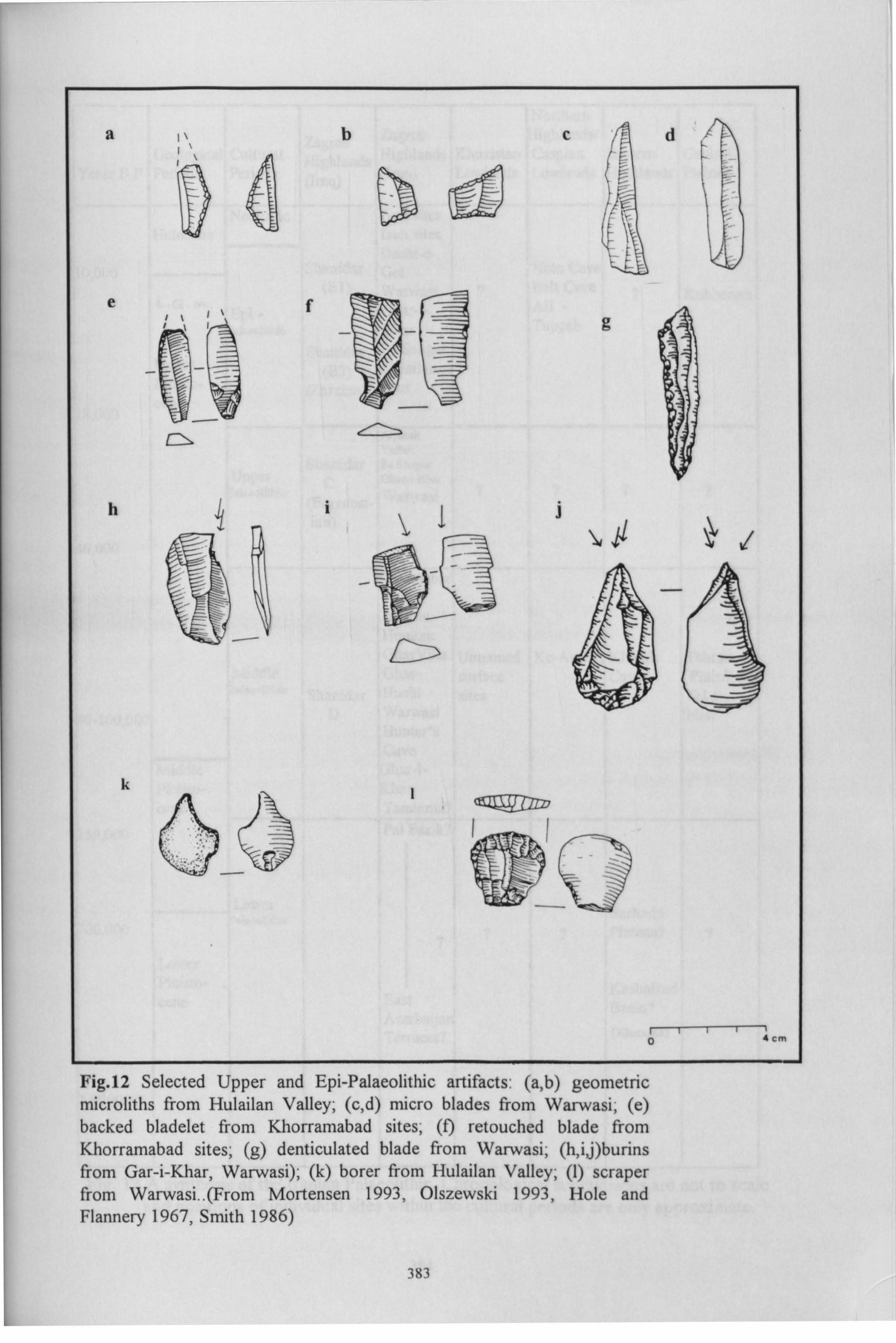
a ,ýbcd
ef
Dd
0 4cm
Fig. 12 Selected Upper and Epi-Palaeolithic artifacts: (a, b) geometric microliths from Hulailan Valley; (c, d) micro blades from Warwasi; (e) backed bladelet from Khorramabad sites; (f) retouched blade from Khorramabad sites; (g) denticulated blade from Warwasi; (h, i, j)burins from Gar-i-Khar, Warwasi); (k) borer from Hulailan Valley; (1) scraper from Warwasi.. (From Mortensen 1993, Olszewski 1993, Hole and Flannery 1967, Smith 1986)
383
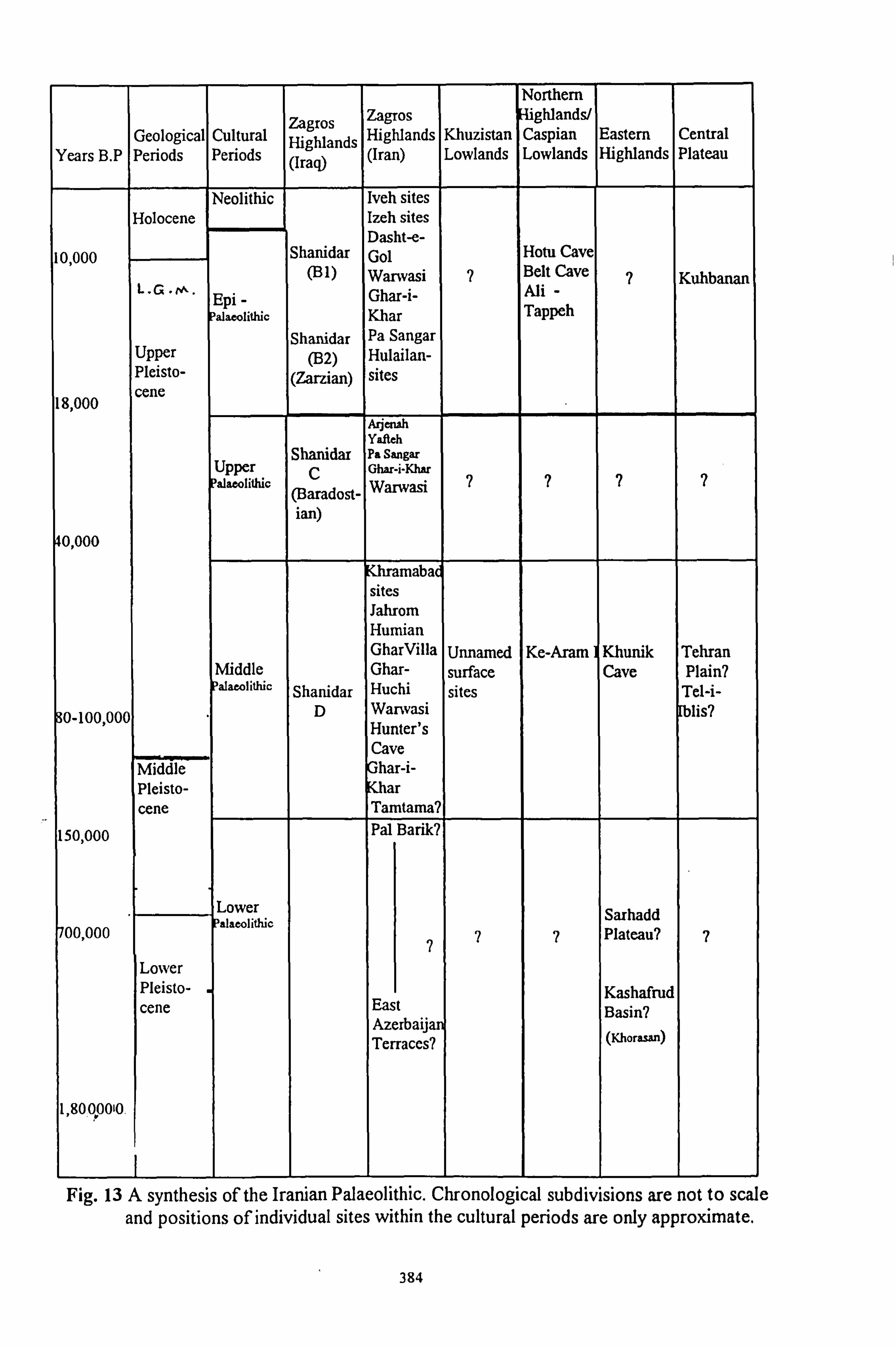
Northern
Zagros Zagros ghlands/ Geological Cultural Highlands Highlands Khuzistan Caspian Eastern Central
Years BY Periods Periods (Iraq) (Iran) Lowlands Lowlands Highlands Plateau
Neolithic Iveh sites Holocene Izeh sites
Dasht-e- 10 000 Shanidar Gol Hotu Cave
, (B1) Warwasi 7 Belt Cave ? Kuhbanan L. G. M. Epi -
Ghar-i- Ali - alaeolithic Khar Tappeh
Shanidar Pa Sangar Upper (B2) Hulailan- Pleisto- (Zarzian) sites
18,000 cene
Az ersah Yafteh
Shanidai Pa Sangar Upper C ? ? ? ? al arm this
(Baradost- Wý
ian)
0,000
Khramabad sites Jahrom Humian GharVilla Unnamed Ke-Aram Khunik Tehran
Middle Ghar- surface Cave Plain? alaCOl'ü1O Shanidar Huchi sites Tel-i-
0-100 000 '
D Warwasi lis? Hunter's Cave
Middle har-i- Pleisto- ar cene Tamtama?
150,000 Pal Barik?
Lower S h dd 00,000 Palaeolithic
7 7 ar a
Plateau? 7 ? Lower Pleisto- Kashafrud cene East Basin?
Azerbaijan Terraces? (Khorasan)
1,8000010.
Fig. 13 A synthesis of the Iranian Palaeolithic. Chronological subdivisions are not to scale and positions of individual sites within the cultural periods are only approximate.
384
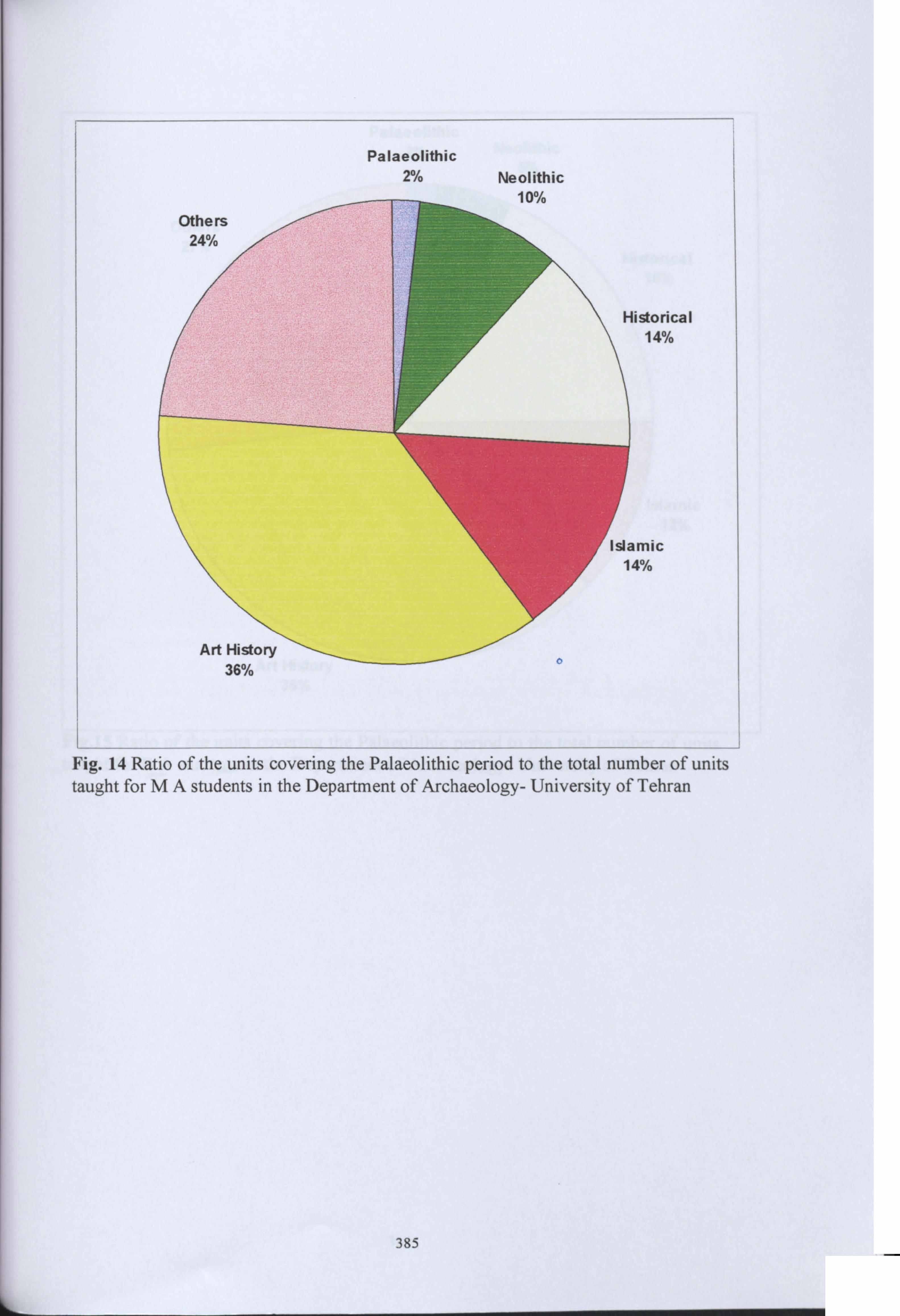
Palaeolithic 2% Neolithic
1nod
listorical 14%
3mic 4%
W/O
Fig. 14 Ratio of the units covering the Palaeolithic period to the total number of units taught for MA students in the Department of Archaeology- University of Tehran
385
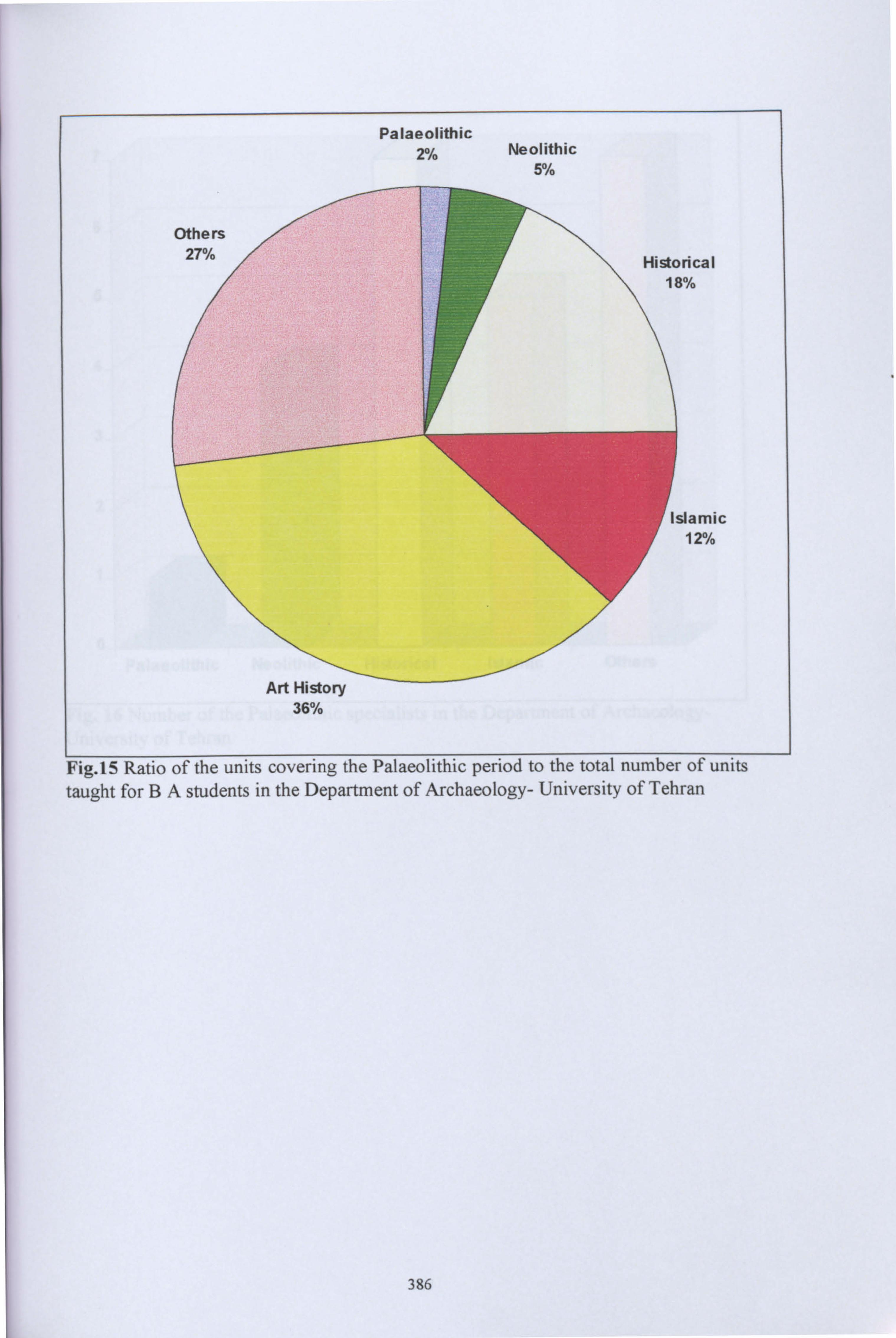
Palaeolithic 2% Neolithic
5°/C
Others 27% Historical
18%
Islamic 12%
Art History 36%
Fig. 15 Ratio of the units covering the Palaeolithic period to the total number of units taught for BA students in the Department of Archaeology- University of Tehran
386
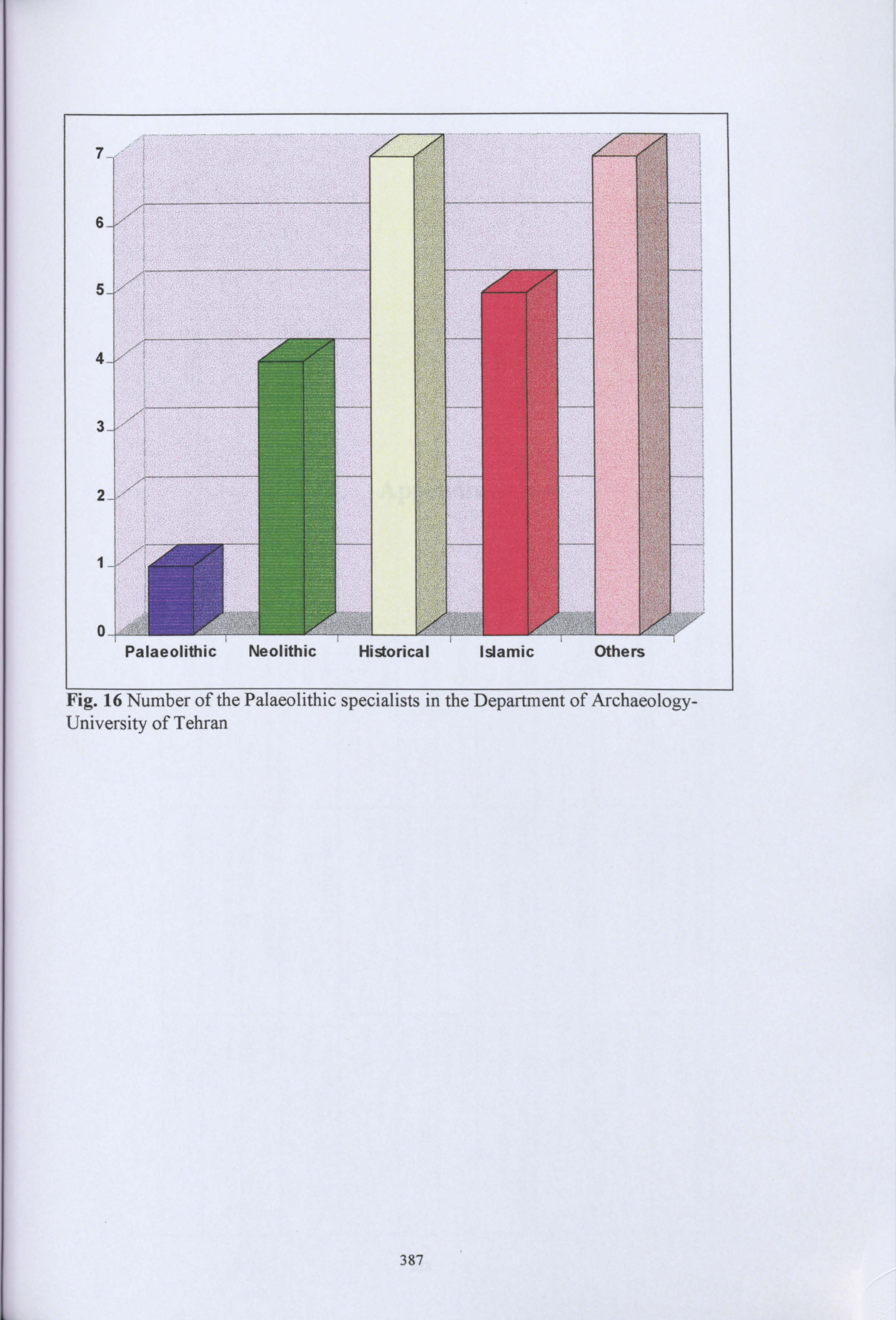
University of Tehran
387

Appendix
388

r- O
%O 00 - (VN tit . W N
Z q t, - - Ö -
wi Ci
o Y a+
y 2)
`ý ýn 10 CD
w Cl.
z z 'TI u Tl t" c ö ° aö aä ý, w i a°o
=1 9
Ä
w .. W W W w .. w .. W - N Ö - 00 en v N N º"+ r r VI . -" 00
w In 00
ý 0,0
< w w
-. l w N
w '. D
w C1 W
. . "+ Ä O
O
v~i to z Nmz tz z a z z z -a
C,
=r CD zr o CD 0 0, m
o>o ý°
co o 0 0 CD a lý
ö LA CD " CD
CD w
.r 0. O G
cbo p 0
ö C fý 0 110 C7 O ý 9
°E ° a =. I O. ' aý M- o 00
RM , ýD ao
I°c vä re o co C v' py- p co
C ý. co
C `~n Ö C. y.
"
y Vl yI
.. ' 0 CD N "q . ý-. Iý 6L
rA- to p G W. Co rp .0 C
N y yN (D
EL
4 C',
. ý' w 0 06 M. :.
ä ö
rß
y lu
121. 0 cD n
ö'
19 0
os
9
0
00
00
00
cr P

- O ýO 00 ý1 Qý In . W N º-ý
RC
C)
R ýýQi: `C UQ 'j C CTl bd
in Ö
CD "l fD -i
~ r
Ami Cf G C
CD yä ä 9
Z2 N G G, 2
p j
-O A %p
4O A \O
-O A 00
'O A -.
"O C. wW 00 \O
'. O A O\
ww Vh
ww to
w w A
w W A
w w W
w w
lý ! 0
W W W
to tö in cn Cn 1
co co co tý >o .4 o a a ä a ä.
co a z ö ä d
a a C)
y 8 A `ý C9 ý+ O
OQ ý lD CO
C7 (9 °
w" ý O cß m.
, ^"s G .y .~ l to
N am , e
p n p (ý O `ý O Cn ton
'O"'ý CDD O O `(d fo
ý '
cu 23 ý' p co
a ä, `9 a
C b ö °

W W U
W W W
W N
W W O
N %O 00
N J
N O\
N LA
N .
N w
b Ö ' P ý
CD ''3' (D
E rjQ
rn C D CD rfýn G
CD
p
oo ä.
ry C¢.
;ý w" 0
llý - 9 0 Q C
Q
r: P=7
a
QQ - Pl R , E
N = y pj H Aý j CA
i R. I
w v. w
fV a a
' P' te w w
Co ON 'o
O\ C% o\ ýo C Lo
C% rn to ýa ýo G' cn Lö
LA '. o to
Lo LA
'. o tr
La LA
'. o cn
'. o vA
.ö to O O O O 00 ýJ . ýO
J 00 J
00 i
00 00 .
O\ . . "+ Ö ý. -. t
- %0 00 00 t p '. D %0
ý N
o to
00 LA
°ä O w
O ° r' C9 n
-. ° ý' 00
CO a: ov
C ä: ý;
. fi
ý C°
,
CD co C7 0 ý D t c) a co ß.
a ö ö a CD co
O o
ÖO ý" C C C `" ý"ý `b C C nr C c o
F Cl) .
°' 8 2 C
ZG
cý C &n. F; - N o £. ö y_ y En .1
0 CD
"-" o O
iii 8 9
O
C) °5" ä R CD C 0
00 0
ý 1 O C O
r
w ~
if w^ý7 ýý"" . ß .
Cal ^ý. '. ""'
"ýý' " `"'' F7.
r7
jýý
ý"' O
vi
'ý
7 y "
im .
C n co
b0 0
00 ý". Fi F
(D f9
O

u . 'O ,A 00 P . 4.
0\ p. . ti, .
. . w . N .
ý--' -PI, O
w %0
w 00
w -1
W En r) -
y ö c) + A
A y
rIn Iýj
ýy O O (D
0
E. w
r" ; fix tý,. x Fv' y ý n_ö ýpvý y
7C d r cr'Cr`0 " r+
ß"
= ! ý., r+
iJ. ý`
CD 0
\0 CN \0 O\ C\ 1.0 ON %0
oý %0
a-, ýO a \C C\ C% %0 oN ýO CC o\ %D C\ 'o o\ '0 LA -
to -
vi ý1
41 - . 43 "P . . w
& N 6T
- b\
4" . -ý -ýl
ý-" &
.r Ö\
ö 00 00 . %O 00 00 00 w bi 00 w
CD ~ " ' ß, Wem, A A (D 0 O CD JC '" C
, ý'"
t-j ß. A 9
ýL" a
0 a a
(D G" a
aA
A
A C) n
> A CD 00 00
CD 00 CD
A
C n I rI
'i pd j
CC)
O r O r
52 y f~/1
y
_ . ` "
"
. :. l. _ K
U I
nq
" O h
º., ii yFy pý"" ii
(ýp ýý. ý. (D
Gýý""
co
C
"y 'Oy `5
R % 1
; 11 P 10
, ýA 00 0Lý' 4 7 C, ' O C
CC ý
1: 1 ýý pes' yG O
Z
pý m .
, pý A L . . " a CD CD R. . (D
cr 0
Ai ty O
Cl)
O ,a
r".

CN w
O\ N
O1% -
Oll O
UI ýO
U 00
LA -1)
LA a%
U cn
Us A.
U w
U N
LA
ý . CD ý7y CD y 1 ' y v.
y om Q. 1 W 0 v
CC 0
ý ý ä
5i co co pý c
En
Q' Q^7j wO
b
O0 00
2
- O\ J
*0
Q\ J
ID
C% a
110 O'. -4
ý
C% ON
ý
O'. o'.
110 Q'. ON
0 C% V%
\C %0 Q'. O'. %M .
O'. LA
%o O1 Un 11 J
00 J 00
J P.
J
-11
J 00
ýl
-Al
LN
-. 1 ý1 - %0
&N %0
61 %0
ON OO
En tTl z b z z tz u, En M V AE - r
ä ü Pý' co c, " '. co g
co i
> o >C) w n Q ö o c co Ö g " a
0
CO
ý°i c °
w ý' ý'
C-- coo c
c X1 tz om '
co Ö[
6i c o -. c o 14. .0
ý'
:
ý' v , coo a. cr Q.
w Ö
0 0 NEW ' co
am O
ý '
o öC C O
cn 3'
[ . G aý
w ý ý ". 3 O Fn to p Ö CO C' co y
0 - cm o
a.
oýC F ö tz a t2
ý,
C, Cd ýo co ý
a 9

Vý ? W N - o aý ýO a% 00 O. -
C% O\ m LA oN A
w W 7 ý- D x
° co o y
C m
C
G 1 0
\o -4 0
-o J 0
1.0 -4 0
Oo ý 14)
Co ON 1.0
0\ ý ýo
%0 cs %0
\o ON ýo
G 00 00
C° 00 00
10 00 00
b b Vii 00 00
W . N 00 Js
O CD O_ yy~
[ýy
O_ co O_
ypy ý °
O y
2.8 y
F: F: "" °
F: G:
ý7 "" oö C-J " El CD a:
: 0
o 0 O o C fý (D .y ý" °
riq ö
va co
. 11 CL '
C) 0 Cw Cw :Ae co cu ý g
co 9 w ce cu
tTl coo
o coo
ö t7
,
r '~ 'ý ö O a
ö ö CM. a
4 Ö
. Q. r 98 EC r P- 0
ft, a rý p, i s ^' o9 r Q.
fD CD (D ý' y
0 0 0 0 fD 0
Ä o-. ß h
°
ITI
=rl I a. 0-

00 00
00 J
00 Qý
00 In
00 00 w
00 N
00 -
00 -4 ýO
J 00
J J G1
üQ O O -3 0
W r) tz ( M.
G 0
ä
CL
W
A WI
9 C)
OO
F- 9 y
ä . FS'
0 OQ F- . w0), a
%0 J .
%o -4 .
IC -3 .
\o J . 4.
\o J w
\O J -
\o J - -J
J O -4 O
J O
J 0
J O
UJi 00 00 00 00 00 rJ-ý 00 b
b yý ýEn - - w rrnto z dnz z aF
CO w z aý
0 0
0. 0 0 CD
ä >n >n n CD
E" a a o.
0ö CD aö CD
av co
y C, c a
b c
(I-
o
Cl- CD
o ný" Zö ö.
CDI äi äi ýi ö(ip m(p CD u ýD c
'
c o cý 0 w CD
ýC1 ", CO
1
C öi CD
C O
ý. 0
ý. Oo
n .
hOo a.
O M.
q q q M
ßtß a
0 ý.
0 ý. C' ̀
fn DO f
rý..
coo CCD two CD w
ö7ý Cýjrý- co CD
ý 9 ß '
0 a. b co co
O f9 ý' - ao
. r . 113
CD P
CD

J tJJ . W N
- Ö
N M M CD
a ,ý C r1
(D N
J
v
v
J
J
J
v
O\
J
O\
J
O'
J
In
J
In
J
.
0000 00
000 000 000
0
co a co
ä n = t) O: n
9" 92.
0)
Oö co
' Co 12 Co Co
g
ö ö 0 ' ö ö ö ö
ý. 9 ý
r'i cri e
ms, cu co co co co co cý


