Embed Size (px)
Citation preview

Geoderma, 42 (1988) 227-244 227 Elsevier Science Publishers B.V., Amsterdam - - Printed in The Netherlands
Micromorphology and Significance of the Surface Crusts of Soils in Rangelands Near Cobar, Australia
H.J. MOCHER 1'', C.J. CHARTRES 1, D.J. TONGWAY 2 and R.S.B. GREENE 2
ICSIRO, Division of Soils, GPO Box 639, Canberra, A.C.T. 2601 (Australia) 2CSIRO, Division of Wildli[e and Rangelands Research, Rangelands Research Centre, Deniliquin, N.S. W. 2710 (Australia)
(Received May 25, 1987; accepted after revision April 14, 1988)
ABSTRACT
Miicher, H.J., Chartres, C.J., Tongway, D.J. and Greene, R.S.B., 1988. Micromorphology and significance of the surface crusts of soils in rangelands near Cobar, Australia. Geoderma, 42: 227-244.
Micromorphological observations were made on thin sections of surface crusts from the upper- most 50 mm of red earths near Cobar, New South Wales. Samples were collected to represent six classes of surface conditions important to plant growth.
The crusts consisted of an upper zone comprising cryptogamic mats, litter and transported soil aggregates, and a lower zone of layers of generally laminated sands, silts and clays. Crusts from class 1 surfaces which showed little evidence of erosion, were loosely structured, bioturbated and lacked sealing properties. Crusts from classes 2 to 4, in which erosion was increasingly evident, contained decreasing proportions of cryptogams, exhibited decreasing evidence of bioturbation and increasing proportions of platy and sealing structures. Crusts from class 5, found in areas of marked colluvial deposition, had a wide range of properties, whereas crusts from class 6 consisted primarily of litter deposited under trees.
The major processes responsible for crust formation are considered to be a combination of erosion by raindrop impact, redeposition by rainwash and colonisation by cryptogams.
Micromorphological properties of the crusts are believed to affect lodgement and germination of seeds and the infiltration and runoff of water, thereby influencing plant growth. Dry matter production ranged from 2.3 t ha-1 on soils with class 1 surfaces to 0.1 t ha 1 on soils with class 4 surfaces. Cryptogam mats also afford protection of the underlying materials from erosion and also promote aggregation. Cryptogams are therefore considered highly desirable components of the crusts.
*Presently at the Laboratory of Physical Geography and Soil Science, University of Amsterdam, Amsterdam, The Netherlands.
0016-7061/88/$03.50 © 1988 Elsevier Science Publishers B.V.

228
INTRODUCTION
The development of surface crusts or seals as a result of overgrazing by sheep and cattle is of major environmental concern over wide areas of the Australian rangelands (Bridge et al., 1983; Noble and Tongway, 1986; Chartres, 1987). Tongway and Smith (1988) had previously ranked the surface layers of over- grazed red earths in a semi-arid environment near Cobar, N.S.W. into six classes of surface soil condition based on field observations of their properties (Table I). These classes were found to provide a more reliable estimate of potential dry matter production than do assessments of vegetative cover and species composition. This paper describes some of the micromorphological and other properties of the upper 50 mm of the different classes identified by Tongway and Smith. The objectives of this study are to determine the micromorpho-
TABLEI
Morphological properties used to classify the soil surfaces into 6 classes and plant production from soils in each class (after Tongway and Smith, 1988}.
Soil Plant "~ Microtopography Erosion Cryptogam "2 Litter surface production (surface water status cover class (t h a - 1 ) detention )
Surface condition
1 2.31
2 1.20
3 0.31
4 0.13
5 (small 0.80 Moderately alluvial smooth fans)
Surface Nil to very irregularities slight present and well developed
Surface Slight, irregularities some lag present but not materials well defined Very little surface Moderate roughness sheeting
visible Very smooth and Extensive, water shedding sheets and
rills present; gravel lag Comprised of alluvium and colluvium
6 (litter 1.50 Comprised of zone under surface water large detention eucalypts )
Nil
Extensive, Clearly Stable, continous many species observable, crust of
often biologically embedded stabilized soil in crust materials
Moderately Litter Crust broken, extensive present slightly unstable
Sporadic Rare Crust extensively small broken, slaked patches appearance Nil Absent Surface comprised
of disaggregated materials
Rare Transported Unconsolidated macro- silty or sandy organic surface matter in alluvium
Present but Thick mat Organic matter not of eucalypt extensive; twigs, fruit some mosses and leaves
*~Dry matter. *~Plants having no stamens or pistils and therefore no proper flowers, and comprising algae, lichens, mosses and liverworts.

229
logical differences that occur between classes and how these differences may affect seed entrapment and germination and seedling emergence. A further aim was to determine the processes responsible for the development of surfaces with sealing properties that were observed in both recent sedimentary laminae and on eroded materials.
SITE INFORMATION AND STUDY M E T H O D S
Sampling was carried out in a gently sloping (3-4%) paddock of 2.25 ha that had been intermittently stocked during the previous six years, approximately 30 km south of Cobar, N.S.W. (Fig. 1 ). The site is located on the Cobar Pedi- plain (Dury et al., 1967), which consists of generally very gently undulating terrain and is underlain by Palaeozoic sedimentary rocks, which, in the vicinity of the sampling site, are veneered with up to 1 m of colluvial and fine aeolian deposits. Soils developed in this veneer are classified as red earths (Stace et al., 1968). A thin silica-indurated duripan at a depth of approximately 60 cm was noted in one of three pits excavated at the sampling site. In the U.S. Soil Taxonomy (Soil Survey Staff, 1975 ) red earths without duripans are classified as Typic Haplargids and those with duripans are Typic Durargids. Brief data on a profile at the field site are given in Table II.
The climate at the site is semi-arid, with a median annual rainfall of 375 mm. Rainfall distribution has a slight winter maximum and there is a tendency for the summer rainfall to occur as storms of moderate intensity.
Soil sampling sites were selected to represent each of the six surface condi- tion classes. Undisturbed samples to a depth of 50 mm were collected from surface soils across the entire paddock to represent each of the six classes of
\
C o b a r \ \ ~ j - - - - __.~Sa~rr, or H i g h w a y
f~
t
[] Field site L I 30 km . . . . . . . . . . . . . . . . . . . . \ . j .
"--"1 B okon f
i oHII I / ,.. N S W 2 1 "
g'~ qySYDNEY Q CANBERRA
Fig. 1. Site location map.

230
TABLEII
Some morphological, physical and chemical properties of the soils investigated (data from a soil pit adjacent to the site used for surface classification; soil type red earth (Typic Haplargid), well drained)
Depth Hor. Colour Struct. Particle-size distrib. (%) pH EC (/zS (cm) cm-')
2000- 200- 20- < 2 200 20 2 #m ttm /~m ttm
0-4 A1 5YR 5/8 AM 7 55 14 26 6.0 0.05 4-20 B1 5YR 4/8 AM 5 47 19 30 5.5 0.03
20-44 B2 2.5YR 4/8 SAB 5 43 22 31 5.7 0.07
Note. AM = apedal massive; SAB = subangular blocky. pH and EC in 1:5 soil to water extracts. A1 and B1 horizons contain c. 10% gravel, B2 horizon contains c.50-60% gravel. Clay mineralogy: all samples contained c. 50% kaolinite, 40% illite and 10% quartz and iron oxides.
surface conditions. In most cases (excepting class 2 where only one sample was collected) at least two and up to five samples from each class were collected in tins with cross-section 155 X 90 mm and a depth of 50 mm. The samples were then impregnated with polyester resin containing a fluorescent dye (Uvitex OB; Ciba-Geigy) after drying at 40 ° C. Duplicate, vertically oriented thin sec- tions (75 X 50 mm) were then produced from the impregnated soil samples with the longer dimension parallel to the surface. These were then described using the terminology of Brewer (1976) and Brewer et al. (1983) unless oth- erwise stated.
RESULTS
Prel iminary observations indicated that, in samples representing each soil class, two distinct zones could be recognised in thin sections of the soil A ho- rizons. Firstly, an upper zone consisting of several thin layers (generally less than 10 mm, but occasionally up to 27 mm thick) of organic and inorganic materials (Table III). Secondly, an underlying zone of predominant ly mineral materials of at least 30-40 mm thickness (Table III). These two zones are hereafter referred to as the "crust" . Generally, the layered appearance of the crust helped distinguish it from the underlying materials. The micromorpho- logical properties of the two zones are described separately in the Appendix and are shown in Figs. 2-4.
231
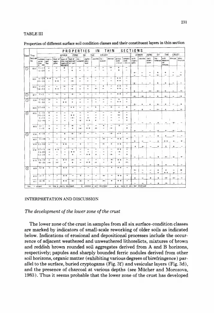
TABLE III
Properties of different surface soil condition classes and their constituent layers in thin section
INTERPRETATION AND DISCUSSION
The development of the lower zone of the crust
The lower zone of the crust in samples from all six surface-condition classes are marked by indicators of small-scale reworking of older soils as indicated below. Indications of erosional and depositional processes include the occur- rence of adjacent weathered and unweathered lithorelicts, mixtures of brown and reddish brown rounded soil aggregates derived from A and B horizons, respectively; papules and sharply bounded ferric nodules derived from other soil horizons, organic matter (exhibiting various degrees of birefringence ) par- allel to the surface, buried cryptogams (Fig. 3f) and vesicular layers (Fig. 3d), and the presence of charcoal at various depths (see Mficher and Morozova, 1983). Thus it seems probable that the lower zone of the crust has developed

3 3
~J
3i
0
3~

233
in colluvial deposits derived as a result of either geological or accelerated ero- sion of the surrounding soils. The occurrence of charcoal in the lower zone suggests that fires were common in the vicinity and could have led to acceler- ated erosion of the surface soils in the immediate post-fire period before veg- etation had time to recover (e.g., see Brown, 1972). No definitive evidence of material having burned in situ was found.
Further evidence for a colluvial origin of the lower zone of the crust is the occurrence of different types of intercalated laminae (Fig. 3a ) at various depths. Most individual laminae are poorly sorted; well sorted laminae of pure clay or silt are rare. The poorly oriented nature of the clays in the laminae may be the result of the masking effects of iron oxides, hydroxides and organic matter. The occasional occurrence of unistrial fabric, which suggests a high degree of dispersion of the clay prior to deposition, may be due to changes in electrolyte content of the soil water, or greater mechanical fragmentation as a result of more prolonged transport in turbulent water, or a combination of both.
Comparison of the micromorphological features of individual laminae with those of wash deposits produced experimentally in a flume by Mficher and de Ploey ( 1977 ) and Miicher et al. ( 1981 ) suggests that the poorly sorted laminae may have been formed by rainwash (effect of rainsplash and overland flow combined-also termed rain-flow transportation by Moss et al., 1979), and the well sorted ones by afterflow (i.e., overland flow without raindrop impact). The relatively short lengths of the laminae and the occurrence of bifurcations and the presence of micro-rills (few millimetres deep), combined with the poor sorting, also suggests that deposition occurred in very shallow braided or an- astomosing, turbulent flows a few millimetres deep with interfingering micro- channels. The non-laminated deposits between laminated materials could have been redeposited by splash (i.e., material transported exclusively by raindrop impact ) because particles carried in droplets have little chance of being sorted.
Fig. 2. Photomicrographs of crusts (soil surface towards top of page; all photographed in trans- mitted plane-polarized light; thin section Noa. in parentheses). a) Cryptogams (lichen) over loose aggregates, sand and colloidal material; upper zone of crust from class 1 (801). b) Cryptogams (lichens) overlying a layer of aggregates (including one on right consisting of a cluster of fecal pellets), sand, silt, clay and some pale crytogam material; upper zone of crust from class 3 (804). c) Surface layer of rounded soil aggregates, litter and some cryptogamic material, overlying a moderately porous argillaceous layer with sand and silt; upper zone of crust from class 1 (800). d) Aggregates of B horizon material in the upper zone of crust from class 5 (807). e ) Partially rounded soil aggregates consisting of a mixture of sand grains, colloidal material and cryptogams in the upper zone of crust from class 1 (802). f) Laminated, compact surface layers in the exposed lower zone of class 4. Argillaceous material with sand and silt in a micro-rill overlies closely packed sand grains, in turn over weakly laminated materials (805).

0
I
"1=
ol
3~
I
0 3
D,.
0
z I
0
0"
235
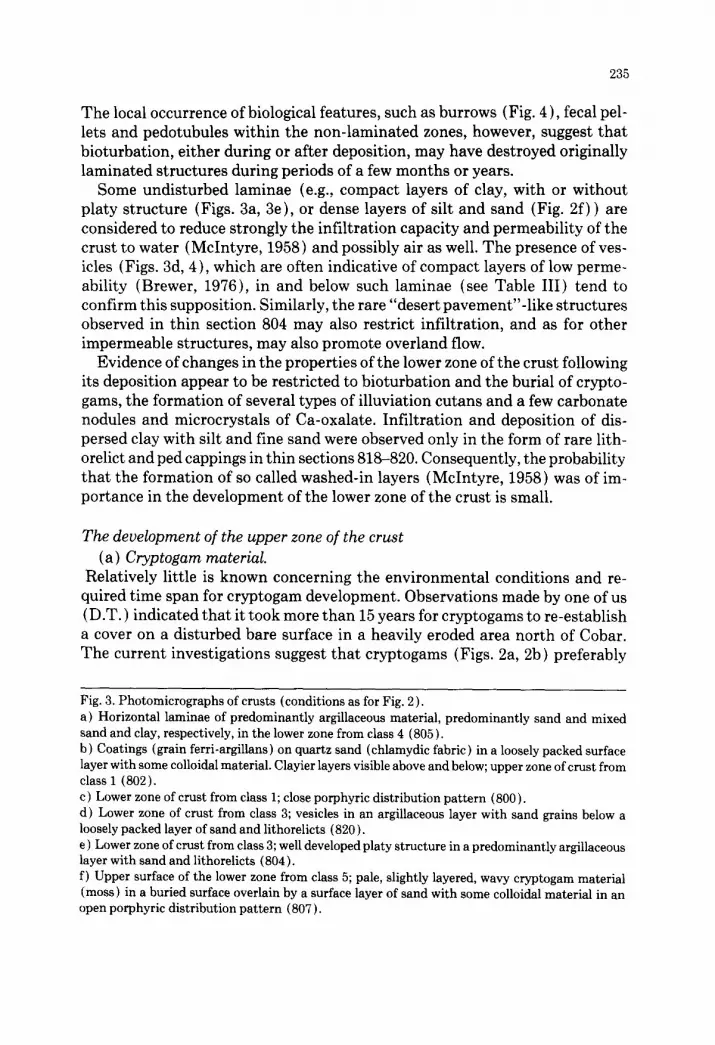
The local occurrence of biological features, such as burrows (Fig. 4), fecal pel- lets and pedotubules within the non-laminated zones, however, suggest that bioturbation, either during or after deposition, may have destroyed originally laminated structures during periods of a few months or years.
Some undisturbed laminae (e.g., compact layers of clay, with or without platy structure (Figs. 3a, 3e), or dense layers of silt and sand (Fig. 2f) ) are considered to reduce strongly the infiltration capacity and permeability of the crust to water (McIntyre, 1958) and possibly air as well. The presence of ves- icles (Figs. 3d, 4), which are often indicative of compact layers of low perme- ability (Brewer, 1976), in and below such laminae (see Table III) tend to confirm this supposition. Similarly, the rare "desert pavement"-like structures observed in thin section 804 may also restrict infiltration, and as for other impermeable structures, may also promote overland flow.
Evidence of changes in the properties of the lower zone of the crust following its deposition appear to be restricted to bioturbation and the burial of crypto- gams, the formation of several types of illuviation cutans and a few carbonate nodules and microcrystals of Ca-oxalate. Infiltration and deposition of dis- persed clay with silt and fine sand were observed only in the form of rare lith- orelict and ped cappings in thin sections 818-820. Consequently, the probability that the formation of so called washed-in layers (McIntyre, 1958) was of im- portance in the development of the lower zone of the crust is small.
The development of the upper zone of the crust ( a ) Cryptogam material.
Relatively little is known concerning the environmental conditions and re- quired time span for cryptogam development. Observations made by one of us (D.T.) indicated that it took more than 15 years for cryptogams to re-establish a cover on a disturbed bare surface in a heavily eroded area north of Cobar. The current investigations suggest that cryptogams (Figs. 2a, 2b) preferably
Fig. 3. Photomicrographs of crusts (conditions as for Fig. 2 ). a) Horizontal laminae of predominantly argillaceous material, predominantly sand and mixed sand and clay, respectively, in the lower zone from class 4 (805). b) Coatings (grain ferri-argillans) on quartz sand (chlamydic fabric) in a loosely packed surface layer with some colloidal material. Clayier layers visible above and below; upper zone of crust from class 1 (802). c) Lower zone of crust from class 1; close porphyric distribution pattern (800). d) Lower zone of crust from class 3; vesicles in an argillaceous layer with sand grains below a loosely packed layer of sand and lithorelicts (820). e ) Lower zone of crust from class 3; well developed platy structure in a predominantly argillaceous layer with sand and lithorelicts (804). f) Upper surface of the lower zone from class 5; pale, slightly layered, wavy cryptogam material (moss) in a buried surface overlain by a surface layer of sand with some colloidal material in an open porphyric distribution pattern (807).

236
CLASS 1 (M802A) (M817) CLASS 2
CLASS 3 (M804 A) (M805 B) CLASS 4
CLASS 5 (M818) 110 mml (M809 A) CLASS 6
Fig. 4. Ultraviolet images of entire thin sections from each soil surface condition class. Pore space appears white (thin section Noso in parentheses). Class 1. Upper zone (0-2.5 ram) of litter and cryptogams and aggregates overlying poorly lami- nated and disturbed argillaceous laminae (to c. 5 mm). Underlying lower zone contains burrows and a pedotubule (top left), is well structured and strongly bioturbated. Class 2. Sporadic, thin (2 mm) layer of aggregates, sand and silt grains and rare organic fragments, overlying a bioturbated, porous lower zone. Class 3. A loosely packed surface layer of soil aggregates, mixed cryptogam/soil aggregates, weath- ered lithorelicts and some plant fragments with a discontinuous lichen cover {centre right) over- lying a lower zone of somewhat laminated argillaceous material containing some silt and sand with a close porphyric fabric. Vesicles occur in a less clayey layer immediately below the surface layer and platy structure is widespread. Class 4. Predominantly exposed lower zone consisting of discontinuous argillaceous laminae with a close porphyric distribution pattern and some aggregates of B horizon material. Note the com- pact nature, platy structure, lack of large pores and absence of biological activity in the upper c. 11 mm. Class 5. A deep ( 15 mm) upper zone of rainwash-deposited organic and mineral material overlying a lower zone with a vesicular, sealed upper layer. Class 6. An upper zone of predominantly organic litter (up to 9 mm deep ) overlying a lower zone which becomes increasingly laminated with depth, but which also exhibits evidence of bioturbation.

237
develop on argillaceous materials containing carbonates and Ca-oxalate crys- tals exuded from plant roots during stable periods without deposition or erosion.
Once established, cryptogams play a role in absorbing and retaining light rainfalls ( < 5 ram) in the surface layers, although runoff from heavier rainfalls can be greater from cryptogam mats than from bare sandy surfaces (Graetz and Tongway, 1986). The latter authors also suggest that soils with cryptogam mats have the two resources essential to plant growth, water and nutrients, concentrated in the upper 10 mm of the profile. Furthermore, the current re- sults suggest that cryptogam material may be significant in the binding of some soil particles into aggregates, possibly because of associated faunal action. Al- gae too have been shown to increase the stability of soil aggregates (Bailey et al., 1973 ). Lichens can also supply nitrogen compounds to the soil (West, 1981; Hale, 1983 ). In addition, the occurrence of cryptogams reflects the stability of the soil surface and as such they are important in distinguishing soil surface condition classes 1-4 (Fig. 4). Where they are observed buried (Fig. 3f), they may be used as reliable indicators of former soil surfaces, which also indicate past periods of stability.
(b) Layers of litter, cryptogams and aggregates. The genesis of the loosely packed layers consisting of mixtures of mainly ag- gregates from A and B horizons (Figs. 2b, 2d), litter and cryptogams seems to be somewhat complex. Clear evidence of specific mechanisms of formation is lacking. On available evidence eolian deposition, saltation, rolling and splash- ing action could have played roles in their formation, with afterflow and rain- splash being of less significance. Changes after deposition of these layers are very restricted with only localised biological activity producing burrows, pe- dotubules and fecal pellets. The genesis of the pale brown aggregates contain- ing cryptogam material (Fig. 2e ) is not clear, but their morphology may indicate a faunal origin. Locally, washed-in layers consisting of silt and fine sand prob- ably resulting from aggregate breakdown under rainsplash, occur at the bases of these layers.
( c ) Layers of aggregates. Layers of loosely packed, rounded aggregates (Figs. 2c, 2d, 2e) are a modifi-
cation of the previously discussed layers. Very locally, at the bottom of the layer and occasionally in shallow micro-rills alternating layers of loose and compact sand and silt occur in association with layers of aggregates. The compact fill- ings of micro-rills could be the result of rainwash, but no sedimentary struc- tures are evident. Aggregate collapse under raindrop action is again a likely mode of formation of washed-in layers at the bases of these layers elsewhere. The brown colloidal cappings on lithorelicts in thin section 818 may have been formed in a similar way.
The accumulation of aggregates indicates, however, the operation of sorting mechanisms during transport. The mainly loose packing of aggregates may indicate deposition by afterflow. The occurrence, in places, of irregular aggre-

238
gates (e.g., in thin section 817) and of apparently elongated, argillaceous crust fragments (with or without lichens on their surfaces) could alternatively in- dicate local splash transport. Eolian activity, including saltation, particularly during droughts, cannot be excluded as a means of deposition.
Both the layers of aggregates and layers of mixed litter, cryptogams and aggregates probably form favourable sites, which afford protection for seeds from wind and water erosion, as well as moisture supply during germination and emergence. Additionally, they may reduce evaporation from the soil sur- face because of their mulch-like properties. Unfavourable properties, such as compaction and sealing, which promote soil erosion are of sporadic and rela- tively rare occurrence in these types of layers.
(d) Layers of sand and silt. Comparison with the laboratory experiments of Mficher and de Ploey (1977)
and Miicher et al. ( 1981 ) again suggests that these well sorted, loosely packed sandy layers (Fig. 3b) are formed during afterflow and the moderately or poorly sorted compact sandy layers are the product of rainwash deposition. Loosely packed layers, if of surface occurrence, may subsequently be modified into compact laminae by raindrop impact.
The local occurrence of patchy sandy layers below layers of aggregates is probably caused by raindrop impact causing the destruction of some aggre- gates. The coarser components of the disrupted aggregates are deposited loosely in between and below other aggregates, whereas the finer, clayey components are washed out.
The sandy layers in micro-rills, best developed in classes 3 and 4, could be formed during rainwash. Those having compact structures and lacking large pores may promote overland flow and have a relatively high resistance to root penetration. If loosely packed, they have a very limited water storage capacity. In both cases, germination and emergence of small seedlings would be inhibited.
( e ) Argillaceous layers. The depositional structure of the laminated argillaceous layers is similar to
the structure of much of the laminated lower zone of the crust and conse- quently may also have formed by similar processes, i.e., predominantly rain- wash and, on occasion, afterflow. As in the lower zone of the crust, only compact clay laminae and layers of closely packed silt-sand mixtures exhibit sealing properties, demonstrated by the presence of vesicles in and below such laminae.
The local presence of typically slow-growing green lichens on the upper sur- faces of argillaceous laminae testifies to the occurrence of stable periods with- out deposition after formation of the laminae. The exact growth rate of such lichens is, however, unknown. After deposition, bioturbation and, in places, the formation of illuviation cutans were locally important. The presence of charcoal fragments in many of the layers again indicates the importance of burning in the area.

239
The relationship between crusting and surface condition classes.
The field differentiation of the six classes of soil surface conditions is sup- ported by this micromorphological study. The six soil surface classes are the result of complex interactions of factors both beneficial and detrimental to plant growth. Beneficial factors are represented by porous layers of aggregates and litter, the occurrence of cryptogams and cryptogamic mats and bioturba- tion. Conversely, the occurrence of compact argillaceous and coarser layers and associated vesicles (which indicate sealing), platy structures and the lack of bioturbation are detrimental to the lodgement and germination of seed and emergence of seedlings. The marked differences between the classes are clearly evident in Fig. 4, which comprises images of entire thin sections taken under ultraviolet illumination. The markedly more porous nature of classes 1 and 2 in comparison with 3 and 4 is particularly apparent in these images. Similarly, platy structures are clearly visible in classes 3 and 4, and a layer of vesicles is apparent at the top of the argillaceous layer in class 5.
Surface condition classes 1-4 essentially represent an er()sional sequence from no erosion (class 1) to strongly eroded (class 4) in which increasing proportions of previously deposited layers of sand and silt with sealing prop- erties have been exposed. Crusts of class 1 have well developed cryptogamic mats underlain by porous layers of aggregates and litter, are reasonably bio- turbated and lack platy and sealing structures for the most part (Table III and Fig. 4 ). Crusts of class 2 and 3 generally have increasing proportions of detri- mental properties and conversely decreasing proportions of beneficial prop- erties. Crusts of class 4 have bare surfaces with cryptogams and other layers of the upper zone of the crust either being absent or very poorly developed. Layers of the lower zone, consisting of silt and sand, are commonly predominant at and immediately below the surface in this class.
The productivity of soils with crusts of class 5, which is a depositional sur- face, appears to depend primarily on the types of surficial layers and secondly, on the properties of the lower zone of the crust, which is generally strongly bioturbated. Where biological activity in the lower zone is high, this can rela- tively rapidly overcome the detrimental influence of compact surface layers, particularly where the rate of deposition is slow. As a result of the various possible types and combinations of layers in class 5, productivity of soils with such crusts is, however, expected to vary considerably.
Biological activity appears to be generally lower in the lower zone of the crust in classes 1-4, particularly classes 3 and 4, than in class 5. This may be the result of a lower infiltration capacity and faster drying rate of the bare and nearly bare ground surfaces in classes 3 and 4, as was reported from similar soils in northern Australia by Mott et al. (1979). Observations of thin sections from class 6 (litter accumulation ) indicated mostly beneficial properties. The lower production of plant dry-matter in soils of this class (i.e. 1.5 t ha -1 ) in

240
comparison with soils of class 1 (2.31 t ha -1) (Table I) is probably the result of the positions of these soils in the field, shaded by larger trees. These trees would intercept a proportion of the incident rain and compete for available w a t e r a n d n u t r i e n t s .
ACKNOWLEDGEMENTS
The authors are much obliged to Dr J.A. Elix, Australian National Univer- sity, Canberra and Dr. H. Streimann, Australian National Botanic Gardens, Canberra for the identification of lichens and mosses, respectively. Thanks are also proferred to Mr. I. Salins and Mr. C.J. Snabili6 for thin section production and the preparation of Table III, respectively. Dr. A.J. Moss made some valu- able comments regarding an earlier draft of the manuscript. The senior author is also indebted to the Division of Soils, C.S.I.R.O., Canberra, and to the Lab- oratory of Physical Geography and Soil Science, University of Amsterdam for their financial support in Australia.
APPENDIX-MICROMORPHOLOGICAL DESCRIPTIONS
The upper zone o[ the crust
The upper zone of the crust differs in thickness, composition, degree of compactness and con- tinuity as can be seen from Table 3. The following main types of layers were recognised as con- tributing to this zone.
(a) Cryptogam layers (Figs. 2a,2b). The uppermost layer of the crust consists predominantly of cryptogams with minor amounts of associated mineral material and litter. Generally lichens predominate with mosses forming the upper surface. Continuous cryptogam mats only occur in class 1 but occur sporadically in classes 2, 3, 4, 5 and 6. Such layers are birefringent in cross- polarized light. The boundary of the cryptogam layer with any underlying soil layers is generally smooth and abrupt.
Very locally in sections representing class 4, cryptogams (mainly mosses but also lichens) were observed on an argillaceous layer in thin section 803 and in a surface layer of a laminated deposit consisting of weak unistrial clay covered by loosely packed aggregates, silt, sand and organic mat- ter (thin section 805). Similarly, mosses were found buried about 12 mm below the surface in a laminated portion of an argillaceous layer in class 5 (thin section 819).
In places, green lichens were found on the surfaces of various argillaceous aggregates on the soil surface (thin section 818), and also buried about 9.5 mm deep (thin section 819) in class 5.
Identification of cryptogams in thin section to species level is incomplete, but field specimens from class 1 soils have been identified (J.A. Elix and H. Streimann, personal communication, 1986) as:
-Lichens: Diploschistes ocellatus, Peltula (sp.), and Xanthoparmelia arapilensis or taractica (all characteristic of dry areas) and Licedea, which occurs in wet tropical as well as in dry areas.
-Mosses: Desmatodon convolutus (general in dry areas) and Bryum (occurring in wet tropical as well as in dry areas).
- Liverworts (hepatics): Targonia hypophylla (generally in dry areas ).

241
(b) Layers of aggregates. A second type of surface layer consists mainly of loosely packed mix- tures of aggregates (diameters: 0.1-1.8 mm) (Figs. 2c, 2d and 2e), litter (both birefringent and non-birefringent and locally containing Ca-oxalate micro-crystals), and cryptogams (mainly mosses and lichens). This layer may contain various amounts of weathered and unweathered lithorelicts (diameters: 0.2-2.5 mm), silt and sand grains ( < 0.5 mm ) covered with free grain ferri-argillans, charcoal fragments, matric fecal pellets (diameters: 0.05-0.1 mm, 0.2-0.25 mm) and rare organic fecal pellets (diameters: 0.1-0.3 mm). These layers occur predominantly in samples representing classes 1, 3, 5 and 6 but are continuous only in samples representing classes 3, 5 and 6 where they often form the uppermost layer. On occasion, however, they are buried by a layer of cryptogams.
The aggregates within the second type of layer can be grouped into three types: (1) dark brown to brown, argillaceous aggregates (asepic plasmic fabric ), with embedded silt and sand grains; (2) reddish brown argillaceous aggregates with oriented clay separations (sepic plasmic fabric), por- phyric distribution pattern, and in places embedded reddish-orange illuviation cutans (ferri-ar- gillans) and papules derived from broken ferri-argillans; (3) light brown and light greyish aggregates with locally strong internal continous orientation (sepic plasmic fabric) (probably the result of enclosed cryptogam material) and with or without some sand and silt grains (Fig. 2d).
The surfaces of some argillaceous aggregates are covered with green lichens with fungal hyphae occurring inside the aggregates. These aggregates also often contain Ca-oxalate and/or carbonate nodules. Simple and compound packing voids ranging from 0.05 to 1.00 mm are found between the aggregates. The boundary between these layers of aggregates and the underlying material is usually smooth or wavy and clear to gradual.
(c) Layers of mixed aggregates and skeleton grains. A variation of the above layer consists mainly of loosely packed aggregates with diameters between 0.1 and 2.5 mm with only small quan- tities of weathered lithorelicts, silt and sand grains, and organic material between the aggregates. This type of layer is continuously developed only in samples representing classes 1 and 5 and occurs predominantly near the surface. In class 5 it also occurs as a weakly developed layer enclosed in a laminated structure. The boundary between this type of layer and underlying adjacent layers is generally clear and wavy.
(d) Layers of sand and silt. A fourth type of surface layer is composed predominantly of sand ( < 500/lm in diameter) with some silt-sized grains, occurring in combination with various num- bers of aggregates ( < 1.5 mm diameter), weathered (ferruginised) and unweathered lithorelicts ( < 1.5 mm in diameter), plant and root remnants, ferric nodules, papules, charcoal fragments, and only occasionally having some loose colloidal material in packing voids. Clear, reddish free grain cutans (ferri-argillans) ( < 20/lm thick) are generally common on the mineral grains. The sandy layers tend to be loosely packed, although where compact layers were observed (thin sec- tions 802 and 820), vesicles (diameters: 0.05-0.6 mm) were often present. Within samples rep- resenting soil surface condition classes 1-4, the sandy layers are best developed in samples of classes 3 and 4 (Table III). The sandy layers occur as more or less independent units, several millimetres thick (e.g., in thin sections 800, 803,804 and 820) or as intercalated laminae less than 1 mm thick in a compact laminated structural unit ( e.g., thin section 805).
The sandy layers occur very locally, for example below aggregate layers and in micro-depressions (Fig. 2f). These local features are loosely packed, as in thin section 801, or densely packed, as in thin section 802, depending upon their mode of formation. The underlying boundary of the sandy layers is smooth to wavy and generally sharp.
In the class 5 crusts, the sandy layers range from poorly to well developed (Table III) and are generally loosely packed. Densely packed sandy laminae occur only in micro-depressions (rills) below aggregate layers. They also occur as intercalated continuous layers in the laminated units of thin sections 818 and 819.

242
In class 6 crusts, a loosely packed sandy layer containing some colloidal material in voids was observed only in the bottom of an aggregate layer in thin section 811.
(e) Argillaceous layers. These clayey layers have a laminated structure (e.g., thin sections 805 and 819), with almost pure clay laminae (0.05-1.2 mm thick) and a weak unidirectional striated extinction pattern (unistrial fabric) or oriented clays occurring in isolated patches and parallel to the edges of sand and silt grains (in-skelsepic fabric). A few silt and sand particles occur within these laminae (Fig. 3a). These laminae alternate with laminae (0.2-0.5 mm thick) consisting of closely packed silt and sand particles with oriented clay coatings (chlamydic fabric) (Fig. 3b).
Some argillaceous layers seem to consist mainly of dark brown unoriented to weakly oriented colloidal material (asepic to weak insepic and locally weak unistrial plasmic fabric) with silt and sand particles (up to 300 mm in diameter) (e.g., thin sections 803 and 818; Table III). Locally, weak, horizontal, very thin ( < 0.05 ram) laminae consisting of almost pure clay were observed.
The most characteristic voids are vesicles with a diameter between 0.05 and 0.6 mm. Addition- ally, a few craze and skew planes, vughs, and channels with diameters less than 0.8 mm occur. Various numbers of weathered and unweathered lithorelicts (diameters: 0.05-2.5 mm), similar to those in the lower zone of the crust, in combination with plant fragments lying parallel or inclined to the surface, matric fecal pellets (diameters: 0.1-0.2 mm), charcoal, pedotubules (diameters: 0.7-2.5 mm), brown and reddish brown rounded aggregates (diameters: 0.1-1.2 mm) and light brown and red papules (diameters: 0.03-0.1 mm) were observed in the argillaceous layers. A few dark brown, speckled illuviation cutans (ferri-argillans consisting of clay similar to that in the adjacent matrix) were also observed in vughs but only in thin section No. 819. In places, crypto- gams occur on the surface of the argillaceous layer (e.g., thin section 805) or on the surface of intercalated argillaceous laminae. The boundary with the lower zone of the crust, or other under- lying upper zone layers, is smooth and ranges from diffuse to sharp.
Lower zone of the crust
The lower zone of the crust, comprising either A or B horizon material, has a minimum thick- ness of 30 mm and consists generally of sand and silt-sized skeleton grains up to 400~m in diameter and brown to reddish brown colloidal material between the grains (close porphyric distribution pattern) (Fig. 3c). Locally, the colloidal material occurs as loose of incomplete fillings in the intergranular spaces (agglomeroplasmic fabric). The grains may be linked by intergranular braces or embedded in a porous groundmass (intertextic fabric ). Intergrades between these related dis- tribution patterns were also observed. The plasmic fabric of the colloidal material ranges from isotic to silasepic to weak insepic. Locally, skel- and glaesepic fabrics occur. Thin cutans (ferri- argillans) were noted around some skeleton grains (chlamydic fabric).
Sand- to gravel-sized rock fragments (lithorelicts) of sandstone, quartzite or shale, with adja- cent fragments sometimes of the same lithology often exhibiting markedly different degrees of weathering, occur randomly within the materials underlying the crust. Generally they are oriented parallel or gently inclined to the surface, but occasionally those with orientation normal to the surface were observed. In places (e.g., thin section 804), rock fragments are concentrated in dense layers rather like a "desert pavement" (Mabbutt, 1977, p. 119). Locally (e.g., thin sections 818, 819 and 820 all from class 5), some lithorelicts and the upper surfaces of some peds have cappings of fine silt and colloidal clay, mineral-rich material up to 60 ~m thick.
Voids in the materials below the crust consist usually of vughs, channels, planes and vesicles in various proportions and sizes. Vesicles (Fig. 3d) and planes (Fig. 3e) (if the latter led to the development of a platy structure) are listed in Table III. Simple and compound packing voids occur predominantly in horizontal laminae, consisting of silt, sand and aggregates. Vesicles can occur in and below argillaceous laminae, as well as in compact layers of silt and sand with or

243
without some colloidal material between the grains. Layers of material containing vesicles were noted at various depths parallel to the surface. Occasionally, the upper 2 mm of the zone of ma- terials below the crust was compact and if porous, the pores were exclusively micropores. Such compact zones are mostly composed of undisturbed argillaceous sedimentary laminae parallel to the surface.
Cryptogams (i.e., plants having no stamens or pistils and therefore no proper flowers, and com- prising algae, lichens, mosses and liverworts) along with fragments of charcoal (Table III) were occasionally noted at the top of and sometimes buried within the materials underlying the crust (Fig. 3d). Other plant and root fragments often occur parallel with the surface. Occasionally, micro-crystals of Ca-oxalate, thought to be plant exudates, were observed within and adjacent to root fragments (Table III).
Well-oriented reddish orange illuviation cutans (e.g., ferri-argillans) and grainy matrans (Bal, 1973 ) and matri-argillans (van Schuylenborgh et al., 1971 ) occur locally in all classes except class 1. Generally, most of the cutans occur in aggregates derived from elsewhere. Ferric nodules are rare and often difficult to distinguish from weathered lithorelicts but where positively identified were noted to have sharp and distinct boundaries. Argillaceous papules derived from ferri-argillans noted in deeper soil horizons (not described here) range in abundance from few to common in most thin sections.
Carbonate-cemented nodules (< 200 pm diameter) with sharp boundaries were only locally observed (i.e., in thin sections 802 and 810) and were probably derived from other soils. Biological features, such as channels, matric fecal pellets (i.e., excrements consisting of mainly mineral ma- terial) and various types of in-filled burrows (pedotubules), are common phenomena. Rare or- ganic fecal pellets occurring in voids in association with other fecal pellets were noted in thin sections 801 and 804.
Occasionally, brown and reddish brown, sharply bounded, rounded aggregates (0.5- 2 mm ) were observed. The clay segregations within the aggregates are commonly strongly oriented (ma-mo- insepic plasmic fabric). Sand grains in the aggregates are usually in juxtaposition (close porphyric distribution pattern) and less commonly widely spaced (open porphyric related distribution pat- tern ). These aggregates often contain yellowish illuviation cutans (ferri-argillans) which were not observed in the surrounding matrix material. We considered these aggregates to be pedorelicts of older eroded soils, or of material formed at depth within the current soils which was subsequently disturbed and then rounded in transport probably by colluvial processes. In some cases they re- semble matric fecal pellets and if aggregates occur with the same diameters as identified excre- ments they cannot be differentiated with confidence.
The numbers of thin (usually < 1 mm), approximately horizontal depositional layers or their disturbed remnants are quite variable (Table III). Most common are argillaceous sandy laminae containing some silt, and silty-clay laminae. Laminae consisting of pure sand- and silt-sized par- ticles and entirely of dark brown clay particles are less common. Lithorelicts and aggregates are most common in poorly sorted laminae. Generally, clay (plasma) separations were not recognised within the depositional laminae (argillasepic plasmic fabric), but a weak unidirectional striated extinction pattern (weak unistrial fabric) was observed in thin sections 807 and 808. Generally, the laminae are sharply bounded, but laminae with more diffuse boundaries also occur. Laminae are generally continuous and several centimetres long. Locally, short ( < 10 mm) laminae, which were observed to bifurcate with the two arms remaining parallel to the surface, were also observed. Frequently, the entire lower zone of the crust consists of laminated material, but in some instances the laminated parts are separated by layers of non-laminated materials.
REFERENCES
Bailey, D., Mazurak, P.A. and Rosowski, J.R., 1973. Aggregation of soil particles by algae. J. Phycol., 9: 99-101.

244
Bal, L., 1973. Micromorphological Analyses of Soils. Lower Levels in the Organisation of Organic Soil Materials. Soil Surv. Pap. No. 6. Netherlands Soil Survey Institute, Wageningen, 174 pp.
Brewer, R., 1976. Fabric and Mineral Analysis of Soils. Krieger, New York, N.Y., 2nd ed., pp. 483. Brewer, R., Sleeman, J.R. and Foster, R., 1983. The fabric of Australian soils. In: Soils an Austra-
lian Viewpoint. CSIRO, Melbourne, and Academic Press, London, pp. 439-476. Bridge, B.J., Mott, J.J. and Hartigan, R.C., 1983. The formation of degraded areas in the dry
savanna woodlands of northern Australia. Aust. J. Soil Res., 21: 91-104. Brown, J.A.H,, 1972. Hydrologic effects of a bushfire in a catchment in southeastern N.S.W.J.
Hydrol., 15: 77-96. Chartres, C.J., 1987. Physical and biological aspects of land degradation. In: R. Dumsday and A.H.
Chisholm (Editors), Land Degradation and Public Policy. Cambridge University Press, Mel- bourne, Ch. 1.
Dury, G.H., Ongley, E.D. and Ongley, V.A., 1967. Attributes of pediment form on the Barrier and Cobar Pediplains of N.S.W.. Aust. J. Sci., 30: 33-34.
Graetz, R.D. and Tongway, D.J., 1986. Influence of grazing management on vegetation, soil struc- ture and nutrient distribution and the infiltration of applied rainfall in a semi-arid chenopod shrubland. Aust. J. Ecol., 11: 347-360.
Hale, M.E., 1983. Biology of Lichens. Edward Arnold, London, 3rd ed. Mabbutt, J.A., 1977. Desert Landforms. Australian National University Press, Canberra, 340 pp. McIntyre, D.S., 1958. Soil splash and the formation of surface crusts by raindrop impact. Soil
Sci., 85: 261-266. Moss, A.J., Walker, P.H. and Hutka, J., 1979. Raindrop-stimulated transportation in shallow
water flows. Sediment. Geol., 22: 165-184. Mott, J., Bridge, B.J. and Arndt, W., 1979. Soil seals in tropical tall grass pastures in northern
Australia. Aust. J. Soil Res., 17: 483-494. Mticher, H.J. and Morozova, T.D., 1983. The application of soil micromorphology in Quaternary
geology and geomorphology. In: P. Bullock and C,P. Murphy (Editors), Soil Micromorphol- ogy. A.B. Academic Publ., Berkhamsted, Vol. 1, pp. 151-194.
Mticher, H.J. and de Ploey, J., 1977. Experimental and micromorphological investigation of ero- sion and redeposition of loess by water. Earth Surface Processes, 2:117-124.
Mticher, H.J., de Ploey, J. and Savat, J., 1981. Response of loess materials to simulated translo- cation by water: micromorphological observations. Earth Surface Processes, 6:331-336.
Noble, J.R. and Tongway, D.J., 1986. Herbivores in arid and semi-arid rangelands. In: J.S. Russell and R.F. Isbell (Editors), Australian Soils: The Human Impact. Univ. Queensland Press, pp. 243-272.
Soil Survey Staff, 1975. Soil Taxonomy: A Basic System for Making and Interpreting Soil Sur- veys. U.S. Department of Agriculture Handbook 436, Washington, D.C.
Stace, H.C.T., Hubble, G.D., Brewer, R., Sleeman, J.R., Mulcahy, M.J. and Hallsworth, E.G., 1968. A Handbook of Australian Soils. Rellim, South Australia, 435 pp.
Tongway, D.J. and Smith, E.L., 1988. Soil surface features as indicators of rangeland site produc- tivity. Aust. Rangeland J. In press.
Van Schuylenborgh, J., Slager, J.S. and Jongmans, A.C., 1971. On soil genesis in temperate humid climate, VIII. The formation of a "Udalfic" Eutrochrept. Neth. J, Agric. Sci., 18: 207-214.
West, N.E., 1981. Nutrient cycling in desert ecosystems. In: D.W. Goodhall and R.A. Perry {Ed- itors ) Arid Land Ecosystems. Cambridge University Press, pp. 301-324.


