Embed Size (px)
Citation preview
sustainability
Article
Negotiating Proximity in Sustainable Urban Planning:A Swedish Case
Ana Gil Solá * and Bertil Vilhelmson
Unit for Human Geography, Department of Economy and Society, School of Business, Economics and Law,University of Gothenburg, Gothenburg 40530, Sweden; [email protected]* Correspondence: [email protected]
Received: 22 November 2018; Accepted: 12 December 2018; Published: 21 December 2018 �����������������
Abstract: In striving for sustainability, urban policy and planning increasingly emphasize proximityideals in order to go beyond established mobility- and speed-oriented accessibility strategies.Yet proximity is a fluid concept with many contextualized meanings, cutting across most sectorsof urban planning. When proximity is realized in actual planning, clarity and communicability aretherefore required. Here we explored how urban planners in different fields of expertise understandand apply the proximity concept. Furthermore, we tested a collaborative tool enabling transparentdiscussion and fostering a joint basis for further application. Qualitative data were collected viasix semi-structured, focus-group workshops with 35 planners of various competencies working inthree western Swedish municipalities. The results indicated that planning goals of proximity werenegotiated according to three understandings: One derived from the established understanding oftransportation and land-use integration, relying on planners’ expert views; a second emphasizingthe local community understanding, highlighting the social context of neighborhoods; and a thirdcomprising the personal environment understanding of the individual’s closest physical space at adetailed scale level. Collaborative exercises resulted in the development of a communicative tool fornegotiating perceived understandings of proximity, as well as planning goals.
Keywords: collaborative tool; planning; spatial proximity; sustainable accessibility; understanding;workshop method
1. Introduction
Proximity (or geographic nearness, propinquity) is an influential concept and a buzzword incurrent urban planning. Increased proximity is believed to enhance individuals’ quality of life, boostneighborhoods, and promote environmental, social, and economic sustainability. The concept is centralto discourse on how to reduce energy-consuming and polluting travel [1,2], foster local social ties,trust, and capital [3,4], and promote economic activity and innovation [5,6]. Ideas of nearness lie at theheart of visions to revitalize and make cities vibrant and attractive via greater densification, land-usemixing and filling, and the co-location of various activities and facilities.
This proximity turn essentially represents an ongoing—or anticipated—shift in urban planningaway from transport-dominated urban development [7,8]. Policy has shifted from viewing car transportas the ultimate norm and means by which citizens reach daily activities to more emphasis put ontransport needs and reduced travel distance, local living, and the promotion of walking, cycling,and public transit [9–11]. Densification, land-use mixing, and slow mobility thus belong to a set ofkey notions in a redefined understanding of urbanity [10,12–14] that goes beyond the establishedplanning principles of 20th-century modernity [15], largely associated with speed, areal differentiation,energy-consuming transport, highway connectivity, and sprawl. Still, it must be remembered thatmobility-based approaches de facto still dominate transportation planning in most countries [16–18].
Sustainability 2019, 11, 31; doi:10.3390/su11010031 www.mdpi.com/journal/sustainability
Sustainability 2019, 11, 31 2 of 18
In Sweden and other countries striving for sustainable development, the notion of proximityis prevalent in most contemporary urban policies. Among Sweden’s three largest cities, Stockholmsells its vision of the urban future in terms of “A Closer City” [19], Gothenburg is branding itself the“Near Metropolitan” in a strategy to promote slower transport modes, public transport, and localliving [20], while Malmö has started to evaluate accessibility improvement in terms of geographicaldistances between people and everyday activities [21]. In addition, medium-sized Swedish cities,in their comprehensive planning, define “the near city”, “the compact city center”, and “mixed landuse” as leading goals for future development, stressing the importance of nearness in everyday lifefor all citizens (e.g., References [22,23]). Proximity-based thinking has become a typical example ofpolicy mobility [24] (i.e., how elusive policy concepts travel between cities and regions, transmitted byconsultants and stakeholders).
This proximity shift is associated with other important tendencies, needs, and challenges incurrent planning. One concerns recognizing the complexity of urban change and planning, and thatmeasures, for example, SUMP-based guidelines within EU [25] require the involvement of variouscompetences, professions, and stakeholders [26]. Establishing common ground, conceptual congruence,and beneficial communication between professions is necessary [27] and of immediate concern.Furthermore, shifts toward proximity thinking bring a focus on people rather than transportationmodes and traffic flows, in order to take account of citizens’ varied needs and activities in everydaylife, involve citizens, and move from top–down expert forms to transparent and participatory forms ofplanning [9,25,28].
When accomplishing such shifts in planning and practice, the specific meaning attributed to theconcept of proximity becomes critical and contested. In detailing this understanding, we founda knowledge gap and a need to develop new and integrative planning practices emphasizingimproved communication between professions, as well as between planners and citizens. This basicissue motivated our study. Drawing on a Swedish case, we aimed to investigate how one set ofinfluential actors—local planners from different municipal-level sectors of expertise and responsibility—recognizes, contextualizes, and implements the concept of proximity from a sustainability perspective.We concentrated on two interrelated research questions:
1. What understandings of proximity exist in current urban planning practice? We exploredplanners’ perceived meanings and challenges regarding how spatial nearness is recognized andmanaged in different sectors of urban planning and administration.
2. How could a shared understanding of proximity be derived from various professional perspectives,conceptions, and interests? Through a collaborative process of organized workshops, we developedand discussed a tool to advance the development of proximity-oriented planning.
This study concentrated on urban planners, considering their performative roles as intermediateagents between policymakers, stakeholders, and citizens [29]. To explore the issues raised, we organizedworkshop discussions with planners from a wide range of urban sectors and responsibilities.Workshops were held in three cities—Gothenburg, Mölndal, and Uddevalla—in western Sweden. Ouranalysis drew on qualitative data derived from thematic group discussions as well as interactive tasksorganized to stimulate responses.
Our case study adds to the scattered literature on planners’ perceptions and emerging practices ofadvanced sustainable planning. This is relevant, because local planners’ conceptions and emergingpractices of proximity-oriented planning processes are poorly documented [14,30,31]. We alsocontribute by involving practitioners active in various municipal responsibilities, ranging from healthand social care, school and child care, and leisure activities to energy, transport, the environment andgreen areas or parks, and comprehensive land-use planning. Caring for proximity in people’s accessto services is central to all these fields, not to be “owned” by one or a few of them, contrasting a roletraditionally held by transportation and land-use planning departments.
The paper is organized as follows. The next section presents our analytical framework. Followingthis, we briefly describe the method and data, outlining the selection of cases and workshops. We then
Sustainability 2019, 11, 31 3 of 18
present the results, examining various understandings of proximity (i.e., differences in understandingengendered tensions in implementing proximity-led planning). The following section evaluates aheuristic tool usable as a basis for dialogue between planners and for deriving and communicatingproximity needs in the population. A concluding discussion is presented in the final section.
2. Analytical Framework
2.1. Proximity in Accessibility Planning
Our study was based on the notion that geographic proximity—the location of people, services,and activities near one another—is one of several principal ways for people to access spatiallydistributed opportunities in the urban environment [32,33]. Accessibility is considered to be anumbrella term denoting an individual’s potential to reach activities important to everyday life andwell-being. Accessibility can also be enabled by mobility strategies, using fast means of travel, such asthe car, or virtual strategies, using information and communication technologies to transcend space.These strategies can be implemented separately or in combination [28,33]. How and to what extentpeople choose physical mobility, proximity, or virtual strategies have important consequences forenvironmental and social sustainability. It is generally recognized that future urban developmentshould rely more on proximity promotion in terms of densification, compactness, co-location, andmixed land use to combat sprawl and pollution and increase sustainability (e.g., References [9,14]).
A shift toward proximity-enhancing (i.e., distance reducing) strategies puts people’s local accessto a wide range of amenities important for quality of life—such as healthcare facilities, preschools andschools, social services, commercial services, leisure, cultural, and entertainment amenities, and parksand nature—at the center of planning [34,35]. It extends established accessibility planning beyond theconventional domains of transportation and land-use planning [8,14,30,36], and reflects on the need forimproved information systems, methods, and metrics that quickly map relevant bases for evaluationand decision-making [37–39]. Yet studies of urban planners’ detailed understandings of accessibility interms of proximity are rare [14,30,31]. One exception is that of Curl et al. [30], who examined how UKplanners integrated accessibility policies in their local transport plans. They considered that improvedaccessibility in terms of proximity would enhance social inclusion, equality, and modal shifts. Non-caraccessibility and proximate opportunities for underprivileged groups were in particular expected toimprove. Outcomes were also seen to affect a wide range of sectors, particularly health, employment,and overall quality of life. Envall [40], also evaluating UK accessibility-based planning, concludedthat it requires new planning skills and working methods. This was stressed by Haugen [34], who,in studying the importance of nearness, noted planners’ need to recognize and prioritize what differentgroups of people want and need to access within easy reach in everyday life. Similarly, Boisjoly andEl-Geneidy [37] investigated the design, benefits, and barriers to the use of proximity-based indicatorsamong established land-use and transportation practitioners in the USA and Europe. Such indicatorsare intended to quantify the ease of reaching various activities or destinations using slow transportationmodes, such as walking and biking, based on travel costs, distance, or time: For example, the numberof jobs, retail stores, or parks reachable from a specific location within 10 min by walking. They foundthat lack of knowledge and data were the main barriers to using such methods in practice, rather thana lack of support and interest among regular urban planners.
A complementary view of the role of the proximate environment stresses the individual’sfunctional capabilities. Wennberg et al. [41] and Hallgrimsdottir et al. [42], for example, examined howlocal planners in Sweden perceive and implement accessibility goals for public outdoor environmentswith regard to disabled people with walking difficulties. They found large variations in the applicableaccessibility standards among Swedish municipalities, partly reflecting the degree of awarenessrevealed in local policy and planning.
Overall, according to the literature, the concept and role of proximity in accessibility planningappears ambiguous and contested, with the role of proximity in implementation varying between
Sustainability 2019, 11, 31 4 of 18
cases and contexts. This illustrates the critical and transformative role of planners in the transition tosustainable urban planning, which involves the mediation of new perspectives, methods, and fields ofexpertise in negotiations between various actors [29]. It calls for reflection on what is important forpeople to have nearby in their daily lives, and on who should answer this central question.
2.2. The Role of Proximity in Social Sustainability
Building on planning practices that put proximity at the center of accessibility planning, proximitycan also be related to a wider context, not only as an individual tactic for accessing specific everydaylife activities, but as important to issues of social inclusion, resident health, quality of life, and urbanrevitalization (i.e., values central to social sustainability) [43,44]. Unraveling social sustainability atthe neighborhood scale, Dempsey et al. [43] discerned two central underlying concepts: Social equityand sustainability of community. Whereas the first relates to equity of access to key services, facilities,and transport infrastructure (see Section 2.1), sustainability of community highlights the importance ofcollective aspects of social life. It denotes the importance of local social interaction, participation inlocal community activities, community stability, pride and sense of place, and feeling safe and secure.For example, Leyden [45] analyzed the role of walkable neighborhoods, demonstrating that inhabitantsof walkable, mixed-use neighborhoods were more likely to know their neighbors, participate politically,trust others, and be socially engaged than were people living in car-oriented suburbs. This was assumedto be due to the enhanced opportunities for resident interaction in neighborhood public areas, suchas sidewalks, encouraging a sense of connection and familiarity. However, the relationship betweenurban form and social interaction in neighborhoods is also contested in the research [43,46].
Associated with this is the understanding that residents’ bonds to a place relate to their actualuse of the area. If inhabitants feel attached to their neighborhood and experience it as positive, theyare more likely to use local amenities in everyday life rather than traveling farther away [47]. Equally,local understandings and emotional ties are reinforced in places where people spend most of their timein everyday life [48,49]. Understanding a place therefore entails more than just examining the physicalenvironment: It also entails considering social ties and memories as important aspects, meaning thatplaces are understood differently by different people [48].
2.3. Evolution of Proximity Policy
Our study starts from the understanding that proximity policy is complex and works at differentadministrative levels. It involves different paradigms and professional understandings existing sideby side within the same institutions [50]. It may contain conflicting goals [51,52]: For example,although current goals of sustainable development, such as reduced emissions, are clearly expressedand defined, they often conflict with stated (or tacit) goals of the continued dominance of car-basedmobility and access [26]. Such goal conflicts can be explained by policy being complex and subject tocontinuous evolution. Importantly, policies evolve through processes such as displacement, layering,drift, conversion, and exhaustion [50,52]. For our purposes, focusing on evolving proximity policy,we considered the displacement process. Displacement implies that established understandings oractions can be pushed aside by existing but subordinate understandings and measures, allowingthe reinterpretation or rediscovery of certain policies. In the present case, this means that the waysproximity is contextualized and problematized, and potentially measured and implemented [53,54],are complemented by the experiences of planners other than transport and land-use professionals,for example from the fields of healthcare, social care, and school planning. Such complementationpermits a more holistic understanding, and is optimally created by knowledge exchange betweenactors from different disciplines (cf. Reference [55]).
3. Materials and Methods
To explore the aim and research questions of this study, we investigated how professionalplanners understand issues of sustainable accessibility in general, and proximity-oriented planning in
Sustainability 2019, 11, 31 5 of 18
particular. In the form of workshops, we conducted six semi-structured focus-group interviews withmunicipal planners. Two consecutive workshops were held in each of three municipalities locatedin the Västra Götaland region of Sweden. A brief methodological description follows. For a moredetailed description, see Gil Solá et al. [26].
The selected municipalities were Gothenburg, considered a larger Swedish city (565,000 inhabitants),and two medium-sized cities, Mölndal (67,000 inhabitants), located within the Gothenburg urbanregion, and Uddevalla (56,000 inhabitants), located about 80 km away [56]. These municipalitiesrepresent different geographical settings. Although the municipalities of Mölndal and Uddevallacontain mixed urban and rural settings, the selection created a risk of overemphasizing urban-oriented problems.
With help from a contact person in each municipality, we selected participants from differentsectors, such as the transport, land-use, care, education, and cultural sectors (see Table 1, showingthe planning sectors represented). The selection was guided by the understanding that issues ofaccessibility and geographic proximity are important across various municipal administrations,and that planners from different sectors have important and complementary experiences withaddressing these issues. Our aim was to encourage knowledge exchange between planners fromdifferent disciplines, as well as between planners and researchers, leading to new co-createdknowledge [55,57]. In total, 10–14 people attended each workshop.
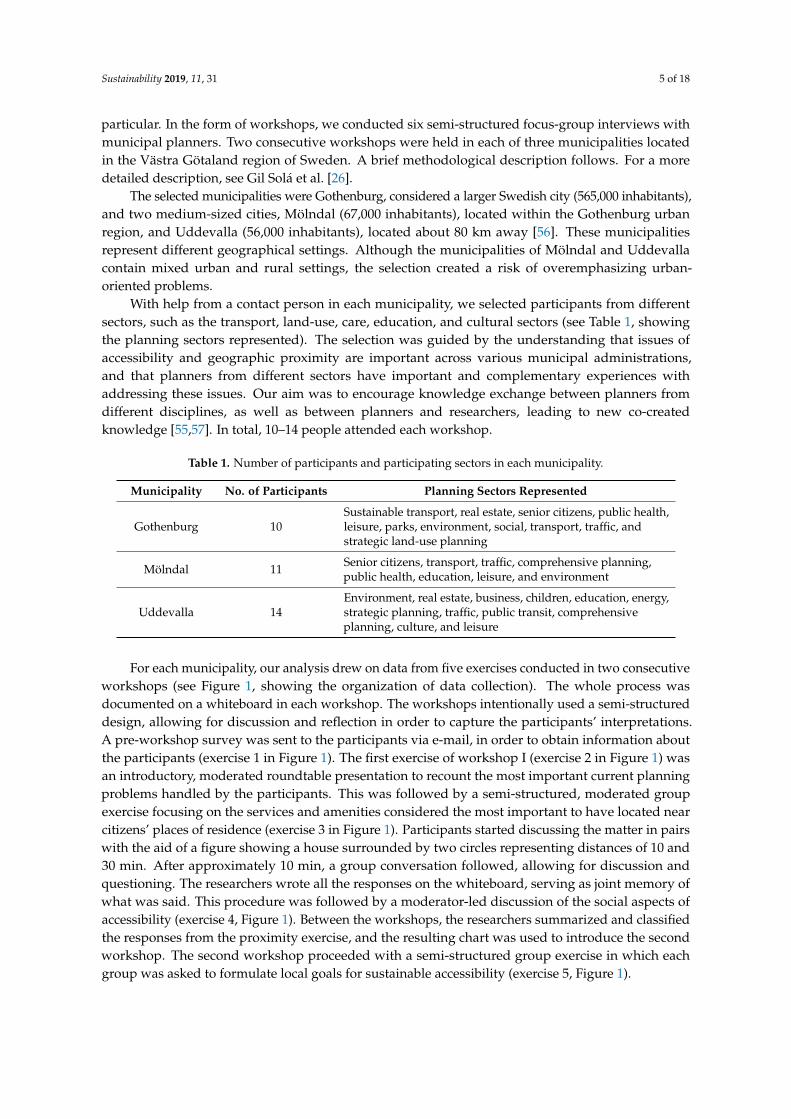
Table 1. Number of participants and participating sectors in each municipality.
Municipality No. of Participants Planning Sectors Represented
Gothenburg 10Sustainable transport, real estate, senior citizens, public health,leisure, parks, environment, social, transport, traffic, andstrategic land-use planning
Mölndal 11 Senior citizens, transport, traffic, comprehensive planning,public health, education, leisure, and environment
Uddevalla 14Environment, real estate, business, children, education, energy,strategic planning, traffic, public transit, comprehensiveplanning, culture, and leisure
For each municipality, our analysis drew on data from five exercises conducted in two consecutiveworkshops (see Figure 1, showing the organization of data collection). The whole process wasdocumented on a whiteboard in each workshop. The workshops intentionally used a semi-structureddesign, allowing for discussion and reflection in order to capture the participants’ interpretations.A pre-workshop survey was sent to the participants via e-mail, in order to obtain information aboutthe participants (exercise 1 in Figure 1). The first exercise of workshop I (exercise 2 in Figure 1) wasan introductory, moderated roundtable presentation to recount the most important current planningproblems handled by the participants. This was followed by a semi-structured, moderated groupexercise focusing on the services and amenities considered the most important to have located nearcitizens’ places of residence (exercise 3 in Figure 1). Participants started discussing the matter in pairswith the aid of a figure showing a house surrounded by two circles representing distances of 10 and30 min. After approximately 10 min, a group conversation followed, allowing for discussion andquestioning. The researchers wrote all the responses on the whiteboard, serving as joint memory ofwhat was said. This procedure was followed by a moderator-led discussion of the social aspects ofaccessibility (exercise 4, Figure 1). Between the workshops, the researchers summarized and classifiedthe responses from the proximity exercise, and the resulting chart was used to introduce the secondworkshop. The second workshop proceeded with a semi-structured group exercise in which eachgroup was asked to formulate local goals for sustainable accessibility (exercise 5, Figure 1).
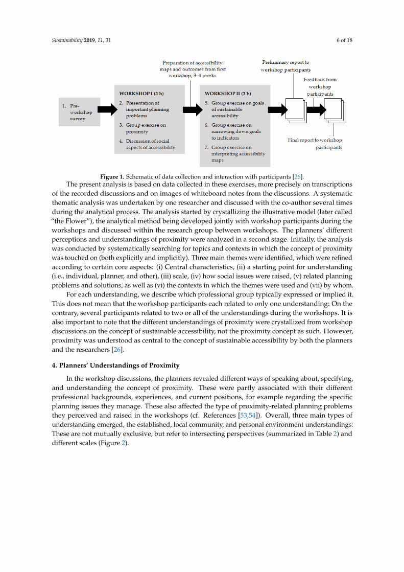
Sustainability 2019, 11, 31 6 of 18Sustainability 2018, 10, x FOR PEER REVIEW 6 of 18
Figure 1. Schematic of data collection and interaction with participants [26].
The present analysis is based on data collected in these exercises, more precisely on transcriptions of the recorded discussions and on images of whiteboard notes from the discussions. A systematic thematic analysis was undertaken by one researcher and discussed with the co-author several times during the analytical process. The analysis started by crystallizing the illustrative model (later called “the Flower”), the analytical method being developed jointly with workshop participants during the workshops and discussed within the research group between workshops. The planners’ different perceptions and understandings of proximity were analyzed in a second stage. Initially, the analysis was conducted by systematically searching for topics and contexts in which the concept of proximity was touched on (both explicitly and implicitly). Three main themes were identified, which were refined according to certain core aspects: (i) Central characteristics, (ii) a starting point for understanding (i.e., individual, planner, and other), (iii) scale, (iv) how social issues were raised, (v) related planning problems and solutions, as well as (vi) the contexts in which the themes were used and (vii) by whom.
For each understanding, we describe which professional group typically expressed or implied it. This does not mean that the workshop participants each related to only one understanding: On the contrary, several participants related to two or all of the understandings during the workshops. It is also important to note that the different understandings of proximity were crystallized from workshop discussions on the concept of sustainable accessibility, not the proximity concept as such. However, proximity was understood as central to the concept of sustainable accessibility by both the planners and the researchers [26].
4. Planners’ Understandings of Proximity
In the workshop discussions, the planners revealed different ways of speaking about, specifying, and understanding the concept of proximity. These were partly associated with their different professional backgrounds, experiences, and current positions, for example regarding the specific planning issues they manage. These also affected the type of proximity-related planning problems they perceived and raised in the workshops (cf. References [53,54]). Overall, three main types of understanding emerged, the established, local community, and personal environment understandings: These are not mutually exclusive, but refer to intersecting perspectives (summarized in Table 2) and different scales (Figure 3).
Figure 1. Schematic of data collection and interaction with participants [26].The present analysis is based on data collected in these exercises, more precisely on transcriptions
of the recorded discussions and on images of whiteboard notes from the discussions. A systematicthematic analysis was undertaken by one researcher and discussed with the co-author several timesduring the analytical process. The analysis started by crystallizing the illustrative model (later called“the Flower”), the analytical method being developed jointly with workshop participants during theworkshops and discussed within the research group between workshops. The planners’ differentperceptions and understandings of proximity were analyzed in a second stage. Initially, the analysiswas conducted by systematically searching for topics and contexts in which the concept of proximitywas touched on (both explicitly and implicitly). Three main themes were identified, which were refinedaccording to certain core aspects: (i) Central characteristics, (ii) a starting point for understanding(i.e., individual, planner, and other), (iii) scale, (iv) how social issues were raised, (v) related planningproblems and solutions, as well as (vi) the contexts in which the themes were used and (vii) by whom.
For each understanding, we describe which professional group typically expressed or implied it.This does not mean that the workshop participants each related to only one understanding: On thecontrary, several participants related to two or all of the understandings during the workshops. It isalso important to note that the different understandings of proximity were crystallized from workshopdiscussions on the concept of sustainable accessibility, not the proximity concept as such. However,proximity was understood as central to the concept of sustainable accessibility by both the plannersand the researchers [26].
4. Planners’ Understandings of Proximity
In the workshop discussions, the planners revealed different ways of speaking about, specifying,and understanding the concept of proximity. These were partly associated with their differentprofessional backgrounds, experiences, and current positions, for example regarding the specificplanning issues they manage. These also affected the type of proximity-related planning problemsthey perceived and raised in the workshops (cf. References [53,54]). Overall, three main types ofunderstanding emerged, the established, local community, and personal environment understandings:These are not mutually exclusive, but refer to intersecting perspectives (summarized in Table 2) anddifferent scales (Figure 2).
Sustainability 2019, 11, 31 7 of 18
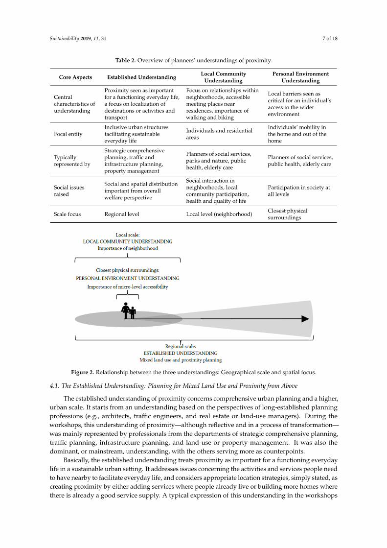
Table 2. Overview of planners’ understandings of proximity.
Core Aspects Established Understanding Local CommunityUnderstanding
Personal EnvironmentUnderstanding
Centralcharacteristics ofunderstanding
Proximity seen as importantfor a functioning everyday life,a focus on localization ofdestinations or activities andtransport
Focus on relationships withinneighborhoods, accessiblemeeting places nearresidences, importance ofwalking and biking
Local barriers seen ascritical for an individual’saccess to the widerenvironment
Focal entityInclusive urban structuresfacilitating sustainableeveryday life
Individuals and residentialareas
Individuals’ mobility inthe home and out of thehome
Typicallyrepresented by
Strategic comprehensiveplanning, traffic andinfrastructure planning,property management
Planners of social services,parks and nature, publichealth, elderly care
Planners of social services,public health, elderly care
Social issuesraised
Social and spatial distributionimportant from overallwelfare perspective
Social interaction inneighborhoods, localcommunity participation,health and quality of life
Participation in society atall levels
Scale focus Regional level Local level (neighborhood) Closest physicalsurroundings
Sustainability 2018, 10, x FOR PEER REVIEW 7 of 18
Table 2. Overview of planners’ understandings of proximity.
Core Aspects Established Understanding Local Community Understanding
Personal Environment Understanding
Central characteristics of understanding
Proximity seen as important for a functioning everyday life, a focus on localization of destinations or activities and transport
Focus on relationships within neighborhoods, accessible meeting places near residences, importance of walking and biking
Local barriers seen as critical for an individual’s access to the wider environment
Focal entity Inclusive urban structures facilitating sustainable everyday life
Individuals and residential areas
Individuals’ mobility in the home and out of the home
Typically represented by
Strategic comprehensive planning, traffic and infrastructure planning, property management
Planners of social services, parks and nature, public health, elderly care
Planners of social services, public health, elderly care
Social issues raised
Social and spatial distribution important from overall welfare perspective
Social interaction in neighborhoods, local community participation, health and quality of life
Participation in society at all levels
Scale focus Regional level Local level (neighborhood) Closest physical surroundings
Figure 2. Relationship between the three understandings: Geographical scale and spatial focus.
4.1. The Established Understanding: Planning for Mixed Land Use and Proximity from Above
The established understanding of proximity concerns comprehensive urban planning and a higher, urban scale. It starts from an understanding based on the perspectives of long-established planning professions (e.g., architects, traffic engineers, and real estate or land-use managers). During the workshops, this understanding of proximity—although reflective and in a process of transformation—was mainly represented by professionals from the departments of strategic comprehensive planning, traffic planning, infrastructure planning, and land-use or property management. It was also the dominant, or mainstream, understanding, with the others serving more as counterpoints.
Basically, the established understanding treats proximity as important for a functioning everyday life in a sustainable urban setting. It addresses issues concerning the activities and services people need to have nearby to facilitate everyday life, and considers appropriate location strategies,
Figure 2. Relationship between the three understandings: Geographical scale and spatial focus.
4.1. The Established Understanding: Planning for Mixed Land Use and Proximity from Above
The established understanding of proximity concerns comprehensive urban planning and a higher,urban scale. It starts from an understanding based on the perspectives of long-established planningprofessions (e.g., architects, traffic engineers, and real estate or land-use managers). During theworkshops, this understanding of proximity—although reflective and in a process of transformation—was mainly represented by professionals from the departments of strategic comprehensive planning,traffic planning, infrastructure planning, and land-use or property management. It was also thedominant, or mainstream, understanding, with the others serving more as counterpoints.
Basically, the established understanding treats proximity as important for a functioning everydaylife in a sustainable urban setting. It addresses issues concerning the activities and services people needto have nearby to facilitate everyday life, and considers appropriate location strategies, simply stated, ascreating proximity by either adding services where people already live or building more homes wherethere is already a good service supply. A typical expression of this understanding in the workshops
Sustainability 2019, 11, 31 8 of 18
highlighted thoughts about the local destinations or activities that various resident groups lack to beable to live efficient daily lives without using a car, and applied a traffic engineer’s perspective:
. . . Similarly, deficiencies in content [may] be an accessibility issue—what is available inthe city or in the projected environment, and what is missing. This might be destinationsof interest, commercial establishments, or meeting places. It could actually be an analysisof the whole picture . . . There is also the matter of links . . . to public transport stops—thatis, analyses of deficiencies in links . . . to points from which you then continue on farther.Wherever you are going. (Land-use planner, Mölndal)
Within the framework of established urban policy and planning, this understanding ofproximity has become central when formulating and implementing goals regarding sustainableaccessibility [26,37,39]. Proximity is to be achieved through densifying the city, mixing activities andland use, and shifting to sustainable transportation modes: Well-functioning walking, cycling, andpublic transport. This reflects a reorientation of discourse found in politically determined visions,goals, policy documents, and planning guidelines, such as the Gothenburg City Traffic Strategy [20].
In this understanding, the social dimension is present in terms of social and spatial distributionsseen from an overall, aggregated welfare perspective on equality: Striving for fairness through creatingproximity to important activities in everyday life is an important goal. This relates to a long-establishedand all-embracing norm of the Swedish welfare state (cf. Reference [26]). Geographic proximity is thenconsidered particularly important for groups that are immobile, lack access to a car, or need proximityfor other reasons. These groups may need greater proximity to specific amenities:
. . . Social sustainability then . . . We want a community in which basic human needs aremet. That means different things for different groups in different areas. This is actually notan equality issue as such . . . It may happen that in some particular area a district healthcarecenter need not be located within 15 minutes’ travel distance, but for a million program [lowincome housing] area such proximity could be extremely important, given that there ismore ill-health there. Health is a basic human need that must be met. It could also be thatneighborhood athletic facilities for sports activities typically engaged in outside the homeshould be much larger in some areas than in others, given that this need is being met in otherways in other areas. (Real estate planner, Uddevalla)
A well-functioning neighborhood should meet and satisfy people’s basic needs in their daily lives,and empower vulnerable groups. Because proximity cannot be created throughout a municipality,remote areas located far from local centers will by definition have poor access to concentrated servicesand activities. Spatial inequality is therefore also linked to the ability of different groups to settle inareas where proximity (through walking and biking) can serve as the main individual accessibilitystrategy. For example, a mismatch occurs when old people living in houses located in less-in-demandperipheral parts of the municipality can no longer cope well there, but cannot afford to buy orrent centrally located apartments in in-demand areas due to high housing prices. This means thatdensification can in fact result in increased proximity for economically strong groups, but more andlonger travel for those who cannot choose to live in these dense areas [28]:
There are people who have lived there for generations—They live in some dilapidated oldhouse and they don’t get much when they sell it. There are no cheap apartments in the cityto move into. They would like to move downtown and be close to public services, but theydon’t have the financial means to make the move. (Planner, Mölndal)
The established understanding also emphasizes that people often have bonds to several“neighborhoods” enabling access such as the areas around their dwelling, their workplace, and ashopping center. Proximity needs can also be met between activities, for example when a preschool andgrocery store are both located on the road between work and home, or when activities are co-located.
Sustainability 2019, 11, 31 9 of 18
This means that the conditions for proximity seen from an individual’s perspective should be assessedfrom the perspectives of several geographical nodes or base locations. Accordingly, this approachtends to focus on more mobile groups, and on accessibility driven by transportation and the movementof people.
Participants representing the established understanding stressed the need for assessment in theirwork (in contrast to the understandings discussed below). The issue of what dimension of proximityis relevant to consider and measure (i.e., spatial, temporal, or perceived proximity) is then central,particularly when modes of transport are discussed. As different transport modes have differentspeeds and distance-bridging capabilities, the chosen dimension becomes critical in actual planning,for instance, when realizing general policy goals of increased proximity and specifying indicatorsand measurements.
In summary, in the established understanding, planners revealed a perception of proximity andof what should be near that treats nearness as contextual (i.e., differing among groups with differentneeds and constraints), multidimensional (i.e., able to be estimated as spatial, temporal, or perceived),and relational (i.e., should be estimated from several geographical nodes or base locations).
4.2. The Local Community Understanding: The Importance of Neighborhoods
What we here call the planners’ local community understanding of proximity emphasizes residents’interactions in their neighborhoods (i.e., aspects central to socially sustainable communities) [43]. Theneighborhood is seen as important for all groups, particularly those who cannot travel far (e.g., olderpeople, children, and the carless) or who for various reasons do not want to do so. This perspectivefocuses on the local scale, and was often highlighted by professionals from other areas than traditionalland-use and traffic planning such as planners of social services, parks and nature, public health, andelderly care. A typical quotation illustrating this understanding stressed accessible meeting placeslocated near residences, considering them crucial for health and quality of life:
. . . If you are single and on a low income, or you are a senior or a child, you are often limitedto a fairly . . . well, you can’t go very far, so your neighborhood is particularly important.There should be green spaces there, places to sit down and rest, and places to meet up withothers. I have a fantastic example: I interviewed some ladies who very much appreciated theflowerbeds. They’d go out into the courtyard and meet up at this flowerbed and watch thechanging of the seasons. Their little get-togethers had beneficial effects—They got exercisethat helped them maintain their balance and kept them active, and they had a routine andenjoyed social interaction. There were so many values linked to this flowerbed. So we said,‘Don’t take it away. Keep it!’. And that was also a form of access to meeting places and socialcontact. So the neighborhood is important, I think. (Public health planner, Mölndal)
The planners also emphasized that social context extends beyond a specific physical location andcurrent situation, encompassing, for instance, the opportunity to participate in society, develop localties, and be able to recognize neighbors. The time perspective then becomes important, because socialrelationships and trust often take time to build and maintain:
. . . Feeling that you’re part of what’s happening around you doesn’t have to meanparticipating in civic discussions. There is value in knowing what the neighbors are doing,interacting with them when you take out the trash. Just being able to go out and exchange afew words with the neighbors at all may be valuable for someone who rarely gets out. It canhelp you feel like you’re part of a community. So this applies from the small things in life tothe big ones . . . (Planner, Gothenburg)
The social context is perceived to be strengthened when many people move about in public spaceand frequently see and meet each other spontaneously. A traffic planner saw this as a positive sideeffect of reducing car-based trips, and as integral to a planning strategy:
Sustainability 2019, 11, 31 10 of 18
. . . It’s a form of social sustainability: If you have a community in which many peoplecan get to places without a car, within a certain radius, somehow that will mean that manypeople are out and moving around. Without a car, but cycling and walking. [One sees] faces. . . and that in itself can create a form of social sustainability. (Transport planner, Mölndal)
Although walkability and walkable neighborhoods were not always explicitly mentioned inthese discussions, the local community understanding clearly invoked New Urbanism ideals [58] andtheories of social capital [45] when relating the use of local areas to the development of social ties andtrust. The important role of nearby-located activities that residents could walk to and where they couldmeet, making proximity to everyday activities a basis for developing and strengthening the socialcontext, was also implicit (cf. References [43,58]).
From a planning perspective, traditional land-use planners are recognized as lacking sufficientknowledge of residents’ social ties, specific wants, and needs. A planner from Uddevalla describedthis when emphasizing the lack of knowledge in central administration of residents’ perceptions ofan area:
We [planners] may not be representative of, say, the people living in these million program[low income housing] areas such as in the northern suburbs of Uddevalla. And I know andbelieve that while not everyone wants to live there, many people do. They don’t want to livein a fancy new riverside neighborhood just because we planners want them to and thinkeveryone wants to. They like it where they live. They feel safe there and they really like theirneighborhood. And it’s a huge waste of resources to believe that everyone wants to moveout of an area where a lot of people live. If we were to build a new apartment building upthere and have it completed by tomorrow, it would be full because a lot of people do want tolive up there. I feel the same way you [i.e., fellow workshop participant] do, that actually weneed to improve an area like this. Invest in features that improve the place where they live,the place where many people actually want to live. (Real estate planner, Uddevalla)
Consequently, this understanding shifts attention in the planning process from the centralmunicipal administration to local administration, underlining the importance of decentralizedplanning that stresses interaction with citizens. Planners from Gothenburg cited the work oflocal district administrations (Stadsdelsförvaltningar in Gothenburg) as an example, particularlyconcerning communication and dialogue with citizens when specifying central policy goals about“well-functioning neighborhoods”. The Gothenburg planners believed that officials at these localdistrict administrations often have a deeper, more nuanced understanding of citizens’ needs and wishesthan is found in the central administration. A decentralized management structure was regardedas enabling ongoing dialogue with residents, qualitatively different from centrally initiated citizendialogue concerning specific projects (e.g., major infrastructure investments).
But in that sense the municipal district administration is a good resource, because they oftenhave in-depth knowledge and are in touch with local organizations and civically engagedresidents. The district administration can help you get an idea of what people in a particularneighborhood want. (Planner, Gothenburg)
Comparing the local community and established understandings, the established understanding ismore directed toward the involvement of actors inside and outside the municipal organization, such asproperty owners, developers, and builders. In contrast, the local community understanding primarilyconcerns citizens’ views and needs, and potential conflicts between different groups of residents.
4.3. The Personal Environment Understanding: The Microlevel Makes a Difference
The personal environment understanding of proximity concerns the individual’s immediatephysical surroundings at a very detailed scale. The understanding typically refers to less physicallymobile people such as small children or the disabled elderly. Barriers in the proximate environment,such as going down stairs or boarding buses, are seen as crucial for individuals’ access to the wider
Sustainability 2019, 11, 31 11 of 18
environment and to quality of life. This understanding stresses aspects of the environment giving riseto physical and psychological barriers that preclude vulnerable groups from using the transport systemand, ultimately, participating in society [32]. It refers to microlevel accessibility, also related to thepotential for access locally and regionally [59]. This understanding is central to planners active in socialservices, elderly care, and health services. Typical articulations based on the personal environmentunderstanding highlighted, for example, the physical barriers elderly people face when walking onthe street:
In the winter it should be possible to use this walkway. Sometimes you have to be able to getover the piles of snow left by the snow plow. That’s what my 80-year-olds say. That theydon’t get out after the snow plow has left its piles [of ice and snow]. Sometimes they can’tcross the street or even get out of their buildings. Snow clearance creates accessibility forcars, but not for pedestrians. (Senior citizen planner, Mölndal)
However, the personal environment perspective does not necessarily target vulnerable groups,and traffic planners agreed that “entirely mobile” groups were often emphasized when identifyingbarriers in the immediate vicinity. Such barriers, though small, are important because they affect localand regional accessibility. Typical planning strategies related to the personal environment concentrateon the lowest level of scale in community planning, such as the supply of facilities near housing ormissing links in a bike lane network, which can be crucial for a functioning everyday life:
. . . We’re in the process of implementing a system of on-site waste collection—that is,for single-family dwellings—with recycling containers placed right on your lot. Which is,I think, a great example of accessibility in line with our environmental and climate goals.(Sustainable mobility planner, Mölndal)
I think that [bike lanes] should be a standard part of any street. There shouldn’t be missinglinks. The route should start right from the building. (Planner, Mölndal)
Of the three understandings of proximity identified and discussed here, the personal environmentunderstanding was the least dominant during the workshops.
5. Planners Negotiating Proximity: Developing an Integrative Tool
The study’s second research question concerned how a joint understanding of proximity couldbe supported and molded by various professional perspectives, conceptions, and interests. Duringthe workshops, we tested a tool that could be used as a basis for integrative dialogue. The workshopdiscussions of the tool are described here and then analyzed in relation to the three understandings inthe concluding discussion.
5.1. Proximity to What: Planners’ Appraisals of Citizens’ Needs
The first workshop included an exercise addressing planners’ professional opinions on whatactivities and amenities citizens need to have near their homes. The basis for discussion was a simplemap showing a home at the center of two circles, indicating time distances of 10 and 30 min.
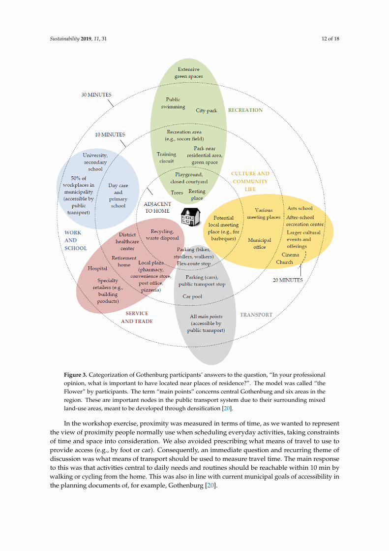
As an outcome example, the assessments conducted by participants from Gothenburg aresummarized in Figure 3. The chart, a flower-like illustrative model, shows what was consideredimportant to have immediately adjacent to the home, within 10 min and within 10–30 min. Variousactivities are clustered in the activity spheres of daily life, like petals on a flower (this clustering wasdone by the researchers after the workshop). In the Gothenburg example, participants consideredthat, for instance, bicycle or stroller parking, recycling facilities, trees, and potential activity space(e.g., for barbeques) should be located adjacent to homes. A car parking lot, public transport stop,healthcare center, convenience store, post office, daycare center and school, recreation area (e.g., soccerfield), and municipal office should be located within 10 min distance from home. Amenities such as ahospital, university, city park, and cinema could acceptably be located farther away, within 10–30 min.
Sustainability 2019, 11, 31 12 of 18
Sustainability 2018, 10, x FOR PEER REVIEW 12 of 18
(e.g., for barbeques) should be located adjacent to homes. A car parking lot, public transport stop, healthcare center, convenience store, post office, daycare center and school, recreation area (e.g., soccer field), and municipal office should be located within 10 min distance from home. Amenities such as a hospital, university, city park, and cinema could acceptably be located farther away, within 10–30 min.
Figure 3. Categorization of Gothenburg participants’ answers to the question, “In your professional opinion, what is important to have located near places of residence?”. The model was called “the Flower” by participants. The term “main points” concerns central Gothenburg and six areas in the region. These are important nodes in the public transport system due to their surrounding mixed land-use areas, meant to be developed through densification [20].
In the workshop exercise, proximity was measured in terms of time, as we wanted to represent the view of proximity people normally use when scheduling everyday activities, taking constraints of time and space into consideration. We also avoided prescribing what means of travel to use to provide access (e.g., by foot or car). Consequently, an immediate question and recurring theme of discussion was what means of transport should be used to measure travel time. The main response
Figure 3. Categorization of Gothenburg participants’ answers to the question, “In your professionalopinion, what is important to have located near places of residence?”. The model was called “theFlower” by participants. The term “main points” concerns central Gothenburg and six areas in theregion. These are important nodes in the public transport system due to their surrounding mixedland-use areas, meant to be developed through densification [20].
In the workshop exercise, proximity was measured in terms of time, as we wanted to representthe view of proximity people normally use when scheduling everyday activities, taking constraintsof time and space into consideration. We also avoided prescribing what means of travel to use toprovide access (e.g., by foot or car). Consequently, an immediate question and recurring theme ofdiscussion was what means of transport should be used to measure travel time. The main responseto this was that activities central to daily needs and routines should be reachable within 10 min bywalking or cycling from the home. This was also in line with current municipal goals of accessibility inthe planning documents of, for example, Gothenburg [20].
Sustainability 2019, 11, 31 13 of 18
5.2. The Proximity Exercise and the Flower as a Planning Tool
The discussion following the proximity exercise and the formulation of the illustrative model—called “the Flower” by participants—showed that the model could serve as a basis for wider dialoguebetween actors. According to participants, one strength of the exercise was that it linked valuestraditionally associated with separate municipal planning domains. The exercise also addressedthe everyday context and lives of the city’s inhabitants. It problematized the understanding ofproximity and accessibility in terms of geographical distance or time, and whether it was perceivedobjectively or subjectively. This was done in a relatively simple and inclusive way that could facilitatedialogue between various actors, for example between planners and citizens, politicians, businessrepresentatives, and NGOs.
The planners in Mölndal, for example, described the exercise as a good tool for use in citizendialogues, not least because of its simplicity and use of shared language. These planners also discussedwhether it could be used in dialogue between different municipal administrations:
I think this type of model would be of great benefit to us, as it would give us a language fortalking about the value of the neighborhood and focusing on the local community. We don’tspeak in those terms, but rather in terms of premises planning and efficient premises . . .From that point of view, we prioritize the efficient use of premises. But if that has effects,such as weakening social cohesion, requiring children to walk longer distances, breakingup other social structures, or making things worse for seniors, we don’t currently bring thatdimension into our planning process. We don’t have any opportunity for that discussionto take place—We don’t accommodate it. I don’t feel we have a structure to enable us totalk that way, but rather that our discussions focus on each individual process separately.(Land-use planner, Mölndal)
Participants also believed that the model could provide a basis for discussing the potentialconsequences of various planning alternatives and measures for the municipality’s supply of activitiesand services. For example, the lack of important services (e.g., elderly care or schools) in a given areacould entail greater municipal travel costs for social transport services or school shuttles. Responsibilityfor managing such side effects often lies in other sectors of the municipal administration than thecity-building office, where many localization decisions are made. “The Flower” model, and the processof specifying accessibility to what and for whom, could serve as a platform for ongoing discussionsof consequences and alternative costs. However, it was evident that if the model and process is to beused for such a purpose, more concrete planning cases should be used. Participating planners alsosuggested that “the Flower” model process could be used as a checklist and provide support whendeveloping detailed development plans.
6. Conclusions
In this article we examined urban planners’ experiences and understandings of proximity-orientedpolicies to foster urban sustainability. We investigated the views of professionals representing a broadspectrum of municipal administrations and sectors, ranging from transport and comprehensiveland use, to healthcare, green areas and parks, schools and daycare, retail, services, and leisureactivities. We intended to uncover potentials and tensions emerging when the concept is put intopractice. Furthermore, we explored a tentative tool, activating reflection and conversation betweenthe planners, for establishing common ground when proximity goals are to be used in concreteplanning and implementation. By elucidating different understandings of proximity, and howproximity can be implemented as a planning goal, our study contributes to a more integrativeproximity-oriented planning, as well as to the limited literature on planners’ understandings ofproximity in the context of the transition from mobility-enhancing to accessibility-oriented strategiesfor sustainable urban planning.
Sustainability 2019, 11, 31 14 of 18
Overall, the planners viewed proximity to daily activities as central to individuals’ well-beingand to increasing urban sustainability. A basic distinction was recurrently made between temporalproximity (enabled by fast transport) and geographical proximity (enabled by near location andmixed land use). Temporal proximity (or nearness in time), traditionally associated with planningfor cars, is considered important so that everyday life can function smoothly and effortlessly.Enabling geographical proximity (or nearness in space), on the other hand, is perceived as crucialto achieving sustainable urban life and mobility, for example by supporting measures promotingurban densification, mixed land use, and walking and cycling. It is also traditionally regarded as animportant accessibility strategy for vulnerable groups, mainly people having difficulties travelinglonger distances, predominantly small children, elderly, and disabled people. Proximity is thus seen asa constituent of both ecologically and socially sustainable city planning.
The results also revealed divergent understandings of proximity, highlighting the contestednature of proximity as a planning goal. Divergent opinions concerned objects and subjects, scale levels,planning problems, and potential measures and solutions. Proximity was negotiated according to threebasic understandings: First, the established understanding of transportation and land-use integration,relying on planners’ expert views of how to influence the overall regional spatial distributionof amenities and population, and the interactions between places; second, the local communityunderstanding, emphasizing the social context of neighborhoods and the relationships within places;and third, the personal environment understanding, centering on individuals’ interactions withimmediate physical space at a very detailed level.
The three understandings both contrast with and overlap one another, linking the regionalto the local and personal levels of urban space. These understandings are also associated withsomewhat divergent conceptions of what is being planned for and what planning entities are involved.The established understanding of proximity clearly relates to locational issues and objects, for examplewhere to locate services, residential areas, and transportation infrastructures. It emphasizes patterns oftransferability and potential between local areas. The local community understanding focuses distinctlyon the role of internal relationships and attachments between people and their places of residence, therole of local community participation, and how to create attractive, safe, and healthy neighborhoods.It emphasizes the importance of socially sustainable communities [43]. The personal environmentunderstanding relates to barriers and hindered access encountered not only by people with reducedmobility function and disability in particular, but also by fully functional groups (cf. References [41,59]).The observed views are also largely associated with differences in professional attitude and planningexperience between regional land-use and transportation planning traditionally rooted in expert(i.e., engineering) modeling and planning “from above”, and local and personal space-oriented viewsrelying more on social participatory planning ideals and practices. Our analysis shows that proximitygoals can be contextualized in different ways, relating to different problems. In the context of urbanand regional planning, this is of fundamental concern, as how problems are framed and understoodaffect how they are solved [53,54].
Although distinct differences are found between the three understandings, there is clearinterconnectedness and complementarity between them. Arguably, the dominant establishedunderstanding is enriched by the local community and personal environment understandings. Therealso is interdependence between the established and community understandings when it comes toimplementation, such a relationship being central to current ideals and theories such as New Urbanism(cf. Reference [58]) and Social Capital (cf. References [3,4,45]): The regular use of activities in an areaallows the development of relationships with local inhabitants and specific places [48], establishinga basis for a sense of local community. The reverse also holds, and residents experiencing a place aspositive are more likely to use everyday activities located there, instead of traveling farther away [47].When shifting to a planning paradigm of proximity, planners should therefore concentrate on bothoffering various needed activities at the local level and improving opportunities for social interactionbetween community residents, thereby creating healthy and safe environments and a sense of place
Sustainability 2019, 11, 31 15 of 18
(cf. Reference [58]). This means that proximity planning policy should more fully take into account theexperience of social planners, understanding the needs of residents at a different level from that of themore engineering-oriented land-use and transportation planners.
This study highlighted how emerging proximity-oriented planning can go beyond the dominantunderstanding of land-use and transport planners, by integrating complementary contextualizations,thereby developing proximity policy and goals through a process of drift [50,52]. To aid such integration,we tentatively developed and tested a collaborative planning exercise. The resulting tool, referred toas “the Flower” model by the participating planners, concerned the importance of nearness and thespecific activities citizens need to have nearby in daily life. Because of its simplicity, and the fact that itlinks values and norms traditionally related to different municipal planning domains, the participantsthought that it had good potential to improve communication between stakeholders. However,the model mainly relates to the established understanding, as well as to the personal environmentunderstanding, due to its land-use and location focus. To fully integrate the different understandingsof proximity presented here, the tool must be improved to better incorporate central aspects of the localcommunity understanding. Within the frame of the exercise, this could be addressed by discussingwith residents what makes them thrive in their neighborhood, as well as the specific qualities ofactivities to be located in their neighborhood (cf. Reference [26]). It is also about planning dedicatedpublic spaces to be freely used by residents, as well as understanding what type of informal publicspaces residents want to use, develop, and control.
A case study based on three focus-group workshops with 35 planners, such as this, has somelimits to generalizability. The results are context-bound and affected by specific conditions. The studywas conducted in a relatively urbanized Swedish region, and the results may underestimate rural andsemi-urban contexts and understandings of proximity. Notably, the study was embedded in the contextof a northern European welfare state, which has implications for the organization of municipalities andpolicy implementation. Further, we gathered planners from many areas of expertise, allowing us tofind different ways of contextualizing and relating to proximity. However, more variations might havebeen found if discussions were held with other combinations of planners. Furthermore, the discussionswere framed as addressing problems of sustainable accessibility, which may well have affected howthe concept of proximity was discussed. These limitations all suggest directions for future studies,which should examine proximity in other contexts and with other groups of professionals, to identifyadditional experiences, understandings, and implementations.
Author Contributions: Conceptualization, A.G.S. and B.V.; data collection, A.G.S. and B.V.; primary analysis,A.G.S.; writing—original draft preparation, A.G.S. and B.V.; writing—review and editing, A.G.S.; fundingacquisition, B.V. and A.G.S.
Funding: This research was funded by the Swedish Research Council Formas (project number 259-2013-103) andthe Sustainable Transport Initiative of the University of Gothenburg and Chalmers University of Technology.
Acknowledgments: The authors express their gratitude to Thomas Straatemeier at Goudappel Coffeng(The Netherlands) for introducing them to the model used as a basis for discussions with planners and later ondeveloped into the Flower model. We thank Anders Larsson at the University of Gothenburg for his cooperationregarding funding acquisition and data collection. We would also like to thank the participating municipalitiesand planners for taking the time to share their valuable knowledge and experiences, as well as the MobilityResearch Group at the University of Gothenburg for their constructive comments on an early draft of this paper.
Conflicts of Interest: The authors declare no conflicts of interest.
References
1. Banister, D.; Anable, J. Transport policies and climate change. In Planning for Climate Change: Strategies forMitigation and Adaptation for Spatial Planners; Davoudi, S., Crawford, J., Eds.; Earthscan: London, UK, 2009;pp. 55–69.
2. Davoudi, S.; Hall, S.P.; Power, A. Key issues for planning futures and the way forward. Twenty-FirstCentury Soc. 2008, 3, 229–247. [CrossRef]
Sustainability 2019, 11, 31 16 of 18
3. David, Q.; Janiak, A.; Wasmer, E. Local social capital and geographical mobility. J. Urban Econ. 2010, 68,191–204. [CrossRef]
4. Kintrea, K. Social mix: International policy approaches. In Neighbourhood Effects or Neighbourhood BasedProblems?: A Policy Context; Manley, D., Van Ham, M., Bailey, N., Simpson, L., Maclennan, D., Eds.; Springer:Dordrecht, The Netherlands, 2013; pp. 133–155.
5. Boschma, R. Proximity and innovation: A critical assessment. Reg. Stud. 2005, 39, 61–74. [CrossRef]6. Hansen, T. Substitution or overlap? The relationship between geographical and non-spatial proximity
dimensions in collaborative innovation projects. Reg. Stud. 2015, 49, 1672–1684. [CrossRef]7. Cervero, R. Balanced Transport and Sustainable Urbanism: Enhancing Mobility and Accessibility Through
Institutional, Demand Management, and Land-Use Initiatives. Urban Plan. Overseas 2005, 20, 15–27.8. Handy, S. Accessibility- vs. Mobility-Enhancing Strategies for Addressing Automobile Dependence in
the U.S. Prepared for the European Conference of Ministers of Transport. 2002. Available online: http://www.escholarship.org/uc/item/5kn4s4pb.pdf;origin=repeccitec (accessed on 31 October 2018).
9. Banister, D. The sustainable mobility paradigm. Transp. Policy 2008, 15, 73–80. [CrossRef]10. Curtis, C. Planning for sustainable accessibility: The implementation challenge. Transp. Policy 2008, 15,
104–112. [CrossRef]11. UN Habitat. Planning and Design for Sustainable Urban Mobility; Global Report on Human Settlements;
Routledge: New York, NY, USA, 2013.12. Bertolini, L.; le Clercq, F.; Kapoen, L. Sustainable accessibility: A conceptual framework to integrate transport
and land use plan-making. Two test-applications in the Netherlands and a reflection on the way forward.Transp. Policy 2005, 12, 207–220. [CrossRef]
13. Johansson, H.; Sandvik, K.O.; Zsidákovits, J.; Lutcyk, G. A need for new methods in the paradigm shift frommobility to sustainable accessibility. Transp. Res. Procedia 2016, 14, 412–421. [CrossRef]
14. Van Wee, B. Accessible accessibility research challenges. J. Transp. Geogr. 2016, 51, 9–16. [CrossRef]15. Qviström, M. Putting accessibility in place: A relational reading of accessibility in policies for transit-oriented
development. Geoforum 2015, 58, 166–173. [CrossRef]16. Levinson, D.; Gillen, D. The machine for access. In Access to Destinations; Levinson, D., Krizek, K., Eds.;
Elsevier: Oxford, UK, 2005.17. Halden, D. The use and abuse of accessibility measures in UK passenger transport planning. Res. Transp.
Bus. Manag. 2011, 2, 12–19. [CrossRef]18. Proffitt, D.; Bartholomew, K.; Ewing, R.; Miller, H. Accessibility planning in American metropolitan areas:
Are we there yet? In Proceedings of the Transportation Research Board 94th Annual Meeting, Washington,DC, USA, 11–15 January 2015.
19. Stockholmregionen. En Närmare Stad; Tillväxt- och Regionplaneförvaltningen: Stockholm, Sweden, 2015.20. City of Gothenburg. Gothenburg 2035: Transport Strategy for a Close-Knit City; City of Gothenburg: Gothenburg,
Sweden, 2014.21. Malmö City. Sustainable Urban Mobility Plan: Creating a More Accessible Malmö; Malmö City: Malmö, Sweden,
2016.22. Katrineholms Kommun. Översiktsplan 2030. Del Staden; Katrineholms Kommun: Katrineholm, Sweden, 2015.23. Uppsala Kommun. Översiktsplan 2016 för Uppsala Kommun; Uppsala Kommun: Uppsala, Sweden, 2016.24. Peck, J. Geographies of policy: From transfer diffusion to mobility-mutation. Prog. Hum. Geogr. 2011, 35,
773–797. [CrossRef]25. EU Commision. Planning for People. Guidelines. Developing and Implementing a Sustainable Urban Mobility Plan;
European Commission, Directorate-General for Mobility and Transport: Brussels, Belgium, 2013.26. Gil Solá, A.; Vilhelmson, B.; Larsson, A. Understanding sustainable accessibility in urban planning: Themes
of consensus, themes of tension. J. Transp. Geogr. 2018, 70, 1–10. [CrossRef]27. De Jong, M.; Joss, S.; Schraven, D.; Zhan, C.; Weijnen, M. Sustainable-smart-resilient-low carbon-eco-
knowledge cities: Making sense of a multitude of concepts promoting sustainable urbanization. J. Clean. Prod.2015, 109, 25–38. [CrossRef]
28. Elldér, E.; Larsson, A.; Gil Solá, A.; Vilhelmson, B. Proximity changes to what and for whom? Investigatingsustainable accessibility change in the Gothenburg city region 1990–2014. Int. J. Sustain. Transp. 2018, 12,271–285. [CrossRef]
Sustainability 2019, 11, 31 17 of 18
29. Hysing, E. Greening transport: Explaining urban transport policy change. J. Environ. Policy Plan. 2009, 11,243–261. [CrossRef]
30. Curl, A.; Nelson, J.D.; Anable, J. Does Accessibility Planning address what matters? A review of currentpractice and practitioner perspectives. Res. Transp. Bus. Manag. 2011, 2, 3–11. [CrossRef]
31. Straatemeier, T.; Bertolini, L. Joint Accessibility Design. Framework Developed with Practitioners to IntegrateLand Use and Transport Planning in the Netherlands. Transp. Res. Rec. 2008, 2077, 1–8. [CrossRef]
32. Church, A.; Frost, M.; Sullivan, K. Transport and social exclusion in London. Transp. Policy 2000, 7, 195–205.[CrossRef]
33. Haugen, K. The Accessibility Paradox: Everyday Geographies of Proximity, Distance and Mobility.Ph.D. Thesis, Umeå Universiy, Umeå, Sweden, 2012.
34. Haugen, K. The advantage of “near”: Which accessibilities matter to whom? EIJTIR 2011, 11, 368–388.35. Haugen, K.; Holm, E.; Strömgren, M.; Vilhelmson, B.; Westin, K. Proximity, accessibility, and choice: A matter
of taste or condition? Pap. Reg. Sci. 2012, 91, 65–84. [CrossRef]36. Cervero, R. Paradigm Shift: From Automobility to Accessibility Planning. Urban Futures 1997, 22, 9–20.37. Boisjoly, G.; El-Geneidy, A.M. The insider: A planners’ perspective on accessibility. J. Transp. Geogr. 2017, 64,
33–43. [CrossRef]38. Cheng, J.Q.; Bertolini, L.; le Clercq, F. Measuring Sustainable Accessibility. Transp. Res. Rec. 2007, 2017, 16–25.
[CrossRef]39. Curtis, C.; Scheurer, J. Planning for Sustainable Accessibility: Developing tools to aid discussion and
decision-making. Prog. Plan. 2010, 74, 53–106. [CrossRef]40. Envall, P. Accessibility Planning: A Chimera? Ph.D. Thesis, University of Leeds, Leeds, UK, 2007.41. Wennberg, H.; Ståhl, A.; Hydén, C. Implementing accessibility in municipal planning—Planners’ view.
J. Transp. Land Use 2009, 2, 3–21.42. Hallgrimsdottir, B.; Wennberg, H.; Svensson, H.; Ståhl, A. Implementation of accessibility policy in municipal
transport planning: Progression and regression in Sweden between 2004 and 2014. Transp. Policy 2016, 49,196–205. [CrossRef]
43. Dempsey, N.; Bramley, G.; Power, S.; Brown, C. The Social Dimension of Sustainable Development: DefiningUrban Social Sustainability. Sustain. Dev. 2011, 19, 289–300. [CrossRef]
44. Luederitz, C.; Lang, D.J.; Von Wehrden, H. A systematic review of guiding principles for sustainable urbanneighborhood development. Landsc. Urban Plan. 2013, 118, 40–52. [CrossRef]
45. Leyden, K.M. Social Capital and the Built Environment: The Importance of Walkable Neighborhoods. Am. J.Public Health 2003, 93, 1546–1551. [CrossRef] [PubMed]
46. Mazumdar, S.; Learnihan, V.; Cochrane, T.; Davey, R. The built environment and social capital: A systematicreview. Environ. Behav. 2018, 50, 119–158. [CrossRef]
47. Waldo, Å. Staden och Resandet. Mötet Mellan Planering och Vardagsliv; Department of Sociology, LundUniversity: Lund, Sweden, 2003.
48. Cedering, M. Konsekvenser av Skolnedläggningar. En Studie av Barns och Barnfamiljers Vardagsliv iSamband med Skolnedläggningar i Ydre Kommun. Ph.D. Thesis, Kulturgeografiska institutionen, Uppsalauniversitet, Uppsala, Sweden, 2016.
49. Lee, J.; Abbott, R. Physical activity and rural young people’s sense of place. Child. Geogr. 2009, 7, 191–208.[CrossRef]
50. Streek, W.; Thelen, K. Introduction: Institutional Change in Advanced Political Economies. In BeyondContinuity. Institutional Change in Institutional Change in Advanced Political Economies; Streek, W., Thelen, K., Eds.;Oxford University Press: Oxford, UK, 2005.
51. Bartholdsson, K. Målkonflikter—en Sund Företeelse Eller ett Olösligt Problem; Naturvårdsverket: Stockholm,Sweden, 2011.
52. Rayner, J.; Howlett, M. Introduction: Understanding integrated policy strategies and their evolution.Policy Soc. 2009, 28, 99–109. [CrossRef]
53. Bacchi, C. Why Study Problematizations? Making Politics Visible. Open J. Polit. Sci. 2012, 2, 1–8. [CrossRef]54. Tennøy, A. Why we fail to reduce urban road traffic volumes: Does it matter how planners frame the
problem? Transp. Policy 2010, 17, 216–223. [CrossRef]55. Westberg, L.; Polk, M. The role of learning in transdisciplinarity: Moving from a normative concept to an
analytical tool through a practice-based approach. Sustain. Sci. 2016, 11, 385–397. [CrossRef]
Sustainability 2019, 11, 31 18 of 18
56. Statistics Sweden. Folkmängd i Riket, län och Kommuner 31 Mars 2018 och Befolkningsförändringar1 Januari–31 Mars 2018. Available online: https://www.scb.se/hitta-statistik/statistik-efter-amne/befolkning/befolkningens-sammansattning/befolkningsstatistik/pong/tabell-och-diagram/kvartals--och-halvarsstatistik--kommun-lan-och-riket/kvartal-1-2018 (accessed on 22 October 2018).
57. Polk, M. Achieving the promise of transdisciplinarity: A critical exploration of the relationship between TDresearch and societal problem solving. Sustain. Sci. 2014, 9, 439–451. [CrossRef]
58. Lund, H. Testing the claims of New Urbanism. Local Access, Pedestrian Travel, and Neighboring Behaviors.J. Am. Plan. Assoc. 2003, 69, 414–429. [CrossRef]
59. Jones, P.; Lucas, C. The social consequences of transport decision-making: Clarifying concepts, synthesisingknowledge and assessing implications. J. Transp. Geogr. 2012, 21, 4–16. [CrossRef]
© 2018 by the authors. Licensee MDPI, Basel, Switzerland. This article is an open accessarticle distributed under the terms and conditions of the Creative Commons Attribution(CC BY) license (http://creativecommons.org/licenses/by/4.0/).