Embed Size (px)
Citation preview

Non‐Utilitarian Use of Proportions in Harappan Town‐Planning
Michel Danino1 1. Indian Institute of Technology, Gandhinagar, VGEC Campus, Ahmedabad, Gujarat‐
382424 (Email: [email protected])
Received: 23 August 2014; Accepted: 12 September 2014; Revised: 09 October 2014 Heritage: Journal of Multidisciplinary Studies in Archaeology 2 (2014): 41‐53
Abstract: A hitherto neglected component of Harappan town‐planning is the systematic use of specific proportions in the dimensions of major structures as well as fortified enclosures. While a few dimensions have been occasionally noted—especially at Dholavira—many have escaped notice. More importantly, the implications of this non‐utilitarian feature in terms of cognitive archaeology have not been explored. This paper summarizes the evidence and attempts to excavate the Harappan mind so as to make sense of this use of proportions and give it its place in the evolution of Indian architecture.
Keywords: Indus, Harappan, Mohenjo‐daro, Dholavira, Town‐planning, Proportions, Ratios
Introduction Archaeologists of the Harappan world noted long ago that some of the major city structures or zones seemed to follow some set proportions. It is well‐known, for instance, that Mohenjo‐daro’s acropolis is twice as long as it is wide (400 x 200 m; Jansen 1988: 134), and so is Kalibangan’s (240 x 120 m; Lal 1997: 122) or the whole of Surkotada in Gujarat (130 x 65 m; Lal 1997: 135). Nevertheless, with one exception to which I will return presently, studies of Harappan town‐planning have failed to note the systematic and non‐utilitarian use of simple proportions applied to almost every major structure or walled enclosure in Harappan cities. None of the prominent experts on the Indus civilization (e.g. Kenoyer 1998; Possehl 2002) has paid attention to this feature; B.B. Lal (Lal 1997) does mention a few simple proportions of fortified enclosures at Mohenjo‐daro, Kalibangan, etc., but stops there. In a fine and wide‐ranging study of south Asian cities across time, Monica Smith (2006) takes no notice of this feature. Nor does Piotr A. Eltsov (2008, 2010), who has carried out a most original and penetrating comparative study of Harappan and Gangetic cities.
Indeed I have borrowed from Eltsov the term “non‐utilitarian”, which he applies to Harappan and Gangetic urban fortifications: “I mean [by that term] that their overall significance was ideational and symbolic, rather than military, ecological, or technical.

ISSN 2347 – 5463 Heritage: Journal of Multidisciplinary Studies in Archaeology 2: 2014
42
... Fortification systems of the Harappan and Ganges civilizations were indeed the most evident expressions of authority ...” (Eltsov 2010: 109, 143). It turns out, however, that Harappan fortifications, the focus of the present study, had an even more non‐utilitarian character than Eltsov suspected.
I will first summarize and supplement the evidence from Mature Harappan sites collected in earlier papers (Danino 2005, 2008, 2010a, 2010b) and then attempt to excavate the Harappan mind so as to make sense of their almost obsessive use of specific proportions.
Mohenjo‐daro If proportions play a significant role in Harappan town‐planning and architecture, we should expect many of them to come to light at Mohenjo‐daro, still the crown of Indus cities. It turns out that it is precisely the case (I present ratios in order of increasing value; dimensions in feet have all been converted to metres):
• 7 : 6 (1.17). A large building called “assembly hall” or “pillared hall,” located on the southern part of the acropolis, measures “approximately 23 by 27 metres” (Possehl 2002: 194), which corresponds to a proportion of 7 : 6 (within 0.6%, although the margin could be more since dimensions are approximate).
• 5 : 4 (1.25). A major building of the lower town’s HR area (Fig. 1), variously described as a large mansion, a palace or a temple, measures 18.90 x 15.24 m (Marshall 1931: 202), thus according to a proportion of 1.25 or 5 : 4 (within 0.8%). Interestingly, the “assembly hall” has four rows of five pillars each (Marshall 1931: 23).
• 3 : 2 (1.50). The massive platform of the “Granary” measures 50 x 33 m (Jansen 1979: 420), thus with a ratio of 3 : 2 (within 1%).
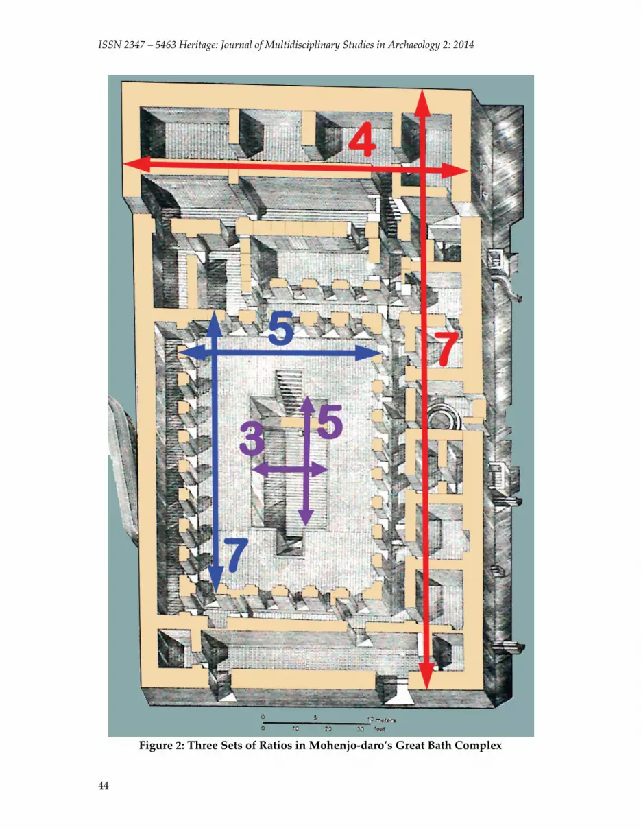
• 5 : 3 (1.67). The Great Bath measures (Marshall 1931: 131) 11.98 x 7.05 m (averaging opposite sides), which yields a ratio of 1.7. However, if we consider the sides’ maximum dimensions, we get 11.99 x 7.12 m, with a ratio of 1.683, which is almost the same as 5 : 3 (within 1%).
• 7 : 4 (1.75). The overall Great Bath complex, as measured on the above‐mentioned isometric plan (Fig. 2) has average dimensions of 56.0 x 32.1 m, which corresponds to a ratio of 7 : 4 (within 0.3%). Thus we find that not only the Bath but the two enclosures around it obey precise predefined ratios.
• 9 : 4 (2.25). A long building located just north of the Great Bath, called “Block 6” measures approximately 56.4 x 25 m (Mackay 1938: 17), following a ratio of 9 : 4 (within 0.3%).
• 3 : 1. The huge so‐called “College” located east of the Great Bath has average dimensions of 70.32 x 23.93 m (Mackay 1938: 10); they correspond to 3 : 1 within 2%.

Danino 2014: 41‐53
43
Figure 1: Proportions of a Major Building in Mohenjo‐daro’s HR Area
As we can now see, every major structure on Mohenjo‐daro’s acropolis obeys a precise proportion according to a simple ratio within a generally very small margin of error. Besides, it is remarkable that the town‐planners consciously decided to implement a wide variety of ratios — no fewer than seven different ones on the acropolis alone. This cannot be a random situation. The case of the Great Bath complex, with three clear ratios at every step from outer to inner, is particularly striking. Fig. 3 illustrates the major findings at Mohenjo‐daro’s acropolis.
ISSN 2347 – 5463 Heritage: Journal of Multidisciplinary Studies in Archaeology 2: 2014
44
Figure 2: Three Sets of Ratios in Mohenjo‐daro’s Great Bath Complex

Danino 2014: 41‐53
45
Figure 3: Proportions of Major Structures on Mohenjo‐daro’s Acropolis

ISSN 2347 – 5463 Heritage: Journal of Multidisciplinary Studies in Archaeology 2: 2014
46
Harappa Owing to massive brick robbing, Harappa has fewer complete structures. Let us mention the following:
• 5 : 4 (1.25). The so‐called “Granary,” probably the largest structure among all Harappan cities (Fig. 4), measures 51.2 x 40.8 m (Mackay 1948: 45), which corresponds to 5 : 4 (with a precision of 0.4%).
Figure 4: Proportions of Harappa’s “Granary”
• 7 : 3 (2.33). Besides, near mound AB, “14 symmetrically arranged small houses” were found, each measuring 17.06 x 7.31 m (Chakrabarti 2006: 156), in a perfect ratio of 7 : 3.
• 5 : 2 (2.50). The “Granary” is composed of 12 individual rooms or “halls”, each measuring 15.2 x 6.1 m (Kenoyer 1998: 64), i.e., in a ratio of 5 : 2 (within 0.3%).
Kalibangan We saw earlier the proportions of Kalibangan’s upper town as 2 : 1; the lower town, too, follows a set ratio (Fig. 5):
• 3 : 2 (1.5) is its overall ratio as its approximate dimensions are 360 x 240 m (Lal 1998: 119). This is also the ratio of a sacrificial pit excavated at the site (1.50 x 1 m) (Lal 1998: 96).
Lothal • 5 : 4 (1.25) is the ratio of Lothal’s average overall dimensions, 280 x 225 m (Lal 1997:
129).

Danino 2014: 41‐53
47
• 6 : 1 is reflected in Lothal’s dockyard whose average dimensions are 216.6 x 36.6 m (Rao 1979: 1:123) with a margin of 1.4%.
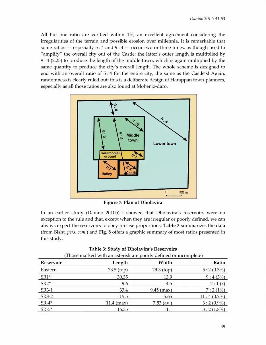
Dholavira Dholavira in the Rann of Kachchh, excavated by R. S. Bisht in the 1990s, is an exceptional site in its largely undisturbed plan and clearly delineated multiple enclosures covering about 48 hectares. Dholavira’s design (Fig. 6) is triple: an acropolis consisting of a massive “castle” and an adjacent “bailey,” a middle town (including a huge “ceremonial ground”), and a lower town, a large part of which was occupied by a series of reservoirs. (The above terms in quotation marks are the designations given by the excavator.)
Table 1 summarizes the city’s dimensions, as supplied by the excavator (Bisht 1997, 1999, 2000), with a maximum margin of error of 0.5% (Bisht 2000: 18). The validity of these dimensions has been confirmed by a preliminary GPS study (Danino 2010b).
Table 1: Dholavira’s Dimensions
Dimension Measurement (in metres)
Length WidthLower town (entire city) 771.1 616.85Middle town 340.5 290.45Ceremonial ground 283 47.5“Castle” (inner) 114 92“Castle” (outer) 151 118“Bailey” 120 120
Bisht soon noticed that those dimensions concealed specific proportions, and noted a few important ratios. My own research added a few more. Table 2 lists the principal ratios at work in Dholavira’s various enclosures (shown also in Fig. 7).
Table 2: Principal Ratios at Dholavira Dimensions Ratio Margin of Error (%)Entire city* 5 : 4 0.0“Castle”, inner* 5 : 4 0.9“Castle”, outer* 5 : 4 2.4“Bailey”* 1 : 1 0.0Middle town* 7 : 6 0.5Ceremonial ground* 6 : 1 0.7Castle’s outer to inner lengths** 4 : 3 0.7Middle town’s length to castle’s internal length** 3 : 1 0.4Middle town’s length to castle’s outer length** 9 : 4 0.2City’s length to middle town’s length** 9 : 4 0.6Middle town’s length to ceremonial ground’s length** 6 : 5 0.3
* = proposed by R. S. Bisht ** = proposed by Michel Danino

ISSN 2347 – 5463 Heritage: Journal of Multidisciplinary Studies in Archaeology 2: 2014
48
Figure 5: Proportions of Kalibangan’s Two Main Enclosed Areas
Figure 6: Plan of Dholavira
Danino 2014: 41‐53
49
All but one ratio are verified within 1%, an excellent agreement considering the irregularities of the terrain and possible erosion over millennia. It is remarkable that some ratios — especially 5 : 4 and 9 : 4 — occur two or three times, as though used to “amplify” the overall city out of the Castle: the latter’s outer length is multiplied by 9 : 4 (2.25) to produce the length of the middle town, which is again multiplied by the same quantity to produce the city’s overall length. The whole scheme is designed to end with an overall ratio of 5 : 4 for the entire city, the same as the Castle’s! Again, randomness is clearly ruled out: this is a deliberate design of Harappan town‐planners, especially as all those ratios are also found at Mohenjo‐daro.
Figure 7: Plan of Dholavira
In an earlier study (Danino 2010b) I showed that Dholavira’s reservoirs were no exception to the rule and that, except when they are irregular or poorly defined, we can always expect the reservoirs to obey precise proportions. Table 3 summarizes the data (from Bisht, pers. com.) and Fig. 8 offers a graphic summary of most ratios presented in this study.
Table 3: Study of Dholavira’s Reservoirs (Those marked with an asterisk are poorly defined or incomplete)
Reservoir Length Width RatioEastern 73.5 (top) 29.3 (top) 5 : 2 (0.3%)SR1* 30.35 13.9 9 : 4 (3%)SR2* 9.6 4.5 2 : 1 (?)SR3‐1 33.4 9.45 (max) 7 : 2 (1%)SR3‐2 15.5 5.65 11 : 4 (0.2%)SR‐4* 11.4 (max) 7.53 (av.) 3 : 2 (0.9%)SR‐5* 16.35 11.1 3 : 2 (1.8%)

ISSN 2347 – 5463 Heritage: Journal of Multidisciplinary Studies in Archaeology 2: 2014
50
Figure 8: A Summary of Harappan Ratios so far, on a Linear Scale
Discussion This study naturally leads to the question of linear units used by Harappans in laying out all those precise dimensions, but I will leave this complex issue (Danino 2010a) out of the present paper. What remains to be grasped is why Harappan town‐planners and

Danino 2014: 41‐53
51
architects took so much trouble to impose precise ratios to almost every major structure or enclosure (there are many more than those noted in this study), when imposing such ratios on the landscape would have meant constraints of space and complicated constructions. Besides, those proportions were non‐utilitarian, in the sense that they did not serve any “useful” purpose such as structural strength, flood control etc. So what made them so attractive?
I have shown earlier (Danino 2008, 2010a) that there is solid evidence of continuity between the Harappan use of proportions and their use in classical India, especially in the field of architecture and iconometry. In the classical age, such proportions — the same as those used by the Harappans — were markers of auspiciousness as well as the expression of a desire to impose a rhythm in an otherwise amorphous space and time. Similar considerations prevailed in many architectural schools elsewhere, from ancient Egypt, Japan or China to the Roman Empire (e.g. Vitruvius), the difference being that Indian architects attributed nothing less than sacredness to those proportions — we may rightly speak of a “sacred geometry” in this case.
Whether the Harappans viewed the proportions illustrated in this paper as “sacred” will remain conjectural; it is however certain that they attached great importance to them and, for their sake, did not mind complicating the construction of structures or the layout of entire cities. This is an important cognitive trait which has escaped notice and deserves the attention of archaeologists, especially those studying the principles behind Harappan town planning. Besides, the ability to conceive of and form ratios — no doubt by adding a fraction to the unit (Danino 2010a) — and select them variously for different applications is in itself an important step in abstract thinking and cognitive ability.
In this perspective, Eltsov’s view of Harappan fortifications as symbols of authority may need to be enlarged to include a need to demarcate space in an auspicious manner and give it order, rhythm and auspiciousness.
Acknowledgements This paper is based on a Keynote Address delivered at an International Conference on “Harappan and Regional Chalcolithic Cultures of Greater Indus Region” organized by the Department of Archaeology, University of Kerala, 25–27 November 2013. I gratefully acknowledge the invitation kindly extended by the conference organizers, in particular Dr. Ajit Kumar and Dr. Rajesh S.V. Images are adapted by me from plans published by ASI (except for Harappa’s “Granary”, which is borrowed from J.M. Kenoyer); all graphs and tables are mine.
References Bisht, R. S. 1997. Dholavira Excavations: 1990–94, in Facets of Indian Civilization —
Essays in Honour of Prof. B. B. Lal, ed. J. P. Joshi, vol. I. New Delhi: Aryan Books International, pp. 107–120.

ISSN 2347 – 5463 Heritage: Journal of Multidisciplinary Studies in Archaeology 2: 2014
52
Bisht, R. S. 1999. Dholavira and Banawali: Two Different Paradigms of the Harappan Urbis Forma. Puratattva 29: 14–37.
Bisht, R. S. 2000. Urban Planning at Dholavira: a Harappan City, in Ancient Cities, Sacred Skies: Cosmic Geometries and City Planning in Ancient India, eds. J. McKim Malville & Lalit M. Gujral. New Delhi: Indira Gandhi National Centre for the Arts & Aryan Books International, pp. 11–23.
Chakrabarti, Dilip K. 2006. The Oxford Companion to Indian Archaeology: The Archaeological Foundations of Ancient India. New Delhi: Oxford University Press.
Danino, Michel. 2005. Dholavira’s Geometry: a Preliminary Study. Puratattva 35: 76–84. Danino, M. 2008. New Insights into Harappan Town‐Planning, Proportions and Units,
with Special Reference to Dholavira. Man and Environment, XXXIII (1): 66–79.
Danino, M. 2010a. Unravelling Dholavira’s Geometry. In P. Chenna Reddy, (ed.), Recent Researches in Archaeology, History and Culture (Festschrift to Prof. K.V. Raman), pp. 179–193. Delhi: Agam Kala Prakashan.
Danino, M. 2010b. Further Research into Harappan Metrology at Dholavira. Man and Environment, XXXV (2): 35–44.
Eltsov, P.A. 2008. From Harappa to Hastinapura: A Study of the Earliest South Asian City and Civilization. Boston: Brill Academic Publishers
Eltsov, P.A. 2010. The Idea of Ancient South Asian City. In Bal Ram Singh, (ed.), Origin of Indian Civilization. Dartmouth: Centre for Indic Studies & New Delhi: DK Printworld.
Jansen, Michael. 1979. Architectural Problems of the Harappa Culture. South Asian Archaeology 1977, vol. 1, ed. Maurizio Taddei. Naples: Istituto Universitario Orientale, Seminario di Studi Asiatici, pp. 405–431.
Jansen, Michael. 1988. Mohenjo‐daro: architecture et urbanisme, in Les cités oubliées de l’Indus: Archéologie du Pakistan, ed. Jean‐François Jarrige. Paris: Association française d’action artistique & Musée national des Arts asiatiques Guimet, pp. 133–42.
Kenoyer, Jonathan Mark. 1998. Ancient Cities of the Indus Valley Civilization. Karachi & Islamabad: Oxford University Press & American Institute of Pakistan Studies.
Lal, B. B. 1997. The Earliest Civilization of South Asia. New Delhi: Aryan Books International.
Lal, B. B. 1998. India 1947–1997: New Light on the Indus Civilization. New Delhi: Aryan Books International.
Mackay, E.J.H. 1938. Further Excavations at Mohenjo‐daro. Delhi: Government of India, vol. 1. (Republished New Delhi: Munshiram Manoharlal, 1998.)
Mackay, Ernest. 1948. Early Indus Civilization: Ancient Cities of the Indus Plains, 2nd edn, repr. Patna: Eastern Book House, 1989.
Marshall, John, (ed.). 1931. Mohenjo‐daro and the Indus Civilization. London: Arthur Probsthain, vol. 1.

Danino 2014: 41‐53
53
Possehl, Gregory L. 2002. The Indus Civilization: A Contemporary Perspective. Walnut Creek: AltaMira Press (reprint New Delhi: Vistaar Publications, 2003).
Rao, S. R. 1979. Lothal, a Harappan Port Town (1955–62). New Delhi: Archaeological Survey of India, 2 vols.
Smith, Monica L. 2006. The Archaeology of South Asian Cities. Journal of Archaeological Research, 14:97–142.


