Embed Size (px)
Citation preview

Student number: S16021
TYPE OF ASSIGNMENT Take Home Examination
Class of 2016
Term 1
Subject: WMU 144 Marine Environmental Science
Number of credits: 4 EC
Date: 26 Oct. 2015
Given by: Prof. Linden
Word count: 2476

Contents
1. Introduction..................................................................................................................................3
2. Characteristics...............................................................................................................................4
2.1. Continental margins...................................................................................................................4
2.2. Ocean basin...............................................................................................................................4
2.3. Seamounts.................................................................................................................................5
2.4. Trenches....................................................................................................................................5
2.5. Ridges and rifts..........................................................................................................................6
3. Bathymetry of oceans and coastal areas.......................................................................................7
4. Salient features of State Georgia...................................................................................................8
5. Conclusion.....................................................................................................................................8
6. Reference......................................................................................................................................9
2

Features of the ocean basin and continental margins, trenches, ridges and rifts. Seamounts. Bathymetry of oceans and coastal areas.
1. Introduction
Geologic evolution of our planet started approximately 4.6 billion years ago. Development and
formation of the main components of the Earth, such as continents, atmosphere, oceans and
biosphere have been progressively passing through complicated stages. Although this process has
begun long time ago the geological evolution of Earth could still be witnessed.
Study of the oceans requires various kinds of scientific work, research methodology, as well as
sophisticated technologies, particularly, exploring the ocean’s floor. Most of the scientists before
believed that oceans were spread on the flat floor and that the deepest places were in the middle of
the oceans. Correct understanding of the features of the ocean’s floor was explained after the
development of plate-tectonic theory. This theory assisted in discovering and realizing that the
ocean’s floor is uneven and contains diverse kinds of geographic relief (Trujillo & Thurman, 2010). A
lot of different ridges, rifts, trenches or seamounts are hidden under the seawater. The basic features
and formation of these different geographic reliefs, the ocean basins and continental margins will be
described in this essay. Bathymetry methods used for studies the ocean floor will also be explained.
2. Characteristics
2.1. Continental margins
Continental margin is one of the main provinces of the ocean floor. It can be defined as submerged
edge of the continental crust which is separated from the oceanic crust. Shapes of the different
continental margins are formed by various elements, such as force and energy of the ocean waves,
currents, river carrying sediments into the ocean, changes in sea level and tectonics (Encyclopedia
Britanica, n.d.).
There exist two kinds of continental margin, depending on how close they are to the tectonic
boundaries: passive and active. Passive continental margin, which is as fixed in lithospheric plate, is
characterized with less tectonic activities. Continental shelf, slope and rise are examples of passive
continental margin.
A continental shelf stretches from the coastline to the shelf break point. It is followed by continental
slope descending into deep ocean basin. Width and extension of continental shelf is different. For
example in Siberia it extends for 1290 kilometers, but in California less than 1 kilometer. Continental
3

rise, area between deep ocean floor and continental margin, contains submerged pile of debris
(National geographic, n.d; Trujillo & Thurman, 2010).
In contrary to passive margins, the active continental margins are distinguished with high tectonic
activities and plate boundaries. The convergent and transform continental margins are the two major
active continental margins. Structures of convergent active margin contain continental arc onshore, a
narrow shelf, a steep slope, and offshore trench. Transform continental margin at the place of
transform plate bounder forms linear islands, banks or deep trenches near the shore (Thurman &
Trujillo, 2004).
One of the features of continental margin is submarine canyon similar to land Grand Canyon. These
narrow and deep valleys are formed on the continental slopes by action of various marine processes
and carving of these canyons is caused by strong turbidity currents (National Oceanography center,
n.d; Trujillo & Thurman, 2010).
Figure 1 clearly shows continental margin and its features.
Figure 1. Continental margin
Areas of the continental margins are distinguished by high and active accumulation and reproduction
of sedimentary particles reflecting high biological productivity in this region. The continental margin
represents only ten percent of the whole ocean but produces fifty percent of organic carbon in the
region (Thunnel, 1997).
2.2. Ocean basin
Ocean basins constitute the largest and deepest province of the ocean floor. They are spread beyond
the continental margin and are characterized by different relief features. Abyssal hills, seamounts,
guyots, ocean ridges, deep-ocean trenches or jagged - are the major features of the deep ocean
basin. Plate tectonics activation creates and defines forms and shapes of the ocean basins. The
continual Plate tectonic motion explains the reasons for relatively new ocean floor compared to the
earth or the ocean itself. For example, the oldest segment found in Pacific ocean is only 200 million
years old, but Earth’s age is about 4.6 billion years. Sedimentation, volcanic action, thermal properties
and tensional forces in the plates promote creation of various features of the ocean basin (Rafferty,
2011).
4

Abyssal plains are one of the components of deep ocean basin. They are flat zone and are spreading
from continental rise into deep ocean basin. Its distribution is defined by type of continental margin.
Formation of the abyssal plains is stipulated by little particles of sediments (Thurman & Trujillo, 2004).
2.3. Seamounts
Seamounts are undersea mountains formed by volcanic activities. There are more than 50,000
seamounts covering approximately 28.8 million of square kilometers of the Earth surface. However,
as scientists estimate this number should be quit more.
Arising from abyssal plains some volcanic peaks reach above the sea level and create islands. But
some remain under the water. These up-rising volcanos which are minimum one kilometer height and
have a cone form are called seamounts. Some of the seamounts having flat tops are called as
tablemount or guyot.
Seamounts which are less than 1000 meters are called abyssal hills or seaknolls. Most of them were
formed as a result of stretching of the crust. Abyssal hills are the most abundant features of Earth.
Groups of abyssal hill create abyssal hill provinces, which are widely spread particularly in the Pacific
Ocean.
Steep slopes of seamounts are the source of nutrients for rich biological seamount habitats. Nutrients
created by upwelling on the surface provide food for live organisms (National ocean service, n.d.;
Trujillo & Thurman, 2010).
2.4. Trenches
Ocean trenches are the greatest depth in the ocean and are result of convergent collision of two
plates. They are characterized as long, narrow, steep-sided scars of the ocean. Volcanic arc, which
are landward rise of the trench, creates islands or range of mountains on the edge of the continent.
Examples of this are Japan, as volcanic island and Andes mountains, as a continental arc.
The Pacific Ocean is distinguished with number of trenches and also has the deepest Mariana trench
with depth of 11 kilometers.
The most active zone by volcanoes and earthquakes is in the Pacific Ocean. High activity of this zone
is caused by existence of convergent plate bounders in this region. Along the margins of the Pacific
Ocean was formed the Pacific Ring of Fire. It involves South America’s western coast, Andes’
Mountains and Peru-Chile trench.
As was studied, the trenches are not stationary and in case of collision of plates, they can move to the
subduction directions. This process is called as seaward migration; it can cause even spreading the
center behind the volcanic arc creating so Back-arc spreading center. The example of this process is
Mariana trench, which formed well developed Back-arc spreading center in 200 kilometers from old
arc remnant to west.
5
Due to their depth, trenches are one of the less explored places of the Earth. Special environment
created particular habitants in this area. High pressure, temperature and darkness are suitable for
some microbes or organisms. These organisms are well adapted to this condition, some of them have
gelatinous material body or use bioluminescence for navigating in deep water (Thurman & Trujillo,
2004; National Geographic, n.d).
2.5. Ridges and rifts
Ridges and rifts are one of the features of the ocean floor. It underlines diversity character of the
undersea relief. Firstly it was explored in 1955 using method of paleomagnetism, by which it was
discovered that undersea mountains had symmetrical and regular pattern in contrast to land.
According to the plate tectonic model, the processes of sea floor spreading and subduction forms new
ocean floor at the mid-ocean ridge (Thurman & Trujillo, 2004).
The mid-ocean ridge can be defined as long range of volcanic mountains spreading almost entire
underwater area. Length of these mountain chain reach about 75 000 kilometers, average width is
about 1000 kilometers and height from sea floor could be about 2.5 kilometers. These huge
complexes of mountains cover about 23 percent of the Earth (Woods hole Oceanographic, n.d.;
Thurman & Trujillo, 2004).
The mid-ocean ridge has volcanic origin and is formed by basaltic lava coming from ocean crust. After
spreading in seawater, it cools down and creates pillow lava or pillow basalts. The mid-ocean ridges
have various forms and shapes depending on different factors. One of the factor defining type of
ridges is the rate of its spreadibilityspreadability. Consequently, there exist fast-spreading and slow-
spreading ridges. Almost 12 cubic kilometers of lava is exploded every year. This quantity is enough
to fill 20 Olympic swimming pools every minute. Mid-Atlantic ridge is slow spread ridge and it moves
at the rate of 2.5 centimeters per year whereas, but fast spreading ridge such as the East-Pacific rise
moves at the rate of 15 centimeters per year (Water Encyclopedia, n.d; Thurman & Trujillo, 2004).
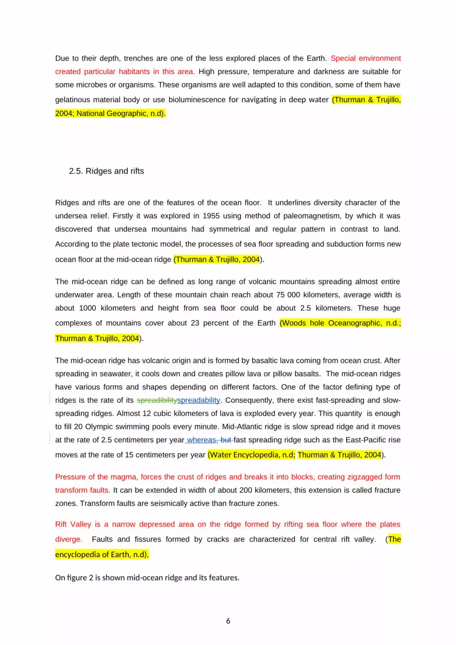
Pressure of the magma, forces the crust of ridges and breaks it into blocks, creating zigzagged form
transform faults. It can be extended in width of about 200 kilometers, this extension is called fracture
zones. Transform faults are seismically active than fracture zones.
Rift Valley is a narrow depressed area on the ridge formed by rifting sea floor where the plates
diverge. Faults and fissures formed by cracks are characterized for central rift valley. (The
encyclopedia of Earth, n.d).
On figure 2 is shown mid-ocean ridge and its features.
6
Figure 2. Ocean Ridge
Magma could be erupted at various places in the ocean. Lava, interacting with seafloor surface, heats
seawater and promotes creation of hydrothermal vents or hot springs. The appearance of these
springs depends on water temperature. The three types of hydrothermal vents are the warm-water
vents, white smokers, and the black smokers. The warm-water vents are transparent and their
temperature is around 30 0C. The white smokers are of white color with temperature varying between
30 – 360 0C and containing light-colored components, such as barium. The black-smokers have
temperature of above 350 0C and are of dark color due to different component concentration. Iron,
zinc, nickel, cooper, chromium, lead are these components. Black-smokers are like the smoke
emanating from the chimney. Specific kind of ecosystem was created around the hydrothermal vents.
It includes different kind of microbes, using chemosynthesis instead of photosynthesis. Except
microbes, various species of clams and tubeworms are found in these thermal areas. These
organisms are able to survive and adapt to toxic environment with high pressure and temperature.
This provides reasons for the scientists to conclude that these organisms could be the first organisms
of the Earth (Thurman & Trujillo, 2004; "Water Encyclopedia," n.d. ) .
3. Bathymetry of oceans and coastal areas
Underwater world, characterized with interesting features, needs to be explored. Bathymetry is a
method to measure depth of the ocean and describe topography of seafloor. On the bathymetric map
diversity of the relief is illustrated by different color and contour lines.
Exploration of the seafloor and its first systematic description was done by British expedition
Chelenger in 1872-76, using long weighted rope for hearing sounds. However, the invention of echo
sounder assisted in exploring underwater relief more correctly. Precision depth recorder, using high
frequency sound was invented after the Second World War. This technology improved the sounding
system to a great extent.
Presently, different types of modern technologies are used for bathymetry. These are acoustic
instruments including multibeam eco-sounders and side-scan sonar, satellite, and electro-navigation.
Working principle of acoustic instrument such as GLORIA is based on measuring the depth of
7

seawater by using downgoing acoustic echo, characterized with different frequencies, and speed of
sound. Acoustic pulses with high frequencies are used for determining depth of the ocean, but with
low frequencies is defined thickness of the ocean sediment. Another instrument, ANGUS has camera
that can take high resolution photographs of seafloor (Rafferty, 2011).
Using satellite and electromagnetic systems provides possibility of mapping the ocean basin. This
method is based on Earth’s gravity. For example above the trenches gravity is lower, then above
seamounts region. Advantage of using satellite method is that the large area of the ocean surface can
be observed at one time saving lots of time compared to the acoustic systems.
4. Salient features of State Georgia
Georgia is one of the countries in the Caucasus region situated on the eastern side of the Black Sea.
The Country has a vast coastline of approximately 312.08 kilometers. Its territorial sea and exclusive
economic zone extends upto twelve miles and two hundred miles respectively. The large territorial
sea of Georgia covers an area of approximately 69.7 square kilometers.
The Black sea seaboard of Georgia is reasonably mountainous towards the northern side with
significant gorges and river valleys. These gorges and river valleys become less sever towards the
south and show more uniformity ("Black Sea and Azov Sea Pilot," 2003).
Georgia had been one of the Socialistic Republics of the Soviet Union for major part of the twentieth
century and therefore did not exist as separate maritime nation. It established its hydrography service
for coordinating and keeping safe navigation after getting independence in 1991. Georgia is in the
process of acquiring membership of the International Hydrographic Organization (IHO) and intends to
update the existing old standards as per new international requirements (www.gshs.gov.ge).
5. Conclusion
The oceans are the most diverse and largest areas of the Earth. They generate necessary living
condition for the whole planet. Oceans promote production of most of the oxygen and absorb organic
carbon. Changes in climate and weather or stabilization of the temperature are linked also with
oceans. It forms continents coastal shapes. Underwater world is the shelter for numerous different
living organisms. During the long geologic evolution in the oceans, a unique environment was created
with seawater flora and fauna. Different kinds of seamounts, trenches, ridges or rifts valleys create
particular physical and geological features of the entire seafloor. It is characterized with active tectonic
processes and results in formation and changes.
The big catastrophes of our planet such as earthquakes, tsunami, volcanos are linked with activity of
the plate tectonics. One of the biggest tragedies which happened in Indonesia in 2004 and in Japan
in 2011 was result of tsunami caused by underwater plates seductions. These are clear evidence why
8

oceans need to be explored more and more. New technologies, new scientific approach should be
applied for defining the processes occurring under seawater. Study the oceans is also necessary to
protect marine environment which was drastically changed during the last century.
So maintain clean environment and save the blue planet Earth should be one of the main goal of
humankind and to fulfill this goal can be reached by exploring and study the oceans.
9

Reference
Black sea and Azov sea pilot. (2003). United kingdom Hydrographic Service. Retrieved from file:///C:/Users/user/Downloads/02-Sailing+Directions+Black+Sea+and+Sea+of+Azov+Pilot+NP+24(OK).pdf
Continental margine [Image] (n.d.). Retrieved from https://www.google.se/search?q=continental+margin&biw=1366&bih=623&tbm=isch&imgil=wZiZ7hsieFk6DM%253A%253BzuJGt-MzszvZXM%253Bhttp%25253A%25252F%25252Fwww.scienceclarified.com%25252Flandforms%25252FBasins-to-Dunes%25252FContinental-Margin.html&source=iu&pf=m&fir=wZiZ7hsieFk6DM%253A%252CzuJGt-MzszvZXM%252C_&dpr=1&usg=__eLRP-QNb7KBFt6zzgGQCsf8bs54%3D&ved=0CCUQyjdqFQoTCKvgkOrTusgCFaIPcgoduwYOSg&ei=n3UaVuuUC6KfyAO7jbjQBA#imgrc=3dCUrT_B9eaCWM%3A&usg=__eLRP-QNb7KBFt6zzgGQCsf8bs54%3D
Encyclopedia Britanica, Continental margin, n.d. Retrieved from http://global.britannica.com/science/continental-margin
National Geographic, Continental shelf, n.d. Retrieved from http://education.nationalgeographic.com/encyclopedia/continental-shelf/
National Geographic, Ocean trenches, n.d. Retrieved from http://education.nationalgeographic.com/encyclopedia/ocean-trench/
National Oceanography center, Submarine Canyons, n.d. Retrieved from http://noc.ac.uk/science-technology/earth-ocean-system/seafloor/submarine-canyons
National Ocean Service, Seamounts, n.d. Retrieved from http://oceanservice.noaa.gov/facts/seamounts.html
Ocean Ridge. [Image]. (n.d.). Retrieved from https://www.google.se/search?q=ridges+and+rift+valleys&biw=1366&bih=623&tbm=isch&imgil=UlgPmLn9WCq9FM%253A%253BBbR9ICYpbe8yUM%253Bhttp%25253A%25252F%25252Fwww.divediscover.whoi.edu%25252Fridge%25252Fspreading.html&source=iu&pf=m&fir=UlgPmLn9WCq9FM%253A%252CBbR9ICYpbe8yUM%252C_&dpr=1&usg=__pVLI0mUUmmpOyNO3R3MJqN7Xg54%3D&ved=0CCoQyjdqFQoTCJr10ZDXusgCFaQscgodf48FSw&ei=FXkaVtqWD6TZyAP_npbYBA#imgrc=BtQ72lpKqzjNfM%3A&usg=__pVLI0mUUmmpOyNO3R3MJqN7Xg54%3D
Rafferty, J. P. (Ed.). (2011). Oceans and Oceanography. Chicago, IL, USA: Encyclopaedia Britannica. Retrieved from http://site.ebrary.com/lib/wmulib/detail.action?docID=10437911
The Encyclopedia of Earth, Mid-Ocean ridges, n.d. retrieved from http://www.eoearth.org/view/article/164696/
Thurman, H. V., & Trujillo, A.P. (2004). Introductory oceanography. 10th Ed. Upper Saddle River, New Jersey: Prentice Hall.
Trujillo, A.P., & Thurman, H.V. (2010). Essentials of oceanography. 10th Ed. Upper Saddle River: Pearson Prentice Hall.
10

Thunnel, R., (1997, 1 December). Continental Margin Particle Flux. Oceanus magazine, 2(40). Retrieved from http://www.whoi.edu/oceanus/feature/continental-margin-particle-flux
Woods hole Oceanographic, Mid-ocean ridges, n.d. retrieved from http://www.whoi.edu/main/topic/mid-ocean-ridges
Water Encyclopedia, Mid-Ocean ridges, n.d. Retrieved from http://www.waterencyclopedia.com/Mi-Oc/Mid-Ocean-Ridges.html
Water Encyclopedia. (n.d.). Retrieved from http://www.waterencyclopedia.com/Ge-Hy/Hot-Springs-on-the-Ocean-Floor.html
11

12


